SUMMARY GEOLOGY REPORT
ON THE PEPPER HOPE PROPERTY
NELSON MINING DIVISION
BRITISH COLUMBIA
Tenure Number 552377
NTS Map 82F 03E
Latitude 490 9’ 9" North Longitude 1170 10’ 58" West
Prepared on behalf of
GOLDSPAN RESOURCES, INC
Suite # 204 - 1155 Seymour Street
Vancouver, BC V6B 1K2
by
RICHARD A. JEANNE
Consulting Geologist
Member AIPG
(CPG No. 8397)
March 20, 2007
TABLE OF CONTENTS
| SUMMARY | ii | |
| 1. | INTRODUCTION | 1 |
| 1.1 Disclaimer | 1 | |
| 2. | PROPERTY DESCRIPTION AND LOCATION | 1 |
| 3. | ACCESSIBILITY, CLIMATE, LOCAL RESOURCES, INFRASTRUCTURE and PHYSIOGRAPHY | 3 |
| 3 | ||
| 4. | HISTORY | 4 |
| 5. | GEOLOGICAL SETTING | 5 |
| 5.1 Regional Geology of the Sheep Camp Area | 5 | |
| 5.2 Property Geology | 5 | |
| 6. | DEPOSIT TYPE | 6 |
| 7. | MINERALIZATION | 6 |
| 8. | EXPLORATION | 6 |
| 9. | DRILLING SUMMARY | 6 |
| 10. | SAMPLING | 7 |
| 11. | ADJACENT PROPERTIES | 7 |
| 12. | INTERPRETATION AND CONCLUSIONS | 7 |
| 13. | RECOMMENDATIONS | 8 |
| 13.1 Budget | 9 | |
| 14. | REFERENCES CITED | 10 |
| 15. | STATEMENT OF QUALIFICATIONS | 10 |
| LIST OF FIGURES | ||
| Figure 1. | LOCATION MAP | 2 |
| Figure 2. | CLAIM PLAN | 3 |
i
SUMMARY
The Pepper Hope claim was electronically staked in February 2007 under the name of GOLDSPAN RESOURCES, INC. who retains a 100% interest in the property. The Pepper Hope consists of all or parts of 7 Mineral Title cells totaling 147.899 hectares or approximately 365 acres. A legal survey of the property has not been conducted.
The property is located about 40 km (≈25 miles) south of the city of Nelson in the Sheep Creek mining camp in southeastern British Columbia, Canada. It can be accessed from route 3, south of the community of Salmo via about 5 km (≈3 miles) of dirt roads.
Cambrian age rocks of the Hamill Group underlie the camp at Sheep Creek and gold is associated with northeast trending faults in quartzites of the Quartzite Range and Reno Formations within this group. Between 1890 and 2003, the Sheep Creek camp produced over 23.1 million grams of gold, 9.1 million grams silver as well as lesser amounts of copper, lead and zinc.
Data in published reports and geologic maps of the area reveal that on the Pepper Hope property, there may be potential for hidden gold deposits of the type at Sheep Creek camp. Rocks of the Active Formation, on which the Pepper Hope claim is located, have been thrust over those of the Quartzite Range Formation.
It is recommended that following a thorough literature review, a site visit be undertaken to gain a better understanding of this thrust relationship and to evaluate the potential for rocks of the Quartzite Range Formation underlying the Pepper Hope claim.
ii
1. INTRODUCTION
In February 2007, the Pepper Hope mineral claim was electronically staked over prospective ground near Sheep Creek camp in the Nelson Mining division, Southeastern British Columbia. The claim, located about 40 km (≈25 miles) south-southeast of the city of Nelson, comprises all or parts of 7 Mineral Title cells, totaling 147.899 hectares (365.5 acres) in area.
Historically, the area has seen significant gold production with the Rossland camp 40 km (≈25 miles) west being the second largest producer and Sheep Creek camp, adjacent to the property, being the twelfth largest producer in the province of British Columbia. Geologic maps and reports obtained during the research for this report suggest potential exists on the property for hidden deposits of the type exploited at Sheep Creek camp.
This report was prepared on behalf of GOLDSPAN RESOURCES, INC, 100% owner of the property, to provide some baseline geologic information and recommendations, with estimated costs, for an initial exploration program to more thoroughly evaluate the property's mineral potential.
1.1 Disclaimer
The author has not visited the Pepper Hope property to assess its mineral potential. This report is based on data obtained from published geologic reports of properties and active mines in the area. Geologic maps and assessment reports compiled by the BC Ministry of Energy and Mines provide the technical basis for this report.
2. PROPERTY DESCRIPTION AND LOCATION
The Pepper Hope claim is located in southeastern British Columbia, Canada, at Sheep Camp in the Nelson Mining Division, about 40 kilometers (≈25 miles) south-southeast of the town
1
of Nelson. It comprises 147.899 hectares (365.5 acres), centered at Latitude 49° 9' 9" N and Longitude 117° 10' 58" W. It lies within the area covered by NTS map sheet 082F 03E.
Data for the claim filing provided by the BC Mineral Title Online website (http://www.mtonline.gov.bc.ca) consists of the following:
Tenure Number | Claim Name | Recording Date | Current Expiry Date |
552377 | Pepper Hope | Feb. 20 2007 | Feb. 20 2008 |
The claim was secured by as a service to GOLDSPAN RESOURCES, INC. using the BC Mineral Title website administered by the Mineral Tenure Act of British Columbia. A legal survey of the claim has not been prepared, pending the results of a field examination to be conducted by a qualified geologist.
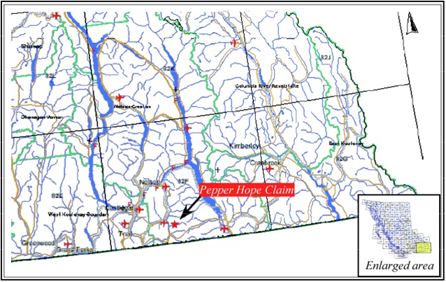
Figure 1 shows the general location of the property. Details of the claim layout and its relationship to neighboring claims are shown in figure 2.
2
Figure 1. Location map of the Pepper Hope Claim
The Pepper Hope claim lies outside any parks or other designated lands and no environmental or other encumbrances are known to the author. Bonding requirements for reclamation may be imposed as exploration proceeds.
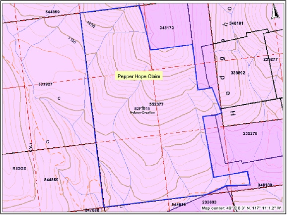
Figure 2. Pepper Hope claim plan, outlined in blue.
3. ACCESSIBILITY, CLIMATE, LOCAL RESOURCES, INFRASTRUCTURE AND TOPOGRAPHY
Access to the property can be gained from the city of Nelson by traveling approximately 50 km (≈31 miles) south on paved Routes 6 and 3 to a point about 6.5 km (≈4 miles) south of the village of Salmo, then about 5 km (≈3 miles) east via dirt roads and 4X4 trails to the southern edge of the claim.
The area typically is blanketed with snow during the winter months but during the remainder of the year the climate is moderate. No perennial streams or lakes are located on the property.
Amenities such as groceries, vehicle rental or general supplies, and services such as restaurants, lodging, banking, internet access, etc. are available in the city of Nelson, about an hour's drive from the property. No roads are located on the claim other than a four wheel drive track that clips its southern edge. Information regarding the proximity of utilities such as power and water is unknown to the author.
The claim is underlain by terrain of modest slopes and relief between the elevations of 900 m and 1,400 m above sea level. No visit to the property has been made by this author nor by the claimant, so the extent of vegetative cover is uncertain, however, aerial photo imagery provided on the Mineral Titles Online web site suggests the claim and surrounding area are covered by heavy timber.
4. HISTORY
No records nor evidence of previous exploration or mining on the claims are known to the author, nor are any indicated on maps and in the literature of the area reviewed by the author for this report.
No exploratory work on the property has been conducted by the current claimant or this author.
3
5. GEOLOGIC SETTING
5.1 Regional Geology of the Sheep Camp Area
The region is underlain by rocks of the Omineca tectonic belt. West of the claim are the Rossland and Ymir group rocks of Early Jurassic age, and to the east are rocks of the North American Terrane comprised of the Middle Proterozoic Windermere Supergroup and Lower Cambrian Quartzite Range and Reno formations. In the vicinity of the claim, and structurally overlying the Quartzite Range and Reno formations, are rocks of the Kootenay terrane comprised of the Lardeau Group and the Laib and Active formations. The claim itself appears to be underlain by the Active Formation.
The Sheep Creek mining camp, near where the claim is located, is ranked as the twelfth largest producer of lode gold in the province (Schroeter and Pardy, 2004). The source of this production was auriferous sulfides in a fault-controlled, regional quartz vein system. Ore shoots developed in northeast trending and southeast dipping faults at their intersections with quartzite beds in the Quartzite Range Formation and to a lesser degree in the Reno Formation. Pyritiferous quartz is the major gangue mineral that also contains small amounts of pyrrhotite, chalcopyrite, galena, sphalerite and rare visible gold.
5.2 Property Geology
Detailed study of the geology of the property has not yet been undertaken by the current claimants, and no published reports specific to the property are known to exist by this author. However, information obtained from regional geologic maps indicates the claims are underlain by rocks of the Active Formation. The Active Formation and related rocks structurally overlie the Quartzite Range and Reno formations that outcrop to the east and are the host rocks for the gold deposits in the camp (Jackaman & Höy, 2004). If this is correct, the Quartzite Range Fm may exist beneath the Active formation at the Pepper Hope claim, offering the potential for hidden ore deposits there.
4
6. DEPOSIT TYPE
No mineralization is currently known to exist on the property, however, the potential for the existence of high grade gold veins hidden by overlying rocks deserves investigation. Gold mineralization in the district occurs in quartz veins developed in northeast trending structures at their intersections with quartzite beds of the Quartzite Range Formation and to a lesser degree of the Reno Formation. These rocks are structurally overlain by rocks of the Active Formation, on which the claim is located. Outcrop patterns in the vicinity of the Pepper Hope, as shown on regional geologic maps, strongly suggest there is potential that the ore bearing formations may project beneath the rocks on which the claims are situated. Detailed mapping of the property and adjacent areas should be undertaken to more thoroughly evaluate this potential.
7. MINERALIZATION
It is unknown if any mineralization is present on the property as no field studies have been undertaken on the claim at this time.
8. EXPLORATION
No exploration is known by the author to have been conducted on the property to date.
9. DRILLING SUMMARY
No drilling is known by the author to have been conducted on the property to date.
5
10. SAMPLING
No sampling is known by the author to have been conducted on the property to date.
11. ADJACENT PROPERTIES
Four important mining camps and over 300 mineral occurrences are located in the vicinity of the Pepper Hope claim. The closest is the Sheep Creek camp which is ranked as the twelfth largest gold producer in the Province. Gold was exploited from quartz veins of mesothermal origin hosted by the Quartzite Range and Reno formations. Between 1890 and 2004, the Sheep Creek camp produced over 23.1 million grams of gold, 9.1 million grams silver as well as lesser amounts of copper, lead and zinc (Schroeter and Pardy, 2004).
To the south and southwest of the Pepper Hope is the Salmo Belt which produced lead and zinc from replacement deposits in carbonate host-rocks. Forty kilometers (≈25 miles) to the west is Rossland Camp, ranked as the second largest gold producing camp in the Province. Rossland produced over 85 million grams of gold from gold-copper and polymetallic veins in rocks of the Elise Formation and the Rossland stock. North of the Pepper Hope is the Ymir-Nelson area. In this area, vein deposits comprised of a variety of polymetallic assemblages and hosted in rocks of the Ymir Group and Elise Formation have produced more than 16,000 kg of gold and 190,000 kg of silver (Jackaman & Höy, 2003)
12. INTERPRETATION AND CONCLUSIONS
The Sheep Creek mining camp was one of the major gold producers in the province. Pepper Hope's proximity to this camp coupled with the structural relationship between rocks hosting the gold deposits there and rocks underlying the claim, suggests there is potential for hidden mineralization at Pepper Hope.
6
An initial site evaluation should be conducted to determine if this structural relationship offers the potential for hidden, yet economically viable mineralization. If such a potential is recognized, then an advanced exploration program will be proposed that will test that potential by exploration drilling.
13. RECOMMENDATIONS
A geologic model for potential mineralization at Pepper Hope is proposed in which rocks of the Active Formation, which are exposed on the claim, have been thrust eastward over the Quartzite Range and Reno formations that host gold mineralization at Sheep Creek camp. Mineralized veins developed at the intersections of faults and quartzite beds in these two units may exist below this thrust, and if not overlain by significant thicknesses of Active Fm., may be profitably exploited.
In order to test this model, a thorough review of the literature of the region should be conducted to provide background information on the local and regional geology. The contact relationships of rocks in the various terranes is of utmost importance, particularly the attitudes of fault contacts. Cross sections through the area, if not available, should be generated to better understand the overthrust relationship of the Active Formation with the Quartzite Range Formation.
The geology of the property should be mapped, with particular attention given to structural data. Geologic reconnaissance of the surrounding area, with emphasis on the structure and outcrop locations of the Quartzite Range Formation, should be undertaken. This data will be necessary in order to compile cross sections that show the depth at which projections of this unit can be expected beneath the Active Formation in the vicinity of the Pepper Hope claim.
An extensive sampling program of the property is not recommended at this time. The reason is that because of the proximity of the claim to the Sheep Creek camp, it is likely that the area
7
has previously been visited and any surface exposures of mineralization would most certainly been discovered by now. Were this the case, evidence of prospecting and development would be noted on existing maps, but no such evidence is apparent on maps reviewed by this author. During reconnaissance and mapping, sampling should be limited to only those outcrops that appear to be mineralized.
Rather than focusing on surface mineralization, geologic data should be sought that will either support or undermine the model of hidden deposits at Pepper Hope.
13.1 Budget
A budget for the proposed work program is as follows (in US $):
| 1. | Review of geologic literature, compilation of maps & cross sections (4 days office @ $600/day) | $ 2,400 |
| 2. | On site surface reconnaissance, mapping and sampling (5 days field, 2 days travel @ $600/day) | $ 4,200 |
| 3. | Geochemical analyses (≈20 samples) Sample prep + Au & Ag fire assay AA finish @ $18/ sample | $ 360 |
| 4. | Expenses: | |
Round trip air fare Reno, NV-Nelson, BC$ Vehicle rental, 6 days Lodging, 6 nights @ $85/night Meals, 6 days @ $30/day | $1,200 $ 400 $ 510 $ 180 | |
TOTAL: | US$ 9,250 |
8
14. REFERENCES CITED
Jackaman, Wayne and Trygve Höy, 2004, Gold Exploration, Rossland-Nelson Area, Southeastern, B.C., in Geological Fieldwork 2004, Paper 2004-1 BC Ministry of Energy and Mines, pp 195-198.
Schroeter, T. G. and J. W. Pardy, 2004, Lode Gold Production and Resources in British Columbia (1890-2003), BC Ministry of Energy and Mines, Open File 2004-18.
15. STATEMENT OF QUALIFICATIONS
I, Richard A. Jeanne, with a business address at 3055 Natalie Street, Reno Nevada, 89509, USA, do hereby certify that:
1. I hold a Bachelor of Science degree in Geology from Northern Arizona University and a Master of Arts degree in Geology from Boston University with over 27 years experience since graduation;
2. I am a Certified Professional Geologist with the American Institute of Professional Geologists (Certificate Number 8397);
3. I am a Consulting Geologist specializing in base and precious metals and minerals exploration, mining geology and property evaluation;
4. This report is based on information obtained by me from the Mineral Titles Online web site and other internet sources;
5. I am independent of GOLDSPAN RESOURCES, INC and of any affiliate thereof; I hold no interests, direct or indirect, in the properties or securities of GOLDSPAN RESOURCES, INC. or any of its affiliates, nor do I expect to receive any; GOLDSPAN RESOURCES, INC is not a publicly trading company at this time;
9
6. I hereby give my permission to include this report in any document to be filed with any appropriate regulatory agency.
Dated and signed at Reno, Nevada this 20th day of March, 2007.
Richard A. Jeanne
Consulting Geologist