EXHIBIT 1.1.1
LEGAL DESCRIPTION
LEASEHOLD ESTATE in the following as created by Ground Lease Agreement executed by and between The Board of Regents of The Texas A&M University System, as Landlord, and Texas Bioproperties, LP, as Tenant, as evidenced by Memorandum of Lease dated March 08, 2010, filed March 15, 2010, recorded in Volume 9536, Page 255, Real Property Records, Brazos County, Texas, as assigned to College Station Investors LLC, by and thru Special Warranty Deed and Assignment of Ground Lease dated December 22, 2015, filed December 22, 2015, recorded under Clerk's File No. 2015- 1251621, Real Property Records, Brazos County, Texas:
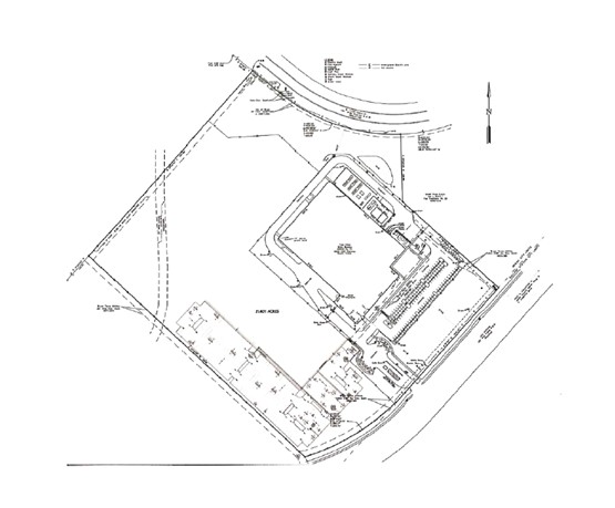
All that certain lot, tract or parcel of land being 21.401 acres situated in the J.H. Jones Survey, Abstract No. 26, Brazos County, Texas, and being all of that certain called 21.401 acre tract as described in Memorandum of Lease between The Board of Regents of The Texas A&M University System and TEXAS BIOPROPERTIES, LP, as recorded in Volume 9536, Page 255 of the Official Records of Brazos County, Texas, said 21.401 acre tract being more particularly described by metes and bounds as follows:
BEGINNING at a 1/2” Iron Rod with Cap found in the southwest right-of-way line of South Traditions Drive as described in Volume 9267, Page 132 for the most northerly corner, said corner being the most easterly corner of the Texas A&M University System called 198.0559 acre tract as described in Volume 7988, Page 209; THENCE S 51° 09'57” E, along the southerly Right-of-Way line of said South Traditions Drive a distance of 125.17 feet to a 1/2” Iron Rod with Cap found for point of curvature;
THENCE continuing along the southerly Right-of-Way line of said South Traditions Drive around a curve in a counterclockwise direction having a delta angle of 40° 38'12”, an arc distance of 425.55 feet, a radius of 600.00 feet, and a chord of S 71° 29’03” E, a distance of 416.68 feet to a 1/2” Iron Rod with Cap found for the northeast corner;
THENCE S 1° 48’09” E, a distance of 221.86 feet to a 1/2” Iron Rod with Cap found for angle point;
THENCE S 48° 08’12” E, a distance of 429.28 feet to a 1/2” Iron Rod with Cap found for the most easterly corner, said corner being located in the southeast City of Bryan City Limits Line as per deed described in Volume 3481, Page 81, said corner also being located in the northwest Right-of-Way line of HSC Parkway;
THENCE S 41° 51’48” W, along the City Limits Line a distance of 464.43 feet to a 1/2” Iron Rod with Cap found for a point of curvature;
THENCE around a curve in a clockwise direction having a delta angle of 31° 10’07”, an arc distance of 401.19 feet, a radius of 737.50 feet, and a chord of S 57° 26’51” W, a distance of 396.27 feet to a 1/2” Iron Rod with Cap found for the most southerly corner;
THENCE N 47° 19’28” W, a distance of 981.81 feet to a 1/2” Iron Rod with Cap found in the southeast line of said called 198.0559 acre tract, a 1/2” Iron Rod with Cap found for the