Exhibit 99.2
NI 43-101 TECHNICAL REPORT PERTAINING TO THE:
ABIGAIL PROPERTY
Nemiscau Area
Northern Quebec, Canada
Lac des Montagnes Volcanic Belt,
NTS 32O12, 32O13
Effective date of the technical report:
November 4, 2011
Prepared for:
Tucana Lithium Corp.
Prepared by: Donald Théberge, P.Eng., Ing., M.B.A.
SOLUMINES
| TUCANA LITHIUM CORP. | NI 43-101 TECHNICAL REPORT, ABIGAIL PROPERTY |
CERTIFICATE OF QUALIFIED PERSON
I, Donald Théberge, Eng., M.B.A, do hereby certify that:
| a) | I am registered under the name Solumines, and my business place is located at 54 De La Vigie, Lévis, Province of Quebec, G6V 5W2; |
| b) | I am the qualified person, responsible for the preparation of all the sections of the technical report entitled “NI 43-101 Technical Report pertaining to the Abigail property, Nemiscau Area, Northern Quebec, Canada. Lac des Montagnes Volcanic Belt NTS 32O12, 32O13, prepared for Tucana Lithium Corp.” dated November 4, 2011; |
| c) | I graduated with a degree in geological engineering from the University du Québec at Chicoutimi in 1978. I obtained a Master of Business Administration (M.B.A.) from Laval University in 1994. I am a member in good standing of the Ordre des Ingénieurs du Québec, No. 32368, and of the Professional Engineers of Ontario (licence # 100166433). I have worked as a geological engineer since my graduation in 1978. My pertinent experience for the Abigail project was acquired during the three years I worked for Serem as a project geologist (1978-1981), Agnico-Eagle as a senior geologist (1982 to 1989), Natural Resources Canada as a technical inspector for the C.E.I.P. program (1989-1990), and several junior exploration companies as a consultant on many mandates; |
| d) | I visited the property on October 8, 2011. One day was required for the site visit. I visited the outcrops within walking distance of the Route du Nord. I did not visit outcrops located too far away; however, I did examine witness samples taken during the geological survey completed in July by Nemaska Exploration geologists. |
| e) | I am responsible for all the sections of the technical report; |
| f) | I am independent of the issuer in accordance with Article 1.5 of National Instrument 43-101 (NI 43-101); |
| SOLUMINES | 2 |
| TUCANA LITHIUM CORP. | NI 43-101 TECHNICAL REPORT, ABIGAIL PROPERTY |
| g) | I have read the definition of “qualified person” set out in NI 43-101 on standards of disclosure for mineral project, and certify that by reason of my education, affiliation with a professional association (as defined in NI 43-101) and past relevant work experience, I fulfill the requirements to be a “qualified person” for the purposes of NI 43-101; |
| h) | I have read NI 43-101 and Form 43-101F1, and the Technical Report has been prepared in compliance with that Instrument and Form; |
| I) | As of November 4, 2011, to the best of my knowledge, information and belief, the Technical Report contained all the scientific and technical information that is required to be disclosed to make the Technical Report not misleading. |
.
Dated November 4, 2011,
________________________
Donald Théberge, Eng., M.B.A.
| SOLUMINES | 3 |
| TUCANA LITHIUM CORP. | NI 43-101 TECHNICAL REPORT, ABIGAIL PROPERTY |
TABLE OF CONTENTS
| CERTIFICATE OF QUALIFIED PERSON | 2 |
| ILLUSTRATIONS | 6 |
| 1.0) SUMMARY | 8 |
| 2.0) INTRODUCTION | 12 |
| 2.1) RECIPIENT | 12 |
| 2.2) TERMS OF REFERENCE | 12 |
| 2.3) SOURCE OF DATA AND INFORMATION | 12 |
| 2.4) SCOPE OF THE PERSONAL INSPECTION BY THE QUALIFIED PERSON | 12 |
| 2.5) UNITS USED IN THIS REPORT | 13 |
| 3.0) RELIANCE ON OTHER EXPERTS | 13 |
| 4.0) PROPERTY DESCRIPTION AND LOCATION | 13 |
| 4.1) AREA | 13 |
| 4.2) LOCATION | 13 |
| 4.3) TYPE OF MINERAL TENURE | 13 |
| 4.4) NATURE AND EXTENT OF THE ISSUER’S TITLES | 15 |
| 4.5) PROPERTY BOUNDARIES | 15 |
| 4.6) ROYALTIES | 15 |
| 4.7) ENVIRONMENTAL LIABILITIES | 17 |
| 4.8) REQUIRED PERMITS | 17 |
| 4.9) SIGNIFICANT FACTORS AND RISKS | 17 |
| 5.0) ACCESSIBILITY, CLIMATE, LOCAL RESOURCES, INFRASTRUCTURE AND PHYSIOGRAPHY | 17 |
| 5.1) TOPOGRAPHY, ELEVATION, VEGETATION AND DRAINAGE | 17 |
| 5.2) ACCESSIBILITY | 18 |
| 5.3) INFRASTRUCTURE | 18 |
| 5.4) CLIMATE | 18 |
| 6.0) HISTORY | 19 |
| 6.1) OWNERSHIP HISTORY | 19 |
| 6.2) WORK DONE BY THE MRNFQ | 19 |
| 6.3) WORK DONE BY MINING COMPANIES | 22 |
| 6.4) MINERAL RESOURCES AND MINERAL PRODUCTION FROM THE PROPERTY | 22 |
| 7.0) GEOLOGICAL SETTING AND MINERALIZATION | 23 |
| 7.1) REGIONAL GEOLOGY | 23 |
| 7.2) LOCAL GEOLOGY | 23 |
| 7.3) PROPERTY GEOLOGY | 26 |
| 7.4) MINERALIZED ZONES | 26 |
| 8.0) DEPOSIT TYPES | 27 |
| 9.0) EXPLORATION | 28 |
| 10.0) DRILLING | 29 |
| SOLUMINES | 4 |
| TUCANA LITHIUM CORP. | NI 43-101 TECHNICAL REPORT, ABIGAIL PROPERTY |
| 11.0) SAMPLE PREPARATION, ANALYSES AND SECURITY | 32 |
| 11.1) SAMPLING METHOD | 32 |
| 11.2) SAMPLE PREPARATION | 32 |
| 11.3) SAMPLE ANALYSIS | 32 |
| 11.4) QUALITY CONTROL PROCEDURES | 33 |
| 11.5) AUTHOR OPINION ON THE ADEQUACY OF SAMPLE PREPARATION, SECURITY AND ANALYTICAL PROCEDURE | 33 |
| 12.0) DATA VERIFICATION | 34 |
| 13.0) MINERAL PROCESSING AND METALLURGICAL TESTING | 34 |
| 14.0) MINERAL RESOURCE ESTIMATES | 34 |
| 15 TO 22: DO NOT APPLY TO THE ABIGAIL PROPERTY | 34 |
| 23.0) ADJACENT PROPERTIES | 34 |
| 24.0) OTHER RELEVANT DATA AND INFORMATION | 34 |
| 25.0) INTERPRETATION AND CONCLUSIONS | 35 |
| 26.0) RECOMMENDATIONS | 36 |
| 27.0) REFERENCES | 38 |
| 27.1) MRNFQ REPORTS | 38 |
| 27.2) ASSESSMENT REPORTS | 39 |
| 27.3) GEOSCIENTIFIC PAPERS | 40 |
| List of Figures | |
| Figure 1: Location Map and Regional Facilities | 14 |
| Figure 2: Claims Map | 16 |
| Figure 3: Total Field Magnetic Survey | 20 |
| Figure 4: Gradiometric Magnetic Survey | 21 |
| Figure 5: Regional Geology | 24 |
| Figure 6: Local Geology and Diamond Drilling | 25 |
| Figure 7: Property Geology and outcrops visited | 30 |
| Figure 8: Samples location | 31 |
| List of Tables | |
| Table 1: Obligations to Fulfill to Obtain a 100% Interest | 15 |
| Table 2: Table of Formations | 23 |
| Table 3: Nisk-1 Resource | 27 |
| Table 4: Budget | 37 |
| List of Schedules | |
| Schedule 1: Claims description |
| SOLUMINES | 5 |
| TUCANA LITHIUM CORP. | NI 43-101 TECHNICAL REPORT, ABIGAIL PROPERTY |
Illustrations
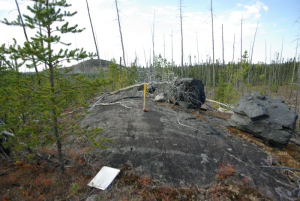
Pegmatite outcrop on the property
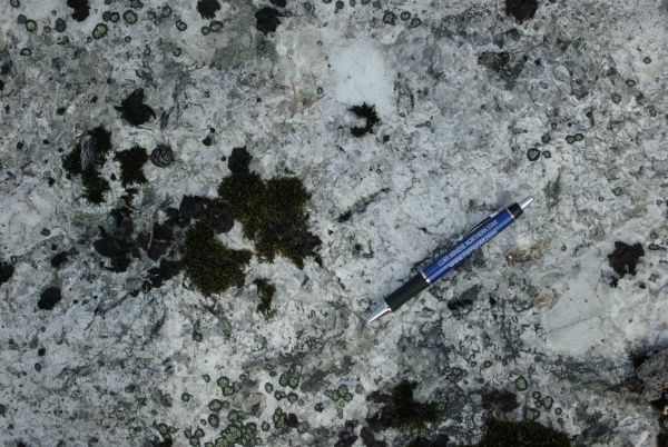
Close-up of a pegmatite outcrop
| SOLUMINES | 6 |
| TUCANA LITHIUM CORP. | NI 43-101 TECHNICAL REPORT, ABIGAIL PROPERTY |
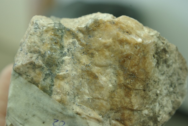
Sample 18070, containing molybdenite (MoS2)
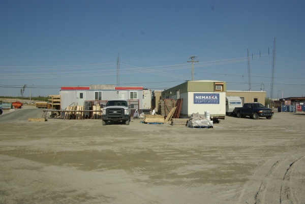
Nemaska facilities at CCDC camp at Nemiscau
| SOLUMINES | 7 |
| TUCANA LITHIUM CORP. | NI 43-101 TECHNICAL REPORT, ABIGAIL PROPERTY |
1.0) SUMMARY
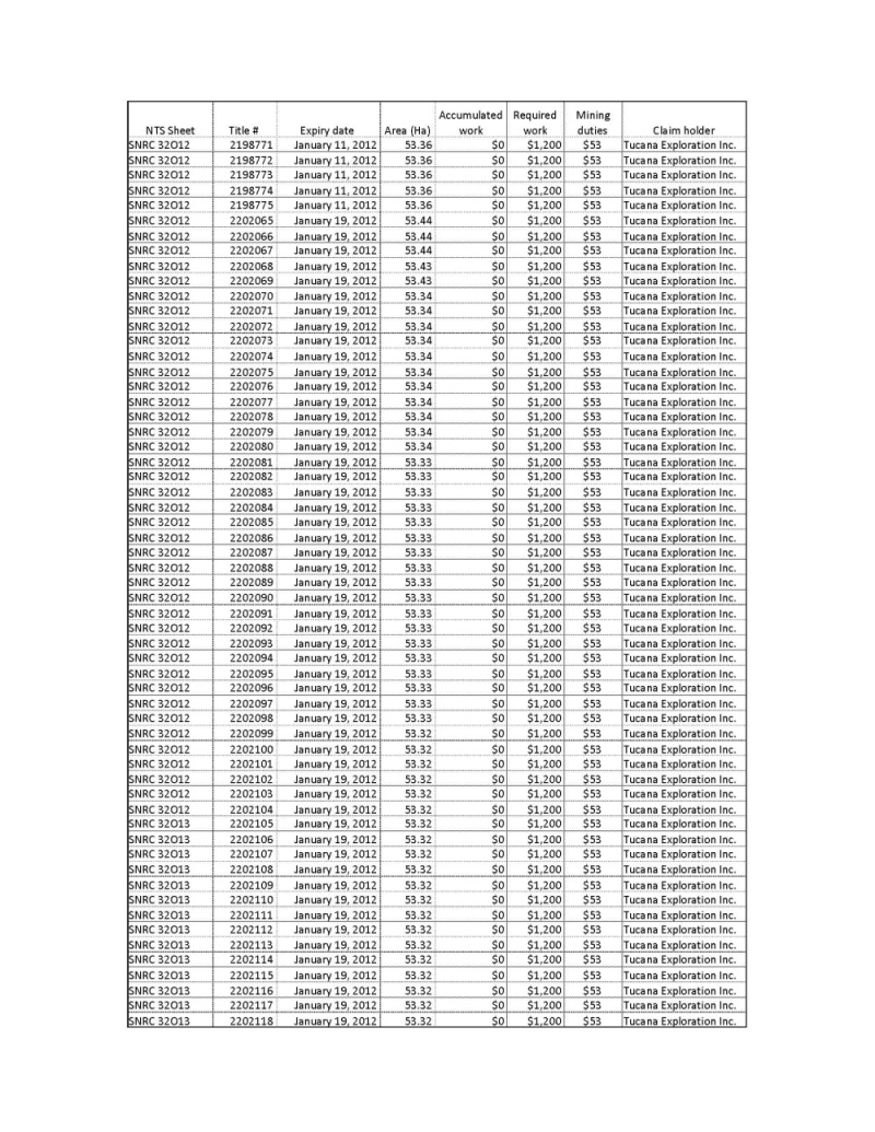
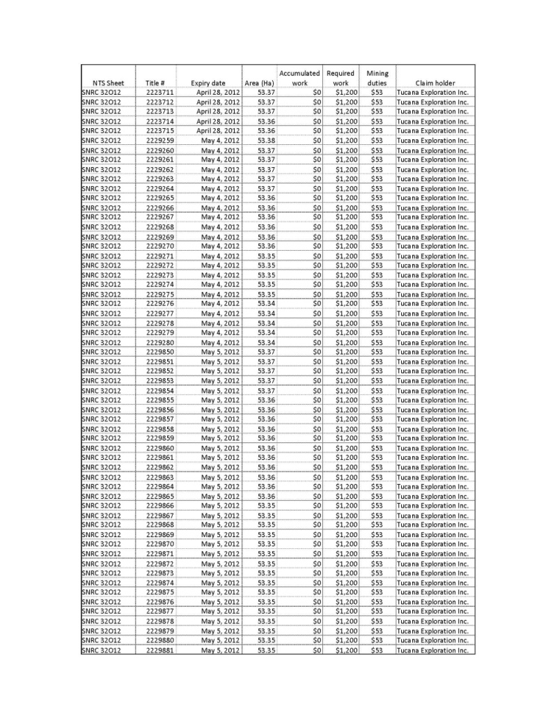
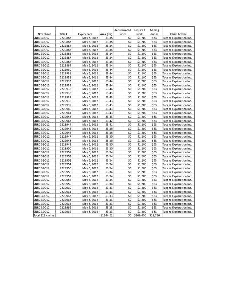
The Abigail property is made up of 222 claims in one claim block, totalling 11,244.52 ha. It is located in the Nemiscau area of Quebec, and more precisely in NTS 32O12 and 32O13. The claims are 100% registered to the name of Tucana Exploration Inc., a wholly owned subsidiary of Tucana Lithium Corp. The claims will expire between January 11 and May 2012. Exploration work in the amount of $266,400 will be required on the next renewal, along with $11,766 in mining duties.
On November 29, 2010, Oteegee Innovations Inc., now Tucana Lithium Corp., signed an agreement with a group of prospectors to acquire a 100% interest in the Abigail property. The agreement calls for cash payments of $250,000 over the first 180 days, and the issuance of 15 million common shares of Oteegee. The remainder of the agreement calls for additional cash payments of $1,250,000 and the issuance of 5 million common shares, ending with the production of a bankable feasibility study. The group of prospectors remains entitled to a 3% NSR on any commercially producing mineral deposit located on the property.
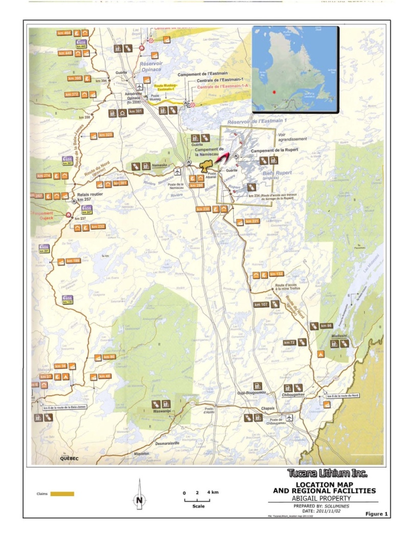
The property is easily accessible, being traversed by the Route du Nord, a main regional road that links the town of Chibougamau, 300 km south, to the village of Nemaska. Because of its size, parts of the property must be accessed by boat, using the network of lakes and rivers, and by foot. Several parts of the property will probably require helicopter support, being too isolated. There are no mining infrastructures on the property. Room and board are provided by CCDC Relais Routier Nemiscau, 23 km west of the property. The Nemiscau airport, located 30 west of the property, is serviced by Air Creebec and chartered flights. To the knowledge of the author, there are no environmental liabilities pertaining to the Abigail property, nor are there any significant factors or risks that could affect access, title, or the right or ability to perform work on the property. Finally, at this latitude, there is no permafrost.
The original claims were map-designated in 2010 by a group of prospectors, and bought in November of that same year by Oteegee Innovations. Historical work done by the Quebec Ministry of Natural Resources can be summarized by two reports. The first is a description of the geology of the area accompanied by a geological map, and was released in 1975 as RG 158. This report outlined the geology of the whole area, including the Lac des Montagnes volcanic belt found on the south part of the property. The other survey was released in 2011 and consisted of an airborne magnetic/gradiometric survey that outlined several magnetic lineaments on the property.
| SOLUMINES | 8 |
| TUCANA LITHIUM CORP. | NI 43-101 TECHNICAL REPORT, ABIGAIL PROPERTY |
Only two mining companies can be considered to have performed historical work on the property, the SDBJ in 1981, with an EM-Input airborne survey, and Westmin from 1986 to 1988, with airborne Dighem survey and minor ground work, mainly prospection and VLF-EM survey. The Dighem survey revealed EM anomalies along a major magnetic lineament, which crosses the south part of the property. Up until now, no drill holes have been reported on the property.
From a geological standpoint, the property can be divided in two parts: north and south of the Route du Nord. The part north of Route du Nord is mainly underlain by paragneiss and diorites, with granite and granodiorites in the extreme north part of the property. Remnants of basaltic flows have been recognized in the paragneiss. This paragneiss is in fact made up of metamorphosed sediments and probably represents a Precambrian sedimentary basin.
The part of the property south of the Route du Nord is mainly underlain by the Lac des Montagnes Formation, a metamorphosed greenstone belt composed of biotite, sillimanite and stauride-bearing schist. Ultramafic to felsic flows along with ultramafic intrusions can be recognized in places in the Lac des Montagnes Formation. A diabase dyke crosses the western part of the property in a NW/SE direction, and an unexplained circular magnetic structure is observed just to the SE of the property.
To date, mineralized zones have yet to be discovered on the property. However, the Whabouchi lithium deposit, owned by Nemaska Exploration, lies just 3 km west of the south part of the property. Five deposit types can be considered to guide exploration of the property; they are as follows:
-Lithium (spodumene)-bearing pegmatites;
-Magmatic nickel sulphide deposits associated with an ultramafic intrusion;
-Volcanogenic massive sulphide (VMS) deposits;
-Uranium and associated elements in pegmatites;
-Chromite deposits.
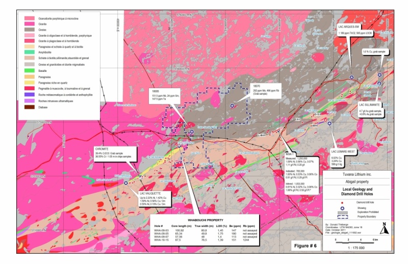
In June 2011, a reconnaissance geology program was carried out on the property by Nemaska Exploration Inc. on behalf of Tucana. More than 2,000 GPS points were recorded and 39 samples were taken and analyzed. Two samples returned slightly anomalous results. The first, numbered 18070, is from a pegmatite visually containing 1% Mo, which returned 292 ppm Mo and 466 ppm Rb. The second, numbered 18005, is from a pink pegmatite and returned 151.5 ppm Nb, 24 ppm Sm and 147.5 ppm Ta. No drilling has been done by Tucana since it purchased the property.
| SOLUMINES | 9 |
| TUCANA LITHIUM CORP. | NI 43-101 TECHNICAL REPORT, ABIGAIL PROPERTY |
The author has reviewed the sample preparation, security and analytical procedure for the samples taken during last summer on the Abigail property. The author is the opinion that no breach of security occurred and that Nemaska took all the necessary steps to keep the samples secure. Preparation and analytical procedures were standard industry practice and adapted to the type of mineral sought. Finally, the author is of the opinion that the results obtained are sound and reliable and were obtained according to industry standards. During the site visit, the author verified several outcrops and all the witness samples taken during the geological survey. All the observations made by the Nemaska geologist correspond to those of the author. The author is of the opinion that the data obtained by Tucana through the geological survey completed by Nemaska geologists is sound and reliable.
The Abigail property is an early stage exploration property. However, it covers highly prospective ground, lying just 3 km east of the Whabouchi lithium deposit owned by Nemaska Exploration. The most recent work by the Quebec Ministry of Natural Resources consists of a magnetic/gradiometric airborne survey released in 2011. This survey covers the whole area, including of course the Abigail property.
This survey is important, because it outlines the main magnetic features of the property. We observe at least three families of magnetic lineaments. The first is oriented at about 070°, and outlines the north boundary of the Lac des Montagnes volcanic belt. The second is oriented at approximately 040° and is located in the paragneiss. The third is oriented NW/SE and has been mapped in the field as a regional diabase dyke.
At this point, the most interesting magnetic feature is the magnetic lineament located on the south part of the property, which seems to outline the north boundary of the volcanic belt. In 1987, Westmin detected several Dighem EM anomalies along this lineament, but did not follow up. This horizon can be fertile, mainly for sulphide-type mineralization.
The geological reconnaissance survey conducted last summer by Nemaska Exploration on the north part of the property revealed two pegmatites with anomalous values. One visually containing 1% Mo returned 292 ppm Mo and 466 ppm Rb, and the other returned 151.5 ppm Nb, 24 ppm Sm and 147.5 ppm Ta. These are anomalous results that should be more thoroughly investigated.
In conclusion, even at this early stage, we can see that Abigail property has a good potential, both for rare earths in pegmatites and for sulphide deposits in volcanics.
| SOLUMINES | 10 |
| TUCANA LITHIUM CORP. | NI 43-101 TECHNICAL REPORT, ABIGAIL PROPERTY |
To fully explore the potential of the property, a two-phase program is recommended. It is described in the proposed budget shown below:
| Phase I (Compilation, geophysical and geological surveys and sampling with 2000 m of drilling) | ||||||
| Work | Quantity | Unit | Unit cost | Total | ||
| Compilation of the EM Input (SDBJ) and Dighem (2007) anomalies (location of anomalies and interpretation) | $10,000 | |||||
| Line cutting (cut every 100 m and picketed every 25 m) on the main coincident Mag and EM anomalies. Provision of 125 km | 125 | km | $550 | $68,750 | ||
| Ground geophysics, EM (MaxMin) and Mag | 125 | km | $350 | $43,750 | ||
| Geology and prospecting on the cut lines and on the north part of the property (including room and board, transportation, etc.) | $100,000 | |||||
| Stripping, trenching and sampling, all inclusive | $50,000 | |||||
| Drilling on the target to be defined ($225/m, all inclusive) | 2,000 | m | $225 | $450,000 | ||
| Report update, NI 43-101 and for statutory purposes | $10,000 | |||||
| Contingency, estimated at 10% | $7,250 | |||||
| Total Phase I | $805,750 | |||||
| Phase II | ||||||
| Provision of 5,000 m of drilling to test the targets defined during Phase I | 5000 | m | $225 | $1,125,000 | ||
| Report update, NI 43-101 and for statutory purposes | $12,000 | |||||
| Contingency, estimated at 10% | $113,700 | |||||
| Total Phase II | $1,250,700 | |||||
| Total Phases I and II | $2,056,450 | |||||
| SOLUMINES | 11 |
| TUCANA LITHIUM CORP. | NI 43-101 TECHNICAL REPORT, ABIGAIL PROPERTY |
2.0) INTRODUCTION
2.1) Recipient
An NI 43-101 technical report on the Abigail property has been prepared at the request of Tucana Lithium Corp. (“Tucana”).
2.2) Terms of Reference
This report provides a summary of the scientific and technical information concerning the exploration activities, both historical and recent, carried out on the Abigail property. Tucana may use this report for the purpose of raising exploration funds, as requested by the regulatory authorities.
2.3) Source of Data and Information
This report is based on the documentation provided by Tucana and the statutory work filed with the Quebec Ministry of Natural Resources and Wildlife (MRNFQ). A complete and detailed list of the documentation used is given in Item 27.0, “References”.
2.4) Scope of the Personal Inspection by the Qualified Person
The author visited the property on October 8, 2011. One day was required for the site visit. The outcrops within walking distance from the Route du Nord were visited. Outcrops located too far away were not visited, but witness samples taken during the geological survey completed in July by Nemaska Exploration geologist were examined. This information is judged reliable by the author, as Nemaska is an exploration company not related to Tucana. No samples were taken or sent for analysis.
Pictures taken during the site visit are included at the beginning of this report under the item “Illustrations”.
| SOLUMINES | 12 |
| TUCANA LITHIUM CORP. | NI 43-101 TECHNICAL REPORT, ABIGAIL PROPERTY |
2.5) Units Used in This Report
Unless otherwise indicated, the units used in this report are in the metric system, amounts are in Canadian dollars, and coordinates are in the UTM system, NAD83, Zone 18.
3.0) RELIANCE ON OTHER EXPERTS
The author did not rely on any other expert in the production of this report. Donald Théberge, Eng., M.B.A., the author of the report, is responsible for all the sections of this technical report.
4.0) PROPERTY DESCRIPTION AND LOCATION
4.1) Area
The property is made up of one claim block totalling 11,844.52 ha.
4.2) Location
The property is located in NTS sheets 32O12 and 32O13. It is made up of 222 claims. Property is approximately centered on UTM coordinates 447,051E / 5,731,194N. Property localization is illustrated at Figure 1, “Location Map and Regional Facilities”.
4.3) Type of Mineral Tenure
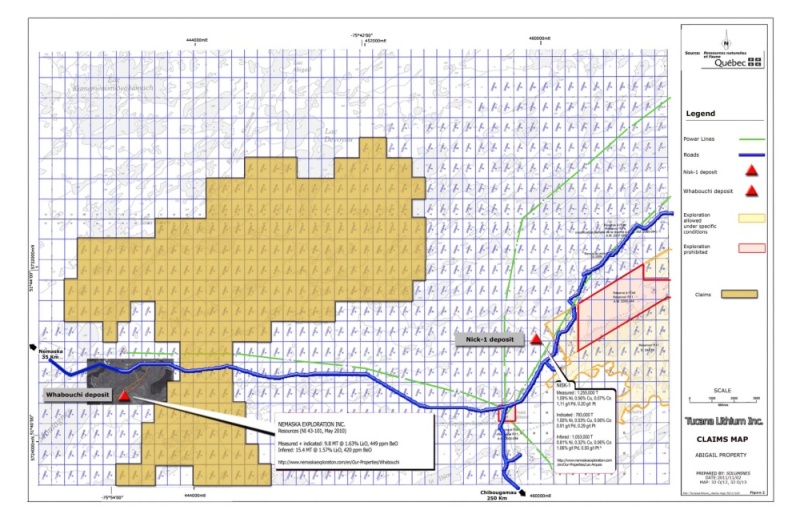
The Abigail property is made up of 222 map-designated claims totalling 11,844.52 ha. All the claims are registered in the name of Tucana Exploration Inc., a wholly owned subsidiary of Tucana Lithium Corp. The claims will expire between January 11 and May 5, 2012. Exploration work in the amount of $266,400 will be required for the next renewal, along with $11,766 in mining duties. At present, no exploration work is accumulated on the claims. However, the geological survey done by Nemaska Exploration Inc. on behalf of Tucana will be recorded in the near future. The claims are described in Schedule 1, "Claims Description", and illustrated in Figure 2, "Claims Map".
| SOLUMINES | 13 |
| TUCANA LITHIUM CORP. | NI 43-101 TECHNICAL REPORT, ABIGAIL PROPERTY |
Figure 1: Location Map and Regional Facilities
| SOLUMINES | 14 |
| TUCANA LITHIUM CORP. | NI 43-101 TECHNICAL REPORT, ABIGAIL PROPERTY |
4.4) Nature and Extent of the Issuer’s Titles
On November 29, 2010, an agreement was signed between Oteegee Innovations Inc., now Tucana Lithium Corp., and a group of prospectors represented by Alain Champagne (‘’Champagne’’). Tucana bought 100% interest in the Abigail property, at the following conditions:
Table 1: Obligations to Fulfill to Obtain a 100% Interest
| Common Shares of Tucana | Cash $ | |
| At signature of the agreement | 15M | |
| 90 days from signature of the agreement | $100,000 | |
| 180 days from signature of the agreement | $150,000 | |
| After incurring a total of $2.5M in exploration | 1M | $250,000 |
| After incurring a total of $5M in exploration | 1M | $250,000 |
| On production of a feasibility study | 1M | $250,000 |
| On production of a bankable feasibility study | 2M | $500,000 |
Tucana also had to secure a minimum financing of $300,000 for an initial exploration program to begin no later than May 16, 2011.
4.5) Property Boundaries
The property boundaries have not been surveyed. They do not need to be surveyed as they are already determined based on the NTS1 coordinates system.
4.6) Royalties
Champagne Group is entitled to a 3% NSR2 on any commercially producing mineral deposit located on the property.
| SOLUMINES | 15 |
| TUCANA LITHIUM CORP. | NI 43-101 TECHNICAL REPORT, ABIGAIL PROPERTY |
Figure 2: Claims Map
| SOLUMINES | 16 |
| TUCANA LITHIUM CORP. | NI 43-101 TECHNICAL REPORT, ABIGAIL PROPERTY |
4.7) Environmental Liabilities
To the knowledge of the author, there are no environmental liabilities pertaining to the Abigail property.
4.8) Required Permits
The only permit required to conduct exploration work on the property is the usual forestry management permit. Tucana must also comply with all the environmental laws and regulations that may apply to the type of work done.
4.9) Significant Factors and Risks
To the knowledge of the author, there are no significant factors or risks that could affect access, title or the right or ability to perform work on the property.
5.0) ACCESSIBILITY, CLIMATE, LOCAL RESOURCES, INFRASTRUCTURE AND PHYSIOGRAPHY
5.1) Topography, Elevation, Vegetation and Drainage
The topography of the area is relatively hilly, with elevations ranging from 275 to 415 m above sea level. Hills are usually due to more competent rocks, mainly diabase dykes and pegmatites. About 20% of the property is covered by lakes and rivers. A forest fire devastated the area several years ago. The property is covered by a taiga type forest, which is mainly made up of spruce and lichens. Glacial deposits exist in the form of unsorted boulders and till. Overburden depth varies from 0 to 25 m. At this latitude there is no permafrost.
| SOLUMINES | 17 |
| TUCANA LITHIUM CORP. | NI 43-101 TECHNICAL REPORT, ABIGAIL PROPERTY |
5.2) Accessibility
The south central part of the property is traversed by the “Route du Nord”. This permanent gravel road originates in the town of Chibougamau approximately 300 km to the SSE, and leads to the village of Nemaska and the Route de la Baie James. Because the Route du Nord is the only road crossing the property, a helicopter and/or a boat must be used to access certain parts of the property. A Hydro-Quebec powerline is located on the property, along the Route du Nord. Figure 1 shows the location of the property relative to the facilities in this area.
5.3) Infrastructure
There is no mining infrastructure on the property. However, Hydro-Quebec has several facilities in the area of the property, including the Albanel and Nemiscau substations. The CCDC (Cree Construction and Development Corporation) Nemiscau Relais Routier, located 23 km to the west, can be used to house workers and service the property. The Nemiscau airport, located 30 km west of the property, is serviced by Air Creebec and chartered flights.
5.4) Climate
The prevailing climate in the Abigail property area is subarctic, with moderate continental precipitation. There is no permafrost, but the ground can freeze to a depth of 2 m. Winter temperatures can reach as low as -40°C. The months of December, January and February and the first half of March are particularly cold, with temperatures averaging -20°C. Summer temperatures average around 15°C. Average annual precipitation is 800 mm. These are normal conditions for northern Quebec, and do not hamper either exploration or mining work.
| SOLUMINES | 18 |
| TUCANA LITHIUM CORP. | NI 43-101 TECHNICAL REPORT, ABIGAIL PROPERTY |
6.0) HISTORY
6.1) Ownership History
In 2010, the Abigail property was acquired by the Champagne group by staking. Nicole Arpin designated 160 cells and Alain Champagne designated 62 cells for a total of 222 cells. Later during that same year, in November 2010, Oteegee Innovations Inc., now Tucana Lithium Corp., bought the Abigail property under the terms of an agreement described in Item 4.4 of this report.
6.2) Work Done by the MRNFQ
The work done by the MRNFQ consisted of geological mapping by Valiquette, first reported in RP 500(a) and RP 518(a), two reports that were combined in 1975 into RG 158. The geology of the property as shown in the figure entitled “Property Geology and Diamond Drilling” is from the geological survey done by Valiquette. The Valiquette map is the only published geological map that covers the area to date.
Around 1997-98, the MRNFQ released the results of a large-scale lake bottom sediment survey. The results are now included in the MRNFQ Sigeom database. In 2010, the results of a re-analysis of more than 27,000 samples collected in the James Bay area were published. This re-analysis was done with a more precise analytical method than the one first used, with a lower detection limit.
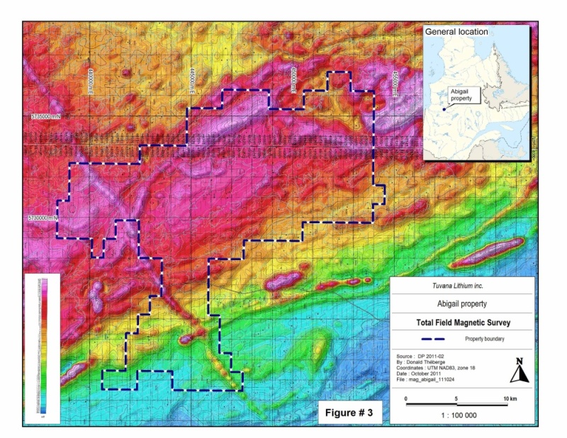
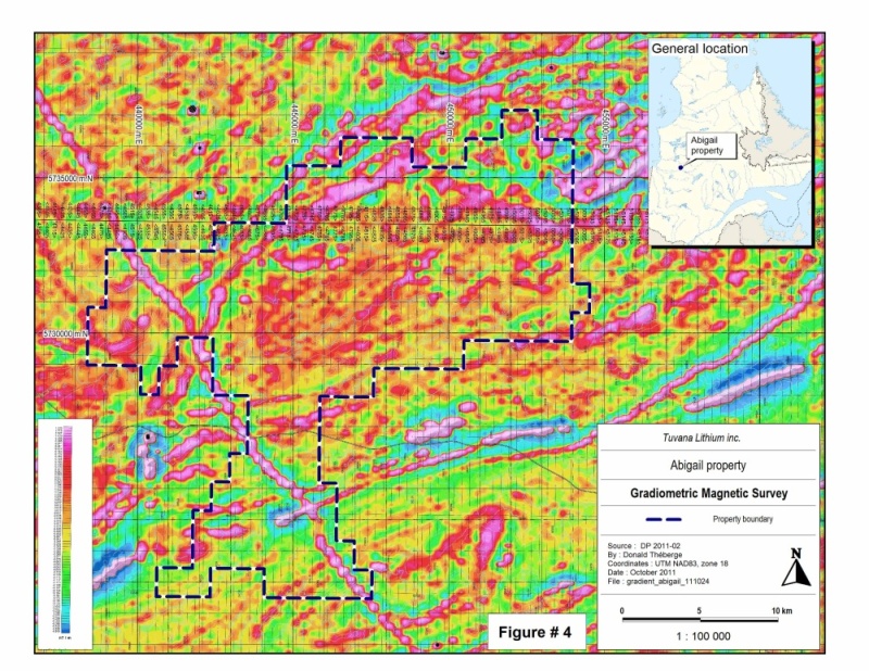
Finally, in 2011, an airborne magnetic and gradiometric survey was completed by Goldak Airborne Surveys on behalf of the MRNFQ. Flights lines were oriented north/south with a spacing of 250 m and east/west control lines every 2,500 m. Unfortunately, the EM was not flown. The purpose of this survey was to find magnetic anomalies for kimberlite targets. Three kimberlite targets were discovered in the immediate vicinity of the Abigail property, from one to three kilometres to the north/west. The results of this survey were disclosed in report DP 2011-02, and are illustrated in Figure 3, Total Field Magnetic Survey”, and Figure 4, “ Gradiometric Magnetic Survey”.
| SOLUMINES | 19 |
| TUCANA LITHIUM CORP. | NI 43-101 TECHNICAL REPORT, ABIGAIL PROPERTY |
Figure 3: Total Field Magnetic Survey
| SOLUMINES | 20 |
| TUCANA LITHIUM CORP. | NI 43-101 TECHNICAL REPORT, ABIGAIL PROPERTY |
Figure 4: Gradiometric Magnetic Survey
| SOLUMINES | 21 |
| TUCANA LITHIUM CORP. | NI 43-101 TECHNICAL REPORT, ABIGAIL PROPERTY |
6.3) Work Done by Mining Companies
In 1981, the SDBJ completed an EM-Input and magnetic survey covering all the property and reported under GM 38445. This is the only exploration work reported on the part of the property north of the Route du Nord. South of that same road, the only work reported was done by Westmin Resources from 1986 to 1988.
In 1986, Westmin carried out some prospecting and several EM-VLF traverses to try to locate Input anomalies identified by the SDBJ survey of 1981. In 1987, Westmin did an airborne Dighem III and magnetic survey. In a report dated November 1987, Betz interpreted the Dighem III survey as follows: “Several magnetic and electromagnetic trends were established, among which there were three definite bedrock conductors. The co-linear aspect of these conductors, combined with the large electrical conductance and direct magnetic response, is highly suggestive of lenses of massive sulphides along a common geological contact”1.
These anomalies are located in part on the Abigail property, and are associated with a magnetic lineament. Westmin did not report any follow-up on these anomalies. No historical drilling has been recorded on the Abigail property.
6.4) Mineral Resources and Mineral Production from the Property
Mineral resources have never been estimated, and no production has ever occurred on the Abigail property.
3Betz, J., (1987): Geophysical Review and Recommendations, Lac Noir Claim Block Nemiscau Project, Québec.
Westmin Resources, GM 46064.
| SOLUMINES | 22 |
| TUCANA LITHIUM CORP. | NI 43-101 TECHNICAL REPORT, ABIGAIL PROPERTY |
7.0) GEOLOGICAL SETTING AND MINERALIZATION
7.1) Regional Geology
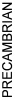
The Abigail property is located in the north-eastern part of the Superior Province, which itself lies in the heart of the Canadian Shield. The Superior Province extends from Manitoba to Quebec, and is mainly made up of Archean rocks. The general metamorphism is at the greenschist facies, except in the vicinity of intrusive bodies, where it can go to the amphibolite-to-granulite facies. According to Card and Ciesielski (1986), the area covered by the property is located in the Opinaca or Nemiscau sub-province. The regional geology is illustrated in figure 5: “Regional Geology”
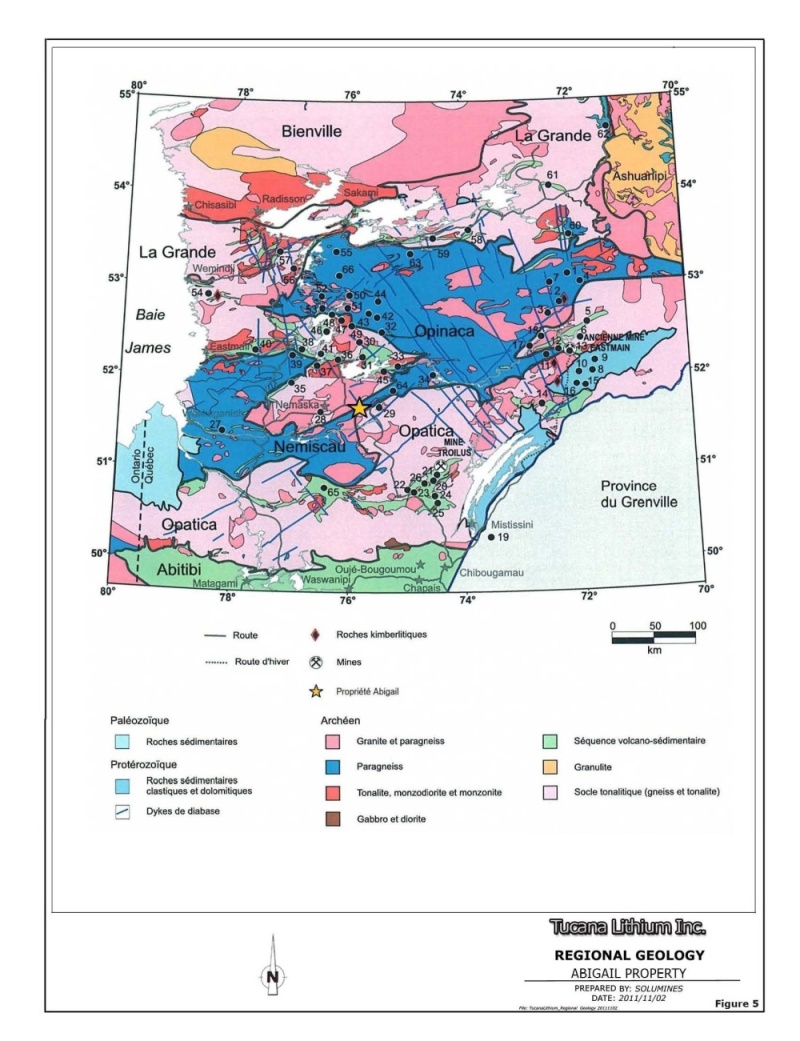
7.2) Local Geology
The Abigail property is located in a gneissic formation, between the Lac des Montagnes volcano-sedimentary belt and the Champion Lake granitoid. The geology of this area is not well known. However, the geological maps by Valiquette reveal the presence of basalt and/or amphibolite remnants in a gneissic formation intruded by granites. The geological formations strike at 045º and, like all the rocks of this area with the exception of the pegmatites, are strongly deformed. The position of the property relative to the Lac des Montagnes belt and the Champion Lake terrains is shown in Figure 6, “Local Geology and Diamond Drilling”. The geological formations in the area are summarized as follows:
Table 2: Table of Formations
| Pleistocene and Holocene | Moraines, eskers, alluvial deposits, reticulated peat bogs, morainic belts |
 | 11: Diabase |
10: Pegmatites a) White with muscovite, tourmaline, garnet and magnetite b) Pink, with microcline | |
| 9: White and pink granite | |
| 8: Grey hornblende-oligoclase granite with phenocrists of pink microcline | |
| 7: Ultramafic rocks: Serpentinites, tremolite rocks | |
| 6: Hornblende-plagioclase gneiss | |
| 5: Metasomatic anthophyllite-cordierite rocks | |
4: Paragneiss or biotite schists; garnet-biotite schists; porphyroblastic schist: Garnet, sillimanite, biotite Garnet, cordierite, biotite Garnet, andalousite, biotite Staurotide, sillimanite, andalousite, biotite Sillimanite, cordierite, andalousite, biotite Amphibole paragneiss | |
| 3: Quartz-rich paragneiss; sillimanite, sericite and quartz schist; impure quartzite | |
| 2: Pillowed metavolcanic amphibolites | |
| 1: Oligoclase gneiss |
| SOLUMINES | 23 |
| TUCANA LITHIUM CORP. | NI 43-101 TECHNICAL REPORT, ABIGAIL PROPERTY |
Figure 5: Regional Geology
| SOLUMINES | 24 |
| TUCANA LITHIUM CORP. | NI 43-101 TECHNICAL REPORT, ABIGAIL PROPERTY |
Figure 6: Local Geology and Diamond Drilling
| SOLUMINES | 25 |
| TUCANA LITHIUM CORP. | NI 43-101 TECHNICAL REPORT, ABIGAIL PROPERTY |
7.3) Property Geology
From a geological standpoint, the property can be divided in two parts, the north and south of Route du Nord. The part north of Route du Nord is mainly underlain by paragneiss and diorites, with granite and granodiorites in the extreme north part of the property. Remnants of basaltic flows have been recognized in the paragneiss. This paragneiss is in fact made of metamorphosed sediments and probably represent a Precambrian sedimentary basin.
The part of the property south of the Route du Nord is mainly underlain by the Lac des Montagnes Formation, a metamorphosed greenstone belt made of biotite, sillimanite and staurotide-bearing schist. Ultramafic to felsic flows, along with ultramafic intrusions, can be recognized in places in the Lac des Montagnes Formation.
Finally, a diabase dyke crosses the western part of the property in a NW/SE direction, and an unexplained circular magnetic structure is observed just to the SE of the property.
7.4) Mineralized zones
To date, mineralized zones have yet to be discovered on the property. However, the Whabouchi lithium deposit lies just 3 km west of the south part of the property. The NI 43-101 resource estimate for the Whabouchi deposit is given as follow on the Nemaska website (www.nemaskaexploration.com):
| Resource Category | Metric tonnes | Grade Li2O (%) | Grade BeO (ppm) |
| Measured | 1,885,000 | 1,60 | 458 |
| Indicated | 7,889,000 | 1,64 | 456 |
| Total | 9,774,000 | 1,63 | 449 |
| Inferred | 15,396,000 | 1,57 | 420 |
Please note that the qualified person was unable to verify this information, and that this information is not necessarily indicative of mineralization on the property.
| SOLUMINES | 26 |
| TUCANA LITHIUM CORP. | NI 43-101 TECHNICAL REPORT, ABIGAIL PROPERTY |
8.0) DEPOSIT TYPES
The geology of the property is relatively complex and unexplored. At this point, five types of deposit may occur on the property. They are described below:
| ● | Lithium (spodumene)-bearing pegmatites |
In 1962-63, a lithium occurrence was discovered in a pegmatite close to the boundary of the gneissic formation and the Lac des Montagnes belt, about 3 km west of the Abigail property. Values of up to 2.34% Li2O, 0.13% BeO/6.4 m and 2.63% Li2O, 0.16% BeO/6.4 m in Hole 14891 and 1.44% Li2O over 83.2 m in Hole 24042 were reported in GM 57880 by Canico. Forty years later, Inco re-sampled the same pegmatite for its tantalum content and obtained 0.026% Ta over 1.0 m and 3.53% Li2O also over 1.0 m in channel samples. This spodumene1-bearing pegmatite is now owned by Nemaska Exploration Inc., and is known as the Whabouchi property. The resource estimate for Whabouchi deposit is given in the preceding item.
| ● | Magmatic nickel sulphide deposits associated with an ultramafic intrusion |
In 2008, Golden Goose produced an updated resource estimate for the Nisk-1 deposit (Lac Levac property), located about 7 km SE of the property. The Nisk-1 deposit is located close to the boundary between the gneissic formation and the Lac des Montagnes belt. It is related to an ultramafic intrusion that cuts the surrounding rocks. Nisk-1 was described by Pierre Trudel, Eng, Ph.D.2, as a magmatic nickel sulphide deposit associated with an ultramafic intrusion. Known orebodies of this type are Voisey’s Bay (Labrador) and Lynn Lake (Manitoba). The NI 43-101 resource reported by Golden Goose is shown in Table 3.
Table 3: Nisk-1 Resource3
Resource category | Tonnes (millions) | Ni % | Cu % | Co % | Pd (g/t) | Pt (g/t) |
| Measured | 1.255 | 1.09 | 0.56 | 0.07 | 1.11 | 0.2 |
| Indicated | 0.783 | 1 | 0.53 | 0.06 | 0.91 | 0.29 |
| Inferred | 1.053 | 0.81 | 0.32 | 0.06 | 1.06 | 0.5 |
Please note that the qualified person was unable to verify this information, and that this information is not necessarily indicative of mineralization on the property.
| SOLUMINES | 27 |
| TUCANA LITHIUM CORP. | NI 43-101 TECHNICAL REPORT, ABIGAIL PROPERTY |
| ● | Volcanogenic Massive Sulphide (VMS) deposits |
As the property covers part of the Lac des Montagnes volcano-sedimentary formation, volcanogenic massive sulphide (VMS) type deposits associated with metamorphosed intermediate-to-felsic volcanics should be considered. Known examples of this type of deposit, albeit in less metamorphosed formations, are the Horne Mine in Rouyn-Noranda and the Matagami Lake Mine in Matagami.
| ● | Uranium and associated elements in pegmatites |
A uranium–thorium occurrence was discovered around 1978 in a pegmatite with 1,189 ppm ThO2 and 565 ppm U3O8, approximately 15 km ENE of the property in a pegmatite located within the same gneissic formation. It is identified on the map in Figure 6, “Property Geology and Diamond Drill Holes” as the Lac Arques SW occurrence.
| ● | Chromite deposits |
Since the early sixties, chromite occurrences have been known to occur in the Lac des Montagnes area, close to the SE shore of Lac des Montagnes, at the base of an ultramafic intrusion west of the Abigail property. Over the years, Noranda, Inco, Canex Placer, SDBJ, Freewest and Muscocho Explorations have worked on these chromite showings. In 1978, SDBJ reported a grade of 30.87% Cr with 11.84% Fe in a grab sample, for a Cr/Fe ration of 2.6. In 1988, Freewest obtained 36.55% Cr in a chip sample, over a length of 1.05 m.
9.0) EXPLORATION
From June 7 to 28, 2011, prospecting, reconnaissance geology and sampling were done on the Abigail property. Nemaska Exploration, an exploration company not related to Tucana, executed the exploration work on behalf of Tucana. Nemaska Exploration’s head office is located at 450, rue de la Gare du Palais, Québec (Québec) G1K 3X2. For the exploration program on Abigail, Nemaska geologists were housed at CCDC1 camp, located at Nemiscau. The exploration program was directed by Yvan Bussières, Ing., a consultant for Nemaska Exploration, and supervised by Yves Caron, M.Sc., Geo., Vice President Exploration for Nemaska.
| SOLUMINES | 28 |
| TUCANA LITHIUM CORP. | NI 43-101 TECHNICAL REPORT, ABIGAIL PROPERTY |
The purpose of the exploration program was mainly to locate mineralized pegmatites, but also any other kind of economic mineralization. In all, 2005 GPS1 points were recorded, and 39 samples were taken and analyzed.
The exploration program was mainly a geological reconnaissance program. Several short traverses were completed south of the Route du Nord, but the bulk of the work was concentrated on the part north of that same road.
The various parts of the property were accessed by boat and by foot. All the pegmatite outcrops mapped were sampled and analyzed for 35 elements, namely: Li, Be, Ba, Ce, Co, Cr, Cs, Dy, Er, Eu, Ga, Gd, Hf, Ho, La, Lu, Mo, Nb, Nd, Pr, Rb, Sm, Sn, Sr, Ta, Tb, Th, Tl, Tm, U, V, W, Y, Yb and Zr. Three amphibolite samples were assayed for Au, Pt, Pd, Ag, Al, As, B, Ba, Bi, Ca, Cd, Co, Cr, Cu, Fe, Ga, K, Mg, Mn, Mo, Na, Ni, P, S, Sb, Sc, Sr, Ti, V and Zn.
Several magnetic anomalies detected using a Beep-Mat2 were exposed, and were explained by primary magnetite in the rocks. Many outcrops also contained hematite and magnetite. A diabase dyke striking NW/SE crosses the west part of the property. Generally, outcrops are oriented according to the regional foliation, from 050° to 070°. No faults or major folding were observed in the field.
Two samples returned slightly anomalous results. The first one, numbered 18070 (451,250E / 5,733,032N) is from a pegmatite visually containing 1% Mo, which returned 292 ppm Mo, 466 ppm Rb. The second one, numbered 18005 (443782E / 5,728,239N), is from a pink pegmatite, and returned 151.5 ppm Nb, 24 ppm Sm and 147.5 ppm Ta. Geology of the property is illustrated in figure 7: “Property Geology and outcrops visited”, and sample location is shown at figure 8.
10.0) DRILLING
No drilling has been completed by the issuer and no drilling was reported in the past.
| SOLUMINES | 29 |
| TUCANA LITHIUM CORP. | NI 43-101 TECHNICAL REPORT, ABIGAIL PROPERTY |
Figure 7: Property Geology and outcrops visited

| SOLUMINES | 30 |
| TUCANA LITHIUM CORP. | NI 43-101 TECHNICAL REPORT, ABIGAIL PROPERTY |
Figure 8: Samples location
| SOLUMINES | 31 |
| TUCANA LITHIUM CORP. | NI 43-101 TECHNICAL REPORT, ABIGAIL PROPERTY |
11.0) SAMPLE PREPARATION, ANALYSES AND SECURITY
11.1) Sampling method
All the samples taken were grab samples, chosen for their mineralization and/or alteration content, to evaluate their concentration in Au, Cu, Ni, Zn, Pb, Cr, Pd, Pt Ag, Co, Li and Be. Samples were taken using a hammer and a cold chisel, then identified and put in a sample bag, which was then sealed. Average sample weight was approximately 1 kg. Grab sample locations were recorded using a Garmin GPS Map 60Cx GPS instrument. The whole sampling process was under the supervision of a junior engineer or geologist. The sample list was updated on a daily basis.
Samples were mainly taken from pegmatites, but also from granitoid, gabbro, basalts and diabases. Samples were taken where mineralization was seen or suspected, like pegmatite and rusted and/or silicified zones, and when sulphides were observed. A total of 39 samples were taken and sent for assaying. Sampling was not systematic, but was representative of the mineralization observed.
11.2) Sample Preparation
Once at the Nemaska camp in Nemsicau, samples were put in bags, with 10 to 15 samples per bag. They were then sealed and transported to Chibougamau by Nemaska personnel. In Chibougamau, they were left at the TJCM1 for preparation. Here, each sample was crushed and pulverized. The pulverized part is called the pulp. Once ready, these pulps are sent to ALS Minerals in Val-d’Or using Expedibus Services.
11.3) Sample analysis
Samples were analyzed by ALS Minerals, located at 1322, rue Harricana, Val-d’Or (Québec), J9P 3X6. The analytical methods used correspond to ALS code PGM-ICP23, ME-ICP41, ME-MS81, Li-OG63 and Be-ICP61. The two first codes were only used on three samples to detect precious and base metals; the other three methods were used for the remaining 36 samples.
| SOLUMINES | 32 |
| TUCANA LITHIUM CORP. | NI 43-101 TECHNICAL REPORT, ABIGAIL PROPERTY |
Preparation for platinum group element (PGE) and gold assaying was done using the PGM-ICP23 method, on an average sample weight of 30 g. This is a lead fusion with an ICP-AES1 finish. To detect the other elements, the pulverized fraction was analyzed for 35 elements using the ME-ICP41 method. This method consists of an aqua regia2 digestion, with ICP-AES analysis.
Finally, the ME-MS81 method (33 elements analyzed) was mainly used for pegmatite samples. This method is oriented towards the search for trace and rare-earth elements. It uses a lithium borate fusion for digestion, followed by ICP-MS3 analysis. Digestion using lithium borate fusion is recognized as more aggressive than aqua regia or four-acid4 digestion, which give a better result for refractory minerals. The Li-OG63 and Be-ICP61 analytical methods with a four-acid digestion were chosen to assay for lithium and beryllium, which are not included in the ME-MS81 method.
11.4) Quality control procedures
The main quality control was the quality control done by the laboratory, which included re-analysis of samples, and analysis of blanks and standards. The results obtained were satisfactory. Internal control by Nemaska Exploration consisted of the insertion of two standard samples with a low lithium content; in this case, too, the assay results were as expected, showing the high quality of the analyses performed.
11.5) Author opinion on the adequacy of sample preparation, security and analytical procedure
The author has reviewed the sample preparation, security and analytical procedure used for the samples taken last summer on the Abigail property. The author is of the opinion that no breach of security occurred and that Nemaska took all the necessary steps to keep the samples secure. Sample preparation and analytical procedures were in accordance with standard industry practice and were adapted to the type of mineral sought. Finally, the author is of the opinion that the results obtained are sound and reliable and were obtained in accordance with industry standards.
| SOLUMINES | 33 |
| TUCANA LITHIUM CORP. | NI 43-101 TECHNICAL REPORT, ABIGAIL PROPERTY |
12.0) DATA VERIFICATION
During the site visit, the author verified several outcrops and all the witness samples taken during the geological survey. All the observations made by the Nemaska geologist corresponded to those of the author. The author is of the opinion that the data obtained by Tucana through the geological survey completed by Nemaska geologists is sound and reliable.
13.0) MINERAL PROCESSING AND METALLURGICAL TESTING
Mineral processing and metallurgical testing have never been done on the Abigail property.
14.0) MINERAL RESOURCE ESTIMATES
Mineral resources have never been estimated on the Abigail property.
15 TO 22: DO NOT APPLY TO THE ABIGAIL PROPERTY
The property is still at an early stage of exploration, and in this case items 15 to 22 do not apply to the Abigail property.
23.0) ADJACENT PROPERTIES
Nemaska Exploration’s Whabouchi property is adjacent to the Abigail property to the west. The Whabouchi lithium deposit lies about 3 km west of the property. Resources for the Whabouchi deposit have already been described in this report under Item 7.4, “Mineralized Zones”.
24.0) OTHER RELEVANT DATA AND INFORMATION
All the relevant data and information have been provided in the preceding sections.
| SOLUMINES | 34 |
| TUCANA LITHIUM CORP. | NI 43-101 TECHNICAL REPORT, ABIGAIL PROPERTY |
25.0) INTERPRETATION AND CONCLUSIONS
The Abigail property is an early stage exploration property. However, it covers highly prospective ground, being located just 3 km east of the Whabouchi lithium deposit owned by Nemaska Exploration. The most recent work by the Quebec Ministry of Natural resources consists of a magnetic/gradiometric airborne survey released in 2011. This survey covers the entire area, including, of course, the Abigail property.
This survey is important, because it outlines the main magnetic features of the property. We observe at least three families of magnetic lineaments. The first is oriented at about 070°, and outlines the northern boundary of the Lac des Montagnes volcanic belt. The second is oriented approximately at 040° and is located in the paragneiss. The third is oriented NW/SE and has been mapped in the field as a regional diabase dyke.
At this point, the most interesting magnetic feature is the magnetic lineament located on the south part of the property, which appears to outline the northern boundary of the volcanic belt. In 1987, Westmin detected several Dighem EM anomalies along this lineament, but did not follow up. This horizon can be fertile, mainly for sulphide-type mineralization.
The geological reconnaissance survey conducted last summer by Nemaska Exploration on the north part of the property revealed two pegmatites with anomalous values. One visually containing 1% Mo returned 292 ppm Mo and 466 ppm Rb, and the other returned 151.5 ppm Nb, 24 ppm Sm and 147.5 ppm Ta. These are anomalous results that should be more thoroughly explored.
In conclusion, even at this early stage, we can see that Abigail property has good potential, mainly for rare earths in pegmatites and for sulphide deposits in volcanics.
| SOLUMINES | 35 |
| TUCANA LITHIUM CORP. | NI 43-101 TECHNICAL REPORT, ABIGAIL PROPERTY |
26.0) RECOMMENDATIONS
To fully explore the potential of the property, a two-phase program is recommended. Work recommended in Phase I is as follows:
-The most recent airborne survey released in 2011 by the Quebec Ministry of Natural Resources did not include an EM survey, which can detect metallic mineralization. At this point, the EM anomalies generated by the EM-Input airborne survey done by SDBJ in 1981 and the Dighem airborne survey done by Westmin in 1987 should be compiled and reinterpreted in light of the new airborne magnetic/gradiometric survey;
-Line cutting with lines cut every 100 m and picketed every 25 m, where coincident magnetic and EM anomalies are located. A provision for 125 km of line cutting is suggested;
-Ground geophysics on the cut lines (magnetic and EM – MaxMin), to precisely locate the anomalies;
-Geology and prospecting on the cut lines, and continued reconnaissance on the north part of the property;
-Stripping and trenching on the sub-cropping anomalies;
-Finally, 2,000 m of diamond drilling is recommended to test the discovered anomalies.
If warranted by the results of Phase I, a second phase is recommended, including 5,000 m of drilling to test the targets identified in Phase I.
The proposed budget to complete both phases of the exploration program is shown on next page.
| SOLUMINES | 36 |
| TUCANA LITHIUM CORP. | NI 43-101 TECHNICAL REPORT, ABIGAIL PROPERTY |
Table 4: Budget
| Phase I (Compilation, geophysical and geological surveys and sampling with 2000 m of drilling) | ||||||
| Work | Quantity | Unit | Unit cost | Total | ||
| Compilation of the EM Input (SDBJ) and Dighem (2007) anomalies (location of anomalies and interpretation) | $10,000 | |||||
| Line cutting (cut every 100 m and picketed every 25 m) on the main coincident Mag and EM anomalies. Provision of 125 km | 125 | km | $550 | $68,750 | ||
| Ground geophysics, EM (MaxMin) and Mag | 125 | km | $350 | $43,750 | ||
| Geology and prospecting on the cut lines and on the north part of the property (including room and board, transportation, etc.) | $100,000 | |||||
| Stripping, trenching and sampling, all inclusive | $50,000 | |||||
| Drilling on the target to be defined ($225/m, all inclusive) | 2,000 | m | $225 | $450,000 | ||
| Report update, NI 43-101 and for statutory purposes | $10,000 | |||||
| Contingency, estimated at 10% | $7, 250 | |||||
| Total Phase I | $805,750 | |||||
| Phase II | ||||||
| Provision of 5,000 m of drilling to test the targets defined during Phase I | 5000 | m | $225 | $1,125,000 | ||
| Report update, NI 43-101 and for statutory purposes | $12,000 | |||||
| Contingency, estimated at 10% | $113,700 | |||||
| Total Phase II | $1,250,700 | |||||
| Total Phases I and II | $2,056,450 | |||||
| SOLUMINES | 37 |
| TUCANA LITHIUM CORP. | NI 43-101 TECHNICAL REPORT, ABIGAIL PROPERTY |
27.0) REFERENCES
27.1) MRNFQ Reports
D’Amours, I., (2011): Levé magnétique aéroporté de la partie sud-est de la sous-province de Nemiscau et de la partie nord de la sous-province d’Opatica, Baie James, Québec. MRNFQ, DP 2011-02.
Card, K.D., and Ciesielski, A., (1986): DNAG #1. Subdivisions of the Superior Province of the Canadian Shield. Geoscience Canada.
Hocq, M., (1994): La Province du Supérieur; in Géologie du Québec, (ed.) M. Hocq, P. Verpaelst, T. Clark, D. Lamothe, D. Brisebois, J. Brun, G. Martineau, Les publications du Québec, p. 7-20. MM94- 01.
Lamothe, D., (2009): Évaluation du potentiel minéral pour les gîtes porphyriques de Cu-Au +-Mo, de la Baie James. MRNFQ EP 2009-01.
Moukshil, L.A., Legault, M., Boily, M., Doyon, J., Sawyer, E., et Davis, D.W., (2002): Synthèse géologique et métallogénique de la ceinture de roches vertes de la moyenne et de la basse Eastmain (Baie James). Ministère des Ressources Naturelles du Québec, ET 2002-06, ET 2007-01.
MRN (1998): Résultats d’analyse de sédiments de fond de lacs, grand nord du Québec. Ministère des Ressources Naturelles, Gouvernement du Québec, DP 98-01.
MRNF (2010): Résumés des conférences et des photoprésentations, Québec Exploration 2010. Ministère des Ressources Naturelles et de la Faune, Gouvernement du Québec, DV 2010-06.
Parent, M., (2011): Compilation géochronologique U-Pb des sous-provinces d’Ashuanipi, d’Opinaca d’Opatica et de La Grande. MRNFQ., GM 65524.
Perreault, S., Houle, P., Doucet, P., Moorhead, J., Côté, S., Moukhsil, A., Lachance, S., Bellemare, Y., Togola, N., Gosselin, C., et Buteau, P., (2006): Rapport sur les activités d’exploration minière au Québec 2005, Ministère des Ressources Naturelles et de la Faune, DV 2006-01, 102 pages.
Valiquette, G., (1975): Rapport géologique, Région de la rivière Némiscau, Ministère des Richesses Naturelles, Direction générale des mines, RG 158.
Valiquette, G., (1965): Preliminary Report, Geology of Cramoisy Lake Area, Mistassini Territory. Department of Natural Resources, Quebec, RP 534.
Valiquette, G., (1964): Preliminary Report, Geology of Lemare Lake Area, Mistassini Lake Territory. Department of Natural Resources, Quebec, RP 518.
| SOLUMINES | 38 |
| TUCANA LITHIUM CORP. | NI 43-101 TECHNICAL REPORT, ABIGAIL PROPERTY |
27.2) Assessment Reports
Beaupré, M.A., 2007: Évaluation du potentiel minier de la propriété du Lac Levac, située sur le territoire de la Baie James. Rapport technique NI 43-101, Golden Goose Resources, le 16 juillet 2007, filed on www.sedar.com
Betz, J., (1987): Geophysical Review and Recommendations, Lac Noir Claim Block Nemiscau Project, Québec. Westmin Resources, GM 46064.
Boivin, M., (2010): Helicopter-borne magnetic gradiometer survey, Nemiscau, Quebec, NTS map 32O12, Whabouchi project. Nemaska Exploration Inc. GM 65145.
Boivin, M., (2009): Advanced interpretation report of airborne geophysical surveys, Lac Arques property, Quebec, Canada. Nemaska Exploration Inc., GM 64856.
Bussières, Y., Binnion, L., (2010): Propriété Lac Levac, propriété Lac Arques, région de Némiscau, rapport de géologie et prospection. Partie sud-ouest des propriétés Lac Levac et Lac Arques. Été 2010., Nemaska Exploration Inc., GM 65335.
Fortin, R., (1981): Rapport final, levé géophysique aéroporté, régions de Elmer Eastmain, Lac des Montagnes, Lac du Glas, projet S80-5117 par Questor Surveys Ltd et Les Relevés Géophysiques Inc. S.D.B.J., GM 38445.
Kilty, S.J., (1987): Dighem III survey of the Nemiscau area Quebec, for Westmin resources Ltd., GM 44340.
Laferrière, A., (2010): NI 43-101 Technical Report, Mineral Resource Estimation, Whabouchi Lithium Deposit, prepared by SGS Canada Inc. (Geostat) for Nemaska Exploration Inc. www.sedar.com
McConnell, T.J., (1987): Dighem III survey, for Westmin Resources Ltd., Nemiscau Project Quebec by Dighem Surveys and Processing Inc., GM 45242.
Raymond, D., Théberge, D., 2009: NI 43-101 Qualifying Report, Pertaining to: The Lac Arques Property, James Bay Area NTS Sheets 32O/11, 32O/12, 32O/13 and 32O/14, October 5, 2009. Prepared for Nemaska Exploration Inc. and filed on www.sedar.com
Moreau, A., (2008): Interprétation des zones d’affleurements, projet Baie James, Baie James, Québec, Canada. Rapport soumis à Exploration Nemaska Inc., GM 64645.
O’Connor, A., (1988): Assessment report on the 1988 work., Nemiscau area, Quebec. Lac Noir claim block. Westmin Resources Ltd. GM 47923.
Paul, R., (2009): Helicopter-borne magnetic and gamma ray spectrometry geophysical survey, Nemiscau, Quebec. NTS map sheets 32O11, 32O12, 32O13 and 32O14. Data acquisition report. Lac Arques project, preliminary. GM 64761.
Robinson, D., 1986: Assessment report on the 1986 work. Nemiscau area, Quebec. La Hutte and Lac Noir claim blocks. NTS 32O11, 12, 14, for Westmin Resources Ltd. GM 44406.
Théberge, D., (2010): Abigail Property, Executive Summary. Prepared by Solumines.
| SOLUMINES | 39 |
| TUCANA LITHIUM CORP. | NI 43-101 TECHNICAL REPORT, ABIGAIL PROPERTY |
Théberge, D., 2009: NI 43-101 Qualifying Report, Pertaining to: The Whabouchi Property, James Bay Area NTS Sheets 32O/12, October 2, 2009. Prepared for Nemaska Exploration Inc. and filed on www.sedar.com, GM 64710.
Théberge, D., (2008): NI 43-101 qualifying report, pertaining to The Lac Arques property, James Bay area, NTS sheets 32O11, 32O12, 32O13 and 32O14. Prepared for James Bay Resources. GM 64481.
Trudel, P., 2008: Resource Estimate for the Nisk-1 Deposit, Lac Levac Property, Nemiscau, Quebec, NI 43-101 Technical Report. Golden Goose Resources Inc., June 2008, filed on www.sedar.com GM 63867.
27.3) Geoscientific Papers
Sinclair, W.D., (1996): Pegmatites granitiques; dans Géologie des types de gîtes minéraux du Canada, rév. par O.R. Eckstrand, W.D. Sinclair et R.I. Thorpe, Commission géologique du Canada, Géologie du Canada, n°8; (aussi The Geology of North America, vol. P-1, Geological Society of America).
| SOLUMINES | 40 |
| TUCANA LITHIUM CORP. | NI 43-101 TECHNICAL REPORT, ABIGAIL PROPERTY |
SCHEDULE 1
CLAIMS LIST
| SOLUMINES | 41 |