DESCRIPTION OF PROPERTY BY GRANT HARTFORD CORPORATION
PURSUANT TO S.E.C. INDUSTRY GUIDE 7
Grant Hartford Corporation provides the following report on its Nancy Hanks Mine, located in Granite County, Montana, in conformity with Industry Guide 7 promulgated by the United States Securities And Exchange Commission ("the SEC"). The Company's principal business at the present time is the development of the Nancy Hanks Mine.
(1) The location and means of access to the property.
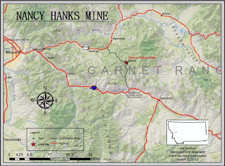
The Nancy Hanks Mine is located in Granite County, Montana, in approximate Section 3, Township 12 North, Range 14 West, M.P.M. Its site coordinates are: Lat/Long 46.82512N 113.34751W; State Plane 1006280E 962440N. There are two principal routes by which the Mine can be accessed:
From Highway 200 - North Access
&nbps; Turn south off of MT Highway 200 on to the Garnet Range Road located 9.5 miles west of Clearwater, MT or 21.4 miles east of Bonner, MT. Proceed south on the Garnet Range Road approximately 9 miles. Look for Nancy Hanks Mine sign on the right or south side of the road. Turn in and follow signs to mine site. The Garnet Range Road is seasonal and is closed from January 1st to April 30th for recreational use.
From Interstate 90 - South Access
&nbps; Turn north on to Bear Gulch Road off of I-90 Frontage Road located approximately 5 miles east of I -90 exit 138 (Bearmouth) or 10.6 miles west of Drummond, MT. Follow Bear Gulch Road approximately 7 miles to the road split. Right road takes Cave Gulch Access approximately 5 miles to the Garnet Ghost Town and the left road is approximately 3 miles to the Garnet Ghost Town via First Chance Gulch. Proceed to Ghost Town Parking lot and Garnet Range Road. Follow Range Road approximately 2 miles towards MT Highway 200. Look for Nancy Hanks Mine Site sign on left or south side of road. Follow signs to mine site. During the period of time that the Garnet Range Road is closed, one can drive through the Ghost Town on the existing road to access the Mine.
Following is a map showing the general location within Montana of the Nancy Hanks Mine.
Description Of Property Pursuant To S.E.C. Industry Guide 7 | Page 1 |
(2) A brief description of the title, claim, lease or option under which the registrant and its subsidiaries have or will have the right to hold or operate the property, indicating any conditions which the registrant must meet in order to obtain or retain the property. If held by leases or options, the expiration dates of such leases or options should be stated. Appropriate maps may be used to portray the locations of significant properties.
The Nancy Hanks Mine is constituted by two patented mining claims (the Nancy Hanks Lode Mining Claim, Survey #5365, and the Dewey And Midnight Lode Mining Claim, Survey No. 9833) and one unpatented mining claim (NHC 016, MMC #217188). Ownership of the claims is vested in Commonwealth Resources, L.L.C., and Grant Hartford's right to mine arises from the terms of an Option Agreement (with two amendments) by and between the owner and Grant Hartford. Under the terms of the option, Grant Hartford is required to make annual option payments to Commonwealth Resources and pay real estate taxes and assessments on the patented claims and the annual retention fee on the unpatented claim. It must exercise its option on or before June 14, 2017 or suffer forfeiture of its right to mine. The purchase price for the 23
Description Of Property Pursuant To S.E.C. Industry Guide 7 | Page 2 |
mineral deeds on patented claims and 122 unpatented claims constituting the optioned property is $7 million. Prior to the option expiration date, Grant Hartford has the right to mine ore from the subject claims, subject to an obligation to pay a net smelter royalty to Commonwealth Resources for such production. Grant Hartford is current in its payment obligations to Commonwealth Resources.
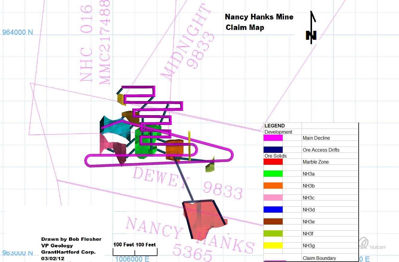
Grant Hartford's right of access is guaranteed by a Non-Exclusive Surface Lease Agreement between it and Commonwealth Resources, the effective date of which was June 15, 2007 and the term of which is co-extensive with the Option Agreement. A map showing the claims which constitute the Nancy Hanks Mine is included in the Supplemental Information packet at Tab 13.
(REMAINDER OF PAGE INTENTIONALLY LEFT BLANK)
Description Of Property Pursuant To S.E.C. Industry Guide 7 | Page 3 |
(3) A brief history of previous operations, including the names of previous operators, insofar as known.
The historical owners of the Garnet mineral property were: Cordoba Corporation and Garnet Mining Corporation between 1989 and 2007; both entities were owned and controlled by Aaron Charlton. Pegasus Gold Corporation ("Pegasus") was a mid-size gold-producing company in the 1980s and mid-1990s that optioned the Garnet Property from Garnet Mining Corporation and Cordoba Corporation, between 1989 and 1993. Pegasus allowed its option to the Garnet mineral property to lapse in 1993 and subsequently filed for bankruptcy in 1998. Pegasus is not affiliated with Grant Hartford or Commonwealth. Trans-Global Resources, N.L., which was an exploration company listed on the Australian Stock Exchange and NASDAQ had a 56% interest in the Garnet Property from 1991 to 1993. Aaron Charlton, our Senior Consultant, was the Chairman of Trans-Global Resources during that period. Western Energy Corporation, a mining exploration subsidiary of the Montana-based power utility, Montana Power Company, conducted exploration of the Garnet Property from 1987 to 1989. American Mining Corporation owned and conducted exploration on the Garnet property between 1966 and 1971. The President of the American Mining Corporation was the late James Charlton, the father of Aaron Charlton. Anaconda Corporation was a major mining company that explored the Garnet Property in the 1960s. Each of the above-mentioned companies compiled geological data from exploration on the Garnet Project. This data was used by Grant Hartford to confirm drilling targets. None of the above-mentioned companies has any current relationship, claim or affiliation to the Garnet Project, Grant Hartford or Commonwealth Resources. None of the above companies have any current relationships or affiliations with related parties to us.
(4)(i) A brief description of the present condition of the property, the work completed by the registrant on the property, the registrant's proposed program of exploration and development, and the current state of exploration and/or development of the property. Mines should be identified as either open-pit or underground. If the property is without known reserves and the proposed program is exploratory in nature, a statement to that effect shall be made.
Excavation of the Nancy Hanks Mine, an underground mine, began in late June of 2011 and then closed in September of 2011. The work was performed by New Millennium Mining, LLC ("New Millennium"). New Millennium used an experienced staff of management and underground miners during this phase of the work. The surface area for the proposed adit (drift) was cleared of vegetation and top soil. The excavation began and it was soon discovered it would be difficult to "turn underground" because of the ground conditions present. New Millennium encountered
Description Of Property Pursuant To S.E.C. Industry Guide 7 | Page 4 |
very weathered and decomposed granodiorite that encased large granodiorite boulders near the surface.
The area above and surrounding the adit was then excavated down in layers using extra care with ground support, installing horizontal 12-foot-long resin rebar ground support bolts, integrated and within heavy gauge wire mesh screen. The bolts and mesh were then covered with 6" to 8" of shotcrete (sprayed on, fiber reinforced, high strength concrete). This was continued to the present sill (floor) level of the adit. The area which incorporates this type of ground support is approximately 24 feet above the back (ceiling) of the adit and 40 feet either side of the adit.
Once the adit area was secure, the actual drifting (tunneling) began. The initial 24 feet of drift excavation was done with a surface excavator and a small tunnel boring machine at a +1% grade. This method was used in order to reduce the stress to the loose material being excavated. As the excavation progressed, the same ground support method was used as mentioned above with the exception that the 12-foot-long resin rebar bolts were installed both horizontally and vertically.
To ensure the safety of the adit area, timber sets were also installed for support. These timber sets consisted of 10"x10" posts, caps, and girts, with 3" lacing on the ribs (sides) and back (ceiling) of the timber sets. The timber sets were then anchored to the ground of the adit with 8-foot resin rebar bolts and also connected to each other with rebar bolts.
The methods for excavation of the drift changed at this point as the ground conditions (rock type) were changing, getting less decomposed and harder. It should also be noted that the declination of this drift changed at this point to -15%, now becoming a decline. It became necessary at this point to use modern, mechanized underground rubber-tired excavation. An electric-over-hydraulic Jumbo (rock drill) was used to drill 6- foot-long blast holes. The blast holes were loaded with ANFO (a mixture of ammonium nitrate and fuel oil) and then blasted. Muckers (underground loaders) then were used to remove the blasted material to the surface. Ground support was now installed. The ground support remained the same as mentioned above in paragraph #4. The cycle then started over again. Drill, muck, blast, and ground support. Excavation of the decline using this method continued for the next 80 feet when ground conditions changed once again, getting much harder and competent.
Ground support changed at this point, installing mostly 8-foot resin rebar bolts in the ribs and back, with a few 12-foot resin rebar bolts in the back within the heavy gauge wire mesh. Shotcrete was no longer needed at this point as the ground was tight and no longer decomposed and coming apart. The contractor was also able to start drilling 10- 12-foot-long blast holes at this point, not fearing the earlier problems of causing too
Description Of Property Pursuant To S.E.C. Industry Guide 7 | Page 5 |
much stress to the decomposed ground conditions. The further down the decline the contractor excavated, the better the ground conditions became, allowing them to start installing only 6-foot-long resin rebar bolts with some occasional 5-foot-long friction-type bolts integrated within the heavy gauge wire.
In September, New Millennium had excavated, including the 24 feet at the adit, 380 feet of the decline. At this time Grant Hartford Corporation decided to discontinue use of the contractor, New Millennium Mining.
Between September and December 2011 Grant Hartford's employees and various contractors were undertaking the task of construction and installation of required infrastructure. All the material from the portal and adit-area excavation was carefully separated into 3 categories. All topsoil was separated and placed in a storage area, large boulders were separated and placed in strategic areas, and all other material from this area and from underground excavation was placed on "the crusher pad area". "The crusher pad", is a multipurpose area; used for ore storage. It is the location of the Actech Impact Crushing Plant that crushes ore and waste rock. Adjacent to the crusher is the Utilities and Shop facility, a 125-feet-long by 40-feet-wide steel building that houses the generators, the air compressors, electrical transformers and a shop for underground mining equipment repairs and maintenance at the mine site. This facility is 90% complete. Under the foundation and cement pad for the building, a mine electrical grounding system was installed. The grounding system meets or exceeds required mining regulations and code as defined by MSHA.
A team of carpenters employed by Grant Hartford also constructed three other buildings: A building that is 30 feet long by 20 feet wide, nearing completion, was constructed as a Safety and Security office, a building, 50 feet long by 30 feet wide, nearing completion, was constructed as a "dry house" and mine office, and a third building was constructed as a residence for the mine manager. The interior and final hook-up of all utilities remains for completion of these three buildings.
A Contractor completed drilling of 2 dewatering wells for the underground mine, a mine water supply well, and a water monitoring well. Over 1.6 miles of road were improved, and 28,000 tons of gravel was laid on the roadbed. The crusher was delivered and installed. Utilities including water lines, compressed air lines, and electrical lines were buried 6 feet deep. There were over 5,000 feet of ditches excavated and completed. Sewer and septic systems were also installed. Final hook-up of these utilities remains to complete this project.
Late in 2011 construction of a 12-foot-wide by 36-foot-long storage facility to house the material necessary for ground support in the underground excavation was constructed. Also constructed was a 12-foot by 12-foot structure that houses the underground mine dewatering pump. A 60-foot by 30-foot Weatherall Structure was purchased and erected near the mine site; it will serve as an interim storage/shop.
Description Of Property Pursuant To S.E.C. Industry Guide 7 | Page 6 |
Installation of the mine dewatering lines was completed in late 2011. This included approximately 700 feet of perforated 4-inch HDPE pipe buried at 6 feet deep and installation of over 2400 feet of 4-inch HDPE on the surface. The 700-foot portion will be used for the infiltration gallery, and the 2400-foot section on the surface will be used for the main feed line. The 700 feet of ditches were excavated 6 feet deep by 3 feet wide, graded at -1%. Washed gravel 2 feet deep was then placed evenly throughout the ditch and also at a -1% grade. The 4-inch perforated HDPE was then placed in the ditch and fused together, incorporating strategically placed shut-off valves. Then, the pipe was covered with 2 more feet of washed gravel, covered with a silt fabric and the ditch was filled back to surface level. The area of surface disturbance was covered with a layer of topsoil and then seeded with a mixture of native vegetation. Once this was completed, the task of fusing and placing over 2400 feet of the 4-inch HDPE pipe started. Each piece of pipe was only 20 feet long upon delivery and needed to be fused (welded) together to form the 2400-foot line. Cleanout valves at low spots in the lines were also installed.
The following section details the mine plans the Company intends to commence in 2012 for the main Nancy Hanks mineralized structural ore zone (NH3) and current mine planning at the Garnet Project. It will discuss the intention to begin extraction of Nancy Hanks ore by targeting the "higher grade" sections of the larger NH3 Ore zone.
Description Of Property Pursuant To S.E.C. Industry Guide 7 | Page 7 |
2012 Mining Methods And Plans For Nancy Hanks Mine
Grant Hartford Corporation's 2012 mining plan will be conducted under the exploration licenses numbered 00402 and 00545, issued by the Montana Department of Environmental Quality and Small Miner's Exclusion Statement #46-032.
Grant Hartford Corporation will, in 2012, continue the excavation of the remaining development drifts. This will include approximately 4090 feet of 12'x12'drifts, muck bays, and sumps, and approximately 1450 feet of ore access drifts along the strike of the vein. These drifts will be excavated in the same manner as the lower portion of the decline. We are anticipating very competent ground conditions at this depth.
An ore block has been identified and will be encompassed by the development decline and ore access drifts. *See ore block model and diagram #1. The development work being completed, production from the stopes will start. Grant Hartford Corporation will use a method called End Bite Timber Stull Stoping. This is an older technique used in difficult (the difficulty is that the vein lays over at a 39 degree angle - see diagram #1) narrow vein mining. End Bite Stoping using the Timber Stull has been successful in narrow vein mining. ***Mining Engineering Handbook, Volume #1, A. Cummins and I. Given, section 12.9 and 12.9.3 copyright 1973.
Raises, (vertical shafts) 5'x8' in dimension will be mined on the extent of the ore body, both east and west, between the levels of the ore accesses. These will serve as break slots for future blasting, ventilation, and utility and man way accesses. *See diagram #2. Once the raises are complete, mining the ore block begins between Level #1 and Level #2. Timber sets have already been installed while the raises were mined. Next: 8-foot drill holes are drilled on the vein on an approximate 2.5' x2.5' pattern (vein will pinch and swell as well as roll some). *See diagram #3. These drill holes will then be blasted creating an ORE muck pile on Level #2. * Refer to diagram #4. This ORE muck pile is then extracted with the rubber-tired mucker while personnel are helping the muck move, (blowing down), from level; #1 to Level #2 with a compressed air and water mixture. The personnel then install other sets of timber from top level #1 to level #2, always keeping cover over their heads for safety. While installing this timber they also drill holes on the vein once again. See diagram #5. The drill holes are then blasted, starting the whole cycle once again. This mining cycle will continue until all the ore is removed from level #1 both east and west. The crew will then start the process over between level #2 and level #3, then between level #3 and level #4,and, finally, between levels #4 and level #5. It will take approximately 28 weeks to complete the extraction of the entire ore block.
Description Of Property Pursuant To S.E.C. Industry Guide 7 | Page 8 |
Diamond drilling will be performed during the mining process, thus helping to identify block models for the next Stope mining cycles.
The ore produced will be delivered to the Golden Sunlight Toll Mill, near Whitehall, Montana for milling and sale. While a specific contract with Golden Sunlight for the Nancy Hanks Mine has not yet been executed, Grant Hartford contracted with Golden Sunlight in 2011 for the milling of tailings taken from its Lead King operation. Grant Hartford anticipates the execution of a similar contract for the 2012 production from the Nancy Hanks Mine and has included a copy of the 2011 contract as an Exhibit for illustrative purposes.
Nancy Hanks and Marble Ore Zones
The Nancy Hanks structural ore trend runs for several thousand feet along the intrusive/sedimentary contact. The primary area of focus at this time lies along strike to the west of the historic Dewey and below the historic Nancy Hanks mines. Drilling completed during the 2010 exploration season followed this trend to the west and resulted in over 650 feet of mineralized material along strike and over 250 feet along dip.
Based on drill exploration results, an ore body model was created and block model and reserve estimations were completed using Vulcan 3-D mine modeling software. As reported in the Technical Report (Form 43-101) dated January 25, 2011, the reserve estimate for the main NH3 ore model contains 161,492 tons grading .268 OPT Au in the measured and indicated categories. Further modeling of a portion of the high-grade sections of the NH3 Vein High resulted in 47,857 tons of material grading .595 OPT Au, containing 28,477 ounces Au in the measured, and indicated categories. Category breakdown is contained in the chart at the end of this report.
A mine plan and design for these high-grade sections was completed based on this reserve model. This plan also includes extraction of a smaller, satellite zone lying to the south, which is found in a flat structural zone within a marble section. Drilling and Vulcan 3-D modeling completed in 2008 and 2009 resulted in a reserve estimate for this "Marble" zone. The current reserve estimate contains 8667 tons grading .311 OPT Au in the measured and indicated categories.
High Grade Zones
Initial mine plans for the NH3 ore zone call for extraction of 7 "high-grade" zones on 6 levels. These high-grade zones will be extracted and processed. Lower-grade zones will be left as pillars and will be extracted at some future date. Tons and grades presented in this report include categories 1 and 2. The attached grade report presents tons and grade by category.
Description Of Property Pursuant To S.E.C. Industry Guide 7 | Page 9 |
| · |
5810 Level - This level will access the Marble zone with 218 feet of access drifting and 420 feet of ore boundary drifting. This ore zone will provide 8667 tons of material, grading .311 OPT Au.5770 Level - Only one high grade zone will be mined on this level. 177 feet of waste-drifting will access the uppermost portion of the NH3 vein and approximately 1289 tons, grading .786 OPT Au, will be removed from this level.
|
| · |
5720 Level - This level will access 4 separate high-grade zones. It will provide approximately 4400 tons of material, grading .747 OPT Au, and an additional 1538 tons of vein material at some lower grade. The uppermost ore zone started on the 5770 level will be completed on the 5720.
|
| · |
5670 Level - Approximately 21354 tons of material, grading .691 OPT Au, will be mined from this level. Three ore zones will be accessed with 91 feet of waste drifting. An additional 919 tons of mineralized vein material will be extracted on this level at some lower grade.
|
| · |
5620 Level - The top of a lower ore zone will be accessed on this level for a total of 4 mineable ore zones. This level will provide approximately 16665 tons of material, grading .556 OPT Au. An additional 333 tons of mineralized vein material at some lower grade will also be extracted between ore zones.
|
| · |
5570 Level - Two of the ore zones will be completed on the 5620 level leaving two ore zones to be mined on the 5570 level. These two zones contain approximately 11853 tons of material, grading .388 OPT Au. An additional 191 tons of mineralized vein material will be removed between ore zones.
|
| · |
5520 Level - Six of the seven ore zones will be completed by the 5520 level, leaving one small remaining ore zone containing 1199 tons of material, grading ..248 OPT AU.
|
Conclusion
Extraction of the seven "high-grade" NH3 zones and the Marble zone will result in approximately 66,000 tons of mineralized material and the processing of 56,524 tons, grading .551 OPT Au, containing 31,169 ounces Au. There will also be approximately 2980 tons of mineralized vein material that will be removed between the high-grade zones. This material will be stockpiled and sampled.
Grant Hartford has concluded that targeting the high-grade zones of the NH3 vein structure will provide for feasible mining of this first 66,000 tons.
The table below was generated by J. Robert Flesher, Grant Hartford's Vice President of Geology, using Vulcan 3-D mine modeling software.
Description Of Property Pursuant To S.E.C. Industry Guide 7 | Page 10 |
2012 High Grade Mine Plan Reserve estimate
Category 1- Measured Category 2 - (Categories 1 and 2 are reportable categories)
Ore Zone | Category | Tons | grade | Ounces |
Nha | 1-2 | 22541 | .608 | 13710 |
NHb | 1-2 | 8361 | .899 | 7518 |
NHc | 1-2 | 4855 | .547 | 2657 |
NHd | 1-2 | 9456 | .334 | 3162 |
Nhe | 1-2 | No Categore 1 | or 2 material | |
NHf | 1-2 | 1445 | .784 | 1133 |
Nhg | 1-2 | 1199 | .248 | 297 |
NH Total | | 47857 | .595 | 28477 |
| | | | |
Marble | 1-2 | 8667 | .311 | 2692 |
| | | | |
Total All | | 56524 | .551 | 31169 |
The data presented below was also generated by J. Robert Flesher, using Vulcan 3-D mine modeling software. This data was included in a 43-101 document (dated Jan. 25th, 2011) produced by CDM, Helena, MT office.
The following estimate includes only measured and indicated material.
Description Of Property Pursuant To S.E.C. Industry Guide 7 | Page 11 |
Ore Zone | Catetory | Tons | Grade | Ounces |
| | | | |
NH3 | 1-2 | 161492 | .268 | 43290 |
| | | | |
Marble | 1-2 | 8667 | .311 | 2692 |
Vulcan Reserve Estimate Search Parameters:
-All estimations were done using Inverse Distance. All estimation parameters were established on recommendations from personnel at Maptek/Vulcan based on ore zone characteristics.
Measured - The following Parameters must be met to qualify an ore block (2.5ft x 2.5ft) as Category 1 or measured.
| · |
60 feet along strike
|
| · |
40 feet along dip
|
| · |
10 feet through width
|
| · |
Minimum samples per estimate - 4
|
| · |
Maximum samples per estimate - 10
|
| · |
Maximum samples per drill hole - 2
|
Indicated - The following Parameters must be met to qualify an ore block (2.5ft x 2.5ft) as Category 2 or Indicated.
| · |
80 feet along strike
|
| · |
40 feet along dip
|
| · |
10 feet through width
|
| · |
Minimum samples per estimate - 2
|
| · |
Maximum samples per estimate - 12
|
| · |
Maximum samples per drill hole - 4
|
4(ii) The age, details as to modernization and physical condition of the plant and equipment, including subsurface improvements and equipment. Further, the total cost for each property and its associated plant and equipment should be stated. The source of power utilized with respect to each property should also be
Description Of Property Pursuant To S.E.C. Industry Guide 7 | Page 12 |
disclosed
The equipment on site is as follows:
| · |
1- Caterpillar 500 KW generator Year 2009 model with an aprox. Value of $125,000 In Excellent condition
|
| · |
1- Atlas Copco 750 cfm air compressor Year 2009 model with an aprox. Value of $32000 In Good condition
|
| · |
1- Actech Impact crushing plant Year 2008 Model with and approximate value of $268,000 In Good condition
|
| · |
1- Komatsu D61 Dozer Year 2009 Model with an aprox. Value of $150,000 In Excellent condition In
|
| · |
1- Komatsu PC 200 Excavator Year 2007 Model with an aprox. Value of $100,000 In Good condition
|
| · |
1- Komatsu HM300 Haul Truck Year 2007 Model with an aprox. Value of $150,000 In Excellent condition
|
| · |
1- Komatsu 320A Loader Year 2007 Model with an aprox. Value of $100,000 In Good condition
|
| · |
1 Onram 1000-3 Core Drill Year 2008 model with all the tooling, pumps and rods with an aprox. Value of $230,000 In Excellent condition
|
| · |
1- Longyear 34 Core Drill Year 1972 model with all the tooling, pumps and rods with an aprox. Value of $70,000 In Good condition
|
| · |
2- Joy150 HP Ventilation fans with silencers Year 2011 with an aprox. Value of $65000 New Condition
|
| · |
2- 4160-480 step up step down transformers Year 2004 Model with an aprox. Value of $75000 In Good condition
|
| · |
1- Terex 760 Backhoe Year 2006 Model with an aprox. Value of $50,000 In Good Condition
|
| · |
1-Kenworth Water Truck Year 1997 Model with an aprox. Value of $38,000 In Good Condition
|
| · |
1-Bobcat Track Skid Steer Year Model 2005 with an aprox. Value of $20000 In Good Condition
|
The equipment that we plan to purchase in the future is as follows:
| · |
2- Atlas Copco ST1020 Muckers Year 2012 models with a Value of $1,450,000 New Condition
|
| · |
1- Atlas Copco 282 Jumbo Year 2012 model with an aprox. Value of $725,000 New Condition
|
| · |
1- Atlas Copco Boltec M20 Bolter Year 2012 Model with an aprox. Value of $850,000 New Condition
|
| · |
1- Atlas Copco MT2010 Haul Truck Year 2012 Model with an aprox. Value
|
Description Of Property Pursuant To S.E.C. Industry Guide 7 | Page 13 |
| |
of $645,000 New Condition
|
| · |
1- Toro 007 Mucker Year 2003 Model remanufactured 2011 with an aprox. Value of $285,000 In Good Condition
|
| · |
1- JCI 416 Haul Truck Year 1995 Model remanufactured 2011 with and aprox. Value of $200,000 In Good Condition
|
| · |
1- Atlas Copco 3.5 yard Mucker Year 1992 Model remanufactured 2011 with an aprox. Value of $200,00 In Good Condition
|
| · |
1 Atlas Copco 282 Jumbo Year 1998 Model remanufactured 2011 with an aprox Value of $395,000 In Excellent condition
|
| · |
1- Atlas Copco 251 HT 251 Bolter Year 1999 Model remanufactured 2011 with an aprox. Value of $360,000 In Excellent condition
|
| · |
1- Caterpillar TH360 Telehandler Year 2006 Model with an approximate Value of $50,000 In Good Condition
|
| · |
1- Can-Blast pneumatic explosives loading system Year 2012 Model with a Value of $25,000 New Condition
|
| · |
8- Midwest 83 Jackleg drill Year 2012 Model with an aprox Value of $35,000 New Condition
|
(5) A brief description of the rock formations and mineralization of existing or potential economic significance on the property, including the identity of the principal metallic or other constituents insofar as known. If proven (measured) or probable (indicated) reserves have been established, state (i) the estimated tonnages and grades (or quality, where appropriate) of such classes of reserves, and (ii) the name of the person making the estimates and the nature of his relationship to the registrant.
The gold-bearing quartz veins of the Nancy Hanks vein structure occur in the border zone of the Late Cretaceous Garnet Range granodiorite stock, and in the adjacent contact-metamorphosed Paleozoic formations. The contact dips moderately to the north, and the veins in the granodiorite are sub-parallel to the intrusive contact. A more gently north-dipping vein, called the marble vein, occurs in the Cambrian Pilgrim Dolomite, and branches from the steeper veins in the granodiorite at a depth of 400 feet. The gold occurs with pyrite, chalcopyrite, and minor galena and sphalerite, in quartz veins with minor calcite, siderite, and chlorite.
The estimated tonnages and grades can be found in the information produced in response to item 4(1) above. The person making the estimates is J. Robert Flesher, Grant Hartford's Vice President of Geology.
(6) If technical terms relating to geology, mining or related matters whose definition cannot readily be found in conventional dictionaries (as opposed to technical dictionaries or glossaries) are used, an appropriate glossary should be
Description Of Property Pursuant To S.E.C. Industry Guide 7 | Page 14 |
included in this report.
Glossary of Mining Terms
Airborne Magnetics - A technique of geophysical exploration of an area using an airborne magnetometer to survey that area. Syn. Aeromagnetic Prospecting
Anastomosing - Pertaining to a network of branching and rejoining fault or vein surfaces or surface traces.
Anhydrous - As a general term, a substance is said to be anhydrous if it contains no water.
Anticline - In structural geology, an anticline is a fold that is convex up and has its oldest beds at its core.
Assays - To analyze the proportions of metals in a mineralized material; to test a mineralized material for composition, purity, weight, or other properties of commercial interest.
Carbonates - A sediment formed by the organic or inorganic precipitation from aqueous solution of carbonates of calcium, magnesium, or iron; e.g., limestone and dolomite.
Consulting Geologist - A specialist employed in an advisory capacity. Normally, this person does not manage or direct any operation, and is at the service of the board rather than of the company's administrative and executive staff.
Core Drilling - Drilling that uses hollow diamond-studded drill bits on the end of the drill stem to produce lengths of cylindrical rock of varying diameter. It has the advantage over other drilling methods of producing a solid core sample of the rock the drill has passed through, rather than chips, enabling more accurate determination and characterization of rock types, mineralized material, and structures encountered, and their orientations in three dimensions.
Core Holes - A boring by a diamond drill or other machine that is made for the purpose of obtaining core samples.
Deposits - Mineralized material deposit is used to designate a natural occurrence of a useful mineralized material, in sufficient extent and degree of concentration to invite exploitation.
Dolomite - Is the name of a sedimentary carbonate rock and a mineral, both composed of calcium magnesium carbonate found in crystals.
Drill Hole Records - A description of the borehole based on the daily logs from the driller and the samples and the report of the geologist.
Description Of Property Pursuant To S.E.C. Industry Guide 7 | Page 15 |
Drilling - The operation of making deep holes with a drill for prospecting, exploration, or valuation.
Exploration - The search for mineralized material by (1) geological surveys; (2) geophysical prospecting (may be ground, aerial, or both); (3) boreholes and trial pits; or (4) surface or underground headings, drifts, or tunnels. Exploration aims at locating the presence of economically feasible mineralized material deposits and establishing their nature, shape, and grade, and the investigation may be divided into (1) preliminary and (2) final.
Exploratory Drilling - The drilling of boreholes from the surface or from underground workings, to seek and locate mineralized material and to establish geological structure.
Faulting - The process of fracturing and displacement that produces a fault.
Geochemistry - The branch of chemistry dealing with the chemical composition of the earth's crust and the chemical changes that occur there
Geology - Organized body of knowledge about the earth, including physical geology and historical geology, among others.
Geophysics - Physics of the Earth.
Grandiorite - Medium to coarse-grained rock that is one of the most abundant intrusive rocks. It contains quartz and is distinguished from granite by having more plagioclase feldspar than orthoclase feldspar; its other mineral constituents include hornblende, biotite, and augite. Granodiorite is similar to granite in appearance but darker. Grinding Mill - A machine for the wet or dry fine crushing of rock or other material. The three main types are the ball, rod, and tube mills. The mill consists of a rotating cylindrical drum; the rock enters one hollow trunnion and the finished product leaves the other. Modern practice indicates ball mill feeds of 1/2 in, 3/4 in, and 1 in (1.27 cm, 1.91 cm, and 2.54 cm) for hard, medium, and soft rock respectively and the products range from 35 to 200 mesh and finer.
Gross Ton - The long ton of 2,240 avoirdupois pounds.
High-Grade - Said of a mineralized material reserve with a relatively high mineral content.
Grade - The element or metal content per unit of material.
Intercepts - That portion included between two points in a borehole, as between the point where the hole first encounters a specific rock or mineralized material and where the hole enters a different or underlying rock formation.
Description Of Property Pursuant To S.E.C. Industry Guide 7 | Page 16 |
Intrusives - Of or pertaining to intrusion--both the processes and the rock so formed.
Log - The paper or electronic record of rock types and other geological and geotechnical information encountered during the drilling of a drill hole.
Metallurgy - The science and art of separating metals and metallic minerals from their ores by mechanical and chemical processes; the preparation of metalliferous materials from raw mineralized material.
Metallurgical Studies - Studies pertaining to the physical and chemical properties and behavior under varying conditions of rocks, minerals, mineralization and mineralized material, their metallic elements and intermetallic compounds, and their mixtures (alloys), and the processes required to optimize the extraction of particular metals.
Metamorphism - A process whereby rocks undergo physical or chemical changes or both to achieve equilibrium with conditions other than those under which they were originally formed (weathering arbitrarily excluded from meaning). Agents of metamorphism are heat, pressure, and chemically active fluids.
Mineralization - The process or processes by which a mineral is introduced into a rock, resulting in a valuable or potentially valuable deposit. It is a general term, incorporating various types; e.g., fissure filling, impregnation, and replacement.
Mining Claim - A mining claim is a parcel of land that has the possibility of containing a valuable mineralized material or proven/probable reserve in the soil or rock. A location is the act of appropriating such a parcel of land according to law or to certain
established rules.
Old Workings - Mine working that has been abandoned, allowed to collapse, and perhaps sealed off. Unless proper safeguards are taken, old workings can be a source of danger to workings in production particularly if they are waterlogged and their plan position is uncertain.
Openpit Mine - A mine working or excavation open to the surface.
Openpit Mining - A form of operation designed to extract minerals that lie near the surface. Waste, or overburden, is first removed, and the mineral is broken and loaded, as in a stone quarry.
Probable (Indicated) Reserves - Reserves for which quantity and grade and/or quality are computed from information similar to that used for proven (measured) reserves, but the sites for inspection, sampling, and measurement are farther apart or are otherwise less adequately spaced. The degree of assurance, although lower than that for proven (measured) reserves, is high enough to assume continuity between points of observation.
Description Of Property Pursuant To S.E.C. Industry Guide 7 | Page 17 |
Proven (Measured) Reserves - Reserves for which (a) quantity is computed from dimensions revealed in outcrops, trenches, workings or drill holes; grade and/or quality are computed from the results of detailed sampling and (b) the sites for inspection, sampling and measurement are spaced so closely and the geologic character is so well defined that size, shape, depth and mineral content of reserves are well-established.
Proven/Probable Reserve Block - A section of a proven/probable reserve body, usually rectangular, that is used for estimates of overall tonnage and quality.
Proven/Probable Reserve Body - A mass of proven/probable reserve with defined geometry.
Outcrop - The part of a rock formation that appears at the surface of the ground.
Output - The quantity of coal or mineralized material raised from a mine and expressed as being so many tons per shift, per week, or per year.
Planimeter - An instrument for measuring the area of any plane figure by passing a tracer around its boundary line.
Prefeasibility Study (PFS) - A preliminary assessment of the economic viability of mining a deposit. A PFS forms the basis for justifying further investigations including a full Feasibility Study. It usually follows a successful exploration campaign, and summarizes all geological, engineering, environmental, legal and economic information accumulated to date on the project.
Proterozoic Era - Younger of the two divisions of Precambrian time, from 2.5 billion to 542 million years ago. Proterozoic rocks have been identified on all the continents and often constitute important sources of metallic mineralized material, notably of iron, gold, copper, uranium, and nickel.
Quartzites - Metamorphic rock commonly formed by metamorphism of sandstone and composed of quartz. No rock cleavage. Breaks through sand grains in contrast to sandstone, which breaks around grains.
Reclamation - Restoration of mined land to original contour, use, or condition.
Recovery - The percentage of valuable constituent derived from a mineralized material, or of coal from a coal seam; a measure of mining or extraction efficiency.
Refining - The purification of crude metallic products.
Reverse Circulation - The circulation of bit-coolant and cuttings-removal liquids, drilling fluid, mud, air, or gas down the borehole outside the drill rods and upward inside the drill rods.
Description Of Property Pursuant To S.E.C. Industry Guide 7 | Page 18 |
Sample - A section of core or a specific quantity of drill cuttings that represents the whole from which it was removed.
Sedimentary - Formed by the deposition of sediment (e.g., a sedimentary clay), or pertaining to the process of sedimentation (e.g., sedimeentary volcanism).
Shales - Fine-grained, detrital sedimentary rock made up of silt- and clay-sized particles. Contains clay mineralized material as well as particles of quartz, feldspar, calcite, dolomite, and other mineralized material. Distinguished from mudstone by presence of fissility.
Skarn - An old Swedish mining term for silicate gangue (amphibole, pyroxene, garnet, etc.) of certain iron mineralized material and sulfide deposits of Archean age, particularly those that have replaced limestone and dolomite. Its meaning has been generally expanded to include lime-bearing silicates, of any geologic age, derived from nearly pure limestone and dolomite with the introduction of large amounts of Si, Al, Fe, and Mg. In American usage, the term is more or less synonymous with tactite.
Strike - Direction of line formed by intersection of a rock surface with a horizontal plane. Strike is always perpendicular to direction of dip.
Stripping Ratio - The unit amount of spoil or overburden that must be removed to gain access to a unit amount of mineralized material, generally expressed in cubic yards of overburden to raw tons of mineralized material.
Tailings - The finely ground material that remains after all economically recoverable metals or proven/probable reserves of economic interest has been removed from the deposit through milling and processing. Tailings may or may nor contain economically recoverable metals or proven/probable reserves.
Tailing Pond - Area closed at lower end by constraining wall or dam to which mill effluents are run. Clear water may be returned after settlement in dam, via penstock (s) and piping.
Target - The point a borehole or exploration work is intended to reach.
Troy Ounce - One-twelfth of a pound of 5,760 grains (troy pound), or 480 grains. A troy ounce equals 20 pennyweights, 1.09714 avoirdupois oz, or 31.1035 g. It is used in all assay returns for gold, silver, and platinum-group metals.
Vein - A fissure, fault or crack in host rock, of varying dimensions, filled by mineralized material that have travelled upwards from a deeper source.
Veinlet - A narrow, fine stringer or filament of mineralized material that occurs in a discontinuous pattern in the host rock.
Description Of Property Pursuant To S.E.C. Industry Guide 7 | Page 19 |
VULCAN Software - is a comprehensive system for mineralized material evaluation, open pit and underground mine design, mine planning and production, used by geologists, engineers and surveyors daily.
Waste Rock - Barren or submarginal rock that has been mined, but is not of sufficient value to warrant treatment and is therefore removed ahead of the milling processes.
Zone - A volume of rock that has mineralized material, or encompasses a particular feature, such as a fault, shear or mineralized material body.
(7) Detailed geographic maps and reports, feasibility studies and other highly technical data should not be included in the report but should be, to the degree appropriate and necessary for the Commission's understanding of the registrant's presentation of business and property matters, furnished as supplemental information.
In response to this item, Grant Hartford is providing, as supplemental information, the following documents, pursuant to the Guide 7 instructions.
Documents with reference to Supplemental Item (c)(1):
Tab 1 - Maps included are: (1) Index Map; (2) Map of Nancy Hanks Mine, prepared by J. Robert Flesher; and (3) 3-D Map of Nancy Hanks Mine, prepared by J. Robert Flesher.
Tab 2 - Nancy Hanks Mine Financial Feasibility Study, prepared by Eric Sauve, President, CEO and CFO, from information provided by Robert Flesher, Vice President of Geology and Cecil Connor, Mine Manager, and other consultants and staff of Grant Hartford.
Tab 3 - Calculated and Projected Mining Costs, Nancy Hanks Mine, prepared by J. Robert Flesher, Vice President of Geology and Cecil Connor, Mine Manager.
Documents with reference to Supplemental Information Item (c)(2):
Tab 4 - Technical Report (Form 43-101) dated January 25, 2011 and prepared for Grant Hartford by CDM Constructors, Inc., through its Helena, Montana office. In the electronic version, the Technical Report will be denominated Tab 4a and the Appendix as 4b.
Tab 5 - Pardee, J.T., 1918, Ore deposits of the northwestern part of the Garnet Range, 110. Montana: U.S. Geological Survey Bulletin 660-F, p. 159-239.
Tab 6 - Garnet Project Summary, December 1992, Prepared By Pegasus Gold Corporation.
Description Of Property Pursuant To S.E.C. Industry Guide 7 | Page 20 |
NOTE: Drill Hole data is being provided in electronic format by flash drive only, due to the extraordinary number of pages that would be required to provide hard copies.
Documents with reference to Supplemental Information Item (c)(3):
Tab 7 - "New discoveries in 2010 Garnet-Coloma Mining District", Dr. James Sears, December 2010
Tab 8 - Exploration licenses numbered 00402 and 00545, issued by the Montana Department of Environmental Quality and Small Miner's Exclusion Statement #46-032
Tab 9 - Deed conveying title to, among others, Nancy Hanks Lode Mining Claim, Survey # 5365, and the Dewey And Midnight Lode Mining Claim, Survey No. 9833, from Cordoba Corporation, as Grantor, to Commonwealth Resources, L.L.C , as Grantee.
Tab 10 - BLM Serial Register Page showing registered ownership of unpatented mining claim NHC 016.
Tab 11 - Grant Hartford Option Agreement, dated June 15, 2007, first amendment thereto, dated January 24, 2008 and second amendment thereto, dated June 28, 2010.
Tab 12 - Notice Of Amended Option To Purchase Mineral Interests, dated February 6, 2012.
Tab 13 - Non-Exclusive Surface Lease Agreement between Commonwealth Resources, L.L.C, as Lessor, and Grant Hartford Corporation, as Lessee, dated June 15, 2007.
Tab 14 - 2011 Golden Sunlight Mines, Inc. Ore Purchase Agreement.
Tab 15 - Certification Letter, Robert Flesher
Tab 16 - Certification Letter, Cecil Connor
Tab 17 - Certification Letter, Dr. James Sears
Description Of Property Pursuant To S.E.C. Industry Guide 7 | Page 21 |