Exhibit 99.62
TECHNICAL REPORT
AND
UPDATED RESOURCE ESTIMATE
ON THE
TOROPARU GOLD-COPPER DEPOSIT
UPPER PURUNI RIVER AREA, GUYANA
Latitude 060 27’ North
Longitude 600 05’ West
For
Sandspring Resources Ltd.
Suite 375, 8000 South Chester Street
Centennial, Colorado
80112
By
P&E Mining Consultants Inc.
Suite 202 - 2 County Court Blvd
Brampton, Ontario,
L6W 3W8
NI-43-101F1
TECHNICAL REPORT No 186
Dr. Wayne Ewert, P.Geo
Mr. Eugene Puritch, P.Eng
Ms. Tracy Armstrong P.Geo
Mr. Antoine Yassa P.Geo
Effective Date: May 12, 2010
Signing Date: July 16, 2010
TABLE OF CONTENTS
| 1.0 | INTRODUCTION | 1 | |
| 1.1 | TERMS OF REFERENCE | 1 | |
| 1.2 | SOURCES OF INFORMATION | 2 | |
| 1.3 | UNITS AND CURRENCY | 2 | |
| 1.4 | GLOSSARY AND ABBREVIATION OF TERMS | 2 | |
| 1.5 | ACKNOWLEDGMENTS | 4 | |
| 2.0 | RELIANCE ON OTHER EXPERTS | 5 | |
| 3.0 | PROPERTY DESCRIPTION AND LOCATION | 6 | |
| 3.1 | PROPERTY DESCRIPTION AND TENURE | 6 | |
| 3.2 | LOCATION | 13 | |
| 4.0 | ACCESSIBILITY, CLIMATE, LOCAL RESOURCES, INFRASTRUCTURE, AND PHYSIOGRAPHY | 17 | |
| 4.1 | ACCESS | 17 | |
| 5.0 | HISTORY AND PREVIOUS EXPLORATION | 18 | |
| 5.1 | EXPLORATION HISTORY | 18 | |
| 5.2 | PREVIOUS METALLURGICAL TESTING | 19 | |
| 6.0 | GEOLOGICAL SETTING | 22 | |
| 6.1 | INTRODUCTION | 22 | |
| 6.2 | REGIONAL GEOLOGY | 24 | |
| 6.3 | PROPERTY GEOLOGY | 26 | |
| 6.4 | GEOLOGY OF TOROPARU SAPROLITE OPEN PIT AREA | 27 | |
| 7.0 | DEPOSIT TYPES | 29 | |
| 8.0 | MINERALIZATION | 31 | |
| 9.0 | EXPLORATION | 34 | |
| 9.1 | 2009 SOIL SAMPLING PROGRAM | 34 | |
| 9.2 | 2009 TRENCHING | 36 | |
| 9.3 | 2009 GRADIENT ARRAY IP SURVEY | 37 | |
| 10.0 | DRILLING | 41 | |
| 10.1 | 2009/2010 TWO-PHASE DRILL PROGRAM | 41 | |
| 11.0 | SAMPLING METHOD AND APPROACH | 50 | |
| 12.0 | SAMPLE PREPARATION, ANALYSES AND SECURITY | 51 | |
| 12.1 | 2009-2010 DIAMOND DRILL PROGRAM | 51 | |
| 12.1.1 ACTIVATION LABORATORIES ("ACTLABS") | 51 | ||
| 12.1.2 ACME ANALYTICAL LABORATORIES ("ACME") | 51 | ||
| 13.0 | DATA VERIFICATION | 53 | |
| 13.1 | SITE VISIT AND INDEPENDENT SAMPLING | 53 | |
| 13.2 | QUALITY CONTROL PROGRAM (QC) | 54 | |
| 13.2.1 CERTIFIED REFERENCE MATERIALS AT ACTLABS | 54 | ||
| 13.2.2 BLANKS FOR HOLES TPD-030 TO TPD-050 | 54 | ||
| 13.3 | CERTIFIED REFERENCE MATERIALS ACME LABS | 55 | |
| 13.3.1 BLANKS FOR HOLES TPD-051 TO TPD-059 | 55 | ||
| 13.4 | FIELD CORE DUPLICATES | 55 | |
| 14.0 | ADJACENT PROPERTIES | ||
| 15.0 | MINERAL PROCESSING AND METALLURGICAL TESTING | 57 | |
| 16.0 | 2010 MINERAL RESOURCE ESTIMATE | 59 | |
| 16.1 | INTRODUCTION | 59 | |
| 16.2 | DATABASE | 59 | |
| 16.3 | DATA VERIFICATION | 59 | |
| 16.4 | DOMAIN INTERPRETATION | 59 | |
| 16.5 | ROCK CODE DETERMINATION | 60 | |
| 16.6 | COMPOSITES | 60 | |
| 16.7 | GRADE CAPPING | 60 | |
| 16.8 | VARIOGRAPHY | 61 | |
| 16.9 | BULK DENSITY | 61 | |
| 16.1 | BLOCK MODELING | 61 | |
| 16.11 | RESOURCE CLASSIFICATION | 62 | |
| 16.12 | RESOURCE ESTIMATE | 62 | |
| 16.13 | RESOURCE ESTIMATE SENSITIVITY TO AU CUT OFF GRADE | 64 | |
| 16.14 | CONFIRMATION OF ESTIMATE | 64 | |
| 17.0 | OTHER RELEVANT DATA AND INFORMATION | 66 | |
| 18.0 | INTERPRETATION AND CONCLUSIONS | 67 | |
| 19.0 | RECOMMENDATIONS | 68 | |
| 19.1 | RECOMMENDED DRILL PROGRAM & PROPOSED 2009-10 BUDGET | 68 | |
| 20.0 | REFERENCES | 72 | |
| 21.0 | CERTIFICATES | 74 | |
| APPENDIX I | SURFACE DRILL HOLE PLAN | 78 | |
| APPENDIX II | 3D DOMAINS | 80 | |
| APPENDIX III | LOG NORMAL HISTOGRAMS | 82 | |
| APPENDIX IV | VARIOGRAMS | 87 | |
| APPENDIX V | AUEQ BLOCK MODEL CROSS SECTIONS AND PLANS | 100 | |
| APPENDIX VI | CLASSIFICATION BLOCK MODEL SECTIONS AND PLANS | 110 | |
| APPENDIX VII | OPTIMIZED PIT SHELL | 120 | |
| LIST OF FIGURES | |||
| Figure 3-1: | Toroparu Prospect Location Map | 14 | |
| Figure 3-2: | Toroparu Prospect Claim Map | 15 | |
| Figure 3-3: | Detail of Toroparu Pit Area | 16 | |
| Figure 6-1: | Geological Setting | 23 | |
| Figure 6-2: | Regional Geology Map | 25 | |
| Figure 9-1: | Results of the Sandspring 2009 Regional Soil Sampling Program | 35 | |
| Figure 9-2: | Ground Induced Polarization (IP) Data | 38 | |
| Figure 9-3: | Toroparu Deposit Drill Section 826099E Over IP | 39 | |
| Figure 9-4: | Toroparu Deposit Drill Section 825878E Over IP | 40 | |
| Figure 10-1: | P&E 2010 Cross Section 1700NW through the Toroparu Prospect | 47 | |
| Figure 10-2: | P&E 2010 Cross Section 1800NW through the Toroparu Prospect | 48 | |
| Figure 10-3: | P&E 2010 Cross Section 1950NW through the Toroparu Prospect | 49 | |
| LIST OF TABLES | |||
| Table 3.1: | Land Tenure - Medium Scale Prospecting Permits | 7 | |
| Table 3.2: | Land Tenure - Mining Permits | 11 | |
| Table 3.3: | Land Tenure - Prospecting Licenses | 11 | |
| Table 5.1: | Summary of Historical Exploration in the Toroparu Area | 18 | |
| Table 9.1: | Summary of Mineralized Trench Zones | 36 | |
| Table 10.1: | Summary of Mineralized Drill Intercepts from the 2009/2010 Drill Program | 42 | |
| Table 16.1: | Au Grade Capping Values | 60 | |
| Table 16.2: | Cu Grade Capping Values | 61 | |
| Table 16.3: | Au Indicated Block Model Interpolation Parameters | 61 | |
| Table 16.4: | Au Inferred Block Model Interpolation Parameters | 62 | |
| Table 16.5: | Cu Indicated Block Model Interpolation Parameters | 62 | |
| Table 16.6: | Cu Inferred Block Model Interpolation Parameters | 62 | |
| Table 16.7: | Toroparu Open Pit Saprolite Resource Estimate @ 0.30 g/t AuEq Cut-Off | 63 | |
| Table 16.8: | Toroparu Open Pit Fresh Rock Resource Estimate @ 0.40 g/t AuEq Cut-Off | 64 | |
| Table 16.9: | Toroparu Open Pit Total Resource Estimate | 64 | |
| Table 16.10: | Resource Estimate Sensitivity to Au Cut-Off Grade | 64 | |
| Table 16.11: | Comparison of Weighted Average Grade of Capped Assays and Composites with Total Block Model Average Grades | 64 | |
| Table 19.1: | Recommended Program And Budget US $ | 69 | |
EXECUTIVE SUMMARY
This report was prepared by P&E Mining Consultants Inc., (“P&E”) at the request of Mr. Rich A. Munson, CEO of Sandspring Resources Ltd. (“Sandspring”). Sandspring is an Ontario based company trading on the TSX-V under the symbol “SSP”. The purpose of the current report is to provide an independent, NI 43-101 compliant, Technical Report and updated Resource Estimate on the Toroparu Gold-Copper Prospect. P&E understands that this report will be used for internal decision making purposes and may be filed as required under TSX-V regulations. The report may also be used to support public equity financings.
The Toroparu Gold-Copper Prospect is located in the Upper Puruni River Area of north-western Guyana, South America at 06O 27’ North Latitude and 60O 05’ West Longitude a position about 210 km by air west southwest of Georgetown, the capital city of Guyana. The Property lies in deep jungle where temperatures range from 250 C to 300 C throughout most of the year. The topography is flat to gently undulating to hilly, with relief of a few hundred metres. This flatter terrain, represented mainly by metasediments, is occasionally interspersed with steep hills of meta-basic rock. Areas for future waste disposal or heap leach pads and potential processing plant sites are readily available in the vicinity of the present operations.
Access to the Toroparu property from Georgetown is via a gravel road. The travel time is one day in the dry season from July to April. A one hour flight by charter aircraft from Ogle airfield in Georgetown is the most efficient means of transport to the airstrip at the Toroparu Property. The Essequibo River is navigable from Georgetown to the river port at Itaballi, for transport of heavy equipment by barge and tug boats. The dry season from July to November is the most advantageous time to carry out exploratory surveys such as geochemical sampling, drilling and geophysical surveys.
ETK, a private company in Guyana, has rights to small scale claim licences, Medium Scale Prospecting Permits (“PPMSs”), Mining Permits (“MPs”) and Prospecting Licences (“PLs”) within the Property. ETK’s outstanding stock is owned by GoldHeart, a private British Virgin Islands company. Sandspring acquired 100% of GoldHeart in a transaction that closed on November 24, 2009.
The Toroparu property is comprised of 7 small scale claim licenses, 167 contiguous PPMSs and 13 MPs that together cover an area of 194,661 acres or 78,810 hectares. To the north of this block five contiguous PLs cover an area of 57,997 acres or 23,471 hectares.
The Toroparu area claims are situated within a northwest-trending belt of lower Proterozoic Barama-Mazaruni Supergroup greenstones that were deformed and metamorphosed during the Trans-Amazonian tectonomagmatic event at about 2.2 and 1.9 Ga. The greenstone sequence is composed of intercalated successions of felsic to mafic and ultramafic volcaniclastic and volcanic tuffaceous fragmentals and flow rocks, with associated continental clastic sequences. The basal members of this succession are thought to be basalts and associated ultramafic bodies that are overlain by intermediate to felsic volcanic strata and are interlayered with immature clastic sedimentary rocks. Metamorphic grade is greenschist to amphibolite facies.
The dominant lithology of the Toroparu Property is undifferentiated Mazaruni Group (2.2-1.9 Ga) metavolcanics and metasediments. Metasediments are usually fine-grained and are metamorphosed to lower greenschist facies. North of the Puruni River, the volcanic rocks are described as variably sheared and metamorphosed, acid to intermediate volcanic with quartz veins that show veining and foliation directions of 1100 to 1400. In the northern part of the Property, metamorphosed argillaceous and fine-grained arenaceous sediments form quartz-chlorite and mica schists with an east-west foliation in a 2 kilometre-wide belt. Metamorphosed fine-grained sediments outcrop at the headwaters of the Puruni and Putareng Rivers. The general lack of basic rocks and the predominance of andesitic and felsic volcanic rocks with sediments, such as shales and greywackes, indicate that the upper part of the Barama-Mazaruni sequence is widespread within the area.
| P&E Mining Consultants Inc., Report No. 186 | i |
| Sandspring Resources Ltd. | |
| Toroparu Gold-Copper Prospect |
The deposit type presently envisioned at Toroparu, is that of a gold-copper-bearing mineralizing system, hosted within late Archean to early Proterozoic Barama-Mazaruni metavolcanic greenstones containing disseminated, stockwork, fracture-filling and shear-related veinlet type styles of sulphide mineralization within the drill-delineated deposit area.
A regional soil sampling program commenced in early 2009 and ongoing throughout the year has yielded results indicating several areas of gold enrichment along trend of the Toroparu Deposit to the WNW, with a high assay value of 9.94 g Au/t. Anomalous gold results have also been obtained from the Ameba Hills, Timmermans, Manx, Confluence Area aka ‘Scum Pool’ prospects.
Sandspring sent samples from the Toroparu deposit to SGS Lakefield Research Limited for initial metallurgical testing in 2009. Results from the testing indicated that the copper and gold in the hard rock material were effectively recovered by flotation and the saprolite/hard rock tailings mixture responded well to cyanidation. In addition, acid generating potential and batch cyanide destruction tests were conducted to verify if potential environmental liabilities associated with the process can be managed. Continuous testing is recommended to optimize process parameters including recovery/grade relationships, flotation retention time, and minimize reagent consumptions.
Following the 2006 and 2007 drilling undertaken by ETK, a follow up secondary two-phase drill program commenced in August of 2009 by ETK (later continued by Sandspring). The initial phase of drilling was carried out from August to December of 2009, while the second phase of drilling was carried out from January through March of 2010. Both phases of drilling focused on the Toroparu pit area carrying out infill and definition drilling whilst also extending the known pit to both the west and east. There is however potential for further infill and step-out drilling to further expand and upgrade the known resources.
Drilling to date has outlined an 800 m long x 150 m wide x 400 m deep subsurface block of poorly stratified, fresh, tuffaceous metavolcanics and derived volcaniclastics that contains two discrete continuous mineralized zones of disseminated gold-copper sulphide mineralization. This mineralized corridor has been explored by 66 NQ diamond drill holes, totalling 25,573 m and by 23 trenches in saprolite, totalling 7,573 m in the open pit area and along the interpreted mineralized trend. This zone of mineralization appears to be open to the east, northwest and to depth.
The Toroparu Deposit was modeled in compliance with the CIM Definitions and Standards on Mineral Resources and Mineral Reserves, December 11, 2005. National Instrument 43-101 reporting standards and formats were followed in this document in order to report the mineral resource in a fully compliant manner.
| P&E Mining Consultants Inc., Report No. 186 | ii |
| Sandspring Resources Ltd. | |
| Toroparu Gold-Copper Prospect |
A Gemcom database was constructed containing 23 surface trenches and 66 diamond drill holes of which 15 surface trenches and 54 diamond drill holes actually fell within the mineralized envelope and were utilized in the May 2010 Resource Estimate update. The drilling to date has been conducted at a section spacing of approximately 25-50 metres where possible and all drill holes were drilled across the strike of the Toroparu pit. Grade interpolation was undertaken with the inverse distance cubed estimation method.
The Mineral Resources tabulated below for Toroparu were compiled at a 0.30 g/t AuEq cut-off grade for saprolite and a 0.40 g/t AuEq cut-off grade for fresh rock. The cut-off grades were determined using a combination of Au price, G&A, process recovery and processing costs.
P&E 2010 Toroparu Open Pit Resource Estimate
Cut-off Grades of 0.30 g/t AuEq for Saprolite & 0.40 g/t AuEq for Fresh Rock
Classification | Tonnes | Au (g/t) | Au (oz) | Cu (%) | Cu (lb M) | AuEq (g/t) | AuEq (oz) |
| Indicated | 104,975,000 | 0.86 | 2,891,000 | 0.12 | 288 | 1.09 | 3,692,000 |
| Inferred | 38,829,000 | 0.72 | 895,000 | 0.08 | 66 | 0.86 | 1,078,000 |
| 1. | Mineral Resources which are not Mineral Reserves do not have demonstrated economic viability. The estimate of mineral resources may be materially affected by environmental, permitting, legal, title, taxation, socio-political, marketing, or other relevant issues. |
| 2. | The quantity and grade of reported Inferred Resources in this estimation are uncertain in nature and there has been insufficient exploration to define these Inferred Resources as an Indicated or Measured Mineral Resource and it is uncertain if further exploration will result in upgrading them to an Indicated or Measured Mineral Resource category. |
| 3. | The mineral resources in this press release were estimated using the Canadian Institute of Mining, Metallurgy and Petroleum (CIM), CIM Standards on Mineral Resources and Reserves, Definitions and Guidelines prepared by the CIM Standing Committee on Reserve Definitions and adopted by CIM Council December 11, 2005 |
During the preparation of the current Mineral Resource estimate, it became evident that additional drilling would be required to fully delineate the known potentially economic mineralization at the Toroparu Gold-Copper Prospect. A program of step-out diamond drilling is recommended to expand the known resource. In addition, in-fill diamond drilling to upgrade Inferred Resources to the Indicated category or better is recommended.
With an overall Inferred Resource of 38,829,000 tonnes in the current estimate and geological potential for expansion of “open” resource boundaries, there is very good potential first to significantly expand the current global resource base and increase the amount of Indicated Resource in this estimate by undertaking the phased diamond drill program outlined below.
A multi phased, results driven integrated exploration and diamond drilling program leading to the various levels of economic evaluation and Proposed Budget, to be completed over a 2 year period, is outlined as follows.
| P&E Mining Consultants Inc., Report No. 186 | iii |
| Sandspring Resources Ltd. | |
| Toroparu Gold-Copper Prospect |
Recommended Work Program
A recommended multi phased, results driven, integrated exploration and diamond drilling program and proposed budget leading to the various levels of economic evaluation studies to be completed over a 2 year period, is outlined below.
Phase I (4 Months)
The Phase I program will consist of an expansion of existing Induced Polarization (IP) geophysical coverage along with the drilling of a total of 10,000 metres of in-fill and limited step-out drilling in approximately 15 inclined holes designed to both fill drill coverage gaps in the current resource and further define and drill test the resource expansion potential on “open” mineralization located northwest of the current mineral resource envelope. This will support a mineral resource update and form the basis for the Preliminary Economic Assessment of the Toroparu Gold-Copper resource.
Phase II (8 Months)
A Phase II program consisting of 20,000 metres of diamond drilling in approximately 30 inclined holes will be largely directed to in-fill drilling in order to bring the Indicated and Inferred Resource to fully Indicated Resource quality. In addition, it is recommended that engineering and permitting processes be continued as outlined in the following proposed budget (all costs are in US$) for a Pre-feasibility economic assessment. An additional drilling budget allocation for drilling of 15,000 metres in approximately 30 inclined holes is also recommended for exploratory diamond drilling of on-strike extension targets along the Toroparu deposit horizon. Also included is the initial testing of other targets through a program of ground geophysical surveying, geological surveying and possible trenching with follow-up diamond drilling.
Phase III (1 Year)
The Phase III Feasibility Study and related resource drilling portion of the proposed budget is presented provisionally on the basis of a required positive recommendation from the Phase II Pre-feasibility economic assessment for the Toroparu Gold-Copper resource.
Proposed Budget
A proposed budget of $31,017,200 has been designed to carry out the recommended work programs over the next 24 months. The 4-month Phase I budget covering a Preliminary Economic Assessment, covering the first 4 months, is approximately $2,948,000. A budget of $13,069,200 will be used to carry out the 8-month Phase II Pre-Feasibility work program, leading to a 1 year Phase III (est. $15,000,000) Feasibility Study and related resource drilling program. The recommended Phase III Feasibility study and related resource drilling program is provisional upon positive results from the Phase I and II programs that are consistent with the data, reports, and interpretations made to date concerning the Toroparu deposit resource and mineralization.
| P&E Mining Consultants Inc., Report No. 186 | iv |
| Sandspring Resources Ltd. | |
| Toroparu Gold-Copper Prospect |
1.0 INTRODUCTION
1.1TERMS OF REFERENCE
The following report was prepared to provide an NI-43-101 compliant Technical Report and updated Resource Estimate of the gold-copper mineralization contained in the Toroparu Gold-Copper deposit, Upper Puruni River Area, Guyana (the “Toroparu Property or Property”).
This report was prepared by P&E Mining Consultants Inc., (“P&E”) at the request of Mr. Rich A. Munson, CEO of Sandspring. Sandspring is an Ontario based company trading on the TSX-V under the symbol “SSP”, with its corporate offices at:
| 375 - 8000 South Chester Street | 101 - 50 Richmond Street East |
| Centennial, CO 80112 | Toronto, Ontario, M5C 1N7 |
| USA | Canada |
| Tel: 720.854.0104 | 807.252.7800 |
| Fax: 303.904.4989 |
This report has an effective date of May 12, 2010.
Mr. Antoine Yassa, P.Geo. a qualified person under the regulations of NI 43-101, conducted a site visit to the Property on September 11 and 12, 2008. An independent verification sampling program was conducted by Mr. Yassa at this time. A site visit was also conducted to the Property by Mr. Eugene Puritch, P.Eng. a qualified person under the regulations of NI 43-101, on April 27 and 28, 2010. An independent verification sampling program was conducted by Mr. Puritch at this time.
In addition to the site visit, P&E carried out a study of all relevant parts of the available literature and documented results concerning the project and held discussions with technical personnel from the Company regarding all pertinent aspects of the project. The reader is referred to those data sources, which are outlined in the “References” section of this report, for further detail.
The present Technical Report is prepared in accordance with the requirements of National Instrument 43-101 (“NI 43-101”) and form NI 43-101F1 of the Ontario Securities Commission (“OSC”) and the Canadian Securities Administrators (“CSA”). The mineral resources in the estimate are considered compliant with the Canadian Institute of Mining, Metallurgy and Petroleum (“CIM”), CIM Standards on Mineral Resources and Reserves, Definitions and Guidelines prepared by the CIM Standing Committee on Reserve Definitions and adopted by CIM Council December 11, 2005.
The purpose of the current report is to provide an independent, NI 43-101 compliant, Technical Report and updated Resource Estimate on the Toroparu Gold-Copper Prospect. P&E understands that this report will be used for internal decision making purposes and may be filed as required under TSX-V regulations. The report may also be used to support public equity financings.
| P&E Mining Consultants Inc., Report No. 186 | Page 1 of 121 |
| Sandspring Resources Ltd. | |
| Toroparu Gold-Copper Prospect |
1.2SOURCES OF INFORMATION
This report is based, in part, on internal company technical reports, and maps, published government reports, company letters and memoranda, and public information as listed in the "References” section 20.0 at the conclusion of this report. Several sections from reports authored by other consultants have been directly quoted or summarized in this report, and are so indicated where appropriate.
It should be noted that the author has drawn heavily upon selected portions or excerpts from material contained in a NI 43-101 compliant report by Henry M. Meixner titled “Technical Report on the Toroparu Copper-Gold Prospect, Upper Puruni River Area, Guyana” dated July 10, 2008, revised August 8, 2008, with a second revision dated October 15, 2008 (“Meixner (2008)”). In turn, Mr. Meixner drew heavily from information obtained from Dr. Linda Heesterman, a consultant to ETK during years prior to the engagement of Mr. Meixner. Dr. Heesterman put together a regional scale geochemical database and provided historical information pertaining to alluvial gold workings in the Upper Puruni Area.
1.3UNITS AND CURRENCY
Unless otherwise stated all units used in this report are metric. Gold assay values are reported in grams per tonne (“g Au/t”) and copper assay values are reported in percent (“%”), unless some other unit is specifically stated. The US$ is used throughout this report unless otherwise specifically stated.
1.4GLOSSARY AND ABBREVIATION OF TERMS
In this document, in addition to the definitions contained heretofore and hereinafter, unless the context otherwise requires, the following terms have the meanings set forth below.
| $ and "CDN$" | means the currency of Canada. | |
| "AA" | is an acronym for Atomic Absorption, a technique used to measure metal content subsequent to fire assay. | |
| "asl" | means above sea level | |
| "Au" | means gold. | |
| "CIM" | means the "Canadian Institute of Mining, Metallurgy and Petroleum." | |
| "client" | means Sandspring Resources Ltd. | |
| "cm" | means centimetres. | |
| "Company" | means Sandspring Resources Ltd. | |
| "CPC " | means a Capital Pool Company as defined under TSX-Venture exchange regulations. | |
| "CSA" | means the Canadian Securities Administrators. | |
| "Cu" | means copper. | |
| "DCP" | is an acronym for Direct Coupled Plasma, a technique used to measure metal content subsequent to fire assay. | |
| "E" | means east. | |
| "el" | means elevation level. | |
| "ETK" | means ETK Inc. |
| P&E Mining Consultants Inc., Report No. 186 | Page 2 of 121 |
| Sandspring Resources Ltd. | |
| Toroparu Gold-Copper Prospect |
| "Ga" | means gigayears, a unit of a billion years. | |
| "GGMC" | means the Guyana Geology and Mines Commission. | |
| "GoldHeart" | means GoldHeart Investment Holdings Ltd. | |
| "g Au/t" | means grams of gold per tonne. | |
| "ha" | means Hectare. | |
| "km" | means kilometre. | |
| "m" | means metre. | |
| "M" | means million. | |
| "Ma" | means millions of years. | |
| "Meixner Report" | means the NI 43-101 compliant report by Henry M. Meixner titled "Technical Report on the Toroparu Copper-Gold Prospect, Upper Puruni River Area, Guyana", dated July 10, 2008, revised August 8, 2008 with a second revision dated October 15, 2008. | |
| "mL" | means meter level. | |
| "mm" | means millimetres. | |
| "MPs" | means Mining Permits | |
| "Mt" | means millions of tonnes. | |
| "N" | means north. | |
| "NE" | means northeast. | |
| "NI" | means National Instrument. | |
| "NTS" | means National Topographic System. | |
| "NW" | means northwest. | |
| "NSR" | is an acronym for net smelter return, which means the amount actually paid to the mine or mill ownere from the sale of ore,minerals and other materials or concentrates mined and removed from mineral properties, after deducting certain expenditures as defined in the underlying smelting agreements. | |
| "oz/T" | means ounces per short ton. | |
| "P&E" | means P&E Mining Consultants Inc. | |
| "PLs" | means Prospecting Licences. | |
| "Property" | means the Toroparu Gold-Copper Deposit. | |
| "ppm" | means parts per million. | |
| "PPMSs" | means Medium Scale Prospecting Permits. | |
| "Qualifying Transaction" | means a transaction where a CPC acquires significant assets, other than cash, by way of purchase, amalgamation, merger or arrangement with another company or by other means. | |
| "S" | means south. | |
| "Sandspring" | means Sandspring Resources Ltd. | |
| "Saprolite" | means a chemically weathered rock, mostly soft or friable and commonly retaining the structure of the parent rock since it is not transported. Saprolites contain predominantly quartz and a high percentage of kaolinite with other clay minerals which are formed by chemical decomposition of primary minerals, mainly feldspars. | |
| "SE" | means southeast. | |
| "SEDAR" | means the System for Electronic Document Analysis and Retrieval. | |
| "SW" | means southwest. | |
| "t" | means tonnes (metric measurement). |
| P&E Mining Consultants Inc., Report No. 186 | Page 3 of 121 |
| Sandspring Resources Ltd. | |
| Toroparu Gold-Copper Prospect |
| "t/a" | means tonnes per year. | |
| "Toroparu property" | means the Toroparu Gold-Copper Deposit | |
| "tpd" | means tonnes per day | |
| "TSX-V" | means the TSX Venture Exchange | |
| "US$" | means the currency of the United States. | |
| "UTM" | means Universal Transverse Mercator. | |
| "W" | means west. |
1.5ACKNOWLEDGMENTS
This report was structured and prepared by Ms. Jarita Barry B.Sc. under the supervision of Dr. Wayne D. Ewert P.Geo., who, acting as a QP as defined by NI 43-101, takes full responsibility for those sections of the report prepared by Ms. Barry, as outlined in the “Certificate of Author” attached to this report.
| P&E Mining Consultants Inc., Report No. 186 | Page 4 of 121 |
| Sandspring Resources Ltd. | |
| Toroparu Gold-Copper Prospect |
2.0 RELIANCE ON OTHER EXPERTS
P&E has assumed, and relied on the fact, that all the information and existing technical documents listed in the References section of this report are accurate and complete in all material aspects. While we carefully reviewed all the available information presented to us, we cannot guarantee its accuracy and completeness. We reserve the right, but will not be obligated to revise our report and conclusions if additional information becomes known to us subsequent to the date of this report.
Copies of the tenure documents, operating licenses, permits, and work contracts were not reviewed and an independent verification of land title and tenure was not performed. P&E has not verified the legality of any underlying agreement(s) that may exist concerning the licenses or other agreement(s) between third parties but has relied on, and believes it has a reasonable basis to rely upon, Mr. Rich A. Munson, CEO of Sandspring, to have conducted the proper legal due diligence.
Land tenure and other select technical data as noted in the report were provided by Sandspring and P&E has relied on the integrity of such data.
A draft copy of the report has been reviewed for factual errors by the client and P&E has relied on Sandspring’s knowledge of the Property in this regard. All statements and opinions expressed in this document are given in good faith and in the belief that such statements and opinions are not false and misleading at the date of this report.
| P&E Mining Consultants Inc., Report No. 186 | Page 5 of 121 |
| Sandspring Resources Ltd. | |
| Toroparu Gold-Copper Prospect |
3.0. PROPERTY DESCRIPTION AND LOCATION
3.1PROPERTY DESCRIPTION AND TENURE
Section 3 of this report has drawn heavily upon material contained within the report by Meixner (2008).
The property descriptions of land held by ETK as outlined in the Meixner (2008) Report have been updated based on information provided by Mr. Rich A. Munson, CEO of Sandspring and the descriptions contained herein therefore supersede those in the Meixner Report.
ETK, a private company in Guyana, has rights to small scale licenses, PPMSs, MPs, and PLs within the Property. All of ETK’s issued and outstanding stock is owned by GoldHeart. Sandspring acquired its interest in ETK by completing its acquisition of 100% of the issued and outstanding shares of GoldHeart which constituted Sandspring’s Qualifying Transaction pursuant to the terms of a share purchase agreement dated May 11, 2009, as amended (the “Share Purchase Agreement”) among Sandspring, GoldHeart, Crescent Global Gold Ltd. (“CGG”) Mercedario Limited (“Mercedario”), ETL, Crescent Global Resources Ltd., and certain other entities and individuals collectively referred to in the Share Purchase Agreement as the “Lenders.” Pursuant to the terms of the Acquisition, the Company purchased 800 common shares in the capital of GoldHeart from CGG and 200 common shares in the capital of GoldHeart from Mercedario, which in the aggregate represented 100% of the issued and outstanding common shares of GoldHeart. The consideration paid by the Company to acquire all of the common shares of GoldHeart was the issuance of 38,156,288 Common Shares of the Company consisting of 30,525,030 Common Shares issued to CGG and 7,631,258 Common Shares issued to Mercedario, at a deemed per share price of $0.6552, representing an aggregate acquisition price of $25,000,000. At the Closing, the Company also assumed and paid all amounts outstanding in respect of certain convertible debt issued by GoldHeart in 2008 and 2009, through the issuance of 5,294,832 Common Shares at a deemed per share value of US$0.50 and the issuance of 1,578,511 units with a deemed per unit value of $0.35, respectively. For further information concerning the acquisition and the Qualifying Transaction, please refer to the Company’s long form prospectus dated November 13, 2009, which is available electronically under the Company’s profile at www.sedar.com.
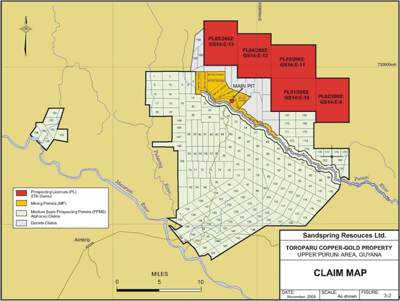
The Toroparu property is comprised of 7 small scale claim licenses, 167 contiguous PPMSs and 13 MPs that together cover an area of 194,661 acres or 78,810 hectares. To the north of this block five contiguous PLs cover an area of 57,997 acres or 23,471 hectares. A list of the mineral tenures is given in the following pages.
Alphonso Small Scale Claim Licenses
Pam 1, Pam 2, Pam 3, Joy 1, Joy 2, Joy 3 and Joy 4 located in or near the Puruni River within the exterior boundaries of Mining Permit A-4/MP/011, described under Mining Permits below, and as reflected on the records of the Guyana Geology & Mines Commission following verification surveys and review conducted in October, November and December 2007, and reissued by GGMC in 2008 based on the map in Figure 3-2 hereof.
| P&E Mining Consultants Inc., Report No. 186 | Page 6 of 121 |
| Sandspring Resources Ltd. | |
| Toroparu Gold-Copper Prospect |
Table 3.1:Land Tenure – Medium Scale Prospecting Permits
| GS8 Number | PPMS Number | Area (Acres) | Location | Map Number | Renewal Date |
| A-106/014/500/95 | 164/2000 | 1109 | Puruni River | 90 | June 06, 2011 |
| A-106/015/501/95 | 165/2000 | 1199 | Puruni River | 52 | June 06, 2011 |
| A-106/016/502/95 | 166/2000 | 1199 | Puruni River | 51 | June 06, 2011 |
| A-106/017/503/95 | 167/2000 | 1158 | Puruni River | 36 | June 06, 2011 |
| A-106/018/504/95 | 168/2000 | 1158.8 | Puruni River | 35 | June 06, 2011 |
| A-140/000/0247/97 | 0080/2000 | 1106 | Upper Mazaruni | 96 | February 10, 2011 |
| A-140/001/0248/97 | 0081/2000 | 1200 | Upper Mazaruni | 105 | February 10, 2011 |
| A-140/002/0249/97 | 0082/2000 | 1143 | Upper Mazaruni | 108 | February 10, 2011 |
| A-140/003/0250/97 | 0083/2000 | 1180 | Upper Mazaruni | 123 | February 10, 2011 |
| A-140/004/0251/97 | 0084/2000 | 938 | Upper Mazaruni | 127 | February 10, 2011 |
| A-140/005/0252/97 | 0085/2000 | 627 | Upper Mazaruni | 135 | February 10, 2011 |
| A-140/007/0254/97 | 0086/2000 | 1106 | Upper Mazaruni | 131 | February 10, 2011 |
| A-140/008/0255/97 | 0087/2000 | 1180 | Upper Mazaruni | 126 | February 10, 2011 |
| A-140-009/0256/97 | 0088/2000 | 1180 | Upper Mazaruni | 122 | February 10, 2011 |
| A-140-010/0257/97 | 0089/2000 | 1180 | Upper Mazaruni | 107 | February 10, 2011 |
| A-140/011/0258/97 | 0090/2000 | 1180 | Upper Mazaruni | 104 | February 10, 2011 |
| A-140/012/97 | 0467/2002 | 1120 | Upper Mazaruni | 106 | July 07, 2011 |
| A-140/013/97 | 0659/2002 | 1120 | Upper Puruni | 121 | October 06, 2010 |
| A-140/014/97 | 0660/2002 | 1120 | Upper Puruni | 125 | October 06, 2010 |
| A-140/015/97 | 0661/2002 | 1120 | Upper Puruni | 130 | October 06, 2010 |
| A-140/016 | 5240/2002 | 1120 | Tamakay | 133 | December 15, 2010 |
| A-140/017/97 | 0662/2002 | 1120 | Tamakay | 68 | October 06, 2010 |
| A-140/018/97 | 0663/2002 | 1120 | Tamakay | 129 | October 06, 2010 |
| A-140/019/97 | 0664/2002 | 1120 | Tamakay | 124 | October 06, 2010 |
| A-140/020/97 | 0665/2002 | 1120 | Upper Puruni | 120 | October 06, 2010 |
| A-140/021/268/97 | 0523/2001 | 900 | Tamakay | 139 | August 27, 2010 |
| A140/023/270/97 | 0091/2000 | 1120 | Purini River | 158 | February 10, 2011 |
| A-140/024/271/97 | 0092/2000 | 1120 | Puruni River | 159 | February 10, 2011 |
| A-140/025/272/95 | 0093/2000 | 1120 | Puruni River | 160 | February 10, 2011 |
| A-140/026/273/97 | 0094/2000 | 1120 | Puruni River | 161 | February 10, 2011 |
| A-140/027/274/97 | 0095/2000 | 734 | Puruni River | 162 | February 10, 2011 |
| A-140/028/0275/97 | 0195/2001 | 1120 | Purini River | 141 | March 13, 2011 |
| A-140/029/97 | 0666/2002 | 1120 | Tamakay | 143 | October 06, 2010 |
| A-140/030/97 | 0667/2002 | 1120 | Tamakay | 142 | October 06, 2010 |
| A-141/000/0282/97 | 225/2000 | 1164 | Pashanamu | 101 | May 29, 2011 |
| A-141/001/0283/97 | 226/2000 | 1164 | Pashanamu | 100 | May 29, 2011 |
| A-141/002/0284/97 | 227/2000 | 922 | Pashanamu | 80 | May 29, 2011 |
| A-141/003/0285/97 | 228/2000 | 530 | Pashanamu | 99 | May 29, 2011 |
| A-141/004/0286/97 | 229/2000 | 1058 | Pashanamu | 109 | May 29, 2011 |
| A-141/005/0287/97 | 230/2000 | 1164 | Pashanamu | 110 | May 29, 2011 |
| P&E Mining Consultants Inc., Report No. 186 | Page 7 of 121 |
| Sandspring Resources Ltd. | |
| Toroparu Gold-Copper Prospect |
| GS8 Number | PPMS Number | Area (Acres) | Location | Map Number | Renewal Date |
| A-141/006/0288/97 | 231/2000 | 551 | Pashanamu | 128 | May 29, 2011 |
| A-184/000/0394/99 | 0264/2001 | 941 | Puruni River | 31 | March 11, 2011 |
| A-184/001/0395/99 | 0265/2001 | 948 | Ikuk River | 44 | March 11, 2011 |
| A-184/002/0396/99 | 0266/2001 | 1137 | Ikuk River | 59 | March 11, 2011 |
| A-184/003/0397/99 | 0267/2001 | 987 | Ikuk River | 76 | March 11, 2011 |
| A-184/004/0398/99 | 0268/2001 | 1200 | Ikuk River | 78 | March 11, 2011 |
| A-184/005/0399/99 | 0269/2001 | 1200 | Ikuk River | 79 | March 11, 2011 |
| A-184/006/0400/99 | 0270/2001 | 1020 | Ikuk River | 98 | March 11, 2011 |
| A-184/007/0401/99 | 0271/2001 | 927 | Ikuk River | 97 | March 11, 2011 |
| A-184/008/0402/99 | 0272/2001 | 869 | Ikuk River | 77 | March 12, 2011 |
| A-184/009/99 | 0579/2002 | 804 | Upper Puruni | 149 | August 15, 2010 |
| A-184/010/99 | 0580/2002 | 804 | Upper Puruni | 148 | August 15, 2010 |
| A-184/011/99 | 0581/2002 | 780 | Upper Puruni | 147 | August 15, 2010 |
| A-184/012/99 | 0582/2002 | 1058 | Upper Puruni | 146 | August 15, 2010 |
| A-184/013/99 | 0583/2002 | 1170 | Upper Puruni | 150 | August 15, 2010 |
| A-185/001/99 | 0577/2002 | 795 | Upper Puruni | 5 | August 14, 2010 |
| A-185/002/99 | 0578/2002 | 1143 | Upper Puruni | 4 | August 14 2010 |
| A-185/003/0411/99 | 0227/2001 | 795 | Puruni River | 3 | March 07, 2011 |
| A-185/004/0412/99 | 338/2001 | 1043 | Puruni River | 19 | May 17, 2011 |
| A-185/005/0413/99 | 0228/2001 | 1200 | Puruni River | 15 | March 06, 2011 |
| A-185/006/0414/99 | 0229/2001 | 1200 | Puruni River | 20 | March 06, 2011 |
| A-185/007/0415/99 | 0330/2001 | 1200 | Upper Puruni | 28 | March 06, 2011 |
| A-185/008/0416/99 | 0331/2001 | 1190 | Upper Puruni | 29 | March 06, 2011 |
| A-185/009/0417/99 | 0424/2001 | 1190 | Upper Puruni | 30 | May 27, 2011 |
| A-185/010/0418/99 | 0425/2001 | 1036 | Upper Puruni | 43 | May 28, 2011 |
| A-185/011/0419/99 | 0426/2001 | 1071 | Upper Puruni | 42 | May 28, 2011 |
| A-185/012/0420/99 | 0332/2001 | 1071 | Upper Puruni | 41 | March 06, 2011 |
| A-185/013/0421/99 | 0333/2001 | 1087 | Upper Puruni | 40 | March 07, 2011 |
| A-185/014/0422/99 | 0334/2001 | 1136 | Upper Puruni | 39 | March 06, 2011 |
| A-185/015/0423/99 | 0335/2001 | 1200 | Ikuk River | 38 | March 06, 2011 |
| A-185/016/0424/99 | 0336/2001 | 637 | Ikuk River | 58 | March 06, 2011 |
| A-185/017/0425/99 | 0337/2001 | 658 | Ikuk River | 57 | March 06, 2011 |
| A-185/018/0426/99 | 0338/2001 | 658 | Upper Puruni | 56 | March 06, 2011 |
| A-185/019/0427/99 | 0339/2001 | 607 | Upper Puruni | 55 | March 06, 2011 |
| A-185/020/0428/99 | 0340/2001 | 679 | Upper Puruni | 54 | March 06, 2011 |
| A-185/021/0429/99 | 0341/2001 | 637 | Upper Puruni | 53 | March 06, 2011 |
| A-185/022/0430/99 | 0342/2001 | 1125 | Ikuk River | 75 | March 06, 2011 |
| A-185/023/0431/99 | 0343/2001 | 1125 | Ikuk River | 74 | March 07, 2011 |
| A-185/024/0432/99 | 0344/2001 | 1125 | Ikuk River | 73 | March 07, 2011 |
| A-185/025/0433/99 | 0345/2001 | 1200 | Ikuk River | 72 | March 08, 2011 |
| A-185/026/0426/99 | 0346/2001 | 700 | Putaring | 71 | March 08, 2011 |
| P&E Mining Consultants Inc., Report No. 186 | Page 8 of 121 |
| Sandspring Resources Ltd. | |
| Toroparu Gold-Copper Prospect |
| GS8 Number | PPMS Number | Area (Acres) | Location | Map Number | Renewal Date |
| A-185/027/99 | 0697/2002 | 675 | Upper Puruni | 70 | October 16, 2010 |
| A-185/028/0436/99 | 0347/2001 | 1150 | Putaring | 95 | March 07, 2011 |
| A-185/029/0437/99 | 0348/2001 | 1139 | Putaring | 94 | March 07, 2011 |
| A-185/030/0438/99 | 0349/2001 | 1035 | Putaring | 93 | March 08, 2011 |
| A-185/031/0439/99 | 0350/2001 | 1081 | Putaring | 92 | March 08, 2011 |
| A-185/032/0440/99 | 0351/2001 | 1200 | Putaring | 2 | March 06, 2011 |
| A-185/033-0441/99 | 0352/2001 | 1200 | Putaring | 1 | March 06, 2011 |
| A-185/034/0442/99 | 0353/2001 | 1104 | Putaring | 9 | March 08, 2011 |
| A-185/035/0443/99 | 0354/2001 | 1066 | Puruni River | 10 | March 08, 2011 |
| A-185/036/0444/99 | 0355/2001 | 1066 | Puruni River | 14 | March 08, 2011 |
| A-185/037/0445/99 | 0356/2001 | 1104 | Tamakay | 13 | March 08, 2011 |
| A-185/038/0446/99 | 0357/2001 | 1115 | Puruni River | 17 | March 07, 2011 |
| A-185/039/0447/99 | 0358/2001 | 1114 | Tamakay | 18 | March 08, 2011 |
| A-185/040/0448/99 | 0359/2001 | 1000 | Tamakay | 26 | March 08, 2011 |
| A-185/041/0449/99 | 0360/2001 | 1080 | Tamakay | 27 | March 08, 2011 |
| A-199/000/2000 | 620/2001 | 1016 | Puruni River | 64 | September 19, 2010 |
| A-199/001/2000 | 621/2001 | 1016 | Puruni River | 81 | September 19, 2010 |
| A-199/002/2000 | 622/2001 | 1200 | Tamakay | 82 | September 19, 2010 |
| A-199/003/2000 | 623/2001 | 1016 | Puruni River | 83 | September 19, 2010 |
| A-199/004/2000 | 624/2001 | 1016 | Puruni River | 85 | September 19, 2010 |
| A-199/005/2000 | 625/2001 | 1016 | Puruni River | 87 | September 19, 2010 |
| A-199/006/2000 | 626/2001 | 1016 | Puruni River | 115 | September 19, 2010 |
| A-199/007/2000 | 627/2001 | 1014 | Puruni River | 117 | September 19, 2010 |
| A-199/008/2000 | 628/2001 | 1085 | Puruni River | 118 | September 19, 2010 |
| A-199/009/2000 | 629/2001 | 1119 | Puruni River | 114 | September 19, 2010 |
| A-199/010/2000 | 630/2001 | 1125 | Puruni River | 103 | September 19, 2010 |
| A-199/011/2000 | 631/2001 | 1102 | Puruni River | 102 | September 19, 2010 |
| A-199/012/2000 | 632/2001 | 1102 | Puruni River | 111 | September 19, 2010 |
| A-199/013/2000 | 633/2001 | 1076 | Puruni River | 112 | September 19, 2010 |
| A-199/014/2000 | 634/2001 | 1102 | Puruni River | 113 | September 20, 2010 |
| A-199/015/2000 | 643/2002 | 1148 | Tamakay | 119 | October 15, 2010 |
| A-199/016/2000 | 635/2001 | 725 | Puruni River | 138 | September 20, 2010 |
| A-199/017/2000 | 636/2001 | 910 | Puruni River | 137 | September 20, 2010 |
| A-199/018/2000 | 637/2001 | 1029 | Puruni River | 136 | September 20, 2010 |
| A-199/021/2000 | 639/2001 | 1011 | Puruni River | 32 | September 20, 2010 |
| A-199/022/2000 | 640/2001 | 995 | Puruni River | 33 | September 20, 2010 |
| A-199/023/2000 | 641/2001 | 965 | Puruni River | 34 | September 20, 2010 |
| A-199/024/2000 | 642/2001 | 958 | Puruni River | 48 | September 20, 2010 |
| A-199/025/2000 | 643/2001 | 1024 | Puruni River | 60 | September 20, 2010 |
| A-199/026/2000 | 644/2001 | 940 | Puruni River | 37 | September 20, 2010 |
| A-199/033/2000 | 0644/2002 | 998 | Tamakay | 45 | October 07, 2010 |
| P&E Mining Consultants Inc., Report No. 186 | Page 9 of 121 |
| Sandspring Resources Ltd. | |
| Toroparu Gold-Copper Prospect |
| GS8 Number | PPMS Number | Area (Acres) | Location | Map Number | Renewal Date |
| A-199/034/2000 | 0645/2002 | 998 | Tamakay | 47 | October 07, 2010 |
| A-199/035/2000 | 0646/2002 | 998 | Tamakay | 46 | October 07, 2010 |
| A-199/036/2000 | 0647/2002 | 1024 | Tamakay | 62 | October 07, 2010 |
| A-199/037/00 | 0648/2002 | 983 | Upper Puruni | 63 | October 07, 2010 |
| A-199/038/00 | 0649/2002 | 1140 | Upper Puruni | 49 | October 08, 2010 |
| A-199/039/00 | 0686/2002 | 912 | Upper Puruni | 50 | October 08, 2010 |
| A-199/040/00 | 0687/2002 | 1072 | Upper Puruni | 67 | October 08, 2010 |
| A-199/041/00 | 0688/2002 | 1180 | Upper Puruni | 89 | October 08, 2010 |
| A-199/042/00 | 0689/2002 | 963 | Upper Puruni | 116 | October 08, 2010 |
| A-199/043/00 | 0690/2002 | 1123 | Upper Puruni | 88 | October 08, 2010 |
| A-199/044/00 | 0691/2002 | 1098 | Upper Puruni | 86 | October 08, 2010 |
| A-199/045/00 | 0692/2002 | 1098 | Upper Puruni | 84 | October 08, 2010 |
| A-199/046/00 | 0693/2002 | 1123 | Upper Puruni | 66 | October 08, 2010 |
| A-199/047/00 | 0694/2002 | 1123 | Upper Puruni | 65 | October 08, 2010 |
| A-218/001/2001 | 0678/2002 | 585 | Tamakay | 163 | October 15, 2010 |
| A-218/002/2001 | 0594/2002 | 693 | Tamakay | 144 | August 15, 2010 |
| A-225/000/2001 | 0679/2002 | 1147 | Tamakay | 151 | September 20, 2010 |
| A-225/001/2001 | 0680/2002 | 747 | Tamakay | 152 | September 25, 2010 |
| A-225/002/2001 | 0681/2002 | 878 | Tamakay | 153 | September 25, 2010 |
| A-225/003/2001 | 0682/2002 | 484 | Tamakay | 154 | September 26, 2010 |
| A-225/004/2001 | 0683/2002 | 1150 | Tamakay | 155 | September 25, 2010 |
| A-225/005/2001 | 0684/2002 | 1140 | Tamakay | 156 | September 25, 2010 |
| A-225/006/2001 | 0475/2002 | 1140 | Tamakay | 157 | July 07, 2011 |
| A-302/001 | 0672/2003 | 1120 | Puruni River | 69 | November 05, 2010 |
| A-302/002 | 0671/2003 | 1120 | Puruni River | 140 | November 05, 2010 |
| D-166/000/2004 | 946/04 | 1200 | Ororiparu | 167 | December 07, 2010 |
| D-166/001/2004 | 947/04 | 1200 | Ororiparu | 170 | December 07, 2010 |
| D-166/002/2004 | 948/04 | 1200 | Ororiparu | 171 | December 07, 2010 |
| D-166/003/2004 | 949/04 | 1200 | Ororiparu | 172 | December 07, 2010 |
| D-166/004/2004 | 950/04 | 1195 | Ororiparu | 168 | December 07, 2010 |
| D-166/005/2004 | 951/04 | 1200 | Ororiparu | 169 | December 07, 2010 |
| D-166/006/2004 | 952/04 | 1200 | Ororiparu | 173 | December 07, 2010 |
| D-166/007/2004 | 953/04 | 929 | Ororiparu | 174 | December 07, 2010 |
| D-166/008/2004 | 954/04 | 1196 | Ororiparu | 175 | December 07, 2010 |
| D-166/010/2004 | 950/04 | 1195 | Ororiparu | 176 | January 16, 2011 |
| D-166/011/2004 | 021/06 | 1052 | Ororiparu | 182 | January 16, 2011 |
| D-166/013/2004 | 022/06 | 444 | Ororiparu | 177 | January 16, 2011 |
| D-166/015/2004 | 023/06 | 430 | Ororiparu | 178 | January 16, 2011 |
| D-166/017/2004 | 024/06 | 445 | Ororiparu | 179 | January 16, 2011 |
| D-166/018/2004 | 025/06 | 1052 | Ororiparu | 180 | January 16, 2011 |
| D-166/019/2004 | 026/06 | 1052 | Ororiparu | 181 | January 16, 2011 |
| P&E Mining Consultants Inc., Report No. 186 | Page 10 of 121 |
| Sandspring Resources Ltd. | |
| Toroparu Gold-Copper Prospect |
| GS8 Number | PPMS Number | Area (Acres) | Location | Map Number | Renewal Date |
| D-181/000/2005 | 018/06 | 927 | Puruni Head | 165 | January 16, 2011 |
| D-181/001/2005 | 019/06 | 1014 | Puruni Head | 166 | January 16, 2011 |
| D-181/002/2005 | 020/06 | 1093 | Puruni Head | 164 | January 16, 2011 |
| D-184/000/2005 | 251/06 | 761 | Toroparu | 21 | May 01, 2011 |
Table 3.2:Land Tenure – Mining Permits
| GS8 Number | MP Number | Area (Acres) | Location | Map Number | Renewal Date |
| A-4/MP/000// | A-4/MP/010// | 1145 | Mazuruni | 16 | April 28, 2011 |
| A-4/MP/001// | A-4/MP/011// | 603 | Mazuruni | 24 | April 28, 2011 |
| A-4/MP/002// | A-4/MP/012// | 858 | Mazuruni | 25 | April 28, 2011 |
| A-4/MP/003// | A-4/MP/013// | 1098 | Mazuruni | 23 | April 28, 2011 |
| A-4/MP/004// | A-4/MP/014// | 992 | Mazuruni | 6 | April 28, 2011 |
| A-4/MP/005// | A-4/MP/015// | 1145 | Mazuruni | 12 | April 28, 2011 |
| A-4/MP/006// | A-4/MP/016// | 893 | Mazuruni | 7 | April 28, 2011 |
| A-4/MP/007// | A-4/MP/007// | 1123 | Mazuruni | 8 | April 28, 2011 |
| A-4/MP/008// | A-4/MP/008// | 1117 | Mazuruni | 11 | April 28, 2011 |
| A-4/MP/009// | A-4/MP/009// | 1200 | Mazuruni | 22 | April 28, 2011 |
| G-6/MP/000 | 09/2003 | 960 | Turupuru | 195 | April 9, 2011 |
| G-6/MP/001 | 08/2003 | 1120 | Turupuru | 194 | April 9, 2011 |
| G-6/MP/002 | 07/2003 | 996 | Turupuru | 193 | April 9, 2011 |
Table 3.3:Land Tenure – Prospecting Licenses
| PL Number | Area (acres) | Renewal Date |
| PL 01/2002 GS 14 E-10 | 11,960 | September 18, 2011 |
| PL 02/2002 GS 14 E-09 | 11,960 | September 18, 2011 |
| PL 03/2002 GS 14 E-11 | 11,986 | September 18, 2011 |
| PL 04/2002 GS 14 E-12 | 10,155 | September 18, 2011 |
| PL 05/2002 GS 14 E-13 | 11,936 | September 18, 2011 |
The PPMSs with the prefix “A” refer to permits which are optioned pursuant to a joint venture with Mr. Alfro Alphonso.. Those with the prefix "D" refer to those that are held in joint venture with Mr. Wallace "Edger" Daniels, and the 3 Mining Permits with the prefix “G” refer to permits that are subject to the Godette joint venture. These claims lie in an area north/northeast of the MP's and south and south of the PL's (see Figure 3.2)
No geologic work, including surface sampling, trenching, drilling, and or mapping has been performed on the Daniels claims or the Godette Mining Permits by Sandspring and Sandspring assigns no material value to these claims at this time.
Mineral claims are subject to annual rentals by the dates as indicated in Tables 3-1, 3-2, and 3-3. Sandspring acknowledges that the rentals are paid in full for all claims as of the date of this report. ETK has been, and will continue to remain responsible for the payment of rentals. P&E has not reviewed the ability of ETK, GoldHeart, Sandspring or its investors ability to, make payments or maintain these claims
| P&E Mining Consultants Inc., Report No. 186 | Page 11 of 121 |
| Sandspring Resources Ltd. | |
| Toroparu Gold-Copper Prospect |
Payments on the claims are made each year prior to the renewal date of each claim. The ten units designated as MP/007, MP/008, MP/009, MP/010, MP/011, MP/012, MP/013, MP/014, MP/015, and MP/016, refer to MPs that were converted from PPMSs. Figure 3- 3 lists the corresponding PPMS numbers for several of the MPs, some of which are still referred to in GGMC documentation relating to property tenure.
The rental rates for each of the Mining Permits is the sum of US$1.00 per acre per annum and the rental for each of the thirteen Mining Permits have been fully paid up.
Mineral tenures in Guyana allow for four scales of operation. These include small scale claims of 1500 x 800 ft. or a river claim consisting of one mile of a navigable river. PPMSs and MPs cover between 150 to 1200 acres each and are restricted to ownership by Guyanese. However, foreigners may enter into joint venture arrangements whereby the two parties jointly develop the property. PLs covering between 500 and 12,800 acres are granted to foreign companies. Large areas for geological surveys are granted as Permission for Geological and Geophysical Surveys with the objective of applying for PLs over favourable ground.
Rental rates for PLs are USD$0.50 per acre for the first year; US$0.60 for the second year, and US$1.00 for the third year. An application fee of US$100.00 and a Work Performance Bond, equivalent to 10% of the approved budget for the respective year, is also payable. The term for PLs is three years with two rights of renewal for one PL year each. After renewing the PLs twice, ETK was given permission to continue renewing on an annual basis. ETK has since requested a renewal for all five PLs for a full three--year term beginning on September 18, 2008. ETK has been advised by the Guyanese Ministry of Mining that the GGMC has agreed to the reissuance and is processing the necessary paperwork. ETK has paid all rentals for the PLs that have come due since GGMC agreed to the reissuance.
The Property has not been surveyed formally on the ground. Surveys have been conducted in parts of the property relating to road-building and access into the Toroparu pit area. Several GPS surveys have been done by ETK personnel to locate drill collar points and by Henry Meixner (author of the previous NI 43-101 technical report on the Property) in order to locate geological features, sample points, trenches, bench faces, buildings, pit dimensions, tailings impoundments, old workings, roads and other pertinent features surrounding the main operations around the Toroparu pit. The known mineral zones and mine workings, tailing ponds, ore storage, waste storage and historic alluvial workings are contained on MP A-4/MP/011 i.e. the main Toroparu pit area, and on A-199/030 and A-4/MP/015 and A-121/002. These are all shown on maps in later sections of this report.
ETK has four positions of claim ownership in the Upper Puruni Area. The PLs are wholly owned by ETK. The 7 small claim licenses located within the exterior boundaries of A-MP 11 and the A-PPMSs to the south of the Alphonso Mining Permits are all owned by Mr. Alfro Alphonso, a Guyanese businessman, and are controlled by ETK under a joint venture agreement (the “Alphonso Joint Venture:”). . The “Middle Ground” claims,directly north of the Toroparu pit and south of the PLs are held in a joint venture with Mr. Wallace Daniels. The Godette Mining Permits south of the PLs and east of the Topoparu pit are held under a joint venture agreement with the Godette family.
The Alphonso Joint Venture stipulates that ETK is the sole operator and has the sole decision-making discretion in all matters pertaining to gold exploration of the property. Royalty payments of 6% are payable to Mr. Alphonso on gold production from the properties mined by either placer or conventional mining operations.
| P&E Mining Consultants Inc., Report No. 186 | Page 12 of 121 |
| Sandspring Resources Ltd. | |
| Toroparu Gold-Copper Prospect |
The royalty payments to Alphonso are in addition to the 5% royalty payable to the Government of Guyana. The joint venture agreement also gives ETK the option of purchasing 100% of Mr. Alphonso’s interest in the Upper Puruni Gold Prospect for the sum of US$20.0 million dollars. There are no credits against the US$20 million dollar option price for royalty or other payments made by ETK to Mr. Alphonso.
The joint venture agreement between ETK and Daniels provides for a payment to Daniels of an annual rental equal to 10% of the total rental payments for the Daniels Claims and a 1% net profits interest to Daniels with a maximum payment under the net profits interest of US$50,000 dollars.
ETK has sole operatorship and sole decision-making discretion in all matters pertaining to gold exploration on the lands subject to the Godette Joint Venture. ETK also has the sole and exclusive right to sell all gold, other precious metals or gemstones it may recover from the properties. The Godette Joint Venture Agreement also gives ETK the option of purchasing 100% of the Godettes’ interest in the Godette Joint Venture for the sum of USD$300,000. The buyout option does not have an expiry date. There are no credits against the USD$300,000 option price for royalty or other payments made by ETK to the Godettes.
Mr. Alphonso, the Godettes', Daniels and ETK have the exclusive right to conduct mining activities on the lands subject to their respective Mining Permits, Prospecting Permits, Prospecting Licences, and Small Scale Claims for the recovery of gold for so long as the rentals due on the Prospecting Permits, Small Scale Claims, Mining Permits and Prospecting Licenses are paid and the Prospecting Permits and Small Scale Claims and the Mining Permits, and Prospecting Licences are renewed as and when due under the provisions of the Mining Act of Guyana and the Regulations made there under.
As of the date of this report all PPMSs, MPs and PLs are in good standing.
To the best of the writers’ knowledge there are no known environmental concerns on the Property.
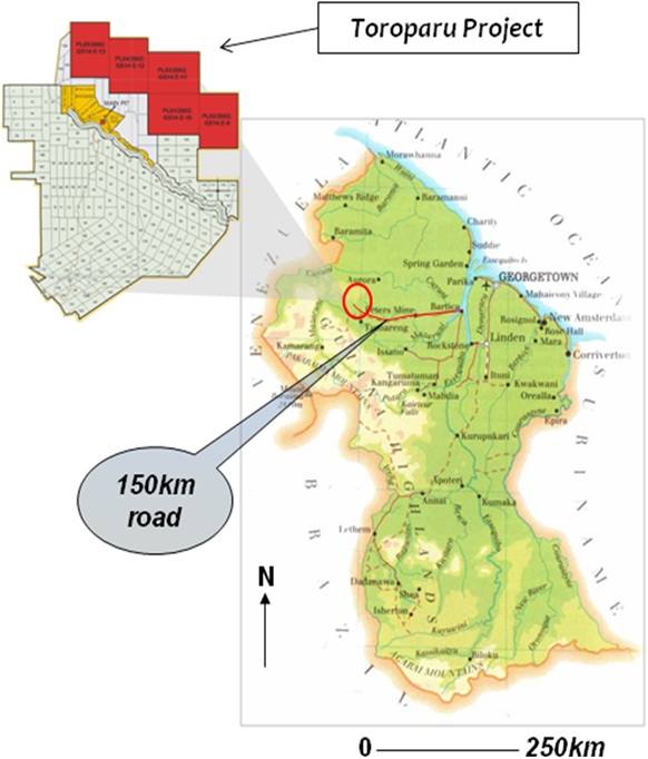
3.2LOCATION
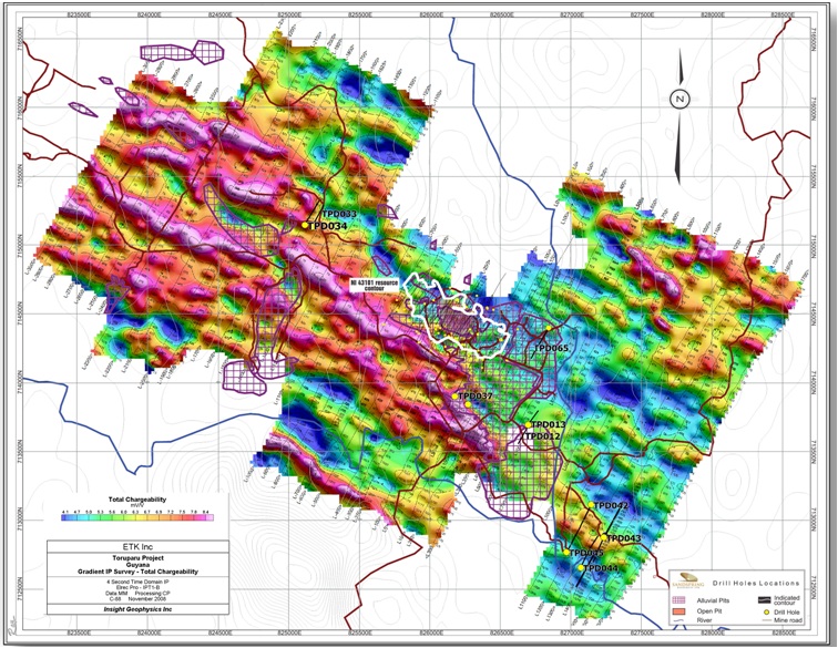
The Property is located in the Upper Puruni River Area of north-western Guyana. The geographic location of mining operations is the Toroparu open pit, the main focus of gold mining operations on the Property, is at 06̊̊ 27’ North Latitude and 60̊ 05’ West Longitude, corresponding to UTM co-ordinates of 714450 N and 826200 E. The Property location is shown on Figure 3-1 and the claims area is shown on Figure 3-2. Figure 3-3 shows in detail the projected deposit and saprolite pit outline in relation to the interpreted IP data.
| P&E Mining Consultants Inc., Report No. 186 | Page 13 of 121 |
| Sandspring Resources Ltd. | |
| Toroparu Gold-Copper Prospect |
Figure 3-1: Toroparu Prospect Location Map from Sandspring (2010)
| P&E Mining Consultants Inc., Report No. 186 | Page 14 of 121 |
| Sandspring Resources Ltd. | |
| Toroparu Gold-Copper Prospect |
Figure 3-2: Toroparu Prospect Claim Map from Meixner (2008); updated by P&E
| P&E Mining Consultants Inc., Report No. 186 | Page 15 of 121 |
| Sandspring Resources Ltd. | |
| Toroparu Gold-Copper Prospect |
Figure 3-3: Detail of Toroparu Deposit (2008)
| P&E Mining Consultants Inc., Report No. 186 | Page 16 of 121 |
| Sandspring Resources Ltd. | |
| Toroparu Gold-Copper Prospect |
4.0 ACCESSIBILITY, CLIMATE, LOCAL RESOURCES, INFRASTRUCTURE, AND PHYSIOGRAPHY
4.1ACCESS
Section 4 of this report contains considerable information gleaned from the report by Meixner (2008).
Access to the Toroparu property from Georgetown is via a newly constructed gravel road and the travel time is one day in the dry season from July to April. Minor delays are encountered at Sherima, Itaballi and Peters Mine/Puruni Crossing. A speedboat from Parika to Itaballi can also be used and a vehicle must be used from Itaballi to the property. A one hour flight by charter aircraft from Ogle airfield in Georgetown is the most efficient means of transport to the 2,500 ft airstrip at the Toroparu camp. The Essequibo River is navigable from Georgetown to the river port at Itaballi, for transport of heavy equipment by barge and tug boats.
The property is in deep jungle and temperatures are in the range of 25o C to 30o C throughout most of the year. A wet season occurs in December to February and a second wet period in May to July of each year. The dry season from July to November is the most advantageous time to carry out exploratory surveys such as geochemical sampling, drilling and geophysical surveys.
Labourers with a variety of experience in heavy equipment operation are available in Georgetown and from villages situated along the rivers. Water for drilling is readily available throughout the year. There is no nearby electricity grid and all power is generated on site by four large diesel generators.
The topography is flat to gently undulating to hilly with a relief of a few hundred metres that is occasionally interspersed with steep hills of meta-basic rock, whereas the metasediments represent flatter topographies. The Toroparu pit is adjacent to a very gentle valley and the area surrounding the pit has had berms constructed to contain the tailings from past mining operations. Areas for future waste disposal or heap leach pads and potential processing plant sites are readily available in the vicinity of the present operations.
| P&E Mining Consultants Inc., Report No. 186 | Page 17 of 121 |
| Sandspring Resources Ltd. | |
| Toroparu Gold-Copper Prospect |
5.0 HISTORY AND PREVIOUS EXPLORATION
5.1EXPLORATION HISTORY
Section 5 of this report is based heavily upon material contained within the report by Meixner (2008).
The following is a summary of the exploration history of the Toroparu area.
Table 5.1: Summary of Historical Exploration in the Toroparu Area
Late 1880's to early 1900's | Historic exploitation of alluvial gold and diamonds in the Toroparu area dates back to about 1887. Conolly (1926) described alluvial diamond operations up to about 1914, to the northwest of the Toroparu area. Grantham (1934) described gold and diamond workings in the Majuba Hill and Wynamu areas. The Wynamu River lies adjacent to the Toroparu pit and is labelled as “Toroparu River” on some older maps. |
| 1950 | Pollard and Hamilton created a geological map of the area in 1950 on which the locations of gold and diamond workings were noted. |
| 1997 | Alphonso commenced alluvial mining at Toroparu in 1997, mining old tailings and river alluvium by washing material into a pit with high pressure water jets and pumping the slurry up to a sluice box. By 1999, much of the alluvial material was exhausted and work proceeded deeper into the underlying saprolite so that the surficial alluvial area was gradually developed into a pit. Mining continued until 2001. |
| 1999 | ETK carried out initial auger drill sampling in 1999 to the east and west of the pit area using a mechanized auger and they also evaluated the possibility of re-working the tailings. This was done by auger sampling, grab and channel sampling of tailings and unworked alluvium. Reports by Hopkinson (1999), Uzunlar (2000) and Shaffer (2000, 2001, and 2003) summarize the available assay data. This work reportedly identified an estimated 1.4 million tons of historic auriferous tailings left behind by previous operators, including 0.9 million tons of higher grade material, estimated at a grade of 1 to 2 g Au/t and located south-easterly of the main pit area. There is insufficient data to quantify this estimate as a possible inferred resource however, for the purposes of this 43-101 report. |
| 2000 | The Guyana Geology and Mines Commission (“GGMC”) carried out regional mapping and geochemical drainage sampling (Heesterman et al 2001) that showed an anomalous gold and copper area in the immediate Toroparu area. |
| ETK also entered into an exploration jolint venture with Alphonso. At this time, ETK also commenced rehabilitation and upgrading a 100 km access road into the property to facilitate the transport of mining equipment and supplies to the mine site. | |
| 2001 | Alphonso ceased gold mining due to increased pit depth, slumping walls and the pit being water laden in the rainy season. At greater depths, copper grains became more plentiful in the gold concentrates and resulted in lower operating costs, with native copper grains of up to 30% volume reported within the black sand concentrates. Some 15 “land dredges” were employed at the peak of activity in this area. It has been estimated that some 60,000 ounces of gold may have been produced historically over a 70 year period from the Toroparu area. |
2001 to 2003 | ETK carried out further auger drill sampling in 2001 and 2003 to the east and west of the pit area. Reports by Uzunlar (2000) and Shaffer (2000, 2001, and 2003) summarize the available assay data. This work reportedly identified an estimated 1.4 million tons of historic auriferous tailings left behind by previous operators, including 0.9 million tons of higher grade material, estimated at a grade of 1 to 2 g Au/t and located south-easterly of the main pit area. There is insufficient data to quantify this estimate as a possible inferred resource however, for the purposes of this 43-101 report. ETK acquired the PLs to the north of Alphonso’s claims in 2002. |
2003 to 2004 | In 2003 and 2004, Heesterman carried out drainage geochemical sampling in the PL blocks to the north of the Toroparu pit area and around the pit itself. This work indicated that gold mineralization may extend at least 6 km to the northwest and 1 km to the southeast of the main pit, as indicated by geochemically anomalous areas of copper and gold. |
| P&E Mining Consultants Inc., Report No. 186 | Page 18 of 121 |
| Sandspring Resources Ltd. | |
| Toroparu Gold-Copper Prospect |
| 2004 | In 2004, ETK commissioned a gravity circuit to test-mine the gold-bearing tailings and saprolite, utilizing a gravity plant based on results obtained from Hazen Research, Inc (described in Section 15.1), and also conducted exploration for additional gold sources defined in the GGMC regional geochemical and prospecting survey of the Upper Puruni area. |
| From December 2004 to April 2007 ETK conducted intermittent, seasonal test-mining from saprolite, in the Toroparu pit using a combination of hydraulic sluicing and a gravity circuit with screens, ball mill, Falcon centrifugal concentrators and shaker tables. | |
| 2005 | In 2005 and 2006, two phases of trench-channel sampling were completed by Meixner and Wesa to determine the tenor and distribution of gold mineralization in the saprolites of the pit area and to determine the suitability for conducting further exploration. This work indicated that a zone of gold mineralization, over an area of about 180 m x 100 m, was present in the saprolitic rock of the pit area with average grades in the general range of 0.5 to 1.5 g Au/t (grams Au per metric tonne), and that this zone was open in all directions. These positive results prompted the proposal to explore the pit area with diamond drilling. |
| 2006 | In late 2006 and throughout 2007 ETK completed an initial drilling program on the Toroparu project consisting of 29 diamond drill holes. The results and details of this drilling program were outlined in the previously published “Technical Report and Resource Estimate on the Toroparu Gold-Copper Prospect, Upper Puruni River, Guyana” This report was published in 2009 by P&E consultants at the request of Sandspring Resources Ltd. |
| A 5 km x 4.5 km high resolution Tri-sensor Magnetic and Radiometric Airborne Survey was conducted over the Toroparu property holdings in October 2006 in an attempt to elucidate the covered geology and aid exploration. This survey locates the pit area to lie within a magnetically low area just to the south of a large magnetic high area of unknown provenance. More importantly, the radiometric portion of the survey outlined a number of radiometric potassium anomalies, K1 to K19, that are distributed within the Toroparu Shear Zone. The anomalies are areas of elevated potassium possibly derived from sericitic alteration in underlying intrusive or volcanic rocks and potentially containing associated gold-copper mineralization related to the potassic alteration event. | |
| 2008 | ETK carried out auger drill sampling in 2008 to the northwest of the pit area over a 2 km x 3 km area, using a mechanized auger. Nine north-easterly lines of auger samples, spaced 500 m apart, were sampled to 5 m depths at approximately 50 m sample intervals. This survey tested the saprolitic rocks beneath the alluvial cover for gold and copper in an area of historic gold workings that lies within the Toroparu Shear Zone to the northwest of the Toroparu pit area. Several clusters of elevated gold and copper values and spot anomalies were identified that suggested the possibility of deeper gold-copper mineralization at this locality. |
| 2009 | Sandspring acquired 100% of GoldHeart, who own 100% of ETK's outstanding stock, in a transaction that closed on November 24, 2009. |
5.2PREVIOUS METALLURGICAL TESTING
In 2002 ETK commissioned Hazen Research Inc. to evaluate the gold recovery potential of Toroparu tailings. The following is a summary of this work intended as an historical reference only.
A composite sample, of 17 5-gallon buckets of tailings with a calculated head grade of 3.28 g Au/t and weighing 370 kg was tested by Hazen utilizing a combination of rod mill tumbling, heavy liquid separations, cyanide leach tests and froth flotation tests. The aim was to determine if gold could be economically recovered from the tailings by the ETK gravity circuit, installed at Toroparu by a variety of mining/milling options. Figure 15-1 shows a schematic of the gravity concentration flowsheet.
Results of this testing indicate that the Falcon concentrators at Toroparu could recover 38.2% of gold in the tailings and that this represented 54.1% of the gold in the feed to the concentrator. Hazen noted that gold was present as “micro-nuggets” in sizes ranging from less than 25 microns up to 500 microns in the longest dimension. Coarse gold was noted in several of the products, including the unprocessed screen oversize, and in the Falcon tailings where one piece of 500 microns was locked in quartz. Some of the gold appeared tarnished. Untarnished varieties were very yellow, indicative of high purity. This was confirmed by the gold assay of the button from amalgamation of the first Falcon concentrate which returned 89.4% Au and 9.9% Ag.
| P&E Mining Consultants Inc., Report No. 186 | Page 19 of 121 |
| Sandspring Resources Ltd. | |
| Toroparu Gold-Copper Prospect |
Significant locking of gold in quartz and in iron oxides was observed, even in the very fine sizes of minus 100 mesh. Because of this locking, no more than 50% of the gold in the tailings was thought to be recoverable by gravity separation without grinding. With additional grinding the recoveries could be elevated perhaps to 60% or 70%.
Higher recoveries, to 90%, could be obtained by a combination of grinding to 100 mesh and gravity separation in closed circuit with grinding, followed by either froth flotation or Cyanidation.
In 2003 ETK submitted a composite sample of saprolite, weighing 150 kg and with a calculated grade of 2.80 g Au/t, to Hazen Research for testing. The sample was composited from 81 5-gallon buckets, taken within the pit, and was submitted to determine the amenability of the saprolite to gold recovery by gravity concentration and froth flotation. The test by Hazen showed that with minus 100 mesh grinding and gravity concentration, up to 80.1 % of the gold can be recovered in a concentrate containing 1.79% of the weight and assaying 87.6 g Au/t.
With froth flotation of the gravity tailings, the recovery increased to 93.9% of the gold in 5.87% of the weight and a grade of 35.2 g Au/t. This test indicates that 2.24 grams of a total of 2.8 grams of gold is theoretically recoverable.
ETK has carried out test-mining of the saprolite from the pit intermittently since 2004, principally during the dry season but, has to date, never achieved recoveries of more than about 18%.
The low recoveries are attributed to of the predominance of fine, micron-sized gold flakes and the high viscosity of the saprolite ore slurries. The combination of high slurry densities with fine gold makes gravity capture of gold very inefficient.
Meixner and Wesa (2006) sampled ore slurries that were being mined by ETK in October 2005 with average grades of 2.58 g Au/t. Tailings samples, taken during the same time interval as the ore slurries were being processed returned 2.13 g Au/t. This indicates a significant gold loss in the concentrator plant, but also a significant gold accumulation in the tailings pond.
During the period of November 19, 2005 to February 28, 2006 accurate production records were kept by ETK of saprolite ore processing through the pilot gravity separation plant (Shaffer, 2006). A total of 59.625 kilograms or 1,917 ounces of gold were recovered from 199,297 metric tonnes of saprolite ore for a calculated recovered grade of 0.30 g Au/t. A weighted average grade of 2.64 g Au/t was determined from hourly pit-head grade samples that were composited daily, and analyzed at Loring Laboratories in Georgetown. Thus the calculated recovery rate of the gravity circuit is 11%. Metallics assays performed by Loring Labs show that 8.5% of the gold values are in the +150 mesh size fraction.
| P&E Mining Consultants Inc., Report No. 186 | Page 20 of 121 |
| Sandspring Resources Ltd. | |
| Toroparu Gold-Copper Prospect |
In February 2006, R. Hyyppa, P.E., consulting mining engineer to ETK, conducted an analysis of the gravity separation procedure at Toroparu by testing the addition of a flotation circuit to improve gold recoveries (Hyyppa, 2006). All flotation concentrate samples were assayed for metallics at Loring Laboratories. This test indicated that 99.5% of the gold in the concentrate occurred in the -150 mesh fraction and that between 49% and 95% of the gold was theoretically recoverable by flotation. In one case, 95% of the gold was recovered into a 3.5% weight-concentrate when operating with tailings from the Ball Mill Falcons. A flotation concentrate assaying about 3.8 g Au/t was achieved from feed that assayed about 1.44 g Au/t; tailings assayed 0.10 g Au/t. In a second case, about 49% of the gold was recovered into a 2.6% weight-concentrate when operating with tailings from the Screen Falcons. A flotation concentrate assaying about 18.5 g Au/t was achieved from a feed that assayed about 3.6 g Au/t; tailings assayed 2.01 g Au/t. This pilot plant test indicates that gold recovery can be substantially improved with flotation from the gravity tailings and that more tests should be conducted to refine these results.
| P&E Mining Consultants Inc., Report No. 186 | Page 21 of 121 |
| Sandspring Resources Ltd. | |
| Toroparu Gold-Copper Prospect |
6.0 GEOLOGICAL SETTING
6.1INTRODUCTION
Section 6 of this report has drawn heavily upon material contained within the report by Meixner (2008).
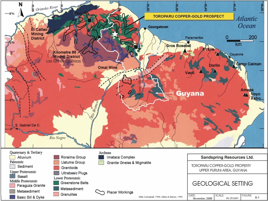
The Guiana Shield, in northern Guyana, is comprised of late Archean and Paleoproterozoic granites and gneisses and greenstones. This continental Craton represents the western part of the Amazon Craton which is a dismembered portion of the West African Craton and that contains numerous economically important gold deposits within its greenstone sequences in Guyana, West Africa and Venezuela. Economically important and geologically similar gold deposits, hosted in 2.1 billion year-old metamorphosed greenstone sequences, within sheared structural corridors or belts, occur in West Africa in Ghana in the Ashanti gold belt at Obusai, Bogosu and others; at Las Cristinas and El Callao, in the Kilometre 88 district of Venezuela; and, at Omai, Aurora, Tassawini and other localities in Guyana.
These gold deposits all occur in deformed and metamorphosed greenstones that are made up of sequences of alternating mafic to felsic volcanic and sedimentary rocks that have been intruded and mineralized by granitoid batholiths and stocks.
In Guyana, the 400 kilometre-long, regional Makapa Kuribrong Shear Zone, that transects the shield area as a north-westerly structural corridor, contains the Omai gold deposit in the southeast which produced a total of 77 Mt @ 1.5 g Au/t (the reader is referred to the March 31, 2006 Cambior Inc. Annual Information Form which has been filed on SEDAR) as well as the Toroparu Gold-Copper Prospect, situated in the northwest. Figure 6-1 illustrates the geological setting of the Toroparu gold-copper occurrence in the greenstone terrain of northern Guyana.
Geologically, Guyana is divided into a Northern and Southern geological province at 4.5̊ North Latitude. The Northern Province is composed of late Archean gneissic-granitic terrain to early Proterozoic folded metamorphosed rocks that are 2.2 to 1.9 billion years in age. Continental clastic rocks, along with volcanic flow and volcanic sedimentary sequences, were deposited in basins or grabens and were subsequently indurated by folding and compression into greenstone belts that were in turn intruded by granitoid bodies. This was accompanied or followed by mineralizing events during which quartz and gold-bearing sulphides were deposited at sites that had been structurally prepared by brittle fracturing. In northern Guyana, the Barama-Mazaruni Supergroup of late Archean to early Proterozoic metavolcanics, metasediments and granitic complexes, are the host to copper-gold mineralization at Toroparu and to gold mineralization at other localities, such as Million Mountain, Tassawini and Aurora. These localities have been historically exploited for alluvial gold and they are presently being explored anew by modern methods, such as geochemistry and drilling, for large-scale open pit type gold deposits.
| P&E Mining Consultants Inc., Report No. 186 | Page 22 of 121 |
| Sandspring Resources Ltd. | |
| Toroparu Gold-Copper Prospect |
Figure 6-1: Geological Setting from Meixner (2008)
| P&E Mining Consultants Inc., Report No. 186 | Page 23 of 121 |
| Sandspring Resources Ltd. | |
| Toroparu Gold-Copper Prospect |
6.2REGIONAL GEOLOGY
The regional geology of the Upper Puruni-Toroparu area is described by Heesterman et al, in a 2001 GGMC report of the Upper Puruni Area, as well as in several of Heesterman’s internal ETK reports dated, 2003 and 2004, and updated in 2005. These are listed in the References section. Also, Voicu et al. (1999), give a concise description of the greenstone geology of the Omai Area (refer to Figure 6-1) that appears broadly geologically similar to the Proterozoic mineralized lithologies in the Toroparu area. Figure 6-2 shows the most current geology map of the district.
The Toroparu area claims are situated within a northwest-trending belt of lower Proterozoic Barama-Mazaruni Supergroup greenstones that were deformed and metamorphosed during the Trans-Amazonian tectonomagmatic event at about 2.2 and 1.9 Ga. The greenstone sequence is composed of intercalated successions of felsic to mafic and ultramafic volcaniclastic and volcanic flow rocks, with associated continental clastic sequences. The basal members of this succession are thought to be basalts and associated ultramafic bodies that are overlain by intermediate to felsic volcanic strata and are interlayered with immature clastic sedimentary rocks. Metamorphic grade is greenschist to amphibolite facies.
Calc-alkaline felsic to intermediate intrusive rocks ranging from small to batholith size bodies are emplaced within the greenstones and are referred to as the Granitoid Complex or Trans-Amazonian Granitoids, (Gibbs and Barron, 1993). These were intruded synchronous to late in the orogenic cycle and range from granite to diorite and tonalite. In the Toroparu area, Older Granitoids and Younger Granites of undetermined age, just north and south of the open pit, are distinguished and inferred from magnetics and trace element geochemistry of saprolite. The younger granites are thought by some authors to be associated with deposition of gold mineralization at a number of localities elsewhere in Guyana. The possible relationship of these younger granitic bodies to gold-copper mineralization at Toroparu is speculative at present. At Toroparu the areas of granitoids are locally strongly affected by shearing and the granitoids are thought to be younger than the metavolcanic greenstones.
There is a broad similarity between the geology of the Omai gold deposit and the Toroparu area. At Omai, a quartz-monzodiorite stock of 2.09 Ga is associated with an earlier quartz-feldspar porphyry of 2.12 Ga, whereas, the gold-bearing quartz vein stockworks cutting the volcano-sedimentary sequence have been dated at 2.00 Ga. The majority of gold occurrences in northern Guyana occur within the Paleoproterozoic Barama-Mazaruni greenstones and the overall distribution of gold appears to be controlled by north-westerly regional structural breaks, such as the crustal scale, late Trans-Amazonian (1.9-2.2 Ga) Makapa-Kuribrong shear zone. At Toroparu, the gold-copper mineralization is situated within the Toroparu Shear Zone. This shear zone may be a subordinate local structure related to the regional Makapa-Kuribrong shear that is also known as the Mazaruni bend line on some maps or may reflect a subordinate splay structure off the through-going regional northwest-trending Puruni River Shear Zone.
Dominant structural trends are northwest-southeast throughout the Toroparu map area and, the meta-basic bodies, as well as the younger basic bodies, are inferred as being aligned in this direction. Old gold workings and regional geochemical sampling have yielded elevated gold values in rocks, stream sediments and in saprolite. The old tailings areas of the historic gold workings are broadly aligned along the north-westerly trace of the Toroparu Shear Zone, that also trends over the older granitoid body to the northwest of the Toroparu pit.
| P&E Mining Consultants Inc., Report No. 186 | Page 24 of 121 |
| Sandspring Resources Ltd. | |
| Toroparu Gold-Copper Prospect |
Figure 6-2: Regional Geology Map from Meixner (2008)
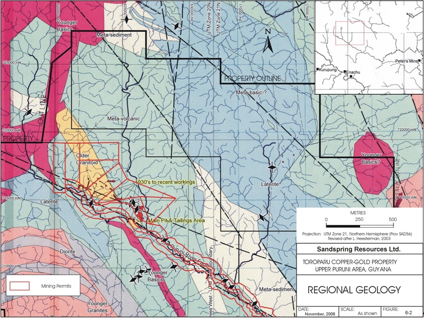
| P&E Mining Consultants Inc., Report No. 186 | Page 25 of 121 |
| Sandspring Resources Ltd. | |
| Toroparu Gold-Copper Prospect |
6.3PROPERTY GEOLOGY
The bedrock geology of the Toroparu area is inferred from indirect evidence because the entire area lies within deep jungle that has a deep weathering profile and therefore fresh rock outcrop exposures do not exist. All rock types are altered to saprolite, a mixture of oxidized material and clay. Original compositions and textures of rocks are obscured.
This zone of laterite/saprolite extends typically to a depth of 35 metres in the Toroparu area, as determined by the recent ETK drilling. Thus, the geology is inferred from boulders at alluvial gold workings or road cuts and pits. Trace element geochemical signatures in stream sediments and heavy mineral concentrates of alluvium and other material have been interpreted to ascertain the likely provenance of bedrock types (Heesterman, 2001, 2003). After the property was taken over by ETK in 2000, the company carried out auger drilling and pit sampling and road construction in 2003, (Shaffer, 2001, 2003). This work revealed additional geological evidence that was incorporated into the interpretation of underlying bedrock types and their distribution.
The dominant lithology of the Toroparu area is undifferentiated Mazaruni Group (2.2-1.9 Ga) metavolcanics and metasediments. Metasediments are usually fine-grained and are metamorphosed to lower greenschist facies. North of the Puruni River, the volcanic rocks are described as variably sheared and metamorphosed, acid to intermediate volcanic with quartz veins that show veining and foliation directions of 1100 to 1400. In the northern part of the area, metamorphosed argillaceous and fine-grained arenaceous sediments form quartz-chlorite and mica schists with an east-west foliation in a 2 kilometre-wide belt. Metamorphosed fine-grained sediments outcrop at the headwaters of the Puruni and Putareng Rivers. The general lack of basic rocks and the predominance of andesitic and felsic volcanic rocks with sediments, such as shales and greywackes, indicate that the upper part of the Barama-Mazaruni sequence is widespread within the map area.
Regionally, a northwest-southeast foliation appears to be deflected adjacent to major faults and this foliation is parallel to two stages of quartz veins that are temporally coincident with metamorphism and to later faulting. The Older Basic rocks are metamorphosed to the same degree as the greenstone host rocks and are believed to be minor intrusions rather than flows. Older Granites, south and north of Toroparu, are described as diorite or quartz diorite or granodiorite, from saprolitic rock samples.
Younger Granites (1.94 Ga) occur to the southwest of Toroparu, as shown in Figure 6-2. These granites were intruded after the Trans-Amazonian deformation and are thought to be related to gold mineralization. It is thought that a granitic to granodioritic stock, intersected in Sandspring’s drilling, with possible copper-molybdenum porphyry associations, may be the progenitor of the gold-copper mineralization at Toroparu.
Younger Basic intrusions are predominantly diabase and they have been dated at between 1.54 Ga and 1.84 Ga elsewhere in Guyana.
Thin section descriptions of surface samples of Mazaruni Group rock types include greenschist-facies phyllitic claystones that grade into volcanic sediments of acid to intermediate composition, such as fine-grained feldspar and quartz. Several varieties of rhyolitic tuffs were noted, exhibiting volcanic glass in the matrix. Metamorphosed sedimentary and volcanic rocks frequently display well developed foliation as a result of the alignment of sericite and chlorite which imparts schistose textures. Some lavas of intermediate composition were recognized in thin section, consisting of altered plagioclase with chlorite, epidote and quartz. A specimen of basaltic andesite, exhibiting flow lineation in the groundmass, was sampled. Several samples of silica-rich rock with high iron oxide content suggest a siliceous exhalative origin, as ascertained by previous workers.
| P&E Mining Consultants Inc., Report No. 186 | Page 26 of 121 |
| Sandspring Resources Ltd. | |
| Toroparu Gold-Copper Prospect |
The predominant structure in Mazaruni Group rocks is reflected in a north-westerly foliation caused by the alignment of chlorite, sericite, micas and amphiboles that is also prevalent in parallel-oriented quartz veins. This alignment is well exposed in the Toroparu pit where dips are generally near-vertical. This structural trend has been noted along the Puruni River Shear Zone and can be seen in aerial photos. Heesterman et al (2001) also observed that adjacent to major faults, the bedding and foliation change, and align themselves parallel to the direction of the fault-trend. Most lithological boundaries are thought to be fault controlled. Younger Basic dykes occur along north-easterly faults. It is surmised therefore that the dominant foliation was formed concordant to the geometry of axial planes of folds and was developed during regional folding and, greenschist to amphibolite metamorphism. Variations in strike directions were imparted during later fault movements. North-trending and east-west faults occur throughout the map area, as well as in the Toroparu pit area. With the exception of the disseminated varieties, gold-copper mineralization at Toroparu appears to be restricted to northwest-southeast oriented quartz veins that are aligned more or less parallel with the foliation in the Mazaruni Group greenstones.
Alteration at Toroparu is thought to be potassic in nature, as interpreted from airborne radiometrics (described in a later section), and as deduced from the geochemistry and mineralogy of saprolite samples, indicating a possible granitoid source that may be associated with the Cu-Au-Ag mineralization. This alteration coincides with the juncture of a north-south fault zone with the north-westerly-trending Toroparu shear zone. Elevated amounts of Au (281-2870 ppb), Ag (276 ppb) and Cu (830 ppm) are common in saprolitic rocks taken from the pit and in the alluvial areas surrounding it. This geochemical signature of major elements may suggest a granitic derivation. Minor element associations are also consistent with a granitic or pegmatitic origin. Heavy mineral concentrates from the pit also show high magnetite contents in the saprolites indicating that magnetite is secondary, having been formed by alteration of the rock. Hematite is also ubiquitous in pit samples along with magnetite, this being a typical association with potassic alteration and the iron oxide copper-gold (IOCG) deposit model.
6.4GEOLOGY OF TOROPARU SAPROLITE OPEN PIT AREA
The original 250 x 200 x 23 metre Toroparu open pit area wholly developed in the saprolite weathered layer is comprised principally of east-west trending purple and brown weathering units of volcaniclastics with less extensive green, tan, and yellow units probably derived from metasediments or from mixtures of sediments and volcanics. The saprolite units are delineated by colour as mappable strata whereas, at depth, they are uniformly green poorly sorted of probable tuffaceous metavolcanics provenance. The saprolitic rocks, within the pit, trend dominantly at 290º and dip sub-vertically, at moderate to steep angles of +/- 70º towards the north or south.
An alignment of the saprolite stratigraphy is discernible between the units in the open pit and those exposed in the trenches located 1200 metres and 550 metres to the west of the pit. The northern portion of the TO6-069 trench contains white kaolinitic saprolite with discrete sub-angular quartz grains reminiscent of a rhyolite. This white unit grades southwards to tan, yellow, brown and reddish terra cotta-coloured saprolite similar in character to the north-south stratigraphic succession that is well exposed in the pit. A stratigraphic continuity of units with unvarying strike, over 1200 metres, is thus possible in the Toroparu area.
| P&E Mining Consultants Inc., Report No. 186 | Page 27 of 121 |
| Sandspring Resources Ltd. | |
| Toroparu Gold-Copper Prospect |
Purple and brown units are believed to be derived predominantly from andesitic or basaltic volcanic tuffs and these also may contain subordinate basaltic flows. These hematite-rich units are fine-grained for the most part, but coarse-grained sections, as well as brecciated sections, with igneous clasts, were observed. Several 1 to 2 metre-wide sections, containing parallel and stratigraphically conformable, auriferous quartz veinlets were noted. Average gold grades of 1.17 g Au/t, over 15 m, and 2.20 g Au/t over 20 m, in the west-central part of the pit are representative of such tectonized intervals. Fine grained sections of purple saprolite, devoid of quartz veins, gave base values of 0.48 g Au/t over 50 m, 0.78 g Au/t Au over 28 m and, 0.53 g Au/t over 25 m along the eastern parts of the pit. The brown units are variously fine to coarse grained and may contain sporadic quartz veinlets of up to 1 cm widths, and these are mineralized in the 1 to 2 g Au/t range. The channel samples taken in 2005/2006 were assayed for gold only, whereas, the core samples from the 2006 to 2008 drilling were analyzed for both copper and for gold.
Orange, yellow, red and light brown units represent the same volcanic lithologies but with lesser amounts of oxidized iron. The more intensely coloured units of red and yellow are thought to have been sheared and altered and usually contain elevated levels of gold along with mineralized quartz veinlets. A section of a bench along this orange unit, at the base of the pit, yielded 2.79 g Au/t. Thin 30 to 50 cm sections of orange-red- yellow saprolite are present within the brown and purple units and these are ubiquitously sheared. The green units in the central pit area are andesite feldspar porphyries that may represent metasomatised lithic tuffs or andesitic or basaltic flow rocks. These fine to medium grained volcanics have sheared or faulted contacts, contain auriferous quartz veinlets and fine disseminated and veinlet gold and copper sulphides. The green unit, intercalated with purple, yellow and brown units, in the west-central part of the pit, is sheared and mineralized. At this locality, this unit is an altered andesite feldspar porphyry that was transected at depth, in holes TPD001 and TPD002. Along the eastern pit margins this unit appears as dikes of less than 1 m widths. Gold grades are typically elevated within this unit to values of 2.99 g Au/t over 10 m and 2.18 g Au/t over 8 m in the western and eastern parts of the pit. A section of green and purple saprolite in the central part assayed 2.49 g Au/t over 49 m.
The pale coloured units of yellow, tan and green in the northern part of the pit are likely derived from felsic volcanic rocks and typically contain lesser amounts of gold, usually less than 1 g Au/t g Au/t at surface and at depth.
The 2006 to 2010 core drilling shows the deeper hard rock equivalents to the overlying surficial saprolites are composed of metamorphosed, altered and sulphide mineralized intermediate volcanic tuff fragmentals that are medium to dark green, fine to coarse- grained, poorly sorted and poorly stratified. Up to 80% of the cored sections of the current Toroparu Gold-Copper deposit, to depths of 500 m within and beyond the saprolite pit perimeter, exhibit this fairly typical greenstone lithology.
| P&E Mining Consultants Inc., Report No. 186 | Page 28 of 121 |
| Sandspring Resources Ltd. | |
| Toroparu Gold-Copper Prospect |
7.0 DEPOSIT TYPES
Section 7 of this report contains material derived in large measure from Meixner (2008).
The salient regional features of shear zone-hosted gold deposits in Guyana are that they occur in Paleoproterozoic greenstones and are distributed within major crustal scale structural breaks, such as the northwest-trending Makapa-Kuribrong shear zone, along which the Toroparu gold-copper occurrence is located. The deposit type presently envisioned at Toroparu, is that of a gold-copper-bearing mineralizing system, hosted within lower Proterozoic Barama-Mazaruni metavolcanic greenstones containing disseminated, stockwork, fracture-filling and shear-related veinlet type styles of sulphide mineralization within a drill-delineated block measuring at least 800 m long x 150 m wide x 400 m deep. The gold-copper mineralization of the Toroparu Deposit is presently outlined by 66 exploratory drill holes and 16 trenches in the saprolite open pit area. A persistent granodiorite intrusive with typical porphyry style alteration and mineralization signatures has now been identified at Toroparu from drilling completed to date. A number of elevated potassium anomalies, identified from an airborne radiometric survey over the open pit area, may also be indicative of other, near-surface intrusive bodies that contain potassic alteration and possibly associated gold-copper sulphide mineralization.
The style, distribution and host lithologies of sulphide mineralization at Toroparu, resembles that which occur at the Brisas copper-gold deposit in Bolivar State, Venezuela, located some 150 kilometres northwest of Toroparu. The Brisas deposit (484 Mt @ 0.67 g Au/t and 0.13% Cu for 10.4 million ounces gold and 1.3 billion lbs Cu), has been extensively explored since 1992 by Gold Reserve Inc. with 800 exploration drill holes. The mineralization at Brisas has been described in an SEG paper by Channer et al, 2005, and in a 43-101 Technical Report by Addison et al., 2006, for Gold Reserve Inc., verified by Meixner (revision of October 15, 2008) and from which the following descriptions are taken. The Toroparu mineral prospect is at a relatively early drilling stage. No reference is made by the author of this report and or Meixner that, that despite the initial similarity of styles of mineralization at Toroparu and at Brisas, that the gold-copper mineralization at Toroparu will be comparable to that at Brisas with respect to geometry, size, grade, extent or volumes of mineralized rock.
At Brisas, the host rocks are deformed and metamorphosed andesitic and rhyolitic lithic tuffs and related sediments of the Caballape formation, as well as a tonalitic intrusive body. All rocks are tilted and metamorphosed to lower greenschist facies. Foliation is parallel to bedding. Four styles of Cu and Au mineralization are present in the Brisas concession and these are characterized by geometry, associated minerals and Au/Cu ratio (Addison et al., 2006). These zones are the Blue Whale body, disseminated gold+pyrite+/-Cu, disseminated high Cu, and shear-hosted Au. The Blue Whale mineralized body is a cigar-shaped, plunging feature, 20 m in diameter that carries the highest Au and Cu grades. The bulk of the ore occurs as disseminations in lensoid bodies in tuff units consisting of auriferous pyrite and narrow 1-2 cm quartz-carbonate-gold veinlets with typical grades of 0.7 g Au/t and low Cu values (Channer et. al., 2005). The Au in the stratiform lenses is highly disseminated but only roughly associated with abundant pyrite. Mineralized rock contains about 2 to 5 percent sulphides and widespread epidote-carbonate alteration with gold occurring as free grains in quartz and as grains and fracture fillings in sulphides. Stratiform lenses of high Cu +/- Au underlie the Au + pyrite lenses and plunge along the bedding foliation in a manner similar to the Blue Whale body with high Au/low Cu lenses. Shear-hosted gold occurrences are emplaced above the larger lenses of disseminated Au mineralization that make up the bulk of the resource and these Au occurrences correlate well with chalcopyrite content, though Cu grades are sub-economic. Copper-gold mineralization, in discrete zones and in disseminated lenses, occurred prior to the main phase of disseminated gold mineralization, which was syndeformational.
| P&E Mining Consultants Inc., Report No. 186 | Page 29 of 121 |
| Sandspring Resources Ltd. | |
| Toroparu Gold-Copper Prospect |
At Toroparu, disseminated pyrite, chalcopyrite and subordinate bornite, chalcocite, covellite, cuprite and native copper grains occur together with gold-copper mineralization similarly to the mineralization styles described at Brisas. The disseminations are in discrete blebs and grains and occasional sulphide-filled hairline fractures. Elevated copper values of 0.1 to 0.4% generally exhibit elevated gold values in the range of 2.0 grams to 5.0 grams per tonne. Quartz-carbonate-pyrite +/-chalcopyrite veins are infrequent but may contain enhanced copper values. Although several drill holes begin and end in mineralization, a zonation of mineralized and barren tuffaceous volcanics is evident, particularly in the south-eastern part of the mineralized corridor. Quartz-carbonate-pyrite-gold veinlets of mm to cm widths, with or without copper and typically with visible gold typically occur near fault planes, as do stockworks of these vein types. The styles of mineralization and their genesis of amalgamation into bodies of potential ore-grade rock at Toroparu are poorly understood and speculative at the present.
| P&E Mining Consultants Inc., Report No. 186 | Page 30 of 121 |
| Sandspring Resources Ltd. | |
| Toroparu Gold-Copper Prospect |
8.0 MINERALIZATION
Section 8 of this report contains material and information drawn heavily from the report by Meixner (2008) and the reader is referred to this report for additional information.
Historic gold workings are distributed over a 7 km x 1.2 km northwest-trending corridor as described by Heesterman (2003). This zone of gold mineralization is roughly coincident with the Toroparu Shear Zone.
The zone extends from east of the Toroparu pit and extends some 6 km north-westerly along a strike of 300º, as outlined by Heesterman’s geochemical survey. Regional geochemical sampling by the GGMC, including rock samples, saprolite samples and stream sediments taken along drainages and at alluvial mining sites show that elevated values of gold, of up to 12 g Au/t, but, more typically of up to 1 to 3 g Au/t are present in the greater Toroparu area. Past fieldwork indicates that some of the alluvial gold was derived from potassic-altered granitic rocks as well as being derived from quartz veins in greenstones, as seen in float boulders. Maximum values within the pit are 22 g Au/t and 900 ppm Cu from purple saprolite with quartz veinlets. Within the immediate pit area, Heesterman’s bulk leach extractable gold sampling of pit feed yielded elevated values of Au (1.4 ppm), Ag (0.27 ppm) and Cu (894 ppm) with elevated amounts of trace elements, including Bi (14 ppm), Mg (0.23%), V (184 ppm), Sc (36 ppm), Rb (150 ppm), W (6 ppm), As (3-5 ppm), Mo (1-3 ppm). Heavy mineral concentrates from the pit showed hematite, magnetite and rutile in the black sands. East of the pit, gold and native copper grains were recovered from saprolite by Shaffer (2000) from samples of 6 metre-deep auger holes.
In the Toroparu saprolite open pit, gold mineralization is most prominently associated with thin gold-bearing quartz veinlets in purple and brown saprolite units. The veinlets, containing free gold, are white to clear and occasionally black, from included tourmaline, and are typically 0.5 cm to 1.0 cm thick and several decimeters long, where they can be observed in outcrop. They are enveloped by sericite and chlorite skins and sparse limonite. Grab samples, taken by Meixner, returned gold values in the 1.0 to 5.0 g Au/t range with a high value of 12.0 g Au/t. Past workers have reported higher values of several tens of grams per tonne Au and vein thicknesses of several centimeters. Mineralized quartz veins occur singly and in parallel swarms. They have been observed in pit exposures over several metre lengths within 1 to 2 metre-wide zones. Vein densities vary. A one metre-wide quartz vein zone might exhibit some 10 veins for example, or single veins may occur every 30 to 50 centimetres across the width of the zone. The azimuths of the auriferous veins usually vary little from 270 to 300 degrees.
Past work by Uzunlar (2000) indicates that three types of quartz veins may be present in the pit area. In addition to the parallel quartz veins some quartz veins appear to be folded, or have formed along old folded bedding planes where they typically dip to the southwest. The thin, closely spaced quartz vein sets that are parallel to the foliation are the main gold-bearing type and these appear to represent about 75% of the total vein types within the pit. Some semi-horizontal or gently northeast-dipping veins are displaced by other veins, and are thought to be older. Rare, north-easterly-oriented and northeast dipping veins have a similar orientation to some air photo lineaments. Quartz veins can vary from 1 to 2 mm to 0.5 to 1.5 cm and 5 to 10 cm in thickness. All rock types carry quartz veins, but they are most prominently observed in the purple and brown units which also contain the highest gold grades.
The quartz vein sets are thought to be related to brittle deformation of the volcaniclastics within fold flexures and also to zones of shearing. Quartz vein sets were noted most abundantly in coarse grained purple or brown saprolite of either volcaniclastic or granitoid derivation. Quartz veinlets usually accompany shears or faults that are exemplified by distinctive orange-red-yellow metre-wide intervals in the purple or brown units of the western and central parts of the pit area. Limonite stringers can are often discerned in the wall rock saprolite in which the quartz veins occur. Cross-cutting veinlets, typical of well-developed stockwork structures, were not observed. In the south-central pit area, numerous black quartz veins appear to be coloured by black tourmaline inclusions, rather than by manganese. The gold content of quartz veined sections typically returned average grades in the 2 to 5 g Au/t range over 5 metre sections of channel samples.
| P&E Mining Consultants Inc., Report No. 186 | Page 31 of 121 |
| Sandspring Resources Ltd. | |
| Toroparu Gold-Copper Prospect |
The green andesitic feldspar porphyry unit in the central saprolite pit area also contains elevated levels of gold mineralization. An outcrop of green porphyry, at the western edge of the pit, slightly more resistive than adjacent brown-purple units, trends towards the eastern edge of the pit manifesting itself as a series of andesitic dikes. Gold content in the green porphyry assayed 2.99 g Au/t over 10 m in channel samples of this outcrop. A 35 m wide section of green and purple strata returned 2.49 g Au/t from the central trench in the pit. In comparison, the brown units, with relatively sparse quartz veins, enclosing the green saprolite, yielded lesser grades of 1.03 g Au/t over 25 m and 1.44 g Au/t over 35 m at the western pit extremity. The quartz-veined purple unit, situated south of the main green unit, returned 2.20 g Au/t over 20 m.
Gold is also present as free disseminated grains in saprolite that is devoid of quartz veins. This mode of occurrence suggests that the gold may have been originally encapsulated in disseminated sulphide blebs or in hairline fracture-coatings that are now oxidized and clay-altered. Gold content in saprolite devoid of quartz veins typically returned less elevated, but significant, gold grades of 0.5 to 1.5 g Au/t.
Trench sampling of continuous channels across the strike of foliation of saprolite units in October 2005 and March 2006 has outlined a principal zone of gold mineralization that was 180 m long and, from 95 m to 120 m wide, and that was enclosed by lower grade zones to the north and south. An aggregate weighted average grade of 1.64 g Au/t over 95 m, true width, was present at the western extremity of the pit. An aggregate weighted average grade of 1.17 g Au/t over 120 m, true width, was present at the eastern pit extremity. The main mineralized zone enclosed intervals of 1.91 g Au/t over 65 m at the western pit margin; 1.87 g Au/t over 65 m in the central pit area, and, 1.42 g Au/t over 58 m at the eastern pit margin, as determined from the 16 trenches in saprolite of the pit area.
The core drilling of 2006-2010 has shown that the pit area is underlain by a poorly sorted succession of tuffaceous intermediate to metavolcanics that contain ubiquitously distributed sulphide gold-copper mineralization from surface to the deepest drilled depths of about 415 vertical metres. The predominant style of mineralization is fine to coarse grained disseminations of sulphide blebs, comprising pyrite and chalcopyrite with subordinate amounts of chalcocite, bornite, cuprite, covellite and native copper. The sulphide content of the core is usually less than about 3%. The range of gold-copper values varies from high grades of 1.29 g Au/t and 0.28% Cu over 303 drilled metres (including 138 m of 2.07 g Au/t and 0.48% Cu from 191 m to 329 m) in hole TPD004, to a low grade of 0.18 g Au/t and 0.08% Cu over 24 drilled metres in hole TPD009. This range of values is generally representative of the tenor of mineralization at Toroparu. A comprehensive list of the mineralized drill hole intercepts can be found in Table 5-1.
| P&E Mining Consultants Inc., Report No. 186 | Page 32 of 121 |
| Sandspring Resources Ltd. | |
| Toroparu Gold-Copper Prospect |
Subordinate to the widespread disseminated mineralization are quartz-carbonate-sulphide veinlets of mm to cm in width, sulphide-coated fractures, sheared veinlets of quartz-carbonate–sulphide-sericite and stockwork quartz-sulphide veinlets that generally carry enhanced Au values of 2.0 to 5.0 g Au/t or more, and Cu values of better than 0.1% Cu. Silver values are also present sporadically, as is rare molybdenite and tourmaline. The pyrite and chalcopyrite veinlets are typically enveloped by epidote, chlorite and sericite.
| P&E Mining Consultants Inc., Report No. 186 | Page 33 of 121 |
| Sandspring Resources Ltd. | |
| Toroparu Gold-Copper Prospect |
9.0 RECENT EXPLORATION (2009/2010)
On November 24, 2009, Sandspring acquired 100% of GoldHeart and at this time commenced their involvement in exploration activities at the Toroparu Property. Previous exploration at the Property has been described in Section 5.1 of this report.
9.12009 SOIL SAMPLING PROGRAM
Soil sampling programs commenced in early 2009 and were ongoing throughout the year. Using hand and power augers approximately 2500 saprolite samples were collected at vertical depths ranging from 1 m to 15 m from prospect areas Ameba Hills, Timmermans, Manx, Confluence Area aka ‘Scum Pool’ as well as areas immediately North West along strike extension of the main mineralized deposit area (Figure 9-1). In summary:
| · | Soils collected in Ameba Hills were taken along alluvial mining access roads on an area approximately 4 km2 centered at UTM: 821000E/720000N (PSAD56). These samples have an average assay value of approximately 0.06 g/t Au with approximately 5% of the samples ranging from 0.10 g Au/t to 2.36 g Au/t. |
| · | Soil samples collected from access roads in the Timmermans prospect covered an area of approximately 3 km2 centered at UTM: 829200E/7153000N (PSAD56) and the average gold value of these samples is approximately 0.04 g Au/t, with the highest assay being 1.80 g Au/t. |
| · | The Manx prospect was sampled using a fly camp and sampling covered an approximate area of 4 km2. The highest assay recorded was 1.80 g Au/t. |
| · | A small sampling program in the Confluence Area prospect covered an area of 1 km2; assays results were typically low (<0.01 g Au/t) with the highest assay of 0.39 g Au/t. |
| · | Several hundred saprolite soil samples were collected on lines spaced 200 m to 400 m. The soil lines, oriented perpendicular to regional structures, extend approximately 4.5 km to the WNW from the resource area. Assay results show several areas of gold enrichment along trend with the highest assay value equal to 9.94 g Au/t. |
| P&E Mining Consultants Inc., Report No. 186 | Page 34 of 121 |
| Sandspring Resources Ltd. | |
| Toroparu Gold-Copper Prospect |
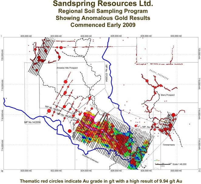
Figure 9-1: Results of the Sandspring 2009 Regional Soil Sampling Program
| P&E Mining Consultants Inc., Report No. 186 | Page 35 of 121 |
| Sandspring Resources Ltd. | |
| Toroparu Gold-Copper Prospect |
9.22009 TRENCHING
Forty one trenches totalling 6,000 m were completed from August through October of 2009. Trenches were spaced 5 km along the strike length of the Toroparu shear zone. Attempts were made to orient trenches perpendicular to regional structural trends. Highlights of this trenching program are given in table 9.1.
Table 9.1:Summary of Mineralized Trench Zones
| Trench ID | From | To | Interval (m) | Au (g/t) |
| Trench09 11 | 14.32 | 51.21 | 36.9 | 0.54 |
| Trench09 13 | 0 | 19.2 | 19.2 | 0.64 |
| Trench09 16 | 93.3 | 103.2 | 9.9 | 0.60 |
| Trench09 17 | 33.1 | 37.5 | 4.4 | 2.06 |
| 120.2 | 125 | 4.8 | 1.14 | |
| 185.5 | 190.2 | 4.7 | 0.73 | |
| 225.2 | 234.5 | 9.3 | 0.51 | |
| 277.8 | 282.4 | 4.6 | 0.90 | |
| 312.1 | 316.4 | 4.3 | 0.92 | |
| Trench09 18 | 53.3 | 58.4 | 5.1 | 1.13 |
| 33.8 | 43.1 | 9.3 | 1.28 | |
| 68.3 | 73.6 | 5.3 | 0.66 | |
| Trench09 35 | 189 | 192 | 3.0 | 1.07 |
| Trench09 38 | 9 | 15 | 6.0 | 1.01 |
| 45 | 48 | 3.0 | 6.26 | |
| 165 | 168 | 3.0 | 2.44 | |
| Trench09 40 | 48 | 69 | 21.0 | 0.55 |
| 75 | 78 | 3.0 | 2.27 | |
| 84 | 87 | 3.0 | 45.20 | |
| 87 | 90 | 3.0 | 13.00 | |
| 147 | 150 | 3.0 | 5.45 | |
| Trench09 41 | 51 | 54 | 3.0 | 1.27 |
| 66 | 69 | 3.0 | 3.41 | |
| 111 | 114 | 3.0 | 2.50 | |
| 138 | 150 | 12.0 | 1.75 | |
| Trench09 42 | 96 | 99 | 3.0 | 1.93 |
| 147 | 159 | 12.0 | 0.72 | |
| Trench09 48 | 201 | 210 | 9.0 | 0.91 |
| Trench09 49N | 0 | 63 | 63.0 | 1.06 |
| Trench09 50 | 0 | 21 | 21.0 | 1.34 |
| 180 | 183 | 3.0 | 0.99 | |
| Trench09 51 | 439 | 442 | 3.0 | 1.23 |
| 472 | 556 | 84.0 | 0.51 | |
| 622 | 628 | 6.0 | 1.36 | |
| 634 | 637 | 3.0 | 1.38 | |
| Trench09 52 | 15 | 18 | 3.0 | 1.99 |
| 27 | 30 | 3.0 | 1.14 | |
| 78 | 84 | 6.0 | 1.43 |
| P&E Mining Consultants Inc., Report No. 186 | Page 36 of 121 |
| Sandspring Resources Ltd. | |
| Toroparu Gold-Copper Prospect |
| Trench ID | From | To | Interval (m) | Au (g/t) |
| Trench09 54 | 72 | 75 | 3.0 | 1.32 |
| Trench09 55 | 36 | 39 | 3.0 | 0.94 |
| 51 | 54 | 3.0 | 26.75 | |
| 54 | 57 | 3.0 | 15.40 | |
| 78 | 81 | 3.0 | 1.62 | |
| Trench09 56 | 105 | 117 | 12.0 | 0.72 |
| Trench09 57 | 51 | 54 | 3.0 | 0.98 |
| Trench09 58 | 18 | 21 | 3.0 | 1.76 |
9.32009 GRADIENT ARRAY IP SURVEY
In 2009, GoldHeart commenced a ground based gradient array IP survey of the Toroparu pit and trend area which was later continued by Sandspring. At the time of writing this report, P&E had not obtained any information relating to this survey other than several figures showing the interpreted IP data, some of which are shown in figures 9-2 to 9-4 below.
| P&E Mining Consultants Inc., Report No. 186 | Page 37 of 121 |
| Sandspring Resources Ltd. | |
| Toroparu Gold-Copper Prospect |
Figure 9-2: Ground Induced Polarization (IP) Data from Sandspring (2010)
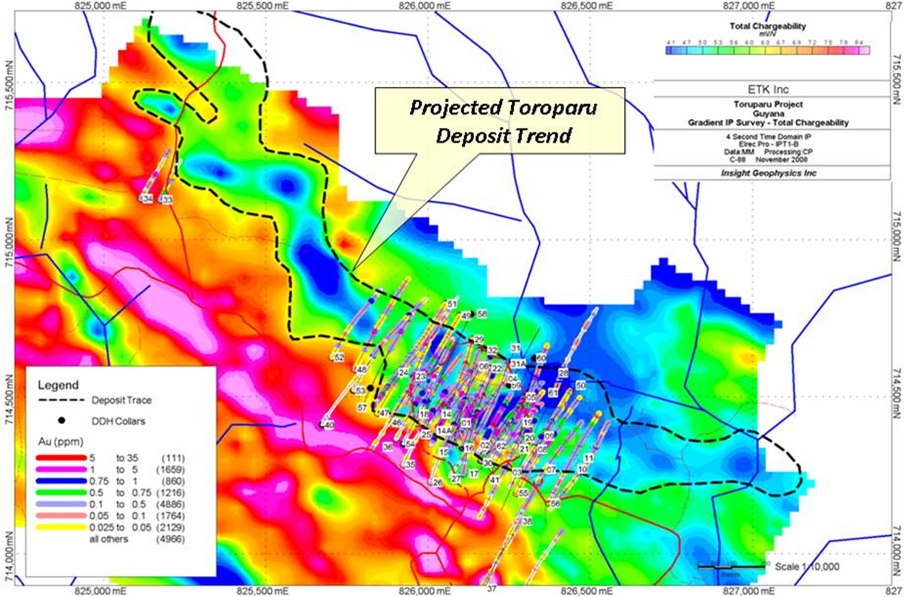
| P&E Mining Consultants Inc., Report No. 186 | Page 38 of 121 |
| Sandspring Resources Ltd. | |
| Toroparu Gold-Copper Prospect |
Figure 9-3:Toroparu Deposit Drill Section 826099E Over IP with Geology, Gold and Copper from Sandspring (2010)
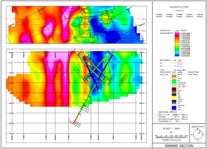
| P&E Mining Consultants Inc., Report No. 186 | Page 39 of 121 |
| Sandspring Resources Ltd. | |
| Toroparu Gold-Copper Prospect |
Figure 9-4:Toroparu Deposit Drill Section 825878E Over IP with Geology, Gold and Copper from Sandspring (2010)
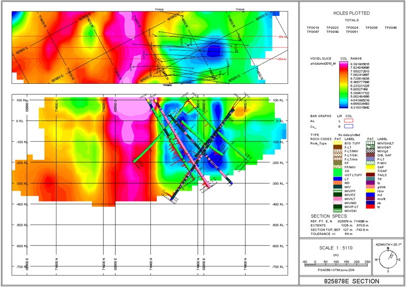
| P&E Mining Consultants Inc., Report No. 186 | Page 40 of 121 |
| Sandspring Resources Ltd. | |
| Toroparu Gold-Copper Prospect |
10.0 DRILLING
All previous drilling carried out on the Property has been described in Section 5.1 of this report.
10.12009/2010 TWO-PHASE DRILL PROGRAM
Following the 2006 and 2007 drilling undertaken by ETK, a follow up secondary two-phase drill program commenced in August of 2009 by ETK (later continued by Sandspring). The initial phase of drilling was carried out from August to December of 2009, while the second phase of drilling was carried out from January through March of 2010. Both phases of drilling focused on the Toroparu pit area carrying out infill and definition drilling whilst also extending the known pit to both the west and east.
The initial phase of drilling was comprised of twenty-one NQ diamond drill holes for a total of 10,102 m. Thirteen holes totalling, 8,010 m were drilled over the Toroparu open pit area with depths upwards of 500 m. Hole 31 was abandoned at 74 m and was re-drilled as 31A.
Two holes, TPD033 and TPD034 (452.0 m) were drilled 700 m to the west along trend, however outside of the currently defined zone of mineralization and returned negligible Au and Cu results. Two holes TPD037 and TPD039 were drilled 320 m off trend to the south. Similarly four holes, TPD042 TPD043, TPD044 and TPD045 (1,467 m) were drilled 1.2 km to the east along trend in an area referred to as Confluence Area (aka “Scum Pool”) which also lies outside of the currently defined zone of mineralization and returned negligible Au and Cu results.
A second phase of infill drilling comprised of fourteen NQ diamond drill holes for a total of 7,337m was completed during the January 2010-March 2010 period. These holes were typically inclined from between -50̊ to -60̊, towards either the north-east (at and azimuth of 027̊) or south-west (at an azimuth of 207̊) and reached depths upwards of 600 m.
This two phase drill program comprised thirty-four NQ diamond drill holes with a total of 17,439 m completed. Twenty-six holes totalling 14,545 m were drilled over the Toroparu open pit area with two holes TPD033 and TPD034 (452.0 m) drilled along trend to the northwest and outside of the mineralized zone approximately 700 m from TPD052, TPD037 and TPD039 (975.0 m) drilled off trend towards the south approximately 320 m from TPD056 and four holes TPD042, TPD043, TPD044 and TPD045 (1,919 m) drilled along trend to the southeast and outside of the mineralized zone approximately 1.2 km from TPD056. Both phases of drilling extended the resource to the east, west and to depth.
All holes were cored with HQ rods within saprolite sections followed by NQ rods within the hard rock and angled roughly perpendicular to the trend of mineralization. Recoveries ranged from between 70-90% in saprolite to 98-100% in hard rock. All drill holes were drilled across the strike of the Toroparu pit and were spaced variably at 25-50m spacing where possible.
Figures 10-1 to 10-3 are representative cross-sections through the Toroparu Deposit showing corresponding drillholes on each section from all phases of drilling.
| P&E Mining Consultants Inc., Report No. 186 | Page 41 of 121 |
| Sandspring Resources Ltd. | |
| Toroparu Gold-Copper Prospect |
Table 10.1:Summary of Mineralized Drill Intercepts from the 2009/2010 Drill Program
| Hole No. | From (m) | To (m) | Length (m) | Au-avg (g/t) | Cu-avg (%) |
| TPD030 | 231.00 | 289.50 | 58.50 | 1.170 | 0.250 |
| 300.00 | 327.00 | 27.00 | 1.110 | 0.240 | |
| TPD031 | 408.00 | 429.00 | 21.00 | 0.670 | 0.110 |
| 438.00 | 454.50 | 16.50 | 0.770 | 0.080 | |
| 498.00 | 504.00 | 6.00 | 1.050 | 0.020 | |
| 550.50 | 555.00 | 4.50 | 2.170 | 0.100 | |
| TPD032 | 456.00 | 468.00 | 12.00 | 0.820 | 0.070 |
| 477.00 | 501.00 | 24.00 | 1.150 | 0.180 | |
| TPD033 | 102.50 | 110.00 | 7.50 | 1.000 | nil |
| 116.00 | 120.50 | 4.50 | 1.000 | nil | |
| TPD034 | 221.00 | 224.00 | 3.00 | 3.660 | 0.010 |
| TPD035 | 314.00 | 368.00 | 54.00 | 1.170 | 0.160 |
| 465.50 | 479.00 | 13.50 | 1.170 | 0.070 | |
| 506.00 | 537.50 | 31.50 | 1.130 | 0.070 | |
| TPD036 | 238.50 | 342.00 | 103.50 | 1.760 | 0.090 |
| 357.00 | 376.50 | 19.50 | 1.390 | 0.210 | |
| 405.00 | 420.00 | 15.00 | 1.140 | 0.100 | |
| TPD037 | 549.50 | 575.00 | 25.50 | 1.770 | 0.030 |
| TPD038 | 87.00 | 90.00 | 3.00 | 2.520 | 0.310 |
| 412.50 | 415.50 | 3.00 | 1.490 | 0.000 | |
| TPD041 | 196.50 | 261.00 | 64.50 | 0.770 | 0.250 |
| 354.00 | 417.00 | 63.00 | 1.500 | 0.090 | |
| 363.00 | 408.00 | 45.00 | 1.880 | 0.110 | |
| 414.00 | 417.00 | 3.00 | 1.640 | 0.090 | |
| TPD046 | 1.00 | 4.00 | 3.00 | 1.330 | 0.000 |
| 22.50 | 25.50 | 3.00 | 0.920 | 0.000 | |
| 141.00 | 144.00 | 3.00 | 3.580 | 0.140 | |
| 201.00 | 303.00 | 102.00 | 1.040 | 0.050 | |
| 201.00 | 273.00 | 72.00 | 1.160 | 0.060 | |
| 289.50 | 303.00 | 13.50 | 1.310 | 0.060 | |
| 339.00 | 348.00 | 9.00 | 1.890 | 0.320 | |
| 369.00 | 390.00 | 21.00 | 0.900 | 0.150 | |
| 465.00 | 499.50 | 34.50 | 1.270 | 0.060 | |
| TPD047 | 226.50 | 231.00 | 4.50 | 3.760 | 0.060 |
| 285.00 | 292.50 | 7.50 | 1.200 | 0.080 | |
| 397.50 | 436.50 | 39.00 | 1.030 | 0.060 | |
| 480.00 | 516.00 | 36.00 | 1.530 | 0.180 | |
| 501.00 | 516.00 | 15.00 | 3.050 | 0.370 | |
| TPD048 | 126.50 | 129.50 | 3.00 | 1.670 | 0.010 |
| 168.50 | 221.00 | 52.50 | 1.920 | 0.030 | |
| 200.00 | 206.00 | 6.00 | 12.790 | 0.030 | |
| 269.00 | 273.50 | 4.50 | 1.290 | 0.030 | |
| 293.00 | 305.00 | 12.00 | 1.320 | 0.090 | |
| 323.00 | 326.00 | 3.00 | 2.040 | 0.150 |
| P&E Mining Consultants Inc., Report No. 186 | Page 42 of 121 |
| Sandspring Resources Ltd. | |
| Toroparu Gold-Copper Prospect |
| Hole No. | From (m) | To (m) | Length (m) | Au-avg (g/t) | Cu-avg (%) |
| TPD049 | 318.00 | 444.00 | 126.00 | 0.780 | 0.090 |
| 538.50 | 565.50 | 27.00 | 1.510 | 0.050 | |
| 559.50 | 565.50 | 6.00 | 4.900 | 0.110 | |
| TPD050 | 0.00 | 4.00 | 4.00 | 3.480 | 0.050 |
| 219.00 | 339.00 | 120.00 | 1.330 | 0.090 | |
| 357.00 | 360.00 | 3.00 | 1.100 | 0.060 | |
| 387.00 | 391.50 | 4.50 | 0.890 | 0.030 | |
| 444.00 | 487.50 | 43.50 | 1.580 | 0.050 | |
| TPD051 | 393.00 | 403.50 | 10.50 | 1.720 | 0.060 |
| 465.00 | 478.50 | 13.50 | 0.810 | 0.020 | |
| 498.00 | 534.00 | 36.00 | 1.130 | 0.040 | |
| 541.50 | 580.50 | 39.00 | 1.390 | 0.020 | |
| 612.00 | 615.00 | 3.00 | 1.490 | 0.060 | |
| TPD052 | 409.50 | 412.50 | 3.00 | 1.250 | 0.140 |
| 423.00 | 426.00 | 3.00 | 0.590 | 0.030 | |
| 433.50 | 436.50 | 3.00 | 0.830 | 0.070 | |
| 442.50 | 445.50 | 3.00 | 1.070 | 0.050 | |
| TPD053 | 265.00 | 269.50 | 4.50 | 1.710 | 0.010 |
| 298.00 | 302.50 | 4.50 | 1.930 | 0.240 | |
| 473.50 | 476.50 | 3.00 | 1.060 | 0.060 | |
| TPD054 | 232.50 | 243.00 | 10.50 | 0.950 | 0.150 |
| 252.00 | 289.50 | 37.50 | 1.110 | 0.120 | |
| 298.50 | 349.50 | 51.00 | 1.380 | 0.070 | |
| 400.50 | 487.50 | 87.00 | 1.740 | 0.100 | |
| 493.50 | 511.50 | 18.00 | 4.460 | 0.020 | |
| TPD055 | 5.50 | 8.50 | 3.00 | 1.250 | 0.010 |
| 103.50 | 108.00 | 4.50 | 2.550 | 0.410 | |
| 117.00 | 120.00 | 3.00 | 10.760 | 0.140 | |
| 133.50 | 141.00 | 7.50 | 1.450 | 0.720 | |
| 174.00 | 178.50 | 4.50 | 2.150 | 0.610 | |
| 238.50 | 241.50 | 3.00 | 0.530 | 0.130 | |
| 244.50 | 249.00 | 4.50 | 2.010 | 0.240 | |
| 274.50 | 277.50 | 3.00 | 0.890 | 0.040 | |
| 285.00 | 288.00 | 3.00 | 0.830 | 0.110 | |
| 291.00 | 340.50 | 49.50 | 1.030 | 0.090 | |
| 346.50 | 352.50 | 6.00 | 3.640 | 0.120 | |
| 394.50 | 397.50 | 3.00 | 0.940 | 0.010 | |
| 402.00 | 409.50 | 7.50 | 0.870 | 0.030 | |
| 415.50 | 418.50 | 3.00 | 1.230 | 0.080 | |
| 430.50 | 444.00 | 13.50 | 0.830 | 0.020 | |
| 453.00 | 457.50 | 4.50 | 0.920 | 0.070 | |
| 502.50 | 508.50 | 6.00 | 1.710 | 0.000 | |
| 543.00 | 547.50 | 4.50 | 1.510 | 0.000 | |
| 559.50 | 564.00 | 4.50 | 1.060 | 0.000 |
| P&E Mining Consultants Inc., Report No. 186 | Page 43 of 121 |
| Sandspring Resources Ltd. | |
| Toroparu Gold-Copper Prospect |
| Hole No. | From (m) | To (m) | Length (m) | Au-avg (g/t) | Cu-avg (%) |
| TPD056 | 0.00 | 4.00 | 4.00 | 0.630 | 0.060 |
| 47.50 | 50.50 | 3.00 | 1.070 | 0.080 | |
| 262.50 | 271.50 | 9.00 | 1.020 | 0.070 | |
| 280.50 | 319.50 | 39.00 | 0.910 | 0.060 | |
| 322.50 | 325.50 | 3.00 | 0.570 | 0.020 | |
| 343.50 | 355.50 | 12.00 | 0.890 | 0.020 | |
| 370.50 | 375.00 | 4.50 | 0.570 | 0.010 | |
| 390.00 | 411.00 | 21.00 | 1.110 | 0.010 | |
| 436.50 | 441.00 | 4.50 | 0.800 | 0.040 | |
| 445.50 | 451.50 | 6.00 | 1.180 | 0.010 | |
| 502.50 | 510.00 | 7.50 | 0.790 | 0.010 | |
| 514.50 | 517.50 | 3.00 | 7.970 | 0.000 | |
| TPD057 | 214.50 | 235.50 | 21.00 | 0.940 | 0.030 |
| 279.00 | 294.00 | 15.00 | 0.750 | 0.130 | |
| 297.00 | 298.50 | 1.50 | 0.700 | 0.070 | |
| 348.00 | 349.50 | 1.50 | 1.050 | 0.120 | |
| 358.50 | 364.50 | 6.00 | 0.870 | 0.090 | |
| 382.50 | 385.50 | 3.00 | 0.700 | 0.050 | |
| 391.50 | 394.50 | 3.00 | 0.560 | 0.050 | |
| 406.50 | 411.00 | 4.50 | 0.800 | 0.030 | |
| 415.50 | 418.50 | 3.00 | 0.970 | 0.090 | |
| 501.00 | 514.50 | 13.50 | 2.070 | 0.210 | |
| TPD058 | 109.50 | 112.50 | 3.00 | 0.700 | 0.170 |
| 258.00 | 265.50 | 7.50 | 1.750 | 0.120 | |
| 276.00 | 303.00 | 27.00 | 0.630 | 0.120 | |
| 327.00 | 330.00 | 3.00 | 0.950 | 0.160 | |
| 367.50 | 370.50 | 3.00 | 0.710 | 0.250 | |
| 390.00 | 399.00 | 9.00 | 2.580 | 0.130 | |
| 424.50 | 432.00 | 7.50 | 0.970 | 0.060 | |
| 459.00 | 462.00 | 3.00 | 18.020 | 0.060 | |
| 466.50 | 469.50 | 3.00 | 1.020 | 0.120 | |
| 528.00 | 567.00 | 39.00 | 1.830 | 0.150 | |
| TPD059 | 23.50 | 25.00 | 1.50 | 1.330 | 0.080 |
| 139.50 | 141.00 | 1.50 | 3.710 | 0.010 | |
| 168.00 | 169.50 | 1.50 | 2.090 | 0.000 | |
| 246.00 | 247.50 | 1.50 | 1.170 | 0.110 | |
| TPD060 | 25.00 | 28.00 | 3.00 | 0.570 | 0.150 |
| 297.50 | 326.00 | 28.50 | 1.570 | 0.100 | |
| 342.50 | 344.00 | 1.50 | 4.380 | 0.100 | |
| 363.50 | 375.50 | 12.00 | 0.950 | 0.130 | |
| 383.00 | 425.00 | 42.00 | 1.860 | 0.190 | |
| 434.00 | 438.50 | 4.50 | 0.740 | 0.150 | |
| 447.50 | 452.00 | 4.50 | 1.580 | 0.110 |
| P&E Mining Consultants Inc., Report No. 186 | Page 44 of 121 |
| Sandspring Resources Ltd. | |
| Toroparu Gold-Copper Prospect |
| Hole No. | From (m) | To (m) | Length (m) | Au-avg (g/t) | Cu-avg (%) |
| TPD061 | 0.00 | 4.00 | 4.00 | 1.060 | 0.040 |
| 36.00 | 39.50 | 3.50 | 0.620 | 0.020 | |
| 92.00 | 104.00 | 12.00 | 1.880 | 0.130 | |
| 108.50 | 111.50 | 3.00 | 1.480 | 0.160 | |
| 119.00 | 162.50 | 43.50 | 1.120 | 0.100 | |
| 168.50 | 255.50 | 87.00 | 1.390 | 0.140 | |
| 266.00 | 275.00 | 9.00 | 2.560 | 0.230 | |
| 345.50 | 351.50 | 6.00 | 0.630 | 0.040 | |
| 395.00 | 398.00 | 3.00 | 0.810 | 0.070 | |
| 479.00 | 482.00 | 3.00 | 0.600 | 0.060 | |
| 485.00 | 528.50 | 43.50 | 1.000 | 0.160 | |
| 549.50 | 552.50 | 3.00 | 0.720 | 0.140 | |
| 555.50 | 558.50 | 3.00 | 4.240 | 0.120 | |
| 612.50 | 615.50 | 3.00 | 0.940 | 0.190 | |
| 629.00 | 632.00 | 3.00 | 1.150 | 0.160 | |
| 642.50 | 648.50 | 6.00 | 0.920 | 0.130 | |
| TPD062 | 37.00 | 40.00 | 3.00 | 2.480 | 0.100 |
| 99.00 | 103.50 | 4.50 | 0.860 | 0.030 | |
| 163.50 | 213.00 | 49.50 | 1.960 | 0.490 | |
| 228.00 | 232.50 | 4.50 | 0.810 | 0.170 | |
| 246.00 | 327.00 | 81.00 | 1.150 | 0.140 | |
| 349.50 | 352.50 | 3.00 | 0.540 | 0.070 | |
| 372.00 | 384.00 | 12.00 | 1.060 | 0.180 | |
| 390.00 | 397.50 | 7.50 | 1.070 | 0.110 | |
| 406.50 | 409.50 | 3.00 | 0.630 | 0.110 | |
| 414.00 | 424.50 | 10.50 | 1.060 | 0.060 | |
| 445.50 | 456.00 | 10.50 | 0.540 | 0.040 | |
| TPD063 | 65.00 | 69.50 | 4.50 | 1.570 | 0.110 |
| 117.50 | 129.50 | 12.00 | 1.030 | 0.090 | |
| 165.50 | 170.00 | 4.50 | 3.680 | 0.030 | |
| 264.50 | 273.50 | 9.00 | 9.670 | 0.010 | |
| 285.50 | 288.50 | 3.00 | 1.590 | 0.130 | |
| 294.50 | 297.50 | 3.00 | 1.950 | 0.220 | |
| 344.00 | 347.00 | 3.00 | 1.120 | 0.020 | |
| TPD064 | 38.50 | 41.50 | 3.00 | 1.580 | 0.070 |
| 115.50 | 121.50 | 6.00 | 1.050 | 0.310 | |
| 133.50 | 138.00 | 4.50 | 0.620 | 0.180 |
| P&E Mining Consultants Inc., Report No. 186 | Page 45 of 121 |
| Sandspring Resources Ltd. | |
| Toroparu Gold-Copper Prospect |
| Hole No. | From (m) | To (m) | Length (m) | Au-avg (g/t) | Cu-avg (%) |
| 142.50 | 145.50 | 3.00 | 0.860 | 0.190 | |
| 151.50 | 198.00 | 46.50 | 2.070 | 0.490 | |
| 204.00 | 225.00 | 21.00 | 3.140 | 0.270 | |
| 238.50 | 241.50 | 3.00 | 0.650 | 0.170 | |
| 253.50 | 274.50 | 21.00 | 1.220 | 0.170 | |
| 280.50 | 285.00 | 4.50 | 0.560 | 0.090 | |
| 325.50 | 336.00 | 10.50 | 0.960 | 0.080 | |
| 342.00 | 358.50 | 16.50 | 1.060 | 0.060 | |
| 364.50 | 376.50 | 12.00 | 1.090 | 0.090 | |
| 385.50 | 394.50 | 9.00 | 0.920 | 0.070 | |
| 400.50 | 406.50 | 6.00 | 1.060 | 0.060 |
| P&E Mining Consultants Inc., Report No. 186 | Page 46 of 121 |
| Sandspring Resources Ltd. | |
| Toroparu Gold-Copper Prospect |
Figure 10-1:P&E 2010 Cross Section 1700NW through the Toroparu Prospect showing both the Main and North zones of gold-copper mineralization.
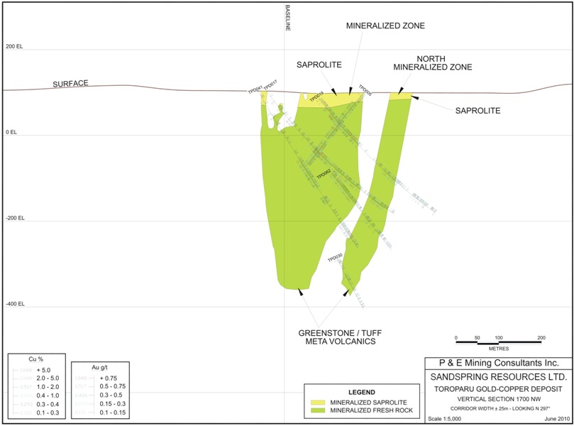
| P&E Mining Consultants Inc., Report No. 186 | Page 47 of 121 |
| Sandspring Resources Ltd. | |
| Toroparu Gold-Copper Prospect |
Figure 10-2:P&E 2010 Cross Section 1800NW through the Toroparu Prospect showing both the Main and North zones of gold-copper mineralization.
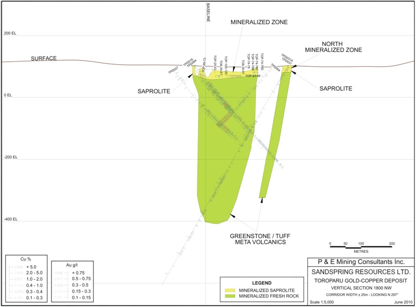
| P&E Mining Consultants Inc., Report No. 186 | Page 48 of 121 |
| Sandspring Resources Ltd. | |
| Toroparu Gold-Copper Prospect |
Figure 10-3:P&E 2010 Cross Section 1950NW through the Toroparu Prospect showing both the Main and North zones of gold-copper mineralization.
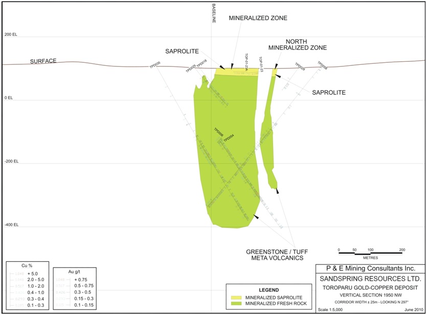
| P&E Mining Consultants Inc., Report No. 186 | Page 49 of 121 |
| Sandspring Resources Ltd. | |
| Toroparu Gold-Copper Prospect |
11.0 SAMPLING METHOD AND APPROACH
All sampling of drill core was supervised by Dr. Andrew Kemp, and Harvey Klatt, P. Geo. with assistance from Terry Naciuk and Kelsey Privett. This work is carried out on site in a specially constructed core logging and core storage facility near the open pit. The core storage is housed in a large industrial steel container with wooden core racks that can be secured with locks. Adjacent to the core storage, long core logging tables, with fluorescent lights and a diamond saw area, facilitate core logging and sample processing.
The core is first cleaned, labelled and tagged and then photographed in three box batches for reference. The core is marked in one metre or 1.5 metre lengths and these are then split. HQ saprolite samples are split with a knife and the NQ hard rock core is sawn in half with a diamond saw. Half of the core is put in marked sample bags with an appropriate tag. The other half is placed in the core box for logging and storage. Ten samples are placed in rice sacks which are then labelled, weighed and marked for weekly transport to the lab.
When the initial drill program began, Acme Analytical Laboratories Ltd. (“Acme”) had just opened a prep lab in Georgetown, Guyana. Sandspring sent samples to Acme, however as drilling progressed the turn-around time for assay results grew to over two months. At the completion of hole TPD-029, drilling activity was curtailed for approximately nine months while the company awaited closing of the Qualifying Transaction and delivery of the proceeds of a market financing. In the meantime, Activation Laboratories Inc., (“Actlabs”), opened a facility in Georgetown. Due to the lengthy turn-around times encountered at Acme, Sandspring chose to change labs and holes TPD-030 to TPD-050 were sent to Actlabs.
When assay turn-around times were not improved upon by sending samples to Actlabs, the Acme facility was once again considered. New personnel were managing the Acme lab and better turn-around was guaranteed. As a result, Sandspring renewed its relationship with Acme and have been shipping samples there from hole TPD-051 upward.
After every 20th sample, a certified reference material (a.k.a. CRM, standard), a core duplicate and a blank were inserted into the sample stream. Blank material was sourced from an outcrop of diabase intrusive, located approximately one kilometre south of the mineralized area.
The core was sampled in 1.0 and 1.5 metre intervals in a continuous fashion throughout each drill hole from the top most saprolite sections to final depths in greenstones. This approach ensured that the finely disseminated nature of the sulphides was adequately sampled and assayed over the entire core length.
There are no obvious drilling, sampling or recovery factors that would impact the reliability of the samples.
| P&E Mining Consultants Inc., Report No. 186 | Page 50 of 121 |
| Sandspring Resources Ltd. | |
| Toroparu Gold-Copper Prospect |
12.0 SAMPLE PREPARATION, ANALYSES AND SECURITY
12. 2009-2010 DIAMOND DRILL PROGRAM
All drill core samples were prepared under the supervision of professional geologists for the 2009-2010 drilling at Toroparu. The geologists were assisted by three trained helpers who split, bagged and prepared the sample batches.
The core samples are stored at the Toroparu camp in a locked steel shipping container and are transported by truck to the prep lab in Georgetown.
12.1.1 ACTIVATION LABORATORIES (“ACTLABS”)
Actlabs is an international analytical laboratory with locations in North and South America, Australia, Asia and Greenland. Actlabs’ Quality System is accredited to international quality standards through the International Organization for Standardization /International Electrotechnical Commission (ISO/IEC) 17025 (ISO/IEC 17025 includes ISO 9001 and ISO 9002 specifications) with CAN-P-1758 (Forensics), CAN-P-1579 (Mineral Analysis) and CAN-P-1585 (Environmental) for specific registered tests by the SCC. The accreditation program includes ongoing audits which verify the QA system and all applicable registered test methods. Actlabs is also accredited by the National Environmental Laboratory Accreditation Conference (NELAC) program and Health Canada.
The analytical procedures at Actlabs involved a metallic screen analysis which is described below.
Metallic Screen
A representative 250 gram split is sieved at 150 mesh (106 microns) with fire assays performed on the entire +150 mesh and 2 splits on the -150 mesh fraction. The total amount of sample and the +150 mesh and -150 mesh fraction is weighed for assay reconciliation. Measured amounts of cleaner sand is used between samples and saved as gold may plate out on the mill.
Fire Assay
The whole +150 mesh sub-sample from the metallic screen is mixed with fire assay fluxes (borax, soda ash, silica, litharge) and with Ag added as a collector and the mixture is placed in a fire clay crucible, the mixture is preheated at 850°C, intermediate 950 °C and finish 1060 °C, the entire fusion process should last 60 minutes. The crucibles are then removed from the assay furnace and the molten slag (lighter material) is carefully poured from the crucible into a mould, leaving a lead button at the base of the mould. The lead button is then placed in a preheated cupel which absorbs the lead when cupelled at 950°C to recover the Ag (doré bead) + Au. Au is separated from the Ag in the dore bead by parting with nitric acid. The gold (roasting) flake remaining is weighed gravimetrically on a microbalance. Two splits on the -150 mesh fraction are weighted and analyzed by fire assay with a gravimetric finish. A final assay is calculated based on the weight of each separated fraction and the values.
12.1.2 ACME ANALYTICAL LABORATORIES (“ACME”)
Acme Labs operates 19 offices in 11 countries. Acme implemented a quality system compliant with the International Standards Organization (ISO) 9001 Model for Quality Assurance and ISO/IEC 17025 General Requirements for the Competence of Testing and Calibration Laboratories. On November 13, 1996, Acme became the first commercial geochemical analysis and assaying lab in North America to be accredited under ISO 9001. The laboratory has maintained its registration in good standing since then.
| P&E Mining Consultants Inc., Report No. 186 | Page 51 of 121 |
| Sandspring Resources Ltd. | |
| Toroparu Gold-Copper Prospect |
In 2005 the Santiago, Chile laboratories received ISO 9001:2000 registration with the preparation facilities in Mendoza, Argentina and Georgetown, Guyana following in 2006. Acme’s Lima, Peru facility has just completed their registration audit.
Both the Vancouver and Santiago hub laboratories are working toward ISO 17025:2005 accreditation and are expected to complete the accreditation process within the next year.
At Acme in Georgetown, the samples are dried and the entire sample is crushed to better than 70%, passing -10 mesh. A 1000 gram split is taken and pulverized to better than 85% passing -200 mesh. The pulps are sent to Acme in Vancouver where they are analyzed for gold and copper.
All samples were analyzed at Acme using the metallic screen method, which is the same procedure as described above for Actlabs.
The sample preparation procedures, security and analytical procedures carried out at the Toroparu mine site and at the various analytical laboratories are all in accordance with industry best practices and accepted industry standards.
| P&E Mining Consultants Inc., Report No. 186 | Page 52 of 121 |
| Sandspring Resources Ltd. | |
| Toroparu Gold-Copper Prospect |
13.0 DATA VERIFICATION
13.1SITE VISIT AND INDEPENDENT SAMPLING
The Toroparu Property was visited by Eugene Puritch, P. Eng. from April 27 to April 28, 2010. Data verification sampling was done during the visit by taking ¼ splits of the remaining half core, with a total of 19 samples taken from 11 holes. The samples were then documented, bagged, and sealed with packing tape and were brought back to Canada by Mr. Puritch. From there the samples were brought to AGAT Labs in Toronto, Ontario for analysis.
At no time, prior to the time of sampling, were any employees or other associates of Sandspring advised as to the location or identification of any of the samples to be collected.
A comparison of the P&E independent sample verification results for gold and copper versus the original assay results can be seen in Figures 13.1 and 13.2.
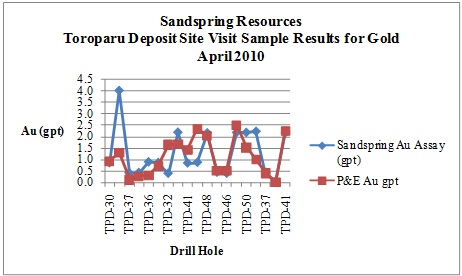
Figure 13.1: Independent Sample Verification Results for Gold
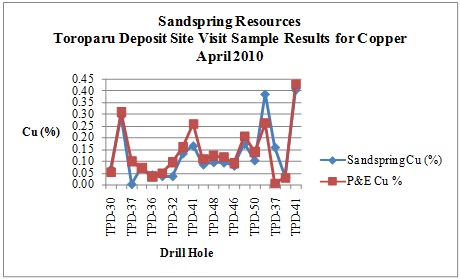
Figure 13.2: Independent Sample Verification Results for Copper
| P&E Mining Consultants Inc., Report No. 186 | Page 53 of 121 |
| Sandspring Resources Ltd. | |
| Toroparu Gold-Copper Prospect |
13.2 QUALITY CONTROL PROGRAM (QC)
Sandspring maintained the QC program that had been initiated with hole TPD-01, with the addition of certified reference materials, blanks and field duplicates to the sample stream. The QC in this section covers drillholes TPD-030 through TPD-066. An evaluation was completed on the results which are presented in the following sub-sections.
13.2.1 CERTIFIED REFERENCE MATERIALS AT ACTLABS
Sandspring inserted 11 different certified reference materials for holes TPD-030 to TPD-050. The list of reference materials is presented below. One of the standards did not have enough data points (CGS-16C) and is not included here.
| CRM Name | Au g/t | Cu % |
| Oreas 50Pb | 0.84 | 0.74 |
| Oreas 52Pb | 0.31 | 0.33 |
| CGS-13 | 1.01 | 0.33 |
| CGS-15 | 0.57 | 0.45 |
| CGS-19 | 0.74 | 0.13 |
| CM-4 | 1.18 | 0.51 |
| CM-5 | 0.29 | 0.32 |
| GS-2C | 2.06 | n/a |
| GS-3F | 3.10 | n/a |
| GS-P8 | 0.78 | n/a |
The reference materials were inserted alternately into the sample stream at a rate of approximately 1 in 20.
All results for all reference materials were examined in detail including graphs of each with the performance gates based on the standard deviations of the between-lab round robins as per the certification spec sheets. Any failure of the Au or Cu reference materials to meet these criteria was dealt with accordingly. All the data included for the current resource have passed the rigorous quality control program.
13.2.2 BLANKS FOR HOLES TPD-030 TO TPD-050
A total of 211 blanks were inserted into the sample stream. Blank material was sourced from an outcrop of diabase intrusive, located approximately one kilometre south of the mineralized area.
At the beginning of the drill program starting with hole TPD-030, blanks were occasionally returning values above 1 g/t Au. Discussions were held with Actlabs, and several of the anomalous blank samples were re-analyzed. The re-runs confirmed the original value. Upon closer examination of the material being used, seams of pyrite up to two cm in width or narrow quartz veinlets were occasionally observed. New blank material was sourced from the same outcrop area as the original blank material, with care taken to avoid collecting any visible sulphides. The new material was used beginning in hole TPD-038.
| P&E Mining Consultants Inc., Report No. 186 | Page 54 of 121 |
| Sandspring Resources Ltd. | |
| Toroparu Gold-Copper Prospect |
There were consistent failures of the blank material in holes TPD-030 through TPD-037, (the lab blanks for holes TPD-030 through TPD-037 passed in all cases). Once the new material had been collected and used, none of the blanks failed for holes TPD-038 through TPD-050.
All values for Cu were above three times the detection limit, which was 0.00015%. The average value was 0.025% Cu and there was one value at 0.34% Cu. It is obvious that the diabase outcrop used for the blank material has higher than normal background values for Cu. The average grade for Cu in the deposit is 0.16%, the likely cut-off grade in the range of 0.08% Cu and all the blank values with the exception of one were well below these values. No action was taken.
13.3CERTIFIED REFERENCE MATERIALS ACME LABS
Sandspring inserted nine different certified reference materials for holes TPD-051 to TPD-066. The two Oreas standards were not used for these holes.
All results for all reference materials were examined in detail including graphs of each with the performance gates based on the standard deviations of the between lab round robins as per the certification spec sheets. Any failure of the Au or Cu reference materials to meet the criteria was dealt with accordingly. All the data included for the current resource has passed the rigorous quality control program.
13.3.1 BLANKS FOR HOLES TPD-051 TO TPD-059
The blank material used was the same as what was used for holes TPD-030 to TPD-050. Due to the continuing occasional failure, Sandspring decided at hole TPD-057 to begin using a commercially available silica sand blank until a better natural source could be located close to the site.
13.4FIELD CORE DUPLICATES
Simple scatter graphs were created for the field duplicate pairs for holes TPD-030 to TPD-050 and for holes TPD-051 to TPD-066. The scatter graphs were divided into these two groups, as holes TPD-030 to TPD-050 were analyzed using the metallic screen method, and holes TPD-051 to TPD-066 were analyzed using routine fire assay on a 50 gram aliquot.
The precision on the field duplicate pairs for holes TPD-030 to TPD-050 which underwent the metallic screen procedure was high, and much better than what is a typical precision for field duplicates. This is due to the fact that 250 grams was crushed and pulverized and the resulting value was a weighted average of the +150 mesh fraction plus the average of two 50 gram samples of the -150 mesh fraction. The initial sample volume was five times higher than the sample volume for holes TPD-051 to TPD-066.
The subsequent drill programs will incorporate a coarse reject duplicate and a pulp replicate into the sample stream, which will enable comparison of the three duplicate types.
The author considers that the data are of good quality for use in a resource estimate.
| P&E Mining Consultants Inc., Report No. 186 | Page 55 of 121 |
| Sandspring Resources Ltd. | |
| Toroparu Gold-Copper Prospect |
14.0 ADJACENT PROPERTIES
Sections 14 is taken directly from the report titled, “2006/2007 Drilling Report on the Toroparu Copper-Gold Prospect, Upper Puruni River Area, Guyana,” authored by Henry Meixner, and dated August 10, 2007.
There are no properties of merit situated immediately adjacent to the Toroparu Property. The nearest property considered of relevance is the Peters Mine Property, which is situated 100 km east of the Toroparu property, and is currently being explored by Guyana Goldfields. This property has reportedly produced 42,000 ounces of gold between 1905 and 1916. The geological setting at Peters Mine, as described by Cargill and Gow in a 43-101 technical report dated January 2004, appears to be somewhat similar to the geological setting at Toroparu..
The Peters Mine property is underlain by greenstones, volcaniclastic sediments and intrusives of the Barama-Mazaruni Supergroup that are locally, unconformably overlain by conglomerates and sandstones of the mid-Proterozoic Roraima Supergroup. A broad shear zone is present, as at Toroparu. The host rocks at Peters Mine are clay-rich sandstones. In the main zone primary gold mineralization occurs in quartz veins with sericite alteration envelopes. Most of the gold is free, similar to Toroparu, and geological ore controls are not understood at present. However, it is known that gold mineralization is structurally controlled and epigenetic. Gold may be present in veins or in distinct wallrock alteration zones. Pyrite and arsenopyrite are the main sulphide species at low metamorphic grades. Wallrock alteration forms a zoned halo 0.2 to 200 metres wide.
Alteration is related to potassium, oxygen, sulphur and carbon dioxide metasomatism. Subtle distal potassium and carbon dioxide metasomatism can be explored using alteration indices and trace element distribution. Trace elements include silver, arsenic, boron, bismuth, molybdenum, lead, antimony, tellurium and tungsten. There is typically a low base metal content associated with gold mineralization.
Indicated and Inferred Gold resources were estimated By Cargill and Gow to be 420,000 tonnes, with a grade of 1.9 g Au/t in the tailings and a total estimated inferred resource of 353,000 tonnes with a grade of 2.8 g Au/t in tailings plus saprolite.
The reader is cautioned that the information regarding the mineralization on the Peters Mine property has not been verified and is not necessarily indicative of any mineralization that maybe present on the Property that is the subject of this report.
| P&E Mining Consultants Inc., Report No. 186 | Page 56 of 121 |
| Sandspring Resources Ltd. | |
| Toroparu Gold-Copper Prospect |
15.0 MINERAL PROCESSING AND METALLURGICAL TESTING
Sandspring undertook initial metallurgical testing on samples from the Toroparu Deposit in 2009. The samples were sent to SGS Lakefield Research Limited and consisted of saprolite ore, saprolite tailing mixture and a hard rock composite. The following is a summary taken directly from the June 2009 SGS Lakefield Research Limited report (Lan et al, 2009) and is intended for reference purposes only.
“An initial metallurgical scoping test program was conducted on the saprolite and hard rock ore samples from the Toroparu deposit of Sandspring Resources Inc. in Guyana. The goal of this program was to scope the amenability of Toroparu ore to typical gold extraction and copper recovery methods. In addition, baseline environmental and batch cyanide destruction tests were conducted to identify potential environmental liabilities associated with the conditions under consideration.
The saprolite tailing mixture sample assayed 0.6 g/t Au. The hard rock core composite assayed 1.43 g/t Au and 0.17% Cu.
The rougher flotation scoping tests on the hard rock composite showed that the copper and gold recoveries in the rougher concentrate were ~97% and ~93%, respectively. The mass pull was 2.5-3.6%. These results show that the copper and gold in the hard rock ore were effectively recovered by flotation.
The 72-hour cyanidation and 48-hour CIL tests on the rougher flotation tailing from the hard rock composite showed that 70-74% of the gold could be extracted. Conventional cyanidation conditions were applied in the tests. The overall gold recovery in the flotation rougher concentrate and cyanidation of flotation tailing was about 98%. A 72-hour cyanidation test on the copper rougher flotation concentrate suggested that approximately 68% of gold was leached.
The 72-hour cyanidation and 48-hour CIL tests on the saprolite gravity tailing mixture revealed that >95% of the gold was extracted using conventional cyanidation conditions and the cyanide consumption was low. The results indicate that the saprolite tailing mixture responded well to cyanidation.
A basic environmental test program characterised three waste samples: (1) a blend of two waste rocks (Sandspring Blended Waste Rock); (2) a CIL residue of hard rock flotation tailings (F2 Ro Tails); and (3) a saprolite tailing CIL residue (CIL-6 Residue).
Whole rock analyses determined that the Toroparu waste products (Sandspring Blended Waste Rock, F2 Ro Tails and CIL-6 Residue) were comprised primarily of silicates with moderate amounts of aluminum and iron. Minor amounts of calcium and sodium were also evident in the Sandspring Blended Waste Rock and F2 Ro Tails samples; however, only trace amounts of these elements were reported in the CIL-6 Residue sample. Inductively coupled plasma-optical emission spectroscopy/mass spectroscopy (ICP-OES/MS) elemental analyses confirmed the whole rock results.
Synthetic precipitation leaching procedure (SPLP) extraction testing of the waste products reported alkaline final pH values indicative of the inherent buffering capacity of the waste samples tested. Significant concentrations of calcium, sodium and silica were also evident in the leachates. With the exception of alkaline pH values, all World Bank controlled parameters in the SPLP leachates reported at concentrations well within the designated limits.
| P&E Mining Consultants Inc., Report No. 186 | Page 57 of 121 |
| Sandspring Resources Ltd. | |
| Toroparu Gold-Copper Prospect |
Modified acid base accounting (ABA) tests clearly indicated the significant neutralization capacity of the Sandspring Blended Waste Rock and F2 Ro Tails samples and suggested that these samples have the potential for acid consumption. The non acid generating nature of these samples was confirmed during net acid generation (NAG) testing.
ABA testing of the CIL-6 Residue sample; however, suggested uncertainty with regard to the acid generation potential. Nonetheless, the very low sulphide content (<0.01%) reported indicates that acid generation is highly unlikely to occur from this sample NAG testing of the CIL-6 Residue sample reported no net acidity generated and an alkaline final pH value corroborating the highly unlikely acid generating designation.
To explore the amenability of the CIL discharges to detoxification, two batch cyanide destruction tests were carried out using the SO2/Air method. One was conducted on the CIL barren solution of the hard rock rougher flotation tailing (test CIL-5) and another was conducted on the CIL barren solution of the gravity tailing mixture (test CIL-6). Both of the tests showed that the CNWAD and CNT contents were lowered to <0.1 ppm and <0.4 ppm, respectively. The retention times were equal or less than 90 minutes. The reagent consumptions for hard rock CIL solution was 4.99 gram equivalent SO2 and 3.30 gram hydrated lime per gram of cyanide in the feed. The reagent requirement for the saprolite tailing mixture CIL solution was 5.14 gram equivalent SO2 and 3.57 gram hydrated lime per gram of cyanide in the feed. Continuous testing is recommended for a future test program to optimize the retention time and minimize the reagent consumptions.”
| P&E Mining Consultants Inc., Report No. 186 | Page 58 of 121 |
| Sandspring Resources Ltd. | |
| Toroparu Gold-Copper Prospect |
16.0 2010 MINERAL RESOURCE ESTIMATE
16.1INTRODUCTION
The purpose of this report section is to update the estimate of the Mineral Resources of the Toroparu Deposit in compliance with NI 43-101 and CIM standards. This Resource Estimate was undertaken by Eugene Puritch, P.Eng. and Antoine Yassa, P.Geo. of P&E Mining Consultants Inc. of Brampton Ontario. The effective date of this resource estimate is May 12, 2010.
16.2DATABASE
All drilling data were provided by Sandspring in the form of text and Excel files. Forty (40) drill cross sections were developed on a UTM grid looking Northwest on an azimuth of 297 degrees at a 25 metre spacing named from 1,325-NW to 2,300-NW.
A Gemcom database was constructed containing 23 surface trenches and 66 diamond drill holes of which 15 surface trenches and 54 diamond drill holes were utilized in the resource calculation. All remaining data in the database were not in the areas that were modeled for the resource estimate. A surface drill hole plan is shown in Appendix-I.
The database was verified in Gemcom with minor corrections made to bring it to an error free status. The Assay Tables of the database contained 20,755 Au and 18,338 Cu assays. Data are expressed in metric units and grid coordinates are in a UTM system.
16.3DATA VERIFICATION
Verification of assay data entry was performed on 19,100 assay intervals with a few very minor data entry errors observed and were subsequently corrected. The 19,100 verified intervals were checked against digital assay lab certificates from Acme Analytical Laboratories of Vancouver, B.C. and Activation Laboratories of Ancaster, ON. The checked assays represented 98.7% of the data to be used for the resource estimate and approximately 98.4% of the entire database.
16.4DOMAIN INTERPRETATION
The Toroparu domain boundaries were determined from lithology, structure and grade boundary interpretation from visual inspection of drill hole sections. Four domains were created named Fresh Rock South, Saprolite South, Fresh Rock North and Saprolite North. These domains were created with computer screen digitizing on drill hole sections in Gemcom by the authors of this report. The outlines were influenced by the selection of mineralized material above 0.4 g/t Au in Fresh Rock and above 0.3 g/t Au in Saprolite that demonstrated a lithological and structural zonal continuity along strike and down dip. In some cases mineralization below 0.4 g/t Au and 0.3 g/t Au was included for the purpose of maintaining zonal continuity. Smoothing was utilized to remove obvious jogs and dips in the domains and incorporated a minor addition of inferred mineralization. This exercise allowed for easier domain creation without triangulation errors from solids validation.
On each section, polyline interpretations were digitized from drill hole to drill hole but not typically extended more than 75 meters into untested territory. Minimum constrained true width for interpretation was 3.0 metres. The interpreted polylines from each section were “wireframed” in Gemcom into 3-dimensional domains. The resulting domains were used for statistical analysis, grade interpolation, rock coding and resource reporting. See Appendix-II.
| P&E Mining Consultants Inc., Report No. 186 | Page 59 of 121 |
| Sandspring Resources Ltd. | |
| Toroparu Gold-Copper Prospect |
16.5ROCK CODE DETERMINATION
The rock codes used for the resource model were derived from the mineralized domain solids. The list of rock codes used is as follows:
| Rock Code | Description | |
| 0 | Air | |
| 10 | Fresh Rock South Domain | |
| 15 | Saprolite South Domain | |
20 | Fresh Rock North Domain | |
| 25 | Saprolite North Domain | |
| 99 | Waste |
16.6COMPOSITES
Length weighted composites were generated for the drill hole data that fell within the constraints of the above-mentioned domains. These composites were calculated for Au over 1.5 metre lengths starting at the first point of intersection between assay data hole and hanging wall of the 3-D zonal constraint. The compositing process was halted upon exit from the footwall of the aforementioned constraint. Un-assayed intervals were set to ½ assay detection limit values. Any composites that were less than 0.50 metres in length were discarded so as not to introduce any short sample bias in the interpolation process. The constrained composite data were transferred to Gemcom extraction files for the grade interpolation as X, Y, Z, Au, Cu files.
16.7GRADE CAPPING
Grade capping was investigated on the raw assay values in the databases within the constraining domains to ensure that the possible influence of erratic high values did not bias the database. Extraction files were created for the constrained Au data. From these extraction files, log-normal histograms were generated. See graphs in Appendix-III.
Table 16.1: Au Grade Capping Values
Domain | Capping Value Au g/t | Number of Capped Assays | Cumulative % for Capping | Raw Coefficient of Variation | Capped Coefficient of Variation |
| Fresh Rock South | 12.50 | 25 | 99.7 | 2.09 | 1.68 |
| Saprolite South | 6.00 | 2 | 99.6 | 1.40 | 1.26 |
| Fresh Rock North | 5.00 | 10 | 99.2 | 1.76 | 1.43 |
| Saprolite North | 1.50 | 3 | 96.0 | 1.89 | 1.25 |
| P&E Mining Consultants Inc., Report No. 186 | Page 60 of 121 |
| Sandspring Resources Ltd. | |
| Toroparu Gold-Copper Prospect |
Table 16.2: Cu Grade Capping Values
Domain | Capping Value Cu % | Number of Capped Assays | Cumulative % for Capping | Raw Coefficient of Variation | Capped Coefficient of Variation |
| Fresh Rock South | 1.50 | 3 | 100.0 | 1.26 | 1.24 |
| Saprolite South | No Cap | 0 | 100.0 | 0.89 | 0.89 |
| Fresh Rock North | 0.45 | 6 | 99.5 | 1.31 | 1.16 |
| Saprolite North | No Cap | 0 | 100.0 | 0.70 | 0.70 |
16.8VARIOGRAPHY
Good quality directional variograms were attained for Au and Cu in all domains except for the North Saprolite Domain. The North Saprolite Domain population was too small to yield any discernable variograms. All variography was developed from constrained domain composites. See variograms in Appendix-IV.
16.9BULK DENSITY
The bulk density used for the creation of a Fresh Rock density block model was derived from a total of 31 site visit samples taken on two separate occasions by Antoine Yassa, P.Geo and Eugene Puritch P.Eng. The average fresh rock bulk density was calculated at 2.73 tonnes/m3 while the Saprolite bulk density was estimated at 1.8 tonnes /m3.
16.10 BLOCK MODELING
The Toroparu Deposit resource model was divided into a block model framework containing 15,465,600 blocks that were 5m in X direction, 5m in Y direction and 5m in Z direction. There were 288 columns (X), 358 rows (Y) and 150 levels (Z). The block model was rotated 63 degrees counter clockwise. Separate block models were created for rock type, density, class, percent, Au and Cu.
The percent block model was set up to accurately represent the volume and subsequent tonnage that was occupied by each block inside the constraining domain. As a result, the domain boundary was properly represented by the percent model ability to measure infinitely variable inclusion percentages within that domain.
The Au and Cu composites were extracted from the Microsoft Access database composite table into separate files. Inverse distance cubed interpolation was utilized for all elements. The first grade interpolation pass was utilized for the Indicated classification while the second was for the Inferred classification. The resulting Au and Cu grade blocks can be seen on the block model cross-sections and plans in Appendix-V. Grade blocks were interpolated using the following parameters:
Table 16.3: Au Indicated Block Model Interpolation Parameters
Domain | Dip Dir. | Strike | Dip | Dip Range (m) | Strike Range (m) | Across Dip Range (m) | Max # per Hole | Min # Sample | Max # Sample |
| Fresh South | 210o | 300o | -90o | 100 | 75 | 75 | 2 | 3 | 20 |
| Sap. South | 210o | 300o | -90o | 30 | 120 | 25 | 2 | 3 | 20 |
| Fresh North | 210o | 300o | -90o | 50 | 50 | 35 | 2 | 3 | 20 |
| P&E Mining Consultants Inc., Report No. 186 | Page 61 of 121 |
| Sandspring Resources Ltd. | |
| Toroparu Gold-Copper Prospect |
Table 16.4: Au Inferred Block Model Interpolation Parameters
Domain | Dip Dir. | Strike | Dip | Dip Range (m) | Strike Range (m) | Across Dip Range (m) | Max # per Hole | Min # Sample | Max # Sample |
| Fresh South | 210o | 300o | -90o | 250 | 250 | 150 | 2 | 1 | 20 |
| Sap. South | 210o | 300o | -90o | 250 | 250 | 150 | 2 | 1 | 20 |
| Fresh North | 210o | 300o | -90o | 250 | 250 | 150 | 2 | 1 | 20 |
| Sap. North | 210o | 300o | -90o | 250 | 250 | 150 | 2 | 1 | 20 |
Table 16.5: Cu Indicated Block Model Interpolation Parameters
Domain | Dip Dir. | Strike | Dip | Dip Range (m) | Strike Range (m) | Across Dip Range (m) | Max # per Hole | Min # Sample | Max # Sample |
| Fresh South | 210o | 300o | -90o | 200 | 100 | 75 | 2 | 3 | 20 |
| Sap. South | 210o | 300o | -90o | 30 | 120 | 25 | 2 | 3 | 20 |
| Fresh North | 210o | 300o | -90o | 50 | 50 | 35 | 2 | 3 | 20 |
Table 16.6: Cu Inferred Block Model Interpolation Parameters
Domain | Dip Dir. | Strike | Dip | Dip Range (m) | Strike Range (m) | Across Dip Range (m) | Max # per Hole | Min # Sample | Max # Sample |
| Fresh South | 210o | 300o | -90o | 250 | 250 | 150 | 2 | 1 | 20 |
| Sap. South | 210o | 300o | -90o | 250 | 250 | 150 | 2 | 1 | 20 |
| Fresh North | 210o | 300o | -90o | 250 | 250 | 150 | 2 | 1 | 20 |
| Sap. North | 210o | 300o | -90o | 250 | 250 | 150 | 2 | 1 | 20 |
16.11RESOURCE CLASSIFICATION
During the Toroparu classification interpolation search ellipsoid passes 441,134 grade blocks were coded as Indicated and 231,324 as Inferred. All classifications were determined from the Au search ellipsoid passes due to the majority potential economic contribution of Au in the deposit. Classification block cross-sections and plans can be seen in Appendix VI.
16.12RESOURCE ESTIMATE
The resource estimate was derived from applying AuEq cut-off grades to the block model and reporting the resulting tonnes and grade for potentially mineable areas. The AuEq grades in the block model were calculated as follows:
Au Price = US$955/oz (Apr 30/10 24 mo. trailing avg.) Au Recovery = 90%
Cu Price = US$2.95/lb (Apr 30/10 24 mo. trailing avg.) Cu Recovery = 75%
Therefore the AuEq = [[($2.95 x 22.046 x 75%)/($955/31.1035 x 90%)] x Cu%] + Au g/t
Effectively 1% Cu = 1.8 grams Au
The following calculation demonstrates the rationale supporting the AuEq cut-off grades that determines the open pit potentially economic portions of the mineralization.
| P&E Mining Consultants Inc., Report No. 186 | Page 62 of 121 |
| Sandspring Resources Ltd. | |
| Toroparu Gold-Copper Prospect |
Saprolite Open Pit AuEq Cut-Off Grade Calculation US$
| Au Price | $955/oz (24 mo. trailing average price Apr 30/10) |
| Au Recovery | 95% |
| Process Cost (3,000tpd) | $7.00/tonne processed |
| General/Administration | $1.75/tonne processed |
Therefore, the Au cut-off grade for the saprolite portion of this resource estimates is calculated as follows:
Operating costs per ore tonne = ($7.00 + $1.75) = $8.75/tonne
[($8.75)/[($955/oz/31.1035 x 95% Recovery)] = 0.30g/t AuEq
Fresh Rock Open Pit AuEq Cut-Off Grade Calculation US$
| Au Price | $955/oz (24 mo. trailing average price Apr 30/10) |
| Au Recovery | 90% |
| Process Cost (3,000tpd) | $9.50/tonne processed |
| General/Administration | $1.50/tonne processed |
Therefore, the Au cut-off grade for the fresh rock portion of this resource estimates is calculated as follows:
Operating costs per ore tonne = ($9.50 + $1.50) = $11.00/tonne
[($11.00)/[($955/oz/31.1035 x 90% Recovery)] = 0.40g/t AuEq
The open pit resource model was further investigated with a Whittle pit optimization to ensure a reasonable stripping ratio was applied and a reasonable assumption of potential economic extraction could be made. The following parameters were utilized in the pit optimizations:
| Au Price | US$955/oz (24 month trailing average price Apr 30/10) |
| Cu Pri | US$2.95/lb (24 month trailing average price Apr 30/10) |
| Au Recovery (Saprolite) | 95% |
| Au Recovery (Fresh Rock) | 90% |
| Cu Recovery | 75% |
| Mining Cost (Saprolite) | $1.50/tonne mined |
| Mining Cost (Fresh Rock) | $1.75/tonne mined |
| Process Cost (Saprolite) | $7.00/tonne processed |
| Process Cost (Fresh Rock) | $9.50/tonne processed |
| General/Administration | $1.50/tonne processed |
| Pit Slopes | 50 degrees |
The above data were derived from similar open pit gold projects to Toroparu. See optimized pit shell in Appendix VII. The resulting resource estimate can be seen in the following tables.
Table 16.7: Toroparu Open Pit Saprolite Resource Estimate @ 0.30 g/t AuEq Cut-Off Grade 1,2,3
Classification | Tonnes | Au (g/t) | Au (oz) | Cu (%) | Cu (lb M) | AuEq (g/t) | AuEq (oz) |
| Indicated | 3,190,000 | 0.94 | 96,000 | 0.05 | 3 | 1.04 | 107,000 |
| Inferred | 2,670,000 | 0.56 | 48,000 | 0.07 | 4 | 0.69 | 60,000 |
| P&E Mining Consultants Inc., Report No. 186 | Page 63 of 121 |
| Sandspring Resources Ltd. | |
| Toroparu Gold-Copper Prospect |
Table 16.8: Toroparu Open Pit Fresh Rock Resource Estimate @ 0.40 g/t AuEq Cut-Off Grade1,2,3
Classification | Tonnes | Au (g/t) | Au (oz) | Cu (%) | Cu (lb M) | AuEq (g/t) | AuEq (oz) |
| Indicated | 101,785,000 | 0.85 | 2,795,000 | 0.13 | 285 | 1.10 | 3,585,000 |
| Inferred | 36,159,000 | 0.73 | 847,000 | 0.08 | 62 | 0.88 | 1,018,000 |
Table 16.9: Toroparu Open Pit Total Resource Estimate1,2,3
Classification | Tonnes | Au (g/t) | Au (oz) | Cu (%) | Cu (lb M) | AuEq (g/t) | AuEq (oz) |
| Indicated | 104,975,000 | 0.86 | 2,891,000 | 0.12 | 288 | 1.09 | 3,692,000 |
| Inferred | 38,829,000 | 0.72 | 895,000 | 0.08 | 66 | 0.86 | 1,078,000 |
| 1. | Mineral Resources which are not Mineral Reserves do not have demonstrated economic viability. The estimate of Mineral Resources may be materially affected by environmental, permitting, legal, title, taxation, socio-political, marketing, or other relevant issues. |
| 2. | The quantity and grade of reported Inferred Resources in this estimation are uncertain in nature and there has been insufficient exploration to define these Inferred Resources as an Indicated or Measured mineral resource and it is uncertain if further exploration will result in upgrading them to an Indicated or Measured Mineral Resource category. |
| 3. | The mineral resources in this press release were estimated using the Canadian Institute of Mining, Metallurgy and Petroleum (CIM), CIM Standards on Mineral Resources and Reserves, Definitions and Guidelines prepared by the CIM Standing Committee on Reserve Definitions and adopted by CIM Council December 11, 2005 |
Table 16.10: Resource Estimate Sensitivity to Au Cut Off Grade
Cut-Off g/t AuEq | Indicated | Inferred | ||||||||
| Tonnes | Au g/t | Cu % | AuEq g/t | AuEq oz | Tonnes | Au g/t | Cu % | AuEq g/t | AuEq oz | |
| 0.80 | 27,842,700 | 1.17 | 0.19 | 1.54 | 1,375,767 | 4,042,391 | 1.34 | 0.12 | 1.56 | 203,153 |
| 0.75 | 38,172,645 | 1.13 | 0.18 | 1.47 | 1,799,025 | 5,430,416 | 1.21 | 0.12 | 1.43 | 250,513 |
| 0.70 | 45,725,516 | 1.08 | 0.17 | 1.40 | 2,064,861 | 6,999,486 | 1.11 | 0.11 | 1.32 | 297,052 |
| 0.65 | 51,035,973 | 1.04 | 0.16 | 1.36 | 2,226,354 | 8,968,215 | 1.05 | 0.10 | 1.25 | 360,377 |
| 0.60 | 57,487,336 | 1.00 | 0.16 | 1.31 | 2,412,606 | 10,698,000 | 0.98 | 0.10 | 1.17 | 401,467 |
| 0.55 | 76,873,007 | 0.95 | 0.14 | 1.22 | 3,024,192 | 18,045,150 | 0.86 | 0.09 | 1.03 | 600,416 |
| 0.50 | 85,971,190 | 0.92 | 0.14 | 1.18 | 3,265,617 | 21,919,551 | 0.81 | 0.09 | 0.97 | 684,433 |
| 0.45 | 96,877,378 | 0.89 | 0.13 | 1.14 | 3,541,311 | 30,077,508 | 0.75 | 0.08 | 0.90 | 873,287 |
| 0.40 | 104,975,451 | 0.86 | 0.12 | 1.09 | 3,691,758 | 38,828,699 | 0.72 | 0.08 | 0.86 | 1,078,426 |
| 0.35 | 113,510,396 | 0.82 | 0.12 | 1.05 | 3,836,934 | 48,129,523 | 0.69 | 0.07 | 0.83 | 1,283,703 |
16.14CONFIRMATION OF ESTIMATE
As a test of the reasonableness of the resource estimates, the block model was queried at a 0.01 g/t AuEq cut-off grade with blocks in all classifications summed and their grades weight averaged. This average is the average grade of all blocks within the mineralized domains. The values of the interpolated grades for the block model were compared to the length weighted capped average grades and average grade of composites of all samples from within the domains. See below.
Table 16.11:Comparison of Weighted Average Grade of Capped Assays and Composites with Total Block Model Average Grades
| Au (g/t) | Cu (%) | |
| Capped Assays | 0.78 | 0.11 |
| Composites | 0.74 | 0.10 |
| Block Model | 0.67 | 0.09 |
| P&E Mining Consultants Inc., Report No. 186 | Page 64 of 121 |
| Sandspring Resources Ltd. | |
| Toroparu Gold-Copper Prospect |
The comparison above shows the average grade of all the grade blocks in the constraining domains to be somewhat lower for the Au and similar for the Cu to the weighted average of all capped assays and composites used for grade estimation. This Au grade reduction is most likely due to the clustering of high grade assays wherein the block model will smooth out these values for a more reliable estimate. In addition, a volumetric comparison was performed with the block model volume of the model versus the geometric calculated volume of the domain solids.
| Block Model Volume | = 77,424,292 m3 |
| Geometric Domain Volume | = 77,616,660 m3 |
| Difference | = 0.25% |
| P&E Mining Consultants Inc., Report No. 186 | Page 65 of 121 |
| Sandspring Resources Ltd. | |
| Toroparu Gold-Copper Prospect |
17.0 OTHER RELEVANT DATA AND INFORMATION
There is no other relevant data or information
| P&E Mining Consultants Inc., Report No. 186 | Page 66 of 121 |
| Sandspring Resources Ltd. | |
| Toroparu Gold-Copper Prospect |
18.0 INTERPRETATION AND CONCLUSIONS
The Toroparu Deposit was modeled in compliance with the CIM Definitions and Standards on Mineral Resources and Mineral Reserves, December 11, 2005. National Instrument 43-101 reporting standards and formats were followed in this document in order to report the mineral resource in a fully compliant manner.
Diamond drill data from 54 drill holes and 15 surface trenches were used for the May 2010 Resource Estimate update. The drilling to date has been conducted at a section spacing of approximately 25-50 metres where possible and all drill holes were drilled perpendicular to mineralization. Grade interpolation was undertaken with the inverse distance cubed estimation method.
A regional soil sampling program commenced in early 2009 and ongoing throughout the year has yielded results indicating several areas of gold enrichment along trend of the Toroparu Deposit to the WNW, with a high assay value of 9.94 g Au/t. Anomalous gold results have also been obtained from the Ameba Hills, Timmermans, Manx, Confluence Area aka ‘Scum Pool’ prospects.
Sandspring sent samples from the Toroparu deposit to SGS Lakefield Research Limited for initial metallurgical testing in 2009. Results from the testing indicated that the copper and gold in the hard rock material were effectively recovered by flotation and the saprolite/hard rock tailings mixture responded well to cyanidation. In addition, acid generating potential and batch cyanide destruction tests were conducted to verify if potential environmental liabilities associated with the process can be managed. Continuous testing is recommended to optimize process parameters including recovery/grade relationships, flotation retention time, and minimize reagent consumptions.
A two-phase drill program carried out from August 2009 through March 2010 has focused on infill and definition drilling and both phases of drilling have extended the known resource to the east, west and to depth. There is however potential for further infill and step-out drilling to further expand and upgrade the known resources.
| P&E Mining Consultants Inc., Report No. 186 | Page 67 of 121 |
| Sandspring Resources Ltd. | |
| Toroparu Gold-Copper Prospect |
19.0 RECOMMENDATIONS
During preparation of the current Mineral Resource estimate, it became evident that additional drilling would be required to fully delineate the known potentially economic mineralization at the Toroparu Gold-Copper Prospect. Therefore, a program of in-fill diamond drilling to upgrade Inferred Resources to the Indicated category or better is recommended. In addition, a program of step-out diamond drilling is recommended to expand the known resource.
With an overall Inferred Resource of 38,829,000 tonnes in the current estimate and geological potential for expansion of “open” resource boundaries, there is very good potential to significantly expand the current global resource base and then increase the amount of Indicated Resource in this estimate by undertaking the phased diamond drill program outlined below.
19.1RECOMMENDED DRILL PROGRAM AND PROPOSED 2009-10 BUDGET
The analysis contained herein represents an accurate representation of the Property as of the date of this report and supersedes in all aspects the previous report by Ewert et al., (2009) titled “Technical Report and Resource Estimate on the Toroparu Gold-Copper Prospect, Upper Puruni River Area, Guyana”, which was based on diamond drill holes TPD001-TPD030 and had an effective date of October 26, 2008.
The recommendations put forth in this section are based on a better informed and current understanding of the Property and mineralization. This is due, in part, to improved geophysical coverage, as well as an additional 18,440 m of drilling recently performed by Sandspring (holes TPD30-TPD66) and forming the basis for the current mineral resource update.
A multi phased, results driven, integrated exploration and diamond drilling program and proposed budget leading to the various levels of economic evaluation studies to be completed over a 2 year period, is outlined below.
A proposed budget of $31,017,200 has been designed to carry out the recommended work programs over the next 24 months. The 4-month Phase I budget covering a Preliminary Economic Assessment, covering the first 4 months, is approximately $2,948,000. A budget of $13,069,200 will be used to carry out the 8-month Phase II Pre-feasibility work program, leading to a 1 year Phase III (est. $15,000,000) Feasibility Study and related resource drilling program.
The above recommended Phase III Feasibility study is provisional upon positive results from the Phase I and II programs that are consistent with the data, reports, and interpretations made to date concerning the Toroparu deposit resource and mineralization.
PHASE I (4 MONTHS)
The Phase I program will consist of an expansion of existing Induced Polarization (IP) geophysical coverage along with the drilling of a total of 10,000 metres of in-fill and limited step-out drilling in approximately 15 inclined holes designed to fill drill coverage gaps in the current resource. In addition the program will further define and drill test the resource expansion potential on “open” mineralization located northwest of the current mineral resource envelope. Results of the drilling will support a mineral resource update and form the basis for the Preliminary Economic Assessment of the Toroparu Gold-Copper resource.
| P&E Mining Consultants Inc., Report No. 186 | Page 68 of 121 |
| Sandspring Resources Ltd. | |
| Toroparu Gold-Copper Prospect |
PHASE II (8 MONTHS)
A Phase 2 program consisting of 20,000 metres of diamond drilling in approximately 30 inclined holes will be largely directed to in-fill drilling of an Indicated and Inferred Resource to fully Indicated Resource quality. In addition, it is recommended that engineering and permitting processes be continued as outlined in the following proposed budget (all costs are in US$) for a Pre-feasibility economic assessment. An additional drilling budget allocation for drilling of 15,000 metres in approximately 30 inclined holes is also recommended for exploratory diamond drilling of on-strike extension targets along the Toroparu deposit horizon. Also included is the initial testing of other targets through a program of ground geophysical surveying, geological surveying and possible trenching with follow-up diamond drilling.
PHASE III (1 YEAR)
The Phase 3 Feasibility Study and related resource drilling portion of the proposed budget is presented provisionally on the basis of a required positive recommendation from the Phase 2 Pre-feasibility economic assessment for the Toroparu Gold-Copper resource.
PROPOSED BUDGET
Table 19.1: Recommended Program and Budget US $
Proposed Phase I Budget (4 mos.)
| In-Fill/Step-Out diamond drilling (10,000 metres in approx. 15 holes) @ $200.00/m | $ | 2,000,000 | ||
| High resolution geophysical survey | ||||
| Insight Real Section Gradient IP Survey | $ | 250,000 | ||
| Technical Support | $ | 120,000 | ||
| Accommodation, food (240 md @ $100/d) | $ | 24,000 | ||
| Consulting, engineering, reporting (Mineral Resource Update) | $ | 80,000 | ||
| Consulting, engineering, reporting (Preliminary Economic Assessment) | $ | 176,000 | ||
| Misc. costs (equipment operations, maintenance) | $ | 30,000 | ||
| Contingency @ 10% | $ | 268,000 | ||
| Subtotal | $ | 2,948,000 |
Proposed Phase II Budget (8 mos.)
| In-fill diamond drilling (20,000 metres in approx. 30 holes) @ $200.00/m | $ | 4,000,000 | ||
| Step-out diamond drilling (15,000 metres in approx. 30 holes) @ $200.00/m | $ | 3,000,000 | ||
| High resolution geophysical survey | ||||
| Insight Real Section Gradient IP Survey | $ | 300,000 | ||
| Fugro Electromagnetic Airborne Survey | 500,000 | |||
| Technical support | 180,000 | |||
| Accommodation, food (360 md @ $100/d) | $ | 36,000 | ||
| Consulting, engineering, reporting (Pre-feasibility Assessment) | 475,000 | |||
| Misc. costs (equipment operations, maintenance) | 180,000 | |||
| Auger/Trench/Geochemical sampling/assaying | 385,000 |
| P&E Mining Consultants Inc., Report No. 186 | Page 69 of 121 |
| Sandspring Resources Ltd. | |
| Toroparu Gold-Copper Prospect |
| ENGINEERING FUNCTIONS | Cost Range (US$) | |
| Pit Slope Design | * | $357,000 |
| Geotechnical Drilling, Lab | $870,000 | |
| Metallurgical Testing | * | $324,000 |
| Infrastructure Geotechnical | * | $275,000 |
| LIDAR Topographical Survey | $400,000 | |
| Geotechnical Drilling | * | $190,000 |
| Permitting | $350,000 | |
| TOTAL | $2,766,000 |
| *Actual bid prices | ||
| ** Includes pilot plant testwork | ||
| ***Estimate only |
| Large Scale Permit Conversion Legal Costs | $ | 150,000 | ||
| Contingency @ 10% | $ | 1,097,200 | ||
| Subtotal | $ | 13,069,200 |
| Proposed Phase III Budget (1 year) | ||||
| Feasibility study ($5,000,000) and related resource drilling ($10,000,000) | $ | 15,000,000 | ||
| TOTAL Proposed Budget | $ | 31,017,200 |
Quality control and assurance plans should also be implemented throughout the proposed drilling and metallurgical testing programs. Complete monitoring utilizing a variety of controls should be implemented as well as verification analyses using other recognized laboratories.
| P&E Mining Consultants Inc., Report No. 186 | Page 70 of 121 |
| Sandspring Resources Ltd. | |
| Toroparu Gold-Copper Prospect |
Respectfully Submitted,
P&E Mining Consultants Inc.
{SIGNED AND SEALED}
[Eugene Puritch]
______________________________
Eugene Puritch, P.Eng. President
Effective Date: May 12th, 2010
Dated this 14th Day of July, 2010
| P&E Mining Consultants Inc., Report No. 186 | Page 71 of 121 |
| Sandspring Resources Ltd. | |
| Toroparu Gold-Copper Prospect |
| 20.0 | REFERENCES |
| Addison, R., Lambert, R.J., and Poos, S. R., (2006): NI 43-101 Technical Report, Brisas Project, Venezuela, Feasibility Update. Prepared for Gold Reserve, Inc. by Pincock, Allen & Holt. |
| Channer, D., Graffe, E. and Vielma, P., (2005): Geology, Mining, and Mineral Potential of Southern Venezuela. Society of Economic Geologists Newsletter, No. 62, pp 5, 13-22. |
| Conolly, H.J.C., (1926): Preliminary Survey of the Mazaruni and Puruni Diamond Field. British Guiana, Geological Survey of British Guiana. |
| Ewert, W.D., Puritch, E.J., Armstrong, T., Yassa, A., 2009: Technical Report and Resource Estimate on the Toroparu Gold-Copper Prospect Upper Puruni River Area, Guyana, NI 43-101 Technical report dated January 6, 2009. |
| Gibbs, A.K., and Barron, C.N., (1993): The geology of the Guiana Shield: Oxford Monographs on Geology and Geophysics, No. 22. |
| Grantham, D.R., (1934): The Upper Puruni. Notes on the Geology and Gold Occurrences. GSBG Annual Report, Sect. 2, pp 77-01. |
| Hazen Research Inc., (2002): Characterization and Testing of Guyana Gold Ore (Toroparu). Hazen Project 9927-02, 12 pp. Unpublished internal ETK Report. |
| Hazen Research Inc., (2003): Gravity Concentration of Guyana (Toroparu) Gold Ore, Hazen Project 10006, 10 pp. Unpublished internal ETK Report. |
| Heesterman, L.J.L., Kemp, A.W., Nestor, G.A., (2001): Upper Puruni Project. A Summary of Geochemistry, Geology and Structure in the Headwaters of the Puruni River. Guyana Geology and Mines Commission, Geoservices Division Report. |
| Heesterman, L.J.L., (2003): Toroparu, Upper Puruni River, Guyana, South America, Information Memorandum, updated 25/02/03, 5 pp. with 14 Figures, 6 plates, 7 pages assays and rock descriptions. Unpublished ETK Report. |
| Heesterman, L.J.L., (2005): Toroparu, Upper Puruni River, Guyana, South America. ETK Information Memorandum, updated 24/07/05, 5 pp, with 21 Figures and 5 Plates. Unpublished ETK Memorandum. |
| Heesterman, L.J.L., (2005): ETK PL Summary. 5 pp, with 15 Figures and 8 pages of geochemical assays, and 7 pages rock descriptions. Unpublished ETK Report. |
| Hopkinson, E., (1999): Report on work done on (A) Oko Project and (B) Wynamu Project (Toroparu), Guyana for Greg Graham, 16 pp. Unpublished ETK Report. |
| Hyyppa, R.R., (2006): Toroparu Flotation Pilot Plant Report, 3 pp. Unpublished internal ETK Report, dated July 3, 2006. |
| P&E Mining Consultants Inc., Report No. 186 | Page 72 of 121 |
| Sandspring Resources Ltd. | |
| Toroparu Gold-Copper Prospect |
| Hyyppa R.R., (2006): Toroparu Process Description, 3 pp. Unpublished internal ETK Report, dated July 2, 2006. |
| Lan, P., Bowman, B., & McKenzie, S., (2009): An Investigation into the Recovery of Gold and Copper from the Toroparu Deposit of Sandspring Resources (Guyana), Project 12039-001 – Final Report. Prepared for ETK by SGS Lakefield Research Limited, dated June 22, 2009. |
| Meixner, H.M., (2005): Toroparu Open Pit Gold Project, Upper Puruni River Area, Guyana. Trench Sampling Program, October, 2005, 6pp. Unpublished internal report for Valgold Resources Ltd. |
| Meixner, H. M. and Wesa, G.L., (2006): Geological Report on the Toroparu Open Pit Gold Prospect, Upper Puruni River Area, Guyana, internal company report prepared for ETK Inc. |
| Meixner, H., (2007): 2006/2007 Drilling Report on the Toroparu Copper-Gold Prospect, Upper Puruni River Area, Guyana, dated August 10, 2007. |
| Meixner, H., (2008): Technical Report on the Toroparu Copper-Gold Prospect, Upper Puruni River Area, Guyana, dated July 10, 2008; revised August 8, 2008; revised October 15, 2008. |
| Pollard, E.R. and Hamilton, M.C., (1950): Putareng-Serenamu-Enachu; Mazaruni District (Map). GSBG. |
| Shaffer, W.L., (2000): Report on the Upper Puruni Prospect, Alfonso Concession, Guyana. 4 pp. and 3 sketch maps. Unpublished internal ETK Report. |
| Shaffer, W.L., (2001): Report on Samples taken at Toroparo, Million Mountain, and Tiger Creek, Guyana, June, 2001. 3 pp. Unpublished ETK Report. |
| Shaffer, W.L., (2003): Auger Drill Exploration Program, Toroparu Prospect, Upper Puruni River, Guyana, S.A., 3pp. Unpublished ETK Report with and field notes. |
| Uzunlar, N., (2000): Brief Report on Gold Mineralization at Puruni Mine, Central North Guyana, 5 pp. and field book notes. Unpublished ETK Report. |
| Voicu, G., Bardoux, M., Jebrak, M. and Crepeau, R., (1999): Structural, Mineralogical, and Geochemical Studies of the Paleoproterozoic Omai Gold Deposit, Guyana. Economic Geology, Vol. 94, 1999 pp 1277-1304. |
| P&E Mining Consultants Inc., Report No. 186 | Page 73 of 121 |
| Sandspring Resources Ltd. | |
| Toroparu Gold-Copper Prospect |
| 21.0 | CERTIFICATES |
CERTIFICATE of AUTHOR
Dr. Wayne D. Ewert, P.Geo.
I, Wayne D. Ewert, P.Geo., residing at 10 Langford Court, Brampton, Ontario, L6W 4K4 do hereby certify that:
| 1. | I am a principal of P&E Mining Consultants Inc. and currently contracted as a consultant by Sandspring Resources Ltd. and have worked as a geologist continuously since obtaining my B.Sc. degree in 1969. |
| 2. | This certificate applies to the technical report titled “Technical Report and Updated Resource Estimate on the Toroparu Gold-Copper Deposit, Upper Puruni River Area, Guyana” (the “Technical Report”) dated July 16, 2010. |
| 3. | I graduated with an Honours Bachelor of Science degree in Geology from the University of Waterloo in 1970 and with a PhD degree in Geology from Carleton University in 1977. I am a member of the Geological Association of Canada, of the Canadian Institute of Mining and Metallurgy and a P. Geo., Registered in the Province of British Columbia (APEGBC No. 18965), the Province of Ontario (APGO No. 0866) and the Province of Saskatchewan (APEGS No.16217). |
I have read the definition of “qualified person” set out in National Instrument 43-101 (“NI 43-101”) and certify that by reason of my education, affiliation with a professional association (as defined in NI 43-101) and past relevant work experience, I fulfill the requirements to be a “qualified person” for the purposes of NI 43-101. My relevant experience for the purpose of the Technical Report is:
| · | Supervising Project Geologist III, Cominco Ltd., | 1976 – 1982 |
| · | Supervising Project Geologist, Getty Mines Ltd., | 1982 – 1986 |
| · | Regional Manager, Gold Fields Canadian Mining Limited, | 1986 – 1987 |
| · | Canadian Manager, New Projects, Gold Fields Canadian Mining Limited, | 1987 – 1992 |
| · | Vice-President, A.C.A. Howe International Limited, | 1992 – 2004 |
| · | Principal, P&E Mining Consultants Inc., | 2004 – Present |
| 4. | I have not visited the Toroparu Property. |
| 5. | I am responsible for sections 1 through 10, 14, 15 and 17 and co-authored sections 18 and 19 and am also responsible for the overall structuring of this Technical Report. |
| 6. | I am independent of Sandspring Resources Ltd. applying the test in Section 1.4 of NI 43-101. |
| 7. | I have had prior involvement with the Toroparu Property that is the subject of this Technical Report. The nature of my prior involvement was co-authoring the technical report titled, “Technical Report and Resource Estimate on the Toroparu Gold-Copper Prospect Upper Puruni River Area, Guyana”, dated January 6, 2009. |
| 8. | I have read NI 43-101 and Form 43-101F1 and the Technical Report has been prepared in compliance therewith. |
| 9. | As of the date of this certificate, to the best of my knowledge, information and belief, the Technical Report contains all scientific and technical information that is required to be disclosed to make the Technical Report not misleading. |
Effective Date: May 12, 2010
Signing Date: July 16, 2010
{SIGNED AND SEALED}
[Wayne D. Ewert]
______________________________
Dr. Wayne D. Ewert P. Geo.
| P&E Mining Consultants Inc., Report No. 186 | Page 74 of 121 |
| Sandspring Resources Ltd. | |
| Toroparu Gold-Copper Prospect |
CERTIFICATE of AUTHOR
Tracy J. Armstrong, P.Geo.
I, Tracy J. Armstrong, residing at 2007 Chemin Georgeville, res. 22, Magog, QC J1X 0M8, do hereby certify that:
| 1. | I am an independent geological consultant contracted by P&E Mining Consultants Inc. and have worked as a geologist continuously since my graduation from university in 1982. |
| 2. | This certificate applies to the technical report titled “Technical Report and Updated Resource Estimate on the Toroparu Gold-Copper Deposit, Upper Puruni River Area, Guyana” (the “Technical Report”) dated July 16, 2010. |
| 3. | I am a graduate of Queen’s University at Kingston, Ontario with a B.Sc. (HONS) in Geological Sciences (1982). I am a geological consultant currently licensed by the Order of Geologists of Québec (License 566), the Association of Professional Geoscientists of Ontario (License 1204) and the Association of Professional Engineers and Geoscientists of British Columbia, (Licence No. 34720). |
| 4. | I have read the definition of "qualified person" set out in National Instrument 43-101 (NI 43-101) and certify that by reason of my education and past relevant work experience, I fulfill the requirements to be a "qualified person" for the purposes of NI 43-101. This report is based on my personal review of information provided by the Issuer and on discussions with the Issuer’s representatives. My relevant experience for the purpose of the Technical Report is: |
| · | Underground production geologist, Agnico-Eagle Laronde Mine1988-1993; |
| · | Exploration geologist, Laronde Mine 1993-1995; |
| · | Exploration coordinator, Placer Dome 1995-1997; |
| · | Senior Exploration Geologist, Barrick Exploration 1997-1998; |
| · | Exploration Manager, McWatters Mining 1998-2003; |
| · | Chief Geologist Sigma Mine 2003 |
| · | Consulting Geologist 2003-to present. |
| 5. | I have not visited the Toroparu Property. |
| 6. | I am responsible for the preparation and authoring of Sections 11 through 13 of this Technical Report. |
| 7. | I am independent of Sandspring Resources Ltd. applying the test in Section 1.4 of NI 43-101. |
| 8. | I have had prior involvement with the Toroparu Property that is the subject of this Technical Report. The nature of my prior involvement was co-authoring the technical report titled, “Technical Report and Resource Estimate on the Toroparu Gold-Copper Prospect Upper Puruni River Area, Guyana”, dated January 6, 2009. |
| 9. | I have read NI 43-101 and Form 43-101F1 and the Technical Report has been prepared in compliance therewith. |
| 10. | As of the date of this certificate, to the best of my knowledge, information and belief, the Technical Report contains all scientific and technical information that is required to be disclosed to make the Technical Report not misleading. |
Effective Date: May 12, 2010
Signing Date: July 16, 2010
{SIGNED AND SEALED}
[Tracy J. Armstrong]
______________________________
Tracy J. Armstrong, P. Geo.
| P&E Mining Consultants Inc., Report No. 186 | Page 75 of 121 |
| Sandspring Resources Ltd. | |
| Toroparu Gold-Copper Prospect |
CERTIFICATE of AUTHOR
Antoine Yassa, P.Geo.
I, Antoine Yassa, residing at Suite 241 Rang 6 West, Evain, Quebec, do hereby certify that:
| 1. | I am an independent geological consultant contracted by P&E Mining Consultants Inc. and have worked as a geologist for a total of 30 years since obtaining my B.Sc. degree in 1977. |
| 2. | This certificate applies to the technical report titled “Technical Report and Updated Resource Estimate on the Toroparu Gold-Copper Deposit, Upper Puruni River Area, Guyana” (the “Technical Report”) dated July 16, 2010. |
| 3. | I graduated with a Bachelor of Science (HONS) degree in Geological Sciences from Ottawa University, Ontario in 1977. I am currently licensed by the Order of Geologists of Québec (License No 224). |
I have read the definition of “qualified person” set out in National Instrument 43-101 (NI 43-101) and certify that by reason of my education and past relevant work experience, I fulfill the requirements to be a “qualified person” for the purposes of NI 43-101. This report is based on my personal review of information provided by the Issuer and on discussions with the Issuer’s representatives. My relevant experience for the purpose of the Technical Report is:
| · | Minex Geologist (Val d’Or), 3D Modeling (Timmins), Placer Dome | 1993-1995; |
| · | Database Manager, Senior Geologist, West Africa, PDX | 1996-1998; |
| · | Senior Geologist, Database Manager, McWatters Mine | 1998-2000; |
| · | Database Manager, Gemcom modeling and Resources Evaluation (Kiena Mine), QAQC Manager (Sigma Open pit), McWatters Mines | 2001-2003; |
| · | Database Manager and Resources Evaluation at Julietta Mine, Far-East Russia, Bema Gold Corporation | 2003-2006; |
| · | Consulting Geologist | 2006 to present. |
| 4. | I visited the Toroparu Property from September 11 and 12, 2008. |
| 5. | I am responsible for the preparation and co-authoring of Section 16 of this Technical Report. |
| 6. | I am independent of Sandspring Resources Ltd. applying the test in Section 1.4 of NI 43-101. |
| 7. | I have had prior involvement with the Toroparu Property that is the subject of this Technical Report. The nature of my prior involvement was co-authoring the technical report titled, “Technical Report and Resource Estimate on the Toroparu Gold-Copper Prospect Upper Puruni River Area, Guyana”, dated January 6, 2009. |
| 8. | I have read NI 43-101 and Form 43-101F1 and the Technical Report has been prepared in compliance therewith. |
| 9. | As of the date of this certificate, to the best of my knowledge, information and belief, the Technical Report contains all scientific and technical information that is required to be disclosed to make the Technical Report not misleading. |
Effective Date: May 12, 2010
Signing Date: July 16, 2010
{SIGNED AND SEALED}
[Antoine R. Yassa]
________________________________
Antoine R. Yassa, P.Geo.
OGQ # 224
| P&E Mining Consultants Inc., Report No. 186 | Page 76 of 121 |
| Sandspring Resources Ltd. | |
| Toroparu Gold-Copper Prospect |
CERTIFICATE of AUTHOR
EUGENE J. PURITCH, P.ENG.
I, Eugene J. Puritch, P. Eng., residing at 44 Turtlecreek Blvd., Brampton, Ontario, L6W 3X7, do hereby certify that:
| 1. | I am President of P&E Mining Consultants Inc. under contract by Sandspring Resources Ltd. (the “Issuer”). |
| 2. | This certificate applies to the technical report titled “Technical Report and Updated Resource Estimate on the Toroparu Gold-Copper Deposit, Upper Puruni River Area, Guyana” (the “Technical Report”) dated July 16, 2010. |
| 3. | I am a graduate of The Haileybury School of Mines, with a Technologist Diploma in Mining, as well as obtaining an additional year of undergraduate education in Mine Engineering at Queen’s University. In addition I have also met the Professional Engineers of Ontario Academic Requirement Committee’s Examination requirement for Bachelor’s Degree in Engineering Equivalency. I am currently licensed by the Professional Engineers of Ontario (License No. 100014010) and the Association of Professional Engineers and Geoscientists of Saskatchewan (License No. 16216) and registered with the Ontario Association of Certified Engineering Technicians and Technologists as a Senior Engineering Technologist. I am also a member of the National and Toronto CIM. I have practiced my profession continuously since 1978. |
I have read the definition of “qualified person” set out in National Instrument 43-101 (“NI 43-101”) and certify that, by reason of my education, affiliation with a professional association (as defined in NI 43-101) and past relevant work experience, I fulfill the requirements to be a “qualified person” for the purposes of NI 43-101.
My summarized career experience is as follows:
| - Mining Technologist - H.B.M.&S. and Inco Ltd. | 1978-1980 |
| - Open Pit Mine Engineer – Cassiar Asbestos/Brinco Ltd | 1981-1983 |
| - Pit Engineer/Drill & Blast Supervisor – Detour Lake Mine | 1984-1986 |
| - Self-Employed Mining Consultant – Timmins Area | 1987-1988 |
| - Mine Designer/Resource Estimator – Dynatec/CMD/Bharti | 1989-1995 |
| - Self-Employed Mining Consultant/Resource-Reserve Estimator | 1995-2004 |
| - President – P & E Mining Consultants Inc. | 2004-Present |
| 4. | I visited the Toroparu Property from April 27 to 28, 2010. |
| 5. | I am responsible for co-authoring Section 16 of the Technical Report. |
| 6. | I am independent of the Issuer applying the test in Section 1.4 of NI 43-101. |
| 7. | I have had prior involvement with the Toroparu Property that is the subject of this Technical Report. The nature of my prior involvement was co-authoring the technical report titled, “Technical Report and Resource Estimate on the Toroparu Gold-Copper Prospect Upper Puruni River Area, Guyana”, dated January 6, 2009. |
| 8. | I have read NI 43-101 and Form 43-101F1 and the Technical Report has been prepared in compliance therewith. |
| 9. | As of the date of this certificate, to the best of my knowledge, information and belief, the Technical Report contains all scientific and technical information that is required to be disclosed to make the Technical Report not misleading; |
Effective Date: May 12, 2010
Signing Date: July 16, 2010
{SIGNED AND SEALED}
[Eugene Puritch]
________________________________
Eugene J. Puritch, P.Eng
| P&E Mining Consultants Inc., Report No. 186 | Page 77 of 121 |
| Sandspring Resources Ltd. | |
| Toroparu Gold-Copper Prospect |
APPENDIX I
SURFACE DRILL HOLE PLAN
| P&E Mining Consultants Inc., Report No. 186 | Page 78 of 121 |
| Sandspring Resources Ltd. | |
| Toroparu Gold-Copper Prospect |
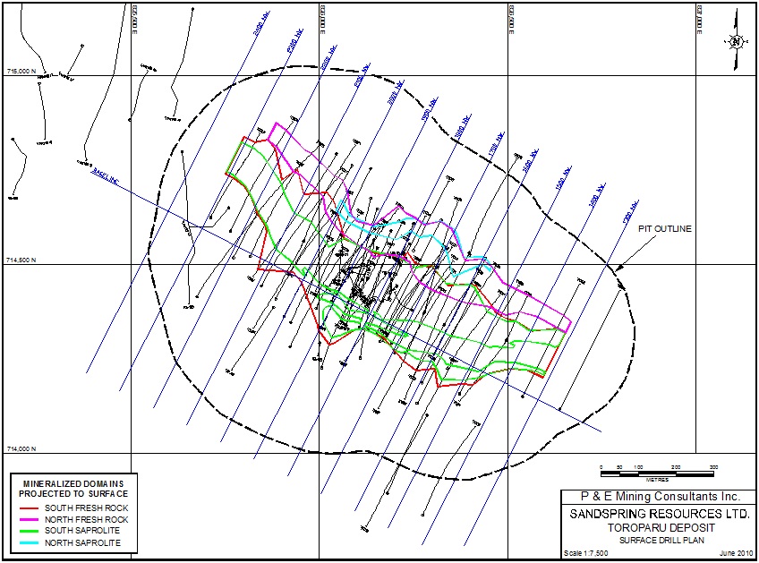
| P&E Mining Consultants Inc., Report No. 186 | Page 79 of 121 |
| Sandspring Resources Ltd. | |
| Toroparu Gold-Copper Prospect |
APPENDIX II
3D DOMAINS
| P&E Mining Consultants Inc., Report No. 186 | Page 80 of 121 |
| Sandspring Resources Ltd. | |
| Toroparu Gold-Copper Prospect |
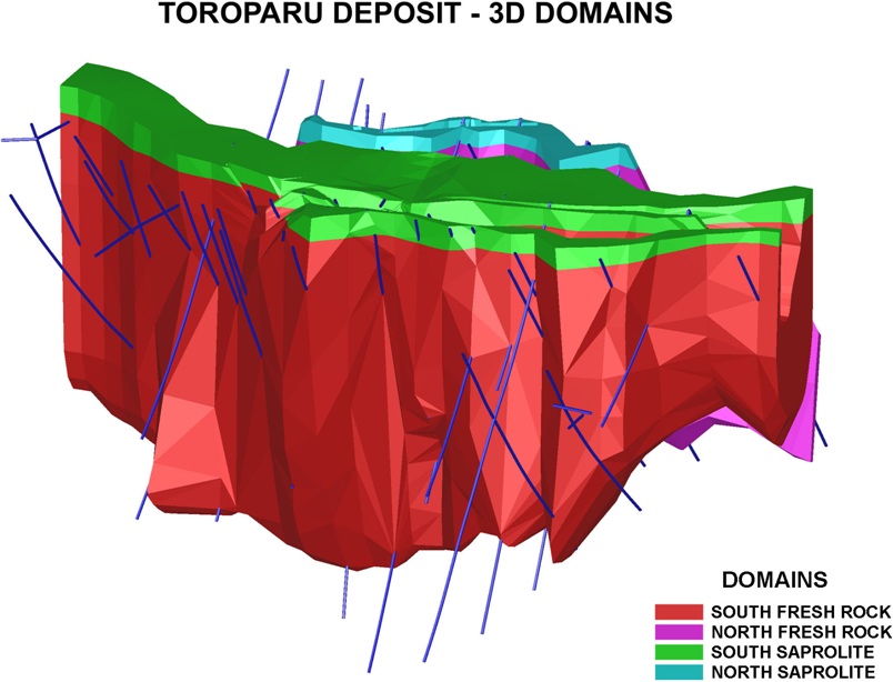
| P&E Mining Consultants Inc., Report No. 186 | Page 81 of 121 |
| Sandspring Resources Ltd. | |
| Toroparu Gold-Copper Prospect |
APPENDIX III
LOG NORMAL HISTOGRAMS
| P&E Mining Consultants Inc., Report No. 186 | Page 82 of 121 |
| Sandspring Resources Ltd. | |
| Toroparu Gold-Copper Prospect |
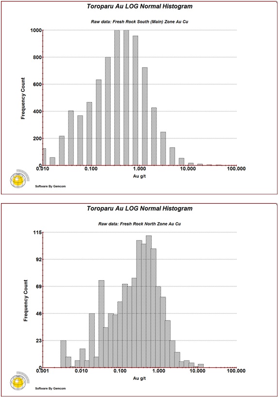
| P&E Mining Consultants Inc., Report No. 186 | Page 83 of 121 |
| Sandspring Resources Ltd. | |
| Toroparu Gold-Copper Prospect |
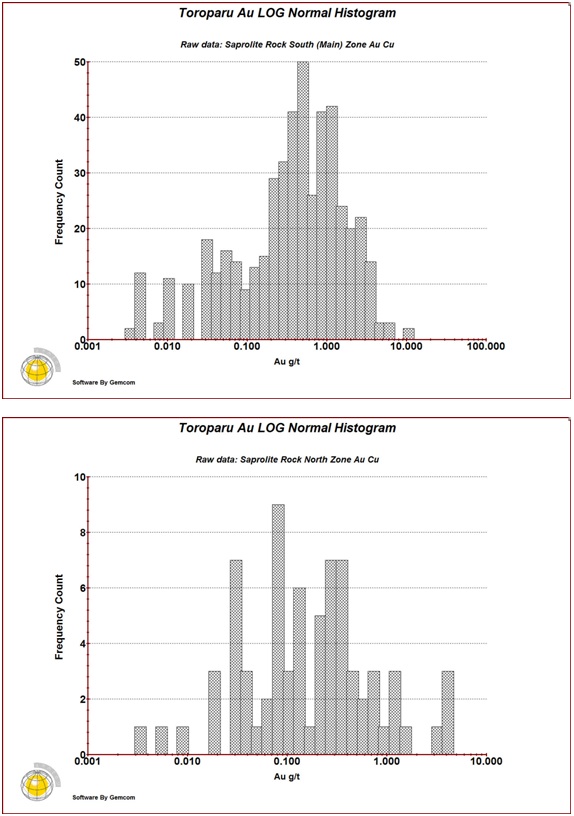
| P&E Mining Consultants Inc., Report No. 186 | Page 84 of 121 |
| Sandspring Resources Ltd. | |
| Toroparu Gold-Copper Prospect |
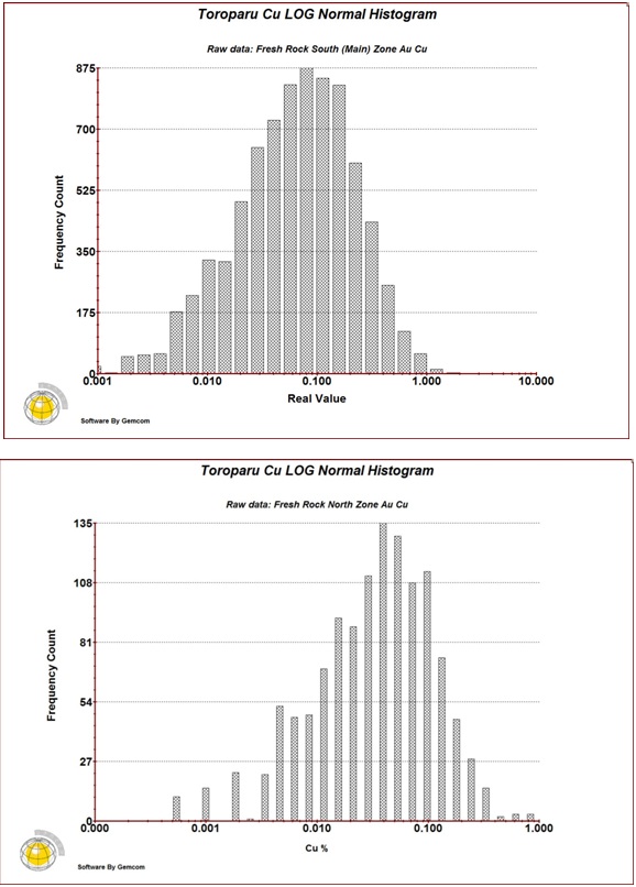
| P&E Mining Consultants Inc., Report No. 186 | Page 85 of 121 |
| Sandspring Resources Ltd. | |
| Toroparu Gold-Copper Prospect |
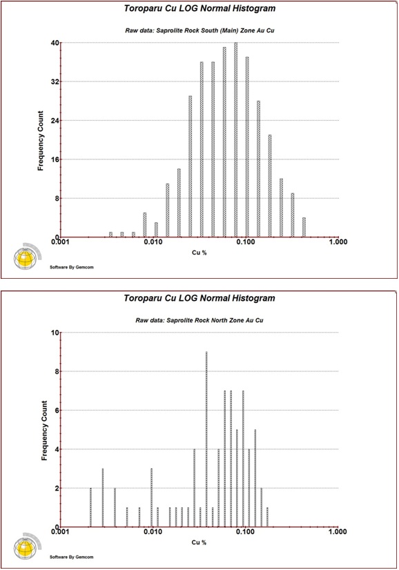
| P&E Mining Consultants Inc., Report No. 186 | Page 86 of 121 |
| Sandspring Resources Ltd. | |
| Toroparu Gold-Copper Prospect |
APPENDIX IV
VARIOGRAMS
| P&E Mining Consultants Inc., Report No. 186 | Page 87 of 121 |
| Sandspring Resources Ltd. | |
| Toroparu Gold-Copper Prospect |
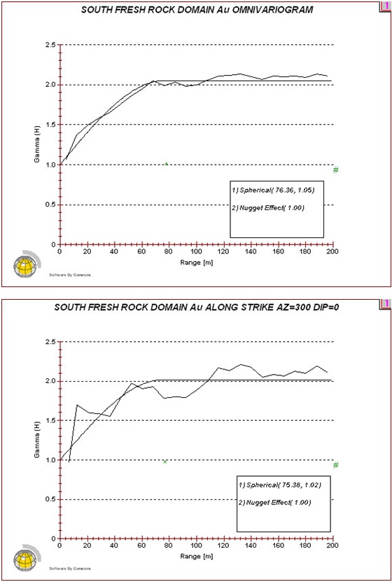
| P&E Mining Consultants Inc., Report No. 186 | Page 88 of 121 |
| Sandspring Resources Ltd. | |
| Toroparu Gold-Copper Prospect |
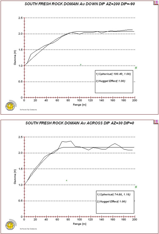
| P&E Mining Consultants Inc., Report No. 186 | Page 89 of 121 |
| Sandspring Resources Ltd. | |
| Toroparu Gold-Copper Prospect |
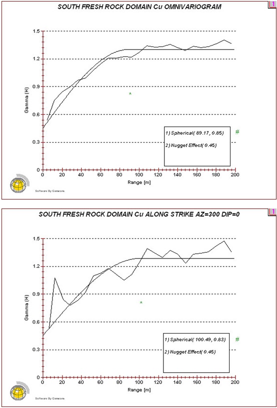
| P&E Mining Consultants Inc., Report No. 186 | Page 90 of 121 |
| Sandspring Resources Ltd. | |
| Toroparu Gold-Copper Prospect |
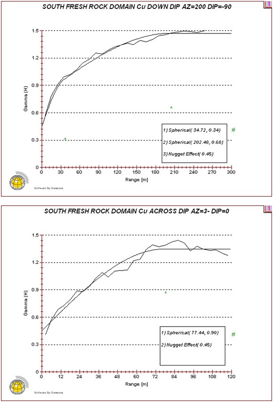
| P&E Mining Consultants Inc., Report No. 186 | Page 91 of 121 |
| Sandspring Resources Ltd. | |
| Toroparu Gold-Copper Prospect |
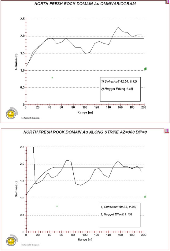
| P&E Mining Consultants Inc., Report No. 186 | Page 92 of 121 |
| Sandspring Resources Ltd. | |
| Toroparu Gold-Copper Prospect |
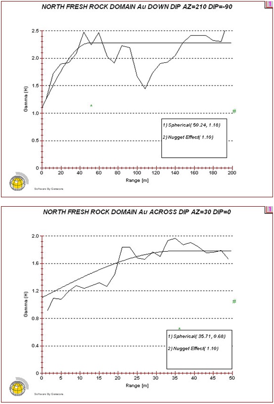
| P&E Mining Consultants Inc., Report No. 186 | Page 93 of 121 |
| Sandspring Resources Ltd. | |
| Toroparu Gold-Copper Prospect |
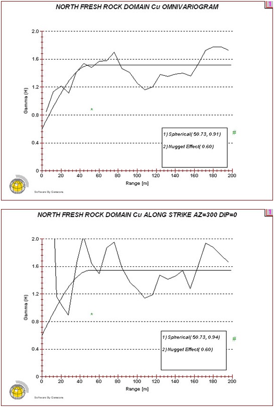
| P&E Mining Consultants Inc., Report No. 186 | Page 94 of 121 |
| Sandspring Resources Ltd. | |
| Toroparu Gold-Copper Prospect |
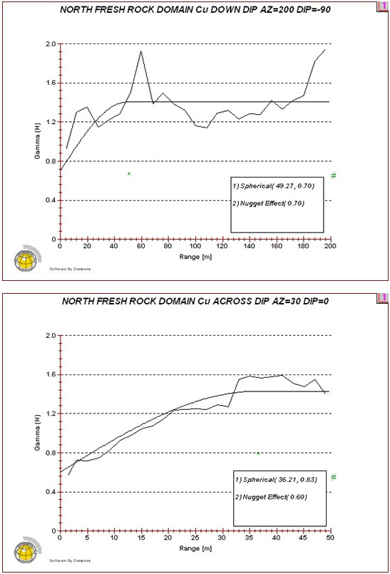
| P&E Mining Consultants Inc., Report No. 186 | Page 95 of 121 |
| Sandspring Resources Ltd. | |
| Toroparu Gold-Copper Prospect |
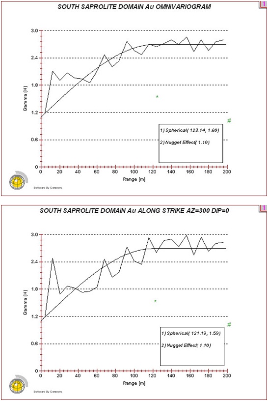
| P&E Mining Consultants Inc., Report No. 186 | Page 96 of 121 |
| Sandspring Resources Ltd. | |
| Toroparu Gold-Copper Prospect |
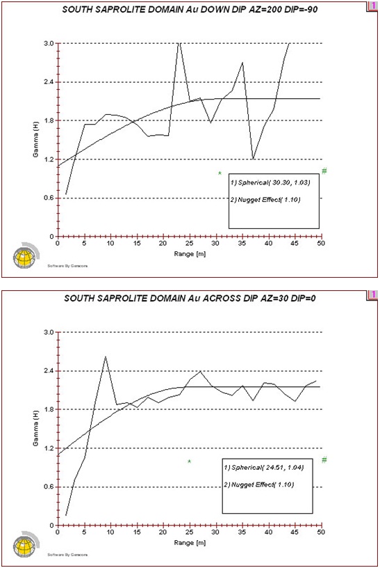
| P&E Mining Consultants Inc., Report No. 186 | Page 97 of 121 |
| Sandspring Resources Ltd. | |
| Toroparu Gold-Copper Prospect |
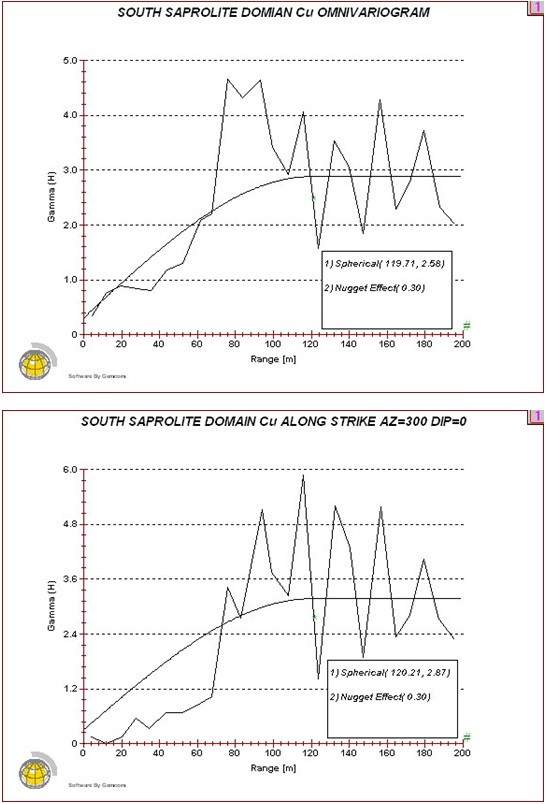
| P&E Mining Consultants Inc., Report No. 186 | Page 98 of 121 |
| Sandspring Resources Ltd. | |
| Toroparu Gold-Copper Prospect |
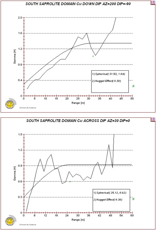
| P&E Mining Consultants Inc., Report No. 186 | Page 99 of 121 |
| Sandspring Resources Ltd. | |
| Toroparu Gold-Copper Prospect |
APPENDIX V
AuEq BLOCK MODEL CROSS SECTIONS
AND PLANS
| P&E Mining Consultants Inc., Report No. 186 | Page 100 of 121 |
| Sandspring Resources Ltd. | |
| Toroparu Gold-Copper Prospect |
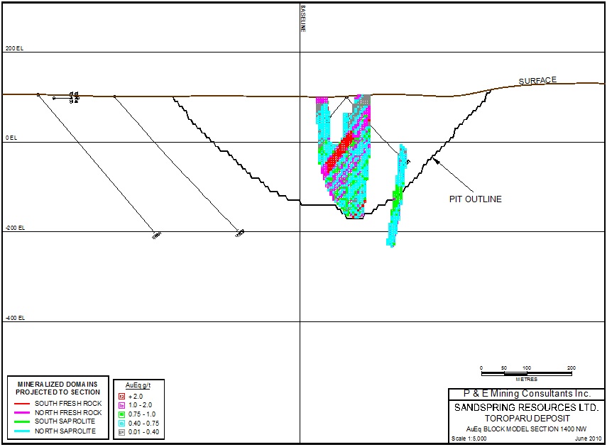
| P&E Mining Consultants Inc., Report No. 186 | Page 101 of 121 |
| Sandspring Resources Ltd. | |
| Toroparu Gold-Copper Prospect |
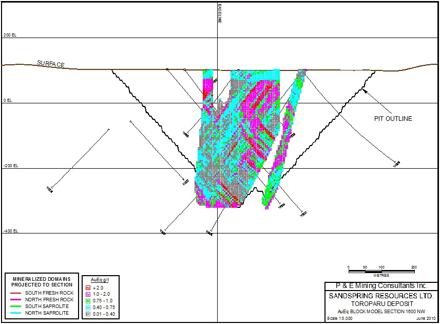
| P&E Mining Consultants Inc., Report No. 186 | Page 102 of 121 |
| Sandspring Resources Ltd. | |
| Toroparu Gold-Copper Prospect |
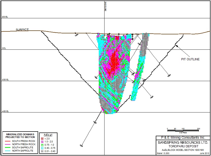
| P&E Mining Consultants Inc., Report No. 186 | Page 103 of 121 |
| Sandspring Resources Ltd. | |
| Toroparu Gold-Copper Prospect |
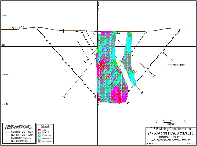
| P&E Mining Consultants Inc., Report No. 186 | Page 104 of 121 |
| Sandspring Resources Ltd. | |
| Toroparu Gold-Copper Prospect |
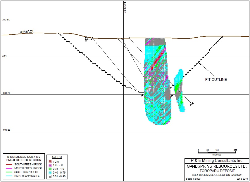
| P&E Mining Consultants Inc., Report No. 186 | Page 105 of 121 |
| Sandspring Resources Ltd. | |
| Toroparu Gold-Copper Prospect |
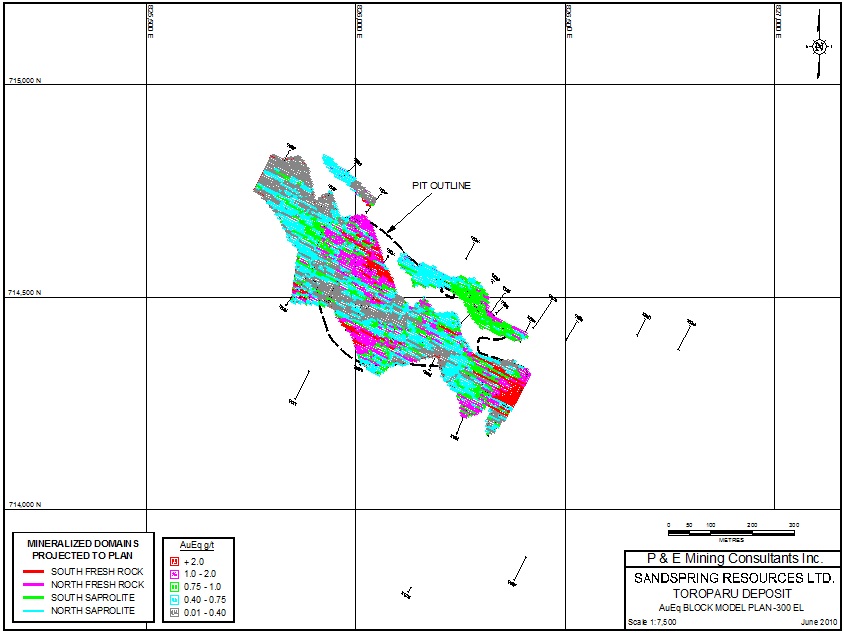
| P&E Mining Consultants Inc., Report No. 186 | Page 106 of 121 |
| Sandspring Resources Ltd. | |
| Toroparu Gold-Copper Prospect |
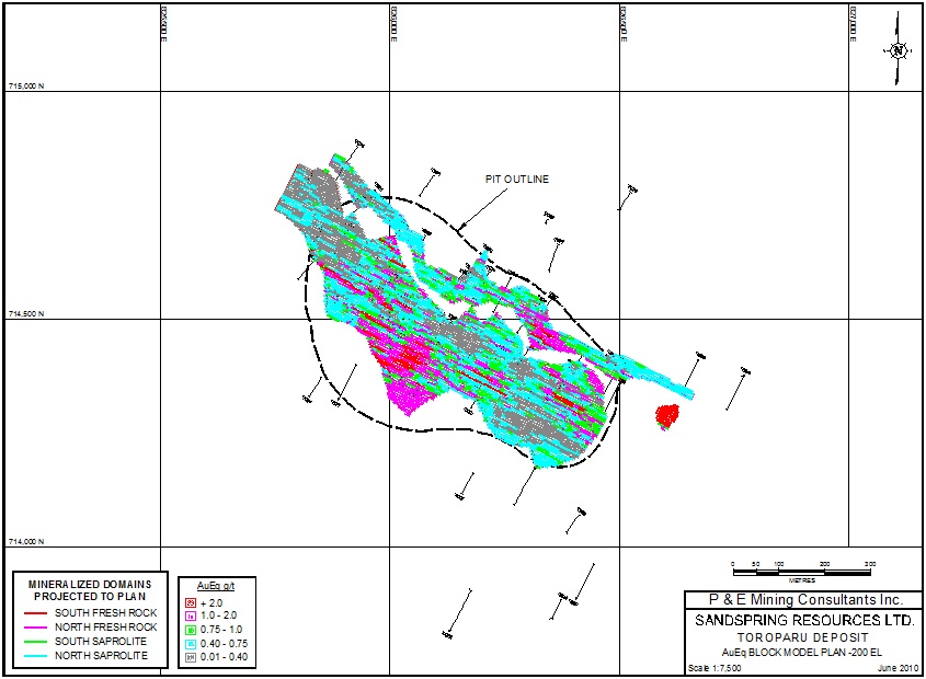
| P&E Mining Consultants Inc., Report No. 186 | Page 107 of 121 |
| Sandspring Resources Ltd. | |
| Toroparu Gold-Copper Prospect |
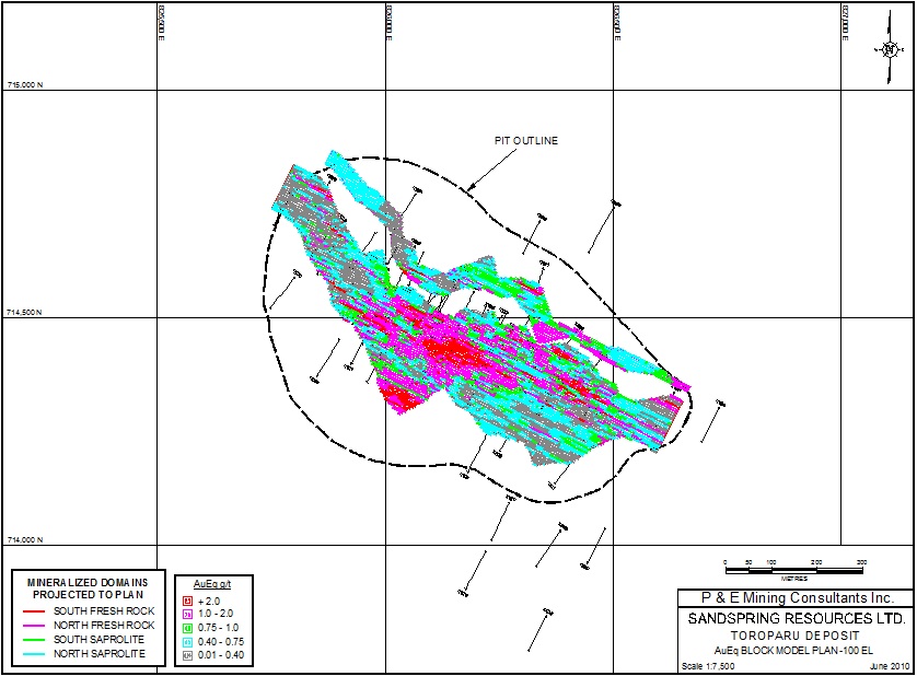
| P&E Mining Consultants Inc., Report No. 186 | Page 108 of 121 |
| Sandspring Resources Ltd. | |
| Toroparu Gold-Copper Prospect |
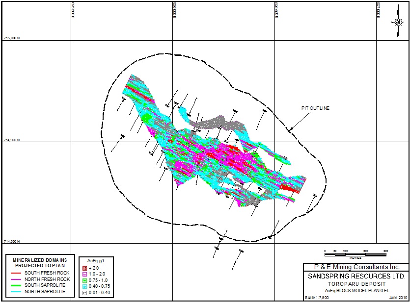
| P&E Mining Consultants Inc., Report No. 186 | Page 109 of 121 |
| Sandspring Resources Ltd. | |
| Toroparu Gold-Copper Prospect |
APPENDIX VI
CLASSIFICATION BLOCK MODEL
CROSS SECTIONS AND PLANS
| P&E Mining Consultants Inc., Report No. 186 | Page 110 of 121 |
| Sandspring Resources Ltd. | |
| Toroparu Gold-Copper Prospect |
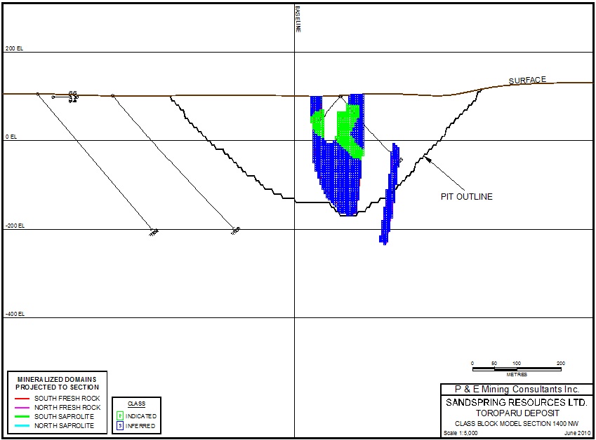
| P&E Mining Consultants Inc., Report No. 186 | Page 111 of 121 |
| Sandspring Resources Ltd. | |
| Toroparu Gold-Copper Prospect |
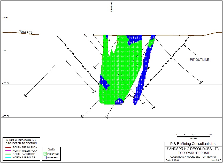
| P&E Mining Consultants Inc., Report No. 186 | Page 112 of 121 |
| Sandspring Resources Ltd. | |
| Toroparu Gold-Copper Prospect |
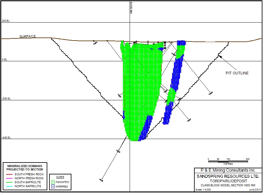
| P&E Mining Consultants Inc., Report No. 186 | Page 113 of 121 |
| Sandspring Resources Ltd. | |
| Toroparu Gold-Copper Prospect |
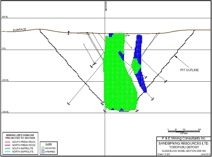
| P&E Mining Consultants Inc., Report No. 186 | Page 114 of 121 |
| Sandspring Resources Ltd. | |
| Toroparu Gold-Copper Prospect |

| P&E Mining Consultants Inc., Report No. 186 | Page 115 of 121 |
| Sandspring Resources Ltd. | |
| Toroparu Gold-Copper Prospect |
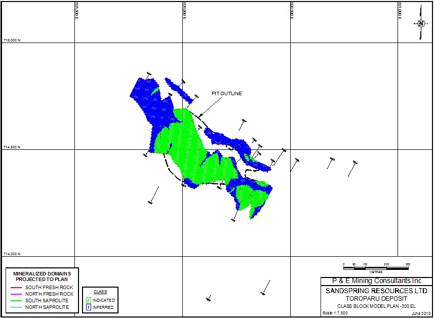
| P&E Mining Consultants Inc., Report No. 186 | Page 116 of 121 |
| Sandspring Resources Ltd. | |
| Toroparu Gold-Copper Prospect |
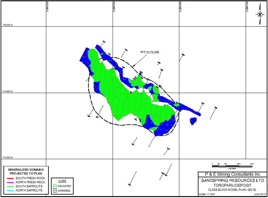
| P&E Mining Consultants Inc., Report No. 186 | Page 117 of 121 |
| Sandspring Resources Ltd. | |
| Toroparu Gold-Copper Prospect |
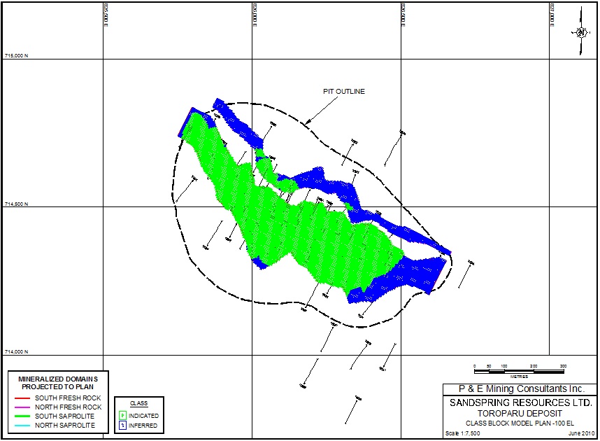
| P&E Mining Consultants Inc., Report No. 186 | Page 118 of 121 |
| Sandspring Resources Ltd. | |
| Toroparu Gold-Copper Prospect |
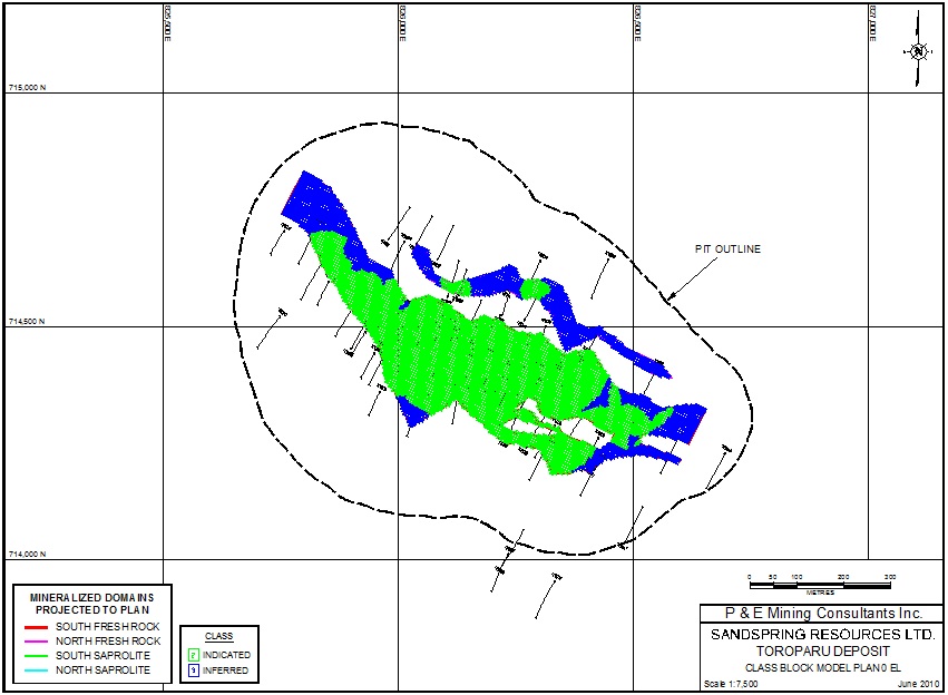
| P&E Mining Consultants Inc., Report No. 186 | Page 119 of 121 |
| Sandspring Resources Ltd. | |
| Toroparu Gold-Copper Prospect |
APPENDIX VII
OPTIMIZED PIT SHELL
| P&E Mining Consultants Inc., Report No. 186 | Page 120 of 121 |
| Sandspring Resources Ltd. | |
| Toroparu Gold-Copper Prospect |
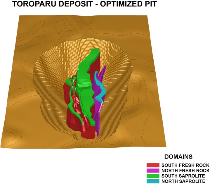
| P&E Mining Consultants Inc., Report No. 186 | Page 121 of 121 |
| Sandspring Resources Ltd. | |
| Toroparu Gold-Copper Prospect |