Summary Report on the Nevada Gold Project
Portfolio Comprising the Blackrock, Argentite,
Bellview and Horsethief Gold Projects, Nevada,
USA
Prepared for Bridgeport Ventures Inc.
by
| Matthew D. Gray, Ph.D., C.P.G. #10688 | |
| Resource Geosciences de Mexico SA de CV | |
| | |
| 26 November 2010 Amended 7 December 2010 | |
![]()
View looking east over Blackrock vein, exposed to left of drill road from right foreground to central midground.
| Summary Report on the Nevada Gold Project Portfolio Comprising the Blackrock, Argentite, Bellview, and Horsethief Gold |
| Projects, Nevada, USA |
Table of Contents
| Matthew D. Gray C.P.G. #1068826 November 2010 Amended 7 December 2010 | Page i of 134 |
| Summary Report on the Nevada Gold Project Portfolio Comprising the Blackrock, Argentite, Bellview, and Horsethief Gold |
| Projects, Nevada, USA |
| Matthew D. Gray C.P.G. #1068826 November 2010 Amended 7 December 2010 | Page ii of 134 |
| Summary Report on the Nevada Gold Project Portfolio Comprising the Blackrock, Argentite, Bellview, and Horsethief Gold |
| Projects, Nevada, USA |
| Matthew D. Gray C.P.G. #1068826 November 2010 Amended 7 December 2010 | Page iii of 134 |
| Summary Report on the Nevada Gold Project Portfolio Comprising the Blackrock, Argentite, Bellview, and Horsethief Gold |
| Projects, Nevada, USA |
List of Figures
List of Tables
| Matthew D. Gray C.P.G. #1068826 November 2010 Amended 7 December 2010 | Page iv of 134 |
| Summary Report on the Nevada Gold Project Portfolio Comprising the Blackrock, Argentite, Bellview, and Horsethief Gold |
| Projects, Nevada, USA |
List of Appendices
| Table | Page |
| Appendix A. Waypoints, due diligence confirmation site visits | 114 |
| Appendix B. Assay certificates, M Gray rock chip samples | 120 |
| Appendix C. Drillhole collar locations, Bellview project | 128 |
| Matthew D. Gray C.P.G. #1068826 November 2010 Amended 7 December 2010 | Page v of 134 |
| Summary Report on the Nevada Gold Project Portfolio Comprising the Blackrock, Argentite, Bellview, and Horsethief Gold |
| Projects, Nevada, USA |
| 3 | SUMMARY |
Fronteer Gold made available for purchase by Bridgeport Ventures Inc. a property portfolio which includes the Blackrock, Argentite, Bellview, and Horsethief gold prospects in Nevada. These four projects represented an attractive opportunity for Bridgeport to quickly acquire a land position in a productive gold producing region and offered exposure to a variety of gold deposit types and project risk levels. Bridgeport purchased the Blackrock, Argentite, Bellview, and Horsethief properties on 16 November 2010. Prior to their purchase by Bridgeport, the author conducted field reviews of the properties including independent sampling and confirmation mapping. The projects are prioritized in terms of exploration potential and development priority as follows:
| 1. | Blackrock, Lyon County. | ||
| a. | Volcanic rock hosted epithermal gold system, Walker Lane province. | ||
| b. | High priority target for high grade “bonanza vein” gold deposit minable by bulk underground methods. | ||
| c. | Lower probability of open pit target. | ||
| d. | Drill targets could be developed within weeks. | ||
| e. | $ 700,000 USD recommended exploration budget. | ||
| 2. | Argentite, Esmeralda County. | ||
| a. | Volcanic rock hosted epithermal hot spring gold system, Walker Lane province. | ||
| b. | High priority target for both open pit and underground gold targets. | ||
| c. | Historic drilling supports model that untested sinter zones are underlain by potentially economic gold concentrations. | ||
| d. | No drill testing east of Argentite Canyon in area of outcropping sinter. | ||
| e. | $ 824,000 USD recommended exploration budget. | ||
| 3. | Bellview, White Pine County. | ||
| a. | Carlin style gold deposit, Carlin-Alligator Ridge trend. | ||
| b. | High priority target on basis of geology, however priority reduced to moderate because of permitting issues related to US Forest Service land and incomplete land package. | ||
| c. | Permitting process for 10 drill sites has been initiated and permits are expected to be obtained in the fourth quarter of 2010. The permitted drill sites will allow testing of three targets developed by Fronteer Gold. | ||
| d. | The property is “drill ready” as soon as permits are obtained. | ||
| e. | $ 780,000 USD recommended exploration budget. | ||
| 4. | Horsethief, Lincoln County. | ||
| a. | Sedimentary rock hosted epithermal or Carlin style gold system. | ||
| b. | Geology, geochemistry, and drill results support a target at stratigraphic levels below current outcrop or concealed by a veneer of post mineral volcanics. | ||
| Matthew D. Gray C.P.G. #1068826 November 2010 Amended 7 December 2010 | Page 1 of 134 |
| Summary Report on the Nevada Gold Project Portfolio Comprising the Blackrock, Argentite, Bellview, and Horsethief Gold |
| Projects, Nevada, USA |
| c. | Will require geophysical surveys and drilling of blind targets under cover. | |
| d. | $ 790,000 USD recommended exploration budget. |
For the Blackrock, Argentite, Bellview, and Horsethief projects, a first phase exploration program, including a minimum of 15,500 m of drilling at a total cost of $3.1M USD, is recommended. A two stage work program, with the second stage conditional upon positive results from the first, considers the total Stage 1 budget of $3.1M USD with a Stage 2 budget of up to $3.4M USD, dependent upon the success of the Stage 1 programs.
| Matthew D. Gray C.P.G. #1068826 November 2010 Amended 7 December 2010 | Page 2 of 134 |
| Summary Report on the Nevada Gold Project Portfolio Comprising the Blackrock, Argentite, Bellview, and Horsethief Gold |
| Projects, Nevada, USA |
| 4 | INTRODUCTION AND TERMS OF REFERENCE |
| 4.1 | Introduction |
Resource Geosciences de Mexico SA de CV (RGM) and Matthew D. Gray, the author of this report, were asked by Bridgeport Ventures Inc. to perform an independent evaluation of the Blackrock, Argentite, Bellview, and Horsethief gold properties located in Nevada, USA, and to provide Bridgeport Ventures with a technical report compliant with CSA National Instrument 43-101. This report has been prepared to meet Canadian Securities Administrators National Instrument 43-101 standards. The report provides a summary of the geology of each project and its potential to host economic mineral deposits.
This revised report, with Amended date 7 December 2010, differs from the version dated 26 November 2010, which was filed on SEDAR on 29 November 2010, in that this report has modifications to Items 4.3, 4.4. and 5, such modifications made to insure compliance with CSA NI43-101 policies regarding limitations on disclaimers.
| 4.2 | Terms of Reference |
This Technical Report has been prepared for Bridgeport Ventures Inc., a publicly traded company listed on the TSX Venture Exchange under symbol BPV. Matthew Gray, senior partner of RGM, an independent geosciences consulting firm contracted by Bridgeport Ventures Inc., visited the Nevada gold prospects, reviewed the available geologic data, and took independent samples in connection with the preparation of the Technical Report.
| 4.3 | Purpose of Report |
The purpose of this report is to provide an independent assessment of the Nevada gold prospect portfolio and to recommend an exploration program to enhance the economic potential of the project portfolio. This report was prepared following the guidelines of CSA National Instrument 43-101.
This Technical Report and all publications, exhibits, documentation, conclusions, and other work products obtained or developed by RGM for this Technical Report are for sole and exclusive use of Bridgeport Ventures Inc. However all reports, publications, exhibits, documentation, conclusions, and other work products obtained or developed by RGM during completion of this Technical Report shall be and remain the property of RGM. Unauthorized use or reuse by third parties of reports, publications, exhibits, documentation, conclusions, and other work products obtained or developed by RGM for the purposes of this Technical Report is prohibited. This Technical Report was prepared specifically for the purpose of complying with Canadian Securities Administrators National Instrument 43-101 and may be distributed to third parties and published without prior consent of RGM if the Technical Report is presented in its entirety without omissions or modifications, subject to the regulations of NI43-101.
| Matthew D. Gray C.P.G. #1068826 November 2010 Amended 7 December 2010 | Page 3 of 134 |
| Summary Report on the Nevada Gold Project Portfolio Comprising the Blackrock, Argentite, Bellview, and Horsethief Gold |
| Projects, Nevada, USA |
| 4.4 | Sources of Information |
In the preparation of this report the author has relied on his own observations and independent assay data, supplemented by information obtained through review of both published and unpublished documents and maps. In addition to the author’s own observations and assay data, sources of information regarding regional geology, mining history of the region, and topographic data, include:
Geologic, geophysical, and assay data collected and published by the Nevada Bureau of Mines and Geology and the United States Geological Survey.
Topographic and physiographic data collected and published by the United States Geological Survey.
Private reports prepared for mining and exploration companies that have previously explored the projects, as referenced in this report.
Data that was not generated by the author has not been independently verified, except as noted in Item 16 of this report. Where information from unverified sources is relevant to interpretations and discussions of the economic potential of the project, the source of information is explicitly mentioned.
| 4.5 | Field Examination and Data Review by the Qualified Person. |
During the period 12 to 15 October 2010 the Qualified Person responsible for this report, Matthew D. Gray, Ph.D., C.P.G., President of Resource Geosciences de Mexico SA de CV, visited the prospects accompanied by Bridgeport C.E.O. Shastri Ramnath and Fronteer Gold geologists Gerald Baughman and Ken Raabe. On 20 October 2010 the author returned alone to the Blackrock and Argentite properties to conduct independent confirmation reviews and sampling. On 4 November 2010 the author, accompanied by Resource Geosciences de Mexico senior geologist Roman Solis, returned to the Bellview and Horsethief properties to conduct independent confirmation reviews and sampling.
Helicopter support was used to expedite the field review to an initial 3 day period, with an additional 2 days devoted to independent confirmation visits, as follows:
| Date | Begin | Properties Visited | End | Participants |
| 13 Oct 2010 | Reno | Blackrock | Tonopah | M Gray S Ramnath Gerry Baughman |
| Matthew D. Gray C.P.G. #1068826 November 2010 Amended 7 December 2010 | Page 4 of 134 |
| Summary Report on the Nevada Gold Project Portfolio Comprising the Blackrock, Argentite, Bellview, and Horsethief Gold |
| Projects, Nevada, USA |
| 14 Oct 2010 | Tonopah | Argentite, Horsethief | Elko | M Gray S Ramnath Gerry Baughman |
| 15 Oct 2010 | Elko | Bellview | Elko | M Gray S Ramnath Ken Raabe |
| 20 Oct 2010 | Carson City | Blackrock, Argentite | Elko | M Gray |
| 4 Nov 2010 | Elko | Bellview, Horsethief | Elko | M Gray R Solis |
The purpose of the review was to examine property geology, the most important known mineral occurrences and historic inactive mine workings, and to collect independent geochemical samples of altered and mineralized areas.
Prior to the field visit and data review conducted for the purposes of this Technical Report, the author had been directly involved in mineral exploration programs in the region, but had not conducted examinations of these particular projects.
Fronteer Gold geologists Matt Lennox-King, Gerry Baughman, and Ken Raabe facilitated the author’s review of the projects and their cooperation and assistance is gratefully acknowledged.
| 4.6 | Definitions and Translations |
| ASL | - | above sea level |
| BLM | - | Bureau of Land Management |
| Bridgeport | - | Bridgeport Ventures Inc. |
| C | - | centigrade |
| cm | - | centimeter |
| ft | - | feet |
| gpt | - | grams per ton, equivalent to ppm |
| km | - | kilometer |
| m | - | meter |
| M | - | million |
| Ma | - | million years before present |
| NAD | - | North American Datum |
| NBMG | - | Nevada Bureau of Mines and Geology |
| NV | - | Nevada |
| oz. | - | Troy Ounce |
| opt | - | Troy ounce per ton |
| ppm | - | parts per million, equivalent to grams per ton |
| RGM | - | Resource Geosciences de Mexico SA de CV |
| Matthew D. Gray C.P.G. #1068826 November 2010 Amended 7 December 2010 | Page 5 of 134 |
| Summary Report on the Nevada Gold Project Portfolio Comprising the Blackrock, Argentite, Bellview, and Horsethief Gold |
| Projects, Nevada, USA |
| USD | - | United States Dollar |
| USFS | - | United States Forest Service |
| UTM | - | Universal Transverse Mercator |
| WGS84 | - | World Geodetic System 1984 datum |
| 4.7 | Units |
Historic data for the projects was generated by a multitude of operators who used both SI (metric) and Imperial units of measurement. When referencing historic data, both systems are utilized, therefore this report contains a non-aesthetic mix of units, referring to features of the same project at times using distance measurements of feet, meters, and kilometers. Similarly, assay data may be presented as parts per million (ppm) and its equivalent grams per ton (gpt), or ounces per ton (opt). Conversion factors for the different measurement units used in this report are:
| 1 foot | = | 0.3038 meters |
| 1 inch | = | 2.54 cm |
| 1 mile | = | 1.6093 kilometers |
| 1 meter | = | 39.37 inches |
| 1 meter | = | 3.2808 feet |
| 1 kilometer | = | 0.6214 miles |
| 1 kilometer | = | 3,280.85 feet |
| 1 gpt | = | 1 ppm |
| 1 gpt | = | 0.02917 opt |
| 1 hectare | = | 2.47105 acres |
| Matthew D. Gray C.P.G. #1068826 November 2010 Amended 7 December 2010 | Page 6 of 134 |
| Summary Report on the Nevada Gold Project Portfolio Comprising the Blackrock, Argentite, Bellview, and Horsethief Gold |
| Projects, Nevada, USA |
| 5 | RELIANCE ON OTHER EXPERTS |
The professional opinions expressed in this report are based in part on data and information generated by and obtained from Fronteer Gold Corporation, its subcontractors, previous operators of the projects, and public domain sources. The author of this report has excercised all reasonable care in reviewing the supplied information and believes that the information provided is accurate. Data that was not generated by the author has not been independently verified, except as noted in Item 16 of this report. Where information from unverified sources is relevant to interpretations and discussions of the economic potential of the project, the source of information is explicitly mentioned. General information for the Blackrock, Argentite, Bellview, and Horsethief properties was obtained from the following sources:
| Material | Source |
| Mining concession Information | Erwin and Thompson LLP, Reno, Nevada |
| Assay data, due diligence sampling by M Gray | ALS Chemex Laboratories Inc. |
| Regional geologic maps | United States Geological Survey; Nevada Bureau of Mines and Geology |
| Regional and local topographic data | United States Geological Survey |
Historic exploration data was used in the interpretation of each property’s geologic setting and exploration potential. Historic exploration data was provided by the vendor of the properties, Fronteer Gold, with original data sources summarized as follows:
Property | Type of Work / Data / Information | Source | Original Source | Year |
| Blackrock | Rock Samples | Fronteer Gold project files | Placid Oil Company | 1985 |
| Blackrock | Soil Samples | Fronteer Gold project files | Placid Oil Company | 1985 |
| Blackrock | Stream Sediment | Fronteer Gold project files | Placid Oil Company | 1985 |
| Blackrock | VLF-EM Survey | Fronteer Gold project files | Placid Oil Company | 1985 |
| Blackrock | Trenching and sampling | Fronteer Gold project files | Almac Mineral Resources | 1991 |
| Blackrock | Geological Mapping | Fronteer Gold project files | Integrated Resources | 1990 |
| Blackrock | Rock Sampling | Fronteer Gold project files | Integrated Resources | 1990 |
| Blackrock | Soil Sampling | Fronteer Gold project files | Integrated Resources | 1990 |
| Blackrock | VLF-EM Survey | Fronteer Gold project files | Integrated Resources | 1990 |
| Blackrock | Total Field Magnetics | Fronteer Gold project files | Integrated Resources | 1990 |
| Matthew D. Gray C.P.G. #1068826 November 2010 Amended 7 December 2010 | Page 7 of 134 |
| Summary Report on the Nevada Gold Project Portfolio Comprising the Blackrock, Argentite, Bellview, and Horsethief Gold |
| Projects, Nevada, USA |
| Blackrock | Trenching | Fronteer Gold project files | Integrated Resources | 1990 |
| Blackrock | Surface Sampling | Fronteer Gold project files | Meridian Gold Company | 1999 |
| Blackrock | Geological Mapping | Fronteer Gold project files | Teck Resources | 2000 |
| Blackrock | Rock and soil sampling | Fronteer Gold project files | Teck Resources | 2000 |
| Blackrock | Petrological Study | Fronteer Gold project files | Teck Resources | 2000 |
| Blackrock | Surface Samples | Fronteer Gold project files | Franco Nevada | 2001 |
| Blackrock | Surface Samples | Fronteer Gold project files | Pacific Rim Exploration | 2001 |
| Blackrock | Drilling | Fronteer Gold project files | Western Exploration | 2001 |
| Blackrock | Drilling | Fronteer Gold project files | New Dimension Res. | 2008 |
| Argentite | Geological Mapping | Fronteer Gold project files | Cordilleran Exploration | 2004 |
| Argentite | Drilling | Fronteer Gold project files | Camnor | 1997 |
| Argentite | Surface Mapping | Fronteer Gold project files | Camnor | 1997 |
| Bellview | Optioned | Fronteer Gold project files | Arctic Precious Metals | 1979 |
| Bellview | Soil and Rock Sampling | Fronteer Gold project files | Arctic Precious Metals | 1980- 1985 |
| Bellview | VLF-EM Survey | Fronteer Gold project files | Arctic Precious Metals | 1980- 1985 |
| Bellview | Mapping | Fronteer Gold project files | Arctic Precious Metals | 1983 |
| Bellview | Drilling | Fronteer Gold project files | Arctic Precious Metals | 1983 |
| Bellview | Resource Estimation | Fronteer Gold project files | Arctic Precious Metals | 1983 |
| Bellview | Drilling | Fronteer Gold project files | Silver State Mining | 1986 |
| Bellview | Rock Chip | Fronteer Gold project files | Pegasus Gold | 1987 |
| Bellview | Soil Sampling | Fronteer Gold project files | Teck | 1987- 1991 |
| Bellview | Rock Chip Sampling | Fronteer Gold project files | Teck | 1987- 1991 |
| Bellview | TFM Survey | Fronteer Gold project files | Teck | 1987- 1991 |
| Bellview | Geologic Mapping | Fronteer Gold project files | Teck | 1987- 1991 |
| Bellview | Drilling | Fronteer Gold project files | Teck | 1987- 1991 |
| Matthew D. Gray C.P.G. #1068826 November 2010 Amended 7 December 2010 | Page 8 of 134 |
| Summary Report on the Nevada Gold Project Portfolio Comprising the Blackrock, Argentite, Bellview, and Horsethief Gold |
| Projects, Nevada, USA |
| Bellview | Resource Estimation | Fronteer Gold project files | Teck | 1987- 1991 |
| Bellview | Geologic Mapping | Fronteer Gold project files | Western States Minerals | 1991- 1999 |
| Bellview | Rock Chip | Fronteer Gold project files | Western States Minerals | 1991- 1999 |
| Bellview | Soil Geochemistry | Fronteer Gold project files | Western States Minerals | 1991- 1999 |
| Bellview | Drilling | Fronteer Gold project files | Western States Minerals | 1991 |
| Bellview | Drilling | Fronteer Gold project files | Western States Minerals | 1993 |
| Bellview | Drilling | Fronteer Gold project files | Western States Minerals | 1995 |
| Bellview | Drilling | Fronteer Gold project files | Homestake Mining | 1996 |
| Horsethief | Rock sampling | Fronteer Gold project files | Canyon Resources / Copper Range Exploration | 1981 |
| Horsethief | Drilling | Fronteer Gold project files | Canyon Resources / Copper Range Exploration | 1982- 1984 |
| Horsethief | Geological Mapping | Fronteer Gold project files | Canyon Resources / Copper Range Exploration | 1982- 1984 |
Appropriate scientific methods and best professional judgment were utilized in the collection and interpretation of data discussed in this report. However, users of this report are cautioned that the evaluation methods used herein are subject to inherent uncertainties and assumptions, over which the authors have no control. These uncertainties and assumptions are stated herein. Users of this report are hereby advised to be aware of and understand these uncertainties and assumptions.
Opinions regarding validity and ownership of title of the mining claims that comprise the four projects reviewed in this report were provided by Bridgeport’s legal counsel, Erwin and Thompson LLP of Reno, Nevada.
| Matthew D. Gray C.P.G. #1068826 November 2010 Amended 7 December 2010 | Page 9 of 134 |
| Summary Report on the Nevada Gold Project Portfolio Comprising the Blackrock, Argentite, Bellview, and Horsethief Gold |
| Projects, Nevada, USA |
| 6 | PROPERTY DESCRIPTION AND LOCATION |
All geographic references in this report utilize UTM Zone 11 and datum NAD 83 unless otherwise stated. Some of the historic data was collected using datum NAD27 thus tabulations of historic data may use this datum and is noted as such. Property locations are shown in Figure 6.1 and detailed property descriptions are presented herein as follows.
| 6.1 | Area and Location |
| 6.1.1 | Blackrock |
| County: | Lyon County, NV |
| Coordinates: | 287,888E, 4,342,914N UTM Zone 11 NAD83 |
| Relation to Major Cities: | 47 km southeast of Reno, NV |
| 27 km east-northeast of the state capital Carson City, NV | |
| Size: | 100.34 hectares (247.93 acres) |
| 6.1.2 | Argentite |
| County: | Esmeralda County, NV |
| Coordinates: | 426,984E, 4,179,876N UTM Zone 11 NAD83 |
| Relation to Major Cities: | 261 km southeast of Reno, NV |
| 295 km northwest of Las Vegas, NV | |
| 63 km southwest of Tonopah, NV | |
| Size: | 66.89 hectares (165.29 acres) |
| Matthew D. Gray C.P.G. #1068826 November 2010 Amended 7 December 2010 | Page 10 of 134 |
| Summary Report on the Nevada Gold Project Portfolio Comprising the Blackrock, Argentite, Bellview, and Horsethief Gold |
| Projects, Nevada, USA |
![]()
Figure 6.1. Nevada gold project portfolio location map.
| Matthew D. Gray C.P.G. #1068826 November 2010 Amended 7 December 2010 | Page 11 of 134 |
| Summary Report on the Nevada Gold Project Portfolio Comprising the Blackrock, Argentite, Bellview, and Horsethief Gold |
| Projects, Nevada, USA |
| 6.1.3 | Bellview |
| County: | White Pine County, NV |
| Coordinates: | 616,828E, 4,438,341N UTM Zone 11 NAD83 |
| Relation to Major Cities: | 363 km east-northeast of Reno, NV |
| 85 km south-southeast of Elko, NV | |
| Size: | approximately 1095 hectares (443 acres) |
| 6.1.4 | Horsethief |
| County: | Lincoln County, NV |
| Coordinates: | 741,187E, 4,211,966N UTM Zone 11 NAD83 |
| Relation to Major Cities: | 223 km northeast of Las Vegas, NV |
| 19 km northeast of Pioche, NV | |
| Size: | 371.90 hectares (150.50 acres) |
| 6.2 | Claims and Title |
Mining and exploration rights on Federal and some private lands in the United Sates are controlled by the Federal Government. Mineral rights for all four properties discussed in this report are held via unpatented mining claims on Federal land. Private parties can obtain mineral rights via solicitation of a mining claim and fulfillment of filing fees and tax payments. To maintain a claim in good standing, Federal and Nevada State law require that assessment expenditures of $140 USD per claim per annum be incurred or the equivalent amount be paid to the US Bureau of Land Management, in addition, filing fees are payable to the State and to the County in which the claims are located. The Nevada State Legislature has enacted a temporary “windfall” filing fee tax on mining concessions under which filing fees are currently determined based on the number of claims held in each county. In July 2011, this sliding scale fee system is set to expire and annual filing fees would revert to $10.50 USD per claim per annum. The current filing fee schedule is detailed in Table 6.1.
| Matthew D. Gray C.P.G. #1068826 November 2010 Amended 7 December 2010 | Page 12 of 134 |
| Summary Report on the Nevada Gold Project Portfolio Comprising the Blackrock, Argentite, Bellview, and Horsethief Gold |
| Projects, Nevada, USA |
Table 6.1. State and County Mining Claim Annual Filing Fees.
| Number of claims | Fee (USD) |
| 0 to 11 | 0 |
| 11 to 199 | 70 |
| 199 to 1300 | 85 |
| 1300 or greater | 195 |
On 25 October 2010 Fronteer Gold, a publically traded Canadian company listed on the TSX and NYSE Amex exchanges as FRG, and Bridgeport Ventures announced a definitive agreement by which Fronteer Gold will sell a 100% interest in ten gold properties, including the Blackrock, Argentite, Bellview, and Horsethief gold properties discussed in this report, to Bridgeport. Under the terms of the Agreement, Bridgeport Ventures will issue an aggregate of 4.5 million common shares as consideration for the sale. In addition, Fronteer Gold will reserve a 2% Net Smelter Return royalty on each of the ten projects. At the close of trading on October 22, 2010, the share consideration was valued at $5.6 million. The transaction was subject to customary regulatory approvals and closed on 16 November 2010.
The mining concessions being sold by Fronteer Gold that comprise the four properties discussed in this report are summarized in Tables 6.2 through 6.5 and shown in Figures 6.2 through 6.6. Bridgeport has staked additional claims at the Argentite project as shown in Figure 6.4. M Gray and Resource Geosciences de Mexico are not Qualified Persons for assessing the validity and ownership of mineral rights. Bridgeport has retained legal counsel Erwin and Thompson LLP of Reno, Nevada to investigate title validity and ownership of the claims comprising the four projects discussed in this report. Bridgeport’s legal advisors are of the opinion that Fronteer Gold held valid rights to the mining claims comprising the Blackrock, Argentite, Bellview, and Horsethief properties.
Table 6.2. Mining Concessions, Blackrock project.
| Black Rock Project | |||||
| Claim Name | Location Date | Filed County | Document No. | Filed BLM | BLM Serial No. |
| North Como 1 | 17-Sep-1999 | 02-Nov-1999 | 240898 | 28-Oct-1999 | NMC808099 |
| North Como 2 | 17-Sep-1999 | 02-Nov-1999 | 240899 | 28-Oct-1999 | NMC808100 |
| North Como 3 | 20-Oct-1999 | 02-Nov-1999 | 240900 | 28-Oct-1999 | NMC808101 |
| North Como 4 | 20-Oct-1999 | 02-Nov-1999 | 240901 | 28-Oct-1999 | NMC808102 |
| North Como 5 | 20-Oct-1999 | 02-Nov-1999 | 240902 | 28-Oct-1999 | NMC808103 |
| North Como 6 | 20-Oct-1999 | 02-Nov-1999 | 240903 | 28-Oct-1999 | NMC808104 |
| North Como 7 | 20-Oct-1999 | 02-Nov-1999 | 240904 | 28-Oct-1999 | NMC808105 |
| North Como 8 | 20-Oct-1999 | 02-Nov-1999 | 240905 | 28-Oct-1999 | NMC808106 |
| North Como 9 | 20-Oct-1999 | 02-Nov-1999 | 240906 | 28-Oct-1999 | NMC808107 |
| North Como 10 | 20-Oct-1999 | 02-Nov-1999 | 240907 | 28-Oct-1999 | NMC808108 |
| North Como 11 | 20-Oct-1999 | 02-Nov-1999 | 240908 | 28-Oct-1999 | NMC808109 |
| North Como 12 | 20-Oct-1999 | 02-Nov-1999 | 240909 | 28-Oct-1999 | NMC808110 |
| Matthew D. Gray C.P.G. #1068826 November 2010 Amended 7 December 2010 | Page 13 of 134 |
| Summary Report on the Nevada Gold Project Portfolio Comprising the Blackrock, Argentite, Bellview, and Horsethief Gold |
| Projects, Nevada, USA |
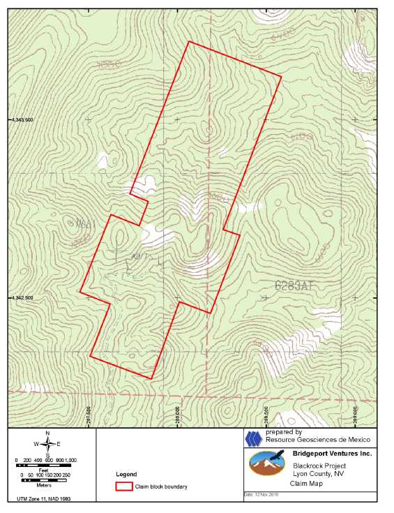
Figure 6.2. Claim map, Blackrock Project.
| Matthew D. Gray C.P.G. #1068826 November 2010 Amended 7 December 2010 | Page 14 of 134 |
| Summary Report on the Nevada Gold Project Portfolio Comprising the Blackrock, Argentite, Bellview, and Horsethief Gold |
| Projects, Nevada, USA |
Table 6.3. Mining Concessions, Argentite project.
| Argentite Project | |||||
| Claim Name | Location Date | Filed County | Document No. | Filed BLM | BLM Serial No. |
| SP II | 01-Sep-2007 | NMC970595 | |||
| Marty 1 | 01-Sep-2007 | NMC970596 | |||
| Marty 2 | 01-Sep-2007 | NMC970597 | |||
| Marty 3 | 01-Sep-2007 | NMC970598 | |||
| Marty 4 | 01-Sep-2007 | NMC970599 | |||
| Marty 5 | 01-Sep-2007 | NMC970600 | |||
| Marty 6 | 01-Sep-2007 | NMC970601 | |||
| Marty 7 | 01-Sep-2007 | NMC970602 | |||
| Matthew D. Gray C.P.G. #1068826 November 2010 Amended 7 December 2010 | Page 15 of 134 |
| Summary Report on the Nevada Gold Project Portfolio Comprising the Blackrock, Argentite, Bellview, and Horsethief Gold |
| Projects, Nevada, USA |
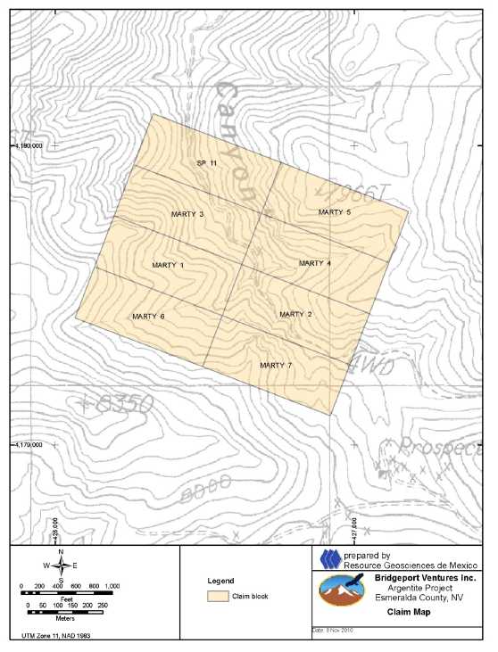
Figure 6.3. Claim map, Argentite Project, Fronteer Gold claims.
| Matthew D. Gray C.P.G. #1068826 November 2010 Amended 7 December 2010 | Page 16 of 134 |
| Summary Report on the Nevada Gold Project Portfolio Comprising the Blackrock, Argentite, Bellview, and Horsethief Gold |
| Projects, Nevada, USA |
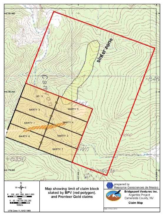
Figure 6.4. Claim block boundary, Argentite project showing limit of claims staked by Bridgeport.
| Matthew D. Gray C.P.G. #1068826 November 2010 Amended 7 December 2010 | Page 17 of 134 |
| Summary Report on the Nevada Gold Project Portfolio Comprising the Blackrock, Argentite, Bellview, and Horsethief Gold |
| Projects, Nevada, USA |
Table 6.4. Mining Concessions, Bellview project.
| Bellview Project | |||||||
| Claim Name | Location Date | Filed County | Book | Page | Document No. | Filed BLM | BLM Serial No. |
| CS -1 | 12-03-1999 | 02-07-2010 | 310 | 167 | 307675 | 02-03-2000 | 813108 |
| CS -2 | 12-03-1999 | 02-07-2010 | 310 | 168 | 307677 | 02-03-2000 | 813109 |
| CS -3 | 12-03-1999 | 02-07-2010 | 310 | 169 | 307676 | 02-03-2000 | 813110 |
| CS -4 | 12-03-1999 | 02-07-2010 | 310 | 170 | 307678 | 02-03-2000 | 813111 |
| CS -5 | 12-03-1999 | 02-07-2010 | 310 | 171 | 307679 | 02-03-2000 | 813112 |
| CS -6 | 12-03-1999 | 02-07-2010 | 310 | 172 | 307680 | 02-03-2000 | 813113 |
| CS -7 | 12-03-1999 | 02-07-2010 | 310 | 173 | 307681 | 02-03-2000 | 813114 |
| CS -8 | 12-03-1999 | 02-07-2010 | 310 | 174 | 307682 | 02-03-2000 | 813115 |
| CS -9 | 12-03-1999 | 02-07-2010 | 310 | 175 | 307683 | 02-03-2000 | 813116 |
| CS -10 | 12-01-1999 | 02-07-2010 | 310 | 176 | 307684 | 02-03-2000 | 813117 |
| CS -11 | 12-01-1999 | 02-07-2010 | 310 | 177 | 307685 | 02-03-2000 | 813118 |
| CS -12 | 12-01-1999 | 02-07-2010 | 310 | 178 | 307686 | 02-03-2000 | 813119 |
| CS -13 | 12-01-1999 | 02-07-2010 | 310 | 179 | 307687 | 02-03-2000 | 813120 |
| CS -14 | 12-01-1999 | 02-07-2010 | 310 | 180 | 307688 | 02-03-2000 | 813121 |
| CS -15 | 12-01-1999 | 02-07-2010 | 310 | 181 | 307689 | 02-03-2000 | 813122 |
| CS -16 | 12-01-1999 | 02-07-2010 | 310 | 182 | 307690 | 02-03-2000 | 813123 |
| CS -17 | 12-01-1999 | 02-07-2010 | 310 | 183 | 307691 | 02-03-2000 | 813124 |
| CS -18 | 12-01-1999 | 02-07-2010 | 310 | 184 | 307692 | 02-03-2000 | 813125 |
| CS -19 | 12-01-1999 | 02-07-2010 | 310 | 185 | 307693 | 02-03-2000 | 813126 |
| CS -20 | 12-01-1999 | 02-07-2010 | 310 | 186 | 307694 | 02-03-2000 | 813127 |
| CS -21 | 12-01-1999 | 02-07-2010 | 310 | 187 | 307695 | 02-03-2000 | 813128 |
| CS -22 | 12-01-1999 | 02-07-2010 | 310 | 188 | 307696 | 02-03-2000 | 813129 |
| CS -23 | 12-01-1999 | 02-07-2010 | 310 | 189 | 307697 | 02-03-2000 | 813130 |
| CS -24 | 12-01-1999 | 02-07-2010 | 310 | 190 | 307698 | 02-03-2000 | 813131 |
| CS -25 | 12-01-1999 | 02-07-2010 | 310 | 191 | 307699 | 02-03-2000 | 813132 |
| CS -26 | 12-01-1999 | 02-07-2010 | 310 | 192 | 307700 | 02-03-2000 | 813133 |
| CS -27 | 12-02-199 | 02-07-2010 | 310 | 193 | 307701 | 02-03-2000 | 813134 |
| CS -29 | 12-02-1999 | 02-07-2010 | 310 | 194 | 307702 | 02-03-2000 | 813135 |
| CS -31 | 12-02-1999 | 02-07-2010 | 310 | 195 | 307703 | 02-03-2000 | 813136 |
| CS -33 | 12-02-1999 | 02-07-2010 | 310 | 196 | 307704 | 02-03-2000 | 813137 |
| CS -35 | 12-02-1999 | 02-07-2010 | 310 | 197 | 307705 | 02-03-2000 | 813138 |
| CS -37 | 12-02-1999 | 02-07-2010 | 310 | 198 | 307706 | 02-03-2000 | 813139 |
| CS -39 | 12-02-1999 | 02-07-2010 | 310 | 199 | 307707 | 02-03-2000 | 813140 |
| CS -41 | 12-02-1999 | 02-07-2010 | 310 | 200 | 307708 | 02-03-2000 | 813141 |
| CS -43 | 12-02-1999 | 02-07-2010 | 310 | 200-A | 307709 | 02-03-2000 | 813142 |
| CS-100 | 05-15-2004 | 07-27-2004 | 390 | 493 | 321774 | 07-23-2004 | 872628 |
| CS-101 | 05-15-2004 | 07-27-2004 | 390 | 494 | 321775 | 07-23-2004 | 872629 |
| CS-102 | 05-15-2004 | 07-27-2004 | 390 | 495 | 321776 | 07-23-2004 | 872630 |
| CS-103 | 05-15-2004 | 07-27-2004 | 390 | 496 | 321777 | 07-23-2004 | 872631 |
| CS-104 | 05-15-2004 | 07-27-2004 | 390 | 497 | 321778 | 07-23-2004 | 872632 |
| CS-105 | 05-15-2004 | 07-27-2004 | 390 | 498 | 321779 | 07-23-2004 | 872633 |
| CS-106 | 05-15-2004 | 07-27-2004 | 390 | 499 | 321780 | 07-23-2004 | 872634 |
| CS-107 | 05-15-2004 | 07-27-2004 | 390 | 500 | 321781 | 07-23-2004 | 872635 |
| Bellview Project 50% Interest | |||||||
| Claim Name | Location Date | Filed County | Book | Page | Document No. | Filed BLM | BLM Serial No. |
| Zillich # 1 | 04-24-1992 | 06-15-1992 | 199 | 1 | 278877 | 07-10-1992 | 653237 |
| Zillich # 2 | 04-24-1992 | 06-15-1992 | 199 | 2 | 278878 | 07-10-1992 | 653238 |
| Zillich # 3 | 04-24-1992 | 06-15-1992 | 199 | 3 | 278879 | 07-10-1992 | 653239 |
| Matney # 1 | 04-24-1992 | 06-15-1992 | 199 | 20 | 278890 | 07-10-1992 | 653256 |
| Matney # 2 | 04-24-1992 | 06-15-1992 | 199 | 21 | 278897 | 07-10-1992 | 653257 |
| Bee # 9 | 04-24-1992 | 06-15-1992 | 199 | 32 | 278908 | 07-10-1992 | 653268 |
| Ann | 04-26-1992 | 06-15-1992 | 199 | 42 | 278918 | 07-10-1992 | 653278 |
| Thor | 04-24-1992 | 06-15-1992 | 199 | 43 | 278919 | 07-10-1992 | 653279 |
| Bee # 14 | 04-26-1992 | 06-15-1992 | 199 | 37 | 278913 | 07-10-1992 | 653273 |
| Paul | 05-18-2004 | 39 | 122 | 06-22-2004 | 870935 | ||
| Matthew D. Gray C.P.G. #1068826 November 2010 Amended 7 December 2010 | Page 18 of 134 |
| Summary Report on the Nevada Gold Project Portfolio Comprising the Blackrock, Argentite, Bellview, and Horsethief Gold |
| Projects, Nevada, USA |
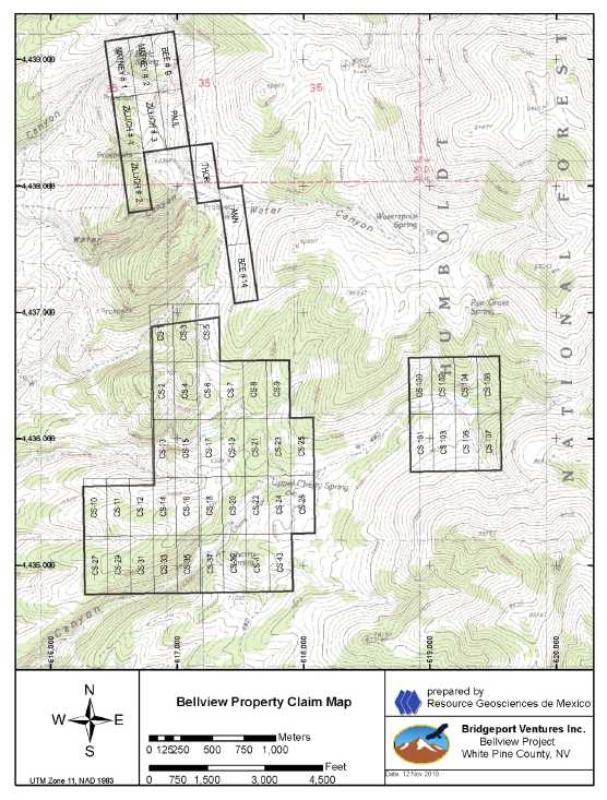
Figure 6.5. Claim map, Bellview Project.
| Matthew D. Gray C.P.G. #1068826 November 2010 Amended 7 December 2010 | Page 19 of 134 |
| Summary Report on the Nevada Gold Project Portfolio Comprising the Blackrock, Argentite, Bellview, and Horsethief Gold |
| Projects, Nevada, USA |
Table 6.5. Mining Concessions, Horsethief project.
| Horsethief Project | |||||
| Claim Name | Location Date | Filed County | Document No. | Filed BLM | BLM Serial No. |
| HT 3 | 08-Sep-2007 | NMC970603 | |||
| HT 4 | 08-Sep-2007 | NMC970604 | |||
| HT 5 | 08-Sep-2007 | NMC970605 | |||
| HT 6 | 08-Sep-2007 | NMC970606 | |||
| HT 7 | 08-Sep-2007 | NMC970607 | |||
| HT 8 | 08-Sep-2007 | NMC970608 | |||
| HT 9 | 08-Sep-2007 | NMC970609 | |||
| HT 10 | 08-Sep-2007 | NMC970610 | |||
| HT 11 | 08-Sep-2007 | NMC970611 | |||
| HT 12 | 08-Sep-2007 | NMC970612 | |||
| HT 13 | 08-Sep-2007 | NMC970613 | |||
| HT 14 | 08-Sep-2007 | NMC970614 | |||
| HT 15 | 08-Sep-2007 | NMC970615 | |||
| HT 16 | 08-Sep-2007 | NMC970616 | |||
| HT 17 | 08-Sep-2007 | NMC970617 | |||
| HT 18 | 08-Sep-2007 | NMC970618 | |||
| HT 19 | 08-Sep-2007 | NMC970619 | |||
| HT 20 | 08-Sep-2007 | NMC970620 | |||
| Matthew D. Gray C.P.G. #1068826 November 2010 Amended 7 December 2010 | Page 20 of 134 |
| Summary Report on the Nevada Gold Project Portfolio Comprising the Blackrock, Argentite, Bellview, and Horsethief Gold |
| Projects, Nevada, USA |

Figure 6.6. Claim map, Horsethief Project.
| Matthew D. Gray C.P.G. #1068826 November 2010 Amended 7 December 2010 | Page 21 of 134 |
| Summary Report on the Nevada Gold Project Portfolio Comprising the Blackrock, Argentite, Bellview, and Horsethief Gold |
| Projects, Nevada, USA |
| 6.3 | Surface Rights |
The ownership of surface rights at the Blackrock, Argentite, and Horsethief projects is Federal, administered by the Bureau of Land Management.
The ownership of surface rights at the Bellview project is Federal, administered by the United States Forest Service.
| 6.4 | Mineralization |
Historic artisanal small mines and exploration workings are present within the Blackrock, Argentite, Bellview, and Horsethief properties. Nearly all are developed on zones of outcropping quartz veins or silicified carbonates (jasperoids). No metals are currently produced from any of the properties. The principal mineralized occurrences are described in Item 11 of this report.
| 6.5 | Environmental Liability |
Potential environmental liabilities associated with the historic exploration at the projects have not been investigated or verified by the author or RGM, but no significant environmental liabilities are apparent. Small abandoned shafts and unmineralized rock piles are present but are not generating acid drainage. Old drill roads and drill pads at the projects have been adequately reclaimed by previous explorers. There are no plant facilities present within the project areas, nor are tailings piles present.
| 6.6 | Permits |
Exploration activities at the Blackrock, Argentite, and Horsethief projects are subject to regulation by the Bureau of Land management. Surface management regulations prescribed by regulation 43 CFR 3809 incorporates three levels of operation on BLM lands as summarized by the Nevada Bureau of Mines and Geology (NBMG, 2010):
| 1. | Casual use by operator who does negligible disturbance. No notice or plan required. Need not contact BLM prior to initiating activities. Does not include use of earth moving equipment or explosives. | |
| 2. | Notice. Includes exploration activities that propose disturbance of 5 acres or less. A written notice must be submitted to the appropriate BLM field office 15 days prior to starting operations. No approval necessary. Effective for 2 years. May be extended for additional 2 years. | |
| 3. | Plan of Operations. Includes all mining and processing activities and exploration exceeding 5 acres of disturbance. BLM approves plan. |
Exploration activities at the Bellview project are subject to regulation by the United States Forest Service. Surface management regulations prescribed for exploration
| Matthew D. Gray C.P.G. #1068826 November 2010 Amended 7 December 2010 | Page 22 of 134 |
| Summary Report on the Nevada Gold Project Portfolio Comprising the Blackrock, Argentite, Bellview, and Horsethief Gold |
| Projects, Nevada, USA |
on USFS lands, as summarized by the Nevada Bureau of Mines and Geology (NBMG, 2010) require:
Any mineral development or exploration activities conducted under the General Mining law of 1872 on National Forest System lands must be approved pursuant to the surface management Regulations (36 CFR 228). An operator must provide information describing the proposed activity to the District Ranger. Operations which will cause a significant surface disturbance will require an approved plan of operations and a reclamation bond. Road Use Permits and other Special Use Permits may be required to access and utilities. Operators must also obtain all applicable state permits.
Basic exploration activities, including road construction and drilling, on BLM lands can typically be permitted in 15 days. The same exploration activities on USFS lands will require approximately 12 months for receipt of permits.
| Matthew D. Gray C.P.G. #1068826 November 2010 Amended 7 December 2010 | Page 23 of 134 |
| Summary Report on the Nevada Gold Project Portfolio Comprising the Blackrock, Argentite, Bellview, and Horsethief Gold |
| Projects, Nevada, USA |
| 7 | ACCESS, CLIMATE, INFRASTRUCTURE, AND PHYSIOGRAPHY |
| 7.1 | Blackrock |
The Blackrock property is located 27 km east-northeast of the state capital of Carson City (Figure 6.1) . Access is by unsurfaced road from Dayton, NV, and may require use of an all wheel drive vehicle. Paved state Highway 50 passes within 12km of the property on the northwest side. Electric transmission lines follow Highway 50 and are close as 12 km to the project.
All basic services are available in Carson City. The project area is unpopulated. An adequate supply of experienced labor for mining operations can be drawn from the region.
The nearest commercial airport is located 27 km west-southwest of the project in Carson City. The Reno, NV airport is located 42 km northwest of the project and is served by daily flights from major US cities.
The property is located in the southwest margin of the Great Basin physiographic province, within the Walker Lane geologic province of Nevada, in the Pine Nut mountain range. Topographic relief is moderate and elevations in the project area range from 2,000 meter ASL to over 2,150 meter ASL. Broad valleys of low relief east of the project area are suitable locations for mill sites, leach pads, rock dumps, and other mine related infrastructure.
The climate in the area is arid with total annual precipitation of 15.6 cm and seasonal temperatures ranging from an average annual high of 33oC in July and an average annual low temperature of -8oC in December, as measured at meteorological station Smith 6 Nevada 267612 located at 38° 57' N, 119° 20' W, 1,524 m ASL (Western Regional Climate Center, 2010). Exploration activities may be conducted year round.
Vegetation in the area is sparse, consisting only of small scrub and sage in the valley floors and piñon-juniper forest at the highest elevations.
| 7.2 | Argentite |
The Argentite property is located 261 km southeast of Reno, NV, 295 km northwest of Las Vegas, NV, and 63 km southwest of Tonopah, NV (Figure 6.1) . Access is by unsurfaced road from Silver Peak or Dyer, NV, and may require use of an all wheel drive vehicle. Paved state Highway 264 passes within 23km of the property on the west side. Electric transmission lines that service Dyer, NV are as close as 24 km to the project.
| Matthew D. Gray C.P.G. #1068826 November 2010 Amended 7 December 2010 | Page 24 of 134 |
| Summary Report on the Nevada Gold Project Portfolio Comprising the Blackrock, Argentite, Bellview, and Horsethief Gold |
| Projects, Nevada, USA |
All basic services are available in Tonopah. The project area is unpopulated. An adequate supply of experienced labor for mining operations can be drawn from the region.
The nearest commercial airport is located 242 km northwest of the project in Carson City. The Reno, NV airport is located 261 km northwest of the project and is served by daily flights from major US cities. A general aviation use airstrip in Tonopah is capable of serving small passenger jets.
The property is located in the southwest margin of the Great Basin physiographic province, within the Walker Lane geologic province of Nevada, in the Silver Peak mountain range. Topographic relief is moderate and elevations in the project area range from 2,250 meter ASL to over 2,500 meter ASL. Broad valleys of low relief east of the project area are suitable locations for mill sites, leach pads, rock dumps, and other mine related infrastructure.
The climate in the area is arid with total annual precipitation of 11.0 cm and seasonal temperatures ranging from an average annual high of 36oC in July and an average annual low temperature of -8oC in December, as measured at meteorological station Silverpeak Nevada 267463 located at 37° 40' N, 117° 35' W, 1,298 m ASL (Western Regional Climate Center, 2010). Exploration activities may be conducted year round.
Vegetation in the area consists predominantly of piñon-juniper forest and lesser open areas covered by small scrub and sage.
| 7.3 | Bellview |
The Bellview property is located 363 km east-northeast of Reno, NV and 85 km south-southeast of Elko, NV (Figure 6.1) . Access is by highway 228, unsurfaced NFS road 114, and Cherry Springs Road, and may require use of an all wheel drive vehicle. Paved state Highway 264 passes within 23km of the property on the west side.
All basic services are available in Elko. The project area is unpopulated. An adequate supply of experienced labor for mining operations can be drawn from the region.
The nearest commercial airport is located in Elko, with turboprop commuter flight connections to Salt Lake City.
The property is located in the north-central portion of the Great Basin physiographic province, on the west flank of the Ruby Mountains. Topographic relief is moderate and elevations in the project area range from 2,000 meter ASL to 2,350 meter ASL. Broad valleys of low relief and pediments west of the project area are suitable locations for mill sites, leach pads, rock dumps, and other mine related infrastructure.
| Matthew D. Gray C.P.G. #1068826 November 2010 Amended 7 December 2010 | Page 25 of 134 |
| Summary Report on the Nevada Gold Project Portfolio Comprising the Blackrock, Argentite, Bellview, and Horsethief Gold |
| Projects, Nevada, USA |
The climate in the area is temperate with total annual precipitation of 33.2 cm and seasonal temperatures ranging from an average annual high of 31oC in July and an average annual low temperature of -10oC in January, as measured at meteorological station Ruby Lake Nevada 267123 located at 40° 12' N, 115° 30' W, 1,831 m ASL (Western Regional Climate Center, 2010). Snowfall in the period December to March may preclude exploration activities.
Vegetation in the area consists predominantly of piñon-juniper forest.
| 7.4 | Horsethief |
The Horsethief property is located 223 km northeast of Las Vegas, NV and 19 km northeast of Pioche, NV (Figure 6.1) . Access is by all weather unsurfaced roads from Pioche. In fair weather, all wheel drive vehicle is not required. Highway 93 passes within 19 km of the property on the southwest side. The electric power grid that serves Pioche is 19km distant.
Basic services are available in Pioche, with additional services available in Ely, NV, 146km to the northwest. The project area is unpopulated. An adequate supply of experienced labor for mining operations can be drawn from the region.
The Las Vegas, NV airport is located 223 km southwest of the project and is served by daily flights from major US cities. A general aviation use airstrip in Ely is capable of serving small passenger jets.
The property is located in the southeast portion of the Great Basin physiographic province, in the Wilson Creek mountain range. Topographic relief is moderate and elevations in the project area range from 1,980 meter ASL to 2,030 meter ASL. Broad flat valleys west of the project area are suitable locations for mill sites, leach pads, rock dumps, and other mine related infrastructure.
The climate in the area is semi arid with total annual precipitation of 30.2 cm and seasonal temperatures ranging from an average annual high of 31oC in July and an average annual low temperature of -13oC in January, as measured at meteorological station Spring Valley State Park Nevada 267750 located at 38° 02' N, 114° 11' W, 1,813 m ASL (Western Regional Climate Center, 2010). Snowfall in the period December to February may preclude exploration activities.
Vegetation in the area consists of piñon-juniper forest.
| Matthew D. Gray C.P.G. #1068826 November 2010 Amended 7 December 2010 | Page 26 of 134 |
| Summary Report on the Nevada Gold Project Portfolio Comprising the Blackrock, Argentite, Bellview, and Horsethief Gold |
| Projects, Nevada, USA |
| 8 | HISTORY |
All four projects reviewed for the purposes of this Technical Report are located within the intensely explored and productive gold producing terrain of the Great Basin and all have been previously explored. Historical records of previous exploration efforts at the Blackrock, Argentite, Bellview and Horsethief projects were summarized by Ramnath (2010) and are shown in Tables 8.1 to 8.4. Where relevant to interpretations of a project’s geologic setting, mineralization and exploration potential, the historical information is discussed in detail in Items 9, 11 and 22 of this report.
Table 8.1. Exploration History Blackrock Project.
| Company | Year | Type of Work | Comments | |
Unknown | 1800’s | Au | Adits | Two adits along the structure (106m) |
| Trenches | Several trenches were completed | |||
| Bentinck and Lester | 1979 | Au | Adits | resampling the adits, old dumps, |
Placid Oil Company | 1985 | Au | Rock Samples | 39 rock samples collected |
| Soil Samples | 30 soil samples collected | |||
| Stream Sediment | 2 stream sediment samples | |||
| VLF-EM Survey | Discontinued due to weak signals | |||
| Echo Bay Exploration | 1986 | Au | Rock sampling | No results |
| Aqua Gold Resources | 1988 | Au | Trenching | Two trenches dug with a bulldozer; |
| Almac Mineral Resources | 1989 | Au | Further Sampling | No available results |
Integrated Resources | 1990 | Au | Geological Mapping | Grid work |
| Rock Sampling | ||||
| Soil Sampling | ||||
| VLF-EM Survey | ||||
| Total Field Magnetics | ||||
| Trenching | ||||
| Baughman | 1999 | Au | Staked | Staked by Jerry as the ground was open |
| Romarco Minerals | 1999 | Au | Surface sampling | 61 rock samples |
| Meridian Gold Company | 1999 | Au | Surface Sampling | 13 rock samples; all samples > 100 ppb Au |
Teck Resources | 2000 | Au | Geological Mapping | |
| Rock and soil sampling | 260 rock samples collected | |||
| Petrological Study | ||||
| Franco Nevada | 2001 | Au | Surface Samples | 17 samples |
| Pacific Rim Exploration | 2001 | Au | Surface Samples | 11 rock samples |
| Western Exploration | 2001 | Au | Drilling | 4 RC dh |
| Miranda Gold Corp. | 2001? | Au | Surface Samples | 3 samples |
| New Dimension Res. | 2008 | Au | Drilling | 12 holes |
| Matthew D. Gray C.P.G. #1068826 November 2010 Amended 7 December 2010 | Page 27 of 134 |
| Summary Report on the Nevada Gold Project Portfolio Comprising the Blackrock, Argentite, Bellview, and Horsethief Gold |
| Projects, Nevada, USA |
Table 8.2. Exploration History, Argentite Project.
| Company | Year | Com. | Type of Work | Comments |
Unknown | 1920’s | Au | Prospecting | Identified mineralization |
Au | Pits, Shafts, Drifts | Several small prospect pits; two 30-foot shafts; Drift on small low grade showing | ||
| WWII | Mn | Prospecting | ||
| Mineral’s Exploration Company & Hecla Mining | 1960’s | Ag | Briefly investigated the area | |
| Sunshine Mining Company | 1970’s | ? | Geochemical Surveys | No data? |
| US Government | 1980’s | -- | Geological Mapping | Government Geology Map (1:63,360) |
| Amoco Minerals Comp. | 1979 | Ag, Zn | Rotary Drilling | 14 RC dh (5655ft); Ag and Zn intersection |
Hunt, Ware, and Proffett (Freeport Exploration) | 1981 | Ag, Au | Geological Mapping | |
| Geochemistry | ||||
| RC Drilling | 10 RC Holes (1855ft) | |||
| Camnor | 1997 | Au | Drilling | 10 RC drillholes |
| Surface Mapping |
Table 8.3. Exploration History Bellview Project.
| Company | Year | Type of Work | Comments | |
???? | 1951-1954 | Pb- Zn | Mining | Small, pits, shafts, and adits; 10% Pb and 1 oz/ton Ag |
| Kohlmoos and Zilich | 1970 | Au | Stake Claims | Claim Staking |
Arctic Precious Metals | 1979 | Au | Optioned | |
| 1980-1985 | Au | Soil and Rock Sampling | ||
| VLF-EM Survey | ||||
| 1983 | Mapping | Produced a 1:200 scale outcrop map | ||
| Drilling | 95 RC Drillholes (15,557ft) | |||
Resource | 500,000 tons @ 0.034 opt AuNOT CSA NI43-101 COMPLIANT | |||
| Silver State Mining | 1986 | Au | Drilling | 10 vertical dh (1,105ft) |
| Pegasus Gold | 1987 | Au | Rock Chip | Across jasperoid areas |
Teck | 1987-1991 | Au | Soil Sampling | |
| Rock Chip Sampling | ||||
| TFM Survey | TFM Survey; | |||
| Geologic Mapping | 1:1000 and 1:200 scale maps | |||
| Drilling | 68 RC dh (10,630ft) | |||
Resource | 1.12 m tons @ 0.031 opt Au( 0.96 g/t - 34,720 Au);NOT CSA NI43-101 COMPLIANT | |||
Western States Minerals | 1991-1999 | Au | Geologic Mapping | Mapping at 1:500 scale; |
| Rock Chip | With mapping in 1999 | |||
| Soil Geochemistry | ||||
| 1991 | Drilling | 3 RC dh (1,410 ft) | ||
| 1993 | Drilling | 21 RC dh (9,595 ft) | ||
| 1995 | Drilling | 2 RC dh (800 ft) | ||
| Homestake Mining | 1996 | Au | Drilling | 6 RC dh (2,835 ft) |
| Lyle Campbell | 1980’s | Au | Drilling | 20 RC holes Cherry Springs area, results unknown |
| Matthew D. Gray C.P.G. #1068826 November 2010 Amended 7 December 2010 | Page 28 of 134 |
| Summary Report on the Nevada Gold Project Portfolio Comprising the Blackrock, Argentite, Bellview, and Horsethief Gold |
| Projects, Nevada, USA |
Table 8.4. Exploration History Horsethief Project.
| Company | Year | Com | Type of Work | Comments |
| Canyon Resources Corp | 1981 | Au | Rock sampling | 190 samples collected |
Unknown | Historical | Au | Mining | Two 25 foot shafts and a few shallow pits |
| Canyon Resources Corp | 1981 | Au | Rock sampling | 46 rock samples collected by Labradex Corporation for Canyon |
Copper Range Exploration | 1982-1984 | Au | Drilling | 40 RC dh (13,890 ft) |
| Geological Mapping | 1 week program | |||
| Rock Chip Sampling | 20 samples collected | |||
| Novagold Resources | 1987 | Au | Hand Drill Sampling | No results |
| Matthew D. Gray C.P.G. #1068826 November 2010 Amended 7 December 2010 | Page 29 of 134 |
| Summary Report on the Nevada Gold Project Portfolio Comprising the Blackrock, Argentite, Bellview, and Horsethief Gold |
| Projects, Nevada, USA |
| 9 | GEOLOGICAL SETTING |
| 9.1 | Regional Geology of the Blackrock and Argentite Projects |
The Blackrock and Argentite projects lie within the Walker Lane geologic province, which occurs at the western edge of the Great Basin physiographic province and separates the Great Basin from the Sierra Nevada batholith and structural block to the west. The Walker Lane is underlain by Precambrian to Cenozoic metamorphic, intrusive, and sedimentary basement rocks. Volcanism related to eastward subduction of the Pacific plate beneath the North American plate resulted in a southwest migration of Cenozoic magmatism which began at approximately 40Ma in northeast Nevada and by 34 Ma began to affect the Walker Lane region, resulting in deposition of extensive volumes of calc-alkalic Tertiary volcanic units and emplacement of associated intrusives (Seedorf, 1991; McKee, 1996). Early Oligocene to Early Miocene calc-alkalic volcanism is volumetrically significant in the eastern and central parts of Nevada yet is associated with few epithermal ore deposits (Cox et al., 1991), however, where the subduction related volcanism affected the intensely faulted crust in the Walker Lane, mineral deposits related to the igneous activity are common (McKee, 1996). Active volcanism in the Walker Lane terminated approximately ~3 Ma. In contrast to the predominant west-northwest extension in the western Great Basin and east-west extension in the eastern Great Basin, the Walker Lane is characterized by right lateral displacement along regional scale, northwest striking, strike slip faults. Collectively these faults accommodate 15 to 25% of the current relative motion between the Pacific and North American tectonic plates (Faulds et al, 2004). Major strike slip faults cut Miocene and younger volcanic rocks indicating that strike slip movement began in the middle and late Cenozoic.
| 9.2 | Regional Geology of the Bellview Project. |
The Bellview project lies within the north central Great Basin. An excellent presentation of the region’s geology was presented by John et al. (2003) and the interested reader is referred to this reference for a detailed discussion of the same. A summary of the most salient points relevant to this report is herein presented. The region of the Bellview project is underlain by Archean and Proterozoic crystalline basement which was rifted in Proterozoic time, forming a rifted continental margin west of the project area. Orogenic contractional deformation associated with the Late Paleozoic Sonoma orogeny thrust allochthonous blocks of western deepwater sedimentary strata, the Roberts Mountains and Golconda allochthons, onto the eastern shallow continental shelf facies sedimentary strata. Middle, Late Jurassic, Early Cretaceous, and Late Cretaceous orogenies associated with an east dipping subduction zone resulted in further displacement of the older allochthons and compressional events were followed by intervening periods of relaxation and extension. Extensional deformation has affected the area since the Late Eocene, with extension direction changing from northwest-southeast in the late Eocene to west-southwest-east-northeast in the late Eocene and middle Miocene, then to northwest-southeast in the late Miocene to present (Zoback et al., 1994). Subduction related calc-alkaline magmatism affected the region in Middle and Late Jurassic, Cretaceous, Late Eocene, and middle Miocene time. Magmatic activity from Late Miocene to the present has been dominated by rift related tholeiitic bimodal magmatism.
| Matthew D. Gray C.P.G. #1068826 November 2010 Amended 7 December 2010 | Page 30 of 134 |
| Summary Report on the Nevada Gold Project Portfolio Comprising the Blackrock, Argentite, Bellview, and Horsethief Gold |
| Projects, Nevada, USA |
| 9.3 | Regional Geology of the Horsethief Project. |
Spalding (2010) summarized the geologic setting of the Horsethief area project as being situated within the east-central Nevada Caldera province, a poorly understood series of nested Tertiary calderas. A public domain geologic report from the NBMG (Tschanz and Pampeyan, 1970) described a volcanic rock package near Horsethief, east of Caliente, Nevada, that is several thousand feet thick, and consists of flows, mud flows, breccias, and tuffs which are andesitic in appearance, but may be latitic or dacitic in chemical composition and are intruded by small dioritic and monzonitic stocks. The age of these rocks is not definitely known. The NBMG report states that they may be as old as Cretaceous or Jurassic.
Spalding (2010) stated that the Horsethief window of Cambrian rocks is an unusual occurrence in a region dominated by volcanic rocks and he speculated that it may represent the tip of a larger package of autochthonous sedimentary rocks underlying the volcanic units or it could be a slide block into a caldera. He also reported that the same section of upper Cambrian rocks can be found in the Bristol/Highland Range 18 miles to the west of Horsethief.
| 9.4 | Local Geology |
The following discussions of project geology are based upon field examinations by the author and a review of historic exploration data contained in the Fronteer Gold project files. A listing of waypoints where geologic data was collected by the author is presented as Appendix A.
| 9.4.1 | Blackrock |
The project area is within the Como mining district. The Como district has produced gold from epithermal deposits in the form of quartz veins, vein stockworks, and disseminated mineralization, all hosted by andesitic volcanic rocks. The Blackrock project is underlain by Miocene andesitic and dacitic volcanic strata similar to those exposed elsewhere in the Como district (NMBG, 1997).
Raabe (2010a) reported that the andesitic flows and tuffs that underlie the Blackrock property are generally southeast-dipping and are underlain, to the north, by an undetermined thickness of volcanic lahar. He described the andesite as porphyritic with phenocrysts of feldspar, pyroxene, and hornblende and in places with textures of a crystal lithic tuff. Throughout the sequence, the andesite contains 0-5% lapilli size, rounded, dark to light brown basalt cobbles. In the north part of the property, steeply dipping, flow foliated andesites, identical in all other aspects to the other andesites in the area, may be intrusive feeders to the surrounding volcanics. A narrow basaltic dike is located in the extreme southeast corner of the property.
| Matthew D. Gray C.P.G. #1068826 November 2010 Amended 7 December 2010 | Page 31 of 134 |
| Summary Report on the Nevada Gold Project Portfolio Comprising the Blackrock, Argentite, Bellview, and Horsethief Gold |
| Projects, Nevada, USA |
The dominant structural feature at Blackrock is a north-northeast striking, southeast dipping fault or fracture zone that controlled emplacement of the Blackrock vein and localized silicification of the footwall andesite. The quartz vein is discontinuously exposed over a 1,300m strike length. The multiphase vein is up to 15m wide and exhibits pinch and swell morphology. It is bordered by greater thicknesses of silicified andesite in the footwall. The vein structure exposed at surface is near vertical but drillhole data demonstrates a steep southeast dip for the southernmost 400m of the vein. Raabe (2010a) reported that cross-fractures intersect the vein at angles ranging from 060º-090º and that the southern exposure of the Blackrock fault is truncated by an east-west fault and that two east-west structures separate the north, central, and south portions of the vein. These faults parallel the main structural features in the Como area, 4 km to the south. He reported that offset along these faults is minor, with displacement along the cross fault at the north end of the South Zone estimated at approximately 3 meters.
| 9.4.2 | Argentite |
| Matthew D. Gray C.P.G. #1068826 November 2010 Amended 7 December 2010 | Page 32 of 134 |
| Summary Report on the Nevada Gold Project Portfolio Comprising the Blackrock, Argentite, Bellview, and Horsethief Gold |
| Projects, Nevada, USA |
The Argentite project lies in the Silver Peak Mountains within the Silver Peak mining district. The property is underlain by a Tertiary volcanic and sedimentary sequence which was described by Albers and Stewart (1972) as comprising a lowermost Tertiary ash-flow tuff dated at 21.5 Ma (early Miocene) which is overlain by andesitic to dacitic volcanic breccias with interlayered flows and lenses of tuffaceous sandstone. Tuffaceous shale and sandstone strata overlie the volcanic breccia unit and may represent lacustrine sedimentation in late Miocene to early Pliocene lakes or basins. Rhyolitic air-fall tuffs, flows, domes, breccias and intrusive masses rest on, or intrude, the lacustrine sediments and older rocks. The rhyolite unit has been dated at 6.0 Ma and is overlain by porphyritic latite or trachyandesite, at least 500 ft thick. This rock is characterized by abundant large plagioclase and sanidine phenocrysts and abundant biotite. Sandstone, conglomerate and tuff are interlayered with the latite flows. The unit has been dated at 5.9 Ma. The distribution, thickness, and lithology of the rhyolitic air-fall tuffs, flows, domes, breccias, intrusive masses, and of the porphyritic latite suggest the central part of the Silver Peak Mountains may have been a caldera-like structure. Forrest (1986) observed that the flows, agglomerates, and sediments on the property form a gentle south-dipping sequence away from a proposed caldera rim a mile or so to the north, and he noted that the major structures on the property are north- to northeast-trending normal faults with 300 to 500 feet of right lateral offset. The coarse grained porphyritic latite unit is exposed at the base of Argentite Canyon whereas the volcaniclastic sedimentary strata and interbedded silica sinters crop out at the higher elevations on the east side of the canyon. They appear to depositionally overlie the porphyritic latite. A geologic map prepared by Cordilleran Exploration Company (Howell, 2004) summarizes the project’s outcrop geology and is presented as Figure 9.1. For a more detailed description of the geology of the Silver Peak district the interested reader is referred to Albers and Stewart (1972).
| Matthew D. Gray C.P.G. #1068826 November 2010 Amended 7 December 2010 | Page 33 of 134 |
| Summary Report on the Nevada Gold Project Portfolio Comprising the Blackrock, Argentite, Bellview, and Horsethief Gold |
| Projects, Nevada, USA |
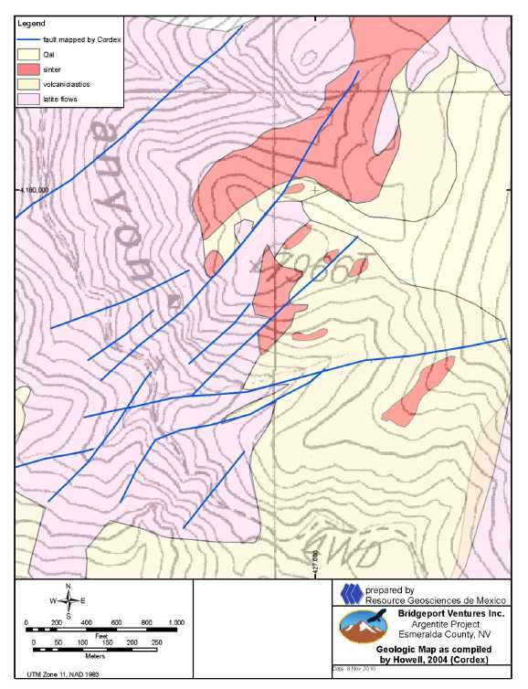
Figure 9.1. Geologic map of Argentite property prepared by Cordilleran Exploration Co. (Howell, 2004).
| Matthew D. Gray C.P.G. #1068826 November 2010 Amended 7 December 2010 | Page 34 of 134 |
| Summary Report on the Nevada Gold Project Portfolio Comprising the Blackrock, Argentite, Bellview, and Horsethief Gold |
| Projects, Nevada, USA |
| 9.4.3 | Bellview |
The Bellview property is underlain by a series of Lower and Middle Cambrian limestones, shales, and dolostones. Lanier (1999a) created a 1:500 scale geologic map of the project area which is summarized as Figure 9.2. The local stratigraphic section has been described by Milliken (1979) and Renken (1983) and is summarized in Table 9.1.
Table 9.1. Stratigraphic description of the Bellview area.
| Sedimentary Formation or Unit | Age | Description |
| Windfall Formation | Upper Cambrian | Comprised of two members at Eureka type section: upper Bullwhacker Member, 400 ft thick thin-bedded tan or light brown sandy or silty limestone; and the 250 ft thick lower Catlin Member comprised of banded chert at the base overlain by thin-bedded limestone with abundant black chert and siltstone, and sandstone. At Bellview, the Windfall forms bold, cliffy exposures in the upper elevations east and south of the property. |
| Dunderberg Shale | Upper Cambrian | Sequence of brown- to khaki-colored, carbonaceous, silty clay shale with thin lenticular limestone interbeds, 1,200 to 1,400 ft thick in the southern Ruby Mountains (Hose and Blake, 1976), but is extremely variable due to intraformational thrusting and/or extensional faulting. At the Bellview property, the lowermost 1-3 ft thick limestone beds are locally silicified and transformed to jasperoid. The lower contact with the Hamburg Limestone is sharp, and is often marked by a thin 0-1 ft zone of silica-cemented hematitic breccias and jasperoid. This contact is a regional zone of shearing in the southern Ruby Mountains, and at Eureka. |
| Hamburg Limestone | Middle Cambrian | 1,000 feet thick in the southern Ruby Mountains (Milliken 1979), comprised of medium light gray biosparrite and biosparrudite, locally dolomitic. At Bellview forms bold cliffy outcrops in the eastern part of the property, and is an important regional marker unit. |
| Secret Canyon Formation | Middle Cambrian | 2,300 feet thick in the southern Ruby Mountains, comprised of thin-bedded silty limestone and greenish silty shale subdivided into four subunits, a lower 183 m of fissile, dark gray, silty, clay shale overlain by 800 feet of yellowish- green weathering silty clay shale with interbedded platy, medium gray micritic limestones, and a 250 foot transitional zone in which shale gives way to predominant limestone of the uppermost 630 foot thick Clark Spring Member. Millikan (1979). At Bellview the lowermost shale unit is locally silicified, argillized, and quartz veined and hosts the non CSA NI43-101 historic gold resource reported for the project. |
| Geddes Limestone | Middle Cambrian | At Bald Mountain, approximately 15km south of Bellview, this unit is 40-50 ft thick underlies and the Secret Canyon Shale at (Nutt et al., 2000). It has not been mapped at Bellview, but Renken (1983) writes that up to 60 ft of yellow- gray weathering carbonaceous limestone in ¼ to 1 in. beds occurs at the base of the Secret Canyon Shale in some places. This may represent the Geddes Limestone. |
| Eldorado Dolomite | Lower to Middle Cambrian | Composed of massive dark gray, medium grained dolostone which weathers a brownish-gray. The unit is approximately 2,500 ft thick at Eureka, but the base at Bellview is not exposed, and has not been reached in drilling. At Bellview the dolostone is extensively silicified along structures and the contact with the overlying Secret Canyon shale strata. Forms bold silicified outcrops. |
| Matthew D. Gray C.P.G. #1068826 November 2010 Amended 7 December 2010 | Page 35 of 134 |
| Summary Report on the Nevada Gold Project Portfolio Comprising the Blackrock, Argentite, Bellview, and Horsethief Gold |
| Projects, Nevada, USA |
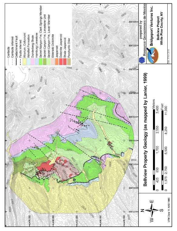
Figure 9.2. Geologic map of Bellview property, summarized from Lanier (1999a).
| Matthew D. Gray C.P.G. #1068826 November 2010 Amended 7 December 2010 | Page 36 of 134 |
| Summary Report on the Nevada Gold Project Portfolio Comprising the Blackrock, Argentite, Bellview, and Horsethief Gold |
| Projects, Nevada, USA |
Raabe (2010b) reported that dioritic, fine-grained, equigranular to medium-grained, weakly porphyritic dikes are found throughout the property. Jones (1992), Lanier (1999a), and Renken (1983) described the main fault orientations at Bellview:
- North-northeast faults striking NA035 with apparent left lateral offset;
- NA000 to NA015 striking faults with normal offsets;
- NA325 striking faults with dip slip and oblique dextral normal displacement;
- East-west faults and shear zones of unspecified relative displacement.
Linear outcrops patterns of silicified Eldorado Dolomite suggest that north and northeast striking faults have locally controlled jasperoid formation.
Lanier (1999b) described the Bellview property as a complex of folded folds, with the elliptical exposure of the Eldorado Dolomite representing the core of a refolded, doubly plunging anticline. Lanier (1999c) mapped small-scale, broad folds or warps trending west-northwest and northeast throughout the property.
Raabe (2010b) reported that the Secret Canyon and overlying units on the east side of the Eldorado exposures strike mostly to the north and dip moderately to the east. Jones (1992) observed that northwest of the resource area, medium to thick-bedded limestones dip from between 37 and 62 degrees west and postulated an anticlinal fold in the center of the property area.
Raabe (2010b) proposed that the structural regime at Bellview represents the sliding of a detached sheet of shale-rich, plastically flowing, Middle Cambrian sediments over a corrugated basement of east-northeast trending rotated horsts and grabens where resistive, brittle fracturing Eldorado Dolomite highs forced upward warping and ramping of the overriding plate, back thrusting, and formation of tear faults along the margins of the Eldorado Dolomite highs.
| 9.4.4 | Horsethief |
| Matthew D. Gray C.P.G. #1068826 November 2010 Amended 7 December 2010 | Page 37 of 134 |
| Summary Report on the Nevada Gold Project Portfolio Comprising the Blackrock, Argentite, Bellview, and Horsethief Gold |
| Projects, Nevada, USA |
The Horsethief project is centered upon a narrow, northwest trending horst of dolostone and limestone strata exposed through an erosional window in overlying Tertiary volcanic strata (Canyon Resources, 1982). The window, or area of exposed carbonates, is approximately 4.7km long and 400 to 1300m wide (Figure 9.3) . The surrounding Tertiary volcanic rocks comprise ash flow tuffs, air fall tuffs, flows, flow breccias, lahars and waterlain tuffs and have been mapped by the NBMG as undifferentiated Tertiary volcanics. The carbonate strata have been interpreted as Upper Cambrian strata of the Dunderberg Shale (Tschanz and Pampeyan, 1970). Bedding of limestone and dolostone observed in outcrop dips gently to the northeast. An east-west trending zone of pervasive silicification of carbonate, mapped as jasperoid, covers an area of approximately 1,200 x 200m and was recognized by both the NBMG and Canyon Resources, and the latter mapped north-northwest trending shear zones cutting the carbonates and postulated an east-west high angle structure as a control of development of jasperoid. Igneous rocks are not exposed in outcrop but drill logs for rotary drillholes completed by Canyon Resources describe intercepts of altered felsic dikes.
| Matthew D. Gray C.P.G. #1068826 November 2010 Amended 7 December 2010 | Page 38 of 134 |
| Summary Report on the Nevada Gold Project Portfolio Comprising the Blackrock, Argentite, Bellview, and Horsethief Gold |
| Projects, Nevada, USA |
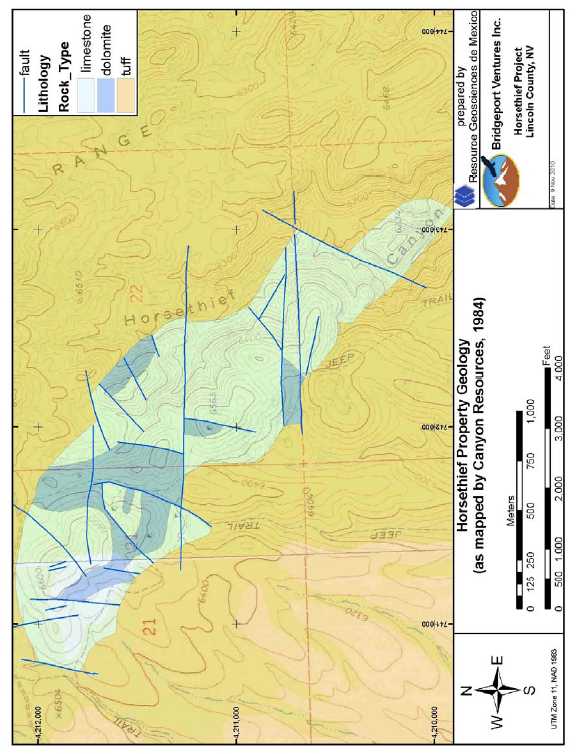
Figure 9.3. Geologic map of Horsethief property as mapped by Canyon Resources (Veek, 1984).
| Matthew D. Gray C.P.G. #1068826 November 2010 Amended 7 December 2010 | Page 39 of 134 |
| Summary Report on the Nevada Gold Project Portfolio Comprising the Blackrock, Argentite, Bellview, and Horsethief Gold |
| Projects, Nevada, USA |
| 10 | DEPOSIT TYPES |
The exploration targets recognized for the projects include both epithermal and mesothermal gold deposits of various types, all of which have known productive and economically important analogs in the region.
| 10.1 | Blackrock, Argentite |
The exploration targets recognized for the Blackrock and Argentite projects include epithermal gold deposits of either high sulfidation (referred to by some authors as acid sulfate or quartz alunite) or low sulfidation (referred to by some authors as quartz adularia) type, both of which have productive and economically important analogs in the region. Geologic characteristics observed at Blackrock are consistent with a low sulfidation system. The Argentite prospect may be prospective for either a low or a high sulfidation deposit.
Economically important low sulfidation epithermal gold systems in the Walker Lane include Aurora, Bullfrog, Comstock, Rawhide, Round Mountain, and Tonopah, Nevada and Bodie, California.The mineralization described for the mines and mining districts in this section is not necessarily indicative of the mineralization at the Blackrock and Argentite properties.
Low sulfidation deposits may be present as veins and/or disseminated deposits and hosted by intrusive, volcanic, and sedimentary rocks. Features common to such deposits (Buchanan, 1981; Hayba et al., 1985; Heald et al., 1987; Bonham, 1988; Berger and Henley, 1989; Albinson et al., 2001) include:
- Intermediate to felsic, calc-alkaline volcanic host rocks.
- Association with intrusive centers.
- Alteration mineral assemblages dominated by sericite, quartz, adularia, and chlorite.
- Variable Au:Ag ratios.
- Ore mineralogy characterized by argentite, tetrahedrite, tennantite, native silver, native gold, and base-metal sulfides.
- Vertical geochemical zoning, with well defined upper and lower elevation limits to economic mineralization, over vertical ranges of 200 to 700m.
- Open space filling vein textures.
- Quartz and carbonate gangue minerals.
- Ore and gangue mineral textures indicative of low temperature environments.
Economically important high sulfidation systems were formed in the Walker Lane at Borealis, Goldfields, and Paradise Peak, Nevada. The mineralization described for the mines and mining districts in this section is not necessarily indicative of the mineralization at the Blackrock and Argentite properties.
| Matthew D. Gray C.P.G. #1068826 November 2010 Amended 7 December 2010 | Page 40 of 134 |
| Summary Report on the Nevada Gold Project Portfolio Comprising the Blackrock, Argentite, Bellview, and Horsethief Gold |
| Projects, Nevada, USA |
High sulfidation gold-silver deposits may be present as veins and/or disseminated deposits. Some of the most intensely studied and described HS deposits include Summitville, Colorado (Stoffregen, 1987; Gray and Coolbaugh, 1994), Goldfield, Nevada (Ransome, 1909, Ashley, 1974; Vikre, 1989), Lepanto, Philippines (Hedenquist et al, 1998) and Julcani, Peru (Petersen et al. 1977; Deen et al. 1994). Based upon these studies and others, excellent compilations of general characteristics and genetic and empirical models have been presented by Hayba et al. (1985), Heald et al. (1987), Berger and Henley (1988) and Arribas (1995). General characteristics of high sulfidation deposits include:
- Located within plutonic-volcanic arcs.
- Associated with intermediate calc-alkaline rocks, often in dome complexes.
- Alteration mineral assemblages indicative of high temperature acidic hydrothermal fluids, including an advanced argillic assemblage characterized by one or more of pyrophyllite, alunite, dickite, kaolinite, and diaspore.
- Silicification and acid leaching of principal hydrothermal fluid conduits (forming the clichéd “vuggy silica” alteration).
- Presence of minerals indicative of high sulfidation states, principally the sulfosalt enargite or its low temperature polymorph luzonite.
- Economically important quantities of Au and/or Ag and/or Cu.
- Alteration zoning typified by a central zone of silica alteration flanked by a zone of advanced argillic alteration, which in turn is surrounded by illite dominated argillic alteration.
Genetic models proposed for high sulfidation systems call upon shallow emplacement of an oxidized calc-alkaline magma. As the magma crystallizes, a metal- and volatile-rich fluid phase exsolves, and at relatively low confining pressures will separate into a low salinity vapor and a hypersaline liquid. The vapor phase ascends and when absorbed into connate or meteoric waters, forms a high temperature, sulfate-rich, acidic hydrothermal fluid. As this hydrothermal fluid ascends and cools, acidity progressively increases, resulting in a vertical zonation where advanced argillic assemblages overly illite-dominated argillic assemblages. Neutralization and cooling of the fluid during lateral fluid flow repeats this zoning pattern, with proximal silicified and leached zones flanked first by advanced argillic alteration, and then by more distal illite dominated alteration. As the hydrothermal system evolves, younger, more reduced hydrothermal fluids, probably generated by interactions between ascending hypersaline magmatic fluid and meteoric water dominated convection cells, then transport and deposit metals (Au-Ag-Cu) along the same conduits utilized previously. Metals may be sourced directly from the magmatic fluids or leached from country rocks.
| 10.2 | Bellview, Horsethief |
The exploration target recognized for the Bellview and Horsethief projects is a Carlin-type deposit, here defined as a sedimentary rock hosted, structurally and lithologically controlled gold deposit of moderate to low temperature of formation.
| Matthew D. Gray C.P.G. #1068826 November 2010 Amended 7 December 2010 | Page 41 of 134 |
| Summary Report on the Nevada Gold Project Portfolio Comprising the Blackrock, Argentite, Bellview, and Horsethief Gold |
| Projects, Nevada, USA |
Divergent ideas for the formation of Carlin type deposits have been proposed ranging from a distal magmatic hydrothermal origin (Sillitoe and Bonham, 1990); to formation from hydrothermal fluids generated by regional metamorphic processes (Phillips and Powell, 1993); to an amagmatic origin related to regional fluid circulation due to crustal extension (Ilchik and Barton, 1997). Although the genesis of the Carlin deposits is a matter of dispute, the general characteristics of the deposits are not, and are summarized from Ilchik and Barton (1997) as follows:
- Metals contained in economically significant amounts are gold and silver.
- Other metals and elements present may include arsenic, antimony, barite and mercury.
- Host rocks are generally Paleozoic silty to massive limestones, dolostones, calcareous siltstones, and shales, with lesser amounts of ore hosted by interbedded mafic flows or crosscutting felsic dikes.
- Commonly occur at intersection of major normal faults with favorable stratigraphic units or thrust contacts.
- No clear association with intrusives although intermediate to felsic intrusions are present in many Carlin districts.
- Individual deposits or mineralized systems contain from 0.1M to 30M ounces gold.
- Associated hydrothermal alteration includes bedding controlled carbonate dissolution, structurally and stratigraphically controlled silica replacement (jasperoid formation), recrystallization of limestones and dolostones, and calcite veining peripheral to mineralized areas.
- Temperatures of formation ranging from 160 to 250 C under pressure of 300 to 800 bars.
- Ore and gangue mineral assemblage of quartz, illite, kaolinite, arsenian pyrite, arsenopyrite, stibnite, realgar, orpiment.
- Gold typically present as micron sized inclusions in pyrite.
| Matthew D. Gray C.P.G. #1068826 November 2010 Amended 7 December 2010 | Page 42 of 134 |
| Summary Report on the Nevada Gold Project Portfolio Comprising the Blackrock, Argentite, Bellview, and Horsethief Gold |
| Projects, Nevada, USA |
| 11 | MINERALIZATION |
| 11.1 | Blackrock |
At Blackrock a gold mineralized multistage quartz vein is exposed in outcrop. A small caved adit in the arroyo at the southern end of the vein outcrop is the only know historic mine working on the property. The vein outcrops have been mapped and sampled by previous operators and the southernmost section of the vein has been partially tested by reverse circulation drilling.
The data generated by previous operators supported the possibility of a bonanza lode target at Blackrock. Surface sampling of the vein by previous operators reportedly confirmed a 1,300 meter strike length over which the vein and/or silicified wall rock discontinuously crops out (Figure 11.1) . Sampling of the vein yielded anomalous to potentially ore grade gold concentrations over significant true widths of as much 6.1m @ 6.5 gpt Au.The historic rock chip assay data has not been independently confirmed by the author but was obtained by exploration groups and personnel known to the author and believed to be credible.The author conducted independent sampling of the vein and altered wallrock and confirmed that the both vein and the silicified footwall are gold and silver mineralized (Table 11.1) . The author’s sampling of the vein and wallrock yielded anomalous results with a minimum gold assay of 0.12 ppm Au from silicified andesite and a maximum gold assay of 1.6 ppm Au across a 3m width of the vein. The author’s sample of vein fragments from the dump at the adit at the south end of the vein yielded 0.35 ppm gold and 228 ppm silver.
| Matthew D. Gray C.P.G. #1068826 November 2010 Amended 7 December 2010 | Page 43 of 134 |
| Summary Report on the Nevada Gold Project Portfolio Comprising the Blackrock, Argentite, Bellview, and Horsethief Gold |
| Projects, Nevada, USA |

Figure 11.1. Map of Blackrock vein showing rock chip sample gold assay data.
| Matthew D. Gray C.P.G. #1068826 November 2010 Amended 7 December 2010 | Page 44 of 134 |
| Summary Report on the Nevada Gold Project Portfolio Comprising the Blackrock, Argentite, Bellview, and Horsethief Gold |
| Projects, Nevada, USA |
Table 11.1. Sample descriptions and assay data for Blackrock project rock samples collected by M Gray.
![]()
The only known drill testing of the project was conducted in 2001 by Western Exploration and in 2008 by New Dimension Resources, a publically traded Canadian exploration company. All drilling was concentrated on the southern end of the exposed vein (Figure 11.2, Table 11.2) . The 2008 drilling tested a 400m strike length of the Blackrock vein at depths of less than 100m. The vein was reported to have been intersected in every drillhole and each drillhole yielded wide, low grade gold intercepts, which were reported to include 38.1m @ 0.64 gpt in drillhole BR08-06 and 70.1m @ 0.21 gpt Au in drillhole BR08-03. The highest grade intercept was 1.5m @ 6.5 gpt Au. New Dimension Resources stated that these drill assay results were consistent with the required disclosure rules outlined in NI43-101. Drill intercepts are summarized as Table 11.3.The author has not reviewed the original drill logs nor assay certificates thus cannot comment on the accuracy of the reported drill results. The drill hole assay data were obtained from sources believed to be reliable but cannot be verified and the 2008 drillhole data has not been independently confirmed by the author.
| Matthew D. Gray C.P.G. #1068826 November 2010 Amended 7 December 2010 | Page 45 of 134 |
| Summary Report on the Nevada Gold Project Portfolio Comprising the Blackrock, Argentite, Bellview, and Horsethief Gold |
| Projects, Nevada, USA |
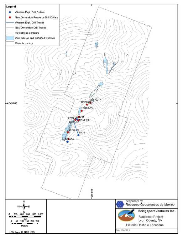
Figure 11.2. Map of Blackrock vein showing historic drillhole locations.
| Matthew D. Gray C.P.G. #1068826 November 2010 Amended 7 December 2010 | Page 46 of 134 |
| Summary Report on the Nevada Gold Project Portfolio Comprising the Blackrock, Argentite, Bellview, and Horsethief Gold |
| Projects, Nevada, USA |
Table 11.2. Blackrock historic drillhole collar locations.
Drillhole | UTM E NAD27 | UTM E NAD27 | Elevation | TD | Azimuth | Inclination | Date |
| BR08-01 | 287958 | 4342665 | 6826' | 280' | N51W | -60 | 6-Mar-08 |
| BR08-02 | 287955 | 4342666 | 6826' | 250' | N84W | -45 | 7-Mar-08 |
| BR08-03 | 287983 | 4342725 | 6836' | 300' | N10W | -70 | 8-Mar-08 |
| BR08-04 | 288036 | 4342785 | 6834' | 320' | N45W | -70 | 9-Mar-08 |
| BR08-05 | 287851 | 4342514 | 6735' | 200' | N10W | -70 | 10-Mar-08 |
| BR08-06 | 287924 | 4342637 | 6816' | 200' | S45W | -45 | 11-Mar-08 |
| BR08-07 | 287923 | 4342636 | 6816' | 170' | N40W | -60 | 12-Mar-08 |
| BR08-08 | 287949 | 4342633 | 6811' | 290' | N70W | -60 | 13-Mar-08 |
| BR08-09 | 287949 | 4342633 | 6811' | 360' | 0 | -90 | 14-Mar-08 |
| BR08-10 | 288068 | 4342802 | 6817' | 330' | N4W | -60 | 15-Mar-08 |
| BR08-11 | 287856 | 4342449 | 6646' | 130' | N75W | -45 | 15-Mar-08 |
| BR08-12 | 287854 | 4342447 | 6646' | 180' | N14E | -60 | 16-Mar-08 |
Table 11.3.Gold intercept summary for historic drillholes atBlackrock.
| Drillhole | From m | To m | Interval m | Au ppm |
| BR08-01 | 36.6 | 67.1 | 30.5 | 0.218 |
| BR08-02 | 27.4 | 50.3 | 22.9 | 0.234 |
| BR08-03 | 9.1 | 79.2 | 70.1 | 0.206 |
| BR08-04 | 25.9 | 39.6 | 13.7 | 0.333 |
| BR08-04 | 59.4 | 91.4 | 32.0 | 0.300 |
| BR08-05 | 0.0 | 29.0 | 29.0 | 0.185 |
| BR08-06 | 22.9 | 61.0 | 38.1 | 0.644 |
| BR08-07 | 16.8 | 45.7 | 29.0 | 0.499 |
| BR08-08 | 33.5 | 64.0 | 30.5 | 0.221 |
| BR08-09 | 68.6 | 89.9 | 21.3 | 0.221 |
| BR08-09 | 96.0 | 106.7 | 10.7 | 0.788 |
| BR08-10 | 48.8 | 100.6 | 51.8 | 0.210 |
| BR08-11 | 16.8 | 30.5 | 13.7 | 0.229 |
| BR08-12 | 27.4 | 54.9 | 27.4 | 0.473 |
| NC-1 | 96.0 | 112.8 | 16.8 | 0.319 |
| NC-1 | 248.4 | 274.3 | 25.9 | 0.186 |
| NC-2 | 59.4 | 77.7 | 18.3 | 0.389 |
| NC-2 | 88.4 | 100.6 | 12.2 | 0.209 |
| NC-3 | 44.2 | 62.5 | 18.3 | 0.261 |
It is the author’s opinion that although the 2008 drilling failed to define an economic resource it yielded results of exploration significance. The reported drill data demonstrated:
| 1. | Continuity of the mineralized vein along strike and dip. |
| Matthew D. Gray C.P.G. #1068826 November 2010 Amended 7 December 2010 | Page 47 of 134 |
| Summary Report on the Nevada Gold Project Portfolio Comprising the Blackrock, Argentite, Bellview, and Horsethief Gold |
| Projects, Nevada, USA |
| 2. | Increasing vein widths at depth and to the north, as shown in Figure 11.3, a preliminary 3D model of the vein created by Bridgeport using the historic drill data. | |
| 3. | Multiple mineralized zones, interpreted as parallel vein structures. | |
| 4. | Possible increase of grade with depth (drillhole BR08-09). |
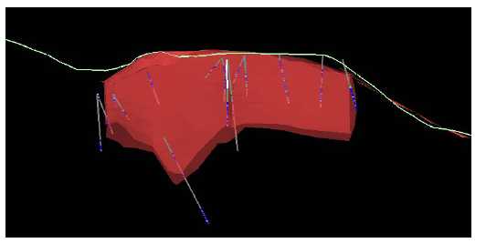
Figure 11.3. 3D longitudinal section of southern 400m of Blackrock vein showing mineralized drill intercepts, view looking northwest.
Field inspection of the area by the author of this report was completed on 14 and 20 October 2010, and was sufficient to confirm a 1,000m strike length of the vein, with true widths locally exceeding 15 meters (Figure 11.4) . The vein is multiphase, comprised of fine white and tan sugary crystalline silica crosscut by white sugary and chalcedonic quartz veinlets, often with an angular breccia texture (Figures 11.5 and 11.6) . The author sampled vein material and silicified footwall host rock and confirmed that both the vein and the silicified wallrock locally contain elevated gold contents. Sample descriptions and gold assays are summarized in Table 11.1 and complete assay data is presented in Appendix B. The outcrop, surface rock chip assays, and drillhole data validate a high grade “bonanza vein” target at the Blackrock prospect, exploitable by underground methods, analogous to the productive veins of the Comstock district. The potential to host a bulk minable near surface deposit is low, but not precluded by the data.
| Matthew D. Gray C.P.G. #1068826 November 2010 Amended 7 December 2010 | Page 48 of 134 |
| Summary Report on the Nevada Gold Project Portfolio Comprising the Blackrock, Argentite, Bellview, and Horsethief Gold |
| Projects, Nevada, USA |

Figure 11.4. Photo of Blackrock vein, looking southwest down strike.
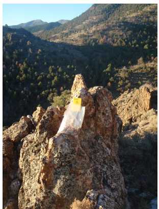
Figure 11.5. Photo of sample site I223001 (1.6 gpt Au), Blackrock vein, looking southwest.
| Matthew D. Gray C.P.G. #1068826 November 2010 Amended 7 December 2010 | Page 49 of 134 |
| Summary Report on the Nevada Gold Project Portfolio Comprising the Blackrock, Argentite, Bellview, and Horsethief Gold |
| Projects, Nevada, USA |
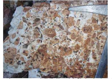
Figure 11.6. Photo of quartz cemented silicified breccia in Blackrock vein at site I223001 (1.6 gpt Au).
| 11.2 | Argentite |
A gold mineralized high angle silicified structural zone is exposed in Argentite Canyon and has been the focus of historic artisanal scale mining. The mineralized zone is characterized by pervasive silicification and quartz veining and in places comprises a quartz cemented silicified breccia. An adit with no more than 50m of combined drifting and a few small prospect pits are the only known historic mines or exploration workings at the project (Figure 11.7) . Brecciation and silicification of the structural zones is intense and iron oxide staining varies from nil to intense (Figures 11.8 and 11.9) . Alteration and mineralization are confined to structurally broken zones. The host rock latites are not visibly altered or mineralized peripheral to the structural zones.
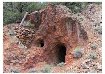
Figure 11.7. Photo of adit in tributary arroyo to Argentite Canyon on developed on high grade silicified zone.
| Matthew D. Gray C.P.G. #1068826 November 2010 Amended 7 December 2010 | Page 50 of 134 |
| Summary Report on the Nevada Gold Project Portfolio Comprising the Blackrock, Argentite, Bellview, and Horsethief Gold |
| Projects, Nevada, USA |
Figure 11.8. Photo of intensely Fe-oxide stained and brecciated latite volcanic (?) at adit
entrance, sample site I223011 (select sample of vein fragments, 17.6 gpt Au).
Figure 11.9. Photo of silicified breccia zone, sample site I223010 (1.9 gpt Au).
| Matthew D. Gray C.P.G. #1068826 November 2010 Amended 7 December 2010 | Page 51 of 134 |
| Summary Report on the Nevada Gold Project Portfolio Comprising the Blackrock, Argentite, Bellview, and Horsethief Gold |
| Projects, Nevada, USA |
Work by previous project operators Camnor (Northair Group), Cordex Exploration, and Fronteer Gold partially tested the epithermal gold system exposed in Argentite Canyon and identified hot spring sinter deposits that crop out at elevations 140 m above the canyon floor. Rock chip samples of the silicified zone exposed in the adit were reported by Camnor Resources to yield as much as a 17m width assaying greater than 3.7 gpt Au. Samples collected from silicified and brecciated outcrops in Argentite Canyon were reported to yield as much as 3.3 gpt Au. The sinters were reported to contain geochemically anomalous concentrations of Au, As, Sb, and Hg.
The historic rock chip assay data has not been independently confirmed by the author but was obtained by exploration groups and personnel known to the author and believed to be credible. The author conducted independent sampling of the silicified zones exposed in Argentite Canyon and of the sinters cropping out above the canyon on the east side. The results verify that the silicified structural zones contain significant gold concentrations and that the sinters are geochemically anomalous (Table 11.4) . The author’s samples across the silicified breccias zones exposed in Argentite Canyon yielded as much as 1.9 gpt Au over a width of 1.5m. The author’s sample of quartz vein material from the dump at the adit yielded 17.6 gpt Au and his samples of the sinter returned assays of 0.03 gpt Au and as much as 286 ppm Sb. In cases where samples were collected at a sample site marked from prior sampling by Fronteer, gold assays matched those reported by Fronteer.
Cordex is known to have drilled exploration boreholes in Argentite Canyon but the author does not have access to the drill data. Drilling by Camnor in 1997 was reported to have returned significant widths of gold mineralized quartz veined zones hosted in Tertiary volcanic strata, with intercepts of as much as 45.7m @ 1.2 gpt Au reported in public press releases (Figures 11.10 and 11.11) .The author has not reviewed the original drill logs nor assay certificates thus cannot comment on the accuracy of the reported drill results. The drill hole assay data were obtained from sources believed to be reliable but cannot be verified and the Camnor drillhole data has not been independently confirmed by the author. Both Camnor and Cordex interpreted east-striking structures as controls of the gold mineralization exposed in Argentite Canyon.
| Matthew D. Gray C.P.G. #1068826 November 2010 Amended 7 December 2010 | Page 52 of 134 |
| Summary Report on the Nevada Gold Project Portfolio Comprising the Blackrock, Argentite, Bellview, and Horsethief Gold |
| Projects, Nevada, USA |
Table 11.4. Sample descriptions and assay data for Argentite project rock samples collected by M Gray.
| Matthew D. Gray C.P.G. #1068826 November 2010 Amended 7 December 2010 | Page 53 of 134 |
| Summary Report on the Nevada Gold Project Portfolio Comprising the Blackrock, Argentite, Bellview, and Horsethief Gold |
| Projects, Nevada, USA |
Figure 11.10. Drillhole map and summary of drill intercepts from public press release by Camnor Resources, 1997.
| Matthew D. Gray C.P.G. #1068826 November 2010 Amended 7 December 2010 | Page 54 of 134 |
| Summary Report on the Nevada Gold Project Portfolio Comprising the Blackrock, Argentite, Bellview, and Horsethief Gold |
| Projects, Nevada, USA |
![]()
Figure 11.11. Drillhole section and summary of drill intercepts from public press release by Camnor Resources, 1997.
| Matthew D. Gray C.P.G. #1068826 November 2010 Amended 7 December 2010 | Page 55 of 134 |
| Summary Report on the Nevada Gold Project Portfolio Comprising the Blackrock, Argentite, Bellview, and Horsethief Gold |
| Projects, Nevada, USA |
During the field review mineralized zones exposed in Argentite Canyon and hydrothermal silica sinter outcrops on the east side of the canyon were visited. High angle silicified and quartz veined zones were observed in the canyon bottom (Figure 11.12), and low temperature chalcedonic silica replacement deposits and sinters were seen 140 m above the canyon floor on the east side. The sinters comprise bedded laminated sinter (Figure 11.13), low temperature chalcedonic silica replacement of sediments possibly deposited contemporaneously with the sinters, and sinter cemented sinter breccias (Figure 11.14) . Accumulated thicknesses of as much as 15 m of sinter and related high level silicified sediments were observed at elevations of 7880 feet. Geologic mapping by Cordex indicates that the sinters crop out for at least 2,500 feet along a northwest trend (Figure 11.15) .
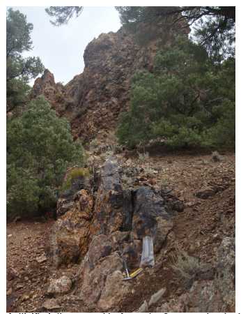
Figure 11.12. Photo of silicified rib exposed in Argentite Canyon, view looking northeast down strike of structure. M Gray sample site I223012 (0.93 gpt Au).
| Matthew D. Gray C.P.G. #1068826 November 2010 Amended 7 December 2010 | Page 56 of 134 |
| Summary Report on the Nevada Gold Project Portfolio Comprising the Blackrock, Argentite, Bellview, and Horsethief Gold |
| Projects, Nevada, USA |
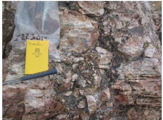
Figure 11.13. Photo of chalcedonic replacement silica and sinter, sample site I223014 (0.03 gpt Au, 245 ppm Sb).
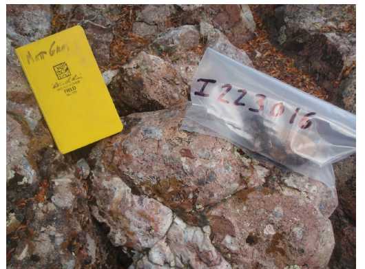
Figure 11.14. Photo of sinter breccia, sample site I223016 (0.03 gpt Au, 222 ppm Sb)
| Matthew D. Gray C.P.G. #1068826 November 2010 Amended 7 December 2010 | Page 57 of 134 |
| Summary Report on the Nevada Gold Project Portfolio Comprising the Blackrock, Argentite, Bellview, and Horsethief Gold |
| Projects, Nevada, USA |
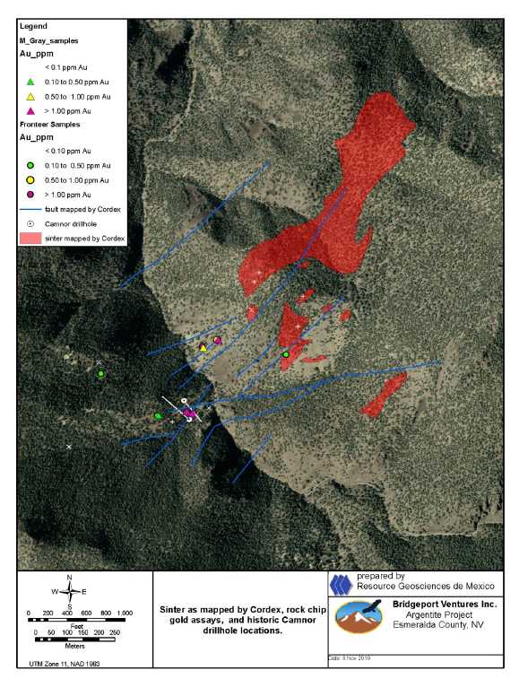
Figure 11.15. Map of faults and sinters mapped by Cordex showing Fronteer and M Gray rock chip sample assay data.
| Matthew D. Gray C.P.G. #1068826 November 2010 Amended 7 December 2010 | Page 58 of 134 |
| Summary Report on the Nevada Gold Project Portfolio Comprising the Blackrock, Argentite, Bellview, and Horsethief Gold |
| Projects, Nevada, USA |
| 11.3 | Bellview |
The Bellview project hosts gold mineralized jasperoids and auriferous argillized, silicified, and quartz veined sedimentary strata. Historic mine and exploration workings are comprised of shallow prospect cuts in areas of boldly outcropping silicified dolostone or jasperoid. No metal production is reported from the property. Initial exploration interest in the property was focused on a gold bearing, jasperoid replaced, carbonate unit, the Cambrian Eldorado Dolomite. Subsequently it was observed that the overlying silty sedimentary strata at the base of the Cambrian Secret Canyon Formation were mineralized and hosted significant gold concentrations. Two areas of outcropping jasperoid are present (Figure 11.16):
| 1. | A large continuous area of jasperoid replaced Eldorado Dolomite exposed in the low hills on the west flank of the Ruby Mountains, beginning at Buck Spring and roughly bounded by Walker Canyon to the north and bounded to the south by the southwest-draining unnamed arroyo located immediately south of Water Canyon. The historic resource was discovered in the northern portion of this jasperoid zone in the Secret Canyon shales immediately overlying the jasperoid. The area including the northernmost jasperoid is herein referred to as the “resource zone”. | |
| 2. | A 400 x 200m area of jasperoid replaced Secret Canyon silty strata located in Cherry Springs Canyon at approximately 7,000 feet elevation, herein referred to as the “Cherry Springs zone”. |
Gold concentrations are localized by both structural and stratigraphic features. Linear zones of jasperoid development in the Eldorado Dolomite and overlying strata are interpreted as high angle faults that allowed migration of mineralizing fluids into the strata of the lower Secret Canyon Formation. Within the Secret Canyon formation, hydrothermal fluids selectively mineralized the basal silty and shaly strata. The jasperoid replaced Eldorado Dolomite forms massive hill capping outcrops (Figure 11.17) and linear rib like outcrops. The jasperoid is crosscut by sugary quartz veins. NA010 steeply west dipping veinlet sets were observed (Figure 11.18) . The mineralized Secret Canyon shale is recessively weathering and is poorly exposed as subcrop and float boulders in the resource area, where it is observed as a drusy and chalcedonic quartz cemented clast supported angular breccia with clasts of variably silicified red-brown Fe-oxide stained siltstone (Figure 11.19) . Structural controls to alteration and gold mineralization are observed in Cherry Springs Canyon and on the hills to the north. In Cherry Springs Canyon, NA015 steeply east dipping sheeted quartz veins cut siltstone of the Secret Canyon Formation (Figure 11.20) and north of Cherry Springs Canyon a northeast striking structurally controlled zone of brecciation, quartz veining, and variable pervasive silicification cuts the Dunderberg Shales (Figure 11.21) .
| Matthew D. Gray C.P.G. #1068826 November 2010 Amended 7 December 2010 | Page 59 of 134 |
| Summary Report on the Nevada Gold Project Portfolio Comprising the Blackrock, Argentite, Bellview, and Horsethief Gold |
| Projects, Nevada, USA |

Figure 11.16. Map of jasperoid outcrops and rock chip gold assays.
| Matthew D. Gray C.P.G. #1068826 November 2010 Amended 7 December 2010 | Page 60 of 134 |
| Summary Report on the Nevada Gold Project Portfolio Comprising the Blackrock, Argentite, Bellview, and Horsethief Gold |
| Projects, Nevada, USA |
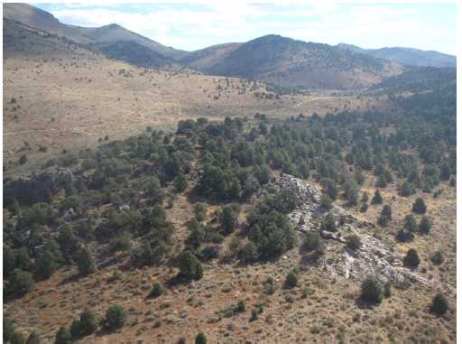
Figure 11.17. Photo of jasperoid replaced Eldorado Dolomite capping low hills in foreground, view looking southeast.
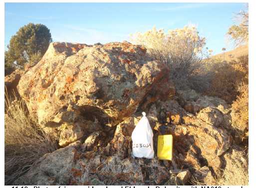
Figure 11.18. Photo of jasperoid replaced Eldorado Dolomite with NA010 steeply west dipping (to left in photo)
structural fabric defined by joints and crosscutting quartz veinlets.
Sample site I223034 (0.025 ppm Au).
| Matthew D. Gray C.P.G. #1068826 November 2010 Amended 7 December 2010 | Page 61 of 134 |
| Summary Report on the Nevada Gold Project Portfolio Comprising the Blackrock, Argentite, Bellview, and Horsethief Gold |
| Projects, Nevada, USA |
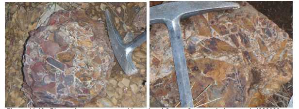
Figure 11.19. Photo of quartz cemented brecciated Secret Canyon shale, sample I223032 on left (0.753 ppm Au), sample I223033 (0.641 ppm Au) on right.

Figure 11.20. Photo of sheeted NA015 steeply east dipping quartz veins cutting siltstone in Cherry Springs Canyon, sample site I223027 (0.050 ppm Au).
| Matthew D. Gray C.P.G. #1068826 November 2010 Amended 7 December 2010 | Page 62 of 134 |
| Summary Report on the Nevada Gold Project Portfolio Comprising the Blackrock, Argentite, Bellview, and Horsethief Gold |
| Projects, Nevada, USA |

Figure 11.21. Photo of northeast striking tabular brecciated and variably silicified and quartz veined zone in Dunderberg Shale. Sample site I223029 (0.182 ppm Au).
Sampling of the jasperoids and quartz veined and silicified zones by previous operators is reported to have identified geochemically anomalous gold, arsenic, and mercury concentrations, principally within the jasperoid in and near the resource zone, and lesser anomalies were reported from the Cherry Springs area.The historic rock chip assay data has not been independently confirmed by the author but was obtained by exploration groups and personnel known to the author and believed to be credible.The author and RGM senior geologist Roman Solis conducted independent sampling of the jasperoids and silicified and quartz veined outcrops and confirmed that they are anomalously gold, arsenic, and antimony mineralized (Table 11.5) . Samples of jasperoid replaced Eldorado Dolomite in the resource area yielded as much as 1.26 gpt Au. Samples of subcrop and float of the mineralized Secret Canyon shale collected in the resource area assayed up to 0.75 ppm Au (Figure 11.19) . Silicified and quartz veined Dunderberg Shale north of Cherry Springs Canyon assayed 0.18 ppm Au (Figure 11.21) and stockwork veined Secret Canyon Shale in Cherry Springs Canyon returned up to 0.15 ppm Au. Where independent samples were collected at sites previously sampled by Fronteer, assays confirmed the previously reported results.
During the last 30 years the property has been explored and drill tested by several operators. Geologic mapping, geochemical sampling, geophysical surveys, and several drilling programs have been completed (Table 8.3) . Raabe (2008b) reported that a total of 225 exploration drillholes have been completed at the property (Figure 11.22, Table 11.6) .
| Matthew D. Gray C.P.G. #1068826 November 2010 Amended 7 December 2010 | Page 63 of 134 |
| Summary Report on the Nevada Gold Project Portfolio Comprising the Blackrock, Argentite, Bellview, and Horsethief Gold |
| Projects, Nevada, USA |
Table 11.5. Sample descriptions and assay data for Bellview project rock samples collected by M Gray and R Solis.
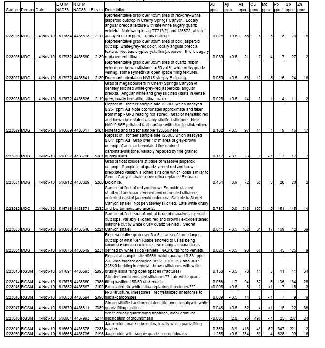
| Matthew D. Gray C.P.G. #1068826 November 2010 Amended 7 December 2010 | Page 64 of 134 |
| Summary Report on the Nevada Gold Project Portfolio Comprising the Blackrock, Argentite, Bellview, and Horsethief Gold |
| Projects, Nevada, USA |
![]()
Figure 11.22. Historic drillhole location map, Bellview project.
| Matthew D. Gray C.P.G. #1068826 November 2010 Amended 7 December 2010 | Page 65 of 134 |
| Summary Report on the Nevada Gold Project Portfolio Comprising the Blackrock, Argentite, Bellview, and Horsethief Gold |
| Projects, Nevada, USA |
Table 11.6. Historic drill programs, Bellview prospect.
| Company | Year | Drillholes | Assays Availabl e | Comment |
| Lyle Campbell | 1980’s (?) | 20 drillholes | No | Drilled at what are now Fronteer’s Skylark claims, no data available. |
| Artic Precious Metals | 1980 to 1985 | 95 rotary and reverse circulation drillholes totaling 4,741m. | Yes | Defined geologic resource of ~500,000 tons @ 0.034 opt Au.NOT CSA NI43- 101 COMPLIANT. |
| Silver State Mining | 1986 | 10 drillholes totaling 336 m | Yes | Infill drilling within resource area. |
| Teck | 1987 to 1991 | 68 reverse circulation drillholes totaling 3,240m | Yes | Mostly infill drilling within resource area. Calculated resource of 1.12M tons @ 0.031 opt Au (~34,000 ounces).NOT CSA NI43-101 COMPLIANT. |
| Western States Minerals | 1991 to 1999 | 26 reverse circulation drillholes totaling 3,598m | Yes | |
| Homestake | 1996 | 6 reverse circulation drillholes totaling 864m | Yes | Tested geophysical and conceptual targets. |
The most significant work is that of Teck Resources in the period 1987 to 1991, when Teck drilled a gold resource estimated to contain 1,120,000 tons of ore grading 0.031 opt Au, using a 0.015 opt cutoff, for a total of 34,720 contained ounces of gold.Insufficient information is available regarding the procedures used to create the historic resource estimate to determine if it is compliant with the protocols set forth by CSA NI43-101. The resource estimate has not been independently verified. The author has not reviewed the original drill logs, assay certificates, or resource model thus cannot comment on the accuracy of the reported drill results or resource estimate. The data were obtained from sources believed to be reliable but cannot be verified and the historical drillhole data and resource estimate has not been independently confirmed by the author thus should not be used in economic assessments of the project’s value.
| Matthew D. Gray C.P.G. #1068826 November 2010 Amended 7 December 2010 | Page 66 of 134 |
| Summary Report on the Nevada Gold Project Portfolio Comprising the Blackrock, Argentite, Bellview, and Horsethief Gold |
| Projects, Nevada, USA |
The mineralization was reported to be contained within the lowermost strata of the Secret Canyon Shale, immediately above the contact with the underlying jasperoid replaced Eldorado Dolomite. Lyle Campbell is reported to have drilled 20 reverse circulation drillholes in the Cherry Springs jasperoid area in the 1980’s. All that is known to the author about these drillholes is that they were vertical and ranged from 125 to 465 feet in depth, with most less than 300 feet. Assay data is not available for these drillholes. Historic drillhole intercepts as summarized by Raabe (2010b) are presented in Table 11.7. Drillhole collar locations are presented as Appendix C.
Table 11.7 Table of historic Bellview drillhole intercepts.
Hole No. | Company | Date | Location | Angle | T .D. (ft) | Gold Intercept (ft @ opt Au) | Interval (from-to, ft) | Comments |
DH01 | Arctic | 1981 | Main Resource | -90 | 200 | 30’@ 0.027 | 125’-155’ | |
DH02 | Arctic | 1981 | Main Resource | -90 | 200 | 5’@ 0.018 | 210’-215’ | |
DH03 | Arctic | 1981 | Main Resource | -90 | 35 | Lost Hole | ||
DH04 | Arctic | 1981 | Main Resource | -90 | 60 | 5’@ 0.023 | 10’-15’ | |
DH05 | Arctic | 1981 | Main Resource | -90 | 70 | |||
DH06 | Arctic | 1981 | Main Resource | -90 | 95 | |||
DH07 | Arctic | 1981 | Main Resource | -90 | 40 | Not Assayed | ||
DH08 | Arctic | 1981 | Main Resource | -90 | 40 | Not Assayed | ||
DH09 | Arctic | 1981 | Main Resource | -90 | 65 | |||
DH10 | Arctic | 1981 | Main Resource | -90 | 65 | 5’@ 0.018 | 20’-25’ | 25’-65’ No Return |
DH11 | Arctic | 1981 | Main Resource | -90 | 30 | 25’@ 0.065 | 5’-30’ | |
| Incl 5’@ 0.116 | 10’-15’ | |||||||
DH12 | Arctic | 1981 | Main Resource | -90 | 45 | 45’@ 0.028 | 0’-45’ | |
DH13 | Arctic | 1981 | Main Resource | -90 | 45 | 35’@ 0.021 | 10’-45’ | |
DH14 | Arctic | 1981 | Main Resource | -90 | 205 | 45’@ 0.033 | 25’-70’ | |
DH15 | Arctic | 1981 | Main Resource | -90 | 225 | 20’@ 0.030 | 0’-20’ | |
DH16 | Arctic | 1981 | Main Resource | -90 | 265 | 5’@ 0.013 | 0’-5’ | |
DH19 | Arctic | 1981 | Main Resource | -90 | 80 | 10’@ 0.051 | 50’-60’ | |
DH20 | Arctic | 1981 | Main Resource | -90 | 100 | 30’@ 0.012 | 0’-30’ | |
DH21 | Arctic | 1981 | Main Resource | -90 | 100 |
| Matthew D. Gray C.P.G. #1068826 November 2010 Amended 7 December 2010 | Page 67 of 134 |
| Summary Report on the Nevada Gold Project Portfolio Comprising the Blackrock, Argentite, Bellview, and Horsethief Gold |
| Projects, Nevada, USA |
DH22 | Arctic | 1981 | Main Resource | -90 | 180 | |||
DH24 | Arctic | 1981 | Main Resource | -90 | 500 | |||
DH29 | Arctic | 1981 | Middle Hill East Side | -90 | 285 | |||
DH30 | Arctic | 1981 | Middle Hill East Side | -90 | 165 | |||
| DH31 | Arctic | 1981 | Middle Hill | -90 | 400 | |||
DH33 | Arctic | 1981 | Middle Hill West Side | -90 | 300 | 120-TD Not Assayed | ||
DH34 | Arctic | 1981 | Middle Hill West Side | -90 | 205 | 10’@ 0.064 | 25’-35’ | |
| Incl 5’@ 0.104 | 25’-30’ | |||||||
| 5’ @ 0.011 | 45’-50’ | |||||||
DH39 | Arctic | 1981 | South Hill West Side | -90 | 365 | |||
DH48 | Arctic | 1981 | South Hill East Side | -90 | 105 | |||
DH49 | Arctic | 1981 | South Hill East Side | -90 | 85 | 5’@ 0.011 | 5’-10’ | |
DH51 | Arctic | 1981 | South Hill South Side | -90 | 65 | 5’@ 0.011 | 5’-10’ | |
DH54 | Arctic | 1981 | South Hill West Side | -90 | 310 | 245-TD No Return | ||
DH58 | Arctic | 1981 | South Hill South Side | -90 | 425 | |||
DH59 | Arctic | 1981 | Main Resource | -90 | 45 | |||
DH60 | Arctic | 1981 | Main Resource | -90 | 320 | |||
DH61 | Arctic | 1981 | Main Resource | -90 | 205 | |||
DH62 | Arctic | 1981 | Main Resource | -90 | 155 | 135-TD No Return | ||
DH64 | Arctic | 1981 | Main Resource | -90 | 310 | 5’@ 0.016 | 260’-265’ | |
DH65 | Arctic | 1981 | South Hill West Side | -90 | 160 | |||
DH66 | Arctic | 1981 | South Hill West Side | -90 | 285 | |||
DH69 | Arctic | 1981 | Main Resource | -90 | 105 | 25’@ 0.030 | 70’-95’ | |
DH70 | Arctic | 1981 | Main Resource | -90 | 605 | |||
DH72 | Arctic | 1981 | Main Resource | -90 | 605 | |||
DH73 | Arctic | 1981 | Main Resource | -90 | 565 | |||
DH75 | Arctic | 1981 | Main Resource N | -90 | 805 | |||
DH84 | Arctic | 1981 | Main Resource W | -90 | 115 |
| Matthew D. Gray C.P.G. #1068826 November 2010 Amended 7 December 2010 | Page 68 of 134 |
| Summary Report on the Nevada Gold Project Portfolio Comprising the Blackrock, Argentite, Bellview, and Horsethief Gold |
| Projects, Nevada, USA |
BV8302 | Arctic | 1983 | Main Resource | -90 | 217 | |||
BV8303 | Arctic | 1983 | Main Resource | -90 | 152 | 5’@ 0.015 | 15’-20’ | |
BV8304 | Arctic | 1983 | Main Resource | -90 | 20 | |||
BV8305 | Arctic | 1983 | Main Resource | -90 | 227 | |||
BV8306 | Arctic | 1983 | Middle Hill West Side? | -90 | 132 | Location? Assays? | ||
BV8308 | Arctic | 1983 | Middle Hill West Side | -90 | 247 | |||
BV8309 | Arctic | 1983 | Middle Hill West Side | -90 | 187 | 5’@ 0.021 | 165’-170’ | |
BV8310 | Arctic | 1983 | Main Resource N | -90 | 187 | |||
BV8311 | Arctic | 1983 | Middle Hill West Side | -90 | 187 | |||
BV8312 | Arctic | 1983 | Middle Hill West Side | -90 | 147 | |||
BV8313 | Arctic | 1983 | Middle Hill West Side | -90 | 92 | |||
BV8314 | Arctic | 1983 | Main Resource | -90 | 30 | 25’@ 0.020 | 5’-30’ | |
BV8315 | Arctic | 1983 | Main Resource | -90 | 30 | |||
BV8316 | Arctic | 1983 | Main Resource | -90 | 145 | 10’@ 0.018 | 0’-10’ | |
| 10’@ 0.013 | 20’-30’ | |||||||
| 5’ @ 0.012 | 40’-45’ | |||||||
BV8317 | Arctic | 1983 | Main Resource | -90 | 97 | |||
BV8320 | Arctic | 1983 | Middle Hill West Side | -90 | 107 | 5’@ 0.021 | 60’-65’ | |
BV8321 | Arctic | 1983 | Middle Hill West Side | -90 | 127 | 20’@ 0.015 | 50’-70’ | |
BV8322 | Arctic | 1983 | Middle Hill West Side | -90 | 147 | 30’@ 0.017 | 60’-90’ | |
BV8323 | Arctic | 1983 | South Hill East Side | -90 | 147 | Terminated due to caving | ||
BV8401 | Arctic | 1984 | Middle Hill West Side | -45 | 100 | 5’@ 0.064 | 50’-55’ | |
| 5’@ 0.016 | 60’-65’ | |||||||
BV8402 | Arctic | 1984 | Middle Hill West Side | -90 | 100 | |||
BV8403 | Arctic | 1984 | Middle Hill West Side | -60 | 100 | |||
BV8404 | Arctic | 1984 | Main Resource | -45 | 100 | 25’@ 0.014 | 65’-90’ | |
BV8405 | Arctic | 1984 | Main Resource | -45 | 100 | 5’@ 0.010 | 10’-15’ | |
BV8406 | Arctic | 1984 | Main Resource | -45 | 100 |
| Matthew D. Gray C.P.G. #1068826 November 2010 Amended 7 December 2010 | Page 69 of 134 |
| Summary Report on the Nevada Gold Project Portfolio Comprising the Blackrock, Argentite, Bellview, and Horsethief Gold |
| Projects, Nevada, USA |
BV8407 | Arctic | 1984 | Main Resource | -45 | 50 | |||
BV8408 | Arctic | 1984 | Main Resource | -60 | 100 | 5’@ 0.012 | 50’-55’ | |
BV8409 | Arctic | 1984 | Main Resource | -48 | 100 | |||
BV8410 | Arctic | 1984 | Main Resource | -45 | 90 | |||
BV8411 | Arctic | 1984 | Main Resource | -90 | 100 | |||
BV8412 | Arctic | 1984 | Main Resource | -90 | 100 | 5’@ 0.025 | 5’-10’ | |
BV8413 | Arctic | 1984 | Main Resource | -90 | 35 | 20’@ 0.042 | 0’-20’ | |
BV8414 | Arctic | 1984 | Main Resource | -90 | 100 | |||
BV8415 | Arctic | 1984 | Main Resource | -60 | 70 | 30’@ 0.066 | 0’-30’ | |
| Incl 10’@ 0.145 | 5’-15’ | |||||||
BV8416 | Arctic | 1984 | Main Resource | -90 | 100 | 5’@ 0.015 | 0’-5’ | |
| 5’ @ 0.013 | 60’-65’ | |||||||
| 25’ @ 0.012 | 75’-100’ | |||||||
BV8417 | Arctic | 1984 | Main Resource | -90 | 145 | 5’@ 0.015 | 0’-5’ | |
| 10’ @ 0.014 | 10’-20’ | |||||||
| 70’ @ 0.026 | 30’-100’ | |||||||
BV8418 | Arctic | 1984 | Main Resource | -60 | 100 | 5’@ 0.014 | 0’-5’ | |
| 20’ @ 0.019 | 15’-35’ | |||||||
BV8419 | Arctic | 1984 | Main Resource | -60 | 100 | 10’@ 0.015 | 0’-10’ | |
| 20’ @ 0.031 | 20’-40’ | |||||||
BV8420 | Arctic | 1984 | Main Resource | -90 | 35 | 15’@ 0.068 | 0’-15’ | 15-25’ No Return |
| 5’ @ 0.015 | 25’-30’ | |||||||
BV8421 | Arctic | 1984 | Main Resource | -90 | 100 | 30’@ 0.021 | 10’-40’ | |
BV8422 | Arctic | 1984 | Main Resource | -90 | 100 | 20’@ 0.026 | 20’-40’ | |
BV8423 | Arctic | 1984 | Main Resource | -90 | 100 | 25’@ 0.042 | 35’-60’ | |
BV8424 | Arctic | 1984 | Main Resource | -60 | 100 | 5’@ 0.013 | 0’-5’ | |
| 5’ @ 0.013 | 10’-15’ | |||||||
| 5’ @ 0.014 | 50’-55’ | |||||||
| 5’@ 0.013 | 65’-70’ | |||||||
| 5’@ 0.010 | 90’-95’ |
| Matthew D. Gray C.P.G. #1068826 November 2010 Amended 7 December 2010 | Page 70 of 134 |
| Summary Report on the Nevada Gold Project Portfolio Comprising the Blackrock, Argentite, Bellview, and Horsethief Gold |
| Projects, Nevada, USA |
BV8425 | Arctic | 1984 | Main Resource | -60 | 145 | 5’@ 0.012 | 35’-40’ | |
| 5’ @ 0.012 | 55’-60’ | |||||||
BV8426 | Arctic | 1984 | Main Resource | -45 | 140 | 15’@ 0.022 | 125’-140’ | Terminated due to lack of steel. |
BV8427 | Arctic | 1984 | Middle Hill East Side | -45 | 100 | |||
BV8428 | Arctic | 1984 | Middle Hill East Side | -45 | 100 | 10’@ 0.010 | 25’-35’ | |
BV8429 | Arctic | 1984 | South Hill West Side | -45 | 100 | |||
BV8430 | Arctic | 1984 | South Hill West Side | -60 | 100 | 5’@ 0.034 | 95’-100’ | |
BV8431 | Arctic | 1984 | South Hill West Side | -60 | 100 | 5’@ 0.020 | 55’-60’ | |
| 15’@ 0.024 | 75’-90’ | |||||||
DB01 | Silver State | 1986 | Main Resource | -90 | 115 | 5’@ 0.051 | 95’-100’ | |
| 5’@ 0.037 | 110’-115’ | |||||||
DB02 | Silver State | 1986 | Main Resource | -90 | 200 | |||
DB03 | Silver State | 1986 | Main Resource | -90 | 220 | |||
DB04 | Silver State | 1986 | Main Resource | -90 | 185 | 90’@ 0.031 | 95’-185’ | |
DB05 | Silver State | 1986 | Main Resource | -90 | 130 | 5’@ 0.010 | 65’-70’ | |
DB06 | Silver State | 1986 | Main Resource | -90 | 75 | 30’@ 0.213 | 0’-30’ | |
| Incl 5’@ 0.254 | 0’-5’ | |||||||
| Incl 5’@ 0.658 | 10’-15’ | |||||||
DB07 | Silver State | 1986 | Main Resource | -90 | 35 | 15’@ 0.063 | 5’-20’ | |
| Incl 5’@ 0.131 | 10’-15’ | |||||||
DB08 | Silver State | 1986 | Main Resource | -90 | 100 | 15’@ 0.061 | 0’-15’ | |
DB09 | Silver State | 1986 | Main Resource | -90 | 20 | 5’@ 0.011 | 10’-15’ | |
DB10 | Silver State | 1986 | Main Resource | -90 | 25 | 25’@ 0.056 | 0’-25’ | |
BV8801 | Teck | 1988 | South Hill West Side | -90 | 300 | |||
BV8802 | Teck | 1988 | South Hill West Side | -90 | 200 | 10’@ 0.025 | 140’-150’ | 40-140, 150-200 Not Available |
BV8803 | Teck | 1988 | East of Main Resource | -90 | 260 | 0-80, 85- 160, 165- 270 Not Available |
| Matthew D. Gray C.P.G. #1068826 November 2010 Amended 7 December 2010 | Page 71 of 134 |
| Summary Report on the Nevada Gold Project Portfolio Comprising the Blackrock, Argentite, Bellview, and Horsethief Gold |
| Projects, Nevada, USA |
BV8804 | Teck | 1988 | East of Main Resource | -90 | 260 | 0-40, 45- 100, 105- 260 Not Available | ||
BV8805 | Teck | 1988 | Main Resource | -90 | 240 | 30’@ 0.079 | 50’-80’ | |
| Incl 20’@ 0.112 | 50’-70’ | |||||||
BV8806 | Teck | 1988 | Main Resource | -90 | 160 | 15’@ 0.043 | 10’-25’ | |
BV8807 | Teck | 1988 | Main Resource | -90 | 100 | 50’@ 0.049 | 0’-50’ | |
| Incl 5’@ 0.171 | 15’-20’ | |||||||
BV8808 | Teck | 1988 | Middle Hill West Side | -90 | 140 | 0-30, 35- 75, 80-140 Not Available | ||
BV8809 | Teck | 1988 | Middle Hill West Side | -90 | 160 | 0-95, 100- 135, 140- 160 Not Avail. | ||
BV8810 | Teck | 1988 | Middle Hill West Side | -90 | 130 | 5’@ 0.016 | 110’-115’ | 0-105, 115- 125 Not Available |
BV8811 | Teck | 1988 | Middle Hill West Side | -90 | 120 | 5’@ 0.010 | 75’-80’ | 0-30, 35- 70, 80-120 Not Available |
BV8812 | Teck | 1988 | South Hill South End | -90 | 120 | 0-5, 10-70, 75-165 Not Available | ||
BV8813 | Teck | 1988 | Main Resource | -90 | 145 | 15’@ 0.067 | 35’-50’ | |
| Incl 5’@ 0.102 | 40’-45’ | |||||||
BV8814 | Teck | 1988 | Main Resource | -90 | 65 | 30’@ 0.085 | 0’-30’ | |
| Incl 15’@ 0.147 | 10’-25’ | |||||||
BV8815 | Teck | 1988 | Main Resource | -90 | 60 | 15’@ 0.026 | 15’-30’ | |
BV8816 | Teck | 1988 | Main Resource | -90 | 85 | 35’@ 0.039 | 0’-35’ | |
| 5’@ 0.080 | 65’-70’ | |||||||
BV8917 | Teck | 1989 | Main Resource | -90 | 220 | |||
BV8918 | Teck | 1989 | Main Resource | -90 | 100 | 25’@ 0.012 | 40’-65’ | |
| 5’@ 0.025 | 70’-75’ | |||||||
BV8919 | Teck | 1989 | Main Resource | -90 | 120 | 5’@ 0.011 | 60’-65’ | |
BV8920 | Teck | 1989 | Main Resource | -90 | 200 | 5’@ 0.010 | 105’-110’ | |
| 5’@ 0.010 | 115’-120’ | |||||||
| 10’@ 0.014 | 130’-140’ | |||||||
BV8921 | Teck | 1989 | Main Resource | -90 | 500 |
| Matthew D. Gray C.P.G. #1068826 November 2010 Amended 7 December 2010 | Page 72 of 134 |
| Summary Report on the Nevada Gold Project Portfolio Comprising the Blackrock, Argentite, Bellview, and Horsethief Gold |
| Projects, Nevada, USA |
BV8922 | Teck | 1989 | Main Resource | -90 | 80 | ||
BV8923 | Teck | 1989 | Main Resource | -90 | 80 | ||
BV8924 | Teck | 1989 | Main Resource | -90 | 100 | ||
BV8925 | Teck | 1989 | Main Resource | -90 | 100 | 5’@ 0.032 | 25’-30’ |
BV8926 | Teck | 1989 | Main Resource | -90 | 100 | 25’@ 0.024 | 20’-45’ |
BV8927 | Teck | 1989 | Main Resource | -90 | 180 | 10’@ 0.014 | 40’-50’ |
| 10’@ 0.014 | 65’-75’ | ||||||
BV8928 | Teck | 1989 | Main Resource | -90 | 140 | 45’@ 0.023 | 40’-85’ |
BV8929 | Teck | 1989 | Main Resource | -90 | 140 | ||
BV8930 | Teck | 1989 | Main Resource | -90 | 100 | 10’@ 0.018 | 40’-50’ |
BV8931 | Teck | 1989 | Main Resource | -90 | 180 | 5’@ 0.032 | 65’-70’ |
| 15’@ 0.067 | 85’-100’ | ||||||
BV8932 | Teck | 1989 | Main Resource | -90 | 200 | 10’@ 0.069 | 75’-85’ |
| Incl 5’@ 0.126 | 80’-85’ | ||||||
| 25’@ 0.028 | 95’-120’ | ||||||
| 5’@ 0.017 | 135’-140’ | ||||||
BV8933 | Teck | 1989 | Main Resource | -90 | 120 | 35’@ 0.065 | 60’-95’ |
| Incl 10’@ 0.100 | 60’-70’ | ||||||
BV8934 | Teck | 1989 | Main Resource | -90 | 100 | 35’@ 0.048 | 35’-70’ |
| Incl 10’@ 0.109 | 35’-45’ | ||||||
BV8935 | Teck | 1989 | Main Resource | -90 | 80 | 10’@ 0.010 | 20’-30’ |
BV8936 | Teck | 1989 | Main Resource | -90 | 200 | 25’@ 0.024 | 80’-105’ |
BV8937 | Teck | 1989 | Main Resource | -90 | 180 | 15’@ 0.032 | 55’-70’ |
BV8938 | Teck | 1989 | Main Resource | -90 | 140 | 20’@ 0.027 | 65’-85’ |
BV8939 | Teck | 1989 | Main Resource | -90 | 120 | ||
BV8940 | Teck | 1989 | Main Resource | -90 | 120 | 15’@ 0.059 | 55’-70’ |
BV8941 | Teck | 1989 | Main Resource | -90 | 240 | 10’@ 0.019 | 140’-150’ |
BV8942 | Teck | 1989 | Main Resource | -90 | 100 | 30’@ 0.023 | 5’-35’ |
BV8943 | Teck | 1989 | Main Resource | -90 | 620 | 5’@ 0.048 | 0’-5’ |
| 5’@ 0.014 | 105’-110’ |
| Matthew D. Gray C.P.G. #1068826 November 2010 Amended 7 December 2010 | Page 73 of 134 |
| Summary Report on the Nevada Gold Project Portfolio Comprising the Blackrock, Argentite, Bellview, and Horsethief Gold |
| Projects, Nevada, USA |
| 5’@ 0.015 | 135’-140’ | ||||||
| 5’@ 0.012 | 205’-210’ | ||||||
| 5’@ 0.047 | 310’-315’ | ||||||
| 10’@ 0.016 | 375’-385’ | ||||||
BV8944 | Teck | 1989 | Main Resource | -90 | 120 | 25’@ 0.017 | 0’-25’ |
BV8945 | Teck | 1989 | Main Resource | -90 | 180 | ||
BV8946 | Teck | 1989 | Main Resource | -90 | 80 | 25’@ 0.047 | 0’-25’ |
| Incl 5’@ 0.106 | 5’-10’ | ||||||
BV8947 | Teck | 1989 | Main Resource | -90 | 180 | 10’@ 0.012 | 40’-50’ |
| 5’@ 0.019 | 90’-95’ | ||||||
BV8948 | Teck | 1989 | Main Resource | -90 | 120 | 15’@ 0.143 | 35’-50’ |
| Incl 5’@ 0.291 | 40’-45’ | ||||||
BV8949 | Teck | 1989 | Main Resource | -90 | 80 | 15’@ 0.024 | 25’-40’ |
BV8950 | Teck | 1989 | Main Resource | -90 | 100 | 5’@ 0.010 | 45’-50’ |
BV8951 | Teck | 1989 | Main Resource | -90 | 160 | 20’@ 0.054 | 100’-120’ |
| Incl 5’@ 0.106 | 105’-110’ | ||||||
BV8952 | Teck | 1989 | Main Resource | -90 | 40 | ||
BV8953 | Teck | 1989 | Main Resource | -90 | 60 | ||
BV8954 | Teck | 1989 | Main Resource | -90 | 80 | 10’@ 0.023 | 0’-10’ |
BV8955 | Teck | 1989 | Main Resource | -90 | 120 | 5’@ 0.036 | 5’-10’ |
BV8956 | Teck | 1989 | Main Resource | -90 | 140 | 5’@ 0.016 | 25’-30’ |
BV8957 | Teck | 1989 | Main Resource | -90 | 120 | ||
BV8958 | Teck | 1989 | Main Resource | -90 | 140 | 5’@ 0.011 | 45’-50’ |
BV8959 | Teck | 1989 | Main Resource | -90 | 100 | 15’@ 0.018 | 40’-55’ |
BV8960 | Teck | 1989 | Main Resource | -90 | 80 | 20’@ 0.087 | 20’-40’ |
| Incl 10’@ 0.152 | 25’-35’ | ||||||
BV8961 | Teck | 1989 | Main Resource | -90 | 200 | 30’@ 0.017 | 15’-45’ |
| 5’@ 0.013 | 50’-55’ | ||||||
BV8962 | Teck | 1989 | Main Resource | -90 | 100 | 5’@ 0.013 | 5’-10’ |
| 5’@ 0.020 | 45’-50’ | ||||||
BV8963 | Teck | 1989 | Main Resource | -90 | 160 |
| Matthew D. Gray C.P.G. #1068826 November 2010 Amended 7 December 2010 | Page 74 of 134 |
| Summary Report on the Nevada Gold Project Portfolio Comprising the Blackrock, Argentite, Bellview, and Horsethief Gold |
| Projects, Nevada, USA |
BV8964 | Teck | 1989 | Main Resource | -90 | 280 | |||
BV8965 | Teck | 1989 | Main Resource | -90 | 260 | 5’@ 0.013 | 175’-180’ | |
BV8966 | Teck | 1989 | Main Resource | -90 | 160 | |||
| BV8967 | Teck | 1989 | S. of Main | -90 | 240 | |||
BV8968 | Teck | 1989 | Main Resource | -90 | 260 | 5’@ 0.011 | 145’-150’ | |
BRC1 | WSMC | 1991 | West Pediment | -90 | 405 | |||
BRC2 | WSMC | 1991 | West Pediment | -90 | 405 | |||
BRC3 | WSMC | 1991 | West Pediment | -90 | 600 | |||
93B01 | WSMC | 1993 | Main Resource | -60 | 500 | 10’@ 0.023 | 0’-10’ | |
| 5’@ 0.024 | 20’-25’ | |||||||
93B02 | WSMC | 1993 | N. of Main Resource | -90 | 800 | |||
93B03 | WSMC | 1993 | Main Resource | -60 | 700 | 10’@ 0.031 | 55’-65’ | |
93B04 | WSMC | 1993 | N. of Main Resource | -90 | 785 | |||
93B05 | WSMC | 1993 | Middle Hill East Side | -60 | 500 | 10’@ 0.019 | 140’-150’ | |
93B06 | WSMC | 1993 | South Hill West Side | -60 | 350 | 30’@ 0.025 | 165’-195’ | |
93B06A | WSMC | 1993 | South Hill West Side | -60 | 130 | Not Assayed | ||
93B07 | WSMC | 1993 | Main Resource | -60 | 600 | 10’@ 0.015 | 30’-40’ | |
93B08 | WSMC | 1993 | South Hill West Side | -60 | 300 | 5’@ 0.016 | 150’-155’ | |
93B09 | WSMC | 1993 | Main Resource | -60 | 700 | 10’@ 0.043 | 60’-70’ | |
| 5’@ 0.013 | 80’-85’ | |||||||
93B10 | WSMC | 1993 | South Hill West Side | -60 | 700 | |||
93B11 | WSMC | 1993 | Middle Hill East Side | -60 | 200 | |||
93B12 | WSMC | 1993 | South Hill West Side | -60 | 250 | 5’@ 0.020 | 40’-45’ | |
| 5’@ 0.012 | 60’-65’ | |||||||
93B13 | WSMC | 1993 | Middle Hill East Side | -60 | 500 | |||
93B14 | WSMC | 1993 | South Hill West Side | -60 | 450 | |||
93B15 | WSMC | 1993 | Middle Hill East Side | -60 | 200 | |||
93B17 | WSMC | 1993 | Middle Hill East Side | -60 | 200 | |||
93B19 | WSMC | 1993 | Middle Hill East Side | -60 | 680 | |||
93B21 | WSMC | 1993 | South Hill East Side | -60 | 300 |
| Matthew D. Gray C.P.G. #1068826 November 2010 Amended 7 December 2010 | Page 75 of 134 |
| Summary Report on the Nevada Gold Project Portfolio Comprising the Blackrock, Argentite, Bellview, and Horsethief Gold |
| Projects, Nevada, USA |
93B22 | WSMC | 1993 | South Hill East Side | -60 | 150 | 5’@ 0.015 | 25’-30’ |
93B23 | WSMC | 1993 | South Hill South Side | -60 | 600 | ||
| B95001 | WSMC | 1995 | ? | -47 | 400 | No Info | |
| B95002 | WSMC | 1995 | ? | -45 | 400 | No Info | |
VIEW1 | Homestake | 1996 | Cherry Creek | -90 | 550 | ||
VIEW2 | Homestake | 1996 | East of Main Resource | -90 | 585 | ||
VIEW3 | Homestake | 1996 | West of Main Resource | -90 | 305 | ||
VIEW4 | Homestake | 1996 | South Hill West Side | -90 | 415 | ||
VIEW5 | Homestake | 1996 | South Hill South End | -90 | 625 | ||
VIEW6 | Homestake | 1996 | South Hill West Side | -90 | 355 | ||
SKR-1 | Lyle Campbell | ? | Cherry Spring | -90 | 245 | No Info | |
SKR-2 | Lyle Campbell | ? | Cherry Spring | -90 | 125 | No Info | |
SKR-3 | Lyle Campbell | ? | Cherry Spring | -90 | 175 | No Info | |
SKR-4 | Lyle Campbell | ? | Cherry Spring | -90 | 245 | No Info | |
SKR-5 | Lyle Campbell | ? | Cherry Spring | -90 | 465 | No Info | |
SKR-6 | Lyle Campbell | ? | Cherry Spring | -90 | 180 | No Info | |
SKR-7 | Lyle Campbell | ? | Cherry Spring | -90 | 385 | No Info | |
SKR-8 | Lyle Campbell | ? | Cherry Spring | -90 | 250 | No Info | |
SKR-9 | Lyle Campbell | ? | Cherry Spring | -90 | 225 | No Info | |
SKR-10 | Lyle Campbell | ? | Cherry Spring | -90 | 90 | No Info | |
SKR-10A | Lyle Campbell | ? | Cherry Spring | -90 | 145 | No Info | |
SKR-11 | Lyle Campbell | ? | Cherry Spring | -90 | 245 | No Info | |
SKR-12 | Lyle Campbell | ? | Cherry Spring | -90 | 145 | No Info | |
SKR-13 | Lyle Campbell | ? | Cherry Spring | -90 | 250 | No Info | |
SKR-14 | Lyle Campbell | ? | Cherry Spring | -90 | 60 | No Info | |
SKR-15 | Lyle Campbell | ? | Cherry Spring | -90 | 260 | No Info | |
SKR-16 | Lyle Campbell | ? | Cherry Spring | -90 | 260 | No Info | |
SKR-17 | Lyle Campbell | ? | Cherry Spring | -90 | 75 | No Info |
| Matthew D. Gray C.P.G. #1068826 November 2010 Amended 7 December 2010 | Page 76 of 134 |
| Summary Report on the Nevada Gold Project Portfolio Comprising the Blackrock, Argentite, Bellview, and Horsethief Gold |
| Projects, Nevada, USA |
SKR-17A | Lyle Campbell | ? | Cherry Spring | -90 | 100 | No Info | ||
SKR-18 | Lyle Campbell | ? | Cherry Spring | -90 | 300 | No Info |
| 11.4 | Horsethief |
Mapping and sampling of the Horsethief property has identified a large area of variably gold mineralized jasperoid. The largest jasperoid body crops out over an area of roughly 900 x 150 meters and a smaller area of jasperoid crops out southeast of the main body (Figures 11.23 and 11.24) . Several small prospect cuts and shafts in the area of jasperoid outcrops are the only known mine or exploration workings at the project. A joint venture between Canyon Resources and Copper Range explored the property in the period 1981 to 1984. Rock chip assay data generated by the joint venture reportedly defined gold anomalies in jasperoid, which was subsequently the focus of exploration drilling. The joint venture is reported to have completed two drill campaigns comprising A total of 40 rotary drillholes and a total of 4,233 meters (Table 11.8) .
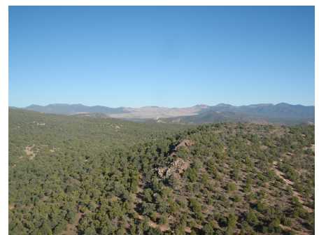
Figure 11.23. Photo of Horsethief jasperoid outcrops, view looking east down trend of jasperoid zone.
| Matthew D. Gray C.P.G. #1068826 November 2010 Amended 7 December 2010 | Page 77 of 134 |
| Summary Report on the Nevada Gold Project Portfolio Comprising the Blackrock, Argentite, Bellview, and Horsethief Gold |
| Projects, Nevada, USA |
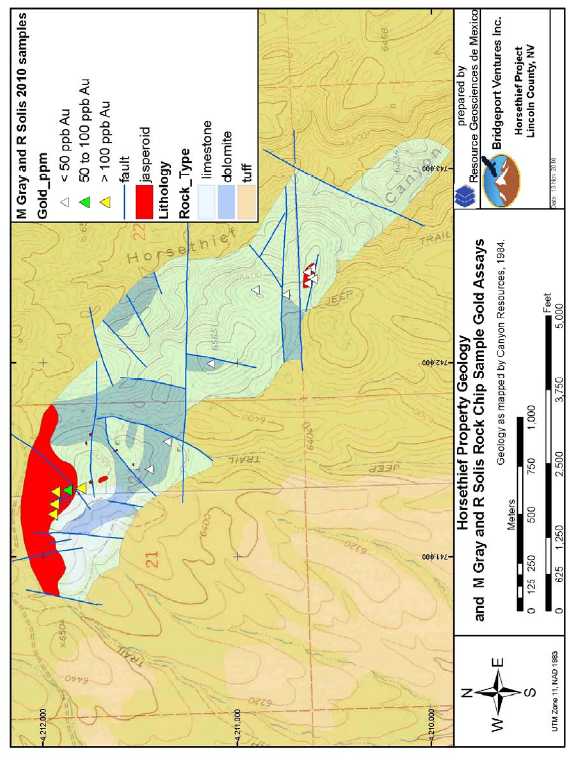
Figure 11.24. Horsethief project rock chip gold assay map.
| Matthew D. Gray C.P.G. #1068826 November 2010 Amended 7 December 2010 | Page 78 of 134 |
| Summary Report on the Nevada Gold Project Portfolio Comprising the Blackrock, Argentite, Bellview, and Horsethief Gold |
| Projects, Nevada, USA |
Table11.8. Drill collar summary, Canyon Resources Horsethief drill programs.
Drillhole | UTM E NAD83 | UTM N NAD83 | Elev (m) | Azimuth | Inclination | Total Depth (m) |
| HT-01 | 740,953 | 4,211,885 | 1,993 | 0 | -90 | 93.0 |
| HT-02 | 741,084 | 4,211,945 | 1,999 | 0 | -90 | 93.0 |
| HT-03 | 741,332 | 4,211,907 | 1,971 | 0 | -90 | 153.9 |
| HT-04 | 741,232 | 4,211,842 | 2,022 | 0 | -90 | 123.4 |
| HT-05 | 741,146 | 4,211,672 | 1,981 | 0 | -90 | 93.0 |
| HT-06 | 741,397 | 4,212,025 | 1,996 | 0 | -90 | 77.7 |
| HT-06A | 741,425 | 4,212,086 | 1,990 | 0 | -90 | 184.4 |
| HT-07 | 741,436 | 4,212,129 | 1,992 | 0 | -90 | 153.9 |
| HT-08 | 741,739 | 4,212,002 | 1,974 | 0 | -90 | 93.0 |
| HT-09 | 741,697 | 4,211,899 | 1,980 | 0 | -90 | 93.0 |
| HT-09A | 741,697 | 4,211,899 | 1,980 | 0 | -90 | 93.0 |
| HT-10 | 742,451 | 4,210,839 | 1,951 | 0 | -90 | 153.9 |
| HT-11 | 742,381 | 4,210,878 | 1,974 | 0 | -90 | 123.4 |
| HT-12 | 742,300 | 4,210,819 | 1,969 | 0 | -90 | 93.0 |
| HT-13 | 742,464 | 4,210,587 | 1,952 | 0 | -90 | 93.0 |
| HT-14 | 742,414 | 4,210,653 | 1,954 | 0 | -90 | 39.6 |
| HT-15 | 742,525 | 4,210,630 | 1,954 | 0 | -90 | 93.0 |
| HT-16 | 741,007 | 4,211,980 | 1,981 | 0 | -90 | 82.3 |
| HT-17 | 741,133 | 4,212,014 | 1,996 | 0 | -90 | 74.7 |
| HT-18 | 741,260 | 4,211,978 | 2,018 | 0 | -90 | 50.3 |
| HT-19 | 741,362 | 4,211,982 | 2,007 | 0 | -90 | 51.8 |
| HT-19A | 741,365 | 4,211,977 | 2,007 | 0 | -90 | 121.9 |
| HT-20 | 741,380 | 4,211,818 | 2,024 | 0 | -90 | 64.0 |
| HT-21 | 741,536 | 4,212,045 | 1,988 | 0 | -90 | 74.7 |
| HT-22 | 741,691 | 4,212,046 | 1,977 | 0 | -90 | 102.1 |
| HT-23 | 742,672 | 4,210,804 | 1,897 | 0 | -90 | 93.0 |
| HT-24 | 742,583 | 4,210,805 | 1,902 | 0 | -90 | 74.7 |
| HT-25 | 742,510 | 4,210,793 | 1,931 | 0 | -90 | 82.3 |
| HT-26 | 742,443 | 4,210,714 | 1,945 | 0 | -90 | 80.8 |
| HT-27 | 742,437 | 4,210,652 | 1,954 | 0 | -90 | 93.0 |
| HT-28 | 742,476 | 4,210,643 | 1,954 | 0 | -90 | 99.1 |
| HT-29 | 742,450 | 4,210,551 | 1,942 | 0 | -90 | 105.2 |
| HT-30 | 742,530 | 4,210,583 | 1,954 | 0 | -90 | 93.0 |
| HT-31 | 741,298 | 4,211,975 | 2,018 | 0 | -90 | 93.0 |
| HT-32 | 740,880 | 4,212,082 | 1,990 | 0 | -90 | 169.2 |
| HT-33 | 740,990 | 4,212,058 | 1,972 | 0 | -90 | 82.3 |
| HT-34 | 741,113 | 4,212,171 | 1,981 | 0 | -90 | 195.1 |
| HT-35 | 741,274 | 4,212,046 | 2,006 | 0 | -90 | 121.9 |
| HT-36 | 741,974 | 4,211,712 | 1,975 | 0 | -90 | 51.8 |
| HT-37 | 741,177 | 4,212,115 | 1,981 | 0 | -90 | 152.4 |
| HT-38 | 742,632 | 4,210,954 | 1,887 | 0 | -90 | 88.4 |
| HT-39 | 742,721 | 4,210,916 | 1,879 | 0 | -90 | 85.3 |
| HT-40 | 742,428 | 4,210,596 | 1,954 | 0 | -90 | 54.9 |
| Matthew D. Gray C.P.G. #1068826 November 2010 Amended 7 December 2010 | Page 79 of 134 |
| Summary Report on the Nevada Gold Project Portfolio Comprising the Blackrock, Argentite, Bellview, and Horsethief Gold |
| Projects, Nevada, USA |
Drillholes ranged from 39 to 195m depth, but were generally less than 100m. The drill campaigns identified a gold mineralized zone in jasperoid and a separate gold mineralized zone hosted in silty limestones. Gold mineralization was also reported from the basal portion of the volcanic units that overlie the limestones and dolostones. Significant mineralized intercepts of as much as 13.7m @ 1.2 gpt Au and 39.6m @ 0.79 gpt Au were reported (Table 11.9) .The author has not reviewed the original drill logs nor assay certificates thus cannot comment on the accuracy of the reported drill results. The drill hole assay data were obtained from sources believed to be reliable but cannot be verified and the Canyon Resources drillhole data has not been independently confirmed by the author. A grade-thickness plot of drillhole intercepts (Figure 11.25 and Table 11.9) demonstrates an east-west trend to the most intensely mineralized portion of the jasperoid, consistent with Canyon Resources’ interpretation of an east-west striking structural control to gold mineralization (Figure 11.26) .
Table 11.9. Summary of gold intercepts and grade x thickness data, Canyon Resources
Horsethief drill programs.
Drillhole | From (m) | To (m) | Interval (m) | ppm Au | Grade x thickness (ppm m) | Comments |
| HT-06 | 42.7 | 77.7 | 35.1 | 0.42 | 14.7 | dh ends in intercept |
| HT-08 | 0.0 | 35.1 | 35.1 | 0.13 | 4.4 | |
| HT-15 | 18.3 | 32.0 | 13.7 | 1.22 | 16.7 | |
| HT-15 | 54.9 | 65.5 | 10.7 | 0.47 | 5.0 | |
| HT-16 | 6.1 | 22.9 | 16.8 | 0.22 | 3.7 | |
| HT-17 | 4.6 | 30.5 | 25.9 | 0.26 | 6.8 | |
| HT-17 | 70.1 | 74.7 | 4.6 | 0.61 | 2.8 | dh ends in intercept |
| HT-18 | 0.0 | 39.6 | 39.6 | 0.79 | 31.3 | |
| HT-19 | 45.7 | 51.8 | 6.1 | 0.79 | 4.8 | dh ends in intercept |
| HT-19A | 51.8 | 76.2 | 24.4 | 0.16 | 4.0 | |
| HT-21 | 3.1 | 18.3 | 15.2 | 0.45 | 6.8 | |
| HT-22 | 13.7 | 48.8 | 35.1 | 0.15 | 5.2 | |
| HT-23 | 10.7 | 25.9 | 15.2 | 0.13 | 2.0 | |
| HT-28 | 61.0 | 91.4 | 30.5 | 0.10 | 3.0 | |
| HT-30 | 12.2 | 25.9 | 13.7 | 0.14 | 2.0 | |
| HT-30 | 83.8 | 93.0 | 9.1 | 0.15 | 1.4 | dh ends in intercept |
| HT-31 | 16.8 | 53.3 | 36.6 | 0.26 | 9.4 | |
| HT-40 | 39.6 | 45.7 | 6.1 | 0.46 | 2.8 |
| Matthew D. Gray C.P.G. #1068826 November 2010 Amended 7 December 2010 | Page 80 of 134 |
| Summary Report on the Nevada Gold Project Portfolio Comprising the Blackrock, Argentite, Bellview, and Horsethief Gold |
| Projects, Nevada, USA |
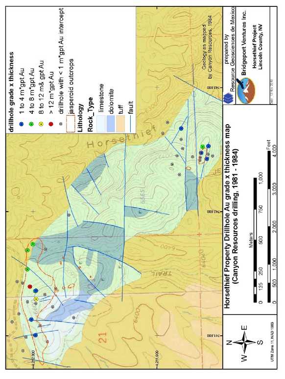
Figure 11.25. Horsethief drillhole Au grade x thickness map.
| Matthew D. Gray C.P.G. #1068826 November 2010 Amended 7 December 2010 | Page 81 of 134 |
| Summary Report on the Nevada Gold Project Portfolio Comprising the Blackrock, Argentite, Bellview, and Horsethief Gold |
| Projects, Nevada, USA |

Figure 11.26. Drillhole cross section with interpretation by Canyon Resources (1984) of high angle, east-west structure controlling development of jasperoid.
The author and RGM senior geologist Roman Solis conducted independent sampling of the jasperoids and silicified or quartz veined outcrops and confirmed that they are anomalously gold, arsenic, and antimony mineralized (Table 11.10, Figure 11.27) . Samples of jasperoid replaced limestone in the northern jasperoid area yielded as much as 0.176 gpt Au. The jasperoid is not everywhere gold mineralized and some samples of jasperoid did not yield gold above the 5 ppb detection limit. The jasperoid is locally an angular breccia (Figure 11.28) and the color varies from brown to hematitic red. The samples of hematitic jasperoid collected by Gray and Solis all contained detectable gold whereas the brown colored jasperoid samples did not. No difference in degree of silicification was noted between the auriferous and barren jasperoids.
| Matthew D. Gray C.P.G. #1068826 November 2010 Amended 7 December 2010 | Page 82 of 134 |
| Summary Report on the Nevada Gold Project Portfolio Comprising the Blackrock, Argentite, Bellview, and Horsethief Gold |
| Projects, Nevada, USA |
Table 11.10. Sample descriptions and assay data for Horsethief project rock samples collected by M Gray and R Solis.

| Matthew D. Gray C.P.G. #1068826 November 2010 Amended 7 December 2010 | Page 83 of 134 |
| Summary Report on the Nevada Gold Project Portfolio Comprising the Blackrock, Argentite, Bellview, and Horsethief Gold |
| Projects, Nevada, USA |
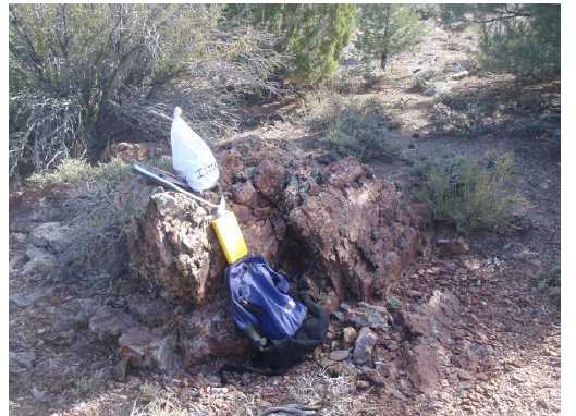
Figure 11.27. Photo of gold mineralized jasperoid outcrop at Horsethief prospect. Sample site I223024, 0.115 ppm Au.
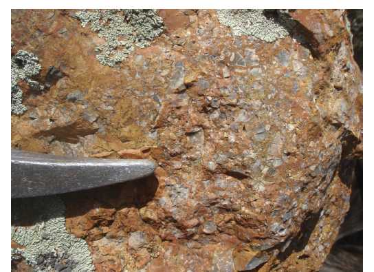
Figure 11.28. Photo of angular breccia texture in jasperoid outcrop at Horsethief prospect. Sample site I223021, <0.005 ppm Au.
| Matthew D. Gray C.P.G. #1068826 November 2010 Amended 7 December 2010 | Page 84 of 134 |
| Summary Report on the Nevada Gold Project Portfolio Comprising the Blackrock, Argentite, Bellview, and Horsethief Gold |
| Projects, Nevada, USA |
| 12 | EXPLORATION |
| 12.1 | General |
Bridgeport Ventures has not conducted any field based exploration on the properties which are the subject of this report, beyond the confirmatory visits and reconnaissance mapping and sampling completed by M Gray and R Solis of Resource Geosciences de Mexico, an independent technical services provider. Results of the mapping and sampling are discussed in Items 11 and 22 of this report. Bridgeport and the author of this report have had full access to digital databases and copies of project exploration files in the possession of Fronteer Gold.
Neither the author nor Bridgeport has access to original documents, maps, drillhole logs, drill cuttings, and assay certificates thusthe author cannot comment on the accuracy of the reported exploration data. The data were obtained from sources believed to be reliable but cannot be verified and have not been independently confirmed by the author.
| 13 | DRILLING |
No drilling campaigns have been conducted on the properties by Bridgeport Ventures.
Previous operators are reported to have conducted exploration drilling at all four projects, as discussed in Items 8 and 11 of this report. Bridgeport and the author of this report have had full access to digital databases and copies of project exploration files in the possession of Fronteer Gold, howeverdrillcore, drill cuttings, original drillhole logs, and original assay certificates for these historical drill programs are not available to the author nor to Bridgeport Venturesthusthe author cannot comment on the accuracy of the reported drillhole data. The data were obtained from sources believed to be reliable but cannot be verified and have not been independently confirmed by the author.
.
| Matthew D. Gray C.P.G. #1068826 November 2010 Amended 7 December 2010 | Page 85 of 134 |
| Summary Report on the Nevada Gold Project Portfolio Comprising the Blackrock, Argentite, Bellview, and Horsethief Gold |
| Projects, Nevada, USA |
| 14 | SAMPLING METHOD AND APPROACH |
| 14.1 | Sampling Method, Nature, and Spacing |
| 14.1.1 | Surface Rock Chip Samples |
Concurrent with reconnaissance review of the Blackrock, Argentite, Bellview, and Horsethief projects, M Gray collected representative rock chip samples of distinct mineralized and altered zones. RGM Senior geologist R Solis assisted the author in reconnaissance visits and sampling at Horsethief and Bellview. Samples were collected from rock exposed in outcrop, prospects, and mine dumps. The objective of the sampling was to determine metal contents and geochemical characteristics of particular zones of interest, and to verify that the mineralized zones that were reported to contain gold were in fact auriferous. All samples were collected by the author or RGM senior geologist R Solis, and remained exclusively in the possession of the author until such time that they were delivered by the author to the ALS Chemex sample reception and preparation facility in Elko, Nevada.
Samples collected were representative grab samples, representative composite samples oriented perpendicular to the structural fabric of the feature of interest being sampled, and both select and random mine dump samples. All samples were collected by hand, using hardened steel geological hammers. Samples were placed in plastic or cloth sample bags and sealed. Sample weights varied from 2 to 4 kg. Sample spacing was variable, and was a function of exposure of mineralized or altered rock. Sample descriptions, location data, and multi-element assay data were captured in digital format and assay certificates are included as Appendix A of this report.
| 14.2 | Recovery Factors |
No factors were identified that materially impact the accuracy or reliability of the sample results. Surface rock chip samples were collected manually and recovery was 100%.
| 14.3 | Sample Quality and Representativity |
In the opinion of the author, samples collected are of high quality and representative of the mineralized areas being evaluated.
| Matthew D. Gray C.P.G. #1068826 November 2010 Amended 7 December 2010 | Page 86 of 134 |
| Summary Report on the Nevada Gold Project Portfolio Comprising the Blackrock, Argentite, Bellview, and Horsethief Gold |
| Projects, Nevada, USA |
Surface sample locations were selected to be representative of the geologic feature being investigated. Representative sample was collected by chipping and collecting rock along a line perpendicular to the orientation of the structure or feature being sampled. Industry standard methods and best professional judgment were used in collection of the rock chip samples, however, by nature, manually collected rock chip samples are of lesser quality than mechanically collected continuous samples (i.e. cored or cut samples). The surface rock chip samples are of sufficient quality and confidence to be used for preliminary assessments of the project’s mineral potential but were not designed to provide detailed or reliable information of true mineralized dimensions and grades.
| Matthew D. Gray C.P.G. #1068826 November 2010 Amended 7 December 2010 | Page 87 of 134 |
| Summary Report on the Nevada Gold Project Portfolio Comprising the Blackrock, Argentite, Bellview, and Horsethief Gold |
| Projects, Nevada, USA |
| 15 | SAMPLE PREPARATION, ANALYSES, AND SECURITY |
It is the author’s opinion that sample preparation, security, and analytical procedures used were adequate to insure the integrity and reliability of the sample data base.
| 15.1 | Personnel |
All samples were collected exclusively by M Gray or R Solis. Employees, officers, directors, or associates of Bridgeport were not involved in sample collection or preparation.
| 15.2 | Bridgeport Resources Sampling Program |
| 15.2.1 | Sample Security/Chain of Custody |
Geologic descriptions of the sample, including nature of the sample, length of sample, lithology, alteration, and mineralization, were captured in geologic field books. Samples were sealed in plastic or cloth sample bags with tie closures. Samples were stored in the author’s locked vehicle until such time that they were delivered directly by the author to the ALS Chemex sample reception facility in Elko, Nevada.
| 15.2.2 | Sample Preparation by ALS Chemex |
Analytical work was performed by ALS Chemex, an ISO 9001:2000 certified international provider of analytical services to mining and exploration companies. Sample preparation was conducted at the ALS Chemex facility in Elko, Nevada and analyses were completed at the ALS Chemex laboratory in Vancouver, British Columbia.
ALS Chemex reports the following preparation method: Each sample was dried and the entire sample was crushed to better than 70% passing a 2 mm (Tyler 10 mesh) screen. Using a riffle splitter, a split of up to 250 grams was taken and pulverized to better than 85% passing a 75 micron (Tyler 200 mesh) screen.
| 15.2.3 | Analytical Techniques used by ALS Chemex |
Gold content was first analyzed utilizing standard fire assay fusion, followed by atomic absorption analysis, of a 30 gram nominal sample weight (ALS Chemex procedure Au AA23), with a detection limit of 0.005 ppm and upper limit of 10 ppm.
All other elements listed below were analyzed utilizing four acid digestion ( HF-
HNO3-HClO4 acid digestion and HCl leach) and Inductively Coupled Plasma -
Atomic Emission Spectroscopy methods (ALS Chemex procedure ME-ICP61). The method and the detection and upper limits for each element are described in Table 15.1.
| Matthew D. Gray C.P.G. #1068826 November 2010 Amended 7 December 2010 | Page 88 of 134 |
| Summary Report on the Nevada Gold Project Portfolio Comprising the Blackrock, Argentite, Bellview, and Horsethief Gold |
| Projects, Nevada, USA |
Table 15.1. Element concentrations analyzed and analytical limits.
| Detection | Upper | |||
| Element | Symbol | Limit | Limit | |
| Aluminum | Al | 0.01% | 25 % | |
| Antimony | Sb | 5 ppm | 1 % | |
| Arsenic | As | 5 ppm | 1 % | |
| * | Barium | Ba | 10 ppm | 1 % |
| Beryllium | Be | 0.5 ppm | 0.01 % | |
| Bismuth | Bi | 2 ppm | 1 % | |
| Cadmium | Cd | 0.5 ppm | 0.05 % | |
| Calcium | Ca | 0.01% | 25 % | |
| * | Chromium | Cr | 1 ppm | 1 % |
| Cobalt | Co | 1 ppm | 1 % | |
| Copper | Cu | 1 ppm | 1 % | |
| Iron | Fe | 0.01% | 25 % | |
| Lead | Pb | 2 ppm | 1 % | |
| Magnesium | Mg | 0.01% | 15 % | |
| Manganese | Mn | 5 ppm | 1 % | |
| Molybdenum | Mo | 1 ppm | 1 % | |
| Nickel | Ni | 1 ppm | 1 % | |
| Phosphorus | P | 10 ppm | 1 % | |
| Potassium | K | 0.01% | 10 % | |
| Silver | Ag | 0.5 ppm | 0.01 % | |
| Sodium | Na | 0.01% | 10 % | |
| Strontium | Sr | 1 ppm | 1 % | |
| Sulfur | S | 0.01 % | 10 % | |
| * | Titanium | Ti | 0.01% | 10 % |
| * | Tungsten | W | 10 ppm | 1 % |
| Vanadium | V | 1 ppm | 1% | |
| Zinc | Zn | 2 ppm | 1 % |
*Elements for which the digestion is possibly incomplete.
| Matthew D. Gray C.P.G. #1068826 November 2010 Amended 7 December 2010 | Page 89 of 134 |
| Summary Report on the Nevada Gold Project Portfolio Comprising the Blackrock, Argentite, Bellview, and Horsethief Gold |
| Projects, Nevada, USA |
| 16 | DATA VERIFICATION |
| 16.1 | Prior Exploration Campaigns |
An extensive amount of exploration work has been completed on the Blackrock, Argentite, Bellview, and Horsethief properties, as discussed in Items 8 and 11 of this report. Nearly all of this work is historic in nature, and as such the reported results are not CSA NI43-101 compliant. Digital copies of data files from exploration programs conducted prior to Bridgeport’s involvement with the projects were reviewed by the author. Data includes geologic maps, drillhole logs, drill sample assays, surface rock chip assays, and geophysical studies. Original documents are not available, nor is drill core or witness samples from reverse circulation drilling. Much of the exploration work was completed decades ago, and reclamation of drill sites and the effects of time and weathering have combined to destroy monuments and physical evidence of drillhole and surface sample locations. The only data that could be directly verified by the author were geologic outcrop maps, some drillhole locations, and some outcrop rock chip sample assays, as discussed in Item 11 of this report.
Bridgeport has not yet commenced an exploration program at the projects beyond the work completed as part of this Technical Report, thus there is no prior data generated by Bridgeport to be verified.
| 16.2 | Production Data |
No significant historic production is reported from the Blackrock, Argentite, Horsethief, and Bellview projects. The tonnes and grades of ore extracted from the mine workings and dumps visited by the author cannot be reliably estimated or confirmed, but material produced probably does not exceed a few hundred tonnes from any of the properties.
| Matthew D. Gray C.P.G. #1068826 November 2010 Amended 7 December 2010 | Page 90 of 134 |
| Summary Report on the Nevada Gold Project Portfolio Comprising the Blackrock, Argentite, Bellview, and Horsethief Gold |
| Projects, Nevada, USA |
| 17 | ADJACENT PROPERTIES |
| 17.1 | Blackrock |
The Blackrock project is not contiguous with any historic or active mining or exploration property. The nearest mining properties of economic significance are the Como and Comstock districts, located 4km south and 20km northwest respectively.
| 17.2 | Argentite |
The Argentite project is not contiguous with any historic or active mining or exploration property. The nearest active mining property is the Mineral Ridge gold mine, located 13km to the east.
| 17.3 | Bellview |
The Bellview project is not contiguous with any historic or active mining or exploration property. The nearest active mining property is the Bald Mountain gold mine of Barrick Gold, located 13km to the south-southeast.
| 17.4 | Horsethief |
The Horsethief project is not contiguous with any historic or active mining or exploration property. The nearest mining property is the Pioche gold mining district, located 24km to the southwest.
| 18 | METALLURGICAL TESTING |
No metallurgical studies have been conducted by Bridgeport Ventures, nor is historical metallurgical data available for the properties.
| 19 | MINERAL RESOURCE ESTIMATE |
Data is insufficient to permit estimation of a mineral resource at any of the four properties.
| Matthew D. Gray C.P.G. #1068826 November 2010 Amended 7 December 2010 | Page 91 of 134 |
| Summary Report on the Nevada Gold Project Portfolio Comprising the Blackrock, Argentite, Bellview, and Horsethief Gold |
| Projects, Nevada, USA |
The historical resource estimate for the Bellview project is discussed in Items 8 and 11 of this report.Insufficient information is available regarding the procedures used to create the historic Bellview resource estimate to determine if it is compliant with the protocols set forth by CSA NI43-101. The resource estimate and has not been independently verified. The author has not reviewed the original drill logs, assay certificates, or resource model thus cannot comment on the accuracy of the reported drill results or resource estimate. The data were obtained from sources believed to be reliable but cannot be verified and the historical drillhole data and resource estimate has not been independently confirmed by the author thus should not be used in economic assessments of the project’s value.
| 20 | OTHER RELEVANT DATA AND INFORMATION |
To the best of the author’s knowledge, all relevant data has been presented in this report.
| Matthew D. Gray C.P.G. #1068826 November 2010 Amended 7 December 2010 | Page 92 of 134 |
| Summary Report on the Nevada Gold Project Portfolio Comprising the Blackrock, Argentite, Bellview, and Horsethief Gold |
| Projects, Nevada, USA |
| 21 | INTERPRETATION AND CONCLUSIONS |
Fronteer Gold made available for purchase by Bridgeport Ventures Inc. a property portfolio which includes the Blackrock, Argentite, Bellview, and Horsethief gold prospects in Nevada. These four projects represented an attractive opportunity for Bridgeport to quickly acquire a land position in a productive gold producing region and offered exposure to a variety of gold deposit types and project risk levels. Bridgeport purchased the Blackrock, Argentite, Bellview, and Horsethief properties on 16 November 2010. Prior to their purchase by Bridgeport, the author conducted field reviews of the properties including independent sampling and confirmation mapping. The projects are prioritized in terms of exploration potential and development priority follows:
| 1. | Blackrock, Lyon County. | ||
Volcanic rock hosted epithermal gold system, Walker Lane province. | |||
High priority target for high grade “bonanza vein” gold deposit minable by bulk underground methods. | |||
Lower probability of open pit target. | |||
Drill targets could be developed within weeks. | |||
| 2. | Argentite, Esmeralda County. | ||
Volcanic rock hosted epithermal hot spring gold system, Walker Lane province. | |||
High priority target for both open pit and underground gold targets. | |||
Historic drilling supports model that untested sinter zones are underlain by potentially economic gold concentrations. | |||
No drill testing east of Argentite Canyon in area of outcropping sinter. | |||
| 3. | Bellview, White Pine County. | ||
Carlin style gold deposit. Carlin-Alligator Ridge trend. | |||
High priority target on basis of geology, however priority reduced to moderate because of permitting issues related to US Forest Service land and incomplete land package. | |||
The permitting process for 10 drill sites has been initiated and permits are expected to be obtained in the fourth quarter of 2010. The permitted drill sites will allow testing of three targets developed by Fronteer Gold. | |||
The property is “drill ready” as soon as permits are obtained. | |||
| 4. | Horsethief, Lincoln County. | ||
Sedimentary rock hosted epithermal or Carlin style gold system. | |||
Geology, geochemistry, and drill results support a target at stratigraphic levels below current outcrop or concealed by a veneer of post mineral volcanics. | |||
Will require geophysical surveys and drilling of blind targets under cover. | |||
| Matthew D. Gray C.P.G. #1068826 November 2010 Amended 7 December 2010 | Page 93 of 134 |
| Summary Report on the Nevada Gold Project Portfolio Comprising the Blackrock, Argentite, Bellview, and Horsethief Gold |
| Projects, Nevada, USA |
Design of future exploration programs for all four projects is aided by the extensive historical exploration database compiled by Fronteer Gold. The Blackrock, Argentite, Bellview, and Horsethief projects all have been partly drill tested with positive exploration results, yielding information of benefit for future drilling programs. Additional exploration, including drill testing, is recommended for all four projects, as discussed in Item 22 of this report.
| Matthew D. Gray C.P.G. #1068826 November 2010 Amended 7 December 2010 | Page 94 of 134 |
| Summary Report on the Nevada Gold Project Portfolio Comprising the Blackrock, Argentite, Bellview, and Horsethief Gold |
| Projects, Nevada, USA |
| 22 | RECOMMENDATIONS |
| 22.1 | Target Concepts |
| 22.1.1 | Blackrock |
The target at Blackrock is an epithermal Au-Ag mineralized vein system, minable by underground methods. Target analogs are the productive deposits of the Comstock district, located 20km to the northwest, which produced greater than 8M ounces gold. The Con Virginia deposit in the Comstock district produced 1.1M tonnes of ore with an average grade of 87 gpt Au (Hudson, 2003).The mineralization described for the mines in this section is not necessarily indicative of the mineralization at the Blackrock property.
Exploration data generated by previous operators, as discussed in Item 11 of this report, has confirmed the viability of a bonanza lode target at Blackrock. Surface mapping, which was confirmed in the field by the author, demonstrates a 1,300 meter strike length of the fault that localizes gold mineralization. Historical sampling of vein outcrops yielded anomalous (>0.1 gpt Au) to potentially ore grade gold concentrations over significant true widths (6.1m @ 6.5 gpt Au). Independent sampling by the author confirmed that the vein outcrops are significantly gold mineralized. The historic drill testing of the project explored only to shallow depths a 400m strike length of the Blackrock vein. The vein was intersected in every drillhole and each yielded wide, low grade gold intercepts. The historic drilling failed to define an economic resource but yielded results of exploration significance. Drill data demonstrates:
| 1. | Continuity of the mineralized vein along strike and dip. | |
| 2. | Increasing vein widths at depth and to the north. | |
| 3. | Multiple mineralized zones, interpreted as parallel vein structures. | |
| 4. | Possible increase of grade with depth (drillhole BR08-09). |
Outcrop and drillhole data validate a high grade “bonanza vein” target at the Blackrock prospect, exploitable by underground methods, analogous to the productive veins of the Comstock district. The potential to host a bulk minable near surface deposit is low, but not precluded by the data.
| 22.1.2 | Argentite |
The target concept at Argentite is an epithermal gold system, probably a low sulfidation type, in a high level and/or hot spring environment, prospective for both bulk minable near surface deposits and high grade, structurally controlled deposits minable by underground methods. Target analogs include the Mineral Ridge mine located approximately 13km east of Argentite. The host rocks at Mineral Ridge are metasediments rather than volcanics, but the mine is developed on a structurally controlled epithermal gold deposit which is reported to have produced 575,000 ounces gold from open pit and underground operations and hosts a Measured and Indicated resource of 221,000 ounces and an inferred resource of 136,000 ounces (Lewis et al., 2010). Another possible exploration analog for the Argentite prospect is the McLaughlin deposit in Napa County, California, which comprises gold bearing epithermal sheeted veins underlying subaerial sinter. McLaughlin hosted a total gold resource (production and reserves) greater than 3.5M ounces gold (Sherlock et. al., 1995).The mineralization described for the mines in this section is not necessarily indicative of the mineralization at the Argentite property.
| Matthew D. Gray C.P.G. #1068826 November 2010 Amended 7 December 2010 | Page 95 of 134 |
| Summary Report on the Nevada Gold Project Portfolio Comprising the Blackrock, Argentite, Bellview, and Horsethief Gold |
| Projects, Nevada, USA |
Work by previous project operators, as discussed in Item 11 of this report, has partially tested the epithermal gold system exposed in Argentite Canyon and identified geochemically anomalous (Au, As, Sb, Hg) hot spring sinter deposits that crop out at elevations 140 m above the canyon floor. Historic drilling returned significant widths of gold mineralized quartz veined zones with intercepts of as much as 46m @ 1.2 gpt Au reported. East-striking structures were interpreted as controls of the gold mineralization exposed in Argentite Canyon.
During the field review mineralized zones exposed in Argentite Canyon and hydrothermal silica sinter outcrops on the east side of the canyon were visited. High angle silicified and quartz veined zones were observed in the canyon bottom, and low temperature chalcedonic silica replacement deposits and accumulated thicknesses of as much as 15m of sinter and related high level silicified sediments at the highest elevations on the east side of the canyon.
Sampling of the silica sinters by previous operators was reported to yield anomalous gold concentrations of as much as 0.1 ppm Au with elevated Hg concentrations. Independent sampling by the author confirmed that the sinters contain geochemically anomalous Au, As, and Sb contents. The author considers the low level metal anomaly in sinter to be significant supporting evidence that the sinters were deposited as part of an auriferous hot springs epithermal system. Such systems often do not produce economic gold concentrations in the near surface environment but may host economic gold concentrations at relatively shallow depths.
The data is permissive of a model in which both the gold showings in Argentite Canyon and the sinters to the east are part of the same mineralizing system, and the sinters represent the highest level of the paleo-hydrothermal system, whereas the auriferous stockwork zones represent a deeper portion of the same system. If so, a 140m vertical extent of the system is exposed, and potentially economic gold concentrations are present at depths of 140m below the paleosurface marked by the sinters, thus the sinters east of Argentite Canyon are guides to potentially economic gold concentrations at relatively shallow depths beneath them.
| Matthew D. Gray C.P.G. #1068826 November 2010 Amended 7 December 2010 | Page 96 of 134 |
| Summary Report on the Nevada Gold Project Portfolio Comprising the Blackrock, Argentite, Bellview, and Horsethief Gold |
| Projects, Nevada, USA |
| 22.1.3 | Bellview |
The target concept for the Bellview prospect is a Carlin style disseminated gold deposit or an intrusive related sedimentary rock hosted gold deposit. A possible analog is the Bald Mountain mine, located 13 km south-southeast. The Bald Mountain mine has exploited gold mineralization hosted along the Dunderberg-Hamburg contact and from Geddes/Secret Canyon strata just above the Eldorado Formation (Nutt et al., 2000). The Bald Mountain mine has produced over 2M ounces gold and as of 31 December 2009 hosted 4.5M ounces gold in measured and indicated reserves (Barrick Gold Corporation, 2009 Annual Report).The mineralization described for the mines in this section is not necessarily indicative of the mineralization at the Bellview property.
The Bellview property has been explored and drill tested by several operators. Geologic mapping, geochemical sampling, geophysical surveys, and several drilling programs have been completed, as discussed in Items 8 and 11 of this report. Fronteer has compiled the historic data into an integrated GIS database, conducted additional field studies, and subsequently developed three target zones proposed for drill testing, located as shown in Figure 22.1 and summarized by Raabe (2010b) as:
The Saddle Target, where brecciated, recrystallized, calcite-veined Hamburg Limestone is thrust over Secret Canyon strata. IP/Resistivity data suggests Eldorado Dolomite lies beneath the ground surface at shallow depths of 100- 200 meters. A north-northwest trending topographic lineation passes through the target and leads to the Cherry Spring Au-As anomaly to the south.
The Cherry Spring Target, located at Cherry Spring in an area of jasperoid development at the contact of a massive, locally oolitic limestone of unknown provenance with overlying Lower Secret Canyon shales and silty limestones. Fronteer’s rock chip samples of the jasperoids returned gold values up to 331 ppb Au, and arsenic values up to 533 ppm As. High angle northeast breccia structures intersect the jasperoid and are interpreted to have controlled gold mineralization. The intersection of these structures with the unexposed Eldorado-Secret Canyon horizon may be an area of significant gold deposition and is a compelling drill target.
The CS Target, where Fronteer’s sampling returned anomalous Au (up to 1.217 ppm) and As (up to 297 ppm) from rock chip samples from silicified limestone beds within the lowermost Dunderberg Formation just above the Hamburg-Dunderberg contact, a regionally important site for gold- mineralization. Controlling structures are a series of northeast and northwest- trending faults which intersect the stratigraphy. The drill targets are the Hamburg-Dunderberg and Secret Canyon-Eldorado Dolomite contacts where they are intersected by the high angle structures.
| Matthew D. Gray C.P.G. #1068826 November 2010 Amended 7 December 2010 | Page 97 of 134 |
| Summary Report on the Nevada Gold Project Portfolio Comprising the Blackrock, Argentite, Bellview, and Horsethief Gold |
| Projects, Nevada, USA |
The author’s field review of the project, as discussed in Item 11 of this report, validated the target concepts proposed by Fronteer.
| Matthew D. Gray C.P.G. #1068826 November 2010 Amended 7 December 2010 | Page 98 of 134 |
| Summary Report on the Nevada Gold Project Portfolio Comprising the Blackrock, Argentite, Bellview, and Horsethief Gold |
| Projects, Nevada, USA |
![]()
Figure 22.1. Bellview project drill target map.
| Matthew D. Gray C.P.G. #1068826 November 2010 Amended 7 December 2010 | Page 99 of 134 |
| Summary Report on the Nevada Gold Project Portfolio Comprising the Blackrock, Argentite, Bellview, and Horsethief Gold |
| Projects, Nevada, USA |
| 22.1.4 | Horsethief |
The target concept at Horsethief is a sediment hosted Carlin style gold deposit. Nearby deposits that may represent geologic analogs include the Pioche district, located 24km to the southwest, which produced over 100,000 ounces gold and the Atlanta mine, located 49km north, which produced over 100,000 ounces gold and 1.7M ounces silver from jasperoid orebodies (Bonham, 1976; NBMG, 1991).The mineralization described for the mines in this section is not necessarily indicative of the mineralization at the Horsethief property.
A joint venture between Canyon Resources and Copper Range explored the property in the period 1981 to 1984 as discussed in Items 8 and 11 of this report. Their mapping and sampling identified large areas of variably auriferous jasperoid. The drill campaigns identified a gold mineralized zone in jasperoid interpreted to be controlled by an E-W striking structure, and a separate disseminated gold zone south of the jasperoid zone, hosted in silty limestones. A soil geochemical survey completed by Fronteer in 2010 identified soil gold anomalies associated with the outcropping jasperoid, but importantly also identified anomalies south and east of the drill tested jasperoid zone. Figure 22.2 presents the drillhole intercept grade- thickness data plotted on a surface plan view (the length of an intercept in meters is multiplied by its gold grade in ppm and the subsequent result is plotted at the location of the drillhole that hosts the intercept) for the main jasperoid zone and a plot of the soil gold data for the same area. The grade x thickness map is consistent with an east-west control to mineralization and the mineralized trend projects beyond the limits of the drill pattern. The soil gold assay data indicates that additional mineralized zones may be present to the south and southeast of the main jasperoid zone. The drillhole and soil assay data indicate potential for the gold mineralized zone to extend both east and west of the drilled jasperoid zone, into areas where the sedimentary strata are concealed by volcanic rocks, and to the south and southeast. The 1981 to 1984 drill campaigns failed to define a significant gold resource in the outcropping jasperoid, however, in many Carlin type systems, auriferous jasperoids are present but do not comprise the economically significant orebody. The author regards the auriferous jasperoid at Horsethief as a positive indication that a significant mineralized system was active at the property, thus the property remains prospective for gold deposits hosted by favorable sedimentary strata beneath the level of current outcrop exposure or drill testing, and for the discovery of gold deposits along the trend of the mineralized zone where it projects under volcanic cover rock.
| Matthew D. Gray C.P.G. #1068826 November 2010 Amended 7 December 2010 | Page 100 of 134 |
| Summary Report on the Nevada Gold Project Portfolio Comprising the Blackrock, Argentite, Bellview, and Horsethief Gold |
| Projects, Nevada, USA |
![]()
Figure 22.2. Horsethief project soil gold and drillhole grade-thickness map.
| Matthew D. Gray C.P.G. #1068826 November 2010 Amended 7 December 2010 | Page 101 of 134 |
| Summary Report on the Nevada Gold Project Portfolio Comprising the Blackrock, Argentite, Bellview, and Horsethief Gold |
| Projects, Nevada, USA |
| 22.2 | Exploration Program and Budget |
| 22.2.1 | Blackrock |
Testing of the prospect is straightforward. Geological mapping and surface rock chip sampling has defined the vein trace on surface and existing drillhole data constrains the vein orientation. The project can be advanced to the drill stage rapidly. The Blackrock project should be evaluated by:
| 1. | Compilation of exploration data into a GIS database. | |
| 2. | Confirmatory program of geologic mapping and rock chip sampling. | |
| 3. | Creation of 2D and 3D models of geology and vein structure using existing drillhole information and outcrop maps. | |
| 4. | Drill testing the projection of the vein structure at depths of 150 to 200m below surface at spacings of 150m along the strike projection of the vein. A total of 4,000m of reverse circulation drilling is recommended for the first phase drill test. |
Completion of the recommended Phase 1 work program is estimated to require 5 months and $700,000 USD as summarized in Table 22.1. A Phase 2 drill and resource modeling program with a budget of $1.0M USD would be conditional upon successful results from the Phase 1 program.
| Matthew D. Gray C.P.G. #1068826 November 2010 Amended 7 December 2010 | Page 102 of 134 |
| Summary Report on the Nevada Gold Project Portfolio Comprising the Blackrock, Argentite, Bellview, and Horsethief Gold |
| Projects, Nevada, USA |
Table 22.1. Proposed exploration program and budget, Blackrock project.
Phase 1 Budget - Blackrock Project, Lyon County, Nevada
| PHASE 1 DRILLING PROGRAM | |||||||||||||||
| Item | Units | Unit Cost USD | Total Cost USD | ||||||||||||
| Lodging/Meals/Communications | 162 | person-days | 150 | 24,300 | |||||||||||
| Geophysical Surveys (IP/Resistivity) | 0 | 0 | |||||||||||||
| Roads and Drill Pads | 1 | 45,000 | 45,000 | ||||||||||||
| Drilling - Reverse Circulation | 4000 | meters | 82 | 328,000 | |||||||||||
| Drilling - Core | 0 | meters | 125 | 0 | |||||||||||
| Assays, drill samples | 3200 | samples | 25 | 80,000 | |||||||||||
| Assays, rock and soil | 0 | samples | 25 | 0 | |||||||||||
| Senior Geologist | 15 | days | 975 | 14,625 | |||||||||||
| Project Geologists | 126 | man-days | 500 | 63,000 | |||||||||||
| Technicians/Samplers | 63 | man-days | 200 | 12,600 | |||||||||||
| Vehicles and Fuel | 189 | vehicle-days | 110 | 20,790 | |||||||||||
| Permits | 1 | 15,000 | 15,000 | ||||||||||||
| Field Supplies | 1 | 40,000 | 40,000 | ||||||||||||
| Travel Costs | 1 | 12,000 | 12,000 | ||||||||||||
| Environmental Costs/Reclamation | 1 | 45,000 | 45,000 | ||||||||||||
| Total | $ | 700,315 | |||||||||||||
| Grand Total Phase 1 | $ | 700,315 | USD | ||||||||||||
Phase 2 Budget -Conditional upon positive results from Phase 1 Program
| PHASE 2 RESOURCE MODELING AND INFILL DRILLING PROGRAM | |||||||||||||||
| Item | Units | Unit Cost USD | Total Cost USD | ||||||||||||
| Lodging/Meals/Communications | 240 | person-days | 150 | 36,000 | |||||||||||
| Roads and Drill Pads | 1 | 50,000 | 50,000 | ||||||||||||
| Resource Modeling | 1 | 75,000 | 75,000 | ||||||||||||
| Drilling - Reverse Circulation | 0 | meters | 82 | 0 | |||||||||||
| Drilling - Diamond Drill Core | 4000 | meters | 125 | 500,000 | |||||||||||
| Assays, drill samples | 4800 | samples | 25 | 120,000 | |||||||||||
| Assays, rocks and soil | 0 | samples | 25 | 0 | |||||||||||
| Senior Geologist | 30 | days | 975 | 29,250 | |||||||||||
| Project Geologists | 105 | man-days | 500 | 52,500 | |||||||||||
| Technicians/Samplers | 105 | man-days | 200 | 21,000 | |||||||||||
| Vehicles and Fuel | 210 | vehicle-days | 110 | 23,100 | |||||||||||
| Permits | 1 | permit | 15,000 | 15,000 | |||||||||||
| Field Supplies | 1 | 40,000 | 40,000 | ||||||||||||
| Travel Costs | 1 | 24,000 | 24,000 | ||||||||||||
| Reclamation | 1 | 50,000 | 50,000 | ||||||||||||
| Total | $ | 1,035,850 | |||||||||||||
| Grand Total Phase 2 | $ | 1,035,850 | USD | ||||||||||||
| Grand Total, Phase 1 and Phase 2 | $ | 1,736,165 | USD | ||||||||||||
| Matthew D. Gray C.P.G. #1068826 November 2010 Amended 7 December 2010 | Page 103 of 134 |
| Summary Report on the Nevada Gold Project Portfolio Comprising the Blackrock, Argentite, Bellview, and Horsethief Gold |
| Projects, Nevada, USA |
| 22.2.2 | Argentite |
The exploration target concept is straightforward, yet requires further data collection to define drill targets. The concept to be explored is gold mineralized zones underlying silica sinters, with gold mineralization controlled by the structural zones that served as conduits for the sinter forming hydrothermal fluids. Sinter outcrops are discontinuously present over an area of greater than 1km2. Developing drill targets within the prospective zone of known sinter outcrops will require:
| 1. | Compilation of historic exploration data into a GIS database. | |
| 2. | Creation of 2D and 3D models of geology, vein structures, and mineralized zones using existing drillhole information and outcrop maps. | |
| 3. | Detailed geologic mapping and rock chip sampling. | |
| 4. | Grid soil geochemical surveys to identify hidden structural controls to gold distribution. | |
| 5. | Terrestrial IP/resistivity/magnetic surveys to seek evidence of pyritic zones (chargeability highs), silicified zones (resistors) and structures (magnetic gradient discontinuities) within the prospective area. | |
| 6. | Drill testing the interpreted structural zones that controlled formation of the sinters at depths of 150m below the sinters. A total of 3,000m of reverse circulation drilling is recommended for the first phase drill test. |
Completion of the recommended work program is estimated to require 8 months and $824,000 USD as summarized in Table 22.2. A Phase 2 drill and resource modeling program with a budget of $1.0M USD would be conditional upon successful results from the Phase 1 program.
| Matthew D. Gray C.P.G. #1068826 November 2010 Amended 7 December 2010 | Page 104 of 134 |
| Summary Report on the Nevada Gold Project Portfolio Comprising the Blackrock, Argentite, Bellview, and Horsethief Gold |
| Projects, Nevada, USA |
Table 22.2. Proposed exploration program and budget, Argentite project.
Phase 1 Budget - Argentite Project, Esmeralda County, Nevada
| PHASE 1 DRILLING PROGRAM | |||||||||||||||
| Item | Units | Unit Cost USD | Total Cost USD | ||||||||||||
| Lodging/Meals/Communications | 210 | person-days | 150 | 31,500 | |||||||||||
| Geophysical Surveys (IP/Resistivity) | 1 | 150,000 | 150,000 | ||||||||||||
| Roads and Drill Pads | 1 | 50,000 | 50,000 | ||||||||||||
| Drilling - Reverse Circulation | 3000 | meters | 82 | 246,000 | |||||||||||
| Drilling - Core | 0 | meters | 125 | 0 | |||||||||||
| Assays, drill samples | 2400 | samples | 25 | 60,000 | |||||||||||
| Assays, rock and soil | 0 | samples | 25 | 0 | |||||||||||
| Senior Geologist | 30 | days | 975 | 29,250 | |||||||||||
| Project Geologists | 147 | man-days | 500 | 73,500 | |||||||||||
| Technicians/Samplers | 126 | man-days | 200 | 25,200 | |||||||||||
| Vehicles and Fuel | 273 | vehicle-days | 110 | 30,030 | |||||||||||
| Permits | 1 | 15,000 | 15,000 | ||||||||||||
| Field Supplies | 1 | 40,000 | 40,000 | ||||||||||||
| Travel Costs | 1 | 24,000 | 24,000 | ||||||||||||
| Environmental Costs/Reclamation | 1 | 50,000 | 50,000 | ||||||||||||
| Total | $ | 824,480 | |||||||||||||
| Grand Total Phase 1 | $ | 824,480 | USD | ||||||||||||
Phase 2 Budget -Conditional upon positive results from Phase 1 Program
| PHASE 2 RESOURCE MODELING AND INFILL DRILLING PROGRAM | |||||||||||||||
| Item | Units | Unit Cost USD | Total Cost USD | ||||||||||||
| Lodging/Meals/Communications | 282 | person-days | 150 | 42,300 | |||||||||||
| Roads and Drill Pads | 1 | 75,000 | 75,000 | ||||||||||||
| Resource Modeling | 1 | 75,000 | 75,000 | ||||||||||||
| Drilling - Reverse Circulation | 5000 | meters | 82 | 410,000 | |||||||||||
| Drilling - Diamond Drill Core | 0 | meters | 125 | 0 | |||||||||||
| Assays, drill samples | 4000 | samples | 25 | 100,000 | |||||||||||
| Assays, rocks and soil | 0 | samples | 25 | 0 | |||||||||||
| Senior Geologist | 30 | days | 975 | 29,250 | |||||||||||
| Project Geologists | 126 | man-days | 500 | 63,000 | |||||||||||
| Technicians/Samplers | 126 | man-days | 200 | 25,200 | |||||||||||
| Vehicles and Fuel | 252 | vehicle-days | 110 | 27,720 | |||||||||||
| Permits | 1 | permit | 25,000 | 25,000 | |||||||||||
| Field Supplies | 1 | 40,000 | 40,000 | ||||||||||||
| Travel Costs | 1 | 24,000 | 24,000 | ||||||||||||
| Reclamation | 1 | 75,000 | 75,000 | ||||||||||||
| Total | $ | 1,011,470 | |||||||||||||
| Grand Total Phase 2 | $ | 1,011,470 | USD | ||||||||||||
| Grand Total, Phase 1 and Phase 2 | $ | 1,835,950 | USD | ||||||||||||
| Matthew D. Gray C.P.G. #1068826 November 2010 Amended 7 December 2010 | Page 105 of 134 |
| Summary Report on the Nevada Gold Project Portfolio Comprising the Blackrock, Argentite, Bellview, and Horsethief Gold |
| Projects, Nevada, USA |
| 22.2.3 | Bellview |
Work by Fronteer and previous operators has identified several high priority targets for drill testing and the permitting process to allow for drilling of these targets has been initiated. The property is “drill ready” pending receipt of permits. Evaluation of the project should include:
| 1. | Compilation of historic exploration data into a GIS database. | |
| 2. | Creation of 2D and 3D models of geology and mineralized zones using existing drillhole information and outcrop maps. | |
| 3. | Expansion of the property concession package to include 100% of the historic resource and areas peripheral to the three defined drill targets. | |
| 4. | Drill testing of all three target areas defined by Fronteer. A 4,500 foot reverse circulation drill program should be an adequate first test. |
Completion of the recommended work program is estimated to require 6 months (assuming permits obtained in 4th quarter 2010) and $780,000 USD and as summarized in Table 22.3. A Phase 2 drill and resource modeling program with a budget of $1.0M USD would be conditional upon successful results from the Phase 1 program.
| Matthew D. Gray C.P.G. #1068826 November 2010 Amended 7 December 2010 | Page 106 of 134 |
| Summary Report on the Nevada Gold Project Portfolio Comprising the Blackrock, Argentite, Bellview, and Horsethief Gold |
| Projects, Nevada, USA |
Table 22.3. Proposed exploration program and budget, Bellview project.
Phase 1 Budget - Bellview Project, White Pine County, Nevada
| PHASE 1 DRILLING PROGRAM | |||||||||||||||
| Item | Units | Unit Cost USD | Total Cost USD | ||||||||||||
| Lodging/Meals/Communications | 240 | person-days | 150 | 36,000 | |||||||||||
| Geophysical Surveys (IP/Resistivity) | 0 | 0 | |||||||||||||
| Roads and Drill Pads | 1 | 40,000 | 40,000 | ||||||||||||
| Drilling - Reverse Circulation | 4500 | meters | 82 | 369,000 | |||||||||||
| Drilling - Core | 0 | meters | 125 | 0 | |||||||||||
| Assays, drill samples | 3600 | samples | 25 | 90,000 | |||||||||||
| Assays, rock and soil | 0 | samples | 25 | 0 | |||||||||||
| Senior Geologist | 30 | days | 975 | 29,250 | |||||||||||
| Project Geologists | 105 | man-days | 500 | 52,500 | |||||||||||
| Technicians/Samplers | 105 | man-days | 200 | 21,000 | |||||||||||
| Vehicles and Fuel | 210 | vehicle-days | 110 | 23,100 | |||||||||||
| Permits | 1 | 15,000 | 15,000 | ||||||||||||
| Field Supplies | 1 | 40,000 | 40,000 | ||||||||||||
| Travel Costs | 1 | 24,000 | 24,000 | ||||||||||||
| Environmental Costs/Reclamation | 1 | 40,000 | 40,000 | ||||||||||||
| Total | $ | 779,850 | |||||||||||||
| Grand Total Phase 1 | $ | 779,850 | USD | ||||||||||||
Phase 2 Budget -Conditional upon positive results from Phase 1 Program
| PHASE 2 RESOURCE MODELING AND INFILL DRILLING PROGRAM | |||||||||||||||
| Item | Units | Unit Cost USD | Total Cost USD | ||||||||||||
| Lodging/Meals/Communications | 240 | person-days | 150 | 36,000 | |||||||||||
| Roads and Drill Pads | 1 | 100,000 | 100,000 | ||||||||||||
| Resource Modeling | 1 | 75,000 | 75,000 | ||||||||||||
| Drilling - Reverse Circulation | 4000 | meters | 82 | 328,000 | |||||||||||
| Drilling - Diamond Drill Core | 0 | meters | 125 | 0 | |||||||||||
| Assays, drill samples | 3200 | samples | 25 | 80,000 | |||||||||||
| Assays, rocks and soil | 0 | samples | 25 | 0 | |||||||||||
| Senior Geologist | 30 | days | 975 | 29,250 | |||||||||||
| Project Geologists | 105 | man-days | 500 | 52,500 | |||||||||||
| Technicians/Samplers | 105 | man-days | 200 | 21,000 | |||||||||||
| Vehicles and Fuel | 210 | vehicle-days | 110 | 23,100 | |||||||||||
| Permits | 1 | permit | 100,000 | 100,000 | |||||||||||
| Field Supplies | 1 | 40,000 | 40,000 | ||||||||||||
| Travel Costs | 1 | 24,000 | 24,000 | ||||||||||||
| Reclamation | 1 | 100,000 | 100,000 | ||||||||||||
| Total | $ | 1,008,850 | |||||||||||||
| Grand Total Phase 2 | $ | 1,008,850 | USD | ||||||||||||
| Grand Total, Phase 1 and Phase 2 | $ | 1,788,700 | USD | ||||||||||||
| Matthew D. Gray C.P.G. #1068826 November 2010 Amended 7 December 2010 | Page 107 of 134 |
| Summary Report on the Nevada Gold Project Portfolio Comprising the Blackrock, Argentite, Bellview, and Horsethief Gold |
| Projects, Nevada, USA |
| 22.2.4 | Horsethief |
The historic drilling has adequately tested, with negative results, the possibility that the outcropping jasperoid is an orebody, however drilling indicates potential for disseminated gold mineralization in silty limestones that may occupy a stratigraphic level below that of the jasperoid replaced limestone. Exploration to date has not explored favorable strata at deeper stratigraphic levels nor the projection of mineralized zones where they are concealed beneath volcanic cover rocks. In order to evaluate these targets the following work plan is recommended:
| 1. | Compilation of all available geology, geochemical, and drillhole data into a GIS database. | |
| 2. | Creation of 2D and 3D models of geology using existing drillhole information and outcrop maps. | |
| 3. | On the basis of trends identified by analysis of the historic data, expand the land package by staking additional claims along the projection of mineralized zones and favorable strata. | |
| 4. | Complete soil and rock chip geochemical surveys, concurrent with geological mapping, to define stratigraphic intervals favorable for mineralization and possible structural controls to mineralization. | |
| 5. | Conduct geophysical surveys to seek evidence of non-outcropping mineralized zones. Silica alteration associated with mineralization may be evidenced by resistivity highs. | |
| 6. | Drill test developed targets. A 4,000 meter reverse circulation drill program will be an adequate phase one test. |
Completion of the estimated work program is estimated to require 8 months and $790,000 USD as summarized in Table 22.4. A Phase 2 drill and resource modeling program with a budget of $416,000 USD would be conditional upon successful results from the Phase 1 program.
| Matthew D. Gray C.P.G. #1068826 November 2010 Amended 7 December 2010 | Page 108 of 134 |
| Summary Report on the Nevada Gold Project Portfolio Comprising the Blackrock, Argentite, Bellview, and Horsethief Gold |
| Projects, Nevada, USA |
Table 22.4. Proposed exploration program and budget, Horsethief Project
Phase 1 Budget - Horsethief Project, Lincoln County, Nevada
| PHASE 1 DRILLING PROGRAM | |||||||||||||||
| Item | Units | Unit Cost USD | Total Cost USD | ||||||||||||
| Lodging/Meals/Communications | 162 | person-days | 150 | 24,300 | |||||||||||
| Geophysical Surveys (IP/Resistivity) | 1 | 100,000 | 100,000 | ||||||||||||
| Roads and Drill Pads | 1 | 40,000 | 40,000 | ||||||||||||
| Drilling - Reverse Circulation | 4000 | meters | 82 | 328,000 | |||||||||||
| Drilling - Core | 0 | meters | 125 | 0 | |||||||||||
| Assays, drill samples | 3200 | samples | 25 | 80,000 | |||||||||||
| Assays, rock and soil | 0 | samples | 25 | 0 | |||||||||||
| Senior Geologist | 15 | days | 975 | 14,625 | |||||||||||
| Project Geologists | 126 | man-days | 500 | 63,000 | |||||||||||
| Technicians/Samplers | 63 | man-days | 200 | 12,600 | |||||||||||
| Vehicles and Fuel | 189 | vehicle-days | 110 | 20,790 | |||||||||||
| Permits | 1 | 15,000 | 15,000 | ||||||||||||
| Field Supplies | 1 | 40,000 | 40,000 | ||||||||||||
| Travel Costs | 1 | 12,000 | 12,000 | ||||||||||||
| Environmental Costs/Reclamation | 1 | 40,000 | 40,000 | ||||||||||||
| Total | $ | 790,315 | |||||||||||||
| Grand Total Phase 1 | $ | 790,315 | USD | ||||||||||||
Phase 2 Budget -Conditional upon positive results from Phase 1 Program
| PHASE 2 RESOURCE MODELING AND INFILL DRILLING PROGRAM | |||||||||||||||
| Item | Units | Unit Cost USD | Total Cost USD | ||||||||||||
| Lodging/Meals/Communications | 94 | person-days | 150 | 14,100 | |||||||||||
| Roads and Drill Pads | 1 | 20,000 | 20,000 | ||||||||||||
| Resource Modeling | 1 | 75,000 | 75,000 | ||||||||||||
| Drilling - Reverse Circulation | 2000 | meters | 82 | 164,000 | |||||||||||
| Drilling - Diamond Drill Core | 0 | meters | 125 | 0 | |||||||||||
| Assays, drill samples | 1600 | samples | 25 | 40,000 | |||||||||||
| Assays, rocks and soil | 0 | samples | 25 | 0 | |||||||||||
| Senior Geologist | 5 | days | 975 | 4,875 | |||||||||||
| Project Geologists | 42 | man-days | 500 | 21,000 | |||||||||||
| Technicians/Samplers | 42 | man-days | 200 | 8,400 | |||||||||||
| Vehicles and Fuel | 84 | vehicle-days | 110 | 9,240 | |||||||||||
| Permits | 1 | permit | 20,000 | 20,000 | |||||||||||
| Field Supplies | 1 | 15,000 | 15,000 | ||||||||||||
| Travel Costs | 1 | 4,000 | 4,000 | ||||||||||||
| Reclamation | 1 | 20,000 | 20,000 | ||||||||||||
| Total | $ | 415,615 | |||||||||||||
| Grand Total Phase 2 | $ | 415,615 | USD | ||||||||||||
| Grand Total, Phase 1 and Phase 2 | $ | 1,205,930 | USD | ||||||||||||
| Matthew D. Gray C.P.G. #1068826 November 2010 Amended 7 December 2010 | Page 109 of 134 |
| Summary Report on the Nevada Gold Project Portfolio Comprising the Blackrock, Argentite, Bellview, and Horsethief Gold |
| Projects, Nevada, USA |
| 23 | REFERENCES |
Albers, J.B. and Stewart, J.H., 1972, Geology and Mineral Deposits of Esmeralda County, Nevada: Nevada Bur. Mines and Geology Bull. 78.
Albinson, T., Norman, D., Cole, D., and Chomiak, B., 2001, Controls on formation of low-sulfidation epithermal deposits in Mexico: Constraints from fluid inclusion and stable isotope data: in New Mines and Mineral Discoveries in Mexico and Central America, Special Publication Number 8 of the Society of Economic Geologists, p. 1 -32.
Arribas, A. Jr., 1995, Characteristics of high-sulfidation epithermal deposits and their relation to magmatic fluid: Mineralogical Association of Canada Short Course Series, v. 23, p. 419-454.
Ashley, R.P., 1974: Goldfield mining district. Nevada Bureau of Mines Geologic Report 19, p. 49-66.
Berger, B.R., and Henley, R.W., 1989, Advances in the understanding of epithermal gold silver deposits with special reference to the western United States: in The Geology of Gold Deposits: the Perspective in 1988, Economic Geology Monograph 6, Keays, W.R., Ramsey, W.R.H., and Groves, D.I., editors, The Society of Economic Geologists.
Bonham, H.F., 1976, Gold producing districts of Nevada, Map 32 Special Edition, published by Nevada Bureau of Mines and Geology.
Bonham, H.F. Jr., 1988, Models for volcanic-hosted epithermal precious metal deposits: in Bulk minable precious metal deposits of the western United States Symposium Proceedings, Schafer, R.W., Cooper, J.J., and Vikre, P.G. editors, Geological Society of Nevada.
Buchanan, L.J., 1981, Precious metal deposits associated with volcanic environments in the southwest: in Relation of tectonics to ore deposits in the Southern Cordillera, Dickenson, W.R., and Payne, W.D., editors, Arizona Geological Society Digest, vol.14.
Canyon Resources Corporation, 1982, Preliminary report on the Horsethief Spring property, Lincoln County, Nevada, June 1981, revised April 1982, private company report, 25 p.
Carithers, Ward, 1978, Ashby Gold Mine, Mineral County, Nevada, unpublished geologic report, dated November 1, 1978.
Cox, D. P., Ludington, S., Sherlock, M.G., Singer, D.A., Berger, B.R., and Tingley, J.V., 1991, Mineralization patterns in time and space in the Great Basin of Nevada:
| Matthew D. Gray C.P.G. #1068826 November 2010 Amended 7 December 2010 | Page 110 of 134 |
| Summary Report on the Nevada Gold Project Portfolio Comprising the Blackrock, Argentite, Bellview, and Horsethief Gold |
| Projects, Nevada, USA |
in Raines, G.L., Liske, R.E., Schafer, R.W., and Wilkinson, W.H., eds., Geology and ore deposits of the Great Basin, Geological Society of Nevada and United States Geological Survey Symposium, Reno-Sparks, April 1990, Proc. v. 1 p. 193-198.
Deen, J. A., Rye, R.O., Munoz, J.L., and Drexler, J.W., 1994: The magmatic hydrothermal system at Julcani, Peru: Evidence from fluid inclusions and hydrogen and oxygen isotopes. Economic Geology v. 89 p. 1924-1938.
Faulds, J.E., Coolbaugh, M., Blewitt, G., and Henry, C.D., 2004, Why is Nevada in hot water? Structural controls and tectonic model of geothermal systems in the northwestern Great Basin: Geothermal Resources Council Transactions, p. 649-654.
Forrest, R.A., 1986, Argentite Project,Horizon Gold Shares, Inc., internal company report, dated February, 1986.
Gray, I.B., 1972, General geologic outline of the Fri claim group, private report prepared for Siskon Corporation, 22 March 1972, 18 p.
Gray, J.E., and Coolbaugh, M.F., 1994: Geology and geochemistry of Summitville, Colorado: An epithermal acid-sulfate deposit in a volcanic dome. Economic Geology v. 89 p. 1906-1923.
Hayba, D.O., Bethke, P.M., Heald, P., and Foley, N.K., 1985: Geologic, mineralogic, and geochemical characteristics of volcanic-hosted epithermal precious metal deposits. Reviews in Economic Geology v. 2 p. 129-167.
Heald, P., Foley, N.K., and Hayba, D.O., 1987: Comparative anatomy of volcanic-hosted epithermal deposits: acid-sulfate and adularia-sericite types. Economic Geology v. 82 p. 1-26.
Hedenquist, J.W., Arribas, A. Jr., Reynolds, T.J., 1998: Evolution of an intrusion-centered hydrothermal system: Far Southeast Lepanto porphyry and epithermal Cu-Au deposits, Philippines. Economic Geology v. 93 p. 373-404.
Hose, R.K., and Blake, M.C., 1976, Geology and Mineral Resources of White Pine County, Nevada, Part I Geology: Nevada Bureau of Mines and Geology Bulletin 85, p. 1-35.
Howell, F., 2004, Argentite project geologic map, scale 1” = 400 ‘, Cordilleran Exploration Company, date 10 July 2004, revised 10 Sept 2004.
Hudson, D.H., 2003, Epithermal alteration and mineralization in the Comstock District, Nevada, Economic Geology, vol. 98, 2003, pp. 367-385.
Ilchik, R.P., and Barton, M.D., 1997, An amagmatic origin of Carlin-type gold deposits; Economic Geology, v. 92, p. 269-288.
| Matthew D. Gray C.P.G. #1068826 November 2010 Amended 7 December 2010 | Page 111 of 134 |
| Summary Report on the Nevada Gold Project Portfolio Comprising the Blackrock, Argentite, Bellview, and Horsethief Gold |
| Projects, Nevada, USA |
John, D.A., Hofstra, A.H., and Theodore, T.G., 2003, ,A special issue devoted to gold deposits in northern Nevada: Part 1 regional studies and epithermal deposits, Preface, Economic Geology, v. 98, no. 2, p. 225 – 234.
Jones, Richard, 1992a, Characteristics of Mineralization and Exploration Recommendations for the Bellview Project Area, consultants report with accompanying geologic map (Jones, 1992b) prepared for Western States Minerals Corp., dated 24 November, 1992.
Lanier, G., 1999a, Bellview Property,geologic map prepared for Western States Minerals Corporation, scale: 1 in. = 500 ft.
Lanier, G., 1999b, Bellview Project District Targets and Exploration Proposal,Western States Minerals Corporation, internal company memo to A.B. Morrow and E.M. Gerick, dated 12 October, 1999.
Lewis, J.L., Godard, M., San Martin, A.J., Murahwi, C., 2010, Technical Report on the initial mineral resource estimate for the Mineral Ridge gold project, Nevada, USA, Effective Date 31 May 2010, prepared by Micon International Limited for Scorpio Gold Corporation for NI43-101 filing, which by Canadian Securities Administrators regulations is available on SEDAR (System for Electronic Data Analysis and Retrieval) athttp://www.sedar.com.
McKee, E.H., 1996, Cenozoic magmatism and mineralization in Nevada; in Coyner, A.R. and Fahey, P.L., eds. Geology and ore deposits of the American Cordillera, Geological Society of Nevada, United States Geological Survey, and Sociedad Geologica de Chile, Symposium, Reno-Sparks, April 1995. Proc. v. 2, , p. 581 -588.
Millikin, Gregory R., 1979,Geology of a Portion of the Sherman Mountain Quadrangle, Nevada, San Diego State University, M.S. Thesis.
NBMG, 1991, Mineral resources inventory, Bureau of Land Management, Schell resource area, Ely district, Nevada, Nevada Bureau of Mines and Geology Open File Report 91-1. 139 p.
NBMG, 1997, County Digital Geological Maps of Nevada (OF97-1) by Ronald H. Hess and Gary L. Johnson, Nevada Bureau of Mines and Geology, 1997 | 1:250,000-scale, public domain maps available athttp://www.nbmg.unr.edu/Mapping/StatewideGeologicMaps.html
NBMG, 2010, State and Federal permits required in Nevada before mining or milling can begin, Nevada Bureau of Mines and Geology Special Publication L-6, revised to May 2009, additional update October 2010.
| Matthew D. Gray C.P.G. #1068826 November 2010 Amended 7 December 2010 | Page 112 of 134 |
| Summary Report on the Nevada Gold Project Portfolio Comprising the Blackrock, Argentite, Bellview, and Horsethief Gold |
| Projects, Nevada, USA |
Nutt, C.J., Hofstra, A.H., Hart, K.S., and Mortensen, J.K., 2000, Structural Setting and Genesis of Gold Deposits in the Bald Mountain – Alligator Ridge Area, East-central Nevada, in Cluer, J.K., Price, J.G., Struhsacker, E.M., Hardyman, R.F., and Morris, C.L., editors, Geology and Ore Deposits 2000: The Great Basin and Beyond: Geological Society of Nevada, Symposium Proceedings, May 13-15, p. 513-542.
Petersen, U., Noble, D.C., Arenas, M.J., and Goodell, P.C., 1977: Geology of the Julcani mining district, Peru. Economic Geology v.72 p. 931-949.
Phillips, G.N., and Powell, R., 1993, Link between gold provinces; Economic Geology, v. 88, p. 1084-1098.
Raabe, K.C., 2010a, Nevada Eagle Blackrock Property, Lyon County, Nevada, Initial Evaluation, private report prepared for Fronteer Gold, 20 August 2010, 24 p.
Raabe, K.C., 2010b, Bellview Property, White Pine County, Nevada, summary report, 2008 exploration program; private report prepared for Fronteer Gold, 11 December 2008, 44 p.
Ramnath, S., 2010, Summary of historical exploration activities, based on review of Fronteer Gold project files, Blackrock, Argentite, Bellview, Horsethief, Hot Pot, East Walker, Ashby, Kobeh properties, Nevada, private report prepared for Bridgeport Ventures Inc., 20 October 2010.
Renken, Paul B., 1983a, Bellview Property, White Pine County, Nevada, T25, 26N R56E: project report and summary of work, 1983, consultants report prepared for Arctic Precious Metals, Ltd., dated December, 1983.
Ransome, F.L., 1909: The association of alunite with gold in the Goldfield district. Economic Geology v.2 p. 667-692.
Seedorf, E., 1991, Magmatism, extension, and ore deposits of Eocene to Holocen age in the Great Basin – mutual effects and preliminary proposed genetic relationships: in Raines, G.L., Liske, R.E., Schafer, R.W., and Wilkinson, W.H., eds., Geology and ore deposits of the Great Basin, Geological Society of Nevada and United States Geological Survey Symposium, Reno-Sparks, April 1990, Proc. v. 1 p. 193-198.
Sherlock, R.L., Tosdal, R.M., Lehrman, N.J., Graney, J.R., Losh, S., Jowett, E.C., Kesler, S, 1995, Origin of the McLaughlin Mine sheeted vein complex: Metal zoning, fluid inclusion, and isotopic evidence, Economic Geology, vol. 90, 1995, pp. 2156-2181.
Sillitoe, R.H., and Bonham, H.F., 1990, Sediment-hosted gold deposits: Distal products of magmatic hydrothermal systems; in Geology, February 1990, v. 18, no. 2, p. 157-161.
| Matthew D. Gray C.P.G. #1068826 November 2010 Amended 7 December 2010 | Page 113 of 134 |
| Summary Report on the Nevada Gold Project Portfolio Comprising the Blackrock, Argentite, Bellview, and Horsethief Gold |
| Projects, Nevada, USA |
Spalding, V., 2010, Nevada Eagle Horsethief Property, Lincoln County, Nevada, Initial Evaluation, private report prepared for Fronteer Gold, 11 July 2010, 17 p.
Stoffregen , R.E., 1987: Genesis of acid-sulfate alteration and Au-Cu-Ag mineralization at Summitville, Colorado. Economic Geology v.82 p. 1575-1591.
Tschanz, T.M. & Pampeyan, E.H., 1970, Geology and Mineral Deposits of Lincoln County, Nevada: Nevada Bur. Mines and Geology Bull. 73.
Urie, G.L., 2010, Nevada Eagle Kobeh property, Eureka County, Nevada, inititial evaluation. Private report prepared for Fronteer Gold, 26 August 2010, 8 p.
Veek, B.M., 1984, Report on exploration for the Horsethief Spring project, Nye County (sic), Nevada, 1984. Private company report, 78p.
Vikre, P. G., 1989: Ledge formation at the Sandstorm and Kendall gold mines, Goldfield, Nevada. Economic Geology v. 84 p. 2115-2138.
Webb, 1984
Western Regional Climate Center, 2010, Public domain historical climate database, joint product of Desert Research Institute and the National Oceanic and Atmospheric Administration, available athttp://www.wrcc.dri.edu/index.html.
Zoback, M.L., McKee, E.H., Blakely, R.J., and Thompson, G.A., 1994, The northern Nevada rift: Regional tectonomagmatic relations and middle Miocene stress direction: Geological Society of America Bulletin, v. 106, P. 371-382.
| Matthew D. Gray C.P.G. #1068826 November 2010 Amended 7 December 2010 | Page 114 of 134 |
| Summary Report on the Nevada Gold Project Portfolio Comprising the Blackrock, Argentite, Bellview, and Horsethief Gold |
| Projects, Nevada, USA |
| 24 | STATEMENT OF QUALIFICATION |
I, Matthew Dean Gray, of Calle 14 de Abril No. 68, Colonia San Benito, Hermosillo, Sonora, Mexico, do hereby certify:
| 1. | That I am employed as a geologist at Resource Geosciences de Mexico SA de CV, (RGM) an independent consulting geosciences firm, whose address is Calle 14 de Abril No. 68, Colonia San Benito, Hermosillo, Sonora, CP 83190, MEXICO. |
| 2. | That: a.) I am a Certified Professional Geologist (#10688) with the American Institute of Professional Geologists; b.) My qualifications include experience applicable to the subject matter of this report, specifically the economic evaluation of both early stage and production gold projects; and c.) as a result of my education, experience, and professional qualifications I am a “Qualified Person” for the purposes of CSA National Instrument 43-101. |
| 3. | That I am a graduate of the Colorado School of Mines (Ph.D., Geology with Minor in Mineral Economics, 1994; B.Sc., Geological Engineering, 1985) and the University of Arizona (M.Sc., Geosciences, 1988) and I have practiced my profession continuously since 1988. |
| 4. | That I have no material interest, direct or indirect, in the properties discussed in this report dated 26 November 2010 and titled “Summary report on the Nevada gold project portfolio comprising the Blackrock, Argentite, Bellview, and Horsethief gold projects, Nevada, USA” or in the securities of Bridgeport Ventures Inc. and that I am independent of Bridgeport Ventures Inc. within the meaning of CSA National Instrument 43-101 and that I have had no prior involvement with the properties which are the subject matter of this report. |
| 5. | That as of the date of this amended technical report, to the best of my knowledge, information and belief this technical report contains all scientific and technical information that is required to be disclosed to make the Technical Report not misleading. |
| 6. | That this report on the Nevada gold project portfolio is based on 5 days of site visits (14, 15, 16, and 20 October; 4 November 2010) and on a review of published and unpublished information and that I have had no prior involvement with the property that is the subject of this report. |
| 7. | That I have read National Instrument 43-101 and Form 43-101F1 and that the technical report has been prepared in compliance with the Instrument and Form and that I am responsible for the preparation and compilation of this report. |
| 8. | That I consent to the use of this report, dated 26 November 2010, Amended 7 December 2010, titled “Summary report on the Nevada gold project portfolio comprising the Blackrock, Argentite, Bellview, and Horsethief gold projects, Nevada, USA”, by Bridgeport Ventures Inc. for making representations on the subject property. |
| 9. | That I have prepared this report for Bridgeport Ventures Inc.. It is based on my observations and data collected by myself, and on data obtained from the United States Geological Survey, the Nevada Bureau of Mines and Geology, and on data provided by the vendor of the properties, Fronteer Gold Inc. |
![]()
| Matthew D. Gray C.P.G. #1068826 November 2010 Amended 7 December 2010 | Page 115 of 134 |
| Summary Report on the Nevada Gold Project Portfolio Comprising the Blackrock, Argentite, Bellview, and Horsethief Gold |
| Projects, Nevada, USA |
Appendix A. Waypoints, due diligence confirmation site visits, M Gray, R Solis.
Waypoint | Person | Project | Date | E UTM NAD83 | N UTM NAD83 | Elev m | Comment |
| 231 | MDG | Argentite | 14- Oct-10 | 426837 | 4179846 | 2410 | |
| A1 | MDG | Argentite | 14- Oct-10 | 426944 | 4179876 | 2420 | sinter |
| A10 | MDG | Argentite | 14- Oct-10 | 426949 | 4180161 | 2356 | sinter |
| A11 | MDG | Argentite | 14- Oct-10 | 426990 | 4180057 | 2383 | sinter |
| A12 | MDG | Argentite | 14- Oct-10 | 426988 | 4179928 | 2417 | contc rhy/sinter |
| A13 | MDG | Argentite | 14- Oct-10 | 426948 | 4179906 | 2424 | contc rhy/sinter |
| A2 | MDG | Argentite | 14- Oct-10 | 426837 | 4179846 | 2410 | sinter |
| A3 | MDG | Argentite | 14- Oct-10 | 426809 | 4179845 | 2404 | sinter |
| A4 | MDG | Argentite | 14- Oct-10 | 426801 | 4179844 | 2404 | sinter |
| A5 | MDG | Argentite | 14- Oct-10 | 426787 | 4179884 | 2396 | sinter |
| A6 | MDG | Argentite | 14- Oct-10 | 426793 | 4179937 | 2398 | sinter |
| A8 | MDG | Argentite | 14- Oct-10 | 426820 | 4179979 | 2414 | sinter |
| A9 | MDG | Argentite | 14- Oct-10 | 426858 | 4180042 | 2401 | sinter |
| Argentite | MDG | Argentite | 14- Oct-10 | 426984 | 4179876 | 2411 | heli landing spot |
| Kr394 | MDG | Argentite | 14- Oct-10 | 426796 | 4179855 | 2399 | Ken Raabe sample site 394 |
| Ab092 | MDG | Argentite | 20- Oct-10 | 426499 | 4179522 | 2331 | sample site |
| Adit | MDG | Argentite | 20- Oct-10 | 426607 | 4179531 | 2297 | Adit trending NA320 |
| Arg Cnyn Landind | MDG | Argentite | 20- Oct-10 | 426660 | 4179652 | 2276 | heli landing spot |
| I223008 | MDG | Argentite | 20- Oct-10 | 426501 | 4179527 | 2333 | Repeat of Fronteer sample AB92 which assayed 0.325 ppm Au. Float boulder of silicified and quartz veined plagioclase and biotite bearing volcanic, indurated and moderately silicified, crosscut by creamy and light grey and white cryptocrystalline silica veinlets. No hint of sulfide or Fe-ox therefrom derived. |
| I223009 | MDG | Argentite | 20- Oct-10 | 426543 | 4179507 | 2319 | Grab sample over 5m area of outcrops of unusual, irregular, planar red hematitic zones in contact with or crosscutting very coarse grained felspar phyric porphyry. I don't kow if this is hydrothermal feature or primary volcanic texture (mega agglomerate?). |
| I223010 | MDG | Argentite | 20- Oct-10 | 426588 | 4179540 | 2307 | Representative grab across 1.5m rib of brecciated silica vein. Angular breccia of dense silicified clasts in dense silicified matrix. Old flag - 4359 sample site. |
| I223011 | MDG | Argentite | 20- Oct-10 | 426607 | 4179534 | 2295 | Grab of quartz vein material from pad in front of adit, select sample of grey and dark grey quartz vein material. Note traces of very fine grained disseminated pyrite in some samples. |
| Matthew D. Gray C.P.G. #1068826 November 2010 Amended 7 December 2010 | Page 116 of 134 |
| Summary Report on the Nevada Gold Project Portfolio Comprising the Blackrock, Argentite, Bellview, and Horsethief Gold |
| Projects, Nevada, USA |
| I223012 | MDG | Argentite | 20- Oct-10 | 426641 | 4179741 | 2290 | Repeat of Fronteer sample KR393 which assayed 1.305 ppm Au. NA060 85NW silica rib vein outcrop. Replacement silica - protolith plagioclase porphyritic volcanic, locally weakly gossanous and argillized. |
| I223013 | MDG | Argentite | 20- Oct-10 | 426687 | 4179767 | 2324 | Repeat of Fronteer sample KR392 which assayed 0.725 ppm Au. 10 to 30cm wide silica breccia vein at NA050 80NW crosscutting rusty weakly silicified plagioclase porphyritic volcanic. Sampleis 3m grab centered on silica breccia vein, 50% breccia vein, 25% HW, 25% FW. |
| I223014 | MDG | Argentite | 20- Oct-10 | 426939 | 4179808 | 2414 | Grab over 10m area of bedded chalcedonic sinter, chalcedonic silica replacements, and sinter breccia. |
| I223015 | MDG | Argentite | 20- Oct-10 | 426800 | 4179949 | 2406 | Grab sample of grey-dark grey non-banded chalcedonic silica crosscut by high angle red hematitic siliceous breccia zones. Crosscutting hydrothermal feature? Silicified sediments infilling fissure? Sample is 20cm wide across hematitic silica breccia 50/50 breccia and wallrock sinter. |
| I223016 | MDG | Argentite | 20- Oct-10 | 426816 | 4179978 | 2413 | Grab of hematitic angular silicified sinter breccia and crudely banded chalcedonic host rock. |
| I223017 | MDG | Argentite | 20- Oct-10 | 426955 | 4179903 | 2425 | Grab of white-red-brown-grey mottled sinter crosscut by less than 2 vol % white drusy quartz veinlets and occasional hematitic brecciated zone. |
| L 10000N P10100E | MDG | Argentite | 20- Oct-10 | 426596 | 4179533 | 2302 | grid stake L10000N P10100E |
| b1 | MDG | Bellview | 15- Oct-10 | 616675 | 4438548 | 2232 | jasp |
| bellview | MDG | Bellview | 15- Oct-10 | 616828 | 4438341 | 2222 | heli landing spot |
| 234 | MDG | Bellview | 4-Nov- 10 | 618655 | 4436778 | 2401 | |
| B3 | MDG | Bellview | 4-Nov- 10 | 617932 | 4435664 | 2127 | |
| B4 | MDG | Bellview | 4-Nov- 10 | 618541 | 4436687 | 2433 | NA085 15N bedding in grey unaltered (but for white cc veins) carbonate |
| B5 | MDG | Bellview | 4-Nov- 10 | 616906 | 4438012 | 2261 | caved prospect pit as base of massive jasperoid outcrop |
| B6 | MDG | Bellview | 4-Nov- 10 | 616798 | 4438001 | 2286 | Pronounced NA020 75W fabric to jasperoid outcrop, contolling rib morphology |
| I223025 | MDG | Bellview | 4-Nov- 10 | 617884 | 4435513 | 2117 | Representative grab over 4x5m area of red- grey-white jasperoid outcrop in Cherry Springs Canyon. Locally angular breccia texture with late white sugary quartz veinlets. Note sample tag TT717(?) and 125872, which assayed 0.010 ppm, at this outcrop. |
| I223026 | MDG | Bellview | 4-Nov- 10 | 617932 | 4435580 | 2139 | Representative grab over 8x8m area of bold jasperoid outcrop, white-grey-red color, locally angular breccia texture. Not true cryptocrystalline jasperoid - this is sugary replacement silica. |
| I223027 | MDG | Bellview | 4-Nov- 10 | 617972 | 4435641 | 2130 | Representative grab over 3x5m area of quartz ribbon veined red-brown siltstone. >50 vol % white milky quartz veining, some symettrical open space filling textures. Dominant orientation NA015 steeply E dipping. |
| I223028 | MDG | Bellview | 4-Nov- 10 | 617872 | 4435626 | 2119 | Grab of mega boulders in Cherry Springs Canyon of densely silicified white-grey-red jasperoidal angular breccia. Angular white and grey silicified clasts in dense grey, locally hematitic, silica matrix. |
| Matthew D. Gray C.P.G. #1068826 November 2010 Amended 7 December 2010 | Page 117 of 134 |
| Summary Report on the Nevada Gold Project Portfolio Comprising the Blackrock, Argentite, Bellview, and Horsethief Gold |
| Projects, Nevada, USA |
| I223029 | MDG | Bellview | 4-Nov- 10 | 618689 | 4436817 | 2401 | Repeat at Fronteer sample site 125866 which assayed 0.254 ppm Au. Note coordinates approximate and taken from map - GPS reading not stored. Grab of hematitic red and brown brecciated vaiably silicified siltstone. Note NA010 65E polished fault surface with dip slip slickenlines. Note tag and flag for sample 125866 here. |
| I223030 | MDG | Bellview | 4-Nov- 10 | 618657 | 4436780 | 2401 | Repeat of Fronteer sample site 125865 which assayed 0.041 ppm Au. Grab over 1x1m area of grey-brown outcrop of angular brecciated fine grained carbonate/siltstone, variably replaced by fine grained sugary silica. |
| I223031 | MDG | Bellview | 4-Nov- 10 | 616912 | 4438009 | 2260 | Grab of float boulders at base of massive jasperoid outcrop. Sample is of quartz veined red and brown brecciated variably silicified siltstone which looks similar to Secret Canyon shale above silica replaced Eldorado Dolomite. |
| I223032 | MDG | Bellview | 4-Nov- 10 | 616715 | 4438571 | 2232 | Sample of float of red and brown Fe-oxide stained shattered and quartz veined and cemented siltstone, collected east of jasperoid outcrops. Sample is Secret Canyon shale? Not pervasively silicified. Late white drusy and low temperature quartz. |
| I223033 | MDG | Bellview | 4-Nov- 10 | 616688 | 4438640 | 2221 | Sample of float east of and at base of massive jasperoid outcrops, variably silicified red and brown Fe-oxide stained siltstone cut by white drusy quartz veinlets. Secret Canyon shale? |
| I223034 | MDG | Bellview | 4-Nov- 10 | 616675 | 4438549 | 2231 | Representative grab over 3 x 5 m area of much larger outcrop of what Ken Raabe showed to us as being silicified Eldorado Dolomite. Note angular clast clasts defined by white silica veinlets. NA010 fabirc to veinlets. |
| 957 | RGSM | Bellview | 4-Nov- 10 | 616588 | 4438673 | 2209 | Old drill site |
| I223043 | RGSM | Bellview | 4-Nov- 10 | 617691 | 4435593 | 2095 | Repeat at sample site 90668 which assayed 0.331 ppm Au. Also tags for samples 9222 , CSA-01R and 3687. 325/20 bedding in reddish -brown siltstones with white drussy silica filling open spaces (fractures) |
| I223044 | RGSM | Bellview | 4-Nov- 10 | 617675 | 4435560 | 2085 | Silicified and brecciated siltstones?? Late white quartz filling cavities-150/60 slickensides |
| I223045 | RGSM | Bellview | 4-Nov- 10 | 617832 | 4435567 | 2100 | Brecciated rib, white silica replacing limestones??? |
| I223046 | RGSM | Bellview | 4-Nov- 10 | 618630 | 4436694 | 2398 | N-S structure, limestones, recrystallized limestones to silica>carbonates |
| I223047 | RGSM | Bellview | 4-Nov- 10 | 618679 | 4436811 | 2389 | Strong silicified and brecciated siltstones locallywith white quartz filling cavities |
| I223048 | RGSM | Bellview | 4-Nov- 10 | 616801 | 4437993 | 2274 | White drussy quartz filling fractures, weak granular silicification of groundmass |
| I223049 | RGSM | Bellview | 4-Nov- 10 | 616659 | 4438575 | 2233 | Jasperoids, crackle breccias, locally white quartz filling cavities |
| I223050 | RGSM | Bellview | 4-Nov- 10 | 616568 | 4438736 | 2195 | Jasperoids with sugary quartz in groundmass |
| Blackrock | MDG | Blackrock | 13- Oct-10 | 287888 | 4342914 | 2082 | heli landing spot |
| Br1 | MDG | Blackrock | 13- Oct-10 | 287828 | 4342855 | 2085 | outcrop, Blackrock vein |
| Br2 | MDG | Blackrock | 13- Oct-10 | 287804 | 4342852 | 2091 | late qtz veins xcutting sil vein |
| Br3 | MDG | Blackrock | 13- Oct-10 | 287800 | 4342831 | 2089 | NA023 70E slip planes in Blackrock vein |
| Br4 | MDG | Blackrock | 13- | 287863 | 4342818 | 2076 | HW hb plag andesite to Blackrock vein, |
| Matthew D. Gray C.P.G. #1068826 November 2010 Amended 7 December 2010 | Page 118 of 134 |
| Summary Report on the Nevada Gold Project Portfolio Comprising the Blackrock, Argentite, Bellview, and Horsethief Gold |
| Projects, Nevada, USA |
| Oct-10 | |||||||
| Clmpst1 | MDG | Blackrock | 13- Oct-10 | 287820 | 4342861 | 2089 | old claimpost |
| Olddh | MDG | Blackrock | 13- Oct-10 | 287877 | 4342846 | 2078 | old drill pad |
| Ab192 | MDG | Blackrock | 20- Oct-10 | 288115 | 4343227 | 1953 | sample site |
| Ab193 | MDG | Blackrock | 20- Oct-10 | 288118 | 4343232 | 1950 | sample site |
| Ab194 | MDG | Blackrock | 20- Oct-10 | 288113 | 4343232 | 1952 | sample site |
| I223001 | MDG | Blackrock | 20- Oct-10 | 287764 | 4342766 | 2085 | Representative grab sample across 3m of NA025 trending bold rib of white multistage quartz vein. Fine grained white and tan sugary crystalline silica crosscut by white sugary and chalcedonic silica veinlets. Locally a breccia vein with angular clasts of silica within silica matrix |
| I223002 | MDG | Blackrock | 20- Oct-10 | 287752 | 4342756 | 2082 | Representative grab over 3 m of weakly silicified and quartz veined andesite (?) FW to massive vein at site 223001, collected approximately 15m W-SW of 223001 from bold NE trending brown rib of silicified andesite crosscut by less than 5 vol % white sugary quartz veinlets at NA 010 80W. |
| I223003 | MDG | Blackrock | 20- Oct-10 | 287794 | 4342816 | 2087 | Representative grab over 3m perpendicular to NA025 trending rib of multistage quartz vein. Fine grained white and tan sugary crystalline silica crosscut by white sugary and chalcedonic silica veinlets. Locally a breccia vein with angular clasts of silica within silica matrix. |
| I223004 | MDG | Blackrock | 20- Oct-10 | 287742 | 4342648 | 2034 | Non-representative grab over 8m width of silicified and quartz veined andesite (multistage quartz veining) exposed in roadcut at arroyo. Selectively sampling the most silicified or or veined zones. Note late drusy quartz veins and traces of cinnabr paint on fractures and in vugs. Old metal sample taga here - BR108??, CN44?? |
| I223005 | MDG | Blackrock | 20- Oct-10 | 287766 | 4342654 | 2035 | Stockpile grab from 4 different piles of quartz vein material on pad on N side of arroyo. Fragments of multistage white and creamy quartz vein material. |
| I223006 | MDG | Blackrock | 20- Oct-10 | 288168 | 4343457 | 1990 | Grab over 3 m area of rusty, weakly silicified andesite with less than 5 vol % white drusy quartz veining, from N-NW trending rib like rusty o/c. |
| I223007 | MDG | Blackrock | 20- Oct-10 | 288115 | 4343237 | 1946 | Grab over 5 x 10m area from NA020 trending bold rib of silificied and quartz veined andesite. Rusty brown color but no jarosite or Fe-ox after sulfides noted. White drusy quartz veins and porcelainous chalcedonic silica veins cutting variably intensely pervasively silicified andesite. |
| 232 | MDG | Horsethief | 14- Oct-10 | 741177 | 4211894 | 2013 | |
| Horsethief | MDG | Horsethief | 14- Oct-10 | 741184 | 4212316 | 1985 | heli landing spot |
| Ht1 | MDG | Horsethief | 14- Oct-10 | 741219 | 4211989 | 2008 | old drill road, base of jasp o/c |
| Ht1950N1 200E | MDG | Horsethief | 14- Oct-10 | 741203 | 4211947 | 2022 | grid stake 1950N 1200E |
| Ht2 | MDG | Horsethief | 14- Oct-10 | 741222 | 4211977 | 2014 | NA015 70W planar fracs in jasp |
| Ht3 | MDG | Horsethief | 14- Oct-10 | 741211 | 4211940 | 2023 | grey ls |
| Matthew D. Gray C.P.G. #1068826 November 2010 Amended 7 December 2010 | Page 119 of 134 |
| Summary Report on the Nevada Gold Project Portfolio Comprising the Blackrock, Argentite, Bellview, and Horsethief Gold |
| Projects, Nevada, USA |
| Ht4 | MDG | Horsethief | 14- Oct-10 | 741187 | 4211966 | 2024 | jasp |
| Ht5 | MDG | Horsethief | 14- Oct-10 | 741189 | 4211909 | 2018 | rxtallized ls |
| Ht6 | MDG | Horsethief | 14- Oct-10 | 741177 | 4211894 | 2013 | old drill road |
| Ht7 | MDG | Horsethief | 14- Oct-10 | 741152 | 4211864 | 2004 | ls bedding NA145 25NE |
| 233 | MDG | Horsethief | 4-Nov- 10 | 742500 | 4210647 | 1952 | |
| Ht0650N2 450E | MDG | Horsethief | 4-Nov- 10 | 742402 | 4210648 | 1957 | soil grid station |
| Ht0650N2 500E | MDG | Horsethief | 4-Nov- 10 | 742500 | 4210648 | 1953 | soil grid station |
| Ht0750N2 350E | MDG | Horsethief | 4-Nov- 10 | 742348 | 4210753 | 1970 | soil grid station |
| Ht0950N2 250E | MDG | Horsethief | 4-Nov- 10 | 742250 | 4210952 | 1973 | soil grid station |
| Ht1000N2 100E | MDG | Horsethief | 4-Nov- 10 | 742100 | 4210998 | 1986 | soil grid station |
| Hts3 | MDG | Horsethief | 4-Nov- 10 | 742040 | 4211113 | 1997 | na155 17 ne bedding in unaltered grey carbonate with thin cherty beds |
| Hts4 | MDG | Horsethief | 4-Nov- 10 | 742354 | 4210702 | 1967 | gently dipping, <15, to ne bedding in grey carbonate |
| Hts5 | MDG | Horsethief | 4-Nov- 10 | 742472 | 4210627 | 1963 | na150 50sw fault plane with dip slip slicks in jasperoid |
| I223018 | MDG | Horsethief | 4-Nov- 10 | 741996 | 4211137 | 1993 | Grab sample of float and boulders in old caved prospect cut, no outcrop, red soil anomaly in area of prospect. Float is medium grained recrystallized an variably hematitic carbonate, locally with medium grained crystalline grey and white carbonate veinlets. No silicification noted. |
| I223019 | MDG | Horsethief | 4-Nov- 10 | 742377 | 4210908 | 1979 | Sample at old drill site of rotary cuttings - dark grey recrystallized carbonate and bleached carbonate chips. |
| I223020 | MDG | Horsethief | 4-Nov- 10 | 742352 | 4210751 | 1971 | Representative grab sample over 2 x 3 m area of outcrop of brecciated variably silicified carbonate ("brown jasperoid"). Surrounding outcrops are all unaltered grey carbonate. Aluminum tag HT-22 at this location - old drill site? |
| I223021 | MDG | Horsethief | 4-Nov- 10 | 742411 | 4210639 | 1961 | Representative grab sample of yellow-brown angular jasperoid breccia. Angular clasts of aphanitic grey silica in ochreous red-brown jasperoidal matrix. |
| I223022 | MDG | Horsethief | 4-Nov- 10 | 741452 | 4211453 | 1984 | Representative grab sample across 2m of brecciated recrystallized grey carbonate with extremely coarse grained white carbonate veining and breccia matrix, exposed in easternmost of two adjacent prospect cuts. Sample is approximately 50% recrystallized carbonate and 50% carbonate vein material. |
| I223023 | MDG | Horsethief | 4-Nov- 10 | 741594 | 4211362 | 1969 | Dump sample, adjacent to caved prospect shaft. Recrystallized grey and sooty carbonate, dark brown chonchoidally fracturing mudstone, hematitic mudstone, and frags of cherty silica (probably from interbedded cherts, not jasperoid). Minor hairline calcite veining in fragments. Sample tag LI-520 at this site. |
| I223024 | MDG | Horsethief | 4-Nov- 10 | 741354 | 4211808 | 2027 | Representative grab over 2x2m area, rib like outcrop of red-brown jasperoid locally with angular breccia texture. Rib trends NA330, float and outcrop to SE is unaltered grey carbonate. |
| Old Drillsite | MDG | Horsethief | 4-Nov- 10 | 742377 | 4210908 | 1978 | old drill site |
| Matthew D. Gray C.P.G. #1068826 November 2010 Amended 7 December 2010 | Page 120 of 134 |
| Summary Report on the Nevada Gold Project Portfolio Comprising the Blackrock, Argentite, Bellview, and Horsethief Gold |
| Projects, Nevada, USA |
| HT 1900N125 0E | RGSM | Horsethief | 4-Nov- 10 | 741250 | 4211900 | 2031 | Soil sample location |
| I223035 | RGSM | Horsethief | 4-Nov- 10 | 742488 | 4210619 | 1955 | Tagged as site as HT-30 - old drill site? Grab composite sample. Brecciated jasperoid, locally filled with hematite and jarosite after sulphides (cubic boxworks). Possible structural control 140/70 |
| I223036 | RGSM | Horsethief | 4-Nov- 10 | 742469 | 4210642 | 1955 | Grab composite sample. Brecciated Jasperoid weak hematite . Posible structural control 130/60 |
| I223037 | RGSM | Horsethief | 4-Nov- 10 | 742440 | 4210623 | 1958 | Strong hematitic brecciated jasperoids, late white silica filled cavities. Strctural control 120/65 |
| I223038 | RGSM | Horsethief | 4-Nov- 10 | 742433 | 4210607 | 1958 | Brecciated jasperoids filled with hematite- adjacent to possible old waste dump |
| I223039 | RGSM | Horsethief | 4-Nov- 10 | 741344 | 4211876 | 2027 | Jasperoid zone, rib strike 330/80 - crackle breccia |
| I223040 | RGSM | Horsethief | 4-Nov- 10 | 741336 | 4211938 | 2027 | Brecciated jasperoids with jarositic alteration trending 165/70 |
| I223041 | RGSM | Horsethief | 4-Nov- 10 | 741272 | 4211944 | 2026 | Angular breccia on jasperoid (intensel silica replacement), weakly hematitic |
| I223042 | RGSM | Horsethief | 4-Nov- 10 | 741219 | 4211951 | 2019 | Brecciated jasperoid, angular fragments supported by fine grain breccia matrix (silicified powder matrix??????) |
| Matthew D. Gray C.P.G. #1068826 November 2010 Amended 7 December 2010 | Page 121 of 134 |
| Summary Report on the Nevada Gold Project Portfolio Comprising the Blackrock, Argentite, Bellview, and Horsethief Gold |
| Projects, Nevada, USA |
Appendix B. Assay certificate, M Gray rock chip samples.
![]()
| Matthew D. Gray C.P.G. #1068826 November 2010 Amended 7 December 2010 | Page 122 of 134 |
| Summary Report on the Nevada Gold Project Portfolio Comprising the Blackrock, Argentite, Bellview, and Horsethief Gold |
| Projects, Nevada, USA |
![]()
| Matthew D. Gray C.P.G. #1068826 November 2010 Amended 7 December 2010 | Page 123 of 134 |
| Summary Report on the Nevada Gold Project Portfolio Comprising the Blackrock, Argentite, Bellview, and Horsethief Gold |
| Projects, Nevada, USA |
![]()
| Matthew D. Gray C.P.G. #1068826 November 2010 Amended 7 December 2010 | Page 124 of 134 |
| Summary Report on the Nevada Gold Project Portfolio Comprising the Blackrock, Argentite, Bellview, and Horsethief Gold |
| Projects, Nevada, USA |
![]()
| Matthew D. Gray C.P.G. #1068826 November 2010 Amended 7 December 2010 | Page 125 of 134 |
| Summary Report on the Nevada Gold Project Portfolio Comprising the Blackrock, Argentite, Bellview, and Horsethief Gold |
| Projects, Nevada, USA |
![]()
| Matthew D. Gray C.P.G. #1068826 November 2010 Amended 7 December 2010 | Page 126 of 134 |
| Summary Report on the Nevada Gold Project Portfolio Comprising the Blackrock, Argentite, Bellview, and Horsethief Gold |
| Projects, Nevada, USA |
![]()
| Matthew D. Gray C.P.G. #1068826 November 2010 Amended 7 December 2010 | Page 127 of 134 |
| Summary Report on the Nevada Gold Project Portfolio Comprising the Blackrock, Argentite, Bellview, and Horsethief Gold |
| Projects, Nevada, USA |
![]()
| Matthew D. Gray C.P.G. #1068826 November 2010 Amended 7 December 2010 | Page 128 of 134 |
| Summary Report on the Nevada Gold Project Portfolio Comprising the Blackrock, Argentite, Bellview, and Horsethief Gold |
| Projects, Nevada, USA |
![]()
| Matthew D. Gray C.P.G. #1068826 November 2010 Amended 7 December 2010 | Page 129 of 134 |
| Summary Report on the Nevada Gold Project Portfolio Comprising the Blackrock, Argentite, Bellview, and Horsethief Gold |
| Projects, Nevada, USA |
Appendix C. Bellview project historic drillhole locations.
Drillhole | UTM E NAD27 | UTM N NAD27 | Elev m |
| 93B01 | 616,811 | 4,438,301 | 2,229 |
| 93B02 | 616,713 | 4,439,008 | 2,195 |
| 93B03 | 616,842 | 4,438,303 | 2,229 |
| 93B04 | 616,837 | 4,439,009 | 2,182 |
| 93B05 | 617,018 | 4,437,868 | 2,242 |
| 93B06 | 616,596 | 4,436,617 | 2,129 |
| 93B06A | 616,596 | 4,436,617 | 2,129 |
| 93B07 | 616,788 | 4,438,435 | 2,219 |
| 93B08 | 616,630 | 4,436,617 | 2,128 |
| 93B09 | 616,821 | 4,438,437 | 2,218 |
| 93B10 | 616,535 | 4,436,614 | 2,124 |
| 93B11 | 616,799 | 4,437,928 | 2,247 |
| 93B12 | 616,622 | 4,436,797 | 2,169 |
| 93B13 | 616,858 | 4,437,928 | 2,245 |
| 93B14 | 616,585 | 4,436,803 | 2,165 |
| 93B15 | 616,862 | 4,437,868 | 2,256 |
| 93B17 | 616,894 | 4,437,861 | 2,254 |
| 93B19 | 616,955 | 4,437,864 | 2,250 |
| 93B21 | 617,425 | 4,437,487 | 2,232 |
| 93B22 | 617,400 | 4,437,482 | 2,233 |
| 93B23 | 616,888 | 4,436,724 | 2,134 |
| B95001 | no data | ||
| B95002 | no data | ||
| BRC1 | 615,832 | 4,437,647 | 2,110 |
| BRC2 | 616,060 | 4,437,631 | 2,131 |
| BRC3 | 615,808 | 4,438,100 | 2,078 |
| BV8302 | 616,891 | 4,438,490 | 2,215 |
| BV8303 | 616,888 | 4,438,429 | 2,220 |
| BV8304 | 616,613 | 4,438,271 | 2,195 |
| BV8305 | 616,311 | 4,437,990 | 2,143 |
| BV8306 | |||
| BV8308 | 616,038 | 4,437,749 | 2,121 |
| BV8309 | 616,308 | 4,437,708 | 2,158 |
| BV8310 | 616,625 | 4,438,719 | 2,172 |
| BV8311 | 616,192 | 4,437,537 | 2,140 |
| BV8312 | 616,358 | 4,437,676 | 2,171 |
| BV8313 | 616,588 | 4,437,687 | 2,218 |
| BV8314 | 616,763 | 4,438,411 | 2,218 |
| BV8315 | 616,738 | 4,438,324 | 2,223 |
| BV8316 | 616,849 | 4,438,224 | 2,220 |
| Matthew D. Gray C.P.G. #1068826 November 2010 Amended 7 December 2010 | Page 130 of 134 |
| Summary Report on the Nevada Gold Project Portfolio Comprising the Blackrock, Argentite, Bellview, and Horsethief Gold |
| Projects, Nevada, USA |
| BV8317 | 616,611 | 4,438,330 | 2,199 |
| BV8320 | 616,292 | 4,437,527 | 2,164 |
| BV8321 | 616,320 | 4,437,482 | 2,167 |
| BV8322 | 616,306 | 4,437,454 | 2,161 |
| BV8323 | 617,190 | 4,437,729 | 2,219 |
| BV8401 | 616,347 | 4,437,390 | 2,155 |
| BV8402 | 616,334 | 4,437,382 | 2,149 |
| BV8403 | 616,344 | 4,437,347 | 2,145 |
| BV8404 | 616,529 | 4,438,378 | 2,183 |
| BV8405 | 616,446 | 4,438,363 | 2,167 |
| BV8406 | 616,559 | 4,438,391 | 2,190 |
| BV8407 | 616,582 | 4,438,392 | 2,195 |
| BV8408 | 616,632 | 4,438,390 | 2,209 |
| BV8409 | 616,658 | 4,438,407 | 2,214 |
| BV8410 | 616,659 | 4,438,402 | 2,215 |
| BV8411 | 616,690 | 4,438,464 | 2,209 |
| BV8412 | 616,714 | 4,438,464 | 2,215 |
| BV8413 | 616,708 | 4,438,408 | 2,221 |
| BV8414 | 616,808 | 4,438,428 | 2,214 |
| BV8415 | 616,772 | 4,438,441 | 2,214 |
| BV8416 | 616,734 | 4,438,526 | 2,200 |
| BV8417 | 616,706 | 4,438,542 | 2,196 |
| BV8418 | 616,692 | 4,438,517 | 2,201 |
| BV8419 | 616,679 | 4,438,503 | 2,203 |
| BV8420 | 616,662 | 4,438,477 | 2,209 |
| BV8421 | 616,629 | 4,438,473 | 2,206 |
| BV8422 | 616,628 | 4,438,446 | 2,208 |
| BV8423 | 616,676 | 4,438,538 | 2,196 |
| BV8424 | 616,664 | 4,438,523 | 2,198 |
| BV8425 | 616,661 | 4,438,553 | 2,192 |
| BV8426 | 616,638 | 4,438,555 | 2,191 |
| BV8427 | 616,891 | 4,437,883 | 2,254 |
| BV8428 | 617,011 | 4,437,788 | 2,243 |
| BV8429 | 616,596 | 4,436,777 | 2,158 |
| BV8430 | 616,672 | 4,436,676 | 2,135 |
| BV8431 | 616,608 | 4,436,716 | 2,145 |
| BV8801 | 616,449 | 4,436,588 | 2,120 |
| BV8802 | 616,673 | 4,436,588 | 2,115 |
| BV8803 | 617,299 | 4,438,808 | 2,274 |
| BV8804 | 617,154 | 4,438,649 | 2,267 |
| BV8805 | 616,793 | 4,438,494 | 2,201 |
| BV8806 | 616,769 | 4,438,430 | 2,215 |
| BV8807 | 616,797 | 4,438,411 | 2,217 |
| Matthew D. Gray C.P.G. #1068826 November 2010 Amended 7 December 2010 | Page 131 of 134 |
| Summary Report on the Nevada Gold Project Portfolio Comprising the Blackrock, Argentite, Bellview, and Horsethief Gold |
| Projects, Nevada, USA |
| BV8808 | 616,334 | 4,437,844 | 2,146 |
| BV8809 | 616,328 | 4,437,763 | 2,158 |
| BV8810 | 616,316 | 4,437,374 | 2,143 |
| BV8811 | 616,210 | 4,437,506 | 2,141 |
| BV8812 | 616,799 | 4,436,615 | 2,121 |
| BV8813 | 616,772 | 4,438,501 | 2,201 |
| BV8814 | 616,791 | 4,438,439 | 2,213 |
| BV8815 | 616,801 | 4,438,389 | 2,220 |
| BV8816 | 616,838 | 4,438,364 | 2,221 |
| BV8917 | 616,537 | 4,438,462 | 2,188 |
| BV8918 | 616,515 | 4,438,408 | 2,181 |
| BV8919 | 616,519 | 4,438,338 | 2,177 |
| BV8920 | 616,566 | 4,438,360 | 2,190 |
| BV8921 | 616,604 | 4,438,538 | 2,193 |
| BV8922 | 616,564 | 4,438,518 | 2,192 |
| BV8923 | 616,559 | 4,438,426 | 2,192 |
| BV8924 | 616,587 | 4,438,480 | 2,197 |
| BV8925 | 616,591 | 4,438,447 | 2,199 |
| BV8926 | 616,621 | 4,438,501 | 2,200 |
| BV8927 | 616,811 | 4,438,352 | 2,222 |
| BV8928 | 616,821 | 4,438,388 | 2,220 |
| BV8929 | 616,810 | 4,438,428 | 2,214 |
| BV8930 | 616,802 | 4,438,452 | 2,211 |
| BV8931 | 616,840 | 4,438,472 | 2,208 |
| BV8932 | 616,868 | 4,438,463 | 2,212 |
| BV8933 | 616,857 | 4,438,435 | 2,214 |
| BV8934 | 616,853 | 4,438,404 | 2,218 |
| BV8935 | 616,849 | 4,438,341 | 2,224 |
| BV8936 | 616,882 | 4,438,399 | 2,221 |
| BV8937 | 616,872 | 4,438,368 | 2,223 |
| BV8938 | 616,878 | 4,438,338 | 2,224 |
| BV8939 | 616,822 | 4,438,412 | 2,217 |
| BV8940 | 616,830 | 4,438,442 | 2,212 |
| BV8941 | 616,866 | 4,438,495 | 2,210 |
| BV8942 | 616,784 | 4,438,460 | 2,210 |
| BV8943 | 616,735 | 4,438,529 | 2,200 |
| BV8944 | 616,760 | 4,438,458 | 2,213 |
| BV8945 | 616,897 | 4,438,455 | 2,220 |
| BV8946 | 616,834 | 4,438,314 | 2,224 |
| BV8947 | 616,831 | 4,438,282 | 2,223 |
| BV8948 | 616,867 | 4,438,302 | 2,223 |
| BV8949 | 616,860 | 4,438,274 | 2,221 |
| BV8950 | 616,900 | 4,438,295 | 2,223 |
| Matthew D. Gray C.P.G. #1068826 November 2010 Amended 7 December 2010 | Page 132 of 134 |
| Summary Report on the Nevada Gold Project Portfolio Comprising the Blackrock, Argentite, Bellview, and Horsethief Gold |
| Projects, Nevada, USA |
| BV8951 | 616,876 | 4,438,180 | 2,217 |
| BV8952 | 616,848 | 4,438,140 | 2,214 |
| BV8953 | 616,708 | 4,438,488 | 2,215 |
| BV8954 | 616,713 | 4,438,472 | 2,215 |
| BV8955 | 616,760 | 4,438,416 | 2,218 |
| BV8956 | 616,855 | 4,438,381 | 2,220 |
| BV8957 | 616,829 | 4,438,333 | 2,223 |
| BV8958 | 616,859 | 4,438,325 | 2,224 |
| BV8959 | 616,851 | 4,438,294 | 2,223 |
| BV8960 | 616,882 | 4,438,267 | 2,221 |
| BV8961 | 616,844 | 4,438,249 | 2,221 |
| BV8962 | 616,875 | 4,438,240 | 2,220 |
| BV8963 | 616,889 | 4,438,317 | 2,224 |
| BV8964 | 616,914 | 4,438,161 | 2,218 |
| BV8965 | 616,879 | 4,438,140 | 2,216 |
| BV8966 | 616,872 | 4,438,111 | 2,215 |
| BV8967 | 616,883 | 4,438,045 | 2,222 |
| BV8968 | 616,914 | 4,438,268 | 2,221 |
| DB01 | 616,838 | 4,438,497 | 2,205 |
| DB02 | 616,814 | 4,438,552 | 2,193 |
| DB03 | 616,790 | 4,438,544 | 2,194 |
| DB04 | 616,772 | 4,438,523 | 2,197 |
| DB05 | 616,809 | 4,438,485 | 2,204 |
| DB06 | 616,739 | 4,438,503 | 2,204 |
| DB07 | 616,780 | 4,438,476 | 2,207 |
| DB08 | 616,751 | 4,438,404 | 2,220 |
| DB09 | 616,733 | 4,438,419 | 2,216 |
| DB10 | 616,789 | 4,438,417 | 2,216 |
| DH01 | 616,837 | 4,438,525 | 2,200 |
| DH02 | 616,893 | 4,438,214 | 2,218 |
| DH03 | 616,863 | 4,438,205 | 2,219 |
| DH04 | 616,830 | 4,438,227 | 2,221 |
| DH05 | 616,816 | 4,438,256 | 2,222 |
| DH06 | 616,804 | 4,438,286 | 2,224 |
| DH07 | 616,779 | 4,438,311 | 2,224 |
| DH08 | 616,779 | 4,438,343 | 2,224 |
| DH09 | 616,786 | 4,438,375 | 2,222 |
| DH10 | 616,770 | 4,438,402 | 2,219 |
| DH11 | 616,755 | 4,438,423 | 2,217 |
| DH12 | 616,757 | 4,438,466 | 2,211 |
| DH13 | 616,757 | 4,438,503 | 2,201 |
| DH14 | 616,606 | 4,438,394 | 2,201 |
| DH15 | 616,496 | 4,438,374 | 2,174 |
| Matthew D. Gray C.P.G. #1068826 November 2010 Amended 7 December 2010 | Page 133 of 134 |
| Summary Report on the Nevada Gold Project Portfolio Comprising the Blackrock, Argentite, Bellview, and Horsethief Gold |
| Projects, Nevada, USA |
| DH16 | 616,360 | 4,438,320 | 2,142 |
| DH19 | 616,856 | 4,438,165 | 2,216 |
| DH20 | 616,840 | 4,438,197 | 2,219 |
| DH21 | 616,824 | 4,438,190 | 2,219 |
| DH22 | 616,765 | 4,438,169 | 2,217 |
| DH24 | 616,699 | 4,438,139 | 2,197 |
| DH29 | 617,043 | 4,438,004 | 2,237 |
| DH30 | 616,935 | 4,437,925 | 2,245 |
| DH31 | 616,758 | 4,437,883 | 2,254 |
| DH33 | 616,601 | 4,437,789 | 2,217 |
| DH34 | 616,486 | 4,437,728 | 2,192 |
| DH39 | 616,259 | 4,437,143 | 2,149 |
| DH48 | 617,319 | 4,437,561 | 2,252 |
| DH49 | 617,364 | 4,437,456 | 2,242 |
| DH51 | 617,153 | 4,437,107 | 2,193 |
| DH54 | 616,522 | 4,436,976 | 2,181 |
| DH58 | 616,982 | 4,436,928 | 2,143 |
| DH59 | 616,799 | 4,438,320 | 2,224 |
| DH60 | 616,727 | 4,438,229 | 2,220 |
| DH61 | 616,797 | 4,438,225 | 2,223 |
| DH62 | 616,792 | 4,438,350 | 2,223 |
| DH64 | 616,925 | 4,438,225 | 2,220 |
| DH65 | 616,501 | 4,437,000 | 2,178 |
| DH66 | 616,352 | 4,437,118 | 2,160 |
| DH69 | 616,800 | 4,438,512 | 2,198 |
| DH70 | 616,726 | 4,438,568 | 2,188 |
| DH72 | 616,606 | 4,438,575 | 2,186 |
| DH73 | 616,541 | 4,438,561 | 2,187 |
| DH75 | 616,926 | 4,438,632 | 2,214 |
| DH84 | 616,502 | 4,438,473 | 2,181 |
| VIEW1 | 617,993 | 4,435,553 | 2,135 |
| VIEW2 | 617,057 | 4,438,281 | 2,238 |
| VIEW3 | 616,501 | 4,438,413 | 2,179 |
| VIEW4 | 616,212 | 4,437,305 | 2,136 |
| VIEW5 | 616,621 | 4,436,518 | 2,101 |
| VIEW6 | 616,481 | 4,436,912 | 2,162 |
| Matthew D. Gray C.P.G. #1068826 November 2010 Amended 7 December 2010 | Page 134 of 134 |