EXHIBIT 99.1
REPORT
On the
Blackjack Project
Similkameen Mining Division, B.C., Canada
NTS Map 092H06E
Latitude 49° 25’ 19” North
Longitude 121° 08’ 10” West
For
Dugu Resources Inc.
117 Queen Street
Cobourg, Ontario, Canada
K9A 1N1
Telephone (905) 377-0979
Fax (905) 377-8347
zdingsdales@sympatico.ca
By
Brian Simmons P.Eng.
Consulting Mining Engineer
Rodell Enterprises Ltd.
Box 151, 1235 Barnes Road
Crofton, B.C., Canada, V0R 1R0
Telephone (250) 210-2520
briangsimmons@shaw.ca
July 21, 2010
TABLE OF CONTENTS
| |
| SUMMARY | 3 |
| FIGURE 1: LOCATION MAP | 5 |
| FIGURE 2: MINERAL CLAIM LOCATION MAP | 6 |
| FIGURE 3: REGIONAL GEOLOGY MAP | 7 |
| INTRODUCTION | 8 |
| Purpose of Report | 8 |
| Sources of Information | 8 |
| Extent of Field Involvement | 8 |
| RELIANCE ON OTHER EXPERTS | 8 |
| PROPERTY DESCRIPTION AND LOCATION | 9 |
| ACCESSIBILITY, CLIMATE, LOCAL RESOURCES, INFRASTRUCTURE & PHYSIOGRAPHY | 10 |
| Topography, elevation and vegetation | 10 |
| Access to the Property | 10 |
| Proximity to Population Centre | 10 |
| Climate | 10 |
| Surface Areas | 11 |
| HISTORY | 11 |
| GEOLOGICAL SETTING | 12 |
| DEPOSIT TYPES | 12 |
| MINERALIZATION | 13 |
| EXPLORATION | 13 |
| DRILLING | 13 |
| SAMPLING METHOD AND APPROACH | 14 |
| SAMPLE PREPARATION, ANALYSES AND SECURITY | 14 |
| DATA VERIFICATION | 14 |
| MINERAL PROCESSING AND METALLURGICAL TESTING | 14 |
| MINERAL RESOURCE AND MINERAL RESERVE ESTIMATES | 14 |
| INTERPRETATION AND CONCLUSIONS | 15 |
| RECOMMENDATIONS | 16 |
| REFERENCES | 17 |
| Certificate of author Brian Simmons | 18 |
Page 2 of 18
SUMMARY
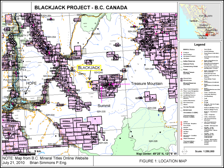
The Blackjack Project consists of one Mineral Claim (DUGU1, Tenure No: 706044) located in the Similkameen Mining Division of British Columbia Canada (Figure 1). The Project area is located approximately 140 km east of Vancouver and 23-km east-northeast of Hope (Figure 2).
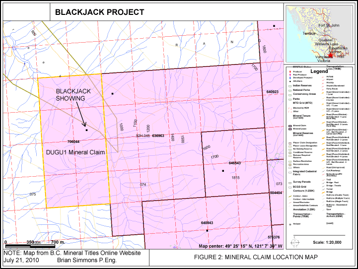
On February 11th 2010, Dugu Resources Inc. (Company) staked 100% undivided right, title and interest to the DUGU1 Mineral Claim. Mr. Steven Earl Smith, an associate of the Company’s President, staked the property on behalf of the Company, and holds these claims on behalf of the Company. The DUGU1 Mineral Claim consists of 8 Cells totaling an area of 168 hectares.
The Blackjack showing is only known mineralized occurrence on the DUGU1 Mineral Claim (Figure 2).
The Blackjack showing is hosted by interbedded tuff, quartzite and argillite which are crosscut by a coarse grained, black felsic dike trending between north and north-northeast. The main showing, located on the west side of the junction of Dewdney Creek, is exposed in an opencut about 6 meters from the creek. Disseminated pyrite, galena and sphalerite occurs in an oxidized band which ranges from 25 to 30 centimeters in width, and consists of sheared and altered wallrock (Gov. of B.C. Ministry of Energy, Mines and Petroleum Resources, MINFILE No. 092HSW046, Detail Report).
From the available history of the DUGU1 Mineral Claim area, it appears that the majority of the claim has had no mineral exploration. The known mineralized occurrences are located along the eastern edge of the mineral claim beside Dewdney Creek.
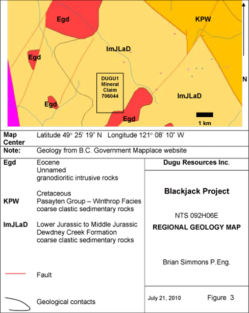
The Blackjack Project is located in coarse clastic sedimentary rocks of the Dewdney Creek formation (Figure 3). This formation is known to host polymetallic veins containing silver, lead and zinc.
Page 3 of 18
The Blackjack Project has the potential for hosting polymetallic veins similar to the nearby past producing Summit and Treasure Mountain Mines,
In the author’s opinion, the Blackjack Project is a worthy exploration target.
A Phase 1 exploratory work program consisting of geological mapping, soil sampling and rock sampling is recommended. Phase 1 will cost $26,000 (Cad).
Contingent upon favorable results from Phase 1, a Phase 2 program is also recommended. Phase 2 will consist of a magnetometer survey and trenching, which will cost $45,000 (Cad).
Page 4 of 18
FIGURE 1: LOCATION MAP
Page 5 of 18
FIGURE 2: MINERAL CLAIM LOCATION MAP
Page 6 of 18
FIGURE 3: REGIONAL GEOLOGY MAP
Page 7 of 18
INTRODUCTION
Purpose of Report
Mr. Zachery Dingsdale, President of Dugu Resources Inc. contracted Brian Simmons P.Eng. to examine the Blackjack Project and make recommendations for further mineral exploration and development.
Sources of Information
Sources of information noted in the text areItalicized and listed in the References. Notes on Figures 1 through 3 list the sources of the maps. For a glossary of geological terms, I recommend using a computer online search engine such as “Google”. Search on the geological term in question.
Extent of Field Involvement
None
RELIANCE ON OTHER EXPERTS
The authors of documents quoted in this report are listed in the references section.
Page 8 of 18
PROPERTY DESCRIPTION AND LOCATION
The Blackjack Project consists of one Mineral Claim (DUGU1, Tenure No: 706044) located in the New Westminster, Similkameen Mining Division of British Columbia Canada (Figure 1). The Project area is located approximately 140 km east of Vancouver and 23 km east-northeast of Hope (Figure 1). A logging road up Dewdney Creek provides access to the northeast corner of the mineral claim. Much of the area has been logged.
On February 11th 2010, Dugu Resources Inc. (Company) staked 100% undivided right, title and interest to the DUGU1 Mineral Claim. Mr. Steven Earl Smith, an associate of the Company’s President, staked the property on behalf of the Company, and holds these claims on behalf of the Company.
The DUGU1 Mineral Claim (Tenure No. 706044) was staked using the British Columbia Mineral Titles Online computer Internet system (Figure 2). All claims staked in British Columbia require $4.00 per hectare worth of assessment work to be undertaken in year 1 through 3, followed by $8.00 per hectare per year thereafter. The DUGU1 Mineral Claim consists of 8 Cells totaling an area of 168 hectares.
The Blackjack showing is located on the northeast corner of the DUGU1 Mineral Claim (Figure 2).
The Blackjack showing is hosted by interbedded tuff, quartzite and argillite which are crosscut by a coarse grained, black felsic dike trending between north and north-northeast. The main showing, located on the west side of the junction of Dewdney Creek, is exposed in an opencut about 6 meters from the creek. Disseminated pyrite, galena and sphalerite occurs in an oxidized band which ranges from 25 to 30 centimeters in width, and consists of sheared and altered wallrock (Gov. of B.C. Ministry of Energy, Mines and Petroleum Resources, MINFILE No. 092HSW046, Detail Report).
There are no known environmental liabilities. No permits have been applied for or acquired for the proposed work.
Page 9 of 18
ACCESSIBILITY, CLIMATE, LOCAL RESOURCES, INFRASTRUCTURE & PHYSIOGRAPHY
Topography, elevation and vegetation
The DUGU1 Mineral Claim is located within the Hozameen Range, which is characterized by high, rugged mountains separated by narrow, deeply incised valleys. The mineral claim is situated on the northwest flank of the Tulameen Mountain.
Elevations on the mineral claim range from 900 meters in the Dewdney Creek on the northeast portion, to over 1800 meters on the southwest corner.
Access to the Property
The mineral claim is accessible from the Coquihalla Highway at the Carolin Mine turnoff, approximately 21 kilometers northeast of Hope (Figure 1). From the highway turnoff, another 12 kilometers is traveled along a logging road up Dewdney Creek. The lower part of the logging road is in good condition, but the remainder has several poor sections. A four-wheel drive vehicle is required to travel the latter part of the road.
Proximity to Population Centre
The City of Hope is closest major population center. Travelling by car, the DUGU1 Mineral Claim is located about 33 kilometers by road to Hope. Vancouver is about 150 kilometers east of Hope.
Climate
Snow normally covers the claims from the end of September to late June.
Page 10 of 18
Surface Areas
The lower part of the valley along Dewdney Creek has been logged. The Upper slopes of the valley are partly logged in areas.
HISTORY
The general area of the DUGU1 Mineral Claim was explored intermittently from the late 1800’s to the present times. Most of the exploration and mining activity was concentrated on Treasure Mountain located to the east of the DUGU1 Mineral Claim (Figure 1).
The Blackjack Showing is located on the northeast corner of the DUGU1 Mineral Claim (Figure 2). The Blackjack showing is first mentioned in the 1913 British Columbia Mines Annual Report. It is reported to have a vein structure mineralized with small amounts of pyrite, marcasite, galena and sphalerite.
In the mid 1980’s Silver Saddle Mines Limited, conducted prospecting and geological mapping on the easterly adjoining and overlapping Argentum claim (Gov. of B.C. Ministry of Energy, Mines and Petroleum Resources, Geological Branch Assessment Report 14,714 and 17,117). On the Blackjack showing a 0.2 meter chip sample from a leached contact zone assayed 23.31 grams silver per tonne(Gov. of B.C. Ministry of Energy, Mines and Petroleum Resources, MINFILE No. 092HSW046, Detail Report).
Page 11 of 18
GEOLOGICAL SETTING
The area is underlain by Lower-Middle Jurassic Dewdney Creek Formation (Ladner Group) tuffaceous sediments comprised of volcanic sandstone, siltstone, wacke, tuff, and argillite with interlayered fossiliferous limestone. These rocks are separated from the Lower-Upper Cretaceous Pasayten Group sediments to the east, by the major northwest trending Chuwanten fault.
The Blackjack showing is hosted by interbedded tuff, quartzite and argillite which are crosscut by a coarse grained, black felsic dike trending between north and north-northeast. The main showing, located on the west side of the junction of Dewdney Creek, is exposed in an opencut about 6 meters from the creek. Disseminated pyrite, galena and sphalerite occurs in an oxidized band which ranges from 25 to 30 centimeters in width, and consists of sheared and altered wallrock.
Another showing, located about 500 meters south of the creek junction, occurs in courser grained sediments. The same black, felsic dike crosscuts these bedded sediments nearly at right angles. On both sides of the dike, which averages 6 meters in width, mineralization consists of disseminated galena and sphalerite. The contacts are highly altered with oxidized and leached wallrock averaging 0.5 meters in width. In 1985, a 0.2 – meter sample from this leached zone assayed 23.31 grams per tonne silver (Assessment Report 14714). (Gov. of B.C. Ministry of Energy, Mines and Petroleum Resources, MINFILE No. 092HSW046, Capsule Geology).
DEPOSIT TYPES
A vein, stockwork type deposit similar to the nearby Treasure Mountain mine is being explored for (Figure 1). The origin of the deposit is classified as hydrothermal and epigenetic, with carbonate and chloritic alteration. The polymetallic veins contain silver, lead, zinc and minor amounts of gold.
Page 12 of 18
MINERALIZATION
The Blackjack showing is only known mineralized occurrence on the DUGU1 Mineral Claim.
The Blackjack showing is hosted by interbedded tuff, quartzite and argillite which are crosscut by a coarse grained, black felsic dike trending between north and north-northeast. The main showing, located on the west side of the junction of Dewdney Creek, is exposed in an opencut about 6 meters from the creek. Disseminated pyrite, galena and sphalerite occurs in an oxidized band which ranges from 25 to 30 centimeters in width, and consists of sheared and altered wallrock.
Another showing, located about 500 meters south of the creek junction, occurs in courser grained sediments. The same black, felsic dike crosscuts these bedded sediments nearly at right angles. On both sides of the dike, which averages 6 meters in width, mineralization consists of disseminated galena and sphalerite. The contacts are highly altered with oxidized and leached wallrock averaging 0.5 meters in width. In 1985, a 0.2 – meter sample from this leached zone assayed 23.31 grams per tonne silver (Assessment Report 14714). (Gov. of B.C. Ministry of Energy, Mines and Petroleum Resources, MINFILE No. 092HSW046, Capsule Geology)
EXPLORATION
The nature of all relevant work to date on the Blackjack Project has been;
1.
the gathering of all past information,
2.
reviewing and analyzing the information, and
3.
the writing of this report.
DRILLING
No drilling was done on the Blackjack Project.
Page 13 of 18
SAMPLING METHOD AND APPROACH
No sampling was done on the Blackjack Project
SAMPLE PREPARATION, ANALYSES AND SECURITY
This section is not applicable to this report.
DATA VERIFICATION
The sources of information, which are not based on personal examination, are quoted in the report and listed in the references. The information provided by the various parties is to the best of my knowledge and experience correct.
MINERAL PROCESSING AND METALLURGICAL TESTING
No metallurgical testing done.
MINERAL RESOURCE AND MINERAL RESERVE ESTIMATES
No Mineral Resource or Mineral Reserve estimates.
Page 14 of 18
INTERPRETATION AND CONCLUSIONS
From the available history of the DUGU1 Mineral Claim area, it appears that the majority of the claim has had no mineral exploration. The known mineralized occurrences are located along the eastern edge of the claim beside Dewdney Creek.
The Blackjack Project is located in coarse clastic sedimentary rocks of the Dewdney Creek formation (Figure 3). This formation is known to host polymetallic veins containing silver, lead and zinc.
The Blackjack Project has the potential for hosting polymetallic veins similar to the nearby past producing Summit and Treasure Mountain Mines.
In the author’s opinion, the Blackjack Project is a worthy exploration target.
Page 15 of 18
RECOMMENDATIONS
The following work program is recommended for the Blackjack Project. Phase 1 of the work program will consist of geological mapping, soil sampling and rock sampling. A mineral exploration grid will be marked out on the mineral claim. Soil and rock samples will be taken at regular intervals. In areas of thick overburden, a gas powered auger will be used to collect the soil samples.
Phase 1 Budget
| |
Geologist 9 days @ $700/day | $6,300 |
Technologist 9 days @ $300/day | $2,700 |
Vehicle 9 days @ $200/day | $1,800 |
Rock Samples 20 @ $50 each | $1,000 |
Soil Samples 100 @ $40 each | $4,000 |
Expenses | $5,200 |
Report | $5,000 |
Total (Can dollars) | $26,000 |
Contingent upon favorable results from Phase 1, the following Phase 2 work program is recommended. Phase 2 will consist of a magnetometer survey and trenching along the favorable areas of the mineral exploration grid.
Phase 2 Budget
| |
Bond | $5,000 |
Geologist 10 days @ $700/day | $7,000 |
Technologist 10 days @ $300/day | $3,000 |
Vehicle 10 days @ $200/day | $2,000 |
Magnetometer Survey | $5,000 |
Excavator 5 days @ $1500/day | $4,500 |
Rock Samples 100 @ $50 each | $5,000 |
Expenses | $8,500 |
Report | $5,000 |
Total (Can dollars) | $45,000 |
Page 16 of 18
REFERENCES
Chung, P.L., Geochemical, Geophysical, Geological and Trenching Report on
the Summit Camp Property, Harrisburg-Dayton Resource Corp.,
Geological Branch Assessment Report 18,111
Government of British Columbia Ministry of Energy, Mines and Petroleum
Resources, MINFILE No. 092HSW023, 092HSW045, 092HSW046,
092HSW047, 092HSW153, 092HSW016,
Jones, H.M., 1987,A Geological Report on the Argentum Claim, Silver Saddle
Mines Ltd., Geological Branch Assessment Report 17,117
Ostensoe, E.A., Giroux, G.H., Beaton, A.J., June 15th 2009, Revised July 2nd
2009,Technical Report, Resource Estimation, Mining and Reclamation
Plan and Economic Evaluation, Treasure Mountain Property,
Huldra Silver Inc.
Rodstrom, H.J., 1985,Prospecting Report, Silver Saddle Mines Ltd.,
Geological Branch Assessment Report 14,714
Page 17 of 18
Certificate of author Brian Simmons
I, Brian Simmons, am a Professional Engineer and President of Rodell Enterprises Ltd. at 1235 Barnes Road, Crofton, B.C., CANADA, V0R 1R0
I am a member of the Association of Professional Engineers and Geoscientists of British Columbia and I am a registered Professional Engineer with License # 15588.
I graduated in 1981, from the Colorado School of Mines with a Bachelor of Science Degree in Mining Engineering. I have practiced my profession for 25 years both as an independent consultant and employee for mining companies in North America. My experience includes exploration, development to production and production. I am presently a Consulting Mining engineer and have been since 1995.
I have reviewed the available data for the Blackjack Project. The sources of information not based on personal examination are quoted in the report. The information provided by the various parties is to the best of my knowledge and experience correct.
I am not aware of any material fact or material change with respect to the subject matter of this technical report that is not reflected in this report, the omission to disclose which would make this report misleading.
This report titledBlackjack Project has been prepared for Dugu Resources Inc. Permission is hereby granted to Dugu Resources Inc. for the inclusion of this report in support of any filings with the US SEC, and/or other regulatory bodies.
Dated this 21st day of July, 2010 in Crofton, B.C. Canada
![[ex991004.gif]](https://capedge.com/proxy/S-1/0001137171-10-000456/ex991004.gif)
Brian Simmons, P. Eng.
Consulting Mining Engineer
Page 18 of 18