Exhibit 99.3

CONTANGO ORE, INC.
OVERVIEWOF CONTANGO ORE, INC.’S
TETLIN PROJECT
(BEHRE DOLBEAR PROJECT 12-004)
JANUARY 2012

PREPARED BY:
BEHRE DOLBEAR & COMPANY (USA), INC.
999 Eighteenth Street, Suite 1500
Denver, Colorado 80202
(303) 620-0020
A Member of the Behre Dolbear Group Inc.
© 2011, Behre Dolbear Group Inc. All Rights Reserved.
www.dolbear.com
|
Overview of Contango Ore, Inc.’s Tetlin Project January 2012 |
| | | | | | |
| | LISTOF TABLES | | | | |
| | |
Table 1 | | Tetlin Exploration Statistics, Samples | | | 2 | |
| | |
| | LISTOF FIGURES | | | | |
| | |
Figure 1. | | Targets from magnetic survey | | | 3 | |
Figure 2. | | Location of Chief Danny, MM, and Chisana Targets | | | 4 | |
Figure 3. | | Drill holes on magnetic survey | | | 5 | |
Figure 4. | | Chisana Mountain geophysical interpretation | | | 7 | |
| | | | |
| Project 12-004 | | i | | BEHRE DOLBEAR |
|
Overview of Contango Ore, Inc.’s Tetlin Project January 2012 |
Contango Ore Inc. has acquired mineral rights to approximately 675,000 acres of Tetlin Indian Corporation lands in south central Alaska and holds approximately 11,360 acres of adjacent State of Alaska mining claims. Exploration on the Tetlin lands was begun by previous owners, Juneau Exploration, in 2009. Work continued in 2010 and 2011 accumulating an impressive database of geological, geophysical, and geochemical information. Expenditures for exploration activities total approximately $4.1 million or $6.07 per acre. The lands under consideration, although adjacent to roads and cultural development, are difficult to access and present challenges to traditional geologic exploration techniques. Approximately one-third of the lands are low lying and comprise tundra covered or submerged terrains. Part of the area of greatest interest has been affected by fire, and the downed trees make survey and exploration traverses difficult.
Behre Dolbear was engaged by Contango to review the exploration data and render an opinion on the exploration work completed, the interpretations of that work, and the recommendations for advancing the project.
Behre Dolbear was granted access to an Avalon Development Corp. server and downloaded files for review. The files included the summary report of 2010 activities. A 2011 PowerPoint presentation of 2011 activities, the interpretation of the aerial Magnetic/EM surveys, interpretations of the IP survey and logs of drill holes, and sampling sites with assay results.
Behre Dolbear found the 2010 summary report to be detailed in its description of the metallogenic setting of the Tetlin lands and of the Alaska terrains overall. The sampling and assaying procedures, in Behre Dolbear’s opinion, were well designed and executed and would meet standards in the industry for exploration projects (Table 1).
TABLE 1
TETLIN EXPLORATION STATISTICS, SAMPLES
| | | | | | | | | | | | | | | | | | | | | | | | | | | | | | | | | | | | |
Year | | Rock | | | Pan
Con | | | Silt | | | Soil | | | Drilling
(ft) | | | Core
Assays | | | Trench
(ft) | | | IP
(km) | | | Aeromag
(km) | |
2009-10 | | | 1,680 | | | | 786 | | | | 934 | | | | 883 | | | | | | | | | | | | 2,330 | | | | 14.15 | | | | | |
2011 | | | 67 | | | | 11 | | | | 8 | | | | 1,610 | | | | 8,065 | | | | 1,415 | | | | | | | | | | | | 3,842.5 | |
| | | | | | | | | | | | | | | | | | | | | | | | | | | | | | | | | | | | |
Total | | | 1,747 | | | | 797 | | | | 942 | | | | 2,493 | | | | 8,065 | | | | 1,415 | | | | 2,330 | | | | 14.15 | | | | 3,842.5 | |
| | | | | | | | | | | | | | | | | | | | | | | | | | | | | | | | | | | | |
Exploration Costs:
| | | | | | |
Cost | | 2009-2010 | | $ 1,597,466 | | |
| | 2011 | | $ 2,498,168 | | |
| | | | | | |
Total | | | | $ 4,095,634 | | |
Equivalent to an average of | | $6.07/acre for the 675,000 acre tract |
Targets:
| | | | |
| Project 12-004 | | 2 | | BEHRE DOLBEAR |
|
Overview of Contango Ore, Inc.’s Tetlin Project January 2012 |
The Chief Danny, Saddle Zone, MM, and Chisana targets are located within the area covered by the aerial survey (Figure 1 and Figure 2).
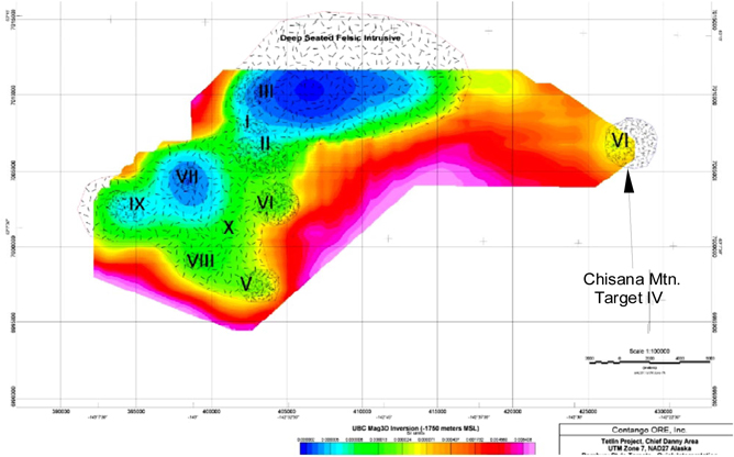
| Figure 1. | Targets from magnetic survey |
| | | | |
| Project 12-004 | | 3 | | BEHRE DOLBEAR |
|
Overview of Contango Ore, Inc.’s Tetlin Project January 2012 |
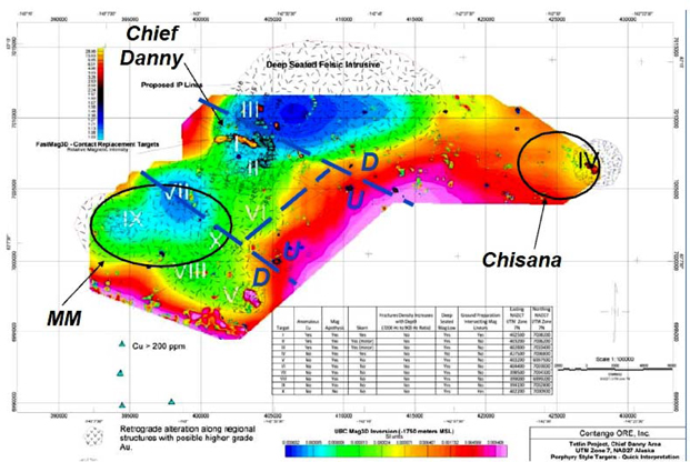
| Figure 2. | Location of Chief Danny, MM, and Chisana Targets |
CHIEF DANNY/SADDLE
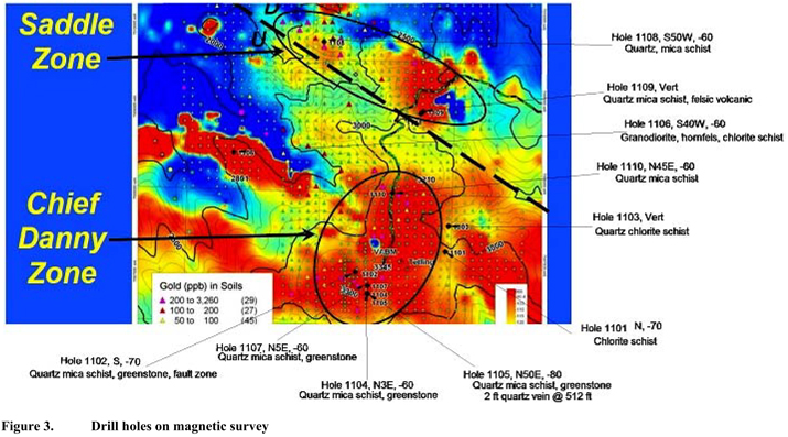
Behre Dolbear considered the drill hole geology at Chief Danny superimposed on the magnetic survey and finds no rocks with high magnetic susceptibility to correspond with the anomalous high response depicted on the graphic of the survey. Behre Dolbear suggests that the pattern of the response, seen on the graphic, may be from more deep seated, massive rocks that were not tested by the drilling. The pattern of the magnetic response does suggest an intrusive in the area and mineralization sampled at Chief Danny likely resulted from fluids from the intrusive or were remobilized by heat or a combination of both (Figure 3).
| | | | |
| Project 12-004 | | 4 | | BEHRE DOLBEAR |
|
Overview of Contango Ore, Inc.’s Tetlin Project January 2012 |
| | | | |
| Project 12-004 | | 5 | | BEHRE DOLBEAR |
|
Overview of Contango Ore, Inc.’s Tetlin Project January 2012 |
Drill holes 1104, 1105, and 1107 recovered mineralized core from structures assumed to be south dipping. Hole 1102 was oriented approximately parallel to the structures tested in holes 1104, 1105, and 1107. It sampled a 123 ft sequence at 213 ft depth with gold values exceeding 100 ppb. One 4 ft intercept at 328 ft returned an assay of 4.9 g Au/t. The copper assay of that interval was 0.5%. (5,000 ppm). The Avalon discussion suggests that the mineralization tested at Chief Danny and Saddle may be distal to a mineralizing intrusive. Behre Dolbear agrees. In Behre Dolbear’s experience, porphyry copper style mineralized intrusives are often located on the flanks of magnetic highs. It is apparent that the Chief Danny occurrence represents a significant mineralized system and deserves further investigation.
Behre Dolbear suggests drilling on the small magnetic low east of hole 1109. Hole 1109 sampled approximately 150 ft of rock that returned anomalous copper values ranging up to 0.1% at 255 ft.
Behre Dolbear suggests extending the soils grid to the west of Chief Danny to cover the shallow magnetic gradient south of hole 1106.
MM
The MM anomaly could represent a similar setting to the Chief Danny. The soil grid should be extended in the direction of the Chief Danny to reveal possible drill targets.
COPPER HILL
The overthrust zone at Copper Hill is an attractive target for gold mineralization. Behre Dolbear suggests the soil sampling be extended to the eastern flank of the hill and the contact zone prospected where accessible.
CHISANA
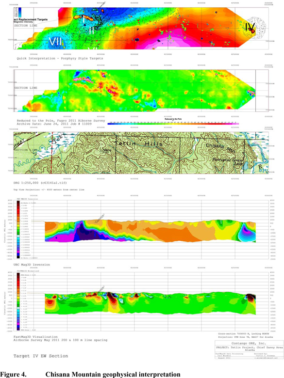
Pan concentrates from two samples on the north slope of Chisana Mountain contained visible gold and eight soil sample returned assays exceeding 200 ppb. The aerial magnetic surveys locate a small magnetic high coincident with Chisana Mountain and it may represent a small intrusive body satellitic to the larger mass interpreted to the west. The soil grid should be extended to cover the eastern slope of Chisana Mountain and the drainage above Porcupine Grass Lake, as time and available resources permit (Figure 4).
CONCLUSIONS
Behre Dolbear concludes that the exploration efforts on the Tetlin lands have been well conceived and executed in difficult field conditions.
Further exploration is justified with emphasis on the four prospects mentioned above, Chief Danny/Saddle, MM, Chisana, and Copper Hill.
| | | | |
| Project 12-004 | | 6 | | BEHRE DOLBEAR |
|
Overview of Contango Ore, Inc.’s Tetlin Project January 2012 |
| | | | |
| Project 12-004 | | 7 | | BEHRE DOLBEAR |