Exhibit 99.1
TECHNICAL REPORT ON the Lms gold project,
goodpaster MINING District,
Alaska
October 22, 2014
PREPARED FOR:
CORVUS GOLD INC.
by
QUALIFIED PERSONS:
Ed Hunter, BSc., P.Geo. Consulting Geologist Hunter Geo Logic, Inc. Lee Creek, B.C. VOE 1M4 250-679-8347 | Gary Giroux, M.A. Sc., P. Eng. Giroux Consultants Ltd. 1215-675 W. Hastings St. Vancouver, B.C. V6B 1N2 604-684-0899 |
| |
DATE AND SIGNATURE PAGE
Corvus Gold Inc.: Technical Report on the LMS Gold Project, Goodpaster Mining District, Alaska.
The effective date of this report is August 1, 2014.
Dated this 22nd day of October, 2014
(signed)Ed Hunter [Sealed]
Ed Hunter, BSc., P.Geo
Geologist
(signed)Gary H. Giroux [Sealed]
Gary H. Giroux, M.A. Sc., P. Eng.
Geological Engineer
| Technical Report on the LMS Gold Project, Goodpaster Mining District, Alaska | October 22, 2014 |
AUTHOR’S CERTIFICATE
Ed Hunter
I, Ed Hunter, of 1324 Demster Road, Lee Creek, British Columbia, Canada do hereby certify that:
1) I am a consulting geologist.
2) I am a graduate of the University of British Columbia in 1970 with a BSc. in Geology.
3) I am a member in good standing of the Association of Professional Engineers and Geoscientists of the Province of British Columbia.
4) I have practiced my profession continuously since 1970. I have worked as an exploration geologist and exploration manager involved directly in the evaluation of early stage exploration projects for 44 years, in five countries, including 32 years with Inco Ltd., among others.
5) I have read the definition of “qualified person” set out in National Instrument 43-101 (“NI 43-101”) and certify that by reason of my education, past relevant work experience and affiliation with a professional association (as defined in NI 43-101), I fulfill the requirements to be a “qualified person” for the purposes of NI 43-101.
6) I am responsible for the preparation of the technical report titled “TECHNICAL REPORT ON THE LMS GOLD PROJECT, GOODPASTER MINING DISTRICT, ALASKA” (the “Technical Report”), with the exception of Section 14 and the related portions of Sections 1, 17 and 18. I have visited the LMS property several times between 2004 and 2007, and spent one month on the property in September 2008, 8 days on the property in 2010 (August 3-10), and one day on April 10, 2014.
7) Prior to being retained by International Tower Hill Mines Ltd. (predecessor in interest to Corvus Gold Inc. (the “issuer”)), I have not had prior involvement with the property that is the subject of the Technical Report.
8)As of the effective date of the Technical Report, to the best of my knowledge, information and belief, the portions of the Technical Report for which I am responsible contain all scientific and technical information that is required to be disclosed to make the portions of the Technical Report for which I am responsible not misleading.
9) I am independent of the issuer applying all of the tests in section 1.5 of NI 43-101.
10) I have read NI 43-101, and the portions of the Technical Report for which I am responsible have been prepared in compliance with NI 43-101.
Dated this 22nd day of October, 2014.
(signed)Ed Hunter [Sealed]
Ed Hunter, P. Geo., BSc.
| Ed Hunter; Hunter Geo Logic Inc. | Gary Giroux; Giroux Consultants Ltd. | ii |
| Technical Report on the LMS Gold Project, Goodpaster Mining District, Alaska | October 22, 2014 |
AUTHOR’S CERTIFICATE
Gary H. Giroux
I, Gary H. Giroux, of 982 Broadview Drive, North Vancouver, British Columbia, Canada do hereby certify that:
1) I am a consulting geological engineer with an office at #1215 - 675 West Hastings Street, Vancouver, British Columbia.
2) I am a graduate of the University of British Columbia in 1970 with a B.A. Sc. and in 1984 with a M.A. Sc., both in Geological Engineering.
3) I am a member in good standing of the Association of Professional Engineers and Geoscientists of the Province of British Columbia.
4) I have practiced my profession continuously since 1970. I have had over 30 years’ experience estimating mineral resources. I have previously completed resource estimations on a wide variety of precious metal deposits both in B.C. and around the world, many similar to the LMS Gold Project.
5) I have read the definition of “qualified person” set out in National Instrument 43-101 (“NI 43-101”) and certify that by reason of my education, past relevant work experience and affiliation with a professional association (as defined in NI 43-101), I fulfill the requirements to be a “qualified person” for the purposes of NI 43-101.
6) I am responsible for the preparation of Section 14, and the relevant portions of Sections 1, 17 and 18, of the technical report titled “TECHNICAL REPORT ON THE LMS GOLD PROJECT, GOODPASTER MINING DISTRICT, ALASKA (the “Technical Report”). I have not visited the property.
7) Prior to being retained by International Tower Hill Mines Ltd. (predecessor in interest to Corvus Gold Inc. (the “issuer”)), I have not had prior involvement with the property that is the subject of the Technical Report.
8)As of the effective date of the Technical Report, to the best of my knowledge, information and belief, the portions of the Technical Report for which I am responsible contain all scientific and technical information that is required to be disclosed to make the portions of the Technical Report for which I am responsible not misleading.
9) I am independent of the issuer applying all of the tests in section 1.5 of NI 43-101.
10) I have read NI 43-101, and the portions of the Technical Report for which I am responsible have been prepared in compliance with NI 43-101.
Dated this 22nd day of October, 2014.
(signed)Gary H. Giroux [Sealed]
Gary H. Giroux, P. Eng., M.A. Sc.
| Ed Hunter; Hunter Geo Logic Inc. | Gary Giroux; Giroux Consultants Ltd. | iii |
| Technical Report on the LMS Gold Project, Goodpaster Mining District, Alaska | October 22, 2014 |
TABLE OF CONTENTS
| Section | | page |
| 1.0 | Summary | 1 |
| | | |
| 2.0 | Introduction | 2 |
| | | |
| | 2.1 | Introduction | |
| | 2.2 | Terms of Reference | |
| | 2.3 | Purpose of Report | |
| | 2.4 | Sources of Information | |
| | 2.5 | Field Examination | |
| | | | |
| 3.0 | Reliance on Other Experts | 3 |
| | | |
| 4.0 | Property Description and Location | 3 |
| | 4.1 | Area and Location | |
| | 4.2 | Claims and Agreements | |
| | 4.3 | Environmental Requirements | |
| | 4.4 | Permits | |
| | 4.5 | Other Considerations | |
| | | | |
| 5.0 | Accessibility, Climate, Local Resources, Infrastructure and Physiography | 6 |
| | 5.1 | Accessibility | |
| | 5.2 | Climate | |
| | 5.3 | Local Resources | |
| | 5.4 | Infrastructure and Physiography | |
| | | | |
| 6.0 | History | 9 |
| | | |
| 7.0 | Geological Setting and Mineralization | 9 |
| | 7.1 | Regional Geologic Setting | |
| | 7.2 | Local Geology | |
| | 7.3 | Mineralization | |
| | | | |
| 8.0 | Deposit Types | 25 |
| | | |
| 9.0 | Exploration | 26 |
| Ed Hunter; Hunter Geo Logic Inc. | Gary Giroux; Giroux Consultants Ltd. | iv |
| Technical Report on the LMS Gold Project, Goodpaster Mining District, Alaska | October 22, 2014 |
| Section | | page |
| 10.0 | Drilling | 30 |
| | 10.1 | 2005 Drill Program | |
| | 10.2 | 2006 Drill Program | |
| | 10.3 | 2010 Drill Program | |
| | 10.4 | 2011 Drill Program | |
| 11.0 | Sample Preparation, Analyses and Security | 36 |
| | 11.1 | 2004 to 2006 Procedures | |
| | 11.2 | 2007 Procedures | |
| | 11.3 | 2010 and 2011 Procedures | |
| | | | |
| 12.0 | Data Verification | 37 |
| | 12.1 | Assay Verification | |
| | 12.2 | Database Error Checks | |
| | | | |
| 13.0 | Mineral Processing and Metallurgical Testing | 38 |
| | | |
| 14.0 | Mineral Resource Estimate | 38 |
| | 14.1 | Geologic Solid Models | |
| | 14.2 | Data Analysis | |
| | 14.3 | Composites | |
| | 14.4 | Variography | |
| | 14.5 | Block Model | |
| | 14.6 | Bulk Density | |
| | 14.7 | Grade Interpolation | |
| | 14.8 | Classification | |
| | 14.9 | Model Verification | |
| | | | |
| 15.0 | Adjacent Properties | 53 |
| | | |
| 16.0 | Other Relevant Data and Information | 54 |
| | | |
| 17.0 | Interpretation and Conclusion | 54 |
| | | |
| 18.0 | Recommendations | 57 |
| | 18.1 | Recommended Exploration | |
| | 18.2 | Budget | |
| | | | |
| 19.0 | References | 58 |
| Ed Hunter; Hunter Geo Logic Inc. | Gary Giroux; Giroux Consultants Ltd. | v |
| Technical Report on the LMS Gold Project, Goodpaster Mining District, Alaska | October 22, 2014 |
LIST OF FIGURES
| Figure | | page |
| | | |
| Figure 1 | Location map of Alaska showing the LMS property. | 4 |
| Figure 2 | Map showing the LMS claim block. | 5 |
| Figure 3 | Photo showing LMS camp during 2010 Drilling Program. | 8 |
| Figure 4 | Terrane map of Alaska showing the Yukon-Tanana Terrane. | 10 |
| Figure 5 | Cross section of the Camp Zone. | 11 |
| Figure 6 | Photo of Schist Unit. | 12 |
| Figure 7 | Photo of Calc-silicate band within Schist Unit. | 13 |
| Figure 8 | Photo of banded Graphitic Quartzite Unit. | 13 |
| Figure 9 | Photo of Lower Gneiss Unit. | 13 |
| Figure 10 | A stereonet plot of poles to foliation from ITH holes in the Camp Zone. | 15 |
| Figure 11 | A stereonet plot of poles to foliation using all holes except LM-05-15. | 16 |
| Figure 12 | Examples of fold relations observed in HQ core. | 17 |
| Figure 13 | Photos of Vuggy Quartz Veins with visible Gold in Graphitic Quartzite Breccia. | 19 |
| Figure 14 | Photo of Native Crystalline Gold in Vuggy Quartz Veinlets. | 20 |
| Figure 15 | Photo of high grade Quartz Sulfide veining in Lower Gneiss. | 20 |
| Figure 16 | A view looking WNW down the fold axis showing the high grade intercepts. | 22 |
| Figure 17 | A view looking down the fold axis highlighting the zones of high grade gold intercepts that parallel the axial plane. | 23 |
| Figure 18 | A plan view, looking down on the axial plane showing the +5 grams Au intercepts. | 24 |
| Figure 19 | A stereonet plot of poles to veins showing low grade and high grade. | 25 |
| Figure 20 | Photo of original sample containing 6.2 g/t Au from the Discovery Outcrop. | 26 |
| Figure 21 | A photo of a 2 metre deep soil hole through loess and sand. | 27 |
| Figure 22 | A plot showing soil sample locations by sample type and year taken. | 28 |
| Figure 23 | Plots of metal values for surface geochemical samples. | 29 |
| Figure 24 | A plan view of the Camp Zone showing drill holes and their traces. | 32 |
| Figure 25 | Leapfrog view looking North. | 39 |
| Figure 26 | Leapfrog view looking North. | 40 |
| Figure 27 | Lognormal Cumulative Frequency Plot for Au in Upper Schist Domain. | 41 |
| Figure 28 | Isometric view of block model. | 44 |
| Figure 29 | Section 571200 E, showing estimated Au (g/t). | 50 |
| Figure 30 | Section 571300 E, showing estimated Au (g/t). | 51 |
| Figure 31 | Section 571400 E, showing estimated Au (g/t). | 52 |
| Figure 32 | Section 571500 E, showing estimated Au (g/t). | 53 |
| Figure 33 | Map showing LMS property and adjacent claims. | 54 |
| Figure 34 | Schematic diagram shows LMS mineralization concept model. | 56 |
| Ed Hunter; Hunter Geo Logic Inc. | Gary Giroux; Giroux Consultants Ltd. | vi |
| Technical Report on the LMS Gold Project, Goodpaster Mining District, Alaska | October 22, 2014 |
LIST OF TABLES
| Table | | page |
| | | |
| Table 1 | Drill hole Information | 30 |
| Table 2 | Highlights of the 2005 Drilling Program | 33 |
| Table 3 | Highlights of the 2006 Drilling Program | 33 |
| Table 4 | Highlights of the 2010 Drilling Program | 35 |
| Table 5 | Highlights of the 2011 Drilling Program | 35 |
| Table 6 | Results of Re-sampling of Drill Core and Discovery Outcrop | 38 |
| Table 7 | Sample Statistics for Gold | 40 |
| Table 8 | Overlapping gold populations in Upper Schist | 41 |
| Table 9 | Capping Levels for Au | 42 |
| Table 10 | Sample Statistics for Capped Gold | 42 |
| Table 11 | 2.5 M Composite Statistics for Gold | 42 |
| Table 12 | Semivariogram Parameters for Gold | 43 |
| Table 13 | Summary of Specific Gravity Determinations | 45 |
| Table 14 | Kriging Parameters for LMS Gold | 46 |
| Table 15 | LMS Inferred Resource | 48 |
| Table 16 | Phase 1 Budget | 58 |
| Ed Hunter; Hunter Geo Logic Inc. | Gary Giroux; Giroux Consultants Ltd. | vii |
| Technical Report on the LMS Gold Project, Goodpaster Mining District, Alaska | October 22, 2014 |
1.0 Summary
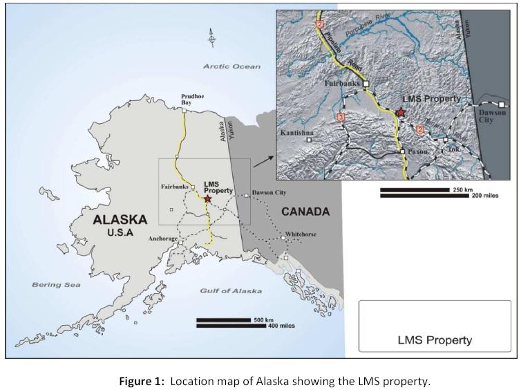
The LMS property is situated 20 km north of Delta Junction, and 150 km southeast of Fairbanks, Alaska at 64⁰ 12'N, 145⁰ 30' W, in the Goodpaster Mining District. Corvus Gold Inc. has 100% ownership of the LMS property through its Alaska subsidiary, Raven Gold Alaska Inc.
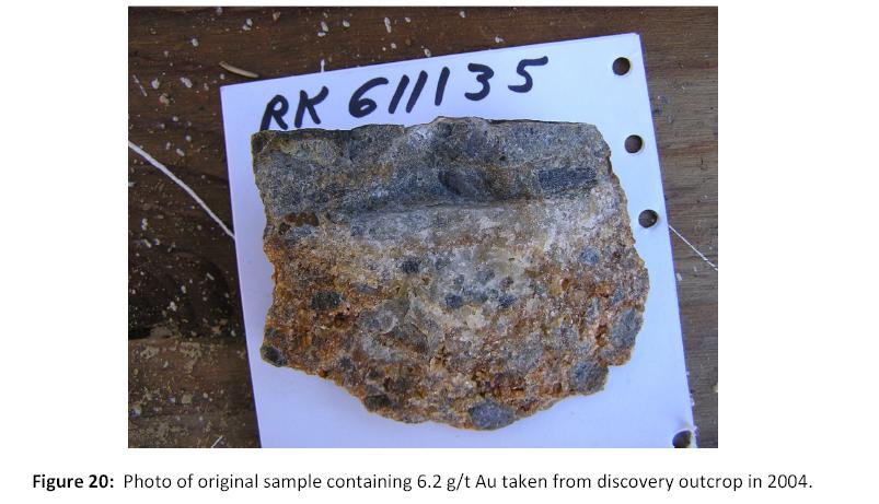
This part of the district has had no known previous exploration prior to regional reconnaissance surface sampling by AngloGold Ashanti (USA) Exploration Inc. (“AGA”) in 2004, even though the region has attracted considerable interest following the discovery of the Pogo deposit in 1994, 40 km to the northeast. Discovery of a gold-bearing outcrop (6.2 g/t Au) led to further sampling and drilling in 2005 which delineated two styles of gold mineralization: 1) gold within a folded, stratabound tabular zone consisting of silicified graphitic quartzite breccia; and 2) high grade narrow veins. Mineralization within the graphitic quartzite breccia zone has been defined through drilling to a down plunge depth of 850 m. Along with the high-grade veins, this area of the LMS property is known as the Camp Zone and is situated at the southeast end of a 6 km long, northwest-trending zone of aligned surface geochemical samples containing anomalous gold, arsenic and lesser silver and copper.
A resource evaluation for gold contained within the Camp Zone of the LMS property offers a range of grades and tonnages with corresponding contained ounces.An inferred resource at a cut-off grade of 0.5 g/t Au has been highlighted as a possible open pit cut-off, and defines 8.32 M tonnes of material estimated to contain 267,000 oz. of Au at an average grade of 1.00 g/t Au.This zone remains open along strike and at depth. An inferred mineral resource is defined by CIM as follows:
“An ‘Inferred Mineral Resource’ is that part of a Mineral Resource for which quantity and grade or quality can be estimated on the basis of geological evidence and limited sampling and reasonably assumed, but not verified, geological and grade continuity. The estimate is based on limited information and sampling gathered through appropriate techniques from locations such as outcrops, trenches, workings and drill holes.”
“Due to the uncertainty that may be attached to Inferred Mineral Resources, it cannot be assumed that all or any part of an Inferred Mineral Resource will be upgraded to an Indicated or Measured Mineral Resource as a result of continued exploration. Confidence in the estimate is insufficient to allow the meaningful application of technical and economic parameters or to enable an evaluation of economic viability worthy of public disclosure. Inferred Mineral Resources must be excluded from estimates forming the basis of feasibility or other economic studies.”
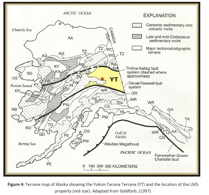
Rocks within the LMS property area lie within the Yukon-Tanana Terrane, a structurally complex, composite terrane that was accreted to North America in the mid to Late Cretaceous period. Among the diverse suites of rocks in this terrane, some of those underlying the LMS property area (schist, gneiss, and quartzite) are similar in composition and structural character to the host rocks at Pogo.
Mineralization in this region, including at Pogo, is believed to be intrusion-related. The first author's observations are consistent with this interpretation, even though no intrusive rocks, except for mafic dikes, have been identified on the LMS property. Fluids derived from an intrusion at depth or at a distance laterally can migrate along structures to produce the observed veins and gold mineralization.
| Ed Hunter; Hunter Geo Logic Inc. | Gary Giroux; Giroux Consultants Ltd. | 1 |
| Technical Report on the LMS Gold Project, Goodpaster Mining District, Alaska | October 22, 2014 |
Exploration of the LMS property is at a relatively early stage with discovery and identification of the graphitic quartzite breccia and vein zones extending from surface to greater than 850 m down plunge. It is recommended that exploration of the LMS property continue with a program of drilling and surface sampling in the form of augering and/or trenching.
The aim of exploration should be to 1) drill test what appears to be a zone of high grade veins that parallel the axial plane of the fold at the Camp Zone; 2) evaluate the other anomalous areas within the claim block by auger sampling or trenching designed to identify WNW trending structures like those identified at the Camp Zone; 3) continue to conduct soil sampling throughout the LMS property in a pattern designed to identify narrow high grade WNW trending structures.
2.0 Introduction
2.1 Introduction
Hunter Geo Logic Inc. of Lee Creek, B.C. (“HGL”) and Giroux Consultants Ltd. of Vancouver, B.C. (“GCL”) have been requested by Corvus Gold Inc. (“CGI”) to provide a new independent technical report on the LMS gold project in the Goodpaster mining district of east central Alaska. Much of the information in this report was sourced from the last NI 43-101 technical report titled "Summary Report on the LMS Gold Project, Goodpaster District, Alaska" authored by Paul Klipfel of Mineral Resource Services, Inc. (“MRS”) and Gary Giroux of GCL, dated June 15, 2010. The 2010 report covers the exploration work from discovery in 2004 through to the end of 2009. This present report covers the period from discovery in 2004 through to the end of 2013 and includes a resource estimate. The resource estimate portion of this report has been prepared by GCL.
2.2 Terms of Reference
Ed Hunter of HGL, and Gary Giroux of GCL were commissioned by CGI to prepare this report to support an initial resource estimate for the LMS property. Ed Hunter and Gary Giroux are each independent consultants and are Qualified Persons (QP) for the purposes of this report.
2.3 Purpose of Report
The purpose of this report is to provide an independent evaluation of the LMS property, the exploration and discovery potential in that area, past exploration, its relevance and adequacy to assess the mineralization potential of the area, and provide recommendations for future work. This report conforms to the guidelines set out by the Canadian Securities Administrators National Instrument 43-101.
| Ed Hunter; Hunter Geo Logic Inc. | Gary Giroux; Giroux Consultants Ltd. | 2 |
| Technical Report on the LMS Gold Project, Goodpaster Mining District, Alaska | October 22, 2014 |
2.4 Sources of Information
Information used in this report has been provided to HGL and GCL by CGI in February, 2014. The first author (Mr. Hunter) spent one day on site in 2014 reviewing core and taking core samples to verify original assays, and was also involved as an independent contractor during some of the earlier sampling programs. In addition, general geologic information available to the public through peer review journals, publications by the U.S. Geological Survey, and agencies of the State of Alaska has been used.
2.5 Field Examination
Mr. Hunter has visited the LMS property on many occasions between 2004 and 2006, becoming very familiar with the discovery outcrop, the drill sites and the areas of surface sampling. On April 10th, 2014 Mr. Hunter visited the LMS property for a day to examine the drill core from the 2010 and 2011 drill programs.
Mr. Giroux is responsible for the resource estimate (section 14), but has not visited the LMS property.
3.0 Reliance on Other Experts
The authors of this report have not relied upon information provided by any relevant experts.
4.0 Property Description and Location
4.1 Area and Location
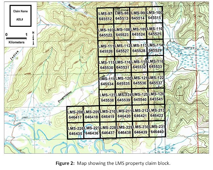
The LMS property is located in the Goodpaster Mining District, approximately 20 km north of Delta Junction, and 150 km southeast of Fairbanks, Alaska, at 64°, 12' N, 145°, 30' W. The LMS property consists of 36 contiguous State of Alaska mining claims held 100 % by Raven Gold Alaska Inc. (“RGA”), a wholly owned subsidiary of CGI (Figure 1). The claims cover an area of 2331 ha (9 square miles).
The principle area of interest surrounds a gold-bearing outcrop that lies at the top of a hill and along the adjacent ridgeline approximately 1 km south of the center of the claim block. Here, the outcrop and down-plunge drill intercepts lie within a northwest trending, ~ 5 km (3 mile) long zone of anomalous gold in soil samples. Surface geochemical sampling defines anomalous gold and pathfinder elements within six areas, each exceeding 500 m in diameter. Scattered other anomalies are also present.
| Ed Hunter; Hunter Geo Logic Inc. | Gary Giroux; Giroux Consultants Ltd. | 3 |
| Technical Report on the LMS Gold Project, Goodpaster Mining District, Alaska | October 22, 2014 |
4.2 Claims and Agreements
The LMS property (36 Alaska State mining claims, 2331 hectares) is owned 100% by RGA (Figure 2). There are no underlying agreements. The LMS property was acquired by RGA as a consequence of the spin-out, on August 26, 2010, of CGI from International Tower Hill Mines Ltd. (“ITH”) as a separate public company by way of a corporate arrangement under the B.C.Business Corporation Act. In connection with the spin-out, the LMS property was transferred from Talon Gold Alaska Inc. (“TGA”), a wholly owned Alaska subsidiary of ITH, to RGA.
On Alaska State lands, the state holds both the surface and subsurface rights. State of Alaska mining claims require an annual rental payment of US$100/claim to be paid to the state (due on or before noon on September 1 in each year) for the first five years, US$220 per year for the second five years, and UD$520 per year thereafter. As a consequence, all Alaska State Mining Claims have an expiry date of noon on September 1 of each year. In addition, there is a minimum annual work expenditure requirement of US$400 per 160 acre claim (due on or before noon on September 1 in each year) or cash-in-lieu, and an affidavit evidencing that such work has been performed is required to be filed on or before November 29 in each year (excess work can be carried forward for up to four years). If such requirements are met, the claims can be held indefinitely.
| Ed Hunter; Hunter Geo Logic Inc. | Gary Giroux; Giroux Consultants Ltd. | 4 |
| Technical Report on the LMS Gold Project, Goodpaster Mining District, Alaska | October 22, 2014 |
Holders of Alaska State mining locations are required to pay a production royalty on all revenues received from minerals produced on state land. The production royalty requirement applies to all revenues received from minerals produced from a state mining claim or mining lease during each calendar year. Payment of royalty is in exchange for and to preserve the right to extract and possess the minerals produced. The current rate is three (3%) of net income, as determined under theMining License Tax Law(Alaska).
The claims constituting the LMS property have been staked using GPS positioning for placement of corner stakes and are filed under the Township and Range system. The claims have not been surveyed. All annual filings have been submitted and the claims are in good standing.
Holders of Alaska State mining claims have the right to the use of land or water included within mining claims only when necessary for mineral prospecting, development, extracting, or basic processing, or for storage of mining equipment. However, the exercise of such rights is subject to the appropriate permits being obtained.
| Ed Hunter; Hunter Geo Logic Inc. | Gary Giroux; Giroux Consultants Ltd. | 5 |
| Technical Report on the LMS Gold Project, Goodpaster Mining District, Alaska | October 22, 2014 |
4.3 Environmental Requirements
Activities at the LMS property are required to operate within all normal US Federal, State, and local environmental rules and regulations. This includes proper and environmentally conscientious protection of operational areas against spills, capture and disposal of any hazardous materials including aviation fuel, etc., reclamation of disturbed ground, plugging or capping drill holes, and removal of all refuse.
CGI, ITH and AGA have each undertaken a prescribed method of bark scoring of downed timber to help forest managers of the Alaskan Department of Natural Resources (“DNR”) mitigate forest damage done by the engraver beetle.
There are no known existing environmental liabilities at the LMS property.
4.4 Permits
Operations which cause surface disturbance, such as drilling, are subject to approval and receipt of a permit from the DNR. The past operations from 2004 through to 2006 were permitted by AGA. In 2006, ITH and TGA entered into an option agreement with AGA to acquire an interest in the LMS property, and TGA took over the permitting for its activities on the LMS property under the option agreement. In 2008, TGA acquired the residual interest of AGA in the LMS property. In 2010, First Star USA Inc. (a wholly owned Alaskan subsidiary of First Star Resources Inc.) (“FSR”), entered into an earn-in agreement with RGA to acquire an interest in the LMS property and was responsible for permitting the field operations carried out by FSR in 2010 and 2011. The FSR option agreement was terminated at the end of 2011. RGA has been responsible for permitting field operations at LMS since 2012.
4.5 Other Considerations
There are no known native rights or community issues that concern the LMS property area at this time.
5.0 Accessibility, Climate, Local Resources, Infrastructure and Physiography
5.1 Accessibility
The LMS property is approximately 150 km (90 miles) southeast of Fairbanks and 20 km (12 miles) north of Delta Junction.
In the summer, access from Fairbanks is via State Route 2 (Richardson Highway) to the point where the Alaska Pipeline and the highway cross the Tanana River. From here, the LMS property can be accessed by boat. Travel is approximately 15 km (10 miles) up the Tanana River and then 3 km (2 miles) upstream on the Goodpaster River to a landing with an ATV trail to camp.
In the winter, between November and March, the LMS property can be accessed via a well-developed winter trail that runs from Quartz Lake directly to the property. This trail provides overland access for heavy equipment including bulldozers and track-mounted drills as well as other supply vehicles.
| Ed Hunter; Hunter Geo Logic Inc. | Gary Giroux; Giroux Consultants Ltd. | 6 |
| Technical Report on the LMS Gold Project, Goodpaster Mining District, Alaska | October 22, 2014 |
A large helipad has been constructed at the camp which allows ready helicopter access.
Travel within the LMS property is by ATV. Several trails constructed for the various phases of drilling allow good access within the property.
5.2 Climate
The climate in this part of Alaska is continental and varies from mild-warm and temperate in the summer to very cold in the winter. Precipitation ranges from approximately 1.1 cm/month in the winter to about 5.1 cm/month in the summer. Snow accumulation in winter is limited, but is preserved by cold temperatures.
5.3 Local Resources
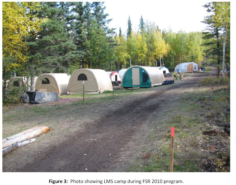
The LMS property is serviced from Fairbanks. State Route 2 from Fairbanks to Delta Junction provides highway access to within 15 km of the property. Fairbank (population 87,000) is serviced by major airlines with numerous daily flights to and from Anchorage and other locations. Helicopters and fixed wing aircraft are plentiful in this area. All supplies necessary for the project can be obtained in Fairbanks.
The camp at the LMS property currently consists of facilities, quarters and work space for approximately 10 people (Figure 3).
| Ed Hunter; Hunter Geo Logic Inc. | Gary Giroux; Giroux Consultants Ltd. | 7 |
| Technical Report on the LMS Gold Project, Goodpaster Mining District, Alaska | October 22, 2014 |
5.4 Infrastructure and Physiography
The LMS property covers an area of rather subdued topography consisting of low to moderate hills rising to an elevation of approximately 800m (2500 feet). The terrain is covered by deciduous alder, birch, and willow forest with scattered stands of spruce.
The area is drained to the west by Progressive Creek and further north by Rapid Creek and to the east by Liscum Slough. These streams drain into flat valley bottoms near the confluence of the Goodpaster and Tanana Rivers a few kilometres to the west of the LMS property.
There is no infrastructure in the immediate vicinity of the LMS property except trails and established camp facilities. To the west is State Route 2 and access to the town of Delta Junction and to Fairbanks to the northwest.
Wildlife in the area includes moose, bears, and smaller animals.
| Ed Hunter; Hunter Geo Logic Inc. | Gary Giroux; Giroux Consultants Ltd. | 8 |
| Technical Report on the LMS Gold Project, Goodpaster Mining District, Alaska | October 22, 2014 |
6.0 History
The Goodpaster District specifically, and the Yukon-Tanana terrane, in general, has long been considered a prospective region. In the last 20 years, the discovery and development of the Pogo deposit 40 km to the northeast and the Coffee deposit in the Yukon has led to increased interest in this region.
AGA began a regional scale, grassroots exploration program in the Goodpaster Mining District of Alaska in 2001, and in the vicinity of the present LMS property in 2004. Stream sediment sampling was the primary exploration tool used. In areas of low rolling hills where drainages were not well developed ridge and spur soil sampling was employed. It was during ridge and spur soil sampling that an outcrop of gold-bearing graphitic quartzite was found on a ridge top. Rock samples from the "Discovery" outcrop and adjacent float returned gold values up to 6.2 g/t. AGA followed up these results with a 17 hole (2600m) discovery drill program in the spring and summer of 2005. This drilling defined a broad, near surface zone of gold mineralization averaging about 1.5 g/t with numerous other narrow higher-grade gold intercepts. These encouraging results were followed up by a further 19 hole drill program by TGA in 2006. Geochemical sampling using shovels and track mounted augers was conducted by AGA in 2005 and by RGA in 2006 and 2007. In 2010, CGI was spun out of ITH and the LMS property ownership was transferred from TGA to RGA as part of the spin-out. The LMS property was joint-ventured to FSR in 2010 and 2011. FSR drilled 3 holes (1102m) in 2010 and 8 holes (2365.5m) in 2011. The FSR/RGA option agreement was terminated in November, 2011.
7.0 Geological Setting and Mineralization
7.1 Regional Geologic Setting
The LMS property is located in rocks of the Yukon-Tanana (YT) Terrane (Figure 4), a regionally extensive accretionary complex of Paleozoic to early Mesozoic volcanic, intrusive, and sedimentary rocks that have been metamorphosed to greenschist and amphibolite facies. Multiple stages of deformation have created complex structural relationships which are poorly understood. The terrane has been intruded by several suites of granitic rocks ranging in age from early Jurassic (212-185 Ma) to early Tertiary (50-70 Ma). Of these, the mid Cretaceous set (110-90 Ma) is the most studied and thought to be related to gold mineralization (Smith, et al., 2000). The YT Terrane is bounded on the north by the Tintina Fault system and on the south by the Denali Fault system (Figure 4). These major dextral faults trend west-northwest in this region and movement along them has led to the development of numerous second order and subsidiary faults that trend NE, NNW, and EW.
| Ed Hunter; Hunter Geo Logic Inc. | Gary Giroux; Giroux Consultants Ltd. | 9 |
| Technical Report on the LMS Gold Project, Goodpaster Mining District, Alaska | October 22, 2014 |
The regional topography consists of broad, rounded hills and interconnected ridgelines with long slopes weakly to moderately dissected by tributary valleys. Relief is in the order of 300-400m with main streams at a base level of approximately 300m. Burial of the terrain by windblown loess and sand contributes to a subdued topographic character. Higher ridge lines offer rare exposures of outcrop making it difficult to understand local geology.
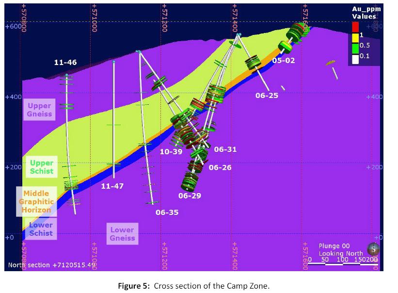
7.2 Local Geology
The LMS property is underlain by folded and metamorphosed Paleozoic schist, gneiss, quartzite, calc-silicate, and amphibolite (Figure 5).
| Ed Hunter; Hunter Geo Logic Inc. | Gary Giroux; Giroux Consultants Ltd. | 10 |
| Technical Report on the LMS Gold Project, Goodpaster Mining District, Alaska | October 22, 2014 |
No intrusive rocks, other than mafic dikes, are known to exist within the LMS property but a mid to late Cretaceous granitic intrusion with gold-bearing stockwork veins has been drilled a few kilometres to the north. Metamorphism is upper greenschist to lower amphibolite rank with an apparent late stage overprinting retrograde or hydrothermal event. The metamorphic rocks generally strike NS to NE and dip or plunge gently to the west. Outcrops are scarce, as Quaternary sand and loess cover most of the LMS property. Therefore, with the exception of the discovery outcrop, virtually all geologic information is derived from subsurface drill holes or soil pits.
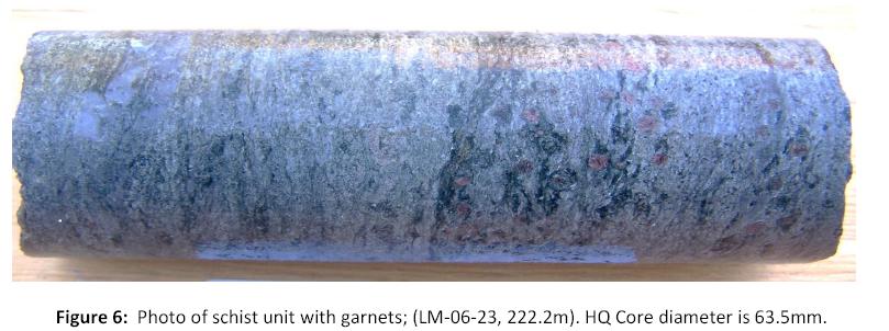
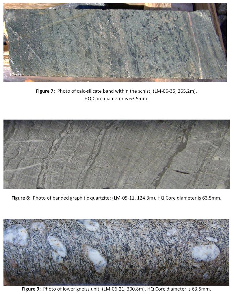
Host rocks have been grouped into two general categories and given field names of "schist" and "gneiss”. The "schist" suite consists predominantly of quartzite, quartz psammite, psammopelite, and calcareous (calc-silicate) versions of each (Figures 6 and 7). In addition to these major lithologies, graphitic quartzite makes up a minor but highly significant portion of the schist sequence (Figure 8). These graphitic quartzites are characterized by elevated concentrations of vanadium, molybdenum and phosphorus indicating that they originated as organic-rich sediments and may represent original cherty horizons. There are multiple zones of graphitic quartzites but only one appears to be continuous at the scale of the drilling to date. Another minor component of the stratigraphy are iron-rich calc-silicate rocks or iron formations. These take the form of actinolite-clinopyroxene-garnet rocks which have locally been retrograded to chlorite and in other places they are more silica rich and form biotite-rich schists. The presence of both cherts and iron-formations suggests that theses sediments accumulated in a relatively distal sediment starved environment.
| Ed Hunter; Hunter Geo Logic Inc. | Gary Giroux; Giroux Consultants Ltd. | 11 |
| Technical Report on the LMS Gold Project, Goodpaster Mining District, Alaska | October 22, 2014 |
These rocks have been metamorphosed to highest greenschist- low amphibolite rank as indicated by the presence of biotite and garnet(Figure 6). Most host rocks are significantly deformed, strained and recrystallized and exhibit platy schistose fabric to varying degrees. Multiple episodes of deformation are evident. Quartz, in particular, shows multiple stages of deformation and introduction. In the schist, quartz grains have undergone flattening and elongation and now display complex suture boundaries, a product of annealing, all of which occurred prior to at least two episodes of brittle deformation, brecciation, and silica introduction (Klipfel, 2007).
"Gneiss" consists of massive felsic igneous rock which has undergone considerable deformation and alteration (Figure 9). Little primary mineralogy or texture remains. Equigranular to local porphyritic texture is apparent macroscopically and in thin section where ghost crystal outlines are all that remain of primary texture. Gneiss exhibits an elongation fabric with elongation ratios ranging up to 5:1 although a few samples may show higher ratios. It is not clear if "gneiss" is after a primary volcanic or intrusive rock.
| Ed Hunter; Hunter Geo Logic Inc. | Gary Giroux; Giroux Consultants Ltd. | 12 |
| Technical Report on the LMS Gold Project, Goodpaster Mining District, Alaska | October 22, 2014 |
| Ed Hunter; Hunter Geo Logic Inc. | Gary Giroux; Giroux Consultants Ltd. | 13 |
| Technical Report on the LMS Gold Project, Goodpaster Mining District, Alaska | October 22, 2014 |
One of the geologic issues to be resolved is the relationship between gneiss and schist. Contacts between these groups of rocks generally appear to be layer parallel, but may be tectonic (breccia, "quartzite breccia"). Importantly, the gneiss and schist may be unrelated packages of rocks. The juxtaposition of a sedimentary package against an igneous package can be explained in many ways and is a subject of spirited debate among geologists involved with the LMS property. These assemblages may reflect one of the following;
1. be intact but deformed primary volcano-sedimentary stratigraphy,
2. fold repeated primary volcano-sedimentary stratigraphy (e.g. recumbent fold), or
3. the gneiss and schist could be fault juxtaposed (thrust or detachment) from different locations.
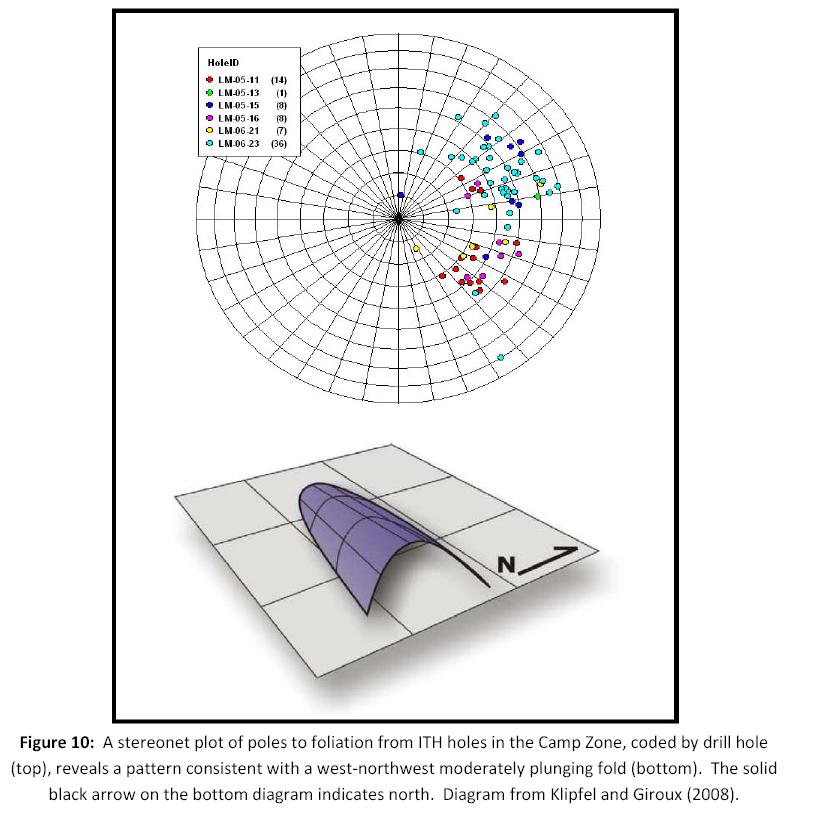
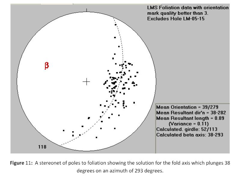
Regardless of interpretation, the current identified folds at the LMS property are multi-stage, with the most recent event producing an open fold gently to moderately plunging to the northwest (Figures 10 and 11).
| Ed Hunter; Hunter Geo Logic Inc. | Gary Giroux; Giroux Consultants Ltd. | 14 |
| Technical Report on the LMS Gold Project, Goodpaster Mining District, Alaska | October 22, 2014 |
| Ed Hunter; Hunter Geo Logic Inc. | Gary Giroux; Giroux Consultants Ltd. | 15 |
| Technical Report on the LMS Gold Project, Goodpaster Mining District, Alaska | October 22, 2014 |
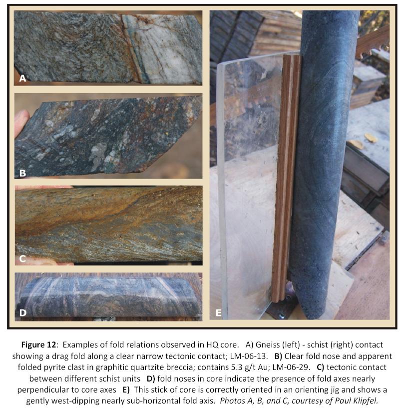
Examples of several different styles of folding have been observed in the drill core (Figure 12). Additional detailed work on the core is required to interpret the significance of these structures, particularly with respect to the recumbent, potentially isoclinal folds illustrated inFigures 12D and E.
| Ed Hunter; Hunter Geo Logic Inc. | Gary Giroux; Giroux Consultants Ltd. | 16 |
| Technical Report on the LMS Gold Project, Goodpaster Mining District, Alaska | October 22, 2014 |
Petrographic and fluid inclusion work (Klipfel, 2007; Reynolds, 2007) reveals three general episodes of quartz veining and mineralization. These are designated Q1, Q2, and Q3 (quartz stages 1, 2, and 3). Q1 consists of quartz introduced as local silicification of host rock and as fine to large bull quartz veins. Quartz grains of this group are highly strained, usually elongated, and display complex sutured grain boundaries. This episode of quartz introduction occurred prior to or during early deformation as indicated by the "wispy" style of fluid inclusions, highly strained quartz, shear deformation, elongation, and recrystallization of quartz veins(Reynolds, 2007). This event appears to correlate with the earliest identifiable deformation event, D1.
| Ed Hunter; Hunter Geo Logic Inc. | Gary Giroux; Giroux Consultants Ltd. | 17 |
| Technical Report on the LMS Gold Project, Goodpaster Mining District, Alaska | October 22, 2014 |
Q2 marks quartz and quartz-albite introduction along brittle shear fractures which cut orthogonal to obliquely across earlier D1 shear and foliation fabric. This deformation is designated here as D2. Some arsenopyrite, pyrite and possibly other sulfides were introduced with some of these veins. This relationship is clear where there are cross-cutting relationships, however, in isolation Q2 is difficult to distinguish from Q1.
Q3 is the designation for late-stage quartz, generally consisting of open-space filled dog-tooth quartz, but includes a variety of veins and introduced quartz textures which exhibit a complex sequence of individual pulses. Early Q3 quartz contains "wispy" fluid inclusions. These give way progressively outward along crystals to a type of fluid inclusion typical of shallow depths. For this reason, Q3 silica is interpreted as having been introduced into rocks that were being uplifted from the ductile mesothermal environment to a shallower 'epizonal' environment. This episode is designated here as D3 and apparently corresponds with the period of intrusion, uplift and associated mineralization. A final stage of carbonate veining with Pb, Zn and Sb sulfides appears to be introduced after the D3 quartz. Again, without cross-cutting relationships, late base metal sulfides are difficult to distinguish from Q2 or possibly earlier base metal sulfides. These late base metal sulfides may be different from other base metal sulfides which occur with calc-silicate rocks and do not necessarily occur with Q1, Q2 or Q3.
Host rocks were sericitized early, as the sericite exhibits fabric characteristics in common with the surrounding deformed quartz. This is evidence for a hydrothermal event prior to or during early deformation. Locally, sericite has been altered to kaolinite (Zamudio, 2006) and or chlorite during subsequent events.
From these relationships, it is interpreted that fluids associated with regional intrusion of Tintina Belt granite and granodiorite plutons traversed the LMS rocks in several pulses or as a continuous but evolving hydrothermal event. At one stage, fluid caused the formation of kaolinite from pre-existing sericite and/or relatively unaltered feldspar. This is the source of apparent argillic alteration in many samples. Following clay alteration and local leaching along fractures, quartz was introduced along with gold and arsenopyrite+/- stibnite. Some carbonate occurs in phyllosilicate-rich layers and may be primary or introduced during D1 deformation. It follows fabric patterns and defines compositional banding suggesting that it derives from a primary calcareous component in the sediment. Late Q3 carbonate fills open spaces left by Q3 quartz.
7.3 Mineralization
Gold mineralization appears to be of two main types with the possibility of a third type. The first type consists of gold associated with silicified, stratabound graphitic quartzite breccia. The concentration of brecciation in this zone may reflect the original competency contrast between the chert and the surrounding mica-rich lithologies. This breccia also forms the most laterally continuous of the two types of mineralization. Rocks within this zone are generally black, locally graphitic, brecciated, locally sheared, pyritic, and strongly silicified (Figure 12B).
| Ed Hunter; Hunter Geo Logic Inc. | Gary Giroux; Giroux Consultants Ltd. | 18 |
| Technical Report on the LMS Gold Project, Goodpaster Mining District, Alaska | October 22, 2014 |
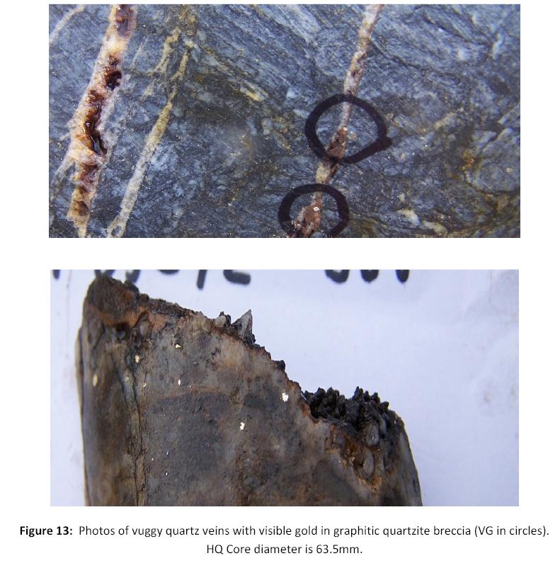
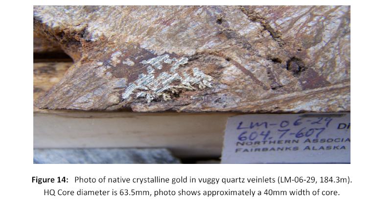
The second mineralization type consists of free gold on dog tooth quartz or in open-space-fill vuggy quartz veins. These veins clearly post-date and overprint the stratabound gold occurrence (Figures 13 and 14). These open space-filled veins occur preferentially in the quartzite and footwall gneiss presumably because these rocks are more brittle than the schist.
| Ed Hunter; Hunter Geo Logic Inc. | Gary Giroux; Giroux Consultants Ltd. | 19 |
| Technical Report on the LMS Gold Project, Goodpaster Mining District, Alaska | October 22, 2014 |
A third and possibly significant type of gold mineralization are the quartz sulfide veins found predominantly in the lower gneiss unit beneath the graphitic quartzite breccia horizon. These are possibly "feeder veins" to the overlying mineralization and they may constitute a significant target. Because of the complexity of the multistage veining it is not possible to determine with certainty if the gold present in these quartz sulfide veins is a third type of gold mineralization or if the gold is actually just an overprinting of the "second type", free gold mineralization (Figure 15).
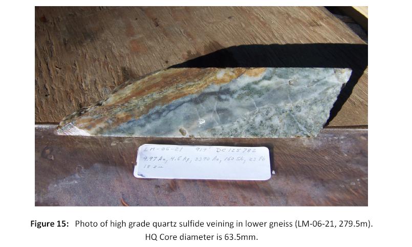
| Ed Hunter; Hunter Geo Logic Inc. | Gary Giroux; Giroux Consultants Ltd. | 20 |
| Technical Report on the LMS Gold Project, Goodpaster Mining District, Alaska | October 22, 2014 |
The veins, and possibly the gold in the stratabound silicified graphitic quartzite breccia, are interpreted here as shallow mesothermal veins that could be intrusion-related. It is also possible that the mineralizing fluids are metamorphic in origin, in which case mineralization would be considered “orogenic”. An intrusion-related origin for the gold mineralization seems most probable based on regional relations as well as features at LMS such as the metal suite, clay alteration, and creation of vuggy cavities for deposition of quartz and gold. The clay alteration and formation of cavities may be the product of acidic magmatic fluids. The first author has been unable to verify the information available with respect to the Pogo property, and such information is not necessarily indicative of the mineralization at the LMS property.
One early suggestion for the origin of the gold in the graphitic quartzite was that it was syngenetic. However, in areas where graphitic quartzite horizons are present and not extensively deformed there is no gold present. This suggests that the gold is introduced either during the deformation or after the rock has been broken and made permeable by the brecciation. Perhaps the graphite helped cause deposition of the gold. Even though the gold in the graphitic quartzite breccia appears to predate vein gold, it is reasonable to think that early silicifying hydrothermal fluids of the same gold event may have permeated laterally along this unit to deposit gold. If true, any structural or stratigraphic zone offering permeability to gold-bearing hydrothermal fluid could be mineralized, particularly if graphitic. As a structural zone, there may be more similar features in the area.
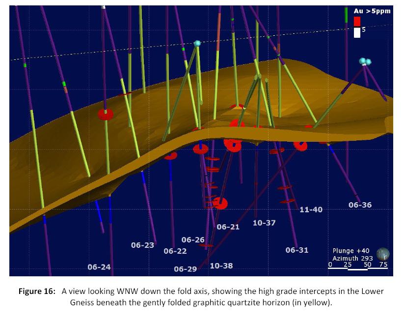
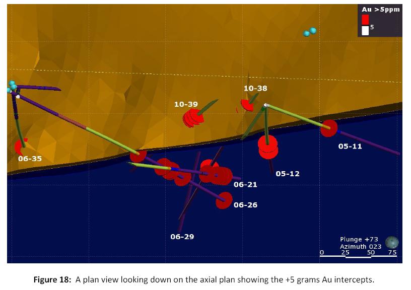
With the help of a 3D model of drill results it can be seen that the majority of the multi-gram gold intersections in the Lower Gneiss appear to fall along several sub vertical zones trending 290 degrees coincident with, and adjacent to, the axial plane of the fold in the Camp Zone (Figures 16, 17 and 18). None of the drill holes on the LMS property were designed to test these structures and, in fact, most of the drilling was sub parallel to these structures and failed to test this potentially significant high grade target.
In addition to gold, there are a myriad of other minor veins with base metal sulfides. The origin and association of these metals with gold is not clear. One interpretation that might explain the variation in metal content is that magmatic and/or metamorphic gold-bearing fluids passed through preexisting weak to very weak massive sulfide-style base-metal mineralization and remobilized these early-stage metals to varying degrees. This possibility is supported by the occurrence of chert, sulfide, and calc-silicate rocks within schist suite stratigraphy. These rock types are typical of settings that host volcanogenic massive sulfide type mineralization. Gold mineralization, however, appears to be later and clearly related to both sub-vertical cross-cutting veins as well as the tabular graphitic quartzite body.
At the LMS property, both ITH and FSR drilled oriented core which should have provided invaluable information for analyzing the origin of the veins. However, neither company adequately characterized the veins in such a way that the data can be used to systematically analyze the relationship between the various generations of quartz veins. The data on mineralized veins does show some level of organization (Figure 19). However, until this data can be evaluated more systematically any speculation on the kinematic environment in which the veins were formed can only be speculative.
| Ed Hunter; Hunter Geo Logic Inc. | Gary Giroux; Giroux Consultants Ltd. | 21 |
| Technical Report on the LMS Gold Project, Goodpaster Mining District, Alaska | October 22, 2014 |
| Ed Hunter; Hunter Geo Logic Inc. | Gary Giroux; Giroux Consultants Ltd. | 22 |
| Technical Report on the LMS Gold Project, Goodpaster Mining District, Alaska | October 22, 2014 |

| Ed Hunter; Hunter Geo Logic Inc. | Gary Giroux; Giroux Consultants Ltd. | 23 |
| Technical Report on the LMS Gold Project, Goodpaster Mining District, Alaska | October 22, 2014 |
| Ed Hunter; Hunter Geo Logic Inc. | Gary Giroux; Giroux Consultants Ltd. | 24 |
| Technical Report on the LMS Gold Project, Goodpaster Mining District, Alaska | October 22, 2014 |

8.0 Deposit Types
Mineral exploration was initiated in this part of the Goodpaster district by AGA in 2001 with Pogo-style or intrusive-related (e.g. Ft. Knox, Brewery Creek) type deposits as the exploration target. This was based on the successful development of the Pogo deposit in the area and known widespread geologic and geochemical prospectivity of the district. This target type is valid for the LMS property as a conceptual model by virtue of the LMS property being in a geologic environment comparable to Pogo.
| Ed Hunter; Hunter Geo Logic Inc. | Gary Giroux; Giroux Consultants Ltd. | 25 |
| Technical Report on the LMS Gold Project, Goodpaster Mining District, Alaska | October 22, 2014 |
There are two important deposit types at the LMS property. The first is mineralization focused in the Middle graphitic horizon that consists of both mineralized breccia and superimposed veins. The second type of deposit consists of vein zones within the schist and gneiss unit outside of the graphitic zone. However, another possible style of mineralization should not be overlooked. Some of the host rocks (calc-silicate, chert, garnet-biotite schist, etc.) in association with base metal mineralization may suggest that volcanogenic hydrothermal processes were active at the time of sediment deposition and massive sulfide-style deposits could be present in the region.
At present, it is believed that the first two deposit types are most likely either magmatic (intrusion- related) or metamorphic ("orogenic") in origin.
9.0 Exploration
AGA initiated a regional grassroots exploration program in 2001 to evaluate the region for intrusive-related gold mineralization. This was done over a broader area in the Goodpaster district and consisted mainly of stream sediment sampling. In 2004, in addition to a broad stream sediment sampling program, AGA conducted ridge and spur soil sampling of the lower hills in the district that could not be evaluated by stream sediment sampling because no streams were developed enough for sampling. During the ridge and spur sampling program the "discovery" outcrop with rock samples up to 6.2 g/t Au (Figure 20) was found. This area is now known as the Camp Zone. This work also identified anomalous gold in soil samples over a broad area that extends about 6 km in a WNW direction and surrounds the discovery outcrop. This anomaly is supported by anomalous arsenic and, to a lesser extent, by anomalous Cu and Ag.
| Ed Hunter; Hunter Geo Logic Inc. | Gary Giroux; Giroux Consultants Ltd. | 26 |
| Technical Report on the LMS Gold Project, Goodpaster Mining District, Alaska | October 22, 2014 |
During the 2004 and 2005 AGA field programs a total of 499 soil samples, 3 stream sediment samples and 66 rock samples were taken in the immediate LMS property area. Results of this work included 30 soil samples containing more than 100 ppb Au.
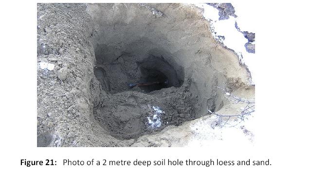
In 2006 ITH collected 334 soil samples, most of which were done with track-mounted auger, the rest were collected with a shovel (Figure 21).
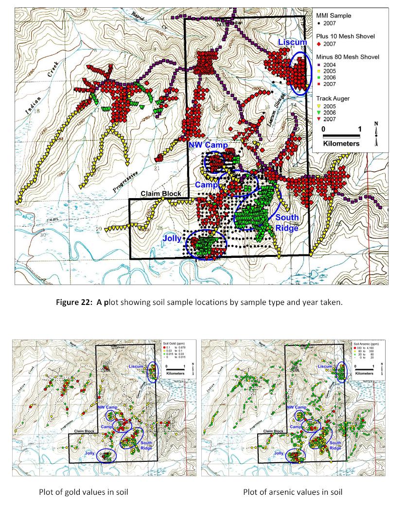
The 2007 ITH exploration program was dedicated largely to surface sampling in an effort to identify trends, extensions and additional surface exposures of mineralization similar to that already discovered. Because of the difficulties in seeing through loess, several techniques were employed. These included, auger sampling, surface soil sampling and Mobil Metal Ion (MMI) sampling (Figure 22). Each of these techniques revealed anomalous areas of potential mineralization (Figure 23). This is an important point because it is often the case that one technique will work when another doesn't. In this case, all techniques show anomalous gold. A total of 1142 MMI samples were collected from areas that had previously been sampled by conventional methods to compare techniques and from areas where the aeolian loess cover is too deep for the auger. The conventional sampling program revealed two new anomalous areas - NW Camp and Liscum. The MMI mapped scattered anomalies in the main target areas that were defined by conventional sampling methods and it highlighted two new areas to the southwest and east of the Camp Zone. These results indicate that the MMI technique shows real promise for identifying mineralized zones beneath deep cover on this property.
| Ed Hunter; Hunter Geo Logic Inc. | Gary Giroux; Giroux Consultants Ltd. | 27 |
| Technical Report on the LMS Gold Project, Goodpaster Mining District, Alaska | October 22, 2014 |
| Ed Hunter; Hunter Geo Logic Inc. | Gary Giroux; Giroux Consultants Ltd. | 28 |
| Technical Report on the LMS Gold Project, Goodpaster Mining District, Alaska | October 22, 2014 |
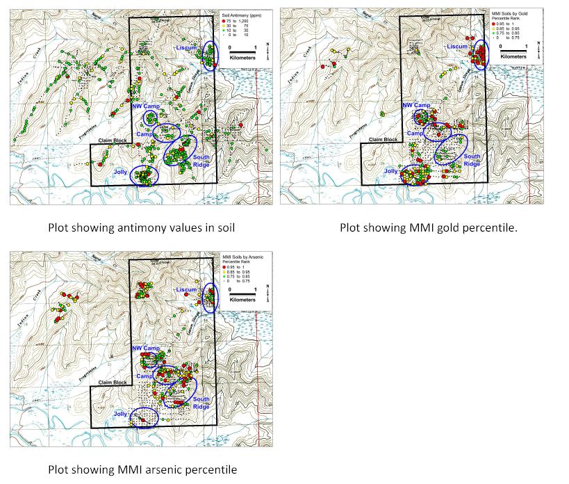
Figure 23:Plots of metal values for surface geochemical samples.
Where possible, soil samples were collected with shovels targeting C-horizon material which was sieved to -80 mesh for analysis (710 samples). In areas where bedrock has been scoured prior to deposition of loess, and no weathered bedrock remains, the material at the top of bedrock surface was collected and sieved, retaining only the coarse +10 mesh fraction for analysis (449 samples). This effectively eliminates potential contamination from the overlying sand and loess. These samples represent rock chip composites from the bedrock surface. Track mounted augers which can drill to 15 metres were used in areas where loess and sand were deeper than 2 metres (711 samples). The auger samples generally consist of ground weathered bedrock and were analysed as rock samples.
All soil, stream sediment, rock, and drill samples were collected according to AGA in-house sampling protocols for geochemical sampling. The first author has reviewed these, as well as AGA security procedures, and has verified that they meet or exceed standard industry practices. The first author did not collect any soil samples for verification purposes.
| Ed Hunter; Hunter Geo Logic Inc. | Gary Giroux; Giroux Consultants Ltd. | 29 |
| Technical Report on the LMS Gold Project, Goodpaster Mining District, Alaska | October 22, 2014 |
All AGA geochemical samples were secured and shipped to Alaska Assay Laboratories Inc. in Fairbanks. Sample preparation (drying, crushing, sieving, and pulverizing) by Alaska Assay Laboratories was according to AGA protocols. Sample splits (300-500g for rock material; -80 mesh for soil samples) were then sent to ALS Minerals in Vancouver for analysis. Analytical methods used were 50g fire assay with AA finish for gold and 4 acid digest multi-element ICP-MS analysis. A gravity finish is used for fire assays with high concentrations of gold. These are standard analytical packages for the exploration industry and are performed to a high standard. Analytical accuracy and precision are monitored by the analysis of reagent blanks, reference material, and replicated samples. Quality control is further assured by the use of international and in-house standards. ALS Minerals is accredited by the Standards Council of Canada, NATA (Australia) and is an ISO 17025 accredited company.
Core and outcrop samples (49) were collected for petrographic and fluid inclusion analyses (Klipfel, 2007; Reynolds, 2007). This work helps constrain the number and relative timing of deformation, hydrothermal, and mineralization events.
No surface sampling was conducted on the property after 2007.
10.0 Drilling
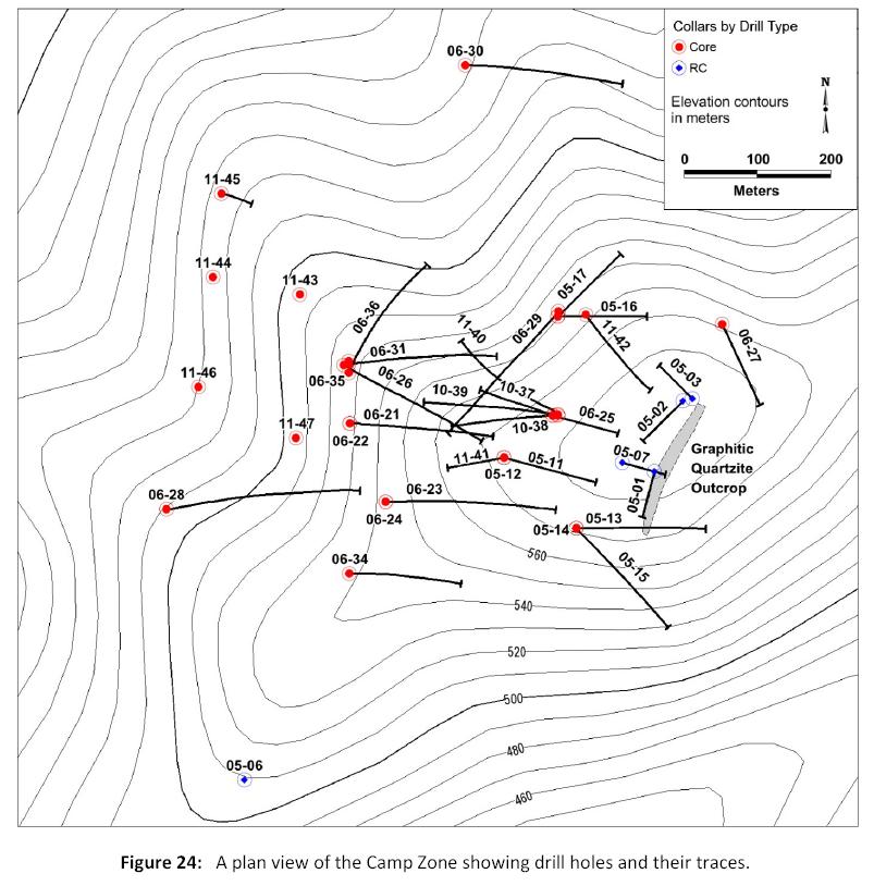
Forty six holes totalling 12,550.74 metres were drilled at the LMS property between 2005 and 2011 (seeFigure 24 andTable 1).Hole numbers in bold were used for the resource estimations.
10.1 2005 Drill Program
In 2005 AGA drilled 10 RC (reverse circulation rotary) holes (959m) in the spring and 7 diamond core holes (1677m) in the fall to test the area around the discovery outcrop. The drilling was conducted by Layne Christiansen Company. This drilling defines a broad, near surface zone of gold mineralization averaging about 1.5 g/t with numerous other narrow higher-grade gold intercepts. Highlights of this program are shown inTable 2.
Table 1:Drill hole information
| Hole ID | UTM_East | UTM_North | Elev_m | Depth_m | Azi | Dip | DrillType | Year |
| | (Zone 6, NAD27-Alaska) | (from LIDAR) | | | | | |
| LM-05-01 | 571557 | 7120398 | 588.4 | 91.44 | 195 | -45 | RC | 2005 |
| LM-05-02 | 571596 | 7120495 | 589.0 | 109.73 | 225 | -45 | RC | 2005 |
| LM-05-03 | 571609 | 7120498 | 588.8 | 91.44 | 315 | -45 | RC | 2005 |
| LM-05-04 | 570523 | 7119831 | 448.2 | 91.44 | 45 | -45 | RC | 2005 |
| LM-05-05 | 570801 | 7119691 | 478.0 | 91.44 | 135 | -55 | RC | 2005 |
| LM-05-06 | 570995 | 7119975 | 499.5 | 91.44 | 185 | -55 | RC | 2005 |
| LM-05-07 | 571513 | 7120410 | 581.7 | 121.92 | 105 | -60 | RC | 2005 |
| LM-05-08 | 572540 | 7120504 | 598.0 | 91.44 | 115 | -45 | RC | 2005 |
| LM-05-09 | 571996 | 7121339 | 495.5 | 91.44 | 45 | -45 | RC | 2005 |
| LM-05-10 | 572000 | 7121300 | 499.2 | 86.87 | 225 | -45 | RC | 2005 |
| LM-05-11 | 571351 | 7120417 | 568.5 | 260.97 | 105 | -60 | Core | 2005 |
| Ed Hunter; Hunter Geo Logic Inc. | Gary Giroux; Giroux Consultants Ltd. | 30 |
| Technical Report on the LMS Gold Project, Goodpaster Mining District, Alaska | October 22, 2014 |
| Hole ID | UTM_East | UTM_North | Elev_m | Depth_m | Azi | Dip | DrillType | Year |
| LM-05-12 | 571351 | 7120417 | 568.5 | 264.60 | 360 | -90 | Core | 2005 |
| LM-05-13 | 571450 | 7120320 | 561.3 | 244.45 | 90 | -45 | Core | 2005 |
| LM-05-14 | 571450 | 7120320 | 561.3 | 154.84 | 360 | -90 | Core | 2005 |
| LM-05-15 | 571450 | 7120320 | 561.3 | 268.83 | 135 | -45 | Core | 2005 |
| LM-05-16 | 571425 | 7120611 | 534.2 | 244.63 | 90 | -60 | Core | 2005 |
| LM-05-17 | 571425 | 7120611 | 534.2 | 241.83 | 45 | -60 | Core | 2005 |
| LM-06-19 | 572000 | 7121345 | 495.2 | 86.87 | 360 | -90 | RC | 2006 |
| LM-06-20 | 571358 | 7121413 | 411.7 | 85.34 | 360 | -90 | RC | 2006 |
| LM-06-21 | 571140 | 7120464 | 514.7 | 334.98 | 90 | -55 | Core | 2006 |
| LM-06-22 | 571140 | 7120464 | 514.7 | 435.32 | 360 | -90 | Core | 2006 |
| LM-06-23 | 571189 | 7120356 | 528.4 | 390.45 | 90 | -55 | Core | 2006 |
| LM-06-24 | 571189 | 7120356 | 528.4 | 490.27 | 360 | -90 | Core | 2006 |
| LM-06-25 | 571418 | 7120475 | 564.8 | 184.40 | 105 | -60 | Core | 2006 |
| LM-06-26 | 571131 | 7120544 | 516.5 | 386.18 | 120 | -55 | Core | 2006 |
| LM-06-27 | 571650 | 7120600 | 561.0 | 172.52 | 155 | -45 | Core | 2006 |
| LM-06-28 | 570888 | 7120346 | 481.4 | 454.15 | 80 | -55 | Core | 2006 |
| LM-06-29 | 571426 | 7120618 | 530.8 | 465.43 | 220 | -60 | Core | 2006 |
| LM-06-30 | 571298 | 7120955 | 444.5 | 361.8 | 90 | -55 | Core | 2006 |
| LM-06-31 | 571138 | 7120545 | 516.9 | 395.33 | 80 | -60 | Core | 2006 |
| LM-06-32 | 570504 | 7118800 | 369.4 | 423.67 | 120 | -45 | Core | 2006 |
| LM-06-33 | 570402 | 7118644 | 345.4 | 303.61 | 120 | -45 | Core | 2006 |
| LM-06-34 | 571139 | 7120258 | 523.7 | 392.61 | 90 | -70 | Core | 2006 |
| LM-06-35 | 571138 | 7120549 | 517.0 | 371.4 | 360 | -90 | Core | 2006 |
| LM-06-36 | 571138 | 7120533 | 516.9 | 423.1 | 20 | -65 | Core | 2006 |
| LM-10-37 | 571418 | 7120475 | 564.8 | 356.01 | 290 | -65 | Core | 2010 |
| LM-10-38 | 571418 | 7120475 | 564.8 | 454.3 | 260 | -65 | Core | 2010 |
| LM-10-39 | 571425 | 7120476 | 565.2 | 367.89 | 275 | -55 | Core | 2010 |
| LM-11-40 | 571425 | 7120475 | 565.3 | 407.82 | 315 | -60 | Core | 2011 |
| LM-11-41 | 571351 | 7120417 | 568.5 | 230.43 | 260 | -70 | Core | 2011 |
| LM-11-42 | 571463 | 7120613 | 540.8 | 191.11 | 135 | -45 | Core | 2011 |
| LM-11-43 | 571071 | 7120641 | 499.0 | 423.37 | 360 | -90 | Core | 2011 |
| LM-11-44 | 570952 | 7120665 | 464.4 | 430.53 | 360 | -90 | Core | 2011 |
| LM-11-45 | 570964 | 7120779 | 468.5 | 517.55 | 360 | -90 | Core | 2011 |
| LM-11-46 | 570932 | 7120514 | 450.0 | 396.85 | 360 | -90 | Core | 2011 |
| LM-11-47 | 571066 | 7120444 | 487.5 | 330.71 | 360 | -90 | Core | 2011 |
| Ed Hunter; Hunter Geo Logic Inc. | Gary Giroux; Giroux Consultants Ltd. | 31 |
| Technical Report on the LMS Gold Project, Goodpaster Mining District, Alaska | October 22, 2014 |
| Ed Hunter; Hunter Geo Logic Inc. | Gary Giroux; Giroux Consultants Ltd. | 32 |
| Technical Report on the LMS Gold Project, Goodpaster Mining District, Alaska | October 22, 2014 |
Table 2:Highlights of 2005 Drilling Program
| Hole ID | Total Depth(m) | From (m) | To (m) | Interval* (m) | Au (g/t) | Ag (g/t) |
| LM-05-01 | 91.44 | 1.52 | 32.00 | 30.48 | 1.10 | 6.4 |
| LM-05-02 | 109.73 | 7.62 | 12.19 | 4.57 | 1.12 | 7.0 |
| LM-05-02 | | 25.91 | 28.96 | 3.05 | 3.76 | 10.7 |
| LM-05-07 | 121.92 | 19.81 | 45.72 | 25.91 | 1.18 | 8.5 |
| LM-05-11 | 261.00 | 109.73 | 125.12 | 15.39 | 3.43 | 12.2 |
| LM-05-11 | | 140.67 | 142.65 | 1.98 | 1.84 | 4.6 |
| LM-05-12 | 265.00 | 142.95 | 146.33 | 3.38 | 21.52 | 46.5 |
| LM-05-12 | | 158.83 | 159.68 | 0.85 | 1.70 | 2.5 |
| LM-05-12 | | 171.75 | 173.28 | 1.53 | 1.84 | 54.4 |
| LM-05-13 | 244.00 | 46.63 | 51.21 | 4.58 | 4.00 | 64.3 |
| LM-05-13 | | 53.80 | 56.39 | 2.59 | 2.11 | 11.8 |
| LM-05-14 | 154.84 | 96.93 | 99.82 | 2.89 | 1.68 | 41.1 |
| LM-05-15 | 266.00 | 78.00 | 78.80 | 0.80 | 1.95 | 11.6 |
| LM-05-16 | 244.00 | 105.22 | 109.39 | 4.17 | 1.95 | 9.5 |
| LM-05-17 | 242.00 | 57.91 | 58.58 | 0.67 | 1.82 | 0.2 |
| LM-05-17 | | 95.80 | 96.32 | 0.52 | 1.33 | 0.2 |
| LM-05-17 | | 137.46 | 138.99 | 1.53 | 2.46 | 25.0 |
*Intervals are not true widths because the orientation of the zones is not sufficiently known to calculate a true thickness.
10.2 2006 drill program
In 2006, ITH drilled another 6157m in 18 diamond core holes and 172m in 2 RC holes. Sixteen core holes were drilled in the Camp Zone and 2 core holes drilled in the Jolly Zone. These holes were drilled to establish the extent and continuity of mineralization identified by AGA in 2005. All core from core holes was oriented, which enabled collection of structural information. Considerable attention was applied to developing an understanding of the structural relations. Highlights of the 2006 drilling are shown inTable 3.
Table 3:Highlights of 2006 Drilling Program
| Hole ID | Total Depth(m) | From (m) | To (m) | Interval* (m) | Au (g/t) | Ag (g/t) |
| LM-06-21 | 334.98 | 295.72 | 297.24 | 1.52 | 5.09 | 1.1 |
| includes | | 295.72 | 296.17 | 0.45 | 13.00 | 2.5 |
| LM-06-21 | | 299.92 | 302.73 | 2.81 | 30.08 | 35.2 |
| includes | | 302.06 | 302.73 | 0.67 | 121.00 | 121 |
| LM-06-21 | | 308.76 | 309.37 | 0.61 | 24.00 | 53.1 |
| LM-06-23 | 390.45 | 118.57 | 119.79 | 1.22 | 4.33 | 2.3 |
| Ed Hunter; Hunter Geo Logic Inc. | Gary Giroux; Giroux Consultants Ltd. | 33 |
| Technical Report on the LMS Gold Project, Goodpaster Mining District, Alaska | October 22, 2014 |
| Hole ID | Total Depth(m) | From (m) | To (m) | Interval* (m) | Au (g/t) | Ag (g/t) |
| LM-06-24 | 490.27 | 175.87 | 178.67 | 2.80 | 7.36 | 1.8 |
| includes | | 175.87 | 176.63 | 0.76 | 15.40 | 6.5 |
| includes | | 177.70 | 178.46 | 0.76 | 9.47 | 0.8 |
| LM-06-24 | | 178.83 | 180.29 | 1.46 | 5.03 | 5.5 |
| includes | | 179.53 | 180.29 | 0.76 | 9.60 | 7.4 |
| LM-06-25 | 184.40 | 116.59 | 116.89 | 0.30 | 68.00 | 18.9 |
| LM-06-26 | 386.18 | 225.86 | 227.08 | 1.22 | 7.45 | 5.0 |
| LM-06-26 | | 269.75 | 272.19 | 2.44 | 4.94 | 0.6 |
| LM-06-26 | | 282.24 | 286.21 | 3.97 | 11.81 | 1.0 |
| includes | | 282.24 | 283.68 | 1.44 | 27.70 | 1.8 |
| includes | | 285.60 | 286.21 | 0.61 | 10.00 | 1.0 |
| LM-06-26 | | 305.96 | 306.78 | 0.82 | 7.04 | 39.7 |
| LM-06-26 | | 380.33 | 380.94 | 0.61 | 22.30 | 3.1 |
| LM-06-29 | 465.43 | 156.00 | 161.15 | 5.15 | 10.14 | 6.8 |
| includes | | 156.00 | 157.28 | 1.28 | 32.77 | 8.3 |
| LM-06-29 | | 185.01 | 186.81 | 1.80 | 713.10 | 83.2 |
| LM-06-31 | 395.33 | 240.03 | 241.74 | 1.71 | 12.04 | 25.2 |
| includes | | 240.88 | 241.74 | 0.86 | 19.44 | 8.7 |
| LM-06-31 | | 253.75 | 256.49 | 2.74 | 3.40 | 1.8 |
| LM-06-31 | | 265.63 | 270.78 | 5.15 | 4.18 | 1.6 |
| includes | | 267.68 | 270.78 | 3.10 | 5.69 | 1.9 |
| LM-06-31 | | 316.96 | 317.51 | 0.55 | 10.70 | 3.6 |
| LM-06-31 | | 334.79 | 336.38 | 1.59 | 3.99 | 3.5 |
| LM-06-35 | 371.40 | 255.54 | 257.10 | 1.56 | 3.40 | 22.3 |
| LM-06-36 | 423.06 | 314.00 | 315.13 | 1.13 | 4.12 | 3.0 |
| LM-06-36 | | 319.67 | 325.37 | 5.70 | 2.70 | 11.4 |
| includes | | 320.34 | 323.7 | 3.36 | 3.24 | 8.8 |
*intervals are not true widths because the orientation of the zones is not sufficiently known to calculate a true thickness.
10.3 2010 drill program
In 2010, FSR drilled 3 diamond core holes (1102m) in the Camp Zone between September 2 and October 5 under an option-joint venture agreement with RGA. These holes were drilled to the NW to test for a NE trending zone of "feeder" veins beneath the graphitic quartzite breccia. Significant intervals of high grade gold mineralization in feeder veins were encountered in 2 of the holes (LM-10-38, LM-10-39). Highlights of the 2010 drilling are shown inTable 4.
| Ed Hunter; Hunter Geo Logic Inc. | Gary Giroux; Giroux Consultants Ltd. | 34 |
| Technical Report on the LMS Gold Project, Goodpaster Mining District, Alaska | October 22, 2014 |
Table 4:Highlights of 2010 Drilling Program
| Hole ID | Total Depth (m) | From (m) | To (m) | Interval* (m) | Au (g/t) | Ag (g/t) |
| LM-10-37 | 356.0 | 158.5 | 179.5 | 21.0 | 0.7 | 6.2 |
| LM-10-37 | | 195.1 | 197.5 | 2.4 | 0.7 | 25.3 |
| LM-10-38 | 454.15 | 161.5 | 164.3 | 2.8 | 4.7 | 4.6 |
| LM-10-38 | | 172.5 | 181.7 | 9.1 | 1.6 | 15.4 |
| including | | 179.5 | 181.7 | 2.1 | 4.8 | 6.0 |
| LM-10-38 | | 198.9 | 201.8 | 2.9 | 12.5 | 6.0 |
| LM-10-38 | | 324.3 | 325.8 | 1.5 | 4.6 | 2.3 |
| LM-10-39 | 292.3 | 221.6 | 224.8 | 3.2 | 3.5 | 6.0 |
| including | | 221.6 | 222.8 | 1.2 | 7.8 | 3.6 |
| LM-10-39 | | 227.2 | 240.6 | 13.4 | 2.5 | 12.4 |
| including | | 233.6 | 238.1 | 4.4 | 4.9 | 19.0 |
| LM-10-39 | | 267.2 | 268.7 | 1.5 | 1.6 | 65.0 |
| LM-10-39 | | 271.3 | 274.8 | 3.5 | 12.1 | 2.0 |
*intervals are not true widths because the orientation of the zones is not sufficiently known to calculate a true thickness.
10.4 2011 drill program
In 2011, FSR deepened the last hole of the 2010 season (LM-10-39) and drilled 8 additional diamond core holes (2365.5m). Two holes were drilled in March and the remainder drilled from June 1 to August 1. Hole LM-11-40 was drilled to the NW to test the feeder zone, the remaining 7 holes were drilled to test for down plunge extension of the graphitic quartzite breccia. Highlights of the 2011 drilling are shown inTable 5.
Table 5:Highlights of 2011 Drilling Program
| Hole ID | Total Depth (m) | From (m) | To (m) | Interval* (m) | Au (g/t) | Ag (g/t) |
| LM-11-40 | 407.8 | 192.3 | 215.6 | 23.3 | 5.2 | 11.9 |
| including | | 194.5 | 203.5 | 9.0 | 0.9 | 4.7 |
| including | | 204.0 | 215.6 | 11.7 | 9.6 | 19.3 |
| including | | 211.2 | 215.6 | 4.4 | 23.8 | 33.5 |
| LM-11-41 | 230.4 | 193.2 | 195.1 | 1.9 | 1.7 | 3.0 |
| LM-11-42 | 191.1 | 99.4 | 101.2 | 1.8 | 2.7 | 17.7 |
| LM-11-43 | 423.4 | 171.8 | 172.8 | 1.1 | 1.0 | 116.3 |
| LM-11-43 | | 336.6 | 339.5 | 2.9 | 1.8 | 28.4 |
| including | | 337.7 | 339.5 | 1.8 | 2.7 | 41.7 |
| LM-11-44 | 430.5 | 73.9 | 77.7 | 3.8 | 1.2 | 0.5 |
| LM-11-44 | | 362.4 | 367.9 | 5.5 | 0.9 | 29.9 |
| including | | 362.4 | 365.1 | 2.7 | 1.3 | 44.8 |
| LM-11-45 | 517.6 | | no | significant | intercepts | |
| LM-11-46 | 396.9 | 288.6 | 290.9 | 2.3 | 0.4 | 17.9 |
| LM-11-47 | 330.7 | 289.0 | 291.7 | 2.7 | 0.8 | 16.5 |
*intervals are not true widths because the orientation of the zones is not sufficiently known to calculate a true thickness.
| Ed Hunter; Hunter Geo Logic Inc. | Gary Giroux; Giroux Consultants Ltd. | 35 |
| Technical Report on the LMS Gold Project, Goodpaster Mining District, Alaska | October 22, 2014 |
11.0 Sample Preparation, Analyses and Security
11.1 2004 to 2006 Procedures
Soil and drill samples obtained in 2004, 2005, and 2006 were subject to AGA's/ITH's in-house methodology and Quality Assurance Quality Control (QAQC) protocols. All samples are weighed and photographed prior to being sealed in bags and securely transported to the Alaska Assay Laboratory preparation facility in Fairbanks. The samples are weighed on receipt and then prepared by sieving or crushing with pulps sent to ALS Minerals lab in Vancouver. Samples were analyzed for gold by ALS Minerals by means of their standard 50 g fire assay with an AA finish and multi-element 4-acid digest ICP-MS analysis for other elements.
In general, all sampling campaigns were subject to insertion of blanks approximately every 25 samples, standards every 25 samples, as well as duplicate samples from pulp splits and coarse reject splits, and sample repeats approximately every 20 samples. Results of AGA's/ITH's QAQC program have been reviewed by the first author. All analyses of sample standards and blanks used as part of the QC during the LMS drill program were reported within standard error envelope. Overall, AGA and ITH have been conscientious in their QAQC program and the first author concludes that sampling and analytical work is accurate and reliable.
Core material was collected at the drill site and placed in core boxes under the supervision of an experienced geologist. It was logged for rock type, alteration, structure, and recorded with detailed descriptions. The first author has examined all of the drill core and core logs from the 2005-2006 drill programs and can verify the reliability of the logging. In general the core was selectively sampled for mineralized intervals only. Core for analysis was sawed in half and one half sent to the laboratory. The other half is either kept on site at the LMS property or at a core storage facility in Fairbanks.
11.2 2007 Procedures
ITH maintained a QAQC protocol in which standard and blank control samples were included at a rate of 1 in 10. Duplicate samples of core are prepared from coarse reject material at a rate of 1 for every 20 samples. All samples are weighed and photographed prior to being sealed in bags and securely transported to the ALS Minerals preparation facility in Fairbanks. The samples are weighed on receipt and then prepared by sieving or crushing with pulps sent by ALS Minerals to their lab in Vancouver. Soil and rock samples are analysed for gold using a 50g fire assay with ICP finish with a 1 ppb detection. Core samples are analyzed for gold using a 50g fire assay with AA finish and 10ppb detection. At LMS, core samples with visible gold are analyzed using screen fire assay, a procedure appropriate for high grade samples. Because screen assay is 1kg, the sample length for these intervals is reduced so that the original sample weight is approximately 1 kg. All samples undergo a four-acid digestion, ICPMS multi-element analysis also.
| Ed Hunter; Hunter Geo Logic Inc. | Gary Giroux; Giroux Consultants Ltd. | 36 |
| Technical Report on the LMS Gold Project, Goodpaster Mining District, Alaska | October 22, 2014 |
Geochemical data has been processed by ITH staff using ratio and multi-element techniques to understand geochemical signature of veins and gold mineralization.
11.3 2010 and 2011 Procedures
FSR maintained a QAQC protocol in which standard and blank control samples were included approximately every 20 samples. Drill core was only selectively sampled in zones of mineralization. All drill core to be sampled was sawed in half with one half going for analysis. The samples were shipped to the ALS Minerals preparation facility in Fairbanks then sent on to the ALS Minerals lab in Vancouver or Sparks, Nevada. All samples were subjected to a gold fire assay technique (Au-ICP22) and a 35 multi-element aqua-regia digestion (ME-MS61). Samples with visible gold, or suspected to contain particulate gold, were analyzed using screen fire assay (Au-SCR24), a procedure appropriate for high grade gold samples. Because the sample size for screen fire assay is one kilogram, the sample length for these intervals was reduced, so that the original sample weight would be approximately one kilogram.
At the end of the 2011 program a problem was found with some of the analytical data in several batches of samples sent to ALS Minerals. The results of some of the control samples were outside of CGI’s accepted limits. These batches were re-analysed by ALS Minerals at the request of CGI. The new results were acceptable and revised certificates were issued for the work orders in question.
12.0 Data Verification
The first author was involved as an independent contractor in most of the sampling programs, including the original ridge and spur soil sampling, the discovery outcrop sampling and subsequent -80 mesh soil and MMI sampling. The first author was present on several occasions during the AGA, ITH, and FSR drill programs and observed the adherence to QAQC protocols. AGA, ITH, and FSR have been diligent in their sampling procedures and efforts to maintain accurate and reliable results.
12.1 Assay verification
In 2014, the first author selected six check samples from the LMS property core for analysis to compare with the original assays, and a rock sample was collected from the discovery outcrop. A comparison between the original assays and the check assays shows that the data reproduce within the range expected for samples containing coarse gold (Table 6).
| Ed Hunter; Hunter Geo Logic Inc. | Gary Giroux; Giroux Consultants Ltd. | 37 |
| Technical Report on the LMS Gold Project, Goodpaster Mining District, Alaska | October 22, 2014 |
12.2 Database Error Checks
The first author reviewed the database by selecting 5% of the nearly 5000 drill core sample assays for comparison with the original laboratory certified assay certificates. This comparison confirmed that the database accurately reflects the values on the original certificates. All the assays in the database are imported directly from csv files generated by ALS so there is no opportunity for typographic errors.
Table 6:Results of re-sampling six drill intercepts and the Discovery outcrop.
| HOLE # | FROM - TO | FROM -TO | Sample Number | Sample Number | Au / Ag ppm | Au / Ag ppm | Shipped |
| | Metres | Feet | Original | Re-sample | Original | Re-sample | weight |
| BLANK | | | | RK210636 | | 0.002 Au / 0.21 Ag | 779 |
| LM-10-38 | 172.52 - 172.91 | 566 - 567.3 | 420839 | RK210637 | 1.32 Au / 21.70 Ag | 1.63 Au / 14.1 Ag | 1549 |
| LM-10-39 | 237.44 - 238.05 | 779 - 781 | 421033 | RK210638 | 3.02 Au / 11.45 Ag | 1.255 Au / 8.97 Ag | 2097 |
| LM-10-39 | 273.1 - 274.02 | 896 - 899 | 421057 | RK210639 | 3.75 Au / 1.85 Ag | 1.45 Au / 1.86 Ag | 2129 |
| LM-11-40 | 211.23 - 211.84 | 693 - 695 | 421358 | RK210640 | 9.32 Au / 2.26 Ag | 10.85 Au / 3.54 Ag | 1640 |
| LM-11-43 | 338.33 - 338.88 | 1110 - 1111.8 | 421904 | RK210641 | 1.96 Au / 4.51 Ag | 2.02 Au / 4.44 Ag | 1562 |
| LM-11-44 | 75.44 - 76.20 | 247.5 - 250 | 421984 | RK210642 | 1.82 Au / 0.29 Ag | 1.755 Au / 0.28 Ag | 2042 |
| Random sample of "Discovery" Outcrop | | | | RK210643 | | 0.317 Au / 1.41 Ag | 2268 |
| Standard SH41 | | | 170176 | RK210644 | 1.344 Au | 1.325 Au / 0.47 Ag | 118 |
| | | | | | | | |
13.0 Mineral Processing and Metallurgical Testing
Neither ITH or CGI have undertaken any mineral processing or metallurgical tests. In 2006 AGA undertook an initial gold characterization study prepared by SGS Mineral Services, Lakefield, Ontario (SGS, 2006). Sample number DC122994 from drill hole LM-05-11, 156.42-156.79m, representing high grade quartz vein mineralization in the footwall gneiss unit, was crushed to liberate gold for the examination. Gold fineness ranges from 445-560 with silver being the complimenting element. Silver is mainly hosted with gold minerals, but is also present as rare Ag-bearing tetrahedrite. Over 95% of the gold (electrum) reported to the gravity concentrate. The report concluded that gravity would be the best method to recover gold from a nominally coarse grind. This information is based on a small sample set but provides some initial information. No metallurgical testing has been conducted on the main siliceous breccia mineralization.
14.0 Mineral Resource Estimate
GCI was retained to produce a resource estimate for the LMS property. The effective date for this resource estimate is March 26, 2014, the date the data was received.
| Ed Hunter; Hunter Geo Logic Inc. | Gary Giroux; Giroux Consultants Ltd. | 38 |
| Technical Report on the LMS Gold Project, Goodpaster Mining District, Alaska | October 22, 2014 |
14.1 Geologic Solid Models
A Leapfrog geologic model was first built by creating a surface chronology of the upper and lower contact surfaces between the schist and gneiss packages. The schist package was further subdivided by creating a refined Leapfrog geologic model of the schist-gneiss model. Surfaces were generated for the upper and lower contacts of the middle graphitic horizon. Four volumes were subsequently created to represent the gneiss, lower schist, middle graphitic horizon, and upper schist packages (Figures 25 and 26). The model was clipped to the LIDAR based bald-earth topographic surface.
A low-grade (>0.05 g/t) gold-shell (LG) was also made around mineralization that occurs predominately in quartz veins within the lower gneiss. This predominately vein-controlled mineralization is difficult to precisely model between drill holes as no systematic control to veining has been identified. In order to provide a representative volume for a resource estimation to be performed, a Leapfrog interpolation shell and volume has been generated and is restricted to only the lower gneiss. A low gold cut-off of 0.05 g/t was used to give reasonable spatial distance from drill hole traces to allow for an adequate volume to be generated for resource modeling. An average trend, based on mineralized vein orientation data from oriented drill core, has been used to bias the interpolation so that it mimics an average strike orientation of NE-SW (060). This volume is further restricted to only holes within the heart of the deposit and to where gold-bearing veining in the lower gneiss was sufficiently present.
Of the 46 supplied drill holes, only 36 holes within the Camp and NW Hillside Prospect were used in this resource estimate. Table 1 shows all holes, with the holes used in the estimate highlighted.
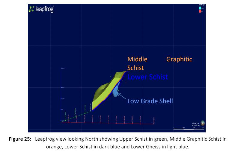
| Ed Hunter; Hunter Geo Logic Inc. | Gary Giroux; Giroux Consultants Ltd. | 39 |
| Technical Report on the LMS Gold Project, Goodpaster Mining District, Alaska | October 22, 2014 |
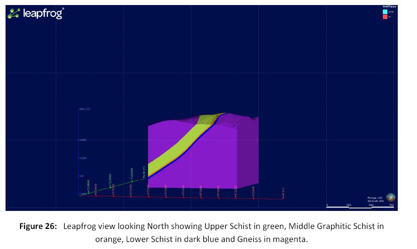
14.2 Data Analysis
For un-sampled drill hole intervals a value of 0.001 g/t Au was inserted in 1,352 cases.
Drill holes were “passed through” the solids with the entry and exit points recorded. Assays were then back tagged with a domain code if within the 5 mineralized solids.Table 7 reports the assay statistics for Au in each of the domains.
Table 7:Sample Statistics for Gold
| Domain | Number | Mean Au (g/t) | Stand. Dev. | Minimum Value | Maximum Value | Coef. Of Variation |
| Upper Schist | 1,194 | 0.146 | 0.996 | 0.001 | 17.20 | 6.83 |
| Middle Graphitic Schist | 528 | 1.289 | 5.398 | 0.001 | 80.80 | 4.19 |
| Lower Schist | 534 | 3.604 | 66.881 | 0.001 | 1542.00 | 18.56 |
| Gneiss | 2,765 | 0.050 | 0.208 | 0.001 | 3.79 | 4.15 |
| Low Grade Shell (LG) | 694 | 0.663 | 5.268 | 0.001 | 121.00 | 7.94 |
As seen in the maximum value column and the high coefficients of variation there are certainly some erratic high values in the data. Each domain was examined using lognormal cumulative probability plots to determine if capping was necessary and if so, at what level. The plot for gold in the Upper Schist domain is shown below asFigure 27. There are 6 overlapping lognormal populations indicated. These populations are tabulated inTable 8.
| Ed Hunter; Hunter Geo Logic Inc. | Gary Giroux; Giroux Consultants Ltd. | 40 |
| Technical Report on the LMS Gold Project, Goodpaster Mining District, Alaska | October 22, 2014 |
Table 8:Overlapping gold populations in Upper Schist
| Population | Mean Au (g/t) | Percentage Of Total | Number of Samples |
| 1 | 12.28 | 0.48 % | 6 |
| 2 | 4.27 | 0.77 % | 9 |
| 3 | 1.41 | 1.35 % | 16 |
| 4 | 0.28 | 5.81 % | 69 |
| 5 | 0.07 | 8.37 % | 100 |
| 6 | 0.003 | 83.22 % | 994 |
For the Upper Schist domain population 1 is considered erratic high grade and a cap level of 2 standard deviations above the mean of population 2, a value of 9.3 g/t, would be an effective cap. A total of 4 samples were capped at 9.3 g/t Au.
A similar exercise was completed for gold in the other 4 domains.Table 9 shows the various cap levels and number of samples capped in each of the domains.
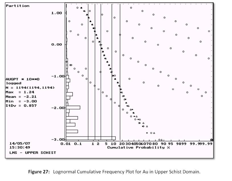
| Ed Hunter; Hunter Geo Logic Inc. | Gary Giroux; Giroux Consultants Ltd. | 41 |
| Technical Report on the LMS Gold Project, Goodpaster Mining District, Alaska | October 22, 2014 |
Table 9:Capping Levels for Au
| Domain | Cap Level | Number Capped |
| Upper Schist | 9.3 g/t | 4 |
| Middle Graphitic Schist | 13.6 g/t | 7 |
| Lower Schist | 9.5 g/t | 9 |
| Gneiss | 2.2 g/t | 5 |
| LG Shell | 14.0 g/t | 5 |
The effects of capping a relatively small number of assays are shown inTable 10 with large reductions in the coefficient of variation.
Table 10:Sample Statistics for Capped Gold
| Domain | Number | Mean Au (g/t) | Stand. Dev. | Minimum Value | Maximum Value | Coef. Of Variation |
| Upper Schist | 1,194 | 0.129 | 0.768 | 0.001 | 9.30 | 5.94 |
| Middle Graphitic Schist | 528 | 0.933 | 2.155 | 0.001 | 13.60 | 2.31 |
| Lower Schist | 534 | 0.370 | 1.455 | 0.001 | 9.50 | 3.94 |
| Gneiss | 2,765 | 0.048 | 0.181 | 0.001 | 2.20 | 3.76 |
| Low Grade Shell (LG) | 694 | 0.420 | 1.694 | 0.001 | 14.00 | 4.04 |
14.3 Composites
Assay intervals were mostly 1.53 m long and ranged from a low of 0.06 to a high of 6.62 m. A composite length of 2.5 m was selected to fit with a 5 m bench height and the most common assay lengths. Uniform down hole composites 2.5 m in length were formed to honour the domain boundaries. At the domain contacts, samples less than 1.25 m were joined with adjacent samples while those more than 1.25 m in length were left intact. In this manner a uniform support of 2.5 ± 1.25 m was created.
The gold statistics for 2.5 m composites are tabulated below inTable 11, sorted by domain.
Table 11:2.5 m Composite Statistics for Gold
| Domain | Number | Mean Au (g/t) | Stand. Dev. | Minimum Value | Maximum Value | Coef. Of Variation |
| Upper Schist | 1,299 | 0.033 | 0.225 | 0.001 | 4.60 | 6.81 |
| Middle Graphitic Schist | 215 | 0.747 | 1.390 | 0.001 | 11.68 | 1.86 |
| Lower Schist | 303 | 0.211 | 0.875 | 0.001 | 8.53 | 4.16 |
| Gneiss | 2,381 | 0.019 | 0.071 | 0.001 | 1.33 | 3.73 |
| Low Grade Shell (LG) | 389 | 0.227 | 0.773 | 0.001 | 8.42 | 3.41 |
The number of 2.5 m composites in Upper Schist actually increased over the number of assays due to the addition of missing intervals at the start and end of many holes. A value of 0.001 g/t Au was inserted in any missing interval.
| Ed Hunter; Hunter Geo Logic Inc. | Gary Giroux; Giroux Consultants Ltd. | 42 |
| Technical Report on the LMS Gold Project, Goodpaster Mining District, Alaska | October 22, 2014 |
14.4 Variography
Pairwise relative semivariograms were produced for the three domains with sufficient data to model: the upper schist unit, gneiss unit and the low grade shell. In all cases anisotropy was observed and nested spherical models were fit to the data.
For the Upper Schist Domain, the longest continuity in the horizontal plane was observed along azimuth 95o dip 0o. The second longest range was along azimuth 5o dipping -85o. The nugget to sill ratio within the Upper Schist Domain was 46%.
Within the surrounding Gneiss Domain the direction of longest continuity was along azimuth 90o dip 0o. The second longest range was along azimuth 0o dip -83o. The nugget to sill ratio for this domain was a higher 53% indicating more variability.
Within the low grade shell that sits underneath the lower schist horizon the direction of longest continuity was along azimuth 130o dip 0o with the next longest range along azimuth 220o dip -80o. For the low grade shell the nugget to sill ratio was quite high at 60% indicating a lot of short range variability.
There were not enough composites within the Middle Graphitic Schist Domain or the Lower Schist Domain to model these domains separately, but because the gold grades in these units were somewhat similar they were combined for variography analysis. The direction of longest continuity was along azimuth 15o dip 0o with the next longest range along azimuth 105o dip -85o. The semivariogram parameters are tabulated below (Table 12).
Table 12:Semivariogram Parameters for Gold
| Domain | Az / Dip | C0 | C1 | C2 | Short Range (m) | Long Range (m) |
| Upper Schist | 95o / 0o | 0.30 | 0.20 | 0.15 | 15.0 | 90.0 |
| 05o / -85o | 40.0 | 85.0 |
| 185o / -5o | 15.0 | 25.0 |
| Gneiss | 90o / 0o | 0.42 | 0.23 | 0.15 | 40.0 | 100.0 |
| 0o / -83o | 15.0 | 70.0 |
| 180o / -7o | 15.0 | 22.0 |
| Low Grade Shell | 130o / 0o | 0.80 | 0.20 | 0.34 | 40.0 | 94.0 |
| 40o / -10o | 20.0 | 30.0 |
| 220o / -80o | 15.0 | 90.0 |
Middle Graphitic Schist and Lower Schist | 15o / 0o | 0.60 | 0.25 | 0.46 | 40.0 | 110.0 |
| 285o / -5o | 20.0 | 50.0 |
| 105o / -85o | 15.0 | 70.0 |
| Ed Hunter; Hunter Geo Logic Inc. | Gary Giroux; Giroux Consultants Ltd. | 43 |
| Technical Report on the LMS Gold Project, Goodpaster Mining District, Alaska | October 22, 2014 |
14.5 Block Model
A block model with blocks 10 x 10 x 5 m in dimension was created to cover the mineralized solids (Figure 28). Within each block the percentage below surface topography, within overburden and within each mineralized solid was recorded. The origin of the block model was as follows:
Lower left corner
570810 East Column size = 10 m 101 columns
7120095 North Row size = 10 m 98 rows
Top of Model
595 Elevation Level size = 5 m 165 levels
No rotation.
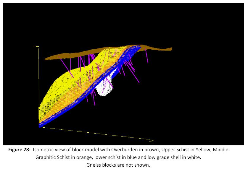
14.6 Bulk Density
Within the volume being estimated a total of 15 specific gravity determinations were made from 2005 and 2006 drill holes(Table 13). Measurements for specific gravity were done by ALS method OA-GRA08 (unsealed sample: SG = (Wt Dry) / (Wt in air - Wt in Water). The results are shown below sorted by domain.
| Ed Hunter; Hunter Geo Logic Inc. | Gary Giroux; Giroux Consultants Ltd. | 44 |
| Technical Report on the LMS Gold Project, Goodpaster Mining District, Alaska | October 22, 2014 |
The average value for each domain was applied to the proportion of each domain within a given block. For the low grade shell the specific gravity for Gneiss was applied while a nominal 1.6 was used for the specific gravity of the overburden. The specific gravity for each block was then a weighted average for all domains present within the block.
During future drill programs, more specific gravity determinations in all domains are recommended.
Table 13:Summary of Specific Gravity Determinations
| Sample ID | Hole | From (m) | To (m) | Domain | SG |
| DC148046 | LM-05-11 | 110.95 | 111.04 | Upper Schist | 2.61 |
| DC148047 | LM-05-11 | 55.47 | 55.57 | Upper Schist | 2.78 |
| | | | | Average | 2.70 |
| DC148003 | LM-06-29 | 158.31 | 158.50 | Middle Graph | 2.68 |
| DC148004 | LM-05-11 | 117.20 | 117.35 | Middle Graph | 2.63 |
| DC148005 | LM-05-11 | 118.17 | 118.32 | Middle Graph | 2.64 |
| DC148006 | LM-05-11 | 124.51 | 124.60 | Middle Graph | 2.68 |
| DC148041 | LM-05-11 | 124.60 | 124.69 | Middle Graph | 2.59 |
| DC148042 | LM-05-12 | 143.87 | 143.96 | Middle Graph | 2.59 |
| DC148045 | surface | | | Middle Graph | 2.62 |
| | | | | Average | 2.63 |
| DC148043 | LM-05-13 | 66.75 | 66.84 | Lower Schist | 2.55 |
| DC148049 | LM-06-22 | 326.14 | 326.23 | Lower Schist | 2.76 |
| | | | | Average | 2.66 |
| DC148001 | LM-06-21 | 300.44 | 300.56 | Gneiss | 2.59 |
| DC148002 | LM-06-21 | 309.95 | 310.04 | Gneiss | 2.65 |
| DC148048 | LM-06-31 | 361.49 | 361.58 | Gneiss | 2.64 |
| DC148050 | LM-06-25 | 157.58 | 157.67 | Gneiss | 2.66 |
| | | | | Average | 2.64 |
14.7 Grade Interpolation
Gold grades were interpolated into blocks by Ordinary Kriging in a number of passes. The search ellipsoid dimensions and orientation for each pass were a function of the semivariogram range for the domain being estimated(Table 14). Blocks with some proportion of each of the 5 domains were estimated separately using the appropriate composites for that domain. The first pass required a minimum of 4 composites, with a maximum of 3 from any given drill hole, within a search ellipsoid with dimensions equal to ¼ of the semivariogram range. For blocks not estimated in pass 1 a second pass was made with search dimensions equal to ½ the semivariogram range. A third pass using the full range and a fourth pass using twice the range completed the kriging exercise. In all passes a maximum of 12 composites were allowed and if more than this were found the closest 12 were used. Separate kriging runs were made for Upper Schist, Middle Graphic Schist, Lower Schist, Low Grade Shell and Gneiss domains. The combined Middle Graphitic Schist-Lower Schist model was used to estimate both the Middle Graphitic Schist and the Lower Schist domains. The search directions and distances are tabulated below.
| Ed Hunter; Hunter Geo Logic Inc. | Gary Giroux; Giroux Consultants Ltd. | 45 |
| Technical Report on the LMS Gold Project, Goodpaster Mining District, Alaska | October 22, 2014 |
Table 14:Kriging Parameters for LMS Gold
| Domain | Pass | Number Estimated | Az/Dip | Dist. (m) | Az/Dip | Dist. (m) | Az/Dip | Dist. (m) |
| Upper Schist | 1 | 156 | 95o / 0o | 22.5 | 5o / -85o | 21.25 | 185o / -5o | 6.25 |
| 2 | 1,096 | 45.0 | 42.50 | 12.50 |
| 3 | 8,359 | 90.0 | 85.00 | 25.00 |
| 4 | 34,595 | 180.0 | 170.00 | 50.00 |
Middle Graphitic Schist | 1 | 64 | 15o / 0o | 27.5 | 285o / -5o | 12.5 | 105o / -85o | 17.5 |
| 2 | 750 | 55.0 | 25.0 | 35.0 |
| 3 | 5,235 | 110.0 | 50.0 | 70.0 |
| 4 | 5,475 | 220.0 | 100.0 | 140.0 |
| Lower Schist | 1 | 28 | 15o / 0o | 27.5 | 285o / -5o | 12.5 | 105o / -85o | 17.5 |
| 2 | 860 | 55.0 | 25.0 | 35.0 |
| 3 | 6,075 | 110.0 | 50.0 | 70.0 |
| 4 | 7,650 | 220.0 | 100.0 | 140.0 |
Low Grade Shell | 1 | 155 | 130o / 0o | 23.5 | 40o / -10o | 7.5 | 220o / -80o | 22.5 |
| 2 | 1,399 | 47.0 | 15.0 | 45.0 |
| 3 | 3,465 | 94.0 | 30.0 | 90.0 |
| 4 | 2,046 | 188.0 | 60.0 | 180.0 |
| Gneiss | 1 | 183 | 90o / 0o | 25.0 | 0o / -83o | 17.5 | 180o / -7o | 5.5 |
| 2 | 1,180 | 50.0 | 35.0 | 11.0 |
| 3 | 10,449 | 100.0 | 70.0 | 22.0 |
| 4 | 101,638 | 200.0 | 140.0 | 44.0 |
14.8 Classification
Based on the study herein reported, the delineated mineralization of the LMS property is classified as a resource according to the following definitions from National Instrument 43-101 and from CIM (2005):
“In this Instrument, the terms "mineral resource", "inferred mineral resource", "indicated mineral resource" and "measured mineral resource" have the meanings ascribed to those terms by the Canadian Institute of Mining, Metallurgy and Petroleum, as the CIM Definition Standards on Mineral Resources and Mineral Reserves adopted by CIM Council, as those definitions may be amended.”
The terms Measured, Indicated and Inferred are defined by CIM (2005) as follows:
“A Mineral Resource is a concentration or occurrence of diamonds, natural solid inorganic material, or natural solid fossilized organic material including base and precious metals, coal and industrial minerals in or on the Earth’s crust in such form and quantity and of such a grade or quality that it has reasonable prospects for economic extraction. The location, quantity, grade, geological characteristics and continuity of a Mineral Resource are known, estimated or interpreted from specific geological evidence and knowledge.”
“The term Mineral Resource covers mineralization and natural material of intrinsic economic interest which has been identified and estimated through exploration and sampling and within which Mineral Reserves may subsequently be defined by the consideration and application of technical, economic, legal, environmental, socio-economic and governmental factors. The phrase ‘reasonable prospects for economic extraction’ implies a judgment by the Qualified Person in respect of the technical and economic factors likely to influence the prospect of economic extraction. A Mineral Resource is an inventory of mineralization that under realistically assumed and justifiable technical and economic conditions might become economically extractable. These assumptions must be presented explicitly in both public and technical reports.”
| Ed Hunter; Hunter Geo Logic Inc. | Gary Giroux; Giroux Consultants Ltd. | 46 |
| Technical Report on the LMS Gold Project, Goodpaster Mining District, Alaska | October 22, 2014 |
Inferred Mineral Resource
“An ‘Inferred Mineral Resource’ is that part of a Mineral Resource for which quantity and grade or quality can be estimated on the basis of geological evidence and limited sampling and reasonably assumed, but not verified, geological and grade continuity. The estimate is based on limited information and sampling gathered through appropriate techniques from locations such as outcrops, trenches, workings and drill holes.”
“Due to the uncertainty that may be attached to Inferred Mineral Resources, it cannot be assumed that all or any part of an Inferred Mineral Resource will be upgraded to an Indicated or Measured Mineral Resource as a result of continued exploration. Confidence in the estimate is insufficient to allow the meaningful application of technical and economic parameters or to enable an evaluation of economic viability worthy of public disclosure. Inferred Mineral Resources must be excluded from estimates forming the basis of feasibility or other economic studies.”
Indicated Mineral Resource
“An ‘Indicated Mineral Resource’ is that part of a Mineral Resource for which quantity, grade or quality, densities, shape and physical characteristics, can be estimated with a level of confidence sufficient to allow the appropriate application of technical and economic parameters, to support mine planning and evaluation of the economic viability of the deposit. The estimate is based on detailed and reliable exploration and testing information gathered through appropriate techniques from locations such as outcrops, trenches, pits, workings and drill holes that are spaced closely enough for geological and grade continuity to be reasonably assumed.”
“Mineralization may be classified as an Indicated Mineral Resource by the Qualified Person when the nature, quality, quantity and distribution of data are such as to allow confident interpretation of the geological framework and to reasonably assume the continuity of mineralization. The Qualified Person must recognize the importance of the Indicated Mineral Resource category to the advancement of the feasibility of the project. An Indicated Mineral Resource estimate is of sufficient quality to support a Preliminary Feasibility Study which can serve as the basis for major development decisions.”
| Ed Hunter; Hunter Geo Logic Inc. | Gary Giroux; Giroux Consultants Ltd. | 47 |
| Technical Report on the LMS Gold Project, Goodpaster Mining District, Alaska | October 22, 2014 |
Measured Mineral Resource
“A ‘Measured Mineral Resource’ is that part of a Mineral Resource for which quantity, grade or quality, densities, shape, and physical characteristics are so well established that they can be estimated with confidence sufficient to allow the appropriate application of technical and economic parameters, to support production planning and evaluation of the economic viability of the deposit. The estimate is based on detailed and reliable exploration, sampling and testing information gathered through appropriate techniques from locations such as outcrops, trenches, pits, workings and drill holes that are spaced closely enough to confirm both geological and grade continuity.”
“Mineralization or other natural material of economic interest may be classified as a Measured Mineral Resource by the Qualified Person when the nature, quality, quantity and distribution of data are such that the tonnage and grade of the mineralization can be estimated to within close limits and that variation from the estimate would not significantly affect potential economic viability. This category requires a high level of confidence in, and understanding of, the geology and controls of the mineral deposit.”
Within the mineralized zones at the LMS property, the geological continuity has been established through surface mapping and drill hole interpretation. Grade continuity can be quantified by semivariogram analysis. By tying the classification to the semivariogram ranges through the use of various search ellipses the resource is classified as follows:
Due to the drill density and relatively small proportion of blocks estimated in Pass 1 and 2, all blocks within the LMS property are classified as Inferred at this time.
The inferred resource is presented as a grade-tonnage table below at a number of Au cut-offs(Table 15). At this time an economic cut-off is unknown and a value of 0.5 g/t Au has been highlighted as a possible open pit cut-off.
Table 15: LMS Inferred Resource
| Au Cut-off (g/t) | Tonnes > Cut-off | Grade >Cut-off Au (g/t) | Gold Contained Ounces |
| 0.10 | 33,560,000 | 0.42 | 450,000 |
| 0.15 | 25,120,000 | 0.52 | 418,000 |
| 0.20 | 20,440,000 | 0.60 | 392,000 |
| 0.25 | 16,890,000 | 0.67 | 366,000 |
| 0.30 | 14,650,000 | 0.74 | 346,000 |
| 0.40 | 10,900,000 | 0.87 | 304,000 |
| 0.50 | 8,320,000 | 1.00 | 267,000 |
| 0.60 | 6,640,000 | 1.11 | 238,000 |
| 0.70 | 5,460,000 | 1.21 | 213,000 |
| 0.80 | 4,490,000 | 1.31 | 190,000 |
| 0.90 | 3,750,000 | 1.41 | 169,000 |
| 1.00 | 3,180,000 | 1.49 | 152,000 |
| 1.20 | 2,120,000 | 1.68 | 115,000 |
| 1.30 | 1,750,000 | 1.78 | 100,000 |
| 1.40 | 1,470,000 | 1.86 | 88,000 |
| 1.50 | 1,200,000 | 1.95 | 75,000 |
| Ed Hunter; Hunter Geo Logic Inc. | Gary Giroux; Giroux Consultants Ltd. | 48 |
| Technical Report on the LMS Gold Project, Goodpaster Mining District, Alaska | October 22, 2014 |
14.9 Model Verification
A series of north-south cross sections were produced showing estimated blocks and all composites, both colour coded by gold grades(Figures 29, 30, 31 and 32). The estimated blocks matched the composites well with no bias indicated.
| Ed Hunter; Hunter Geo Logic Inc. | Gary Giroux; Giroux Consultants Ltd. | 49 |
| Technical Report on the LMS Gold Project, Goodpaster Mining District, Alaska | October 22, 2014 |

| Ed Hunter; Hunter Geo Logic Inc. | Gary Giroux; Giroux Consultants Ltd. | 50 |
| Technical Report on the LMS Gold Project, Goodpaster Mining District, Alaska | October 22, 2014 |
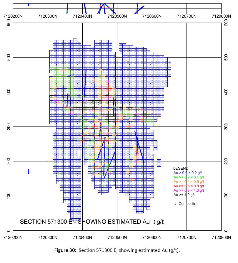
| Ed Hunter; Hunter Geo Logic Inc. | Gary Giroux; Giroux Consultants Ltd. | 51 |
| Technical Report on the LMS Gold Project, Goodpaster Mining District, Alaska | October 22, 2014 |
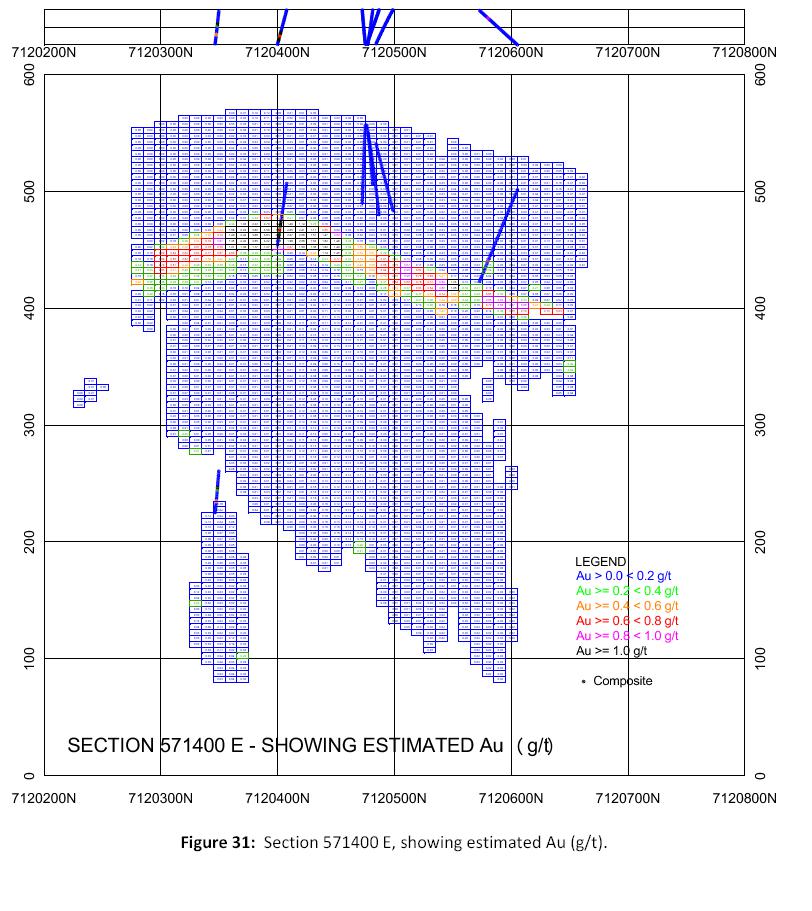
| Ed Hunter; Hunter Geo Logic Inc. | Gary Giroux; Giroux Consultants Ltd. | 52 |
| Technical Report on the LMS Gold Project, Goodpaster Mining District, Alaska | October 22, 2014 |
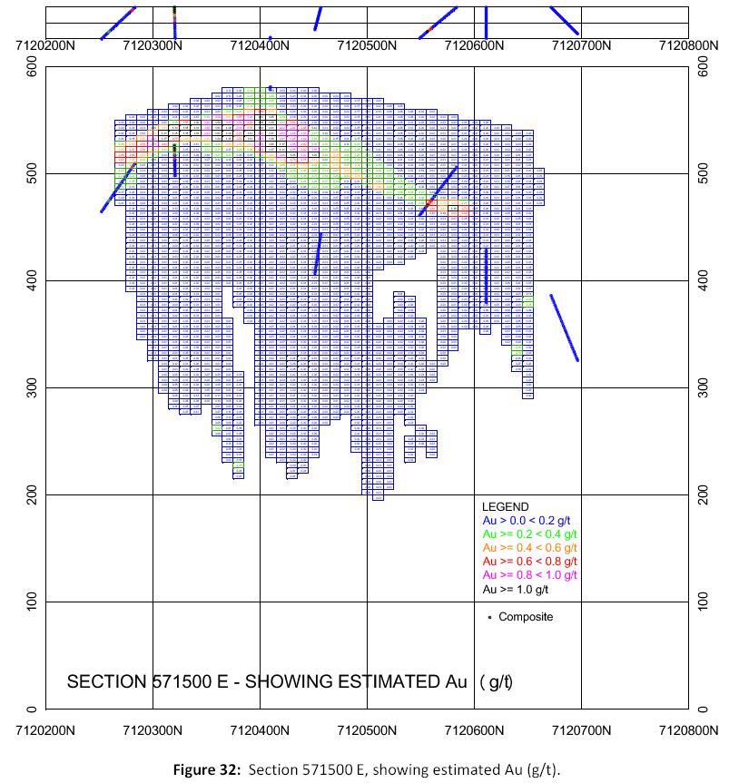
15.0 Adjacent Properties
DNR records as of May 4, 2014 indicate that there is only one block of claims near the LMS property. These claims are located approximately 1 km to the northeast of the LMS property boundary and are registered to Kiska Minerals Corporation (Figure 33).
| Ed Hunter; Hunter Geo Logic Inc. | Gary Giroux; Giroux Consultants Ltd. | 53 |
| Technical Report on the LMS Gold Project, Goodpaster Mining District, Alaska | October 22, 2014 |
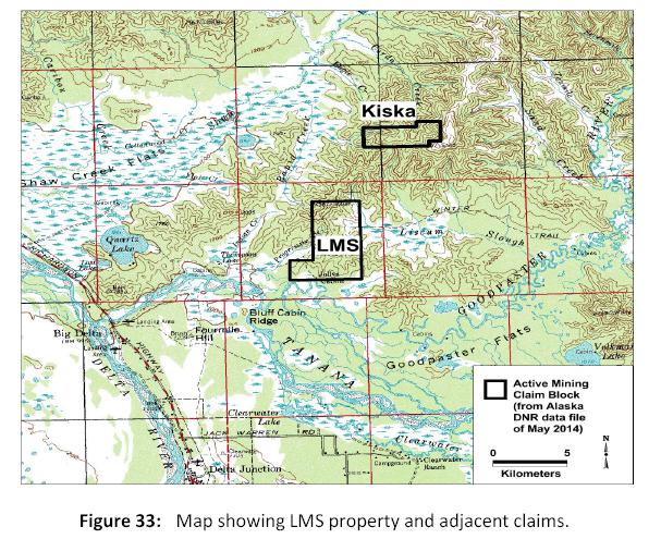
16.0 Other Relevant Data and Information
No additional information or explanation is known by the authors to be necessary to make the technical report understandable and not misleading.
17.0 Interpretation and Conclusions
The LMS property is situated in a portion of the Goodpaster district which has had no known previous exploration prior to AGA’s reconnaissance program in 2004, in spite of the fact that the broader region has attracted considerable interest following the discovery of the Pogo deposit 40 km to the northeast.
Rocks within the LMS project area belong to the Yukon-Tanana Terrane, a complex terrane that was accreted to North America in the mid to Late Cretaceous period. Among the diverse suites of rocks in this terrane, some of those underlying the LMS property area are similar in composition and structural character to the host rocks at Pogo.
Mineralization in this region, including at Pogo, is believed to be intrusion-related as described by many workers (McCoy, et al., 1997; Newberry, 2000; Smith, 2000; Smith, et al., 2000). The first author’s observations are consistent with this interpretation even though no intrusive rocks have been identified on the LMS property. Fluids derived from intrusions at depth or at distance laterally can migrate along structures to produce the observed gold mineralization at the LMS property. An alternate possibility is that the gold is sourced from metamorphic fluids, in which case, mineralization would be classified as “orogenic” type. These genetic labels do not affect the architecture or morphology of the deposit because in both cases gold-bearing hydrothermal fluid, regardless of where it is derived, will migrate through rocks according to structural and lithologic factors.
| Ed Hunter; Hunter Geo Logic Inc. | Gary Giroux; Giroux Consultants Ltd. | 54 |
| Technical Report on the LMS Gold Project, Goodpaster Mining District, Alaska | October 22, 2014 |
The authors have been unable to verify the information available with respect to the Pogo property, and such information is not necessarily indicative of the mineralization at LMS.
Outcropping gold mineralization was discovered by AGA as part of a regional exploration program in 2004 and has now become what is referred to as the Camp Zone. AGA followed up with drill testing in 2005 and discovered down-dip continuity of mineralization in an open folded, west-plunging, stratabound zone of graphitic quartzite breccia as well as high grade gold in subvertical veins in hangingwall and footwall rocks above and beneath the breccia zone. In 2006, ITH further tested this feature by drilling and demonstrated its continuity and occurrence over a broader area. FSR did additional drilling in 2010 and 2011 and confirmed an even larger area of mineralization.
In 2014, a resource estimate was made using the AGA, ITH and FSR drill intercepts through the gold-bearing graphitic quartzite breccia and the underlying high grade veins in the Lower gneiss. The estimate offers a range of grades and tonnages with corresponding contained ounces.At a 0.5 g/t cut-off, 8.32 M tonnes of material are estimated to contain 267,000 oz. of Au at an average grade of 1.00 g/t Au. In accordance with the definitions in NI 43-101, this estimate should be considered to be an inferred mineral resource.
The high grade veins crosscut the graphitic quartzite breccia indicating that they postdate the mineralization that is included in the resource estimate. It is proposed here that gold-bearing hydrothermal fluids traversed upward through rocks of the LMS property area along steep structures and migrated laterally along particular horizons such as the graphitic quartzite breccia (Figure 34). If true, it is unlikely that this is the only such receptive horizon in the area. Any other similar horizon could also be mineralized. Although veins could have formed at a relatively much later time during a separate mineralizing event, it is possible that they are the latest stage of an evolving hydrothermal system. These fluids, at any stage, may have encountered pre-existing weak volcanogenic massive sulfide style mineralization and remobilized minor base metals to form the array of vein types and their respective metal contents.
All drilling to date targeted the graphitic quartzite breccia. The high grade veins in the Lower Gneiss were discovered during this drilling but no consistent vein orientation was determined. The recently constructed 3-D model led to the recognition of a concentration of high grade gold values in veins that appear to parallel the axial plane of the fold in the Camp Zone. These high grade veins, where encountered, have been in the lower gneiss unit and in the graphitic quartzite unit. They have not been identified in the upper gneiss or schist units but this may, in part, be a function of drill hole location. The graphitic quartzite breccia is an enigmatic unit and style of mineralization, but seems unlikely to be unique on the LMS property. Likewise, current drilling has not defined the limits of this unit or the mineralization. Therefore, it also is deserving of further testing and exploration.
| Ed Hunter; Hunter Geo Logic Inc. | Gary Giroux; Giroux Consultants Ltd. | 55 |
| Technical Report on the LMS Gold Project, Goodpaster Mining District, Alaska | October 22, 2014 |
Soil sampling by shovel and track-mounted auger along with MMI sampling has identified the presence of at least five additional sizeable areas of anomalous gold in soil. When considering the extent and depth to which the LMS property area is buried beneath wind-blown loess, the fact that these areas are identifiable is encouraging and suggests that the Camp Zone is not a unique mineralized body on the LMS property. Several of these zones define a northwest-trending corridor of anomalism that is approximately 6 km long at the surface.
It is concluded here that identification of gold mineralization and its extent is at an early stage on the LMS property. The identification of a small inferred resource based on limited drilling within one of several areas that show gold anomalism at the surface suggests that the LMS property is host to more extensive gold mineralization.
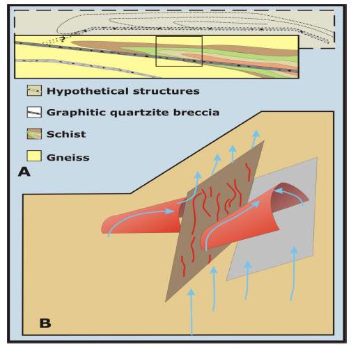
Figure 34:Schematic diagram shows LMS mineralization concept model.A) Thrust-faulted volcano-sedimentary stratigraphy produces recumbent folds with axial planar thrust surfaces. There may be parallel structures, duplexes, or related lateral structures which might also host mineralization. The intersection of any of these types of features might explain some of the other surface anomalies at the LMS property. Boxed area represents the approximate scale of the area investigated so far with respect to the concept area.B) The entire package is folded about west-northwest striking and west plunging upright fold axes (red fold). Faults produced during this deformation could be approximately perpendicular (brown-gray plane) or approximately parallel to the fold axial plane (gray plane). Hydrothermal fluid rising through the crust could utilize these structures and infiltrate porous/permeable features such as the graphitic quartzite breccia (thrust fault?). Fluids would likely rise along structures and anticlinal axes. High grade veins ought to lie along the perpendicular faults (brown-gray) or in parallel zones. This direction is approximately parallel to the principle stress direction that formed the late upright folds.
| Ed Hunter; Hunter Geo Logic Inc. | Gary Giroux; Giroux Consultants Ltd. | 56 |
| Technical Report on the LMS Gold Project, Goodpaster Mining District, Alaska | October 22, 2014 |
18.0 Recommendations
18.1 Recommended Exploration
Exploration of the LMS property is at a relatively early stage, with discovery and identification of the graphitic quartzite breccia extending from the surface to 850 m down dip, and the high grade gold veins in the Lower Gneiss. A two phase exploration program is recommended. Phase 1 would focus on evidence of a zone of high grade gold bearing veins in the Camp Zone, while Phase 2 would be a limited drill program contingent on encouraging results from Phase 1.
Phase 1) Re-log the existing core with a focus on axial plane parallel structures and veins. A focus on the metamorphic fabric may help to capture the orientation of the veins and determine if the veining extends into the schist and Upper Gneiss.
Other useful procedures that should be carried out during the re-logging process are:
- some sampling of the core for stratigraphic correlation,
- sampling of any un-sampled intervals that appear to be potentially mineralized,
- collect specific gravity measurements on all lithologies, and
- collect data on the resistivity of the different rock units in the event that it could be useful in any future geophysical surveys that may be considered.
Phase 2)If the Phase 1 re-log program is successful in confirming the presence of a zone of high grade gold veins in the Camp Zone, a drill program totaling 2300 metres in 4 holes should be conducted to test this zone.
18.2 Budget for Recommended Program
A budget to carry out the Phase 1 program is presented below inTable 16. This budget assumes that the program will be supported by river transportation and carried out by a 3 person crew; a senior geologist to do structural analysis on the core, an assistant geologist to handle the thousands of core boxes and assist in data collection, and a handyman to start up, maintain and shut down camp and assist the geologists (water hauling from river, core sawing etc.), drinking water to be brought from town.
Labor and equipment rates were provided by local contractors. Total days include mob-demob from Fairbanks with 2 days at the end for report writing by the geologist.
| Ed Hunter; Hunter Geo Logic Inc. | Gary Giroux; Giroux Consultants Ltd. | 57 |
| Technical Report on the LMS Gold Project, Goodpaster Mining District, Alaska | October 22, 2014 |
Table 16:Phase 1 Budget
| Expenditure | rate/day or unit | total units | total |
| General support/expediting | $100 | 15 | $1,500 |
| senior geologist | $550 | 23 | $12,650 |
| assistant geologist | $350 | 21 | $7,350 |
| handyman | $350 | 21 | $7,350 |
| boat trip | $350 | 6 | $2,100 |
| ATV & trailer rental | $90 | 42 | $3,780 |
| misc. equipment rental | $100 | 21 | $2,100 |
| food & misc. supplies | $100 | 21 | $2,100 |
| camp maintenance & repairs | $1,000 | 1 | $1,000 |
| analytical costs | $40 | 50 | $2,000 |
| | | TOTAL | $41,930 |
| | | | |
19.0 References
Bentzen, A., and A. J. Sinclair, 1993, P-RES - a computer program to aid in the investigation of polymetallic ore reserves; Tech. Rept. MT-9, Mineral Deposit Research Unit, Dept. of Geological Sciences, UBC, Vancouver (includes diskette), 55 pp.
Giroux Consultants Ltd, 2007, LMS resource evaluation, Consultant’s report to ITH, 12 pp.
Goldfarb, R.J., 1997, Metallogenic evolution of Alaska, in Mineral Deposits of Alaska, Goldfarb, R.J., and Miller, L.D. ed. Economic Geology Monograph 9, p. 4-34.
Goldfarb, R., Hart, C., Miller, M., Miller, L., Farmer, G.L., Groves, D., 2000, The Tintina gold belt-a global perspective, in the Tintina Gold Belt: Concepts, Exploration, and Discoveries, British Columbia and Yukon Chamber of Mines, Cordilleran Roundup Special Volume 2, p. 5-31.
Hunter, E., 2006, LMS Core Review, Independent Consultant’s report
Klipfel, P., 2006, Summary report on the LMS gold project, Goodpaster District, Alaska, Independent Consultant’s report, 25 pp.
Klipfel, P. 2007, Petrographic evaluation of LMS host rocks and mineralization, Goodpaster District, Alaska; unpublished Consultant’s report for ITH, 113 pp.
Klipfel, P. and Giroux, G., 2008, Summary Report on the LMS Gold Project, Goodpaster District, Alaska, Independent Consultants’ report, 63pp.
Klipfel, P. and Giroux, G., 2010, Summary Report on the LMS Gold Project, Goodpaster District, Alaska
| Ed Hunter; Hunter Geo Logic Inc. | Gary Giroux; Giroux Consultants Ltd. | 58 |
| Technical Report on the LMS Gold Project, Goodpaster Mining District, Alaska | October 22, 2014 |
McCoy, D., Newberry, R.J., Layer, P., DiMarchi, J.J., Bakke, A., Masterman, J.S., and Minehane, D.L., 1997, Plutonic related gold deposits of interior Alaska, Society of Economic Geologists, Economic Geology Monograph 9, pp. 91-241.
Myers, J.M., 2007, QA/QC 2006 - Gold, unpublished company report, Talon Gold (US) LLC, 62pp.
Myers, J.M., 2008, QA/QC 2007, unpublished company report, Talon Gold (US) LLC, 99pp.
Myers, R., 2007, LMS Soil Lithogeochemical Analysis, unpublished company report, Talon Gold (US) LLC, 23pp.
Newberry, R.J., 2000, Mineral deposits and associated Mesozoic and Tertiary igneous rocks within the interior Alaska and adjacent Yukon portions of the ‘Tintina’ gold Belt’: a progress report, in The Tintina Gold Belt: Concepts, Exploration, and Discoveries, Cordilleran Roundup Special Volume 2, British Columbia and Yukon Chamber of Mines pp. 59-88.
Plafker, G. and Berg, H.C., 1994, Overview of the geology and tectonic evolution of Alaska, in Plafker, G. and Berg, H.C. eds., The Geology of Alaska: Geological Society of America, Boulder CO, The Geology of North America, v. G1, p. 989-1017.
Reynolds, J., 2007, Reconnaissance survey of fluid inclusions from a Au prospect memorandum, Consultant’s report to ITH, 9 pp.
SGS, 2006, A mineralogical description of gold occurrences within two exploration sample composites, Consultant’s report to AngloGold Ashanti Corp., 96 pp.
Sinclair, A.J., 1976: Applications of probability graphs in mineral exploration; Spec. v. 4, Association of Exploration Geochemists, 95 pp.
Smith, M., 2000, The Tintina gold belt: an emerging gold district in Alaska and Yukon, in The Tintina Gold Belt: Concepts, Exploration, and Discoveries, British Columbia and Yukon Chamber of Mines, Cordilleran Roundup Special Volume 2, p. 1-3.
Smith, M., Thompson, J.F.H., Moore, K.H., Bressler, J.R., Layer, P., Mortensen, J.K., Abe, I., Takaoka, H.,2000, The Liese Zone, Pogo property: a new high-grade gold deposit in Alaska, in The Tintina Gold Belt: Concepts, Exploration, and Discoveries, Cordilleran Roundup Special Volume 2, British Columbia and Yukon Chamber of Mines, p. 131-144.
Swainbank, R., Robinson, M., Summary of the 2010 Exploration Diamond Drill Program at the LMS Gold Property, Goodpaster District, Eastern Interior Alaska.
Swainbank, R., Henning, M., Kelley, K., Robinson, M., Summary of the 2011 Exploration Diamond Drill Program at the LMS Gold Property, Goodpaster District, Eastern Interior Alaska
Zamudio, J., 2006, LM-06-21-970ft Clay Determination Revised, 1pp.
| Ed Hunter; Hunter Geo Logic Inc. | Gary Giroux; Giroux Consultants Ltd. | 59 |
| Technical Report on the LMS Gold Project, Goodpaster Mining District, Alaska | October 22, 2014 |
Zonge Engineering and Research Organization, 2005, Logistical Report Dipole-Dipole Complex Resistivity (CRIP) & Natural Source Audio-Frequency Magneto-Telluric (NSAMT) Surveys, LMS Project, Delta Junction, Alaska, Consultant’s report to AGA, 13 pp.
| Ed Hunter; Hunter Geo Logic Inc. | Gary Giroux; Giroux Consultants Ltd. | 60 |