TECHNICAL REPORT ON THE SOMBRERO PROJECT,
AYACUCHO DEPARTMENT, PERU
Prepared For: | Auryn Resources Inc. 600-1199 West Hastings Street Vancouver, BC Canada V6E 3T5 | |
Prepared by: | APEX Geoscience Ltd. 110-8429 24 ST NW
Edmonton AB T6P 1L3 Canada | |
Andrew J. Turner, B.Sc., P. Geol.
Effective Date 1 March 2019
Technical Report on the Sombrero Project, Ayacucho Department, Peru
Contents
| 1 | Summary | | 5 |
| 2 | Introduction | | 10 |
| 3 | Reliance of Other Experts | | 12 |
| 4 | Property Description and Location | | 12 |
| 4.1 | Property Introduction and Location | | 12 |
| 4.2 | Property Ownership | | 14 |
| 4.2.1 | Original Alturas/ Sombrero Option | | 14 |
| 4.2.2 | Mollecruz Option | | 14 |
| 4.2.3 | Aceros Option | | 15 |
| 4.3 | Peruvian Mining Law and Concession Maintenance | | 16 |
| 4.4 | Permitting and Environmental Approvals | | 17 |
| 5 | Accessibility, Climate, Local Resources, Infrastructure and Physiography | | 18 |
| 5.1 | Accessibility | | 18 |
| 5.2 | Climate | | 18 |
| 5.3 | Local Resources & Infrastructure | | 19 |
| 5.4 | Physiography | | 19 |
| 6 | Historical Exploration Completed by Previous Companies | | 19 |
| 6.1 | Exploration Work Completed by Alturas | | 21 |
| 6.1.1 | Geological Mapping | | 21 |
| 6.1.2 | Rock Chip Geochemical Sampling | | 22 |
| 6.1.3 | Geophysics | | 25 |
| 7 | Geological Setting and Mineralization | | 29 |
| 7.1 | Tectonic Setting | | 29 |
| 7.2 | Regional Geology | | 36 |
| 7.3 | Property Geology | | 39 |
| 7.3.1 | Yura Group | | 39 |
| 7.3.2 | Ferrobamba Formation | | 39 |
| 7.3.3 | AY Batholith Equivalent (?) | | 42 |
| 7.3.4 | Sencca Formation | | 42 |
| 7.4 | Mineralization | | 42 |
| 7.4.1 | Sombrero Main – Corrales Areas | | 43 |
| 7.4.2 | Good Lucky | | 44 |
| 7.4.3 | Uchuy | | 46 |
| 7.4.4 | Totora | | 46 |
Technical Report on the Sombrero Project, Ayacucho Department, Peru
| 8 | Deposit Types | | 46 |
| 8.1 | Skarn-style Mineral Deposits | | 46 |
| 8.2 | Porphyry-style Mineralization | | 48 |
| 9 | Exploration | | 50 |
| 9.1 | 2017 Regional Stream Sediment (BLEG) Sampling Program | | 50 |
| 9.2 | Mapping | | 53 |
| 9.3 | Soil Sampling | | 53 |
| 9.3.1 | 2016 Soil Sampling | | 53 |
| 9.3.2 | 2018 Soil Sampling | | 57 |
| 9.4 | Rock Grab Sampling | | 60 |
| 9.4.1 | 2016 to 2018 Rock Grab Sampling | | 60 |
| 9.4.2 | 2017 Good Lucky Area pXRF Rock Grab Sampling | | 64 |
| 9.5 | 2016 and 2018 Trenching Work | | 66 |
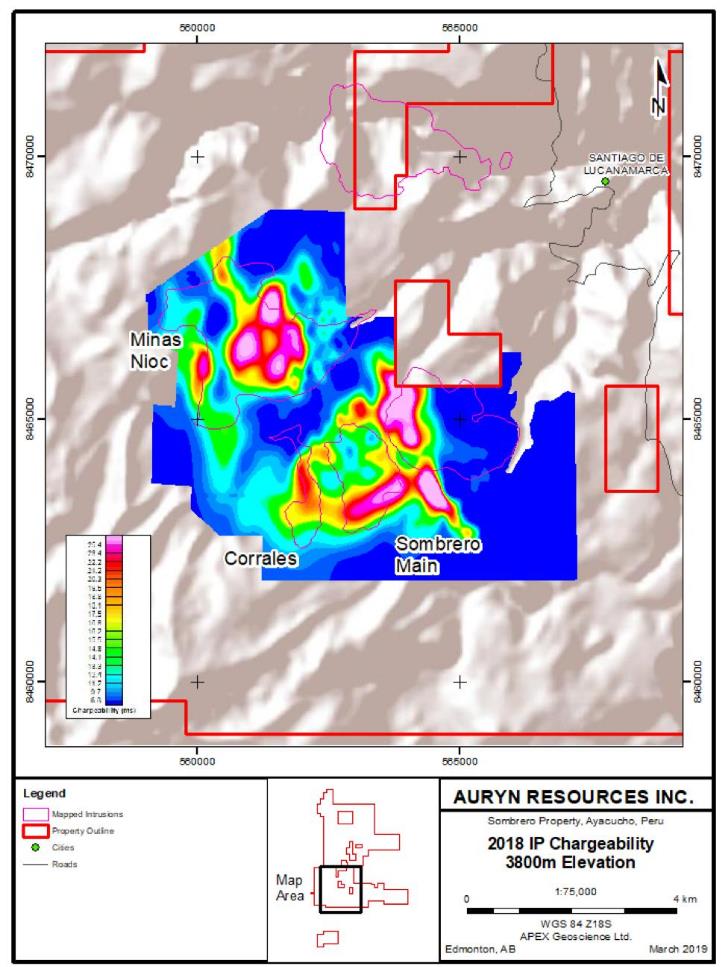
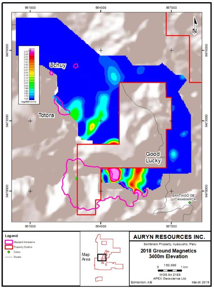
| 9.6 | 2018 Geophysical Surveys | | 71 |
| 9.6.1 | 2018 Induced Polarization | | 71 |
| 9.6.2 | 2018 Ground Magnetics | | 71 |
| 10 | Drilling | | 75 |
| 11 | Sample Preparation, Analyses and Security | | 75 |
| 11.1 | Regional Stream Sediment (BLEG) Sampling | | 75 |
| 11.2 | Soil Sampling | | 77 |
| 11.2.1 | 2016 Soil Sampling | | 77 |
| 11.2.2 | 2018 pXRF Soil Sampling | | 78 |
| 11.3 | Rock (Grab) Sampling | | 79 |
| 11.4 | Trench Sampling | | 80 |
| 11.5 | Previous Sampling by Alturas | | 81 |
| 12 | Data Verification | | 82 |
| 12.1 | Non-Analytical Data Verification | | 82 |
| 12.2 | Analytical Data Verification | | 82 |
| 12.3 | Quality Assurance and Quality Control | | 82 |
| 12.4 | Qualified Person Site Inspection | | 85 |
| 13 | Mineral Processing and Metallurgical Testing | | 88 |
| 14 | Mineral Resource Estimates | | 88 |
| 15 | Adjacent Properties | | 88 |
| 15.1 | Deposit Analogs | | 88 |
| 15.1.1 | Las Bambas | | 90 |
| 15.1.2 | Tintaya | | 91 |
| 16 | Other Relevant Data and Information | | 93 |
Technical Report on the Sombrero Project, Ayacucho Department, Peru
| 17 | Interpretation and Conclusions | | 93 |
| 18 | Recommendations | | 97 |
| 19 | References | | 99 |
| 20 | Certificate of Author | | 101 |
| Appendix 1 - General List of Units, Abbreviations and Measurements | | 102 |
| Appendix 2 – Author’s 2018 Property Visit Confirmation Sample Descriptions and Analytical Certificate | 104 |
| Appendix 3 – List of Mineral Concession | | 105 |
| | | | |
| Tables | | | |
| | | | |
| Table 4.1. Sombrero Property Mineral Concessions Summary | | 14 |
| Table 9.1 Press Released assay highlights from the 2016 and 2018 Sombrero Trench Sampling Programs. | 68 |
| Table 15.1. Antilla Mineral Resources (Aarsen, 2018). | | 90 |
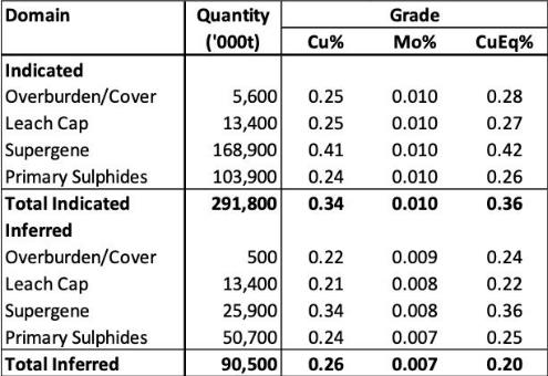
| Table 15.2 Las Bambas Mineral Reserves and Resources (after MMG, 2018) | | 91 |
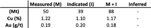
| Table 15.3. Tintaya Reserves and Resources (as at Dec 31, 2011) (Xstrata, 2011). | | 91 |
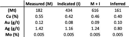
| Table 15.4. Antapaccay Reserves and Resources (as at Dec 31, 2017) (Glencore, 2018). | | 92 |
| Table 15.5. Antapaccay Reserves and Resources (as at Dec 31, 2017) (Glencore, 2018). | | 93 |
| Table 18.1. Estimated expenditure requirements for recommended exploration work. | | 97 |
| | | | |
| Figures | | | |
| | | | |
| Figure 2.1. Sombrero Property location. | | 11 |
| Figure 4.1. Sombrero Property mining concessions. | | 13 |
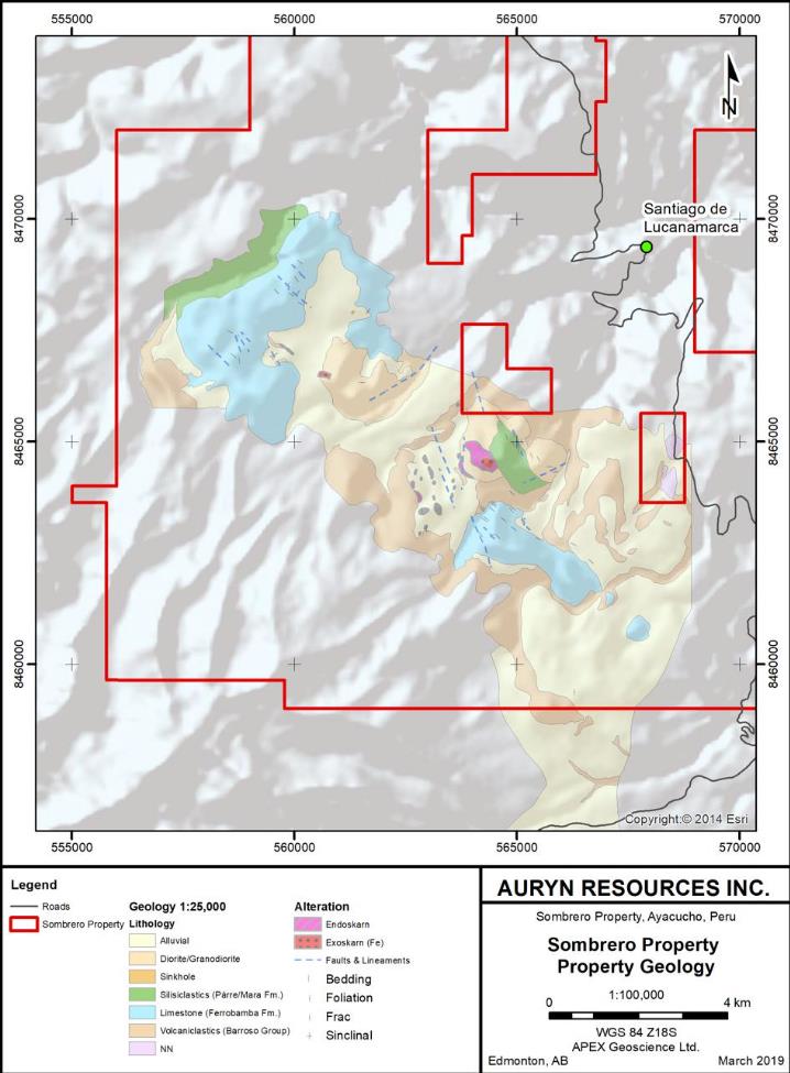
| Figure 6.1. Skarn prospects and target areas at the Sombrero Property. | | 20 |
| Figure 6.2. 2007 Mapping work by Alturas Mineral Corp. | | 23 |
| Figure 6.3. 2007 Alturas Rock Sample Geochemistry – Au ppm (6.3a) and Cu ppm (6.3b). | 24 |
| Figure 6.4. 2007 Ground Magnetics survey (Reduced to Pole data). | | 26 |
| Figure 6.5. 2007 Ground Magnetics survey (Analytical Signal). | | 26 |
| Figure 6.6. Coverage of the Induced Polarization survey completed by Alturas (chargeability at 3700m RL). | 27 |
| Figure 6.7. Coverage of the Induced Polarization survey completed by Alturas (Resistivity at 3700m RL). | 27 |
| Figure 6.8. Inversion sections of the Induced Polarization surveys completed by Alturas (chargeability, Northern Zone). | 28 |
| Figure 6.9. Inversion sections of the Induced Polarization surveys completed by Alturas (chargeability, Southern Zone). | 28 |
| Figure 7.1. Geographic location of the Sombrero Property. | | 30 |
| Figure 7.2. Tectonic domains of Peru. | | 31 |
| Figure 7.3. Geological Setting of the Sombrero Property relative to INGEMMET Metallogenic Zones and the AY Belt. | 34 |
| Figure 7.4. Tectonic Setting of the Sombrero Property relative to the Eocene-Oligocene Porphyry belts of Peru and Chile (after Perelló et al., 2003). | 36 |
| Figure 7.5. Regional geology of the Sombrero Property. | | 38 |
| Figure 7.6. Sombrero schematic stratigraphic section (with known prospects). | | 40 |
Technical Report on the Sombrero Project, Ayacucho Department, Peru
| Figure 7.7. Sombrero (South) Property geology (from recent mapping by Alturas and Auryn). | 41 |
| Figure 7.8. Massive hematite skarn in a north-south structure at the Sombrero Main area. | 43 |
| Figure 7.9. Close-up view of the copper-stained massive magnetite (+hematite) rock (from Auryn Resources). | 44 |
| Figure 7.10. View looking northeast of the Good Lucky intrusion and skarn zone (from Auryn, 2018A). | 45 |
| Figure 7.11. Massive hematite-chalcopyrite mineralization at the Good Lucky prospect. | | 45 |
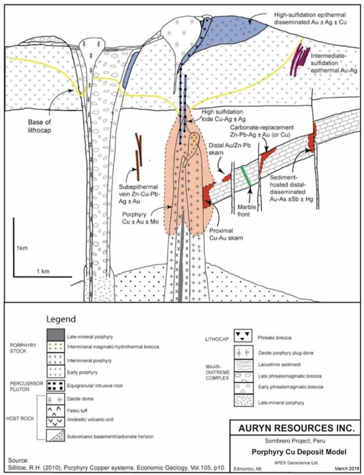
| Figure 8.1. Porphyry Copper Deposit Model (after Sillitoe, 2010). | | 49 |
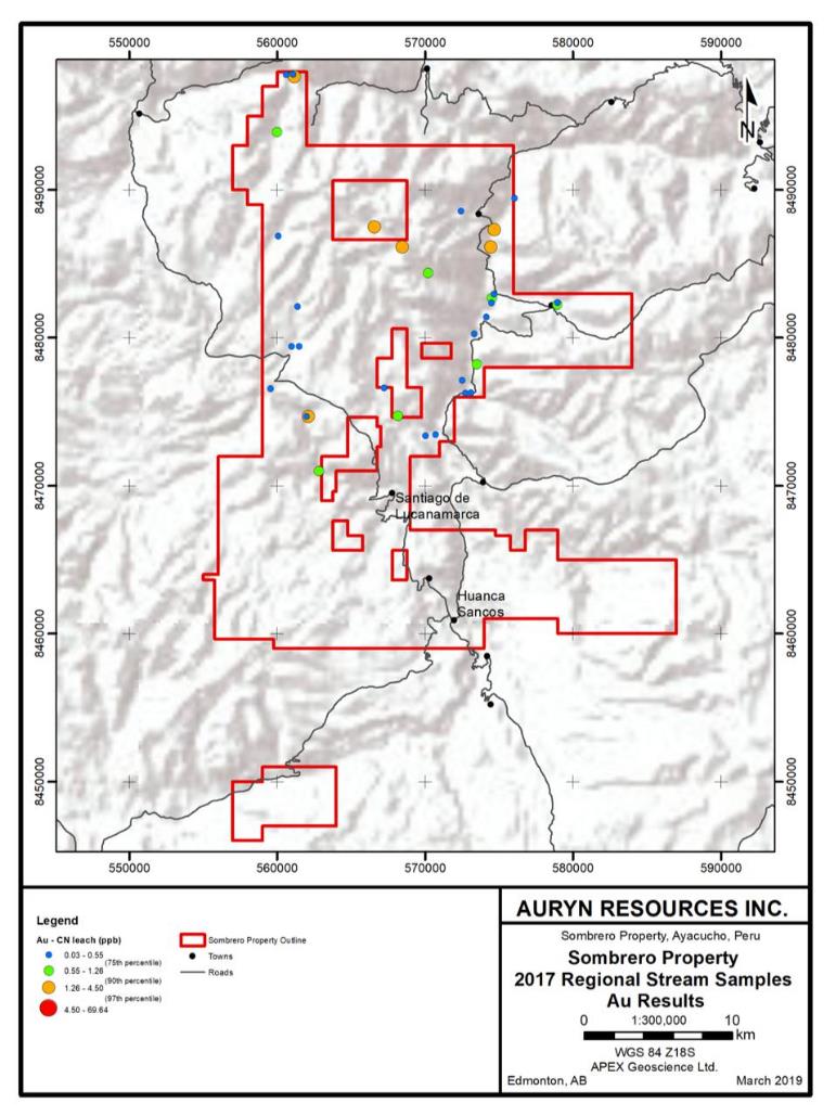
| Figure 9.1. 2017 regional stream sediment sampling program – BLEG (Au) results. | | 51 |
| Figure 9.2. 2017 regional stream sediment sampling program – Cu ICP results. | | 52 |
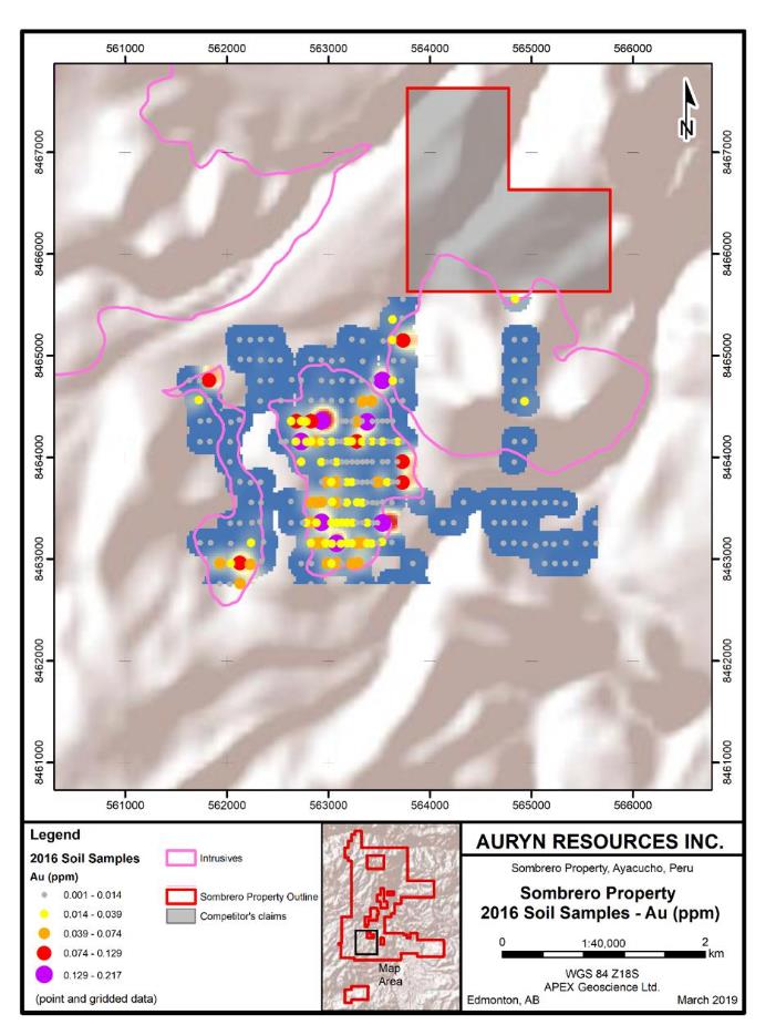
| Figure 9.3. 2016 soil sampling program – Au results. | | 55 |
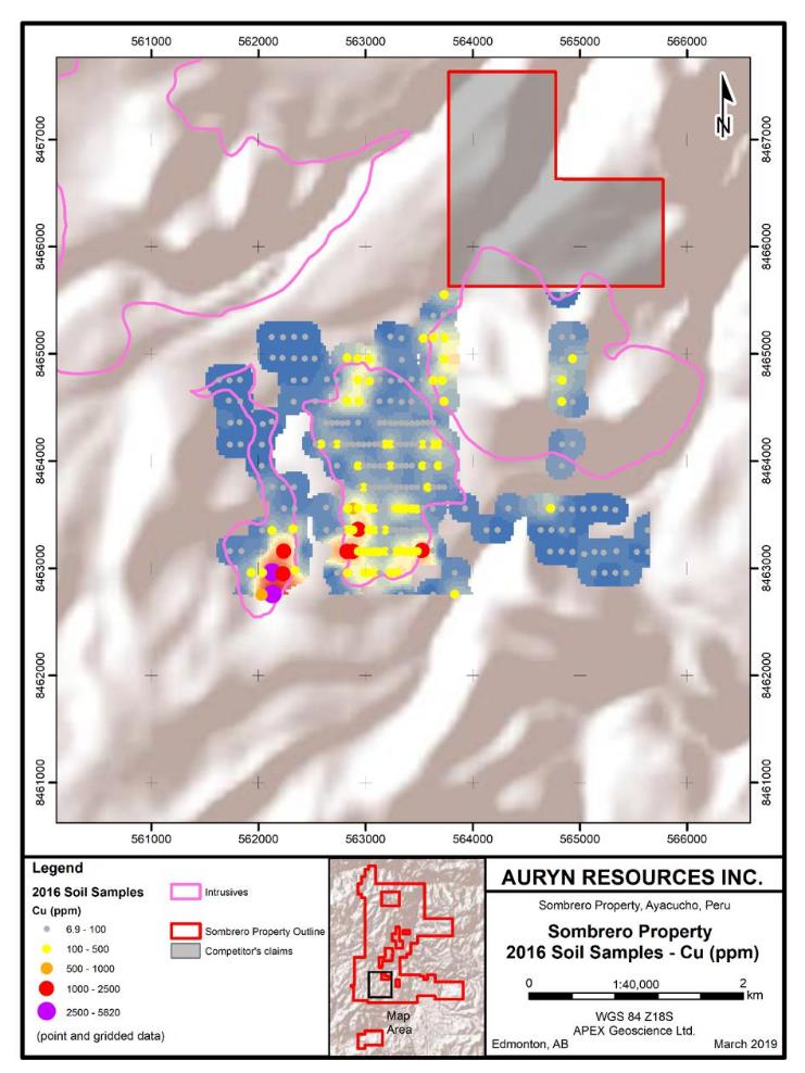
| Figure 9.4. 2016 soil sampling program – Cu results. | | 56 |
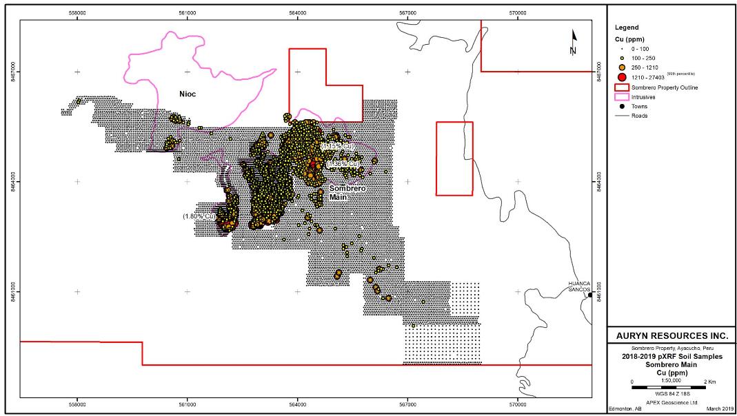
| Figure 9.5. 2018-2019 pXRF soil sampling program at the Sombrero Main prospect – Cu (ppm) results. | 58 |
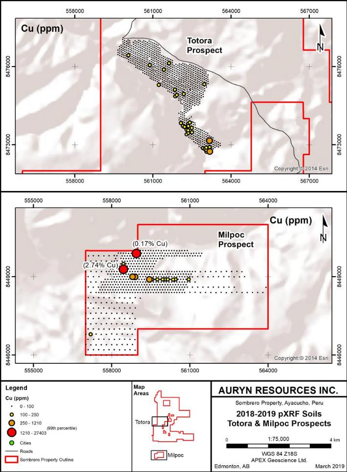
| Figure 9.6. 2018-2019 pXRF soil sampling program - Totora (9.6a) and Milpoc (9.6b) prospects Cu (ppm) results. | 59 |
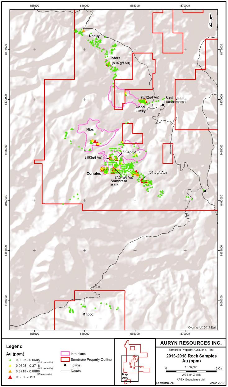
| Figure 9.7. 2016-2018 rock grab sampling program – Au (ppm) results. | | 62 |
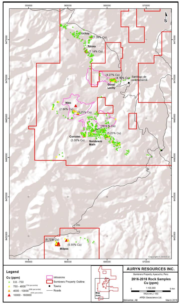
| Figure 9.8. 2016-2018 rock grab sampling program – Cu (ppm) results. | | 63 |
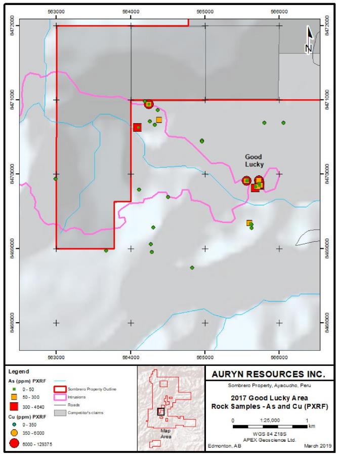
| Figure 9.9. 2017 Good Lucky area rock sampling - As and Cu pXRF results. | | 65 |
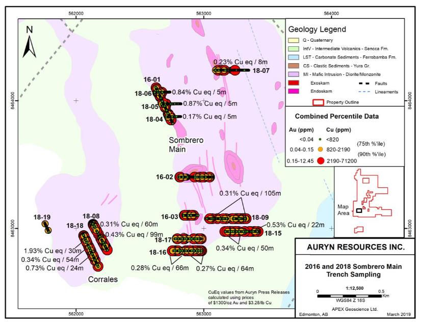
| Figure 9.10. 2016 and 2018 Sombrero Main trench sampling. | | 69 |
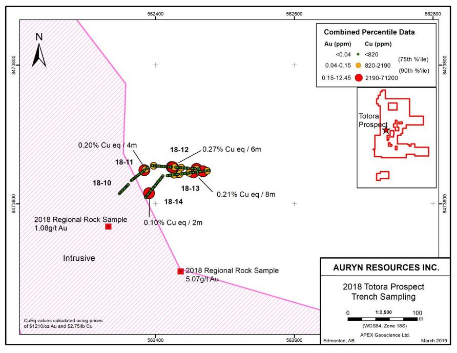
| Figure 9.11. 2018 Sombrero Totora prospect area trench sampling. | | 70 |
| Figure 9.12. Coverage of the IP survey completed in 2018 (chargeability at 3800 m RL). | | 72 |
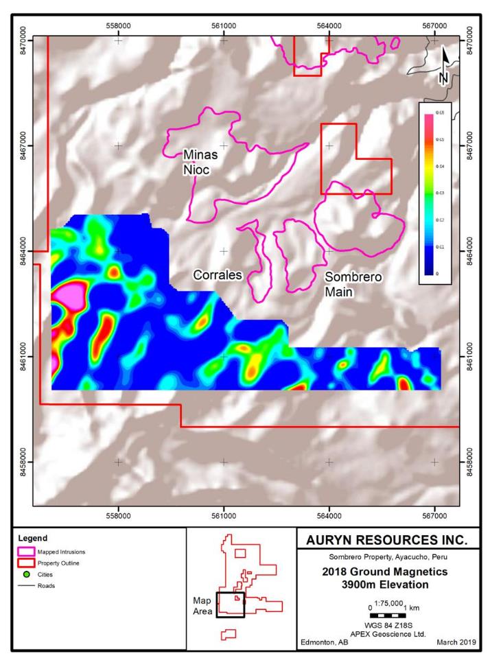
| Figure 9.13. Coverage of the ground magnetic survey over the north ground block completed in 2018 at 3400 m RL. | 73 |
| Figure 9.14. Coverage of the ground magnetic survey over the south ground block completed in 2018 at 3900 m RL. | 74 |
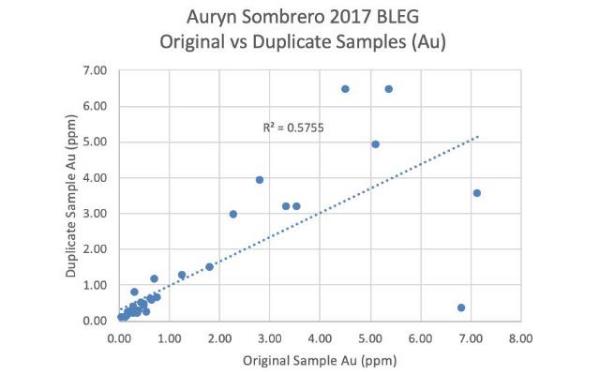
| Figure 12.1. Bivariate plot of original BLEG sample assays versus field duplicate assays. | 84 |
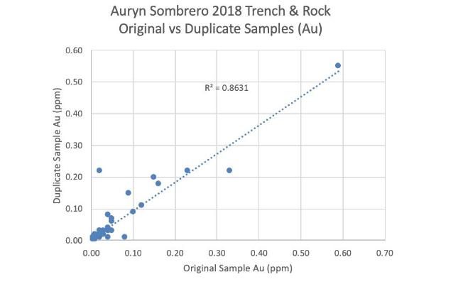
| Figure 12.2. Bivariate plot of original trench and rock sample assays versus field duplicate assays (Au). | 84 |
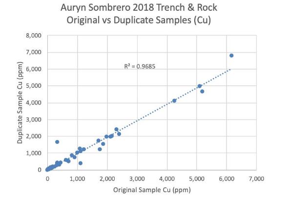
| Figure 12.3. Bivariate plot of original trench and rock sample assays versus field duplicate assays (Cu). | 85 |
| Figure 12.4. 2018 APEX rock grab samples collections (author’s confirmation samples). | | 87 |
| Figure 15.1. Mineral deposits of the Andahuaylas-Yauri BeltAY Belt of Peru, (from Perelló, 2003). | 89 |
Technical Report on the Sombrero Project, Ayacucho Department, Peru
The Sombrero Property (the “Property”) is located in southern Peru approximately 345 kilometers (km) southeast of Lima. The Property is being explored for copper (Cu) - gold (Au) skarn mineralization and possible related Cu (and Cu-Au) Porphyry mineralization. The following Technical Report, written in accordance with NI 43-101 standards, summarizes the results of recent exploration work conducted at the Property by Auryn Resources Inc. (“Auryn” or “Auryn Resources”). The author of this report, Mr. Andrew J. Turner, P.Geol., is a Principal and Consultant with APEX Geoscience Ltd. (“APEX”), which was retained to complete this Technical Report in July of 2018. Mr. Turner is fully independent of both Auryn and all of the other underlying mineral concession owners. The author conducted a site visit at the Property between July 12 and 14, 2018, during which the presence of significant zones of iron (Fe)+/-Cu-Au skarn mineralization at the Property was confirmed.
The Sombrero Property is located in southern Peru, in the Department of Ayacucho, and straddles the Provinces of Huanca Sancos and Victor Fajardo. The Property comprises a main block of 81 individual mineral concessions and a block of 3 additional concessions approximately 8km to the south of the main block. The 84 total mineral concessions comprise a total area of 73,000 hectares (ha), approximately 83% of which have been published and 17% remain “in application” but are expected to be granted shortly. Due to minor overlaps with pre-existing concessions, the effective size of the Property is currently 65,494.7 ha.
Auryn Resources Inc., through its wholly owned subsidiary Sombrero Minerales SAC (“Sombrero Minerales”), entered into an Option Agreement with Alturas Minerals Corp. (“Alturas” or “Alturas Minerals”) in June of 2016 whereby Sombrero Minerales was granted the right to initially earn an 80% interest in the original Alturas Sombrero Property by making cash payments to Alturas totaling US$200,000 and by incurring exploration expenditures of US$2.1 million over a 5-year period. An 80-20 Joint Venture (JV) between Auryn and Alturas with respect to the Sombrero Property would be formed following the completion of the payment and expenditure requirements, with Alturas having a carried interest during the 1st year of the JV and Auryn having the right to buy out Alturas’ remaining 20% in the Property for US$5 million.
Through out the subsequent years, Sombrero Minerales expanded the Sombrero Property with application for additional mineral concessions and two additional option agreements, the Mollecruz Option and the Aceros Option.
The Property is located geographically in the Western Cordillera of southern Peru and its climate, flora and fauna, and topography is typical of this region. The project area mainly comprises a high plateau with gently rolling hills that are cut occasionally by relatively deeply incised, steep-walled river valleys. The overall topographic relief on the Property is between ~2900 meters (m) and 4700m, with relief on the plateau areas generally more subdued, ranging between 3900m and 4100m.
Technical Report on the Sombrero Project, Ayacucho Department, Peru
There is no documentation available describing any historical mineral exploration or mineral production at the current Sombrero Property prior to the recent work that has been completed at the Project by Auryn and Alturas. That being said, the concessions comprising the Sombrero Property surround a number of concessions belonging to competitors that form (6) “holes” within the otherwise contiguous Property concessions. At several locations on both Sombrero and competitor’s concessions, small historically excavated pits and adits (i.e. Good Lucky) have been identified. The Fierrazo iron skarn zone was apparently mined recently by Aceros Arequipa with the mining activity for magnetite ore evidenced by a number of shallow trenches, excavations and waste rock piles. The concession that hosts the old Fierrazo iron mine was recently acquired by Auryn and is now included in the Sombrero Property. The author is not aware of any environmental liabilities on the current Sombrero Property.
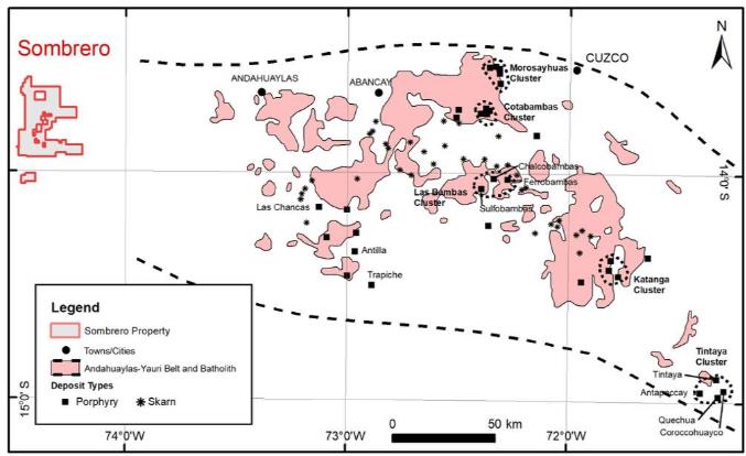
The Sombrero Property lies within a likely northwestern extension of the of Andahaulylas-Yauri (AY) Belt of southern Peru, which is an important porphyry copper and skarn belt. The belt strikes roughly northwest-southeast and can be traced for more than 300km along strike. The belt hosts important copper-gold-molybdenum camps/deposits at Las Bambas, Los Chancas, Cotambambas and Tintaya (and others) and is thought to be a northern extension of the copper-rich belt of the same Eocene-Oligocene age that strikes broadly north-south in Chile (Perelló et al., 2003).
Historical exploration work completed at the Property by Alturas, prior to the involvement of Auryn Resources (2007-2016), included geological mapping, rock sampling and geophysical surveying (ground magnetics and Induced Polarization (IP)). Recent work by Auryn Resources at the Property (since June 2016) includes additional mapping and rock sampling, regional stream sediment sampling, soil sampling, trenching and geophysical surveying (ground magnetics and IP). This work has resulted in the identification of widespread skarn-style mineralization in the “original” southern part of the Property. Extensive zones of Fe +/- Cu and Au exoskarn and endoskarn have been mapped and sampled throughout Sombrero Main – Corrales area in the southern part of the Property, which has been the focus of recent work. A complete intrusive-skarn (exoskarn and endoskarn) system is exposed by erosion in the north wall of a steep canyon at the Good Lucky prospect located approximately 6km north northeast of the Sombrero Main area. In addition, recent work by Auryn has identified new zones of jasperoid and skarn mineralization and, significantly, porphyry-style alteration at the Totora and Uchuy prospects, located approximately 5km northwest of the Good Lucky prospect, as well as Cu-oxide with associated silver (Ag) mineralization at the Milpoc prospect, located 13km south of the Sombrero Main prospect.
Mineralization comprises large, sub-horizontal areas of intense iron oxide (magnetite and hematite) with amphibole-garnet developed in metasomatized Ferrobamba Formation (Fm.) limestones (exoskarn). Exoskarn occurs in areas immediately adjacent to the mapped extent of intrusive rocks and within the intrusives as interpreted possible roof pendants. Endoskarn comprises similar but narrower zones of iron oxide-rich skarn generally developed along north northwest-south southeast striking structures cutting through the dioritic-monzonitic intrusive rocks. Both the endo and exoskarn units contain varying amounts of late (?) Cu mineralization associated with silicified breccia, which appears to be related to increased Au grades. The Cu-Au zones were likely sulphide-bearing but surface weathering has removed most of the sulphide minerals, which have been replaced by often abundant Cu oxides. At the Good Lucky prospect, where several small surface pits and tunnels have been excavated into the mineralized zones, unoxidized skarn comprises massive coarse iron oxides with coarse-grained chalcopyrite.
Technical Report on the Sombrero Project, Ayacucho Department, Peru
Rock sampling highlights from the Property’s prospect areas are as follows;
● Sombrero Main – Corrales area: up to 193g/t Au and 16.0% Cu.
●Good Lucky area: up to 5.12g/t Au and 4.29% Cu.
●Uchuy area: up to 0.50g/t Au and 1.39% Cu.
●Totora area: up to 5.07g/t Au and 3.14% Cu
●Milpoc area: up to 8.75% Cu and 101g/t Ag
Recent trenching in the southern portion of the Sombrero Main area has identified significant zones of Cu-Au mineralization (with <5m of dilution) including;
● Trench 18-08 : 234m of 0.28% CuEq (with some dilution),
Including 60m of 0.29% Cu Equivalent (CuEq) *
and an additional 99m of 0.46% CuEq *
● Trench 18-09 : 177m of 0.23% CuEq (with some dilution),
Including 105m of 0.30% CuEq *
● Trench 18-15:
22m of 0.53% CuEq and 0.92g/t Au Equivalent (AuEq)**
and an additional 50m of 0.34% CuEq and 0.59g/t AuEq**
● Trench 18-16:
64m of 0.27% CuEq and 0.46g/t AuEq**
and an additional 66m of 0.28% CuEq and 0.49g/t AuEq**
● Trench 18-18:
30m of 1.93% CuEq and 3.34g/t AuEq***
and an additional 54m of 0.34% CuEq and 0.60g/t AuEq***
and an additional 24m of 0.73% CuEq and 1.26g/t AuEq***
* see Auryn Press Releases dated June 19, 2018
** see Auryn Press Releases dated September 5, 2018
*** see Auryn Press Releases dated September 26, 2018.
(“dilution” includes zones >5m in length averaging < 0.1g/t Au or 0.1% Cu)
(Cu Equivalent Grades calculated using metal prices of $1300/oz of Au and $3.28/lb of Cu)
Three-dimensional (3-D) interpretation of historical and recent magnetics and Induced Polarization (IP) geophysical data indicates that (magnetic and chargeability) anomalies extend to depth below the mineralization exposed at surface. There has been no drilling at the Sombrero Property to date.
Technical Report on the Sombrero Project, Ayacucho Department, Peru
It is the opinion of the author of this report that recent exploration completed at the Sombrero Property is appropriate for the deposit type(s) being explored and has been carried out in a manner that meets, and often exceeds, “industry standards”. Furthermore, based upon the author’s site visit and the results of the exploration work discussed in this report, it is the opinion of the author that the Sombrero Property is a “Property of Merit” warranting continued exploration work. The author is unaware of any unusual risk factor, other than those normally associated with mineral exploration, that might affect future exploration work and potential development of the Property.
Based upon the author’s site visit and the results of the exploration work discussed in this report, it is the opinion of the author that the Sombrero Property is a “Property of Merit” warranting significant continued exploration work including work at Minas Nioc, Good Lucky, Fierrazo, Totora, Uchuy, and Milpoc. The estimated cost of the recommended work programs at the Sombrero Property is $8.19 million, a tabulated summary of which is provided in Table 18.1.
In addition to certain general and administrative costs, such as the required payment of approximately $219,000 in concession maintenance fees, there are still large areas throughout the Property that require basic exploration work. Additional prospecting (rock sampling) and geological mapping is required in several areas in the northern part of the Property. Regional soil sampling programs are warranted to expand the extensive sampling completed in the southern part of the Property, as well as extending the sampling at the Good Lucky – Totora - Uchuy corridor and the sampling to the south at the Milpoc prospect.
Additional work is also required at the known prospect areas to evaluate and potentially expand the currently identified areas of alteration and mineralization. Additional trenching is required at the Sombrero Main – Corrales prospect areas, as well as at the Good Lucky prospect. Most importantly, a significant expansion of ground geophysical work (magnetics and IP) is required in order to define targets for drill testing, particularly in areas where recent volcanic deposits cover the prospective intrusions and their host sedimentary rocks.
The recommended work program also includes a significant amount of drilling at the Sombrero Main – Corrales area as well as the Good Lucky prospect. Initial drill testing of these areas/prospects is warranted at this time based upon current exploration results and is not contingent upon the results of the recommended fieldwork programs discussed above. Initial drill testing of the Sombrero Main – Corrales area will require a program on the order of 4,000m comprising 15 holes drilled to depth of between 250-300m in order to test the full depth extent of IP anomalies. Similarly, a drill program on the order of 2,500m comprising 8-10 holes drilled to depth of between 250-300m is recommended for the initial drill testing of the Good Lucky prospect.
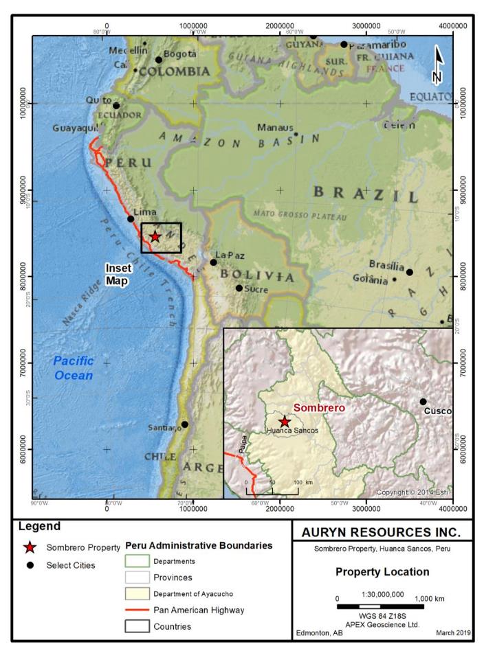
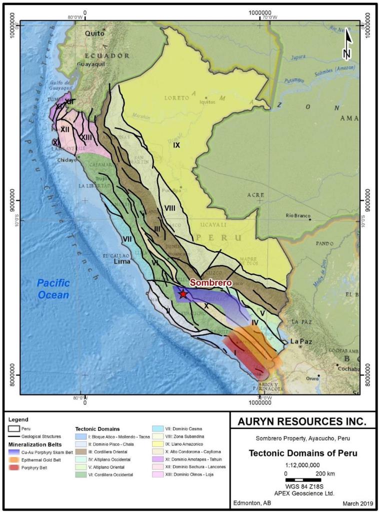
Auryn Resources Inc. (“Auryn” or “the Company”), is a Vancouver-based mineral exploration company incorporated in British Columbia and is a public company listed on the NEX board of the TSX Venture Exchange (“TSX.V”) trading under the symbol AUG. The Company is exploring approximately 65,000 hectares of land in southern Peru referred to as the Sombrero Project, which is roughly centered 80km south southwest of the city of Ayacucho, Ayacucho Department, in southern Peru (Figure 2.1). This Technical Report has been prepared on behalf of Auryn and is intended to summarize historic work and recent work completed at the Project by Auryn during 2016 and 2019.
Auryn Resources, through its wholly owned Sombrero Minerales, initially acquired an interest in the Sombrero Project on June 26, 2016 through an option of 6 mineral concessions from Alturas Minerals SAC. Under the terms of this option, Sombrero Minerales, was granted the right to earn an 80% interest in these concessions by making cash payments to Alturas totaling US$200,000 and by incurring exploration expenditures of US$2.1 million over a 5-year period. An 80-20 Joint Venture (JV) between Auryn and Alturas with respect to the Sombrero Property would be formed following the completion of the payment and expenditure requirements, with Alturas having a carried interest during the 1st year of the JV and Auryn having the right to buy out Alturas’ remaining 20% in the Property for US$5 million.
Through out the subsequent years, Sombrero Minerales expanded the Sombrero Property with applications for additional mineral concessions and concluded two additional option agreements, the Mollecruz Option and the Aceros Option. The property currently comprises 84 individual mineral concessions in 2 blocks, covering an effective area of approximately 65,495 hectares.
The Sombrero Project is located geologically within the AY Belt and sits northwest of the main Eocene-Oligocene aged copper-gold porphyry and skarn belt of southern Peru that hosts the Las Bambas, Haquira, Los Chancas, Cotambambas, Constancia, Antapaccay and Tintaya deposits. Auryn is hopeful that the Sombrero Property area represents a northwest extension to this zone of mineral deposits, which has been relatively underexplored due mainly to a thick and regionally extensive blanket of recent volcanic rocks. The main target area at the Sombrero Project comprises an erosional window through the overlying volcanics with extensive exposures of the underlying sediments and intrusives. The Property is being explored for porphyry and/or skarn mineralization characterized by elevated Au and Cu values.
The author of this report, Mr. Andrew Turner, B.Sc., P.Geol., is a Principal and a Senior Consulting Geologist with APEX Geoscience Ltd. (APEX). The author is fully independent of Auryn Resources and Alturas Minerals and is a Qualified Person, as defined by NI 43-101. APEX was recently retained by Auryn to perform a property visit and complete this Technical Report regarding the Sombrero Property. Mr. Turner is responsible for the writing and preparation of all sections of this report and conducted a site visit to the Sombrero Property on July 12 and 13, 2018, and observed evidence
Technical Report on the Sombrero Project, Ayacucho Department, Peru
Figure 2.1. Sombrero Property location.
Technical Report on the Sombrero Project, Ayacucho Department, Peru
verifying recent work by Auryn. Furthermore, the author observed extensive zones of alteration, with Cu mineralization, at the Property and collected several rock samples.
Unless otherwise stated, all units discussed in this report are metric units, all references to currency reference United States dollars, and all coordinates refer to UTM (Universal Transverse Mercator) projection relative to zone 18 south of the WGS84 datum (World Geodetic Survey – 1984).
| | 3 | Reliance of Other Experts |
This Technical Report is a compilation of proprietary and publicly available information. In writing this report, the author has not relied upon or utilized the opinions or conclusions of any other experts. The exploration data utilized and discussed in this report was obtained from Auryn Resources primarily in digital format. This included a review of previous reports and exploration data, as well as all modern surface exploration data. These and other sources of information are reviewed in Section 6 and listed in the Reference Section 19. A list of common abbreviations that may appear in this report is provided in Appendix 1.
The author, in writing this Report, has used sources of information from current previous explorers, which appear to have been completed in a manner consistent with normal exploration practices. The supporting documents, which were used as background information are referenced in the ‘History’, ‘Geological Setting and Mineralization’, ‘Deposit Types’, ‘Adjacent Properties’ and ‘References’ Sections. The author, based upon the property visit and work performed on the property to date, believes that the work performed to date is appropriate for the target type and is substantially accurate and complete.
| | 4 | Property Description and Location |
| | 4.1 | Property Introduction and Location |
The Sombrero Property is located in southern Peru approximately 350km southeast of Lima and 80km south-southwest of the city of Ayacucho, the capital of the Ayacucho Department. The Sombrero Property straddles the districts of Sancos and Santiago de Lucanamarca and the Provinces of Huanca Sancos and Victor Fajardo. The approximate centre of the property is located at UTM coordinates 566,500 E, 8,478,500 N, (WGS 84 zone 18S), or latitude 13.762° S, longitude 74.385° W.
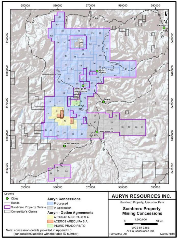
The Property comprises a total of 84 mineral concessions in 2 blocks (see Appendix 3). Of these concessions, 70 (or approximately 83% of the concession area) have had their title granted to their registered owner while the remaining 14 concessions (approximately 17% of the concession area) remain “in application”. Auryn is not aware
Technical Report on the Sombrero Project, Ayacucho Department, Peru
Figure 4.1. Sombrero Property mining concessions.
Technical Report on the Sombrero Project, Ayacucho Department, Peru
of any reason that would prevent the granting of the concessions ‘in application’ as their respective areas were “open” (unclaimed) at the time of their application.
There are six (6) small gaps, or holes, within the main area of the Sombrero Property that correspond to pre-existing competitor’s claims (see Figure 4.1). As a result, the net size of the Sombrero Property is approximately 65,494.7 ha.
The Sombrero Property is held by Sombrero Minerales either through direct ownership of the mineral concessions or through option agreements with third parties (see Table 4.1)
Table 4.1. Sombrero Property Mineral Concessions Summary
| Ownership Description | Registered Owner | Number of Claims | Hectares |
| Direct | Sombrero Minerales SAC1 | 71 | 66,500 |
| Alturas/ Sombrero Option | Alturas Minerals SA | 6 | 4,600 |
| Mollecruz Option | Ingrid Prado | 4 | 1,300 |
| Aceros Option | Aceros Arequipa SA | 3 | 600 |
| Total | | 84 | 73,000 65,494.7 net ha |
1 Concession Sombrero 15 is registered under the name of Corisur Peru SAC, a Peruvian Company wholly owned by Auryn. Corisur has filed to have the concession transfer to Sombrero. This filing is still in process at the time of this report.
| | 4.2.1 | Original Alturas/ Sombrero Option |
On June 28, 2016, Auryn Resources Inc. entered into an Option Agreement with respect to the Sombrero Project with Alturas Minerals Corp. whereby Auryn was granted the option to earn up to a 100% interest in the Property. Initially, Auryn has an option to earn an 80% interest in the Property by incurring US$2.1 million in exploration expenditures within 5 years and making payments to Alturas totaling US$200,000 within the first year of the agreement. When these payments and work requirements are achieved by Auryn, an 80:20 Joint Venture will be formed with respect to further exploration and development of the Sombrero Property with Alturas having a carried interest for 1 year, during which time Auryn will have the right to buy Alturas’ remaining 20% interest for US$5 million.
On June 22, 2018, the Company acquired the rights to the Mollecruz concessions covering 1,300 ha and the “Good Lucky” prospect. Under the terms of an option agreement dated June 22, 2018, the Company may acquire a 100% interest in the Mollecruz concessions by completing US$3,000,000 in work expenditures and by making payments totaling US$1,600,000 to the underlying owner over a five year period. At signing, Auryn paid US$50,000 and upon exercise of the option, the underlying owner will retain 0.5% NSR royalty with an advance annual royalty payment of US$50,000 commencing after completion of this option.
Technical Report on the Sombrero Project, Ayacucho Department, Peru
On December 19, 2018, Sombrero Minerales entered into a series of agreements with Corporacion Aceros Arequipa S.A. (“Aceros”) which constitute an 80% option over three (3) key inlier concessions to the Sombrero Project. Under the terms of these agreements, Sombrero Minerales will initially option the concessions through a mining assignment and lease agreement to ultimately earn a right to form an 80:20 corporate joint venture after completing a series of cash payments ($800,000) and work commitments ($5,150,000) over a 5 year period. The joint venture will encompass the Aceros concessions and the Alturas/Sombrero Option concessions.
If the Option is exercised, Sombrero Minerales will hire an independent engineer to complete two preliminary economic scoping studies (PEAs) over a period of two years. These PEAs will be a study of the existing magnetite deposits and of any identified non-ferrous (including Cu, Au, Ag, Mo) mineralization, respectively. If it can be shown that the net present value (NPV) of any non-ferrous deposit located within the joint venture area is greater than five times the NPV of the existing magnetite deposits within the Aceros Concessions then an 80:20 corporate joint venture will be established using a newly-formed, jointly-owned Peruvian corporation.
In the event Sombrero Minerales is unable to show that the net present value (NPV) of any non-ferrous deposit is greater than five times the NPV of the existing magnetite deposits, then it can attain an extension of up to three years if an NPV of at least $100 million was shown, and Sombrero Minerales must pay Aceros an additional $2 million for each year of extension.
Once the joint venture is established, it will be governed by a customary shareholders’ agreement with specific provisions allowing for the dilution of non-contributing parties and drag-along and first refusal rights.
Formation of the joint venture also requires that Sombrero Minerales first exercise its existing option rights with Alturas to acquire a 100% interest in the underlying concessions.
To the knowledge of the author of this report, there are no other royalties or other encumbrances regarding the mineral concession that comprise the Sombrero Property. Furthermore, there are no environmental liabilities at the Property.
Technical Report on the Sombrero Project, Ayacucho Department, Peru
| | 4.3 | Peruvian Mining Law and Concession Maintenance |
The following Information is summarised from an online article summarising Peruvian Mining Law by Alberto Delgado and David Baracco of the Peruvian Lay Firm Miranda & Amado (https://content.next.westlaw.com/Document/ Ie3ca5b2637ef11e798dc8b09b4f043e0).
Mining and mineral exploration in Peru is administered by the Ministry of Energy and Mines (Ministerio de Energia y Minas) The General Mining Law of Peru, which was consolidated in the ‘Single Revised Text of the General Mining Law’ of 1992 (document D.S. No. 014-92EM, 19926) defines and regulates different categories of mining activities, ranging from sampling and prospecting to development, exploitation and processing. The law differentiates between metallic and non-metallic mining and further differentiates between Large scale, Medium scale, Small scale and Artisanal scale mining activities.
The right to explore for and exploit minerals in Peru is granted by way of mining concessions. Since 2007, mining concessions have been awarded by, and are registered at INGEMMET (Instituto Geológico, Minero Y Metalúrgico). Prior to 2007, all transactions and contracts pertaining to mining concessions were entered in the Public Registry of Mining (SUNARP) at INACC. The owner of a concession registered at INACC or INGEMMET is the legal owner of that concession. Modern mining concessions are established using UTM coordinates specifying corner points, are measured in hectares (ha) with a minimum size of 100ha and a maximum size of 1000ha, and are required to have boundaries orientated orthogonal to the UTM grid, whereas older concessions (before 1992) were based on the ‘punto de partido’ system and can be of any orientation.
From the year in which the initial application is made for a mining concession, the owner must pay a licence fee (Article 39, General Mining Law). This payment must be made annually and represents a fee of US$3/ha for medium and large-scale mining concessions. Mining concessions are issued without a time limit and can only be canceled if a) the annual licencing fees are not paid or b) if the minimum mining production amount is not achieved by the end of the 30th year of the concession. Additionally, in the case of failure to comply with the minimum production or minimum investment obligations (see below), the mining holder must pay a penalty. Mining concessions oblige their holders to invest in the exploration and exploitation (production) of minerals. Therefore, mining holders are obliged to obtain, no later than by the expiration of the tenth year calculated from the following year in which the title was granted, an annual production per hectare (minimum production) of, for the medium and large-scale regime, no less than one tax unit or UIT (for 2018, US$1,300 approximately).
When a company reaches production level, a concession holder must sustain a minimum level of annual commercial production greater than US$100 per hectare in gross sales before the end of the sixth year following the granting of the concession. If a concession has been put into production within the six year period, the annual maintenance fee (derecho vigencia) remains US$3.00 per hectare, up to the beginning of the ninth year subsequent to the granting of the concession, when it increases to
Technical Report on the Sombrero Project, Ayacucho Department, Peru
US$4.00 per hectare for years 9 to 14. The annual maintenance fee rises to US$10.00 per hectare for each year thereafter.
If a concession has not been put into production within a six year period, the annual maintenance fee increases from the first semester of the seventh year to US$9.00 per hectare (US$3.00 for derecho vigencia, plus a US$6.00 penalty), until the minimum production level is met. If, by the start of the twelfth year from granting a concession the minimum production level is not achieved, the annual maintenance fee increases to US$23.00 per hectare (US$3.00 for derecho vigencia, plus a US$20.00 penalty). A concession holder can, however, be exonerated from paying penalties by demonstrating that at least ten times the penalty for the total concession was invested during the previous year. The investment must be documented, and it must be accompanied by a copy of the relevant annual tax statement (declaración jurada de impuesto a la renta) and payment of the annual maintenance fees.
Excluding work requirements and property payments that may be required under the various Option Agreements discussed above, the annual maintenance cost for the Sombrero Property for 2019 is anticipated to be approximately $219,000.
| | 4.4 | Permitting and Environmental Approvals |
The granting of mining concessions in Peru does not convey any surface rights and it is the responsibility of the concession holder to negotiate surface access rights to allow for mineral exploration work to be undertaken. With respect to the Sombrero Property, Auryn has successfully negotiated surface access agreements with the communities of Huanca Sancos, Santiago de Lucanamarca and San Jose de Hauracya allowing for exploration work to proceed on the majority of the Property, including the southern portion of the Property, which is the main area of interest at present.
In January 2019, the Company submitted an application for an initial Declaracion de Impacto Ambiental (DIA) for the Huanca Sancos portion of the Sombrero property covering an Area Of Interest (AOI) of 3600 hectares. This application will allow for the construction of up to 40 drill pads and drill access roads totalling 10 hectares of disturbance. As part of the process of drafting this application, the Company conducted initial baseline environmental studies, archeological studies and social economic studies in the effected areas. The submission process for environmental permits is complex and uncertain in nature and the company cannot guarantee that the permits will be received in a reasonable time frame or at all. At the date of this report, however, the Company does not foresee any reason that it will not receive permits to drill. Approval of the DIA is expected in the third quarter of 2019.
On the hill top within the older “Aceros HS 1” concession, there is a past producing iron (magnetite) mine that was operated by Aceros up until 2017. The previous mining activity is evidenced by a number of shallow trenches and excavations. Magnetite was extracted by an earthmoving contractor, who trucked it to Aceros’ smelter close to the coastal port of Paracas. Under the terms of the Aceros Option, Sombrero Minerales is not liable for any environmental damage or remediation associated with activities undertaken prior to the start of the option. In the event the option is exercised, the resulting joint venture would be responsible for any remaining reclamation outstanding at the date of formation.
Technical Report on the Sombrero Project, Ayacucho Department, Peru
The regulation on environmental protection on mining activities is provided principally by the Regulations for the Protection of the Environment applicable to the development of Mining Exploration Activities (Supreme Decree 042-2017-EM) and Environmental Regulations for Mining and Metallurgic Activities (Supreme Decree 040-2014-EM). These regulations establish the standards for the protection of the environment that have to be accomplished in the corresponding environmental and social management instrument (ESIA) for exploration and exploitation, including the environmental obligation and commitments of the mining holders. Currently, the ESIAs for medium and large-scale projects are approved by the General Bureau of Environmental Mining Affairs of the Ministry of Energy and Mines (MINEM) in the case of exploration and by the National Service of Environmental Certification for Sustainable Investments (SENACE) in the case of production; while the ESIA for small and artisanal scale activities are approved by the regional governments.
The Peruvian Ministry of Energy and Mines establishes an environmental protection policy and proposes maximum allowable levels for effluents, signs environmental administrative stability agreements. The Supervisory Board Investment in Energy and Mines (“OSINERGMIN”), is the entity in charge of supervising environmental obligations corresponding to mining companies. Work at the Sombrero Property is currently in the ‘exploration phase’.
| | 5 | Accessibility, Climate, Local Resources, Infrastructure and Physiography |
The Property was accessed by the author during his site visit by driving south from the city of Ayacucho, which is serviced daily by commercial flights from Lima, amongst other cities. The town of Huanca Sancos, located immediately adjacent to (east of) the main area of interest at the Sombrero Project, was accessed by a 4 hour drive on paved roads starting on Highway 3S from Ayacucho. Huanca Sancos is currently being used by Auryn as their main base of operations for the project as it offers food and basic supplies, accommodations and a labour supply. The main Sombrero target area is located approximately 10km west of Haunca Sancos and is accessible via a number of gravel roads, which remain open year-round.
Weather in the area of the Project is typical of high-altitude terrain at this latitude, where annual temperature fluctuations are limited. Daytime temperatures are typically cooler during the months of May to September with a rainy season generally extending from November to April. Temperatures vary between a few degrees centigrade (C) below zero during the night, up to 20°C during the day in the last months of the year. Snow is possible during the year but is not a significant issue and would not interfere with exploration or potential future mining activities.
Technical Report on the Sombrero Project, Ayacucho Department, Peru
| | 5.3 | Local Resources & Infrastructure |
The main area of interest, located in the southern portion of the Sombrero Property, is located approximately 10km west-northwest of the town of Huanca Sancos. As previously mentioned, Haunca Sancos is the current base of operations for Auryn and offers basic services including electricity, food markets, internet access and accommodations. Local labour can be obtained from the villages of Huanca Sancos or Santiago de Lucanamarca.
With respect to ongoing exploration and potential future mining activity, infrastructure in the project area is limited to several gravel roads and a high voltage powerline that crosses the southern portion of the Property. There is abundant water in and around the project area.
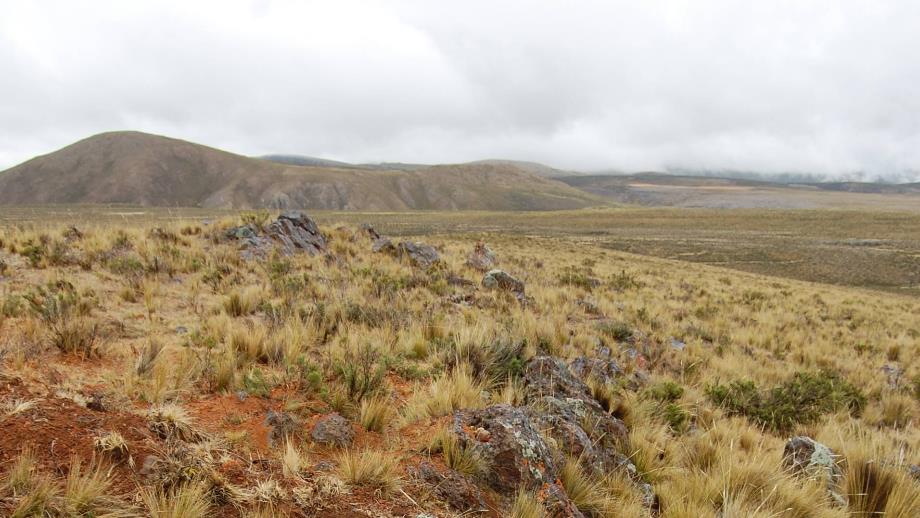
The project area expresses geographic features typical of the Altiplano with high plateau areas with gently rolling hills cut occasionally by relatively deeply incised, steep-walled river valleys. The topographic relief on the Property is between ~2900m and 4700m, with relief on the plateau areas generally more subdued ranging between 3900m and 4100m.
Tree cover is generally rare throughout the project area and is limited to valleys. The upland plateaus throughout the project area, including the main area of interest in the southern portion of the Sombrero Property, are characterized as elevated grasslands. Auryn is unaware of any plant or animal species or habitats at the project that may require special attention or special protective measures.
| | 6 | Historical Exploration Completed by Previous Companies |
There is no documentation available describing any historical mineral exploration or mineral production at the current Sombrero Property, prior to the recent work that has been completed at the Project by Auryn and Alturas, which is discussed below.
Within the main area of interest in the southern portion of the Sombrero Property, and at the Good Lucky prospect in the central part of the Property, there are several zones of Fe +/- Cu-Au skarn associated with intrusive rocks that have seen small scale historical excavation and production. For reference, the locations of the named prospects at the Sombrero Property are shown in Figure 6.1. During the site visit, the author observed several shallow test pits excavated in the recent past (exact dates unknown) at several locations in the Corrales–Sombrero Main area and several small adits and surface excavations, and small stockpiles of mineralized rock, were observed at the Good Lucky prospect. Again, there are no records available documenting the timing, scale or results
Technical Report on the Sombrero Project, Ayacucho Department, Peru
Figure 6.1. Skarn prospects and target areas at the Sombrero Property.
Technical Report on the Sombrero Project, Ayacucho Department, Peru
of these small-scale mining/excavation activities and, in the opinion of the author, none constitute a significant environmental liability.
In addition, the Fierrazo iron skarn zone has seen historical and recent iron ore production. The Fierrazo prospect is located within the southern part of the Sombrero Property, approximately 3km to the northeast of the Sombrero Main area. The Fierrazo prospect is located on a ridge top within the older “Aceros HS 1” concession and was mined recently by Arequipa. This activity is evidenced by a number of shallow trenches and excavations and waste rock piles. Magnetite ore was apparently the focus of the recent small-scale production work and was trucked to Aceros Arequipa’s smelter close to the coastal port of Paracas.
| | 6.1 | Exploration Work Completed by Alturas |
Prior to the current Auryn-Alturas Option Agreement (see Section 4 for details), Alturas Minerals completed exploration work at the Sombrero Property between 2007 and 2008 that comprised the following work items:
| | ● | Geological mapping (1:25,000 scale) and Rock Grab Sampling (total 96 samples) |
| | ● | Ground Magnetics surveying (200m line spacing, covering the mapped area), and |
| | ● | IP (Induced Polarization) geophysical surveying (pole-dipole 3D array). |
In 2007, Alturas Minerals completed 1:25,000 scale geological mapping over an area measuring approximately 13.0km x 5.0km, which covered the majority of the current area of interest in the southern portion of the Property. The area was traversed extensively on foot and geological contacts, areas of alteration and structures were mapped. Rock sampling was also conducted during the mapping work. The geological map resulting from the 2007 Alturas mapping work is shown in Figure 6.2. More recent mapping work completed by Auryn, which has refined this early map, is discussed in the Exploration Section of this report.
The mapping showed that roughly 2/3 of the area is covered by Tertiary (post-mineralization) volcanic rocks and Quaternary sediments. However, the mapping also confirmed that in the southern portion of the Property there are large areas comprising erosional windows through the volcanic cover rocks that expose prospective Mesozoic and lower Tertiary geological units. Of note were significant areas of Mesozoic sediments, including calcareous units that are intruded by diorites, monzonites, granodiorites and felsic dykes. At the time, intrusive rocks were recognized in two areas referred to simply as the northern area (Minas Nioc area) and the southern area (Sombrero Main). These intrusive-dominated domains generally occupy the topographically depressed areas.
Technical Report on the Sombrero Project, Ayacucho Department, Peru
During the early mapping work, it was recognized that the Mesozoic sedimentary rocks and the lower Tertiary intrusive rocks included (were cut by) extensive skarn alteration systems centered around the “Northern” and “Southern” intrusives. In addition, both units were found to be cut by sporadic polymetallic veins up to 1-2m in thickness that appear to have been worked previously for high grade gold and silver. These veins are abundant within the block of Ferrobamba Formation limestone in the extreme southeast part of the Property (map area), which were interpreted to represent distal veins peripheral to intrusive/skarn systems.
| | 6.1.2 | Rock Chip Geochemical Sampling |
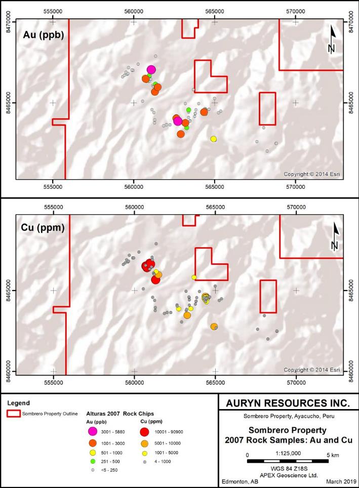
Alturas Minerals personnel collected a total of 96 rock grab samples during the 2007 exploration season. The 2007 rock sampling program included the collection of 33 samples at the Fierrazo iron skarn, and a further 6 samples at the Minas Nioc area. The remaining 57 rock samples identified two broad zones of anomalous results highlighting the same “Sombrero South” and “Sombrero North” areas identified by mapping (discussed above). The Sombrero South (Sombrero Main) area comprised a broad zone (roughly 2km x 3km) of anomalous results that yielded values up to 4.04 grams/tonne gold (g/t Au) and 11% copper. The Sombrero North (Minas Nioc) target area was found to be more localized and yielded values up to 5.9 g/t Au and up to 9.1% Cu. The mineralization was described as comprising zones and structures of endoskarn associated with intrusive rocks. The Au and Cu data resulting from the 2007 Alturas rock sampling program is illustrated in Figure 6.3.
Technical Report on the Sombrero Project, Ayacucho Department, Peru
Figure 6.2. 2007 Mapping work by Alturas Mineral Corp.
Technical Report on the Sombrero Project, Ayacucho Department, Peru
Figure 6.3. 2007 Alturas Rock Sample Geochemistry – Au ppm (6.3a) and Cu ppm (6.3b).
Technical Report on the Sombrero Project, Ayacucho Department, Peru
| | 6.1.3.1 | Ground Magnetics Survey |
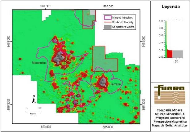
Alturas Minerals commissioned FUGRO Ground Geophysics to complete a ground magnetics survey at the Sombrero Property in late 2007. Ground magnetic surveying was conducted along east-west oriented lines spaced 200m apart over a total area of approximately 13 x 5km. The survey comprises approximately 480 line-kilometers of magnetic data acquisition. The ‘Reduced to Pole’ (RTP) and ‘Analytical Signal’ (AS) transformed magnetic data are illustrated in Figures 6.4 and 6.5. The Analytical Signal is the vector sum of the horizontal and vertical gradients and generally places magnetic anomalies directly over their source, particularly in equatorial regions (such as Peru) where RTP is less effective due to the dominance of the horizontal vector in the earth’s magnetic field.
The 2007 ground magnetic survey identified broad zones of elevated magnetic response associated with the Sombrero North and South zones outlined by the 2007 Alturas rock sample geochemistry (discussed above). These features roughly define broad, 1-2km wide, zones that are oriented northeast-southwest across the survey area. These zones are interpreted as representing iron oxides in endoskarn, and possible exoskarn, alteration associated with intrusive rocks mapped in the area. It was further suggested in a previous report on the Property (Pearson, 2010), that magnetic anomalies are concentrated around intersections of northeast-southwest and northwest-southeast structures.
In addition, the data clearly shows intense magnetic dipole responses that correspond to iron oxide skarn mineralization at the Fierrazo mine (located on the Sombrero Property), as well as at the Sombrero North area (not on the Sombrero Property), and at the southeast part of the Sombrero South area (located on the Sombrero Property). These features are strong indications that the positive magnetic responses comprising the Sombrero North and Sombrero South magnetic corridors (as described above) likely comprise abundant but smaller zones of iron skarn mineralization, which is the principal target on the Property as it is a common host to late-stage Au and Cu mineralization.
| | 6.1.3.2 | Induced Polarization/Resistivity Survey |
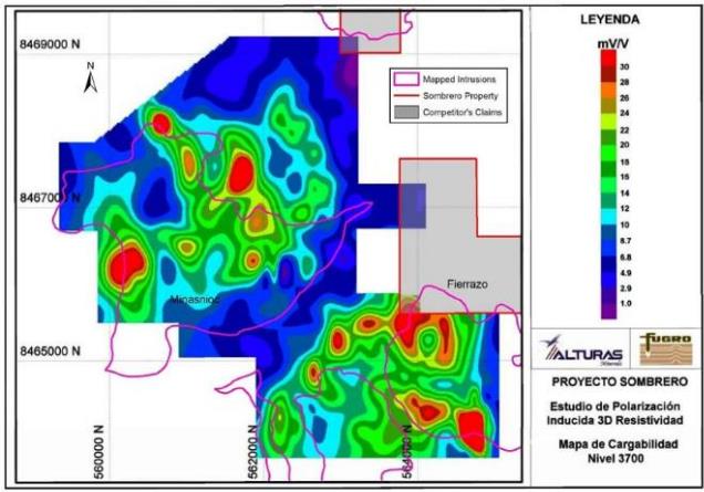
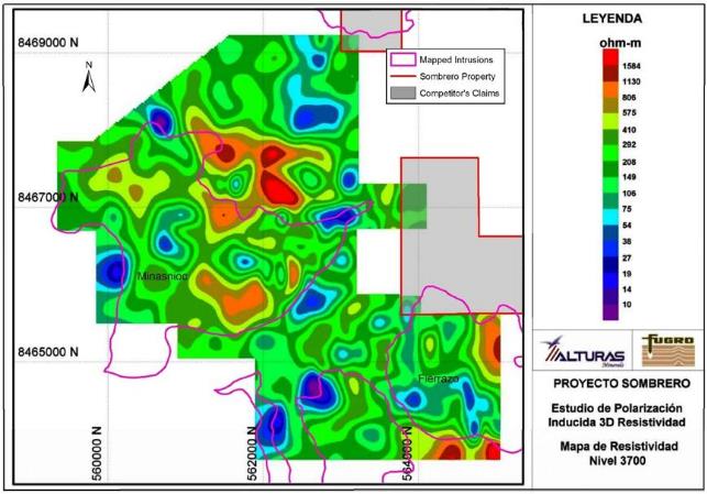
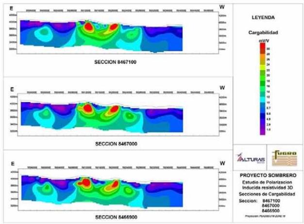
Alturas commissioned FUGRO Ground Geophysics in late 2008 to complete an Induced Polarization (IP) survey, using a pole-dipole array, along east-west lines spaced 100m apart over a total area of 6.0 x 2.5km. The survey covered a total of 108 line-kilometres, with electrodes spaced 50m apart.
The raw data was processed by Dr. Bob White in Australia using inversion methods with minimum squares smoothing (deGroot-Hedlin and Constable 1990, Sasaki 1992). Inversion data was presented to Alturas as level plans and sections. Figures 6.6 and 6.7 show example level plans of the inversions (chargeability and resistivity). Figures 6.8 and 6.9 show sectional inversions of the “Northern” and “Southern” Zones (chargeability).
Technical Report on the Sombrero Project, Ayacucho Department, Peru
Figure 6.4. 2007 Ground Magnetics survey (Reduced to Pole data).
Figure 6.5. 2007 Ground Magnetics survey (Analytical Signal).
Technical Report on the Sombrero Project, Ayacucho Department, Peru
Figure 6.6. Coverage of the Induced Polarization survey completed by Alturas (chargeability at 3700m RL).
Figure 6.7. Coverage of the Induced Polarization survey completed by Alturas (Resistivity at 3700m RL).
Technical Report on the Sombrero Project, Ayacucho Department, Peru
Figure 6.8. Inversion sections of the Induced Polarization surveys completed by Alturas (chargeability, Northern Zone).
Figure 6.9. Inversion sections of the Induced Polarization surveys completed by Alturas (chargeability, Southern Zone).
Technical Report on the Sombrero Project, Ayacucho Department, Peru
The induced polarization survey has defined two anomaly complexes centered approximately 3.0km apart beneath strong copper-gold anomalies and oxidized skarns:
| | ● | A northern broadly ring-shaped structure, approximately 1.5km in diameter, consisting of chains of individual +25 mV/V chargeability anomalies between 200 and 400m in diameter (“Northern Zone”); |
| | ● | A southern oval-shaped structure, approximately 1.8km in diameter, formed by several individual +25 mV/V chargeability anomalies in the order of 100 to 400m in diameter (“Southern Zone”). |
The individual chargeability anomalies are distributed either close to the mapped contacts between limestone of the Ferrobamba Formation and intrusions, or within the intrusive complex itself. Most of the chargeability anomalies flank or overlap magnetic anomalies defined in the previously reported ground magnetic survey and appear to have depth extents of several hundred meters. The combined magnetic / chargeability anomaly complexes are interpreted as zones of disseminated sulfides formed within and around contact skarns and endoskarns. It is difficult to ascertain what contribution magnetite, pyrite and pyrrhotite make to the form and intensity of each chargeability anomaly.
Resistivity is somewhat more difficult to interpret. However, there appears to be zones of generally higher resistivity around the chargeability complexes. These zones possibly represent either zones of dense alteration (e.g. albitization, garnetization) and/or blocks of relatively resistant unaltered limestone.
| | 7 | Geological Setting and Mineralization |
The following discussion of the “Tectonic Setting”, “Regional Geology” and “Property Geology” for the Sombrero Project is reproduced from a previous report on the Project completed for Alturas Minerals (Pearson, 2010).
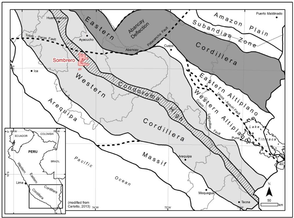
Geographically, the Sombrero Property is located is the Andean Cordillera (Cordillera Occidental) of south central Peru. The Property is located along a the Condoroma High which runs through the central part of the Western Cordillera (Figure 7.1). The Andean Cordillera is the result of three major orogenic cycles: Precambrian, Palaeozoic to Early Triassic and Late Triassic to present. Although the two earlier cycles were important as they set up the crustal architecture of western south America, it is most recent (current) orogenic event that has produced the most significant copper and gold deposits found to date within the Peruvian Cordillera. The tectonic domains and main mineralization belts of Peru are shown in Figure 7.2.
Technical Report on the Sombrero Project, Ayacucho Department, Peru
Figure 7.1. Geographic location of the Sombrero Property.
Technical Report on the Sombrero Project, Ayacucho Department, Peru
Figure 7.2. Tectonic domains of Peru.
Technical Report on the Sombrero Project, Ayacucho Department, Peru
The following discussion is taken from a previous Technical Report on the Sombrero Property by Pearson (2010):
The formation of the South American continent began in the Precambrian when “Proterozoic crust was accreted in mobile belts around Archaean cores (Guyana-Amazon craton). Proterozoic basement, exposed in isolated windows, comprises the basement complex to southern Peru and consists of gneisses, granulite and schists. Strong reworking of these complexes probably occurred during the Late Proterozoic Grenvillian Orogeny.
Lower Palaeozoic marine clastic sequences were deposited on this basement in a tectonic environment that is not well understood. Upper Palaeozoic siltstones, sandstones and limestones were later deposited in a marginal marine environment in a probable passive margin environment. During the late Palaeozoic (Hercynian Cycle), the western margin of South America was an active margin environment and these sequences were folded, faulted and uplifted. Orogenic gold mineralization formed well inland in the Puno region and into adjacent Bolivia.
The latest tectonic cycle commenced with the opening of the South Atlantic in the Triassic. Beginning in the Triassic and continuing until the Late Cretaceous, a thick sequence of clastic sediments and limestones was deposited in shallow to deep water marine environments throughout southern Peru. This deposition probably involved at least two basin-forming extensional events, each associated with important intrusive and volcanic activity. Two magmatic belts / arcs, one closely following the present coastline and the other well inboard passing through the Cusco-Puno departments, developed in various diachronous pulses throughout the Mesozoic.
The Late Cretaceous - Early Tertiary marked the beginning of a new compressional tectonic cycle (Andean Cycle) that was punctuated by numerous alternating volcanic, magmatic and deformational / uplift events. These were essentially driven by the subduction of the Nazca Plate eastward under the South America Plate. The geometry and character of these tectonic events was closely linked to variations in the dip of the subducting Nazca Plate, plus changes in the relative convergence rate and azimuth. Discrete compressive episodes have been recognized, comprising: Peruvian (84-79 Ma), Incaic I (59-55 Ma), Incaic II (43-42 Ma), Incaic III (30-27 Ma), Incaic IV (22 Ma), Quechua I (17 Ma), Quechua II (8-7 Ma), Quechua III (5-4 Ma) and the Quechua IV (early Pleistocene).
Orogeny and uplift resulted in widespread regression and the Mesozoic and older sequences were intruded in the Paleocene-Early Eocene by a batholithic complex associated with important porphyry and skarn copper mineralization along the present southern Peruvian coastline. Important manifestations of this pre-Incaic Orogeny copper belt in southern Peru include the Toquepala, Quellaveco, Cuajone and Cerro Verde porphyries, which are distributed along a northwest-southeast striking regional structural corridor known as the Incapuquio Fault Zone, which extends approximately 175km northwest from the Peru-Chile border area.
Technical Report on the Sombrero Project, Ayacucho Department, Peru
Incaic II orogenic activity, commencing in the Mid to Late Eocene and continuing into the Oligocene, was accompanied by the development of copper-gold-molybdenum mineralised systems in the Apurimac, Cusco and Puno such as Tintaya-Antapaccay, Las Bambas and Los Chancas. This orogeny formed broad fold structures with NW-SE to NNW-SSE strikes in the earlier sequences.
Deposition of significant volumes of continental volcanic sequences commenced in the Oligocene-Lower Miocene with the eruption of the Tacaza Group. Later pulses of volcanic activity throughout the Neogene deposited a number of important lava and pyroclastic sequences. The latest of these include the Barroso Group, which ranges in age between Miocene-Pliocene and Pliocene. The Neogene events were particularly productive with respect to emplacement of large gold deposits, the Lower Miocene to the Lower Pliocene being the most significant mineralizing period in this part of Peru.”
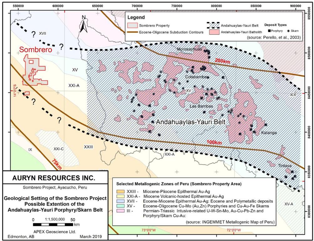
With reference to the INGEMMET (Geological, Mining, and Metallurgical Institute of Peru) Metallogenic Zones of Peru, the Sombrero Project lies within a belt known primarily for its Miocene – Pliocene age Epithermal Au-Ag deposits (Zones XXI-A and XXIII as illustrated in Figure 7.3). However, given the fact that the Property clearly exhibits Cu-Au-Fe skarn mineralization (as discussed below), it is likely that the area of the Sombrero Property represents an extension and overlap of the adjacent Metallogenic Zone XV, which is characterized by Eocene–Oligocene age Cu-Mo (+/-Au) Porphyry mineralization and Cu-Au-Fe Skarn mineralization.
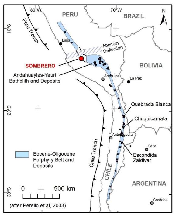
INGEMMET’s Metallogenic Zone XV corresponds to the Andahuaylas-Yauri (AY) Belt of southern Peru, which is recognized as an important porphyry copper and skarn belt (Perelló et al., 2003). The AY belt can be traced for more than 300km and generally strikes northwest-southeast. However, Perelló, et al. (2003) recognized that the location of the AY Belt roughly corresponds with, and is likely related to, a transition between steep (to the north) and flat (to the south) subduction of the Nazca Plate during the Eocene-Oligocene. This transition can be seen as a change from a normal northwest-southeast orientation to an almost east-west orientation of the 100km and 200km depth contours of the subducting Nazca Plate (see Figure 7.3).
The AY Belt hosts copper-gold-molybdenum camps/deposits, including Las Bambas, Los Chancas, Cotambambas and Tintaya, that are related to the Eocene-Oligocene age AYBatholith (see Figure 7.3). The AY belt is thought to be a northern extension of the copper-rich belt of the same Eocene-Oligocene age that strikes broadly north-south in Chile (see Figure 7.4). In Chile, this belt broadly follows the well-known “West Fissure” structure, along which lie deposits of similar age such as Escondida, Zaldivar, and Chuquicamata.
Technical Report on the Sombrero Project, Ayacucho Department, Peru
Figure 7.3. Geological Setting of the Sombrero Property relative to INGEMMET Metallogenic Zones and the AY Belt.
Technical Report on the Sombrero Project, Ayacucho Department, Peru
Figure 7.4. Tectonic Setting of the Sombrero Property relative to the Eocene-Oligocene Porphyry belts of Peru and Chile (after Perelló et al., 2003).
In the Sombrero region, dismembered blocks of Precambrian metamorphic rocks form the basement. Mesozoic sequences, comprising several thousand metres of mainly Jurassic-Cretaceous marine clastic sediments and limestones, were deposited in a broad marine shelf to deep water environment on this basement.
Stratigraphically the following units are recognised (from older to youngest):
| | ● | Yura Group (middle Jurassic to lower Cretaceous) – clastic sedimentary sequences; |
| | ● | Ferrobamba Formation (middle Cretaceous) – dark limestones with fossils and chert nodules. |
Technical Report on the Sombrero Project, Ayacucho Department, Peru
During the Eocene to Early Oligocene these sequences were intruded by an extensive Batholith complex, the AYBatholith, that broadly corresponds in time with the Incaic Orogeny. This orogeny folded the earlier Mesozoic sequences into moderate to tight folds with northwest-southeast to east-west–striking axial planes. More or less synchronous with the intrusion of the Batholith and the Incaic Orogeny, continental red beds and fluviatile clastic sediments, plus volcanics, were deposited in northwest-southeast striking fault-controlled basins around the eastern margins of the currently outcropping magmatic belt.
Post - Early Oligocene continental volcanism deposited several thousand metres of volcanics and pyroclastics in several pulses throughout the Neogene. These magmatic pulses were associated regionally with high-level epithermal gold camps/mines in southern Peru such as Orcopampa, Arcata, Antapite, Ares, Cailloma, La Rescatada, etc.
Three main fault systems are recognized in the project area. The oldest faults in the area have a northwest-southeast trend and are recognized by their long, mostly straight segments cutting through the Jurassic–Cretaceous units. The second fault system strikes northeast-southwest and controls most of the drainage systems in the area. The youngest recognized fault system is represented by east-west striking faults that affect mostly the Tertiary units and clearly overlaps the first two systems (Huerta, 2000).
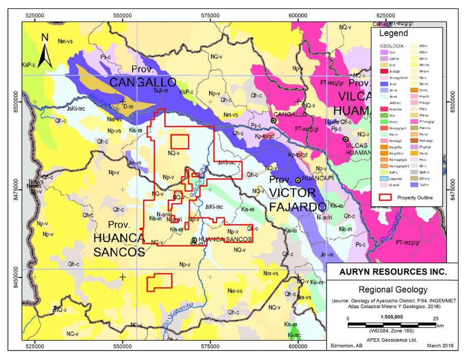
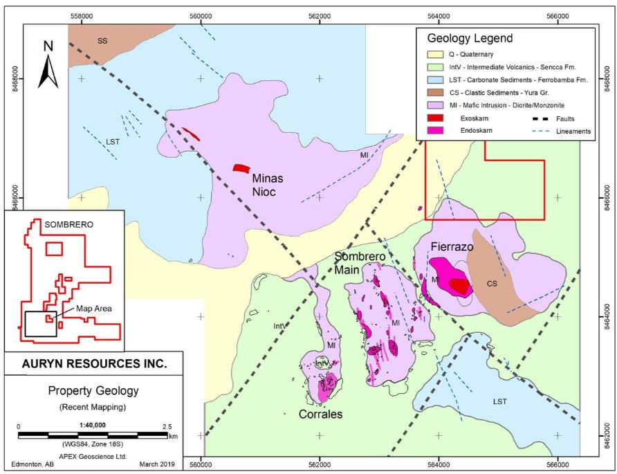
The regional geology of the Sombrero Property is shown in Figure 7.5. The Property lies on the boundary of two broad geological domains: a volcanic domain to the west (characterized by warmer yellow and beige colours), and a domain dominated by folded Mesozoic sedimentary sequences (blues and greens). The latter is intruded by Lower Tertiary intrusive stocks (orange and red). The Property itself lies over an erosional window into the Mesozoic geology.
Technical Report on the Sombrero Project, Ayacucho Department, Peru
Figure 7.5. Regional geology of the Sombrero Property.
Technical Report on the Sombrero Project, Ayacucho Department, Peru
The Geology of the Sombrero Property includes;
| | ● | Northwest-southeast striking and shallow-dipping folded sequences of Jurassic to Middle Cretaceous clastic and carbonate rocks. The oldest sedimentary sequences correspond to the middle-late Jurassic Yura Group, which is overlain unconformably by the middle Cretaceous Ferrobamba Formation (Fm.). Lower Cretaceous units of the Yura Group appear to be absent within the project area; |
| | ● | Eocene-Oligocene intrusive stocks of the AYBatholith. Intrusive rocks in the Property area are dominantly dioritic in composition, although in many zones the diorite is cut by abundant stocks and dykes of more felsic composition such as monzonite, granodiorite, aplite and potassium-feldspar-phyric pegmatite. Intrusive contacts range between bedding-parallel and sub-horizontal to strongly transgressive and sub-vertical; |
| | ● | Shallow-dipping volcanic rocks of the Miocene-Pliocene age Sencca Formation. This unit also unconformably overlies all earlier units, although in many places it is in fault contact with them. |
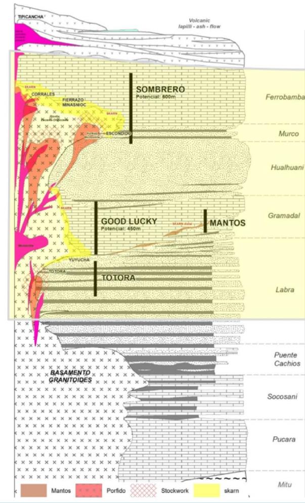
The general stratigraphy of the Property is shown in Figure 7.6. The geology of the southern part of the Sombrero Property is shown in Figure 7.7, which is based upon recent mapping completed by Alturas and Auryn geologists.
As yet, no Proterozoic basement rocks have been observed at the Property. The oldest rocks exposed on the Sombrero Property are part of the Yura Group, which comprises a siliciclastic platformal sequence of middle to upper Jurassic age, including white medium- to coarse- grained sandstones with coarse stratification and minor thin shale units. Only two small areas of this unit have been mapped in the southern part of the Property, which is much less than is suggested by the 1:100,000 scale government (INGEMMET) mapping.
| | 7.3.2 | Ferrobamba Formation |
Overlying the clastic sediments of the Yura Group is the Ferrobamba Fm., which is a platformal marine limestone sequence that extends regionally over much of southern Peru. It comprises a fairly massive calcareous sequence (primarily gray micritic limestones). The mid-Cretaceous age Ferrobamba Fm. averages 500-600m in thickness and is an important host for skarn and replacement mineralization adjacent to numerous igneous intrusions in the region.
Technical Report on the Sombrero Project, Ayacucho Department, Peru
Figure 7.6. Sombrero schematic stratigraphic section (with known prospects).
Technical Report on the Sombrero Project, Ayacucho Department, Peru
Figure 7.7. Sombrero (South) Property geology (from recent mapping by Alturas and Auryn).
Technical Report on the Sombrero Project, Ayacucho Department, Peru
| | 7.3.3 | AY Batholith Equivalent (?) |
Kilometer-scale intrusive stocks intrude the Mesozoic sedimentary sequence within the Property. These intrusive bodies are internally complex and consist mainly of diorite, cut by stocks and dykes of monzonite, granodiorite, aplite and pegmatite. Textures range between coarse-grained aphanitic to fine-grained matrix with megacrysts of potassium feldspars. In general, there is a strong suggestion that the intrusive rocks range in structural level from batholithic to hyperbysal. The intrusive rocks tend to occupy the topographic depressions within the Property and the presence of skarn throughout the mapped extent of the intrusive units in the southern portion of the Property suggests that the limestone-intrusive contact is very close to the present erosion surface.
The age of the intrusive rocks is thought to be mid Eocene to mid Oligocene, according to field age relationships, and a likely correlate with, and potentially represent an extension of, the AYBatholith (see Figures 7.3 and 7.4). Of course, this conclusion depends on the age of the intrusive rocks present at the Property and the current western edge of the AYBatholith, as described in Perelló (et al., 2003), lies some 100km east of the Property. However, the presence of significant Cu-Au-Fe skarn mineralization throughout the Property is undeniable evidence of a western extension of the INGEMMET metallogenic zone XV characterized by Cu (+/-Mo) Porphyry deposits and Cu-Au-Fe skarn deposits, otherwise referred to as the “AY Belt” of Porphyry and Skarn mineral deposits (Figure 7.3).
Regionally extensive volcanic rocks mapped as the Sencca Formation unconformably overly the older rock units described above. The Sencca Fm. is a continental volcanic sequence of Miocene-Pliocene age, correlated with the ubiquitous Barrosso Group that occurs throughout southern Peru. At its base it consists of porphyritic andesitic lavas, followed by flows of aphanitic andesites, in turn overlain by pyroclastic deposits; fine tufts, glassy tuffs and ignimbrite.
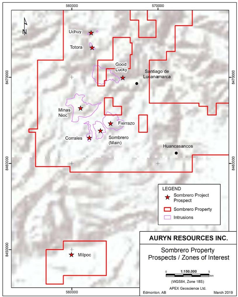
Skarn-style iron-copper+/-gold mineralization is evident in several areas throughout the Property. Exploration at the Sombrero Property has mainly been focussed on the original Alturas claim block area in the southern part of the current Property, which includes the Sombrero Main, Minas Nioc and Corrales prospects. Recently (2017-18), Auryn has expanded the Property and has added the Mollecruz concessions, which host the Good Lucky prospect, as well as the Fierrazo prospect area to the immediate east of Sombrero Main (see Section 4 for concession acquisition details).
Recent exploration by Auryn has identified new zones of intrusive-related (porphyry and skarn style) mineralization and alteration in the western and northwestern parts of the Property, including the Uchuy and Totora prospects, as well as the Milpoc prospect located in the concessions approximately 13km south of Sombrero Main. The author,
Technical Report on the Sombrero Project, Ayacucho Department, Peru
during a site visit (July 11 to 14, 2018), examined skarn-style mineralization and alteration at the Sombrero Main, Corrales and Good Lucky areas. The following information pertaining to the new Uchuy and Totora prospects was taken from an Auryn Resources Press Release dated June 25, 2018 (Auryn, 2018A).
| | 7.4.1 | Sombrero Main – Corrales Areas |
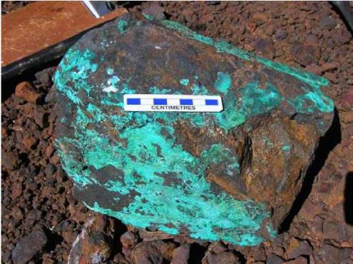
The mineralized zones throughout the southern portion of the Property express similar styles and mineralogy to that exposed at the Good Lucky prospect. The Sombrero Main - Corrales prospects comprise significant areas with extensive endoskarn as well as exoskarn. The area also includes a number of narrow but laterally extensive, skarn-altered and mineralized, primarily north-south striking, structures (see Figures 7.8). The skarn zones are dominated by coarse iron oxides (magnetite and hematite) with later copper mineralization and evidence of a final stage of quartz veining and silica-stockworking that appears to control gold mineralization. “Primary” copper sulphide mineralization at surface is rare in the southern portion of the property due to weathering and thus copper mineralization comprises mainly copper oxides (see Figure 7.9), such as malachite and chrysocolla. Calc-silicate mineralogy within skarn zones commonly includes garnet, pyroxene and scapolite(?), and some retrograde amphibole and chlorite.
The results of rock grab sampling and recent trenching work at the Sombrero Property are discussed in detail in the Exploration Section of this report. However, the skarn bodies and structures in the southern Sombrero Main - Corrales area are commonly mineralized with copper and gold, particularly where they are sulfidized, with individual rock chip samples returning values up to 4.0 g/t Au and 1.0% Cu.
Figure 7.8. Massive hematite skarn in a north-south structure at the Sombrero Main area.
Technical Report on the Sombrero Project, Ayacucho Department, Peru
Figure 7.9. Close-up view of the copper-stained massive magnetite (+hematite) rock (from Auryn Resources).
Technical Report on the Sombrero Project, Ayacucho Department, Peru
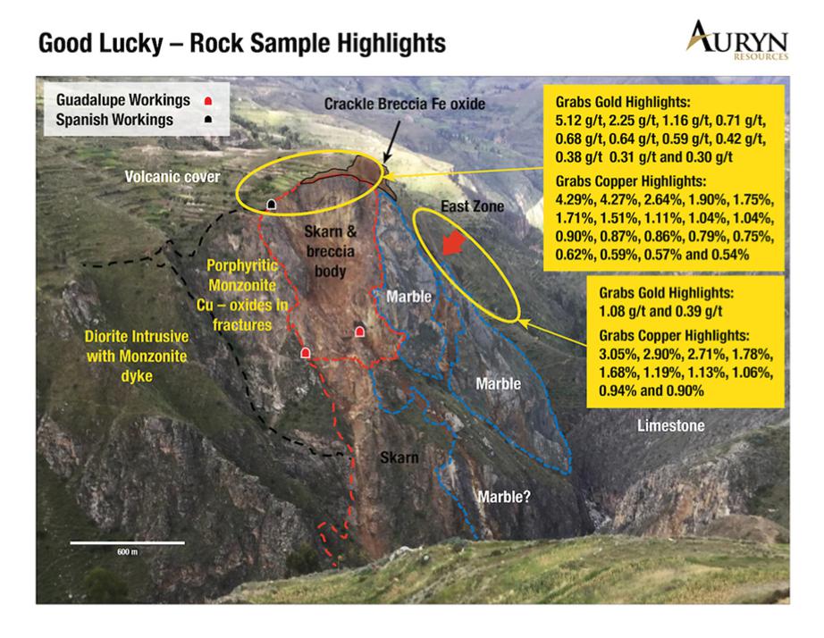
A small monzonitic intrusion with a significant zone of Fe-Cu+/-Au skarn mineralization occurs at the Good Lucky prospect in the central part of the Property (see Figures 6.1). The main area of mineralization is fairly widespread and occurs throughout the southern portion of the Property. As with the Good Lucky prospect, the dominant style of mineralization is skarn-style Fe-Cu+/-Au mineralization (both as exoskarn and endoskarn) associated with several large dioritic to monzonitic intrusions in contact with the Ferrobamba limestone. This includes the Fierrazo iron mine and the Minas Nioc prospect, as well as the Sombrero Main and Corrales areas (Figure 6.1 and 7.7).
The alteration and mineralization at Good Lucky is exposed over a vertical distance of approximately 150m in the north side of a steep-walled, east-west canyon (Figure 7.10). Mineralization includes disseminated pyrite and minor chalcopyrite within the monzonitic intrusion and surrounding skarn altered limestones, as well as massive iron oxide skarn with coarse pyrite and chalcopyrite (Figure 7.11). Late quartz veining appears to control Au mineralization.
Technical Report on the Sombrero Project, Ayacucho Department, Peru
Figure 7.10. View looking northeast of the Good Lucky intrusion and skarn zone (from Auryn, 2018A).
Technical Report on the Sombrero Project, Ayacucho Department, Peru
Figure 7.11. Massive hematite-chalcopyrite mineralization at the Good Lucky prospect.
Technical Report on the Sombrero Project, Ayacucho Department, Peru
At Uchuy, mineralization is characterized by jasperoid (silica) structures and skarn bodies associated with Labra formation sandstones and the Gramadal limestone sequence, respectively. The jasperoids and the skarn bodies occur over a one kilometer length in a north-south structural corridor. These bodies are highly elevated in both arsenic (As) and antimony (Sb) demonstrating that they have the potential to be in close proximity to a precious and base metal system at depth. The majority of recent rock grab samples collected from this area have returned values >200ppm As, with multiple samples >1% As, and many have returned values between 50ppm and 570ppm Sb. A single rock grab sample retuned values of 0.5 g/t Au, 285g/t Ag and 1.385% Cu (Auryn, 2018A).
At Totora, Auryn has identified a 50m-wide porphyritic monzonite dyke within a larger diorite body. The dyke itself is intensely altered by porphyry-style silica and clay and has extensive stockwork veining over its entire width. Reconnaissance rock sampling from Totora has yielded gold and copper mineralization over a 200m length with samples returning values of up to 4.92g/t Au and 3.14% Cu along the margins of the monzonite dyke. The results of additional samples are pending (Auryn, 2018A).
The Sombrero Property is being explored by Auryn Resources for skarn related and/or Porphyry type Cu-Au mineralization. Skarn-hosted sulfide copper-gold mineralization at Sombrero is hosted by both the calcareous country rocks (exoskarn) and by the intrusive rocks (endoskarn). The basic characteristics of skarn deposits are described below.
| | 8.1 | Skarn-style Mineral Deposits |
Skarn mineralization can form in a number of different geological environments and can be isochemical (closed system) or metasomatic (open system). The most common skarn mineralization is fluid-controlled metasomatic skarn, which typically involves alteration and mineralization in carbonate rocks by hydrothermal fluids resulting from intrusive (exoskarn). Skarn alteration and mineralization can also occur within the source intrusion. The common characteristic of skarn mineralization is the replacement and/or recrystallization of host rocks, typically involving the destruction of primary textures by calc-silicate minerals (garnet, pyroxene and amphibole being the most common). Skarns are also commonly categorized by the primary commodity they host, which includes Fe, tungsten (W), Au, Cu, zinc (Zn), molybdenum (Mo) and tin (Sn).
Technical Report on the Sombrero Project, Ayacucho Department, Peru
According to Meinert (1992), copper skarns are perhaps the world´s most abundant skarn type. They are particularly common in orogenic zones related to subduction, both in oceanic and continental settings. Most copper skarns are associated with I-type, magnetite series, calc-alkalic, porphyritic plutons, many of which have cogenetic volcanic rocks, stockwork veining, brittle fracturing and brecciation, and intense hydrothermal alteration. These are all features of a relatively shallow level of emplacement.
Most copper skarns form in close proximity to the contacts of stocks, with a relatively oxidized skarn mineralogy dominated by andraditic garnet. Other mineral phases include diopsidic pyroxene, vesuvianite, wollastonite, actinolite and epidote. Hematite and magnetite are common in most deposits, and the presence of dolomitic wall rocks is coincident with massive magnetite lodes, which may be mined on a large scale for iron. As noted by Einaudi et al., (1981) copper skarns are commonly zoned, with massive garnetite near the pluton, increasing pyroxene away from the contact and, finally, vesuvianite and/or wollastonite occurring near the marble contact. In addition, garnet may be colour zoned from dark reddish-brown proximal to the pluton, to green and yellow varieties in distal occurrences. Sulfide mineralogy and metal ratios may also be systematically zones relative to the causative pluton. In general pyrite and chalcopyrite are most abundant near the pluton, with chalcopyrite increasing away from the pluton, and bornite finally occurring in wollastonite zones near the pluton contact.
The largest copper skarns are associated with mineralized porphyry copper plutons. These deposits can exceed 1 billion tonnes of combined porphyry and skarn ore, with more than 5 million tonnes recoverable from skarn ore. The mineralized plutons exhibit characteristic potassium silicate and sericitic alteration, which can be correlated with prograde garnet-pyroxene and retrograde epidote-actinolite, respectively, in the skarn. Intense retrograde alteration is common in copper skarns and may destroy most of the prograde garnet and pyroxene in some porphyry-related deposits. Endoskarn alteration of mineralized plutons is rare. In contrast, barren stocks associated with copper skarns contain abundant epidote-actinolite-chlorite endoskarn and less intense retrograde alteration of skarn.
Some skarns have a significant geophysical response. Almost all skarns are significantly denser than the surrounding rock and therefore may form a gravitational anomaly or seismic discontinuity. This is particularly evident in some of the large iron skarns which may contain more than a billion tonnes of magnetite (specific gravity 5.18). In addition, both skarns and associated plutons may form magnetic anomalies. Relatively oxidized plutons may contain enough primary magnetite to form a magnetic high whereas reduced plutons typically contain ilmenite rather than magnetite and may form a magnetic low.
Technical Report on the Sombrero Project, Ayacucho Department, Peru
Skarns may form a magnetic high due to large concentrations of magnetite or other magnetic minerals such as high temperature pyrrhotite. Electrical surveys of skarns need to be interpreted carefully. Either disseminated or massive sulphide minerals may give strong IP, EM or magnetotelluric responses in skarn. However, metasomatism of carbonate rock necessarily involves the redistribution of carbon. The presence of carbonaceous matter, especially if it is in the form of graphite, can strongly affect electrical surveys. Such carbon-induced anomalies may be distant from or unrelated to skarn orebodies.
| | 8.2 | Porphyry-style Mineralization |
In addition to skarn-style mineralization, there is potential for identifying Porphyry-style mineralization on the Sombrero Property as skarns are a common characteristic of Porphyry systems, particularly where mineralizing porphyry intrusions come in contact with calcareous country rocks.
The term “Porphyry deposit” is generally applied to widespread zones of disseminated (low-grade) Cu, Mo, Cu + Mo and Cu + Au mineralization, which is normally hosted by intermediate to felsic intrusive rocks that normally exhibit (feldspar +/- quartz) porphyritic textures. In general terms, porphyry mineral deposits are; associated with igneous intrusions, the intrusions are generally felsic but can vary widely in their composition, the intrusions are epizonal and invariably porphyritic, may be hosted by any rock type (intrusion and country rock units), and are the result of large scale hydrothermal systems that result in extensive lateral and vertical zones of alteration (McMillan and Panteleyev, 1988).
Porphyry deposits worldwide are associated with orogenic belts within island arcs and at continental margins. Furthermore, porphyry systems are generally associated with magmatism related to subduction.
Porphyry copper deposits can be classified into three broad types; Plutonic, Volcanic and “Classic”. Plutonic copper porphyry deposits occur in batholithic settings with mineralization generally hosted within one or more phases of plutonic host rocks. Volcanic porphyry deposits occur in the roots of volcanoes with mineralization developed in the volcanics and the associated co-magmatic plutons. The term “Classic-type’ simply refers to a large group of economically significant mineral deposits that are associated with high-level, post-orogenic stocks that intrude unrelated host rocks (McMillan and Panteleyev, 1988). The classic, vertically and concentrically zoned, porphyry copper system is illustrated in Figure 8.1 (from Sillitoe, 2010).
Mineralization within porphyry systems typically comprises widespread, disseminated, low-grade sulphide mineralization. Typical hypogene sulphide mineralogy in porphyry systems includes chalcopyrite, less frequent bornite, molybdenite as well as ubiquitous, and often widespread, pyrite. Supergene alteration, normally produced by the late-stage introduction of meteoric water, can remobilize copper and produce ‘enrichment’ zones that are typically characterized by Cu sulphides such as chalcocite and covellite. Further oxidation can also occur resulting in the complete replacement of sulphide minerals by a wide variety of Cu oxide minerals such as malachite, azurite and chrysocolla.
Technical Report on the Sombrero Project, Ayacucho Department, Peru
Figure 8.1. Porphyry Copper Deposit Model (after Sillitoe, 2010).
Technical Report on the Sombrero Project, Ayacucho Department, Peru
Auryn Resources Inc. acquired the Sombrero Property from Alturas Mineral Corp. in 2016. Since entering into the Option Agreement on the Sombrero Project, Auryn has completed a large regional stream sediment sampling (BLEG/Geochem) program, along with more focused programs on the Property including; mapping, soil sampling, rock grab sampling, trenching and geophysical surveys.
| | 9.1 | 2017 Regional Stream Sediment (BLEG) Sampling Program |
In 2017, Auryn Resources completed a significant regional stream sediment sampling program that included BLEG (Bulk Leach Extractable Gold) and standard geochemical analysis of samples completed at the ALS Laboratories in Lima. The entire survey comprised 561 samples, of which approximately 90 were collected on and immediately adjacent to the Sombrero Property. Of these 90 Sombrero Area samples, 9 yielded BLEG values >1ppb Au up to a maximum of 4.33ppb Au, and 14 samples returned Cu values > 30ppb up to a maximum of 72.4ppb Cu. Figures 9.1 and 9.2 illustrate the BLEG Au and geochemical Cu data, respectively, for the 90 samples located on and adjacent to the Sombrero Property.
The 2017 Auryn stream sediment data clearly identifies a number of anomalous to strongly anomalous gold values (>75th percentile). The anomalous gold results appear to highlight a pair of northwest-southeast trends running through the center and northern portions of the Property along with a possible perpendicular connector along the central eastern parts of the Property. Of note is that these anomalies are located well away from the current area of interest, which was not sampled during this program as it was already known to host mineralization. In addition to, and in support of, these gold anomalies there are similar anomalies with respect to other possible ‘epithermal metals’ such as and Bi.
With respect to copper mineralization, the 2017 Auryn stream sediment data also clearly identifies a number of anomalous to strongly anomalous copper values in the central and northern parts of the Sombrero Property (again) located well away from the main area of interest located in the southern portion of the Property. The +75th percentile Cu values appear to mimic the trends highlighted by the Au data. Specifically, there is a strong northwest-southeast striking trend of +90th percentile Cu anomalies that crosses the central portion of the Sombrero Property, which appears to be highlighting a possible through-going structure. Additionally, there is an interesting cluster of +75th and +90th percentile Cu values in the northeast corner of the Property.
Technical Report on the Sombrero Project, Ayacucho Department, Peru
Figure 9.1. 2017 regional stream sediment sampling program – BLEG (Au) results.
Technical Report on the Sombrero Project, Ayacucho Department, Peru
Figure 9.2. 2017 regional stream sediment sampling program – Cu ICP results.
Technical Report on the Sombrero Project, Ayacucho Department, Peru
Between 2016 and 2017, Auryn completed additional mapping work in the Sombrero Main target area to refine the mapping that was initiated earlier by Alturas Minerals. The recent mapping work by Auryn has identified several new areas of igneous intrusives and has added to the understanding of mineralization controls in the main Sombrero target area by adding significant detail to the mapped extent of skarn alteration and mineralization associated with the intrusive rocks. These skarn bodies include large areas of Fe+/-Cu-Au endoskarn skarn mineralization at Corrales and Sombrero Main, along with numerous thin, but laterally extensive, structurally controlled skarn bodies that extend north-northwest to south–southeast - primarily across the Sombrero Main intrusion. The most recent Property Geology is shown in Figure 7.6.
Auryn has conducted extensive soil sampling over the Sombrero Property, with the majority of the sampling completed in the southern portion of the main Sombrero Project area and additional sampling conducted over the Totora and Milpoc prospects. In total, 15,386 soil samples have been collected and analyzed in two sampling programs from 2016 to early 2019.
In 2016, Auryn undertook a soil sampling program focussed on the main Sombrero target area. The 2016 soil samples were collected on an orthogonal grid with 50m sample spacing on east-west lines spaced 200m apart. The soil grid covered an area measuring approximately 3km x 4km and a total of 261 samples was collected. At the time of sampling, the non-Auryn/Alturas Fierrazo mineral concession interrupted the 2016 soil sampling grid in its eastern and northeastern extents. For the 2016 soil samples, Au was determined by an aqua regia extraction (50g sample) followed by an inductively coupled plasma mass spectrometry (ICP-MS) finish, and a multi-element ICP package (aqua regia digestion) was also performed on the samples, all completed at the ALS Laboratories in Lima. The Au and Cu analytical results for the 2016 soil sampling program are presented in Figures 9.3 and 9.4.
The 2016 soil geochemical data shows a reasonable statistical correlation between Au and Cu (correlation coefficient, cc, of 0.23). In addition, the Au-in-soil data also shows good correlation with Ag (cc = 0.338), As (cc = 0.309) and Bi (cc = 0.276). The Cu-in-soil data also shows a very strong correlation with Ag (cc = 0.629), Pb (cc = 0.767) and Zn (cc = 0.535) and good correlation with As (cc = 0.320), Mo (cc = 0.195) and W (cc = 0.206).
Both the Au- and Cu-in-soil results show similar patterns with two prominent clusters of >75th percentile results. The first anomalous soil cluster is located around the Corrales prospect in the southeastern corner of the soil grid while the second cluster, approximately 1km to the east, is located at the southern half of the intrusion and skarn outcrops comprising the Sombrero Main area. Additional anomalous results extend to the north and northeast of the south Sombrero Main cluster, correlating with mineralized skarn structures in these areas. The northeast extension suggests a discreet anomalous area leading to the northeast and onto the non-Alturas/Auryn Fierrazo concession. However, the obvious area of interest identified by the 2016 Sombrero soil sampling program is the southern portion of the Sombrero Main area, including the Corrales prospect, where intrusions (with skarn alteration and mineralization) are in contact with Ferrobamba limestones.
Technical Report on the Sombrero Project, Ayacucho Department, Peru
Figure 9.3. 2016 soil sampling program – Au results.
Technical Report on the Sombrero Project, Ayacucho Department, Peru
Figure 9.4. 2016 soil sampling program – Cu results.
Technical Report on the Sombrero Project, Ayacucho Department, Peru
An extensive pXRF (portable XRF, X-Ray Fluorescence) soil survey was completed over the Property with 14,127 samples collected and analyzed in 2018, and 998 samples collected and analyzed in early 2019, for a total of 15,125 samples. The majority of the samples were collected in the region of the main Sombrero prospect (Figure 9.5), with additional sampling conducted at the Totora prospect, located to the northwest of the Good Lucky prospect (Figure 9.6a), and the Milpoc prospect, located approximately 13km south of the main Sombrero prospect (Figure 9.6b).
Most of the samples in the main Sombrero prospect area were collected on an orthogonal grid with 50m sample spacings, decreasing to 25m sampling spacings over the mapped intrusives. The regional samples at Totora were collected on an orthogonal grid with 80m sample spacing and the regional samples at Milpoc were collected on an orthogonal grid with 100m sample spacing. The samples were analyzed by Auryn’s field geologists using a pXRF unit, therefore the data is only semi-quantitative, but does provide an excellent means of determining relative abundances (concentrations) of various key elements in the samples.
The concentration of Cu in the soil samples, when compared to background values from ICP analysis, defined a large area of interest in the main Sombrero prospect area. The highest Cu values (99th percentile) occur in the southern area of the intrusive bodies and seem to correlate with elevated levels of bismuth and tellurium in the ICP data from the trenching and rock sampling (further discussed in Section 9.5) (Auryn Resources, 2018B). The Cu-in-soil data for the soil samples show the association between Cu mineralization and skarn alteration associated with the intrusive units in the Sombrero Main area. Copper highlights from the 2018-2019 pXRF soil sampling program include several Cu analysis’ >1%, to a maximum of 1.6% Cu at the main Sombrero prospect area, and 2.7% Cu at the Milpoc prospect (Figures 9.5, 9.6a and 9.6b).
Technical Report on the Sombrero Project, Ayacucho Department, Peru
Figure 9.5. 2018-2019 pXRF soil sampling program at the Sombrero Main prospect – Cu (ppm) results.
Technical Report on the Sombrero Project, Ayacucho Department, Peru
Figure 9.6. 2018-2019 pXRF soil sampling program - Totora (9.6a) and Milpoc (9.6b) prospects Cu (ppm) results.
Technical Report on the Sombrero Project, Ayacucho Department, Peru
Various rock sampling programs have been completed by Auryn over the Sombrero Property between 2016 and 2018. During this time, Auryn geologists collected a total of 1,043 rock grab samples on, or immediately adjacent to, the Sombrero Property, the majority of which were collected in the southern portion of the Sombrero Property (336 rock grab samples in 2016, 19 samples in 2017 and 688 samples in 2018).
Finally, owing to the extensive bedrock exposures in the vicinity of the Good Lucky prospect, located in the central part of the Sombrero Property, a detailed rock sampling program was completed there in 2017 that resulted in the collection of 82 samples that were analysed by a PXRF unit.
| | 9.4.1 | 2016 to 2018 Rock Grab Sampling |
The 2016 rock sampling program completed by Auryn was partially completed along the same grid lines as the 2016 soil sampling program described above in Section 9.3.1. Where significant zones of alteration and/or mineralization were encountered, additional sampling off the east-west grid lines was completed. In 2017, rock grab samples were collected within, and adjacent to, the Sombrero Property as part of a regional program. The 2018 rock sampling program followed up on results from the 2017 BLEG regional stream sampling program and focussed on the concessions to the west of the Good Lucky prospect.
The 2016 and 2017 rock samples were submitted to ALS Laboratories in Lima for a 30 g fire assay (with an ICP finish) and a standard multi-element ICP geochemical analysis (following aqua regia digestion). The 2018 were also submitted to ALS Laboratories in Lima for a 30 g fire assay (with an ICP finish) but the multi-element ICP geochemical analysis included a 4-acid digestion.
The Au-in-rock data for the 2016-18 rock samples (Figure 9.7) clearly shows the significance and association between gold mineralization and skarn alteration associated with the intrusive units in the Sombrero Main area, including the nearby Corrales prospect. The >75th percentile gold results are associated with the larger broad zones of skarn as well as several of the narrower, north-northwest to south-southeast trending, endoskarn structures, primarily in the central and southern parts of the Sombrero intrusions.
Similarly, the Cu-in-rock data for the 2016-18 rock samples (Figure 9.8) shows the same pattern with >75th percentile values primarily located in the southern portions of the Sombrero Main intrusions. Of particular interest is the significant number of >90th percentile Cu values that were returned from rock samples collected in and around the Corrales skarn prospect.
Technical Report on the Sombrero Project, Ayacucho Department, Peru
Analytical Highlights from the 2016-18 rock sampling at the Sombrero Main area include; several Au assays >10g/t Au up to a maximum of 193g/t Au, which comprised iron skarn with quartz breccia along a north-northwest to south-southeast-striking structure along the northwest edge of the Sombrero Main intrusion, and; several Cu values >1% up to a maximum of 16% Cu, which was collected from an outcrop of highly oxidized iron skarn with abundant Cu oxides (malachite and chrysocolla) in the center of the Sombrero Main intrusion. Gold and copper highlights from the 2018 sampling to the east of the Sombrero Main intrusion included Au assays up to 31.6g/t Au and Cu values up to 0.42%, hosted in jasperoid veins within the Ferrobamba limestone formation.
At the Good Lucky prospect, rock grab sampling of mineralized skarn has returned values up to 5.12g/t Au and 4.29% Cu.
Additionally, the 2018 rock sampling program identified three new prospects; the Totora and Uchuy prospects, located to the northwest of the Good Lucky prospect, and the Milpoc prospect, located 13km south of the Sombrero Main prospect. Highlights of the 2018 grab sampling program from the new prospect areas include:
| | ● | At the new Totora prospect area, Auryn geologists have identified a 50m-wide intensely altered porphyritic monzonite dyke within a larger diorite body. Rock sampling from the Totora area has returned values of up to 5.07g/t Au and 3.14% Cu along the margins of the monzonite dyke. |
| | ● | At the new Uchuy prospect, located approximately 1.5km north of the Totora area, prospecting work has identified a number of jasperoid (silica altered) and true skarn bodies associated with Labra formation sandstones and the Gramadal limestone sequence, respectively. Rock sampling has returned values up to 0.5 g/t Au, 285g/t Ag and 1.385% Cu (Auryn, 2018A) with several samples containing elevated As (>1% As) and Sb (up to 570ppm Sb), which are common intrusive-related Au pathfinder elements; and |
| | ● | At the new Milpoc prospect, located approximately 13km south of the Sombrero Main prospect, recent rock sampling has returned values of Cu-oxide mineralization up to 8.75% Cu, with associated silver grades of up to 101 ppm Ag. The mineralization at Milpoc is hosted within the Casapalca formation, situated stratigraphically above the Ferrobamba limestone formation. |
Technical Report on the Sombrero Project, Ayacucho Department, Peru
Figure 9.7. 2016-2018 rock grab sampling program – Au (ppm) results.
Technical Report on the Sombrero Project, Ayacucho Department, Peru
Figure 9.8. 2016-2018 rock grab sampling program – Cu (ppm) results.
Technical Report on the Sombrero Project, Ayacucho Department, Peru
| | 9.4.2 | 2017 Good Lucky Area pXRF Rock Grab Sampling |
In 2017, a prospecting and rock sampling program was completed in the area surrounding the Good Lucky prospect in the central portion of the Property. A total of 82 rock samples was collected and analysed by Auryn staff using a portable XRF unit (X-ray fluorescence). As a result, the data is only semi-quantitative but does provide an excellent means of determining relative abundances (concentrations) of various key elements in the samples.
The pXRF data for Cu and As (as a proxy for Au) in the 2017 Good Lucky rock samples is presented in Figure 9.9. The data clearly highlights the known area of skarn alteration and mineralization at the prospect itself but also highlights an area approximately 1.8km to the northwest of the Good Lucky prospect. Both the Good Lucky and the area northwest of Good Lucky (trending towards the Totora prospect) lie along the central, northwest-southeast trend of anomalous stream sediment sample results illustrated in Figures 9.1 and 9.2.
Technical Report on the Sombrero Project, Ayacucho Department, Peru
Figure 9.9. 2017 Good Lucky area rock sampling - As and Cu pXRF results.
Technical Report on the Sombrero Project, Ayacucho Department, Peru
| | 9.5 | 2016 and 2018 Trenching Work |
Auryn Resources began trench sampling several of the more compelling areas of skarn mineralization in the southern portion of the Sombrero Property in 2016. During 2016, 3 trenches totaling 697m were completed at the Sombrero Main target area. Auryn expanded its trenching efforts in 2018 and completed a further 2645m of trenching in an additional 16 trenches, with 11 (2419 m) completed at the Sombrero Main area and 5 (226 m) completed at the location of a highly anomalous rock grab sample collected in 2018 in the Totora Prospect area, located approximately 5 km northwest of the Good Lucky Prospect. The current trench sampling database includes 2473 samples, which were sent for gold fire assay with an atomic absorption (AA) finish (a 50 g charge was assayed from each of the 2016 samples and a 30 g charge was assayed from each of the 2018 samples) and a multi-element ICP analysis (following aqua regia digestion for the 2016 samples and a 4-acid digestion for the 2018 samples).
The 2016 and 2018 Sombrero Trenching program tested several large areas of exoskarn and several structurally controlled zones of endoskarn associated with intrusive rocks in the southern portion of the Property including the Sombrero Main and Corrales targets. The combined Cu and Au results for the 2016-2018 Sombrero Main trenching programs are illustrated in Figure 9.10. In addition, 5 short trenches were completed in the north central portion of the Property at the new Totora prospect as a follow-up to the early 2018 prospecting rock sampling program that returned 5.07g/t and 1.08g/t Au in two rock samples. Combined Cu and Au results for the trenching program completed in 2018 at the Totora prospect are illustrated in Figure 9.11.
In short, the trench sampling program was successful in testing the tenor and extent of mineralization associated with skarn (endoskarn and exoskarn), particularly in the Sombrero Main area. Table 9.1 summarizes the assay results of the 2016 and 2018 Sombrero trench sampling work. For comparative purposes, a Cu Equivalent grade value is shown to include the “value” of the gold content of each sample. The 2018 trench sampling results were discussed in Auryn Press Releases dated June 19th, September 5th and September 26th, 2018, which specified that the reported Cu equivalent grades were calculated using a gold price of $1300/oz and a copper price of $3.28/lb. It should be noted that Auryn limited its reported trench assay intervals to exclude significant dilution.
The 2016 and 2018 Sombrero Trench Sampling program identified significant zones of Cu-Au mineralization in skarn associated with intrusions in and around the southern part of the Sombrero Main area. Assay highlights include an interval in trench 18-08 that, with some dilution, averages 0.28% Cu Equivalent (0.23% Cu and 0.07g/t Au) across 234m. Within this interval, and with only minor dilution, is the Press Released interval that averages 0.29% Cu Equivalent (0.22% Cu and 0.12g/t Au) across 60m (Auryn, 2018). Trench 18-09 is located approximately 1km to the east of Trench 18-08 and includes the Press Released interval that averages 0.30% Cu Equivalent (0.23% Cu and 0.13g/t Au) across 105m (Auryn Resources, 2018). Highlights from 18-18, located approximately 130m to the west of trench 18-09, includes the Press Released interval that averages 1.93% Cu Equivalent and 3.34 Au Equivalent (1.86% Cu and 0.12g/t Au) across 30m (Auryn Resources, 2018C). Additional Press Released assay highlights are shown in Table 9.1.
Table 9.1 Press Released assay highlights from the 2016 and 2018 Sombrero Trench Sampling Programs.
| Trench | From (m) | To (m) | Length (m) | Cu (%) | Au (g/t) | Cu Equiv. (%) * |
| 18SRT-04 | 79 | 84 | 5 | 0.01 | 0.28 | 0.17 |
| 18SRT-05 | 117 | 122 | 5 | 0.01 | 0.50 | 0.30 |
| and | 132 | 137 | 5 | 0.02 | 1.47 | 0.87 |
| 18SRT-06 | 61 | 66 | 5 | 0.03 | 0.99 | 0.60 |
| including | 83 | 88 | 5 | 0.02 | 0.33 | 0.22 |
| and | 93 | 98 | 5 | 0.03 | 1.39 | 0.84 |
| 18SRT-07 | 176 | 181 | 5 | 0.10 | 0.08 | 0.15 |
| and | 197 | 210 | 13 | 0.11 | 0.01 | 0.12 |
| and | 259 | 267 | 8 | 0.01 | 0.37 | 0.23 |
| and | 306 | 316 | 10 | 0.13 | 0.02 | 0.15 |
| 18SRT-08 | 13 | 73 | 60 | 0.22 | 0.12 | 0.31 |
| and | 135 | 234 | 99 | 0.37 | 0.09 | 0.43 |
| 18SRT-09 | 14 | 119 | 105 | 0.23 | 0.13 | 0.31 |
| and | 124 | 133 | 9 | 0.20 | 0.21 | 0.33 |
| and | 173 | 180 | 7 | 0.18 | 0.25 | 0.33 |
| and | 186 | 191 | 5 | 0.13 | 0.03 | 0.15 |
| and | 305 | 312 | 7 | 0.13 | 0.54 | 0.45 |
| 18SRT-15 | 14 | 36 | 22 | 0.17 | 0.63 | 0.53 |
| and | 98 | 106 | 8 | 0.15 | 0.08 | 0.19 |
| and | 140 | 148 | 8 | 0.10 | 0.02 | 0.12 |
| and | 180 | 186 | 6 | 0.14 | 0.40 | 0.37 |
| and | 196 | 246 | 50 | 0.27 | 0.13 | 0.34 |
| and | 250 | 264 | 14 | 0.15 | 0.06 | 0.18 |
| 18SRT-16 | 14 | 78 | 64 | 0.22 | 0.08 | 0.27 |
| and | 92 | 100 | 8 | 0.14 | 0.07 | 0.18 |
| and | 111 | 121 | 10 | 0.14 | 0.76 | 0.58 |
| and | 135 | 139 | 4 | 0.14 | 0.72 | 0.56 |
| and | 169 | 175 | 6 | 0.14 | 0.02 | 0.15 |
| and | 181 | 247 | 66 | 0.25 | 0.06 | 0.28 |
| 18SRT-17 | 62 | 68 | 6 | 0.10 | 0.91 | 0.63 |
| and | 136 | 142 | 6 | 0.19 | 0.04 | 0.21 |
| and | 162 | 178 | 16 | 0.14 | 0.05 | 0.16 |
| 18SRT-18 | 14 | 30 | 16 | 0.47 | 0.10 | 0.53 |
| and | 49 | 79 | 30 | 1.86 | 0.12 | 1.93 |
| and | 104 | 158 | 54 | 0.32 | 0.04 | 0.34 |
| and | 182 | 206 | 24 | 0.66 | 0.11 | 0.73 |
| and | 230 | 244 | 14 | 0.14 | 0.02 | 0.15 |
* Calculated using a gold price of $1300/oz and a copper price of $3.28/lb., reproduced from Auryn Press Releases (Auryn, 2018A; Auryn, 2018B; Auryn 2018C).
Technical Report on the Sombrero Project, Ayacucho Department, Peru
Figure 9.10. 2016 and 2018 Sombrero Main trench sampling.
Technical Report on the Sombrero Project, Ayacucho Department, Peru
Figure 9.11. 2018 Sombrero Totora prospect area trench sampling.
Technical Report on the Sombrero Project, Ayacucho Department, Peru
| | 9.6 | 2018 Geophysical Surveys |
Auryn completed two geophysical surveys over the Sombrero Property in 2018, including ground-based induced polarization (IP) and ground magnetics. The geophysical surveys were conducted over three survey areas; the IP survey covered the Sombrero Main, Corrales and Minas Nioc prospect areas (Figure 9.12), and the ground magnetics survey covered the Good Lucky and Totora prospect areas (Figure 9.13) and the southwest corner of the Sombrero Property (Figure 9.14).
| | 9.6.1 | 2018 Induced Polarization |
The 2018 Direct Current Induced Polarization (DCIP) survey was collected by Zissou Peru SAC over the Sombrero Main, Corrales and Minas Nioc prospect areas. Conventional 2D pole-dipole lines were collected with 100m dipoles with a north-spacing of 1 to 8, combined with the data of a 2008 offset geophysical survey (McMillan, 2018). The 3D inversion processing was performed by Computational Geosciences Inc.
The 2018 IP survey was conducted with the aim to identify potential sulphide bodies (defined by chargeability) at the lithological contact between the mineralized intrusives and Ferrobamba Formation. The IP survey was conducted over the mapped intrusives of the Sombrero Main prospect area and identified several chargeability anomalies within the intrusives over the Sombrero Main, Minas Nioc, and Corrales prospects (Figure 9.12).
| | 9.6.2 | 2018 Ground Magnetics |
The 2018 ground magnetic survey was collected by Zissou Peru SAC over two separate blocks; the north (Huarcaya) block, covering the Good Lucky and Totora prospect areas, and the south (Huancasancos) block, covering the southwest corner of the Sombrero Property. A total of 270 east-west oriented line-km were collected over 41 lines in the north and 29 lines in the south (McMillan, 2018A). The 3D inversion processing of the magnetic geophysical data was performed by Computational Geosciences Inc.
The 2018 ground magnetic survey was conducted with aim to identify and define potential buried exoskarn targets within the Sombrero Property. Past magnetic surveys conducted over the Sombrero Main area of the Property have been successfully in correlating magnetic highs with mapped exoskarn bodies. The 2018 ground survey identified elevated magnetic response in several anomalies north of the mapped intrusives at the Good Lucky prospect (Figure 9.13) and in several anomalies in the southwest corner of the Sombrero Property (Figure 9.14).
Technical Report on the Sombrero Project, Ayacucho Department, Peru
Figure 9.12. Coverage of the IP survey completed in 2018 (chargeability at 3800 m RL).
Technical Report on the Sombrero Project, Ayacucho Department, Peru
Figure 9.13. Coverage of the ground magnetic survey over the north ground block completed in 2018 at 3400 m RL.
Technical Report on the Sombrero Project, Ayacucho Department, Peru
Figure 9.14. Coverage of the ground magnetic survey over the south ground block completed in 2018 at 3900 m RL.
Technical Report on the Sombrero Project, Ayacucho Department, Peru
No drilling has yet been completed by Auryn Resources at the Sombrero Property. Furthermore, there is no record of any historical drilling at the Project.
| | 11 | Sample Preparation, Analyses and Security |
The following section describes the sampling techniques, analytical procedures and sample security measures employed by Auryn during the execution of recent geochemical sampling programs at the Sombrero Property. Unless otherwise stated, all samples were analysed at ALS Laboratories in Lima, Peru, ALS is an internationally recognized analytical company with ISO accreditation and is fully independent of both Auryn and APEX. All sampling was conducted under the supervision of the Company’s geologists.
| | 11.1 | Regional Stream Sediment (BLEG) Sampling |
In 2017, Auryn Resources completed a significant regional stream sediment sampling program that included sample analysis at ALS Laboratories in Lima by BLEG (Bulk Leach Extractable Gold) and standard ICP geochemical analyses. The entire survey comprised 561 samples, of which approximately 90 were collected on and immediately adjacent to the Sombrero Property. Depending on the condition of the sample location, a dry sample or a wet sample was collected using the procedures detailed below.
The BLEG sampling procedure for dry samples is as follows:
| | ● | Samplers cannot wear any jewelry (rings, bracelets or chains) when sampling. |
| | ● | Select the best possible sample site in the field based on proximity to predetermined target site and the abundance or availability of fine/very fine sediments. |
| | ● | Collect fine and ultra-fine material using a clean plastic/stainless steel vessel. Collect 3-10kg of sand/gravel with fine and ultra-fine material for sieving. |
| | ● | Primary sieve material into a separate clean plastic bucket using 4.75mm mesh to reduce the overall size fraction. |
| | ● | Secondary sieve the fines using a 600 micron (30 mesh) and/or 75 micron (200 mesh) sieve to obtain suitable fines for the final sample. |
| | ● | Repeat sieving procedures until 0.5-1kg of 75 micron fines or 1.5-2.5kg of 600 micron fines, are collected. |
| | ● | Pour the final sample fines from the bucket into an impermeable bag. |
| | ● | Weigh sample with field scales to check the requisite sample weight is achieved. |
Technical Report on the Sombrero Project, Ayacucho Department, Peru
| | ● | Label bag with sample number and insert sample ticket into bag. |
| | ● | Collect field data including date, UTM coordinates, lithology data from float and surrounding catchment, and quality of sample. |
| | ● | For duplicate sample sites, follow the same procedures as above to achieve a duplicate sample that is as similar to the original as possible. |
| | ● | Photograph the sample site with the sample in the frame. |
The BLEG sampling procedure for wet samples is as follows:
| | ● | Samplers cannot wear any jewelry (rings, bracelets or chains) when sampling. |
| | ● | Prepare a flocculent solution by adding 2 teaspoons of magnafloc E10 to 10L of filtered water, stir until completely dissolved, then leave to rest for 12 to 24 hours. After this time period, decant the concentrate into plastic bottles and add water until a ratio of 10 parts water to 1 part concentrate is achieved. Clearly label plastic bottles as “Flocculent”. |
| | ● | Select the best possible sample site in the field based on proximity to predetermined target site and the abundance or availability of fine/very fine sediments. |
| | ● | Collect 3-10 kg of wet sample material for sieving using a clean plastic/stainless steel trowel. |
| | ● | Pass the wet sample through a 4.75mm mesh sieve into a bucket with water to remove coarse stones and pebbles. Agitate the water containing the sieved sample to get the clays (ultra-fines in suspension). Slowly decant the suspension into a second bucket, thus separating it from the sand and silt fractions remaining in the first bucket. |
| | ● | Add approximately 20mL of the flocculent to the suspension in the second bucket and wait until the suspended fines settle out. Decant off the excess water back into the first bucket containing the sand and silt fractions. |
| | ● | Decant/remove as much water as possible from the sample and then pour into a permeable sample bag. |
| | ● | Label bag with sample number, insert sample tag, seal and ringing out as much water as possible. |
| | ● | Place sample in an impermeable plastic bag for transport out of the field. |
| | ● | Collect field data including date, UTM coordinates, lithology and alteration data from float and surrounding catchment, and quality of sample. Record into Fulcrum. |
Technical Report on the Sombrero Project, Ayacucho Department, Peru
| | ● | For duplicate sample sites, follow the same procedures as above to achieve a duplicate sample that is as similar to the original as possible. |
| | ● | Photograph the sample site with the sample in the frame. |
| | ● | Once back at camp or office, remove wet samples from their plastic transport bag and lay them out to dry in the sun. Do not open the permeable sample bags. |
The follow up BLEG sampling protocol follows the same general procedure for initial dry and wet sampling as outlined in the protocols above, although 0.3-0.5kg of 75 micron material is required for a dry sample and 0.5-1kg of flocculated wet material for a wet sample.
In the opinion of the author of this report, the regional stream sediment sampling procedures and protocols employed by Auryn are sufficient to ensure sample integrity and that the resulting samples and their analysis are appropriate with respect to their intended use. There are no indications that there were any significant issues with respect to sample bias or sample security.
Auryn utilizes digital data collection procedures that automatically integrate GPS sample site coordinates with sample (and sample site) descriptive information entered by the sampler. In addition, this system allows for the scanning of sample tag bar codes. This system virtually eliminates potential issues related to manual data entry.
In 2016, Auryn undertook a soil sampling program focussed on the main Sombrero target area. The 2016 soil samples were collected on an orthogonal grid with 50m sample spacing on east-west lines spaced 200m apart. The soil grid covered an area measuring approximately 3 km x 4 km and a total of 261 samples were collected. All sampling was conducted under the supervision of the Company’s geologists following the soil sampling protocol detailed below:
| | ● | Samplers cannot wear any jewelry (rings, bracelets or chains) when sampling. |
| | ● | Select the best possible sample site in the field based on proximity to the predetermined target site and the availability of a good soil horizon. |
| | ● | Clean the sampling area using a pick and/or shovel. |
| | ● | Identify the horizon with clay content (50 cm depth on average). |
Technical Report on the Sombrero Project, Ayacucho Department, Peru
| | ● | Sieve mesh using ¼ inch mesh to reduce the overall size fraction and then sample the below 30-mesh fraction. This procedure must be performed until a 1kg sample is obtained. |
| | ● | Label the bag with the appropriate code and pour sample material into the bag. |
| | ● | Record sampling information on the handheld device and take a photo of the sampling site. |
| | ● | Verify that the sample site is reclaimed to its original state. |
| | ● | For duplicate sample sites, follow the same procedures as above to achieve a duplicate sample that is as similar to the original as possible. |
| | ● | Sampling sites can be located up to a maximum of 10m from the predetermined “target” site. If there is no suitable material in the allowed area surrounding a target sampling point, and there is an outcrop, a rock sample should be collected. Otherwise, do not collect a sample and move to the next target site. |
Gold in the 2016 soil samples was determined by an aqua regia extraction (50g sample) followed by an ICP-MS finish (Au-TL44 method). In addition, a multi-element ICP package (also following an aqua regia digestion) was performed on the samples.
Auryn utilizes digital data collection procedures that automatically integrate GPS sample site coordinates with sample (and sample site) descriptive information entered by the sampler. In addition, the system allows for the scanning of sample tag bar codes and virtually eliminates potential issues related to manual data entry. Individual soil samples comprised the collection of approximately 1kg of soil that was placed in individual paper sample bags marked with their respective sample numbers and into which a portion of the sample tag was placed (see above for Auryn’s sampling protocol). Samples were closed and secured in the field and were later catalogued and packaged for shipping to the laboratory in Lima in rice sacks with security seals attached. Sample shipments were sent to ALS in Lima by commercial carriers and security seal numbers and conditions were confirmed upon receipt of the shipments at the laboratory.
In the opinion of the author of this report, the soil sampling procedures and protocols employed by Auryn are sufficient to ensure sample integrity and that the resulting samples and their analysis are appropriate with respect to their intended use. There are no indications that there were any significant issues with respect sample bias or sample security.
Technical Report on the Sombrero Project, Ayacucho Department, Peru
| | 11.2.2 | 2018 pXRF Soil Sampling |
In addition to the “normal” 2016 soil sampling program discussed above, Auryn geologists completed an extensive pXRF soil survey over the Sombrero Property in 2018 and early 2019. A total of 15,125 samples were collected and analyzed in the Sombrero Main, Totora and Milpoc prospect areas. Most of the samples in the Sombrero Main prospect area were collected on an orthogonal grid with 50m sample spacings, decreasing to 25m sample spacings over the mapped intrusives. The samples taken at Totora were collected on an orthogonal grid with 80m sample spacings and the samples at Milpoc were collected on an orthogonal grid with 100m sample spacings. The same protocols and procedures discussed in Section 11.2.1 were applied to the pXRF soil sampling program, however, these soil samples were not submitted to a laboratory for analysis and were instead analysed by Auryn in the field by pXRF (a portable XRF, X-Ray Fluorescence) machine. The results were semi-quantitative and were simply intended to see if there was a discreet XRF “signature” with respect to the mineralization at Sombrero that might aid in the identification of additional areas of mineralization.
The 2016 rock sampling program completed by Auryn was partially completed along the same grid lines as the 2016 soil sampling program. Where significant zones of alteration and/or mineralization were encountered, additional sampling off the east-west grid lines was completed. In total, 366 rock grab samples were collected in 2016 at the main target area in the southern portion of the Sombrero Property. In 2017, a further 19 rock grab samples were collected within, and adjacent to, the Sombrero Property as part of a regional program. The 2018 rock grab sampling program focused on the concessions to the west of the Good Lucky prospect, with a total of 688 samples collected in 2018.
All of the 2016 and 2017 rock samples were submitted to ALS Laboratories in Lima, Peru, for analysis. Gold in the 2016-18 rock samples was determined by a standard 30g fire assay (with an ICP finish) and a standard. Samples of obvious mineralization were assayed by fire assay with a gravimetric finish. The multi-element ICP geochemical analysis for the 2016 and 2017 rock samples was completed following aqua regia digestion whereas the 2018 rock samples were analysed following a 4-acid digestion.
Auryn utilizes digital data collection procedures that automatically integrate GPS sample site coordinates with sample (and sample site) descriptive information entered by the sampler. In addition, the system allows for the scanning of sample tag bar codes and virtually eliminates potential issues related to manual data entry. Individual rock samples comprised the collection of approximately 3-5kg of rock that was placed in individual plastic sample bags marked with their respective sample numbers and into which a portion of the sample tag was placed. Samples were closed and secured in the field and were later catalogued and packaged for shipping to the laboratory in Lima in rice sacks with security seals attached. Sample shipments were sent to ALS in Lima by commercial carriers and security seal numbers and conditions were confirmed upon receipt of the shipments at the laboratory.
Technical Report on the Sombrero Project, Ayacucho Department, Peru
In the opinion of the author of this report, the rock sampling procedures and protocols employed by Auryn are sufficient to ensure sample integrity and that the resulting samples and their analysis are appropriate with respect to their intended use. Although there is always a potential that rock grab (and chip) samples may be biased to some degree with respect to selective sampling of obviously mineralized material (commonly referred to as “high grading”), Auryn geologists were instructed to collect “representative” (unbiased) samples. There were no indications that there were any significant issues with respect to sample bias or sample security.
In addition to the “normal” prospecting rock samples discussed above, Auryn geologists collected a further 82 rock samples in the vicinity of the Good Lucky prospect in the central portion of the Sombrero Property in 2017. The same protocols and procedures discussed above were applied to the Good Lucky rock samples, however, these samples were not submitted to a laboratory for analysis and were instead analysed by Auryn in the field by pXRF (a portable XRF, X-Ray Fluorescence) machine. The results were semi-quantitative and were simply intended to see if there was a discreet XRF “signature” with respect to the mineralization at Good Lucky that might aid in the identification of additional areas of mineralization.
Auryn Resources began trench sampling several of the more compelling areas of skarn mineralization in the southern portion of the Sombrero Property in 2016. During that year, 3 trenches totaling 697m were completed at the Sombrero Main target area. Auryn expanded its trenching efforts in 2018 and completed a further 2645m of trenching in an additional 16 trenches, with 11 (2419m) completed at the Sombrero Main area and 5 (226m) completed at the location of the highly anomalous rock grab sample collected in 2016 at the recently identified Totora prospect located approximately 5km northwest of the Good Lucky Prospect (see Figures 9.8 and 9.9).
The current trench sampling database includes 2473 samples. All of the 2016 and 2018 trench samples were submitted for analysis at ALS Laboratories in Lima, Peru. ALS is an internationally recognized analytical company with ISO accreditation and is fully independent of both Auryn and APEX. All of the samples were sent for gold fire assay with an atomic absorption (AA) finish. A 50g charge was assayed from each of the 2016 samples and a 30g charge was assayed from each of the 2018 samples. In addition, a multi-element ICP analysis was performed on all samples with the 2016 samples undergoing an aqua regia digestion and the 2018 samples undergoing a 4-acid digestion. When the multi-element ICP results received were greater or near 10,000g/t Cu, Zn or Pb, the assay was repeated with ore grade 4-acid digestion (Auryn Resources, 2018C).
Auryn utilizes digital data collection procedures that automatically integrate GPS sample site coordinates with sample (and sample site) descriptive information entered by the sampler. In addition, the system allows for the scanning of sample tag bar codes and virtually eliminates potential issues related to manual data entry. For the 2016-18 trench samples, however, idealized geographic coordinates (center points) were determined based upon GPS measurements of the start and end points of each trench while honoring the measured length of each sample.
Technical Report on the Sombrero Project, Ayacucho Department, Peru
The location and orientation of the 2016 and 2018 trenches were planned in advance and were determined in the field using hand-held GPS. Trenches were excavated manually to a depth of between 0.5 and 1.0m below surface sufficient to get into weakly weathered bedrock beneath a generally thin soil cover. The majority of the trench samples were collected as rock chip samples across 1m lengths, although some samples were collected over 2m intervals. Sample intervals were measured in the field using a survey chain and were marked with spray paint. Several 4-5m intervals within some of the longer trenches remained unsampled as bedrock was not encountered. As with surface rock (grab) samples individual chip samples (approximately 2-3 kg) were collected in plastic sample bags marked with their respective sample numbers and receiving a portion of their pre-printed sample tags before being sealed. Groups of samples were placed in poly-woven rice sacks for shipment to ALS in Lima by commercial carrier, each having received a numbered security seal, the condition of which was confirmed by the laboratory following their receipt of the samples. There were no issues with sample collection or shipping during the 2016 and 2018 trenching programs. Due to work permit requirements, all of the 2016 and 2018 trenches were closed and reclaimed shortly after their excavation.
In the opinion of the author of this report, the trench sampling procedures and protocols employed by Auryn are sufficient to ensure sample integrity and that the resulting samples and their analysis are appropriate with respect to their intended use. Although there is always a potential that rock chip samples may be biased to some degree with respect to selective sampling of obviously mineralized material (commonly referred to as “high grading”), Auryn geologists were instructed to collected “representative” (unbiased) samples. There were no indications that there were any significant issues with respect sample bias.
| | 11.5 | Previous Sampling by Alturas |
Strict sample integrity is maintained throughout the geochemical sampling program at Sombrero. The bagged samples are transported by Alturas staff to the city of Ica in Southern Peru where they are shipped directly to Inspéctorate Services Perú SAC Labs in Lima. Inspectorate is an ISO 9001:2000 certified laboratory that is preparing for ISO 17025 accreditation. At the Inspectorate´s Lima facility, all samples are dried then crushed to 90% -10 mesh (<2mm) size; then riffle split to obtain an approximately 200 gram subsample. The subsample is further crushed to 95% -200 mesh (<75 microns) to obtain a 100 gram split ready for analysis. All samples are routinely assayed for gold by conventional fire-assay methods at Inspectorate´s Lima facility, and for 34 additional elements (including silver, copper, lead, zinc) using aqua regia acid digestion followed by Inductively Coupled Plasma-Atomic Emission Spectroscopy ("ICP-AES") analysis.
Alturas follows a rigorous Quality Assurance and Quality Control program, including routine insertion of standards and blanks as well as assay of duplicate samples at other independent laboratories. Certified standards, of known gold grade are inserted “blind” every 20th sample as an independent check on assay accuracy.
Technical Report on the Sombrero Project, Ayacucho Department, Peru
The following section details the Quality Assurance and Quality Control (QA/QC) program employed by Auryn for the exploration program completed during 2016 to 2019, as well as the extent to which the author has verified the information with the Auryn exploration datasets.
| | 12.1 | Non-Analytical Data Verification |
For non-analytical field data, Auryn has instituted protocols to ensure data integrity. Auryn utilizes digital data collection procedures that automatically integrate GPS sample site coordinates with sample (and sample site) descriptive information entered by the sampler. In addition, the system allows for the scanning of sample tag bar codes and virtually eliminates potential data input errors. The procedures employed are considered reasonable and adequate with respect of ensuring data integrity.
| | 12.2 | Analytical Data Verification |
In reviewing the historical (pre-Auryn Resources) and recent (Auryn Resources) exploration work at the Property, the author was able to examine archived analytical certificates for stream sediment, soil, rock grab and rock channel samples. There were no significant differences with respect to the Company’s databases and the archived analytical certificates. In the opinion of the author of this report, industry standard procedures have been used that are acceptable for ensuring the accuracy of all analytical data pertaining to exploration work conducted by Auryn.
| | 12.3 | Quality Assurance and Quality Control |
Quality assurance sampling provides evidence to demonstrate that a project’s assay data is sufficiently precise and accurate to allow for confidence in any subsequent use of that data, including and especially for, resource estimation. Quality control consists of procedures used to ensure that an adequate level of quality is maintained in the process of collecting, describing, preparing, assaying and documenting the exploration samples. In general, QA/QC programs are designed to prevent or detect contamination and allow assaying (analytical) precision (repeatability) and accuracy to be quantified. In addition, a QA/QC program can disclose the overall sampling-assaying variability of the sampling method itself.
The following QA/QC protocol was applied to the geochemical sampling program at Sombrero:
| | ● | Field duplicates: 1 duplicate per 20 samples (Figures 12.1-12.3). |
| | ● | Blanks: 1 blank was inserted per 50 samples during rock and trench sampling. No blank was used for the soil sampling or stream sampling, a low-grade standard (OREAS 25a) was used instead. |
Technical Report on the Sombrero Project, Ayacucho Department, Peru
| | ● | Certified reference materials (standards): 1 standard was inserted per 50 samples for trench and rock sampling, 1 standard every 30 samples for soils, and 1 standard every 20 samples for stream sediment sampling. |
Standards for soil samples and follow up stream sediment samples:
Standards for rock samples:
| | - | OREAS 600 (0.2ppm Au, 24.8ppm Ag) |
| | - | OREAS 60C (2.47ppm Au, 4.87ppm Ag) |
Standards for trench samples:
| | - | OREAS 502b (0.494ppm Au, 0.773% Cu) |
| | - | OREAS 504b (1.61ppm Au, 1.11% Cu) |
| | ● | For samples, standards or blanks, enter the code in the system, label the bag with the respective code, insert code tag and close. The material for these samples is inserted before shipment to ALS. |
The QA/QC data for the Sombrero Project indicates that there are no significant issues with the analyses of the stream sediment, soil, rock and trench (chip/channel) samples collected by Auryn Resources at the Project.
Technical Report on the Sombrero Project, Ayacucho Department, Peru
Figure 12.1. Bivariate plot of original BLEG sample assays versus field duplicate assays.
Figure 12.2. Bivariate plot of original trench and rock sample assays versus field duplicate assays (Au).
Technical Report on the Sombrero Project, Ayacucho Department, Peru
Figure 12.3. Bivariate plot of original trench and rock sample assays versus field duplicate assays (Cu).
| | 12.4 | Qualified Person Site Inspection |
The author of this Technical Report, Mr. Turner, visited the Property between July 12 and 14, 2018 and was able to verify the location of several of the 2018 trenches, although they had recently been reclaimed (backfilled) due to land use permit requirements. During the site visit, the author collected 5 grab samples to confirm/verify the presence of Cu-Au mineralization at the Property (see Figure 12.4). Descriptive information, including location data, and geochemical certificates for the 5 confirmation samples collected by the author are appended to this report (Appendix 2).
The first 2 samples (18ATP001 and 002) were collected at the Good Lucky prospect and comprise a sample of iron skarn with 3-5% coarse disseminated chalcopyrite collected from an historic stockpile beside an underground adit and a sample of mineralized (sulphidized) monzonitic intrusive collected in outcrop, respectively. The iron skarn sample (18ATP001) was observed to contain significant Cu mineralization and returned an analytical result of 2.72% Cu (and 170ppb Au), while the sample of mineralized intrusive (18ATP002) returned a result of 0.16% Cu (and 20ppb Au).
Technical Report on the Sombrero Project, Ayacucho Department, Peru
Sample 18ATP003 was collected at an outcrop along trench 18-07 at the northern part of the Sombrero Main area (see Figure 9.10). The sample comprised iron skarn along a north northwest-south southeast striking structure cut by the trench and returned results of 194ppm Cu and 35ppb Au. An additional 2 samples of iron-rich skarn were collected at the Corrales prospect in the southern portion of the Property (samples 18ATP004 and 5), with minor malachite observed in both samples. Sample 18ATP004 was collected from an outcrop of skarn and returned results of 0.54% Cu (and 80ppb Au), while sample 18ATP005 comprised float material along trench 18-08 (see Figure 9.10) presumably representing material that was excavated during the trenching work and was then used to reclaim and refill the trench. This sample returned values of 0.27% Cu and 510 ppb (0.5g/t) Au.
In short, the author’s samples collected during a site visit confirmed the presence of iron skarn (with Fe values ranging between 18.16% and 45.88%) with varying amounts of Cu and Au mineralization. Furthermore, the author’s examination of the Company’s exploration databases yielded no significant issues and the data is deemed adequate for discussion in this report and for use in compilations intended to help guide future exploration work.
Technical Report on the Sombrero Project, Ayacucho Department, Peru
Figure 12.4. 2018 APEX rock grab samples collections (author’s confirmation samples).
Technical Report on the Sombrero Project, Ayacucho Department, Peru
| | 13 | Mineral Processing and Metallurgical Testing |
No metallurgical test work has yet been conducted on materials from the Sombrero Property.
| | 14 | Mineral Resource Estimates |
There are currently no mineral resource or reserve estimate for the Sombrero Property.
Auryn Resources Inc. has several other smaller properties in the area of the Sombrero Property. The closest is located approximately 35km southeast, and the furthest approximately 75km southeast, of the Sombrero Property and each has its own Property/Project names. Auryn has only recently commenced exploration work at these Properties, as a result, they are not included in the Sombrero Property and are not discussed in this report.
There are currently no significant mineral exploration or development projects in the immediate vicinity of the Sombrero Property.
The following section briefly summarizes information pertaining to mineral deposits located within the AY Belt, which are located between 150km and 350km east and southeast of the Sombrero Project. These mineral deposits are discussed simply as examples of the deposit types for which Auryn is exploring at the Sombrero Project. However, there are as yet no mineral resources or reserves identified at the Sombrero Project and the reader is cautioned that the discussions that follow, of mineralization within deposits not located on the Sombrero Property, does not imply the presence of such mineralization at the Sombrero Property. Furthermore, the mineral resources quoted below are presented for reference only. The author has not visited any of the properties discussed below and thus has not verified any of the resource figures.
The Sombrero Property lies within what is likely a northwesterly projection of the AY Belt of Porphyry and skarn deposits in southern Peru (Perelló et al., 2003). The AY Belt strikes northwest-southeast and can be traced along strike for more than 300km. The AY Belt hosts copper-gold-molybdenum camps/deposits at Las Bambas and Tintaya, and others (Figure 15.1, and Figure 7.3). The AY belt is likely a northern extension of the copper-rich belt of the same Eocene-Oligocene age that strikes broadly north-south in Chile (see Figure 7.4). The following is a discussion of several mineral deposits that lie within the AY Belt that exemplify the deposit types currently being explored for on the Sombrero Property.
Technical Report on the Sombrero Project, Ayacucho Department, Peru
Figure 15.1. Mineral deposits of the AY Belt of Peru, (from Perelló, 2003).
Although there are currently no significant mineral exploration or development projects in the immediate vicinity of the Sombrero Property, the three (3) most significant mineral deposits lying within a 200 km radius of the Sombrero property are the Los Chancas, Antilla and Trapiche deposits located at the west end of the currently established edge of the AY Belt;
| | ● | The Los Chancas copper-molybdenum project lies 145km east-southeast of Sombrero and is a Cu-Au porphyry discovered by Southern Peru Copper Corporation. The project is in the Feasibility stage and has an unclassified resource of 545.2mT @ 0.59% Cu, 0.04% Mo and 0.04g/t Au (BN Americas, 2018), |
| | ● | The Antilla Cu-Mo project is located 170km east-southeast of Sombrero. Mineralization comprises a supergene enrichment blanket underlain by primary sulphide mineralization, both hosted in quartzite and sandstones layers, which is associated with an Andean-type copper-molybdenum porphyry system (Aarsen, 2018). The project is owned by Panoro Minerals Ltd. The Antilla Mineral Resources are listed in Table 15.1. |
Technical Report on the Sombrero Project, Ayacucho Department, Peru
Table 15.1. Antilla Mineral Resources (Aarsen, 2018).
* Mineral resources are not mineral reserves and have not demonstrated economic viability. All figures have been rounded to reflect the relative accuracy of the estimates. Reported at a cut-off grade of 0.175 CuEq%; assuming an open pit extraction scenario, a copper price of US$3.25 per pound and a molybdenum price of US$ 9.00 per pound, and a metallurgical recovery of 90% for copper and 80% for molybdenum.
| | ● | The Trapiche Cu-Mo project lies 180km east-southeast of Sombrero. It is a Cu Porphyry system currently being explored by Compañia Minera Buenaventura. The project has an unclassified resource of 920 Mt @ 0.41% Cu with the cut-off grade of 0.15% (Yang et al., 2015). |
As discussed above, Auryn’s primary exploration target at the Sombrero Property is Cu-Au skarn and/or porphyry style mineralization, which are the main styles of mineralization within the adjacent AY Belt, located east and southeast of the Project area. The following are brief descriptions of two (2) of the more significant mineral deposits located within the AY Belt. These mineral deposits are discussed simply as examples of the exploration target for which Auryn is exploring at the Sombrero Project. Currently, there are no mineral resources or reserves identified at the Sombrero Project and the reader is cautioned that the discussion of mineralization within the following deposits does not imply the presence of such mineralization at the Sombrero Property.
Las Bambas is a large, long-life copper mine located in Cotabambas, Apurimac region of Peru. The Project is a joint venture between the operator MMG (62.5%), a wholly owned subsidiary of Guoxin International Investment Co. Ltd (22.5%) and CITIC Metal Co. Ltd (15.0%). The Las Bambas mine began producing copper concentrate in December 2015, made its first shipment of copper concentrate in January 2016, and achieved full production in July 2016.
Technical Report on the Sombrero Project, Ayacucho Department, Peru
Las Bambas is one of the world’s largest copper mines, with an annual throughput capacity of 51.1 million tonnes. The mine produced 453,749 tonnes of copper in copper concentrate during 2017 and is expected to produce between 410,000 to 430,000 tonnes of copper in copper concentrate in 2018 (MMG website, 2018).
The Las Bambas Mine comprises three individual mineral deposits; Ferrobamba, Chalcobamba and Sulfobamba (see Figure 7.3). The combined 2017 mineral reserves and resources for the Las Bambas deposits are summarized below in Table 15.2 (MMG, 2018).
Table 15.2 Las Bambas Mineral Reserves and Resources (after MMG, 2018)
Similar to the Las Bambas deposits, Tintaya refers to a cluster of mineral deposits located at the southeast end of the AY Belt. The cluster includes the Tintaya deposit as well as the Antapaccay, Coroccohuayco and Quechua deposits (see Figure 7.3).
The Tintaya Cu-Au skarn deposit is located in the Cusco Department of Peru approximately 350km southeast of the Sombrero Project. The Tintaya mine consists of several garnet and magnetite-dominant exoskarn deposits hosted by the Cretaceous Ferrobamba Formation, which are related to an 8km diameter Oligocene to Eocene monzonitic porphyry stock – part of the AYbatholith. Mineralization is predominantly chalcopyrite ± bornite, occurring as disseminations or thin (<5mm) veinlets. Historical reserve and resource figures for the Tintaya deposit, giving an indication of the deposit’s initial size, are as follows (Xstrata, 2011):
Table 15.3. Tintaya Reserves and Resources (as at Dec 31, 2011) (Xstrata, 2011).
Technical Report on the Sombrero Project, Ayacucho Department, Peru
The Antapaccay deposit, within the Tintaya cluster, is a Cu-Au porphyry deposit with zones of high grade Cu-Ag skarn and high-grade epithermal Cu-Au-Ag-Pb-Zn-Mo mineralization. Hydrothermal activity persisted over a period of 4.4 million years in association with multiple intrusive and mineralizing events. The copper mineralization was introduced during the formation of retrograde exoskarn; during the sodic-calcic, potassic, transitional and phyllic stages of hydrothermal porphyry-style alteration and with argillic epithermal alteration. Magmatic-hydrothermal evolution accompanied by uplift and erosion resulted in the telescoping of the system and the superimposition of shallow epithermal mineralization on deep hydrothermal porphyry and skarn phases.
The mineralization at Antapaccay is associated with the Abancay intrusive suite which have an atypical, medium to high-potassium, calc-alkaline chemistry and range from hornblende gabbro cumulates, through quartz tonalites to trondhjemites. The current (as of Dec 31, 2017) reserve and resource figures for the Antapaccay deposit are as follows (Glencore, 2018):
Table 15.4. Antapaccay Reserves and Resources (as at Dec 31, 2017) (Glencore, 2018).
The Coroccohuayco deposit, within the Tintaya cluster, is a porphyry-related copper skarn deposit associated with the AYbatholith, hosted by the Cretaceous Ferrobamba Formation, occurring within the hinge zone of a synform. Hydrothermal skarn alteration, which is largely controlled by the permeability of the carbonate protolith, occurs between the underlying hornfels-altered Mara Formation (shale, siltstone, lesser sandstone and minor gypsum) and an overlying pre-skarn sill-like diorite intrusion. The main zone of mineralization is generally 200m below surface. The mineralization and alteration occur as a prograde (400-600°C) garnet-dominant calc-silicate assemblage with disseminated chalcopyrite-bornite±chalcocite.
Copper mineralization was introduced at between 400 and 250°C, accompanied by magnetite over the upper part of this temperature range. Retrograde alteration is generally magnetite (+carbonate-silica) replacement of calc-silicates and is locally associated with copper mineralization. Hydrous retrograde alteration is of lesser importance at Coroccohuayco, possibly due to the overlying diorite sill either impeding the influx of meteoric water or buffering the late stage fluids. The current (as of Dec 31, 2017) reserve and resource figures for the Coroccohuayco deposit are as follows (Glencore, 2018).
Technical Report on the Sombrero Project, Ayacucho Department, Peru
Table 15.5. Antapaccay Reserves and Resources (as at Dec 31, 2017) (Glencore, 2018).
| | 16 | Other Relevant Data and Information |
The author is not aware of any other relevant information related to either property that is not described in this report that would change the interpretation or conclusions.
| | 17 | Interpretation and Conclusions |
It is the opinion of the author of this report that recent exploration completed at the Sombrero Property by Auryn Resources is appropriate for the deposit type(s) being explored and has been carried out in a manner that meets, and often exceeds, “industry standards”. Furthermore, based upon the author’s site visit and the results of the exploration work discussed in this report, it is the opinion of the author that the Sombrero Property is a “Property of Merit” warranting continued exploration work. The author is unaware of any unusual risk factor, other than those normally associated with mineral exploration that might affect future exploration work and potential development of the Property.
The following conclusions can be drawn from the recent exploration work that has been completed at the Sombrero Property:
●Auryn Resources Inc. is engaged in an option agreement with Alturas Minerals Corp. whereby Auryn has the right to initially earn an 80% interest in the Sombrero Property by making cash payments to Alturas totaling US$200,000 and by incurring exploration expenditures of US$2.1 million over a 5-year period. An 80-20 Joint Venture between Auryn and Alturas with respect to the Sombrero Property would then be formed with Auryn having the right to buyout Alturas’ remaining 20 percent in the Property for US$5 million.
●Auryn Resources Inc. added the four (4) Mollecruz concessions to the Project, which host the Good Lucky Prospect, in June of 2018 by way of an option agreement whereby Auryn may acquire a 100% interest in the concessions by completing US$3 million in expenditures and by making payments totalling US$1.6 million to the owner over a five-year period. Auryn paid US$50,000 to the owner at signing and upon exercise of the option, the underlying owner will retain a 0.5% NSR royalty with an advance annual royalty payment of US$50,000 (Auryn Resources, 2018A).
Technical Report on the Sombrero Project, Ayacucho Department, Peru
●On December 19, 2018, Sombrero Minerales entered into a series of agreements with Corporacion Aceros Arequipa S.A. (“Aceros”) which constitute an 80% option over three (3) key inlier concessions to the Sombrero Project. Under the terms of these agreements, Sombrero Minerales will initially option the concessions through a mining assignment and lease agreement to ultimately earn a right to form an 80:20 corporate joint venture after completing a series of cash payments ($800,000) and work commitments ($5,150,000) over a 5 year period. The joint venture will encompass the Aceros concessions and the Alturas/Sombrero Option concessions.
●The Property comprises a total of 84 primarily contiguous mineral concessions (See Appendix 3). Of these concessions, 70 (or approximately 83% of the concession area) have had their title granted to their registered owner while the remaining 14 concessions (approximately 17% of the concession area) remain “in application”. Auryn is not aware of any reason why the concessions ‘in application’ would not be granted as the ground applied for was open at the time of their application.
●The Sombrero Property is being explored for Cu-Au skarn-style mineralization, and potentially associated Cu-Au Porphyry-style mineralization, and recent exploration work has shown that significant zones of Cu-Au skarn mineralization have been identified at the Property.
●Skarn-style mineralization is widespread within the “original” southern part of the property, where extensive zones of Fe-Cu+/-Au exoskarn and endoskarn have been mapped and sampled at the southern Sombrero Main – Corrales area. Rock grab samples have yielded values up to 193g/t Au and 16.0% Cu.
●In addition, a complete mineralized intrusive – skarn (exoskarn and endoskarn) system is exposed by erosion in the north wall of a steep canyon at the Good Lucky prospect located approximately 6km north northeast of the Sombrero Main area. Rock grab samples have yielded values up to 5.12g/t Au and 4.29% Cu. Several elevated magnetic anomalies have be identified north of the mapped instrusives at the Good Lucky prospect.
●Recent exploration by Auryn in early 2018 has identified a new zone of jasperoid and skarn mineralization approximately 6km northwest of Good Lucky at the Uchuy prospect. Rock grab samples at Uchuy have yielded values up to 0.50g/t Au and 1.39% Cu with extensive As and Sb anomalies.
●Recent 2018 ground work has identified an intensely altered porphyritic dyke at the new Torora prospect approximately 1.5km south of Uchuy. Sampling the margins of the dyke have yielded values of 5.07g/t Au and 3.14% Cu. Additionally, 5 small trenches were completed at the Torora prospect as a follow-up to the rock sampling. Trench 18-12 yielded 0.27% Cu eq over 6m and trench 18-13 yielded 0.21% Cu eq over 8m.
Technical Report on the Sombrero Project, Ayacucho Department, Peru
●Recent exploration by Auryn in 2018 has identified a new area of Cu-oxide mineralization, with associated silver, at the Milpoc prospect located approximately 13km south of the Sombrero Main area. Rock sampling highlights from Milpoc include up to 8.75% Cu and 101g/t Ag.
●Mineralization at the Sombrero Main area comprises large sub-horizontal areas, and narrow north northwest-south southeast striking structures, of intense iron oxide (magnetite and hematite) with amphibole-garnet developed in metasomatized Ferrobamba Fm. limestones) and recent work at the Uchuy area has identified zones of jasperoid and skarn alteration associated with Labra Fm. sandstones and the Gramadal limestone.
●At the Sombrero Main area exoskarn occurs in areas immediately adjacent to the mapped extent of intrusive rocks, and within the monzonitic intrusions as interpreted possible roof pendants. Endoskarn comprises similar but narrower zones of iron oxide-rich skarn generally developed along north northwest-south southeast striking structures cutting through the dioritic-monzonitic intrusive rocks. Both the endo and exoskarn units contain varying amounts of late (?) Cu mineralization associated with silicified breccia, which appears to be related to increased Au grades. The Cu-Au zones were likely sulphide-bearing but surface weathering has removed most of the sulphide minerals, which have been replaced by often abundant Cu oxides. At the Good Lucky prospect, where several small surface pits and tunnels have been excavated into the mineralized zones, unoxidized skarn comprises massive coarse iron oxides with coarse-grained chalcopyrite.
●Recent trenching in the southern part of the Property in the Sombrero Main area has identified significant zones of Cu-Au mineralization (with <5m dilution) including;
| | ● | Trench 18-08: 234m of 0.28% CuEq (with some dilution), |
Including 60m of 0.29% Cu Equivalent (CuEq) *
and an additional 99m of 0.46% CuEq *
| | ● | Trench 18-09: 177m of 0.23% CuEq (with some dilution), |
Including 105m of 0.30% CuEq *
22m of 0.53% CuEq and 0.92g/t Au Equivalent (AuEq)**
and an additional 50m of 0.34% CuEq and 0.59g/t AuEq**
64m of 0.27% CuEq and 0.46g/t AuEq**
and an additional 66m of 0.28% CuEq and 0.49g/t AuEq**
30m of 1.93% CuEq and 3.34g/t AuEq***
and an additional 54m of 0.34% CuEq and 0.60g/t AuEq***
and an additional 24m of 0.73% CuEq and 1.26g/t AuEq***
* see Auryn Press Releases dated June 19, 2018
** see Auryn Press Releases dated September 5, 2018
Technical Report on the Sombrero Project, Ayacucho Department, Peru
*** see Auryn Press Releases dated September 26, 2018.
(“dilution” includes zones >5m in length averaging < 0.1g/t Au or 0.1% Cu)
(Cu Equivalent Grades calculated using metal prices of $1300/oz of Au and $3.28/lb of Cu)
●3-D interpretation of historical and recent magnetics and Induced Polarization (IP) geophysical data indicates that (magnetic and chargeability) anomalies extend to depth below the mineralization exposed at surface. Additional geophysical surveying is warranted in order to evaluate areas beneath the extensive volcanic cover across the Property to outline possible zones of sulphide mineralization for drill testing.
●There has been no drilling at the Sombrero Property to date. Drill testing of currently identified zones of mineralization and alteration is warranted.
●The majority of the exploration work conducted to date at the Sombrero Property has been focussed on the original Alturas claim block, which comprises a small portion at the south end of the current Sombrero Property. Additional exploration work comprising trenching and additional ground geophysics is warranted at the Sombrero Main target area, as well as at the Good Lucky prospect area, in order to properly define targets for eventual drill testing.
●Stream sediment and soil sampling, and limited prospecting/rock sampling, has identified a number of compelling geochemical anomalies in the southern (Milpoc), central and northern portions of the Property that warrant further exploration.
Technical Report on the Sombrero Project, Ayacucho Department, Peru
Based upon the author’s site visit and the results of the exploration work discussed in this report, it is the opinion of the author that the Sombrero Property is a “Property of Merit” warranting significant continued exploration work including work at Minas Nioc, Good Lucky, Fierrazo, Totora, Uchuy, and Milpoc. The estimated cost of the recommended work programs at the Sombrero Property is $8.19 million, a tabulated summary of which is provided in Table 18.1.
Table 18.1. Estimated expenditure requirements for recommended exploration work. |
| Additional Fieldwork | | | | | |
| Drone Orthophoto & DEM Survey | | | | | $100,000 |
| Soil Sampling | | | | | $400,000 |
| Prospecting (Rock Sampling) | | | | | $100,000 |
| Geological Mapping & Consulting | | | | | $100,000 |
| Geophysical Surveying (Mag and IP) and Interpretation | | | $500,000 |
| Trenching & Trench Sampling | | | | | $400,000 |
| Drilling | | | | | |
| | | Total (m) | Estimated Al-in Cost | |
| Drilling - Sombrero Main (Corrales-Combrero, Minas Nico, Fierrazo) | | 10,000 | $350 | /m | $3,500,000 |
| Drilling - Good Lucky prospect | | 2,500 | $350 | /m | $875,000 |
| Drilling - Other Targets (Uchuy, Totora, Milpoc) | | 2,500 | $350 | /m | $875,000 |
| Administrative/General | | | | | |
| Administration and Project Management | | | | | $150,000 |
| Bonding / Permitting / Environmental Studies | | | | | $150,000 |
| Earthwork / Reclamation (access roads/drill pads) | | | | | $75,000 |
| Property Maintenance & Payments | | | | | $208,000 |
| | | | | | |
| | | | | sub-total | $7,433,000 |
| | | | | Contingency | $754,500 |
| | | | | | |
| | | | | Grand Total | $8,187,500 |
In addition to certain general and administrative costs, such as the required payment of approximately $219,000 in concession maintenance fees, there are still large areas throughout the Property that require basic exploration work. Additional prospecting (rock sampling) and geological mapping is required in several areas in the northern part of the Property. Regional soil sampling programs are warranted to expand the extensive sampling completed in the southern part of the Property, as well as extending the sampling at the Good Lucky – Totora - Uchuy corridor and the sampling to the south, at the Milpoc prospect.
Technical Report on the Sombrero Project, Ayacucho Department, Peru
Additional work is also required at the known prospect areas to evaluate and potentially expand the currently identified areas of alteration and mineralization. Additional trenching is required at the Sombrero Main – Corrales prospect areas, as well as at the Good-Lucky prospect. Most importantly, a significant expansion of ground geophysical work (magnetics and IP) is required in order to define targets for drill testing, particularly in areas where recent volcanic deposits cover the prospective intrusions and their host sedimentary rocks.
The recommended work program also includes a significant amount of drilling at the Sombrero Main – Corrales area as well as the Good Lucky prospect. Initial drill testing of these areas/prospects is warranted at this time based upon current exploration results and is not contingent upon the results of the recommended fieldwork programs discussed above. Initial drill testing of the Sombrero Main – Corrales area will require a program on the order of 10,000m comprising 35 holes drilled to depth of between 250-300m in order to test the full depth extent of IP anomalies. Similarly, a drill program on the order of 2,500m comprising 8-10 holes drilled to depth of between 250-300m is recommended for the initial drill testing of the Good Lucky prospect. Drilling of 8-10 holes between 250-300m at Uchuy, Totora, and Milpoc is recommended to test the results obtained.
As discussed above, the estimated cost of the recommended work programs, including general and administrative items and a contingency, is approximately $8.19 million. All of the items discussed above and listed in Table 18.1 are warranted at this time and none is contingent upon the results of any of the others. As a further recommendation, it would be prudent for Auryn Resources to plan on second phase of work comprising additional trenching and drilling of 20,000m – 30,000m likely to cost in excess of $9 million. However, this work would be conditional and would be based upon the results of the first phase of work.
APEX Geoscience Ltd.
________________________________
Andrew J. Turner, B.Sc., P.Geol.
Edmonton, Alberta, Canada
March 1, 2019
Technical Report on the Sombrero Project, Ayacucho Department, Peru
Aarsen, J. 2018. NI 43-101 Technical Report On The PEA For The Antilla Copper Project Heap Leach And SX/EW Operation. Written for Panoro Minerals Ltd. by Jesse Aarsen, P.Eng., Moose Mountain Technical Services.
Auryn Resources, 2018. “Auryn Trenches 99m of 0.46% Copper Equivalent and Samples up to 193g/t Gold in High-Grade Structures at Sombrero”, unpublished company news release dated June 19th, 2018. (www.aurynresources.com).
Auryn Resources, 2018A. “Auryn Acquires Good Lucky Prospect and Discovers New Prospects at Sombrero”, unpublished company news release dated June 25th, 2018. (www.aurynresources.com).
Auryn Resources, 2018B. “Auryn Identifies 3.5 Kilometer Drill Target at Sombrero and Initiates Permitting”, unpublished company news release dated September 5th, 2018. (www.aurynresources.com).
Auryn Resources, 2018C. “Auryn Trenches 30 meters of 1.93% Cu Equivalent at Sombrero”, unpublished company news release dated September 26th, 2018. (www.aurynresources.com).
BN Americas, 2018. BN Americas website project summary for Los Chancas Project, Peru. https://www.bnamericas.com/project-profile/en/los-chancas-los-chancas.
FUGRO Ground Geophysics, November 2008: “INFORME DEL ESTUDIO GEOFISICO POR LOS METODOS DE POLARIZACION INDUCIDA 3D PROSPECCION MAGNETICA EN EL PROYECTO SOMBRERO PARA LA COMPANIA ALTURAS MINERALS SAA” Lima, Peru. Spanish.
Geomechanica, January 2008: PROYECTO SOMBRERO: INFORME TECNICO GEOM 001-2008. Lima, Peru. Spanish.
Glencore, 2018. Glencore Mineral Resources and Ore Reserves Statement as at 31 December 2017. Glencore website http://glencore.com. 2018.
| | www.glencore.com/dam/jcr:a2823ab5.../GLEN-2017-Resources-Reserves-Report.pdf | |
McMillan, M. 2018. 3D Inversion of DCIP data at Sombrero Project, Peru. Written for Auryn Resources by Mike McMillan, Computational Geosciences Inc.
McMillan, M. 2018A. 3D Inversion of MAG data at Sombrero Project, Peru. Written for Auryn Resources by Mike McMillan, Computational Geosciences Inc.
MMG, 2018. Mineral Resources and Ore Reserves Statement As At 30 June 2017. MMG Limited website http://www.mmg.com. 2018. http://www.mmg.com/en/Our-Operations/~/media/Files/Investors%20and%20Media/2017/20102017-Mineral-Resources-Ore-Reserves-Statement-and-Appendix.pdf
Pearson, P., 2010. Technical Report for the SOMBRERO PROJECT, Ayacucho Department, Southern Peru. Dated June 2010. Prepared for Alturas Minerals Corp.
Technical Report on the Sombrero Project, Ayacucho Department, Peru
Perelló, J., Carlotto, V., Zárate, A., Ramos, P., Posso, H., Neyra, C., Caballero, A., Fuster, N., and Muhr, R. 2003. Porphyry-Style Alteration and Mineralization of the Middle Eocene to Early Oligocene AY Belt, Cuzco Region, Peru. Economic Geology Vol. 98, 2003, pp. 1575-1605.
Rosas, A., 2007: “INORME SOBRE LOS PROSPECTOS SOMBRERO”. Unpublished Alturas internal report. Lima, Peru. Spanish.
Xstrata, 2011. Mineral Resources and Ore Reserves Statement As At December 31, 2011. Xstrata archived document now on the Glencore website. www.glencore.com/dam/jcr:547534e4-87d8.../x-reserves-resources-201112.pdf
Yang, Sek-Jun & Heo, Chul-Ho & Kim, You-Dong. (2015). Geology and Mineralization in Trapiche Cu-Mo Deposit, Apurimac State in Southeastern Peru. Economic and Environmental Geology. 48. 12. 10.9719/EEG.2015.48.6.525.
Technical Report on the Sombrero Project, Ayacucho Department, Peru
I, Andrew J. Turner, B.Sc., P.Geol., do hereby certify that:
| | 1. | I am a Principal of, and senior Geological Consultant with: |
APEX Geoscience Ltd.
Suite 110, 8429 – 24th Street NW
Edmonton, Alberta T6P 1L3
Phone: 780-467-3532
| | 2. | My academic qualification is: Bachelor of Science, (Honors) Geology, received from the University of Alberta in 1989. |
| | 3. | My professional affiliation(s): member of the Association of Professional Engineers and Geoscientists of Alberta (APEGA) since 1994 as well as the Northwest Territories and Nunavut Association of Professional Engineers and Geoscientists (NAPEGG). |
| | 4. | I have worked as a geologist for 30 years since my graduation from university and I have extensive experience with exploration for, and the evaluation of, Skarn and Porphyry Cu deposits in Western Canada, the United States and Chile. |
| | 5. | I have read the definition of “Qualified Person” set out in National Instrument 43-101 (“NI 43-101”) and certify that by reason of my education, affiliation with a professional association and past relevant work experience, I fulfill the requirements to be a “Qualified Person” for the purposes of NI 43-101. |
| | 6. | I am responsible for, and have supervised the preparation of, all sections of the Technical Report titled “Technical Report On the Sombrero Project, Ayacucho Department, Peru”, and dated March 1, 2019 (the “Technical Report”). I visited the Property between July 12 and 14, 2018. |
| | 7. | I have not had any involvement with the Property that is the subject of the Technical Report prior to my initial site visit conducted in July 2018. |
| | 8. | As of the date of this certificate, to the best of my knowledge, information and belief, the Technical Report contains all scientific and technical information that is required to be disclosed so as to make the Technical Report not misleading. |
| | 9. | I am independent of the Property and the issuer applying all of the tests in section 1.5 of NI 43-101. |
| | 10. | I have read National Instrument 43-101 and Form 43-101F1, and the Technical Report has been prepared in compliance with that Instrument and Form. |
| | 11. | I consent to the public filing of the Technical Report and to extracts from, or a summary of the Technical Report, with any stock exchange and other regulatory authority and any publication by them, including electronic publication in the public company files on their website accessible by the public. |
Dated: March 1, 2019 Edmonton, Alberta, Canada | |
| | Andrew J. Turner, B.Sc., P.Geol. |
Technical Report on the Sombrero Project, Ayacucho Department, Peru
Appendix 1 - General List of Units, Abbreviations and Measurements
(may or may not be used in this report)
~ - Approximately
% - Percent
| | ‘ | - Minutes (in the context of latitude and longitude coordinates) |
| | “ | - Seconds (in the context of latitude and longitude coordinates) |
| | AA/AAS | - Atomic Absorption (Spectrometry) |
| | ALS | - ALS Global (analytical laboratories) |
| | APEX | - APEX Geoscience Ltd. |
| | ASARCO | - American Smelting and Refining Company |
| | Barksdale | - Barksdale Capital Corporation |
| | BLM | - Bureau of Land Management, US Department of the Interior |
| | B.Sc. | - Bachelor of Science |
| | cm | - Centimeter (0.3937 in) |
| | DPE | - Desert Pacific Exploration, Inc. |
et al.- and others
| | FA-AA | - Fire Assay with Atomic Absorption (Spectrometry) finish |
| | g/t | - Grams per tonne (equivalent to ppm, 1 g/t Au = 0.29167 oz/ton Au) |
| | GIS | - Geographic Information System |
| | GPS | - Global Positioning System |
| | ICP | - Inductively Coupled Plasma geochemical analysis |
(ICP-AES, Atomic Emissions Spectrometry and ICP-MS, Mass Spectrometry)
| | kg | - Kilogram (2.2046 lbs) |
| | km | - Kilometers (0.6214 mi) |
| | km² | - Square Kilometers (247.105 acres) |
Technical Report on the Sombrero Project, Ayacucho Department, Peru
| | LLC | - Limited liability company |
| | NAD | - North American Datum (NAD27 – 1927 datum, NAD83 – 1983 datum) |
| | oz | - Ounce (always referring to troy ounce when referring to gold grade) |
| | oz/st | - Ounces per short ton (eg. Gold or Silver grades) or, more commonly, ‘ounce per ton’ |
or ‘opt’ (1 opt is equivalent to 34.2857 g/t or ppm)
| | P.Geol. | - Professional Geologist (now further abbreviated to P.Geo. in many jurisdictions) |
| | PLSS | - Public Land Survey System |
| | ppb | - Parts per billion (0.001 ppm) |
| | ppm | - Parts per million (equivalent to grams per tonne, 1 g/t Au = 0.29167 oz/ton Au) |
| | QAQC | - Quality Assurance and Quality Control (sometimes abbreviated as “QC”) |
| | QFP | - Quartz-feldspar-porphyry |
| | R | - Range, as in the Dominion Land Survey System of Townships and Ranges |
(i.e. T30N, R53E)
| | RC | - Reverse Circulation Drilling |
| | Regal | - Regal Resources Inc. and Regal Resources USA, Inc. |
| | SG | - Specific Gravity or Density |
| | st | - Stone (0.00635029 tonne) |
| | t | - Metric tonne (1,000 kg = 2,204.6 lbs) |
| | T | - Township, as in the Dominion Land Survey System of Townships and Ranges |
(i.e. T30N, R53E)
| | ton | - Imperial ton or short ton (1.01605 tonne) |
| | US | - United States of America |
| | USA | - United States of America |
| | USD | - United States Dollar |
| | UTM | - Universal Transverse Mercator |
Technical Report on the Sombrero Project, Ayacucho Department, Peru
Appendix 2 – Author’s 2018 Property Visit Confirmation Sample Descriptions and Analytical Certificate
Analytical Certificates are on file at the offices of APEX Geoscience Ltd.
Technical Report on the Sombrero Project, Ayacucho Department, Peru
Appendix 3 – List of Mineral Concession
| Mineral Concession | Registered Owner | Status | Application Date | Province | Size (HA) |
| 1 | ACEROS HS 1 | CORPORACION ACEROS AREQUIPA S.A. | Title awarded | 5/25/2005 | HUANCA SANCOS | 199.5987 |
| 2 | ACEROS HS 2 | CORPORACION ACEROS AREQUIPA S.A. | Title awarded | 5/30/2005 | HUANCA SANCOS | 200 |
| 3 | EL FIERRAZO RV | CORPORACION ACEROS AREQUIPA S.A. | Title awarded | 6/1/2004 | HUANCA SANCOS | 200 |
| 4 | MOLLECRUZ I | INGRID PRADO PINTO | Title awarded | 6/1/2015 | HUANCA SANCOS | 300 |
| 5 | MOLLECRUZ II | INGRID PRADO PINTO | Title awarded | 6/1/2015 | HUANCA SANCOS | 400 |
| 6 | MOLLECRUZ III | INGRID PRADO PINTO | Title awarded | 10/26/2016 | HUANCA SANCOS | 100 |
| 7 | MOLLECRUZ IV | INGRID PRADO PINTO | Title awarded | 1/2/2017 | HUANCA SANCOS | 500 |
| 8 | SOMBRERO 1 | ALTURAS MINERALS S.A. | Title awarded | 11/14/2005 | HUANCA SANCOS | 400 |
| 9 | SOMBRERO2 | ALTURAS MINERALS S.A. | Title awarded | 4/24/2007 | HUANCA SANCOS | 400 |
| 10 | SOMBRERO 3 | ALTURAS MINERALS S.A. | Title awarded | 6/20/2007 | HUANCA SANCOS | 1000 |
| 11 | SOMBRERO 4 | ALTURAS MINERALS S.A. | Title awarded | 6/22/2007 | HUANCA SANCOS | 1000 |
| 12 | SOMBRERO 5 | ALTURAS MINERALS S.A. | Title awarded | 6/22/2007 | HUANCA SANCOS | 1000 |
| 13 | SOMBRERO 6 | ALTURAS MINERALS S.A. | Title awarded | 1/7/2008 | HUANCA SANCOS | 800 |
| 14 | SOMBRERO 7 | CORISUR PERU S.A.C. | Filed at public registry | 11/25/2016 | HUANCA SANCOS | 900 |
| 15 | SOMBRERO 8 | CORISUR PERU S.A.C. | Filed at public registry | 11/25/2016 | HUANCA SANCOS | 900 |
| 16 | SOMBRERO 9 | CORISUR PERU S.A.C. | Filed at public registry | 11/25/2016 | HUANCA SANCOS | 900 |
| 17 | SOMBRERO 10 | CORISUR PERU S.A.C. | Filed at public registry | 11/25/2016 | HUANCA SANCOS | 1000 |
| 18 | SOMBRERO 11 | SOMBRERO MINERALES S.A.C. | Filed at public registry | 11/25/2016 | HUANCA SANCOS | 1000 |
| 19 | SOMBRERO 12 | SOMBRERO MINERALES S.A.C. | Filed at public registry | 11/25/2016 | HUANCA SANCOS | 900 |
| 20 | SOMBRERO 13 | SOMBRERO MINERALES S.A.C. | Filed at public registry | 11/25/2016 | HUANCA SANCOS | 1000 |
| 21 | SOMBRERO 14 | SOMBRERO MINERALES S.A.C. | Filed at public registry | 11/25/2016 | HUANCA SANCOS | 1000 |
| 22 | SOMBRERO 15 | CORISUR PERU S.A.C. | Awarding resolution received | 11/25/2016 | HUANCA SANCOS | 1000 |
| 23 | SOMBRERO 16 | SOMBRERO MINERALES S.A.C. | Filed at public registry | 11/25/2016 | HUANCA SANCOS | 800 |
| 24 | SOMBRERO 17 | SOMBRERO MINERALES S.A.C. | Filed at public registry | 11/25/2016 | HUANCA SANCOS | 1000 |
| 25 | SOMBRERO 18 | SOMBRERO MINERALES S.A.C. | Filed at public registry | 11/25/2016 | HUANCA SANCOS | 900 |
Technical Report on the Sombrero Project, Ayacucho Department, Peru
| Mineral Concession | Registered Owner | Status | Application Date | Province | Size (HA) |
| 26 | SOMBRERO 19 | SOMBRERO MINERALES S.A.C. | Filed at public registry | 11/25/2016 | HUANCA SANCOS | 900 |
| 27 | SOMBRERO 20 | SOMBRERO MINERALES S.A.C. | Published | 10/31/2017 | CANGALLO / VICTOR FAJARDO | 800 |
| 28 | SOMBRERO 21 | SOMBRERO MINERALES S.A.C. | Awarding resolution received | 10/31/2017 | VICTOR FAJARDO | 600 |
| 29 | SOMBRERO 22 | SOMBRERO MINERALES S.A.C. | Published | 10/31/2017 | VICTOR FAJARDO | 1000 |
| 30 | SOMBRERO 23 | SOMBRERO MINERALES S.A.C. | Published | 10/31/2017 | VICTOR FAJARDO | 1000 |
| 31 | SOMBRERO 24 | SOMBRERO MINERALES S.A.C. | Awarding resolution received | 10/31/2017 | VICTOR FAJARDO | 1000 |
| 32 | SOMBRERO 25 | SOMBRERO MINERALES S.A.C. | Published | 10/31/2017 | VICTOR FAJARDO | 900 |
| 33 | SOMBRERO 26 | SOMBRERO MINERALES S.A.C. | Published | 10/31/2017 | VICTOR FAJARDO | 1000 |
| 34 | SOMBRERO 27 | SOMBRERO MINERALES S.A.C. | Published | 10/31/2017 | VICTOR FAJARDO | 1000 |
| 35 | SOMBRERO 28 | SOMBRERO MINERALES S.A.C. | Published | 10/31/2017 | VICTOR FAJARDO | 900 |
| 36 | SOMBRERO 29 | SOMBRERO MINERALES S.A.C. | Publication notice received | 10/31/2017 | VICTOR FAJARDO | 1000 |
| 37 | SOMBRERO 30 | SOMBRERO MINERALES S.A.C. | Published | 10/31/2017 | VICTOR FAJARDO | 1000 |
| 38 | SOMBRERO 31 | SOMBRERO MINERALES S.A.C. | Published | 10/31/2017 | VICTOR FAJARDO | 1000 |
| 39 | SOMBRERO 32 | SOMBRERO MINERALES S.A.C. | Published | 10/31/2017 | VICTOR FAJARDO | 1000 |
| 40 | SOMBRERO 33 | SOMBRERO MINERALES S.A.C. | Published | 10/31/2017 | VICTOR FAJARDO | 1000 |
| 41 | SOMBRERO 34 | SOMBRERO MINERALES S.A.C. | Published | 10/31/2017 | VICTOR FAJARDO | 1000 |
| 42 | SOMBRERO 35 | SOMBRERO MINERALES S.A.C. | Published | 10/31/2017 | VICTOR FAJARDO | 1000 |
| 43 | SOMBRERO 36 | SOMBRERO MINERALES S.A.C. | Published | 10/31/2017 | VICTOR FAJARDO | 1000 |
| 44 | SOMBRERO 37 | SOMBRERO MINERALES S.A.C. | Published | 10/31/2017 | VICTOR FAJARDO | 1000 |
| 45 | SOMBRERO 38 | SOMBRERO MINERALES S.A.C. | Awarding resolution received | 10/31/2017 | VICTOR FAJARDO | 1000 |
| 46 | SOMBRERO 39 | SOMBRERO MINERALES S.A.C. | Awarding resolution received | 10/31/2017 | HUANCA SANCOS / VICTOR FAJARDO | 1000 |
| 47 | SOMBRERO 40 | SOMBRERO MINERALES S.A.C. | Published | 10/31/2017 | HUANCA SANCOS / VICTOR FAJARDO | 1000 |
| 48 | SOMBRERO 41 | SOMBRERO MINERALES S.A.C. | Published | 10/31/2017 | HUANCA SANCOS / VICTOR FAJARDO | 1000 |
| 49 | SOMBRERO 42 | SOMBRERO MINERALES S.A.C. | Published | 10/31/2017 | HUANCA SANCOS / VICTOR FAJARDO | 1000 |
Technical Report on the Sombrero Project, Ayacucho Department, Peru
| Mineral Concession | Registered Owner | Status | Application Date | Province | Size (HA) |
| 50 | SOMBRERO 43 | SOMBRERO MINERALES S.A.C. | Published | 10/31/2017 | HUANCA SANCOS / VICTOR FAJARDO | 800 |
| 51 | SOMBRERO 44 | SOMBRERO MINERALES S.A.C. | Published | 10/31/2017 | HUANCA SANCOS / VICTOR FAJARDO | 800 |
| 52 | SOMBRERO 45 | SOMBRERO MINERALES S.A.C. | Published | 10/31/2017 | HUANCA SANCOS / VICTOR FAJARDO | 600 |
| 53 | SOMBRERO 46 | SOMBRERO MINERALES S.A.C. | Published | 10/31/2017 | VICTOR FAJARDO | 1000 |
| 54 | SOMBRERO 47 | SOMBRERO MINERALES S.A.C. | Published | 10/31/2017 | VICTOR FAJARDO | 700 |
| 55 | SOMBRERO 48 | SOMBRERO MINERALES S.A.C. | Published | 10/31/2017 | VICTOR FAJARDO | 900 |
| 56 | SOMBRERO 49 | SOMBRERO MINERALES S.A.C. | Published | 10/31/2017 | HUANCA SANCOS / VICTOR FAJARDO | 900 |
| 57 | SOMBRERO 50 | SOMBRERO MINERALES S.A.C. | Published | 10/31/2017 | HUANCA SANCOS / VICTOR FAJARDO | 900 |
| 58 | SOMBRERO 51 | SOMBRERO MINERALES S.A.C. | Published | 10/31/2017 | HUANCA SANCOS / VICTOR FAJARDO | 1000 |
| 59 | SOMBRERO 52 | SOMBRERO MINERALES S.A.C. | Published | 10/31/2017 | HUANCA SANCOS | 1000 |
| 60 | SOMBRERO 53 | SOMBRERO MINERALES S.A.C. | Published | 10/31/2017 | HUANCA SANCOS / VICTOR FAJARDO | 1000 |
| 61 | SOMBRERO 57 | SOMBRERO MINERALES S.A.C. | Published | 4/20/2018 | CANGALLO / VICTOR FAJARDO | 800 |
| 62 | SOMBRERO 61 | SOMBRERO MINERALES S.A.C. | Published | 4/20/2018 | VICTOR FAJARDO | 700 |
| 63 | SOMBRERO 62 | SOMBRERO MINERALES S.A.C. | Published | 4/20/2018 | VICTOR FAJARDO | 800 |
| 64 | SOMBRERO 130 | SOMBRERO MINERALES S.A.C. | Awarding resolution received | 10/31/2017 | HUANCA SANCOS / VICTOR FAJARDO | 1000 |
| 65 | SOMBRERO 131 | SOMBRERO MINERALES S.A.C. | Submitted application | 10/31/2017 | HUANCA SANCOS | 400 |
| 66 | SOMBRERO 132 | SOMBRERO MINERALES S.A.C. | Published | 10/31/2017 | HUANCA SANCOS | 1000 |
| 67 | SOMBRERO 133 | SOMBRERO MINERALES S.A.C. | Published | 10/31/2017 | HUANCA SANCOS / VICTOR FAJARDO | 1000 |
| 68 | SOMBRERO 134 | SOMBRERO MINERALES S.A.C. | Published | 10/31/2017 | HUANCA SANCOS / VICTOR FAJARDO | 1000 |
| 69 | SOMBRERO 135 | SOMBRERO MINERALES S.A.C. | Published | 10/31/2017 | HUANCA SANCOS | 1000 |
| 70 | SOMBRERO 136 | SOMBRERO MINERALES S.A.C. | Published | 10/31/2017 | HUANCA SANCOS | 1000 |
Technical Report on the Sombrero Project, Ayacucho Department, Peru
| Mineral Concession | Registered Owner | Status | Application Date | Province | Size (HA) |
| 71 | SOMBRERO 137 | SOMBRERO MINERALES S.A.C. | Submitted application | 10/1/2018 | HUANCA SANCOS | 1000 |
| 72 | SOMBRERO 138 | SOMBRERO MINERALES S.A.C. | Submitted application | 10/1/2018 | HUANCA SANCOS | 1000 |
| 73 | SOMBRERO 139 | SOMBRERO MINERALES S.A.C. | Submitted application | 10/1/2018 | HUANCA SANCOS | 1000 |
| 74 | SOMBRERO 140 | SOMBRERO MINERALES S.A.C. | Submitted application | 10/1/2018 | HUANCA SANCOS | 1000 |
| 75 | SOMBRERO 141 | SOMBRERO MINERALES S.A.C. | Submitted application | 10/1/2018 | HUANCA SANCOS | 1000 |
| 76 | SOMBRERO 142 | SOMBRERO MINERALES S.A.C. | Submitted application | 10/1/2018 | HUANCA SANCOS | 1000 |
| 77 | SOMBRERO 143 | SOMBRERO MINERALES S.A.C. | Submitted application | 10/1/2018 | HUANCA SANCOS | 1000 |
| 78 | SOMBRERO 144 | SOMBRERO MINERALES S.A.C. | Submitted application | 10/1/2018 | HUANCA SANCOS | 1000 |
| 79 | SOMBRERO 145 | SOMBRERO MINERALES S.A.C. | Submitted application | 10/1/2018 | HUANCA SANCOS | 1000 |
| 80 | SOMBRERO 146 | SOMBRERO MINERALES S.A.C. | Submitted application | 10/1/2018 | HUANCA SANCOS | 1000 |
| 81 | SOMBRERO 147 | SOMBRERO MINERALES S.A.C. | Submitted application | 10/1/2018 | HUANCA SANCOS | 1000 |
| 82 | SOMBRERO 149 | SOMBRERO MINERALES S.A.C. | Submitted application | 10/18/2018 | HUANCA SANCOS | 800 |
| 83 | SOMBRERO 150 | SOMBRERO MINERALES S.A.C. | Submitted application | 10/18/2018 | HUANCA SANCOS | 1000 |
| 84 | SOMBRERO 151 | SOMBRERO MINERALES S.A.C. | Submitted application | 10/18/2018 | HUANCA SANCOS | 1000 |