NI 43-101 Technical Report
On The
Duncan Kerr Property
Larder Lake Mining Division, Northeastern Ontario
for
Trio Resources, Inc.
Prepared by:

Joerg Kleinboeck, P.Geo.
JMK Exploration Consulting
March 22nd, 2013
JMK Exploration Consulting
TABLE OF CONTENTS
| 1. EXECUTIVE SUMMARY | 4 |
| 2. INTRODUCTION AND TERMS OF REFERENCE | 6 |
| | |
| 2.1 Introduction | 6 |
| 2.2 Terms of Reference | 6 |
| 2.3 Sources of Information | 6 |
| 2.4 Details of Personal Inspection of the Property | 7 |
| 2.5 Units and Currency | 7 |
| | |
| 3. RELIANCE ON OTHER EXPERTS | 9 |
| 4. PROPERTY DESCRIPTION AND LOCATION | 10 |
| | |
| 4.1 Location | 10 |
| 4.2 Mineral Dispositions | 10 |
| 4.3 Environmental Liabilities and Permitting | 11 |
| | |
| 5. ACCESS, CLIMATE, LOCAL RESOURCES, INFRASTRUCTURE, AND PHYSIOGRAPHY | 12 |
| | |
| 5.1 Accessibility | 12 |
| 5.2 Climate | 12 |
| 5.3 Local Resources and Infrastructure | 13 |
| 5.4 Physiography | 14 |
| | |
| 6. HISTORY | 14 |
| | |
| 6.1 Historical Mineral Exploration | 14 |
| | |
| 7. GEOLOGICAL SETTING AND MINERALIZATION | 15 |
| | |
| 7.1 Regional Geology | 15 |
| 7.2 Property Geology | 16 |
| 7.3 Mineralization | 17 |
| | |
| 8. DEPOSIT TYPES | 17 |
| 9. EXPLORATION | 18 |
| 10. DRILLING | 19 |
| | |
| 10.1 Historical Drilling | 19 |
| 10.2 Drilling | 19 |
| | |
| 11. SAMPLE PREPARATION, ANALYSES, AND SECURITY | 19 |
| 12. DATA VERIFICATION | 19 |
| | |
| 12.1 Historical Data Verification | 19 |
| 12.2 Recent Data Verification | 20 |
| | |
| 13. MINERAL PROCESSING AND METALLURGICAL TESTING | 21 |
| 14. MINERAL RESOURCE ESTIMATES | 21 |
| 23. ADJACENT PROPERTIES | 21 |
| 24. OTHER RELEVANT DATA AND INFORMATION | 21 |
| 25. INTERPRETATION AND CONCLUSIONS | 22 |
Trio Resources, Inc. – Duncan Kerr Property
NI 43-101 Technical Report – March 22nd, 2013
JMK Exploration Consulting
| 26. RECOMMENDATIONS | 22 |
| 27. DATE AND SIGNATURE PAGE | 25 |
| 28. REFERENCES | 26 |
LIST OF FIGURES
| Figure 1: Location of the Duncan Kerr Property, Cobalt, Ontario | 11 |
| | |
| Figure 2: Land Tenure of the Duncan Kerr Property | 13 |
| | |
| Figure 3: Regional Geology | 16 |
| | |
| Figure 4: Property Geology | 18 |
| | |
| Figure 5: Diamond drill holes locations | 20 |
LIST OF TABLES
| Table 1: Abbreviations | 8 |
| | |
| Table 2: Claim Details | 10 |
| | |
| Table 3: Phase 1 Surface Exploration Budget | 23 |
| | |
| Table 4: Phase 1 Diamond Drilling Budget | 24 |
| | |
| Table 5: Phase 2 Diamond Drilling Budget | 24 |
LIST OF PHOTOS
| Photo 1: Lawson Head Frame, Duncan Kerr Property | 9 |
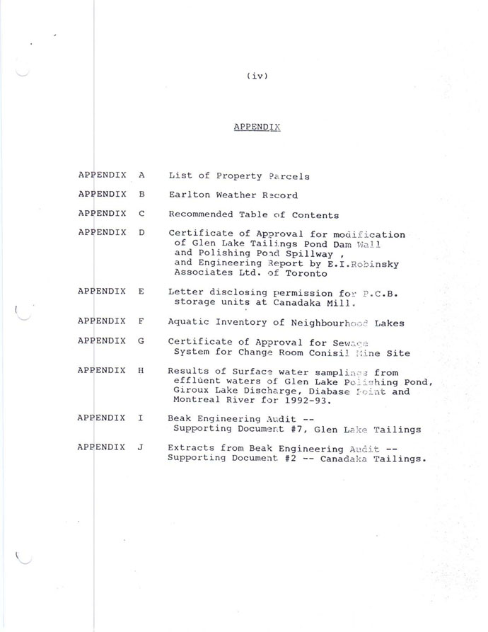
APPENDICES
Appendix I: Purchase Agreement
Trio Resources, Inc. – Duncan Kerr Property
NI 43-101 Technical Report – March 22nd, 2013
JMK Exploration Consulting
Appendix II: Agnico-Eagle Mines Ltd. Closure Plan
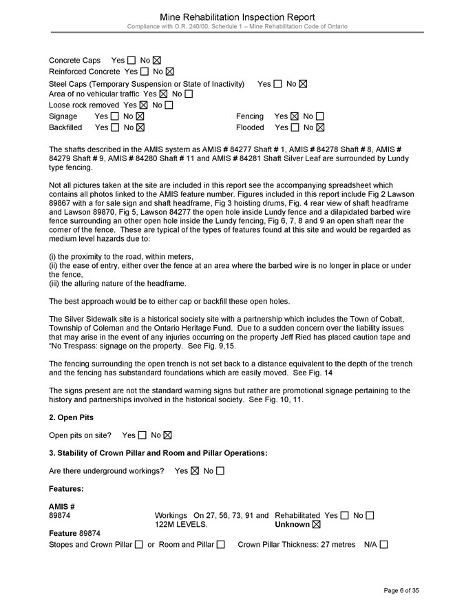
1. EXECUTIVE SUMMARY
At the request of Trio Resources, Inc. (“Trio”), the author has completed a geological review of the Duncan Kerr Property (the “Property”) and prepared this technical report (the “Technical Report”) in compliance with NI 43-101, Companion Policy NI43-101CP, and Form 43-101F1. This Technical Report has been prepared voluntarily and not pursuant to an obligation to prepare and file a technical report under NI 43-101.
The author has prepared this report to provide a summary of scientific and technical data on the Property, including historical exploration activities, and he has made recommendations concerning future exploration and development of the Property. This Technical Report is based on exploration and Property information supplied to the author by Trio, as well as by the review of geological and exploration information available in the public domain. The author visited the property on December 29th, 2012, and again on February 26th and 27th, 2013.
The Property is situated approximately 3 km southeast of the town of Cobalt, Ontario in Coleman Township, Larder Lake Mining Division. The Property consists of 2 contiguous patented mining claims known as Parcels 1831 NND, and 3694 NND, totalling 32.374 ha in area. The Property encompasses the part of the historical mine workings of the Kerr Lake Mine that are located on Parcel 1831 NND, as well as the historical mine workings of the Lawson Mine that are located on Parcel 3694 NND. An estimated total of 32,715,590 oz of Ag have been produced from the Kerr Lake and Lawson Mines (Cunningham, 1963). A well maintained municipal road and power line service the Property. The Property is bounded by UTM NAD83 Z17T coordinates 600890E to 601694E, and 5247329N to 5247904N.
Trio Resources, Inc. – Duncan Kerr Property
NI 43-101 Technical Report – March 22nd, 2013
JMK Exploration Consulting
The Property is located within the Cobalt embayment in the Southern Province of the Canadian Shield. The oldest rocks on the Property are Archean mafic volcanics that have been intruded by several lamprophyre dykes. These rocks have been unconformably overlain by Proterozoic age Huronian sediments. A large south-southeast dipping Nipissing diabase sill intrudes the Archean mafic volcanics and Huronian sediments. This sill is part of a domed Nipissing diabase sheet that is also exposed to the north of the Property. Most of the silver deposits in the Cobalt mining camp are located proximal to the Huronian-Archean unconformity and are spatially associated with the Nipissing diabase sills.
Exploration potential exists south of the Kerr Lake Mine where the Huronian/Archean unconformity may exist beyond the mine workings. A review of a north-south orientated long section from an unknown source in the Ministry of Northern Development and Mines (“MNDM”) government assessment files shows a profile through the Kerr Lake Mine. The interpretation of that section shows the diabase contact becoming very steeply dipping at approximately 70 degrees south. This may have been inferred or implied from geological observations seen on the 2ndlevel of the Kerr Lake Mine, but in contrast the diabase contact to the west on the Conisil and Lawson Mines has a generally shallow dipping contact at approximately 20 to 30 degrees south-southeast with local areas where the contact dips steeply over a short strike length. Assuming this is the case south of the Kerr Lake Mine, potential may exist for a southern, relatively shallow dipping, extension of the Huronian-Archean unconformity or at the Archean-diabase contact. Silver was mined at the Conisil, Lawson, and Kerr Lake Mines within the diabase near the Archean contact. For example, the Number 3 vein at the Kerr Lake Mine produced over 3 Moz of Ag, and it was hosted in diabase and Archean rocks (Cunningham, 1963).
It is recommended that a GIS (Geographic Information System) compilation be completed prior to commencement of any work programs. Prospecting and geological mapping is also recommended to map in the geological contacts and structures on the Property which will assist in the preparation of future work programs on the Property. A diamond drill program is also recommended, with the first phase totaling 2,000 m, and the second phase, contingent upon favorable results in the first phase of diamond drilling, totaling 3,000 m. The aggregate expenditure of the work programs proposed for 2013 is estimated to be $831,050.
Trio Resources, Inc. – Duncan Kerr Property
NI 43-101 Technical Report – March 22nd, 2013
JMK Exploration Consulting
2. INTRODUCTION AND TERMS OF REFERENCE
2.1 Introduction
At the request of Trio, the author has prepared this Technical Report to provide a summary of scientific and technical data on the Property. This Technical Report provides a summary and results from exploration work on the Property carried out by previous operators, Trio, and publicly available information.
2.2 Terms of Reference
The author was retained by Trio to carry out an independent technical review of the Property. The review commenced December 29th, 2012, and continued to March 22nd, 2013.
The author’s assignment consisted of:
1) Reviewing and summarizing historical exploration data generated on the Property prior to Trio’s acquisition of the Property;
2) Undertaking a site visit to confirm historical and current data;
3) Preparing a technical report on the Property; and
4) Making recommendations for future exploration activities on the Property.
Trio Resources, Inc. – Duncan Kerr Property
NI 43-101 Technical Report – March 22nd, 2013
JMK Exploration Consulting
2.3 Sources of Information
The historical exploration information was mostly gathered from the Ontario government databases and from documents provided by Trio. Information in regards to the Property and work completed by Trio was provided by Duncan Reid, Trio’s Chief Executive Officer.
For geographical reference purposes, all UTM locations used in this Technical Report are using NAD83 Zone 17N projection. Tenure information presented in this Technical Report was valid on the MNDM website on March 20th, 2013 (http://www.mci.mndm.gov.on.ca/claims/clm_mdvcl.cfm). Other online database sites providing basic geographic information used for this Technical Report, such as topographic contours, digital elevation models, drainage systems and roads, include:http://geogratis.cgdi.gc.ca/andhttp://www.geobase.ca/.
2.4 Details of Personal Inspection of the Property
The author initially visited the Property on December 29th, 2012. The site visit included reviewing the former locations of the Kerr Lake and Lawson Mines, along with recent trenching, drill site locations, and the tailings pond. The author also completed another visit on February 26thand 27th, 2013 which included spending two full days re-logging drill core from diamond drill holes DK12-02, DK12-04, DK12-07, and DK12-08.
2.5 Units and Currency
This Technical Report uses both the Imperial and Metric Systems (System International or “SI”) as systems of measure and length. Conversions from the Metric System to the Imperial System are provided below and quoted where practical. Many of the geologic publications and more recent work assessment files now use the SI system but older work assessment files almost exclusively refer to the Imperial System. Metal and mineral acronyms in this Technical Report conform to mineral industry accepted usage.
Conversion factors utilized in this Technical Report include: 1 inch = 2.54 centimetres (cm); 1 pound (lb.) = 0.454 kilograms (kg); 1 foot (ft) = 0.3048 metres (m); 1 mile (mi) = 1.609 kilometres (km); 1 acre (ac) = 0.405 hectares (ha); and, 1 sq mile = 2.59 square kilometres.
Trio Resources, Inc. – Duncan Kerr Property
NI 43-101 Technical Report – March 22nd, 2013
JMK Exploration Consulting
Table 1 lists the common abbreviations that are used in this Technical Report. Dollars are expressed in Canadian currency ($) unless otherwise noted. Unless otherwise mentioned, all coordinates in this Technical Report are provided as UTM datum NAD83, Zone 17N.
| Table 1: Abbreviations |
| |
| Abbreviation | | Unit or Term |
| Ag | | silver |
| ASL | | above sea level |
| As | | arsenic |
| Au | | gold |
| Ga | | billion years |
| C | | celsius |
| cm | | centimetre |
| Co | | cobalt |
| CRM | | certified reference material |
| Cu | | copper |
| ft2 | | square foot |
| ft3 | | cubic feet |
| ° | | degree (degrees) |
| ddh | | diamond drill hole |
| ft | | foot (feet) |
| g | | gram |
| GIS | | Geographic Information System |
| g/t | | gram per tonne |
| ha | | hectare |
| km | | kilometre |
| km2 | | square kilometres |
| M | | metre |
| mm | | millimetre |
| Moz | | million troy ounces |
Trio Resources, Inc. – Duncan Kerr Property
NI 43-101 Technical Report – March 22nd, 2013
JMK Exploration Consulting
| Ma | | million years |
| MNDM | | Ministry of Northern Development and Mines |
| Ni | | nickel |
| NI 43-101 | | Canadian National Instrument 43-101 |
| oz | | ounce(s), Troy ounce(s) |
| % | | percent |
| PGE’s | | platinum-group elements |
| ppb | | parts per billion |
| ppm | | parts per million |
| QA/QC | | Quality Assurance/Quality Control |
| SG | | specific gravity |
| ton | | short ton (2,000 pounds) |
| T | | metric tonne (2,000 kg) (2,204.6 pounds) |
| Zn | | zinc |
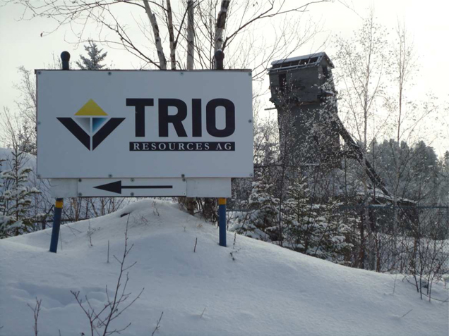
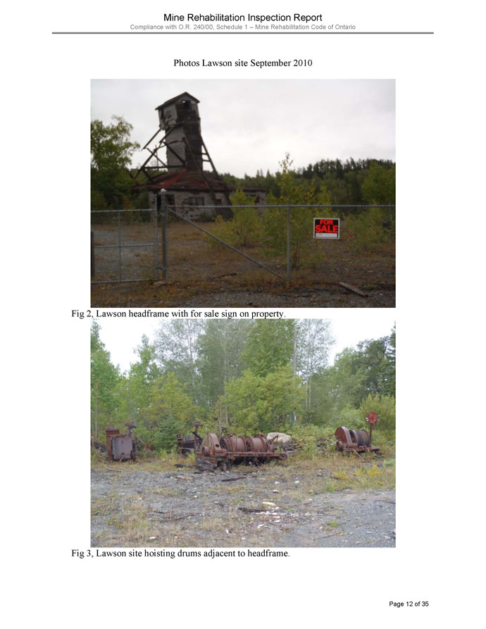
Photo 1: Lawson Head Frame, Duncan Kerr Property.
Trio Resources, Inc. – Duncan Kerr Property
NI 43-101 Technical Report – March 22nd, 2013
JMK Exploration Consulting
3. RELIANCE ON OTHER EXPERTS
The information, conclusions and recommendations contained herein are based on a review of digital and hard copy data and information supplied to the author by Trio, various geological reports, and reports that were available in the public domain, as well as a review of assessment files located at the Resident Geologist’s Office in Kirkland Lake, Ontario.
Some relevant information on the Property presented in this Technical Report is based on data derived from reports written by geologists and/or engineers who may or may not be “qualified persons” (as defined in NI 43-101). The author hasmade every attempt to accurately convey the content of those reports, but cannot guarantee either the accuracy, validity, or completeness of the data contained within those files. However, it is believed that these reports were written with the objective of presenting the results of the work performed, without any promotional or misleading intent.
4. PROPERTY DESCRIPTION AND LOCATION
4.1 Location
The Property is situated approximately 3 km southeast of the town of Cobalt, Ontario in Coleman Township, Larder Lake Mining Division (Figure 1). A well maintained municipal road and power line service the Property. The Property is bounded by UTM NAD83 Z17T coordinates 600890E to 601694E, and 5247329N to 5247904N, and is covered by NationalTopographic System (NTS) map sheet 31M/5.
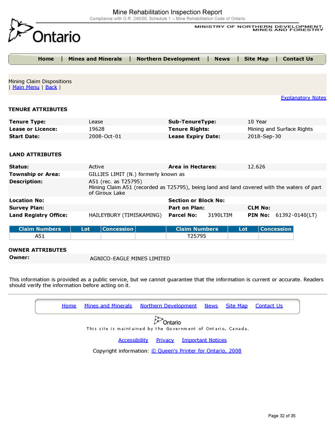
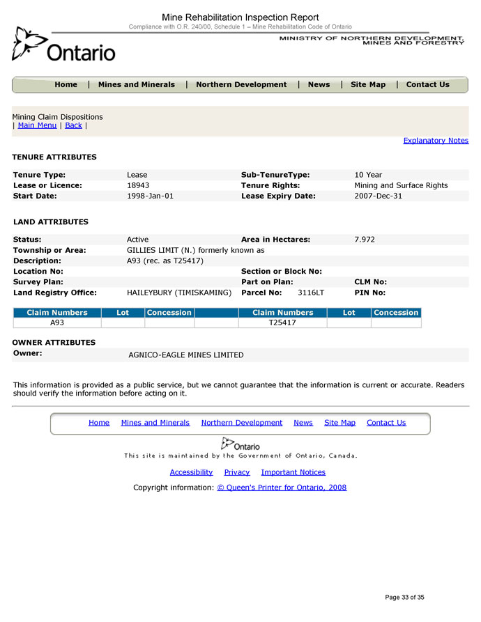
4.2 Mineral Dispositions
In 2012, Trio acquired 100% ownership intwo patented mining claims in Coleman Township, 1831NND and 3694NND (Figure 2). The claims are located on property parcel PT E 1/2 of N 1/2, Lot 3, Con 4, and SW 1/4 of N 1/2, Lot 3, Con 4 respectively (Table 2).
The purchase by Trio included a cash payment of $100,000, and issuing a vendor note representing $500,000 which shall be automatically converted into common shares of Trio upon the completion of a transaction resulting in the listing of the Company on the NASDAQ stock exchange. Details of the purchase agreement can be found in Appendix 1.
Trio Resources, Inc. – Duncan Kerr Property
NI 43-101 Technical Report – March 22nd, 2013
JMK Exploration Consulting
The author has not sought a formal legal opinion with regard to the ownership status of the claims comprising the Property and has in all aspects of tenure relied on materials made available on the MNDM’s website (http://www.mci.mndm.gov.on.ca/claims/clm_mdvcl.cfm) and by Trio. JMK Exploration Consulting expresses no opinion as to the ownership status of the Property. Both surface and mineral rights are attached to the patents that comprise the Property. The patents are held “Fee Simple”, which requires the annual payment of $129.50 Mining Land Tax. Trio has advised that all taxes are current.
Table 2: Claim Details
| Township/Area | | Parcel
Number | | | Claim Type | | Claim Size
(ha) | | | Annual
Mining
Land Taxes | |
| Coleman | | | 1831NND | | | Patented | | | 16.187 | | | $ | 64.75 | |
| Coleman | | | 3694NND | | | Patented | | | 16.187 | | | $ | 64.75 | |
Trio Resources, Inc. – Duncan Kerr Property
NI 43-101 Technical Report – March 22nd, 2013
JMK Exploration Consulting

Figure 1: Location of the Duncan Kerr Property, Cobalt, Ontario
4.3 Environmental Liabilities and Permitting
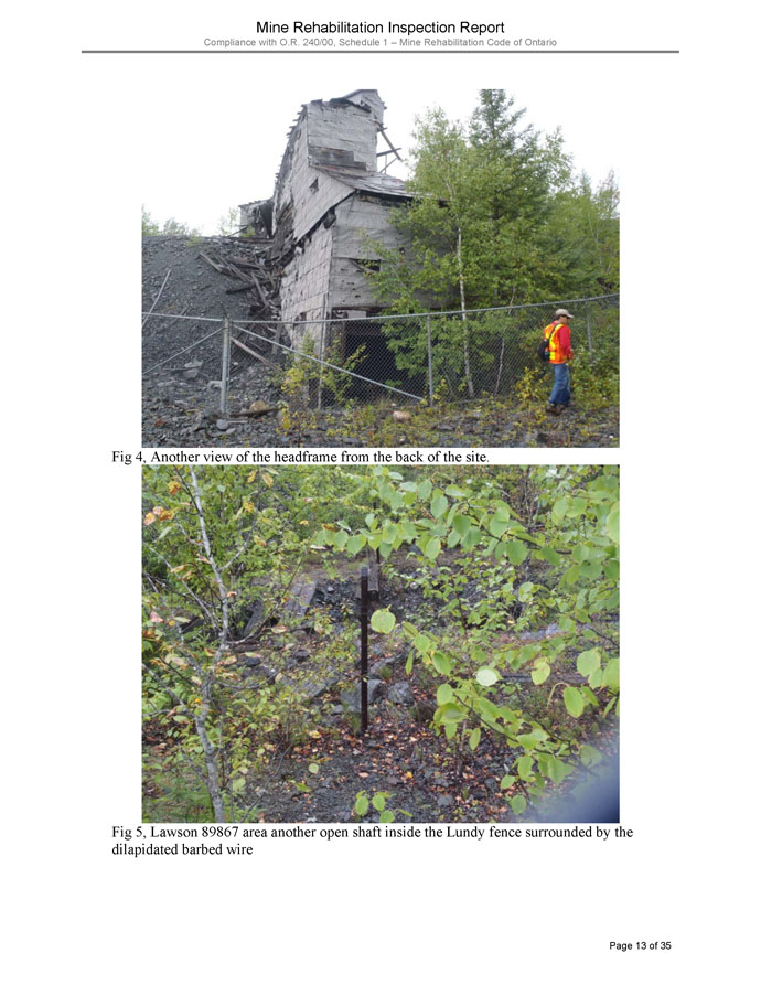
The Property hosts parts of the past producing Kerr Lake Mine which operated intermittently from 1905 through to 1964, and the Lawson Mine which operated intermittently from 1909 through to the 1960’s.
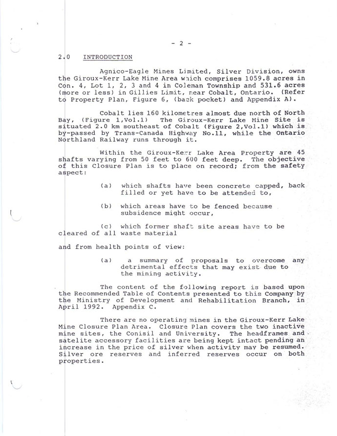
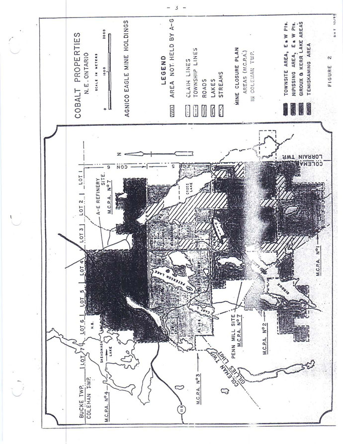
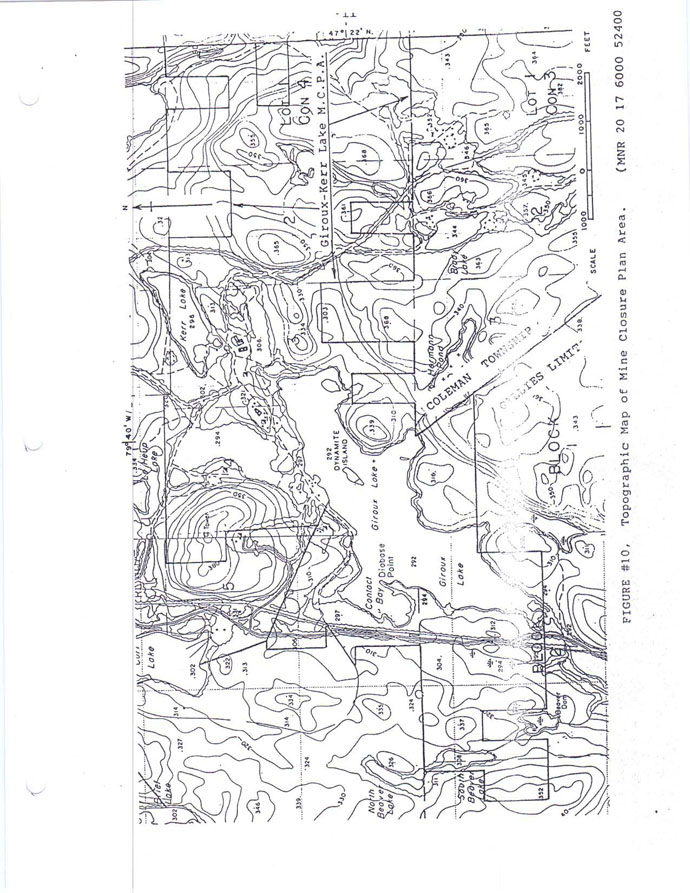
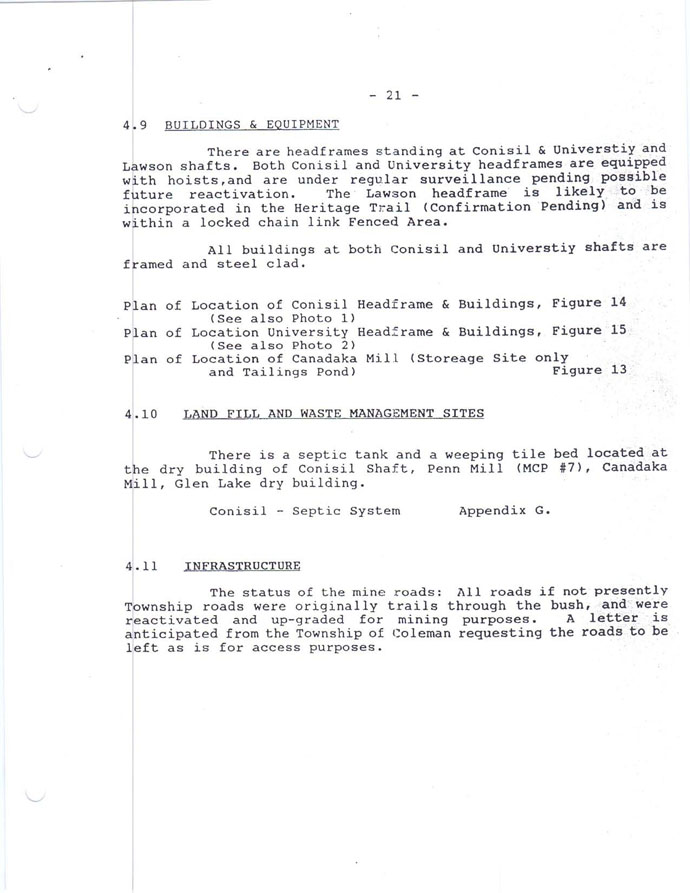
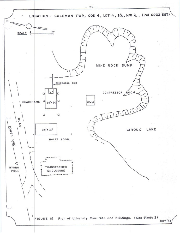
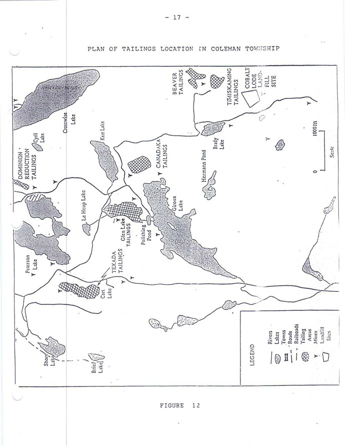
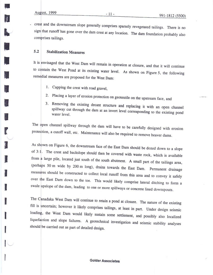
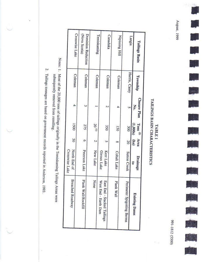
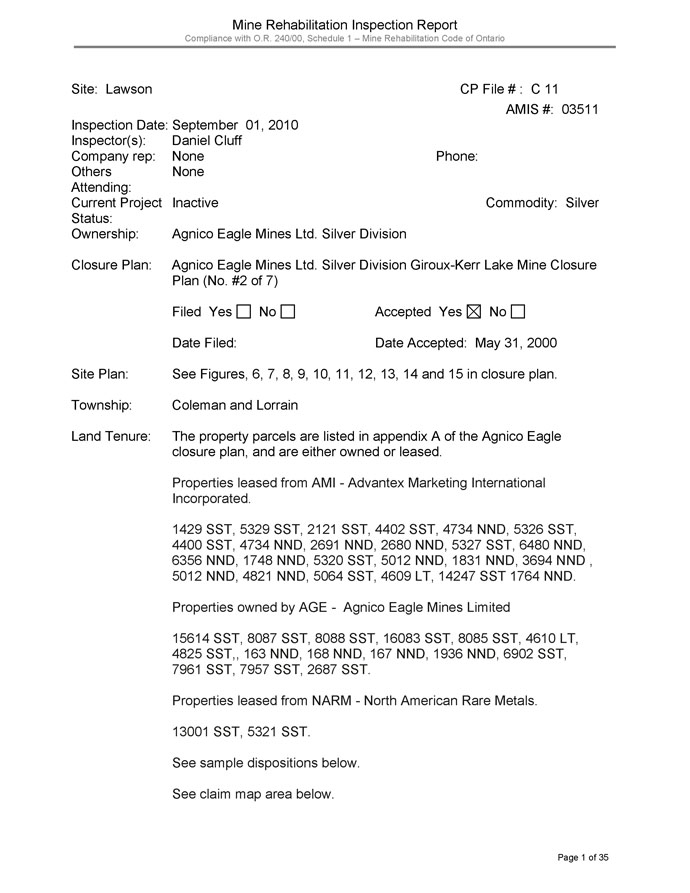
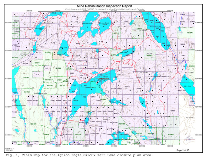
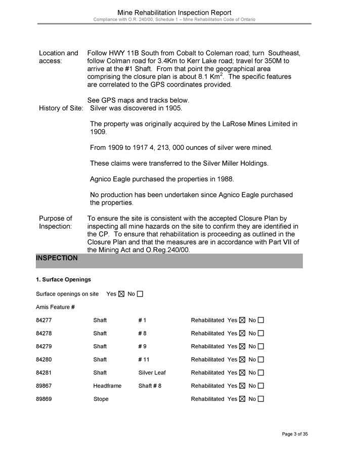
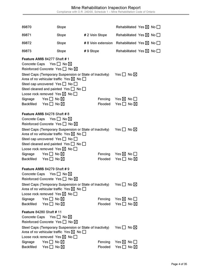
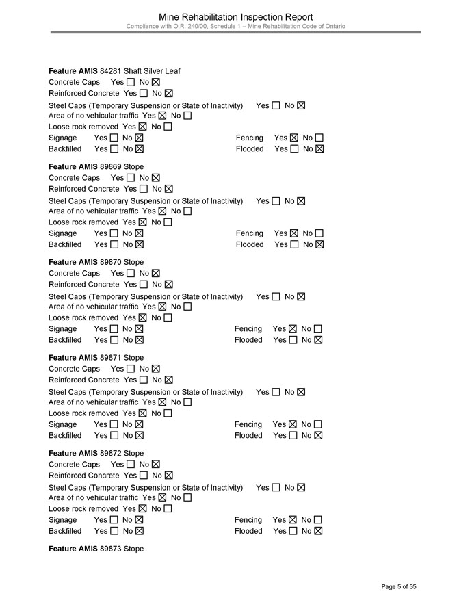
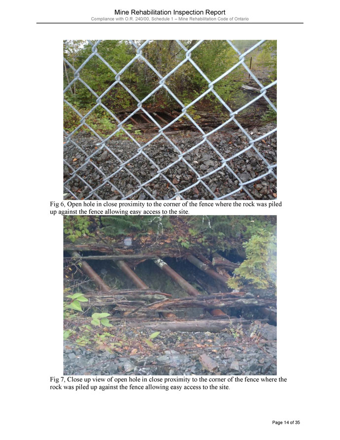
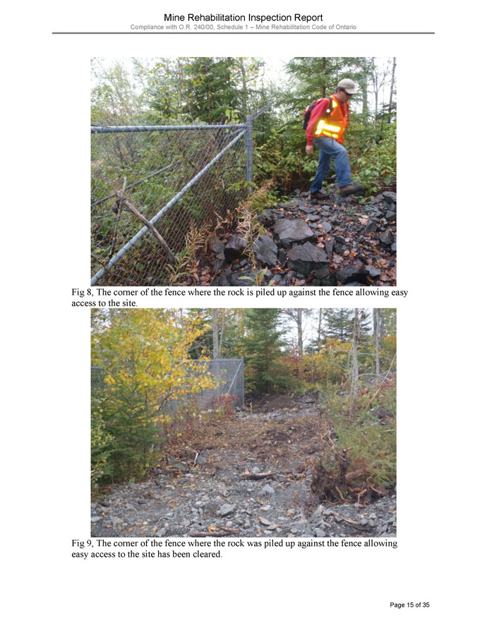
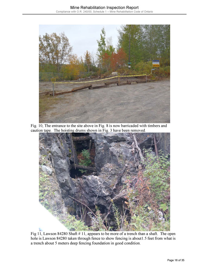
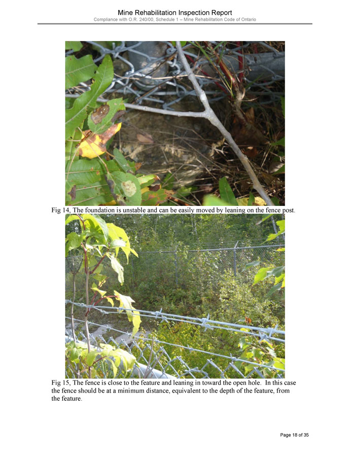
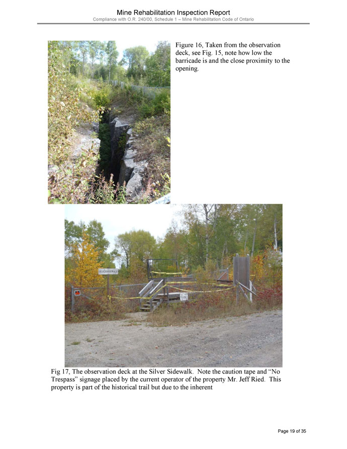
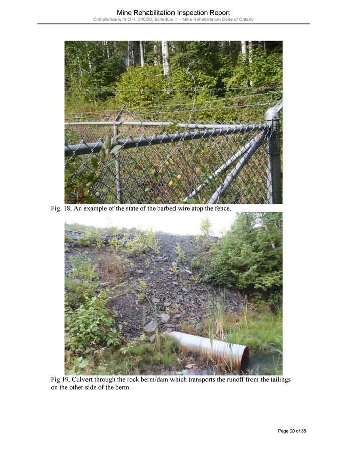
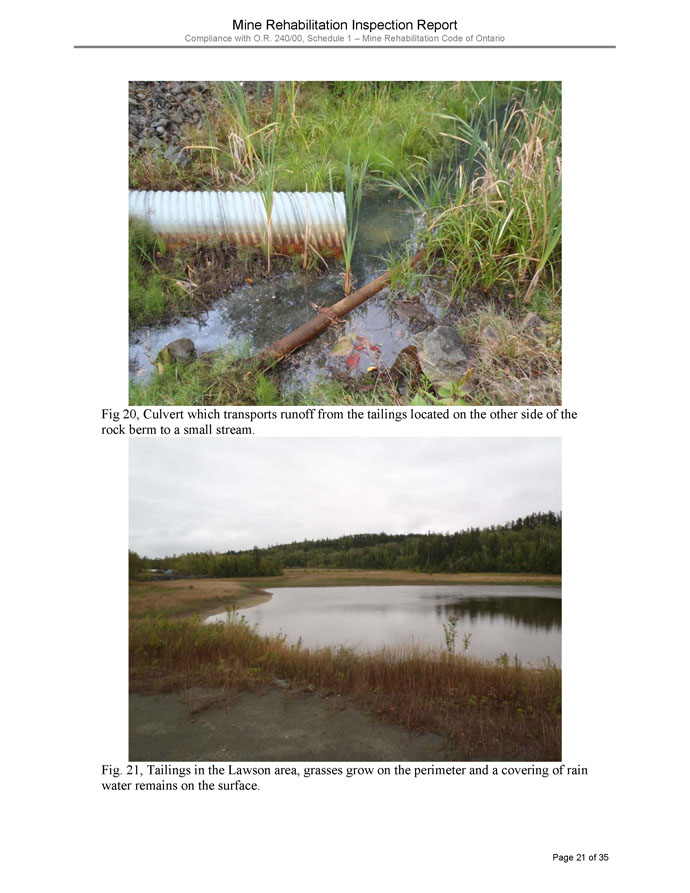
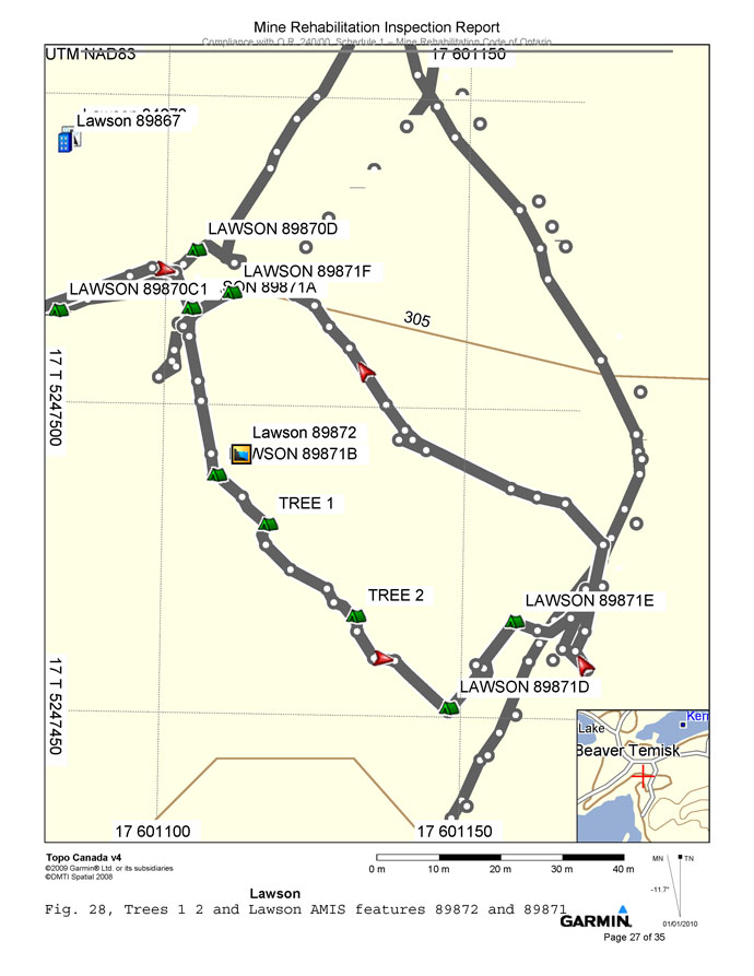
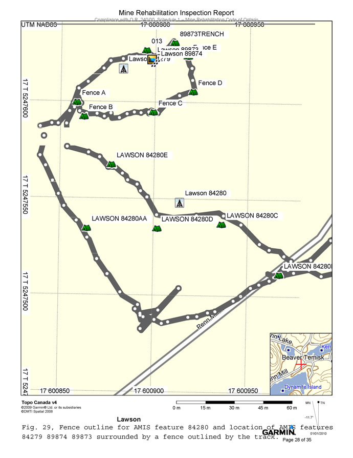
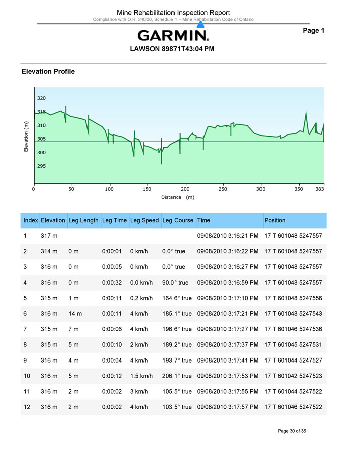
Trio is responsible for all environmental and mine hazards located on the Property. The majority of the mine hazards have been addressed, but according to inspection reports, several hazards may still exist on the Property. As well, Trio is responsible for the ongoing maintenance of the remediation efforts such as maintaining fencing, signage, etc. It is recommended that the hazards and environmental liabilities on the property be documented by Trio and inspected on a semi-annual basis. Appendix 2 provides the closure plan that was submitted by Agnico Eagle Mines Ltd. in 1994, and the most recent site inspection by the MNDM in 2010.
Trio Resources, Inc. – Duncan Kerr Property
NI 43-101 Technical Report – March 22nd, 2013
JMK Exploration Consulting
All work performed to date by Trio on the Property has not required any special permit or licences. Currently, no permits are required to perform any exploration activity in the Province of Ontario. However, due to new rules under Ontario’s Mining Act passed in 2009, exploration plans and permits will have to be submitted and approved by MDNM after April 1, 2013 for completing work on unpatented claims. Surface rights owners must be notified when applying for permits, and aboriginal communities, potentially affected by the exploration permit activities, have to be consulted and have an opportunity to provide comments and feedback before a decision is made by MNDM on the permit. As the claims that comprise the Property are patented, where Trio owns the surface and mineral rights, no permits are necessary under the Mining Act of Ontario.
5. ACCESS, CLIMATE, LOCAL RESOURCES, INFRASTRUCTURE, AND PHYSIOGRAPHY
5.1 Accessibility
The Property is located approximately 3 km southeast of the town of Cobalt, Ontario in Coleman Township. A well maintained year-round municipal road and power line service the Property. The Property is bounded by UTM NAD83 Z17T coordinates 600890E to 601694E, and 5247329N to 5247904N.
5.2 Climate
The Property is under the influence of a moist boreal climate. The mean January temperature is -16.4oC; the mean July temperature is 18.1oC. The annual precipitation is approximately 785.1 mm (http://climate.weatheroffice.gc.ca). The beginning of permanent snow cover varies from year to year, sometimes starting in November and lasting until late April.
Trio Resources, Inc. – Duncan Kerr Property
NI 43-101 Technical Report – March 22nd, 2013
JMK Exploration Consulting
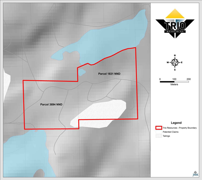
Figure 2: Land Tenure of the Duncan Kerr Property
5.3 Local Resources and Infrastructure
Local resources on the Property consist of an abundance of fresh water, and mixed deciduous and coniferous trees.
Several buildings are present on the Property, including a 4,000 ft2 partially heated warehouse. The Property is serviced by hydro. Highway 11 is located approximately 10 km to the west of the Property. Most supplies and services can be found in Temiskaming Shores, Ontario, a city with a population of approximately 10,400.
Trio Resources, Inc. – Duncan Kerr Property
NI 43-101 Technical Report – March 22nd, 2013
JMK Exploration Consulting
5.4 Physiography
The physiography is typical of the Precambrian Shield area in northeastern Ontario with general rolling and steep ledges and cliffs with occasional swamps, lakes, and streams. Typical vegetation on the Property consists of a boreal forest with a mixture of coniferous and deciduous trees, including poplars, birch, maple, pine, spruce, alders, and willows. The elevation of the Property is approximately 310 m above sea level and the maximum topographical relief is generally less than 25 m.
6. HISTORY
6.1 Historical Mineral Exploration
Historical exploration in the area of the Property dates back to 1903 with the discovery of silver in Cobalt, Ontario. Silver production of the Cobalt Camp is reported to be 464,853,101 oz (Pressacco, Webster, and Zalnieriunas, 2008).
The Kerr Lake deposit was discovered in 1904, and production commenced in 1905 whereby the Kerr Lake Mine was operated intermittently until it finally closed in 1964. The original Kerr Lake property was comprised of three claims historically referred to as Parcel 1764 NND (under Kerr Lake), 1831 NND, and 4821 NND (referred to as the Kerr Lake fraction). From 1905 through to 1956, 28,502,037 oz of Ag was produced from the three claims (Cunningham, 1963). A total of 8 shafts and were sunk on the Kerr Lake claims, along with one adit that was driven south from the shoreline of Kerr Lake. The main shaft, known as the Number 3 shaft, was sunk to a depth of 550 ft with 9 levels being developed. The underground workings were connected to the Hargrave, Conisil, and Lawson Mines located to the southeast, south, and west respectively.
The Lawson deposit was discovered in 1905 and production commenced at the Lawson Mine in 1909. A total of 4 shafts were sunk on the Lawson claim (Parcel 3694 NND). The deepest shaft, the No 8, was sunk to a depth of approximately 410 ft. All underground workings were connected and 6 levels were developed. When the mine initially closed in 1919, a total of 4,213,553 oz of Ag had been produced (Cunningham, 1963). From 1922 through to 1944, the Lawson Mine was operated pursuant to several leases. The mine was later re-opened in 1953 and was operated through to 1960 by Silver Miller Mines Ltd. No records of silver production were recorded during this period as the ore was mixed with other Silver Miller ores from the surrounding mines (Cunningham, 1963).
Trio Resources, Inc. – Duncan Kerr Property
NI 43-101 Technical Report – March 22nd, 2013
JMK Exploration Consulting
In 1977, St. Joseph Exploration Ltd. constructed the Canadaka Mill on the Lawson claim (parcel 3694NND). It was designed to process up to 500 tons per day, but was estimated to have only processed 350 tons per day. The mill was designed as an ore concentrator by combining gravity and flotation methods to process ore from the company’s area mines. The mill was closed in 1980 when the company’s mines ceased production.
In 1983, the mill was bought by Sulpetro Minerals Ltd. and was modified to process tailings being mined at the Chambers-Ferland tailings containment area. Milling rates averaged 450 to 500 tons per day. The tailings were deposited to the south of the Main Shaft in a series of three ponds that were formed by damming a small creek flowing from Kerr Lake to Giroux Lake. At the time, the tailings capacity had not been reached and an estimated 500,000 tons of tailings could be added (Anderson, 1993). The mill was later sold prior to Trio’s acquisition of the Property.
As at the date of this Technical Report, limited historical information was available. No records of past exploration work were located. It is recommended that on-going efforts be made to locate historical reports that pertain to the Property.
7. GEOLOGICAL SETTING AND MINERALIZATION
7.1 Regional Geology
The Property is located within the Cobalt Embayment in the Southern Province of the Canadian Shield. Huronian Supergroup sedimentary rocks unconformably overly Archean basement rocks, and are commonly found filling paleo-valleys or troughs in the Archean basement. The Archean rocks are summarized as a steeply dipping sequence of mafic to felsic volcanics, intercalated with cherty and sulphidic interflow sediments, along with intrusions of mafic to ultramafic dykes and sills. Both the Huronian sediments and Archean rocks have been intruded by Proterozoic-aged Nipissing diabase occurring as both sills and dykes (Figure 3).
Trio Resources, Inc. – Duncan Kerr Property
NI 43-101 Technical Report – March 22nd, 2013
JMK Exploration Consulting
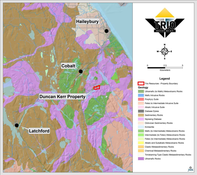
Figure 3: Regional Geology of the Cobalt Area, Ontario (after OGS MRD 282).
7.2 Property Geology
The oldest rocks on the Property are Keewatin-age volcanic rocks that have been overlain by Huronian sediments of Proterozoic age. A large south-southeast dipping Nipissing diabase sill intrudes the Archean mafic volcanics and Huronian sediments. This sill is part of a domed Nipissing diabase sheet that is also exposed to the north of the Property. The current level of erosion has exposed the underlying Cobalt Series sediments and Keewatin volcanic rocks (Figure 4).
Trio Resources, Inc. – Duncan Kerr Property
NI 43-101 Technical Report – March 22nd, 2013
JMK Exploration Consulting
Exploration potential exists south of the Kerr Lake Mine where the Huronian/Archean unconformity may exist beyond the mine workings. A review of a north-south orientated long section from an unknown source in the MNDM government assessment files shows a profile through the Kerr Lake Mine. The interpretation of that section has the diabase contact becoming very steeply dipping at approximately 70 degrees south. This may have been inferred or implied from geological observations seen on the 2nd level of the Kerr Lake Mine, but in contrast the diabase contact to the west on the Conisil and Lawson Mines has a generally shallow dipping contact at approximately 20 to 30 degrees south-southeast with local areas where the contact dips steeply over a short strike length. Assuming this is the case south of the Kerr Lake Mine, potential may exist for a southern, relatively shallow-dipping, extension of the Huronian-Archean unconformity or at the Archean-diabase contact. Silver was mined at the Conisil, Lawson, and Kerr Lake Mines within the diabase near the Archean contact.
7.3 Mineralization
Silver mineralization on the Property has been exploited by several mining operations from 1905 through to the 1960’s. An estimated 32,715,590 oz of Ag have been produced from the Kerr Lake and Lawson Mines (Cunningham, 1963). The Property encompasses the historical mine workings of the Kerr Lake Mine that lie on Parcel 1831 NND, as well as the historical mine workings of the Lawson Mine on Parcel 3694 NND.
8. DEPOSIT TYPES
Most of the silver deposits in the Cobalt Camp are located proximal to the Huronian-Archean unconformity and are spatially associated with the Nipissing diabase sills. The majority of the historical silver production from the Cobalt Camp has been within 200 m of the contacts of the diabase.
The veins hosting the mineralization in the Cobalt Camp are referred to as five-element veins, containing Ni, Co, As, Ag, and Bi. The veins are characteristically open-space filling, and the replacement of wall rock is not extensive. Most veins are directly or indirectly associated with vertical to sub-vertical fault systems. Veins are commonly completely filled with hydrothermally deposited minerals and pinch and swell from cm to m scale thicknesses.
Trio Resources, Inc. – Duncan Kerr Property
NI 43-101 Technical Report – March 22nd, 2013
JMK Exploration Consulting
Mineralization is typically discontinuous along the structure with high-grade ore pockets commonly occurring in the vicinity of vein intersections, or at the intersections of veins with late, shallow-dipping shear zones, and at lithological contacts. Ore minerals occur in a wide variety of forms including massive pods, bands, dendrites, plates, leaves, and zoned rosettes.
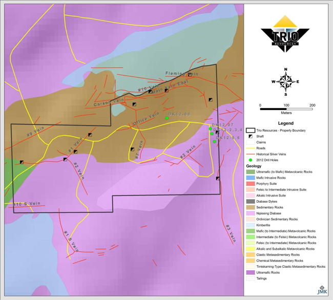
Figure 4: Property Geology with historical veins projected to surface (after OGS MRD 282).
9. EXPLORATION
Trio has not completed any exploration activities on the Property.
Trio Resources, Inc. – Duncan Kerr Property
NI 43-101 Technical Report – March 22nd, 2013
JMK Exploration Consulting
10. DRILLING
10.1 Historical Drilling
No records of any surface diamond drilling were located from the OGS digital database and through searching through assessment files at the Kirkland Lake Resident Geologist Office. Several underground drill holes were shown on level plan maps.
10.2 Drilling
In 2012, Trio completed 8 short AQ diameter (2.7 cm) diamond drill holes, with the longest drill hole, DK12-07, drilled to a depth of 165.1 ft (Figure 5)). The author re-logged four drill holes, DK12-02, DK12-04, DK12-07, and DK12-08 as part of the current review. No core samples had been submitted for analysis as at the date of this Technical Report. All four holes that were logged intersected Cobalt series sediments. In diamond drill hole DK12-07, local sections of significant mineralization consisting of cobaltite +/- silver veinlets up to several mm’s in width were intersected. Drill hole DK12-07 was drilled at a vertical inclination, and would have been orientated sub-parallel to the known orientation of the veins on the Property. This is supported by several mineralized fractures that are orientated 0° to the core axis.
The diamond drilling program was not conducted to industry standards as outlined by CIM Best Practice guidelines. The author attempted to validate the drill results, and it is the opinion of the author that the results should not be considered reliable.
11. SAMPLE PREPARATION, ANALYSES, AND SECURITY
Trio has not carried out any sampling programs on the Property.
12. DATA VERIFICATION
12.1 Historical Data Verification
Historical data verification included a site visit to the former locations of the Kerr Lake and Lawson Mines, as well as the tailings facility. The author also reviewed historical maps and reports located at the Kirkland Lake Resident Geologist Office. The author believes this information is generally of sufficient accuracy to form the basis of an exploration program on the Property.
Trio Resources, Inc. – Duncan Kerr Property
NI 43-101 Technical Report – March 22nd, 2013
JMK Exploration Consulting
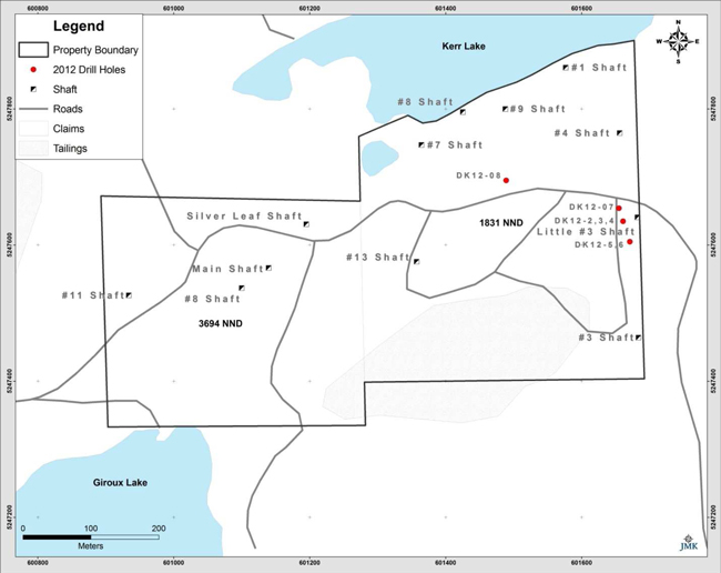
Figure 5: 2012 Diamond drill hole locations.
12.2 Recent Data Verification
The diamond drilling program completed in 2012 by Trio was reviewed by the author. The author logged four drill holes, DK12-02, DK12-04, DK12-07, and DK12-08 as part of the review. No core samples had been submitted for analysis as at the date of this Technical Report. As previously noted, the diamond drilling program was not conducted to industry standards as outlined by CIM Best Practice guidelines. The author attempted to validate the drill results, and it is the opinion of the author that the results should not be considered reliable.
Trio Resources, Inc. – Duncan Kerr Property
NI 43-101 Technical Report – March 22nd, 2013
JMK Exploration Consulting
13. MINERAL PROCESSING AND METALLURGICAL TESTING
The Property is at the exploration stage and no metallurgical testing has been carried out.
14. MINERAL RESOURCE ESTIMATES
There has not been sufficient work on the Property to undertake a mineral resource estimate.
23. ADJACENT PROPERTIES
The Property hosts parts of the past producing Kerr Lake Mine, and the Lawson Mine, which represent two of the numerous past producing mines that have operated over the past century in the Cobalt Camp. The majority of the mines in the Cobalt Camp contained mineralization similar to that in the Kerr Lake and Lawson Mines.
24. OTHER RELEVANT DATA AND INFORMATION
There is no other relevant data or information.
Trio Resources, Inc. – Duncan Kerr Property
NI 43-101 Technical Report – March 22nd, 2013
JMK Exploration Consulting
25. INTERPRETATION AND CONCLUSIONS
Exploration potential exists south of the Kerr Lake Mine where the Huronian/Archean unconformity may exist beyond the mine workings. A review of a north-south orientated long section from an unknown source in the MNDM government assessment files shows a profile through the Kerr Lake Mine. The interpretation of that section has the diabase contact becoming very steeply dipping at approximately 70 degrees south. This may have been inferred or implied from geological observations seen on the 2nd level of the Kerr Lake Mine, but in contrast the diabase contact to the west on the Conisil and Lawson Mines has a generally shallow dipping contact at approximately 20 to 30 degrees south-southeast with local areas where the contact dips steeply over a short strike length. Assuming this is the case south of the Kerr Lake Mine, potential may exist for a southern, relatively shallow-dipping, extension of the Huronian-Archean unconformity or at the Archean-diabase contact. Silver was mined at the Conisil, Lawson, and Kerr Lake Mines within the diabase near the Archean contact. For example, the Number 3 vein at the Kerr Lake Mine produced over 3 Moz of Ag and it was hosted in diabase and Archean rocks (Cunningham, 1963).
26. RECOMMENDATIONS
Subsequent to the research conducted for this Technical Report, and taking into consideration information provided by Trio, the author recommends a two phase exploration program:
Phase 1:
1) If possible, the diamond drill core that was recovered from the 2012 drill program completed by Trio should be completely logged and sampled. For future drilling programs, it is recommended to drill larger diameter cores, such as NQ diameter (47.6 mm). As well, the drill core should be placed into properly labeled boxes and the drill site should be marked and surveyed at the time of the completion of the drill hole. Proper core storage and security is also recommended to ensure that no loss of information pertaining to the drill core or drill holes occurs. The drilling and exploration programs should follow CIM Best Practice guidelines.
2) Creation of a GIS database, including all geological, geophysical and historical information should be completed. This would entail digitization of historical plans and sections, along with the supporting assay data. This will help to assist in the preparation of future work programs along with targeting the most prospective areas on the Property.
Trio Resources, Inc. – Duncan Kerr Property
NI 43-101 Technical Report – March 22nd, 2013
JMK Exploration Consulting
3) A surface work program is recommended prior to the commencement of any diamond drilling. This should include geological mapping, line cutting, and possible induced polarization and magnetometer surveying to assist in identifying diamond drill targets.
4) A 2,000 m diamond drill program is recommended for the Property to locate new bedrock resources at the Archean-Huronian unconformity.
Phase 2:
1) Based on favourable results from Phase 1, a 3,000 m follow-up diamond drill program is recommended for the Property.
Tables 3, 4, and 5 summarize the budget and recommendations of a two phase exploration program for the Property.
Table 3: Phase 1 Surface Exploration Budget
| Personnel costs (GIS compilation) | | Unit | | | Unit cost | | Sub-Total | |
| Project Manager | | | 15 days | | $ | 700/day | | $ | 10,500 | |
| Exploration Geologist | | | 15 days | | $ | 425/day | | $ | 6,375 | |
| | | | | | | | | | | |
| Personnel costs (geological mapping, prospecting) | | | | | | | | | | |
| Project Manager | | | 20 days | | $ | 700/day | | $ | 14,000 | |
| Exploration Geologist | | | 20 days | | $ | 425/day | | $ | 8,500 | |
| Fixed contract costs | | Unit | | | Unit cost | | Sub-Total | |
| | | | | | | | | |
| Line cutting | | | 10 km | | $ | 600/km | | $ | 6,000 | |
| IP Survey | | | 6 days | | $ | 3,000/day | | $ | 18,000 | |
| Magnetometer Survey | | | 10 km | | $ | 200/km | | $ | 2,000 | |
| Other costs | | Unit | | Unit cost | | | Sub-Total | |
| Meals and accommodation | | | 40 | | $ | 100/day | | | $ | 4,000 | |
| Assays | | | 100 | | $ | 40 | | | $ | 4,000 | |
| Supplies | | | 1 | | $ | 5,000 | | | $ | 5,000 | |
| | | | | | | Total: | | | $ | 78,375 | |
Trio Resources, Inc. – Duncan Kerr Property
NI 43-101 Technical Report – March 22nd, 2013
JMK Exploration Consulting
Table 4: Phase 1 Diamond Drilling Budget (2,000 m)
| Personnel costs (diamond drilling) | | Unit | | | Unit cost | | Sub-Total | |
| Project Manager | | | 30 days | | $ | 700/day | | $ | 21,000 | |
| Exploration Geologist | | | 30 days | | $ | 425/day | | $ | 12,750 | |
| Technician | | | 30 days | | $ | 300/day | | $ | 9,000 | |
| Fixed contract costs | | Unit | | | Unit cost | | Sub-Total | |
| Diamond Drilling (all inclusive) | | | 2000 m | | $ | 100/m | | $ | 200,000 | |
| Other costs | | Unit | | | Unit cost | | | Sub-Total | |
| Supplies | | | 1 | | | $ | 10,000 | | | $ | 10,000 | |
| Diamond Saw Rental | | | 1 | | | $ | 650 | | | $ | 650 | |
| Meals and accommodation | | | 60 | | | $ | 100 | | | $ | 6,000 | |
| Rock Analysis | | | 500 samples | | | $ | 40/Sample | | | $ | 20,000 | |
| | | | | | | | Total: | | | $ | 279,400 | |
Table 5: Phase 2 Diamond Drilling Budget (3,000 m)
| Personnel costs (diamond drilling) | | Unit | | | Unit cost | | Sub-Total | |
| Project Manager | | | 45 days | | $ | 700/day | | $ | 21,000 | |
| Exploration Geologist | | | 45 days | | $ | 425/day | | $ | 12,750 | |
| Technician | | | 45 days | | $ | 300/day | | $ | 9,000 | |
| Fixed contract costs | | Unit | | | Unit cost | | Sub-Total | |
| Diamond Drilling (all inclusive) | | | 3000 m | | $ | 100/m | | $ | 300,000 | |
| Other costs | | Unit | | | Unit cost | | | Sub-Total | |
| Supplies | | | 1 | | | $ | 15,000 | | | $ | 15,000 | |
| Diamond Saw Rental | | | 1.5 | | | $ | 650 | | | $ | 975 | |
| Meals and accommodation | | | 90 | | | $ | 100 | | | $ | 9,000 | |
| Rock Analysis | | | 750 samples | | | $ | 40/Sample | | | $ | 30,000 | |
| | | | | | | | Total: | | | $ | 397,725 | |
| | Sub-Total: | | $ | 755,500 | |
| | Contingency (10%): | | $ | 75,550 | |
| | Total: | | $ | 831,050 | |
Trio Resources, Inc. – Duncan Kerr Property
NI 43-101 Technical Report – March 22nd, 2013
JMK Exploration Consulting
27. DATE AND SIGNATURE PAGE
This report titled “NI 43-101 Technical Report on the Duncan Kerr Property, Larder Lake Mining Division, Northeastern Ontario” for Trio Resources, Inc. dated March 22nd, 2013, was prepared and signed by the following author:
Signed by:

Joerg M. Kleinboeck, P.Geo.
Trio Resources, Inc. – Duncan Kerr Property
NI 43-101 Technical Report – March 22nd, 2013
JMK Exploration Consulting
28. REFERENCES
Anderson, P. 1993. Cobalt Mining Camp Tailings Inventory, Cobalt, Ontario.
Assessment Files at the Resident Geologist’s Office, Kirkland Lake, Ontario.
Ayer, J.A. and Chartrand, J.E. 2011. Geological compilation of the Abitibi greenstone belt; Ontario Geological Survey, Miscellaneous Release—Data 282.
Cunningham, L.J. 1963. Report on the Kerr Lake, Lawson, University, Cleopatra, Silver Hill, and adjoining claims, for Glen Lake Silver Mines Ltd.
http://mindat.org
http://www.trioresources.com
Kissin, S.A., 1993. Five Element (Ni-Co-As-Ag-Bi) Veins, in Ore Deposit Models Vol II., edited by P.A. Sheahan and M.E. Cherry, Geological Association of Canada.
Knight, C. 1922. Thirty-first Annual Report of the Ontario Department of Mines, Cobalt and South Lorrain Silver Areas, Volume XXXI, Part II.
Ministry of Northern Development and Mines; Geology of Ontario, Assessment File Research Information (AFRI) found at www.geologyontario.mndm.gov.on.ca
Ministry of Northern Development and Mines; Assessment Files at the Resident Geologist’s Office, Kirkland Lake, Ontario.
Nichols, R.M. 1988. Archean Geology and Silver mineralization controls at Cobalt, Ontario. CIM bulletin, Vol 81, No. 910.
Ontario Geological Survey, 2006. 1:250,000 Scale Bedrock Geology of Ontario; Ontario Geological Survey, Miscellaneous Release Data 126 revised.
Percival, J.A., Easton, R.M., 2007: Geology of the Canadian Shield in Ontario: An update; Geological Survey of Canada, Open File 5511, Ontario Geological Survey ,Miscellaneous Release Data 216.
Pressacco, R., Webster, C., and Zalnieriunas, R., 2008. Technical Report on the Peterson Lake Property, Coleman Township, Ontario. Prepared for Castle Resources Inc.
Trio Resources, Inc. – Duncan Kerr Property
NI 43-101 Technical Report – March 22nd, 2013
JMK Exploration Consulting
CERTIFICATE OF AUTHOR
I, Joerg M. Kleinboeck, of 147 Lakeside Dr., North Bay, Ontario do hereby certify that:
| 1. | I am a Consulting Geologist offering geological exploration services to the mineral exploration industry. |
| 2. | I hold the following academic qualifications: B.Sc. Geology (2000) Laurentian University. |
| 3. | I am a member of the Association of Professional Geoscientists of Ontario (Member #1411). |
| 4. | I have worked as a geologist for over 13 years on a variety of exploration properties targeting gold, Ni-Cu-PGE, base metals, diamonds, and industrial minerals. |
| 5. | At the effective date of the Technical Report, to the best of my knowledge, information, and belief, the Technical Report, contains all scientific and technical information that is required to be disclosed to make the Technical Report not misleading. |
| 6. | In accordance with section 1.5 of NI 43-101, I am independent of Trio Resources, Inc. |
| 7. | I have read National Instrument 43-101 and the Technical Report has been prepared in compliance with National Instrument 43-101. |
| 8. | I am responsible for all sections of the Technical Report titled “NI 43-101 Technical Report on Duncan Kerr Property, Larder Lake Mining Division, Northeastern Ontario”, dated March 22nd, 2013 and prepared for Trio Resources, Inc. |
| 9. | I am a “qualified person” as defined in National Instrument 43-101. |
| 10. | I last visited the Duncan Kerr Property on February 27th, 2013 for a period of 8 hours. I have had no prior involvement other than described above with respect to the Duncan Kerr Property. |
Dated this 22nd Day of March, 2013
Joerg M. Kleinboeck, P.Geo.
Trio Resources, Inc. – Duncan Kerr Property
NI 43-101 Technical Report – March 22nd, 2013
Appendix I: Purchase Agreement
THIS AGREEMENT is made 17th day of May, 2012
BETWEEN:
TrioResources AG, a Ontario corporation, (the “Purchaser”)
- and -
2023682 Ontario Inc. DBA Canamet Resources and Jeffrey D. Reid,
(the “Vendor”)
The Purchaser and the Vendor agree as follows:
1. The Purchaser shall purchase from the Vendor and the Vendor shall sell to the Purchaser, as a going concern, the Vendor’s Assets (the “Assets”) and all the assets and rights used in carrying on the Business other than cash on hand and in the bank or other similar depository (the “Purchased Assets”) including:
| (a) | Property Parcel 1. PT E 1/2 of N 1/2 Lot 3 CON 4 as in NP 1503 S/T NL 10177 Coleman District of Temiskaming |
| (b) | Property Parcel 2. SW ¼ of N ½ Lot 3 Con 4 as in NP1644 S/T NLT 17839 Coleman District of Temiskaming |
| (c) | Real Property Including the Two buildings, Office/locker room, 40 foot Storage Container, Portable loading ramps |
| (d) | Inventory of Cobalt/Silver feedstock on the property approximately 4,000 metric tons |
| (e) | All Equipment including Cat 235B Excavator, 22x13 Jaw Crusher, Vibratory Screeners, 2 Cat Diesel 300 KVA Generators, Gehl Skid Steer 330, Lift Truck, Digital Scale, and High Speed bagging equipment but excluding Mill Equipment. |
| (f) | Patented Claims 1831 NND and Patented Claim 3694NND. |
| 2 | The purchase price payable for the Purchased Assets of $600,000 (the “Purchase Price”) shall be allocated in accordance with Schedule A and shall be paid as follows: |
| (i) | cash of $100,000.00 CDN (“Cash”); and |
| (ii) | a Vendor Note representing $500,000 which shall be automatically convertible into common shares of the Company upon the completion of a Go-Public Transaction. The convertible price of the shares shall be the average 5 day BID price of the stock within 30 days of the company going public The Vendor Note shall bear interest at the rate of [3%] per annum starting 12 months after closing. The interest shall be accrued and be added to the principal of the Vendor Note for the purposes of determining the number of shares in on a Go-Public Transaction. |
| 3 | The transaction shall be completed on 15th day of June, 2012 (the “Closing Date”) at 12 a.m. at Pickering when the Purchaser shall pay the Cash to the Vendor by negotiable certified cheque or bank draft, subject to the adjustments provided for herein, against delivery of the documents to be delivered by the Vendor to the Purchaser hereunder on the Closing Date. |
| 4 | Real property taxes, electricity, water, fuel and shall be appropriately adjusted between the Vendor and the Purchaser as of the Closing Date. |
| 5 | The Purchaser shall assume the Vendor’s obligations with respect to liabilities in respect of which an adjustment is made pursuant to section 4. but shall not assume any other liabilities or obligations of the Vendor. The Vendor shall indemnify and hold the Purchaser harmless against all loss, costs or damages which the Purchaser may suffer as a result of the assertion against the Purchaser at any time after the Closing Date by any person, firm or corporation of any failure or alleged failure of the Vendor to perform or satisfy any of its liabilities or obligations other than those assumed by the Purchaser hereunder. |
| 6 | On the Closing Date the Vendor shall deliver to the Purchaser: |
| a. | all conveyances, bills of sale, transfers, assignments, consents and other documents necessary to vest in the Purchaser good and marketable title, free and clear of all liens, charges and encumbrances, to the Purchased Assets; |
| b. | evidence satisfactory to the Purchaser that the Vendor has complied with theBulk Sales Act (Ontario) and that all taxes payable by the Vendor under theRetail Sales Tax Act (Ontario) have been paid; |
| c. | evidence satisfactory to the Purchaser that all necessary corporate action (including shareholder approval) has been duly taken to approve this agreement and the sale of the Purchased Assets hereunder. |
| 7 | From time to time after the Closing Date, the Vendor shall deliver to the Purchaser such further documents and take such further action as the Purchaser may reasonably request to convey, transfer and assign the Purchased Assets to the Purchaser. |
| 8 | Until the Closing Date the Vendor shall: |
| a. | conduct the Business in the ordinary course and maintain the goodwill of the Business; |
| b. | not enter into any contract, commitment or transaction pertaining to the Business except as necessary to conduct the Business in the ordinary course; |
| c. | not increase wages, salaries or other compensation of any employee of the Business; |
| d. | not sell, dispose of or encumber any of the Purchased Assets other than inventories used in the ordinary course of the Business; |
| e. | give to Purchaser’s representatives full access during business hours to all assets, agreements and records relating to the Business and furnish them with such information as they may reasonably request. |
| 9 | The Purchased Assets shall remain at the risk of the Vendor up to the Closing Date. If any of the Purchased Assets are lost, damaged or destroyed the Purchaser may, at its option, either terminate this agreement or complete the purchase and have all proceeds of insurance paid to it. |
| a. | it owns and has good and marketable title, free and clear of all liens, charges and encumbrances (except for liens for current taxes not yet due) to all of the Purchased Assets and has the right to sell them to the Purchaser; |
| b. | it is a resident of Canada under theIncome Tax Act (Canada); |
| c. | all facts relating to the Business and the Purchased Assets which would be material to an intending purchaser of the Purchased Assets and the Business have been disclosed to the Purchaser; and |
| d. | the foregoing warranties will be true on and as of the Closing Date with the same effect as if made on and as of the Closing Date. |
| 10 | All representations, warranties and agreements contained herein shall survive the closing of the transaction and shall continue for the applicable limitation period. |
| 11 | All representations, warranties and agreements of the Vendor herein may, at the Purchaser’s option, be treated as conditions, the breach of any of which will entitle the Purchaser to terminate this agreement. |
| 12 | Time is of the essence of this agreement. |
| 13 | This agreement shall be governed by and construed in accordance with the laws of the Province of Ontario and the laws of Canada applicable therein. |
| | TrioResources AG |
| | | |
| | by: | /s/ Angelo Boujos |
| | | Angelo Boujos |
| | | President |
| | | |
| | 2023682 Ontario Inc. |
| | | |
| | by: | /s/ Jeffrey Reid |
| | | Jeffrey Reid |
| | | President |
| | | |
| | DBA Canamet Resources. |
| | | |
| | by: | /s/ Jeffrey Reid |
| | | Jeffrey Reid |
| | | President |
| | | |
| | Jeffrey Reid. |
| | | |
| | by: | /s/ Jeffrey Reid |
| | | Jeffrey Reid |
SCHEDULE A
Purchased Assets
 | | A | Mining Equpt |
| TrioResources AG Inc. | B | Moterized Equpt |
| | C | Generators/Furances |
| | D | Containers |
| | | | | | | | | PURCHASE | | | | | | AMORT/ | | | | |
| BREAKDOWN OF PURCHASE AND SALE AGREEMENT | | | | | PRICE | | | LIFE | | | YEAR | | | | |
| | | | | | | | | | | | | | | | | | | |
| Crusher | | | 1 | | | | A | | | $ | 75,000 | | | | 5 | | | | 15000 | | | | 1,250 | |
| Generator | | | 2 | | | | A | | | $ | 60,000 | | | | 5 | | | | 12000 | | | | 1,000 | |
| Cat Excavator 235B | | | 1 | | | | B | | | $ | 45,000 | | | | 5 | | | | 9000 | | | | 750 | |
| Screener & Conveyor | | | 1 | | | | A | | | $ | 40,000 | | | | 5 | | | | 8000 | | | | 667 | |
| Bagger | | | 1 | | | | A | | | $ | 25,000 | | | | 5 | | | | 5000 | | | | 417 | |
| Digital Scale | | | 1 | | | | A | | | $ | 5,000 | | | | 5 | | | | 1000 | | | | 83 | |
| Office/Locker Room | | | 1 | | | | D | | | $ | 10,000 | | | | 5 | | | | 2000 | | | | 167 | |
| Storage Container | | | 1 | | | | D | | | $ | 1,000 | | | | 5 | | | | 200 | | | | 17 | |
| Furnaces | | | 2 | | | | C | | | $ | 16,000 | | | | 5 | | | | 3200 | | | | 267 | |
| Ball Mill | | | 1 | | | | A | | | $ | 55,000 | | | | 5 | | | | 11000 | | | | 917 | |
| Lift Truck | | | 1 | | | | B | | | $ | 3,000 | | | | 5 | | | | 600 | | | | 50 | |
| Skid Steer | | | 1 | | | | B | | | $ | 30,000 | | | | 5 | | | | 6000 | | | | 500 | |
| Compressor | | | 1 | | | | B | | | $ | 800 | | | | 5 | | | | 160 | | | | 13 | |
| Gas Generators | | | 1 | | | | B | | | $ | 1,000 | | | | 5 | | | | 200 | | | | 17 | |
| Tools | | | 1 | | | | E | | | $ | 10,000 | | | | 5 | | | | 2000 | | | | 167 | |
| | | | | | | | | | | | | | | | | | | | 75360 | | | | 6282 | |
| | | | | | | | | | | | | | | | | | | | | | | | | |
| EQUIPMENT | | | | | | | | | | $ | 376,800 | | | | | | | | | | | | | |
| | | | | | | | | | | | | | | | | | | | | | | | | |
| BUILDING/CLAIMS | | | | | | | | | | $ | 95,200 | | | | 20 | | | | 4,760 | | | | 396.6667 | |
| | | | | | | | | | | | | | | | | | | | | | | | | |
| INVENTORY | | | 4000 MT @ $32 | | | | | | | $ | 128,000 | | | | | | | | | | | | | |
| | | | | | | | | | | | | | | | | | | | | | | | | |
| TOTAL PURCHASE | | | | | | | | | | $ | 600,000 | | | | | | | | | | | | | |
Appendix II: Agnico-Eagle Mines Ltd. Closure Plan