COVER LETTER
October 4, 2012
Securities and Exchange Commission
Attn: John Reynolds, Assistant Director
Division of Corporation Finance
100 F Street NE
Washington, D.C. 20549
VIA: EDGAR
| Re: | Canyon Gold Corp. | |
Amendment No. 6 to | ||
| Form S-1 (Filed September 6, 2012) | ||
| SEC File No. 333-177903 | ||
Dear Mr. Reynolds:
In response to your letter dated September 18, 2012, the following information, corresponding sequentially to the paragraphs in your letter, is hereby submitted on behalf of Canyon Gold Corp. (“Canyon Gold” or the “Company”) and is based solely upon representations made, and documents and information provided by the Company. Amendment No. 6 to the Registration Statement on Form S-1 is being filed concurrently with this letter. The Company has made certain changes in the Amendment in response to the Staff’s comments as described below.
Plan of Operation
Comment 1.
Please clarify the meaning of, and basis for, Mr. Burton's referring to your project as "a project of merit."
Response to Comment 1: In anticipation of and prior to submitting the NI 43.101 Technical Report to the Company, Alex Burton, the geologist responsible for the report, delivered a letter to the Company dated August 31, 2012 regarding completion of the preliminary report and NI 43.101 Technical Report. A copy of his letter was included with Amendment No. 5 to the Form S-1 as Exhibit 23.4. Mr. Burton states in his letter that he considers the Company’s project to be “a project of merit.” In a follow-up to the Company, Mr. Burton explained and expanded on several reasons for his project of merit claim including, the following:
| ● | Certain geological features of the property typically accompany a mineralization trend. | |
| ● | Preliminary assay reports of samples taken on the property were promising for mineralization. | |
| ● | Preliminary test results on the Company’s property tend to agree with results from neighboring projects. | |
| ● | The Company’s property is well positioned to explore for mineral deposits. | |
Because the NI 43.101 Technical Report had not yet been delivered to the Company at the time of filing Amendment No. 5, we believed it prudent to include Mr. Burton’s preliminary findings that the project was a project of merit, the rationale for which is set forth above. Because the NI 43.101 Technical Report has now been delivered to the Company, we have removed reference to Mr. Burton’s letter and reference to “a project of merit” from Amendment No. 6. We believe this should satisfy your comment.
Executive Compensation
Comment 2.
We note the inclusion in the summary compensation table of the fiscal year ended April 30, 2013. Since this fiscal year has not been completed, please explain the reason for inclusion in the table. In addition, we note your response to comment five that some of the amount included in 2011 should have been included in 2012. However, the reduction in 2011 compensation to Mr. Blewett was more than the increase in the 2012 compensation. Please revise or advise. In addition, please provide a narrative to the table to clarify why no compensation was earned in 2011.
Response to Comment 2: We included compensation for the three months ended July 30, 2012, which is the first quarter of fiscal year ending April 30, 2013, to be more up-to-date and complete, although the information is not required. Because Regulation S-K only requires disclosure for the two most recent fiscal years and, in response to your comment, we have removed the reference to compensation paid subsequent to fiscal year ended April 30, 2012. We have also revised the compensation table and footnotes accordingly.
In Amendment No. 3, Mr. Blewett’s 2011 compensation was listed as $10,500. Although partially earned during the “calendar” year ended December 31, 2011, none was earned during the “fiscal year” ended April 30, 2011. The $7,500 shown as 2012 compensation actually inadvertently included some compensation for the period commencing May 1, 2012, which should have been depicted as compensation for fiscal year ending April 30, 2013. This was corrected in Amendment No. 4 that indicated Mr. Blewett’s compensation as $0 for 2011 and $13,000 for 2012. Because we eliminated compensation earned after April 30, 2012, the reduction in 2011 compensation was more than the increase in 2012 compensation. The amounts depicted in the compensation table in Amendment No. 4 correctly states Mr. Blewett’s compensation for the fiscal year ended April 30, 2012.
In response to your comment 5 to our Amendment No. 4, the compensation table was revised to depict amounts as of “fiscal years” ended April 30, 2011 and 2012 and the headings to the table were revised to eliminate confusion. The compensation table in Amendment No. 5 also properly disclosed Mr. Blewett’s compensation for the fiscal year ended April 30, 2012 as $13,000. However, we elected to include information for fiscal year ending April 30, 2013 (compensation subsequent to April 30, 2012), which as indicated above and in response to your comment, has been removed.
Please note that during fiscal year ended April 30, 2011, the Company paid $10,500 in directors’ fees to the Company’s former director and President, Nand Shankar. This information is disclosed in the second sentence of the introductory paragraph to the compensation table on page 36. The Company’s current President and director, Delbert Blewett, did not become a director and officer until March 14, 2011 and was not paid any compensation from that date through fiscal year ended April 30, 2011, a period of approximately six and one-half weeks. Both Mr. Blewett and Harold Schneider, the Company’s CFO, were compensated starting in the fiscal year ended April 30, 2012. Thus, there was compensation paid during fiscal year ended April 30, 2011 to the former President and director, but not to the current officers and directors. We believe the disclosure set forth in this section explains this fact.
Comment 3.
If footnotes two and four refer to the amount in the all other compensation column, please relocate. To the extent you have not included the amounts accrued in the summary compensation table, please revise to include.
Response to Comment 3: In response to your comment 2 above and in reliance on Regulation S-K, we have limited executive compensation disclosure to the two most recent fiscal years ended April 30, 2012. Accordingly, we have removed reference to compensation paid during the three months ended July 31, 2012 and deleted footnotes two and four that referred to this period.
Financial Statements
General
Comment 4.
Please note the updating requirements for your financial statements as set forth in Rule 8-08 of Regulation S-X.
Response to Comment 4: Please be advised that we have updated and included unaudited financial statements for the three months ended July 31, 2012 as well as related information throughout the prospectus, including the Summary Financial Information on page 5 and the MD&A starting on page 31.
Exhibits
Comment 5.
Please file exhibits 23.3, 23.4 and 23.5 in an appropriate electronic format. Refer to Rule 102(a) of Regulation S-T and Section 2.1 of Volume II of the EDGAR Filer Manual.
Response to Comment 5: We have included exhibits 23.2, 23.4 and 23.5 in the appropriate electronic format as per your comment.
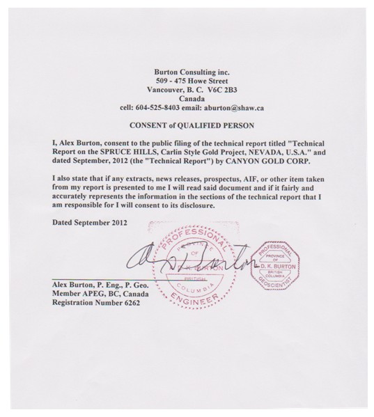
Exhibit 23.3
Comment 6.
We note the consent provided in response to comment one from our letter dated August 30, 2012. Based on your response it appears that the NJ 43.101 Technical Report has not been completed and the Industry Guide 7 disclosure in your document is based on a different report. Please clarify the scope of this consent and have Mr. Burton also consent to the inclusion of his name in your filing under the heading "Experts" and revise your filing accordingly.
Response to Comment 6: Please note that the NI 43.101 Technical Report has been completed and delivered to the Company as disclosed in the revised prospectus. Under the “Experts” section on page 38, we have included DRLLC and Alex Burton as experts and have accordingly included their revised consents as exhibits. We are providing herewith as supplemental information a copy of the NI 43.101 Technical Report as Attachment No. 1 to this letter.
Exhibit 23.5
Comment 7.
Please have DRLLC consent to the use of their name in your filing under the heading "Experts" and revise your filing accordingly.
Response to Comment 7: We are including the revised consent of DRLLC as Exhibit 23.5 that incorporates responses to your comment.
Please continue your review of the Form S-1. We respectfully request that following your review, your will accept the Company’s written request for acceleration of the effective date of the registration statement.
We will deliver to the Staff “redlined” hard copies of the Form S-1 for your convenience. Any further questions or comments concerning the Company can be directed to this office by phone at (801) 733-0800, by Fax at (801) 733-0808 or e-mail at LNeilsonLaw@aol.com with a copy to Delbert G. Blewett at del.b32@gmail.com.
| Yours truly, | |
/S/ Leonard E. Neilson | |
| Leonard E. Neilson |
:ae
Attachments
cc: Delbert G. Blewett, President, Canyon Gold Corp.
Attachment No. 1
43.101 TECHNICAL REPORT
On the
SPRUCE HILLS, Carlin Style Gold Project
NEVADA, U.S.A.
On the north end of the Spruce Hills Range south of Wells, Nevada
For
CANYON GOLD CORP.
(Canyon Gold)
7810 MARCHWOOD PLACE
VANCOUVER, B. C. V5S 4A6
CANADA
Email: canyongold@shaw.ca
Tel. 604 202 3212
Fax 778 340 2929
By
Alex Burton, P. Eng., P. Geo.
Consulting Geologist
BURTON CONSULTING INC.
507 – 475 Howe Street
Vancouver, B. C. V6C 2B3
CANADA
Email: aburton@shaw.ca
Cell 604 525 8403
Fax 604 526 2396
Dated September 2012
ROAD to the CANYON GOLD CLAIMS

SUMMARY
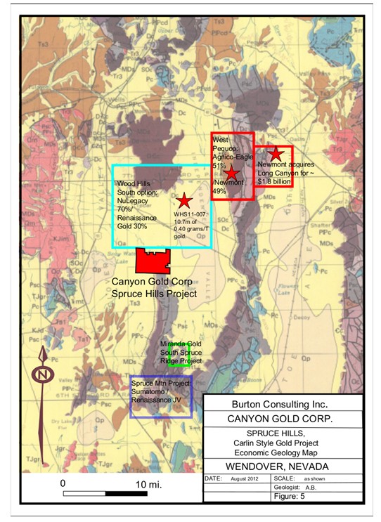
The Spruce Hills, Nevada project is on the next range west of the recent Pequop Mountains, Long Canyon trend, discovery by Fronteer Gold of a very large “Carlin” type gold deposit. The Long Canyon deposit was acquired in February, 2011 by Newmont Mines USA for 2.3 billion dollars. They are presently drilling to increase the deposit size.
As of January 12, 2011 published ore resources at Long Canyon were 1,396,000 oz. of gold at an average grade of 2.36 grams per gold per tonne contained in 18,371,000 tons of ore. Inferred resources were 803,000 oz. of gold at average grade of 2.24 grams gold per tonne contained in 11,170,000 tons of rock.
It is the intention of Canyon Gold to explore their claims for the same type of target, a large tonnage gold deposit similar to the West Pequop Mountains Long Canyon type of gold deposit. Canyon Gold will use similar exploration techniques modified to fit the characteristics of the Spruce Hills property which have fracturing and alteration similar to that of Long Canyon. Section 35 claims in this project were staked by Development Resources LLC. (DRLLC) under contractual agreement with Canyon Gold Corp. Sections 20, 21, 22, 23, 26, 27, 28, 29, 32, 34, claims were staked by DRLLC under contractual agreement with EMAC Handels AG (EMAC) of Switzerland and are optioned to Canyon Gold Corp.
Spin off companies from the original explorers of the Long Canyon discovery are exploring in the Wood Hills range to the north of the Canyon Gold claims, and to the south of the Canyon Gold claims in the Spruce Hills range. These spin off companies are tied on or adjacent to the northern and southern boundaries of the Canyon Gold claims.
The southern company is Renaissance Gold Inc. (RenGold) which has an exploration agreement with Summit Mining Exploration 11, Inc. which is a US subsidiary of Sumitomo Corporation. A recent press release (June 11, 2012) said they have already spent US $ 1.8 million dollars on Spruce Mountain exploration and announced a second round budget of US $ 1.7 million in additional expenditures.
Miranda Gold Corp. has the East Spruce property which is to the southeast of Canyon Gold Corp. property and is also just to the east of the RenGold/ Sumitomo JV project.
The company to the north is NuLegacy Gold Corporation exploring their Wood Hills South property which they optioned from Renaissance Gold Inc. They have completed a series of geochemical and gravity surveys to guide two sets of drilling. NuLegacy's southern boundary is also Canyon Gold's northern boundary.
To the east of the NuLegacy ground between their ground and the Long Canyon project is Agnico- Eagle.
Typical exploration methodology used to look for the Long Canyon variety of a Carlin type gold deposit is to identify a major break in the shelf type Paleozoic carbonate sediments similar to Long Canyon that developed the complex fracturing and extensive faulting and semi Karsting dissolution channels and openings that are the conduits for the gold mineralization.
A combination of soil geochemistry, plus gravity, and Induced Polarization geophysical surveys is used to define highly fractured areas below the major faults where gold deposition occurs such as at Long Canyon.
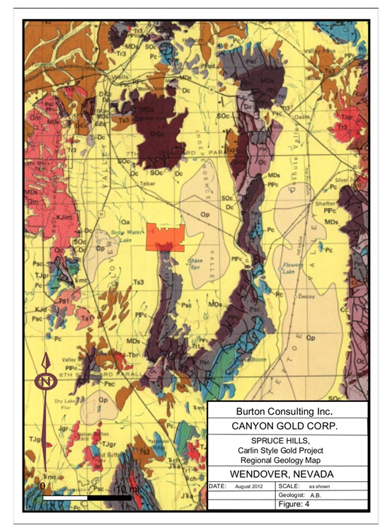
The project is in northeastern Nevada in the Basin and Range topography where tensional displacement has caused large blocks of bedrock to be slightly pulled apart along northerly trending fault lines so that the blocks have been tilted to the east or the west thus forming longitudinal mountains separated by parallel valleys that have become filled with eroded sediments from the mountains. The Wood Hills and the Spruce Mountain Ridge are the next range west of the Pequop Mountains. They are separated by the Independence valley, and are construed to be part of the same Palaeozoic sediments that make up the Pequops where the Long Canyon gold deposit was discovered recently.
The exploration philosophy used by the northern and southern neighbours to the Canyon Gold project is that they are looking for a similar set of circumstances as found controlling the Long Canyon discovery. The Long Canyon discovery is related to vertical faults that cut the shelf type sediments to allow ingress of surface water to lower layers of the Palaeozoic sequence to more soluble horizons where the water dissolved the more permeable layers causing a Karst type of collapse of the blocks that extended upwards through the sequence. Then hydrothermal fluids gained access to this complex of slump fault structures and deposited the precious metal mineralization. Often a deep seated intrusive is postulated as the source of the hydrothermal ore bearing fluids. In the case of the Long Canyon discovery Newmont Mines USA believes there is validity to explore for tens of millions of ounces of gold.
Canyon Gold intends to use a similar exploration philosophy to explore their claims. Some preliminary rock samples have been collected and a test program of drainage geochemical samples have been taken. Signs of mineralization, alteration and faulting with similar characteristics to the type of fracturing and alteration seen at the long Canyon Deposit, have been discovered on the Canyon Gold Claims, but not explored. There are no known resources or reserves discovered to this date.
A program for exploration and budget is included in this report. This program modified to fit circumstances will include geological mapping, geochemistry and geophysics in the form of Induced Polarization using Resistivity Mode, and selected areas of Gravity surveys. Then drilling the chosen targets with Reverse Circulation rigs to be followed later by Diamond drilling.
TABLE OF CONTENTS
| PAGE | ||
| SUMMARY | 3 | |
| INTRODUCTION | 6 | |
| RELIANCE ON OTHER EXPERTS | 8 | |
| PROPERTY DESCRIPTION AND LOCATION | 9 | |
| ACCESSIBILITY, CLIMATE, LOCAL RESOURCES, | ||
| INFRASTRUCTURE, AND PHYSIOGRAPHY | 11 | |
| HISTORY | 13 | |
| GEOLOGICAL SETTING AND MINERALIZATION | 14 | |
BUDGET PHASE TWO Stage "A" | 28 | |
BUDGET PHASE TWO Stage "B" | 28 | |
| INTERPRETATIONS AND CONCLUSION | 29 | |
| SAMPLE PREPARATION, ANALYSES AND SECURITY | 29 | |
| RECOMMENDATIONS | 30 | |
| REFERENCES | 31 | |
| CERTIFICATE | 32 | |
| CONSENT | 33 | |
| FIGURES | ||
| 1 | LOCATION MAP | 7 |
| 2 | CLAIM MAP | 10 |
| 3 | HISTORIC GOLD PRODUCTION | 13 |
| 4 | REGIONAL GEOLOGY MAP | 15 |
| 5 | ECONOMIC GEOLOGY MAP | 17 |
| 6 | Renaissance Gold Wood Hills Project conceptual model | 26 |
| PHOTOS | ||
| 1 | Pediment Slopes12 | 12 |
| 2 | Valley Flats | 12 |
| 3 | Fractures blocks and alteration at Long Canyon | 18 |
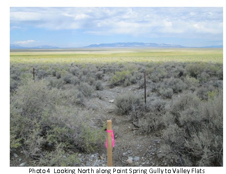
| 4 | Looking North along Point Spring Gully to Valley Flats | 22 |
| 5 | Looking south up Point Spring Gully | 23 |
| 6 | Geochemical Sampling using auger on the pediment slope | 23 |
| 7 | Upper Point Spring gulley looking North to the Flats | 24 |
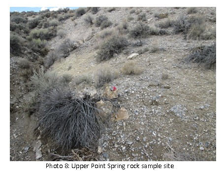
| 8 | Upper Point Spring rock sample site | 25 |
| TABLES | ||
| 1 | Assay Locations 2011 | 20-21 |
| 2 | Phase Two Budget | 28 |
| APPENDICES | ||
| 1 | Mineral Sampling Program | 34 |
| 2 | Assay Results | 38 |
INTRODUCTION
This report is prepared for Canyon Gold Corp., 7180 Marchwood Place, Vancouver, BC, V5S 4A6. Canyon Gold contracted Development Resources LLC. of American Fort, Utah, to provide exploration services on the Spruce project.
Terms of reference were to examine the property and become familiar with other exploration going on in this camp, then to prepare an exploration program suitable for the project along with a budget.
Fronteer Gold Inc. explored the Long Canyon trend in the Pequop Mountain Range of northeastern Nevada and discovered large tonnages of economic open pit mining gold grade deposit. In February, 2011 Newmont USA acquired the company and most of their holdings for 2.3 billion dollars. Shortly after Newmont stated in a press release they were confident they would eventually find considerably more mineralization by several times than what Fronteer had already found. Newmont are actively continuing drilling the project and extending the drilled area as of June, 2012.
Canyon Gold Corp. has acquired claims along the NE-SW "Long Canyon trend" on the next range to the west of the Pequop Mountains in the Spruce Hills area, and intends to actively explore them for a large tonnage “Carlin” type of gold deposit.
The Spruce Hills range and Mountain has an earlier history of mining activity with several small base and precious metals mines. Today these are generally considered to represent “leakage” deposits or mineralization that can be used as leaders to the unexposed (or partially exposed) Carlin type of mineralization.
The claims are south westerly from the Long Canyon deposit and have spin off companies from the Long Canyon group who are exploring to the north and the south of Canyon Gold claims.
There are several known and recently discovered types of gold mineralization on the Canyon Gold claims in the outcrop, and upper portions of the pediment slopes on the Canyon Gold claims where more than 1/4 of the Grab Samples were over one ppm gold.
The northern portion of the Canyon Gold claims consists of valley floor covered with stream and lake/swamp sediments. The valley floor area, pediment, and upper slopes are usually explored with geochemistry and geophysics before drilling.

This is the typical Basin and Range topography found in Nevada where the Wood Hills and the Spruce Hills represent the uplifted portion and the basin between the Wood Hills plus Spruce Hills, and the Pequop Hills represent the basinal down dropped block.
Mineralized zones are often postulated to carry across a basin to the next range, such as postulated here on all three projects.
Canyon Gold's representative Development Resources LLC has researched and prepared an extensive file on the exploration and mining history of the Spruce Hills and Spruce Mountain. There are many base metal, gold and silver mines that saw small to medium production in the past to the south of the claims as well as veins that today can be classified as “leakage veins”.
The present exploration stage of the project is discussed and recommendations for a sequential exploration program are made with a budget for Phase Two, Stage A and B. The Stages are sequential and do not require a new report with recommendations from a qualified person.
The budget is separated into each sequential stage of exploration.
RELIANCE ON OTHER EXPERTS
Sources of information included State and Federal government reports plus press releases from the several companies active in the area.
The claims controlled by Canyon Gold and other pertinent projects were personally examined by the author from May 19 to 29, 2012. The field examinations included a visit to the Long Canyon gold project and a discussion with the geologist in charge of the project for Newmont Inc. USA. Mr. Jon Powell, who graciously made time for me during his busy day. A visit was also made to the BLM office in Elko where a discussion was held with Ms Whitney Wirthin, Wells Field Geologist where claim and exploration maps were examined. Enough claim posts were examined in the field by the author to see that the claim locations had been done in a workman like manner. A Development Resources LLC field crew was indoctrinated into the specified geochemical field sampling techniques required by the author who is a geochemist as well as a geologist and “Qualified Person”.
Reliance on other experts relates to the press releases of other companies working in the area and quoted in this report. All the press releases referred to are freely available on the respective company's websites and all state the name and title of their expert responsible for the contents of their press release.
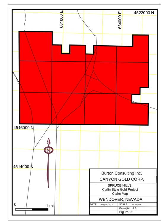
PROPERTY DESCRIPTION AND LOCATION
Canyon Gold’s “Spruce Hills Project” is located in the northeast area of the State of Nevada USA. It is approximately 23 miles south of the town of Wells, Nevada on Highway 93. Drive south of Wells for about 8 miles until you drive over the tracks where the Union Pacific Railway crosses the highway. Then after crossing the rail tracks take the first turn off east through a shallow gravel pit onto the dirt Tobar/Ventosa road. Go southeasterly on the dirt road for about 14 miles to the center of the claims at the northern base of the pediment slope off Spruce Hills, which is at Point Spring, a historical emigrant site.
The southern half of the Ventosa Quadrangle Map Sheet, 7.5 Minute Series N4045-W11445/7.5 at a scale of 1:24,000 adequately covers the claims. The central portion of the claims at Point Spring is 114 degrees and 50 minutes of Longitude, and 40 degrees and 48 minutes of Latitude. That is in Section 35, of T 33 N, and R 63 E.
The Canyon Gold Corp. mineral claims are all located in Section 35, Township 34N, Range 63E, Meridian MDB&M with a small portion of some claims extending into Sections 2, 3, and 36. These claims were recorded with the Elko County Recorder’s Office on May 9, 2011, and in the BLM office on May 23, 2011 with NMC 1044657- 1044657. The renewal fees to maintain these claims in good standing with all agencies have been paid to September 1, 2013. Total area is one section, or one mile by one mile.
Another block of 280 claims covering Sections 20, 26, 27, 28, 29, 32, 33, 34, and parts of Sections 21, 22, and 23 were optioned from Emac Handels AG who had acquired them from DRLLC. The whole block of claims covers 4 miles wide E-W by 3 miles N-S. Individual claims are listed in the Claims Appendix. All renewal fees to maintain these claims in good standing with all agencies have been paid to September 1, 2013.
There are no known environmental liabilities on the claims as there has not been any significant work done on the claims.
Preliminary discussions have been held with the Elko office of the Bureau of Land management regarding the application that is to be made for the work permit. They were supportive and have history of speedy permitting.
ACCESSIBILITY, CLIMATE, LOCAL RESOURCES, INFRASTRUCTURE, AND PHYSIOGRAPHY
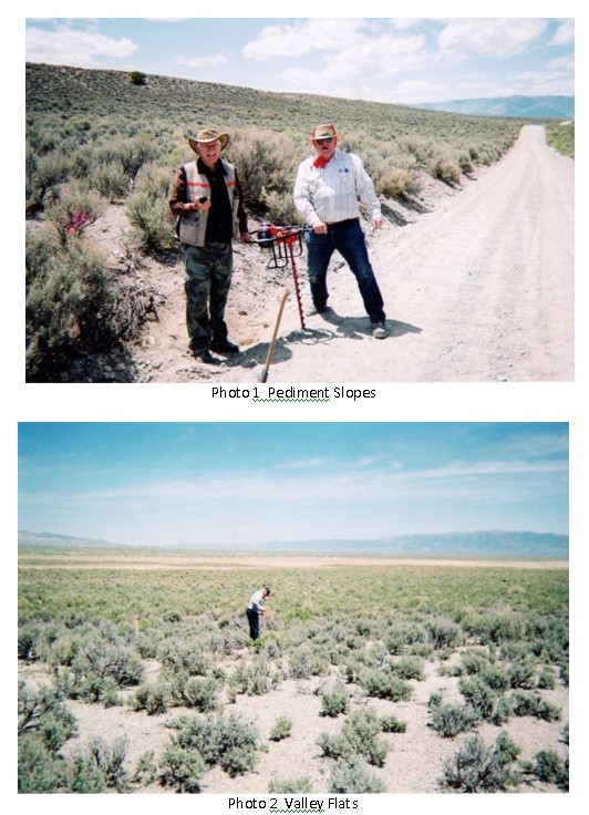
There are several dirt roads going across and through the property. The northern portion of the project covers the low lying valley floor called “The Slough” at 5600 feet elevation with swampy conditions in the spring when runoff water accumulates. To the south of the valley floor area the pediment slopes are largely covered with a rubbly soil that gradually decreases in thickness from plus four feet deep at the southern margin of the swampy valley floor to two feet deep further upslope at 5850 feet elevation. Outcrops are sporadic at lower elevation on the pediment slope and fairly common by 5800 feet elevation, and along ridges such as Spruce Point. The lowest elevations on the claims are grass and Sage brush covered, giving way at the lowest pediment to sage brush vegetation that does not extend far up the pediment slopes where grass is again prominent. At the higher elevations Juniper trees appear along drainages and some ridges. As in any desert area water could be problem, although a well known spring (Point Spring) used by early western bound settlers provides some running water.
The town of Wells will soon become much larger when the Long Canyon deposit is brought to production, but for the present remains a small town close to the Nevada major mining centers such as Elko, Reno, Winnemucca, etc.
Several areas of faulting, fracturing, and fault breccia zones containing altered rocks and quartz veins have been identified in the Point Spring drainage channel where stream erosion has exposed these features. In addition haphazard patches of hematite and some of limonite are seen on the otherwise unaltered blue shelf type limestone beds. These features typically accompany the mineralization on the Long Canyon trend.
HISTORY
Spruce Hills is in the new developing Long Canyon trend of the Carlin style gold deposits of Nevada

The Spruce Mountain Ridge area extends north from Spruce Mountain where most of the old mining activity took place. There are several old showings near the north end of Spruce Mountain Ridge close to the claims with pits and shafts showing well oxidized material on the surface as well as several Diorite intrusive bodies that show up as prominent rusty areas. There is no recorded exploration or production from showings within the Canyon Gold Corp. claims.
On Spruce Mountain there were several operating mines where ore bodies were mined in individual veins. A history of the Spruce Mountain mines has been assembled by Development Resources LLC and was useful during familiarization of the district.
The Canyon Gold claims appear to have had at least some prior cursory examination, and maybe some exploration. Recently the Development Resources LLC crew met a reconnaissance geologist from Newmont on the claims. The author found some old wire type flagging pickets and some old white plastic claim posts on the claims, but there is no record of any exploration available in the public domain.
The known historical mineral deposits including those only explored and those that had production in the Spruce Hills, and specially the Spruce Mountain area are today considered to be “leakage deposits” that may indicate Long Canyon or Carlin type deposits at depth. They are considered worth exploring in the hopes of developing a large tonnage gold mine.
GEOLOGICAL SETTING AND MINERALIZATION
The project is in northeastern Nevada in the Basin and Range topography where tensional displacement has caused large blocks of bedrock to be slightly pulled apart along northerly trending fault lines so that the blocks have been tilted to the east or the west thus forming longitudinal mountains separated by parallel valleys that have become filled with eroded sediments from the mountains. The Wood Hills and the Spruce Mountain Ridge are the next range west of the Pequop Mountains. They are separated by Independence valley, and are construed to be part of the same Palaeozoic sediments that make up the Pequops where the Long Canyon gold deposit was discovered recently.
Bulletin 101, Geology of Elko County, Nevada, by Nevada Bureau of Mines and Geology, 1987, in co-operation with the USGS, has mapped the Spruce Ridge. They show the ridge to be underlain by carbonate and detrital rocks of the foreland basin. Specifically the Pequop Formation (Lower Permian) Fusilinid Limestone (Pp) which overlies Limestone and Dolomite (PPI), lower Permian which includes some Upper Pennysylvanian rocks
The exploration philosophy used by the northern and southern neighbours to the Canyon Gold project is that they are looking for a similar set of circumstances as found controlling the Long Canyon discovery. The Long Canyon discovery is related to vertical faults that cut
the shelf type sediments to allow ingress of surface water to lower layers of the Palaeozoic sequence to more soluble horizons where the water dissolved the more permeable layers causing a Karst type of collapse of the blocks that extended upwards through the sequence. Then hydrothermal fluids gained access to this complex of slump fault / fracture structures and deposited the precious metal mineralization. In the case of the Long Canyon discovery Newmont mines USA believes there is validity to explore for tens of millions of ounces of gold.
A photo of typical trenched surface rocks at a drill pad on the Long Canyon property taken on May 23, 2012 (Photo 4) is shown on page 18. The normally almost massive blue limestone beds have been cut by numerous fractures and several breccia filled faults all of different attitudes that are indicative of tensional stretching and subsequent collapse activity. The published material from ex Fronteer Gold as well as other explorers in the district ascribe this feature to the solution collapse and decalcification of lower soluble beds. That makes for depositional location for the hydrothermal solutions bringing in the gold. A source for these hydrothermal solutions has been postulated as emanating from a geophysically inferred buried intrusive.

On the pediment and upper slopes of the Canyon Gold claims several areas of faulting, fracturing, and fault breccia zones containing altered rocks and quartz veins have been identified in the Point Spring drainage channel where stream erosion has exposed these features. In addition haphazard patches of hematite and some of limonite are seen on the otherwise unaltered blue shelf type limestone beds. These features typically accompany the mineralization on the Long Canyon trend.
Other explorers in the district have first used geochemistry by taking stream drainage samples and then soil samples. A 1966 report by the USGS titled Geochemical Reconnaissance in the Pequop Mountains and Wood Hills, Elko County Nevada reported poor success using standard soil and stream drainage sampling of the minus 80 mesh fraction. However they did report that collecting cobbles at each site that showed silicification or oxidized hematitic or limonitic iron staining might be a useful method of exploration. The author had previously worked in the field in Utah with two of the authors of this report (Marranzino and Erikson, see references) and had great respect for them so has incorporated their idea into the Canyon Gold exploration program with a few additional elements. Experimental ephemeral stream sediment geochemistry samples have been taken following their suggestion of collecting altered cobbles at each sample site in the ephemeral streams. The cobbles were crushed and pulverized to minus 140 mesh, then a 50 gram sample analyzed.
Preliminary grab sampling on the Spruce Ridge property was done by Canyon Gold’s field exploration agent Development Resources LLC in 2011. They sent a bedrock sampling crew
to traverse across the claims from the Northeast to the Southwest on sections: 23, 26, 27, 28, 33, 34, 35, 4, 5, 8, and 9, (note: Sections 4, 5, 8, and 9 are not part of the property). Locations for 24 of the 67 samples were lost. The samples illustrate the range of values from trace up to high grade that were found.
While the samples are grabs from likely looking outcrops they are rock samples and do show excellent values in gold and silver. There are 19 samples that ran over 1 ppm gold (Au), which is 28% of the samples. At a higher threshold there are 5 samples (13%) that ran over 32 ppm gold which represents grades of over one ounce gold per ton.
For the silver values there are 27 samples that ran over 1 ppm silver (Ag) which is 40% of the samples, and for samples over 10 ppm silver (Ag) there were 17 samples which is 25% of the samples.
There is a general good correlation between the gold and silver values as 25% of the Ag
and 28% of the Au samples were anomalous for both elements.
| Location (section/township/range) | GPS Coordinates | Sample Year | Sample Number | Assay Results | |||||
| Northings | Eastings | Au (ppm) | Ag (ppm) | ||||||
| 14-Jun-10 | LCG 101 | 52.4* | 69* | ||||||
| S35 | T34N | R63E | 0683121 | 451969 | 2011 | DR-303-S | 2.87 | 1.3 | |
| S35 | T34N | R63E | 0683121 | 451969 | 2011 | DR-304-S | <0.005 | <0.2 | |
| S35 | T34N | R63E | 0683121 | 451969 | 2011 | DR-305-S | <0.005 | <0.2 | |
| S35 | T34N | R63E | 0683121 | 451969 | 2011 | DR-306-S | <0.005 | <0.2 | |
| S35 | T34N | R63E | 0683121 | 451969 | 2011 | DR-307-S | <0.005 | <0.2 | |
| S35 | T34N | R63E | 0683121 | 451969 | 2011 | DR-308-S | <0.005 | <0.2 | |
| S35 | T34N | R63E | 0684294 | 451700 | 2011 | DR-309-S | <0.005 | <0.2 | |
| S35 | T34N | R63E | 0684294 | 451700 | 2011 | DR-310-S | <0.005 | <0.2 | |
| S35 | T34N | R63E | 0684294 | 451700 | 2011 | DR-311-S | 0.529 | 144* | |
| S35 | T34N | R63E | 0684294 | 451700 | 2011 | DR-312-S | 4.71 | 801* | |
| S35 | T34N | R63E | 0684294 | 451700 | 2011 | DR-313-S | 2.83 | 10.5 | |
| S35 | T34N | R63E | 0684294 | 451700 | 2011 | DR-314-S | 210* | 218* | |
| S35 | T34N | R63E | 0683435 | 4516911 | 2011 | DR-303-F | 29.4* | 83.5 | |
| S35 | T34N | R63E | 0683435 | 4516911 | 2011 | DR-304-F | 0.008 | <0.2 | |
| S35 | T34N | R63E | 0683435 | 4516911 | 2011 | DR-305-F | 0.008 | <0.2 | |
| S35 | T34N | R63E | 0683435 | 4516911 | 2011 | DR-306-F | 0.014 | 0.3 | |
| S35 | T34N | R63E | 0683435 | 4516911 | 2011 | DR-307-F | <0.005 | 0.3 | |
| S35 | T34N | R63E | 0683435 | 4516911 | 2011 | DR-308-F | >10.0 | 21 | |
| - | - | - | 2011 | DR-309-F | <0.025 | 310* | |||
| - | - | - | 2011 | DR-310-F | >10.0 | 293* | |||
| - | - | - | 2011 | DR-311-F | 1.610 | 79.4 | |||
| - | - | - | 2011 | DR-312-F | 2.99 | 204* | |||
| - | - | - | 2011 | DR-313-F | 0.023 | 1.9 | |||
| - | - | - | 2011 | DR-314-F | 33.4* | 4.2 | |||
| - | - | - | 2011 | SR-A | 0.013 | 1.3 | |||
| - | - | - | 2011 | SR-B | 0.007 | 1.6 | |||
| - | - | - | 2011 | SR-C | <0.005 | 0.6 | |||
| - | - | - | 2011 | SR-D | <0.005 | 1.4 | |||
| - | - | - | 2011 | SR-E | 0.005 | <0.2 | |||
| S36 | T34N | R63E | 0685331 | 4516802 | 2011 | SR-F | 7.77 | 11 | |
| S36 | T34N | R63E | 0685331 | 4516802 | 2011 | SR-G | 0.007 | <0.2 | |
| Notes: | |||||||||
| Assay results for Au using Au-AA23 (0.005 ppm) or for Ag using Ag-AA46 (1 ppm). | |||||||||
| "*" denotes assay results for sample using Au - GRA21 (0.05 ppm) for Au or Ag- AA46 (1 ppm) for Ag. | |||||||||
| denotes positive anomalous results for Au. | |||||||||
| Bold | denotes positive anomalous results over 1 ppm for Ag. | ||||||||
| Bold | denotes positive anomalous results over 10 ppm for Ag. | ||||||||
"-" Missing GPS coordinate locations were lost, however, sampling was from NE running to the SW in sections 23, 26, 27, 28, 33, 34, 35, 4, 5, 8, and 9. | |||||||||
| Location (section/township/range) | GPS Coordinates | Sample Year | Sample Number | Assay Results | ||||||
| Northings | Eastings | Au (ppm) | Ag (ppm) | |||||||
| S36 | T34N | R63E | 0685331 | 4516802 | 2011 | SR-H | 37.7* | 9.3 | ||
| S36 | T34N | R63E | 0685331 | 4516802 | 2011 | SR-I | 0.113 | 0.5 | ||
| S36 | T34N | R63E | 0685331 | 4516802 | 2011 | SR-J | <0.005 | 0.2 | ||
| S36 | T34N | R63E | 0685337 | 4516802 | 2011 | SR-K | 11.65* | 11.4 | ||
| S36 | T34N | R63E | 0685337 | 4516802 | 2011 | SR-L | 0.011 | <0.2 | ||
| S36 | T34N | R63E | 0685337 | 4516802 | 2011 | SR-M | 16.80* | 17.3 | ||
| S36 | T34N | R63E | 0685337 | 4516802 | 2011 | SR-N | 0.040 | 0.5 | ||
| S36 | T34N | R63E | 0685337 | 4516802 | 2011 | SR-O | 0.005 | <0.2 | ||
| - | - | - | 2011 | SR-P | 0.118 | <0.2 | ||||
| - | - | - | 2011 | SR-Q | <0.005 | 1.3 | ||||
| - | - | - | 2011 | SR-V | 9.81* | 15.2 | ||||
| - | - | - | 2011 | SR-W | 0.012 | <0.2 | ||||
| S34 | T33N | R63E | 068347 | 4516464 | 2011 | SR-401 | 0.024 | <0.2 | ||
| S34 | T33N | R63E | 068347 | 4516464 | 2011 | SR-402 | 0.017 | <0.2 | ||
| S34 | T33N | R63E | 068347 | 4516464 | 2011 | SR-403 | 0.030 | <0.2 | ||
| S34 | T33N | R63E | 068347 | 4516464 | 2011 | SR-404 | 0.038 | 0.2 | ||
| S34 | T33N | R63E | 068347 | 4516464 | 2011 | SR-405 | 0.008 | <0.2 | ||
| S34 | T33N | R63E | 0683021 | 4515920 | 2011 | SR-406 | 0.008 | <0.2 | ||
| S34 | T33N | R63E | 0683021 | 4515920 | 2011 | SR-407 | 0.021 | 0.4 | ||
| S34 | T33N | R63E | 0683021 | 4515920 | 2011 | SR-408 | 42.2* | 22.7 | ||
| S34 | T33N | R63E | 0683021 | 4515920 | 2011 | SR-409 | 0.058 | 2.7 | ||
| S34 | T33N | R63E | 0683021 | 4515920 | 2011 | SR-410 | 0.010 | 0.2 | ||
| S34 | T33N | R63E | 0683294 | 4516090 | 2011 | SR-411 | 0.407 | 0.3 | ||
| S34 | T33N | R63E | 0683294 | 4516090 | 2011 | SR-412 | 0.007 | <0.2 | ||
| S34 | T33N | R63E | 0683294 | 4516090 | 2011 | SR-413 | 0.014 | 0.3 | ||
| S34 | T33N | R63E | 0683294 | 4516090 | 2011 | SR-414 | 0.006 | <0.2 | ||
| S34 | T33N | R63E | 0683294 | 4516090 | 2011 | SR-415 | 25.8* | 29.2 | ||
| - | - | - | 2011 | SR-416 | 0.021 | <0.2 | ||||
| - | - | - | 2011 | SR-417 | 0.009 | 0.2 | ||||
| - | - | - | 2011 | SR-418 | 25.5* | 20.2 | ||||
| - | - | - | 2011 | SR-419 | <0.005 | <0.2 | ||||
| - | - | - | 2011 | SR-420 | 0.088 | <0.2 | ||||
| - | - | - | 2011 | SR-421 | 0.009 | 0.2 | ||||
| - | - | - | 2011 | SR-422 | 0.023 | 0.2 | ||||
| - | - | - | 2011 | SR-423 | <0.005 | 0.3 | ||||
| - | - | - | 2011 | SR-424 | 0.007 | <0.2 | ||||
| Notes: | ||||||||||
| Assay results for Au using Au-AA23 (0.005 ppm) or for Ag using Ag-AA46 (1 ppm). | ||||||||||
| "*" denotes assay results for sample using Au - GRA21 (0.05 ppm) for Au or Ag- AA46 (1 ppm) for Ag. | ||||||||||
| denotes positive anomalous results. | ||||||||||
| Bold | denotes positive anomalous results over 1 ppm for Ag. | |||||||||
| Bold | denotes positive anomalous results over 10 ppm for Ag. | |||||||||
A full and expanded program of sampling more mineralized outcrops would be well worthwhile. In addition, excavator trenching and surface blasting to freshen the outcrops before sampling be undertaken to obtain representative samples.
The results of our May 2012 preliminary geochemical survey using an auger to collect soil samples at the base of the soil horizon, and collecting surface cobbles of altered and, or mineralized rock results showed both systems to be useful. Sampling went from the outlet of Point Spring drainage up drainage to just south of the southern edge of the claims boundary.

At each site a hand held gas powered post hole digger with small 3 inch auger flytes was used to drill to the bedrock in the pediment and upper slope areas of the claims. The auger samples taken from the bedrock level were screened to minus 10 mesh, then the minus 10 mesh material pulverized to minus 140 mesh before analyzing. It is thought that there is a greater chance of finding anomalous material at the base of the rubbly soil on the bedrock than on the surface, and that the processing technique will include any gold or sulphide grains greater than 80 mesh.
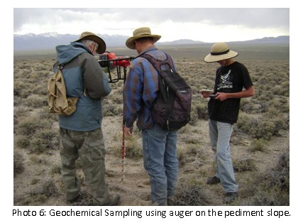

Photo 7: Upper Point Spring gulley looking North to the Flats.
Limestone with white alteration and some hematite
A total of 33 geochemical samples were taken for evaluation of the different sampling techniques on the Pediment and upper slopes topography.
The average of all 33 different types of geochemical samples taken showed 15% to be anomalous. However the cobble samples were 23% anomalous and the auger samples only 5% anomalous. Only one sample was taken on the flats where the bedrock was 4.5 feet deep which was on the border of being anomalous.
Of the 5 bedrock samples taken only one was anomalous (20%). The following photo shows Upper Point Spring gully at the general site of rock samples CG RX 1,2,3,4 and 5.
The sample area's GPS co-ordinates are as follows: 06841590E to 0684250E and 4516720N to 45168900N.
Sample descriptions and locations are listed in Appendix 1.
Assay results in Appendix 2.
It appears that our results agree that the 1960 sampling of cobbles by the USGS on the Pequops and Wood Hills and on the Canyon Gold ground is a worthwhile technique.
Our preliminary test results agree with the results from the neighboring Wood Hills project of Renaissance Gold on the north boundary of Canyon Gold claims.
On the Wood Hills project Renaissance Gold announced in a Feb. 6, 2012 news release that they had drilled 10 of 20 planned holes based on the results of 31,000 meters of induced polarization and resistivity surveys, and 70,000 metres of co-incident soil sampling surveys. They had previously announced that the soil samples would be taken at 45 meter (150 feet) intervals with each sample analyzed for gold, mercury soil gas, and a package of 39 trace elements. Their published results found that 15% of their samples were anomalous (Au > 5ppb) and that areas along “breaks” have 5 to 10 times the Au values than fresh limestone/dolomite blocks of bedrock formations. These results agree with Canyon Gold preliminary results.

Figure 6 Renaissance Gold Wood Hills Project conceptual model
Renaissance Gold announced exploration and drilling budget was to be “in excess of $1.5 million (News release March 21, 2011).
An initial similar program and budget seems eminently suitable for the Canyon Gold project as it lies in an identical geological situation.
On the upper slopes and even in to the upper portion of the pediment there are numerous outcrops. Based on the results of the grab sampling done in Phase One work more rock outcrops should be examined for signs of alteration and mineralization and sampled after blasting to freshen up the mineralization before taking channel samples.
When the recommended Phase Two sampling is completed the geochemical precious metal (Au, Ag) and trace elements (As, Sb, and Hg) results from sampling the flats are in they will be used to lay out Induced Polarization surveys in Resistivity mode to best outline the major fault, fractured, and brecciated areas as well as the subterranean karsted areas that are the potential locus for mineralization.
Gravity surveys are useful in showing areas of karst type solution cavities and would be a practical addition to the Canyon Gold exploration program.
Quotations for Induced Polarization Resistivity mode and Gravity geophysical surveys to cover the Canyon Gold claims range from roughly $140,000 to $170,000.
Estimates for water well type drills going in to bedrock for a few tens of feet at various spacings of 50 metres (164 feet) to 500 metre spacings (1640 feet) go from $24,000 to $240,00 not including sample collection and analytical costs.
Diamond drills typically are in the range of $50 per foot not including sample preparation and analytical costs bringing the per foot total close overall cost of $60 to $70 per foot. News releases on the Wood Hills project on the northern claim boundary suggested they would drill about 12 holes of RC for about 5000 feet (1524 metres) which averages about 416 feet per hole.
Typically in this camp drilling is first done with RC (reverse circulation) drills which are followed with diamond drilling if mineralization is encountered.
Using the above figures 5000 feet of RC drilling which is about half the cost of diamond drilling that would bring the drilling cost to $35 times 5000 feet equals $175,000.
The northern portion of the Canyon Gold property extends significantly across the valley floor where a preliminary testing program to find the most suitable method for geochemical soil sampling should be undertaken before starting the geochemical sampling. Sampling of the surface valley sediments would be useless as they are transported from the surrounding hills and do not relate to the underlying bedrock.
For the valley flats the auger drilling system will be used. This can be done with the hand held auger type of drill using a 3 inch diameter spiral flyte of 30 inches length with three extension rods of 30 inches each for a maximum possible depth of 120 inches (10 feet). The same can be used until the valley sediments become too deep for the auger to penetrate to the bedrock floor. For penetration depths too great for the hand held auger it may be possible to use a tractor or ATV mounted auger if it has both a forward and reverse gears to obtain greater depths.
If the depths of valley fill reach beyond either type of auger attainable depths to the maximum depths reported by the water well drillers of 60 to 80 feet to bedrock then one of the regular water wells could be used to both get a sample of the bedrock soil, and to drill a distance in to the bedrock to provide samples for geochemical sampling. Water well drills are available to drill significant depths in to the bedrock and return a sample, albeit maybe not as good recovery as a diamond or RC type drill, but at much reduced unit cost. They certainly appear adequate for preliminary depth testing with an all in cost of $25 per foot plus sample collecting and analytical costs.
Later an RC or core type drill could be used to confirm recovery and grades.
BUDGET PHASE ONE - Note that PHASE ONE exploration has been completed.
BUDGET PHASE TWO - STAGE A
Unit cost estimates have been obtained from several contractors and service companies for the project.
| Geochemistry | |||||
| Hand held Auger Pediment and Upper slope soil sampling | |||||
| combined with surface cobble sampling. | |||||
| 20 line of 6000m length at 50m spacings includes $30 analysis | $ | 80,000 | |||
| Blasting and channel sampling outcrops on | |||||
| upper slopes and pediment. | $ | 80,000 | |||
| Valley Flats ATV mounted auger sampling includes $30 assay. | $ | 80,000 | |||
| Water Well drill. (RC type) | |||||
| Say 30 holes to 60 feet at $25/foot | $ | 45,000 | |||
| Collection and assay costs $70 per sample 30 holes X 10 samples | $ | 21,000 | |||
| Geophysical surveys | $ | 170,000 | |||
| Engineering | $ | 45,000 | |||
| Sub Total | $ | 521,000 | |||
| Contingency (20%) | $ | 104,200 | |||
| Total Estimated budget, Stage A | $ | 625,200 | |||
BUDGET PHASE TWO - STAGE B
Stage B exploration is sequential after assay results have been evaluated.
A new report is not required.
Further exploration will require the drilling of a series of about a dozen
Reverse Circulation drill holes to depths ranging from 400 feet to 1000
feet. This is usually followed by a series holes drilled with a diamond drill
to firm up the grades obtained in the RC (Reverse Circulation) drilling so
that greater validity can be assigned to the ore grades for reserve and
resource calculations.
| Reverse circulation of 12 holes to 400 feet with engineering plus assays is $75 per foot with 20% contingency will total (Stage B) | $ | 432,000 | ||
| Total cost for PHASE TWO, Stage A and B | $ | 1,057,200 |
It is possible that inflation may affect the exploration costs, as analytical, geophysical, and drilling costs have seen increases.
INTERPRETATIONS AND CONCLUSION
The portion of the claims on the upper slopes and on the pediment area should be amenable to the standard already established exploration methodologies.
As over half of the claims are along the valley floor the exploration procedure on them will be with available methods of geochemistry, geophysics and drilling techniques proven to work in areas of deeper overburden.
Twenty eight percent of the grab samples from bedrock mineralization ran over one ppm gold.
The Canyon Gold property is well positioned geologically to explore for a western extension of the Long Canyon type of gold deposit.
SAMPLE PREPARATION, ANALYSES AND SECURITY
Samples were collected under the author’s personal supervision, then transported to Elko to the ALS laboratory by Development Resources LLC staff where they were analyzed according to a methodology that had been discussed with ALS staff prior to the samples being collected.
RECOMMENDATIONS
The Canyon Gold Spruce Point claims have an equal chance as their neighbors to find gold mineralization in the hopes of proving up a mine.
Canyon Gold’s neighbors have each spent in the order of 1.5 million dollars in exploration, and all have announced plans for further exploration.
The initial examination studies showed similar conditions as at the Long Canyon deposit and that standard exploration techniques used for exploring for the Long Canyon type of Carlin trend ore body should work effectively on the Canyon Gold Corp. claims.
A PHASE TWO, Stage A and a sequential Stage B exploration program has been laid out to use the most cost and technique effective system for exploration.
Exploration can start as soon as the BLM permitting is approved and financing in place.
REFERENCES
Camilleri, P.A. and Chamberlain, K.R., 1997, Mesozoic tectonics and metamorphism in the Pequop Mountains and Wood Hills region, northeast Nevada: Implications for the architecture and evolution of the Sevier orogen; Geological Society of America Bulletin, v. 109, no 1, p. 74-94.
Coats, R.R., 1987, Geology of Elko County, Nevada; Nevada Bureau of Mines and Geology, Bulletin 101, 112 p.
Cook, H. E. and Corboy, J. J., 2003, Great Basin Paleozoic Carbonate Platform: Facies, Facies Transitions, Depositional Models, Platform Architecture, Sequence Stratigraphy, and Predictive Mineral Host Models; USGS Open-File Report 2004-1078, 129 p.
Erickson,R.L.; Marranzino, A.P.; Oda, U.: Janes, W.W.; 1966, Geochemical Survey Bulletin
1198-E, 20 p.
Granger, 1957, Geology and Mineral Resources of Elko County; Nevada Bureau of Mines and Geology
Ilchik, R. P., 1990, Geology and geochemistry of the Vantage gold deposits, Alligator Ridge-Bald Mountain mining district, Nevada; Economic Geology, v. 85, no. 1, p. 50-75
Wood, R.H., II, 1985, Mineral resources of the South Pequop Wilderness Study Area, Elko County, Nevada: U.S. Bureau of Mines Open-file Report MLA 35-85, 23 p.
CERTIFICATE
CONSENT
Appendices
Appendix 1
Canyon Gold Corp.
Mineral Sampling Program Spruce Ridge,
Elko County, Nevada, Section 35, T34N, R 63E MDB&M
All Drill Samples screened to minus .060” “Oversized Discarded”
Geologist on Site: Alex Burton
***********************************************************************
Thursday, May 24th 2012 Clear day, 70 degrees F.
Number One drill hole
GPS: 0684338 & 4517225; in ditch of Tobar road, bedrock at 3 ft. deep. Elevation: 5,635 ft.
Number Two drill hole
GPS: 0684331 & 4517213; two ft. to bedrock, showed magnetic particles with low power magnet, 50 ft. from Tobar road going south on section 35. Elevation: 5637 ft.
Number Three Drill Hole
GPS: 0684338 & 4517152; 300 feet from road, two ft. to bedrock, magnetic particles in sample, Tufa shown on surface 20 feet south from test hole, little red rock on surface, Elevation: 5,655 ft.
Number Four Drill Hole��
GPS: 0684300 & 45170682; ½ ft., some magnetic particles. Not much Tufa, a few reddish rocks. Elevation: 5,684 ft.
Number Five Drill Hole
GPS: 0684237 & 4516946; 1 ½ feet to bedrock, two washes come together, a few reddish rocks, some magnetic particles in sample. Elevation: 5,702 feet
Number Six Drill Hole
GPS: 0684219 & 4516917; drill hole by outcropping vein, lots of magnetic particles in sample, 3 feet to bedrock, mineralized zone going up wash. Elevation: 5,712 ft.
Number Six “A” Drill Hole
GPS : 0684179 & 4516879; up wash from Fault Vein, a few tan colored rocks, 2 ft. to bedrock. No sample
Number Seven Drill Hole
GPS: 0684171 & 4516830; Rattle Snake Vein, Ledge outcrop, mineralized area, 3.5 feet to bedrock. Elevation: 5,751 ft.
Number Eight Drill Hole
GPS: 0684146 & 4516682; “Y” tributary coming into main wash, lots of magnetite, 3.5 feet to bedrock. Elevation: 5,783 feet.
***********************************************************************
Canyon Gold Corp
Spruce Ridge Mineral Sampling Program, Clear day, some clouds, warm, Friday May 25th 2012
Number Nine Drill Hole
GPS: 0684083 & 4516562; Area had Juniper trees, No large rocks, lots of magnetic particles in sample, 3.5 feet to bedrock. Elevation: 1,777 meters.
Number Ten Drill Hole
GPS: 0684044 & 4516349; hillside with large rocks, 3 ft. to bedrock, lots of magnetic particles in sample, mineralization observed. Elevation: 1,799 meters.
Number Eleven Drill Hole
GPS: 0684021 & 4516149; downwash large outcrop of rock, wash cut by a two track (4 wheel drive trail) 1.5 foot to bedrock sample has magnetic particles, (magnetite?) fifty ft. downwash of “Y” Tributary. Elevation: 1,813 meters.
Number Twelve Drill Hole
GPS: 0684041 & 4515993; Downwash of tributaries which split 3 ways, 1.5 feet to bedrock. Elevation: 1,832 meters.
Number Thirteen Drill Hole
GPS: 0683136 & 4516350; Wash in a fairly flat area, magnetic particles in sample, 6 inches to bedrock. Elevation: 1,781 meters.
Number Fourteen Drill Hole
GPS: 0683067 & 4516474; 1 ft. to bedrock, magnetic particles in sample. Elevation: 1,771 meters.
Number Fifteen Drill Hole
GPS: 0683044 & 4516636; 3 ft. to bedrock, magnetic particles in sample. Elevation: 1,761 meters.
Number Sixteen Drill Hole
GPS: 0683046 & 4516857; 2 ft. to bedrock, considerable magnetic particles in sample. Elevation: 1,747 meters.
Number Seventeen Drill Hole
GPS: 0682995 & 4517193; 4 ft. to bedrock, magnetic particles in sample, downwash of “Y” tributary. Elevation: 1.724 meters.
Number Eighteen Drill Hole
GPS: 06873079 & 4517543; 5 ft. to bedrock, magnetic particles in sample. Elevation: 1,716 meters.
**********************************************************************
Canyon Gold Corp. Mineral Sampling Program, Saturday, May 26th 2012 Rain, Snow, sleet, sunny, fog, etc.
Newmont U.S.A. Geologist Road on Section 35 at Tobar road,
GPS: 0683240 & 4517571.
Number Nineteen Drill Hole
GPS: 0684334 & 4517243; 4 ft. to bedrock, followed wash across the road on private ground.
Number Twenty Drill Hole
GPS: 0684268 & 4517342; 4 ft. to bedrock, in clay area.
************************************************************************
NOTES OF GEOLOGIST’S OBSERVATIONS AND SAMPLES:
Friday May 25th 2012
Sample: CGRX#1:
GPS: 0684177 & 4516878; creamy white clay, (Delorne?)
Second Sample CGRX #2
Quartz, same area as CGRX#1
Sample CGRX#3
GPS: 0684248 & 4516907; Alteration similar to CGRX#1. This site is in the main wash just below Auger Drill hole
Prominent outcrop:
GPS: 0684200 & 4516891; south of CGRX#1 alteration (no sample)
Sample CGRX#4
GPS: 0684177 & 4516820; Limestone fractured and in-filled with Calcite and creamy alteration clays, Adjacent to CG Auger Drill #5
Geologist’s Observation:
GPS: 0684150 & 4516720; One meter in diameter (36.5 inches) Boulder of creamy alteration (No Sample)
Sample CGRX#5
GPS: 0684025 & 4516257; Boulders from probable outcrop, Up wash from Drill Hole #10
Appendix 2
Assay Results
