Exhibit 99.1
TECHNICAL REPORT ON THE TITIRIBÍ PROJECT
DEPARTMENT OF ANTIOQUIA, COLOMBIA
Latitude N 6° 3ʹ 55″
Longitude W 75° 47ʹ 55″
Effective Date: 14 June 2021
Published Date: 25 August 2021
Prepared For:
GoldMining Inc. (formerly Brazil Resources Inc.)
1030 West Georgia Street, Suite 1830
Vancouver, British Columbia V6E 2Y3
CANADA
Prepared By:
Joseph A. Kantor, MMSA Geology 01309QP
Robert E. Cameron, Ph.D., MMSA Mining and Ore Reserves 01357QP
Mauricio Castañeda, MAIG, QP
Office: +1 (303) 620 0020 • inquiry@dolbear.com • www.dolbear.com
Behre Dolbear Group, Inc. 4255 South Buckley Road, #425 Aurora, Colorado 80013
Independent Technical Report on the Titiribi Project – Colombia Effective Date: 14 June 2021; Published Date: 25 August 2021 |
TABLE OF CONTENTS
| 1.0 | EXECUTIVE SUMMARY | 1 |
| | 1.1 | BACKGROUND | 1 |
| | 1.2 | RESOURCES | 3 |
| | 1.3 | RECOMMENDATIONS | 5 |
| | | 1.3.1 | Geologic, QA/QC, and Exploration Recommendations | 5 |
| | | 1.3.2 | Resource and Modeling Recommendations | 5 |
| | | 1.3.3 | Social and Cultural Recommendations | 5 |
| 2.0 | INTRODUCTION | 6 |
| | 2.1 | UNITS, DEFINITIONS, AND ABBREVIATIONS | 6 |
| 3.0 | RELIANCE ON OTHER EXPERTS | 7 |
| 4.0 | PROPERTY DESCRIPTION AND LOCATION | 8 |
| | 4.1 | LOCATION | 8 |
| | 4.2 | PROJECT TENURE | 10 |
| | 4.3 | PERMIT TENURE | 10 |
| | 4.4 | PERMIT SURFACE FEES | 10 |
| | | 4.4.1 | Surface Rights and Access Agreements | 10 |
| | 4.5 | NATURE AND EXTENT OF TITLE | 11 |
| | 4.6 | PROPERTY BOUNDARIES | 11 |
| | 4.7 | ROYALTIES, AGREEMENTS, AND ENCUMBRANCES | 11 |
| | | 4.7.1 | Royalties | 11 |
| | 4.8 | ENVIRONMENTAL LIABILITIES | 12 |
| 5.0 | ACCESSIBILITY, CLIMATE, LOCAL RESOURCES, INFRASTRUCTURE, AND PHYSIOGRAPHY | 13 |
| | 5.1 | ACCESSIBILITY | 13 |
| | 5.2 | CLIMATE | 13 |
| | 5.3 | LOCAL RESOURCES | 13 |
| | 5.4 | INFRASTRUCTURE | 14 |
| | 5.5 | PHYSIOGRAPHY | 15 |
| 6.0 | HISTORY | 18 |
| | 6.1 | OVERVIEW | 18 |
| | 6.2 | EARLY HISTORY OF THE EL ZANCUDO/TITIRIBí DISTRICT | 18 |
| | 6.3 | RECENT TITIRIBí PROJECT HISTORY | 18 |
| 7.0 | GEOLOGIC SETTING AND REGIONAL MINERALIZATION | 20 |
| | 7.1 | REGIONAL GEOLOGY | 20 |
| | 7.2 | LOCAL GEOLOGY | 23 |
| | | 7.2.1 | Basement Rocks | 24 |
| | | 7.2.2 | Breccia | 24 |
| | | | 7.2.2.1 | “Mylonite” Breccia | 24 |
| | | | 7.2.2.2 | Diatreme Breccia | 25 |
| | | | 7.2.2.3 | Intrusive and Hydrothermal Contact Breccia | 26 |
| | | | 7.2.2.4 | Fault Breccia | 26 |
| | | 7.2.3 | Amagá Formation | 26 |
| | | | 7.2.3.1 | Amagá Formation (Lower Member) | 27 |
| | | | 7.2.3.2 | Amagá Formation (Middle Member) | 27 |
| | | | 7.2.3.3 | Amagá Formation (Upper Member) | 27 |
| Project 21-036 (GoldMining Inc.) | BEHRE DOLBEAR |
Independent Technical Report on the Titiribi Project – Colombia Effective Date: 14 June 2021; Published Date: 25 August 2021 |
TABLE OF CONTENTS
(continued)
| | | 7.2.4 | Combia Formation | 28 |
| | | | 7.2.4.1 | Combia Formation (Lower Member) | 28 |
| | | | 7.2.4.2 | Combia Formation (Upper Member) | 28 |
| | 7.3 | INTRUSIVE ROCKS | 28 |
| | | 7.3.1 | Amagá Granodiorite (Pre-Mineral) | 28 |
| | | 7.3.2 | Cerro Vetas Diorite Stock (Syn-Mineral) | 28 |
| | | 7.3.3 | Dacite-Andesite Intrusives (Post-Mineral) | 29 |
| | 7.4 | STRUCTURAL GEOLOGY | 29 |
| | 7.5 | REGIONAL MINERALIZATION TRENDS | 30 |
| | 7.6 | PROJECT MINERALIZATION – GENERAL | 32 |
| | 7.7 | CERRO VETAS-NW BRECCIA-CHISPEROS GOLD-COPPER PORPHYRY DEPOSIT | 32 |
| | | 7.7.1 | Cerro Vetas | 32 |
| | | 7.7.2 | NW Breccia | 34 |
| | | 7.7.3 | Chisperos | 35 |
| | 7.8 | ALTERATION | 35 |
| | 7.9 | MINERALIZATION | 36 |
| | 7.10 | GEOLOGIC SECTIONS, PLANS, SECTION GRADE, AND PLAN GRADE MAPS | 41 |
| 8.0 | DEPOSIT TYPES | 55 |
| 9.0 | EXPLORATION | 57 |
| | 9.1 | GEOPHYSICAL SURVEYS | 57 |
| | 9.2 | REMOTE SENSING | 58 |
| | 9.3 | GEOCHEMISTRY | 59 |
| | 9.4 | ADDITIONAL EXPLORATION TARGETS | 63 |
| | | 9.4.1 | Maria Jo | 64 |
| | | 9.4.2 | Junta | 67 |
| | | 9.4.3 | Candela | 69 |
| | | 9.4.4 | Porvenir | 71 |
| | | 9.4.5 | Rosa | 76 |
| | | 9.4.6 | Margarita | 76 |
| | 9.5 | EXPLORATION POTENTIAL | 73 |
| 10.0 | DRILLING | 74 |
| | 10.1 | DIAMOND DRILLING | 74 |
| | 10.2 | PRE-SUNWARD DRILLING | 74 |
| | 10.3 | SUNWARD DRILLING THROUGH FEBRUARY 2013 | 74 |
| | 10.4 | PROJECT DRILLING STATISTICS | 75 |
| | 10.5 | DRILL HOLE SURVEYING | 77 |
| | 10.6 | LOGGING PROCEDURES | 77 |
| | 10.7 | ORIENTED CORE | 78 |
| | 10.8 | RELIABILITY OF CORE | 79 |
| 11.0 | SAMPLE PREPARATION, ANALYSES, QA/QC, AND SECURITY | 80 |
| | 11.1 | GOLD FIELDS PROCEDURES | 80 |
| | 11.2 | DBGF PROCEDURES | 80 |
| | 11.3 | SUNWARD SAMPLE PREPARATION PROCEDURE | 80 |
| | 11.4 | SUNWARD’S ANALYTICAL PROCEDURES | 80 |
| Project 21-036 (GoldMining Inc.) | BEHRE DOLBEAR |
Independent Technical Report on the Titiribi Project – Colombia Effective Date: 14 June 2021; Published Date: 25 August 2021 |
TABLE OF CONTENTS
(continued)
| | 11.5 | QA/QC PROCEDURES | 82 |
| | | 11.5.1 | Blanks and Standards | 82 |
| | | | 11.5.1.1 | Blank Samples | 83 |
| | | | 11.5.1.2 | Gold Standards | 83 |
| | | | 11.5.1.3 | Gold Re-Assays | 85 |
| | | | 11.5.1.4 | Duplicate Splits (¼-core) | 85 |
| | | 11.5.2 | Copper Standards | 86 |
| | | 11.5.3 | Duplicate Copper Assays | 86 |
| | | 11.5.4 | Analytical Laboratory to Laboratory Comparison | 88 |
| 12.0 | DATA VERIFICATION | 90 |
| | 12.1 | THE AUTHORS’ VERIFICATION | 90 |
| 13.0 | MINERAL PROCESSING AND METALLURGICAL TESTING | 96 |
| | 13.1 | METALLURGICAL TEST WORK | 96 |
| 14.0 | MINERAL RESOURCE ESTIMATES | 99 |
| | 14.1 | ELECTRONIC DATABASE USED FOR RESOURCE MODELS | 100 |
| | 14.2 | BULK DENSITY MEASUREMENTS | 101 |
| | 14.3 | PROCEDURES AND PARAMETERS USED FOR THE RESOURCE MODELING | 102 |
| | 14.4 | GOLD EQUIVALENCE ESTIMATIONS | 110 |
| | | 14.4.1 | Metals Pricing Used for Resource Estimate and Gold Equivalence | 110 |
| | 14.5 | BEHRE DOLBEAR’S RESOURCE ESTIMATION RESULTS | 111 |
| | | 14.5.1 | Reasonable Prospects of Economic Extraction | 112 |
| | 14.6 | RESOURCE RISK FACTORS | 115 |
| | 14.7 | RESOURCE CONCLUSIONS | 115 |
| 15.0 | MINERAL RESERVE ESTIMATES | 119 |
| 16.0 | MINING METHODS | 120 |
| 17.0 | RECOVERY METHODS | 121 |
| 18.0 | PROJECT INFRASTRUCTURE | 122 |
| 19.0 | MARKET STUDIES AND CONTRACTS | 123 |
| 20.0 | ENVIRONMENTAL STUDIES, PERMITTING, AND SOCIAL OR COMMUNITY IMPACT | 124 |
| 21.0 | CAPITAL AND OPERATING COSTS | 125 |
| 22.0 | ECONOMIC ANALYSIS | 126 |
| 23.0 | ADJACENT PROPERTIES | 127 |
| 24.0 | OTHER RELEVANT DATA AND INFORMATION | 128 |
| 25.0 | INTERPRETATION AND CONCLUSIONS | 129 |
| 26.0 | RECOMMENDATIONS | 130 |
| | 26.1 | GEOLOGIC AND EXPLORATION RECOMMENDATIONS | 130 |
| | 26.2 | RESOURCE AND MODELING RECOMMENDATIONS | 130 |
| | 26.3 | METALLURGICAL RECOMMENDATIONS | 130 |
| | 26.4 | SOCIAL AND CULTURAL RECOMMENDATIONS | 131 |
| | 26.5 | RECOMMENDED BUDGET | 131 |
| 27.0 | REFERENCES | 133 |
| | | | | | |
| APPENDIX 1.0 | DRILL HOLE SUMMARY – ALL HOLES DRILLED AT THE PROJECT | A1-1 |
| Project 21-036 (GoldMining Inc.) | BEHRE DOLBEAR |
Independent Technical Report on the Titiribi Project – Colombia Effective Date: 14 June 2021; Published Date: 25 August 2021 |
LIST OF TABLES
| Table 1.1 | Titiribí Measured and Indicated Mineral Resource | 3 |
| Table 1.2 | Titiribí Inferred Mineral Resource | 4 |
| Table 10.1 | Summary of All Titiribí Project Drilling | 76 |
| Table 11.1 | Summary of Gold Standard Assay Results | 84 |
| Table 11.2 | Summary of Copper Standard Assay Results | 86 |
| Table 12.1 | Original Gold-Copper Assays Versus ¼-core Split Gold-Copper Assays | 92 |
| Table 12.2 | Pulp, Duplicate, and Coarse Reject Verification Assays | 95 |
| Table 13.1 | Cerro Vetas Locked Cycle Flotation Tests | 97 |
| Table 13.2 | NW Breccia and Chisperos Locked Cycle Flotation Tests | 97 |
| Table 14.1 | Summary of the 2013 Master Magna Drill Hole Database | 100 |
| Table 14.2 | Bulk Density Summary | 102 |
| Table 14.3 | Assay Statistics | 104 |
| Table 14.4 | Five Meter Composite Statistics | 105 |
| Table 14.5 | Experimental Semi-variogram Models | 106 |
| Table 14.6 | Titiribí Block Model Definition | 109 |
| Table 14.7 | Search Ellipse Orientation for Resource Estimation | 109 |
| Table 14.8 | Estimation Parameters | 109 |
| Table 14.9 | BMO Analysis of Metals Price Used for Determining Resources1 | 110 |
| Table 14.10 | Parameters Used for Pit Shell | 112 |
| Table 14.11 | Titiribí Measured and Indicated Mineral Resource | 116 |
| Table 14.12 | Titiribí Inferred Mineral Resource | 117 |
| Table 26.1 | Proposed Budget (December 2021 through February 2023) | 131 |
| | | |
| | | |
| Table A1.1 | Summary List of All Titiribí Project Drilling Through February 2013 | A1-2 |
| Project 21-036 (GoldMining Inc.) | BEHRE DOLBEAR |
Independent Technical Report on the Titiribi Project – Colombia Effective Date: 14 June 2021; Published Date: 25 August 2021 |
LIST OF FIGURES
| Figure 4.1. | Generalized location map of the Titiribí Project in Colombia | 8 |
| Figure 4.2. | Titiribí Concession and Concession Contract Applications covering small gaps | 9 |
| Figure 5.1. | Running water, “Quebrada del Medio” outcrop in the area of the Titiribí Project | 13 |
| Figure 5.2. | Exploration facilities of the Titiribí Project: geology, administration office, and other facilities | 14 |
| Figure 5.3. | Drill core storage and core shed (left); workshop and supplies storage (central); detail of geology office (right) | 15 |
| Figure 5.4. | Exploration facilities of the Titiribí Project; core shed for logging and sampling (left), drill core and rejects storage (central), and drill core storage detail (right) | 15 |
| Figure 5.5. | Town of Titiribí and Chisperos (looking southwest); Cerro Vetas is on the upper right and Candela is at the top on the upper center | 16 |
| Figure 5.6. | Three-dimensional view of Titiribí and the gold-copper deposits and exploration areas, looking southeast | 17 |
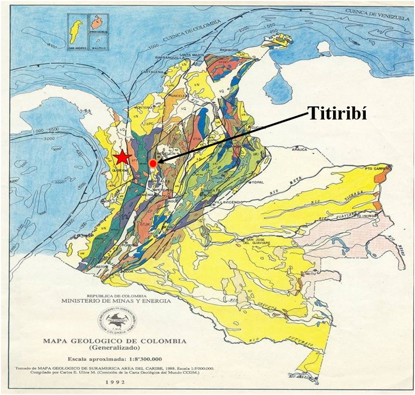
| Figure 7.1. | Geology of Colombia showing the location of the Titiribí Project | 21 |
| Figure 7.2. | Geology of Antioquia Province | 22 |
| Figure 7.3. | Enlargement of the regional geology in the vicinity of Titiribí | 23 |
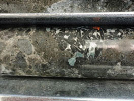
| Figure 7.4. | Barren lahar from 128 meters to 132 meters in CV054 | 25 |
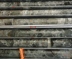
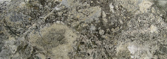
| Figure 7.5. | Photographs of Chisperos diatreme breccia in core; note very large hornblende crystals in the photograph on the left | 26 |
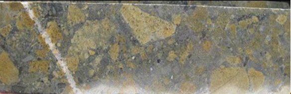
| Figure 7.6. | Photo of the basal quartz pebble conglomerate of the Amagá from drill hole MJ-6 (Maria Jo) at 234 meters | 27 |
| Figure 7.7. | Structural interpretation for the emplacement of the Cerro Vetas stock, dikes, and other intrusive bodies in the district | 30 |
| Figure 7.8. | Gold deposit distribution versus “Magmatic Period” | 31 |
| Figure 7.9. | Major gold occurrences in the Neogene and their relationship to Neogene plutons | 31 |
| Figure 7.10. | Cerro Vetas, NW Breccia and Chisperos geology-drill hole location map; Cerro Vetas is on the southwest side of the figure; NW Breccia on the north and northwest; Chisperos to the northeast | 33 |
| Figure 7.11. | Airborne magnetic map outlining magnetic highs, geochemical anomalies and the Project targets | 34 |
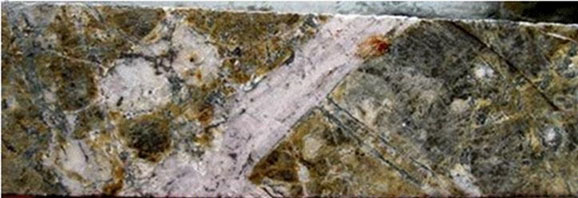
| Figure 7.12. | Multiple-stage mineralization from drill hole CV018 at 393 meters (assay interval contains 0.5 grams of gold per tonne and 0.25% copper) | 37 |
| Figure 7.13. | Intrusive breccia with magnetite-rich fragments, magnetite-rich matrix from drill hole CV038 at 208 meters (assay interval contains 0.3 grams of gold per tonne and 0.23% copper) | 37 |
| Figure 7.14. | Diorite breccia with magnetite matrix from drill hole CV028 at 45 meters (assay interval contains 1.9 grams of gold per tonne and 0.24% copper) | 37 |
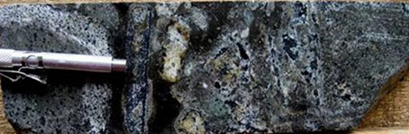
| Figure 7.15. | Stockwork contact breccia from CV053 at 98 meters (assay interval contains 1.5 grams of gold per tonne and 0.06% copper) | 38 |
| Figure 7.16. | Possible fluidized pebble dike from hole CV099 at 208.5 meters (assay interval contains 1.08 grams gold per tonne and 0.56% copper) | 38 |
| Figure 7.17. | Diorite breccia with alteration halos on fragments from hole CV98 at 292 meters (assay interval contains 0.268 grams gold per tonne and 0.120% copper) | 38 |
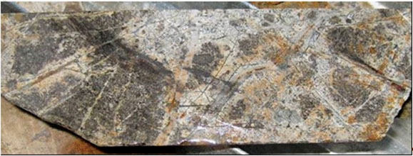
| Figure 7.18. | Diatreme breccia from CP014 at 29.5 meters (assay interval contains 0.7 grams of gold per tonne) | 39 |
| Figure 7.19. | Bleached, iron stained diatreme breccia from CP014 at 32 meters (assay interval contains 1.2 grams of gold per tonne) | 40 |
| Project 21-036 (GoldMining Inc.) | BEHRE DOLBEAR |
Independent Technical Report on the Titiribi Project – Colombia Effective Date: 14 June 2021; Published Date: 25 August 2021 |
LIST OF FIGURES
(continued)
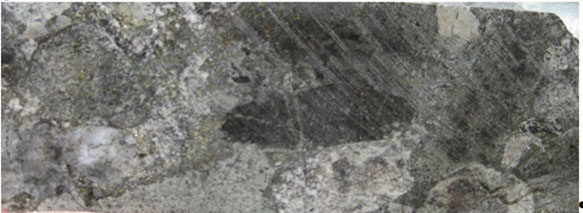
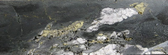
| Figure 7.20. | Clots and fracture filling chalcopyrite in basement metamorphic complex from hole MJ003 at 335 meters (assay interval contains 0.422 grams of gold/tonne and 0.516% copper) | 40 |
| Figure 7.21. | Polished thin section showing 130-micron gold grain with chalcopyrite | 41 |
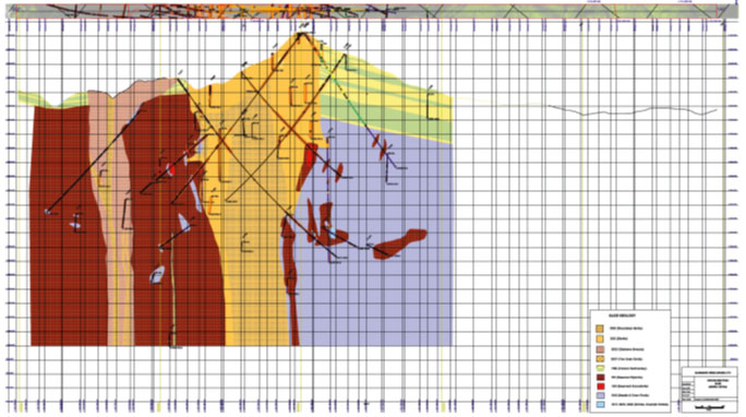
| Figure 7.22. | Surface geology map of the Cerro Vetas-NW Breccia-Chisperos porphyry system with the section line grid | 42 |
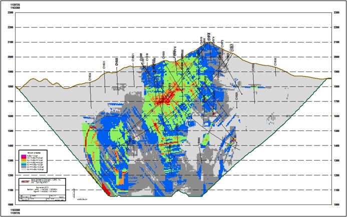
| Figure 7.23. | Cross section 300 east, looking northeast through Cerro Vetas and NW Breccia | 43 |
| Figure 7.24. | Cross section 400 east, looking northeast through the Cerro Vetas and NW Breccia zones | 44 |
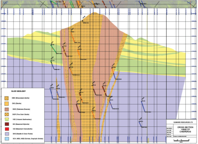
| Figure 7.25. | Cross section 1050 east, looking northeast through the Chisperos zone | 45 |
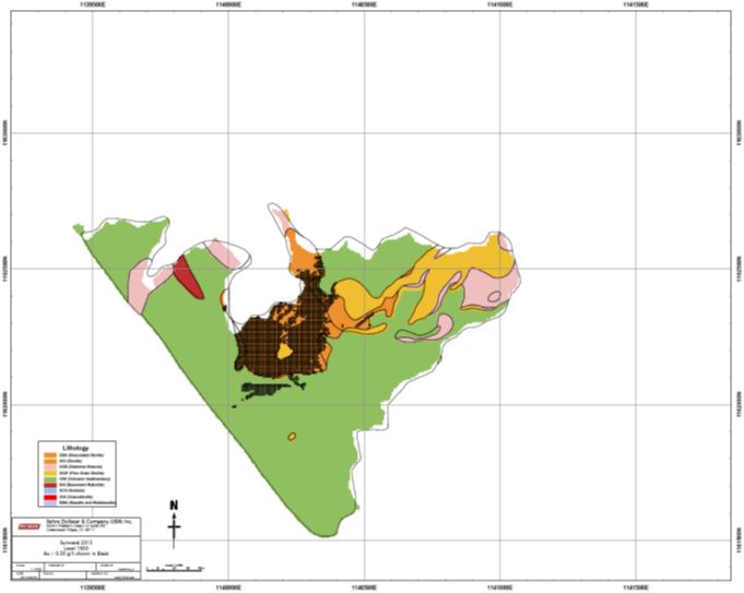
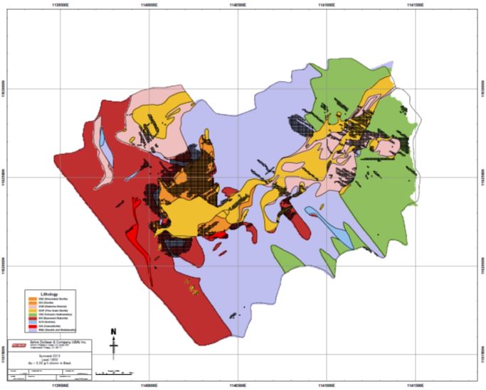
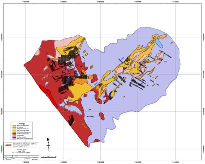
| Figure 7.26. | Plan geology map of the 1,950 meters above sea level elevation | 46 |
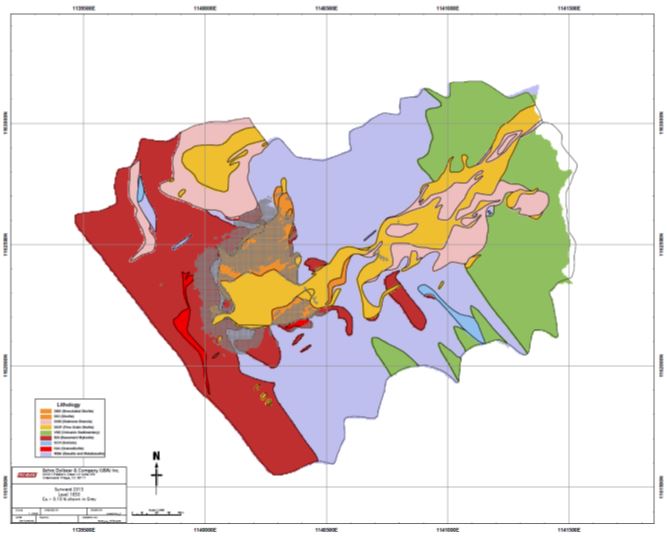
| Figure 7.27. | Plan geology map of the 1,650 meters above sea level elevation | 47 |
| Figure 7.28. | Plan geology map of the 1,350 meters above sea level elevation | 48 |
| Figure 7.29. | Gold grade blocks for elevation 1,950 meters above sea level | 49 |
| Figure 7.30. | Gold grade blocks for elevation 1,650 meters above sea level | 50 |
| Figure 7.31. | Gold grade blocks for elevation 1,350 meters above sea level | 51 |
| Figure 7.32. | Copper grade blocks for elevation 1,650 meters above sea level | 52 |
| Figure 7.33. | Gold block model for section 300E across Cerro Vetas and NW Breccia | 53 |
| Figure 7.34. | Gold block model for section 400E across Cerro Vetas and NW Breccia | 53 |
| Figure 7.35. | Gold block model for section 1050E across Chisperos | 54 |
| Figure 8.1. | Generalized porphyry model | 56 |
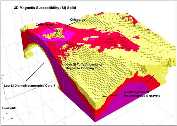
| Figure 9.1. | Three-dimensional magnetic susceptibility solid from the inversion of the total field aeromagnetic data | 58 |
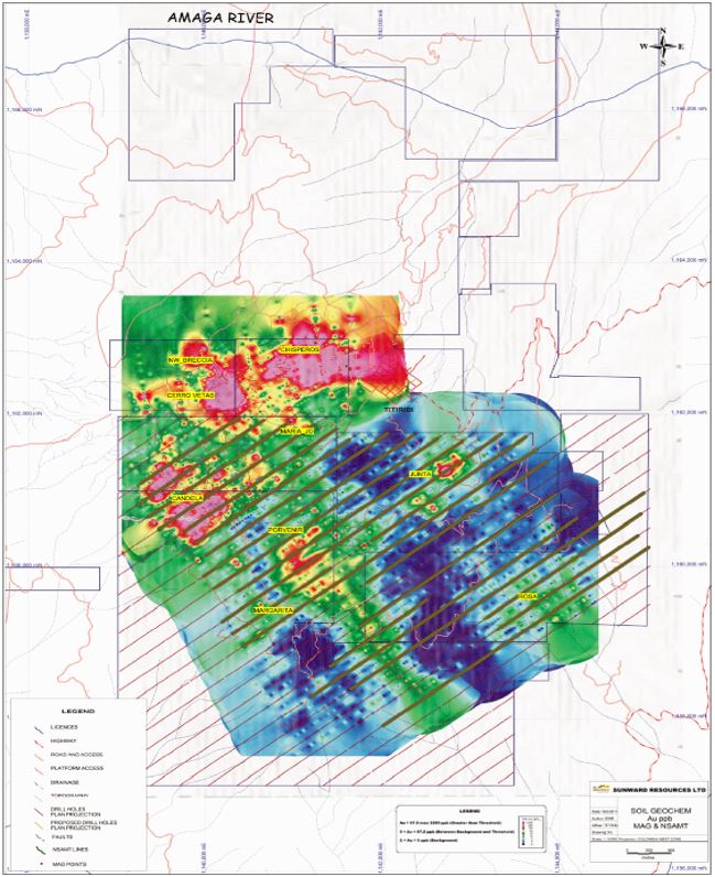
| Figure 9.2. | Gold-in-soil geochemical anomaly map | 60 |
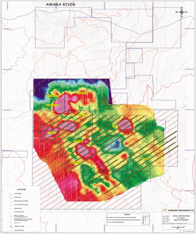
| Figure 9.3. | Copper-in-soil anomaly map | 61 |
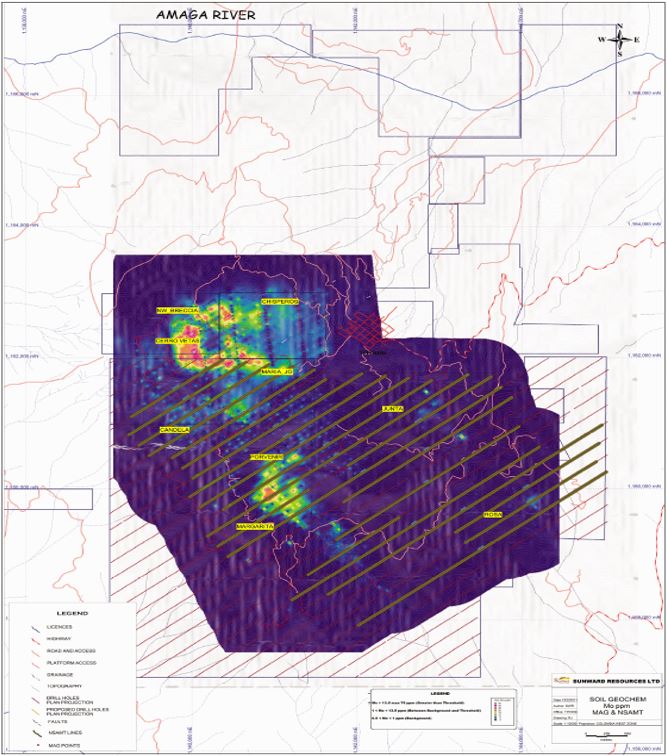
| Figure 9.4. | Molybdenum-in-soil anomalies | 62 |
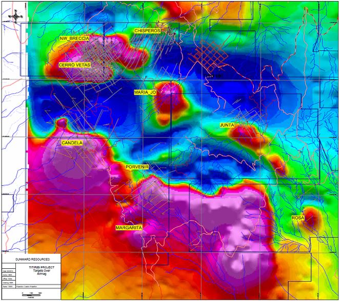
| Figure 9.5. | Overlay of geophysical and geochemical anomalies on target areas | 63 |
| Figure 9.6. | Maria Jo drilling and projected Maria Jo diorite stock | 64 |
| Figure 9.7. | Maria Jo geology/drill hole location map | 66 |
| Figure 9.8. | Maria Jo geologic section from 074° to 254° | 67 |
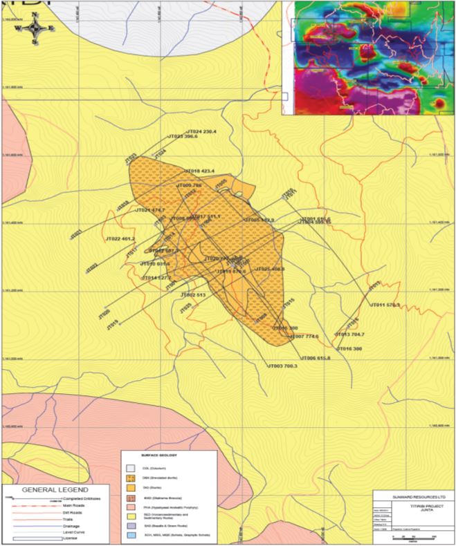
| Figure 9.9. | Junta geology/drill map | 68 |
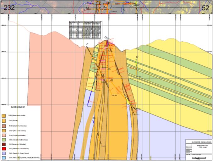
| Figure 9.10. | Junta geologic cross section along 750N | 69 |
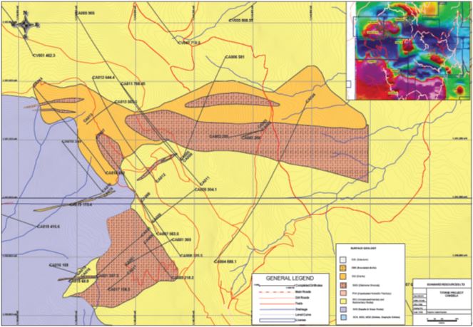
| Figure 9.11. | Candela geology/drill hole map | 70 |
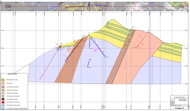
| Figure 9.12. | Candela geology section 2150N | 71 |
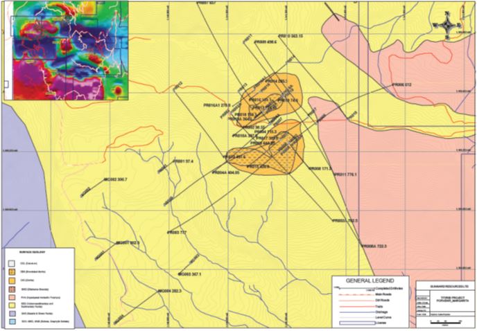
| Figure 9.13. | Porvenir geology and drill hole location map | 72 |
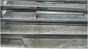
| Figure 10.1. | Core logging building in foreground and logging and storage building in the background | 78 |
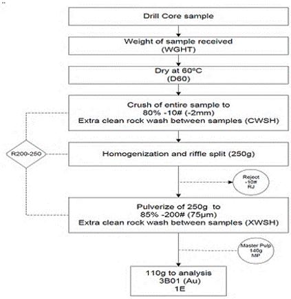
| Figure 11.1. | Acme sample preparation and analytical protocol flow chart | 81 |
| Figure 11.2. | Assay results on 5,945 blank samples | 83 |
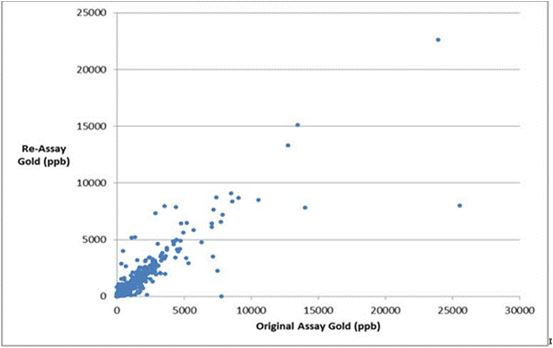
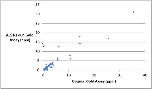
| Figure 11.3. | Scatter diagram for re-assaying original pulp samples for gold | 85 |
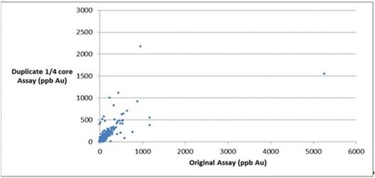
| Figure 11.4. | Assay results for duplicate samples comparing original sample to a ¼-split sample | 86 |
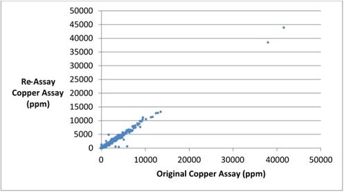
| Figure 11.5. | Copper re-assay results on original sample pulps | 87 |
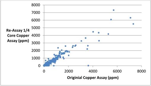
| Figure 11.6. | Scatter diagram comparison of original copper assays and duplicate (¼-core splits) assay results | 87 |
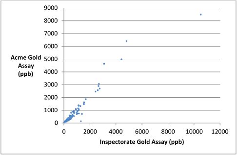
| Figure 11.7. | Comparison between Inspectorate and Acme Laboratories | 88 |
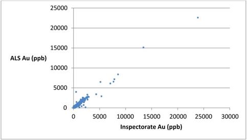
| Figure 11.8. | Comparison between Inspectorate and ALS Laboratories | 89 |
| Figure 11.9. | Comparison between SGS and ALS Laboratories | 89 |
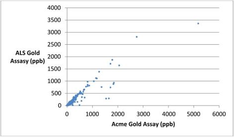
| Figure 11.10. | Comparison between Acme and ALS Laboratories | 90 |
| Figure 12.1. | CV098 – highlighting a portion of the interval 354.5 meters to 356.0 meters | 92 |
| Project 21-036 (GoldMining Inc.) | BEHRE DOLBEAR |
Independent Technical Report on the Titiribi Project – Colombia Effective Date: 14 June 2021; Published Date: 25 August 2021 |
LIST OF FIGURES
(continued)
| Figure 12.2. | CV098 – highlighting a portion of the interval 534.5 meters to 536.0 meters | 92 |
| Figure 12.3. | CV099 – highlighting a portion of the interval 97.5 meters to 99.0 meters | 92 |
| Figure 12.4. | CV73 – highlighting a portion of the interval 523.5 meters to 524.5 meters | 92 |
| Figure 12.5. | CV 94 – highlighting a portion of the interval 635.0 meters to 636.3 meters | 93 |
| Figure 12.6. | CP022 – highlighting a portion of the 347.0 meters to 348.5 meters, with obvious pyrite veins | 93 |
| Figure 12.7. | CP 40 – highlighting a portion of the interval 140.5 meters to 141.5 meters | 93 |
| Figure 12.8. | Scatter diagram for pulp copper verification assays | 94 |
| Figure 12.9. | Scatter diagram for pulp gold verification assays | 94 |
| Figure 14.1. | Block model areas | 99 |
| Figure 14.2. | Density measurements by lithology code | 101 |
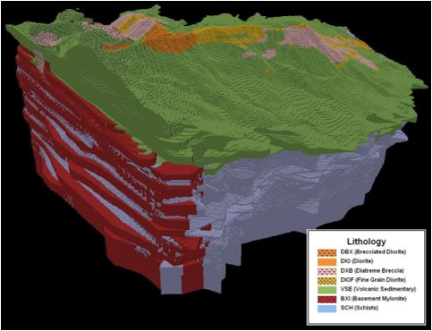
| Figure 14.3. | Sunward 3-dimensional geologic model | 103 |
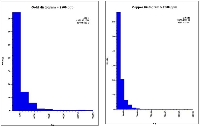
| Figure 14.4. | Cerro Vetas gold and copper assay histograms | 104 |
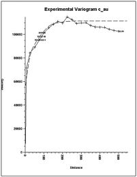
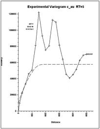
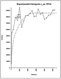
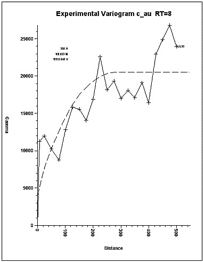
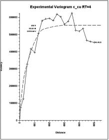
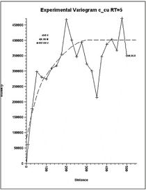
| Figure 14.5. | Gold experimental semi-variograms | 107 |
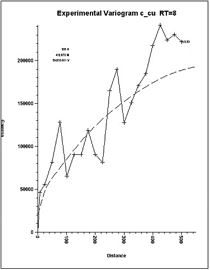
| Figure 14.6. | Copper experimental semi-variograms | 108 |
| Figure 14.7. | Section Location Map | 113 |
| Figure 14.8. | Section A-AI | 114 |
| Figure 14.9. | Section B-BI | 114 |
| Project 21-036 (GoldMining Inc.) | BEHRE DOLBEAR |
Independent Technical Report on the Titiribi Project – Colombia Effective Date: 14 June 2021; Published Date: 25 August 2021 |
Glossary of Selected Terms
| Term | | Definition |
| | | |
| Ordinary Kriging | | A statistical weighted average process whereby the grade of a block is estimated by weighted average from surrounding assay or composite samples. The weights are established to minimize the error of the estimate. |
| Nugget (as used in variography) | | Variance of samples taken at the same location or with zero separation between the two samples. |
| Range (as used in variography) | | Distance at which the variogram model reaches a constant value. |
| Spherical Model | | A form of equation used to approximate the variogram function for input to other tools such as kriging. |
| Sill | | The total variance of widely spaced samples, approximately equal to the variance of the statistical population in general. |
| Stope | | An underground excavation from which ore is being extracted. |
| Variogram | | A statistical tool that measures how similar samples are likely to be with various separation distances. The plot of a variogram shows variance versus distance between samples. |
| Variography | | A statistical analysis technique where statistics are calculated as a function of the spatial location of the data points. |
| Project 21-036 (GoldMining Inc.) | BEHRE DOLBEAR |
Independent Technical Report on the Titiribi Project – Colombia Effective Date: 14 June 2021; Published Date: 25 August 2021 |
List of Abbreviations
| AAS or AA | Atomic Absorption Spectroscopy |
| Ag | Silver |
| Au | Gold |
| CIM | Canadian Institute of Mining Metallurgy and Petroleum |
| Cu | Copper |
| DDH | Diamond Drill Hole |
| g | grams |
| GPS | Global Positioning System |
| GRG | Gravity Recoverable Gold |
| gpt or g/t | grams per tonne |
| ITR | Independent Technical Report |
| kg | kilogram |
| km | kilometers |
| km2 | square kilometer |
| m | meters |
| m2 | square meters |
| m3 | cubic meters |
| Ma | million years |
| Mo | Molybdenum |
| Mt | million tonnes |
| NSR | net smelter return |
| ppm | parts per million |
| OK | Ordinary Kriging |
| QA/QC | Quality Assurance/Quality Control |
| tonnes or t | metric tonnes |
| tpy or tpa | tonnes per year |
| Project 21-036 (GoldMining Inc.) | BEHRE DOLBEAR |
Independent Technical Report on the Titiribi Project – Colombia Effective Date: 14 June 2021; Published Date: 25 August 2021 |
Behre Dolbear & Company (USA), Inc. (Behre Dolbear) was retained by GoldMining Inc. to prepare an Independent Technical Report (ITR) on the Titiribí Project (Project), Department of Antioquia (Province), Colombia, compliant to Canadian National Instrument 43-101 (NI 43-101). Behre Dolbear assigned Mr. Joseph A. Kantor, Dr. Robert E. Cameron, and Mr. Mauricio Castañeda, all Qualified Professionals as recognized under NI 43-101, to undertake the Project. Mr. Kantor, Dr. Cameron, and Mr. Castañeda are the authors of this report.
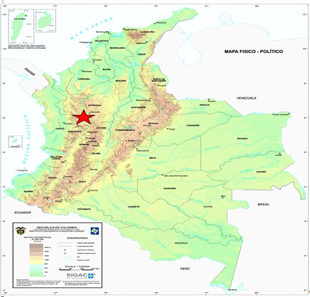
GoldMining Inc. is the holder of 100% of the Project in Colombia through its wholly-owned subsidiary, Resources Sucursal Colombia. The Project hosts several gold-copper exploration properties in a historic gold mining district located near the small town of Titiribí, Department of Antioquia (Province). The Titiribí Mining District is located approximately at latitude N 6° 3′ 55″ and longitude W 75° 47′ 55″ and is about 70 kilometers (km) southwest of Medellín, Colombia. Historic production in the Titiribí Mining District has occurred over hundreds of years and is estimated at 1.5 to 2.0 million ounces of gold equivalent (Emmons, 1937). The Project lies between the elevations of 1,200 meters to 2,200 meters.
The Project consists of one Mineral Title (Concession Contract L5085) registered on April 18, 2013 with an exploration term of 3 additional years, renewable every 2 years, up until 11 years, and is valid for 30 years (starting 2007) and renewable for 20 more years. GoldMining Inc. holds Concession Contract #L5085 expiring April 18, 2043 and is in the process of acquiring two additional Concession Contracts (SCF-15483x and TJ2-10181).
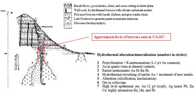
The Cerro Vetas-NW Breccia-Chisperos complex is a bulk tonnage gold and copper porphyry deposit directly related to several interconnected Cerro Vetas diorite porphyry centers but also hosted in the immediate contact aureoles and adjacent breccias. Chisperos hosts intrusive and contact aureole mineralization. Mineralization hosted in the Cerro Vetas diorite porphyry is disseminated and fracture controlled. The principal metallic minerals are native gold, chalcopyrite, pyrite, and magnetite. Gold values within the Cerro Vetas diorite porphyry normally correlate well with copper content and magnetite. The largest diorite intrusive occurs within the Cerro Vetas zone with smaller plugs and dikes found within the NW Breccia and Chisperos zones. The diorite porphyry hosts typical porphyry copper alteration with a barren to weakly mineralized pro-grade potassic core, surrounded by a well-mineralized phyllic zone, and a weakly mineralized retrograde argillic zone. The outermost propylitic alteration zone is widespread. Interpretation of geophysical and drill hole data suggests that potential higher-grade gold-copper zones exist as a domed contact-related shell in the intrusive where brecciated diorite with xenolithic fragments of sedimentary rocks was intercepted in drilling. This higher-grade domed shell is, at least in part, coincident with the phyllically altered intrusive-sedimentary contact breccia.
A second style of mineralization is gold-only mineralization developed in diatreme breccia in the NW Breccia and Chisperos zones. At NW Breccia, a separate diorite plug hosts gold and copper mineralization while the diatreme breccia hosts both gold-only and gold-copper mineralization. The reason for separate gold-only and gold-copper zones in the diatreme breccia is unknown but may be related to proximity to diorite dikes.
Similar to the NW Breccia, Chisperos hosts gold-copper mineralization in diorite plugs and dikes, gold-only mineralization in diatreme breccia, but also hosts substantial epithermal, lower-temperature generally gold-only mineralization within parallel to sub-parallel mineralized zones that are both stratigraphically and structurally controlled and hosted in a sedimentary-volcanic rock sequence. The near vertical diorite plugs and dikes consistently strike east-northeast and appear to emanate from the principal stock at the Cerro Vetas zone with all intruding structural weaknesses developed in the earlier diatreme breccia. Northwest-striking, steeply dipping faults are theorized to be the channel ways for auriferous hydrothermal fluids that mineralized shallow-dipping, favorable stratigraphic hosts; the Amagá Formation/basement contact; diatreme breccia; and possibly shallow-dipping bedding-plane fault zones.
| Project 21-036 (GoldMining Inc.) | BEHRE DOLBEAR |
Independent Technical Report on the Titiribi Project – Colombia Effective Date: 14 June 2021; Published Date: 25 August 2021 |
The Cerro Vetas, NW Breccia, and Chisperos zones host NI 43-101 guideline-compliant resources. Exploration during 2013 discovered copper-dominant and gold-copper mineralization at the Maria Jo prospect, a portion of which may be an extension of the Cerro Vetas and Chisperos zones and a portion related to a separate but related Cerro Vetas style intrusive body.
Further exploration potential exists to expand the known resources at Cerro Vetas-NW Breccia-Chisperos particularly along the alignment of magnetic highs hosting the Cerro Vetas, Maria Jo, and Junta mineralized zones. Drilling at Maria Jo has intersected intervals of copper-dominant and gold-copper mineralization related to a diorite intrusive where surface exposures are lacking due to a thin veneer of post-mineral gravel. Several other prospects lie a few kilometers to the south and southeast of the Cerro Vetas-NW Breccia-Chisperos complex. The Junta property hosts mineralized stock-like diorite porphyry intrusive, as does the Porvenir property; the Candela property hosts thick zones of mineralized hornfels and diorite porphyry. The Margarita and Rosa properties are very early-stage targets.
Through February 2013, 270 diamond drill holes, totaling 144,778.51 meters have been drilled at the Project, including 184 diamond drill holes, totaling 106,250.06 meters at Cerro Vetas, NW Breccia, and Chisperos. At the peripheral targets at Junta, Porvenir, Candela, Maria Jo, Rosa, and Margarita, 86 holes, totaling 38,528.45 meters of core, have been drilled. The 16 holes drilled in 1998 by Gold Fields have not been used in the resource estimation but are counted in the total of 270 diamond drill holes. Since February 2013, no new drilling has been undertaken at the Project.
Quality Assurance/Quality Control (QA/QC) data is extensive and all industry recognized procedures have been followed. The authors’ previous review of standard and blank assay data show little bias. Duplicate assays of higher-grade gold intervals demonstrate some minor concerns due to suspected coarse gold and coarse-grained sulfide-hosted gold. There is a minor negative bias during re-assaying of pulps that may be related to heavier minerals gravitating toward the bottom of the pulp envelope. In 2013 update, the authors coordinated a verification program that included quartering specific core intervals and a program of re-assaying 87 pulp samples from the Project area. The results generally verified the original assays but demonstrated some concerns with suspected coarse gold-nugget effect and some concerns with possible mislabeling original pulp envelopes.
In 2012, TJ Metallurgical Services, located in Scotland, developed a suitable test work program (Phase 3) that would identify an optimized process flow sheet and determine the key metallurgical design parameters. The United Kingdom laboratory of Wardell Armstrong International (WAI) was selected and 3 samples weighing 270 kilograms (kg) to 300 kg from Cerro Vetas, NW Breccia, and Chisperos were sent to the Cornwall laboratory. Results include:
| | ● | For all the samples, around 10% to 12%, of the gold, was recoverable to a gravity concentrate. The gold was not liberated and was generally locked with sulphides but was amenable to cyanidation. For Cerro Vetas, 57% was recoverable to a copper concentrate and 13% to a pyrite concentrate. For NW Breccia and Chisperos, the majority was associated with pyrite and was also amenable to cyanidation. |
| | ● | Samples of Cerro Vetas and NW Breccia were sent for test work at FLS-Knelson (FLS). FLS reported that for Cerro Vetas and NW Breccia there was a significant GRG (Gravity Recoverable Gold) element in both samples of 39.8% and 64.8%, respectively. More importantly, they stated that the introduction of a Knelson circuit and a cyanidation circuit would lead to an additional gold recovery of 1.2% to 1.8% and 4.0% to 5.6% for Cerro Vetas and NW Breccia, respectively. Chisperos was not tested. |
| | ● | Locked Cycle flotation tests on Cerro Vetas samples indicate that a saleable copper concentrate can be produced with a copper recovery of 90% and a gold recovery of 77%. The flotation of a pyrite concentrate recovers a further 6% of the gold. The best results indicate a 21.7% copper concentrate grade with up to 41.8 grams of gold per tonne. |
| Project 21-036 (GoldMining Inc.) | BEHRE DOLBEAR |
Independent Technical Report on the Titiribi Project – Colombia Effective Date: 14 June 2021; Published Date: 25 August 2021 |
| | ● | Locked Cycle flotation tests indicate that over 90% of the gold can be recovered to a pyrite flotation concentrate for both NW Breccia and Chisperos. A 6-test optimization program showed that it was not necessary to re-grind the pyrite flotation concentrate to achieve high gold recoveries and an average gold recovery of 91.7% with a cyanide consumption of 5.2 kg/tonne was achieved. |
| | ● | The environmental characterization tests did not report any issues with regard to acid generation. |
GoldMining Inc. is active in community affairs focusing upon dialogue and training on responsible mining; updates on the Project status, support for the local home for the elderly, support for 4 local productive and education initiatives and support for local cultural and sports events.
The author opines that, based on a cut-off of 0.3 grams of gold equivalent per tonne, the mineral deposits covered by this review hold approximately 85.0 Mt of Measured Mineral Resources averaging 0.39 grams of gold per tonne and 0.15% copper, and Indicated Mineral Resources of 349.6 Mt averaging 0.40 grams of gold per tonne and 0.10% copper. In addition, the Project has approximately 241.9 Mt of Inferred Mineral averaging 0.41 grams of gold per tonne and 0.04% copper, as shown below in Table 1.1 and Table 1.2.
These Mineral Resources conform to the definitions in the 2014 CIM Definition Standards – for Mineral Resources and Mineral Reserves. No reserves conforming to CIM standards have been estimated for this report, as GoldMining Inc. has not advanced the evaluation work to a point of developing mine plans, production schedules, and economic analysis. Also, no resources have been estimated for the mineralization at Junta, Maria Jo, Candela, and Porvenir, as an estimation would be premature at these early stage exploration projects.
Table 1.1
Titiribí Measured and Indicated Mineral Resource (0.3 Grams of Gold Equivalent per Tonne Cut-off as of 14 June 2021)1,2 |
| | | | | Contained Metals | Au Equivalence3 |
| Area | Class | Million Tonnes | Au (g/t) | Cu (%) | Au (kg) | Au (million oz) | Cu (tonnes) | Cu (million lbs) | (g/t) | (million oz) |
Cerro Vetas | Measured | 85.0 | 0.39 | 0.15 | 32,907 | 1.06 | 129,533 | 285.6 | 0.62 | 1.69 |
| | Indicated | 254.4 | 0.35 | 0.14 | 88,925 | 2.86 | 351,836 | 775.7 | 0.56 | 4.57 |
| | | | | | | | | | | |
Chisperos | Indicated | 60.4 | 0.48 | - | 29,206 | 0.94 | - | - | 0.48 | 0.94 |
| | | | | | | | | | | |
NW Breccia | Indicated | 34.8 | 0.61 | - | 21,368 | 0.69 | - | - | 0.61 | 0.69 |
| | | | | | | | | | | |
Total Measured + Indicated | | 434.6 | 0.40 | 0.11 | 172,407 | 5.54 | 481,369 | 1,061.2 | 0.56 | 7.88 |
1Numbers may not add due to rounding. 2Chisperos and NW Breccia values based on 0.3 grams of gold per tonne cut-off. 3Gold Equivalence estimated using AuEq (oz) = Au (oz) + Cu (lbs) × 0.0022026 |
| Project 21-036 (GoldMining Inc.) | BEHRE DOLBEAR |
Independent Technical Report on the Titiribi Project – Colombia Effective Date: 14 June 2021; Published Date: 25 August 2021 |
Table 1.2
Titiribí Inferred Mineral Resource (0.3 Grams of Gold Equivalent per Tonne Cut-off as of 14 June 2021)1,2 |
| | | | | Contained Metals | Au Equivalence3 |
| Area | Class | Million Tonnes | Au (g/t) | Cu (%) | Au (kg) | Au (million oz) | Cu (tonnes) | Cu (million lbs) | (g/t) | (million oz) |
Cerro Vetas | Inferred | 124.9 | 0.31 | 0.08 | 38,133 | 1.23 | 96,439 | 212.6 | 0.42 | 1.69 |
| | | | | | | | | | | |
Chisperos | Inferred | 44.2 | 0.45 | - | 19,813 | 0.64 | - | - | 0.45 | 0.64 |
| | | | | | | | | | | |
NW Breccia | Inferred | 72.8 | 0.55 | - | 39,999 | 1.29 | - | - | 0.55 | 1.29 |
| | | | | | | | | | | |
Total Inferred | | 241.9 | 0.40 | 0.04 | 97,945 | 3.16 | 96,439 | 212.6 | 0.47 | 3.62 |
1Numbers may not add due to rounding. 2Chisperos and NW Breccia values based on 0.3 grams of gold per tonne cut-off. 3Gold Equivalence estimated using AuEq (oz) = Au (oz) + Cu (lbs) × 0.0022026 |
| Project 21-036 (GoldMining Inc.) | BEHRE DOLBEAR |
Independent Technical Report on the Titiribi Project – Colombia Effective Date: 14 June 2021; Published Date: 25 August 2021 |
1.3.1 | Geologic, QA/QC, and Exploration Recommendations |
| | ● | The known deposits and early stage exploration projects have focused upon magnetic highs with coincident gold-copper soil anomalies. In 2012, Behre Dolbear recommended a preliminary drill test at a magnetic high that did not host geochemical anomalies, along the Cerro Vetas-Junta structural zone. This recommendation resulted in the discovery of significant copper-dominant and gold-dominant mineralization at the margins of, but north of, the magnetic high and now termed the Maria Jo prospect. The authors would recommend further exploration drilling at Maria Jo, focused along the Cerro Vetas-Junta structural trend, and over the magnetic high, which is presumably a diorite intrusive center. |
| | ● | The relationship between magnetic highs, intrusive centers, and mineralization is well established. An unexplored magnetic high occurs about 700 meters southeast of the Junta magnetic high along the trend of the Cerro Vetas-Maria Jo-Junta magnetic highs. This trend suggests a common source along a controlling deep-seated structural weakness. Although there are no geochemical anomalies related to this un-named and unexplored magnetic feature, the analogy with Maria Jo, where the causative intrusive and mineralized contact aureole is covered by post-mineral gravel, is plausible. If additional geologic mapping cannot find the source of the magnetic high, the authors recommend that some initial exploration drill holes be drilled in and peripheral to the magnetic high. |
| | ● | Future geologic studies focus on a more in-depth study of small-displacement faults that are not depicted on the present geologic plan and cross sectional maps, but appear to be important structural-mineralizing controls, particularly at Chisperos. |
| | ● | QA/QC procedures are good; however, it is recommended, in the future, that: |
| | ● | More diligence be paid to explain outlier results on standards to ensure that the standard used was correctly recorded in the database. |
| | ● | More care is needed in reviewing outlier results (duplicate or re-assay) and outliers should be repeated, as necessary, to determine if erratic results are caused by coarse gold, error in sample identification, etc. |
| | ● | Greater emphasis should be placed on additional re-run assays on higher-grade assays as they have an inordinate effect on grade. |
1.3.2 | Resource and Modeling Recommendations |
If additional infill drilling is completed at the Chisperos and the NW Breccia areas, additional variography work should be completed and the detailed three-dimensional geologic models updated.
1.3.3 | Social and Cultural Recommendations |
| | ● | GoldMining Inc. should continue Sunward’s social and community relations programs. These programs have established “lines of communication” with the local and surrounding communities concerning mining and the Titiribí Project along with aiding the local elderly population and supporting cultural and sporting events. |
| | ● | If a decision has been made to move forward with the Project, it is recommended that more formal social and community programs should be established. Each program should be developed to address stakeholder concerns and needs to be sustainable. |
| Project 21-036 (GoldMining Inc.) | BEHRE DOLBEAR |
Independent Technical Report on the Titiribi Project – Colombia Effective Date: 14 June 2021; Published Date: 25 August 2021 |
Behre Dolbear & Company (USA), Inc. (Behre Dolbear) was retained by GoldMining Inc. to prepare an Independent Technical Report (ITR) on the Titiribí Project (Project), Department of Antioquia (Province), Colombia, compliant to Canadian National Instrument 43-101 (NI 43-101). Behre Dolbear assigned Mr. Joseph A. Kantor, Dr. Robert E. Cameron, and Mr. Mauricio Castañeda, all Qualified Professionals as recognized under NI 43-101, to undertake the Project. Mr. Kantor, Dr. Cameron, and Mr. Castañeda are the authors of this report. GoldMining Inc., a company incorporated under the laws of Canada, is the issuer for whom this report has been prepared.
Brazil Resources Inc. announced on September 1, 2016 that it had acquired, through its wholly-owned subsidiaries, a 100% interest in the properties (through its acquisition of Sunward Resources Limited and Sunward Investments Limited, which own the ultimate owner of the Project, being Sunward Resources Sucursal Colombia), free of royalties, from Sunward Investments, a subsidiary of NovaCopper, who in turn had purchased Sunward Resources Limited (Sunward). Brazil Resources Inc. announced that effective December 6, 2016, it had changed its name to GoldMining Inc. The Project hosts several gold-copper exploration properties in a historic gold mining district located near the small town of Titiribí. Titiribí is located about 70 km southwest of Medellín, Colombia.
Mr. Joseph A. Kantor and Robert E. Cameron, Ph.D. visited the Project in 2011, 2012, and 2013. Mr. Mauricio Castañeda visited the property on 13 June 2021 for this technical report. During Mr. Castañeda’s visit, among other things, he reviewed the offices, core shed, drill core storage, representative maps and sections and conducted a full day of technical discussions and review with the issuer’s local project geologist about facilities, lithology, mineralization, alteration, and structures. This visit is being treated as the current personal inspection for the purposes of this report.
In 2011, Dr. Cameron and Mr. Kantor visited the principal deposits at Cerro Vetas, NW Breccia, and Chisperos, observed drilling and sampling techniques, and examined rock exposures and drill sites at Junta, Margarita, and Porvenir. In 2012, Dr. Cameron and Mr. Kantor focused upon the examination of mineralized cores from Cerro Vetas, NW Breccia, Chisperos, and the peripheral target at Junta. During the 2013 site visit, Dr. Cameron and Mr. Kantor reviewed all technical aspects including but not limited to geology; exploration results; drill cores from the Cerro Vetas, NW Breccia, Maria Jo, Junta, and Candela; QA/QC; geologic cross sectional and plan modeling. Special emphasis was placed upon a more rigorous three-dimensional geological modeling procedure; metallic screen assay results; QA/QC; and resource modeling for this report.
Mr. Castañeda has confirmed during his 2021 site visit that the data is current as no additional drilling or other technical work has been undertaken and no new technical data has been collected on the Project since 2013.
2.1 | UNITS, DEFINITIONS, AND ABBREVIATIONS |
The metric system is used throughout this report and the currency used is the United States dollar (US$) unless specifically stated otherwise.
| Project 21-036 (GoldMining Inc.) | BEHRE DOLBEAR |
Independent Technical Report on the Titiribi Project – Colombia Effective Date: 14 June 2021; Published Date: 25 August 2021 |
3.0 | RELIANCE ON OTHER EXPERTS |
The authors have not relied on information from other experts except certain information concerning legal title matters as described below.
The authors have not performed an independent verification of land title and tenure information, as summarized in Section 4.0 of this report and have relied upon a title report prepared by Dentons, Cardenas & Cardenas, counsel for GoldMining titled “Titiribi Mining and Environmental Due Diligence Report” dated August 20161. While it appears that all titles (concessions) are in force and free of any liens and encumbrances, the authors are not qualified to express a legal opinion with respect to the property titles and current ownership and possible encumbrance status, and therefore, we have relied on such title report for this information and disclaim direct responsibility for such legal title information.
1Valdiri, J., Project Titiribi Mining and Environmental Due Diligence Report, Dentons, Cardenas & Cardenas, August 2016.
| Project 21-036 (GoldMining Inc.) | BEHRE DOLBEAR |
Independent Technical Report on the Titiribi Project – Colombia Effective Date: 14 June 2021; Published Date: 25 August 2021 |
4.0 | PROPERTY DESCRIPTION AND LOCATION |
The Titiribí Mining District is located at approximately latitude N 6° 3′ 55″ and longitude W 75° 47′ 55″ and is about 70 km southwest of Medellín, Colombia (Figure 4.1). The Project lies within a rectangle defined by 1293400N to 1293900N and 930000E to 930500E (Magna Sirgas) and between elevations of 1,200 meters to 2,200 meters. Colombia updated the Bogota National Grid to the regional Magna Sirgas Grid to correspond better to the South America International Grid. In 2012, all Project coordinates were converted to the Magna Sirgas Grid.
Figure 4.1. | Generalized location map of the Titiribí Project in Colombia |
| Project 21-036 (GoldMining Inc.) | BEHRE DOLBEAR |
Independent Technical Report on the Titiribi Project – Colombia Effective Date: 14 June 2021; Published Date: 25 August 2021 |
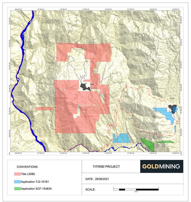
Originally, Sunward held 5 concessions and 4 exploration licenses that total about 3,919 hectares or about 9,684 acres. The exploration licenses consisted of L4982, L4983, L4984, and L5085; and the concessions consisted of H5820, H5820B, H5949, H5949B, and H5963. Based upon Resolution 0117702 of December 2, 2010, the 9 licenses and concessions were consolidated into 1 Mineral Title (Concession Contract # L5085) registered on April 18, 2013 with an exploration term of 3 additional years, renewable every 2 years, up until 11 years, which is valid for 30 years (starting 2007) and renewable for 20 more years.
GoldMining Inc. holds the Concession Contract #L5085, which expires on April 18, 2043. Two additional Concession Contracts (SCF-15483x and TJ2-10181) are in process.
Figure 4.2 is a map showing the Titiribí Concession as well as the two applications that were submitted.
Figure 4.2. | Titiribí Concession and Concession Contract Applications |
| (Source: GoldMining Inc., 2021) |
| Project 21-036 (GoldMining Inc.) | BEHRE DOLBEAR |
Independent Technical Report on the Titiribi Project – Colombia Effective Date: 14 June 2021; Published Date: 25 August 2021 |
Modern exploration on the Project commenced in 1992 with Muriel Mining South America (Muriel) acquiring a significant land position in the district. Muriel entered into several joint ventures. In 2009, Gold Plata Resources Limited (GRL) (formerly Muriel) entered into a joint venture with Sunward. Sunward subsequently reached an agreement with Gold Plata Mining International Corporation (GMIC), parent company to GRL, to earn up to 80% of the Project. A revised agreement (September 2010) allowed Sunward to take a 100% interest in the Project and to acquire the 2% net smelter return (NSR), in exchange for the issuance of 6.0 million shares of Sunward. On November 24, 2010, Sunward announced it had acquired 100% of the shares of GRL, the holder of 100% of the Project, free of royalties pursuant to the revised September 2010 agreement.
NovaCopper acquired the Titiribí Project on June 19, 2015, as part of its acquisition of Sunward Resources. GoldMining Inc. announced on September 1, 2016 that it had completed a share purchase agreement with NovaCopper, Inc., pursuant to which it acquired Sunward Investments Limited, a subsidiary of NovaCopper, which owned 100% of the Titiribí Gold-Copper Project. GoldMining Inc. paid 5 million shares and 1 million warrants exercisable at $3.50 per share for 2 years in exchange for Sunward Investments. Brazil Resources Inc. announced that effective December 6, 2016, it had changed its name to GoldMining Inc.
All disclosures concerning permits, exploration, and mining codes; rules, regulations, and fees are based upon a title opinion prepared by Colombian counsel and commissioners. No attempt was made to confirm the legality of licenses conferring the rights to mine, explore, and produce gold and copper and other metal products and accordingly, the authors disclaim any responsibility or liability in connection with such information or data. The authors are not qualified to express any legal opinion with respect to the property titles and current ownership, Colombian mining and exploration concession rules, and possible encumbrance status, and therefore, disclaim direct responsibility for such titles and property status representations.
During the exploration, evaluation, and construction stages, concessions require an annual fee or “canon” as set out in Article 230 in the Colombian Ley de Minas (Mining Law). The authors are not qualified to express any legal opinion with respect to the surface access agreements, and therefore, disclaim direct responsibility for such surface access representations.
4.4.1 | Surface Rights and Access Agreements |
In Colombia, there is no need to have surface ownership to access the sub-soil mineral rights. The Mining Law provides for mining rights and the expropriation of the surface, in case it is required, since mining is considered to be in the public’s interest. GoldMining Inc. currently holds surface agreements for the on-site office and core storage. New land access agreements will need to be re-established.
To re-establish surface agreements, Colombian mining law allows for two choices:
| | 1) | either negotiate a new agreement and fees directly with owners or |
| | 2) | request the local authority (the mayor’s office), to legally set the agreement fee to be signed with the owners. |
Surface agreements are needed when the nature of exploration work (drilling, drilling pads, access roads, trenches, etc.) do not allow the surface owner to have full utilization of the land. No native title claims exist over the Project area.
| Project 21-036 (GoldMining Inc.) | BEHRE DOLBEAR |
Independent Technical Report on the Titiribi Project – Colombia Effective Date: 14 June 2021; Published Date: 25 August 2021 |
4.5 | NATURE AND EXTENT OF TITLE |
The concessions are held 100% by GoldMining Inc., through its wholly-owned subsidiary, Sunward Resources Sucursal Colombia. The concessions are issued under the terms of the Colombian Ley de Minas (2001) under Article 14 and Article 15.
Article 14. Mining Title. “Mining title” whereby “the right to explore and exploit the mines of State’s ownership by means of a contract of mining concession, duly awarded and registered at the National Mining Register.”
Article 15. Nature of the Rights of the Beneficiary. “The concession contracts all other titles emanated from the State which are referred in the above Article, do not transfer to the beneficiary the right of ownership over minerals in situ but to establish, in an exclusive and temporal manner within the area granted, the existence of minerals in a quantity and quality that can be usable, and take possession by means of its extraction or capture of them and to impose on third parties’ properties with necessary easements for an efficient exercise of such activities.”
There is no differentiation in the law regarding foreigners or foreign companies operating in Colombia, as described in Article 18 and Article 19 of the Mining Code.
Article 18. Foreigners. The natural persons and foreign corporate persons acting as proponents or contractors of mining concessions will have the same rights and obligations as Colombian natives. The mining and environmental authorities cannot, in their field of competence, demand from them any additional or different requirements, conditions and formalities, save those expressly appointed in this Code.
Article 19. Foreign Companies. The foreign corporate persons will be able to, through a representative domiciled in Colombia, present and transact proposals. For the execution of the concession contract, a branch, affiliate or subsidiary should be established, domiciled in the national territory. This requirement will also be demanded from such persons in order that they dedicate to the exploring and exploiting of mines of private ownership, as owners of the corresponding right or as operators or contractors of the owners or successful bidders. They should duly assure before the granting authority, the liabilities contracted in this country, either with the guarantee of the work’s or service’s beneficiary or an endorsement of a banking institution or an insurance company that might be operating in Colombia.
The property boundaries of each of the concessions are stated as Bogotá National Observatory Grid (Bogotá Sector) coordinates. It should be noted, however, that Colombia updated the Bogota National Grid to the regional Magna Sirgas Grid to correspond better to the South America International Grid. In 2012, all Project coordinates were converted to the Magna Sirgas Grid.
4.7 | ROYALTIES, AGREEMENTS, AND ENCUMBRANCES |
Under Article 227 of the Colombian Mining Code (Law 685), production of non-renewable natural resources generates a royalty payment that may consist of a percentage (fixed or progressive) of the exploited gross product, sub-products, and by-products, payable in cash or in kind. Presently, precious metals (gold and silver) incur a gross royalty of 4% to the Colombian government. However, the payment is based on 80% of the PM fix on the London Bullion Market for an effective rate of 3.2%. The royalty on copper is 5%.
| Project 21-036 (GoldMining Inc.) | BEHRE DOLBEAR |
Independent Technical Report on the Titiribi Project – Colombia Effective Date: 14 June 2021; Published Date: 25 August 2021 |
Article 227. Royalties. In conformity with Articles 58, 332 and 360 of the Political Constitution, every exploitation of non-renewable natural resources of state ownership generates royalties as a compulsory counter-benefit. This consists in a percentage, fixed or progressive, of the exploited gross product, object of the mining title, and its sub-products, calculated or measured on the mine head, payable in currency or in kind. It will also cause royalties the reception of minerals coming from natural sources that are technically considered mines.
In the case of private owners of the subsoil, those should pay no less than 0.4% of the value of the production calculated or measured on the mine head, payable in currency or in kind. Those funds will be collected and distributed in conformity with the dispositions of Act 141 of 1994. The Government will rule whatever is pertaining to the matter.
The Project is subject to a 2% net smelter royalty (NSR) payable to Gold Royalty Corp.
4.8 | ENVIRONMENTAL LIABILITIES |
The current environmental liabilities consist of the need to rehabilitate areas of cleared vegetation created during the construction of access roads, trails, and drill pads. All programs are covered by Environmental Management Plans, which are monitored by the Ministry of Environment (Corantioquia) who carry out regular site inspections. GoldMining Inc. management has plans for re-vegetation of affected areas, water monitoring, and controls for slope failure and mass movements.
In 2013, Corantioquia notified Sunward Colombia that it had failed to obtain a water permit. In 2015, Sunward Colombia received an inquiry notice from Corantioquia along with the violations. Sunward Colombia’s counsel has submitted a letter to Corantioquia opposing the violations. A decision is pending and any potential penalty amount is unknown at this point. GoldMining Inc.’s actions will depend upon the results of the pending decision.
Although not environmental in nature, community related matters currently outstanding are as follows:
| | ● | In late 2017, the municipal council of Titiribí voted in favor of prohibition on metallic mining in the municipality, which resolution was subsequently declared invalid by the Administrative Tribunal of Antioquia. Subsequently, the municipality called for a municipal referendum to determine whether to amend its applicable zoning to prohibit metallic mining activities in the municipality. In February 2018, the Administrative Tribunal of Antioquia issued a decision in which it determined that the referendum may proceed. Such referendum was originally scheduled to be held in April 2018. However, it has since been suspended until further notice. Along with others in the industry, Sunward commenced a challenge of this decision and the proposed referendum with the applicable State Council. In October 2018, Sunward received notice that the State Council had issued a decision, which, among other things, declared the February 2018 decision of the Administrative Tribunal of Antioquia null and void and ordered it to consider Sunward’s arguments and issue a new ruling on the matter within 15 days. In November 2018, the Administrative Tribunal of Antioquia decided to maintain its ruling approving the referendum and the municipality could now proceed to schedule a referendum. The Constitutional Court declared the act of municipalities prohibiting mining through popular consultations as unconstitutional. This decision obliges other courts and authorities, including the Municipality of Titiribí, to uphold this declaration. Therefore, the Ministry of Mines of Colombia commenced a challenge of the Administrative Tribunal’s decision in November 2018 before the State Council. In January 2019, the State Council ruled against the November 2018 decision of the Administrative Tribunal, declaring such decision null and void and ordered the Administrative Tribunal of Antioquia to consider the Unified Sentence SU-095 from the Constitutional Court that states that the act of municipalities prohibiting mining through popular consultations is unconstitutional. |
| | ● | In May 2021, the Municipal Council issued a Territorial Ordinance Scheme, which prohibits mining and mineral exploitation activities in the municipality. The Company has announced that it believes that the Territorial Ordinance Scheme is unconstitutional and outside the authority of the municipality. As such, it announced plans to challenge this decision of the municipality through appropriate proceedings on the same basis as the prior successful challenge of the municipality’s similar actions in 2017 and 2018. The Company has further announced that, while it believes that it will be successful, based on the advice of its local counsel and past precedent, there can be no assurance that it will be successful in such proceedings, which are subject to the risks normally associated with such legal proceedings. |
| Project 21-036 (GoldMining Inc.) | BEHRE DOLBEAR |
Independent Technical Report on the Titiribi Project – Colombia Effective Date: 14 June 2021; Published Date: 25 August 2021 |
5.0 | ACCESSIBILITY, CLIMATE, LOCAL RESOURCES, INFRASTRUCTURE, AND PHYSIOGRAPHY |
Titiribí Township, with a population of approximately 14,000 people, is located approximately 70 km southwest of Medellín (3.2 million people), in the Department of Antioquia (Province), on the northwestern margin of Colombia’s Central Cordillera as part of the northern Andean Cordillera and limited geographically to the west by the Cauca River and cross it by Amagá river to the northern of the property. Access is by paved road from Medellín to the historic town of Titiribí. The Project area is surrounding the town of Titiribí and accessed is by gravel and dirt roads. Site access is generally by four-wheel drive, ATV, mule, and horse because of the steep nature of the terrain. Access to the area is available year round.
The Project is located at an elevation from 1,200 meters to 2,200 meters above sea level. The highest peak is at Cerro Vetas. The climate is mild and sub-tropical. The average annual temperature is 21°C. The region is entirely vegetation covered and is mostly pasture and crop lands. Rainfall averages about 1,500 millimeters (mm) annually. Running water is abundant and flow rates fluctuate seasonally providing to the Project the geological outcrops for the appropriate mapping and sampling in the exploration activities (Figure 5.1). Rainfall has a bi-modal distribution with the wettest months in middle March to middle June and again from middle September to middle December.
| | | | |
| | Figure 5.1. | Running water, “Quebrada del Medio” outcrop in the area of the Titiribí Project (Source: Mauricio Castañeda, QP., 2021) | |
Titiribí Township predominantly supports farming and ranching and contains local services with basic amenities. Titiribí has modern communication facilities (with cell phone and internet coverage in most of the extension of the municipality), a local hospital offering basic medical facilities, and all essential services to support small- to medium-scale mining operations. A large and educated workforce is available in Medellín, and available local workforce skills with active underground coal mining.
| Project 21-036 (GoldMining Inc.) | BEHRE DOLBEAR |
Independent Technical Report on the Titiribi Project – Colombia Effective Date: 14 June 2021; Published Date: 25 August 2021 |
No large-scale mining infrastructure is available in the area. Small-scale and artisanal mining is commonplace in the region and historically well developed at the El Zancudo gold and silver mine some 3 km north of Titiribí. Medellín, approximately 70 km northeast, is a city of 3.2 million people and has a well-developed infrastructure, including 1 international airport and 1 local airport.
A large port (Buenaventura) is located about 500 km to the west and a hydroelectric power station is available via the National Grid (at 500 kilovolts [kV]) some 3 km distant from the license boundary. Local electrical infrastructure is restricted to domestic supply from a low-tension grid.
The area is well serviced by roads and highways that were utilized by the QP for accessing the Project for the current site visit.
As the Project is still in an exploration stage, it is premature to discuss mining personnel, potential tailings storage areas, potential waste disposal areas, potential heap leach, and processing plant sites. However, it would be expected that such sites would likely be out of the view of the town of Titiribí.
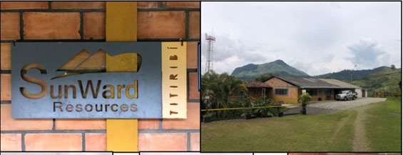
The facilities of the company, Sunward Resources Sucursal Colombia (owned by GoldMining Inc.), are in excellent condition and very well maintained. Figure 5.2 shows a series of photos of the geology office and other logistic and administrative facilities. Figure 5.3 shows the drill core storage and core shed facilities with the capacity over 145,000 meters of drill core storage and its core back up rejects. Figure 5.4 shows the exploration facilities at the Titiribí Project to include the core shed, drill core and rejects storage, and a detailed picture of the drill core storage.
Figure 5.2. | Exploration facilities of the Titiribí Project: geology, administration office, and other facilities |
| (Source: Mauricio Castañeda, QP, 2021) |
| Project 21-036 (GoldMining Inc.) | BEHRE DOLBEAR |
Independent Technical Report on the Titiribi Project – Colombia Effective Date: 14 June 2021; Published Date: 25 August 2021 |
Figure 5.3. | Drill core storage and core shed (left); workshop and supplies storage (central); detail of geology office (right) |
| (Source: Mauricio Castañeda, QP, 2021) |
Figure 5.4. | Exploration facilities of the Titiribí Project; core shed for logging and sampling (left), drill core and rejects storage (central), and drill core storage detail (right) |
| (Source: Mauricio Castañeda, QP, 2021) |
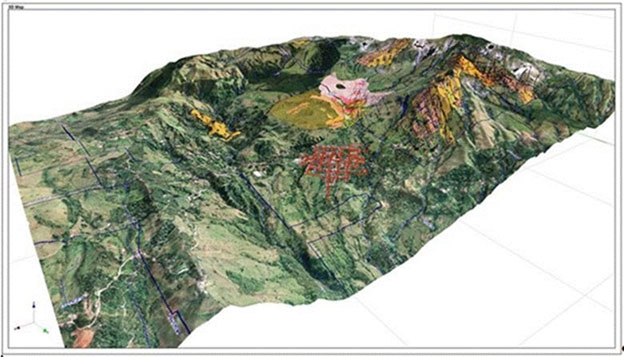
The topography is steep to abruptly mountainous and is dissected by steeply incised, active drainages typical of the Central cordillera of the northern Andean cordillera in Colombia. The area was once covered by tropical forest but has long since been cleared to make way for pasture land for cattle grazing, sugar cane, and coffee plantations. The Project area has moderate to steep relief, elevations range from about 1,200 meters to 2,200 meters above sea level. The series of hills and valleys dominate the geomorphology and many appear to be related to geologic structures.
Soil development, typically saprolitic, is poor to moderate but vegetation is generally thick with grasses to moderately sized trees. A network of small paths and fence lines identifying land ownership cuts the Project area. General land use is agricultural and ranching: principally coffee, sugar cane, and dairy and beef cattle. Artisanal mining, including precious metals and coal, continues to form a limited part of the regional economy. Figure 5.5 is a photo looking southwest at the town of Titiribí and the Project lands above the town. Cerro Vetas is mostly beyond the tree-covered peak in the foreground. Chisperos is partially on the far right side of the photo. Figure 5.6 is a three-dimensional view looking southeast outlining the Titiribí townsite; Cerro Vetas-NW Breccia-Chisperos to the southwest of Titiribí; Maria Jo (a new gold-copper discovery immediately south of Titiribí; and several of the other exploration targets.
| Project 21-036 (GoldMining Inc.) | BEHRE DOLBEAR |
Independent Technical Report on the Titiribi Project – Colombia Effective Date: 14 June 2021; Published Date: 25 August 2021 |
Figure 5.5. | Town of Titiribí and Chisperos (looking southwest); Cerro Vetas is on the upper right and Candela is at the top on the upper center |
| (Source: Mauricio Castañeda, QP, 2021) |
| Project 21-036 (GoldMining Inc.) | BEHRE DOLBEAR |
Independent Technical Report on the Titiribi Project – Colombia Effective Date: 14 June 2021; Published Date: 25 August 2021 |
Figure 5.6. | Three-dimensional view of Titiribí and the gold-copper deposits and exploration areas, looking southeast |
| Project 21-036 (GoldMining Inc.) | BEHRE DOLBEAR |
Independent Technical Report on the Titiribi Project – Colombia Effective Date: 14 June 2021; Published Date: 25 August 2021 |
Historical gold production in Colombia, since the Spanish conquest in 1537 until the start of the California gold rush, is estimated to be between 29.0 million ounces and 35.0 million ounces, making the country the largest gold producer of the Spanish empire and the second in South America, after the much larger Brazil (Restrepo, 1883). Approximately 75% of this gold production came from the Departments of Antioquia (Province) and Caldas. Colombian gold production, between 1514 and 1934, had been estimated at 49.0 million ounces (Emmons, 1937). Two-thirds of that estimated historic gold production was from placer operations. The Banco de la Republica (Shaw, 2000) estimated subsequent Colombian production through 2000 at 30.0 million ounces.
Prior to the historic production, there was a long period of undocumented pre-historic production. Farmers, potters, gold miners, and goldsmiths of the Quimbaya culture (500 BC to 1600 AD) occupied the Middle Cauca region surrounding the Project area for 2,000 years before the Spanish conquest. The culture was noted for some of the finest gold workmanship in Colombia and was part of the greater Chibcha culture that occupied the present day countries of Colombia, Panama, and Costa Rica (Andrew, 2011).
6.2 | EARLY HISTORY OF THE EL ZANCUDO/TITIRIBí DISTRICT |
Mining has been carried out in this district since 1793. During the 1800s and early 1900s, production of polymetallic ores containing gold, silver, zinc, lead, copper, antimony, and arsenic came from at least 14 principal mines within a 3 km radius of Titiribí. One of the early companies was Sociedad de Minas de Antioquia, formed in 1828. The most important company was the Sociedad de El Zancudo, formed in 1848. Peak production was from 1885 to 1930 and roasters recovered the gold. The Sociedad de El Zancudo (El Zancudo) reported production of 129,325 ounces of gold and 958,570 ounces of silver. El Zancudo exploited rich polymetallic fault-related veins and replacement deposits in particular at the contact between the basal conglomerate of the Amagá Formation and the basement schists and in favorable stratigraphic hosts within the conglomerate, schist, and Oligocene-age sediments. The favorability of these stratigraphic horizons may be very likely due to bedding plane or thrust faults that allowed porosity and permeability for mineralizing hydrothermal solutions. Total production from the Titiribí District has been estimated at 1.5 million to 2.0 million ounces of gold equivalent (Emmons, 1937). As these estimates were made when the mines were in production, individual gold, silver, and base metal production estimates are not available.
High-grade ores were hand-cobbed and roasted; lower-grade ore was crushed in stamp mills. The sands were concentrated by gravity on Wilfley tables and the fines by flotation. Free gold was panned from the concentrates at some mines. At some mines, the concentrate was smelted using locally available coal resulting in a precious metal matte and slag. The mattes were refined through progressive oxidation. After 1910, hydrometallurgical processes were introduced to treat the primary matte by sulfidization to recover silver, leaving a gold-bearing residue that was treated by cyanide.
Over recent years, the slags from various historic operations have been processed by crushing, grinding, followed by agitation in cyanide tanks, and Merrill Crowe precipitation using zinc powder.
In the Project area, there has been some historic production, mostly from the Chisperos area. The total production is unknown, but is included in the regional production estimates.
6.3 | RECENT TITIRIBí PROJECT HISTORY |
Muriel Mining S.A. (Muriel) initiated work in 1992, focusing upon the Otra Mina, Cateadores, Chisperos, Muriel, and Cerro Vetas areas of the Titiribí District. Numerous adits were re-opened, cleaned, advanced, and sampled. Muriel entered into two joint ventures; first with a junior company, Ace Resources Limited (ACE) of Vancouver, British Columbia, and then with Gold Fields of South Africa Limited (Gold Fields).
| Project 21-036 (GoldMining Inc.) | BEHRE DOLBEAR |
Independent Technical Report on the Titiribi Project – Colombia Effective Date: 14 June 2021; Published Date: 25 August 2021 |
ACE started a large-scale soil sampling program of the Project area on lines spaced 400 meters apart. The result of this effort, utilizing multi-element geochemistry, was the outlining of several anomalies. “Ground-truthing” via geologic mapping led to the interpretation that some anomalies were related to porphyry systems. ACE also conducted the first ground-based magnetic and Induced Polarization (IP)/Resistivity surveys across the original wide-spaced soil lines. Although ACE defaulted on their option, their efforts defined several initial targets.
Gold Fields continued the exploration efforts started by ACE and focused on the porphyry-style targets. In 1998, Gold Fields completed a detailed 80-meter spaced soil and geophysical survey resulting in better definition of the Cerro Vetas porphyry target. Outcrop is minimal and is generally confined to drainages, ridge tops, and road cuts. Soil sampling is useful but is less than optimal due to “soil creep.” Trenching is banned in the area. Targets are thus defined by a combination of geophysics, soil sampling, and geologic mapping. In 1998, Gold Fields started a 2,500-meter diamond-drilling program centered in the Cerro Vetas target area. Drilling was designed to test the IP chargeability anomalies associated with pyrite-gold mineralization interpreted to rim the postulated porphyry intrusive body. Drill hole DDT5 was the first hole to intersect weak porphyry-style mineralization.
Gold Fields subsequently drilled four additional holes on the northern margin of the porphyry intrusive and two other holes were drilled to the west testing a coincident soil anomaly and strong magnetic high. Based upon their drilling, they interpreted Cerro Vetas as a multi-phase, monzonitic porphyry intrusive with a pro-grade potassic core overprinted by retrograde argillic alteration.
Gold Fields opted out of the joint venture. Gold Plata Mining (formerly Muriel) then in 2006 entered into a joint venture with Debeira Goldfields (DBGF). This joint venture drilled an additional 16 drill holes; 13 into the Chisperos target and 3 holes into Cerro Vetas. In 2008, DBGF vended its right in the Project to Windy Knob Resources (WKR). Exploration by WKR included the acquisition and review of LandSat imagery culminating in the delineation of over 30 targets in the concessions. They collaborated with AngloGold Ashanti Colombia S.A. to fly a geophysical survey over the Project area; and undertook soil sampling at the Candela prospect; diamond drilling at Cerro Vetas; and diamond drilling (3 holes) at Candela resulting in the discovery of gold mineralization. In 2009, WKR relinquished the Project and Gold Plata Mining entered into an acquisition agreement on the Project with Sunward Resources.
Sunward initiated an aggressive exploration and development program. Through February 2013, 270 diamond drill holes, totaling 144,778.51 meters, have been drilled at the Project with 184 diamond drill holes, totaling 106,250.06 meters at Cerro Vetas, NW Breccia, and Chisperos. At the peripheral targets at Junta, Porvenir, Candela, Maria Jo, Rosa, and Margarita, 86 holes, totaling 38,528.45 meters of core, have been drilled. The 16 holes drilled in 1998 by Gold Fields have not been used in the resource estimation nor have been counted toward the total of the 270 diamond drill holes.
Sunward did not undertake any additional drilling between February 2013 and its sale to NovaCopper in June 2015. Similarly, NovaCopper did not undertake any exploration drilling within the Project since June 2015. GoldMining Inc. acquired the Project on September 1, 2016 and is in the planning stage for additional exploration drilling. Brazil Resources Inc. announced that effective December 6, 2016, it had changed its name to GoldMining Inc.
| Project 21-036 (GoldMining Inc.) | BEHRE DOLBEAR |
Independent Technical Report on the Titiribi Project – Colombia Effective Date: 14 June 2021; Published Date: 25 August 2021 |
7.0 | GEOLOGIC SETTING AND REGIONAL MINERALIZATION |
The geology of western Colombia is very complex. Radiometric data (Aspden, et al., 1987) from western Colombia combined with geologic mapping, suggest that there have been five main plutonic episodes, ranging from Triassic to Tertiary in age. It is likely that the variation of the convergence angle of the oceanic plate, relative to the continental plate, was an important factor for the timing and spatial distribution of the plutons. On a regional scale, “major breaks in activity are probably best attributed to either low-angle/parallel convergence or periods of accretion along the convergent margin” (Aspden, et al., 1987).
The western Colombian Andés consist of four sub-parallel mountain ranges separated by intermontane depressions. The ranges and depressions are generally north-south. From east to west, the mountain ranges are the Eastern, Central, and Western Cordillera and the Pacific Coast Range. The Magdalena Valley separates the Eastern and Central Cordillera. The Cauca-Patia graben-type depression separates the Central and Western Cordillera. The Project is located on the northwest margin of the Central Cordillera. The Pacific Coast, or Serrania de Baudo, extends from the Panamanian border to approximately 5° North Latitude, and is separated from the Western Cordillera by the Atrato-San Juan depression.
Recent analysis of seismic reflection profiles indicates the Paleozoic basement and clastic sedimentary sequences in the southern portion of the Cauca-Patia depression underwent thrust and fold-style deformation both prior to and following porphyry intrusions (Shaw, 2000).
A suggested three-phase geologic history of the Cauca-Patia depression is:
| | ● | The Cauca-Patia structural graben, as a coastal margin-intermontane basin, begins receiving clastic sedimentation from the emerging Central and Western Cordilleras. |
| | ● | The depression continues to be caught up in a zone of foreland compression, responding to the collision of Cretaceous oceanic terranes along the Colombian Pacific margin. |
| | ● | Finally, as an arc-axial depression or zone of weak extension, it marks the thermal axis of Miocene calc-alkaline magmatism. |
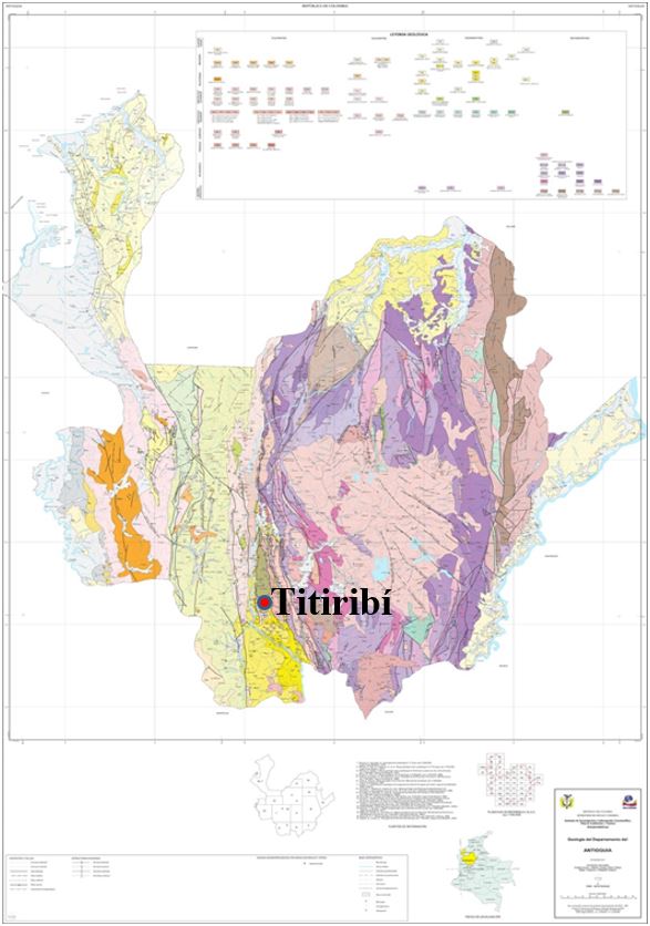
The Central Cordillera consists of a pre-Mesozoic basement of faulted and folded Paleozoic-age rocks within a metamorphic belt consisting of both continental and oceanic character and remnants of Precambrian rocks. Numerous Mesozoic batholiths and stocks intruded this rock package. The western edge of the Paleozoic schist belt is defined, regionally, by the Romeral Fault (McCourt, et al., 1984), a suture of lowermost-Cretaceous age along which the Jurassic oceanic basalts and related ophiolitic rocks of the Amaime terrane (Aspden and McCourt, 1986) or Romeral terrane (Cediel, et al., 2003) were accreted. In the Project area, the mélange of Romeral terrane contains mega-scale blocks and fragments of the oceanic allochthon and crustal slivers of autochthonous Paleozoic metamorphic rock that formed the continental margin at the time of oceanic terrane accretion. Following accretion, the Romeral terrane was unconformably overlain by autochthonous Oligocene siliciclastic sedimentary sequences. The region was once again compression deformed in the early-middle Miocene and again in the middle-late Miocene. In the late Miocene, both the Romeral terrane and the Oligocene siliciclastic sediments were syn-tectonically intruded by a series of mineralized and altered stocks, dikes, and sills and associated extrusive equivalents, which return K-Ar whole rock dates ranging from 8 Ma to 6 Ma (Andrew, Internal Sunward Document, 2011 and Kedahda, Internal Muriel Mining Report, 2003). Following the intrusion and extrusion of Miocene intrusives and syn-mineral volcanics, there was a period of continued volcanism dominated by dacitic-andesitic dikes, tuffs, and ash. Figure 7.1 shows the generalized structural geology of Colombia. Figure 7.2 shows the geology in Antioquia Province. Titiribí is the block of yellow color in the southern part of the map. Note that on this scale, none of the intrusive rocks are mapped. Figure 7.3 is an enlargement of the regional geology in the vicinity of Titiribí.
| Project 21-036 (GoldMining Inc.) | BEHRE DOLBEAR |
Independent Technical Report on the Titiribi Project – Colombia Effective Date: 14 June 2021; Published Date: 25 August 2021 |
Figure 7.1. | Geology of Colombia showing the location of the Titiribí Project |
| Project 21-036 (GoldMining Inc.) | BEHRE DOLBEAR |
Independent Technical Report on the Titiribi Project – Colombia Effective Date: 14 June 2021; Published Date: 25 August 2021 |
Figure 7.2. | Geology of Antioquia Province |
| Project 21-036 (GoldMining Inc.) | BEHRE DOLBEAR |
Independent Technical Report on the Titiribi Project – Colombia Effective Date: 14 June 2021; Published Date: 25 August 2021 |
Figure 7.3. | Enlargement of the regional geology in the vicinity of Titiribí Titiribí is located within the squared area at the center of the figure |
| (Source: Behre Dolbear, 2011) |
The local geology is dominated by multiple intrusives of the Cerro Vetas porphyry system. The intrusive complex is a cluster of separate intrusives of Miocene age, some of which may be connected at depth. The intrusive rocks are generally locally porphyritic diorite and monzonite but other closely related phases are likely. The porphyry system of stocks, plugs, and dikes intrude a lower plate Paleozoic to Cretaceous basement complex and an upper plate Oligocene to Miocene sedimentary sequence. The porphyries also intrude a diatreme breccia that may be an earlier precursor to younger porphyries. The Oligocene-Miocene Amagá Group consists of folded and faulted sequences of siliciclastic sedimentary rocks dominated by marine-continental quartz pebble conglomerates, sandstone, green, black, and red shale, and coal. The Amagá Group overlies the highly tectonized Paleozoic to Cretaceous basement meta-sediments rocks consisting of chloritic, sandy, and graphitic schist of the Jurassic to early-Cretaceous Arquia Complex and the Paleozoic Cajamarca-Valdivia Group. The genesis and age of a suspected lahar-type unit in the basement rocks is unknown. Both the basement rocks and overlying Amagá Group sediments are intruded by sills and dikes and locally overlain by coeval andesitic volcanic rocks of the Combia Formation.
| Project 21-036 (GoldMining Inc.) | BEHRE DOLBEAR |
Independent Technical Report on the Titiribi Project – Colombia Effective Date: 14 June 2021; Published Date: 25 August 2021 |
The local detailed geology, particularly the basement stratigraphy and structure, is very complex as there are few recognizable marker horizons; the units have been tectonically displaced by multiple large shear and fault zones, which themselves have been intruded by younger magmas.
The basement rocks consist of Arquia Complex, Cajamarca-Valdivia Group, and the Quebradagrande Formation. The late-Jurassic to early-Cretaceous Arquia Complex schists are dark green and hard with intervals of black, pyritic, graphitic schist, and are possibly equivalent to the Cajamarca-Valdivia Group. The Cajamarca-Valdivia Group is most common east of the La Junta-Cerro Vetas fault near the Zancudo Mine. Schistosity is north-south to northwest and dipping steeply to the west.
The Quebradagrande Formation is basaltic to andesitic volcanic rocks and low-grade meta-sedimentary rocks. Some units may have been ultramafic originally. They form much of the basement in the western part of the Project area and are mostly Cretaceous in age. They are dark green to black; often porphyritic with hornblende phenocrysts; locally are pyritic and nearly universally chloritized. The green to black basaltic rocks have been intersected in nearly all of the drilling at Chisperos, Cerro Vetas, and Candela. The contact with the overlying Amagá Formation is discordant and regionally dips northeast at approximately 40°.
During the early stages of exploration, many different types of breccias were logged based upon multiple lithologies encountered. Over time, the various breccia units have been consolidated as it was recognized that a major difference related to the lithology of the fragments, rather than the genesis of the breccia. The three major types of breccias include fault breccia, intrusive and hydrothermal contact breccia, and diatreme breccia. A fourth type of breccia, logged as a mylonite breccia, is more likely to be a lahar unit in the basement volcanic package.
Correlation from hole to hole of the various styles of breccia is difficult as original fragment content varies and intrusive contact alteration modifies the appearance. Fragments in some breccias are rounded due to shearing and/or intrusion. Some may be fluidized pebble dikes. Some breccias are characterized by angular to slightly rounded rock and mineral fragments of various sizes down to rock flour. Many fragments are quartz. Mineralization in all the various breccias is disseminated and fracture controlled. Some breccias show locally intense shearing. In some mineralized breccia, halos of alteration surround clasts. In some cases, breccia fragments are mineralized; in others, the matrix is mineralized; and in still others, both fragments and matrix are mineralized, thus, demonstrating various ages for breccia units. Breccia units rarely outcrop.
The authors opine that the “mylonite” breccia is a pre-mineral basement volcano-sedimentary unit that has its origins as a lahar-type unit. It contains both angular and semi-rounded fragments, most commonly of volcanic origin. Commonly, there are small quartz-rich fragments, the origin of which is unknown and locally, the lahar contains very large disconnected blocks, many meters across, of pre-mineral Amagá granodiorite. The matrix appears to have originally been a dark-colored mud and shows flow features surrounding the larger fragments leaving the appearance of being mylonitic or schistose. Figure 7.4 is an example of un-mineralized lahar. There is a preponderance of fragments, many of which are sub-rounded. There is no destruction of the larger fragments that would be expected in a mylonite zone. The “mylonite breccia” or lahar has been regionally metamorphosed. It is brecciated at the contact zone with intrusive diorite.
| Project 21-036 (GoldMining Inc.) | BEHRE DOLBEAR |
Independent Technical Report on the Titiribi Project – Colombia Effective Date: 14 June 2021; Published Date: 25 August 2021 |
Figure 7.4. | Barren lahar from 128 meters to 132 meters in CV054 |
| (Source: Behre Dolbear, 2012) |
The first true breccia to develop is the diatreme intrusive breccia that likely formed due to early explosive activity above dioritic magma. Diatreme breccia occurs throughout the Cerro Vetas, NW Breccia, and Chisperos areas intruding both basement and the overlying sedimentary package. The largest, single block was originally designated the NW Breccia. The NW Breccia hosts mafic and ultramafic fragments while at Cerro Vetas and Chisperos there appears to be fewer ultramafic fragments but more mafic fragments. In most areas, the diatreme breccia bodies appear dike-like and are parallel to, sub-parallel to, and intruded by locally mineralized diorite dikes. As diorite dikes cut diatreme breccia, the diatreme breccia is pre-mineral and has become a good host for mineralization, and as they occupy the same structural weakness as the younger diorite, the authors speculate that they formed as explosive vents above the diorite. Furthermore, at Chisperos, diatreme breccia is cut by parallel and sub-parallel northwest striking, northeast dipping faults that control mineralization not only in diatreme breccia but also along the contact between basement volcanoclastic sediments and Amagá conglomerate. This clearly demonstrates that diatreme breccia is an early, pre-mineral feature. At shallow depths, diatreme breccia hosts fragments of younger, Amagá age sediments, demonstrating some collapse into the crater or fissure; however, at depth, the breccia is dominated by volcanic and volcanoclastic sediments and at further depth, particularly at Chisperos, diorite dikes intrude diatreme breccia. In a larger sense, the diatreme breccia locations are partially controlled by the deep-seated structural weakness caused by the Cauca-Romeral shear zone. Younger Cerro Vetas diorite intrusions are also structurally controlled by the deep-seated Cauca-Romeral shear zone.
Photographs of the hornblende-rich mafic porphyry fragments in the diatreme breccia are shown in Figure 7.5. The authors speculate that such fragments may have origins in the Quebradagrande Formation as coarse hornblende crystal-rich porphyries as described in this unit and the Quebradagrande Formation is widely exposed to the west of the property. However, compared to diatreme breccia at NW Breccia, there are fewer mafic and ultramafic fragments in the Chisperos diatreme breccia.
| Project 21-036 (GoldMining Inc.) | BEHRE DOLBEAR |
Independent Technical Report on the Titiribi Project – Colombia Effective Date: 14 June 2021; Published Date: 25 August 2021 |
Figure 7.5. | Photographs of Chisperos diatreme breccia in core; note very large hornblende crystals in the photograph on the left |
7.2.2.3 | Intrusive and Hydrothermal Contact Breccia |
It is speculated that multiple types of contact breccia developed during intrusion of the Cerro Vetas porphyry, in the margins adjacent to and within the intrusive, and were excellent passageways for hydrothermal alteration and mineralization. The breccias occur on all sides of the main Cerro Vetas intrusive. Most Cerro Vetas drill holes intersect these breccias. Much of the better-mineralized contact breccia occurs in the phyllic alteration zone of the Cerro Vetas porphyry. The authors opine that the contact breccia hosts at least two, but probably three different breccia types. The first is true contact breccia consisting mostly of brecciated, altered, and mineralized wall rock, while the second type is true intrusive breccia consisting mostly of diorite fragments. A third breccia style demonstrates multiple phases of mineralization and includes fragments of diorite and wall rock. Fluidized features associated with rounded fragments often with higher-grade mineralization are likely vertical hydrothermal fluidized pebble dikes.
Fault breccia occurs commonly throughout the deposits, except for local areas, fault displacement appears small. Some breccia appears to form along bedding planes while others host small amounts of gouge. One fault, offsetting basement and younger sediments near the intrusive contact between Cerro Vetas and NW Breccia, appears to have been the structural weakness followed by a wide linear diorite dike. At Chisperos, northwest-striking, steeply dipping faults are theorized to be the channel ways for auriferous hydrothermal fluids that mineralized shallow dipping, favorable stratigraphic hosts: the Amagá Formation/basement contact; diatreme breccia; and possibly shallow-dipping bedding-plane fault zones. These northwest-striking faults are not depicted on the plan geologic and cross sections because of their limited displacement and uncertainty of continuity.
The Amagá Formation is divided into 3 members: the lower, middle, and upper members. On a regional basis, the Amagá Formation attains stratigraphic thicknesses up to plus 1,400 meters, but in the Candela, Margarita, and Cerro Vetas areas, only 50 to 75 stratigraphic meters of the lower member is preserved as diapirically domed roof pendants or west-verging thrust slices, resting upon the basement complex. The middle and upper members have been eroded away and are not present in the Project area. The Amagá Formation sediments form important hosts for stratiform replacement-style, contact-zone, and reverse-fault-hosted mineralization in the Independencia and Otra Mina sectors in the northeastern part of the Titiribí District.
| Project 21-036 (GoldMining Inc.) | BEHRE DOLBEAR |
Independent Technical Report on the Titiribi Project – Colombia Effective Date: 14 June 2021; Published Date: 25 August 2021 |
7.2.3.1 | Amagá Formation (Lower Member) |
The lower member of the Amagá Formation sediments forms the most extensive outcrops in the Project area, especially to the west of the Junta fault and to the east of the Candela-Porvenir fault. The basal member is a coarse- to medium-grained conglomerate that lies unconformably on the older graphitic schists in the basement rocks. Above the basal conglomerate is a series of white and grey sandstone units with interbedded carbonaceous beds, carbonaceous sandy mudstone, and gray claystone. In the upper part of the lower unit is a violet colored claystone with thick interbeds of sandstone. At Titiribí, only 50 meters to 75 meters of the stratigraphic section remains of the regionally present 200 meters. Figure 7.6 is the basal member conglomerate from drill hole MJ-6 (Maria Jo) at 234 meters. The conglomerate has been an outstanding host to high-grade bedding and shear-hosted veins throughout the district.
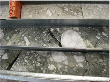
Figure 7.6. | Photo of the basal quartz pebble conglomerate of the Amagá from drill hole MJ-6 (Maria Jo) at 234 meters |
| (Source: Behre Dolbear, 2013) |
7.2.3.2 | Amagá Formation (Middle Member) |
The middle member of the Amagá Formation regionally is about 200 meters to 250 meters thick and consists of white, argillaceous, and ferruginous sandstones interbedded with an alternating series of at least 5 separate coal seams, up to 2.5 meters in thickness. The middle member is exposed east of Titiribí and north of Amagá. The middle unit has been eroded away at the Titiribí Project.
7.2.3.3 | Amagá Formation (Upper Member) |
The upper member is up to 1,000 meters thick and consists of well-cemented cream, green, and brown colored sandstones and locally thin conglomerate and coal seams.
| Project 21-036 (GoldMining Inc.) | BEHRE DOLBEAR |
Independent Technical Report on the Titiribi Project – Colombia Effective Date: 14 June 2021; Published Date: 25 August 2021 |
The Combia Formation is divided into two members. The lower member is dominantly volcanic and consists of agglomeratic breccias, basalt, and andesite dikes. The upper member is dominantly volcanoclastic consisting of poorly consolidated sand, gravel, and muds.
The Combia Formation has been considered as late Miocene to Pliocene age (20 Ma to 6 Ma) and outcrops over the entire strip of land between the Junta and Candela-Porvenir faults. The Combia Formation has been intersected in the many drill holes in the Chisperos, Cerro Vetas, and Candela areas. In the Chisperos and Cerro Vetas areas, both the volcanic and sedimentary units are present as a series of crystal tuffs, lithic tuffs, and conglomerate units consisting of quartz pebbles and re-worked Cretaceous basement rocks and Amagá Formation.
7.2.4.1 | Combia Formation (Lower Member) |
Lower member agglomerates are volcanic rocks of andesitic composition; the crystal and lithic tuffs are composed of crystalline fragments of augite, hornblende, biotite, quartz, kaolinized feldspar, and variable proportions of volcanic glass and fragments of volcanic rock. Chemically, the basalt flows are generally feldspar-rich. Flow tops are often auto-brecciated and amygdaloidal with amygdules locally filled with chalcedony.
7.2.4.2 | Combia Formation (Upper Member) |
The upper member consists of interstratified conglomerate, sedimentary breccia, fine to medium-grained sandstone, and reddish to cream colored argillite that unconformably overlie both the Combia Formation lower member and the Amagá Formation.
There are three principal intrusive rocks. From oldest to youngest, they are the pre-mineral Amagá granodiorite stock, syn-mineral Cerro Vetas diorite porphyry, and post-mineral andesite porphyry. The andesite porphyry’s extrusive equivalents are andesitic tuffs and ash.
7.3.1 | Amagá Granodiorite (Pre-Mineral) |
This unit is a medium- to coarse-grained granodiorite that intrudes the Paleozoic basement rocks, but in turn, has been cut by intrusive breccias and the younger mineralized Cerro Vetas intrusive. The granodiorite has been intersected in many drill holes and generally exhibits some effects of shearing. Compositionally, the Amagá stock is mostly granodioritic but also includes diorite to tonalite phases. Locally, large blocks of Amagá granodiorite are caught up in the mud flows of the basement lahar.
7.3.2 | Cerro Vetas Diorite Stock (Syn-Mineral) |
The gold-copper mineralized Cerro Vetas diorite porphyry stock is exposed in road cuts and has been penetrated in many drill holes at Cerro Vetas. The diorite porphyry intrudes Paleozoic basement volcanic, schistose, and lahar-style rocks; Amagá granodiorite; diatreme breccia; lower member of the Amagá Formation; and the volcanic and sedimentary units of the Combia Formation. The diorite ranges in composition from diorite to quartz diorite to monzonite and consists of biotite, hornblende, feldspar, and quartz, and is enriched in magnetite. It ranges from stock-like to plugs and wide dikes that may taper at depth. Based upon its geometry and the present level of exposure, it might be the roots of a larger intrusive. It has intruded along the northwest-southeast-trending Cauca-Romeral fault but the main dike-like intrusive bodies are aligned in an east-northeast to west-southwest direction paralleling several faults and tensional structures developed within the Cauca-Romeral fault zone.
| Project 21-036 (GoldMining Inc.) | BEHRE DOLBEAR |
Independent Technical Report on the Titiribi Project – Colombia Effective Date: 14 June 2021; Published Date: 25 August 2021 |
Mapping, drilling, and geophysical surveys suggest similar diorite intrusives at Junta, Maria Jo, Porvenir, and Candela with magnetic highs aligned along the Cauca-Romeral fault trend. Initial drilling and road cut exposures confirm the presence of mineralized diorite and/or mineralized hornfels.
7.3.3 | Dacite-Andesite Intrusives (Post-Mineral) |
These intrusives are generally dikes and mineralogically range from dacite to andesite. The dacite is light colored consisting of quartz, plagioclase, biotite, and opaque minerals. The andesite dikes are more common in the southern part of the Project, are dark grey, and consist of plagioclase, hornblende, biotite, opaque minerals, and rare quartz. Neither the dacite nor the andesite dikes are mineralized and neither hosts any hydrothermal alteration.
Pre-existing structures, particularly the Cauca-Romeral fault zone, have created zones of weakness first occupied by diatreme breccias and later by the mineralized Cerro Vetas stock, plugs, and dikes. It is also likely that faulting along bedding planes played a crucial part in ground preparation for the high-grade base and precious metal veins and replacement deposits that were historically mined in the Titiribí District. The authors opine that the structural diagram, shown in Figure 7.7, originally proposed by the Sunward geologic staff, is a reasonable representation of the pre-curser structural preparation model for the Cerro Vetas stock, plugs, and dikes. The major northwest-southeast trend is the deep-seated Cauca-Romeral fault zone and the tensional openings in the northeast-southwest direction were the tensional zones of weakness followed by diatreme breccias and the Cerro Vetas intrusive bodies. The regional north and northeast-trending structural blocks also are sub-parallel to the tension faults.
| Project 21-036 (GoldMining Inc.) | BEHRE DOLBEAR |
Independent Technical Report on the Titiribi Project – Colombia Effective Date: 14 June 2021; Published Date: 25 August 2021 |
Figure 7.7. | Structural interpretation for the emplacement of the Cerro Vetas stock, dikes, and other intrusive bodies in the district |
| (Source: Andrew, Sunward Internal Report, 2011) |
7.5 | REGIONAL MINERALIZATION TRENDS |
The Cerro Vetas porphyry gold-copper system and its nearby genetically related deposits and prospects are part of a regionally significant mineralized belt. Gold mineralization is related to a series of magmatic intrusive systems ranging in age from Jurassic, Cretaceous, Paleocene (Paleocene, Eocene, and Oligocene) to Neogene (Miocene and Pliocene). Figure 7.8 shows the relationship between intrusive or the “magmatic period” to the distribution of gold deposits in Colombia. The distance between Sta. Marta on the north to the El Oro District on the south is approximately 1,200 km. The Project is in the Middle Cauca region and may ultimately be related to the Antioquia Batholith. Figure 7.9 shows the Miocene and Pliocene-age gold deposits and their spatial relationship to Neogene plutons. Titiribí is near the northern end of the Neogene-aged deposits. The distance between the Buritica deposit on the north and La Concepcion deposit on the south is approximately 600 km.
| Project 21-036 (GoldMining Inc.) | BEHRE DOLBEAR |
Independent Technical Report on the Titiribi Project – Colombia Effective Date: 14 June 2021; Published Date: 25 August 2021 |
Figure 7.8. | Gold deposit distribution versus “Magmatic Period” |
Figure 7.9. | Major gold occurrences in the Neogene and their relationship to Neogene plutons |
| Project 21-036 (GoldMining Inc.) | BEHRE DOLBEAR |
Independent Technical Report on the Titiribi Project – Colombia Effective Date: 14 June 2021; Published Date: 25 August 2021 |
7.6 | PROJECT MINERALIZATION – GENERAL |
The Project contains several separate mineralized areas, and although all appear related to a large Miocene gold-copper porphyry system, each is spatially related to a separate intrusive center. The Project contains one bulk tonnage gold-copper porphyry system consisting of the Cerro Vetas, NW Breccia, and Chisperos zones and several separate porphyry-style occurrences. The Cerro Vetas, NW Breccia, and Chisperos complex includes multiple gold-copper-bearing intrusive centers surrounded by contact aureoles hosting gold-dominant mineralization. Cerro Vetas is a bulk-tonnage gold and copper deposit with most mineralization directly related to the Cerro Vetas diorite porphyry, related breccias, and its immediate contact aureole. Gold-dominant mineralization occurs in the NW Breccia, northwest of the main Cerro Vetas porphyry. At Chisperos, higher-temperature gold-copper mineralization is hosted in and adjacent to diorite dikes and as structurally and stratigraphically controlled, gold-dominant low-temperature epithermal vein mineralization, surrounded by thick intervals of lower-grade sediment-volcanic, hosted mineralization.
The Cerro Vetas-NW Breccia-Chisperos system hosts NI 43-101 guideline-compliant resources. Most of the nearby exploration prospects have intersected copper and gold mineralization but the data is currently insufficient to estimate resources. The Maria Jo occurrence is adjacent to the Cerro Vetas and Chisperos zones and hosts zones of copper-dominant and gold-copper mineralization. Junta hosts near-surface supergene enriched mineralization in a stock-like porphyry intrusive and in structurally controlled breccia. Candela hosts thick zones of promising mineralized hornfels and diorite porphyry and Porvenir has encountered encouraging mineralization. Margarita and Rosa are still in early stages of exploration and the very limited drilling campaign has failed to encounter any significant mineralization.
7.7 | CERRO VETAS-NW BRECCIA-CHISPEROS GOLD-COPPER PORPHYRY DEPOSIT |
The Cerro Vetas-NW Breccia-Chisperos gold-copper porphyry deposit consists of three adjacent zones of mineralization that are geologically related, but host three different styles of mineralization based upon the presence of diorite, diatreme breccia, favorable host stratigraphy, and a contact aureole.
The Cerro Vetas diorite porphyry cores the Cerro Vetas gold-copper porphyry deposit. The centrally located diorite porphyry stock intruded along the northwest-southeast-trending Cauca-Romeral fault zone but dikes emanating from the stock are controlled by a series of tensional east northeast-west southwest-striking faults. Diatreme breccia and the younger diorite intruded along these older zones of weakness. The intrusive bodies that domed pre-existing shallow dipping structures are vertical to steeply eastward dipping at 70° to 80°. The Cerro Vetas diorite porphyry intrudes the basement Paleozoic rocks, the older Amagá granodiorite stock, the Amagá-Combia volcano-sedimentary sequence, and the diatreme breccia units. The Cerro Vetas diorite porphyry is fine to medium grained and locally exhibits typical porphyry copper alteration. The intrusive is multiple-phase with different grain sizes, slightly different mineralogy, and various intrusive breccias. The bulk of the central stock-like diorite intrusive is about 550 meters to 600 meters wide. Figure 7.10 shows the generalized surface geology and drill hole map for the Cerro Vetas-NW Breccia-Chisperos system. The Cerro Vetas diorite porphyry and related dikes are colored orange. The pinkish red-hachured unit is diatreme breccia. All the Amagá and Combia units are combined and shown in green. Basement rock, as a small exposure in a drainage, is shown in dark red. The NW Breccia zone is to the north and northwest and the Chisperos zone is immediately to the east of the main Cerro Vetas stock. Drill hole traces are also shown. Bedrock is exposed in only about 5% of the area as rock outcrops are generally confined to drainages, ridge tops, or new man-made road cuts. Thus, much of the geologic map is interpreted by drill hole data and it changes as new drill data is acquired.
| Project 21-036 (GoldMining Inc.) | BEHRE DOLBEAR |
Independent Technical Report on the Titiribi Project – Colombia Effective Date: 14 June 2021; Published Date: 25 August 2021 |
Figure 7.10. | Cerro Vetas, NW Breccia and Chisperos geology-drill hole location map; Cerro Vetas is on the southwest side of the figure; NW Breccia on the north and northwest; Chisperos to the northeast |
| Project 21-036 (GoldMining Inc.) | BEHRE DOLBEAR |
Independent Technical Report on the Titiribi Project – Colombia Effective Date: 14 June 2021; Published Date: 25 August 2021 |
The Cerro Vetas diorite is marked as a magnetic high on the magnetic and magneto-telluric surveys. It is one of several distinct magnetic highs. Figure 7.11 clearly shows the alignment of magnetic highs that parallel the Cauca-Romeral fault zone and their spatial relationship to known mineralization and exploration targets.
Figure 7.11. | Airborne magnetic map outlining magnetic highs, geochemical anomalies and the Project targets |
| (Source: Sunward Internal Report, 2011) |
This zone is dominated by diatreme breccia that is intruded on the south by the main Cerro Vetas diorite. A small diorite plug-like body intrudes the diatreme breccia on the north. Diatreme breccia in this area is unusual; based upon multi-element scans, it is relatively high in nickel and chrome. The high background value of nickel and chrome is due to the presence of ultramafic fragments. Gold values have a very positive correlation with nickel and chrome values, suggesting that ultramafic fragments are very favorable host rocks. The fragments are quartz-rich and mafic or ultramafic. The authors opine that these hornblende-rich mafic rocks may be derived from the basement Quebradagrande Formation. Where the diatreme breccia is in close proximity to diorite, it hosts gold and copper mineralization. However, much of the diatreme breccia hosts gold mineralization but virtually no copper.
| Project 21-036 (GoldMining Inc.) | BEHRE DOLBEAR |
Independent Technical Report on the Titiribi Project – Colombia Effective Date: 14 June 2021; Published Date: 25 August 2021 |
At Chisperos, diorite dikes intrude diatreme breccia and both follow pre-existing east northeast-west southwest tensional zones of weakness. The near vertical diorite plugs and dikes consistently strike east northeast-west southwest and appear to emanate from the principal stock at the Cerro Vetas zone. Locally at depth, the uppermost portion of some diorite dikes intrude into the diatreme breccia and in other locations, the diorite intrudes to the present level of erosion. Both intrude basement rocks and the overlying Amagá-Combia sedimentary-volcanic units. The diatreme breccia hosts mafic fragments including very coarse-grained hornblende- and biotite-rich mafic porphyry, but generally contains few ultramafic fragments compared to the diatreme breccias in the NW Breccia zone. Both gold-dominant and gold-copper mineralized zones are present. Generally, gold-copper zones relate to the presence of diorite dikes and their immediate contact area. Gold-dominant zones are hosted in diatreme breccia and in the sedimentary-volcanic sequence where it is low-temperature and higher-grade zones often contain free gold. Much mineralization at Chisperos is structurally and stratigraphically controlled. Based upon studies of obvious vein mineralization in oriented core, the predominant controls of vein mineralization are in a northwest-southeast direction. Other zones of mineralization are concordant to bedding and have a northwest strike and dips 40° to 50° northeast. It is theorized, based upon oriented core studies, that several parallel to sub-parallel steeply dipping faults that extend from the basement meta-basalt have acted as feeders focusing the hydrothermal alteration and depositing sulfide and gold mineralization in (a) parallel zones in the crystalline and lithic tuffs of the Combia Formation; (b) at the contact between Amagá conglomerate and basement rocks; (c) in basement schistose rocks; and (d) in diatreme breccia. It is believed that there are two sets; both being sub-vertical with one striking northwest-southeast and the other east northeast-west southwest. The northwest-southeast direction is dominant and is sub-parallel to the Cauca-Romeral fault zone direction. The authors suggest that in the stratigraphically controlled mineralization, bedding plane faults or shallow angle shearing may be an important structural control. Furthermore, the contact between Amagá conglomerate and basement rocks may be a low-angle thrust fault that is part of the set of low-angle faults.
Zones of bedding-controlled mineralization in volcanoclastic sediments pass apparently uninterrupted through diatreme breccia that cuts through the sediments. Mineralized diorite dikes cut through diatreme breccia. Thus, an important age relationship can be established. Early diatreme breccia is pre-low-angle thrust and pre-northwest-striking hydrothermal feeder faults, as mineralization related to those faults also mineralizes the breccia and mineralization along the low-angle faults passes uninterrupted through the diatreme breccia.
A reasonably well-defined alteration zoning pattern at the Cerro Vetas-NW Breccia-Chisperos deposit was recognized by the Sunward geologists. The core of the Cerro Vetas diorite intrusive exhibits potassic alteration and is roughly circular to slightly elongated in a northeast-southwest direction and apparently tops out at an elevation of about 1,950 meters above sea level. The potassic alteration consists of secondary biotite, K-spar, quartz, magnetite, and pyrite as disseminations, veins, and fracture fillings. The potassic core is at best very weakly mineralized. The potassic core of the intrusive is fine-grained but grain-size increases outward. A second but much less defined potassic core is present in a plug-like diorite in the NW Breccia. At Cerro Vetas, a well-developed phyllic zone of minor quartz-sericite-pyrite veinlets and sericite selvages on feldspars with disseminated, stockwork, and veinlet chalcopyrite, and veinlet magnetite hosts much of the potentially economic gold-copper mineralization. Pyrite content in the diorite porphyry is low. The phyllic zone is developed above and surrounding the potassic core. However, on the southwest side of the Cerro Vetas intrusive, the phyllic zone is very thin. The phyllic zone appears to be widest above the core zone and tapers on all sides at depth. Erosion has removed a portion of the uppermost phyllic zone. The phyllic alteration zone is superimposed over the outer margin of the diorite and a contact breccia that consists of intrusive and intruded rocks. A well-developed but narrow argillic zone with similar mineralization to the phyllic zone borders the phyllic zone. Surrounding the argillic zone is a halo of a propylitic alteration zone with intense silica-flooded hornfels nearest the intrusive passing outward into widespread areas of green chloritic rocks. Strong to weak silicification accompanies much of porphyry style alteration, particularly in the potassic zone. At Chisperos, near the surface, propylitic (chlorite-dominant) alteration in the diatreme breccia predominates. However, at deeper levels, potassic alteration in diorite intrusives is very evident.
| Project 21-036 (GoldMining Inc.) | BEHRE DOLBEAR |
Independent Technical Report on the Titiribi Project – Colombia Effective Date: 14 June 2021; Published Date: 25 August 2021 |
Mineralization hosted in the Cerro Vetas diorite porphyry is disseminated and fracture controlled. The principal metallic minerals are native gold, chalcopyrite, pyrite, and magnetite. Gold values within the Cerro Vetas diorite normally correlate well with copper content and magnetite. The largest diorite intrusive occurs within the Cerro Vetas zone with smaller plugs and dikes found within the NW Breccia and Chisperos zones. At Cerro Vetas, interpretation of geophysical and drill hole data suggests that higher-grade gold-copper zones exist as a domed saucer-shaped contact breccia-related shell in the intrusive where brecciated diorite with xenolithic fragments of sedimentary rocks were intercepted in drilling. This higher-grade domed shell is, at least in part, coincident with the phyllically altered intrusive-sedimentary contact breccia. The contact breccia can be sub-divided into three lithologic types but the boundaries are not distinctive. The first is true contact breccia consisting mostly of brecciated, altered, and mineralized wall rock, while the second type is mineralized intrusive breccia consisting mostly of diorite fragments. A third breccia style demonstrates multiple phases of mineralization and includes fragments of diorite and wall rock. Fluidized features associated with rounded fragments, often with higher-grade mineralization, are likely near-vertical hydrothermal fluidized pebble dikes.
Within the Cerro Vetas diorite, there are many examples of multiple phases of mineralization as veins of quartz-magnetite-chalcopyrite are cut by younger grey quartz (possibly with extremely fine-grained pyrite)-magnetite, which in turn are cut by quartz-sericite-magnetite veins. In general, there is a strong positive correlation between gold and copper values and little correlation between gold and pyrite. High metal values are often accompanied by large amounts of magnetite; however, the reverse is also true in the magnetite-rich but gold-copper poor potassic zone.
Figure 7.12 shows multiple-stages of cross-cutting quartz-magnetite vein mineralization from drill hole CV018 at 393 meters (assay interval contains 0.5 grams of gold per tonne and 0.25% copper). Figure 7.13 is intrusive breccia with (a) fragment hosting margins rich in magnetite (by magnet); (b) a fragment with quartz-magnetite veins cutting diorite; (c) a diorite fragment with potassic altered core with typical K-spar and small clots of magnetite; and (d) a breccia with matrix rich in magnetite from drill hole CV038 at 208 meters (assay interval contains 0.3 grams of gold per tonne and 0.23% copper). Figure 7.14 is a diorite breccia with matrix heavy with magnetite from drill hole CV028 at 45 meters (assay interval contains 1.9 grams of gold per tonne and 0.24% copper). Figure 7.15 is diorite from the contact breccia zone from CV053 from 98 meters (assay interval contains 1.5 grams of gold per tonne and 0.06% copper). Figure 7.16 is a possible fluidized pebble dike from hole CV099 at 208.5 meters (assay interval contains 1.08 grams gold per tonne and 0.56% copper). Figure 7.17 is diorite breccia with alteration halos on fragments from hole CV98 at 292 meters (assay interval contains 0.268 grams gold per tonne and 0.120% copper).
| Project 21-036 (GoldMining Inc.) | BEHRE DOLBEAR |
Independent Technical Report on the Titiribi Project – Colombia Effective Date: 14 June 2021; Published Date: 25 August 2021 |
Figure 7.12. | Multiple-stage mineralization from drill hole CV018 at 393 meters (assay interval contains 0.5 grams of gold per tonne and 0.25% copper) |
| (Source: Behre Dolbear, 2011) |
Figure 7.13. | Intrusive breccia with magnetite-rich fragments, magnetite-rich matrix from drill hole CV038 at 208 meters (assay interval contains 0.3 grams of gold per tonne and 0.23% copper) |
| (Source: Behre Dolbear, 2011) |
Figure 7.14. | Diorite breccia with magnetite matrix from drill hole CV028 at 45 meters (assay interval contains 1.9 grams of gold per tonne and 0.24% copper) |
| (Source: Behre Dolbear, 2011) |
| Project 21-036 (GoldMining Inc.) | BEHRE DOLBEAR |
Independent Technical Report on the Titiribi Project – Colombia Effective Date: 14 June 2021; Published Date: 25 August 2021 |
Figure 7.15. | Stockwork contact breccia from CV053 at 98 meters (assay interval contains 1.5 grams of gold per tonne and 0.06% copper) |
| (Source: Behre Dolbear, 2012) |
Figure 7.16. | Possible fluidized pebble dike from hole CV099 at 208.5 meters (assay interval contains 1.08 grams gold per tonne and 0.56% copper) |
| (Source: Behre Dolbear, 2013) |
Figure 7.17. | Diorite breccia with alteration halos on fragments from hole CV98 at 292 meters (assay interval contains 0.268 grams gold per tonne and 0.120% copper) |
| (Source: Behre Dolbear, 2013) |
| Project 21-036 (GoldMining Inc.) | BEHRE DOLBEAR |
Independent Technical Report on the Titiribi Project – Colombia Effective Date: 14 June 2021; Published Date: 25 August 2021 |
A second style of mineralization is gold-only mineralization developed in diatreme breccias in the NW Breccia and at Chisperos. At NW Breccia, a separate diorite plug hosts gold and copper mineralization while the diatreme breccia hosts both gold-only and gold-copper mineralization. The reason for separate gold-only and gold-copper zones in the diatreme breccia is unknown but may be related to proximity to diorite dikes.
Chisperos hosts gold-copper mineralization in diorite plugs and dikes, gold-only mineralization in diatreme breccia, and also hosts substantial epithermal, lower-temperature generally gold-only mineralization within parallel to sub-parallel mineralized zones that are both stratigraphically and structurally controlled and hosted in a sedimentary-volcanic sequence. Northwest-striking, steeply dipping faults are theorized to be the channel ways for auriferous hydrothermal fluids that mineralized shallow dipping, favorable stratigraphic hosts: the Amagá Formation/basement contact; diatreme breccia; and possibly shallow-dipping bedding-plane fault zones.
At Chisperos, although there is some disseminated and stockwork mineralization in wide mineralized zones, most of the higher-grade mineralization is in narrow, sulphide-rich veins consisting mostly of pyrite and occasionally sphalerite. Pyrite occurs in at least three paragenetic settings, including as very fine-grained auriferous and argentiferous grains, laminations along bedding, and as coarser-grained veins. Sphalerite is the second-most common sulphide and occurs as massive crystalline aggregates and isolated grains mostly in veins and veinlets. Sphalerite is generally associated with higher grades of gold-silver mineralization. Arsenopyrite is present but only locally common. Metallurgical studies show that pyrrhotite is present and although magnetite and magnetite-ilmenite are present, they may be less prevalent than at Cerro Vetas. Gangue minerals in the mineralized veins include calcite, quartz with restricted occurrences of dolomite, sericite, adularia, and possibly barite. The vein textures are clearly low-temperature epithermal, with fine drusy crystals, cockscomb structures, open-space filling, and crustiform banding. Other evidence of the low-temperature origin is the presence of stibnite, laumontite, and chalcedony. Surrounding these narrow higher-grade, sulphide-rich zones is much lower grade rock; and thus, the thin high-grade veins carry the entire zone. The Chisperos lower-temperature epithermal style of mineralization is common in the historic mines, such as in the “Mina El Cateador” gallery, the old Zancudo Mine and the Otra Mina.
Figure 7.18 is diatreme breccia from Chisperos hole CP014 at 29.5 meters (assay interval contains 0.7 grams of gold per tonne). Figure 7.19 shows bleached diatreme breccia from CP014 at 32 meters (assay interval contains 1.2 grams of gold per tonne). Note that in both samples, the fragments are mostly acidic intrusive or sub-volcanic and sulphides occur in matrix and in fragments. These samples may be intrusive or breccia pipe rather than diatreme breccia.
Figure 7.18. | Diatreme breccia from CP014 at 29.5 meters (assay interval contains 0.7 grams of gold per tonne) |
| (Source: Behre Dolbear, 2012) |
| Project 21-036 (GoldMining Inc.) | BEHRE DOLBEAR |
Independent Technical Report on the Titiribi Project – Colombia Effective Date: 14 June 2021; Published Date: 25 August 2021 |
Figure 7.19. | Bleached, iron stained diatreme breccia from CP014 at 32 meters (assay interval contains 1.2 grams of gold per tonne) |
| (Source: Behre Dolbear, 2012) |
Exploration during 2013 discovered thick zones of copper-dominant and gold-copper mineralization at the Maria Jo prospect that may be an extension of the Cerro Vetas and Chisperos zones. Similarly, the Maria Jo mineralization may be related to an intrusive outlined by as a yet un-drilled magnetic high. Figure 7.20 shows clots of coarse-grained chalcopyrite in basement metamorphic rocks from the newly discovered Maria Jo zone from hole MJ003 at 335 meters and contains 0.422 grams of gold/tonne and 0.516% copper.
Figure 7.20. | Clots and fracture filling chalcopyrite in basement metamorphic complex from hole MJ003 at 335 meters (assay interval contains 0.422 grams of gold/tonne and 0.516% copper) |
| (Source: Behre Dolbear, 2013) |
Base and precious metal mineralogy is simple. Gold occurs as fine- to coarse-grained native metal, associated with chalcopyrite and less so with pyrite. Figure 7.21 is a polished thin section of a sample that is a chalcopyrite-rich, biotite-altered breccia with a 130-micron grain of gold intimately associated with chalcopyrite (Geosure, 2010). Disseminated chalcopyrite is typically very fine-grained but when in fractures and veinlets, chalcopyrite is coarser grained, as seen in Figure 7.20. Within the Cerro Vetas diorite porphyry, typically gold grades track copper grades. Sphalerite is coarse-grained compared to chalcopyrite and pyrite, and often occurs in thin, multi-directional veins with pyrite. Sphalerite is more common in the lower-temperature epithermal veins in Chisperos than in the Cerro Vetas reflecting metal zoning in the contact aureole. All other sulphide minerals, such as bornite, pyrrhotite, and arsenopyrite, are uncommon to rare. Mineralogic studies on bulk metallurgical samples have identified magnetite/ilmenite, chalcocite, and galena as other metallic minerals present at Cerro Vetas.
| Project 21-036 (GoldMining Inc.) | BEHRE DOLBEAR |
Independent Technical Report on the Titiribi Project – Colombia Effective Date: 14 June 2021; Published Date: 25 August 2021 |
Figure 7.21. | Polished thin section showing 130-micron gold grain with chalcopyrite |
7.10 | GEOLOGIC SECTIONS, PLANS, SECTION GRADE, AND PLAN GRADE MAPS |
Saprolitic soils mask most areas where the intrusive and the volcano-sedimentary section outcrop. Outcrop is generally confined to drainages and ridge tops. Occasionally, man-made road cuts expose relatively un-weathered bedrock. Along some 4-wheel drive and pack trails, rains have concentrated magnetite where the bedrock is nearly totally saprolitic, suggesting the presence of diorite bedrock. With the general lack of bedrock exposures, geologic interpretations are based almost entirely on drilling. Note that all core drilling is oriented. Downhole photography is routinely utilized aiding in the three-dimensional understanding of structures. Figure 7.22 is a generalized surface geologic map of the Cerro Vetas-NW Breccia-Chisperos porphyry system, including the base geologic section lines. Cerro Vetas is the left side of the figure, NW Breccia is to the north, and Chisperos is to the east.
| Project 21-036 (GoldMining Inc.) | BEHRE DOLBEAR |
Independent Technical Report on the Titiribi Project – Colombia Effective Date: 14 June 2021; Published Date: 25 August 2021 |
Figure 7.22. | Surface geology map of the Cerro Vetas-NW Breccia-Chisperos porphyry system with the section line grid |
| Project 21-036 (GoldMining Inc.) | BEHRE DOLBEAR |
Independent Technical Report on the Titiribi Project – Colombia Effective Date: 14 June 2021; Published Date: 25 August 2021 |
Figure 7.23 is cross section 300 east, looking northeast through the Cerro Vetas and NW Breccia zones. The lower plate basement rock includes basalt, graphitic schist, and mylonite breccia that the authors interpret as a lahar unit. Upper plate undifferentiated Amagá and Cambia Formations are shown in green and yellow. The Cerro Vetas stock-like body in the center of the section and diatreme breccia to the northwest (part of the NW Breccia zone) intrude upper and lower plate rocks. The Cerro Vetas potassic core is shown in orange cross-hatching. A narrow Cerro Vetas type dike intrudes the diatreme breccia.
Figure 7.23. | Cross section 300 east, looking northeast through Cerro Vetas and NW Breccia |
| Project 21-036 (GoldMining Inc.) | BEHRE DOLBEAR |
Figure 7.24 is cross section 400 east, looking northeast through the Cerro Vetas and NW Breccia zones. The geology is very similar to section 300 east, but in the NW breccia zone, the Cerro Vetas type intrusive into diatreme breccia is now a plug or narrow stock-like body.
Figure 7.24. | Cross section 400 east, looking northeast through the Cerro Vetas and NW Breccia zones |
| Project 21-036 (GoldMining Inc.) | BEHRE DOLBEAR |
Independent Technical Report on the Titiribi Project – Colombia Effective Date: 14 June 2021; Published Date: 25 August 2021 |
Figure 7.25 is cross section 1050 east, looking northeast through the Chisperos zone. A Cerro Vetas type plug or narrow stock-like body intrudes into a diatreme breccia and both intrude upper and lower plate rocks.
Figure 7.25. | Cross section 1050 east, looking northeast through the Chisperos zone |
| Project 21-036 (GoldMining Inc.) | BEHRE DOLBEAR |
Independent Technical Report on the Titiribi Project – Colombia Effective Date: 14 June 2021; Published Date: 25 August 2021 |
Figure 7.26, Figure 7.27, and Figure 7.28 are plan geologic maps at elevations of 1,950 meters above sea level, 1,650 meters above sea level, and 1,350 meters above sea level, respectively. Figure 7.26 shows Cerro Vetas diorite (DIO and DIOF) intruding upper plate rocks and diatreme breccia (DXB). In the core of the Cerro Vetas stock is the top of the potassic alteration zone. Figure 7.27 shows the Cerro Vetas stock with a central core of potassically-altered diorite; and Cerro Vetas diorite dikes and plugs intruding diatreme breccia. Basement units include the lahar, basalt, and graphitic schist while the upper plate is undifferentiated sedimentary and volcanic rocks. Note the narrow zones of hydrothermal and intrusive breccia (DBX) that locally surround the Cerro Vetas stock. Also, note the large blocks of pre-mineral Amagá granodiorite (IGD) within the lahar. The age relationship between the lahar and basement basalt is uncertain as large blocks of each float within the other. Figure 7.28 also demonstrates the relationship between the Cerro Vetas stock, plugs, and dikes, diatreme breccia, and the basement rocks. Note that on the northeast side, the northwest orientation of schist and graphitic schist (SCH) may be reflective of northwest-striking structures that appear to control mineralization in the upper and lower plate rocks.
Figure 7.26. | Plan geology map of the 1,950 meters above sea level elevation |
| Project 21-036 (GoldMining Inc.) | BEHRE DOLBEAR |
Independent Technical Report on the Titiribi Project – Colombia Effective Date: 14 June 2021; Published Date: 25 August 2021 |
Figure 7.27. | Plan geology map of the 1,650 meters above sea level elevation |
| Project 21-036 (GoldMining Inc.) | BEHRE DOLBEAR |
Independent Technical Report on the Titiribi Project – Colombia Effective Date: 14 June 2021; Published Date: 25 August 2021 |
Figure 7.28. | Plan geology map of the 1,350 meters above sea level elevation |
Figure 7.29, Figure 7.30, and Figure 7.31 are gold grade block models plan maps for elevations of 1,950 meters above sea level, 1,650 meters above sea level, and 1,350 meters above sea level, respectively. Figure 7.32 is the copper grade block model for the elevation of 1,650 meters above sea level. All gold blocks are for grades ≥ 0.30 grams of gold per tonne classified as Measured and Indicated Resources. All copper blocks are for grades ≥ 0.1% copper. Blocks of Inferred Resources are not depicted. Figure 7.29 shows the top of the barren potassic core centrally located within the mineralized zone hosted in Cerro Vetas diorite. Figure 7.30 shows the increased size of the barren potassic core at depth at Cerro Vetas and the northwest striking structural and stratigraphic controls of mineralization at Chisperos. Figure 7.31 depicts the shift of mineralization into the NW Breccia at depth and shows the continued control by small structures and stratigraphy on mineralization at Chisperos. Figure 7.32 clearly shows copper mineralization hosted in the Cerro Vetas diorite and in the peripheral contact zone and defines the barren potassic core of the intrusive.
| Project 21-036 (GoldMining Inc.) | BEHRE DOLBEAR |
Independent Technical Report on the Titiribi Project – Colombia Effective Date: 14 June 2021; Published Date: 25 August 2021 |
Figure 7.29. | Gold grade blocks for elevation 1,950 meters above sea level |
| (Source: Behre Dolbear, 2013) |
| Project 21-036 (GoldMining Inc.) | BEHRE DOLBEAR |
Independent Technical Report on the Titiribi Project – Colombia Effective Date: 14 June 2021; Published Date: 25 August 2021 |
Figure 7.30. | Gold grade blocks for elevation 1,650 meters above sea level |
| (Source: Behre Dolbear, 2013) |
| Project 21-036 (GoldMining Inc.) | BEHRE DOLBEAR |
Independent Technical Report on the Titiribi Project – Colombia Effective Date: 14 June 2021; Published Date: 25 August 2021 |
Figure 7.31. | Gold grade blocks for elevation 1,350 meters above sea level |
| (Source: Behre Dolbear, 2013) |
| Project 21-036 (GoldMining Inc.) | BEHRE DOLBEAR |
Independent Technical Report on the Titiribi Project – Colombia Effective Date: 14 June 2021; Published Date: 25 August 2021 |
Figure 7.32. | Copper grade blocks for elevation 1,650 meters above sea level |
| (Source: Behre Dolbear, 2013) |
Figure 7.33 to Figure 7.35 are gold grade block models for sections 300 East, 400 East, and 1050 East, respectively. All blocks are for grades ≥ 0.30 grams of gold per tonne classified as Measured and Indicated Resources. Blocks of Inferred Resources are not depicted. Note in Figure 7.33 and Figure 7.34, the distribution of gold blocks forms a shell partially surrounding the barren core of the Cerro Vetas diorite intrusive. In Figure 7.34, note the general overall boundary of mineralized blocks is tabular dipping westward. This mineralization is controlled by small displacement structures that are not shown. In Figure 7.35, gold mineralization at Chisperos is hosted mostly in diorite breccia and the basement complex and commonly is controlled by host rock and/or small structures.
| Project 21-036 (GoldMining Inc.) | BEHRE DOLBEAR |
Independent Technical Report on the Titiribi Project – Colombia Effective Date: 14 June 2021; Published Date: 25 August 2021 |
Figure 7.33. | Gold block model for section 300E across Cerro Vetas and NW Breccia |
| (Source: Behre Dolbear, 2013) |
Figure 7.34. | Gold block model for section 400E across Cerro Vetas and NW Breccia |
| (Source: Behre Dolbear, 2013) |
| Project 21-036 (GoldMining Inc.) | BEHRE DOLBEAR |
Independent Technical Report on the Titiribi Project – Colombia Effective Date: 14 June 2021; Published Date: 25 August 2021 |
Figure 7.35. | Gold block model for section 1050E across Chisperos |
| (Source: Behre Dolbear, 2013) |
| Project 21-036 (GoldMining Inc.) | BEHRE DOLBEAR |
Independent Technical Report on the Titiribi Project – Colombia Effective Date: 14 June 2021; Published Date: 25 August 2021 |
All the deposits and prime exploration targets are related to a cluster of gold-copper-bearing Miocene-age porphyry intrusives. The intrusive bodies have been emplaced along pre-existing zones of weakness related to the intersection of the northwest-southeast-trending Cauca-Romeral fault zone, tension faults related to the same, and regional northerly striking fault zones. These zones of weakness were first intruded by diatreme breccia, which in turn, were intruded by the Cerro Vetas stock, plugs, and dikes. The largest porphyry gold-copper deposit is the Cerro Vetas-NW Breccia-Chisperos complex, where the principal diorite stock is centrally located at Cerro Vetas. Dike swarms at Chisperos emanate from the Cerro Vetas stock and another smaller diorite plug occurs at NW Breccia. Copper-gold mineralization occurs in and immediately adjacent to intrusive dioritic stocks, plugs, and dikes. Gold-dominant mineralization occurs in diatreme breccia, sediments, and volcanic rocks that are within the contact aureole of the diorite. Another postulated intrusive center with significant copper-dominant and gold-copper mineralization in the contact aureole was discovered during the 2012-2013 drilling campaign at Maria Jo. The Junta prospect, to the southeast of Maria Jo, and along the same structural feature as Cerro Vetas and Maria Jo, hosts disseminated and fracture-controlled gold-copper mineralization in a stock-like intrusive body while Porvenir and Candela hosts mineralization in the intrusive and its contact aureole.
Mineralization is either gold-copper, gold dominant, or copper-dominant. The most significant gold-copper deposit is the bulk-tonnage porphyry gold and copper mineralization typified by the Cerro Vetas intrusive. Gold and copper mineralization within the porphyry system is disseminated, fracture filling, and stockwork. Similar mineralization occurs in various breccia types as mineralized fragments and/or mineralized matrix, and in the contact zone hosted by the volcano-sedimentary section. The system has a high chalcopyrite to pyrite ratio. Gold mineralization is relatively coarse and intimately related to chalcopyrite. The Cerro Vetas intrusive exhibits typical but restricted porphyry copper-style alteration. A relatively barren prograde potassic core is superimposed by a well-developed retrograde mineralized phyllic zone that in turn is surrounded by a thin retrograde mineralized argillic zone and then a widespread propylitic alteration zone. On all sides of intrusive-wall rock contact, a contact breccia has developed. The phyllic zone overlaps the intrusive and the contact breccia. The saucer-shaped phyllic zone is widest above and on the sides of the Cerro Vetas intrusive and thins at depth. Most of the significant gold-copper mineralization is associated with the phyllic alteration-contact breccia zone. Both the potassic core and phyllic zone host a high content of magnetite.
Other intrusive bodies, as small plugs and dikes, occur near the Cerro Vetas stock at NW Breccia and Chisperos. At NW Breccia, a sub-group of gold-only mineralization occurs in a diatreme breccia. There is an unusual association in the diatreme breccia with anomalous nickel and chrome. This association is undoubtedly due to high background values of nickel and chrome in mafic and/or ultramafic basement rocks brought up from depth. It is likely that particular mafic rocks are also favorable reactive host rocks susceptible to contact related mineralization. Gold-dominant diatreme breccia dikes also occur in Chisperos where they are mineralized when near plugs and dikes of diorite.
The second style of gold-dominant mineralization is low-temperature epithermal veins and disseminations that are peripheral to and in the contact aureole of the principal Cerro Vetas intrusive center and other smaller plugs and dikes. Some deposits, such as the Chisperos, host predominantly vein and fracture filling and some disseminated gold with minor copper mineralization. Hydrothermal fluids follow high-angle faults depositing gold mineralization in the high-angle faults and spread out along the Amagá conglomerate-basement contact and in receptive volcano-sedimentary and diatreme breccia hosts, or in a series of parallel to sub-parallel zones of weakness, possibly formed by bedding-plane or relatively low-angle thrust faults.
Central to the Chisperos zone is a series of possibly interconnected diatreme breccias that are very similar to the diatreme breccia in the NW Breccia zone. High-level diorite dikes, perhaps above more stock-like intrusives, have intruded into the throats of the diatreme breccias.
| Project 21-036 (GoldMining Inc.) | BEHRE DOLBEAR |
Independent Technical Report on the Titiribi Project – Colombia Effective Date: 14 June 2021; Published Date: 25 August 2021 |
At Cerro Vetas and other deposits, there is a clear relationship between magnetic highs, gold-copper-molybdenum geochemical anomalies and underlying mineralized dioritic intrusives. At Maria Jo, a large magnetic high caused by a suspected buried diorite body, with zones of copper-dominant and gold-copper mineralization in its contact aureole, is surficially covered by post-mineral gravel. Maria Jo is the only deposit or occurrence without a surface geochemical signature.
Since only about 5% of the area outcrops, mostly in drainages, ridge tops, and man-made road cuts, the best pre-drilling exploration tools are geochemical sampling and geophysics, particularly since trenching is not allowed as an exploration tool. Figure 8.1 depicts the generalized gold-copper porphyry model used at Titiribí.
Figure 8.1. | Generalized porphyry model |
| (Source: Andrew, Sunward Internal Report, 2011) |
| Project 21-036 (GoldMining Inc.) | BEHRE DOLBEAR |
Independent Technical Report on the Titiribi Project – Colombia Effective Date: 14 June 2021; Published Date: 25 August 2021 |
Aside from geologic mapping, there has been extensive multi-element geochemistry in soil sampling grids and rock chips, as well as multiple campaigns of geophysical surveying. Over the past several years, diamond drilling has been the principal exploration tool.
The following geophysical surveys were completed.
| | ● | 1997-1998: Zonge Engineering performed a survey covering Cerro Vetas and Chisperos. This survey included ground magnetics, IP, resistivity, and controlled source audio frequency magneto-telluric (CSAMT). The survey was done over eight lines in a north-northwest and south-southeast direction (3 over Chisperos and 5 over Cerro Vetas) with each about 2 km in length; and 7 cross lines in north-northeast and south-southwest direction only over Cerro Vetas with each line about 600 meters in length. The line spacing for the long north-northwest and south-southeast lines in Chisperos was 200 meters and in Cerro Vetas it was 400 meters and the line spacing for the cross lines in Cerro Vetas was 200 meters. The station interval for all surveys was 2 meters. |
| | ● | 2008: AngloGold completed an airborne geophysical survey over the entire license area under a services contract with WKR and GPR. This survey included magnetic, multi-spectral radiometric (U, Th, K) and a LASER altimeter survey corrected with DGPS. The survey was done with 64 lines in a north-south direction and 10 tie lines in an east-west direction. The lines were 100 meters apart with an average terrain clearance of 115 meters. The magnetic and the LASER data were collected at 1‑meter intervals and the radiometric data at 10-meter intervals. |
| | ● | 2010: A ground magnetic survey over the southern part of the area was done by KTTM Geophysics. This survey was along a North 52°-North 232° direction parallel to the soil sampling lines and natural source audio-frequency magneto telluric (NSAMT) survey lines and was done using a GEM system “Overhauser” magnetometer. The survey used 200-meter line spacing and a 10-meter station interval. |
| | ● | 2010: A NSAMT (natural source audio-frequency magnetotelluric) survey was performed by Zonge Engineering over the southern area of the Titiribí Project. This survey was intended to locate drill targets in the southern areas in conjunction with the soil geochemical survey. The survey used 200‑meter line spacing and 20‑meter station interval. |
| | ● | 2010: Mr. Robert Ellis, consulting geophysicist from Ellis Consulting, was engaged to review all geophysical information and interpret the available information. Figure 9.1 shows the Ellis three-dimensional magnetic susceptibility solid with a large domal feature at Cerro Vetas with a high magnetic susceptibility, overlying what was inferred to be either a low-silica diorite or a metamorphic core feature. |
| Project 21-036 (GoldMining Inc.) | BEHRE DOLBEAR |
Independent Technical Report on the Titiribi Project – Colombia Effective Date: 14 June 2021; Published Date: 25 August 2021 |
Figure 9.1. | Three-dimensional magnetic susceptibility solid from the inversion of the total field aeromagnetic data (View is looking to the northeast) |
Additional controls on Cerro Vetas zone mineralization were hypothesized by the Sunward staff based upon an in-house review of the geophysical interpretations and a reasonable understanding of district-wide mineralization controls. As low-angle structures control higher-grade mineralization district-wide, it was hypothesized that pre-existing low-angle structures were domed and now dip outward from the central stock. Drilling across these outward structures has confirmed the presence of zones of high-grade mineralization that are coincident with the well mineralized phyllic alteration halo that surrounds and dips away from the barren potassic core of the Cerro Vetas intrusive.
Proprietary enhancement of magnetic data suggests that large structural-magnetic anomalies occur at depth in several areas. Some come to surface near known intrusive centers. One possibility is that larger stock-like bodies exist at moderate depths and that the known mineralized smaller stocks and dikes are plumes off a larger intrusive body at depth. This is in no way to suggest larger mineralized bodies occur at depth, but perhaps suggest that the parent magma bodies to the Cerro Vetas-Maria Jo-Junta-Candela-Porvenir suite of diorite porphyries perhaps can be located with geophysical tools.
High resolution, multi-spectral panchromatic (spatial resolution < 6 centimeter (cm)) satellite imagery of the Titiribí region has been used to create a lineament map of the region. The imagery was purchased from Digital Globe®. The imagery was used by Sunward to map out linear features to enhance their geologic understanding of the Project area. Many linear features follow drainages and drilling has shown small displacement fault contacts follow many drainages. LandSat® studies were also completed. Such remote sensing studies are designed to help decipher the sub-surface geology since outcrop exposure is poor.
| Project 21-036 (GoldMining Inc.) | BEHRE DOLBEAR |
Independent Technical Report on the Titiribi Project – Colombia Effective Date: 14 June 2021; Published Date: 25 August 2021 |
Multi-element soil sampling grids have played a very important part in planning drilling locations. Anomalous gold and copper are a direct indication of sub-surface mineralization; however, soil creep has shifted anomalies downhill from their source. At Maria Jo, downhill soil creep of barren soil covers near surface mineralization. Nonetheless, the use of copper, gold, and other metals and their zoning patterns has proved quite useful in delineating target areas.
Over the years, several soil sampling campaigns were completed. In 2009, after Sunward re-interpreted the previous geophysical surveys, a systematic soil sampling program was completed. A network of 46 lines bearing 052°, covering an area of 12.58 square kilometer (km2) with line and sample spacing of 100 meters by 40 meters, respectively, was completed. A total of 3,152 samples were collected. In part, the lines were the same as used on the 200-meter by 20‑meter geophysical grid. However, for in-fill lines and sample points, control was via GPS. Soils from the “B” horizon were generally collected but on some very steep slopes, soils were very poorly developed and “C” horizon samples were collected. The average depth to the “B” horizon was 0.5 meters to 0.8 meters. About 3 kilograms (kg) to 4 kg of soil were collected at each site and a photographic record of the color, texture, and description of each sample was recorded. Maps of the soil colors were created to determine if iron-rich soil zones could be outlined. Holes were backfilled, samples shipped to Medellín for sample preparation, and then they were shipped to the Inspectorate Laboratory in Reno, Nevada for multi-element analysis. Quality Control was assured as in each batch of 142 samples, a blank and a standard was included (44 control samples in total).
The Cerro Vetas, NW Breccia, and Chisperos anomalies were previously well established but four new anomalies were identified. The anomalies are closely aligned with geophysical anomalies, and all the major geochemical anomalies are now, by virtue of drilling, related to at least anomalous gold-copper mineralization in intrusives and/or their contact aureoles.
In addition, rock and channel samples have been collected in numerous locations. Although the authors have not been on-site to observe the sampling method, from the description, the surface sampling program appears to have been completed in a professional manner and there is little reason to suspect any bias. The good correlation with geophysical anomalies reflects on a well-run sampling and analytical campaign. Figure 9.2, Figure 9.3, and Figure 9.4 are the gold-, copper-, and molybdenum-in-soil geochemical signatures over the entire area, respectively. Note that on the west side of the copper-in-soil geochemical map, a large copper anomaly exists. Little exploration has occurred over this anomalous area; however, exploration at Candela suggests that portions of the anomaly may overlie diorite intrusive found deep in the angled drill holes.
| Project 21-036 (GoldMining Inc.) | BEHRE DOLBEAR |
Independent Technical Report on the Titiribi Project – Colombia Effective Date: 14 June 2021; Published Date: 25 August 2021 |
Figure 9.2. | Gold-in-soil geochemical anomaly map |
| (Source: Sunward Internal Reports, 2013) |
| Project 21-036 (GoldMining Inc.) | BEHRE DOLBEAR |
Independent Technical Report on the Titiribi Project – Colombia Effective Date: 14 June 2021; Published Date: 25 August 2021 |
Figure 9.3. | Copper-in-soil anomaly map |
| (Source: Sunward Internal Report, 2011) |
| Project 21-036 (GoldMining Inc.) | BEHRE DOLBEAR |
Independent Technical Report on the Titiribi Project – Colombia Effective Date: 14 June 2021; Published Date: 25 August 2021 |
Figure 9.4. | Molybdenum-in-soil anomalies |
| (Source: Sunward Internal Report, 2011) |
| Project 21-036 (GoldMining Inc.) | BEHRE DOLBEAR |
Independent Technical Report on the Titiribi Project – Colombia Effective Date: 14 June 2021; Published Date: 25 August 2021 |
9.4 | ADDITIONAL EXPLORATION TARGETS |
The results of the geochemical, geophysical, and remote sensing tools along with detailed geologic mapping have identified the Candela, Margarita, Porvenir, Junta, and Rosa prospects as prime targets, in addition to the already established Cerro Vetas-NW Breccia-Chisperos deposit. Based solely on a strong magnetic anomaly, Maria Jo was added to the target list. Drilling at Maria Jo has encountered significant gold-copper mineralization in an area covered by a thin veneer of post-mineral gravel and soil. Figure 9.5 is an overlay of geophysical and geochemical anomalies that define the primary exploration targets. Exploration drilling has returned promising gold-copper mineralization at Maria Jo; structurally limited mineralization at Junta and widespread but to date, low-grade values at Candela and Porvenir. A minimal drill campaign at Rosa and Margarita has failed to intersect promising mineralization.
Figure 9.5. | Overlay of geophysical and geochemical anomalies on target areas |
| (Source: Sunward Internal Report, 2013) |
| Project 21-036 (GoldMining Inc.) | BEHRE DOLBEAR |
Independent Technical Report on the Titiribi Project – Colombia Effective Date: 14 June 2021; Published Date: 25 August 2021 |
Maria Jo is a prospect recommended for drilling by the authors, and initially drill tested during the 2012-2013 drilling campaign. Although there is no soil geochemical anomaly, a strong magnetic anomaly suggested the possibility of a buried stock-like intrusive. The magnetic anomaly, shown in Figure 9.5, lies on trend about halfway between the Junta and Cerro Vetas stocks. Drilling has established the presence of diorite dikes beneath a thin veneer of post-mineral gravel and barren soils developed from downhill creep. Mineralization uncovered to date is unusual for the Project, in that it is hosted in the intruded rocks but is copper-dominant over long intervals although narrow intervals of copper-gold and gold dominant zones exist. Quartz-sphalerite-gold and quartz-sphalerite-chalcopyrite-gold fills the fractures and veinlets. Silver appears to track with copper. In drill hole MJ-003, the 239-meter interval, from 160.5 meters to 399.5 meters, averages 0.18% copper and 0.158 grams of gold per tonne and in drill hole MJ‑006, the 55.5-meter interval from 220 meters to 275 meters averages 0.20% copper and 0.289 grams of gold per tonne. Note that all mineralized intervals are measured downhole, along the length of the core, and are not true widths. An example of a gold-dominant interval includes a 5.12-meter zone from 193.64 meter to 198.76 meter in drill hole MJ-004 that averages 1.649 grams of gold per tonne but only 0.015% copper. Interestingly, the copper-dominant zones appear to be hosted in the basement metamorphosed basalt units rather than diorite. Initial drill results are quite interesting as the contact aureole hosts strong copper mineralization compared to the contact aureole at Chisperos. Diorite intersected in drilling appears to be dike-like and the main stock-like intrusive to the southeast (based upon magnetic surveys) has not yet been drill tested. Figure 9.6 shows the location of the Maria Jo drilling (in the center of the figure) in relation to the surrounding deposits and targets. Figure 9.7 is a Maria Jo geology/drill hole location map with the diorite stock location based upon the magnetic survey data. Figure 9.8 is a cross section from 074° to 254° depicting zones of mineralization, sedimentary and basaltic sections, and a diorite dike.
| Project 21-036 (GoldMining Inc.) | BEHRE DOLBEAR |
Figure 9.6. | Maria Jo drilling and projected Maria Jo diorite stock |
| Project 21-036 (GoldMining Inc.) | BEHRE DOLBEAR |
Independent Technical Report on the Titiribi Project – Colombia Effective Date: 14 June 2021; Published Date: 25 August 2021 |
Figure 9.7. | Maria Jo geology/drill hole location map |
| Project 21-036 (GoldMining Inc.) | BEHRE DOLBEAR |
Independent Technical Report on the Titiribi Project – Colombia Effective Date: 14 June 2021; Published Date: 25 August 2021 |
Figure 9.8. | Maria Jo geologic section from 074° to 254° |
Junta is located about 2,000 meters southeast of Cerro Vetas and Chisperos. Geochemical sampling resulted in a circular gold-, copper-, and silver-in-soil anomaly directly over a magnetic high. A zinc halo surrounds the gold and copper anomaly. The anomalies are slightly elongated in a northwest-southeast direction and are parallel to the Cerro Vetas-Junta fault. Follow-up detailed mapping at Junta outlined a diorite intrusive that might have been intruded along the intersection of north-northeast, northeast, and northwest-striking faults. It is also possible that one or more of these fault sets have offset the dioritic intrusive.
In 2012, a significant near-surface intercept of approximately 44 meters containing 0.78 grams of gold per tonne and 0.41% copper (0 meters to 43.7 meters) was returned from hole JT009. Included in this interval is a higher-grade zone with nearly 16 meters averaging 1.39 grams of gold per tonne and 0.63% copper. Copper oxides and supergene-enriched chalcocite occur on fractures in this well-mineralized interval. In 2013, the most significant drill intercepts include 34 meters from 34.5 meters to 68.5 meters at a grade of 1.139 grams of gold per tonne and 0.059% copper in hole JT-012. A second important intercept was 42.5 meters from 125 meters to 167.5 meters at a grade of 0.574 grams of gold per tonne and 0.13% copper, also from drill hole JT-012. Note that all mineralized intervals are measured downhole, along the length of the core, and are not true widths. The Junta intrusive may be at a higher structural level than elsewhere in the district, as mineralization is associated with enhanced levels of volatile elements, silver values up to 10 grams per tonne, and a higher proportion of primary bornite in addition to chalcopyrite. These promising intercepts, unfortunately, appear to be rather restricted as most holes have encountered generally very low-grade mineralization. Figure 9.9 is the Junta geology/drill hole map and Figure 9.10 is a cross section along the 750N section.
| Project 21-036 (GoldMining Inc.) | BEHRE DOLBEAR |
Independent Technical Report on the Titiribi Project – Colombia Effective Date: 14 June 2021; Published Date: 25 August 2021 |
Figure 9.9. | Junta geology/drill map |
| Project 21-036 (GoldMining Inc.) | BEHRE DOLBEAR |
Independent Technical Report on the Titiribi Project – Colombia Effective Date: 14 June 2021; Published Date: 25 August 2021 |
Figure 9.10. | Junta geologic cross section along 750N |
Candela is located about 1,000 meters south of Cerro Vetas. The Candela zone is host to coincident gold-in-soil and geophysical anomalies. Anomalous gold values occur in a wide aureole of silicified hornfels with pyrite, stockwork quartz veining peripheral to a zone of parallel to sub-parallel diorite dikes. The diorite dikes host gold-copper mineralization. The strongest gold values occur in diatreme breccia, one of which appears to be pipe-shaped based upon surface exposures and drilling data. Gold, silver, and polymetallic base metal mineralization (chalcopyrite, sphalerite, and galena) are exclusively found in the diatreme breccia. Drilling has encountered a second and texturally different diorite dike that is devoid of mineralization and may be post-mineral.
Although at an early exploration stage, Candela appears very similar to the Cerro Vetas-NW Breccia-Chisperos complex with gold, copper, and magnetite mineralization in diorite dikes and peripheral gold and base metal mineralization in diatreme breccia and the contact aureole of the diorite. Figure 9.11 is the geology/drill hole map for Candela. Figure 9.12 is cross section 2150N.
| Project 21-036 (GoldMining Inc.) | BEHRE DOLBEAR |
Independent Technical Report on the Titiribi Project – Colombia Effective Date: 14 June 2021; Published Date: 25 August 2021 |
Figure 9.11. | Candela geology/drill hole map |
| Project 21-036 (GoldMining Inc.) | BEHRE DOLBEAR |
Independent Technical Report on the Titiribi Project – Colombia Effective Date: 14 June 2021; Published Date: 25 August 2021 |
Figure 9.12. | Candela geology section 2150N |
Porvenir is located about 2,000 meters south-southeast of Cerro Vetas. The target at Porvenir is based on favorable soil geochemical results superimposed over a small magnetic anomaly. There is good correlation between gold-, copper-, and molybdenum-in-soil anomalies, which correspond in part to the Candela-Porvenir fault. At the headwaters of the Guamo drainage, a strongly argillized diorite porphyry is exposed. Some malachite occurs in fractures in the drainage area. Drilling, to date, has identified two small diorite intrusive bodies; one fine-grained and one medium-grained. The fine-grained diorite is host to weak gold-dominant mineralization with generally low copper values within a phyllically-altered zone. Figure 9.13 is the Porvenir geology map/drill hole location map.
| Project 21-036 (GoldMining Inc.) | BEHRE DOLBEAR |
Independent Technical Report on the Titiribi Project – Colombia Effective Date: 14 June 2021; Published Date: 25 August 2021 |
Figure 9.13. | Porvenir geology and drill hole location map |
Scattered weak gold-in-soil values, in the vicinity of a small magnetic anomaly, mark the Rosa target. During 2013, two holes were drilled testing IP/Resistivity anomalies and both intersected barren graphitic schist. The core is very fresh with little evidence of any hydrothermal alteration.
The Margarita target is also based upon a small magnetic anomaly with scattered gold-in-soil anomalies. Four holes were drilled in 2013 testing resistivity anomalies. The volcano-sedimentary sequence and the metamorphic basement hosting barren graphitic schist were encountered.
| Project 21-036 (GoldMining Inc.) | BEHRE DOLBEAR |
Independent Technical Report on the Titiribi Project – Colombia Effective Date: 14 June 2021; Published Date: 25 August 2021 |
The authors opine that exploration potential to expand the known mineralization, within the existing Project area, is specifically interesting in the following areas:
| | ● | Along the trend of diorite dikes at Chisperos. |
| | ● | Near a diorite plug in the NW Breccia that has seen limited drilling. |
| | ● | Between Cerro Vetas and Maria Jo. |
| | ● | Between Chisperos and Maria Jo. |
| | ● | Within the Maria Jo intrusive (not yet drill tested) and in its contact aureole, and in particular along the trend hosting Cerro Vetas and Junta. |
| | ● | In shallow supergene-enriched areas at Junta. |
| | ● | In near-surface mineralized areas of Candela. |
| | ● | The untested magnetic anomaly southeast of Junta along the trend of the Cerro Vetas-Maria Jo-Junta magnetic anomalies. |
| Project 21-036 (GoldMining Inc.) | BEHRE DOLBEAR |
Independent Technical Report on the Titiribi Project – Colombia Effective Date: 14 June 2021; Published Date: 25 August 2021 |
All drilling on the property has been by diamond drilling. Drills are moved from site to site manually. This is a labor intensive practice but it avoids the need for bulldozer-built roads, as there are strict environmental guidelines for drilling. Core size is typically NQ (NTW and NQ3) although rarely, due to drilling difficulty, holes are reduced in size to BQ (BTW and BQ3). All diamond drill core has been oriented (as has all the diamond drilling by Sunward, DBGF, and WKR) and Sunward diligently collected a large amount of data on the orientation of vein zones on the property.
The initial drilling in 1998 by Gold Fields was based upon the Muriel and ACE exploration efforts and follow-up exploration by Gold Fields. Gold Fields completed a 3,057 meter coring program (DDT1-DDT16) designed to test IP chargeability anomalies associated with the pyrite-gold association that they interpreted to rim the porphyry body. It is unknown whether any QA/QC procedures were followed. In 2008, WKR drilled one twin hole to DDT4. Major assay variances were discovered between the “paired” holes and could not be rectified. Further work is necessary to determine if the DDT series of holes can be used in resource estimations. As this drilling is historic, with unknown QA/QC procedures and perhaps unresolved questions on assays, these holes have not been utilized by the authors’ resource estimation.
Exploration on the Titiribí Project recommenced, in 2006, under the joint venture between GRL and DBGF and consisted of 16 diamond drill holes with 3 at Cerro Vetas (CV001-CV003) and 13 at Chisperos (TR1-TR13). Two of the 3 holes at Cerro Vetas encountered mineralized zones with porphyritic textures and significant alteration. The third hole was not mineralized and is currently interpreted as being outside the margin of the deposit. Most of the Chisperos holes encountered mineralization. All drilling between 2006 and 2008 was contracted to Terramundo Drilling S.A. In 2008, drilling continued at Cerro Vetas with holes CV004-CV017.
10.3 | SUNWARD DRILLING THROUGH FEBRUARY 2013 |
The Sunward drilling commenced in December 2009 and terminated in February 2013. During this period, 89 holes totaling 67,700.8 meters were drilled at the combined Cerro Vetas and NW Breccia area; and 49 holes totaling 25,402.85 meters drilled at Chisperos. Additionally, 18 holes totaling 8,051.55 meters were drilled at Candela; 25 holes totaling 13,989.1 meters were drilled at Junta; and 25 holes totaling 10,991.3 meters were drilled at Porvenir. Finally, 2 holes totaling 552.1 meters, 4 holes totaling 1,252.4 meters, and 9 holes totaling 4,364.2 meters were drilled at Rosa, Margarita, and Maria Jo, respectively. All holes were diamond drill core holes.
During the various Behre Dolbear site visits, many hundreds of meters of core were examined. Core recoveries were excellent, averaging over 98.5%. In many holes, except for the very top of the holes, core recovery was nearly 100%. Since the 2006 drilling campaign started, all coring has been oriented; thus, allowing for many measurements for the orientation of intersected veins.
Little information is available for the pre-Sunward drilling contractors. Sunward utilized the following contractors:
| | ● | AK Drilling International SAS (AK Drilling) is headquartered in Péru. Their rigs include 3 portable Hydracore 2000 rigs and 2 track-mounted Sandvik 710 rigs. The Hydracore are lightweight, easy to move, and leave a small footprint. They can drill about 300 meters to 400 meters of HQ and 500 meters to 700 meters of NQ-size core. The Sandvik rigs are heavier and require larger drill pads but can drill 500 meters to 700 meters of HQ size and 800 meters to 1,200 meters of NQ-size core. AK Drilling completed core holes at Candela, Margarita, Rosa, Maria Jo, Porvenir, Chisperos, Junta, and Cerro Vetas-NW Breccia. |
| Project 21-036 (GoldMining Inc.) | BEHRE DOLBEAR |
Independent Technical Report on the Titiribi Project – Colombia Effective Date: 14 June 2021; Published Date: 25 August 2021 |
| | ● | Codrilco is the new corporate name of GE and DE Enterprise (Grant Thorpe) and is headquartered in Medellín, Colombia. Codrilco uses a LF-70 drill, manufactured by Longyear, and has good depth capability and is skid-mounted. Codrilco also used a Gopher rig that is used for short holes of only about 200 meters. Codrilco completed core holes at Porvenir, Maria Jo, and Cerro Vetas-NW Breccia. |
| | ● | Logan Drilling Colombia, SAS (Logan) is a Canadian company. Duralite, an eastern Canadian company, manufactured their rigs. A Duralite D800 and a Duralite D1000 were utilized along with an A5 manufactured by Fordia. |
| | ● | Terra Colombia SAS (Terra) utilized a LF-70 drill rig and drilled at Porvenir and elsewhere. |
10.4 | PROJECT DRILLING STATISTICS |
Table 10.1 summarizes the total number of holes and meters drilled at each Project area. Table A1.1 in Appendix 1.0 is a drill hole summary with all holes drilled at the Project. Including the Gold Fields drill holes, through February 2013, 270 diamond drill holes totaling 144,778.51 meters, have been drilled at the Project. Except for the Gold Fields drill holes (DDT1-DDT16), all Cerro Vetas and NW Breccia holes through CV102 and all Chisperos drill holes (TR1-TR13, CP001-CP040, and VR001-VR008) were used in the resource estimation.
| Project 21-036 (GoldMining Inc.) | BEHRE DOLBEAR |
Independent Technical Report on the Titiribi Project – Colombia Effective Date: 14 June 2021; Published Date: 25 August 2021 |
Table 10.1
Summary of All Titiribí Project Drilling |
Project | Years | Number of Drill Holes | Total Meters |
Gold Fields (DDT1-DDT16) | 1998 | 16 | 3,057.51 |
Cerro Vetas (CV001-CV003) | 2007 | 3 | 1,547.35 |
Cerro Vetas (CV004-CV017) | 2008 | 14 | 5,430.75 |
Cerro Vetas (Sunward) (CV017E-CV044) | 2010 – July 2011 | 29 | 23,525.70 |
Cerro Vetas (Sunward) (CV045-CV073) | July 2011 – February 2012 | 29 | 22,448.10 |
Cerro Vetas (Sunward) (CV074-CV102) | February 2012 – February 2013 | 31 | 21,727.00 |
Chisperos (TR1-TR13) | 2006 – 2007 | 13 | 3,110.80 |
Chisperos (Sunward) (CP001-CP013) | 2010 | 14 | 5,694.66 |
Chisperos (Sunward) (VR001-VR008) | 2010 | 8 | 4,945.84 |
Chisperos (Sunward) (CP014-CP027) | November 2011 – March 5, 2012 | 14 | 7,282.10 |
Chisperos (Sunward) (CP028-CP040) | March 5, 2012 – February 2013 | 13 | 7,480.25 |
Candela (CA001-CA003) | 2008 | 3 | 750.00 |
Candela (Sunward) (CA004-CA014) | 2011 – February 2012 | 11 | 6,431.75 |
Candela (Sunward) (CA015-CA021) | February 2012 – February 2013 | 7 | 1,620.50 |
Junta (Sunward) (JT001-JT011) | 2012 – January 2012 | 11 | 6,551.65 |
Junta (Sunward) (JT012-JT025) | January 2012 – February 2013 | 14 | 7,073.50 |
Porvenir (Sunward) (PR001-PR013) | 2011– January 2012 | 16 | 7,413.85 |
Porvenir (Sunward) (PR014-PR019) | January 2012 – February 2013 | 9 | 2,518.50 |
Rosa (Sunward) (RO001-RO002) | January 2012 – February 2013 | 2 | 552.10 |
Margarita (Sunward) (MG001-MG004) | January 2012 – February 2013 | 4 | 1,252.40 |
Maria Jo (Sunward) (MJ001-MJ009) | January 2012 – February 2013 | 9 | 4,364.20 |
| | | | |
Total | | 270 | 144,778.51 |
| Project 21-036 (GoldMining Inc.) | BEHRE DOLBEAR |
Independent Technical Report on the Titiribi Project – Colombia Effective Date: 14 June 2021; Published Date: 25 August 2021 |
All rigs were lined up by compass and checked by a geologist before drilling commenced. On drill hole completion, collars were obtained by using total station surveying equipment. Also, on completion of drilling, all holes were surveyed downhole.
All work performed by DBGF, WKR, GPR, and Sunward were recorded in the Bogota 1975/Colombia West 3W coordinate system and stored in the digital database. Historic data had been converted into the Colombia West Grid. In 2013, all survey data was converted to the Magna Sirgas coordinate system that allows for all of South America to be on the same grid (Sunward staff, 2013). Compared to the Colombia West Grid, the new Magna Sirgas Grid is about 5 meters to 10 meters different horizontally with only a very small elevation change.
Early downhole surveying was performed in the most part using a Reflex Act1, then a Reflex Act2 unit by FlexIt MultiSmart™ from 2006 into 2008. However, the magnetite-rich portions of the deposit likely were affecting the tool. Thus, in late 2008, several holes were re-surveyed with a north-seeking gyroscope and the differential between the 2 instruments was evident and all new surveys, since late 2008, were switched to a Devicore™ gyroscopic tool. A downhole measurement was taken every 10 meters. Adjustments in old holes were made on all points affected by large amounts of magnetite.
Since 2006, all logging procedures have been nearly identical. Only the protocols on the prior Gold Fields procedures are unknown. After the core was washed and cleaned of all drilling lubricants, it was placed in metal core trays marked with “Start” and “Finish” and arrows pointing downhole. The tray was marked with the drill hole details and wooden core blocks were placed at the end of each run with the depth of the hole marked. Each core box was securely tied shut and transported, by truck or mule, to the core logging and/or core storage shed (Figure 10.1). Core was oriented at intervals assigned by the supervising geologist. The intervals were determined by ground conditions but do not exceed 20 meters. Downhole photography was utilized to aid in deciphering fracture, joint, and vein orientation. All core was logged geotechnically and lithologically. Logging by a technician includes the notation of core recoveries, RQDs, weathering, and oxidation state. In addition, core size, rig number, driller’s name, casing depth, bit number, start and finish depths of each shift, cementing, water use, moving time, and weather were recorded. After all the non-geologic items were logged, the geologist began logging lithology, structure, alteration, mineralization, and other comments. All geotechnical logs were checked by a geologist. All logging entries were entered directly onto a laptop computer. No paper copies were produced. All the historic paper copy data were re-entered into the digital database. Driller’s record recovery but a technician was on every rig and verified the percent recovery.
| Project 21-036 (GoldMining Inc.) | BEHRE DOLBEAR |
Independent Technical Report on the Titiribi Project – Colombia Effective Date: 14 June 2021; Published Date: 25 August 2021 |
Figure 10.1. | Core logging building in foreground and logging and storage building in the background |
| (Source: Behre Dolbear, 2011) |
The geologist placed a large dot, in marking pen, on the core every 1.5 meters, and a magnetic susceptibility measurement was taken by technicians. Logging occurred directly onto a laptop. The data was uploaded into the geological database.
Core was photographed before cutting and after the sample numbers had been assigned to show the sample numbers with relation to the core. Each box of core was photographed twice; once dry and again wet.
Core was oriented using the DeviCore™ Core Orientation system, a high-accuracy instrument based on advanced state of the art electronic sensor technology that provides data for a core analyst to accurately determine the dip and strike of bedding, foliation, cleavage, healed or broken joints, veins, contacts, and shears.
The DeviCore™ system consists of an electronic sensor well protected in a probe. The main components are:
| | ● | DeviTool-DeviDip™ EMS probe. |
| | ● | Control device PDA and software. |
The EMS probe is an electronic inclinometer. It continuously records all sensor data (inclination and tool face) at pre-set time intervals and stores this information in its internal memory. The EMS probe is set and activated by the control device in the beginning of an oriented coring operation. Then it is placed inside the inner tube and stays on board during drilling, as long as oriented core is needed. During drilling, measurements are taken and stored in the DeviTool-DeviDip™ EMS probe memory. After the run, data from the EMS probe is downloaded to the control device for further analysis. All communication with the EMS probe is via a PDA and cable modem. A reference mark is placed on the core barrel and as the core is removed, a mark is placed on the core that will represent the actual bottom side of the core.
| Project 21-036 (GoldMining Inc.) | BEHRE DOLBEAR |
Independent Technical Report on the Titiribi Project – Colombia Effective Date: 14 June 2021; Published Date: 25 August 2021 |
The authors opine that core reliability is very high. Core recovery is nearly 100%. The core is quite representative because of the excellent recovery and as drill hole spacing is relatively even over the areas drilled. The authors noticed a very small number of holes where the hole tops returned poor recovery. All data was entered directly in a digital system, thus, avoiding transcribing errors.
| Project 21-036 (GoldMining Inc.) | BEHRE DOLBEAR |
Independent Technical Report on the Titiribi Project – Colombia Effective Date: 14 June 2021; Published Date: 25 August 2021 |
11.0 | SAMPLE PREPARATION, ANALYSES, QA/QC, AND SECURITY |
11.1 | GOLD FIELDS PROCEDURES |
Data is not available concerning sample preparation, analyses, QA/QC, and security for the Gold Fields core; thus, the Gold Fields data has not been used in the GoldMining Inc. resource estimate. All the DBGF, WKR, and Sunward sample preparation procedures, analyses, QA/QC, and security are essentially identical; however, DBGF utilized only a very limited QA/QC program that did not included standards and blanks.
QA/QC data associated with the DBGF drilling program in 2006-2007 is not available. GPR, who managed the exploration program in those years, utilized only a very limited QA/QC program but did not include standards and blanks. The laboratory QA/QC had been reviewed by Sunward and was found to be adequate. The authors agree since there are so few DBGF drill holes involved and the grades involved are similar to the Sunward drill holes.
11.3 | SUNWARD SAMPLE PREPARATION PROCEDURE |
All samples were under the control of Sunward’s technical personnel from the time the holes were cored until the samples were received in Medellín for sample preparation. Each batch had at least one duplicate sample and standards and blanks were inserted randomly by Sunward personnel within the numbering sequence. During the most recent exploration drilling campaign (2012-2013), the duplicates were ¼-core samples. Blanks, standards, and duplicate samples were inserted into the sample stream, on average, every 18th sample.
Sample preparation for the assaying campaign was undertaken in Medellín. For all labs, the procedure called for sawing the core in half, crushing the sample to 80% minus 10 mesh. Through a riffle splitter, a split was obtained with 1 portion (pulp) pulverized to 80% to 85% minus 150 mesh and the remainder was returned to Sunward as a coarse reject and stored onsite.
11.4 | SUNWARD’S ANALYTICAL PROCEDURES |
During the various drilling campaigns, Sunward utilized four certified laboratories: ACME, Inspectorate, SGS, and ALS. All of these laboratories are industry-recognized laboratories and when they undertook the analyses, they all operated under the then current ISO Guidelines. Inspectorate’s Canadian and United States laboratories were ISO 9001:2008 certified and met ISO and ASTM requirements. ALS (Reno) was certified to standards within ISO 9001:2008 and had received accreditation to ISO/IEC 17025:2005 from the Standards Council of Canada for fire assay gold by atomic absorption (AA). ACME (Vancouver) had also received formal approval of its ISO/IEC 17025:2005. ACME’s Medellín Colombia facility also held an ISO 9001 Registration Certificate. SGS also holds ISO 9001:2008 and ISO/IEC 17025:2005 certification. The authors did not inspect the sample preparation facilities.
Each year a different laboratory was chosen to be the lead laboratory for the various exploration targets with the other laboratories used for duplicate assays and check assays. All of the laboratories used similar sample preparation methods and analytical methods. During the last drilling campaign (2012-2013), the majority of the samples were analyzed by ACME. The normal ACME sample preparation procedure is shown in Figure 11.1.
| Project 21-036 (GoldMining Inc.) | BEHRE DOLBEAR |
Independent Technical Report on the Titiribi Project – Colombia Effective Date: 14 June 2021; Published Date: 25 August 2021 |
Figure 11.1. | Acme sample preparation and analytical protocol flow chart |
The ACME pulps were sent to the ACME Laboratory in Vancouver, British Columbia. The Inspectorate pulp samples were shipped to the Inspectorate Laboratory in Reno-Sparks, Nevada. ALS samples were sent to their Reno-Sparks, Nevada facility. SGS samples were shipped to Vancouver, British Columbia.
Sample analyses utilized a Four-Acid Digestion; precious metals by fire assay fusion with ICP-ES, ICP MS, AA, and gravimetric finish. All laboratories use similar procedures for precious metal and multi-element assaying procedures.
All laboratories utilize an internal QA/QC procedure and those results were made available to Sunward. Acme’s internal QA/QC includes (taken from Acme internet site):
“Blanks (analytical and method), duplicates and standard reference materials inserted in the sequences of client samples provide a measure of background noise, accuracy and precision. QA/QC protocol incorporates a granite or quartz sample-prep blank(s) carried through all stages of preparation and analysis as the first sample(s) in the job. Typically an analytical batch will be comprised of 34-36 client samples, a pulp duplicate to monitor analytical precision, a -10 mesh reject duplicate to monitor sub-sampling variation (rock and drill core), a reagent blank to measure background and an aliquot of Certified Reference Material (CRM) or In-house Reference Material to monitor accuracy.”
| Project 21-036 (GoldMining Inc.) | BEHRE DOLBEAR |
Independent Technical Report on the Titiribi Project – Colombia Effective Date: 14 June 2021; Published Date: 25 August 2021 |
Coarse gold and a minor nugget effect has been recognized, particularly in the Chisperos zone and portions of Cerro Vetas. When coarse gold was suspected, a coarse gold (metallic screen) sample preparation procedure was utilized for the metallic screen analyses, a 1,000-gram split was pulverized to 90% minus 150 mesh.
The core samples were generally 1.5 meters to 2 meters in length. The maximum sample length was 2 meters. Samples may have deviated from the 2-meter standard, if there was a change in lithology. A small sticker was placed on the core for the start and finish of each interval to be sawn. Core was sawn along the “sampling line” that is slightly offset from the orientation line with half sent off for assay and the other retained for future reference. On average, the assay split weighed between 3 kg and 7 kg.
Samples were placed in bags printed with the sample numbers and a “ticket” with the sample number placed inside the bag. The sample was weighed, recorded, and placed in a transport bag. Ordinarily, 5 samples fit in a transport bag. The samples were secured until delivered to the sample preparation facility in Medellín. Through February 2012, a standard and blank was inserted into the sample stream every 40 samples with the blank following the standard. From March 2012 through February 2013, on average, after every 18th sample, a standard and blank was added to the sample stream and a ¼-core duplicate program was started. Also, about 8% of all pulps were re-assayed.
In 2011, the authors watched some of the broken, gougy core being split by hand. The technician manually collected about half of the larger rocks and then scooped up about half of the fine material. No jewelry was worn by the technicians. Those same procedures were followed in 2012 and 2013.
All logging and sampling procedures were to industry standards, as were the surface collar, downhole surveys, and oriented core procedures. All data was logged directly on to laptop computers.
Density measurements were made on a periodic schedule every few meters in each hole. A sawn slice of core was weighed and placed in a set volume of water and the water displacement measured.
The primary laboratory, as a matter of routine internal control, prepared a duplicate for each 30 samples from coarse rejects and a duplicate from every 20 pulp samples.
Assays were reported on a batch-by-batch basis with the following batch acceptance/rejection criteria used.
| | ● | Automatic batch failure, if the reference material assay is greater than the three standard deviation limit. |
| | ● | Automatic batch failure, if two consecutive reference material assays are greater than two standard deviations limit on the same side of the mean. |
| | ● | Automatic batch failure, if the field blank is over a pre-set limit. |
11.5.1 | Blanks and Standards |
Field blanks were comprised of cuts of barren granodiorite from a dimension stone cutting company based in Medellín. Many different international certified standards were purchased from several reference material companies. There is a minimum amount of data on the WKR standards so the results were inconclusive; however, with the expanded standard list used by Sunward and the much greater number of samples, there was enough information to produce performance charts. Performance charts were produced for all standards, blanks, re-assay, and duplicate samples. Results for standards and blanks were excellent. Results for re-assay and duplicate sample assays were also good but did contain a limited number of outliers that may have been caused by a coarse gold nugget effect or errors in sample identification.
| Project 21-036 (GoldMining Inc.) | BEHRE DOLBEAR |
Independent Technical Report on the Titiribi Project – Colombia Effective Date: 14 June 2021; Published Date: 25 August 2021 |
Of the 5,945 blanks inserted into the sample stream from all project areas, only 8 samples reported values greater than 0.10 ppm gold. About 99.87% returned values of less than 0.1 ppm gold. These results clearly demonstrate minimal contamination concerns. Only one sample indicates a possible contamination but since the blank is from a local granodiorite dimension stone source, it is possible that the assay value reflects an erratic trace of gold in the granodiorite. Figure 11.2 charts the assay results on blank standards.
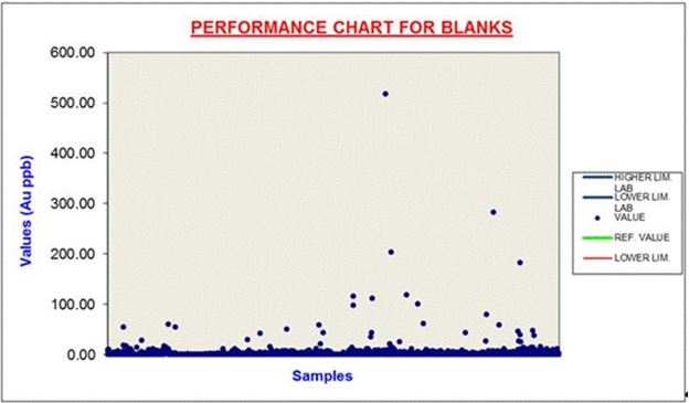
Figure 11.2. | Assay results on 5,945 blank samples |
Twenty-eight different certified gold standards were utilized by Sunward during their exploration drilling campaigns. Seventeen were Oreas standards and 11 were Rocklabs. Both companies supply standards to the mineral exploration industry. In all, 5,797 gold standard samples were assayed. In nearly all cases, the percent of standard sample assays reporting within the acceptable limits was above 95%. In most cases, the out-of-bound samples were slightly outside acceptable limits. However, a small number of standards reported a value so different from the accepted value that sample-labeling error is most probable. Overall, assay results on gold standards show excellent results. Table 11.1 summarizes the results on the gold standard assays.
| Project 21-036 (GoldMining Inc.) | BEHRE DOLBEAR |
Independent Technical Report on the Titiribi Project – Colombia Effective Date: 14 June 2021; Published Date: 25 August 2021 |
Table 11.1
Summary of Gold Standard Assay Results |
Standard I.D. | Reference Value in Gold (ppm) | Number of Times Used | % Within Accepted Range | Comments |
Oreas 16b | 2.21 | 101 | 96.0 | Results acceptable. Not used in 2012-2013 |
Oreas 2Pd | 0.885 | 286 | 97.2 | Results acceptable. Used during 2012-2013 |
Oreas 43P | 0.0731 | 66 | 97.0 | Results acceptable. Not used in 2012-2013 |
Oreas 45P | 0.054 | 225 | 99.6 | Results acceptable. Not used in 2012-2013 |
Oreas 5Pb | 0.098 | 189 | 95.2 | Results acceptable. Not used in 2012-2013 |
Oreas 50C | 0.836 | 739 | 98.0 | Results acceptable. Used during 2012-2013 |
Oreas 50Pb | 0.841 | 68 | 94.1 | Results marginally acceptable. Not used in 2012-2013 |
Oreas 52c | 0.346 | 621 | 98.9 | Results acceptable. Not used in 2012-2013 |
Oreas 52Pb | 0.307 | 89 | 96.6 | Results acceptable. Not used in 2012-2013 |
Oreas 60Pb | 2.57 | 106 | 95.3 | Results acceptable. Not used in 2012-2013 |
Oreas 68a | 3.89 | 177 | 99.4 | Results acceptable. Used exclusively in 2012-2013 |
Oreas 151A | 0.043 | 398 | 99.5 | Results acceptable. Used in 2012-2013 |
Oreas 153A | 0.311 | 99 | 96.0 | Results acceptable. Used in 2012-2013 |
Oreas 501 | 0.204 | 151 | 98.0 | Results acceptable. Used exclusively in 2012-2013 |
Oreas 502 | 0.491 | 196 | 98.5 | Results acceptable. Used exclusively in 2012-2013 |
Oreas 503 | 0.658 | 161 | 97.5 | Results acceptable. Used exclusively in 2012-2013 |
Oreas 504 | 1.48 | 99 | 96.0 | Results acceptable. Used exclusively in 2012-2013 |
Rocklabs KH 1 | 0.85 | 94 | 98.9 | Results acceptable. Not used in 2012-2013 |
Rocklabs OxA71 | 0.0849 | 198 | 96.5 | Results acceptable. Used in 2012-2013 |
Rocklabs OxA89 | 0.0836 | 415 | 98.8 | Results acceptable. Used in 2012-2013 |
Rocklabs OxF100 | 0.804 | 20 | 100 | Results acceptable. Used in 2012-2013 |
Rocklabs SE 29 | 0.597 | 17 | 94.1 | Results marginally acceptable. Not used in 2012-2013 |
Rocklabs SE 44 | 0.606 | 97 | 94.8 | Results marginally acceptable. Not used in 2012-2013 |
Rocklabs SF 45 | 0.848 | 94 | 95.7 | Results acceptable. Not used in 2012-2013 |
Rocklabs SF 57 | 0.848 | 499 | 99.8 | Results acceptable. Used in 2012-2013 |
Rocklabs SK 21 | 4.048 | 18 | 88.89 | Results marginally acceptable. Not used in 2012-2013 |
SK 52 | 4.107 | 371 | 97.8 | Results acceptable. Used in 2012-2013 |
SK 62 | 4.075 | 203 | 98.5 | Results acceptable. Used in 2012-2013 |
| Project 21-036 (GoldMining Inc.) | BEHRE DOLBEAR |
Independent Technical Report on the Titiribi Project – Colombia Effective Date: 14 June 2021; Published Date: 25 August 2021 |
Sunward conducted a vigorous re-assay program through 2012. In 2013, Sunward’s focus was on duplicate sample assaying by utilizing a ¼-core sample split. Through February 2012, 3,226 samples have been re-assayed. The average gold value of the original samples was 430 parts per billion (ppb) while the assay value of the re-assay sample was 413 ppb. Figure 11.3 is a scatter diagram on the results of re-assaying original pulp samples. Results were generally quite good; however, there were a number of outliers likely representing intervals hosting coarse gold. A very small number of the outliers were very poor comparisons but are likely errors in sample identification. Re-assaying of higher-grade samples has been limited.
Figure 11.3. | Scatter diagram for re-assaying original pulp samples for gold |
11.5.1.4 | Duplicate Splits (¼-core) |
During the 2012-2013 drilling campaign, Sunward initiated a duplicate split sampling program by taking a ¼‑core. There were 732 duplicate (¼-core) samples; the average grade of the original samples was 66 ppb gold and the duplicate average was 65 ppb gold. As can be seen in Figure 11.4, above about 500 ppb gold, there is scatter on the assay values. This is to be expected as the original sample is from a ½-split of the core and the duplicate is a ½-split of the remaining core. Some scatter may be due to a coarse gold (nugget) effect. Except for two samples, the results are to be expected.
| Project 21-036 (GoldMining Inc.) | BEHRE DOLBEAR |
Independent Technical Report on the Titiribi Project – Colombia Effective Date: 14 June 2021; Published Date: 25 August 2021 |
Figure 11.4. | Assay results for duplicate samples comparing original sample to a ¼-split sample |
Eleven different Oreas copper standards have been utilized by Sunward during their exploration drilling campaigns. In all, 1,120 copper standard samples were assayed. Only 15 samples (1.3%) were slightly to marginally outside the acceptable limit and only 1 sample result was well outside the acceptable limit. Assay results on copper standards show excellent results (Table 11.2).
Table 11.2
Summary of Copper Standard Assay Results |
Standard I.D. | Reference Value in Copper (ppm) | Number of Times Used | % Within Accepted Range | Comments |
Oreas 50C | 7,420 | 734 | 98.4 | Results acceptable. Used in 2012-2013 |
Oreas 50Pb | 7,440 | 68 | 98.5 | Results acceptable. Not used in 2012-2013 |
Oreas 52C | 3,440 | 614 | 99.0 | Results acceptable. Used in 2012-2013 |
Oreas 52Pb | 3,338 | 89 | 95.5 | Results acceptable. Used in 2012-2013 |
Oreas 68A | 392 | 177 | 96.6 | Results acceptable. Used exclusively in 2012-2013 |
Oreas 151A | 1,660 | 360 | 99.4 | Results acceptable. Used in 2012-2013 |
Oreas 153A | 7,120 | 98 | 95.9 | Results acceptable. Used in 2012-2013 |
Oreas 501 | 2,710 | 151 | 99.3 | Results acceptable. Used exclusively in 2012-2013 |
Oreas 502 | 7,550 | 196 | 98.5 | Results acceptable. Used exclusively in 2012-2013 |
Oreas 503 | 5,660 | 161 | 94.4 | Results acceptable. Used exclusively in 2012-2013 |
Oreas 504 | 11,400 | 99 | 97.0 | Results acceptable. Used exclusively in 2012-2013 |
11.5.3 | Duplicate Copper Assays |
A large number of original pulp samples were re-assayed for copper (2,425). The average of the original assays was 1,029 ppm copper while the average of the re-assay value was 1,043 ppm copper. Figure 11.5 is a scatter diagram comparing the original copper assay with the re-assay of the original pulp. Results are excellent except for a very small number of outliers that may reflect an error in sample identification.
| Project 21-036 (GoldMining Inc.) | BEHRE DOLBEAR |
Independent Technical Report on the Titiribi Project – Colombia Effective Date: 14 June 2021; Published Date: 25 August 2021 |
Figure 11.5. | Copper re-assay results on original sample pulps |
The duplicate sampling program (732 intervals) utilizing the ¼-core was also undertaken for copper assays. The average copper value of the original samples was 380 ppm copper and the average of the duplicate splits was 371 ppm copper. Figure 11.6 is a scatter diagram comparing the two sets of assay data. The correlation is good, although there is moderate scatter in the higher-grade samples. All of the moderate scatter are from the Maria Jo and Junta areas where the copper mineralization is coarse-grained and forms as clots (see Figure 7.20). The two samples that returned unacceptable comparisons are both from Cerro Vetas; suggesting a database entry or assay error, since copper mineralization is very fine-grained.
Figure 11.6. | Scatter diagram comparison of original copper assays and duplicate (¼-core splits) assay results |
| Project 21-036 (GoldMining Inc.) | BEHRE DOLBEAR |
Independent Technical Report on the Titiribi Project – Colombia Effective Date: 14 June 2021; Published Date: 25 August 2021 |
11.5.4 | Analytical Laboratory to Laboratory Comparison |
A vigorous cross check between the 4 principal laboratories was undertaken during the 2012-2013 drilling campaign for both gold and copper. Cross checking copper values between the various laboratories showed a nearly perfect sample to sample correlation. Cross checks for gold were also outstanding.
The average value for the comparative assays of 968 Cerro Vetas sets from Inspectorate and Acme was 546 ppb gold and 536 ppb gold, respectively. Figure 11.7 is the scatter diagram comparing the two principal laboratories, Inspectorate and Acme.
Figure 11.7. | Comparison between Inspectorate and Acme Laboratories |
The average value for the comparative assays of 566 Junta and Cerro Vetas sets from Inspectorate and ALS was 630 ppb gold and 624 ppb gold, respectively. Figure 11.8 is the scatter diagram comparing these two laboratories.
| Project 21-036 (GoldMining Inc.) | BEHRE DOLBEAR |
Independent Technical Report on the Titiribi Project – Colombia Effective Date: 14 June 2021; Published Date: 25 August 2021 |
Figure 11.8. | Comparison between Inspectorate and ALS Laboratories |
The average value for the comparative assays of 28 Cerro Vetas (CV069) sets from SGS and ALS Laboratories was 789 ppb gold and 755 ppb gold, respectively. Figure 11.9 is the scatter diagram comparing these two laboratories.
Figure 11.9. | Comparison between SGS and ALS Laboratories |
The average value for the comparative assays of 305 Porvenir sets from Acme and ALS Laboratories was 243 ppb gold and 208 ppb gold. Figure 11.10 is the scatter diagram comparing these two laboratories.
| Project 21-036 (GoldMining Inc.) | BEHRE DOLBEAR |
Independent Technical Report on the Titiribi Project – Colombia Effective Date: 14 June 2021; Published Date: 25 August 2021 |
Figure 11.10. | Comparison between Acme and ALS Laboratories |
The comparison between each laboratory set is excellent with nearly all the outlier values being higher-grade samples, possibly reflecting a nugget effect. A few samples with poor correlation may reflect an error in sample identification.
| Project 21-036 (GoldMining Inc.) | BEHRE DOLBEAR |
Independent Technical Report on the Titiribi Project – Colombia Effective Date: 14 June 2021; Published Date: 25 August 2021 |
The Project has had a rigorous and “fail-safe” procedure established to ensure the security and accuracy of the database. Although the entire Sunward technical staff had access to the database, only one person, the Database Manager, was permitted to make changes or additions to the database. All data was electronically entered including all drilling, logging, geotechnical, surface, and downhole surveys, magnetic susceptibility, sample numbers, density, assay information, etc. The assay data was electronically transferred. All back-up assay data, such as the commercial laboratory and standard and blank assay results were electronically filed. Geologists or geological technicians checked all driller’s records, recovery, RQD, etc. Only certain codes could be entered into the geological logging record. The logging form was designed by the entire in-house team. Drill logs were directly entered into a computer. All historic paper copies were converted to electronic files. There have been no paper copies of the drill logs since 2008. All data had been on an FTP server and had been backed up once a month. The entire database has been transferred to GoldMining Inc. All drill core, coarse rejects, and pulps are securely stored onsite. While drilling campaigns were ongoing, the technical staff periodically inspected the sample preparation facilities in Medellín.
12.1 | THE AUTHORS’ VERIFICATION |
The Master Database contains all the sample data including repeats and duplicates and other QA/QC samples. The authors carefully compared at least 33 pages of assay certificates to the digital database. As expected, there were no errors or omissions. The authors also spent a lot of time reviewing and evaluating the original versus the metallic screen gold assays, gold and copper re-assays and duplicates, and gold and copper standard assays and blanks.
The authors detected a few minor concerns on how a “no-assay” data point was entered into the database. These minor concerns have been rectified. Also, a number of examples exist where the authors suspect that pulps or coarse rejects have been mislabeled based upon the uncommon examples of poor correlation between check or duplicate assays.
A total of 7 intervals from 6 different core holes, 4 from Cerro Vetas and 2 from Chisperos, were selected by the authors for quartering and re-assaying as a duplicate check. The gold and copper assays of the ¼-core from the Cerro Vetas holes matched reasonably well with the original ½-core split assays. In the 5 sets containing significant copper mineralization, the original copper values are slightly higher suggesting the possibility of a slight bias. However, via visual inspection of the core, copper minerals (and by analogy the corresponding gold values) are extremely fine-grained and disseminated and purposeful bias is doubtful. Copper values from the two Chisperos holes matched well for the ¼-split and original assay but the gold values were dissimilar. The sampled intervals were re-checked to ensure the two sets of samples were from the same interval. The core from CP022 does contain obvious sulfide-rich (pyrite) veins that could account for some bias in sampling. Another explanation for the dichotomy of results from the two Chisperos holes is the coarse nature of the gold mineralization at Chisperos. Table 12.1 shows the results of the original assays (½-split) and the duplicate (¼-split). Figure 12.1 to Figure 12.5 show portions of the Cerro Vetas core intervals (before quartering) from holes CV098 (354.5 meters to 356.0 meters), CV098 (534.5 meters to 536.0 meters), CV099 (97.5 meters to 99.0 meters), CV073 (523.5 meters to 524.5 meters), and CV094 (635.0 meters to 636.33 meters), respectively. Figure 12.6 and Figure 12.7 shows portions of the Chisperos core intervals (before quartering) from holes CP022 (347.0 meters to 348.5 meters) and CP040 (140.5 meters to 141.5 meters), respectively.
| Project 21-036 (GoldMining Inc.) | BEHRE DOLBEAR |
Independent Technical Report on the Titiribi Project – Colombia Effective Date: 14 June 2021; Published Date: 25 August 2021 |
Table 12.1
Original Gold-Copper Assays Versus ¼-core Split Gold-Copper Assays |
Drill Hole | From | To | Original Gold Assay (ppb) | Duplicate ¼-core Gold Assay (ppb) | Original Copper Assay (ppm) | Duplicate ¼-core Copper Assay (ppm) |
CV098 | 354.50 | 356.00 | 148 | 114 | 721 | 666 |
CV098 | 534.50 | 536.00 | 2,220 | 2,101 | 6,704 | 5,586 |
CV099 | 97.50 | 99.00 | 438 | 366 | 2,727 | 2,308 |
CV073 | 523.50 | 524.50 | 918 | 741 | 1,286 | 1,142 |
CV094 | 635.00 | 636.33 | 603 | 722 | 2,803 | 2,418 |
CP022 | 347.00 | 348.50 | 922 | 113 | 7 | 11 |
CP040 | 140.50 | 141.50 | 1,049 | 361 | 70 | 82 |
| | |
Figure 12.1. CV098 – highlighting a portion of the interval 354.5 meters to 356.0 meters (Source: Behre Dolbear, 2013) | | Figure 12.2. CV098 – highlighting a portion of the interval 534.5 meters to 536.0 meters (Source: Behre Dolbear, 2013) |
| | |
Figure 12.3. CV099 – highlighting a portion of the interval 97.5 meters to 99.0 meters (Source: Behre Dolbear, 2013) | | Figure 12.4. CV73 – highlighting a portion of the interval 523.5 meters to 524.5 meters (Source: Behre Dolbear, 2013) |
| Project 21-036 (GoldMining Inc.) | BEHRE DOLBEAR |
Independent Technical Report on the Titiribi Project – Colombia Effective Date: 14 June 2021; Published Date: 25 August 2021 |
| | |
Figure 12.5. CV 94 – highlighting a portion of the interval 635.0 meters to 636.3 meters (Source: Behre Dolbear, 2013) | | Figure 12.6. CP022 – highlighting a portion of the 347.0 meters to 348.5 meters, with obvious pyrite veins (Source: Behre Dolbear, 2013) |
|
Figure 12.7. CP 40 – highlighting a portion of the interval 140.5 meters to 141.5 meters (Source: Behre Dolbear, 2013) |
The authors also selected a group of 87 assay pulp intervals from throughout the Project area for re-assaying. The correlation results for copper were excellent with only one pulp sample returning a slightly different assay. A scatter diagram for the copper results is shown in Figure 12.8. The correlation results for gold were mixed with 76 pulps returning excellent correlation and 11 returning marginal or questionable results. Figure 12.9 is a scatter diagram for the re-assaying of the 87 pulps. The 11 pulp samples, along with their respective original coarse rejects, were re-assayed for gold. The assay results are shown in Table 12.2 and includes the original assay, ALS 1st duplicate assay, ALS 1st duplicate re-run check assay, ALS re-run assay on a 2nd duplicate (for 11 samples), ALS 2nd duplicate re-run assay, ALS coarse reject assay, and coarse reject check assay re-runs.
| Project 21-036 (GoldMining Inc.) | BEHRE DOLBEAR |
Independent Technical Report on the Titiribi Project – Colombia Effective Date: 14 June 2021; Published Date: 25 August 2021 |
Figure 12.8. | Scatter diagram for pulp copper verification assays |
| (Source: Behre Dolbear, 2013) |
Figure 12.9. | Scatter diagram for pulp gold verification assays |
| (Source: Behre Dolbear, 2013) |
| Project 21-036 (GoldMining Inc.) | BEHRE DOLBEAR |
Independent Technical Report on the Titiribi Project – Colombia Effective Date: 14 June 2021; Published Date: 25 August 2021 |
Table 12.2
Pulp, Duplicate, and Coarse Reject Verification Assays |
Original Au (ppm) | ALS 1st Duplicate Au (ppm) | ALS 1st Duplicate (Check Assay) Au (ppm) | ALS 2nd Duplicate Au (ppm) | ALS 2nd Duplicate (Check Assay) Au (ppm) | ALS Coarse Reject Au (ppm) | ALS Coarse Reject (Check) Au (ppm) |
0.336 | 0.07 | 0.13 | <0.05 | | 0.07 | |
0.685 | 0.13 | | 0.69 | 0.65 | 0.65 | |
0.336 | 0.01 | | 0.31 | 0.25 | 0.07 | |
0.336 | 0.01 | | <0.05 | | 0.46 | 0.22 |
0.441 | 0.01 | | <0.05 | | 0.33 | |
1.199 | 0.45 | | 0.61 | | 0.68 | |
0.729 | 0.45 | 0.47 | 0.68 | | 0.67 | |
0.995 | 0.39 | | 0.68 | | 0.53 | |
1.123 | 0.17 | | 0.42 | | 0.26 | |
0.910 | 0.57 | | 0.6 | | 0.5 | |
1.610 | 0.01 | | 0.13 | | 1.46 | |
These results suggest that the variation in gold assay results may be due to a coarse gold (nugget effect) associated with sulfide minerals or improper labeling of pulp bags and in one instance, a reasonable spread of values.
During the 2011, 2012, and 2013 site visits, the authors spent considerable time looking at core from the higher-grade intervals from many drill holes to compare the drill core of higher-grade mineralization to the surrounding lower-grade zones. In nearly every case, the higher-grade mineralization correlated very well with intervals of considerably more disseminated and fracture filling chalcopyrite and/or magnetite; or pyrite-sphalerite ± chalcopyrite veins; and/or minor chalcocite, bornite, or copper oxides.
During the 2013 site visit and data review, the authors spent considerable time reviewing in detail all the geologic cross sections, which were prepared in two directions and plan geologic maps to ensure continuity of geologic contacts, intrusive boundaries, and structure. The interpretations appear correct and the three-dimensional geology was utilized to build a viable resource block model. Nonetheless, there are small displacement faults that are not depicted on the present geologic plan and cross sectional maps that need to be better understood for improved geological interpretation, particularly at Chisperos. Additional detailed geological interpretations are necessary to better understand these faults and their relationship to mineralization.
Mr. Castañeda’s site visit in 2021 also included inspection of the diamond drill cores; comparisons of grade to mineralized cores and verified that higher-grade mineralization correlated with increased sulfidic stockwork and vein zones.
No negative issues were identified during the inspection of diamond drill core, drill hole geology-assay cross sections, or the relationships between geology and the three-dimensional resource model. Issues concerning coarse gold and the nugget effect were discussed and resolved to the authors’ satisfaction. The logging database, specifically lithology and alteration, was checked with no major concerns identified. The authors opined several different interpretations concerning the breccia units, simplifying the geology, particularly on the “mylonite breccia,” now considered a lahar-type unit.
Because the diamond drill core has been oriented and strikes and dips recorded for the vast majority of veins, continuity of mineralization is reasonably good based upon the drill hole spacing. In addition, the use of three-dimensional downhole photography has enhanced the understanding of joints, faults, and veins.
All technical functions, performed by the Sunward staff, were clearly to industry standards. Assay data was electronically added to the database, eliminating the possibility of translation and typographical errors. The authors have verified the adequacy of the data used in this updated 2021 NI 43-101 Technical Report and the resource estimation. The authors have deemed such information is current as of the effective date of this report.
| Project 21-036 (GoldMining Inc.) | BEHRE DOLBEAR |
Independent Technical Report on the Titiribi Project – Colombia Effective Date: 14 June 2021; Published Date: 25 August 2021 |
13.0 | MINERAL PROCESSING AND METALLURGICAL TESTING |
13.1 | METALLURGICAL TEST WORK |
Metallurgical test work progressed satisfactorily through early 2012. No new metallurgical testing has been undertaken since 2012. The following statement is a summary of the 2011 and 2012 metallurgical test results.
In 2011, Sunward engaged Tetra Tech Inc. to carry out preliminary metallurgical investigations on mineralized samples from Titiribí. They contracted Resource Development Inc. of Golden, Colorado and for the Phase 2 program, four samples of 75 kg were investigated. The principal results were:
| | 1) | For all four samples tested, a significant proportion of the gold could be upgraded by gravity. |
| | 2) | The samples were all non-refractory and cyanidation of the head samples, or the gravity or flotation concentrates, successfully recovered gold. |
| | 3) | Flotation of the Cerro Vetas sample produced a saleable copper concentrate with high gold and copper recoveries. |
In 2012, TJ Metallurgical Services was asked by Sunward to develop a suitable test work program that would identify an optimized process flow sheet and determine the key metallurgical design parameters. The UK laboratory of Wardell Armstrong International (WAI) was selected and 3 samples weighing 270 kg to 300 kg from Cerro Vetas, NW Breccia, and Chisperos were sent to the Cornwall laboratory. The work carried out covered:
| | a) | Extensive Head Sample Investigations. XRD, ICP, Abrasion Indices and Bond Work Index determinations. |
| | b) | Knelson Gravity Test Work. Three 50kg samples were dispatched to FLSmidth-Knelson for Gravity Recoverable Gold (GRG) test work and a determination of the gold that could be recovered to a final product. |
| | c) | Gold Deportment Investigations on Gravity and Flotation Concentrates. This included Diagnostic Leach test work, Qemscan, and SEM investigations to determine the gold association and so plan the subsequent metallurgical test work. |
| | d) | Flotation Test Work. Reagent and flotation optimisation for all three samples tested. Cleaner test work with optimised flotation reagent regime. |
| | e) | Locked Cycle Flotation Test Work. Nine tests were carried out in total with six being carried out on Cerro Vetas to maximise the Au and Cu recovery to a copper flotation concentrate. |
| | f) | Cyanidation Test Work. Pyrite flotation concentrates were produced from all three samples and the Au recovered by cyanidation. |
| | g) | Detailed Cyanidation Test Work. A large bulk pyrite concentrate was produced from NW Breccia and a six-test cyanidation test work programme carried out. |
| | h) | Environmental Test Work. TCLP leach tests, ABA investigations and NAP/NAG tests were carried out on the flotation tailings. An Inco-type cyanide detox test was also carried on the NW Breccia cyanide leach tailings. |
The metallurgical work was reported by WAI in the report ‘Stage III Metallurgical Testing on Samples of Gold and Copper Mineralisation’ ZT64-0386, May 2013. The principal results obtained are:
| | a) | Gold Deportment. For all the samples around 10-12% was recoverable to a gravity concentrate. The gold was not liberated and was generally locked with sulphides but was amenable to cyanidation. For Cerro Vetas, 57% was recoverable to a copper concentrate and 13% to a pyrite concentrate. For NW Breccia and Chisperos the majority was associated with pyrite and was also amenable to cyanidation. |
| Project 21-036 (GoldMining Inc.) | BEHRE DOLBEAR |
Independent Technical Report on the Titiribi Project – Colombia Effective Date: 14 June 2021; Published Date: 25 August 2021 |
| | b) | Knelson GRG Tests. Samples of Cerro Vetas and NW Breccia were sent for test work at FLS-Knelson. FLS reported that for Cerro Vetas and NW Breccia there was a significant GRG (Gravity Recoverable Gold) element in both samples of 39.8% and 64.8% respectively. More importantly they stated that the introduction of a Knelson circuit and a cyanidation circuit would lead to an additional Au recovery of 1.2-1.8% and 4.0-5.6% for Cerro Vetas and NW Breccia respectively. Chisperos was not tested. |
| | c) | Locked Cycle Flotation Test Work. These tests replicate plant practice by recirculating intermediate streams and give the best indication of the grades and recoveries that can be achieved in an operating flotation plant. Using the optimized collector MX-5125 with other collectors in combination the following results were obtained for Cerro Vetas. |
Table 13.1
Cerro Vetas Locked Cycle Flotation Tests

LCT3 reported the best results and LCT4 was a repeat with the same conditions. Very similar results were reported. The LC tests indicate that a saleable copper concentrate can be produced with a copper recovery of 90% and a gold recovery of 77%. The flotation of a pyrite concentrate recovers a further 6% gold.
The two Locked Cycle blend tests are on a feed composite of Cerro Vetas and NW Breccia in a blend of 9:1.
Two Locked Cycle tests were carried out on a sample of NW Breccia and one Locked Cycle test on Chisperos.
Table 13.2
NW Breccia and Chisperos Locked Cycle Flotation Tests
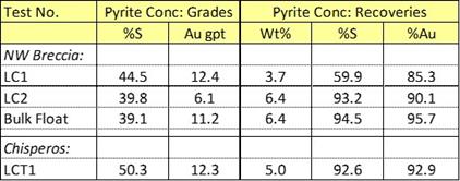
The NW Breccia ‘Bulk Float’ test was a test on a 20-kg feed sample to generate a 1.25-kg pyrite flotation concentrate for a cyanidation test work program. The results indicate that over 90% of the gold can be recovered to a pyrite flotation concentrate for both NW Breccia and Chisperos.
| | a) | Pyrite Concentrate Cyanidation Test Work. The six-test optimization program showed that it was not necessary to regrind the pyrite flotation concentrate to achieve high gold recoveries and an average gold recovery of 91.7% with a cyanide consumption of 5.2 kg/t was achieved. |
| Project 21-036 (GoldMining Inc.) | BEHRE DOLBEAR |
Independent Technical Report on the Titiribi Project – Colombia Effective Date: 14 June 2021; Published Date: 25 August 2021 |
| | b) | Environmental Test Work. The environmental characterization tests did not report any issues with regard to acid generation. |
The WAI test work has identified the following process flow route to treat a Cerro Vetas ROM ore or a blend of Cerro Vetas with a minor proportion of NW Breccia;
| | a) | Comminution circuit to produce a flotation feed with a P80 of 90 microns. |
| | b) | Knelson circuit within the comminution circuit to recover a gravity concentrate. |
| | c) | Copper flotation circuit to produce a copper concentrate as filter cake. |
| | d) | Pyrite flotation circuit. |
| | e) | Small cyanidation circuit to treat the Knelson gravity concentrate and the pyrite flotation concentrate and produce Au/Ag doré. |
From a series of Locked Cycle flotation and detailed cyanidation tests, the WAI test work program has identified the likely copper and gold recoveries that could be achieved from a standard two-circuit flotation plant with a small cyanidation circuit. It is the opinion of WAI and the consultants involved that sufficient metallurgical data has been produced in the Stage III metallurgical test work program for an engineering design company to carry out a preliminary process design and costing.
| Project 21-036 (GoldMining Inc.) | BEHRE DOLBEAR |
Independent Technical Report on the Titiribi Project – Colombia Effective Date: 14 June 2021; Published Date: 25 August 2021 |
14.0 | MINERAL RESOURCE ESTIMATES |
The Sunward staff generated a block model based on the Titiribí Master Magna drill hole database, as of April 15, 2013 and a new three-dimensional geological interpretation produced by the Sunward geologists was completed in May 2013. These in-house models formed the basis of the three-dimensional geological model that were used with minor modifications by Dr. Robert E. Cameron (one of the authors) of Behre Dolbear to re-estimate the tonnage and grades at the Project.
To determine the historical mineral resource at Titiribí, a single block model had been developed to cover the primary drilling areas: Cerro Vetas, NW Breccia, and Chisperos. The resource areas are shown in Figure 14.1 and are referred to as:
Figure 14.1. | Block model areas |
| (Source: Behre Dolbear, 2013) |
For the purposes of this report, the author reviewed the primary data and his work completed for Sunward and used it, in part, as the basis for the current resource estimations. The author is of the opinion that the initial Sunward exploration work and drill hole data was collected and analyzed in a manner that conforms to acceptable industry practices and is acceptable for use to produce Canadian NI 43-101-compliant mineral resource estimates.
| Project 21-036 (GoldMining Inc.) | BEHRE DOLBEAR |
Independent Technical Report on the Titiribi Project – Colombia Effective Date: 14 June 2021; Published Date: 25 August 2021 |
14.1 | ELECTRONIC DATABASE USED FOR RESOURCE MODELS |
The Sunward April 2013 Master Magna drill hole database was used for the current resource estimate. It consists of 254 diamond drill holes with a total drilled length of 141,585.9 meters. Eighty of these holes are outside of the model area and this database does not contain the older 1998 Gold Fields drilling. During 2012, Sunward migrated all their surveying and collar locations from the Bogota 1975/Colombia West Zone used in previous studies and resources estimates to the Magna-Sirgas/Colombia West zone resulting in use of the term “Magna” in the database name.
The database used for the current Project resource model and estimate is summarized by the drilling campaigns listed in Table 14.1.
Table 14.1
Summary of the 2013 Master Magna Drill Hole Database |
Drilling Campaign | Number | Total Meters |
2006 Gold Plata | 16 | 4,658.15 |
2008 Windy Knob | 17 | 6,180.75 |
2010 Sunward | 36 | 22,214.46 |
2011 Sunward | 68 | 41,986.64 |
2012 Sunward | 111 | 64,703.10 |
2013 Sunward | 6 | 1,842.80 |
| | | |
Total | 254 | 141,585.90 |
The electronic database contains 95,970 assay intervals plus an additional 13,082 assays used for the QA/QC work (check assays, blanks, and standards). Each assay interval contains grades for gold and copper along with 39 other elements reported in the standard ACME Labs multi-element package, such as Ag, Al, As, B, Bi, Ca, Cd, Co, Fe, and other elements.
The electronic database supplied also contains the geologic logging. For each assay interval, a three-letter lithologic code, based on the geologic logging, has been entered. In addition, the detailed lithologic codes have been divided into nine primary lithologic groups that include:
| | ● | Unconsolidated Sediments |
The author spot checked the data entry during a previous reviews and found a few typographic errors in the lithology group entries, which were all misspellings. These changes were confirmed to be corrected in the current database. Assay entries were also spot checked against original assay certificates and no errors were discovered. No additional drilling or assaying has been undertaken since 2013; thus, the 2013 database is considered current for this resource estimate.
| Project 21-036 (GoldMining Inc.) | BEHRE DOLBEAR |
Independent Technical Report on the Titiribi Project – Colombia Effective Date: 14 June 2021; Published Date: 25 August 2021 |
Topography used for the resource estimation was provided to the author as a standard 1-meter contour interval GIS shape files, DTM and AutoCAD® files. The topography in the modeling area used was current as of approximately June 2012 and was generated from a LIDAR survey. Behre Dolbear was provided the LIDAR survey of the surrounding region completed in March 2013, but this information was outside of the resource estimate area. All drill hole collar locations were surveyed or re-surveyed by Conditop, S.A.S. and converted to the MAGNA-SIRGAS/Colombia West zone. The 2013 collar locations supplied to Behre Dolbear were checked to ensure conversion accuracy by using a simple computer transformation of the collar locations used in the 2012 work to compare these against the new MAGNA-SIRGAS/Colombia West zone coordinates in the current database.
The 2006 drilling, completed by Gold Plata, was used for geologic interpretation but the assay information was excluded from grade estimation.
14.2 | BULK DENSITY MEASUREMENTS |
The Project routinely collected and measured the bulk density or specific gravity (SG) of the drill core. The database consisted of 7,265 measurements divided into 33 lithologic codes. Approximately 6,820 measurements were taken from drilling in the resource area and these were grouped into the primary lithology groups used for the geologic model. Figure 14.2 shows a scatter diagram of all SG measurements by detailed lithology code. Table 14.2 summarizes the SGs, from the modeling area and divided into the major lithology groups, used in the current model.
Figure 14.2. | Density measurements by lithology code |
| Project 21-036 (GoldMining Inc.) | BEHRE DOLBEAR |
Independent Technical Report on the Titiribi Project – Colombia Effective Date: 14 June 2021; Published Date: 25 August 2021 |
Table 14.2
Bulk Density Summary |
Model Lithology | Average Density (g/cm3) | Number of Samples | Logged Lithology |
Diorite | 2.76 | 2,412 | DIO DBX DIOF |
Basement Rocks | 2.84 | 1,257 | MBA MSG SCH IRU MGW MR MSC |
Breccia Basement | 2.99 | 1,543 | BXF BXH BXI BXQ BXX IRU MMY |
Diatreme Breccia | 2.86 | 290 | BXD |
IGD | 2.77 | 193 | PHA |
Volcanic-Sedimentary | 2.81 | 1,125 | XTU LTU ANB ARN BXS CGL CLY MUD QFS QST STO CLS COL SAP SNS SRU GRW |
14.3 | PROCEDURES AND PARAMETERS USED FOR THE RESOURCE MODELING |
The 2021 resource estimate uses a single block model covering the three areas.
The gold and copper mineralization in the Cerro Vetas area is associated with an intrusive event. It is believed that the intrusive event created permeability in surrounding country rocks, which was then susceptible to mineralizing fluids. The core of the intrusion appears to be relatively barren. The Chisperos portion of the deposit is north and east of the Cerro Vetas area (Figure 14.1). It is generally gold-only and consists of parallel to sub-parallel mineralized zones that are both stratigraphically and structurally controlled and hosted in a sedimentary-volcanic sequence. The transition area between the Cerro Vetas and Chisperos mineralization may be a link between the low-temperature epithermal style at Chisperos and the high-temperature porphyry intrusive hosted style at Cerro Vetas. The NW Breccia area is north and west of the Cerro Vetas area (Figure 14.1). The NW Breccia deposit is also generally gold-only and hosted primarily in the diatreme breccia adjacent to the Cerro Vetas intrusion.
The following procedures and parameters were used in the current (2021) resource estimation for the mineralization at the Project.
| | ● | Three-dimensional Geologic Model: Sunward developed a series of very detailed geologic cross sections and plan maps at the Project, a representative portion that were shown previously in Figure 7.23 through Figure 7.28. After extensive reviews, the authors accept the interpreted geologic model. These formed the basis of the development of a three-dimensional geologic model consisting of 8 major lithologies or rock types. The 50-meter plan maps were digitized and then extruded to generate the geologic model. Blocks within each rock type were tagged with a block rock type code. The Gold Plata drilling, completed in 2006, was used for the geologic interpretation but was not used for the grade estimation. |
| | | |
| | | Figure 14.3 illustrates the three-dimensional geologic solid used to delineate the intrusive and surrounding mineralization. This model does not fully encompass the true extent of mineralization around the intrusive at Titiribí and is, therefore, only used as a guide for additional geologic interpretation. |
| Project 21-036 (GoldMining Inc.) | BEHRE DOLBEAR |
Independent Technical Report on the Titiribi Project – Colombia Effective Date: 14 June 2021; Published Date: 25 August 2021 |
Figure 14.3. | Sunward 3-dimensional geologic model |
● | Grade Capping and Assay Statistics: Grade capping for the Titiribí block model was based on examination of the distribution of the raw assays and grade probability distributions. Grades were capped to eliminate the effects of high-grade outliers on the resource estimation. Gold was capped at 25,000 ppb of gold per tonne and copper was capped at 20,000 ppm. These values only capped 14 gold and 8 copper assays. Figure 14.4 shows the histograms of the assay distributions for both gold and copper for the high end of the population. Notice that after about 25,000 ppb of gold per tonne for the gold distribution and 20,000 ppm for the copper, the assays are fairly spotty, and therefore, can be considered outliers. |
| Project 21-036 (GoldMining Inc.) | BEHRE DOLBEAR |
Independent Technical Report on the Titiribi Project – Colombia Effective Date: 14 June 2021; Published Date: 25 August 2021 |
Figure 14.4. | Cerro Vetas gold and copper assay histograms |
Both raw and uncapped assay statistics were computed for the Titiribí model. These are shown in Table 14.3.
Table 14.3
Assay Statistics |
Element | Number of Assays | Raw Assays | Capped Assays |
| | | Mean | S.D. | Max | Min | Mean | S.D. | Max | Min |
Au (ppb) | 70,923 | 202.09 | 692 | 113,500 | 0 | 200.50 | 536 | 25,000 | 0 |
Cu (ppm) | 70,923 | 616.99 | 1,098 | 131,000 | 0 | 614.69 | 965 | 20,000 | 0 |
● | Compositing: Capped gold and copper assays were composited to 5-meters fixed-length composites. The composite length was chosen to correspond to the block dimensions in the block model. Once the composites were generated, they were assigned the rock type corresponding to the rock type of the geologic model. The author opines that the composite length is appropriate for the modeling work. Table 14.4 shows the composite statistics divided by rock type. A few composites were not assigned rock types as they fell outside of the three-dimensional geologic model. The rock type code used in the modeling work is in parenthesis after the rock type. |
| Project 21-036 (GoldMining Inc.) | BEHRE DOLBEAR |
Independent Technical Report on the Titiribi Project – Colombia Effective Date: 14 June 2021; Published Date: 25 August 2021 |
Table 14.4
Five Meter Composite Statistics |
Rock Type | Element | Number of | Composites |
| | | Composites | Mean | S.D. | Max | Min |
All Rock Types | Au (ppb) | 21,414 | 193.7 | 329 | 9,753 | 0.0 |
| | Cu (ppm) | 21,414 | 599.2 | 823 | 13,030 | 0.0 |
Diorite (1) | Au (ppb) | 4,071 | 375.2 | 364 | 4,202 | 8.1 |
| | Cu (ppm) | 4,071 | 1,426.0 | 1,066 | 9,808 | 30.5 |
Fine Grain Diorite (2) | Au (ppb) | 2,955 | 144.9 | 236 | 3,793 | 0.0 |
| | Cu (ppm) | 2,955 | 309.8 | 406 | 3,806 | 0.0 |
Diatreme Breccia (3) | Au (ppb) | 1,746 | 221.2 | 374 | 5,047 | 0.0 |
| | Cu (ppm) | 1,746 | 213.8 | 215 | 1,967 | 0.8 |
Basement Mylonite (4) | Au (ppb) | 4,276 | 172.6 | 377 | 9,753 | 0.0 |
| | Cu (ppm) | 4,276 | 561.1 | 748 | 8,075 | 3.3 |
Volcanic Sedimentary (5) | Au (ppb) | 4,372 | 127.0 | 235 | 7,806 | 0.0 |
| | Cu (ppm) | 4,372 | 406.1 | 624 | 6,156 | 0.0 |
Basalts and Green Rocks (6) | Au (ppb) | 3,345 | 132.5 | 280 | 5,305 | 0.0 |
| | Cu (ppm) | 3,345 | 409.8 | 664 | 13,030 | 6.9 |
Schists (7) | Au (ppb) | 147 | 184.5 | 646 | 7,384 | 0.0 |
| | Cu (ppm) | 147 | 105.7 | 94 | 912 | 8.5 |
Granodiorite (8) | Au (ppb) | 389 | 107.8 | 141 | 983 | 0.0 |
| | Cu (ppm) | 389 | 412.9 | 441 | 3,207 | 10.2 |
Unclassified | Au (ppb) | 113 | 4.6 | 8 | 55 | 0.0 |
| | Cu (ppm) | 113 | 160.5 | 64 | 341 | 31.9 |
● | Variography: Variograms models were estimated for both gold and copper using the 5 meter-composites based on each rock type at a variety of orientations and directions. |
| | |
| | The variogram models were developed using four nested variogram structures. The variogram models have typical nugget (or random) components for gold-copper mineralization with the gold nugget being approximately 50% of the total population variance. The copper nugget is also typical of that found in this sort of deposit at less than 30% of the total variance. Rock type 7 had insufficient samples to construct a meaningful variogram; hence, the global variogram was used for estimation. Table 14.5 summarizes the variogram models selected for the Titiribí block model area. |
| Project 21-036 (GoldMining Inc.) | BEHRE DOLBEAR |
Independent Technical Report on the Titiribi Project – Colombia Effective Date: 14 June 2021; Published Date: 25 August 2021 |
Table 14.5
Experimental Semi-variogram Models |
Rock Type | Variogram Model | Au | Cu |
| | | Sill | Range | Sill | Range |
| Nugget | 56,000 | NA | 100,000 | NA |
| Global | Spherical 1 | 21,500 | 40 | 100,000 | 40 |
| | Spherical 2 | 26,000 | 160 | 420000 | 120 |
| | Spherical 3 | 8000 | 280 | 60000 | 320 |
| Nugget | 42,000 | NA | 180,000 | NA |
| 1,2,3 | Spherical 1 | 22,500 | 40 | 360,000 | 40 |
| | Spherical 2 | 19,000 | 160 | 240,000 | 240 |
| | Spherical 3 | 30,000 | 280 | 151,000 | 480 |
| Nugget | 30,000 | NA | 50,000 | NA |
| 4 | Spherical 1 | 9,000 | 40 | 120,000 | 40 |
| | Spherical 2 | 64,000 | 160 | 310,000 | 160 |
| | Spherical 3 | 44,000 | 200 | 74,000 | 320 |
| Nugget | 10,000 | NA | 80,000 | NA |
| 5 | Spherical 1 | 3,000 | 40 | 12,000 | 45 |
| | Spherical 2 | 33,000 | 160 | 100,000 | 90 |
| | Spherical 3 | 11,700 | 200 | 210,000 | 315 |
| Nugget | 12,000 | NA | 50,000 | NA |
| 6 | Spherical 1 | 25,000 | 40 | 60,000 | 40 |
| | Spherical 2 | 19,000 | 160 | 40,000 | 240 |
| | Spherical 3 | 30,000 | 280 | 290,000 | 600 |
| Nugget | 56,000 | NA | 100,000 | NA |
| 7 | Spherical 1 | 21,500 | 40 | 100,000 | 40 |
| (Global) | Spherical 2 | 26,000 | 160 | 420,000 | 120 |
| | Spherical 3 | 8,000 | 280 | 60,000 | 320 |
| Nugget | 4,000 | NA | 20,000 | NA |
| 8 | Spherical 1 | 1,500 | 40 | 20,000 | 40 |
| | Spherical 2 | 4,000 | 160 | 20,000 | 240 |
| | Spherical 3 | 11,000 | 280 | 134,000 | 600 |
Figure 14.5 and Figure 14.6 shows the semi-variograms, produced by the author, for both gold and copper for the Titiribí model. The author opines that the variography work with the extrapolation used is adequate for the current resource model.
| Project 21-036 (GoldMining Inc.) | BEHRE DOLBEAR |
Independent Technical Report on the Titiribi Project – Colombia Effective Date: 14 June 2021; Published Date: 25 August 2021 |
Figure 14.5. | Gold experimental semi-variograms |
| Project 21-036 (GoldMining Inc.) | BEHRE DOLBEAR |
Independent Technical Report on the Titiribi Project – Colombia Effective Date: 14 June 2021; Published Date: 25 August 2021 |
Figure 14.6. | Copper experimental semi-variograms |
| | ● | Block Model Definition: A three-dimensional block model with a block size of 5 meters × 5 meters × 5 meters was defined for the Titiribí model. The estimation zone or rock type envelopes were coded into the block model using the center of the block, i.e., a block is considered inside the mineralized envelope, if the center of the block is located inside the mineralized envelope. Table 14.6 shows the definitions of the block model used for Titiribí. |
| Project 21-036 (GoldMining Inc.) | BEHRE DOLBEAR |
Independent Technical Report on the Titiribi Project – Colombia Effective Date: 14 June 2021; Published Date: 25 August 2021 |
Table 14.6
Titiribí Block Model Definition |
Direction | From | To | Length (m) | Block Dimensions (m) | Number of Blocks |
East | 1,139,203.5 | 1,141,813.5 | 2,610 | 5 | 522 |
North | 1,161,355 | 1,163,445 | 2,090 | 5 | 418 |
Vertical | 1,000 | 2,400 | 1,400 | 5 | 280 |
| | ● | Grade Estimation: Block grade estimation for both gold and copper was conducted using a 5‑pass ordinary kriging (OK) procedure. The search radii and orientation for all 5 passes are shown in Table 14.7. The variography used for the kriging estimates are the experimental semi-variograms discussed above. This resource estimate utilizes only the first 3 passes. |
Table 14.7
Search Ellipse Orientation for Resource Estimation |
Rock Type | Azimuth
Major Axis | Dip
Major Axis | Rotation
Semi-Major Axis |
1,2,3 | 140 | 80 | 90 |
4 | 100 | -80 | 30 |
5 | 140 | 20 | 0 |
6 | 140 | 80 | 0 |
7 | 140 | 80 | 90 |
8 | 140 | 80 | 90 |
The minimum number of 5-meter composites used for each pass varied and ranged from 2 to 6 and a maximum of 10 composites were allowed. A maximum of two composites from any single drill hole requiring composites from multiple drill holes for the first and second passes. Grades for each block were estimated from only composites with the same rock type code. The estimation parameters for composites and the range of the search ellipsoid are shown in Table 14.8.
Table 14.8
Estimation Parameters |
Pass | Number of Composites | Range of Search Ellipsoid (m) |
| | Max | Min | Max from Any Hole | Major | Semi-major | Minor |
1 | 10 | 6 | 2 | 60 | 50 | 50 |
2 | 10 | 4 | 2 | 120 | 100 | 100 |
3 | 10 | 2 | 2 | 240 | 200 | 200 |
The author believes the procedures utilized for grade estimation are suitable for the current overall estimate of tonnage, average grade, and metal content.
| | ● | Resource Classification: Model blocks were classified into Measured, Indicated, and Inferred Mineral Resources using the CIM definitions. Measured blocks were those that were estimated in pass one that required at least two composites from each of a minimum of three different drill holes. Blocks estimated during the second pass were classified as Indicated and required at least two composites from each of a minimum of two different drill holes. Inferred blocks required at least 2 composites from 1 drill hole and are the blocks estimated in pass 3. The author reviewed the classification and adjusted some of the pass 1 tonnage downward to Indicated and Indicated to Inferred where sampling data combined with the detailed geologic sections would warrant the change of categorization. |
| Project 21-036 (GoldMining Inc.) | BEHRE DOLBEAR |
Independent Technical Report on the Titiribi Project – Colombia Effective Date: 14 June 2021; Published Date: 25 August 2021 |
| | ● | Validation: Local grade bias was checked by posting the block grades and composite grades on a computer screen on sections and plans. Visual inspection indicated that the block grades estimates are generally similar to the nearby composite grades, with a reasonable amount of smoothing. The author believes that the model grade distribution reasonably corresponds to the drilling data. |
14.4 | GOLD EQUIVALENCE ESTIMATIONS |
Gold equivalent ounces were estimated based on a selling price of $1,600 per troy ounce gold and $3.25 per pound copper. Overall, average recoveries of 83% for gold and 90% for copper were factored into the estimations based on the preliminary metallurgical test work discussed in Section 13.0. No revenue adjustments for transportation or smelter charges were considered for the copper concentrate in the estimation. The equation below shows the detailed conversion from troy ounces of gold and pounds of copper to troy ounces of gold equivalence.
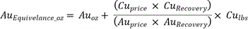
or

14.4.1 | Metals Pricing Used for Resource Estimate and Gold Equivalence |
The average spot gold price during May 2021 was $1,826 per ounce. The average spot copper price during this period was $4.62 per pound. The Bank of Montreal (BMO) conducted market research as of May 2021 of the gold and copper prices used by the industry to determine resources and reserves. Table 14.9 shows the results of the research for both gold and copper resources. Based on these figures, the author selected a gold price of $1,800 per ounce and a copper price of $3.50 per pound to estimate limits to a pit shell to constrain the Mineral Resource estimate.
Table 14.9
BMO Analysis of Metals Price Used for Determining Resources1 (May 2021) |
Type | Low | Average | High |
Gold Resource | $1,250 | $1,544 | $1,800 |
Copper Resource | $2.95 | $3.32 | $4.00 |
1From Gold and Copper Price Analysis, May 2021, The Bank of Montreal. |
From 2018 to 2021, the gold price varied from a low of $1,128 per ounce to a high of $2,063.68 per ounce with an average price of $1,560 (3-year trailing average) per ounce and copper varied from a low of $2.09 per pound to a high of $4.86 with an average price of $2.97 (3-year trailing average), which are consistent with the forecasts in the BMO Analysis shown in Table 14.9.
A gold price of $1,600 per ounce and a copper price of $3.25 per pound was selected to define the economic cut-off between ore and waste for calculating Mineral Resources and is based primarily on world commodity prices. As outlined above, this figure was deemed reasonable by the author based upon market prices as well as consensus research.
| Project 21-036 (GoldMining Inc.) | BEHRE DOLBEAR |
Independent Technical Report on the Titiribi Project – Colombia Effective Date: 14 June 2021; Published Date: 25 August 2021 |
The selection of an $1,800 per ounce gold price and $3.50 per pound copper price for defining pit constraints is just one of several factors used to define the volume in which the cut-off is applied. Factors specific to the deposit (pit slope, mining cost, deposit geometry, etc.) often have a larger role in defining the mined volume than defining the cut-off. Therefore, the author believes it is reasonable, and has determined to utilize separate price assumptions for the two concepts.
Among other things, calculating Mineral Resources at a cut-off grade using a gold price that is lower than the constraining pit shell helps mitigate risk for the project by reducing risk exposure to fluctuating metal prices and results in a more conservative resource statement with less tonnage and less contained metal.
A gold price of $1,600 per ounce and a copper price of $3.25 per pound was selected for the Gold Equivalent estimation for the Mineral Resource tabulation. These metals prices, again, are within the ranges shown in the BMO analysis in Table 14.9.
14.5 | BEHRE DOLBEAR’S RESOURCE ESTIMATION RESULTS |
The Canadian Institute of Mining, Metallurgy and Petroleum (CIM) Standing Committee on Reserve Definitions prepared the CIM Standards on Mineral Resources and Reserves – Definitions and Guidelines, which was adopted by the CIM council on May 10, 2014. This is a resource/reserve classification system that has been widely used and is internationally recognized. The CIM definitions are used by the author to report the Mineral Resources at the Titiribí property in this report. Mineral Resources under the CIM Standards are defined as follows:
A ‘Mineral Resource’ is a concentration or occurrence of solid material in or on the Earth’s crust in such form, grade or quality and quantity that there are reasonable prospects for eventual economic extraction. The location, quantity, grade or quality, continuity and other geological characteristics of a Mineral Resource are known, estimated or interpreted from specific geological evidence and knowledge, including sampling.
An ‘Inferred Mineral Resource’ is that part of a Mineral Resource for which quantity and grade or quality are estimated on the basis of limited geological evidence sampling. Geological evidence is sufficient to imply but not verified, geological and grade continuity. An Inferred Mineral Resource is based on limited information and sampling gathered through appropriate sampling techniques from locations such as outcrops, trenches, pits, workings and drill holes.
An ‘Indicated Mineral Resource’ is that part of a Mineral Resource for which quantity, grade or quality, densities, shape and physical characteristics are estimated with sufficient confidence to allow the application of Modifying Factors in sufficient detail to support mine planning and evaluation of the economic viability of the deposit. Geological evidence is derived from adequately detailed and reliable exploration, sampling and testing and is sufficient to assume geological and grade or quality continuity between points of observation.
A ‘Measured Mineral Resource’ is that part of a Mineral Resource for which quantity, grade or quality, densities, shape, and physical characteristics are estimated with confidence sufficient to allow the application of Modifying Factors to support detailed mine planning and final evaluation of the economic viability of the deposit. Geological evidence is derived from detailed and reliable exploration, sampling and testing and is sufficient to confirm geological and grade or quality continuity between points of observation.
| Project 21-036 (GoldMining Inc.) | BEHRE DOLBEAR |
Independent Technical Report on the Titiribi Project – Colombia Effective Date: 14 June 2021; Published Date: 25 August 2021 |
14.5.1 | Reasonable Prospects of Economic Extraction |
The initial concept for mining at the Titiribí property is open pit where the mineralization is contained within three separate but adjoining deposits and can be mined using a single pit operation. To determine reasonable prospects of economic extraction, the QP has constrained the mineralization by floating an open pit shell on the block model. The Mineral Resource estimate contains mineralized material within the constrained pit shell and is reported utilizing a cut-off grade determined using a gold price of $1,600 per ounce and copper price of $3.25 per pound
The conceptual pit shell developed to constrain the limits of open pit mineralization uses a selling price of $1,800 for gold and $3.50 per pound for copper which is below the average May 2021 spot prices. The author considers this as reasonable as of the effective date of this report to identify the mineralization that would have reasonable expectation to be extracted by open pit mining at the Project.
Table 14.10 shows the complete parameters and assumptions used to develop the resource pit shell used to constrain the mineralization for reporting Mineral Resources.
Table 14.10
Parameters Used for Pit Shell |
Item | Units | |
Gold Price (US$/oz) | US$/ounce | $1,800 |
Copper Price (US$/lb) | US$/pound | $3.50 |
| | | |
Gold Recovery | % | 83 |
Copper Recovery | % | 90 |
| | | |
Mining Costs – Waste | US$/tonne | $1.60 |
Mining Costs – Ore | US$/tonne | $1.70 |
| | | |
Processing and G&A Costs | US$/tonne milled | $6.80 |
| | | |
Pit Slope | degree | 50 |
| | | |
Net Smelter Return Royalty | % | 2 |
To illustrate to shape of the optimized pit, two cross sections are provided below. The locations of the sections are illustrated in Figure 14.7, Figure 14.8, and Figure 14.9 show the two orthogonal cross sections to illustrate the optimized pit shell in relation to the mineralization.
| Project 21-036 (GoldMining Inc.) | BEHRE DOLBEAR |
Independent Technical Report on the Titiribi Project – Colombia Effective Date: 14 June 2021; Published Date: 25 August 2021 |
Figure 14.7 | Section Location Map |
| (each square in the grid measures 500 meters × 500 meters) |
| Project 21-036 (GoldMining Inc.) | BEHRE DOLBEAR |
Independent Technical Report on the Titiribi Project – Colombia Effective Date: 14 June 2021; Published Date: 25 August 2021 |
| Project 21-036 (GoldMining Inc.) | BEHRE DOLBEAR |
Independent Technical Report on the Titiribi Project – Colombia Effective Date: 14 June 2021; Published Date: 25 August 2021 |
The author has categorized and summarized the Mineral Resource at the Project using the CIM definitions for Mineral Resources. Various cut-off grades, ranging from 0.2 grams of gold equivalent per tonne to 0.5 grams of gold equivalent per tonne, to summarize the results of the resource estimate within the optimized pit shell. Any of the blocks meeting the cut-off criteria and contained within the pit shell is included in the resource summary and any mineralization outside of the pit shell was excluded. Table 14.11 presents the estimate of the Measured and Indicated Mineral Resource at the Project at various cut-off. Table 14.12 shows the estimate of the Inferred Mineral Resource.
A gold equivalent cut-off of 0.3 grams of gold equivalent per tonne, which has a positive net value, was selected by the QP to report Mineral Resources at the Project, which is highlighted in Table 14.11 and Table 14.12. A gold price of $1,600 per ounce and a copper price of $3.25 per pound was selected for the Gold Equivalent calculation by the author as outlined in Table 14.11 and Table 14.12.
14.6 | RESOURCE RISK FACTORS |
The author opines that the Mineral Resource Statements are appropriate based on our review of the mineralized envelopes and the grade estimation methods. However, there are still a number of risk factors for the resource estimate.
| | ● | The Author Has Not Conducted Independent Drilling: The author has accepted the drilling data, mine sampling data, and assays, as presented by Sunward, for this report. The author has spot checked the database against the laboratory certificates. The author had a few check samples run using ¼-core of selected intervals and the stored pulps; however, no independent drilling and check work has been completed. Low Risk |
| | ● | Resource Categorization: Model blocks were estimated and classified into Measured, Indicated, and Inferred Mineral Resource under the CIM definitions. The author opines that as additional drill holes are completed in the Chisperos and NW Breccia areas, the variography should be reviewed, in detail, and adjustments made to both the grade estimation parameters and to the methodology for determining Mineral Resource categories. Low Risk |
| | ● | Risks to Mine Planning: The author opines that the overall grade and tonnage estimates are reasonable for mine planning based on the assay statistics and variography. The current resource model will smooth out the localized variations in the grade in the Inferred areas, as the drilling density here will miss some of the highly oriented structural controls. This presents a Low Risk for pre-feasibility or feasibility mine planning work, as no Inferred Resource should be used. |
The author selected a 0.30 grams of gold equivalent per tonne cut-off grade for reporting the Mineral Resources, which is higher than the estimated break-even cut-off grade. Based on a cut-off of 0.3 grams of gold equivalent per tonne, the mineral deposits at Titiribí covered by this review, hold approximately 85.0 Mt of Measured Mineral Resources averaging 0.39 grams of gold per tonne and 0.15% copper, and Indicated Mineral Resources of 349.6 Mt averaging 0.40 grams of gold per tonne and 0.10% copper. In addition, the Project has approximately 241.9 Mt of Inferred Mineral averaging 0.41 grams of gold per tonne and 0.04% copper as of 14 July 2021.
| Project 21-036 (GoldMining Inc.) | BEHRE DOLBEAR |
Independent Technical Report on the Titiribi Project – Colombia Effective Date: 14 June 2021; Published Date: 25 August 2021 |
Table 14.11
Titiribí Measured and Indicated Mineral Resource (0.3 Grams of Gold Equivalent per Tonne Cut-off as of 14 June 2021)1,2 |
Area | Category | Au | Million | Average Au | Average Cu | Contained Metal | Au Equivalence3 |
| | | Cut-off | Tonnes | (g/t) | (%) | Au (kg) | Au (million oz) | Cu (tonnes) | Cu (million lbs) | (g/t) | (million oz) |
| | 0.2 | 100.2 | 0.35 | 0.14 | 34,960 | 1.12 | 141,111 | 311.1 | 0.56 | 1.81 |
| | Measured | 0.3 | 85.0 | 0.39 | 0.15 | 32,907 | 1.06 | 129,533 | 285.6 | 0.62 | 1.69 |
| | | 0.4 | 68.6 | 0.43 | 0.16 | 29,642 | 0.95 | 113,092 | 249.3 | 0.68 | 1.50 |
| Cerro Vetas | | 0.5 | 51.2 | 0.49 | 0.18 | 24,976 | 0.80 | 92,252 | 203.4 | 0.76 | 1.25 |
| | | 0.2 | 408.1 | 0.27 | 0.11 | 111,039 | 3.57 | 453,692 | 1,000.2 | 0.44 | 5.77 |
| | Indicated | 0.3 | 254.4 | 0.35 | 0.14 | 88,925 | 2.86 | 351,836 | 775.7 | 0.56 | 4.57 |
| | | 0.4 | 175.6 | 0.42 | 0.16 | 72,813 | 2.34 | 278,117 | 613.1 | 0.65 | 3.69 |
| | | 0.5 | 22.9 | 0.49 | 0.10 | 11,291 | 0.36 | 21,799 | 48.1 | 0.64 | 0.47 |
| | | | | | | | | | | | |
| | 0.2 | 137.5 | 0.35 | - | 47,930 | 1.54 | - | - | 0.35 | 1.54 |
| Chisperos | Indicated | 0.3 | 60.4 | 0.48 | - | 29,206 | 0.94 | - | - | 0.48 | 0.94 |
| | | 0.4 | 31.1 | 0.62 | - | 19,191 | 0.62 | - | - | 0.62 | 0.62 |
| | | 0.5 | 18.5 | 0.73 | - | 13,623 | 0.44 | - | - | 0.73 | 0.44 |
| | | | | | | | | | | | |
| | 0.2 | 64.8 | 0.44 | - | 28,646 | 0.92 | - | - | 0.44 | 0.92 |
| NW Breccia | Indicated | 0.3 | 34.8 | 0.61 | - | 21,368 | 0.69 | - | - | 0.61 | 0.69 |
| | | 0.4 | 21.0 | 0.79 | - | 16,609 | 0.53 | - | - | 0.79 | 0.53 |
| | | 0.5 | 13.0 | 1.00 | - | 13,063 | 0.42 | - | - | 1.00 | 0.42 |
| | | | | | | | | | | | |
Base Case –
Measured + Indicated | 0.3 | 434.6 | 0.40 | 0.11 | 172,407 | 5.54 | 481,369 | 1,061.2 | 0.56 | 7.88 |
1Numbers may not add due to rounding. 2Chisperos and NW Breccia values based on 0.3 grams of gold per tonne cut-off. 3Gold Equivalence estimated using AuEq (oz) = Au (oz) + Cu (lbs) × 0.0022026. |
| Project 21-036 (GoldMining Inc.) | BEHRE DOLBEAR |
Independent Technical Report on the Titiribi Project – Colombia Effective Date: 14 June 2021; Published Date: 25 August 2021 |
Table 14.12
Titiribí Inferred Mineral Resource (0.3 Grams of Gold Equivalent per Tonne Cut-off as of 14 June 2021)1,2 |
Area | Category | Au | Million | Average Au | Average Cu | Contained Metal | Au Equivalence3 |
| | | Cut-off | Tonnes | (g/t) | (%) | Au (kg) | Au (million oz) | Cu (tonnes) | Cu (million lbs) | (g/t) | (million oz) |
| | 0.2 | 292.8 | 0.22 | 0.07 | 65,037 | 2.09 | 189,545 | 417.9 | 0.32 | 3.01 |
| Cerro Vetas | Inferred | 0.3 | 124.9 | 0.31 | 0.08 | 38,133 | 1.23 | 96,439 | 212.6 | 0.42 | 1.69 |
| | | 0.4 | 53.1 | 0.39 | 0.09 | 20,902 | 0.67 | 46,938 | 103.5 | 0.53 | 0.90 |
| | | 0.5 | 22.9 | 0.49 | 0.10 | 11,291 | 0.36 | 21,799 | 48.1 | 0.64 | 0.47 |
| | | | | | | | | | | | |
| | 0.2 | 102.9 | 0.33 | - | 34,027 | 1.09 | - | - | 0.33 | 1.09 |
| Chisperos | Inferred | 0.3 | 44.2 | 0.45 | - | 19,813 | 0.64 | - | - | 0.45 | 0.64 |
| | | 0.4 | 20.7 | 0.57 | - | 11,788 | 0.38 | - | - | 0.57 | 0.38 |
| | | 0.5 | 9.4 | 0.72 | - | 6,749 | 0.22 | - | - | 0.72 | 0.22 |
| | | | | | | | | | | | |
| | 0.2 | 123.0 | 0.43 | - | 52,472 | 1.69 | - | - | 0.43 | 1.69 |
| NW Breccia | Inferred | 0.3 | 72.8 | 0.55 | - | 39,999 | 1.29 | - | - | 0.55 | 1.29 |
| | | 0.4 | 39.8 | 0.72 | - | 28,615 | 0.92 | - | - | 0.72 | 0.92 |
| | | 0.5 | 29.1 | 0.82 | - | 23,887 | 0.77 | - | - | 0.82 | 0.77 |
| | | | | | | | | | | | |
Base Case – Inferred | 0.3 | 241.9 | 0.40 | 0.04 | 97,945 | 3.15 | 96,439 | 212.6 | 0.47 | 3.62 |
1Numbers may not add due to rounding. 2Chisperos and NW Breccia values based on 0.3 grams of gold per tonne cut-off. 3Gold Equivalence estimated using AuEq (oz) = Au (oz) + Cu (lbs) × 0.0022026 |
| Project 21-036 (GoldMining Inc.) | BEHRE DOLBEAR |
Independent Technical Report on the Titiribi Project – Colombia Effective Date: 14 June 2021; Published Date: 25 August 2021 |
These Mineral Resources conform to the definitions in the 2014 CIM Definition Standards – for Mineral Resources and Mineral Reserves. No reserves conforming to CIM standards have been estimated for this report, as GoldMining Inc. has not advanced the evaluation work to a point of developing mine plans, production schedules, and economic analysis. Also, no resources have been estimated for the mineralization at Junta, Maria Jo, Candela, and Porvenir, as an estimation would be premature at these early stage exploration projects.
The author opines that the Mineral Resource estimation database, procedures, and parameters applied at the Project to be generally reasonable and appropriate. The geological constraints were adequately considered in the estimation of the resource. The author opines that the data density requirements used for Measured, Indicated, and Inferred Mineral Resource definition are adequate and generally comparable to those used for Mineral Resource estimation for similar deposits.
Future Mineral Resource estimates should include more detailed geologic modeling and interpretation as new infill drilling increases the density of drilling within the NW Breccia and Chisperos areas.
| Project 21-036 (GoldMining Inc.) | BEHRE DOLBEAR |
Independent Technical Report on the Titiribi Project – Colombia Effective Date: 14 June 2021; Published Date: 25 August 2021 |
15.0 | MINERAL RESERVE ESTIMATES |
Not Applicable.
| Project 21-036 (GoldMining Inc.) | BEHRE DOLBEAR |
Independent Technical Report on the Titiribi Project – Colombia Effective Date: 14 June 2021; Published Date: 25 August 2021 |
Not Applicable.
Independent Technical Report on the Titiribi Project – Colombia Effective Date: 14 June 2021; Published Date: 25 August 2021 |
Not Applicable.
| Project 21-036 (GoldMining Inc.) | BEHRE DOLBEAR |
Independent Technical Report on the Titiribi Project – Colombia Effective Date: 14 June 2021; Published Date: 25 August 2021 |
18.0 | PROJECT INFRASTRUCTURE |
Not Applicable.
| Project 21-036 (GoldMining Inc.) | BEHRE DOLBEAR |
Independent Technical Report on the Titiribi Project – Colombia Effective Date: 14 June 2021; Published Date: 25 August 2021 |
19.0 | MARKET STUDIES AND CONTRACTS |
Not Applicable.
| Project 21-036 (GoldMining Inc.) | BEHRE DOLBEAR |
Independent Technical Report on the Titiribi Project – Colombia Effective Date: 14 June 2021; Published Date: 25 August 2021 |
20.0 | ENVIRONMENTAL STUDIES, PERMITTING, AND SOCIAL OR COMMUNITY IMPACT |
Not Applicable.
| Project 21-036 (GoldMining Inc.) | BEHRE DOLBEAR |
Independent Technical Report on the Titiribi Project – Colombia Effective Date: 14 June 2021; Published Date: 25 August 2021 |
21.0 | CAPITAL AND OPERATING COSTS |
Not Applicable.
| Project 21-036 (GoldMining Inc.) | BEHRE DOLBEAR |
Independent Technical Report on the Titiribi Project – Colombia Effective Date: 14 June 2021; Published Date: 25 August 2021 |
Not Applicable.
| Project 21-036 (GoldMining Inc.) | BEHRE DOLBEAR |
Independent Technical Report on the Titiribi Project – Colombia Effective Date: 14 June 2021; Published Date: 25 August 2021 |
The QPs are unaware of any adjacent properties, as defined by the NI 43-101.
| Project 21-036 (GoldMining Inc.) | BEHRE DOLBEAR |
Independent Technical Report on the Titiribi Project – Colombia Effective Date: 14 June 2021; Published Date: 25 August 2021 |
24.0 | OTHER RELEVANT DATA AND INFORMATION |
All relevant data and information regarding the Project is included in other sections of this report.
| Project 21-036 (GoldMining Inc.) | BEHRE DOLBEAR |
Independent Technical Report on the Titiribi Project – Colombia Effective Date: 14 June 2021; Published Date: 25 August 2021 |
25.0 | INTERPRETATION AND CONCLUSIONS |
The Cerro Vetas-NW Breccia-Chisperos complex is a bulk tonnage gold and copper porphyry deposit directly related to several interconnected Cerro Vetas diorite porphyry centers but also hosted in the immediate contact aureoles and adjacent breccias. Mineralization hosted in the Cerro Vetas diorite porphyry is disseminated and fracture controlled. The principal metallic minerals are native gold, chalcopyrite, pyrite, and magnetite. Gold values within the Cerro Vetas diorite normally correlate well with copper content and magnetite. The largest diorite intrusive occurs within the Cerro Vetas zone with smaller plugs and dikes found within the NW Breccia and Chisperos zones. The diorite porphyry hosts typical porphyry copper alteration with a barren to weakly mineralized pro-grade potassic core, surrounded by a well-mineralized phyllic zone, and a thinly mineralized retrograde argillic zone. The outermost propyllitic alteration zone is widespread. Interpretation of geophysical and drill hole data suggests that potential higher-grade gold-copper zones exist as a domed contact-related shell in the intrusive where brecciated diorite with xenolithic fragments of sedimentary rocks was intercepted in drilling. This higher-grade domed shell is, at least in part, coincident with the phyllically altered intrusive-sedimentary contact breccia.
A second style of mineralization is gold-only mineralization developed in diatreme breccias in the NW Breccia and at Chisperos. Chisperos hosts gold-copper mineralization in diorite plugs and dikes, gold-only mineralization in diatreme breccia, and also hosts substantial epithermal, lower-temperature generally gold-only mineralization within parallel to sub-parallel mineralized zones that are both stratigraphically and structurally controlled and hosted in a sedimentary-volcanic sequence. The Cerro Vetas, NW Breccia, and Chisperos zones host NI 43-101-guideline-compliant resources. Exploration during 2013 discovered copper-dominant and gold-copper mineralization at the Maria Jo prospect that may be an extension of the Cerro Vetas and Chisperos zones.
Further exploration potential exists to expand the known resources at Cerro Vetas-NW Breccia-Chisperos particularly along the alignment of magnetic highs hosting the Maria Jo and Junta mineralized zones. Drilling at Maria Jo has intersected significant intervals of copper-dominant and gold-copper mineralization related to a diorite intrusive where surface exposures are lacking due to a thin veneer of post-mineral gravel. Junta hosts mineralized stock-like diorite porphyry intrusive, as does Porvenir; Candela hosts thick zones of mineralized hornfels and diorite porphyry. Margarita and Rosa are very early-stage targets.
Coring is logged and well documented. The QA/QC data is extensive; the use of standards and blanks, duplicate and check assays followed industry recognized procedures. There are some minor concerns that relate to a coarse gold-nugget effect and possible mislabeling of pulp sample envelopes.
| Project 21-036 (GoldMining Inc.) | BEHRE DOLBEAR |
Independent Technical Report on the Titiribi Project – Colombia Effective Date: 14 June 2021; Published Date: 25 August 2021 |
26.1 | GEOLOGIC AND EXPLORATION RECOMMENDATIONS |
| | ● | The known deposits and early stage exploration projects have focused upon magnetic highs with coincident gold-copper soil anomalies. In 2012, the authors recommended a preliminary drill test at a magnetic high that did not host geochemical anomalies, along the Cerro Vetas-Junta structural zone. This recommendation resulted in the discovery of significant copper-dominant mineralization at Maria Jo. The authors recommend further drilling at Maria Jo, focused along the Cerro Vetas-Junta structural trend and over the magnetic high, which has yet to be drill tested. |
| | ● | The relationship between magnetic highs, intrusive centers, and mineralization is well established. An unexplored magnetic high occurs about 700 meters southeast of the Junta magnetic high along the trend of the Cerro Vetas-Maria Jo-Junta magnetic highs. This trend suggests a common source along a controlling deep-seated structural weakness. Although there are no geochemical anomalies related to this un-named and unexplored magnetic feature, the analogy with Maria Jo, where the causative intrusive and mineralized contact aureole is covered by post-mineral gravel, is plausible. If additional geologic mapping cannot find the source of the magnetic high, the authors recommend that some initial exploration drill holes be drilled in and peripheral to the magnetic high. |
| | ● | Future geologic studies focus on a more in-depth study of small-displacement faults that are not depicted on the present geologic plan and cross sectional maps, but appear to be important structural-mineralizing controls, particularly at Chisperos. |
| | ● | QA/QC procedures are good; however, it is recommended, in the future, that: |
| | ● | More diligence be paid to explain outlier results on standards. There are concerns with the assay results on two gold standards. The questionable results appear to be due to the insertion of the wrong standard sample into the sample stream. |
| | ● | Outlier results (duplicate or re-assay) should be repeated, as necessary, to determine if the cause is a nugget effect, error in sample identification, etc. |
26.2 | RESOURCE AND MODELING RECOMMENDATIONS |
| | ● | If infill drilling is contemplated at the Chisperos and the NW Breccia areas, additional variography work should be completed and the detailed three-dimensional geologic models updated. |
26.3 | METALLURGICAL RECOMMENDATIONS |
| | ● | Comprehensive metallurgical testing of mining plan-based composites needs to be completed to further develop the milling flow sheet. |
| | ● | Copper concentrate marketability needs to be investigated to fully understand the effects of identified penalty elements, such as zinc and lead. |
| | ● | An optimized flow sheet can be developed following the development of a base mining plan with annual head grades and ore production values. More specific costing can then be developed to match the production variables. |
| Project 21-036 (GoldMining Inc.) | BEHRE DOLBEAR |
Independent Technical Report on the Titiribi Project – Colombia Effective Date: 14 June 2021; Published Date: 25 August 2021 |
26.4 | SOCIAL AND CULTURAL RECOMMENDATIONS |
| | ● | Assuming preliminary economic assessments are positive, GoldMining Inc. should initiate a formal baseline environmental monitoring program. The next step would be to begin preparation of the necessary permits. A mine and reclamation plan will be needed to evaluate environmental and other impacts. GoldMining Inc. should seek input from Colombian governmental agencies to make sure they are informed and nothing is missed. |
| | ● | If a decision is made to move forward with the Project, formalization of sustainable social and community impact programs should be established. The recommendations noted above, along with those contained in the Akicita, S.A. report, will provide a strong base for these programs. The public affairs/communications program noted above should start by bringing local, state, and Colombian officials to the Project site at the earliest time possible to educate them on the Project. Training, communications, and education are the foundation for success. |
The authors of this Technical Report recommend a moderate increase in expenditures starting in December 2021 through February 2023, totaling $1,605,100 (US$) as shown in Table 26.1.
Table 26.1
Proposed Budget (December 2021 through February 2023) |
Item | Explanation | US$ |
| | | December 2021 | 2022 | January-February 2023 | Total |
Drilling and Assaying | Exploration, Geochemical, and Assaying | | 870,000 | | 870,000 |
Camp Cost | Food, Rents, Security, Supplies, Utilities, and Communication | 33,000 | 100,500 | 10,500 | 144,000 |
Fuel and Transportation | Fuel, Tolls, Maintenance, and Parking | 600 | 9,000 | 1,200 | 10,800 |
Land Access | Land Access and Cannon Fee Policy | | 63,000 | | 63,000 |
Legal | Legal Lawyers | 500 | 12,000 | 3,000 | 15,500 |
Medellin Cost | Rent, Security, Supplies, Utilities, Communication, and Food | | | | |
Includes IR | 1,700 | 60,500 | 7,100 | 69,300 | |
Consultants | Statutory Audit, Internet Technology, Accounting, and Security | 2,900 | 40,900 | 8,000 | 51,800 |
Staff Cost | Labor Cost – Including All-in Cost | 28,400 | 244,000 | 41,000 | 313,400 |
Taxes | Equity, VAT, and Corporate Income Tax | 2,200 | 26,200 | 4,800 | 33,200 |
Sustainability | Reclamation, Community Relations, Health and Safety, Marketing, and Communications | 1,500 | 26,800 | 5,800 | 34,100 |
| | | | | | |
Total | | 70,800 | 1,452,900 | 81,400 | 1,605,100 |
| Project 21-036 (GoldMining Inc.) | BEHRE DOLBEAR |
Independent Technical Report on the Titiribi Project – Colombia Effective Date: 14 June 2021; Published Date: 25 August 2021 |
Drilling and Assaying – Budget for 3,200 meters of diamond drilling costing an estimated $750,000, geotechnical studies costing an estimated $40,000 and $80,000 for Contingencies. All drilling is expected to be oriented diamond drilling. Drilling costs include assaying at certified laboratories and the use of blanks, standards, duplicate and check assays. Drilling would include in-fill diamond drilling and drilling at exploration targets.
Camp Cost – Includes food and board, camp supplies, cell phone use, warehouse rent, utilities, security, maintenance, field vehicle insurance, and reject storage.
Fuel and Transportation – Maintenance, fuel, and tires for vehicles in Medellin and Titiribí.
Land Access – Includes mandatory Cannon Fees and mandatory insurance.
Legal – Includes costs for Mr. Hernando Escobar and Ms. Claudia Herrara.
Medellin – Includes costs principally for Chamber of Commerce, rent, vehicle insurance, software fees, general liability insurance, security, and miscellaneous office costs.
Consultants – Includes costs for auditors, risk and security advisors, accounting, annual income tax presentation, Sigmin, and mandatory health and safety officer.
Staff Cost – Includes salaries, benefits, mandatory uniforms, health and life insurance, staff, and temporary employees.
Taxes – Includes VAT and withholding taxes.
Sustainability – Includes Follow-up and Control of the Platform and Access Recovery Process (all mandatory); Solid Waste Management; Maintenance of Office Gardens and/or Green Areas; Climate and Water Monitoring; Piragua (water follow-up committee); Environmental Meetings and Management; Support for Productive Projects; Memory and Cultural Heritage; Museum House; Cleaning Supplies for the Elderly (charity institution); SG-SST Occupational Health and Safety Management System; and Consulting Firm (popular consultation).
| Project 21-036 (GoldMining Inc.) | BEHRE DOLBEAR |
Independent Technical Report on the Titiribi Project – Colombia Effective Date: 14 June 2021; Published Date: 25 August 2021 |
Akicita, S.A., 2012, Evaluation of Community Relations Program
Andrew, Colin J., 2011, Sunward Resources Internal Report
Andrew, Colin J., 2012, personal communications
Aspden, J.A., McCourt, W.J., and Brook, M., 1987, Geometrical Control of Subduction-Related Magmatism: The Mesozoic and Cenozoic Plutonic History of Western Colombia, Journal of the Geological Society, London, Volume 144, pp. 893-905
Behre Dolbear, 2011, Summary of the Technical Report on the Titiribí Project, Department of Antioquia, Colombia
Behre Dolbear, 2012, Technical Report on the Titiribí Project, Department of Antioquia, Colombia
Behre Dolbear, 2013, Technical Report on the Titiribí Project, Department of Antioquia, Colombia
Behre Dolbear, 2016, Technical Report on the Titiribí Project, Department of Antioquia, Colombia
Bing.com News, 2016, News on Colombia Peace Agreement
CNN.com News, 2016, News on Colombian Peace Accord Vote
CIM Standing Committee on Reserve Definitions, 2014, CIM Definition Standards - For Mineral Resources and Mineral Reserves
Cediel, F., Shaw, R.P., and Caceres, C., 2003, Tecontonic Assembly of the Northern Andean Block in Bartolini, C., Buffler, R. and Blickwede, J., eds., The Circum-Gulf of Mexico and Caribbean Region: Plate Tectonics, Basin Formation and Hydrocarbon Habitats; American Association of Petroleum Geologist’s Memoir
CIA 2013 World Factbook, Colombia Economy 2013
Ellis, R., 2011, Summary Comments of Geophysical Data, Ellis Geophysical Consultings
Emmons, W.H., 1937, Gold Deposits of the World, McGraw-Hill Book Co., Inc.
Forest, D., 2011, In House Report
Frost, D., 2011, Sunward Resources Internal Document
Geosure Exploration & Mining Solutions, 2010, Amended Independent Resource Report for Cerro Vetas Prospect, Titiribí Project, Antioquia, Colombia
GEOTEC, Ltda., 1987, Gold in Colombia: Historical overview, geologic framework, prospectivity, legal aspects
GEOTEC Ltda., 2000, Geological Map of Colombia, 1:2,000,000 scale with Legend and Tectono-stratigraphic chart, digital format
Hill, M., 2012, Colombia Coal Production to Reach 120Mt in 2014, says Minister, Mining Weekly, 2012
Kedahda, S.A., Titiribí Project, La Candela-La Margarita Sectors, 2003, Final Reconnaissance Report, Muriel Mining Internal Document
Llewellyn, R.O., 2013, Colombian Mining Dispute Highlights Legislative Disarray, news.mongabay.com
Martinez, B.P.C, and Duque, J.D.M., Mining in Colombia, Latinlawyer.com
McCourt, W.J., and Aspden, J.A., 1983, A Plate Tectonic Model for the Phanerozoic Evolution of Central and Southern Colombia, 10th Caribbean Geological Conference, Cartagena, Abstracts
McCourt, W.J., and Feininger, T. 1984, High-pressure Metamorphic Rocks in the Central Cordillera of Colombia and Their Regional Significance, British Geological Report Series, 16/1, 28-35
McCourt, W.J., Feininger, T., and Brook, M, 1984, New Geological and Geochronological Data from the Colombia Andes: Continental Growth by Multiple Accretion, Journal of the Geological Society, London, 141, 831-845
Meldrum S., 1998, Titiribí Porphyry Copper Project, Antioquia, Colombia: Data Compilation and Porphyry Model, Prepared for Gold Fields of South Africa
Restrepo, V., 1883, Studies on the Gold and Silver Mines in Colombia, Bibliotec Colombiana de Ciencias Sociales, Quinta Edicion, 1979, Medellín, 220 pages
Rodriquez, C., and Warden, A.J., 1993, Overview of some Colombian Gold Deposits and Their Development Potential, Mineralium Deposita, Volume 28, pp. 47-57
Shaw, R.P., 2000, Gold Mineralisation in the Northern Andes: Magmatic Setting vs. Metallogeny, Grupo de Bullet, S.A., Medellín – GEOTEC Ltda, Bogota,Colombia
Sillitoe, R.H., 2008, Major Gold Deposits and Belts of the North and South American Cordillera: Distribution, Tectonomagmatic Settings, and Metallogenic Considerations, Society of Economic Geologists, Volume 103, pp. 663-687
Sillitoe, R.H., 2010, Porphyry Copper Systems, Society of Economic Geologists, Volume 105, pp. 3-41
Sunward Resources Titiribí Project Annual Report 2010
Sunward Resources, 2011 and 2012, Press Releases, June 22, 2011, July 25, 2011, September 29, 2011, November 10, 2011, February 02, 2012, and February 09, 2012
Sunward Resources, Report on C 21, Internal Document
The Bank of Montreal, Gold and Copper Price Analysis, May 2021
Valdiri, James, 2016, Project Titiribí Mining and Environmental Due Diligence Report, 12 August 2016, Dentons, Cardenas & Cardenas, August 12, 2016
Wardell Armstrong International, Stage III Metallurgical Testing on Samples of Gold and Copper Mineralization, ZT64-0385, May 2013
World Gold Analyst, The Colombia Gold Mine Industry, 2011
| Project 21-036 (GoldMining Inc.) | BEHRE DOLBEAR |
Independent Technical Report on the Titiribi Project – Colombia Effective Date: 14 June 2021; Published Date: 25 August 2021 |
DATE AND SIGNATURE PAGE
This technical report, with an effective date of 14 June 2021, is respectfully submitted this 25th day of August 2021.
“Signed and Sealed”
Joseph A. Kantor, M.Sc., MMSA Geology 01309QP
“Signed and Sealed”
Robert E. Cameron, Ph.D., MMSA Mining and Ore Reserves 01357QP
“Signed and Sealed”
Mauricio Castañeda, MAIG, QP
| Project 21-036 (GoldMining Inc.) | BEHRE DOLBEAR |
Independent Technical Report on the Titiribi Project – Colombia Effective Date: 14 June 2021; Published Date: 25 August 2021 |
CERTIFICATE OF AUTHOR
JOSEPH A. KANTOR, M.Sc., MMSA GEOLOGY 01309QP
I, Joseph A. Kantor, M.Sc., MMSA Geology 01309QP, of 3792 Worthington Place, Southport, North Carolina, 28461, USA, certify that:
1) | I am an independent consulting geologist providing exploration services to the mineral exploration community. |
2) | I graduated from Michigan Technological University with a B.S. degree in Geology in 1966 and an M.S. degree in 1968. |
3) | I am a member of the Society for Mining, Metallurgy and Exploration, Inc. and a Qualified Professional (QP) Member of the Mining and Metallurgical Society of America, QP Member #01309 – Geology. |
4) | I have practiced my profession continuously since 1966 and have been involved in projects and evaluations exploring for precious and base metals in the United States, Canada, China, México, Kazakhstan, Mongolia, Péru, and elsewhere. As a result of my experience and qualifications, I am a Qualified Professional, as defined by the Canadian National Instrument 43-101 Standards of Disclosure for Mineral Properties (“NI 43-101”) and am a Qualified Person (Professional) for this Instrument. |
5) | I have read the definition of “qualified person” as set out in the NI 43-101 and certify that by reason of my education, affiliation with a professional association (as defined in NI 43-101), and past relevant work experience, I fulfill the requirements to be a “qualified person” for the purposes of the NI 43-101. |
6) | I am responsible for the preparation of Sections 1.1, 1.3, all parts of Sections 2.0, 3.0, and 4.0 (including being jointly responsible for all parts of Section 2.0 with Mauricio Castaneda), all parts of Section 6.0 through 12.0, all parts of Sections 16.0 through 25.0, Sections 26.1, 26.3, 26.4, and 26.5, and Appendix 1.0 of the Technical Report on the Titiribí Project, Department of Antioquia, Colombia with an effective date of 14 June 2021 (the “Technical Report”) and published date of 25 August 2021. |
7) | I have personally visited the Titiribí Project on July 12 through July 14, 2011, March 12 through March 13, 2012, and April 16 through April 18, 2013. |
8) | I have had no prior involvement with the property that is the subject of the Summary Technical Report, except for my involvement with the 2011, 2012, 2013, and 2016 Technical Reports. |
9) | As of the effective date of the Technical Report, to the best of my knowledge, information, and belief, the Technical Report contains all scientific and technical information that is required to be disclosed to make the report not misleading. |
10) | I am independent of GoldMining Inc., as set out in Section 1.5 of the NI 43-101. |
11) | I have read the NI 43-101 and the Technical Report has been prepared in compliance with the NI 43-101 and Form 43-101F1. |
12) | I consent to the filing of this Technical Report with any stock exchange and other regulatory authority and any publication by them, including electronic publication in the public company files on their websites accessible by the public. |
Dated this 25th day of August 2021.
“Signed and Sealed”
Joseph A. Kantor, M.Sc., MMSA Geology 01309QP
| Project 21-036 (GoldMining Inc.) | BEHRE DOLBEAR |
Independent Technical Report on the Titiribi Project – Colombia Effective Date: 14 June 2021; Published Date: 25 August 2021 |
CERTIFICATE OF AUTHOR
ROBERT E. CAMERON, PH.D., MMSA GEOLOGY 01357QP
I, Robert E. Cameron, Ph.D., MMSA Mining and Ore Reserves 01357QP, do hereby certify that:
1) | I am a consulting resource and reserve specialist doing business as Robert Cameron Consulting at the address of 200 Dubois Street, Black Hawk, Colorado, 80422, USA. |
2) | I am a Qualified Person – No. 01357QP of the Mining and Metallurgical Society of America. |
3) | I am a graduate of The University of Utah with a B.S., M.S., and Ph.D. degrees in Mining Engineering. |
4) | I have practiced my profession since 1977. My relevant experience for the purpose of the Technical Report (as hereinafter defined) is acting as a consulting resource and reserve specialist for 40 years specializing in the due diligence review, computerized mine design, mine optimization, geostatistical review, and resource and reserve audits of a wide variety of minerals. |
5) | I have read the definition of “Qualified Person” as set out in the Canadian National Instrument 43-101 Standards of Disclosure for Mineral Properties (“NI 43-101”) and certify that by reason of my education, affiliation with a professional association (as defined in NI 43-101), and past relevant work experience, I fulfill the requirements to be a “Qualified Person” for the purposes of NI 43-101. |
6) | I am responsible for the preparation of Section 1.2, all parts of Sections 13.0 through 15.0, Section 26.2, and all parts of Section 27.0 of the Technical Report on the Titiribí Project, Department of Antioquia, Colombia with an effective date of 14 June 2021 (the “Technical Report”) and published date of 25 August 2021. |
7) | I have personally visited the Titiribí Project on July 12 through July 14, 2011, March 12 through March 13, 2012, and April 16 through April 18, 2013. |
8) | I have had no prior involvement with the properties that are the subject of the Technical Report except for my involvement with the 2011, 2012, 2013, and 2016 Technical Reports. |
9) | I am independent of GoldMining Inc., as set out in Section 1.5 of the NI 43-101. |
10) | I have read the NI 43-101 and the Technical Report has been prepared in compliance with the NI 43-101 and Form 43-101F1. |
11) | As of the effective date of the Technical Report, to the best of my knowledge, information, and belief, the Technical Report contains all scientific and technical information that is required to be disclosed to make the Technical Report not misleading. |
12) | I consent to the filing of this Technical Report with any stock exchange and other regulatory authority and any publication by them, including electronic publication in the public company files on their websites accessible by the public. |
Dated this 25th day of August 2021.
“Signed and Sealed”
Robert E. Cameron, Ph.D., MMSA Mining and Ore Reserves 01357QP
| Project 21-036 (GoldMining Inc.) | BEHRE DOLBEAR |
Independent Technical Report on the Titiribi Project – Colombia Effective Date: 14 June 2021; Published Date: 25 August 2021 |
CERTIFICATE OF AUTHOR
MAURICIO CASTAÑEDA, MAIG, QP
I, Mauricio Castañeda, MAIG, QP, do hereby certify that:
1) | I am an independent consulting mineral exploration specialist doing business as Mauricio Castañeda at the address of Cra. 48 98A Sur 250, Medellín, Colombia. |
2) | This certificate applies to the Technical Report on the Titiribí Project, Department of Antioquia, Colombia with an effective date of 14 June 2021 (the “Technical Report”). |
3) | I graduated with a Bachelor of Science and Engineering in Geological Engineering from Universidad EIA (Former Escuela de Ingeniería de Antioquia) in Medellín, Colombia. |
4) | I am a Member of the Australian Institute of Geoscientists (AIG Member ID 5443) and Member of Canadian Institute of Mining, Metallurgy and Petroleum (CIM Member No. 706703). I have worked as a geologist continuously for approximately 22 years since my graduation from university. |
5) | I have been involved in mining, mineral exploration and mineral resource evaluation practice for approximately 22 years. My relevant experience for the purpose of the Technical Report is acting as an independent mineral exploration consultant specializing in the precious and base metal exploration, managing and leading mineral exploration in early and advanced projects, managing and leading mining operations, and evaluating base and precious metal projects, scoping, prefeasibility and feasibility studies. |
6) | I have read the definition of “Qualified Person” as set out in the Canadian National Instrument 43-101 Standards of Disclosure for Mineral Properties (“NI 43-101”) and certify that by reason of my education, affiliation with a professional association (as defined in NI 43-101), and past relevant work experience, I fulfill the requirements to be a “Qualified Person” for the purposes of NI 43-101. |
7) | I am responsible for Sections 2.0 and 5.0 (including being jointly responsible for all parts of Section 2.0 with Joseph Kantor) of the Technical Report on the Titiribí Project, Department of Antioquia, Colombia with an effective date of 14 June 2021 (the “Technical Report”) and published date of 25 August 2021. |
8) | I have personally visited the Titiribí Project on 13 June 2021. |
9) | I have had no prior involvement with the properties that are the subject of the Technical Report. |
10) | I am independent of GoldMining Inc., as set out in Section 1.5 of the NI 43-101. |
11) | I have read the NI 43-101 and the Technical Report has been prepared in compliance with the NI 43-101 and Form 43-101F1. |
12) | As of the effective date of the Technical Report, to the best of my knowledge, information, and belief, the Technical Report contains all scientific and technical information that is required to be disclosed to make the Technical Report not misleading. |
13) | I consent to the filing of this Technical Report with any stock exchange and other regulatory authority and any publication by them, including electronic publication in the public company files on their websites accessible by the public. |
Dated this 25th day of August 2021.
“Signed and Sealed”
Mauricio Castañeda, MAIG, QP
| Project 21-036 (GoldMining Inc.) | BEHRE DOLBEAR |
Independent Technical Report on the Titiribi Project – Colombia Effective Date: 14 June 2021; Published Date: 25 August 2021 |
APPENDIX 1.0
DRILL HOLE SUMMARY – ALL HOLES DRILLED AT THE PROJECT
| Project 21-036 (GoldMining Inc.) | BEHRE DOLBEAR |
Independent Technical Report on the Titiribi Project – Colombia Effective Date: 14 June 2021; Published Date: 25 August 2021 |
Table A1.1
Summary List of All Titiribí Project Drilling Through February 2013 |
Hole ID | East UTM Colombia West | North UTM Colombia West | Elevation | Azimuth | Dip | Total Depth (meters) | Date Completed |
Goldfields | | | | | | | |
DDT1 | 1,141,272.98 | 1,162,641.07 | 1,785.82 | 175 | -50 | 159.50 | 5/28/1998 |
DDT2 | 1,140,855.88 | 1,162,622.42 | 1,926.75 | 175 | -50 | 125.10 | 6/4/1998 |
DDT3 | 1,140,851.02 | 1,162,822.79 | 1,865.02 | 175 | -50 | 160.50 | 6/8/1998 |
DDT4 | 1,140,449.80 | 1,162,719.99 | 1,920.68 | 175 | -50 | 167.00 | 6/12/1998 |
DDT5 | 1,140,300.44 | 1,162,504.57 | 1,981.80 | 360 | -90 | 132.41 | 6/15/1998 |
DDT6 | 1,140,102.86 | 1,162,352.16 | 1,934.49 | 175 | -50 | 160.00 | 6/18/1998 |
DDT7 | 1,140,041.20 | 1,162,663.62 | 1,885.62 | 175 | -50 | 188.00 | 6/21/1998 |
DDT8 | 1,139,679.05 | 1,162,454.96 | 1,962.58 | 175 | -50 | 158.00 | 6/26/1998 |
DDT9 | 1,139,679.05 | 1,162,454.96 | 1,962.58 | 85 | -50 | 149.00 | 7/10/1998 |
DDT10 | 1,139,734.42 | 1,162,701.54 | 1,934.54 | 85 | -50 | 101.00 | 7/15/1998 |
DDT11 | 1,140,104.70 | 1,162,354.04 | 1,934.45 | 52 | -50 | 300.00 | 7/23/1998 |
DDT12 | 1,140,041.26 | 1,162,663.55 | 1,885.50 | 52 | -50 | 149.00 | 7/27/1998 |
DDT13 | 1,140,104.87 | 1,162,351.14 | 1,934.52 | 232 | -50 | 150.00 | 8/1/1998 |
DDT14 | 1,140,455.23 | 1,162,627.44 | 1,948.47 | 232 | -50 | 302.00 | 8/8/1998 |
DDT15 | 1,140,165.68 | 1,162,304.65 | 1,959.58 | 232 | -45 | 250.00 | 8/19/1998 |
DDT16 | 1,140,342.08 | 1,162,328.77 | 2,021.27 | 232 | -45 | 406.00 | 10/3/1998 |
Chisperos – GRL and DBGF Joint Venture | | | | | | | |
TR1 | 1,141,534.77 | 1,162,660.84 | 1,633.50 | 270 | -70 | 200.00 | 12/1/2006 |
TR2 | 1,141,536.86 | 1,162,658.58 | 1,633.41 | 320 | -55 | 197.00 | 12/5/2006 |
TR3 | 1,141,535.48 | 1,162,658.35 | 1,633.47 | 230 | -55 | 152.85 | 12/12/2006 |
TR4 | 1,141,533.60 | 1,162,802.33 | 1,652.10 | 270 | -60 | 200.00 | 1/11/2007 |
TR5 | 1,141,531.51 | 1,162,806.75 | 1,652.10 | 315 | -60 | 295.00 | 2/18/2007 |
TR6 | 1,141,438.44 | 1,162,909.04 | 1,655.84 | 263 | -60 | 161.15 | 2/28/2007 |
TR7 | 1,141,438.06 | 1,162,906.48 | 1,655.88 | 360 | -70 | 185.15 | 3/8/2007 |
TR8 | 1,141,437.47 | 1,162,900.90 | 1,656.14 | 90 | -80 | 191.50 | 3/17/2007 |
TR9 | 1,141,440.04 | 1,162,900.32 | 1,656.18 | 180 | -60 | 200.00 | 3/27/2007 |
| Project 21-036 (GoldMining Inc.) | BEHRE DOLBEAR |
Independent Technical Report on the Titiribi Project – Colombia Effective Date: 14 June 2021; Published Date: 25 August 2021 |
Table A1.1
Summary List of All Titiribí Project Drilling Through February 2013 |
Hole ID | East UTM Colombia West | North UTM Colombia West | Elevation | Azimuth | Dip | Total Depth (meters) | Date Completed |
TR10 | 1,141,307.17 | 1,162,520.31 | 1,785.00 | 360 | -60 | 304.20 | 4/17/2007 |
TR11 | 1,141,309.84 | 1,162,519.43 | 1,784.84 | 180 | -60 | 301.45 | 5/4/2007 |
TR12 | 1,141,308.79 | 1,162,515.75 | 1,785.07 | 270 | -60 | 322.10 | 5/14/2007 |
TR13 | 1,141,316.60 | 1,162,642.18 | 1,763.52 | 270 | -75 | 400.40 | 5/31/2007 |
Cerro Vetas – GRL and DBGF Joint Venture | | | | | | | |
CV001 | 1,140,153.33 | 1,161,950.45 | 2,103.80 | 360 | -60 | 497.70 | 7/14/2007 |
CV002 | 1,140,154.42 | 1,161,951.44 | 2,103.81 | 245 | -60 | 364.65 | 8/4/2007 |
CV003 | 1,140,153.00 | 1,161,946.88 | 2,103.83 | 45 | -50 | 685.00 | 9/7/2007 |
CV004 | 1,140,106.79 | 1,162,353.09 | 1,934.59 | 232 | -70 | 450.00 | 5/5/2008 |
CV005 | 1,140,106.55 | 1,162,352.92 | 1,934.57 | 232 | -50 | 300.00 | 5/17/2008 |
CV006 | 1,140,134.70 | 1,162,430.89 | 1,927.52 | 232 | -70 | 450.00 | 5/29/2008 |
CV007 | 1,140,134.45 | 1,162,430.67 | 1,927.50 | 232 | -50 | 300.00 | 5/13/2008 |
CV008 | 1,140,400.24 | 1,162,443.13 | 2,005.39 | 232 | -70 | 350.00 | 7/30/2008 |
CV009 | 1,140,399.95 | 1,162,442.82 | 2,005.39 | 232 | -50 | 450.70 | 8/8/2008 |
CV010 | 1,140,104.60 | 1,162,358.18 | 1,934.38 | 52 | -77 | 400.00 | 8/15/2008 |
CV011 | 1,140,101.68 | 1,162,355.17 | 1,934.37 | 232 | -85 | 400.50 | 8/22/2008 |
CV012 | 1,140,181.42 | 1,162,534.94 | 1,921.95 | 232 | -50 | 400.00 | 8/29/2008 |
CV013 | 1,140,457.75 | 1,162,658.22 | 1,938.67 | 232 | -60 | 400.00 | 9/21/2008 |
CV014 | 1,140,462.79 | 1,162,260.43 | 2,099.34 | 232 | -50 | 400.00 | 10/11/2008 |
CV015 | 1,140,426.80 | 1,162,304.51 | 2,074.18 | 232 | -50 | 429.55 | 9/13/2008 |
CV016 | 1,140,355.81 | 1,162,101.75 | 2,074.38 | 60 | -50 | 300.00 | 10/17/2008 |
CV017 | 1,140,350.10 | 1,162,464.73 | 2,006.24 | 232 | -50 | 400.00 | 9/30/2008 |
CV017E | 1,140,350.10 | 1,162,464.73 | 2,006.24 | 232 | -50 | 995.50 | 10/10/2010 |
CV018 | 1,140,238.85 | 1,162,617.60 | 1,963.72 | 232 | -56 | 1,031.80 | 6/11/2010 |
CV019 | 1,140,290.62 | 1,162,600.63 | 1,937.46 | 232 | -60 | 1,047.35 | 7/23/2010 |
CV020 | 1,140,602.34 | 1,162,646.68 | 1,928.56 | 232 | -58 | 887.20 | 8/12/2010 |
CV020A | 1,140,602.53 | 1,162,646.96 | 1,928.53 | 232 | -58 | 360.00 | 8/12/2010 |
CV021 | 1,140,188.04 | 1,162,699.71 | 1,960.54 | 232 | -60 | 1,059.70 | 8/22/2010 |
| Project 21-036 (GoldMining Inc.) | BEHRE DOLBEAR |
Independent Technical Report on the Titiribi Project – Colombia Effective Date: 14 June 2021; Published Date: 25 August 2021 |
Table A1.1
Summary List of All Titiribí Project Drilling Through February 2013 |
Hole ID | East UTM Colombia West | North UTM Colombia West | Elevation | Azimuth | Dip | Total Depth (meters) | Date Completed |
CV022 | 1,140,128.58 | 1,162,792.20 | 1,930.20 | 232 | -60 | 1,073.50 | 9/7/2010 |
CV023 | 1,140,130.93 | 1,162,792.16 | 1,930.12 | 52 | -50 | 500.00 | 10/3/2010 |
CV024 | 1,140,628.23 | 1,162,414.96 | 2,040.33 | 232 | -60 | 1,244.26 | 11/1/2010 |
CV025 | 1,140,353.63 | 1,162,465.91 | 2,006.21 | 52 | -60 | 401.00 | 10/24/2010 |
CV026 | 1,140,197.75 | 1,162,336.31 | 1,976.51 | 232 | -45 | 657.00 | 10/27/2010 |
CV027 | 1,140,377.80 | 1,162,588.17 | 1,941.26 | 232 | -60 | 1,025.40 | 11/22/2010 |
CV028 | 1,140,287.49 | 1,162,269.38 | 2,041.33 | 232 | -50 | 922.20 | 11/23/2010 |
CV029 | 1,140,651.18 | 1,162,177.78 | 2,003.61 | 232 | -70 | 369.05 | 11/19/2010 |
CV030 | 1,140,433.40 | 1,162,052.85 | 2,037.98 | 232 | -60 | 1,014.30 | 27/01/2011 |
CV031 | 1,140,090.40 | 1,162,868.40 | 1,909.99 | 232 | -60 | 850.90 | 16/01/2011 |
CV032 | 1,140,642.96 | 1,162,030.77 | 1,948.96 | 232 | -65 | 1,015.00 | 18/1/2011 |
CV033 | 1,140,476.45 | 1,162,925.22 | 1,832.97 | 232 | -55 | 1,045.00 | 12/2/2011 |
CV034 | 1,140,060.92 | 1,162,966.14 | 1,873.19 | 232 | -60 | 941.50 | 24/02/2011 |
CV035 | 1,140,646.62 | 1,161,851.33 | 1,931.05 | 232 | -60 | 808.55 | 6/2/2011 |
CV036 | 1,140,331.11 | 1,162,186.50 | 2,112.94 | 232 | -50 | 828.29 | 3/3/2011 |
CV037 | 1,140,219.38 | 1,162,653.22 | 1,963.55 | 142 | -60 | 700.00 | 26/03/2011 |
CV038 | 1,140,401.75 | 1,162,444.42 | 2,005.39 | 142 | -60 | 692.50 | 26/03/2011 |
CV039 | 1,139,679.01 | 1,162,452.91 | 1,962.78 | 142 | -50 | 950.00 | 26/05/2011 |
CV040 | 1,140,179.88 | 1,162,064.85 | 2,134.10 | 322 | -51 | 873.50 | 11/6/2011 |
CV041 | 1,139,626.18 | 1,162,525.13 | 2,019.68 | 142 | -70 | 357.20 | 18/06/2011 |
CV042 | 1,140,100.63 | 1,162,005.05 | 2,134.22 | 322 | -60 | 783.00 | 30/06/2011 |
CV043 | 1,139,552.00 | 1,162,278.00 | 2,085.00 | 142 | -50 | 492.00 | 2/7/2011 |
CV044 | 1,140,013.00 | 1,162,023.00 | 2,117.00 | 322 | -50 | 600.00 | 14/07/2011 |
CV045 | 1,140,612.00 | 1,162,139.00 | 1,988.00 | 142 | -60 | 324.60 | 27/07/2011 |
CV046 | 1,140,261.00 | 1,162,144.00 | 2,110.00 | 322 | -50 | 816.50 | 7/8/2011 |
CV047 | 1,139,889.00 | 1,161,880.00 | 2,142.00 | 142 | -50 | 710.50 | 18/08/2011 |
CV048 | 1,140,260.00 | 1,162,134.00 | 2,110.00 | 142 | -50 | 300.80 | 17/08/2011 |
CV049 | 1,140,141.00 | 1,162,038.00 | 2,117.00 | 322 | -50 | 670.00 | 6/9/2011 |
CV050 | 1,139,889.00 | 1,161,880.00 | 2,142.00 | 322 | -50 | 506.50 | 31/08/2011 |
| Project 21-036 (GoldMining Inc.) | BEHRE DOLBEAR |
Independent Technical Report on the Titiribi Project – Colombia Effective Date: 14 June 2021; Published Date: 25 August 2021 |
Table A1.1
Summary List of All Titiribí Project Drilling Through February 2013 |
Hole ID | East UTM Colombia West | North UTM Colombia West | Elevation | Azimuth | Dip | Total Depth (meters) | Date Completed |
CV051 | 1,139,488.00 | 1,161,735.00 | 2,106.00 | 142 | -50 | 462.30 | 23/09/2011 |
CV052 | 1,140,141.00 | 1,162,038.00 | 2,117.00 | 142 | -50 | 500.00 | 20/09/2011 |
CV053 | 1,140,226.00 | 1,162,116.00 | 2,107.00 | 322 | -50 | 731.50 | 10/10/2011 |
CV054 | 1,139,731.00 | 1,162,707.00 | 1,931.00 | 142 | -50 | 964.50 | 25/10/2011 |
CV055 | 1,140,222.00 | 1,162,116.00 | 2,107.00 | 142 | -55 | 724.00 | 27/10/2011 |
CV056 | 1,140,294.00 | 1,162,815.00 | 1,870.00 | 142 | -50 | 495.40 | 9/11/2011 |
CV057 | 1,139,830.00 | 1,162,740.00 | 1,921.00 | 142 | -50 | 1,208.50 | 26/11/2011 |
CV058 | 1,140,304.00 | 1,162,163.00 | 2,103.00 | 322 | -50 | 744.70 | 14/11/2011 |
CV059 | 1,140,612.00 | 1,162,139.00 | 1,988.00 | 322 | -50 | 832.30 | 15/12/2011 |
CV060 | 1,140,304.00 | 1,162,163.00 | 2,103.00 | 142 | -55 | 507.50 | 28/11/2011 |
CV061 | 1,139,853.00 | 1,162,581.00 | 1,937.00 | 142 | -55 | 953.00 | 16/1/2012 |
CV062 | 1,140,342.00 | 1,162,183.00 | 2,098.00 | 322 | -50 | 902.00 | 13/1/2012 |
CV063 | 1,140,549.00 | 1,162,144.00 | 2,007.00 | 322 | -50 | 1,022.00 | 13/2/2012 |
CV064 | 1,140,451.00 | 1,162,362.00 | 2,047.00 | 230 | -60 | 1,000.00 | 11/2/2012 |
CV065 | 1,140,342.00 | 1,162,183.00 | 2,098.00 | 142 | -55 | 578.50 | 26/1/2012 |
CV066 | 1,140,460.00 | 1,162,286.00 | 2,084.00 | 322 | -50 | 886.60 | 21/2/2012 |
CV067 | 1,139,848.00 | 1,162,579.00 | 1,937.00 | 230 | -85 | 1,006.80 | 9/2/2012 |
CV068 | 1,140,219.00 | 1,162,709.00 | 1,933.00 | 142 | -50 | 870.30 | 25/2/2012 |
CV069 | 1,140,219.38 | 1,162,653.22 | 1,945.00 | 142 | -50 | 497.00 | 20/2/2012 |
CV070 | 1,140,376.00 | 1,162,221.00 | 2,087.00 | 322 | -50 | 1,245.50 | 14/2/2012 |
CV071 | 1,140,063.00 | 1,162,535.00 | 1,938.00 | 142 | -50 | 904.00 | 28/2/2012 |
CV072 | 1,140,504.00 | 1,162,127.00 | 2,018.00 | 322 | -50 | 1,041.60 | 10/3/2012 |
CV073 | 1,140,378.00 | 1,162,220.00 | 2,087.00 | 142 | -55 | 1,041.20 | 26/2/2012 |
CV074 | 1,140,373.75 | 1,162,210.61 | 2,106.00 | 142 | -55 | 417.00 | 26/2/2012 |
CV075 | 1,140,487.23 | 1,162,291.08 | 2,097.00 | 322 | -50 | 833.30 | 2/3/2012 |
CV076 | 1,140,307.15 | 1,162,457.54 | 1,982.00 | 142 | -50 | 707.15 | 18/3/2012 |
CV077 | 1,140,180.86 | 1,162,625.73 | 1,938.00 | 142 | -50 | 1,000.00 | 17/3/2012 |
CV078 | 1,140,402.62 | 1,162,243.91 | 2,100.00 | 322 | -50 | 990.00 | 11/3/2012 |
CV079 | 1,140,020.28 | 1,162,526.56 | 1,966.00 | 142 | -50 | 60.00 | 3/3/2012 |
| Project 21-036 (GoldMining Inc.) | BEHRE DOLBEAR |
Independent Technical Report on the Titiribi Project – Colombia Effective Date: 14 June 2021; Published Date: 25 August 2021 |
Table A1.1
Summary List of All Titiribí Project Drilling Through February 2013 |
Hole ID | East UTM Colombia West | North UTM Colombia West | Elevation | Azimuth | Dip | Total Depth (meters) | Date Completed |
CV079A | 1,140,017.79 | 1,162,524.68 | 1,967.00 | 142 | -50 | 872.00 | 19/3/2012 |
CV080 | 1,140,420.93 | 1,162,061.91 | 2,037.00 | 322 | -55 | 1,021.10 | 8/4/2012 |
CV081 | 1,140,372.32 | 1,162,045.82 | 2,054.79 | 322 | -55 | 508.60 | 23/3/2012 |
CV081E | 1,140,372.32 | 1,162,045.82 | 2,054.79 | 322 | -55 | 633.90 | 2/5/2012 |
CV082 | 1,140,252.05 | 1,161,947.91 | 2,044.00 | 322 | -57 | 1,038.10 | 14/04/2012 |
CV083 | 1,140,088.98 | 1,162,570.97 | 1,916.00 | 142 | -50 | 878.30 | 1/4/2012 |
CV084 | 1,140,016.77 | 1,162,528.43 | 1,968.00 | 322 | -50 | 666.40 | 30/3/2012 |
CV085 | 1,140,358.54 | 1,161,984.89 | 2,012.00 | 322 | -50 | 1,106.70 | 16/4/2012 |
CV086 | 1,140,000.68 | 1,162,476.78 | 1,957.00 | 142 | -50 | 457.30 | 18/4/2012 |
CV087 | 1,140,295.27 | 1,161,973.29 | 2,026.00 | 322 | -55 | 1,000.35 | 16/5/2012 |
CV088 | 1,140,306.25 | 1,162,391.53 | 1,987.00 | 142 | -60 | 677.65 | 22/4/2012 |
CV089 | 1,140,004.87 | 1,162,474.50 | 1,954.00 | 322 | -50 | 621.00 | 3/5/20102 |
CV090 | 1,140,275.28 | 1,162,342.07 | 1,992.00 | 142 | -55 | 483.80 | 15/5/2012 |
CV091 | 1,140,462.69 | 1,162,089.42 | 2,024.00 | 322 | -60 | 1,049.70 | 31/5/2012 |
CV092 | 1,139,964.06 | 1,162,439.49 | 1,970.00 | 142 | -50 | 803.30 | 24/5/2012 |
CV093 | 1,140,193.22 | 1,162,352.11 | 1,974.00 | 142 | -50 | 515.20 | 4/6/2012 |
CV094 | 1,140,540.23 | 1,162,325.11 | 2,096.00 | 322 | -50 | 919.05 | 13/6/2012 |
CV095 | 1,140,052.15 | 1,162,973.26 | 1,872.00 | 142 | -50 | 801.30 | 12/6/2012 |
CV096 | 1,139,943.22 | 1,162,482.12 | 1,997.00 | 45 | -85 | 1,004.00 | 12/6/2012 |
CV097 | 1,140,015.22 | 1,162,295.12 | 1,947.00 | 142 | -60 | 673.20 | 22/6/2012 |
CV098 | 1,140,197.23 | 1,162,545.11 | 1,932.00 | 142 | -80 | 988.60 | 8/7/2012 |
CV099 | 1,140,264.00 | 1,162,515.00 | 1,975.50 | 142 | -60 | 250.00 | 26/1/2013 |
CV100 | 1,140,297.00 | 1,162,542.00 | 1,970.00 | 142 | -55 | 250.00 | 1/30/2013 |
CV101 | 1,140,370.00 | 1,162,570.00 | 1,961.00 | 142 | -65 | 300.00 | 2/8/2013 |
CV102 | 1,140,193.00 | 1,162,411.00 | 1,934.00 | 142 | -55 | 200.00 | 2/14/2013 |
Sunward – Chisperos | | | | | | | |
CP001 | 1,141,531.07 | 1,162,800.44 | 1,652.30 | 205 | -50 | 365.50 | 3/31/2010 |
CP002 | 1,141,570.48 | 1,162,901.15 | 1,609.49 | 205 | -50 | 331.90 | 4/10/2010 |
CP003 | 1,141,416.84 | 1,162,831.48 | 1,677.83 | 205 | -50 | 500.30 | 4/25/2010 |
| Project 21-036 (GoldMining Inc.) | BEHRE DOLBEAR |
Independent Technical Report on the Titiribi Project – Colombia Effective Date: 14 June 2021; Published Date: 25 August 2021 |
Table A1.1
Summary List of All Titiribí Project Drilling Through February 2013 |
Hole ID | East UTM Colombia West | North UTM Colombia West | Elevation | Azimuth | Dip | Total Depth (meters) | Date Completed |
CP004 | 1,141,470.00 | 1,162,949.44 | 1,637.51 | 205 | -50 | 501.70 | 5/16/2010 |
CP005 | 1,141,306.08 | 1,162,871.15 | 1,712.83 | 205 | -50 | 500.40 | 5/6/2010 |
CP006 | 1,141,329.55 | 1,162,980.43 | 1,686.46 | 205 | -50 | 500.60 | 6/5/2010 |
CP007 | 1,141,230.59 | 1,162,982.65 | 1,732.01 | 205 | -50 | 301.00 | 6/2/2010 |
CP008 | 1,140,915.67 | 1,162,889.93 | 1,848.08 | 205 | -50 | 339.90 | 6/17/2010 |
CP009 | 1,141,011.33 | 1,162,833.45 | 1,843.66 | 205 | -50 | 241.56 | 6/23/2010 |
CP009B | 1,141,010.87 | 1,162,832.97 | 1,843.76 | 205 | -50 | 714.00 | 9/8/2010 |
CP010A | 1,141,052.65 | 1,162,993.03 | 1,795.91 | 205 | -60 | 271.80 | 7/1/2010 |
CP011 | 1,141,292.16 | 1,162,569.31 | 1,779.73 | 205 | -60 | 317.30 | 7/10/2010 |
CP012 | 1,141,434.69 | 1,162,558.86 | 1,698.82 | 205 | -60 | 245.50 | 8/10/2010 |
CP013 | 1,141,049.14 | 1,162,045.88 | 1,846.61 | 205 | -60 | 563.20 | 12/3/2010 |
CP014 | 1,141,225.00 | 1,162,847.00 | 1,738.00 | 205 | -50 | 545.30 | 11/11/2011 |
CP015 | 1,141,169.00 | 1,162,880.00 | 1,782.00 | 205 | -50 | 612.10 | 29/11/2011 |
CP016 | 1,141,565.00 | 1,162,750.00 | 1,632.00 | 205 | -50 | 208.50 | 11/12/2011 |
CP017 | 1,141,127.00 | 1,162,956.00 | 1,777.00 | 205 | -50 | 668.60 | 15/12/2011 |
CP018 | 1,141,501.00 | 1,162,596.00 | 1,652.00 | 205 | -50 | 190.60 | 18/1/2012 |
CP019 | 1,141,097.00 | 1,162,881.00 | 1,802.00 | 205 | -50 | 677.10 | 26/1/2012 |
CP020 | 1,141,449.00 | 1,162,756.00 | 1,672.00 | 205 | -50 | 273.70 | 22/1/2012 |
CP021 | 1,141,505.00 | 1,162,763.00 | 1,647.00 | 205 | -60 | 214.60 | 21/2/2012 |
CP022 | 1,141,399.00 | 1,162,915.00 | 1,662.00 | 205 | -50 | 509.70 | 4/2/2012 |
CP023 | 1,140,959.00 | 1,163,001.00 | 1,823.00 | 205 | -50 | 682.00 | 14/2/2012 |
CP024 | 1,141,026.00 | 1,162,742.00 | 1,890.00 | 205 | -50 | 635.60 | 15/2/2012 |
CP025 | 1,141,320.00 | 1,162,771.00 | 1,724.00 | 205 | -50 | 662.90 | 22/2/2012 |
CP026 | 1,141,004.00 | 1,162,988.00 | 1,807.00 | 205 | -50 | 737.20 | 5/3/2012 |
CP027 | 1,141,163.00 | 1,162,717.00 | 1,812.00 | 205 | -50 | 664.20 | 4/3/2012 |
CP028 | 1,141,230.25 | 1,162,745.85 | 1,771.00 | 205 | -50 | 736.90 | 11/3/2012 |
CP029 | 1,140,899.64 | 1,162,444.46 | 2,030.58 | 205 | -60 | 497.00 | 27/3/2012 |
CP030 | 1,141,160.67 | 1,162,583.86 | 1,842.00 | 205 | -50 | 617.50 | 22/3/2012 |
CP031 | 1,141,516.32 | 1,162,918.80 | 1,618.00 | 205 | -50 | 301.15 | 24/3/2012 |
| Project 21-036 (GoldMining Inc.) | BEHRE DOLBEAR |
Independent Technical Report on the Titiribi Project – Colombia Effective Date: 14 June 2021; Published Date: 25 August 2021 |
Table A1.1
Summary List of All Titiribí Project Drilling Through February 2013 |
Hole ID | East UTM Colombia West | North UTM Colombia West | Elevation | Azimuth | Dip | Total Depth (meters) | Date Completed |
CP032 | 1,141,248.87 | 1,162,640.45 | 1,791.57 | 205 | -50 | 317.80 | 21/3/2012 |
CP033 | 1,141,343.68 | 1,162,552.45 | 1,756.96 | 205 | -50 | 734.20 | 13/4/2012 |
CP034 | 1,140,929.80 | 1,162,776.72 | 1,873.00 | 205 | -50 | 709.70 | 12/4/2012 |
CP035 | 1,140,815.75 | 1,162,412.00 | 2,043.00 | 205 | -60 | 664.90 | 21/4/2012 |
CP036 | 1,140,843.02 | 1,162,628.70 | 1,926.85 | 205 | -45 | 516.40 | 27/4/2012 |
CP037 | 1,141,391.99 | 1,162,669.68 | 1,706.02 | 205 | -50 | 638.10 | 6/5/2012 |
CP038 | 1,140,942.51 | 1,162,579.13 | 1,959.00 | 205 | -60 | 478.60 | 15/5/2012 |
CP039 | 1,140,726.30 | 1,162,647.14 | 1,926.03 | 205 | -65 | 717.30 | 20/5/2012 |
CP040 | 1,141,222.81 | 1,162,991.43 | 1,731.00 | 142 | -70 | 550.70 | 18/5/2012 |
VR001 | 1,140,954.00 | 1,162,691.00 | 1,920.00 | 205 | -50 | 500.00 | 7/22/2010 |
VR002 | 1,141,184.00 | 1,162,618.00 | 1,827.00 | 205 | -60 | 351.45 | 7/17/2010 |
VR003 | 1,141,127.68 | 1,162,776.95 | 1,817.77 | 205 | -50 | 637.50 | 8/3/2010 |
VR004 | 1,140,797.88 | 1,162,655.75 | 1,915.28 | 205 | -50 | 377.00 | 7/30/2010 |
VR005 | 1,140,664.00 | 1,162,636.00 | 1,935.00 | 205 | -60 | 1,325.69 | 9/14/2010 |
VR006 | 1,140,868.00 | 1,162,507.00 | 1,980.00 | 205 | -60 | 668.40 | 10/1/2010 |
VR007 | 1,140,986.81 | 1,162,470.73 | 2,040.21 | 205 | -54 | 603.80 | 10/27/2010 |
VR008 | 1,140,990.53 | 1,162,473.46 | 2,039.86 | 180 | -75 | 482.00 | 11/12/2010 |
Sunward – Candela | | | | | | | |
CA001 | 1,139,974.95 | 1,160,764.25 | 1,873.03 | 60 | -50 | 300.00 | 11/12/2008 |
CA002 | 1,140,440.37 | 1,161,225.74 | 2,017.67 | 258 | -50 | 200.00 | 11/29/2008 |
CA003 | 1,140,440.28 | 1,161,225.84 | 2,017.70 | 258 | -70 | 250.00 | 12/6/2008 |
CA004 | 1,140,591.38 | 1,161,321.29 | 1,986.75 | 205 | -50 | 888.10 | 22/03/2011 |
CA005 | 1,140,162.33 | 1,161,124.78 | 2,074.22 | 322 | -50 | 905.00 | 29/04/2011 |
CA006 | 1,140,165.54 | 1,161,123.23 | 2,074.22 | 25 | -50 | 581.00 | 12/5/2011 |
CA007 | 1,139,874.58 | 1,161,199.00 | 2,001.40 | 142 | -50 | 563.60 | 1/6/2011 |
CA008 | 1,140,033.00 | 1,160,974.00 | 1,977.00 | 142 | -50 | 325.50 | 11/6/2011 |
CA009 | 1,140,043.00 | 1,160,849.00 | 1,920.00 | 142 | -45 | 218.20 | 18/06/2011 |
CA010 | 1,139,884.00 | 1,161,017.00 | 1,923.00 | 322 | -45 | 350.00 | 21/07/2011 |
CA011 | 1,140,224.00 | 1,161,035.00 | 2,072.00 | 322 | -50 | 708.45 | 10/9/2011 |
| Project 21-036 (GoldMining Inc.) | BEHRE DOLBEAR |
Independent Technical Report on the Titiribi Project – Colombia Effective Date: 14 June 2021; Published Date: 25 August 2021 |
Table A1.1
Summary List of All Titiribí Project Drilling Through February 2013 |
Hole ID | East UTM Colombia West | North UTM Colombia West | Elevation | Azimuth | Dip | Total Depth (meters) | Date Completed |
CA012 | 1,140,078.00 | 1,161,058.00 | 2,009.00 | 322 | -50 | 644.40 | 17/10/2011 |
CA013 | 1,139,841.00 | 1,161,261.00 | 1,992.00 | 52 | -78 | 565.50 | 25/11/2011 |
CA014 | 1,139,666.00 | 1,161,386.00 | 2,027.00 | 142 | -55 | 682.00 | 22/1/2012 |
CA015 | 1,139,801.20 | 1,160,739.11 | 1,832.00 | 232 | -50 | 60.80 | 15/7/2012 |
CA016 | 1,139,804.00 | 1,160,740.00 | 1,828.00 | 290 | -50 | 168.00 | 6/8/2012 |
CA017 | 1,139,973.20 | 1,160,741.11 | 1,865.00 | 232 | -55 | 158.30 | 15/8/2012 |
CA018 | 1,139,417.00 | 1,160,987.00 | 1,784.00 | 110 | -50 | 416.60 | 13/9/2012 |
CA019 | 1,139,881.00 | 1,161,016.00 | 1,938.00 | 253 | -50 | 175.40 | 8/10/2012 |
CA020 | 1,140,057.00 | 1,160,918.00 | 1,952.00 | 52 | -50 | 304.10 | 24/10/2012 |
CA021 | 1,140,021.00 | 1,160,872.00 | 1,921.00 | 232 | -50 | 337.30 | 4/11/2012 |
Sunward – Juntas | | | | | | | |
JT001 | 1,142,624.51 | 1,161,198.78 | 1,649.00 | 52 | -50 | 616.60 | 24/08/2011 |
JT002 | 1,142,775.01 | 1,161,275.92 | 1,658.00 | 232 | -70 | 513.00 | 13/09/2011 |
JT003 | 1,142,586.14 | 1,161,396.75 | 1,635.00 | 142 | -50 | 700.30 | 15/09/2011 |
JT004 | 1,142,777.39 | 1,161,278.97 | 1,658.00 | 52 | -70 | 595.15 | 7/10/2011 |
JT005 | 1,142,734.69 | 1,161,504.09 | 1,607.00 | 142 | -50 | 182.90 | 30/09/2011 |
JT006 | 1,142,697.64 | 1,161,389.47 | 1,607.00 | 142 | -50 | 615.80 | 21/10/2011 |
JT007 | 1,142,777.69 | 1,161,276.29 | 1,655.00 | 142 | -70 | 774.50 | 5/11/2011 |
JT008 | 1,142,833.38 | 1,161,108.07 | 1,710.00 | 322 | -50 | 595.50 | 16/11/2011 |
JT009 | 1,142,774.51 | 1,161,278.51 | 1,655.00 | 322 | -70 | 786.00 | 16/01/12 |
JT010 | 1,142,897.52 | 1,161,477.27 | 1,606.00 | 232 | -50 | 601.60 | 9/12/2012 |
JT011 | 1,142,901.28 | 1,161,475.35 | 1,610.00 | 142 | -50 | 570.30 | 23/1/2012 |
JT012 | 1,142,659.22 | 1,161,475.09 | 1,608.00 | 205 | -75 | 687.30 | 10/6/2012 |
JT013 | 1,143,110.22 | 1,161,203.08 | 1,698.00 | 205 | -75 | 704.70 | 17/6/2012 |
JT014 | 1,142,608.22 | 1,161,347.09 | 1,614.00 | 205 | -75 | 527.70 | 26/6/2012 |
JT015 | 1,142,899.22 | 1,161,149.08 | 1,685.00 | 205 | -75 | 300.00 | 2/7/2012 |
JT016 | 1,143,057.22 | 1,161,094.08 | 1,710.00 | 205 | -75 | 300.00 | 15/7/2012 |
JT017 | 1,142,541.00 | 1,161,333.00 | 1,648.00 | 52 | -70 | 511.10 | 20/9/2012 |
JT018 | 1,142,495.36 | 1,161,441.08 | 1,657.00 | 52 | -60 | 423.40 | 21/9/2012 |
| Project 21-036 (GoldMining Inc.) | BEHRE DOLBEAR |
Independent Technical Report on the Titiribi Project – Colombia Effective Date: 14 June 2021; Published Date: 25 August 2021 |
Table A1.1
Summary List of All Titiribí Project Drilling Through February 2013 |
Hole ID | East UTM Colombia West | North UTM Colombia West | Elevation | Azimuth | Dip | Total Depth (meters) | Date Completed |
JT019 | 1,142,500.00 | 1,161,104.00 | 1,718.00 | 52 | -70 | 870.60 | 10/10/2012 |
JT020 | 1,142,465.00 | 1,161,153.00 | 1,722.00 | 52 | -70 | 777.00 | 12/10/2012 |
JT021 | 1,142,381.00 | 1,161,356.00 | 1,707.00 | 52 | -70 | 474.70 | 25/10/2012 |
JT022 | 1,142,419.00 | 1,161,256.00 | 1,724.00 | 52 | -70 | 461.20 | 27/10/2012 |
JT023 | 1,142,519.00 | 1,161,575.00 | 1,647.00 | 52 | -70 | 396.60 | 5/11/2012 |
JT024 | 1,142,580.00 | 1,161,604.00 | 1,615.00 | 52 | -60 | 230.40 | 8/11/2012 |
JT025 | 1,142,678.00 | 1,161,153.00 | 1,642.00 | 52 | -60 | 408.80 | 14/11/2012 |
Sunward – Porvenir | | | | | | | |
PR001 | 1,140,773.58 | 1,160,120.92 | 1,951.21 | 52 | -50 | 97.40 | 1/4/2011 |
PR002 | 1,141,018.82 | 1,160,321.61 | 2,059.88 | 142 | -50 | 98.55 | 26/05/2011 |
PR002A | 1,141,018.82 | 1,160,321.61 | 2,059.88 | 142 | -50 | 702.50 | 27/07/2011 |
PR003 | 1,141,216.00 | 1,160,236.00 | 2,025.00 | 232 | -50 | 777.00 | 5/9/2011 |
PR004 | 1,141,151.00 | 1,160,295.00 | 2,058.00 | 232 | -50 | 116.50 | 14/08/2011 |
PR004A | 1,141,151.00 | 1,160,295.00 | 2,058.00 | 232 | -50 | 404.05 | 12/9/2011 |
PR005 | 1,140,788.00 | 1,160,023.00 | 1,925.00 | 52 | -50 | 644.35 | 2/10/2011 |
PR006 | 1,141,216.00 | 1,160,236.00 | 2,025.00 | 52 | -50 | 612.00 | 24/09/2011 |
PR007 | 1,141,151.00 | 1,160,295.00 | 2,058.00 | 322 | -50 | 657.00 | 9/10/2011 |
PR008 | 1,141,216.00 | 1,160,236.00 | 2,025.00 | 142 | -50 | 171.30 | 5/10/2011 |
PR008A | 1,141,216.00 | 1,160,236.00 | 2,025.00 | 142 | -60 | 722.30 | 1/11/2011 |
PR009 | 1,141,304.00 | 1,160,302.00 | 2,054.00 | 322 | -50 | 498.60 | 6/11/2011 |
PR010 | 1,141,420.00 | 1,160,314.00 | 2,094.00 | 322 | -50 | 563.15 | 6/11/2011 |
PR011 | 1,141,060.00 | 1,160,578.00 | 2,112.00 | 142 | -50 | 776.10 | 8/12/2011 |
PR012 | 1,140,819.00 | 1,160,418.00 | 2,063.00 | 142 | -50 | 451.60 | 12/12/2011 |
PR013 | 1,141,051.00 | 1,160,411.00 | 2,107.00 | 142 | -50 | 121.45 | 15/1/2012 |
PR014 | 1,141,198.21 | 1,160,498.10 | 2,051.00 | 232 | -70 | 285.30 | 15/7/2012 |
PR015 | 1,141,177.21 | 1,160,239.10 | 2,019.00 | 232 | -70 | 426.80 | 9/8/2012 |
PR016 | 1,141,108.00 | 1,160,403.00 | 2,109.00 | 232 | -70 | 151.10 | 2/8/2012 |
PR016A1 | 1,141,090.00 | 1,160,409.00 | 2,110.00 | 232 | -70 | 278.80 | 20/9/2012 |
PR017 | 1,141,269.21 | 1,160,315.10 | 2,061.00 | 232 | -70 | 389.80 | 20/8/2012 |
| Project 21-036 (GoldMining Inc.) | BEHRE DOLBEAR |
Independent Technical Report on the Titiribi Project – Colombia Effective Date: 14 June 2021; Published Date: 25 August 2021 |
Table A1.1
Summary List of All Titiribí Project Drilling Through February 2013 |
Hole ID | East UTM Colombia West | North UTM Colombia West | Elevation | Azimuth | Dip | Total Depth (meters) | Date Completed |
PR018 | 1,141,128.21 | 1,160,346.10 | 2,076.00 | 232 | -70 | 150.10 | 22/8/2012 |
PR018A | 1,141,119.00 | 1,160,336.00 | 2,075.00 | 232 | -70 | 397.90 | 6/9/2012 |
PR019 | 1,141,189.00 | 1,160,388.00 | 2,116.00 | 232 | -70 | 74.60 | 26/9/2012 |
PR019A | 1,141,184.00 | 1,160,390.00 | 2,117.00 | 232 | -70 | 364.10 | 7/10/2012 |
Sunward – Rosa | | | | | | | |
RO001 | 1,144,478.22 | 1,160,353.07 | 1,558.00 | 232 | -68 | 295.50 | 23/7/2012 |
RO002 | 1,144,304.00 | 1,160,222.00 | 1,519.00 | 52 | -62 | 256.60 | 2/8/2012 |
Sunward – Margarita | | | | | | | |
MG001 | 1,140,552.20 | 1,159,833.11 | 1,947.00 | 52 | -73 | 302.30 | 14/8/2012 |
MG002 | 1,140,503.00 | 1,160,047.00 | 1,961.00 | 52 | -72 | 300.70 | 27/8/2012 |
MG003 | 1,140,872.00 | 1,159,820.00 | 1,897.00 | 232 | -82 | 367.10 | 3/9/2012 |
MG004 | 1,140,616.00 | 1,159,615.00 | 1,904.00 | 52 | -50 | 282.30 | 5/9/2012 |
Sunward – Maria Jo | | | | | | | |
MJ001 | 1,141,339.00 | 1,161,748.00 | 1,737.00 | 52 | -60 | 455.4 | 18/10/2012 |
MJ002 | 1,141,578.00 | 1,162,297.00 | 1,637.00 | 205 | -50 | 464.4 | 27/10/2012 |
MJ003 | 1,141,424.00 | 1,162,245.00 | 1,706.00 | 205 | -50 | 505.7 | 12/11/2012 |
MJ004 | 1,141,322.00 | 1,162,229.00 | 1,757.00 | 205 | -50 | 498 | 25/11/2012 |
MJ005 | 1,141,125.00 | 1,161,962.00 | 1,819.00 | 142 | -50 | 437.7 | 24/11/2012 |
MJ006 | 1,141,332.00 | 1,162,228.00 | 1,751.00 | 142 | -50 | 500.2 | 6/12/2012 |
MJ007 | 1,141,210.00 | 1,162,197.00 | 1,813.00 | 142 | -50 | 660 | 7/12/2012 |
MJ008 | 1,141,067.00 | 1,161,714.00 | 1,801.00 | 142 | -50 | 503.8 | 1/17/2013 |
MJ009 | 1,140,936.00 | 1,161,541.00 | 1,823.00 | 142 | -50 | 339 | 1/20/2013 |
| | | | | | | | |
Total | | | | | | 144,778.51 | |
| Project 21-036 (GoldMining Inc.) | BEHRE DOLBEAR |