Exhibit 99.2

 | Bornite Project |
| Northwest Alaska, USA |
| S-K 1300 Technical Report Summary on the Initial Assessment |
Contents
| 1.0 | executive summary | 1-1 |
| | 1.1 | Introduction | 1-1 |
| | 1.2 | Terms of Reference | 1-2 |
| | 1.3 | Mineral Tenure, Surface Rights and Obligations | 1-2 |
| | 1.4 | Geology and Mineralization | 1-3 |
| | 1.5 | Exploration | 1-4 |
| | 1.6 | Drilling, Sampling, and Data Verification | 1-4 |
| | 1.7 | Metallurgical Testing | 1-5 |
| | 1.8 | Mineral Resource Estimates | 1-5 |
| | 1.9 | Mining Methods | 1-7 |
| | 1.10 | Processing and Recovery Methods | 1-9 |
| | 1.11 | Infrastructure | 1-10 |
| | 1.12 | Market Studies | 1-11 |
| | 1.13 | Capital Costs | 1-11 |
| | 1.14 | Operating Costs | 1-12 |
| | 1.15 | Environmental Studies, Permitting, and Plans, Negotiations, or Agreements with Local Individuals or Groups | 1-12 |
| | 1.16 | Financial Model | 1-13 |
| | 1.17 | Conclusions | 1-14 |
| | 1.18 | Risks | 1-14 |
| | 1.19 | Opportunities | 1-16 |
| | 1.20 | Recommendations | 1-18 |
| 2.0 | introduction | 2-1 |
| | 2.1 | Terms of Reference | 2-1 |
| | 2.2 | Qualified Persons | 2-1 |
| | 2.3 | Site Visits | 2-2 |
| | 2.4 | Information Sources | 2-3 |
| 3.0 | project description | 3-4 |
| | 3.1 | Location | 3-4 |
| | 3.2 | Mineral Tenure | 3-5 |
| | 3.3 | Royalties, Agreements and Encumbrances | 3-6 |
| | | 3.3.1 | Agreements | 3-6 |
| | | 3.3.2 | NANA Agreement | 3-7 |
| | 3.4 | Environmental Liabilities | 3-9 |
| | | 3.4.1 | Reclamation of Exploration Activities | 3-9 |
| | 3.5 | Permits | 3-9 |
| | 3.6 | Significant Risk Factors | 3-10 |
| 4.0 | Accessibility, Climate, Local Resources, Infrastructure and Physiography | 4-1 |
| | | | | | |
| Project No.: 253821 | | Table of Contents | |  |
| January 2025 | | TOC i | |
| Bornite Project |
| Northwest Alaska, USA |
| S-K 1300 Technical Report Summary on the Initial Assessment |
| | 4.1 | Accessibility | 4-1 |
| | | 4.1.1 | Air | 4-1 |
| | | 4.1.2 | Water | 4-1 |
| | | 4.1.3 | Road | 4-1 |
| | 4.2 | Climate | 4-1 |
| | 4.3 | Local Resources | 4-2 |
| | 4.4 | Infrastructure | 4-3 |
| | 4.5 | Physiography | 4-3 |
| | 4.6 | Sufficiency of Surface Rights | 4-4 |
| 5.0 | history | 5-1 |
| | 5.1 | Bornite Property History | 5-1 |
| | | 5.1.1 | Geochemistry | 5-1 |
| | | 5.1.2 | Geophysics | 5-2 |
| | | 5.1.3 | Drilling and Underground Workings | 5-3 |
| | | 5.1.4 | Petrology, Mineralogy, and Research Studies | 5-5 |
| | | 5.1.5 | Geotechnical and Hydrological Studies | 5-5 |
| | | 5.1.6 | Metallurgical Studies | 5-5 |
| 6.0 | Geological Setting, Mineralization and Deposit | 6-1 |
| | 6.1 | Regional Geology | 6-1 |
| | | 6.1.1 | Tectonic and Metamorphic History | 6-1 |
| | | 6.1.2 | Stratigraphy | 6-2 |
| | | 6.1.3 | Igneous Rocks | 6-3 |
| | | 6.1.4 | Timing of Mineralization in the District | 6-4 |
| | 6.2 | Property Geology | 6-4 |
| | | 6.2.1 | Lithology Units | 6-5 |
| | | 6.2.2 | Lithology Interpretation | 6-10 |
| | | 6.2.3 | Structure | 6-11 |
| | 6.3 | Mineral Deposits | 6-13 |
| | | 6.3.1 | Mineralization | 6-14 |
| | | 6.3.2 | Alteration | 6-16 |
| | 6.4 | Prospects/Exploration Targets | 6-17 |
| | 6.5 | Genesis/Genetic Implications | 6-19 |
| | 6.6 | Deposit Types | 6-20 |
| 7.0 | exploration | 7-1 |
| | 7.1 | Introduction | 7-1 |
| | 7.2 | NOVAGOLD (2006) | 7-1 |
| | 7.3 | NOVAGOLD (2010) | 7-1 |
| | 7.4 | NOVAGOLD (2011) | 7-4 |
| | 7.5 | NovaCopper (2012) | 7-6 |
| | 7.6 | NovaCopper (2013) | 7-8 |
| | 7.7 | NovaCopper (2014) | 7-8 |
| | 7.8 | NovaCopper (2015) | 7-8 |
| | 7.9 | Trilogy Metals (2017) | 7-8 |
| | | | | | |
| Project No.: 253821 | | Table of Contents | | |
| January 2025 | | TOC ii | |
| Bornite Project |
| Northwest Alaska, USA |
| S-K 1300 Technical Report Summary on the Initial Assessment |
| | 7.10 | Trilogy Metals (2018) | 7-9 |
| | 7.11 | Trilogy Metals (2019) | 7-11 |
| | 7.12 | Ambler Metals (2020) | 7-12 |
| | 7.13 | Ambler Metals (2021) | 7-12 |
| | 7.14 | Ambler Metals (2022) | 7-14 |
| | 7.15 | Ambler Metals (2023) | 7-14 |
| | 7.16 | Ambler Metals (2024) | 7-14 |
| | 7.17 | Exploration Potential | 7-15 |
| | 7.18 | Drilling | 7-16 |
| | | 7.18.1 | Drill Core Procedures | 7-19 |
| | | | 7.18.1.1 | BCMC/Kennecott | 7-19 |
| | | | 7.18.1.2 | Trilogy Metals | 7-20 |
| | 7.19 | Drill Core Recovery | 7-21 |
| | 7.20 | Collar Surveys | 7-22 |
| | | 7.20.1 | Kennecott | 7-22 |
| | | 7.20.2 | Trilogy Metals | 7-23 |
| | 7.21 | Down-Hole Surveys | 7-23 |
| | 7.22 | Summary of Drill Results | 7-24 |
| | 7.23 | Hydrogeological | 7-24 |
| | 7.24 | Geotechnical | 7-25 |
| | 7.25 | QP Opinion on Section 7 | 7-25 |
| 8.0 | Sample Preparation, Analyses, and Security | 8-1 |
| | 8.1 | BCMC/Kennecott | 8-1 |
| | 8.2 | NOVAGOLD/Trilogy Metals | 8-1 |
| | | 8.2.1 | Sample Preparation | 8-1 |
| | | 8.2.2 | Density Determinations | 8-2 |
| | 8.3 | Security | 8-3 |
| | 8.4 | Assaying and Analytical Procedures | 8-3 |
| | 8.5 | Quality Assurance Quality Control | 8-5 |
| | | 8.5.1 | Core Drilling Sampling QAQC | 8-5 |
| | | | 8.5.1.1 | Historical Sample Re-assay Review | 8-5 |
| | | | 8.5.1.2 | Review of 2011 to 2019 QC Results | 8-6 |
| | | | 8.5.1.3 | Review of 2011 to 2017 Cobalt Assays | 8-8 |
| | | 8.5.2 | Density Determinations QAQC | 8-8 |
| | 8.6 | QP Opinion on Section 8 | 8-9 |
| 9.0 | data verification | 9-1 |
| | 9.1 | Drill Hole Data Transcription Error Checks | 9-1 |
| | | 9.1.1 | Previous Checks | 9-1 |
| | 9.2 | Drill Collar Validation | 9-2 |
| | | 9.2.1 | Previous Checks | 9-2 |
| | | 9.2.2 | Current Checks | 9-2 |
| | 9.3 | Down Hole Survey Validation | 9-2 |
| | 9.4 | Assessment of Historical Assay Data | 9-3 |
| | 9.5 | Site Visit Observations | 9-3 |
| | 9.6 | Metallurgical Data Verification | 9-3 |
| | | | | | |
| Project No.: 253821 | | Table of Contents | | |
| January 2025 | | TOC iii | |
| Bornite Project |
| Northwest Alaska, USA |
| S-K 1300 Technical Report Summary on the Initial Assessment |
| | 9.7 | Mining Data Verification | 9-4 |
| | 9.8 | Hydrology Data Verification | 9-4 |
| | 9.9 | Hydrogeology Data Verification | 9-4 |
| | 9.10 | Geotechnical (Tailings) Data Verification | 9-4 |
| | 9.11 | QP Opinion on Data Adequacy | 9-5 |
| | | 9.11.1 | Geology and Resource | 9-5 |
| | | 9.11.2 | Metallurgical | 9-5 |
| | | 9.11.3 | Mining | 9-5 |
| | | 9.11.4 | Hydrology | 9-6 |
| | | 9.11.5 | Hydrogeology | 9-6 |
| | | 9.11.6 | Geotechnical (Tailings) Data Verification | 9-6 |
| 10.0 | Mineral Processing and Metallurgical Testing | 10-1 |
| | 10.1 | Introduction | 10-1 |
| | 10.2 | Historical Test Work | 10-1 |
| | 10.3 | Metallurgical Test Work Programs Initiated by Trilogy Metals | 10-2 |
| | | 10.3.1 | Test Samples | 10-3 |
| | | 10.3.2 | Mineralogical Investigation | 10-4 |
| | | 10.3.3 | Sample Hardness Test Results | 10-5 |
| | | 10.3.4 | Flotation Test Results | 10-6 |
| | | 10.3.5 | Concentrate Quality Targets | 10-9 |
| | | 10.3.6 | Cobalt Speciation Studies | 10-9 |
| | | 10.3.7 | Opportunities for Cobalt Recovery | 10-9 |
| | 10.4 | QP Opinion on Data Adequacy | 10-10 |
| | 10.5 | Recommended Test Work | 10-10 |
| 11.0 | mineral resource estimates | 11-1 |
| | 11.1 | Introduction | 11-1 |
| | 11.2 | Sample Database and Other Available Data | 11-1 |
| | | 11.2.1 | Geologic Model | 11-3 |
| | 11.3 | Compositing | 11-7 |
| | 11.4 | Exploratory Data Analysis | 11-9 |
| | | 11.4.1 | Modelling Implications | 11-16 |
| | 11.5 | Treatment of Outlier Grades | 11-16 |
| | 11.6 | Specific Gravity Data | 11-18 |
| | 11.7 | Variography | 11-19 |
| | 11.8 | Model Setup and Limits | 11-20 |
| | 11.9 | Interpolation Parameters | 11-21 |
| | 11.10 | Block Model Validation | 11-22 |
| | | 11.10.1 | Visual Inspection | 11-22 |
| | | 11.10.2 | Model Checks for Change of Support | 11-23 |
| | | 11.10.3 | Comparison of Interpolation Methods | 11-25 |
| | | 11.10.4 | Swath Plots | 11-25 |
| | 11.11 | Mineral Resource Classification | 11-28 |
| | 11.12 | Reasonable Prospects for Economic Extraction | 11-29 |
| | | | | | |
| Project No.: 253821 | | Table of Contents | | |
| January 2025 | | TOC iv | |
| Bornite Project |
| Northwest Alaska, USA |
| S-K 1300 Technical Report Summary on the Initial Assessment |
| | | 11.12.1 | Basis of Copper Price and Cost Assumptions | 11-30 |
| | 11.13 | Bornite Mineral Resource Statement | 11-31 |
| | | 11.13.1 | Portions of South Reef Mineral Resource Amenable to Underground Mining | 11-33 |
| | 11.14 | Uncertainties that Could Affect the Mineral Resource Estimate | 11-34 |
| 12.0 | mineral reserve estimates | 12-1 |
| 13.0 | mining Methods | 13-1 |
| | 13.1 | Summary | 13-1 |
| | 13.2 | Advanced Exploration Decline | 13-2 |
| | 13.3 | Geotechnical | 13-2 |
| | 13.4 | Mine Design | 13-6 |
| | | 13.4.1 | Level Design | 13-6 |
| | | 13.4.2 | Stope Design | 13-6 |
| | | 13.4.3 | Dilution and Recovery | 13-10 |
| | | 13.4.4 | Throughput and Cut-off Grade | 13-11 |
| | 13.5 | Underground Infrastructure | 13-13 |
| | | 13.5.1 | Ventilation | 13-13 |
| | | 13.5.2 | Material Handling | 13-15 |
| | | | 13.5.2.1 | Underground Production to Surface ROM Stockpile | 13-15 |
| | | | 13.5.2.2 | Surface ROM Stockpile to Arctic Processing Facility | 13-17 |
| | | | 13.5.2.3 | Development Material to Surface | 13-17 |
| | | | 13.5.2.4 | Development Material to Arctic | 13-17 |
| | | 13.5.3 | Dewatering | 13-18 |
| | | 13.5.4 | Backfill | 13-19 |
| | | 13.5.5 | Explosive Storage | 13-20 |
| | | 13.5.6 | Maintenance Facilities | 13-20 |
| | | 13.5.7 | Services | 13-20 |
| | | | 13.5.7.1 | Mine Water | 13-20 |
| | | | 13.5.7.2 | Compressed Air | 13-20 |
| | | | 13.5.7.3 | Mine Communications | 13-21 |
| | 13.6 | Contingency Through Design | 13-21 |
| | 13.7 | Mobile Equipment | 13-22 |
| | 13.8 | Mine Labour | 13-23 |
| | 13.9 | Production Schedule | 13-24 |
| 14.0 | Processing and recovery methods | 14-1 |
| | 14.1 | Overview | 14-1 |
| | 14.2 | Process Flowsheet | 14-1 |
| | 14.3 | Process Design Criteria | 14-1 |
| | 14.4 | Plant Description | 14-5 |
| | | 14.4.1 | Crushing Plant | 14-5 |
| | | 14.4.2 | Coarse Material Storage | 14-5 |
| | | 14.4.3 | Grinding and Classification | 14-6 |
| | | | 14.4.3.1 | Copper Flotation | 14-6 |
| | | | | | |
| Project No.: 253821 | | Table of Contents | | |
| January 2025 | | TOC v | |
| Bornite Project |
| Northwest Alaska, USA |
| S-K 1300 Technical Report Summary on the Initial Assessment |
| | | 14.4.4 | Product Dewatering | 14-7 |
| | | 14.4.5 | Tailings Disposal and Tailings Filter Cake Production | 14-7 |
| | | 14.4.6 | Reagent Handling and Storage | 14-8 |
| | | | 14.4.6.1 | Collector (Aerophine 3418A) | 14-8 |
| | | | 14.4.6.2 | Frother | 14-9 |
| | | | 14.4.6.3 | Flocculant | 14-9 |
| | | | 14.4.6.4 | Quicklime | 14-9 |
| | | | 14.4.6.5 | Antiscalant | 14-9 |
| | | 14.4.7 | Process Materials | 14-9 |
| | | 14.4.8 | Power Supply | 14-9 |
| | | 14.4.9 | Water Supply | 14-10 |
| | | | 14.4.9.1 | Fresh Water Supply System | 14-10 |
| | | | 14.4.9.2 | Waste Rock Contact Pond Water Supply System | 14-10 |
| | | | 14.4.9.3 | Process Water Supply System | 14-10 |
| | | 14.4.10 | Air Supply | 14-11 |
| 15.0 | infrastructure | 15-1 |
| | 15.1 | Bornite Site | 15-1 |
| | | 15.1.1 | Summary | 15-1 |
| | | 15.1.2 | Advanced Exploration Decline Infrastructure | 15-3 |
| | | 15.1.3 | Site Road Access | 15-3 |
| | | 15.1.4 | Site Roads | 15-4 |
| | | 15.1.5 | Waste Transfer Pad | 15-4 |
| | | 15.1.6 | Topsoil Stockpile | 15-5 |
| | | 15.1.7 | ROM Stockpile | 15-5 |
| | | 15.1.8 | Water Management | 15-5 |
| | | | 15.1.8.1 | Mine Dewatering | 15-6 |
| | | | 15.1.8.2 | Surface Water Management | 15-9 |
| | | | 15.1.8.3 | Water Treatment | 15-12 |
| | | 15.1.9 | Ancillary Buildings | 15-13 |
| | | 15.1.10 | Power and Distribution | 15-14 |
| | | | 15.1.10.1 | Power Consumption | 15-14 |
| | | | 15.1.10.2 | Power Plant | 15-15 |
| | | | 15.1.10.3 | Site Power Distribution | 15-16 |
| | | 15.1.11 | Communications | 15-18 |
| | | 15.1.12 | Diesel Supply, Storage and Distribution | 15-18 |
| | | 15.1.13 | Water Supply | 15-18 |
| | 15.2 | Offsite Infrastructure | 15-18 |
| | | 15.2.1 | Arctic Site | 15-18 |
| | | 15.2.2 | Access to the Arctic Site | 15-19 |
| | | 15.2.3 | Process Plant | 15-21 |
| | | 15.2.4 | Tailings Storage Facility | 15-21 |
| | | | 15.2.4.1 | Assumptions | 15-23 |
| | | | 15.2.4.2 | Design | 15-23 |
| Project No.: 253821 | | Table of Contents | | |
| January 2025 | | TOC vi | |
| Bornite Project |
| Northwest Alaska, USA |
| S-K 1300 Technical Report Summary on the Initial Assessment |
| | | 15.2.5 | Transportation of Concentrate | 15-26 |
| 16.0 | market studies | 16-1 |
| | 16.1 | Introduction | 16-1 |
| | 16.2 | Copper Price | 16-1 |
| | 16.3 | Market for Copper Concentrate | 16-1 |
| | 16.4 | Contracts | 16-1 |
| 17.0 | Environmental Studies, Permitting, and Plans, negotiations, or agreements with local individuals or groups | 17-1 |
| | 17.1 | Environmental Studies | 17-1 |
| | | 17.1.1 | Archaeology | 17-1 |
| | | 17.1.2 | Aquatic Life | 17-2 |
| | | 17.1.3 | Wetlands and Soils | 17-2 |
| | | 17.1.4 | Surface Water Quality and Hydrology | 17-3 |
| | | 17.1.5 | Meteorology, Air Quality and Noise | 17-3 |
| | | 17.1.6 | Subsistence and Traditional Ecological Knowledge | 17-4 |
| | | 17.1.7 | Additional Baseline Requirements | 17-5 |
| | 17.2 | Environmental Management | 17-5 |
| | 17.3 | Permitting | 17-8 |
| | 17.4 | Social and Community Considerations | 17-8 |
| | 17.5 | Reclamation | 17-10 |
| | | 17.5.1 | Bornite Mine Legacy Cleanup | 17-10 |
| | | 17.5.2 | Reclamation of Exploration Activities | 17-11 |
| | | 17.5.3 | Bornite Mine Reclamation and Closure | 17-11 |
| | | | 17.5.3.1 | Conceptual Development | 17-12 |
| | | | 17.5.3.2 | Reclamation and Closure Activities | 17-13 |
| | | | 17.5.3.3 | Closure Costs | 17-14 |
| | 17.6 | QP’s Opinion on Data Adequacy | 17-14 |
| 18.0 | capital and operating cost | 18-1 |
| | 18.1 | Capital Cost Estimate | 18-1 |
| | | 18.1.1 | Summary | 18-1 |
| | | 18.1.2 | Scope of Responsibilities | 18-1 |
| | | 18.1.3 | Mining | 18-2 |
| | | 18.1.3.1 | Underground | 18-3 |
| | | 18.1.4 | Crushing/Process | 18-5 |
| | | 18.1.5 | Tailings | 18-6 |
| | | 18.1.6 | Onsite Infrastructure | 18-6 |
| | | 18.1.7 | Offsite Infrastructure | 18-7 |
| | | 18.1.8 | Indirect Costs | 18-7 |
| | | 18.1.9 | Owners’ Cost | 18-8 |
| | | 18.1.10 | Contingency | 18-8 |
| | | 18.1.11 | Sustaining Capital Costs | 18-9 |
| | | 18.1.12 | Exclusions | 18-9 |
| | 18.2 | Closure Costs | 18-11 |
| | | | | | |
| Project No.: 253821 | | Table of Contents | | |
| January 2025 | | TOC vii | |
| Bornite Project |
| Northwest Alaska, USA |
| S-K 1300 Technical Report Summary on the Initial Assessment |
| | 18.3 | Operating Cost Estimate | 18-11 |
| | | 18.3.1 | Summary | 18-11 |
| | | 18.3.2 | Underground Mine Operating Costs | 18-12 |
| | | 18.3.3 | OTR Haulage Costs | 18-14 |
| | | 18.3.4 | Process Operating Costs | 18-14 |
| | | | 18.3.4.1 | Basis of Estimate | 18-14 |
| | | | 18.3.4.2 | Power | 18-16 |
| | | | 18.3.4.3 | Consumables | 18-17 |
| | | | 18.3.4.4 | Maintenance Consumables | 18-17 |
| | | | 18.3.4.5 | Plant Labour | 18-17 |
| | | 18.3.5 | General and Administrative Costs | 18-18 |
| | | | 18.3.5.1 | General and Administrative Cost Summary | 18-18 |
| | | | 18.3.5.2 | Water Treatment | 18-19 |
| | | | 18.3.5.3 | Bornite Dewatering Wells | 18-19 |
| | | 18.3.6 | AAP Road Cost | 18-20 |
| 19.0 | economic analysis | 19-1 |
| | 19.1 | Cautionary Statement | 19-1 |
| | 19.2 | Methodology Used | 19-1 |
| | 19.3 | Financial Model Parameters | 19-2 |
| | | 19.3.1 | Metal Recovery | 19-2 |
| | | 19.3.2 | Metal Price | 19-2 |
| | | 19.3.3 | Smelting and Refining Terms | 19-2 |
| | | 19.3.4 | Exchange Rate | 19-3 |
| | | 19.3.5 | Transportation and Selling Costs | 19-3 |
| | | 19.3.6 | Royalty Agreements | 19-3 |
| | | 19.3.7 | Taxes | 19-3 |
| | | | 19.3.7.1 | US Federal Tax | 19-4 |
| | | | 19.3.7.2 | Alaska State Tax | 19-4 |
| | | | 19.3.7.3 | Alaska Mining License Tax | 19-5 |
| | | 19.3.8 | Working Capital | 19-5 |
| | | 19.3.9 | Closure and Reclamation | 19-5 |
| | | 19.3.10 | Capital Costs | 19-6 |
| | | 19.3.11 | Operating Costs | 19-6 |
| | | 19.3.12 | Salvage Value | 19-6 |
| | | 19.3.13 | Inflation | 19-6 |
| | | 19.3.14 | Financial Results | 19-6 |
| | 19.4 | Sensitivity Analysis | 19-9 |
| 20.0 | adjacent properties | 20-1 |
| 21.0 | Other Relevant Data and Information | 21-1 |
| 22.0 | interpretation and conclusions | 22-1 |
| | 22.1 | Summary | 22-1 |
| | 22.2 | Mineral Tenure, Surface Rights, Royalties | 22-1 |
| | 22.3 | Geology and Mineralization | 22-1 |
| | | | | | |
| Project No.: 253821 | | Table of Contents | | |
| January 2025 | | TOC viii | |
| Bornite Project |
| Northwest Alaska, USA |
| S-K 1300 Technical Report Summary on the Initial Assessment |
| | 22.4 | Data Collection in Support of Mineral Resource Estimation | 22-1 |
| | 22.5 | Mineral Resources | 22-1 |
| | 22.6 | Metallurgical Test Work | 22-2 |
| | 22.7 | Mine Plan | 22-3 |
| | 22.8 | Processing and Recovery Methods | 22-3 |
| | 22.9 | Infrastructure | 22-4 |
| | 22.10 | Environmental, Permitting, and Plans, Negotiations, or Agreements with Local Individuals or Groups | 22-5 |
| | 22.11 | Markets Studies | 22-5 |
| | 22.12 | Capital and Operating Costs | 22-5 |
| | 22.13 | Economic Analysis | 22-6 |
| | 22.14 | Risks | 22-6 |
| | 22.15 | Opportunities | 22-8 |
| 23.0 | recommendations | 23-1 |
| | 23.1 | Summary | 23-1 |
| | 23.2 | Geology and Mineral Resources | 23-1 |
| | 23.3 | Advanced Exploration Underground Decline | 23-2 |
| | | 23.3.1 | Advanced Exploration Underground Decline Studies | 23-2 |
| | | 23.3.2 | Hydrogeology | 23-2 |
| | | 23.3.3 | Mining Geotechnical | 23-3 |
| | | 23.3.4 | Rock Mechanics | 23-3 |
| | | 23.3.5 | Advanced Exploration Decline Capital Cost | 23-4 |
| | | 23.3.6 | Underground Drill Program | 23-4 |
| | 23.4 | Metallurgical Test Work | 23-5 |
| | 23.5 | Processing and Recovery Methods | 23-5 |
| | 23.6 | Tailings Studies | 23-5 |
| | 23.7 | Water Management | 23-6 |
| | | 23.7.1 | Hydrology | 23-6 |
| | | 23.7.2 | Water Treatment | 23-7 |
| | 23.8 | Infrastructure | 23-7 |
| | 23.9 | Environmental, Permitting, and Plans, Negotiations, or Agreements with Local Individuals or Groups | 23-8 |
| | 23.10 | Summary of Costs | 23-8 |
| 24.0 | references | 24-1 |
| 25.0 | reliance on information provided by the registrant | 25-1 |
| | 25.1 | Legal Status | 25-1 |
| | 25.2 | Taxation | 25-1 |
| | | | | | |
Tables
| Table 1-1: | Mineral Resources for the Bornite Deposit | 1-6 |
| Table 1-2: | Portions of South Reef Mineral Resource Amenable to Underground Mining | 1-7 |
| Project No.: 253821 | | Table of Contents | | |
| January 2025 | | TOC ix | |
| Bornite Project |
| Northwest Alaska, USA |
| S-K 1300 Technical Report Summary on the Initial Assessment |
| Table 1-3: | Subset of the Bornite Mineral Resource Estimate within the IA Mine Plan | 1-9 |
| Table 1-4: | Summary of Capital Cost Estimate | 1-11 |
| Table 1-5: | Total Operating Costs over LOM | 1-12 |
| Table 1-6: | Financial Results | 1-14 |
| Table 2-1: | Third-Party Firms Who Prepared this Report | 2-2 |
| Table 3-1: | Summary of Bornite Property | 3-6 |
| Table 6-1: | Tectono-Stratigraphic Units of the Cosmos Hills Area | 6-3 |
| Table 6-2: | Lithology Units on the Bornite Property | 6-6 |
| Table 7-1: | Summary Bornite Drill Hole Campaigns | 7-17 |
| Table 7-2: | Kennecott Drill Holes Re-logged and Re-assayed by Trilogy Metals | 7-18 |
| Table 7-3: | Representative Drill Intersections with Cobalt Grades | 7-29 |
| Table 8-1: | Standard Reference Materials Used by Year | 8-2 |
| Table 8-2: | Analytical Laboratories Used by Operators | 8-4 |
| Table 10-1: | Summary of Bornite Metallurgical Test Work Programs Initiated by Trilogy Metals | 10-2 |
| Table 10-2: | Summary of Chemical Analyses of Metallurgical Composites | 10-3 |
| Table 10-3: | Summary of Bond Ball Mill Work Index Determinations | 10-5 |
| Table 10-4: | Summary of Process Simulation Test Work - Locked Cycle Tests Results | 10-7 |
| Table 10-5: | Typical Concentrate Analysis – KM5705 Final Copper Concentrates | 10-9 |
| Table 11-1: | Metal Lost Due to Treatment of Outlier Copper Sample Data | 11-18 |
| Table 11-2: | Copper Correlogram Parameters | 11-20 |
| Table 11-3: | Copper and SG Interpolation Parameters | 11-21 |
| Table 11-4 | Parameters Used to Constrain the Mineral Resource | 11-30 |
| Table 11-5: | Bornite Mineral Resource Statement | 11-31 |
| Table 11-6: | Portions of South Reef Mineral Resource Amenable to Underground Mining | 11-33 |
| Table 13-1: | Subset of the Mineral Resources included in the Underground in the IA Mine Plan | 13-1 |
| Table 13-2: | Advanced Exploration Decline Physicals | 13-2 |
| Table 13-3: | Modified Stability Graph Inputs | 13-4 |
| Table 13-4: | Underground Life of Mine Physicals (excluding AEX Decline) | 13-8 |
| Table 13-5: | Average Stope Parameters | 13-9 |
| Table 13-6: | MSO Parameters | 13-10 |
| Table 13-7: | Mining Dilution Parameters | 13-10 |
| Table 13-8: | Mining Recovery Parameters | 13-11 |
| Table 13-9: | Cut-off Optimization Parameters at 1.6% Cu | 13-12 |
| Table 13-11: | Ventilation Requirements in Year 2 | 13-14 |
| Table 13-12: | Development Contingency | 13-21 |
| Table 13-13: | Operating Hours Contingency | 13-22 |
| Table 13-14: | Mobile Equipment Fleet | 13-22 |
| Table 13-15: | OTR Haulage Mobile Equipment Fleet | 13-23 |
| Table 13-16: | Underground Labour Force (Year 2) | 13-23 |
| Table 13-17: | OTR Haulage Labour Force (Year 2) | 13-24 |
| Table 13-18: | Underground LOM Schedule | 13-25 |
| Table 14-1: | List of Arctic Circuit Status for Bornite | 14-3 |
| Table 14-2: | Process Design Criteria | 14-4 |
| Project No.: 253821 | | Table of Contents | | |
| January 2025 | | TOC x | |
| Bornite Project |
| Northwest Alaska, USA |
| S-K 1300 Technical Report Summary on the Initial Assessment |
| Table 14-3: | Nominal Reagent Consumption | 14-8 |
| Table 14-4: | Nominal Process Material Consumption | 14-10 |
| Table 15-1: | Dewatering Quantities | 15-6 |
| Table 15-2: | Phase 1 Underground Dewatering Wells | 15-7 |
| Table 15-3: | Phase 2 Underground Dewatering | 15-8 |
| Table 15-4: | Ruby Creek Valley Dewatering Wells | 15-9 |
| Table 15-5: | Diversion Ditches | 15-10 |
| Table 15-6: | Water Treatment Pond Design | 15-11 |
| Table 15-7: | Pipelines | 15-12 |
| Table 15-8: | Power Consumption by Area | 15-14 |
| Table 15-9: | Generator Unit Dispatch Summary | 15-15 |
| Table 17-1: | Recommended Additional Environmental Baseline Studies | 17-6 |
| Table 17-2: | Permits that May Be Required for the Bornite Project | 17-9 |
| Table 18-1: | Summary of Capital Cost Estimate | 18-1 |
| Table 18-2: | Initial Mining Capital Costs | 18-2 |
| Table 18-3: | Initial Underground and Backfill Capital Costs | 18-3 |
| Table 18-4: | Process Direct Capital Costs | 18-5 |
| Table 18-5: | Tailings Capital Costs | 18-6 |
| Table 18-6: | Onsite Infrastructure Capital Costs | 18-7 |
| Table 18-7: | Offsite Infrastructure Capital Costs | 18-7 |
| Table 18-8: | Sustaining Capital Costs | 18-10 |
| Table 18-9: | Reclamation Cost Estimate | 18-11 |
| Table 18-10: | Total Operating Costs Over LOM | 18-12 |
| Table 18-11: | Underground Operating Costs | 18-12 |
| Table 18-12: | OTR Haulage Operating Costs | 18-14 |
| Table 18-13: | Summary of Process Operating Costs | 18-15 |
| Table 18-14: | G&A Summary Costs | 18-19 |
| Table 18-15: | Bornite Dewatering Wells Costs | 18-20 |
| Table 19-1: | Summary of Financial Results | 19-7 |
| Table 19-2: | Cash Flow Summary | 19-8 |
| Table 23-1: | Estimated Costs to Develop the Advanced Exploration Decline | 23-4 |
| Table 23-2: | Costs for Recommended Work Programs | 23-8 |
Figures
| Figure 1-1: | Property Location Map | 1-1 |
| Figure 1-2: | Bornite Site Layout | 1-8 |
| Figure 3-1: | Upper Kobuk Mineral Properties | 3-4 |
| Figure 3-2: | Bornite Mineral Tenure Plan | 3-5 |
| Figure 5-1: | 1996 Kennecott Residual Gravity | 5-3 |
| Figure 5-2: | Diamond Drilling from the 700 Level of the No. 1 Shaft | 5-4 |
| Figure 5-3: | Diamond Drilling from the 975 Level of the No. 1 Shaft | 5-4 |
| Project No.: 253821 | | Table of Contents | | |
| January 2025 | | TOC xi | |
| Bornite Project |
| Northwest Alaska, USA |
| S-K 1300 Technical Report Summary on the Initial Assessment |
| Figure 6-1: | Generalized Geologic Map of the Local Geology | 6-2 |
| Figure 6-2: | Typical Limestones and Dolostones of the Bornite Carbonate Sequence | 6-7 |
| Figure 6-3: | Typical Phyllites of the Bornite Carbonate Sequence | 6-8 |
| Figure 6-4: | General Stratigraphic Column for the Ruby Zone and South Reef Lithologies | 6-9 |
| Figure 6-5: | Schematic Cross-sectional Diagram of Carbonate Environment Showing Position of Mineralization (red) | 6-10 |
| Figure 6-6: | Copper Grade Thickness Plan Map for the Bornite Deposit | 6-14 |
| Figure 6-7: | Typical Mineralization of the Bornite Deposit | 6-15 |
| Figure 6-8: | Southwest-Northeast Schematic Cross-section through South Reef Illustrating Geology, Alteration and Sulphide Mineral Zoning | 6-18 |
| Figure 7-1: | Total Field Magnetics | 7-2 |
| Figure 7-2: | Northwest-Southeast Re-interpreted Profile Across the Bornite Deposit | 7-3 |
| Figure 7-3: | District Airborne Magnetics Compiled from Kennecott, AK DNR and NOVAGOLD Surveys | 7-5 |
| Figure 7-4: | Isometric View of 2011 and 2012 Resistivity Profiles | 7-7 |
| Figure 7-5: | Isometric View of 2011 and 2012 Chargeability Profiles | 7-7 |
| Figure 7-6: | Plan Map Showing Drill Hole Locations by Year | 7-18 |
| Figure 7-7: | Plan Map Showing Copper in Drilling on the Bornite Deposit | 7-26 |
| Figure 7-8: | Vertical Cross-section (Section A) Showing Copper in Drilling in the Ruby Zone Area | 7-27 |
| Figure 7-9: | Vertical Cross-section (Section B) Showing Copper in Drilling in the South Reef Area | 7-27 |
| Figure 7-10: | Cobalt Grades in the Drill Holes | 7-28 |
| Figure 8-1: | Historical Copper Re-assay RMA Chart | 8-7 |
| Figure 10-1: | Typical Grain-Size Distribution Observed (KM3621) | 10-5 |
| Figure 10-2: | Proposed Bornite Flotation Flowsheet | 10-6 |
| Figure 10-3: | Copper Recovery versus Copper Feed Grades | 10-8 |
| Figure 11-1: | Copper Grades in Drill Holes | 11-2 |
| Figure 11-2: | Drilling by Campaign | 11-3 |
| Figure 11-3: | Cross-section Showing Lithology Domains in the Ruby Zone | 11-4 |
| Figure 11-4: | Cross-section Showing Lithology Domains in the South Reef Area | 11-4 |
| Figure 11-5: | Vertical Cross-sections Showing Trend Planes Used to Control Dynamic Isotropy | 11-6 |
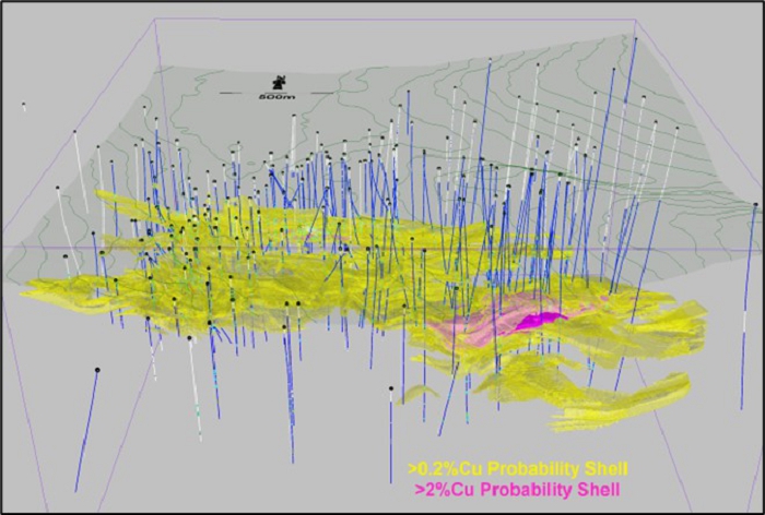
| Figure 11-6: | Copper Probability Shells | 11-8 |
| Figure 11-7: | Boxplots of Total Copper in Carbonate Breccias and Phyllites | 11-11 |
| Figure 11-8: | Contact Profiles for Total Copper between Carbonate Breccias and Phyllites | 11-11 |
| Figure 11-9: | Boxplots for Copper in the Lower Reef Phyllite Domains | 11-12 |
| Figure 11-10: | Boxplots for Copper in the Lower Reef Carbonate Breccia Domains | 11-12 |
| Figure 11-11: | Boxplots for Copper in the Upper Reef Phyllite Domains | 11-13 |
| Figure 11-12: | Boxplots for Copper in the Upper Reef Carbonate Breccia Domains | 11-13 |
| Figure 11-13: | Boxplots for Copper in the South Reef Phyllite Domains | 11-14 |
| Figure 11-14: | Boxplots for Copper in the South Reef Carbonate Breccia Domains | 11-14 |
| Figure 11-15: | Section 589250 E with Interpreted Stratigraphic Units | 11-15 |
| Figure 11-16: | Section 589250 E with 0.2% Cu Probability Shell | 11-15 |
| Project No.: 253821 | | Table of Contents | | |
| January 2025 | | TOC xii | |
| Bornite Project |
| Northwest Alaska, USA |
| S-K 1300 Technical Report Summary on the Initial Assessment |
| Figure 11-17: | Contact Profile of Copper in 2% and 0.2% Cu Shells | 11-17 |
| Figure 11-18: | Contact Profile of Copper In/Out of the 0.2% Cu Shell | 11-17 |
| Figure 11-19: | North-South Vertical Section of Copper Estimates in the Block Model in the Ruby Zone | 11-22 |
| Figure 11-20: | North-South Vertical Section of Copper Estimates in the Block Model in the South Reef Area | 11-23 |
| Figure 11-21: | Herco and Model Grade/Tonnage Plots for Copper Inside Probability Shells | 11-24 |
| Figure 11-22: | Comparison of Copper Model Types in Carbonates Inside Grade Shell Domains | 11-26 |
| Figure 11-23: | Swath Plots of Copper in Carbonates Inside Grade Shell Domains | 11-27 |
| Figure 11-24: | Isometric Views of the Bornite Inferred Mineral Resource | 11-32 |
| Figure 11-25: | Area of South Reef Amenable to Underground Mining Methods (depicted by dashed red line) | 11-34 |
| Figure 13-1: | Advanced Exploration Decline, Section View Looking South | 13-3 |
| Figure 13-2: | Modified Stability Graph | 13-5 |
| Figure 13-3: | Bornite Development Layout, Section View Looking South | 13-7 |
| Figure 13-4: | South Reef Stopes, Section View Looking South | 13-8 |
| Figure 13-5: | Typical Level Design Plan, View Showing 700L | 13-9 |
| Figure 13-6: | Cut-off Grade Optimization | 13-12 |
| Figure 13-7: | Ventilation Network, Section View Looking South | 13-15 |
| Figure 13-8: | Material Handling System Layout, Section View Looking East | 13-16 |
| Figure 13-9: | Dewatering System Layout, Section View Looking East | 13-19 |
| Figure 14-1: | Bornite Process Flowsheet | 14-2 |
| Figure 15-1: | Bornite Site Layout | 15-2 |
| Figure 15-2: | Site Road Access | 15-4 |
| Figure 15-3: | Representative Treatment Plant Footprint and Layout | 15-13 |
| Figure 15-4: | Arctic Site Layout | 15-20 |
| Figure 15-5: | Simplified Process Plant Layout | 15-22 |
| Figure 15-6: | Expanded Arctic Tailings Storage Facility | 15-24 |
| Figure 15-7: | Arctic Pit Tailings Capacity | 15-25 |
| Figure 18-1: | Plant Operating Cost Breakdown over the LOM | 18-16 |
| Figure 19-1: | After-Tax NPV @ 8% - Sensitivity | 19-9 |
| Figure 19-2: | After-Tax IRR - Sensitivity | 19-10 |
| Project No.: 253821 | | Table of Contents | | |
| January 2025 | | TOC xiii | |
| Bornite Project |
| Northwest Alaska, USA |
| S-K 1300 Technical Report Summary on the Initial Assessment |
Trilogy Metals Inc. (Trilogy Metals) retained Wood Canada Limited (Wood), SRK Consulting (Canada) Inc. (SRK), Ausenco Engineering Canada ULC. (Ausenco), International Metallurgical & Environmental and Core Geoscience LLC (Core Geoscience) to prepare a technical report summary (Report) on the initial assessment (IA) of their Bornite project in Alaska (Bornite Project).
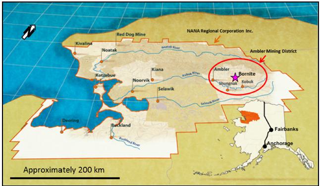
The Bornite property is part of the Upper Kobuk Mineral Projects (UKMP) mineral tenure package, which includes the Bornite deposit, as well as numerous additional mineral showings/deposits. The property is located in the Ambler Mining District of the southern Brooks Range, in the Northwest Arctic Borough (NWAB) of Alaska. The property is located 248 km east of the town of Kotzebue, 19 km north of the village of Kobuk, and 275 km west of the Dalton Highway, an all-weather state-maintained highway. Figure 1-1 shows the location of the property.
Figure 1-1: Property Location Map
(Source: Trilogy Metals, 2013)
| Project No.: 253821 | | Executive Summary | | |
| January 2025 | | Page 1-1 | |
| Bornite Project |
| Northwest Alaska, USA |
| S-K 1300 Technical Report Summary on the Initial Assessment |
Trilogy Metals is traded on the Toronto Stock Exchange (TSX) and New York Stock Exchange (NYSE) American stock exchanges. Trilogy Metals must file a current technical report summary with the United States Securities and Exchange Commission (SEC) under Subpart 229.1300-Disclosure by Registrants Engaged in Mining Operations under Regulation S-K (S-K 1300) to support their annual report on Form 10-K. Under S-K 1300 Trilogy Metals has prepared a current IA to support the mineral resources of the Bornite Project.
The Bornite Project is an IA supporting a high-grade copper mineral resource amenable to both open pit and underground mining methods. Within the Bornite resource is a relatively high-grade copper deposits that can be mined using underground mining methods which is illustrated through a mine plan and cash flow in this Report.
The Arctic Project is located on the Arctic property which is adjacent to the Bornite property. Through the Ambler Joint Venture, the Bornite Project has access to the Arctic project’s processing facility, TSF and waste rock facility once the Arctic deposit has been developed and mined to depletion. The IA assumes Arctic process and waste management facilities will be available after the Arctic project has been completed. and the Arctic deposit has been depleted.
The IA and the mineral resource estimates are prepared in accordance with the S-K 1300 definitions and standards. All units of measurement in this Report are metric, unless otherwise stated.
Currency is expressed in US dollars, unless otherwise stated.
| 1.3 | Mineral Tenure, Surface Rights and Obligations |
In October 2011, Trilogy Metals entered into an exploration agreement with NANA Regional Corporation, Inc. (NANA), the owner of the property, for the development of the parties’ collective resource interests in the Ambler Mining District. The agreement consolidated certain land holdings of the parties into a land package that currently totals approximately 181,387 ha of which the property contributes 97,483 ha (Bornite Property).
On February 11, 2020, Trilogy Metals transferred the UKMP to a 50/50 joint venture named Ambler Metals LLC (Ambler Metals). With NANA’s approval, Trilogy Metals also contributed, along with the UKMP, its rights under the NANA Agreement to Ambler Metals while its joint venture partner, South32 Limited (South32) an Australian Securities Exchange (ASX) listed company, contributed $145 million dedicated to advancing the development of the properties.
| Project No.: 253821 | | Executive Summary | | |
| January 2025 | | Page 1-2 | |
| Bornite Project |
| Northwest Alaska, USA |
| S-K 1300 Technical Report Summary on the Initial Assessment |
The Project is subject to two net smelter return (NSR) royalties payable to NANA on production from the Bornite Lands (2%) and a on production from the Alaska Native Claims Settlement Act (ANSCA) Lands (2.5%).
It is assumed that the Bornite Project would have access to the Arctic facilities through the existing agreements.
| 1.4 | Geology and Mineralization |
Mineralization in the UKMP area is characterized by two mineralized belts: the Devonian Ambler Schist Belt and the Devonian Bornite carbonate sequence. The Ambler Schist Belt hosts volcanogenic massive sulphide (VMS) deposits related to metamorphosed and strongly deformed bimodal Devonian volcanic and sedimentary rocks. A series of notable VMS deposits, including the Arctic, Dead Creek (Shungnak), Sunshine, Horse Creek, Sun, and Smucker deposits, occur in this belt. Bornite Property mineralization is hosted in less deformed Devonian clastic and carbonate sedimentary rocks lying 20 km south of the Ambler Schist Belt across the Ambler Lowlands. Widespread hydrothermal dolomitization is characteristic of the belt and locally hosts the associated copper and cobalt mineralization.
Copper mineralization at Bornite is comprised of chalcopyrite, bornite, and chalcocite as stringers, veinlets, and breccia fillings distributed in stacked, stratabound zones exploiting favourable stratigraphy. Stringer and massive pyrite and locally significant sphalerite occur above and around the copper zones, while locally massive pyrite and sparse pyrrhotite occur in association with siderite alteration below and adjacent to copper mineralization.
Cobalt mineralization at Bornite is comprised of carrollite and cobaltite directly associated with copper bearing minerals as well as cobaltiferous pyrite within and enveloping the copper mineralized zones. Germanium is associated with copper mineralization and is present as germanite and renierite.
Bornite has characteristics similar to a series of districts and deposits including the Mount Isa and McArther River districts in Australia, the Tynagh deposit in Ireland, the Kipushi deposit in the Congo, and the Tsumeb deposit in Namibia. All of these deposits show: early epigenetic characteristics; emplacement in carbonate stratigraphy; and early pyrite-dolomite alteration followed by copper dominant sulphide mineralization. All occur in intra-continental to continental margin settings undergoing extensional tectonics and bimodal volcanism. Basin margin faults seem to play an important role in localizing mineralizing fluids.
| Project No.: 253821 | | Executive Summary | | |
| January 2025 | | Page 1-3 | |
| Bornite Project |
| Northwest Alaska, USA |
| S-K 1300 Technical Report Summary on the Initial Assessment |
Regional exploration began in the area in the late 1800s with prospectors discovering several small gold placer deposits in the southern Cosmos Hills. Copper mineralization was explored using short adits and shafts around 1906. In 1947 prospector Rhinehart Berg carried out extensive trenching and the first diamond drilling on the Bornite Property that led to an option agreement with BCMC (a Kennecott subsidiary). BCMC discovered the “No. 1 Ore Body” in 1961 which led to the development of an exploration shaft for underground drilling. After the discovery of Arctic, Kennecott paused exploration until 1997-1998. Since then, the Bornite Property has been explored using integrated programs, including geologic mapping; soil, stream, and rock chip geochemistry; geophysics; underground shaft sinking and drifting; and diamond and reverse circulation drilling. Trilogy Metals geologists continue to use these integrated programs to explore for other Bornite-style mineral systems on the Bornite Property.
| 1.6 | Drilling, Sampling, and Data Verification |
There are 106,406 m of diamond drilling in 273 surface (222) and underground (51) holes completed between 1957 and 2019. Drill campaigns before 2011 were completed by Kennecott or its exploration subsidiary, Bear Creek Mining Company (BCMC), and drill campaigns since 2011 were completed by the predecessor companies to Trilogy Metals being NOVAGOLD RESOURCES INC., (NOVAGOLD), NovaCopper Inc. (NovaCopper), or Trilogy Metals.
The assay interval table contains 39,740 copper assays of which 14% are original historical values. Sampling and assaying since 2011 is supported by quality control (QC) sample result monitoring following standard industry practice. There is limited documentation available describing the sample preparation, security, analysis, and QC of drill core samples collected by Kennecott. Re-assaying of a significant amount of historical drill core which was generally confirmatory of the original assays, but did indicate a risk of a 12% high bias in zones of historical high copper grade. Only a few historical samples within the high-grade Lower Reef zone and no samples within the Upper Reef zone were re-assayed. The risk associated with the observed high bias for historical copper assays that remain in the database used for resource estimation, and the absence of any re-assaying within the Upper and Lower Reef zones is taken into consideration during mineral resource classification. Issues identified during data verification process are considered manageable by the restriction of the mineral resource to the Inferred category.
This issue discussed above only impacts the data within the Upper and Lower Reef and does not impact the South Reef.
A site visit was performed by the Wood geology and SRK geotechnical qualified persons (QP) .
| Project No.: 253821 | | Executive Summary | | |
| January 2025 | | Page 1-4 | |
| Bornite Project |
| Northwest Alaska, USA |
| S-K 1300 Technical Report Summary on the Initial Assessment |
Kennecott conducted metallurgical test work programs between 1960 and 1990 on targeted copper mineralization from Ruby Zone Upper Reef (No. 1 Ore Body). Lock-cycle test work suggested copper was recoverable in a concentrate, while mineralogy work showed high-grade mineralization of the Ruby Zone Upper Reef to be dominated by bornite with subordinate chalcocite and chalcopyrite. It was also confirmed cobalt was present in the Bornite materials occurring as carrollite, cobaltite and cobaltiferous pyrite.
In 2012, Trilogy conducted sample characterization and flotation test work on samples from South Reef aim at producing a saleable copper concentrate. Later, Trilogy Metals continued metallurgical test work on samples of lower grade mineralization within a constraining pit shell. Bond ball mill work index determination shows Bornite materials to be soft or easily ground in traditional grinding mills and consistent in hardness. Flotation work shows a consistent trend of copper recovery increasing with higher copper feed grades.
Test work has demonstrated that the Bornite materials can be processed using conventional copper flotation processes, producing a high-grade copper concentrate with traces of cobalt, gold and silver. A copper recovery to copper feed grade relationship was developed from test work results. The grade-recovery relationship predicts a copper recovery of 90.89% at a copper feed grade of 2.66%. Final copper concentrate grades are expected to be in the range of 28 to 30% Cu.
To date, test work has not been able to identify a process route to recover cobalt. Some work has been done to investigate cobalt recovery in copper and pyrite concentrate with limited success. There have been no detailed studies that have evaluated the potential to mine cobalt rich areas separately present at the Bornite deposit or to apply differential flotation techniques.
| 1.8 | Mineral Resource Estimates |
Wood’s geology QP reviewed and performed validation checks on the mineral resource model and based on the results prepared a revised mineral resource statement that is summarized in Table 1-1. The mineral resources are reported in place (point of reference). The mineral resource estimates are based on a combination of open pit and underground mining methods and a copper price of $4.60/lb. Mineral resources amenable to open pit methods are constrained within a pit shell above a marginal cut-off grade of 0.50% Cu. Mineral resources amenable by underground methods are constrained within a grade shell defined by a breakeven cut-off grade of 1.79% Cu for Ruby Zone reflecting cut-and-fill mining method and an optimized underground mineable stope shape based on 1.45% for South Reef reflecting a sublevel stoping mine method. Underground development material not included within the mineable stope shape that is mined to gain access to the stopes and is above a marginal cut-off grade of 0.70% Cu can be selectively handled and stored in a low-grade stockpile to be processed at the end of the mine life and was included in the mineral resource estimate. A portion of the in-pit mineral resource is well above the copper cut-off and would be amenable to underground mining methods providing flexibility on how to develop the deposit (Table 1-2).
| Project No.: 253821 | | Executive Summary | | |
| January 2025 | | Page 1-5 | |
| Bornite Project |
| Northwest Alaska, USA |
| S-K 1300 Technical Report Summary on the Initial Assessment |
| Table 1-1: | Mineral Resources for the Bornite Deposit as at November 30, 2024 |
| Class | | Type/Area | | Cut-off
(Cu %) | | | Tonnes
(Mt) | | | Average Grade
(Cu %) | | | Contained
Cu (Mlb) | |
| Inferred | | In-Pit | | | 0.50 | | | | 170.4 | | | | 1.15 | | | | 4,303 | |
| | | Outside-Pit South Reef | | | 1.45 | | | | 27.5 | | | | 2.78 | | | | 1,687 | |
| | | Outside-Pit Ruby Zone | | | 1.79 | | | | 10.4 | | | | 2.28 | | | | 521 | |
| | | Underground Development | | | 0.70 | | | | 0.7 | | | | 0.98 | | | | 16 | |
| Total Inferred | | | | | | | | | 208.9 | | | | 1.42 | | | | 6,527 | |
| Note: | (1) | Wood is the third-party firm responsible for preparing the mineral resource estimate. |
| | (2) | Mineral resources are prepared in accordance with S-K 1300 definitions. Mineral resources are exclusive of mineral reserves. There have been no mineral reserves estimated on the Bornite Property |
| | (3) | The assessment is preliminary in nature, it includes Inferred mineral resources that are considered too speculative geologically to have modifying factors applied to them that would enable them to be categorized as mineral reserves, and there is no certainty that this economic assessment will be realized. |
| | (4) | Mineral resources are reported in place (point of reference). |
| | (5) | Mineral resources are constrained by: an open pit shell at a cut-off grade of 0.50% Cu, with an average pit slope of 43 degrees; and underground mining shapes assuming cut-and-fill mining method based on a 1.79% Cu grade shell for Ruby Zone and an optimized underground mineable stope shape assuming sublevel stoping mine method based on a break-even cut-off grade of 1.45% for South Reef. The cut-off grades assume a $4.60/lb Cu price over the expected 17-year LOM, process recovery of 90.47%, process cost of $21.00/t processed, treatment, refining, sales cost of $0.78/lb Cu in concentrate, road use cost of $8.04/t processed, and 2% NSR royalty. For the open pit, costs include mining costs of $3.34/t mined and G&A cost of $4.30/t processed. For mining at South Reef, costs include mining costs of $65.00/t mined and G&A cost of $14.50/t processed. For mining at Ruby Zone, costs include mining costs of $90.00/t mined and G&A cost of $14.50/t processed. |
| | (6) | Underground development material uses a marginal cut-off of 0.70% Cu where the mining costs are excluded. |
| | (7) | Figures may not sum due to rounding. |
| | (8) | The mineral resource estimates are shown on a 100% ownership basis, of which Trilogy Metals’ share is 50%. |
| Project No.: 253821 | | Executive Summary | | |
| January 2025 | | Page 1-6 | |
| Bornite Project |
| Northwest Alaska, USA |
| S-K 1300 Technical Report Summary on the Initial Assessment |
| Table 1-2: | Portions of South Reef Mineral Resource Amenable to Underground Mining |
| Class | | Type/Area | | Cut-off (Cu %) | | | Tonnes
(Mt) | | | Average Grade
(Cu %) | | | Contained
Cu (Mlb) | |
| Inferred | | In-Pit South Reef1 | | | 1.45 | | | | 14.2 | | | | 2.80 | | | | 876 | |
| | | Outside-Pit South Reef2 | | | 1.45 | | | | 27.5 | | | | 2.78 | | | | 1,687 | |
| | | Total/Average South Reef | | | | | | | 41.7 | | | | 2.79 | | | | 2,563 | |
| Note: | (1) | The 1.45% Cu break-even cut-off assumes sublevel stoping mine method. The cut-off grades assume a $4.60/lb Cu price, process recovery of 90.47%, process cost of $21.00/t processed, mining costs of $65.00/t mined and G&A cost of $14.50/t processed, treatment, refining, sales cost of $0.78/lb Cu in concentrate, road use cost of $8.04/t processed, and 2% NSR royalty. |
| | (2) | Subset of the mineral resource using a higher cut-off to what was used in Table 1-1 and is not additive to the in-pit mineral resource reported in Table 1-1. |
| | (3) | Restatement of the mineral resources outside of the pit as reported in Table 1-1 and is not additive to Table 1-1. |
The Bornite mine consists of an underground operation to exploit South Reef (Figure 1-2).
The underground mine will focus on South Reef using sublevel stoping. Stope shape optimizations were run to generate production stopes using cut-off grades determined from preliminary cost modelling, stope optimization parameters and process recoveries. Throughput and cut-off grade were optimized resulting in 6,000 t/d and 1.6% Cu cut-off, respectively.
South Reef will be accessed from surface via twin declines, one for the material handling system and the second for mobile equipment and personnel access. It is expected that an exploration decline will have been developed prior to the start of underground development allowing access to the deposit quicker. The material handling system utilizes 63-tonne diesel trucks to haul development mineralized material and waste and a conveyor system to transport production mineralized material to the run-of-mine (ROM) pad on surface.
Underground development will require two years pre-production and a year of ramp up before reaching 6,000 t/d production. The Bornite life-of-mine (LOM) is 17 years.
A subset of the mineral resources within the LOM plan is summarized in Table 1-3.
| Project No.: 253821 | | Executive Summary | | |
| January 2025 | | Page 1-7 | |
| Bornite Project |
| Northwest Alaska, USA |
| S-K 1300 Technical Report Summary on the Initial Assessment |
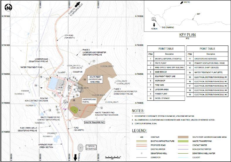
Figure 1-2: Bornite Site Layout
(Source: Wood, 2024)
| Project No.: 253821 | | Executive Summary | | |
| January 2025 | | Page 1-8 | |
| Bornite Project |
| Northwest Alaska, USA |
| S-K 1300 Technical Report Summary on the Initial Assessment |
Table 1-3: Subset of the Bornite Mineral Resource Estimate within the IA Mine Plan
| Confidence Category | | Tonnes
(Mt) | | | Average Grade
(Cu %) | | | Contained Cu
(Mlb) | |
| Inferred | | | 36.9 | | | | 2.61 | | | | 2,125 | |
| | Note: | (1) | The assessment is preliminary in nature. It includes Inferred mineral resources that are considered too speculative geologically to have modifying factors applied to them that would enable them to be categorized as mineral reserves, and there is no certainty that this economic assessment will be realized. |
| | | (2) | Mineral resources within the mine plan were estimated using sublevel stoping underground mining method and includes variable dilution explained in Table 16-7 and a mine recovery of 95%. |
| | | (3) | Input assumptions used to determine mineable stope shapes include a copper price of $4.20/lb, mine operating cost of $73.29/t, process operating cost of $19.84/t, G&A and surface costs of $9.64/t, haulage and road use costs of $28.78/t, closure and water treatment costs of $1.26/t, shipping, treatment, refining and selling costs of $0.78/lb Cu, process recovery of 90%, and NSR royalty of 2% |
| | | (4) | Production stope cut-off of 1.6% Cu and development cut-off 0.7% Cu. The production stope cut-off input assumptions include a copper price of $4.20/lb, mine operating cost of $44.08/t, process operating cost of $24.82/t, G&A and surface cost of $17.3/t, and sustaining costs of $8.52/t, road use costs of $14.4/t, shipping, treatment, refining and selling costs of $0.78/lb Cu, process recovery of 90.89%, and average NSR royalty of 2.25%. |
| 1.10 | Processing and Recovery Methods |
Bornite material will be processed in the Arctic process plant that has currently been designed to a feasibility study (FS) level (Murray et al., 2023). The process plant will process 10,000 t/d of material on a two week on, one week off campaign basis. The process plant will operate at an overall availability of 64%, processing an annual average of 2,215,000 tonnes of mineralized material to produce a copper concentrate.
Modifications to the Arctic flowsheet to allow the processing of Bornite material at the end of the Arctic LOM include:
| · | decommissioning the talc, zinc and lead flotation circuits as these are not required to process Bornite material. |
| · | incorporating some of the zinc circuit flotation and dewatering equipment in the copper flotation and dewatering circuit which is anticipated to handle higher copper loadings. |
| · | a new regrind mill will be required to operate in parallel to the existing copper and zinc regrind mills. |
A new tailings filtration plant will dewater up to 50% of the plant tailings for paste backfill purposes. Filtered tailings will be transported by dual tractor trailer from the Arctic plant to the Bornite paste backfill plant. Power consumption will be less than the total output capacity currently required for the Arctic process plant.
| Project No.: 253821 | | Executive Summary | | |
| January 2025 | | Page 1-9 | |
| Bornite Project |
| Northwest Alaska, USA |
| S-K 1300 Technical Report Summary on the Initial Assessment |
Surface infrastructure is limited at the Bornite site as the Bornite Project will leverage off of existing infrastructure at Arctic once Arctic mineral reserves have been exhausted. Onsite infrastructure and services required to support the Bornite Project include mining facilities including a paste fill plant, waste transfer pad, ROM stockpile, topsoil stockpile, underground portal, power plant, fuel storage, upgraded Ruby Creek section, dewatering wells, water treatment pond, contact and non-contact diversions/ditches (Figure 1-2). It is assumed that the Arctic camp will be sufficient to accommodate Bornite personnel.
Access to site will be from the north, along the south route from the Ambler Access Project (AAP) road and from the south from the Dahl Creek airport.
A waste transfer pad with capacity of 40,000 tonnes will temporarily store waste and low-grade mineralized material from underground and will be hauled to the Arctic waste rock facility for long term storage. Low-grade mineralized material will be processed at the end of mine life. A ROM stockpile with a capacity of 30,000 tonnes equating to five days of production will store mineralized material and serve as a loading point for haulage to the Arctic mill by the over-the-road (OTR) truck fleet.
Tailings produced from processing the mineralized material from Bornite at the Arctic mill, will be stored in an expanded Arctic tailings storage facility (TSF) and within the Arctic pit. The existing TSF will be expanded to hold the additional 16 Mm3 while the pit will store 2.5 Mm3 with the possibility of storing more if required. It is assumed that approximately 50% of the tailings would be sent to the filter press at the Arctic mill to be used to produce paste backfill and is backhauled to the Bornite site.
A portal diesel power plant comprising of six diesel gensets will provide power for peak site demand of 13.3 MWe.
Perimeter dewatering wells are planned to limit the inflow of water into the underground mine. This water will be conveyed back into Ruby Creek. The upgraded Ruby Creek section and Ruby Creek valley dewatering wells are intended to disconnect flow in Ruby Creek from the underlying groundwater system and reduce infiltration into the mine. Diversion ditches around site will intercept water runoff water before it becomes contact water. Contact water will be treated before release into the environment.
| Project No.: 253821 | | Executive Summary | | |
| January 2025 | | Page 1-10 | |
| Bornite Project |
| Northwest Alaska, USA |
| S-K 1300 Technical Report Summary on the Initial Assessment |
Trilogy Metals has not completed any market analysis for the Bornite copper concentrate, nor are there any contracts in place with any buyers for the concentrate. Given the average copper concentrate grade is expected to exceed 28% and there are no significant amounts of deleterious elements contained in the concentrate, there should be no barriers to obtain sales contracts with third-party smelters.
The long-term forecast copper price of $4.20/lb used for mine planning and cash flow analysis was provided by an analyst consensus reflecting the average forecasted price from 18 financial institutions.
The capital cost estimate was prepared in accordance with S-K 1300 standards for an IA and developed a Class 5 using AACE International Guidelines Practice No. 47R-11 with an expected accuracy of ±50% and a contingency of 14.4% overall. All costs are expressed in fourth-quarter 2024 US dollars.
The Bornite Project’s initial capital cost, as summarized in Table 1-4 is $503.4 million, including indirect costs of $80.6 million and contingency of $72.5 million. A sustaining capital of $363.1 million considers equipment replacement costs and pipeline and ditch construction for water management and electrical. The total Bornite Project capital, inclusive of initial and sustaining costs is estimated at $866.5 million.
Table 1-4: Summary of Capital Cost Estimate
| WBS | | Description | | Initial Capital
($M) | | | Sustaining Capital
($M) | | | Total Capital
($M) | |
| 1000 | | Mining | | | 214.9 | | | | 300.6 | | | | 515.5 | |
| 2000 | | Crushing | | | - | | | | - | | | | - | |
| 3000 | | Process | | | 28.6 | | | | - | | | | 28.6 | |
| 4000 | | Tailings | | | 10.4 | | | | - | | | | 10.4 | |
| 5000 | | Onsite Infrastructure | | | 85.3 | | | | 20.7 | | | | 106.0 | |
| 6000 | | Offsite Infrastructure | | | 1.7 | | | | - | | | | 1.7 | |
| Subtotal | | | | | 340.8 | | | | 321.3 | | | | 662.1 | |
| 7000 | | Indirect Costs | | | 80.6 | | | | 4.1 | | | | 84.7 | |
| 9000 | | Owners’ Costs | | | 9.5 | | | | 1.2 | | | | 10.7 | |
| 8000 | | Provisions/Contingency | | | 72.5 | | | | 36.5 | | | | 109.0 | |
| Total | | | | | 503.4 | | | | 363.1 | | | | 866.5 | |
Note: Figures may not sum due to rounding.
| Project No.: 253821 | | Executive Summary | | |
| January 2025 | | Page 1-11 | |
| Bornite Project |
| Northwest Alaska, USA |
| S-K 1300 Technical Report Summary on the Initial Assessment |
Total operating costs over the LOM have been estimated at $3,651.6 million with a breakdown summarized in Table 1-5. The operating cost accuracy is ±50% with a contingency of less than 25%.
Table 1-5: Total Operating Costs over LOM
| Cost Area | | LOM Cost
($M) | | | Avg. Unit Cost of Mineralized Material Processed
($/t) | |
| Underground Mining | | | 1,392.5 | | | | 37.74 | |
| OTR Haulage | | | 197.3 | | | | 5.35 | |
| Process | | | 915.8 | | | | 24.82 | |
| AAP Road | | | 528.7 | | | | 14.33 | |
| G&A | | | 495.2 | | | | 13.42 | |
| Water Management | | | 105.8 | | | | 2.87 | |
| Surface Operations Cost | | | 16.4 | | | | 0.44 | |
| Total | | | 3,651.6 | | | | 98.97 | |
Note: (1) G&A = general and administrative
(2) Figures may not sum due to rounding.
| 1.15 | Environmental Studies, Permitting, and Plans, Negotiations, or Agreements with Local Individuals or Groups |
Environmental baseline studies have been conducted since 2007 including archaeology, aquatic life surveys, wetlands mapping, surface water quality sampling, hydrology, and subsistence. Additional baseline studies for the Bornite Project area have been recommended to generate the data to support future mine design, development of an Environmental Impact Statement (EIS), permitting, construction, operations and closure.
A significant number of permits from state, federal and local governments will be necessary to develop a mine at Bornite. Most agencies must comply with the requirements of the National Environmental Policy Act (NEPA) before issuing their permits. NEPA planning includes the development of an Environmental Assessment (EA) or an Environmental Impact Statement (EIS).
The NANA Agreement made in October 2011 includes the promotion of education opportunities for shareholders in the region. Ambler Metals have been periodically meeting with neighbouring communities providing updates on project plans and participate in a subsistence advisory committee with representatives from NANA Region villages and NANA.
| Project No.: 253821 | | Executive Summary | | |
| January 2025 | | Page 1-12 | |
| Bornite Project |
| Northwest Alaska, USA |
| S-K 1300 Technical Report Summary on the Initial Assessment |
A preliminary conceptual reclamation plan has been estimated to leave the site stable in terms of erosion and avoids the degradation of water quality on site.
The results of the economic analysis in the IA represents forward-looking information that is subject to a number of known and unknown risks, uncertainties, and other factors that may cause actual results to differ materially from those presented here. Forward-looking information includes mineral resource estimates in the IA mine plan and the cash flows derived from them, forecast copper prices used, capital and operating cost estimates, estimated copper production, and payback period. Actual results may vary from the forward-looking information with the mineral resource estimates, costs, copper prices, metallurgical recoveries, and taxes being different from what was assumed in the IA.
The assessment is preliminary in nature, it includes Inferred mineral resources that are considered too speculative geologically to have modifying factors applied to them that would enable them to be categorized as mineral reserves, and there is no certainty that this economic assessment will be realized.
The IA has been evaluated using a discounted cash flow (DCF) analysis. Cash inflows consist of annual revenue projections for the mine. Cash outflows such as capital, pre-production mining costs, operating costs, taxes, and royalties, are subtracted from the inflows to arrive at the annual cash flow projections. Cash flows are taken to occur at the end of each period.
The after-tax evaluation of the Bornite Project under the assumptions used in this Report generates positive results. Before-tax and after-tax financial results are presented in Table 1-6. The financial analysis is presented on a 100% basis on which Trilogy Metals has a 50% attributable interest.
The financial model on which the analysis is based includes 100% Inferred mineral resources. The results of the economic analysis excluding Inferred mineral resources would not be economically viable.
The Bornite Project is most sensitive to changes in copper selling price and copper feed grade, followed by changes to operating costs and total capital costs.
| Project No.: 253821 | | Executive Summary | | |
| January 2025 | | Page 1-13 | |
| Bornite Project |
| Northwest Alaska, USA |
| S-K 1300 Technical Report Summary on the Initial Assessment |
Table 1-6: Financial Results
| Description | | Unit | | Value | |
| Before-Tax Valuation Indicators | | | | | | |
| Undiscounted Cumulative Cash Flow | | $M | | | 1,582.5 | |
| NPV @ 8% | | $M | | | 552.1 | |
| Payback Period (from start of operations) | | years | | | 4.0 | |
| IRR Before Tax | | % | | | 23.6 | |
| After-Tax Valuation Indicators | | | | | | |
| Undiscounted Cumulative Cash Flow | | $M | | | 1,218.8 | |
| NPV @ 8% | | $M | | | 393.9 | |
| Payback Period (undiscounted from start of operations) | | years | | | 4.4 | |
| IRR After Tax | | % | | | 20.0 | |
Note: NPV = net present value; IRR = internal rete of return
Under the assumptions in this Report, the Bornite Project shows a positive financial return. The QPs of the third-party firms have identified additional test work and engineering studies required to support further mining studies.
| 1.18.1 | Geology and Mineral Resources |
| · | Risks to the mineral resource estimate are listed in Section 11.14. |
| · | The available geotechnical information indicates that sublevel stoping should be a viable mining method for Bornite, but further studies and core drilling are required to validate this assumption. |
| · | Dewatering quantities may be significant at Bornite based on historical rapid flooding of the exploration shaft when it intersected a specific zone at depth. The plan for Bornite has include substantial dewatering and water management efforts; however, further studies are required to validate the assumptions about dewatering flow quantity and quality. |
| Project No.: 253821 | | Executive Summary | | |
| January 2025 | | Page 1-14 | |
| Bornite Project |
| Northwest Alaska, USA |
| S-K 1300 Technical Report Summary on the Initial Assessment |
| · | The IA has assumed the Arctic process plant copper, zinc and tailings thickeners will have sufficient capacity for the Bornite copper concentrate and tailings streams based on benchmarking reference projects and existing operations; however, thickening test work to confirm this has not been completed. |
| · | The IA has assumed the two Arctic process plant copper and zinc filters will have sufficient dewatering capacity for the Bornite copper concentrate based on benchmarking reference projects and existing operations; however, filtration test work to confirm this has not been completed. |
| · | Regrind milling power requirements have been calculated using signature plots and comminution data available from benchmark and reference projects; however, Bornite copper concentrate regrind test work to confirm this has not been completed. |
| · | The tailings filters have been sized from benchmark and reference project filtration data. Bornite tailings material filtration test work to confirm this has not been completed at this level of study. |
| · | Tailings filter cake handleability or transport material test work has not been completed and further work will be required to confirm the filter cake can be adequately transported from Arctic for disposal at Bornite. |
| · | Existing Arctic infrastructure and process equipment must be in good enough condition to be repurposed for processing Bornite material. Increased process capital costs could result should the process infrastructure and plant equipment require replacement at the end of the Arctic mine life. |
| · | Process plant operators may not be familiar with the non-standard campaigned nature of the Arctic plant operation (two week on, one week off schedule), resulting in sub-optimal throughput as a result of the ramp up/down cycling. |
| 1.18.5 | Geotechnical (Tailings) |
| · | Backfilling the Bornite underground mine may not be possible if the plant tailings can’t be processed adequately to provide bulk feed for backfilling, which would significantly affect the mine design and require additional tailings storage. |
| Project No.: 253821 | | Executive Summary | | |
| January 2025 | | Page 1-15 | |
| Bornite Project |
| Northwest Alaska, USA |
| S-K 1300 Technical Report Summary on the Initial Assessment |
| · | Water treatment needs are poorly constrained, and assumptions may not actually be conservative which could lead to higher water treatment costs or significant permitting needs/delays. |
| · | Contact water may originate from various sources at the site, including temporary stockpiles, construction earthworks, mine water, and intercepted ground and surface waters. Waste rock characterization and management assumes that long-term (post-reclamation) water treatment is not required because the most likely source (stockpiles) will be relocated to Arctic. However, depending on further analysis and refinement of development plans, water treatment may be required during closure and early post-closure for an indetermined length of time, until water quality standards are achieved. |
| · | Permitting and construction of the upgraded Ruby Creek section may be more challenging than anticipated. Similarly, reclamation of the upgrades could require multiple stakeholder approvals. |
| 1.18.7 | Project Infrastructure |
| · | Actual ground conditions along proposed infrastructure are not suitable for proposed structures, which must be moved or redesigned resulting in higher costs. |
| · | AAP road not being permitted limiting access to the Bornite Project. |
| · | The uncertainty in the cost of the AAP road could materially affect the results of the economic analysis for the Bornite Project. |
| · | A portion of the Ruby Zone deposit is near surface that is amenable to open pit mining. This material was not included in the mine plan to limit surface capital related to a required expansion of the tailings facility at Arctic, but pending further study work, could be in a future mine plan. |
| · | A portion of the Ruby Zone deposit is amenable to underground mining. A preliminary design included 6.3 Mt at 2.38% Cu utilizing a cut-and-fill mining method, but this was removed to improve project economics by limiting sustaining capital and the required expansion of the tailings facility at Arctic. Depending on copper price and geological interpretation of the resource, sublevel stoping could be an appropriate mining method. |
| Project No.: 253821 | | Executive Summary | | |
| January 2025 | | Page 1-16 | |
| Bornite Project |
| Northwest Alaska, USA |
| S-K 1300 Technical Report Summary on the Initial Assessment |
| · | Converting the talc pre-float circuit into the copper rougher-scavengers would improve the flow routing for the treatment of Bornite material. |
| · | Completing additional comminution characterization test work (Axb, rod mill, ball mill and abrasion) to better represent the mineable resource. |
| · | Expand the number of geological samples subjected to detailed mineralogy and flotation test work, to confirm the current operational parameters are providing optimal metallurgical results for the resource. |
| · | Complete thickening tests for both Bornite copper concentrate and tailings material to confirm the existing Arctic thickeners are adequate for the upgrade and the flocculant dosages required. |
| · | Complete filtration test work on both Bornite copper concentrate and tailings material to confirm the existing Arctic concentrate filters are adequate for the upgrade and to size the tailings filters. |
| · | Complete regrind comminution test work to confirm the regrind mill power requirements and to test various regrind technologies. |
| · | The expansion and re-configuration of the Arctic flowsheet should be considered in the layout of the initial Arctic process plant site to ensure the Bornite process plant upgrade strategy is understood and to minimize brownfield operating impacts and shutdown costs. This would involve: |
| – | Ensuring there is adequate free space on the process pad for the additional regrind mill and tailings filter plant |
| – | Optimizing flotation cell orientation to allow for faster repurposing for the Bornite flowsheet, reducing downtime. |
| · | Complete project execution, shutdown and schedule planning in future project phases to confirm construction shutdown durations for the required process plant modifications at the end of the Arctic deposit mine life. |
| · | Thorough testing may provide an opportunity to custom design an economically viable solution to backfill Bornite. |
| Project No.: 253821 | | Executive Summary | | |
| January 2025 | | Page 1-17 | |
| Bornite Project |
| Northwest Alaska, USA |
| S-K 1300 Technical Report Summary on the Initial Assessment |
| 1.19.3 | Geotechnical (Tailings) |
| · | Integration of Bornite tailings on top of the Arctic tailings may provide positive impacts to the closure water treatment requirements. |
| · | Hydraulic connection between Ruby Creek/Ruby Creek valley and the underground is not as significant as assumed resulting in lower water management and dewatering costs than assumed. |
| · | Optimization of water management infrastructure is likely possible, which could simplify the overall system and possibly reduce capital costs. |
The QPs of the third-party firms have identified recommendations around developing an advanced exploration decline to access South Reef for further drilling, hydrogeology, geotechnical and rock mechanics work, metallurgical test work, investigations around re-purposing the Arctic process plant to receive Bornite mineralized material, tailings studies considering additional locations and technologies, a hydrological program, geochemistry assessments, a site water and load balance (water quality predictions) and water treatment needs, and environmental baseline studies with estimated costs totaling $172.4 million.
| Project No.: 253821 | | Executive Summary | | |
| January 2025 | | Page 1-18 | |
| Bornite Project |
| Northwest Alaska, USA |
| S-K 1300 Technical Report Summary on the Initial Assessment |
Trilogy Metals, a company involved in the exploration and development of projects in the UKMP in Alaska’s Ambler Mining District, retained Wood, SRK, Ausenco, International Metallurgical & Environmental and Core Geoscience to prepare a Report disclosing the results of an IA of their Bornite project in Alaska.
Trilogy Metals is traded on the TSX and NYSE American stock exchanges. Trilogy Metals must file a current technical report summary with the United States SEC under Subpart 229.1300-Disclosure by Registrants Engaged in Mining Operations under Regulation S-K (S-K 1300) to support their annual report on Form 10-K. Under S-K 1300 Trilogy Metals has prepared a current IA to support the mineral resources of the Bornite Project.
The Bornite Project is an IA supporting a high-grade copper mineral resource amenable to both open pit and underground mining methods. Within the Bornite resource is a relatively high-grade copper deposits that can be mined using underground mining methods which is illustrated through a mine plan and cash flow in this Report.
The Arctic Project is located on the Arctic property which is adjacent to the Bornite property. Through the Ambler Joint Venture, the Bornite Project has access to the Arctic project’s processing facility, TSF and waste rock facility once the Arctic deposit has been developed and mined to depletion. The IA assumes Arctic process and waste management facilities will be available after the Arctic project has been completed and the Arctic deposit has been depleted.
All units of measurement in this Report are metric, unless otherwise stated.
Currency is expressed in US dollars, unless otherwise stated.
This Report was prepared by appropriate QPs from Wood, SRK, Ausenco, International Metallurgical & Environmental and Core Geoscience, whose firms are considered third-party firms comprising of mining experts. Table 2-1 lists the sections of the Report prepared by or contributed to by each third-party firm.
| Project No.: 253821 | | Introduction | | |
| January 2025 | | Page 2-1 | |
| Bornite Project |
| Northwest Alaska, USA |
| S-K 1300 Technical Report Summary on the Initial Assessment |
| | Table 2-1: | Third-Party Firms Who Prepared this Report |
| Third-Party Firms | | Report Sections |
| Wood | | 1.1-1.6, 1.8-1.9, 1.11-1.14, 1.16, 1.17, 1.18.1, 1.18.7, 1.18.2, 1.19.1, 1.20, 2-6, 7.1-7.22, 7.24, 7.25, 8, 9.1-9.5, 9.7, 9.11.1, 9.11.3, 11-13, 15.1.1-15.1.7, 15.1.9-15.1.13, 15.2.5, 16, 18.1.1-18.1.3, 18.1.6-18.1.12, 18.3.1-18.3.3, 18.3.5.1, 18.3.5.3, 18.3.6, 19-21 22.1-22.5, 22.7, 22.9, 22.11-22.13, 22.14.1, 22.14.2, 22.15.1 23.1, 23.2, 23.3.1, 23.3.3-23.3.6, 23.8, 23.10, 24-25 |
| SRK | | 1.11, 1.18.3, 1.18.5, 1.18.6, 1.19.3, 1.19.4, 1.20, 2.2, 2.3, 7.23, 9.8-9.10, 9.11.4-9.11.6, 15.1.8, 15.2.4, 17.5, 18.1.1, 18.1.2, 18.1.5, 18.1.6, 18.1.8, 18.1.11, 18.2, 18.3.1, 18.3.5.2, 18.3.5.3, 22.1, 22.9, 22.12, 22.14.3, 22.14.5, 22.14.6, 22.15.3, 22.15.4 23.1, 23.3.2, 23.6, 23.7, 23.10, 24 |
| Ausenco | | 1.10, 1.13, 1.14, 1.18.4, 1.19.2, 1.20, 2.2, 2.3, 9.6, 9.11.2, 14, 15.2.1-15.2.3, 18.1.1, 18.1.2, 18.1.4, 18.1.8, 18.3.1, 18.3.4, 18.3.5.1, 22.1, 22.8, 22.12, 22.14.4, 25.15.2, 23.1, 23.5, 23.10, 24 |
| International Metallurgical & Environmental | | 1.7, 1.20, 2.2, 2.3, 9.6, 9.11.2, 10, 22.1, 22.6, 23.1, 23.4, 23.10, 24 |
| Core Geoscience | | 1.15, 1.17-1.20, 2.2, 2.3, 17.1-17.4, 17.6, 22.1, 22.10, 22.14, 22.15, 23.1, 23.9, 23.10, 24 |
International Metallurgical & Environmental’s process QP has not visited the Bornite Property as it is a greenfield site. The QP made several visits to the metallurgical laboratories, SGS Mineral Services (Burnaby, British Columbia) and ALS Metallurgical Services (Kamloops, British Columbia) during ongoing test work between 2012 and 2021. During their visits they observed Bornite test work being completed.
SRK’s geotechnical QP visited the Arctic Project site from July 24-25, 2017, and July 10-12, 2018. The QP inspected property access and surface topography where the waste rock facility and tailings management facilities are to be located, as well as available space for other mine facilities.
Core Geoscience’s environmental QP has not visited the Bornite Project site. The QP relied on the information obtained from other QPs who have performed a personal inspection.
| Project No.: 253821 | | Introduction | | |
| January 2025 | | Page 2-2 | |
| Bornite Project |
| Northwest Alaska, USA |
| S-K 1300 Technical Report Summary on the Initial Assessment |
Wood’s geology QP visited the Bornite Property site between August 29 and September 8, 2022 in preparation for this Report. The following work was completed:
| · | Visited core storage facilities |
| · | Reviewed drill core and compared against original logging data and assay results |
| · | Visited trenches observing outcrops and mineralization (Lower Reef) extending to surface |
| · | Located drill holes collars and measured coordinates with a handheld global positioning system (GPS). |
Wood’s mining QP has not visited the Property. The QP relied on information obtained from the Wood geology QP during their site visit and a site visit report developed by a Wood mining engineer that visited the Arctic Project on August 30, 2022. During that site visit, the Wood geology QP observed the diamond drill core logging processes that include geology, structure and geotechnical logging, sampling, and specific gravity (SG) measurement process. They also visited Arctic site area, measured historical collar locations with a handheld global positioning system (GPS), reviewed representative drill cores, observed active drilling process. The Wood geology QP visited drill core and pulp storage sites at camp and in Fairbanks office/warehouse.
SRK’s hydrogeology QP visited the Arctic project site from July 6-8, 2016, during which time accommodations were at the Bornite Camp. The QP inspected terrain and core and participated with field activities for an on-going hydrogeology testing program at Arctic. While at the Bornite Camp, they viewed terrain and surface infrastructure in the camp area.
Ausenco’s QP has not visited the Bornite Project site. The QP has relied on information from another experienced Ausenco engineer who had visited the Arctic project site on July 25, 2017. During the site visit, the Ausenco engineer inspected the property access, viewed the surface topography in the area proposed for the process plant and supporting infrastructure.
Reports and documents listed in Section 24.0 were used to support the preparation of the technical report summary. Additional information was requested from Trilogy Metals’ personnel where required. Information provided by Trilogy Metals is identified in Section 25.0.
This Report updates the previous Report entitled “Technical Report Summary on the Initial Assessment of the Bornite Mineral Resource, Northwest Alaska, USA”, prepared by Wood dated of November 30, 2022. This Report includes a cash flow analysis that demonstrates economic potential of the Bornite Project.
| Project No.: 253821 | | Introduction | | |
| January 2025 | | Page 2-3 | |
| Bornite Project |
| Northwest Alaska, USA |
| S-K 1300 Technical Report Summary on the Initial Assessment |
The Bornite Property is part of the UKMP mineral tenure package, which includes the Bornite deposit as well as numerous additional mineral showings/deposits (Figure 3-1 and Figure 3-2). The Bornite Property is located in the Ambler Mining District of the southern Brooks Range in the NWAB of the State of Alaska, USA. The Bornite Property is located in Ambler River A-2 quadrangle, Kateel River Meridian T 19N, R 9E, sections 4, 5, 8 and 9 (Figure 3-2).
The Bornite Property is located 248 km east of the town of Kotzebue, 19 km north of the village of Kobuk, 275 km west of the Dalton Highway (an all-weather state maintained public road) with geographic coordinates of the Bornite deposit of N67.07° latitude and W156.94° longitude which is the equivalent of Universal Transverse Mercator (UTM) North American Datum (NAD) 83, Zone 4W coordinates 7440449N, 589811E.
| | Figure 3-1: | Upper Kobuk Mineral Properties |
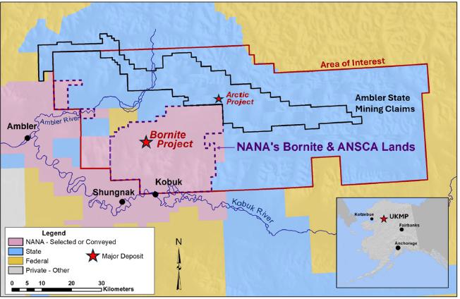
(Source: Trilogy Metals, 2022)
Note: The NANA’s Bornite and ANSCA Lands cover the mineral tenure and surface rights to the Bornite deposit
| Project No.: 253821 | | Project Description | | |
| January 2025 | | Page 3-4 | |
| Bornite Project |
| Northwest Alaska, USA |
| S-K 1300 Technical Report Summary on the Initial Assessment |
| | Figure 3-2: | Bornite Mineral Tenure Plan |
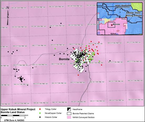
(Source: Trilogy Metals, 2023)
The Bornite Property consists of NANA-owned patented lands (NANA (Bornite)) and NANA-selected ANCSA lands (NANA (ANSCA)). A breakdown of these lands is provided in Table 3-1.
Road access to the Bornite Project is discussed in Section 15.0.
| Project No.: 253821 | | Project Description | | |
| January 2025 | | Page 3-5 | |
| Bornite Project |
| Northwest Alaska, USA |
| S-K 1300 Technical Report Summary on the Initial Assessment |
| | Table 3-1: | Summary of Bornite Property |
| Owner | | Number | | Type | | Acres | | | Hectares | |
| NANA (ANCSA) | | N/A | | Selected/Patented | | | 240,369 | | | | 97,274 | |
| NANA (Bornite) | | 25 (2 USMS Patent) | | Patented | | | 517 | | | | 209 | |
| Total | | | | | | | 240,886 | | | | 97,483 | |
| Note: | The NANA (Bornite) 25 patented mining claims incorporated within U.S. Mineral Surveys (USMS) 2233 and 2234 are located in the State of Alaska within Sections 4, 5, 8 and 9, Township 19 North, Range 9 East, Kateel River Meridian aggregating approximately 516.5 acres more or less. Patented mining claims do not expire. |
| 3.3 | Royalties, Agreements and Encumbrances |
On March 22, 2004, Alaska Gold Company (Alaska Gold), a wholly owned subsidiary of NOVAGOLD, completed an Exploration and Option to Earn an Interest Agreement with Kennecott Exploration Company and Kennecott Arctic Company (collectively, Kennecott) on the Ambler land holdings.
On December 18, 2009, a Purchase and Termination Agreement was entered into between Alaska Gold and Kennecott whereby NOVAGOLD agreed to pay Kennecott a total purchase price of $29 million for a 100% interest in the Ambler land holdings, which included the Arctic deposit, to be paid as: $5 million by issuing 931,098 NOVAGOLD shares, and two installments of $12 million each, due 12 months and 24 months from the closing date of January 7, 2010.
The NOVAGOLD shares were issued in January 2010, the first $12 million payment was made on January 7, 2011, and the second $12 million payment was made in advance on August 5, 2011; this terminated the March 22, 2004 exploration agreement between NOVAGOLD and Kennecott. Under the Purchase and Termination Agreement, the seller retained a 1% NSR royalty that is purchasable at any time by the landowner for a one-time payment of $10 million.
In 2011, NOVAGOLD incorporated NovaCopper Inc. (now known as Trilogy Metals Inc.) and related entities and transferred its Ambler land holdings, including the Arctic deposit, from Alaska Gold to NovaCopper US Inc., a wholly-owned subsidiary of NovaCopper. In April 2012, NOVAGOLD completed a spin-out of NovaCopper, with the Ambler lands, to the NOVAGOLD shareholders and made NovaCopper an independent publicly listed company, listed on the TSX and NYSE American exchanges. NovaCopper subsequently underwent a name change to Trilogy Metals Inc. in 2016.
| Project No.: 253821 | | Project Description | | |
| January 2025 | | Page 3-6 | |
| Bornite Project |
| Northwest Alaska, USA |
| S-K 1300 Technical Report Summary on the Initial Assessment |
On February 11, 2020, Trilogy Metals transferred the UKMP to a 50/50 joint venture named Ambler Metals. With NANA’s approval, Trilogy Metals also contributed, along with the UKMP, its rights under the NANA Agreement to Ambler Metals while its joint venture partner, South32, contributed $145 million dedicated to advancing the projects.
In 1971, the US Congress passed the Alaska Native Claims Settlement Act (ANCSA) which settled land and financial claims made by the Alaska Natives and provided for the establishment of 13 regional corporations to administer those claims. These 13 corporations are known as the Alaska Native Regional Corporations (ANCSA Corporations). One of these 13 regional corporations is NANA Regional Corporation, Inc. ANCSA Lands controlled by NANA bounds the southern border of the Bornite Property claim block. National Park lands are within 25 km of the northern Bornite Property border. The Bornite deposit is located entirely on lands owned by NANA.
On October 19, 2011, Trilogy Metals and NANA Regional Corporation, Inc. entered into the NANA Agreement for the cooperative development of their respective resource interests in the Ambler Mining District. The NANA Agreement consolidates Trilogy Metals’ and NANA’s land holdings into an approximately 142,831 ha land package and provides a framework for the exploration and development of the area. The NANA Agreement provides that NANA will grant Trilogy Metals the nonexclusive right to enter onto, and the exclusive right to explore, the Bornite Lands and the ANCSA Lands (each as defined in the NANA Agreement) and in connection therewith, to construct and utilize temporary access roads, camps, airstrips, and other incidental works. The NANA Agreement has a term of 20 years, with an option in favour of Trilogy Metals to extend the term for an additional 10 years. The NANA Agreement may be terminated by mutual agreement of the parties or by NANA if Trilogy Metals does not meet requirements of aggregate expenditures over two consecutive calendar years are not at least $600,000 on NANA’s lands. Trilogy Metals has confirmed expenditure requirement have been met to date.
On February 11, 2020, Trilogy Metals transferred the UKMP to Ambler Metals. With NANA’s approval, Trilogy Metals also contributed, along with the UKMP, its rights under the NANA Agreement to Ambler Metals while its joint venture partner, South32 contributed $145 million.
The NANA Agreement outlines a partnership agreement for the development the UKMP. If, following receipt of a feasibility study and the release for public comment of a related draft environmental impact statement, Ambler Metals decides to proceed with construction of a mine on the lands subject to the NANA Agreement, Ambler Metals will notify NANA in writing and NANA will have 120 days to elect to either (a) exercise a non-transferrable back-in-right to acquire between 16% and 25% (as specified by NANA) of that specific project; or (b) not exercise its back-in-right, and instead receive a net proceeds royalty equal to 15% of the net proceeds realized by Ambler Metals from such project. The cost to exercise such back-in-right is equal to the percentage interest in the property multiplied by the difference between (i) all costs incurred by Ambler Metals or its affiliates on the property, including historical costs incurred prior to the date of the NANA Agreement together with interest on the historical costs; and (ii) $40 million (subject to exceptions). This amount will be payable by NANA to Ambler Metals in cash at the time the parties enter into a joint venture agreement and in no event will the amount be less than zero.
| Project No.: 253821 | | Project Description | | |
| January 2025 | | Page 3-7 | |
| Bornite Project |
| Northwest Alaska, USA |
| S-K 1300 Technical Report Summary on the Initial Assessment |
In the event that NANA elects to exercise its back-in-right, the parties will, as soon as reasonably practicable, form a joint venture with NANA electing to participate between 16% to 25%, and Ambler Metals will own the balance of interest in the joint venture. Upon formation of the joint venture, the joint venture will assume all obligations of Ambler Metals and be entitled to all the benefits of Ambler Metals under the NANA Agreement in connection with the mine to be developed and the related lands. A party’s failure to pay its proportionate share of costs in connection with the joint venture will result in dilution of its interest. Each party will have a right of first refusal over any proposed transfer of the other party’s interest in the joint venture other than to an affiliate or for the purposes of granting security. A transfer by either party of a NSR royalty on the property or any net proceeds royalty interest in the property other than for financing purposes will also be subject to a first right of refusal.
To allow development on the Bornite Lands or ANCSA Lands, Ambler Metals and NANA will execute a mining lease to allow Ambler Metals or the joint venture to construct and operate a mine on the Bornite Lands or ANCSA Lands. These leases will provide NANA a 2% NSR royalty as to production from the Bornite Lands (NANA (Bornite)) and a 2.5% NSR royalty as to production from the ANCSA Lands (NANA (ANCSA)).
If Ambler Metals decides to proceed with construction of a mine on its own lands subject to the NANA Agreement, NANA will enter into a surface-use agreement with Ambler Metals which will afford Ambler Metals access to the project along routes approved by NANA (the Surface Use Agreement). In consideration for the grant of such surface use rights, Ambler Metals will grant NANA a 1% NSR royalty on production and an annual payment of $755 per acre (as adjusted for inflation each year beginning with the second anniversary of the effective date of the NANA Agreement and for each of the first 400 acres (and $100 for each additional acre) of the lands owned by NANA and used for access which are disturbed and not reclaimed.
| Project No.: 253821 | | Project Description | | |
| January 2025 | | Page 3-8 | |
| Bornite Project |
| Northwest Alaska, USA |
| S-K 1300 Technical Report Summary on the Initial Assessment |
| 3.4 | Environmental Liabilities |
Under the NANA Agreement, NANA is required to complete a baseline environmental report following the cleanup of the former mining camp on the Bornite Lands; this work must be completed to Alaska Department of Environmental Conservation standards. Cleanup includes the removal and disposal, as required by law, of all hazardous substances present on the Bornite Lands. NANA has indemnified and will hold Trilogy Metals harmless for any loss, cost, expense, or damage suffered or incurred attributable to the environmental condition of the Bornite Lands at the date of the baseline report which relate to any activities prior to the date of the agreement.
In addition, there are no indications of any known environmental impairment or enforcement actions associated with Trilogy Metals’ activities to date. There have been environmental disturbances associated with the airstrip, shaft, trenches, camp, roads, and exploration drilling. Trilogy Metals has indicated it has not incurred outstanding environmental liabilities in conjunction with its entry into the NANA Agreement.
| 3.4.1 | Reclamation of Exploration Activities |
Reclamation of mineral exploration activities at the Bornite Property is completed under the guidelines presented by the State of Alaska in the Multi-Year Hardrock Exploration Permit #2183 issued by the Department of Natural Resources Division of Mining, Land, and Water.
Multiple permits are required during the exploration phase of the Bornite Property. Permits are issued from Federal, State, and Local agencies, including: the Environmental Protection Agency (EPA), US Army Corps of Engineers (USACE), Alaska Department of Environmental Conservation (ADEC), Alaska Department of Fish and Game (ADF&G), Alaska Department of Natural Resources (ADNR), and NWAB. The State of Alaska permit for exploration on the Bornite Property, known as the Annual Hardrock Exploration Activity (AHEA) Permit, is obtained and renewed every five years through the ADNR – Division of Mining, Land and Water. Trilogy Metals held an AHEA exploration permit in good standing with the ADNR and has done so each year since 2004 under Alaska Gold. The Bornite Property is within the NWAB therefore requiring a Title 9 Miscellaneous Land Use permit for mineral exploration, fuel storage, gravel extraction, and the operation of a landfill. The Bornite Camp, Bornite Landfill, and Dahl Creek Camp are permitted by the ADEC. After the formation of the joint venture, Ambler Metals has renewed the necessary permits for exploration and related camp operations.
| Project No.: 253821 | | Project Description | | |
| January 2025 | | Page 3-9 | |
| Bornite Project |
| Northwest Alaska, USA |
| S-K 1300 Technical Report Summary on the Initial Assessment |
As the Project progresses, additional permits for environmental baseline and engineering studies will be necessary at Federal, State, and Local levels (see Section 17.0).
There have been no significant violations or fines on the Bornite Property.
| 3.6 | Significant Risk Factors |
The Fraser Institute Annual Survey of Mining Companies was sent to approximately 2,045 explorations, development, and other mining-related companies around the world. This is a means of assessing mining industry consensus of attractiveness of mining policies in a jurisdiction. In the 2023 Fraser Institute Annual Survey of Mining Companies (Mejia and Aliakbari, 2024), Alaska is ranked number 13 out of 62 jurisdictions in the world ranking of policy perception index for favourable mining jurisdictions for investment making Alaska in the first quartile of mining policy attractiveness.
Wood’s geology QP is not aware of any significant factors and risks that may affect access, title, or the right or ability to perform work on the Bornite Property other than what is described in the Report.
| Project No.: 253821 | | Project Description | | |
| January 2025 | | Page 3-10 | |
| Bornite Project |
| Northwest Alaska, USA |
| S-K 1300 Technical Report Summary on the Initial Assessment |
| 4.0 | Accessibility, Climate, Local Resources, Infrastructure and Physiography |
Primary access to the Bornite Property is by air, using both fixed-wing aircraft and helicopters.
There are four well maintained, approximately 1,500 m long gravel airstrips located near the Bornite Property, capable of accommodating charter, fixed-wing aircraft. These airstrips are located 40 km west at Ambler, 23 km southwest at Shungnak, 19 km south at Kobuk, and 15 km south at Dahl Creek. There is daily commercial air service from Kotzebue to the village of Kobuk, the closest community to the Bornite Property. There are also flights between Fairbanks and some of the local villages. During the summer months, the Dahl Creek airstrip is suitable for larger aircraft, such as C-130 and DC-6.
There is also a 700 m airstrip located at the Bornite Camp. The airstrip at Bornite is suited to smaller aircraft, which support the Bornite Camp with personnel and supplies.
There is no direct navigable water access to the Property. During spring runoff, river access is possible by barge from Kotzebue Sound to Ambler, Shungnak, and Kobuk via the Kobuk River.
A two-lane, two-wheel drive gravel road links the Bornite Camp to the 1,525 m Dahl Creek airstrip and village of Kobuk.
The climate in the region is typical of a sub-arctic environment. Exploration is generally conducted from late May until late September. Weather conditions at the Bornite Property can vary significantly from year to year and can change suddenly. During the summer exploration season, average maximum temperatures range from 10°C to 20°C, while average lows range from -2°C to 7°C (Alaska Climate Summaries: Kobuk 1971 to 2000). By early October, unpredictable weather limits safe helicopter travel to the Bornite Property. During winter months, the Bornite Property can be accessed by snow machine, track vehicle, or fixed-wing aircraft. Winter temperatures are routinely below -25°C and can exceed -50°C. Annual precipitation in the region averages at 500 mm for elevations lower than 600 m above sea level (masl) with the most rainfall occurring from June through September, and the most snowfall occurring from November through January. Any future mine operations should be able to operate year-round with proper equipment.
| Project No.: 253821 | | Accessibility, Climate, Local Resources, Infrastructure and Physiography | | |
| January 2025 | | Page 4-1 | |
| Bornite Project |
| Northwest Alaska, USA |
| S-K 1300 Technical Report Summary on the Initial Assessment |
The Bornite Property is approximately 248 km east of the town of Kotzebue (on the edge of Kotzebue Sound), 19 km north of the village of Kobuk, 275 km west of the Dalton Highway, and 485 km northwest of Fairbanks. Kobuk (population 191; 2020 US Census) is a potential workforce source for the Bornite Property and is the location of one of the airstrips near the Bornite Property. Several other villages are also near the Bornite Property, including Shungnak located 23 km to the southwest (population of 272; 2020 US Census) and Ambler, 40 km to the west (population 274; 2020 US Census). Kotzebue (population of 3,102; 2020 US Census) is the largest population centre in the Northwest Arctic Borough. Kotzebue is a potential source of limited mining-related supplies and labourers and is the nearest centre serviced by regularly scheduled, large, commercial aircraft (via Nome or Anchorage). In addition, there are seven other villages in the region that will be potential sources of some of the workforce for the Bornite Property. Fairbanks (population 32,515; 2020 US Census) has a long mining history and can provide most mining related supplies and support that cannot be sourced closer to the Bornite Property.
Drilling and mapping programs are seasonal and have been supported out of the main Bornite Camp. The main Bornite Camp facilities are located on Ruby Creek on the northern edge of the Cosmos Hills. The camp provides office space and accommodations for the geologists, drillers, pilots, and support staff. There were four, two-person cabins installed by NANA prior to Trilogy Metals’ tenure.
The 85-person capacity Bornite Camp consists of 35 structures most of which are metal-framed, insulated tents that house multi-occupancy sleeping accommodations, kitchen facilities, dining facilities, medical services, showers, washrooms, laundry, administrative offices, and a recreation tent. Early 1960s-era legacy structures constructed by Kennecott to support Bornite shaft sinking are used for equipment maintenance, storage, and sleeping cabins.
Core is logged in two, metal-clad buildings: one from the early 1970s and one 30 m x 9 m structure that was built in 2011.
Electricity is generated at site by one 275 kW primary and one 300 kW backup diesel-powered generator.
| Project No.: 253821 | | Accessibility, Climate, Local Resources, Infrastructure and Physiography | | |
| January 2025 | | Page 4-2 | |
| Bornite Project |
| Northwest Alaska, USA |
| S-K 1300 Technical Report Summary on the Initial Assessment |
Potable water is sourced from a permitted well. Solid waste disposal is accomplished by a combination of diesel-fired incineration and permitted landfill placement. The Bornite Camp’s domestic wastewater is treated in a packaged bioreactor-style treatment plant before it is discharged. Wastewater from a small portion of the camp is treated in a conventional septic system.
Currently, the Bornite Property does not have access to Alaska grid power, road access or transportation infrastructure. Power to support mine operations would have to be generated on site.
Access to the Bornite site is assumed to be through a combination of State of Alaska-owned highways (existing), an AIDEA-owned private road (proposed) and Ambler-owned access roads (proposed). The AAP road is proposed by AIDEA to connect the Ambler Mining District to the Dalton Highway. The AAP road is expected to be permitted as a private road with restricted access for industrial use. To connect the Bornite Project site and the existing exploration camp to the proposed AAP road, an access road will need to be built.
The Bornite Property is located on Ruby Creek on the northern edge of the Cosmos Hills. The Cosmos Hills are part of the southern flank of the Brooks Range in Northwest Alaska. Topography in the area is moderately rugged. Maximum relief in the Cosmos Hills is approximately 1,000 masl with an average of 600 masl. Talus covers much of the upper portions of the hills; glacial and fluvial sediments occupy valleys.
The Kobuk Valley is located at the transition between boreal forest and Arctic tundra. Spruce, birch, and poplar are found in portions of the valley, with a ground cover of lichens (reindeer moss). Willow and alder thickets and isolated cottonwoods follow drainages, and alpine tundra is found at higher elevations. Tussock tundra and low, heath-type vegetation covers most of the valley floor. Patches of permafrost exist on the Bornite Property.
Permafrost is a layer of soil at variable depths beneath the surface where the temperature has been below freezing continuously from a few to several thousand years (Climate of Alaska, 2007). Permafrost exists where summer heating fails to penetrate to the base of the layer of frozen ground and occurs in most of the northern third of Alaska as well as in discontinuous or isolated patches in the central portion of the state. However, Ambler Metals has drilled over 350 diamond drill holes throughout the UKMP area to depths up to 500 m and only one drill hole intersected an ice lens (approximately 100 ft below surface).
| Project No.: 253821 | | Accessibility, Climate, Local Resources, Infrastructure and Physiography | | |
| January 2025 | | Page 4-3 | |
| Bornite Project |
| Northwest Alaska, USA |
| S-K 1300 Technical Report Summary on the Initial Assessment |
Wildlife in the Bornite Property area is typical of Arctic and Subarctic fauna (Kobuk Valley National Park, 2007). Larger animals include caribou, moose, Dall sheep, bears (grizzly and black), wolves, wolverines, coyotes, and foxes. Fish species include salmon, sheefish, arctic char, and arctic grayling. The Bornite Property lies within the Shungnak River drainage which is isolated from the Kobuk River by a large waterfall preventing migrations of salmon. The Shungnak River joins the Kobuk River, a significant salmon spawing river near the southwest corner of the UKMP. The caribou on the Bornite Property belong to the Western Arctic herd that migrates twice a year: south in August from their summer range north of the Brooks Range, and north in March from their winter range along the Buckland River.
| 4.6 | Sufficiency of Surface Rights |
Trilogy Metals has sufficient surface rights for its planned future mining operations, including sufficient land to construct various facilities, such as tailings storage areas and potential waste disposal areas, stockpile areas and processing plants. For the purposes of the IA the assumption is made that the Arctic process and waste management facilities will be available for use to process and dispose of waste generated from the Bornite deposit after the Arctic mine is depleted. Trilogy Metals has access to the Arctic facilities through the existing agreements.
| Project No.: 253821 | | Accessibility, Climate, Local Resources, Infrastructure and Physiography | | |
| January 2025 | | Page 4-4 | |
| Bornite Project |
| Northwest Alaska, USA |
| S-K 1300 Technical Report Summary on the Initial Assessment |
| 5.1 | Bornite Property History |
Prospectors travelling up the Kobuk River in 1898 to 1899 (Grinnell, 1901) found several small gold placer deposits in the southern Cosmos Hills that were worked intermittently over the ensuing decades. Around this time, copper mineralization at Ruby Creek and Pardner Hill was explored using small shafts and adits (Smith, 1913). At Ruby Creek, Smith describes bornite and chalcopyrite and lesser amounts of galena and pyrite filling open spaces in brecciated zones in limestone and in places replacing dolomite breccia.
In 1947, Rhinehart “Rhiny” Berg staked claims over the Ruby Creek prospects, carried out extensive trenching and the first diamond drilling, and constructed an airstrip for access (alaskamininghalloffame.org 2012). In 1957, BCMC, Kennecott's exploration subsidiary, optioned the property from Berg. Refer to Section 3.3.1 for further details regarding the changes of ownership of the Bornite Property since Kennecott.
Exploration drilling in 1961 and 1962 culminated in the discovery of the “No.1 Ore Body” where drill hole RC-34 cut 20 m of 24% Cu (the “No. 1 Ore Body” is a historical term used by BCMC that does not connote economic viability in the present context; it is convenient to continue to use the term to describe exploration work in a specific area that was previously referred to as the Ruby Creek Zone and is now referred to as simply the Ruby Zone). The discovery led to the development of an exploration shaft in 1965 through 1966, the development of an exploration drift and the completion of underground drilling in 1967 (Section 5.1.3).
The discovery of the Arctic deposit in 1965 prompted a hiatus in exploration at Bornite, and only limited drilling occurred up until 1997.
In the late 1990s, Kennecott resumed its evaluation of the Bornite deposit and the mineralization in the Cosmos Hills with an extensive soil, stream, and rock chip geochemical sampling program using a 32-element inductively coupled plasma (ICP) analyses. Grid soil sampling yielded 765 samples. Ridge and spur sampling resulted in an additional 850 soil samples in the following year. Skeletonized core samples (85 samples) from key historical drill holes were also analyzed using 32-element ICP analytical methods. Geochemical sampling identified multiple areas of elevated copper and zinc in the Bornite region (Kennecott Annual Ambler Project Reports, 1995-1997).
| Project No.: 253821 | | History | | |
| January 2025 | | Page 5-1 | |
| Bornite Project |
| Northwest Alaska, USA |
| S-K 1300 Technical Report Summary on the Initial Assessment |
Kennecott completed numerous geophysical surveys as an integral part of exploration throughout its tenure on the Bornite Property. Various reports, notes, figures, and data files stored in Kennecott’s Salt Lake City exploration office indicated that geophysical work included, but was not limited to, the following:
| · | Airborne magnetic and electromagnetic (EM) surveys (fixed-wing INPUT) (1950s) |
| · | Gravity, single point (SP), audio-frequency magnetotelluric (AMT), EM, borehole and surface induced polarization (IP)/resistivity surveys (1960s) |
| · | Gravity, airborne magnetic, and controlled-source audio-frequency magnetotelluric (CSAMT) surveys (1990s). |
Trilogy Metals has minimal information or documentation associated with these geophysical surveys conducted prior to the 1990s. Where data are available in these earlier surveys, the lack of details in data acquisition, coordinate systems, and data reduction procedures limit their usefulness. The only complete geophysical report that is available concerns down-hole IP/resistivity results (Merkel, 1967).
Most notable is the 1996 Bouguer gravity survey from the Bornite deposit into the Ambler Lowlands. Figure 5-1 shows the terrain-corrected Bouguer residual gravity survey anomalies. The Bornite deposit itself is seen as a significant 3 milligal anomaly. Numerous 2 milligal to >6 milligal anomalies occur under cover in the Ambler Lowlands and near the Aurora Mountain and Pardner Hill occurrences.
The wide range of geophysical techniques used in and around the deposit over a span of 40 years indicates the level of difficulty experienced by Kennecott while trying to detect mineralization. When applying EM and IP/resistivity methods, the problem appears to be that deeper mineralization is often masked by the response of near-surface conductive rocks.
In addition to the geophysical surveys conducted by Kennecott, the Alaska Department of Natural Resources and Geometries completed an aeromagnetic survey of portions of the Ambler Mining District from 1974 to 1975 (Gilbert et al., 1977). Part of this survey is reproduced in Figure 7-3.
| Project No.: 253821 | | History | | |
| January 2025 | | Page 5-2 | |
| Bornite Project |
| Northwest Alaska, USA |
| S-K 1300 Technical Report Summary on the Initial Assessment |
| Figure 5-1: | 1996 Kennecott Residual Gravity |
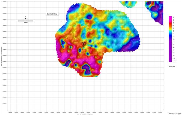
(Source: Trilogy Metals, 2011)
| 5.1.3 | Drilling and Underground Workings |
In October 1965, Kennecott began a shaft to further investigate the Ruby Zone Upper Reef “No. 1 Ore Body” mineralization. In 1966, the shaft reached the 297 m level. At this level, a 91 m crosscut was driven due north to the mineralized zone. The shaft was continued to 328 m deep to prepare a sump and loading pocket. On October 27, 1966, a small blast to excavate a bay at the bottom of the shaft opened a watercourse. The in-flow of water quickly exceeded the pump capacity and within 12 hours the 328 m shaft was flooded to within 13 m from the surface (Hawke, 1966). Prior to the shaft flooding, exploration drilling was completed from the 700 ft level shaft station and the 975 ft level shaft station and crosscut. In 1967, the shaft bottom was partially sealed and then pumped out, and additional exploration drilling completed from the 700 level and the 975 level shaft stations (see Figure 5-2 and Figure 5-3).
| Project No.: 253821 | | History | | |
| January 2025 | | Page 5-3 | |
| Bornite Project |
| Northwest Alaska, USA |
| S-K 1300 Technical Report Summary on the Initial Assessment |
| Figure 5-2: | Diamond Drilling from the 700 Level of the No. 1 Shaft |
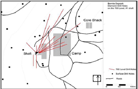
(Source: Trilogy Metals, 2017)
| Figure 5-3: | Diamond Drilling from the 975 Level of the No. 1 Shaft |
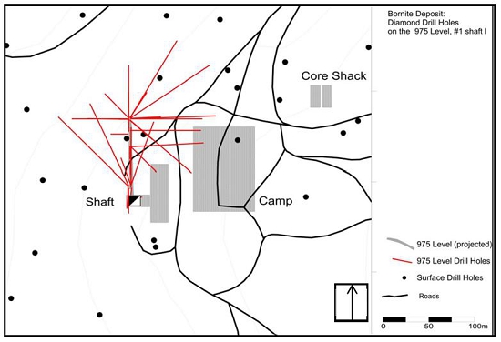
(Source: Trilogy Metals, 2017)
| Project No.: 253821 | | History | | |
| January 2025 | | Page 5-4 | |
| Bornite Project |
| Northwest Alaska, USA |
| S-K 1300 Technical Report Summary on the Initial Assessment |
| 5.1.4 | Petrology, Mineralogy, and Research Studies |
Several studies have been conducted to review the geology and geochemistry of the Bornite deposit. Most notable is Murray Hitzman’s PhD dissertation at Stanford University (Hitzman, 1983) and Don Runnel’s PhD dissertation at Harvard University (Runnels, 1963). Bernstein and Cox (1986) reported on mineralization of the “No. 1 Ore Body” in a 1986 paper in Economic Geology.
| 5.1.5 | Geotechnical and Hydrological Studies |
Kennecott conducted two technical reviews of the groundwater conditions (Vance, 1962) and a summary of the findings related to the flooding of the exploration shaft (Erskine, 1970).
| 5.1.6 | Metallurgical Studies |
In 1961, Kennecott collected 32 coarse reject samples from five drill holes to support preliminary metallurgical test work at Bornite. Samples targeted high-grade (>10%) copper mineralization from the Upper Reef at the Ruby Zone (Lutz, 1961). Further discussion of the historical and current metallurgical studies is presented in Section 10.0.
| Project No.: 253821 | | History | | |
| January 2025 | | Page 5-5 | |
| Bornite Project |
| Northwest Alaska, USA |
| S-K 1300 Technical Report Summary on the Initial Assessment |
| 6.0 | Geological Setting, Mineralization and Deposit |
Wood’s geology QP has reviewed the geology, mineralization, exploration, and drilling content in Sim et al. (2022) and considers it reliable and current. The following discussion is summarized from that report.
The Bornite Property is located within the Arctic Alaska Terrane, a sequence of mostly Paleozoic continental margin rocks that make up the Brooks Range and North Slope of Alaska (Moore, 1992). It is within the Phyllite Belt geologic subdivision, which together with the higher metamorphic grade Schist Belt, stretches almost the entire length of the southern Brooks Range and is considered to represent the hinterland of the Jura-Cretaceous Brookian orogeny. The southern margin of the Phyllite Belt is marked by mélange and low-angle faults associated with the Kobuk River fault zone, while the northern boundary is thought to be gradational with the higher-grade metamorphic rocks of the Schist Belt (Till et al., 2008).
| 6.1.1 | Tectonic and Metamorphic History |
The tectonic setting of the project area during deposition of the host rocks (early Devonian) has been masked by subsequent Brookian deformation and remains difficult to reconstruct. Dillon et al. (1980) interpreted the existence of Devonian granites throughout the Brooks Range as supporting a volcanic arc environment, while Hitzman et al. (1986) pointed to bimodal volcanic rocks and abrupt lateral sedimentary facies transitions as supporting an extensional tectonic setting. Based on igneous geochemistry, Ratterman et al. (2006) suggest that the Ambler sequence volcanic rocks were emplaced in an extensional back-arc spreading environment; however, the original pre-deformation spatial relationship between the Bornite project area and the Ambler sequence remains poorly understood.
The project area underwent regional deformation and metamorphism during the Middle Jurassic to Early Cretaceous Brookian orogeny. The collision of the Koyukuk Arc Terrane from present-day south caused north-directed imbrication and partial subduction of the Arctic Alaska passive margin sedimentary succession. Rocks in the Schist Belt were metamorphosed to blueschist facies. The Schist Belt and the Phyllite Belt were exhumed from greenschist facies conditions during an episode of rapid extension and erosion in the Late Cretaceous beginning around 103 Ma (Moore et al., 1994; Vogl, 2003). Mapping conducted in 2021 found kinematic indicators in the Cosmos Hills that suggest these rocks have experienced top-south deformation.
| Project No.: 253821 | | Geological Setting, Mineralization and Deposit | | |
| January 2025 | | Page 6-1 | |
| Bornite Project |
| Northwest Alaska, USA |
| S-K 1300 Technical Report Summary on the Initial Assessment |
In the project area, the low-angle Kobuk fault zone juxtaposes the Cosmos Hills stratigraphy (Schist Belt and Phyllite Belt) against the overlying Angayucham Terrane, and another low-angle fault likely juxtaposes the Cosmos Hills against the Ambler sequence to the north (Figure 6-1). Bornite sequence carbonate rocks are also in low-angle fault contact with the structurally underlying Anirak schist and the overlying Beaver Creek phyllite.
| | Figure 6-1: | Generalized Geologic Map of the Local Geology |
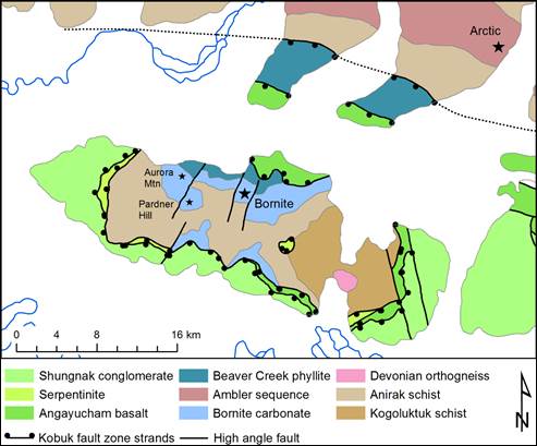
(Source: Modified from Till et al., 2008 and Hitzman, 1986)
The tectonostratigraphy of the district is characterized by pelitic, carbonate and local volcanic rocks metamorphosed to lower greenschist to epidote-amphibolite facies as shown in Figure 6-1 and summarized in Table 6-1.
| Project No.: 253821 | | Geological Setting, Mineralization and Deposit | | |
| January 2025 | | Page 6-2 | |
| Bornite Project |
| Northwest Alaska, USA |
| S-K 1300 Technical Report Summary on the Initial Assessment |
| | Table 6-1: | Tectono-Stratigraphic Units of the Cosmos Hills Area |
| Unit (age) | | Lithology | | Metamorphic Grade | | Approximate Thickness
(m) | |
| Shungnak conglomerate (Cretaceous) | | Pebble conglomerate, sandstone, siltstone, minor intermediate volcanics | | Almost Unmetamorphosed | | 1,000 | |
| Angayucham terrane (Devonian-Mississippian) (allochthonous) | | Pillow basalt, pillow breccia | | Prehnite-Pumpellyite | | >500 | |
| Beaver Creek phyllite (Devonian*) | | Phyllite, quartzite, marble | | Lower Greenschist | | >2,000 | |
| Ambler sequence (Devonian*) | | Metarhyolite, metabasite, tuffaceous metasediments, calcareous metasediments, pelitic schist | | Blueschist to Greenschist | | 700–1,850 | |
| Bornite carbonate sequence (Lower Devonian to Upper Silurian*) | | Marble, argillaceous marble, dolostone, phyllite, phyllitic marble | | Lower Greenschist | | 200–1,000 | |
| Anirak schist (Devonian*) | | Pelitic schist, quartzite, marble, minor metabasite | | Greenschist | | 3,000 | |
| Kogoluktuk schist (Precambrian to Devonian*) | | Pelitic schist, quartzite, metagabbro, minor marble | | Epidote-Amphibolite | | 4,000 | |
(Source: Modified from Hitzman et al., 1986. *Ages from Till et al., 2008)
The intersection of the Cosmos Arch and the Kogoluktuk River drainage 14 km southeast of Bornite exposes a cataclastic orthogneiss of granitic composition that intrudes the Kogoluktuk Schist and has a uranium-lead (U-Pb) zircon age of 386 ± 3 Ma (Till et al., 2008, citing W.C. McClelland).
Higher in the tectono-stratigraphic section, the Kogoluktuk Schist is intruded by sub-horizontal sill-like bodies of metagabbro of unknown age. Other metamafic greenstones are interpreted to have originated as basaltic lava flows and/or tuffaceous volcaniclastic sedimentary rocks (Hitzman, 1986).
Although none occur in the Bornite resource area, discontinuous stratabound greenstone bodies occur in the Anirak schist and at the base of the Bornite carbonate succession, particularly west and southwest of Bornite, including at Aurora Mountain and near the base of the Beaver Creek phyllite west of Bornite (Hitzman et al., 1982). A gabbroic outcrop approximately 200 m wide is exposed 2 km east of Bornite that has been interpreted to be Cretaceous to Tertiary in age.
| Project No.: 253821 | | Geological Setting, Mineralization and Deposit | | |
| January 2025 | | Page 6-3 | |
| Bornite Project |
| Northwest Alaska, USA |
| S-K 1300 Technical Report Summary on the Initial Assessment |
The most significant igneous rocks in the district are the bimodal volcanic rocks of the Ambler sequence that hosts volcanic massive sulphide (VMS) deposits and outcrop 20 km north of Bornite but are not observed in the Cosmos Hills (Table 6-1). These include sub-alkaline basaltic flows and sills with an un-depleted mantle geochemical signature. Sub-alkaline rhyolitic to andesitic tuffs and flows have geochemistry consistent with derivation from a source that includes melting continental crust. Geochemical data imply an origin in an extensional, back-arc basin setting (Ratterman et al., 2006). U-Pb zircon dating from Ambler sequence metarhyolites yields ages of 387–376 Ma (McClelland et al., 2006), which are syn- to early post-mineralization with respect to the Bornite (Ruby Zone) deposit.
| 6.1.4 | Timing of Mineralization in the District |
Sulphides (chalcopyrite, pyrite, and bornite) from Bornite (Ruby Zone) were dated by rhenium–osmium (Re-Os) techniques, yielding an age of 384 ± 4.2 Ma for main stage copper mineralization (Selby et al., 2009).
More recent work (Conner, 2015) suggests a post Jura-Cretaceous (i.e., Post-Brookian) age for mineralization based on 1) albite alteration associated with the mineralizing event cross-cuts the pronounced Jura-Cretaceous penetrative fabric at Bornite, and 2) the common presence of cymrite, a barium-rich blueschist-stable metamorphic mineral related to the Jura-Cretaceous deformation common within all the various mineralized assemblages. The Re-Os ages appear to be contradictory to the Conner (2015) geologic observations, and it seems unlikely for Re-Os to retain a syn-sedimentary age in a metamorphosed and orogenically modified terrane. The question of whether sulphides at Bornite are deformed by, cross-cut, or lie in the plane of Brookian deformation needs to be further investigated.
The syngenetic VMS deposits in the Ambler sequence are constrained by dating of related felsic volcanic rocks. Early post-mineral metarhyolite at the Arctic deposit yielded a mean U-Pb zircon age of 378 ± 2 Ma. Uranium-lead zircon ages for metarhyolite at the Tom-Tom prospect, 11 km east of Arctic, and the Sun prospect, 60 km east of Arctic, are 381 ± 2 Ma and 386 ± 2 Ma, respectively (McClelland et al., 2006) suggesting that felsic magmatism migrated west over time.
The geology of the Bornite resource area is composed of alternating intervals of carbonate rocks (limestone and dolostone) and calcareous phyllite. Limestone transitions laterally into dolostone near zones of mineralization and is considered hydrothermally altered. Spatial relationships and petrographic work suggest that dolomitization is genetically related to early stages of the copper mineralizing system (Hitzman, 1986).
| Project No.: 253821 | | Geological Setting, Mineralization and Deposit | | |
| January 2025 | | Page 6-4 | |
| Bornite Project |
| Northwest Alaska, USA |
| S-K 1300 Technical Report Summary on the Initial Assessment |
Trilogy Metals geologists have been unable to identify any meta-igneous rocks in the resource area; all lithologies described are interpreted as meta-sedimentary in origin.
The current logging system for lithology derives from early Kennecott core logs (1960). Original unit descriptions have not been found; however, the units were re-described during re-logging by NOVAGOLD geologists in the summer of 2010. The scheme encompasses not only primary lithology, but also alteration, and compositional and textural variations. Resource-scale geologic interpretation and modelling is based on the hierarchical generalization shown in Table 6-2.
Figure 6-2 shows typical dolomitized sedimentary breccias of the Bornite carbonate sequence, which are the principal host of mineralization at Bornite. Figure 6-3 shows typical phyllites of the Bornite carbonate sequence.
In 2015, Trilogy Metals tried to improve the understanding of the distribution and nature of the various lithologic units and their context within a sedimentary depositional model. A new interpretation, based on lithogeochemical signatures of the various units along with their historical visual logging, concluded that stacked debris flows composed of basal non-argillaceous channelized breccias were overlain by upward fining increasingly argillaceous breccias and capped by high calcium (Ca) phyllites occupying channels cut into either massive or thin-bedded carbonates.
Two mineralized stacked debrite successions were named the Lower and Upper Reefs. The Upper Reef grades upward into argillaceous limestones instead of discrete high Ca phyllites indicating a waning of debris supply. Based on this interpretation, a series of individual debrites were identified, and these units form the basis of the mineral resource model presented in Section 11.0.
In contrast to the locally derived high-Ca phyllites of the debrite-dominated Bornite carbonate sequence, low calcium (Ca) phyllites are abundant in the allochthonous Anirak schist (quartz phyllite) and the Beaver Creek phyllite that underlie and overlie the Bornite carbonate sequence, respectively.
In addition to depositional lithostratigraphy, a cross-cutting mineralized breccia called the P-Breccia was identified in and around the South Reef deposit. Though poorly defined due to lack of drilling in the area, the P-Breccia zone—which contains excellent copper grade—lies at the apex of the Iron Mountain discontinuity. Although clearly post-deformational, it remains unclear whether the P-Breccia is a post-depositional structural, hydrothermal or solution-collapse breccia.
| Project No.: 253821 | | Geological Setting, Mineralization and Deposit | | |
| January 2025 | | Page 6-5 | |
| Bornite Project |
| Northwest Alaska, USA |
| S-K 1300 Technical Report Summary on the Initial Assessment |
A short lithostratigraphic project carried out during the 2021 field season updated the interpretation of the depositional environment of the Bornite succession; this resulted in significant differences when compared to the previously summarized interpretations (Turner, 2021). The Bornite succession is now understood to be a carbonate slope deposit characterized by (a) lime mudstone, exported to the slope from a contemporaneous shallow-marine carbonate factory, variably mixed with and interlayered with (b) background argillaceous sediment that is locally carbonaceous. Superimposed on these calcite-dominated normal slope strata are locally impressive thicknesses of dolomudstone-clast conglomerate (formerly breccia). Slope limestone and siltstone-mudstone were originally centimetrically to decimetrically bedded, but are commonly ductilely deformed, producing the variably limey phyllites that exhibit sub-mm scale foliation. In contrast, the dolostone-clast conglomerates and individual dolomudstone clasts responded brittlely to Brookian stress and show no significant shearing or plastic deformation. Instead, plastic deformation is largely restricted to the various phyllitic layers around the peripheries of the dolostone bodies.
Figure 6-4 shows a general stratigraphic column of the lithologic units in the Ruby Zone and South Reef areas.
| Table 6-2: | Lithology Units on the Bornite Property |
| Area | | Lithology | | Codes | | Description |
| Carbonate | | Limestone | | BXLC, LS, TBLS | | Carbonate sedimentary breccia consisting of 10% to 90% polylithic carbonate clasts supported in a calcareous matrix. Clast lithologies include limestone, dolostone, ferroan dolostone, and locally massive pyrite. |
| | | Dolostone (secondary) | | BXDC, DOL, ADP | | Dolomitized carbonate sedimentary breccia consisting of abundant (±90%), polylithic clasts (0.5 to 50 cm in diameter). Host for mineralization at Bornite. |
| Phyllite | | Carbonaceous Calcareous Phyllite | | AP, ALP, APL, ALS, ALCB | | Weakly to moderately carbonaceous calcareous phyllite defined by presence of a significant (5 to 95%) shale-rich component in the carbonate section. Phyllites commonly act as limits or delimit mineralized bodies. |
| | | Bleached Calcareous Phyllite | | TS, TLP, TPL, CHPL | | Texturally similar to the carbonaceous calcareous phyllite described above and interpreted as altered equivalents. Commonly characterized by strong sericite component historically misidentified as talc. |
| Anirak Achist | | Quartz Phyllite (Anirak Schist) | | QP | | Moderately graphitic quartz-rich-phyllite, locally moderately calcareous. |
| Note: | BXLC = Limestone Clastic Breccia; LS = Limestone; TBLS = Thin Bedded Limestone; BXDC = Dolostone Clastic Breccia; DOL = Dolostone; ADP = Argillaceous Dolomitic Phyllite; AP = Argillaceous/Carbonaceous Phyllite; ALP = Argillaceous Limestone Phyllite; APL = Argillaceous/Carbonaceous Phyllitic Limestone; ALS = Argillaceous Limestone;
ALCB = Argillaceous Limestone Breccia; TS = Talc Schist; TPL = Tan Phyllitic Limestone; TLP = Tan Limey Phyllite; CHPL = Chloritic Phyllite; QP = Quartz Phyllite. |
| Project No.: 253821 | | Geological Setting, Mineralization and Deposit | | |
| January 2025 | | Page 6-6 | |
| Bornite Project |
| Northwest Alaska, USA |
| S-K 1300 Technical Report Summary on the Initial Assessment |
| | Figure 6-2: | Typical Limestones and Dolostones of the Bornite Carbonate Sequence |
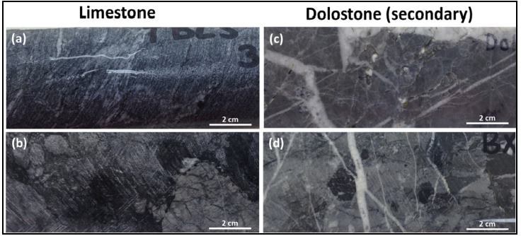
(Source: Trilogy Metals, 2017)
| Note: | (a) Thin Bedded Limestone (TBLS): Limestone textural variant with 1 mm scale banding of light and dark grey carbonaceous seams; (b) Limestone Clastic Breccia (BXLC): Carbonate sedimentary breccia with carbonate clasts in a calcareous, locally phyllitic matrix; (c) Dolostone (DOL): Partially dolomitized carbonate with late dolomite-calcite veining; (d) Dolostone Clastic Breccia (BXDC): Polylithic clasts of dolostone in a dolostone matrix. Hydrothermal matrix or veins (low Fe) dolomite, pyrite, ± calcite, chalcopyrite, bornite, sphalerite. |
| Project No.: 253821 | | Geological Setting, Mineralization and Deposit | | |
| January 2025 | | Page 6-7 | |
| Bornite Project |
| Northwest Alaska, USA |
| S-K 1300 Technical Report Summary on the Initial Assessment |
| | Figure 6-3: | Typical Phyllites of the Bornite Carbonate Sequence |
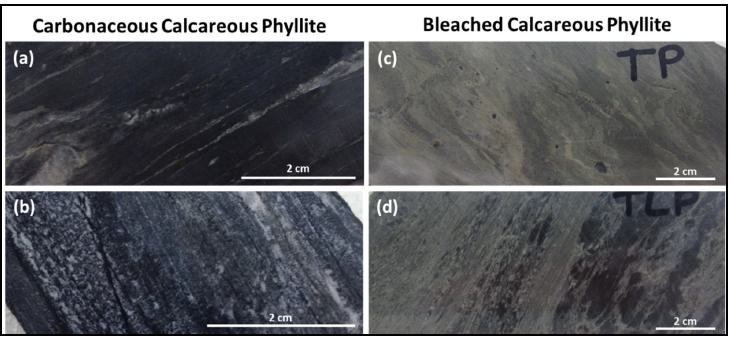
(Source: Trilogy Metals, 2017)
| Note: | (a) Argillaceous/Carbonaceous Phyllite (AP): Carbonaceous to graphitic, weak to moderately calcareous phyllite with >75% phyllosilicates. Typically 1% to 2% pyrite; (b) Argillaceous/Carbonaceous Phyllitic Limestone (APL): Carbonaceous limestone (marble) with 5% to 20% phyllosilicates, especially in dark bands. Typically 1% to 2% pyrite; (c) Tan Phyllite (TP): Non-carbonaceous, weak-mod calcareous phyllite with > 75% phyllosilicates. Typically contains 1% to 2% fine-grained pyrite; (d) Tan Phyllitic Limestone (TPL): Non-carbonaceous limestone (marble) with 5% to 20% phyllosilicates, including white mica. Typically contains 1% to 2% very fine-grained pyrite. |
| Project No.: 253821 | | Geological Setting, Mineralization and Deposit | | |
| January 2025 | | Page 6-8 | |
| Bornite Project |
| Northwest Alaska, USA |
| S-K 1300 Technical Report Summary on the Initial Assessment |
| | Figure 6-4: | General Stratigraphic Column for the Ruby Zone and South Reef Lithologies |
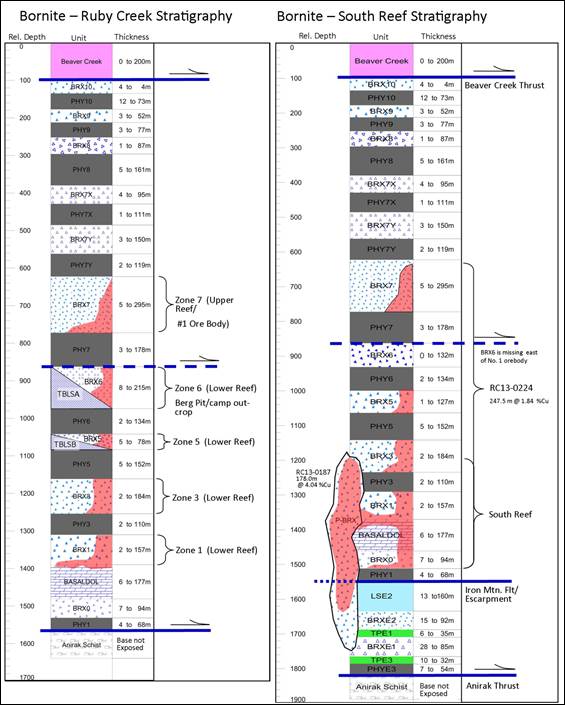
(Source: Trilogy Metals, 2016)
| Project No.: 253821 | | Geological Setting, Mineralization and Deposit | | |
| January 2025 | | Page 6-9 | |
| Bornite Project |
| Northwest Alaska, USA |
| S-K 1300 Technical Report Summary on the Initial Assessment |
| 6.2.2 | Lithology Interpretation |
The current lithostratigraphic understanding does not support the historical Kennecott interpretation of a talus-dominated fore-reef environment for the development of the high energy carbonate breccias. The results of the 2021 lithostratigraphy project indicate- that no reef is present in the area. Although there are minor debrites of slope-derived lime mudstone and calcareous siltstone casts, the dolomudstone-clast conglomerates are not the product of the active, normal carbonate system that produced lime mud that accumulated on the slope (Turner, 2021). Instead, the dolomudstone clasts are interpreted to have been derived from anomalous faulted sea-floor scarps that exposed older, unrelated dolostone bedrock to gravitational failure, resulting in deposition of dolostone-clast conglomerates by rockfall at and near scarp bases, and their further resedimentation downslope, mixed into the calcareous slope sediment as debrites (Figure 6-5). The syn-sedimentary faults that shed the conglomerates were probably the result of extension during accumulation of the Bornite succession. They also possibly acted as later conduits for mineralizing fluids. Dolostone-clast conglomerates are the main hosts of copper mineralization at Bornite, which is concentrated where the Bornite strata are most doloclast-conglomerate-rich.
| Figure 6-5: | Schematic Cross-sectional Diagram of Carbonate Environment Showing Position of Mineralization (red) |
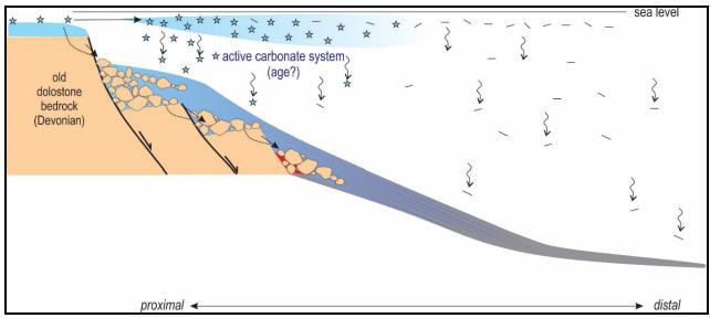
(Source: Turner, 2021)
| Project No.: 253821 | | Geological Setting, Mineralization and Deposit | | |
| January 2025 | | Page 6-10 | |
| Bornite Project |
| Northwest Alaska, USA |
| S-K 1300 Technical Report Summary on the Initial Assessment |
Structural fabrics observed on the Bornite Property include rare bedding and two distinct metamorphic foliations. Bedding (S0) can be measured only rarely where phyllite and carbonate are interbedded, and it is unclear to what extent it is transposed. The pervasive foliation (S1) is often mylonitic and exhibits both an imprinted stretching lineation and preferred top direction. It is easily measured in phyllites and is commonly reflected by colour banding and/or stylolamination (flaggy habit in outcrop) of the carbonates. Some limestone outcrops, in particular the TBLS on Aurora Mountain and the marbles at the base of Coral Hill, also exhibit a stretching lineation. Core-logging shows that S1 is folded gently on a 10 m scale and locally tightly folded at the decimetre scale forming a common S2 axial planar cleavage. S2 is folded gently on a 10 m scale forming an upright mesoscale S3 foliation. S1 and S3 foliations are thought to be Jura-Cretaceous in age.
Structural mapping in 2021 recognized a well-developed stretching lineation (i.e., L-tectonite) in the carbonate-phyllite rocks, typically oriented shallowly towards the north-northeast or south-southwest. Top directions indicate movement to the south or south-southwest along the vector of the stretching lineation. Moreover, mapping in 2022 indicates that stiff Bornite rocks, in particular metric to hectametric dolostone bodies, have been boudinaged into 3D ellipsoids. Slip is accommodated by phyllites. Interpretation of this mapping should be performed to determine whether such a tectonic style plays a role in the distribution of copper mineralization.
Owing to their greater rigidity, dolostone bodies of secondary dolostone manifest strain differently: tan hydrothermal dolostone tends to be broken into centimetre- to decimetre-scale blocks, whereas grey (diagenetic?) dolostone may exhibit unusual, contorted forms, some resembling human fingers or swan necks, as evident in outcrop. Dolostone is rarely cut by plastically deformed zones and instead forms metric to hectametric lenses (augens) encased in plastically deformed calc-mylonite and calc-phyllite. This deformation, presumably a product of the Jura-Cretaceous Brookian orogeny, complicates sedimentological interpretations.
Possibly the earliest and most prominent structural feature in the resource area is the northeast-trending Iron Mountain fault or discontinuity, which is still problematic in its interpretation because it is a cross structure that strikes northeast at a high angle to the overall Brookian structural trend, as well as that of the South Reef deposit. Numerous drill holes in the South Reef area intersect a thin zone of apparent basal quartz phyllite tectonostratigraphy overlying mineralized carbonate stratigraphy, a relationship that was also documented in a trench dug between Pardner Hill and Aurora Mountain in 2021.
| Project No.: 253821 | | Geological Setting, Mineralization and Deposit | | |
| January 2025 | | Page 6-11 | |
| Bornite Project |
| Northwest Alaska, USA |
| S-K 1300 Technical Report Summary on the Initial Assessment |
Numerous explanations for the Iron Mountain discontinuity have been suggested, none of which completely accounts for all the logged observations. Inadequate drilling through the feature into lower stratigraphy and the assumption that the basal quartz phyllite is in fact the bottom has limited its resolution. Interpretations offered over time, include: 1) a normal growth fault (that would date to the Devonian); 2) a thrust fault; 3) a kink or fault-propagation fold; 4) a quartz phyllite lens intercalated within the basal part of the carbonate sequence; 5) a basement-involved drag fold formed during displacement of the Bornite sequence; and 6) a depositional unconformity. Interpretations 2 to 5 would all date to the Brookian orogeny.
Importantly, the recognition of the P-Breccia at or near the apex of the Iron Mountain discontinuity, and its interpretation as a post-depositional structural, hydrothermal, or solution-collapse breccia, suggests a post-lithification origin. Some data also suggest that the P-Breccia is a syn-depositional slump related to the Iron Mountain discontinuity and the eastern terminus of the thin QP wedge, suggesting that the Iron Mountain structure was already present during the Devonian. Although the spatial distribution of mineralization adjacent to the Iron Mountain feature is unequivocal, a direct link between the discontinuity and mineralization has yet to be demonstrated.
To the north, the Bornite carbonate sequence is in low-angle normal fault contact with the Beaver Creek phyllite along the north-dipping Beaver Creek fault. The fault, a thick, brittle structure of potentially regional significance, defines the approximately bedding-parallel contact of the structurally higher Beaver Creek phyllite with the structurally lower Bornite carbonate sequence in the immediate Bornite area. However, the fault is absent further west, where these units lie in apparent stratigraphic contact.
Both the Beaver Creek fault and the Bornite carbonate sequence were in the past thought to be cut by a series of north-trending high-angle brittle faults of apparent small displacement as shown in Figure 6-1 (Hitzman et al., 1982). These structures have not been identified in outcrop or in drilling at Bornite and are no longer thought to exist. However, mapping on Aurora Mountain has identified two high-angle brittle normal faults that strike northwest and west-northwest that have some 50 m to 100 m of throw across them. This set of normal faults may wind up being present in other parts of the Cosmos Hills.
| Project No.: 253821 | | Geological Setting, Mineralization and Deposit | | |
| January 2025 | | Page 6-12 | |
| Bornite Project |
| Northwest Alaska, USA |
| S-K 1300 Technical Report Summary on the Initial Assessment |
Mineralization at Bornite forms tabular mineralized zones that coalesce into crudely stratabound bodies hosted in dolostone conglomerate/breccia. Two significant dolomitic horizons that host mineralization have been identified by drilling and include: 1) the Lower Reef, a substantial 100 m to 300 m thick dolomitized zone lying immediately above the basal quartz phyllite unit of the Anirak schist and 2) the Upper Reef, a 100 m to 150 m thick dolomite horizon that sits roughly 300 m higher in the section. The Lower Reef is separated from the Upper Reef by a zone of ductilely sheared phyllites up to 60 m thick.
The Lower Reef dolostone outcrops along the southern margin of the Ruby Zone and is spatially extensive throughout the deposit area. It hosts a significant portion of the shallow mineral resources in the Ruby Zone as well as higher grade mineral resources down-dip and to the northeast in the South Reef area. The Upper Reef hosts relatively high-grade mineral resources to the north in the Ruby Zone. The Upper Reef zone appears to lie at an important northeast-trending facies transition to the northwest of the main drilled area and appears to be at least partially thrust over the Lower Reef stratigraphy to the southeast.
Drill results from 2013 show dolomitization and copper mineralization in the Upper and Lower Reefs coalescing into a single unit along the northern limits of current exploration. The northeast--trending Ruby Zone and South Reef areas also coalesce into a roughly 1,000 m wide zone of >200 m thick dolomite containing significant copper mineralization dipping north at roughly 5 to 10°. The 2017 drill results show that the mineralized dolomite interval continues for at least another 700 m down-dip to the northeast from mineralization in the Upper and Lower Reefs.
Figure 6-6 shows the grade thickness (Cu% x thickness in metres) distribution of copper mineralization for the Bornite deposit.
| Project No.: 253821 | | Geological Setting, Mineralization and Deposit | | |
| January 2025 | | Page 6-13 | |
| Bornite Project |
| Northwest Alaska, USA |
| S-K 1300 Technical Report Summary on the Initial Assessment |
| Figure 6-6: | Copper Grade Thickness Plan Map for the Bornite Deposit |

(Source: Trilogy Metals, 2019)
Copper mineralization at Bornite comprises chalcopyrite, bornite, and chalcocite distributed in stacked, stratabound zones exploiting favourable lithologies (conglomerate/breccia) within the Bornite sequence. Mineralization occurs, in order of increasing grade, as disseminations, irregular and discontinuous stringer-style veining, breccia matrix replacement, and stratabound massive sulphides. Figure 6-7 shows typical mineralization of the Bornite deposit characterized by chalcocite, bornite, chalcopyrite and pyrite.
| Project No.: 253821 | | Geological Setting, Mineralization and Deposit | | |
| January 2025 | | Page 6-14 | |
| Bornite Project |
| Northwest Alaska, USA |
| S-K 1300 Technical Report Summary on the Initial Assessment |
The distribution of copper minerals is zoned around the bottom-centre of each zone of mineralization, with bornite-chalcocite-chalcopyrite at the core progressing outward to a fringe of chalcopyrite-pyrite. Additional volumetrically minor copper minerals include carrollite, digenite, tennantite-tetrahedrite, and covellite (Bernstein and Cox, 1986). Stringer pyrite and locally significant sphalerite occur above and around the copper zones and locally massive pyrite and sparse pyrrhotite are associated with siderite alteration below copper mineralization in the Lower Reef.
| Figure 6-7: | Typical Mineralization of the Bornite Deposit |
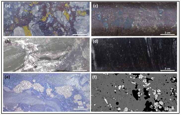
(Source: Trilogy Metals, 2017)
| Note: | (a) Typical high-grade chalcocite-bornite-chalcopyrite mineralization; commonly forms stringers, veinlets, disseminations, and breccia fillings; (b) Chalcocite (Cu2S) appears dark grey to black, occurs in massive sulphide zones and typically replaces bornite. Note the boudinage of the carbonate beds in which the boudin necking zone is filled with white calcite; (c) Massive sulphide mineralization, chalcocite-bornite-chalcopyrite of the historically termed “No. 1 Ore Body” Ruby Zone Upper Reef; (d) Typical disseminated 1% and 2% pyrite in ductilely deformed Quartz Phyllite – Rock unit defines the base of the Bornite carbonate sequence, equivalent to the Anirak schist; attenuated foliation parallel white quartz stringers indicate significant ductile deformation has occurred in this unit; (e) Coarse-grained carrollite (Co2CuS4) appears shiny and highly reflective resembling aluminum foil and is often found associated with high-grade copper zones; (f) back-scattered electron image showing cobaltite (white rounded grains) growing on chalcopyrite (dark gray). |
| Project No.: 253821 | | Geological Setting, Mineralization and Deposit | | |
| January 2025 | | Page 6-15 | |
| Bornite Project |
| Northwest Alaska, USA |
| S-K 1300 Technical Report Summary on the Initial Assessment |
Significant cobalt mineralization is found accompanying bornite-chalcocite mineralization (Section 10.5). Cobalt often occurs with high-grade copper as carrollite (Co2CuS4), cobaltite (CoAsS) and as cobaltiferous rims on recrystallized pyrite grains (Bernstein and Cox, 1986). Preliminary geometallurgical work by Trilogy Metals showed that cobalt occurs primarily as cobaltiferous pyrite (approximately 80% of the contained cobalt) and within other cobalt minerals, such as carrollite and cobaltite (CoAsS).
In 2021, as part of his master’s thesis, Mahaffey collected detailed handheld XRF analyses on 15 drill holes. Together with reflected light petrography, electron microprobe-based compositional maps, and electron microprobe analyses (EPMA), Mahaffey identified various carrollite and cobaltite compositions, textures and associations with copper sulphides as well as their spatial distribution in the Bornite deposit (Mahaffey, 2021).
Germanium is also seen to be associated with copper mineralization (Runnels, 1963; Bernstein and Cox, 1986). In 2011, 50 mostly continuous core samples selected from four drill holes were found to have germanium values ranging from <1 to 83 ppm and averaging 10.7 ppm using sample preparation methods specifically for germanium (compared to a maximum value of 1.15 ppm using a standard analytical method). More recently, values ranging from <1 to 125 ppm and averaging 10.5 ppm were measured in 84 core samples taken from five drill holes from South Reef as part of a Master of Science thesis on the distribution of germanium at South Reef by Alex Jones (2023) at the Colorado School of Mines. The average grades obtained from a few samples does not represent the overall germanium grade within the deposit. Further interest in germanium would require additional sampling and metallurgical test work to understand its economic potential.
A long-held view regarding alteration at Bornite assumes that dolomite is the predominant product of hydrothermal alteration. Dolomite is particularly pronounced in 1) certain massive carbonate units; 2) the Lower and Upper Reef debris flow breccias; and 3) the P-Breccia and in some outcrops in the district, especially in the Pardner Hill area. Similar to the trend in copper grade, more intense and complete dolomitization is expressed at the base of both the Lower and Upper Reefs.
Importantly, copper grade generally has a positive correlation with the intensity of dolomite alteration expressed as Ca/Mg ratios of 0.4 to 0.67. Fe-compositions of the carbonates show a significant negative correlation with copper grade. High iron carbonate species, such as siderite and iron-rich ferroan dolomite, exhibit almost no grade, whereas low iron dolomites show strong copper mineralization.
| Project No.: 253821 | | Geological Setting, Mineralization and Deposit | | |
| January 2025 | | Page 6-16 | |
| Bornite Project |
| Northwest Alaska, USA |
| S-K 1300 Technical Report Summary on the Initial Assessment |
The spatial distribution of the iron-rich dolomites is zoned with high iron siderite and ankerite localized down the plunge of the lowermost debrites in the Lower Reef. Low-iron dolomites, zoned around this basal core of high-iron dolomites, are well mineralized and form an annulus or horseshoe around the core of unmineralized iron-rich carbonates between the Ruby Zone and the South Reef area.
The overall dolomite alteration pattern suggests sourcing of a mineralizing fluid from the south and transport to the north down the principal axes of coarse-grained debris flows. Of critical importance is the limit of iron-dolomites and the strongly open down-dip extension of low-iron dolomites. This supports the possible continuation of significant grade down-dip on the combined Lower Reef/South Reef extension and could constitute a very effective targeting tool elsewhere in the district.
Alteration within the high calcium (Ca) phyllites capping successive debrites is expressed as albitization of pre-existing K-feldspar and the development of magnesium-phengite at the expense of early detrital muscovite, biotite, and chlorite. Increased albite and Mg-phengites are characteristically seen as bleaching of the high calcium (Ca) phyllites with highest intensities of alteration immediately below strong copper mineralization in the debrite breccias.
Work in 2021 suggests that dolostone (dolomite) may occur primarily or only as clasts within conglomerate (breccia) and pre-dates mineralization. Additional work is needed to resolve this important discrepancy.
Figure 6-8 shows a southwest-northeast-trending schematic cross-section across the South Reef, showing an interpretation of the geology, mineralization, and alteration from the drilling results.
| 6.4 | Prospects/Exploration Targets |
The Bornite carbonate sequence, host to the mineralization at Bornite, is exposed over approximately 16 km along the north slope of the Cosmos Hills and to a lesser extent on the southern margin of the Cosmos Hills arch (Figure 6-1). Numerous areas of hydrothermal dolomitization and copper mineralization occur across the entire width of outcropping carbonates and are the focus of ongoing regional exploration by Ambler Metals. Most notable of the known prospects are the Pardner Hill and Aurora Mountain areas, where outcropping mineralization was discovered and drill-tested during the Kennecott era.
| Project No.: 253821 | | Geological Setting, Mineralization and Deposit | | |
| January 2025 | | Page 6-17 | |
| Bornite Project |
| Northwest Alaska, USA |
| S-K 1300 Technical Report Summary on the Initial Assessment |
| Figure 6-8: | Southwest-Northeast Schematic Cross-section through South Reef Illustrating Geology, Alteration and Sulphide Mineral Zoning |
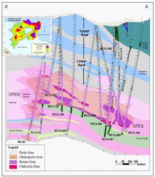
(Source: Trilogy Metals, 2016)
The Pardner Hill prospect is located 5 km west of Bornite (Figure 6-1) and consists of a 3 km copper (± zinc) soil and rock geochemical anomaly in rubble cropping dolostone. Kennecott drilled 16 holes in the area and defined a stratabound copper mineralized zone approximately 150 m by 400 m and varying from 5 m to 35 m thick at the southern end of the geochemical anomaly. Mineralization is cut off by a low-angle fault but remains open down-dip to the north and to the south.
| Project No.: 253821 | | Geological Setting, Mineralization and Deposit | | |
| January 2025 | | Page 6-18 | |
| Bornite Project |
| Northwest Alaska, USA |
| S-K 1300 Technical Report Summary on the Initial Assessment |
Dolomitization and anomalous copper and zinc geochemistry also characterize the Aurora Mountain prospect located 6 km west of Bornite (Figure 6-1). Anomalies are distributed along a 2 km mineralized horizon about a third of which has been tested by four Kennecott-era drill holes.
Importantly, the evolving understanding of the spatial distribution of the debrite breccias and their control on fluid flow along with the alteration vectoring pattern from high- iron dolomites through progressively iron-depleted dolomites provide an important opportunity to target additional mineralization both down-dip along the Upper and Lower Reefs and in the Pardner Hill and Aurora Mountain areas.
| 6.5 | Genesis/Genetic Implications |
Recent development of a coherent sedimentary model for the Bornite deposit suggests a carbonate slope environment with a series of debrites characterized by extremely coarse-grained conglomerates (breccias). The lateral and vertical controls on the distribution of dolostone-clast conglomerate remain poorly understood but are likely a function of underlying structural controls, such as syn-sedimentary growth faults.
The overall distribution of dolomite alteration suggests sourcing of a mineralizing fluid from the south and transport to the north. The debrites may have provided important permeability and dolomitization would have been associated with volume reduction and permeability enhancement. Texturally, mineralization occupies breccia interstices and overprints dolostone wallrock via irregular fracture patterns.
From a genetic standpoint, the geochemical trends apparent in the alteration and mineralization along the south-to-north fluid path show initial or proximal high iron, magnesium, and potassium with overall low sulphur to distal high calcium, sodium and sulphur as the system evolved. Copper is broadly zoned around the high-iron core enclosed by low-iron dolomites. Importantly, the reduced (ferrous) iron present in the early assemblage of chlorite, siderite, and pyrrhotite does not support the model that the principal metal transport mechanism was an oxidized metalliferous brine with sulphide precipitation as a result of encountering reductants such as carbonaceous and pyritic phyllites or the surrounding halo of anthraxolite and other organic-C compounds.
| Project No.: 253821 | | Geological Setting, Mineralization and Deposit | | |
| January 2025 | | Page 6-19 | |
| Bornite Project |
| Northwest Alaska, USA |
| S-K 1300 Technical Report Summary on the Initial Assessment |
Copper-cobalt-silver-zinc-germanium mineralization at the Bornite Property forms disseminations, veins, and massive sulphides in stacked, semi-stratabound bodies closely associated with secondary hydrothermal dolomitization. The cross-cutting nature of the mineralization along with the presence of early pyrite and sphalerite in sedimentary breccia clasts suggest an epigenetic origin that was temporally very close after the deposition of host strata. Re-Os dating supports this interpretation (Selby et al., 2009).
Data are limited regarding the sources and nature of the copper-rich fluids that formed the Bornite deposit, but they suggest that mineralizing fluids may have formed from the interaction of saline basin fluids with mafic volcanic rocks in the area.
Given these constraints, Bornite has characteristics similar to other districts and deposits including: the Mount Isa and McArthur River districts in Australia, the Tynagh deposit in Ireland, the Kipushi deposit in the Democratic Republic of the Congo, and the Tsumeb deposit in Namibia. All of these deposits show early epigenetic characteristics, emplacement in carbonate stratigraphy, and early pyrite-dolomite alteration followed by sulphide mineralization.
These comparable deposits occur in intra-continental to continental margin settings undergoing extensional tectonics and bimodal volcanism similar to Bornite. Basin-margin faults seem to have been important in localizing mineralization (Hitzman, 1983) although basin margin structures at Bornite have not been directly identified.
An early epigenetic carbonate-hosted Cu-Co model is applicable for exploration targeting in the project area.
| Project No.: 253821 | | Geological Setting, Mineralization and Deposit | | |
| January 2025 | | Page 6-20 | |
| Bornite Project |
| Northwest Alaska, USA |
| S-K 1300 Technical Report Summary on the Initial Assessment |
Wood’s geology QP has reviewed the geology, mineralization, exploration, and drilling content in Sim et al. (2022) and considers it reliable and current. The following discussion is summarized from that report.
Exploration work completed by Kennecott (1957 through 1998) is summarized in Section 5.0. In addition to extensive drilling, Kennecott completed widespread surface geochemical sampling, regional- and property-scale mapping, and numerous geophysical surveys. Most of the data was acquired by NOVAGOLD and has formed the basis for further exploration, targeting Bornite-style mineralization in the Bornite carbonate sequence.
In 2006, NOVAGOLD contracted Fugro Airborne Surveys (Fugro) to complete a detailed helicopter DIGHEM (frequency-domain EM), magnetic and radiometric survey of the Cosmos Hills. The survey covered a rectangular block approximately 18 km by 49 km which totalled 2,852-line km. The survey was flown at 300 m line spacing with a line direction of N20E. The DIGHEM helicopter survey system produced detailed profile data of magnetics, EM responses and radiometrics (total count, uranium, thorium, and potassium) and was processed into maps of magnetics, discrete EM anomalies, EM apparent resistivity, and radiometric responses.
A report and Fugro-processed maps and grids are available (Fugro, 2007). Figure 7-1 shows total field magnetics from the survey.
In 2010, in anticipation of completing the NANA Agreement, NANA granted NOVAGOLD permission to begin low level exploration at Bornite. This consisted of re-logging and re-analyzing select drill holes using a Niton™ portable XRF. A drill section across the Bornite deposit was made using Kennecott surface diamond drill holes: RC-27, -29, -32, -35, -53, -58, -62, and -102, and underground drill hole RU-16 that were re-logged and re-analyzed in the Bornite camp in July and August 2010 (Figure 7-2).
| Project No.: 253821 | | Exploration | | |
| January 2025 | | Page 7-1 | |
| Bornite Project |
| Northwest Alaska, USA |
| S-K 1300 Technical Report Summary on the Initial Assessment |
| Figure 7-1: | Total Field Magnetics |

(Source: Fugro, 2007)
| Project No.: 253821 | | Exploration | | |
| January 2025 | | Page 7-2 | |
| Bornite Project |
| Northwest Alaska, USA |
| S-K 1300 Technical Report Summary on the Initial Assessment |
| Figure 7-2: | Northwest-Southeast Re-interpreted Profile Across the Bornite Deposit |
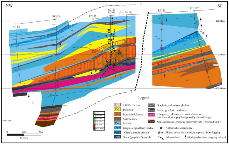
(Source: NOVAGOLD, 2010)
| Project No.: 253821 | | Exploration | | |
| January 2025 | | Page 7-3 | |
| Bornite Project |
| Northwest Alaska, USA |
| S-K 1300 Technical Report Summary on the Initial Assessment |
In general, the re-logging and re-interpretation compared moderately well with the 1996 Kennecott interpretation. General relationships apparent in Figure 7-2 include: a thick area of dolomitization centred approximately at drill hole RC-60 corresponding with mineralization and surrounding and overlying the Ruby Zone Upper Reef; iron-rich dolomite, forming an inner alteration zone; and a strong stratigraphic control with mineralization occurring in dolomitized limestones immediately overlying a graphitic phyllite.
One notable difference from the Kennecott interpretation was the recognition of a significant stratigraphic and structural discontinuity between the southeastern and northwestern parts of the section. A sharp, apparent truncation or offset of mineralization, dolomitization, and stratigraphic units across this boundary is apparent in the re-logging effort. Interpretation of the discontinuity remains unclear at this time, but it could represent either a post-mineral offset or a major facies transition or both. Interpretation of this discontinuity between the Upper and Lower Reef dolomites continues to be problematic in developing a coherent structural and stratigraphic model for the deposit.
In addition to the 2010 re-logging effort, NOVAGOLD contracted a consulting geophysicist to compile a unified airborne magnetic map for the Ambler Mining District from Kennecott, Alaska DNR, and NOVAGOLD airborne geophysical surveys (Figure 7-3).
In 2011, NOVAGOLD contracted Zonge International Inc. (Zonge) to conduct both dipole-dipole complex resistivity induced polarization (CRIP) and natural source audio-magnetotelluric (NSAMT) surveys over the northern end of Bornite to develop tools for additional exploration targeting under cover to the north.
NSAMT data were acquired along two lines totalling 5.15 line-km; one line is oriented generally north-south through the centre of the survey area and the other line is the southernmost east-west line in the survey area. CRIP data were acquired on five lines: four east-west lines and one north-south line, for a total coverage of 14.1 line-km and 79 collected CRIP stations. The initial objective of the survey was to investigate geological structures and the distribution of sulphides possibly associated with copper mineralization.
Results from the paired surveys show that wide-spaced dipole-dipole resistivity is the most effective technique to directly target the mineralization package. Broad, low-resistivity anomalies reflecting pyrite haloes and mineralization appear to define the limits of the fluid package. Well-defined and often very strong chargeability anomalies are also present but appear in part to be masked by phyllitic units which also have strong chargeability signatures. NSAMT shows similar resistivity features as the IP, but these are less well resolved.
| Project No.: 253821 | | Exploration | | |
| January 2025 | | Page 7-4 | |
| Bornite Project |
| Northwest Alaska, USA |
| S-K 1300 Technical Report Summary on the Initial Assessment |
| Figure 7-3: | District Airborne Magnetics Compiled from Kennecott, AK DNR and NOVAGOLD Surveys |

(Source: O’Connor, 2011)
| Project No.: 253821 | | Exploration | | |
| January 2025 | | Page 7-5 | |
| Bornite Project |
| Northwest Alaska, USA |
| S-K 1300 Technical Report Summary on the Initial Assessment |
Considering the success of the 2011 geophysical program, Trilogy Metals contracted Zonge to conduct a major district-wide dipole/dipole IP survey, a down-hole IP radial array survey in the South Reef area, and an extensive physical property characterization study of the various lithologies to better interpret the existing historical geophysical data.
Zonge completed 48 line-km of 200 m dipole/dipole IP during 2012, infilling and expanding on the 2011 survey, and stretching across the most prospective part of the outcropping permissive Bornite carbonate sequence. Figure 7-4 and Figure 7-5 show isometric views of the combined 2011 and 2012 surveys for resistivity and IP, respectively. The results show a well-defined low resistivity area associated with mineralization and variable IP signatures attributed both to mineralization and the overlying Beaver Creek phyllite. Numerous target areas occur in the immediate Bornite area with lesser targets occurring in the Aurora Mountain and Pardner Hill areas and in the far east of the survey area. During the 2012 drill program at South Reef, a single drill hole was targeted on a low resistivity area approximately 500 m to 600 m southeast of the South Reef mineralization trend. Although the drill hole intersected some dolomite alteration in the appropriate stratigraphy, no significant sulphides were encountered.
In addition to the extensive ground IP survey, Zonge also completed 9 km of down-hole radial IP using an electrode placed in drill hole RC12-0197 to further delineate the trend and potential in and around the South Reef.
Extensive physical property data, including resistivity, chargeability, specific gravity, and magnetic susceptibility were captured for use in modelling the existing ground IP and gravity surveys, and the airborne EM and magnetic surveys. In general, some broad comments can be made concerning geophysical domains in and around mineralization at Bornite. Mineralization is characterized by low resistivity <20 ohms, ambiguous but elevated, often irregular chargeability highs (>35 milliradians) marginal to the mineralization, and 3-5 milligal gravity anomalies. Mineralization appears to lie along the flanks of 20-150 nT long wave magnetic anomalies which might reflect deep-seated mafic greenstones deeper in the stratigraphy.
In addition to geophysical-focused exploration, a district-wide geologic map was compiled integrating Kennecott’s 1970s mapping of the Cosmos Hills with selective Trilogy Metals mapping in 2012.
| Project No.: 253821 | | Exploration | | |
| January 2025 | | Page 7-6 | |
| Bornite Project |
| Northwest Alaska, USA |
| S-K 1300 Technical Report Summary on the Initial Assessment |
| Figure 7-4: | Isometric View of 2011 and 2012 Resistivity Profiles |
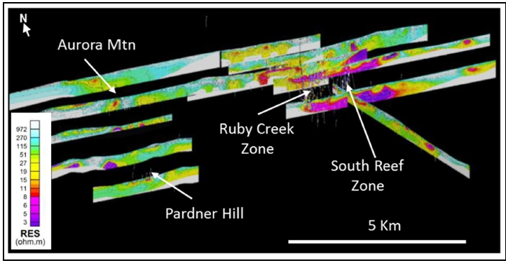
(Source: NovaCopper, 2012)
| Figure 7-5: | Isometric View of 2011 and 2012 Chargeability Profiles |
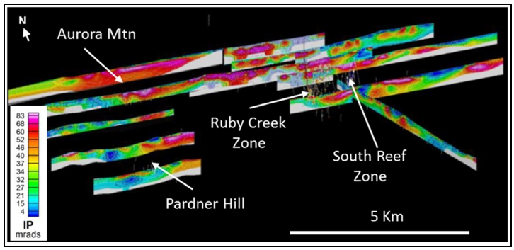
(Source: NovaCopper, 2012)
| Project No.: 253821 | | Exploration | | |
| January 2025 | | Page 7-7 | |
| Bornite Project |
| Northwest Alaska, USA |
| S-K 1300 Technical Report Summary on the Initial Assessment |
The emphasis of the 2013 program was to further validate and refine the 2012 geologic map of the Cosmos Hills. A deep penetrating soil and vegetation geochemical orientation survey was completed over the South Reef deposit, using various partial leaches and pH methods. The initial, approximately 1 km test lines suggest a good response for several of the partial leaches of the soils but little response in the vegetative samples. Follow-up sampling was warranted to the north of the deposit into the Ambler Lowlands.
During 2014, exploration work was limited to a re-logging and re-sampling program of historical Kennecott drill core. Work was conducted out of the Fairbanks warehouse and is described in Section 7.18.
As a follow-up to the 2013 field program, a deep penetrating soil and vegetation geochemical survey was extended north of the deposit into the Ambler Lowlands. Trilogy Metals geologists completed a litho-geochemical desktop study and a comprehensive update to the 3D lithology model.
The 2017 field program extended the 2013 and 2015 deep penetrating geochemical (DPG) soil survey another 500 m to the northeast. The 2013 soil line was extended 1,500 m to the east to test over the covered projection of the Two Grey Hills carbonate section. The 3D lithology model was updated to incorporate the 2017 drill program results.
Trilogy Metals also completed a ground gravity survey over a 2 km by 4 km grid with 100 m station spacing over the resource area and extending northeast over the 2017 drill target area. The complete Bouguer anomaly (CBA) residual plot (removes a strong decreasing to the northeast regional gradient) shows good correlation with the Lower Reef mineralization that outcrops on surface with the gravity high gradually decreasing down-dip to the northeast.
As part of the overall gravity program, Mira Geosciences (Mira) created a petrophysical model for the Bornite deposit that synthesized the expected gravity response on surface (forward model) for the 2017 gravity stations. This forward model matches very closely with the actual survey data over the deposit area but diverges on the south end where the expected response of gravity low is actually a strong gravity high that may reflect shallow mineralization up-dip along the South Reef trend. Mira also completed a geologically constrained 3D inversion using the 2017 gravity data. Two areas of anomalously high densities (>2.9 g/cc) were identified. The first area extends up to 750 m to the east-northeast of RC17-0239, which was one of the more successful holes in 2017 and is coincident with the Iron Mountain structure. The second anomaly is located just above the Anirak contact (Lower Reef) to the west of the 2017 target area and 700 m to the north of the closest drill hole (RC-53), which is weakly mineralized along that horizon. This area falls along the northwest-southeast high-grade thickness trend.
| Project No.: 253821 | | Exploration | | |
| January 2025 | | Page 7-8 | |
| Bornite Project |
| Northwest Alaska, USA |
| S-K 1300 Technical Report Summary on the Initial Assessment |
| 7.10 | Trilogy Metals (2018) |
During the 2018 field season, Trilogy Metals carried out additional DPG and a 2D seismic survey at Bornite. In addition, geophysical and geochemical data from Bornite were studied using existing datasets.
Soil sampling was completed on the westerly extension of the DPG lines on the northwestern portion of the Bornite deposit. DPG was used to assist with outlining the edges of the deposit as well as to corroborate gravity anomalies defined during the 2017 field season.
A 2D seismic survey was completed by HiSeis (3D seismic imaging) in June 2018. This 2D acquisition program was designed to test whether seismic reflection was suitable for the Bornite deposit and to understand the logistics of any future 3D seismic survey over the project area. Two 6 km 2D seismic lines, a dip line and a strike line, were acquired with a total of 792 unique source locations to attempt to image hanging wall and footwall shears; other faults and shears; folding of stratigraphy; internal (within Bornite sequence) phyllite units; facies changes within the dolostones; and direct detection of massive sulphide mineralization; and any alteration associated with mineralization. Acquisition of this 2D dataset used 500 g seismic charges as a means of producing seismic energy. All seismic vibrations were measured on a fully active line of 1,189 geophone receivers which provided up to 6 km of offset on either side of the source using the Aries I seismic acquisition system. Supporting rock property data were acquired from drill core stored in Fairbanks, Alaska.
HiSeis interpreted a zone of weak seismic reflectance (strong bleached zone) within the Bornite carbonate sequence, proximal to the Anirak schist contact. Vertical features (fault array?) extending >3 km deep were identified below this bleached zone. It was hypothesized that the bleached zone represents a zone of alteration within the carbonate sequence near vertical faults that could have acted as fluid-migration pathways. Therefore, this area was identified as prospective for hosting high-grade mineralization. Hole RC18-0254 was designed to target this area up-dip of hole RC18-0224, as the centre of this altered zone had not been adequately tested by previous drilling. The results of this test hole were positive and are discussed in the drilling results below. In conclusion, the results of the 2D survey demonstrate the ability of seismic to image stratigraphy, structure and alteration at Bornite, including zones of low reflectivity related to alteration and possibly indicative of pathways for mineralizing fluids.
| Project No.: 253821 | | Exploration | | |
| January 2025 | | Page 7-9 | |
| Bornite Project |
| Northwest Alaska, USA |
| S-K 1300 Technical Report Summary on the Initial Assessment |
Mira Geosciences completed a 3D inversion model of the 100 m spaced ground gravity data that were collected over the Bornite deposit during the 2017 exploration season. Using geology to constrain the model, three areas of anomalously higher gravity were defined. Unfortunately, none of these intervals were properly tested in 2017 with two holes, those at Anomaly “B” and “C”, ending above the gravity anomalies. Two of the three identified anomalies from the 2017 inversion modelling changed in size and relative orientation with the updated geologic model. Anomaly B, which stretches to the northwest from hole RC17-0238 decreased in extent, likely the result of a thicker-than-previously-modelled Upper Reef carbonate section in RC17-0238. Anomaly C is much broader and less defined, indicating that it may be the result of underestimating the SG in the lithology model. This anomaly remains untested with the failures of drill holes RC17-0242 and RC18-0245 and should be redrilled in the future. Anomaly A is relatively unchanged and remains coincident with the Iron Mountain structure. Holes RC18-0246, RC18-0249, and RC18-0250 tested the southwest edge of the anomaly where it joins the South Reef trend. Hole RC18-0250 suggests that mineralization wanes to the east, though this hole may have just missed mineralization controlled by the Iron Mountain structure. The northeast extent of this anomaly is still considered a viable exploration target.
South32 completed a QAQC review, lithogeochemical-alteration assessment, and a vectoring/targeting exercise on downhole geochemical data on the Bornite deposit. The purpose of this exercise was to use downhole analyses to assess the geology, alteration, and mineralogy of the deposit to vector towards mineralization. The Bornite sequence can be classified into three geochemical groups including: 1) very low immobiles; 2) low immobiles; and 3) higher immobiles. The latter was then subdivided into five groups based on Al, Cr, and V concentrations. The very low and low immobile groups are predominately limestones and dolomites (including breccias), whereas increasing Al in higher immobiles represent the increasingly argillaceous/micaceous units (phyllites). High Al samples in the lower Bornite sequence can be discriminated from those in the upper sequence based on high Ni:Cu ratios. In the South Reef area, lithogeochemistry, supported Trilogy Metals’ geologic model, identified the lower, central and upper Bornite sequence units and distinguished many of the logged phyllites from breccias. The results support Trilogy Metals’ interpretation that the Ruby Zone in the Lower Reef is hosted in units corresponding to the South Reef central sequence. Interestingly, the Beaver Creek phyllite could not be distinguished geochemically from the Anirak schists.
| Project No.: 253821 | | Exploration | | |
| January 2025 | | Page 7-10 | |
| Bornite Project |
| Northwest Alaska, USA |
| S-K 1300 Technical Report Summary on the Initial Assessment |
Lastly, research on stable isotopes of oxygen (δ18O) and carbon (δ13C), based on Conner’s 2015 Master’s thesis, continued in 2018. Conner (2015) showed that δ18O becomes depleted with alteration and mineralization in Hole RC12-0202. He concluded that a significant gradient in δ18O from unaltered marble to dolostone to carbonates is associated with the presence of sulphide mineralization and that 18O equilibrated at the highest temperature experienced by the fluid that interacted with the carbonates. To test this idea, approximately 200 samples were collected from eight drill holes to examine other parts of the Bornite deposit and from Pardner Hill (Hole PH-179). The results show a general pattern of 18O depletion with increasing depth in the upper portions of the reefs that reverses and becomes heavier toward the bottom of the reef. Nevertheless, the result of this work suggests that a reasonable correlation between mineralization and depleted δ18O exists. Also, Conner (2015) observed that there is a small population of the tan phyllite suite with the lightest δ13C and among the lightest δ18O. Basal tan phyllites in or near the Anirak contact show this signature at Bornite and Pardner Hill, as do some tan phyllites higher in the section. However, other tan phyllites with values close to the middle of the trends are interpreted to have possible alteration overprints or have formed from a different protolith.
| 7.11 | Trilogy Metals (2019) |
In 2019, Trilogy Metals contracted Geotech Ltd. (Geotech) of Aurora, Ontario to complete VTEM Plus (versatile time domain electromagnetic) and ZTEM (z-axis tipper electromagnetic) airborne helicopter geophysical surveys over the Cosmos Hills and the Ambler VMS belt. These survey methods were a significant upgrade over the previous DIGHEM survey flown by Kennecott in 1998 over the VMS belt and the DIGHEM survey flown by NOVAGOLD over Bornite in 2006 due to greater resolution and deeper penetration ability. Magnetics were measured using a cesium vapour sensor, while radiometrics was not collected due to snow cover.
Resource Potentials PTY Ltd. (Resource Potentials), a geophysical consulting company in Perth, Australia designed the program with input from the Trilogy Metals technical team, managed the request for proposal process, supervised the survey program, and performed QAQC analysis of the data collected by Geotech. Resource Potentials also reprocessed the raw signal data from Geotech and modelled the data.
The VTEM survey was flown along 200 m spaced lines, oriented northwest-southeast over the entire Bornite carbonate sequence north of the Cosmos Arch (which hosts the Bornite deposit), with additional lines at 100 m spacing directly above the Bornite resource. A second set of perpendicular lines (southwest-northeast) were flown at 200 m spacing over just the general Bornite area. Tie lines at ~4,000 m spacing were flown perpendicular to the EM flight lines to provide control for the magnetic survey.
| Project No.: 253821 | | Exploration | | |
| January 2025 | | Page 7-11 | |
| Bornite Project |
| Northwest Alaska, USA |
| S-K 1300 Technical Report Summary on the Initial Assessment |
The VTEM results from the Bornite sequence are complex and appear to be mostly reflecting bedrock lithologies (the graphitic phyllites). The conductive plates that were modelled are generally coincident with the interpreted phyllite units, as are the apparent anomalies tested by holes RC19-0263 and RC19-0266 (see Section 7.18).
Trilogy Metals and South32 decided not to proceed with the 2020 exploration program due to the coronavirus pandemic. The Bornite geologic model was updated using the 2019 drill program results. The Irish Centre for Research in Applied Geosciences initiated a machine-learning geochemical modelling project to help define the controls on high-grade copper mineralization.
During the 2021 field season, the understanding of the Bornite deposit and the potential for additional deposits was advanced with a new interpretation of the carbonate sequence at Bornite and an improved structural understanding of the Cosmos Hills.
A specialist in carbonate geology from Laurentian University re-logged two fences/sections of drill holes, east-west and north-south, through the Bornite deposit, to identify, distinguish and correlate lithofacies within the Bornite sequence and to identify and distinguish different types/ages of dolomitization, including, if possible, their relation to mineralization.
Turner describes the Bornite sequence as a tectonized normal carbonate slope deposit that consists of calcitic material (lime mud) derived from a nearby shallow-marine source area, interlayered with variable amounts of background terrigenous mud (argillaceous proportion increases with distance downslope). The observed sequence includes massive lime mudstone, thin-bedded argillaceous lime mudstone, lime mudstone centimetrically interbedded with terrigenous mudstone, calcareous siltstone, and limestone-clast slope conglomerates. Brookian deformation strained these argillaceous limestone slope deposits to varying degrees producing phyllites and recrystallized, strained limestones/marbles.
Importantly, superimposed on the active limestone slope system is the local presence of dolostone-clast conglomerate. Dolostone clasts are equant and irregular; predominantly dolomudstone (locally with fossil fragments) and are likely derived from subaqueous horst blocks of pre-existing older dolostone and shed into the slope limestone system. The fault scarp(s) that shed dolostone clasts were probably part of a seafloor paleotopographic system that developed during regional extension and associated fault-mediated syn-depositional subsidence.
| Project No.: 253821 | | Exploration | | |
| January 2025 | | Page 7-12 | |
| Bornite Project |
| Northwest Alaska, USA |
| S-K 1300 Technical Report Summary on the Initial Assessment |
The Bornite succession contains sedimentary evidence of proximal-distal relationships with respect to both the bedrock doloclast source and the active carbonate slope. Proximal-distal relationships may help locate structures that delivered mineralizing fluids because dolostone conglomerates dominate the stratigraphy in the mineralized areas of the Bornite deposit. Massive sulphide distribution and characteristics suggest that syn-sedimentary faults associated with dolostone-clast conglomerates may have later served as conduits for mineralizing fluids. Turner notes that massive sulphide mineralization seems to preferentially replace matrix of dolostone-clast conglomerates, especially where the dolostone-clast conglomerates dominate the stratigraphy and that sulphides in gangue-filled hydrothermal breccia interstices and veins are also localized to dolostone-clast conglomerates (Turner, 2021).
A better understanding of the configuration of the sedimentary system is recommended as its characteristics could assist in future exploration looking for other Bornite-style deposits. This could be facilitated by developing lithostratigraphic methods to pick out sedimentological characteristics indicating proximity to ancient sea-floor fault(s), lithofacies mapping of all local and regional carbonate exposures that may be affiliated with the Bornite sequence to establish their paleogeographic implications relative to the depositional model and geophysical methods to pick out possible evidence of stratigraphic offsets in the subsurface.
Also initiated in 2021 was structural mapping around Pardner Hill and Aurora Mountain. Initial results indicate: (1) Large carbonate bodies, such as Pardner Hill, Shield Mountain, and probably also Aurora Mountain, are fault klippen in allochthonous contact with the structurally subjacent Anirak schist; (2) Dolostone bodies are typically boudinaged forming metric to hectametric 3D ellipsoids encased in ductilely deformed phyllites and, in some places, calc-mylonites (limestone protolith); (3) Top-South (to SSW) deformation at a number of outcrops in the Cosmos Hills suggest that this entire structural block may have been juxtaposed southward from the position of the Ambler Lowlands or, potentially, from off the top of the Ambler Highlands (Arctic area) during exhumation that was part of the Brookian orogeny; (4) the fault contact with the overlying Beaver Creek phyllite is likely a low-angle normal fault that cuts out of the Bornite deposit to the southeast where Beaver Creek is in structural contact with Anirak schist.
Two diamond drill holes targeting the Bornite copper-hosting carbonate sequence in the Cosmos Hills and Ambler Lowlands were completed during the 2021 field season. Hole ALL21-001 targeted the northeast projection of the Bornite carbonate sequence under cover in the Ambler Lowlands about 7 km east-northeast of Bornite. The second hole, hole RC21-0267 was located at West Bornite, along the Coxcomb Ridge - Pardner Hill saddle, 3.5 km west of the Bornite deposit.
| Project No.: 253821 | | Exploration | | |
| January 2025 | | Page 7-13 | |
| Bornite Project |
| Northwest Alaska, USA |
| S-K 1300 Technical Report Summary on the Initial Assessment |
Hole ALL21-001 intercepted alternating units of limestone clastic breccia, dolostone clastic breccia, limestone and dolostone with textures similar to the Beaver Creek carbonates; alternating intervals of argillaceous phyllite, argillaceous limey phyllite, argillaceous phyllitic limestone, and argillaceous limestone clastic breccias. The phyllitic units host trace pyrite mineralization and have geochemical signatures that are similar to Beaver Creek phyllites. Unfortunately, the hole was lost at 335 m without drilling through the carbonate stratigraphy.
Hole RC21-0267 tested the down-dip projection of weakly mineralized dolomitic breccia mapped in the saddle between Coxcomb Ridge and Pardner Hill. The hole intersected argillaceous phyllite (probable Beaver Creek) followed by Bornite sequence: alternating tan phyllitic limestone, tan limey phyllite, argillaceous/carbonaceous phyllitic limestone, limestone clastic breccia, limestone, and argillaceous limestone clastic breccias and dolostone clastic breccia. Trace to locally 1% chalcopyrite, with lesser amounts of sphalerite, and tennantite/tetrahedrite occur through-out a 180 m thickness of dolostone clastic breccia, mostly as disseminations within the breccia matrix and in this carbonate veins. Within this zone a 54.9 m thick interval averages 0.165% Cu starting from 196.5 m. RC21-0267 ended in a quartz phyllite fault zone at 435 m.
During the 2022 field season, structural mapping around Pardner Hill and Aurora Mountain carried out in 2021 was extended to the south to Cosmos Mountain and to the east to Inerevuk Mountain. In addition, two of seven planned holes were drilled, hole RC22-0268 at Bornite West to follow up the mineralized interval encountered during the 2021 drilling, and the other at Pardner Hill, hole PH22-0180 to test the down-dip potential of the historical Pardner Hill resource to the south. Both holes intersected copper mineralization but intersections were narrower and lower grade compared to nearby holes.
During 2023, exploration work was limited to a detailed study of the geochemistry results of soil samples collected in the Cosmos Hills and Ambler Lowlands during the 2021 and 2022 field seasons.
During 2024, exploration work was limited to organizing geospatial data for the Bornite Property, including a new GIS directory structure and digitization of geological maps and structural field data.
| Project No.: 253821 | | Exploration | | |
| January 2025 | | Page 7-14 | |
| Bornite Project |
| Northwest Alaska, USA |
| S-K 1300 Technical Report Summary on the Initial Assessment |
| 7.17 | Exploration Potential |
Outcropping exposures of the mineralization-hosting carbonate stratigraphy along with large areas of dolomite alteration occur over approximately 18 km of strike along the northern flank of the Cosmos Hills. Historical exploration drilling focused solely on outcropping mineralization and subsurface extensions at the Bornite, Aurora Mountain, and Pardner Hill areas. Much of the carbonate belt has still yet to be evaluated. In addition, airborne geophysics completed in 2006 show the Bornite carbonate sequence and the bounding stratigraphy dip to the north under the Ambler Lowlands toward the Ambler Schist Belt. This opens a large area to explore for deposits beneath the till and recent sediments that occupy the lowlands.
Exploration by Kennecott and Trilogy Metals has used a variety of methodologies. In 1996, Kennecott completed an initial gravity survey of the Ambler Lowlands showing significant gravimetric anomalies that may indicate structural dislocations and potential alteration and mineralization (Figure 5-1). In 2011, Trilogy Metals investigated both deep IP and NSAMT geophysical techniques. Results from the 2011 program led to a 2012 district-wide, 200 m dipole-dipole, deep-penetrating IP survey. Along with extensive physical property data captured for all lithologies, airborne EM and magnetic data, the IP data was used to develop a comprehensive geophysical model of the district to support future exploration targeting. In 2017, Trilogy Metals conducted a more detailed gravity survey that delineated significant north-northeast to northeast oriented structures which appear in part to control local basin morphology and mineralization.
Geochemical methods include conventional and DPG and lithogeochemical vectoring. Test lines using DPG methods with various selective partial leaches of metals proved effective in recognizing margins of South Reef mineralization at significant depths under cover. A recent analysis of the extensive ICP trace element data set at Bornite demonstrates some significant alteration vectors including iron content of various hydrothermal dolomites. Simple XRF analysis of dolomites in the field might prove effective in vectoring toward Fe-poor mineralized dolomite sections.
A better understanding of the basin development and its structural framework is critical to the exploration of Bornite-style systems. Dating of mineralization in the Ambler Mining District suggests that the Ambler schist belt that hosts the Arctic deposit and the Bornite carbonate-hosted mineralization are close to contemporaneous. However, some textural and metamorphic observations suggest a possible Jura-Cretaceous or younger age for Bornite and as such, mineralization at Bornite is suspected to slightly post-date host stratigraphy. This early and extensive syngenetic/early epigenetic signature, along with the overall fluid chemistry of the system investigated by early workers, such as Hitzman (1983 and 1986), point to large saline basin-generated fluid transport as the mechanism controlling the metallogeny of the Ambler Mining District. Importantly, similar metallogenies related to saline, basin-generated fluids and their associated deposits form some of the largest copper districts in the world.
| Project No.: 253821 | | Exploration | | |
| January 2025 | | Page 7-15 | |
| Bornite Project |
| Northwest Alaska, USA |
| S-K 1300 Technical Report Summary on the Initial Assessment |
Wood’s geology QP has reviewed the geology, mineralization, exploration, and drilling content in Sim et al. (2022) and considers it reliable and current. The following discussion is summarized from that report.
From 1957 to 2019, a total of 273 holes targeted the Bornite deposit during 24 different campaigns; 222 surface core holes and 51 underground core holes were drilled, totalling 106,406 m. All drill campaigns prior to 2011 were completed by Kennecott or its exploration subsidiary, BCMC, and the drill campaigns since 2011 were completed by NOVAGOLD (2011), NovaCopper (2012 and 2013) or Trilogy Metals. The drill campaigns are summarized in Table 7-1. The distribution of drilling by year is shown in Figure 7-6.
Split core from all drill holes, except for Kennecott-era drill holes resampled from 2012 to 2014 by NovaCopper/Trilogy and RC13-230 and RC13-232, has been retained in a storage facility at site for future reference or to provide material for metallurgical studies.
In the summer of 2017, Trilogy Metals initiated eleven holes, but four were abandoned due to drilling problems. The seven remaining drill holes stepped-out to the north for distances between 250 m to 400 m from the previous drill holes; these were distances considered too far to support the estimation of mineral resources at that time.
In the summer of 2018, Trilogy Metals conducted a drilling program that included the completion of 12 holes that infilled gaps in previous drilling in the northern, down-dip part of the deposit as well as in the central area between the Ruby Zone and South Reef area. Three additional holes were collared but were abandoned due to drilling problems.
In the summer of 2019, Trilogy Metals completed another drilling program comprising eight holes that tested the continuity of the mineralization within the Bornite deposit and two holes that tested exploration targets located about 1 km south and southeast of the deposit.
Between 2012 and 2014, Trilogy Metals geologists re-logged and re-sampled legacy drill holes in the Ruby Zone and South Reef area which were previously drilled and only selectively sampled by Kennecott. Table 7-2 summarizes the target areas and drill holes by year. These assays were used in the estimation of the current mineral resource, except where duplicates of Kennecott samples were collected. In the case of duplicates, the original assay information was given priority in the mineral resource database.
| Project No.: 253821 | | Exploration | | |
| January 2025 | | Page 7-16 | |
| Bornite Project |
| Northwest Alaska, USA |
| S-K 1300 Technical Report Summary on the Initial Assessment |
| Table 7-1: | Summary Bornite Drill Hole Campaigns |
| Year | | | Surface
Drill Holes | | | Underground
Drill Holes | | | Metres | | | Operator | | Core Size | | Drill Contractor |
| 1957 | | | 8 | | | - | | | 1,749 | | | BCMC | | AX | | Sprague and Henwood |
| 1958 | | | 10 | | | - | | | 2,150 | | | Kennecott/BCMC | | AX | | Sprague and Henwood |
| 1959 | | | 15 | | | - | | | 4,932 | | | Kennecott/BCMC | | AX & BX | | Sprague and Henwood |
| 1960 | | | 14 | | | - | | | 4,482 | | | Kennecott/BCMC | | AX & BX | | Sprague and Henwood |
| 1961 | | | 33 | | | - | | | 13,590 | | | Kennecott/BCMC | | AX, BX, & NX | | Sprague and Henwood |
| 1962 | | | 24 | | | - | | | 8,450 | | | Kennecott/BCMC | | AX, BX, & NX | | Sprague and Henwood |
| 1963 | | | 1 | | | - | | | 396 | | | Kennecott/BCMC | | BX | | Sprague and Henwood |
| 1966 | | | 0 | | | 26 | | | 1,384 | | | Kennecott/BCMC | | EX & AX | | Sprague and Henwood |
| 1967 | | | 0 | | | 21 | | | 1,862 | | | Kennecott/BCMC | | EX & AX | | Sprague and Henwood |
| 1968 | | | 8 | | | 4 | | | 3,210 | | | Kennecott/BCMC | | BX & AX | | Sprague and Henwood |
| 1969 | | | 2 | | | - | | | 781 | | | Kennecott/BCMC | | BX | | Sprague and Henwood |
| 1970 | | | 2 | | | - | | | 733 | | | Kennecott/BCMC | | BX | | Sprague and Henwood |
| 1971 | | | 2 | | | - | | | 829 | | | Kennecott/BCMC | | BX? | | Sprague and Henwood |
| 1972 | | | 1 | | | - | | | 466 | | | Kennecott/BCMC | | BX? | | Sprague and Henwood |
| 1974 | | | 2 | | | - | | | 702 | | | Kennecott/BCMC | | NX & BX | | Sprague and Henwood |
| 1975 | | | 1 | | | - | | | 316 | | | Kennecott/BCMC | | NX & BX | | Sprague and Henwood |
| 1976 | | | 6 | | | - | | | 2,170 | | | Kennecott/BCMC | | NXWL & BXWL | | Sprague and Henwood |
| 1997 | | | 3 | | | - | | | 928 | | | Kennecott/BCMC | | NX & HQ | | Tonto |
| 2011 | | | 14 | | | - | | | 5,819 | | | NOVAGOLD | | NQ & HQ | | Boart Longyear |
| 2012 | | | 23 | | | - | | | 16,046 | | | NovaCopper | | NQ & HQ | | Boart Longyear |
| 2013 | | | 17 | | | - | | | 8,140 | | | NovaCopper | | NQ & HQ | | Boart Longyear |
| 2017 | | | 11 | | | - | | | 9,302 | | | Trilogy Metals | | NQ & HQ | | Tuuq & Major Drilling |
| 2018 | | | 15 | | | - | | | 10,363 | | | Trilogy Metals | | NQ & HQ | | Tuuq & Major Drilling |
| 2019 | | | 10 | | | - | | | 7,610 | | | Trilogy Metals | | NQ & HQ | | Major Drilling |
| Total | | | 222 | | | 51 | | | 106,406 | | | | | | | |
| Project No.: 253821 | | Exploration | | |
| January 2025 | | Page 7-17 | |
| Bornite Project |
| Northwest Alaska, USA |
| S-K 1300 Technical Report Summary on the Initial Assessment |
| Figure 7-6: | Plan Map Showing Drill Hole Locations by Year |
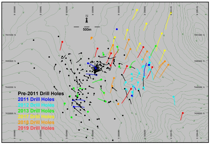
(Source: SIM et al., 2022)
| Table 7-2: | Kennecott Drill Holes Re-logged and Re-assayed by Trilogy Metals |
| Year Re-logged / Re-assayed | | | Area | | Drill Holes |
| 2012 | | | South Reef | | RC-92, RC-93, RC-95, RC-96, RC-99, RC-102, RC-163, RC-168, RC-174 |
| 2013 | | | Ruby Zone | | RC-3, RC-4, RC-19, RC-29, RC-30, RC-34, RC-35, RC-35W, RC-37, RC-48, RC-50, RC-51, RC-54, RC-55, RC-57, RC-61, RC-64, RC-66, RC-67, RC-68, RC-73, RC-83, RC-84, RC-86, RC-87, RC-111, RC-151, RC-152, RC-153, RC-165, RC-166, RC-169, RC-172 |
| 2014 | | | Ruby Zone | | RC-22, RC-25, RC-26, RC-32, RC-33, RC-40, RC-44, RC-45, RC-47, RC-49, RC-53, RC-56, RC-58, RC-59, RC-60, RC-65, RC-69, RC-70, RC-71, RC-72, RC-74, RC-77, RC-79, RC-80, RC-81, RC-85, RC-97, RC-100, RC-105, RC-107, RC-112, RC-114, RC-150, RC-157, RC-164, RC-170, RC-173 |
| Project No.: 253821 | | Exploration | | |
| January 2025 | | Page 7-18 | |
| Bornite Project |
| Northwest Alaska, USA |
| S-K 1300 Technical Report Summary on the Initial Assessment |
| 7.18.1 | Drill Core Procedures |
In the initial years of drilling at Bornite, Kennecott relied on AX diameter core (30.2 mm diameter), but, as drilling migrated towards deeper targets, a change to BX diameter core (41.3 mm diameter) was implemented to help limit deviation.
From 1966 to 1967, drilling activity at Bornite moved underground, and EX diameter core (21.5 mm diameter) was implemented to define the Ruby Zone Upper Reef “No. 1 Ore Body”. In 1968, drilling activity moved back to the surface and from 1968 to 1972, BX diameter core was most commonly drilled.
In later years, core size increased to NX (54.0 mm diameter) and finally, in 2011, core size increased to NQ (47.6 mm diameter) and HQ (63.5 mm diameter). Over the years, progressively larger diameter drill rods have been used in an effort to minimize drill hole deviations.
The Kennecott/BCMC and Trilogy Metals drilling was conducted with drill equipment that used imperial measurement units. For the purposes of data management, all imperial units were converted to metric units in the Trilogy Metals database. Trilogy Metals works exclusively in metric units.
There is limited information with respect to the specific drill core handling procedures used by BCMC/Kennecott. All drill data collected during 1957 to 1997 were logged on paper drill logs, with copies stored in the Kennecott office in Salt Lake City, Utah. Electronic, scanned copies of the paper logs are held by Trilogy Metals and stored in the Fairbanks field office.
Drill core was sawed or split in half with a splitter; half was submitted to various assay laboratories and the remainder was stored in the Kennecott/BCMC core storage facility at the Bornite deposit. In 1995, Kennecott converted the drill assay data, geologic core logs, and
down-hole collar survey data into an electronic format. In 2009, NOVAGOLD geologists verified the geologic data from the original paper logs against the Kennecott electronic format and then merged the data into a Microsoft™ SQL database.
Sampling of drill core by Kennecott/BCMC focused primarily on the moderate to high grade mineralized zones. Intervals of visible sulphide mineralization containing roughly >0.5% to 1% Cu were selected for analysis by Union Assay Office Inc. of Salt Lake City, Utah. This approach left numerous intervals, containing weak to moderate copper mineralization, unsampled in the historical drill core. During the 2012 exploration program, Trilogy Metals began sampling a portion of this remaining drill core in select holes in the South Reef area. Trilogy Metals extended this sampling program to the Ruby Zone in 2013 and 2014.
| Project No.: 253821 | | Exploration | | |
| January 2025 | | Page 7-19 | |
| Bornite Project |
| Northwest Alaska, USA |
| S-K 1300 Technical Report Summary on the Initial Assessment |
The following core handling procedures have been implemented (including programs conducted by NOVAGOLD and NovaCopper). Core is slung by helicopter or transported by truck or all-terrain vehicle from the drill rig to the core-logging facility. Upon delivery, geologists and geo-technicians open and inspect the core boxes for any irregularities. They first mark the location of each drilling block on the core box, and then convert footages on the blocks into metric equivalents. Geo-technicians or geologists measure the intervals (or from/to) for each box of core and include this information, together with the drill hole ID and box number, on a metal tag stapled to the end of each box.
Geo-technicians then measure the core to calculate percent recovery and rock quality designation (RQD). RQD is the sum of the total length of all pieces of core in a run over 12 cm. The total length of core in each run is measured and compared to the corresponding run length to determine percent recovery.
Core is then logged with lithology and visual alteration features captured on observed interval breaks. Mineralization data, including total sulphide species (recorded as percent), sulphide type (recorded as a relative amount), and gangue and vein mineralogy are collected for each sample interval with an average interval of approximately 2 m. Structural data is collected as point data.
Geologists then mark sample intervals to indicate each lithology or other geologically appropriate intervals. Sample intervals of core are typically between 1 m and 3 m long but are not to exceed 3 m long. Occasionally, if warranted by the need for better resolution of geology or mineralization, smaller sample intervals have been used. Geologists staple sample tags on the core boxes at the start of each sample interval and mark the core itself with a wax pencil to designate sample intervals. This sampling approach is considered sound and appropriate for this style of mineralization and alteration.
Drill core is digitally photographed prior to sampling.
Drill core is cut in half using diamond core saws. Specific attention to core orientation is maintained during core sawing to ensure that representative samples are obtained. One-half of the core is retained in the core box for storage on site or at Trilogy Metals' Fairbanks warehouse, and the other half is bagged and labelled for analysis. Samples are selected for specific gravity measurements as discussed in Section 8.0.
| Project No.: 253821 | | Exploration | | |
| January 2025 | | Page 7-20 | |
| Bornite Project |
| Northwest Alaska, USA |
| S-K 1300 Technical Report Summary on the Initial Assessment |
In 2013 and 2014, 33 historical drill holes and 37 historical drill holes, respectively, in the Ruby Zone area were re-logged, re-sampled, and re-assayed because these holes had only been selectively sampled by Kennecott. Entire holes were re-logged using Trilogy Metals protocols discussed above. Samples were submitted either as half-core where previously sampled or whole core where un-sampled (to ensure that a sufficient volume of material was provided for analysis). Sample intervals were matched to legacy intervals whenever possible or selected to reflect Trilogy Metals sampling procedures described above.
The objectives of the re-assay/re-logging program were threefold: to implement a QAQC program on intervals previously sampled by Kennecott to confirm the validity of its results; to identify additional lower grade (0.2% to 0.5% Cu), which was not previously sampled; and to provide additional multi-element ICP data to assist in the geologic interpretation of the deposit. A further discussion of the program and its results are incorporated into Sections 8.0 and 11.0.
The 2011 through to 2014 and 2017 NOVAGOLD and NovaCopper/Trilogy Metals diamond drilling and relogging/re-sampling programs used a commercial, computer-based core-logging system for data capture (GeoSpark Logger© developed by GeoSpark Consulting Inc. (Geospark)). During each drill program, all logging data was captured on individual laptops in a Microsoft™ SQL database and then validated and merged into the Bornite camp server. In 2012, the system was modified to allow each laptop to sync daily to the Data Logger database residing on the Bornite camp server. The server was periodically backed up, and the database was sent to Vancouver, British Columbia for integration into the master database. The camp server was stored in the Fairbanks field office at the end of each field season. Hardcopies of the 2011 through 2013 drill core logs are stored in the Fairbanks office.
Generally, core recovery has been very good throughout all drilling programs conducted at Bornite. Overall recoveries average 88%, with recoveries in the early programs, conducted in the 1950s through 1970s averaging >86%, and recoveries in drilling since 2011 averaging 90%. There is minimal difference in core recovery by rock type, with phyllites averaging 87% recovery and dolomites averaging 89% recovery. There is no apparent relationship between recovery and grade in the database. There were no adjustments or omissions to the mineral resource database in response to drill core recoveries.
| Project No.: 253821 | | Exploration | | |
| January 2025 | | Page 7-21 | |
| Bornite Project |
| Northwest Alaska, USA |
| S-K 1300 Technical Report Summary on the Initial Assessment |
Kennecott provided NOVAGOLD with collar coordinates for all legacy holes in UTM coordinates using the NAD27 datum. During the 2011 field season, the collar locations of 63 legacy surface holes were re-surveyed in UTM NAD83 zone 4N datum. The results of this re-survey were compared to the original Kennecott collar survey data as follows:
| · | Horizontal errors were found to cluster tightly around zero, with a mean difference of +1.61 m Easting and -0.80 m Northing. Absolute total horizontal error ranged from 0.39 m to a maximum 24.27 m, with a median absolute error of 1.22 m. The 24.27 m difference was considered to be the result of an individual surveying error. Based on these results, the remaining 68 un-surveyed Kennecott drill hole collars were accepted without application of a horizontal correction. |
| · | Vertical errors were identified in the 2011 collar re-survey campaign. The checks revealed a semi-systematic elevation error of about +10 m vertical for most of the legacy collar locations compared to the 2011 re-survey. Elevation differences in the existing database were found to range from -2.17 m to +10.91 m, with a median error of +9.61 m. While these errors show some systematic patterns in space and time, a unifying correction factor for elevation based on the survey results was considered inappropriate. Ultimately, Trilogy Metals assigned collar elevations for all legacy drill holes that could not be re-surveyed based on the 2010 PhotoSat 1 m resolution digital terrain model (DTM). The collar elevations for the 63 re-surveyed holes were assigned elevations from the 2011 re-survey. |
| · | The benchmark for the shaft and the elevation control for the underground drill hole collar surveys could not be located during the re-survey exercise to provide a reasonable elevation check between the underground survey and the surface elevations of the DTM. Therefore, the underground holes were given a standard +10 m vertical correction consistent with the error observed in the re-surveyed surface holes around the underground workings. As a quantitative check, it was confirmed that the lithological contacts constructed from the adjusted drill holes aligned well with the lithological contacts encountered in the 2011 drilling. |
| Project No.: 253821 | | Exploration | | |
| January 2025 | | Page 7-22 | |
| Bornite Project |
| Northwest Alaska, USA |
| S-K 1300 Technical Report Summary on the Initial Assessment |
In 2011, collar locations for the 14 holes drilled that year were surveyed by NOVAGOLD using a differential GPS relative to benchmark AAA-1 established by Karl Spohn, PLS, WH Pacific, Inc. (WHPacific), in 2010. An Ashtech Promark 2 GPS instrument was used for these surveys.
In 2012, collar locations for 17 of the 23 holes drilled that year were surveyed by WHPacific professional land surveyors using a differential GPS relative to benchmark “AAA-1”. The remaining six holes were surveyed by Trilogy Metals using an Ashtech Promark 2 GPS instrument relative to benchmark AAA-1.
In 2013, collar locations for all 17 drill holes were surveyed by Trilogy Metals using an Ashtech Promark 2 GPS instrument relative to benchmark AAA-1.
The 2017 collar locations were originally surveyed using a hand-held GPS. Following the 2018 drilling program, the 2017 and 2018 collars were surveyed by DOWL (A.W. Stoll) using a differential GPS relative to benchmark AAA-1.
The 2019 drill hole collars were surveyed by Windy Creek Surveys using a differential GPS.
All collar surveys completed since 2011 were conducted in the UTM NAD83 zone 4N datum coordinate system relative to benchmark AAA-1.
Trilogy Metals provided a topographic digital terrain surface derived from a 2010 PhotoSat 1 m resolution model. Drill hole collar locations, surveyed using a differential GPS, correlate very well with the local, digital terrain (topographic) surface.
Approximately 63% of the drill holes in the database have associated down-hole surveys. On a core-length basis, this represents approximately 82% of the drilling, because the more recent holes, which typically have down-hole surveys, tend to be longer compared to the historical drilling.
Since 1961, Sperry-Sun single-shot surveys were conducted on drill holes that encountered significant mineralization. Drill holes with marginal mineralization were often not surveyed. In 1961, Kennecott attempted to conduct down-hole surveys in holes drilled in 1959 and 1960. Of the 51 underground holes, only 11 were surveyed. From 1968 through 1997, down-hole surveys were sporadic. The first six holes of the 1968 campaign, and all holes drilled in 1971 and 1997, were not surveyed.
| Project No.: 253821 | | Exploration | | |
| January 2025 | | Page 7-23 | |
| Bornite Project |
| Northwest Alaska, USA |
| S-K 1300 Technical Report Summary on the Initial Assessment |
Four Kennecott drill holes at South Reef that were never surveyed have been assigned projected deviations based on nearby (surveyed) holes (down-hole surveys have been assigned to holes RC-96, RC-95, RC-99 and RC-163). The resulting locations of mineralized intervals in these drill holes mesh better with the overall geologic interpretation of the deposit.
Many of the Kennecott holes in the Ruby Zone are relatively short and, therefore, deviation is not a significant issue. In the deeper drilling at South Reef, Trilogy Metals has appropriately used implied deviations based on local experience.
NOVAGOLD (in 2011) and NovaCopper/Trilogy Metals (in 2012, 2013 and 2017) completed down-hole surveys of all their drill holes using a Reflex Easy-Shot instrument. Trilogy Metal’s 2018 program used the Reflex Easy-Trac instrument and the 2019 program used both the Reflex Easy-Trac and Gyro-Sprint instruments. Down-hole surveys were taken on 30 m intervals in 2011, 2017, 2018 and 2019 and on 45 m intervals in 2012 and 2013.
| 7.22 | Summary of Drill Results |
Drilling on the Bornite deposit covers an area measuring roughly 2,500 m east-west by 2,500 m north south with holes that approach 1,200 m below surface. The distribution of copper grades in the drilling is shown in plan in Figure 7-7 and in vertical cross-sectional views through the Ruby Zone area in Figure 7-8 and through the South Reef area in Figure 7-9. The distribution of cobalt grades in the drill holes is shown in Figure 7-10. Table 7-3 shows representative drill hole intersections with cobalt grades. In general, drill holes within the South Reef outside pit area show wider ranges of cobalt grades, with higher average grade than the drill holes in-pit. Further interpretation of the geology and mineralization from the drilling results is presented in Figure 6-8, Figure 7-2, Figure 11-3, Figure 11-4, , Figure 11-15, Figure 11-16, Figure 11-19, and Figure 11-20.
Characterization of the hydrogeology utilized the geological model developed as part of Bornite Project, and data and interpretations from numerous previous studies, including historical pumping tests within the historical exploration shaft and related observation data from both groundwater and surface water locations. Data from these tests were reviewed and considered appropriate for use in the IA. No laboratory data was used as part of this work.
A conceptual model was developed for the Bornite Project based on the geology and testing results mentioned above. The overall groundwater system is considered to be dominated by a low hydraulic conductivity and storage, fracture-controlled flow system crosscut by large high permeability discrete feature(s). The presence of at least one such features is evident from observations and testing within the historical exploration shaft, and was observed to be hydraulically connected to Ruby Creek during the historical testing. Groundwater recharge from precipitation was assumed to be within the range of 10% to 30% of mean annual precipitation.
| Project No.: 253821 | | Exploration | | |
| January 2025 | | Page 7-24 | |
| Bornite Project |
| Northwest Alaska, USA |
| S-K 1300 Technical Report Summary on the Initial Assessment |
Results from a simple steady-state 3D groundwater numerical model, completed as part of previous work on an open pit concept, were used to understand and scale inflows for the proposed underground mine. This model included the high hydraulic conductivity discrete feature identified and tested as part of historical work. Bedrock was assumed to have a mean bulk hydraulic conductivity of 1x10⁻⁹ m/s and the high permeability feature was assumed to have a mean hydraulic conductivity of 7x10⁻⁴ m/s. Results from the open pit modelling were scaled and adjusted to remove direct precipitation and runoff into the modelled pit void that would not be observed in the underground. Inflow along the discrete feature was then assumed to be reduced by an additional 50% due to lining of Ruby Creek across the area where it was observed to be affected during historical testing (see Section 15.1.8.2). Cumulative groundwater inflows were estimated to be 32,500 m3/d for the IA.
There were no dedicated geotechnical holes drilled on the Property; however, geotechnical data was collected from the exploration drill holes. The drill hole database is populated with logging information for rock quality designation (RQD), fracture frequency, rock hardness, weathering, and joint condition. This information is used in Section 13.0.
| 7.25 | QP Opinion on Section 7 |
Preliminary geotechnical data was collected from drill core such as RQD and limited hydrogeology data has been obtained which is sufficient to support early-stage resource estimation. Wood’s geology QP is not aware of any drilling, sampling or recovery factors that could materially impact the accuracy and reliability of the copper results supporting the mineral resource estimate.
| Project No.: 253821 | | Exploration | | |
| January 2025 | | Page 7-25 | |
| Bornite Project |
| Northwest Alaska, USA |
| S-K 1300 Technical Report Summary on the Initial Assessment |
Figure 7-: Plan Map Showing Copper in Drilling on the Bornite Deposit
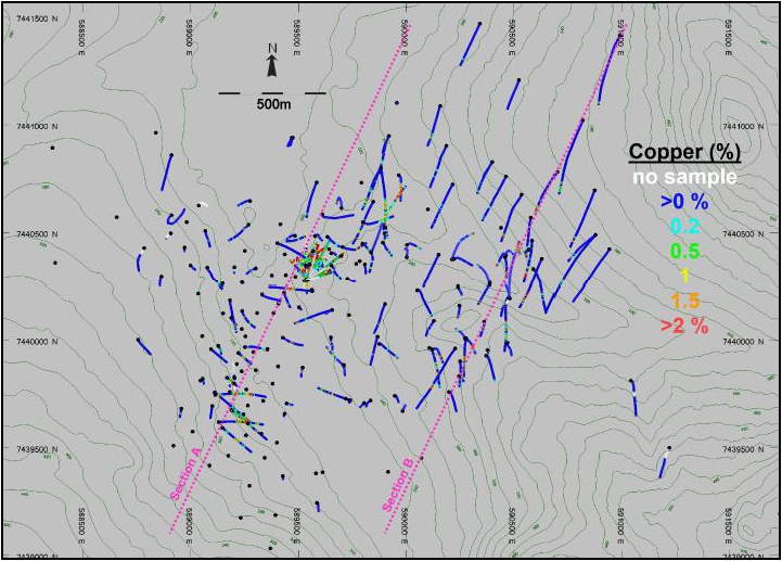
(Source: SIM et al., 2022)
| Project No.: 253821 | | Exploration | | |
| January 2025 | | Page 7-26 | |
| Bornite Project |
| Northwest Alaska, USA |
| S-K 1300 Technical Report Summary on the Initial Assessment |
Figure 7-: Vertical Cross-section (Section A) Showing Copper in Drilling in the Ruby Zone Area
(Source: SIM et al., 2022)
Figure 7-: Vertical Cross-section (Section B) Showing Copper in Drilling in the South Reef Area

(Source: SIM et al., 2022)
| Project No.: 253821 | | Exploration | | |
| January 2025 | | Page 7-27 | |
| Bornite Project |
| Northwest Alaska, USA |
| S-K 1300 Technical Report Summary on the Initial Assessment |
Figure 7-: Cobalt Grades in the Drill Holes
(Source: Wood, 2023)
| Project No.: 253821 | | Exploration | | |
| January 2025 | | Page 7-28 | |
| Bornite Project |
| Northwest Alaska, USA |
| S-K 1300 Technical Report Summary on the Initial Assessment |
Table 7-3: Representative Drill Intersections with Cobalt Grades
| Area | | Hole-ID | | | From
(m) | | | To
(m) | | | Sample-ID | | | Co
(%) | | | Year
Drilled | |
| In-Pit | | | RC11-0186 | | | | 12.80 | | | | 15.55 | | | | 2100472 | | | | 0.005 | | | | 2011 | |
| | | | RC11-0186 | | | | 15.55 | | | | 16.41 | | | | 2100473 | | | | 0.003 | | | | 2011 | |
| | | | RC11-0186 | | | | 16.41 | | | | 19.33 | | | | 2100474 | | | | 0.011 | | | | 2011 | |
| | | | RC11-0186 | | | | 19.33 | | | | 22.33 | | | | 2100475 | | | | 0.024 | | | | 2011 | |
| | | | RC11-0186 | | | | 22.33 | | | | 25.33 | | | | 2100476 | | | | 0.028 | | | | 2011 | |
| | | | RC11-0186 | | | | 25.33 | | | | 28.33 | | | | 2100478 | | | | 0.011 | | | | 2011 | |
| | | | RC11-0186 | | | | 28.33 | | | | 31.33 | | | | 2100479 | | | | 0.091 | | | | 2011 | |
| | | | RC11-0186 | | | | 31.33 | | | | 32.95 | | | | 2100480 | | | | 0.044 | | | | 2011 | |
| | | | RC13-0229 | | | | 54.04 | | | | 54.71 | | | | 2123467 | | | | 0.035 | | | | 2013 | |
| | | | RC13-0229 | | | | 54.71 | | | | 57.21 | | | | 2123468 | | | | 0.022 | | | | 2013 | |
| | | | RC13-0229 | | | | 57.21 | | | | 59.71 | | | | 2123470 | | | | 0.013 | | | | 2013 | |
| | | | RC13-0229 | | | | 59.71 | | | | 62.02 | | | | 2123471 | | | | 0.015 | | | | 2013 | |
| | | | RC13-0229 | | | | 62.02 | | | | 64.52 | | | | 2123472 | | | | 0.016 | | | | 2013 | |
| | | | RC13-0229 | | | | 64.52 | | | | 67.02 | | | | 2123473 | | | | 0.026 | | | | 2013 | |
| | | | RC13-0229 | | | | 67.02 | | | | 69.52 | | | | 2123475 | | | | 0.005 | | | | 2013 | |
| South Reef | | | RC12-0214 | | | | 480.31 | | | | 482.19 | | | | 2114356 | | | | 0.009 | | | | 2012 | |
| Outside Pit | | | RC12-0214 | | | | 482.19 | | | | 485.05 | | | | 2114358 | | | | 0.009 | | | | 2012 | |
| | | | RC12-0214 | | | | 485.05 | | | | 487.94 | | | | 2114359 | | | | 0.008 | | | | 2012 | |
| | | | RC12-0214 | | | | 498.07 | | | | 500.10 | | | | 2114365 | | | | 0.288 | | | | 2012 | |
| | | | RC12-0214 | | | | 500.10 | | | | 501.70 | | | | 2114366 | | | | 0.070 | | | | 2012 | |
| | | | RC12-0214 | | | | 501.70 | | | | 504.62 | | | | 2114368 | | | | 0.185 | | | | 2012 | |
| | | | RC12-0214 | | | | 504.62 | | | | 507.55 | | | | 2114369 | | | | 0.025 | | | | 2012 | |
| | | | RC12-0214 | | | | 507.55 | | | | 510.27 | | | | 2114370 | | | | 0.141 | | | | 2012 | |
| | | | RC12-0216 | | | | 701.76 | | | | 703.36 | | | | 2114833 | | | | 0.009 | | | | 2012 | |
| | | | RC12-0216 | | | | 703.36 | | | | 705.67 | | | | 2114835 | | | | 0.034 | | | | 2012 | |
| | | | RC12-0216 | | | | 705.67 | | | | 707.29 | | | | 2114836 | | | | 0.014 | | | | 2012 | |
| | | | RC12-0216 | | | | 707.29 | | | | 708.24 | | | | 2114837 | | | | 0.036 | | | | 2012 | |
| | | | RC12-0216 | | | | 708.24 | | | | 709.90 | | | | 2114838 | | | | 0.741 | | | | 2012 | |
| | | | RC12-0216 | | | | 709.90 | | | | 711.22 | | | | 2114839 | | | | 0.368 | | | | 2012 | |
| | | | RC12-0216 | | | | 711.22 | | | | 713.08 | | | | 2114841 | | | | 0.021 | | | | 2012 | |
| Project No.: 253821 | | Exploration | | |
| January 2025 | | Page 7-29 | |
| Bornite Project |
| Northwest Alaska, USA |
| S-K 1300 Technical Report Summary on the Initial Assessment |
| 8.0 | Sample Preparation, Analyses, and Security |
References to Trilogy Metals also applies to its previous name of NovaCopper.
There is limited documentation available describing the sample preparation, security, and analysis of drill core samples collected between 1957 and 1997. The original samples were analyzed by Union Assay in Salt Lake City (Union) or Kennecott’s on-site laboratory. The details of the original analytical methods are not available. The on-site laboratory may have used titration for the early years (1952 to 1962) for copper analysis. The Union laboratory used atomic absorption from 1963 onwards. These assumptions are based on the old assay certificates and some sample ledgers with mixed in quality assurance (QA)QC check assays. Gold and silver were likely analyzed by fire assay off site.
Between 2012 and 2014, Trilogy Metals completed a re-assay and re-sampling program of the historical drill holes. As a result, 67% of the historical hole assay values are now supported by a current and documented QAQC program. Sample preparation and analysis for these results are described in this section.
| 8.2 | NOVAGOLD/Trilogy Metals |
The drill core sampling procedures are described in Section 7.18.
After the drill core was sawed in half, one half was retained for future reference and the other half was sent to ALS Minerals (formerly ALS Chemex) in Vancouver, British Columbia for analyses.
Core samples were shipped from the Bornite camp when backhaul capacity was available on the chartered aircraft; this was generally five to six days a week. Rice bags, containing two to four individual poly-bagged core samples were marked and labelled with the ALS Minerals address, project name (Bornite), drill hole number, bag number, and the enclosed sample numbers. Rice bags were secured with a pre-numbered plastic security tie, assembled into loads for transport by chartered flights on a commercial airline to Fairbanks, Alaska, and delivered directly to the ALS Minerals preparation facility by a contracted expeditor. Control samples were also inserted into these shipments at the approximate rate of one standard, one blank, and one duplicate per 17 core samples, as follows:
| · | Standards: Typically, four to five certified standards were used each year (Table 8-1). Standard reference material was purchased from a commercial supplier (CDN located in Vancouver, British Columbia or OREAS located in Melbourne, Australia). Standards were blindly incorporated into the sample sequence. When required, the core cutter inserted a sachet of the appropriate standard, as well as the sample tag, into the sample bag. |
| Project No.: 253821 | | Sample Preparation, Analyses, and Security | | |
| January 2025 | | Page 8-1 | |
| Bornite Project |
| Northwest Alaska, USA |
| S-K 1300 Technical Report Summary on the Initial Assessment |
| · | Blanks: Blanks were composed of unmineralized marble drill core from an abandoned hole and split to mimic a regular core sample. Blanks were also incorporated blindly into the sample sequence. When required, the core cutter inserted about 150 g of a blank, as well as the sample tag, into the sample bag. |
| · | Duplicates: The assay laboratory was instructed to split the duplicate sample and run both splits as two separate samples. The core cutter inserted a sample tag into an empty sample bag. |
On arrival, samples were logged into a tracking system at ALS Minerals and weighed. Samples were then crushed and dried, and a 250 g split was pulverized to greater than 85% passing 75 µm.
| Table 8-1: | Standard Reference Materials Used by Year |
| | 2011 | | | | 2012 | | | | 2013 | | | | 2014 | | | | 2017 | | | | 2018 | | | | 2019 | |
| | Std-ME09 | | | | CDN-ME-09 | | | | CDN-ME-09 | | | | CDN-ME-09 | | | | CDN-ME-09 | | | | CDN-ME-09 | | | | CDN-ME-09 | |
| | Std-OREAS-111 | | | | CDN-ME-18 | | | | CDN-ME-18 | | | | CDN-ME-1201 | | | | CDN-ME-1208 | | | | CDN-ME-1208 | | | | CDN-ME-1208 | |
| | Std-OREAS-75a | | | | GBMS304-5 | | | | OREAS-24b | | | | CDN-ME-1210 | | | | CDN-ME-1409 | | | | GBM 911-11 | | | | - | |
| | Std-OREAS-90 | | | | Std-OREAS-90 | | | | OREAS-92 | | | | OREAS-24b | | | | GBM 911-11 | | | | GBM 301-8 | | | | - | |
| | - | | | | - | | | | Std-OREAS-90 | | | | - | | | | OREAS-165 | | | | OREAS-165 | | | | OREAS-165 | |
| | - | | | | - | | | | - | | | | - | | | | OREAS-24b | | | | OREAS-24b | | | | - | |
| 8.2.2 | Density Determinations |
Density determinations were not conducted by BCMC/Kennecott on any of the older drill holes. Trilogy Metals conducted specific gravity (SG) measurements on some select historical drill holes during the 2013 and 2014 re-sampling programs.
NOVAGOLD and Trilogy Metals collected 7,476 full-assay-width SG measurements from available historical split core and NOVAGOLD/Trilogy Metals whole core. The samples averaged 2.01 m long and were collected continuously within mineralized zones estimated to have ≥1% chalcopyrite (CuFeS2) or its equivalent copper content (0.3% Cu). In unmineralized zones, samples were collected every 10 m to 15 m.
| Project No.: 253821 | | Sample Preparation, Analyses, and Security | | |
| January 2025 | | Page 8-2 | |
| Bornite Project |
| Northwest Alaska, USA |
| S-K 1300 Technical Report Summary on the Initial Assessment |
A digital Intell-Lab Balance was used to determine a weight-in-air value for dried core, followed by a weight-in-water value. The wet value was determined by submerging the entire assay interval within a wire basket into a water-filled tote. The SG value was then calculated using the following formula:
Weight in air / (Weight in air – Weight in water)
Samples were not sealed with wax prior to measuring the weight-in-water. There is minimal porosity evident in the rocks at Bornite and, as a result, this is not considered to be a significant factor in determining density measurements. The density measurements are appropriate for a deposit of this type but wax-coated water immersion checks to confirm porosity does not impact the SG determination, have not been completed.
SG values range from 2.12 to 5.20. One anomalously high SG value of 8.3 was excluded from the database.
Security measures taken during historical Kennecott and BCMC programs are not known to Trilogy Metals; however, Trilogy Metals is not aware of any reason to suspect that any of these samples have been tampered with. The 2011 to 2019 samples were either in the custody of NOVAGOLD or Trilogy Metals personnel, or the assay laboratories at all times and the chain of custody of the samples is well documented.
| 8.4 | Assaying and Analytical Procedures |
The laboratories used during the various exploration, infill, and step-out drill and re-assay programs are summarized in Table 8-2. All laboratories are independent of Trilogy Metals.
Copper and cobalt data were derived using a 48-element suite assayed by inductively coupled plasma-mass spectrometry (ICP-MS) and atomic emission spectroscopy (ICP-AES) methodologies, following a four-acid digestion. The lower detection limits for copper and cobalt are 0.2 ppm and 0.1 ppm, respectively. The upper limits were 10,000 ppm. Over limit (>1.0%) copper and cobalt analyses were completed by atomic absorption (AA), following a four-acid digestion. In 2011 and 2012, gold assays were determined using fire analysis followed by an atomic absorption spectroscopy (AAS) finish. Gold was not analyzed in 2013 or 2014. The lower detection limit was 0.005 ppm Au; the upper limit was 10 ppm Au.
| Project No.: 253821 | | Sample Preparation, Analyses, and Security | | |
| January 2025 | | Page 8-3 | |
| Bornite Project |
| Northwest Alaska, USA |
| S-K 1300 Technical Report Summary on the Initial Assessment |
Table 8-2: Analytical Laboratories Used by Operators
| Laboratory Name | Laboratory Location | Years Used | Accreditation | Comment |
| Unknown | Unknown | Pre-2011
specific years unknown | Unknown | - |
| ALS Analytical | Fairbanks, Alaska | 2011
2012–2013
2014
2017
2018
2019 | · In 2004, ALS Chemex held ISO 9002 accreditations but changed to ISO 9001 accreditations in late 2004. ISO/International Electrotechnical Commission (IEC) 17025 accreditation was obtained in 2005. | · 2011 to 2014 and 2017 to 2019 · Preparation Laboratory Facility |
| ALS Analytical | Vancouver, BC | 2011
2014
2017
2018
2019 | · In 2004, ALS Chemex held ISO 9002 accreditations but changed to ISO 9001 accreditations in late 2004. ISO/International Electrotechnical Commission (IEC) 17025 accreditation was obtained in 2005. | · 2011 to 2014 and 2017 to 2019 · Primary Assay Laboratory |
| Acme | Vancouver, BC | 2012 2013
2015
2017 | · Holds ISO 9001 and ISO/IEC 17025:2005 accreditations | · 2012 and 2013 · Secondary Check Sample Laboratory and DPG soil geochemistry |
| SGS | Vancouver, BC | 2014
2017
2018
2019 | · ISO/IEC 17025 Scope of Accreditation | · 2014, 2017 to 2019 · Secondary Check Sample Laboratory |
| Project No.: 253821 | | Sample Preparation, Analyses, and Security | | |
| January 2025 | | Page 8-4 | |
| Bornite Project |
| Northwest Alaska, USA |
| S-K 1300 Technical Report Summary on the Initial Assessment |
ALS Minerals has attained International Organization for Standardization (ISO) 9001:2000 registration. In addition, the ALS Minerals laboratory in Vancouver is accredited to ISO 17025 by the Standards Council of Canada for several specific test procedures, including fire assay of gold by AA, ICP and gravimetric finish, multi-element ICP, and AA assays for silver, copper, lead and zinc. Trilogy Metals has no relationship with any of the primary or check assay laboratories.
| 8.5 | Quality Assurance Quality Control |
| 8.5.1 | Core Drilling Sampling QAQC |
In 2012, 2013, 2014, and 2017 through to 2019, Trilogy Metals staff performed continuous validation of the drill data during the logging process and after the field program was complete (West, 2013). Trilogy Metals also retained independent consultant GeoSpark Consulting Inc. (GeoSpark) to import digital drill data to the master database and conduct QAQC checks upon import; conduct a QAQC review of paired historical assays and Trilogy Metals 2012, 2013 and 2014 re-assays; monitor an independent check assay program for the 2012, 2013 and 2014 campaigns; and generate a QAQC report for each of the drilling campaigns conducted in 2012, 2013, 2017, 2018 and 2019, including a 2017 review of the cobalt data. QAQC monitoring by GeoSpark included assessment laboratory precision and accuracy using assay results from certified reference standards, blanks and duplicates inserted into the sample stream by Trilogy Metals personnel.
| 8.5.1.1 | Historical Sample Re-assay Review |
Historical drilling at Bornite was conducted by Kennecott. It was a leading technical exploration company during its tenure, known for rigorously controlled drilling programs which typically included the insertion of quality control samples. Unfortunately, records from the Kennecott era are incomplete and direct validation of some portions of the database cannot be completed. The current assay database contains results for 39,740 sample intervals including 17,103 (43%) historical hole sample intervals. Between 2012 and 2014 Trilogy Metals completed a re-sampling program of Kennecott historical drill holes. As a result, 11,540 (67%) historical hole intervals now have assay results from ALS Minerals. This includes 863 re-assays of previously assayed historical hole sample interval, representing approximately 15% of the original sample intervals in the historical holes. In the database reviewed by Wood geology QP, the original copper values from the KCC/Utah laboratory results are given priority over ALS laboratory results for the 863 re-assay intervals (2% of the database). The database does not distinguish between previously sampled and newly sampled historical intervals or original and new assay values. Wood’s geology QP used the presence and absence of cobalt values to establish re-sampling and re-assay frequency.
| Project No.: 253821 | | Sample Preparation, Analyses, and Security | | |
| January 2025 | | Page 8-5 | |
| Bornite Project |
| Northwest Alaska, USA |
| S-K 1300 Technical Report Summary on the Initial Assessment |
A Reduced to Major Axis (RMA) chart prepared by Wood’s geology QP (Figure 8-1) comparing the paired original historical and re-assay copper values indicates there is a 12% high bias in the historical copper after exclusion of 29 outliers. An inflection in the trend of the paired copper values starting at 1% Cu may indicate the bias may be related to an upper detection limit for the original assay procedure and or a change to an overlimit method.
| 8.5.1.2 | Review of 2011 to 2019 QC Results |
QAQC reviews are documented in a series of memos (Vallat 2012, 2013a, 2013b, 2014, and 2017 to 2020). The results are summarized in the following subsections by year of campaign.
2011
The 2011 exploration program QAQC was monitored by NOVAGOLD and reported no indication of significant assay quality deficiency.
2012
The 2012 exploration program included the drilling of 23 new holes. Review of the control sample analytical results indicates that the assay results are of sufficient quality to adequately represent the tenor of the mineralization intersected in drill holes.
2013
The 2013 exploration program included the drilling of 17 new holes. A review of the control sample analytical results indicates that the assay results are of sufficient quality to adequately represent the tenor of mineralization intersected in drill holes.
2014
The 2014 exploration program included a large re-sampling and re-assaying program on 37 historical drill holes. Of the 5,819 submitted samples, 5,134 (11,149 m) were from previously un-sampled and un-assayed drill core. The remaining 685 samples (1,503 m) were from drill core that was previously sampled by Kennecott and sent for re-assaying to confirm results.
A review of the control sample analytical results indicates that the assay results are of sufficient quality to adequately represent the tenor of mineralization intersected in drill holes.
| Project No.: 253821 | | Sample Preparation, Analyses, and Security | | |
| January 2025 | | Page 8-6 | |
| Bornite Project |
| Northwest Alaska, USA |
| S-K 1300 Technical Report Summary on the Initial Assessment |
Figure 8-1: Historical Copper Re-assay RMA Chart
(Source: Wood, 2022)
| Project No.: 253821 | | Sample Preparation, Analyses, and Security | | |
| January 2025 | | Page 8-7 | |
| Bornite Project |
| Northwest Alaska, USA |
| S-K 1300 Technical Report Summary on the Initial Assessment |
2017
The 2017 exploration program included eleven drill holes (four were abandoned due to drilling problems) that primarily tested the northern, down-dip area of the deposit. Four additional holes were initiated during the program but were abandoned due to drilling problems. A review of the control sample analytical results indicates that the assay results are of sufficient quality to adequately represent the tenor of mineralization intersected in drill holes.
2018
The 2018 exploration program included 15 holes, but three of these holes were abandoned due to drilling problems. A review of the control sample analytical results indicates that the assay results are of sufficient quality to adequately represent the tenor of mineralization intersected in drill holes.
2019
The 2019 exploration program included the drilling of 10 new drill holes. A review of the control sample analytical results indicates that the assay results are of sufficient quality to adequately represent the tenor of mineralization intersected in drill holes.
| 8.5.1.3 | Review of 2011 to 2017 Cobalt Assays |
The quality control of cobalt was not actively monitored until 2018. In 2017 GeoSpark conducted a review of all cobalt analyses collected between 2011 and 2017. The control samples, duplicate sample pairs, and secondary laboratory check duplicates show good quality for cobalt results within the 2011 to 2017 assay database.
| 8.5.2 | Density Determinations QAQC |
A QAQC review of the 2011, 2012, 2013, and 2017 SG determinations were conducted by Trilogy Metals staff and are documented in a series of memos. Where SG determinations have matching assay from/to intervals, a stoichiometric check was completed (West, 2014). The wet/dry measurements compare well with the stoichiometrically estimated values. In addition, outlier SG determinations (below 2.0 and above 5.0) were flagged and evaluated individually by the project geologist.
| Project No.: 253821 | | Sample Preparation, Analyses, and Security | | |
| January 2025 | | Page 8-8 | |
| Bornite Project |
| Northwest Alaska, USA |
| S-K 1300 Technical Report Summary on the Initial Assessment |
| 8.6 | QP Opinion on Section 8 |
The drill core sampling procedures at site, the laboratory sample preparation and analytical procedures, and the QAQC and security procedures applied by NOVAGOLD and Trilogy Metals for samples collected and analyzed since 2011 are appropriate for the mineralization style observed at Bornite.
Trilogy Metals re-sampled 67% of the historical drill core from the Kennecott drilling completed prior to 2011. These drill holes are now supported by a current and documented QAQC program. Historical copper values greater than 1% that remain in the primary assay database have a risk of being biased high. This issue only impacts the data within the Upper and Lower Reef and does not impact the South Reef.
Wood’s geology QP considers the sample preparation, security, and analytical procedures are adequate to support an Inferred mineral resource.
| Project No.: 253821 | | Sample Preparation, Analyses, and Security | | |
| January 2025 | | Page 8-9 | |
| Bornite Project |
| Northwest Alaska, USA |
| S-K 1300 Technical Report Summary on the Initial Assessment |
| 9.1 | Drill Hole Data Transcription Error Checks |
In 2007, historical data (1957 to1997) were compiled from both digital and paper logs supplied by Kennecott into a central Microsoft™ Access database. In 2008, the Microsoft™ Access database was imported into DataShed, a SQL-based data management software program created by Maxwell GeoServices Pty Ltd. In September 2011 (Davis and Sim, 2013; Davis et al., 2014), NOVAGOLD contracted an independent data management consultant to carry out an audit of the 1957 to1997 collar, down-hole survey, sample interval, and assay data. After initial review, collar, down-hole survey, sample interval, and assay data were re-entered into the database from the original data sources in NOVAGOLD's possession using double entry procedures. All remaining data, including lithology, alteration, and mineralization were not re-entered or validated at the time. Overall, very few errors (<3%) were found between the 2007 and 2008 NOVAGOLD compiled historical database and the re-entered database files. Collar errors were mostly transformation problems between coordinate systems, and errors in down-hole survey data were small azimuth and dip calculation problems. Minor errors in the sample data were generally meterage typos. All errors were addressed and corrected.
In 2011, NOVAGOLD began using a customizable data logger (GeoSpark Logger©) created by GeoSpark. This Microsoft™ Access-based software was used to capture all drilling and surface data. A data entry technician entered the geological information, collar, and down-hole survey data at the Bornite camp. Data were then exported by geologists on-site to Microsoft™ Excel or Microsoft™ Access format and posted on a secure file transfer protocol (FTP) site for the Database Manager in Vancouver. These exports were then imported directly into the DataShed database in Vancouver. Assay data were imported directly from electronic files provided by the laboratories. At the end of the field season, all geological information, collar, and down-hole survey information was visually verified by NOVAGOLD geologists by comparing original files against an export of the database.
Sim et al. (2022) randomly selected 2012 and 2013 drill holes for manual validation. The collar, survey, and assay information for these holes in the electronic database was checked against original data sources, and no significant errors or differences were found.
Sim et al. (2022) randomly selected an additional 16 Trilogy Metals-era drill holes and compared the copper and cobalt grades the certified assay certificates. No significant errors were found.
| Project No.: 253821 | | Data Verification | | |
| January 2025 | | Page 9-1 | |
| Bornite Project |
| Northwest Alaska, USA |
| S-K 1300 Technical Report Summary on the Initial Assessment |
| 9.2 | Drill Collar Validation |
In 2011 (Davis and Sim, 2013), the collar coordinates for 63 historical surface holes, including fourteen 2011 drill holes used in the 2012 Ruby Creek (now known as Ruby Zone) resource estimate, were surveyed or re-surveyed in 2011 using UTM NAD 83 zone 4 coordinates. The remaining 119 surface and underground drill holes had the original collar horizontal coordinates directly converted to UTM NAD83 zone 4 coordinates. The comparisons of new and historical collar elevations indicated an inconsistent, but approximate, +10 m variance. The surface drill holes that were not re-surveyed had the collar elevations assigned the surface elevation from the 2010 PhotoSat 1 m resolution DTM. The underground drill hole collars had a +10 m adjustment assigned to the original collar survey data.
In 2012, five of the six historical drill holes, that are part of the South Reef resource, were located and surveyed. The original horizontal Kennecott collar coordinates for drill hole RC-163 (the one drill hole not found) was accepted and included. The collar elevation for drill hole RC-163 was assigned the surface elevation from the 2010 PhotoSat 1-m resolution DTM.
During a site visit in 2022, Wood’s geology QP measured five surface drill collars with a handheld GPS unit. Out of five drill collars, one drill collar was off more than 40 m when compared to the collar database. After further investigation, Ambler Metals identified seven drill collars in the database with planned coordinates, rather than the surveyed coordinates. Wood’s geology QP recommends additional validation of the drill collar database for the next resource model update; however, considers the existing database sufficient to support Inferred mineral resources.
Underground drill holes have not been resurveyed.
| 9.3 | Down Hole Survey Validation |
The drill plan view map shows several drill collars with no drill trace evident, indicating vertical holes with no down hole deviation. Inspection of the drill hole survey file revealed 111 drill holes have no down hole surveys, 66 of which are vertical and 30 of which are 300 m long. The plan map also shows drill hole traces with excessive deviation or unusual kinks, usually between the collar and the first down hole survey. A check for the presence of any large discrepancies between sequential dip and azimuth readings revealed 10 holes with between-survey measurement reading in excess of 2x an expected tolerance of 5° in 30 m and 14 holes with between-survey measurement readings in excess of 1.5x an expected tolerance of 5° in 30 m. All but three of the suspect drill traces are from the historical drill programs.
| Project No.: 253821 | | Data Verification | | |
| January 2025 | | Page 9-2 | |
| Bornite Project |
| Northwest Alaska, USA |
| S-K 1300 Technical Report Summary on the Initial Assessment |
| 9.4 | Assessment of Historical Assay Data |
The high grade Upper and Lower Reef zones are primarily supported by holes drilled pre-1960 (Lower Reef) and between 1966 and 1967 (Upper Reef). Although NOVAGOLD and Trilogy Metals completed a substantial re-assay program, very few samples within the high-grade Lower Reef zone and no samples within the Upper Reef zone are re-assayed. A comparison of historical samples that were re-assayed in 2012 and 2013 indicates a potential significant high bias in historical copper grades greater than 1% Cu. While this is not a direct assessment of the pre-1960 samples within the Upper Reef zone it does indicate that historical copper assay results that have not been replaced by re-assay results may be biased high in copper. The three or four holes drilled post-2011 within each of these zones do not provide enough samples to make a reliable assessment of possible bias in the original results within these zones. There are also no original or re-assay cobalt results for most of the Lower Reef zone drill hole samples and no original or re-assay cobalt results for any of the drill hole samples supporting the Upper Reef zones.
| 9.5 | Site Visit Observations |
Wood’s geology QP visited the Bornite Property from August 29 to September 8, 2022. During the visit, he reviewed drill core, measured drill collars with a handheld GPS unit, visited the historical trench area and viewed the deposit area by helicopter.
The geologic descriptions appeared to be reasonable, and visual observations of the copper bearing minerals present reflected the grades in the sample database. No witness samples were taken by Wood’s geology QP to verify the results during the site visits, as there had been extensive re-sampling of drill core by Trilogy Metals and there was clear visual evidence of mineralization in the core. In the opinion of Wood’s geology QP, the exploration activities used at Bornite follow generally accepted industry standards.
| 9.6 | Metallurgical Data Verification |
Ausenco and International Metallurgical & Environmental process QPs reviewed the metallurgical test work reports, the analytical procedures, qualification of the laboratory, and presentation of the test results and consider all to have followed industry accepted practice. Additional statements on the adequacy of the metallurgical data are presented in Section 10.0.
| Project No.: 253821 | | Data Verification | | |
| January 2025 | | Page 9-3 | |
| Bornite Project |
| Northwest Alaska, USA |
| S-K 1300 Technical Report Summary on the Initial Assessment |
The International Metallurgical & Environmental process QP frequently visited the metallurgical laboratories during ongoing test work.
| 9.7 | Mining Data Verification |
Wood’s mining QP spot checked core photos and compared them to the RQD logging to verify the RQD data.
| 9.8 | Hydrology Data Verification |
Hydrometeorology datasets were developed for the Bornite Project based on a series of weather stations, rain gauges, snow course surveys and hydrometric station, which include both public stations operated National Oceanic and Atmospheric Administration (NOAA) and United States Geological Survey (USGS) and stations operated by Trilogy Metals. In addition, Modern-Era Retrospective analysis for Research and Application, Version 2 (MERRA-2), from the National Aeronautics and Space Administration (NASA), was used to augment, gap fill, and extend the regional and Project climate records. Datasets were processed, filtered and gap-filled under the supervision of SRK’s hydrogeology QP to develop records suitable for the site.
| 9.9 | Hydrogeology Data Verification |
Hydrogeology datasets for the Bornite Project were compiled based on historical records from a previous owner. Data was reviewed by SRK’s hydrogeology QP and considered reasonable for use at this stage of study.
| 9.10 | Geotechnical (Tailings) Data Verification |
SRK’s geotechnical QP reviewed the overburden geotechnical investigation that provided overburden characterization in support of waste facility siting evaluation and geotechnical design of the waste rock facility and TSF at Arctic. SRK’s geotechnical QP also reviewed the data from topography and a nearby geotechnical hole that were used to determine the maximum height of the expanded TSF embankment.
| Project No.: 253821 | | Data Verification | | |
| January 2025 | | Page 9-4 | |
| Bornite Project |
| Northwest Alaska, USA |
| S-K 1300 Technical Report Summary on the Initial Assessment |
| 9.11 | QP Opinion on Data Adequacy |
| 9.11.1 | Geology and Resource |
Drilling, surveying, sampling, and assaying by NOVAGOLD and Trilogy Metals since 2011 have been conducted using appropriate tools and methods for quality control and data entry procedures.
Inspection of the historical drill hole data has revealed some issues with collar, down hole survey and assay results. There are 183 historical holes representing 46% of the total drilled metres in the Bornite database 177 of which are in the Ruby Zone and six of which are in the South Reef area. There are no significant concerns with the current collar survey records. Errors such as using planned instead of actual coordinates are minor and were corrected in the database when identified. Coordinates determined from calculated transformations of drill holes that cannot be resurveyed are reasonable. The absence of down hole survey measurements for a large portion of the historical database is partly mitigated by the limited length of the holes. The few long holes without down hole survey measurements and the local suspect measurements are not expected to have a material impact on the outcome of the mineral resource estimate. Twenty-three percent of the historical assays have no available supporting quality control, many of which are within the two high-grade Ruby Zones. Re-assay work indicates a potential high bias for the higher-grade portion of these original results. Issues identified are manageable by the significant number of drilling and sampling that has been undertaken, and restriction of the resource classification to the Inferred category.
The Wood geology QP’s review of the database transcription error checks is considered adequate and provides sufficient support for the database to be judged as acceptably error free.
In the opinion of Ausenco and International Metallurgical & Environmental process QPs the metallurgical data is adequate for the purposes used in this Report.
In the opinion of the Wood’s mining QP the rock mechanics data is adequate for the purposes used in this Report.
| Project No.: 253821 | | Data Verification | | |
| January 2025 | | Page 9-5 | |
| Bornite Project |
| Northwest Alaska, USA |
| S-K 1300 Technical Report Summary on the Initial Assessment |
In the opinion of SRK’s hydrogeology QP the hydrology data is adequate for the purposes used in this Report.
In the opinion of SRK’s hydrogeology QP the hydrogeological data is adequate for the purposes used in this Report.
| 9.11.6 | Geotechnical (Tailings) Data Verification |
In the opinion of SRK’s geotechnical QP the geotechnical data is adequate for the purposes used in this Report.
| Project No.: 253821 | | Data Verification | | |
| January 2025 | | Page 9-6 | |
| Bornite Project |
| Northwest Alaska, USA |
| S-K 1300 Technical Report Summary on the Initial Assessment |
| 10.0 | Mineral Processing and Metallurgical Testing |
A number of metallurgical studies have been completed on samples collected from the Bornite deposit with metallurgical test work campaigns conducted at the Kennecott Research Centre (KRC), ALS Metallurgy (Kamloops) and SGS Mineral Services (Burnaby). Metallurgical test work laboratories are typically not accredited. The KRC was not independent of Kennecott at the time the test work was completed; all other laboratories were and are independent of Trilogy Metals. The current accreditation status of the KRC is unknown. SGS Mineral Services and ALS Metallurgy conform to the requirements of ISO/IEC 17025 for specific tests as listed on their respective scope of accreditation documents.
A majority of the test work has been completed under the direction of Trilogy Metals. Studies to date are limited to the recovery of copper from the Bornite deposit samples.
In 1961, Kennecott collected 32 coarse reject samples from five drill holes intersecting the Bornite deposit (RC-34, RC-54, RC-60, RC-61, and RC-65) to support preliminary metallurgical test work conducted at KRC. Samples targeted high-grade (>10%) copper mineralization from the Ruby Zone Upper Reef (“No. 1 Ore Body”) (BCMC, 1961).
All sample intervals, weighing approximately 68 kg in total, were composited using weighted compositing methodology. Prior to compositing, each sample was crushed and screened to pass a 10-mesh screen. The grade of the composited sample, based on the assay results of the individual samples, was 13.9% Cu.
Locked-cycle laboratory test work suggested that 97.64% of the copper was recoverable in a concentrate assaying 43.90% Cu. Fine-grinding to 95% passing +200-mesh was required to obtain the liberation of copper minerals from pyrite necessary for such a high recovery. Mineralogical test work on the composite sample showed high-grade mineralization of the Ruby Zone Upper Reef is dominated by bornite with subordinate chalcocite and chalcopyrite.
It is not known whether the test work conducted by Kennecott used samples representative of the various types of high-grade mineralization or whether any deleterious elements were encountered during the tests.
| Project No.: 253821 | | Mineral Processing and Metallurgical Testing | | |
| January 2025 | | Page 10-1 | |
| Bornite Project |
| Northwest Alaska, USA |
| S-K 1300 Technical Report Summary on the Initial Assessment |
| 10.3 | Metallurgical Test Work Programs Initiated by Trilogy Metals |
A total of four metallurgical test work programs have been conducted on materials from the Property under the supervision of Trilogy Metals. A summary of the test work schedule and samples completed is shown in Table 10-1.
Table 10-1: Summary of Bornite Metallurgical Test Work Programs Initiated by Trilogy Metals
| Year of Test Work | Research Facility, Project Number,
and Report Date | Comments on Test Work Program |
| 2012/2013 | ALS Metallurgy,
KM3621: June 20, 2013 | Test work on four high-grade
South Reef composites |
| 2017/2018 | SGS
CAVM 50296-001: July 4, 2018 | Flotation and Comminution Testing
Five composites |
| 2018/2019 | ALS Metallurgy,
KM5705: April 18, 2019 | Flotation and Comminution Testing
Nine composites |
| 2020/2021 | ALS Metallurgy,
KM6184: March 12, 2021 | Flotation and Comminution Testing
Five composites |
In 2012, Trilogy Metals contracted ALS Metallurgy to conduct preliminary sample characterization and flotation test work on mineralized samples collected from the South Reef area. To the extent known, the samples are representative of the styles and types of mineralization present in the South Reef area. The program at ALS Metallurgy was based on traditional grinding and flotation test work aimed at producing saleable copper concentrates. The test work continued into 2013, and the results were summarized in ALS Metallurgy (2013).
In 2017, Trilogy Metals contracted SGS to conduct detailed metallurgical test work on a series of samples that represent the lower grade mineralization within the constraining pit shell. This work followed the preliminary flowsheet and process options outlined in the 2012/2013 test work. This test work continued into 2018, and the results were summarized in SGS Canada (2018).
Additional metallurgical testing was conducted by ALS Metallurgy in 2018/2019 and again in 2020/2021 which followed on from the process development of the earlier test work. The results of these test programs were presented in ALS Metallurgy (2019, 2021).
| Project No.: 253821 | | Mineral Processing and Metallurgical Testing | | |
| January 2025 | | Page 10-2 | |
| Bornite Project |
| Northwest Alaska, USA |
| S-K 1300 Technical Report Summary on the Initial Assessment |
The various composites used in metallurgical testing are summarized in Table 10-2. Details of all test sample intervals are contained within the respective test work reports.
Table 10-2: Summary of Chemical Analyses of Metallurgical Composites
| Sample | | Cu
(%) | | | Co
(ppm) | | | Fe
(%) | | | S
(%) | | | Zn
(%) | | | Au
(g/t) | | | Ag
(g/t) | |
| 2012/2013 Samples KM3621 | | | | | | | | | | | | | | | | | | | | | | | | | | | | |
| Composite 0.5–1.0 | | | 0.65 | | | | - | | | | 4.9 | | | | 2.04 | | | | 0.02 | | | | 0.01 | | | | <1.0 | |
| Composite 1.0–2.0 | | | 1.21 | | | | - | | | | 4.9 | | | | 3.29 | | | | 0.01 | | | | 0.01 | | | | 1.0 | |
| Composite 2.0–10.0 | | | 4.04 | | | | - | | | | 11.6 | | | | 13.9 | | | | 0.70 | | | | 0.12 | | | | 1.0 | |
| Composite >10.0 | | | 17.3 | | | | - | | | | 14.6 | | | | 18.1 | | | | 0.71 | | | | 0.24 | | | | 13.0 | |
| 2017/2018 Samples CAVM 50296-001 | | | | | | | | | | | | | | | | | | | | | | | | | | | | |
| Dev. Composite 1 | | | 1.11 | | | | 200 | | | | 7.72 | | | | 8.29 | | | | 0.21 | | | | 0.02 | | | | <0.02 | |
| Dev. Composite 2 | | | 0.91 | | | | 200 | | | | 5.97 | | | | 4.91 | | | | 0.11 | | | | 0.05 | | | | <0.02 | |
| Dev. Composite 3 | | | 0.91 | | | | 200 | | | | 6.01 | | | | 4.87 | | | | 0.1 | | | | 0.03 | | | | <0.02 | |
| Dev. Composite 4 | | | 1.45 | | | | 300 | | | | 10.4 | | | | 11.6 | | | | 0.09 | | | | 0.04 | | | | <0.02 | |
| Dev. Composite 5 | | | 1.00 | | | | 300 | | | | 9.12 | | | | 10.2 | | | | 0.16 | | | | 0.03 | | | | 0.04 | |
| 2018/2019 Samples KM5705 | | | | | | | | | | | | | | | | | | | | | | | | | | | | |
| Composite 1 | | | 1.56 | | | | 413 | | | | 6.7 | | | | 5.88 | | | | 0.18 | | | | 0.03 | | | | 2 | |
| Composite 2 | | | 0.95 | | | | 229 | | | | 10.0 | | | | 10.4 | | | | 0.28 | | | | 0.02 | | | | 1 | |
| Composite 3 | | | 1.03 | | | | 154 | | | | 8.2 | | | | 8.4 | | | | 0.03 | | | | 0.02 | | | | 2 | |
| Composite 4 | | | 2.29 | | | | 682 | | | | 6.6 | | | | 5.77 | | | | 0.22 | | | | 0.04 | | | | 3 | |
| Composite 5 | | | 1.80 | | | | 294 | | | | 4.6 | | | | 4.19 | | | | 0.02 | | | | 0.01 | | | | 2 | |
| Composite 6 | | | 0.76 | | | | 153 | | | | 5.8 | | | | 4.69 | | | | 0.03 | | | | 0.01 | | | | 1 | |
| Composite 7 | | | 1.98 | | | | 244 | | | | 7.4 | | | | 7.48 | | | | 0.05 | | | | 0.04 | | | | 1 | |
| Composite 8 | | | 3.00 | | | | 560 | | | | 7.5 | | | | 6.94 | | | | 0.17 | | | | 0.03 | | | | 2 | |
| Composite 9 | | | 4.16 | | | | 257 | | | | 6.2 | | | | 6.65 | | | | 0.01 | | | | 0.13 | | | | 1 | |
| 2020/2021 Samples KM6184 | | | | | | | | | | | | | | | | | | | | | | | | | | | | |
| Composite 10 | | | 1.30 | | | | 264 | | | | 7.1 | | | | 7.22 | | | | - | | | | 0.04 | | | | 2 | |
| Composite 11 | | | 2.01 | | | | 379 | | | | 10.6 | | | | 11.2 | | | | - | | | | 0.06 | | | | 5 | |
| Composite 12 | | | 3.21 | | | | 901 | | | | 6.5 | | | | 5.13 | | | | - | | | | 0.04 | | | | 1 | |
| Composite 13 | | | 1.88 | | | | 150 | | | | 3.4 | | | | 1.62 | | | | - | | | | 0.04 | | | | 3 | |
| Composite 14 | | | 2.12 | | | | 163 | | | | 5.4 | | | | 4.08 | | | | - | | | | 0.10 | | | | 1 | |
| Project No.: 253821 | | Mineral Processing and Metallurgical Testing | | |
| January 2025 | | Page 10-3 | |
| Bornite Project |
| Northwest Alaska, USA |
| S-K 1300 Technical Report Summary on the Initial Assessment |
The 2012/2013 test work program used 71 individual drill core (half core) sample intervals totalling 262 kg of material from the South Reef area located between 400 m and 600 m below surface. Individual samples were combined into four composites, which were prepared to represent a range of copper grades (0.5% to 1.0% Cu, 1.0% to 2.0% Cu, 2.0% to 10.0% Cu, and >10.0% Cu).
The 2017/2018 test work program prepared five large composite samples (development composites) from two drill holes for use in detailed flotation test work. As well, 15 variability samples were prepared as sub-samples for use in grinding test work from this same drill core. These samples represent lower grade mineralization within the constraining pit shell.
The 2018/2019 test program was conducted on nine large composite samples, each representing approximately 40 m of drill core intercept. Composites were selected over a range of grades that generally reflect both open pit and underground mining scenarios. Significant differences in overall copper recovery were observed, with the higher-grade samples showing higher copper recoveries when compared to the lower grade samples. Detailed recovery data are shown later in Table 10-4.
The 2020/2021 test program was conducted on five large composite samples, each representing approximately 40 m of drill core intercept. These were higher grade samples that generally reflect material that may be amenable to underground mining methods.
| 10.3.2 | Mineralogical Investigation |
All of the metallurgical test work programs contained some component of mineralogical analysis of the various Bornite feed samples. Details of mineralogical evaluations are contained in the respective test work reporting.
In summary, the Bornite materials require grinding to approximately 100 microns to achieve liberation targets supporting a rougher flotation stage to maximize the recovery of copper.
Re-grinding of copper rougher flotation concentrates requires fine grinding in the range of 10 to 20 microns to achieve liberation targets for final concentrate production. A portion of the copper mineralization is fine grained and associated with gangue minerals requiring the fine re-grind prior to flotation cleaning stages.
A typical photomicrograph of the 1.0% to 2.0% Cu composite from the 2013 ALS Metallurgical test program is shown in Figure 10-1; typical, liberated copper minerals are shown as well as somewhat complex chalcopyrite/pyrite/bornite multiphase particles.
| Project No.: 253821 | | Mineral Processing and Metallurgical Testing | | |
| January 2025 | | Page 10-4 | |
| Bornite Project |
| Northwest Alaska, USA |
| S-K 1300 Technical Report Summary on the Initial Assessment |
The higher-grade materials contain significant concentrations of bornite, chalcocite and covellite which may lead to the production of higher-than-average grade copper concentrates, when the flotation process is finally optimized.
Figure 10-1: Typical Grain-Size Distribution Observed (KM3621)
(Source: Trilogy Metals, 2018)
Note: Cp = Chalcopyrite; Bn = Bornite; Ch/Cv = Chalcocite/Covellite; Py = Pyrite; Gn = Gangue
| 10.3.3 | Sample Hardness Test Results |
Composite samples from all four of Trilogy Metals metallurgical test work programs were subject to a Bond Ball Mill Work Index determination, and the results are summarized in Table 10-3. Based on these results, the Bornite materials can be considered as soft, or easily ground in traditional grinding mills. It is also apparent that the Bornite materials are consistent in terms of hardness, with little variation between samples. The classification size used in all test work was 150 microns.
Table 10-3: Summary of Bond Ball Mill Work Index Determinations
| Sample | | Unit | | | Bond Ball Mill Work Index | |
| Number of Samples Tested | | # | | | | 33 | |
| Average Bond Ball Mill Work Index | | kWh/tonne | | | | 9.52 | |
| Maximum Bond Ball Mill Work Index | | kWh/tonne | | | | 10.90 | |
| Minimum Bond Ball Mill Work Index | | kWh/tonne | | | | 7.80 | |
| Project No.: 253821 | | Mineral Processing and Metallurgical Testing | | |
| January 2025 | | Page 10-5 | |
| Bornite Project |
| Northwest Alaska, USA |
| S-K 1300 Technical Report Summary on the Initial Assessment |
| 10.3.4 | Flotation Test Results |
ALS Metallurgy and SGS have both provided detailed test reports outlining the results of flotation test work programs (refer to Table 10-1). All test composites responded well to the recovery of copper minerals using the flowsheet shown in Figure 10-2. The proposed recovery process, generally considered standard in the industry, is expected to incorporate the following key unit operations:
| · | Semi-autogenous grinding (SAG) and ball milling to approximately 100 microns |
| · | Rough concentrate re-grinding to approximately 10 to 20 microns |
| · | Flotation cleaning to produce final copper concentrates |
| · | Tailings deposition of tailings solids. |
| Figure 10-2: | Proposed Bornite Flotation Flowsheet |

(Source: Wood, 2022)
| Project No.: 253821 | | Mineral Processing and Metallurgical Testing | | |
| January 2025 | | Page 10-6 | |
| Bornite Project |
| Northwest Alaska, USA |
| S-K 1300 Technical Report Summary on the Initial Assessment |
| | Table 10-4: | Summary of Process Simulation Test Work - Locked Cycle Tests Results |
| Sample | | Feed Grade
(% Cu) | | | Copper Recovery
(%) | | | Final Conc. Grade
(% Cu) | |
| | | | | | | | | | |
| 2012/2013 ALS Metallurgy KM3621 |
| Composite 0.5–1.0 | | | 0.65 | | | | 67.5 | | | | 30.9 | |
| Composite 1.0–2.0 | | | 1.21 | | | | 78.0 | | | | 29.4 | |
| Composite 2.0–10.0 | | | 4.04 | | | | 85.2 | | | | 24.5 | |
| Composite >10.0 | | | 17.3 | | | | 98.0 | * | | | 30.0 | * |
| 2017/2018 SGS CAVM 50296-001 |
| Dev. Composite 1 | | | 1.11 | | | | 90.4 | | | | 30.3 | |
| Dev. Composite 2 | | | 0.91 | | | | 87.0 | | | | 24.3 | |
| Dev. Composite 3 | | | 0.91 | | | | 89.7 | | | | 25.6 | |
| Dev. Composite 4 | | | 1.45 | | | | 91.6 | | | | 33.5 | |
| Dev. Composite 5 | | | 1.00 | | | | 90.9 | | | | 28.0 | |
| 2018/2019 ALS Metallurgy KM5705 |
| Composite 1 | | | 1.56 | | | | 88.6 | | | | 25.8 | |
| Composite 2 | | | 0.95 | | | | 75.6 | | | | 16.7 | |
| Composite 3 | | | 1.03 | | | | 87.8 | | | | 25.0 | |
| Composite 4 | | | 2.29 | | | | 88.3 | | | | 27.2 | |
| Composite 5 | | | 1.80 | | | | 89.3 | | | | 29.8 | |
| Composite 6 | | | 0.76 | | | | 80.5 | | | | 26.4 | |
| Composite 7 | | | 1.98 | | | | 94.1 | | | | 24.0 | |
| Composite 8 | | | 3.00 | | | | 94.1 | | | | 28.5 | |
| Composite 9 | | | 4.16 | | | | 94.7 | | | | 34.2 | |
| 2020/2021 ALS Metallurgy KM6184 |
| Composite 10 | | | 1.30 | | | | 76.1 | | | | 26.7 | |
| Composite 11 | | | 2.01 | | | | 86.3 | | | | 26.4 | |
| Composite 12 | | | 3.21 | | | | 90.3 | | | | 32.3 | |
| Composite 13 | | | 1.88 | | | | 88.9 | | | | 36.9 | |
| Composite 14 | | | 2.12 | | | | 85.5 | | | | 34.1 | |
Note: *open circuit test result only due to high-grade feed sample.
Flotation parameters used in the test work are considered typical of a copper operation and included copper flotation collectors such as xanthates and Aerophine® copper collectors. Lime was used for pH control in the flotation process.
The latter ALS Metallurgy programs and the SGS program followed similar metallurgical test work protocols, and fairly consistent metallurgical results were obtained across all samples tested. The copper recovery and concentrate grades from process simulation testing is also summarized in Table 10-4. These results show a consistent trend of copper recovery increasing with higher copper feed grades. This is consistent with mineralogical observations and points to higher expected recoveries for higher grade mineralization. The relationship of copper recovery to copper feed grades is shown in Figure 10-3.
| Project No.: 253821 | | Mineral Processing and Metallurgical Testing | | |
| January 2025 | | Page 10-7 | |
| Bornite Project |
| Northwest Alaska, USA |
| S-K 1300 Technical Report Summary on the Initial Assessment |
| | Figure 10-3: | Copper Recovery versus Copper Feed Grades |
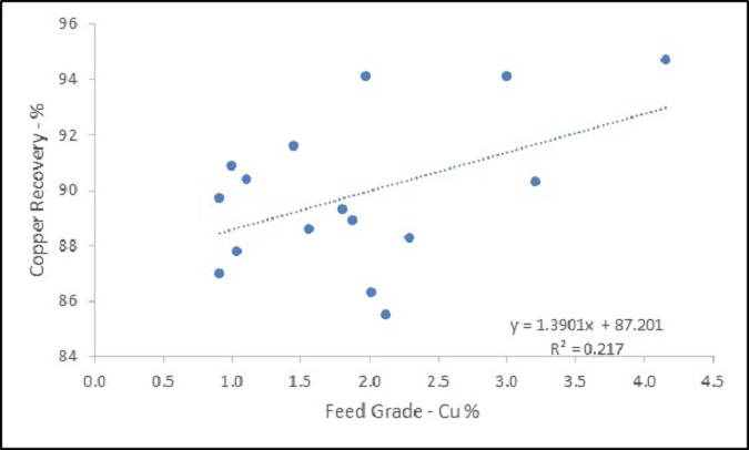
(Source: International Metallurgical & Environmental Inc., 2024)
Test work results point to estimated copper recoveries of 87% to 90% for lower grade feed samples of 1% to 2% Cu and increased copper recoveries of 90% to 94% for higher grade mineralized material, in excess of 2% Cu, and would likely be amenable to underground mining methods.
The underground Bornite Project has an expected LOM grade of 2.66% Cu. Based on the relationship shown in Figure 10-3, this predicts a copper recovery of 90.89% which was used in the cash flow model. A slightly lower copper recovery of 90.47% was used for the mineral resource estimate and mine plan. A concentrate grade of 29.5% was selected to predict concentrate production.
| Project No.: 253821 | | Mineral Processing and Metallurgical Testing | | |
| January 2025 | | Page 10-8 | |
| Bornite Project |
| Northwest Alaska, USA |
| S-K 1300 Technical Report Summary on the Initial Assessment |
| 10.3.5 | Concentrate Quality Targets |
Analysis of the final copper concentrates was completed within the various test work programs, and the results are summarized in Table 10-5.
The concentrates are unlikely to contain payable precious metals as these appear to be below accepted splitting limits within traditional concentrate sales terms.
The concentrates are also considered to contain low levels of penalty elements such as arsenic, antimony, mercury, cadmium, and selenium. The concentrates will likely not incur any financial penalty under traditional sales terms. Zinc may incur a payable penalty if levels are consistently above about 3% Zn. There would be an added transportation expense at those levels as well. Zinc is typically not payable within copper concentrates.
| Table 10-5: | Typical Concentrate Analysis – KM5705 Final Copper Concentrates |
| Element | | Symbol | | Unit | | Comp 1 | | | Comp 3 | | | Comp 5 | | | Comp 8 | |
| Antimony | | Sb | | % | | | 0.0021 | | | | 0.0136 | | | | 0.145 | | | | 0.0099 | |
| Arsenic | | As | | % | | | 0.023 | | | | 0.018 | | | | 0.130 | | | | 0.120 | |
| Cadmium | | Cd | | % | | | 0.0084 | | | | 0.0026 | | | | 0.0017 | | | | 0.0055 | |
| Cobalt | | Co | | ppm | | | 1,515 | | | | 516 | | | | 1,466 | | | | 1,505 | |
| Copper | | Cu | | % | | | 25.8 | | | | 25.0 | | | | 29.8 | | | | 28.5 | |
| Iron | | Fe | | % | | | 26.4 | | | | 29.9 | | | | 27.9 | | | | 28.0 | |
| Mercury | | Hg | | ppm | | | 6 | | | | 7 | | | | 10 | | | | 9 | |
| Sulphur | | S | | % | | | 32.8 | | | | 34.8 | | | | 32.6 | | | | 33.7 | |
| Zinc | | Zn | | % | | | 2.60 | | | | 0.56 | | | | 0.23 | | | | 1.16 | |
| 10.3.6 | Cobalt Speciation Studies |
A preliminary cobalt mineral speciation investigation was conducted by Trilogy Metals in 2017 using both the tailings- and concentrate-test products of the 2012/2013 and 2017 metallurgical test work. Microprobe analysis and backscatter electron mapping of the products show that the majority of cobalt (~80%) is contained within cobaltiferous pyrite at low cobalt contents, while the remaining cobalt (20%) occurs as carrollite and/or cobaltite. A majority of the cobalt contained in the Bornite deposit is contained within pyrite minerals and not as a distinct cobalt mineral.
| 10.3.7 | Opportunities for Cobalt Recovery |
Drill sample results have identified areas of the Bornite deposit such as South Reef contain significantly higher grades of copper and cobalt than the overall deposit.
| Project No.: 253821 | | Mineral Processing and Metallurgical Testing | | |
| January 2025 | | Page 10-9 | |
| Bornite Project |
| Northwest Alaska, USA |
| S-K 1300 Technical Report Summary on the Initial Assessment |
Preliminary metallurgical test work indicates that a pyrite-cobalt concentrate can be produced from the copper concentrate tailings. Future test work on cobalt recovery processes may be warranted.
| 10.4 | QP Opinion on Data Adequacy |
The International Metallurgical & Environmental process QP has been involved with the Bornite Project since 2012 and supervised a majority of the test work programs mentioned in this Report.
The testing program included mineralogical analysis, as well as comminution and flotation testing using samples of sufficient size and spatial distribution to be considered representative of the Bornite deposit. The selected samples for the testing campaigns cover a wide range of copper and cobalt content.
The available metallurgical test work information is considered of an acceptable quality and sufficient to support a copper mineral resource estimate. The copper concentrate that would be produced is considered in general terms a clean concentrate, and it is unlikely that penalties would be imposed as no significant amounts of deleterious elements are contained in the concentrate.
In the opinion of the International Metallurgical & Environmental process QP the metallurgical data is adequate for the purposes used in this Report.
| 10.5 | Recommended Test Work |
Additional metallurgical test work is required to support more advanced studies. Key areas that require additional test work are as follows:
| · | Additional grinding and flotation test work to expand the sample size and better represent the deposit, similar to the recently completed metallurgical test work programs. |
| · | Detailed test work involving settling and filtering of concentrates and tailings |
| · | Additional studies regarding the recovery and upgrading of cobalt values from the copper flotation tailings may be warranted. |
| Project No.: 253821 | | Mineral Processing and Metallurgical Testing | | |
| January 2025 | | Page 10-10 | |
| Bornite Project |
| Northwest Alaska, USA |
| S-K 1300 Technical Report Summary on the Initial Assessment |
| 11.0 | mineral resource estimates |
This section describes the updated mineral resource estimate for the Bornite Project. Wood’s geology QP reviewed and validated the resource model previously prepared and based on that review prepared a revised mineral resource statement.
| 11.2 | Sample Database and Other Available Data |
Trilogy Metals provided the Bornite database in Microsoft™ Excel format, exported from the master database (GeoSpark Core Database System). The files contain collar, survey, assay, lithology, and specific gravity data, and other geological and geotechnical information. The Bornite database comprises a total of 273 diamond drill (core) holes totalling 106,406 m; 203 holes target the Ruby Zone to the west and 58 holes target the South Reef area to the east. The remaining 12 holes in the database are exploratory in nature and test for satellite mineralization proximal to the Bornite deposit or represent holes that encountered problems and were therefore abandoned. A total of 242 drill holes are used in the mineral resource estimate which contains a total of 39,740 samples that were analyzed for copper content and 34,177 that were analyzed for cobalt content. Most holes drilled by Trilogy Metals, plus a few select historical holes drilled by Kennecott, contain additional analyses for elements such as zinc, lead, gold, silver, and cobalt. At this time, only copper has established reasonable prospects for eventual economic extraction.
During the 2012, 2013 and 2014 field seasons, Trilogy Metals collected samples from drill hole intervals that were not previously sampled. It is assumed that Kennecott did not sample these intervals because, visually, they did not exhibit the presence of high-grade copper mineralization (amenable to underground mining). In previous mineral resource estimates, these un-sampled intervals were assigned a default grade of 0% Cu. At this current stage, the majority of the core drilled by Kennecott has been sampled and analyzed for copper content and are included in the database. The sampling and assaying for cobalt is less extensive. Where assay data are not available, these intervals are assigned a zero grade for cobalt (0% Co) when the host rocks are phyllite, or they are left blank when the host rocks are carbonates.
Individual sample intervals range from 3 cm to 39.58 m long and average 2.09 m.
Drill hole spacing at the Ruby Zone varies from approximately 10 m to 20 m for underground holes and 50 m to 100 m or more for holes drilled from surface. All holes testing the South Reef area are collared from surface and typically intersect mineralization at approximately 100 m to 200 m spacing.
| Project No.: 253821 | | Mineral Resource Estimates | | |
| January 2025 | | Page 11-1 | |
| Bornite Project |
| Northwest Alaska, USA |
| S-K 1300 Technical Report Summary on the Initial Assessment |
SG measurements were conducted on 7,476 samples in the database and range from a minimum of 2.12 to a maximum of 5.20 and average 2.89. The distribution of SG data is considered sufficient to support resource estimation.
The distribution of copper grades in drill holes is shown in Figure 11-1. The distribution of drilling by campaign, including the re-sampling completed in 2012, 2013 and 2014, is shown in Figure 11-2.
With the drilling completed by Trilogy Metals, plus the additional re-sampling of the historical drill core, the original Kennecott sample data represent a relatively minor proportion of the overall database. All of the historical drilling has been included in the Bornite mineral resource estimate, and no adjustments were made to any of this historical data.
Figure 11-1: Copper Grades in Drill Holes
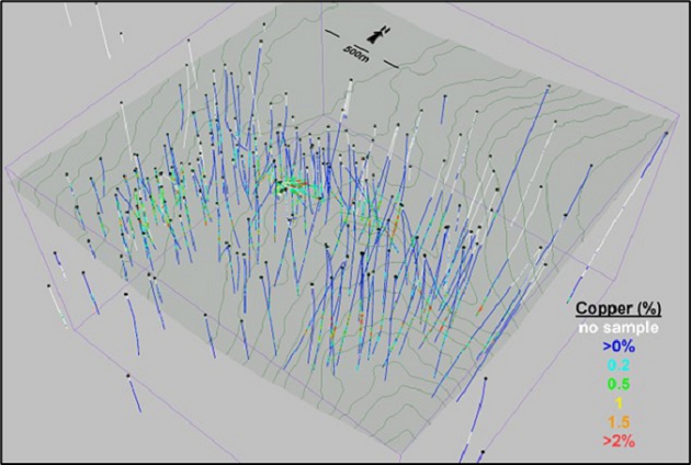
(Source: SIM et al., 2022)
| Project No.: 253821 | | Mineral Resource Estimates | | |
| January 2025 | | Page 11-2 | |
| Bornite Project |
| Northwest Alaska, USA |
| S-K 1300 Technical Report Summary on the Initial Assessment |
Figure 11-2: Drilling by Campaign
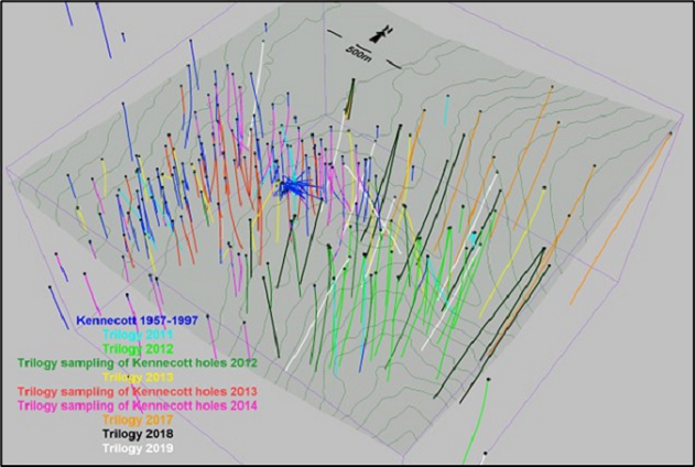
(Source: SIM et al., 2022)
The geologic model interpreted for the Bornite deposit consists primarily of a series of inter-bedded carbonate and phyllitic rocks that dip gently to the north and overlay a quartz-phyllite footwall. The geologic model comprises 18 individual phyllite domains and 16 separate carbonate domains plus a series of separate domains representing the hanging wall (Beaver Creek phyllite), the footwall (quartz-phyllite Anirak schist), and the overlying overburden. Some of the phyllite and carbonate units are continuous across the entire deposit area and others pinch out and are more localized.
Figure 11-3 and Figure 11-4 show vertical cross-sections through the lithologic model in the Ruby Zone and South Reef areas, respectively and illustrate a summary of the interpretation of the geology and mineralization from the drill results.
| Project No.: 253821 | | Mineral Resource Estimates | | |
| January 2025 | | Page 11-3 | |
| Bornite Project |
| Northwest Alaska, USA |
| S-K 1300 Technical Report Summary on the Initial Assessment |
Figure 11-3: Cross-section Showing Lithology Domains in the Ruby Zone
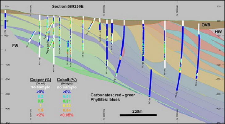
(Source: SIM et al., 2022)
Figure 11-4: Cross-section Showing Lithology Domains in the South Reef Area
(Source: SIM et al., 2022)
| Project No.: 253821 | | Mineral Resource Estimates | | |
| January 2025 | | Page 11-4 | |
| Bornite Project |
| Northwest Alaska, USA |
| S-K 1300 Technical Report Summary on the Initial Assessment |
To replicate the stratabound nature of the mineralization in the mineral resource model, a dynamic anisotropy approach relative to the overall trend of copper and cobalt mineralization was applied. Three-dimensional (3D) surfaces were interpreted and represent the general trend of the copper mineralization: one plane for the South Reef units, one for the Lower Reef units, and another for the Upper Reef lithologic units. The vertical cross sections in Figure 11-5 show the interpreted trend planes, indicated by dashed lines, across several areas of the deposit. These trend planes are used to control search orientations during subsequent interpolations in the model. Variograms are generated using distances relative to the trend planes rather than the true sample elevations. This approach essentially flattens out the zone during interpolation relative to the defined trend plane.
The parts of the deposit with the highest grades occur within areas where semi-massive and massive sulphides are present. The density of drilling is insufficient in most areas to allow for the interpretation of these massive sulphide domains, and a probability shell approach is used to identify areas where higher grade mineralization is likely to occur.
Two probability shells were generated: one at a threshold of 2% Cu and another at a threshold of 0.2% Cu. The 2% Cu shell generally correlates with the presence of massive and semi-massive zones of bornite and chalcopyrite mineralization, and the 0.2% Cu shell correlates with the visual presence of chalcopyrite mineralization. Cobalt mineralization is strongly associated with both sets of copper mineralization. The higher grade shell occurs mainly in the South Reef area and is based primarily on visual observations of the distribution of sample data suggesting that a relatively continuous zone of higher grade copper mineralization occurs above a threshold grade of 2% Cu. Approximately 90% of the sample data in the South Reef area is below 2% Cu and 10% of the data is greater than 2% Cu. A relatively small (>2%) copper probability shell is also generated in the Upper Reef area of the Ruby Zone.
Approximately one half of the samples in the carbonate domains have copper grades above the lower grade threshold of 0.2% Cu. This limit roughly segregates areas of mineralized versus unmineralized rocks and is still below the anticipated cut-off grade of the mineral resource, ensuring that sufficient internal dilution is retained in the mineral resource model. There are also areas where the phyllite domains contain appreciable copper grades (above the 0.2% Cu threshold), but these tend to be rare and localized occurrences.
| Project No.: 253821 | | Mineral Resource Estimates | | |
| January 2025 | | Page 11-5 | |
| Bornite Project |
| Northwest Alaska, USA |
| S-K 1300 Technical Report Summary on the Initial Assessment |
Figure 11-5: Vertical Cross-sections Showing Trend Planes Used to Control Dynamic Isotropy
(Source: SIM et al., 2022)
| Project No.: 253821 | | Mineral Resource Estimates | | |
| January 2025 | | Page 11-6 | |
| Bornite Project |
| Northwest Alaska, USA |
| S-K 1300 Technical Report Summary on the Initial Assessment |
Indicator values are assigned to 2 m composites at the grade thresholds, and indicator variograms are produced. Probability values are estimated in model blocks using ordinary kriging; the vertical range and locations are controlled dynamically using elevations relative to the trend planes described previously. A series of shells are generated at varying probability thresholds and are then compared to the distribution of the underlying sample data. The higher grade shell represents areas where there is greater than a 30% probability that the grade will be more than 2% Cu. The lower grade shell envelopes areas where there is a greater than 50% probability that the grade will exceed 0.2% Cu. The shape and location of the probability shells are shown in Figure 11-6.
Compositing drill hole samples standardizes the database for further statistical evaluation. This step eliminates any effect the sample length may have on the data. To retain the original characteristics of the underlying data, a composite length that reflects the average, original sample length is selected; a composite that is too long can sometimes result in a degree of smoothing that can mask certain features of the data.
The average sample length at both the Ruby Zone and South Reef areas is 2.09 m. As a result, a composite length of 2 m was selected for the Bornite deposit.
Drill hole composites were length-weighted and generated down-the-hole, meaning composites began at the top of each drill hole and were generated at constant intervals down the length of the drill hole. Composites were broken at lithology domain boundaries. Once composites were generated, probability shell codes were assigned on a majority basis. Several holes were randomly selected, and the composited values were checked for accuracy. No errors were found.
| Project No.: 253821 | | Mineral Resource Estimates | | |
| January 2025 | | Page 11-7 | |
| Bornite Project |
| Northwest Alaska, USA |
| S-K 1300 Technical Report Summary on the Initial Assessment |
Figure 11-6: Copper Probability Shells
(Source: SIM et al., 2022)
| Project No.: 253821 | | Mineral Resource Estimates | | |
| January 2025 | | Page 11-8 | |
| Bornite Project |
| Northwest Alaska, USA |
| S-K 1300 Technical Report Summary on the Initial Assessment |
| 11.4 | Exploratory Data Analysis |
Exploratory data analysis (EDA) involves statistically summarizing groups of samples to quantify the characteristics of the data. The main purpose of EDA is to determine whether there is any evidence of spatial distinctions in grade; if this occurs, a separation and isolation of domains during interpolation may be necessary. An unwanted mixing of data is prevented by applying separate domains during interpolation; the result is a grade model that better reflects the unique properties of the deposit. However, applying domain boundaries in areas where the data are not statistically unique may impose a bias in the distribution of grades in the model.
A domain boundary, which segregates the data during interpolation, is typically applied if the average grade in one domain is significantly different from that of another domain. A boundary may also be applied when there is evidence that a significant change in the grade distribution exists across the contact.
The original variable length drill hole samples were composited to 2 m intervals prior to analysis. The interpreted wireframe domains were then used to backtag the composited sample data, assigning unique domain codes. The EDA described here is based on composited sample data which are segregated based on the interpreted wireframe domains.
This EDA consists primarily of a series of boxplots and contact profiles. Boxplots summarize many aspects of the frequency distributions of the data in simple graphical displays for comparison purposes. Contact profiles evaluate the nature of grade trends between two domains: they graphically display the average grades at increasing distances from the contact boundary. The numbers beside the data points represent the amount of data averaged together at a particular separation distance. Those contact profiles that show a marked difference in grade across a domain boundary indicate that the two domain datasets should be isolated during interpolation. Conversely, if a more gradual change in grade occurs across a contact, the introduction of a hard boundary (e.g., segregation during interpolation) may result in a much different trend in the grade model; in this case, the change in grade between domains in the model is often more abrupt than the trends seen in the raw data. Finally, a flat contact profile indicates no grade changes across the boundary; in this case, hard or soft domain boundaries will produce similar results in the model. The boxplots and contact profiles presented in this section of the report are based on all available sample data following the 2018 drilling program; they do not include information from the few additional drill holes completed in 2019 because the impact of the 2019 drill hole results would be negligible.
| Project No.: 253821 | | Mineral Resource Estimates | | |
| January 2025 | | Page 11-9 | |
| Bornite Project |
| Northwest Alaska, USA |
| S-K 1300 Technical Report Summary on the Initial Assessment |
The boxplot in Figure 11-7 shows there is a major difference between the copper grades in the carbonate breccias versus the phyllite domains. The contact profile, shown in Figure 11-8, shows the difference in the vicinity of the boundaries. The carbonate breccias delimit zones of higher copper grades.
Figure 11-9 shows the boxplots for copper in the phyllites in the Lower Reef. Note that while a large majority of the sample grades fall below 0.1% Cu, there are a few high-grade samples present which show that localized copper mineralization does exist in the phyllite units. This is a pattern that is also repeated in the South and Upper Reefs. Some of these mineralized phyllites are proximal to well-mineralized carbonates, but the majority of the very high grades occurring in the phyllites tend to be isolated and cannot be associated with high grades in other units or any geological feature, such as structure.
Figure 11-10 shows the copper sample grade distribution boxplots for the Lower Reef breccias. The distributions have a significantly greater number of high-grade areas than in the phyllites. The carbonate breccia domains tend to be a better host to mineralization, but as the boxplots show, there are still volumes of lower grade within the carbonate breccia units.
Figure 11-11 and Figure 11-12 show boxplots for copper in the phyllites and carbonate breccias for the Upper Reef. The phyllites are less mineralized than in the Lower Reef, but rare very high values continue to occur in most of the phyllite units. Breccia units higher up in the stratigraphic section tend to contain less mineralization, as seen in Figure 11-13.
The boxplots in Figure 11-13 and Figure 11-14 show the grade distributions in South Reef. The grade distribution in phyllite unit PHY1L tends to be more like a carbonate breccia grade distribution due to local mineralization related to shearing. The copper grade in carbonate breccia BRXE1 resembles a phyllite-grade distribution due to its location on the unmineralized footwall side of the Iron Mountain fault structure. As in the other reefs, the phyllite units continue to host a sprinkling of high-grade samples.
Figure 11-15 shows a drill hole vertical section with the sample grades and the interpreted phyllite and carbonate breccia units. The section illustrates the fact that mineralization in breccia units occurs in more limited volumes and, therefore, it is necessary to confine the interpolation of grades in the breccias, and rarely in the mineralized phyllites, to the mineralized volumes. To properly constrain the interpolation of grade, probability shells were constructed, as described in Section 11.2, and they are used in conjunction with the stratigraphic units, segregating areas using both stratigraphy and probability shell domains during block grade interpolation. Figure 11-16 shows an example of the 0.2% Cu probability shell overlain on the stratigraphic units.
| Project No.: 253821 | | Mineral Resource Estimates | | |
| January 2025 | | Page 11-10 | |
| Bornite Project |
| Northwest Alaska, USA |
| S-K 1300 Technical Report Summary on the Initial Assessment |
| Figure 11-7: | Boxplots of Total Copper in Carbonate Breccias and Phyllites | | Figure 11-8: | Contact Profiles for Total Copper between Carbonate Breccias and Phyllites |
 | |  |
| | | |
| (Source: SIM, March 2019) | | (Source: SIM, March 2019) |
| Project No.: 253821 | | Mineral Resource Estimates | | |
| January 2025 | | Page 11-11 | |
| Bornite Project |
| Northwest Alaska, USA |
| S-K 1300 Technical Report Summary on the Initial Assessment |
Figure 11-9: Boxplots for Copper in the Lower Reef Phyllite Domains

(Source: SIM, March 2019)
Figure 11-10: Boxplots for Copper in the Lower Reef Carbonate Breccia Domains

(Source: SIM, March 2019)
| Project No.: 253821 | | Mineral Resource Estimates | | |
| January 2025 | | Page 11-12 | |
| Bornite Project |
| Northwest Alaska, USA |
| S-K 1300 Technical Report Summary on the Initial Assessment |
Figure 11-11: Boxplots for Copper in the Upper Reef Phyllite Domains
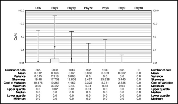
(Source: SIM, March 2019)
Figure 11-12: Boxplots for Copper in the Upper Reef Carbonate Breccia Domains

(Source: SIM, March 2019)
| Project No.: 253821 | | Mineral Resource Estimates | | |
| January 2025 | | Page 11-13 | |
| Bornite Project |
| Northwest Alaska, USA |
| S-K 1300 Technical Report Summary on the Initial Assessment |
Figure 11-13: Boxplots for Copper in the South Reef Phyllite Domains

(Source: SIM, March 2019)
Figure 11-14: Boxplots for Copper in the South Reef Carbonate Breccia Domains
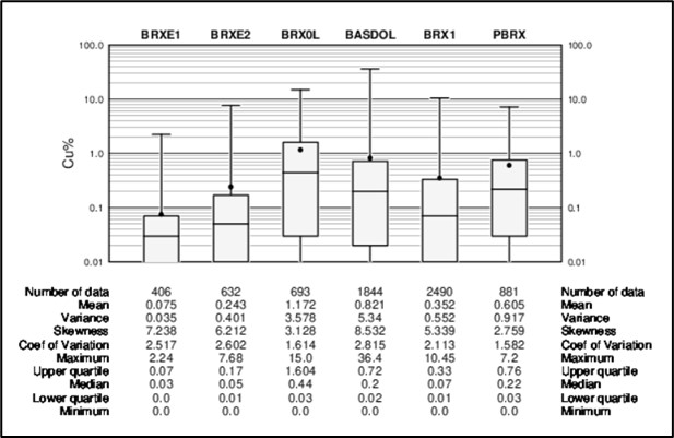
(Source: SIM, March 2019)
| Project No.: 253821 | | Mineral Resource Estimates | | |
| January 2025 | | Page 11-14 | |
| Bornite Project |
| Northwest Alaska, USA |
| S-K 1300 Technical Report Summary on the Initial Assessment |
Figure 11-15: Section 589250 E with Interpreted Stratigraphic Units
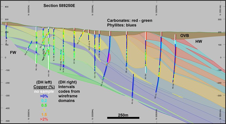
(Source: SIM et al., 2022)
Figure 11-16: Section 589250 E with 0.2% Cu Probability Shell
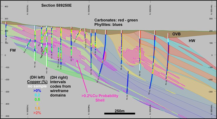
(Source: SIM et al., 2022)
| Project No.: 253821 | | Mineral Resource Estimates | | |
| January 2025 | | Page 11-15 | |
| Bornite Project |
| Northwest Alaska, USA |
| S-K 1300 Technical Report Summary on the Initial Assessment |
Figure 11-17 shows copper sample grades inside the 2% Cu shell with samples inside the surrounding 0.2% Cu shell. There is a pronounced change in copper grade at this boundary suggesting that it should be recognized during block-grade estimation.
Figure 11-18 shows distinct changes in copper grade at the 0.2% Cu shell boundary. This is an indication that the 0.2% Cu shell does, in general, segregate mineralized from unmineralized rocks.
| 11.4.1 | Modelling Implications |
The boxplot and contact profile analysis shows distinct differences in sample data contained in carbonate and phyllite domains, indicating that these data should remain segregated during the estimation of copper grades in the block model. Analysis of the probability grade shells also indicates that these encompass differing populations of samples that should not be mixed during copper grade interpolations.
Based on these results, a combination of lithology and probability grade shell domains are used to control the distribution of copper in the mineral resource block model.
| 11.5 | Treatment of Outlier Grades |
Histograms and probability plots were generated from 2 m composited sample data to show the distribution of copper in each estimation domain. These were used to identify the existence of anomalous outlier grades in the composite database. The physical locations of these potential outlier samples were reviewed in relation to the surrounding data, and it was decided that their effects could be controlled primarily through the use of outlier limitations.
An outlier limitation approach limits samples above a defined threshold to a maximum distance of influence during grade estimates. In the South Reef domains, drill holes tend to intersect the mineralized zone at roughly 100 m intervals, and as a result, samples above the outlier threshold are limited to a maximum distance of influence of 50 m during block grade interpolation (½ the distance between drill holes).
| Project No.: 253821 | | Mineral Resource Estimates | | |
| January 2025 | | Page 11-16 | |
| Bornite Project |
| Northwest Alaska, USA |
| S-K 1300 Technical Report Summary on the Initial Assessment |
| Figure 11-17: Contact Profile of Copper in 2% and 0.2% Cu Shells | | Figure 11-18: Contact Profile of Copper In/Out of the 0.2% Cu Shell |
| | | |
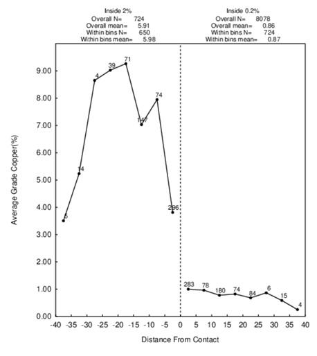 | | 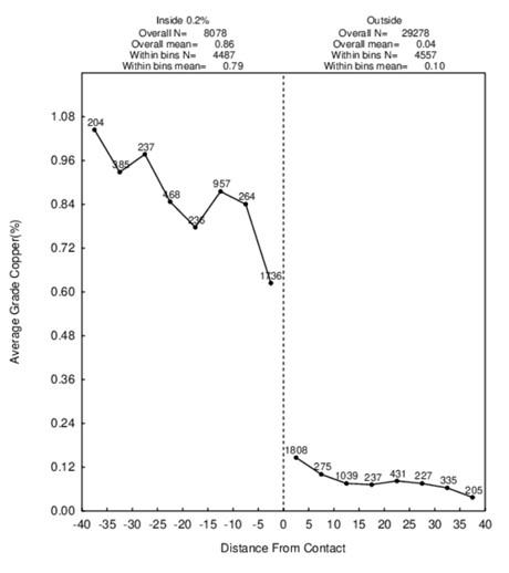 |
| (Source: SIM, March 2019) | | (Source: SIM, March 2019) |
| Project No.: 253821 | | Mineral Resource Estimates | | |
| January 2025 | | Page 11-17 | |
| Bornite Project |
| Northwest Alaska, USA |
| S-K 1300 Technical Report Summary on the Initial Assessment |
In the Lower and Upper Reef domains, drilling tends to be more closely spaced and, therefore, samples above the outlier thresholds are limited to a maximum distance of influence of 25 m during block grade interpolation. One exception applies to the 2% Cu shell in the Upper Reef, which is densely drilled with numerous closely spaced underground drill holes. Here, samples above the outlier threshold grade of 20% Cu are limited to a maximum range of 10 m during block grade interpolation. In addition to the outlier limitations described here, samples inside the 2% Cu probability shell in the South Reef area were top-cut to 30% Cu prior to block grade interpolation.
Table 11-1 summarize the treatment of outlier sample data and the resulting effects on the estimate of contained metal in the models.
The proportion of metal lost is calculated in resource model. Overall, these measures have reduced the total amount of contained copper by 5.8%. The amount of copper metal lost in the carbonate domains, which host the majority of the mineral resources at Bornite, is considered appropriate for a project at this level of delineation drilling. The greater losses exhibited in the phyllites are due to the effects of these limitations on the skewed grade distributions in these domains. The effect of these measures also tends to have a greater impact on the high-grade parts of the deposit inside the 2% Cu probability shell. Overall, the proportions of metal lost due to top-cutting and outlier restriction measures are considered appropriate for a project with this level of exploration.
Table 11-1: Metal Lost Due to Treatment of Outlier Copper Sample Data
| Domain Group | | Percentage Metal Lost
(%) | |
| Carbonates | | | -4.3 | |
| Phyllites | | | -12.0 | |
| 2% Cu Probability Shell | | | -10.5 | |
| 11.6 | Specific Gravity Data |
SG measurements were conducted on 7,476 samples in the database with a minimum of 2.12 and two highest values of 5.20 and 8.30 and an average 2.89. Approximately 40% of the available SG data occur in the probability grade shell domains. Copper content and SG are moderately correlated. There is minimal variation in the SG values for the various estimation domains with coefficient-of-variation values that are typically less than 0.1.
SG data are available for the majority of drill holes with measurements typically made at 10 m to 20 m intervals down drill holes with continuous sampling through the mineralized areas.
The distribution of SG data is considered sufficient to support estimation in the mineral resource model.
| Project No.: 253821 | | Mineral Resource Estimates | | |
| January 2025 | | Page 11-18 | |
| Bornite Project |
| Northwest Alaska, USA |
| S-K 1300 Technical Report Summary on the Initial Assessment |
The degree of spatial variability and continuity in a mineral deposit depends on both the distance and direction between points of comparison. Typically, the variability between samples is proportionate to the distance between samples. If the variability is related to the direction of comparison, then the deposit is said to exhibit anisotropic tendencies which can be summarized by an ellipse fitted to the ranges in the different directions. The semi-variogram is a common function used to measure the spatial variability within a deposit.
The components of the variogram include the nugget, the sill, and the range. Often samples compared over very short distances (including samples from the same location) show some degree of variability. As a result, the curve of the variogram often begins at a point on the y-axis above the origin; this point is called the nugget. The nugget is a measure of not only the natural variability of the data over very short distances, but also a measure of the variability which can be introduced due to errors during sample collection, preparation, and assay.
Typically, the amount of variability between samples increases as the distance between the samples increase. Eventually, the degree of variability between samples reaches a constant or maximum value; this is called the sill, and the distance between samples at which this occurs is called the range.
The spatial evaluation of the data was conducted using a correlogram instead of the traditional variogram. The correlogram is normalized to the variance of the data and is less sensitive to outlier values; this generally gives cleaner results.
Many of the individual estimation domains do not contain sufficient sample data from which reasonable correlograms can be generated. As a result, separate correlograms for copper were generated for samples inside the 0.2% Cu probability shell in each of the South, Lower and Upper Reefs, and these were applied to each of the respective carbonate domains. A separate correlogram was produced from all samples outside of the 0.2% Cu probability shell, and this was used to estimate grades in the phyllite domains. Finally, a correlogram was used to estimate the distribution of copper inside of the 2% Cu probability shell domain.
Correlograms were generated using the commercial software package SAGE2001 developed by Isaaks & Co. Correlograms were generated using elevations relative to the trend planes described in Section 11.2. This ensures that the local undulations of the typically banded mineralization are replicated in the block model. The correlograms are summarized in Table 11-2. Experimental correlograms are modelled with a nugget and two spherical structures.
| Project No.: 253821 | | Mineral Resource Estimates | | |
| January 2025 | | Page 11-19 | |
| Bornite Project |
| Northwest Alaska, USA |
| S-K 1300 Technical Report Summary on the Initial Assessment |
Table 11-2: Copper Correlogram Parameters
| | | | | | | | | | | | 1st Structure | | | 2nd Structure | |
| Domain | | Nugget | | | S1 | | | S2 | | | Range (m) | | | AZ | | | Dip | | | Range (m) | | | AZ | | | Dip | |
| Upper Reef Carbonates | | | 0.100 | | | | 0.784 | | | | 0.116 | | | | 23 | | | | 319 | | | | 61 | | | | 554 | | | | 212 | | | | 11 | |
| | | | | | | | Spherical | | | | | | | | 11 | | | | 170 | | | | 25 | | | | 538 | | | | 54 | | | | 78 | |
| | | | | | | | | | | | | | | | 6 | | | | 74 | | | | 13 | | | | 73 | | | | 123 | | | | -4 | |
| Lower Reef Carbonates | | | 0.150 | | | | 0.761 | | | | 0.089 | | | | 96 | | | | 91 | | | | 43 | | | | 1,079 | | | | 181 | | | | 0 | |
| | | | | | | | Spherical | | | | | | | | 28 | | | | 333 | | | | 26 | | | | 95 | | | | 91 | | | | 0 | |
| | | | | | | | | | | | | | | | 10 | | | | 223 | | | | 36 | | | | 38 | | | | 32 | | | | 90 | |
| South Reef Carbonates | | | 0.150 | | | | 0.787 | | | | 0.063 | | | | 24 | | | | 77 | | | | 34 | | | | 2,427 | | | | 215 | | | | 0 | |
| | | | | | | | Spherical | | | | | | | | 21 | | | | 292 | | | | 51 | | | | 562 | | | | 125 | | | | 0 | |
| | | | | | | | | | | | | | | | 9 | | | | 179 | | | | 18 | | | | 33 | | | | 146 | | | | 90 | |
| Phyllites | | | 0.450 | | | | 0.519 | | | | 0.031 | | | | 27 | | | | 280 | | | | 51 | | | | 573 | | | | 343 | | | | 37 | |
| | | | | | | | Spherical | | | | | | | | 22 | | | | 38 | | | | 21 | | | | 413 | | | | 77 | | | | 5 | |
| | | | | | | | | | | | | | | | 12 | | | | 321 | | | | -31 | | | | 381 | | | | 354 | | | | -52 | |
| 2% Cu Probability Shell | | | 0.200 | | | | 0.724 | | | | 0.076 | | | | 35 | | | | 216 | | | | 80 | | | | 1,871 | | | | 137 | | | | 0 | |
| | | | | | | | Spherical | | | | | | | | 11 | | | | 111 | | | | 3 | | | | 438 | | | | 47 | | | | 42 | |
| | | | | | | | | | | | | | | | 6 | | | | 20 | | | | 10 | | | | 52 | | | | 46 | | | | -48 | |
| Note: | Correlogram generated from 2 m composited sample data using elevations relative to trend plane of mineralization. S1 = sill of the first structure; S2 = sill of the second structure |
| 11.8 | Model Setup and Limits |
A block model was initialized with a nominal block size of 5 x 5 x 5 m which is considered appropriate, based on current drill hole spacing, for a project at this stage of evaluation.
Because the deposit contains mineral resource that are amendable to both underground and open pit mining methods, the 5 x 5 x 5 m selective mining unit (SMU) is driven primarily by the underground extraction potential of the deposit. Evaluations of the open pit extraction potential of the mineral resource may require that these blocks are combined into a larger SMU size.
Further engineering studies are required to evaluate the viability of the Bornite deposit. The limits of the block model are represented by the purple rectangle shown in the previous isometric views (Figure 11-1, Figure 11-2, and Figure 11-6).
Using the domain wireframes, blocks in the model are assigned estimation domain code values on a majority basis. Blocks with more than 50% of their volume inside a wireframe domain are assigned a zone code value of that domain.
| Project No.: 253821 | | Mineral Resource Estimates | | |
| January 2025 | | Page 11-20 | |
| Bornite Project |
| Northwest Alaska, USA |
| S-K 1300 Technical Report Summary on the Initial Assessment |
| 11.9 | Interpolation Parameters |
Copper grades in the resource model were estimated using ordinary kriging. SG was estimated using inverse distance squared (ID2) and all estimation domains were recognized as hard boundaries. The ordinary kriging models were evaluated using a series of validation approaches as described in Section 11.10. The interpolation parameters were adjusted until the appropriate results were achieved. In general, the ordinary kriging models were generated using a relatively limited number of composited sample data. This approach reduces the amount of smoothing (also known as averaging) in the model, and while there may be some uncertainty on a localized scale, this approach produces reliable estimates of the grade and tonnage for the overall deposit. Interpolation parameters for copper in the various estimation domains are summarized in Table 11-3.
During grade and SG estimation, search orientations were designed to follow the mineralization trend surfaces interpreted to represent the general trend of the mineralization in the deposit. Although the maximum XY range is set at 500 m, block grades are generally estimated using data limited to the nearest three or four drill holes; this criterion is often met within a maximum distance of less than 100 m. In areas where drill holes are spaced at 200 m intervals, at depth or on the fringes of the deposit, the search range is large enough so that multiple drill holes are captured, and guided by the variogram, used in the block-grade estimates. Although actual search ranges may extend for more than 200 m in some areas, only blocks within a maximum distance of 100 m from a drill hole are included in the Inferred category.
| Table 11-3: | Copper and SG Interpolation Parameters |
| | | Search Ellipse Range (m) | | No. of Composites (2 m) | | | |
| Domain | | X | | Y | | Z1 | | Min/block | | Max/block | | Max/hole | | Other | |
| Upper Reef Carbonates | | 500 | | 500 | | 3 | | 1 | | 9 | | 3 | | 1DH per Octant | |
| Lower Reef Carbonates | | 500 | | 500 | | 3 | | 1 | | 12 | | 3 | | 1DH per Octant | |
| South Reef Carbonates | | 500 | | 500 | | 3 | | 1 | | 9 | | 3 | | 1DH per Octant | |
| Phyllite | | 500 | | 500 | | 4 | | 1 | | 15 | | 5 | | 1DH per Octant | |
| 2% Cu Probability Shell | | 500 | | 500 | | 5 | | 1 | | 15 | | 5 | | 1DH per Octant | |
| SG | | 500 | | 500 | | 7 | | 1 | | 21 | | 7 | | ID2 | |
| Note: (1) | Vertical range relative to distances from trend plane of mineralization. DH = drill hole |
| Project No.: 253821 | | Mineral Resource Estimates | | |
| January 2025 | | Page 11-21 | |
| Bornite Project |
| Northwest Alaska, USA |
| S-K 1300 Technical Report Summary on the Initial Assessment |
| 11.10 | Block Model Validation |
The block models were validated using a thorough visual review of the model grades in relation to the underlying drill hole sample grades, comparisons with the change of support model, comparisons with other estimation methods, and grade distribution comparisons using swath plots.
Detailed visual inspection of the block model was conducted in both section and plan to compare estimated grades against underlying sample data. This included confirmation of the proper coding of blocks within the respective domains. Examples of the distribution of copper grades in the block model are shown in section in Figure 11-19 and Figure 11-20.
Figure 11-19: North-South Vertical Section of Copper Estimates in the Block Model in the Ruby Zone

(Source: SIM et al., 2022)
| Project No.: 253821 | | Mineral Resource Estimates | | |
| January 2025 | | Page 11-22 | |
| Bornite Project |
| Northwest Alaska, USA |
| S-K 1300 Technical Report Summary on the Initial Assessment |
Figure 11-20: North-South Vertical Section of Copper Estimates in the Block Model in the South Reef Area

(Source: SIM et al., 2022)
| 11.10.2 | Model Checks for Change of Support |
The relative degree of smoothing in the block estimates was evaluated using the Discrete Gaussian or Hermitian Polynomial Change of Support method (Rossi and Deutsch, 2014). With this method, the distribution of the hypothetical block grades can be directly compared to the estimated ordinary kriging model through the use of pseudo-grade/tonnage curves. Adjustments are made to the block model interpolation parameters until an acceptable match is made with the Herco (Hermitian Correction) distribution. In general, the estimated model should be slightly higher in tonnage and slightly lower in grade when compared to the Herco distribution at the projected cut-off grade. These differences account for selectivity and other potential ore-handling issues which commonly occur during mining.
The Herco distribution is derived from the declustered composite grades which are adjusted to account for the change in support moving from smaller drill hole composite samples to the larger blocks in the model. The transformation results in a less skewed distribution, but with the same mean as the original declustered samples.
| Project No.: 253821 | | Mineral Resource Estimates | | |
| January 2025 | | Page 11-23 | |
| Bornite Project |
| Northwest Alaska, USA |
| S-K 1300 Technical Report Summary on the Initial Assessment |
Examples of Herco change of support grade/tonnage plots for copper are shown in Figure 11-21; they are calculated for each reef formation limited to blocks inside the copper probability shells.
Overall, the desired degree of correlation between models has been achieved. The change of support model is a theoretical tool intended to direct model estimation. There is uncertainty associated with the change of support model, and its results should not be viewed as a final or correct value.
Figure 11-21: Herco and Model Grade/Tonnage Plots for Copper Inside Probability Shells
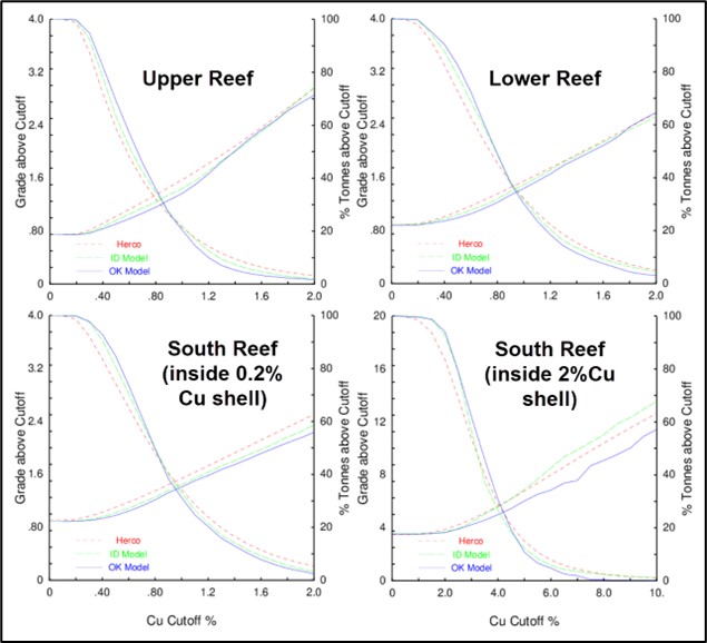
(Source: SIM et al., 2022)
| Project No.: 253821 | | Mineral Resource Estimates | | |
| January 2025 | | Page 11-24 | |
| Bornite Project |
| Northwest Alaska, USA |
| S-K 1300 Technical Report Summary on the Initial Assessment |
| 11.10.3 | Comparison of Interpolation Methods |
For comparison purposes, additional grade models were generated using the ID2 and nearest neighbour (NN) interpolation methods. The NN model was created using data composited to 5 m lengths to ensure all sample data are used in the model. The results of these models were compared to the ordinary kriging models at various cut-off grades using a grade/tonnage graph. The example shown in Figure 11-22 compares copper models within the combined 2% Cu and in the 0.2% Cu shells for the Upper, Lower and South Reefs. There is good correlation between the ordinary kriging and ID2 models.
The correspondence among the grade tonnage curves is typical for the compared interpolation methods. The NN grades and tonnages above cut-off are correct assuming that the perfect selection of material above and below the cut-off can be executed at the scale of the composite samples. It is included to show the results of the averaging that occurs in the other two methods. The ordinary kriging curves show the lowest grades and highest tonnages. The correct amount of averaging for the chosen block size is ensured for the ordinary kriging by the change of support calculation described in the preceding section.
A swath plot is a graphical display of the grade distribution derived from a series of bands, or swaths, generated in several directions throughout the deposit. Using the swath plot, grade variations from the ordinary kriging model are compared to the distribution derived from the declustered NN grade model.
On a local scale, the NN model does not provide reliable estimations of grade, but on a much larger scale, it represents an unbiased estimation of the grade distribution based on the underlying data. Therefore, if the ordinary kriging model is unbiased, the grade trends may show local fluctuations on a swath plot, but the overall trend should be similar to the NN distribution of grade.
Swath plots were generated in three orthogonal directions that compare the ordinary kriging and NN estimates for copper in each of the estimation domains.
Examples from each of the three reefs, limited to blocks inside the 0.2% Cu probability shell, together with the 2% Cu shells for copper are shown in Figure 11-23.
| Project No.: 253821 | | Mineral Resource Estimates | | |
| January 2025 | | Page 11-25 | |
| Bornite Project |
| Northwest Alaska, USA |
| S-K 1300 Technical Report Summary on the Initial Assessment |
Figure 11-22: Comparison of Copper Model Types in Carbonates Inside Grade Shell Domains

(Source: SIM et al., 2022)
| Project No.: 253821 | | Mineral Resource Estimates | | |
| January 2025 | | Page 11-26 | |
| Bornite Project |
| Northwest Alaska, USA |
| S-K 1300 Technical Report Summary on the Initial Assessment |
Figure 11-23: Swath Plots of Copper in Carbonates Inside Grade Shell Domains
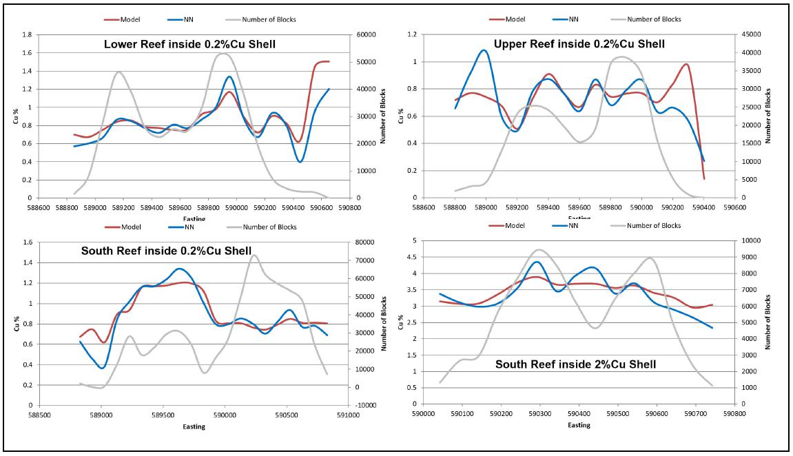
(Source: SIM et al., 2022)
| Project No.: 253821 | | Mineral Resource Estimates | | |
| January 2025 | | Page 11-27 | |
| Bornite Project |
| Northwest Alaska, USA |
| S-K 1300 Technical Report Summary on the Initial Assessment |
There is good correlation between models and the degree of smoothing in the ordinary kriging model (shown in red) is evident in the swaths. Areas where there are large differences between the models tend to be the result of edge effects, where there are less available data to support a comparison. The validation results indicate that the ordinary kriging copper model has reasonable reflections of the underlying sample data.
| 11.11 | Mineral Resource Classification |
The mineral resources were classified in accordance with S-K 1300 definitions. The classification parameters are defined relative to the distance between sample data and are intended to encompass zones of reasonably continuous mineralization that exhibit the desired degree of confidence in the estimate and at a grade and within a constraining surface suitable for the assumed mining method.
Copper indicator variograms were evaluated to provide information regarding the range of continuity of mineralization. This was combined with visual observations regarding the nature of the deposits with respect to the distribution of available sample information.
Factors considered in the uncertainty affecting the confidence classification of the mineral resource estimates include the following:
| · | Wood’s geology QP observed high-grade portions of the Upper and Lower Reef Ruby Zone where the drill hole spacing and continuity of geology and mineralization would have been sufficient to support Indicated confidence classification. However, there was an absense of documented QAQC results by Kennecott for this drilling that was completed between 1959 and 1968. Trilogy Metals completed some limited in-fill drilling in this area that included a proper QAQC program and performed considerable re-assay of drill core surrounding this area but that program did not include these Kennecott close-spaced drill holes (presumably because they were narrow diameter holes drilled from underground). This resulted in additional uncertainty to the accuracy of the grades that limited the confidence classification to the Inferred in this area |
| · | The extensive re-sampling program that was completed by Trilogy Metals with proper QAQC allowed the comparison of the re-sampling data to the original data (Section 8.5.1.1). This comparison showed there to be a potential copper high bias in these higher-grade assays. This uncertainy in accuracy limits the confidence classification to Inferred. This uncertainty is limited to the Upper and Lower Reef Ruby Zone and does not affect the South Reef which is the basis of the mine plan and cash flow for this IA. |
As a result of the above, the confidence classification was limited to the Inferred category.
| Project No.: 253821 | | Mineral Resource Estimates | | |
| January 2025 | | Page 11-28 | |
| Bornite Project |
| Northwest Alaska, USA |
| S-K 1300 Technical Report Summary on the Initial Assessment |
The classification criteria for defining Inferred mineral resources for the Bornite deposit is the requirement of a minimum of one drill hole within a maximum distance of 100 m and exhibit sufficient confidence in the grade and continuity of mineralization.
Wood’s geology QP expects the majority of Inferred mineral resources could be upgraded to Indicated mineral resources with additional exploration.
| 11.12 | Reasonable Prospects for Economic Extraction |
The requirement for reasonable prospects for economic extraction generally implies that quantity and grade estimates meet certain technical and economic thresholds and that mineral resources are reported at an appropriate cut-off and within a constrained mining shape that considers the extraction scenarios, processing recovery, costs, royalities and revenues.
At this stage of project evaluation, copper is the only economic contributor at Bornite. Currently there is insufficient information to identify a reasonable process method for economic recovery of cobalt or a market for the pyrite-cobalt concentrate.
The Bornite deposit comprises several zones of relatively continuous moderate- to high-grade copper mineralization that extends from surface to depths of more than 800 m below surface. The deposit is amenable to either open pit or underground mining methods. Underground mining assumes the sublevel stoping method for South Reef and cut-and-fill method for Ruby Zone with assumed mining costs of $65.00/t and $90.00/t mined, respectively. The primary input parameters used to develop a constraining pit shell and constraining underground mining shapes are summarized in Table 11-4. Using these parameters an open pit marginal cut-off grade of 0.5% Cu and underground break-even cut-off grades of 1.45% Cu for South Reef and 1.79% Cu for Ruby Zone were determined.
The underground mining shape for Ruby Zone is based on a 1.79% Cu grade shell while the underground mining shape for South Reef utilizes a mineable stope optimizer based on 1.45% Cu.
Underground development material not included within the mineable stope shape that is mined to gain access to the stopes and is above a marginal cut-off grade of 0.7% Cu can be selectively handled and stored in a low-grade stockpile to be processed at the end of the mine life. This material is included in the mineral resource estimate as a separate line item.
| Project No.: 253821 | | Mineral Resource Estimates | | |
| January 2025 | | Page 11-29 | |
| Bornite Project |
| Northwest Alaska, USA |
| S-K 1300 Technical Report Summary on the Initial Assessment |
Table 11-4 Parameters Used to Constrain the Mineral Resource
| | Item | | Unit | | Value | |
| | Open Pit Mining Cost | | $/t mined | | | 3.34 | |
| | Sublevel Mining Cost | | $/t mined | | | 65.00 | |
| | Cut-and-fill Mining Cost | | $/t mined | | | 90.00 | |
| | Process Cost | | $/t processed | | | 21.00 | |
| | G&A (open pit) | | $/t processed | | | 4.30 | |
| | G&A (underground) | | $/t processed | | | 14.50 | |
| | Treatment, Refining and Sales Cost | | $/lb Cu in concentrate | | | 0.78 | |
| | Road Use Cost | | $/t processed | | | 8.04 | |
| | NSR Royalty | | % | | | 2.0 | |
| | Pit Slope | | degree | | | 43 | |
| | Metallurgical Recovery | | % | | | 90.47 | |
| | Copper Price | | $/lb | | | 4.60 | |
Note: No adjustments for mining recovery or external dilution
| 11.12.1 | Basis of Copper Price and Cost Assumptions |
Copper futures are exchange-traded contracts on all of the world’s major commodity exchanges. Copper is the world's third most widely used metal after iron and aluminum and is primarily consumed in industries such as construction and industrial machinery manufacturing.
To establish the long-term copper price forecast Wood’s geology QP used a combination of information derived from 22 financial institutions, copper pricing used in technical reports filed with Canadian regulatory authorities over the previous 12-month period from the effective date of the mineral resource estimate, from pricing reported by major mining companies in public filings such as annual reports, historical average pricing. From this assessment Wood’s geology QP considers industry consensus on a long-term price forecast on production schedules and cash flows of $4.20/lb Cu is reasonable over the life of the expected mine plan.
In accordance with industry-accepted practice a higher metal price for the mineral resource estimates is used in comparison to the consensus price used for production schedules and cash flows. Wood’s geology QP used a 10% higher metal price for mineral resources over the price used for production schedules and cash flows. For Bornite, the copper price forecast of $4.20/lb was increased by approximately 10% to provide the mineral resource estimate copper price assumption of $4.60/lb. This ensures that the mineral resources in the IA production schedule is a subset of the total mineral resources.
The cost inputs in Table 11-4 applied for establishing the mineral resource cut-offs are based on similar projects in Wood’s database.
| Project No.: 253821 | | Mineral Resource Estimates | | |
| January 2025 | | Page 11-30 | |
| Bornite Project |
| Northwest Alaska, USA |
| S-K 1300 Technical Report Summary on the Initial Assessment |
| 11.13 | Bornite Mineral Resource Statement |
Using the parameters stated in Table 11-4, a pit shell was generated to constrain mineralization amenable to open pit extraction (in-pit) with the mineralization outside the pit amenable to underground mining methods (outside-pit).
Table 11-5 summarizes the pit constrained resources and underground mineral resources for the Bornite deposit. The mineral resources are reported in place (point of reference). There are no mineral reserves on the Bornite Property. The distribution of mineral resources is presented with a series of isometric views in Figure 11-24.
The South Reef and Ruby Zone extend below the constraining resource pit and are constrained within mineable shapes.
Table 11-5: Bornite Mineral Resource Statement as at November 30, 2024
| Class | | Type/Area | | Cut-off
(Cu %) | | | Tonnes
(Mt) | | | Average Grade
(Cu %) | | | Contained
Cu (Mlb) | |
| Inferred | | In-Pit | | | 0.50 | | | | 170.4 | | | | 1.15 | | | | 4,303 | |
| | | Outside-Pit South Reef | | | 1.45 | | | | 27.5 | | | | 2.78 | | | | 1,687 | |
| | | Outside-Pit Ruby Zone | | | 1.79 | | | | 10.4 | | | | 2.28 | | | | 521 | |
| | | Underground Development | | | 0.70 | | | | 0.7 | | | | 0.98 | | | | 16 | |
| Total Inferred | | | | | | | | 208.9 | | | | 1.42 | | | | 6,527 | |
| Note: | (1) | Wood is the third-party firm responsible for preparing the mineral resource estimate. |
| (2) | Mineral resources are reported in accordance with S-K 1300 definitions. Mineral resources are exclusive of mineral reserves. There have been no mineral reserves estimated on the Bornite Property. |
| (3) | The assessment is preliminary in nature, it includes Inferred mineral resources that are considered too speculative geologically to have modifying factors applied to them that would enable them to be categorized as mineral reserves, and there is no certainty that this economic assessment will be realized. |
| (4) | Mineral resources are reported in place (point of reference). |
| (5) | Mineral resources are constrained by: an open pit shell at a marginal cut-off grade of 0.50% Cu, with an average pit slope of 43 degrees; and underground mining shapes assuming cut-and-fill mining method based on a 1.79% Cu grade shell for Ruby Zone and an optimized underground mineable stope shape assuming sublevel stoping mine method based on a break-even cut-off grade of 1.45% Cu for South Reef. The cut-off grades assume a $4.60/lb Cu price over the expected 17-year LOM, process recovery of 90.47%, process cost of $21.00/t processed, treatment, refining, sales cost of $0.78/lb Cu in concentrate, road use cost of $8.04/t processed, and 2% NSR royalty. For the open pit, costs include mining costs of $3.34/t mined and G&A cost of $4.30/t processed. For mining at South Reef, costs include mining costs of $65.00/t mined and G&A cost of $14.50/t processed. For mining at Ruby Zone, costs include mining costs of $90.00/t mined and G&A cost of $14.50/t processed. |
| (6) | Underground development material uses a marginal cut-off of 0.70% Cu where the mining costs are excluded. |
| (7) | Figures may not sum due to rounding. |
| (8) | The mineral resource estimates are shown on a 100% ownership basis, of which Trilogy Metals’ share is 50%. |
| Project No.: 253821 | | Mineral Resource Estimates | | |
| January 2025 | | Page 11-31 | |
| Bornite Project |
| Northwest Alaska, USA |
| S-K 1300 Technical Report Summary on the Initial Assessment |
Figure 11-24: Isometric Views of the Bornite Inferred Mineral Resource

(Source: Wood, 2024)
| Project No.: 253821 | | Mineral Resource Estimates | | |
| January 2025 | | Page 11-32 | |
| Bornite Project |
| Northwest Alaska, USA |
| S-K 1300 Technical Report Summary on the Initial Assessment |
| 11.13.1 | Portions of South Reef Mineral Resource Amenable to Underground Mining |
A relevant factor to consider in any future development of the Bornite mineral resource is the opportunity to focus on a much higher grade, lower tonnage mine operation. The Bornite mineral resource contains a relatively large tonnage of a relatively high-grade copper deposit based on a combination of open pit and underground mining methods. Within the mineral resource is a significant tonnage of a much higher-grade copper zone (South Reef). This offers the opportunity to develop the deposit by focusing only on the high-grade deposit by underground mine methods. This may be of benefit by limiting the footprint of any proposed mining operation, reducing initial capital costs, and be advantageous to the permitting process.
To illustrate this opportunity, Table 11-6 presents the high-grade portion of the South Reef that is contained within the constraining pit shell (shows sensitivity to a higher cut-off); this is a subset of the in-pit mineral resource in Table 11-5 based on an optimized underground stope shape at a break-even cut-off of 1.45% Cu reflecting a sublevel stoping mine method. Table 11-6 also shows the extension of the South Reef below the pit shell presented in Table 11-5. This subset of the South Reef resource represents the tonnes and grade of the high-grade portion of the Bornite mineral resource that could be mined by underground sublevel stoping methods. An illustration of this area is presented in Figure 11-25.
Table 11-6: Portions of South Reef Mineral Resource Amenable to Underground Mining
| Class | | Type/Area | | Cut-off
(Cu %) | | | Tonnes
(Mt) | | | Average Grade
(Cu %) | | | Contained
Cu (Mlb) | |
| Inferred | | In-Pit South Reef1 | | | 1.45 | | | | 14.2 | | | | 2.80 | | | | 876 | |
| | | Outside-Pit South Reef2 | | | 1.45 | | | | 27.5 | | | | 2.78 | | | | 1,687 | |
| | | Total South Reef | | | | | | | 41.7 | | | | 2.79 | | | | 2,563 | |
| Note: | (1) | The 1.45% Cu break-even cut-off assumes sublevel stoping mine method. The cut-off grades assume a $4.60/lb Cu price, process recovery of 90.47%, process cost of $21.00/t processed, mining costs of $65.00/t mined and G&A cost of $14.50/t processed, treatment, refining, sales cost of $0.78/lb Cu in concentrate, road use cost of $8.04/t processed, and 2% NSR royalty. |
| (2) | Subset of the mineral resource using a higher cut-off to what was used in Table 11-5 and is not additive to the in-pit mineral resource reported in Table 11-5. |
| (3) | Restatement of the mineral resources outside of the pit as reported in Table 11-5 and is not additive to Table 11-5. |
| Project No.: 253821 | | Mineral Resource Estimates | | |
| January 2025 | | Page 11-33 | |
| Bornite Project |
| Northwest Alaska, USA |
| S-K 1300 Technical Report Summary on the Initial Assessment |
Figure 11-25: Area of South Reef Amenable to Underground Mining Methods(depicted by dashed red line)
(Source: Wood, 2024)
| 11.14 | Uncertainties that Could Affect the Mineral Resource Estimate |
Some of the in-pit mineral resources are of sufficiently high grade to allow mining by underground mining methods which allows flexibility on how they could eventually be extracted.
Additional to what are described elsewhere in this Report, uncertainty factors that could affect the mineral resource estimate include:
| · | Unrecognized complexity and other changes to the interpretation of the geological model and grade shell |
| · | Mineral resource estimation involves judgement and interpretations by a QP. Difference QPs could come up with different results |
| · | Uncertainties regarding bias in the higher-grade copper |
| · | Unrecognized metallurgical variability |
| · | Uncertainties in the quantities of water underground that may need to be managed |
| · | Uncertainty in government approval for developing road access to site. |
| Project No.: 253821 | | Mineral Resource Estimates | | |
| January 2025 | | Page 11-34 | |
| Bornite Project |
| Northwest Alaska, USA |
| S-K 1300 Technical Report Summary on the Initial Assessment |
These uncertainties were considered in the assigning of mineral resources to the Inferred confidence category.
Wood’s geology QP is of the opinion that all issues relating to relevant technical and economic factors likely to influence the prospect of economic extraction can be resolved with further work.
| Project No.: 253821 | | Mineral Resource Estimates | | |
| January 2025 | | Page 11-35 | |
| Bornite Project |
| Northwest Alaska, USA |
| S-K 1300 Technical Report Summary on the Initial Assessment |
| 12.0 | mineral reserve estimates |
This Report summarizes an IA which cannot be used to support mineral reserves. There are no mineral reserves for the Bornite Project.
| Project No.: 253821 | | Mineral Reserve Estimates | | |
| January 2025 | | Page 12-1 | |
| Bornite Project |
| Northwest Alaska, USA |
| S-K 1300 Technical Report Summary on the Initial Assessment |
The IA consists of an underground operation to exploit the higher-grade South Reef deposit. No open pit mining was included in the IA mine plane.
The Bornite deposit will be mined by underground sublevel stoping methods. The underground mine is developed to maintain a 6,000 t/d feed rate to the process plant.
The Bornite underground mine is focused on the South Reef deposit beginning at a depth of -75 masl. Levels have been named based on a depth from 300 masl set as zero to represent the elevation of the portal, with the sill elevation set as the level. Production stopes exist from 425 L to 850 L.
A subset of the mineral resources within the underground mine plan for South Reef is summarized in Table 13-1. Production stope cut-off assumptions in Note 4 reflect the updated costs used in the final round of optimization to support the cut-off grade.
Table 13-1: Subset of the Mineral Resources included in the Underground in the IA Mine Plan
| | Confidence Category | | Tonnes
(Mt) | | | Average Grade Cu
(%) | | | Contained Cu
(Mlb) | |
| | Inferred | | | 36.9 | | | | 2.61 | | | | 2,125 | |
| | Note: | (1) | The assessment is preliminary in nature. It includes Inferred mineral resources that are considered too speculative geologically to have modifying factors applied to them that would enable them to be categorized as mineral reserves, and there is no certainty that this economic assessment will be realized. |
| | | (2) | Mineral resources within the mine plan were estimated using sublevel stoping underground mining method and includes variable dilution explained in Table 13-7 and a mining recovery of 95%. |
| | | (3) | Input assumptions used to determine mineable stope shapes include a copper price of $4.20/lb, mine operating cost of $73.29/t, process operating cost of $19.84/t, G&A and surface costs of $9.64/t, haulage and road use costs of $28.78/t, closure and water treatment costs of $1.26/t, shipping, treatment, refining and selling costs of $0.78/lb Cu, process recovery of 90%, and NSR royalty of 2%. |
| | | (4) | Production stope cut-off of 1.6% Cu and development cut-off of 0.7% Cu. The production stope cut-off input assumptions include a copper price of $4.20/lb, mine operating cost of $44.08/t, process operating cost of $24.82/t, G&A and surface cost of $17.3/t, and sustaining costs of $8.52/t, road use costs of $14.4/t, shipping, treatment, refining and selling costs of $0.78/lb Cu, process recovery of 90.89%, and average NSR royalty of 2.25%. |
| Project No.: 253821 | | Mining Methods | | |
| January 2025 | | Page 13-1 | |
| Bornite Project |
| Northwest Alaska, USA |
| S-K 1300 Technical Report Summary on the Initial Assessment |
| 13.2 | Advanced Exploration Decline |
Wood’s mining QP has recommended the use of an advanced exploration (AEX) decline to reduce exploration costs.
Project capital to develop the AEX decline has been estimated in the range of $53-87 million. Based on the net reduction in exploration cost and the property improvement of developing long term infrastructure for production, it is assumed that the AEX decline will be in place prior to a production decision. The mining design and schedule has been built to include the AEX decline, with all work associated with the AEX decline treated as a sunk cost. Details of the AEX are summarized in Table 13-2 and depicted in Figure 13-1.
During future production, the AEX decline will be utilized as the mobile equipment decline. The vent raise will be used as the primary fresh air raise for the mine production ventilation circuit.
Table 13-2: Advanced Exploration Decline Physicals
| Description | | Unit | | | AEX Decline Total | | | AEX Decline Used for Production | |
| Lateral development | | | m | | | | 4,836 | | | | 3,588 | |
| Vertical development | | | m | | | | 391 | | | | 391 | |
| Total waste | | | t | | | | 357,518 | | | | 271,672 | |
A high-level review was completed on available geotechnical data and a set of design parameters was created for use in the underground mine.
The drillhole database is populated with logging information for rock quality designation (RQD), fracture frequency, rock hardness, weathering, and joint condition. Assumptions were made for the rock stress, joint orientation, and gravity adjustment factors generally assuming poor to OK conditions.
Stope stability was assessed using the Nickson Modified Stability Graph. This method evaluates stope stability based on the hydraulic radius (HR) and the stability Number (N’). The stability number is calculated by adjusting the Q’ value for induced stresses (A), discontinuity orientation (B) and excavation surface orientation (C), following the formula N’ = Q’ x A x B x C. The Q’ is an indication of rock mass quality, following the formula Q’ = RQD/Jn x Jr/Ja. In this equation, RQD is the rock quality designation, Jn is the joint set number, Jrthe joint roughness number, and Ja the joint alteration number.
| Project No.: 253821 | | Mining Methods | | |
| January 2025 | | Page 13-2 | |
| Bornite Project |
| Northwest Alaska, USA |
| S-K 1300 Technical Report Summary on the Initial Assessment |
Figure 13-1: Advanced Exploration Decline, Section View Looking South

(Source: Wood, 2024)
| Project No.: 253821 | | Mining Methods | | |
| January 2025 | | Page 13-3 | |
| Bornite Project |
| Northwest Alaska, USA |
| S-K 1300 Technical Report Summary on the Initial Assessment |
Geotechnical data was queried and summarized as N’ modified stability inputs on a range of potential values. The N’ values from Table 13-3 are plotted on a modified stability graph (Figure 13-2) for cable bolted case histories against HR values for the proposed stope dimensions, up to a maximum height of 30 m (including drill drive above), 20 m width, and 25 m length (HR values = 5 to 6.8). Cable bolting is expected to be sufficient support for stopes within the stable/transition zones.
If plotted against the modified stability graph for unsupported cases, the low-end N’ values are expected to fall within the supported transition zone. Further geotechnical work is recommended to refine the range of inputs used for the hanging wall, footwall, and deposit zones.
Typical ground support for North American operations has been assumed for all underground development excavations. Typical ground support consists of 2.4 m long 19 mm resin rebar in the back spaced in a square pattern, and 1.8 m long friction bolts in the sidewalls, with 6-gauge weld wire mesh screen to 1.5 m of the floor.
Shotcrete is not expected to be required for the majority of development but has been allowed for in 10% of development headings to control locally poor ground conditions. Where applied, shotcrete will be 0.2 m thick.
Cable bolts are planned for use in development and production stopes. Development intersections will be supported with 6 m cable bolts on a 2 m x 2 m spacing. Each intersection will utilize a total of 13-15 cable bolts depending on the size of the intersection.
Table 13-3: Modified Stability Graph Inputs
| | | | Backs | | | Endwall | | | Sidewall | |
| | N’ Parameter | | | Low End | | | | High End | | | | Low End | | | | High End | | | | Low End | | | | High End | |
| | RQD | | | 30 | | | | 60 | | | | 30 | | | | 60 | | | | 30 | | | | 60 | |
| | Jn | | | 9 | | | | 6 | | | | 9 | | | | 6 | | | | 9 | | | | 6 | |
| | Jr | | | 1.5 | | | | 3 | | | | 1.5 | | | | 3 | | | | 1.5 | | | | 3 | |
| | Ja | | | 4 | | | | 2 | | | | 4 | | | | 2 | | | | 4 | | | | 2 | |
| | A | | | 0.4 | | | | 1 | | | | 0.4 | | | | 1 | | | | 0.4 | | | | 1 | |
| | B | | | 0.2 | | | | 0.4 | | | | 0.2 | | | | 0.4 | | | | 0.2 | | | | 0.4 | |
| | C | | | 2 | | | | 4 | | | | 4 | | | | 6 | | | | 6 | | | | 8 | |
| | N’ | | | 0.2 | | | | 24 | | | | 0.4 | | | | 36 | | | | 0.6 | | | | 48 | |
| | HR | | | 5.6 | | | | 6.0 | | | | 6.8 | |
| Project No.: 253821 | | Mining Methods | | |
| January 2025 | | Page 13-4 | |
| Bornite Project |
| Northwest Alaska, USA |
| S-K 1300 Technical Report Summary on the Initial Assessment |
Figure 13-2: Modified Stability Graph
(Source: modified after Nickson, 1992)
Note: Blue represents the N’ values for the backs; orange represents the N’ values for the endwall; green represents N’ for the sidewall.
Stopes will be supported with 10 m cable bolts on a 2 m spacing. Five cable bolts will be installed per ring along the top of the stope, and a total of nine cable bolts will be installed in three rings for brow support. A total of 56 cable bolts are planned for an average stope, for an average of one 10 m cable bolt for every 580 production tonnes.
Stopes will be backfilled with a pastefill with binder requirements averaging 4% depending on the application. It may be possible to utilize lower cement contents in secondary stopes and this binder content should be reviewed when evaluating the material for pastefill application.
Sequencing will be on a primary-secondary sequence, mining two primary stopes high and backfilling before a secondary stope is mined.
Dilution from the hanging wall and footwall is expected, with equivalent linear overbreak/slough (ELOS) estimated at 1.0 m in the hanging wall and 0.5 m in the footwall.
| Project No.: 253821 | | Mining Methods | | |
| January 2025 | | Page 13-5 | |
| Bornite Project |
| Northwest Alaska, USA |
| S-K 1300 Technical Report Summary on the Initial Assessment |
The Bornite underground mine is accessed from surface via twin declines. One decline is dedicated to the material handling system infrastructure, and the second is used for mobile equipment and personnel access. It is mined by sublevel stoping, using a 25 m sill-sill level spacing.
The mobile equipment decline is a spiral decline following the general trend of the deposit. Each level is accessed from a connection to the mobile equipment decline. The material handling decline connects to an orepass that services the levels above and has a total of three orepasses servicing the orebody. There are connections between the material handling and mobile equipment declines to support development during the initial excavation and maintenance during operations.
The fresh air ventilation circuit is connected to each level through sublevel raises to support development, and strategically through longer large diameter raises to support production.
Figure 13-3 shows a section of the final mine outline of the access, ventilation development, Figure 13-4 shows the final mine outline of the stopes and Table 13-4 summarizes the LOM physicals.
Each level is accessed through a main access driven directly off the mobile equipment decline. The main access includes space for a remuck, level sump, and ventilation drive.
A footwall drive is driven perpendicular to the stope crosscuts, leaving a solid waste pillar of approximately 20 m in width to the first stope. The orepass is accessed from the footwall drive. Figure 13-5 shows a plan of a typical level design.
Average stope design parameters used in costing and mineable shape optimizer (MSO) are outlined in Table 13-5 and Table 13-6, respectively. The average stope parameters are used to calculate the cycle time of the stope, including delays, and smaller stopes would result in more delay time relative to operating time.
| Project No.: 253821 | | Mining Methods | | |
| January 2025 | | Page 13-6 | |
| Bornite Project |
| Northwest Alaska, USA |
| S-K 1300 Technical Report Summary on the Initial Assessment |
Figure 13-3: Bornite Development Layout, Section View Looking South
(Source: Wood, 2024)
| Project No.: 253821 | | Mining Methods | | |
| January 2025 | | Page 13-7 | |
| Bornite Project |
| Northwest Alaska, USA |
| S-K 1300 Technical Report Summary on the Initial Assessment |
Figure 13-4: South Reef Stopes, Section View Looking South

(Source: Wood, 2024)
Note: Stope shapes are coloured by Cu%
Table 13-4: Underground Life of Mine Physicals (excluding AEX Decline)
| Description | | Unit | | | LOM Total | |
| Lateral development | | | m | | | | 99,107 | |
| Vertical development | | | m | | | | 1,458 | |
| Development waste | | | Mt | | | | 4.75 | |
| Development low grade (0.7-1.5% Cu) | | | Mt | | | | 0.98 | |
| Development mineralized material (>1.5% Cu) | | | Mt | | | | 1.49 | |
| Stope production | | | Mt | | | | 34.42 | |
| Total mineralized tonnes | | | Mt | | | | 35.91 | |
| Average Cu grade | | | % | | | | 2.66 | |
Note: Development low grade material is stockpiled and processed at end of mine life.
| Project No.: 253821 | | Mining Methods | | |
| January 2025 | | Page 13-8 | |
| Bornite Project |
| Northwest Alaska, USA |
| S-K 1300 Technical Report Summary on the Initial Assessment |
Figure 13-5: Typical Level Design Plan, View Showing 700L

(Source: Wood, 2024)
Table 13-5: Average Stope Parameters
| Parameter | | Unit | | | Value | |
| Height (sill-sill) | | | m | | | | 25 | |
| Width | | | m | | | | 20 | |
| Length | | | m | | | | 20 | |
| Average tonnage | | | t | | | | 32,435 | |
| Tonnes per drill metre | | | t/drm | | | | 14.9 | |
| Powder factor | | | kg/t | | | | 0.52 | |
Note: drm = drill metres
| Project No.: 253821 | | Mining Methods | | |
| January 2025 | | Page 13-9 | |
| Bornite Project |
| Northwest Alaska, USA |
| S-K 1300 Technical Report Summary on the Initial Assessment |
Table 13-6: MSO Parameters
| Parameter | | Unit | | | Value | |
| Height | | | m | | | | 25 | |
| Section length | | | m | | | | 20 | |
| Minimum width | | | m | | | | 6 | |
| Maximum width | | | m | | | | 100 | |
| Post processing split interval | | | m | | | | 20 | |
| Stope pillar minimum width | | | m | | | | 10 | |
| ELOS hanging wall dilution | | | m | | | | 1.0 | |
| ELOS footwall dilution | | | m | | | | 0.5 | |
| Minimum dip | | | degree | | | | 60 | |
| Maximum dip | | | degree | | | | 120 | |
| 13.4.3 | Dilution and Recovery |
Mining dilution values have been calculated and applied as shown in Table 13-7. Development in mineralized material is not diluted to prevent double counting dilution of mineralized material from stope shapes. Stope dilution from fill includes an overbreak allowance from sidewalls, end walls, and floor.
Mining recovery values applied are shown in Table 13-8.
Table 13-7: Mining Dilution Parameters
| Parameter | | Dilution
(%) | | | Dilution Grade
(%) | | | Source |
| Stope internal dilution | | | 31.7 | | | | 0.76 | | | Calculated from MSO output |
| Stope external dilution | | | 4.0 | | | | 1.51 | | | Calculated from MSO output |
| Primary stope dilution from fill | | | 1.5 | | | | 0.00 | | | Calculated estimate |
| Secondary stope dilution from fill | | | 4.5 | | | | 0.00 | | | Calculated estimate |
| Development waste | | | 8.0 | | | | 0.00 | | | Calculated estimate |
| Development in mineralized material | | | 0.0 | | | | 0.00 | | | Calculated estimate |
| Note: | (1) Stope internal dilution = MSO Undiluted Waste Tonnes/MSO Undiluted Total Tonnes |
| | (2) Stope external dilution = MSO Diluted Total Tonnes/MSO Undiluted Total Tonnes |
| | (3) Internal Dilution Grade = MSO Undiluted Waste Total contained metal/MSO Undiluted Waste Total Tonnes |
| | (4) External Dilution Grade = (MSO Diluted Total Contained Metal-MSO Undiluted Total contained metal)/(MSO Diluted Total Tonnes – MSO Undiluted Total Tonnes) |
| Project No.: 253821 | | Mining Methods | | |
| January 2025 | | Page 13-10 | |
| Bornite Project |
| Northwest Alaska, USA |
| S-K 1300 Technical Report Summary on the Initial Assessment |
Table 13-8: Mining Recovery Parameters
| Parameter | | Recovery
(%) | | | Source |
| Mining recovery | | | 95 | | | Industry standard recovery |
| Sill recovery | | | 90 | | | Estimated 2.5 m solid rock sill |
Note: Sill stopes have both sill recovery and mining recovery applied, resulting in a net recovery of 85.5%.
| 13.4.4 | Throughput and Cut-off Grade |
Throughput and cut-off grade were optimized in a preliminary trade-off with recommendations for a throughput of 6,000 t/d at a cut-off grade of 1.6% Cu.
A set of simplified production schedules was created by utilizing a range of MSO outputs generated by variable cut-off in 0.1% increments from 0.9% Cu to 2.5% Cu. Modifying factors and variable costs (Table 13-9) were applied to the MSO output to estimate mined tonnages, production grades, throughput, capital costs, and operating costs for each scenario.
From these simplified schedules, a free cash flow (FCF), net present value (NPV), internal rate of return (IRR) and profitability index (PI) was estimated for each mining scenario, as shown in Figure 13-6.
The capital cost of constructing a new tailings facility would play a significant role in project economics, and the cut-off optimization includes an escalating cost for tailings management at intervals of 17-37 Mt and greater than 37 Mt. The first interval represents capital expenditures related to expansion of the existing tailings facility, and the second interval represents the capital required to construct a new tailings facility.
| Project No.: 253821 | | Mining Methods | | |
| January 2025 | | Page 13-11 | |
| Bornite Project |
| Northwest Alaska, USA |
| S-K 1300 Technical Report Summary on the Initial Assessment |
Table 13-9: Cut-off Optimization Parameters at 1.6% Cu
| Parameter | | Unit | | | Cost | |
| Mining operating cost | | | $/t | | | | 42.20 | |
| Process operating cost | | | $/t | | | | 11.45 | |
| G&A and surface operating cost | | | $/t | | | | 34.44 | |
| Tailings Management Capex (>17 Mt mill feed) | | | $M | | | | 6.0 | |
| Tailings Management Capex (>37 Mt mill feed) | | | $ | | | | $25 M + $5/t | |
| Fixed annual costs | | | $M | | | | 98 | |
| Metal price | | | $/lb | | | | 4.20 | |
| Treatment and refining charges | | | $/lb | | | | 0.98 | |
Note: These values were used for optimization only and are not representative of what was used to establish the IA mine plan.
Figure 13-6: Cut-off Grade Optimization

(Source: Wood, 2024)
| Project No.: 253821 | | Mining Methods | | |
| January 2025 | | Page 13-12 | |
| Bornite Project |
| Northwest Alaska, USA |
| S-K 1300 Technical Report Summary on the Initial Assessment |
| 13.5 | Underground Infrastructure |
The mine is designed as a push ventilation network, utilizing a dual fan arrangement with propane-fired heaters installed on the fresh air raise. Ventilation demand has been estimated based on total engine power of diesel mobile equipment, an engine operating factor, and a leakage factor of 20%. The minimum airflow requirement is based on a requirement of 100 cfm/HP of diesel-powered equipment. An additional allowance is included to remove heat generated by the conveyor. Ventilation demand peaks in Year 4 at 868 kcfm (Table 13-10).
Climate data for Kobuk, Alaska was utilized to estimate the annual heating requirements. The heating system has been sized for a low of -50°F heating to 37.4°F during peak ventilation. Kobuk has seen record lows below -60°F, and in the event of an extreme cold snap, the ventilation will need to be controlled operationally to prevent freezing in the fresh air raise.
Ventilation will be supplied from a fresh air raise to surface, connecting through raise extensions to each production level. Air will exhaust through the twin declines (Figure 13-7).
Secondary ventilation will be provided by 90 kW and 180 kW fans supplying fresh air to the working face in active mining areas. Ventilation ducts will be run to multiple headings and controlled with choke lines installed at the intersections to restrict airflow to inactive faces.
| Project No.: 253821 | | Mining Methods | | |
| January 2025 | | Page 13-13 | |
| Bornite Project |
| Northwest Alaska, USA |
| S-K 1300 Technical Report Summary on the Initial Assessment |
Table 13-10: Ventilation Requirements in Year 2
| Equipment | | Engine Rating
(HP) | | | Utilization Factor
(%) | | | Quantity | | | Ventilation Requirement
(kcfm) | |
| Truck | | | 760 | | | | 90 | | | | 3 | | | | 205 | |
| LHD | | | 335 | | | | 90 | | | | 5 | | | | 151 | |
| Jumbo | | | 210 | | | | 50 | | | | 3 | | | | 32 | |
| ITH drill | | | 160 | | | | 50 | | | | 2 | | | | 24 | |
| Explosive loader | | | 140 | | | | 90 | | | | 2 | | | | 25 | |
| Rock bolter | | | 110 | | | | 50 | | | | 4 | | | | 22 | |
| Cable bolter | | | 140 | | | | 50 | | | | 1 | | | | 7 | |
| Shotcreter | | | 95 | | | | 90 | | | | 1 | | | | 9 | |
| Scissor deck | | | 140 | | | | 90 | | | | 3 | | | | 50 | |
| Grader | | | 140 | | | | 40 | | | | 1 | | | | 11 | |
| Transmixer | | | 140 | | | | 50 | | | | 2 | | | | 14 | |
| Personnel carrier | | | 140 | | | | 20 | | | | 1 | | | | 3 | |
| Utility vehicle | | | 90 | | | | 25 | | | | 5 | | | | 11 | |
| Utility LHD | | | 195 | | | | 30 | | | | 1 | | | | 6 | |
| Conveyor | | | - | | | | - | | | | - | | | | 79 | |
| Leakage | | | - | | | | - | | | | - | | | | 20 | % |
| Total airflow requirement | | | - | | | | - | | | | - | | | | 772 | |
| Propane consumption - heaters | | | - | | | | - | | | | - | | | | 1,562,970 usg | |
Note: LHD = load-haul-dump; ITH = in-the-hole
| Project No.: 253821 | | Mining Methods | | |
| January 2025 | | Page 13-14 | |
| Bornite Project |
| Northwest Alaska, USA |
| S-K 1300 Technical Report Summary on the Initial Assessment |
Figure 13-7: Ventilation Network, Section View Looking South

(Source: Wood, 2024)
| 13.5.2.1 | Underground Production to Surface ROM Stockpile |
A trade-off study was completed on material handling to evaluate the sizing and selection of diesel and battery electric vehicles trucks, conveyor, or railveyor. The conveyor and railveyor material handling systems are expected to significantly outperform utilizing trucks to move mineralized material over the LOM. Railveyor is expected to have a slightly lower discounted cost over the whole project life; however, the results are comparable to conveyor for a reduced capital cost, so the conveyor system was selected.
The material handling system for Bornite utilizes 63-tonne diesel trucks to haul development mineralized material and waste to surface, and a conveyor to transport stope production mineralized material to the ROM pad on surface. The conveyor will be loaded from three orepass/jaw crusher stations (Figure 13-8). Nine switchback/transfer stations are required to bring the conveyor to surface following the designed path. The longest run length of uninterrupted conveyor is approximately 1.8 km from surface to a depth of 250 m. The typical run length to a transfer station is 400 m.
| Project No.: 253821 | | Mining Methods | | |
| January 2025 | | Page 13-15 | |
| Bornite Project |
| Northwest Alaska, USA |
| S-K 1300 Technical Report Summary on the Initial Assessment |
The infrastructure to move 6,000 t/d of mill feed to surface requires a secondary decline regardless of the haulage method. The truck fleet peaks at three trucks for development material alone, which accounts for approximately one quarter of peak annual material movement. Eleven trucks are required to move material to surface requiring a dedicated haulage decline for efficient material movement.
Orepasses are spaced every 100-150 vertical metres, depending on the local geometry of the mineralized material. Load-haul-dumps (LHDs) mucking stopes will tram directly to an orepass covered by a grizzly. For longer trams from the stope (greater than 250 m along the footwall), it may be beneficial to utilize a truck on the level to haul to the orepass, which can be evaluated in a further study.
Figure 13-8: Material Handling System Layout, Section View Looking East

(Source: Wood, 2024)
| Project No.: 253821 | | Mining Methods | | |
| January 2025 | | Page 13-16 | |
| Bornite Project |
| Northwest Alaska, USA |
| S-K 1300 Technical Report Summary on the Initial Assessment |
| 13.5.2.2 | Surface ROM Stockpile to Arctic Processing Facility |
To transport the mineralized material from the ROM stockpile and the waste transfer pad to the Arctic waste rock facility, truck tractors will be used to pull a B-train configuration trailer with two 72.5 tonne capacity trailers. The Over-the-Road (OTR) fleet consists of one front-end-loader (FEL) and nine trucks.
This fleet will also be utilized to backhaul filtered tailings for use in the paste plant as bulk backfill material. One half of the total tailings produced by the plant will be utilized for backfill.
The travel distance between sites has been measured to be approximately 30.2 km. Round-trip, the cycle time is expected to be 2.1 hours, including time for loading and dumping at both ends. The dumping time of filtered tailings at Bornite is increased to include additional time to allow for potential issues caused by freezing conditions requiring box scrape outs.
The road between Bornite and Arctic will be maintained by a contractor at a factored rate per kilometre based on the expected maintenance costs of the AAP road.
| 13.5.2.3 | Development Material to Surface |
Development material will be mucked from the heading to a stockpile by an LHD and loaded into a 63-tonne articulated haul truck for transport to surface utilizing the mobile equipment decline. Waste (<0.7% Cu) and low-grade (0.7‒1.5% Cu) will be moved to the waste transfer pad and mineralized material (>1.5% Cu) will be moved to the ROM stockpile.
It is assumed that all development material will be trucked to surface. Operationally, it may be feasible to utilize the conveyor for mineralized material or directly dispose of waste in empty stopes, but that level of detail has not been evaluated at this stage of the study.
| 13.5.2.4 | Development Material to Arctic |
The OTR fleet specified in Section 13.5.2.2 has been sized to include moving all development material to Arctic along with the mineralized material.
Mineralized material (>1.5% Cu) from development will be mixed with stope production material on the ROM stockpile during loading to be transported to the Arctic processing facility for direct feed.
Low-grade development (0.7‒1.5% Cu) will be transported to the Arctic waste storage facility where it will be stockpiled and fed to the mill at end of mine life.
| Project No.: 253821 | | Mining Methods | | |
| January 2025 | | Page 13-17 | |
| Bornite Project |
| Northwest Alaska, USA |
| S-K 1300 Technical Report Summary on the Initial Assessment |
Development waste (<0.7% Cu) will be transported to the Arctic waste storage facility for long term disposal.
Preliminary estimates of dewatering requirements for underground workings have been estimated at 5,000 m3/d as discussed in Section 15.1.8. Fresh water requirements supplied to underground working faces for equipment and dust control is estimated at 600 m3/d.
To limit the total dewatering requirement, the sumps have been designed as staged decanting sumps with two water clarifiers located at the upper two primary dewatering stations. These clarifiers will connect to the freshwater system underground to reduce the surface water demands for equipment and dust control.
The remaining inflow and mine water will be managed using a series of primary dewatering sumps spread throughout the mine by elevation. Figure 13- shows a staged pumping system consisting of three main stations at the top, midpoint, and bottom of the mine that will be used to pump water out of the mine to surface for water treatment and discharge. Each pumping station has been sized to include a decanting system to assist with water clarification prior to pumping out of the mine.
The initial design for primary dewatering pumping utilizes six 45 kW centrifugal pumps at each dewatering station, pumping in stages from the deepest sump to the next primary dewatering sump. Primary Dewatering Station #1 will pump up a dewatering borehole to surface.
Sumps are located along the decline and in each production level to locally control the water inflow and will be used to direct water to the primary dewatering system through use of pumps and boreholes.
Water at the face will be managed using grading or small pumps to direct water to the level and decline sumps.
| Project No.: 253821 | | Mining Methods | | |
| January 2025 | | Page 13-18 | |
| Bornite Project |
| Northwest Alaska, USA |
| S-K 1300 Technical Report Summary on the Initial Assessment |
Figure 13-9: Dewatering System Layout, Section View Looking East
(Source: Wood, 2024)
Backfill will be completed with a pastefill mixed in a pastefill plant on surface. The bulk material in the fill will be sourced from filtered tailings from the Arctic process plant and hauled back to Bornite utilizing the OTR fleet on backhaul. The pastefill plant will consist of a mixing stage constructed at Bornite.
The fill will be distributed through the underground workings with a distribution line from the surface plant delivering fill directly to the stope. Stopes will be filled with an average cement content of 4% cement by weight to allow for mining the adjacent stope within 28 days of pouring.
| Project No.: 253821 | | Mining Methods | | |
| January 2025 | | Page 13-19 | |
| Bornite Project |
| Northwest Alaska, USA |
| S-K 1300 Technical Report Summary on the Initial Assessment |
Bulk storage will be in the explosive magazine utilized for the Arctic project. Two magazines will be constructed underground for storage of detonators, boosters, and bulk emulsion.
| 13.5.6 | Maintenance Facilities |
Major services and rebuild maintenance will be completed on surface at the workshop at Arctic. Equipment will tram to the surface using the mobile equipment decline and be loaded onto an equipment trailer before being transferred to Arctic. OTR mobile fleet will use Arctic as a staging area and can be pulled for maintenance in the Arctic workshop as needed.
Regularly scheduled preventative maintenance will be completed at a smaller workshop on surface at Bornite.
A small workshop for limited maintenance will be constructed in the underground workings to limit tramming time to surface and provide maintenance support closer to the working faces. The underground workshop will consist of two work bays, a wash bay, limited storage space, and a refuge chamber/lunchroom.
Breakdown maintenance will be conducted at the working face or along the footwall drive when it is not possible to move the equipment to a better location for service.
Mine water is supplied from a surface water tank located in the boxcut. Water requirements are expected to be approximately 600 m3/d. Availability of water is not expected to be an issue. To limit the total dewatering requirements, a portion of this mine water requirement is planned to be sourced from two in-mine filtration systems that will connect directly to the freshwater supply.
Compressed air is available locally at the equipment using on-board compressors. To supplement the feed from on-board compressors and limit equipment down-time, two centralized compressors will distribute compressed air throughout the mine.
| Project No.: 253821 | | Mining Methods | | |
| January 2025 | | Page 13-20 | |
| Bornite Project |
| Northwest Alaska, USA |
| S-K 1300 Technical Report Summary on the Initial Assessment |
| 13.5.7.3 | Mine Communications |
Mine communications will utilize ultra-high frequency leaky feeder distributed throughout the entire mine. Handheld and equipment mounted radios will be the primary means of communication. Fixed radio installations and servers will be installed on surface and the underground workshop.
A fiber optic network has been included to control the material handling system. This can be further leveraged to utilize ventilation on demand, equipment and personnel monitoring, and other technology-oriented optimizations to be evaluated in further studies.
| 13.6 | Contingency Through Design |
Development meters within the mine schedule have been factored to include a contingency value to account for unplanned development as per Table 13-11.
Operating hours are scheduled to include regular tasks such as redrills, tramming, set up, tear down, and watering muck pile. However, not all activities can be captured, so operating hours are escalated based on the type of task to account for unscheduled activities (Table 13-12), including but not limited to the following:
| · | Interaction with management, engineering, geology, or surveyors |
| · | Rework such as rehanging/repairing services |
Table 13-11: Development Contingency
Development
Heading Profile | | Heading Types | | Contingency
Factor (%) | | | Total Design
Length (m) | | | Total Scheduled
Length (m) | |
| 5.5 m x 6.0 m | | Stockpile, orepass access, infrastructure | | | 10 | % | | | 3,000 | | | | 3,300 | |
| 5.5 m x 5.5 m | | Mobile equipment decline, level access, footwall drive, vent crosscut | | | 10 | % | | | 17,464 | | | | 19,210 | |
| 5.0 m x 5.0 m | | Material handling decline, sump, crosscut, exploration drift, resill | | | 5 | % | | | 72,683 | | | | 76,317 | |
| Project No.: 253821 | | Mining Methods | | |
| January 2025 | | Page 13-21 | |
| Bornite Project |
| Northwest Alaska, USA |
| S-K 1300 Technical Report Summary on the Initial Assessment |
Table 13-12: Operating Hours Contingency
| Equipment/Crew Type | | Contingency Factor
(%) | | | Peak Hours per Month
(h) | |
| Haul Truck | | | 5 | | | | 80 | |
| LHD | | | 5 | | | | 106 | |
| Jumbo | | | 5 | | | | 55 | |
| ITH | | | 5 | | | | 44 | |
| Explosives Loader | | | 5 | | | | 35 | |
| Ground Support | | | 5 | | | | 79 | |
| Cable Bolting | | | 5 | | | | 13 | |
| Shotcreting | | | 5 | | | | 10 | |
| Fill Crew | | | 50 | | | | 151 | |
| Service Crew | | | 25 | | | | 132 | |
The planned mobile equipment fleet detailed in Table 13- is typical of sublevel underground operations. Mobile equipment for OTR haulage is summarized in Table 13-14. Equipment requirements are based on a first principles estimate of total hours required to execute the planned schedule.
Table 13-13: Mobile Equipment Fleet
| Equipment Type | | Operating Size | | | Maximum Quantity | |
| Haul truck | | | 63 t | | | 3 | |
| LHD | | | 14 t | | | 5 | |
| Jumbo | | | - | | | 3 | |
| ITH drills | | | 114 mm (4.5”) | | | 3 | |
| Explosive loader | | | - | | | 2 | |
| Rock bolter | | | - | | | 4 | |
| Cable bolter | | | - | | | 1 | |
| Shotcreter | | | - | | | 1 | |
| Scissor deck | | | - | | | 4 | |
| Grader | | | - | | | 1 | |
| Waste dump dozer | | | - | | | 1 | |
| Crew bus | | | - | | | 3 | |
| Transmixer | | | - | | | 2 | |
| Personnel carrier | | | - | | | 1 | |
| Utility vehicle | | | - | | | 4 | |
| Utility LHD | | | - | | | 1 | |
| Truck Tractor – Maintenance | | | - | | | 2 | |
| Equipment Trailer – Maintenance | | | - | | | 2 | |
Note: ITH = in-the-hole
| Project No.: 253821 | | Mining Methods | | |
| January 2025 | | Page 13-22 | |
| Bornite Project |
| Northwest Alaska, USA |
| S-K 1300 Technical Report Summary on the Initial Assessment |
Table 13-14: OTR Haulage Mobile Equipment Fleet
| Equipment Type | | Operating Size
(t) | | | Maximum Quantity | |
| Truck Tractor B-Train | | | 145 | | | | 9 | |
| Front End Loader | | | 15 | | | | 2 | |
Labour requirements are based on first principles estimate of operation hours. Total labour force size assumes a two week on/one week off schedule. Annual headcount for the underground mine peaks at 197 personnel in Year 2 (Table 13-15). Annual headcount for the OTR fleet peaks in Year 2 with 39 personnel (Table 13-16).
Table 13-15: Underground Labour Force (Year 2)
| Area | | Maximum Quantity | |
| Salaried Personnel | | | | |
| Supervision | | | 10 | |
| Engineering | | | 17 | |
| Geology | | | 7 | |
| Survey | | | 8 | |
| Operations | | | 4 | |
| Maintenance | | | 5 | |
| Subtotal | | | 51 | |
| Wage Personnel | | | | |
| Operations | | | 83 | |
| Fill Crew | | | 20 | |
| Maintenance | | | 43 | |
| Subtotal | | | 146 | |
| Total Personnel | | | 197 | |
| Project No.: 253821 | | Mining Methods | | |
| January 2025 | | Page 13-23 | |
| Bornite Project |
| Northwest Alaska, USA |
| S-K 1300 Technical Report Summary on the Initial Assessment |
Table 13-16: OTR Haulage Labour Force (Year 2)
| Area | | Maximum Quantity | |
| Salaried Personnel | | | | |
| Supervision | | | 3 | |
| Operations | | | 1 | |
| Maintenance | | | 1 | |
| Subtotal | | | 5 | |
| Wage Personnel | | | | |
| Operations | | | 26 | |
| Maintenance | | | 8 | |
| Subtotal | | | 34 | |
| Total Personnel | | | 39 | |
The underground schedule is shown in Table 13-17. Average feed grade from pre-production Year 2 (PP2) to Year 5 is 2.78% Cu. Approximately 984 kt of low grade (0.7%‒1.5% Cu) mineralized development material will be stockpiled at the Arctic waste rock facility and fed to the mill during the final year of processing.
| Project No.: 253821 | | Mining Methods | | |
| January 2025 | | Page 13-24 | |
| Bornite Project |
| Northwest Alaska, USA |
| S-K 1300 Technical Report Summary on the Initial Assessment |
Table 13-17: Underground LOM Schedule
| | | | | Years | |
| Description | | Unit | | PP2 | | | PP1 | | | 1 | | | 2 | | | 3 | | | 4 | | | 5 | | | 6 | | | 7 | | | 8 | |
| Lateral development | | m | | 7,831 | | | 11,687 | | | 10,372 | | | 10,117 | | | 10,603 | | | 10,712 | | | 3,279 | | | 4,736 | | | 5,070 | | | 5,158 | |
| Vertical development | | m | | 185 | | | 327 | | | 181 | | | 194 | | | 111 | | | - | | | - | | | 107 | | | 131 | | | 133 | |
| Stope Production | | kt | | - | | | 224 | | | 1,757 | | | 2,093 | | | 1,989 | | | 1,997 | | | 2,170 | | | 2,162 | | | 2,176 | | | 2,156 | |
| ROM plant feed | | kt | | - | | | - | | | 2,329 | | | 2,198 | | | 2,184 | | | 2,202 | | | 2,238 | | | 2,223 | | | 2,209 | | | 2,216 | |
| ROM feed grade | | Cu% | | - | | | - | | | 2.87 | | | 2.78 | | | 2.69 | | | 2.84 | | | 2.73 | | | 2.44 | | | 2.51 | | | 2.51 | |
| Low Grade Stockpile Feed | | kt | | - | | | - | | | - | | | - | | | - | | | - | | | - | | | - | | | - | | | - | |
| Low Grade Stockpile Grade | | Cu% | | - | | | - | | | - | | | - | | | - | | | - | | | - | | | - | | | - | | | - | |
| | | | | |
| | | | | Years |
| Description | | Unit | | 9 | | | 10 | | | 11 | | | 12 | | | 13 | | | 14 | | | 15 | | | 16 | | | 17 | | | Total | |
| Lateral development | | m | | 5,430 | | | 4,856 | | | 1,787 | | | 2,257 | | | 2,110 | | | 1,829 | | | 1,200 | | | 75 | | | - | | | 99,107 | |
| Vertical development | | m | | 90 | | | - | | | - | | | - | | | - | | | - | | | - | | | - | | | - | | | 1,458 | |
| Stope Production | | kt | | 2,087 | | | 2,101 | | | 2,153 | | | 2,184 | | | 2,184 | | | 2,194 | | | 2,195 | | | 2,137 | | | 463 | | | 34,421 | |
| ROM plant feed | | kt | | 2,189 | | | 2,199 | | | 2,229 | | | 2,214 | | | 2,225 | | | 2,246 | | | 2,234 | | | 2,111 | | | 463 | | | 35,911 | |
| ROM feed grade | | Cu% | | 2.70 | | | 2.78 | | | 2.69 | | | 2.67 | | | 2.56 | | | 2.56 | | | 2.62 | | | 2.52 | | | 2.68 | | | 2.66 | |
| Low Grade Stockpile Feed | | kt | | - | | | - | | | - | | | - | | | - | | | - | | | - | | | - | | | 984 | | | 984 | |
| Low Grade Stockpile Grade | | Cu% | | - | | | - | | | - | | | - | | | - | | | - | | | - | | | - | | | 1.04 | | | 1.04 | |
| Project No.: 253821 | | Mining Methods | | |
| January 2025 | | Page 13-25 | |
| Bornite Project |
| Northwest Alaska, USA |
| S-K 1300 Technical Report Summary on the Initial Assessment |
| 14.0 | Processing and recovery methods |
The Bornite process plant will utilize the current Arctic project (Arctic) feasibility study (FS) process plant design. The Arctic flowsheet will be repurposed through brownfield modifications to allow the Bornite material to be processed at the end of Arctic’s mine life considering the metallurgical test results discussed in Section 10.0.
The process plant will operate two 12-hour shifts per day on a two week on, one week off schedule to allow the process plant to be operated at the designed 10,000 t/d capacity for Arctic. The process plant will operate at an overall availability of 64%, processing an annual average of 2,215,000 tonnes of mineralized material to produce a copper concentrate.
The Bornite process flowsheet is shown in Figure 14-1 and outlines the modifications to the original Arctic flowsheet to allow the processing of the Bornite material at the end of Arctic’s mine life. The Arctic lead and zinc processing circuits will be repurposed or decommissioned as outlined in Table 14-1.
| 14.3 | Process Design Criteria |
The repurposed process plant is designed for a nominal throughput of 10,000 t/d. The key design criteria considered for the design and selection of equipment for the processing facilities are listed in Table 14-2.
| Project No.: 253821 | | Processing and Recovery Methods | | |
| January 2025 | | Page 14-1 | |
| Bornite Project |
| Northwest Alaska, USA |
| S-K 1300 Technical Report Summary on the Initial Assessment |
Figure 14-1: Bornite Process Flowsheet
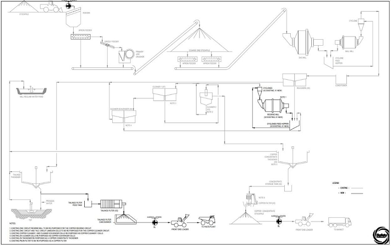
(Source: Ausenco, 2024)
| Project No.: 253821 | | Processing and Recovery Methods | | |
| January 2025 | | Page 14-2 | |
| Bornite Project |
| Northwest Alaska, USA |
| S-K 1300 Technical Report Summary on the Initial Assessment |
Table 14-1: List of Arctic Circuit Status for Bornite
| Description | | Status | | Notes |
| Crushing Circuit | | Repurposed | | Crusher unchanged. Feed now loaded by FEL. |
| Plant Feed Stockpiling | | Repurposed | | Unchanged |
| Grinding Circuit | | Repurposed | | Primary P80 grind size increased to 100 µm |
| Talc Pre-float | | De-commissioned | | Pre-float Jameson Cell will be repurposed for copper 2 cleaning circuit |
| Copper-Lead Rougher | | Repurposed | | Copper bulk roughers only |
| Copper-Lead Separation | | Repurposed | | Copper cleaners flotation only |
| Copper Regrind | | Repurposed | | New regrind mill required for additional regrinding power |
| Lead Rougher/Cleaners | | De-commissioned | | - |
| Zinc Rougher/Cleaners | | Repurposed | | · Zinc Cleaner 1 cells repurposed as copper cleaner scavenger cells · Zinc Cleaner 2 Jameson cell repurposed as copper 2nd cleaners |
| Zinc Regrind | | Repurposed | | To be repurposed as copper rougher concentrate regrind mill |
| Copper Conc. Thickening | | Repurposed | | - |
| Copper Conc. Filtration | | Repurposed | | - |
| Lead Concentrate Thickening | | De-commissioned | | - |
| Zinc Concentrate Thickening | | Repurposed | | As copper concentrate thickener |
| Lead/Zinc Concentrate Filtration | | Repurposed | | As copper concentrate filter |
| Tailings Disposal | | Repurposed | | - |
| Tailings Filtration | | Added | | New tailings filtration circuit |
| Project No.: 253821 | | Processing and Recovery Methods | | |
| January 2025 | | Page 14-3 | |
| Bornite Project |
| Northwest Alaska, USA |
| S-K 1300 Technical Report Summary on the Initial Assessment |
Table 14-2: Process Design Criteria
| Item | | Type | | Unit | | | Value | |
| Plant Design Capacity | | | | | t/a | | | | 3,358,000 | |
| Plant Nominal Capacity | | | | | t/a | | | | 2,336,000 | |
| Plant Design Capacity | | | | | t/d | | | | 10,000 | |
| Operating Hours per Year | | | | | h/a | | | | 5,840 | |
| Operating Availability – Crushing | | | | | % | | | | 70 | |
| Operating Availability – Process Plant | | | | | % | | | | 96 | |
| Operating Availability – Filtration | | | | | % | | | | 85 | |
| Plant Feed Grades – Copper, Average LOM | | | | | % | | | | 2.66 | |
| Crushing (Single Stage) | | Jaw Crusher | | | | | | | | |
| Crushing Feed Size, 80% Passing | | | | | mm | | | | 158 | |
| Crusher Closed Side Setting (CSS) | | | | | mm | | | | 100 | |
| Grinding | | SAG Mill, Ball Mill | | | | | | | | |
| Bond Ball Mill Work Index, Design | | | | | kWh/t | | | | 9.52 | |
| Bond Abrasion Index, Design | | | | | g | | | | 0.054 | |
| Grinding Circuit Product Size, P80 | | | | | µm | | | | 100 | |
| Copper Bulk Rougher Flotation | | Conventional Tank Cells | | | | | | | | |
| Stage Recovery to Concentrate, mass (nom) | | | | | % of Plant Feed | | | | 20.0 | |
| Regrind Mill | | Ball Mills | | | | | | | | |
| Product Particle Size P80 | | | | | µm | | | | 20 | |
| Copper Cleaners | | Conventional, Jameson | | | | | | | | |
| Stage Recovery to Concentrate, mass (nom) | | | | | % of Plant Feed | | | | 10.6 | |
| Copper Recovery, Design | | | | | % | | | | 90.5 | |
| Concentrate Dewatering | | Thickener, Horizontal Plate Filter | | | | | | | | |
| Thickener Solids Flux Rate | | | | | t/m2.h | | | | 0.25 | |
| Nominal Concentrate Filter Cake Moisture | | | | | %w/w | | | | 6 | |
| Cycle Time | | | | | mins | | | | 12.0 | |
| Tailings Dewatering | | Thickener, Vertical Plate Filter | | | | | | | | |
| Thickener Solids Flux Rate | | | | | t/m2.h | | | | 1.0 | |
| Nominal Tailings Filter Cake Moisture | | | | | %w/w | | | | <10 | |
| Cycle Time | | | | | mins | | | | 12.5 | |
| Note: | Design throughput based upon 8,760 operating hours at 92% plant availability. Operating availability based on major maintenance activities completed during off weeks. |
| Project No.: 253821 | | Processing and Recovery Methods | | |
| January 2025 | | Page 14-4 | |
| Bornite Project |
| Northwest Alaska, USA |
| S-K 1300 Technical Report Summary on the Initial Assessment |
The Bornite processing plant will be designed to process 10,000 t/d of mineralized material on a two week on, one week off campaign basis. The plant will require a total of 83 personnel for operation, comprised of 40 operations and laboratory, and 43 maintenance staff. The plant will utilize a repurposed Arctic process equipment and infrastructure at the end of the Arctic mine life. All equipment outlined in the plant area descriptions below will be existing, unless mentioned otherwise.
ROM mineralized material from the Bornite underground mine will be trucked to the processing plant by dual trailer tractor trailers and dumped onto a ROM stockpile next to the existing crushing station dump hopper. Plant feed will be reclaimed from the ROM stockpile by a FEL and discharged into a 200-tonne receiving bin protected with a 1,000 mm aperture stationary grizzly. Material will be reclaimed from the bin with an apron feeder and scalped of fines using a 75 mm aperture vibrating grizzly. The grizzly oversize will be passed onto the primary jaw crusher with a closed side setting of 100 mm. The crushed material together with the grizzly undersize, will be discharged to the primary jaw crusher discharge conveyor. A tramp metal magnet will be installed at the head end of the primary jaw crusher conveyor to remove tramp metal before material is discharged onto the stockpile feed conveyor. Crushed material will be directed to a single covered conical stockpile via the stockpile feed conveyor.
| 14.4.2 | Coarse Material Storage |
The coarse material stockpile will have a live capacity of 5,000 tonnes, equivalent to approximately 12 hours of mill feed at the nominal mill feed rate. The stockpile total capacity will be approximately 20,000 tonnes. The coarse material stockpile will be a covered facility to mitigate freezing of the stockpiled material. The stockpile cover will be equipped with a dust collecting system and there will be sufficient space to allow for the operation of mobile equipment as required. Material will be reclaimed from the stockpile by two duty apron feeders; however, each feeder will be capable of maintaining the mill feed rate should one feeder be down for maintenance. The apron feeders will discharge onto the SAG mill feed conveyor.
| Project No.: 253821 | | Processing and Recovery Methods | | |
| January 2025 | | Page 14-5 | |
| Bornite Project |
| Northwest Alaska, USA |
| S-K 1300 Technical Report Summary on the Initial Assessment |
| 14.4.3 | Grinding and Classification |
The grinding circuit will consist of a 3 MW SAG mill followed by a 6 MW ball mill operating in a closed circuit with a hydrocyclone cluster. The nominal feed throughput will be 453 t/h, matching the original throughput of the Arctic FS. The grinding circuit will reduce the crushed material particle size to a P80 of 100 µm.
SAG mill feed will report to the SAG mill from the SAG mill feed conveyor and SAG mill product will discharge onto a trommel screen, where the undersize will report to a hydrocyclone feed sump and the oversize to a scats bunker.
Slurry is pumped from the hydrocyclone feed sump to the ball mill cyclone cluster. The cyclone cluster underflow stream will report to the ball mill and the ball mill discharge reports to the hydrocyclone where it is combined with the SAG mill discharge. Process water will be added to the milling circuit and hydrocyclone feed pumpbox to maintain a target slurry density in the mill and the feed to the cyclones. The ball mill cyclone cluster overflow, with a P80 of 100 µm and a target solids density of 37%, will gravitate to the flotation circuit.
The Arctic FS plant flowsheet features a talc pre-float circuit followed by three separate rougher cleaner lines for metal concentrate production of copper, zinc and lead. The plant will utilize the bulk copper flotation line with some additional Jameson and cleaner cells repurposed from the other metal flotation circuits to ensure optimal metal recovery.
The ball mill hydrocyclone overflow will feed the copper rougher bulk flotation cells, where rougher copper concentrate will be produced. The conventional rougher flotation tank cell bank in the Arctic plant will be used.
The bulk copper concentrate stream P80 grind size will be reduced to 20 µm prior to further flotation cleaning stages. The bulk rougher concentrate stream will be reground in three parallel ball regrind mill circuits; two existing and one new. The existing mills include the 600 kW copper regrind mill and the 355 kW zinc regrind mill, which will be reconfigured as a copper regrind mill. One new 2,000 kW regrind ball mill will be installed to meet the increased total regrind power requirement. Each regrind mill circuit will operate in closed circuit with hydrocyclones.
The reground material will undergo two stages of cleaning with the 1st stage of cleaner and cleaner scavenger flotation conducted in conventional tank cells and the 2nd stage of flotation completed in a Jameson cell. The 2nd cleaner tailings will be reprocessed in the 1st cleaner flotation stage.
| Project No.: 253821 | | Processing and Recovery Methods | | |
| January 2025 | | Page 14-6 | |
| Bornite Project |
| Northwest Alaska, USA |
| S-K 1300 Technical Report Summary on the Initial Assessment |
Due to the expected metallurgical equipment loadings of the Bornite material:
| · | The existing conventional copper cleaner 1 and cleaner-scavenger cells will be repurposed as the copper cleaner 1 flotation cells. |
| · | The conventional tank cells from the zinc cleaner circuit will be repurposed as the copper cleaner-scavenger cells. |
| · | Jameson cells from the pre-flotation and zinc circuit will be integrated into the copper cleaner 2 flotation circuit and will operate in parallel to the existing copper Jameson cell. |
Copper flotation dilution water and launder sprays will be supplied by a dedicated process-water system. The supply for this system will be a combination of concentrate thickener overflow and plant process water.
Collector Aerophine 3418A, frother MIBC and pH modifier lime reagents will be added throughout the flotation circuit to assist with selective copper flotation.
The copper concentrate from the second cleaner circuit will be pumped to two high-rate thickeners; the existing copper concentrate thickener and the zinc concentrate thickener, which will be repurposed for Bornite material. Flocculant will be added to each thickener to assist in solid settling and water recovery. The copper and repurposed zinc concentrate thickener underflow streams will be thickened to an underflow density of 65% w/w solids and will be pumped to their respective copper and repurposed zinc concentrate agitated storage tank prior to filtering. Each concentrate storage tank will feed an existing dedicated concentrate tower pressure filter, which will dewater the concentrate filter cake to the target moisture content of 6%.
The copper concentrate produced from both filters will be discharged onto product stockpiles from which FELs will load concentrate into containers for shipment. Filtrate from each filter will return to their respective concentrate thickener for solids capture and water recovery.
| 14.4.5 | Tailings Disposal and Tailings Filter Cake Production |
Tailings from the rougher flotation and cleaner scavenger flotation streams will be combined and will report to the existing 32 m diameter high-rate tailings thickener. Flocculant will be added to improve settling of the tailings and to assist in water recovery. The overflow from the high-rate thickener will report to the process pond from where it will be pumped to the process water tank for distribution in the plant. The thickener underflow will be thickened to 60% w/w solids and pumped to a new agitated tailings stock tank.
| Project No.: 253821 | | Processing and Recovery Methods | | |
| January 2025 | | Page 14-7 | |
| Bornite Project |
| Northwest Alaska, USA |
| S-K 1300 Technical Report Summary on the Initial Assessment |
Due to Bornite’s underground mine requiring paste for backfill operations, up to 5,000 t/d of thickened tailings can be dewatered using pressure filters to produce a suitable filter cake for paste backfill at the Bornite mine site. Tailings from the stock tank will be pumped to two new high-capacity pressure filters, producing a filter cake at a 9% target moisture. Filter cake will be discharged into a stockpile bunker, which will be continually serviced by FELs to load the dual trailer tractor trailers returning back to the Bornite site.
Tailings from the stock tank will also be pumped to the tailings pumpbox, from where the tailings will be pumped to the TSF. Process water will be added to the tailings pumpbox, as required, to maintain the velocity in the tailings pipeline and prevent material settling.
Existing water pump barges in the tailings pond will reclaim water to the process water ponds.
| 14.4.6 | Reagent Handling and Storage |
Chemical reagents will be added in the grinding and flotation circuits to modify the mineral particle surfaces and enhance the flotability of the valuable mineral particles into the concentrate product. Flocculant is required to assist with solid settling and water recovery in the concentrate and tailings thickeners. The reagents will be prepared and stored in an existing separate, self-contained areas inside the process plant and dosed by individual metering pumps or centrifugal pumps to the addition points. Reagents requiring make-up will be prepared using fresh water via bulk reagent handling systems including mixing and holding tanks.
Table 14-3 presents the anticipated yearly consumption of key reagents.
Table 14-3: Nominal Reagent Consumption
| Item | | Unit | | | Consumption per Operating
Year | |
| Collector | | t/a | | | | 55.6 | |
| Frother | | t/a | | | | 15.8 | |
| Flocculant | | t/a | | | | 37.6 | |
| Quicklime | | t/a | | | | 2,085.4 | |
| Antiscalant | | t/a | | | | 22.2 | |
| 14.4.6.1 | Collector (Aerophine 3418A) |
Aerophine 3418A will be delivered as liquid through IBC totes. It will be dosed to the copper flotation circuit via metering pumps without dilution to aid the flotation process.
| Project No.: 253821 | | Processing and Recovery Methods | | |
| January 2025 | | Page 14-8 | |
| Bornite Project |
| Northwest Alaska, USA |
| S-K 1300 Technical Report Summary on the Initial Assessment |
MIBC frother will be delivered as liquid through IBC totes. The reagent will be dosed at the supplied strength and delivered to the copper flotation circuit via existing metering pumps.
Flocculant solution will be prepared with the existing preparation system, which features a screw feeder, flocculant educator and mixing equipment. The flocculant will be prepared to a 0.5% w/v solution strength and will be added through metering pumps to the concentrate and tailing thickener feed wells.
Quicklime in the form of unslaked pebbles will be trucked onto site in 2-tonne supersacks. Lime will manually loaded into a lime powder hopper from where it will be conveyed to the lime slaker and slaked with water. The slaked lime will be stored in an agitated mixing tank and distributed to the addition points via lime slurry loop.
Anti-scaling chemicals will be required to minimize scale buildup over the LOM, especially in the reclaim or recycle water lines. These chemicals will be delivered in liquid form and metered directly into the intake of the reclaim water pumps and process water tanks.
Consumable rates are based upon comminution data, vendor estimates and historical benchmarks. A summary of the consumption of process materials is listed in Table 14-4.
Plant power will be derived from the existing diesel-powered generator set installed for the Arctic plant. The hourly operating power consumption of the Bornite process plant is estimated to be approximately 16.5 MW, which is less than the total output capacity of 21.6 MW sourced from the existing four operating diesel generators.
| Project No.: 253821 | | Processing and Recovery Methods | | |
| January 2025 | | Page 14-9 | |
| Bornite Project |
| Northwest Alaska, USA |
| S-K 1300 Technical Report Summary on the Initial Assessment |
Table 14-4: Nominal Process Material Consumption
| Item | | Unit | | | Nominal Consumption Rate
per Year | |
| Jaw Liners | | sets/a | | | | 1.33 | |
| SAG Mill Liners | | sets/a | | | | 0.67 | |
| Ball Mill Liners | | sets/a | | | | 0.67 | |
| Primary Grind Media | | t/a | | | | 667 | |
| Regrind Mill Liners (Per Mill) | | sets/a | | | | 0.67 | |
| Regrind Mill Media | | t/a | | | | 128 | |
| Concentrate Filter Cloths | | sets/a | | | | 11.5 | |
| Tailings Filter Cloths | | sets/a | | | | 8.5 | |
Water supply is sourced from three separate systems: a freshwater system, a waste rock contact pond (WRCP) water supply system, and a process water supply system. The plant water makeup required during operation is expected to be 109 m3/h for a total of 614 ML/a.
| 14.4.9.1 | Fresh Water Supply System |
Fresh water will be used for fire water and potable water applications, supplied from the ground water wells.
| 14.4.9.2 | Waste Rock Contact Pond Water Supply System |
WRCP water will be fed to the TSF during winter months and treated and discharged in the summer. Additional process water will be supplied from the WRCP to the TSF.
| 14.4.9.3 | Process Water Supply System |
Process water for the process plant will be supplied from the process pond which is fed by the tailings thickener overflow and reclaimed water from the TSF. Contact water is another source for makeup water. The process water will be stored and distributed to the process plant and other service locations from the process water tank.
| Project No.: 253821 | | Processing and Recovery Methods | | |
| January 2025 | | Page 14-10 | |
| Bornite Project |
| Northwest Alaska, USA |
| S-K 1300 Technical Report Summary on the Initial Assessment |
High-pressure compressed air will be provided by three duty and one standby screw compressors and a duty plant air receiver. The instrument air will be dried and then stored in a dedicated air receiver.
High-pressure air for the concentrate filters will be supplied from existing dedicated compressed air and receiver systems.
High-pressure air for the new tailings filters will come from a new and dedicated compressed air system consisting of two dual rotary screw compressors and air receivers.
Low-pressure air for the conventional flotation-cell air requirements will be provided by the existing duty and standby centrifugal blowers.
| Project No.: 253821 | | Processing and Recovery Methods | | |
| January 2025 | | Page 14-11 | |
| Bornite Project |
| Northwest Alaska, USA |
| S-K 1300 Technical Report Summary on the Initial Assessment |
The onsite site infrastructure required for the Bornite Project includes:
| · | South route improvements and onsite roads |
| · | Underground portal and services |
| · | Mine office and mine dry |
| · | Truck shop/maintenance/warehouse |
| · | Diesel storage and distribution |
| · | Power plant and electrical distribution modules |
| · | Dewatering wells and upgraded Ruby Creek section |
| · | Surface water diversion/ditches |
| · | Water treatment plant (WTP) and pond |
Preliminary estimates indicate that approximately 1.0Mt of NAG waste will be required to construct the designed facilities at Bornite. Bornite is expected to produce approximately 1.6Mt of NAG during pre-production from the underground mine development, and will be available for construction.
The proposed site layout is shown later in Figure 15-1.
| Project No.: 253821 | | Infrastructure | | |
| January 2025 | | Page 15-1 | |
| Bornite Project |
| Northwest Alaska, USA |
| S-K 1300 Technical Report Summary on the Initial Assessment |
Figure 15-1: Bornite Site Layout
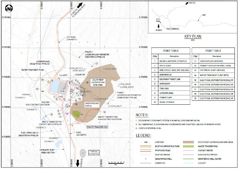
(Source: Wood, 2024)
| Project No.: 253821 | | Infrastructure | | |
| January 2025 | | Page 15-2 | |
| Bornite Project |
| Northwest Alaska, USA |
| S-K 1300 Technical Report Summary on the Initial Assessment |
| 15.1.2 | Advanced Exploration Decline Infrastructure |
Following completion of the AEX decline outlined in Section 13.0, there will be limited facilities related to support of the underground exploration, such as:
| · | Process water supply tanks |
| · | Main portal ventilation fan |
| · | Temporary power generation. |
Most facilities that are expected to be utilized for AEX decline construction will be utilized during pre-production to support mine development, but will be insufficient for production, and will be replaced or upgraded to the infrastructure outlined in this section.
The area will be accessed by the proposed AAP road which is approximately 340 km long, extending from the Dalton Highway to the east (Figure 15-2).
The site will be accessible from the north, along the south route from the AAP road and from the south from the Dahl Creek airport. It is assumed that the road from the airport to the Bornite site, developed for the Arctic project, will meet the needs for transporting personnel and materials.
The Bornite Project considers approximately 4.5 km of the south route, from the Bornite mine site to the AAP road will need to expand the width from 6 m to 12 m.
| Project No.: 253821 | | Infrastructure | | |
| January 2025 | | Page 15-3 | |
| Bornite Project |
| Northwest Alaska, USA |
| S-K 1300 Technical Report Summary on the Initial Assessment |
Figure 15-2: Site Road Access

(Source: Ambler, 2023)
There are existing roads on site related to exploration and past activities. An allowance for 2 km of a 12-m wide road around the Bornite surface facilities has been considered.
An allowance for 3.5 km of single-laned gravel roads has been considered to access dewatering wells and site surface facilities (Figure 15-1).
The waste transfer pad will temporarily store low-grade and waste material from the underground mine workings that will be hauled to the Arctic waste rock facility. Low-grade material will be stockpiled as production feed to the Arctic process plant at the end of mine life. The majority of the waste material is considered non-acid generating (NAG) with some potentially acid generating (PAG) material. It is assumed that the NAG material will be made available for site construction and road-base needs.
| Project No.: 253821 | | Infrastructure | | |
| January 2025 | | Page 15-4 | |
| Bornite Project |
| Northwest Alaska, USA |
| S-K 1300 Technical Report Summary on the Initial Assessment |
During pre-production, the waste transfer pad will be utilized for stockpiling of pre-production development mineralized material to be hauled to Arctic when milling commences.
The waste transfer pad was designed with a downhill slope of 3H:1V and has a capacity of approximately 40,000 tonnes. A swell factor of 40% was used for estimating volumes. The waste transfer pad has capacity for the low-grade underground mine waste that can be used for production feed at end of mine life.
A topsoil stockpile located south of the underground portal has a volume of approximately 100,000 m3. This considers the stripping of 0.5 m of topsoil from the area of the waste transfer pad, ROM stockpile, paste plant, portal, and surface building facilities.
A ROM stockpile is a short distance from the underground portal. Mineralized material will be placed on the stockpile from the underground conveyor material handling system.
The ROM stockpile has a capacity of approximately 30,000 tonnes equating to five days of production.
The ROM stockpile will serve as the loading point for haulage to the Arctic mill by the OTR truck fleet.
Water management facilities are defined for major needs including surface water diversions/ditches, settling pond, underground dewatering, and water treatment. Many water management components are influenced by integration with both the mine plan and other water management facilities and will likely be influenced by environmental and permitting requirements that are not fully defined at this stage of planning; modifications are likely as project planning advances.
Allowances have been made in capital and operating costs for heat tracing and insulation of piping.
Figure 15-1 presents the site general arrangement, showing the location of various components of water management infrastructure.
| Project No.: 253821 | | Infrastructure | | |
| January 2025 | | Page 15-5 | |
| Bornite Project |
| Northwest Alaska, USA |
| S-K 1300 Technical Report Summary on the Initial Assessment |
Dewatering Quantities
The approach to dewatering for the underground assumed a strategy of reducing clean non-contact water from contact with mining facilities where possible, to reduce both potential treatment needs and improve working conditions. Dewatering quantities were based on scaling from previous work (SRK, 2025) and assumptions about various other water management facilities. Underground perimeter dewatering is assumed to occur over two phases. Dewatering from within the underground will still be required despite perimeter dewatering. Dewatering quantities are summarized in Table 15-1.
Table 15-1: Dewatering Quantities
| | | Quantity | | Infrastructure | | Water Type |
| Ruby Creek Valley | | 8,400 m3/d | | 6 pumping wells in Ruby Creek valley
@ 1,400 m3/d each | | Non-contact |
| Underground | | 16,500 m3/d | | Phase 1 Shallow: 3 pumping wells
@ 5,500 m3/d each | | Non-contact |
| | 16,500 m3/d | | Phase 2 Deep: 3 pumping wells
@ 5,500 m3/d each + 2 backup | | Non-contact |
| | | 5,000 m3/d | | Underground sump | | Contact |
Key assumptions for quantities:
| · | Underground inflow estimates can be scaled from previous work based on a combination of difference in depths of excavation and catchment area with associated reductions in direct precipitation and runoff (SRK, 2025). |
| · | Upgrade of the Ruby Creek section reduces recharge into contact zone by 50%. |
| · | Pumping wells in Ruby Creek valley alongside the upgrade further reduce remaining flow in valley bottom that can recharge contact zone. |
| – | Water pumped from the dewatering wells is assumed to be non-contact and can be discharged to the environment. |
| Project No.: 253821 | | Infrastructure | | |
| January 2025 | | Page 15-6 | |
| Bornite Project |
| Northwest Alaska, USA |
| S-K 1300 Technical Report Summary on the Initial Assessment |
Underground Dewatering Infrastructure
Underground dewatering is assumed to occur using peripheral dewatering wells, which will both reduce water to be managed in the underground and the amount of contact water directed to the WTP. The peripheral dewatering wells will be implemented over two phases. Assumptions for peripheral underground dewatering wells are:
Phase 1 – Shallow Wells
| · | Wells targeting contact zone completed to depths of 340 to 390 m below ground |
| · | 18-inch well completions; mild steel louvered well screen |
| · | 5,500 m3/d pumping rate each |
| · | 675 HP submersible turbine pumps |
| · | Water pumped from the dewatering wells is assumed to be non-contact and can be discharged to the environment. |
Underground dewatering well locations are shown in Figure 15-1 and depths are summarized in Table 15-2.
Table 15-2: Phase 1 Underground Dewatering Wells
Drill Hole
Name | | Easting | | | Northing | | | Elevation
(m) | | | Azimuth
(o) | | | Dip
(o) | | | Target Depth
(m) | |
| UGDW_006-P1 | | | 590652 | | | | 7440026 | | | | 301 | | | | 0 | | | | 90 | | | | 350 | |
| UGDW_007-P1 | | | 590142 | | | | 7440270 | | | | 274 | | | | 0 | | | | 90 | | | | 390 | |
| UGDW_008-P1 | | | 590425 | | | | 7440148 | | | | 301 | | | | 0 | | | | 90 | | | | 340 | |
Phase 2 – Deep Wells
| · | Three duty wells + two installed standby wells |
| · | Wells targeting contact zone completed to depths of 450 to 540 m below ground |
| · | 18-inch well completions; mild steel louvered well screen |
| · | 5,500 m3/d pumping rate each |
| · | 900 HP submersible turbine pumps |
| · | Water pumped from the dewatering wells is assumed to be non-contact and can be discharged to the environment. |
Underground dewatering well locations are shown in Figure 15-1 and depths are summarized in Table 15-3.
| Project No.: 253821 | | Infrastructure | | |
| January 2025 | | Page 15-7 | |
| Bornite Project |
| Northwest Alaska, USA |
| S-K 1300 Technical Report Summary on the Initial Assessment |
Even with peripheral dewatering wells, some water will still seep into the underground operation. Assumptions for pumping of residual inflow from within the underground are:
| · | Sumps with sediment removal |
| · | 5,000 m3/d cumulative max pumping rate |
| · | Sumps, pumps and water lines provided by others as part of underground utilities |
| · | Water pumped from the underground mine is assumed to be mine contact water and will be directed to the water treatment pond. |
Table 15-3: Phase 2 Underground Dewatering
| Drill Hole Name | | Easting | | | Northing | | | Elevation (m) | | | Azimuth
(o) | | | Dip (o) | | | Target Depth
(m) | |
| UGDW_001 -P2 | | | 590199 | | | | 7440659 | | | | 250 | | | | 0 | | | | 90 | | | | 530 | |
| UGDW_002 -P2 | | | 590811 | | | | 7440364 | | | | 323 | | | | 0 | | | | 90 | | | | 530 | |
| UGDW_003 -P2 | | | 590244 | | | | 7440648 | | | | 259 | | | | 0 | | | | 90 | | | | 540 | |
| UGDW_004 -P2 | | | 590567 | | | | 7440648 | | | | 318 | | | | 0 | | | | 90 | | | | 450 | |
| UGDW_005 -P2 | | | 590848 | | | | 7440346 | | | | 326 | | | | 0 | | | | 90 | | | | 450 | |
Ruby Creek Valley Dewatering Infrastructure
Pumping wells are positioned in the Ruby Creek valley with the primary objective of further reducing water in the valley bottom that could recharge the contact zone influencing groundwater inflow into the underground. Assumptions for pumping wells within the Ruby Creek Valley are:
| · | Wells completed to average depth of 38 m below ground |
| · | 10-inch well completions; stainless steel wire-wrap screens |
| · | 1,400 m3/d pumping rate each |
| · | 15 HP submersible turbine pumps |
| · | Water pumped from the dewatering wells is assumed to be non-contact and can be discharged to the environment. |
Ruby Creek valley dewatering well locations are shown in Figure 15-1 and depths are summarized in Table 15-4.
| Project No.: 253821 | | Infrastructure | | |
| January 2025 | | Page 15-8 | |
| Bornite Project |
| Northwest Alaska, USA |
| S-K 1300 Technical Report Summary on the Initial Assessment |
Table 15-4: Ruby Creek Valley Dewatering Wells
| Drillhole Name | | Easting | | | Northing | | | Elevation
(m) | | | Azimuth (o) | | | Dip (o) | | | Target Depth
(m) | |
| RVDW001 | | | 589718 | | | | 7439435 | | | | 214 | | | | 0 | | | | 90 | | | | 30 | |
| RVDW002 | | | 589796 | | | | 7439494 | | | | 213 | | | | 0 | | | | 90 | | | | 30 | |
| RVDW003 | | | 589579 | | | | 7439670 | | | | 209 | | | | 0 | | | | 90 | | | | 40 | |
| RVDW004 | | | 589422 | | | | 7439970 | | | | 205 | | | | 0 | | | | 90 | | | | 50 | |
| RVDW005 | | | 589229 | | | | 7440170 | | | | 205 | | | | 0 | | | | 90 | | | | 40 | |
| RVDW006 | | | 589332 | | | | 7440195 | | | | 204 | | | | 0 | | | | 90 | | | | 40 | |
| 15.1.8.2 | Surface Water Management |
Surface water management infrastructure includes non-contact water diversions, sediment and contact water control ditches, settling pond, conveyances, and upgrades to sections of Ruby Creek to limit infiltration to underground workings (Figure 15-1). Flow rates and design events used for sizing of water management infrastructure, including the upgraded Ruby Creek section, were based on the hydrology assessment developed for the Arctic project (SRK, 2022).
Stormwater Methodology
Evaluation of design flows for surface water infrastructure was performed using the HEC-HMS software, developed by the U.S. Army Corps of Engineers (USACE), applying the Soil Conservation Service (SCS) Curve Number (CN) method. The CN is a dimensionless parameter based on land use, soil type, hydrologic condition, and antecedent moisture condition (AMC). A CN of 50 was selected for normal conditions for the site catchments, based on calibration of the model to measured peak flows in Ruby Creek. For extreme conditions, such as the 100-year or Probable Maximum Precipitation, a higher CN of 70 was selected to reflect wetter antecedent moisture conditions.
Catchment boundaries were generated using project contours. These boundaries determine the location and amount of area draining into the water treatment pond and ditches. Peak flow rates represent the highest rates generated from summer storms (July to September) and are defined using the 24-hour, 1:100-year event. The upgraded Ruby Creek section described below, is designed to the 1:200-year event as consequences from overflow (increased recharge to underground) are assumed to be higher risk.
| Project No.: 253821 | | Infrastructure | | |
| January 2025 | | Page 15-9 | |
| Bornite Project |
| Northwest Alaska, USA |
| S-K 1300 Technical Report Summary on the Initial Assessment |
Upgraded Ruby Creek Section
The upgraded Ruby Creek section is intended to disconnect flow in Ruby Creek from underlying valley bottom sediments to reduce infiltration into the underground. Assumptions for the upgrade are:
| · | Design capacity for Q200 = 60 m3/s (ranges between 40 to 90 m3/s) |
| · | 10 m wide base x 1.5 to 3 m depth (3H:1V slopes) |
| · | High density polyethene (HDPE) liner |
| · | Minimal riprap requirements. |
No specific assumptions regarding intake nor outfall designs have been made. Further design will also be required for construction upgrades, fisheries considerations, and any influence of permafrost.
It is assumed that the upgrade can be decommissioned once mining is complete and closure activities have proceeded to an acceptable stage.
Non-Contact Diversion and Contact Water Control Ditches
The diversion ditches will intercept any water runoff before it becomes contact-water. Contact-water is runoff that comes into contact with disturbed/mined rock and that has the potential to leach environmentally harmful minerals or compounds. This water needs to be treated before being released to the environment. By diverting watershed area waters from around the mined rock, the amount of contact-water requiring mechanical treatment is minimized.
Ditches were designed based on general design requirements. Ditches are designed to handle the peak 24-hour, 1:100-year flow event and will require either riprap to protect against high flow velocities (>5 m/s for non-contact ditch) or liner to prevent leakage (contact water ditch). Table 15-5 summarizes ditch designs.
Table 15-5: Diversion Ditches
| Ditch | | | Length
(m) | | | Depth
(m) | | | Type | | Side Slope
(H:V) |
| Non-Contact | | | | 650 | | | | 2.0 | | | Trapezoidal, base with 1.5 m | | 2.5:1 |
| Contact | | | | 150 | | | | 1.0 | | | V-ditch | | 2.5:1 |
| Project No.: 253821 | | Infrastructure | | |
| January 2025 | | Page 15-10 | |
| Bornite Project |
| Northwest Alaska, USA |
| S-K 1300 Technical Report Summary on the Initial Assessment |
Water Treatment Pond
A water treatment pond will be required for both sediment removal and influent control for the WTP. Though the waste transfer pad is expected to be non-PAG, runoff/seepage from the facility as well as underground dewatering (underground inflow only, not perimeter dewatering wells) will be directed to the combined sediment/WTP influent retention pond upstream of the WTP.
The WTP influent retention pond is designed to store the greater of the maximum monthly stored volume, estimated using a monthly site-wide water balance, plus a 100-year 24-hour inflow volume, or the maximum monthly stored volume during a 100-year wet-year. In addition, as the pond is expected to contain contact water, it is designed to handle the peak flow resulting from a Probable Maximum Flood (PMF) event through an emergency overflow spillway. This design criteria is consistent with the Alaskan regulatory requirements for a Class II dam, as defined by the Alaska Department of Natural Resources (DNR) Dam Safety Program. Note that the current water treatment pond configuration does not anticipate the need for dams but may be classified as such should the quality of impounded water be poor. Table 15-6 summarizes the water treatment pond design.
Table 15-6: Water Treatment Pond Design
| Pond | | Type | | Area
(m2) | | | Liner | |
| Water treatment pond | | Settling
WTP influent storage
Contact | | 25,000
(3.0 m depth) | | | Lined | |
Conveyance Pipelines
Pipelines will be required to convey water from dewatering wells and dewatering from the underground, as well as contact water runoff from the waste transfer pad and the ROM stockpile. For the purposes of the IA, all pipelines are assumed to be 12-inch diameter HDPE with insulation and heat trace. Table 15-7 summarizes conveyance pipelines.
| Project No.: 253821 | | Infrastructure | | |
| January 2025 | | Page 15-11 | |
| Bornite Project |
| Northwest Alaska, USA |
| S-K 1300 Technical Report Summary on the Initial Assessment |
Table 15-7: Pipelines
| Pipeline | | Type | | Length
(m) | |
| Phase 2 Underground Perimeter Dewatering | | Gravity Non-contact | | | 1,815 | |
| Ruby Creek Wells Dewatering | | Gravity Non-contact | | | 1,500 | |
| Underground Dewatering | | Gravity Contact | | | 1,500 | |
| Phase 1 Underground Perimeter Dewatering | | Gravity Non-contact | | | 1,000 | |
| Waste Transfer Pad Contact Water | | Gravity Contact | | | 700 | |
Contact water will require treatment. Treatment assumptions include the following:
| · | Treatment design capacity of 5,250 m3/d |
| - | Waste transfer pad: 250 m3/d (average, with surge storage provided by the water treatment pond) |
| · | Dissolved metals and total suspended solids removal using lime treatment |
| · | Ammonia/nitrate/nitrite removal using aerobic and anaerobic moving bed bioreactors |
| · | Treatment will remove common metals/N-nutrients, but not oxyanions (Se, Sb, Mo and U). |
The WTP footprint would be similar to the design shown in Figure 15-3.
| Project No.: 253821 | | Infrastructure | | |
| January 2025 | | Page 15-12 | |
| Bornite Project |
| Northwest Alaska, USA |
| S-K 1300 Technical Report Summary on the Initial Assessment |
Figure 15-3: Representative Treatment Plant Footprint and Layout
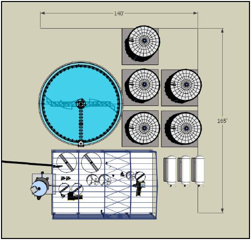
(Source: SRK, 2023b)
| 15.1.9 | Ancillary Buildings |
The ancillary buildings are concentrated around the flat-laying area of the current Bornite Camp. This area provides a suitable flat location proximal to the underground portal for required infrastructure. In this area there will be the following buildings:
| · | Mine office and mine dry building (prefabricated) |
| · | Truck shop with a maintenance and warehouse bay |
| · | Ready line (parking lot) and tire yard for mine fleet |
| · | Power plant and diesel storage area |
The Project will utilize the Arctic explosives storage and magazine.
| Project No.: 253821 | | Infrastructure | | |
| January 2025 | | Page 15-13 | |
| Bornite Project |
| Northwest Alaska, USA |
| S-K 1300 Technical Report Summary on the Initial Assessment |
| 15.1.10 | Power and Distribution |
The portal power system is designed with redundancy to ensure reliable power supply. This minimizes the risk of power failures and ensures uninterrupted operation by minimizing downtime.
Bornite mine and Arctic processing plant will be run on two separate grids with independent power generation.
| 15.1.10.1 | Bornite Power Demand |
Table 15-8 presents the average, maximum and peak demand loads required by the Bornite site.
Table 15-8: Power Demand by Area
| Area | | Load
(kWe) | |
| Average Load | | | |
| Mobile equipment | | | 527 | |
| Primary ventilation | | | 2,311 | |
| Secondary ventilation | | | 1,417 | |
| Mine dewatering | | | 3,893 | |
| Mine conveyor | | | 1,262 | |
| Hydraulic fill plant | | | 485 | |
| Mining miscellaneous | | | 88 | |
| Surface facilities | | | 1,863 | |
| Total Average Load | | | 11,846 | |
| Maximum Load Demands | | | | |
| Mobile equipment | | | 888 | |
| Primary ventilation | | | 2,682 | |
| Secondary ventilation | | | 2,910 | |
| Mine dewatering | | | 4,604 | |
| Mine conveyor | | | 1,662 | |
| Hydraulic fill plant | | | 971 | |
| Mining miscellaneous | | | 140 | |
| Surface facilities | | | 1,899 | |
| Total Maximum Load | | | 15,756 | |
| Peak Demand | | | 13,310 | |
| Project No.: 253821 | | Infrastructure | | |
| January 2025 | | Page 15-14 | |
| Bornite Project |
| Northwest Alaska, USA |
| S-K 1300 Technical Report Summary on the Initial Assessment |
| 15.1.10.2 | Bornite Power Plant |
The Bornite portal power plant will comprise six diesel gensets, each with an output rating of 3,600 kW, 4160 V, three-phase, 60 Hz, 0.8 power factor. The power plant is configured for N+1 operation. Under peak load conditions five generators will be operational with the sixth generator in a standby mode. Table 15-9 shows the power consumption and the number of generators operating when the portal is fully operational.
The gensets and other large modules will be installed in walk-in Arctic enclosures, complete with sub-base fuel day-tank, heat recovery, alternating current (AC) and direct current (DC) auxiliary services, automatic fire detection (FM 200), alarm and suppression systems. Medium voltage (MV) switchgear and ancillary services will be installed in modular E-houses complete with building services including lighting, heating and ventilation, DC battery, synchronization control, automatic fire detection (FM 200), alarm and suppression systems. Each module will be internally pre-wired, with only external connections requiring field installation. Each enclosure will be assembled and bolted to an access utilidor.
The power plant will be installed in two phases. In year one, four generators and all the associated auxiliary buildings and electrical equipment will be installed. In year four, three additional generators will be installed.
Table 15-9: Generator Unit Dispatch Summary
| Electrical Demand | | Unit | | | Value | |
| Average Load Demand - Total | | kWe | | | | 11,846 | |
| Peak Demand - Total | | kWe | | | | 13,310 | |
| Normal Operation - Total On-Line Generation | | | | | | | |
| Generator #1 Tier 4 certified 3,600 kW | | kWe | | | | 3,600 | |
| Generator #2 Tier 4 certified 3,600 kW | | kWe | | | | 3,600 | |
| Generator #3 Tier 4 certified 3,600 kW | | kWe | | | | 3,600 | |
| Generator #4 Tier 4 certified 3,600 kW | | kWe | | | | 3,600 | |
| Generator #5 Tier 4 certified 3,600 kW | | kWe | | | | 3,600 | |
| Generator #6 (N+1) Tier 4 certified 3,600 kW | | kWe | | | | - | |
| Total generator output capacity | | kWe | | | | 18,000 | |
| Normal Operation - % Loading On-Line Generators | | | | | | | |
| Average Load - Total | | % | | | | 66 | |
| Peak Demand - Total | | % | | | | 74 | |
| Project No.: 253821 | | Infrastructure | | |
| January 2025 | | Page 15-15 | |
| Bornite Project |
| Northwest Alaska, USA |
| S-K 1300 Technical Report Summary on the Initial Assessment |
The power plant 480 V power distribution system will consist of two step-down transformers rated 100 kVA, 4,160 V-480 V, three-phase, 60 Hz, with a neutral grounding resister (NGR) connected to double-ended switchgear. This switchgear will provide power to the power plant auxiliary loads and to the urea mix module.
The emission control system will include a bulk diesel exhaust fluid (urea) holding tank, pumps, piping, and ancillaries installed in a separate walk-in modularized insulated Arctic enclosure with lighting, heating/ventilation, automatic fire detection (FM 200), alarm and suppression systems. The power plant will meet Environmental Protection Agency (EPA) Tier 4 emission standards.
| 15.1.10.3 | Bornite Site Power Distribution |
The underground mine power distribution system will operate at 4160 V. From the power plant, two separate and dedicated 4160 V feeder cables will bring power to the portal. At the portal, the 4160 V feeder cables will terminate into two separate 5 kV switchgear units. These units will provide overcurrent, short-circuit, surge and ground fault protection. They will also function as a disconnecting device, to provide visual confirmation that the underground feeder circuit is de-energized when the circuit is open.
The 480 V loads will be serviced from two localized electrical distribution modules, each supplied with 4160 V power from two independent 4160 V feeder cables originating in the power plant. The 480 V switchgear will be double ended with two independent power sources. The switchgear will include main-tie-main (M-T-M) draw-out circuit breakers with Kirk key-locking scheme. In the event of a power outage in one of the two sources, the tiebreaker can be closed to transfer the entire connected load to the remaining source. Each distribution module will consist of two step-down transformers rated for 2000 kVA, 4160 V-480 V, three-phase, 60 Hz with an NGR connected to the double-ended switchgear line up.
Electrical distribution module #1 will provide power to the following facilities:
| · | Truck shop/maintenance/warehouse facility |
| · | Mine offices/mine dry facility |
| · | Diesel storage facilities |
| · | Emergency service garage |
| Project No.: 253821 | | Infrastructure | | |
| January 2025 | | Page 15-16 | |
| Bornite Project |
| Northwest Alaska, USA |
| S-K 1300 Technical Report Summary on the Initial Assessment |
Electrical distribution module #2 will provide power to the following facilities:
| · | Heat and ventilation module |
| · | Portal fans located at the portal entrance |
There will be a dedicated electrical distribution module (module #3) for the Phase 2 perimeter underground deep dewatering wells. This module will be supplied 4,160 V power from two independent 4160 V feeder cables originating in the power plant. This module will consist of a 4,160 V double end switchgear lineup, 4,160 V variable frequency drives (VFDs) and 4,160 V/480 V 150 kVA step down transformer and miscellaneous low voltage power distribution equipment. From this module a 4,160 V motor feeder will be installed to each of the Phase 2 deep well pumps (900 HP).
The Ruby Creek valley dewatering wells will have a dedicated electrical distribution module (module #4). This module will be supplied 4160 V power from two independent 4,160 V feeder cables originating in the power plant. The 480 V motor control cent (MCC) will be double-ended with two independent power sources. The MCC will include main-tie-main (M-T-M) breakers with Kirk key-locking scheme. In the event of a power outage in one of the two sources, the
tie-breaker can be closed to transfer the entire connected load to the remaining source. This distribution module will consist of two step-down transformers rated for 2,000 kVA, 4,160 V-480 V, three-phase, 60 Hz with an NGR connected to a double-ended 480 V MCC line up complete with 480 V VFDs and miscellaneous low voltage power distribution equipment. From this module, a 480 V motor feeder will be installed to each of the Ruby Creek valley dewatering pumps.
There will be a dedicated electrical distribution module (module #5) for the Phase 1 shallow perimeter underground dewatering wells and South Reef fresh air fan. This module will be supplied 4,160 V power from two independent 4,160 V feeder cables originating in the power plant. This module will consist of a 4,160 V double end switchgear lineup, 4,160 V VFDs and 4,160 V/480 V 150 kVA step down transformer and miscellaneous low voltage power distribution equipment. From this module a 4,160 V motor feeder will be installed to each of the Phase 1 shallow well pumps (900 HP).
| Project No.: 253821 | | Infrastructure | | |
| January 2025 | | Page 15-17 | |
| Bornite Project |
| Northwest Alaska, USA |
| S-K 1300 Technical Report Summary on the Initial Assessment |
All surface facilities will be supplied with ethernet switches and interconnected by a 48-conductor single-mode fiber-optic cable. The mine dry facility will be the central hub for the communication system. The mine dry facility will be equipped with a satellite communication system that will allow communications with the existing administration facility.
A single 48-conductor cable will terminate in a fiber patch panel near the portal entrance for use underground.
| 15.1.12 | Diesel Supply, Storage and Distribution |
Diesel is required for the power plant and mining equipment. Diesel storage for the power plant is adjacent to the power plant and consists of six 30,000 US gallon dual-storage tanks equating to seven days of storage.
A truck refueling station is situated proximal to the truck shop/maintenance/warehouse area and stores diesel in two 30,000 US gallon dual-storage tanks for mining equipment.
Additionally, a single 30,000 US gallon propane tank will be located by the portal to service underground requirements.
It is assumed that water supply will be obtained from the dewatering wells onsite. Fresh water will be distributed within the site for process water make-up (required underground), dust suppression and for potable water needs.
A sewage treatment plant will be located in areas where ablutions take place.
| 15.2 | Offsite Infrastructure |
Some infrastructure located at the Arctic site will be utilized for the purposes of the Bornite Project after mining at Arctic has been completed. Specific infrastructure includes:
| · | Process plant and associated facilities |
| Project No.: 253821 | | Infrastructure | | |
| January 2025 | | Page 15-18 | |
| Bornite Project |
| Northwest Alaska, USA |
| S-K 1300 Technical Report Summary on the Initial Assessment |
| · | Surface water management and water treatment |
Through the joint venture with South32, the Bornite Project has access to the Arctic project’s processing facility, waste management facilities once the Arctic deposit has been depleted and mining has ceased. The IA assumes Arctic process and waste management facilities will be available after the Arctic project has been completed and the Arctic deposit has been depleted. The process plant and waste management facilities must be modified to be able to treat Bornite mineralized material (see Section 18.1.4 and Section 18.1.5 for costs for re-purposing the Arctic process plant and waste management facilities, respectively). The other Arctic facilities are sufficient as currently planned for the Arctic FS. The waste rock facility will receive waste and low-grade material from Bornite. The truck shop will perform major services and rebuilds for the underground equipment when required. The power plant has sufficient capacity to handle the modifications to the process plant and pumping of tailings to the Arctic pit.
A layout of the Arctic site is depicted in Figure 15-4.
| 15.2.2 | Access to the Arctic Site |
The Arctic mine and process plant is currently designed to accommodate material coming from the Arctic pit without considering the introduction of material from outside sources. Bornite material will access the site from the south traveling past the mill to the ROM stockpile pad. Any adjustments to the Arctic site layout to accommodate Bornite material can be incorporated during the Arctic design or during operations. In either case, the changes should be evaluated considering the appropriate risks and opportunities. Due to the distances, gradients, Arctic ROM pad size limitations and material volume to transport, a 140-t tridem B-train truck configuration has been selected.
| Project No.: 253821 | | Infrastructure | | |
| January 2025 | | Page 15-19 | |
| Bornite Project |
| Northwest Alaska, USA |
| S-K 1300 Technical Report Summary on the Initial Assessment |
Figure 15-4: Arctic Site Layout

(Source: Ausenco, 2024)
| Project No.: 253821 | | Infrastructure | | |
| January 2025 | | Page 15-20 | |
| Bornite Project |
| Northwest Alaska, USA |
| S-K 1300 Technical Report Summary on the Initial Assessment |
The Arctic process plant will be modified to receive mineralized material from Bornite. Mineralized material will be hauled to the ROM stockpile adjacent to the crushing facility. The transition plan to modify the Arctic process plant for use by the Bornite Project focuses on re-purposing existing copper flotation trains within the process plant and the addition of extra regrind mill and tailings filtration facility. The repurposing of the flotation circuit for the Bornite material will be confined entirely within the existing Arctic process plant building, saving on capital requirements. The new regrind circuit and tailings filtration plant will be constructed outside of the existing process building due to their required footprint. The new regrind building will be constructed west of the process plant, south of the of the reagent and storage handling area. South of the laboratory, the plant service area will be re-purposed as the tailings filtration building, due to its close proximity to the Arctic tailings thickener.
The proposed regrind building and tailings filtration building areas are depicted in Figure 15-5. It is recommended that the Arctic process plant pad be reviewed during the Arctic plant detailed design to provide the necessary space required for the Bornite upgrades.
| 15.2.4 | Tailings Storage Facility |
During the study multiple locations were assessed for the potential to contain tailings from the Bornite Project. This exercise was appropriate for the current level of study but was not exhaustive of the potential locations and should be further evaluated at the next level of study.
Based on the following key project parameters, the recommended option was determined.
| · | Bornite will be developed as an underground only project. |
| · | The existing Arctic mill will be modified to process mineralized material from Bornite. |
| · | The Arctic project permit and reclamation will not be negatively impacted by altering the configuration with Bornite tailings. |
For the purposes of financial modelling, a TSF option was selected for the IA study that includes storage for all tailings at the Arctic site. This option considers a storage scenario where Bornite tailings are stored in both an expanded Arctic TSF and within the Arctic pit, as discussed below.
| Project No.: 253821 | | Infrastructure | | |
| January 2025 | | Page 15-21 | |
| Bornite Project |
| Northwest Alaska, USA |
| S-K 1300 Technical Report Summary on the Initial Assessment |
Figure 15-5: Simplified Process Plant Layout
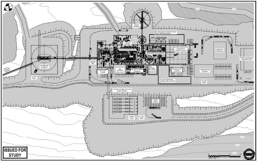
(Source: Ausenco, 2024)
| Project No.: 253821 | | Infrastructure | | |
| January 2025 | | Page 15-22 | |
| Bornite Project |
| Northwest Alaska, USA |
| S-K 1300 Technical Report Summary on the Initial Assessment |
It is assumed that the existing Arctic site can accommodate the Bornite tailings through an expanded TSF as well as some storage in the bottom of the Arctic pit. A future study might consider additional sites as contingency options.
This exercise was focused on storage capacity (i.e., volumetrics) as well as integrating with existing Arctic infrastructure.
Bornite requires 18.5 Mm3 of tailings deposition capacity. This is derived from a total of 35.91 Mt mineralized material fed to the mill (see Section 13.0) and produced at a tailing’s dry density of 1.1 t/m3. It is assumed that 50% of the tailings would be sent to the filter press to be utilized to produce paste backfill for transportation back to Bornite. Of the remaining volume, a 15% contingency is added to account for water volumes or ice entrainment.
A best available technology (BAT) review was not completed. Only conventional tailings deposition (to match Arctic output) is considered.
Cost inputs are based on Arctic FS data with adjustments as necessary based on inflation, engineering experience and judgement.
Figure 15-6 shows Bornite tailings placed on top of Arctic tailings utilizing the Arctic TSF embankment with some minor adjustments to the embankments and surrounding infrastructure.
The design provides 16 Mm3 tailings capacity, with the additional 2.5 Mm3 stored in the Arctic pit (Figure 15-7).
This scenario utilizes the same tailings management approach as for the Arctic tailings, including the same embankment geometries and a 3 m freeboard for the main embankment. Adjustments include the addition of small buttresses on either side of the Arctic embankment up to 910 m where the current Arctic closure spillway is to be located (890 m); however, a redesign of the embankment will bring these lifts to the 910 m elevation to account for conventional tailings freeboard. This will be done by redirecting some waste material from the upper lifts, offering a modest savings in haulage cost, not captured in the cost estimate of this exercise.
| Project No.: 253821 | | Infrastructure | | |
| January 2025 | | Page 15-23 | |
| Bornite Project |
| Northwest Alaska, USA |
| S-K 1300 Technical Report Summary on the Initial Assessment |
Figure 15-6: Expanded Arctic Tailings Storage Facility

(Source: SRK, 2024)
| Project No.: 253821 | | Infrastructure | | |
| January 2025 | | Page 15-24 | |
| Bornite Project |
| Northwest Alaska, USA |
| S-K 1300 Technical Report Summary on the Initial Assessment |
Figure 15-7: Arctic Pit Tailings Capacity
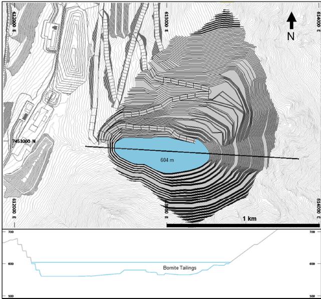
(Source: SRK, 2024)
A second small embankment will be required in saddle northwest of the TSF. SRK’s geotechnical QP considered both the topography and a nearby geotechnical drillhole, GT18-AR-07, to determine the maximum height of this embankment. The saddle embankment height is the main restriction on the ultimate capacity of conventional tailings in the Arctic TSF. Future studies should confirm the feasibility of a 912.5 m crest height, or if there is any additional height to be gained.
| Project No.: 253821 | | Infrastructure | | |
| January 2025 | | Page 15-25 | |
| Bornite Project |
| Northwest Alaska, USA |
| S-K 1300 Technical Report Summary on the Initial Assessment |
The saddle embankment parameters are:
| · | Upstream – 2W:1H slope (matching the Arctic TMF upstream) |
| · | Downstream – 3W:1H slope |
The freeboard for the saddle dam was increased to 5 m (compared to the Arctic TSF of 3 m) due to the risk of overtopping into a different watershed to the northwest. Future studies should confirm the geometry and freeboard of the saddle embankment.
The additional 2.5 Mm3 of tailings will be stored in the Arctic pit to an elevation of 604 m. A previous study indicated that due to weathered bedrock, the maximum elevation for tailings storage would be 631.5 m providing additional storage capacity within the Arctic pit if it were required.
Bornite’s lithology, distinct from Arctic’s, may offer geochemical benefits as a cap on Arctic tailings, potentially reducing the closure efforts required for Arctic.
| 15.2.5 | Transportation of Concentrate |
Copper concentrate will be transported from the Bornite site to the Port of Alaska in Anchorage. Containers will be trucked to Fairbanks by a trucking contractor and then transferred to rail for delivery to the Anchorage port terminal for shipping to Asia.
| Project No.: 253821 | | Infrastructure | | |
| January 2025 | | Page 15-26 | |
| Bornite Project |
| Northwest Alaska, USA |
| S-K 1300 Technical Report Summary on the Initial Assessment |
The Bornite Project will produce copper concentrate from the Bornite deposit which will then be transported to be sold in the Asia Pacific area.
Forecast copper prices used for mine planning and cash flow analysis are provided by CIBC Global Mining Group Analyst Consensus Commodity Price Forecasts as of September 6, 2024. The forecast price reflects the average forecasted price from 18 financial institutions. The long-term copper price forecast is $4.20/lb.
The copper price assumption of $4.60/lb used for inputs to mineral resources are described in Section 11.0.
| 16.3 | Market for Copper Concentrate |
There has been no market analysis completed for the Bornite copper concentrate. Based on publicly available information, an expected average copper concentrate grade exceeding 29% and no significant amounts of deleterious elements contained in the concentrate, there should be no barriers to obtain sales contracts with third-party smelters.
There are currently no contracts in place with any buyers for the concentrate. Publicly available information was used for the IA economic parameters for the copper concentrate.
| · | Payable copper of 96.5%, subject to a minimum deduction of 1.0 unit |
| · | Transport and logistic costs of $332.52/wmt |
| · | Treatment charge of $80.0/dmt |
| · | Copper refining charge of $0.08/lb Cu payable |
| · | Concentrate transport loss of 0.35% |
| · | No applicable penalties. |
| · | Selling costs consisting of: |
| – | Insurance cost equivalent to 0.15% of the net value of the concentrate (payable value less treatment and refining costs) |
| – | Marketing and representation cost of $2.50/dmt |
| Project No.: 253821 | | Market Studies | | |
| January 2025 | | Page 16-1 | |
| Bornite Project |
| Northwest Alaska, USA |
| S-K 1300 Technical Report Summary on the Initial Assessment |
| 17.0 | Environmental Studies, Permitting, and Plans, negotiations, or Agreements with Local Individuals or groups |
This section characterizes the existing and ongoing environmental baseline data collection for the Bornite Project area and makes suggestions for additional studies that would provide a basis for the future mine permitting efforts, describes the major environmental permits that will likely be required for mine development, and identifies social and community considerations.
| 17.1 | Environmental Studies |
The Bornite Project area consists of NANA lands, including ANCSA lands and patented federal mining claims owned by NANA, and encompasses portions of the Ruby Creek drainage (a tributary of the Shungnak River), the Shungnak River drainage, and the Ambler Lowlands. Since 2007, a limited amount of baseline environmental data collection has occurred in the area including archaeology, aquatic life surveys, wetlands mapping, surface water quality sampling, hydrology, and subsistence.
Some very limited archaeological work was done in 2008 by Northern Land Use Research Inc. (NLUR) as part of clearing a number of proposed exploratory drill sites. They did not locate any archaeology sites and concluded that "No Historic Properties would be Affected" by the proposed 2008 drill plan. However, they also concluded there is a moderate potential for prehistoric sites in the area, in part because the historical Bornite mine site is centred on a low pass between the Shungnak River to the north and the Kobuk River to the south. NLUR also recommended that all historical mine-related artifacts and features be avoided and reported to SHPO, now the Office of History and Archaeology (OHA).
Both the historical Bornite mine site and the Bornite road were subsequently determined to be not eligible for inclusion onto the National Register of Historic Places (Rigg, 2010). In 2019 KUNA Engineering (KUNA) noted that no formal historical building surveys at the historical Bornite mine site had been completed but concluded it is still likely that they would be considered ineligible for inclusion onto the National Register of Historic Places.
Additional archaeological surveys were done in 2018 and 2019 by KUNA in conjunction with the proposed Dahl Creek to Arctic Mine Road. In the Bornite Project area the survey was aerially restricted to the narrow road corridor in Ruby and Wesley creeks, and a 7.7 ha area east of the South Reef underground mine area. No cultural resource indicators were found.
| Project No.: 253821 | | Environmental Studies, Permitting, and Plans, Negotiations, or Agreements
with Local Individuals or Groups | | |
| January 2025 | | Page 17-1 | |
| Bornite Project |
| Northwest Alaska, USA |
| S-K 1300 Technical Report Summary on the Initial Assessment |
Aquatic life surveys were conducted in 2010 by TetraTech Inc. (TetraTech). TetraTech’s efforts included surveys in the area along the proposed road alternatives between the Bornite airstrip and Arctic airstrip, and to the north in the Arctic project area. The purpose of this study was to characterize the aquatic life within the Shungnak River drainage and potentially impacted tributaries with a focus on potential future development of the Arctic deposit, located some 13 km northeast of the Bornite deposit. Opportunistic observations were also collected in the Kogoluktuk River, southeast of the Arctic deposit.
The Alaska Department of Fish and Game (ADF&G) has been conducting aquatic biomonitoring since 2016 in the Ambler district, except in 2020 due to the COVID-19 pandemic. Sample sites have been added and refined over the years. In 2024 nine sites in the Shungnak River drainage were sampled, including two in Ruby Creek, which drains the Bornite Project area and seven in the Shungnak drainage, upstream from Bornite. An additional site on Riley Creek in the Kogoluktuk River drainage was also sampled. At Bornite, ADF&G monitored for periphyton, aquatic invertebrates, and fish. Fish are captured using minnow traps and fyke nets. A subset of fish is retained for whole body element analysis. ADF&G performs seasonal aquatic biomonitoring surveys at several operating mines and exploration projects in Alaska and publishes the data annually.
Despite being isolated from the Kobuk River by a large waterfall preventing migrations of anadromous fish, the Shungnak River drainage supports self-sustaining populations of Arctic grayling, Dolly Varden, round whitefish, longnose suckers, Alaska blackfish, and slimy sculpin.
Soil sampling was done at the Bornite Camp, Bornite airstrip, and along the Kobuk to Bornite Road in 2011 to determine the presence of naturally occurring asbestos (NOA). Analysis of the samples was conducted using polarized light microscopy. No asbestos was detected although additional testing of future construction material sites and other new mine disturbance areas will require similar testing.
A number of wetlands delineation efforts were made between 2010 and 2019 including portions of the Bornite Project area. The work established the presence of wetlands in the Bornite Project area, particularly in riparian zones. However, much of that work may be outdated and it will be necessary to review it in light of the elapsed time, potential changes to the environment and newer wetlands mapping protocols. That review might also entail additional field work to
re-establish the field data used in past surveys to support the wetland classification types.
| Project No.: 253821 | | Environmental Studies, Permitting, and Plans, Negotiations, or Agreements
with Local Individuals or Groups | | |
| January 2025 | | Page 17-2 | |
| Bornite Project |
| Northwest Alaska, USA |
| S-K 1300 Technical Report Summary on the Initial Assessment |
| 17.1.4 | Surface Water Quality and Hydrology |
Surface water quality sampling has been conducted within the Ambler District including the Bornite Project area, and the Arctic project area, since 2007, with the exceptions of 2009, 2011, and 2020. Samples are routinely analyzed for dissolved metals, total metals, cyanide, chloride, fluoride, nitrates, sulphate, acidity, alkalinity, total suspended solids, total dissolved solids, and field parameters including pH, conductivity, and dissolved oxygen. Velocity, depth, width and discharge are also measured, using a Marsh McBirney current meter or SonTek FlowTracker 2 acoustic doppler velocimeter. The water quality sampling has been done on a rather coarse district scale, with wide sample-site spacing on the order of several kilometers.
It will be necessary to initiate surface water quality sampling in several smaller drainages surrounding the proposed Bornite mine facilities to establish background conditions prior to construction. This should be initiated in time to allow at least five years of quarterly data to be collected as this is an important aspect in developing permit terms associated with mine water and waste management plans.
Two hydrologic gauging stations have been installed; one on Ruby Creek (RCDN) in the Bornite Project area, and one on the Shungnak River (SRGS) in the Arctic project area, several kilometres northeast of Bornite. The RCDN station was installed in 2013 and relocated in 2017 due to the presence of a beaver dam. The SRGS station was installed in 2012. These stations measure water elevation, pH, and conductivity in hourly intervals. Coupled with instantaneous flow measurements, ratings curves can be developed to determine daily and monthly flow predictions.
| 17.1.5 | Meteorology, Air Quality and Noise |
No meteorologic data has been collected in the Bornite Project area.
Meteorological data was collected year-round at the Arctic airstrip, located 14 km northeast of the Bornite Project area, from September 2011 to 2015. Site data were collected hourly and included humidity, barometric pressure, precipitation, solar radiation, temperature, wind speed, and wind direction. The station experienced operational problems, mostly due to bears in the area, and was subsequently abandoned in 2015.
| Project No.: 253821 | | Environmental Studies, Permitting, and Plans, Negotiations, or Agreements
with Local Individuals or Groups | | |
| January 2025 | | Page 17-3 | |
| Bornite Project |
| Northwest Alaska, USA |
| S-K 1300 Technical Report Summary on the Initial Assessment |
A new meteorological station was installed in 2018 in the Arctic project area to measure temperature, windspeed and direction, barometric pressure, snow depth, precipitation and evaporation. Potentially, some of the meteorological data from this station might be useful in extrapolating certain climatic conditions for the Bornite Project area.
It is advised that at least one meteorological monitoring station be installed at Bornite to allow at least two years of monitoring prior to any new mine development. It is also noteworthy that it is widely recognized that climatic conditions are changing, particularly in the Arctic. Portions of the western Brooks Range, for example, have experienced both an increase in average annual precipitation and increase in the frequency and intensity of high precipitation events. Longer-term meteorological monitoring at the Bornite Project area may better capture any trends that are developing there, and better inform mine designs, particularly water diversion and containment structures, and water management strategies. Further, current regulatory requirements may lag behind evolving climatic conditions and certain risk reductions may be gained by exceeding minimum regulatory standards for certain water diversion and containment structures.
| 17.1.6 | Subsistence and Traditional Ecological Knowledge |
In 2012, Stephen R. Braund & Associates (SRB&A) completed a subsistence data gap analysis under contract with the Alaska Department of Transportation and Public Facilities (ADOT&PF) as part of the baseline studies associated with a proposed road to the Ambler mining district (AAP road). The purpose of this analysis was to identify any existing subsistence data for the potentially affected local communities, determine if subsistence uses and use areas overlap with or may be affected by the AAP, and identify what, if any, additional information (i.e., data gaps) needed to be collected to accurately assess potential effects to subsistence. Among other things, SRB&A documented that the villages of Kobuk and Shungnak use the broad area encompassing both the Bornite and Arctic project areas for subsistence.
In 2016 WHPacific completed archaeology and cultural resource survey work that included interviews with local residents of Shungnak and Kobuk. During the interviews they gathered traditional ecological knowledge that documented subsistence activities including trapping and caribou and sheep hunting, and caribou migration in the areas encompassing both the Bornite Project and Arctic project areas.
In 2023, KUNA was hired to complete a subsistence study including the potential resource impacts and mitigation measures for development of the Arctic deposit, including areas on and around the Bornite Project area. KUNA subcontracted with ABR, Inc. and SRB&A to complete the analysis. The report is currently in draft form and is expected to be completed by the middle of 2025.
Since 2013 Ambler Metals has participated in a subsistence advisory committee with ten representatives from five NANA Region villages, and NANA.
| Project No.: 253821 | | Environmental Studies, Permitting, and Plans, Negotiations, or Agreements
with Local Individuals or Groups | | |
| January 2025 | | Page 17-4 | |
| Bornite Project |
| Northwest Alaska, USA |
| S-K 1300 Technical Report Summary on the Initial Assessment |
| 17.1.7 | Additional Baseline Requirements |
Additional baseline studies for the Bornite Project area are required to generate the data to support future mine design, development of an Environmental Impact Statement (EIS), permitting, construction, operations and closure. Ambler Metals will consult with state, local and federal regulatory agencies to develop a comprehensive environmental baseline program. Depending on the resource discipline these studies may require multiple years to complete. A comprehensive baseline program should be initiated at least five years prior to any substantive mine development activities. Specific recommendations for additional baseline studies are included in Table 17-1.
All baseline data are important for developing a representative pre-mining environmental baseline for the Bornite Project area. These baseline studies need sufficient scope to support ongoing and future engineering, water management strategies, permitting and National Environmental Policy Act (NEPA). In addition, they will provide a comparative basis for determining the success of the future reclamation and closure effort. The risks that come with insufficient baseline data include delays in the permitting process, poorly constrained pre-mining characterizations, inappropriate trigger levels in permits, higher costs and other impacts to mine operations and closure.
| 17.2 | Environmental Management |
Plans for waste and tailings disposal as well as water management are discussed in Section 15.0. In the opinion of Core Geoscience’s environmental QP , the plan to permanently dispose of Bornite tailings in an expanded Arctic TSF, the Arctic pit, or underground as a component of structural paste backfill at Bornite are all acceptable practices. In addition, the plan to truck and dispose of waste rock in the Arctic waste rock facility is also an acceptable practice. Further consideration should be given to the potential need to manage any fugitive dust from haul trucks traveling between Bornite and Arctic with mineralized material or waste.
The plans for dewatering the mine and diverting surface waters are acceptable practices. Non-contact water will be diverted away from the site to the greatest practical extent while contact water will be collected and treated before being discharged to the environment. However additional work is required to evaluate the potential need to treat water from the dewatering wells prior to discharge to the environment, and the ability of Ruby Creek to accommodate the anticipated water discharge volume during the winter months when base flows are lowest and freezing conditions prevail.
| Project No.: 253821 | | Environmental Studies, Permitting, and Plans, Negotiations, or Agreements
with Local Individuals or Groups | | |
| January 2025 | | Page 17-5 | |
| Bornite Project |
| Northwest Alaska, USA |
| S-K 1300 Technical Report Summary on the Initial Assessment |
Table 17-1: Recommended Additional Environmental Baseline Studies
| Discipline | Recommended Studies |
| Acid-Base Accounting | Acid-Base accounting (ABA) for all project solid waste streams including waste rock and tailings, and potentially, fugitive dust to establish acid-rock drainage and metal leaching (ARD/ML) characteristics of the waste. A subset of waste rock types based on lithology/mineralogy, alteration and sulphide species and concentration should be determined, and ABA characteristics for each type should be established. The results of program will inform waste management strategies as well reclamation and closure strategies and can be encoded into the mine block model to inform mine scheduling. If Bornite waste rock or tailings are to be comingled with Arctic deposit waste rock or tailings, the resultant geochemical reactions should also be characterized to ensure this will be long-term-stable from an ARD/ML perspective. Barrel tests at site should also be considered to initiate long term ARD/ML characterization of waste rock types under local meteorological conditions. ABA is also recommended for all proposed construction material sites. |
| Archaeology | Pedestrian surveys for cultural resources are largely lacking in the Bornite Project area. Pedestrian surveys are warranted in all areas designated for future disturbance as well as a buffer around the proposed disturbance limits, collectively referred to as the area of potential effect. The scope of the pedestrian surveys should be negotiated with the State Office of History and Archaeology in collaboration with other federal agencies that have a requirement to comply with the National Preservation Act, i.e., the USACE. As part of that work an assessment of the potential historical significance of the older mining equipment and buildings at Bornite should be performed to confirm the previous tentative conclusion that none of these are eligible for listing in the National Historic Register. |
| Aquatic Life | Aquatic life surveys should be continued, and ADF&G should be consulted about the potential need to increase the number of monitoring sites near the Bornite Project area and/or establishing an additional long-term monitoring site to compare any pre- and post-mining changes in fish tissue metals concentration. |
| Wetlands and Soil | Wetlands delineation will be required for the proposed disturbance area plus additional areas reasonably expected to be included in any future NEPA alternatives analysis. Existing wetlands mapping may still be useful but will likely require a review, verification and likely some updating, including some field work. Construction material sites and mine facility sites that are excavated to bedrock will need to be evaluated for NOA before any material is excavated and used for project construction. |
| Permafrost | Permafrost delineation is an integral part of ongoing site geotechnical investigations. This can inform foundation designs, facility locations and groundwater management. Shallow permafrost in the region appears to be warming and this should be a consideration for project facility designs. Permafrost may also play a role in the distribution and movement of groundwater in the mine area. |
| Project No.: 253821 | | Environmental Studies, Permitting, and Plans, Negotiations, or Agreements
with Local Individuals or Groups | | |
| January 2025 | | Page 17-6 | |
| Bornite Project |
| Northwest Alaska, USA |
| S-K 1300 Technical Report Summary on the Initial Assessment |
| Discipline | Recommended Studies |
| Hydrogeology | Understanding groundwater characteristics is an important part of developing the mine and water management plans, including water treatment and discharge. Ambler Metals has been performing various hydrogeology studies at Bornite for the last several years as a step in estimating future mine inflows. A groundwater investigation will be required to generate a reasonable estimate of predicted mine inflows. The investigation will require hydrogeologic testing, instrumenting a number of boreholes and monitoring of groundwater quality and water levels over time. |
| Hydrology | · Multi-year snow surveys should be completed for the Bornite area to inform water management strategies. The RCDN gauging station should be maintained to adequately characterize stream flows in Ruby Creek. In part this will inform portions of the permitting process for treated water discharge · Additional limited hydrology will be required for stream crossings requiring a bridge or culvert. |
| Meteorology, Air Quality, and Noise | · A meteorological monitoring station should be installed at the proposed site for the power plant. An early installation may provide longer-term monitoring and prove beneficial in capturing trends in changing climatic conditions at Bornite. · Engage in a qualified consultant to assess the potential need and timing for air quality monitoring. Monitoring tends to be expensive owing to the need for Environmental Protection Agency (EPA)-certified equipment, calibration, reliability and maintenance that generally proves challenging in the arctic. |
| Water Quality | Ongoing surface water quality monitoring should continue and be expanded in the immediate Bornite Project area to include several smaller drainages surrounding the proposed mine development and upstream of proposed infrastructure. Groundwater monitoring wells should be developed inside and outside the proposed underground development limits as part of the hydrogeology program but should also be purposed for groundwater quality sampling. |
| Wildlife | Potential impacts to wildlife, particularly caribou, should be evaluated further and mitigation measures for reducing impacts to wildlife should be developed and integrated into future mine standard operating procedures. Potential impact to caribou is likely to be considered a significant issue by communities of interest and government agencies during the permitting and NEPA processes. |
| Project No.: 253821 | | Environmental Studies, Permitting, and Plans, Negotiations, or Agreements
with Local Individuals or Groups | | |
| January 2025 | | Page 17-7 | |
| Bornite Project |
| Northwest Alaska, USA |
| S-K 1300 Technical Report Summary on the Initial Assessment |
Development of a new mine at Bornite will require a significant number of permits from state, federal, and local governments. The permitting process should be preceded by a robust environmental baseline program and integration of that data into effective designs and operating plans for the mine and other NEPA pre-planning. Ideally, there will be pre-permitting engagement with regulatory agencies and stakeholders with the intent of identifying significant issues and mitigating them to the greatest practical extent through the mine engineering and operating plans. Most federal agencies must comply with the requirements of NEPA before making a final decision to issue their respective permit. NEPA generally results in development of an Environmental Assessment (EA) or an Environmental Impact Statement (EIS) that identifies and compares the direct, indirect, cumulative and reasonably foreseeably impacts of the project, both good and bad and includes the selection of a preferred alternative. The level of NEPA pre-planning, including the overall effort that mine project proponents invest in robust baseline, recognizing the potential environmental and social impacts, and designing a mine with the least impacts, has a direct effect on reducing the risk of delays or unanticipated project changes during the NEPA process.
Table 17-2 lists the major permits that may be required for the Bornite Project.
| 17.4 | Social and Community Considerations |
The Bornite Project is located approximately 18 km north of the village of Kobuk, 22 km northeast of the village of Shungnak, and 40 km east of the village of Ambler. The population in these villages are 191 in Kobuk (2020 Census), 272 in Shungnak (2020 Census) and 274 in Ambler (2020 US Census). Residents live a largely subsistence lifestyle with incomes supplemented by trapping, guiding, local development projects, government aid and other work in, and outside of the villages.
The Bornite Project has the potential to significantly improve work opportunities for village residents in the region. Ambler Metals works directly with the villages to employ residents in the ongoing exploration program as geotechnicians, drill helpers, environmental technicians, and a myriad of other camp support positions. Ambler Metals and NANA have established a workforce development subcommittee to assist with developing a local workforce. In addition, Ambler Metals has existing contracts with native-affiliated companies (such as NANA Management Services and KUNA) that provide camp catering and environmental services for the Bornite Project.
| Project No.: 253821 | | Environmental Studies, Permitting, and Plans, Negotiations, or Agreements
with Local Individuals or Groups | | |
| January 2025 | | Page 17-8 | |
| Bornite Project |
| Northwest Alaska, USA |
| S-K 1300 Technical Report Summary on the Initial Assessment |
| Table 17-2: | Permits that May Be Required for the Bornite Project |
| Authority | Permit |
| Federal | |
| Environmental Protection Agency (EPA) | · Spill Prevention Containment and Contingency (SPCC) Plan |
| U.S. Army Corps of Engineers (USACE) | · CWA Section 404 Permit (wetlands dredge and fill) |
| | · River and Harbors Act (RHA) Section 10 (structures in navigable waters) |
| | · RHA Section 9 (dams and dykes in navigable waters-interstate commerce) |
| Bureau of Alcohol, Tobacco, and Firearms (ATF) | · License to Transport Explosives |
| | · Permit and License for Use of Explosives |
| Federal Aviation Administration (FAA) | · Notice of Landing Area Proposal (existing airstrip) |
| | · Notice of Controlled Firing Area for Blasting |
| U.S. Department of Transportation | · Hazardous Materials Registration |
| U.S. Fish and Wildlife Service | · Section 7 of the Endangered Species Act, Consultations requiring a Biological Assessment or Biological Opinion |
| State | |
| Department of Natural Resources (ADNR) | · Reclamation Plan Approval |
| | · Mining License |
| | · Temporary Water Use Authorizations |
| Department of Environmental Conservation (ADEC) | · APDES Water Discharge Permit |
| | · Alaska Multi-Sector General Permit (MSGP) for Stormwater |
| | · Stormwater Pollution Prevention Plan (part of MSGP) |
| | · Sec. 401 Water Quality Certification of the CWA Sec. 404 Permit |
| | · Integrated Waste Management Permit |
| | · Air Quality Control – Construction Permit |
| | · Air Quality Control – Title V Operating Permit |
| | · Reclamation Plan Approval |
| | · Approval to Construct and Operate a Public Water System |
| State Office of History and Archaeology (OHA) | · Section 106 National Historic Preservation Act Concurrence |
| Department of Fish and Game (ADF&G) | · Title 16 Fish Habitat and Passage Permits |
| | · Wildlife Hazing Permit |
| NANA Regional Corporation | · Surface Use Agreement for Facilities, Roads and Material Sites |
| | · Mining Agreement |
| Local | |
| Northwest Arctic Borough (NWAB) | · Title 9 Permit: exploration activities, camps, fuel storage |
| | · Master Plan Approval and Rezoning Title 9 Permit: exploration activities, camps, fuel storage |
| | · Master Plan Approval and Rezoning |
| Project No.: 253821 | | Environmental Studies, Permitting, and Plans, Negotiations, or Agreements
with Local Individuals or Groups | | |
| January 2025 | | Page 17-9 | |
| Bornite Project |
| Northwest Alaska, USA |
| S-K 1300 Technical Report Summary on the Initial Assessment |
In October 2011, NovaCopper signed an agreement with NANA that consolidated landholdings in the Ambler District but also has language establishing shareholder hiring preferences and preferential use of NANA subsidiaries for contract work. The agreement also formalized an oversight committee, with equal representation from Ambler Metals and NANA, to regularly review project plans and activities. The agreement also includes a scholarship funded annually by Ambler Metals that promotes education opportunities for shareholders in the region. Ambler Metals meets periodically during the field season, with the residents of Kobuk, Shungnak and Ambler. Ambler Metals also meets annually with several other NANA region villages including Noatak, Kotzebue, Kiana, and Noorvik, for the purpose of updating residents on project plans and fielding their questions and concerns. Ambler Metals has also developed a good working relationship with the NWAB government.
Since 2013 Ambler Metals has participated in a subsistence advisory committee with ten representatives from five NANA Region villages, and NANA.
In general terms, rural Alaska residents are often concerned about potential mining impacts to wildlife and fish for those projects within their traditional use areas. Ambler Metals acknowledges these concerns and has taken substantive steps to address them during the current exploration stage of the Bornite Project and will incorporate additional steps as part of the future mine development.
Local community concerns will also be formally recognized during the scoping stage at the beginning of the NEPA process. At that time, the lead federal agency (likely the USACE) will hold scoping meetings in rural villages to hear and record the concerns of the local communities so that they can be addressed during the development of the EIS. In addition, the USACE would have government-to-government consultations with the Tribal Councils in each of the villages, as part of the NEPA process, to discuss the project and potential stakeholder concerns.
| 17.5.1 | Bornite Mine Legacy Cleanup |
Under the NANA Agreement signed on October 19, 2011, NANA is required to complete a baseline environmental report following completion of cleanup of the former mining camp on the Bornite Lands, to the standards required by the Alaska Department of Environmental Conservation and “to the reasonable satisfaction of NovaCopper”. This includes “removal and disposal as required by law of all hazardous substances present on the Bornite Lands. NANA has indemnified and will hold NovaCopper harmless for any loss, cost, expense, or damage suffered or incurred attributable to the environmental condition of the Bornite Lands at the date of the baseline report which relate to any activities prior to the date of the agreement.”
| Project No.: 253821 | | Environmental Studies, Permitting, and Plans, Negotiations, or Agreements
with Local Individuals or Groups | | |
| January 2025 | | Page 17-10 | |
| Bornite Project |
| Northwest Alaska, USA |
| S-K 1300 Technical Report Summary on the Initial Assessment |
Travis/Peterson Environmental Consulting Inc. (2007) completed a site characterization for Bornite in 2007. The report identified several safety and environmental issues and possible mitigation solutions. Identified in the report are asbestos-containing structures, petroleum ground contamination, an open shaft which presents a safety hazard, and environmental liabilities due to out of service vehicles.
NANA has completed all the planned work and has satisfied the requirements laid out in the Agreement. NANA has prepared the final baseline environmental report, which was reviewed and accepted by NovaCopper, thereby releasing NANA from legacy environmental obligations at the Bornite site.
| 17.5.2 | Reclamation of Exploration Activities |
Reclamation of mineral exploration activities in the Bornite Project area is subject to the stipulations in Reclamation Plan Approval F2021-2183- issued by the Department of Natural Resources Division - Mining Section. The approval expires on Dec 31, 2025. The approval includes the following stipulations:
| · | Topsoil shall be stockpiled |
| · | The area shall be reshaped to blend with surrounding topography |
| · | Organic material shall be spread over the site to prevent erosion |
| · | Reclamation shall be done in the same exploration season as disturbance |
| · | Drill casing shall be removed or cut off at ground level |
| · | Drill holes shall be plugged with bentonite clay or equivalent |
| · | Reseeding shall be done as necessary |
| · | Disturbance shall be held to a minimum. |
ADNR staff conducted a site inspection on July 15-16, 2024. All drill sites under Reclamation Plan Approval F2021-2183 were inspected by ADNR staff and no corrective actions were required.
| 17.5.3 | Bornite Mine Reclamation and Closure |
Closure of the Bornite Project will primarily be regulated by the Alaska Department of Natural Resources (ADNR) and Alaska Department of Environmental Conservation (ADEC) under the Alaska Reclamation Act and the Solid Waste Management Regulations. The Act requires that a reclamation and closure plan (RCP) and financial assurance (FA) be provided to the State prior to any mining activity or project development. The RCP details reclamation prescriptions which are designed to minimize or eliminate the risk of pollutants released into the environment. The RCP details conceptual means and methods used to return the site to near pre-mining conditions and protect the environment during, reclamation, and long-term site management activities. In addition, the RCP must be consistent with NANA’s intended post mining land use and NANA must formally confirm that in writing to ADNR as part of the agency approval process. Approval of the RCP and FA prior to initiation of mining safeguards the environment, while the FA (bond) provides a funding mechanism to implement the defined closure activities should the operator default or abandon the site.
| Project No.: 253821 | | Environmental Studies, Permitting, and Plans, Negotiations, or Agreements
with Local Individuals or Groups | | |
| January 2025 | | Page 17-11 | |
| Bornite Project |
| Northwest Alaska, USA |
| S-K 1300 Technical Report Summary on the Initial Assessment |
The RCP will be prepared in parallel with mine facility designs, incorporate baseline information studies, and other operational and long-term planning efforts. Submission of the RCP is not expected to be accepted by the State until all Federal actions have been successfully approved. The proponent is required to post a bond for the amount reasonably expected to reclaim the site. Permits to operate the mine will not be granted until the RCP is approved, and the bond is secured and provided to the State of Alaska.
| 17.5.3.1 | Conceptual Development |
Understanding the conceptual development is key to determining the reclamation and closure prescriptions required to meet regulatory requirements. The conceptual development plan for the site is anticipated to include: supporting underground mining infrastructure (portal, vent raises, and paste backfill plant), surface infrastructure (buildings, roads, etc.), a waste transfer pad, temporary and long-term stockpiles, surface water management controls (contact water collection, diversion channels, dewatering wells and the water treatment pond and a water treatment plant. Mineralized material will be transferred and processed off-site eliminating processing and storage of mine waste rock and tailings. Waste rock will be managed at the site in small quantities during operations and will be hauled to the Arctic site for disposal.
Initial development includes installation of water management controls, stripping and stockpiling overburden and growth medial, and development of foundations, developing portals and vent raises, laydown pads and other mine facilities. Facility design is anticipated to incorporate aspects that will reduce reclamation liabilities or provide opportunity for progressive reclamation to the extent practical. Development activities to reduce reclamation liabilities could include items such as minimizing footprints, installing impervious liners to reduce soil contamination, incorporating natural terrain, and minimizing surface and ground water impacts.
Geochemical analysis of the mineralized material and waste rock is ongoing. Some waste rock and low-grade material is anticipated to be PAG. Mineralized material and waste rock will be temporarily stockpiled on site prior to transfer to Arctic. Controls to manage water interacting with mineralized material and waste rock (contact water) will be implemented to further reduce the risk of ARD developing.
| Project No.: 253821 | | Environmental Studies, Permitting, and Plans, Negotiations, or Agreements
with Local Individuals or Groups | | |
| January 2025 | | Page 17-12 | |
| Bornite Project |
| Northwest Alaska, USA |
| S-K 1300 Technical Report Summary on the Initial Assessment |
Contact water will be collected at key locations on the site, transferred to a water treatment pond for temporary storage prior to treatment and discharge. Non-contact water in Ruby Creek will be diverted into a lined channel to reduce infiltration into underground workings. Dewatering wells will be installed in key locations, and discharged into the upgraded Ruby Creek section or released downstream of the development.
| 17.5.3.2 | Reclamation and Closure Activities |
At completion of mining all dewatering will cease, diversion channels will be removed allowing surface water to return to the natural stream channels. Contact water is anticipated to be minimized or eliminated upon completion of all reclamation and closure activities. Equipment will be removed from the site. Underground workings will be allowed to flood further reducing or eliminating the potential for ARD development. Flooded water levels are not anticipated to interact with surface water or shallow groundwater.
Vent raises will be closed by backfilling and construction of engineered plugs. Site infrastructure including all buildings, roads, water management structures, will be removed. All soils impacted by interaction with mine waste will be removed and placed in a suitable long-term storage location at Arctic. All developed areas will be regraded to blend with the natural surroundings to the extent practical and revegetated to provide long-term stabilization of the site. The estimate assumes all mining related facilities will be reclaimed and/or removed from site.
Buildings and infrastructure such as roads, may offer some benefit to the landowner (NANA) post-mining. The RCP must be compatible with NANA’s post-mining land use plan, and an agreement between NANA, ADNR and ADEC must be prepared prior to final closure and release of the project.
Long-term activities could include, site maintenance, revegetated cover maintenance and environmental monitoring. All waste rock on the surface will be relocated to Arctic or placed underground at Bornite in areas which will be submerged by water. As noted above, design controls could be implemented to reduce or eliminate long-term obligations all together.
Closure of the site is anticipated to be performed in two phases. The first phase includes physical reclamation activities which will likely occur over the course of two years. The second phase includes 10-years of long-term monitoring and vegetation maintenance, considering that no mine waste is stored on surface at the Bornite site, it is anticipated that the applicable water quality standards will be achieved early in closure and all monitoring activity will cease 10 years post reclamation. At that time the mine will be considered closed, and no further closure liability will exist. ADEC may require additional periodic water monitoring for up to 30 years post mining, but is not anticipated at this time.
| Project No.: 253821 | | Environmental Studies, Permitting, and Plans, Negotiations, or Agreements
with Local Individuals or Groups | | |
| January 2025 | | Page 17-13 | |
| Bornite Project |
| Northwest Alaska, USA |
| S-K 1300 Technical Report Summary on the Initial Assessment |
Closure liabilities at Bornite are anticipated to include physical reclamation activities detailed below. A closure cost of $78.8 million detailed in Section 18.2 assumes the following:
| · | All disturbed areas as a result of mining activity will be regraded to promote drainage. |
| · | All buildings on site will be removed and disposed of in an approved landfill. |
| · | Impacted soils will be relocated to Arctic or placed underground. |
| · | Water management structures will be removed, and dams breached. |
| · | An annual operating and sustaining capital allowance for site management and maintenance |
| · | An annual allowance for environmental and regulatory compliance |
| · | Cash flows are projected for 12 years, including the two year reclamation period followed by 10 years of maintenance and monitoring |
| · | A discount rate of 4.3% for all long-term obligations relating to reclamation |
| · | Indirect costs are included, consistent with State of Alaska policy |
| · | The estimate assumes additive premiums and contingences to account for the level of detailed design, remoteness of the site, and other unknowns. |
| 17.6 | QP’s Opinion on Data Adequacy |
The data considered in this Section included historical baseline environmental data, the proposed mine plan, and the reclamation and closure plan. As described above it will be necessary to implement environmental baseline programs in several disciplines sufficient to support more detailed mine development plans, operating plans, reclamation and closure planning, as well as mine permitting. Specifically, additional baseline data are required for surface water and groundwater quality, wetlands delineation, aquatic life, meteorology, hydrology, permafrost and hydrogeology, acid-base accounting, wildlife, and cultural resources including archaeology. Considering the likely long lead time to development of the Bornite mine there is sufficient time to initiate each of these baseline program components and collect sufficient data to meet project needs. As a guideline it will require approximately up to five years to collect the requisite data.
| Project No.: 253821 | | Environmental Studies, Permitting, and Plans, Negotiations, or Agreements
with Local Individuals or Groups | | |
| January 2025 | | Page 17-14 | |
| Bornite Project |
| Northwest Alaska, USA |
| S-K 1300 Technical Report Summary on the Initial Assessment |
In the opinion of Core Geoscience’s environmental QP, the current plans to address any issues related to environmental compliance, permitting and local individuals or groups are adequate for the purposes of this Report.
| Project No.: 253821 | | Environmental Studies, Permitting, and Plans, Negotiations, or Agreements
with Local Individuals or Groups | |  |
| January 2025 | | Page 17-15 | |
 | Bornite Project |
| Northwest Alaska, USA |
| S-K 1300 Technical Report Summary on the Initial Assessment |
| 18.0 | capital and operating cost |
| 18.1 | Capital Cost Estimate |
Estimates for capital and operating costs were prepared at a scoping study level with an expected accuracy of ±50% and a contingency of 14.4% overall which is in accordance with the S-K 1300 standard for an IA. The capital costs can be classified as a Class 5 estimate in accordance with AACE International Guidelines Practice No. 47R-11 (AACE International, 2020). The stated cost accuracy of the estimates has taken into account the use of conventional underground mining methods, process methods and waste management and have been benchmarked to similar projects in similar environments. All costs are expressed in fourth-quarter 2024 US dollars.
The Bornite Project’s pre-production capital cost estimate is summarized in Table 18-1. It addresses the mine, process, and site infrastructure costs as well the expanded Arctic TSF.
Table 18-1: Summary of Capital Cost Estimate
| WBS | | | Description | | Initial Capital
($M) | | | Sustaining Capital
($M) | | | Total Capital
($M) | |
| 1000 | | | Mining | | | 214.9 | | | | 300.6 | | | | 515.5 | |
| 2000 | | | Crushing | | | - | | | | - | | | | - | |
| 3000 | | | Process | | | 28.6 | | | | - | | | | 28.6 | |
| 4000 | | | Tailings | | | 10.4 | | | | - | | | | 10.4 | |
| 5000 | | | Onsite Infrastructure | | | 85.3 | | | | 20.7 | | | | 106.0 | |
| 6000 | | | Offsite Infrastructure | | | 1.7 | | | | - | | | | 1.7 | |
| Subtotal | | | | | | 340.8 | | | | 321.3 | | | | 662.1 | |
| 7000 | | | Indirect Costs | | | 80.6 | | | | 4.1 | | | | 84.7 | |
| 9000 | | | Owners’ Costs | | | 9.5 | | | | 1.2 | | | | 10.7 | |
| 8000 | | | Provisions/Contingency | | | 72.5 | | | | 36.5 | | | | 109.0 | |
| Total | | | | | | 503.4 | | | | 363.1 | | | | 866.5 | |
Note: Figures may not sum due to rounding. WBS = work breakdown structure.
| 18.1.2 | Scope of Responsibilities |
The estimate was prepared by Wood with contributions from SRK and Ausenco. Wood prepared the mining estimate and contributed to surface infrastructure costs related to roads, buildings and electrical. Ausenco prepared the process costs. SRK prepared the tailings and site wide water management including dewatering wells and WTP. Wood coordinated all the data being assembled into the estimate and relies on the information supplied as being accurate.
| Project No.: 257777 | | Capital and Operating Costs | | |
| January 2025 | | Page 18-1 | |
| Bornite Project |
| Northwest Alaska, USA |
| S-K 1300 Technical Report Summary on the Initial Assessment |
Mining capital costs include underground costs, cost of the OTR truck fleet, and truck shop/maintenance/workshop and contribute to 63% of the initial direct capital costs.
Mining initial direct capital costs are estimated at $214.9 million and distributed as detailed in Table 18-2. These costs include the following:
| · | Capital cost for the OTR haulage fleet (haul roads) including the semi-tractor trailer and tandem trailer fleet and designated 5 m3 front wheel loader. |
| · | Truck shop facility including tire yard and equipment ready line. |
| · | Underground and backfill plant costs as further discussed in Section 18.1.3.1. |
| · | Initial capital purchases required for Year 1 mine production is assumed to be made in PP1. |
Table 18-2: Initial Mining Capital Costs
| WBS 1000 | | Area | | Cost
($M) | |
| 1200 | | Mine Development (Capitalized Pre-production Operating Costs) | | | 57.6 | |
| 1500 | | Mine Truck Shop Facility | | | 6.4 | |
| 1600 | | Haul Roads (OTR Haulage Fleet) | | | 5.0 | |
| 1700 | | Underground | | | 129.8 | |
| 1800 | | Backfill | | | 16.3 | |
| Total | | | | | 214.9 | |
Note: Figures may not sum due to rounding.
Support and ancillary equipment prices not obtained by quotation were obtained from CostMine estimates and in-house benchmark data.
A first principles cost model was developed that incorporates the Bornite mine production plan to determine capital equipment quantities and replacements. Initial capital purchases required for Year 1 production is assumed to be made in pre-production Year 1 (PP1). Capital replacements are assumed to be purchased in the year they are needed.
| Project No.: 257777 | | Capital and Operating Costs | | |
| January 2025 | | Page 18-2 | |
| Bornite Project |
| Northwest Alaska, USA |
| S-K 1300 Technical Report Summary on the Initial Assessment |
The underground initial capital cost is $146.0 million and is primarily driven by mine development and the backfill plant as detailed in Table 18-3.
Table 18-3: Initial Underground and Backfill Capital Costs
| WBS 1700/1800 | | Area | | Cost
($M) | |
| 1710 | | Mine Development | | | 74.5 | |
| 1720 | | Mobile Equipment | | | 27.9 | |
| 1730 | | Material Handling | | | 20.9 | |
| 1740 | | Fixed Infrastructure | | | 0.4 | |
| 1750 | | Ventilation | | | 1.6 | |
| 1760 | | Dewatering | | | 0.5 | |
| 1770 | | Surface Infrastructure | | | 0.0 | |
| 1780 | | Services | | | 0.2 | |
| 1790 | | Electrical | | | 3.9 | |
| 1810 | | Backfill general | | | 16.3 | |
| Total | | | | | 146.0 | |
Note: Figures may not sum due to rounding.
Underground mine capital cost includes initial and sustaining capital for the following:
| – | Lateral and vertical development |
| – | Capitalized pre-production |
| – | Installed services (e.g., electrical cable, dewatering piping, leaky feeder line) |
| – | Rebuilds and replacements |
| – | Orepass and conveyor loading infrastructure |
| – | Underground workshop outfitting |
| Project No.: 257777 | | Capital and Operating Costs | | |
| January 2025 | | Page 18-3 | |
| Bornite Project |
| Northwest Alaska, USA |
| S-K 1300 Technical Report Summary on the Initial Assessment |
| – | Heaters and diesel storage |
| – | Bulkheads and vent doors |
| – | Primary dewatering stations |
| – | Sediment filtration system |
Backfill capital costs includes initial and sustaining capital for the following:
| · | Bornite paste plant building infrastructure and mechanical infrastructure including thickened tailings receiving silo, conditioning mixers, surge hoppers, batch mixers, consumable storage, paste pump and piping. |
| · | Underground pumping stations. |
Underground capital costs are based on a combination of factored costs from recent studies, in-house data, CostMine estimates, and allowances based on experience. A first principles cost model was developed for operating and capital costs to estimate operating hours, consumables, and labour requirements. Labour rates are estimated from CostMine labour rates from a non-unionized underground gold mine in Alaska and are similar in cost per hour to the rates used in the Arctic FS.
| Project No.: 257777 | | Capital and Operating Costs | | |
| January 2025 | | Page 18-4 | |
| Bornite Project |
| Northwest Alaska, USA |
| S-K 1300 Technical Report Summary on the Initial Assessment |
The process area and tailings filtration capital costs are detailed in Table 18-4 totalling $28.6 million, accounting for 8.4% of the initial direct capital cost.
Table 18-4: Process Direct Capital Costs
| WBS 3000 | | Area | | Cost
($M) | |
| 3100 | | Process Plant Building | | | 2.4 | |
| 3140 | | Tailings Filtration | | | 20.2 | |
| 3300 | | Flotation and Regrind | | | 6.0 | |
| Total | | | | | 28.6 | |
Note: Figures may not sum due to rounding.
There will be no modifications or capital required for the crushing area as the crushing plant will process Bornite material at the same nameplate capacity as the Arctic plant.
The process plant building, flotation and regrind capital cost is estimated at $8.4 million and includes the capital required for the existing plant refurbishment, upgrade and re-configuration and a new regrind mill. The process plant costs cover the piping changes, pump upgrades, new pumps and platework items required for the Bornite plant. These costs were escalated and factored using the existing flowsheet and costs from the Arctic plant.
Major equipment pricing for the new regrind mill was determined using internal database pricing, with additional direct cost allowances for the associated concrete, architectural, steel, piping, platework. Instrumentation and electrical included and benchmarked against existing and similar projects.
The new regrind mill equipment will be installed adjacent to the Arctic plant and will be housed in an enclosed building to allow the new circuit to be constructed in a “greenfield like” environment prior to switching to Bornite feed. This approach will minimize the impact to operations during construction and the operational downtime required to make the internal plant modifications required to process Bornite feed.
The process area costs include an allowance for the demolition of redundant equipment which would need to be removed to allow the piping and pumping modifications to be completed. However, there are no cost provisions for complete removal of redundant equipment for salvaging purposes.
| Project No.: 257777 | | Capital and Operating Costs | | |
| January 2025 | | Page 18-5 | |
| Bornite Project |
| Northwest Alaska, USA |
| S-K 1300 Technical Report Summary on the Initial Assessment |
The direct capital cost of the tailings filtration plant required to dewater plant tailings for paste backfill requirements is estimated at $20.2 million. Filtration and ancillary equipment capital costs were established from internal database and reference project pricing. Additional direct cost allowances were then applied to develop the additional costs required for concrete, architectural, steel, piping, platework. instrumentation and electrical scope items. The overall direct capital cost has been benchmarked against similar projects.
The tailings filtration plant will be installed adjacent to the Arctic plant and will be housed in an enclosed building to allow construction to occur in a ‘greenfield like’ environment.
Tailings initial capital costs total $10.4 million (Table 18-5) and consider the expansion of the Arctic TSF including construction of a saddle dam, underliner preparation and liner. The cost accounts for 3.0% of the initial direct capital cost.
Costing of the expanded TSF at Arctic utilizes material take-offs from volumetric calculations. Unit rates are based on previous work from the Arctic FS and adjusted for inflation.
Table 18-5: Tailings Capital Costs
| WBS 4000 | | Area | | Cost
($M) | |
| 4900 | | Tailings General | | | 10.4 | |
| Total | | | | | 10.4 | |
| 18.1.6 | Onsite Infrastructure |
Onsite infrastructure capital costs are estimated at $85.3 million, as broken down in Table 18-6, and account for 25% of the initial direct capital cost.
Capital costs for water management, including diversions, site drainage, conveyances and peripheral dewatering of the underground mine are based on a combination of factored costs from recent studies, in-house data and allowances based on experience. Designs were developed from a combination of first principles cost model and previous work. Diversion and site drainage sizing was based on available hydrological studies for Arctic (including Bornite monitoring stations), assumed storm event design criteria (1-in-100 or 1-in-200 depending on feature) and experience on comparable projects. Sizing and layout of peripheral dewatering for the underground mine was scaled from previous inflow estimates for Bornite and factored unit rates for dewatering equipment from vendor quotes for comparable projects.
| Project No.: 257777 | | Capital and Operating Costs | | |
| January 2025 | | Page 18-6 | |
| Bornite Project |
| Northwest Alaska, USA |
| S-K 1300 Technical Report Summary on the Initial Assessment |
Table 18-6: Onsite Infrastructure Capital Costs
| WBS 5000 | | Area | | Cost
($M) | |
| 5100 | | Site Civil Infrastructure | | | 18.0 | |
| 5200 | | Water Systems (including dewatering) | | | 6.7 | |
| 5300 | | Sewage, Waste and Water Treatment Systems | | | 26.3 | |
| 5400 | | Electrical Services | | | 28.6 | |
| 5500 | | IT & Communications | | | 0.1 | |
| 5600 | | Ancillary Buildings | | | 1.6 | |
| 5700 | | Diesel Storage and Distribution | | | 3.9 | |
| 5800 | | Plant Mobile Equipment | | | - | |
| 5900 | | Onsite Infrastructure General | | | 0.0 | |
| Total | | | | | 85.3 | |
Note: Figures may not sum due to rounding.
| 18.1.7 | Offsite Infrastructure |
Offsite infrastructure capital costs include the cost of upgrading the road from the Bornite site to the AAP road and are presented in Table 18-7. The cost accounts for less than 0.5% of the initial direct capital cost.
Table 18-7: Offsite Infrastructure Capital Costs
| WBS 6000 | | Area | | Cost
($M) | |
| 6100 | | Access Road Upgrade from AAP to Bornite | | | 1.7 | |
| Total | | | | | 1.7 | |
Note: Figures may not sum due to rounding.
Indirect costs have been factored based on historical data and are estimated at $80.6 million, approximately 16% of the total initial capital cost. Indirect costs are determined as a percentage of the direct costs and consider the following areas:
| · | Engineering procurement (EP) and construction management (CM) execution |
| – | 17.5% EPCM on all process and tailings filtration plant scope (WBS 3100 and 3300) |
| – | 5% EP and 10% CP on civil work |
| – | 7% EP and 13% CP on structural, mechanical, process, electrical and instrumentation (SMPEI) |
| Project No.: 257777 | | Capital and Operating Costs | | |
| January 2025 | | Page 18-7 | |
| Bornite Project |
| Northwest Alaska, USA |
| S-K 1300 Technical Report Summary on the Initial Assessment |
| · | Construction/field Indirects |
| – | 25% on all direct costs excluding underground dewatering costs |
| – | 18% on underground dewatering costs |
| – | 10% on all direct costs minus major equipment |
| · | Mechanical vendor representatives |
The Owners’ costs were factored on the direct and indirect costs excluding underground mining and contingency at a rate of 5% and account for approximately 1.9% of the total initial capital cost.
Contingency is a monetary provision intended to cover items that have not been included in the described scope of work yet cannot be accurately defined at this stage. This is due to normal variability of quantities, productivity, unit rates, the current level of engineering and other factors that could affect the accuracy of the expected final cost of the Project. Contingency should be considered as expenditure that is predictable but nondefinable at this stage of the project, therefore contingency is expected to be spent. Contingency does not include any project scope change.
Contingency has been applied using a “deterministic” approach inferring that it has been applied to the base estimate and based on a single point evaluation. Contingency was determined by area and is calculated to be 14.4% overall.
| Project No.: 257777 | | Capital and Operating Costs | | |
| January 2025 | | Page 18-8 | |
| Bornite Project |
| Northwest Alaska, USA |
| S-K 1300 Technical Report Summary on the Initial Assessment |
| 18.1.11 | Sustaining Capital Costs |
The basis for estimating the sustaining costs is similar to that used for estimating the initial capital costs in both methodology and the principles applied. Indirect costs, contingency, and Owners’ costs were applied and added to the direct sustaining capital cost to arrive at the total sustaining capital cost.
Table 18-8 summarizes the sustaining capital costs over the LOM as $363.1 million. Costs consider the following:
| · | Mine services equipment: replacement of OTR haulage and loader equipment |
| · | Underground: sustaining capital development, replacement and rebuilds of mining mobile equipment, material handling system, fixed infrastructure, ventilation fans, dewatering pumps, services, electrical network, and backfill plant |
| · | Onsite infrastructure: mobile equipment, and pipeline and ditch construction for water management including electrical. |
The following items are specifically excluded from the capital cost estimate:
| · | Financing costs or interest costs during construction |
| · | Extraordinary climatic events |
| · | Insurance, bonding, permits and legal costs |
| · | National and local taxes and duties |
| · | Exchange rate variations |
| · | Schedule recovery or acceleration |
| · | Property taxes, corporate and mining taxes, duties |
| Project No.: 257777 | | Capital and Operating Costs | | |
| January 2025 | | Page 18-9 | |
| Bornite Project |
| Northwest Alaska, USA |
| S-K 1300 Technical Report Summary on the Initial Assessment |
Table 18-8: Sustaining Capital Costs
| | | | | | | Years |
| WBS | | Area | | Total
($M) | | 1
($M) | | 2
($M) | | 3
($M) | | 4
($M) | | 5
($M) | | 6
($M) | | 7
($M) | | 8
($M) | | 9
($M) | | 10
($M) | | 11
($M) | | 12
($M) | | 13
($M) | | 14
($M) | | 15
($M) | | 16
($M) | | 17
($M) |
| 1600 | | Haul Roads (OTR Fleet) | | 14.6 | | 4.4 | | 1.1 | | - | | - | | - | | - | | - | | 4.7 | | - | | - | | - | | - | | 4.4 | | - | | - | | - | | - |
| 1700/1800 | | Underground Mining | | 286.0 | | 34.3 | | 49.0 | | 17.2 | | 15.8 | | 7.4 | | 18.9 | | 36.2 | | 33.2 | | 15.4 | | 15.8 | | 9.6 | | 7.9 | | 5.9 | | 9.1 | | 5.1 | | 4.9 | | 0.1 |
| 2000/3000 | | Crushing/Processing | | - | | - | | - | | - | | - | | - | | - | | - | | - | | - | | - | | - | | - | | - | | - | | - | | - | | - |
| 4000 | | Tailings | | - | | - | | - | | - | | - | | - | | - | | - | | - | | - | | - | | - | | - | | - | | - | | - | | - | | - |
| 5000 | | Onsite Infrastructure | | 20.7 | | 0.4 | | - | | 20.2 | | - | | - | | - | | - | | - | | - | | 0.1 | | - | | - | | - | | - | | - | | - | | - |
| 7000 | | Indirect Costs | | 4.1 | | - | | - | | 4.1 | | - | | - | | - | | - | | - | | - | | - | | - | | - | | - | | - | | - | | - | | - |
| 9000 | | Owners’ Cost | | 1.2 | | - | | - | | 1.2 | | - | | - | | - | | - | | - | | - | | - | | - | | - | | - | | - | | - | | - | | - |
| | | Contingency | | 36.5 | | 5.1 | | 4.4 | | 8.5 | | 1.5 | | 0.7 | | 1.4 | | 2.4 | | 4.4 | | 1.2 | | 1.5 | | 1.0 | | 0.8 | | 1.7 | | 0.9 | | 0.5 | | 0.5 | | 0.0 |
| | | Total | | 363.1 | | 44.2 | | 54.5 | | 51.1 | | 17.4 | | 8.2 | | 20.3 | | 38.6 | | 42.3 | | 16.7 | | 17.4 | | 10.5 | | 8.7 | | 12.0 | | 10.1 | | 5.6 | | 5.4 | | 0.1 |
Note: (1) Figures may not sum due to rounding.
(2) Capital replacement are assumed to be purchased in the year they are needed.
| Project No.: 253821 | | Capital and Operating Costs | | |
| January 2025 | | Page 18-10 | |
| Bornite Project |
| Northwest Alaska, USA |
| S-K 1300 Technical Report Summary on the Initial Assessment |
The costs associated with the reclamation activities described in Section 17.5.3 are detailed in Table 18-9. Closure activities will be performed over two years while post-closure activities will extend a further 10 years.
Table 18-9: Reclamation Cost Estimate
| Item | | Cost
($M) | |
| Closure Costs | | | | |
| Mining Infrastructure | | | 10.0 | |
| Surface Infrastructure, Waste Disposal and Maintenance | | | 8.8 | |
| Soil Remediation | | | 5.0 | |
| Water Management | | | 13.9 | |
| Monitoring | | | 4.0 | |
| Management and Contingency | | | 16.8 | |
| Subtotal | | | 58.5 | |
| Post Closure Costs | | | | |
| Monitoring, Maintenance and Reporting | | | 14.6 | |
| Management and Contingency | | | 5.7 | |
| Subtotal | | | 20.2 | |
| Total | | | 78.8 | |
Note: Figures may not sum due to rounding.
| 18.3 | Operating Cost Estimate |
Total operating costs over the LOM have been estimated at $3,651.6 million and are summarized in Table 18-10. Operating cost accuracy is ±50% with a contingency less than 25%.
| Project No.: 253821 | | Capital and Operating Costs | | |
| January 2025 | | Page 18-11 | |
| Bornite Project |
| Northwest Alaska, USA |
| S-K 1300 Technical Report Summary on the Initial Assessment |
Table 18-10: Total Operating Costs Over LOM
| Cost Area | | LOM Cost
($M) | | | Avg. Unit Cost of Mineralized
Material Processed($/t) | |
| Underground Mining | | | 1,392.5 | | | | 37.74 | |
| OTR Haulage | | | 197.3 | | | | 5.35 | |
| Process | | | 915.8 | | | | 24.82 | |
| AAP Road | | | 528.7 | | | | 14.33 | |
| G&A | | | 495.2 | | | | 13.42 | |
| Water Management | | | 105.8 | | | | 2.87 | |
| Surface Operations Cost | | | 16.4 | | | | 0.44 | |
| Total | | | 3,651.6 | | | | 98.97 | |
Note: Figures may not sum due to rounding.
| 18.3.2 | Underground Mine Operating Costs |
Underground mining operating costs were calculated from a first principles basis. The mine operating costs are inclusive of all costs to drill, blast, load, and haul both waste and mineralized material to the waste transfer pad and the ROM stockpile, respectively.
Underground mine operating costs over the LOM is approximately $1.43 billion, of which $42.2 million are pre-production costs that are capitalized.
Operating costs are based on a build-up from labour, consumables, maintenance, fuel, power, and geology based on annual operational requirements as summarized in Table 18-11.
Table 18-11: Underground Operating Costs
| Cost Centre | | LOM Cost
($M) | | | $/t mined | | | Percentage of Total
(%) | |
| Labour | | | 424.0 | | | | 11.49 | | | | 29.6 | |
| Consumables | | | 457.4 | | | | 12.40 | | | | 31.9 | |
| Maintenance | | | 89.1 | | | | 2.42 | | | | 6.2 | |
| Mine Air Heating | | | 22.8 | | | | 0.62 | | | | 1.6 | |
| Fuel | | | 43.9 | | | | 1.19 | | | | 3.1 | |
| Power | | | 322.4 | | | | 8.74 | | | | 22.5 | |
| Paste plant | | | 12.2 | | | | 0.33 | | | | 0.8 | |
| Low Grade Rehandle | | | 1.0 | | | | 0.03 | | | | 0.1 | |
| Geology | | | 61.9 | | | | 1.68 | | | | 4.3 | |
| Subtotal | | | 1,434.7 | | | | 38.89 | | | | 100.0 | |
| Capitalized Pre-production | | | (42.2 | ) | | | | | | | | |
| Total | | | 1,392.5 | | | | 37.74 | | | | | |
Note: Figures may not sum due to rounding.
| Project No.: 253821 | | Capital and Operating Costs | | |
| January 2025 | | Page 18-12 | |
| Bornite Project |
| Northwest Alaska, USA |
| S-K 1300 Technical Report Summary on the Initial Assessment |
Average operating cost per tonne of process plant feed is $38.89/t. Operating development cost averages $5,902/m, and production mining cost averages $30.57/t.
Labour rates are based on Costmine comparable operations for underground non-unionized mines in Alaska and are comparable to rates used in the Arctic FS.
Consumables are estimated based on a build-up by activity and from Costmine unit rates. Consumables include, but are not limited to:
| · | Explosives and blast initiation |
| · | Ground support (bolts, mesh, resin, shotcrete, cables, etc.) |
| · | Ventilation tubing and hanging supplies |
| · | Compressed air and process water distribution |
Maintenance costs are driven by operating hours required by activity and from Costmine average maintenance costs.
Mine air heating is driven by an estimate of quantity of propane required on an annual basis to heat the air requirements to a minimum of 2°C at an average rate of $1.15/gal.
Fuel consumption is driven by operating hours and average fuel consumption rates from equipment at an average rate of $4.71/gal.
Annual power consumption is estimated based on total connected equipment and power demand rates supplied at an average cost of $0.343/kWh.
Paste plant costs are driven by an estimate of paste plant equipment required and operating hours and costs to maintain the plant. Cement consumption is included in consumables.
Low grade rehandle costs are an estimated cost of $1.00/t to rehandle the 984 kt of low grade from the waste storage facility at Arctic to the Arctic processing facility at end of mine life.
Geology costs are driven by an estimate of infill drilling requirements for production and grab samples.
| Project No.: 253821 | | Capital and Operating Costs | | |
| January 2025 | | Page 18-13 | |
| Bornite Project |
| Northwest Alaska, USA |
| S-K 1300 Technical Report Summary on the Initial Assessment |
OTR haulage costs were calculated from a first principles basis. OTR haulage costs include the following:
| · | Loading and hauling mineralized material from the ROM stockpile at Bornite to the Arctic process plant ROM stockpile |
| · | Loading and hauling waste and low-grade material to the Arctic waste rock facility |
| · | Loading and backhauling filtered tailings from the tailings filter plant at the Arctic process plant to the backfill stockpile at the Bornite paste plant. |
| · | Contractor maintenance costs for onsite roads, access roads and the associated maintenance mobile equipment costs, at an average rate of $29.5k/km/a over 31.9 km. |
The operating costs are estimated at a total of $207.6 million over the LOM, of which $10.2 million is capitalized as pre-production operating expenses, which translates to a cost of $5.62/t of Bornite material processed (Table 18-12).
Table 18-12: OTR Haulage Operating Costs
| Cost Centre | | LOM Cost
($M) | | | $/t Mineralized
Material Processed | | | Percentage of Total
(%) | |
| Operator Labour | | | 64.3 | | | | 1.74 | | | | 31 | |
| Diesel Consumption | | | 56.8 | | | | 1.54 | | | | 27 | |
| Fleet Maintenance Labour | | | 39.5 | | | | 1.07 | | | | 19 | |
| Fleet Maintenance | | | 30.9 | | | | 0.84 | | | | 15 | |
| Road Maintenance | | | 16.0 | | | | 0.43 | | | | 8 | |
| Subtotal | | | 207.6 | | | | 5.62 | | | | 100.0 | |
| Capitalized Pre-production | | | (10.2 | ) | | | | | | | | |
| Total | | | 197.3 | | | | 5.35 | | | | | |
Note: Figures may not sum due to rounding.
| 18.3.4 | Process Operating Costs |
| 18.3.4.1 | Basis of Estimate |
Processing operating costs have been estimated based on the Arctic FS operating cost estimate, adjusting for the updated Bornite mechanical equipment list which includes the removal of redundant equipment and facilities at the Artic process plant and the inclusion of the tailings filtration plant.
| Project No.: 253821 | | Capital and Operating Costs | | |
| January 2025 | | Page 18-14 | |
| Bornite Project |
| Northwest Alaska, USA |
| S-K 1300 Technical Report Summary on the Initial Assessment |
The process operating cost estimate is based on the following assumptions and inputs:
| · | LOM plant capacity of 10,000 t/d |
| · | Process plant operating on a two week on, one week off schedule. |
| · | Crushing, process plant and tailings filtration availabilities of 70%, 96% and 85%, respectively based on major maintenance activities being completed during off weeks. |
| · | The operating cost estimate is based on fourth-quarter 2024 pricing (with escalation excluded) and costs are expressed in US dollars |
| · | Mobile equipment adjusted to reflect a decrease in labour |
| · | Process mobile equipment costs include for fuel and maintenance |
| · | Unit power price of $0.343/kWh |
| · | A quoted fuel supply price of $4.71/gal delivered to site |
| · | Processing costs include labour, mobile equipment, operating consumables, maintenance and power requirements for the crushing, process and tailings filtration areas. |
The LOM process plant operating costs are summarized in Table 18-13 and illustrated in Figure 18-1.
Table 18-13: Summary of Process Operating Costs
| Cost Centre | | Cost
($M/a) | | | $/t Mineralized
Material Processed | | | Contribution
Percentage
(%) | |
| Production Labour | | | 6.5 | | | | 3.04 | | | | 12.2 | |
| Plant Maintenance Labour | | | 6.9 | | | | 3.21 | | | | 12.9 | |
| Power | | | 31.7 | | | | 14.68 | | | | 59.0 | |
| Operating Consumables - Process | | | 5.4 | | | | 2.42 | | | | 10.0 | |
| Maintenance Consumables | | | 2.8 | | | | 1.29 | | | | 5.2 | |
| Light Vehicles and Mobile Equipment | | | 0.4 | | | | 0.18 | | | | 0.8 | |
| Total1 | | | 53.8 | | | | 24.82 | | | | 100.0 | |
Note: (1) Includes tailings filtration operating cost
| Project No.: 253821 | | Capital and Operating Costs | | |
| January 2025 | | Page 18-15 | |
| Bornite Project |
| Northwest Alaska, USA |
| S-K 1300 Technical Report Summary on the Initial Assessment |
Figure 18-1: Plant Operating Cost Breakdown over the LOM
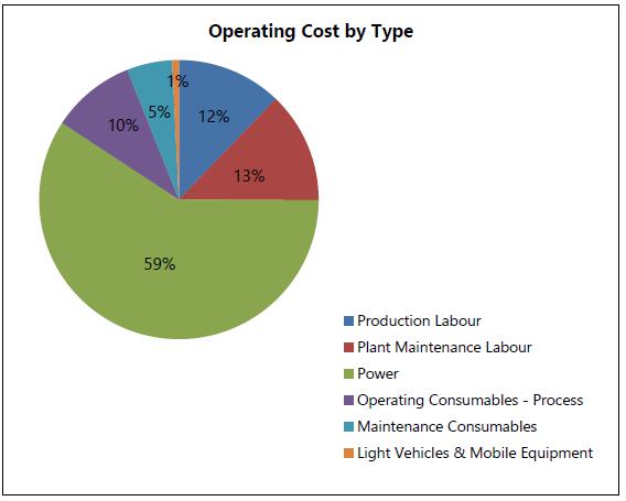
(Source: Ausenco, 2024)
The processing power cost estimate is based on the Arctic electrical load list modified to reflect the Bornite processing scope. The major updates include the removal of redundant flotation equipment and the inclusion of the new regrind mill and tailings filtration plant.
The processing power draw was based on the average power utilization of each motor on the electrical load list. The annual power costs were estimated based on the annual energy consumption at a unit cost of $0.343/kWh, which was derived from the diesel generator cost and its corresponding fuel consumption.
The processing plant power will include small cost allowances for the Arctic truck shop and onsite infrastructure facilities.
Annual energy consumption is estimated at 94,863 MWh, costing an average of $31.7 M/a over LOM.
| Project No.: 253821 | | Capital and Operating Costs | | |
| January 2025 | | Page 18-16 | |
| Bornite Project |
| Northwest Alaska, USA |
| S-K 1300 Technical Report Summary on the Initial Assessment |
Process reagent and consumable costs are estimated based on throughput and the reagent consumption rates. All reagent and consumable costs include freight charges to site.
The operating consumables costs were developed with the following basis:
| · | All reagents and grinding media delivered to site costs have been updated based on 2024 vendor pricing |
| · | Reagent consumptions are based upon interpretation of the metallurgical test work and benchmarking against comparable operations |
| · | Liner consumptions for the jaw crusher, SAG, ball and regrind mill were determined based on available Bornite and Arctic comminution and breakage data |
| · | Grinding media consumption rates are based on the average Bornite material abrasion index (Ai) and average mill power draw. |
| · | Tailings filter cloth costs are based on historical pricing, escalated to 2024. |
The LOM average plant reagent and consumable costs are estimated at $5.4 M/a.
| 18.3.4.4 | Maintenance Consumables |
Annual maintenance consumable costs are estimated based on a benchmarked percentage of the Bornite mechanical equipment costs.
The LOM average maintenance consumables cost is $2.8 M/a.
Processing production labour includes general management, metallurgy, operations, maintenance and laboratory staff.
The labour costs are based on a modified Arctic FS labour manning list, where each position was defined and classified as salary and wages. The staffing costs includes taxes and benefits. The labour estimate was based on providing a labour force to support the two week on, one week off rotation for the operations team, and a full continuous three shift roster for the maintenance team. The total estimated labour force for the plant is estimated at 83 for a LOM average cost of $13.4 M/a.
| Project No.: 253821 | | Capital and Operating Costs | | |
| January 2025 | | Page 18-17 | |
| Bornite Project |
| Northwest Alaska, USA |
| S-K 1300 Technical Report Summary on the Initial Assessment |
| 18.3.5 | General and Administrative Costs |
| 18.3.5.1 | General and Administrative Cost Summary |
General and administrative (G&A) and surface operation costs encompass costs required to support the safe and effective operations of the Arctic and Bornite sites. These costs were jointly developed using Trilogy Metals, Wood and Ausenco in house data from existing operations and include the following:
| · | Total G&A headcount is 53, based on 44 located at Arctic and nine supporting the Bornite site |
| · | Underground dewatering costs, power costs for surface infrastructure, and electrical equipment maintenance costs |
| · | Arctic and Bornite water treatment costs |
| · | General operating costs for safety, training, medical and first aid expenditure, computer supplies and software, human resources services, and entertainment/professional memberships |
| · | G&A operating vehicles and warehousing costs |
| · | Communications including hardware of telecommunications and internet |
| · | Contract services including insurance, consulting, assaying, and additional allowance relocation, recruitment, audit, and legal services |
| · | Camp costs and personnel transport |
| · | Operation and maintenance of the site airport |
| · | Other miscellaneous costs including liaisons to local communities, sustainability costs, etc. |
The G&A and surface operation costs are estimated at $36.3 M/a and the LOM costs are summarized in Table 18-14.
| Project No.: 253821 | | Capital and Operating Costs | | |
| January 2025 | | Page 18-18 | |
| Bornite Project |
| Northwest Alaska, USA |
| S-K 1300 Technical Report Summary on the Initial Assessment |
Table 18-14: G&A Summary Costs
| Description | | LOM Costs
($M) | | | Average Unit Cost of
Mineralized Material Processed
($/t) | |
| G&A Labour (Arctic & Bornite) | | | 147.1 | | | | 4.0 | |
| G&A Operating Costs | | | 121.9 | | | | 3.3 | |
| Airport, Travel and Accommodation Costs | | | 143.0 | | | | 3.9 | |
| Surface Operations | | | 16.4 | | | | 0.4 | |
| Water Treatment Costs (Arctic) | | | 73.7 | | | | 2.0 | |
| Water Treatment Costs (Bornite) | | | 32.1 | | | | 0.9 | |
| Bornite Dewatering Wells | | | 88.3 | | | | 2.4 | |
| Subtotal | | | 622.4 | | | | 16.9 | |
| Capitalized Pre-production | | | (5.1 | ) | | | | |
| Total | | | 617.3 | | | | 16.7 | |
Note: Figures may not sum due to rounding.
Waste water treatment costs for the operation (labour, reagents, power) and maintenance for the reverse osmosis water treatment plant during Bornite plant operation have been developed based on the Arctic operating costs.
Reagent delivered to site prices have been escalated to reflect fourth-quarter 2024 pricing. Refurbishment and closure costs are included in Section 18.2.
The estimated average water treatment cost is $4.3 M/a at Arctic site and $1.9 M/a at Bornite site, which equates to an average of $2.00/t and $0.87/t, respectively of mineralized material processed.
| 18.3.5.3 | Bornite Dewatering Wells |
Dewatering operating costs include pumping costs required for the two underground dewatering phases and the Ruby Valley dewatering. Total LOM costs for dewatering are $88.3 million with the fixed annual operating costs outlined as per Table 18-15.
| Project No.: 253821 | | Capital and Operating Costs | | |
| January 2025 | | Page 18-19 | |
| Bornite Project |
| Northwest Alaska, USA |
| S-K 1300 Technical Report Summary on the Initial Assessment |
Table 18-15: Bornite Dewatering Wells Costs
| Description | | Annual Cost
($M) | |
| Underground Dewatering – Phase 1 (Yr 1 to Yr 3) | | | 3.9 | |
| Underground Dewatering – Phase 2 (Yr 4 to Yr 17) | | | 5.2 | |
| Ruby Creek Dewatering (Yr -1 to Yr 17) | | | 0.2 | |
| Total (Yr -1) | | | 0.2 | |
| Total (Yr 1 to Yr 3) | | | 4.1 | |
| Total (Yr 4 to Yr 17) | | | 5.4 | |
Trilogy Metals have provided an annual cost of the AAP road to be $31.1 million. This represents the annual anticipated AAP toll and maintenance cost for the road. There is uncertainty around the annual cost of this road as AIDEA anticipates multiple users making it difficult to accurately predict the actual road toll cost.
This annual cost is included in G&A in the financial model.
| Project No.: 253821 | | Capital and Operating Costs | | |
| January 2025 | | Page 18-20 | |
| Bornite Project |
| Northwest Alaska, USA |
| S-K 1300 Technical Report Summary on the Initial Assessment |
Certain information and statements contained in this section are forward-looking in nature and are subject to known and unknown risks, uncertainties, and other factors, many of which cannot be controlled or predicted and may cause actual results to differ materially from those presented here. Forward-looking statements include, but are not limited to, statements with respect to the economic and study parameters of the Bornite Project; mineral resources; the cost and timing of any development of the Bornite Project; the proposed mine plan and mining strategy including water management costs; processing method and rates and production rates; projected metallurgical recovery rates and concentrate grades; infrastructure requirements and assumptions regarding road use fees; capital, operating and sustaining cost estimates; copper marketability and commercial terms; the projected LOM and other expected attributes of the Bornite Project; the net present value (NPV), internal rate of return (IRR) and payback period of capital; future copper prices and currency exchange rates; government regulations and permitting timelines; estimates of reclamation obligations; requirements for additional capital; environmental risks; and general business and economic conditions.
The assessment is preliminary in nature, it includes Inferred mineral resources that are considered too speculative geologically to have modifying factors applied to them that would enable them to be categorized as mineral reserves, and there is no certainty that this economic assessment will be realized.
The financial analysis was carried out using a DCF approach. Net annual cash flows were estimated by projecting yearly cash inflows (or revenues) and subtracting projected yearly cash outflows (such as capital and operating costs, royalties, and taxes).
The financial analysis was based on an after-tax discount rate of 8%. Cash flows were assumed to occur at the end of each year and were discounted back to the beginning of the year assumed construction starts and totalled to determine NPV. Cash flows are reported in generic years (e.g., Year -2 (PP2), Year -1 (PP1), Year 1, Year 2, Year 3).
In addition, the IRR, expressed as the discount rate that yields an NPV of zero, and the payback period, expressed as the estimated time from the start of production until all initial capital expenditures have been recovered, were also calculated.
| Project No.: 253821 | | Economic Analysis | | |
| January 2025 | | Page 19-1 | |
| Bornite Project |
| Northwest Alaska, USA |
| S-K 1300 Technical Report Summary on the Initial Assessment |
A sensitivity analysis was carried out to identify potential impacts on NPV and IRR of variations in copper prices, grades, capital costs and operating costs.
All costs within the financial model are expressed in constant, real fourth-quarter 2024 US dollars.
One hundred percent equity financing is assumed with no debt considered in the economic analysis.
| 19.3 | Financial Model Parameters |
The financial analysis was based on royalty agreements described in Section 3.0, the subset of the mineral resource tabulated in Section 11.0, the forecasted mine plan presented in Section 13.0, the process plan and assumptions detailed in Section 14.0, the projected infrastructure requirements outlined in Section 15.0, the copper price assumption in Section 16.0, the permitting, social and environmental regime discussions in Section 17.0, and the capital and operating cost estimates detailed in Section 18.0.
A fixed copper recovery of 90.89% was used for the financial analysis throughout the life of mine. A copper recovery of 88.50% was applied to the stockpiled material assumed to be treated at the end of the LOM. The copper concentrate product is comprised of 29.5% Cu metal. A 7% moisture content was used for the copper concentrate.
A constant long-term copper price of $4.20/lb was used in the economic analysis.
| 19.3.3 | Smelting and Refining Terms |
The concentrate product is assumed to be sold in the Asian markets. The following was applied:
| · | Payable copper of 96.5%, subject to a minimum deduction of 1.0 unit |
| · | Treatment charge of $80/dmt |
| · | Copper refining charge of $0.08/lb Cu payable |
| · | No applicable penalties. |
| Project No.: 253821 | | Economic Analysis | | |
| January 2025 | | Page 19-2 | |
| Bornite Project |
| Northwest Alaska, USA |
| S-K 1300 Technical Report Summary on the Initial Assessment |
No exchange rates have been utilized in the economic analysis.
| 19.3.5 | Transportation and Selling Costs |
The following was applied:
| · | Total shipping cost of $332.52/wmt |
| · | Insurance cost equivalent to 0.15% of the net value of the concentrate (payable value less transportation costs (TC) and refining costs (RC)) |
| · | Marketing and representation cost of $2.50/dmt |
| · | A concentrate transport loss of 0.35%. |
The Project is subject to the following NSR royalties:
| · | NANA (Bornite) – 2.0% NSR royalty on production from the 25 patented mining claims incorporated within the US Mineral Surveys 2233 |
| · | NANA (ANCSA) – 2.5% NSR royalty on production from all other NANA Lands. |
The Bornite Project lies entirely within NANA Lands.
The following tax regimes were incorporated in the post-tax analysis as provided by EY: US Federal Income Tax, Alaska State Income Tax (AST), and Alaska Mining License Tax (AMLT). Taxes were calculated based on currently enacted United States and State of Alaska tax laws and regulations, including the US Federal enactment of the Tax Cuts & Jobs Act (TCJA) on December 22, 2017, and the Coronavirus Aid, Relief and Economic Security Act (CARES Act) on March 27, 2020.
The Alaska Production Royalty tax of 3% is not applicable to the Bornite Project as the Bornite Project’s claims are all federal mining patented claims.
| Project No.: 253821 | | Economic Analysis | | |
| January 2025 | | Page 19-3 | |
| Bornite Project |
| Northwest Alaska, USA |
| S-K 1300 Technical Report Summary on the Initial Assessment |
For tax years beginning on or after January 1, 2018, the US Federal income tax corporate rate is 21% of taxable income, as opposed to a 35% rate which was applicable to prior tax years. Taxable income is calculated as revenues less allowable costs. In addition to other allowable costs, Alaska State Income Tax, AMLT, tax depreciation and the greater of the cost depletion or percentage depletion can be deducted. Cost depletion is the ratable recovery of cost basis as units are produced and sold; however, as noted, cost depletion is not calculated in the model because the initial cost basis of the mineral property has not been provided. IRC §613(a) governs percentage depletion and provides that the deduction for depletion shall be a statutorily prescribed percentage of the taxpayer’s gross income from the mineral property during the taxable year. Such allowance shall not exceed 50% of the taxpayer’s taxable income from the property that is mining related. Relevant statutorily prescribed percentages are 15% for copper. As a result of the TCJA, losses incurred for tax years beginning on or after January 1, 2018, are not eligible to be carried back to prior tax years but may be carried forward indefinitely. However, losses generated under the TCJA are only eligible to offset 80% of taxable income in future years.
For the purposes of this Report, as a stand-alone project, it was assumed that the initial adjusted cost base of the depletable and depreciable property was zero and that the initial loss carry-forwards were zero.
Alaska State Income Tax (AST) is determined based on a company’s federal taxable income and Alaska state adjustments such as add-back of state taxes deducted on the federal income tax return. Alaska adopted an equally weighted three-factor apportionment formula to determine the state taxable income, based on property, payroll, and sales within the state relative to a company’s totals everywhere. AST is calculated using a graduated rate table times apportioned Alaska taxable income with 9.4% being the highest applicable rate. For a consolidated group, Alaska requires two or more Alaska taxpayers engaged in a unitary business and included in the same federal consolidated return to file a consolidated Alaska return.
Alaska generally conforms to IRC §613(a) (percentage depletion) and the TCJA NOL limitation of 80% as provided for the US Federal income tax purposes. Additionally, the Alaskan Alternative Minimum Tax (AMT) statutes are tied to the federal AMT statutes; therefore, the repeal of federal corporate AMT has effectively repealed Alaskan State AMT for tax years beginning on or after January 1, 2018.
| Project No.: 253821 | | Economic Analysis | | |
| January 2025 | | Page 19-4 | |
| Bornite Project |
| Northwest Alaska, USA |
| S-K 1300 Technical Report Summary on the Initial Assessment |
| 19.3.7.3 | Alaska Mining License Tax |
The Alaska Mining License Tax (AMLT) is an income-based tax imposed on the gross income from a mining property in Alaska less deductive mining expenses, including the costs of production (required to be allocated to the product extracted during the tax year) and other expenses that are incident and necessary to the taxpayer’s business activities such as interest, advertising, and Alaska corporate income tax expenses (deductible when paid or accrued). AMLT also provides a deduction for percentage depletion, which is the lower of 15% of net metal revenues (e.g., copper) and 50% of net income before depletion. Alaska provides that loss carry-forwards or carry-backs are not applied when calculating the taxable income subject to AMLT. In addition, explorations costs, federal income taxes, the Alaska mining license tax, losses on the sale of mining equipment or properties, and other capital losses are not deductible. No AMLT tax is charged for the first 3.5 years following commencement of production. In each year, AMLT can be reduced by up to 50% through the application of “Exploration Incentive Credits” (EICs); however, the credits may not exceed $20 million in the aggregate for a mining operation and the credits must be utilized within 15 years. Note the EICs can be utilized against AST as well.
For the purposes of this Report, as a stand-alone project evaluated at the project level, it was assumed that the initial EIC balance is zero even though Trilogy Metals has a history of exploration at the Bornite Project. It was also assumed that no EICs would be earned over the life of the Bornite Project.
A working capital allocation was included in the cash flow model. The following payment terms were assumed:
| · | 30 days in accounts receivable, including revenue |
| · | 30 days in accounts payable, including operating costs and concentrate selling costs. |
Working capital is assumed to be recovered at project completion. Thus, the sum of all working capital over mine life is zero.
| 19.3.9 | Closure and Reclamation |
Total closure costs of $78.8 million were applied following the last period of production. A one-time downpayment (reclamation bond) of $2.5 million was assumed upfront, applied in Year -2.
| Project No.: 253821 | | Economic Analysis | | |
| January 2025 | | Page 19-5 | |
| Bornite Project |
| Northwest Alaska, USA |
| S-K 1300 Technical Report Summary on the Initial Assessment |
A construction period of two years (Years -1 and -2) was considered for the overall project implementation.
Total project capital is $866.5 million comprised of $503.4 million in initial capital and $363.1 million in sustaining capital. This includes pre-production operating costs that have been capitalized in the year incurred.
Operating costs over the LOM total $3,651.6 million.
No salvage value was considered.
No escalation or inflation has been applied. All amounts are in real (constant) terms.
The financial analysis shows a pre-tax NPV of $552.1 million at an 8% discount rate, an IRR of 23.6% and a payback period of 4.0 years. The financial analysis results show an after-tax NPV of $393.9 million at an 8% discount rate, an IRR of 20.0% and a payback period of 4.4 years. Table 19-1 presents a summary of the financial analysis inputs and results. Table 19-2 presents the cash flow summary. The financial analysis is presented on a 100% basis on which Trilogy Metals has a 50% attributable interest.
The financial model on which the analysis is based includes 100% Inferred mineral resources. The results of the economic analysis excluding Inferred mineral resources would not be economically viable.
| Project No.: 253821 | | Economic Analysis | | |
| January 2025 | | Page 19-6 | |
| Bornite Project |
| Northwest Alaska, USA |
| S-K 1300 Technical Report Summary on the Initial Assessment |
Table 19-1: Summary of Financial Results
| Description | | Unit | | | Value | |
| Copper Recovered | | | Mlb | | | | 1,931.0 | |
| Initial Project Capital | | | $M | | | | 503.4 | |
| Sustaining Capital | | | $M | | | | 363.1 | |
| Closure Cost (including bond) | | | $M | | | | 81.2 | |
| Mining Operating Cost | | | $M | | | | 1,589.8 | |
| Process Operating Cost | | | $M | | | | 915.8 | |
| G&A (including water treatment, surface operations and AAP) | | | $M | | | | 1,146.0 | |
| Pre-Tax Valuation Indicators | | | | | | | | |
| Undiscounted cumulative cash flow | | | $M | | | | 1,582.5 | |
| NPV8 | | | $M | | | | 552.1 | |
| Payback period (from start of operations) | | | years | | | | 4.0 | |
| IRR before tax | | | % | | | | 23.6 | |
| Post-Tax Valuation Indicators | | | | | | | | |
| Undiscounted cumulative cash flow | | | $M | | | | 1,218.8 | |
| NPV8 | | | $M | | | | 393.9 | |
| Payback period (from start of operations) | | | years | | | | 4.4 | |
| IRR after tax | | | % | | | | 20.0 | |
| Project No.: 253821 | | Economic Analysis | | |
| January 2025 | | Page 19-7 | |
| Bornite Project |
| Northwest Alaska, USA |
| S-K 1300 Technical Report Summary on the Initial Assessment |
Table 19-2: Cash Flow Summary
| | | | | | | | | Years | |
| Item | | Unit | | | Total | | | PP2 | | | PP1 | | | 1 | | | 2 | | | 3 | | | 4 | | | 5 | | | 6 | | | 7 | | | 8 | | | 9 | | | 10 | | | 11 | | | 12 | | | 13 | | | 14 | | | 15 | | | 16 | | | 17 | | | 18 | | | 19 | | | 20-29 | |
| Mine Production | | | | | | | | | | | | | | | | | | | | | | | | | | | | | | | | | | | | | | | | | | | | | | | | | | | | | | | | | | | | | | | | | | | | | | | | |
| Mineralized material mined | | kt | | | 36,894.7 | | | 53.7 | | | 494.6 | | | 2,089.2 | | | 2,283.6 | | | 2,324.4 | | | 2,306.7 | | | 2,274.1 | | | 2,249.0 | | | 2,223.2 | | | 2,234.4 | | | 2,242.5 | | | 2,262.4 | | | 2,248.6 | | | 2,238.5 | | | 2,251.0 | | | 2,267.2 | | | 2,251.8 | | | 2,136.5 | | | 463.2 | | | - | | | - | | | - | |
| Cu head grade | | % | | | 2.61 | | | 2.05 | | | 2.54 | | | 2.70 | | | 2.71 | | | 2.59 | | | 2.76 | | | 2.70 | | | 2.42 | | | 2.50 | | | 2.50 | | | 2.66 | | | 2.73 | | | 2.68 | | | 2.65 | | | 2.54 | | | 2.55 | | | 2.61 | | | 2.51 | | | 2.68 | | | | | | | | | | |
| Feed to Mill | | | | | | | | | | | | | | | | | | | | | | | | | | | | | | | | | | | | | | | | | | | | | | | | | | | | | | | | | | | | | | | | | | | | | | | | |
| Mill feed | | kt | | | 36,894.7 | | | - | | | - | | | 2,329.4 | | | 2,198.3 | | | 2,184.5 | | | 2,201.8 | | | 2,238.4 | | | 2,222.8 | | | 2,209.3 | | | 2,215.9 | | | 2,188.7 | | | 2,198.9 | | | 2,229.1 | | | 2,213.6 | | | 2,225.5 | | | 2,245.8 | | | 2,234.3 | | | 2,111.1 | | | 1,447.2 | | | - | | | - | | | - | |
| Cu feed grade | | % | | | 2.61 | | | | | | | | | 2.87 | | | 2.78 | | | 2.69 | | | 2.84 | | | 2.73 | | | 2.44 | | | 2.51 | | | 2.51 | | | 2.70 | | | 2.78 | | | 2.69 | | | 2.67 | | | 2.56 | | | 2.56 | | | 2.62 | | | 2.52 | | | 1.57 | | | | | | | | | | |
| Metal Recovery | | | | | | | | | | | | | | | | | | | | | | | | | | | | | | | | | | | | | | | | | | | | | | | | | | | | | | | | | | | | | | | | | | | | | | | | |
| Cu recovered | | Mlb | | | 1,931.0 | | | - | | | - | | | 134.2 | | | 122.5 | | | 117.7 | | | 125.3 | | | 122.4 | | | 108.7 | | | 111.1 | | | 111.4 | | | 118.4 | | | 122.5 | | | 120.2 | | | 118.4 | | | 114.2 | | | 115.2 | | | 117.3 | | | 106.6 | | | 44.8 | | | - | | | - | | | - | |
| Concentrate Production | | | | | | | | | | | | | | | | | | | | | | | | | | | | | | | | | | | | | | | | | | | | | | | | | | | | | | | | | | | | | | | | | | | | | | | | |
| Concentrate produced | | ktdmt | | | 2,969.0 | | | - | | | - | | | 206.3 | | | 188.3 | | | 181.0 | | | 192.7 | | | 188.3 | | | 167.1 | | | 170.9 | | | 171.4 | | | 182.1 | | | 188.3 | | | 184.7 | | | 182.1 | | | 175.5 | | | 177.1 | | | 180.4 | | | 163.9 | | | 69.0 | | | - | | | - | | | - | |
| Cu grade | | % | | | 29.5 | | | | | | | | | 29.5 | | | 29.5 | | | 29.5 | | | 29.5 | | | 29.5 | | | 29.5 | | | 29.5 | | | 29.5 | | | 29.5 | | | 29.5 | | | 29.5 | | | 29.5 | | | 29.5 | | | 29.5 | | | 29.5 | | | 29.5 | | | 29.5 | | | | | | | | | | |
| Payable Metals | | | | | | | | | | | | | | | | | | | | | | | | | | | | | | | | | | | | | | | | | | | | | | | | | | | | | | | | | | | | | | | | | | | | | | | | |
| Cu payable | | Mlb | | | 1,856.8 | | | - | | | - | | | 129.0 | | | 117.8 | | | 113.2 | | | 120.5 | | | 117.7 | | | 104.5 | | | 106.9 | | | 107.2 | | | 113.9 | | | 117.8 | | | 115.5 | | | 113.9 | | | 109.8 | | | 110.8 | | | 112.8 | | | 102.5 | | | 43.1 | | | - | | | - | | | - | |
| Metal Revenue | | $M | | | 7,798.8 | | | - | | | - | | | 541.9 | | | 494.6 | | | 475.6 | | | 506.1 | | | 494.5 | | | 438.9 | | | 448.8 | | | 450.1 | | | 478.2 | | | 494.7 | | | 485.3 | | | 478.3 | | | 461.1 | | | 465.3 | | | 473.7 | | | 430.5 | | | 181.1 | | | - | | | - | | | - | |
| Cu payable value | | $M | | | 7,798.8 | | | - | | | - | | | 541.9 | | | 494.6 | | | 475.6 | | | 506.1 | | | 494.5 | | | 438.9 | | | 448.8 | | | 450.1 | | | 478.2 | | | 494.7 | | | 485.3 | | | 478.3 | | | 461.1 | | | 465.3 | | | 473.7 | | | 430.5 | | | 181.1 | | | - | | | - | | | - | |
| Treatment and Refining Costs | | $M | | | (385.2 | ) | | - | | | - | | | (26.7 | ) | | (24.4 | ) | | (23.5 | ) | | (25.0 | ) | | (24.4 | ) | | (21.7 | ) | | (22.2 | ) | | (22.2 | ) | | (23.6 | ) | | (24.4 | ) | | (24.0 | ) | | (23.6 | ) | | (22.8 | ) | | (23.0 | ) | | (23.4 | ) | | (21.3 | ) | | (8.9 | ) | | - | | | - | | | - | |
| Concentrate treatment cost | | $M | | | (236.7 | ) | | - | | | - | | | (16.4 | ) | | (15.0 | ) | | (14.4 | ) | | (15.4 | ) | | (15.0 | ) | | (13.3 | ) | | (13.6 | ) | | (13.7 | ) | | (14.5 | ) | | (15.0 | ) | | (14.7 | ) | | (14.5 | ) | | (14.0 | ) | | (14.1 | ) | | (14.4 | ) | | (13.1 | ) | | (5.5 | ) | | - | | | - | | | - | |
| Cu refining cost | | $M | | | (148.5 | ) | | - | | | - | | | (10.3 | ) | | (9.4 | ) | | (9.1 | ) | | (9.6 | ) | | (9.4 | ) | | (8.4 | ) | | (8.5 | ) | | (8.6 | ) | | (9.1 | ) | | (9.4 | ) | | (9.2 | ) | | (9.1 | ) | | (8.8 | ) | | (8.9 | ) | | (9.0 | ) | | (8.2 | ) | | (3.4 | ) | | - | | | - | | | - | |
| Transport and Selling Costs | | $M | | | (1,080.1 | ) | | - | | | - | | | (75.0 | ) | | (68.5 | ) | | (65.9 | ) | | (70.1 | ) | | (68.5 | ) | | (60.8 | ) | | (62.2 | ) | | (62.3 | ) | | (66.2 | ) | | (68.5 | ) | | (67.2 | ) | | (66.2 | ) | | (63.9 | ) | | (64.4 | ) | | (65.6 | ) | | (59.6 | ) | | (25.1 | ) | | - | | | - | | | - | |
| Concentrate transport costs | | $M | | | (1,061.6 | ) | | - | | | - | | | (73.8 | ) | | (67.3 | ) | | (64.7 | ) | | (68.9 | ) | | (67.3 | ) | | (59.7 | ) | | (61.1 | ) | | (61.3 | ) | | (65.1 | ) | | (67.3 | ) | | (66.1 | ) | | (65.1 | ) | | (62.8 | ) | | (63.3 | ) | | (64.5 | ) | | (58.6 | ) | | (24.7 | ) | | - | | | - | | | - | |
| Concentrate insurance and selling costs | | $M | | | (18.5 | ) | | - | | | - | | | (1.3 | ) | | (1.2 | ) | | (1.1 | ) | | (1.2 | ) | | (1.2 | ) | | (1.0 | ) | | (1.1 | ) | | (1.1 | ) | | (1.1 | ) | | (1.2 | ) | | (1.2 | ) | | (1.1 | ) | | (1.1 | ) | | (1.1 | ) | | (1.1 | ) | | (1.0 | ) | | (0.4 | ) | | - | | | - | | | - | |
| Net Smelter Return | | $M | | | 6,333.4 | | | - | | | - | | | 439.3 | | | 400.9 | | | 385.5 | | | 410.3 | | | 400.9 | | | 355.8 | | | 363.8 | | | 364.9 | | | 387.7 | | | 401.1 | | | 393.4 | | | 387.8 | | | 373.8 | | | 377.2 | | | 384.0 | | | 349.0 | | | 146.8 | | | - | | | - | | | - | |
| Production Costs | | $M | | | (3,651.6 | ) | | - | | | - | | | (223.2 | ) | | (215.7 | ) | | (234.9 | ) | | (241.9 | ) | | (219.2 | ) | | (216.6 | ) | | (205.7 | ) | | (212.7 | ) | | (224.0 | ) | | (225.7 | ) | | (215.3 | ) | | (218.0 | ) | | (217.5 | ) | | (216.3 | ) | | (214.2 | ) | | (207.0 | ) | | (143.8 | ) | | - | | | - | | | - | |
| Mining | | $M | | | (1,589.8 | ) | | - | | | - | | | (102.2 | ) | | (94.9 | ) | | (113.6 | ) | | (119.3 | ) | | (96.5 | ) | | (93.9 | ) | | (83.1 | ) | | (90.0 | ) | | (101.3 | ) | | (103.0 | ) | | (92.6 | ) | | (95.3 | ) | | (94.8 | ) | | (93.6 | ) | | (91.5 | ) | | (84.5 | ) | | (39.8 | ) | | - | | | - | | | - | |
| Process | | $M | | | (915.8 | ) | | - | | | - | | | (54.7 | ) | | (54.5 | ) | | (55.0 | ) | | (55.0 | ) | | (55.1 | ) | | (55.0 | ) | | (55.0 | ) | | (55.0 | ) | | (55.0 | ) | | (55.0 | ) | | (55.0 | ) | | (55.0 | ) | | (55.0 | ) | | (55.1 | ) | | (55.1 | ) | | (54.9 | ) | | (36.4 | ) | | - | | | - | | | - | |
| G&A | | $M | | | (1,146.0 | ) | | - | | | - | | | (66.4 | ) | | (66.3 | ) | | (66.3 | ) | | (67.6 | ) | | (67.7 | ) | | (67.6 | ) | | (67.6 | ) | | (67.6 | ) | | (67.7 | ) | | (67.6 | ) | | (67.6 | ) | | (67.6 | ) | | (67.7 | ) | | (67.6 | ) | | (67.6 | ) | | (67.6 | ) | | (67.6 | ) | | - | | | - | | | - | |
| Royalties | | $M | | | (151.5 | ) | | - | | | - | | | (10.1 | ) | | (9.4 | ) | | (9.1 | ) | | (9.9 | ) | | (9.8 | ) | | (8.5 | ) | | (8.5 | ) | | (8.5 | ) | | (9.5 | ) | | (9.8 | ) | | (9.4 | ) | | (9.6 | ) | | (9.3 | ) | | (9.0 | ) | | (9.2 | ) | | (8.6 | ) | | (3.5 | ) | | - | | | - | | | - | |
| NSR royalty - Bornite-NANA lands | | $M | | | (27.2 | ) | | - | | | - | | | (3.8 | ) | | (2.8 | ) | | (2.3 | ) | | (1.5 | ) | | (0.9 | ) | | (1.8 | ) | | (2.3 | ) | | (2.5 | ) | | (0.9 | ) | | (0.8 | ) | | (1.7 | ) | | (0.5 | ) | | (0.4 | ) | | (1.8 | ) | | (1.8 | ) | | (0.7 | ) | | (0.8 | ) | | - | | | - | | | - | |
| NSR royalty - NANA-ANCSA lands | | $M | | | (124.1 | ) | | - | | | - | | | (6.3 | ) | | (6.6 | ) | | (6.8 | ) | | (8.5 | ) | | (8.9 | ) | | (6.6 | ) | | (6.3 | ) | | (6.1 | ) | | (8.6 | ) | | (9.0 | ) | | (7.7 | ) | | (9.1 | ) | | (8.9 | ) | | (7.1 | ) | | (7.3 | ) | | (7.9 | ) | | (2.7 | ) | | - | | | - | | | - | |
| Taxes and Royalties | | $M | | | (363.7 | ) | | - | | | - | | | (5.8 | ) | | (15.4 | ) | | (15.4 | ) | | (20.9 | ) | | (26.4 | ) | | (18.3 | ) | | (23.0 | ) | | (21.1 | ) | | (23.9 | ) | | (27.8 | ) | | (29.5 | ) | | (28.1 | ) | | (25.2 | ) | | (27.0 | ) | | (30.6 | ) | | (25.4 | ) | | - | | | - | | | - | | | - | |
| Alaska mining tax | | $M | | | (37.3 | ) | | - | | | - | | | - | | | - | | | - | | | (1.1 | ) | | (3.1 | ) | | (1.6 | ) | | (2.5 | ) | | (2.0 | ) | | (2.5 | ) | | (3.4 | ) | | (3.9 | ) | | (3.6 | ) | | (3.0 | ) | | (3.4 | ) | | (4.2 | ) | | (3.2 | ) | | - | | | - | | | - | | | - | |
| Alaska state income tax | | $M | | | (107.4 | ) | | - | | | - | | | (1.8 | ) | | (5.0 | ) | | (5.0 | ) | | (6.4 | ) | | (7.7 | ) | | (5.5 | ) | | (6.8 | ) | | (6.3 | ) | | (7.0 | ) | | (8.1 | ) | | (8.5 | ) | | (8.1 | ) | | (7.3 | ) | | (7.8 | ) | | (8.8 | ) | | (7.3 | ) | | - | | | - | | | - | | | - | |
| Federal income tax | | $M | | | (218.9 | ) | | - | | | - | | | (4.0 | ) | | (10.3 | ) | | (10.4 | ) | | (13.3 | ) | | (15.7 | ) | | (11.2 | ) | | (13.8 | ) | | (12.8 | ) | | (14.3 | ) | | (16.3 | ) | | (17.1 | ) | | (16.4 | ) | | (14.9 | ) | | (15.8 | ) | | (17.6 | ) | | (14.8 | ) | | - | | | - | | | - | | | - | |
| Capital Costs | | $M | | | (947.7 | ) | | (115.6 | ) | | (390.3 | ) | | (44.2 | ) | | (54.5 | ) | | (51.1 | ) | | (17.4 | ) | | (8.2 | ) | | (20.3 | ) | | (38.6 | ) | | (42.3 | ) | | (16.7 | ) | | (17.4 | ) | | (10.5 | ) | | (8.7 | ) | | (12.0 | ) | | (10.1 | ) | | (5.6 | ) | | (5.4 | ) | | (0.1 | ) | | (29.3 | ) | | (29.3 | ) | | (20.2 | ) |
| Initial Capital | | $M | | | (503.4 | ) | | (113.1 | ) | | (390.3 | ) | | - | | | - | | | - | | | - | | | - | | | - | | | - | | | - | | | - | | | - | | | - | | | - | | | - | | | - | | | - | | | - | | | - | | | - | | | - | | | - | |
| Sustaining Capital | | $M | | | (363.1 | ) | | - | | | - | | | (44.2 | ) | | (54.5 | ) | | (51.1 | ) | | (17.4 | ) | | (8.2 | ) | | (20.3 | ) | | (38.6 | ) | | (42.3 | ) | | (16.7 | ) | | (17.4 | ) | | (10.5 | ) | | (8.7 | ) | | (12.0 | ) | | (10.1 | ) | | (5.6 | ) | | (5.4 | ) | | (0.1 | ) | | - | | | - | | | - | |
| Closure Cost | | $M | | | (81.2 | ) | | (2.5 | ) | | - | | | - | | | - | | | - | | | - | | | - | | | - | | | - | | | - | | | - | | | - | | | - | | | - | | | - | | | - | | | - | | | - | | | - | | | (29.3 | ) | | (29.3 | ) | | (20.2 | ) |
| Working Capital | | | | | | | | | | | | | | | | | | | | | | | | | | | | | | | | | | | | | | | | | | | | | | | | | | | | | | | | | | | | | | | | | | | | | | | | |
| Change in working capital | | $M | | | - | | | - | | | - | | | (17.8 | ) | | 2.5 | | | 2.8 | | | (1.5 | ) | | (1.1 | ) | | 3.5 | | | (1.5 | ) | | 0.5 | | | (1.0 | ) | | (1.0 | ) | | (0.2 | ) | | 0.7 | | | 1.1 | | | (0.4 | ) | | (0.7 | ) | | 2.3 | | | 11.7 | | | - | | | - | | | - | |
| Net Cash Flow | | | | | | | | | | | | | | | | | | | | | | | | | | | | | | | | | | | | | | | | | | | | | | | | | | | | | | | | | | | | | | | | | | | | | | | | |
| Before Tax | | $M | | | 1,582.5 | | | (115.6 | ) | | (390.3 | ) | | 144.8 | | | 124.6 | | | 94.0 | | | 140.3 | | | 163.3 | | | 114.6 | | | 110.0 | | | 102.5 | | | 137.3 | | | 147.9 | | | 158.6 | | | 152.9 | | | 136.8 | | | 142.2 | | | 155.0 | | | 131.0 | | | 11.3 | | | (29.3 | ) | | (29.3 | ) | | (20.2 | ) |
| After Tax | | $M | | | 1,218.8 | | | (115.6 | ) | | (390.3 | ) | | 139.0 | | | 109.2 | | | 78.5 | | | 119.5 | | | 136.9 | | | 96.3 | | | 87.0 | | | 81.5 | | | 113.4 | | | 120.2 | | | 129.1 | | | 124.7 | | | 111.6 | | | 115.2 | | | 124.4 | | | 105.7 | | | 11.3 | | | (29.3 | ) | | (29.3 | ) | | (20.2 | ) |
| Project No.: 253821 | | Economic Analysis | | |
| January 2025 | | Page 19-8 | |
| Bornite Project |
| Northwest Alaska, USA |
| S-K 1300 Technical Report Summary on the Initial Assessment |
A sensitivity analysis was carried out to identify potential impacts on the after-tax NPV and IRR of variations in copper prices, copper grade, capital costs and operating costs. Results of this analysis are presented in Figure 19-1 and Figure 19-2.
The Bornite Project is most sensitive to fluctuations in copper selling price and copper feed grade. It is less sensitive to changes in operating cost and least sensitive to changes in capital cost.
Figure 19-1: After-Tax NPV @ 8% - Sensitivity
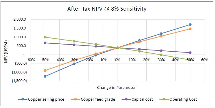
(Source: Wood, 2025)
| Project No.: 253821 | | Economic Analysis | | |
| January 2025 | | Page 19-9 | |
| Bornite Project |
| Northwest Alaska, USA |
| S-K 1300 Technical Report Summary on the Initial Assessment |
| | Figure 19-2: | After-Tax IRR - Sensitivity |
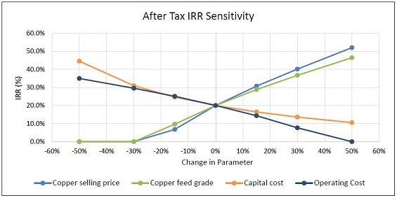
(Source: Wood, 2025)
| Project No.: 253821 | | Economic Analysis | | |
| January 2025 | | Page 19-10 | |
| Bornite Project |
| Northwest Alaska, USA |
| S-K 1300 Technical Report Summary on the Initial Assessment |
The Arctic project is on an adjacent property.
| Project No.: 253821 | | Adjacent Properties | | |
| January 2025 | | Page 20-1 | |
| Bornite Project |
| Northwest Alaska, USA |
| S-K 1300 Technical Report Summary on the Initial Assessment |
| 21.0 | Other Relevant Data and Information |
This section is not relevant to the Report.
| Project No.: 253821 | | Other Relevant Data and Information | | |
| January 2025 | | Page 21-1 | |
| Bornite Project |
| Northwest Alaska, USA |
| S-K 1300 Technical Report Summary on the Initial Assessment |
| 22.0 | interpretation and conclusions |
The QPs of the third-party firms note the following interpretations and conclusions in their respective areas of expertise, based on the review of data available for this Report.
| 22.2 | Mineral Tenure, Surface Rights, Royalties |
Trilogy Metals has provided expert information pertaining to the mineral tenure and property agreements that supports the assumptions used in this Report.
| 22.3 | Geology and Mineralization |
The current assumptions about the geologic controls that influence the distribution of copper mineralization and the geological model that forms the basis of the current Bornite mineral resource estimate are reasonable. The recent lithostratigraphy project improved the understanding of the geological model.
| 22.4 | Data Collection in Support of Mineral Resource Estimation |
The drilling, sampling and validation practices used by NOVAGOLD and Trilogy Metals adhere to accepted industry standards and have resulted in a reliable database for data collected since 2011. Data verification completed by NOVAGOLD and Trilogy Metals that included re-surveying historical drill collar location and re-entering 100% of the historical down hole survey and re-assay of 67% of the historical samples provides reasonable confidence in the reliability of the database. A perceived high bias observed for high-grade historical copper results and the absence of direct quality control support or indirect support through re-assaying for almost all sampling within the high grade Upper and Lower Reef zones remains a risk that should be resolved through re-assaying and new drilling.
Based on the information to date, the Bornite Property hosts a relatively large copper resource that is potentially amenable to a combination of open pit and underground mining methods. The IA has focused on the high-grade portion of the mineral resource (South Reef) that could be mined by underground methods.
| Project No.: 253821 | | Interpretation and Conclusions | | |
| January 2025 | | Page 22-1 | |
| Bornite Project |
| Northwest Alaska, USA |
| S-K 1300 Technical Report Summary on the Initial Assessment |
All of the current mineral resource occurs in the Inferred category and represents an early-stage evaluation of the potential of the Bornite Property. The significant risk and uncertainties that could affect the reliability of the mineral resources or projected economic outcomes include:
| · | Unrecognized complexity and other changes to the interpretation of the geological model and grade shell |
| · | Changes to the mineral resource estimate methodology by different mineral resource QPs |
| · | Adjustments to address the perceived high-grade bias in the higher-grade copper in the historical drill holes |
| · | Unrecognized metallurgical variability |
| · | Uncertainties in the geotechnical and ground water data that could cause changes to the underground mine operating costs and production rates |
| · | Government approval for developing road access to the site. |
These risk factors and uncertainties were considered in the classification of the Inferred mineral resource.
| 22.6 | Metallurgical Test Work |
Three significant metallurgical programs have been conducted using materials from the Bornite project. The sample materials represented a mixture of high and low-grade samples and detailed test work included locked cycle testing in order to report overall copper recoveries and final concentrate grades. The Bornite deposit is thought to be well represented by the test samples in the various test work programs.
The 2017/2018 test work program prepared five large composite samples (development composites) from two drill holes for use in detailed flotation test work. As well, 15 variability samples were prepared as sub-samples for use in grinding test work from this same drill core. These samples represent lower grade mineralization within the constraining pit shell.
The 2018/2019 test program was conducted on nine large composite samples, each representing approximately 40 m of drill core intercept. Composites were selected over a range of grades that generally reflect both open pit and underground mining scenarios. Significant differences in overall copper recovery were observed, with the higher-grade samples showing higher copper recoveries when compared to the lower grade samples.
The 2020/2021 test program was conducted on five large composite samples, each representing approximately 40 m of drill core intercept. These were higher grade samples that generally reflect material amenable to underground mining methods.
| Project No.: 253821 | | Interpretation and Conclusions | | |
| January 2025 | | Page 22-2 | |
| Bornite Project |
| Northwest Alaska, USA |
| S-K 1300 Technical Report Summary on the Initial Assessment |
A key risk to the Bornite Project and the assumptions in the IA, are related to the grade of the mine production and the ability to produce higher grade mill feed as outlined in the mine production schedule. Overall copper recovery is dependent on mill feed grades and overall recovery predictions are dependent on mill feed copper grades.
Mining is projected to take place using underground transverse sublevel mining methods. A cut-off grade of 1.6% Cu was used to constrain the production shapes, based on cut-off optimization to maximize NPV.
Waste and mineralized material will be hauled to the Arctic site for disposal and processing, respectively.
The available geotechnical data is limited to exploration drill core RQD logging and characterization, which is sufficient for this level of study.
The projected water inflows indicate the Bornite underground mine will have higher than typical dewatering requirements for similarly sized operations. Dewatering is expected to be a key aspect of the mining operation.
In the opinion of Wood’s mining QP, the current underground design and LOM plan is reasonable for a IA stage of study and will benefit from more technical data collection and testing to confirm design inputs, additional drilling to upgrade resources into higher confidence categories, and mine optimization activities.
| 22.8 | Processing and Recovery Methods |
Recovery of the Bornite underground deposit is planned using the Arctic process plant at the end of the Arctic deposit mine life. The zinc and lead flotation, regrind and dewatering circuits will either be decommissioned or re-purposed to allow the Bornite material to be processed through a conventional crushing, grinding, flotation and dewatering flowsheet to produce copper concentrate. The plant will be operated at a 10,000 t/d throughput on a two week on and one week off campaign schedule. Up to 50% of the tailings will be dewatered in a new tailings filtration plant to produce a tailings filter cake suitable for the underground mine backfill.
In addition to the tailings filtration facility, one additional regrind mill will be required to operate in parallel with the existing copper and zinc regrind mills, to provide enough regrind capacity.
| Project No.: 253821 | | Interpretation and Conclusions | | |
| January 2025 | | Page 22-3 | |
| Bornite Project |
| Northwest Alaska, USA |
| S-K 1300 Technical Report Summary on the Initial Assessment |
Access to the project area is via the proposed AAP road with an access road to Bornite along a south route and access to Arctic along a north route. The Bornite site infrastructure is concentrated around the existing Bornite Camp, close to the underground portal, limiting the environmental footprint. Surface infrastructure is limited at the Bornite site as the Bornite Project will leverage off of existing infrastructure at Arctic once Arctic mineral reserves have been exhausted.
Surface water management infrastructure at Bornite (channels and ponds) are defined based on available hydrometeorological and site data. Hydrometeorological data is available for site, but analysis has been primarily focused on the Arctic deposit region. Conservative interpretations have been used for design of Bornite surface water infrastructure which can be refined in future stages. Design of key water management infrastructure such as the water treatment pond and Ruby Creek upgrades are dependent on in-situ ground conditions for both cost optimization and ensuring effectiveness of the design (notably, limiting seepage to the underground workings) and are expected to be refined as ground information along the alignments becomes available. The site layout has been optimized to limit the need for treatment of surface water or significant drainage management infrastructure (apart from Ruby Creek). Water treatment needs will be defined based on improved understanding of chemical loading rates from both the underground (peripheral and internal mine dewatering) and surface infrastructure, which will impact the water treatment plant design.
Groundwater management needs, specifically sizing of peripheral dewatering wells and in-mine dewatering infrastructure at Bornite, are defined based on available hydrogeological information and previous assessments. Hydrogeological data is available, including large scale pumping tests from the historical shaft, but is limited for detailed definition of dewatering needs. Conservative interpretations have been made for the design of dewatering infrastructure, which can be refined in future stages. Future updates will need to consider site-specific groundwater quality data.
Water management infrastructure may be impacted by environmental considerations notably, winter discharge constraints, if applicable, have the potential to impact underground development, discharge locations and/or surface water storage needs.
The Bornite portal power plant will comprise six diesel gensets.
| Project No.: 253821 | | Interpretation and Conclusions | | |
| January 2025 | | Page 22-4 | |
| Bornite Project |
| Northwest Alaska, USA |
| S-K 1300 Technical Report Summary on the Initial Assessment |
| 22.10 | Environmental, Permitting, and Plans, Negotiations, or Agreements with Local Individuals or Groups |
Limited environmental baseline data exist for the Bornite Project area. The data are limited to desktop wetlands delineation, surface water hydrology, preliminary historical cultural resource survey and isolated surface water quality sampling. These data are sufficient for the IA but not to fully support mine planning or permitting. It will be necessary to design and implement a new robust environmental baseline program at least five years prior to any mine development activities at Bornite. Limited baseline work has been completed to date, but it has been primarily focused on the broader Ambler District and the Arctic deposit.
The terms of the 2011 NANA Agreement have been implemented including establishing shareholder hiring preference and formalizing the Oversight Committee and funding a scholarship fund that promotes education opportunities for NANA shareholders in the region. Annual meetings with residents of several of the nearest local communities to update residents on project plans have been conducted as well as periodical meetings during the exploration season with residents in the villages of Kobuk, Shungnak and Ambler. These efforts are reasonable and adequate for the stage of the current stage of the Bornite Project. It is recommended that stakeholders be made aware of efforts to develop the IA for Bornite and put it in the context of being developed after mining the Arctic deposit.
No market study analysis has been completed for the Bornite copper concentrate; however, given the expected average copper concentrate grade with no significant amounts of deleterious elements, there should be no barriers to obtain sales contracts with third-party smelters.
The long-term forecast copper price of $4.20/lb used for mine planning and cash flow analysis was provided by an analyst consensus reflecting the average forecasted price from 18 financial institutions.
| 22.12 | Capital and Operating Costs |
The capital and operating costs have been estimated with an expected accuracy within ±50% of final cost and a contingency within what is allowed under S-K 1300 for an IA. The initial capital cost of $503.4 million includes an overall contingency of 14.4% with sustaining capital costs totalling $363.1 million over the LOM. The total capital inclusive of initial and sustaining is estimated at $866.5 million.
| Project No.: 253821 | | Interpretation and Conclusions | | |
| January 2025 | | Page 22-5 | |
| Bornite Project |
| Northwest Alaska, USA |
| S-K 1300 Technical Report Summary on the Initial Assessment |
The operating costs over the LOM are estimated at $3,651.6 million, equivalent to a unit operating cost of $98.97/t of mineralized material processed.
The IA is preliminary in nature and the mineral resources in the mine plans, production schedules, and cash flows are Inferred mineral resources that are considered too speculative geologically to have the economic considerations applied to them that would enable them to be categorized as mineral reserves, and there is no certainty that the IA will be realized.
Under the assumptions presented in this Report, the Bornite Project generates positive after-tax results. The after-tax NPV at an 8% discount rate is $393.9 million with an IRR of 20.0% and an after-tax payback of 4.4 years. The financial results are presented on a 100% basis on which Trilogy Metals has a 50% attributable interest.
The Bornite Project is most sensitive to fluctuations in copper selling price and copper feed grade followed by operating cost and capital cost.
| 22.14.1 | Geology and Mineral Resources |
| · | Risks to the mineral resource estimate are listed in Section 22.3. |
| · | The available geotechnical information indicates that sublevel stoping should be a viable mining method for Bornite, but further studies and core drilling are required to validate this assumption. |
| · | Dewatering quantities may be significant at Bornite based on historical rapid flooding of the exploration shaft when it intersected a specific zone at depth. The plan for Bornite has included substantial dewatering and water management efforts; however, further studies are required to validate the assumptions about dewatering flow quantity and quality. |
| Project No.: 253821 | | Interpretation and Conclusions | | |
| January 2025 | | Page 22-6 | |
| Bornite Project |
| Northwest Alaska, USA |
| S-K 1300 Technical Report Summary on the Initial Assessment |
| · | The IA has assumed the Arctic process plant copper, zinc and tailings thickeners will have sufficient capacity for the Bornite copper concentrate and tailings streams based on benchmarking reference projects and existing operations; however, thickening test work to confirm this has not been completed. |
| · | The IA has assumed the two Arctic process plant copper and zinc filters will have sufficient dewatering capacity for the Bornite copper concentrate based on benchmarking reference projects and existing operations; however, filtration test work to confirm this has not been completed. |
| · | Regrind milling power requirements have been calculated using signature plots and comminution data available from benchmark and reference projects; however, Bornite copper concentrate regrind test work to confirm this has not been completed. |
| · | The tailings filters have been sized from benchmark and reference project filtration data. Bornite tailings material filtration test work to confirm this has not been completed at this level of study. |
| · | Tailings filter cake handleability or transport material test work has not been completed and further work will be required to confirm the filter cake can be adequately transported from Arctic for disposal at Bornite. |
| · | Existing Arctic infrastructure and process equipment must be in good enough condition to be repurposed for processing Bornite material. Increased process capital costs could result should the process infrastructure and plant equipment require replacement at the end of the Arctic mine life. |
| · | Process plant operators may not be familiar with the non-standard campaigned nature of the Arctic plant operation (two week on, one week off schedule), resulting in sub-optimal throughput as a result of the ramp up/down cycling. |
| 22.14.5 | Geotechnical (Tailings) |
| · | Backfilling the Bornite underground mine may not be possible if the plant tailings cannot be processed adequately to provide bulk feed for backfilling, which would significantly affect the mine design and require additional tailings storage. |
| Project No.: 253821 | | Interpretation and Conclusions | | |
| January 2025 | | Page 22-7 | |
| Bornite Project |
| Northwest Alaska, USA |
| S-K 1300 Technical Report Summary on the Initial Assessment |
| · | Water treatment needs are poorly constrained, and assumptions may not actually be conservative leading to higher water treatment costs or significant permitting needs/delays. |
| · | Waste rock characterization and management assumes that long-term (post-reclamation) water treatment is not required. Depending on further analysis, water treatment may be required in closure for an indetermined length of time. |
| · | Permitting and construction of the upgraded Ruby Creek section may be more challenging than anticipated. Similarly, reclamation of the upgrades could require multiple stakeholder approval. |
| 22.14.7 | Project Infrastructure |
| · | Actual ground conditions along proposed infrastructure are not suitable for proposed structures, which must be moved or redesigned resulting in higher costs. |
| · | AAP road not being permitted limiting access to the Bornite Project. |
| · | The uncertainty in the cost of the AAP road could materially affect the results of the economic analysis for the Bornite Project. |
| · | A portion of the Ruby Zone deposit is near surface that is amenable to open pit mining. This material was not included in the mine plan to limit surface capital related to a required expansion of the tailings facility at Arctic, but pending further study work, could be included in a future mine plan. |
| · | A portion of the Ruby Zone deposit is amenable to underground mining. A preliminary design included 6.3 Mt at 2.38% Cu utilizing a cut-and-fill mining method, but this was removed to improve project economics by limiting sustaining capital and the required expansion of the tailings facility at Arctic. Depending on copper price and geological interpretation of the resource, sublevel stoping could be an appropriate mining method. |
| Project No.: 253821 | | Interpretation and Conclusions | | |
| January 2025 | | Page 22-8 | |
| Bornite Project |
| Northwest Alaska, USA |
| S-K 1300 Technical Report Summary on the Initial Assessment |
| · | Converting the talc pre-float circuit into the copper rougher-scavengers would improve the flow routing for the treatment of Bornite material. |
| · | Completing additional comminution characterization test work (Axb, rod mill, ball mill and abrasion) to better represent the mineable resource. |
| · | Expand the number of geological samples subjected to detailed mineralogy and flotation test work, to confirm the current operational parameters are providing optimal metallurgical results for the resource. |
| · | Complete thickening tests for both Bornite copper concentrate and tailings material to confirm the existing Arctic thickeners are adequate for the upgrade and the flocculant dosages required. |
| · | Complete filtration test work on both Bornite copper concentrate and tailings material to confirm the existing Arctic concentrate filters are adequate for the upgrade and to size the tailings filters. |
| · | Complete regrind comminution test work to confirm the regrind mill power requirements and to test various regrind technologies. |
| · | The expansion and re-configuration of the Arctic flowsheet should be considered in the layout of the initial Arctic process plant site to ensure the Bornite process plant upgrade strategy is understood and to minimize brownfield operating impacts and shutdown costs. This would involve: |
| – | Ensuring there is adequate free space on the process pad for the additional regrind mill and tailings filter plant |
| – | Optimizing flotation cell orientation to allow for faster repurposing for the Bornite flowsheet, reducing downtime. |
| · | Complete project execution, shutdown and schedule planning in future project phases to confirm construction shutdown durations for the required process plant modifications at the end of the Arctic deposit mine life. |
| · | Thorough testing may provide an opportunity to custom design an economically viable solution to backfill Bornite. |
| 22.15.3 | Geotechnical (Tailings) |
| · | Integration of Bornite tailings on top of the Arctic tailings may provide positive impacts to the closure water treatment requirements. |
| Project No.: 253821 | | Interpretation and Conclusions | | |
| January 2025 | | Page 22-9 | |
| Bornite Project |
| Northwest Alaska, USA |
| S-K 1300 Technical Report Summary on the Initial Assessment |
| · | Hydraulic connection between Ruby Creek/Ruby Creek valley and the underground is not as significant as assumed resulting in lower water management and dewatering costs than assumed. |
| · | Optimization of water management infrastructure is likely possible, which could simplify the overall system and possibly reduce capital costs. |
| Project No.: 253821 | | Interpretation and Conclusions | | |
| January 2025 | | Page 22-10 | |
| Bornite Project |
| Northwest Alaska, USA |
| S-K 1300 Technical Report Summary on the Initial Assessment |
The QPs of the third-party firms make the following recommendations to advance the Bornite Project with an estimated budget of $172.4 million.
| 23.2 | Geology and Mineral Resources |
Considerable geological mapping has been completed in 2021 and 2022. This information should be used to improve the understanding of the interpreted tectonic style and the role it plays in the distribution of copper mineralization. Interpretation of a discontinuity between the Upper and Lower Reef dolomites continues to be problematic in developing a coherent structural and stratigraphic model for the deposit. Additional subsurface structural interpretation to improve the understanding of discontinuities is recommended. The estimated cost of this work is $50,000.
To help improve the confidence in the resource estimate primarily with historical holes within the Upper and Lower Reef zone, the core boxes of the remaining archived historical core should be laid out, sample intervals flagged where possible, and the integrity of the core examined to determine if re-sampling is possible. Assuming the re-sampling program is feasible, a budget for labour, assay and data analysis is estimated at $0.2 million.
To improve the confidence in the resource estimate and to justify gaining access to the South Reef underground, 20 drill holes totalling 16,000 m is recommended. This total drilling cost is estimated to be approximately $8 million. A scoping study to better define where these holes would be drilled (from surface) is recommended at a cost of $0.4 million.
The Upper and Lower Reef zones should be re-drilled to validate a representative number of historical holes and to infill drill and improve confidence in the estimate (see Section 23.3.6).
To improve confidence in the database quality, a quantified data entry transcription error check should be completed on the entire drill hole database. A random 5% selection, by year, of collar, down hole survey, and assay data should be re-entered from original source documents and compared with the database entries. If the entry error rate exceeds 1% in the random selection, then a new 100% data entry program should be considered. Care should be taken to ensure transformations of collar locations and down hole survey depth from feet to metres, collar transformation from UTM NAD 27 to UTM NAD 83, and down hole survey bearing from quadrant to azimuth are correct and that the source documents are appropriate. The initial database review is estimated to cost $8,000 to $10,000. A full database document review and re-entry is estimated to be an additional $25,000.
| Project No.: 253821 | | Recommendations | | |
| January 2025 | | Page 23-1 | |
| Bornite Project |
| Northwest Alaska, USA |
| S-K 1300 Technical Report Summary on the Initial Assessment |
| 23.3 | Advanced Exploration Underground Decline |
| 23.3.1 | Advanced Exploration Underground Decline Studies |
Two trade-offs have been completed that indicate a savings in exploration costs through use of an exploration decline.
Further studies to advance the exploration decline will include the hydrogeology, geotechnical, and rock mechanics studies listed below, as well as further scoping of the infrastructure required on surface for an exploration decline. Estimated cost of planning the exploration decline is $0.3 million.
There are existing hydrogeology data for the Bornite Project and studies to date suggest risk of high inflow, but data is not available for all areas that could be influenced by the proposed mining. Further studies will be required to advance the overall project to the PFS level. This will include:
| · | Underground Mine Area Characterization: Drilling, hydraulic testing and vibrating wire piezometer installation of approximately 10 drill holes around the underground, including along Upper/Lower Reef contact near Ruby Creek, to characterize hydrogeological parameters influencing mine inflow and recharge mechanisms. Drilling could be combined with exploration or geotechnical programs. Packer testing and vibrating wire installations assumed at ~6,000 m (10 x 600 m average depth). Estimated cost is $0.4 million (time, equipment excluding drilling). |
| · | Underground Mine Area Groundwater Quality: characterization program should include collection of samples for groundwater quality assessment for dewatering wells. Establish baseline groundwater quality monitoring network, including deep groundwater, to allow update of dewatering well discharge water quality. Results will need to be incorporated into broader site water quality prediction models to refine treatment requirements. Estimated cost is $0.2 million (specialized equipment for groundwater sampling, laboratory analyses). |
| · | Shallow Groundwater Characterization: Installation of at least five shallow (overburden and/or shallow bedrock) groundwater wells around the site with subsequent regular monitoring to characterize baseline elevations and quality of local groundwaters. Estimated cost is $0.1 million (time, equipment excluding the cost of drilling). |
| Project No.: 253821 | | Recommendations | | |
| January 2025 | | Page 23-2 | |
| Bornite Project |
| Northwest Alaska, USA |
| S-K 1300 Technical Report Summary on the Initial Assessment |
| · | All data will be integrated into the groundwater model. |
Total estimated cost is $0.7 million.
| · | Drilling/installation of pumping wells with subsequent pumping tests will eventually be required to improve estimates of long-term inflow, but targets and drilling/test design are not well constrained with current information and result in high risk of any well not providing necessary information. This kind of testing will be required but should be deferred until better targeting and design can be completed. PFS stage programs can be used to start building the observation network for pumping tests to be completed at future date. |
The estimated cost is $0.5 million.
| 23.3.3 | Mining Geotechnical |
Investigations will be required to collect additional data to support a PFS level design for Bornite. This will include:
| · | Surface geotechnical drilling investigations including 20 holes totalling approximately 400 m at a cost of $760/m, and material testing to understand the soil foundation conditions related to site infrastructure and mine rock storage. |
PFS-level design efforts are not included in these activities.
Total estimated cost is $0.4 million.
Additional site investigations are needed to collect data to support a PFS level design for Bornite. This will include:
| · | Geomechanical drilling (oriented core) including packer testing to support the development of underground mine design. It is estimated that approximately four to five boreholes will be required of 250 to 400 m in length for approximately 1,500 m of drilling at a cost of $760/m. It is recommended to supplement this work with geophysical acoustic televiewer surveys in open exploration borehole. This work can be accomplished in tandem with the hydrogeological work and exploration drilling. |
| Project No.: 253821 | | Recommendations | | |
| January 2025 | | Page 23-3 | |
| Bornite Project |
| Northwest Alaska, USA |
| S-K 1300 Technical Report Summary on the Initial Assessment |
The estimated cost is $1.3 million.
| 23.3.5 | Advanced Exploration Decline Capital Cost |
Project capital to develop the AEX decline has been estimated at $68 million as detailed in Table 23-1.
| Table 23-1: | Estimated Costs to Develop the Advanced Exploration Decline |
| AEX Decline Capital | | Cost
($M) | |
| Mining Excavation | | | | |
| Boxcut | | | 1.2 | |
| Lateral Development (4,836m) | | | 31.4 | |
| Vertical Development (391m) | | | 4.7 | |
| Subtotal | | | 37.3 | |
| Surface Infrastructure | | | | |
| Site Prep | | | 1.0 | |
| Offices | | | 0.7 | |
| Surface Workshop | | | 1.8 | |
| Fuel Farm | | | 0.8 | |
| Electrical | | | 6.2 | |
| Ventilation Fan | | | 1.6 | |
| Dewatering | | | 5.0 | |
| Subtotal | | | 17.1 | |
| Contingency (25%) | | | 13.6 | |
| Total | | | 68.0 | |
| 23.3.6 | Underground Drill Program |
An underground drill program from the AEX is recommended to increase the confidence in the mineral resources allowing more advanced studies for mining the South Reef deposit. A total of 105,000 m of drilling in 210 drill holes at an average all in cost of $830/m results in an estimated total underground drilling cost of $87 million.
| Project No.: 253821 | | Recommendations | | |
| January 2025 | | Page 23-4 | |
| Bornite Project |
| Northwest Alaska, USA |
| S-K 1300 Technical Report Summary on the Initial Assessment |
| 23.4 | Metallurgical Test Work |
The current design review and recent test work shows that the Arctic processing facility can be adapted to suite the production rates selected for the treatment of Bornite material. Additional metallurgical test work will be required to support more advanced studies for the Bornite Project. The following is recommended:
| · | There is a requirement for grinding, flotation, filtration, and thickening test programs on variability in the two mineralized domains Ruby Zone and South Reef. Test work is recommended to follow the optimized conditions of previous test work programs. |
| · | Detailed test work involving settling and filtering of copper concentrate and tailings. |
| · | Some tailings thickening, and filtration work will be required to assess potential requirements for backfill/dry-stackable materials (transportable on haul trucks on the return leg). Subsequently, adjustments to the existing Arctic process plant design will be required to consider the inclusion of a filtration circuit. |
It is assumed any additional samples required for test work will use the drilling recommended in 23.3.6. The test work has an estimated cost of $1.0 million.
| 23.5 | Processing and Recovery Methods |
Recommendations for re-purposing the Arctic process plant to receive Bornite mineralized material include:
| · | Modifying the layout of the Arctic plant site to consider the future Bornite operation. Layout provision for the installation of the future tailings filtration plant and additional regrind mill is recommended to simplify the upgrade and minimize the downtime required before introducing Bornite material into the plant. |
| · | Developing project and execution plans for future project phases, to adequately identify the brownfield tie-ins and plant modifications required and de-risk the shutdown construction schedule and impact to operations. |
The estimated cost to complete these investigations is $0.5 million.
The Arctic site has the potential to store the current planned Bornite tailings with 50% of the tailings sent back to Bornite for paste backfill. A more thorough evaluation of tailings storage is recommended. Studies should consider both additional locations and technologies, including a site selection study or alternatives assessment. Included in these efforts should be:
| · | Better understanding of the logistics of the haul from Bornite to the Arctic processing plant, as well as the backhaul of filtered tailings for paste backfill. |
| Project No.: 253821 | | Recommendations | | |
| January 2025 | | Page 23-5 | |
| Bornite Project |
| Northwest Alaska, USA |
| S-K 1300 Technical Report Summary on the Initial Assessment |
| · | Revisit the Arctic mine plan, schedule, and closure plan in the context of the Bornite deposit for other synergies. |
| · | Additional locations and layouts for TSFs beyond those considered in this study. |
| · | Geotechnical investigations to support updating the Arctic TSF embankment geometries. |
| · | Determine design and cost impacts to the Arctic closure plan based on the modifications required to accommodate the Bornite tailings. |
| · | A geochemical analysis to determine the water treatment impacts of adding Bornite tailings to the Arctic TSF. |
| · | A rheology study to characterize tailings for both wet disposal and dry stacking methods to optimize project economics. |
The estimated cost for the above studies is approximately $1.0 million, depending on the field investigation scope that is required.
A site-specific hydrometeorological program should be completed to improve hydrological baseline and design parameters for diversions, ditches and water management ponds. Future designs will need to include considerations for discharge locations and any environmental/ regulatory constraints or limitations. Baseline surface water quality program should be continued and/or expanded based on potential project design components.
Initial geotechnical drilling and/or test pitting program will be required to improve understanding of soil geotechnical characteristics along diversion/ditch alignments and pond locations. The scale of this program could be on the order of 25 to 50 locations, combined, and on the order of 350 m of drilling, all to shallow depths on the order of 10 to 1 5 m.
The estimated cost is $0.3 million.
| Project No.: 253821 | | Recommendations | | |
| January 2025 | | Page 23-6 | |
| Bornite Project |
| Northwest Alaska, USA |
| S-K 1300 Technical Report Summary on the Initial Assessment |
Water treatment requirements need to be advanced. Water quality predictions will be dependent on results of geochemistry assessments, water quality monitoring and, ultimately, water quality predictions (with site water balance).
Geochemical testing programs will be required to characterize mineralized material and waste rock materials. These include static tests (acid base accounting/shake flask extraction (ABA)/(SFE) as well as longer-lead time testing (humidity cells and/or field barrels). Water and load balance modelling will need to be advanced in conjunction with baseline work (see Section 23.9), followed by water treatment Best Available Technology (BAT) assessments.
The estimated cost is $0.8 million.
Access to the Bornite site has been assumed via the development of the proposed AAP road that will extend from the UKMP to the Dalton Highway. In 2020, the Bureau of Land Management (BLM) granted permits for the right-of-way approval for the road which has been contested with lawsuits and led to the suspension in the right-of-way permit in 2022. In October 2023, the BLM released a draft supplemental environmental impact statement focussing on assessing impacts to resources as a result of the AAP road. In June 2024, the BLM recommended a “No Action” alternative in Record of Decision (ROD).
Trilogy Metals has identified a number of options regarding the AAP road:
| · | Land conveyance of BLM-managed lands to State of Alaska and Regional Alaska Native Corporations |
| · | Remand existing ROD to select different alternative |
| · | File new permit application (possible joint road/mine permit application) |
| · | Transfer permit application to another entity |
| · | Governor Dunleavy’s December 2024 Alaska Priorities for Federal Transition report to Trump’s national transition team in Washington, DC requests restoration of the Right-of-Way to the Ambler Mining District. |
Given the uncertainty around permitting the AAP road being granted, Wood’s mining QP recommends a study to investigate other options for accessing the Bornite site.
The estimated cost is $0.1 million.
| Project No.: 253821 | | Recommendations | | |
| January 2025 | | Page 23-7 | |
| Bornite Project |
| Northwest Alaska, USA |
| S-K 1300 Technical Report Summary on the Initial Assessment |
| 23.9 | Environmental, Permitting, and Plans, Negotiations, or Agreements with Local Individuals or Groups |
A robust environmental baseline program should be initiated at least five years prior to any mine development activities at Bornite. The focus of the new baseline program should include wetlands delineation, surface water quality monitoring, aquatic life monitoring, meteorological monitoring, archaeology pedestrian surveys, snow surveys, and hydrogeology (groundwater) studies.
NEPA pre-planning in early project development plans should be considered to add efficiency and reduce the risk typically associated with the NEPA process.
Continued efforts should be made to engage community stakeholders in the region and integrate these stakeholders into future mine development plans to the greatest possible extent, including adopting mine development plans that consider the impacts to these stakeholders and their lifestyles.
The estimated cost for a five-year baseline program is $1.8 million.
Recommended costs for work to further the development of the Bornite Project are summarized in Table 23-2.
| Table 23-2: | Costs for Recommended Work Programs |
| Discipline | | Cost
($M) | |
| Geology and Mineral Resource | | | 8.7 | |
| Advanced Exploration Decline Planning | | | 0.3 | |
| Hydrogeology | | | 1.2 | |
| Mining Geotechnical | | | 0.4 | |
| Rock Mechanics | | | 1.3 | |
| Advanced Exploration Decline Capital | | | 68.0 | |
| Underground Drilling | | | 87.0 | |
| Metallurgical Test Work | | | 1.0 | |
| Recovery Method/Process Design | | | 0.5 | |
| Tailings Studies | | | 1.0 | |
| Water Management | | | 1.1 | |
| Infrastructure | | | 0.1 | |
| Environmental Studies | | | 1.8 | |
| Total | | | 172.4 | |
| Project No.: 253821 | | Recommendations | | |
| January 2025 | | Page 23-8 | |
| Bornite Project |
| Northwest Alaska, USA |
| S-K 1300 Technical Report Summary on the Initial Assessment |
AACE International, 2020. AACE International Recommended Practice No. 47R-11 Cost Estimate Classification System – As Applied in Engineering, Procurement, and Construction for the Mining and Mineral Processing Industries, August 7, 2020
ALS Metallurgy, 2013. Metallurgical Assessment of the Bornite Deposit, report prepared for NovaCopper Inc. Report reference KM3621
ALS Metallurgy, 2019. Copper and Cobalt Recovery Test Work on the Bornite Project Samples, report prepared for Trilogy Metals. Report reference KM5705
ALS Metallurgy, 2021. Flotation Test Work on 5 Bornite UG Zone Composites, report prepared for Ambler Metals. Report reference KM6184
Ausenco, 2023a. Arctic Project Pre-feasibility Study Update Alaska, USA. January 18, 2023
Ausenco, 2023b. Arctic Project NI 43-101 Technical Report and Feasibility Study, Ambler Mining District, Alaska, effective date January 20, 2023
Avé Lallemant, H.G., Gottschalk, R.R., Sisson, V.B., and Oldow, J.S., 1998. Structural analysis of the Kobuk fault zone, north-central Alaska, in Oldow, J.S., and Avé Lallemant, H.G., eds., Architecture of the Central Brooks Range Fold and Thrust Belt, Arctic Alaska: Boulder, Colorado, Geologic Society of America Special Paper 324.
BCMC, 1961. Amenability Testing of Ruby Creek, Alaska Samples, Exploration Lot D-378, Bear Creek Mining Company memorandum
Beisher, G., 2000. Ruby Creek Copper Prospect Bornite Carbonate Sequence, NANA Regional Corporation Lands Northwest Alaska report submitted to M.I.M. (USA) Inc.
Bergstrom, F., 2008. Trip Report – Arctic and Bornite, August 13-18, 2008 memorandum, Amerikanuak, Inc.
Bernstein, L.R., and Cox, D.P., 1986. Geology and Sulfide Mineralization of the Number One Orebody, Ruby Creek Copper Deposit, Alaska: Economic Geology, 81, p. 1675-1689.
Bigelow, C.G., 1963. Facies distribution, structure and mineralization, Ruby Creek Development project, Alaska June 1963: Bear Creek Mining Company internal report
Braem, N.M., Mikow, E.H., Wilson, S.J., and Kostick, M.L., 2015. Wild Food Harvests in 3 Upper Kobuk Communities: Ambler, Shungnak and Kobuk, 2012-2013, Alaska Department of Fish and Game, Division of Subsistence
Braund, S.R., et al., 2012. Ambler Mining District Access Project, Subsistence Data Gap Memo, prepared for Alaska Department of Transportation and Public Facilities
| Project No.: 253821 | | References | | |
| January 2025 | | Page 24-1 | |
| Bornite Project |
| Northwest Alaska, USA |
| S-K 1300 Technical Report Summary on the Initial Assessment |
Christiansen, P.P. and Snee, L.W., 1994. Structure, metamorphism, and geochronology of the Cosmos Hills and Ruby Ridge, Brooks Range Schist Belt, Alaska: Tectonics, 13, p. 193-213.
CIM, 2014. CIM Definition Standards for Mineral Resources and Mineral Reserves
CIM, 2019. CIM Estimation of Mineral Resources and Mineral Reserves Best Practice Guidelines
Conner, D.T., 2015. The Geology of the Bornite Copper-Zinc-Cobalt Carbonate-Hosted Deposit, Southwestern Brooks Range, Alaska: M.Sc. thesis submitted to the Colorado School of Mines
Craig, C., 2011. Ambler Project Asbestos Soil Sampling Report, internal report prepared for the Alaska Gold Company
Craig, C., 2013. Water Quality Monitoring Report: First Quarter 2013, internal report prepared for NovaCopper Inc.
Craig, C., 2013. Water Quality Monitoring Report: Second Quarter 2013, internal report prepared for NovaCopper Inc.
Craig, C., 2013. 2012 Water Quality Monitoring Report Third Quarter, internal report prepared for NovaCopper US Inc.
Craig, C., 2013. 2013 Water Quality Monitoring Report First Quarter, internal report prepared for NovaCopper US Inc.
Craig, C., 2013. 2013 Water Quality Monitoring Report Third Quarter, internal report prepared for NovaCopper US Inc.
Craig, C., 2014. 2014 Water Quality Monitoring Report Third Quarter, internal report prepared for NovaCopper US Inc.
Craig, C., 2015. 2015 Water Quality Monitoring Report Third Quarter, internal report prepared for NovaCopper US Inc.
Crupi, S.R., 2007. Ambler Project 2007 Environmental Baseline Sampling Alaska Gold Co., Shaw Alaska, Inc.
Crupi, S.R., 2008. Shaw Hydraulics Data Report July 2008 Event Final, Shaw Environmental, Inc.
Crupi, S.R., 2008. Water Quality Report July 2008 Event Final, Shaw Environmental, Inc.
Crupi, S.R., 2009. Hydraulics Data Report July 2009 Event Draft, Shaw Environmental, Inc.
Crupi, S.R., 2009. Water Quality Report July 2009 Event Final, Shaw Alaska, Inc.
| Project No.: 253821 | | References | | |
| January 2025 | | Page 24-2 | |
| Bornite Project |
| Northwest Alaska, USA |
| S-K 1300 Technical Report Summary on the Initial Assessment |
Davis, B., 2012. NI 43-101 Technical Report Resource Estimate – Ruby Creek Zone, Bornite Deposit, Upper Kobuk Mineral Project, Northwest Alaska, effective date July 18, 2012, 120 p.
Davis, B., and Sim, R., 2013. Technical Report for the Bornite Deposit South Reef and Ruby Creek Zones, Northwest Alaska, USA, effective date January 31, 2013, 149 p.
Davis, B., Sim, R., and Austin, J., 2014. NI 43-101 Technical Report on the Bornite Project, Northwest Alaska, USA, effective date March 18, 2014, 152 p.
Davis, B., Sim, R., and Austin, J., 2016. NI 43-101 Technical Report on the Bornite Project, Northwest Alaska, USA, effective date April 19, 2016, 169 p.
Davis, B., Sim, R., and Austin, J., 2018. NI 43-101 Technical Report on the Bornite Project, Northwest Alaska, USA, effective date June 5, 2018, 172 p.
Dillon, J.T., Pessel, G.H., Chen, J.H., and Veach, N.C., 1980. Middle Paleozoic magmatism and orogenesis in the Brooks Range, Alaska: Geology, 8, p. 338-343.
DOWL HKM, 2012. DOWL HKM September 2012 Trip Report, DOWL HKM
DOWL HKM, 2012. DOWL HKM Stream Gage Install July-August 2012 Trip Report
DOWL, 2015. NovaCopper Wetlands Assessment, DOWL
Dryden, J., 2012. Dryden Stream Gage Install August 2012 Trip Report
Einsele, G., 1998. Event stratigraphy: Recognition and Interpretation of Sedimentary Event Horizons. In: Doyle P, Bennett MR (eds) Unlocking the stratigraphic record: advances in modern stratigraphy, Wiley, Chichester, p. 145-193.
Erskine, C.F., 1970. Summary Report on Ground Water Investigations at Ruby Creek Division, Bornite, Alaska, November 1966 through April 1968: Metal Mining Division – Engineering Department internal report for Kennecott Copper Corporation
Exploration Agreement and Option to Lease between NovaCopper US Inc. and NANA Regional Corporation, Inc. dated October 19, 2011, as amended
Fugro, 2007. DIGHEM Survey for Alaska Gold Company, Bornite and Baird Mountains Areas and Kugruk Area, Alaska. Job #06053.
Gilbert et al., 1977. Geology of Ruby Ridge, Southwestern Brooks Range, Alaska: Alaska Division of Geological and Geophysical Surveys Geologic Report 58.
Grinnell, J.G., 1901. Gold Hunting in Alaska (E. Grinnell, Ed.), David C. Cook Publishing Company
Gustin, M.M., and Ronning, P., 2013. NI 43-101 Technical Report on the Sun Project, prepared by Mine Development Associates of Reno, Nevada for Andover Mining Corp.
| Project No.: 253821 | | References | | |
| January 2025 | | Page 24-3 | |
| Bornite Project |
| Northwest Alaska, USA |
| S-K 1300 Technical Report Summary on the Initial Assessment |
Hale, C., 1996. 1995 Annual Ambler District Report: Kennecott Exploration Internal report
Hale, C., 1997. Ruby Creek-Cosmos Hills Geology, 1997 Results: Kennecott Exploration Internal report
Hawke Engineering, 1966. Flooding on October 27, 1966 exploration shaft at Bornite Alaska: Hawk Engineering internal report for Ruby Creek development Kennecott Copper Corp.
Hitzman, M.W., Smith, T.E., and Proffett, J.M., 1982. Bedrock Geology of the Ambler District, Southwestern Brooks Range, Alaska: Alaska Division of Geological and Geophysical Surveys Geologic Report 75, 1:50,000.
Hitzman, M.W., 1983. Geology of the Cosmos Hills and its relationship to the Ruby Creek copper-cobalt deposit: Unpublished Ph.D. dissertation, Stanford, CA, Stanford University, 266 p.
Hitzman, M.W., 1986. Geology of the Ruby Creek Copper Deposit: Economic Geology, 81, p. 1644-1674.
Hitzman, M.W., Proffett, J.M., Schmidt, J.M., Smith, T.E., 1986. Geology and Mineralization of the Ambler District, Northwest Alaska: Economic Geology, 81, p. 1592-1618.
Jones, A., 2023. Germanium Occurrence in the Bornite Deposit, Southwestern Brooks Range, Alaska: M.Sc. thesis submitted to the Colorado School of Mines.
Kim, H, and Drake, A., 2023. NI 43-101 Technical Report on the Mineral Resource update of the Bornite Project, Northwest Alaska, USA, effective date January 26, 2023
Lutz, N.R., 1960. Progress report Ruby Creek thru 1959: Bear Creek Mining Company internal report
Lutz, N.R., 1961. Memo: Bear Creek Mining Co.
Mahaffey, Z., 2021. The Mineralogical Associations, Distribution, and Mineral Zoning of Cobalt in the Bornite Deposit, Southwest Brooks Range, Alaska: M.Sc. thesis submitted to the University of Alaska Fairbanks
McClelland, W.C., Schmidt, J.M., and Till, A.B., 2006. New U-Pb SHRIMP ages from Devonian felsic volcanic and Proterozoic plutonic rocks of the southern Brooks Range, AK: Geologic Society of America Abstracts with Programs, v. 38, n. 5, p. 12.
Mejia, J., and Aliakbari, E., 2024. Fraser Institute Annual Survey of Mining Companies 2023
Merkel, 1967. Analysis of Resistivity and IP Drill-Hole Logs and Surface Expanders from Ruby Creek, Alaska, Bear Creek Mining Company internal report
| Project No.: 253821 | | References | | |
| January 2025 | | Page 24-4 | |
| Bornite Project |
| Northwest Alaska, USA |
| S-K 1300 Technical Report Summary on the Initial Assessment |
Moore, T.E., 1992. The Arctic Alaska Superterrane in Bradley, D.C., and Dusel-Bacon, C., eds., Geologic Studies in Alaska by the U.S. Geological Survey, 1991: U.S. Geological Survey Bulletin 2041, p. 238-244.
Moore, T.E., Wallace, W.K, Bird, K.J., Karl, S.M., Mull, C.G., and Dillon, J.T., 1994. Geology of northern Alaska, in Plafker, G., and Berg, H.C., eds., The Geology of Alaska: Boulder, Colorado, Geologic Society of America, The Geology of North America, v. G-1.
Murray, K., Fink, D., Boese, C., Bowie A., Murphy, B., Kim, H., and Wendlandt, P., 2023. Arctic Project NI 43-101 Technical Report and Feasibility Study Ambler Mining District, Alaska, effective date January 20, 2023, 509 p.
NANA Regional Corporation, Inc., 2010. Kobuk Village Profile
National Instrument, 2016. National Instrument 43-101 Standards of Disclosure for Mineral Projects (May 9, 2016)
Neely, B., and Proue, M., 2008. Assessment of Cultural Resources and Site Potential of Proposed Geologic Exploration Drill Areas, Northwest Alaska, Northern Land Use Research, Inc.
Nickson, S.D, 1992. Cable Support Guidelines for Underground Hard Rock Mine Operations. Masters of Applied Science Thesis. Faculty of Graduate Studies Mining and Mineral Process Engineering, University of British Columbia
NovaCopper, 2013. Technical Report for the Bornite Deposit South Reef and Ruby Creek Zones, Northwest Alaska, USA: prepared by BD Resource Consulting Inc.
O‘Connor, L., 2011. Summary of Geophysical Surveys in the Vicinity of the Bornite Deposit, Alaska
Penny, C.T., 1966. Annual Report Ruby Creek Division, Kennecott Copper Corp. Internal report
Penny, C.T., 1968. Review Ruby Creek Division 1964 – 68: Kennecott Exploration Internal report
Piekenbrock, J., 2015. Lithogeochemical Review: NovaCopper Inc. Internal report
Ratterman, N.S., McClelland, W.C., and Presnell, R.D., 2006. Geochronology and lithogeochemistry of volcanic rocks of the Ambler District, Southern Brooks Range, Alaska: Geologic Society of America Abstracts with Programs, v. 38, n. 5, p. 69.
Robinson, J., 2010. The Ruby Creek Deposit in 2009, NovaGold Resources Internal report
Roskowski, J., 2011. Bornite Collar Corrections, NovaCopper Internal memo
Rossi, M., and Deutsch, C., 2014. Mineral Resource Estimation, Springer, New York, NY, 2014.
| Project No.: 253821 | | References | | |
| January 2025 | | Page 24-5 | |
| Bornite Project |
| Northwest Alaska, USA |
| S-K 1300 Technical Report Summary on the Initial Assessment |
Runnels, D.D., 1963. The copper deposits of Ruby Creek, Cosmos Hills, Alaska: Ph.D. Thesis, Harvard University, Cambridge Massachusetts, University Microfilms Inc., Ann Arbor, Michigan, 274 p.
Selby, D., Kelley, K.D., Hitzman, M.W., Zieg, J., 2009. Re-Os sulfide (bornite, chalcopyrite, and pyrite) systematics of the carbonate-hosted copper deposits at Ruby Creek, southwestern Brooks Range, Alaska: Economic Geology, 104, p. 437-444.
SGS Canada Inc., 2018. An Investigation into Comminution and Flotation Studies of Samples from the Bornite Deposit, report prepared for Trilogy Metals. Report reference CAVM-50296-0001.
Sim, R., Davis, B.M., and Austin, J.B., 2022. Trilogy Metals Inc. NI 43-101 Technical Report on the Bornite Project, Northwest Alaska, USA, effective date December 31, 2021, 186 p.
Subpart 229.1300-Disclosure by Registrants Engaged in Mining Operations under Regulation S-K.
Smith, P.S., 1913. The Noatak-Kobuk Region, Alaska, USGS, Bulletin 536.
SRK, 2017. Review of Hydrogeological Conditions and Preliminary Estimate of Dewatering Rates for the Bornite Deposit, Alaska. SRK Consulting (Canada) Inc. report prepared for Trilogy Metals Inc. SRK Project No. 1CT030.000. May 2017. 104 pages
SRK, 2022. Arctic Deposit Project: Climate and Hydrology Baseline and Existing Conditions Assessment. SRK Consulting (Canada) Inc. report prepared for Ambler Metals Ltd. SRK Project No. 1UA059.004. September 2022. 89 pages
SRK, 2023a. Email communication from Anne Day, Water Resources Consultant at SRK, regarding “flow estimation for Alaska project”. August 22, 2023
SRK, 2023b. Internal SRK communications from Soren Jensen, Principal Consultant Environmental Engineering at SRK regarding “Bornite water treatment plan footprint”. September 13, 2023
SRK, 2025. Technical Report for Surface Water, Hydrogeology, Tailings Storage, Water Treatment and Closure for Bornite PEA. SRK Consulting (Canada) Inc. Report prepared for Trilogy Metals Inc. Project No. CAPR003466. February 2025
Staples, P., Davis, B.M, MacDonald, A., Austin, J.B., Boese, C., Murphy, B., Sharp, T., and Romero, A.P., 2020. Arctic Feasibility Study, Alaska, USA, NI 43-101 Technical Report, effective date August 20, 2020, 397 p.
TetraTech, 2010. Arctic Deposit Access Environmental Baseline Data Collection Aquatics, TetraTech, Inc.
| Project No.: 253821 | | References | | |
| January 2025 | | Page 24-6 | |
| Bornite Project |
| Northwest Alaska, USA |
| S-K 1300 Technical Report Summary on the Initial Assessment |
TetraTech, 2010. Arctic Deposit Access Environmental Baseline Data Collection Hydrology, TetraTech, Inc.
TetraTech, 2010. Arctic Deposit Access Environmental Baseline Data Collection Wetlands & Vegetation, TetraTech, Inc.
Till, A.B., Dumoulin, J.A., Harris, A.G., Moore, T.E., Bleick, H.A., and Siwiec, B.R., 2008. Bedrock geologic map of the Southern Brooks Range, Alaska and accompanying conodont data: U.S. Geologic Survey Open File Report 2008-1149.
Travis/Peterson Environmental Consulting, Inc., 2007. Bornite Mine Camp Site Characterization Report, prepared for NANA Regional Corporation
Turner, E., 2021. Lithofacies, stratigraphy and implications of the Bornite succession; internal report prepared for Ambler Metals Inc.
Vallat, C., 2012. Quality Assurance and Quality Control Report on NovaCopper, Bornite and Arctic Projects 2012 Northwest Alaska, internal memo prepared for NovaCopper
Vallat, C., 2013a. Quality Assurance and Quality Control Report on the NovaCopper Bornite Project 2013 Northwest Alaska, internal memo prepared for NovaCopper
Vallat, C., 2013b. NovaCopper Inc. 2012 and 2013 Bornite Re-Assay Results Compared with Original Results, internal memo prepared for NovaCopper
Vallat, C., 2014. Quality Assurance and Quality Control Report on the NovaCopper Bornite Project 2014 Northwest Alaska, internal memo prepared for NovaCopper
Vallat, C., 2017a. QAQC Report for Bornite Project Cobalt Assays Reported From 2011 to 2017, internal memo prepared for Trilogy Metals
Vallat, C., 2017b. Trilogy Metals Inc. 2017 Bornite and Cosmos Project Assay QAQC, internal memo prepared for NovaCopper
Vallat, C., 2019. Trilogy Metals Inc. 2018 Bornite Project Analytical Result Quality Assurance and Quality Control, internal memo prepared for Trilogy Metals
Vallat, C., 2020. QAQC Report for Bornite Project Assays Reported for Drill Holes RC-19-0257 through RC19-0266, internal memo prepared for Trilogy Metals
Vance, T., 1962. A Preliminary Study of Ground-Water Conditions at Ruby Creek, Alaska: internal report for Bear Creek Mining Company
Vogl, J.J., 2003. Thermal-baric structure and P-T history of the Brooks Range metamorphic core, Alaska: Journal of Metamorphic Geology, 21, p. 269-284.
West, A., 2013. 2013 Bornite Drill Data Validation, internal memo prepared for NovaCopper
| Project No.: 253821 | | References | | |
| January 2025 | | Page 24-7 | |
| Bornite Project |
| Northwest Alaska, USA |
| S-K 1300 Technical Report Summary on the Initial Assessment |
West, A., 2014. Identified 2013 Erroneous SG Measurements, internal memo prepared for NovaCopper
Williams, 1988. Bornite Data Summaries internal report, Kennecott Internal report
Zimmerley, S.R, 1961. Amenability of Samples from the Ruby Creek, Alaska, Copper Prospect – Exploration Lot D-378, Letter to R. D. Hutchinson, District Geologist, Bear Creek Mining Company
| Project No.: 253821 | | References | | |
| January 2025 | | Page 24-8 | |
| Bornite Project |
| Northwest Alaska, USA |
| S-K 1300 Technical Report Summary on the Initial Assessment |
| 25.0 | reliance on information provided by the registrant |
The QPs of the third-party firms have fully relied upon information provided by registrant (Trilogy Metals) on legal matters.
This information is used in Section 3.0 for property description and legal agreements, in Section 11.0 for inputs for establishing reasonable prospects for economic extraction, in Section 13.0 for inputs to the mine plan, and in Section 19.0 to support royalty costs and attributable ownership interest in the economic analysis.
The QPs of the third-party firms consider it reasonable to rely on this information as they understand that Trilogy Metals obtained independent legal opinion when providing this information.
The Wood mining QP has used the Ernst & Young LLP (EY) information as described in a letter to Wood entitled:
| · | “Provisions of income tax and mineral tax portions of economic analysis for the preliminary economic assessment technical report on Trilogy’s Bornite Project”, dated November 28, 2024. |
for the application to the financial model in the IA.
The Wood mining QP has fully relied upon this information provided by Trilogy Metals on taxation matters.
This information is used in support of the sub-section on tax information and the tax inputs to the financial model that provides the after-tax financial analysis in Section 19.0.
The Wood mining QP consider it reasonable to rely on this information since Trilogy Metals obtained independent taxation advisors that supports the details on the taxation rate and taxation schemes and they reviewed the financial model for the correct application of taxes in the model.
| Project No.: 253821 | | Reliance on Information Provided by the Registrant | | |
| January 2025 | | Page 25-1 | |