Exhibit 96.1
![]() | ![]() |
Table of Contents
1 | EXECUTIVE SUMMARY | 1 | ||||||||
1.1 | Introduction | 1 | ||||||||
1.2 | Terms of Reference | 1 | ||||||||
1.3 | Property Description | 1 | ||||||||
1.4 | Mineral Tenure, Surface Rights, Water Rights, Royalties and Agreements | 2 | ||||||||
1.5 | Geological Setting, Mineralization, and Deposit | 3 | ||||||||
1.6 | History | 4 | ||||||||
1.7 | Exploration | 4 | ||||||||
1.8 | Sample Preparation, Analyses, and Security | 4 | ||||||||
1.9 | Data Verification | 6 | ||||||||
1.10 | Mineral Processing and Metallurgical Testing | 6 | ||||||||
1.11 | Mineral Resource Estimates | 7 | ||||||||
1.12 | Mineral Resource Statement | 9 | ||||||||
1.13 | Mineral Reserve Estimates | 10 | ||||||||
1.14 | Mineral Reserve Statement | 11 | ||||||||
1.15 | Mining Methods | 11 | ||||||||
1.15.1 | Overview | 11 | ||||||||
1.15.2 | Geotechnical Considerations | 12 | ||||||||
1.15.3 | Mine Design | 12 | ||||||||
1.15.4 | Mine Production Plan | 13 | ||||||||
1.16 | Processing and Recovery Methods | 14 | ||||||||
1.17 | Infrastructure | 18 | ||||||||
1.17.1 | Overview | 18 | ||||||||
1.17.2 | Temporary Rock Storage Facilities and Borrow Pits | 18 | ||||||||
1.17.3 | Tailings Storage Facility | 18 | ||||||||
1.17.4 | Water Management | 19 | ||||||||
1.17.5 | Water Balance | 19 | ||||||||
1.18 | Market Studies | 19 | ||||||||
1.19 | Environmental Studies, Permitting, and Plans, Negotiations, or Agreements with Local Individuals or Groups | 20 | ||||||||
1.19.1 | Overview | 20 | ||||||||
1.19.2 | Environmental Considerations | 20 | ||||||||
1.19.3 | Closure and Reclamation | 20 | ||||||||
1.19.4 | Permitting Considerations | 20 | ||||||||
1.19.5 | Social Considerations | 21 | ||||||||
1.20 | Capital and Operating Costs | 21 | ||||||||
1.20.1 | Capital Costs | 21 |
Grassy Mountain Project |
Page i | |
S-K 1300 Technical Report Summary on Feasibility Study
| June 30, 2022
|
![]() | ![]() |
1.20.2 | Operating Costs | 22 | ||||||||
1.21 | Economic Analysis | 22 | ||||||||
1.21.1 | Sensitivity Analysis | 26 | ||||||||
1.22 | Interpretations and Conclusions | 27 | ||||||||
1.23 | Risks and Opportunities | 28 | ||||||||
1.23.1 | Risks | 28 | ||||||||
1.23.2 | Opportunities | 29 | ||||||||
1.24 | Recommendations | 30 | ||||||||
1.24.1 | Introduction | 30 | ||||||||
1.24.2 | Mining | 30 | ||||||||
1.24.3 | Hydrology | 30 | ||||||||
1.24.4 | Geotechnical | 31 | ||||||||
1.24.5 | Resource Model | 31 | ||||||||
1.24.6 | Mineral Processing and Metallurgical Testing | 31 | ||||||||
2 | INTRODUCTION | 33 | ||||||||
2.1 | Introduction | 33 | ||||||||
2.2 | Terms of Reference | 33 | ||||||||
2.3 | Qualified Persons | 33 | ||||||||
2.4 | Site Visits and Scope of Personal Inspection | 34 | ||||||||
2.5 | Effective Dates | 35 | ||||||||
2.6 | Information Sources and References | 35 | ||||||||
2.7 | Previous Technical Reports | 35 | ||||||||
2.8 | Abbreviations and Acronyms | 36 | ||||||||
3 | PROPERTY DESCRIPTION | 41 | ||||||||
3.1 | Introduction | 41 | ||||||||
3.2 | Mineral Tenure | 42 | ||||||||
3.2.1 | Mineral Concession Payment Terms | 42 | ||||||||
3.2.2 | Land Access and Ownership Agreements | 42 | ||||||||
3.2.3 | Seabridge Gold Corporation | 42 | ||||||||
3.2.4 | Sherry and Yates, Inc. | 42 | ||||||||
3.2.5 | Cryla LLC | 43 | ||||||||
3.3 | Royalties and Additional Encumbrances | 44 | ||||||||
3.3.1 | Seabridge Gold | 44 | ||||||||
3.3.2 | Sherry and Yates | 44 | ||||||||
3.3.3 | Cryla | 45 | ||||||||
3.3.4 | Other Encumbrances | 45 | ||||||||
3.4 | Environmental Liabilities | 45 | ||||||||
3.5 | Environmental Permitting | 45 | ||||||||
3.6 | Surface Rights | 46 | ||||||||
3.7 | Water Rights | 46 | ||||||||
3.8 | Summary Statement | 46 |
Grassy Mountain Project |
Page ii | |
S-K 1300 Technical Report Summary on Feasibility Study
| June 30, 2022
|
![]() | ![]() |
4 | ACESSIBILITY, CLIMATE, LOCAL RESOURCES, INFRASTRUCTURE AND PHYSIOGRAPHY | 47 | ||||||||
4.1 | Access | 47 | ||||||||
4.2 | Physiography | 48 | ||||||||
4.3 | Climate | 49 | ||||||||
4.4 | Water Supply | 49 | ||||||||
4.5 | Power | 49 | ||||||||
4.6 | Infrastructure | 49 | ||||||||
4.7 | Community Services | 49 | ||||||||
5 | HISTORY | 51 | ||||||||
5.1 | Introduction | 51 | ||||||||
5.2 | 1986–1996 Exploration | 51 | ||||||||
5.2.1 | Atlas 1986–1992 | 51 | ||||||||
5.2.2 | Newmont 1992–1996 | 52 | ||||||||
5.2.3 | 1996 Exploration at Outlying Targets within the Grassy Mountain Claims Group | 52 | ||||||||
5.3 | 1998–2016 Exploration | 55 | ||||||||
5.3.1 | Tombstone 1998 | 55 | ||||||||
5.3.2 | Seabridge 2000–2010 | 55 | ||||||||
5.3.3 | Calico 2011–2016 | 55 | ||||||||
5.4 | Production | 57 | ||||||||
6 | GEOLOGICAL SETTING, MINERALIZATION, AND DEPOSIT | 58 | ||||||||
6.1 | Introduction | 58 | ||||||||
6.2 | Regional Geologic Setting | 58 | ||||||||
6.3 | Local and Property Geology | 58 | ||||||||
6.4 | Grassy Mountain Deposit | 61 | ||||||||
6.4.1 | Geology | 61 | ||||||||
6.4.2 | Structure | 63 | ||||||||
6.4.3 | Alteration and Mineralization | 63 | ||||||||
6.5 | Deposit Types | 65 | ||||||||
7 | EXPLORATION | 66 | ||||||||
7.1 | Drilling | 67 | ||||||||
7.1.1 | Historical Drilling 1987–2012 | 72 | ||||||||
7.1.2 | Paramount Drilling 2016–2019 | 74 | ||||||||
7.2 | Drill-Hole Collar and Down-Hole Surveys | 77 | ||||||||
7.3 | Sample Quality | 78 | ||||||||
7.3.1 | Core Samples | 78 | ||||||||
7.3.2 | RC Samples | 80 | ||||||||
7.4 | Summary Statement | 81 | ||||||||
8 | SAMPLE PREPARATION, ANALYSES AND SECURITY | 82 | ||||||||
8.1 | Introduction | 82 | ||||||||
8.2 | Sample Preparation, Analysis and Security | 82 |
Grassy Mountain Project |
Page iii | |
S-K 1300 Technical Report Summary on Feasibility Study
| June 30, 2022
|
![]() | ![]() |
8.2.1 | Atlas 1987–1992 | 82 | ||||||||
8.2.2 | Newmont 1992–1996 | 82 | ||||||||
8.2.3 | Tombstone 1998 | 83 | ||||||||
8.2.4 | Calico 2011–2012 | 83 | ||||||||
8.2.5 | Paramount 2016–2019 | 84 | ||||||||
8.3 | Quality Assurance/Quality Control Procedures | 85 | ||||||||
8.3.1 | Atlas QA/QC 1987–1992 | 85 | ||||||||
8.3.2 | Newmont QA/QC 1992–1996 | 85 | ||||||||
8.3.3 | Tombstone QA/QC 1998 | 86 | ||||||||
8.3.4 | Calico QA/QC 2011–2012 | 86 | ||||||||
8.3.5 | Paramount QA/QC 2016–2019 | 87 | ||||||||
8.4 | Quality Assurance/Quality Control Results | 88 | ||||||||
8.4.1 | Atlas 1987–1992 | 88 | ||||||||
8.4.2 | Newmont 1992–1996 | 92 | ||||||||
8.4.3 | Tombstone 1998 | 95 | ||||||||
8.4.4 | Calico 2011–2012 | 96 | ||||||||
8.4.5 | Paramount 2016–2017 | 99 | ||||||||
8.4.6 | Paramount 2018–2019 | 105 | ||||||||
8.4.7 | Discussion of QA/QC Results | 106 | ||||||||
8.5 | Summary Statement | 106 | ||||||||
9 | DATA VERIFICATION | 107 | ||||||||
9.1 | Drill-Hole Data | 107 | ||||||||
9.1.1 | Collar Data | 107 | ||||||||
9.1.2 | Down-Hole Survey Data | 107 | ||||||||
9.1.3 | Assay Data | 108 | ||||||||
9.1.4 | Additional Data Verification | 108 | ||||||||
9.2 | Site and Field Office Inspections | 109 | ||||||||
9.3 | Summary Statement | 109 | ||||||||
10 | MINERAL PROCESSING AND METALLURGICAL TESTING | 111 | ||||||||
10.1 | Introduction | 111 | ||||||||
10.2 | Historical Testwork Programs | 111 | ||||||||
10.2.1 | Historical Studies 1989 to 2012 | 111 | ||||||||
10.2.2 | Historical Testwork from 2018 PFS | 111 | ||||||||
10.3 | FS Testwork | 112 | ||||||||
10.3.1 | Objectives | 112 | ||||||||
10.3.2 | SGS Testwork Program 15944-02 Scope of Work | 112 | ||||||||
10.3.3 | McClelland Testwork Program MLI 4551 Scope of Work | 112 | ||||||||
10.3.4 | Sample Selection for SGS Program 15944-02 | 113 | ||||||||
10.3.5 | Sample Selection for McClelland Program MLI 4551 | 113 | ||||||||
10.4 | Presentation and Discussion of Results | 114 | ||||||||
10.4.1 | Ore Characterization and Deleterious Elements | 114 |
Grassy Mountain Project |
Page iv | |
S-K 1300 Technical Report Summary on Feasibility Study
| June 30, 2022
|
![]() | ![]() |
10.4.2 | Comminution Test Results | 115 | ||||||||
10.4.3 | Mineralogical Analysis | 116 | ||||||||
10.4.4 | Leach Tests | 117 | ||||||||
10.4.5 | Cyanide Destruction | 121 | ||||||||
10.5 | Recovery Estimation | 122 | ||||||||
10.5.1 | Leach Recovery, SGS Program 15944-001, SGS Program 15944-02 and McClelland Program MLI 4551 | 122 | ||||||||
10.6 | Conclusions | 128 | ||||||||
10.7 | Qualified Person’s Opinion on Data Adequacy | 129 | ||||||||
11 | MINERAL RESOURCE ESTIMATES | 130 | ||||||||
11.1 | Introduction | 130 | ||||||||
11.2 | Grassy Mountain Project Data | 130 | ||||||||
11.2.1 | Drill-Hole Database | 130 | ||||||||
11.2.2 | Topography | 130 | ||||||||
11.3 | Deposit Geology Relevant to Resource Modeling | 130 | ||||||||
11.4 | Geologic Modeling | 131 | ||||||||
11.5 | Water Table and Oxidation Modeling | 132 | ||||||||
11.6 | Density Modeling | 132 | ||||||||
11.7 | Gold and Silver Modeling | 133 | ||||||||
11.7.1 | Mineral Domains | 133 | ||||||||
11.7.2 | Assay Coding, Capping, and Compositing | 139 | ||||||||
11.7.3 | Block Model Coding | 141 | ||||||||
11.7.4 | Grade Interpolation | 141 | ||||||||
11.7.5 | Model Checks | 143 | ||||||||
11.8 | Grassy Mountain Mineral Resources | 143 | ||||||||
11.8.1 | Classification | 151 | ||||||||
11.9 | Additional Comments on the Modeling of the Mineral Resources | 152 | ||||||||
12 | MINERAL RESERVE ESTIMATES | 154 | ||||||||
12.1 | Introduction | 154 | ||||||||
12.1.1 | Estimation Procedure | 154 | ||||||||
12.2 | Mineral Reserve Statement | 154 | ||||||||
12.3 | Economic Cut-off Grade Calculation | 155 | ||||||||
12.3.1 | Gold Price | 155 | ||||||||
12.3.2 | Silver Price | 157 | ||||||||
12.4 | Stope Design | 158 | ||||||||
12.5 | Dilution and Recovery | 159 | ||||||||
12.5.1 | External Dilution | 159 | ||||||||
12.5.2 | Internal Dilution | 161 | ||||||||
12.5.3 | Mining Recovery | 161 | ||||||||
12.6 | Discussion of Mineral Reserves | 161 | ||||||||
12.7 | Classification | 162 |
Grassy Mountain Project |
Page v | |
S-K 1300 Technical Report Summary on Feasibility Study
| June 30, 2022
|
![]() | ![]() |
13 | MINING METHODS | 164 | ||||||||
13.1 | Mining Method Selection | 164 | ||||||||
13.1.1 | Mechanized Cut-and-fill Mining | 164 | ||||||||
13.1.2 | Mining Method Sequence | 167 | ||||||||
13.2 | Geotechnical Analysis | 168 | ||||||||
13.2.1 | Overview | 168 | ||||||||
13.2.2 | Geotechnical Characterization | 170 | ||||||||
13.2.3 | Golder Geotechnical Appraisal | 171 | ||||||||
13.2.4 | Ausenco Geotechnical Work | 172 | ||||||||
13.2.5 | Feasibility Study Geotechnical Analysis | 175 | ||||||||
13.2.6 | Geotechnical Model | 178 | ||||||||
13.2.7 | Summary of Geotechnical Analysis and Evaluation for Underground Mining | 180 | ||||||||
13.3 | Hydrogeological modelling | 180 | ||||||||
13.4 | Excavation Design | 180 | ||||||||
13.4.1 | Mining Method Selection | 180 | ||||||||
13.4.2 | Drift Sizes and Stability Assessments | 181 | ||||||||
13.5 | Numerical Modelling | 184 | ||||||||
13.5.1 | Ground Support | 190 | ||||||||
13.5.2 | Ground Monitoring Program | 191 | ||||||||
13.5.3 | Global Extraction Sequence | 192 | ||||||||
13.6 | Portal Design | 193 | ||||||||
13.7 | Grade Control | 193 | ||||||||
13.8 | Personnel | 193 | ||||||||
13.9 | Development Design | 194 | ||||||||
13.9.1 | Mine Design Parameters | 194 | ||||||||
13.9.2 | Level Access | 194 | ||||||||
13.9.3 | Station Design | 195 | ||||||||
13.10 | Equipment Selection | 196 | ||||||||
13.11 | Production and Development Productivity Assumptions | 197 | ||||||||
13.11.1 | Drilling and Bolting | 197 | ||||||||
13.11.2 | Shotcrete | 199 | ||||||||
13.11.3 | Blasting | 202 | ||||||||
13.11.4 | Mucking | 203 | ||||||||
13.11.5 | Hauling | 205 | ||||||||
13.11.6 | Backfilling | 207 | ||||||||
13.11.7 | Backfill Plant | 210 | ||||||||
13.11.8 | Production Scheduling | 211 | ||||||||
13.11.9 | Underground Mining Construction | 214 | ||||||||
13.11.10 | Underground Mining Production Ramp-Up | 216 | ||||||||
13.12 | Underground Infrastructure and Services | 218 | ||||||||
13.12.1 | Ventilation | 218 | ||||||||
13.12.2 | Underground Dewatering | 220 |
Grassy Mountain Project |
Page vi | |
S-K 1300 Technical Report Summary on Feasibility Study
| June 30, 2022
|
![]() | ![]() |
13.12.3 | Underground Power | 222 | ||||||||
13.12.4 | Underground Communications | 222 | ||||||||
13.12.5 | Underground Refuge and Escape Ways | 222 | ||||||||
13.13 | Mining Costs | 223 | ||||||||
13.14 | Life-of-Mine Production | 223 | ||||||||
14 | PROCESSING AND RECOVERY METHODS | 228 | ||||||||
14.1 | Introduction | 228 | ||||||||
14.2 | Process Design Criteria | 228 | ||||||||
14.3 | Process Flowsheet Development | 230 | ||||||||
14.4 | Overall Process Description | 233 | ||||||||
14.4.1 | Crushing Circuit | 233 | ||||||||
14.4.2 | Grinding Circuit | 234 | ||||||||
14.4.3 | CIL Leaching | 234 | ||||||||
14.4.4 | Carbon Management | 235 | ||||||||
14.4.5 | Gold Room | 236 | ||||||||
14.4.6 | Cyanide Detoxification and Tailings Deposition | 236 | ||||||||
14.4.7 | Reagent Handling and Storage | 237 | ||||||||
14.4.8 | Air Supply and Distribution | 239 | ||||||||
14.4.9 | Water Supply and Distribution | 239 | ||||||||
14.5 | Personnel | 239 | ||||||||
14.6 | Sampling and Metallurgical Laboratory | 240 | ||||||||
14.7 | Projected Energy Requirements | 240 | ||||||||
14.8 | Project Water Requirements | 240 | ||||||||
15 | INFRASTRUCTURE | 241 | ||||||||
15.1 | Introduction | 241 | ||||||||
15.2 | Access | 243 | ||||||||
15.3 | Temporary Waste Rock Storage Facility (TWRSF) | 243 | ||||||||
15.4 | Basalt Borrow Quarry | 243 | ||||||||
15.5 | Tailings Storage Facility | 244 | ||||||||
15.5.1 | Topography, Drainage, and Vegetation | 246 | ||||||||
15.5.2 | Past Studies, Subsurface Investigations, and Civil Design | 246 | ||||||||
15.5.3 | Design Objectives | 246 | ||||||||
15.5.4 | TSF Design | 247 | ||||||||
15.5.5 | Monitoring | 249 | ||||||||
15.5.6 | Closure | 250 | ||||||||
15.6 | Closure Cover Borrow Areas | 250 | ||||||||
15.7 | Water Management | 251 | ||||||||
15.7.1 | Non-Contact Water Management | 251 | ||||||||
15.7.2 | Contact Water Management | 253 | ||||||||
15.7.3 | Site-wide Water Balance | 255 | ||||||||
15.8 | Built Infrastructure | 256 |
Grassy Mountain Project |
Page vii | |
S-K 1300 Technical Report Summary on Feasibility Study
| June 30, 2022
|
![]() | ![]() |
15.9 | Camps and Accommodation | 257 | ||||||||
15.10 | Power and Electrical | 257 | ||||||||
16 | MARKET STUDIES | 258 | ||||||||
16.1 | Introduction | 258 | ||||||||
16.2 | Market Studies | 258 | ||||||||
16.3 | Metal Pricing and Projections | 258 | ||||||||
16.3.1 | Economic Analysis | 258 | ||||||||
16.3.2 | Metal Pricing Forecasts | 260 | ||||||||
16.4 | Contracts | 261 | ||||||||
16.5 | QP Comment | 261 | ||||||||
17 | ENVIRONMENTAL STUDIES, PERMITTING, AND PLANS, NEGOTIATIONS, OR AGREEMENTS WITH LOCAL INDIVIDUALS OR GROUPS | 262 | ||||||||
17.1 | Introduction | 262 | ||||||||
17.2 | Permit History | 263 | ||||||||
17.3 | Project Permits | 264 | ||||||||
17.4 | State of Oregon Permit Processing | 264 | ||||||||
17.4.1 | Federal Plan of Operations Processing | 267 | ||||||||
17.4.2 | Malheur County Permit Processing | 267 | ||||||||
17.5 | Environmental Study Results and Known Issues | 268 | ||||||||
17.5.1 | Baseline Studies | 268 | ||||||||
17.5.2 | Geochemical Characterization and Groundwater Studies | 269 | ||||||||
17.6 | Waste Disposal, Monitoring, Water Management | 270 | ||||||||
17.7 | Social and Community Issues | 270 | ||||||||
17.8 | Closure | 271 | ||||||||
17.9 | Environmental and Permitting Risks and Opportunities | 271 | ||||||||
17.10 | Qualified Person’s Opinion | 272 | ||||||||
18 | CAPITAL AND OPERATING COSTS | 273 | ||||||||
18.1 | Capital Cost Estimate | 273 | ||||||||
18.1.1 | Introduction | 273 | ||||||||
18.1.2 | Project Execution | 274 | ||||||||
18.1.3 | Estimate Summary | 274 | ||||||||
18.1.4 | Sustaining Capital Cost Estimate | 275 | ||||||||
18.1.5 | Definition of Costs | 276 | ||||||||
18.1.6 | Methodology | 276 | ||||||||
18.1.7 | Exchange Rates | 277 | ||||||||
18.1.8 | Market Availability | 277 | ||||||||
18.1.9 | Mining Capital Cost Estimate | 278 | ||||||||
18.1.10 | Processing and Overall Site Infrastructure Capital Cost Estimate | 282 | ||||||||
18.1.11 | Tailings Storage and Temporary Waste Rock Storage Facilities Capital Cost Estimate | 288 | ||||||||
18.1.12 | Indirect Capital Cost Estimate | 289 | ||||||||
18.1.13 | Owner’s Costs | 290 |
Grassy Mountain Project |
Page viii | |
S-K 1300 Technical Report Summary on Feasibility Study
| June 30, 2022
|
![]() | ![]() |
18.1.14 | Contingency | 290 | ||||||||
18.1.15 | Reclamation and Closure Capital Cost Estimate | 291 | ||||||||
18.2 | Operating Cost Estimate | 291 | ||||||||
18.2.1 | Basis of Operating Cost Estimate | 291 | ||||||||
18.2.2 | Mining Operating Cost Estimate | 291 | ||||||||
18.2.3 | Process Operating Cost Estimate | 294 | ||||||||
18.2.4 | General and Administrative Operating Cost Estimate | 296 | ||||||||
19 | ECONOMIC ANALYSIS | 298 | ||||||||
19.1 | Cautionary Statement Regarding Forward-Looking Information | 298 | ||||||||
19.2 | Methodology Used | 299 | ||||||||
19.3 | Financial Model Parameters | 299 | ||||||||
19.4 | Taxes | 300 | ||||||||
19.5 | Royalty | 300 | ||||||||
19.6 | Economic Analysis | 300 | ||||||||
19.7 | Sensitivity Analysis | 304 | ||||||||
19.8 | Conclusion – Economic Analysis | 307 | ||||||||
20 | ADJACENT PROPERTIES | 308 | ||||||||
21 | OTHER RELEVANT DATA AND INFORMATION | 309 | ||||||||
22 | INTERPRETATION AND CONCLUSIONS | 310 | ||||||||
22.1 | Introduction | 310 | ||||||||
22.2 | Mineral Tenure, Surface Rights, Water Rights, Royalties and Agreements | 310 | ||||||||
22.3 | Geology and Mineralization | 310 | ||||||||
22.4 | Exploration, Drilling and Analytical Data Collection in Support of Mineral Resource Estimation | 311 | ||||||||
22.5 | Metallurgical Testwork | 311 | ||||||||
22.6 | Mineral Resource Estimates | 312 | ||||||||
22.7 | Mineral Reserve Estimates | 312 | ||||||||
22.8 | Mine Plan | 313 | ||||||||
22.8.1 | Mining Method | 313 | ||||||||
22.8.2 | Geotechnical Considerations | 313 | ||||||||
22.9 | Recovery Plan | 314 | ||||||||
22.10 | Infrastructure | 314 | ||||||||
22.10.1 | Key Infrastructure | 314 | ||||||||
22.10.2 | Roads and Power | 314 | ||||||||
22.10.3 | Waste Rock Storage and Borrow Pits | 314 | ||||||||
22.10.4 | Tailings Storage Facility | 315 | ||||||||
22.10.5 | Water Management | 315 | ||||||||
22.10.6 | Water Supply | 315 | ||||||||
22.11 | Environmental, Permitting and Social Considerations | 316 | ||||||||
22.12 | Markets and Contracts | 316 | ||||||||
22.13 | Capital Cost Estimates | 316 |
Grassy Mountain Project |
Page ix | |
S-K 1300 Technical Report Summary on Feasibility Study
| June 30, 2022
|
![]() | ![]() |
22.14 | Operating Cost Estimates | 317 | ||||||||
22.15 | Economic Analysis | 317 | ||||||||
22.16 | Risks and Opportunities | 318 | ||||||||
22.16.1 | Risks | 318 | ||||||||
22.16.2 | Opportunities | 320 | ||||||||
22.17 | Conclusions | 320 | ||||||||
23 | RECOMMENDATIONS | 321 | ||||||||
23.1 | Introduction | 321 | ||||||||
23.2 | Mining | 321 | ||||||||
23.3 | Hydrology | 321 | ||||||||
23.4 | Geotechnical | 321 | ||||||||
23.5 | Resource Model | 324 | ||||||||
23.6 | Mineral Processing and Metallurgical Testing | 324 | ||||||||
24 | REFERENCES | 325 | ||||||||
25 | RELIANCE ON INFORMATION PROVIDED BY THE REGISTRANT | 330 | ||||||||
25.1 | Introduction | 330 | ||||||||
25.2 | Macroeconomic trends | 330 | ||||||||
25.3 | Markets | 330 | ||||||||
25.4 | Legal Matters | 330 | ||||||||
25.5 | Environmental Matters | 331 |
APPENDIX A – CLAIMS LIST
List of Tables
Table 1-1: | Mineral Resource Statement | 9 | ||||
Table 1-2: | Cut-off Grade Input Parameters for Gold Metal | 10 | ||||
Table 1-3: | Mineral Reserves Statement | 11 | ||||
Table 1-4: | Initial Capital Cost Estimate Summary (direct and indirect) | 22 | ||||
Table 1-5: | Summary of Forecast Project Economics | 25 | ||||
Table 2-1: | Abbreviations and Acronyms | 36 | ||||
Table 2-2: | Unit Abbreviations | 39 | ||||
Table 3-1: | Grassy Mountain Annual 2022 Land Holding Costs | 43 | ||||
Table 7-1: | Grassy Mountain Claim Block Drilling Summary | 68 | ||||
Table 7-2: | Paramount 2016–2019 RC Pre-Collar vs. Core Lengths | 76 | ||||
Table 8-1: | Grassy Mountain Certified Reference Materials for 2011–2012 | 86 | ||||
Table 8-2: | Grassy Mountain Certified Reference Materials | 87 |
Grassy Mountain Project |
Page x | |
S-K 1300 Technical Report Summary on Feasibility Study
| June 30, 2022
|
![]() | ![]() |
Table 10-1: | 2018 PFS Testwork Scope | 113 | ||||
Table 10-2: | Metallurgical Test Matrix for SGS Program 15944-02 | 114 | ||||
Table 10-3 : | FS Production Composites Sample Composition | 114 | ||||
Table 10-4: | Head Assays | 115 | ||||
Table 10-5: | Hazen 1989 Comminution Results | 115 | ||||
Table 10-6: | Summary of JK DWT Results | 115 | ||||
Table 10-7: | Bond Rod Mill Grindability Test Results | 116 | ||||
Table 10-8: | Ball Mill Work Indices | 116 | ||||
Table 10-9: | Average Cyanide and Lime Consumption | 121 | ||||
Table 10-10: | Cyanide Destruction Test Results from Historical Work | 122 | ||||
Table 10-11: | Cyanide Destruction Test Results – Continuous Test | 123 | ||||
Table 10-12: | Leach Test Data Used for Recovery Estimation | 123 | ||||
Table 10-13: | Estimated Additional Plant Losses for Gold | 127 | ||||
Table 10-14: | Estimated Additional Plant Losses for Silver | 128 | ||||
Table 11-1: | Hazen Research, Inc. Tonnage Factors | 132 | ||||
Table 11-2: | Combined Atlas and Paramount Tonnage Factors | 133 | ||||
Table 11-3: | Approximate Grade Ranges of Gold and Silver Domains | 134 | ||||
Table 11-4: | Grassy Mountain Gold and Silver Assay Caps by Domain | 139 | ||||
Table 11-5: | Descriptive Statistics of Grassy Mountain Coded Gold Assays | 140 | ||||
Table 11-6: | Descriptive Statistics of Grassy Mountain Coded Silver Assays | 140 | ||||
Table 11-7: | Descriptive Statistics of Grassy Mountain Gold Composites | 141 | ||||
Table 11-8: | Descriptive Statistics of Grassy Mountain Silver Composites | 141 | ||||
Table 11-9: | Estimation Parameters | 142 | ||||
Table 11-10: | Pit Optimization Parameters | 144 | ||||
Table 11-11: | Parameters Used to Determine Cut-Off Grade for Mineral Resources Potentially Amenable to Underground Mining Methods | 145 | ||||
Table 11-12: | Grassy Mountain Gold and Silver Resources – Exclusive of Mineral Reserves | 145 | ||||
Table 11-13: | Grassy Mountain Gold and Silver Resources – Inclusive of Mineral Reserves | 146 | ||||
Table 11-14: | Resource Classification Parameters | 152 | ||||
Table 12-1: | Mineral Reserves Statement | 155 | ||||
Table 12-2: | Cut-off Grade Input Parameters for Gold Metal | 156 | ||||
Table 12-3: | Total Mineral Reserves Multiplied by the Metal Price | 158 | ||||
Table 12-4: | Stope Optimization Parameters | 158 | ||||
Table 12-5: | External Dilution Grade by Level | 160 | ||||
Table 12-6: | Reserve Classification Parameters | 163 | ||||
Table 13-1: | Rock Quality Categories | 172 | ||||
Table 13-2: | Rock Quality Categories | 174 | ||||
Table 13-3: | Summary of RMR (Bieniawski, 1976) Values by Area | 175 | ||||
Table 13-4: | Intact Rock Strength for Geotechnical Units Calculated from PLTs | 177 | ||||
Table 13-5: | Summary of RQD, RMR76, and GSI 2013 Values by Geotechnical Unit | 179 | ||||
Table 13-6: | Strength Parameters for Geotechnical Units | 179 | ||||
Table 13-7: | Iso-Probability Contours for Stable Cases Results | 182 |
Grassy Mountain Project |
Page xi | |
S-K 1300 Technical Report Summary on Feasibility Study
| June 30, 2022
|
![]() | ![]() |
Table 13-8: | Iso-Probability Contours for Failure Cases Results | 183 | ||||
Table 13-9: | Reinforcement and Support Design for Mine Development Under Rock Mass Environment | 191 | ||||
Table 13-10: | Reinforcement and Support Design for Mine Development Under Backfill Environment | 191 | ||||
Table 13-11: | Mine Design Parameters | 194 | ||||
Table 13-12: | Equipment Selection | 197 | ||||
Table 13-13: | Drilling First Principles Assumptions | 198 | ||||
Table 13-14: | Bolting First Principles Assumptions | 199 | ||||
Table 13-15: | Shotcrete First Principals Assumptions | 200 | ||||
Table 13-16: | Transmixer First Principle Assumptions | 201 | ||||
Table 13-17: | Blasting First Principles Assumptions | 203 | ||||
Table 13-18: | Mucking First Principles Assumptions | 204 | ||||
Table 13-19: | Haulage First Principles Assumptions | 205 | ||||
Table 13-20: | CRF Mix Recipe for UCS Testing | 208 | ||||
Table 13-21: | Number of Assets Per Crew | 212 | ||||
Table 13-22: | Calendars by Crew | 212 | ||||
Table 13-23: | Production Rates | 212 | ||||
Table 13-24: | Production Limits on Production Fields | 212 | ||||
Table 13-25: | Physicals for Each Crew | 213 | ||||
Table 13-26: | Underground mining construction physicals schedule | 215 | ||||
Table 13-27: | Estimated Underground LOM Water Requirement | 220 | ||||
Table 13-28: | Mine Production Summary | 224 | ||||
Table 13-29: | Material to the Mill | 225 | ||||
Table 13-30: | Development Schedule | 226 | ||||
Table 14-1: | Process Design Criteria | 228 | ||||
Table 15-1: | Stage Capacity Relationship | 247 | ||||
Table 15-2: | Annual Average Water Balance | 255 | ||||
Table 15-3: | Built Infrastructure Requirements | 256 | ||||
Table 16-1: | Estimated Payability and Refining Costs | 258 | ||||
Table 16-2: | Gold Price Average (LBMA PM), US$/oz | 260 | ||||
Table 16-3: | Silver Price Average (LBMA PM), US$/oz | 260 | ||||
Table 16-4: | Mid-term gold price estimate by year from various organizations | 260 | ||||
Table 17-1: | Surface Disturbance for the Proposed Project | 262 | ||||
Table 17-2: | Permitting | 263 | ||||
Table 18-1: | Capital Cost Estimate Input Areas | 273 | ||||
Table 18-2: | Initial Capital Cost Estimate Summary (direct and indirect) | 275 | ||||
Table 18-3: | Initial Capital Cost Estimate by Major Area | 275 | ||||
Table 18-4: | Sustaining Capital Cost Estimate Summary (direct and indirect) | 276 | ||||
Table 18-5: | Breakdown for Direct Equipment Pricing, by Source/Pricing Method | 277 | ||||
Table 18-6: | Exchange Rates used in the FS | 277 | ||||
Table 18-7: | Underground Capital Costs | 278 | ||||
Table 18-8: | Underground Leasing Costs | 279 | ||||
Table 18-9: | Underground Mine Personnel | 280 |
Grassy Mountain Project |
Page xii | |
S-K 1300 Technical Report Summary on Feasibility Study
| June 30, 2022
|
![]() | ![]() |
Table 18-10: | Initial Mining Capital Cost Estimate Summary (direct) | 281 | ||||
Table 18-11: | Initial Process Capital Cost Estimate Summary (direct and indirect) | 283 | ||||
Table 18-12: | Direct Labor-Hours by Discipline | 284 | ||||
Table 18-13: | Initial TSF Capital Cost Estimate Summary (direct and indirect) | 288 | ||||
Table 18-14: | Initial Owner’s Cost Estimate Summary | 290 | ||||
Table 18-15: | Summary of Underground Mining Costs per Ton | 292 | ||||
Table 18-16: | Costs Applied to the Mine Plan Physicals | 292 | ||||
Table 18-17: | Underground Labor Summary | 293 | ||||
Table 18-18: | Average Annual Process Operating Cost | 294 | ||||
Table 18-19: | Process Salaries | 295 | ||||
Table 18-20: | Annual Average G&A Operating Cost Summary | 296 | ||||
Table 18-21: | G&A Staff Summary | 297 | ||||
Table 19-1: | Summary of Forecast Project Economics | 302 | ||||
Table 19-2: | Project Cash Flow on an Annualized basis | 303 | ||||
Table 19-3: | Summary Pre-Tax Sensitivity Analysis | 306 | ||||
Table 19-4: | Summary Post-Tax Sensitivity Analysis | 306 |
List of Figures
Figure 1-1: | Proposed Production Plan | 14 | ||||
Figure 1-2: | Simplified Overall Flowsheet | 16 | ||||
Figure 1-3: | Proposed Plant Site Layout | 17 | ||||
Figure 1-4: | Forecast Project Post-Tax Unlevered Free Cash Flow (US$ M) | 24 | ||||
Figure 1-5: | Pre-Tax NPV & IRR Sensitivity Results | 26 | ||||
Figure 1-6: | Post-Tax NPV & IRR Sensitivity Results | 27 | ||||
Figure 2-1: | Project Location Plan | 34 | ||||
Figure 3-1: | Location of the Grassy Mountain Project | 41 | ||||
Figure 3-2: | Grassy Mountain Claim Group | 43 | ||||
Figure 3-3: | Sherry and Yates Area of Interest | 44 | ||||
Figure 4-1: | Access to Grassy Mountain Claims Group | 47 | ||||
Figure 4-2: | Photograph of Grassy Mountain Area Looking | 48 | ||||
Figure 4-3: | Proposed Power Source for the Planned Operation | 50 | ||||
Figure 5-1: | Outlying Target Area Map | 53 | ||||
Figure 5-2: | Map of 2012 CSAMT Lines | 56 | ||||
Figure 5-3: | CSAMT Inversion: Resistivity at 328 to 656 Feet Below Surface | 57 | ||||
Figure 6-1: | Grassy Mountain Regional Geology | 59 | ||||
Figure 6-2: | Stratigraphic Column for the Grassy Mountain Area | 60 | ||||
Figure 6-3: | Grassy Mountain Deposit Area Geologic Map | 62 | ||||
Figure 6-4: | Conceptual Hot-Springs Epithermal Deposit Model | 65 |
Grassy Mountain Project |
Page xiii | |
S-K 1300 Technical Report Summary on Feasibility Study
| June 30, 2022
|
![]() | ![]() |
Figure 7-1: | 2018 Aerial Magnetic Survey of Grassy Mountain Area | 67 | ||||
Figure 7-2: | Locations of Drill Holes Within the Grassy Mountain Claims Group | 69 | ||||
Figure 7-3: | Locations of Holes Drilled in the Grassy Mountain Deposit Area | 71 | ||||
Figure 7-4: | Gold Grade vs. RQD | 79 | ||||
Figure 7-5: | Gold Grade vs. Core Recovery | 80 | ||||
Figure 8-1: | Cone Analyses of Preparation Duplicates Relative to Original Chemex Gold Assays | 89 | ||||
Figure 8-2: | Hunter Analyses of Preparation Duplicates Relative to Original Chemex Gold Assays | 90 | ||||
Figure 8-3: | Chemex Analyses of RC Field Duplicates Relative to Original Chemex Gold Assays | 91 | ||||
Figure 8-4: | Shasta Check Analyses Relative to Original Chemex Gold Assays | 92 | ||||
Figure 8-5: | RMGC Check Analyses Relative to Original RMGC Gold Assays | 93 | ||||
Figure 8-6: | RMGC Core Duplicate “B” Relative to RMGC “A” Gold Assays | 94 | ||||
Figure 8-7: | AAL Preparation Duplicate Analyses Relative to AAL Original Gold Assays | 95 | ||||
Figure 8-8: | Chart of ALS Analyses of CRM CDN-GS-3J | 97 | ||||
Figure 8-9: | Chart of ALS Analyses of Coarse Blanks – Calico | 98 | ||||
Figure 8-10: | AAL Pulp Checks of ALS Original Gold Analyses | 100 | ||||
Figure 8-11: | Chart of ALS Analyses of Coarse Blanks – Paramount | 101 | ||||
Figure 8-12: | ALS Gold Analyses Preparation Duplicates – Paramount | 102 | ||||
Figure 8-13: | Core Duplicates Relative to Original Gold Assays – Paramount | 103 | ||||
Figure 8-14: | Second Set of Paramount Core Duplicates Relative to Original Gold Assays | 104 | ||||
Figure 8-15: | Paramount RC Duplicates Relative to Original Gold Analyses | 105 | ||||
Figure 10-1: | Gold Leach Extraction Rate | 118 | ||||
Figure 10-2: | Gold Leach Extraction Rate for Grade Variability Samples | 119 | ||||
Figure 10-3: | Silver Leach Extraction Rate for Grade Variability Samples | 120 | ||||
Figure 10-4: | Relationship Between Leach Feed and Residue Grades for Gold | 125 | ||||
Figure 10-5: | Relationship Between Leach Feed and Residue Grades for Silver | 125 | ||||
Figure 10-6: | Predicted versus Measured Recovery for Gold | 126 | ||||
Figure 10-7: | Predicted versus Measured Recovery for Silver | 127 | ||||
Figure 11-1: | Cross-section 3050 Showing Gold Domains | 135 | ||||
Figure 11-2: | Cross-section 3050 Showing Silver Domains | 136 | ||||
Figure 11-3: | Cross-section 3250 Showing Gold Domains | 137 | ||||
Figure 11-4: | Cross-section 3250 Showing Silver Domains | 138 | ||||
Figure 11-5: | Cross-section 3050 Showing Block-Model Gold Grades | 147 | ||||
Figure 11-6: | Cross-section 3050 Showing Block-Model Silver Grades | 148 | ||||
Figure 11-7: | Cross-section 3250 Showing Block-Model Gold Grades | 149 | ||||
Figure 11-8: | Cross-section 3250 Showing Block-Model Silver Grades | 150 | ||||
Figure 12-1: | Daily Gold Closing Monthly Average Price, US$/oz | 156 | ||||
Figure 12-2: | Daily Silver Closing Monthly Average Price, US$/oz | 157 | ||||
Figure 12-3: | Mine Production Design of Level 3210, Plan View | 159 | ||||
Figure 12-4: | External Dilution Scheme at Level 3240 | 160 | ||||
Figure 12-5: | Ore and Waste Designation | 163 | ||||
Figure 13-1: | Grassy Mountain Mine Cross Section Looking North | 164 | ||||
Figure 13-2: | Proposed Grassy Mountain Mine Plan (plan view) | 165 |
Grassy Mountain Project |
Page xiv | |
S-K 1300 Technical Report Summary on Feasibility Study
| June 30, 2022
|
![]() | ![]() |
Figure 13-3: | Drift Profiles | 166 | ||||
Figure 13-4: | Production Drift Layout (Section Looking East) | 166 | ||||
Figure 13-5: | Detailed level Sequence for a Typical Level | 167 | ||||
Figure 13-6: | Mining Lifts | 168 | ||||
Figure 13-7: | Golder Rock Mass Rating (all 2016–2017 core) | 171 | ||||
Figure 13-8: | RMR 76 Histogram from 27 Drill Holes. | 173 | ||||
Figure 13-9: | Examples of Three Geotechnical Rock Classes | 174 | ||||
Figure 13-10: | GM19-37 Core Trays (89.5 to 105.5 ft.) – High Variability in Geotechnical Conditions | 176 | ||||
Figure 13-11: | Iso-Probability Contours for Stable Cases | 182 | ||||
Figure 13-12: | Iso-probability contours for failure cases (Mawdesley, 2001) | 183 | ||||
Figure 13-13: | Modeling Results for Decline Ramp; a) Major Principal Stress, S1; b) Minor Principal Stress, S3; c) Strength Factor, SF; d) Displacements | 185 | ||||
Figure 13-14: | Modeling Results for Topcut A; a) Major Principal Stress, S1; b) Minor Principal Stress, S3; c) Strength Factor, SF; d) Displacements | 186 | ||||
Figure 13-15: | Modeling Results for Undercut B; a) Major Principal Stress, S1; b) Minor Principal Stress, S3; c) Strength Factor, SF; d) Displacements | 187 | ||||
Figure 13-16: | Modeling Results for Undercut C; a) Major Principal Stress, S1; b) Minor Principal Stress, S3; c) Strength Factor, SF; d) Displacements | 188 | ||||
Figure 13-17: | Three-Dimensional Model of Finite Difference | 189 | ||||
Figure 13-18: | Level Access Layout (Looking North) | 195 | ||||
Figure 13-19: | Station Design | 196 | ||||
Figure 13-20: | Resemin Troidon 88 Dual | 198 | ||||
Figure 13-21: | Normet Spraymec 8100 | 199 | ||||
Figure 13-22 : | Normet Utimec SF 300 Transmixer | 200 | ||||
Figure 13-23: | 3360 Shotcrete Thickness (units in inches) | 201 | ||||
Figure 13-24: | CAT 440 with Emulsion Configuration | 202 | ||||
Figure 13-25: | CAT R1600 Underground Loader | 204 | ||||
Figure 13-26: | CAT AD22 Truck | 205 | ||||
Figure 13-27: | Distances for the Ton*Mile Calculation | 206 | ||||
Figure 13-28: | Waste Haulage by Year | 207 | ||||
Figure 13-29: | Mixing, Casting and Curing Process | 209 | ||||
Figure 13-30: | UCS Results vs Curing Time | 210 | ||||
Figure 13-31: | Eagle 4000 Backfill Plant | 211 | ||||
Figure 13-32: | Location of Crew Assignments | 214 | ||||
Figure 13-33: | Location of underground Mining Construction during Year -1 | 216 | ||||
Figure 13-34: | Underground Ramp-Up schedule in Tonnage | 217 | ||||
Figure 13-35: | Underground Ramp-Up schedule in Footage | 217 | ||||
Figure 13-36: | Ventilation Network (isometric view looking west) | 218 | ||||
Figure 13-37: | Ventilation Network (Section View Looking Northwest) | 219 | ||||
Figure 13-38: | Design of Vent Raises | 220 | ||||
Figure 13-39: | Sump Design and Layout | 221 | ||||
Figure 13-40: | Mobile Refuge Station | 222 |
Grassy Mountain Project |
Page xv | |
S-K 1300 Technical Report Summary on Feasibility Study
| June 30, 2022
|
![]() | ![]() |
Figure 13-41: | Mine Production Schedule (tons by period) | 226 | ||||
Figure 13-42: | Mine Production Schedule (ounces by period) | 227 | ||||
Figure 14-1: | Simplified Overall Flowsheet | 231 | ||||
Figure 14-2: | Proposed Plant Site Layout | 232 | ||||
Figure 14-3: | Projected Plant Water Balance | 240 | ||||
Figure 15-1: | Proposed Infrastructure Layout Plan | 242 | ||||
Figure 15-2: | Overall TSF Layout | 245 | ||||
Figure 15-3: | Site-wide Hydrologic Catchment Areas | 248 | ||||
Figure 15-4: | Process Plant Stormwater Contact and Non-contact Catchment Areas | 252 | ||||
Figure 16-1: | London Bullion Market Association Gold Price (5-year span, US$/oz) | 254 | ||||
Figure 16-2: | London Bullion Market Association Silver Price (5-year span, US$/oz) | 259 | ||||
Figure 18-1: | Proposed Mine Organizational Chart | 281 | ||||
Figure 19-1: | Forecast Project Post-Tax Unlevered Free Cash Flow (US$ M) | 301 | ||||
Figure 19-2: | Pre-Tax NPV & IRR Sensitivity Results | 304 | ||||
Figure 19-3: | Post-Tax NPV & IRR Sensitivity Results | 305 |
Grassy Mountain Project |
Page xvi | |
S-K 1300 Technical Report Summary on Feasibility Study
| June 30, 2022
|
![]() | ![]() |
1 | EXECUTIVE SUMMARY |
1.1 | Introduction |
Ausenco Engineering Canada Inc. (Ausenco), RESPEC Company LLC (RESPEC), Golder Associates USA, Inc. (Golder), SLR Consulting (SLR), Geotechnical Mine Solutions (GMS), and Arrowhead Underground LLC (Arrowhead), compiled a technical report summary (the Report) on a feasibility study (the FS) completed on the Grassy Mountain Project (the Project) for Paramount Gold Nevada Corp. (Paramount), located in Oregon, USA.
Paramount holds its Project interest through an indirectly wholly owned subsidiary, Calico Resources USA Corp. (Calico).
1.2 | Terms of Reference |
This Report supports disclosures by Paramount in its Annual Report pursuant to Section 13 or 15(d) of the securities exchange act of 1934 for the fiscal year ended June 30, 2022.
Measurement units used in this Report are generally US customary; however, some units, such as analytical and metallurgical testwork units may be in metric units. Unless otherwise stated, all monetary amounts are in United States dollars (US$).
Mineral resources and mineral reserves are reported using the definitions in subpart 229.1300 – Disclosure by Registrants Engaged in Mining Operations in Regulations S-K 1300.
Effective Dates
The Report has a number of effective dates as follows:
● | Date of supply of last information on mineral tenure, surface rights and agreements: October 22, 2020; |
● | Date of close-out of database that supports the Mineral Resource estimates: May 1, 2018; |
● | Mineral Resource estimates: June 30, 2022; |
● | Mineral Reserve estimate: June 30, 2022; |
● | Date of financial analysis that supports the Mineral Reserves: June 30, 2022. |
The overall effective date of this Report is the effective date of the financial analysis, which is June 30, 2022.
1.3 | Property Description |
The Grassy Mountain deposit is situated near the western edge of the Snake River Plain in eastern Oregon, 20 miles south of the town of Vale, Oregon and about 70 miles west of the city of Boise, Idaho. Support services for mining and other
Grassy Mountain Project, Oregon, United States |
Page 1 | |
S-K 1300 Technical Report Summary on Feasibility Study
| June 30, 2022
|
![]() | ![]() |
resource sector industries in the region would primarily be provided by these communities. The closest major airport is at Boise, which is a commercial airport served by all major US airlines.
Access to the main Grassy Mountain deposit within the Grassy Mountain claims group is provided by Twin Springs Road, a seasonally maintained unpaved road that originates at Russell Road, a paved two-lane county road that joins with US Highway 20 approximately four miles west of Vale.
The climate is semi-arid and continental-interior in type. Average annual precipitation is approximately about 9 inches, roughly half of which falls as snow between November and March. Mining activities are expected to be conducted year-round.
The Project area is in the semi-arid high desert plateau region of eastern Oregon. Elevations range from 3,330 to 4,300 ft above mean sea level at the main Grassy Mountain claims group area. The terrain is mainly open steppe with mesas, broad valleys, and gently rolling hills to steeper uplands.
Vegetation across the entire area consists of sagebrush, weeds, and desert grasses tolerant of semi-arid conditions.
1.4 | Mineral Tenure, Surface Rights, Water Rights, Royalties and Agreements |
The Grassy Mountain Project is located within Malheur County and is comprised of the Grassy Mountain claims group, which covers 9,300 acres. The mineral tenure holdings comprise 436 unpatented lode and mill site claims, three patented claims, and a land lease for 28 unpatented lode mining claims. Claims are held in the name of Paramount’s US subsidiary, Calico.
Patented claims were individually surveyed at the time of location. Unpatented claim and fee land boundaries were established initially by handheld global positioning system (GPS) units and were formally surveyed in 2011.
Calico Resources Corp. (Calico BC) acquired all right, title and interest in the Project, including all existing exploration and water rights pertaining to the Grassy Mountain Project, pursuant to a “Deed and Assignment of Mining Properties” between Seabridge Gold Inc., Seabridge Gold Corporation (collectively Seabridge) and Calico BC dated February 5, 2013. Paramount acquired Calico BC in July 2016 and amalgamated the two companies.
Paramount’s 100% ownership of the Grassy Mountain project is subject to underlying agreements and royalties.
Seabridge Gold Corporation (Seabridge Gold) is entitled to a 10% net profits interest (NPI) royalty. Pursuant to the Deed of Royalties, within 30 days following the day that Calico made a production decision and construction financing was secured, Seabridge may elect to cause Calico to purchase the 10% NPI for C$10 million (M). Otherwise Seabridge will retain the 10% NPI. Seabridge, at the Report effective date, is the second largest Paramount shareholder and has indicated that it will convert its NPI into equity in Paramount, thus the Seabridge NPI has not been included in the FS.
Sherry and Yates, Inc. (Sherry and Yates) are entitled to a 1.5% royalty of the gross proceeds on any production from three patented and 37 unpatented mining claims, and a surrounding 1⁄2 mile area of interest. The royalty is not subject to any advance-royalty payments. The royalty covers the area of the Grassy Mountain deposit.
Cryla LLC (Cryla) leased 28 unpatented lode mining claims located west of Grassy Mountain to Calico in 2018. Calico is required to make an annual lease payment of $60,000. Calico is eligible to acquire the property for $560,000 plus $3/oz of gold reserves, as defined by a pre-feasibility or higher confidence-level study. Cryla is entitled to a 2% NSR if the gold
Grassy Mountain Project, Oregon, United States |
Page 2 | |
S-K 1300 Technical Report Summary on Feasibility Study
| June 30, 2022
|
![]() | ![]() |
price is ≤US$1,500/oz and a 4% NSR if the gold price >US$1,500/oz. Calico is entitled to reduce the NSR to 1% by paying Cryla $800,000 under any circumstances. No Mineral Resources or Mineral Reserves are estimated on the Cryla claims.
Paramount holds three patented claims over the Grassy Mountain deposit, which provides surface rights for that area. The surrounding surface rights associated with the proposed locations of the Project surface facilities belong to the Federal government and are managed by the Vale District Bureau of Land Management (BLM) office.
Paramount holds a water right granted by the Oregon Water Resources Department to Calico. The water right was issued on April 5, 1990, through State of Oregon Water Rights Application G-11847 and Permit G-10994. Use is limited to not more than 2.0 ft3/s (897.6 gpm) measured at the well. On December 11, 2019, the State of Oregon issued a new Permit to Appropriate the Public Waters (G-18337) that replaces the previous permit and includes the requested modifications. This permit does not change the 2.0 ft3/s of water use allowed.
1.5 | Geological Setting, Mineralization, and Deposit |
The geological setting, hydrothermal alteration, styles of gold-silver mineralization, and close spatial and timing association with silica sinter deposition, indicate that Grassy Mountain is an example of the hot-springs subtype of low-sulfidation, epithermal precious-metals deposits.
The Miocene-age Lake Owyhee volcanic field is the regional host to a number of recognized epithermal hot-spring precious-metal deposits, of which the Grassy Mountain deposit is the largest. Initial large-volume peralkaline and subalkaline caldera volcanism was followed by subsidence, forming extensive grabens. These were filled by small-volume metaluminous high-silica rhyolite domes and flows, small-volume basalt flows and mafic vent complexes, and co-eval lacustrine and fluvial sediments.
The Grassy Mountain deposit extends for about 1,900 ft along a N60°E to N70°E axis, as much as 2,700 ft in a northwest–southeast direction, and as much as 1,240 ft vertically.
The deposit is hosted in units of the Miocene Grassy Mountain Formation, consisting of interbedded conglomerate, sandstone, siltstone, tuffaceous siltstone, mudstone, and several silica sinter deposits. It is situated within a zone of complex extensional block faulting and rotation, dominated by N30°W to N10°E striking normal faults (graben faults). A set of orthogonal, N70°E-striking high-angle faults of minor displacement are inferred to link the graben faults.
Silicification (silica sinter, pervasive silica flooding, and as cross-cutting chalcedonic veins, veinlets, and stockworks) is the principal hydrothermal alteration type associated with gold–silver mineralization. In some parts of the deposit, particularly within arkose and sandy conglomerate units, silicification can be accompanied by potassic alteration in the form of adularia flooding.
Mineralization is developed largely within the silicic and potassic alteration zones. Three distinct and overlapping types of gold–silver mineralization are recognized within the central core of the deposit. These are gold-bearing chalcedonic quartz ± adularia veins, disseminated mineralization in silicified siltstone and arkose, and gold and silver in bodies of clay matrix breccia. Gold mostly occurs as electrum along the vein margins or within microscopic voids Lower-grade mineralization envelopes the higher-grade core and, further from the core, extends outwards as stratiform, mineralized lenses parallel to bedding.
Grassy Mountain Project, Oregon, United States |
Page 3 | |
S-K 1300 Technical Report Summary on Feasibility Study
| June 30, 2022
|
![]() | ![]() |
1.6 | History |
Companies and individuals involved in exploration prior to Paramount’s Project interest include prospectors Richard “Dick” Sherry and Eugene “Skip” Yates (Sherry and Yates), Atlas Precious Metals (Atlas), Golden Predator Mines U.S. Inc., Newmont Exploration Ltd (Newmont), Tombstone Exploration Company Ltd. (Tombstone), Seabridge Gold, and Calico BC. Work completed included reconnaissance, geological mapping, geochemical sampling (soil, float, rock chip), geophysical surveys (airborne magnetic and radiometric, ground-based gravity, gradient array (IP/resistivity) controlled-source audio-frequency magnetotelluric (CSAMT)), core and reverse circulation (RC) drilling, and Mineral Resource estimation. This work defined the Grassy Mountain deposit, on which a feasibility study was completed in 1990 by Atlas assuming a combined heap leach/milling operation and open pit mining methods.
1.7 | Exploration |
Since acquiring its Project interest in 2016, Paramount has conducted an exploration review of the available Project data, helicopter-borne aeromagnetic and radiometric and CSAMT ground geophysical surveys, drilling, Mineral Resource and Mineral Reserve estimation, baseline environmental studies, and mining studies. A feasibility study was completed in 2022 and is the subject of this Report.
A number of prospects were located during the exploration programs. Of these, the Crabgrass, Bluegrass, North Bluegrass, Ryegrass and Dennis’ Folly areas in the Grassy Mountain claims block were recommended for surface work with the goal of defining further exploration drill targets.
No production is known from the Project area.
1.8 | Sample Preparation, Analyses, and Security |
The database includes a total of 264,112 ft drilled by four historical operators (Atlas, Tombstone, Newmont, Calico BC), from 1987 through 2012, in 442 drill holes. Paramount drilled 34 holes for a total of 25,511 ft in 2016–2019 to bring the Project total to 476 holes and 289,623 ft drilled. Approximately 77% of the footage drilled was at, and adjacent to, the Grassy Mountain deposit area, although nearly 43% of the holes were drilled at outlying prospects, as well as for water wells.
The bulk of the drill holes in the Grassy Mountain deposit area was drilled using RC, accounting for 77% of the footage drilled. Holes drilled using core methods account for about 12% of the footage drilled in the deposit area, and holes drilled with RC pre-collars and core tails account for about 11%. A total of 256 of the drill holes in the Grassy Mountain deposit area support Mineral Resource estimation, including 34 Paramount drill holes and 252 historical drill holes.
During the Calico BC and Paramount drill programs, logging recorded lithological, alteration, mineralization, and structural information, including the angle of intersection of faults with the core, fault lineations, fractures, veins, and bedding. Up until Calico BC’s involvement in the Project in 2011, the Project coordinates were based on a local grid established by Atlas. All Calico and subsequent drill-hole collar surveys were collected directly in UTM coordinates. Where information is recorded, drill collars were located using total station, Trimble, survey-grade GPS, and Topcon Hiper V GPS Receivers instrumentation. Down hole surveys were performed, where recorded, using Eastman, REFLEX EZ-Track, gyroscopic, Goodrich-Humphrey surface-recording gyroscopic and Goodrich surface-recording gyroscopic instruments.
Wet RC cuttings were split using a variable or rotary wet-cone splitter positioned below the cyclone on the RC rigs. Dry cuttings were split under the cyclone with a Jones splitter. During the Calico BC and Paramount drill programs, core
Grassy Mountain Project, Oregon, United States |
Page 4 | |
S-K 1300 Technical Report Summary on Feasibility Study
| June 30, 2022
|
![]() | ![]() |
sample lengths generally did not exceed 5 ft and, where possible, correlated to the 5 ft drilling runs. Competent core was cut using either a hydraulic splitter or a diamond blade core saw. During the Newmont program material too fine to be sawed was carefully swept out of the core boxes for each sample interval, split into halves using a Jones splitter, and recombined with the half-core to be sent for assaying. During the Calico BC and Paramount drill programs, core that was intensely broken or very soft was split in half using a small scoop or putty knife.
Laboratories used for sample preparation and analysis include Chemex Analytical Laboratories (Chemex; Boise and Vancouver), Rocky Mountain Geochemical Corporation (Rocky Mountain; Salt Lake City); American Assay Laboratory (AAL; Reno); and ALS Minerals (ALS; Reno). All laboratories were independent. Accreditations for Chemex, Rocky Mountain and AAL at the time used are not known. ALS holds ISO 9001:2008 accreditation for quality management and ISO/IEC17025:2005 accreditation for selected analytical techniques.
Laboratories used for check analysis included Chemex, AAL, Cone Geochemical Laboratories (Cone; Denver), and Hunter Mining Laboratories (Hunter; Reno). Accreditations at the time are not known. The laboratories were independent.
Sample preparation and analytical methods included:
● | Chemex: dried, crushed to minus 1/8 inch, pulverized to 95% at minus 100 mesh. Gold and silver assays using 30 g aliquots and fire assay fusion, primarily with an atomic absorption (AA) finish; |
● | Rocky Mountain: dried, crushed to minus 10 mesh, pulverized to minus 48 mesh and repulverized to nominal, minus 150 mesh. Fire assayed for gold with a gravimetric and AA finishes. Screen-fire assays completed where gold values were >0.20 oz Au/ton; |
● | AAL: dried, crushed to 8–10 mesh, pulverized to 90% -150 mesh. Gold assays via fire assaying with an AA finish. Silver via method D210, which included aqua-regia digestion; |
● | ALS: dried, crushed to 75% at <6 mm, pulverized to 85% at <75 µm (200 mesh). Gold assays via fire assaying with an AA finish. A separate five-gram aliquot was used for inductively coupled plasma atomic-emission spectrometric (ICP-AES) determination of silver and 32 major, minor, and trace elements following a four-acid digestion. Gold overlimits re-assayed using fire assay with gravimetric finish. Silver overlimits re-assayed using 10-g aliquot with a four-acid digestion for silver and an AA finish or 30-g fire assay with a gravimetric finish. |
The available Atlas quality assurance and quality control (QA/QC) data of consequence (the preparation and field duplicates) suggest that the original gold assay results may be overstated to some extent. However, the average grade of the duplicate dataset is much higher than the average grade of the Grassy Mountain deposit and repeat analyses of only the higher-grade portion of a deposit with free gold can yield lower results than original assays. Without further data, it is impossible to know whether there is a high bias in the Atlas results, although a comparison of resources with and without Paramount drill data suggests there are no material issues with the Atlas data. The Newmont QA/QC data do not identify any issues, while it is possible that the Tombstone gold values are slightly understated. No issues were revealed by the Paramount certified reference material (CRM), blank, and preparation-duplicate data. The core duplicate data suggest that the Paramount gold assays of core, particularly at higher grades, may be understated to some degree. These data also serve to emphasize the importance of careful sampling and splitting of core-box fines. The variability evidenced by the duplicate data from all operators at Grassy Mountain does not exceed normal bounds, especially considering the presence of visible gold.
Grassy Mountain Project, Oregon, United States |
Page 5 | |
S-K 1300 Technical Report Summary on Feasibility Study
| June 30, 2022
|
![]() | ![]() |
1.9 | Data Verification |
The Project drill-hole database was subjected to data verification and corrections prior to the initiation of the 2016–2017 drilling program. This verified database was periodically updated by RESPEC with information acquired during Paramount’s various drilling programs.
As part of the 2016–2017 drilling program, all prior drill-hole collars that could be identified in the field were re-surveyed. The collar locations of 82 Atlas drill holes, six Newmont drill holes, four Tombstone drill holes, and nine Calico drill holes were surveyed. RESPEC was provided the original digital file produced by the survey contractor, and RESPEC used this file to compare the new survey locations with those in the existing database. The scale of the discrepancies in the drill hole locations is not considered to be material due to the nature of the Grassy Mountain mineralization and the 10 x 10 x 10-ft block size used in modelling.
RESPEC compared the total depths of 47 historical drill holes against historical records and found no material errors.
Down-hole survey records from selected drill holes from the historical drilling were examined. No material errors were noted; errors that were identified were corrected in the database. The drill-collar azimuths and dips for 40 drill holes were checked against historical records and no discrepancies were found.
The database assay values for selected intervals from historical drill holes were checked against historical documents. No material discrepancies were found; errors that were identified were corrected in the database.
RESPEC personnel conducted a number of site visits that included inspection of outcrop, visiting core and RC drill sites with ongoing sampling and logging, review of numerous mineralized intervals in drill core, review of all Project procedures related to logging, sampling, and data capture, and on-site evaluation of several target areas throughout the Project area.
The QP verified that the Grassy Mountain Project data are acceptable as used in this Report, most significantly to support the estimation and classification of the Mineral Resources and Reserves.
1.10 | Mineral Processing and Metallurgical Testing |
In support of the FS, historical work conducted by Hazen Research Inc., Golden Sunlight, Newmont and Resource Development Inc. (RDI) was reviewed. The degree to which historical metallurgical samples are representative of the Grassy Mountain deposit is not known with certainty, but there is no evidence that the historical samples were not representative. Early historical work listed above is viewed as indicative or informative only since the QP was not able to reconcile the test results to drill hole locations and depth to confirm that these drill holes represent the ore in the current mine plan.
During 2017, Paramount completed head grade analyses, comminution tests (JK drop-weight tests), gravity and leach tests, and rheology and solid/liquid separation tests. This was supplemented in 2019 and 2020 by chemical and mineralogical analysis, Bond ball and rod mill work index tests, and testwork on leaching, oxygen demand, and cyanide destruction.
Tests were performed on mineralization that is considered to be representative of the material that will be sent to the plant. Composite samples representing major lithologies, Year 1 and Year 2 production composites and a range of head grades aligned with the minimum and maximum values expected in the plant feed in the initial two years of production were tested in 2019–2020.
Grassy Mountain Project, Oregon, United States |
Page 6 | |
S-K 1300 Technical Report Summary on Feasibility Study
| June 30, 2022
|
![]() | ![]() |
The grade variability composite samples calculated gold and silver grades ranged from 3.57–13.13 g/t Au (0.104–0.383 oz./ton Au) and 5.1–21.5 g/t Ag (0.149 - 0.628 oz./ton Ag).
Comminution testing showed that all the materials tested are considered very hard, with Bond ball mill work indices ranging from 18.1 to 29 kWh/t.
Bottle roll and agitated batch leach tests showed that the materials were highly responsive to recovery by cyanidation at a grind size of 80% passing 106 µm or lower, with leach recoveries ranging from 82.1–97.5% for gold and 59–84.6% for silver, dependent on leach feed grade.
Overall plant recoveries for gold are predicted to range from 89.5–94.9% for head grades of 3.3–17.4 g/t Au (0.096 – 0.58 oz/ton Au) over the life of mine (LOM). Overall plant recoveries for silver are predicted to range from 62.7–80.4% for head grades of 5.5–17.9 g/t Ag (0.161– 0.523 oz/ton Ag) over the LOM.
Cyanide destruction tests achieved <0.2 mg/L CNWAD, which is well within the maximum legislated value in Oregon of 30 mg/L.
Mercury grades were in the range of 1.86–2.64 g/t in the leach feed, and the concentration of mercury in solution after leaching ranged from 0.08–0.26 mg/L. A retort and gas collection and scrubbing system was incorporated into the plant design to manage and control mercury in the process. Arsenic is present in the feed at concentrations ranging between 119–183 g/t and is not expected to be problematic in processing. No other elements that may cause issues in the process plant or concerns with product marketability were noted.
1.11 | Mineral Resource Estimates |
Paramount supplied RESPEC with a set of detailed cross-sectional lithological and structural interpretations that cover most of the extent of the Grassy Mountain deposit. These cross-sections were used as the base for RESPEC’s modeling of the gold and silver mineralization. RESPEC made minor modifications to Paramount’s structural interpretations, including adding some additional structures.
Density used in the estimation was based on water displacement measurements performed by Atlas and Paramount. The Grassy Mountain mineralization has a consistent density, while unmineralized rocks are distinctly lighter. This is likely a reflection of alteration, as mineralization of all grades is strongly silicified, while unmineralized portions of the host rocks are generally far less silicified, if at all. A tonnage factor of 13.5 ft3/ton was used for mineralization and 14.8 ft3/ton for non-mineralized material.
Three gold–silver grade populations were outlined. The highest-grade gold population (>~0.25 oz Au/ton; domain 200) strongly correlated with the presence of thin, often banded, quartz–chalcedony veins and veinlets and/or breccias. The mineralization captured within the lower-grade domain (domain 100) is much less variable than the higher-grade mineralization. This mineralization is distal from the zone of boiling and related brecciation, and its distribution exhibits strong effects from stratigraphic controls. Domain 0 correlated with outside domain material.
Assay caps were determined by the inspection of population distribution plots of the coded assays, by domain, to identify high-grade outliers that might be appropriate for capping. Gold was capped at values ranging from 0.09–10 oz/t Au, and silver was capped at values ranging from 0.12–7 oz/t Ag. In addition to the assay caps, restrictions on the search distances of higher-grade portions of some of the domains were applied during grade interpolations.
Grassy Mountain Project, Oregon, United States |
Page 7 | |
S-K 1300 Technical Report Summary on Feasibility Study
| June 30, 2022
|
![]() | ![]() |
Level-plan mineral-domain polygons were used to code a three-dimensional block model with a model bearing of 340° consisting of 5 x 10 x 10-ft blocks (model x, y, z). The volume percent of each mineral domain for both gold and silver was stored within each block (referred to as the partial percentages). The block model was also coded using a digital topographic surface.
Grade interpolation was completed in three passes using length-weighted composites. The block model was coded to two unique estimation areas (areas 10 and 20). Estimation area 10 encompassed most of the Grassy Mountain deposit and was characterized by shallow dips of the stratigraphic host rocks of up to about -15º. Estimation area 20 consists of the west–southwestern-most portion of the deposit where the dips of the stratigraphic units steepen to approximately -20º. To prioritize the estimation of the highest-grade mineralization, which is most commonly associated with steeply dipping veinlets, the estimation of the higher-grade domain was initiated to reflect high-angle structural control. The second estimation pass of the higher-grade domain invoked a search ellipse reflective of stratigraphic control while using the same search distance as pass 1 (50 ft). The third and final estimation pass was an isotropic pass, i.e., without either a structural or stratigraphic bias, and was used to estimate domain 200 grades into blocks that were not estimated by the first two passes, which are largely limited to the outer extents of the domain. Only a very limited portion of the higher-grade gold and silver domains lie in estimation area 20.
Statistical analyses of coded assays and composites, including coefficients of variation and population-distribution plots, indicate that multiple populations of significance were captured in the higher-grade domain (domain 200) of both gold and silver. This led to the restrictions on the search distances for higher-grade populations within some domains.
Gold and silver grades were interpolated using inverse-distance to the third power (ID3), ordinary-kriging (OK), and nearest-neighbor (NN) methods. The Mineral Resources were estimated using ID3 interpolation, as this method led to results that were judged to more closely approximate the drill data than those obtained by OK. The NN estimation was completed only as a check on the ID3 and OK interpolations. The estimation passes were performed independently for each of the mineral domains, so that only composites coded to a particular domain were used to estimate grade into blocks coded by that domain. The estimated grades were coupled with the partial percentages of the mineral domains and the outside-domain volumes to enable the calculation of weight-averaged gold and silver grades for each block.
While the Project Mineral Reserves discussed are estimated on the basis of a proposed underground-mining scenario, these Mineral Reserves represent only a small subset of the entire gold–silver deposit. The Mineral Resources were therefore estimated to reflect potential open-pit extraction and milling as the primary scenario (Mineral Resources potentially amenable to open pit mining methods), with potential underground mining of a very small quantity of material lying outside of the lower portions of the open pit as a secondary scenario (Mineral Resources potentially amenable to underground mining methods). The Mineral Reserves were converted primarily from the potential open-pit resources, with a very small amount converted from the underground resource estimate.
A conceptual pit shell was used to constrain the Mineral Resources potentially amenable to open pit mining methods, with the added constraint of a gold equivalent (AuEq) cut-off grade of 0.011 oz/ton AuEq applied to all model blocks lying within the optimized pit. The oz/ton AuEq grade of each model block was calculated as follows:
● | oz/ton AuEq = oz/ton Au + (oz/ton Ag ÷ 106). |
The factor of 106 reflects metal prices of $1,750/oz gold and $22/oz silver, as well as recoveries of 80% for gold and 60% for silver.
Mineral Resources potentially amenable to underground mining methods were estimated by applying a cut-off of 0.085 oz/ton AuEq to blocks lying immediately outside of the optimized pit.
Grassy Mountain Project, Oregon, United States |
Page 8 | |
S-K 1300 Technical Report Summary on Feasibility Study
| June 30, 2022
|
![]() | ![]() |
Both resource estimates are based on a 5,000 tons/day processing rate, with processing assumed to consist of crushing, and milling, followed by carbon-in-leach recovery.
1.12 | Mineral Resource Statement |
Mineral Resources are reported exclusive of the Mineral Resources that have been converted to Mineral Reserves, using the mineral resource definitions set out in S-K 1300. Mineral Resources that are not Mineral Reserves do not have demonstrated economic viability. The Qualified Person firm responsible for the Mineral Resource estimate is RESPEC. The Mineral Resource estimates are presented in Table 1-1.
Table 1-1: Mineral Resource Statement
Category | Resources | Cut-off Grades (oz/ton Au) | Metallurgical Recovery | |||||||
Amount | Grades | |||||||||
(tons) | oz/ton Au | oz/ton Ag | ||||||||
Measured mineral resources | 21,153,000 | 0.017 | 0.072 | Inside pit: 0.011 Outside pit: 0.085 | Au – 80% Ag – 60% | |||||
Indicated mineral resources | 12,902,000 | 0.030 | 0.115 | Inside pit: 0.011 Outside pit: 0.085 | Au – 80% Ag – 60% | |||||
Measured + Indicated mineral resources | 34,055,000 | 0.022 | 0.088 | Inside pit: 0.011 Outside pit: 0.085 | Au – 80% Ag – 60% | |||||
Inferred mineral resources | 1,151,000 | 0.037 | 0.109 | Inside pit: 0.011 Outside pit: 0.085 | Au – 80% Ag – 60% |
Notes:
● | The Qualified Person firm responsible for the mineral resources estimate is RESPEC. |
● | Mineral Resources comprised all model blocks at a 0.011 oz/ton AuEq cut-off that lie within an optimized pit plus blocks at a 0.085 oz/ton AuEq cut-off that lie outside of the optimized pit. |
● | oz/ton AuEq (gold equivalent grade) = oz/ton Au + (oz/ton Ag ÷ 106). |
● | Mineral Resources summarized in the table immediately above are reported exclusive of the Mineral Resources converted to Mineral Reserves. Mineral Resources that are not Mineral Reserves do not have demonstrated economic viability. |
● | Mineral Resources potentially amenable to open pit mining methods are reported using a gold price of US$1,750/oz, a silver price of US$22/oz, a throughput rate of 5,000 tons/day, assumed metallurgical recoveries of 80% for Au and 60% for Ag, mining costs of US$2.50/ton mined, processing costs of US$13.00/ton processed, general and administrative costs of $2.22/ton processed, and refining costs of $5.00/oz Au and $0.50/oz Ag produced. Mineral Resources potentially amenable to underground mining methods are reported using a gold price of US$1,750/oz, a silver price of US$22/oz, a throughput rate of 5,000 tons/day, assumed metallurgical recoveries of 90% gold equivalent, mining costs of US$90/ton mined, processing costs of US$30/ton processed, general and administrative costs of $15.00/ton processed, and refining costs of $5.00/oz gold equivalent produced. |
● | The effective date of the estimate is June 30, 2022; |
● | Rounding may result in apparent discrepancies between tons, grade, and contained metal content. |
The Mineral Resources exclusive of Mineral Reserves contain 363,000 oz of gold and 1,529,000 oz of silver classified as Measured, 392,000 oz of gold and 1,480,000 oz of silver classified as Indicated, and 42,000 oz of gold and 126,000 oz of silver classified as Inferred.
Grassy Mountain Project, Oregon, United States |
Page 9 | |
S-K 1300 Technical Report Summary on Feasibility Study
| June 30, 2022
|
![]() | ![]() |
1.13 | Mineral Reserve Estimates |
An underground mining scenario is assumed using mechanized cut-and-fill methods, which, following ramp-up, will produce 1,300–1,400 tons/day, four days a week. This mining rate will provide sufficient material for the 750 ton/day mill and processing plant to operate at full capacity for seven days a week.
The Proven and Probable Mineral Reserves for Grassy Mountain were estimated by first calculating an economic cut-off grade for mining underground stopes, then using the cut-off grade to design stope shapes centered on Measured and Indicated Mineral Resource blocks with gold grades greater than or equal to the cut-off grade. All Inferred material was considered to be waste with no value or metal content. Internal and external dilution and mining recoveries (ore loss) were estimated and applied as modifying factors based on the total tonnage of material inside of the final designs.
Table 1-2: Cut-off Grade Input Parameters for Gold Metal
Name | Quantity | Unit | ||
Underground mining costs | 100.00 | US$/ton processed | ||
Surface rehandle | 0.20 | US$/ton processed | ||
Process costs | 35.00 | US$/ton processed | ||
G&A costs | 20.00 | US$/ton processed | ||
Total operating costs | 155.20 | US$/ton processed | ||
Refining cost | 6.00 | US$/ton processed | ||
NSR royalty | 1.5% | percent | ||
Gold metal recovery | 92.8% | percent | ||
Gold selling price | 1,600.00 | US$/oz Au | ||
Calculated cut-off grade | 0.107 | oz/ton Au | ||
Mineral Reserve cut-off grade | 0.10 | oz/ton AuEq |
Note: G&A = general and administrative.
The calculated gold cut-off grade is 0.107 oz/ton Au. The Reserve cut-off grade was adjusted to 0.10 oz/ton AuEq to reflect the accuracy of the estimate. The Reserve cut-off grade utilized the AuEq grade to account for the silver within the design. The economic stope cut-off grade was used in the stope optimization to identify the Measured and Indicated blocks available for consideration to be converted to Mineral Reserves. Measured and Indicated resource blocks with grades less than the economic stope cut-off grade were applied to internal dilution.
Each stope block was queried against the resource block model to determine the tonnages and grades within the stope shapes. Stopes with an average gold grade above the cut-off grade were selected to be included in the mine plan and Mineral Reserves estimate. Some isolated stopes above the cut-off grade were eliminated from consideration because the development to extract them would cost more than the economic return. The dilution and extraction were not considered during the stope optimization. The dilution and extraction were applied as modifying factors later in the process. Development designs were generated concurrently for each stope shape with the purpose of minimizing development in waste.
A modifying factor of 8% was used for calculating external dilution tons. All Inferred resource blocks or partial blocks within the stopes and all unclassified material within the stopes is considered internal dilution. The tons were accounted for with zero grade.
Grassy Mountain Project, Oregon, United States |
Page 10 | |
S-K 1300 Technical Report Summary on Feasibility Study
| June 30, 2022
|
![]() | ![]() |
Mining recovery is estimated to be 97% based on an assumed ore loss of 3%. This is considered appropriate for the highly selective mechanized cut-and-fill mining method selected for the Grassy Mountain deposit and it is based on similar operations in disseminated ore bodies.
1.14 | Mineral Reserve Statement |
The reference point for the estimated Mineral Reserves is the crusher. The Mineral Reserves estimated for the Grassy Mountain Project are provided in Table 1-3 and have an effective date of June 30, 2022. The Qualified Person firm for the Mineral Reserve estimate is Arrowhead Underground LLC.
Table 1-3: Mineral Reserves Statement
Tons | Grades | Cut-off grades | Metallurgical recovery | |||||
Proven mineral reserves | 259,600 | 0.181 oz/ton Au 0.264 oz/ton Ag | 0.10 oz/ton AuEq | 92.8% Au 73.5% Ag | ||||
Probable mineral reserves | 1,651,900 | 0.202 oz/ton Au 0.294 oz/ton Ag | 0.10 oz/ton AuEq | 92.8% Au 73.5% Ag | ||||
Total mineral reserves | 1,911,400 | 0.199 oz/ton Au 0.290 oz/ton Ag | 0.10 oz/ton AuEq | 92.8% Au 73.5% Ag |
Notes:
● | Mineral reserves have an effective date of June 30, 2022. The Qualified Person firm responsible for the mineral reserves estimate is Arrowhead Underground LLC. |
● | Mineral Reserves are reported inside stope designs assuming drift-and-fill mining methods, and an economic gold equivalent cut-off grade of 0.10 oz/ton AuEq. The economic cut-off grade estimate uses a gold price of $1,600/oz, mining costs of $100/ton processed, surface re-handle costs of $0.20/ton processed, process costs of $35/ton processed, general and administrative costs of $20/ton processed, and refining costs of $6/oz Au recovered. Metallurgical recovery is 92.8% for gold. Mining recovery is 97% and mining dilution is assumed to be 8%. Mineralization that was either not classified or was assigned to Inferred Mineral Resources was set to waste. A 1.5% NSR royalty is payable. The reserves reference point is the FS mill crusher. |
● | Tonnage and contained metal have been rounded to reflect the accuracy of the estimate. Apparent discrepancies are due to rounding. |
1.15 | Mining Methods |
1.15.1 | Overview |
The Grassy Mountain mine will be an underground operation accessed via one decline and a system of internal ramps. One ventilation raise is included in the design to be used for ventilation and secondary egress. The mechanized cut-and-fill mining method was selected. The mining direction will be underhand. Cemented rock fill (CRF) will be used for backfill. The mechanized cut-and-fill method is highly flexible and can achieve high recovery rates in deposits with complex geometries, as is the case at the Grassy Mountain deposit. The estimated mine life is eight years.
The mining sequence contains a detailed level sequence and an underhand sequence. The level access is mined first. The mains are mined second. Typically, two mains are mined at the same time providing multiple mining locations on a level. After the mains are mined, then the production drifts can begin mining. The production drifts are sequenced with primaries and secondaries. The primaries are mined and backfilled first. This continues until the entire level is complete. After the entire level is complete the level access is backfilled. The underhand sequence is grouped into lifts. One level in each lift can be mining at any given time during the life of mine. The underhand sequence starts at the top and works down in elevation. Constraints will be applied to ensure that the bottom level of a lift does not influence the top level of the lift below.
Grassy Mountain Project, Oregon, United States |
Page 11 | |
S-K 1300 Technical Report Summary on Feasibility Study
| June 30, 2022
|
![]() | ![]() |
1.15.2 | Geotechnical Considerations |
The Grassy Mountain deposit is situated is a horst block which has been raised 50–200 ft in a region of complex block faulting and rotation. Faulting is dominated by post-mineral N30W to N10E striking normal faults developed during Basin and Range extension. On the northeast side of the deposit, these faults progressively down-drop mineralization beneath post-mineral cover. The North and Grassy faults are significant fault structures that pose a risk to the stability of an open stoping method; hence, these areas are considered suitable only for a limited man-entry mining method such as mechanized cut-and-fill, where conditions can be well controlled.
Time-dependent drill core degradation has previously been identified at Grassy Mountain. In general, degraded zones are contained within siliceous sinter bodies, conglomerates, and interbedded tuff beds within the Grassy Mountain Formation. Degradation is strongest in intervals that are observed or interpreted as having contained silicic and potassic alteration. Degradation of Grassy Mountain Formation lithologic units results in difficult mining conditions that can be mitigated through additional ground support. This would result in higher mining cost with slower advance rates in those areas.
Stress measurements are not currently available. In the absence of this information, a stress regime based on the World Stress Map was used to obtain a range of estimates. Based on the shallow depth, ground stress is relatively low, and rock damage due to higher mining-induced stress concentrations is only anticipated in high-extraction or sequence closure areas and weaker rock mass areas. However, a reduction in the mining stresses around excavations is likely to adversely affect the stability of large open-span areas. Tensile failure and gravity-induced unraveling are foreseen as the main failure mechanisms.
The Grassy Mountain deposit is in a structurally complex, clay-altered, epithermal environment. Rock mass conditions in the infrastructure and production areas vary from Poor to Fair quality (RMR 20–45; RMR mean 40–45) with the poorest conditions within major structures that run longitudinally through and bound the deposit. Outside of these fault areas,
rock mass conditions are generally Fair. However, localized zones of Poor ground potentially associated with secondary structures or locally elevated alteration intensity are present throughout the planned mining area.
Excavation stability assessments were completed using industry-accepted empirical relationships, with reference to analog operational mines where possible. The rock mass conditions (Poor to Fair) are considered suitable only for a selective underground mining methods and limited sizes, such mechanized cut and fill.
Ground support design considers industry-standard empirical guidelines and GMS’s experience in variable ground conditions. Compromises have been made in the extraction sequence due to the need to balance grade and production profiles, extraction of wide orebody areas, and other geotechnical constraints. Ultimately, some aspects of the sequence may not be geotechnically optimal, and additional analysis or design may be required.
1.15.3 | Mine Design |
The portal is designed to allow access to the underground mine facilities while providing adequate space for equipment and vehicles. It will be located uphill and approximately 750 ft south of the primary crusher, at an approximate elevation of 3,749 ft. Weak rock mass ground conditions at the portal require that a shallow box-cut excavation be established to form a suitable face where tunneling can occur.
The Grassy Mountain orebody will be accessed using a 15ft x 15 ft main decline, developed from a portal on surface. The decline will provide the connection to all services. The design intent is to have the decline located as close as possible
Grassy Mountain Project, Oregon, United States |
Page 12 | |
S-K 1300 Technical Report Summary on Feasibility Study
| June 30, 2022
|
![]() | ![]() |
to the mineralization in order to reduce transportation costs, but sufficiently removed from mining activities to ensure that the decline is geotechnically stable for the planned life-of-mine (LOM).
Level stations will have a standoff distance from the orebody of approximately 300 ft. This distance is determined by the maximum gradient of the level access of 15%, the geometry of accessing five levels for every one level station, and the geometry of the orebody. There are five stations planned for the mine, accessed off the decline, and each station will access up to five production levels. Each station will have a truck loading bay (used to load trucks with load–haul–dump (LHD) vehicles), power bay (used to store the mobile load center), ventilation access (will connect on each station via vent raises), stockpile (used to store material until it can be loaded into trucks), sump (used to collect mine water, and level access (provide access to the production stopes).
When a production stope gets within two rounds of the design, the stope will go on grade control. When a stope is on grade control, every round must be sampled before the next round can be drilled. The stope may end prematurely or extend past the design if the assayed grade is below or above the cut-off grade.
The ventilation network was designed to comply with US ventilation standards for underground mines. The planned ventilation will use a push/pull system and will require two exhaust fans on surface. A raise bore will be used to construct ventilation raises between level stations and connecting to the surface fans. Each vent raise will have a diameter of 12 ft. Each raise will be steel lined and have an escape ladder. Auxiliary fans will take air from the main circuit and push the air to the working face on the level using vent ducting and vent bag. Each level will have an auxiliary fan at the level station.
Mine operations will be based on the usage of mobile mining equipment suitable for underground mines. The estimate of the fleet size was based on first principles and equipment running-time requirements to achieve the mine production plan. Equipment is conventional for mechanized cut-and-fill mining operations.
Water will be needed for underground production drilling, bolting, shotcrete, and diamond drilling. The required LOM water supply has been estimated based on the mine-equipment requirements.
Underground power will be provided by two transformers. The transformers will be moved, as required, depending on the location of the mining activities. A main power line will be installed along the rib of the decline to carry 1.4 kV. Line power will also be extended to the locations of the two ventilation shafts to supply power to the ventilation fans.
Two mobile emergency refuge stations will be provided in case of fire or rockfalls that would block access and prevent full evacuation of personnel.
1.15.4 | Mine Production Plan |
The production plan is shown in Figure 1-1.
Grassy Mountain Project, Oregon, United States |
Page 13 | |
S-K 1300 Technical Report Summary on Feasibility Study
| June 30, 2022
|
![]() | ![]() |
Figure 1-1: Proposed Production Plan
Note: Figure prepared by Ausenco, 2022
1.16 | Processing and Recovery Methods |
The process plant will be designed with conventional processing unit operations frequently used within the gold processing industry. The process plant will treat 750 tons/d and will operate with two shifts per day, 365 days per year, producing gold doré bars. The major equipment within the process plant is specified in accordance with the climate, site conditions, metal grades and metallurgical performance outlined in this report. Any deleterious metals present in the ore such as Mercury will be abated by specialized equipment installed in the process plant and are not expected to impact payability terms. The plant will have average head grades of 0.206 oz/ton Au and 0.293 oz/ton Ag.
The plant feed will be trucked from the underground mine to a modular crushing facility that will include a jaw crusher as the primary stage and a cone crusher for secondary size reduction. The crushed ore will be ground by a ball mill in closed circuit with a hydro-cyclone cluster. The hydro-cyclone overflow with P80 of 150 mesh (106 µm) will flow to a leach–carbon-in-leach (CIL) recovery circuit via a pre-aeration tank. Gold and silver leached in the CIL circuit will be recovered onto activated carbon and eluted in a pressurized Zadra-style elution circuit and then recovered by electrowinning in the gold room. The gold–silver precipitate will be dried in a mercury retort oven and then mixed with fluxes and smelted in a furnace to pour doré bars. Carbon will be re-activated in a carbon regeneration kiln before being returned to the CIL circuit. CIL tails will be treated for cyanide destruction prior to pumping to the tailings storage facility (TSF) for disposal.
Grassy Mountain Project, Oregon, United States |
Page 14 | |
S-K 1300 Technical Report Summary on Feasibility Study
| June 30, 2022
|
![]() | ![]() |
The installed power for the process plant will be 4,445 hp and the power consumption is estimated to be 72 kWh/ton processed. Raw water will be pumped from borehole wells to a raw-water storage tank. Potable water will be sourced from the raw water tank and treated by a potable water treatment plant. Gland water will be supplied from the raw-water tank. Process water will primarily consist of TSF reclaim water. Reagents will include lime, sodium cyanide, sodium hydroxide, copper sulfate, hydrochloric acid and sodium metabisulfite.
The simplified overall flowsheet is shown in Figure 1-2 The plant site layout is shown in Figure 1-3.
Grassy Mountain Project, Oregon, United States |
Page 15 | |
S-K 1300 Technical Report Summary on Feasibility Study
| June 30, 2022
|
![]() | ![]() |
Figure 1-2: Simplified Overall Flowsheet
Note: Figure prepared by Ausenco, 2020.
Grassy Mountain Project, Oregon, United States |
Page 16 | |
S-K 1300 Technical Report Summary on Feasibility Study
| June 30, 2022
|
![]() | ![]() |
Figure 1-3: Proposed Plant Site Layout
Note: Figure prepared by Ausenco, 2020.
Grassy Mountain Project, Oregon, United States |
Page 17 | |
S-K 1300 Technical Report Summary on Feasibility Study
| June 30, 2022
|
![]() | ![]() |
1.17 | Infrastructure |
1.17.1 | Overview |
Key Project infrastructure as envisaged in the FS includes: underground mine, including portal and decline; roads; site main gate and guard house; administration building, training, first aid, change house and car park; process plant e-room; crushing area e-room; control room; reagent storage and building; gold room; assay laboratory and sample preparation area; plant workshop and warehouse; truck shop, warehouse, wash pad; fuel facility, fuel storage and dispensing; water wells; 14.4 kV overland power line; fresh water supply and treatment; raw water tank; tailings storage facility; temporary waste rock storage facility; and explosives magazine.
The main access road will use an existing BLM road to the site. This road is approximately 17 miles long and will be upgraded to include some straightening and widening in portions.
The power supply will initially be from diesel power generators located on site. The diesel power generators will be used for approximately one year during initial construction and the initial mining of the decline. During the construction period a new power line would be constructed along the main access road to site. The power line would be constructed from the Hope Substation near Vale to the mine site along the main access road. It will provide 5.3 MW of power to site. The power plan includes a 23-mile distribution circuit, a new 69/34.5 kV to 14 MV transformer, and a new 34.5kV 67-amp regulator.
1.17.2 | Temporary Rock Storage Facilities and Borrow Pits |
During operation, a lined stockpile for waste rock will be temporarily managed on the surface to be used as CRF as defined by the mine plan. The containment and drainage collection systems installed below the temporary waste rock storage facility (TWRSF) will be the same systems used for the TSF impoundment basin.
A basalt borrow quarry will be located on the east side of the mine area where there are basalts that are believed to be suitable for construction, mine-backfill and reclamation materials. A small borrow pit north of the processing area is planned for additional construction material. Borrow material will be generated using contract mining.
Closure Cover Borrow Areas located immediately west of the basalt borrow quarry and south of the TSF will be developed as additional vegetative closure cover material for final reclamation of the surface facilities
1.17.3 | Tailings Storage Facility |
The proposed TSF will cover approximately 108 acres and will be located in a broad valley immediately west of the Grassy Mountain mine portal and process facilities. The TSF will fill the valley and require embankments on the north and west sides to impound the tailings. The main embankment will cross the natural drainage on the north side of the TSF, and a secondary embankment will be constructed along the western ridge. The TSF design envisages three overall stages, Stage 1 will be split into two intermediate phases.
Based on the TSF design, the Stage 3 TSF will provide a total storage capacity of 3.64 Mt. However, for the purposes of this Study, only 2.07 Mt are planned to be delivered to the TSF. Therefore, only Stages 1 and 2 are required for this Study.
The TSF is designed as a “zero discharge” facility, capable of storing runoff from tributary areas and direct precipitation on the facility resulting from the 500-year, 24-hour storm event, as well as an allowance for wave run-up due to wind action. It will be a 100% geomembrane-lined facility with a continuous, engineered lining system extending across the impoundment basin and the upstream slope of the embankments.
Grassy Mountain Project, Oregon, United States |
Page 18 | |
S-K 1300 Technical Report Summary on Feasibility Study
| June 30, 2022
|
![]() | ![]() |
A lined reclaim pond, to be located downstream (north) of the TSF, will capture all tailings draindown collected in the underdrain collection system from the tailings and WRSF draindown. A supernatant pool
will be maintained away from the embankments on the eastern side of the TSF by controlled deposition of tailings from spigots installed around the perimeter of the facility.
1.17.4 | Water Management |
Contact and non-contact surface water will be routed around the plant site:
● | Non-contact water runoff is designed to flow into natural drainages downstream of the site to unnamed tributaries of Negro Rock Canyon which in turn discharges to the lower Malheur River; |
● | Meteoric water contacting the process plant site and associated infrastructure will be diverted through contact water diversion ditches and channels to a geomembrane-lined contact water pond to be located east of the process plant |
Permanent channels are designed to convey the 100-year, 24-hour storm event with 9 inches of freeboard, or 500-year, 24-hour storm event without overtopping. Temporary channels were designed to convey the 25-year, 24-hour storm event with nine inches of freeboard, or 100-year, 24-hour storm event without overtopping.
1.17.5 | Water Balance |
Water supply from the raw water production wells and mine dewatering is projected to be sufficient to support the FS mine plan requirements and during seasonal fluctuations. Water demands are expected to increase and decrease seasonally and during periods of extended dry and wet climactic years, respectively. During periods of extended dry conditions, additional make-up water from the production wells may be required.
1.18 | Market Studies |
The proposed Grassy Mountain operation will produce doré bars on site, which will then be shipped to an out of State refinery. There is currently no contract in place with any refinery or buyer for the doré.
No market studies have been completed as Gold and silver are freely-traded commodities. The doré that will be produced by the mine is considered to be readily marketable with no deleterious/penalty elements.
Metal pricing used in the economic analysis is based on a rounded three-year historical trailing average price (LME) as of June 2022, with a LOM forecast at $1,750/oz Au and US$22/oz Ag.
Paramount has no current contracts for property development, mining, concentrating, smelting, refining, transportation, handling, sales and hedging, forward sales contracts or arrangements.
Grassy Mountain Project, Oregon, United States |
Page 19 | |
S-K 1300 Technical Report Summary on Feasibility Study
| June 30, 2022
|
![]() | ![]() |
1.19 | Environmental Studies, Permitting, and Plans, Negotiations, or Agreements with Local Individuals or Groups |
1.19.1 | Overview |
Since the acquisition of Calico by Paramount in 2016, the permitting process has continued with DOGAMI, Malheur County, and the BLM including submittals of the PoO and CPA in December 2021. Calico has been working with the regulators during the review of permit application review and are expecting acceptance of the CPA and the PoO in quarter four of 2022. Once accepted, DOGAMI has a licensing time frame (LTF) of 365 days from the acceptance of the CPA. The BLM does not have a permitting timeframe and the NEPA process timeframe is highly variable depending on the location of the project, type of project, and anticipated environmental impacts. The PoO includes a total of approximately 490 acres of proposed surface disturbance including approximately 470 acres of disturbance occurring on public land
1.19.2 | Environmental Considerations |
Calico has been conducting baseline data collection for over 10 years for environmental studies required to support the State and Federal permitting process resulting in 22 baseline studies completed and submitted to DOGAMI and the BLM. Results indicate limited biological and cultural issues, air quality impacts appear to be within State of Oregon standards, traffic and noise issues are present but at low levels, and socioeconomic impacts are positive. The result of the geochemical characterization identified that the geochemistry of the ore and waste rock provide for a possible source of future environmental issues as the Grassy Mountain Project is developed.
Data produced during the baseline and geochemical studies were used in the Project design process, including the design and operation of the TSF and handling and use of waste rock as cemented backfill material, specifically considering environmental impacts. The design of the TSF and the waste rock management plan used the results of this geochemical characterization work.
1.19.3 | Closure and Reclamation |
A closure plan and RCE were submitted to the BLM and DOGAMI as part of PoO and CPA, respectively. This approach will result in two post-reclamation landforms, the TSF and the quarry, and is anticipated to be completed within five years of ceasing operation. Post-reclamation monitoring, including groundwater and stormwater quality and revegetation success, is proposed to meet Federal and State requirements and guidance and will be continue for up to 30 years following reclamation. Closure costs are estimated at $12.4 M for the purposes of the FS.
1.19.4 | Permitting Considerations |
The Project will require numerous environmental permits to construct, operate, and close. Most notable is a Record of Decision from the BLM and the approval of the Consolidated Permit Application by DOGAMI.
DOGAMI administrators and the TRT have reviewed and approved the “Calico Resources Environmental Baseline Work Plans Grassy Mountain Mine Project”, which was filed on May 17, 2017. In July 2017 a “Notice of Prospective Applicant’s Readiness to Collect Baseline Data” was issued to Calico by DOGAMI. The environmental baseline data collection and reporting program is now complete. All Baseline Data Reports (BDRs) submitted by Calico have been accepted by the TRT. The three most current approvals were for the Wildlife Resources BDR accepted in March 2021, the Geochemistry BDR accepted in June 2022 and the Groundwater BDR accepted in June 2022. The Cultural Resources BDR is confidential and relies on the State Historical Preservation Offices (SHPO) to provide a recommendation to the TRT. SHPO is expected to present a recommendation at the next TRT meeting anticipated in September/October 2022.
Grassy Mountain Project, Oregon, United States |
Page 20 | |
S-K 1300 Technical Report Summary on Feasibility Study
| June 30, 2022
|
![]() | ![]() |
1.19.5 | Social Considerations |
There are no known social or community issues that would have a material impact on the Project’s ability to extract Mineral Resources and Mineral Reserves. Identified socioeconomic issues (employment, payroll, services and supply purchases, and State and local tax payments) are anticipated to be positive through the creation of direct and indirect jobs.
1.20 | Capital and Operating Costs |
1.20.1 | Capital Costs |
The capital cost estimate is reported in Q3 2022 US$. The capital costs are at a minimum feasibility level of confidence (±15%) as that is defined in S-K 1300, and are prepared using the AACE Class 3 estimate standards, with a contingency of 9.9%.
The estimate includes the cost to complete the design, procurement, construction and commissioning of all the identified facilities. The estimate was based on the traditional engineering, procurement and construction management (EPCM) approach where the EPCM contractor oversees the delivery of the completed project from detailed engineering and procurement to handover of a working facility. For equipment sourced in Canadian dollars (CAD), an exchange rate of 0.776 USD:CAD was assumed.
The estimate was derived from budgetary pricing for major items in the mechanical equipment list, electrical equipment list and contractor work packages (e.g. concrete, structural steel, platework, etc.), benchmarked against similar projects and scaled / escalated accordingly. The estimates were based on a number of fundamental assumptions as indicated in process flow diagrams, general arrangements, material take offs (MTOs), cable schedules, scope definition and a work breakdown structure. The estimate included all associated infrastructure as defined by the scope of work.
The initial capital cost estimate of US$136.2 M is summarized in Table 1-4.
Grassy Mountain Project, Oregon, United States |
Page 21 | |
S-K 1300 Technical Report Summary on Feasibility Study
| June 30, 2022
|
![]() | ![]() |
Table 1-4: Initial Capital Cost Estimate Summary (direct and indirect)
WBS | Description | US$ M | % of Total Costs | |||
1000 | Mine | 12.3 | 9.0% | |||
2000 | Site development | 4.8 | 3.5% | |||
3000 | Mineral processing | 34.4 | 25.3% | |||
4000 | Tailings management & waste rock facility | 19.6 | 14.4% | |||
5000 | On-site infrastructure | 15.1 | 11.1% | |||
6000 | Off-site infrastructure | 10.0 | 7.3% | |||
Direct Subtotal | 96.2 | 70.6% | ||||
7000 | Project delivery (EPCM), field indirects, spares, first fills | 18.4 | 13.5% | |||
9000 | Owner’s Costs | 8.1 | 5.9% | |||
Indirect Subtotal | 26.5 | 19.5% | ||||
8000 | Provisions (Contingency) | 13.5 | 9.9% | |||
Project Total – Initial Capital | 136.2 | 100.0% |
1.20.2 | Operating Costs |
The operating cost estimate has an accuracy of ±15% reported in Q3 2022 USD. The operating costs are at a minimum feasibility level of confidence (±15%) as that is defined in S-K 1300.
The LOM underground mining costs are estimated at US$139.3 M over the LOM, and average US$67.29/ton milled over the LOM.
The LOM process operating cost is estimated at US$70.2 M over the LOM, and averages US$33.92/ton milled over the LOM.
The LOM general and administrative (G&A) cost is estimated at US$34.3 M over the LOM, and averages US$16.57/ton milled over the LOM.
1.21 | Economic Analysis |
The results of the economic analyses discussed in this section represent forward-looking information statements within the meaning of applicable securities laws relating to Paramount Gold Nevada Corp. The results depend on inputs that are subject to a number of known and unknown risks, uncertainties, and other factors that may cause actual results to differ materially from those presented herein.
An economic model was developed to estimate annual pre-tax and post-tax cash flows and sensitivities of the Project based on a 5% discount rate, run on a constant 2022 US dollar basis with no inflation.
All inputs to the economic analysis are at a minimum of a feasibility level of confidence, having an accuracy level of ±15% and a contingency range not exceeding 10%, as defined in S-K 1300.
The economic analysis was performed using the following assumptions:
Grassy Mountain Project, Oregon, United States |
Page 22 | |
S-K 1300 Technical Report Summary on Feasibility Study
| June 30, 2022
|
![]() | ![]() |
● | Gold price of US$1,750/oz, silver price of US$22/oz (rounded three-year trailing average price (LME) as of June 30, 2022); |
● | Construction period of 18 months beginning March 1, 2024; |
● | All construction costs are capitalized; |
● | Commercial production starting (effectively) on September 1, 2025; |
● | LOM of 7.8 years; |
● | Cost estimates in constant Q3 2022 USD with no inflation or escalation; |
● | Capital costs funded with 100% equity (no financing costs assumed); |
● | All cash flows discounted at a 5% discount rate, to the start of construction; |
● | Metal is assumed to be sold in the same year it is produced; |
● | No contractual arrangements for refining currently exist; |
● | Closure costs of $12.4 M; |
● | 1.5% NSR royalty, resulting in approximately $9.6 M in undiscounted royalty payments over the LOM; |
● | US Federal corporate income tax rate of 21%; Oregon tax rate of 7.6% for net proceeds of more than $1 M; giving total undiscounted tax payments of $30.9 M over the LOM. |
Based on the assumptions and parameters presented, the FS shows positive economics with a 3.3-year payback period supported by a pre-tax NPV5% of $134.9 M and pre-tax IRR of 24.22%, and after-tax NPV5% of $114.1 M and after-tax IRR of 22.54%. The initial Capex is at $136.2 M, with undiscounted LOM revenue of $641.8 M, sustaining Capex of $36.1 M, all-in Opex of $244 M, and closure costs of $12.4 M.
A summary of Project economics is provided in Figure 1-4and Table 1-5.
Grassy Mountain Project, Oregon, United States |
Page 23 | |
S-K 1300 Technical Report Summary on Feasibility Study
| June 30, 2022
|
![]() | ![]() |
Figure 1-4: Forecast Project Post-Tax Unlevered Free Cash Flow (US$ M)
Note: Figure prepared by: Ausenco 2022. Unlevered free cash flow represents the Project cash flow before taking interests payments into account
Grassy Mountain Project, Oregon, United States |
Page 24 | |
S-K 1300 Technical Report Summary on Feasibility Study
| June 30, 2022
|
![]() | ![]() |
Table 1-5: Summary of Forecast Project Economics
Area | Item | Units | LOM Total/Avg. | |||
General | Gold price | US$/oz | 1,750 | |||
Silver price | US$/oz | 22.00 | ||||
Mine life | years | 7.75 | ||||
Total mill feed tons | tons x 1,000 | 2,070 | ||||
Production (gold) | Mill head grade Au | oz/ton | 0.19 | |||
Mill recovery rate Au | % | 92.78% | ||||
Total mill ounces recovered Au | oz x 1,000 | 361.8 | ||||
Total average annual production Au | oz x 1,000 | 46.6 | ||||
Production (silver) | Mill head grade Ag | oz/ton | 0.28 | |||
Mill recovery rate Ag | % | 73.46% | ||||
Total mill ounces recovered Ag | oz x 1,000 | 424.8 | ||||
Total average annual production Ag | oz x 1,000 | 54.5 | ||||
Operating Costs | Mining cost | US$/ton milled | 67.29 | |||
Processing cost | US$/ton milled | 33.92 | ||||
G&A cost | US$/ton milled | 16.57 | ||||
Total operating costs | US$/ton milled | 117.78 | ||||
Refining cost Au | US$/oz | 5.00 | ||||
Refining cost Ag | US$/oz | 0.50 | ||||
*Cash costs net of by-products | US$/oz Au | 680.97 | ||||
**AISC net of by-products | US$/oz Au | 815.09 | ||||
Capital Costs | Initial capital | US$ M | 136.2 | |||
Sustaining capital | US$ M | 36.1 | ||||
Closure costs | US$ M | 12.4 | ||||
Financials(pre-tax) | Pre-tax NPV, 5% | US$ M | 134.9 | |||
Pre-tax IRR | % | 24.22% | ||||
Pre-tax Payback | years | 3.32 | ||||
Financials(post-tax) | Post-tax NPV, 5% | US$ M | 114.1 | |||
Post-tax IRR | % | 22.54% | ||||
Post-tax Payback | years | 3.32 |
Notes: * | Cash costs consist of mining costs, processing costs, mine-level G&A and refining charges and royalties. ** All-in sustaining costs (AISC) includes cash costs plus sustaining capital and closure costs. AISC is at the Project-level and does not include an estimate of corporate G&A. |
Grassy Mountain Project, Oregon, United States |
Page 25 | |
S-K 1300 Technical Report Summary on Feasibility Study
| June 30, 2022
|
![]() | ![]() |
1.21.1 Sensitivity Analysis
A sensitivity analysis conducted on the base case pre-tax and after-tax NPV and IRR showed that the Project is most sensitive to (from most to least sensitive): gold price; mill head grade; initial capital cost; discount rate; and operating cost.
Figure 1-5 shows the summary pre-tax sensitivity, and Figure 1-6 shows the after-tax sensitivity results.
Figure 1-5: Pre-Tax NPV & IRR Sensitivity Results
Note: Figure prepared by Ausenco, 2022.
Grassy Mountain Project, Oregon, United States |
Page 26 | |
S-K 1300 Technical Report Summary on Feasibility Study
| June 30, 2022
|
![]() | ![]() |
Figure 1-6: Post-Tax NPV & IRR Sensitivity Results
Note: Figure prepared by Ausenco, 2022.
1.22 | Interpretations and Conclusions |
Based on the assumptions and parameters presented in the Report, the Grassy Mountain Project has a mine plan that is technically feasible and economically viable. The positive financials of the Project ($114.1 M after-tax NPV5% and 22.54% after-tax IRR) support the mineral reserve.
Grassy Mountain Project, Oregon, United States |
Page 27 | |
S-K 1300 Technical Report Summary on Feasibility Study
| June 30, 2022
|
![]() | ![]() |
1.23 | Risks and Opportunities |
1.23.1 | Risks |
1.23.1.1 | Project Setting |
Unlike states such as Nevada and Arizona, Oregon does not have a strong mining background. The Project may encounter a lack of mining skills and expertise at the local level, which could affect Paramount’s ability to operate using local labour, until Paramount has trained sufficient local staff to suit Project requirements. There may also be effects on the Project caused by a lack of familiarity with Mine Safety and Health Administration (MSHA) requirements at the local and State levels and at the local staff operator level, which may in turn lead to safety incidents. Such incidents could result in Project delays and affect the permitting process.
1.23.1.2 | Mining |
There is a risk that the estimated mining costs may not be achievable if additional support over that contemplated in the FS is required due to poor quality rock mass. This can be mitigated by completing an additional geotechnical work program including further detailed characterization prior to the detailed design.
1.23.1.3 | Infrastructure |
Delays in the power line installation including the substation upgrade may result in delays to the Project schedule. As the Project power requirements are relatively modest, there is a risk that the selected power provider may delay supply to the Project. However, power for the initial stages of project development can be generated using diesel-powered generators prior to the power supplier completing the requisite power infrastructure for the Project.
Water supply is envisaged to be partly from groundwater sources. Additional production wells may be required to support operations, which will require permitting. In addition, well productivity may not be as envisaged, which may affect both the volume of water available for operations and the number of wells that must be pumped.
If additional borrow areas are required for construction and reclamation of the TSF that are more distant than contemplated in the FS, then reclamation construction costs of the TSF will increase as compared to the costs estimated in this Report.
As construction work in Oregon is seasonal, poor weather during the construction season may result in delays to the Project schedule. This is de-risked by scheduling earthworks and building construction in summer, with mill construction during winter months to be completed within a building.
1.23.1.4 | Environmental, Permitting and Social |
Changes to the permitting environment as envisaged in the FS may result in Project changes being required by the permitting agencies. Such changes may result in additional capital costs or increases in operating costs.
The State and Federal governments will need to agree on the level of reclamation bonding required for the Project. Currently both levels of government require reclamation bonds to be posted. There is a move to co-ordinate the bonding so only a single bond is required. However, if the two levels of government are not in agreement, this could cause delays in Project permitting, and delays in obtaining the social license to operate. It may also result in Paramount being required to post additional bonding to that envisaged in the FS.
Grassy Mountain Project, Oregon, United States |
Page 28 | |
S-K 1300 Technical Report Summary on Feasibility Study
| June 30, 2022
|
![]() | ![]() |
If non-governmental organizations object to the Project as envisaged in the FS, a number of risks may result. These could include additional capital costs or increases in operating costs, delays in Project permitting, and delays in obtaining the social license to operate.
Permits granted by the State and the Record of Decision by the Federal government, BLM, could result in modification to the construction and operation of the Project as presented in this Report. If any protected flora and fauna are identified in the wildlife surveys, Paramount may be required to mitigate for the affected species. This could include acquisition of suitable habitat/land to offset proposed disturbances, which would increase Project capital costs.
1.23.1.5 | Economic Analysis |
The economic analysis is based on three-year trailing average commodity prices with no considerations for escalation or inflation over the LOM. Large fluctuations to metals prices or drastic changes to inflation can negatively impact the project returns.
1.23.1.6 | Operational Readiness |
Mining is cyclical, and during an up-cycle, it can be difficult for any mining operation to attract quality staff. There is a cost risk to Paramount to source a non-local operations team of sufficient experience and expertise, including additional costs to train and mobilize the team locally, to adequately support the Owner’s team.
Implementation of an effective operations readiness strategy and program is key to address the potential risk that Paramount currently has no active operations. A lack of familiarity with the operational environment, particularly in Oregon, could otherwise result in unexpected Project delays or cost increases.
1.23.1.7 | Mineral Processing and Metallurgical Testing |
If material flowability properties in the mined product are not aligned to the analysis and benchmarking completed in this FS, there is a risk of delayed production ramp-up as well as remedial corrections required to the crushing circuit design. To mitigate this, additional materials flowability testwork should be completed on the mined product prior to detailed design.
1.23.2 | Opportunities |
1.23.2.1 | Mining |
The mine plan and cut-off grades used for the FS are based on conservative metal prices. There may be upside for the Project in higher metal pricing scenarios. A higher metal price would potentially result in additional material meeting the cut-off grade criteria and being available to potentially convert to Mineral Reserves, thereby providing additional metal production and potentially, extending the mine life.
1.23.2.2 | Infrastructure |
The mine plan requires sources of aggregate and borrow materials in support of road construction and CRF. Private sources for gravel construction along the access route may be obtainable. There may also be an opportunity to source borrow material from local sources. This could lead to more simplified permitting for the development of these sources, and it could potentially reduce costs of the gravel for the access-road construction and borrow materials for CRF.
Grassy Mountain Project, Oregon, United States |
Page 29 | |
S-K 1300 Technical Report Summary on Feasibility Study
| June 30, 2022
|
![]() | ![]() |
1.23.2.3 | Capital and Operating Costs |
Changes to current market conditions (marked by short supply and high costs for major equipment packages and increased contractor rates), including improvement of supply chain logistics and better equipment availability would provide a substantial opportunity to lower the Project capital cost and boost the overall economics.
There may be an opportunity to reduce some of the capital costs envisaged in the FS, if some equipment or buildings can be purchased second-hand.
The cost of geosynthetic materials may be able to be reduced if these materials are purchased direct from the manufacturer or vendor.
1.23.2.4 | Mineral Processing and Metallurgical Testing |
There is an opportunity to further optimize the flowsheet with respect to leach feed particle size and retention time that could positively affect the project economics, further comminution and metallurgical testwork work should completed to confirm the opportunity.
1.24 | Recommendations |
1.24.1 | Introduction |
The recommendations cover the discipline areas of mining, hydrology, geotechnical, resource model and mineral processing and metallurgical testing. The total recommended budget estimate to complete the programs is $1,137,000. Recommendations include:
1.24.2 | Mining |
● | Determination of the optimal gold prices in order to lower the cut-off grade to bring in more economic material into the mine plan |
● | Further analysis of the underground equipment types and sizes to identify possible improvements and economic efficiencies |
● | Further analysis of the underground ventilation system |
● | If permitting requirement results in an alternative mine plan, then sublevel caving and sublevel shrinkage should be evaluated as an alternative underground mining method |
1.24.3 | Hydrology |
● | Well field construction should be initiated |
● | Conduct pumping tests conducted to confirm the water flow available from the water well. |
Grassy Mountain Project, Oregon, United States |
Page 30 | |
S-K 1300 Technical Report Summary on Feasibility Study
| June 30, 2022
|
![]() | ![]() |
1.24.4 | Geotechnical |
Recommendations include:
● | A structural study should be completed to geotechnically characterize the vein/faults and document strength properties and mean thicknesses. |
● | There should be an updated seismic hazard study to provide additional qualification of seismic risk for the project area. |
● | Recommend completing a pillar dimensioning and stability analysis to provide recommendations to the mine design and planning department. |
● | Additional tests should be undertaken to test CRF strength resistance in response to changes in the cement and fly ash percentages to reduce the amount of cement that may be required. |
● | Reinforcements should be installed during operations to intersect the vertical joints at an oblique angle to improve the shear resistance. |
● | Measure wall response in permanent and temporary excavations during excavation in order to develop a better understanding of the interaction between bolts, cable bolts and the rock mass. |
● | A geotechnical risk model is recommended to economically quantify the risk of instabilities and prepare alternative plans to ensure on time ore deliver. |
● | An update should be undertaken to the reinforcement and support numerical analysis to support the shotcrete assumptions. |
● | The three-dimensional numerical analysis of the timeframes assumed for excavation and backfill should be conducted on a month-by-month basis to evaluate displacement velocity against the stand-up time requirements for the excavation. |
● | Prepare a detailed monitoring plan for underground operations. |
● | The application of pre-splitting blasting process or smooth blasting processes should be investigated to reduce blast damage and achieve blast design. |
● | A vibrations study is recommended to define the maximum size of blasting to reduce the risk of underground collapses or instabilities. |
● | The effect of blasting on the weak rock mass should be quantified using techniques proposed by Caceres (2011) related to peak particle velocity and scaled distance as a function of rock mass quality. |
● | For the portal excavation, a 2D numerical model should be completed to assess stability and deformation during the excavation process. |
1.24.5 | Resource Model |
● | Update the current lithological model to be fully rectified three-dimensionally. |
1.24.6 | Mineral Processing and Metallurgical Testing |
● | Complete further comminution and metallurgical testwork, particularly on material to be processed in the first 5 years to optimize the comminution flowsheet and/or capital costs into later years. |
Grassy Mountain Project, Oregon, United States |
Page 31 | |
S-K 1300 Technical Report Summary on Feasibility Study
| June 30, 2022
|
![]() | ![]() |
● | It is recommended that material handling testwork be completed to optimize and de-risk material handling design of conveyors, bins and stockpiles and potential operating issues associated with solids bridging or rat holes. |
Grassy Mountain Project, Oregon, United States |
Page 32 | |
S-K 1300 Technical Report Summary on Feasibility Study
| June 30, 2022
|
![]() | ![]() |
2 | INTRODUCTION |
2.1 | Introduction |
Ausenco Engineering Canada Inc. (Ausenco), RESPEC Company LLC (RESPEC), Golder Associates USA, Inc. (Golder), SLR Consulting (SLR), Geotechnical Mine Solutions (GMS), and Arrowhead Underground LLC (Arrowhead), compiled a technical report summary (the Report) on a feasibility study (the FS) completed on the Grassy Mountain Project (the Project) for Paramount Gold Nevada Corp. (Paramount), located in Oregon, USA (Figure 2-1).
Paramount owns the Grassy Mountain Project through its wholly owned subsidiary, Calico Resources USA Corp. (Calico).
2.2 | Terms of Reference |
This Report supports disclosures by Paramount in its Annual Report pursuant to Section 13 or 15(d) of the securities exchange act of 1934 for the fiscal year ended June 30, 2022.
Measurement units used in this Report are generally US customary; however, some units, such as analytical and metallurgical testwork units may be in metric units. Unless otherwise stated, all monetary amounts are in United States dollars (US$).
Mineral Resources and Mineral Reserves are reported in accordance with subpart 229.1300 of the S-K 1300 reporting requirements.
2.3 | Qualified Persons |
The following third party Qualified Persons (QP) firms contributed to the preparation of this Technical Report Summary:
● | Ausenco; |
● | Arrowhead; |
● | GMS; |
● | Golder; |
● | RESPEC; |
● | SLR |
Paramount contributed to Sections 1.3, 1.4, 3, 4, and 22.2 of this Technical Report Summary.
Grassy Mountain Project, Oregon, United States |
Page 33 | |
S-K 1300 Technical Report Summary on Feasibility Study
| June 30, 2022
|
![]() | ![]() |
Figure 2-1: Project Location Plan
Note: Figure from Gustin et al., 2018.
2.4 | Site Visits and Scope of Personal Inspection |
Mr. Raponi, Ausenco, conducted a site visit on August 15, 2019 and inspected the area planned for the portal and the general site layout.
RESPEC visited the Project site and/or Paramount’s field office - core logging facility in Vale, Oregon, for one day in each of August and November 2016, three days in December 2016, a total of 30 days in January, February, and March 2017, and one day in June 2018. During the visits to the Project site, RESPEC reviewed altered and sometimes mineralized outcrops throughout the Grassy Mountain deposit area, as well as at many of the exploration target areas discussed in other Sections of this report. Active core and RC drill sites with ongoing sampling and logging were also visited. Drill core from a number of holes was reviewed in detail, as were all Project procedures related to logging, sampling, and data capture, with recommendations provided as appropriate.
Grassy Mountain Project, Oregon, United States |
Page 34 | |
S-K 1300 Technical Report Summary on Feasibility Study
| June 30, 2022
|
![]() | ![]() |
Mr. Seamons, Arrowhead, conducted a site visit on August 15, 2019 and inspected the area planned for the portal and the general site layout.
SLR visited the project site on November 16, 2021 and met with senior technical staff from Paramount. The site visit included an on-site tour with Paramount senior staff, local, State, and Federal permitting agencies to discuss the proposed TSF and TWRSF site
Mr. MacMahon, Golder, conducted a visit to the Project site on August 18, 2016, and November 16, 2021. During these visits, Mr. MacMahon met with senior technical staff from Paramount. The August 18, 2016 site visit provided a general overview of the Grassy Mountain deposit area, including access to the Project, potential surface infrastructure locations, and the site of the proposed portal for the underground mine access. The site visit included additional time at Paramount’s core storage and field office facilities in Vale, Oregon, which was used to further review technical aspects of the Project. The November 16, 2021, site visit included an on-site tour with Paramount senior staff, local, State, and Federal permitting agencies to discuss the proposed TSF and TWRSF site. This site visit also included a meet at the Vale field office.
2.5 | Effective Dates |
The Report has a number of effective dates as follows:
● | Date of supply of last information on mineral tenure, surface rights and agreements: October 22, 2020; |
● | Date of close-out of database that supports the Mineral Resource estimates: May 1, 2018; |
● | Mineral Resource estimates: June 30, 2022; |
● | Mineral Reserve estimate: June 30, 2022; |
● | Date of financial analysis that supports the Mineral Reserves: June 30, 2022. |
The overall effective date of this Report is the effective date of the financial analysis, which is June 30, 2022.
2.6 | Information Sources and References |
This Report is primarily based on the report entitled, “Feasibility Study and Technical Report for the Grassy Mountain Project, Oregon, USA” completed in 2020 and supporting memoranda and trade-off studies, as well as information from sources cited in the references section of this Report (Section 25). This Report is also based in part on internal company reports, maps, published government reports, and public information, as listed in Section 24. Additionally, Ausenco relied on recent updated budgetary quotations from vendors to develop the capital cost estimate for this report.
Additional information was sought from Paramount employees in their areas of expertise as required.
2.7 | Previous Technical Reports |
Paramount has previously filed the following technical reports on the Project in Canada which are publicly available on SEDAR:
Grassy Mountain Project, Oregon, United States |
Page 35 | |
S-K 1300 Technical Report Summary on Feasibility Study
| June 30, 2022
|
![]() | ![]() |
● | Raponi T. R., Gustin M. M., Seamons J., DeLong R., MacMahon C., Palma L., 2020: Feasibility Study and Technical Report for the Grassy Mountain Project, Oregon, USA: report prepared by Mine Development Associates, Golder Associates, EM Strategies, Geotechnical Mine Solutions and Ausenco Canada Inc. for Paramount Gold Nevada Corp., effective date September 15, 2020. |
● | Gustin, M.M., Dyer, T.L., MacMahon, C., Caro, B., Raponi, T.R., and Baldwin, D., 2018: Preliminary Feasibility Study and Technical Report for the Grassy Mountain Gold and Silver Project, Malheur County, Oregon, USA: report prepared by Mine Development Associates, Golder Associates and Ausenco Canada Inc. for Paramount Gold Nevada Corp., effective date May 21, 2018. |
Prior to Paramount’s Project interest, the following technical reports were filed on the Project:
● | Wilson, S.E., Pennstrom, W.J. Jr., Batman, S.B., and Black, Z.J., 2015: Amended Preliminary Economic Assessment, Calico Resources Corp., Grassy Mountain Project, Malheur County, Oregon, USA: report prepared by Metal Mining Consultants Inc. for Calico Resources Corp., effective date January 13, 2015, amended July 9, 2015; |
● | Brown, J.J., Malhotra, D., and Black, Z., 2012: NI 43-101 Technical Report on Resources, Grassy Mountain Gold Project, Malheur County, Oregon: report prepared by Gustavson Associates for Calico Resources Corp., effective date September 26, 2012; |
● | Hulse, D.E., Brown, J.J., and Malhotra, D., 2012: NI 43-101 Technical Report on Resources, Grassy Mountain Gold Project, Malheur County, Oregon: report prepared by Gustavson Associates for Calico Resources Corp., effective date March 1, 2012; |
● | Lechner, M.J., 2011: Grassy Mountain NI 43-101 Technical Report, Malheur County, Oregon: report prepared for Calico Resources Corp., effective date June 6, 2011; |
● | Lechner, M.J., 2007: Grassy Mountain Technical Report, Malheur County, Oregon: NI 43-101 Technical Report: report prepared for Seabridge Gold Inc., effective date April 27, 2007. |
2.8 | Abbreviations and Acronyms |
Table 2-1: Abbreviations and Acronyms
Abbreviation | Description | |
AA | atomic absorption | |
ABA | acid-base accounting | |
AACE | Association for the Advancement of Cost Engineering | |
Ag | silver | |
As | arsenic | |
Atlas | Atlas Precious Metals | |
Au | gold | |
AuEq | gold equivalent | |
Ausenco | Ausenco Engineering Canada Inc. | |
AVRD | absolute value of relative differences | |
BLM | Bureau of Land Management |
Grassy Mountain Project, Oregon, United States |
Page 36 | |
S-K 1300 Technical Report Summary on Feasibility Study
| June 30, 2022
|
![]() | ![]() |
Abbreviation | Description | |
Calico | Calico Resources USA Corp. / Calico BC | |
CIL | carbon-in-leach | |
CIM | Canadian Institute of Mining, Metallurgy, and Petroleum | |
COMEX | Commodity Exchange | |
CPA | Consolidated Permit Application | |
CRF | cemented rock fill | |
CRM | certified reference material | |
Cryla | Cryla LLC | |
CSAMT | controlled-source audio-frequency magnetotelluric | |
CT | carbon total | |
Cu | copper | |
DO | dissolved oxygen | |
DOGAMI | Department of Geology and Mineral Industries | |
EE | Environmental Evaluation | |
EIS | Environmental Impact Statement | |
EM Strategies | EM Strategies Inc. | |
EPCM | Engineering, Procurement, and Construction Management | |
Fe | iron | |
FS | Feasibility Study | |
G&A | General and Administrative | |
GCL | Geosynthetic clay liner | |
GMS | Geotechnical Mine Solutions | |
Golder | Golder Associates Inc. | |
GPS | global positioning system | |
Hazen | Hazen Research Inc. | |
HDPE | high-density polyethylene | |
Hg | mercury | |
IDS | International Directional System | |
IP | Intellectual property | |
IRR | internal rate of return | |
LOM | Life of Mine | |
LTF | licencing time frame | |
LUCS | Land Use Compatibility Statement | |
Major Drilling | Major Drilling America Inc. | |
ML | metal leaching | |
MOU | Memorandum of Understanding | |
MSHA | Mine Safety and Health Administration | |
MTOs | Material Take-offs |
Grassy Mountain Project, Oregon, United States |
Page 37 | |
S-K 1300 Technical Report Summary on Feasibility Study
| June 30, 2022
|
![]() | ![]() |
Abbreviation | Description | |
NAG | net-acid generating | |
NEPA | National Environmental Policy Act | |
Nevada Select | Nevada Select Royalty Inc. | |
Newmont | Newmont Exploration Ltd. | |
NGO | Non-governmental agency | |
NN | nearest neighbor | |
NNP | net-neutralizing potential | |
NOI | Notice of Intent | |
NPI | net profits interest | |
NPV | net present value | |
NSR | net sales revenue | |
NVP | net present value | |
ODEQ | Oregon Department of Environmental Quality | |
OK | ordinary-kriging | |
OWRD | Oregon Water Resources Department | |
Paramount | Paramount Gold Nevada Corp. | |
PCC | Project Coordinating Committee | |
PoO | Plan of Operation | |
Project | Grassy Mountain Project | |
QP | Qualified Person | |
RC | reverse circulation | |
RCE | Reclamation Cost Estimate | |
RD | relative difference | |
RDI | Resource Development Inc. | |
RESPEC | RESPEC Company LLC | |
RMCG | Rocky Mountain Geochemical Corporation | |
S2-S | sulphide sulphur | |
Sherry and Yates | Sherry and Yates, Inc. | |
SO4-S | sulphate- sulphur | |
SRK | SRK Consulting U.S., Inc. | |
ST | sulphur total | |
TIMA | Tescan Integrated Mineral Analyzer | |
TOC | total organic carbon | |
Tombstone | Tombstone Exploration Company Ltd | |
TRT | Technical Review Team | |
TSF | Tailings Storage Facility | |
TWRSF | Temporary Waste Rock Storage Facility | |
WMC | Western Mining Corp |
Grassy Mountain Project, Oregon, United States |
Page 38 | |
S-K 1300 Technical Report Summary on Feasibility Study
| June 30, 2022
|
![]() | ![]() |
Table 2-2: Unit Abbreviations
Abbreviation | Description | |
C$/CAD | Canadian dollar | |
US$/USD | United States dollar | |
% | percent | |
° | degree | |
°F | Fahrenheit | |
µm | micron | |
amp | ampere | |
amsl | above mean sea level | |
d | day | |
ft | feet | |
ft2 | square feet | |
ft3 | cubic feet | |
ft3/s | cubic feet per second | |
g | gram | |
g/L | grams/liter | |
g/t | grams per metric tonne | |
gal | gallon | |
gpm | gallons per minute | |
hp | horsepower | |
hr | hour | |
in | inch | |
kg | kilogram | |
kg/t | kilograms per metric tonne | |
kV | kilovolt | |
kWh/t | Kilowatt hours per metric tonne | |
lb | pound | |
M | million | |
Ma | megannum (million years) | |
mg | milligram | |
mg/L | milligrams per liter | |
mi | mile | |
mi2 | square mile | |
min | minute | |
mm | millimeter | |
MPa | megapascal | |
Mton | million short ton | |
MV | megavolt | |
MW | megawatt | |
oz | ounce |
Grassy Mountain Project, Oregon, United States |
Page 39 | |
S-K 1300 Technical Report Summary on Feasibility Study
| June 30, 2022
|
![]() | ![]() |
Abbreviation | Description | |
oz/ton | ounces per short ton | |
ppb | parts per billion | |
ppm | parts per million | |
rpm | revolutions per minute | |
s | second | |
t | metric tonne | |
ton | short ton | |
ton/d | short ton per day | |
V | volt |
Grassy Mountain Project, Oregon, United States |
Page 40 | |
S-K 1300 Technical Report Summary on Feasibility Study
| June 30, 2022
|
![]() | ![]() |
3 | PROPERTY DESCRIPTION |
3.1 | Introduction |
Calico, a wholly-owned subsidiary of Paramount, owns and controls 100% of the mineral tenure of the unpatented mining claims, patented mining claims, and mining leases that comprise the Grassy Mountain Project. The Grassy Mountain Project consists of two claims groups that are situated near the western edge of the Snake River Plain in eastern Oregon, 20 miles (mi) south of the town of Vale, Oregon and about 70 miles west of Boise, Idaho (refer to Figure 2-1 and Figure 3-1).
Figure 3-1: Location of the Grassy Mountain Project
Note: Figure courtesy of Paramount, 2022.
Grassy Mountain Project, Oregon, United States |
Page 41 | |
S-K 1300 Technical Report Summary on Feasibility Study
| June 30, 2022
|
![]() | ![]() |
The Grassy Mountain claims group encompasses approximately 9,300 acres located within surveyed townships in Malheur County.
The geographic center of the Grassy Mountain claims group is located at 43.674° N latitude and 117.362° W longitude, and the principal zone of mineralization, the Grassy Mountain deposit, is located at approximately 43.670° N latitude and 117.359° W longitude.
3.2 | Mineral Tenure |
The Grassy Mountain Project consists of 436 unpatented lode and mill site claims, three patented claims, and a land lease for 28 unpatented lode mining claims Figure 3-2 and Figure 3-3. Patented claims were individually surveyed at the time of location. Unpatented claim boundaries were established initially by handheld global positioning system (GPS) units, and in 2011 by onsite survey work. Claim information is in APPENDIX A.
Unpatented claims are subject to annual US Bureau of Land Management (BLM) fees of $165 per claim. The unpatented annual claim fees have been paid and are not due until September 1, each year . Patented claims are subject to annual property taxes of $114 per year. Taxes for the 2021–2022 tax year have been paid; taxes for the coming year are due December 2022.
Calico, a wholly-owned subsidiary of Paramount, owns and controls 100% of the mineral tenure of the unpatented mining claims, patented mining claims, and mining leases that comprise the Grassy Mountain Project. Calico acquired all right, title, and interest in the Project pursuant to a “Deed and Assignment of Mining Properties” between Seabridge Gold Inc., Seabridge Gold Corporation (collectively Seabridge Gold), and Calico dated February 05, 2013.
3.2.1 | Mineral Concession Payment Terms |
Annual property holding costs, including the Cryla LLC (Cryla) and Nevada Select Royalty Inc. (Nevada Select) lease agreements, total $138,941 (Table 3-1).
3.2.2 | Land Access and Ownership Agreements |
Paramount’s 100% ownership of the Grassy Mountain Project is subject to the underlying agreements summarized in the following subsections.
3.2.3 | Seabridge Gold Corporation |
All claims and property were transferred to Calico by Seabridge Gold. Seabridge Gold retained a 10% net profits interest (NPI) royalty in the Grassy Mountain Project pursuant to the “Deed of Royalties” between Calico and Seabridge Gold dated February 5, 2013 and modified in 2015 (see Section 3.3.1).
3.2.4 | Sherry and Yates, Inc. |
On February 14, 2018, Calico exercised an Option to Purchase whereby Sherry and Yates agreed to sell to Calico all right, title, and interest in three patented and 37 unpatented mining claims. The 2004 Lease and Agreement with Sherry and Yates was then terminated, although Sherry and Yates retained a royalty over the claims (see Section 3.3.2).
Grassy Mountain Project, Oregon, United States |
Page 42 | |
S-K 1300 Technical Report Summary on Feasibility Study
| June 30, 2022
|
![]() | ![]() |
3.2.5 | Cryla LLC |
In 2018, Calico signed a 25-year lease agreement with Cryla that applies to 28 unpatented lode mining claims located to the west of the Grassy Mountain deposit (Figure 3-2). Calico is required to make an annual lease payment of $60,000. Calico is eligible to acquire the property for $560,000 plus $3/oz of gold reserves, as defined by a pre-feasibility or higher confidence-level study. Additionally, Cryla retains a royalty for mineral produced from their claims (see Section 3.3.3).
Figure 3-2: Grassy Mountain Claim Group
Note: Figure courtesy Paramount, 2020.
Table 3-1: Grassy Mountain Annual 2022 Land Holding Costs
Claims | No. Claims | BLM Fee (US$) | County Fee (US$) | Lease (US$) | Total (US$) | |||||
Calico Unpatented (lode & mill) | 436 | 71,940 | 2,256 | 74,196 | ||||||
Calico Patented | 3 | 114 | 114 | |||||||
Cryla | 28 | 4,620 | 11 | 60,000 | 64,631 | |||||
Total | 467 | 76,560 | 2,381 | 60,000 | 138,941 |
Grassy Mountain Project, Oregon, United States |
Page 43 | |
S-K 1300 Technical Report Summary on Feasibility Study
| June 30, 2022
|
![]() | ![]() |
3.3 | Royalties and Additional Encumbrances |
3.3.1 | Seabridge Gold |
Pursuant to the Deed of Royalties, within 30 days following the day that Calico makes a production decision and construction financing is secured, Seabridge Gold may elect to cause Calico to purchase the 10% NPI for C$10 million. Otherwise, Seabridge Gold will retain the 10% NPI. Seabridge Gold, as of the effective date of this Report, is the second largest Paramount shareholder.
3.3.2 | Sherry and Yates |
Sherry and Yates closed the purchase and sale of the three patented and 37 unpatented mining claims under terms of the 2004 Lease and option Agreement. Sherry and Yates retain a 1.5% royalty of the gross proceeds for the production of minerals from the patented and unpatented claims and a surrounding 1⁄2 mile area of interest (Figure 3-3).
Figure 3-3: Sherry and Yates Area of Interest
Note: Figure courtesy Paramount, 2020
Grassy Mountain Project, Oregon, United States |
Page 44 | |
S-K 1300 Technical Report Summary on Feasibility Study
| June 30, 2022
|
![]() | ![]() |
3.3.3 | Cryla |
Pursuant to the Deed of Royalties, Cryla is entitled to a NSR royalty on mineral or products produced from their claims group. Cryla is entitled to a 2% NSR if the gold price is ≤US$1,500/oz and a 4% NSR if the gold price >US$1,500/oz. Calico is entitled to reduce the NSR to 1% by paying Cryla $800,000 under any circumstances. The Mineral Resources and Mineral Reserves discussed in this Report are outside the area of the Cryla claims group.
3.3.4 | Other Encumbrances |
There are no other encumbrances, liens, mortgages or legal actions against the properties.
3.4 | Environmental Liabilities |
Except for the exploration surface disturbance, primarily related to drilling, and the network of groundwater monitoring wells that will need to be reclaimed, there are no known environmental liabilities associated with the Grassy Mountain Project.
All exploration drill holes that are not part of the current approved monitor-well program have been plugged according to Oregon regulations. Surface disturbance that has not been reclaimed will potentially be used for future development activities and access. The groundwater monitoring wells remain in use for ongoing exploration activities and ongoing data-acquisition activities. The disturbance is bonded as described in Section 3.6.
The company has not violated any regulatory requirements and no fines have been imposed to date.
3.5 | Environmental Permitting |
There is a valid exploration permit with the Department of Geology and Mineral Industries (DOGAMI) and the US Bureau of Land Management (BLM). A bond in the amount of $146,200 is associated with this exploration permit. An existing Notice (OR-068894) with the BLM for four acres of surface disturbance and a monitor well has an associated bond in the amount of $28,211.
A Conditional Use Permit from Malheur County was approved by the Malheur County Planning Commission in May 2019. In 2021 the company received an extension approval, for an additional two years.
The tailings storage facility (TSF) dam was approved by the Oregon Water Resources Department in July 2020. The approval is valid for five years, and an extension can be requested. However, as the company filed a new Consolidated permit application in December 2021, a new approval is expected. No changes were made to the dam design.
Permits not obtained but needed for the type and scope of potential mining at Grassy Mountain as outlined in this Report will involve a number of Federal, State, and local regulatory authorities. The Project will require the environmental permits covering the construction, operation, and closure of the envisioned mine as discussed in Section 17.
Further information on environmental studies, permitting, and social and community impacts is discussed in Section 17.
Grassy Mountain Project, Oregon, United States |
Page 45 | |
S-K 1300 Technical Report Summary on Feasibility Study
| June 30, 2022
|
![]() | ![]() |
3.6 | Surface Rights |
Paramount owns the surface rights in the Grassy Mountain deposit area. The deposit is located within three patented mining claims. The surrounding surface rights associated with the locations of the planned Project surface facilities belongs to the Federal government and are managed by the Vale District office of the BLM.
3.7 | Water Rights |
Paramount holds a water right granted by the Oregon Water Resources Department to Calico. The water right was issued on April 5, 1990, through State of Oregon Water Rights Application G-11847 and Permit G-10994. Use is limited to not more than 2.0 ft3/s (897.6 gpm) measured at the well.
On December 26, 2012, the Oregon Water Resources Department, Water Rights Services Division, granted Final Order Extension of Time for Permit Number G-10994. This extension extended the date for Calico to fully develop and apply water to beneficial use to October 1, 2028. In 2019, Calico submitted an application to OWRD (T-13157) to modify the points of appropriation and place of use, and to clarify language in the permit. On December 11, 2019, the State of Oregon issued a new Permit to Appropriate the Public Waters (G-18337) that replaces the previous permit and includes the requested modifications. This permit does not change the 2.0 ft3/s of water use allowed.
3.8 | Summary Statement |
The QP is not aware of any significant factors and risks not discussed in this Report that may affect access, title, or the right or ability to perform work on the Project, although the QP is not an expert with respect to such matters.
Grassy Mountain Project, Oregon, United States |
Page 46 | |
S-K 1300 Technical Report Summary on Feasibility Study
| June 30, 2022
|
![]() | ![]() |
4 | ACESSIBILITY, CLIMATE, LOCAL RESOURCES, INFRASTRUCTURE AND PHYSIOGRAPHY |
4.1 | Access |
Access to the main Grassy Mountain deposit is provided by Twin Springs Road, a seasonally maintained unpaved road that originates at Russell Road, a paved two-lane county road that joins with US Highway 20 approximately 4 miles (mi) west of Vale, Oregon. The center of the Project area may be reached from the Twin Springs Road via 2.5 mi of secondary unpaved roads. Winter and wet weather conditions occasionally limit access to the property, although on-site travel is generally possible year-round. Figure 4-1 shows the road access from Vale to the Grassy Mountain claims group.
Figure 4-1: Access to Grassy Mountain Claims Group
Note: Figure courtesy of Paramount, 2020.
Grassy Mountain Project, Oregon, United States |
Page 47 | |
S-K 1300 Technical Report Summary on Feasibility Study
| June 30, 2022
|
![]() | ![]() |
4.2 | Physiography |
The Project area is in the semi-arid high-desert plateau region of eastern Oregon. The terrain is mainly open steppe with mesas, broad valleys, and gently rolling hills to steeper uplands (Figure 4-2).
Figure 4-2: Photograph of Grassy Mountain Area Looking
Note: Photograph taken by Paramount, 2018. Modified by MDA.
Elevations range from 3,330 to 4,300 ft above mean sea level (amsl) at the main Grassy Mountain area, while elevations at the Frost Area claims group range from 4,400 to 5,000 ft (amsl). Vegetation across the entire area consists of sagebrush, weeds, and desert grasses tolerant of semi-arid conditions.
Grassy Mountain Project, Oregon, United States |
Page 48 | |
S-K 1300 Technical Report Summary on Feasibility Study
| June 30, 2022
|
![]() | ![]() |
4.3 | Climate |
The climate is of the semi-arid, continental-interior type, with average annual precipitation of about 9.25 inches (in), roughly half of which falls as snow between November and March. Local weather data indicate a mean annual temperature of 52° F, with daily temperatures ranging from an extreme low of -20°F in the winter to extreme highs of 100°F and higher in the summer.
It is expected that mining activities will be conducted year-round. Seasonal road maintenance is anticipated to be sufficient to provide initial access to the site for all personnel and any deliveries related to the mine site and construction. The road will be upgraded for year-round activities during mine construction.
4.4 | Water Supply |
Water to support current exploration activity is available from on-site wells. Long-term water needs for mining and processing will require additional wells to ensure availability. Existing capacity is as much as 200 gpm from multiple water wells situated near the proposed mill and mine sites.
A new Permit to Appropriate the Public Waters was issued in 2019 (T-18337); refer to Section 3.7. The water extraction rate is sufficient to support the requirements of the proposed mine and processing facility. Project water requirements and sources are described in more detail in Section 15.
4.5 | Power |
A regional, 500-kV electrical transmission line runs through the southern part of the Project area, about 2.5 mi south of the proposed mine site. However, the high voltage of this interstate transmission line makes it unsuitable as a source of power for the site. Studies and designs have been completed based on a power source from the Hope Substation owned by Idaho Power Company, located along US Highway 20 (Figure 4-3; see also discussion in Section 15).
4.6 | Infrastructure |
As of the effective date of this Report, groundwater monitoring wells and unpaved access and drilling roads are the only existing infrastructure within the Grassy Mountain Project area. The infrastructure required for the proposed operation is detailed in Section 15.
4.7 | Community Services |
The community nearest the Project is Vale, Oregon, with a population of approximately 1,700. Vale is the seat of Malheur County and the home of all related government offices. The regional BLM office is also located in Vale.
Fuel, restaurants, lodging, groceries, hardware supplies, and equipment-repair shops are available in Vale. Other logistical support is available in Nyssa and Ontario, Oregon, both of which are located within 30 mi of the Project. Boise, Idaho, a major metropolitan city, is within a 90-minute drive of the Project area. Mining personnel, equipment suppliers, engineering expertise, and telecommunications services are all expected to be available within the area.
Grassy Mountain Project, Oregon, United States |
Page 49 | |
S-K 1300 Technical Report Summary on Feasibility Study
| June 30, 2022
|
![]() | ![]() |
Figure 4-3: Proposed Power Source for the Planned Operation
Note: Figure courtesy of Paramount, 2018
Grassy Mountain Project, Oregon, United States |
Page 50 | |
S-K 1300 Technical Report Summary on Feasibility Study
| June 30, 2022
|
![]() | ![]() |
5 | HISTORY |
5.1 | Introduction |
The information summarized in this section of the report has been extracted and modified from Wilson et al. (2015a), which was drawn from Hulse et al. (2012), with additional information derived from multiple other sources, as cited. A concise early history of the discovery of the Grassy Mountain deposit and other events through to September 1988 was reported by Kelly (1988). RESPEC reviewed this information and believes this summary accurately depicts the history of the Grassy Mountain Project.
Portions of the present Grassy Mountain Project were first staked by two independent geologists, Richard “Dick” Sherry and Eugene “Skip” Yates, in 1984. Atlas Precious Metals (Atlas) acquired the Sherry and Yates interests in the Grassy Mountain area in 1986. Between 1986 and 1991, Atlas conducted extensive exploration of the property that culminated in the discovery and delineation of the Grassy Mountain deposit, as well as the identification of a number of other peripheral exploration targets. Atlas collected extensive geological, mine engineering, civil engineering, metallurgical and environmental baseline data related to the Grassy Mountain deposit that were used to support a 1990 historical feasibility study for an envisioned open-pit heap-leach and milling operation. Atlas then began to consider underground-mining scenarios, but declining gold prices and the perception of an unfavorable permitting environment discouraged Atlas from developing the Project, and the claims group was optioned to Newmont Exploration Ltd (Newmont) in 1992 and Tombstone Exploration Company Ltd (Tombstone) in 1998. In February 2000, Seabridge entered an option agreement with Atlas to acquire a 100% interest in the Grassy Mountain claims group and completed the acquisition in April 2003.
Seabridge did not carry out exploration at the Grassy Mountain Project. In April 2011, Seabridge signed an option agreement granting Calico the sole and exclusive right and option to earn a 100% interest in the claims group. The acquisition of the Grassy Mountain claims group by Calico was completed in 2012. In 2011 and 2012, Calico carried out geologic mapping and sampling, and drilled a total of 13,634 feet in 17 holes. Calico also commissioned a geophysical survey to assist in their exploration efforts.
Paramount acquired Calico in 2016.
5.2 | 1986–1996 Exploration |
Historical exploration conducted by previous operators includes exploration programs carried out by Atlas, Newmont, Tombstone, Western Mining Corp. (WMC), and Calico.
5.2.1 | Atlas 1986–1992 |
Atlas carried out geologic mapping and recognized soil geochemistry as an important exploration tool at Grassy Mountain. Most Atlas exploration targets were initially identified by claim-corner soil sampling on 600-ft by 1,500-ft spacings. Atlas conducted additional soil and float sampling on several anomalies and identified a genetic link between gold mineralization and silicification. Of the 400 drill holes completed by Atlas, 196 were reverse circulation (RC) holes drilled on 75- to 100-ft centers within what became the Grassy Mountain deposit area. The remaining holes were drilled at other targets within the Grassy Mountain claims group. Atlas also drilled 87 RC holes at the Crabgrass deposit and defined three separate near-surface zones of gold and silver mineralization.
Details and results of the drilling are provided in Section 7.1.1.1.
Grassy Mountain Project, Oregon, United States |
Page 51 | |
S-K 1300 Technical Report Summary on Feasibility Study
| June 30, 2022
|
![]() | ![]() |
5.2.2 | Newmont 1992–1996 |
Newmont carried out extensive and locally detailed geologic mapping and conducted both soil and rock-chip sampling. In 1993, Newmont geologists mapped 40 square miles at a scale of 1:6,000 and collected approximately 2,600 soil samples on a 400-ft by 200-ft grid in hopes of identifying anomalies missed by
prior Atlas sampling. During 1993 and 1994, Newmont collected more than 400 rock-chip samples and conducted several geophysical surveys, including a ground-based gravity survey along existing roads, airborne magnetic and radiometric surveys over the entire property, and ground-based gradient-array (IP/resistivity) surveys over the Grassy Mountain deposit and several of the satellite prospects. Ground magnetic surveys were conducted at specific areas. Newmont geologists re-logged the remaining Atlas drill core during this period, and eventually the Atlas RC drill chips as well.
In 1994, Newmont drilled 11 inclined core holes designed to intersect and define the geometry of potential high-grade gold zones within the Grassy Mountain deposit. These were followed with one core hole wedged off of the initial core hole, two holes pre-collared by RC and completed with core, and one additional core hole.
Newmont’s 15 holes were all angled and totaled 15,009.5 ft. This drilling defined what Newmont thought could be several gold zones in excess of 0.1 oz/ton Au within an area of the Grassy Mountain deposit measuring approximately 600-ft long by 350-ft wide by 250-ft thick. Mineralization was constrained to the northeast by a single drill hole that failed to encounter high-grade gold. Newmont considered the western extent of the main high-grade zone effectively closed off after encountering only low-grade mineralization (0.012–0.019 oz/ton Au) and local barren quartz–chalcedony veins. Based on the core drilling and mapping and sampling of surface exposures, Newmont geologists concluded that high gold grades at the Grassy Mountain deposit were controlled by narrow, steeply south-dipping quartz-chalcedony veins and clay matrix breccias that would need to be properly represented by grade modeling and resource estimation.
Details and results from the drilling are provided in Section 7.1.1.2.
During 1995 and 1996, Newmont’s activities focused on estimating Mineral Resources at the main Grassy Mountain deposit. No new exploration work was done during this period.
5.2.3 | 1996 Exploration at Outlying Targets within the Grassy Mountain Claims Group |
By 1996, Atlas and Newmont had identified and named a number of mineralized and potentially mineralized target areas peripheral to the main Grassy Mountain gold deposit based primarily on rock-chip, float, and soil-sample data. These outlying targets, several of which were drilled to varying extents, are shown in Figure 5-1.
Grassy Mountain Project, Oregon, United States |
Page 52 | |
S-K 1300 Technical Report Summary on Feasibility Study
| June 30, 2022
|
![]() | ![]() |
Figure 5-1: Outlying Target Area Map
Note: | Figure courtesy Paramount, 2016. Blue lines demark the outer limits of Paramount’s claims group; UTM NAD83 US Feet, Zone 11 projection; contour interval is 10 ft. 5,000-ft grid lines for scale. Dots are drill hole collars through 2012 colored by gold values. |
5.2.3.1 | Wheatgrass |
This target area is approximately 1,500 ft southwest of the Grassy Mountain deposit area (Figure 5-1) and was the site of the first drilling on the claims. Wheatgrass may be a lateral continuation of mineralization extending from the main Grassy Mountain deposit that is displaced by down-to-the-west faults. A number of RC drill holes tested this area with some narrow, low-grade intersections being encountered. Most of these historical holes were drilled vertically and are widely spaced.
5.2.3.2 | North Spur |
North Spur is 2,000 ft to the north–northeast of the main Grassy Mountain deposit (Figure 5-1). Resistant ledges of silicified sandstone indicate hydrothermal fluids flowed through the North Spur area. Three widely spaced vertical RC holes south of the silicified ledges intercepted elevated gold grades. About 500 ft to the north, a fence of three vertical RC holes is located approximately at the northern margin of the most strongly silicified outcrops. These holes penetrated
Grassy Mountain Project, Oregon, United States |
Page 53 | |
S-K 1300 Technical Report Summary on Feasibility Study
| June 30, 2022
|
![]() | ![]() |
intervals with generally low gold grades, but they are sporadically mineralized. Review of RC chips and logs from these holes indicates that gold grades decrease down hole as the sandstone intervals transition to more clay-rich units with depth. All of these holes were drilled vertically and did not adequately test for steeply dipping mineralized structures.
5.2.3.3 | Crabgrass |
The three mineralized areas that comprise the Crabgrass prospect (Figure 5-1) appear to be stratiform and are contained within the flat-lying to gently east-dipping sandstones above clay-rich units, but confidence in these observations is limited by the fact that all the historical holes are vertical and drilled by RC methods. Significant low-grade gold mineralization was encountered in numerous holes, which formed the basis for a historical resource estimate.
5.2.3.4 | Bluegrass and North Bluegrass |
These targets are located 1.2 miles and 1.6 miles northeast of the Grassy Mountain deposit, respectively (Figure 5-1). Sixteen RC holes were drilled in the area to follow up on rock-chip and float-chip samples with elevated gold contents. Further work is needed to warrant additional drilling.
5.2.3.5 | Snake Flats |
This area is 2.25 miles to the northeast of the Grassy Mountain deposit (Figure 5-1). The target was identified by mapping float of silicified arkose and sinter boulders. A large mercury, arsenic, and antimony soil anomaly extends down-slope for approximately 3,500 ft to the northeast. This is the most aerially extensive surface geochemical anomaly at the Project other than at Wheatgrass. Some of the samples from the altered boulders yielded elevated gold values; the source area for these boulders appears to be somewhere beneath post-mineral basalt that occurs in the area. Three RC holes were drilled through about 100 ft of the post-mineral basalt before intersecting unaltered sandstone and siltstone. Additional work is necessary to better define drill targets.
5.2.3.6 | Wood |
The Wood target is 1.2 miles northwest of the main Grassy Mountain deposit area (Figure 5-1). Wood was identified by surface rock and soil sampling, followed by surface trenching. Rock-chip samples that were taken from a small outcrop of weakly silicified volcanic rocks returned elevated gold values. Fifteen shallow RC drill holes were completed in the area, some of which returned encouraging results.
5.2.3.7 | Wally |
The Wally, or Big Wally, target is 1.5 miles north–northwest of the Grassy Mountain deposit (Figure 5-1). Soil samples in the Wally area defined overlapping arsenic, mercury, antimony, and gold anomalies that straddle a north-northwest-trending fault shown on the district geology map. Drilling returned some favorable results.
5.2.3.8 | Ryegrass |
The Ryegrass, or Dennis’ Folly, target is located 1.2 miles north of the Grassy Mountain deposit (Figure 5-1). This area was identified by mapping silicified zones that returned low-level gold values and anomalous mercury in rock-chip samples.
Grassy Mountain Project, Oregon, United States |
Page 54 | |
S-K 1300 Technical Report Summary on Feasibility Study
| June 30, 2022
|
![]() | ![]() |
5.2.3.9 | Clover |
This target is one mile west of the Grassy Mountain deposit (Figure 5-1) and is identified as an area of weakly silicified arkose adjacent to a northeast-trending fault. Rock-chip sampling identified an outcrop containing 25 ppb gold.
5.2.3.10 | Bunchgrass |
Bunchgrass is an area of modestly elevated mercury, arsenic, and antimony in soil samples located 0.5 miles south of Crabgrass (Figure 5-1). Wilson et al. (2015a) reported that the target area is approximately 750 ft wide.
5.2.3.11 | Sweetgrass |
Sweetgrass is located approximately 1.75 miles southwest of the Grassy Mountain deposit (Figure 5-1). Sampling of a large float boulder of siliceous sinter returned elevated gold values. Although additional sampling in the area did not return any significant values, more work is warranted to determine the source of this siliceous sinter boulder.
5.3 | 1998–2016 Exploration |
5.3.1 | Tombstone 1998 |
Prior to finalizing their agreement with Atlas, Tombstone reviewed data from previous work and commissioned an economic study of alternative development scenarios. Tombstone subsequently drilled 10 RC holes, six of which were completed with core tails, for a total of 8,071 ft. Tombstone relied heavily on Newmont’s gradient-array IP/resistivity geophysical surveys to define their drilling targets. Details and results of the Tombstone drilling are provided in Section 7.1.1.3.
5.3.2 | Seabridge 2000–2010 |
Seabridge acquired the Grassy Mountains claims group in 2000 and then optioned the property to Calico in early 2011. Seabridge did not conduct any exploration.
5.3.3 | Calico 2011–2016 |
Prior to the acquisition of Calico by Paramount, Calico geologists conducted geologic mapping and compiled the Atlas and Newmont geology and surface sample data using a geographic information system (GIS) software. During 2011 and 2012, a total of 13,634 ft was drilled in 14 RC and three core holes. Thirteen of these holes were drilled at the Grassy Mountain deposit area and four were drilled to test outlying targets. Details and results of the Calico drilling are provided in Section 7.1.1.4.
In 2012, Calico commissioned a 25.1 line-mile controlled-source audio-frequency magnetotelluric (CSAMT) survey conducted by Zonge Geosciences Inc. (Zonge). The survey lines were oriented N20°W (Figure 5-2) and arranged to cross the trend of known mineralization.
Grassy Mountain Project, Oregon, United States |
Page 55 | |
S-K 1300 Technical Report Summary on Feasibility Study
| June 30, 2022
|
![]() | ![]() |
Figure 5-2: Map of 2012 CSAMT Lines
Note: | Figure Courtesy of Wright, 2012. Red lines show CSAMT lines. Blue lines demark the outer limits of Paramount’s claims group; UTM NAD83 US Feet, Zone 11 projection; contour interval is 10 ft. 5,000-ft grid lines for scale. Dots are drill hole collars through 2012 by maximum gold assays. |
The CSAMT survey was done under the supervision of consulting geophysicist J.L. Wright of Wright Geophysics, Spring Creek, Nevada. Mr. Wright documented the survey methods and parameters, analyzed the processed data provided by Zonge, and made geologic and exploration interpretations in a 2012 report to Calico that included 18 inverted resistivity sections and interpretive overlays in PDF format, as well as ArcGIS and MapInfo electronic data files (Wright, 2012).
The CSAMT survey identified a zone of high resistivity that encompassed the main Grassy Mountain gold deposit Figure 5-3), which is attributed to the zone of extensively silicified rocks in the deposit area. The high-resistivity response was visible in sectional and plan views of the resistivity inversion; an example is shown in Figure 5-3.
Grassy Mountain Project, Oregon, United States |
Page 56 | |
S-K 1300 Technical Report Summary on Feasibility Study
| June 30, 2022
|
![]() | ![]() |
Figure 5-3: CSAMT Inversion: Resistivity at 328 to 656 Feet Below Surface
Note: | Figure courtesy of Wright, 2012. Blue lines demark the outer limits of Paramount’s claims group; UTM NAD83 US Feet, Zone 11 projection; contour interval is 10 ft. 5,000-ft grid lines for scale. Grey dots are drill hole collars through 2012. |
In July 2016, Calico and the Grassy Mountain claims group were acquired by Paramount. Work carried out by Paramount through Calico as its operating entity is summarized in Section 7.
5.4 | Production |
There has been no production at the Grassy Mountain Project.
Grassy Mountain Project, Oregon, United States |
Page 57 | |
S-K 1300 Technical Report Summary on Feasibility Study
| June 30, 2022
|
![]() | ![]() |
6 | GEOLOGICAL SETTING, MINERALIZATION, AND DEPOSIT |
6.1 | Introduction |
The information presented in this section of the Report is derived from multiple sources, as cited. RESPEC reviewed this information and believes this summary accurately represents the Grassy Mountain Project geology and mineralization, as it is presently understood.
6.2 | Regional Geologic Setting |
The Grassy Mountain gold–silver deposit is the largest of 12 recognized epithermal hot-spring precious-metal deposits of the Lake Owyhee volcanic field. The Lake Owyhee volcanic field is located at the intersection of three tectonic provinces: the buried North American cratonic margin, the northern Basin and Range, and the Snake River Plain. During mid-Miocene time, large-volume peralkaline and subalkaline caldera volcanism occurred throughout the region in response to large silicic magma chambers emplaced in the shallow crust (Rytuba and McKee, 1984). The Lake Owyhee volcanic field includes several ash-flow sheets and rhyolite tuff cones that were erupted between 15.5 to 15 Ma (Rytuba and Vander Meulen, 1991). The district geology surrounding the Grassy Mountain gold deposit is shown in Figure 6-1.
At about 15 Ma, subsidence of the Lake Owyhee volcanic field triggered a change in volcanic eruption styles, resulting in small-volume basaltic and rhyolite deposits of limited extents. Volcanism during the middle to late Miocene was characterized by the eruption of small-volume metaluminous high-silica rhyolite domes and flows, as well as small-volume basalt flows and mafic vent complexes in north- and northwest-trending Basin and Range-type fracture zones and ring structures related to resurgent calderas. Regional subsidence involved the development of extensive grabens and facilitated the formation of through-going fluvial systems and large lacustrine basins. Large volumes of fluvial sediments, sourced in part from the exhumed Idaho Batholith to the east and southeast, were deposited contemporaneous with volcanism and hot-spring activity during the waning stages of volcanic field development (Cummings, 1991). The resulting regional stratigraphic section is a thick sequence of mid-Miocene volcanic rocks and coeval to Pliocene-age lacustrine, volcaniclastic, and fluvial sedimentary rocks. The oldest units encountered are the flow-on-flow Blackjack and Owyhee Basalts (14.3 to 13.6 Ma). These basalts are overlain by arkosic sandstone, tuffaceous sandstone, and conglomerates of the Deer Butte Formation.
6.3 | Local and Property Geology |
Bedrock outcrops in the vicinity of the Grassy Mountain Project are typically composed of olivine basalt flows and siltstones, sandstones, and conglomerates of the Miocene Grassy Mountain Formation. These rocks are locally covered with relatively thin, unconsolidated alluvial and colluvial deposits. Erosion-resistant basalt flows cap local topographic highs, including Grassy Mountain proper, which is a prominent northeast-elongate ridge that forms a topographic crest about 1 mile southeast of the Grassy Mountain gold–silver deposit (Figure 6-1). Arkosic sandstones are encountered at the surface and at depth, but individual beds or sequences have not been correlated across the Project area, in part due to lateral sedimentary facies changes and structural offsets. Surface exposures and drill-defined stratigraphy at the Grassy Mountain deposit area reveal complex facies produced during the waning stages of volcanism of the Lake Owyhee volcanic field (Lechner, 2011) and development of the coeval Ore-Ida graben.
Grassy Mountain Project, Oregon, United States |
Page 58 | |
S-K 1300 Technical Report Summary on Feasibility Study
| June 30, 2022
|
![]() | ![]() |
Figure 6-1: Grassy Mountain Regional Geology
Note: | Figure modified by Calico, 2017. |
Grassy Mountain Project, Oregon, United States |
Page 59 | |
S-K 1300 Technical Report Summary on Feasibility Study
| June 30, 2022
|
![]() | ![]() |
Figure 6-2 shows the local stratigraphic column in the vicinity of Grassy Mountain Project. The lowermost unit intersected by drilling at the Grassy Mountain deposit is the Kern Basin Tuff, a sequence of pumaceous crystal tuff that in part displays cross beds and local surge structures, and non-welded to densely welded rhyolite ash-flow tuff. Clast size, thickness of individual ash units, and bedding structures suggest a source in the Grassy Mountain Project area (Cummings, 1991). The Kern Basin Tuff ranges in thickness from 300 ft on the south bluffs of Grassy Mountain proper to at least 1,500 ft in a drill hole beneath the Grassy Mountain gold–silver deposit.
Figure 6-2: Stratigraphic Column for the Grassy Mountain Area
Note: | Figure courtesy of Paramount, 2020. |
Grassy Mountain Project, Oregon, United States |
Page 60 | |
S-K 1300 Technical Report Summary on Feasibility Study
| June 30, 2022
|
![]() | ![]() |
A small local flow-dome of approximately 12.5 Ma and known as the Butterfly Hill rhyodacite overlies the Kern Basin Tuff (Figure 6-2). However, in most of the Project area the Kern Basin Tuff is overlain by a series of fluvial, lacustrine, and tuffaceous sediments that are assigned to the Grassy Mountain Formation (Cummings, 1991). These sedimentary units include granitic-clast conglomerate, arkosic sandstone, fine-grained sandstone, siltstone, tuffaceous siltstone, and mudstone (Figure 6-2). The sedimentary units of the Grassy Mountain Formation, which host the entirety of the current Grassy Mountain esources, reportedly range from 300 ft to over 1,000 ft in thickness. Several siliceous “terraces” and siliceous-sinter deposits are interbedded with silicified units of the Grassy Mountain Formation. Terrace construction was apparently episodic and intermittently inundated by fluvial and lacustrine sediments and ash, resulting in an interbedded sequence of siltstone, tuffaceous siltstone, sandstone, conglomerate, and sinter-terrace deposits. Load casts, flame textures, convolute laminations, and other soft-sediment deformation textures are common in both the sinter beds and other sedimentary units (Siems, 1990). The amount and size of the sinter clasts in the sedimentary rocks reflect relative proximity to a terrace. Proximal deposits are angular, inhomogeneous, clast-supported breccias of sandstone, siltstone, and sinter with indistinct clast boundaries in a sulfidic mud-textured matrix.
According to Lechner (2007), the sedimentary units of the Grassy Mountain Formation are unconformably overlain by 50 to 100 ft of black-chert pebble conglomerate interbedded with unconsolidated siltstone. This unit is recessive, and it is overlain by flows of olivine basalt assigned to the Grassy Mountain basalt, and, in the northwestern part of the Project area, by the basalt of Negro Rock (Figure 6-2). These mafic lavas are overlain by lacustrine and fluvial siltstone, sandstone, and conglomerate, which are successively overlain by the Rock Springs lacustrine deposits and basalt lavas that together make up the late-Miocene Idaho Group.
6.4 | Grassy Mountain Deposit |
6.4.1 | Geology |
The geology of the Grassy Mountain deposit area is shown in Figure 6-3. The deposit is centered beneath a prominent, 150-ft-high, silicified and iron-stained hilltop that consists of hydrothermally altered arkose and interbedded conglomerate of the Grassy Mountain Formation. Bedding is horizontal at the hilltop and dips at 10 to 25° to the north–northeast on the northern and eastern flanks. The bedding steepens to 30 to 40° on the west side of the hill due to drag folding in the footwall of the N20°W-striking Antelope fault. The southwest slope is covered by landslide debris of silicified arkose.
Several horizons of laminated silica, from a few inches to several ft in thickness, crop out southwest and north of the deposit area and are interbedded within the arkose, siltstone, and conglomerate of the Grassy Mountain Formation. These have been interpreted as beds of silica sinter (Figure 6-2), due in part to the presence of fossil reeds, petrified wood, and other fossilized plant debris. Drilling within the Grassy Mountain deposit penetrated through more numerous and much thicker sinter horizons, indicating the sinter was deposited from hydrothermal fluids venting at the paleo-surface within the accumulating fluvial sedimentary sequence.
Drilling has also shown that in the subsurface of the deposit area the arkosic sandstones and conglomerates are interbedded with numerous intervals of siltstone and mudstone, much of which is thinly laminated. Beds with clay-altered ash to lapilli-sized tephra are common, and there are abundant layers rich in organic carbon ± carbonized plant debris. The laminated siltstone and mudstone intervals reflect a predominantly lacustrine setting that was the site of frequent episodic influxes of fluvial sand- to cobble-sized material.
Grassy Mountain Project, Oregon, United States |
Page 61 | |
S-K 1300 Technical Report Summary on Feasibility Study
| June 30, 2022
|
![]() | ![]() |
Figure 6-3: Grassy Mountain Deposit Area Geologic Map
Grassy Mountain Project, Oregon, United States |
Page 62 | |
S-K 1300 Technical Report Summary on Feasibility Study
| June 30, 2022
|
![]() | ![]() |
6.4.2 | Structure |
The Grassy Mountain gold–silver deposit is situated within a zone of complex extensional block faulting and rotation. Faults at Grassy Mountain are dominated by N30°W- to N10°E-striking normal faults developed during Basin and Range extension and are inferred to have post-mineral displacement. On the east side of the deposit, these faults are inferred to have down-to-the east movement based on interpreted offsets of a prominent white sinter bed in drill holes, as well as drilled intersections of fault gouge. A set of orthogonal, N70°E-striking high-angle faults of minor displacement are inferred to link the graben faults. One of these, the Grassy fault, has vertical offset of only 10 to 40 ft or less, although it coincides with the axis of the high-grade core of the deposit.
6.4.3 | Alteration and Mineralization |
Hydrothermal activity and gold mineralization occurred during the accumulation of the Grassy Mountain Formation, coeval with active sedimentation. The water-saturated, unconsolidated sediments therefore required silicic ± potassic alteration to develop sufficient competency to allow for the creation of fractures and structurally induced open space.
Silicification is the principal hydrothermal alteration type associated with gold–silver mineralization at the Grassy Mountain deposit. It takes the form of silica sinter, pervasive silica flooding, and as cross-cutting chalcedonic veins, veinlets, and stockworks. Silicification is inferred to be largely controlled by hot-spring vents active during accumulation of the Grassy Mountain Formation. The 300-ft deep main sinter is underlain by a zone of strong silicification with silica flooding and chalcedonic quartz veins.
Small amounts of fine-grained pyrite are present in silicified rocks that have not undergone later oxidation. In some parts of the deposit, particularly within arkose and sandy conglomerate units, silicification is accompanied by potassic alteration in the form of adularia flooding. Orthoclase, present primarily in sand-sized grains and in granitic clasts, is unaffected by potassic alteration, while plagioclase is replaced by adularia. Adularia is extremely fine-grained and is identified microscopically or by cobaltinitrite staining. Silicic and potassic alteration zones are surrounded by barren, unaltered, clay-rich (20–40% montmorillonite), tuffaceous siltstone and arkose with minor diagenetic pyrite.
The Grassy Mountain gold–silver deposit is located largely within the silicic and potassic alteration, zones, beginning approximately 200 ft below the surface. The deposit has extents of 1,900 ft along a N60°E to N70°E axis, as much as 2,700 ft in a northwest-southeast direction, and as much as 1,240 ft vertically. The surface expression of the mineralization is indicated by weak to moderately strong silicification and iron-staining, accompanied by scattered, 1/8- to 1.0-inch-wide creamy to light-gray chalcedonic veins that filled joints.
The deposit consists of a central, higher-grade core with gold grades of >~0.03 oz/ton Au that is surrounded by a broad envelope of lower-grade mineralization. The central, higher-grade core is almost 1,000 ft long on the N60°E to N70°E axis, 450 ft in width, and 450 ft in vertical extent, and it lies above the Kern Basin Tuff and below a distinctive sinter unit. Representative cross sections through the deposit are provided in Section 11.7.1 (see Figure 11-1 to Figure 11-4).
6.4.3.1 | Central Higher-Grade Core Zone |
Three distinct and overlapping types of gold–silver mineralization are recognized within the central core of the deposit: gold-bearing chalcedonic quartz ± adularia veins, disseminated mineralization in silicified siltstone and arkose, and gold and silver in bodies of clay matrix breccia.
Zones of high-grade mineralization are defined by the presence of chalcedonic quartz ± adularia veins. Mineralized quartz ± adularia vein types include single, banded, colloform, brecciated, and calcite-pseudomorphed veins. Colloform veins tend to carry the highest grades (>0.5 oz/ton Au), with visible gold up to as much as 0.02 inches in the longest dimension associated with argentite. Veins with relict bladed calcite texture also contain higher gold grades than the banded and
Grassy Mountain Project, Oregon, United States |
Page 63 | |
S-K 1300 Technical Report Summary on Feasibility Study
| June 30, 2022
|
![]() | ![]() |
single vein types. Gold mostly occurs as electrum along the vein margins or within microscopic voids. Some veins carry very little grade or are barren. At least some of the higher-grade zones of veins are thought to strike approximately N70°E.
Vein widths range from 1/16 to ~2.0 inches. Individually, such narrow veins are unlikely to have lateral or vertical extents of significance, but vein frequency can average one vein per foot in places. Zones of veining have strike lengths of 400 to 700 ft and vertical extents of 100 to 250 ft at elevations of 3,150 to 3,400 ft. Individual veins are too narrow to trace or correlate from hole to hole, but the zones of veining have continuity.
A steep southerly dip (70–85°) of the veins is inferred from vein intersection angles with drill core axes and bedding. Veins are mostly perpendicular to bedding, which generally dips 10–25° NNE within the deposit. Vein intersection angles of 10–25° to the core axis were mostly recorded in core holes GMC-001 to GMC-008 angled at -50° at S20°E, compared with 25° to 50° intersection angles in holes GMC-009 to GMC-011 angled -50° at N20°W. The N70°E strike of the vein zones is supported by: 1) surface mapping, 2) vein orientation perpendicular to bedding, 3) grade-thickness contouring, and 4) the overall trend in mineralization with grades in excess of ~0.03 oz/ton Au.
The veins crosscut the silicified sediments and have extremely sharp grade boundaries with the sediments. Vein frequency diminishes abruptly below an elevation of ~3,000 ft at the west–southwest limit of the higher-grade core to ~3,100 ft at the east-northeastern limit, and very few high-grade veins were encountered above the higher-grade core of the deposit.
Within the higher-grade core, high gold grades are also present in silicified siltstone and arkose with no visible veins. In these cases, gold and silver are inferred to be very finely disseminated in a stratiform manner in the silicified rock. Fine-grained pyrite is commonly disseminated in the silicified siltstone and sandstone where oxidation has not occurred. Contacts between siltstone and arkose beds seem to be more favorable and carry higher gold grades. In places, beds of tuff and tuffaceous siltstone appear to be particularly favorable hosts for higher-grade mineralization that lacks associated veins.
The third style of gold–silver mineralization was referred to by Newmont and later operators as “clay matrix breccia”, bodies of which may be more prevalent in the lower portion of the higher-grade core of the deposit. These bodies are interpreted to extend at near-vertical angles up and down into the surrounding, low-grade gold-silver envelope. Clay matrix breccias are mainly of clast-supported types and contain sub-rounded to sub-angular, sand- to boulder-sized clasts of silicified and/or veined arkose and siltstone with minor amounts of clay and iron-oxide minerals between the clasts. In drill core, clay matrix breccia intervals are intersected over lengths of as much as several tens of feet, but their true thickness and exact orientations are poorly understood, in part because their margins are commonly irregular-to-gradational and not planar, except where structural fabrics related to fault movement are evident. In some cases, it is difficult to discern where clay matrix breccias end and similar fault-related breccias begin; it is possible the two are in some cases genetically related.
Clay matrix breccias cut, and are therefore paragenetically later than, the silicification and veins. One interpretation is the clay matrix breccias formed by explosive releases of over-pressured water vapor through faults and fractures during boiling in the waning stages of the hydrothermal activity.
6.4.3.2 | Lower-Grade Envelope |
Lower-grade mineralization envelopes the higher-grade core and, farther from the core, extends outwards as stratiform mineralized lenses (see Figure 11-1 through Figure 11-4). There are very few visible chalcedonic veins; the gold and silver are inferred to be disseminated within the silicified arkose and siltstone units. Contacts between arkose, siltstone, and sinter appear to have been preferentially mineralized, and beds of tuff and tuffaceous siltstone also were favorable sites for mineralization. Low-grade mineralization is also present in numerous intervals of silica sinter, but not all sinter
Grassy Mountain Project, Oregon, United States |
Page 64 | |
S-K 1300 Technical Report Summary on Feasibility Study
| June 30, 2022
|
![]() | ![]() |
intervals are mineralized. Sinter-hosted mineralization may be disseminated or within fractures where the sinter has been structurally disrupted.
6.5 | Deposit Types |
The geological setting, hydrothermal alteration, styles of gold-silver mineralization, and close spatial and timing associations of the mineralization with siliceous-sinter deposition indicate that Grassy Mountain is an example of the hot-springs subtype of low-sulfidation, epithermal, precious-metals deposits. The Grassy Mountain deposit is characterized by stacked sinter terraces that demonstrate hydrothermal fluids vented at the paleosurface concurrent with lacustrine and intermittent fluvial sedimentation. At a depth of 300 ft, the main sinter at Grassy Mountain is underlain by a zone of intense silicification, within which is located the core of the deposit that is the focus of this Report.
A conceptual, schematic section (Figure 6-4) shows a low-sulfidation epithermal system and its variable form with increasing depth, as well as the typical alteration zonation, including the distribution of sinter, a blanket of steam-heated advanced argillic alteration, and water-table silicification (Buchanan, 1981; Sillitoe, 1993).
Figure 6-4: Conceptual Hot-Springs Epithermal Deposit Model
Note: | Figure modified from Buchanan, (1981) |
In the case of Grassy Mountain, the broader lower-grade mineralization extends up to and overlaps multiple, stacked deposits of sinter, reflecting near-surface epithermal mineralization as the sedimentary sequence accumulated.
Grassy Mountain Project, Oregon, United States |
Page 65 | |
S-K 1300 Technical Report Summary on Feasibility Study
| June 30, 2022
|
![]() | ![]() |
7 | EXPLORATION |
In early 2017, Paramount commissioned an exploration review of the Grassy Mountain Project data to evaluate and define exploration drilling opportunities for potential expansion the known mineralization. This study was focused on the area within the Grassy Mountain claims group controlled by Paramount and was carried out and reported by RESPEC (Weiss, 2017).
RESPEC first compiled and evaluated geological and geophysical maps, soil and rock-chip assay data, and aerial images from files supplied by Paramount. During March 2017, RESPEC reviewed RC drill cuttings and core, drill logs, paper maps, cross sections, and other files at Paramount’s office in Vale. As part of this review, field traverses were made throughout the Grassy Mountain claim-group area to better understand the geology, rock geophysical response, and effects of hydrothermal alteration within the claims group.
Based on the field traverses, RESPEC noted the high-potassium zones shown by the Newmont airborne radiometric data are likely controlled by abundant potassium-bearing clasts within exposed stratigraphic units of the Grassy Formation, and therefore concluded they are not the result of extensive potassic alteration. District patterns of low total magnetic intensity visible in the Newmont airborne magnetic maps also appear closely related to stratigraphy, as well as regional faults of the Oregon-Idaho graben, rather than major zones of hydrothermal alteration.
Zones of high resistivity defined by the 2012 CSAMT survey (refer to Section 5 correlate in part with the thick volume of silicified rocks that host the Grassy Mountain gold deposit. Drill data, including RC chips, show the resistivity high that extends southwest from the deposit toward the Crabgrass deposit, and the outlying resistivity high at the Wood area, are not the result of extensive silicification (Weiss, 2017). In these areas, the CSAMT high resistivity response may be from the underlying Kern Basin Tuff (Tkt) and rhyodacite of Butterfly Hill (Trd) units.
Four drill targets were identified within the immediate area of the Grassy Mountain deposit and were recommended for limited expansion drilling (Weiss, 2017). Drilling conducted as recommended to test these targets is summarized in Section 7.1.2. These near-mine targets have significant uncertainties in their locations due to a lack of confidence in the precise locations, dips, amount of displacement, and timing of the Apache–Coyote and Gopher faults, and the northeast-trending fault in the North Spur, all of which are viewed as potentially mineralized structures. Nevertheless, the targets were considered to be justified by the combination of their proximity to the proposed underground mine and the opportunity to expand the known mineralization, even if only incrementally (Weiss, 2017). Two holes were drilled as a preliminary test of the North Spur target in 2018 and these returned anomalous values.
Two separate targets in the outlying Wood prospect were also recognized to have the potential for structurally controlled vein or stockwork mineralization (Weiss, 2017).
Additional surface work was also recommended by Weiss (2017), with the goal of defining further exploration drill targets. This included expansion of the 2012 CSAMT coverage to better understand the subsurface at the Crabgrass, Bluegrass, North Bluegrass, Ryegrass, and Dennis’ Folly areas. The large geochemical anomaly north of Snake Flats was recommended for verification and infill soil sampling and trenching, which could help define one or more new drilling targets. The Dennis’ Folly area also was recommended for a modest infill soil-sampling program, the results of which could help define or improve a drilling target there as well (Weiss, 2017).
In October 2018, Paramount contracted Precision GeoSurveys of Langley, B.C., Canada to fly helicopter-borne aeromagnetic and radiometric geophysical surveys over the Grassy Mountain claim group. The Grassy Mountain claims group survey covered 13,400 acres within which 734 line-miles were flown with an Airbus AS350 helicopter at 50-meter spacings and a heading of 090°/270°; tie lines were flown at 500-meter spacings at a heading of 000°/180°. The results
Grassy Mountain Project, Oregon, United States |
Page 66 | |
S-K 1300 Technical Report Summary on Feasibility Study
| June 30, 2022
|
![]() | ![]() |
of this survey show the Grassy Mountain deposit lies within a large magnetic low (Figure 7-1). Magnetic highs are seen to outline the extents of intrusive rocks and basaltic units.
Figure 7-1: 2018 Aerial Magnetic Survey of Grassy Mountain Area
Note: Figure courtesy Paramount, 2018 update with 2022 resource outline by RESPEC.
7.1 | Drilling |
Drilling at the Grassy Mountain claim block is summarized Table 7-1 and shown in Figure 7-2.
Grassy Mountain Project, Oregon, United States |
Page 67 | |
S-K 1300 Technical Report Summary on Feasibility Study
| June 30, 2022
|
![]() | ![]() |
Table 7-1: Grassy Mountain Claim Block Drilling Summary
Year | Company | # Holes | Hole Type | Length (ft) | Area | |||||
1987–1991 | Atlas | 193 | RC | 154,963 | Grassy Mtn | |||||
1989–1991 | Atlas | 5 | Core | 4,153 | Grassy Mtn | |||||
�� | ||||||||||
1989–1991 | Atlas | 5 | RC & Core | 3,502 | Grassy Mtn | |||||
1987–1991 | Atlas | 187 | RC | 62,895 | Outlying Prospects | |||||
1987–1991 | Atlas | 10 | RC | 1,884 | Water wells | |||||
1992–1996 | Newmont | 13 | Core | 13,101 | Grassy Mtn | |||||
1992–1996 | Newmont | 2 | RC & Core | 1,909 | Grassy Mtn | |||||
1998 | Tombstone | 4 | RC | 3,145 | Grassy Mtn | |||||
1998 | Tombstone | 6 | RC & Core | 4,926 | Grassy Mtn | |||||
2011 | Calico | 3 | Core | 2,531 | Grassy Mtn | |||||
2011–2012 | Calico | 10 | RC | 8,518 | Grassy Mtn | |||||
2012 | Calico | 4 | RC | 2,585 | Outlying prospects | |||||
Historical Total: | 442 | 264,112 | ||||||||
2016–2017 | Paramount | 3 | RC | 1,140 | Grassy Mtn | |||||
2016–2017 | Paramount | 3 | Core | 1,933 | Grassy Mtn | |||||
2016–2017 | Paramount | 24 | RC & Core | 19,907 | Grassy Mtn | |||||
2018 | Paramount | 2 | RC | 1,600 | North Spur Target | |||||
2019 | Paramount | 2 | Core | 931 | Geotechnical | |||||
Paramount Total: | 34 | 25,511 | ||||||||
All Drilling Total: | 476 | 289,623 |
Grassy Mountain Project, Oregon, United States |
Page 68 | |
S-K 1300 Technical Report Summary on Feasibility Study
| June 30, 2022
|
![]() | ![]() |
Figure 7-2: Locations of Drill Holes Within the Grassy Mountain Claims Group
Grassy Mountain Project, Oregon, United States |
Page 69 | |
S-K 1300 Technical Report Summary on Feasibility Study
| June 30, 2022
|
![]() | ![]() |
The database includes a total of 264,112 ft drilled by four historical operators, from 1987 through 2012, in 442 drill holes. Paramount drilled 34 holes for a total of 25,511 ft in 2016–2019 to bring the total drilled within the claims group to 476 holes for 289,623 ft. Approximately 77% of the footage drilled was at, and adjacent to, the Grassy Mountain deposit area. Most of the holes at the Grassy Mountain deposit area was drilled entirely by RC, accounting for 77% of the footage drilled there. Holes drilled using core methods account for about 12% of the footage drilled in the deposit area, and holes drilled with RC pre-collars and core tails account for about 11% of the footage drilled. The locations of holes drilled in and near the Grassy Mountain deposit area are shown in Figure 7-3. Figure 5-1 shows the collar locations of holes drilled to test outlying prospects within the Grassy Mountain claim block. The results of drilling at the outlying prospects are summarized in Section 5.2 and Section 5.3.
Within the Grassy Mountain deposit area, approximately 80% of the holes were drilled vertical or within 3.0° of vertical. Approximately 69% of the core and core-tail holes were inclined at angles less than -80°. Overall results of drilling within the Grassy Mountain deposit are summarized with representative cross sections presented in Section 11.7.1; the locations of these cross sections are shown on Figure 7-3. At the outlying prospects, where all of the drilling was done with RC methods, approximately 98% of the holes were vertical. The median hole depth was 300 ft outside the Grassy Mountain deposit area.
In addition to the holes discussed above, three short, vertical core holes, for a total of 438 ft, were drilled in 2018 to the east of the Grassy Mountain deposit. The purpose of these holes was to obtain samples of unaltered and unmineralized basalt that is considered to be a potential source of aggregate and mine-backfill material. The samples were used in various geotechnical and geochemical evaluations. Four groundwater-monitoring wells (GM18-31 through GM18-34) drilled by Paramount in 2018 are also not included in the drilling summarized in Figure 7-2and Figure 7-3.
Grassy Mountain Project, Oregon, United States |
Page 70 | |
S-K 1300 Technical Report Summary on Feasibility Study
| June 30, 2022
|
![]() | ![]() |
Figure 7-3: Locations of Holes Drilled in the Grassy Mountain Deposit Area
Grassy Mountain Project, Oregon, United States |
Page 71 | |
S-K 1300 Technical Report Summary on Feasibility Study
| June 30, 2022
|
![]() | ![]() |
7.1.1 | Historical Drilling 1987–2012 |
7.1.1.1 | Atlas 1987–1992 |
A small track-mounted rig was mobilized in early 1987 to drill six holes in two target areas. Drill hole 026-004 intercepted 80 ft of mineralization averaging 0.021 oz/ton Au. A follow up drill program consisting of five holes was completed in the spring of 1988. Drill hole 026-009 is considered to be the Grassy Mountain deposit discovery hole, with an intersection of 145 ft of mineralization that averaged 0.075 oz/ton Au. By the end of 1991, Atlas had drilled 227,397 ft in 400 holes. Of the total, 13 holes were drilled for water wells and 187 holes were drilled at outlying prospects.
The Atlas RC holes were drilled by Eklund Drilling Company from Elko, Nevada, using Ingersoll Rand TH-60 and RD-10 truck-mounted drills with a nominal hole diameter of 51⁄4 inches (Lechner, 2007). The RC cuttings were sampled at 5-ft intervals. Twenty-three of the Atlas RC exploration holes were drilled to at least 1,000 ft in depth, and all of these are in the Grassy Mountain deposit area. RC drilling was “almost invariably” done dry, as groundwater was reportedly not encountered above 750-ft depths, with the exception of some local perched water that was intersected along the northern portions of the deposit. Because the deposit is strongly silicified, drilling penetration rates were slow and resulted in excessive bit wear. Drilling in certain areas was completed with some difficulty due to tight hole conditions and caving of rubble zones. In many cases, historical documentation is not sufficient to ascertain with confidence whether a particular hole was drilled dry or wet.
Atlas drilled 10 core holes at Grassy Mountain to confirm high-grade mineralization identified by RC drilling, obtain samples for metallurgical testwork, and to collect geotechnical data. Two confirmation core holes were drilled as NQ (1.875 inch) angle holes by Longyear, Incorporated (Longyear). Five core holes drilled specifically to obtain sample material for metallurgical testing were drilled as vertical PQ (3.345 inch) diameter holes by Boyles Brothers; these holes were pre-collared with RC. Three geotechnical holes were also drilled by Boyles Brothers. Assay records indicate that the confirmation holes were sampled on intervals ranging from 0.5 to 7.5 ft in length, with an average sample length of 4.5 ft. RESPEC is uncertain whether the core was mechanically split in half or sawed in half for sampling. Whole core from the metallurgical holes was shipped to Hazen Research Inc. for metallurgical testwork, and the geotechnical holes were logged for various geotechnical parameters such as rock quality designation (RQD), fracture frequency, etc.
An Atlas geologist was assigned to each drill rig and was responsible for the placement of the rig, drilling and sampling methods, hole depths, and lithologic logging.
The Atlas drilling discovered and completed the initial delineation of the Grassy Mountain deposit. Atlas also discovered and completed all drilling of the Crabgrass deposit.
7.1.1.2 | Newmont 1994 |
Newmont drilled 15 angled core holes, including a wedge drilled off the first hole. Two of the last three core holes were pre-collared with RC. This drilling totaled 15,010 ft and was conducted by Longyear of Spokane, Washington. All of the holes were drilled with HQ (2.5 inch) diameter core, with the exception of six drill holes in which the HQ core was reduced to NQ-size due to ground conditions. The RC pre-collar portions were sampled over intervals of 5.0 ft. Approximately 90% of the core was sawed in half for sampling, with the remainder mechanically split in half.
Newmont determined that high-grade gold was hosted by steep, southeast-dipping quartz–chalcedony–adularia veins. The steep southeast dip was inferred from comparison of vein/core intersection angles from southeast-directed holes with those in northwest directed holes. High-grade gold mineralization was inferred to have a relatively sharp base at an elevation of 3,000 to 3,100 ft.
Grassy Mountain Project, Oregon, United States |
Page 72 | |
S-K 1300 Technical Report Summary on Feasibility Study
| June 30, 2022
|
![]() | ![]() |
7.1.1.3 | Tombstone 1998 |
In 1998, Tombstone drilled six core holes with RC pre-collars and four complete RC holes that altogether totaled 8,071 ft of drilling at the Grassy Mountain deposit. Dateline Drilling Incorporated (Dateline) from Missoula, Montana performed all of Tombstone’s RC drilling. RC samples were collected over 2.5 and 5.0-ft intervals, with both interval lengths sometimes used in the same drill hole. The RC drilling was conducted wet, as water and mud was used for hole conditioning. The core drilling was done by Ray Hyne Drilling of Winnemucca, Nevada, while Dateline completed the RC drilling. Approximately 80% of the core was sawed in half for sampling, with the remainder mechanically split in half.
The Tombstone drilling was concentrated in the higher-grade core of the deposit, with the goal of better defining the higher-grade mineralization. The Tombstone results, however, were judged not to have included the very high-grade (>2 oz/ton Au) component of the Grassy Mountain mineralization that was encountered in previous Atlas RC and Newmont core holes (French, 1998). French (1998) theorized that the lack of very high-grade intersections might be due to the drilling and related sampling problems encountered during the program. He recommended the use of a more powerful RC rig that would be less susceptible to poor ground conditions and therefore require less hole reaming and conditioning, which would lead to uninterrupted drilling and sample collection.
7.1.1.4 | Calico 2011–2012 |
Calico commenced drilling in August 2011. Three core holes were drilled at the Grassy Mountain deposit using a modified track-mounted LF-90 core drill operated by Marcus and Marcus Drilling Company, of Post Falls, Idaho (Marcus and Marcus). HQ diameter core was drilled using a triple-tube core recovery barrel. Operating 24 hours per day, a total of 2,530.5 ft of drilling was completed, with average production of 39 ft per day.
A truck-mounted Ingersoll-Rand TH-75 drill operated by Boart Longyear, of South Jordan, Utah, began RC drilling at the Grassy Mountain property in October 2011. The drill utilized a cyclone wet splitter for sample collection, with an approximate 40% split retained in the sample bag. Drill cuttings passed through a cyclone and then divided into three streams through the splitter: one for sampling, one for logging and retention for reference, and the excess discarded to the sump. A portion of the sample collected for logging was placed into a plastic chip tray labeled with the hole number and the depth from which the sample was taken. The drill helper collected one sample for each 5-ft interval in bags pre-labeled with the sample number under supervision by the site geologist. Each sample bag was sealed at the drill site and remained unopened until it reached the analytical laboratory. After each 20 ft length of drill rod was added to the drill string, the hole was cleaned of material which may have descended while the new section of rod was installed. Calico’s 2011 RC samples were partially dried at the drill site prior to shipment for assay. Samples received at the assay laboratory had an average weight of 20 lb.
The RC drill operated on a single 12-hour daily shift. A Calico geologist was on-site during drilling to monitor the drilling and sample collection, log the drill cuttings, and collect and store a portion of the drill cuttings for future reference. The RC drill rig completed nine holes at the Grassy Mountain deposit area totaling 7,668 ft.
During June of 2012, Calico drilled a total of 3,435 ft in 5 RC holes. One hole was drilled in the Grassy Mountain deposit area, one was drilled in the Wheatgrass area, one was drilled at the Wood area, and two holes were drilled at the Wally area. Leach Drilling of Dayton, Nevada was contracted for the job using an Ingersoll-Rand DM25/RC track-mounted rig. A cyclone wet splitter was used for sample collection with approximately 40% of the sample retained in the sample bag for analysis. The sampling procedures were the same as those used in 2011. The drill operated on a single 12-hour daily shift. A Calico geologist was on-site during the drilling to monitor the drilling and sample collection, log the drill cuttings, and collect a portion of the drill cuttings for future reference. The drill program was completed on June 28.
The 13 holes drilled at the Grassy Mountain deposit area increased the drill density within the higher-grade core of the deposit, with the core holes providing additional information regarding the higher-grade mineralization. The hole drilled
Grassy Mountain Project, Oregon, United States |
Page 73 | |
S-K 1300 Technical Report Summary on Feasibility Study
| June 30, 2022
|
![]() | ![]() |
at Wheatgrass returned results consistent with existing holes in the target area, while the hole drilled at the Wood target was drilled almost 450 ft from the nearest drill hole and returned only very low-grade intersections. The first hole drilled in the Wally area unsuccessfully tested the western extension of previously defined mineralization, while the second drill hole returned similar results as the existing drill holes and thereby confirmed the extension of this low-grade mineralization about 200 ft to the north.
7.1.2 | Paramount Drilling 2016–2019 |
Paramount conducted infill, geotechnical, hydrological, and metallurgical drilling at Grassy Mountain in 2016 through 2019. The drilling focused on the central higher-grade core of the deposit and significantly improved Paramount’s knowledge of the continuity and styles of mineralization within this core zone, while also providing samples for geotechnical and metallurgical testing. The results of the drilling contributed materially to the estimation and confidence in the modeling of the Grassy Mountain gold and silver resources.
Paramount drilled 22,980 ft in a total of 30 holes within the higher-grade core of the Grassy Mountain deposit in 2016 and 2017. The goals of this drilling program included: (i) the verification of the historical drill data, particularly the historical RC holes; (ii) substantially increasing the quantity of drill core derived from the higher-grade portion of the deposit; (iii) obtaining better definition of the controls and extents of the higher-grade mineralization; and (iv) obtaining drill core for use in detailed geotechnical logging and metallurgical testing. Two RC holes were drilled in 2018 at the North Spur target, located a short distance to the north of the Grassy Mountain deposit, and two geotechnical core holes were drilled in 2019 within the lower-grade peripheries of the Grassy Mountain deposit. The 2019 drilling included a short, vertical hole (100-ft depth) drilled near the planned mine portal and a deeper hole (831-ft down-hole depth) drilled at -70° to penetrate an area of the planned underground access ramp. Representative cross sections of the drilling are in Section 11.7.1; the cross-section locations are shown on Figure 7-3.
Historical core drilling programs often experienced significant problems due to poor ground conditions, particularly in the uppermost portion of the deposit down through to the bottom of the upper sinter package. Paramount therefore decided to pre-collar the core holes with RC to depths of approximately 400–500 ft, which then allowed for core drilling throughout the higher-grade core of the deposit.
Major Drilling America Inc., of Salt Lake City, Utah (Major Drilling) was contracted for both the RC and core drilling. RC pre-collars were drilled with a Schramm T450GT track-mounted drill that was operated on a single 12-hour daily shift. A 61⁄2 inch diameter RC bit was used to the planned pre-collar depth. Once the planned depth was reached, 41⁄2 inch steel casing was set for the entire length of the hole and the drill rig was moved to the next RC pre-collar location.
During the RC drilling, small amounts of water were injected down the hole to control dust emissions. RC samples were collected at nominal 5-ft intervals via a cyclone rotary splitter and center-discharge tube into 20-inch by 24-inch sample bags that were pre-numbered by Paramount geologists or geotechnicians. Samples typically weighed approximately 15–20 lb for each sample interval. A Major Drilling sampling assistant was on-site during drilling operations to monitor the drilling, perform the sample collection, and collect and store a portion of the drill cuttings in plastic chip trays for future reference and logging. The sampling assistant was trained by a Paramount geologist who was on-site for the first seven RC pre-collars.
Duplicate RC samples were collected at the rate of approximately one per 40 regular sample intervals. For duplicate samples, the primary sample was collected from the center discharge tube of the rotary splitter and the duplicate sample was collected from the side discharge tube of the rotary splitter. A “Y-type” splitter was not used at any time for duplicate samples.
Core drilling was completed with two track-mounted drills: a Boart Longyear LF-90 drill, and a Boart Longyear LF-230 drill. Both rigs drilled HQ diameter core using a triple-tube type core barrel. The drills operated 24 hours per day on two 12-
Grassy Mountain Project, Oregon, United States |
Page 74 | |
S-K 1300 Technical Report Summary on Feasibility Study
| June 30, 2022
|
![]() | ![]() |
hour shifts, each manned by a two-man crew. A drill foreman was on site as well. A single water truck and driver was able to supply adequate water for the two drills, hauling water from a well approximately one mile north of the drilling area.
Drilling of the first RC pre-collar began in November 2016, and seven RC pre-collars totaling 2,695 ft were completed during the year. Core totaling 3,078 ft was drilled in six holes in 2016. Drilling was suspended from mid-December 2016 through early March 2017. During March, April, and May of 2017, 20 RC pre-collars totaling 8,556 ft were drilled. From March through June of 2017, 8,651 ft of core were drilled in 21 holes. Footages drilled by pre-collar RC and core methods are shown in Table 7-2.
Grassy Mountain Project, Oregon, United States |
Page 75 | |
S-K 1300 Technical Report Summary on Feasibility Study
| June 30, 2022
|
![]() | ![]() |
Table 7-2: Paramount 2016–2019 RC Pre-Collar vs. Core Lengths
Drill Hole | Pre-Collar RC From (ft) | Pre-Collar RC To (ft) | Core From (ft) | Core To (ft) | Total RC (ft) | Total Core (ft) | Notes | |||||||
GM16-01 | 0 | 380 | 380 | 0 | Stuck hammer | |||||||||
GM16-02 | 0 | 400 | 400 | 742 | 400 | 342 | ||||||||
GM16-03 | 0 | 380 | 380 | 785 | 380 | 405 | ||||||||
GM16-04 | 0 | 744.5 | 0 | 744.5 | Geotechnical hole | |||||||||
GM16-05 | 0 | 360 | 360 | 618 | 360 | 258 | ||||||||
GM16-06 | 0 | 400 | 400 | 731 | 400 | 331 | ||||||||
GM17-07 | 0 | 391 | 391 | 850.5 | 391 | 459.5 | ||||||||
GM16-08 | 0 | 375 | 375 | 0 | Twisted off rods | |||||||||
GM16-09 | 0 | 400 | 400 | 795 | 400 | 395 | ||||||||
GM17-10 | 0 | 400 | 400 | 822 | 400 | 422 | ||||||||
GM17-11 | 0 | 385 | 385 | 0 | Stuck hammer | |||||||||
GM17-12 | 0 | 395 | 395 | 689 | 395 | 294 | Re-drill of GM16-08 | |||||||
GM16-13 | 0 | 438.5 | 0 | 438.5 | Twisted off rods | |||||||||
GM16-14 | 0 | 750 | 0 | 750 | Geotechnical hole | |||||||||
GM17-15 | 0 | 320 | 320 | 780 | 320 | 460 | ||||||||
GM17-16 | 0 | 480 | 480 | 923 | 480 | 443 | ||||||||
GM17-17 | 0 | 480 | 480 | 929.5 | 480 | 449.5 | ||||||||
GM17-18 | 0 | 450 | 450 | 884.5 | 450 | 434.5 | ||||||||
GM17-19 | 0 | 450 | 450 | 857.5 | 450 | 407.5 | ||||||||
GM17-20 | 0 | 380 | 380 | 856 | 380 | 476 | ||||||||
GM17-21 | 0 | 460 | 460 | 832 | 460 | 372 | ||||||||
GM17-22 | 0 | 500 | 500 | 953.5 | 500 | 453.5 | ||||||||
GM17-23 | 0 | 400 | 400 | 956 | 400 | 556 | ||||||||
GM17-24 | 0 | 450 | 450 | 896 | 450 | 446 | ||||||||
GM17-25 | 0 | 400 | 400 | 887 | 400 | 487 | ||||||||
GM17-26 | 0 | 520 | 520 | 875 | 520 | 355 | ||||||||
GM17-27 | 0 | 440 | 440 | 772 | 440 | 332 | ||||||||
GM17-28 | 0 | 420 | 420 | 862 | 420 | 442 | ||||||||
GM17-29 | 0 | 440 | 440 | 800 | 440 | 360 | ||||||||
GM17-30 | 0 | 400 | 400 | 810 | 400 | 410 | ||||||||
GM18-35 | 0 | 800 | 800 | 0 | North Spur | |||||||||
GM18-36 | 0 | 800 | 800 | 0 | North Spur | |||||||||
GM19-37 | 0 | 831 | 0 | 831 | Geotechnical hole | |||||||||
GM19-38 | 0 | 100 | 0 | 100 | Geotechnical hole |
Average drill production was 142 ft per 12-hour shift for RC, and 31.1 ft per drill, per 12-hour shift, for core drilling. Three of the RC pre-collars encountered extremely bad ground conditions that led to premature terminations of the holes and precluded the drilling of core tails.
Grassy Mountain Project, Oregon, United States |
Page 76 | |
S-K 1300 Technical Report Summary on Feasibility Study
| June 30, 2022
|
![]() | ![]() |
All of the goals of drilling program, summarized above, were achieved. Beyond obtaining core for detailed geotechnical logging and metallurgical testing, the drill core aided in furthering the understanding of the geology of the deposit, which largely confirmed many of Newmont’s conclusions. This in turn formed the base from which the resource model was constructed. Finally, the results of the Paramount drilling program have aided in the verification of the historical data (e.g., see discussion of estimating with and without Paramount drill data in Section 9.1.4).
The results and interpretations of the geotechnical and hydrological data derived from the Grassy Mountain deposit area drilling programs are discussed in Section 13.2 and Section 13.3, respectively.
7.2 | Drill-Hole Collar and Down-Hole Surveys |
For the Atlas drilling, collar locations were surveyed by Apex Surveying from Riverton, Wyoming using a total station. Most holes were not surveyed for down-hole direction and deviation, except four RC holes and all of the core holes, which were surveyed using an Eastman down-hole camera (Lechner, 2007).
It is not known with certainty whether Newmont’s collar locations were surveyed. Down-hole deviation surveys of the Newmont holes were performed by Scientific Drilling from Elko, Nevada. Newmont handwritten “Drill Hole Summary” sheets indicate that the holes were surveyed using a “gyro” instrument.
For the Tombstone drilling, there are no written records of how the collar locations were surveyed (Lechner, 2007). Surveys of down-hole deviation were reportedly done by Silver State Surveys of Elko, Nevada using a gyroscopic survey tool, but no written records are present in Paramount’s archives. No down-hole survey data are available for three of the Tombstone drill holes.
Until Calico’s involvement in the Project in 2011, Project coordinates were based on a local grid established by Atlas. All Calico and subsequent drill-hole collar surveys were collected directly in UTM coordinates. Section 9.1 includes a discussion on the transformation of historical mine-grid collar locations into UTM coordinates.
During 2011 and 2012, drill collar locations were surveyed by Calico personnel using hand-held Garmin global positioning system (GPS) units with a horizontal accuracy on the order of ±10 ft, and later surveyed with a Trimble, survey-grade GPS to ±0.1 ft. Drill holes were marked in the field with a lath and/or stake.
The 2011 core holes were surveyed for down-hole directional deviation by Marcus and Marcus using a REFLEX EZ-Track survey instrument to obtain multi-shot readings. The 2011 RC holes were surveyed for down-hole deviation by International Directional Services (IDS) using a Goodrich-Humphrey surface-recording gyroscopic system. Deviation from planned orientations was generally on the order of 3° for core and RC holes, although some of the RC holes deviated by up to 6° in azimuth and 8° in dip.
Down-hole surveys were not performed in the first four of the 2012 RC holes. The final 2012 hole, CAL12R17, was surveyed for down-hole deviation by IDS using a Goodrich-Humphrey surface recording gyroscopic system.
During Paramount’s 2016–2017 drilling program, the Paramount drill-collar locations, as well as many of the historical drill collars in the Grassy Mountain deposit area, were surveyed by Atlas Land Surveying of Fruitland, Idaho (see Section 9.1.1). The coordinates for the holes drilled in 2018 and 2019 were determined by handheld GPS. The owner of Atlas Land Surveying, Dean J. Coon, is a Registered Professional Land Surveyor (Oregon 65687LS) and was responsible for the field work, data processing, and reporting. All survey work was completed using real-time kinematic (RTK) surveying techniques with Topcon Hiper V GPS Receivers. In RTK mode, the stated accuracy of the measurements is within 10 mm ±1 mm for horizontal data and 15 mm ±1 mm for vertical data. Static data were collected in the field and then submitted to the National Geodetic Service Online Positioning User Service to derive accurate geodetic coordinates tied to the National Spatial Reference System. Using these coordinates, the RTK data were processed through a survey
Grassy Mountain Project, Oregon, United States |
Page 77 | |
S-K 1300 Technical Report Summary on Feasibility Study
| June 30, 2022
|
![]() | ![]() |
measurement adjustment program, “StarNET”, to determine the final coordinates for the located points. These data were projected to the Universal Transverse Mercator grid using the NAD83 datum in units of US Survey feet.
Down-hole deviation surveys were obtained from 25 of the 2016 and 2017 Paramount drill holes, the two holes drilled in 2018, and the deeper of the two geotechnical holes drilled in 2019. These surveys were performed by IDS of Elko, Nevada using a Goodrich surface-recording gyroscopic system (SRG). The SRG is capable of mapping the direction of boreholes and is unaffected by steel pipe or local magnetic-field anomalies. Five of the 2016–2017 drill holes had blockages, such as lost or stuck pipe, casing, or core barrel, that prevented down-hole surveys.
7.3 | Sample Quality |
7.3.1 | Core Samples |
In consideration of the presence of visible gold in the drill core, Newmont decided to evaluate the potential for unrepresentative loss of gold in the splitting of drill core for sampling. During the sampling of their first hole (GMC-001), the minus 10 mesh fines produced during the sawing of drill core into halves were collected for each sample, weighed, and assayed separately (Jory, 1993). Jory (1993) reported that the mean of the gold assays of the 171 samples of saw fines collected was 86% higher (0.044 versus 0.024 oz/ton Au) than the associated half-core samples sent to the laboratory. Jory (1993) noted that since the saw fines accounted for less than 0.5% of the total sample weight, sampling of the saw fines was discontinued. However, Newmont did take 38 additional saw-fines samples for hole GMC-001-9, a core wedge off of GMC-001, for which the assay certificate is available. The average of the saw-fines assays is 0.438 oz/ton Au and the mean of the half-core assays is 0.143 oz/ton Au; Newmont did not obtain silver assays for any of their drill samples. The high bias in the saw fines relative to the half-core samples is present at all gold grades, but it increases as the grade increases.
While the unrepresentative loss of gold to the saw fines is not material due to the small amount of these fines relative to half-core samples, these data suggest the potential for the unrepresentative loss of gold to fines that may be generated by other means. One such possibility is in fines that collect in core boxes from broken intervals, which clearly warrant careful collection and splitting along with the sawing of competent pieces of core. Newmont brushed fines out of the core boxes for each sample interval and split the fines into halves, with one half added to the sample bags of sawed core sent to the assay laboratory and the other half bagged and returned to the core boxes.
Fines can also be lost below the surface during the drilling of core. In an attempt to evaluate this possibility, the relationship between geotechnical data (core recovery and RQD) collected during the logging of the core and gold grades was examined. Figure 7-4 summarizes the relationship between gold grade and RQD for all Grassy Mountain core holes for which RQD data are available.
Grassy Mountain Project, Oregon, United States |
Page 78 | |
S-K 1300 Technical Report Summary on Feasibility Study
| June 30, 2022
|
![]() | ![]() |
Figure 7-4: Gold Grade vs. RQD
Note: Figure prepared by RESPEC, 2018.
Each blue bar in the graph includes data within a 20% RQD bin, as indicated on the x-axis (RQDs of 100% and greater report to the “100” bin). The heights of the bars are indicative of the average grade of all intervals within the each of the recovery bins, as shown on the y-axis of the left-hand side of the graph. The total number of RQD intervals in each recovery bin is displayed by the orange line, with the scale provided by the y-axis on the right-hand side of the graph.
With the exception of the lowest RQD bin, there is a consistent correlation between RQD and gold grade in which gold grades increase as RQD decreases. This negative correlation is at least in part due to the relationship of higher-grade mineralization with highly fractured zones that yield low RQD values. In some deposits, unrepresentative loss of soft, clay-rich, and relatively unmineralized material from the recovered drill core occurs in low RQD zones, which would lead to increased grades in the recovered samples of core. The Grassy Mountain mineralization of all grade ranges is associated with uniformly strong silicification; however, so this mechanism of apparent grade increases is unlikely. As far as the possibility of losing gold related to fines during drilling, the negative correlation between RQD and gold grade does not provide evidence of this, but potential losses cannot be definitively ruled out.
The RQD measurements used in this analysis were extensively reviewed and edited to assure their validity. The bulk of the core-recovery data has not gone through this validation and has many inconsistencies that need to be resolved. Two Paramount drill holes were validated, and the relationship between recovery and gold grade for these holes is summarized in Figure 7-5.
Grassy Mountain Project, Oregon, United States |
Page 79 | |
S-K 1300 Technical Report Summary on Feasibility Study
| June 30, 2022
|
![]() | ![]() |
Figure 7-5: Gold Grade vs. Core Recovery
Note: Figure prepared by RESPEC, 2018.
No clear trend is evident in the data at core recoveries of 60% and greater. Gold grades decrease with decreasing recoveries for core recoveries lower than 60%, but the number of recovery intervals in each bin is relatively low and likely insufficient to support definitive conclusions.
7.3.2 | RC Samples |
Due to the nature of RC drilling, the possibility of contamination of drill cuttings from intervals higher than the drill bit in the hole is a concern, especially when groundwater is encountered or fluids are added during drilling. Atlas RC holes were reportedly drilled dry unless groundwater was intersected, while Tombstone, Calico, and Paramount RC holes were drilled entirely wet. Comments on geologic logs and other historical documentation suggest that the water table at Grassy Mountain lies near the base of the higher-grade core of the deposit, with ‘perched’ groundwater noted in a few holes at much higher elevations.
Down-hole contamination can sometimes be detected by careful inspection of the RC drill results in the context of the geology (e.g., anomalous to significant assays returned from samples from post-mineral units), by comparison with adjacent core holes, and by examining down-hole grade patterns.
Cyclic down-hole grade patterns are evident in some of the RC holes at Grassy Mountain. These cycles consist of high gold grades (relative to adjacent samples) every fourth 5-ft samples drilled with the same 20-ft drill rod. In a classic case, the first sample of the drill rod will have the highest grade, while the following 3 samples will gradually decrease in grade. This ‘decay’ pattern in grade is caused by the accumulation of mineralized material (derived from some level higher in the hole than the drill bit) at the bottom of the hole as the drilling pauses and a new drill rod is added to the drill string. When drilling resumes, the first sample has the greatest amount of contamination, and the successive samples are
Grassy Mountain Project, Oregon, United States |
Page 80 | |
S-K 1300 Technical Report Summary on Feasibility Study
| June 30, 2022
|
![]() | ![]() |
gradually ‘cleaner’ as the accumulated contamination decreases and the continuing contamination experienced during the drilling is overwhelmed by the material being drilled. This decay pattern is usually possible to detect only while drilling barren or very weakly mineralized rock. Even in cases where this cyclic gold contamination is of such low grade as to have minimal impact on resource estimation, its presence suggests that similar, and possibly more serious, contamination may have occurred higher in the hole within mineralization, where the contamination can be impossible to recognize.
Atlas did not believe down-hole contamination was a “significant or consistent problem” but did recognize that the bottom of hole 026-034 could be contaminated over a 200-ft interval. During the resource modeling and related detailed review of the Project data, RESPEC identified 21 drill holes with suspected down-hole contamination of precious-metals values, primarily based on cyclic patterns described above. These intervals are all at the lowermost portions of the holes, and they were either excluded from the mineral domains that constrain the resource estimations, and therefore not used in the estimation of resources, or they were explicitly excluded from use in the resource estimation on the basis of a “no use” code in the assay table of the resource database.
7.4 | Summary Statement |
The drilling and sampling procedures provided samples that are believed to be representative and of sufficient quality for use in the resource estimations discussed in Section 11. RESPEC is unaware of any sampling or recovery factors that have not been addressed that would materially impact the Mineral Resources discussed in Section 11.
Down-hole drilled lengths of the higher-grade gold and silver portions of the deposit, some of which are oriented at high angles, could significantly exaggerate true mineralized thicknesses in cases where steeply dipping holes intersect the steeply dipping mineralization. A very high percentage of the Atlas holes were drilled vertically. Possible effects of exaggerated down-hole lengths on the estimation of the current resources were carefully evaluated, and the model is believed to appropriately represent the higher-grade volumes.
The average down-hole length of the sample intervals used directly in the estimation of the resource gold and silver grades is 4.76 ft, with a minimum length of 0.3 ft and a maximum of 12 ft. The sample lengths are considered appropriate for the Grassy Mountain deposit.
Only four of the 177 Atlas RC holes that directly contribute assay data to the resource estimation were surveyed for down-hole deviation. The four drill holes that were surveyed deviated from 14 to 35 ft horizontally from the drill collar positions to the distinct lower contact of the higher-grade zone (see Section 11), which lies approximately 800 ft below the surface. The average horizontal deviation is 22 ft. In consideration of the block size of the resource model (5 x 10 x 10 ft; model x, y, z) and other factors related to the resource estimation, this level of deviation is not considered to be a serious issue.
Grassy Mountain Project, Oregon, United States |
Page 81 | |
S-K 1300 Technical Report Summary on Feasibility Study
| June 30, 2022
|
![]() | ![]() |
8 | SAMPLE PREPARATION, ANALYSES AND SECURITY |
8.1 | Introduction |
This section summarizes all information known to RESPEC relating to sample preparation, analysis, and security, as well as quality assurance and quality control (QA/QC) procedures, that pertain to the Grassy Mountain drilling data. The information has either been compiled under the supervision of RESPEC from historical records as cited, or provided by Mr. Michael McGinnis, the Project Manager for Paramount.
8.2 | Sample Preparation, Analysis and Security |
8.2.1 | Atlas 1987–1992 |
The Atlas RC samples were split at the drill site to weigh between 8–15 lb, averaging approximately 12 lb, and were collected in 10-inch by 17-inch olefin sample bags. An Atlas geologist was stationed at the drill rig and with the drill samples at all times. Wet RC cuttings were split using a variable wet-cone splitter positioned below the cyclone on the RC rigs. Dry cuttings were split under the cyclone with a Jones splitter. The samples were delivered to a secure storage facility in Vale at the end of each shift by Atlas project geologists. The samples were routinely picked up from the Vale storage facility by Chemex Analytical Laboratories (Chemex) personnel and delivered to their preparation facility located in Boise, Idaho. The samples were dried at 100°C, cone crushed to minus 1/8 inch, and then 300-g subsamples were taken using a Jones riffle splitter. These subsamples were then reduced to 95% passing 100 mesh using a ring and puck pulverizer. The coarse reject materials were placed in storage at the Boise facility for possible future use. The 300-g pulps were shipped by Chemex to their assay facility located in North Vancouver, Canada. Gold and silver were assayed using 30-g aliquots that were analyzed by fire assay fusion, primarily with an atomic absorption (AA) finish.
It is not known what type of certification Chemex may have had in 1987–1990, but it was a well-known, commercial assayer and was independent of Atlas.
8.2.2 | Newmont 1992–1996 |
Jory (1993) reported that the Newmont core was cut into halves at the Vale field office with vein apices oriented perpendicular to the saw blade. Material too fine to be sawed was carefully swept out of the core boxes for each sample interval, split into halves using a Jones splitter, and recombined with the half-core to be sent for assaying. Newmont core boxes in the possession of Paramount include core fines inside zip-lock plastic sandwich bags, presumably representing the remaining half-split of fines for each sample interval.
Jory (1993) documented that the core samples were picked up by Rocky Mountain Geochemical Corporation (RMGC) from the Atlas storage facility in Vale and delivered to the RMGC facility located in Salt Lake City, Utah, for sample preparation and analysis. A copy of a Newmont report that lacks a title page states that: “Coarse gold (up to 500 microns) problems necessitated careful sample prep procedures for Grassy Mountain core”. Samples were dried at a temperature of 100°C, crushed to minus 10 mesh, split in half with a Jones riffle splitter, and coarse pulverized to minus 48 mesh. A 200-g split of the minus 48 mesh material was then ring-pulverized to a nominal, minus 150 mesh particle size, from which a 30-g aliquot was fire assayed with gravimetric and AA finishes.
Newmont had screen-fire assays completed at RMGC on 20 samples from drill holes GMC-001 and -002 that had original gold assays in excess of 0.20 oz/ton Au.
Grassy Mountain Project, Oregon, United States |
Page 82 | |
S-K 1300 Technical Report Summary on Feasibility Study
| June 30, 2022 �� |
![]() | ![]() |
There is no documentation regarding the sample security methods Newmont employed during their drilling campaigns.
It is not known what type of certification RMGC may have had in 1992–1996. RMGC was a well-known, independent commercial assayer of that era and was independent of Newmont. The Newmont check analyses were completed by their in-house laboratory, and therefore were not independent of Newmont. These check analyses exist only in paper form and should be added to the Project database.
8.2.3 | Tombstone 1998 |
Tombstone RC cuttings were passed through a rotary wet splitter below the cyclone to produce samples weighing 10–15 lb. The splitter was washed before each new sample was taken. A five-gallon bucket placed under the splitter collected the wet samples, the water was partially decanted out of the bucket, and the RC cuttings and remaining fluid were emptied into the sample bag. The bucket was then washed to empty remaining fines into the sample bag as well, and then the sample bags were closed with one-way plastic ties. Tombstone brought the samples to the Vale field office, where they were later picked up by American Assay Laboratory (AAL) of Sparks, Nevada.
The RC and half-core samples were prepared and analyzed by AAL. The samples were dried at 100°C, crushed to 8 to 10 mesh, and then passed through a Jones riffle splitter to produce a four-pound subsample. These subsamples were pulverized to 90% -150 mesh, blended, and then a 350-g split was taken. A 30-g aliquot from the 350-g split was then analyzed for gold by fire assaying with an AA finish (AAL method FA30). Silver was analyzed by method D210, which included aqua-regia digestion. AAL was independent of Tombstone and remains a well-known commercial laboratory. It is not known what type of certification AAL may have had in 1998.
8.2.4 | Calico 2011–2012 |
The 2011 and 2012 drilling samples were transported from the drill sites by Calico personnel to the Calico sample handling and core logging facility located in Vale. For drill core, the date, box number, number of boxes transported, and beginning and ending footages of the transported core were recorded on a core handling form.
At the logging facility, Calico personnel measured and recorded core recovery and RQD data. The core was then logged by a Calico geologist who recorded lithological, alteration, mineralization, and structural information, including the angle of intersection of faults with the core, fault lineations, fractures, veins, and bedding. The entire length of core was then prepared for sampling. Sample intervals were based on the geological logs in an effort to separate different lithologies and styles of mineralization and alteration. Sample length generally did not exceed 5 ft and, where possible, correlated to the 5-ft drilling runs. If any significant veins, veinlets, healed breccias, or other potentially mineralized planar features were present, the geologist marked a line down the length of the core where the core should be sawed or split to ensure a representative sample was taken by the sampler. After logging was completed, sample intervals were marked and assigned a unique sample identification (sample tag), with the sample tag stapled inside of the box at the end of each sample interval. A duplicate sample tag for each interval was placed inside the sample bag, and the sample number was recorded in the sample tag booklet. If contamination or down-hole caving was observed, the interval was flagged and not sampled.
Once the core logging was complete and all of the sample intervals were marked, the core was sprayed with water and photographed. The core boxes were then moved to the sampling station where a technician either split the core with a hydraulic splitter or cut the core in half with a diamond-blade core saw. One half of the core was placed into a cloth sample bag labeled with the sample number. The other half was placed back into the core box for future reference. Core that was intensely broken or very soft was split in half using a small scoop or putty knife and 1 of the halves was placed in the sample bag. The responsible technician filled out a core cutting/splitting form recording the sample number, the starting and ending footage of the sample interval, the date, and the technician’s initials. The sample bags were tied off and stored in the secure core facility until the sample batch was ready to be shipped.
Grassy Mountain Project, Oregon, United States |
Page 83 | |
S-K 1300 Technical Report Summary on Feasibility Study
| June 30, 2022
|
![]() | ![]() |
RC samples were typically left at the drill site for two to three days to dry, before being transported by Calico personnel to the Calico storage and core logging facility in Vale. The date and the number of samples transported were recorded on a sample handling form. The samples were arranged in a manner to ensure that all samples, blanks, and standards were accounted for, and were photographed prior to shipment for analysis. RC samples were then air-dried and stored until shipped by commercial freight service to the ALS Minerals (ALS) laboratory in Reno, Nevada.
When all of the core and RC samples were prepared for shipment, they were laid out in order (including quality assurance/quality control samples) at the Calico logging facility in Vale. A complete sample inventory was filled out and maintained as an Excel spreadsheet to verify that all samples were accounted for and that bags were not damaged prior to shipment. Drill core sample bags were placed into rice bags, and each rice bag was sealed with a numbered security seal. RC samples were placed into super sacks and each super sack was sealed with a numbered security seal. Only samples from a single drill hole were included in a shipment. A sample submittal form was prepared with the shipment number, security seal numbers, the sample numbers, the type of analyses requested, and a list of samples to be duplicated. A hard copy of the submittal form was included with the sample shipment and an electronic copy was emailed to the laboratory. A chain of custody form was filled out by the Calico personnel who prepared the shipment. This form included the sample shipment number, the location the samples were shipped from, the total number of containers in the shipment, the security seal numbers, name of the person who prepared the shipment, name of the person who transported the shipment, and the name of the person who received the shipment at the laboratory. When the form was completed at the laboratory by the receiving individual, any damage or discrepancies were noted on the form and the form was sent back to Calico. The driver of each truck was required to sign off on the chain of custody form.
Calico’s 2011 and 2012 drilling samples were shipped by a commercial freight service to ALS. ALS was independent of Calico and maintained an ISO 9001:2008 accreditation for quality management and ISO/IEC17025:2005 accreditation for gold assay methods.
ALS crushed the samples to 75% passing <6 mm and then split off a 250-g subsample for pulverization to 85% passing <75 µm (200 mesh). Cleaner sand was run through the crusher every 5 samples or at any color change in the sample noticed by the ALS technicians. Cleaner sand was run through the pulverizer between every sample in the pulverizing step. Pulps were split to separate a 30-g aliquot for determining gold by fire assay with AA finish (ALS code Au-AA23). A separate 5-g aliquot was used for inductively coupled plasma atomic-emission spectrometric (ICP-AES) determination of silver and 32 major, minor, and trace elements following a 4-acid digestion (ALS code ME-ICP61). Additional aliquots were taken from the same pulp for fire assay with gravimetric finish (ALS code Au-GRA21) if the original gold assay exceeded the 10 g/t Au (0.29 oz/ton Au) upper limit of the analyses. Samples that yielded silver assays greater than 100 g/t Au (2.92 oz/ton Au) were reanalyzed using a 10-g aliquot with a four-acid digestion for silver and an AA finish (ALS code AG-OG62). Samples that assayed greater than 1,500 g/t Ag (44 oz/ton) were reanalyzed using a 30-g fire assay with a gravimetric finish (ALS code Ag-GRA21).
8.2.5 | Paramount 2016–2019 |
Samples from Paramount’s drilling programs in 2016 through 2019 were transported by Paramount personnel from the drill sites to the Paramount storage and logging facility in Vale. The procedures used by Calico in 2011 and 2012 for sample handling, drying, logging, sample marking, core cutting, and packaging (Section 8.2.4) were applied by Paramount to the core and RC samples from 2016 through 2019, with the exception of the two geotechnical core holes drilled in 2019 that, at the Report effective date, remain unsampled. Competent core was cut into halves with a saw, while highly broken core was split by hand directly from the box using a brush and spoon in an effort to take a representative half-core sample; approximately 10% of the core samples were split by hand. After logging and sampling by Paramount geologists and technicians, core samples were transported by ALS personnel from the project office in Vale, to the ALS sample preparation facility in Reno or Elko, Nevada. Chain of custody paperwork was completed by Paramount and by ALS. Sample security was maintained at all times by Paramount and ALS. ALS is a commercial assayer independent
Grassy Mountain Project, Oregon, United States |
Page 84 | |
S-K 1300 Technical Report Summary on Feasibility Study
| June 30, 2022
|
![]() | ![]() |
from Paramount. ALS maintains an ISO 9001:2008 accreditation for quality management and ISO/IEC17025:2005 accreditation for gold assay methods.
ALS crushed the samples to 75% passing a 6-millimeter mesh and then split off 250-g subsamples for pulverization to 85% passing -<75 µm (200 mesh). Cleaner sand was run through the crusher every 5 samples or at any color change in the sample noticed by ALS technicians. Cleaner sand was pulverized between every sample in the pulverizing step. Pulps were split to separate a 30-g aliquot for determining gold by fire assay with AA finish (ALS code Au-AA23). A separate 5-g aliquot was used for ICP-AES determination of silver and 32 major, minor, and trace elements following a four-acid digestion (ALS code ME-ICP61). Further aliquots were taken from the same pulp for fire assay with gravimetric finish (ALS code Au-GRA21) if the original gold assay exceeded the 10.0 g/t Au upper limit of detection. Samples that assayed greater than 100 g/t Ag were reanalyzed using a 10-g aliquot with a four-acid digestion for silver and an AA finish (ALS code AG-OG62). Samples that assayed greater than 1,500 g/t Ag were reanalyzed using a 30-g fire assay with a gravimetric finish (ALS code Ag-GRA21)
8.3 | Quality Assurance/Quality Control Procedures |
8.3.1 | Atlas QA/QC 1987–1992 |
Atlas employed two primary procedures for QA/QC:
● | Random re-sampling of coarse-reject material for samples where the initial assay was in excess of approximately 0.020 oz/ton Au; |
● | Analyses of RC rig duplicates of original 5-ft samples collected at even 100-ft intervals. |
Periodically, Atlas geologists prepared a list of the initial Chemex assays greater than approximately 0.020 oz/ton Au. For every 10th sample from that list, coarse rejects were collected and split into two 1-lb subsamples. These coarse-reject subsamples were sent to Cone Geochemical Laboratories (Cone) in Denver, Colorado, and Hunter Mining Laboratories (Hunter) in Reno, Nevada. Cone and Hunter were independent of Atlas, but it is not known if these laboratories held certifications at that time. The check samples sent to both laboratories were reportedly prepared using the same procedures. The samples were dried, cone crushed to minus 1/8 inch, and split into 125-g subsamples that were then ring pulverized to minus 150 mesh. From these pulps, 30-g aliquots were analyzed by fire assay methods. The duplicate samples that were collected at 200-ft down-hole intervals were sent along with the initial samples to the Chemex facility in Boise, and then to the Chemex assay laboratory in North Vancouver. Hunter assay certificates indicate that their fire assays were finished gravimetrically, while the finish of the Cone assays was not indicated on the available certificate documentation.
The rig duplicates were sent to Chemex along with the original drill samples for preparation and analysis.
8.3.2 | Newmont QA/QC 1992–1996 |
Newmont sent 163 check samples to their in-house Newmont Metallurgical Services laboratory in Salt Lake City, Utah for fire assays with AA finishes. The nature of these samples (e.g., pulps, preparation duplicates, or field duplicates) is not known. The original samples were assayed by RMGC.
Text from an original Newmont report or memorandum that lacks the header page describes the testing of drill core from hole GMC-001-9, which was a wedge off of GMC-001. The core was entirely consumed by the testing of 3 splits that included both halves of the sawed core as two sample sets, as well as samples of the fines derived from sawing of the core that would not normally be sampled.
Grassy Mountain Project, Oregon, United States |
Page 85 | |
S-K 1300 Technical Report Summary on Feasibility Study
| June 30, 2022
|
![]() | ![]() |
Newmont requested RMGC to reanalyze 98 samples originally analyzed by RMGC; the nature of these check samples is not known for certain, but evidence suggests they were preparation duplicates.
8.3.3 | Tombstone QA/QC 1998 |
Tombstone sent the following samples to Chemex for check analyses: 14 AAL pulps for pulp-check analyses, fifteen 2-lb splits of AAL coarse rejects as preparation duplicates, 14 core duplicates, and 15 RC rig duplicates. The RC rig duplicates were originally collected at approximately even 100-ft intervals.
The mesh sizes of the 14 AAL pulps were checked by Chemex prior to analyses. The RC and core duplicates were dried at 100°C and crushed to 65% at less than 10 mesh. These coarse-crush samples, along with the preparation duplicates, were split into 200–300-g subsamples using a Jones riffle splitter, and these subsamples were then ring-pulverized to 95% passing 150 mesh, from which 30-g aliquots were fire assayed for gold and silver using gravimetric finishes.
In addition to the QA/QC testing described above, Tombstone selected 60 AAL coarse rejects from storage and instructed AAL to coarse pulverize the entire sample to minus 60 mesh. AAL split the samples into halves with a rotary splitter, sent one set of the halved samples to Chemex for further sample preparation (pulverization to 95% passing 150 mesh) and analysis (30-g fire assay with AA finish), and completed the same preparation and analysis at AAL using the second set of halved samples. Tombstone referred to these samples as “Assay Prep Checks,” while calling the more standard preparation duplicates described in the previous paragraph “Reject Checks.”
AAL also routinely completed replicate analyses of AAL original pulps.
8.3.4 | Calico QA/QC 2011–2012 |
Calico inserted QA/QC samples every 10th sample in sequence using pre-labeled bags in the same manner as the primary core and RC-chip samples. Drill samples were grouped in batches of 36 samples. Each sample batch contained a field duplicate, a commercially prepared certified reference material (CRM), and a blank. The blanks included commercial blank pulps and coarse basalt rock barren of gold (coarse blanks). All four types of control samples were inserted with the drill core; only the CRMs and blank pulps were inserted with the RC samples.
The basalt rock was used to monitor the possibility of contamination potentially introduced during the coarse-crushing and pulverization processes used for drill core. The blank pulps monitored possible contamination that might be introduced after pulverization.
Three commercial CRMs obtained from CDN Resource Laboratories Ltd. (CDN) were inserted to assess the precision and accuracy of the analyses. These are listed in Table 8-1.
Table 8-1: Grassy Mountain Certified Reference Materials for 2011–2012
CRMID | Certified Value (g/t Au) | 2 Std. Dev. (g/t Au) | Submitted No. | |||
CDNGS-P3A | 0.338 | 0.022 | 55 | |||
CD-GS-3J | 2.71 | 0.26 | 36 | |||
CD-GS-8A | 8.25 | 0.60 | 21 |
At the request of Calico, a preparation-duplicate sample was created approximately every 20 samples to assess the homogeneity of the sample material and the overall sample variance. During the 2011 drilling program, 59 sample pulps
Grassy Mountain Project, Oregon, United States |
Page 86 | |
S-K 1300 Technical Report Summary on Feasibility Study
| June 30, 2022
|
![]() | ![]() |
representing about 5% of the samples from the higher-grade portion of the deposit were also retrieved from ALS and shipped to AAL as check samples.
8.3.5 | Paramount QA/QC 2016–2019 |
Paramount compiled an electronic database containing all historical and 2016–2019 drilling information. This database was maintained using SQL software and housed by an off-site remote server that is controlled by a third-party database expert. All database inquiries and data requests were routed through this third-party expert. All data were controlled by Paramount’s designated data manager and the third-party expert in order to prevent any unauthorized changes to the Paramount database. Paramount established QA/QC protocols for data management, verification, validation, and data screening. These protocols consisted of primary and secondary checks on electronic entry of field data, drill-hole data, sample information, assays, and geochemistry. All information was verified and cross checked by Paramount and the third-party database expert to ensure accuracy.
During the 2016–2019 drilling programs, nine different commercially-prepared CRMs obtained from CDN were inserted into the sample sequence for the purpose of QA/QC (Table 8-2).
Table 8-2: Grassy Mountain Certified Reference Materials
CRM ID | Certified Value (g/t Au) | 2 Std. Dev. (g/t Au) | Certified Value (g/t Ag) | 2 Std. Dev. (g/t Ag) | No. Submitted | |||||
CDN-GS-P3A | 0.338 | 0.022 | 31 | 30 | ||||||
CDN-GS-P3C | 0.263 | 0.02 | 26 | |||||||
CDN-GS-P4F | 0.498 | 0.028 | 22 | |||||||
CDN-GS-P7E | 0.766 | 0.086 | 28 | |||||||
CDN-GS-1Q | 1.24 | 0.08 | 40.7 | 2.2 | 32 | |||||
CDN-GS-3J | 2.71 | 0.26 | 57 | |||||||
CDN-GS-8A | 8.25 | 0.60 | 27 | |||||||
CDN-GS-10D | 9.50 | 0.56 | 12 | |||||||
CDN-ME-1414 | 0.284 | 0.026 | 18.2 | 1.2 | 36 |
To meet Paramount’s QA/QC protocols, the standards needed to assay within three standard deviations of the recommended gold value furnished from CDN. One of the CRMs had certified silver values. If any sample values were outside the three standard-deviation limits, the sample previous to and after the failed sample were examined for accuracy and for cohesiveness with the geology and mineralization. Any failures and surrounding samples that were thought out of the ordinary after this examination were re-assayed.
A white marble chip blank sample was variously inserted for both core and RC samples. If any blank samples assayed above a 0.10 g/t Au limit, the sample previous to and after the failed sample were examined for possible contamination sources. Any failures and surrounding samples that were thought out of the ordinary after this examination were re-assayed.
RC rig-duplicate samples were collected at the drill rig
Grassy Mountain Project, Oregon, United States |
Page 87 | |
S-K 1300 Technical Report Summary on Feasibility Study
| June 30, 2022
|
![]() | ![]() |
Paramount also instructed ALS to prepare and analyze preparation duplicates for all drill holes, while field duplicates were submitted with the original samples for all core holes. Finally, a subset of ALS pulps from RC and core samples were sent to AAL for check assays.
8.4 | Quality Assurance/Quality Control Results |
8.4.1 | Atlas 1987–1992 |
Atlas made extensive use of preparation duplicates and field duplicates in an effort to verify their drill-hole gold results. The field duplicates were analyzed by Chemex, the primary assay laboratory used by Atlas, while the preparation duplicates were sent to Cone and Hunter.
8.4.1.1 | Preparation Duplicates. |
Preparation duplicates are analyses of pulps derived from secondary splits of the coarsely ground material (coarse rejects) that remain after the primary split is taken for the original assay. Preparation duplicates are therefore used to evaluate the variability introduced by subsampling of the coarsely crushed material. Ideally, preparation duplicates are analyzed by the primary analytical laboratory in order to remove variability introduced by techniques employed by a second laboratory. In this case, however, Atlas sent the preparation duplicates to two secondary laboratories.
RESPEC compiled the data for 458 preparation duplicates derived from coarse rejects of samples from 89 Atlas drill holes that were analyzed by Cone. The relative-difference (RD) graph in Figure 8-1 shows the percentage difference (plotted on the y-axis) of each Cone preparation-duplicate assay relative to its paired primary-sample analysis by Chemex. This RD is calculated as follows:
The x-axis of the graph plots the means of the gold values of the paired data (the mean of the pairs, or MOP) in a sequential but non-linear fashion. The red line shows the moving average of the RDs of the pairs, thereby providing a visual guide to trends in the data that aids in the identification of potential bias. Positive RD values indicate that the duplicate-sample analysis is greater than the primary-sample assay. A total of 17 pairs characterized by unrepresentatively high RDs are excluded from Figure 8-1.
Grassy Mountain Project, Oregon, United States |
Page 88 | |
S-K 1300 Technical Report Summary on Feasibility Study
| June 30, 2022
|
![]() | ![]() |
Figure 8-1: Cone Analyses of Preparation Duplicates Relative to Original Chemex Gold Assays
Note: Figure prepared by RESPEC, 2018.
The graph suggests a low bias in the Cone gold results relative to the original Chemex assays over significant portions of the grade range of the data. The mean of Cone analyses (0.226 oz/ton Au) is lower than that of the original results (0.237 oz/ton Au), and the average RD of the pairs is -7% (the average RD can be an approximate measure of the degree of bias, although one must be aware of the statistical effects of pairs with anomalously high RDs). The mean of the absolute value of the RDs (AVRD) is 29%, which is a measure of the average variability exhibited by the paired data.
Hunter analyzed 428 preparation duplicates from the same original-sample set as analyzed by Cone (Figure 8-2).
Grassy Mountain Project, Oregon, United States |
Page 89 | |
S-K 1300 Technical Report Summary on Feasibility Study
| June 30, 2022
|
![]() | ![]() |
Figure 8-2: Hunter Analyses of Preparation Duplicates Relative to Original Chemex Gold Assays
Note: Figure prepared by RESPEC, 2018.
In this case, 25 extreme outlier pairs are removed for the purposes of this discussion. The mean of the Hunter analyses is lower than the mean of the original Chemex assays (0.208 vs. 0.221 oz/ton Au), and the average of the RDs is -9%. The AVRD is 34%.
The Hunter and Cone preparation-duplicate data are generally consistent, showing a low bias in the gold results relative to the original Chemex analyses and average variability of approximately 30%. One difference in the duplicate versus original analyses is that the Chemex pulps were prepared to meet a 95% minus 100-mesh particle size, and the Hunter and Cone pulps were pulverized to minus 150 mesh.
8.4.1.2 | RC Field Duplicates |
Field duplicates are secondary splits of drill samples that are mainly used to assess the natural grade variability of the deposit, as well as to evaluate the total subsampling variances attributable to splitting both in the field and in all subsequent subsampling steps in the laboratory. The Atlas field duplicates were collected simultaneously as the original samples at the RC drill sites and sent to Chemex together with the original samples. The results of 1,252 RC duplicates from 165 holes drilled by Atlas were compiled by RESPEC (Figure 8-3; 38 pairs in which both the original and field-duplicate analyses are less than the detection limit are removed, as are 14 extreme outlier pairs).
Grassy Mountain Project, Oregon, United States |
Page 90 | |
S-K 1300 Technical Report Summary on Feasibility Study
| June 30, 2022
|
![]() | ![]() |
Figure 8-3: Chemex Analyses of RC Field Duplicates Relative to Original Chemex Gold Assays
Note: Figure prepared by RESPEC, 2018.
The field duplicates compare well with the original results, and the means of the datasets are identical (0.016 oz/ton Au). The average of the RD is +4%, while the mean of the AVRD is 35%.
8.4.1.3 | Miscellaneous QA/QC Samples |
In addition to the preparation and field duplicates, Atlas sent 32 samples of unknown type (e.g., sample pulps, coarse rejects, or field duplicates) in 1990 from drill hole 026-034 to Shasta Analytical Geochemistry Laboratory of Redding, California (Shasta) for 30-g fire assays. It is not known if Shasta had formal accreditation at the time of the Atlas assays. A handwritten note on the paper assay certificate states that these samples consist of a “set of 4th check assays from [this] hole”. The Shasta check assays are compared to the original Chemex results in Figure 8-4; one outlier pair and two pairs in which Chemex overlimit assays were not performed are removed from the graph.
Grassy Mountain Project, Oregon, United States |
Page 91 | |
S-K 1300 Technical Report Summary on Feasibility Study
| June 30, 2022
|
![]() | ![]() |
Figure 8-4: Shasta Check Analyses Relative to Original Chemex Gold Assays
Note: Figure prepared by RESPEC, 2018.
The paired data compare reasonably well up to a MOP grade of ~0.2 oz/ton Au. At higher grades, the Shasta check assays tend to be lower grade than the Chemex original analyses, although there are far too few pairs to make definitive conclusions. The mean of the Shasta analyses (0.462 oz/ton Au) is significantly lower than the mean of the original Chemex assays (0.533 oz/ton Au), but this difference is largely due to the two highest-grade pairs.
In May 1988, Tombstone sent 12 high-grade Chemex pulps from eight Atlas drill holes to AAL for check assaying; 1 of the pulps did not have the 30 g needed for the one-assay-ton (30 g) gravimetric fire assays. The mean of the 11 check assays (3.835 oz/ton Au) agrees well with the mean of the original Chemex results (3.866 oz/ton Au).
In late 1990, Phelps Dodge Mining Company had four pulps and 27 coarse-reject samples from 9 Atlas holes sent to Chemex for assaying. Backup information is not adequate to determine which of the check assays are from pulps versus the coarse rejects. The paired data compare well up to a MOP of approximately 0.14 oz/ton Au; the check assays in the seven pairs at higher grades are on average lower grade than the original results, but again the quantity of data is insufficient to derive statistically valid conclusions.
8.4.2 | Newmont 1992–1996 |
8.4.2.1 | Preparation Duplicates |
In 1993, Newmont had RMGC reanalyze 98 samples originally analyzed by RMGC; five of the samples did not have sufficient material to assay. The nature of these check samples is uncertain, but the assay certificate includes “REMARKS” that state, “To report Original Pulp and New Pulp values for Gold fire and Cyanide”. This suggests the
Grassy Mountain Project, Oregon, United States |
Page 92 | |
S-K 1300 Technical Report Summary on Feasibility Study
| June 30, 2022
|
![]() | ![]() |
samples were preparation duplicates. The check results are compared to the originals in Figure 8-5; six outlier pairs are excluded.
Figure 8-5: RMGC Check Analyses Relative to Original RMGC Gold Assays
Note: Figure prepared by RESPEC, 2018.
The duplicates and originals compare reasonably well, and the mean of the checks (0.903 oz/ton Au) is close to the original (0.923 oz/ton Au). The mean of the RD is +2%, while the mean of the AVRD is 15%.
8.4.2.2 | Core Field Duplicates |
Newmont drill hole GMC-001-9 was wedged off GMC-001. Newmont submitted both halves of the sawed core from the wedge hole for analyses by RMGC. Newmont’s split “A” is presumed to be the original sample in the following analysis and split “B” is therefore considered to be a core duplicate sample. The two sets of 73 core samples were sent to RMGC for sample preparation and fire assaying in July 1993. Figure 8-6 is a RD plot of the data, excluding two pairs that did not have sufficient material to analyze and five outlier pairs.
Grassy Mountain Project, Oregon, United States |
Page 93 | |
S-K 1300 Technical Report Summary on Feasibility Study
| June 30, 2022
|
![]() | ![]() |
Figure 8-6: RMGC Core Duplicate “B” Relative to RMGC “A” Gold Assays
Note: Figure prepared by RESPEC, 2018.
The core duplicate values are higher than the originals up to a MOP grade of approximately 0.020 oz/ton Au, then lower than the original at MOP grades of about 0.040 oz/ton Au and higher. The means of the core duplicates and originals are 0.085 and 0.108 oz/ton Au, respectively, but if the highest-grade pair is removed the duplicate mean becomes higher than the original (0.052 and 0.049 oz/ton Au, respectively). The mean of the RD is +2%, while the mean of the AVRD is 30%.
The preparation-duplicate data and core-duplicate data do not identify any significant issues. The two datasets taken together suggest the variability attributable to the splitting of core into halves is approximately 15% (core-duplicate AVRD of 30% minus preparation-duplicate AVRD of 15%).
8.4.2.3 | Miscellaneous QA/QC Samples |
In December 1993, Newmont had the “A” and “B” pulps reanalyzed by RMGC. These pulp-check analyses for both datasets yielded results extremely close to the original November 1993 assays, with means of RDs of 0% and 1% for the A and B pulp sets, respectively, and AVRDs of 2% in both cases.
Newmont completed gold fire assays on 163 samples at their in-house metallurgical assay facility in Salt Lake City, Utah as a check on the RMGC results (Jory, 1993). The nature of the check samples (pulps, coarse rejects, or field duplicates) is not known. The mean (0.970 oz/ton Au) and median (0.080 oz/ton Au) of the Newmont checks, as reported by Jory, are both slightly higher than the original RMGC mean (0.942 oz/ton Au) and median (0.078 oz/ton Au).
In addition to Newmont’s sampling and analytical verification programs discussed above, Tombstone sent nine high-grade samples of Newmont “drill cuttings” from seven drill holes to AAL for preparation and 30-g gravimetric fire assays
Grassy Mountain Project, Oregon, United States |
Page 94 | |
S-K 1300 Technical Report Summary on Feasibility Study
| June 30, 2022
|
![]() | ![]() |
in April 1998. The AAL analyses had a mean of 11.209 oz/ton Au, which compares well with the mean of 11.25 oz/ton Au from RMGC’s original assays.
8.4.3 | Tombstone 1998 |
8.4.3.1 | Replicate Analyses |
AAL, Tombstone’s primary assay laboratory, routinely completed replicate analyses of some of the original assays. Replicate analyses use a second aliquot taken from the primary sample pulp and are typically reported on the same certificate as the original assays. A total of 113 of these analyses were reported by AAL on the same certificates that report the original assays for the 10 holes drilled by Tombstone. The replicate analyses show excellent reproducibility of the original assays, with a mean that is almost identical to the original and an average RD of +1%. The mean of the AVRD is 6%, which is somewhat high for replicate analyses.
8.4.3.2 | Preparation Duplicates |
A total of 60 AAL coarse rejects from two drill holes were crushed to minus 60 mesh by AAL and split into halves. One of the halves was pulverized and analyzed by AAL and the second set was sent to Chemex to do the same. The results of this modified version of preparation duplicates completed by AAL are shown in Figure 8-7.
Figure 8-7: AAL Preparation Duplicate Analyses Relative to AAL Original Gold Assays
Note: Figure prepared by RESPEC, 2018.
The RD graph shows high biases at low and high grades, while a low bias is evident at MOP grades between approximately 0.025 and 0.06 oz/ton Au. The duplicate mean is higher than that of the original samples (0.175 vs. 0.157 oz/ton Au), and the mean of the RDs is +11%.
Grassy Mountain Project, Oregon, United States |
Page 95 | |
S-K 1300 Technical Report Summary on Feasibility Study
| June 30, 2022
|
![]() | ![]() |
A RD graph of the Chemex analyses versus the original AAL results shows a roughly similar form as seen in Figure 8-7, although no bias is present. In this case the duplicate mean (0.159 oz/ton Au) matches the original mean well, and the mean of the RDs is +1%. The means of the AVRD is 20%.
The differences between the AAL and Chemex results is likely more a reflection of insufficient data to adequately evaluate the Tombstone preparation duplicates than some internal differences between the two laboratories.
8.4.3.3 | Miscellaneous QA/QC Samples |
Tombstone sent Chemex a set of original AAL pulps for pulp-check analyses, splits of AAL coarse-rejects as preparation duplicates, and some core and RC field duplicates. The mean of 14 pulp-check analyses from three drill holes (0.523 oz/ton Au) is about 5% higher than that of the original AAL analyses (0.499 oz/ton Au). The mean of 15 Chemex preparation duplicates from six drill holes is also higher than the AAL mean (0.447 vs. 0.412 oz/ton Au, respectively). A total of 13 core duplicates from four drill holes yielded a mean (0.119 oz/ton Au) much higher than the original analyses (mean of 0.085 oz/ton Au), but the elimination of 1 extreme pair (0.414 oz/ton Au for the duplicate vs. 0.080 oz/ton Au for the original) brings the duplicate mean (0.094 oz/ton Au) much closer to the mean of the original samples (0.086 oz/ton Au). The mean of 15 RC duplicates from six drill holes is again higher than the mean of the original samples (0.055 vs. 0.048 oz/ton Au, respectively).
While none of this miscellaneous testwork involves sufficient samples to derive statistically significant conclusions, the check analyses of the various sample sets are consistently higher than the original AAL results.
8.4.4 | Calico 2011–2012 |
8.4.4.1 | Certified Reference Materials |
Three sets of CRMs were used to evaluate the analytical accuracy and precision of the original ALS analyses of Calico’s drill samples. The CRMs were inserted into the original sample stream and analyzed with the drill samples. In the case of normally distributed data, 95% of the CRM analyses are expected to lie within the two standard-deviation limits of the certified value, while only 0.3% of the analyses are expected to lie outside of the three standard-deviation limits. Note, however, that most assay datasets from metal deposits are positively skewed.
Figure 8-8 shows a plot of the ALS analyses of CRM CDN-GS-3J, which has a certified value of 2.71 g/t Au (0.079 oz/ton Au). The x-axis plots the certificate numbers by increasing dates.
Grassy Mountain Project, Oregon, United States |
Page 96 | |
S-K 1300 Technical Report Summary on Feasibility Study
| June 30, 2022
|
![]() | ![]() |
Figure 8-8: Chart of ALS Analyses of CRM CDN-GS-3J
Note: Figure prepared by RESPEC, 2018.
Samples outside of the three standard-deviation limits are typically considered to be failures. As it is statistically unlikely that two consecutive analyses of standards would lie between the two and three standard-deviation limits, such samples are also considered to be failures unless further investigations suggest otherwise. All potential failures should trigger investigation, possible laboratory notification of potential problems, and possible reanalyses of all samples included with the failed standard result.
Using the above criteria, two of the ALS analyses of this CRM are three standard-deviation failures. However, the CRM analyses are biased slightly low of the certified value and the low-side failure would not be a failure if the low bias is taken into account.
A similar analysis of the CRM CDN-GS-8, which has a certified value of 8.25 g/t Au (0.241 oz/ton Au) shows no bias and no failures, while CDN-GS-P3A has 12 failures out of the 56 ALS analyses. Although nine of the CDN-GS-P3A failures are on the high side (ALS value > certified value), no bias is evident in the data taken as a whole. CDN-GS-8A has a certified value of 0.338 g/t Au (0.010 oz/ton Au).
It is not known what actions, if any, were taken in response to the CRM failures.
8.4.4.2 | Coarse Blanks |
Coarse blanks are samples of barren material that are used to detect possible contamination in the laboratory, which is most common during sample preparation stages. In order for analyses of blanks to be meaningful, they must be sufficiently coarse to require the same crushing and pulverizing stages as the drill samples. It is also important for a
Grassy Mountain Project, Oregon, United States |
Page 97 | |
S-K 1300 Technical Report Summary on Feasibility Study
| June 30, 2022
|
![]() | ![]() |
significant number of the blanks to be placed in the sample stream within, or immediately following, a set of mineralized samples, which would be the source of most contamination issues. In practice, this is much easier to accomplish with core samples than RC. Blank results that are greater than five times the lower detection limit of the relevant analyses are typically considered failures that require further investigation and possible re-assaying of associated drill samples. The detection limit of the ALS analyses was 0.005 g/t Au, so blank samples assaying in excess of 0.025 g/t Au (0.0007 oz/ton Au) are considered to be failures.
A total of 18 coarse blanks were analyzed in 2011–2012 by ALS (Figure 8-9).
Figure 8-9: Chart of ALS Analyses of Coarse Blanks – Calico
Note: Figure prepared by RESPEC, 2018.
Three of the analyses exceeded the failure threshold, and the highest analysis of the blanks is 0.100 g/t Au (0.003 oz/ton Au). All three of the failures are associated with previous samples that are significantly mineralized. While the blank data provide evidence of cross contamination during ALS sample preparation, the magnitude of this contamination is insignificant.
8.4.4.3 | Analytical Blanks |
Analytical blanks are used to monitor possible contamination or calibration problems during the determination of gold concentrations. Calico used a blank commercial pulp supplied by CDN Laboratories (CDN-BL-7) for the QA/QC program. There are 62 ALS analyses of the analytical blank, and 5 of the analyses exceeded the 0.025 g/t Au (0.0007 oz/ton Au) threshold. The failures range from 0.001, 0.001, 0.003, 0.004, and 0.009 oz/ton Au. It is not common for analytical blanks
Grassy Mountain Project, Oregon, United States |
Page 98 | |
S-K 1300 Technical Report Summary on Feasibility Study
| June 30, 2022
|
![]() | ![]() |
to generate failures, and the latter three failures are at a level that would warrant investigation and potentially corrective action; it is not known if any actions were taken.
8.4.4.4 | Field Duplicates |
Calico collected 40 RC duplicates and 10 core duplicates that were analyzed by the primary laboratory (ALS). The mean of the RC duplicates (0.030 oz/ton Au) is close to the mean of the original assays (0.032 oz/ton Au). Although the average of the RDs is -9%, the removal of two of the higher-grade pairs with anomalously high RDs changes this average to 4%. The mean of the AVRD of the entire dataset is 21%.
The means of the duplicates and original samples are reasonably close (0.043 and 0.040 oz/ton Au, respectively) considering the lack of pairs, but the size of the core-duplicate dataset is too small to derive meaningful conclusions.
8.4.4.5 | Pulp-Checks |
Pulp checks are reanalyses of the remaining pulps from the original assays. These reanalyses are typically completed by a second laboratory. A total of 59 ALS original sample pulps from Calico’s drilling program were sent to AAL for check assays. Excluding one extreme outlier pair, the mean of the AAL checks compare very well with the mean of the original samples (0.206 versus 0.208 oz/ton Au, respectively), and the average of the RDs is -2%. The mean of the AVRD is 12%, which is relatively high for pulp-check analyses.
8.4.5 | Paramount 2016–2017 |
8.4.5.1 | Certified Reference Materials |
Paramount inserted the nine sets of certified CRMs listed in Table 8-2 into the RC and core sample stream.
Out of the 270 ALS gold assays of the CRMs, there were a total of nine analyses that exceeded the three standard-deviation limits. Four of these are due to slight high biases in the ALS analyses of GS-P3A and GS-P3C. Of the remaining five cases that can be considered failures, three are from analyses of GS-P4F, although each of these are only slightly above the high-side failure limits.
8.4.5.2 | Pulp Checks |
Paramount sent 569 ALS pulps from the 2016–2017 drilling program to AAL for pulp-check analyses (Figure 8-10; 11 outlier pairs are excluded).
Grassy Mountain Project, Oregon, United States |
Page 99 | |
S-K 1300 Technical Report Summary on Feasibility Study
| June 30, 2022
|
![]() | ![]() |
Figure 8-10: AAL Pulp Checks of ALS Original Gold Analyses
Note: Figure prepared by RESPEC, 2018.
While the means of the duplicate and original analyses are identical (0.066 oz/ton Au), the graph provides evidence of a slight high bias in the AAL check assays and the mean of the RDs is +3%. The mean of the AVRD is 8%.
A high bias in the AAL results compared to the original ALS assays is apparent in the silver data as well. The mean of the AAL analyses is 4% higher than the ALS mean, the average of the RDs is +6%, and the mean of the AVRD is 10%.
8.4.5.3 | Coarse Blanks |
A total of 151 coarse blanks were analyzed by ALS (Figure 8-11), eight of which exceeded the failure threshold.
Grassy Mountain Project, Oregon, United States |
Page 100 | |
S-K 1300 Technical Report Summary on Feasibility Study
| June 30, 2022
|
![]() | ![]() |
Figure 8-11: Chart of ALS Analyses of Coarse Blanks – Paramount
Note: Figure prepared by RESPEC, 2018.
The failures range from 0.029 to 0.221 g/t Au (0.001 to 0.007 oz/ton Au); three of the blank analyses exceeded 0.1 g/t Au (0.003 oz Au/t). The failures do not correlate well with previous samples that are significantly mineralized, but the data provide the suggestion of cross contamination during ALS sample preparation. The magnitude of this potential contamination in the three highest-grade blank analyses would warrant investigation and, if appropriate, re-assaying of samples that accompany the failures.
8.4.5.4 | Preparation Duplicates |
ALS prepared and analyzed a total of 153 preparation duplicates that were analyzed along with the original samples in 29 of the 30 holes drilled by Paramount (Figure 8-12; three outlier pairs were removed).
Grassy Mountain Project, Oregon, United States |
Page 101 | |
S-K 1300 Technical Report Summary on Feasibility Study
| June 30, 2022
|
![]() | ![]() |
Figure 8-12: ALS Gold Analyses Preparation Duplicates – Paramount
Note: Figure prepared by RESPEC, 2018.
The mean of the gold analyses of the preparation duplicates is very close to the mean of the original assays (0.040 versus 0.039 oz/ton Au, respectively), and the average of the RDs is -1%. The mean of the AVRD is 9%. The silver results are very similar to those of gold, with means of the duplicate and original samples of 0.172 and 0.174 oz/ton Ag, respectively. The mean of the RDs is -1% and the average of the AVRD of 9%.
8.4.5.5 | Core Field Duplicates |
Paramount regularly included RC and core field duplicates with the submission of the original core samples to ALS. The core duplicates consisted of half splits of the 1⁄2 core remaining, creating 1⁄4-core samples, from all 27 holes drilled at least in part with core. Fines, consisting of pieces of core too small for sawing, were sampled using a scoop and putty knife to obtain an ‘eyeball’ 1⁄2-split (this was identical to the procedure used for the primary 1⁄2-core samples). A total of 136 core duplicates and 52 RC duplicates were analyzed by ALS. The two datasets require separate evaluation because the splitting methodologies are completely different.
The 1⁄4-core duplicates are compared to the original results in Figure 8-13; five outlier pairs were removed.
Grassy Mountain Project, Oregon, United States |
Page 102 | |
S-K 1300 Technical Report Summary on Feasibility Study
| June 30, 2022
|
![]() | ![]() |
Figure 8-13: Core Duplicates Relative to Original Gold Assays – Paramount
Note: Figure prepared by RESPEC, 2018.
At mean of pairs (MOP) of up to ~0.02 oz/ton Au, the means of the duplicate and original analyses are identical, although a slight low bias in the duplicate results is evident over much of this grade range. This bias is largely driven by spikes on the graph that are predominantly pairs where the duplicates are lower than the originals. At MOP higher than 0.02 oz/ton Au, variability increases dramatically (AVRD = 40% versus 18% over the lower-grade range) and the duplicate data display both high- and low-bias trends. On average, the duplicate data are lower grade than the original samples (means of duplicates and originals are 0.078 and 0.093 oz/ton Au, respectively, and the mean of the RDs is -16%).
Excluding seven outlier pairs, the silver results for the core duplicates compare well with the original results, with near identical means and an average RD of -1%. The mean of the silver AVRD is 17%.
The core-duplicate gold results led to the submission of 59 additional core duplicates from 10 of the Paramount drill holes that include core. In this case, 1⁄2-core samples were submitted, and, with the first set of core duplicates and Newmont results regarding fines in mind (see Section 7.3.1), special care was taken to brush out all fines in the core boxes related to each sample interval and include them in the duplicate samples. The gold analyses of this second batch of core duplicates, excluding two outlier pairs, show excellent correspondence with the original 1⁄2-core results up to a MOP grade of ~0.02 oz/ton Au (Figure 8-14).
Grassy Mountain Project, Oregon, United States |
Page 103 | |
S-K 1300 Technical Report Summary on Feasibility Study
| June 30, 2022
|
![]() | ![]() |
Figure 8-14: Second Set of Paramount Core Duplicates Relative to Original Gold Assays
Note: Figure prepared by RESPEC, 2018.
At higher grades, the core duplicates are systematically higher grade (duplicate mean is 8% higher than the original mean; average of the RDs is +18%), and as was the case for the first set of core duplicates, variability increases substantially (mean of the AVRD is 33%).
The silver values of the second set of duplicate core samples compare reasonably well with originals. The mean of the duplicates (0.167 oz/ton Ag) is close to the original mean (0.163 oz/ton Ag) considering the relatively small dataset, and the mean of the RDs is +3%. The average of the AVRD is 18%.
It is reasonable to postulate from the core duplicate data that sampling of the core-box fines derived from higher-grade gold samples may have played a significant role in the core-duplicate gold and silver results. Specifically, native gold particles collecting at the bottoms of the boxes in high-grade samples may have been unrepresentatively lost to both the original half-core samples and the first set of 1⁄4-core duplicates. This loss of native gold particles can be attributed to the manual, unsystematic splitting of the core-box fines (fines were sampled with a scoop and putty knife). In contrast, the second set of half-core duplicates likely oversampled gold in the higher-grade samples, as these samples would have incorporated the gold lost from the primary samples (all fines left in the core boxes were brushed into the duplicate sample bags). The possibility of free gold preferentially collecting in fines is supported by the results of Newmont analyses of saw fines (Section 7.3.1). In contrast to gold, silver analyses of both sets of core duplicates compare reasonably well with the original assays.
Grassy Mountain Project, Oregon, United States |
Page 104 | |
S-K 1300 Technical Report Summary on Feasibility Study
| June 30, 2022
|
![]() | ![]() |
8.4.5.6 | RC Field Duplicates |
A total of 52 RC duplicates are available for 27 of the Paramount drill holes. Most of these drill holes were completed with core. Figure 8-15 compares the duplicate RC assays to the original results.
Figure 8-15: Paramount RC Duplicates Relative to Original Gold Analyses
Note: Figure prepared by RESPEC, 2018.
The means of the RC duplicates compare well (0.018 versus 0.019 oz/ton Au, respectively), and the mean of the RDs is -1%. There is a suggestion of a low bias in the graph, although this is not well supported due to the low number of pairs. The average of the AVRD is 23%, which is somewhat lower than expected, but could be due to the lack of higher-grade pairs.
The silver analyses of the RC duplicates are systematically lower than the originals, the mean of the duplicates is 0.092 oz/ton Ag while that of the originals is 0.099 oz/ton Ag, and the average of the RDs is -13%. The cause of this systematic low bias in the silver results is difficult to explain, but perhaps the bias would lessen with more data. The mean of the AVRD is 23%; considering the presence of native gold, one would expect the gold variability to be higher than that of silver, which supports the conclusion above of the surprisingly low variability in the RC duplicate gold results.
8.4.6 | Paramount 2018–2019 |
The QA/QC results associated with the two 2018 RC holes drilled at the North Spur target, which lies outside of the limits of the current Mineral Resources, were not reviewed in detail. The QA/QC results associated with the two 2019
Grassy Mountain Project, Oregon, United States |
Page 105 | |
S-K 1300 Technical Report Summary on Feasibility Study
| June 30, 2022
|
![]() | ![]() |
geotechnical core holes were also not evaluated, as the results were not available to RESPEC until the resource estimation had been completed.
8.4.7 | Discussion of QA/QC Results |
The available Atlas QA/QC data of consequence (the preparation and field duplicates) suggest that the original gold assay results may be overstated to some extent. However, the average grade of the duplicate dataset is much higher than the average grade of the Grassy Mountain deposit and repeat analyses of only the higher-grade portion of a deposit with free gold can yield results that on average are lower than original assays. Without additional data, it is impossible to know whether there is a positive bias in the Atlas results, although a comparison of resources with and without Paramount drill data suggests there are no material issues with the Atlas data (see Section 8.2.1).
The Newmont QA/QC data do not identify any issues, while it is possible that the Tombstone gold values are slightly understated.
No issues were revealed by the Paramount CRM, blank, and preparation-duplicate data. The core duplicate data suggest that the Paramount gold assays of core, particularly at higher grades, may be understated to some degree. These data also serve to emphasize the importance of careful sampling and splitting of core-box fines.
The variability evidenced by the duplicate data from all operators at Grassy Mountain does not exceed normal bounds, especially considering the presence of visible gold.
8.5 | Summary Statement |
RESPEC is satisfied that the procedures and methods used for the sample preparation, analyses, and security of the historical and Paramount samples are adequate for generating reliable data that is acceptable as used in this Report.
Grassy Mountain Project, Oregon, United States |
Page 106 | |
S-K 1300 Technical Report Summary on Feasibility Study
| June 30, 2022
|
![]() | ![]() |
9 | DATA VERIFICATION |
9.1 | Drill-Hole Data |
The current Grassy Mountain drill-hole database, which forms the basis for the resource estimates in Section 11, consists of information derived from 472 drill holes. A total of 286 of these holes were drilled in the general area of the Grassy Mountain resource estimates, including 34 Paramount holes and 252 historical holes.
Paramount originally provided RESPEC with the Project drill-hole database prior to the initiation of the 2016–2017 drilling program. This database was then subjected to the data verification procedures discussed below and corrections were made as appropriate. Following the creation of a verified database, RESPEC periodically updated this database with the information acquired during Paramount’s various drilling programs.
9.1.1 | Collar Data |
Atlas established a local grid coordinate system following the discovery of the Grassy Mountain deposit in 1988. This local coordinate system remained in use through to the acquisition of the project by Calico in 2011, following which Calico transformed all relevant project data, including the drill-hole coordinates, into UTM coordinates. The transformation was done by plotting all drill holes on digital topography of the Project area in the local coordinates system, projecting these data onto a USGS topographic base map in UTM zone 11 NAD27 coordinates, and rotating and scaling the local-grid data until the contours generated from the Atlas grid matched those from the USGS topographic map contours as closely as possible. The UTM coordinates of each drill hole were then determined. All holes from subsequent drilling programs were surveyed in UTM coordinates.
As part of the 2016–2017 drilling program, all prior drill-hole collars that could be identified in the field were re-surveyed. The collar locations of 82 Atlas drill holes, six Newmont drill holes, four Tombstone drill holes, and nine Calico drill holes were surveyed. RESPEC was provided the original digital file produced by the survey contractor, and he used this file to compare the new survey locations with those in the existing database. Excluding one drill hole, in which the location was known to be incorrect in the original project database, the northings from the new survey differed from the database locations by more than 3 ft in four drill holes, with a maximum change of 7 ft. The eastings differed by more than 3 ft in four drill holes, with a maximum change of 8 ft, and elevations of four drill holes differed by more than 3.0 feet, with a maximum change of 5 ft. These discrepancies were found in a total of eight of the 101 historical drill holes that were re-surveyed. The scale of the discrepancies in the drill-hole locations is not considered to be material due to the nature of the Grassy Mountain mineralization and the 5 x 10 x 10-ft block size used in modeling.
The collars of all holes drilled in 2016–2017 were also surveyed by the contractor. RESPEC used the original digital survey data for the historical and Paramount drill holes to update the drill-hole locations in the Project database.
In addition to the drill-hole locations, the total depths of 47 of the historical drill holes were checked against historical records. The depth of one drill hole was found to be off by one foot.
9.1.2 | Down-Hole Survey Data |
There are 43 historical holes drilled in the area of the Grassy Mountain resources that have down-hole survey data, and 14 of these were chosen for verification purposes. Excluding three Newmont drill holes, which are discussed below, a total of 168 survey intervals from six Atlas drill holes, two Tombstone drill holes, and three Calico drill holes were checked against historical records. Two azimuth measurements in the database were found to be off by <1º, and three inclination
Grassy Mountain Project, Oregon, United States |
Page 107 | |
S-K 1300 Technical Report Summary on Feasibility Study
| June 30, 2022
|
![]() | ![]() |
errors of <1.5º were found. One of the azimuth errors and two of the dip discrepancies occurred in a single drill hole (Atlas hole 079-001). The Project database was corrected to match the historical records. Two survey intervals were also added to the Project database as a result of the auditing.
The down-hole survey data for three Newmont drill holes were also checked. Backup data consisted of Newmont handwritten “Drill Hole Summary” sheets. The Project database includes more than twice the number of survey intervals than are listed on the summary sheets, and the database azimuths and inclinations have higher precision than those on the summary sheets. The database values are very close to those in the summary sheets, although the values only match exactly when the precision of the two datasets are identical. It appears that the summary sheets are exactly as they are named, which is to say they summarize the down-hole survey data.
There are 209 historical drill holes within the area of the resource estimates that lack down-hole survey data in the Project database. The drill-collar azimuths and dips for 40 of these drill holes were checked against historical records and no discrepancies were found.
RESPEC used digital data derived directly from the down-hole survey instrument to add the deviation data from Paramount’s drilling programs to the Project database. Down-hole surveys were completed on 28 of the holes drilled by Paramount; down-hole caving precluded surveys for five drill holes, and no deviation data were collected from a short (100-ft depth) geotechnical hole.
9.1.3 | Assay Data |
The original database provided to RESPEC included a total of 39,124 assay sample intervals from historical holes drilled in the area of the Grassy Mountain resource estimates. Of these sample intervals, the database assay values for 6,942 of the intervals from 38 Atlas drill holes, two Calico drill holes, seven Newmont drill holes, and four holes drilled by Tombstone were checked against historical documents. A total of only five errors in the database gold values were found, including two intervals with assay values from the assay certificates (0.002 and 0.004 oz/ton Au) that had no values in the database, two transcription errors whereby certificate values of 0.001 and 0.002 oz/ton Au were entered into the database as 0.010 and 0.020 oz/ton Au, respectively, and a value of zero in the database which should have been 0.054 oz/ton Au according to the assay certificate (the zero value was likely mistakenly transcribed from an adjacent column on the assay certificate). One silver error was found whereby a 0.28 oz/ton Ag value on the certificate was entered in the database as 0.2 oz/ton Ag.
In addition to the errors described above, there were 28 sample intervals with database gold and silver assay values of “0” that had no corresponding assays on the certificates; these intervals presumably had no sample recovery.
All identified errors were corrected in the resource database, and silver values found for one Atlas drill hole and three Tombstone drill holes that were not in the database were added to the database.
RESPEC received all digital assay certificates relating to Paramount’s 2016–2017 drilling program directly from ALS and used these to update the resource database.
9.1.4 | Additional Data Verification |
In addition to the verification procedures discussed above, extensive verification of the project data was undertaken throughout the process of the resource modeling. RESPEC’s detailed, explicit modeling of the gold and silver mineral domains within the context of the project geology (see Section 11.7.1) resulted in iterative modifications to the modeling of critical mineral-controlling structures initially modeled by Paramount. Lithologic mineralizing controls were also recognized as being important by Paramount, and this was confirmed by RESPEC. Paramount’s lithologic model was verified, and it was also used to guide RESPEC’s mineral-domain modeling.
Grassy Mountain Project, Oregon, United States |
Page 108 | |
S-K 1300 Technical Report Summary on Feasibility Study
| June 30, 2022
|
![]() | ![]() |
The Integra drilling provided another critical component to the verification of the historical data. As the mineral-domain modeling proceeded, the grade and geological consistency between the historical and Paramount drill holes were continually evaluated. This work led to the recognition of potentially contaminated RC sample intervals, which were then excluded from use in the estimation of the Project mineral resources.
As a further step in the verification of the historical drilling data, a test resource estimate was completed in which all Paramount drill data were excluded from the estimate, and the results were then compared to the current resource model in which the Paramount data are included. The check estimation was run using the same estimation parameters as those used to estimate the current resources. On a global basis (no cut-off), the exclusion of the Paramount drill data resulted in a 0.4% loss of gold ounces as compared to the current resource estimation. At various cut-offs from 0.005 to 0.090 oz/ton Au, the highest-magnitude change was a 0.9% decrease in gold ounces. This constancy in the ounces estimated using composited assays that included or excluded Paramount data serves to support the use of historical drilling data used in resource estimation.
9.2 | Site and Field Office Inspections |
Ausenco QP conducted a site visit on 15 August 2019 and inspected the area planned for the portal and the general site layout.
RESPEC visited the Project site and/or Paramount’s field office – core logging facility in Vale, Oregon, for one day in each of August and November 2016, three days in December 2016, a total of 30 days in January, February, and March 2017, and one day in June 2018. During the visits to the Project site, RESPEC reviewed altered and sometimes mineralized outcrops throughout the Grassy Mountain deposit area, as well as at many of the exploration target areas discussed in other Sections of this report. Active core and RC drill sites with ongoing sampling and logging were also visited. Drill core from a number of holes was reviewed in detail, as were all Project procedures related to logging, sampling, and data capture, with recommendations provided as appropriate.
RESPEC assisted Paramount’s geological team with the cross-sectional geological modeling that was eventually used as the basis for resource modeling. These activities involved detailed checking, validation, and in some cases modifications of the Paramount and historical geological data, interpretations, and/or geological modeling of the Grassy Mountain deposit.
The site and field-office visits contributed significantly to RESPEC’s understanding of the Project and confidence in the Project data.
9.3 | Summary Statement |
In the opinion of Ausenco, the data used for the development of the sections it is responsible for, are sufficient to support a feasibility study because metallurgical testing and data was completed at certified laboratories, capital and operating costs were developed following AACE guidelines and included development of detailed mechanical, electrical equipment lists, electrical load lists, reagent and consumable consumption calculations and vendor and supplier quotes as well as material take-off and benchmarking of Ausenco database.
RESPEC and Arrowhead experienced no limitations with respect to data verification activities for the Grassy Mountain Project. In consideration of the information summarized in Sections 5 through 9 and 11 through 12 of the Report, RESPEC and Arrowhead have verified that the Grassy Mountain Project data are acceptable as used in this Report, most significantly to support the estimation and classification of the Mineral Resources and Mineral Reserves.
SLR was responsible for the development of the closure plan and RCE and as a result are responsible for the data verification related to closure. Source data for the development of the closure plan and RCE were provided by others as
Grassy Mountain Project, Oregon, United States |
Page 109 | |
S-K 1300 Technical Report Summary on Feasibility Study
| June 30, 2022
|
![]() | ![]() |
it pertains to individual facilities design responsibilities in the FS. SLR has confidence in the validity of the data and the providers of the data considering these data were provided from the PFS, design reports, etc. and utilized for the development and permitting of this Project.
Grassy Mountain Project, Oregon, United States |
Page 110 | |
S-K 1300 Technical Report Summary on Feasibility Study
| June 30, 2022
|
![]() | ![]() |
10 | MINERAL PROCESSING AND METALLURGICAL TESTING |
10.1 | Introduction |
The Grassy Mountain deposit has been the subject of several metallurgical testwork programs and previous studies, as described in Section 10.2.
During the 2018 PFS, the testwork program was focused on a gravity, leach and adsorption flowsheet comprising:
● | Primary grind (P80 150 µm); |
● | Gravity gold recovery; |
● | Cyanide leaching; |
● | Adsorption in a carbon-in-leach (CIL) circuit; |
● | Cyanide destruction. |
During the FS, the leach flowsheet design was modified to a simpler, lower capital cost alternative comprising:
● | Primary grind (P80 106 µm); |
● | Hybrid leach–CIL circuit; |
● | Mercury removal circuit; |
● | Cyanide destruction. |
10.2 | Historical Testwork Programs |
10.2.1 | Historical Studies 1989 to 2012 |
In support of the FS, historical work conducted by Hazen, Golden Sunlight, Newmont, and Resource Development Inc. (RDI) was reviewed. The degree to which historical metallurgical samples are representative of the Grassy Mountain deposit is not known with certainty, but there is no evidence that the historical samples were not representative. Early historical work listed above is viewed as indicative or informative only since the QP was not able to reconcile the test results to drill hole locations and depth to confirm that these drill holes represent the ore in the current mine plan.
Historical results are presented in Section 10.4, where relevant to the current flowsheet.
10.2.2 | Historical Testwork from 2018 PFS |
In 2017, Ausenco oversaw metallurgical testing to develop data for the 2018 PFS for the Grassy Mountain Project.
Grassy Mountain Project, Oregon, United States |
Page 111 | |
S-K 1300 Technical Report Summary on Feasibility Study
| June 30, 2022
|
![]() | ![]() |
10.2.2.1 | 2018 PFS Sample Selection |
Nine samples were submitted for metallurgical testing. Lithologies were identified by Ausenco, under the guidance of the Paramount technical team. Samples were described as Arkose, Mixed Lithology Drop Weight Test (MLDWT), Mixed Lithology Low Grade (ML-LG), Mixed Lithology Average Grade (ML-1), Mixed Lithology Average Grade (ML-2), Mixed Lithology High Grade (HG), Silt Stone (SLST), Mudstone and Clay Mixed Breccia (CMB).
10.2.2.2 | 2018 PFS Testwork Scope |
PFS testwork was completed but SGS Canada Inc. (SGS) in Burnaby, Canada conducted the metallurgical testing and associated assays shown in Table 10-1 under program 15944-001. SGS conforms to the requirements of ISO/IEC 17025 for specific tests as listed on their scope of accreditation which can be found at www.scc.ca/en/search/palcan/sga.
10.3 | FS Testwork |
10.3.1 | Objectives |
Metallurgical test work in support of the FS was defined based on review of historical work and consideration of the mine plan prepared during the 2018 PFS. Consideration was also given to potential for optimization, and flowsheet simplification.
The program was designed with the intent to confirm the parameters for the process design criteria for comminution, leaching, carbon adsorption and cyanide destruction in the process plant and to assess recovery as a function of head grade. The metallurgical program was conducted at SGS.
Supplementary work to support recovery estimation was conducted at McClelland Laboratories, Inc (Sparks, Nevada); (McClelland).
10.3.2 | SGS Testwork Program 15944-02 Scope of Work |
Six samples were sent to SGS for metallurgical testing.
The range of tests and samples used for each test is summarized in Table 10-2.
SGS Canada Inc. (SGS) in Burnaby, Canada conducted the metallurgical testing and associated assays under program 15944-02. SGS conforms to the requirements of ISO/IEC 17025 for specific tests as listed on their scope of accreditation which can be found at www.scc.ca/en/search/palcan/sga.
10.3.3 | McClelland Testwork Program MLI 4551 Scope of Work |
Twelve samples were sent to McClelland for metallurgical testing.
The testwork program scope included determination of head assays and leach tests.
McClelland Laboratories conducted testwork under program 4551 and has met the requirements of AC89, IAS Accreditation Criteria for Testing Laboratories and has demonstrated compliance with ISO/IEC Standard 17025:2017.
Grassy Mountain Project, Oregon, United States |
Page 112 | |
S-K 1300 Technical Report Summary on Feasibility Study
| June 30, 2022
|
![]() | ![]() |
10.3.4 | Sample Selection for SGS Program 15944-02 |
The composite samples were selected by Paramount with input from Ausenco to represent the production composites for the proposed Year 1 and Year 2 of operations, and the major lithologies, Arkose, Siltstone and Sinter (Table 10-3).
The metallurgical program was performed on the following composites: Year 1, Year 2, Arkose, Siltstone, Sinter and un-used ML-LG sample from the 2017/2018 testwork program.
Since there was insufficient sample available of the Year 1 composite for comminution testing, it was decided to test the comminution properties for each of the major lithologies for Year 1 as an alternative. A low-grade sinter sample was provided for comminution testing.
10.3.5 | Sample Selection for McClelland Program MLI 4551 |
Samples tested at McClelland were made up from drill core as composites to represent the ore that will be mined during the first two years of production. Twelve grade variability composite samples (4551-001 to 012) and one master composite sample (4551-013) were tested. Variability composite samples calculated gold and silver grades ranged from 3.57–13.13 g/t Au and 5.1–21.5 g/t Ag.
Table 10-1: 2018 PFS Testwork Scope
Sample ID | Head Assay | JK DWT | E-GRG | Gravity Separation | Bulk Leach on Gravity Tailing | Cyanide Destruction | Carbon Modelling | Rheology | Solid/Liquid Separation | |||||||||
Arkose | x | x | – | x | x | x | – | x | x | |||||||||
MLDWT | x | x | – | x | x | x | x | x | x | |||||||||
ML-LG | x | – | x | x | x | – | – | – | – | |||||||||
ML-1 | x | – | x | x | x | – | – | – | – | |||||||||
ML-2 | x | – | – | x | x | x | – | – | – | |||||||||
HG | x | – | x | x | x | – | – | – | – | |||||||||
SLST | x | – | – | x | x | x | – | x | x | |||||||||
Mudstone | x | – | – | x | x | – | – | – | – | |||||||||
CMB | x | – | – | x | x | x | – | – | – |
Grassy Mountain Project, Oregon, United States |
Page 113 | |
S-K 1300 Technical Report Summary on Feasibility Study
| June 30, 2022
|
![]() | ![]() |
Table 10-2: Metallurgical Test Matrix for SGS Program 15944-02
Sample ID | Head Assay | Mineralogy Analysis | Comminution Rwi & Bwi | Bottle Roll Leach | Oxygen Uptake | Bulk Leach | Cyanide Destruction | |||||||
Year 1 | x | x | – | x | x | – | – | |||||||
Year 2 | x | – | x | x | x | – | – | |||||||
Arkose | x | – | x | x | – | – | – | |||||||
Siltstone | x | – | x | x | – | – | – | |||||||
Sinter | – | – | x | – | – | – | – | |||||||
ML-LG | x | – | – | – | – | x | x |
Table 10-3 : FS Production Composites Sample Composition
Sample | % Arkose | % Siltstone | % Sinter | |||
Year 1 | 39.4 | 44.5 | 16.0 | |||
Year 2 | 49.4 | 44.3 | 6.3 |
Composites 4551-001 through 4551-006 were designated as Year 1 composites and composites 4551-007 through 4551-012 were designated as Year 2 composites. Year 1 composites were prepared to represent a lithology make-up of 6% sinter, 40% siltstone and 54% arkose by mass. Year 2 composites were prepared to represent a lithology make-up of 7% sinter, 45% siltstone and 47% arkose by mass.
A 15 kg master composite sample was generated, designated as 4551-013. This composite was composed of select interval samples used in the variability composites. The lithology make-up of this composite was 6% sinter, 43% siltstone, and 51% arkose by mass.
10.4 | Presentation and Discussion of Results |
10.4.1 | Ore Characterization and Deleterious Elements |
Ore composition was investigated in SGS Program 15944-02. Selected head assays are presented in Table 10-4.
Grassy Mountain Project, Oregon, United States |
Page 114 | |
S-K 1300 Technical Report Summary on Feasibility Study
| June 30, 2022
|
![]() | ![]() |
Table 10-4: Head Assays
Sample ID | Au (g/t) | Au (oz/ton) | Ag (g/t) | Ag (oz/ton) | Hg (g/t) | ST (%) | S2-S (%) | SO4-S (%) | CT (%) | TOC (%) | Cu (g/t) | Fe (%) | As (g/t) | |||||||||||||
Year 1 | 9.56 | 0.306 | 12.9 | 0.413 | 2.054 | 0.22 | 0.08 | 0.14 | 0.09 | 0.09 | 13.7 | 0.69 | 167 | |||||||||||||
Year 2 | 7.84 | 0.251 | 12.5 | 0.400 | 2.639 | 0.44 | 0.27 | 0.15 | 0.12 | 0.12 | 15.6 | 0.92 | 181 | |||||||||||||
Arkose | 9.66 | 0.309 | 11.7 | 0.374 | 2.066 | 0.18 | 0.08 | 0.1 | 0.06 | 0.06 | 11.6 | 0.58 | 119 | |||||||||||||
Siltstone | 24.71 | 0.791 | 34.2 | 1.094 | 2.156 | 0.42 | 0.26 | 0.14 | 0.35 | 0.35 | 15.7 | 0.93 | 183 | |||||||||||||
ML-LG | 1.69 | 0.054 | 8.48 | 0.271 | 1.858 | 0.43 | 0.25 | 0.15 | 0.04 | <0.05 | 36.6 | 0.84 | 156 |
The conclusion of these results is that mercury is present in high enough concentrations to warrant removal and management, and this has been incorporated into the flowsheet. No other elements are present at levels that are cause for concern.
10.4.2 | Comminution Test Results |
10.4.2.1 | Hazen 1989 |
The historical comminution testwork conducted by Hazen in 1989 and as reported by RDI in 2012 is summarized in Table 10-5.
Table 10-5: Hazen 1989 Comminution Results
Description | Units | Sample Description | ||||||||||
Zone 1 | Zone 2 | Zone 3 | Composite | High Grade | ||||||||
Product Size,80% passing | µm | 551 | 483 | 541 | ||||||||
Bond rod mill work index, Rwi | kWh/ton | 18.0 | 17.2 | 17.6 | 18.2 | |||||||
Bond ball mill work index, Bwi | kWh/ton | 21.3 | 17.7 | 20.2 | ||||||||
Bond abrasion index, Ai | 0.711 | 0.783 | 0.529 | 0.714 |
10.4.2.2 | SGS Program 15944-001 |
JK drop-weight tests (DWT) were conducted on the arkose and MLDWT samples. The data were interpreted by JK Tech Pty Ltd (JK Tech) and a summary of results is presented in Table 10-6.
Table 10-6: Summary of JK DWT Results
Sample ID | SG | ta | A | b | Axb | |||||
Arkose | 2.56 | 0.13 | 100 | 0.32 | 32.0 | |||||
MLDWT | 2.51 | 0.15 | 99.8 | 0.30 | 29.9 |
Note: | The JKTech Drop-Weight test provides ore-specific parameters for use in the JKSimMet Mineral Processing Simulator Software. The ta parameter indicates resistance to abrasion. The Axb parameter indicates resistance to Impact breakage. |
Grassy Mountain Project, Oregon, United States |
Page 115 | |
S-K 1300 Technical Report Summary on Feasibility Study
| June 30, 2022
|
![]() | ![]() |
The impact breakage data of these samples showed they can be classified as hard when compared to other samples in the JKTech database. The JK DWT results were used by Ausenco to estimate the crusher work index at 20.9 kWh/ton.
10.4.2.3 | SGS Program 15944-02 |
Rod mill work indices presented in Table 10-7.
Table 10-7: Bond Rod Mill Grindability Test Results
Sample ID | Mesh of Grind | Work Index (kWh/t) | Hardness Percentile | Category | ||||
Year 2 | 14 | 20.1 | 96 | very hard | ||||
Arkose | 14 | 17.4 | 82 | hard | ||||
Siltstone | 14 | 20.3 | 97 | very hard | ||||
Sinter | 14 | 20.4 | 97 | very hard |
Bond ball mill work indices are presented in Table 10-8.
Table 10-8: Ball Mill Work Indices
Sample ID | Mesh of Grind | Work Index (kWh/t) | Hardness Percentile | Category | ||||
Year 2 | 100 | 24.1 | 99 | very hard | ||||
Arkose | 100 | 18.9 | 88 | hard | ||||
Siltstone | 100 | 24.8 | 99 | very hard | ||||
Sinter | 100 | 29.0 | 100 | very hard |
Bond ball mill work indices were performed at a closing screen size of 100 mesh, or 150 µm.
The samples tested were categorized as hard to very hard; this finding aligns with previous findings from historical testwork.
10.4.3 | Mineralogical Analysis |
10.4.3.1 | Hazen 1990 |
Mineralogical examinations of ore from Zones 1, 2 and 3 showed that they were similar and composed mainly of quartz and orthoclase feldspar. Minor amounts of pyrite were noted, mostly less than 5 µm but ranging up to 20 µm, along with native gold ranging from 50–250 µm in Zones 1 and 3 and up to 600 µm in Zone 2.
10.4.3.2 | SGS Program 15944-02 |
The mineralogical investigation was performed on the Year 1 sample which was stage crushed to a P80 size of 150 µm. A 100 g sample was extracted by riffle splitting for quantitative evaluation of materials by scanning electron microscopy
Grassy Mountain Project, Oregon, United States |
Page 116 | |
S-K 1300 Technical Report Summary on Feasibility Study
| June 30, 2022
|
![]() | ![]() |
(QEMSCAN) testing and 900 g was submitted for a gold deportment study. The gold deportment subsample was concentrated using gravity methods and examined using the Tescan Integrated Mineral Analyzer (TIMA).
Findings included:
● | Electrum accounts for 77.4% of the total gold grade; the remainder is present as native gold; |
● | Gold association: The liberation of gold is high at 77.5%. Most of the remainder is associated with light silicates; |
● | Gold exposure: The exposure of gold (>20% exposure) is good at 89.1%. Gold which is well exposed (>20% exposure) should be readily amenable to leaching; |
● | Gold association by size and gold mineral sizes: the majority (81%) of gold mineral grains are <30 µm in size, the non-liberated grains typically occur in association with light silicates, complex particles and rarely with oxides, pyrite and silver minerals. Gold grains coarser than 30 µm are liberated. Most gold grains would be leachable; |
● | Mineral composition is predominantly quartz (63.6%) and K-feldspar (30,7%), with trace amounts (<2%) of clays, sericite/muscovite, plagioclase and other minerals. Pyrite is detected in trace amounts (0.30%). Chalcopyrite and other copper sulfides are present in trace amounts (0.03%). |
10.4.4 | Leach Tests |
10.4.4.1 | Evaluation of Grind Size, SGS Program 15944-02 |
The Year 2 sample was crushed in three stages to -2 mm. A single point grind calibration was conducted on a 1 kg charge in a laboratory rod mill to determine the grind time required to achieve the fineness of grind. A series of standard bottle roll tests were conducted on the Year 2 sample at three grind sizes (P80 of 100 µm, 75 µm and 53 µm) and two cyanide concentrations (0.5 and 1.0 g/L).
Leaching conditions were a pulp density of 45% solids, pH of 10.5–11 with lime addition and leach time of 24, 48 and 72 hours.
Residue grades decreased with finer grind, for all leach times evaluated.
A P80 grind size of 106 µm was used in the FS; however, provision to grind finer to 75 µm was considered in sizing the ball mill.
10.4.4.2 | Evaluation of Leach Time, SGS Program 15944-001 |
A 20 kg sample of each lithology (all nine samples) was ground and passed by a Knelson MD-3 concentrator. The concentrate obtained was further upgraded with a Mozley C800 laboratory separator. The tailings from the Knelson concentrator and Mozley separator were combined and ground to a target P80 size of 106 µm and submitted for bulk leach testing by CIP or CIL.
For the bulk agitated leach tests, approximately 10 kg of gravity tailings was pulped to 45% solids, pH was adjusted to 10.5–11 with lime, dissolved oxygen (DO) was maintained at >6 ppm, 0.5 g/L of NaCN was added and 0.25 g/L NaCN was maintained throughout the leaching process. Carbon concentrations of 12 g/L and 15 g/L were added for CIL and
Grassy Mountain Project, Oregon, United States |
Page 117 | |
S-K 1300 Technical Report Summary on Feasibility Study
| June 30, 2022
|
![]() | ![]() |
CIP respectively. The residence times were 48 hours and 72 hours for the CIL and CIP tests respectively. Carbon was added to the pulp at 48 hours for the CIP test. Pre-aeration of three hours was included for both tests.
Relevant results from SGS Program 15944-001 that align with the selected flowsheet and include samples representative of ore that is included in the 2018 PFS mine plan are shown in Figure 10-1. These results show that gold leaching is fast and complete within 24 hours.
Figure 10-1: Gold Leach Extraction Rate
Note: Figure prepared by Ausenco, 2020.
10.4.4.3 | Evaluation of Leach Time, SGS Program 15944-02 |
A series of standard bottle roll tests were conducted on the Year 1, Year 2 and Arkose and Siltstone samples at two grind sizes (P80 of 100 µm and 75 µm) and two cyanide concentrations (0.5 and 1.0 g/L). Leaching conditions comprised:
● | Sample mass of 1.0 kg, pulp density of 45% solids; |
● | pH at 10.5–11 with lime addition and leach time of 30, 48 and 72 hours. |
For each test a 1.0 kg charge was ground to the target grind size and pulped to 45% solids. The pH was adjusted to 10.5–11 using lime and DO was maintained at > 6 mg/L. Three hours of pre-aeration using air were applied to all samples.
A lower level of confidence was placed in these results as the solution assay results were erratic; however, the same trends were seen as in more reliable testwork, i.e. a fast initial leach rate and completion of the gold leach reaction within 24 hours.
Grassy Mountain Project, Oregon, United States |
Page 118 | |
S-K 1300 Technical Report Summary on Feasibility Study
| June 30, 2022
|
![]() | ![]() |
10.4.4.4 | Evaluation of Leach Time, McClelland Program MLI 4551 |
Twelve grade variability composite samples of 1 kg each were prepared for mechanical agitation leach testing. The samples were stage ground to 80% passing 106 µm in a laboratory steel ball mill. Samples were prepared in order of estimated increasing gold grade. Following each composite, the mill was cleaned by grinding barren silica sand.
After grinding, samples were slurried to 45% solids and pH was adjusted to 10.8–11.2 by adding hydrated lime. Slurries were sparged with air for three hours prior to leaching at 0.5 g/L sodium cyanide. Leaching was conducted by mechanically agitating the slurries in baffled, air sparged leaching vessels for 48 hours.
Results are presented in Figure 10-2 and Figure 10-3 and show the gold leach rate flattening by 24 hours, supporting the selection of the leach time at 24 hours.
Figure 10-2: Gold Leach Extraction Rate for Grade Variability Samples
Note: Figure prepared by Ausenco, 2020.
Grassy Mountain Project, Oregon, United States |
Page 119 | |
S-K 1300 Technical Report Summary on Feasibility Study
| June 30, 2022
|
![]() | ![]() |
Figure 10-3: Silver Leach Extraction Rate for Grade Variability Samples
Note: Figure prepared by Ausenco, 2020.
McClelland commented that similar dips in the solution grades over time were observed as seen in the SGS program 15944-02 data, and that this is thought to be indicative of the possible presence of preg-borrowing clays.
10.4.4.5 | Effect of Pre-aeration, SGS Program 15944-02 |
A round of tests were carried out which included a three-hour pre-aeration step ahead of the leach. Tests were conducted at 100 µm grind size, 45% solids, pH 10.5–11, and DO maintained at >7 for CN3 and >9 for CN9 and CN10 tests.
For tests conducted at 0.5 g/L cyanide addition with and without pre-aeration, cyanide consumption reduced from 0.23 to 0.12 g/t with pre-aeration for the Year 1 sample and from 0.14 to 0.11 g/t for the Year 2 sample. From this investigation it can be concluded that pre-aeration is beneficial to leach kinetics in all cases and to overall recovery, particularly for the Year 2 sample. A three-hour pre-aeration step was incorporated into the plant design.
Grassy Mountain Project, Oregon, United States |
Page 120 | |
S-K 1300 Technical Report Summary on Feasibility Study
| June 30, 2022
|
![]() | ![]() |
10.4.4.6 | Leach Reagent Consumption, SGS Program 15944-001, SGS Program 15944-02 and McClelland Program MLI 4551 |
Cyanide and lime consumption rates from all leach tests that included the three-hour pre-aeration step and conducted on relevant lithologies are shown in Table 10-9.
Table 10-9: Average Cyanide and Lime Consumption
Test Description | Cyanide addition (g/L) | Cyanide Consumption | Lime Consumption | |||||||
(kg/t) | (lb/ton) | (kg/t) | (lb/ton) | |||||||
Bottle roll, PFS | 0.5 | 0.34 | 0.68 | 0.84 | 1.68 | |||||
Bottle roll, FS | 0.5 | 0.17 | 0.34 | 1.27 | 2.54 | |||||
Bottle roll, FS | 1.0 | 0.27 | 0.54 | 1.27 | 2.54 | |||||
Agitated leach, FS | 0.5 | 0.90 | 1.80 | 2.74 | 5.48 |
A cyanide consumption of 0.34 g/t and lime consumption of 1.05 kg/t respectively were selected for use in estimating plant operating costs. These values align with the bottle roll test results as these are believed to be a closer representation of plant consumption than the agitated leach tests.
10.4.4.7 | Oxygen Uptake Test, SGS Program 15944-02 |
Two oxygen uptake tests were conducted on each of the Year 1 and Year 2 samples. Samples were ground to a P80 size of 102 µm and pulped to 45% solids with water in a stirred glass reflux reactor at ambient temperature. The sample was agitated with an impeller using a Caframo mixer at 300 rpm throughout the test (~150 rpm for readings). The pulp pH was adjusted to 10.5–11.0 and cyanide was added. Air was sparged into the pulp sample to maintain the dissolved at 10–13 mg/L. The DO content of the slurry was measured for a total time of 15 minutes, at one-minute intervals. During these readings, the air sparge was removed from the pulp, remaining in the headspace of the vessel. DO readings were taken at 0, 2, 4, 8, 12, 24, 30, and 36 hours.
The test results show that the oxygen uptake rate was very low, showing that the Year 1 and Year 2 samples were low oxygen consumers. Air was selected as the source of oxygen for the plant design.
10.4.4.8 | Mercury Dissolution Test, SGS Program 15944-02 |
Mercury concentrations in the final (48 hour) solutions were 0.25 mg/L and 0.26 mg/L for arkose and siltstone samples, respectively. Mercury analysis in the final (30 hour) solution samples for Year 1 pregnant solutions were 0.16 and 0.25 mg/L for tests with 0.5 and 1.0 g/L of cyanide addition respectively. For Year 2 pregnant solutions, the results were 0.08 and 0.18 mg/L for tests with 0.5 and 1.0 g/L of cyanide addition respectively.
10.4.5 | Cyanide Destruction |
10.4.5.1 | Historical Results |
Cyanide destruction was investigated by SGS (Table 10-10) and acceptable results were achieved relative to the Project design value of <15 mg/L weakly acid dissociable cyanide (CNWAD).
Grassy Mountain Project, Oregon, United States |
Page 121 | |
S-K 1300 Technical Report Summary on Feasibility Study
| June 30, 2022
|
![]() | ![]() |
Table 10-10: Cyanide Destruction Test Results from Historical Work
Test Program | Sample Description | Test | Feed (CN WAD mg/L) | Product (CN WAD mg/L) | ||||
SGS Program 15944-001 | Three lithology samples, continuous tests (MLDWT-CIP, Arkose-CIP, SLST-CIP) | SO2/air | 110–149 | 0.04–0.1 |
10.4.5.2 | SGS Program 15944-02 Results |
A 10 kg bulk cyanide CIP leach test was performed on the ML-LG sample to produce cyanide-leached pulp for cyanide destruction testwork. This sample was selected as it contained sulfide sulfur and iron concentrations representing the upper limits in the Year 1 and 2 samples. The test was conducted in a 20 L pail with an overhead mixer with three hours of pre-aeration. The test conditions were a sample mass of 10 kg, grind size (P80) of 106 µm, pulp density 45% solids, NaCN concentration of 0.5 g/L, pH of 10.5–11 with lime addition, Carbon addition of 15 g/L after 10-hour leach, and a leach time of 48 hours.
Test results are shown in Table 10-11. The test achieved very low levels of CNWAD(0.13 mg/L) under continuous operation. Reagent addition rates (SO2, copper sulfate and lime) were typical for this process.
10.5 | Recovery Estimation |
10.5.1 | Leach Recovery, SGS Program 15944-001, SGS Program 15944-02 and McClelland Program MLI 4551 |
The data in Table 10-12 were used as the basis for estimation of recovery for this Report.
While the data includes leach tests that ran for longer than the selected leach time of 24 hours, the leach curves shown in Section 10.4 flatten out after 24 hours, giving the same recovery at longer leach times. These data were considered to be sufficiently valid to be included in recovery estimation.
Grassy Mountain Project, Oregon, United States |
Page 122 | |
S-K 1300 Technical Report Summary on Feasibility Study
| June 30, 2022
|
![]() | ![]() |
Table 10-11: Cyanide Destruction Test Results – Continuous Test
Conditions | Total Continuous Test | |||||||||||||||||||||||||||||||
Test ID | Feed Pulp (L) | Pulp (%) | Feed (mg/L) | Test pH | Test DO (mg/L) | Discharge (L) | Total (min) | Retention (min) | Discharge (mg/L) | Discharge (mg/L) | Discharge (mg/L) | Discharge (mg/L) | Ratio of (g/g) | SO2 (g/L pulp) | Ratio of CNWAD (g/g) | Ratio of (g/g) | ||||||||||||||||
ML-LG | 16.9 | 40 | 200 | 8.6 | 5.2 | 14.5 | 140 | 51 | 0.13 | 0.34 | 6.9 | 330 | 4.23 | 0.71 | 0.06 | 2.1 |
Table 10-12: Leach Test Data Used for Recovery Estimation
Test Campaign | Test Number | Target Grind (µm) | Retention (hours) | Leach/CIL | Leach Feed Source | Cyanide (g/L) | Cyanide Maintained (g/L) | Leach Feed Au (g/t) | Residue Au (g/t) | Leach Feed Grade, Ag (g/t) | Residue Ag (g/t) | Leach Au (%) | Leach Ag (%) | |||||||||||||
SGS Program 15944-001 | ML1-CIL-A | 100 | 48 | CIL | Whole ore | 0.5 | 0.25 | 4.48 | 0.36 | 91.96 | ||||||||||||||||
ML1-CIL-B | 103 | 48 | CIL | Whole ore | 0.5 | 0.25 | 4.47 | 0.69 | 84.56 | |||||||||||||||||
HG-CIL-A | 89 | 48 | CIL | Whole ore | 0.5 | 0.25 | 10.01 | 0.67 | 93.30 | |||||||||||||||||
ML1-CIL | 99 | 48 | CIL | Gravity tails | 0.5 | 0.25 | 4.15 | 0.25 | 7.67 | 2.60 | 93.97 | 66.11 | ||||||||||||||
ML1-CIL2 | 104 | 48 | Leach CIP | Gravity tails | 1 | 0.5 | 4.38 | 0.35 | 9.32 | 3.15 | 92.01 | 66.19 | ||||||||||||||
SLST-CIL | 114 | 48 | CIL | Gravity tails | 0.5 | 0.25 | 3.96 | 0.25 | 10.13 | 2.75 | 93.69 | 72.85 | ||||||||||||||
LG-CIL | 96 | 48 | CIL | Gravity tails | 0.5 | 0.25 | 1.62 | 0.29 | 8.41 | 2.85 | 82.07 | 66.11 | ||||||||||||||
HG-CIL | 99 | 48 | CIL | Gravity tails | 0.5 | 0.25 | 8.88 | 0.34 | 15.60 | 2.40 | 96.17 | 84.62 | ||||||||||||||
Arkose-CIL | 116 | 48 | CIL | Gravity tails | 0.5 | 0.25 | 2.89 | 0.39 | 8.17 | 3.35 | 86.51 | 59.00 | ||||||||||||||
MLDWT-CIL | 107 | 48 | CIL | Gravity tails | 0.5 | 0.25 | 2.47 | 0.31 | 7.65 | 3.00 | 87.45 | 60.76 | ||||||||||||||
SGS Program 15944-002 | Year 1-CN9 | 98 | 30 | Leach | Whole ore | 0.5 | 0.5 | 11.29 | 0.40 | 14.01 | 2.80 | 96.46 | 80.01 | |||||||||||||
Year 1-CN10 | 98 | 30 | Leach | Whole ore | 1 | 1 | 11.33 | 0.37 | 14.07 | 2.70 | 96.73 | 80.82 | ||||||||||||||
Year 2-CN9 | 101 | 30 | Leach | Whole ore | 0.5 | 0.5 | 7.12 | 0.72 | 12.30 | 3.60 | 89.89 | 70.72 | ||||||||||||||
Year 2-CN10 | 101 | 30 | Leach | Whole ore | 1 | 1 | 7.15 | 0.51 | 12.26 | 2.70 | 92.87 | 77.98 | ||||||||||||||
Year 1-CN11 | 75 | 30 | Leach | Whole ore | 0.5 | 0.5 | 9.76 | 0.35 | 15.00 | 2.70 | 96.41 | 82.00 | ||||||||||||||
Year 2-CN11 | 74 | 30 | Leach | Whole ore | 0.5 | 0.5 | 7.10 | 0.39 | 15.04 | 3.20 | 94.51 | 78.73 |
Grassy Mountain Project, Oregon, United States |
Page 123 | |
S-K 1300 Technical Report Summary on Feasibility Study
| June 30, 2022
|
![]() | ![]() |
Test Campaign | Test Number | Target Grind (µm) | Retention (hours) | Leach/CIL | Leach Feed Source | Cyanide (g/L) | Cyanide Maintained (g/L) | Leach Feed Au (g/t) | Residue Au (g/t) | Leach Feed Grade, Ag (g/t) | Residue Ag (g/t) | Leach Au (%) | Leach Ag (%) | |||||||||||||
Year 2-CN12 | 101 | 48 | Leach | Whole ore | 1 | 1 | 6.97 | 0.50 | 92.83 | |||||||||||||||||
Year 2-CN13 | 74 | 48 | Leach | Whole ore | 1 | 1 | 6.99 | 0.42 | 93.99 | |||||||||||||||||
Year 2-CN14 | 51 | 48 | Leach | Whole ore | 1 | 1 | 6.94 | 0.35 | 94.96 | |||||||||||||||||
Arkose-CN1 | 99 | 48 | Leach | Whole ore | 0.5 | 0.5 | 11.80 | 0.51 | 13.33 | 2.60 | 95.68 | 80.49 | ||||||||||||||
Siltstone-CN1 | 105 | 48 | Leach | Whole ore | 0.5 | 0.5 | 17.92 | 1.18 | 18.07 | 2.20 | 93.42 | 87.83 | ||||||||||||||
McClelland Program MLI 4551 | AL-7 4551-001 | 106 | 48 | Leach | Whole ore | 0.50 | 0.50 | 8.85 | 0.61 | 14.6 | 3.5 | 93.11 | 76.03 | |||||||||||||
AL-9 4551-002 | 106 | 48 | Leach | Whole ore | 0.50 | 0.50 | 10.18 | 0.59 | 14.6 | 3.9 | 94.20 | 73.29 | ||||||||||||||
AL-5 4551-003 | 106 | 48 | Leach | Whole ore | 0.50 | 0.50 | 7.10 | 0.45 | 13.5 | 3.5 | 93.66 | 74.07 | ||||||||||||||
AL-3 4551-004 | 106 | 48 | Leach | Whole ore | 0.50 | 0.50 | 5.20 | 0.45 | 11.1 | 3 | 91.35 | 72.97 | ||||||||||||||
AL-11 4551-005 | 106 | 48 | Leach | Whole ore | 0.50 | 0.50 | 11.17 | 1.19 | 21.5 | 4.8 | 89.35 | 77.67 | ||||||||||||||
AL-1 4551-006 | 106 | 48 | Leach | Whole ore | 0.50 | 0.50 | 3.57 | 0.37 | 9.3 | 2.5 | 89.64 | 73.12 | ||||||||||||||
AL-6 4551-007 | 106 | 48 | Leach | Whole ore | 0.50 | 0.50 | 8.01 | 0.47 | 11 | 2 | 94.13 | 81.82 | ||||||||||||||
AL-10 4551-008 | 106 | 48 | Leach | Whole ore | 0.50 | 0.50 | 13.13 | 0.42 | 9 | 1.5 | 96.80 | 83.33 | ||||||||||||||
AL-2 4551-009 | 106 | 48 | Leach | Whole ore | 0.50 | 0.50 | 4.29 | 0.23 | 9.1 | 2 | 94.64 | 78.02 | ||||||||||||||
AL-12 4551-010 | 106 | 48 | Leach | Whole ore | 0.50 | 0.50 | 11.02 | 0.48 | 9.4 | 1.7 | 95.64 | 81.91 | ||||||||||||||
AL-8 4551-011 | 106 | 48 | Leach | Whole ore | 0.50 | 0.50 | 8.75 | 0.22 | 13.9 | 2.4 | 97.49 | 82.73 | ||||||||||||||
AL-4 4551-012 | 106 | 48 | Leach | Whole ore | 0.50 | 0.50 | 6.21 | 0.27 | 5.1 | 1.1 | 95.65 | 78.43 |
Grassy Mountain Project, Oregon, United States |
Page 124 | |
S-K 1300 Technical Report Summary on Feasibility Study
| June 30, 2022
|
![]() | ![]() |
10.5.1.1 | Leach Recovery Estimate |
The data in Table 10-12 were used to derive a relationship between leach feed and residue grades for both gold and silver, as shown in Figure 10-4 and Figure 10-5.
Figure 10-4: Relationship Between Leach Feed and Residue Grades for Gold
Note: | Figure prepared by Ausenco, 2020. |
Figure 10-5: Relationship Between Leach Feed and Residue Grades for Silver
Note: | Figure prepared by Ausenco, 2020. |
Grassy Mountain Project, Oregon, United States |
Page 125 | |
S-K 1300 Technical Report Summary on Feasibility Study
| June 30, 2022
|
![]() | ![]() |
The following relationships were derived from the data in Figure 10-4 and Figure 10-5 to calculate leach gold recovery:
● | Leach Residue Grade = 0.0336 (Leach Feed Grade) + 0.2173; |
● | Leach Recovery = (1-leach residue grade/leach feed grade) * 100. |
The following relationships were derived from the data in Figure 10-4 and Figure 10-5 to calculate leach silver recovery:
● | Leach Residue Grade = 0.112 (Leach Feed Grade) +1.4188; |
● | Leach Recovery = (1-leach residue grade/leach feed grade) * 100. |
Predicted leach recovery is compared to recovery achieved in testwork for gold and silver in Figure 10-6 and Figure 10-7, respectively.
Figure 10-6: Predicted versus Measured Recovery for Gold
Note: Figure prepared by Ausenco, 2020.
Grassy Mountain Project, Oregon, United States |
Page 126 | |
S-K 1300 Technical Report Summary on Feasibility Study
| June 30, 2022
|
![]() | ![]() |
Figure 10-7: Predicted versus Measured Recovery for Silver
Note: Figure prepared by Ausenco, 2020.
10.5.1.2 | Estimation of Plant Losses |
Additional plant losses for gold were estimated and are shown in Table 10-13.
Table 10-13: Estimated Additional Plant Losses for Gold
Description | Units | Values | ||||||
Head Grade | g/t Au | ≤6 | >6 to ≤ 9 | >9 | ||||
Solution loss | % | 0.33 | 0.35 | 0.37 | ||||
Fine carbon loss | % | 0.04 | 0.03 | 0.03 | ||||
Other loss plant operation | % | 0.10 | 0.10 | 0.10 | ||||
Total additional plant losses | % | 0.47 | 0.49 | 0.49 |
Additional plant losses for silver were estimated and are shown in Table 10-14.
Grassy Mountain Project, Oregon, United States |
Page 127 | |
S-K 1300 Technical Report Summary on Feasibility Study
| June 30, 2022
|
![]() | ![]() |
Table 10-14: Estimated Additional Plant Losses for Silver
Description | Units | Value | ||
Solution loss | % | 0.33 | ||
Fine carbon loss | % | 0.06 | ||
Other loss plant operation | % | 0.10 | ||
Total additional plant losses | % | 0.49 |
10.5.1.3 | Overall Recovery Estimate |
Overall plant recovery for gold and silver is calculated as the leach recovery less the plant losses. Recovery was calculated monthly as a function of head grades for gold and silver based on the feasibility study mine plan.
Mercury has been identified as the only deleterious element of consequences and provisions have been added to the process flowsheet to manage the removal of it from the final product and capture and control it safely.
Arsenic is present in the feed but is not expected to be problematic in processing. No other elements that may cause issues in the process plant or concerns with product marketability were noted
10.6 | Conclusions |
Three recent testwork programs (SGS Program 15944-001, SGS 15944-02 and McClelland MLI 4551) were completed between 2017 and 2020 on samples from the Grassy Mountain deposit to confirm design information and metallurgical response which would provide a basis for process flowsheet selection and recovery estimation.
Between the various recent testwork programs, composite samples representing major lithologies, Year 1 and Year 2 production composites and a range of head grades aligned with the minimum and maximum values expected in the plant feed in the initial two years of production were tested.
The grade variability composite samples calculated gold and silver grades ranged from 3.57–13.13 g/t (0.104–0.383 oz/ton) Au and 5.1–21.5 g/t (0.149–0.628 oz/ton) Ag.
Comminution testing showed that all the materials tested are considered very hard, with Bond ball mill work indices ranging from 18.1 to 29 kWh/t.
Bottle roll and agitated batch leach tests showed that the materials were highly responsive to recovery by cyanidation at a grind size of 80% passing 106 µm or lower, with leach recoveries ranging from 82.1–97.5% for gold and 59–84.6% for silver, dependent on leach feed grade.
Overall plant recoveries for gold are predicted to range between 89.5 and 94.9% for head grades of 3.3 to 17.4 g/t Au respectively over the life of mine. Overall plant recoveries for silver are predicted to range between 62.7 and 80.4% for head grades of 5.5 to 17.9 g/t Ag respectively over the life of mine.
Cyanide destruction tests achieved <0.2 mg/L CNWAD, which is well within the maximum legislated value in Oregon of 30 mg/L.
Grassy Mountain Project, Oregon, United States |
Page 128 | |
S-K 1300 Technical Report Summary on Feasibility Study
| June 30, 2022
|
![]() | ![]() |
Mercury grades were in the range of 1.86–2.64 g/t in the leach feed, and the concentration of mercury in solution after leaching ranged between 0.08 and 0.26 mg/L. A retort and gas collection and scrubbing system was incorporated into the plant design to manage and control mercury in the process. Arsenic is present in the feed at concentrations ranging between 119 and 183 ppm and is not expected to be problematic in processing.
10.7 | Qualified Person’s Opinion on Data Adequacy |
In the QP’s opinion, based on the testwork summarized in the Report and predictions made from that testwork in terms of mineralogy, plant design considerations, recovery forecasts, and presence of deleterious elements, the predictions of proposed throughput and metallurgical performance are acceptable.
Grassy Mountain Project, Oregon, United States |
Page 129 | |
S-K 1300 Technical Report Summary on Feasibility Study
| June 30, 2022
|
![]() | ![]() |
11 | MINERAL RESOURCE ESTIMATES |
11.1 | Introduction |
The Mineral Resource estimates presented herein were completed by the Qualified Person firm RESPEC.
11.2 | Grassy Mountain Project Data |
Mineral Resources were estimated using data generated by Paramount and the historical operators discussed in Section 7. These data were provided to RESPEC by Paramount.
11.2.1 | Drill-Hole Database |
The drill-hole data are in UTM Zone 11 NAD83 coordinates in US Feet. The database includes information from a total of 485 drill holes, 282 of which were drilled in the area of the Grassy Mountain resources. A total of 256 of these holes contribute assay data that are directly used in the estimation of the Project resources.
Paramount provided RESPEC with a Project drill-hole database prior to the 2016–2017 drilling program. As discussed in Section 9.1, RESPEC audited these historical drill data and made corrections to the database as appropriate. RESPEC then periodically updated the database with the information acquired during Paramount’s drilling programs, including gold and silver assay data received directly from the analytical laboratory.
11.2.2 | Topography |
As part of Paramount’s 2016–2017 work program, a drone aerial survey was conducted over the resource area and detailed topographic data were collected. RESPEC used the raw data from this survey to create a three-dimensional digital topographic surface for use in resource modeling.
11.3 | Deposit Geology Relevant to Resource Modeling |
The Grassy Mountain gold-silver deposit is hosted by arkoses, siltstones, mudstones, and sinters of the Grassy Mountain Formation. As presently drilled, it has extents of 1,900 ft in the strike direction of the higher-grade mineralization (060° to 070°), approximately 2,700 ft perpendicular to the strike, and 1,240 ft in the vertical direction. The deposit is comprised of a central core zone characterized by gold grades in excess of0.03 oz/ton Au that lies within a broad envelope of lower-grade mineralization. The central core includes the mineralization that is the subject of the economic analysis discussed in following Sections of the FS.
The central core zone has extents of almost 1,000 ft along strike, about 450 ft perpendicular to strike, and up to 450 ft in the vertical direction. Sub-horizontal and subvertical extensions of the higher-grade central-core mineralization extend outward into the lower-grade envelope, likely due to stratigraphic and structural controls, respectively. The base of the central core is very sharp, marked by a distinct drop in the precious-metal grades, and it is the lower limit of the strong silicification that typifies the entire Grassy Mountain deposit (including the lower-grade envelope).
Grassy Mountain Project, Oregon, United States |
Page 130 | |
S-K 1300 Technical Report Summary on Feasibility Study
| June 30, 2022
|
![]() | ![]() |
High-grade mineralization (>~0.25 oz/ton Au) within the central core zone and its stratigraphic and structural extensions is most frequently associated with thin (<2 inches), often banded, typically steeply dipping chalcedonic quartz + adularia veins/veinlets, although it is important to note that there are examples of high-grade mineralization that have no obvious association with veins, and the presence of veins does not guarantee high grades. The distribution of high-grade mineralization is somewhat erratic, but some systematics to its distribution are evident. For example, the high-grade mineralization is characteristic of the basal portion of the central core, even as continuity remains somewhat limited. In addition, the Grassy fault has also long been hypothesized as playing a pivotal role in the formation of the deposit, and there is evidence of an association of this and other high-angle structural zones with increases in vein density and grades.
Stratigraphic control of mineralization is expressed by lenses of more-or-less concordant mineralization that extend outwards from the margins of both the central core of higher-grade mineralization and its lower-grade envelope. Similar mineralized lenses are associated with the upper portions of the mineralized structural zones as they extend above the central core zone. There are also indications that mineralization within the central core of the deposit have been influenced by the host stratigraphy as well. While arkose and siltstone are the most common hosts of stratigraphically controlled mineralization, both sides of the contacts of these interbedded units seem particularly favorable.
RESPEC believes the Grassy Mountain gold- and silver-bearing hydrothermal fluids were introduced into the Grassy Mountain Formation along a series of 060°- to 070°-striking, steeply dipping (primarily to the southeast) structural zones, of often minimal displacement, that occur over the full extents of the central core of the deposit. The planar base of this zone and its abrupt change to weakly mineralized and altered rocks below likely reflect the elevation upon which boiling initiated in the ascending hydrothermal fluids and high-grade mineralization was deposited. The unfocussed nature of fluid flow along the many, and sometimes ill-defined, structural zones resulted in the generally erratic deposition of high-grade mineralization throughout the central core zone.
The waning stages of the mineralizing system appear to be manifested by what Newmont termed “Clay matrix breccias”. These breccias are primarily, if not entirely, post-mineral and post-silicification. They are primarily matrix-supported breccias with rotated fragments (some with mineralized quartz veinlets) that range up to boulder-size. Newmont suggested that the breccias formed during, “a period of late-stage boiling along pre-existing conduits as H2S and CO2were expelled from the system” (Jory, 1993). Close inspection of Paramount drill core suggests that the pre-existing conduits are indeed the mineralized structural zones described above. Due to their frequently unconsolidated nature, the clay matrix breccias have geotechnical implications.
Post-mineral faulting has resulted in a slight tilting of the Grassy Mountain deposit and its host stratigraphy to the east.
It is within this context of geology that the gold and silver resource modeling was undertaken.
11.4 | Geologic Modeling |
Paramount supplied RESPEC with a set of detailed cross-sectional lithological and structural interpretations that cover most of the extents of the Grassy Mountain mineral deposit. These cross-sections were used as the base for RESPEC’s modeling of the gold and silver mineralization.
The structural interpretations were particularly critical to the gold and silver mineral-domain modeling discussed in Section 11.7. RESPEC made minor modifications to Paramount’s structural interpretations and also modeled some additional structures that in part control higher-grade mineralization.
Grassy Mountain Project, Oregon, United States |
Page 131 | |
S-K 1300 Technical Report Summary on Feasibility Study
| June 30, 2022
|
![]() | ![]() |
11.5 | Water Table and Oxidation Modeling |
Oxidation within the Grassy Mountain deposit is quite variable, making accurate modeling of discrete oxide and/or unoxidized zones impracticable. The entire deposit is best characterized as being within a mixed zone (oxidized + partially oxidized + unoxidized), with unoxidized portions typically occurring only on a very local basis.
Hydrologic conditions are discussed in Section 13.3. Other than potential impacts of down-hole contamination in the RC drill holes (discussed in Section 7.3.2), the presence or absence of groundwater did not impact the resource modeling.
11.6 | Density Modeling |
In 1990, Hazen Research, Inc. (Hazen) completed 314 determinations of bulk density and Atlas completed 61 determinations. The Hazen determinations were done by the water-immersion method on samples of drill core; it is not known if samples with open spaces were coated as part of the testing. The samples were identified by gold grade ranges, but the specific drill intervals tested are not known. The Hazen densities (tonnage factors: ft3/ton) are summarized in Table 11-1.
Table 11-1: Hazen Research, Inc. Tonnage Factors
Zone | Mean | Median | Min | Max | Count | Grade Range (oz/ton Au) | ||||||
OZ-1 | 12.8 | 12.8 | 13.7 | 12.3 | 63 | <0.005 | ||||||
OZ-2 | 12.8 | 12.8 | 14.4 | 12.3 | 166 | 0.003–0.050 | ||||||
OZ-3 | 13.1 | 13.0 | 24.6 | 11.0 | 85 | 0.050–0.750 |
The Atlas determinations were completed at Atlas’ Gold Bar mine in Nevada and are described as being “wet tests” (Steele, 1990). The same internal Atlas memorandum describes the Hazen method as “wet and dry”. It can be inferred from this that the Atlas tests were done using the water-displacement method, but this is uncertain. The drill-core samples tested by Atlas are identified by drill interval and therefore can be spatially located within the deposit.
Newmont completed density testing of 10 samples of drill core (Jory, 1993). Although the test results are not available, Jory stated the results suggest, “a Grassy Mountain tonnage factor closer to 13.3 ft3/ton”.
Paramount requested ALS complete bulk-density testing on 266 samples of core from the Atlas, Calico, and Newmont drilling programs, in addition to 374 determinations on core from Paramount’s 2016–2017 drill program. The determinations were done by the water-immersion method (ALS codes OA-GRA08), and coating with paraffin wax was implemented when necessary (OA-GRA08A). Two of the sinter determinations are anomalously high (low tonnage factors) and were removed from the dataset.
The density data collected by Atlas and Paramount were examined collectively and individually by rock types and gold domains modeled as part of the resource estimation. In general, average tonnage factors from the Atlas data for the lithological and grade subgroups are slightly lower (higher density) than those from the Paramount determinations. The combined Atlas and Paramount dataset grouped by modeled gold domain is summarized in Table 11-2. Domain 100 is the low-grade gold domain (~0.006 to ~0.030 oz/ton Au) modeled by RESPEC, while the higher-grade mineralization is within Domain 200 (> ~0.030 oz/ton Au).
Grassy Mountain Project, Oregon, United States |
Page 132 | |
S-K 1300 Technical Report Summary on Feasibility Study
| June 30, 2022
|
![]() | ![]() |
Table 11-2: Combined Atlas and Paramount Tonnage Factors
Gold Domain | Mean | Median | Min | Max | Count | Block Model | ||||||
100 | 13.3 | 13.0 | 21.5 | 11.6 | 341 | 13.5 | ||||||
200 | 13.0 | 12.9 | 14.7 | 12.4 | 275 | 13.5 | ||||||
100+200 | 13.2 | 12.9 | 21.5 | 11.6 | 616 | n/a | ||||||
0 | 14.8 | 14.5 | 23.0 | 11.2 | 83 | 14.8 |
Inclusive of the Hazen tests, the results suggest that the Grassy Mountain mineralization has a consistent density, while unmineralized rocks are distinctly lighter. This is likely a reflection of alteration, as mineralization of all grades is strongly silicified, while unmineralized portions of the host rocks are generally far less silicified, if at all.
The block model tonnage factors shown in Table 11-2 were used in resource estimation. The model tonnage factors are higher than the measured core to account for unmeasurable open spaces related to the relatively high degree of fracturing that characterizes the Grassy Mountain deposit.
11.7 | Gold and Silver Modeling |
11.7.1 | Mineral Domains |
A mineral domain encompasses a volume of rock that ideally is characterized by a single, natural, grade population of a metal or metals that occurs within a specific geologic environment. In order to define the mineral domains at Grassy Mountain, the natural gold and silver populations were first identified on population-distribution graphs that plot the gold- and silver-grade distributions of all of the drill-hole assays, as well as distribution plots using only analyses from core samples. This analysis led to the identification of 3 populations for both gold and silver. Ideally, each of these populations can then be correlated with specific geologic characteristics that are captured in the Project database, which can be used in conjunction with the grade populations to interpret the bounds of each of the gold and silver mineral domains. In the case of Grassy Mountain, the high-grade population of gold (>~0.25 oz/ton Au) and silver (>~0.4 oz/ton Ag) do not have sufficient continuity for confident modeling of the domains, and therefore these populations were not explicitly modeled. The approximate grade ranges of the lower-grade (domain 100) and higher-grade (domain 200) domains that were modeled for gold and silver are listed in Table 11-3.
Grassy Mountain Project, Oregon, United States |
Page 133 | |
S-K 1300 Technical Report Summary on Feasibility Study
| June 30, 2022
|
![]() | ![]() |
Table 11-3: Approximate Grade Ranges of Gold and Silver Domains
Domain | oz/ton Au | oz/ton Ag | ||
100 | ~0.006 to ~0.03 | ~0.04 to ~0.15 | ||
200 | > ~0.03 | > ~0.15 |
The gold and silver mineralization was modeled by first interpreting gold and silver mineral-domain polygons individually on a set of vertical, 50-ft spaced, northeast-looking (070°) cross sections that span the extent of the deposit. The mineral domains were interpreted using the gold and silver drill-hole assay data and associated alteration and mineralization codes, as well as sectional lithological and structural interpretations by Paramount. Core photographs were also referred to extensively during the sectional modeling. This information was used to discern the stratigraphic and structural controls of the mineralization discussed in Section 11.3 and to model the domains accordingly. Gold was modeled first, and the sectional gold-domain polygons were then used as guides for defining the silver domains.
The inherent variability of the Grassy Mountain mineralization resulted in the need for including significant quantities of lower-grade mineralization within some volumes of the higher-grade domain (domain 200). This variability also precluded confident modeling of the highest-grade population of gold and silver, which therefore was also encompassed within the 200 domains of gold and silver. The highest-grade gold population (>~0.25 oz/ton Au) is perhaps the most readily identifiable grade population in drill core, as it strongly correlated with the presence of thin, often banded, quartz–chalcedony veins and veinlets and/or breccias (and sometimes visible gold) that in certain portions of the higher-grade domain correlate well with highest grades. Taking drill-hole orientations and angles to core axes into account, the high-grade veinlets are most commonly steeply dipping.
The boundary between the lower– and higher-grade domains was largely determined by grade. Although the grade change across this domain boundary is usually sharp, it is locally gradational. The grade change across the sub-horizontal base of the higher-grade domain is usually quite sharp, especially in core holes, and it can be marked by a significant decrease in the intensity of silicification. This basal contact of domain 200 is likely indicative of the elevation of the initiation of boiling in the Grassy Mountain hydrothermal system.
The mineralization captured within the lower-grade domain (domain 100) is much less variable than the higher-grade mineralization. This mineralization is distal from the zone of boiling and related brecciation, and its distribution exhibits strong effects from stratigraphic controls.
The cross-sectional gold and silver mineral-domain envelopes were pressed horizontally to the drill data within each sectional window and sliced at 10-ft vertical intervals that match the mid-bench elevations of the block model. These slices, along with slices of triangulated surfaces of the steeply dipping structures that influence the distribution of higher-grade mineralized, were then used to create a new set of mineral-domain polygons for both gold and silver on level plans at 10-ft spacings to rectify the domain interpretations to the drill-hole data at the scale of the block model.
Cross-sections showing examples of the gold and silver mineral domains in the central portion of the Grassy Mountain deposit are shown in Figure 11-1 to Figure 11-4.
Grassy Mountain Project, Oregon, United States |
Page 134 | |
S-K 1300 Technical Report Summary on Feasibility Study
| June 30, 2022
|
![]() | ![]() |
Figure 11-1: Cross-section 3050 Showing Gold Domains
Grassy Mountain Project, Oregon, United States |
Page 135 | |
S-K 1300 Technical Report Summary on Feasibility Study
| June 30, 2022
|
![]() | ![]() |
Figure 11-2: Cross-section 3050 Showing Silver Domains
Grassy Mountain Project, Oregon, United States |
Page 136 | |
S-K 1300 Technical Report Summary on Feasibility Study
| June 30, 2022
|
![]() | ![]() |
Figure 11-3: Cross-section 3250 Showing Gold Domains
Grassy Mountain Project, Oregon, United States |
Page 137 | |
S-K 1300 Technical Report Summary on Feasibility Study
| June 30, 2022
|
![]() | ![]() |
Figure 11-4: Cross-section 3250 Showing Silver Domains
Grassy Mountain Project, Oregon, United States |
Page 138 | |
S-K 1300 Technical Report Summary on Feasibility Study
| June 30, 2022
|
![]() | ![]() |
11.7.2 | Assay Coding, Capping, and Compositing |
Drill-hole gold and silver assays were coded to the gold and silver mineral domains, respectively, using the cross-sectional polygons. Assay caps (Table 11-4) were determined by the inspection of population distribution plots of the coded assays, by domain, to identify high-grade outliers that might be appropriate for capping. The plots were also evaluated for the possible presence of multiple grade populations within each of the metal domains. Descriptive statistics of the coded assays by domain and visual reviews of the spatial relationships of the possible outliers, and their potential impacts during grade interpolation, were also considered in the definition of the assay caps.
Table 11-4: Grassy Mountain Gold and Silver Assay Caps by Domain
Domain | oz/ton Au | Number Capped (% of samples) | oz/ton Ag | Number Capped (% of samples) | ||||
0 | 0.090 | 8 (<1%) | 0.120 | 12 (<1%) | ||||
100 | 0.300 | 3 (<1%) | 0.600 | 4 (<1%) | ||||
200 | 10.000 | 4 (<1%) | 7.000 | 2 (<1%) |
Each model block was coded to the volume percentage of each of the two domains for both gold and silver, as discussed below. For model blocks that are not entirely coded to the lower- and higher-grade domains for either or both metals, these outside-domain volumes of the blocks (assigned as “domain 0”) were also estimated using assays lying outside of the domains (uncoded, domain 0 assays). The domain 0 assays used in this dilutionary estimate were also capped as shown in Table 11-4.
In addition to the assay caps, restrictions on the search distances of higher-grade portions of some of the domains were applied during grade interpolations. The use of search restrictions allows for minimizing the number of samples subjected to capping while properly respecting the highest-grade populations within each domain.
Descriptive statistics of the capped and uncapped coded gold and silver assays are provided in Table 11-5 and Table 11-6, respectively.
Grassy Mountain Project, Oregon, United States |
Page 139 | |
S-K 1300 Technical Report Summary on Feasibility Study
| June 30, 2022
|
![]() | ![]() |
Table 11-5: Descriptive Statistics of Grassy Mountain Coded Gold Assays
Domains | Assays | Count | Mean (oz/ton Au) | Median (oz/ton Au) | Std. Dev. | CV | Min (oz/ton Au) | Max (oz/ton Au) | ||||||||
0 | Au | 23,361 | 0.002 | 0.001 | 0.007 | 3.45 | 0.000 | 0.732 | ||||||||
Au Cap | 23,361 | 0.002 | 0.001 | 0.004 | 2.15 | 0.000 | 0.090 | |||||||||
100 | Au | 24,808 | 0.013 | 0.011 | 0.011 | 0.82 | 0.000 | 0.561 | ||||||||
Au Cap | 24,808 | 0.013 | 0.011 | 0.010 | 0.77 | 0.000 | 0.300 | |||||||||
200 | Au | 7,523 | 0.108 | 0.044 | 0.441 | 4.09 | 0.000 | 21.698 | ||||||||
Au Cap | 7,523 | 0.107 | 0.044 | 0.405 | 3.79 | 0.000 | 10.000 | |||||||||
100+200 | Au | 32,331 | 0.033 | 0.013 | 0.209 | 6.27 | 0.000 | 21.698 | ||||||||
Au Cap | 32,331 | 0.033 | 0.013 | 0.193 | 5.81 | 0.000 | 10.000 |
Table 11-6: Descriptive Statistics of Grassy Mountain Coded Silver Assays
Domains | Assays | Count | Mean (oz/ton Ag) | Median (oz/ton Ag) | Std. Dev. | CV | Min (oz/ton Ag) | Max (oz/ton Ag) | ||||||||
0 | Ag | 20,921 | 0.009 | 0.005 | 0.011 | 1.19 | 0.000 | 0.496 | ||||||||
Ag Cap | 20,921 | 0.009 | 0.005 | 0.010 | 1.11 | 0.000 | 0.120 | |||||||||
100 | Ag | 13,292 | 0.071 | 0.064 | 0.040 | 0.57 | 0.003 | 1.138 | ||||||||
Ag Cap | 13,292 | 0.071 | 0.064 | 0.039 | 0.55 | 0.003 | 0.600 | |||||||||
200 | Ag | 6,646 | 0.262 | 0.200 | 0.400 | 1.52 | 0.005 | 18.600 | ||||||||
Ag Cap | 6,646 | 0.260 | 0.200 | 0.310 | 1.19 | 0.005 | 7.000 | |||||||||
100+200 | Ag | 19,938 | 0.132 | 0.085 | 0.246 | 1.86 | 0.003 | 18.600 | ||||||||
Ag Cap | 19,938 | 0.131 | 0.085 | 0.199 | 1.51 | 0.003 | 7.000 |
The capped assays were composited at 5-ft down-hole intervals that respect the mineral domain boundaries. The 5-ft composite length is equal to the sample length of RC drill samples, which means that the RC sample data are effectively not composited at all, while core intervals shorter than 5 ft are composited. This minimal compositing was deliberately chosen as part of an effort to retain some of the inherent variability of the Grassy Mountain mineralization in the resource modeling. Descriptive statistics of Grassy Mountain composites are shown in Table 11-7 and Table 11-8 for gold and silver, respectively.
Grassy Mountain Project, Oregon, United States |
Page 140 | |
S-K 1300 Technical Report Summary on Feasibility Study
| June 30, 2022
|
![]() | ![]() |
Table 11-7: Descriptive Statistics of Grassy Mountain Gold Composites
Domain | Count | Mean (oz/ton Au) | Median (oz/ton Au) | Std. Dev. | CV | Min (oz/ton Au) | Max (oz/ton Au) | |||||||
0 | 23,452 | 0.00 | 0.00 | 0.00 | 2.15 | 0.00 | 0.09 | |||||||
100 | 24,213 | 0.01 | 0.01 | 0.01 | 0.74 | 0.00 | 0.30 | |||||||
200 | 6,738 | 0.11 | 0.05 | 0.35 | 3.30 | 0.00 | 9.89 | |||||||
100+200 | 30,951 | 0.03 | 0.01 | 0.17 | 5.09 | 0.00 | 9.89 |
Table 11-8: Descriptive Statistics of Grassy Mountain Silver Composites
Domain | Count | Mean (oz/ton Ag) | Median (oz/ton Ag) | Std. Dev. | CV | Min (oz/ton Ag) | Max (oz/ton Ag) | |||||||
0 | 20,910 | 0.009 | 0.005 | 0.010 | 1.100 | 0.000 | 0.120 | |||||||
100 | 12,985 | 0.071 | 0.067 | 0.038 | 0.530 | 0.003 | 0.600 | |||||||
200 | 6,137 | 0.260 | 0.200 | 0.295 | 1.140 | 0.005 | 7.000 | |||||||
100+200 | 19,122 | 0.131 | 0.085 | 0.191 | 1.460 | 0.003 | 7.000 |
11.7.3 | Block Model Coding |
The level-plan mineral-domain polygons were used to code a three-dimensional block model with a model bearing of 340° that is comprised of 5 x 10 x 10 ft blocks (model x, y, z). The block size was chosen in consideration of the underground mining scenario evaluated in the FS. The volume percentages of each mineral domain for both gold and silver are stored within each block (referred to as the partial percentages). The block model was also coded using the digital topographic surface described in Section 11.2.2.
The bulk density values discussed in Section 11.6 were assigned to model blocks, so that blocks coded as having with any partial percentage of gold or silver have a density of 13.5 ft3/ton and all other blocks are assigned a value of 14.8 ft3/ton.
11.7.4 | Grade Interpolation |
The parameters applied to the gold-grade estimations at Grassy Mountain are summarized in Table 11-9. Grade interpolation was completed in three passes using length-weighted composites.
Due to the varying effects of subvertical structural controls and sub-horizontal lithological controls, the modeled mineralization has varying orientations throughout the deposit. The block model was therefore coded to two unique estimation areas (areas 10 and 20). Estimation area 10 encompasses most of the Grassy Mountain deposit and is characterized by shallow dips of the stratigraphic host rocks of up to about -15°. Estimation area 20 is comprised of only the west–southwestern-most portion of the deposit where the dips of the stratigraphic units steepen to approximately-20°. As shown in Table 11-9, the lower-grade gold and silver domains, as well as domain 0, were entirely estimated using search ellipses that reflect these stratigraphic orientations.
The higher-grade gold and silver domains exhibit both sub-horizontal (stratigraphic) and high-angle (structural) controls. In order to prioritize the estimation of the highest-grade mineralization, which is most commonly associated with steeply
Grassy Mountain Project, Oregon, United States |
Page 141 | |
S-K 1300 Technical Report Summary on Feasibility Study
| June 30, 2022
|
![]() | ![]() |
dipping veinlets, the estimation of the higher-grade domain was initiated to reflect high-angle structural control (Table 11-9; estimation area 10, domain 200, pass 1).
Table 11-9: Estimation Parameters
Estimation Pass – Au + Ag Domain | Search Ranges (ft) | Composite Constraints | ||||||||||
Major | Semi-Major | Minor | Min | Max | Max/Hole | |||||||
Pass 1 – Domain 0 + 100 | 100 | 100 | 50 | 2 | 15 | 3 | ||||||
Pass 2 – Domain 0 + 100 | 200 | 200 | 100 | 2 | 15 | 3 | ||||||
Pass 3 – Domain 0 + 100 | 310 | 310 | 310 | 1 | 15 | 3 | ||||||
Pass 1 + 2 – Domain 200 | 50 | 50 | 16.7 | 2 | 15 | 3 | ||||||
Pass 3 – Domain 200 | 110 | 110 | 110 | 1 | 15 | 3 |
Restrictions on Search Ranges | ||||||
Domain | Grade Threshold | Search Restriction Distance | Estimation Pass | |||
Au 200 | >0.30 oz/ton Au | 35ft | 2 | |||
Au 0 | >0.01 oz/ton Au | 30ft | 1, 2, 3 | |||
Ag 0 | >0.04 oz/ton Ag | 30ft | 1, 2, 3 |
Search Ellipse Orientations
| ||||||||||
Estimation Area | Au + Ag Domains and Controls | Major Bearing | Plunge | Tilt | Estimation Pass | |||||
10 [most of the deposit] | Domain 0 + 100 – stratigraphic | 0° | 0° | -15° | 1, 2, 3 | |||||
Domain 200 – structural | 070° | 0° | -85° | 1 | ||||||
Domain 200 – stratigraphic | 070° | -10° | 0° | 2 | ||||||
Domain 200 – stratigraphic | 0° | 0° | 0° | 3 | ||||||
20 [WSW end of the deposit] | Domain 0 + 100 + 200 – stratigraphic | 070° | 0° | 20° | 1, 2, 3 |
The second estimation pass of the higher-grade domain invoked a search ellipse reflective of stratigraphic control while using the same search distance as pass 1 (50 ft). The third and final estimation pass was an isotropic pass, i.e., without either a structural or stratigraphic bias, and was used to estimate domain 200 grades into blocks that were not estimated by the first two passes, which are largely limited to the outer extents of the domain.
Only a very limited portion of the higher-grade gold and silver domains lie in estimation area 20.
Statistical analyses of coded assays and composites, including coefficients of variation and population-distribution plots, indicate that multiple populations of significance were captured in the higher-grade domain (domain 200) of both gold and silver. This recognition of multiple populations within the higher-grade domains, which lack sufficient continuity to be explicitly modeled as separate domains, coupled with the results of initial grade-estimation runs that indicated the higher-grade samples were affecting inappropriate volumes in the model, led to the restrictions on the search distances for higher-grade populations within some domains. These restrictions place limits on the maximum distances from a block that the highest-grade composites can be used in the interpolation of gold and silver grade into that block. The final search-restriction parameters were derived from the results of multiple interpolation iterations that employed various search-restriction parameters.
Gold and silver grades were interpolated using inverse-distance to the third power (ID3), ordinary-kriging (OK), and nearest-neighbor (NN) methods. The Mineral Resources were estimated using ID3 interpolation, as this method led to
Grassy Mountain Project, Oregon, United States |
Page 142 | |
S-K 1300 Technical Report Summary on Feasibility Study
| June 30, 2022
|
![]() | ![]() |
results that were judged to more closely approximate the drill data than those obtained by OK. The NN estimation was completed only as a check on the ID3 and OK interpolations.
The estimation passes were performed independently for each of the mineral domains, so that only composites coded to a particular domain were used to estimate grade into blocks coded by that domain. The estimated grades were coupled with the partial percentages of the mineral domains and the outside-domain volumes to enable the calculation of weight-averaged gold and silver grades for each block. The final resource grades, and their associated resource tonnages, are therefore fully block-diluted using this methodology.
11.7.5 | Model Checks |
Gold and silver domain volumes coded into the block model as partial percentages were compared to the volumes of both the cross-sectional and level-plan mineral-domain polygons to assure close agreement, and all block-model coding was checked visually. A polygonal estimate using the cross-sectional domain polygons was used as a check on the ID3 estimation results, as were the NN and OK estimates. No unexpected relationships between the check estimates and the inverse-distance estimate were identified. Various grade-distribution plots of assays, composites, and NN, OK, and ID3 block grades were evaluated as a check on both the global and local estimation results. Finally, the ID3 grades were visually compared to the drill-hole assay data in detail to assure that reasonable results were obtained; particular emphasis was placed on the evaluation of the estimations of high-grade gold and silver.
11.8 | Grassy Mountain Mineral Resources |
The Grassy Mountain deposit has the potential to be mined by open-pit methods. While the Mineral Reserves discussed in Section 12 are estimated on the basis of a proposed underground-mining scenario, these Mineral Reserves represent only a small subset of the entire gold–silver deposit. The Mineral Resources were estimated to reflect potential open-pit extraction and milling as the primary scenario (Mineral Resources potentially amenable to open pit mining methods), with potential underground mining of a very small quantity of material lying outside of the lower portions of the open pit as a secondary scenario (Mineral Resources potentially amenable to underground mining methods). The Mineral Reserves discussed in Section 12 were converted primarily from the potential open-pit resources, with a small amount converted from the underground resource estimate.
To meet the requirement of reasonable prospects for eventual economic extraction for the portion of the Mineral Resources potentially amenable to open pit mining methods, a pit optimization was run using the parameters summarized in Table 11-10.
Grassy Mountain Project, Oregon, United States |
Page 143 | |
S-K 1300 Technical Report Summary on Feasibility Study
| June 30, 2022
|
![]() | ![]() |
Table 11-10: Pit Optimization Parameters
Item | Value | Unit | ||
Mining cost | 2.50 | $/ton | ||
Processing cost | 13.00 | $/ton processed | ||
Process rate | 5,000 | tons-per-day processed | ||
General and Administrative cost | 2.22 | $/ton processed | ||
Au price | 1,750 | $/oz | ||
Ag price | 22 | $/oz | ||
Au recovery | 80 | percent | ||
Ag recovery | 60 | percent | ||
Royalty | 1.5% | NSR | ||
Au refining cost | 5.00 | $/oz produced | ||
Ag refining cost | 0.50 | $/oz produced |
The pit shell created by this optimization was used to constrain the Mineral Resources potentially amenable to open-pit mining methods, with the added constraint of a gold-equivalent cut-off grade of 0.011 oz/ton applied to all model blocks lying within the optimized pit. The gold-equivalent cut-off grade was calculated using the processing and general and administrative costs, as well as the gold price, recovery, refining cost, and royalty provided in Table 11-10. The mining cost is not included in the determination of the cut-off grade, as all material in the conceptual pit is potentially to be mined and the cut-off grade determines whether the mined materials are sent to be processed or to the waste-rock storage facilities. The reference point at which the Mineral Resources are defined is therefore at the top rim of the pit, where material equal to or greater than the cut-off grade would be processed.
The gold equivalent grade (oz/ton AuEq) of each model block was calculated as follows:
● | oz/ton AuEq = oz/ton Au + (oz/ton Ag ÷ 106). |
The silver-to-gold equivalency factor of 106 was derived from the metal prices and recoveries in Table 11-10.
The metal prices used in the pit optimization and the determination of the gold-equivalent cut-off grade and gold-equivalency factor are derived from three-year moving-average prices as of June 22, 2022 ($1,750/oz and $22/oz for gold and silver, respectively).
Mineral Resources potentially amenable to underground mining methods were estimated by applying a cut-off of 0.085 oz/ton AuEq to blocks lying immediately outside of the optimized pit that could reasonably be accessed from the resource pit. Table 11-11 lists the parameters used to calculate the underground cut-off grade.
Grassy Mountain Project, Oregon, United States |
Page 144 | |
S-K 1300 Technical Report Summary on Feasibility Study
| June 30, 2022
|
![]() | ![]() |
Table 11-11: Parameters Used to Determine Cut-Off Grade for Mineral Resources Potentially Amenable to Underground Mining Methods
Item | Value | Unit | ||
Mining cost | 90.00 | $/ton | ||
Processing cost | 30.00 | $/ton processed | ||
Process rate | 5,000 | tons-per-day processed | ||
General and administrative cost | 15.00 | $/ton processed | ||
Au price | 1,750 | $/oz | ||
Ag price | 22 | $/oz | ||
Royalty | 1.5% | NSR | ||
AuEq recovery | 95 | percent | ||
Refining cost | 5.00 | $/oz produced |
Both the open-pit and underground resource estimates are based on a 5,000 ton per day processing rate, with processing assumed to consist of crushing and milling, followed by carbon-in-leach recovery.
The parameters used to estimate the very limited quantity of resources lying outside of the resource pit that are potentially amenable to underground extraction are derived from, but often more optimistic than, those used to define the Mineral Reserves discussed in Section 12.
The Grassy Mountain Mineral Resources that are exclusive of the resources that have been converted to Mineral Reserves are presented in Table 11-12. Mineral Resources that are not Mineral Reserves do not have demonstrated economic viability.
Table 11-12: Grassy Mountain Gold and Silver Resources – Exclusive of Mineral Reserves
Resources | Cut-off Grades (oz/ton Au) | Metallurgical Recovery | ||||||||
Amount (tons) | Grades | |||||||||
Oz/ton Au | Oz/ton Ag | |||||||||
Measured mineral resources | 21,153,000 | 0.017 | 0.072 | Inside pit: 0.011 Outside pit: 0.085 | Au – 80% Ag – 60% | |||||
Indicated mineral resources | 12,902,000 | 0.030 | 0.115 | Inside pit: 0.011 Outside pit: 0.085 | Au – 80% Ag – 60% | |||||
Measured + Indicated mineral resources | 34,055,000 | 0.022 | 0.088 | Inside pit: 0.011 Outside pit: 0.085 | Au – 80% Ag – 60% | |||||
Inferred mineral resources | 1,151,000 | 0.037 | 0.109 | Inside pit: 0.011 Outside pit: 0.085 | Au – 80% Ag – 60% |
Notes: |
● | The Qualified person firm responsible for the mineral resources estimate is RESPEC. |
● | Mineral Resources comprised all model blocks at a 0.011 oz/ton AuEq cut-off that lie within an optimized pit plus blocks at a 0.085 oz/ton AuEq cut-off that lie outside of the optimized pit. |
● | oz/ton AuEq (gold equivalent grade) = oz/ton Au + (oz/ton Ag ÷ 106). |
● | Mineral Resources summarized in the table immediately above are reported exclusive of the Mineral Resources converted to Mineral Reserves. Mineral Resources that are not Mineral Reserves do not have demonstrated economic viability. |
● | Mineral Resources potentially amenable to open pit mining methods are reported using a gold price of US$1,750/oz, a silver price of US$22/oz, a throughput rate of 5,000 tons/day, assumed metallurgical recoveries of 80% for Au and 60% for Ag, mining costs of US$2.50/ton mined, processing costs of US$13.00/ton processed, general and administrative costs of $2.22/ton processed, and refining costs of $5.00/oz Au and $0.50/oz Ag produced. Mineral Resources potentially amenable to underground mining methods are reported using a gold price of US$1,750/oz, a silver price of US$22/oz, a throughput rate of 5,000 tons/day, assumed metallurgical recoveries of 90% gold equivalent, mining costs of US$90.00/ton mined, processing costs of US$30.00/ton processed, general and administrative costs of $15.00/ton processed, and refining costs of $5.00/oz gold equivalent produced. |
● | The effective date of the estimate is June 30, 2022; |
● | Rounding may result in apparent discrepancies between tons, grade, and contained metal content. |
Grassy Mountain Project, Oregon, United States |
Page 145 | |
S-K 1300 Technical Report Summary on Feasibility Study
| June 30, 2022
|
![]() | ![]() |
The Mineral Resources exclusive of Mineral Reserves contain 363,000 oz of gold and 1,529,000 oz of silver classified as Measured, 392,000 oz of gold and 1,480,000 oz of silver classified as Indicated, and 42,000 oz of gold and 126,000 oz of silver classified as Inferred.
Grassy Mountain Project mineral resources inclusive of the resources that have been converted to Mineral Reserves are summarized in Table 11-13.
Table 11-13: Grassy Mountain Gold and Silver Resources – Inclusive of Mineral Reserves
Resources | ||||||||||
Amount (tons) | Grades | Cut-off Grades (oz/ton Au) | Metallurgical Recovery | |||||||
Oz/ton Au | Oz/ton Ag | |||||||||
Measured mineral resources | 21,383,000 | 0.019 | 0.074 | Inside pit: 0.011 Outside pit: 0.085 | Au – 80% Ag – 60% | |||||
Indicated mineral resources | 14,392,000 | 0.049 | 0.134 | Inside pit: 0.011 Outside pit: 0.085 | Au – 80% Ag – 60% | |||||
Measured + Indicated mineral resources | 35,775,000 | 0.031 | 0.1 | Inside pit: 0.011 Outside pit: 0.085 | Au – 80% Ag – 60% | |||||
Inferred mineral resources | 1,151,000 | 0.037 | 0.11 | Inside pit: 0.011 Outside pit: 0.085 | Au – 80% Ag – 60% |
Note: | Footnotes to Table 11-12 are also applicable to this table, with the exception that the Mineral Resources summarized in the table immediately above are inclusive of the resources that have been converted to Mineral Reserves. This table is not additive to Table 11-12. |
The Mineral Resources inclusive of Mineral Reserves contain 406,000 oz of gold and 1,591,000 oz of silver classified as Measured, 711,000 oz of gold and 1,934,000 oz of silver classified as Indicated, and 42,000 oz of gold and 126,000 oz of silver classified as Inferred.
RESPEC is not aware of any unusual environmental, permitting, legal, title, taxation, socio-economic, marketing, political, or other relevant factors not discussed in the FS that could materially affect the Mineral Resource estimates as of the effective date of the FS.
Figure 11-5 through Figure 11-8 are cross-sections through the central portion of the Grassy Mountain deposit that show estimated block-model gold and silver grades. These figures correspond to the mineral-domain cross-sections presented in Figure 11-5 to Figure 11-8.
Grassy Mountain Project, Oregon, United States |
Page 146 | |
S-K 1300 Technical Report Summary on Feasibility Study
| June 30, 2022
|
![]() | ![]() |
Figure 11-5: Cross-section 3050 Showing Block-Model Gold Grades
Grassy Mountain Project, Oregon, United States |
Page 147 | |
S-K 1300 Technical Report Summary on Feasibility Study
| June 30, 2022
|
![]() | ![]() |
Figure 11-6: Cross-section 3050 Showing Block-Model Silver Grades
Grassy Mountain Project, Oregon, United States |
Page 148 | |
S-K 1300 Technical Report Summary on Feasibility Study
| June 30, 2022
|
![]() | ![]() |
Figure 11-7: Cross-section 3250 Showing Block-Model Gold Grades
Grassy Mountain Project, Oregon, United States |
Page 149 | |
S-K 1300 Technical Report Summary on Feasibility Study
| June 30, 2022
|
![]() | ![]() |
Figure 11-8: Cross-section 3250 Showing Block-Model Silver Grades
Grassy Mountain Project, Oregon, United States |
Page 150 | |
S-K 1300 Technical Report Summary on Feasibility Study
| June 30, 2022
|
![]() | ![]() |
11.8.1 | Classification |
Uncertainties that could impact resource classification include: (i) the preponderance of vertical RC holes drilled by historical operators; (ii) the potential for poor sample quality in some portions of the RC holes; and (iii) the adequacy of the drill-hole spacing in the higher-grade core of the deposit, where the definition of structural controls on higher-grade mineralization is critical and variability in the highest-grade gold population is high.
Atlas drilled 180 of the 256 holes that directly contributed data to the grade estimation of the current mineral resources. All but four of these holes were drilled vertically, and only nine of the holes were core. Due to the emerging understanding of the importance of high-angle structural controls to the higher-grade mineralization, all operators subsequent to Atlas, including Paramount, emphasized angled core holes in their drilling programs. A total of 59 core holes, including 27 drilled by Paramount, and 55 angled holes, including 18 drilled by Paramount, support the current resource estimates, almost all of which were drilled within the central, higher-grade core of the deposit. This post-Atlas drilling, and particularly the Paramount program that was planned in coordination with RESPEC, significantly enhanced RESPEC’s confidence in the geological understanding of the Grassy Mountain deposit and thereby decreased uncertainties in the resource estimation that were related to the relative lack of angled core holes in the historical drilling.
There is an inherent risk of down-hole contamination in RC drilling generally, particularly below the water table. RESPEC identified 21 RC holes with suspected intervals of down-hole contamination of precious-metals values, all within the deepest portion of the central core of the deposit where groundwater was encountered in drilling. The samples from these intervals were excluded from use in the resource estimation.
The central, higher-grade core of the deposit, which would be critical to the potential economic viability of any mining operation, has predominantly been drilled at hole spacings of about 30 to 50 ft. Even at this tight drill spacing, in many cases the highest-grade gold mineralization (>~0.2 oz/ton Au) could not be confidently correlated from drill hole to drill hole. Because the highest-grade population could not be confidently modeled as its own mineral domain, these high-grade samples were included within a domain that encompassed grades greater than approximately 0.03 oz/ton Au (domain 200). While special care was taken to properly represent the highest-grade population within this domain during grade estimation, its inclusion within the domain creates increased grade variability and thereby adds uncertainties.
The risk imparted by the variability of the highest-grade gold mineralization influenced the choice of estimation parameters applied to mineral domain 200 (Table 11-9), including: (i) the use of a tight search ellipse (3:1 ratio of major and semi-major axes to the minor axis); (ii) limiting the search distances of estimation Pass 1 and Pass 2 to a maximum of 50 ft (which still resulted in only a small proportion of the model blocks in the core zone of the deposit to be estimated in Pass 3); and (iii) the further restriction on the search distance in Pass 2 that limits the influence of composites grading in excess of 0.3 oz/ton Au to 35 ft (Pass 2 estimates grade respecting subhorizontal lithologic controls).
In consideration of the uncertainties discussed above, as well as the steps taken to mitigate these uncertainties, the most significant risk that remains in the current Grassy Mountain mineral resource estimation is related to the modeling of the highest-grade gold mineralization in the central core of the deposit. While visual and statistical evaluations provide RESPEC with confidence that the volume of the modeled highest-grade population properly respects its proportional representation as defined by the unclustered drill data, the modeled locations of these grades in the block model likely vary from reality as distances from the drill data increase.
The Grassy Mountain mineral resources were classified according to the criteria presented in Table 11-14. The criteria were applied to the estimation of gold grades because gold is much more significant than silver from a potential economic standpoint.
Grassy Mountain Project, Oregon, United States |
Page 151 | |
S-K 1300 Technical Report Summary on Feasibility Study
| June 30, 2022
|
![]() | ![]() |
Table 11-14: Resource Classification Parameters
Class | Criteria | Distance of Block Centroid to Nearest Composite | ||
Measured | All estimated blocks coded to Au Domain 200 with or without Au Domain 100 coding | ≤ 10 ft | ||
All estimated blocks coded exclusively to Au Domain 100 | < 50 ft | |||
Indicated | All estimated blocks coded to Au Domain 200 with or without Au Domain 100 coding not classified as Measured | ≤ 50 ft | ||
All estimated blocks coded exclusively to Au Domain 100 not classified as Measured | ≤ 100 ft | |||
Inferred | All other estimated blocks |
In light of the preceding discussion related to uncertainties in the resource modeling, two sets of criteria were used in the definition of the Measured and Indicated classifications of the resource model blocks. One set of more restrictive parameters were applied to all blocks coded as having any percentage of gold domain 200 (the higher-grade domain), and another, less restrictive set of criteria were used to classify all other blocks, which are coded entirely to domain 100 (the lower-grade gold domain). Domain 200 includes the central core zone of the deposit as well as thin, structurally and stratigraphically controlled mineralization that extends outward from the core zone, while domain 100 is comprised of the much larger, lower-grade halo of mineralization that encompasses domain 200. Domain 100 mineralization has much more extensive grade continuity and is less influenced by discreet structural controls. The distance criteria required for Measured and Indicated classifications are therefore significantly less restrictive than those applied to blocks coded to domain 200.
Despite the relatively restricted distances of Measured and Indicated blocks from the drill data used to estimate grades into them, the overall tight drill spacing that characterizes the deposit significantly limits the quantity of Inferred material.
11.9 | Additional Comments on the Modeling of the Mineral Resources |
The current Grassy Mountain mineral resources are estimated in consideration of potential mining by open pit methods, as well as a very minor amount of potential underground-mineable resources estimated that lie immediately outside of the pit walls. However, an alternate scenario is also realistic, whereby only the higher-grade portion of the deposit is potentially mined exclusively by underground methods. It is this latter scenario that was chosen to define the mineral reserves discussed in Section 12. The resource model was constructed to accommodate both potential open-pit and underground mining scenarios. The block size (5 x 5 x 10 ft) fits seamlessly with the reserve stope optimization discussed in Section 12, while the blocks could also easily be re-blocked to a larger size (e.g., 20 x 20 x 20 ft) to accommodate open-pit engineering requirements. All other modeling steps and inputs that were used to estimate the Au and Ag resources, including the mineral-domain modeling, grade capping, compositing, grade estimation, density assignment, and classification, were completed independent of potential mining method.
As previously discussed, structural zones were identified during resource modeling as being the principal controls of the high-grade mineralization localized within the central core of the Grassy Mountain deposit. This mineralization has significant grade variability, which creates modeling uncertainties with respect to the location of the estimated high grades as distances from drill data increase. While the risk imparted by the location uncertainty would be minimized in an open-pit mining scenario, underground mining would require spatial accuracy far beyond that needed for an open-pit operation. Properly oriented, closely spaced, definition drilling would therefore be required to update the operation’s short- and long-term resource models, as well as to refine geotechnical modeling and final stope designs. The drilling
Grassy Mountain Project, Oregon, United States |
Page 152 | |
S-K 1300 Technical Report Summary on Feasibility Study
| June 30, 2022
|
![]() | ![]() |
would also be important from a geotechnical standpoint, again primarily from an underground mining perspective, as the mineralized structures are typically characterized by poor to very poor rock quality.
There is a total of 14,947 sample intervals in the drill-hole database that have gold assays but no silver analyses. In most of these cases, entire drill holes were not assayed for silver. For example, some of the early Atlas holes and all of the Newmont holes were not assayed for silver. A total of 4,720 of the sample intervals lacking silver assays lie within the silver domains that form the basis of the resource estimates, while 19,938 sample intervals used in the resource estimates do have silver analyses. The lower quantity of silver analyses is mitigated by the fact that silver would add very little value relative to gold in any potential mining operation.
RESPEC believes that any factors that would likely influence the prospect of economic extraction have either been addressed or could be resolved by further drilling.
Grassy Mountain Project, Oregon, United States |
Page 153 | |
S-K 1300 Technical Report Summary on Feasibility Study
| June 30, 2022
|
![]() | ![]() |
12 | MINERAL RESERVE ESTIMATES |
12.1 | Introduction |
Mineral Reserves were estimated by Qualified Professional firm Arrowhead and classified in order of increasing confidence into Probable and Proven categories to be in accordance with definitions in Subpart 229.1300 – Disclosure by Registrants Engaged in Mining Operations in Regulation S-K 1300. Arrowhead is independent of Paramount and has no affiliations with Paramount except that of an independent consultant/client relationship.
12.1.1 | Estimation Procedure |
An underground mining scenario is assumed using mechanized cut-and-fill methods, which, following ramp-up, will produce 1,300–1,400 ton/day, four days a week. This mining rate will provide sufficient material for the 750 ton/day mill and processing plant to operate at full capacity for seven days a week. The underground cut-and-fill mining method was selected based on minimizing the environmental impacts. The underground cut-and-fill mining method has a significant smaller footprint compared to open pit mining methods. Underground stoping and other larger underground mining methods were not selected because the size and geometry of the ore body do not support a higher production rate.
The Proven and Probable reserves for Grassy Mountain have been estimated by first calculating an economic cut-off grade for mining underground stopes, then using the cut-off grade to design stope shapes centered on Measured and Indicated Mineral Resource blocks with gold grades greater than or equal to the cut-off grade. The QP used the resource block model described in Section 11, in GEOVIA Surpac format. All Inferred material was considered to be waste with no value or metal content. Internal and external dilution and mining recoveries (ore loss) were estimated and applied as modifying factors based on the total tonnage of material inside of the final designs. The following sections provide details on the assumptions and design criteria used for estimating the reported Proven and Probable Mineral Reserves.
12.2 | Mineral Reserve Statement |
The reference point for the estimated Mineral Reserves is the crusher. Section 11.8 describes the conversion of Mineral Resources to Mineral Reserves.
The Mineral Reserves estimated for the Grassy Mountain Project are provided in Table 12-1 and have an effective date of June 30th, 2022. An underground mining scenario is assumed in this study using mechanized cut-and-fill methods. The Qualified Person responsible firm for the mineral reserves estimate is Arrowhead Underground LLC. The reference point at which the Mineral Reserves are defined is the point where the ore is delivered to the FS mill crusher.
Grassy Mountain Project, Oregon, United States |
Page 154 | |
S-K 1300 Technical Report Summary on Feasibility Study
| June 30, 2022
|
![]() | ![]() |
Table 12-1: Mineral Reserves Statement
Tons | Grades | Cut-off grades | Metallurgical recovery | |||||
Proven mineral reserves | 259,600 | 0.181 oz/ton Au 0.264 oz/ton Ag | 0.10 oz/ton AuEq | 92.8% Au 73.5% Ag | ||||
Probable mineral reserves | 1,651,900 | 0.202 oz/ton Au 0.294 oz/ton Ag | 0.10 oz/ton AuEq | 92.8% Au 73.5% Ag | ||||
Total mineral reserves | 1,911,400 | 0.199 oz/ton Au 0.290 oz/ton Ag | 0.10 oz/ton AuEq | 92.8% Au 73.5% Ag |
Notes:
● | Mineral reserves have an effective date of June 30th, 2022. The Qualified Person firm responsible for the mineral reserves estimate is Arrowhead Underground LLC. |
● | Mineral Reserves are reported inside stope designs assuming drift-and-fill mining methods, and an economic gold equivalent cut-off grade of 0.10 oz/ton AuEq. The economic cut-off grade estimate uses a gold price of $1,600/oz, mining costs of $100/ton processed, surface re-handle costs of $0.20/ton processed, process costs of $35/ton processed, general and administrative costs of $20.00/ton processed, and refining costs of $6/oz Au recovered. Metallurgical recovery is 92.8% for gold. Mining recovery is 97% and mining dilution is assumed to be 8%. Mineralization that was either not classified or was assigned to Inferred Mineral Resources was set to waste. A 1.5% NSR royalty is payable. The reserves reference point is the FS mill crusher. |
● | Tonnage and contained metal have been rounded to reflect the accuracy of the estimate. Apparent discrepancies are due to rounding. |
12.3 | Economic Cut-off Grade Calculation |
12.3.1 | Gold Price |
The gold price used for the cut-off grade is US$1,600.00/oz Au. The gold daily closing monthly averages in US$/oz Au from the London Precious Metals Exchange is shown in Figure 12-1 for the three year period leading up to June 2022. The 24-month average for the period ending in June 2022 is US$1,841/oz Au, the 36-month average is US$1,748/oz Au, and the 48-month average is US$1,627/oz Au. A recent peak price of US$1,947/oz Au was observed on March 2022, and the gold price has declined in the following months. This recent decline in the gold price led the QP to select a lower gold price of US$1,600/oz Au, which is in line with the 48-month average and provides some conservatism should gold prices continue trending lower.
Grassy Mountain Project, Oregon, United States |
Page 155 | |
S-K 1300 Technical Report Summary on Feasibility Study
| June 30, 2022
|
![]() | ![]() |
Figure 12-1: Daily Gold Closing Monthly Average Price, US$/oz
Note: Figure prepared by Ausenco, from London Metal Exchange (LME), June 30, 2022.
The economic cut-off grade used for stope design is based on initial economic parameters shown in Table 1-2.
Table 12-2: Cut-off Grade Input Parameters for Gold Metal
Name | Quantity | Unit | ||
Underground mining costs | 100.00 | USD/ton processed | ||
Surface rehandle | 0.20 | USD/ton processed | ||
Process costs | 35.00 | USD/ton processed | ||
G&A costs | 20.00 | USD/ton processed | ||
Total operating costs | 155.20 | USD/ton processed | ||
Refining cost | 6.00 | USD/ton processed | ||
NSR royalty | 1.5% | percent | ||
Gold metal recovery | 92.8% | percent | ||
Gold selling price | 1,600.00 | USD/oz Au | ||
Calculated cut-off grade | 0.107 | oz/ton Au | ||
Mineral Reserve cut-off grade | 0.10 | oz/ton AuEq |
Note: G&A = general and administrative.
Grassy Mountain Project, Oregon, United States |
Page 156 | |
S-K 1300 Technical Report Summary on Feasibility Study
| June 30, 2022
|
![]() | ![]() |
The calculated gold cut-off grade is 0.107 oz/ton Au. The gold equivalent cut-off grade of 0.10 oz/ton AuEq, adjusted to reflect the accuracy of the estimate, was used in the stope optimization to identify the Measured and Indicated blocks available for consideration to be converted to Mineral Reserves. Measured and Indicated resource blocks with grades less than the economic stope cut-off grade, as well as all Inferred resource blocks irrespective of grade, were applied to internal dilution.
12.3.2 | Silver Price |
The silver price used for the cut-off grade is US$18.00 USD/oz Ag. The silver daily closing monthly averages in US$/oz Ag from the London Precious Metals Exchange is shown in Figure 12-2 for the three-year period leading up to June 2022. The 24-month average for the period ending in June 2022 is US$24.50/oz Ag, the 36-month average is US$21.96/oz Ag , and the 48-month average is US$20.22/oz Ag . The peak in Figure 12-2 is on March 2022 at US$25/oz Ag and has declined in the following months. This recent decline in the silver price led the QP to select a lower silver price of US$18/oz Ag , which provides some conservatism should silver prices continue trending lower.
Figure 12-2: Daily Silver Closing Monthly Average Price, US$/oz
Note: Figure prepared by Ausenco, from London Metals Exchange, June 30, 2022.
The silver metal at Grassy Mountain has a minimal impact on the economics of the project. Table 12-3 shows the Total Mineral Reserves multiplied by the respective metal prices for gold and silver. The silver metal contributes to less than 2% of the total.
Grassy Mountain Project, Oregon, United States |
Page 157 | |
S-K 1300 Technical Report Summary on Feasibility Study
| June 30, 2022
|
![]() | ![]() |
Table 12-3: Total Mineral Reserves Multiplied by the Metal Price
Metal | Total Mineral Reserves | Metal Price | (Total Mineral Reserves) x (Metal Price) | % Contribution | ||||
Gold | 380,000 oz Au | US$ 1,600/oz Au | US$ 608,000,000 | 98% | ||||
Silver | 554,000 oz Ag | US$ 18/oz Ag | US$ 9,972,000 | 2% |
A calculated silver cut-off grade was not used in the mine design due to its relatively small (<2%) contribution to total economic value as shown in Table 12-3. The gold equivalent cut-off grade of 0.10 oz/ton AuEq was used for determining the stope designs. Revenue for silver is included in the financial model, and therefore silver grade and silver contained metal are reported in the estimated Mineral Reserves.
12.4 | Stope Design |
The Mineral Reserves were constrained by the design of mineable stope shapes centered on Measured and Indicated blocks with grades greater than the economic stope cut-off grade. For stope optimization, the Stope Optimizer module from Deswik™ software was used. The stope optimization parameters are stated in Table 12-4.
Table 12-4: Stope Optimization Parameters
Attribute | Quantity | Unit | ||
Height | 15 | ft | ||
Width | 15 | ft | ||
Round length | 10 | ft | ||
Minimum optimization length | 10 | ft | ||
Maximum optimization length | 50,000 | ft | ||
Minimum stope pillar | 5 | ft | ||
Slice interval | 2 | ft | ||
Cut-off grade | 0.10 | oz/ton AuEq | ||
Evaluation method | cell centerline |
Each stope block was queried against the resource block model to determine the tonnages and grades within the stope shapes. Stopes with an average measured or indicated gold grade equal to and above the cut-off grade were selected to be included in the mine plan and Mineral Reserves estimate. Some isolated stopes above the cut-off grade threshold were eliminated from consideration because the development to extract them would cost more than the economic return. Dilution and recovery were not considered during the stope optimization. The dilution and recovery were applied as modifying factors later in the process.
Development designs were generated concurrently for each stope shape with the purpose of minimizing development in waste. Figure 12-3 shows a typical mine production-level design. These designs were done every 15 vertical feet.
Grassy Mountain Project, Oregon, United States |
Page 158 | |
S-K 1300 Technical Report Summary on Feasibility Study
| June 30, 2022
|
![]() | ![]() |
Figure 12-3: Mine Production Design of Level 3210, Plan View
Note: Figure prepared by MDA, 2020.
12.5 | Dilution and Recovery |
12.5.1 | External Dilution |
A modifying factor of 8% was used for calculating external dilution tons. Grade was assigned to the external dilution by expanding the stope limits by one foot on all sides that are not adjacent to other stopes. The resource block model was queried against the expanded volume and 80% of the queried grade was used to determine the appropriate external dilution grades for silver and gold. Figure 12-4 shows an example of the external dilution on the 3240 level. The external dilution skin is the blue outline surrounding the planned stopes, which are shown in yellow.
Grassy Mountain Project, Oregon, United States |
Page 159 | |
S-K 1300 Technical Report Summary on Feasibility Study
| June 30, 2022
|
![]() | ![]() |
Figure 12-4: External Dilution Scheme at Level 3240
Note: Figure prepared by MDA, 2020.
The external dilution grade for each level is shown in Table 12-5 and is categorized by gold and silver grades.
Table 12-5: External Dilution Grade by Level
Level | Grade (oz/t Au) | Grade (oz/t Ag) | ||
3525 | 0.065 | 0.134 | ||
3510 | 0.044 | 0.126 | ||
3495 | 0.064 | 0.186 | ||
3480 | 0.059 | 0.158 | ||
3465 | 0.042 | 0.161 | ||
3450 | 0.042 | 0.176 | ||
3435 | 0.051 | 0.222 | ||
3420 | 0.053 | 0.212 | ||
3405 | 0.054 | 0.176 | ||
3390 | 0.057 | 0.188 | ||
3375 | 0.064 | 0.200 | ||
3360 | 0.061 | 0.216 | ||
3345 | 0.061 | 0.195 | ||
3330 | 0.060 | 0.198 |
Grassy Mountain Project, Oregon, United States |
Page 160 | |
S-K 1300 Technical Report Summary on Feasibility Study
| June 30, 2022
|
![]() | ![]() |
Level | Grade (oz/t Au) | Grade (oz/t Ag) | ||
3315 | 0.072 | 0.194 | ||
3300 | 0.064 | 0.184 | ||
3285 | 0.074 | 0.206 | ||
3270 | 0.066 | 0.182 | ||
3255 | 0.068 | 0.177 | ||
3240 | 0.072 | 0.159 | ||
3225 | 0.075 | 0.152 | ||
3210 | 0.075 | 0.168 | ||
3195 | 0.062 | 0.173 | ||
3180 | 0.057 | 0.143 | ||
3165 | 0.071 | 0.133 | ||
3150 | 0.053 | 0.117 | ||
3135 | 0.058 | 0.123 | ||
3120 | 0.056 | 0.123 | ||
3105 | 0.066 | 0.107 | ||
3090 | 0.055 | 0.106 | ||
3075 | 0.054 | 0.084 | ||
3060 | 0.030 | 0.061 |
12.5.2 | Internal Dilution |
All Inferred resource blocks or partial blocks within the stopes and all unclassified material within the stopes is considered internal dilution. The tons were accounted for with zero grade.
12.5.3 | Mining Recovery |
Mining recovery is estimated to be 97% based on an assumed ore loss of 3%. This is considered appropriate for the highly selective mechanized cut-and-fill mining method selected for the Grassy Mountain deposit and it is based on similar operations in disseminated ore bodies.
12.6 | Discussion of Mineral Reserves |
The QP is not aware of any mining, metallurgical, infrastructure, permitting or other relevant factors not discussed in this Report that could materially affect the mineral reserve estimate. The economic viability of Grassy Mountain is disclosed in Section 19. Further conclusions are disclosed in Section 22.
Grassy Mountain Project, Oregon, United States |
Page 161 | |
S-K 1300 Technical Report Summary on Feasibility Study
| June 30, 2022
|
![]() | ![]() |
12.7 | Classification |
All design solids were determined to be either ore or waste as shown in Figure 12-5. All mine design solids above the cut-off-grade (Table 12-4) were designated as ore. All mine design solids below the cut-off-grade were designated as waste. The block model classified each block as either measured, indicated, or inferred as follows:
● | All tons within the ore mine design solids and classified as measured in the block model were classified as Proven. |
● | All tons within the ore mine design solids and classified as indicated in the block model were classified as Probable. |
● | All tons within the ore mine design solids and classified as inferred in the block model were classified as Ore Loss. |
These parameters are listed in Table 12-6. Please note that a single mine design solid could contain multiple blocks with different block model classifications. These were segregated according to Table 12-6. Therefore, the classification was done at the block model resolution and not at the mine design resolution.
Grassy Mountain Project, Oregon, United States |
Page 162 | |
S-K 1300 Technical Report Summary on Feasibility Study
| June 30, 2022
|
![]() | ![]() |
Figure 12-5: Ore and Waste Designation
Note: Figure prepared by Arrowhead, 2022
Table 12-6: Reserve Classification Parameters
Class | Mine Design Criteria | Classification from the Block Model | ||
Proven | Ore material above the Cut-Off-Grade | Measured | ||
Probable | Ore material above the Cut-Off-Grade | Indicated | ||
Ore Loss | Ore material above the Cut-Off-Grade | Inferred |
Grassy Mountain Project, Oregon, United States |
Page 163 | |
S-K 1300 Technical Report Summary on Feasibility Study
| June 30, 2022
|
![]() | ![]() |
13 | MINING METHODS |
13.1 | Mining Method Selection |
The mechanized cut-and-fill mining method was selected using the methodology proposed by Nicholas (1981). Cemented rock fill (CRF) will be used for backfill. The mining direction will be underhand. The mechanized cut-and-fill method is highly flexible and can achieve high recovery rates in deposits with complex geometries, as is the case at the Grassy Mountain deposit. The estimated mine life is eight years.
13.1.1 | Mechanized Cut-and-fill Mining |
The Grassy Mountain mine will be an underground operation accessed via one decline and a system of internal ramps. One ventilation raise is included in the design to be used for ventilation and secondary egress as shown in Figure 13-1. A plan view of the proposed mine design is shown in Figure 13-2.
Figure 13-1: Grassy Mountain Mine Cross Section Looking North
Note: Figure prepared by MDA, 2020. Mining activity types shown by the same colors used in Figure 13-1 and Figure 13-2.
Grassy Mountain Project, Oregon, United States |
Page 164 | |
S-K 1300 Technical Report Summary on Feasibility Study
| June 30, 2022
|
![]() | ![]() |
Figure 13-2: Proposed Grassy Mountain Mine Plan (plan view)
Note: Figure prepared by MDA, 2020. Mining activity types of workings shown by the same colors used in Figure 13-1 and Figure 13-2.
The mine design was based on an average production rate of 1,200 tons per day using a four-day-on and three-day-off schedule, with two 12-hour shifts per day, to provide 24-hour coverage during the four operating days at full operation. This will provide sufficient material to feed 750 tons/d to the mill on a seven day per week basis.
The nominal development size will be 15 ft wide by 15 ft high as shown in Figure 13-3. The nominal Topcut-A production size is to be 15 ft wide by 15 ft high as shown in Figure 13-3 . The Topcut-A will be used when the material above is native rock. The nominal Undercut-B production size is to be 20 ft wide by 15 ft high as shown in Figure 13-3. The Undercut-B will be used when the material above is cemented backfill from a Topcut-A production drift as shown in Figure 13-4. The nominal Undercut-C production size is to be 30 ft wide by 15 ft high as shown in Figure 13-3. The Undercut-C will be used when the material above is cemented backfill from an Undercut-B as shown in Figure 13-4. This heading layout will tolerate very poor ground conditions while still maximizing production in a cut-and-fill mine. The sizes will allow the miners and associated diesel mining equipment access and flexibility to maximize production from the mine as well as minimize waste haulage from the development headings.
Grassy Mountain Project, Oregon, United States |
Page 165 | |
S-K 1300 Technical Report Summary on Feasibility Study
| June 30, 2022
|
![]() | ![]() |
Figure 13-3: Drift Profiles
Note: Figure prepared by MDA, 2020.
Figure 13-4: Production Drift Layout (Section Looking East)
Note: Figure prepared by MDA, 2020
Grassy Mountain Project, Oregon, United States |
Page 166 | |
S-K 1300 Technical Report Summary on Feasibility Study
| June 30, 2022
|
![]() | ![]() |
The mining cycle involves drilling, blasting, and mucking for the development and production access. The final part of the mining cycle is to backfill the stopes.
13.1.2 | Mining Method Sequence |
The mining sequence contains a detailed level sequence and an underhand sequence. The detailed level sequence for a typical level can be seen in Figure 13-5. The level access is mined first. The mains are mined second. Typically, two mains are mined at the same time providing multiple mining locations on a level. After the mains are mined, then the production drifts can begin mining. The production drifts are sequenced with primaries and secondaries. The primaries are mined and backfilled first allowing for a backfill minimum cure time of 14-days between the primaries and secondaries. This continues as shown in Figure 13-5 until the entire level is complete. After the entire level is complete the level access is backfilled and a 28-day delay for the cure time is applied. After the cure time is complete the level below can start.
Figure 13-5: Detailed level Sequence for a Typical Level
Note: Figure prepared by MDA, 2020.
Grassy Mountain Project, Oregon, United States |
Page 167 | |
S-K 1300 Technical Report Summary on Feasibility Study
| June 30, 2022
|
![]() | ![]() |
The underhand sequence is grouped into lifts as shown in Figure 13-6.
Figure 13-6: Mining Lifts
Note: Figure prepared by MDA, 2020.
One level in each lift can be mining at any given time during the life of mine. The underhand sequence starts at the top and works down in elevation. Constraints are applied to ensure that the bottom level of a lift does not influence the top level of the lift below.
13.2 | Geotechnical Analysis |
13.2.1 | Overview |
The Grassy Mountain deposit is situated is a horst block which has been raised 50–200 ft in a region of complex block faulting and rotation. Faulting is dominated by post-mineral N30ºW to N10ºE striking normal faults developed during Basin and Range extension. On the northeast side of the deposit, these faults progressively down-drop mineralization beneath post-mineral cover. These offsets are suggested by interpreted offsets in drill holes of a prominent white sinter
Grassy Mountain Project, Oregon, United States |
Page 168 | |
S-K 1300 Technical Report Summary on Feasibility Study
| June 30, 2022
|
![]() | ![]() |
bed, as well as intersections with a fault gouge. The N70ºE striking the Grassy Mountain fault shows a minor vertical offset of 10–40 ft.
The North and Grassy faults are significant fault structures that pose a risk to the stability of an open stoping method; hence, these areas are considered suitable only for a limited man-entry mining method such as mechanized cut-and-fill, where conditions can be well controlled.
Degradation of the Grassy Mountain Formation results in difficult mining conditions that can be mitigated through additional ground support, which would involve a higher mining cost with slower advance rates in those areas.
Stress measurements are not currently available. In the absence of this information, a stress regime based on the World Stress Map was used to obtain a range of estimates. Based on the shallow depth, ground stress is relatively low, and rock damage due to higher mining-induced stress concentrations is only anticipated in high-extraction or sequence closure areas and weaker rock mass areas. However, a reduction in the mining stresses around excavations is likely to adversely affect the stability of large open-span areas. Tensile failure and gravity-induced unraveling are foreseen as the main failure mechanisms.
The Grassy Mountain deposit is in a structurally complex, clay-altered, epithermal environment. Rock mass conditions in the infrastructure and production areas vary from Poor to Fair quality (RMR 20–45; RMR mean 40–45) with the poorest conditions within major structures that run longitudinally through and bound the deposit. Outside of these fault areas, rock mass conditions are generally Fair. However, localized zones of Poor ground potentially associated with secondary structures or locally elevated alteration intensity are present throughout the planned mining area.
Excavation stability assessments were completed using industry-accepted empirical relationships, with reference to analogue mines where possible. The rock mass conditions (Poor to Fair) are considered suitable only for a selective underground mining methods and limited sizes.
Ground support design considers industry-standard empirical guidelines and GMS’s experience in variable ground conditions. Compromises have been made in the extraction sequence due to the need to balance grade and production profiles, extraction of wide orebody areas, and other geotechnical constraints. Ultimately, some aspects of the sequence may not be geotechnically optimal, and additional analysis or design may be required.
The North and Grassy faults are significant fault structures that pose a risk to the stability of an open stoping method; these areas are therefore considered suitable only for a limited man-entry mining method such mechanized cut and fill, where conditions can be well controlled. Two secondary structural systems have been identified, which cut and cause slight dislocations in the veins and mineralized bodies: one corresponding to normal-displacement structures with a north–northeast–south–southwest strike and the other with a northwest–southeast strike. Not all fault structures could be modelled, and the influence of several secondary- and tertiary-level structures in the deposit are not well understood. Several fault structures will need to be further defined and interpreted during the decline ramp excavation program.
13.2.1.1 | Degradation Zones |
Time-dependent drill core degradation has previously been identified at Grassy Mountain. In general, degraded zones are contained within siliceous sinter bodies, conglomerates, and interbedded tuff beds within the Grassy Mountain Formation. Degradation is strongest in intervals that are observed or interpreted as having contained silicic and potassic alteration. Contacts of the Grassy Mountain Formation were used to extrapolate degradation zones beyond areas of graphically-logged intervals in order to construct moderate- and high-confidence degradation shells. Across the deposit, the North and Grassy faults produce significant degradation above and below the conglomerates and tuff strata, and the faults to the west appear to displace or bound the degradation zone.
Grassy Mountain Project, Oregon, United States |
Page 169 | |
S-K 1300 Technical Report Summary on Feasibility Study
| June 30, 2022
|
![]() | ![]() |
Degradation of Grassy Mountain Formation lithologic units results in difficult mining conditions that can be mitigated through additional ground support. This would result in a higher mining cost with slower advance rates in those areas.
13.2.1.2 | Structural Fabric |
The geotechnical holes drilled in the 2016–2017 campaign were drilled with “triple tube” techniques to increase core integrity and preservation for best geotechnical logging and measurements. Observations of the core suggest that there is little systematic structure, except for the very steep features often sub-parallel to the core axis that are likely oriented similarly to the interpreted northwest–southeast-striking faults associated with mineralization. The remaining structure is typically very small-scale, irregular, and generally related to micro-defects within the rock mass.
13.2.1.3 | In-situ Stress |
Stress measurements are not currently available. In the absence of this information, a stress regime based on the World Stress Map was used to obtain a range of estimates. Uncertainty in the stress magnitude will need to be further assessed and interpreted during the decline ramp excavation program.
Based on the shallow depth, ground stress is relatively low, and rock damage due to higher mining-induced stress concentrations is only anticipated in high-extraction or sequence closure areas and weaker rock mass areas. However, a reduction in the mining stresses around excavations is likely to adversely affect the stability of large, open-span areas. Tensile failure and gravity-induced unraveling are foreseen as the main failure mechanisms. The pre-mining stress field should be further evaluated.
13.2.2 | Geotechnical Characterization |
A geotechnical investigation was carried out by Golder in 2017 and Ausenco in 2018 to characterize rock mass conditions in support of an underground design for the 2018 PFS. A combined total of 27 core holes were drilled through the deposit and geotechnically logged and sampled for laboratory strength testing as part of the 2016–2017 program. Point load testing was also conducted on cores retrieved from the geotechnical drill holes. After the 2016–2017 core holes program, GMS geotechnically logged two core holes from the 2019 program.
The geotechnical database from the 2016–2017 program was checked against the respective core photographs for internal data consistency and the data are considered to be suitable for a feasibility-level study.
Overall, the following information was used to base geotechnical assessments:
● | 2016–2017 core holes database with RQD and core recovery data; |
● | Core photographs for 2016–2017 core holes; |
● | Detailed geotechnical logging for 25 holes by Paramount under Golder training and review (2016–2017); |
● | Detailed geotechnical logging for two holes by Golder (2016–2017); |
● | Detailed geotechnical logging for two holes by Paramount (2019); |
● | Field point load testing of cores from six holes (total of 300 tests) during the 2016–2017 program and from two holes (total of 166 tests) during the 2019 program; |
Grassy Mountain Project, Oregon, United States |
Page 170 | |
S-K 1300 Technical Report Summary on Feasibility Study
| June 30, 2022
|
![]() | ![]() |
● | Laboratory strength testing for two programs (2016–2017 and 2019) including uniaxial compressive strength (UCS), Brazilian tensile strength, and elastic properties. |
13.2.3 | Golder Geotechnical Appraisal |
A geotechnical appraisal of the proposed underground mine area was carried out by Golder during 2016–2017 (Golder Associates Inc, 2018). Geotechnical data were available from three different drilling programs that were completed prior to the 2016–2017 drill program. Calico, Newmont, and Atlas carried out RQD measurements. Additional geotechnical data from Newmont and Calico drilling were reviewed, but not used directly in Golder’s 2016–2017 evaluation, due to uncertain reliability and consistency in the data.
Two holes were logged in detail for geotechnical characterization by Golder personnel at the drill rig. The other 2016–2017 holes were logged by Paramount personnel according to Golder’s instructions and procedures (25 core holes).
Golder used the geotechnical log data to characterize the orebody and surrounding rock mass, based on an RMR calculation from the logged data. Figure 13-7 presents the RMR76 histogram for all core that was geotechnically logged from the 2016–2017 drill program. The pre-2016–2017 Calico, Newmont, and Atlas historical data were not evaluated with the 2016–2017 program. Golder did not consider the pre- 2016–2017 data usable with the 2016–2017 RMR log data.
Figure 13-7: Golder Rock Mass Rating (all 2016–2017 core)
Note: Figure from Golder (2018).
Golder’s drill core review in 2016–2017 indicated the presence of a significant number of zones of broken rock fragments within what Golder termed “a matrix of soil” and referred to as “Soil Matrix Breccia”. These zones are more correctly
Grassy Mountain Project, Oregon, United States |
Page 171 | |
S-K 1300 Technical Report Summary on Feasibility Study
| June 30, 2022
|
![]() | ![]() |
referred to as “Clay Matrix Breccia”. The Clay Matrix Breccia, an important contributor to Type III rock quality (Table 13-1) is readily observed in cores in split tubes immediately after drilling, but it is also clearly identifiable after the core has been boxed and somewhat disturbed.
Table 13-1: Rock Quality Categories
Rock Quality Category | Description | Approximate Expected Percent of (%) | ||
Type I | Moderately fractured rock | 20 | ||
Type II | Poor quality, highly fractured rock | 40 | ||
Type III | Clay matrix breccia and other very poor-quality rock (clay, broken rock and rubble in core boxes) | 40 (15% clay matrix breccia, 25% other poor-quality rock) |
Note: Based on percent encountered within 2016–2017 drill holes.
The geological and geotechnical data did not identify any trends or patterns that would allow the delineation of rock quality domains for mine design, with the exception of Very Poor-quality rock encountered in and around the interpreted sub-vertical structures. However, Very Poor-quality rock was not limited to the vicinity of the structures; it was also frequently observed between structures. This degree of variability required a selective mining method that can quickly respond to changing ground conditions.
Golder (2018) concluded that, in the absence of spatial patterns in rock quality, three categories of rock quality should be applied for PFS-level design and cost estimating purposes (refer to Table 13-1).
13.2.4 | Ausenco Geotechnical Work |
In 2017, Ausenco’s geotechnical group conducted a review of all the available geotechnical information provided by Paramount, including core logs and core photographs. The main objectives were to select a mining method and develop recommendations for support in underground openings.
Ausenco’s geotechnical group reviewed all core photographs from the 2016–2017 core drilling program and estimated additional geotechnical parameters that were incorporated into the geotechnical review.
In order to characterize the rock mass of the deposit, a statistical analysis was performed on the geotechnical data derived from the core logging by Paramount and Golder. The RMR76 results analyses are shown in Figure 13-8.
Grassy Mountain Project, Oregon, United States |
Page 172 | |
S-K 1300 Technical Report Summary on Feasibility Study
| June 30, 2022
|
![]() | ![]() |
Figure 13-8: RMR 76 Histogram from 27 Drill Holes.
Note: Figure prepared by Ausenco, 2017.
Per the analysis conducted by Ausenco, the majority of the ground conditions of the Grassy Mountain deposit are classified as being of Fair to Poor rock quality, and the RMR is typically less than 49.
Based on RMR76 statistics and Ausenco’s interpretation and correlation with the geological database, it can be concluded that Golder’s previous analysis (unknown at that time), with the same data, had very similar results.
The Grassy Mountain deposit was assigned by Ausenco to three rock classes by geotechnical quality:
● | Class 1: Rocks of Poor geotechnical quality according to RMR76; approximately 40% of the deposit. |
● | Class 2: Rocks of Fair geotechnical quality according to RMR76; approximately 50% of the deposit. |
● | Class 3: Rocks of Good geotechnical quality according to RMR76; approximately 10% of the deposit. |
Table 13-2 shows the cumulative frequency values based on the RMR76 histogram from 27 drill holes (Figure 13-8) with the rock classes assigned by Ausenco.
Grassy Mountain Project, Oregon, United States |
Page 173 | |
S-K 1300 Technical Report Summary on Feasibility Study
| June 30, 2022
|
![]() | ![]() |
Table 13-2: Rock Quality Categories
Rock Quality (RMR) | Frequency (%) | Rock Class | Deposit (%) | |||||
0–20 | Very Poor | 1.8 | – | – | ||||
20–40 | Poor | 38.3 | Class 1 | 40 | ||||
40–60 | Fair | 49.4 | Class 2 | 50 | ||||
60–80 | Good | 9.3 | Class 3 | 10 | ||||
80–100 | Very Good | 1.2 | – | – |
The Very Poor and Very Good rock qualities, according to the RMR classification, are not representative of the deposit due to the low frequencies measured, so they were omitted from the three rock classes assigned. However, they do exist and should be considered when mining, in particular the Very Poor quality, which may require additional support.
Examples of the three Ausenco 2017 RMR classes are shown in Figure 13-9.
Figure 13-9: Examples of Three Geotechnical Rock Classes
Note: Figure prepared by Ausenco, 2017.
Grassy Mountain Project, Oregon, United States |
Page 174 | |
S-K 1300 Technical Report Summary on Feasibility Study
| June 30, 2022
|
![]() | ![]() |
13.2.5 | Feasibility Study Geotechnical Analysis |
The basic geotechnical parameters recorded in the field during the 2016–2017 and 2019 drill holes program were combined to form an RMR system (Bieniawski, 1976). These data were used to create an RMR profile with depth for each of the geotechnical holes drilled. The RMR76 system consists of a rating scale accounting for intact rock strength (IRS), fracture frequency per meter (ff/m), joint conditions, and groundwater. RMR values consider a maximum possible value of 100 for each run. Dry conditions were assumed for RMR calculations, as groundwater pressures are accounted for during the stability analysis using effective stress type analyses. A summary of RMR values per area of the deposit is presented in Table 13-3.
Table 13-3: Summary of RMR (Bieniawski, 1976) Values by Area
Area Data | RMR (B76) | Data (no) | ||||
Mean | Standard Deviation | |||||
Decline ramp/mine infrastructure | 38 | 18 | 226 | |||
Stopes (drifts) | 40 | 18 | 1,123 | |||
Crown pillar | 41 | 19 | 242 | |||
Centre of deposit (Section) | 38 | 20 | 149 |
Data from the geotechnical core logging and the statistical analysis indicate that the geotechnical units have similar geotechnical conditions. The data indicate that the deposit presents no substantial differences in geotechnical qualities among the stope areas and mine infrastructure location, including the intersections with faults or veins, which present Poor to Very Poor qualities. In general, the deposit presents a high variability in geotechnical qualities over short distances, but with a similar behavior for the whole area of the proposed mine. This assumption can be refuted or confirmed by the rock quality observed in the core trays shown in Figure 13-10.
Grassy Mountain Project, Oregon, United States |
Page 175 | |
S-K 1300 Technical Report Summary on Feasibility Study
| June 30, 2022
|
![]() | ![]() |
Figure 13-10: GM19-37 Core Trays (89.5 to 105.5 ft.) – High Variability in Geotechnical Conditions
Note: Figure prepared by GMS, 2020.
13.2.5.1 | Intact Rock Strength |
Physical testing of suitable rock core specimens allows determining the mechanical properties of intact rock required for mine design using rock mass classification or numerical analysis methods. The IRS is commonly measured in uniaxial compression, point load, indirect tensile, and triaxial compression tests (Brady and Brown, 2004). Usually, a limited (but representative) number of cylindrical specimens of each rock type should be tested for UCS in a suitable laboratory equipped with a stiff testing machine. A larger number of point load tests can be carried out during the core logging
Grassy Mountain Project, Oregon, United States |
Page 176 | |
S-K 1300 Technical Report Summary on Feasibility Study
| June 30, 2022
|
![]() | ![]() |
process for orebody delineation. A comprehensive set of suggested testing methods has been published by the International Society for Rock Mechanics (ISRM) (Brown, 1981; Ulusay and Hudson, 2007).
Golder selected core samples for laboratory testing from six of the 2016–2017 geotechnical core holes. Samples from one of the 2019 geotechnical core holes were also selected by GMS for laboratory testing. The samples were submitted to Golder’s laboratory in Burnaby, British Columbia.
Point load tests (PLTs) were conducted by Paramount geologists in the core shed after geotechnical logging, in keeping with the ASTM Standard D 5731-07: Determination of the Point Load Strength Index of Rocks, and Application to Rock Strength Classifications. PLTs were performed at approximately 10-ft intervals down hole.
Table 13-4 provides a summary of the IRS parameters by geotechnical units considering the median depths where the deposit is located.
Table 13-4: Intact Rock Strength for Geotechnical Units Calculated from PLTs
Geotechnical Unit | H (ft)
| Intact Rock | ||||||||
mi* |
CS (Mpa) | Ei** (Gpa) | g (T/m3) | |||||||
GTU-2 (sandstone/arkose (D=0.5)) | 492 | 12.7 | 116.70 | 60.2 | 2.47 | |||||
984 | ||||||||||
GTU-2 (sandstone/arkose (D=0)) | 492 | 12.7 | 116.70 | 60.2 | 2.47 | |||||
984 | ||||||||||
GTU-3 (siltstone (D=0.5)) | 492 | 7.0 | 101.92 | 46.9 | 2.49 | |||||
984 | ||||||||||
GTU-3 (siltstone (D=0)) | 492 | 7.0 | 101.92 | 46.9 | 2.49 | |||||
984 | ||||||||||
GTU-4 (tuff (D=0.5)) | 492 | 13.0 | 158.08 | 57.1 | 2.44 | |||||
984 | ||||||||||
GTU-4 (tuff (D=0)) | 492 | 13.0 | 158.08 | 57.1 | 2.44 | |||||
984 | ||||||||||
GTU-5 (sinter (D=0.5)) | 492 | 13.1 | 120.92 | 69.7 | 2.45 | |||||
984 | ||||||||||
GTU-5 (sinter (D=0)) | 492 | 13.1 | 120.92 | 69.7 | 2.45 | |||||
984 | ||||||||||
GTU- 6 (conglomerate (D=0.5)) | 492 | 21.0 | 90.41 | 69.45 | 2.47 | |||||
984 | ||||||||||
GTU-6 (Conglomerate (D=0)) | 492 | 21.0 | 90.41 | 69.45 | 2.47 | |||||
984 |
* mi: material constant for the intact rock
** Ei (Gpa): intact rock modulus
Grassy Mountain Project, Oregon, United States |
Page 177 | |
S-K 1300 Technical Report Summary on Feasibility Study
| June 30, 2022
|
![]() | ![]() |
13.2.6 | Geotechnical Model |
The geotechnical model for this Report is the final result of the combination of the geological model, the rock mass fabric descriptions, the rock mass strengths, and the hydrogeological model. This geotechnical model describes the rock mass units from an engineering perspective through geotechnical domains. Geotechnical domains are zones showing similar geotechnical properties, based on rock type, rock mass strength, and geological characteristics. In particular, in the Grassy Mountain deposit the geotechnical domains are controlled by the lithology present and its alteration grade as geotechnical units. Seven geotechnical units were identified:
● | Cover soil; |
● | Sandstone/arkose; |
● | Siltstone-mudstone; |
● | Tuff; |
● | Sinter; |
● | Conglomerate; |
● | Clay matrix breccia. |
Overall, the first layer corresponds to cover soil with a thickness of less than 9.8 ft. Below that is a jointed rock mass mainly composed of a series of layers of sandstone/arkose, siltstone, tuff, sinter, and conglomerate. The layers do not follow any sequence between geotechnical units, and clay matrix breccia can be located between every geotechnical unit combination around the deposit and, especially, close to drifts. In general, all the geotechnical units are highly jointed and have strengths between 95–135 Mpa.
A statistical analysis was performed to provide the frequency of geotechnical qualities per each geotechnical unit. The RQD, RMR76, and GSI 2013 values are summarized in Table 13-5.
The rock mass quality of the deposit’s geotechnical units does not improve with depth. Around faults/veins, the geotechnical units are in Very Poor-quality rock with an RMR of less than 30. However, Very Poor-quality rock is not limited to the vicinity of the faults/veins; it is also frequently observed between faults/veins. There is no clear evidence that these zones correspond to the veins, but the statistical analysis of RMR76 and PLT values indicates that the geotechnical units have a separate population with low values in the approximate location of the faults/veins.
Based on the RMR76 statistics and the current interpretation and correlation with the previous geotechnical analysis conducted, it can be concluded that the defined geotechnical units are classified as being of Fair to Poor rock quality, represented by an RMR76 of typically less than 48 and a GSI2013 of less than 45.
Core logging data suggest that the generalized Hoek-Brown failure criteria is a suitable method for calculating the rock mass strength parameters for all of the units, because the majority of the rock mass is considered jointed hard rock material. When RMR values are less than 23, the Hoek-Brown failure criteria are no longer applicable because strength parameters are not strongly dependent on confinement.
Table 13-5 provides a summary of rock mass strength parameters by geotechnical units considering the median depths where the deposit is located.
Grassy Mountain Project, Oregon, United States |
Page 178 | |
S-K 1300 Technical Report Summary on Feasibility Study
| June 30, 2022
|
![]() | ![]() |
Table 13-5: Summary of RQD, RMR76, and GSI 2013 Values by Geotechnical Unit.
Geotechnical Unit (GTU) | RQD | RMR76 | GSI2013 | |||||||||||
Description | Weighted Mean |
Weighted | Weighted Mean | Weighted Standard Deviation | Weighted Mean | Weighted Standard Deviation | ||||||||
1 | Cover soil | NA | NA | NA | NA | NA | NA | |||||||
2 | Sandstone, arkose | 50.3 | 26.8 | 48.0 | 12.7 | 45.1 | 21.0 | |||||||
3 | Siltstone, mudstone, breccia | 41.2 | 26.8 | 42.6 | 12.4 | 37.4 | 20.4 | |||||||
4 | Tuff | 41.7 | 27.6 | 41.7 | 10.2 | 38.8 | 22.3 | |||||||
5 | Sinter | 35.0 | 30.4 | 44.7 | 11.1 | 37.1 | 22.0 | |||||||
6 | Conglomerate | NA | NA | NA | NA | NA | NA | |||||||
7 | Clay matrix breccia | 23.4 | 28.1 | 30.1 | 13.6 | 18.9 | 19.3 |
Note: NA = not applicable.
Table 13-6: Strength Parameters for Geotechnical Units
Geotechnical Unit | H (ft) | Rock Mass | ||||||||||||||||||
GSI | mb | s | a | s TM (Mpa) | E H-D2005 (Gpa) | v | C (kPa) | ∅ (°) | ||||||||||||
GTU-2 (sandstone/arkose (D=0.5)) | 492 | 45 | 0.929 | 0.0007 | 0.508 | -0.082 | 6.37 | 0.26 | 798 | 48.0 | ||||||||||
984 | 1184 | 42.8 | ||||||||||||||||||
GTU-2 (sandstone/arkose (D=0)) | 492 | 45 | 1.788 | 0.0022 | 0.508 | -0.145 | 13.46 | 0.26 | 1075 | 52.9 | ||||||||||
984 | 1542 | 48.0 | ||||||||||||||||||
GTU-3 (siltstone (D=0.5)) | 492 | 37 | 0.349 | 0.0002 | 0.514 | -0.066 | 3.01 | 0.27 | 525 | 38.3 | ||||||||||
984 | 777 | 33.1 | ||||||||||||||||||
GTU-3 (siltstone (D=0)) | 492 | 37 | 0.738 | 0.0009 | 0.514 | -0.126 | 6.10 | 0.27 | 743 | 44.5 | ||||||||||
984 | 1065 | 39.3 | ||||||||||||||||||
GTU-4 (tuff (D=0.5)) | 492 | 37 | 0.647 | 0.0002 | 0.514 | -0.055 | 3.66 | 0.27 | 717 | 47.2 | ||||||||||
984 | 1088 | 42.0 | ||||||||||||||||||
GTU-4 (tuff (D=0)) | 492 | 37 | 1.370 | 0.0009 | 0.514 | -0.105 | 7.42 | 0.27 | 987 | 53.0 | ||||||||||
984 | 1453 | 48.1 | ||||||||||||||||||
GTU-5 (sinter (D=0.5)) | 492 | 37 | 0.652 | 0.0002 | 0.514 | -0.042 | 4.47 | 0.27 | 646 | 45.2 | ||||||||||
984 | 986 | 39.9 | ||||||||||||||||||
GTU-5 (sinter (D=0)) | 492 | 37 | 1.381 | 0.0009 | 0.514 | -0.080 | 9.06 | 0.27 | 875 | 51.2 | ||||||||||
984 | 1308 | 46.2 |
Grassy Mountain Project, Oregon, United States |
Page 179 | |
S-K 1300 Technical Report Summary on Feasibility Study
| June 30, 2022
|
![]() | ![]() |
Geotechnical Unit | H (ft) | Rock Mass | ||||||||||||||||||
GSI | mb | s | a | s TM (Mpa) | E H-D2005 (Gpa) | v | C (kPa) | ∅ (°) | ||||||||||||
GTU- 6 (conglomerate (D=0.5)) | 492 | 40 | 1.206 | 0.0003 | 0.511 | -0.025 | 5.34 | 0.27 | 706 | 48.2 | ||||||||||
984 | 1099 | 43.0 | ||||||||||||||||||
GTU-6 (conglomerate (D=0)) | 492 | 40 | 2.464 | 0.0013 | 0.511 | -0.047 | 11.09 | 0.27 | 916 | 53.7 | ||||||||||
984 | 1410 | 48.8 |
13.2.7 | Summary of Geotechnical Analysis and Evaluation for Underground Mining |
The QP believes the available geotechnical data are adequate for designing the mine openings associated with the estimation of the Grassy Mountain Mineral Reserves at the current stage. Risks associated with the current level of geotechnical analysis are discussed in Section 22.16, and recommendations for additional work are presented in Section 23.2.5.
While the rock quality is variable and the deposit is mineable based on the chosen mining method, care must be taken during the execution of the mine plan. The selected mining method and underground support recommendations are specified in Sections 13.4 and 13.5 of this Report.
13.3 | Hydrogeological modelling |
A hydrogeological assessment of the mine site was completed by Lorax Environmental Services (March 2020) in a report titled “Grassy Mountain Gold and Silver Project Mine Dewatering Hydrogeologic Assessment”, which included baseline reports for groundwater and dewatering analysis. This report is used as the basis for underground dewatering requirements in Section 15.7.3.
13.4 | Excavation Design |
13.4.1 | Mining Method Selection |
The selection method assessment was carried out during the 2018 PFS according to the methodology proposed by Nicholas (1981), where the deposit geometry and the geotechnical parameters are assessed as main parameters. In particular, the methodology provides a ranking of mining methods in order to incorporate economic parameters for the final selection.
The design factors that influence the choice of mining method include:
● | Orebody geometry (e.g. vein shape, thickness, dip, etc.) and grade distribution within the deposit; |
● | Rock mechanics characteristic of the veins, hanging wall, and footwall rock mass; |
● | Mining costs and capitalization requirements; |
● | Mining rate; |
● | Type and availability of mining labor; |
Grassy Mountain Project, Oregon, United States |
Page 180 | |
S-K 1300 Technical Report Summary on Feasibility Study
| June 30, 2022
|
![]() | ![]() |
● | Environmental concerns; |
● | Other site-specific considerations. |
The assessment suggested the mechanized cut-and-fill mining method would be most appropriate for the Grassy Mountain Project.
The mechanized cut-and-fill method is highly flexible and can achieve high recovery rates in deposits with complex and flat-dipping geometries, as is the case at the Grassy Mountain deposit.
13.4.2 | Drift Sizes and Stability Assessments |
Preliminary dimensioning was carried out during the 2018 PFS using the empirical design proposed by Mathews (1980). The analysis provided the hydraulic radius for the maximum drift dimension under 60% stability conditions.
The stability graph is a function of the stability number, which represents the ability of the rock mass to remain stable under certain operating stress conditions as a function of the hydraulic radius, which represents the geometry of the stope surface. The main concept associated with the stability graph is that the surface size of an excavation can be related to the strength properties of the rock mass, so as to have an idea of the associated stability or instability.
The rock mass conditions in the Poor to Fair rock mass range are considered suitable only for a man-entry method where conditions can be well controlled, such as mechanized cut-and-fill.
The current analysis aims to validate the drifts dimensioning defined for the 2020 FS. For that, the Q’ value was obtained from the geotechnical characterization using RMR76, particularly considering GTU-2 as the most frequent geotechnical unit in the deposit.
Iso-probability contours, which relate the stability number and the hydraulic radius, were used to calculate drift dimensions stability for stable cases (Figure 13-11; Table 13-7).
Grassy Mountain Project, Oregon, United States |
Page 181 | |
S-K 1300 Technical Report Summary on Feasibility Study
| June 30, 2022
|
![]() | ![]() |
Figure 13-11: Iso-Probability Contours for Stable Cases.
Note: Figure prepared by GMS, 2020, after Mawdesley, 2001.
Table 13-7: Iso-Probability Contours for Stable Cases Results
Drift | B–E Walls (Roof)
Stable (%) | H–F Walls (Wall)
Stable (%) | ||
Topcut A | >95 | >95 | ||
Undercut B | ≈90 | >95 | ||
Undercut C | ≈80 | >95 |
The results show that, for the current dimensions, the hanging wall and foot wall would present a probability of stability of more than 95%, and the back and end walls would present a probability of stability of more than 95% for Topcut A, of around 90% for Undercut B, and of around 80% for Undercut C.
The iso-probability contours for failure cases are shown in Figure 13-12 and Table 13-8.
Grassy Mountain Project, Oregon, United States |
Page 182 | |
S-K 1300 Technical Report Summary on Feasibility Study
| June 30, 2022
|
![]() | ![]() |
Figure 13-12: Iso-probability contours for failure cases (Mawdesley, 2001).
Note: Figure prepared by GMS, 2020
Table 13-8: Iso-Probability Contours for Failure Cases Results
Drift | B–E Walls (Roof)
Failure (%) | H–F Walls (Wall)
Failure (%) | ||
Topcut A | <10 | <10 | ||
Undercut B | <10 | <10 | ||
Undercut C | ≈20 | <10 |
The results show that, for the current dimensions, the Hanging and Foot Walls would present a probability of failure of less than 10%, and the Back and End Walls would present a probability of failure of less than 10% for Topcut A and Undercut B, and of around 20% for Undercut C.
Grassy Mountain Project, Oregon, United States |
Page 183 | |
S-K 1300 Technical Report Summary on Feasibility Study
| June 30, 2022
|
![]() | ![]() |
13.5 | Numerical Modelling |
Numerical assessments using RS2 and FLAC3D have been completed to evaluate the extraction sequence, decline ramp and drift stability, stress migration, potential damage to infrastructure, and subsidence, even though the mine will be at relatively shallow depths (500–900 ft below ground surface).
To complement empirical methods and validate the support design, a detailed two-dimensional numerical analysis was carried out using the RS2 program (Rocscience, 2020). The purpose of these numerical models is to assess the effect of the in-situ stress on the excavation and the response of the reinforcement and support elements.
The results for the decline ramp (Figure 13-13) indicate the following:
● | In general, the maximum principal stress (S1) contours show high compressive stresses at the toe of the walls and above the roof at 1.6 ft, and a relaxation of stresses in the walls and the bottom; |
● | The minimum principal stress (S3) contours show a complete relaxation of stresses around the walls, the bottom, and the roof. Therefore, no tensile stress problems are revealed; |
● | The strength factor (SF) is higher than 1.0 around the walls and roof, with only the bottom presenting values close to 1.0. However, there is a concentration of shear and tension yielding points. Yielding points reach up to 1.3 ft over the roof and 2.6 ft around the walls; |
● | Displacement (D) contours show a maximum >1 cm in the walls and bottom. |
Grassy Mountain Project, Oregon, United States |
Page 184 | |
S-K 1300 Technical Report Summary on Feasibility Study
| June 30, 2022
|
![]() | ![]() |
Figure 13-13: Modeling Results for Decline Ramp; a) Major Principal Stress, S1; b) Minor Principal Stress, S3; c) Strength Factor, SF; d) Displacements
Note: Figure prepared by GMS, 2020.
The results for Topcut A (Figure 13-14) indicate the following:
● | In general, the maximum principal stress (S1) contours show high compressive stresses on the shoulders and a relaxation of stresses in the walls, the bottom, and the roof; |
● | The minimum principal stress (S3) contours show a zone with tensile stress on the shoulders and relaxation of stresses around the walls, the bottom, and the roof. Therefore, no major tensile stress problems are revealed; |
● | The strength factor (SF) is higher than 1.0 around the walls and roof, with only the bottom presenting values close to 1.0. However, there is a concentration of shear and tension yielding points. Yielding points reach up to 1.2 ft over the roof and 1.0 ft around the walls; |
○ | Displacement (D) contours shown a maximum >1 cm in the walls, the bottom, and the roof. |
Grassy Mountain Project, Oregon, United States |
Page 185 | |
S-K 1300 Technical Report Summary on Feasibility Study
| June 30, 2022
|
![]() | ![]() |
Figure 13-14: Modeling Results for Topcut A; a) Major Principal Stress, S1; b) Minor Principal Stress, S3; c) Strength Factor, SF; d) Displacements
Note: Figure prepared by GMS, 2020
The results for Undercut B (Figure 13-15) indicate the following:
● | In general, the maximum principal stress (S1) contours show high compressive stresses on the shoulders and a relaxation of stresses in the walls, the bottom, and the roof; |
● | The minimum principal stress (S3) contours show a zone with tensile stress on the shoulders and a relaxation of stresses around the walls, the bottom, and the roof. Therefore, no major tensile stress problems are revealed; |
● | The strength factor (SF) is higher than 1.0 around the walls and roof, with only the bottom presenting values close to 1.0. However, there is a concentration of shear and tension yielding points. Yielding points reach up to 2.0 ft over the roof and 1.2 ft around the walls; |
● | Displacement (D) contours shown a maximum > 1 cm in the walls, the bottom, and the roof. |
Grassy Mountain Project, Oregon, United States |
Page 186 | |
S-K 1300 Technical Report Summary on Feasibility Study
| June 30, 2022
|
![]() | ![]() |
Figure 13-15: Modeling Results for Undercut B; a) Major Principal Stress, S1; b) Minor Principal Stress, S3; c) Strength Factor, SF; d) Displacements
Note: Figure prepared by GMS, 2020.
The results for Undercut C (Figure 13-16) indicate the following:
● | In general, the maximum principal stress (S1) contours show high compressive stresses on the shoulders and a relaxation of stresses in the walls, the bottom, and the roof; |
● | The minimum principal stress (S3) contours show a zone with tensile stress on the shoulders and relaxation of stresses around the walls, the bottom, and the roof. Therefore, no major tensile stress problems are revealed; |
● | The strength factor (SF) is higher than 1.0 around the walls and roof, with only the bottom presenting values close to 1.0. However, there is a concentration of shear and tension yielding points. Yielding points reach up to 2.5 ft over the roof and the bottom, and 1.2 ft around the walls; |
● | Displacement (D) contours shown a maximum >1 cm in walls, the bottom, and the roof. |
Grassy Mountain Project, Oregon, United States |
Page 187 | |
S-K 1300 Technical Report Summary on Feasibility Study
| June 30, 2022
|
![]() | ![]() |
Figure 13-16: Modeling Results for Undercut C; a) Major Principal Stress, S1; b) Minor Principal Stress, S3; c) Strength Factor, SF; d) Displacements
Note: Figure prepared by GMS, 2020
To optimize the mine design and mine plan, a three-dimensional model considering finite difference (Figure 13-17) was developed using the Flac 3D v.5.01 Program (Itasca, 2015).
Grassy Mountain Project, Oregon, United States |
Page 188 | |
S-K 1300 Technical Report Summary on Feasibility Study
| June 30, 2022
|
![]() | ![]() |
Figure 13-17: Three-Dimensional Model of Finite Difference
Note: Figure prepared by GMS, 2020.
The model was developed to perform the parametric analysis of the mine design and mine plan according to the excavation and backfill process for the life-of-mine (LOM). In addition, potential caving on surface was assessed using the model results.
Excavation of adjacent drifts could not only result in loss of backfill strength, it could also generate high levels of stress, resulting in rock mass damage and possible poor excavation performance related to low-strength rock mass. Maintaining at least three horizontal drifts of distance between excavations would help to cut off the horizontal stresses acting across the deposit.
Rock mass damage will be particularly prevalent in the excavation intervals located within the fault zones adjacent to advancing drifts. These cross-cut intervals will need to be well supported during initial development and may need rehabilitation in the more critical closure areas.
In general, the reduction in the mining stresses around excavations is more likely to adversely affect the stability of the areas immediately above the cut and fill mining areas. The failure modes in these areas are likely to be tensile failure and gravity-induced unravelling. Preventing these types of failure will require high levels of support.
FLAC3D code was specifically used to review the potential for movement along faults and the potential for surface subsidence. The excavation and backfilling sequences generate accumulated displacements of around 11–15 inches over the levels facing the north orientation of the mine. These displacements are considered the maximums identified in the global excavation of the model and represent a contour area of at least five levels higher. In spite of the maximum
Grassy Mountain Project, Oregon, United States |
Page 189 | |
S-K 1300 Technical Report Summary on Feasibility Study
| June 30, 2022
|
![]() | ![]() |
displacements identified, the displacements are expected to be overestimated because the numerical analysis was modelled considering year-by-year excavation that strongly affects the rock mass displacement values. Therefore, the monthly excavation may present lower displacement values.
Subsidence caused by extraction could cause dilation or fracturing above the deposit and an increase in hydraulic conductivities and water inflows to the mine. Some level of dilation of fault and joint systems within the Grassy Mountain Formation can be expected as a result of mining. Under the current extraction sequence, this is expected to occur during the initial stages of mining. The ground surface presents contour displacements of around 0.4–9.8 inches from year 1 to year 5 (increasing in lineal proportion), but from year 5 to year 8, the contour displacements are projected to stabilize at around 9.8 inches.
GMS noted the following:
● | Based on the prevailing ground conditions in the Poor rock conditions, cut and fill headings are recommended (30 ft wide x 15 ft high maximum dimension stope allowed). These dimensions will ensure that good quality backfill practices can be maintained through tight filling to manage open spans, side wall stability, and ultimately the stability of the mining area. Smaller spans will require less ground support to ensure that cycle times and productivity are maintained. |
��
● | The stand-off distance for long-term critical excavations, including decline ramp and ventilation shafts, is recommended to be 200 ft from the drifts. For permanent foot wall drives, a 100 ft stand-off is recommended. |
To ensure stability during the mine sequence, lateral rock pillars should be wider than three drifts wide. These rock pillars known as Rib Pillar, also maintain control of mining and reduce possible high stress concentrations around the drifts in mining and backfilling process. This is primarily dictated by the potential range of Fair–Poor rock mass conditions (especially near faulted areas).
GMS considers that the best approach to manage risk in this environment is to plan a more conservative approach to the drift design and extraction sequence. The high-grade nature of the deposit means that ore recovery is critical to maintaining the grade profile, and the stability and final recovery of drifts in the variable rock mass could be very challenging.
13.5.1 | Ground Support |
The ground support design considers industry-standard empirical guidelines and GMS’s experience in variable ground conditions. The ground support philosophy for underground excavations is sprayed concrete lining (fiber-reinforced shotcrete) with bolts installed through the concrete. Sprayed concrete was selected for overall simplicity and speed of application, longevity of surface support, and sealing of rock blocks that may potentially fall from the roof and walls.
Enhanced ground support for poor ground areas includes the installation of initial (pre-support), thicker shotcrete, reduced bolting spacing, and Swellex-type bolting. Cable bolts are considered for over-stressed accesses, cross-cuts in cut and fill areas, and drifts under rock mass environments (particularly the roof). Table 13-9 and Table 13-10 provide the support designs under rock mass and backfill environments, respectively.
Grassy Mountain Project, Oregon, United States |
Page 190 | |
S-K 1300 Technical Report Summary on Feasibility Study
| June 30, 2022
|
![]() | ![]() |
Table 13-9: Reinforcement and Support Design for Mine Development Under Rock Mass Environment
Excavation | Section (ft) | Bolts Length (ft) | Bolts Pattern (ft) | Cable Bolts (ft) | Cable Pattern (ft) | Fiber-Reinforced (Inches) |
Mesh (1) | |||||||
Decline |
15 |
7.9 | 4.3 x 4.3 |
No | 8.2 x 8.2 | 4 | Yes | |||||||
Access (top) |
15 |
7.9 |
19.7 | |||||||||||
Access (under) |
15 |
7.3 |
No | No | ||||||||||
Topcut A |
15 |
7.9 |
19.7 | |||||||||||
Undercut B |
20 |
8.4 (2) |
19.7 | |||||||||||
Undercut C |
30 |
9.3 (2) |
19.7 |
Note: | (1) Galvanized welded wire mesh. (2) Final length should be defined in-situ by geotechnical engineer on site according to Boltec equipment to use (at this stage was necessary to use 7.9 ft. length as maximum bolt length). |
Table 13-10: Reinforcement and Support Design for Mine Development Under Backfill Environment.
Excavation | Section (ft) | Bolts Length (ft) | Bolts Pattern (ft) | Cable Bolts (ft) | Cable Pattern (ft) | Fiber-Reinforced Shotcrete (inches)
|
Mesh (1) | |||||||
Topcut A (3) | 15 | 7.3 | 4.3 x 4.3 | No | No | 2 | No | |||||||
Undercut B (3) |
20 |
7.5 | ||||||||||||
Undercut C (3) |
30 |
8.0 (2) |
Note: | (1) Galvanized welded wire mesh. (2) Final length should be defined in-situ by geotechnical engineer on site according to Boltec equipment to use (at this stage was necessary to use 7.9 ft. length as maximum bolt length). (3) Shotcrete and bolts in rock walls (not at CRF roof and/or walls). |
Long-standing temporary development, over-stressed accesses, and cross-cuts in closure areas would require some level of rehabilitation. This has been estimated as at least 30% of cross-cuts (in Poor and Fair–Poor rock conditions). A rehabilitation requirement for permanent development should also be considered and estimated based on the linear feet of development completed in Poor rock conditions (mainly close to the North fault and the Grassy fault).
13.5.2 | Ground Monitoring Program |
Due to the rock quality and strength issues summarized in Sections 13.2 and 13.2.7, it will be necessary to install rock stability monitoring instrumentation in the Grassy Mountain underground workings to monitor the geotechnical behavior of pillars in the different mined areas and backfilled areas. The configuration considers that data collection will be manual and continuous, and its ongoing interpretation will be the responsibility of the mine operation. The instrumentation may be installed as the lower levels are developed and should focus on measuring the deformations and stresses that may develop during mining operations.
Grassy Mountain Project, Oregon, United States |
Page 191 | |
S-K 1300 Technical Report Summary on Feasibility Study
| June 30, 2022
|
![]() | ![]() |
The Grassy Mountain instrumentation program will consider, at least, the following:
● | Underground monitoring: |
● | Geotechnical inspections and permanent ground control during the operation; |
● | Preparation of procedures for systematic convergence and stress changes measurements; |
● | Topographic monitoring using total station, where the convergence of the decline ramp and drifts development will be surveyed through the laser scanner; |
● | Deformation monitoring using a tape extensometer, measuring stations every 98 or 164 ft, depending on visual availability. This monitoring will be correlated with the topographic monitoring; |
● | In-situ stress testing using overcoring. This will indicate those sectors subject to significant changes in compression or relaxation due to stress redistribution during drift mining. This will be done twice a year by an external service to update the in-situ stress condition; |
● | Surface monitoring: |
● | Visual inspection of settlements and/or cracks on the surface; |
● | Cross-crack measurements, either manual or by wireline extensometer; |
● | Topographic monitoring using total station, where the surface deformation above the mine operation will be measured monthly through an on-site prism network; |
● | Satellite InSAR monitoring to measure the surface deformation of the general arrangement, especially the possible subsidence above the underground portion of the mine. This will be an external service performed once a year, and the measures will be correlated with the topographic measuring above the mine. |
13.5.3 | Global Extraction Sequence |
The mine should be programmed with fast drifts advances, keeping the initial support to the excavation face, the reinforcement, and the final support at 40 ft as the maximum allowed. The backfill should be installed in reverse and according to schedule, to avoid damage from side drifts excavation, that affects its strength and/or its attachment to the bedrock.
Special care should be taken of stability as excavations advance in areas where the North and Grassy faults are present and in the area between them, due to the Poor quality of the rock mass conditions. Sub-parallelism between drifts and these faults result in slow excavations under poor geotechnical conditions with a high risk of instability in roofs and walls during excavation, according to the trace of the fault. In general, the deposit presents this sub-parallelism condition for the mine design, so it is estimated to be a general operational condition for the mine.
If considered, the presence of a water surface in the upper levels of the mine is an additional variable to the probable instability conditions in the drifts, so it will be necessary to implement and maintain a rigorous operation.
Compromises have been made in the extraction sequence as a result of the need to balance grade and production profiles, extraction of wide orebody areas, and other geotechnical constraints. Ultimately, some aspects of the sequence may not be geotechnically optimal, and additional analyses or designs may be required.
Grassy Mountain Project, Oregon, United States |
Page 192 | |
S-K 1300 Technical Report Summary on Feasibility Study
| June 30, 2022
|
![]() | ![]() |
13.6 | Portal Design |
The portal excavation and soft ground tunneling design was initially done by Ausenco during the 2018 PFS and its stability checked by GMS during the Consolidated Permits stage.
The portal is designed to allow access to the underground mine facilities while providing adequate space for equipment and vehicles. It will be located uphill and approximately 750 ft south of the primary crusher, at an approximate elevation of 3,749 ft. The portal pad was designed with a 1% inclination toward outside, to allow storm water to flow away from the portal and toward the storm water drainage ditches. The portal pad will have sufficient space to install the required ventilator infrastructure to be used during the excavation of the decline ramp, construction facilities, and to allow the safe transit of the development equipment. The pad area was expanded from the initial area designed during the Consolidated Permits process to allow more space for facilities. In addition, the general cut design was updated, increasing the total area of the portal and the excavation volume.
The portal will have a waste rock excavation volume of 1,120,305 ft3, which will be transported and disposed of in the waste rock dump facility designed for the mine operations.
Weak rock mass ground conditions at the portal require that a shallow box-cut excavation be established to form a suitable face where tunneling can occur. Specialized soft ground tunneling techniques with full rock reinforcement and support will then be required to advance the tunnel for an approximate 33 ft decline distance, to a point where conventional drill and blast tunneling can begin.
The current design is considered suitable for the feasibility level. Additional work has been proposed to bring the design to construction level, including a numerical modeling of the excavation sequence to be completed prior to the start of pre-construction. Then, during the construction perform site investigations such as bench geotechnical mapping, portal slope re-design (if necessary), and numerical re-modeling of the excavation.
13.7 | Grade Control |
The grade control will be done by the geologist daily. The geologist will collect samples from all producing stopes and send them to an assay laboratory. The assay grades will be compared to the anticipated grades in the resource block model to monitor the accuracy of the model and maintain the desired head-grade.
When a production stope gets within two rounds of the design, the stope will go on grade control. When a stope is on grade control, every round must be sampled before the next round can be drilled. The stope may end prematurely or extend past the design if the assayed grade is below or above the cut-off grade.
13.8 | Personnel |
Please refer to Section 18.2.2.2 for underground personnel requirements.
Grassy Mountain Project, Oregon, United States |
Page 193 | |
S-K 1300 Technical Report Summary on Feasibility Study
| June 30, 2022
|
![]() | ![]() |
13.9 | Development Design |
13.9.1 | Mine Design Parameters |
The Grassy Mountain orebody will be accessed using a 15 x 15 ft main decline, developed from a portal on surface. The decline will provide the connection to all services. The design intent is to have the decline located as close as possible to the mineralization in order to reduce transportation costs, but sufficiently removed from mining activities to ensure that the decline is geotechnically stable for the planned LOM. A summary of the mine design criteria is shown in Table 13-11.
Table 13-11: Mine Design Parameters
Design Parameters | Width (ft) | Height (ft) | Diameter (ft) | Length (ft) | Maximum Gradient (%) | |||||
Decline | 15 | 15 | NA | varies | 15 | |||||
Level access | 15 | 15 | NA | varies | 12.5 | |||||
Power station | 15 | 15 | NA | 50 | 0 | |||||
Level station | 15 | 15 | NA | 105 | 0 | |||||
Stockpile | 15 | 15 | NA | 50 | 0 | |||||
Sump | 15 | 15 | NA | 50 | 12 | |||||
Truck loading bay | 15 | 15 | NA | 50 | 0 | |||||
Ventilation bay | 15 | 15 | NA | varies | 0 | |||||
Ventilation raise | NA | NA | 12 | varies | vertical | |||||
Topcut A | 15 | 15 | NA | varies | 0 | |||||
Undercut B | 20 | 15 | NA | varies | 0 | |||||
Undercut C | 30 | 15 | NA | varies | 0 | |||||
Decline turning radius | NA | NA | 100 | NA | NA |
Note: NA = not applicable
13.9.2 | Level Access |
The level station will have a standoff distance from the orebody of approximately 300 ft. This distance is determined by the maximum gradient of the level access of 12.5%, the geometry of accessing five levels for every one level station, and the geometry of the orebody as shown in Figure 13-18. Therefore, the standoff distance of 300 ft varies slightly depending on these inputs.
Grassy Mountain Project, Oregon, United States |
Page 194 | |
S-K 1300 Technical Report Summary on Feasibility Study
| June 30, 2022
|
![]() | ![]() |
Figure 13-18: Level Access Layout (Looking North)
Note: Figure prepared by MDA, 2020.
13.9.3 | Station Design |
There are five stations planned for the mine. Each station will access up to five production levels. The stations will be on the following levels: 3420, 3360, 3285, 3210, and 3135. Each station is to be accessed via the decline. Each station will have a truck loading bay, power bay, ventilation access, stockpile, sump, and level access as shown in Figure 13-19.
Grassy Mountain Project, Oregon, United States |
Page 195 | |
S-K 1300 Technical Report Summary on Feasibility Study
| June 30, 2022
|
![]() | ![]() |
Figure 13-19: Station Design
Note: Figure prepared by MDA, 2020.
The truck loading bay will be used to load trucks with load–haul–dump (LHD) vehicles. The power bay will be used to store the mobile load center. The ventilation access will connect on each station via the vent raises. The sump is designed at a -12% gradient and will be used to collect mine water. The stockpile will be used to store material until it can be loaded into trucks. The level access will provide access to the production stopes.
13.10 | Equipment Selection |
Mine operations will be based on the usage of mobile mining equipment suitable for underground mines. The estimate of the fleet size was based on first principles and equipment running-time requirements to achieve the mine production plan. The estimate of the running time for the mine equipment was conducted through the usage of mine-operating factors. Maximum permanent equipment quantities are summarized in Table 13-12.
Grassy Mountain Project, Oregon, United States |
Page 196 | |
S-K 1300 Technical Report Summary on Feasibility Study
| June 30, 2022
|
![]() | ![]() |
Table 13-12: Equipment Selection
Underground Mining Equipment | Model | Quantity | ||
Dual (drill + bolter) | Resemin Troidon 88 Dual | 3 | ||
LHD 5.2 cubic yards | CAT R1600 | 4 | ||
Front-end loader | CAT 962H | 1 | ||
Truck with ejector bed | CAT AD22 | 3 | ||
Emulsion loader | CAT 440 | 1 | ||
Telehandler | JCB 540-170 | 2 | ||
Dozer | CAT D6T | 1 | ||
Motor grader | Paus PG5HA | 1 | ||
4WD twin cab truck | Ford F-150 | 1 | ||
Mine rescue truck | Ford F-150 | 1 | ||
Diamond drilling | Hydracore Gopher | 1 | ||
Shotcrete sprayer | Normet Spraymec 8100 VC | 1 | ||
Shotcrete truck | Normet Utimec SF 300 | 1 | ||
Lube truck | Normet Multimec MF 100 | 1 | ||
Water truck | Normet Multimec MF 100 | 1 | ||
Van man-transport | Ford SPLODER | 3 |
13.11 | Production and Development Productivity Assumptions |
13.11.1 | Drilling and Bolting |
Production and development drilling and bolting will be done using three Resemin Troidon 88 Duals as shown in Figure 13-20.
Grassy Mountain Project, Oregon, United States |
Page 197 | |
S-K 1300 Technical Report Summary on Feasibility Study
| June 30, 2022
|
![]() | ![]() |
Figure 13-20: Resemin Troidon 88 Dual
Note: Figure provided by MDA, 2020, after Western States Equipment Company quote, 2020.
The Dual is a newer concept that has two booms. One boom is a drilling boom and the other boom is a bolting boom. The dual can setup in a heading and bolt the back and then drill the face all in one setup. Resemin is based in Peru and has been making mining equipment for 30 years. Drilling and bolting productivities were built up from first principles and vary by heading profile. The results from the first principles are summarized in Table 13-13 and Table 13-14. The bolting requirements were determined from the geotechnical analysis.
Table 13-13: Drilling First Principles Assumptions
Drilling | Units | Development | 15 Topcut | 20 Undercut | 30 Undercut | |||||
Penetration rate | ft/min | 5.7 | 5.7 | 5.7 | 5.7 | |||||
Effective time | % | 80 | 80 | 80 | 80 | |||||
Penetration rate | ft/min/eff | 4.6 | 4.6 | 4.6 | 4.6 | |||||
Non-drill time | min | 60 | 60 | 60 | 60 | |||||
Hole length | ft | 11 | 11 | 11 | 11 | |||||
Holes per round | holes | 53 | 50 | 61 | 85 | |||||
Length per round | ft | 583 | 550 | 671 | 935 | |||||
Time per round | min/rd | 188 | 181 | 207 | 265 | |||||
Time per round | hr/rd | 3.1 | 3.0 | 3.5 | 4.4 | |||||
Operating hours per shift | hr | 10 | 10 | 10 | 10 | |||||
Rounds per shift | rd/shift | 3.2 | 3.3 | 2.9 | 2.3 | |||||
Tons per round | tons/rd | 161 | 179 | 239 | 359 | |||||
Tons per hour | tons/hr | 51 | 59 | 69 | 81 |
Grassy Mountain Project, Oregon, United States |
Page 198 | |
S-K 1300 Technical Report Summary on Feasibility Study
| June 30, 2022
|
![]() | ![]() |
Table 13-14: Bolting First Principles Assumptions
Bolting | Units | Development | 15 Topcut | 20 Undercut | 30 Undercut | |||||
Bolting rate | bolts/min | 0.2 | 0.2 | 0.2 | 0.2 | |||||
Effective time | % | 80 | 80 | 80 | 80 | |||||
Bolting rate | bolts/min | 0.16 | 0.16 | 0.16 | 0.16 | |||||
Non-bolting time | min | 45 | 45 | 45 | 45 | |||||
Bolts per round | bolts/rd | 27 | 33 | 36 | 42 | |||||
Time per round | min/rd | 214 | 251 | 270 | 308 | |||||
Time per round | hr/rd | 3.6 | 4.2 | 4.5 | 5.1 | |||||
Operating hours per shift | hr | 10 | 10 | 10 | 10 | |||||
Rounds per shift | rd/shift | 2.8 | 2.4 | 2.2 | 2.0 | |||||
Tons per round | tons/rd | 161 | 179 | 239 | 359 | |||||
Tons per hour | tons/hr | 45 | 43 | 53 | 70 |
13.11.2 | Shotcrete |
Production and development shotcrete will be sprayed using a Normet Spraymec-8100 as shown in Figure 13-21.
Figure 13-21: Normet Spraymec 8100
Note: Figure provided by MDA, 2020, after Normet, 2014 (Normet Spraymec 8100 VC Technical Data Sheet #100075525).
The haulage of the shotcrete will be done using a Normet Utimec SF-300 Transmixer as shown in Figure 13-22.
Grassy Mountain Project, Oregon, United States |
Page 199 | |
S-K 1300 Technical Report Summary on Feasibility Study
| June 30, 2022
|
![]() | ![]() |
Figure 13-22 : Normet Utimec SF 300 Transmixer
Note: Figure provided by MDA, 2020, after Normet, 2017 (Normet Utimec SF 300 Transmixer Technical Data Sheet #100109723).
Shotcrete sprayer productivities were built up from first principles and vary by heading profile. The results from the first principles are summarized in Table 13-15 and Table 13-16. The transmixer productivities are based on ton*miles. The distances used for the ton*mile calculation are shown in Figure 13-1.
Table 13-15: Shotcrete First Principals Assumptions
Shotcrete Spray | Units | Development | 15 Topcut | 20 Undercut | 30 Undercut | |||||
Shotcrete rate | ft3/min | 2.5 | 2.5 | 2.5 | 2.5 | |||||
Effective time | % | 80 | 80 | 80 | 80 | |||||
Shotcrete rate | ft3/min | 2 | 2 | 2 | 2 | |||||
Non-shotcrete time | min | 30 | 30 | 30 | 30 | |||||
Shotcrete per Round | ft3/rd | 166 | 186 | 207 | 250 | |||||
Time per round | min/rd | 113 | 123 | 134 | 155 | |||||
Time per round | hr/rd | 1.9 | 2.1 | 2.2 | 2.6 | |||||
Operating hours per shift | hr | 10 | 10 | 10 | 10 | |||||
Rounds per shift | rd/shift | 5.3 | 4.9 | 4.5 | 3.9 | |||||
Tons per round | tons/rd | 161 | 179 | 239 | 359 | |||||
Tons per hour | tons/hr | 85 | 87 | 107 | 139 |
Note: rd = round.
Grassy Mountain Project, Oregon, United States |
Page 200 | |
S-K 1300 Technical Report Summary on Feasibility Study
| June 30, 2022
|
![]() | ![]() |
Table 13-16: Transmixer First Principle Assumptions
Haulage Transmixer | Units | Quantity | ||
Truck capacity | tons | 5.5 | ||
Fill efficiency | % | 90% | ||
Truck capacity | tons | 5.0 | ||
Average speed | mph | 4 | ||
ton*miles per hour | ton*miles/hr | 20 |
Figure 13-23: 3360 Shotcrete Thickness (units in inches)
Note: Figure prepared by MDA, 2020.
The location and thickness of shotcrete was based on geotechnical recommendations:
Grassy Mountain Project, Oregon, United States |
Page 201 | |
S-K 1300 Technical Report Summary on Feasibility Study
| June 30, 2022
|
![]() | ![]() |
● | All long-term development will receive 4 inches of shotcrete; |
● | All access drifts will receive 4 inches of shotcrete; |
● | All stope accesses not under backfill will receive 4 inches of shotcrete; |
● | All stope accesses under backfill will receive 2 inches of shotcrete on the ribs. |
An example of the shotcrete application is shown in Figure 13-23.
13.11.3 | Blasting |
Emulsion will be used for most production blasting and development rounds. A CAT 440 with an emulsion configuration will be used for blasting as shown in Figure 13-24.
Figure 13-24: CAT 440 with Emulsion Configuration
Note: Figure provided by MDA, 2020, after Industrial Fabrication Inc., 2013 (Industrial Fabrication Inc. #IFIF99135).
Boosters, primers, detonators, detonation cord, and other ancillary blasting supplies will also be required. Bulk explosives will be stored in a secure powder magazine on surface in accordance with current applicable explosives regulations.
Grassy Mountain Project, Oregon, United States |
Page 202 | |
S-K 1300 Technical Report Summary on Feasibility Study
| June 30, 2022
|
![]() | ![]() |
Once the drilling cycle is complete, the emulsion blasting agent will be loaded into the holes with the respective nonel blasting cap and booster. The timing of the round with the nonel caps is extremely important as it is critical to pulling the maximum amount of distance per round.
Blasting will occur on-demand throughout the shift. Before blasting occurs, any affected areas will be cleared of personnel and the blasting location will be announced over the mine communication system. After the blast, an appropriate amount of time must pass to provide adequate ventilation to any affected areas before mining can resume. Blasting productivities were built up from first principles and vary by heading profile. The results from the first principles are summarized in Table 13-17.
Table 13-17: Blasting First Principles Assumptions
Blasting | Units | Development | 15 Topcut | 20 Undercut | 30 Undercut | |||||
Loading rate | ft/min | 8 | 8 | 8 | 8 | |||||
Effective time | % | 80% | 80% | 80% | 80% | |||||
Loading rate | ft/min | 6.4 | 6.4 | 6.4 | 6.4 | |||||
Non-blasting time | min | 30 | 30 | 30 | 30 | |||||
Hole length | ft | 10 | 10 | 10 | 10 | |||||
Holes per round | Holes | 52 | 49 | 60 | 84 | |||||
Length per round | ft | 520 | 490 | 600 | 840 | |||||
Time per round | min/rd | 111 | 107 | 124 | 161 | |||||
Time per round | hr/rd | 1.9 | 1.8 | 2.1 | 2.7 | |||||
Operating hours per shift | hr | 10 | 10 | 10 | 10 | |||||
Rounds per shift | rd/shift | 5.4 | 5.6 | 4.8 | 3.7 | |||||
Tons per round | tons/rd | 161 | 179 | 239 | 359 | |||||
Tons per hour | tons/hr | 87 | 101 | 116 | 134 |
13.11.4 | Mucking |
The CAT R1600 underground loader as shown in Figure 13-25 with a nominal 5.2 cubic yard bucket capacity will be used for all underground loading activities.
Grassy Mountain Project, Oregon, United States |
Page 203 | |
S-K 1300 Technical Report Summary on Feasibility Study
| June 30, 2022
|
![]() | ![]() |
Figure 13-25: CAT R1600 Underground Loader
Note: Figure provided by MDA, 2020, after Caterpillar, 2011 (Caterpillar Technical Data Sheet #AEHQ6427-01).
Backfill placement will also be done using the same loader except the bucket will be replaced with a push plate.
The blasted material will be transported to the underground stockpile located on the level station using the loader. The material will then be loaded into haul trucks at the truck loading bay using the same loader. The material will then be transported to surface. The truck loading bay intersection will be excavated to a height of 16 ft to provide clearance to load the trucks.
Mucking productivities were built up from first principles and vary by heading profile. The results from the first principles are summarized in Table 13-18
Table 13-18: Mucking First Principles Assumptions
Mucking | Units | Development | 15 Topcut | 20 Undercut | 30 Undercut | |||||
Mucking rate | tons/hr | 30 | 30 | 30 | 30 | |||||
Effective time | % | 80% | 80% | 80% | 80% | |||||
Mucking rate | tons/hr | 24 | 24 | 24 | 24 | |||||
Non-mucking time | min | 30 | 30 | 30 | 30 | |||||
Tons per round | tons/rd | 161 | 179 | 239 | 359 | |||||
Time to muck a round | min/rd | 433 | 478 | 628 | 928 | |||||
Time to muck a round | hr/rd | 7.21 | 7.96 | 10.46 | 15.46 | |||||
Operating hours per shift | hr | 10 | 10 | 10 | 10 | |||||
Rounds per shift | Rd/shift | 1.4 | 1.3 | 1.0 | 0.6 | |||||
Tons per shift | t/shift | 223 | 225 | 229 | 232 | |||||
Tons per hour | tons/hr | 19 | 19 | 19 | 19 |
Grassy Mountain Project, Oregon, United States |
Page 204 | |
S-K 1300 Technical Report Summary on Feasibility Study
| June 30, 2022
|
![]() | ![]() |
13.11.5 | Hauling |
The haulage fleet will use CAT AD22 trucks as shown in Figure 13-26: CAT AD22 Truck.
Figure 13-26: CAT AD22 Truck
Note: Figure provided by MDA, 2020, after Caterpillar, 2018 (Caterpillar Technical Data Sheet #AEHQ8139).
The CAT AD22 truck is a conventional low-profile underground-mining trucks with a nominal 22-ton capacity. The haul trucks will be equipped with an ejector bed for the use of dumping backfill in the headings. Trucks will be loaded at the truck loading bay. The trucks will transport the material to surface. Once unloaded on the surface, the trucks will be loaded at the backfill plant on surface and haul the backfill underground to a location that is undergoing backfilling.
Hauling productivities were built up from first principles. The results from the first principles are summarized in Table 13-19.
Table 13-19: Haulage First Principles Assumptions
Haulage Trucks | Units | Quantity | ||
Truck capacity | tons | 22 | ||
Fill efficiency | % | 90% | ||
Truck capacity | tons | 20 | ||
Average speed | mph | 6 | ||
Ton*miles per hour | ton*miles/hr | 132 |
The haulage productivities were limited on ton-miles. The distance for the ton-mile calculation is shown in Figure 13-27. Each task was assigned a distance based on the group number shown in Figure 13-27.
Grassy Mountain Project, Oregon, United States |
Page 205 | |
S-K 1300 Technical Report Summary on Feasibility Study
| June 30, 2022
|
![]() | ![]() |
Figure 13-27: Distances for the Ton*Mile Calculation
Note: Figure prepared by MDA, 2020.
Ore that is hauled to surface will be placed in the ore stockpile. A front-end surface loader will feed the ore from the stockpile into the primary crusher. Waste rock hauled to surface will be dumped at a waste-rock storage facility. The tonnage of waste hauled to surface over the LOM is summarized in Figure 13-28. This waste will be fully utilized over the mine life as cemented rock-fill material, reducing the total amount of borrow material required over the mine life.
Grassy Mountain Project, Oregon, United States |
Page 206 | |
S-K 1300 Technical Report Summary on Feasibility Study
| June 30, 2022
|
![]() | ![]() |
Figure 13-28: Waste Haulage by Year
Note: Figure prepared by MDA, 2020.
13.11.6 | Backfilling |
Stopes are planned to be backfilled with CRF that will provide confinement on the stope walls.
The backfill method was selected based on the geological and geotechnical conditions of the deposit, as well as the selected mechanized cut and fill mining method. The main objectives of the backfill is to provide stability to the drifts and to control dilution associated with ore extraction.
Rock from a borrow pit close to the mine will be used as aggregate. An LHD equipped with a jamming boom and push plate will be used to place the CRF into the drifts.
Laboratory tests were conducted to define the CRF strength. For that, a testing plan was prepared for 12 CRF samples. The entire program involved different phases such as:
● | Sieve analysis of the aggregate; |
● | Mixing of samples with two different compositions; |
● | Casting or molds preparation; |
● | Curing process; |
● | Mechanical properties measurements: laboratory testing. |
Grassy Mountain Project, Oregon, United States |
Page 207 | |
S-K 1300 Technical Report Summary on Feasibility Study
| June 30, 2022
|
![]() | ![]() |
The sieve analysis of the aggregate was conducted by PACS Laboratory. Approximately 1,392 kg of GM-1mix and 1,392 kg of GM-2 mix were sieved separately and entirely. The aggregate was tested in the “as received” moisture content condition with no drying or washing. Testing was conducted in general accordance with ASTM D-422 Particle Size Analyses of Soils and as specified by the testing plan on the following sieves:
● | 3 inch (75 mm); |
● | 2 inch (50 mm); |
● | 1 1⁄2 inch (37.5 mm); |
● | 1 inch (25.0 mm); |
● | 3⁄8 inch (19.0 mm); |
● | 3⁄8 inch (9.5 mm); |
● | Number. 4 (4.75 mm); |
● | Number 10 (2.0 mm). |
The aggregate used was compared using Talbot grading. The material used was rock Basalt from a borrow pit near the mine. The material was crushed to less than 4” and sent to MetaRock Laboratories in two (2) bag packages. The results show that the distribution is similar to the Talbot grading. Talbot and Richard (1923) proposed a general equation for combined (fine and coarse) regularly graded aggregate. Swan (1995) suggested that the Talbot grading equation can be used to make an optimal grading of waste rock for CRF design.
In general, for a CRF application, a particle size >10 mm is classified as a coarse aggregate, while a particle size of<10 mm is defined as a fine aggregate.
The UCS testing program included 12 samples with a diameter of approximately 8 inches and an approximate length of 16 inches. The design cement percentages were 5% and 7%, both proper percentages used for CRF backfill in mining industry. The design curing times were 14 and 28 days, according to the standard curing time for concrete. Table 13-20 summarizes the CRF mix recipe prepared for UCS testing.
Table 13-20: CRF Mix Recipe for UCS Testing.
Mix ID | GM-1 | GM-2 | ||
Aggregate size | <2 mm to 51 mm | <2 mm to 51 mm | ||
Cement % by weight | 5 | 7 | ||
Aggregate for 2.79 ft3 CRF (lb) (material from Sample 2, under 2 inches) | 313.80 | 313.80 | ||
Sand for 2.79 ft3 CRF (lb) (fine material from Sample 2, under 10 mesh) | 47.07 | 43.93 | ||
Cement for 2.79 ft3 CRF (lb) | 18.04 | 25.04 | ||
Water for 2.79 ft3 CRF (gal) (water/cement = 1.2) | 2.59 | 3.60 | ||
Estimate fresh CRF mix density (g/cm3) | 2.30 | 2.37 |
The mixing, casting and curing processes are shown in Figure 13-29.
Grassy Mountain Project, Oregon, United States |
Page 208 | |
S-K 1300 Technical Report Summary on Feasibility Study
| June 30, 2022
|
![]() | ![]() |
Figure 13-29: Mixing, Casting and Curing Process
Note: Image prepared by MetaRock Laboratories, 2020 (Rock Mechanics Testing Report for – CRF Testing. Houston, Texas).
The following CRF capacities and strength results were obtained (Figure 13-30):
● | 3.9 to 5.3 Mpa of CRF strength with 7% of cement content and 14 days of curing; |
● | 5.2 to 6.1 Mpa of CRF strength with 7% of cement content and 28 days of curing; |
● | 1.8 to 2.4 Mpa of CRF strength with 5% of cement content and 14 days of curing; |
● | 3.0 to 3.2 Mpa of CRF strength with 5% of cement content and 28 days of curing. |
Grassy Mountain Project, Oregon, United States |
Page 209 | |
S-K 1300 Technical Report Summary on Feasibility Study
| June 30, 2022
|
![]() | ![]() |
Figure 13-30: UCS Results vs Curing Time
Note: Figure prepared by MetaRock Laboratories, 2020 (Rock Mechanics Testing Report for – CRF Testing. Houston, Texas).
Samples with low fines content and large particle concentration, which make rock contact possible, produce a weak zone of failure. A large particle size concentration can sometimes reduce the strength of CRF. A good relationship between sample density and strength was also found; therefore, a denser CRF with a low content of large particle sizes could have higher strengths.
Future work is required to assess the response of samples composed of 3% cement and 2% fly ash, and 4% cement and 3% fly ash, in order to compare these test results with the results of 5% and 7% cement, respectively.
13.11.7 | Backfill Plant |
An Eagle 4000 backfill plant, as shown in Figure 13-31, will be constructed near the portal.
Grassy Mountain Project, Oregon, United States |
Page 210 | |
S-K 1300 Technical Report Summary on Feasibility Study
| June 30, 2022
|
![]() | ![]() |
Figure 13-31: Eagle 4000 Backfill Plant
Note: Figure provided by MDA, after SIMEM, 2017 (SIMEM Quote #BA4X000001)
The waste rock from underground operations will be used for CRF. The plant will produce approximately 3,000 tons of CRF per day. The maximum amount of backfill required on a single day in the mine plan is 1,200 tons. The plant is oversized to ensure that the backfill plant will not be a bottle neck in the mining operation.
It is assumed that the truck haulage fleet will get loaded with material underground and haul the material to surface. After the haul truck dumps the material on surface the haul truck will be loaded on surface with backfill. Each truck will require four batches of backfill from the backfill plant to be fully loaded. The haul truck will haul the backfill underground and place it in a backfilling location. To summarize, the haul trucks will be loaded with underground material on the way out of the mine and be loaded with backfill on the way into the mine. This is referred to as “round-haul”. The backfilling assumptions are the same as the haulage assumptions in Table 13-19.
13.11.8 | Production Scheduling |
The scheduling approach assigns workers and equipment to four different crews: production mining, production backfilling, contractor development, and contractor raise bore. The production mining crew will contain four assets. An asset is a group of workers and equipment that can work one heading at a time. Each asset was assigned a rate of 30 ft/d. The production mining crew will contain four assets and one of the assets will not be scheduled for work because of maintenance or delays. The production backfilling crew will contain two assets and each asset will have a rate of 600 backfill ton/d. The contractor development crew will have one asset and a rate of 18 ft/d. The contractor raise bore crew will contain one asset and the asset will have a rate of 3 vertical ft/d. Each crew will have a specific calendar applied to determine what days the crew will mine. The quantity of assets, calendars applied, and production rates are shown in Table 13-21, Table 13-22, and Table 13-23 respectively. The physicals for each crew are shown in Table 13-25. The location for each crew assignment is shown in Figure 13-32.
Grassy Mountain Project, Oregon, United States |
Page 211 | |
S-K 1300 Technical Report Summary on Feasibility Study
| June 30, 2022
|
![]() | ![]() |
Table 13-21: Number of Assets Per Crew
Crew | Quantity of Assets | |
Production mining | 4 | |
Production backfilling | 2 | |
Contractor development | 1 | |
Contractor raise bore | 1 |
Table 13-22: Calendars by Crew
Crew | Hours Per Day | Days Per Week | ||
Production mining | 24 | Mon–Thurs (4) | ||
Production backfilling | 24 | Mon–Thurs (4) | ||
Contractor development | 24 | Mon–Sun (7) | ||
Contractor raise bore | 24 | Mon–Sun (7) |
Table 13-23: Production Rates
Name | Quantity | Unit | ||
Lateral development rate | 18 | ft/d | ||
Vertical development rate | 3 | ft/d | ||
Production rate | 30 | ft/d | ||
Backfill rate | 600 | t/d |
Limits were placed on production fields. The limits were based on the first-principle productivity rates, and the mill capacity and the shotcrete plant capacity. The limits are shown in Table 13-24.
Table 13-24: Production Limits on Production Fields
Production Field | Limit | Unit | ||
Economic material | 1,600 | t/d | ||
Truck haulage | 65,500 | ton*mile/month | ||
Transmixer haulage | 5,500 | ton*mile/month | ||
Dual equipment hours | 72 | hr/d | ||
Mucking equipment hours | 96 | hr/d | ||
Blasting equipment hours | 24 | hr/d | ||
Shotcrete sprayer equipment hours | 24 | hr/d | ||
Shotcrete volume | 1,100 | cubic ft/d |
Grassy Mountain Project, Oregon, United States |
Page 212 | |
S-K 1300 Technical Report Summary on Feasibility Study
| June 30, 2022
|
![]() | ![]() |
Table 13-25: Physicals for Each Crew
YEAR Production Mining Crew – Tons (t) | -1 | 1 | 2 | 3 | 4 | 5 | 6 | 7 | 8 | Total | ||||||||||
Tons for Production Miner Asset-1 (t) | 0 | 85,054 | 104,768 | 104,669 | 112,191 | 108,983 | 107,046 | 114,693 | 86,537 | 823,942 | ||||||||||
Tons for Production Miner Asset-2 (t) | 0 | 83,046 | 103,039 | 92,823 | 105,043 | 102,093 | 105,422 | 95,566 | 56,494 | 743,525 | ||||||||||
Tons for Production Miner Asset-3 (t) | 0 | 80,219 | 101,563 | 86,462 | 92,068 | 95,172 | 97,978 | 72,899 | 29,628 | 655,989 | ||||||||||
Tons for Production Miner Asset-4 (t) | Not scheduled for production because of maintenance and delays. | |||||||||||||||||||
Production Mining Crew – Footage (ft) | ||||||||||||||||||||
Footage for Production Miner Asset-1 (ft) | 0 | 4,938 | 5,981 | 5,616 | 5,649 | 5,507 | 5,524 | 5,546 | 4,305 | 43,066 | ||||||||||
Footage for Production Miner Asset-2 (ft) | 0 | 4,840 | 5,718 | 4,938 | 5,376 | 5,085 | 5,186 | 4,811 | 3,024 | 38,977 | ||||||||||
Footage for Production Miner Asset-3 (ft) | 0 | 4,677 | 5,757 | 4,729 | 4,875 | 4,853 | 4,906 | 3,810 | 1,661 | 35,268 | ||||||||||
Footage for Production Miner Asset-4 (ft) | Not scheduled for production because of maintenance and delays. | |||||||||||||||||||
Contractor Development Crew – Tons (t) | ||||||||||||||||||||
Tons for Contract Miner Asset-1 (t) | 57,820 | 44,832 | 9,005 | 0 | 0 | 0 | 0 | 0 | 0 | 111,656 | ||||||||||
Contractor Development Crew – Footage (ft) | ||||||||||||||||||||
Footage for Contract Miner Asset-1 (ft) | 3,805 | 2,977 | 603 | 0 | 0 | 0 | 0 | 0 | 0 | 7,385 | ||||||||||
Production Backfilling Crew – CRFl Tons (t) | ||||||||||||||||||||
Tons for Backfill Asset-1 (t) | 0 | 82,960 | 101,155 | 109,716 | 107,333 | 109,327 | 108,411 | 104,554 | 88,052 | 811,508 | ||||||||||
Tons for Backfill Asset-2 (t) | 0 | 53,166 | 73,085 | 99,903 | 92,048 | 95,049 | 91,604 | 89,895 | 56,366 | 651,118 | ||||||||||
Raisebore (ft & t) | ||||||||||||||||||||
Vertical Footage for Raisebore Asset-1 (ft) | 470 | 210 | 75 | 0 | 0 | 0 | 0 | 0 | 0 | 755 | ||||||||||
Vertical Tonnage for Raisebore Asset-1 (t) | 4,079 | 1,807 | 641 | 0 | 0 | 0 | 0 | 0 | 0 | 6,527 |
Grassy Mountain Project, Oregon, United States |
Page 213 | |
S-K 1300 Technical Report Summary on Feasibility Study
| June 30, 2022
|
![]() | ![]() |
Figure 13-32: Location of Crew Assignments
Note: Figure prepared by MDA, 2020
13.11.9 | Underground Mining Construction |
The underground mining construction physical schedule is shown in Table 13-26. The schedule shown in Table 13-26 is during Year -1 which indicates the construction phase of work. One will see that no production has been allocated to the production crew assets nor the backfill crew assets. Only contractor development and raisebore construction will be done underground during this period of time. The location for the underground construction is shown in Figure 13-33.
Grassy Mountain Project, Oregon, United States |
Page 214 | |
S-K 1300 Technical Report Summary on Feasibility Study
| June 30, 2022
|
![]() | ![]() |
Table 13-26: Underground mining construction physicals schedule.
(Year -1) Month: Production Mining Crew – Tons (t) | JUL | AUG | SEP | OCT | NOV | DEC | Total | |||||||
Tons for Production Miner Asset-1 (t) | 0 | 0 | 0 | 0 | 0 | 0 | 0 | |||||||
Tons for Production Miner Asset-2 (t) | 0 | 0 | 0 | 0 | 0 | 0 | 0 | |||||||
Tons for Production Miner Asset-3 (t) | 0 | 0 | 0 | 0 | 0 | 0 | 0 | |||||||
Tons for Production Miner Asset-4 (t) | Not scheduled for production because of maintenance and delays. | |||||||||||||
Production Mining Crew – Footage (ft) | ||||||||||||||
Footage for Production Miner Asset-1 (ft) | 0 | 0 | 0 | 0 | 0 | 0 | 0 | |||||||
Footage for Production Miner Asset-2 (ft) | 0 | 0 | 0 | 0 | 0 | 0 | 0 | |||||||
Footage for Production Miner Asset-3 (ft) | 0 | 0 | 0 | 0 | 0 | 0 | 0 | |||||||
Footage for Production Miner Asset-4 (ft) | Not scheduled for production because of maintenance and delays. | |||||||||||||
Contractor Development Crew – Tons (t) | ||||||||||||||
Tons for Contract Miner Asset-1 (t) | 8,404 | 7,933 | 11,546 | 8,327 | 7,953 | 13,656 | 57,820 | |||||||
Contractor Development Crew – Footage (ft) | ||||||||||||||
Footage for Contract Miner Asset-1 (ft) | 540 | 510 | 741 | 577 | 535 | 902 | 3,805 | |||||||
Production Backfilling Crew – CRFl Tons (t) | ||||||||||||||
Tons for Backfill Asset-1 (t) | 0 | 0 | 0 | 0 | 0 | 0 | 0 | |||||||
Tons for Backfill Asset-2 (t) | 0 | 0 | 0 | 0 | 0 | 0 | 0 | |||||||
Raisebore (ft & t) | ||||||||||||||
Vertical Footage for Raisebore Asset-1 (ft) | 0 | 0 | 0 | 206 | 108 | 156 | 470 | |||||||
Vertical Tonnage for Raisebore Asset-1 (t) | 0 | 0 | 0 | 1,781 | 931 | 1,367 | 4,079 |
Grassy Mountain Project, Oregon, United States |
Page 215 | |
S-K 1300 Technical Report Summary on Feasibility Study
| June 30, 2022
|
![]() | ![]() |
Figure 13-33: Location of underground Mining Construction during Year -1.
Note: Figure courtesy of Arrowhead, 2022
13.11.10 | Underground Mining Production Ramp-Up |
The underground mining production ramp-up schedule is shown in Figure 13-34 and Figure 13-35. The production ramp-up period is in the first 6 months of year 1. The largest percentage increase is from February to March, which contains a 47% increase in tons and a 44% increase in footage. The average increase in production is approximately 28% increase in tons each month and 28% increase in footage each month. The ramp-up is achieved after 6 months and then a steady production of approximately 280k tons per year is maintained until the last year of production.
Grassy Mountain Project, Oregon, United States |
Page 216 | |
S-K 1300 Technical Report Summary on Feasibility Study
| June 30, 2022
|
![]() | ![]() |
Figure 13-34: Underground Ramp-Up schedule in Tonnage.
Note: Figure courtesy of Arrowhead, 2022
Figure 13-35: Underground Ramp-Up schedule in Footage.
Note: Figure courtesy of Arrowhead, 2022
Grassy Mountain Project, Oregon, United States |
Page 217 | |
S-K 1300 Technical Report Summary on Feasibility Study
| June 30, 2022
|
![]() | ![]() |
13.12 | Underground Infrastructure and Services |
13.12.1 | Ventilation |
The ventilation network was designed to comply with US ventilation standards for underground mines (Code of Federal Regulations/Title 30. Underground metal and nonmetal mines. Washington, DC: U.S. Government Printing Office, Office of the Federal Register). Regulatory concentrations for gases are specified by the 1973 American Conference of Industrial Hygienists (ACGIH) threshold limit values (TLVs) [71 Fed. Reg. 3 28924 (2006)]. For diesel particular matter (DPM), a permissible exposure limit (PEL) of 160 µg/m3 total carbon is specified in the US diesel rule for metal/nonmetal mines (71 Fed. Reg. 28924 (2006)).
The Mine Safety and Health Administration (MSHA) sets an airflow requirement for the dilution of gas emissions, and an additional airflow requirement for dilution of DPM. These values are published with the list of approved engines on MSHA’s internet website. Airflow of 100,000 cubic feet per minute (cfm) was selected as a minimum reference for the ventilation design of each level in order to meet the MSHA ventilation standards. A mine ventilation network design was built using the VentSim (Version 5.2) software package as shown in Figure 13-36 and Figure 13-37.
Figure 13-36: Ventilation Network (isometric view looking west)
Note: Figure prepared by MDA, 2020.
Grassy Mountain Project, Oregon, United States |
Page 218 | |
S-K 1300 Technical Report Summary on Feasibility Study
| June 30, 2022
|
![]() | ![]() |
Figure 13-37: Ventilation Network (Section View Looking Northwest)
Note: Figure prepared by MDA, 2020.
Required airflows were determined at multiple stages during the mine life, using equipment numbers and utilization rates, specific engine types and exhaust output, and the number of personnel expected to be working underground. The designed ventilation system includes the following parameters:
● | Main fan total pressure of 10.2 inches of water gauge; |
● | Main fan air flow of 467,000 cfm for both fans combined; |
● | Main fan power of 520 hp for each fan. |
● | Each active level air flow of 100,000 cfm; |
● | Only three active levels at any given time; |
● | Air density of 0.0722 lb/ft3. |
The planned ventilation will use a push/pull system and will require two exhaust fans on surface. A raise bore will be used to construct ventilation raises between level stations and connecting to the surface fans as shown in Figure 13-38.
Grassy Mountain Project, Oregon, United States |
Page 219 | |
S-K 1300 Technical Report Summary on Feasibility Study
| June 30, 2022
|
![]() | ![]() |
Figure 13-38: Design of Vent Raises
Note: Figure prepared by MDA, 2020.
Each vent raise will have a diameter of 12 ft. Each raise will be steel lined and have an escape ladder. Auxiliary fans will take air from the main circuit and push the air to the working face on the level using vent ducting and vent bag. Each level will have an auxiliary fan at the level station.
13.12.2 | Underground Dewatering |
Water will be needed for underground production drilling, bolting, shotcrete, and diamond drilling. The required LOM water supply has been estimated based on the mine-equipment requirements as summarized in Table 13-27.
Table 13-27: Estimated Underground LOM Water Requirement
Equipment | Quantity | Water Requirements (gpm) | Operational Factors | Water Required (gpm) | ||||
Resemin Troidon 88 Dual | 3 | 20 | 70% | 42 | ||||
Diamond Drill | 1 | 20 | 70% | 14 | ||||
Normet Spraymec 8100 VC | 1 | 10 | 70% | 7 | ||||
Total Required | 63 | |||||||
Factor | 20% | |||||||
Total with factor | 76 |
Grassy Mountain Project, Oregon, United States |
Page 220 | |
S-K 1300 Technical Report Summary on Feasibility Study
| June 30, 2022
|
![]() | ![]() |
Water at the face will be pumped to the station sump. From the station sump the water will either be used for equipment water supply or pumped out to the plant for use in the process circuit. When used for equipment water supply, the sediments will be removed at the station sump. Excess water at the station sump will be pumped up to the next station sump. The water will continue to be pumped up to the next station until it is pumped out of the mine as shown in Figure 13-39.
Figure 13-39: Sump Design and Layout
Note: Figure prepared by MDA, 2020.
The distance from each sump and the change in elevation is also given in Figure 13-35. The connection between sumps will be a steel pipe in the ventilation raise. The report titled “Grassy Mountain Gold and Silver Project Mine Dewatering Hydrogeologic Assessment” by Lorax Environmental Services (March, 2020) states the following: “The total estimated range of inflow rates is 12 US gpm to 78 US gpm.” The dewatering system was designed for 200 gpm which will accommodate both the max inflow rates (78 gpm) and the equipment water requirements rates (76 gpm) in the event that water is not recirculated to the equipment.
Grassy Mountain Project, Oregon, United States |
Page 221 | |
S-K 1300 Technical Report Summary on Feasibility Study
| June 30, 2022
|
![]() | ![]() |
13.12.3 | Underground Power |
An underground 480 V transformer will be placed near the entrance to the portal at the start of mining. This will supply power to electrical equipment used to develop the main decline and to portable fans. A main power line will be installed along the rib of the decline to carry 1.4 kV when development has advanced far enough that carrying power at 480 V becomes too inefficient. This line will be connected to a transformer that will be moved underground. Line power will also be extended to the locations of the two ventilation shafts to supply power to the ventilation fans.
Upon completion of the decline to the 3420 level, a second transformer will be purchased. Both transformers will be placed underground in power bays. The transformers will be moved to other power bays depending on the location of the mining activities.
13.12.4 | Underground Communications |
Inside the mine, a leaky-feeder very high frequency (VHF) radio system will be used as the primary means of communication. The system will allow for communications between the underground mine and surface operations.
13.12.5 | Underground Refuge and Escape Ways |
Two emergency refuge stations will be necessary in case of fire or rockfalls that would block access and prevent full evacuation of personnel. These refuges will allow the staff to remain safe in the underground mine for 48 hours. The refuges are mobile, each can accommodate up to 20 people within the protected chamber, and they will be located so that they are always no more than 1,000 ft from the areas where the mine operation personnel are located. Figure 13-40 shows an example of a refuge station.
Figure 13-40: Mobile Refuge Station
Note: Figure provided by MDA, 2020, after MineARC, 2020 (MineARC Quote #MS-SD2-12-SIV-36).
Grassy Mountain Project, Oregon, United States |
Page 222 | |
S-K 1300 Technical Report Summary on Feasibility Study
| June 30, 2022
|
![]() | ![]() |
All vent raises will be steel lined and equipped with an escape way ladder for secondary evacuation. The primary route for evacuation will be the decline. The secondary route for evacuation will be the vent raises.
13.13 | Mining Costs |
Mining costs are summarized in Section 18.
13.14 | Life-of-Mine Production |
The QP used the Proven and Probable Mineral Reserves to create a mine production schedule using Deswik Scheduler (version 2019.4), which allows for the scheduling of both underground development and production. The primary inputs used to develop the schedule include:
● | The resource block model with defined material types; |
● | Development centerlines drawn in the direction of mining; |
● | Solids representing the stopes or production areas to be mined; |
● | Attributes to define activity types, material types, profiles, etc.; |
● | Mining sequence among developments and production areas; |
● | Development and production rates by location; |
● | Definition of the periods to be used. |
The naming convention for material types considered either ore or waste. Ore was assigned to two categories based on grade: high-grade or low-grade. High-grade is material that is above the economic cut-off grade. Low-grade is material that is below the mining economic cut-off grade, but above the resource cut-off grade. The basic assumption is that a stope that is economic to be mined will be processed in its entirety. Thus, if internal waste in an economic stope is classified as Measured or Indicated Mineral Resources, these resources will be converted to Proven or Probable Mineral Reserves, respectively, and will contribute to the revenue stream.
Waste comprises:
● | Material classified as Measured or Indicated Mineral Resources that is below both the mining cut-off grade and the resource cut-off grade; |
● | Material classified as Inferred Mineral Resources. |
Waste is considered to be internal dilution within a stope, which would be mined and sent to the process plant. All waste material is considered to have zero grade and therefore does not contribute to the revenue steam.
The final production schedule was calculated in Deswik Scheduler and then summarized in Excel. The mine production summary is presented in Table 13-28. The material to be sent to the mill is summarized in Table 13-29. The development schedule is summarized in Table 13-30.
Grassy Mountain Project, Oregon, United States |
Page 223 | |
S-K 1300 Technical Report Summary on Feasibility Study
| June 30, 2022
|
![]() | ![]() |
Table 13-28: Mine Production Summary
Year | Year -1 | Year 1 | Year 2 | Year 3 | Year 4 | Year 5 | Year 6 | Year 7 | Year 8 | Total | ||||||||||
Mined M&I Resource Above Cut-off Grade | ||||||||||||||||||||
Tons (tons x 1,000) | — | 158 | 203 | 198 | 201 | 205 | 235 | 205 | 126 | 1,532 | ||||||||||
Grade (oz Au/ton) | — | 0.26 | 0.22 | 0.23 | 0.26 | 0.22 | 0.22 | 0.22 | 0.24 | 0.23 | ||||||||||
Ounces (oz Au x 1,000) | — | 42 | 44 | 46 | 53 | 45 | 51 | 45 | 30 | 356 | ||||||||||
Grade (oz Ag/ton) | — | 0.35 | 0.28 | 0.29 | 0.33 | 0.32 | 0.30 | 0.32 | 0.34 | 0.31 | ||||||||||
Ounces (oz Ag x 1,000) | — | 56 | 57 | 57 | 66 | 66 | 71 | 65 | 43 | 481 | ||||||||||
Mined M&I Resource Subgrade | ||||||||||||||||||||
Tons (tons x 1,000) | — | 52 | 61 | 51 | 59 | 55 | 45 | 37 | 19 | 380 | ||||||||||
Grade (oz Au/ton) | — | 0.06 | 0.06 | 0.06 | 0.06 | 0.07 | 0.07 | 0.07 | 0.07 | 0.06 | ||||||||||
Ounces (oz Au x 1,000) | — | 3 | 4 | 3 | 4 | 4 | 3 | 3 | 1 | 24 | ||||||||||
Grade (oz Ag/ton) | — | 0.21 | 0.18 | 0.17 | 0.18 | 0.19 | 0.20 | 0.21 | 0.20 | 0.19 | ||||||||||
Ounces (oz Ag x 1,000) | — | 11 | 11 | 9 | 11 | 11 | 9 | 8 | 4 | 72 | ||||||||||
Total Mined to Stockpile | ||||||||||||||||||||
Tons (tons x 1,000) | — | 210 | 265 | 249 | 260 | 260 | 281 | 242 | 144 | 1,911 | ||||||||||
Grade (oz Au/ton) | — | 0.21 | 0.18 | 0.20 | 0.22 | 0.19 | 0.19 | 0.19 | 0.22 | 0.20 | ||||||||||
Ounces (oz Au x 1,000) | — | 45 | 48 | 49 | 57 | 48 | 54 | 47 | 31 | 380 | ||||||||||
Grade (oz Ag/ton) | — | 0.32 | 0.26 | 0.26 | 0.30 | 0.29 | 0.29 | 0.30 | 0.32 | 0.29 | ||||||||||
Ounces (oz Ag x 1,000) | — | 67 | 68 | 66 | 77 | 76 | 80 | 73 | 47 | 554 | ||||||||||
Total with Ore Loss & Dilution | ||||||||||||||||||||
Tons (tons x 1,000) | — | 230 | 288 | 267 | 281 | 278 | 304 | 266 | 156 | 2,070 | ||||||||||
Grade (oz Au/ton) | — | 0.20 | 0.17 | 0.19 | 0.21 | 0.18 | 0.18 | 0.18 | 0.21 | 0.19 | ||||||||||
Ounces (oz Au x 1,000) | — | 46 | 50 | 51 | 58 | 50 | 56 | 48 | 32 | 390 | ||||||||||
Grade (oz Ag/ton) | — | 0.30 | 0.25 | 0.26 | 0.29 | 0.29 | 0.28 | 0.29 | 0.31 | 0.28 | ||||||||||
Ounces (oz Ag x 1,000) | — | 70 | 71 | 68 | 80 | 80 | 84 | 76 | 49 | 578 | ||||||||||
Waste | ||||||||||||||||||||
Waste tons (tons x 1,000) | 62 | 65 | 31 | 17 | 28 | 28 | 6 | 17 | 17 | 272 | ||||||||||
Backfill | ||||||||||||||||||||
Cemented rockfill tons (tons x 1,0000) | — | 136 | 174 | 210 | 199 | 204 | 200 | 194 | 144 | 1,463 |
Grassy Mountain Project, Oregon, United States |
Page 224 | |
S-K 1300 Technical Report Summary on Feasibility Study
| June 30, 2022
|
![]() | ![]() |
Year | Year -1 | Year 1 | Year 2 | Year 3 | Year 4 | Year 5 | Year 6 | Year 7 | Year 8 | Total | ||||||||||
Footage | ||||||||||||||||||||
Lateral footage (ft) | 3,800 | 17,400 | 18,100 | 15,300 | 15,900 | 15,400 | 15,600 | 14,200 | 9,000 | 124,700 | ||||||||||
Vertical footage (ft) | 500 | 200 | 100 | 800 | ||||||||||||||||
Total footage (ft) | 4,300 | 17,600 | 18,200 | 15,300 | 15,900 | 15,400 | 15,600 | 14,200 | 9,000 | 125,500 |
Note: | subgrade refers to Measured and Indicated (M&I) Mineral Resources with grades greater than the resource cut-off grade, but lower than the stope economic cut-off grade. |
Table 13-29: Material to the Mill
Year | Year -1 | Year 1 | Year 2 | Year 3 | Year 4 | Year 5 | Year 6 | Year 7 | Year 8 | Total | ||||||||||
Low-Grade Material | ||||||||||||||||||||
Tons (tons x 1,000) | — | 56 | 66 | 55 | 64 | 59 | 50 | 40 | 21 | 411 | ||||||||||
Grade (oz Au/ton) | — | 0.06 | 0.06 | 0.06 | 0.06 | 0.07 | 0.07 | 0.07 | 0.07 | 0.06 | ||||||||||
Ounces (oz Au x 1,000) | — | 3 | 4 | 3 | 4 | 4 | 3 | 3 | 1 | 26 | ||||||||||
Grade (oz Ag/ton) | — | 0.20 | 0.17 | 0.17 | 0.18 | 0.19 | 0.20 | 0.20 | 0.19 | 0.19 | ||||||||||
Ounces (oz Ag x 1,000) | — | 11 | 11 | 9 | 11 | 11 | 10 | 8 | 4 | 76 | ||||||||||
High-Grade Material | ||||||||||||||||||||
Tons (tons x 1,000) | — | 174 | 222 | 212 | 217 | 219 | 255 | 226 | 135 | 1,659 | ||||||||||
Grade (oz Au/ton) | — | 0.24 | 0.20 | 0.22 | 0.25 | 0.21 | 0.21 | 0.20 | 0.23 | 0.22 | ||||||||||
Ounces (oz Au x 1,000) | — | 43 | 45 | 47 | 54 | 46 | 53 | 46 | 31 | 364 | ||||||||||
Grade (oz Ag/ton) | — | 0.33 | 0.27 | 0.28 | 0.32 | 0.31 | 0.29 | 0.30 | 0.33 | 0.30 | ||||||||||
Ounces (oz Ag x 1,000) | — | 58 | 60 | 59 | 69 | 69 | 74 | 68 | 45 | 502 | ||||||||||
Total to Plant | ||||||||||||||||||||
Tons (tons x 1,000) | — | 230 | 288 | 267 | 281 | 278 | 304 | 266 | 156 | 2,070 | ||||||||||
Grade (oz Au/ton) | — | 0.20 | 0.17 | 0.19 | 0.21 | 0.18 | 0.18 | 0.18 | 0.21 | 0.19 | ||||||||||
Ounces (oz Au x 1,000) | — | 46 | 50 | 51 | 58 | 50 | 56 | 48 | 32 | 390 | ||||||||||
Grade (oz Ag/ton) | — | 0.30 | 0.25 | 0.26 | 0.29 | 0.29 | 0.28 | 0.29 | 0.31 | 0.28 | ||||||||||
Ounces (oz Ag x 1,000) | — | 70 | 71 | 68 | 80 | 80 | 84 | 76 | 49 | 578 |
Grassy Mountain Project, Oregon, United States |
Page 225 | |
S-K 1300 Technical Report Summary on Feasibility Study
| June 30, 2022
|
![]() | ![]() |
Table 13-30: Development Schedule
Year | Year -1 | Year 1 | Year 2 | Year 3 | Year 4 | Year 5 | Year 6 | Year 7 | Year 8 | TOTAL | ||||||||||
Development Type | ||||||||||||||||||||
Main Decline (ft) | 3,000 | 1,890 | 250 | 5,140 | ||||||||||||||||
Level Station (ft) | 260 | 760 | 260 | 1,280 | ||||||||||||||||
Level Development Waste (ft) | 60 | 1,170 | 1,270 | 1,000 | 1,670 | 1,630 | 350 | 1,040 | 1,000 | 9,190 | ||||||||||
Level Development Ore (ft) | 13,280 | 16,190 | 14,290 | 14,230 | 13,820 | 15,270 | 13,130 | 7,990 | 108,200 | |||||||||||
Vent Drift (ft) | 490 | 330 | 100 | 920 | ||||||||||||||||
Vent Raise (ft) | 470 | 210 | 70 | 750 | ||||||||||||||||
Total Development (ft) | 4,280 | 17,640 | 18,140 | 15,290 | 15,900 | 15,450 | 15,620 | 14,170 | 8,990 | 125,480 |
Figure 13-41 and Figure 13-42 show the proposed yearly production schedule in terms of tons and gold and silver ounces for the LOM.
Figure 13-41: Mine Production Schedule (tons by period)
Note: Figure prepared by Ausenco, 2022 (based on information in Table 13-29).
Grassy Mountain Project, Oregon, United States |
Page 226 | |
S-K 1300 Technical Report Summary on Feasibility Study
| June 30, 2022
|
![]() | ![]() |
Figure 13-42: Mine Production Schedule (ounces by period)
Note: Figure prepared by Ausenco, 2022 (based on information in Table 13-29).
Grassy Mountain Project, Oregon, United States |
Page 227 | |
S-K 1300 Technical Report Summary on Feasibility Study
| June 30, 2022
|
![]() | ![]() |
14 | PROCESSING AND RECOVERY METHODS |
14.1 | Introduction |
Based on the information and metallurgical test results summarized in Section 10, the Grassy Mountain gold–silver mineralization is considered amenable to cyanide leaching as a recovery method. The process plant will consist of a 750 tons/d, two-stage crushing, ball mill, CIL, elution and electrowinning circuit, all of which are well-known, conventional, processing unit operations.
14.2 | Process Design Criteria |
The process plant is designed for treatment of 750 tons/d or 34 tons/hour based on an availability of 7,998 hours per annum or 91.3%. The crushing section design is set at 70% availability and the gold room availability is set at 52 weeks per year including two operating days and one smelting day per week. The plant is designed to operate with two shifts per day, 365 days per year, and will produce doré bars.
Key design parameters derived from metallurgical testwork, as well as the resulting sizing parameters of major equipment, are shown in Table 14-1.
Table 14-1: Process Design Criteria
Description | Units | Value | ||
Ore throughput | tons/year | 273,750 | ||
Mine life | years | 7.8 | ||
LOM average grade, Au | oz/ton | 0.206 | ||
LOM average grade, Ag | oz/ton | 0.293 | ||
Design grade, Au | oz/ton | 0.266 | ||
Design grade, Ag (corresponding to design grade for Au) | oz/ton | 0.280 | ||
Operating Schedule and Stockpile | ||||
Crusher availability | % | 70 | ||
Plant availability (milling and leach) | % | 91.3 | ||
Crusher operating time | hours/year | 6,132 | ||
Plant operating time | hours/year | 7,998 | ||
Gold room operating days | days/year | 104 | ||
Gold room smelting days | days/year | 52 | ||
Stockpile type | — | Conical | ||
Stockpile repose angle | ° | 37 |
Grassy Mountain Project, Oregon, United States |
Page 228 | |
S-K 1300 Technical Report Summary on Feasibility Study
| June 30, 2022
|
![]() | ![]() |
Description | Units | Value | ||
Stockpile retention time | hours | 24 | ||
Ore Properties | ||||
Specific gravity (average) | — | 2.6 | ||
JK Axb (25th percentile) | — | 30.4 | ||
Bond rod work index (BRWi) (75th percentile) | kWh/ton | 22.3 | ||
Bond ball work index (BBWi) (75th percentile) | kWh/ton | 26.9 | ||
Bond abrasion index (Ai) (average) | g | 0.641 | ||
Primary Crushing | ||||
Throughput, nominal | tons/hour | 45 | ||
Primary crusher type | Jaw | |||
Primary crusher model | Metso C80 or equivalent | |||
Closed size setting | Inches | 2.0 | ||
Feed size, F80 | Inches | 8.3 | ||
Crushing product, P80 | inches | 1.9 | ||
Secondary Crushing | ||||
Circulating load, nominal | % | 263 | ||
Secondary crusher type | Cone | |||
Secondary crusher model | Metso HP200 or equivalent | |||
Closed size setting | Inches | 0.6 | ||
Feed size, F80 | Inches | 1.6 | ||
Milling and Classification | ||||
Throughput, nominal | tons/hour | 34.2 | ||
Ball mill dimensions (diameter x effective grinding length) | Ø x EGL (ft) | 12 x 16 | ||
Ø x EGL (m) | 3.66 x 4.88 | |||
Ball mill required power | horsepower | 1,021 | ||
Ball mill installed power | horsepower | 1,341 | ||
Ball mill product P80 | Mesh (µm) | 150 (106) | ||
Circulating load, max for design | % | 350 | ||
Cyclone overflow solids | % | 45 | ||
Carbon-In-Leach | ||||
Total leach time required | hours | 24 | ||
Total leach time available | hours | 27 | ||
Number of tanks | number | 1 pre-aeration + 2 leaching + 7 adsorption |
Grassy Mountain Project, Oregon, United States |
Page 229 | |
S-K 1300 Technical Report Summary on Feasibility Study
| June 30, 2022
|
![]() | ![]() |
Description | Units | Value | ||
Cyanide addition | pound/ton | 0.68 | ||
Lime addition | pound/ton | 2.1 | ||
Carbon concentration | pound/gallon | 0.21 | ||
Carbon loading (Au + Ag) | oz/ton | 187 | ||
Carbon consumption | pound/ton | 0.06 | ||
Desorption/Electrowinning/Refining
| ||||
Elution method | — | Pressure Zadra | ||
Carbon batch size | ton | 2.2 | ||
Elution strips per week | number | 7 | ||
Furnace capacity, Au + Ag | pound/smelt | 57.5 | ||
Cyanide Destruction
| ||||
Cyanide reduction system | — | SO2 /air | ||
Residence time, max for design | minutes | 90 | ||
CNWAD in feed, maximum for design | ppm | 200 | ||
CNWAD discharge, not to exceed | ppm | 30 | ||
CNWAD discharge target for design | ppm | 15 | ||
SO2 addition | lb/lb CNWAD | 6.4 | ||
Hydrated lime addition | lb/lb CNWAD | 10.8 | ||
Cu addition | lb/lb CNWAD | 0.11 |
14.3 | Process Flowsheet Development |
The process flowsheet was developed based on information from the metallurgical testwork as outlined in Section 10. The crushing and grinding circuit sizing were determined using in-house Bruno and Ausgrind simulations, respectively. The flowsheet developed previously was modified to a simpler, lower capital cost alternative comprising:
● | Two-stage crushing circuit; |
● | Grinding circuit; |
● | Hybrid leach-CIL circuit with pre-aeration; |
● | Mercury removal circuit; |
● | Cyanide destruction. |
The simplified overall flowsheet is shown in Figure 14-1. The plant site layout is shown in Figure 14-2.
Grassy Mountain Project, Oregon, United States |
Page 230 | |
S-K 1300 Technical Report Summary on Feasibility Study
| June 30, 2022
|
![]() | ![]() |
Figure 14-1: Simplified Overall Flowsheet
Note: | Figure prepared by Ausenco, 2020. |
Grassy Mountain Project, Oregon, United States |
Page 231 | |
S-K 1300 Technical Report Summary on Feasibility Study
| June 30, 2022
|
![]() | ![]() |
Figure 14-2: Proposed Plant Site Layout
Note: | Figure prepared by Ausenco, 2020. |
Grassy Mountain Project, Oregon, United States |
Page 232 | |
S-K 1300 Technical Report Summary on Feasibility Study
| June 30, 2022
|
![]() | ![]() |
14.4 | Overall Process Description |
The plant feed will be hauled from the underground mine to a mobile crushing facility that will include a jaw crusher as the primary stage and a cone crusher for secondary size reduction. The crushed ore will be ground by a ball mill in closed circuit with a hydro-cyclone cluster. The hydro-cyclone overflow with P80 of 150 mesh (106 µm) will flow to a leach–CIL recovery circuit via a pre-aeration tank.
Gold and silver leached in the CIL circuit will be recovered onto activated carbon and eluted in a pressure Zadra-style elution circuit and then precipitated by electrowinning in the gold room. The gold–silver precipitate will be dried in a mercury retort oven and then mixed with fluxes and smelted in a furnace to pour doré bars. Carbon will be re-activated in a carbon regeneration kiln before being returned to the CIL circuit. Mercury is collected and shipped off site for third party storage.
CIL tails will be treated for cyanide destruction prior to pumping to the tailings storage facility (TSF) for disposal.
14.4.1 | Crushing Circuit |
The crushing facility will be a two-stage crushing circuit that will process the run-of-mine (ROM) ore at an average rate of 45 tons/hour. The major equipment and facilities at the ROM receiving and crushing areas will include:
● | Ore stockpile; |
● | ROM hopper; |
● | Vibrating pan feeder; |
● | Primary jaw crusher; |
● | Coarse ore screen; |
● | Secondary crusher surge bin; |
● | Secondary crusher vibrating feeder; |
● | Secondary cone crusher; |
● | Fine ore bin; |
● | Feed and product conveyors. |
Ore will be trucked from underground and dumped directly into the ROM hopper or onto the outdoor stockpile during crushing circuit downtime. A front-end loader will reclaim ore from the stockpile and move it to the ROM hopper as necessary.
The ROM hopper will continuously feed a vibrating pan feeder which will discharge into the primary jaw crusher. After primary crushing, the ore conveyor will bring the ore to a coarse ore screen. A belt magnet at the end of the ore conveyor will be present to prevent pieces of metal from continuing onto the coarse ore screen.
Grassy Mountain Project, Oregon, United States |
Page 233 | |
S-K 1300 Technical Report Summary on Feasibility Study
| June 30, 2022
|
![]() | ![]() |
Oversize from this screen will be transferred by the secondary crusher feed conveyor to the secondary crusher surge bin. This conveyor will be fitted with a metal detector for the secondary crushing circuit to be temporarily shut down for tramp metal removal. Ore from the secondary crusher surge bin will pass over the second crusher vibrating feeder and into the secondary crusher. After secondary crushing, the ore will recirculate to the coarse ore screen in combination with ore from the primary jaw crusher via the ore conveyor.
Undersize from the coarse ore screen will be taken by the product conveyor to the fine ore bin. The product conveyor will have a weightometer to monitor the crushing circuit throughput.
The fine ore bin discharge feeder will feed ore from the fine ore bin onto the ball mill feed conveyor and over to the grinding circuit and will be fitted with a weightometer to provide data for feed-rate control to the grinding circuit.
14.4.2 | Grinding Circuit |
The grinding circuit will have an average feed rate of 34.2 tons/hour and will consist of a ball mill and a cyclone cluster in a closed circuit. The recirculating load will have a maximum of 350%. The grinding circuit will be designed for a product size P80 of 150 mesh. The major equipment in the primary grinding circuit will include:
● | One 12-ft diameter (inside shell) by 16-ft effective grinding length (EGL) single-pinion ball mill driven by a single 1,341 hp fixed-speed drive motor; |
● | One cyclone cluster. |
As required, steel balls will be added into the ball mill using a ball bucket and ball charging chute to maintain grinding efficiency.
Crushed ore will travel along the ball mill feed conveyor and discharge directly into the ball mill via the mill feed chute. Process water will be added to reach a pulp density of 72% solids (by weight) through the ball mill, which will then discharge to the cyclone feed pump box. Trash or broken mill balls will be discharged to a scats bunker and removed by a front-end loader. Additional process water will be added to the cyclone feed pump box to achieve a density of 63.5%w/w solids, which will then be pumped to the cyclone cluster. The cyclone underflow will recirculate to the mill feed chute. The cyclone overflow will discharge at 45%w/w solids and report to a trash screen. Trash screen oversize will be sent to a trash bin. The slurry will then flow by gravity to the pre-aeration tank.
Maintenance activities in the grinding and classification area will be serviced by a mill area crane, and a grinding area hoist, which will be used for ball-mill charging duties and minor lifts. Spillages in the grinding and classification area will be pumped by the grinding area sump pump into the cyclone-feed pump box.
14.4.3 | CIL Leaching |
A pre-aeration tank was included ahead of the leach circuit, as testwork showed this reduced consumption of cyanide and improved recovery. Testwork determined that the optimal leach residence time for gold 24 hours.
The adsorption circuit configuration selected was a hybrid leach–CIL circuit (two leach, seven CIL tanks). This circuit configuration is beneficial as it achieves higher loadings of gold on carbon (gold is fast-leaching and approximately 85% of gold is expected to be dissolved before adsorption, resulting in higher loaded carbon grades in the first adsorption tank). This translates into lower soluble losses and a smaller elution circuit size. Selection of identical tank sizes for
Grassy Mountain Project, Oregon, United States |
Page 234 | |
S-K 1300 Technical Report Summary on Feasibility Study
| June 30, 2022
|
![]() | ![]() |
leach and CIL simplifies tank access and reduces maintenance spares holding. Each tank has a capacity of 42,250 gallons.
The pre-aeration tank will mix the cyclone overflow with low-pressure air. Slurry will overflow the pre-aeration tank to the first leach tank, where lime will be added at a rate of 2.1 lb/ton of feed. Cyanide will be added into both leach tanks at a rate of 0.68 lb/ton of feed, together with low-pressure air.
The slurry will then overflow into seven CIL tanks. The first four CIL tanks will also be fed low-pressure air. Barren carbon will be added to the last CIL tank and will travel up through the circuit in the opposite direction from the slurry flow (counter-current flow). Carbon will advance once per day with carbon transfer pumps, which pump carbon-laden slurry to the next tank in the train. Carbon will be retained in the tanks after the transfer with inter-stage screens, which will have mesh baskets sized to allow slurry to pass through but not the loaded carbon.
Leached tails will overflow the last tank to the detox tank which in turn will overflow to the carbon safety screen. This screen will collect carbon that would otherwise be lost to the tailings in the event of a hole in one of the inter-stage screens. Loaded carbon will be pumped from the first CIL tank to the elution circuit via a loaded-carbon screen, which will separate the carbon from slurry and send the slurry back to the leach circuit.
14.4.4 | Carbon Management |
14.4.4.1 | Acid Wash |
Loaded carbon from the leach circuit will be loaded into an acid-wash column, where it will be submerged in a 3%w/w hydrochloric acid solution in order to dissolve lime scale that would otherwise interfere with the elution and adsorption process. After soaking for 30 mins, the acid will be drained, and two bed volumes of raw water will be circulated through the column to rinse and neutralize the acid from the carbon. After rinsing, the carbon will be pumped to the elution column via carbon-transfer water.
14.4.4.2 Carbon Elution
A pressure Zadra circuit was selected for elution of gold and silver from carbon due to the small carbon processing requirements of the CIL circuit and unknown water quality from the raw water wells. A pressure Zadra circuit is less complicated than comparable alternatives, and is less sensitive to poor water quality, which makes it a better choice in this instance.
Strip solution (eluate) will be made up in the strip-solution tank using raw water dosed with 2%w/w sodium hydroxide and 0.2%w/w cyanide to form an electrolyte for the electrowinning process. This solution will be circulated through the elution column via an eluate heater, which heats the solution, the carbon, and the column to 275°F. The elution system will be pressurized to keep the solution from flashing to steam in the heater or elution column.
A recovery heat exchanger will transfer heat from the hot pregnant solution exiting the column to the incoming solution before passing through the solution heater. This will reduce the energy required to maintain the solution temperature and cool the pregnant solution before it enters the electrowinning cell. Once the required system temperature is reached, the hot pregnant eluate solution will be directed to the electrowinning cell, where the metals will be plated onto cathodes. Solution continues to circulate through the elution column and electrowinning cell. The process will continue to deposit metals into the electrowinning cell for a maximum of 16 hours.
Grassy Mountain Project, Oregon, United States |
Page 235 | |
S-K 1300 Technical Report Summary on Feasibility Study
| June 30, 2022
|
![]() | ![]() |
14.4.4.3 | Carbon Regeneration |
At the end of the elution cycle, the barren carbon will be transferred to the regeneration kiln feed hopper where it will be fed into the regeneration kiln. The kiln will regenerate the carbon by burning off any organic material fouling the carbon that would hinder its ability to absorb metals in the CIL circuit. The kiln’s operating temperature will be 1,382°F.
Regenerated carbon will exit the kiln and report to the water-filled quench tank. The quench tank will serve as a holding place for the carbon while it is waiting to be returned to the circuit. Regenerated carbon will be pumped from the quench tank through a barren carbon screen to remove fines as well as dewater the carbon. Oversize from the screen will then re-enter the CIL circuit via the CIL tank at the end of the bank.
14.4.4.4 | Carbon Transport Water |
All carbon movements in the elution and regeneration circuits will be accomplished using carbon-transport water. A transport-water tank and pump will supply transport water to carbon movement demands as needed. The acid wash and elution columns will be fitted with internal strainers to allow the transport water to drain out while the column retains the carbon.
Transport water will pick up fines when moving carbon due to the attrition associated with carbon movement. The transport water tank will be periodically drained to tailings.
14.4.5 | Gold Room |
The gold room will house the electrowinning cell, smelting furnace, and associated support equipment within a secured area.
One day a per week, the electrowinning cell will be opened so that sludge can be cleaned out manually with a high-pressure water hose. Sludge from the clean-up will flow by gravity to the sludge settling tank and into the gold room sludge filter press to be dewatered. Dewatered sludge will then be transported manually using a tray to the mercury retort oven for mercury removal as well as simultaneous drying. Mercury collected will be sent off site for third-party processing.
Dried sludge will be removed from the oven the following day and combined with fluxes in a flux mixer before reporting to the smelt furnace. Once all the mixture has been added to the furnace and enough time has elapsed for the material to fully melt, the slag will be poured into a conical slag pot. The liquid metal will then be poured into molds on a mound tray. Cooled doré will then be cleaned, weighed, and stamped. The bars will be placed in a vault to await shipment to a refinery.
Dust collection will be provided in the gold room for smelting. Extraction fans are planned for the kiln, electrowinning cell, retort/drying oven, and smelting-furnace off gasses. All extraction fans will lead to a gas scrubbing system.
14.4.6 | Cyanide Detoxification and Tailings Deposition |
A cyanide-destruction circuit will be included in the design to comply with tailings-discharge permit requirements. Testwork shows that SO2/air process was an effective detoxification method at reducing weak-acid dissociable (WAD) cyanide levels to 15 mg/L (30 mg/L maximum).
Grassy Mountain Project, Oregon, United States |
Page 236 | |
S-K 1300 Technical Report Summary on Feasibility Study
| June 30, 2022
|
![]() | ![]() |
The CIL tailings will be pumped to the cyanide detoxification tank, where lime will be added to buffer pH, copper sulfate will be added as a reaction catalyst, and sodium meta-bisulfite (SMBS) will be added as an SO2 source. The tank is sized to provide 90 mins of residence time for the reaction to reach completion.
Detoxified slurry will overflow to the tailings pump box where it will be pumped to the TSF by the final tailings pumps. At the TSF, the tailings will be deposited using spigot manifolds positioned along the rim of the impoundment to create low-angle deposition beaches. The position of the spigot manifolds will be moved periodically to produce an even beach head and push decant water towards the decant-water pool. A pontoon-mounted decant-return water pump will be provided to pump decant water back to the process-water tank for re-use in the plant.
14.4.7 | Reagent Handling and Storage |
Reagents will be prepared and stored in separate self-contained areas within the process plant and delivered by individual metering pumps or centrifugal pumps to the required addition points. Acidic and basic reagents will be stored and mixed in physically separated areas to ensure no exposure of cyanide to acidic chemicals, which would generate hydrogen-cyanide gas.
Estimated reagent consumptions are as follows:
● | Lime: 6.3 lb/ton of ore processed; |
● | Sodium cyanide: 0.91 lb/ton of ore processed; |
● | Sodium meta-bisulfite: 3.6 lb/ton of cyanide processed. |
14.4.7.1 | Hydrated Lime |
Preparation of hydrated lime slurry will require:
● | A bulk-storage silo; |
● | A mixing tank; |
● | Dosing pumps feeding a ring main; |
● | Automatically controlled dosing point from the ring main. |
Hydrated lime will be used in leaching and detoxification for pH control. Hydrated lime powder will be delivered to site by bulk tankers and blown into the lime bulk-storage silo. When the mixing-tank is low, hydrated lime will be added to the tank via a rotary valve and screw feeder. Process water will be added at the same time to maintain the mixture strength of 20%w/w, forming a suspended lime slurry.
The suspended lime slurry will be distributed to the various dosage points via a ring main that provides constant flow to various destinations. Dosing will be accomplished with drop lines off the rink main with automated on-off valves that open when pH is low and close when the target pH is reached.
14.4.7.2 | Sodium Cyanide |
Storage and distribution of sodium cyanide (NaCN) will require:
Grassy Mountain Project, Oregon, United States |
Page 237 | |
S-K 1300 Technical Report Summary on Feasibility Study
| June 30, 2022
|
![]() | ![]() |
● | A bulk storage tank; |
● | A ring main; |
● | Dosing pumps. |
NaCN will be used in the leach circuit as a lixiviant and in elution as a carbon-stripping aid. Aqueous sodium cyanide will be delivered to site by bulk tanker at 30% purity and emptied into the sodium cyanide storage tank. NaCN solution will be distributed to the various dosage points via a ring main that provides constant flow to various destinations.
14.4.7.3 Sodium Hydroxide
Preparation of sodium hydroxide (NaOH) will require dosing pumps. NaOH will be delivered to site in 264.2-gal totes at a solution strength of around 50%w/w. New totes will be lifted onto a mount using a forklift. Dosing will be done at full strength using dedicated positive-displacement metering pumps. NaOH will be used as an electrolyte in carbon elution/electrowinning.
14.4.7.4 | Sodium Metabisulfite |
Preparation of SMBS will require:
● | A bulk handling system; |
● | Mixing and holding tanks; |
● | Dosing pumps. |
SMBS will be a source of SO2 for cyanide destruction with the SO2/air process. It will be delivered to site in 1.1-ton bulk bags.
SMBS will be held in the SMBS storage tank after it is mixed. When the storage-tank is low, a SMBS mixture will be started by dropping a bulk bag of SMBS onto a bag breaker, which discharges SMBS into the mix tank. The mix tank will have been previously filled with the required amount of process water to produce a mixture strength of 20%w/w. Once mixing is complete, the SMBS will be dosed from the storage tank to the cyanide detoxification circuit. There will be two positive displacement metering pumps dedicated to this process, one of which will be in place as a spare.
14.4.7.5 | Copper Sulfate |
Distribution of copper sulfate (CuSO4) will require dosing pumps. CuSO4 will be delivered to site in 53-gal drums at a solution strength of 15%w/w. New drums will be listed onto a mount using a forklift. Dosing to the detoxification circuit will be done using dedicated positive-displacement metering pumps.
14.4.7.6 | Hydrochloric Acid |
Distribution of hydrochloric acid (HCl) will require a dosing pump. HCl will be used to remove lime scale from loaded carbon in the acid-wash column of the elution circuit. HCl will be delivered in 264.2-gallon totes at 32%w/w solution strength and will be housed in the reagent handling area.
Grassy Mountain Project, Oregon, United States |
Page 238 | |
S-K 1300 Technical Report Summary on Feasibility Study
| June 30, 2022
|
![]() | ![]() |
Raw water will be added to the HCl to a strength of 3%w/w by inline mixing ahead of the acid-wash column.
14.4.8 | Air Supply and Distribution |
14.4.8.1 | Low-Pressure Air |
Two low-pressure air blowers will supply air to the pre-aeration, leach, and detoxification circuits. The installed blowers will be multiple-stage, centrifugal-type blowers and will be used with a “blow-off” arrangement to adapt to fluctuations in air demand.
14.4.8.2 | Plant and Instrument Air |
Two plant-air compressors (duty/standby) will provide high-pressure compressed air, to meet the demand for plant and instrument-air requirements. Wet plant air will be stored in the plant-air receivers to account for variation in demand prior to being distributed through the plant. Wet air will report to cyanide offloading. Instrument air will be filtered then dried in the instrument-air dryer before reporting to the gold room or general plant distribution.
14.4.9 | Water Supply and Distribution |
14.4.9.1 | Raw Water |
Raw water will be pumped from borehole wells via a well water pump to the raw-water storage tank. Raw water in the raw-water storage tank will be used to supply the process-water tank, gland water, reagent mixing, and fire-protection requirements. The raw water tank is sized to include a fire water reserve.
14.4.9.2 | Potable Water |
Potable water will be sourced from the raw water tank and treated in the potable water treatment plant. Treated water will then be stored in the potable-water storage tank for distribution by two potable-water pumps in a duty/standby configuration.
14.4.9.3 | Gland Water |
Gland water will be supplied from the raw-water tank and distributed to the plant by two gland-seal water pumps in a duty/standby configuration.
14.4.9.4 | Process Water |
Process water primarily consist of TSF reclaim water. Process water will be stored in the process-water storage tank and distributed by two process-water pumps, in a duty/standby configuration.
14.5 | Personnel |
The number of process operations and maintenance personnel is provided in Section 18.2.3.4.
Grassy Mountain Project, Oregon, United States |
Page 239 | |
S-K 1300 Technical Report Summary on Feasibility Study
| June 30, 2022
|
![]() | ![]() |
14.6 | Sampling and Metallurgical Laboratory |
The process plant will be equipped with automatic samplers to collect shift and routine samples for aqua-regia digestion, AA analysis, and fire assays. Samples to be taken will include head, intermediate products, tailings, and doré. The data obtained will be used for product quality control, metal accounting and process optimization.
The metallurgical laboratory will perform metallurgical tests for quality control and optimization of the process flowsheet. The laboratory will include equipment such as laboratory crushers, ball mill, sieve screens, bottle rollers, leach reactors, balances, DO meters, and pH meters.
14.7 | Projected Energy Requirements |
The installed power for the process plant will be 4,445 hp and the power consumption is estimated to be 72 kWh/ton processed.
14.8 | Project Water Requirements |
The overall projected plant water balance is shown in Figure 14-3.
Figure 14-3: Projected Plant Water Balance
Note: Figure prepared by Ausenco, 2020.
Grassy Mountain Project, Oregon, United States |
Page 240 | |
S-K 1300 Technical Report Summary on Feasibility Study
| June 30, 2022
|
![]() | ![]() |
15 | INFRASTRUCTURE |
15.1 | Introduction |
Infrastructure contemplated in the FS includes:
● | Underground mine, including portal and decline; |
● | Roads: main access road, site access road, borrow pit haul road, tailings storage facility haul road, temporary waste rock storage facility haul road, explosives light vehicle access road and ventilation raise and laydown light vehicle access road; |
● | Site main gate and guard house; |
● | Administration building, training, first aid, change house and car park; |
● | Control room; |
● | Reagent storage area; |
● | Gold room; |
● | Assay laboratory and sample preparation area; |
● | Plant workshop and warehouse; |
● | Truck shop, warehouse, wash pad; |
● | Fuel facility, fuel storage and dispensing; |
● | Water wells; |
● | 14.4 kV overland power line; |
● | Fresh water supply and treatment; |
● | Raw water tank; |
● | Tailings Storage Facility (TSF); |
● | Temporary Waste Rock Storage Facility (TWRSF); |
● | Explosives magazine. |
A layout of the proposed major infrastructure is included in Figure 15-1.
Grassy Mountain Project, Oregon, United States |
Page 241 | |
S-K 1300 Technical Report Summary on Feasibility Study
| June 30, 2022
|
![]() | ![]() |
Figure 15-1: Proposed Infrastructure Layout Plan
Note: Figure courtesy of Ausenco, 2020
Grassy Mountain Project, Oregon, United States |
Page 242 | |
S-K 1300 Technical Report Summary on Feasibility Study
| June 30, 2022
|
![]() | ![]() |
15.2 | Access |
Access to the Project area is described in Section 4. The FS envisages that the main access road to Grassy Mountain will use an existing BLM road to the site. This road is approximately 17 miles long and will be upgraded to include some straightening and widening in portions.
15.3 | Temporary Waste Rock Storage Facility (TWRSF) |
The following summarizes the results and interpretations for the TWRSF based on data collected and engineering means and methods presented in the 2021 Detailed Design Report (Golder, 2021d).
Waste rock materials generated during mining will be stockpiled in a TWRSF near the TSF for use as either cement rock backfill to support the underground mining operation or as an operational layer above the tailings surface for closure as discussed in Section 15.5.6. As required by the Oregon Administrative Rule, the potential sulfides in the waste rock material requires the TWRSF to be a geomembrane-lined facility. The containment and drainage collection systems installed below the TWRSF will be the same systems used for the TSF impoundment basin described in Section 15.5.
Above the geomembrane liner, a collection system consisting of perforated piping will be installed within the drainage layer to collect water coming in contact with the waste rock. Captured precipitation infiltrating through the waste rock will be conveyed to the TSF reclaim pond for monitoring and management. The TWRSF collection pipe will remain isolated from the TSF underdrain collection system so the water can be handled separately, if necessary.
The location of the TWRSF, adjacent to the TSF, will allow the lining system to tie into the TSF lining system to provide continuous containment (see Figure 15-2). The TWRSF collection pipe will gravity drain through the TSF impoundment where it will be installed within the TSF drainage layer and ultimately outlet at the TSF Reclaim Pond for independent monitoring and management.
During reclamation, remaining waste rock (if any) stockpiled on the TWRSF will be removed and placed as an operation layer above the tailings surface as part of the TSF reclamation strategy. The TWRSF lining system will either be removed or buried upon completion of mining operations. Further discussion of the TWRSF closure strategy is discussed in Section .17.7.
15.4 | Basalt Borrow Quarry |
The Basalt Borrow Quarry will be located on the east side of the mine area (refer to Figure 15-2) where there are basalts that are believed to be suitable for construction, mine-backfill and reclamation materials:
● | Construction; |
● | Run-of-mine (ROM) material for fill and TSF-embankment construction, as required; |
● | Screened and processed materials for drainage and filter materials in the TSF and TWRSF, as required; Backfill: backfill and CRF material for backfilling of underground stopes; crushed to -6 inches; |
● | Reclamation: screened and processed materials for drainage and filter materials. As required. |
Grassy Mountain Project, Oregon, United States |
Page 243 | |
S-K 1300 Technical Report Summary on Feasibility Study
| June 30, 2022
|
![]() | ![]() |
Borrow material from the Basalt Borrow Quarry will be mined using contract mining. During initial construction where more material is needed, the borrow mining will use larger equipment, while smaller equipment will be used during production when the amount of material required is reduced. A small contractor laydown-yard is planned near the main borrow source area.
15.5 | Tailings Storage Facility |
The following summarizes the results and interpretations for the tailings storage facility based on data collected and engineering means and methods presented in the 2021 Tailings Storage Facility and Temporary Waste Rock Storage Facility detailed design report (Golder, 2021d).
The TSF will be constructed in three primary stages to store a total of 3.64 Mt of tailings and industry-accepted design criteria for geotechnical stability and flood events during operations and long-term closure (passive care). The combined tailings dam embankment and impoundment basin will occupy an ultimate footprint of approximately 108 acres
(4.705 M sq. ft.), as shown on Figure 15-2. The TSF centroid is located is located in mine grid at 15,865,300 N and 1,543,500 E approximately 0.3 miles west and 0.1 miles north of the overall mine site centroid.
Grassy Mountain Project, Oregon, United States |
Page 244 | |
S-K 1300 Technical Report Summary on Feasibility Study
| June 30, 2022
|
![]() | ![]() |
Figure 15-2: Overall TSF Layout
Note: Figure courtesy of Golder, 2021d.
Conventional tailings are transported to the TSF via a tailings delivery pipeline from the mill. Tailings are then deposited into the TSF impoundment from the staged perimeter road via sub-aerial deposition. As tailings are deposited, free water separates from the slurry mix to form the supernatant pool. Through consolidation and seepage, additional water reports to the impoundment underdrain system where it drains via gravity into the reclaim pond system. Water recovery from the TSF will include independent pumping and piping systems from the supernatant pool to and reclaim pond which will combine into a single return water system for reuse at the mill.
Non-contact stormwater is managed through a series of permanent and temporary stormwater diversion channels constructed upgradient of the TSF. Precipitation falling on the TSF and areas downgradient of the stormwater channels ultimately reports to the supernatant pool where it is incorporated into the process circuit.
Additional details regarding design criteria, methodology, and engineering evaluations of the TSF are presented in the following sections.
Grassy Mountain Project, Oregon, United States |
Page 245 | |
S-K 1300 Technical Report Summary on Feasibility Study
| June 30, 2022
|
![]() | ![]() |
15.5.1 | Topography, Drainage, and Vegetation |
In general, the mine site and surrounding area has rolling topography with bedrock exposed at or near the ground surface in upland and hill areas, including Grassy Mountain proper. Within the TSF area, as topographic elevation drops, the surrounding hills transition into broad valleys with shallow alluvial soils overlying deeper lacustrine clays.
The TSF area generally slopes from south to north at about two percent along the valley floor. Valley wall slopes to the east and west ranging from about 10 percent to 15 percent, and about 5 percent in the south along the higher valley slopes in the southern portion of the TSF basin.
Vegetation across the site generally consisted of moderately dense native shrubs and grasses. No surface water, perennial streams, or springs were observed within the TSF footprint or TWRSF areas at the time of the geotechnical field investigations.
15.5.2 | Past Studies, Subsurface Investigations, and Civil Design |
Several previous studies and investigations have been completed to support various scoping studies and designs of the TSF. Golder Associates USA Inc. (Golder) utilized information obtained from the following prior studies for this TSF design in conjunction with the FS Project design criteria defined by Paramount and Ausenco:
● | Siting Study Letter Report titled Grassy Mountain Project – Tailings Storage Facility Siting and Trade-off Study. December 2016 (Golder 2016b). Updated for Consolidated Permit Application in September 2019 (Golder 2019b). |
● | Design Report titled Pre-feasibility Design, Tailings Storage Facility for Calico included a geotechnical subsurface investigation at the proposed TSF site in December 2017 consisting of 15 geotechnical borings and excavating 44 test pits in the project area (Golder 2018b). |
● | Design Report titled Detailed Design, Tailings Storage Facility and Waste Rock Dump for Calico (Golder 2019c) included: |
○ | March 2019 – Six geotechnical boreholes within the TSF area and laboratory testing |
○ | April 2019 – Geotechnical tailings testing program |
○ | July 2019 – 11 cone penetration test soundings within TSF area |
● | Design Report titled Detailed Design, Tailings Storage Facility and Temporary Waste Rock Storage Facility for Calico (Golder 2021d) included a geotechnical subsurface investigation included 16 test pits at the proposed closure cover borrow areas and 2 test pits within the TWRSF footprint. |
15.5.3 | Design Objectives |
The TSF design was developed by Golder using designs and methods that protect against impacts to groundwater in accordance with State and Federal environmental and dam safety guidelines and regulations. The dam design as presented exceeds the dam safety requirements of OAR 625 Division 20 – Dam Safety for a Low Hazard dam.
In July 2020, the Oregon Water Resources Department (OWRD) issued approval for the TSF based on the November 2019 Revision 0 design confirming the Low Hazard designation (OWRD 2020). The 2021 design revision of the TSF presented in this report includes only minor revisions to the previously OWRD-approved design.
Grassy Mountain Project, Oregon, United States |
Page 246 | |
S-K 1300 Technical Report Summary on Feasibility Study
| June 30, 2022
|
![]() | ![]() |
15.5.3.1 | Basis of Design |
The TSF consists of an earth- and rock-fill dam spanning a shallow valley at the north limits of the TSF site to impound tailings to the south. A saddle dam constructed along the western ridge will be required beginning in Stage 2. The dam will be developed using concepts that will provide a safe and stable dam during all stages of construction, operation, and closure. The impoundment basin will be lined with multi-layered composite containment system consisting of an enhanced geosynthetic clay liner (GCL), leak detection, and high-density polyethylene (HDPE) geomembrane liner to contain the tailings solids and fluids. The lining system will extend to the upstream crest of the embankment. Tailings will be transferred to the TSF with an average solids concentration of 42.4%, by weight through a slurry pipeline from the mill.
15.5.3.2 | Mill Throughput |
Upon completion of plant commissioning, tailings are anticipated to be delivered to the TSF via a slurry pipeline. Total mill throughput for LOM is 2.07 Mtons.
15.5.3.3 | Tailings Density and Storage Capacity |
Geotechnical testing and consolidation modelling performed by Golder estimates a tailings settled dry density of 80 lb/ft3. Based on the TSF design, the Stage 3 TSF will provide a total storage capacity of 3.64 Mtons. However, for the LOM, only 2.07 Mtons are planned to be delivered to the TSF, and, therefore, only Stages 1A, 1B, and 2 will be required for this Study’s LOM plan. The design capacity considerations for each stage are outlined in Table 15-1.
Table 15-1: Stage Capacity Relationship
Stage | Elevation (ft) | Maximum Tailings Surface Area (acres) | Storage Capacity (M tons) | |||||||
Main Embankment Crest | Maximum Tailings Surface | Stage | Cumulative | |||||||
1A | Varies (Min. 3583) | 3581 | 42.0 | 0.40 | 0.40 | |||||
1B | Varies (Min. 3595) | 3593 | 44.7 | 0.58 | 0.98 | |||||
2 | Varies (Min. 3609) | 3607 | 59.5 | 1.06 | 2.04* | |||||
3 | Varies (Min. 3622) | 3620 | 83.0 | 1.60 | 3.64 |
* During final deposition, additional tailings storage will be available within the supernatant pool area and in Golder’s opinion will adequately store this study’s life of mine requirement of 2.07 M tons at the end of Stage 2 TSF operation. Additional storage capacity is available with the Stage 3 expansion.
15.5.4 | TSF Design |
15.5.4.1 | Embankment Construction |
The embankments will be constructed in three primary stages. Stage 1 will be separated into two intermediate stages (Stage 1A and 1B). Stage 2 and Stage 3 will be constructed as downstream raises along the north and west embankments. The embankments will be constructed of soil and/or rock materials using downstream construction
Grassy Mountain Project, Oregon, United States |
Page 247 | |
S-K 1300 Technical Report Summary on Feasibility Study
| June 30, 2022
|
![]() | ![]() |
methods. Suitable embankment materials will be generated from the on-site basalt borrow area and during impoundment grading operations.
The embankments will have a maximum overall upstream slope of 3H:1V, with a downstream slope of 2.5H:1V. The overall embankment slopes are suitable for long-term geotechnical stability, closure, and meeting Oregon Administrative Rules requirements. The north and west embankments will have a maximum height of 84 feet and 30 feet, respectively. The crest width of the north embankment will be 50 ft, and the smaller west embankment will have a 30-ft wide crest. The TSF is designed as a “zero discharge” facility to meet OAR requirements. To achieve this, the facility will be a 100% geomembrane-lined facility with a continuous, engineered lining system extending across the impoundment basin and the upstream slope of the embankments.
Downstream construction will be accomplished by extending new embankment against the existing downstream slope of the previous stage, and then raising the embankment up to the new crest elevation for each stage as shown in Figure 15-3.
Figure 15-3: TSF Main (North) Embankment Cross Section,
Note: Figure courtesy of Golder, 2021d.
15.5.4.2 | Containment and Underdrain System |
To achieve “zero discharge” and provide environmental containment as required by OAR, the composite lining system within the impoundment basin will consist of (from bottom to top) a six-inch to 12-inch thick prepared subgrade, a 300-mil thick enhanced geosynthetic clay liner, 80-mil HDPE geomembrane liner, an 18-inch thick drainage layer, and a six-inch thick filter layer. An underdrain collection system consisting of perforated piping will be located within the drainage layer to promote drainage of the tailings. The upstream slope of the embankments will use the same composite lining system, but without the overlying piping, drainage and filter layers.
15.5.4.3 | Tailings Deposition Management and Return Water |
A reclaim pond, located downstream (north) of the TSF, will capture all tailings draindown collected in the underdrain collection system from the tailings. To achieve “zero discharge” and provide environmental containment as required by
Grassy Mountain Project, Oregon, United States |
Page 248 | |
S-K 1300 Technical Report Summary on Feasibility Study
| June 30, 2022
|
![]() | ![]() |
the Oregon Administrative Rules, the lining system for the reclaim pond will consist of (from bottom to top): a prepared-in-place subgrade, 60-mil HDPE secondary geomembrane liner, HDPE geonet, and 80-mil HDPE geomembrane primary liner. The geonet located between the two geomembranes will serve as the leakage collection and recovery system.
The supernatant pool will be maintained away from the embankments on the eastern side of the facility by controlled deposition of tailings from spigots installed around the perimeter of the facility. Water separating from the tailings solids after deposition will be managed with two independent return-water systems. One will manage flows collected in the reclaim pond from the underdrain collection systems and the other will manage water collected in the supernatant pool. The supernatant pool will be managed with a pump installed either on the eastern edge of the facility or on a floating barge within the pool. Water from both systems will be returned to the mill for use in the process circuit. At all times, process fluid pipelines will be located above secondary containment that consists of either geomembrane liners or reinforced concrete containment structures.
Precipitation falling on area downgradient of the diversion channels and above geomembrane-lined areas will is captured and incorporated into the process circuit. Seasonal fluctuations in precipitation and evaporation are accounted for in the process fluid water balance prepared by Golder.
15.5.4.4 | Surface Water Management |
The TSF will be capable of storing runoff from tributary areas and direct precipitation on the facility resulting from a 500-year, 24-hour storm event, as well as an allowance for wave run-up due to wind action. Permanent and temporary stormwater diversions will collect and divert a majority of the stormwater runoff around the facility to a natural drainage on the north side of the TSF.
15.5.4.5 | Geotechnical Stability |
The embankments are designed by Golder to be geotechnically stable during normal operation, and during the design seismic event. For this design, Golder performed a site-specific seismic and faulting hazard assessment to estimate peak ground motions resulting from various seismic events. The maximum credible earthquake (MCE) was selected as the design seismic event for long-term closure. This selected design seismic event is suitable for any hazard classification determined by regulatory agencies.
15.5.5 | Monitoring |
The TSF design was advanced to construction-level to support on-going State and Federal permitting. To support construction-level design and permitting, Golder prepared a detailed geotechnical monitoring plan that defines the roles and responsibilities of key stakeholders (Owner, operator, engineer) for safe and stable TSF construction and operation. Monitoring will be accomplished through both measurements of the monitoring points and visual observations of surface conditions.
The geotechnical monitoring plan (Golder 2021d) provides definition on normal and abnormal operating conditions. A network of monitoring instruments will be installed during each stage of construction to monitor critical geotechnical conditions as they relate to dam stability and environmental containment. Trigger actions response plans have also been developed by Golder to guide key stakeholders in their response to specific conditions.
Grassy Mountain Project, Oregon, United States |
Page 249 | |
S-K 1300 Technical Report Summary on Feasibility Study
| June 30, 2022
|
![]() | ![]() |
15.5.6 | Closure |
When mining operations are complete, active tailings deposition from the mill into the TSF will cease. Water collected in the reclaim pond will be recirculated to the supernatant pool for active water management. Over time, the supernatant pool will evaporate and the underdrain flows reporting from the TSF will reduce as the tailings consolidate and drain.
Under the conceptual closure plan, once the tailings surface no longer has a free water surface and the tailings continue to desiccate and densify, a closure cover will be constructed over the tailings surface and TSF embankments. The conceptual closure plan recommends that installation of the closure cover is at a point in time where majority of the tailings consolidation has occurred and is not expected to negatively impact drainage of the closure cover.
The closure cover above the tailings surface will be constructed with the following (bottom to top):
● | Operational layer of waste rock (if available) or other materials to provide vehicle access (as needed); |
● | 4 to 12 inches of Liner bedding (if required); |
● | 60-mil double sided textured linear low-density polyethylene (LLDPE) geomembrane liner; |
● | 12 inches of non-acid generating granular drainage layer; |
● | 12 ounce per square yard (oz/sy) non-woven geotextile; and |
● | 12 inches of growth medium, scarified and revegetated. |
The TSF embankment closure cover will consist of 12 inches of growth medium placed on the crest and downstream slopes of the TSF embankments. After placement, the growth medium will be scarified and revegetated.
Closure cover material will be sourced from the Closure Cover Borrow Areas located northwest of the basalt quarry and southwest of the TSF.
The remaining waste rock (if any) stockpiled on the TWRSF will be removed and placed as an operation layer above the tailings surface when it is safe to do so. The TWRSF lining system will either be removed or buried upon completion of mining operations. Stormwater falling on the TSF and upgradient catchment areas, below the permanent diversion channels, will be routed over the covered impoundment surface to a closure drop chute channel located at the eastern abutment of the north embankment. The closure drop chute and impoundment surface swale are designed to safely convey stormwater flows resulting from a 500-year, 24-hour storm event.
Once tailings draindown flow rates reduce to levels suitable for passive water management (depending on the long-term passive management system), the reclaim pond will be retrofitted to a geomembrane-lined evaporation pond. With installation of the closure cover and gravity drainage from the underdrain collection system, it is expected that draindown from the TSF will cease. Once drainage from the TSF has ceased, the evaporation pond will be removed.
15.6 | Closure Cover Borrow Areas |
To support final reclamation, closure cover will be sourced from growth media stockpiles generated during construction as well as designated closure cover borrow areas as presented on Figure 15-2. During initial mine development, and staged construction of the TSF, growth media and topsoil will be stripped and stockpiled in designated locations north of the TSF and immediately west of the Basalt Borrow Quarry. During reclamation, the growth media stockpiles will be
Grassy Mountain Project, Oregon, United States |
Page 250 | |
S-K 1300 Technical Report Summary on Feasibility Study
| June 30, 2022
|
![]() | ![]() |
excavated and placed as vegetative closure cover. Once depleted, the Closure Cover Borrow Areas located immediately west of the Basalt Borrow Quarry and south of the TSF will be developed as additional vegetative closure cover material.
Growth media stockpiles will be constructed with maximum 2.5H:1V side slopes and re-vegetated. The Closure Cover Borrow Areas will be excavated as needed with maximum 2.5H:1V side slopes and the floor of the quarry will be graded to drain to natural drainages. Upon completion of reclamation activities, the final Closure Cover Borrow Area quarries will be re-vegetated.
15.7 | Water Management |
15.7.1 | Non-Contact Water Management |
The following summarizes the results and interpretations for the stormwater diversion channels based on data collected and engineering means and methods presented in the 2019 Hydrology Analysis and Stormwater Diversion Recommendations for the Process and Portal Pads (Golder, 2019a), 2021 Tailings Storage Facility and Temporary Waste Rock Storage Facility detailed design report (Golder, 2021d) and 2021 stormwater pollution control plan (Golder, 2021a).
The Project site is located approximately 6.5 miles northwest of Lake Owyhee in the semi-arid plateau of eastern Oregon and local landscape is typical of high mountain desert environment and rangeland. The terrain is gentle to moderate with relatively low relief. Elevation ranges from approximately 4,050 feet above mean sea level at the southeastern corner of the proposed borrow pit area to 3,330 feet above mean sea level north of the TSF reclaim pond. Drainage at the site is generally to the north in ephemeral natural drainages. No perennial streams or wetlands exist at the site.
The Project site is divided into three main hydrologic catchment areas. Each catchment area was used to size temporary and permanent diversion channels that route water around the zero-discharge process areas. The catchment areas are shown on Table 15-3 and defined as:
● | TSF area: All western hydrologic catchment areas draining to the TSF area; 688 acres; |
● | Process pad and portal pad area: All interior hydrologic catchment areas draining to the processing area and portal; 12.4 acres; |
● | Site wide area: All eastern hydrologic catchment areas draining to the planned borrow pit area and the catchment for the existing natural drainage immediately west of the borrow pit; 664 acres. |
The overall Project site catchment area has a total tributary area covering approximately 1,350 acres. Hydrologic catchments areas were developed based on existing topographic features and identifying areas where calculated peak flows will be required for hydraulic design of drainage improvements.
Grassy Mountain Project, Oregon, United States |
Page 251 | |
S-K 1300 Technical Report Summary on Feasibility Study
| June 30, 2022
|
![]() | ![]() |
Figure 15-3: Site-wide Hydrologic Catchment Areas
Note: Figure courtesy of Golder, 2021a.
Grassy Mountain Project, Oregon, United States |
Page 252 | |
S-K 1300 Technical Report Summary on Feasibility Study
| June 30, 2022
|
![]() | ![]() |
Hydrologic and hydraulic analyses were completed with weighted average soil characteristic curve numbers and time of concentrations. This model developed flows from each sub-basin for the 25- year, 24-hour; 100-year, 24-hour; and the 500-year, 24-hour storm events. The flows were used to design the surface water diversion and contact water collection channels, culverts, and outlet aprons.
The following design storm events and freeboard capacity were applied:
● | Permanent channels: 100-year, 24-hour storm event with freeboard (9 inches), or 500-year, 24-hour storm event without overtopping; |
● | Temporary channels: 25-year, 24-hour storm event with freeboard (9 inches), or 100-year, 24-hour storm event without overtopping. |
All culverts were designed to only be in place during operation and were therefore designed to convey the 25-year, 24-hour storm event. Channel velocities were reviewed by Golder during hydraulic design of the stormwater diversion channels to determine appropriate channel lining systems for erosion protection. In most areas, unless in permanent diversion channels, the channels will be either unlined or riprap-lined with variable stone sizes.
In areas where channel velocities exceeded the reliability limits of a natural soil lining, riprap lining systems will be used. Dissipation aprons will be located at permanent channel discharge points around the TSF where run-off will be discharged into existing natural drainages to encourage a smooth transition into the existing drainage and minimize erosion to the natural slopes.
Non-contact water runoff is designed to flow into natural drainages downstream of the site to unnamed tributaries of Negro Rock Canyon that in turn discharges to the lower Malheur River.
15.7.2 | Contact Water Management |
Meteoric water contacting impacted materials at the TSF and TWRSF will be managed within the TSF process fluid water balance a discussed in Section 15.5.4.1. Meteoric water contacting process plant and associated infrastructure will be diverted through a network of contact water diversion ditches and channels to a geomembrane-lined contact water pond to be located east of the process plant.
The process plant contact water pond will be a geomembrane-lined containment pond using a dual containment and leakage collection system.
Figure 15-4 shows the proposed locations of the structures to control contact and non-contact surface water routing around the process plant site. The process plant contact water pond, designed by Ausenco, will be a geomembrane-lined containment pond using a dual containment and leakage collection system. The containment system consists of (from bottom to top):
● | Prepared subgrade; |
● | 12 inches of soil liner bedding; |
● | 60-mil HDPE geomembrane liner; |
● | Geonet; |
● | 80-mil HDPE geomembrane liner. |
Water entering the process plant containment pond will be used in the process circuit or evaporated.
Grassy Mountain Project, Oregon, United States |
Page 253 | |
S-K 1300 Technical Report Summary on Feasibility Study
| June 30, 2022
|
![]() | ![]() |
Figure 15-4: Process Plant Stormwater Contact and Non-contact Catchment Areas
Note: Figure courtesy of Golder, 2019a.
Grassy Mountain Project, Oregon, United States |
Page 254 | |
S-K 1300 Technical Report Summary on Feasibility Study
| June 30, 2022
|
![]() | ![]() |
15.7.3 | Site-wide Water Balance |
A high-level site-wide water balance was developed based on the following assumptions:
● | Annual average water demands from the process plant mass balance (estimated by Ausenco); |
● | Usage of water extracted from dewatering operations in the process circuit and to supply the underground mining equipment (estimated by Lorax): |
○ | Low dewatering estimate = 12 gpm; |
○ | Mid-range dewatering estimate = 23 gpm; |
○ | High dewatering estimate = 78 gpm; |
● | Water for underground equipment, of about 76 gpm (estimated by MDA) will be sourced from underground dewatering and raw water production and recirculated as needed; |
● | Tailings slurry concentration of 42.4% solids, by weight, during deposition (estimated by Ausenco); |
● | Climate conditions based on TSF water balance (estimated by Golder, 2021d); |
● | Water collected in the process plant contact water pond will be used in the process circuit or evaporated; |
● | Additional raw water will be supplied by the proposed production wells as make-up water. |
Water demands will vary seasonally (Table 15-2).
Table 15-2: Annual Average Water Balance
Item | M gallons/year | |||
Demand | Total water for tailings discharge | 92.8 | ||
Demand total | 92.8 | |||
Source/supply | Raw water for elution circuit | 17.2 | ||
Ore feed | 3.6 | |||
Underground dewatering | 12.1 | |||
TSF return water | 47.5 | |||
Plant contact water pond | 0.4 | |||
Source/supply total | 80.7 | |||
Make-up water | 12.1 |
Note: Table based on average annual climate and mid-range dewatering estimate.
Water supply from the raw water production wells and mine dewatering is projected to be sufficient to support the FS mine plan requirements and during seasonal fluctuations. Water demands are expected to increase and decrease seasonally and during periods of extended dry and wet climactic years, respectively. During periods of extended dry conditions, additional make-up water from the production wells may be required. During extended periods of wet conditions, raw water from the production wells will be reduced as needed. Additionally, if operated within the design parameters, the TSF supernatant pool may be used to provide seasonal buffer for water demands. On an as-needed basis, enhanced evaporation through the use of spray evaporators over the tailings surface during the dry season can be implemented.
Grassy Mountain Project, Oregon, United States |
Page 255 | |
S-K 1300 Technical Report Summary on Feasibility Study
| June 30, 2022
|
![]() | ![]() |
15.8 | Built Infrastructure |
The built infrastructure requirements are summarized in Table 15-3.
Table 15-3: Built Infrastructure Requirements
Item | Comment | |
Process plant | Steel-frame and metal clad building with an area of 7,000 ft2. Will include a bridge crane that comes with an electric chain hoist and trolley and control pendant | |
Process plant control room | Single-level modular steel container, modular building, preassembled. Will include insulated steel doors, windows, operator’s desk, soundproof and dustproof with an area of 135 ft2. | |
Gold room | Pre-cast masonry building of approximately 1,000 ft2. Will include an electric chain hoist and trolley | |
Assay laboratory | Single-level steel containers of approximately 2,715 ft2 to be situated adjacent to the process building. Will include sample receiving and preparation, fire assay, weighing room, wet analytical laboratory, dry instrument room, and utilities and storage modules. Will house the laboratory equipment for assaying, metallurgical, and environmental requirements. Dust-collection equipment will be located external to the laboratory building. The building will be serviced with power, water, air conditioning and heating, communications, air and mercury scrubbers, and fume hoods. | |
Process plant workshop and warehouse | Pre-engineered steel-frame and metal clad building of approximately 2,540 ft2. Will be used to perform maintenance for process equipment, as well as for the storage of equipment spare parts | |
Administration building | Single level modular wood frame, 80 x 110 ft for a total footprint of approximately 8,800 ft2. Will house the site management team, including general management, commercial and administration management, engineering, mine operations, senior processing, and maintenance personnel. Will be serviced with power, water, air conditioning and heating, communications. | |
Contractor office and laydown | Modular trailer with an area of 160 ft2 | |
Truck workshop and warehouse | Pre-engineered steel-frame and metal-clad building with an area of 6,250 ft2. Will be positioned adjacent to the mine-office building. Will be divided into two sections, one for warehousing spare parts and tool storage and the other for a maintenance workshop. A bridge crane will be included | |
Vehicle wash-bay | Open-air, 50 x 50-ft concrete slab with a fluid-collection sump and oil-water separator that will be located adjacent to the truck workshop and warehouse. Wash water will be collected in the sump where settling will occur prior to the water being recirculated back to the wash system. The oil-water separation system will recover hydrocarbons prior to re-use of the wash water. The recovered hydrocarbons will be collected and shipped offsite for disposal in accordance with applicable environmental regulations. | |
Security gate house | Pre-assembled wood-frame modular building with an area of 325 ft2. The building will include lift gates and one turnstile. 22,350 ft of security fencing will be installed around the entire mine site, including the borrow source area. There will be a main gate where the main access road enters the site, and a second gate will be placed at the southern end of the property. The southern access gate is anticipated to remain locked with access only allowed as needed. | |
Explosives-storage facilities | Will be constructed at the southwest side of the mine area. This location uses a hill as a natural barrier between the explosives-storage facility and other infrastructure. Will consist of a powder magazine in accordance with current applicable explosives regulations. Dirt berms will be placed around the magazines for additional security. Explosives will be delivered to site by vendors using the main access. | |
Fuel | Two double-walled steel tanks will be used for diesel storage. The total volume between the two tanks is 8,250 gal. Will be used by the underground equipment. A fuel truck will be used to fuel underground equipment as required and may be used to fuel surface equipment as needed. |
Grassy Mountain Project, Oregon, United States |
Page 256 | |
S-K 1300 Technical Report Summary on Feasibility Study
| June 30, 2022
|
![]() | ![]() |
Item | Comment | |
Air | High-pressure compressed air will be provided by one duty screw compressor, one standby screw compressor, and a duty-plant air receiver. Two high-pressure air uses: instrument air and plant air. Instrument air will be dried and then stored in a dedicated air receiver. Plant air will be fed straight from the plant air receiver without a drying step. Low-pressure air for pre-aeration tank air requirements will be provided by two duty and one standby rotary air compressor. | |
Communications | On-site communications will comprise inter-connected mobile and fixed systems, including a land-line telephone network, portable two-way radios, and internet. Access for internet and corporate network connection will be made via satellite connections. Underground communication with the surface will be via a leaky-feeder system |
15.9 | Camps and Accommodation |
No accommodations camps are envisaged. Personnel are expected to reside in nearby communities such as Vale, OR, and Boise, ID.
15.10 | Power and Electrical |
The power supply will initially be from diesel power generators located on site. The diesel power generators will be used for approximately one year during initial construction and the initial mining of the decline. During the construction period a new power line would be constructed along the main access road to site. Once construction of the primary power lines is completed, the generators will remain on site for backup in case of power outages.
The construction of line power will deliver approximately 5.3 MW of power to site and will require a 23-mi distribution circuit, a new 69/34.5 kV to 14 MV transformer, and a new 34.5kV 67-amp regulator. The power line would be constructed from the Hope Substation near Vale to the mine site along the main access road.
The plant power distribution from the powerhouse will be via overhead powerlines. The distribution voltage to the local electrical rooms will be 14.4 kV. There will be a combination control-room and motor-control-center room. This room will be pre-fabricated and loaded with electrical equipment prior to delivery to site. The power distribution from the electrical rooms will be 480 V.
The total connected load for the process plant is expected to be 4.8 MW, with an average power draw of 3.6 MW. Power requirements for the underground mine are discussed in Section 13.12.3.
Grassy Mountain Project, Oregon, United States |
Page 257 | |
S-K 1300 Technical Report Summary on Feasibility Study
| June 30, 2022
|
![]() | ![]() |
16 | MARKET STUDIES |
16.1 | Introduction |
The proposed Grassy Mountain operation will produce doré bars on site, which will then be shipped to an out of State refinery. There is currently no contract in place with any refinery or buyer for the doré.
16.2 | Market Studies |
No market studies have been completed. Gold and silver are freely-traded commodities. The doré that will be produced by the mine is considered to be readily marketable with no deleterious/penalty elements. Although mercury is present in the ore, a retort and recovery system has been included to maintain doré quality.
The doré bars are forecast to have a variable gold and silver content with an expected gold to silver ratio of 44–49% gold to 51–56% silver.
The economic analysis in Section 19 assumes that Paramount will be paid 99.9% of the gold value and 99.5% of the silver value by a refinery (Table 16-1). Ausenco conducted a benchmarking analysis that estimated refining charges of $5/oz payable gold and $0.50/oz payable silver, totaling direct refining costs of US$2 M over the LOM.
Table 16-1: Estimated Payability and Refining Costs
Description | Units | Value | ||
Proportion of Au | % wt content in doré bars | 46 | ||
Proportion of Ag | % wt content in doré bars | 54 | ||
Payable gold | % | 99.9 | ||
Payable silver | % | 99.5 | ||
Refining charges Au | US$/oz | 5.00 | ||
Refining charges Ag | US$/oz | 0.50 |
16.3 | Metal Pricing and Projections |
16.3.1 | Economic Analysis |
The economic analysis included in the FS uses a three-year trailing average of gold and silver prices as of June 30, 2022. The estimated prices are based on the daily closing gold and silver price from the London Bullion Market Association (LBMA).
Figure 16-1 and Figure 16-2 show the LBMA gold and silver prices respectively over the past five years ending June 30, 2022.
Grassy Mountain Project, Oregon, United States |
Page 258 | |
S-K 1300 Technical Report Summary on Feasibility Study
| June 30, 2022
|
![]() | ![]() |
Figure 16-1: London Bullion Market Association Gold Price (5-year span, US$/oz)
Note: Figure prepared by Ausenco from LBMA, 2022.
Figure 16-2: London Bullion Market Association Silver Price (5-year span, US$/oz)
Note: Figure prepared by Ausenco from LBMA, 2022.
Grassy Mountain Project, Oregon, United States |
Page 259 | |
S-K 1300 Technical Report Summary on Feasibility Study
| June 30, 2022
|
![]() | ![]() |
Metal prices are defined daily by several commodity markets via contract trading. Some of these markets are the London Metal Exchange (LME), the Commodity Exchange (COMEX), the New York Mercantile Exchange (NYMEX), the Chicago Mercantile Exchange (CME), and the London Bullion Market Association (LBMA).
Some exchanges define prices on the spot while others like the LBMA set prices based on offer and demand in the morning (AM) and in the afternoon (PM). Prices are set each day, except weekends and holidays. The gold and silver PM contract values are used to define future and expected gold prices.
Given the volatility of the metal prices, industry uses medium term average gold and silver prices as the basis for economic analysis. The tables below show the average prices calculated each month based on the PM daily gold prices set at the (LBMA).
Table 16-2: Gold Price Average (LBMA PM), US$/oz
Date | High (1-yr) | Low (1-yr) | 5-yr Avg | 4-yr Avg | 3-yr Avg | 2-Yr Avg | 1-yr Avg | |||||||
June 30 ‘22 | 1,947.83 | 1,776.85 | 1,561.17 | 1,627.22 | 1,748.39 | 1,841.10 | 1,832.41 |
Table 16-3: Silver Price Average (LBMA PM), US$/oz
Date | High (1-yr) | Low (1-yr) | 5-yr Avg | 4-yr Avg | 3-yr Avg | 2-Yr Avg | 1-yr Avg | |||||||
June 30 ‘22 | 25.75 | 21.50 | 19.52 | 20.22 | 21.96 | 24.50 | 23.56 |
Based on long-term analysis and industry consensus, three-year trailing average metal prices were selected as representative for the economic analysis. The gold and silver prices used in the economic analysis are:
● | Gold price: $1,750/oz; |
● | Silver price: $22/oz. |
Metal prices were kept constant throughout the life of the Project.
16.3.2 | Metal Pricing Forecasts |
Paramount expects to commence production at Grassy Mountain within four years. Mid-term gold price forecasts by several institutions are listed in Table 16-4, seen to be in a similar range as those applied in the base case scenario in the FS.
Table 16-4: Mid-term gold price estimate by year from various organizations
Year | Units | 2022 | 2023 | 2024 | 2025 | 2026 | ||||||
CIBC Capital Markets | $/oz Au | 1,842 | 1,796 | 1,762 | 1,749 | 1,650 | ||||||
Citigroup | $/oz Au | 1,950 | 1,750 | |||||||||
COMEX | $/oz Au | 1,650 | 1,750 | 1,793 | 1,858 | 1,869 | ||||||
LBMA | $/oz Au | 1,802 | ||||||||||
World Bank | $/oz Au | 1,600 | 1,550 | 1,600 | 1,600 | 1,650 | ||||||
Average | $/oz Au | 1,769 | 1,712 | 1,718 | 1,736 | 1,723 | ||||||
Median | $/oz Au | 1,802 | 1,750 | 1,762 | 1,749 | 1,650 |
Grassy Mountain Project, Oregon, United States |
Page 260 | |
S-K 1300 Technical Report Summary on Feasibility Study
| June 30, 2022
|
![]() | ![]() |
16.4 | Contracts |
Paramount has no current contracts for property development, mining, concentrating, smelting, refining, transportation, handling, sales and hedging, forward sales contracts or arrangements.
It is expected that when any such contracts are negotiated, they would be within industry norms for projects in similar settings in the US.
16.5 | QP Comment |
The doré that will be produced by the planned operation is readily marketable with no deleterious/penalty elements.
Metal pricing used in the economic analysis in Section 19 is based on a three-year historical trailing average, and is forecast at $US1,750/oz Au and US$22/oz Ag.
The QP has reviewed commodity pricing assumptions, marketing assumptions, and the potential major contracts that may be entered into and considers the information acceptable for use in estimating Mineral Resources, Mineral Reserves, and in the economic analysis that supports the FS.
Grassy Mountain Project, Oregon, United States |
Page 261 | |
S-K 1300 Technical Report Summary on Feasibility Study
| June 30, 2022
|
![]() | ![]() |
17 | ENVIRONMENTAL STUDIES, PERMITTING, AND PLANS, NEGOTIATIONS, OR AGREEMENTS WITH LOCAL INDIVIDUALS OR GROUPS |
17.1 | Introduction |
Permitting activities began in 2012 with engagement with the state and federal agencies and collection of baseline data. In December 2021, Calico submitted a Consolidated Permit Application (CPA) to the Oregon Department of Geology and Mineral Industries (DOGAMI). Calico and DOGAMI have been working together as the CPA and associated studies are being evaluated. In December 2021, Calico submitted a Plan of Operation (PoO) to the BLM. The BLM determined that additional information was necessary to complete the PoO and Calico is in the process of responding to this request. The PoO includes a total of approximately 490 acres of proposed surface disturbance including approximately 470 acres of disturbance occurring on public land (Table 17-1).
Table 17-1: Surface Disturbance for the Proposed Project
Component | Public Acres | Private Acres | Total Acres | |||
Underground Mine | 0.5 | 6.2 | 6.7 | |||
TSF | 99.8 | 0.0 | 99.8 | |||
TWRSF | 5.7 | 0.0 | 5.7 | |||
Process Plant1 | 2.5 | 0.0 | 2.5 | |||
Infrastructure & Ancillary Facilities2 | 17.8 | 0.0 | 17.8 | |||
Roads | 31.6 | 3.3 | 34.9 | |||
Yards & Laydown Areas | 9.9 | 0.1 | 10.0 | |||
Growth Media Stockpiles | 7.7 | 0.0 | 7.7 | |||
Water Supply3 | 7.9 | 0.0 | 7.9 | |||
Power Supply4 | 61.1 | 0.0 | 61.1 | |||
Stormwater Diversion Channels | 11.6 | 0.2 | 11.8 | |||
Quarry | 48.2 | 0.0 | 48.2 | |||
Reclamation Borrow Areas5 | 55.9 | 0.0 | 55.9 | |||
Monitoring | 0.0 | 0.0 | 0.0 | |||
Exploration6 | 10.0 | 0.0 | 10.0 | |||
Disturbed Areas7 | 98.6 | 9.1 | 107.8 | |||
Total | 469.0 | 18.9 | 487.9 |
1 | Includes the mill, refining plant, administrative building, parking lot, security building, mining contractor yard, reagent storage, assay laboratory, and substation. |
2 | Includes the perimeter fence at 22,176 ft with a 20-ft construction disturbance width. |
3 | Includes the water supply pipeline at 16,164 ft with a 20-ft construction disturbance width and well locations each at 0.25 acre. |
4 | Includes 20-ft area of disturbance for the 25.2 miles of new powerline. |
5 | The area of disturbance for the Reclamation Borrow Area is the maximum area of disturbance. |
6 | The actual location of the exploration activities within the Project Area is currently unknown and is assumed to be equally on public and private lands. Annual exploration work plans will be submitted and reviewed by BLM and DOGAMI as defined at 43 CFR 3809.0-5. |
7 | Disturbed Area is a 50-ft buffer on the mining facilities excluding the Reclamation Borrow Areas. |
Grassy Mountain Project, Oregon, United States |
Page 262 | |
S-K 1300 Technical Report Summary on Feasibility Study
| June 30, 2022
|
![]() | ![]() |
Table 17-2: Permitting
Permit/Approval | Granting Agency | Permit Purpose | ||
Plan of Operations/Environmental Impact Statement (EIS) Record of Decision | BLM | Prevent unnecessary or undue degradation associated with Plan of Operations, EIS to disclose and evaluate environmental impacts and project alternatives. An EIS will be developed to analyze impacts of this Plan. | ||
Oregon Department of Environmental Quality (ODEQ) Water Pollution Control Facility Permit and Water Pollution Control Facility-Individual Onsite system | ODEQ | Prevent degradation of waters of the state from mining, establishes minimum facility design and containment requirements. Regulates onsite septic system. | ||
Standard Air Contaminant Discharge Permit | ODEQ | Regulates project air emissions from stationary and fugitive sources. | ||
General Discharge Permit (Stormwater) | ODEQ | Protect waters of the state. | ||
Oregon Water Resources Department (OWRD) Water Rights Amendment, Permit to Appropriate Water | OWRD | Water appropriation. | ||
Public Drinking Water System (Non-Transient Non-Community Water System) | Oregon Health Authority | Regulates drinking water treatment systems. | ||
OWRD Dam Safety Permit | OWRD | Design and construction of embankments 10 ft or higher and store at least 9.2 acre ft of water. | ||
Malheur County Land Use Compatibility Statement (LUCS) | Malheur County | Permitting or approval activities that affect land use are required by Oregon law to be consistent with local comprehensive plans and have a process for determining consistency. | ||
Explosives Permit | United States Department of the Treasury, Bureau of Alcohol, Tobacco, Firearms, and Explosives | Storage and use of explosives. | ||
Hazardous Waste Identification Number | United States Environmental Protection Agency | Registration as a conditionally exempt small quantity generator of wastes regulated as hazardous. | ||
Aggregate Operating Permit Application | DOGAMI | Operation and closure of the Basalt Quarry. | ||
Chemical Process Mines Permit (Division 37) | DOGAMI | Operation and closure of the Project. | ||
Chemical Mining Permit (Division 43) | ODEQ | Operation and closure of the Project. | ||
2920 Permit – Leases, Permits and Easements* | BLM | Allow for the access road improvements and power line installation on property controlled by others |
Note: * 2920 Permit required for a portion of Dripping Springs Road improvement
17.2 | Permit History |
Permitting activities for the Grassy Mountain Project have spanned 30 years and includes multiple environmental permits for the purposes of exploration and investigation to support the development of the CPA and PoO. During the late 1980s Atlas collected geologic, mine engineering, civil engineering, and environmental baseline data to support a feasibility study that was completed in 1990. During 2012 to 2016, Calico began the permitting process for an underground-mining operation at Grassy Mountain. Since the acquisition of Calico by Paramount in 2016, the permitting process has continued with DOGAMI, Malheur County, and the BLM including submittals of the PoO and CPA in December 2021.
Grassy Mountain Project, Oregon, United States |
Page 263 | |
S-K 1300 Technical Report Summary on Feasibility Study
| June 30, 2022
|
![]() | ![]() |
17.3 | Project Permits |
The Project will require a PoO and numerous state and local permits to construct, operate, and close presented in Table 17-2.
Since the acquisition of Calico by Paramount in 2016, the permitting process has continued with DOGAMI, Malheur County, and the BLM including submittals of the PoO and CPA in December 2021. Calico has been working with the regulators during the review of permit application review and are expecting acceptance of the CPA and the PoO in quarter four of 2022. Once accepted, DOGAMI has a licensing time frame (LTF) of 365 days from the acceptance of the CPA. The BLM does not have a permitting timeframe and the NEPA process timeframe is highly variable depending on the location of the project, type of project, and anticipated environmental impacts
17.4 | State of Oregon Permit Processing |
Calico entered into a Memorandum of Understanding for Cost Recovery (MOU) with the Oregon DOGAMI on November 3, 2014. A new MOU was signed when the Consolidated Permit Application (CPA) was submitted in November 2019. The MOU provides a mechanism whereby Calico, as the Project proponent, agrees to reimburse DOGAMI and other primary State agencies for their involvement in processing the CPA for the Grassy Mountain Project when those fees exceed their permit fees. In addition, DOGAMI hired consulting firms to provide expertise that is not available from the staff that the various agencies are involved with during the permitting process.
The key components of the permitting program with the State of Oregon are as follows:
● | Environmental baseline studies for all resource categories described in Chapter 632, Division 37 Chemical Process Mining Rules; |
● | Meeting all requirements of Division 37 Rules which include, but are not limited to: |
○ | Preparation of a Consolidated Permit Application; |
○ | Obtaining all necessary Federal, State, and local permits and authorizations; |
○ | Satisfying any potentially applicable environmental evaluation requirements; |
● | Implementing a pro-active community involvement and consultation process including: |
○ | Local hire preference; |
○ | Local contracting and purchase where practicable; |
○ | Mine worker job training to provide an experienced workforce. |
A key authorization permit which will be required is the permit for Chemical Processing Mining, as required under Chapter 632, Division 37, 1991 Oregon Laws (§632-037-0005). The Consolidated Permit also requires approval by ODEQ under Division 43, Chemical Mining Rules (OAR 430-043-000), which address other environmental stipulations. “Chemical Process Mining” means a mining and processing operation for metal-bearing ores that uses chemicals to dissolve metals from ore. The Calico processing facility will employ cyanide in the metallurgical process. The Division 37 Rules provide a well-defined regulatory pathway with definitive permitting requirements and timelines.
Calico has filed multiple Notices of Intent (NOIs) under Division 37, which initiate the State permitting process and begin baseline data collection. The reason for the multiple NOIs is that the scope of the operation, as well as the configuration of the Project area have changed. Each change requires the submittal of a new NOI and a re-initiation of the permitting process. In addition, the initial NOI filing was done to initiate the agency Division 37 permit process and provide for public
Grassy Mountain Project, Oregon, United States |
Page 264 | |
S-K 1300 Technical Report Summary on Feasibility Study
| June 30, 2022
|
![]() | ![]() |
notice that the Project is proceeding into the permitting phase. As part of initiating the public notification, an interagency “Technical Review Team” (TRT) was organized to provide interdisciplinary review of technical permitting issues for the State Consolidated Permitting Process. This TRT has met numerous times and accepted the NOIs.
In addition, DOGAMI administrators and the TRT have reviewed and approved the “Calico Resources Environmental Baseline Work Plans Grassy Mountain Mine Project”, which was filed on May 17, 2017. In July 2017 a “Notice of Prospective Applicant’s Readiness to Collect Baseline Data” was issued to Calico by DOGAMI. The environmental baseline data collection and reporting program is now complete. All Baseline Data Reports (BDRs) submitted by Calico have been accepted by the TRT. The three most current approvals were for the Wildlife Resources BDR accepted in March 2021, the Geochemistry BDR accepted in June 2022 and the Groundwater BDR accepted in June 2022. The Cultural Resources BDR is confidential and relies on the State Historical Preservation Offices (SHPO) to provide a recommendation to the TRT. SHPO is expected to present a recommendation at the next TRT meeting anticipated in September/October 2022.
Calico prepared and submitted the Division 37 CPA for the Grassy Mountain Gold Mine in November 2019. This single application, as required under Oregon laws, included the following elements:
● | General information; |
● | Existing environment-baseline data; |
● | Operating plan; |
● | Reclamation and closure plan; |
● | Alternatives analysis. |
DOGAMI finished their completeness review with input from the TRT. DOGAMI determined that additional information is necessary before further processing of the application. Comment was received in February 2020. Calico submitted the Revised CPA package to DOGAMI in December 2021. Calico has been working with DOGAMI since the submittal responding to questions and comments. The air application has been submitted separately in August 2022.
Once the application is determined complete, a Notice to Proceed with the preparation of draft permits will be issued by DOGAMI. This notice will also involve a directive by DOGAMI to use the third-party contractor to prepare an Environmental Evaluation (EE), which is to be issued at least 60 days prior to the issuance of any draft permits. This EE is not a Federal National Environmental Policy Act (NEPA) requirement. It is a State of Oregon requirement which includes:
● | Impact analysis; |
● | Cumulative impact analysis; |
● | Alternatives analysis (OAR 632-037-0085). |
Concurrent with this assessment, DOGAMI will also use the contractor to prepare a Socioeconomic Analysis. This analysis will identify major and reasonably foreseeable socioeconomic impacts on individuals and communities located in the vicinity of the proposed mine. In particular, the analysis will describe impacts on population, economics, infrastructure, and fiscal structure (OAR 632-037-0090).
This process for permit review and approval will also involve a consolidated public hearing on all draft permits, and the draft operating permit. Other applicable State of Oregon and Federal permits may include, but are not limited to the following:
● | Permits to appropriate groundwater or surface water, or to store water in an impoundment (ORS 537.130, ORS 537.400, and ORS 540.350); |
Grassy Mountain Project, Oregon, United States |
Page 265 | |
S-K 1300 Technical Report Summary on Feasibility Study
| June 30, 2022
|
![]() | ![]() |
● | Water Pollution Control Facility (ORS 468B.050); |
● | Storm Water Pollution Prevention Plan (EPA); |
● | Air Quality Permits (ORS 468A.040); |
● | Solid Waste Disposal Permit (ORS 459.205); |
● | Permit for Placing Explosives (ORS 509.140); |
● | Hazardous Waste Storage Permit (OAR 340-102-0010); |
● | Land Use Permit (OAR Chapter 632, Division 001); |
● | Any other State permits, if applicable and required under Division 37. |
A Project Coordinating Committee (PCC) was also formed for the purpose of sharing information; further coordinating the Federal, State, and local permitting requirements; optimizing communication; facilitating the regulatory process; and avoiding duplicative effort. The PCC has met formally and conducted a series of public meetings in Ontario and Bend, Oregon. These meetings were attended by agencies, public officials, Project supporters, and non-governmental organizations (NGOs).
Division 37 mandates DOGAMI to manage and facilitate the regulatory permitting process. It requires that a series of public meetings are held, to be coordinated by DOGAMI or its contractor. This committee is charged with gathering comments from the public regarding Project specifics. DOGAMI acts as the facilitating State agency and State clearinghouse for the mine permitting process. It is the applicant’s responsibility to secure other needed State permits such as air pollution control, storm water pollution prevention plan, and land use permits as may be required. However, the Division 37 process is designed to promote a consolidated permitting pathway.
DOGAMI coordinates with the other agencies to avoid duplication on the part of the applicants and related agency requests. The agency is also responsible for reviewing mine operating plans and issuing reclamation permits. It establishes reclamation bond amounts for the Project, working closely with Calico.
The basic information for a Division 37 application involves:
● | Determining existing environmental baseline conditions; |
● | Providing an operating plan (mine plan and reclamation/closure plan); |
● | Providing an alternatives analysis; |
● | Providing an environmental evaluation; |
● | Providing a socio-economic impact analysis; |
● | Developing a plan to minimize pollution and erosion; |
● | Protecting fish and wildlife during operations and closure (fish and wildlife standards), |
● | Providing a water balance; |
● | Establishing financial assurance requirements; |
● | Inclusion of all other State, Federal, and local permit applications required under Division 37. |
Grassy Mountain Project, Oregon, United States |
Page 266 | |
S-K 1300 Technical Report Summary on Feasibility Study
| June 30, 2022
|
![]() | ![]() |
The Division 37 timeline for permit issuance is no more than 365 days from the acceptance of a “complete application” (as deemed complete by DOGAMI).
17.4.1 | Federal Plan of Operations Processing |
A PoO must be submitted to the BLM for any surface disturbance in excess of five acres. A PoO describes the operational procedures for the construction, operation, and closure of a project. The PoO must also include a waste rock management plan, quality assurance plan, a storm water plan, a spill prevention plan, reclamation plan and cost estimate, a monitoring plan, and an interim management plan. .. The content of the PoO is based on the mine plan design and the data gathered as part of the environmental baseline studies. The PoO includes all mine and processing design information and mining methods. The BLM determines the completeness of the PoO and, when the completeness letter is submitted to the proponent, the NEPA process begins.
The initial submittal of the Grassy Mountain PoO was in September 2017. A revised PoO was submitted to the BLM in February 2020. The BLM determined the PoO submitted in February 2020 was not complete and requested additional details. Calico submitted a new PoO in December 2021 and that the BLM determined was incomplete and provided comments to Calico in March 2022. Calico responded to the comments in July 2022 and received further input from the BLM in September 2022. The final PoO will be submitted to the BLM in October 2022 and based on input receivedfrom the BLM, acceptance of the PoO triggering the NEPA process is anticipated in quarter four of 2022..
17.4.1.1 | National Environmental Policy Act |
The NEPA process is triggered by a Federal action. In this case, the issuance of a completeness letter for the PoO triggers the Federal action. The BLM has stated that the NEPA review process for this Project will be an EIS.
An EIS process is conducted in accordance with NEPA regulations (40 CFR 1500 et. Seq.), BLM guidelines for implementing the NEPA in BLM Handbook H-1790-1 (updated January 2008), and BLM Washington Office Bulletin 94-310. The intent of the EIS is to assess the direct, indirect, residual, and cumulative effects of a project and to determine the significance of those effects. Scoping is conducted by the BLM and includes a determination of the environmental resources to be analyzed in the EIS, as well as the degree of analysis for each environmental resource. The scope of the cumulative analysis is also addressed during the scoping process. Following scoping and baseline information collection, a Draft EIS is prepared for the BLM by a third-party contractor. When the BLM determines the Draft EIS is complete, is submitted to the public for review. Comments received from the public are incorporated into a Final EIS, which is in turn be reviewed by the BLM and the public prior to a record of decision (ROD). Under an EIS there can be significant impacts. The project proponent pays for the third-party contractor to prepare the EIS, and also pays recovery costs to the BLM for any work on the Project by BLM specialists.
The BLM is requiring the preparation of an EIS for the Grassy Mountain Project to comply with the NEPA, which, the BLM intends to complete within one year of accepting the PoO; the NEPA process for similar chemical mining projects can typically be completed in between 12 and 36 months depending on the region, however, no formal licensing timeframe exists for the NEPA process.
17.4.2 | Malheur County Permit Processing |
Malheur County requires the authorization of a Conditional Use Permit (CUP) for the Private Land part of the Grassy Mountain Project. Calico obtained the CUP in May of 2019. Additionally, building permits from the Malheur County will also be required to address plumbing, electrical, and structural design.
Grassy Mountain Project, Oregon, United States |
Page 267 | |
S-K 1300 Technical Report Summary on Feasibility Study
| June 30, 2022
|
![]() | ![]() |
17.5 | Environmental Study Results and Known Issues |
17.5.1 | Baseline Studies |
Calico has been conducting baseline data collection for over ten years for environmental studies required to support the State and Federal permitting process. Results indicate limited biological and cultural issues, air quality impacts appear to be within State of Oregon standards, traffic and noise issues are present but at low levels, and socioeconomic impacts are positive. The result of the geochemical characterization identified that the geochemistry of the ore and waste rock provide for a possible source of future environmental issues as the Grassy Mountain Project is developed.
Data produced during the baseline and geochemical studies were used in the Project design process, including the design and operation of the TSF and handling and use of waste rock as cemented backfill material, specifically considering environmental impacts. As outlined in Section 15, the design of the TSF and the waste rock management plan used the results of this geochemical characterization work.
The following baseline studies have been submitted to the BLM and DOGAMI as part of the permitting process:
● | Air Quality Resources Baseline Report |
● | Aquatic Resources Baseline Report |
● | Areas of Critical Environmental Concern Research Natural Areas Baseline Report |
● | A Cultural Resource Inventory of 830 Acres for the Grassy Mountain Mine Project (withheld from public review) |
● | Environmental Justice Baseline Report |
● | Baseline Geochemical Characterization Report |
● | Geology and Soils Baseline Report |
● | Grazing Management Baseline Report |
● | Grassy Mountain Gold Project Baseline Groundwater Reports |
● | Land Use Baseline Report |
● | Noise Baseline Report |
● | Oregon Natural Heritage Resources Baseline Report |
● | Outstanding Natural Areas Baseline Report |
● | Recreation Baseline Report |
● | Socioeconomics Baseline Report |
● | Surface Water Baseline Report |
● | Terrestrial Vegetation Baseline Report |
● | Transportation Baseline Report |
● | Transportation Baseline Traffic |
Grassy Mountain Project, Oregon, United States |
Page 268 | |
S-K 1300 Technical Report Summary on Feasibility Study
| June 30, 2022
|
![]() | ![]() |
● | Transportation Baseline Trip Generation |
● | Visual Resources Baseline Report |
● | Wetland Delineation Report |
● | Wild, Scenic, or Recreational Rivers Baseline Report |
● | Wildlife Resources Baseline Report |
All baseline data reports submitted by Calico have been accepted. The Cultural BDR is handled confidentially and separately. The State Historical Preservation Office (SHP) is expected to make a recommendation to the TRT; the TRT will not review the report itself, nor will it be available for public comment. DOGAMI intends to request that SHPO present their recommendation on the Cultural Resources BDR at the next TRT meeting (expected in October 2022).
17.5.2 | Geochemical Characterization and Groundwater Studies |
The geochemical characterization and groundwater studies are interrelated studies with both focused on predicting the potential for acid rock drainage on the surface and in groundwater primarily due to the storage of tailings and the storage and use of waste rock as backfill. Calico, DOGAMI, and the BLM have worked together over the past two years to ensure the baseline reports including geochemical and hydrogeological characterization and modeling is sufficient for the PoO and CPA to be accepted and move forward in the permitting process. The final reports are planned to be submitted in 2022
SRK Consulting U.S., Inc. (SRK) is in the process of completing the baseline geochemical characterization study for the Grassy Mountain Project. The purpose of the baseline geochemical characterization program was to provide a prediction of the potential geochemical reactivity and chemical stability of mine waste that will be produced by the Grassy Mountain Project. The results of the geochemical characterization program assisted in determining the potential for acid rock drainage (ARD) and metal leaching (ML) associated with the Grassy Mountain Project. Data produced during this study were used in the Grassy design process and as an operational tool for identifying material types that require special handling during operations. As outlined in Section 15 of the Report, the design of the TSF and the waste rock management plan used the results of this geochemical characterization work.
The Grassy Mountain Project waste rock shows variable geochemical behavior and each material type has a wide range of sulfide content and predicted acid generation from the static test results. Overall, the waste rock has very limited acid neutralizing capacity due to the low inorganic carbon content and as such the predicted acid generating potential is strongly related to sulfide content. The characterization results for the ore grade material are comparable to the waste rock material.
Based on the acid–base accounting (ABA) and net-acid generating (NAG) results, six out of the 104 waste rock and ore samples contain greater than 0.5% sulfide sulfur indicating a higher potential for acid generation. The remaining samples have an uncertain potential for acid generation with net-neutralizing potential (NNP) values between -20 and
20 kg CaCO3 eq/ton. The NAG results are consistent with the ABA data and show samples with sulfide sulfur greater than 0.5 wt% are predicted to have a higher capacity for acid generation with NAG values greater than 20 kg H2SO4 eq/ton. Samples with sulfide sulfur content between 0.05 and 0.5 wt% show a low to moderate potential for acid generation with NAG values between 1 and 20 kg H2SO4 eq/ton.
Based on a meteoric water mobility procedure test, the majority of the samples have neutral to alkaline paste pH values (pH 6–8), indicating minimal readily-soluble acid sulfate salts from prior oxidation of the core material. The exceptions are a few samples of mudstone and siltstone with the highest sulfide sulfur content that generated acidic leachate. Constituents above Oregon groundwater quality guidelines under the low pH conditions include sulfate, arsenic,
Grassy Mountain Project, Oregon, United States |
Page 269 | |
S-K 1300 Technical Report Summary on Feasibility Study
| June 30, 2022
|
![]() | ![]() |
cadmium, chromium, copper, fluoride, iron, manganese, selenium and zinc. For samples with neutral pH (i.e., pH >7) all constituents were below the Oregon groundwater quality guidelines.
Eight of the 10 humidity cell tests generated acidic leachate throughout the test and indicate that samples with an uncertain potential for acid generation from the ABA will generate acid under long term weathering conditions. The only two samples that maintained neutral conditions during the humidity cell test program consisted of sinter material. All other material types are considered to be acid generating including the sandstone, siltstone and mudstone. A comparison of the HCT leachate chemistry to Oregon groundwater quality guidelines indicates the mudstone (HC-3 and HC-4) had the greatest number of parameters that exceeded guidelines and the sinter cells (HC-8 and HC-9) had the least. Most cells that developed acidic conditions leached copper, iron, manganese, arsenic and sulfate at concentrations greater than the guidelines, indicating these elements are mobile under acidic pH conditions. Other constituents that were leached above Oregon groundwater quality guidelines during the first few weeks of the test include cadmium, chromium, copper, fluoride, lead, selenium, silver and zinc.
17.6 | Waste Disposal, Monitoring, Water Management |
Waste rock characterization has been conducted and results indicate that the waste rock and ore are generally reactive, acid generating, and have the potential to leach metals (refer to Section 17.4). As a result, waste rock and tailings management have been and will remain key issues in the permitting of the mining operation. The TSF design, as described in Section 15, was developed to mitigate the risk of groundwater impacts due to tailings storage and includes drainage layer for solution capture and repurposing, a dual liner, and leak detection. The waste rock generated during the operation will be temporarily stored on a dual lined facility prior to utilization as cement rock fill (CRF), as described in Section 15.
Calico has developed and submitted to BLM and DOGAMI for approval, the following monitoring and management plans associated with waste disposal:
● | Stormwater Management Plan |
● | Waste Management Plan |
● | Groundwater and Facilities Monitoring Plan |
● | Cyanide Management Plan |
● | Petroleum-Contaminated Soil Management Plan |
● | Tailings Chemical Monitoring Plan |
17.7 | Social and Community Issues |
Social and community impacts have been and are being considered and evaluated for the PoO in accordance with the NEPA and other Federal laws, and the State of Oregon Socioeconomic Analysis. Potentially affected Native American tribes, tribal organizations and/or individuals are consulted during the preparation of the PoO to advise on the proposed projects that may have an effect on cultural sites, resources, and traditional activities.
The most recent planning by Malheur County, Oregon, were considered during the preparation of PoO and CPA. Potential community impacts to existing population and demographics, income, employment, economy, public finance, housing, community facilities and community services will be evaluated for potential impacts as part of the State of Oregon and the NEPA process.
Grassy Mountain Project, Oregon, United States |
Page 270 | |
S-K 1300 Technical Report Summary on Feasibility Study
| June 30, 2022
|
![]() | ![]() |
There are no known social or community issues that would have a material impact on the Project’s ability to extract Mineral Resources and Mineral Reserves. Identified socioeconomic issues (employment, payroll, services and supply purchases, and State and local tax payments) are anticipated to be positive through the creation of direct and indirect jobs.
Calico plans to implement a proactive community involvement and consultation process including 1) local-hire preference; 2) local contracting and purchasing where practicable; and 3) mine-worker job training to provide an experienced work force. Mining and milling jobs are expected to be sourced to local communities where possible, with limited relocation to supply the expertise reinforcing the local skillsets.
As a commitment to the local community, Calico has conducted site tours and discussions with the state and local senators, representatives, regulators and the local school high school regarding the project. Calico also has plans to further partnerships with local community colleges and vocational schools whereby “mining expertise” can be developed through partnership curriculums. These partnerships are likely to include Treasure Valley Community College in Ontario, Eastern Oregon University in LaGrande, and College of Western Idaho in Boise. Calico will coordinate with Eastern Oregon University to develop and provide the MSHA safety training program.
17.8 | Closure |
A closure plan and RCE were submitted to the BLM and DOGAMI as part of PoO and CPA, respectively. The proposed reclamation approach for the Project includes sealing the mine portal, lining, capping, and revegetating the TSF supported by temporary active solution management followed by passive solution management (evaporation) as the TSF drains down, the removal and offsite disposal of the temporary waste rock storage facility liner, process plant and other infrastructure, the demolition and offsite disposal of the powerline and associated infrastructure, and in general the grading, capping, and revegetation of disturbed areas. This approach will result in two post-reclamation landforms, the TSF and the quarry, and is anticipated to be completed within five years of ceasing operation. Post-reclamation monitoring, including groundwater and stormwater quality and revegetation success, is proposed to meet Federal and State requirements and guidance and will be continue for up to 30 years following reclamation.
The RCE was developed using the Nevada Standardized Reclamation Cost Estimator (SRCE Version 2.0) and includes direct and indirect costs, contingency, and post-reclamation monitoring assuming third-party costs. The reclamation surety associated with the proposed reclamation plan is $12,416,573 USD. The BLM and State of Oregon are in negotiations to establish an MOU allowing the State of Oregon to hold the bond and oversee the reclamation activities.
17.9 | Environmental and Permitting Risks and Opportunities |
As with almost all mining projects, there are inherent risks and opportunities related to the final outcome of the Project. Most of these risks related to environmental and permitting are based on uncertainty of the permitting program, and timing to obtain all necessary permits and authorizations. Other risks can involve new regulations, the modifications of environmental standards like air or water quality, and legal challenges; however, the Project has limited applicable environmental standards as it relates to water quality (groundwater and surface water).
To facilitate Project permitting and development for the FS and permitting programs, and to design a sustainable project and reduce environmental risks, Calico has adopted the following environmental principles for the Project:
● | Confirm the presence of potential threatened and endangered or sensitive amphibians, wildlife, or plant species at the site; |
● | Reduce the area of disturbance where possible by utilizing existing infrastructure and re-use of waste rock as backfill; |
Grassy Mountain Project, Oregon, United States |
Page 271 | |
S-K 1300 Technical Report Summary on Feasibility Study
| June 30, 2022
|
![]() | ![]() |
● | Reduce environmental impacts such as emissions, noise and vibration, water consumption, etc. through operational controls such as limiting traffic to and from the site and the re-use of water from the underground and TSF; |
● | Protect local surface and ground water quality and quantity by applying best management practices and evaluating and implementing new practices as they are identified;, |
● | Effectively manage all related mine waste including lining the TSF and use of waste rock underground as backfill; |
● | Reduce the carbon footprint for the Project by processing the gold concentrate on site; |
● | Conduct environmental monitoring to ensure compliance with all applicable State, Federal, and local laws, regulations, and ordinances; |
● | Transport all fuel to the mining operation according to accepted transport and spill prevention and response standard operating procedures developed specifically for the Project; |
● | Integrate pro-active wildlife habitat mitigation and enhancement proposals with an environmentally responsible reclamation plan; |
● | Provide adequate financial assurance for implementing an effective reclamation plan to ensure long-term protection and rehabilitation of the mine site; |
● | Implement a responsible community and statewide public affairs program to further open communications, maximize local job opportunities and involvement, and meet environmental justice requirements for the Grassy Mountain Mine Project. |
Collectively, these objectives or environmental principles will guide Project development. They will also serve to reduce risk and enhance related Project opportunities.
17.10 | Qualified Person’s Opinion |
It is the QP’s opinion that the current PoO and CPA submitted to the BLM and DOGAMI in December 2021 are adequate for the successful permitting of the Project and meet State and Federal requirements. Calico’s engagement with the local, state, and federal regulatory agencies as well as the local community has been frequent resulting in a supportive local community and strong working relationship with the regulatory agencies.
Grassy Mountain Project, Oregon, United States |
Page 272 | |
S-K 1300 Technical Report Summary on Feasibility Study
| June 30, 2022
|
![]() | ![]() |
18 | CAPITAL AND OPERATING COSTS |
18.1 | Capital Cost Estimate |
18.1.1 | Introduction |
The capital cost estimate was developed with an accuracy of ±15% using the AACE Class 3 estimate standards, and includes the cost to complete the design, procurement, construction and commissioning of all the identified facilities.
The entities involved in the estimate and their areas of input are summarized in Table 18-1.
Table 18-1: Capital Cost Estimate Input Areas
Company Responsible | Area | Item | ||
Ausenco | Site development & earthworks | ● Internal roads ● Catchment pond ● Diversion ditches from process plant to pond ● Crusher rom pad ● Plant site bulk earthworks ● On-site infrastructure bulk earthworks | ||
Crushing & material handling | ● Primary crushing ● Secondary crushing ● Fine ore bin | |||
Process plant | ● Grinding and classification ● Carbon-in-leach ● Cyanide detox ● Carbon elution and goldroom ● Tailings filtration ● Reagents ● Process utilities (Process plant building, water systems, plant & instrument air, process control system) | |||
Tailings management & waste rock | ● Tailings & reclaim pipelines | |||
On-site infrastructure & utilities | ● Power distribution (power distribution & supply, electrical rooms, control rooms) ● Water supply & distribution ● Waste management (water treatment plant (grey water)) ● Ancillary buildings (mine dry & office, mine maintenance/warehouse, underground truck shop, plant maintenance/warehouse, assay laboratory) ● Surface mobile equipment (surface mobile equipment & facilities) ● Bulk fuel storage & distribution ● Information technology and communications | |||
RESPEC | Mining pre-stripping | ● Portal construction ● Portal laydown |
Grassy Mountain Project, Oregon, United States |
Page 273 | |
S-K 1300 Technical Report Summary on Feasibility Study
| June 30, 2022
|
![]() | ![]() |
Company Responsible | Area | Item | ||
Mine development | ● Decline ● Level station ● Level access ● Underground sump ● Underground stockpiles ● Underground power stations ● Underground truck loading bays ● Ventilation infrastructure (ventilation bays, raises) | |||
Underground mine equipment | ||||
Mine infrastructure & services | ● Main fans and housing ● Auxiliary fans | |||
Mine dewatering | ● Face pumps ● Sump pumps | |||
Paste plant | ||||
Haul roads | ● Portal to WRSF ● Ventilation laydown ● Powder magazine ● Borrow pit road | |||
Golder | Tailings facility & water management Reclamation & closure | ● Construction material quantity estimate only | ||
HDR Engineering Inc (HDR) | Main access roads | |||
SPF Water Engineering (SPF) | Water distribution | |||
Fire Safety Systems Ltd (FSS) | Fire suppression, detection and protection systems | |||
Idaho Power | Powerlines | |||
Paramount | Owner’s costs |
18.1.2 | Project Execution |
The estimate was based on the traditional engineering, procurement and construction management (EPCM) approach where the EPCM contractor will oversee the delivery of the completed project from detailed engineering and procurement to the transfer of a working facility. The EPCM contractor shall engage and coordinate several subcontractors to complete all work within the given scopes.
18.1.3 | Estimate Summary |
The estimate was derived from budgetary pricing for major items in the mechanical equipment list, electrical equipment list and contractor work packages (e.g. concrete, structural steel, platework, etc.), benchmarked against similar projects and scaled / escalated accordingly. The estimates were based on a number of fundamental assumptions as indicated in process flow diagrams, general arrangements, material take offs (MTOs), cable schedules, scope definition and a work breakdown structure. The estimate included all associated infrastructure as defined by the scope of work.
The capital cost estimate is summarized in Table 18-2 and Table 18-3. The estimate has a base date of Q3, 2022 with no provision for forward escalation and noted in US dollars unless stated otherwise.
Grassy Mountain Project, Oregon, United States |
Page 274 | |
S-K 1300 Technical Report Summary on Feasibility Study
| June 30, 2022
|
![]() | ![]() |
Table 18-2: Initial Capital Cost Estimate Summary (direct and indirect)
WBS | Description | US$ M | % of Total Costs | |||
1000 | Mine | 12.3 | 9.0% | |||
2000 | Site development | 4.8 | 3.5% | |||
3000 | Mineral processing | 34.4 | 25.3% | |||
4000 | Tailings management & waste rock facility | 19.6 | 14.4% | |||
5000 | On-site infrastructure | 15.1 | 11.1% | |||
6000 | Off-site infrastructure | 10.0 | 7.3% | |||
Direct Subtotal | 96.2 | 70.6% | ||||
7000 | Project delivery (EPCM), field indirects, spares, first fills | 18.4 | 13.5% | |||
9000 | Owner’s Costs | 8.1 | 5.9% | |||
Indirect Subtotal | 26.5 | 19.5% | ||||
8000 | Provisions (Contingency) | 13.5 | 9.9% | |||
Project Total – Initial Capital | 136.2 | 100.0% |
Table 18-3: Initial Capital Cost Estimate by Major Area
Disc. | Major Discipline | US$ M | ||
A | Architectural | 8.3 | ||
B | Earthworks | 5.1 | ||
C | Concrete | 3.8 | ||
S | Structural steel | 2.5 | ||
F | Platework | 4.2 | ||
M | Mechanical equipment | 16.7 | ||
P | Piping | 3.1 | ||
Q | Insulation & coatings | 0 | ||
E | Electrical equipment | 4.9 | ||
L | Electrical bulks | 1.7 | ||
I | Instrumentation | 0.5 | ||
N | Mobile equipment | 1.5 | ||
R | Third party estimates | 44.0 | ||
Direct Subtotal | 96.2 | |||
O | Owner’s costs & bonding | 8.1 | ||
T | Project delivery (EPCM) | 12.9 | ||
U | Field indirects | 3.3 | ||
V | Spares & first fills | 2.3 | ||
Indirect Subtotal | 26.5 | |||
Y | Provisions (Contingency) | 13.5 | ||
Project Total – Initial Capital | 136.2 |
18.1.4 | Sustaining Capital Cost Estimate |
The sustaining capital cost estimate is provided in Table 18-4 and includes costs for mining operations (equipment lease), mineral processing, tailings management and site infrastructure over the LOM.
Grassy Mountain Project, Oregon, United States |
Page 275 | |
S-K 1300 Technical Report Summary on Feasibility Study
| June 30, 2022
|
![]() | ![]() |
Table 18-4: Sustaining Capital Cost Estimate Summary (direct and indirect)
Cost Type | Description | US$ M | ||
1000 | Mine | 16.8 | ||
2000 | Site development | 0 | ||
3000 | Mineral processing | 0.3 | ||
4000 | Tailings management & waste rock facility | 14.2 | ||
5000 | On-site infrastructure | 1.0 | ||
6000 | Off-site infrastructure | 0.4 | ||
Direct Subtotal
| ||||
7000 | Indirects | 1.5 | ||
9000 | Owner’s costs | (0.3) | ||
Indirect Subtotal
| ||||
8000 | Provisions (Contingency) | 2.1 | ||
Project Total over LOM – Sustaining Capital | 36.1 |
18.1.5 | Definition of Costs |
The capital cost estimate was broken out into direct and indirect costs:
● | Initial capital is the capital expenditure required to start up a business to a standard where it is ready for initial production; |
● | Sustaining capital is the capital cost associated with the periodic addition of new plant, equipment or services that are required to maintain production and operations at their existing levels, or a TSF expansion; |
● | Direct costs are those costs that pertain to the permanent equipment, materials and labor associated with the physical construction of the process facility, infrastructure, utilities, buildings, etc. Contractor’s indirect costs were contained within each discipline’s all-in rates; |
● | Indirect costs include all costs associated with implementation of the plant and incurred by the Owner, engineer or consultants in the project design, procurement, construction, and commissioning. |
18.1.6 | Methodology |
The estimate was updated in 2022 based on a mix of budgetary quotations for major equipment supply, detailed material take-offs and engineered / factored quantities and costs, and detailed unit costs supported by contractor bids , consistent with AACE Class 3 estimating guidelines.
The structure of the estimate was a build-up of the direct and indirect cost of the current quantities; this included the installation/construction hours, unit labor rates and contractor distributable costs, bulk and miscellaneous material and equipment costs, any subcontractor costs, freight and growth.
The craft wages carried in the estimate were calculated based on current contractor bids and adjusted to align with current industry rates for the project area. The labour rates reflect the composition of the project location using local Oregon labour and other surrounding regional workforces from neighbouring states.
Grassy Mountain Project, Oregon, United States |
Page 276 | |
S-K 1300 Technical Report Summary on Feasibility Study
| June 30, 2022
|
![]() | ![]() |
Percentages have been added to the base labour rate for concrete, structural, mechanical, piping, electrical and instrumentation whilst earthworks has been based on sub-contractor rates. Distributable costs have been allocated by percentage per discipline based on Ausenco’s historical data confirmed by back calculating contractor indirect costs from the returned bids.
Mechanical and electrical equipment were updated to a 2022 basis with pricing for major equipment based on budget quotations. Other minor equipment costs are from historical data from recent projects and studies or developed using engineering estimates. Table 18-5 summarizes the proportion of direct equipment costs estimated using the above methodology, with ~85% of the estimate value from budgetary quotes.
Table 18-5: Breakdown for Direct Equipment Pricing, by Source/Pricing Method
Item | Proportion of Direct Equipment Cost, % | |
Budgetary quotes | 84.9 | |
Historical data / benchmarks | 14.9% | |
Estimated | 0.2% | |
Total | 100% |
18.1.7 | Exchange Rates |
The exchange rates used were determined from the XE.com website as of June 30, 2022 and were applied to foreign currency data. The exchange rates in Table 18-6 were used.
Table 18-6: Exchange Rates used in the FS
Forex Rate | US$ | |
1.000 CAD | 0.776 | |
1.000 EUR | 1.044 | |
1.000 AUD | 0.688 |
Note: | AUD = Australian dollar, EUR = Euro, CAD = Canadian dollar. |
18.1.8 | Market Availability |
The pricing and delivery information for quoted equipment, material and services was provided by suppliers based on the market conditions and expectations applicable at the time of estimate development.
Market conditions are susceptible to the impact of demand and availability at the time of purchase and could result in variations in the supply conditions. The estimate in this report is based on information provided by suppliers and assumes that current challenges faced with the supply and availability of equipment and services are not applicable during the proposed execution phase.
Grassy Mountain Project, Oregon, United States |
Page 277 | |
S-K 1300 Technical Report Summary on Feasibility Study
| June 30, 2022
|
![]() | ![]() |
18.1.9 | Mining Capital Cost Estimate |
18.1.9.1 | Underground Capital Costs |
The underground capital costs were estimated using quotes and InfoMine cost estimates. The underground capital costs are listed in Table 18-7.
Table 18-7: Underground Capital Costs
Equipment | Model | Quantity | Quote or Estimate | Buy or Lease | Total Cost ($US M) | |||||
Dual | Resemin Troidon 88 Dual | 3 | Quote | Lease | 2.36 | |||||
Van man-transport | Ford Van | 3 | Quote | Lease | 0.20 | |||||
LHD 5.2 cubic yards | CAT R1600 | 4 | Quote | Lease | 3.56 | |||||
Front-end loader (share with surface & underground) | CAT 962H | 1 | Quote | Buy | 0.50 | |||||
Truck with ejector bed | CAT AD22 | 3 | Quote | Lease | 2.50 | |||||
Emulsion loader | CAT 440 | 1 | Quote | Lease | 0.33 | |||||
Telehandler | JCB 540-170 | 2 | Quote | Lease | 0.19 | |||||
Dozer (share with surface & underground) | CAT D6T | 1 | Quote | Buy | 0.31 | |||||
Motor grader | Paus PG5HA | 1 | Quote | Lease | 0.53 | |||||
4wd twin cab utility | Light Vehicle 4WD Twin Cab Utility 1/2 ton | 1 | Quote | Lease | 0.09 | |||||
Mine rescue truck | Light Vehicle 4WD Twin Cab Utility 1/2 ton | 1 | Quote | Lease | 0.09 | |||||
Diamond drilling | Hydracore Gopher | 1 | Estimate | Buy | 0.08 | |||||
Shotcrete sprayer | Normet Spraymec 8100 VC | 1 | Estimate | Lease | 0.66 | |||||
Shotcrete truck | Normet Utimec SF 300 | 1 | Quote | Lease | 0.58 | |||||
Lube truck | Normet Multimec MF 100 | 1 | Quote | Lease | 0.62 | |||||
Water truck | Normet Multimec MF 100 | 1 | Quote | Lease | 0.72 | |||||
Main fan | 5400-VAX-2700 Fans | 1 | Quote | Buy | 0.91 | |||||
Auxiliary fans | 3800-VAX-2100 50HP | 5 | Quote | Buy | 0.20 | |||||
Auxiliary pumps | Peak TD350HH | 5 | Quote | Buy | 0.13 | |||||
Face pump | TD250HH 13HP | 5 | Quote | Buy | 0.06 | |||||
Initial supplies & inventory | Powder, bolts, pipe, inventory | 1 | Estimate | Buy | 0.17 | |||||
Mobile load center (electrical) | 3 | Quote | Buy | 0.37 | ||||||
Jumbo boxes | 6 | Quote | Buy | 0.10 | ||||||
Portal preparation | 1 | Quote | Buy | 0.31 |
Grassy Mountain Project, Oregon, United States |
Page 278 | |
S-K 1300 Technical Report Summary on Feasibility Study
| June 30, 2022
|
![]() | ![]() |
Equipment | Model | Quantity | Quote or Estimate | Buy or Lease | Total Cost ($US M) | |||||
Compressed air | 4 | Quote | Buy | 0.04 | ||||||
Spare parts – main fan | 1 | Quote | Buy | 0.91 | ||||||
Spare parts – fans, MLC, jumbobox, compressor | 1 | Quote | Buy | 0.22 | ||||||
Spare parts – pumps | 1 | Quote | Buy | 0.07 | ||||||
Backfill plant | Master Plant – Eagle 4000 | 1 | Quote | Buy | 0.55 | |||||
Control room | Insulated single block cabin | 1 | Quote | Buy | 0.01 | |||||
Housing insulation | Insulation and heating for pipes | 1 | Quote | Buy | 0.002 | |||||
Housing lights | Internal plant lighting system | 1 | Quote | Buy | 0.01 | |||||
Mixer | Superwash | 1 | Quote | Buy | 0.03 | |||||
Truck to haul cement | Semi-truck | 1 | Estimate | Buy | 0.12 | |||||
Truck to haul cement 40-tons | Dry bulk pneumatic cement trailer | 1 | Estimate | Buy | 0.08 | |||||
Contingency | NA | NA | NA | 1.5 | ||||||
Total | 19.10 |
The capital costs are categorized into ‘buy’ or ‘lease’. The items that are categorized as ‘lease’ will be lease-to-own. A portion of those costs pertain to initial capital, and the remaining portion to sustaining capital. The summary for leasing costs by year is shown in Table 18-8.
Table 18-8: Underground Leasing Costs
Item | Unit | Year -1 | Year 1 | Year 2 | Year 3 | Year 4 | Year 5 | Year 6 | Year 7 | Year 8 | Total | |||||||||||
Down payment | $US M | 1.62 | 1.44 | — | — | — | — | — | — | — | 3.06 | |||||||||||
Principal payment | $US M | 0.63 | 2.81 | 3.10 | 2.55 | 0.13 | — | — | — | — | 9.22 | |||||||||||
Net capital | $US M | 2.24 | 4.26 | 3.10 | 2.55 | 0.13 | — | — | — | — | 12.28 | |||||||||||
Interest payment | $US M | 0.12 | 0.42 | 0.26 | 0.08 | 0.001 | — | — | — | — | 0.87 | |||||||||||
Total payments | $US M | 2.36 | 4.68 | 3.37 | 2.62 | 0.13 | — | — | — | — | 13.15 |
18.1.9.2 | Underground Labor |
Underground personnel requirements for the LOM are summarized in Table 18-9 and include staff for underground operation, underground maintenance, and underground technical services.
Grassy Mountain Project, Oregon, United States |
Page 279 | |
S-K 1300 Technical Report Summary on Feasibility Study
| June 30, 2022
|
![]() | ![]() |
Table 18-9: Underground Mine Personnel
Position | Quantity | |
Mine engineer | 1 | |
Mine surveyor | 1 | |
Mine geologist | 1 | |
Mine superintendent | 1 | |
Mine clerk | 1 | |
Mine foreman | 4 | |
Underground miner | 28 | |
Underground laborer | 22 | |
Mine electricians | 1 | |
Mine maintenance superintendent | 1 | |
Heavy equipment elec-mechanic | 10 | |
Welder | 2 | |
Serviceman | 2 | |
Maintenance laborer | 2 | |
Light vehicle mechanic | 1 | |
Total underground personnel | 78 |
The quantities shown in Table 18-9 do not include milling process personnel nor site management / general & administrative staff. The total underground mine personnel required will be 78 workers. The shift system for administrative personnel is planned to be four days on and three days off, at 10 hours per day. Production-related mining personnel (operators, fitters, electricians, and assistants) will work a shift system of four days on and three days off in two crews. Each crew will provide 12 hour/day coverage so that the mine can operate 24 hours/day, four days per week. Some personnel may work additional overtime through weekends for backfill, dewatering, and care-and-maintenance requirements, as needed. The operating calendar is based on 360 operating days per year. The planned mine organization chart is shown in Figure 18-1.
Grassy Mountain Project, Oregon, United States |
Page 280 | |
S-K 1300 Technical Report Summary on Feasibility Study
| June 30, 2022
|
![]() | ![]() |
Figure 18-1: Proposed Mine Organizational Chart
Note: Figure prepared by MDA, 2022.
18.1.9.3 | Initial Mining Cost Summary |
Mining costs are summarized in Table 18-10.
Table 18-10: Initial Mining Capital Cost Estimate Summary (direct)
WBS | Description | US$ M | ||
1100 | Mine pre-strip | 0.31 | ||
1200 | Mine development/production | 4.90 | ||
1300 | Mine fixed equipment | 0.91 | ||
1400 | Mine infrastructure and services | 1.78 | ||
1500 | Mine fleet | 3.24 | ||
1600 | Mine dewatering | 0.83 | ||
1700 | Mine pre-production costs | 0.17 | ||
1800 | Paste plant | 0.92 | ||
Direct Subtotal | 12.30 | |||
8100 | Provision (contingency) | 1.50 | ||
Project Total – Initial Mining Capital (direct) | 13.80 |
Grassy Mountain Project, Oregon, United States |
Page 281 | |
S-K 1300 Technical Report Summary on Feasibility Study
| June 30, 2022
|
![]() | ![]() |
18.1.10 | Processing and Overall Site Infrastructure Capital Cost Estimate |
18.1.10.1 | Direct Costs |
Direct costs are generally quantity based and include all permanent equipment and materials associated with the physical construction of the facility. Cost estimates include:
● | Direct labor-hours and labor; |
● | Contractor distributable; |
● | Permanent equipment and bulk materials; |
● | Freight and subcontracts. |
The process capital cost estimate is provided in Table 18-11.
Grassy Mountain Project, Oregon, United States |
Page 282 | |
S-K 1300 Technical Report Summary on Feasibility Study
| June 30, 2022
|
![]() | ![]() |
Table 18-11: Initial Process Capital Cost Estimate Summary (direct and indirect)
WBS | Description | US$ M | ||
2100 | Bulk earthworks | 1.80 | ||
2200 | Roads | 1.86 | ||
2300 | Surface water management | 1.16 | ||
3100 | Crushing & ore handling | 5.51 | ||
3200 | Grinding & classification | 4.49 | ||
3400 | Carbon-in-leach (CIL) | 6.91 | ||
3500 | Carbon elution and goldroom | 5.32 | ||
3600 | Cyanide detox | 3.06 | ||
3700 | Tailings thickening | 0.24 | ||
3800 | Reagents | 1.73 | ||
3900 | Plant building services | 7.15 | ||
4100 | Tailings facility & water management | 19.11 | ||
4200 | Tailings & reclaim pipelines | 0.46 | ||
5100 | Power generation & distribution | 0.94 | ||
5200 | Water supply & distribution | 5.08 | ||
5400 | Ancillary buildings | 6.87 | ||
5500 | Surface mobile equipment | 1.49 | ||
5600 | Bulk fuel storage & distribution | 0.24 | ||
5700 | Information technology and communications | 0.20 | ||
5800 | General | 0.27 | ||
6100 | External/main access road | 5.39 | ||
6200 | Overhead power line | 4.61 | ||
Direct Subtotal | 83.89 | |||
7000 | Indirects | 18.44 | ||
9100 | Owner’s costs | 8.07 | ||
Indirect Subtotal | 26.51 | |||
8100 | Provision (contingency) | 11.96 | ||
Project Total – Initial Process & On-Site Infrastructure Capital | 122.36 |
Grassy Mountain Project, Oregon, United States |
Page 283 | |
S-K 1300 Technical Report Summary on Feasibility Study
| June 30, 2022
|
![]() | ![]() |
18.1.10.2 | Direct Labor-Hours |
Direct site labor-hours are summarized in Table 18-12.
Table 18-12: Direct Labor-Hours by Discipline
Description | Labor-Hours | |
Earthworks | 18,498 | |
Concrete | 13,787 | |
Architectural | 8,449 | |
Structural steel | 5,011 | |
Platework | 4,660 | |
Mechanical equipment | 11,204 | |
Piping & fittings | 10,650 | |
Electrical equipment | 3,770 | |
Electrical bulks | 5,818 | |
Instrumentation | 828 | |
Third party – Fire Protection | 2,532 | |
Total Direct Hours | 86,684 |
18.1.10.3 | Labor Productivity |
Productivity factors were used to capture the productivity loss due to conditions experienced in the Project area.
Site productivity was assessed for each discipline using the scorecard method. Unit-labor hours were multiplied by the productivity factors for total labor-hours per line item. Total labor-hours were then compared against returned contractor bids to ensure sufficient labor-hours were carried in the estimate.
18.1.10.4 | Contractor Labor Rates |
The contractor labor wages carried in the estimate were calculated from a recently completed project by Ausenco in Washington State. The rates were benchmarked against historical data for labor in Oregon and Idaho. The labor rates reflect the use of local labor and surrounding regional workforces. The rates are fully burdened.
18.1.10.5 | Contractor Distributable Costs |
Percentages were added to the base labor rate for concrete, structural, mechanical, piping, electrical and instrumentation. Earthworks were based on sub-contractor rates. Distributable costs were allocated by percentage per discipline based on Ausenco’s in-house database and confirmed by back calculating contractor indirect costs from the returned bids.
18.1.10.6 | Earthworks & Site Preparation |
Items such as engineered fill are to be sourced from borrow pits and stockpiles on site. MTOs were taken from an Autodesk Civil 3D model of the plant layout and general arrangements.
Grassy Mountain Project, Oregon, United States |
Page 284 | |
S-K 1300 Technical Report Summary on Feasibility Study
| June 30, 2022
|
![]() | ![]() |
Sub-contract rates were used in the estimate for bulk earthworks requirements. Prices carried in the estimate were a combination of rates from local contractors and Ausenco’s in-house database for benchmarking.
18.1.10.7 | Concrete Supply & Installation |
The scope of the concrete works allows for all concrete work in the process plant and relevant on-site facilities. MTOs were prepared by engineering and are based on calculations derived from a 3D layout model, general arrangement drawings and sketches.
The basis for the development of installed concrete was the product of concrete material supply and installation costs. Labor costs included the necessary consumables, reinforcement bar, and formwork. Supply of ready-mix concrete costs were sourced from contractors in the area for current pricing and benchmarked against other reference projects in a similar geography. The overall unit rates were comparable to those in Ausenco’s in-house database for projects in Oregon and Idaho.
The cost of an on-site batch plant was excluded from the estimate as the mine site is located within driving distance to Vale and Boise. Both cities have existing ready-mix plants.
18.1.10.8 | Structural Steel |
Structural steel quantities were prepared by engineering based on calculations derived from a 3D layout model, general arrangement drawings and sketches.
The basis for the development of installed structural steel was the product of steel material supply and installation costs. Labor-hours were based on local contractors for the installation of the necessary structural sections and all associated items such as stair treads, hand railing and grating with adjustments by Ausenco for productivity.
Pricing was sourced from fabricators in Idaho, Montana and Arizona and allowed for the supply, fabrication, shop detailing and painting of bulk steel products graded as light, medium, heavy and extra heavy structural steel designations, and miscellaneous steel including checker plate, grating and handrail.
The structural, mechanical and piping (SMP) contractor will be free-issued the steel for assembly on site.
18.1.10.9 | Architectural |
A buildings list was developed from general arrangement drawings and historical data of similar facilities. Concrete and internal support steel for equipment inside the buildings were accounted for in the engineer’s MTOs.
Pricing for the supply and installation of the building packages was from current quotations and Ausenco’s in-house database from recent relevant projects. Allowances were carried in the estimate for furniture, fittings and fixtures. Overhead cranes were not included in the building costs as they were accounted for in the mechanical equipment list.
18.1.10.10 | Mechanical Equipment |
A detailed mechanical equipment list was developed, generally sized by process and mechanical engineering, and emphasized the selection of proven designs. Quantities were based on process flow diagrams, equipment list, equipment datasheets and general arrangement plans. Mechanical equipment was included in the capital cost estimate in accordance with the latest revision of the equipment list.
Grassy Mountain Project, Oregon, United States |
Page 285 | |
S-K 1300 Technical Report Summary on Feasibility Study
| June 30, 2022
|
![]() | ![]() |
Pricing for major process mechanical equipment items was based on budget quotations. Other minor equipment costs were from Ausenco’s in-house database and recent studies or estimated by engineering.
18.1.10.11 | Platework |
A platework list was prepared for chute work, launders, hoppers, bins and major field erected tanks and silos, this list makes up part of the mechanical equipment list. Platework and liners were quantified in short tons or square feet by engineering. Tanks were designed as panel-style bolted and welded construction. Mechanical bulks quantities were prepared by engineering based on design calculations, previous similar designs, and forced quantity factors. Some minor structures were developed from drawings and sketches.
The basis for the development of installed platework steel was the product of steel material supply and installation costs. Labor-hours were based on local contractors in the region for the installation of the bulk steel plate and rubber or carbon steel lining products with adjustments by Ausenco for productivity.
Pricing was sourced from fabricators in Idaho, Montana and Arizona and allows for the supply, fabrication, shop detailing of platework elements.
Rubber and carbon steel lining products were costed using historical data. Installation hours of rubber liners have been based on increments of 6 mm thickness. Installation hours of carbon steel liners were based on increments of 16 mm thickness. Tanks identified and designed as panel-style bolted tanks were quoted as supply and install.
The SMP contractor will be free-issued the platework bulk steel for assembly on site.
18.1.10.12 | Process Plant Piping |
The process plant piping was factored from the total installed mechanical. The factor allowed for pipe, fittings, supports, valves, paint, special pipe items and flanges. The piping bulks will be free issued to the SMP contractor for installation.
18.1.10.13 | Fire Protection and Detection Piping |
Fire protection and detection piping was included in the estimate based on a vendor quotation from FSS. The quote allowed for the supply and installation of fire protection/detection equipment, pipes, fittings, supports, valves, special pipe items, and flanges.
18.1.10.14 | Water Supply and Distribution |
Potable water, fresh water, raw water pipeline, wells and septic water supply and distribution piping were included in the estimate based on a vendor quotation from SPF. The estimate included supply rates for pipe and fittings, civil works and mechanical equipment.
18.1.10.15 | Pipelines |
Ausenco’s scope included the installation of the decant line and tailings distribution lines. The supply rates included pipe and fittings with standard install hours applied to the labor rate. The tailings pipelines will be free issued to the SMP contractor for installation.
Grassy Mountain Project, Oregon, United States |
Page 286 | |
S-K 1300 Technical Report Summary on Feasibility Study
| June 30, 2022
|
![]() | ![]() |
18.1.10.16 | Electrical Equipment |
The proposed electrical equipment list aligns with the current mechanical equipment list and load list.
Pricing for major electrical equipment items was developed from a combination of budget quotations for major items and Ausenco’s in-house database.
A 15 kV overhead powerline was included to feed the process plant, ancillary buildings, and tailings area. The powerline will have a total length of 5,290 ft and will branch off the main powerline from the mine site.
18.1.10.17 | Electrical Bulks |
An electrical cable schedule was developed for the Project covering the major power and control cables between electrical equipment (transformers and switchgears/motor control centers or MCCs) and between MCCs and motors. Based on the layout and e-room placement, MTOs for high voltage cables were developed via manual take-offs for major lines and an average length per area was established for medium voltage cables.
Cable trays were estimated via manual take-offs for 6–36-inch trays together with allowances for cable tray covers. While not all cables would travel the full length of the longest tray run, any over-supply is expected to cover costs for risers, bends, covers, fittings and fixtures.
An allowance for terminations, small lighting, and receptacles was developed by factoring from the mechanical equipment supply costs.
18.1.10.18 | Instrumentation and Control |
Instrumentation was developed by factoring from the mechanical equipment supply costs. The process control system for the process plant was priced separately.
18.1.10.19 | Mobile Equipment |
Equipment prices included price ex-factory, freight and erection at site if required.
The major equipment fleet for support to the completion of the site development and bulk earthworks was built-up into the earthworks unit rates. Surface mobile equipment to support the construction of the process plant and on-site infrastructure was included in the all-in labor rate provided by the contractors.
18.1.10.20 | Freight Costs |
Freight costs included inland transportation, export packing, all forwarder costs, ocean freight and air freight where required, insurance, receiving port custom agent fees, and local inland freight to the planned mine site for all bulk materials and process plant equipment.
The estimate freight costs were determined by applying a percentage to the applicable items direct supply cost and then including this cost as a separate value on each line items build-up. Vendor-supplied freight costs were included for major equipment where available.
Vendor packages, third-party costs and any other subcontract and design and construct items were inclusive of any required freight to site.
Grassy Mountain Project, Oregon, United States |
Page 287 | |
S-K 1300 Technical Report Summary on Feasibility Study
| June 30, 2022
|
![]() | ![]() |
18.1.10.21 | Import Duties |
Import duties were excluded from the estimate.
18.1.11 | Tailings Storage and Temporary Waste Rock Storage Facilities Capital Cost Estimate |
18.1.11.1 | Material Take-off and Bid Solicitation |
As discussed in Section 15.5 and presented in Table 15-1, the TSF is designed to be constructed in a total of three primary construction stages (Stages 1 through 3). Stage 1 is separated into two intermediate construction phases (Stages 1A and Stage 1B). In this study , Stage 1A is designated as initial capital and Stage 1B and Stage 2 are denoted as sustaining capital. Stage 3 is currently not required for the FS mine production.
Stage 1A will be the initial stage of construction and provides the basic infrastructure to be able to operate the TSF and WRSF, including underdrains, embankments, stormwater diversion channels, and a TSF reclaim pond. Stage 1B and Stage 2 will include construction of embankment raises and TSF basin expansions to provide additional tailings storage.
The TSF design, as presented in Section 15.5 is of sufficient detail that construction quantity estimates for major earthwork, geosynthetics, and gravity piping are to an accuracy of 10%. Construction quantities estimates were developed by Golder using Autodesk AutoCAD Civil 3D designs of the TSF and TWRSF facilities and general arrangements and design details.
Upon Golder receiving and compiling all quotations, the quotations were provided to Paramount and Ausenco for inclusion in the financial cost model prepared by Ausenco. Golder did not select a preferred general contractor for use in the FS financial model. In September 2022, the preferred general contracted provided an updated capital construction cost estimate to account for design revisions of the TSF and TWRSF as presented in Golder’s 2021 Detailed Design Report, and reflect present unit prices for all construction equipment, labor, and materials.
18.1.11.2 | Cost Estimate |
Ausenco and Paramount used the contractor bids obtained by Golder to create a construction cost estimates for Stage 1A, Stage 1B, and Stage 2 to develop the initial and sustaining cost estimates considering the timing required for construction of the TSF expansions as required by the FS mine life. Table 18-13 presents the initial capital cost applied for Stage 1A of the TSF in the economic analysis in Section 19.
Table | 18-13: Initial TSF Capital Cost Estimate Summary (direct and indirect) |
WBS | Description | US$ M | ||
4100 | Tailings Facility & Water Management | 19.57 | ||
Direct Subtotal | 19.57 | |||
7000 | Indirects | 3.75 | ||
9100 | Owner’s Costs | 1.64 | ||
Indirect Subtotal | 5.39 | |||
8100 | Provision (Contingency) | 2.74 | ||
Project Total – Initial Tailings Capital | 27.71 |
Grassy Mountain Project, Oregon, United States |
Page 288 | |
S-K 1300 Technical Report Summary on Feasibility Study
| June 30, 2022
|
![]() | ![]() |
18.1.12 | Indirect Capital Cost Estimate |
18.1.12.1 | Project Preliminaries (field indirects) |
Project preliminaries are items or services which are not directly attributable to the construction of specific physical facilities of plant or associated infrastructure but required to be provided as support during the construction period.
These costs may include:
● | Temporary construction facilities: site offices, induction center, first aid facilities, admin, portable toilets, temporary fencing, temporary roads and parking; |
● | Temporary utilities: power supply, temporary grounding and generators, construction lighting, and water supply; |
● | Construction support: site clean-up and waste disposal, material handling, maintenance of buildings and roads, testing and training, service labor, site transport, site surveys, QA/QC, and security; |
● | Construction equipment, tools and supplies purchased by the owner or EPCM contractor: heavy equipment and cranes, large tools, consumables, scaffolding and purchased utilities; |
● | Material transportation and storage incurred by the Owner or EPCM contractor: all types of freight, agents, staging and marshalling; |
● | Site office: local services and expenses, communications and office furniture. |
Project preliminaries were developed from first principles and summarized in the estimate to cover the construction duration for the process plant and on-site infrastructure. RESPEC and Golder accounted for field indirect costs in their respective discipline areas to support their scope of work.
18.1.12.2 | Operational Spares |
Mechanical and electrical spares for operations purposes were provided by vendor quotes for major equipment for the initial first year of operations. The remaining equipment was factored using Ausenco’s in-house database.
18.1.12.3 | Capital (Insurance) and Commissioning Spares |
Major mechanical and electrical spares for capital/insurance and commissioning purposes were provided by vendor quotes for major equipment. The remaining equipment was factored using Ausenco’s in-house database.
18.1.12.4 | First Fills |
First fills include the costs for the initial construction first fills for installed equipment and process first fills. First fills were developed by process engineering and separated in the estimate as either construction or commissioning first-fills.
18.1.12.5 | Vendors |
Costs for vendor representatives for commissioning were identified from the returned budget quotes as a cost per day or an allowance made by engineering. Costs were separated in the estimate as either construction or commissioning vendor representatives.
Grassy Mountain Project, Oregon, United States |
Page 289 | |
S-K 1300 Technical Report Summary on Feasibility Study
| June 30, 2022
|
![]() | ![]() |
18.1.12.6 | Pre-commissioning, Commissioning |
Commissioning assistance from mechanical completion to hand over was developed using Ausenco’s EPCM costs. A modification squad was allowed for in the estimate. The modification squad was carried to allow the commissioning team to make minor modifications or provide labor assistance for commissioning. The modification squad allowance has been estimated using Ausenco’s in-house database.
18.1.12.7 | Construction Camp and Catering |
No onsite camp was allowed for in the estimate. It was assumed that all labor would be sourced from within the region and would reside in either Vale, OR or Boise, ID.
18.1.12.8 | EPCM |
EPCM services costs covered such items as engineering and procurement services (home office based), construction management services (site based), project office facilities, information technology, staff transfer expenses, secondary consultants, field inspection and expediting, corporate overhead and fees.
The overall EPCM budget for Ausenco’s scope of work was developed from first principles and was inclusive of allocations for other direct costs and general expenses.
18.1.13 | Owner’s Costs |
The Owner’s initial capital cost estimate is provided in Table 18-14.
Table 18-14: Initial Owner’s Cost Estimate Summary
Description | US$ M | |
Corporate overheads | 0.04 | |
Environmental monitoring | 0.24 | |
Site office | 0.68 | |
Setup & running costs | 0.30 | |
Staff & labor | 1.51 | |
Bonding | 5.30 | |
Project Total – Initial Owner’s Capital | 8.07 |
18.1.14 | Contingency |
18.1.14.1 | Estimate Contingency |
Estimate contingency was included to address anticipated variances between the specific items contained in the estimate and the final actual project cost.
The estimate contingency does not allow for the following:
● | Abnormal weather conditions; |
Grassy Mountain Project, Oregon, United States |
Page 290 | |
S-K 1300 Technical Report Summary on Feasibility Study �� | June 30, 2022
|
![]() | ![]() |
● | Changes to market conditions affecting the cost of labor or materials; |
● | Changes of scope within the general production and operating parameters; |
● | Effects of industrial disputes. |
18.1.14.2 | Contingency Analysis |
A cost risk analysis ranging workshop was held to develop the contingency value. The estimate was summarized by major discipline such as concrete, steel, contractor labor, mechanical equipment, etc. Through experience, judgement, discussion and reviews the relevant stakeholders attending the workshop evaluated the major cost components in terms of confidence of pricing and quantity basis and provided input ranges for potential underrun/overrun. The inputs were applied as percentages to the base estimate and then run in a Monte Carlo model using the @Risk program.
18.1.14.3 | Management Reserve Analysis |
No management reserve was allowed for.
18.1.14.4 | Escalation |
No escalation was proportioned to any part of the estimate.
18.1.15 | Reclamation and Closure Capital Cost Estimate |
Closure costs were provided in Section 17.7 and total approximately $12.4 M over the LOM.
18.2 | Operating Cost Estimate |
18.2.1 | Basis of Operating Cost Estimate |
The basis for the operating cost estimates is included in the discussions provided in the following sub-sections by discipline area.
The operating cost estimates have an accuracy range of ±15%.
18.2.2 | Mining Operating Cost Estimate |
The mining costs were built up by first principles using the productivity assumptions in Section 13.11 and budgetary quotes. The mining costs were applied in the model to each profile type and ground support type. The mining costs were summarized by year and totaled for the LOM (US$139.3 million over the LOM) to determine the total mining costs.
A summary of the mining cost per ton is shown in Table 18-15.
Grassy Mountain Project, Oregon, United States |
Page 291 | |
S-K 1300 Technical Report Summary on Feasibility Study
| June 30, 2022
|
![]() | ![]() |
Table 18-15: Summary of Underground Mining Costs per Ton
Mine | Yearly (000’s of $/a) | Percentage of Total Cost (%) | Mill Feed ($/ton) | |||||||||
Blasting operating cost | 40 | 0.2% | 0.16 | |||||||||
Blasting product operating cost | 1,446 | 8.3% | 5.58 | |||||||||
Dual (drill & bolt) operating cost | 499 | 2.9% | 1.93 | |||||||||
Dual (drill & bolt) product operating cost | 1,140 | 6.5% | 4.41 | |||||||||
Mucking operating cost | 738 | 4.2% | 2.85 | |||||||||
Shotcrete operating cost | 66 | 0.4% | 0.26 | |||||||||
Transmixer operating cost | 67 | 0.4% | 0.26 | |||||||||
Trucking operating cost | 598 | 3.4% | 2.31 | |||||||||
Trucking backfill operating cost | 227 | 1.3% | 0.88 | |||||||||
Backfill product cost | 4,064 | 23.3% | 15.71 | |||||||||
Subtotal mining operating cost | 8,886 | 51.0% | 34.35 | |||||||||
Labor cost operating | 7,503 | 43.1% | 29.00 | |||||||||
Electrical cost operating | 329 | 1.9% | 1.27 | |||||||||
Diesel fuel cost operating | 582 | 3.3% | 2.25 | |||||||||
General supplies operating | 112 | 0.6% | 0.43 | |||||||||
Subtotal general operating cost | 8,526 | 49.1% | 32.95 | |||||||||
Total (mining + general) | 17,411 | 100.0% | 67.29 |
18.2.2.1 | Costs Applied to Mine Plan Physicals |
The costs shown in Table 18-16 were applied to the mine plan physicals to determine the total costs.
Table 18-16: Costs Applied to the Mine Plan Physicals
Cost | Unit | Development | 15 Topcut | 20 Undercut | 30 Undercut | |||||||||||||
Blasting equipment | $/hr | 32.06 | 32.06 | 32.06 | 32.06 | |||||||||||||
Blasting product | $/ton | 5.20 | 4.40 | 3.90 | 3.50 | |||||||||||||
Dual equipment (drill & blast) | $/hr | 68.70 | 68.70 | 68.70 | 68.70 | |||||||||||||
Dual product (drill & blast) | $/ton | 6.70 | 4.70 | 3.90 | 3.10 | |||||||||||||
Truck haulage | $/ton*mile | 1.14 | 1.14 | 1.14 | 1.14 | |||||||||||||
Jamming equipment | $/hr | 95.40 | 95.40 | 95.40 | 95.40 | |||||||||||||
Mucking equipment | $/hr | 95.40 | 95.40 | 95.40 | 95.40 | |||||||||||||
Shotcrete equipment | $/hr | 38.93 | 38.93 | 38.93 | 38.93 | |||||||||||||
Shotcrete product | $/ton | 15.80 | 5.60 | 4.20 | 2.90 | |||||||||||||
Transmixer haulage | $/ton*mile | 2.00 | 2.00 | 2.00 | 2.00 | |||||||||||||
Raise bore cost | $/ton | 254.20 |
Grassy Mountain Project, Oregon, United States |
Page 292 | |
S-K 1300 Technical Report Summary on Feasibility Study
| June 30, 2022
|
![]() | ![]() |
The costs in Table 18-16 were determined using first principles build-up, quotes from suppliers, and InfoMine cost models.
18.2.2.2 | Underground Labor |
Staffing was estimated by benchmarking against similar projects. The labor costs incorporated requirements for underground operations such as operating underground equipment, technical support, underground electricians, underground mechanics, and underground management. A summary of the underground labor required is included as Table 18-17.
Table 18-17: Underground Labor Summary
Position | Labor Code | No. of Employees | Total Cost per Year ($/a) | |||
Mine engineer | Salary | 1 | 127,000 | |||
Mine surveyor | Salary | 1 | 127,000 | |||
Mine geologist | Salary | 1 | 127,000 | |||
Mine superintendent | Salary | 1 | 163,500 | |||
Mine clerk | Hourly | 1 | 54,500 | |||
Mine foreman | Salary | 4 | 460,000 | |||
Underground miner | Hourly | 28 | 2,940,800 | |||
Underground laborer | Hourly | 22 | 1,779,800 | |||
Mine electricians | Hourly | 1 | 96,700 | |||
Mine maintenance superintendent | Salary | 1 | 163,500 | |||
Heavy equipment elec-mechanic | Hourly | 10 | 998,000 | |||
Welder | Hourly | 2 | 198,600 | |||
Serviceman | Hourly | 2 | 184,600 | |||
Maintenance laborer | Hourly | 2 | 193,600 | |||
Light vehicle mechanic | Hourly | 1 | 83,700 | |||
Total Underground Personnel | 78 | 7,700,300 |
18.2.2.3 | Other Underground Costs |
Power costs were estimated using consumptions from the equipment manufacturer and the cost of power. The total cost of power is $1.27/ton or 1.6% of the total underground operating costs.
Diesel costs were estimated using consumptions from InfoMine cost models and the cost of local diesel. The total cost of diesel is $2.25/ton or 2.8% of the total underground operating costs.
General supplies were estimated using 0.5% of the total underground operating costs. The total cost of general supplies is $0.43/ton. The general supplies included mining software, engineering supplies, geology supplies, survey supplies, and other general supplies.
Grassy Mountain Project, Oregon, United States |
Page 293 | |
S-K 1300 Technical Report Summary on Feasibility Study
| June 30, 2022
|
![]() | ![]() |
18.2.3 | Process Operating Cost Estimate |
The LOM process operating cost is estimated $70.2 M over the eight-year LOM. A breakdown of this value and its unit costs is presented in Table 18-18.
Table 18-18: Average Annual Process Operating Cost
Cost Center | Annual Costs* ($’000/a) | Percentage of Total (%) | Unit Costs* ($ per ton milled) | Unit Costs LOM Average ($ per ton milled) | ||||
Labor | 3,684 | 40.2% | 13.46 | 13.80 | ||||
General Maintenance | 1,248 | 13.6% | 4.56 | 3.87 | ||||
Power | 1,155 | 12.6% | 4.22 | 4.22 | ||||
Reagents & Operating Consumables | 2,780 | 30.6% | 10.23 | 10.23 | ||||
Maintenance Consumables | 274 | 3.0% | 1.00 | 1.00 | ||||
Total | 9,160 | 100% | 33.46 | 33.92 |
* For a typical operating year
18.2.3.1 | Reagents and Operating Consumables |
Individual reagent consumption rates were estimated based on the metallurgical testwork results, Ausenco’s in-house database and experience, industry practice, and peer-reviewed literature. Each reagent cost was obtained through benchmarking for similar projects performed by Ausenco.
Other consumables (e.g., liners for the primary crusher, SAG mill, ball mill, and ball media for the mills) were estimated using:
● | Metallurgical testing results (abrasion index); |
● | Ausenco’s in-house calculation methods, including simulations; |
● | Forecast nominal power consumption. |
Reagents and consumables represent approximately 30.6% of the total process operating cost at $10.23/ton of plant feed.
18.2.3.2 | Maintenance |
General maintenance costs were 13.6% of the total operating cost at $4.56/ton. Annual maintenance consumable costs were calculated based on a total installed mechanical capital cost by area using a weighted average factor from 1–5%. The factor was applied to mechanical equipment, platework, and piping. The total maintenance consumable operating cost was $1.00/ton milled, or approximately 3.0% of the total process operating cost.
18.2.3.3 | Power |
The processing power draw was based on the average power utilization of each motor on the electrical load list for the process plant and services. Power will be supplied by the Idaho Power grid to service the facilities at the site. The total process plant power cost is $4.22/ton, approximately 12.6% of the total process operating cost.
Grassy Mountain Project, Oregon, United States |
Page 294 | |
S-K 1300 Technical Report Summary on Feasibility Study
| June 30, 2022
|
![]() | ![]() |
18.2.3.4 | Mobile Equipment |
Vehicle costs were based on a scheduled number of light vehicles and mobile equipment, including fuel, maintenance, spares and tires, and annual registration and insurance fees.
18.2.3.5 | Labor |
Staffing was estimated by benchmarking against similar projects. The labor costs incorporate requirements for plant operation, such as management, metallurgy, operations, maintenance, site services, assay laboratory, and contractor allowance. The total operational labor averages 37 employees.
Individual personnel were divided into their respective positions and classified as either 10-hour or 12-hour shift employees. Salaries were determined using published US labor market data and were used to develop the total G&A labor cost. The rates were estimated as overall rates, including all burden costs.
Table 18-19: Process Salaries
Position | Labor Code | No. of Employees | Total Cost per Year ($/a) | |||
Processing Superintendent | Salary | 1 | 160,300 | |||
Gold Room Operator | Hourly | 1 | 104,300 | |||
Reagents/TMF Operator | Hourly | 1 | 79,200 | |||
Shift Foreman/Crusher Operator | Hourly | 4 | 439,600 | |||
Control Room Operator/Mill Operator | Hourly | 4 | 417,200 | |||
CIL Operator/Elution Operator | Hourly | 4 | 471,200 | |||
CN Destruction Operator | Hourly | 4 | 316,800 | |||
Plant Metallurgist | Salary | 1 | 127,100 | |||
Chief Assayer | Hourly | 1 | 111,700 | |||
Assayer | Hourly | 1 | 104,300 | |||
Sample Bucker | Hourly | 2 | 158,400 | |||
Maintenance Foreman | Salary | 1 | 97,000 | |||
Mill Wright/Fitter | Hourly | 2 | 200,400 | |||
Service Man | Hourly | 2 | 186,800 | |||
Electrical Foreman | Hourly | 1 | 115,400 | |||
Contract Electrician | Hourly | 1 | 113,400 | |||
Trades Assistant | Hourly | 4 | 315,200 | |||
Electrician | Hourly | 1 | 98,600 | |||
Instrument Tech | Hourly | 1 | 120,900 | |||
Total | 37 | 3,683,800 |
Grassy Mountain Project, Oregon, United States |
Page 295 | |
S-K 1300 Technical Report Summary on Feasibility Study
| June 30, 2022
|
![]() | ![]() |
18.2.4 | General and Administrative Operating Cost Estimate |
A bottoms-up approach was used to develop estimates for G&A costs over the LOM. The G&A costs were determined for an eight-year mine life with an average annual cost of $4.43 M.
The G&A labor costs were estimated by developing a headcount profile for each department that was then forecast over the LOM. Labor rates were determined based on published US labor market data and were applied to develop the total G&A labor cost.
Health and safety equipment, supplies, training, and environmental costs were provided by Paramount Gold, as were the information technology and telecommunications costs for telecommunication, networking, internet, computers, radio system, and repairs.
A breakdown summary of forecast LOM G&A costs is shown in Table 18-20.
Table 18-20: Annual Average G&A Operating Cost Summary
Cost Center | Annual Cost* ($000’s/a) | Unit Cost* (US$/ton milled) | Unit Cost LOM Average (US$/ton milled) | |||
G&A maintenance | 100 | 0.37 | 0.37 | |||
Personnel (incl. bonuses and benefits) | 2,829 | 10.33 | 10.59 | |||
Human resources and public relations | 205 | 0.75 | 0.77 | |||
Power | 15 | 0.05 | 0.06 | |||
Laboratory | 86 | 0.32 | 0.32 | |||
Miscellaneous, supplies & equipment | 133 | 0.49 | 0.50 | |||
Fees and consulting services | 372 | 1.36 | 1.39 | |||
G&A vehicles & transportation | 81 | 0.30 | 0.31 | |||
Environmental | 14 | 0.05 | 0.05 | |||
IT & telecommunications | 60 | 0.22 | 0.23 | |||
Contract services | 429 | 1.57 | 1.61 | |||
Mine software | 42 | 0.15 | 0.16 | |||
Mine hardware | 57 | 0.21 | 0.21 | |||
Total | 4,425 | 16.16 | 16.57 |
* For a typical operating year
Grassy Mountain Project, Oregon, United States |
Page 296 | |
S-K 1300 Technical Report Summary on Feasibility Study
| June 30, 2022
|
![]() | ![]() |
Table 18-21: G&A Staff Summary
No. of Employees | Total Cost per Year ($/a) | |||
Mine General Manager | 1 | 216,600 | ||
Accountant | 1 | 97,200 | ||
Human Resources Specialist | 1 | 115,400 | ||
Purchaser | 1 | 94,400 | ||
Mine Warehouse Specialist | 1 | 94,400 | ||
Janitor | 1 | 71,800 | ||
Health, Safety, and Security Superintendent | 1 | 161,900 | ||
Safety Specialist | 1 | 95,700 | ||
Environmental Technician | 1 | 75,900 | ||
Security Officers, access control, 24 hours | 4 | 177,900 | ||
Reception/admin assistant/ metal accounting clerk | 1 | 56,000 | ||
Accounts Payable/Receivable Clerk | 1 | 56,000 | ||
Site Services | 4 | 316,500 | ||
Total | 19 | 1,629,700 |
Grassy Mountain Project, Oregon, United States |
Page 297 | |
S-K 1300 Technical Report Summary on Feasibility Study
| June 30, 2022
|
![]() | ![]() |
19 | ECONOMIC ANALYSIS |
19.1 | Cautionary Statement Regarding Forward-Looking Information |
Paramount is subject to the reporting requirements of the Exchange Act and this filing and other U.S. reporting requirements are governed by Subpart 1300 of Regulation S-K promulgated by the SEC. The results of the economic analyses discussed in this section represent forward-looking statements within the meaning of applicable securities laws relating to Paramount Gold Nevada Corp. These statements by their nature involve substantial risks and uncertainties. Statements involving the foregoing results of economic analysis are forward-looking statements. Without limiting the generality of the foregoing, words such as “may”, “anticipate”, “intend”, “could”, “estimate”, or “continue” or the negative or other comparable terminology are intended to identify forward-looking statements. Should one or more of these risks or uncertainties materialize or should the underlying assumptions prove incorrect, actual outcomes and results could differ materially from those indicated in the forward-looking statements.
Information that is forward-looking includes, but is not limited to, the following:
● | Proven and Probable Mineral Reserve estimates which have been modified from Measured and Indicated Mineral Resource estimates; |
● | Assumed commodity prices and exchange rates; |
● | Proposed mine production plan; |
● | Projected mining and process recovery rates; |
● | Assumptions as to mining dilution; |
● | Assumptions as geotechnical support requirements for underground openings; |
● | Proposed sustaining costs and operating costs; |
● | Seabridge Gold’s intentions to convert the NPI royalty into Paramount equity upon Paramount securing sufficient construction financing; |
● | Assumptions as to closure costs and closure requirements; |
● | Assumptions as to environmental, permitting, and social risks. |
Additional risks to the forward-looking information include:
● | Changes to costs of production from what is assumed; |
● | Unexpected variations in quantity of mineralized material, grade or recovery rates; |
● | Geotechnical or hydrogeological considerations during mining being different from what was assumed; |
● | Failure of mining methods to operate as anticipated; |
● | Failure of plant, equipment or processes to operate as anticipated; |
● | Changes to assumptions as to the availability of electrical power, and the power rates used in the operating cost estimates and financial analysis; |
Grassy Mountain Project, Oregon, United States |
Page 298 | |
S-K 1300 Technical Report Summary on Feasibility Study
| June 30, 2022
|
![]() | ![]() |
● | Unrecognized environmental risks; |
● | Unanticipated reclamation expenses; |
● | Ability to maintain the social license to operate; |
● | Accidents, labor disputes and other risks of the mining industry; |
● | Changes to interest rates; |
● | Changes to tax rates. |
Calendar years used in the financial analysis are provided for conceptual purposes only. Additional permits still must be obtained in support of operations; and approval to proceed is still required from Paramount’s Board of Directors.
19.2 | Methodology Used |
An economic model was developed to estimate annual pre-tax and post-tax cash flows and sensitivities of the Project based on a 5% discount rate. Tax estimates involve complex variables that can only be accurately calculated during operations and, as such, the after-tax results are approximations.
The capital and operating cost estimates developed specifically for this Project are presented in Section 18 using third quarter (Q3) 2022 US dollars. The economic analysis was run on a constant dollar basis with no inflation.
19.3 | Financial Model Parameters |
The economic analysis contemplated in the FS uses metal prices that remain constant over the Project life and are based on a three-year trailing average price of US$1,750/oz gold and US$22.00/oz silver prices as of June 30, 2022. No price inflation or escalation factors were utilized as commodity prices can be volatile, and there is the potential for deviation from the forecast.
The economic analysis was performed using the following assumptions:
● | Construction period of 18 months beginning March 1, 2024; |
● | All construction costs are capitalized; |
● | Commercial production starting (effectively) on September 1, 2025; |
● | Mine life of 7.8 years; |
● | Cost estimates in constant Q3 2022 U.S dollars with no inflation or escalation; |
● | Capital costs funded with 100% equity (no financing costs assumed); |
● | All cash flows discounted at a 5% discount rate to the start of construction; |
● | Metal is assumed to be sold in the same year it is produced; |
● | No contractual arrangements for refining are in place. |
Grassy Mountain Project, Oregon, United States |
Page 299 | |
S-K 1300 Technical Report Summary on Feasibility Study
| June 30, 2022
|
![]() | ![]() |
19.4 | Taxes |
The Project was evaluated on an after-tax basis to provide an approximate value of the potential economics. The tax model was prepared by MNP LLP, an independent tax consultant. The calculations are based on the tax regime as of the date of the FS, and includes estimates for Paramount’s expenditures, and related impacts to various tax pool balances, between the FS and the assumed construction start date.
At the Report effective date, the Project was assumed to be subject to the following tax regime:
● | US Federal corporate income tax system of a 21% tax rate; |
● | Oregon tax rate of 7.6% for net proceeds of more than US$1 M; |
● | Total undiscounted tax payments are estimated to be US$30.9 M over the LOM. |
19.5 | Royalty |
A 1.5% NSR royalty was assumed, resulting in approximately $9.6 M in undiscounted royalty payments over the LOM. The FS assumes that Seabridge will convert its 10% NPI royalty into Paramount equity upon Paramount securing sufficient construction financing, and thus the NPI was not included in the financial model.
19.6 | Economic Analysis |
The economic analysis was performed assuming a 5% discount rate.
The pre-tax net present value (NPV) discounted at 5% is $134.9 M; the internal rate of return (IRR) is 24.22%; and payback period is 3.3 years.
On an after-tax basis, the NPV discounted at 5% is $114.1 M; the IRR is 22.54%; and the payback period is 3.3 years.
A summary of forecast Project economics is shown graphically in Figure 19-1 and listed in Table 19-1.
A cashflow on an annualized basis is provided in Table 19-2.
Grassy Mountain Project, Oregon, United States |
Page 300 | |
S-K 1300 Technical Report Summary on Feasibility Study
| June 30, 2022
|
![]() | ![]() |
Figure 19-1: Forecast Project Post-Tax Unlevered Free Cash Flow (US$ M)
Note: Figure prepared by: Ausenco 2022. Unlevered free cash flow represents the Project cash flow before taking interests payments into account
Grassy Mountain Project, Oregon, United States |
Page 301 | |
S-K 1300 Technical Report Summary on Feasibility Study
| June 30, 2022
|
![]() | ![]() |
Table 19-1: Summary of Forecast Project Economics
Area | Item | Units | LOM Total/Avg. | |||
General | Gold price | US$/oz | 1,750 | |||
Silver price | US$/oz | 22.00 | ||||
Mine life | years | 7.75 | ||||
Total mill feed tons | tons x 1,000 | 2,070 | ||||
Production (gold) | Mill head grade Au | oz/ton | 0.19 | |||
Mill recovery rate Au | % | 92.78% | ||||
Total mill ounces recovered Au | oz x 1,000 | 361.8 | ||||
Total average annual production Au | oz x 1,000 | 46.6 | ||||
Production (silver) | Mill head grade Ag | oz/ton | 0.28 | |||
Mill recovery rate Ag | % | 73.46% | ||||
Total mill ounces recovered Ag | oz x 1,000 | 424.8 | ||||
Total average annual production Ag | oz x 1,000 | 54.5 | ||||
Operating Costs | Mining cost | US$/ton milled | 67.29 | |||
Processing cost | US$/ton milled | 33.92 | ||||
G&A cost | US$/ton milled | 16.57 | ||||
Total operating costs | US$/ton milled | 117.78 | ||||
Refining cost Au | US$/oz | 5.00 | ||||
Refining cost Ag | US$/oz | 0.50 | ||||
*Cash costs net of by- products | US$/oz Au | 680.97 | ||||
**AISC net of by-products | US$/oz Au | 815.09 | ||||
Capital Costs | Initial capital | US$ M | 136.2 | |||
Sustaining capital | US$ M | 36.1 | ||||
Closure costs | US$ M | 12.4 | ||||
Financials(pre-tax) | Pre-tax NPV, 5% | US$ M | 134.9 | |||
Pre-tax IRR | % | 24.22% | ||||
Pre-tax Payback | years | 3.32 | ||||
Financials(post-tax) | Post-tax NPV, 5% | US$ M | 114.1 | |||
Post-tax IRR | % | 22.54% | ||||
Post-tax Payback | years | 3.32 |
Notes: | * Cash costs consist of mining costs, processing costs, mine-level G&A and refining charges and royalties. ** All-in sustaining costs (AISC) includes cash costs plus sustaining capital and closure costs. AISC is at the Project-level and does not include an estimate of corporate G&A. |
Grassy Mountain Project, Oregon, United States |
Page 302 | |
S-K 1300 Technical Report Summary on Feasibility Study
| June 30, 2022
|
![]() | ![]() |
Table 19-2: Project Cash Flow on an Annualized basis
Dollar figures in Real 2022 $mm unless otherwise noted | ||||||||||||||||||||||||
Macro Assumptions | Units | Total / Avg. | 2024 | 2025 | 2026 | 2027 | 2028 | 2029 | 2030 | 2031 | 2032 | 2033 | ||||||||||||
Gold Price | US$/oz | $1,750 | $1,750 | $1,750 | $1,750 | $1,750 | $1,750 | $1,750 | $1,750 | $1,750 | $1,750 | $1,750 | ||||||||||||
Silver Price | US$/oz | $22.00 | $22.00 | $22.00 | $22.00 | $22.00 | $22.00 | $22.00 | $22.00 | $22.00 | $22.00 | $22.00 | ||||||||||||
Revenue | $mm | $641.8 | -- | -- | $75.8 | $81.2 | $83.1 | $95.4 | $81.5 | $91.9 | $79.8 | $53.1 | ||||||||||||
Operating Cost | $mm | ($243.8) | -- | ($0.0) | ($27.5) | ($31.6) | ($32.0) | ($32.3) | ($32.3) | ($32.7) | ($31.5) | ($23.8) | ||||||||||||
Refining Charges | $mm | ($2.0) | -- | -- | ($0.2) | ($0.3) | ($0.3) | ($0.3) | ($0.3) | ($0.3) | ($0.3) | ($0.2) | ||||||||||||
Royalties | $mm | ($9.6) | -- | -- | ($1.1) | ($1.2) | ($1.2) | ($1.4) | ($1.2) | ($1.4) | ($1.2) | ($0.8) | ||||||||||||
EBITDA | $mm | $386.4 | -- | ($0.0) | $46.9 | $48.1 | $49.6 | $61.3 | $47.6 | $57.5 | $46.9 | $28.4 | ||||||||||||
Initial Capex | $mm | ($136.2) | ($44.9) | ($91.2) | -- | -- | -- | -- | -- | -- | -- | -- | ||||||||||||
Sustaining Capex | $mm | ($36.1) | -- | ($0.2) | ($10.6) | ($8.8) | ($6.3) | ($7.0) | ($3.2) | ($0.1) | -- | -- | ||||||||||||
Closure Capex | $mm | ($12.4) | -- | -- | -- | -- | -- | -- | -- | -- | -- | -- | ||||||||||||
Salvage Value | $mm | $11.5 | -- | -- | -- | -- | -- | -- | -- | -- | -- | $11.5 | ||||||||||||
Change in Working Capital | $mm | -- | -- | -- | -- | -- | -- | -- | -- | -- | -- | -- | ||||||||||||
Pre-Tax Unlevered Free Cash Flow | $mm | $213.2 | ($44.9) | ($91.5) | $36.3 | $39.4 | $43.3 | $54.4 | $44.4 | $57.5 | $46.9 | $39.9 | ||||||||||||
Corporate Income Tax | $mm | ($30.9) | -- | -- | -- | -- | -- | -- | ($4.1) | ($10.3) | ($8.4) | ($8.1) | ||||||||||||
Post-Tax Unlevered Free Cash Flow | $mm | $182.3 | ($44.9) | ($91.5) | $36.3 | $39.4 | $43.3 | $54.4 | $40.3 | $47.2 | $38.5 | $31.8 | ||||||||||||
Production Summary | ||||||||||||||||||||||||
Total Resource Mined | kt | 2,070 | -- | -- | 230 | 288 | 267 | 281 | 278 | 304 | 266 | 156 | ||||||||||||
Project Life | yrs | 7.8 | -- | -- | 1.0 | 1.0 | 1.0 | 1.0 | 1.0 | 1.0 | 1.0 | 0.8 | ||||||||||||
Mill Feed | kt | 2,070 | -- | -- | 230 | 288 | 267 | 281 | 278 | 304 | 266 | 156 | ||||||||||||
Mill Head Grade (Au) | oz/t | 0.19 | -- | -- | 0.20 | 0.17 | 0.19 | 0.21 | 0.18 | 0.18 | 0.18 | 0.21 | ||||||||||||
Mill Head Grade (Ag) | oz/t | 0.28 | -- | -- | 0.30 | 0.25 | 0.26 | 0.29 | 0.29 | 0.28 | 0.29 | 0.31 | ||||||||||||
Mill Recovery (Au) | % | 92.8% | -- | -- | 93.0% | 92.5% | 92.8% | 93.1% | 92.6% | 92.7% | 92.7% | 93.1% | ||||||||||||
Mill Recovery (Ag) | % | 73.5% | -- | -- | 74.6% | 71.6% | 72.1% | 73.8% | 73.8% | 73.3% | 73.9% | 75.0% | ||||||||||||
Recovered Gold | koz | 362 | -- | -- | 43 | 46 | 47 | 54 | 46 | 52 | 45 | 30 | ||||||||||||
Recovered Silver | koz | 425 | -- | -- | 52 | 51 | 49 | 59 | 59 | 62 | 56 | 37 | ||||||||||||
Recovered Gold Equivalent | koz | 367 | -- | -- | 43 | 46 | 48 | 55 | 47 | 52 | 46 | 30 | ||||||||||||
Total TC & RC | $mm | ($2.0) | -- | -- | ($0.2) | ($0.3) | ($0.3) | ($0.3) | ($0.3) | ($0.3) | ($0.3) | ($0.2) | ||||||||||||
Payable Gold | koz | 361 | -- | -- | 43 | 46 | 47 | 54 | 46 | 52 | 45 | 30 | ||||||||||||
Payable Silver | koz | 423 | -- | -- | 52 | 51 | 49 | 59 | 59 | 61 | 56 | 36 | ||||||||||||
Payable Gold Equivalent | koz | 367 | -- | -- | 43 | 46 | 48 | 55 | 47 | 52 | 46 | 30 | ||||||||||||
Gold Revenue | $mm | $633 | -- | -- | $75 | $80 | $82 | $94 | $80 | $91 | $79 | $52 | ||||||||||||
Silver Revenue | $mm | $9 | -- | -- | $1 | $1 | $1 | $1 | $1 | $1 | $1 | $1 | ||||||||||||
Total Revenue | $mm | $642 | -- | -- | $76 | $81 | $83 | $95 | $81 | $92 | $80 | $53 | ||||||||||||
Royalties | $mm | ($10) | -- | -- | ($1) | ($1) | ($1) | ($1) | ($1) | ($1) | ($1) | ($1) | ||||||||||||
Total Operating Costs | $mm | ($244) | -- | ($0) | ($28) | ($32) | ($32) | ($32) | ($32) | ($33) | ($31) | ($24) | ||||||||||||
Mine Operating Costs | $mm | ($139.3) | -- | ($0.0) | ($14.6) | ($17.8) | ($18.5) | ($18.6) | ($18.7) | ($18.6) | ($18.0) | ($14.3) | ||||||||||||
Mill Processing | $mm | ($70.2) | -- | -- | ($8.5) | ($9.4) | ($9.1) | ($9.3) | ($9.2) | ($9.6) | ($9.0) | ($6.1) | ||||||||||||
Equipment Leasing Fees | $mm | ($1.0) | -- | ($0.2) | ($0.3) | ($0.3) | ($0.3) | -- | -- | -- | -- | -- | ||||||||||||
G&A Costs | $mm | ($34.3) | -- | -- | ($4.4) | ($4.4) | ($4.4) | ($4.4) | ($4.4) | ($4.4) | ($4.4) | ($3.3) | ||||||||||||
Operating Costs per Tonne Processed | $/t Processed | $117.78 | -- | -- | $119.95 | $109.73 | $120.00 | $115.08 | $116.16 | $107.35 | $118.38 | $152.46 | ||||||||||||
Cash Costs (By-Product Basis) | ||||||||||||||||||||||||
Cash Cost * | US$/oz Au | $681.0 | -- | -- | $651.1 | $698.7 | $691.7 | $609.3 | $710.3 | $637.7 | $705.5 | $799.9 | ||||||||||||
All-in Sustaining Cost (AISC) ** | US$/oz Au | $815.1 | -- | -- | $898.5 | $889.9 | $826.8 | $739.1 | $780.0 | $639.0 | $705.5 | $799.9 | ||||||||||||
Total Initial Capital | $mm | ($136) | ($45) | ($91) | -- | -- | -- | -- | -- | -- | -- | -- | ||||||||||||
Mine | $mm | ($12.3) | ($4.1) | ($8.2) | -- | -- | -- | -- | -- | -- | -- | -- | ||||||||||||
Site Development | $mm | ($4.8) | ($1.6) | ($3.2) | -- | -- | -- | -- | -- | -- | -- | -- | ||||||||||||
Plant | $mm | ($34.4) | ($11.4) | ($23.1) | -- | -- | -- | -- | -- | -- | -- | -- | ||||||||||||
Process Indirects | $mm | ($18.4) | ($6.1) | ($12.4) | -- | -- | -- | -- | -- | -- | -- | -- | ||||||||||||
On-Site Infrastructure | $mm | ($15.1) | ($5.0) | ($10.1) | -- | -- | -- | -- | -- | -- | -- | -- | ||||||||||||
Off-Site Infrastructure | $mm | ($10.0) | ($3.3) | ($6.7) | -- | -- | -- | -- | -- | -- | -- | -- | ||||||||||||
TSF | $mm | ($19.6) | ($6.5) | ($13.1) | -- | -- | -- | -- | -- | -- | -- | -- | ||||||||||||
Owners Capital | $mm | ($8.1) | ($2.7) | ($5.4) | -- | -- | -- | -- | -- | -- | -- | -- | ||||||||||||
Contingency | $mm | ($13.5) | ($4.4) | ($9.0) | -- | -- | -- | -- | -- | -- | -- | -- | ||||||||||||
Total Sustaining Capital | $mm | ($36.1) | -- | ($0.2) | ($10.6) | ($8.8) | ($6.3) | ($7.0) | ($3.2) | ($0.1) | -- | -- | ||||||||||||
Mining | $mm | ($16.8) | -- | -- | ($8.8) | ($5.2) | ($2.6) | ($0.1) | -- | -- | -- | -- | ||||||||||||
Tailings Storage Facility | $mm | ($17.8) | -- | -- | ($1.4) | ($2.9) | ($3.4) | ($6.8) | ($3.4) | -- | -- | -- | ||||||||||||
Infrastructure | $mm | ($1.4) | -- | ($0.2) | ($0.3) | ($0.7) | ($0.3) | -- | -- | -- | -- | -- | ||||||||||||
Processing | $mm | ($0.3) | -- | -- | -- | -- | ($0.1) | ($0.1) | ($0.1) | ($0.1) | -- | -- | ||||||||||||
Owner’s/Other | $mm | $0.3 | -- | -- | -- | -- | -- | -- | $0.3 | -- | -- | -- | ||||||||||||
Closure † | $mm | ($12.4) | -- | -- | -- | -- | -- | -- | -- | -- | -- | -- | ||||||||||||
Salvage Value | $mm | $11.5 | -- | -- | -- | -- | -- | -- | -- | -- | -- | $11.5 | ||||||||||||
Total Capital Expenditures Including Salvage Value | $mm | ($173.2) | ($44.9) | ($91.4) | ($10.6) | ($8.8) | ($6.3) | ($7.0) | ($3.2) | ($0.1) | -- | $11.5 |
Notes:
All dollar figures are in Real 2022 US$ millions unless otherwise noted.
† Yearly cashflow figures for closure costs extend to 20+ years beyond 2033 and are not shown above; the total closure cost listed reflects the accurate closure costs over the LOM.
* Cash costs consist of mining costs, processing costs, mine-level G&A and refining charges and royalties
** AISC includes cash costs plus sustaining capital and closure costs
Grassy Mountain Project, Oregon, United States |
Page 303 | |
S-K 1300 Technical Report Summary on Feasibility Study
| June 30, 2022
|
![]() | ![]() |
19.7 | Sensitivity Analysis |
A sensitivity analysis was conducted on the base case pre-tax and after-tax NPV and IRR, using the following variables: gold price, mill head grades, initial capital cost, operating cost, metallurgical recovery, and discount rate.
Figure 19-2 shows the summary pre-tax sensitivity, and Figure 19-3 shows the after-tax sensitivity results, with detailed sensitivity tables presented in Table 19-3 and Table 19-4.
Figure 19-2: Pre-Tax NPV & IRR Sensitivity Results
Note: Figure prepared by Ausenco, 2022.
Grassy Mountain Project |
Page 304 | |
S-K 1300 Technical Report Summary on Feasibility Study
| June 30, 2022
|
![]() | ![]() |
Figure 19-3: Post-Tax NPV & IRR Sensitivity Results
Note: Figure prepared by Ausenco, 2022.
The analysis showed that the Project is most sensitive to, in order from most to least sensitive:
● | Gold price; |
● | Mill head grade; |
● | Metallurgical recovery rates; |
● | Initial capital cost; |
● | Discount rate; |
● | Operating cost. |
Grassy Mountain Project |
Page 305 | |
S-K 1300 Technical Report Summary on Feasibility Study
| June 30, 2022
|
![]() | ![]() |
Table 19-3: Summary Pre-Tax Sensitivity Analysis
Pre-Tax NPV Sensitivity To Inputs | ||||||||||
-20% | -10% | Base | +10% | +20% | ||||||
Gold Price (US$) | 1435 | 1575 | 1750 | 1925 | 2100 | |||||
NPV (US$ M) | 41 | 88 | 135 | 182 | 229 | |||||
Discount rate (%) | 4.0% | 4.5% | 5.0% | 5.5% | 6.0% | |||||
NPV (US$ M) | 148 | 142 | 135 | 129 | 122 | |||||
Head Grade (+/-%) | -20% | -10% | Base | +10% | +20% | |||||
NPV (US$ M) | 40 | 87 | 135 | 182 | 230 | |||||
Operating Cost (US$/ton milled) | 94 | 106 | 118 | 130 | 141 | |||||
NPV (US$ M) | 140 | 138 | 135 | 132 | 130 | |||||
Capital Cost (US$ M) | 109 | 123 | 136 | 150 | 163 | |||||
NPV (US$ M) | 161 | 148 | 135 | 122 | 109 | |||||
Pre-Tax IRR Sensitivity To Inputs | ||||||||||
-20% | -10% | Base | +10% | +20% | ||||||
Gold Price (US$) | 1435 | 1575 | 1750 | 1925 | 2100 | |||||
IRR (%) | 12% | 18% | 24% | 30% | 35% | |||||
Discount rate (%) | 4% | 5% | 5% | 6% | 6% | |||||
IRR (%) | 24% | 24% | 24% | 24% | 24% | |||||
Head Grade (+/-%) | -20% | -10% | Base | +10% | +20% | |||||
IRR (%) | 11% | 18% | 24% | 30% | 35% | |||||
Operating Cost (US$/ton milled) | 94 | 106 | 118 | 130 | 141 | |||||
IRR (%) | 25% | 25% | 24% | 24% | 24% | |||||
Capital Cost (US$ M) | 109 | 123 | 136 | 150 | 163 | |||||
IRR (%) | 32% | 28% | 24% | 21% | 19% |
Table 19-4: Summary Post-Tax Sensitivity Analysis
Post-Tax NPV Sensitivity To Inputs | ||||||||||
-20% | -10% | Base | +10% | +20% | ||||||
Gold Price (US$) | 1435 | 1575 | 1750 | 1925 | 2100 | |||||
NPV (US$ M) | 39 | 77 | 114 | 151 | 188 | |||||
Discount rate (%) | 4.0% | 4.5% | 5.0% | 5.5% | 6.0% | |||||
NPV (US$ M) | 126 | 120 | 114 | 109 | 103 | |||||
Head Grade (+/-%) | -20% | -10% | Base | +10% | +20% | |||||
NPV (US$ M) | 38 | 77 | 114 | 151 | 188 | |||||
Operating Cost (US$/ton milled) | 94 | 106 | 118 | 130 | 141 | |||||
NPV (US$ M) | 118 | 116 | 114 | 112 | 110 | |||||
Capital Cost (US$ M) | 109 | 123 | 136 | 150 | 163 | |||||
NPV (US$ M) | 140 | 127 | 114 | 101 | 88 | |||||
Post-Tax IRR Sensitivity To Inputs | ||||||||||
-20% | -10% | Base | +10% | +20% | ||||||
Gold Price (US$) | 1435 | 1575 | 1750 | 1925 | 2100 | |||||
IRR (%) | 11% | 17% | 23% | 27% | 32% | |||||
Discount rate (%) | 4% | 5% | 5% | 6% | 6% | |||||
IRR (%) | 23% | 23% | 23% | 23% | 23% | |||||
Head Grade (+/-%) | -20% | -10% | Base | +10% | +20% | |||||
IRR (%) | 11% | 17% | 23% | 28% | 32% | |||||
Operating Cost (US$/ton milled) | 94 | 106 | 118 | 130 | 141 | |||||
IRR (%) | 23% | 23% | 23% | 22% | 22% | |||||
Capital Cost (US$ M) | 109 | 123 | �� | 136 | 150 | 163 | ||||
IRR (%) | 30% | 26% | 23% | 20% | 17% |
Grassy Mountain Project |
Page 306 | |
S-K 1300 Technical Report Summary on Feasibility Study
| June 30, 2022
|
![]() | ![]() |
19.8 | Conclusion – Economic Analysis |
Based on the assumptions and parameters presented, the FS shows positive economics supported by an after-tax NPV5% of $114.1 M and after-tax IRR of 22.54%. The initial Capex is at $136.2 M, with undiscounted LOM revenue of $641.8 M, sustaining Capex of $36.1 M, all-in Opex of $244 M, and closure costs of $12.4 M.
Grassy Mountain Project |
Page 307 | |
S-K 1300 Technical Report Summary on Feasibility Study
| June 30, 2022
|
![]() | ![]() |
20 ADJACENT PROPERTIES
There is no relevant information concerning adjacent properties for this Report.
Grassy Mountain Project |
Page 308 | |
S-K 1300 Technical Report Summary on Feasibility Study
| June 30, 2022
|
![]() | ![]() |
21 OTHER RELEVANT DATA AND INFORMATION
There is no other relevant data or information for this Report.
Grassy Mountain Project |
Page 309 | |
S-K 1300 Technical Report Summary on Feasibility Study
| June 30, 2022
|
![]() | ![]() |
22 INTERPRETATION AND CONCLUSIONS
22.1 Introduction
The QPs note the following interpretations and conclusions within their respective areas of expertise, based on the review of data available for this Report.
22.2 Mineral Tenure, Surface Rights, Water Rights, Royalties and Agreements
Information from legal experts support that the tenure held is valid and sufficient to support a declaration of Mineral Resources and Mineral Reserves. Tenure is in the geographic area referred to as the Grassy Mountains claims group. The Grassy Mountain deposit is within the Grassy Mountains claims group.
Paramount’s 100% ownership of the Grassy Mountain Project is subject to underlying agreements and royalties.
Seabridge Gold is entitled to a 10% net profits interest (NPI) royalty. Seabridge Gold, at the Report effective date, is the second largest Paramount shareholder and has indicated that it will convert its NPI into equity in Paramount, thus the Seabridge NPI has not been included in the FS.
Sherry and Yates retain a 1.5% royalty of the gross proceeds for the production of minerals from the patented and unpatented claims and a surrounding 1⁄2 mile area of interest. This area covers the Grassy Mountain deposit. There are an additional two royalty obligations in the Project area; however, these are not over claims that host Mineral Resources or Mineral Reserves.
Paramount holds three patented claims over the Grassy Mountain deposit, which provides surface rights for that area. The surrounding surface rights associated with the proposed locations of the Project surface facilities belong to the Federal government and are managed by the Vale District BLM office.
Paramount holds a water right granted by the Oregon Water Resources Department to Calico.
Except for the exploration surface disturbance, primarily related to drilling, and the network of water wells that will need to be reclaimed, there are no known environmental liabilities associated with the Grassy Mountain Project.
To the extent known to the QP, there are no other significant factors and risks that may affect access, title, or the right or ability to perform work on the Project that are not discussed in this Report.
22.3 Geology and Mineralization
The Grassy Mountain deposit is an example of a low-sulfidation epithermal deposit.
The understanding of the Grassy Mountain deposit settings, lithologies, mineralization, and the geological, structural, and alteration controls on mineralization is sufficient to support estimation of Mineral Resources and Mineral Reserves.
There is remaining exploration potential in the Project area. The Crabgrass, Bluegrass, North Bluegrass, Ryegrass and Dennis’ Folly areas in the Grassy Mountain claims block were recommended for surface work with the goal of defining further exploration drill targets.
Grassy Mountain Project |
Page 310 | |
S-K 1300 Technical Report Summary on Feasibility Study
| June 30, 2022
|
![]() | ![]() |
22.4 Exploration, Drilling and Analytical Data Collection in Support of Mineral Resource Estimation
The exploration programs completed to date are appropriate for epithermal-style mineralization.
Sampling methods are acceptable for Mineral Resource estimation.
Sample preparation, analysis and security are generally performed in accordance with exploration best practices and industry standards at the time the information was collected.
The quantity and quality of the logged geological data, collar, and downhole survey data collected in the exploration and infill drill programs are sufficient to support Mineral Resource estimation.
No material factors were identified with the data collection from the drill programs that could significantly affect Mineral Resource estimation.
The sample preparation, analysis, and security practices and are acceptable, meet industry-standard practices at the time they were undertaken, and are sufficient to support Mineral Resource estimation.
QA/QC submission rates met industry-accepted standards at the time of the campaign. The QA/QC programs did not detect any material sample biases in the data reviewed that supports Mineral Resource estimation.
The data verification programs concluded that the data collected from the Project adequately support the geological interpretations and constitute a database of sufficient quality to support the use of the data in Mineral Resource estimation.
22.5 Metallurgical Testwork
Metallurgical testwork and associated analytical procedures were appropriate to the mineralization type, appropriate to establish the optimal processing route, and were performed using samples that are typical of the mineralization styles found within the Grassy Mountain deposit. Whole ore gold/ silver leaching with cyanide and recovery with activated carbon is a well established and effective method for extracting and recovering gold and silver from free milling deposits like Grassy Mountain.
Samples selected for testing were representative of the mineralization. Samples were selected from a range of depths within the deposit. Sufficient samples were taken so that tests were performed on sufficient sample mass.
Recovery factors estimated are based on appropriate metallurgical testwork and are appropriate to the mineralization and the selected process route. Overall plant recoveries for gold are predicted to range from 89.5–94.9% for head grades of 3.3–17.4 g/t (0.096–0.508 oz/ton) Au over the life of mine (LOM). Overall plant recoveries for silver are predicted to range from 62.7–80.4% for head grades of 5.5–17.9 g/t (0.161–0.523 oz/ton) Ag over the LOM.
Mercury is present in sufficient concentration in the ore to warrant removal and management, and a mercury retort step has been incorporated into the flowsheet. Arsenic is present in the feed but at low concentrations that are not expected to be problematic in processing. No other elements that may cause issues in the process plant or concerns with product marketability were noted.
Grassy Mountain Project |
Page 311 | |
S-K 1300 Technical Report Summary on Feasibility Study
| June 30, 2022
|
![]() | ![]() |
22.6 Mineral Resource Estimates
The Mineral Resource estimates for the Project are reported using the definition in Subpart 229.1300 - Disclosure by Registrants Engaged in Mining Operations in Regulations S-K 1300.
The Grassy Mountain Mineral Resources are estimated in consideration of potential mining by open pit, with the addition of a very minor amount underground-mineable resources lying immediately outside of the pit walls at the lower portion of the pit. An alternate scenario, comprised exclusively of mining the higher-grade portion of the deposit by underground methods, is also realistic, and this scenario was chosen to define the Project Mineral Reserves. The resource model was constructed to accommodate both mining scenarios.
Structural zones were the principal controls of the high-grade mineralization localized within the central core of the Grassy Mountain deposit. This mineralization has significant grade variability, which creates modeling uncertainties with respect to the location of the estimated high grades as distances from drill data increase. While the risk imparted by the location uncertainty would be minimized in an open-pit mining scenario, underground mining requires far more spatial accuracy. Properly oriented, closely spaced, definition drilling would therefore be required on and ongoing basis to update the operation’s short- and long-term resource models, as well as to refine geotechnical modeling and final stope designs. The drilling would also be important from a geotechnical standpoint, again primarily from an underground mining perspective, as the mineralized structures are typically characterized by poor to very poor rock quality.
There is a total of 14,947 sample intervals in the drill-hole database that have gold assays but no silver analyses. In most of these cases, entire drill holes were not assayed for silver. For example, some of the early Atlas holes and all of the Newmont holes lack silver assays. A total of 4,720 of the sample intervals lacking silver assays lie within the domains that form the basis of the silver resource estimate, while 19,938 sample intervals used in the resource estimate do have silver analyses. The lower quantity of silver analyses relative to gold analyses is mitigated by the fact that silver would add very little value relative to gold in any potential mining operation.
RESPEC believes that any factors that would likely influence the prospect of economic extraction have either been addressed or could be resolved by further drilling. RESPEC is not aware of any unusual environmental, permitting, legal, title, taxation, socio-economic, marketing, political, or other relevant factors not discussed in this Report that could materially affect the Mineral Resource estimates as of the effective date of the Report.
22.7 Mineral Reserve Estimates
An underground mining scenario is assumed using mechanized cut-and-fill methods.
The Proven and Probable Mineral Reserves for Grassy Mountain were estimated by first calculating an economic cut-off grade for mining underground stopes, then using the cut-off grade to design stope shapes centered on Measured and Indicated Mineral Resource blocks with gold grades greater than or equal to the cut-off grade.
The calculated gold cut-off grade is 0.10 oz/ton Au. Silver was not included in the cut-off grade calculation due to its relatively small contribution (<2%) to total economic value.
The economic stope cut-off grade was used in the stope optimization to identify the Measured and Indicated blocks available for consideration to be converted to Mineral Reserves. Measured and Indicated resource blocks with grades less than the economic stope cut-off grade were applied to internal dilution.
A modifying factor of 8% was used for calculating external dilution tons. All Inferred resource blocks or partial blocks within the stopes and all unclassified material within the stopes is considered internal dilution. The tons were accounted for with zero grade.
Grassy Mountain Project |
Page 312 | |
S-K 1300 Technical Report Summary on Feasibility Study
| June 30, 2022
|
![]() | ![]() |
Mining recovery is estimated to be 97% based on an assumed ore loss of 3%. This is considered appropriate for the highly selective mechanized cut-and-fill mining method selected for the Grassy Mountain deposit and it is based on similar operations in disseminated ore bodies.
The Mineral Reserve estimation for the Project is reported using the definition in Subpart 229.1300 - Disclosure by Registrants Engaged in Mining Operations in Regulations S-K 1300.
The Mineral Reserve estimation for the Project conforms to industry-accepted practices and is reported using the 2014 CIM Definition Standards.
The QP is not aware of any mining, metallurgical, infrastructure, permitting or other relevant factors not discussed in this Report that could materially affect the Mineral Reserve estimate.
22.8 Mine Plan
22.8.1 Mining Method
The estimated mine life is eight years.
The Grassy Mountain mine will be an underground operation accessed via one decline and a system of internal ramps. The decline will be 15ft x 15ft in dimensions, developed from a portal on surface.
An underground mining scenario is assumed using mechanized cut-and-fill methods, which, following ramp-up, will produce 1,300–1,400 tons/day, four days a week. This mining rate will provide sufficient material for the 750 tons/day mill and processing plant to operate at full capacity for seven days a week. The mining direction will be underhand. The mechanized cut-and-fill method is highly flexible and can achieve high recovery rates in deposits with complex geometries, as is the case at the Grassy Mountain deposit.
Level stations will have a standoff distance from the orebody of approximately 300 ft. There are five stations planned for the mine, accessed off the decline, and each station will access up to five production levels.
The ventilation network was designed to comply with US ventilation standards for underground mines. The planned ventilation will use a push/pull system and will require two exhaust fans on surface. One ventilation raise is included in the design to be used for ventilation and secondary egress.
Cemented rock fill (CRF) will be used for backfill.
Mine operations will be based on the usage of mobile mining equipment suitable for underground mines. Equipment is conventional for mechanized cut-and-fill mining operations.
22.8.2 Geotechnical Considerations
The Grassy Mountain deposit is in a structurally complex, clay-altered, epithermal environment. Rock mass conditions in the infrastructure and production areas vary from Poor to Fair quality with the poorest conditions within major structures that run longitudinally through and bound the deposit. Outside of these fault areas, rock mass conditions are generally Fair. However, localized zones of Poor ground potentially associated with secondary structures or locally elevated alteration intensity are present throughout the planned mining area.
Grassy Mountain Project |
Page 313 | |
S-K 1300 Technical Report Summary on Feasibility Study
| June 30, 2022
|
![]() | ![]() |
The North and Grassy faults are significant fault structures that pose a risk to the stability of an open stoping method; hence, these areas are considered suitable only for a limited man-entry mining method such as mechanized cut-and-fill, where conditions can be well controlled.
Degradation of Grassy Mountain Formation lithologic units results in difficult mining conditions that can be mitigated through additional ground support. This would result in a higher mining cost with slower advance rates in those areas.
Based on the shallow depth, ground stress is relatively low, and rock damage due to higher mining-induced stress concentrations is only anticipated in high-extraction or sequence closure areas and weaker rock mass areas. However, a reduction in the mining stresses around excavations is likely to adversely affect the stability of large open-span areas. Tensile failure and gravity-induced unraveling are foreseen as the main failure mechanisms.
Ground support design considers industry-standard empirical guidelines and GMS’s experience in variable ground conditions. Compromises have been made in the extraction sequence due to the need to balance grade and production profiles, extraction of wide orebody areas, and other geotechnical constraints. Ultimately, some aspects of the sequence may not be geotechnically optimal, and additional analysis or design may be required.
22.9 Recovery Plan
The process plant will be designed with conventional processing unit operations frequently used within the gold processing industry. The process plant will treat 750 tons/d and will operate with two shifts per day, 365 days per year, producing gold doré bars. The major equipment within the process plant is specified in accordance with the climate, site conditions, metal grades and metallurgical performance outlined in this report. Any deleterious metals present in the ore such as Mercury will be abated by specialized equipment installed in the process plant and are not expected to impact payability terms.
22.10 Infrastructure
22.10.1 Key Infrastructure
Key Project infrastructure as envisaged in the FS includes: underground mine, including portal and decline; roads; site main gate and guard house; administration building, training, first aid, change house and car park; process plant e-room; crushing area e-room; control room; reagent storage and building; gold room; assay laboratory and sample preparation area; plant workshop and warehouse; truck shop, warehouse, wash pad; fuel facility, fuel storage and dispensing; water wells; 14.4 kV overland power line; fresh water supply and treatment; raw water tank; TSF; WRSF; and explosives magazine.
22.10.2 Roads and Power
The main access road will use an existing BLM road, which will be widened to support operations.
Power will initially be provided by diesel power generators during the construction period (year 1). A power line will be built to site in that first year and will deliver approximately 5.3 MW. The generators will remain on site as backup.
22.10.3 Waste Rock Storage and Borrow Pits
Waste rock will be temporarily stored on surface in a lined facility and will be returned underground as CRF.
Grassy Mountain Project |
Page 314 | |
S-K 1300 Technical Report Summary on Feasibility Study
| June 30, 2022
|
![]() | ![]() |
Two borrow pits are planned, using contract mining. Borrow material will be used for construction, backfill, and reclamation.
22.10.4 Tailings Storage Facility
The TSF uses conventional designs and assumes construction in three primary stages and zero discharge. The facility envisaged in this Study, however, will be constructed in only two primary stages (with Stage 1 constructed in two intermediate phases), as only 2.07 Mtons are planned to be delivered to the TSF. The TSF will fill the broad valley immediately west of the Grassy Mountain mine portal and process facilities and require embankments on the north and west sides to impound the tailings. The main embankment will cross the natural drainage on the north side of the TSF, and a secondary embankment will be constructed along the western ridge. The facility will be a 100% geomembrane-lined facility with a continuous, engineered lining system extending across the impoundment basin and the upstream slope of the embankments. The design is capable of storing runoff from tributary areas and direct precipitation on the facility resulting from the 500-year, 24-hour storm event, as well as an allowance for wave run-up due to wind action.
The relevant results and interpretations related to the TSF design are based on the data and other information summarized in this Report.
Golder provided a detailed design for the TSF sufficient to contain the tailings projected from this study’s life of mine production (Golder, 2021d). At this stage of the Project, there is reasonable certainty that the location and design of the TSF and TWRSF as presented for Study will be used as planned. No significant design changes are likely to be required provided that no material changes in location or design are needed as a result of the on-going local, State, and Federal permitting process.
Provided that actual construction, operation, management, and closure of the TSF do not differ materially from the results and design parameters summarized in this Report, there are no significant risks and uncertainties that could reasonably be expected to affect the reliability or confidence in the TSF design and cost estimates.
If actual activities related to the construction, management, operation, and closure of the TSF do differ materially from the results summarized in this Report, then the reasonably foreseeable impacts of these risks and uncertainties are most likely to be project delays and additional costs. However, any such delays or additional costs may reasonably be expected to be managed in the ordinary course and should not impact overall Project viability.
22.10.5 Water Management
Contact and non-contact surface water will be routed around the plant site. Permanent channels were designed on a 100-year, 24-hour storm event with 9 inches of freeboard, or 500-year, 24-hour storm event without overtopping. Temporary channels were designed on a 25-year, 24-hour storm event with 9 inches of freeboard, or 100-year, 24-hour storm event without overtopping.
22.10.6 Water Supply
Water supply from the raw water production wells and mine dewatering is projected to be sufficient to support the operational demands. Water demands are expected vary seasonally.
Grassy Mountain Project |
Page 315 | |
S-K 1300 Technical Report Summary on Feasibility Study
| June 30, 2022
|
![]() | ![]() |
22.11 Environmental, Permitting and Social Considerations
Permitting activities began in 2012 with engagement with the state and federal agencies and collection of baseline data. In December 2021, Calico submitted a CPA to the Oregon DOGAMI. Calico and DOGAMI have been working together as the CPA and associated studies are being evaluated. In December 2021, Calico submitted a Plan of Operation (PoO) to the BLM. The BLM determined that additional information was necessary to complete the PoO and Calico is in the process of responding to this request. The BLM has stated that the NEPA review process for this Project will be an EIS.
Calico has been conducting baseline data collection for over ten years for environmental studies required to support the State and Federal permitting process. Results indicate limited biological and cultural issues, air quality impacts appear to be within State of Oregon standards, traffic and noise issues are present but at low levels, and socioeconomic impacts are positive. The result of the geochemical characterization identified that the geochemistry of the ore and waste rock provide for a possible source of future environmental issues as the Grassy Mountain Project is developed.
Data produced during the baseline and geochemical studies were used in the Project design process, including the design and operation of the TSF and handling and use of waste rock as cemented backfill material, specifically considering environmental impacts. The design of the TSF and the waste rock management plan used the results of this geochemical characterization work.
A closure plan and RCE were submitted to the BLM and DOGAMI as part of PoO and CPA, respectively. The proposed reclamation approach for the Project includes sealing the mine portal, lining, capping, and revegetating the TSF supported by temporary active solution management followed by passive solution management (evaporation) as the TSF drains down, the removal and offsite disposal of the temporary waste rock storage facility liner, process plant and other infrastructure, the demolition and offsite disposal of the powerline and associated infrastructure, and in general the grading, capping, and revegetation of disturbed areas. The reclamation surety associated with the proposed reclamation plan is US$12,416,573.
Social and community impacts have been and are being considered and evaluated for the various PoO amendments performed for the Project in accordance with the NEPA and other Federal laws, and the State of Oregon Socioeconomic Analysis.
22.12 Markets and Contracts
No market studies have been completed as Gold and silver are freely-traded commodities. The doré that will be produced by the mine is considered to be readily marketable with no deleterious/penalty elements.
Metal pricing used in the economic analysis is based on a three-year historical trailing average (LME) as of June 30, 2022, with a LOM forecast at $1,750/oz Au and US$22/oz Ag.
Paramount has no current contracts for property development, mining, concentrating, smelting, refining, transportation, handling, sales and hedging, forward sales contracts or arrangements.
22.13 Capital Cost Estimates
The capital cost estimates are reported in Q3 2022 USD. The capital costs are at a minimum at a feasibility level of confidence of ±15% as is defined in S-K 1300.
Grassy Mountain Project |
Page 316 | |
S-K 1300 Technical Report Summary on Feasibility Study
| June 30, 2022
|
![]() | ![]() |
Capital costs are estimated at US$136.2 M of initial capital. This figure includes US$13.5 M of contingency (9.9%). In addition, there is US$36.1 M of sustaining capital over the LOM and US$12.4 M in closure costs.
22.14 Operating Cost Estimates
The operating cost estimates are reported in Q3 2022 USD. The capital costs are at a minimum at a feasibility level of confidence of ±15% as is defined in S-K 1300.
The LOM underground mining costs are estimated at US$139.3 M over the LOM, and average US$67.29/ton milled over the LOM.
The LOM process operating cost is estimated at US$70.2 M over the LOM, and averages US$33.92/ton milled over the LOM.
The LOM general and administrative (G&A) cost is estimated at US$34.3 M over the LOM, and averages US$16.57/ton milled over the LOM.
22.15 Economic Analysis
An economic model was developed to estimate annual pre-tax and post-tax cash flows and sensitivities of the Project based on a 5% discount rate.
The analysis used the following key inputs:
● | Gold price of US$1,750/oz, silver price of US$22/oz; |
● | Construction period of 18 months beginning March 1, 2024; |
● | All construction costs are capitalized; |
● | Commercial production starting (effectively) on September 1, 2025; |
● | LOM of 7.8 years; |
● | Cost estimates in constant Q3 2022 U.S dollars with no inflation or escalation; |
● | Capital costs funded with 100% equity (no financing costs assumed); |
● | All cash flows discounted at a 5% discount rate, to the start of construction; |
● | Metal is assumed to be sold in the same year it is produced; |
● | No contractual arrangements for refining currently exist; |
● | Closure costs of $12.4 M; |
● | 1.5% NSR royalty, resulting in approximately $9.6 M in undiscounted royalty payments over the LOM; |
● | US Federal corporate income tax rate of 21%; Oregon tax rate of 7.6% for net proceeds of more than $1 M; giving total undiscounted tax payments of $30.9 M over the LOM. |
Grassy Mountain Project |
Page 317 | |
S-K 1300 Technical Report Summary on Feasibility Study
| June 30, 2022
|
![]() | ![]() |
The pre-tax net present value (NPV) discounted at 5% is $134.9 M; the internal rate of return (IRR) is 24.22%; and payback period is 3.3 years. On an after-tax basis, the NPV discounted at 5% is $114.1 M; the IRR is 22.54%; and the payback period is 3.3 years.
A sensitivity analysis conducted on the base case pre-tax and after-tax NPV and IRR showed that the Project is most sensitive to (from most to least sensitive): gold price; mill head grade; initial capital cost; discount rate; and operating cost.
22.16 Risks and Opportunities
22.16.1 Risks
22.16.1.1 Project Setting
Unlike states such as Nevada and Arizona, Oregon does not have a strong mining background. The Project may encounter a lack of mining skills and expertise at the local level, which could affect Paramount’s ability to operate using local labour, until Paramount has trained sufficient local staff to suit Project requirements. There may also be effects on the Project caused by a lack of familiarity with Mine Safety and Health Administration (MSHA) requirements at the local and State levels and at the local staff operator level, which may in turn lead to safety incidents. Such incidents could result in Project delays and affect the permitting process.
22.16.1.2 Mining
There is a risk that the estimated mining costs may not be achievable if additional support over that contemplated in the FS is required due to poor -quality rock mass.
22.16.1.3 Infrastructure
Delays in the power line installation including the substation upgrade may result in delays to the Project schedule. As the Project power requirements are relatively modest, there is a risk that the selected power provider may delay supply to the Project. However, power for the initial stages of project development can be generated using diesel-powered generators prior to the power supplier completing the requisite power infrastructure for the Project.
Water supply is envisaged to be partly from groundwater sources. Additional production wells may be required to support operations, which will require permitting. In addition, well productivity may not be as envisaged, which may affect both the volume of water available for operations and the number of wells that must be pumped.
If additional borrow areas are required for construction and reclamation of the TSF that are more distant than contemplated in the FS, then reclamation construction costs of the TSF will increase as compared to the costs estimated in this Report.
As construction work in Oregon is seasonal, poor weather during the construction season may result in delays to the Project schedule. This is de-risked by scheduling earthworks and building construction in summer, with mill construction during winter months to be completed within a building.
Grassy Mountain Project |
Page 318 | |
S-K 1300 Technical Report Summary on Feasibility Study
| June 30, 2022
|
![]() | ![]() |
22.16.1.4 Environmental, Permitting and Social
Changes to the permitting environment as envisaged in the FS may result in Project changes being required by the permitting agencies. Such changes may result in additional capital costs or increases in operating costs.
The State and Federal governments will need to agree on the level of reclamation bonding required for the Project. Currently both levels of government require reclamation bonds to be posted. There is a move to co-ordinate the bonding so only a single bond is required. However, if the two levels of government are not in agreement, this could cause delays in Project permitting, and delays in obtaining the social license to operate. It may also result in Paramount being required to post additional bonding to that envisaged in the FS.
If non-governmental organizations object to the Project as envisaged in the FS, a number of risks may result. These could include additional capital costs or increases in operating costs, delays in Project permitting, and delays in obtaining the social license to operate.
Permits granted by the State and the Record of Decision by the Federal government, BLM, could result in modification to the construction and operation of the Project as presented in this Report. If any protected flora and fauna are identified in the wildlife surveys, Paramount may be required to mitigate for the affected species. This could include acquisition of suitable habitat/land to offset proposed disturbances, which would increase Project capital costs.
22.16.1.5 Economic Analysis
The economic analysis is based on three-year trailing average commodity prices with no considerations for escalation or inflation over the LOM. Large fluctuations to metals prices or drastic changes to inflation can negatively impact the project returns.
22.16.1.6 Operational Readiness
Mining is cyclical, and during an up-cycle, it can be difficult for any mining operation to attract quality staff. There is a cost risk to Paramount to source a non-local operations team of sufficient experience and expertise, including additional costs to train and mobilize the team locally, to adequately support the Owner’s team.
Implementation of an effective operations readiness strategy and program is key to address the potential risk that Paramount currently has no active operations. A lack of familiarity with the operational environment, particularly in Oregon, could otherwise result in unexpected Project delays or cost increases.
22.16.1.7 Mineral Processing and Metallurgical Testing
If material flowability properties in the mined product are not aligned to the analysis and benchmarking completed in this FS, there is a risk of delayed production ramp-up as well as remedial corrections required to the crushing circuit design. To mitigate this, additional materials flowability testwork should be completed on the mined product prior to detailed design.
Grassy Mountain Project |
Page 319 | |
S-K 1300 Technical Report Summary on Feasibility Study
| June 30, 2022
|
![]() | ![]() |
22.16.2 Opportunities
22.16.2.1 Mining
The mine plan and cut-off grades used for the FS are based on conservative metal prices. There may be upside for the Project in higher metal pricing scenarios. A higher metal price would potentially result in additional material meeting the cut-off grade criteria and being available to potentially convert to Mineral Reserves, thereby providing additional metal production and potentially, extending the mine life.
22.16.2.2 Infrastructure
The mine plan requires sources of aggregate and borrow materials in support of road construction and CRF. Private sources for gravel construction along the access route may be obtainable. There may also be an opportunity to source borrow material from local sources. This could lead to more simplified permitting for the development of these sources, and it could potentially reduce costs of the gravel for the access-road construction and borrow materials for CRF.
22.16.2.3 Capital and Operating Costs
Changes to current market conditions (marked by short supply and high costs for major equipment packages and increased contractor rates), including improvement of supply chain logistics and better equipment availability would provide a substantial opportunity to lower the Project capital cost and boost the overall economics.
There may be an opportunity to reduce some of the capital costs envisaged in the FS, if some equipment or buildings can be purchased second-hand.
The cost of geosynthetic materials may be able to be reduced if these materials are purchased direct from the manufacturer or vendor.
22.16.2.4 Mineral Processing and Metallurgical Testing
There is an opportunity to further optimize the flowsheet with respect to leach feed particle size and retention time that could positively affect the project economics, further comminution and metallurgical testwork work should be completed to confirm the opportunity.
22.17 Conclusions
Based on the assumptions and parameters presented in the Report, the Grassy Mountain Project has a mine plan that is technically feasible and economically viable. The positive financials of the Project ($114.1 M after-tax NPV5% and 22.54% after-tax IRR) support the mineral reserve.
Grassy Mountain Project |
Page 320 | |
S-K 1300 Technical Report Summary on Feasibility Study
| June 30, 2022
|
![]() | ![]() |
23 RECOMMENDATIONS
23.1 Introduction
A single work phase is proposed, set out by discipline area. All items within the work phase can be completed concurrently. The estimated budget to complete the work program is approximately $1,137,000.
23.2 Mining
Additional optimization of the mine design and underground production should be undertaken before construction begins. This should include:
● | Determination of an optimal gold price. A higher gold price will lower the cut-off grade and bring in more economic material into the mine plan. This is estimated to require a budget of approximately $25,000 to complete; |
● | Further analysis of the underground equipment types and sizes to identify possible improvements to the economics and efficiencies. A budget of $10,000 is recommended to complete this step; |
● | Further analysis of the underground ventilation system should be completed. This analysis should include a further detailing of the ventilation model, fan selection, and ventilation raise diameter. This is estimated to require a budget of approximately $15,000 to complete; and |
● | The permitting process may require alternative mine plans with alternative mining methods. If the permitting process requires alternative underground mine plans, then sublevel caving and sublevel shrinkage should be evaluated as alternative underground mining methods. A budget of $100,000 is recommended to complete this step. |
The mining recommendations overall have a completion cost estimate of approximately $150,000.
23.3 Hydrology
Well field construction should be initiated and pumping tests conducted to confirm the water flow available from the water well.
This work is estimated at approximately $450,000.
23.4 Geotechnical
A geotechnical classification should be used for narrow zones of weakness, both in rock core descriptions and during underground geotechnical mapping. Good options are the fault classifications of Riedmüller et al. (2001) or Fashing and Vanek (2011). This will allow for the differentiation, characterization, and geotechnical classification of clay matrix breccias, faults, faults/veins or other weakness zones.
Grassy Mountain Project |
Page 321 | |
S-K 1300 Technical Report Summary on Feasibility Study
| June 30, 2022
|
![]() | ![]() |
It is important to identify structural domains since, given the characteristics of the deposit, it is more likely that there will be instabilities associated with wedge fall than instabilities associated with the existing stress state. This was not analyzed in the FS due to lack of structural information.
A study should be completed to geotechnically characterize the vein/faults and document strength properties and mean thicknesses.
The seismic hazard study should be updated to provide additional quantification of the seismic risk for the Project area.
The empirical design is based on the median of Q’ values, so these designs are valid for half of the cases studied. The empirical design using a lower Q’ value standard deviation range should be reviewed to determine the stability condition of all development determine what additional stability measures may be required if designs change due to a more conservative assessment of the Q’ values.
A pillar dimensioning and stability analysis is recommended to be completed to provide recommendations to the mine design and planning department.
Additional tests should be undertaken to test CRF strength resistance in response to changes in the cement and fly ash percentages to reduce the amount of cement that may be required. The FS tested 5% and 7% cement, but the following should be evaluated:
● | 3% cement and 2% fly ash; |
● | 4% cement and 3% fly ash |
A limit equilibrium analysis should be completed to assess the typical failure modes of caving, flexural, sliding and rotational as proposed by Mitchell and Roettger (1989).
Reinforcements should be installed during operations to intersect the vertical joints at an oblique angle to improve the shear resistance. Otherwise, vertically-installed reinforcements may need to be longer than envisaged in this Report to penetrate beyond the potential height of the stable arch.
Wall response in permanent and temporary excavations must be measured during excavation to develop a better understanding of the interaction between bolts, cable bolts and the rock mass.
A geotechnical risk model is recommended to economically quantify the risk of instabilities and prepare alternative plans to ensure on time ore delivery.
An update should be undertaken to the reinforcement and support numerical analysis to support the shotcrete assumptions.
The three-dimensional numerical analysis of the timeframes assumed for excavation and backfill should be conducted on a month-by-month basis. This monthly examination should evaluate displacement velocity against the stand-up time requirements for the excavations. Work should include:
● | The performance of CRF cured for 14 days; |
● | The excavation sequence criteria for drifts located beside backfilled drifts; |
● | The displacements and maximum shear strengths for the local excavation–backfill sequence; |
● | The maximum cover up of plastic zones due to the excavation backfill sequence. |
Grassy Mountain Project |
Page 322 | |
S-K 1300 Technical Report Summary on Feasibility Study
| June 30, 2022
|
![]() | ![]() |
● | Evaluate potential mine plan updates that may result from decreasing the total covering of the plastic zone generated around the excavations, the maximum shear strengths and pillar displacements, and generate a sequence that is based on the recommended backfill cure times. |
Rib pillars that are lower than three drifts wide in drift excavations under rock mass environments (i.e. that are not under CRF) should be avoided, due to the risk of high stress concentrations in the pillar and therefore local instabilities.
The safety factor should be calculated as part of the numerical model update, to provide information on the response of the rock mass to the induced stress through the excavation–backfill process.
Paramount should prepare a detailed monitoring plan for underground operations. The plan should include:
● | Geotechnical inspections and permanent ground control during the operation are strongly recommended; |
● | Installation of vibrating wire extensometers to measure displacements along time in sectors considered critical as the permanent infrastructure; |
● | A measurement program for in-situ stress parameter. This will indicate those sectors subject to large compression or relaxation changes due to stress redistribution during drift mining; and |
● | Preparation of procedures for a systematic convergence measurement and stress changes measurement. |
The plan also should consider the surface displacements monitoring according to:
● | Visual inspection; |
● | Cross-crack measurements, either manual or by wireline extensometer; |
● | Survey monitoring; and mainly; and |
● | Satellite imaging subsidence monitoring (InSAR). |
The application of pre-splitting blasting process or smooth blasting processes should be investigated to reduce blast damage and achieve blast design.
Blasting should be avoided beside drifts that have recently been backfilled or where the CRF still undergoing the curing process (28 days) to prevent CRF damage and affect the CRF stability in undercut operations.
A vibrations study is recommended to define the maximum size of blasting to reduce the risk of underground collapses or instabilities.
The effect of blasting on the weak rock mass should be quantified using techniques proposed by Caceres (2011) related to peak particle velocity and scaled distance as a function of rock mass quality.
A workshop should be organized to review the mine plan and geotechnical assumptions to optimize the mine plan so as to ensure stability between drifts and mine levels.
For the portal excavation, a 2D numerical model should be completed to assess stability and deformation during the excavation process. The model should consider the updated geotechnical characterization and assess these conditions at different excavation stages.
The total geotechnical program is estimated to cost approximately $342,000 to complete, broken out as follows:
Grassy Mountain Project |
Page 323 | |
S-K 1300 Technical Report Summary on Feasibility Study
| June 30, 2022
|
![]() | ![]() |
● | Vein/faults geotechnical characterization: $20,000 of study costs and $15,000 of laboratory costs; |
● | Seismic hazard study update: $40,000; |
● | Design stability update and pillar assessment: $5,500; |
● | CRF test update: $50,000 of study costs and $100,000 of laboratory costs; |
● | CRF limit equilibrium assessment: $7,000; |
● | Geotechnical risk model: $9,500; |
● | Support numerical analysis update: $7,500; |
● | 3D stability numerical analysis update: $25,000; |
● | Detailed ground monitoring plan: $8,500; |
● | Effect blasting assessment: $7,000; |
● | Numerical model for portal excavation sequence: $7,000; |
● | Mining and geotechnical workshop: $20,000; |
● | Other studies: $20,000. |
23.5 Resource Model
The current lithologic model has not been fully rectified three-dimensionally. To support an active mining operation, a fully rectified lithological model is recommended.
This work is estimated to cost about $45,000.
23.6 Mineral Processing and Metallurgical Testing
It is recommended that further comminution and metallurgical testwork be completed, particularly on material to be processed in the first 5 years of operations in order to investigate the opportunity of optimizing the comminution flowsheet and/ or the opportunity to defer some equipment and capital costs into later years. Estimated cost $100,000.
It is recommended that material handling testwork be completed to optimize and de-risk material handling design of conveyors, bins and stockpiles and potential operating issues associated with solids bridging or rat holes. Estimated cost $50,000.
Grassy Mountain Project |
Page 324 | |
S-K 1300 Technical Report Summary on Feasibility Study
| June 30, 2022
|
![]() | ![]() |
24 REFERENCES
Barton, N., 2002: Some New Q-Value Correlations to Assist in Site Characterization and Tunnel Design: Int. J Rock Mech and Min Sci, (39), pp. 185–216.
Barton, N., 2008: Rock Engineering for a Drill and Blast and TBM Tunneling, and Important Aspects of Rock Joint and Rock Mass Behavior: Short course presented 26–27 June 2008, Santiago, Chile.
Barton, N.; Lien, R. and Lunde, J., 1974: Engineering Classification of Rock Masses for the Design of Tunnel Support: Rock Mechanics, Vol. 6, N° 4.
Baxter, K., 2020: Grassy Mountain Gold and Silver Project Mine Dewatering Hydrogeologic Assessment: report prepared by Lorax Environmental Services, March 2020, Project Number A547-1.
Bieniawski, Z. T., 1976: Rock Mass Classification in Rock Engineering: in Z. T. Bieniawski, ed. Proceedings of the Symposium on Exploration for Rock Engineering, Vol. 1. Johannesburg, 1–5 November 1976. Cape Town: A.A. Balkema, pp. 97–106.
Bieniawski, Z. T., 1989: Engineering Rock Mass Classifications: New York: John Wiley & Sons, first edition.
Bieniawski, Z. T., 1990: Tunnel Design by Rock Mass Classifications: Washington: US Army Corps of Engineers, first edition.
BMO Capital Markets, 2020: Material Precious Metal & Minerals: September 2020.
Brady, B.H. & Brown, E.T., 2004: Rock Mechanics for Underground Mining: Kluwer Academic, third edition.
Brown, J.J., Malhotra, D., and Black, Z., 2012: NI 43-101 Technical Report on Resources, Grassy Mountain Gold Project, Malheur County, Oregon: report prepared by Gustavson Associates for Calico Resources Corp., effective date September 26, 2012.
Buchanan, L.J., 1981: Precious Metal Deposits Associated with Volcanic Environments in the Southwest: in Dickinson, W.R., and Payne, W.D., eds, Relations of Tectonics to Ore Deposits in the Southern Cordillera: Arizona Geological Society Digest, v. 14, pp. 237–261.
Caceres, C.A., 2011: Quantifying the Effect of Rock Mass Quality on Peak Particle Velocity for Underground Drift Development: PhD thesis, University of British Columbia.
Canadian Securities Administrators (CSA), 2011: National Instrument 43-101, Standards of Disclosure for Mineral Projects, Canadian Securities Administrators.
Cantor Fitzgerald, 2020: Precious Metals & Mining Macro: March 2020.
Carter, T. G.,2000: An Update on the Scaled Span Concept for Dimensioning Surface Crown Pillar for New or Abandoned Mine Workings: 4th North American Rock Mechanics Symposium, 31 July–3 August, Seattle, Washington.
Clark, A., Thompson, J., and Scanlon, T., 2018: Grassy Mountain Pre-Feasibility Dewatering Estimates RE: (1294.0010 - Task 6): Memorandum prepared by SPF Water Engineering for Paramount Gold Nevada, January 2018, 129 p.
Cordova, M., Saw, H., and Villaescusa, E., 2015: Laboratory Testing of Cemented Rock Fill for Open Stope Support. |
Grassy Mountain Project |
Page 325 | |
S-K 1300 Technical Report Summary on Feasibility Study
| June 30, 2022
|
![]() | ![]() |
Cummings, M.L., 1991: Relationships Among Volcaniclastic Sedimentation, Volcanism, Faulting, and Hydrothermal Activity West of Lake Owyhee, Malheur County, Oregon: in Geology and Ore Deposits of the Great Basin: Geological Society of Nevada, Symposium Proceedings, v2, pp. 111–132.
Erwin, T.P., 2017: Mineral Status Report for the Grassy Mountain Project: Report prepared for Paramount Gold Nevada Corp. by Erwin & Thompson, LLP, Reno, Nevada, 23 p.
Fashing, F. and Vanek, R., 2011: Engineering Geological Characterisation of Fault Rocks and Fault Zones: Geomechanics and Tunnelling, 4(3), pp. 181–194.
French, G.M., 1998: Possible Differences Between Tombstone and the Atlas and Newmont Drilling: internal Atlas Precious Metals report, in Tombstone Exploration memorandum, 1 p.
Golden Sunlight Mines, 1991: Grassy Mountain Metallurgical Studies: May 1991.
Golder, 2016a: Collection of Geotechnical Data from Drill Core at Grassy Mountain: Field procedure manual, Lake Oswego, Oregon prepared by Golder Associates.
Golder, 2016b: Grassy Mountain Project – Tailings Storage Facility, Siting and Trade-Off Study, Malheur County, Oregon: Report prepared for Paramount Nevada by Golder Associates Inc. December 9, 2016.
Golder, 2018a: Paramount Gold Nevada – Grassy Mountain Project, Geotechnical Data Collection Factual Report: Report prepared for Paramount Gold Nevada Corp. by Golder Associates Inc., March 2018, 281 p.
Golder, 2018b. Report Pre-Feasibility Design Tailings Storage Facility Grassy Mountain Project: Report prepared by Golder Associates Inc., June 29, 2018, 1633241.36.R.REV0.
Golder, 2019a: Grassy Mountain Project – Hydrology and Stormwater Diversion Recommendations for the Process and Portal Pads. Technical memorandum prepared for Ausenco Minerals and Metals by Golder Associates Inc. Draft, June 7, 2019.
Golder, 2019b: Grassy Mountain Project – Tailings Storage Facility, Tailings Storage Facility Location Options Analysis. Prepared for Calico Resources USA Corp. by Golder Associates Inc. September 13, 2019.
Golder, 2019c: Detailed Design, Tailings Storage Facility and Waste Rock Dump, Grassy Mountain Mine, Malheur County, Oregon: Report prepared for Calico Resources USA Corp. by Golder Associates Inc., November 6, 2019.
Golder, 2019d: Stormwater Pollution Control Plan, Grassy Mountain Mine, Malheur County, Oregon. Prepared for Calico Resources USA Corp. by Golder Associates inc. November 6, 2019.
Golder, 2020: Rock Mechanics Laboratory Testing Results (Grassy Mountain Project), Reno, Nevada.
Golder, 2021a: Stormwater Pollution Control Plan, Grassy Mountain Mine, Malheur County, Oregon, Revision 1. Prepared for Calico Resources USA Corp. by Golder Associates USA Inc. October 27, 2021.
Golder, 2021b: Abbreviated Operating Permit Application – Grassy Mountain Basalt Borrow Quarry, Revision 1. Prepared for Oregon Department of Geology and Minerals Industries by Golder Associates USA Inc. October 27, 2021. |
Grassy Mountain Project |
Page 326 | |
S-K 1300 Technical Report Summary on Feasibility Study
| June 30, 2022
|
![]() | ![]() |
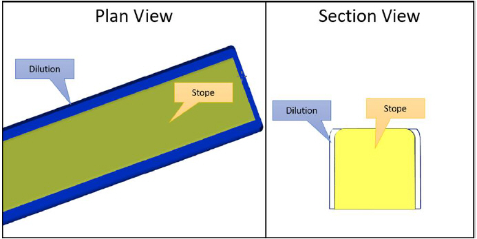
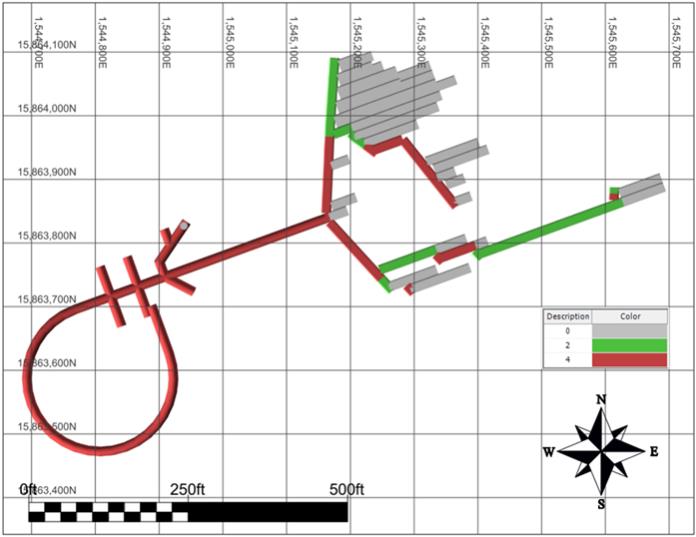
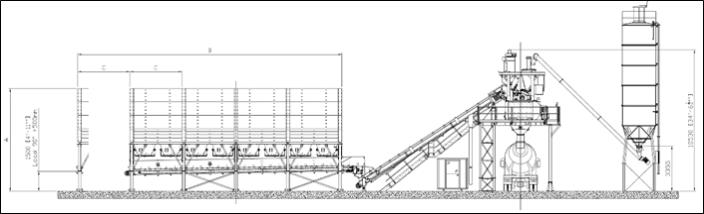
Golder, 2021c: Abbreviated Operating Permit Application – Grassy Mountain Closure Cover Borrow Areas Quarry. Prepared for Oregon Department of Geology and Minerals Industries by Golder Associates USA Inc. October 27, 2021.
Golder, 2021d: Detailed Design, Tailings Storage Facility and Temporary Waste Rock Storage Facility, Grassy Mountain Mine, Malheur County, Oregon, Revision 1. Report prepared for Calico Resources USA Corp. by Golder Associates USA Inc., October 29, 2021.
Gonzalez de Vallejo, L., 2004: Ingeniería Geológica: Pearson Educación, Madrid.
Gonzalez de Vallejo, L., Ferrer, M., Ortuño, L., Oteo, C., 2002: Ingeniería Geológica, Madrid, España.
Goodman, R., 1989: Introduction to Rock Mechanics: John Wiley & Sons, New York, second edition.
Gustin, M.M., Dyer, T.L., MacMahon, C., Caro, B., Raponi, T.R., and Baldwin, D., 2018: Preliminary Feasibility Study and Technical Report for the Grassy Mountain Gold and Silver Project, Malheur County, Oregon, USA: report prepared by Mine Development Associates, Golder Associates and Ausenco Canada Inc. for Paramount Gold Nevada Corp., effective date 21 May, 2018.
Hazen Research Inc., 1990: Grassy Mountain Metallurgical Studies: March 1990.
Hazen Research Inc., 1991: Gravity Concentrations Studies on the Grassy Mountain Gold Ore, July 1991.
Hoek, E.; Kaiser, P. and Bawden, W., 1995: Support for Underground Excavations in Hard Rock: A. A. Balkema.
Hulse, D.E., Brown, J.J., and Malhotra, D., 2012: NI 43-101 Technical Report on Resources, Grassy Mountain Gold Project, Malheur County, Oregon: report prepared by Gustavson Associates for Calico Resources Corp., effective date March 1, 2012.
Itasca, 2012: FLAC3D (Fast Lagrangian Analysis of Continua in 3 Dimensions), 2010: v5.0.
Jory, J.C., 1993: Grassy Mountain Development Geology 1993 Year-End Report: internal Newmont Exploration Limited draft memorandum, December 1993, 9 p. plus figures.
Kelly, J.M., 1988: Discovery History of the Grassy Mountain Deposit: unpublished inter-office correspondence of Atlas Precious Metals Inc., September 1988, 4 p.
Laubscher D. H. and Jakubec J., 2001: The MRMR Rock Mass Classification for Jointed Rock Masses: in W. A. Hustrulid & R. L. Bullock eds. Underground Mining Methods: Engineering Fundamentals and International Case Studies. New York, Society of Mining Engineers, pp. 474–481.
Laubscher, D. H., 1990: A Geomechancis Classification System for the Rating of Rock Mass in Mine Design: Journal of the South African Institute of Mining and Metallurgy, 90(10), pp. 257–273.
Lechner, M.J., 2007: Grassy Mountain Technical Report, Malheur County, Oregon: NI 43-101 Technical Report: Report prepared for Seabridge Gold Inc., effective date April 27, 2007
Lechner, M.J., 2011: Grassy Mountain NI 43-101 Technical Report, Malheur County, Oregon: Report prepared for Calico Resources Corp., effective date June 6, 2011. |
Grassy Mountain Project |
Page 327 | |
S-K 1300 Technical Report Summary on Feasibility Study
| June 30, 2022
|
![]() | ![]() |
MacMahon, C., Browne, R., and Barton, M., 2018: Draft Report Pre-Feasibility Design Tailings Storage Facility Grassy Mountain Project: Report prepared by Golder Associates Inc., June 2018, 1633241.36. REVA, 30 p. plus appendices.
Mathews, 1981: Stability Graph Method: SME Mining Engineering Handbook, Third Edition, pp. 362–363.
McClelland Laboratories Inc., 2020: Report on Milling/ Cyanidation Testing – Grassy Mountain Composites MLI Job No. 4551, August 13, 2020.
MetaRock Laboratories, 2020: Rock Mechanics Testing Report for - CRF Testing. Houston, Texas.
Mitchell, R.J. and Roettger, J.J., 1989: Analysis and Modelling of Sill Pillars: in Innovations in Mining Backfill Technology, Balkema, Rotterdam, pp 53–62.
Newmont Exploration Inc., 1993: Grassy Mountain Metallurgical Test Results: December 1993.
Nicholas, D.E., 1981: Method Selection – A Numerical Approach; Design and Operation of Caving and Sublevel Stoping Mines: SME-AIME, New York.
Palmström, A., 1995: RMi - A Rock Mass Characterization System for Rock Engineering Purposes: PhD thesis, University of Oslo.
Pakalnis, R.; Caceres, C., Clapp, K., and Morin, M., 2005: Design Spans – Underhand and Fill Mining.
Raponi T. R., Gustin M. M., Seamons J., DeLong R., MacMahon C., Palma L., 2020: Feasibility Study and Technical Report for the Grassy Mountain Project, Oregon, USA: report prepared by Mine Development Associates, Golder Associates, EM Strategies, Geotechnical Mine Solutions and Ausenco Canada Inc. for Paramount Gold Nevada Corp., effective date 15 September 2020.
Read J., and Stacey P., 2009: Guidelines for Open Pit Slope Design.
Resource Development Inc. (RDI), 2012: Review of Metallurgical Studies for the Grassy Mountain Project: January 2012.
Resource Development Inc., (RDI) 2015: Metallurgical Testing of Grassy Mountain Project, Malheur County Oregon: March 2015.
Riedmüller, G., Brosch, F. J., Klima, K. and Medley, E. W., 2001: Engineering geological Characterization of Brittle Faults and Classification of Fault Rocks: Felsbau, 19(4), pp. 13–19.
Rocscience, 2020: RS2 v10.012. 2D Finite Element Program for Rock and Soil Applications.
Rytuba, J.J., and McKee, E.H., 1984: Peralkaline Ash Flow Tuffs and Calderas of the McDermitt Volcanic Field, Southeast Oregon and North Central Nevada: Journal of Geophysical Research v. 89; doi: 10.1029/JB080i010p08616. issn: 0148-0227.
Rytuba, J.J., and VanderMuelen, D.B., 1991: Hot-Spring Precious Metal Systems in the Lake Owyhee Volcanic Field, Oregon-Idaho: in Geology and Ore Deposits of the Great Basin: Geological Society of Nevada, Symposium Proceedings, v2, pp. 1085–1096.
Saw, N., De Vries, R., Hassel, R., and Villaescusa, E., 2017: Optimization of Cemented Rockfill Strength for Open Stope Support. |
Grassy Mountain Project |
Page 328 | |
S-K 1300 Technical Report Summary on Feasibility Study
| June 30, 2022
|
![]() | ![]() |
SGS, 2018: An Investigation into Metallurgical Testing of samples from the Grassy Mountain Gold Project (Project 15944-001), March 2018.
SGS, 2020a: An Investigation into Comminution and Metallurgical testing on Samples from the Grassy Mountain Gold Project, Project Number 15944-02 – Final Report; June 23, 2020
SGS, 2020b: An Investigation by High Definition Mineralogy into One Composite Sample from Grassy Mountain Mine, Project Number 15944-02 – Final Report, September 18, 2020
Siems, P.L., 1990: Grassy Mountain Alteration and Geochemistry Report: unpublished internal report prepared for Atlas Precious Metals Corporation.
Sillitoe, R.H., 1993: Epithermal Models: Genetic Types, Geometrical Controls and Shallow Features: in Kirkham, R.V., Sinclair, W.D., Thorpe, R.I., and Duke, J.M. (eds.), Mineral Deposit Modeling, Geological Association of Canada Special Paper, n. 40, pp. 403–417.
Steele, G.L., 1990: Grassy Mountain Rock Density: internal Atlas Precious Metals, Inc. memorandum, 2 p.
Szwedzicki, T., 2003: Rock Mass Behavior Prior to Failure: Int. J Rock Mech and Min Sci, (40), pp. 573–584.
Villaescusa, E., 2014: Geotechnical Design for Sublevel Open Stoping.
Weiss, S.I., 2017: Summary Report on Drilling Targets for Augmenting Mill Feed, Grassy Mountain Gold Project, Malhuer County, Oregon: unpublished report prepared for Paramount Gold Nevada Corp., June 2020, 20 p.
Wilson, S.E., Pennstrom, W.J. Jr., Batman, S.B., and Black, Z.J., 2015: Amended Preliminary Economic Assessment, Calico Resources Corp., Grassy Mountain Project, Malheur County, Oregon, USA: report prepared by Metal Mining Consultants Inc. for Calico Resources Corp., effective date 13 January 2015, amended July 9, 2015.
Wright, J.L., 2012: Grassy Mountain Property CSAMT Survey GIS Compilation: unpublished report prepared for Calico Resources Corp., February 2012, 48 p., plus data files on CD. |
Grassy Mountain Project |
Page 329 | |
S-K 1300 Technical Report Summary on Feasibility Study
| June 30, 2022
|
![]() | ![]() |
25 RELIANCE ON INFORMATION PROVIDED BY THE REGISTRANT
25.1 Introduction
The QPs fully relied on the registrant for guidance and information in the areas noted in the following subsections. The QPs undertook checks that the information provided by the registrant was suitable to be used in the Report.
25.2 Macroeconomic trends
Information relating to interest rates, discount rates, foreign exchange rates and taxes.
This information is used to present the Executive Summary in Section 1. This information supports the Mineral Resource estimate in Section 11 and the Mineral Reserve estimate in Section 12. It is used in the capital and operating cost analysis in Section 18 and the economic analysis in Section 19.
25.3 Markets
Information relating to market studies/markets for product, market entry strategies, marketing and sales contracts, product valuations, product specifications, refining and treatment charges, agency relationships, material contracts (e.g. mining, concentrating, smelting, refining, transportation, handling, sales and hedging, forward sales contracts or arrangements) and contract status (in place, renewals).
This information is used when presenting the Executive Summary in Section 1 and discussing the market, commodity price and contract information in Chapter 16, and in the economic analysis in Section 19. It supports the Mineral Resource estimate in Section 11 and the Mineral Reserve estimate in Section 12.
25.4 Legal Matters
Information relating to the corporate ownership interest, ownership of the Project area and any underlying property agreements, mineral tenure, surface rights, water rights, royalties, encumbrances, violations and fines, permitting requirements, ability to maintain and renew permits.
Information derived from legal experts retained by Paramount, and on information provided by Paramount, through the following documents:
● | Erwin, T.P., 2017: Mineral Status Report: report prepared by Erwin, Thompson & Faillers LLP for Paramount Nevada Gold Corp., September 26, 2017, 9 p. plus appendices; |
● | Van Treek, G., 2020: Technical Report on Grassy Mountain Feasibility Study Project: letter prepared by Paramount Nevada Gold Corp., for Ausenco Canada Inc, 22 October, 2020, 25 p. |
This information is used to present the Executive Summary in Section 1, and the interpretation and conclusions in Section 22. This information is used in discussing property ownership information in Section 3 of the Report, the tailings facility design in Section 15, the permitting and closure discussions in Section 17, and in support of the Economic Analysis in Section 19. It also supports the Mineral Resource estimate in Section 11 and the Mineral Reserve estimate in Section 12.
Grassy Mountain Project |
Page 330 | |
S-K 1300 Technical Report Summary on Feasibility Study
| June 30, 2022
|
![]() | ![]() |
25.5 Environmental Matters
Information relating to design reports, baseline and supporting studies for environmental permitting, environmental permitting and monitoring requirements, environmental characterization reports, ability to maintain and renew permits, emissions controls, closure planning, closure and reclamation bonding and bonding requirements, sustainability accommodations.
This information is used in the Executive Summary in Section 1 and when discussing the property ownership information in Section 3. It is also used when discussing the permitting, closure plan and RCE in Section 17, and the economic analysis in Section 19. It supports the Mineral Resource estimate in Section 11 and the Mineral Reserve estimate in Section 12.
Grassy Mountain Project |
Page 331 | |
S-K 1300 Technical Report Summary on Feasibility Study
| June 30, 2022
|
![]() | ![]() |
APPENDIX A – CLAIMS LIST
Serial Number | Claim Name | County Number | Case Type | Location Date | Owner | Claims Group | Patent Number | |||||||
36-2001-0141 | Poison Springs 24 | 84-121773 | Patented | 05-04-84 | Calico Resources | Grassy | 36-2001-0141 | |||||||
36-2001-0141 | Poison Springs 25 | 84-121774 | Patented | 05-03-84 | Calico Resources | Grassy | 36-2001-0141 | |||||||
36-2001-0141 | Poison Springs 35 | 84-121775 | Patented | 04-05-85 | Calico Resources | Grassy | 36-2001-0141 | |||||||
ORMC106700 | Winter Claim 33 | 88-20087 | LODE | 08-01-88 | Cryla | Grassy | ||||||||
ORMC155919 | Winter #1 | 2001-1031 | LODE | 02/18/2001 | Cryla | Grassy | ||||||||
ORMC155920 | Winter #2 | 2001-1032 | LODE | 02/18/2001 | Cryla | Grassy | ||||||||
ORMC155921 | Winter #3 | 2001-1033 | LODE | 02/18/2001 | Cryla | Grassy | ||||||||
ORMC155922 | Winter #4 | 2001-1034 | LODE | 02/18/2001 | Cryla | Grassy | ||||||||
ORMC155923 | Winter #5 | 2001-1035 | LODE | 02/18/2001 | Cryla | Grassy | ||||||||
ORMC155924 | Winter #6 | 2001-1036 | LODE | 02/18/2001 | Cryla | Grassy | ||||||||
ORMC155925 | Winter #7 | 2001-1037 | LODE | 02/18/2001 | Cryla | Grassy | ||||||||
ORMC155926 | Winter #8 | 2001-1038 | LODE | 02/18/2001 | Cryla | Grassy | ||||||||
ORMC158876 | Cryla #1 | 2004-2068 | LODE | 03/13/2004 | Cryla | Grassy | ||||||||
ORMC158877 | Cryla #2 | 2004-2069 | LODE | 03/13/2004 | Cryla | Grassy | ||||||||
ORMC158878 | Cryla #3 | 2004-2070 | LODE | 03/13/2004 | Cryla | Grassy | ||||||||
ORMC158879 | Cryla #4 | 2004-2071 | LODE | 03/13/2004 | Cryla | Grassy | ||||||||
ORMC158880 | Cryla #5 | 2004-2072 | LODE | 03/13/2004 | Cryla | Grassy | ||||||||
ORMC158881 | Cryla #6 | 2004-2073 | LODE | 03/13/2004 | Cryla | Grassy | ||||||||
ORMC158882 | Cryla #7 | 2004-2074 | LODE | 03/13/2004 | Cryla | Grassy | ||||||||
ORMC158883 | Cryla #8 | 2004-2075 | LODE | 03/13/2004 | Cryla | Grassy |
Grassy Mountain Project |
Appendix A | |
S-K 1300 Technical Report Summary on Feasibility Study
| June 30, 2022
|
![]() | ![]() |
Serial Number | Claim Name | County Number | Case Type | Location Date | Owner | Claims Group | Patent Number | |||||||
ORMC164789 | Lucky Lucy #1 | 2009-3235 | LODE | 04-12-09 | Cryla | Grassy | ||||||||
ORMC164790 | Lucky Lucy #2 | 2009-3236 | LODE | 04-12-09 | Cryla | Grassy | ||||||||
ORMC164791 | Lucky Lucy #3 | 2009-3237 | LODE | 04-12-09 | Cryla | Grassy | ||||||||
ORMC164792 | Lucky Lucy #4 | 2009-3238 | LODE | 04-12-09 | Cryla | Grassy | ||||||||
ORMC164793 | Lucky Lucy #5 | 2009-3239 | LODE | 04-12-09 | Cryla | Grassy | ||||||||
ORMC164794 | Lucky Lucy #6 | 2009-3240 | LODE | 04-12-09 | Cryla | Grassy | ||||||||
ORMC164795 | Lucky Lucy #7 | 2009-3241 | LODE | 04-12-09 | Cryla | Grassy | ||||||||
ORMC164796 | Lucky Lucy #8 | 2009-3242 | LODE | 04-12-09 | Cryla | Grassy | ||||||||
ORMC164797 | Lucky Lucy #9 | 2009-3243 | LODE | 04-12-09 | Cryla | Grassy | ||||||||
ORMC164798 | Lucky Lucy #10 | 2009-3244 | LODE | 04-12-09 | Cryla | Grassy | ||||||||
ORMC76751 | Winter Claim 32 | 84-122580 | LODE | 07-10-84 | Cryla | Grassy | ||||||||
ORMC127904 | Poison Springs 16A | 90-1362 | LODE | 01/28/1990 | Calico Resources | Grassy | ||||||||
ORMC127905 | Poison Springs 17A | 90-1363 | LODE | 01/28/1990 | Calico Resources | Grassy | ||||||||
ORMC174063 | PSR 1 | 2017-2056 | LODE | 03/30/2017 | Calico Resources | Grassy | ||||||||
ORMC174064 | PSR 2 | 2017-2057 | LODE | 03/29/2017 | Calico Resources | Grassy | ||||||||
ORMC174065 | PSR 3 | 2017-2058 | LODE | 03/29/2017 | Calico Resources | Grassy | ||||||||
ORMC174066 | PSR 4 | 2017-2059 | LODE | 03/29/2017 | Calico Resources | Grassy |
Grassy Mountain Project |
Appendix A | |
S-K 1300 Technical Report Summary on Feasibility Study
| June 30, 2022
|
![]() | ![]() |
Serial Number | Claim Name | County Number | Case Type | Location Date | Owner | Claims Group | Patent Number | |||||||
ORMC174067 | PSR 5 | 2017-2060 | LODE | 03/29/2017 | Calico Resources | Grassy | ||||||||
ORMC174068 | PSR 6 | 2017-2061 | LODE | 03/29/2017 | Calico Resources | Grassy | ||||||||
ORMC74965 | Poison Springs #1 | 84-121750 | LODE | 05-01-84 | Calico Resources | Grassy | ||||||||
ORMC74966 | Poison Springs #2 | 84-121751 | LODE | 05-01-84 | Calico Resources | Grassy | ||||||||
ORMC74967 | Poison Springs #3 | 84-121752 | LODE | 05-01-84 | Calico Resources | Grassy | ||||||||
ORMC74968 | Poison Springs #4 | 84-121753 | LODE | 05-01-84 | Calico Resources | Grassy | ||||||||
ORMC74969 | Poison Springs #5 | 84-121754 | LODE | 05-01-84 | Calico Resources | Grassy | ||||||||
ORMC74970 | Poison Springs #6 | 84-121755 | LODE | 05-01-84 | Calico Resources | Grassy | ||||||||
ORMC74971 | Poison Springs #7 | 84-121756 | LODE | 05-01-84 | Calico Resources | Grassy | ||||||||
ORMC74972 | Poison Springs #8 | 84-121757 | LODE | 05-01-84 | Calico Resources | Grassy | ||||||||
ORMC74973 | Poison Springs #9 | 84-121758 | LODE | 05-01-84 | Calico Resources | Grassy | ||||||||
ORMC74974 | Poison Springs #10 | 84-121759 | LODE | 05-01-84 | Calico Resources | Grassy | ||||||||
ORMC74975 | Poison Springs #11 | 84-121760 | LODE | 05-01-84 | Calico Resources | Grassy | ||||||||
ORMC74976 | Poison Springs #12 | 84-121761 | LODE | 05-01-84 | Calico Resources | Grassy | ||||||||
ORMC74977 | Poison Springs #13 | 84-121762 | LODE | 05-02-84 | Calico Resources | Grassy | ||||||||
ORMC74978 | Poison Springs #14 | 84-121763 | LODE | 05-02-84 | Calico Resources | Grassy | ||||||||
ORMC74979 | Poison Springs #15 | 84-121764 | LODE | 05-02-84 | Calico Resources | Grassy |
Grassy Mountain Project |
Appendix A | |
S-K 1300 Technical Report Summary on Feasibility Study
| June 30, 2022
|
![]() | ![]() |
Serial Number | Claim Name | County Number | Case Type | Location Date | Owner | Claims Group | Patent Number | |||||||
ORMC74980 | Poison Springs #16 | 90-1364 | LODE | 05-02-84 | Calico Resources | Grassy | ||||||||
ORMC74981 | Poison Springs #17 | 90-1365 | LODE | 05-02-84 | Calico Resources | Grassy | ||||||||
ORMC74982 | Poison Springs #18 | 84-121767 | LODE | 05-03-84 | Calico Resources | Grassy | ||||||||
ORMC74983 | Poison Springs #19 | 90-6119 | LODE | 05-03-84 | Calico Resources | Grassy | ||||||||
ORMC74984 | Poison Springs #20 | 90-6120 | LODE | 05-03-84 | Calico Resources | Grassy | ||||||||
ORMC74985 | Poison Springs #21 | 90-6121 | LODE | 05-03-84 | Calico Resources | Grassy | ||||||||
ORMC74986 | Poison Springs #22 | 84-121771 | LODE | 05-03-84 | Calico Resources | Grassy | ||||||||
ORMC74987 | Poison Springs #23 | 88-22375 | LODE | 05-03-84 | Calico Resources | Grassy | ||||||||
ORMC74990 | Poison Springs #26 | 84-121775 | LODE | 05/25/1984 | Calico Resources | Grassy | ||||||||
ORMC74991 | Poison Springs #27 | 84-121776 | LODE | 05/24/1984 | Calico Resources | Grassy | ||||||||
ORMC74992 | Poison Springs #28 | 84-121777 | LODE | 05/24/1984 | Calico Resources | Grassy | ||||||||
ORMC74996 | Poison Springs #32 | 84-121781 | LODE | 05/25/1984 | Calico Resources | Grassy | ||||||||
ORMC82455 | Poison Springs #36 | 88-22384 | LODE | 04-05-85 | Calico Resources | Grassy | ||||||||
ORMC82456 | Poison Springs #37 | 90-6130 | LODE | 04-05-85 | Calico Resources | Grassy | ||||||||
ORMC104797 | Frog #1 | 88-18804 | LODE | 05-06-88 | Calico Resources | Grassy | ||||||||
ORMC104798 | Frog #2 | 88-18805 | LODE | 05-06-88 | Calico Resources | Grassy | ||||||||
ORMC104801 | Frog #5 | 88-18808 | LODE | 05-06-88 | Calico Resources | Grassy |
Grassy Mountain Project |
Appendix A | |
S-K 1300 Technical Report Summary on Feasibility Study
| June 30, 2022
|
![]() | ![]() |
Serial Number | Claim Name | County Number | Case Type | Location Date | Owner | Claims Group | Patent Number | |||||||
ORMC104803 | Frog #7 | 88-18809 | LODE | 05-06-88 | Calico Resources | Grassy | ||||||||
ORMC104805 | Frog #9 | 88-18811 | LODE | 05-06-88 | Calico Resources | Grassy | ||||||||
ORMC104807 | Frog #11 | 88-18813 | LODE | 05-06-88 | Calico Resources | Grassy | ||||||||
ORMC104812 | Frog #16 | 88-18819 | LODE | 05-06-88 | Calico Resources | Grassy | ||||||||
ORMC104814 | Frog #18 | 88-18821 | LODE | 05-06-88 | Calico Resources | Grassy | ||||||||
ORMC104815 | Frog #19 | 88-18822 | LODE | 05-06-88 | Calico Resources | Grassy | ||||||||
ORMC104816 | Frog #20 | 88-18823 | LODE | 05-06-88 | Calico Resources | Grassy | ||||||||
ORMC104817 | Frog #21 | 88-18824 | LODE | 05-06-88 | Calico Resources | Grassy | ||||||||
ORMC104818 | Frog #22 | 88-18825 | LODE | 05-06-88 | Calico Resources | Grassy | ||||||||
ORMC104819 | Frog #23 | 88-18826 | LODE | 05-06-88 | Calico Resources | Grassy | ||||||||
ORMC104820 | Frog #24 | 88-18827 | LODE | 05-06-88 | Calico Resources | Grassy | ||||||||
ORMC104821 | Frog #25 | 88-18828 | LODE | 05-07-88 | Calico Resources | Grassy | ||||||||
ORMC104822 | Frog #26 | 88-18829 | LODE | 05-07-88 | Calico Resources | Grassy | ||||||||
ORMC104823 | Frog #27 | 88-18830 | LODE | 05-07-88 | Calico Resources | Grassy | ||||||||
ORMC104824 | Frog #28 | 88-18831 | LODE | 05-07-88 | Calico Resources | Grassy | ||||||||
ORMC104825 | Frog #29 | 88-18832 | LODE | 05-07-88 | Calico Resources | Grassy | ||||||||
ORMC104826 | Frog #30 | 88-18833 | LODE | 05-07-88 | Calico Resources | Grassy |
Grassy Mountain Project |
Appendix A | |
S-K 1300 Technical Report Summary on Feasibility Study
| June 30, 2022
|
![]() | ![]() |
Serial Number | Claim Name | County Number | Case Type | Location Date | Owner | Claims Group | Patent Number | |||||||
ORMC104827 | Frog #31 | 88-18834 | LODE | 05-07-88 | Calico Resources | Grassy | ||||||||
ORMC104828 | Frog #32 | 88-18835 | LODE | 05-07-88 | Calico Resources | Grassy | ||||||||
ORMC104829 | Frog #33 | 88-18836 | LODE | 05-07-88 | Calico Resources | Grassy | ||||||||
ORMC104830 | Frog #34 | 88-18837 | LODE | 05-07-88 | Calico Resources | Grassy | ||||||||
ORMC104831 | Frog #35 | 90-3396 | LODE | 05-07-88 | Calico Resources | Grassy | ||||||||
ORMC104832 | Frog #36 | 88-18839 | LODE | 05-07-88 | Calico Resources | Grassy | ||||||||
ORMC104833 | Frog #37 | 88-18840 | LODE | 05-07-88 | Calico Resources | Grassy | ||||||||
ORMC104834 | Frog #38 | 88-18841 | LODE | 05-07-88 | Calico Resources | Grassy | ||||||||
ORMC104835 | Frog #39 | 88-18842 | LODE | 05-07-88 | Calico Resources | Grassy | ||||||||
ORMC104836 | Frog #40 | 88-18843 | LODE | 05-07-88 | Calico Resources | Grassy | ||||||||
ORMC104837 | Frog #41 | 88-18844 | LODE | 05-07-88 | Calico Resources | Grassy | ||||||||
ORMC104838 | Frog #42 | 88-18845 | LODE | 05-07-88 | Calico Resources | Grassy | ||||||||
ORMC104839 | Frog #46 | 88-18846 | LODE | 05-07-88 | Calico Resources | Grassy | ||||||||
ORMC104840 | Frog #47 | 88-18847 | LODE | 05-07-88 | Calico Resources | Grassy | ||||||||
ORMC104841 | Frog #48 | 88-18848 | LODE | 05-07-88 | Calico Resources | Grassy | ||||||||
ORMC104878 | Frog #85 | 90-1366 | LODE | 05-08-88 | Calico Resources | Grassy | ||||||||
ORMC104879 | Frog #86 | 90-1367 | LODE | 05-08-88 | Calico Resources | Grassy |
Grassy Mountain Project |
Appendix A | |
S-K 1300 Technical Report Summary on Feasibility Study
| June 30, 2022
|
![]() | ![]() |
Serial Number | Claim Name | County Number | Case Type | Location Date | Owner | Claims Group | Patent Number | |||||||
ORMC104880 | Frog #87 | 90-1368 | LODE | 05-08-88 | Calico Resources | Grassy | ||||||||
ORMC104881 | Frog #88 | 90-1369 | LODE | 05-08-88 | Calico Resources | Grassy | ||||||||
ORMC104882 | Frog #89 | 90-1370 | LODE | 05-08-88 | Calico Resources | Grassy | ||||||||
ORMC104883 | Frog #90 | 90-1371 | LODE | 05-08-88 | Calico Resources | Grassy | ||||||||
ORMC104884 | Frog #91 | 90-1372 | LODE | 05-08-88 | Calico Resources | Grassy | ||||||||
ORMC104885 | Frog #92 | 90-1373 | LODE | 05-08-88 | Calico Resources | Grassy | ||||||||
ORMC104886 | Frog #93 | 88-18893 | LODE | 05-08-88 | Calico Resources | Grassy | ||||||||
ORMC104887 | Frog #94 | 88-18894 | LODE | 05-08-88 | Calico Resources | Grassy | ||||||||
ORMC104889 | Frog #96 | 88-18896 | LODE | 05/17/1988 | Calico Resources | Grassy | ||||||||
ORMC104891 | Frog #98 | 88-18898 | LODE | 05/17/1988 | Calico Resources | Grassy | ||||||||
ORMC104900 | Frog #107 | 88-18907 | LODE | 05/20/1988 | Calico Resources | Grassy | ||||||||
ORMC104901 | Frog #108 | 88-18908 | LODE | 05/20/1988 | Calico Resources | Grassy | ||||||||
ORMC104902 | Frog #109 | 88-18909 | LODE | 05/20/1988 | Calico Resources | Grassy | ||||||||
ORMC104903 | Frog #110 | 88-18910 | LODE | 05/20/1988 | Calico Resources | Grassy | ||||||||
ORMC104904 | Frog #111 | 88-18911 | LODE | 05/20/1988 | Calico Resources | Grassy | ||||||||
ORMC104905 | Frog #112 | 88-18912 | LODE | 05/19/1988 | Calico Resources | Grassy | ||||||||
ORMC104906 | Frog #113 | 88-18913 | LODE | 05/19/1988 | Calico Resources | Grassy |
Grassy Mountain Project |
Appendix A | |
S-K 1300 Technical Report Summary on Feasibility Study
| June 30, 2022
|
![]() | ![]() |
Serial Number | Claim Name | County Number | Case Type | Location Date | Owner | Claims Group | Patent Number | |||||||
ORMC104926 | Frog #133 | 88-18933 | LODE | 05/20/1988 | Calico Resources | Grassy | ||||||||
ORMC104927 | Frog #134 | 88-18934 | LODE | 05/20/1988 | Calico Resources | Grassy | ||||||||
ORMC104928 | Frog #135 | 88-18935 | LODE | 05/20/1988 | Calico Resources | Grassy | ||||||||
ORMC104929 | Frog #136 | 88-18936 | LODE | 05/20/1988 | Calico Resources | Grassy | ||||||||
ORMC104940 | Frog #147 | 88-18947 | LODE | 05/22/1988 | Calico Resources | Grassy | ||||||||
ORMC104941 | Frog #148 | 88-18948 | LODE | 05/22/1988 | Calico Resources | Grassy | ||||||||
ORMC104942 | Frog #149 | 88-18949 | LODE | 05/22/1988 | Calico Resources | Grassy | ||||||||
ORMC104943 | Frog #150 | 88-18950 | LODE | 05/22/1988 | Calico Resources | Grassy | ||||||||
ORMC104960 | Frog #167 | 88-18967 | LODE | 05/19/1988 | Calico Resources | Grassy | ||||||||
ORMC104961 | Frog #168 | 88-18968 | LODE | 05/19/1988 | Calico Resources | Grassy | ||||||||
ORMC104962 | Frog #169 | 88-18969 | LODE | 05/19/1988 | Calico Resources | Grassy | ||||||||
ORMC104963 | Frog #170 | 88-18970 | LODE | 05/19/1988 | Calico Resources | Grassy | ||||||||
ORMC104964 | Frog #171 | 88-18971 | LODE | 05/19/1988 | Calico Resources | Grassy | ||||||||
ORMC104965 | Frog #172 | 88-18972 | LODE | 05/19/1988 | Calico Resources | Grassy | ||||||||
ORMC104966 | Frog #173 | 88-18973 | LODE | 05/19/1988 | Calico Resources | Grassy | ||||||||
ORMC104967 | Frog #174 | 88-18974 | LODE | 05/19/1988 | Calico Resources | Grassy | ||||||||
ORMC104968 | Frog #175 | 88-18975 | LODE | 05/19/1988 | Calico Resources | Grassy |
Grassy Mountain Project |
Appendix A | |
S-K 1300 Technical Report Summary on Feasibility Study
| June 30, 2022
|
![]() | ![]() |
Serial Number | Claim Name | County Number | Case Type | Location Date | Owner | Claims Group | Patent Number | |||||||
ORMC104969 | Frog #176 | 88-18976 | LODE | 05/19/1988 | Calico Resources | Grassy | ||||||||
ORMC104988 | Frog #195 | 88-18995 | LODE | 05/22/1988 | Calico Resources | Grassy | ||||||||
ORMC104989 | Frog #196 | 88-18996 | LODE | 05/22/1988 | Calico Resources | Grassy | ||||||||
ORMC104990 | Frog #197 | 88-18997 | LODE | 05/22/1988 | Calico Resources | Grassy | ||||||||
ORMC104991 | Frog #198 | 88-18998 | LODE | 05/21/1988 | Calico Resources | Grassy | ||||||||
ORMC105000 | Frog #207 | 88-19007 | LODE | 05/29/1988 | Calico Resources | Grassy | ||||||||
ORMC105001 | Frog #208 | 88-19008 | LODE | 05/29/1988 | Calico Resources | Grassy | ||||||||
ORMC105002 | Frog #209 | 88-19009 | LODE | 05/29/1988 | Calico Resources | Grassy | ||||||||
ORMC105003 | Frog #210 | 88-19010 | LODE | 05/24/1988 | Calico Resources | Grassy | ||||||||
ORMC105004 | Frog #211 | 88-19011 | LODE | 05/27/1988 | Calico Resources | Grassy | ||||||||
ORMC105005 | Frog #212 | 88-19012 | LODE | 05/27/1988 | Calico Resources | Grassy | ||||||||
ORMC105006 | Frog #213 | 88-19013 | LODE | 05/27/1988 | Calico Resources | Grassy | ||||||||
ORMC105007 | Frog #214 | 88-19014 | LODE | 05/27/1988 | Calico Resources | Grassy | ||||||||
ORMC105008 | Frog #215 | 88-19015 | LODE | 05/27/1988 | Calico Resources | Grassy | ||||||||
ORMC105009 | Frog #216 | 88-19016 | LODE | 05/27/1988 | Calico Resources | Grassy | ||||||||
ORMC105017 | Frog #224 | 88-19024 | LODE | 05/26/1988 | Calico Resources | Grassy | ||||||||
ORMC105019 | Frog #226 | 88-19026 | LODE | 05/26/1988 | Calico Resources | Grassy |
Grassy Mountain Project |
Appendix A | |
S-K 1300 Technical Report Summary on Feasibility Study
| June 30, 2022
|
![]() | ![]() |
Serial Number | Claim Name | County Number | Case Type | Location Date | Owner | Claims Group | Patent Number | |||||||
ORMC105021 | Frog #228 | 88-19028 | LODE | 05/26/1988 | Calico Resources | Grassy | ||||||||
ORMC105023 | Frog #230 | 88-19030 | LODE | 05/26/1988 | Calico Resources | Grassy | ||||||||
ORMC105025 | Frog #232 | 88-19032 | LODE | 05/26/1988 | Calico Resources | Grassy | ||||||||
ORMC105913 | Frog #252 | 88-19861 | LODE | 07/21/1988 | Calico Resources | Grassy | ||||||||
ORMC107597 | Frog #649 | 88-21299 | LODE | 08/17/1988 | Calico Resources | Grassy | ||||||||
ORMC107598 | Frog #650 | 88-21300 | LODE | 08/17/1988 | Calico Resources | Grassy | ||||||||
ORMC107599 | Frog #651 | 88-21301 | LODE | 08/17/1988 | Calico Resources | Grassy | ||||||||
ORMC107600 | Frog #652 | 88-21302 | LODE | 08/17/1988 | Calico Resources | Grassy | ||||||||
ORMC107703 | Frog #755 | 88-21405 | LODE | 08/23/1988 | Calico Resources | Grassy | ||||||||
ORMC107704 | Frog #756 | 88-21406 | LODE | 08/23/1988 | Calico Resources | Grassy | ||||||||
ORMC108077 | Don #1 | 88-22025 | MILLSITE | 09/28/1988 | Calico Resources | Grassy | ||||||||
ORMC108078 | Don #2 | 88-22026 | MILLSITE | 09/28/1988 | Calico Resources | Grassy | ||||||||
ORMC108079 | Don #3 | 88-22027 | MILLSITE | 09/28/1988 | Calico Resources | Grassy | ||||||||
ORMC108080 | Don #4 | 88-22028 | MILLSITE | 09/28/1988 | Calico Resources | Grassy | ||||||||
ORMC108081 | Don #5 | 88-22029 | MILLSITE | 09/28/1988 | Calico Resources | Grassy | ||||||||
ORMC108082 | Don #6 | 88-22030 | MILLSITE | 09/28/1988 | Calico Resources | Grassy | ||||||||
ORMC108083 | Don #7 | 88-22031 | MILLSITE | 09/28/1988 | Calico Resources | Grassy |
Grassy Mountain Project |
Appendix A | |
S-K 1300 Technical Report Summary on Feasibility Study
| June 30, 2022
|
![]() | ![]() |
Serial Number | Claim Name | County Number | Case Type | Location Date | Owner | Claims Group | Patent Number | |||||||
ORMC108084 | Don #8 | 88-22032 | MILLSITE | 09/28/1988 | Calico Resources | Grassy | ||||||||
ORMC108085 | Don #9 | 88-22033 | MILLSITE | 09/28/1988 | Calico Resources | Grassy | ||||||||
ORMC108086 | Frog #10A | 88-22228 | LODE | 09/28/1988 | Calico Resources | Grassy | ||||||||
ORMC108087 | Frog #25A | 88-22229 | LODE | 09/27/1988 | Calico Resources | Grassy | ||||||||
ORMC108088 | Frog #26A | 88-22230 | LODE | 09/27/1988 | Calico Resources | Grassy | ||||||||
ORMC108089 | Frog #35A | 88-22231 | LODE | 09/27/1988 | Calico Resources | Grassy | ||||||||
ORMC108090 | Frog #46A | 88-22232 | LODE | 09/27/1988 | Calico Resources | Grassy | ||||||||
ORMC108091 | Frog #46B | 88-22233 | LODE | 09/27/1988 | Calico Resources | Grassy | ||||||||
ORMC125178 | Frog #151 | 89-38517 | LODE | 10-04-89 | Calico Resources | Grassy | ||||||||
ORMC126210 | Frog #3 | 89-39554 | LODE | 10/29/1989 | Calico Resources | Grassy | ||||||||
ORMC126212 | Frog #1274 | 89-39556 | LODE | 10/27/1989 | Calico Resources | Grassy | ||||||||
ORMC126213 | Frog #1275 | 89-39557 | LODE | 10/27/1989 | Calico Resources | Grassy | ||||||||
ORMC126215 | Frog #1277 | 89-39559 | LODE | 10/27/1989 | Calico Resources | Grassy | ||||||||
ORMC146318 | Poison Spring 1A | 93-6060 | LODE | 07/19/1993 | Calico Resources | Grassy | ||||||||
ORMC146319 | Poison Spring 3A | 93-6061 | LODE | 07/19/1993 | Calico Resources | Grassy | ||||||||
ORMC146320 | Poison Spring 5A | 93-6062 | LODE | 07/20/1993 | Calico Resources | Grassy | ||||||||
ORMC146321 | Poison Spring 6A | 93-6063 | LODE | 07/20/1993 | Calico Resources | Grassy |
Grassy Mountain Project |
Appendix A | |
S-K 1300 Technical Report Summary on Feasibility Study
| June 30, 2022
|
![]() | ![]() |
Serial Number | Claim Name | County Number | Case Type | Location Date | Owner | Claims Group | Patent Number | |||||||
ORMC146322 | Poison Spring 7A | 93-6064 | LODE | 07/18/1993 | Calico Resources | Grassy | ||||||||
ORMC146323 | Poison Spring 8A | 93-6065 | LODE | 07/18/1993 | Calico Resources | Grassy | ||||||||
ORMC146324 | Poison Spring 9A | 93-6066 | LODE | 07/19/1993 | Calico Resources | Grassy | ||||||||
ORMC146325 | Poison Spring 11A | 93-6067 | LODE | 07/19/1993 | Calico Resources | Grassy | ||||||||
ORMC146326 | Poison Spring 14A | 93-6068 | LODE | 07/18/1993 | Calico Resources | Grassy | ||||||||
ORMC146327 | Poison Spring 18A | 93-6069 | LODE | 07/18/1993 | Calico Resources | Grassy | ||||||||
ORMC146328 | Poison Spring 22A | 93-6070 | LODE | 07/18/1993 | Calico Resources | Grassy | ||||||||
ORMC146329 | Poison Spring 26A | 93-6071 | LODE | 07/18/1993 | Calico Resources | Grassy | ||||||||
ORMC146330 | Poison Spring 27A | 93-6072 | LODE | 07/19/1993 | Calico Resources | Grassy | ||||||||
ORMC146331 | Poison Spring 38A | 93-6073 | LODE | 07/18/1993 | Calico Resources | Grassy | ||||||||
ORMC167998 | GM 5058 | 2011-3790 | LODE | 09/15/2011 | Calico Resources | Grassy | ||||||||
ORMC167999 | GM 5059 | 2011-3791 | LODE | 09/15/2011 | Calico Resources | Grassy | ||||||||
ORMC168000 | GM 5060 | 2011-3792 | LODE | 09/15/2011 | Calico Resources | Grassy | ||||||||
ORMC168001 | GM 5061 | 2011-3793 | LODE | 09/15/2011 | Calico Resources | Grassy | ||||||||
ORMC168002 | GM 5062 | 2011-3794 | LODE | 09/15/2011 | Calico Resources | Grassy | ||||||||
ORMC168003 | GM 5063 | 2011-3795 | LODE | 09/17/2011 | Calico Resources | Grassy | ||||||||
ORMC168004 | GM 5064 | 2011-3796 | LODE | 09/17/2011 | Calico Resources | Grassy |
Grassy Mountain Project |
Appendix A | |
S-K 1300 Technical Report Summary on Feasibility Study
| June 30, 2022
|
![]() | ![]() |
Serial Number | Claim Name | County Number | Case Type | Location Date | Owner | Claims Group | Patent Number | |||||||
ORMC168005 | GM 5065 | 2011-3797 | LODE | 09/17/2011 | Calico Resources | Grassy | ||||||||
ORMC168006 | GM 5066 | 2011-3798 | LODE | 09/17/2011 | Calico Resources | Grassy | ||||||||
ORMC168007 | GM 5067 | 2011-3799 | LODE | 09/17/2011 | Calico Resources | Grassy | ||||||||
ORMC168008 | GM 5068 | 2011-3800 | LODE | 09/17/2011 | Calico Resources | Grassy | ||||||||
ORMC168009 | GM 5069 | 2011-3801 | LODE | 09/17/2011 | Calico Resources | Grassy | ||||||||
ORMC168010 | GM 5070 | 2011-3802 | LODE | 09/17/2011 | Calico Resources | Grassy | ||||||||
ORMC168011 | GM 5071 | 2011-3803 | LODE | 09/17/2011 | Calico Resources | Grassy | ||||||||
ORMC168012 | GM 5072 | 2011-3804 | LODE | 09/17/2011 | Calico Resources | Grassy | ||||||||
ORMC168013 | GM 5150 | 2011-3805 | LODE | 09/15/2011 | Calico Resources | Grassy | ||||||||
ORMC168014 | GM 5151 | 2011-3806 | LODE | 09/15/2011 | Calico Resources | Grassy | ||||||||
ORMC168015 | GM 5152 | 2011-3807 | LODE | 09/15/2011 | Calico Resources | Grassy | ||||||||
ORMC168016 | GM 5153 | 2011-3808 | LODE | 09/15/2011 | Calico Resources | Grassy | ||||||||
ORMC168017 | GM 5154 | 2011-3809 | LODE | 09/15/2011 | Calico Resources | Grassy | ||||||||
ORMC168018 | GM 5155 | 2011-3810 | LODE | 09/15/2011 | Calico Resources | Grassy | ||||||||
ORMC168019 | GM 5156 | 2011-3811 | LODE | 09/15/2011 | Calico Resources | Grassy | ||||||||
ORMC168020 | GM 5157 | 2011-3812 | LODE | 09/15/2011 | Calico Resources | Grassy | ||||||||
ORMC168021 | GM 5158 | 2011-3813 | LODE | 09/15/2011 | Calico Resources | Grassy |
Grassy Mountain Project |
Appendix A | |
S-K 1300 Technical Report Summary on Feasibility Study
| June 30, 2022
|
![]() | ![]() |
Serial Number | Claim Name | County Number | Case Type | Location Date | Owner | Claims Group | Patent Number | |||||||
ORMC168022 | GM 5159 | 2011-3814 | LODE | 09/15/2011 | Calico Resources | Grassy | ||||||||
ORMC168023 | GM 5160 | 2011-3815 | LODE | 09/15/2011 | Calico Resources | Grassy | ||||||||
ORMC168024 | GM 5161 | 2011-3816 | LODE | 09/15/2011 | Calico Resources | Grassy | ||||||||
ORMC168025 | GM 5162 | 2011-3817 | LODE | 09/15/2011 | Calico Resources | Grassy | ||||||||
ORMC168026 | GM 5163 | 2011-3818 | LODE | 09/17/2011 | Calico Resources | Grassy | ||||||||
ORMC168027 | GM 5164 | 2011-3819 | LODE | 09/17/2011 | Calico Resources | Grassy | ||||||||
ORMC168028 | GM 5165 | 2011-3820 | LODE | 09/17/2011 | Calico Resources | Grassy | ||||||||
ORMC168029 | GM 5166 | 2011-3821 | LODE | 09/17/2011 | Calico Resources | Grassy | ||||||||
ORMC168030 | GM 5167 | 2011-3822 | LODE | 09/17/2011 | Calico Resources | Grassy | ||||||||
ORMC168031 | GM 5168 | 2011-3823 | LODE | 09/17/2011 | Calico Resources | Grassy | ||||||||
ORMC168032 | GM 5169 | 2011-3824 | LODE | 09/17/2011 | Calico Resources | Grassy | ||||||||
ORMC168033 | GM 5170 | 2011-3825 | LODE | 09/17/2011 | Calico Resources | Grassy | ||||||||
ORMC168034 | GM 5171 | 2011-3826 | LODE | 09/17/2011 | Calico Resources | Grassy | ||||||||
ORMC168035 | GM 5172 | 2011-3827 | LODE | 09/17/2011 | Calico Resources | Grassy | ||||||||
ORMC168036 | GM 5250 | 2011-3828 | LODE | 09/15/2011 | Calico Resources | Grassy | ||||||||
ORMC168037 | GM 5251 | 2011-3829 | LODE | 09/15/2011 | Calico Resources | Grassy | ||||||||
ORMC168038 | GM 5252 | 2011-3830 | LODE | 09/15/2011 | Calico Resources | Grassy |
Grassy Mountain Project |
Appendix A | |
S-K 1300 Technical Report Summary on Feasibility Study
| June 30, 2022
|
![]() | ![]() |
Serial Number | Claim Name | County Number | Case Type | Location Date | Owner | Claims Group | Patent Number | |||||||
ORMC168039 | GM 5253 | 2011-3831 | LODE | 09/15/2011 | Calico Resources | Grassy | ||||||||
ORMC168040 | GM 5254 | 2011-3832 | LODE | 09/15/2011 | Calico Resources | Grassy | ||||||||
ORMC168041 | GM 5255 | 2011-3833 | LODE | 09/15/2011 | Calico Resources | Grassy | ||||||||
ORMC168042 | GM 5256 | 2011-3834 | LODE | 09/15/2011 | Calico Resources | Grassy | ||||||||
ORMC168043 | GM5257 | 2011-3835 | LODE | 09/15/2011 | Calico Resources | Grassy | ||||||||
ORMC168044 | GM 5258 | 2011-3836 | LODE | 09/15/2011 | Calico Resources | Grassy | ||||||||
ORMC168045 | GM 5259 | 2011-3837 | LODE | 09/15/2011 | Calico Resources | Grassy | ||||||||
ORMC168046 | GM 5260 | 2011-3838 | LODE | 09/15/2011 | Calico Resources | Grassy | ||||||||
ORMC168047 | GM 5261 | 2011-3839 | LODE | 09/16/2011 | Calico Resources | Grassy | ||||||||
ORMC168048 | GM 5262 | 2011-3840 | LODE | 09/16/2011 | Calico Resources | Grassy | ||||||||
ORMC168049 | GM 5263 | 2011-3841 | LODE | 09/16/2011 | Calico Resources | Grassy | ||||||||
ORMC168050 | GM 5264 | 2011-3842 | LODE | 09/16/2011 | Calico Resources | Grassy | ||||||||
ORMC168051 | GM 5265 | 2011-3843 | LODE | 09/16/2011 | Calico Resources | Grassy | ||||||||
ORMC168052 | GM 5266 | 2011-3844 | LODE | 09/16/2011 | Calico Resources | Grassy | ||||||||
ORMC168053 | GM 5267 | 2011-3845 | LODE | 09/23/2011 | Calico Resources | Grassy | ||||||||
ORMC168054 | GM 5268 | 2011-3846 | LODE | 09/23/2011 | Calico Resources | Grassy | ||||||||
ORMC168055 | GM 5269 | 2011-3847 | LODE | 09/23/2011 | Calico Resources | Grassy |
Grassy Mountain Project |
Appendix A | |
S-K 1300 Technical Report Summary on Feasibility Study
| June 30, 2022
|
![]() | ![]() |
Serial Number | Claim Name | County Number | Case Type | Location Date | Owner | Claims Group | Patent Number | |||||||
ORMC168056 | GM 5270 | 2011-3848 | LODE | 09/23/2011 | Calico Resources | Grassy | ||||||||
ORMC168057 | GM 5271 | 2011-3849 | LODE | 09/23/2011 | Calico Resources | Grassy | ||||||||
ORMC168058 | GM 5272 | 2011-3850 | LODE | 09/23/2011 | Calico Resources | Grassy | ||||||||
ORMC168059 | GM 5273 | 2011-3851 | LODE | 09/23/2011 | Calico Resources | Grassy | ||||||||
ORMC168060 | GM 5274 | 2011-3852 | LODE | 09/23/2011 | Calico Resources | Grassy | ||||||||
ORMC168061 | GM 5275 | 2011-3853 | LODE | 09/23/2011 | Calico Resources | Grassy | ||||||||
ORMC168062 | GM 5276 | 2011-3854 | LODE | 09/23/2011 | Calico Resources | Grassy | ||||||||
ORMC168063 | GM 5352 | 2011-3855 | LODE | 09/15/2011 | Calico Resources | Grassy | ||||||||
ORMC168064 | GM 5353 | 2011-3856 | LODE | 09/15/2011 | Calico Resources | Grassy | ||||||||
ORMC168065 | GM 5354 | 2011-3857 | LODE | 09/15/2011 | Calico Resources | Grassy | ||||||||
ORMC168066 | GM 5355 | 2011-3858 | LODE | 09/15/2011 | Calico Resources | Grassy | ||||||||
ORMC168067 | GM 5356 | 2011-3859 | LODE | 09/15/2011 | Calico Resources | Grassy | ||||||||
ORMC168068 | GM 5357 | 2011-3860 | LODE | 09/15/2011 | Calico Resources | Grassy | ||||||||
ORMC168069 | GM 5358 | 2011-3861 | LODE | 09/15/2011 | Calico Resources | Grassy | ||||||||
ORMC168070 | GM 5359 | 2011-3862 | LODE | 09/15/2011 | Calico Resources | Grassy | ||||||||
ORMC168071 | GM 5360 | 2011-3863 | LODE | 09/15/2011 | Calico Resources | Grassy | ||||||||
ORMC168072 | GM 5361 | 2011-3864 | LODE | 09/16/2011 | Calico Resources | Grassy |
Grassy Mountain Project |
Appendix A | |
S-K 1300 Technical Report Summary on Feasibility Study
| June 30, 2022
|
![]() | ![]() |
Serial Number | Claim Name | County Number | Case Type | Location Date | Owner | Claims Group | Patent Number | |||||||
ORMC168073 | GM 5362 | 2011-3865 | LODE | 09/16/2011 | Calico Resources | Grassy | ||||||||
ORMC168074 | GM 5363 | 2011-3866 | LODE | 09/16/2011 | Calico Resources | Grassy | ||||||||
ORMC168075 | GM 5364 | 2011-3867 | LODE | 09/16/2011 | Calico Resources | Grassy | ||||||||
ORMC168076 | GM 5365 | 2011-3868 | LODE | 09/16/2011 | Calico Resources | Grassy | ||||||||
ORMC168077 | GM 5366 | 2011-3869 | LODE | 09/16/2011 | Calico Resources | Grassy | ||||||||
ORMC168078 | GM 5367 | 2011-3870 | LODE | 09/23/2011 | Calico Resources | Grassy | ||||||||
ORMC168079 | GM 5368 | 2011-3871 | LODE | 09/23/2011 | Calico Resources | Grassy | ||||||||
ORMC168080 | GM 5369 | 2011-3872 | LODE | 09/23/2011 | Calico Resources | Grassy | ||||||||
ORMC168081 | GM 5370 | 2011-3873 | LODE | 09/23/2011 | Calico Resources | Grassy | ||||||||
ORMC168082 | GM 5371 | 2011-3874 | LODE | 09/23/2011 | Calico Resources | Grassy | ||||||||
ORMC168083 | GM 5372 | 2011-3875 | LODE | 09/23/2011 | Calico Resources | Grassy | ||||||||
ORMC168084 | GM 5373 | 2011-3876 | LODE | 09/23/2011 | Calico Resources | Grassy | ||||||||
ORMC168085 | GM 5374 | 2011-3877 | LODE | 09/23/2011 | Calico Resources | Grassy | ||||||||
ORMC168086 | GM 5375 | 2011-3878 | LODE | 09/23/2011 | Calico Resources | Grassy | ||||||||
ORMC168087 | GM 5376 | 2011-3879 | LODE | 09/23/2011 | Calico Resources | Grassy | ||||||||
ORMC168088 | GM 5452 | 2011-3880 | LODE | 09/19/2011 | Calico Resources | Grassy | ||||||||
ORMC168089 | GM 5453 | 2011-3881 | LODE | 09/19/2011 | Calico Resources | Grassy |
Grassy Mountain Project |
Appendix A | |
S-K 1300 Technical Report Summary on Feasibility Study
| June 30, 2022
|
![]() | ![]() |
Serial Number | Claim Name | County Number | Case Type | Location Date | Owner | Claims Group | Patent Number | |||||||
ORMC168090 | GM 5454 | 2011-3882 | LODE | 09/19/2011 | Calico Resources | Grassy | ||||||||
ORMC168091 | GM 5455 | 2011-3883 | LODE | 09/19/2011 | Calico Resources | Grassy | ||||||||
ORMC168092 | GM 5552 | 2011-3884 | LODE | 09/19/2011 | Calico Resources | Grassy | ||||||||
ORMC168093 | GM 5553 | 2011-3885 | LODE | 09/19/2011 | Calico Resources | Grassy | ||||||||
ORMC168094 | GM 5554 | 2011-3886 | LODE | 09/19/2011 | Calico Resources | Grassy | ||||||||
ORMC168095 | GM 5555 | 2011-3887 | LODE | 09/19/2011 | Calico Resources | Grassy | ||||||||
ORMC168096 | GM 5580 | 2011-3888 | LODE | 09/23/2011 | Calico Resources | Grassy | ||||||||
ORMC168097 | GM 5581 | 2011-3889 | LODE | 09/23/2011 | Calico Resources | Grassy | ||||||||
ORMC168098 | GM 5582 | 2011-3890 | LODE | 09/23/2011 | Calico Resources | Grassy | ||||||||
ORMC168099 | GM 5583 | 2011-3891 | LODE | 09/23/2011 | Calico Resources | Grassy | ||||||||
ORMC168100 | GM 5584 | 2011-3892 | LODE | 09/23/2011 | Calico Resources | Grassy | ||||||||
ORMC168101 | GM 5652 | 2011-3893 | LODE | 09/18/2011 | Calico Resources | Grassy | ||||||||
ORMC168102 | GM 5653 | 2011-3894 | LODE | 09/18/2011 | Calico Resources | Grassy | ||||||||
ORMC168103 | GM 5654 | 2011-3895 | LODE | 09/18/2011 | Calico Resources | Grassy | ||||||||
ORMC168104 | GM 5655 | 2011-3896 | LODE | 09/18/2011 | Calico Resources | Grassy | ||||||||
ORMC168105 | GM 5680 | 2011-3897 | LODE | 09/22/2011 | Calico Resources | Grassy | ||||||||
ORMC168106 | GM 5681 | 2011-3898 | LODE | 09/22/2011 | Calico Resources | Grassy |
Grassy Mountain Project |
Appendix A | |
S-K 1300 Technical Report Summary on Feasibility Study
| June 30, 2022
|
![]() | ![]() |
Serial Number | Claim Name | County Number | Case Type | Location Date | Owner | Claims Group | Patent Number | |||||||
ORMC168107 | GM 5682 | 2011-3899 | LODE | 09/22/2011 | Calico Resources | Grassy | ||||||||
ORMC168108 | GM 5683 | 2011-3900 | LODE | 09/22/2011 | Calico Resources | Grassy | ||||||||
ORMC168109 | GM 5684 | 2011-3901 | LODE | 09/22/2011 | Calico Resources | Grassy | ||||||||
ORMC168110 | GM 5752 | 2011-3902 | LODE | 09/18/2011 | Calico Resources | Grassy | ||||||||
ORMC168111 | GM 5753 | 2011-3903 | LODE | 09/18/2011 | Calico Resources | Grassy | ||||||||
ORMC168112 | GM 5754 | 2011-3904 | LODE | 09/18/2011 | Calico Resources | Grassy | ||||||||
ORMC168113 | GM 5755 | 2011-3905 | LODE | 09/18/2011 | Calico Resources | Grassy | ||||||||
ORMC168114 | GM 5756 | 2011-3906 | LODE | 09/25/2011 | Calico Resources | Grassy | ||||||||
ORMC168115 | GM 5757 | 2011-3907 | LODE | 09/25/2011 | Calico Resources | Grassy | ||||||||
ORMC168116 | GM 5758 | 2011-3908 | LODE | 09/25/2011 | Calico Resources | Grassy | ||||||||
ORMC168117 | GM 5780 | 2011-3909 | LODE | 09/22/2011 | Calico Resources | Grassy | ||||||||
ORMC168118 | GM 5781 | 2011-3910 | LODE | 09/22/2011 | Calico Resources | Grassy | ||||||||
ORMC168119 | GM 5782 | 2011-3911 | LODE | 09/22/2011 | Calico Resources | Grassy | ||||||||
ORMC168120 | GM 5783 | 2011-3912 | LODE | 09/22/2011 | Calico Resources | Grassy | ||||||||
ORMC168121 | GM 5784 | 2011-3913 | LODE | 09/22/2011 | Calico Resources | Grassy | ||||||||
ORMC168122 | GM 5785 | 2011-3914 | LODE | 09/22/2011 | Calico Resources | Grassy | ||||||||
ORMC168123 | GM 5786 | 2011-3915 | LODE | 09/22/2011 | Calico Resources | Grassy |
Grassy Mountain Project |
Appendix A | |
S-K 1300 Technical Report Summary on Feasibility Study
| June 30, 2022
|
![]() | ![]() |
Serial Number | Claim Name | County Number | Case Type | Location Date | Owner | Claims Group | Patent Number | |||||||
ORMC168124 | GM 5787 | 2011-3916 | LODE | 09/22/2011 | Calico Resources | Grassy | ||||||||
ORMC168125 | GM 5852 | 2011-3917 | LODE | 09/24/2011 | Calico Resources | Grassy | ||||||||
ORMC168126 | GM 5853 | 2011-3918 | LODE | 09/24/2011 | Calico Resources | Grassy | ||||||||
ORMC168127 | GM 5854 | 2011-3919 | LODE | 09/24/2011 | Calico Resources | Grassy | ||||||||
ORMC168128 | GM 5855 | 2011-3920 | LODE | 09/24/2011 | Calico Resources | Grassy | ||||||||
ORMC168129 | GM 5856 | 2011-3921 | LODE | 09/24/2011 | Calico Resources | Grassy | ||||||||
ORMC168130 | GM 5857 | 2011-3922 | LODE | 09/24/2011 | Calico Resources | Grassy | ||||||||
ORMC168131 | GM 5858 | 2011-3923 | LODE | 09/24/2011 | Calico Resources | Grassy | ||||||||
ORMC168132 | GM 5859 | 2011-3924 | LODE | 09/24/2011 | Calico Resources | Grassy | ||||||||
ORMC168133 | GM 5860 | 2011-3925 | LODE | 09/24/2011 | Calico Resources | Grassy | ||||||||
ORMC168134 | GM 5861 | 2011-3926 | LODE | 09/24/2011 | Calico Resources | Grassy | ||||||||
ORMC168135 | GM 5862 | 2011-3927 | LODE | 09/24/2011 | Calico Resources | Grassy | ||||||||
ORMC168136 | GM 5863 | 2011-3928 | LODE | 09/24/2011 | Calico Resources | Grassy | ||||||||
ORMC168137 | GM 5864 | 2011-3929 | LODE | 09/24/2011 | Calico Resources | Grassy | ||||||||
ORMC168138 | GM 5885 | 2011-3930 | LODE | 09/22/2011 | Calico Resources | Grassy | ||||||||
ORMC168139 | GM 5886 | 2011-3931 | LODE | 09/22/2011 | Calico Resources | Grassy | ||||||||
ORMC168140 | GM 5887 | 2011-3932 | LODE | 09/22/2011 | Calico Resources | Grassy |
Grassy Mountain Project |
Appendix A | |
S-K 1300 Technical Report Summary on Feasibility Study
| June 30, 2022
|
![]() | ![]() |
Serial Number | Claim Name | County Number | Case Type | Location Date | Owner | Claims Group | Patent Number | |||||||
ORMC168141 | GM 5956 | 2011-3933 | LODE | 09/24/2011 | Calico Resources | Grassy | ||||||||
ORMC168142 | GM 5957 | 2011-3934 | LODE | 09/24/2011 | Calico Resources | Grassy | ||||||||
ORMC168143 | GM 5958 | 2011-3935 | LODE | 09/24/2011 | Calico Resources | Grassy | ||||||||
ORMC168144 | GM 5959 | 2011-3936 | LODE | 09/24/2011 | Calico Resources | Grassy | ||||||||
ORMC168145 | GM 5960 | 2011-3937 | LODE | 09/24/2011 | Calico Resources | Grassy | ||||||||
ORMC168146 | GM 5961 | 2011-3938 | LODE | 09/24/2011 | Calico Resources | Grassy | ||||||||
ORMC168147 | GM 5962 | 2011-3939 | LODE | 09/24/2011 | Calico Resources | Grassy | ||||||||
ORMC168148 | GM 5974 | 2011-3940 | LODE | 09/21/2011 | Calico Resources | Grassy | ||||||||
ORMC168149 | GM 5975 | 2011-3941 | LODE | 09/21/2011 | Calico Resources | Grassy | ||||||||
ORMC168150 | GM 5976 | 2011-3942 | LODE | 09/21/2011 | Calico Resources | Grassy | ||||||||
ORMC168151 | GM 5985 | 2011-3943 | LODE | 09/22/2011 | Calico Resources | Grassy | ||||||||
ORMC168152 | GM 5986 | 2011-3944 | LODE | 09/22/2011 | Calico Resources | Grassy | ||||||||
ORMC168153 | GM 5987 | 2011-3945 | LODE | 09/22/2011 | Calico Resources | Grassy | ||||||||
ORMC168154 | GM 6056 | 2011-3946 | LODE | 09/24/2011 | Calico Resources | Grassy | ||||||||
ORMC168155 | GM 6057 | 2011-3947 | LODE | 09/24/2011 | Calico Resources | Grassy | ||||||||
ORMC168156 | GM 6058 | 2011-3948 | LODE | 09/24/2011 | Calico Resources | Grassy | ||||||||
ORMC168157 | GM 6059 | 2011-3949 | LODE | 09/24/2011 | Calico Resources | Grassy |
Grassy Mountain Project |
Appendix A | |
S-K 1300 Technical Report Summary on Feasibility Study
| June 30, 2022
|
![]() | ![]() |
Serial Number | Claim Name | County Number | Case Type | Location Date | Owner | Claims Group | Patent Number | |||||||
ORMC168158 | GM 6060 | 2011-3950 | LODE | 09/24/2011 | Calico Resources | Grassy | ||||||||
ORMC168159 | GM 6061 | 2011-3951 | LODE | 09/24/2011 | Calico Resources | Grassy | ||||||||
ORMC168160 | GM 6062 | 2011-3952 | LODE | 09/24/2011 | Calico Resources | Grassy | ||||||||
ORMC168161 | GM 6069 | 2011-3953 | LODE | 09/21/2011 | Calico Resources | Grassy | ||||||||
ORMC168162 | GM 6070 | 2011-3954 | LODE | 09/21/2011 | Calico Resources | Grassy | ||||||||
ORMC168163 | GM 6071 | 2011-3955 | LODE | 09/21/2011 | Calico Resources | Grassy | ||||||||
ORMC168164 | GM 6072 | 2011-3956 | LODE | 09/21/2011 | Calico Resources | Grassy | ||||||||
ORMC168165 | GM 6073 | 2011-3957 | LODE | 09/21/2011 | Calico Resources | Grassy | ||||||||
ORMC168166 | GM 6074 | 2011-3958 | LODE | 09/21/2011 | Calico Resources | Grassy | ||||||||
ORMC168167 | GM 6075 | 2011-3959 | LODE | 09/21/2011 | Calico Resources | Grassy | ||||||||
ORMC168168 | GM 6076 | 2011-3960 | LODE | 09/21/2011 | Calico Resources | Grassy | ||||||||
ORMC168169 | GM 6077 | 2011-3961 | LODE | 09/21/2011 | Calico Resources | Grassy | ||||||||
ORMC168170 | GM 6085 | 2011-3962 | LODE | 09/21/2011 | Calico Resources | Grassy | ||||||||
ORMC168171 | GM 6086 | 2011-3963 | LODE | 09/21/2011 | Calico Resources | Grassy | ||||||||
ORMC168172 | GM 6087 | 2011-3964 | LODE | 09/21/2011 | Calico Resources | Grassy | ||||||||
ORMC168173 | GM 6156 | 2011-3965 | LODE | 09/24/2011 | Calico Resources | Grassy | ||||||||
ORMC168174 | GM 6157 | 2011-3966 | LODE | 09/24/2011 | Calico Resources | Grassy |
Grassy Mountain Project |
Appendix A | |
S-K 1300 Technical Report Summary on Feasibility Study
| June 30, 2022
|
![]() | ![]() |
Serial Number | Claim Name | County Number | Case Type | Location Date | Owner | Claims Group | Patent Number | |||||||
ORMC168175 | GM 6158 | 2011-3967 | LODE | 09/24/2011 | Calico Resources | Grassy | ||||||||
ORMC168176 | GM 6159 | 2011-3968 | LODE | 09/24/2011 | Calico Resources | Grassy | ||||||||
ORMC168177 | GM 6160 | 2011-3969 | LODE | 09/24/2011 | Calico Resources | Grassy | ||||||||
ORMC168178 | GM 6161 | 2011-3970 | LODE | 09/24/2011 | Calico Resources | Grassy | ||||||||
ORMC168179 | GM 6162 | 2011-3971 | LODE | 09/24/2011 | Calico Resources | Grassy | ||||||||
ORMC168180 | GM 6174 | 2011-3972 | LODE | 09/21/2011 | Calico Resources | Grassy | ||||||||
ORMC168181 | GM 6175 | 2011-3973 | LODE | 09/21/2011 | Calico Resources | Grassy | ||||||||
ORMC168182 | GM 6176 | 2011-3974 | LODE | 09/21/2011 | Calico Resources | Grassy | ||||||||
ORMC168183 | GM 6177 | 2011-3975 | LODE | 09/21/2011 | Calico Resources | Grassy | ||||||||
ORMC168184 | GM 6178 | 2011-3976 | LODE | 09/21/2011 | Calico Resources | Grassy | ||||||||
ORMC168185 | GM 6179 | 2011-3977 | LODE | 09/21/2011 | Calico Resources | Grassy | ||||||||
ORMC168186 | GM 6180 | 2011-3978 | LODE | 09/21/2011 | Calico Resources | Grassy | ||||||||
ORMC168187 | GM 6181 | 2011-3979 | LODE | 09/21/2011 | Calico Resources | Grassy | ||||||||
ORMC168188 | GM 6182 | 2011-3980 | LODE | 09/21/2011 | Calico Resources | Grassy | ||||||||
ORMC168189 | GM 6183 | 2011-3981 | LODE | 09/21/2011 | Calico Resources | Grassy | ||||||||
ORMC168190 | GM 6184 | 2011-3982 | LODE | 09/21/2011 | Calico Resources | Grassy | ||||||||
ORMC168191 | GM 6185 | 2011-3983 | LODE | 09/21/2011 | Calico Resources | Grassy |
Grassy Mountain Project |
Appendix A | |
S-K 1300 Technical Report Summary on Feasibility Study
| June 30, 2022
|
![]() | ![]() |
Serial Number | Claim Name | County Number | Case Type | Location Date | Owner | Claims Group | Patent Number | |||||||
ORMC168192 | GM 6186 | 2011-3984 | LODE | 09/21/2011 | Calico Resources | Grassy | ||||||||
ORMC168193 | GM 6187 | 2011-3985 | LODE | 09/21/2011 | Calico Resources | Grassy | ||||||||
ORMC168194 | GM 6258 | 2011-3986 | LODE | 09/21/2011 | Calico Resources | Grassy | ||||||||
ORMC168195 | GM 6259 | 2011-3987 | LODE | 09/21/2011 | Calico Resources | Grassy | ||||||||
ORMC168196 | GM 6260 | 2011-3988 | LODE | 09/21/2011 | Calico Resources | Grassy | ||||||||
ORMC168197 | GM 6261 | 2011-3989 | LODE | 09/21/2011 | Calico Resources | Grassy | ||||||||
ORMC168198 | GM 6262 | 2011-3990 | LODE | 09/21/2011 | Calico Resources | Grassy | ||||||||
ORMC168199 | GM 6263 | 2011-3991 | LODE | 09/21/2011 | Calico Resources | Grassy | ||||||||
ORMC168200 | GM 6264 | 2011-3992 | LODE | 09/21/2011 | Calico Resources | Grassy | ||||||||
ORMC168201 | GM 6265 | 2011-3993 | LODE | 09/21/2011 | Calico Resources | Grassy | ||||||||
ORMC168202 | GM 6266 | 2011-3994 | LODE | 09/21/2011 | Calico Resources | Grassy | ||||||||
ORMC168203 | GM 6267 | 2011-3995 | LODE | 09/21/2011 | Calico Resources | Grassy | ||||||||
ORMC168204 | GM 6268 | 2011-3996 | LODE | 09/21/2011 | Calico Resources | Grassy | ||||||||
ORMC168205 | GM 6271 | 2011-3997 | LODE | 09/20/2011 | Calico Resources | Grassy | ||||||||
ORMC168206 | GM 6272 | 2011-3998 | LODE | 09/20/2011 | Calico Resources | Grassy | ||||||||
ORMC168207 | GM 6273 | 2011-3999 | LODE | 09/20/2011 | Calico Resources | Grassy | ||||||||
ORMC168208 | GM 6274 | 2011-4000 | LODE | 09/20/2011 | Calico Resources | Grassy |
Grassy Mountain Project |
Appendix A | |
S-K 1300 Technical Report Summary on Feasibility Study
| June 30, 2022
|
![]() | ![]() |
Serial Number | Claim Name | County Number | Case Type | Location Date | Owner | Claims Group | Patent Number | |||||||
ORMC168209 | GM 6275 | 2011-4001 | LODE | 09/20/2011 | Calico Resources | Grassy | ||||||||
ORMC168210 | GM 6276 | 2011-4002 | LODE | 09/20/2011 | Calico Resources | Grassy | ||||||||
ORMC168211 | GM 6277 | 2011-4003 | LODE | 09/20/2011 | Calico Resources | Grassy | ||||||||
ORMC168212 | GM 6278 | 2011-4004 | LODE | 09/20/2011 | Calico Resources | Grassy | ||||||||
ORMC168213 | GM 6279 | 2011-4005 | LODE | 09/20/2011 | Calico Resources | Grassy | ||||||||
ORMC168214 | GM 6280 | 2011-4006 | LODE | 09/20/2011 | Calico Resources | Grassy | ||||||||
ORMC168215 | GM 6281 | 2011-4007 | LODE | 09/22/2011 | Calico Resources | Grassy | ||||||||
ORMC168216 | GM 6282 | 2011-4008 | LODE | 09/22/2011 | Calico Resources | Grassy | ||||||||
ORMC168217 | GM 6283 | 2011-4009 | LODE | 09/22/2011 | Calico Resources | Grassy | ||||||||
ORMC168218 | GM 6284 | 2011-4010 | LODE | 09/22/2011 | Calico Resources | Grassy | ||||||||
ORMC168219 | GM 6285 | 2011-4011 | LODE | 09/22/2011 | Calico Resources | Grassy | ||||||||
ORMC168220 | GM 6286 | 2011-4012 | LODE | 09/22/2011 | Calico Resources | Grassy | ||||||||
ORMC168221 | GM 6287 | 2011-4013 | LODE | 09/22/2011 | Calico Resources | Grassy | ||||||||
ORMC168222 | GM 6358 | 2011-4014 | LODE | 09/21/2011 | Calico Resources | Grassy | ||||||||
ORMC168223 | GM 6359 | 2011-4015 | LODE | 09/21/2011 | Calico Resources | Grassy | ||||||||
ORMC168224 | GM 6360 | 2011-4016 | LODE | 09/21/2011 | Calico Resources | Grassy | ||||||||
ORMC168225 | GM 6361 | 2011-4017 | LODE | 09/21/2011 | Calico Resources | Grassy |
Grassy Mountain Project |
Appendix A | |
S-K 1300 Technical Report Summary on Feasibility Study
| June 30, 2022
|
![]() | ![]() |
Serial Number | Claim Name | County Number | Case Type | Location Date | Owner | Claims Group | Patent Number | |||||||
ORMC168226 | GM 6362 | 2011-4018 | LODE | 09/21/2011 | Calico Resources | Grassy | ||||||||
ORMC168227 | GM 6363 | 2011-4019 | LODE | 09/21/2011 | Calico Resources | Grassy | ||||||||
ORMC168228 | GM 6364 | 2011-4020 | LODE | 09/21/2011 | Calico Resources | Grassy | ||||||||
ORMC168229 | GM 6365 | 2011-4021 | LODE | 09/21/2011 | Calico Resources | Grassy | ||||||||
ORMC168230 | GM 6366 | 2011-4022 | LODE | 09/21/2011 | Calico Resources | Grassy | ||||||||
ORMC168231 | GM 6367 | 2011-4023 | LODE | 09/21/2011 | Calico Resources | Grassy | ||||||||
ORMC168232 | GM 6368 | 2011-4024 | LODE | 09/21/2011 | Calico Resources | Grassy | ||||||||
ORMC168233 | GM 6371 | 2011-4025 | LODE | 09/20/2011 | Calico Resources | Grassy | ||||||||
ORMC168234 | GM 6372 | 2011-4026 | LODE | 09/20/2011 | Calico Resources | Grassy | ||||||||
ORMC168235 | GM 6373 | 2011-4027 | LODE | 09/20/2011 | Calico Resources | Grassy | ||||||||
ORMC168236 | GM 6374 | 2011-4028 | LODE | 09/20/2011 | Calico Resources | Grassy | ||||||||
ORMC168237 | GM 6375 | 2011-4029 | LODE | 09/20/2011 | Calico Resources | Grassy | ||||||||
ORMC168238 | GM 6376 | 2011-4030 | LODE | 09/20/2011 | Calico Resources | Grassy | ||||||||
ORMC168239 | GM 6377 | 2011-4031 | LODE | 09/20/2011 | Calico Resources | Grassy | ||||||||
ORMC168240 | GM 6378 | 2011-4032 | LODE | 09/20/2011 | Calico Resources | Grassy | ||||||||
ORMC168241 | GM 6379 | 2011-4033 | LODE | 09/20/2011 | Calico Resources | Grassy | ||||||||
ORMC168242 | GM 6380 | 2011-4034 | LODE | 09/20/2011 | Calico Resources | Grassy |
Grassy Mountain Project |
Appendix A | |
S-K 1300 Technical Report Summary on Feasibility Study
| June 30, 2022
|
![]() | ![]() |
Serial Number | Claim Name | County Number | Case Type | Location Date | Owner | Claims Group | Patent Number | |||||||
ORMC168243 | GM 6381 | 2011-4035 | LODE | 09/22/2011 | Calico Resources | Grassy | ||||||||
ORMC168244 | GM 6382 | 2011-4036 | LODE | 09/22/2011 | Calico Resources | Grassy | ||||||||
ORMC168245 | GM 6383 | 2011-4037 | LODE | 09/22/2011 | Calico Resources | Grassy | ||||||||
ORMC168246 | GM 6384 | 2011-4038 | LODE | 09/22/2011 | Calico Resources | Grassy | ||||||||
ORMC168247 | GM 6385 | 2011-4039 | LODE | 09/22/2011 | Calico Resources | Grassy | ||||||||
ORMC168248 | GM 6386 | 2011-4040 | LODE | 09/22/2011 | Calico Resources | Grassy | ||||||||
ORMC168249 | GM 6387 | 2011-4041 | LODE | 09/22/2011 | Calico Resources | Grassy | ||||||||
ORMC174048 | PGM 1 | 2017-2062 | LODE | 03/29/2017 | Calico Resources | Grassy | ||||||||
ORMC174049 | PGM 2 | 2017-2063 | LODE | 03/29/2017 | Calico Resources | Grassy | ||||||||
ORMC174050 | PGM 3 | 2017-2064 | LODE | 03/31/2017 | Calico Resources | Grassy | ||||||||
ORMC174051 | PGM 4 | 2017-2065 | LODE | 03/30/2017 | Calico Resources | Grassy | ||||||||
ORMC174052 | PGM 5 | 2017-2066 | LODE | 03/30/2017 | Calico Resources | Grassy | ||||||||
ORMC174053 | PGM 6 | 2017-2067 | LODE | 03/31/2017 | Calico Resources | Grassy | ||||||||
ORMC174054 | PGM 7 | 2017-2068 | LODE | 03/31/2017 | Calico Resources | Grassy | ||||||||
ORMC174055 | PGM 8 | 2017-2069 | LODE | 03/31/2017 | Calico Resources | Grassy | ||||||||
ORMC174056 | PGM 9 | 2017-2070 | LODE | 03/31/2017 | Calico Resources | Grassy | ||||||||
ORMC174057 | PGM 10 | 2017-2071 | LODE | 03/30/2017 | Calico Resources | Grassy |
Grassy Mountain Project |
Appendix A | |
S-K 1300 Technical Report Summary on Feasibility Study
| June 30, 2022
|
![]() | ![]() |
Serial Number | Claim Name | County Number | Case Type | Location Date | Owner | Claims Group | Patent Number | |||||||
ORMC174058 | PGM 11 | 2017-2072 | LODE | 03/29/2017 | Calico Resources | Grassy | ||||||||
ORMC174059 | PGM 12 | 2017-2073 | LODE | 03/29/2017 | Calico Resources | Grassy | ||||||||
ORMC174060 | PGM 13 | 2017-2074 | LODE | 03/29/2017 | Calico Resources | Grassy | ||||||||
ORMC174061 | PGM 14 | 2017-2075 | LODE | 03/29/2017 | Calico Resources | Grassy | ||||||||
ORMC174062 | PGM 15 | 2017-2076 | LODE | 03/29/2017 | Calico Resources | Grassy |
Grassy Mountain Project |
Appendix A | |
S-K 1300 Technical Report Summary on Feasibility Study
| June 30, 2022
|