
December 22, 2017
By EDGAR
Mr. John Reynolds
Assistant Director
Office of Beverages, Apparel and Mining
Division of Corporate Finance
Securities and Exchange Commission
Mail Stop 3561
Washington, DC 20549
Re: Jupiter Gold Corporation
Form 20-F for the Fiscal Year Ended December 31, 2016
Filed May 15, 2017
File No. 333-214872
Dear Mr. Reynolds:
Reference is made to your comment letter, dated December 14, 2017, to Jupiter Gold Corporation (the "Company" or "Jupiter Gold"), relating to the subject filing (the "Comment Letter").
In response to the Comment Letter, we intend to file an amendment to our Form 20-F for the Fiscal Year Ended December 31, 2016 in which Item 5 will be revised to read in its entirety as follows:
Item 5. Operating and Financial Review and Prospects.
The following discussion and analysis of our financial condition and results of operations should be read in conjunction with the financial statements and the related notes and other information included elsewhere in this registration statement. This discussion contains forward-looking statements that are based on management's current expectations, estimates and projections about our business and operations. Our actual results may differ materially from those currently anticipated and expressed in such forward-looking statements and as a result of the factors we describe under "Risk Factors" and elsewhere in this filing. See "Special Note Regarding Forward-looking Statements" and "Risk Factors." We undertake no obligation to update publicly any forward-looking statements for any reason, even if new information becomes available or other events occur in the future.
Page 1
| I. | OVERVIEW |
Jupiter Gold Corporation ("Jupiter Gold", the "Company", "we", "us", or "our"), together with its subsidiary, Mineração Jupiter Ltda., owns title to six mineral rights for gold and two mineral rights for manganese in Brazil. These mineral rights are described in Section II. Mineral Rights below. Additionally, the Company has built an initial modular plant for recovery of alluvial gold and placed it in a mining concession in Brazil under a royalty agreement, described in Section III. First Modular Plant below.
| II. | MINERAL RIGHTS |
We have title to eight minerals rights encompassing a total surface area of approximately 80,209 acres as follows:
DNPM Mineral Right Number | Mineral Right Status | Location in Brazil | Area of Mineral Right (in acres) | Minerals Currently Listed in Mineral Right | Validity of Current Stage of the Mineral Right (when applicable) |
| 860.807/2016 | RP | Crixás | 3,068 | gold | 12/27/2019 (1) |
| 831.883/2016 | RP | Paracatu | 773 | gold | 04/12/2020 (1) |
| 831.942/2016 | RP | Itabira | 4,653 | gold | 04/12/2020 (1) |
| 831.665/2016 | RP | Diamantina | 233 | manganese | 05/03/2020 (1) |
| 831.642/2016 | RP | Diamantina | 2,152 | manganese | 06/06/2020 (1) |
| 880.133/2016 | ARP | Apuí | 23,043 | gold | n/a (2) |
| 880.134/2016 | ARP | Apuí | 23,207 | gold | n/a (2) |
| 880.135/2016 | ARP | Apuí | 23,080 | gold | n/a (2) |
Table Legend:
DNPM is the "Departamento Nacional de Produção Mineral", the Brazilian national mining department, a federal entity with offices in each state
Ref: Mineral Right Status
RP: Research Permit Granted
ARP: Application for Research Permit
Ref: Location in Brazil
Apuí: Apuí municipality, state of Amazonas
Crixás: Crixás municipality, state of Goiás
Paracatu: Paracatu municipality, state of Minas Gerais
Diamantina: greater Diamantina region, state of Minas Gerais
Itabira: greater Itabira region, state of Minas Gerais
Page 2
Ref: Validity of the Current Stage of the Mineral Right
| (1) | By this date the Company must submit a research report to DNPM which, if approved, allows the Company to proceed towards obtaining a mining concession. By this date, if the research is not concluded, the Company may request an extension upon submission of some preliminary findings; DNPM usually grants such extensions for one to three additional years but there are no guarantees. |
Details on Each Mineral Right
DNPM 831.883/2016
We have title to the mineral right designated by the number DNPM 831.883/2016. Its status is that of "Alvará de Resquisa" or research permit.
Location
DNPM 831.883/2016 is located in the municipality of Paracatu, state of Minas Gerais, in Brazil.
The city of Paracatu was founded in the early 17th century by pioneers searching for gold and silver. Today, Paracatu is a city with 100,000 inhabitants. Only 1.2 miles from city center sits the largest gold mine in Brazil, on a deposit named "Morro do Ouro", which is owned and operated by Kinross Gold, one of the world's largest gold producers. It annually produces 480,000 ounces of gold and is also the largest gold deposit in Brazil, with 16 Million ounces of gold (6 million ounces of past production and 9.6 million ounces in reserves, as of 2015 Kinross Gold's published estimates).
Paracatu is located in the northwest part of the state of Minas Gerais, approximately 300 miles from Belo Horizonte, the capital of the state of Minas Gerais. Paracatu is also located 125 miles from Brasilia, the capital of Brazil. It has a regional airport with flights to these cities and others. The city has all of the infrastructure and labor needed for mining research and exploration.
Size
DNPM 831.883/2016 has a surface area of 312.66 hectares (approximately 773 acres).
Coordinates
The coordinates of DNPM 831.883/2016 are as follows (using SIRGAS2000):
| Latitude | Longitude |
| -17°15'01''463 | -46°50'53''207 |
| -17°15'56''063 | -46°50'53''207 |
| -17°15'56''063 | -46°51'13''542 |
| -17°15'56''560 | -46°51'13''542 |
| -17°15'56''560 | -46°51'47''557 |
| -17°15'56''065 | -46°51'47''557 |
| -17°15'56''034 | -46°51'47''557 |
| -17°15'56''034 | -46°51'50''753 |
| -17°14'56''524 | -46°51'50''753 |
| -17°14'56''524 | -46°50'53''207 |
| -17°15'01''463 | -46°50'53''207 |
Page 3
Map
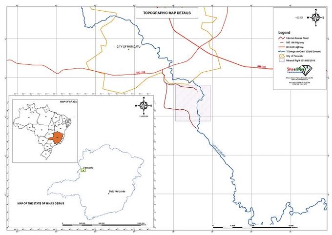
Map – Mineral Right DNPM 831.883/2016; drawn on 11/02/2016 by W. Oliveira.
Industry Guide 7 Compliance
DNPM 831.883/2016 is without known reserves, according to such definition under the SEC's Industry Guide 7. Our intended program for this area is exploratory in nature.
DNPM 860.807/2016
We have title to the mineral right designated by the number DNPM 860.807/2016. Its status is that of "Alvará de Resquisa" or research permit.
Location
DNPM 860.807/2016 is located in the municipalities of Crixás and Uirapuru, state of Goiás, in Brazil.
Crixás was founded in the 18th century by pioneers searching for gold. Today, Crixás has 15,000 inhabitants, and its municipality is home to the some of the largest gold operations in Brazil, with large gold mines and projects from AngloGold Ashanti and Cleveland Mining.
Page 4
According to publicly available information, the AngloGold Ashanti operations in Crixás encompass three underground and two open-pit mines. Production of over 4 million ounces of gold has occurred from these mines, and more than 3 million ounces remain; the 2015 annual yield was 132,000 ounces of gold.
Size
DNPM 860.807/2016 has a surface area of 1,993.02 hectares (approximately 4,925 acres).
Coordinates
The coordinates of DNPM 860.807/2016 are as follows (using SIRGAS2000):
| Latitude | Longitude |
| -14°17'33''849 | -49°52'32''642 |
| -14°17'49''893 | -49°52'32''642 |
| -14°17'49''893 | -49°52'32''633 |
| -14°17'49''894 | -49°52'32''633 |
| -14°17'49''894 | -49°51'50''935 |
| -14°18'54''969 | -49°51'50''935 |
| -14°18'54''969 | -49°50'44''160 |
| -14°18'33''817 | -49°50'44''160 |
| -14°18'33''817 | -49°50'19''172 |
| -14°17'58''023 | -49°50'19''172 |
| -14°17'58''023 | -49°49'54''151 |
| -14°17'36''871 | -49°49'54''151 |
| -14°17'36''871 | -49°49'37''472 |
| -14°20'08''484 | -49°49'37''472 |
| -14°20'08''484 | -49°52'32''711 |
| -14°18'49''229 | -49°52'32''711 |
| -14°18'49''229 | -49°53'09''593 |
| -14°17'33''849 | -49°53'09''593 |
| -14°17'33''849 | -49°52'32''642 |
Page 5
Map
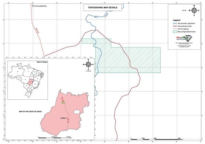
Map – Mineral Right DNPM 860.807/2016; drawn on 11/02/2016 by W. Oliveira.
Industry Guide 7 Compliance
DNPM 860.807/2016 is without known reserves, according to such definition under the SEC's Industry Guide 7. Our intended program for this area is exploratory in nature.
DNPM 831.942/2016
We have title to the mineral right designated by the number DNPM 831.942/2016. Its status is that of "Alvará de Resquisa" or research permit.
Location
DNPM 831.942/2016 crosses into the municipalities of Dionisio, Marliéria, e São Domingos do Prata, all in the state of Minas Gerais, in Brazil. These municipalities are within the greater Itabira area.
Itabira is a city with 108,000 people, and is part of the "Quadrilátero Ferrífero", roughly a geographical quadrangle in shape with the largest iron mines in Brazil and underground gold mines.
Page 6
Size
DNPM 831.942/2016 has a surface area of 1,889.51 hectares (approximately 4,669 acres).
Coordinates
The coordinates of DNPM 831.942/2016 are as follows (using SIRGAS2000):
| Latitude | Longitude |
| -19°46'15''600 | -42°49'22''800 |
| -19°46'55''200 | -42°49'22''800 |
| -19°46'55''200 | -42°48'21''600 |
| -19°49'19''200 | -42°48'21''600 |
| -19°49'19''200 | -42°49'22''800 |
| -19°49'40''800 | -42°49'22''800 |
| -19°49'40''800 | -42°50'02''400 |
| -19°49'01''200 | -42°50'02''400 |
| -19°49'01''200 | -42°50'27''600 |
| -19°46'15''600 | -42°50'27''600 |
| -19°46'15''600 | -42°49'22''800 |
Page 7
Map
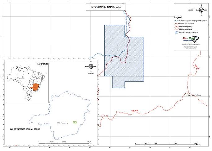
Map – Mineral Right DNPM 831.942/2016; drawn on 11/02/2016 by W. Oliveira.
Industry Guide 7 Compliance
DNPM 831.942/2016 is without known reserves, according to such definition under the SEC's Industry Guide 7. Our intended program for this area is exploratory in nature.
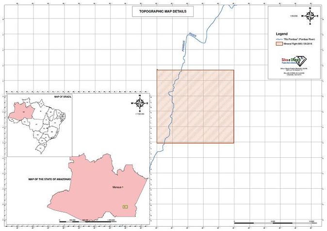
DNPM 880.133/2016
We have title to the mineral right designated by the number DNPM 880.133/2016. Its status is that of "Requerimento de Pesquisa" or request for research permit.
Location
DNPM 880.133/2016 is located in the municipality of Apuí, state of Amazonas, in Brazil.
Size
DNPM 880.133/2016 has a surface area of 9,325.31 hectares (approximately 23,043 acres).
Page 8
Coordinates
The coordinates of DNPM 880.133/2016 are as follows (using SIRGAS2000):
| Latitude | Longitude |
| -07°03'21''278 | -60°05'58''879 |
| -07°08'14''679 | -60°05'58''879 |
| -07°08'14''679 | -60°11'36''022 |
| -07°03'18''797 | -60°11'36''022 |
| -07°03'18''797 | -60°11'34''391 |
| -07°03'21''278 | -60°11'34''391 |
| -07°03'21''278 | -60°05'58''879 |
Map
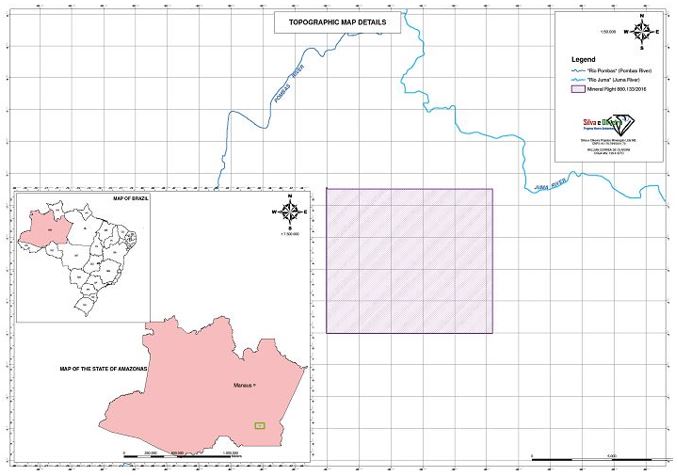
Map – Mineral Right DNPM 880.133/2016; drawn on 11/02/2016 by W. Oliveira.
Page 9
Industry Guide 7 Compliance
DNPM 880.133/2016 is without known reserves, according to such definition under the SEC's Industry Guide 7. Our intended program for this area is exploratory in nature.
DNPM 880.134/2016
We have title to the mineral right designated by the number DNPM 880.134/2016. Its status is that of "Requerimento de Pesquisa" or request for research permit.
Location
DNPM 880.134/2016 is located in the municipality of Apuí, state of Amazonas, in Brazil.
Size
DNPM 880.134/2016 has a surface area of 9,391.67 hectares (approximately 23,207 acres).
Coordinates
The coordinates of DNPM 880.134/2016 are as follows (using SIRGAS2000):
| Latitude | Longitude |
| -07°03'21''278 | -60°05'58''879 |
| -07°03'21''278 | -60°11'34''391 |
| -07°03'18''797 | -60°11'34''391 |
| -07°03'10''357 | -60°11'34''391 |
| -07°03'10''357 | -60°11'33''931 |
| -06°58'25''526 | -60°11'33''931 |
| -06°58'25''526 | -60°05'57''149 |
| -07°03'21''278 | -60°05'57''149 |
| -07°03'21''278 | -60°05'58''879 |
Page 10
Map

Map – Mineral Right DNPM 880.134/2016; drawn on 11/02/2016 by W. Oliveira.
Industry Guide 7 Compliance
DNPM 880.134/2016 is without known reserves, according to such definition under the SEC's Industry Guide 7. Our intended program for this area is exploratory in nature.
DNPM 880.135/2016
We have title to the mineral right designated by the number DNPM 880.135/2016. Its status is that of "Requerimento de Pesquisa" or request for research permit.
Location
DNPM 880.135/2016 is located in the municipality of Apuí, state of Amazonas, in Brazil.
Size
DNPM 880.135/2016 has a surface area of 9,340.04 hectares (approximately 23,080 acres).
Page 11
Coordinates
The coordinates of DNPM 880.135/2016 are as follows (using SIRGAS2000):
| Latitude | Longitude |
| -07°03'07''637 | -60°16'56''443 |
| -07°03'10''357 | -60°16'56''443 |
| -07°03'10''357 | -60°11'36''021 |
| -07°03'18''797 | -60°11'36''021 |
| -07°08'14''679 | -60°11'36''021 |
| -07°08'17''489 | -60°11'36''021 |
| -07°08'17''489 | -60°16'58''594 |
| -07°03'07''637 | -60°16'58''594 |
| -07°03'07''637 | -60°16'56''443 |
Map
Map – Mineral Right DNPM 880.135/2016; drawn on 11/02/2016 by W. Oliveira.
Page 12
Industry Guide 7 Compliance
DNPM 880.135/2016 is without known reserves, according to such definition under the SEC's Industry Guide 7. Our intended program for this area is exploratory in nature.
DNPM 831.665/2016
We have title to the mineral right designated by the number DNPM 831.665/2016. Its status is that of "Alvará de Resquisa" or research permit.
Location
DNPM 831.665/2016 is located in the municipalities of Augusto de Lima, Buenopolis, and Diamantina, state of Minas Gerais, in Brazil.
Size
DNPM 831.665/2016 has a surface area of 94.44 hectares (approximately 233 acres).
Coordinates
The coordinates of DNPM 831.665/2016 are as follows (using SIRGAS2000):
| Latitude | Longitude |
| -18°09'06''501 | -43°56'54''794 |
| -18°09'06''501 | -43°57'42''551 |
| -18°08'44''619 | -43°57'42''549 |
| -18°08'44''619 | -43°56'54''794 |
| -18°09'06''501 | -43°56'54''794 |
Page 13
Map

Map – Mineral Right DNPM 831.665/2016; drawn on 12/20/2017 by R. Mello.
Industry Guide 7 Compliance
DNPM 831.665/2016 is without known reserves, according to such definition under the SEC's Industry Guide 7. Our intended program for this area is exploratory in nature.
DNPM 831.642/2016
We have title to the mineral right designated by the number DNPM 831.642/2016. Its status is that of "Alvará de Resquisa" or research permit.
Location
DNPM 831.642/2016 is located in the municipalities of Senador Modestino Gonçalves, state of Minas Gerais, in Brazil.
Page 14
Size
DNPM 831.642/2016 has a surface area of 870.93 hectares (approximately 2,152 acres).
Coordinates
The coordinates of DNPM 831.642/2016 are as follows (using SIRGAS2000):
| Latitude | Longitude |
| -17°50'10''467 | -43°10'29''389 |
| -17°50'51''224 | -43°10'29''389 |
| -17°50'51''224 | -43°10'12''738 |
| -17°51'33''352 | -43°10'12''738 |
| -17°51'33''352 | -43°11'35''771 |
| -17°51'06''561 | -43°11'35''771 |
| -17°51'06''561 | -43°11'39''684 |
| -17°49'30''978 | -43°11'39''684 |
| -17°49'30''978 | -43°10'18''699 |
| -17°50'10''467 | -43°10'18''699 |
| -17°50'10''467 | -43°10'29''389 |
Page 15
Map
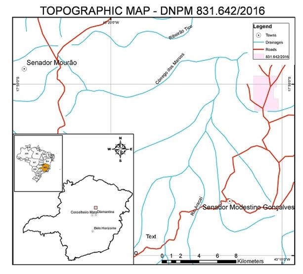
Map – Mineral Right DNPM 831.642/2016; drawn on 12/20/2017 by R. Mello.
Industry Guide 7 Compliance
DNPM 831.642/2016 is without known reserves, according to such definition under the SEC's Industry Guide 7. Our intended program for this area is exploratory in nature.
| III. | FIRST MODULAR PLANT |
The Company has built an initial modular plant for recovery of alluvial gold and placed it in a mining concession in Brazil under a royalty agreement. The plant uses high speed centrifugation as the primary method of gold separation.
This modular plant is owned by the Company, and is solely operated by Brazil Minerals, Inc. ("Brazil Minerals"), a Nevada corporation with presence in Brazil, which retains 100% of the diamonds and 50% of the gold recovered from it, while the other 50% of gold is for the account of the Company. Brazil Minerals is an affiliate and the largest shareholder in the Company.
Page 16
Details of the Modular Plant
The use of centrifugal concentrators for free gold recovery from alluvial ore has been a common practice in the mining industry for over two decades. This method uses the difference in intrinsic densities between gold and the "waste" for separation – whereas the native gold density is equal to 19.0 g/cm³, the density of silica, the main component of the waste, is equal to 2.6 g/cm³.
This equipment was originally developed by the Canadian mining industry and has several advantages over other processes, such as:
| · | No use of chemicals (such as cyanide and mercury) |
| · | Low maintenance and low energy consumption |
| · | Recovery of gold in a wide particle size range |
| · | Simple installation and operation, with excellent mobility |
In our first modular plant, the desired alluvial material with gold content is added by loader into the feeder. In the feeder this material will be mixed on a 50% basis with clean water to form a pulp. The pulp then passes through vibrating size separators and a rotating trommel before being fed to a large centrifuge. The recovered gold from the centrifuge is further separated using a vibrating table. Any waste from the centrifuge is deposited in special pits for reprocessing to guarantee minimal loss of gold in the process.
Location of the Modular Plant
Our initial modular plant has been placed in a mining concession area that belongs to Brazil Minerals, through its subsidiary, Mineração Duas Barras Ltda ("MDB"), a Brazilian company. Brazil Minerals owns 100% of MDB.
MDB holds title to two mineral rights, including a mining concession for gold, diamonds and sand, located on the margins of the Jequitinhonha River in the state of Minas Gerais in Brazil. The Jequitinhonha River valley is a well-known area for both gold and diamond production. Along its course, it has hosted alluvial production for both gold and diamonds since the 18th century.
Page 17
Map Showing Location of MDB

Map – location of MDB; furnished to Jupiter Gold by MDB.
Facilities and Equipment
MDB's facilities are located an approximately one and one-half hour drive from Montes Claros, a city of approximately 500,000 people which has the necessary infrastructure to support mining operations in a broad area. The Company owns an excavator, a bulldozer, and a truck for mining operations.
Source of Water and Power
Water supplies are abundant at MDB, being sourced from a large lake that is physically separate from the Jequitinhonha River by over 100 meters.
MDB does not have electricity from the national grid and instead relies on several diesel generators for power. Our modular plant utilizes a portable diesel-powered generator. There are several local suppliers of diesel.
Page 18
Mining Concession
MDB holds title to two mineral rights: a mining concession ("Concessão de Lavra") for mineral right DNPM 806.568/1977, and another mineral right in an earlier stage. MDB's mining concession covers a surface area of 422 acres and allows for the exploration and commercialization of gold, diamonds and sand. "Concessão de Lavra" is the highest level of mineral right in Brazil. It permits the owner to mine in perpetuity provided that environmental licenses are kept current and that mining guidelines are followed. There are no liens or other encumbrances on MDB's mining concession, and there are no regular fees to be paid to maintain such mineral right, besides government royalties on production. The government's royalty on gold production is 1% (one percent) of sales. DNPM 806.568/1977 is without known reserves, according to such definition under the SEC's Industry Guide 7.
Map Showing Jupiter Gold's Modular Plant inside MDB's Mining Concession (mineral right DNPM 806.569/1977):

Map – location of Jupiter Gold's modular plant (or "Gold Recovery Unit", GRU) inside MDB's mining concession (mineral right DNPM 806.569/1977); drawn by W. Oliveira on 11/03/2016.
Page 19
The Company has performed maintenance on several items of capital equipment which needed upgrading and refurbishment to function properly and extensively. The Company utilized the available time while the equipment was in repair to test various locations within MDB's mining location for production of gold. The production of gold from these samples utilizing the Company's modular plant allowed us to rank such locations, in preparation for mining them.
| Very truly yours, | ||
| Marc Fogassa | ||
| Chairman & CEO | ||
| Jupiter Gold Corporation |
cc: John Coleman
Page 20