Effective Date: June 28, 2023
Report Date: July 30, 2023
Prepared By:
William J. Lewis, P.Geo.
Richard Gowans, P.Eng.
Christopher Jacobs, CEng, MIMMM
Andrew Hanson, P.E.
Dr. Deepak Malhotra, Ph.D.
Ralston Pedersen, P.E.
 | INTEGRA RESOURCES CORP. 400 Burrard Street, Suite 1050 Vancouver, BC Canada, V6C 3A6 Tel: 1.604.416.0576 |
601 – 90 Eglinton Ave East, Toronto, Ontario, Canada M4P 2Y3
+1 416 362 5135 | www.micon-international.com
Table of Contents
| 1.0 SUMMARY | 1 |
| 1.1 INTRODUCTION | 1 |
| 1.2 PROPERTY DESCRIPTION, LOCATION AND OWNERSHIP | 2 |
| 1.2.1 Wildcat Project | 2 |
| 1.2.2 Mountain View Project | 2 |
| 1.2.3 Wildcat and Mountain View Projects, Ownership 2021 to 2023 | 3 |
| 1.3 ACCESSIBILITY, CLIMATE, PHYSIOGRAPHY, LOCAL RESOURCES AND INFRASTRUCTURE | 4 |
| 1.3.1 Accessibility | 4 |
| 1.3.2 Climate and Physiography | 4 |
| 1.3.3 Local Resources and Infrastructure | 5 |
| 1.4 HISTORY | 5 |
| 1.4.1 Wildcat Project History | 5 |
| 1.4.2 Mountain View Project History | 7 |
| 1.5 GEOLOGICAL SETTING AND MINERALIZATION | 8 |
| 1.5.1 Regional Geology | 8 |
| 1.5.2 Wildcat Project Geology | 9 |
| 1.5.3 Wildcat Project Mineralization | 9 |
| 1.5.4 Mountain View Project Geology | 9 |
| 1.5.5 Mountain View Project Mineralization | 10 |
| 1.6 MILLENNIAL 2021 TO 2022 EXPLORATION PROGRAMS | 11 |
| 1.6.1 Wildcat and Mountain View Projects Surface Exploration Programs | 11 |
| 1.6.2 Wildcat and Mountain View Projects Drilling Programs | 12 |
| 1.7 METALLURGICAL TESTWORK | 12 |
| 1.7.1 Wildcat Project | 12 |
| 1.7.2 Mountain View Project | 13 |
| 1.8 MINERAL RESOURCE ESTIMATE | 14 |
| 1.8.1 Mineral Resource Estimate for the Wildcat Project | 14 |
| 1.8.2 Mineral Resource Estimate for the Mountain View Project | 19 |
| 1.9 MINING, PROCESSING AND INFRASTRUCTURE | 25 |
| 1.9.1 Mining | 25 |
| 1.9.2 Processing | 29 |
| 1.9.3 Infrastructure | 32 |
| 1.9.4 Capital and Operating Costs | 33 |
| 1.10 ECONOMIC ANALYSIS | 33 |
| 1.11 CONCLUSIONS AND RECOMMENDATIONS | 35 |
| 1.11.1 Mineral Resource Estimate Conclusions | 35 |
| 1.11.2 Risks and Opportunities | 35 |
| 1.11.3 Planned Expenditures and Budget Preparation | 37 |
| 1.11.4 Further Recommendations | 39 |
| | |
| 2.0 INTRODUCTION | 41 |
| 2.1 TERMS OF REFERENCE | 41 |
| 2.2 QUALIFIED PERSONS, SITE VISIT AND AREAS OF RESPONSIBILITY | 42 |
| 2.3 UNITS AND ABBREVIATIONS | 42 |
| 2.4 INFORMATION SOURCES | 45 |
| | |
| 3.0 RELIANCE ON OTHER EXPERTS | 47 |
| | |
| 4.0 PROPERTY DESCRIPTION AND LOCATION | 48 |
| 4.1 GENERAL DESCRIPTION AND LOCATION | 48 |
| 4.1.1 Wildcat Property Description and Location | 48 |
| 4.1.2 Mountain View Property Description and Location | 48 |
| 4.2 LAND TENURE, AGREEMENTS, MINERAL RIGHTS AND OWNERSHIP | 48 |
| 4.2.1 Wildcat Property Description and Ownership | 51 |
| 4.2.2 Wildcat Project, Obligations and Encumbrances | 51 |
| 4.2.3 Wildcat Environmental Liabilities and Permitting | 53 |
| 4.2.4 Mountain View Property Description and Ownership | 55 |
| 4.2.5 Mountain View Project Obligations and Encumbrances | 57 |
| 4.2.6 Mountain View Environmental Liabilities and Permitting | 59 |
| 4.3 MICON QP COMMENTS | 61 |
| | |
| 5.0 ACCESSIBILITY, CLIMATE, LOCAL RESOURCES, INFRASTRUCTURE AND PHYSIOGRAPHY | 62 |
| 5.1 CLIMATE | 62 |
| 5.2 WILDCAT PROJECT | 62 |
| 5.2.1 Accessibility | 62 |
| 5.2.2 Physiography | 63 |
| 5.2.3 Local Resources and Infrastructure | 63 |
| 5.3 MOUNTAIN VIEW PROJECT | 64 |
| 5.3.1 Accessibility | 64 |
| 5.3.2 Physiography | 64 |
| 5.3.3 Local Resources and Infrastructure | 65 |
| 5.4 MICON QP COMMENTS FOR BOTH WILDCAT AND MOUNTAIN VIEW PROJECTS | 65 |
| | |
| 6.0 HISTORY | 66 |
| 6.1 WILDCAT PROJECT | 66 |
| 6.1.1 General Ownership and Exploration History | 66 |
| 6.1.2 Mining District History and Production | 67 |
| 6.1.3 Historic Mineral Resource Estimates | 69 |
| 6.1.4 Differences in Historical Versus Current Resource Classification Definitions | 74 |
| 6.2 MOUNTAIN VIEW PROJECT | 79 |
| 6.2.1 Historical Exploration and Mining | 79 |
| 6.2.2 Historical Mineral Resource Estimates | 80 |
| | |
| 7.0 GEOLOGICAL SETTING AND MINERALIZATION | 81 |
| 7.1 REGIONAL GREAT BASIN GEOLOGY | 81 |
| 7.2 WILDCAT PROJECT GEOLOGY | 85 |
| 7.3 WILDCAT PROJECT MINERALIZATION | 88 |
| 7.4 MOUNTAIN VIEW PROJECT GEOLOGY | 90 |
| 7.5 MOUNTAIN VIEW PROJECT MINERALIZATION | 92 |
| 7.6 MICON QP COMMENTS | 93 |
| 8.0 DEPOSIT TYPES | 94 |
| 8.1 WILDCAT AND MOUNTAIN VIEW PROJECTS | 94 |
| | |
| 9.0 EXPLORATION | 96 |
| 9.1 WILDCAT PROJECT EXPLORATION PROGRAMS | 96 |
| 9.1.1 Exploration Programs Pre-2021 | 96 |
| 9.1.2 Millennial Exploration Programs: Post-2021 | 96 |
| 9.1.3 Integra Exploration Programs | 97 |
| 9.2 MOUNTAIN VIEW PROJECT EXPLORATION PROGRAMS | 97 |
| 9.2.1 Mountain View Project, Historical Exploration Programs | 97 |
| 9.3 MICON QP COMMENTS | 98 |
| | |
| 10.0 DRILLING | 99 |
| 10.1 WILDCAT PROJECT DRILLING PROGRAMS | 99 |
| 10.1.1 Wildcat Project Historical Drilling Programs | 99 |
| 10.1.2 Wildcat Project, Millennial Drilling Programs | 100 |
| 10.1.3 Wildcat Project Integra Drilling Programs | 102 |
| 10.2 MOUNTAIN VIEW PROJECT DRILLING PROGRAM | 102 |
| 10.2.1 Mountain View Project Historical Drilling Programs | 102 |
| 10.2.2 Mountain View, Millennial Drilling Program | 107 |
| 10.2.3 Integra Drilling Programs | 110 |
| 10.3 MICON QP COMMENTS | 110 |
| | |
| 11.0 SAMPLE PREPARATION, ANALYSES AND SECURITY | 111 |
| 11.1 SAMPLING APPROACH AT THE WILDCAT AND MOUNTAIN VIEW PROJECTS | 111 |
| 11.1.1 Introduction | 111 |
| 11.1.2 Sample Handling and Security | 111 |
| 11.1.3 Assay Laboratories Accreditation and Certification | 111 |
| 11.2 SAMPLE PREPARATION AND ASSAYING | 112 |
| 11.2.1 AAL Sample Preparation and Analysis | 112 |
| 11.3 QUALITY ASSURANCE AND QUALITY CONTROL | 112 |
| 11.3.1 Wildcat QA/QC Program | 112 |
| 11.3.2 Mountain View Project QA/QC Program | 115 |
| 11.4 MICON QP COMMENTS | 118 |
| | |
| 12.0 DATA VERIFICATION | 119 |
| 12.1 SITE VISIT | 119 |
| 12.2 DATABASE REVIEW FOR THE WILDCAT AND MOUNTAIN VIEW PROJECTS | 123 |
| | |
| 13.0 MINERAL PROCESSING AND METALLURGICAL TESTING | 126 |
| 13.1 WILDCAT PROJECT | 126 |
| 13.1.1 Historical Testwork | 126 |
| 13.1.2 2022/23 McClelland Testwork | 127 |
| 13.1.3 Wildcat Project, Metallurgical Testing | 133 |
| 13.2 WILDCAT PROJECT, TESTWORK CONCLUSIONS AND RECOMMENDATIONS | 142 |
| 13.3 MOUNTAIN VIEW PROJECT | 143 |
| 13.3.1 Historical Testwork | 143 |
| 13.3.2 2022/23 McClelland Testwork | 143 |
| 13.3.3 Mountain View Project, Metallurgical Testing | 149 |
| 13.3.4 Mountain View Project, Conclusions and Recommendations | 156 |
| 13.4 NOTES REGARDING METALLURGICAL LABORATORY CERTIFICATIONS | 157 |
| | |
| 14.0 MINERAL RESOURCE ESTIMATES | 158 |
| 14.1 INTRODUCTION | 158 |
| 14.2 CIM RESOURCE DEFINITIONS AND CLASSIFICATIONS | 158 |
| 14.3 CIM ESTIMATION OF MINERAL RESOURCES BEST PRACTICES GUIDELINES | 160 |
| 14.4 WILDCAT PROJECT, MINERAL RESOURCE ESTIMATE | 160 |
| 14.4.1 Methodology | 160 |
| 14.4.2 Wildcat Resource Database | 161 |
| 14.4.3 Wildcat Project Geological Modelling | 162 |
| 14.4.4 Wildcat Project Geostatistical Analysis | 163 |
| 14.4.5 Wildcat Project, Contact Analysis | 164 |
| 14.4.6 Wildcat Project, High-Grade Capping | 164 |
| 14.4.7 Wildcat Project, Density | 166 |
| 14.4.8 Wildcat Project, Compositing | 166 |
| 14.4.9 Wildcat Project, Variogram Analysis | 168 |
| 14.4.10 Wildcat Project, Block Model | 168 |
| 14.4.11 Wildcat Project, Search Ellipse and Interpolation Parameters | 168 |
| 14.4.12 Wildcat Project, Model Validation | 169 |
| 14.4.13 Wildcat Project, Mineral Resource Classification | 170 |
| 14.4.14 Wildcat Project, Reasonable Prospects for Eventual Economic Extraction | 171 |
| 14.4.15 Wildcat Project Mineral Resource Estimate | 172 |
| 14.4.16 Wildcat Project, Mineral Resource Sensitivity Analysis | 173 |
| 14.4.17 Wildcat Project, 2023 Resource Estimate, Comparison with Previous 2020 Estimate | 175 |
| 14.5 MOUNTAIN VIEW PROJECT, MINERAL RESOURCE ESTIMATE | 176 |
| 14.5.1 Mountain View Project Methodology | 176 |
| 14.5.2 Mountain View Resource Database | 176 |
| 14.5.3 Mountain View Project, Geological Modelling | 177 |
| 14.5.4 Mountain View Project, Geostatistical Analysis | 179 |
| 14.5.5 Mountain View Project Contact Analysis | 179 |
| 14.5.6 Mountain View Project, High Grade Capping | 180 |
| 14.5.7 Mountain View Project, Density | 180 |
| 14.5.8 Mountain View Project Compositing | 183 |
| 14.5.9 Mountain View Project Block Model | 185 |
| 14.5.10 Mountain View Search Ellipse and Interpolation Parameters | 185 |
| 14.5.11 Mountain View Project Model Validation | 186 |
| 14.5.12 Mountain View Project, Classification | 187 |
| 14.5.13 Mountain View Project, Reasonable Prospects for Eventual Economic Extraction | 188 |
| 14.5.14 Mountain View Project, Mineral Resource Estimate | 189 |
| 14.5.15 Mountain View Project, Mineral Resource Grade Sensitivity Analysis | 190 |
| 14.5.16 Mountain View Project, 2023 Mineral Resource Estimate Comparison with 2020 Estimate | 192 |
| 14.6 FACTORS THAT COULD AFFECT THE WILDCAT AND MOUNTAIN VIEW MINERAL RESOURCE ESTIMATES | 193 |
| 14.7 RESPONSIBILITY FOR THE WILDCAT AND MOUNTAIN VIEW MINERAL RESOURCE ESTIMATES | 193 |
| | |
| 15.0 MINERAL RESERVE ESTIMATES | 194 |
| | |
| 16.0 MINING METHODS | 195 |
| 16.1 PIT OPTIMIZATION | 195 |
| 16.1.1 Pit Optimization Parameters | 195 |
| 16.1.2 Geometrical Parameters | 197 |
| 16.1.3 Pit Optimization Results | 197 |
| 16.2 PIT DESIGNS | 201 |
| 16.2.1 Pit Design Slope Parameters | 201 |
| 16.2.2 Bench Height | 204 |
| 16.2.3 Wildcat Project, Pit Design | 205 |
| 16.2.4 Mountain View Project, Pit Design | 210 |
| 16.2.5 Cut-Off Grade | 210 |
| 16.2.6 Dilution | 213 |
| 16.2.7 Mineral Resources in the PEA Conceptual Mine Plan | 213 |
| 16.3 MINE WASTE FACILITIES | 215 |
| 16.3.1 Wildcat Waste Disposal | 215 |
| 16.3.2 Mountain View Waste Disposal | 215 |
| 16.4 MINERALIZED MATERIAL STOCKPILE FACILITIES | 218 |
| 16.5 PRODUCTION SCHEDULING | 218 |
| 16.6 MINE EQUIPMENT REQUIREMENTS | 221 |
| 16.7 MINE OPERATIONS PERSONNEL | 221 |
| | |
| 17.0 RECOVERY METHODS | 226 |
| 17.1 PROCESS FLOW | 226 |
| 17.2 PROCESS FACILITIES | 226 |
| 17.3 ENERGY, WATER AND PROCESS MATERIALS | 229 |
| 17.4 PROCESS PRODUCTION SCHEDULE | 230 |
| 17.5 PLANT AND ADMINISTRATIVE OPERATIONS PERSONNEL | 230 |
| | |
| 18.0 PROJECT INFRASTRUCTURE | 234 |
| 18.1 ACCESS ROADS | 234 |
| 18.2 BUILDINGS | 234 |
| 18.3 HEAP LEACH PAD | 234 |
| 18.3.1 Conceptual HLF, Operation Overview | 235 |
| 18.3.2 Process Ponds | 240 |
| 18.3.3 Stormwater Diversion | 240 |
| 18.4 PROCESS AREA GEOTECHNICAL REVIEW AND ANALYSIS | 240 |
| 18.5 ANCILLARY AREAS | 241 |
| 18.5.1 Wash Bay | 241 |
| 18.5.2 Explosives Magazine | 241 |
| 18.5.3 Fuel Island | 241 |
| 18.6 POWER | 241 |
| | |
| 19.0 MARKET STUDIES AND CONTRACTS | 242 |
| | |
| 20.0 ENVIRONMENTAL STUDIES, PERMITTING AND SOCIAL OR COMMUNITY IMPACT | 243 |
| 20.1 GENERAL OVERVIEW | 243 |
| 20.2 WILDCAT PROJECT | 244 |
| 20.2.1 Environmental Baseline Studies | 244 |
| 20.2.2 Permitting | 245 |
| 20.2.3 Social or Community Impacts | 246 |
| 20.2.4 Mine Closure Requirements and Cost | 247 |
| 20.3 MOUNTAIN VIEW PROJECT | 248 |
| 20.3.1 Environmental Baseline Studies | 248 |
| 20.3.2 Permitting | 248 |
| 20.3.3 Social or Community Impacts | 250 |
| 20.3.4 Mine Closure Requirements and Cost | 250 |
| | |
| 21.0 CAPITAL AND OPERATING COSTS | 252 |
| 21.1 CAPITAL COSTS - INFRASTRUCTURE | 252 |
| 21.1.1 Quantities and Estimating Methodology | 252 |
| 21.1.2 Civil (Earthworks and Utilities) | 252 |
| 21.1.3 Concrete | 252 |
| 21.1.4 Structural Steel | 253 |
| 21.1.5 Buildings | 253 |
| 21.1.6 Mechanical Equipment | 253 |
| 21.1.7 Electrical | 253 |
| 21.1.8 Instrumentation and Communication | 253 |
| 21.1.9 Labour Rates | 254 |
| 21.1.10 Construction Field Indirect Costs | 254 |
| 21.1.11 Insurance, Freight and Transportation | 254 |
| 21.1.12 Sales Tax | 254 |
| 21.1.13 Procurement | 254 |
| 21.1.14 Construction Phase Services | 254 |
| 21.1.15 Vendor Representative Assistance, Start-up and Communication Costs | 254 |
| 21.1.16 Building Permit Fees | 255 |
| 21.1.17 Spare Parts | 255 |
| 21.1.18 Contingency | 255 |
| 21.1.19 Owner Costs | 255 |
| 21.1.20 Accuracy | 255 |
| 21.2 CAPITAL COSTS - HEAP LEACH | 256 |
| 21.3 MINING CAPITAL COSTS | 257 |
| 21.4 PLANT OPERATING COSTS | 257 |
| 21.4.1 Design Criteria | 257 |
| 21.4.2 Reagents | 257 |
| 21.5 MINING OPERATING COSTS | 259 |
| 22.0 ECONOMIC ANALYSIS | 261 |
| 22.1 CAUTIONARY STATEMENT | 261 |
| 22.2 BASIS OF EVALUATION | 262 |
| 22.3 MACRO-ECONOMIC ASSUMPTIONS | 262 |
| 22.3.1 Exchange Rate and Inflation | 262 |
| 22.3.2 Weighted Average Cost of Capital | 262 |
| 22.3.3 Forecast Gold Price | 262 |
| 22.3.4 Taxation and Royalty Regime | 263 |
| 22.4 TECHNICAL ASSUMPTIONS | 263 |
| 22.4.1 Mining | 263 |
| 22.4.2 Processing | 264 |
| 22.5 BASE CASE CASH FLOW | 264 |
| 22.6 SENSITIVITY STUDY | 267 |
| 22.6.1 Discount Rate Sensitivity | 267 |
| | |
| 23.0 ADJACENT PROPERTIES | 269 |
| 23.1 WILDCAT PROJECT | 269 |
| 23.2 MOUNTAIN VIEW PROJECT | 269 |
| | |
| 24.0 OTHER RELEVANT DATA AND INFORMATION | 270 |
| | |
| 25.0 INTERPRETATION AND CONCLUSIONS | 271 |
| 25.1 GENERAL INFORMATION | 271 |
| 25.2 MINERAL RESOURCE ESTIMATE | 271 |
| 25.2.1 Mineral Resource Estimate for the Wildcat Project | 271 |
| 25.2.2 Mineral Resource for the Mountain View Project | 276 |
| 25.3 PEA MINING, PROCESSING AND INFRASTRUCTURE | 282 |
| 25.3.1 Mining | 282 |
| 25.3.2 Processing | 286 |
| 25.3.3 Infrastructure | 287 |
| 25.3.4 Capital and Operating Costs | 288 |
| 25.4 PEA ECONOMIC ANALYSIS | 288 |
| 25.5 CONCLUSIONS | 290 |
| 25.5.1 Mineral Resource Estimate Conclusions | 290 |
| 25.5.2 Risks and Opportunities | 290 |
| | |
| 26.0 RECOMMENDATIONS | 294 |
| 26.1 PLANNED EXPENDITURES AND BUDGET PREPARATION | 294 |
| 26.2 FURTHER RECOMMENDATIONS | 295 |
| 26.2.1 Geological and Resource Recommendations | 295 |
| 26.2.2 Metallurgical Recommendations | 295 |
| 26.2.3 Geotechnical Recommendations | 295 |
| 26.2.4 Mining Recommendations | 296 |
| 26.2.5 Infrastructure Recommendations | 296 |
| 26.2.6 Permitting Recommendations | 296 |
| 27.0 DATE AND SIGNATURE PAGES | 297 |
| | |
| 28.0 REFERENCES | 298 |
| 28.1 GENERAL REFERENCES | 298 |
| 28.1.1 Technical Reports, Papers and Other Sources | 298 |
| 28.1.2 Web Based Sources of Information | 299 |
| 28.2 WILDCAT PROJECT SPECIFIC REFERENCES | 299 |
| 28.2.1 Technical Reports, Papers and Other Sources | 299 |
| 28.2.2 Web Based Sources of Information | 300 |
| 28.3 MOUNTAIN VIEW PROJECT SPECIFIC REFERENCES | 300 |
| 28.3.1 Technical Reports, Papers and Other Sources | 300 |
| 28.3.2 Web Based Sources of Information | 301 |
| | |
| 29.0 CERTIFICATES OF QUALIFIED PERSONS | 302 |
Appendices
| Appendix I: Glossary of Mining and Other Related Terms | End of the Report |
| | |
| Appendix II: Wildcat and Mountain View Mineral Claim Details | End of the Report |
List of Tables
| Table 1.1 | Wildcat Project Mineral Resource Estimate Economic Parameters | 17 |
| | | |
| Table 1.2 | Wildcat Deposit June, 2023, Mineral Resource Estimate Statement | 17 |
| | | |
| Table 1.3 | Wildcat Project, Gold Grade Sensitivity Analysis at Different Cut-Off Grades | 18 |
| | | |
| Table 1.4 | Mountain View Project, Mineral Resource Economic Parameters | 22 |
| | | |
| Table 1.5 | Mountain View Deposit June, 2023, Mineral Resource Estimate Statement | 23 |
| | | |
| Table 1.6 | Mountain View Project, Gold Grade Sensitivity Analysis at Different Cut-Off Grades | 24 |
| | | |
| Table 1.7 | Mine Production Schedule | 30 |
| | | |
| Table 1.8 | Summary LOM Cash Flow, Wildcat and Mountain View Projects | 33 |
| | | |
| Table 1.9 | Risks and Opportunities at the Wildcat and Mountain View Projects | 36 |
| | | |
| Table 1.10 | Wildcat and Mountain View Projects, Recommended Budget for Further Work | 38 |
| | | |
| Table 2.1 | Qualified Persons, Areas of Responsibility and Site Visits | 43 |
| | | |
| Table 2.2 | List of the Abbreviations | 43 |
| | | |
| Table 4.1 | Summary of the Mineral Claims that Comprise the Wildcat and Mountain View Properties | 50 |
| | | |
| Table 5.1 | Average Climatic Data - Gerlach Station | 62 |
| | | |
| Table 6.1 | Historical Production from the Seven Troughs District | 68 |
| | | |
| Table 6.2 | Production from the Seven Troughs District by Year from 1908 to 1940 (Gold, Silver, Copper, Lead) | 68 |
| | | |
| Table 6.3 | Historical Lac Minerals 1993 Wildcat Mineral Resource Estimation* | 69 |
| | | |
| Table 6.4 | Summary of the Historical 1998 MDA Wildcat Resource Estimation | 71 |
| | | |
| Table 6.5 | Historical 2006 Wildcat Indicated Resource Estimate (0.010 oz/t gold cut-off) | 74 |
| | | |
| Table 6.6 | Historical 2006 Wildcat Inferred Resource Estimate (0.010 oz/t gold cut-off) | 74 |
| | | |
| Table 6.7 | Historical 2002 Snowden Mineral Resource Estimate, Severance Deposit, Mountain View Project | 80 |
| | | |
| Table 10.1 | Summary of the Historical Wildcat Project Drilling Programs | 99 |
| Table 10.2 | Comparison between the Core Diamond Drill Holes and the Close-by Reverse Circulation Drill Holes | 100 |
| | | |
| Table 10.3 | Summary of the 2022 Millennial Drilling Program for the Wildcat Project | 100 |
| | | |
| Table 10.4 | Summary of the Mountain View Project Drilling Programs from 1984-2004 | 102 |
| | | |
| Table 10.5 | Summary of the Drill Hole Information for the 2003 and 2004 Vista Drill Programs | 104 |
| | | |
| Table 10.6 | Summary of the 2003 and 2004 Mineralized Drill Hole Intersections | 106 |
| | | |
| Table 10.7 | Summary of the Drill Hole Information for the 2021 to 2022 Millennial Drilling Program | 107 |
| | | |
| Table 11.1 | Standards used by Millennial for the 2022 Wildcat Core Drilling Program | 112 |
| | | |
| Table 11.2 | AAL Results for the Standards used by Millennial during the 2022 Drilling Program at the Wildcat Project | 113 |
| | | |
| Table 11.3 | Summary of Blank Performance at Wildcat | 113 |
| | | |
| Table 11.4 | Standards used by Millennial for the 2021-2022 Mountain View Project Core Drilling Program | 115 |
| | | |
| Table 11.5 | AAL Results of Standards used by Millennial for the 2021-2022 Drilling Program at Mountain View Program | 116 |
| | | |
| Table 11.6 | Summary of Blank Performance at Mountain View Project | 117 |
| | | |
| Table 12.1 | Wildcat Project, Drill Hole Samples Chosen for Reassaying | 124 |
| | | |
| Table 12.2 | Mountain View Project, Drill Hole Samples Chosen for Reassaying | 124 |
| | | |
| Table 12.3 | Comparison of the Original AAL Assay and the BV Re-Assay | 125 |
| | | |
| Table 13.1 | Summary of Historical Metallurgical Testwork | 126 |
| | | |
| Table 13.2 | Wildcat Project, Metallurgical Composite Selected Analyses | 129 |
| | | |
| Table 13.3 | Column Metallurgical Composite Whole Rock Analyses | 130 |
| | | |
| Table 13.4 | Column Metallurgical Composite XRD Analyses | 130 |
| | | |
| Table 13.5 | Bottle Roll Metallurgical Variability Samples Gold, Silver and Sulphide Analyses | 131 |
| | | |
| Table 13.6 | Summary of Column Composite Sample Bottle Roll Leach Test Results | 134 |
| | | |
| Table 13.7 | Average Bottle Roll Leach Test Results for Each Mineralization-Type | 135 |
| | | |
| Table 13.8 | Summary of Final Column Leach Test Results | 137 |
| Table 13.9 | Physical Characteristics of the Wildcat Column Leach Test Samples | 140 |
| | | |
| Table 13.10 | Summary of Diagnostic Leach Test Results | 141 |
| | | |
| Table 13.11 | Summary of the Wildcat Sample Gravity Test Results | 141 |
| | | |
| Table 13.12 | Mountain View Project, Metallurgical Composite Selected Analyses | 145 |
| | | |
| Table 13.13 | Mountain View Project, Column Metallurgical Composite Whole Rock Analyses | 146 |
| | | |
| Table 13.14 | Mountain View Column Metallurgical Composite XRD Analyses | 146 |
| | | |
| Table 13.15 | Mountain View Bottle Roll Metallurgical Variability Samples, Gold, Silver and Sulphide Analyses | 147 |
| | | |
| Table 13.16 | Summary of Column Composite Sample Bottle Roll Leach Test Results | 150 |
| | | |
| Table 13.17 | Average Bottle Roll Leach Test Results for Each Mineralization-Type | 153 |
| | | |
| Table 13.18 | Summary of Final Column Leach Test Results | 154 |
| | | |
| Table 13.19 | Physical Characteristics of the Mountain View Column Leach Test Samples | 156 |
| | | |
| Table 14.1 | Wildcat Project, Drill Hole Assaying Gold and Silver Statistics | 163 |
| | | |
| Table 14.2 | Wildcat Project, Drilling Assays Sensitivity to Capping Value | 166 |
| | | |
| Table 14.3 | Wildcat Project, Drilling 4.5m Composites Statistics | 167 |
| | | |
| Table 14.4 | Wildcat Project, Block Model Geometry | 168 |
| | | |
| Table 14.5 | Wildcat Project, Search Ellipse Parameters | 169 |
| | | |
| Table 14.6 | Wildcat Project, Gold Interpolation Comparison at Zero Cut-off | 170 |
| | | |
| Table 14.7 | Wildcat Project Mineral Resource Estimate Economic Parameters | 172 |
| | | |
| Table 14.8 | Wildcat Deposit June, 2023, Mineral Resource Estimate Statement | 172 |
| | | |
| Table 14.9 | Wildcat Project, Gold Grade Sensitivity Analysis at Different Cut-Off Grades | 173 |
| | | |
| Table 14.10 | Wildcat Project, Comparison of the 2023 Mineral Resource Estimate with Previous 2020 Estimate | 175 |
| | | |
| Table 14.11 | Mountain View Project, Drilling Assay Gold and Silver Statistics | 179 |
| | | |
| Table 14.12 | Mountain View Project, West Breccia Drilling Assays Sensitivity to Gold Capping Value | 183 |
| | | |
| Table 14.13 | Mountain View Project, Selected Capping Value per Domain for Gold and Silver | 183 |
| Table 14.14 | Mountain View Project, Drilling, 4.5m Composites Statistics | 184 |
| | | |
| Table 14.15 | Mountain View Project, Block Model Geometry | 185 |
| | | |
| Table 14.16 | Mountain View Project, Search Ellipse Parameters | 185 |
| | | |
| Table 14.17 | Mountain View Project, Interpolation Parameters | 186 |
| | | |
| Table 14.18 | Mountain View Project, Gold Interpolation Comparison Cut-Off | 187 |
| | | |
| Table 14.19 | Mountain View Project, Mineral Resource Economic Parameters | 189 |
| | | |
| Table 14.20 | Mountain View Deposit June, 2023, Mineral Resource Estimate Statement | 189 |
| | | |
| Table 14.21 | Mountain View Project, Gold Grade Sensitivity Analysis at Different Cut-Off Grades | 190 |
| | | |
| Table 14.22 | Mountain View Project, Comparison between the 2023 and the 2020 Mineral Resource Estimates | 192 |
| | | |
| Table 16.1 | Pit Optimization Parameters | 196 |
| | | |
| Table 16.2 | Wildcat Project, Pit Optimization Results | 198 |
| | | |
| Table 16.3 | Mountain View Project, Pit Optimization Results | 200 |
| | | |
| Table 16.4 | Combined Wildcat and Mountain View Project Pit Optimization Results | 201 |
| | | |
| Table 16.5 | Wildcat Geotechnical Parameters | 204 |
| | | |
| Table 16.6 | Mountain View Geotechnical Parameters | 204 |
| | | |
| Table 16.7 | Cut-off Grade Estimation | 210 |
| | | |
| Table 16.8 | Dilution Factors | 213 |
| | | |
| Table 16.9 | Wildcat Project, Mineral Resources within the Conceptual Mine Plan | 214 |
| | | |
| Table 16.10 | Mountain View Project, Mineral Resources within the Conceptual Mine Plan | 214 |
| | | |
| Table 16.11 | Wildcat Project, Waste Dump Capacity | 215 |
| | | |
| Table 16.12 | Mountain View Project, Waste Dump Capacity | 215 |
| | | |
| Table 16.13 | Mineralized Material Stockpile Capacity | 218 |
| | | |
| Table 16.14 | Mine Production Schedule | 222 |
| | | |
| Table 16.15 | Mining Fleet Requirements | 224 |
| Table 16.16 | Mine Personnel Requirements | 225 |
| | | |
| Table 17.1 | Energy Requirements for the Wildcat and Mountain View Projects | 229 |
| | | |
| Table 17.2 | Reagents Requirements for the Wildcat and Mountain View Projects | 229 |
| | | |
| Table 17.3 | Process Production Schedule for the Wildcat and Mountain View Projects | 231 |
| | | |
| Table 17.4 | Plant Personnel Requirements | 232 |
| | | |
| Table 17.5 | General and Administration Personnel Requirements | 233 |
| | | |
| Table 19.1 | Average Annual High and Low London PM Fix for Gold and Silver from 2000 to July 30, 2023 | 242 |
| | | |
| Table 20.1 | Required Permits for the Wildcat Project | 245 |
| | | |
| Table 20.2 | Wildcat Project, Reclamation Cost Estimate | 247 |
| | | |
| Table 20.3 | Required Permits for the Mountain View Project | 249 |
| | | |
| Table 20.4 | Mountain View Project, Reclamation Cost Estimate | 251 |
| | | |
| Table 21.1 | General Infrastructure Estimate for the Wildcat Project | 255 |
| | | |
| Table 21.2 | General Infrastructure Estimate for Mountain View Project | 255 |
| | | |
| Table 21.3 | Heap Leach Estimate for the Wildcat Project | 256 |
| | | |
| Table 21.4 | Heap Leach Estimate for Mountain View Project | 256 |
| | | |
| Table 21.5 | Plant Operating Costs for the Wildcat Project, 11 Mt/y | 258 |
| | | |
| Table 21.6 | Plant Operating Costs for the Wildcat Project, Leaching Only | 258 |
| | | |
| Table 21.7 | Plant Operating Costs for the Mountain View Project, 5.5 Mt/y | 258 |
| | | |
| Table 21.8 | Plant Operating Costs for the Mountain View Project, Leaching Only | 259 |
| | | |
| Table 21.9 | Mining Average Operating Costs for the Wildcat Project | 259 |
| | | |
| Table 21.10 | Mining Average Operating Costs for the Mountain View Project | 260 |
| | | |
| Table 22.1 | Summary LOM Cash Flow, Wildcat and Mountain View Projects | 265 |
| | | |
| Table 22.2 | Annual LOM Cash Flow | 266 |
| | | |
| Table 25.1 | Wildcat Project Mineral Resource Estimate Economic Parameters | 274 |
| Table 25.2 | Wildcat Deposit June, 2023, Mineral Resource Estimate Statement | 275 |
| | | |
| Table 25.3 | Wildcat Project, Gold Grade Sensitivity Analysis at Different Cut-Off Grades | 275 |
| | | |
| Table 25.4 | Mountain View Project, Mineral Resource Economic Parameters | 279 |
| | | |
| Table 25.5 | Mountain View Deposit June, 2023, Mineral Resource Estimate Statement | 280 |
| | | |
| Table 25.6 | Mountain View Project, Gold Grade Sensitivity Analysis at Different Cut-Off Grades | 281 |
| | | |
| Table 25.7 | Summary LOM Cash Flow, Wildcat and Mountain View Projects | 288 |
| | | |
| Table 25.8 | Risks and Opportunities at the Wildcat and Mountain View Projects | 291 |
| | | |
| Table 26.1 | Wildcat and Mountain View Projects, Recommended Budget for Further Work | 294 |
List of Figures
| Figure 1.1 LOM Cash Flow Chart | 35 |
| | |
| Figure 4.1 Location Map of the Wildcat and Mountain View Projects in Northwestern Nevada | 49 |
| | |
| Figure 4.2 Wildcat Project Claims Map | 52 |
| | |
| Figure 4.3 Mountain View Project Mineral Claims Map | 56 |
| | |
| Figure 5.1 A Panoramic View of Main Hill (looking North-Northeast) at the Wildcat Project | 63 |
| | |
| Figure 5.2 A View of the Mountain View Property | 64 |
| | |
| Figure 6.1 View of the Old Wooden Headframe on the Historical Shaft | 69 |
| | |
| Figure 7.1 The Bimodal Basalt-Rhyolite Assemblage | 82 |
| | |
| Figure 7.2 Generalized Geology of the Western North American Cordillera | 83 |
| | |
| Figure 7.3 Regional Geology Map for Northwest Nevada | 84 |
| | |
| Figure 7.4 Property Geology Map for the Wildcat Project | 86 |
| | |
| Figure 7.5 Regional Geology Surrounding the Mountain View Project | 91 |
| | |
| Figure 8.1 Schematic Model of Mineral Zonation in Low-Sulphidation Epithermal Deposits. | 95 |
| | |
| Figure 10.1 Location of 2003 and 2004 Vista Drill Holes in Relation to Previous Drill Holes | 105 |
| | |
| Figure 11.1 Example of AAL Results for Standard OREAS 252b for the Wildcat 2022 Drill Program | 114 |
| | |
| Figure 11.2 Graph of Blank Performance at Wildcat | 114 |
| | |
| Figure 11.3 Graph of Field Duplicate Performance at the Wildcat Project | 115 |
| | |
| Figure 11.4 Example of AAL Results for Standard OREAS 250b for the Mountain View 2021 and 2022 Drill Program | 116 |
| | |
| Figure 11.5 Graph of Blank Performance at Mountain View Project | 117 |
| | |
| Figure 11.6 Graph of Duplicate Performance at Mountain View Project | 118 |
| | |
| Figure 12.1 Drilling WCCD-0012 at the Wildcat Project August, 2022 Site Visit | 119 |
| | |
| Figure 12.2 Millennial Coreshack at the time of Micon's Site Visit in August, 2022 | 120 |
| | |
| Figure 12.3 Millennial Storage of Pulp Samples | 120 |
| Figure 12.4 Site of Wildcat Drill Hole WCCD-0005 | 121 |
| | |
| Figure 12.5 View of Mountain View Drill Hole MVCD-0021 | 121 |
| | |
| Figure 12.6 View of the Wildcat Project from the Access Road | 122 |
| | |
| Figure 12.7 View of the Mountain View Project from Drill Hole MVCD-0021 | 122 |
| | |
| Figure 12.8 Comparison between the Original Assay from AAL and the Bureau Veritas Check Re-Assays | 125 |
| | |
| Figure 13.1 Wildcat Metallurgical Samples Locations | 128 |
| | |
| Figure 13.2 -1.7 mm Variability Bottle Roll Tests - Au and Ag Recovery versus Sulphide Sulphur Content | 134 |
| | |
| Figure 13.3 P80 75 µm Variability Bottle Roll Tests - Au and Ag Recovery versus Sulphide Sulphur Content | 135 |
| | |
| Figure 13.4 Column Leach Gold Recoveries - P80 19 mm | 138 |
| | |
| Figure 13.5 Column Leach Gold Recoveries - P80 9.5 mm | 138 |
| | |
| Figure 13.6 Column Leach Gold Recoveries - P80 6.3 mm (HPGR) | 139 |
| | |
| Figure 13.7 Mountain View Metallurgical Samples Locations | 144 |
| | |
| Figure 13.8 -1.7 mm Variability Bottle Roll Tests - Au and Ag Recovery versus Sulphide Sulphur Content | 150 |
| | |
| Figure 13.9 -1.7 mm Oxide Variability Bottle Roll Tests - Au and Ag Extraction versus Head Grade | 151 |
| | |
| Figure 13.10 P80 75 µm Variability Bottle Roll Tests - Au and Ag Recovery versus Sulphide Sulphur Content | 151 |
| | |
| Figure 13.11 P80 75 µm Oxide Variability Bottle Roll Tests - Au and Ag Extraction versus Head Grade | 152 |
| | |
| Figure 13.12 Mountain View Project, Program Column Leach Gold Recoveries - P80 19 mm | 155 |
| | |
| Figure 13.13 Mountain View Project, Column Leach Gold Recoveries - P80 9.5 mm | 155 |
| | |
| Figure 14.1 Wildcat Project Drilling Location Plan View | 161 |
| | |
| Figure 14.2 Wildcat 3D View, Drilling Lithologies at the Main Hill Zone (Looking Northeast) | 162 |
| | |
| Figure 14.3 Wildcat Project, Volcanoclastic Contact Plot | 164 |
| | |
| Figure 14.4 Wildcat Project, Logarithmic Probability Plots for Gold | 165 |
| Figure 14.5 Wildcat Project, Logarithmic Probability Plots for Silver | 165 |
| | |
| Figure 14.6 Wildcat Project, Assays Length Histogram | 167 |
| | |
| Figure 14.7 Wildcat Project, North-South Block Model Cross Section Visual Checks (Looking West) | 169 |
| | |
| Figure 14.8 Wildcat Project, Gold Trend Plot: East, North and Elevation | 170 |
| | |
| Figure 14.9 Wildcat Project, Plan View of the Mineral Resource Classification | 171 |
| | |
| Figure 14.10 Wildcat Project, Grade Tonnage Curves for the Indicated Mineral Resources at Different Cut-Off Grades | 174 |
| | |
| Figure 14.11 Wildcat Project, Grade Tonnage Curves for the Inferred Mineral Resources at Different Cut-Off Grades | 175 |
| | |
| Figure 14.12 Mountain View Project, Plan View of Drilling Locations | 177 |
| | |
| Figure 14.13 Mountain View Project, 3D View of the Drilling Lithologies at the Main Hill Zone (Looking West) | 178 |
| | |
| Figure 14.14 Mountain View Project, West Breccia and Rhyolite Contact Plots | 181 |
| | |
| Figure 14.15 Mountain View Project, Logarithmic Probability Plots for Gold | 182 |
| | |
| Figure 14.16 Mountain View Project, Assay Length Histogram | 184 |
| | |
| Figure 14.17 Mountain View Project, North-South Block Model Cross Section Visual Checks (Looking North) | 186 |
| | |
| Figure 14.18 Mountain View Project, Gold Trend Plot for East, North and Elevation | 187 |
| | |
| Figure 14.19 Mountain View Project 3D View of the Classification (Looking Northeast) | 188 |
| | |
| Figure 14.20 Mountain View Project, Grade Tonnage Curves for the Indicated Mineral Resources at Different Cut-Off Grades | 191 |
| | |
| Figure 14.21 Mountain View Project, Grade Tonnage Curves for the Inferred Mineral Resources at Different Cut-Off Grades | 192 |
| | |
| Figure 16.1 Wildcat Project Pit-by-Pit Graph | 199 |
| | |
| Figure 16.2 Mountain View Project, Pit-by-Pit Graph | 200 |
| | |
| Figure 16.3 Pit Wall Terminology | 202 |
| | |
| Figure 16.4 Wildcat Geotechnical Sectors: North-Northwest Wall of South Pit Highlighted | 203 |
| Figure 16.5 Wildcat Pit, Phase 1A (North) and Phase 2A (South) | 206 |
| | |
| Figure 16.6 Wildcat Pit, Phase 1F (North) and Phase 2F (South) | 207 |
| | |
| Figure 16.7 Wildcat Pit, Phase A (North) and Phase B (South) | 208 |
| | |
| Figure 16.8 Wildcat Pit all Phases, Satellite Pits A and B | 209 |
| | |
| Figure 16.9 Mountain View Pit Phase 1 | 211 |
| | |
| Figure 16.10 Mountain View Final Pit Phase 2 | 212 |
| | |
| Figure 16.11 Wildcat Project, Waste Dumps | 216 |
| | |
| Figure 16.12 Mountain View Project, Waste Dump | 217 |
| | |
| Figure 16.13 Wildcat Project, Mineralized Material Stockpile Design | 219 |
| | |
| Figure 16.14 Mountain View Project, Mineralized Material Stockpile Design | 220 |
| | |
| Figure 17.1 Process Flow for the Wildcat Project | 227 |
| | |
| Figure 17.2 Process Flow for the Mountain View Project | 228 |
| | |
| Figure 18.1 Wildcat Project Site Layout | 236 |
| | |
| Figure 18.2 Mountain View Project Site Layout | 237 |
| | |
| Figure 18.3 General Arrangement for the Wildcat Project | 238 |
| | |
| Figure 18.4 General Arrangement for the Mountain View Project | 239 |
| | |
| Figure 22.1 Historical Gold Price (10 years) | 263 |
| | |
| Figure 22.2 Wildcat and Mountain View Mining Production Schedule | 264 |
| | |
| Figure 22.3 Wildcat and Mountain View Production Schedule | 264 |
| | |
| Figure 22.4 LOM Cash Flow Chart | 267 |
| | |
| Figure 22.5 NPV Sensitivity Chart | 268 |
| | |
| Figure 22.6 IRR Sensitivity Chart | 268 |
| | |
| Figure 25.1 LOM Cash Flow Chart | 290 |
1.0 SUMMARY
1.1 Introduction
Integra Resources Corp. (Integra) has retained Micon International Limited (Micon) to assist with and compile a Preliminary Economic Assessment (PEA) for its Nevada Projects; the Wildcat Project located in Pershing County and the Mountain View Project located in Washoe County. The two Projects are located approximately 40 miles (65 km) from one another but because Integra plans to combine the two Projects and operate them sequentially as one continuous Project, a single PEA has been prepared to encompass both Projects. Micon has also been retained to compile this Technical Report to disclose the results of the PEA for the combined Project, in accordance with Canadian National Instrument (NI) 43-101 Standards of Disclosure for Mineral Projects.
On May 4, 2023, Integra Resources Corp. (Integra) and Millennial Precious Metals Corp. (Millennial) announced the completion of their previously announced at-market merger by way of a court-approved plan of arrangement. As a result, Integra and Millennial may be used interchangeably in this report.
A PEA is preliminary in nature, and it includes inferred mineral resources that are considered too speculative geologically to have the economic considerations applied that would enable them to be classified as mineral reserves, and there is no certainty that the preliminary assessment will be realized. All currency amounts in this report are stated in US dollars (US$).
In this report, the terms Wildcat Project and Mountain View Project refers to the areas within the exploitation or mining concessions upon which historical exploration and mining has been conducted, while the term Wildcat property and Mountain View property refers to the entire land package within the mineral exploitation and exploration concessions.
The information in this report was derived from published material, as well as data, professional opinions and unpublished material submitted by the professional staff of Integra or its consultants, supplemented by the Qualified Person(s) (QPs) independent observations and analysis. Much of the data came from prior reports for the Wildcat and Mountain View Projects updated with information provided by Integra, as well as information researched by the QPs.
Neither the Micon QPs nor the other QPs contributing to this report have or have previously had any material interest in Integra or related entities. The relationship with Integra is solely a professional association between the client and the independent consultants. This report has been prepared in return for fees based upon agreed commercial rates and the payment of these fees is in no way contingent on the results of the reports.
This report includes technical information which requires subsequent calculations or estimates to derive sub-totals, totals and weighted averages. Such calculations or estimations inherently involve a degree of rounding and consequently introduce a margin of error. Where these occur, the QPs do not consider them to be material.
This report is intended to be used by Integra subject to the terms and conditions of its agreement with Micon. That agreement permits Integra to file this report as a Technical Report with the Canadian Securities Administrators (CSA) pursuant to provincial securities legislation or with the Securities and Exchange Commission (SEC) in the United States.
The conclusions and recommendations in this report reflect the QPs' best independent judgment in light of the information available to them at the time of writing. The QPs and Micon reserve the right, but will not be obliged, to revise this report and its conclusions if additional information becomes known to them subsequent to the date of this report. Use of this report acknowledges acceptance of the foregoing conditions.
1.2 Property Description, Location and Ownership
The Wildcat and Mountain View Projects are both located in northern Nevada, United States of America. Both Projects are northeast of Reno, which is the nearest large city. The Mountain View Project is located roughly 40 miles (65 km) northwest of the Wildcat Project.
1.2.1 Wildcat Project
The Wildcat property is located on the northeastern portion of the Seven Troughs Range, about 35 miles northwest of the town of Lovelock in Pershing County, Nevada.
The property is located in all or portions of: sections 32-36, T32N, R29E; sections 1 and 12 of T31N, R28E; sections 1-36 of T31N, R29E; and sections 4 and 5 of T30N, R29E, Mount Diablo Baseline and Meridian. The latitude and longitude of the Project are 40.5425° N, 118.7550° W and the Project is at an elevation of approximately 6,299 ft.
The Wildcat property consists of 4 patented (Fee Tracts) and 916 unpatented lode claims. The total area is 17,612 acres. The claims are on publicly owned lands administered by the U.S. Bureau of Land Management (BLM). All of the claims are located in Pershing County in northwest-north-central Nevada. Micon noted that the maintenance fee of US$151,140 has been paid, and the federal fee requirements were met for each of the claims for the assessment year ending on September 1, 2024.
According to federal and state regulations, the lode claims are renewed annually. In order to keep the claims current, a 'Notice of Intent to Hold' and payments are filed with the BLM and the counties. Tenure is unlimited, as long as filing payments are made each year.
The mineral claims were originally purchased from Clover Nevada Limited Liability Company (Clover Nevada) a subsidiary of Waterton Precious Metals Fund II Cayman, LP (Waterton). On April 29, 2021 all rights were assigned to Millennial NV Limited Liability Company (Millennial NV).
The Wildcat mineral claims are currently owned 100% by Millennial NV, which is a subsidiary of Integra.
1.2.2 Mountain View Project
The Mountain View property is located in northwest Nevada, USA, near the Granite Range, at a latitude and longitude of 40.8314° N and 119.5027° W and at an approximate elevation of 5,000 ft.
The property lies approximately 15 miles northwest of Gerlach, Nevada in Washoe County. The Mountain View property straddles the boundary between the Squaw Valley and Banjo topographic quadrangles.
The Mountain View property currently consists of 284 un-patented lode claims with a total area of approximately 5,476 acres. Millennial NV has provided Micon with copies of the mining claim maintenance fee filings, affidavits and notices of intent to hold mining claims, as filed with the BLM. Micon's QP noted that the maintenance fee of US$46,860 was paid, and that the federal fee requirements were met for each of the claims for the assessment year ending on September 1, 2024.
According to federal and state regulations, the lode claims are renewed annually. In order to keep the claims current, a 'Notice of Intent to Hold' and payments are filed with the BLM and the counties. Tenure is unlimited as long as filing payments are made each year. The land on which the claims are located is administered by the BLM.
The mineral claims were originally purchased from Clover Nevada a subsidiary of Waterton. On April 29, 2021, all rights were assigned to Millennial NV, a subsidiary of Integra.
The ownership of the claims listed in the fee filings is in the name of Millennial NV and Leslie Wittkopp. Currently Millennial NV owns 100% interest in the Mountain View Project.
1.2.3 Wildcat and Mountain View Projects, Ownership 2021 to 2023
On April 28, 2021, Millennial announced the successful completion of the previously announced series of transactions with Millennial Silver Corp. (Millennial Silver) and Clover Nevada a subsidiary of Waterton, resulting in Millennial indirectly acquiring Waterton's interest in the Wildcat property, the Mountain View property and other properties located in Nevada. The transactions were undertaken through an asset purchase agreement dated December 11, 2020 (the Asset Purchase Agreement) between Millennial (as successor to 1246768 B.C. Ltd. (768)), Millennial Silver and Waterton, and an amalgamation agreement dated December 11, 2020 between Millennial Silver and 768.
On May 4, 2023, Integra and Millennial announced the completion of their previously announced at-market merger by way of a court-approved plan of arrangement.
Under the terms of the Transaction, Integra acquired all the issued outstanding common shares of Millennial. Millennial shareholders received 0.23 of a common share of Integra for each Millennial share held. Integra subsequently consolidated its common shares on the basis of one (1) new post-consolidation common share for every two and a half (2.5) existing pre-consolidation common share. In aggregate, 16,872,050 Integra shares (post-consolidation) were issued to former Millennial shareholders as consideration for their Millennial Shares.
As a result of the Transaction, Millennial has become a wholly owned subsidiary of Integra and the Millennial shares were delisted from the TSX Venture Exchange (the TSXV) on May 5, 2023.
1.3 Accessibility, Climate, Physiography, Local Resources and Infrastructure
1.3.1 Accessibility
1.3.1.1 Wildcat Project
The Wildcat Project is accessible from the city of Reno, Nevada, via both paved and dirt roads. Access is primarily via Intestate 80 to the town of Lovelock, at approximately 91 miles from Reno. State Route 398 from Lovelock is followed (1 mile) to the intersection with State Route 399. After 12 miles, Route 399 reaches the intersection with a good-condition dirt road, which runs to the northwest. After approximately 15.6 miles, there is an intersection with a dirt road, in regular driving condition. The Project is located 4.7 miles after the intersection of this dirt road.
1.3.1.2 Mountain View Project
The Mountain View Project is easily accessed from Reno, via 124 miles of paved routes and 2.8 miles of good condition dirt roads. Access is primarily via Intestate Highway 80 up to the intersection with paved state route 447, located 33 miles east of Reno. State route 477 runs north for 75 miles, to the town of Gerlach. At Gerlach, State Route 47 turns to the northeast and at 17.6 miles, once the Squaw Valley Reservoir is reached, there is a junction with a dirt road that runs to the northwest. This dirt road is generally in good driving condition up to the Project, which is located at 2.8 miles from the intersection with the paved route.
The Wildcat and Mountain View Projects are both accessible year-round by vehicle with the only limitation being the condition of dirt roads. Potential drifting winter snow and heavy spring runoff accompanied by flooding could lead to sections of each Project's respective access road being impassible.
1.3.2 Climate and Physiography
Both the Wildcat and Mountain View Projects have semi-arid climates with high temperatures in the summer generally in the 80°F to 90°F range, with winter highs generally in the 40°F to 50°F range. Winter temperatures can be below 0°F. Precipitation at the properties usually totals more than 8 inches per year, divided between winter snow, spring rain and summer thunderstorms. The evaporation potential greatly exceeds the precipitation on an average annual basis, so the area is one with a negative water balance. The closest weather station is at Gerlach, located about 20 miles to the northwest of the Wildcat Project area and 20 miles southeast of the Mountain View Project area. Gerlach is lower in elevation than the Wildcat Project and the weather at the Project is likely to be wetter and cooler. Weather at the Mountain View Project is expected to be similar to that at the Gerlach station.
1.3.2.1 Wildcat Project
The Wildcat Project is located in the high desert of the Basin and Range Physiographic Province. It lies in the Farrell Mining District in the Seven Troughs Range, between 5,000 ft and 7,500 ft above sea level. The area is rugged and generally covered by sagebrush, grasses and a few Juniper and Pinyon trees.
1.3.2.2 Mountain View Project
The physiography of the Mountain View Project is characterized by typical basin and range topography, with north to northwest trending ranges of hills and low mountains with moderate relief, separated by wide, flat bottomed gravel filled basins. Mountain peaks east of the Project are roughly 9,000 ft and valleys are roughly 4,500 ft above sea level. Valleys in the region are typically covered by sagebrush and grasses, with scattered stands of pine trees occurring at higher elevations. The only infrastructure on the property, other than the roads, is an interstate transmission power line.
1.3.3 Local Resources and Infrastructure
1.3.3.1 Wildcat Project
The Wildcat property is located 35 miles from the town of Lovelock, Nevada. Lovelock is a town of about 3,000 people, with the infrastructure to support a mining operation. Water should be available on site, because a former water well was operated on the site by Allied Nevada Gold Corp. (Allied Nevada) and springs were observed near the access road, but power is not currently available at the site.
Claims have been staked, enlarging the Project area, to accommodate the future construction of mining infrastructure, such as heap leach pads, mine offices, equipment storage areas and resource expansion potential.
1.3.3.2 Mountain View Project
The nearest community to the Mountain View Project is Gerlach, with approximately 500 people. There are larger communities in the region that may also be used as regional supply centres should Gerlach not have the necessary supplies. Areas of the Mountain View property have been staked to account for future mine infrastructure, such as heap leach pads, mine offices, equipment storage areas and resource expansion potential.
1.3.3.3 Resources Common to the Projects
Both Projects are located north-northeast of Reno, Nevada which can provide access to international destinations if required. It is presumed that most of the skilled workforce for any operation would come from other parts of Nevada and the surrounding states.
There are larger centres and other communities in the region of both Projects that may also be used as regional supply centres, as mining is a major generator of revenue in Nevada.
1.4 History
1.4.1 Wildcat Project History
The history of the property and district has been taken directly from internal documents belonging to a prior property-holder, Lac Minerals (USA) Limited Liability Company (Lac Minerals). Mining began in the early 1900's and concentrated on epithermal quartz veins hosted within Cretaceous granodiorite. Production was small but high-grade, at less than 100,000 short tons with a grade in excess of one ounce per short ton (oz/st) gold. The patented claims on the Wildcat property were located in 1906 and 1907 and patented in May, 1912 by the Seven Troughs Monarch Mines Company. Surface cuts were taken on three main surface veins: Hero, Hillside and Wildcat. An 1,800 ft tunnel was completed in 1912 to intersect these veins at the 300 ft to 400 ft level. The veins were reported barren, but were wider than projected (Tullar, 1992).
Monex Explorations (Monex) purchased five unpatented lode claims around 1980 and worked the Tag mine intermittently. Homestake Mining Company (Homestake) took an interest in the hydrothermally altered volcanic cap northwest of the Wildcat mine area in 1982 and drilled three core holes in 1983. Based on these holes Homestake retained an interest in the property between 1984 and 1990.
Touchstone Resources Company Inc. (Touchstone), an exploration subsidiary of Cornucopia, leased the property from Homestake in 1983. Touchstone completed a 30-hole, 6,260 ft program of reverse circulation drilling in 1984. Although Touchstone reportedly developed an "inferred reserve" of 21 million short tons grading 0.021 oz/st gold at a 1.1:1 stripping ratio (Tullar, 1992), Touchstone dropped the property in 1985. Homestake drilled one 400 ft core hole to cover the 1986/1987 assessment requirement. Kincaid Exploration and Mining Co. II (Kemco) optioned the claims in 1987 and completed a 35-hole, 6,150 ft reverse circulation drilling program in the same year. Kemco dropped the property in 1988, when the Star Valley Resources/Pactolus Corporation optioned the Homestake ground, along with the Monex ground. During 1989, the Star Valley Resource/Pactolus Corporation partnership completed 12 reverse circulation drill holes totalling 3,280 ft. The partnership dropped its interest in 1989. Homestake sold its interest in the property to Monex in 1990 but retained an underlying NSR interest. Amax optioned the property in 1991 and completed a single 500 ft reverse circulation drill hole.
Lac Minerals acquired the Wildcat Project in 1992 and conducted a significant amount of exploration mapping, sampling, geophysics and the majority of the drilling on the property. In the process, it identified a large, low-grade gold resource. Sagebrush Exploration worked on the Project during the period of 1996-1998 and completed some reverse circulation drilling on the property.
On October 30, 2003, Vista Gold Corp. (Vista) announced that it has signed agreements to acquire a 100% interest in the Wildcat Project.
On July 10, 2006, Vista announced a spin-off of its existing Nevada properties into a new publicly listed company (newco) that, concurrently with the spin-off, would acquire the Nevada mining properties of the Pescio Group. The transaction was completed by way of a court-approved plan of arrangement under the Business Corporations Act (Yukon). Under the transaction, Vista's shareholders exchanged their common shares of Vista for common shares of newco and new common shares of Vista.
On May 10, 2007, Vista and Allied Nevada announced that the plan of arrangement involving Vista, Allied Nevada and the Pescio Group had closed. The transaction resulted in the acquisition by Allied Nevada of Vista's Nevada properties and the Nevada mineral assets of the Pescio Group.
On June 15, 2015, Allied Nevada announced that the United States Bankruptcy Court for the District of Delaware had approved the sale of Allied Nevada's exploration properties and related assets (excluding the Hycroft operation) to Clover Nevada.
1.4.2 Mountain View Project History
The Mountain View Project is located in the Deephole mining district and includes the old Mountain View mine, located approximately 8,000 ft north of the Severance deposit. The Mountain View vein zone averaged about 15 ft in width and cut PermoTriassic metasediments near the contact with the Granite Range batholith. The mine was originally explored from underground by the Anaconda Company in 1938, under option from the original claimants. However, no commercial mineralization was defined.
From 1939 to 1941, the Burm-Ball Co. optioned the property and produced some gold ore from a winze sunk from the main (lower) adit level. Production was said to be 1,480 ounces (oz) of gold, 6,668 oz of silver, 11,000 pounds (lbs) of copper and 6,400 lbs of lead, mostly prior to 1940 (WGM, 1997). This production was followed by intermittent unsuccessful attempts to rework the mine, most recently in 1961 and 1962.
There was little exploration or mining activity from 1940 until 1984, when the Mountain View area became the focus of a significant amount of exploration effort. The property was staked or re-staked in 1979 and there was visible activity at the time of a field examination in 1984 by NBMG staff geologists.
Rejuvenated exploration began with St. Joe in 1984 in the vicinity of the Mountain View mine and was followed by programs from US Borax in 1986, N.A. Degerstrom Inc. (Degerstrom) from 1988 to 1990, Westgold in 1989, Canyon Resources Corp. (Canyon) from 1992 to 1994, Homestake Mining Co. (Homestake) from 1995 to 1996 and, finally, Franco-Nevada Mining Corp. (Franco-Nevada) in 2000 and 2001.
In 1992, the Severance deposit was discovered by Canyon in drill hole MV92-6, which intersected 400 ft of 0.017 oz/t gold. Canyon was in a joint venture with Independence Mining at that time and went on to acquire 100% ownership in 1995. Subsequently, Homestake entered into a joint venture agreement with Canyon, with Homestake as operator.
Newmont acquired the property during the takeover of Franco-Nevada in February, 2002, and then sold the property to Vista Gold Corp. (Vista) in October, 2002.
On July 10, 2006, Vista announced a spin-off of its existing Nevada properties into a new publicly listed company (newco) that, concurrently with the spin-off, would acquire the Nevada mining properties of the Pescio Group. The transaction was completed by way of a court-approved plan of arrangement under the Business Corporations Act (Yukon). Under the transaction, Vista's shareholders exchanged their common shares of Vista for common shares of newco and new common shares of Vista.
As noted above, on June 15, 2015, Allied Nevada announced that the United States Bankruptcy Court for the District of Delaware had approved the sale of Allied Nevada's exploration properties and related assets (excluding the Hycroft operation) to Clover Nevada, a wholly-owned subsidiary of Waterton. A search by Micon could not find any press releases or Technical Reports written on or about the Mountain View Project after a Technical Report by Snowden was published in 2006.
1.5 Geological Setting and Mineralization
1.5.1 Regional Geology
The Wildcat and Mountain View Projects both lie within the Great Basin, a region and geologic province within the North American Cordillera. The Great Basin is bounded by the Colorado Plateau on the east, Sierra Nevada on the west, Snake River Plain on the north, Garlock fault and Mojave block on the south, and is approximately 600 km by 600 km in size. The majority of the Great Basin is occupied by the state of Nevada (Dickinson, 2006). The evolution of geology in the Great Basin spans from the Archean to present and is detailed by Dickinson (2006).
In the Precambrian to early Paleozoic, after the rifting of Rodinia, a miogeocline formed along the western edge of the Cordillera. This event marked the beginning of deposition of a westward thickening sedimentary package that is observed across the Great Basin today. Between Devonian and Cretaceous time, three major orogenic events, the Antler, Sonoma, and Sevier Orogenies, thrust deep-water siliciclastic rocks eastward, typically on top of shallower carbonate shelf rocks. In the Paleocene, Eocene and early-Oligocene, magmatism and volcanism, likely related to intracontinental extension, began in present-day Idaho and swept southwest across the Great Basin. This event formed numerous volcanic and intrusive units and likely had a major metallogenic influence on the Great Basin. In middle Oligocene time an ignimbrite flare up deposited additional extrusive rocks across the Great Basin. Starting at 17 Ma, crustal extension in the Great Basin formed the Northern Nevada Rift, deposited basaltic rocks, led to the formation of numerous normal faults across, and formed epithermal gold deposits across the region. Present day geological topography reflects this most recent extensional event with young basaltic rocks atop older magmatic sedimentary rocks and countless mountain ranges separated by wide basins that are bounded by range-front normal faults.
The present-day surface geology of northwest Nevada, where both the Wildcat and Mountain View Projects are located, is at the intersection of two geologic domains, defined by John (2001) as, 1) the Western andesite assemblage, commonly referred to as the Walker Lane, and 2) the Bimodal basalt-rhyolite assemblage. Underlying these Western andesite assemblage and Bimodal basalt-rhyolite assemblage are Cretaceous granodiorites, Triassic sedimentary rocks, and Paleozoic metavolcanic rocks.
Rocks within the Western andesite assemblage are interpreted to have a tectonic setting related to subduction along the continental margin arc, have a high magmatic oxidation state, and are typified by andesite-dacite, minor rhyolite, and rare basalt. Gold deposits found in the Western andesite assemblage include the Comstock Lode, Goldfield, and Tonopah.
The Bimodal basalt-rhyolite assemblage, the host assemblage of the Wildcat and Mountain View deposits, differs from the Western andesite assemblage in that these rocks are tectonically related to continental rifting, have a low magmatic oxidation state, and the most common rock types are basalt-mafic andesite and rhyolite with minor trachydacite. Aside from Wildcat and Mountain View, other gold deposits found within the Bimodal basalt-rhyolite assemblage are Fire Creek, Sleeper, Midas, Florida Canyon, and Hog Ranch. Located in northwestern Nevada, where the Walker Lane (Western andesite assemblage) and Bimodal basalt-rhyolite assemblages intersect, the Project areas around Wildcat and Mountain View are clearly in a favourable geologic terrain for the formation of economic gold deposits.
1.5.2 Wildcat Project Geology
The Wildcat Project lies in the Seven Troughs Range, which is underlain by Triassic and Jurassic sedimentary rocks and has been intruded by Cretaceous granodiorite. Cenozoic igneous activity emplaced andesite, diorite, trachyte, trachyandesite, rhyolite and basalt domes and plugs. Cenozoic flows, pyroclastic debris, and vitrophyres of rhyolitic, trachytic and andesitic composition blanket much of the area, and these are broadly related to at least four intrusive events that are mappable on the surface at the Wildcat Project. Post-mineral and Late Cenozoic conglomerates, basalt plugs and flows, tuffs, and Quaternary alluvium mask much of the area.
Deformation in the Project area is varied and locally intense. Previous workers interpreted the presence of low-angle normal faults. High-angle normal faults at the deposit and along the range front are interpreted to be related to Basin and Range faulting and regional extension. The relationship between these is uncertain, though the low angle faults have both controlled mineralization and post-dated mineralization.
Cataclastic deformation has been described in the granodiorite and probably played a role in controlling the mineralization.
1.5.3 Wildcat Project Mineralization
Precious metal mineralization at the Wildcat Project occurs with low-temperature silica, chalcedony and pyrite and can be best-described as epithermal precious metal mineralization. The entire known deposit has a footprint approximately 1,500 m long, 1,500 m wide and 150 m deep, with some areas containing significantly higher gold mineralization than others. Principal controls on the mineralization are lithologic, high-angle faults, and the contact between the granodiorite and lapilli tuff breccia.
Precious metal mineralization is identified in two lithologies at Wildcat, the granodiorite and lapilli tuff breccia. Mineralization in the granodiorite is typically limited to discontinuous quartz veins that strike north-northeast, dip steeply (70° to 80°), display localized and intense acid-bleaching (kaolinization) in the adjacent host rock, and appear to occupy a set of faults shown to predate the bulk of magmatic-hydrothermal activity in the district. Typically, these veins range in thickness from 10 cm to 2.5 m.
1.5.4 Mountain View Project Geology
The geology around the Mountain View Project consists of Miocene volcanic and volcaniclastic sedimentary rocks, greenschist facies, Jurassic rocks, and a large granodiorite (99.9 Ma) intrusion just to the east of the property.
Mapping shows that the western portion of the Project area consists of Quaternary alluvium and Miocene rocks, including mafic tuffs, rhyolite tuffs and flows, volcaniclastic sediments and basalts. At the range front, Miocene rocks are in the hanging wall of a structural contact with Cretaceous and Jurassic rocks. The normal range front fault on the western edge of the Granite range runs northwest-southeast, dips steeply southwest, and is has geometry consistent with broader Basin and Range faulting in northwestern Nevada.
Since the late 1980s two mineralized zones, Severance and Buffalo Hills, have been the target of exploration at the Mountain View Project. This report focuses on the Severance area, as that is where drilling during 2021 and 2022 was completed. The Buffalo Hills mineralized zone is not the subject of this Technical Report.
The Severance deposit is hosted in the Severance Rhyolite (15.4 Ma). The deposit is located in the hanging wall of the northwest-striking southwest-dipping range-bounding fault on the western side of the Granite range. Juxtaposed to the deposit, in the footwall side of this fault, is Cretaceous granodiorite. In only a couple of instances, the Severance rhyolite outcrops along the range front and drilling evidence suggests it occupies an area approximately 3,200 ft long and 1,000 ft wide. Much of the Severance deposit is overlain by 500 ft to 700 ft of Quaternary alluvial cover.
A second body of rhyolite (Cañon Rhyolite) crops out near the Squaw Valley reservoir and is interpreted to extend to the northeast toward the Buffalo Hills zone, located approximately 5,000 ft to the west-northwest of Severance. The Cañon and Severance rhyolites are likely the same unit.
Structure on the property is dominated by northwest and northeast trending faults and fracture sets, though a number of north-south lineaments have been identified from aerial photographs. Major dip-slip offsets occur along the range-front fault system and these are, in turn, offset by the northeast trending structures. The latest movement on the range front fault system is interpreted to offset recent alluvium (Homestake, 1996)
1.5.5 Mountain View Project Mineralization
The mineralized zone at the Mountain View Project has a roughly tabular shape, striking towards the northwest and dipping steeply to the southwest. The mineralization occurs beneath unconsolidated alluvium, between approximately 400 ft and 1,000 ft below surface. Two different styles of epithermal gold mineralization are recognized as occurring on the Project:
Both styles of mineralization are interpreted to be the same age and are products of the same mineralizing event. Potassium-argon dating indicates that the age of mineralization is approximately 14 Ma to 15 Ma.
Both types of mineralization are geochemically similar, with high arsenic, mercury and antimony levels, low base metal levels, and high silver to gold ratios of approximately 7:1. Petrographic and microprobe work by Homestake on high grade gold samples from the Severance deposit has identified abundant silver selenides and coarse grains of electrum.
The high-grade zones at the Severance zone occur along northwest and east-northeast trending structures.
Low sulphidation epithermal mineralization at the Severance deposit has been interpreted as a somewhat planar zone of low to moderate grade gold mineralization, hosted primarily by the Severance Rhyolite. The zone has a roughly tabular shape striking toward the northwest and dipping steeply toward the southwest, roughly parallel with the interpreted orientation of the range-front fault. The mineralization occurs beneath the unconsolidated alluvium at the top of bedrock. Several small high-grade zones are interpreted as being strongly structurally controlled and are completely encompassed by lower grade mineralization. They are interpreted to have generally northwest trending and northeast trending cross-cutting orientations.
1.6 Millennial 2021 to 2022 Exploration Programs
Millennial, prior to its merger with Integra, undertook the following exploration and drilling programs, summarized below.
1.6.1 Wildcat and Mountain View Projects Surface Exploration Programs
1.6.1.1 Wildcat Surface Exploration
During the 2021 and 2022 field seasons, Millennial undertook a mapping and surface sampling program with the aim of identifying areas of interest for additional exploration drilling and to gain a broader understanding of the mineral potential of the Wildcat Project.
The Millennial surface mapping and rock chip sampling program covered the entire 17,612-acre land position, aside from areas with post-mineral rocks or cover. In areas of particular interest, identified by analysis of historical work and Millennial field mapping, sample density was higher than in areas where rocks that typically do not host the mineralization were located.
When collecting samples, Millennial attempted to take the highest-grade samples to get a complete understanding of the potential for gold mineralization at depth. In addition to trying to collect high-grade samples, Millennial sampled each mapped lithology on the property, thus gaining a comprehensive and representative understanding of which lithologies and areas have the best potential for hosting potentially economic gold mineralization.
In addition to the surface sampling program, a field mapping program of the lithology, alteration and geological structures was carried out by Millennial. Field mapping covered the entire Wildcat Project, but particular attention was given to the main Wildcat deposit area.
Results of the mapping and exploration campaigns indicated that there is good potential for additional mineralization beyond of the areas covered by the PEA discussed in this Technical Report. Mapping and sampling also indicated that, wherever the lapilli tuff breccia is located, it is likely to have gold greater than 0.25 ppm. Interpretations of mapping and sampling data north of the main Wildcat deposit, at the Cross-Roads area, indicate a favourable potential for expanding the gold resource in this area. Moreover, sampling and mapping at the Snow Squall area, south of the main Wildcat deposit, revealed that the andesite can be a viable host for gold mineralization and follow up exploration is warranted at Snow Squall.
1.6.1.2 Mountain View Surface Exploration
Neither Millennial nor Integra has undertaken any surface exploration at Mountain View.
1.6.2 Wildcat and Mountain View Projects Drilling Programs
1.6.2.1 Wildcat Drilling
In 2022, Millennial completed a 12-hole (1,297.99 m) drill program on the Wildcat property, totalling 1,297.99 m.
Historical drilling provided ample evidence for a gold deposit at the Wildcat Project and, thus the 2022 drill holes were designed to primarily collect metallurgical and geotechnical information. Each hole drilled in 2022 intersected mineralization within the planned oxide open pit. Holes WCCD-0005, WCCD-0010 and WCCD-0012, intersected mineralization outside the previous 2020 mineral resource pit shell, suggesting there is additional mineralization that can be added to the resource at the Wildcat deposit and that further exploration is warranted.
1.6.2.2 Mountain View Drilling
The drill program at the Mountain View property consisted of 32 drill holes, totalling 8,107.6 m. Two of the holes, MVRC-0001 and MVRC-0002 were drilled using reverse circulation. These holes were drilled with an RC685 drill rig. Twenty-five of the holes drilled at the Mountain View Project were diamond bit core holes that were all collared using a PQ hole diameter. One hole, MVCD-0015 had to be reduced twice in size while drilling, from PQ to HQ and from HQ to NQ, due to difficult drilling conditions. Five holes (MVCD-0001A, 0011, 0012, 0013 and 0014) were collared with reverse circulation drilling and then transitioned to PQ diamond core drilling closer to the interpreted location of the mineralization. Core holes were drilled with CT14 and CT20 drill rigs.
Throughout the program, drilling conditions were difficult, and nine holes were lost.
Historical drilling provided ample evidence for a gold deposit at the Mountain View Project, and holes for the Millennial drilling campaign were designed primarily to collect metallurgical and geotechnical information, while focusing on minimal environmental disturbance. The program was designed to confirm continuity of the mineralization in a number of areas within the deposit.
Over 50% of the holes drilled at Mountain View in 2021 and 2022 intersected mineralization, suggesting that the mineralization is fairly continuous. Some drill holes intersected economic gold grades outside the area of the pit designed for the PEA and this tends to reinforce the hypothesis that there are areas with the potential to host additional economic mineralization at the Project.
1.7 Metallurgical Testwork
Historical metallurgical testwork has been undertaken on both the Wildcat and Mountain View Projects and Millennial, prior to its merger with Integra, undertook further testwork, summarized below.
1.7.1 Wildcat Project
The composite samples selected by Millennial to represent typical oxide mineralization within the Wildcat mineral resources were amenable to heap leaching. Column leach tests suggest that gold extractions of around 60% to 80% could be achieved for the predominant mineralization-type (oxide rhyolite volcaniclastic) under typical design conditions. Gold recoveries of about 50% from oxide granodiorite were achieved from column leach tests. Corresponding silver extractions of between 20% to 30% would be expected from oxide mineralization. Column test results using sulphide mineralization suggested that this material was not amenable to heap leaching.
Bottle roll tests with both coarse and fine material indicated a significant negative relationship between gold recovery and sulphur content, with a steep drop off of gold extraction with sulphide sulphur assays higher than 0.3%. Silver recoveries also tended to reduce with higher sulphur.
Bottle roll cyanide and lime requirements for oxide rhyolite volcaniclastic samples tested were reasonable, typically about 0.2 kg NaCN /t and 1.4 kg lime /t. However, reagent requirements for the oxide granodiorite samples were significantly higher. Corresponding cyanide consumptions for the column tests were 3 to 5 times higher, primarily due to long extended leaching times.
Hydraulic conductivity testing showed that permeability was high for the P80 9.5 mm oxidized rhyolitic vocaniclastic samples (4832-002 and 003), although it was lower for 4832-001, the oxidized granodiorite composite. This result suggests that oxidized granodiorite may require cement agglomeration or blending with high permeability material.
During the column tests there was very little slumping (typically less than 1%) and there were no issues with solution channelling or fines migration during leaching.
Wildcat samples were classified as "very soft" in terms of crusher work index and "moderate to very abrasive" based on Bond abrasion index tests.
1.7.2 Mountain View Project
The Mountain View composite samples selected by Millennial to represent typical oxide mineralization within the mineral resources were amenable to heap leaching. Column leach tests suggest that high gold extractions (>90%) could be achieved under typical design conditions. Corresponding silver extractions of around 20% would be expected.
Bottle roll and column leach tests on transition mineralization, which would be found at the deposit oxide-sulphide boundaries, suggest that gold extraction from this material will be about 30% lower than gold extraction from oxide mineralization.
Bottle roll cyanide and lime requirements for all samples tested were reasonable, averaging 0.2 kg NaCN/t and 1.82 kg lime/t for the P80 75 µm tests. Cyanide consumptions for the column tests were relatively high (up to 2.14 kg NaCN/t), primarily due to long extended leaching times.
Hydraulic conductivity testing showed that permeability was high for all the P80 19 mm oxide samples.
During the column tests, there was very little slumping (typically less than 1%) and there were no issues with solution channeling or fines migration during leaching.
Mountain View samples were classified as "very soft" in terms of crusher work index and "moderately abrasive to abrasive" based on the Bond abrasion index tests.
Preliminary flotation tests on four transition and sulphide variability samples gave gold recoveries between 59% and 78%.
1.8 Mineral Resource Estimate
1.8.1 Mineral Resource Estimate for the Wildcat Project
1.8.1.1 Wildcat Methodology
Modelling for the Wildcat deposit was performed using LeapFrog GEO v2021.2 (LeapFrog) and Isatis NEO mining v2022.12 (Isatis). LeapFrog was used for modelling the lithological, alteration and oxidation profiles. Isatis was used for the grade estimation, which consisted of 3D block modelling and the inverse distance cubed (ID3) interpolation method. Statistical studies, capping and variography were completed using Isatis and Microsoft Excel. Capping and validations were carried out in Isatis and Excel.
1.8.1.2 Wildcat Mineral Resource Database
The close-out date for the Wildcat deposit mineral resource database is December 31, 2022. The database consists of 315 validated diamond drill holes and reverse circulation (RC) holes, totalling 39,143.45 m and including 24,510 sample intervals. The database includes the 12 drill holes, totalling 1,289.80 m of diamond drilling and including 935 sample intervals assayed for gold and silver, completed in 2022.
The database also includes validated location, survey and assay results, as well as geotechnical, lithological, alterations, oxidation and structural descriptions taken from the drill core logs.
The database covers the strike length of each mineralized domain at variable drill hole spacings, ranging from 20 m to 100 m, with an average spacing of approximately 50 m.
The Wildcat deposit is divided into 2 zones, the Main Hill zone, in which most of the drilling was conducted, and the Cross-Road zone (to the north west), which represents the other area of drilling.
In addition to the tables of raw data, the database includes several tables of calculated drill hole composites and wireframe solid intersections, which are required for the statistical evaluation and mineral resource block modelling.
1.8.1.3 Wildcat Geological Modelling
The Integra geological team prepared the geological model of the Wildcat deposit in LeapFrog, using surface mapping, rock or soil samples, and drill holes, all of which were completed by December 31, 2022.
A total of six lithological domains were modelled, with each domain defined based on the lithological logs prepared by the geologists from the core or RC chips.
In addition to the lithological model, an oxidation model was developed for the Wildcat deposit. This model is principally based on the original logs, relogging and geochemical information (ICP and cyanide shakes). During the 2022 drilling and relogging campaign, it was observed that geologists were recording the rocks as 'oxidized' when the sulphur content was low (generally below 0.3% sulphur), which also corresponds to the area in which the ratio of cyanide shakes to fire assays for gold are generally higher. Although the oxidation level varies in depth locally, the geological contact zone was used to build a smoothed 3D surface representing the oxide material compared to the underlying non-oxide material (i.e. transition and fresh rock).
1.8.1.4 Wildcat Geostatistical Analysis
All assays in the Wildcat database were flagged by lithologies and oxidation, allowing further statistical analysis.
1.8.1.5 Wildcat Contact Analysis
To determine the grade continuity between the main lithologies, a contact plot analysis was performed on the raw assays. The contact plot demonstrates that the Volcanoclastic (Rhyolitic Tuff Breccia) has a higher gold grade than other lithologies, but that the grade within the other lithologies close to the contact is, on average, similar to the grade found in the Volcaniclastics. Similar plots were performed for all lithological contacts, and the same conclusion was found. Based on this information, it was decided that no hard boundary would be used during the resource estimation process, although a relatively short distance should be considered when interpolating parallel to the contact zone.
1.8.1.6 Wildcat High-Grade Capping
The impact of high-grade outliers on composite data was examined using log histograms and log probability plots. Cumulative metal and mean and variance plots were analyzed for the impact of high-grade capping. Threshold indicator grades were coded and analyzed to determine spatial continuity of the high grades. The indicator variograms suggest that high-grade continuity decreases with increasing grade thresholds. From a statistical and spatial review of the composite data, the QPs are of the opinion that capping is required in order to restrict the influence of high-grade outlier assays at varying ranges.
The log probability plots were used to select a 10 g/t capping value for gold, and a 100 g/t capping value for silver. The 10 g/t capping value on gold represents the 99.9 percentile value and removes approximately 3% of the gold metal in the assays, which is considered reasonable for the type of deposit. Overall, the deposit is not very sensitive to capping values.
1.8.1.7 Wildcat Density
During the 2022 drilling campaign, 245 density measurements were conducted by Millennial's geologists, using the immersion technique. Measurements were taken approximately every 10 m to 20 m across all lithologies and alterations. Based on these measurements and the interpretation of the statistics, a fixed density of 2.6 g/cm3 was selected and used in the resources estimate.
1.8.1.8 Wildcat Compositing
The assay data were flagged and analyzed to determine an appropriate composite length to minimize any bias introduced by variable sample lengths. Most of the analytical samples were collected at lengths of between 0.30 m and 3.52 m with a clear mode at 1.52 m. Based on these observations and considering the appropriate bench height, a 4.5 m length composite was selected. All drill holes were composited from collar to toe, using capped and uncapped values for gold and silver. Composites with a length less than 2.25 m were discarded.
1.8.1.9 Wildcat Variogram Analysis
The spatial distribution of gold and silver was evaluated through variogram analysis for each mineralized domain. Three dimensional experimental variograms were generated and modelled to assess the grade continuity and perform geostatistical validation tests as well, as comparative Ordinary Kriging interpolation. After review of the variograms and the different interpolation strategies, an Inverse Distance interpolator was selected for the present resources estimate.
1.8.1.10 Wildcat Block Model
The criteria used in the selection of block size for the Wildcat deposit include drill hole spacing, composite length, the geometry of the modelled zone, and the anticipated mining methods. A block size of 15.24 m x 15.24 m x 9.144 m (50 ft x 50 ft x 30 ft) was used. The block model was coded for each of the lithological and oxidation domains, using the 50% rule. No rotation was applied to the block model.
1.8.1.11 Wildcat Search Ellipse and Interpolation Parameters
To respect the folded aspect of the Main Hill, as well as the 'flatter' orientation of the Cross-Road area, three different search ellipse orientations were selected. These orientations were selected manually in 3D and validated through variography.
Block model was interpolated using an Inverse Distance to the power three (ID3) using a block discretization of 4 x 4 x 4. A minimum of 7 samples (respecting a maximum of 3 samples per hole) with a maximum of 15 samples, was used during both passes. The same interpolation strategy was used for both gold and silver grades.
1.8.1.12 Wildcat Mineral Resource Classification
Mineral resource classification was determined through manual geometric criteria deemed reasonable for the deposit. Only blocks within the Oxide zone were classified. Blocks interpolated within the transition and fresh material were not considered in the resource estimation. Blocks located within the Main Hill zone at a spacing of approximately 50 m x 50 m were classified as indicated, and interpolated blocks within approximately 100 m from an existing hole were classified as inferred. Considering the historical nature of the drilling at the Cross-Road zone, no blocks were classified as indicated. Most of the inferred area in the Main Hill region consists of potential extension zones that will require additional infill drilling.
1.8.1.13 Wildcat Reasonable Prospects for Eventual Economic Extraction
For the Wildcat deposit, a reasonable economic cut-off grade for the resource estimate was determined to be 0.15 g/t Au. This cut-off grade was determined using the parameters presented in Table 1.1. The QP considers the selected cut-off grade of 0.15 g/t Au to be reasonable based on the current knowledge of the Project.
In addition to the cut-off grade, an open pit optimizer program was run on the block model to constrain the mineral resources within a pit shell.
Table 1.1
Wildcat Project Mineral Resource Estimate Economic Parameters
Parameters | Units | Value |
Gold price | U$/oz | 1,800 |
Silver price | U$/oz | 21.0 |
Mining costs | US$/t | 2.40 |
Processing costs | US$/t | 3.70 |
G&A costs | US$/t | 0.50 |
Gold Cut-off | g/t Au | 0.15 |
Discount rate | % | 5.0 |
Pit slope | ° | 51-54 |
Rhyolite recovery | Au % | 73.0 |
Granodiorite recovery | Au % | 52.0 |
Silver Recovery | Ag % | 18.0 |
1.8.1.14 Wildcat Mineral Resource Estimate
The QPs have classified the Wildcat Project mineral resource estimate as indicated, and inferred mineral resources, based on data density, search ellipse criteria and interpolation parameters. The resource estimate is considered to be a reasonable representation of the mineral resources of the Wildcat deposit, based on the currently available data and geological knowledge. The mineral resource estimate follows the 2014 CIM Definition Standards on Mineral Resources and Reserves. The effective date of the Mineral Resource Estimate is June 28, 2023. William Lewis P. Geo, of Micon is the QP responsible for the Wildcat mineral resource estimate.
Table 1.2 displays the results of the mineral resource estimate at a 0.15 g/t Au cut-off grade for the Wildcat deposit.
Table 1.2
Wildcat Deposit June, 2023, Mineral Resource Estimate Statement
Classification | Tonnes | g/t Au | oz Au | g/t Ag | oz Ag | g/t AuEq | oz AuEq |
Indicated | 59,872,806 | 0.39 | 746,297 | 3.34 | 6,437,869 | 0.43 | 829,152 |
Inferred | 22,455,848 | 0.29 | 209,662 | 2.74 | 1,980,129 | 0.33 | 235,146 |
Table Notes:
(1) Effective date of the Mineral Resource Estimate is June 28, 2023.
(2) Mineral Resources that are not Mineral Reserves do not have demonstrated economic viability.
(3) William J. Lewis, P.Geo., of Micon has reviewed and verified the Mineral Resource Estimate for the Wildcat Project. Mr. Lewis is an independent Qualified Person, as defined in National Instrument 43-101 Standards of Disclosure for Mineral Projects (NI 43-101).
(4) The estimate is reported for an open-pit mining scenario, based upon reasonable assumptions. The cut-off grade of 0.15 g/t Au was calculated using a gold price of US$1,800/oz, mining costs of US$2.4/t, processing cost of US$3.7/t, G&A costs of US$0.5/t, and metallurgical gold recoveries varying from 73.0% to 52.0% and silver recoveries of 18%. The gold equivalent figures in the resource estimate are calculated using the formula (g/t Au + (g/t Ag ÷ 77.7)).
(5) An average bulk density of 2.6 g/cm3 was assigned to all mineralized rock types.
(6) The Inverse Distance cubed interpolation was used with a parent block size of 15.24 m x 15.24 m x 9.144 m.
(7) Rounding as required by reporting guidelines may result in minor apparent discrepancies between tonnes, grades, and contained metal content.
(8) The estimate of mineral resources may be materially affected by geological, environmental, permitting, legal, title, taxation, sociopolitical, marketing, or other relevant issues.
(9) Neither Integra nor Micon's QP is aware of any known environmental, permitting, legal, title-related, taxation, socio-political, marketing or other relevant issue that could materially affect the mineral resource estimate other than any information already disclosed in this report.
1.8.1.15 Wildcat Cut-off Grade Sensitivity Analysis
Table 1.3 shows the cut-off grade sensitivity analysis of gold and silver for the updated mineral resource estimate. The reader is cautioned that the figures provided in Table 1.3 should not be interpreted as mineral resource statements. The reported quantities and grade estimates at different cut-off grades are presented for the sole purpose of demonstrating the sensitivity of the mineral resource model for gold to the selection of a reporting cut-off grades. The QP has reviewed the cut-off grades used in the sensitivity analysis, and it is the opinion of the QP that they meet the test for reasonable prospects of eventual economic extraction at varying prices of gold.
Table 1.3
Wildcat Project, Gold Grade Sensitivity Analysis at Different Cut-Off Grades
Classification | Cut-off* | Tonnes | g/t Au | oz Au | g/t Ag | oz Ag |
Indicated | 0.05 | 67,016,721 | 0.36 | 770,900 | 3.16 | 6,804,827 |
0.1 | 64,761,568 | 0.37 | 765,404 | 3.23 | 6,716,586 |
0.15 | 59,872,806 | 0.39 | 746,297 | 3.34 | 6,437,869 |
0.2 | 52,012,138 | 0.42 | 702,728 | 3.53 | 5,904,258 |
0.25 | 42,440,131 | 0.47 | 635,006 | 3.84 | 5,236,770 |
0.3 | 33,411,641 | 0.52 | 556,692 | 4.22 | 4,528,878 |
0.35 | 25,762,514 | 0.58 | 478,202 | 4.62 | 3,825,142 |
0.4 | 19,392,625 | 0.65 | 402,566 | 5.08 | 3,164,355 |
0.45 | 15,276,484 | 0.71 | 347,188 | 5.53 | 2,715,493 |
0.5 | 12,049,761 | 0.77 | 298,456 | 5.98 | 2,317,021 |
0.6 | 7,755,728 | 0.90 | 223,657 | 6.82 | 1,700,408 |
0.65 | 6,205,147 | 0.97 | 192,787 | 7.21 | 1,439,359 |
0.7 | 4,971,819 | 1.04 | 166,263 | 7.69 | 1,228,962 |
0.75 | 4,069,767 | 1.11 | 145,461 | 8.23 | 1,076,238 |
0.8 | 3,423,662 | 1.18 | 129,489 | 8.64 | 950,677 |
0.85 | 2,962,655 | 1.23 | 117,374 | 9.14 | 870,587 |
0.9 | 2,503,727 | 1.30 | 104,537 | 9.75 | 784,511 |
0.95 | 2,199,431 | 1.35 | 95,528 | 10.17 | 718,988 |
Classification | Cut-off* | Tonnes | g/t Au | oz Au | g/t Ag | oz Ag |
Inferred | 0.05 | 25,515,457 | 0.27 | 219,842 | 2.62 | 2,150,330 |
0.1 | 24,341,745 | 0.28 | 217,068 | 2.69 | 2,101,984 |
0.15 | 22,455,848 | 0.29 | 209,662 | 2.74 | 1,980,129 |
0.2 | 17,615,915 | 0.32 | 182,950 | 2.90 | 1,643,048 |
0.25 | 12,239,483 | 0.37 | 145,178 | 3.24 | 1,275,913 |
0.3 | 7,909,184 | 0.42 | 107,855 | 3.52 | 895,212 |
0.35 | 5,051,117 | 0.48 | 78,604 | 3.74 | 607,127 |
0.4 | 3,369,700 | 0.54 | 58,751 | 3.96 | 429,367 |
0.45 | 2,316,862 | 0.60 | 44,596 | 4.21 | 313,932 |
0.5 | 1,627,724 | 0.65 | 34,229 | 4.66 | 243,747 |
0.6 | 691,921 | 0.80 | 17,839 | 5.69 | 126,486 |
0.65 | 467,070 | 0.89 | 13,360 | 6.00 | 90,072 |
0.7 | 358,293 | 0.96 | 11,030 | 6.26 | 72,118 |
0.75 | 280,671 | 1.02 | 9,246 | 6.40 | 57,735 |
0.8 | 229,353 | 1.08 | 7,977 | 6.68 | 49,250 |
0.85 | 196,386 | 1.12 | 7,098 | 6.82 | 43,064 |
0.9 | 162,361 | 1.18 | 6,148 | 6.66 | 34,746 |
0.95 | 154,645 | 1.19 | 5,924 | 6.75 | 33,539 |
*Base Case cut-off grades shown in bold.
1.8.2 Mineral Resource Estimate for the Mountain View Project
1.8.2.1 Mountain View Methodology
Modelling for the Mountain View deposit was performed using LeapFrog GEO v2021.2 (LeapFrog) and Isatis NEO mining v2022.12 (Isatis). LeapFrog was used for modelling the lithological, alteration, and oxidation profiles. Isatis was used for the grade estimation, which consisted of 3D block modelling and the inverse distance cubed (ID3) interpolation method. Statistical studies, capping and variography were completed using Isatis and Microsoft Excel. Capping and validations were carried out in Isatis and Excel.
1.8.2.2 Mountain View Mineral Resource Database
The close-out date for the Mountain View deposit mineral resource estimate database is June 28, 2023. The database consists of 260 validated diamond drill holes and RC holes, totalling 55,777.92 m and including 20,839 sample intervals. This database includes Millennial's 27 holes, totalling 5,152.37 m of diamond drilling and including 4,023 sample intervals assayed for gold and silver. One of the Millennial's 2022 holes was drilled and logged, but not sampled, as it has been kept intact for future metallurgical testing.
The database also includes validated location, survey and assay results, along with geotechnical, lithological, alteration, oxidation and structural descriptions taken from drill core logs.
The database covers almost the entire property, but most of the holes are within the main mineralized area. The strike length of each mineralized domain was drilled at variable drill hole spacings, ranging from 20 m to 100 m, with an average spacing of approximately 50 m.
In addition to the tables of raw data, the database includes several tables of calculated drill hole composites and wireframe solid intersections, which are required for the statistical evaluation and mineral resource block modelling.
1.8.2.3 Mountain View Geological Modelling
The Integra geological team prepared the geological model of the Mountain View deposit in LeapFrog, using surface mapping, rock or soil samples and drill holes, all completed by December 31, 2022.
A total of six lithological domains were modelled, with each domain defined based on the lithological logs compiled by the geologists on core or RC chips.
The lithological model at Mountain View is composed of a barren granodiorite to the east, and a basalt basement below the main rhyolitic dome hosting most of the mineralization. Locally, some undifferentiated volcano-sedimentary units are interbedded within the rhyolitic dome. A thin (1 m to 10 m) layer of Tertiary detritic units is generally mineralized. A Quaternary Alluvium unit covers most of the deposit, with a thin layer to the east (1 m) going deeper to the west (up to 200 m). Most of the mineralization is constrained within two hydrothermal breccia domains, the one to the east has a lower brecciation with a lower average grade, while the main western breccia body presents high quartz and adularia brecciation as well as higher grade.
The granodiorite and Quaternary Alluvium domains are considered barren and were not used during interpolation process.
Most of the historical drilling was done using RC, and only limited structural information is present in historical logs. The Range Front Fault comprises the contact zone between the granodiorite to the east and all the other lithologies to the west. During the 2022 drilling, some minor faults were identified, and some north-south (slightly dipping west) structures were modelled; these structures are believed to be controlling a portion of the mineralization and breccias orientation.
In addition to the lithological and breccia domains, an oxidation model was developed for the Mountain View deposit. This model is principally based on the original drill logs and geochemical information (ICP and cyanide shakes). Although the oxidation level varies locally in depth and structure, three smoothed oxidation solids were created: oxidation (where most of the sulphur is oxidized), transitional (with a mix of oxidized and unoxidized sulphur) and fresh material (where no oxidation is observed).
1.8.2.4 Mountain View Geostatistical Analysis
All assays in the database were flagged by domain and oxidation, allowing further statistical analysis.
1.8.2.5 Mountain View Contact Analysis
To determine the grade continuity between the main lithologies, a contact plot analysis was performed on the raw assays. The contact plot demonstrates that the West Breccia domain has a higher gold grade than other lithologies, and that there is a sharp change in the grade at the contact zone. Similar plots were performed for all of the domain contacts, and the same conclusion was found for the East Breccia. However, there was no significant change in grades between the other domains (ie. Rhyolite, Basalts and Volcano-Sedimentary units). Based on this information, it was decided that a hard boundary would be used for estimation of both breccia domains, but that no hard boundary would be used for the other domains.
1.8.2.6 Mountain View High-Grade Capping
The impact of high-grade outliers on composite data was examined using log histograms and log probability plots. Cumulative metal and mean and variance plots were analyzed for the impact of high-grade capping. Threshold indicator grades were coded and analyzed to determine spatial continuity of the high grades. The indicator variograms suggest that high-grade continuity decreases with increasing grade thresholds. From a statistical and spatial review of the composite data, the QPs are of the opinion that capping is required in order to restrict the influence of high-grade outlier assays at varying ranges.
The 20 g/t gold capping value used represents the 99.3 percentile value and removes approximately 8% of the gold metal in the assays, which is considered reasonable for the type of deposit; overall, the deposit is not very sensitive to capping values.
1.8.2.7 Mountain View Density
A total of 88 pulps from 14 holes were sent to the Bureau Veritas laboratory for specific gravity determination by pycnometry. The mean result for the rock density was 2.68 g/cm3 and this value was used for the mineral resource estimate. A density of 1.94 g/cm3 was used for the Quaternary Alluvium. This result was derived from density measurements performed by the laboratory during the geotechnical investigations.
1.8.2.8 Mountain View Compositing
The assay data were flagged and analyzed to determine an appropriate composite length to minimize any bias introduced by variable sample lengths. Most of the analytical samples were collected at lengths of between 0.30 m and 3.1 m with a clear mode at 1.52 m (5 ft). Based on these observations and considering the appropriate bench heigh, a 3 m length composite was selected. All drill holes were composited by domain, using capped and uncapped values for gold and silver. Composites with a length less than 1.5 m were discarded.
1.8.2.9 Mountain View Block Model
The criteria used in the selection of block size include drill hole spacing, composite length, the geometry of the modelled zone, and the anticipated mining methods. A block size of 7.62 m x 7.62 m x 6.10 m was used (25 ft x 25 ft x 20 ft). The block model was coded for each of the lithological and oxidation domains using the 50% rule. No rotation was applied to the block model.
1.8.2.10 Mountain View Search Ellipse and Interpolation Parameters
Three different search ellipse orientations were selected. These orientations were selected manually in 3D and validated though variography. The size of the search ellipse was set to be large enough to populate the densely informed area during the first pass and to roughly correspond to 70% of the variance of the variogram: the results of this provided a flat ellipse of 30 m x 20 m x 30 m. To populate most of the block model, a second pass was used.
Block model was interpolated using an Inverse Distance to the power of three (ID3) using a block discretization of 3 x 3 x 3. A 3-pass interpolation strategy was used, with relaxing parameters for each successive pass.
1.8.2.11 Mountain View Mineral Resource Classification
The mineral resource classification was determined through manual geometric criteria deemed reasonable for the deposit by the QP. Considering the complex 3D shape of the mineralization at the Mountain View Project, a classification based on a number of search passes was used. Blocks interpolated during the first and second passes were classified as Indicated, with blocks that were interpolated during the third pass classified as Inferred.
1.8.2.12 Mountain View Reasonable Prospects for Eventual Economic Extraction
A reasonable economic cut-off grade for resource evaluation at the Mountain View deposit is 0.15 g/t Au. This was determined using the parameters presented in Table 1.4.
In addition to the cut-off grade, an open pit shell optimization was undertaken on the block model to constrain the mineral resources within a conceptual pit shell.
Table 1.4
Mountain View Project, Mineral Resource Economic Parameters
Parameters | Units | Value |
Gold price | U$/oz | 1,800 |
Silver price | U$/oz | 21.0 |
Mining costs (QAL) | US$/t | 1.67 |
Mining costs (Rock) | US$/t | 2.27 |
Processing costs | US$/t | 3.10 |
G&A costs | US$/t | 0.40 |
Gold Cut-off | g/t Au | 0.15 |
Discount rate | % | 5.0 |
Pit slope (QLA) | ° | 44 |
Pit slope (Rock) | ° | 44-50 |
Oxide recovery | Au % | 86.0 |
Transition recovery | Au % | 64.0 |
Fresh recovery | Au % | 30.0 |
Silver Recovery | Ag % | 20.0 |
1.8.2.13 Mountain View Mineral Resource Estimate
The QPs have classified the Mountain View Project mineral resource estimate as indicated and inferred mineral resources, based on data density, search ellipse criteria and interpolation parameters. The estimate is considered to be a reasonable representation of the mineral resources of the Mountain View deposit, based on the currently available data and geological knowledge. The mineral resource estimate follows the 2014 CIM Definition Standards on Mineral Resources and Reserves. The effective date of the mineral resource estimate is June 28, 2023.
Table 1.5 displays the results of the mineral resource estimate at a gold cut-off grade of 0.15 g/t for the Mountain View deposit. William Lewis, P. Geo. of Micon is the QP responsible for the Mountain View mineral resource estimate.
Table 1.5
Mountain View Deposit June, 2023, Mineral Resource Estimate Statement
Type | Classification | Tonnes | Gold
Grade
g/t | Ounces
Gold | Silver
Grade
g/t | Ounces
Silver | Gold
Equivalent
g/t | Gold
Equivalent
Ounces |
Oxide | Indicated | 22,007,778 | 0.57 | 401,398 | 2.46 | 1,738,448 | 0.60 | 423,772 |
Inferred | 3,579,490 | 0.44 | 50,716 | 1.43 | 165,049 | 0.46 | 52,840 |
Transition | Indicated | 2,804,723 | 0.66 | 59,676 | 6.56 | 591,868 | 0.75 | 67,293 |
Inferred | 215,815 | 0.40 | 2,750 | 3.77 | 26,184 | 0.44 | 3,087 |
Fresh | Indicated | 3,938,017 | 0.92 | 116,970 | 8.46 | 1,071,521 | 1.03 | 130,760 |
Inferred | 360,198 | 0.58 | 6,679 | 4.57 | 52,955 | 0.64 | 7,361 |
Total | Indicated | 28,750,517 | 0.63 | 578,044 | 3.68 | 3,401,836 | 0.67 | 621,826 |
Inferred | 4,155,502 | 0.45 | 60,145 | 1.83 | 244,188 | 0.47 | 63,288 |
Notes:
(1) Effective date of the Mineral Resource Estimate is June 28, 2023.
(2) Mineral Resources that are not Mineral Reserves do not have demonstrated economic viability.
(3) William J. Lewis, P.Geo., of Micon has reviewed and verified the Mineral Resource Estimate for the Mountain View Project. Mr. Lewis is an independent Qualified Person, as defined in National Instrument 43-101 Standards of Disclosure for Mineral Projects (NI 43-101).
(4) The estimate is reported for an open-pit mining scenario, based upon reasonable assumptions. The cut-off grade of 0.15 g/t Au was calculated using a gold price of US$1,800/oz, mining costs of US$1.67/t to US$2.27/t, processing cost of US$3.1/t, G&A costs of US$0.4/t, and metallurgical gold recoveries varying from 30.0% to 86.0% with a silver recovery of 20%. Gold equivalent in the Resource Estimate is calculated using the formula (g/t Au + (g/t Ag ÷ 77.7)).
(5) An average bulk density of 2.6 g/cm³ was assigned to all mineralized rock types.
(6) Inverse Distance cubed interpolation was used with a parent block size of 7.62 m x 7.62 m x 6.10 m.
(7) Rounding as required by reporting guidelines may result in minor apparent discrepancies between tonnes, grades, and contained metal content.
(8) The estimate of mineral resources may be materially affected by geological, environmental, permitting, legal, title, taxation, sociopolitical, marketing, or other relevant issues.
(9) Neither Integra nor Micon' QP is aware of any known environmental, permitting, legal, title-related, taxation, socio-political, marketing, or other relevant issue that could materially affect the mineral resource estimate other than any information already disclosed in this report.
1.8.2.14 Mountain View Cut-off Grade Sensitivity Analysis
Table 1.6 summarizes the cut-off grade sensitivity analysis for gold and silver for the mineral resource estimate. The reader is cautioned that the figures provided in Table 1.6 should not be interpreted as a mineral resource statements. The reported quantities and grade estimates at different cut-off grades are presented for the sole purpose of demonstrating the sensitivity of the mineral resource model for gold to the selection of a reporting cut-off grade. Micon's QP has reviewed the cut-off grades used in the sensitivity analysis and is of the opinion that they meet the test for reasonable prospects of eventual economic extraction at varying prices of gold.
Table 1.6
Mountain View Project, Gold Grade Sensitivity Analysis at Different Cut-Off Grades
Classification | Cut-off* | Tonnes | g/t Au | oz Au | g/t Ag | oz Ag |
Indicated | 0.05 | 40,403,411 | 0.47 | 611,331 | 2.77 | 3,603,425 |
0.1 | 33,505,516 | 0.55 | 596,279 | 3.25 | 3,504,450 |
0.15 | 28,750,517 | 0.63 | 578,044 | 3.68 | 3,401,836 |
0.2 | 24,655,131 | 0.70 | 555,638 | 4.13 | 3,273,399 |
0.25 | 20,636,857 | 0.79 | 527,273 | 4.71 | 3,126,157 |
0.3 | 17,607,873 | 0.89 | 501,067 | 5.30 | 3,002,439 |
0.35 | 15,040,896 | 0.98 | 474,722 | 5.96 | 2,884,444 |
0.4 | 12,825,775 | 1.09 | 448,438 | 6.72 | 2,770,464 |
0.45 | 11,148,152 | 1.19 | 425,832 | 7.44 | 2,665,760 |
0.5 | 9,921,924 | 1.28 | 407,305 | 8.10 | 2,585,043 |
0.6 | 8,060,436 | 1.45 | 374,797 | 9.37 | 2,428,881 |
0.65 | 7,261,650 | 1.54 | 358,880 | 10.06 | 2,349,158 |
0.7 | 6,605,735 | 1.62 | 344,764 | 10.74 | 2,280,086 |
0.75 | 6,092,995 | 1.70 | 332,892 | 11.34 | 2,221,263 |
0.8 | 5,604,020 | 1.78 | 320,793 | 11.99 | 2,160,136 |
0.85 | 5,141,115 | 1.87 | 308,589 | 12.67 | 2,094,668 |
0.9 | 4,704,754 | 1.96 | 296,388 | 13.43 | 2,031,580 |
0.95 | 4,347,878 | 2.04 | 285,832 | 14.17 | 1,980,755 |
Inferred | 0.05 | 7,216,472 | 0.29 | 68,309 | 1.23 | 286,151 |
0.1 | 5,193,523 | 0.38 | 64,086 | 1.58 | 264,520 |
0.15 | 4,155,502 | 0.45 | 60,145 | 1.83 | 244,188 |
0.2 | 3,295,489 | 0.52 | 55,404 | 2.01 | 213,229 |
0.25 | 2,666,150 | 0.59 | 50,996 | 2.23 | 190,903 |
0.3 | 2,183,919 | 0.67 | 46,813 | 2.42 | 170,015 |
0.35 | 1,787,425 | 0.74 | 42,741 | 2.68 | 153,958 |
0.4 | 1,482,411 | 0.82 | 39,121 | 2.95 | 140,721 |
0.45 | 1,251,206 | 0.90 | 36,019 | 3.20 | 128,567 |
0.5 | 1,082,894 | 0.96 | 33,480 | 3.38 | 117,542 |
0.6 | 820,366 | 1.10 | 28,925 | 3.81 | 100,545 |
0.65 | 731,986 | 1.15 | 27,166 | 4.04 | 94,982 |
0.7 | 648,315 | 1.22 | 25,362 | 4.30 | 89,554 |
0.75 | 587,329 | 1.27 | 23,954 | 4.47 | 84,454 |
0.8 | 520,384 | 1.33 | 22,299 | 4.70 | 78,600 |
0.85 | 468,262 | 1.39 | 20,924 | 4.92 | 74,091 |
0.9 | 434,955 | 1.43 | 19,995 | 5.07 | 70,965 |
0.95 | 396,559 | 1.48 | 18,855 | 5.18 | 66,060 |
1 | 360,031 | 1.53 | 17,717 | 5.34 | 61,864 |
*Base Case cut-off grades shown in bold.
1.9 Mining, Processing and Infrastructure
1.9.1 Mining
Economic pit limit analysis for both the Projects was carried out using the Lerchs-Grossmann algorithm, incorporating economic and geometrical parameters provided for the Wildcat and Mountain View Projects. Various mining and processing scenarios based on different throughput rates were examined.
1.9.1.1 Pit Optimization Parameters
Technical and economic parameters were established for each scenario, including mining costs, process costs, general and administrative (G&A) costs, dilution and metallurgical recoveries.
All throughput scenarios assumed mine operating costs comparable to similar projects in Nevada. The mining cost was further refined using the mine schedule to reflect specific operational requirements.
For all scenarios, leaching is assumed to be conducted in a valley for the Wildcat deposit and adjacent to the pit for the Mountain View deposit. A conveyor is included in the Wildcat scenario to transport crushed ore from the crusher to the leach pad.
Process costs were initially estimated based on processing models and were further refined with the final mine plan.
General and administrative costs were determined based on personnel, supplies, and other expenses required to support the operation.
Recoveries were based on the results of metallurgical testwork conducted.
While pit optimizations considered various metal prices, the base metal prices used in the economic analyses were US$1,700 per ounce of gold and US$21.00 per ounce of silver.
Geometrical parameters typically include property boundaries, royalty boundaries, and pit slope parameters. No royalty factors were directly applied to the optimization; instead, royalties were calculated based on the final schedule, considering all permits that overlap with the properties.
Recent pit slope stability studies conducted by Alius Mine Consulting provided recommendations for the design parameters. These recommendations were incorporated into the optimization work, ensuring that the pit slopes maintain stability and meet the necessary safety standards.
1.9.1.2 Wildcat Pit Optimization
The technical and cost parameters, along with base metal prices of US$1,700 per ounce of gold and US$21.00 per ounce of silver, were utilized in the pit optimization process for the Wildcat deposit. Gold prices were varied from US$500 to US$2,000 per ounce in increments of US$50, to generate the pit optimization results.
During the optimization, the focus was on the economic potential of the deposit, and as a result, the fresh unoxidized material was excluded from the analysis.
For design purposes the ultimate pit limits used a gold price of US$1,200 per ounce as the base-case pit.
The pit shell chosen for the Wildcat Project represents the maximized discounted operating cash flow, considering a gold price of US$1,700 and a silver price of US$21.00 while minimizing the capital required.
1.9.1.3 Mountain View Pit Optimization
The pit optimization for the Mountain View deposit was conducted using the same parameters as those used for the Wildcat Project, with gold prices ranging from US$500 to US$2,000 per ounce.
Like Wildcat, the ultimate pit limit for design purposes, representing the base-case pit, was selected as the optimized pit at a gold price of $1,200 per ounce.
1.9.1.4 Combined Selected Shell
The US$1,200/oz gold price shell was chosen as the optimal pit configuration to maximize the value of the Projects while minimizing the capital requirement. This selection was made based on a comprehensive evaluation of the pit optimization results, taking into account economic considerations and the need to optimize the balance between profitability and capital expenditure. By selecting the US$1,200/oz shell, the Projects generate value while maintaining an efficient capital utilization strategy.
The pit design was developed using the optimized pit shells. This pit design was created to ensure efficient access to the mineral resources for equipment and personnel involved in the mining operations.
1.9.1.5 Wildcat Pit Design
The Wildcat pit was divided into two main pits, each consisting of two phases, along with the addition of two satellite pits, resulting in a total of six phases in the design. It is planned to mine all six phases simultaneously to achieve a well-blended production.
The two main phases, Phase 1 and Phase 2, were further divided into initial pushbacks, denoted as Phase 1A and Phase 2A, as well as final phases. This subdivision allows for efficient sequencing of mining activities and facilitates the optimal utilization of equipment and personnel.
The mineral resources within the final pit designs were estimated using a volumetric report. Due to lower recovery rates in the fresh material at the Wildcat Project, only oxide and transition material from the pit was included for processing in the production schedule. Additionally, a dilution factor of 1% was applied to the mineralized tonnes in the production schedule.
1.9.1.6 Mountain View Pit Design
The Mountain View deposit consists of a single main pit, which is divided into two phases: Phase 1 and Phase 2. Both phases are mined simultaneously. The primary objective of the pit design was to achieve a balance between material flows and the cost/revenue streams.
In addition to the determination of resources within the final pit designs, a dilution factor of 5% was applied to the mineralized tonnes during the production scheduling process.
1.9.1.7 Wildcat Waste Disposal
The site at the Wildcat Project has varying topography with very few level areas upon which to locate a waste dump. Two waste storage areas were designed for the Wildcat Project with the south waste dump primarily accommodating material from Phase 2A and Phase 2F, while the north dump is designated for the remaining phases.
The waste dump designs were based on a bench face angle of 35º, with 15-m lift heights. Catch benches measuring 24 m were incorporated on each lift, resulting in an inter-ramp angle of 18°. The road to the dump is 30 m wide with a gradient of 10%. This configuration allows for final reclamation at the overall slope. In-pit dumping was also included in the mine plan.
The total dump capacity at Wildcat is 22.5 million tonnes, considering a swell factor of 1.25 and a loose density of 2.2 tonnes per cubic metre (t/cm3).
1.9.1.8 Mountain View Waste Disposal
The site at Mountain View slopes to the southwest. The design for the Mountain View Project incorporates a waste dump, based on the same parameters as the Wildcat Project. The dump is situated to the south of the pit, with a 100 m buffer around the pit edge and two main ramps to facilitate short hauling from the Phase 1 and Phase 2 pit exits.
The total dump capacity at Mountain View is 105.4 million tonnes, considering a swell factor of 1.25 and a loose density of 2.0 t/m3.
1.9.1.9 Mineralized Material Stockpile Facilities
Two mineralized material stockpiles have been designed, one for each Project, utilizing the waste dump design criteria. The stockpiles were designed with a bench face angle of 35º, 15-m lift heights, and catch benches of 24 m, resulting in an inter-ramp angle (IRA) of 18°.
In the Wildcat Project, a small stockpile with a capacity of 0.5 million tonnes has been designed. This stockpile primarily serves the purpose of blending to maintain the granodiorite ratio in the feed below 15%.
At the Mountain View Project, a larger stockpile with a capacity of 9.2 million tonnes is planned to store mineralized material during the pre-stripping period before processing commences. The stockpile capacities have been estimated using a swell factor of 1.25 and a loose density of 2.2 t/m3.
1.9.1.10 Production Scheduling
The mine production schedule was created with a cutoff grade of 0.15 g/t of gold applied to all material across both Projects.
Various scenarios were run to determine the optimal processing rate. The scenarios ranged from 10,000 t/d to 30,000 t/d, in increments of 5,000 t/d. The best net present value (NPV) for the Wildcat Project was achieved at a processing rate of 30,000 t/d, while the Mountain View Project showed the highest NPV at a rate of 20,000 t/d.
To minimize capital requirements and maximize NPV, the two Projects have been designed to share resources. Consequently, a processing rate of 30,000 t/d was retained for both Projects. However, due to factors such as high stripping ratios, bench advance rates, and mining rate constraints, the processing capacity at the Mountain View Project is not optimized.
The scheduling process was designed to optimize NPV and internal rate of return (IRR). There is synergy between the Wildcat and Mountain View operations, with shared resources enhancing operational efficiency.
Production at the Wildcat Project is scheduled to commence in Year 1, with construction of Phase 1 of the heap leach pad. The objective is to maximize the processing rate and generate cash to fund the expansion of the leach pad. Additional mining resources will be acquired and allocated to the Mountain View Project from Year 5 to Year 7, during which pre-stripping activities will be initiated. Leachable material will be stockpiled during this period. In Year 7, the Wildcat Project will be completed, and the remaining mining resources will be relocated to the Mountain View Project to increase the mining rate. The processing facilities, including the crusher and plant, will also be relocated from Wildcat to Mountain View, and metal production will commence at the Mountain View site in Year 7. Table 1.7 summarizes the mine production schedule for the Wildcat and Mountain View Projects.
1.9.1.11 Mine Equipment Requirements
For the current PEA, owner mining was selected over more costly contract mining. The production schedule, along with additional efficiency factors, performance curves, and productivity rates, was utilized to calculate the hours required for primary mining equipment to meet the production schedule. The primary mining equipment includes drills, loaders, hydraulic shovels, and haul trucks.
In addition to the primary mining equipment, provision has been made for support equipment, blasting equipment, and mine maintenance facilities.
1.9.1.12 Mine Operations Personnel
Based on the production schedule and equipment requirements, the estimate for mine operations personnel was performed. The mine is expected to operate 24 h/d, employing three crews of workers who will work 12-hour shifts on a fourteen-days on and seven-days off rotation. These crews will alternate between day shift and night shift.
1.9.2 Processing
Run-of-mine (ROM) material will be truck dumped into the primary jaw crusher feed hopper. The undersize ore will be scalped prior to the jaw crusher by a grizzly screen and deposited on the secondary crusher feed conveyor. The undersize ore and primary crushed ore will be screened with oversize crushed by secondary and tertiary cone crushers. Material will then be dosed with lime and conveyor stacked on the leach pad.
The stacked ore will be leveled and ripped by a dozer prior to the deployment of drip emitters. Dilute cyanide solution (NaCN) will be applied to the mineralization. The cyanide solution will flow through the heap by gravity and report to a pregnant solution tank within the pregnant solution pond.
The pregnant solution will be pumped through a series of activated carbon beds to remove the gold. The barren solution will be dosed with additional cyanide and anti-scalant and recirculated back to the heap. The activated carbon will be advanced counter-current to the solution. The loaded carbon will be transferred to an acid wash / elution circuit to remove contaminants and gold from the carbon. The carbon will then be re-introduced to the adsorption circuit. After year 7 of operation, loaded carbon from Wildcat will be shipped by tanker trailers for acid wash / elution at the Mountain View facility.
After stripping of metals at the Adsorption, Desorption, Recovery (ADR) plant, the carbon will be sized, washed in dilute hydrochloric acid, neutralized, regenerated in a kiln, and then recycled into the carbon column. Some additional carbon will be added to account for carbon losses in the system.
Material from the elution circuit will be smelted into doré bars to be sold to a gold refinery.
Table 1.7
Mine Production Schedule |
Project | Phases | Destinations | Units | Year1 | Year2 | Year3 | Year4 | Year5 | Year6 | Year7 | Year8 | Year9 | Year10 | Year11 | Year12 | Total |
Wildcat | Wildcat Phase1A | Expit Leach to pad | K Tonnes | 4,694 | 2,626 | 4,538 | - | 689 | 1,055 | 1,036 | - | - | - | - | - | 14,638 |
Au (g/t | 0.38 | 0.36 | 0.41 | - | 0.43 | 0.46 | 0.48 | - | - | - | - | - | 0.40 |
Gold (Koz) | 57 | 30 | 60 | - | 10 | 16 | 16 | - | - | - | - | - | 188 |
Ag(g/t) | 2.05 | 2.19 | 2.90 | - | 3.15 | 3.22 | 1.30 | - | - | - | - | - | 2.42 |
Ag (Koz) | 309 | 185 | 423 | - | 70 | 109 | 43 | - | - | - | - | - | 1,139 |
Leach to Stockpile | K Tonnes | 73 | 12 | - | - | - | - | - | - | - | - | - | - | 85 |
Waste to Dump | K Tonnes | 859 | 493 | 514 | - | 131 | 254 | 390 | - | - | - | - | - | 2,640 |
Total Mined | K Tonnes | 5,626 | 3,131 | 5,052 | - | 820 | 1,308 | 1,426 | - | - | - | - | - | 17,363 |
Strip Ratio | W:O | 0.18 | 0.19 | 0.11 | - | 0.19 | 0.24 | 0.38 | - | - | - | - | - | 0.18 |
Wildcat Phase1F | Expit Leach to pad | K Tonnes | 5,991 | 6,967 | 2,058 | 782 | 9,430 | 552 | 575 | - | - | - | - | - | 26,354 |
Au (g/t | 0.35 | 0.35 | 0.34 | 0.35 | 0.34 | 0.33 | 0.33 | - | - | - | - | - | 0.35 |
Gold (Koz) | 68 | 79 | 22 | 9 | 104 | 6 | 6 | - | - | - | - | - | 293 |
Ag(g/t) | 2.52 | 2.61 | 2.45 | 2.46 | 3.51 | 3.62 | 5.08 | - | - | - | - | - | 2.97 |
Ag (Koz) | 486 | 584 | 162 | 62 | 1,064 | 64 | 94 | - | - | - | - | - | 2,517 |
Leach to Stockpile | K Tonnes | - | 0 | - | - | - | - | - | - | - | - | - | - | 0 |
Waste to Dump | K Tonnes | 1,880 | 1,471 | 260 | 90 | 1,225 | 91 | 163 | - | - | - | - | - | 5,181 |
Total Mined | K Tonnes | 7,871 | 8,438 | 2,318 | 872 | 10,655 | 643 | 738 | - | - | - | - | - | 31,535 |
Strip Rati0 | W:O | 0.31 | 0.21 | 0.13 | 0.12 | 0.13 | 0.16 | 0.28 | - | - | - | - | - | 0.20 |
Wildcat Phase2A | Expit Leach to pad | K Tonnes | 233 | 1,244 | 4,354 | 10,168 | 776 | 435 | 1,219 | - | - | - | - | - | 18,428 |
Au (g/t) | 0.45 | 0.26 | 0.28 | 0.54 | 0.62 | 0.44 | 0.44 | - | - | - | - | - | 0.45 |
Gold (Koz) | 3 | 10 | 39 | 176 | 16 | 6 | 17 | - | - | - | - | - | 267 |
Ag(g/t) | 1.84 | 1.56 | 2.14 | 5.97 | 6.95 | 4.84 | 4.07 | - | - | - | - | - | 4.61 |
Ag (Koz) | 14 | 62 | 300 | 1,952 | 173 | 68 | 159 | - | - | - | - | - | 2,729 |
Leach to Stockpile | K Tonnes | 49 | 101 | 0 | - | 0 | - | - | - | - | - | - | - | 150 |
Waste to Dump | K Tonnes | 123 | 865 | 2,276 | 2,960 | 178 | 174 | 282 | - | - | - | - | - | 6,858 |
Total Mined | K Tonnes | 405 | 2,210 | 6,630 | 13,128 | 954 | 609 | 1,501 | - | - | - | - | - | 25,435 |
Strip Ratio | W:O | 0.44 | 0.64 | 0.52 | 0.29 | 0.23 | 0.40 | 0.23 | - | - | - | - | - | 0.37 |
Wildcat Phase2F | Expit Leach to pad | K Tonnes | - | - | - | - | 55 | 3,215 | - | - | - | - | - | - | 3,270 |
Au (g/t | - | - | - | - | 0.19 | 0.28 | - | - | - | - | - | - | 0.28 |
Gold (Koz) | - | - | - | - | 0 | 29 | - | - | - | - | - | - | 30 |
Ag(g/t) | - | - | - | - | 2.19 | 3.76 | - | - | - | - | - | - | 3.74 |
Ag (Koz) | - | - | - | - | 4 | 389 | - | - | - | - | - | - | 393 |
Leach to Stockpile | K Tonnes | - | - | - | - | - | - | - | - | - | - | - | - | - |
Waste to Dump | K Tonnes | - | - | - | - | 1,249 | 1,832 | - | - | - | - | - | - | 3,081 |
Total Mined | K Tonnes | - | - | - | - | 1,304 | 5,047 | - | - | - | - | - | - | 6,351 |
Strip Ratio | W:O | - | - | - | - | 22.60 | 0.57 | - | - | - | - | - | - | 0.94 |
Wildcat Phase0A | Expit Leach to pad | K Tonnes | 32 | 114 | - | - | - | 5,176 | 914 | - | - | - | - | - | 6,236 |
Au (g/t | 0.32 | 0.34 | - | - | - | 0.31 | 0.27 | - | - | - | - | - | 0.31 |
Gold (Koz) | 0 | 1 | - | - | - | 52 | 8 | - | - | - | - | - | 61 |
Ag(g/t) | 3.07 | 3.15 | - | - | - | 2.29 | 1.50 | - | - | - | - | - | 2.19 |
Ag (Koz) | 3 | 12 | - | - | - | 381 | 44 | - | - | - | - | - | 439 |
Leach to Stockpile | K Tonnes | - | - | - | - | - | - | - | - | - | - | - | - | - |
Waste to Dump | K Tonnes | 67 | 8 | - | - | - | 1,217 | 75 | - | - | - | - | - | 1,367 |
Total Mined | K Tonnes | 99 | 122 | - | - | - | 6,393 | 989 | - | - | - | - | - | 7,602 |
Strip Ratio | W:O | 2.07 | 0.07 | - | - | - | 0.24 | 0.08 | - | - | - | - | - | 0.22 |
Wildcat Phase0B | Expit Leach to pad | K Tonnes | - | - | - | - | - | - | 814 | - | - | - | - | - | 814 |
Au (g/t | - | - | - | - | - | - | 0.36 | - | - | - | - | - | 0.36 |
Gold (Koz) | - | - | - | - | - | - | 9 | - | - | - | - | - | 9 |
Ag(g/t) | - | - | - | - | - | - | 2.71 | - | - | - | - | - | 2.71 |
Ag (Koz) | - | - | - | - | - | - | 71 | - | - | - | - | - | 71 |
Leach to Stockpile | K Tonnes | - | - | - | - | - | - | - | - | - | - | - | - | - |
Waste to Dump | K Tonnes | - | - | - | - | - | - | 808 | - | - | - | - | - | 808 |
Total Mined | K Tonnes | - | - | - | - | - | - | 1,622 | - | - | - | - | - | 1,622 |
Strip Ratio | W:O | - | - | - | - | - | - | 0.99 | - | - | - | - | - | 0.99 |
Project | Phases | Destinations | Units | Year1 | Year2 | Year3 | Year4 | Year5 | Year6 | Year7 | Year8 | Year9 | Year10 | Year11 | Year12 | Total |
Mountain view | Mountain view Phase01 | Expit Leach to pad | K Tonnes | - | - | - | - | - | - | - | 3,983 | 3,867 | 5,191 | - | - | 13,041 |
Au (g/t | - | - | - | - | - | - | - | 0.34 | 0.43 | 0.49 | - | - | 0.43 |
Gold (Koz) | - | - | - | - | - | - | - | 44 | 53 | 83 | - | - | 180 |
Ag(g/t) | - | - | - | - | - | - | - | 0.94 | 1.07 | 2.64 | - | - | 1.65 |
Ag (Koz) | - | - | - | - | - | - | - | 121 | 132 | 441 | - | - | 694 |
Leach to Stockpile | K Tonnes | - | - | - | - | 815 | 669 | 515 | - | - | - | - | - | 1,999 |
Waste to Dump | K Tonnes | - | - | - | - | 10,185 | 7,179 | 4,876 | 15,702 | 5,021 | 1,738 | - | - | 44,701 |
Total Mined | K Tonnes | - | - | - | - | 11,000 | 7,848 | 5,392 | 19,685 | 8,888 | 6,928 | - | - | 59,740 |
Strip Ratio | W:O | - | - | - | - | 12.49 | 10.74 | 9.47 | 3.94 | 1.30 | 0.33 | - | - | 2.97 |
Mountain view Phase02 | Expit Leach to pad | K Tonnes | - | - | - | - | - | - | - | 235 | 1,025 | 2,603 | 5,271 | 4,866 | 14,000 |
Au (g/t | - | - | - | - | - | - | - | 0.27 | 0.28 | 0.41 | 0.81 | 0.97 | 0.74 |
Gold (Koz) | - | - | - | - | - | - | - | 2 | 9 | 34 | 137 | 152 | 334 |
Ag(g/t) | - | - | - | - | - | - | - | 0.44 | 0.47 | 1.00 | 5.56 | 8.49 | 5.27 |
Ag (Koz) | - | - | - | - | - | - | - | 3 | 15 | 84 | 942 | 1,328 | 2,373 |
Leach to Stockpile | K Tonnes | - | - | - | - | - | 1 | 507 | - | - | - | - | - | 508 |
Waste to Dump | K Tonnes | - | - | - | - | - | 3,151 | 13,102 | 5,080 | 15,087 | 12,036 | 7,013 | 562 | 56,031 |
Total Mined | K Tonnes | - | - | - | - | - | 3,152 | 13,608 | 5,315 | 16,112 | 14,639 | 12,284 | 5,427 | 70,539 |
Strip Ratio | W:O | - | - | - | - | - | 3,465.71 | 25.85 | 21.61 | 14.72 | 4.62 | 1.33 | 0.12 | 3.86 |
Total Mining | Total | Total Leach to pad | K Tonnes | 10,950 | 10,950 | 10,950 | 10,950 | 10,950 | 10,667 | 4,557 | 6,725 | 4,892 | 7,794 | 5,271 | 4,866 | 99,522 |
Au (g/t | 0.36 | 0.34 | 0.34 | 0.52 | 0.37 | 0.32 | 0.39 | 0.33 | 0.40 | 0.47 | 0.81 | 0.97 | 0.43 |
Gold (Koz) | 128 | 121 | 121 | 184 | 129 | 111 | 57 | 72 | 62 | 117 | 137 | 152 | 1,390 |
Ag(g/t) | 2.31 | 2.39 | 2.51 | 5.72 | 3.72 | 2.99 | 2.81 | 0.91 | 0.94 | 2.09 | 5.56 | 8.49 | 3.26 |
Ag (Koz) | 812 | 843 | 885 | 2,014 | 1,311 | 1,027 | 412 | 197 | 148 | 525 | 942 | 1,328 | 10,443 |
Waste to Dump | K Tonnes | 2,929 | 2,838 | 3,050 | 3,050 | 12,968 | 13,898 | 19,696 | 20,782 | 20,108 | 13,774 | 7,013 | 562 | 120,666 |
Total Mined | K Tonnes | 14,000 | 13,901 | 14,000 | 14,000 | 24,733 | 25,000 | 25,275 | 25,000 | 25,000 | 21,568 | 12,284 | 5,427 | 220,188 |
Strip Ratio | W:O | 0.27 | 0.26 | 0.28 | 0.28 | 1.18 | 1.30 | 4.32 | 3.09 | 4.11 | 1.77 | 1.33 | 0.12 | 1.21 |
For each of the Projects, facilities will include a single large leach pad, a single process pond (barren/pregnant pond), an emergency drain-down pond, carbon columns, an ADR plant, a laboratory and the other associated facilities.
Energy requirements were estimated at approximately 49,000,000 kWh/y for Wildcat and approximately 40,400,000 kWh/y for Mountain View. Power will be generated on site, using LNG generators, at an estimated cost of US$0.13/kWh.
Reagents and consumables were estimated using the metallurgical testwork performed at McClelland laboratory. Reagent costs were estimated using actual quotes for lime, cyanide and carbon) and benchmark costs for lesser items.
Water will be supplied from wells near the processing facility. The Wildcat Project processing facility will need approximately 800 gpm (600 gpm at Mountain View) of make-up water to saturate new mineralization stacked, provide dust control, and off-set evaporation. In addition, it is estimated that 100,000 m3 (approximately 80 acre-feet) per year will be required for mining activities (including dust control) per year.
1.9.3 Infrastructure
All buildings at both Projects will be designed using modified shipping containers/conexes on a concrete floor, with a prefabricated roof anchored to the containers. This will allow buildings to accommodate storage, offices, change rooms, and restrooms. The following buildings are planned for both Projects: Maintenance facility, warehouse, process facility, and assay laboratory.
A separate process facility will be installed at each Project. The Wildcat facility will be larger and will include a barren solution tank, a vertical carbon-in-column (VCIC), an elution circuit, a refining circuit, reagent tanks, carbon holding tanks, and a tanker bay. The smaller Mountain View process facility will include a barren solution tank, a VCIC, carbon holding tanks and a tanker bay. The reagent tanks will be insulated and in containment external to the building. Both processing facilities will be erected on a concrete containment which will drain to the pregnant solution pond.
The preliminary designs for the Wildcat and Mountain View heap leach pads were prepared in accordance with the requirements outlined in the State of Nevada Regulations, Nevada Administrative Code (NAC) 445A Governing the Design, Construction, Operation and Closure of Mining Operations.
Both the Wildcat and Mountain View Projects will use conventional open pit mining techniques. For both sites, mineralized material will be produced from the respective deposits, with recovery utilizing a conventional cyanide heap leach process. This will consist of a non-impounding leach pad, with composite lining and solution collection systems. The Wildcat pad will have a total lined area of approximately 10.0 million square feet (ft2), (0.93 Mm3) and the Mountain View pad will have a total lined area of approximately 5.9 million ft2 (0.54 Mm3). Mineralized material for both pads is planned to be placed to a maximum height up to 330 ft.
The Wildcat pad will have a capacity of approximately 70 million metric tonnes (approximately 77.2 million short tons) of mineralized material based on an estimated dry unit weight of 1.6 kg/m3 (100 lb/ft3). The Mountain View pad will have a capacity of approximately 31 million metric tonnes (approximately 34.2 million short tons) of mineralized material also based on an estimated dry unit weight of 1.6 kg/m3 (100 lb/ft3).
For both the Wildcat and Mountain View Projects, barren leach solution (BLS) is assumed to be applied to each pad at a rate of 0.0025 gpm/ft2 to 0.003 gpm/ft2 with a total flowrate of approximately 2,500 gpm. Collection and recovery of pregnant leach solution at the toe of both pads will be via gravity flow, promoted using an integrated piping network.
For the purposes of heap sizing and stacking, the recovery cycle for the Wildcat Project was estimated at 45 days, and the recovery cycle for the Mountain View Project was estimated at 35 days.
1.9.4 Capital and Operating Costs
The capital cost estimate was developed using current and historical quotes and bulk materials costs based on similar projects, with allowances for the location of the Wildcat and Mountain View Projects relative to materials manufacturing and delivery, available work force and contractor support resources. Two scenarios have been evaluated for the Mountain View Project. The first scenario starts mining at Mountain View two years after Wildcat and progresses concurrently. The relative proximity of the two Projects allows the carbon from Mountain View to be processed at Wildcat. The second scenario begins mining at the Mountain View Project sequentially, following the completion of mining at the Wildcat Project. This scenario allows the mining fleet at Wildcat and most of the processing equipment to be relocated to Mountain View. This scenario is favourable due to the lower capital expenditures.
An operating cost estimate was developed for both the Wildcat and the Mountain View Projects using current reagent market price quotes from local vendors, leaching parameters from metallurgical testing performed by McCelland Laboratories, and operational experience in the local area.
1.10 Economic Analysis
The life-of-mine (LOM) base case cash flow is summarized in Table 1.8.
Table 1.8
Summary LOM Cash Flow, Wildcat and Mountain View Projects
Area | Item | LOM Total | US$/t | US$/oz AuEq |
Revenue | Gross sales | 1,772,503 | 17.81 | 1,700 |
| | | | |
Cash op. costs | Mining costs | 400,385 | 4.02 | 384 |
| Processing costs | 357,220 | 3.59 | 343 |
| G&A costs | 57,480 | 0.58 | 55 |
| Cash operating costs | 815,085 | 8.19 | 782 |
| Selling expenses incl. royalties | 63,323 | 0.64 | 61 |
| NV net proceeds of minerals tax | 41,150 | 0.41 | 39 |
| Total cash costs | 919,558 | 9.24 | 882 |
| | | | |
Net cash operating margin (EBITDA) | 852,945 | 8.57 | 818 |
Area | Item | LOM Total | US$/t | US$/oz AuEq |
| | | | |
Capital expenditure | Wildcat | 178,518 | 1.79 | 171 |
| Mountain View | 81,124 | 0.82 | 78 |
| Closure provision | 21,748 | 0.22 | 21 |
| Sustaining capital | 36,000 | 0.36 | 35 |
| Residual value | (12,063) | (0.12) | (12) |
Net cash flow before tax | 547,619 | 5.50 | 525 |
Income tax payable | 62,504 | 0.63 | 60 |
Net cash flow after tax | 485,114 | 4.87 | 465 |
| | | |
All-in Sustaining Cost per ounce AuEq (AISC) | | | 973 |
All-in Cost per ounce AuEq (AIC) | | | 1,175 |
This preliminary economic assessment is preliminary in nature; it includes inferred mineral resources that are considered too speculative geologically to have the economic considerations applied to them that would enable them to be categorized as mineral reserves, and there is no certainty that the preliminary economic assessment will be realized.
The average annual LOM production at Wildcat and Mountain View is expected to be 80,000 oz AuEq per year which, at the base case metal prices of US$1,700/oz Au and US$21.50/oz Ag will generate total LOM net free cash flow of US$485 million and average annual free cash flow of US$46 million from year 1 to year 13. Corporate office general and administrative costs were not included in the LOM costs for the Projects.
The base case cash flow is equivalent to an after-tax net present value (NPV) of US$309.6 million at a discount rate of 5% and yields an internal rate of return (IRR) of 36.9%. Over the LOM period, the operating margin averages 48.1%.
At the time of announcement (June 27, 2023) spot prices of US$1,920/oz gold and US$22.00/oz silver, the forecast cash flow evaluates to an after-tax NPV5 of US$442.1 million at an annual discount rate of 5% and yields an internal rate of return (IRR) of 49.7%.
The Projects are expected to have direct cash costs of US$882/oz gold equivalent (AuEq) an All-in-Sustaining Cost (AISC) of US$973/oz AuEq, and All-in-Costs (AIC) of US$1,175/oz AuEq.
Annual cash flows are shown graphically in Figure 1.1.
Figure 1.1
LOM Cash Flow Chart
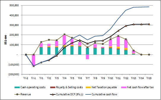
The sensitivity of the Projects' NPV and IRR were tested over a range of ±25% around the base case values for gold price, operating costs and capital expenditure. The results show that NPV and IRR remain positive across the ranges tested. The Project is most sensitive to metal price, with NPV5 being reduced to US$52.7M from the base case value of US$309.6M at a 25% reduction in gold price, equivalent to US$1,275/oz, yielding an IRR of 10.5% at that price.
The base case discount rate of 5.0% yields NPV5 of US$309.6M. At discount rates of 7.5% and 10.0%, NPV is reduced to US$249.3M and US$201.2M, respectively.
1.11 Conclusions and Recommendations
1.11.1 Mineral Resource Estimate Conclusions
Micon's QPs believe that the mineral resource estimate reported herein is robust enough that it can be used as the basis of further economic studies, as Integra continues to define the nature and extent of the mineralization at the Wildcat and Mountain View Projects through further exploration programs.
1.11.2 Risks and Opportunities
Table 1.9 identifies the significant internal risks, potential impacts and possible risk mitigation measures that could affect the economic outcome of the Wildcat and Mountain View Projects. This excludes the external risks that apply to all mining projects, (such as changes in metal prices and exchange rates, availability of investment capital, change in government regulations, etc.). Significant opportunities that could improve the economics, timing and permitting of the project are also identified in Table 1.9.
Table 1.9
Risks and Opportunities at the Wildcat and Mountain View Projects
| Risk | Potential Impact | Possible Risk Mitigation |
| Mineral resource continuity | Widely spaced drilling in some areas | Continue infill drilling to upgrade a larger proportion of the mineral inventory to indicated and measured resources. |
| Proximity to the local communities | Possibility that the population does not accept the mining project | Maintain a pro-active and transparent strategy to identify all stakeholders and maintain a communication plan. The main stakeholders have been identified, and their needs/concerns understood. Continue to organize information sessions, publish information on the mining project, and meet with host communities. |
| Difficulty in attracting experienced professionals | The ability to attract and retain competent, experienced professionals is a key success factor. | The early search for professionals will help identify and attract critical people. It may be necessary to provide accommodation for key people (not included in project costs). |
| Metallurgical recovery | Lower recovery than estimated will negatively impact the project economic | Additional testwork required to improve understanding of the recovery in different lithologies. |
| Permitting challenges | Delays the permitting timeframe, and increase pre-production costs | Additional biological, geochemical, hydrogeological and archaeological baseline studies and follow-up are required. |
| Infrastructure construction and equipment | Delays, availability, and costs increase | Pro-actively contact main local suppliers and start negotiating costs and scheduling |
| Low permeability soil (LPS) source for heap leach facilities has not been identified | Increase of capital costs associated with the heap leach facility construction | Perform LPS borrow source investigations and testing programs; Minimize the use of LPS by using geosynthetic clay liner (GCL) and/or import low permeability material. |
| Overliner source for heap leach facilities has not been explicitly identified | Poor selection/inadequate testing of overliner material may inhibit effective solution collection or may cause daylighting of solution to heap leach pad(s) side slopes | Identify and test overliner sources for permeability and potential for mechanical/chemical degradation across a range of samples fully representative of each source; if it is determined that native borrow material sources are inadequate to be used as overliner as-is, identify (through additional testing) extent of processing required to achieve nominal overliner characteristics. |
| Poor foundation (geotechnical) conditions below proposed heap leach facilities and related infrastructure locations | May need to adjust location of heap leach facilities or perform additional work to increase the suitability of the foundation below the facilities; overall stacking height may need to be reduced resulting in an expansion of footprint of facilities for similar capacity | Complete geotechnical and hydrogeological investigations and material testing programs for the heap leach facilities and related infrastructure to define foundation conditions and/or shallow ground water. |
| Risk | Potential Impact | Possible Risk Mitigation |
| Potential for proposed heap leach facilities to be located above extractable resource | May need to adjust location of heap leach facilities | Perform condemnation drilling in proposed footprints of heap leach facilities. |
| Poor permeability of mineralized material placed on heap leach pad(s) | Potential to cause channeling of solution through, or blind off entire sections of the heap leach pad, thereby preventing nominal/expected precious metal recovery; may affect heap leach stability in extreme cases | Generally, perform additional permeability testing over a broader range of samples to increase overall confidence; perform additional permeability testing to verify feasibility of blending less permeable mineralized material types with more permeable mineralized material types (Wildcat); if poor permeability results persist, reduce heap leach pad height, or agglomerate as required to achieve sufficient permeability |
| Opportunities | Explanation | Potential Benefit |
| Surface definition diamond drilling | Potential to upgrade inferred resources to the indicated category | Adding indicated resources increases the economic value of the Project. |
| Surface exploration drilling | Potential to identify additional inferred resources or additional mineralized zones | Adding inferred resources or additional mineralized zones increases the economic value of the mining project. |
| Metallurgical recovery | Additional testwork may improve recoveries, mineralization permeability and reduce crushing requirements | Improve recoveries, increase revenue, reduce costs |
| Geotechnical | Increase pit design slope used | Will reduce the strip-ratio improving the project economic |
| Partial contract mining | Using contractor to perform pre-stripping early in the Project life | Could improve Project economic by delaying capital costs and reducing maintenance fees. |
| Permit Wildcat under EA | Wildcat's Mine Plan of Operation might be granted under an EA process (rather than EIS) | Faster permitting process, less cost (pre-production). |
| Inpit dumping | Optimize inpit dumping sequence | Reduce haulage distance/time, improve productivity, decrease mining unit costs |
| Power generation conveyor | Down hill conveyor can generate electricity | Produce 'free electricity', reduce power consumption and operating costs |
1.11.3 Planned Expenditures and Budget Preparation
A summary of the proposed budget is presented in Table 1.10.
Integra's primary objective is to continue advancing the Wildcat Project towards completion of a pre-feasibility study. Integra plans to continue to conduct additional metallurgical testwork, and to continue to work on designing the heap leach facilities and infrastructure for the Project. Further drilling programs comprised of greenfield, definition, condemnation and metallurgical drill holes will be conducted as needed. In addition, further work towards permitting the Project will be conducted.
Integra also plans to continue engaging with all stakeholders in the areas around the Projects to that they are informed regarding the development of the Projects.
Table 1.10
Wildcat and Mountain View Projects, Recommended Budget for Further Work
Project | Type | Cost
(USD/m) | Drilling
Quantity (m) | Total (USD) |
Wildcat | Greenfield exploration | 650 | 10,000 | 6,500,000 |
Definition drilling | 600 | 4,600 | 2,760,000 |
Condemnation drilling | 650 | 2,000 | 1,300,000 |
Metallurgical testwork | | 960 | 1,800,000 |
Geotechnical testwork | | 720 | 656,000 |
Heap Leach designs | | | 1,400,000 |
Infrastructure designs | | | 3,200,000 |
Pre-feasibility study | | | 1,000,000 |
Mine Plan of Operations Permitting | | | 1,700,000 |
TOTAL | | | 20,316,000 |
| | | | |
Mountain View | Geophysics | | | 250,000 |
Greenfield exploration | 650 | 5,000 | 3,250,000 |
Infill Drilling | 600 | 2,000 | 1,200,000 |
Metallurgical testwork | | | 150,000 |
Resource update | | | 100,000 |
Permitting | | | 800,000 |
TOTAL | | | 5,750,000 |
Given the known extent of mineralization on the properties, both the Wildcat and Mountain View Projects have the potential to host further deposits, or lenses of gold, similar to those identified so far at both properties.
Micon's QPs have reviewed the budgets for the Wildcat and Mountain View properties and, in light of the observations made in this report, together with the prospective nature of the properties, the QPs believe that Integra should continue to conduct work programs on both properties to advance the Projects towards a potential production decision at a future date.
Micon and its QPs appreciate that the nature of the programs and expenditures may change as the further studies advance, and that the final expenditures and results may not be the same as originally proposed.
1.11.4 Further Recommendations
1.11.4.1 Geological and Resource Recommendations
The following recommendations are suggested by Micon's QPs regarding the geology and mineral resources:
1. Further infill and exploration drilling should be conducted on the main deposits at the Wildcat and Mountain View Projects to increase the confidence of the mineral resource classifications to measured and indicated within the areas of the pits and to extend the known mineralization beyond the current pit limits.
2. Further surface exploration and drilling programs should be conducted on other portions of both the Wildcat and Mountain View properties, with the goal of finding new areas of potentially economic mineralization.
3. Continue to monitor and revise, as needed, the QA/QC programs at both Projects such that these programs continue to meet and potentially exceed best practices standards in the industry.
1.11.4.2 Metallurgical Recommendations
It is recommended that the following program of metallurgical testing be undertaken during the next stage of Project development:
1. Additional column leaching tests to optimize conditions in terms of precious metal recovery, capital costs and operating costs. The effect of coarser crush sizes should be investigated.
2. Samples for the additional column tests should be selected to ensure that all lithologies within the mineral resources are fully represented. The resources should also be fully represented spatially.
3. Geochemical characterization testwork on representative feed and residue samples is recommended.
4. Appropriate additional comminution and hardness testing needs to be considered.
5. Additional variability bottle roll testwork should be undertaken to ensure that all types of mineralization within the mineral resources have been evaluated.
1.11.4.3 Geotechnical Recommendations
For future studies, it is recommended that:
1. Geotechnical and laboratory investigation programs be performed for both the Wildcat and Mountain View Projects to establish baseline foundation conditions and minimum depth to groundwater below the proposed facilities to satisfy permitting requirements.
2. Geotechnical programs should also serve to identify appropriate LPS borrow and overliner sources for each site.
3. As the Projects are advanced, more detailed design studies should be completed.
1.11.4.4 Mining Recommendations
The following recommendations are suggested by the QPs regarding mine engineering:
1. Engineering and baseline studies are ongoing which include facility layout, open-pit design, and infrastructure evaluations. Additional studies may improve value and optimizations including additional geotechnical studies to potentially steepen pit slopes.
a. A study of geotechnical requirements for final pit slope angles to ensure optimal pit slopes are utilized.
b. A study of geotechnical requirements for final waste pad slope angles.
c. Additional trade-off studies for the pit designs and haul road access.
2. Waste Rock Characterization studies to investigate the potential for the development of Acid Rock Drainage and Metal Leaching (ARDML) due to the oxidation of sulphide minerals that are unstable under atmospheric conditions. Upon exposure to oxygen and water, sulphide minerals will oxidize, releasing metals, acidity, and sulphate.
3. Evaluation of the pumping requirements to keep pit dry at all times (surface and underground water management).
4. Drill and blast optimization including powder factor optimization and drilling rate productivity.
5. Optimization of sequencing and fleet size to maximize productivity and decrease unit costs.
1.11.4.5 Infrastructure Recommendations
The following recommendations are suggested by the QPs regarding infrastructure requirements:
1. Optimization of the heap-leach sequencing and designs, taking into consideration the leaching rate and metallurgical kinetics.
2. Geotechnical investigations below the infrastructure (including the Heap Leach pads).
3. Optimization of the crushing facility and ADR plant designs.
4. Surface hydrogeological study covering all the infrastructure areas.
1.11.4.6 Permitting Recommendations
The following recommendations are suggested by the QPs regarding permitting:
1. Initiate a hydrologic baseline characterization program and prepare a numerical groundwater model.
2. Continue the geochemical baseline characterization program and commence humidity cell testing of pit wall rocks and waste rocks.
2.0 INTRODUCTION
2.1 Terms of Reference
Integra Resources Corp. (Integra) has retained Micon International Limited (Micon) to assist with and compile a Preliminary Economic Assessment (PEA) for its Nevada Projects; the Wildcat Project located in Pershing County and the Mountain View Project located in Washoe County. The two Projects are located approximately 40 km from one another but, because Integra plans to run them both as a single Project, the two have been combined into one PEA. Micon has also been retained to compile this Technical Report to disclose the results of the PEA for the combined Project, in accordance with the requirements of Canadian National Instrument (NI) 43-101, Standards of Disclosure for Mineral Projects.
A preliminary economic assessment is preliminary in nature and it includes inferred mineral resources that are considered too speculative geologically to have the economic considerations applied that would enable them to be classified as mineral reserves, and there is no certainty that the preliminary assessment will be realized.
On May 4, 2023, Integra and Millennial Precious Metals Corp. (Millennial) announced the completion of their previously announced at-market merger by way of a court-approved plan of arrangement. As a result, Integra and Millennial may be used interchangeably in this report.
In this report, the terms Wildcat Project or Mountain View Project refers to the area within the exploitation or mining concessions upon which historical mining and exploration has been conducted, while the term Wildcat property or Mountain View property refers to the entire land package of exploitation and exploration concessions.
The information in this report was derived from published material, as well as data, professional opinions and unpublished material submitted by the professional staff of Integra or its consultants, supplemented the Qualified Person(s) (QPs) independent observations and analysis. Much of these data came from prior reports for the Wildcat and Mountain View Projects updated with information provided by Integra, as well as information researched by the QPs.
None of the QPs has or has previously had any material interest in Integra or related entities. The relationship with Integra is solely a professional association between the client and the independent consultants. This report has been prepared in return for fees based upon agreed commercial rates and the payment of these fees is in no way contingent on the results of the reports.
This report includes technical information which requires subsequent calculations or estimates to derive sub-totals, totals and weighted averages. Such calculations or estimations inherently involve a degree of rounding and consequently introduce a margin of error. Where these occur, the QPs do not consider them to be material.
This report is intended to be used by Integra subject to the terms and conditions of its agreement with Micon. That agreement permits Integra to file this report as a Technical Report with the Canadian Securities Administrators (CSA) pursuant to provincial securities legislation or with the Securities and Exchange Commission (SEC) in the United States.
The conclusions and recommendations in this report reflect the QPs best independent judgment in light of the information available to them at the time of writing. The QPs and Micon reserve the right, but will not be obliged, to revise this report and conclusions if additional information becomes known to them subsequent to the date of this report. Use of this report acknowledges acceptance of the foregoing conditions.
2.2 Qualified Persons, Site Visit and Areas of Responsibility
The authors of this report and QPs are:
William J. Lewis, B.Sc., P.Geo. a Senior Geologist and Director with Micon.
Richard Gowans, P.Eng., Principal Metallurgist and Director with Micon.
Chris Jacobs, CEng, MIMMM, President of Micon
Andrew Hanson, P.E., Senior Engineer, NewFields Mining Design and Technical Services (NewFields)
Dr. Deepak Malhotra, Ph.D., Director of Metallurgy, Forte Dynamics, Inc. (Forte Dynamics)
Ralston Pedersen, P.E., President of Convergent Mining, Limited Liability Company (Convergent).
Table 2.1 summarizes the details for the QPs, their areas of responsibility and dates of site visits.
2.3 Units and Abbreviations
All currency amounts are stated in US dollars (US$). Quantities are generally stated in Imperial units as is customary in the United States. However, some sections of this report state measurements in metric units which is the standard Canadian and international practice, including metric tons (tonnes, t) and kilograms (kg) for weight, kilometres (km) or metres (m) for distance, hectares (ha) for area, grams (g) and grams per metric tonne (g/t) for gold and silver grades (g/t Au, g/t Ag). Wherever applicable, Imperial units have been converted to Système International d'Unités (SI) units for reporting consistency. Precious metal grades may be expressed in parts per million (ppm) or parts per billion (ppb) and their quantities may also be reported in troy ounces (ounces, oz), a common practice in the mining industry. A list of some abbreviations is provided in Table 2.2. Appendix I contains a glossary of mining and other related terms.
Table 2.1
Qualified Persons, Areas of Responsibility and Site Visits
| Qualified Person | Title and Company | Area of Responsibility | Site Visit |
| William J. Lewis, P.Geo. | Senior Geologist, Micon | Sections 1.1 to 1.6, 1.8, 1.11 to 1.11.4.1, 1.11.4.6, 2 through 12, 14, 19, 20, 23, 24, 25.1, 25.2, 25.5, 26.1, 26.2.1, 26.2.6, 28 | August 23 to August 26, 2022 |
| Richard Gowans, P.Eng. | Principal Metallurgist | Section 1.7, 1.11.4.2 and 13, 26.2.2, | None |
| Christoher Jacobs, CEng, MIMMM | President, Micon | Section 1.10, 22, 25.5 | None |
| Andrew Hanson, P.E. | Senior Engineer, NewFields | Section 1.11.4.3, 18.3, 21.2, 26.2.3 | None |
| Deepak Malhotra | Director of Metallurgy, Forte Dynamics | Section 1.9.2 to 1.9.4, 1.11.4.5, 17, 18 (except 18.3), 21 (except 21.2, 21.3 and 21.5), 25.3.2 to 25.3.4, 26.2.5 | None |
| Ralston Pedersen, P.E. | President, Convergent | Sections 1.9.1, 1.11.4.4, 15, 16, 21.3, 21.5, 25.3.1, 26.2.4 | None |
Table 2.2
List of the Abbreviations
Name | Abbreviation |
Acre(s) | ac |
Alius Mine Consulting | Alius |
Allied Nevada Gold Corp. | Allied Nevada |
American Assay Laboratories | AAL |
Barren Leach Solution | BLS |
Barringer Laboratories | Barringer |
Big Hero-type | BHT |
Canadian Institute of Mining, Metallurgy and Petroleum | CIM |
Canadian National Instrument 43-101 | NI 43-101 |
Canadian Securities Administrators | CSA |
Canyon Resources Corp. | Canyon |
Carbon in leach | CIL |
Centimetre(s) | cm |
Clover Nevada LLC | Clover Nevada |
Complex resistivity | CRIP |
Controlled-Source Audio-Frequency Magnetotellurics | CSAMT |
Cubic feet per minute | cfm |
Dawson Metallurgical Laboratories | Dawson |
Day | d |
Degree(s) | ° |
Degrees Fahrenheit | °F |
Digital elevation model | DEM |
Diamond Drilling | DD |
Dollar(s) US | $ and US$ |
Elko Mining Group, LLC | Elko Mining |
Environmental Assessment | EA |
Environmental Impact Statement | EIS |
Name | Abbreviation |
Exploration Plan of Operations/Reclamation Permit Applications | ExPO |
Foot, feet | ft |
Franco-Nevada Mining Corp. | Franco-Nevada |
Geosynthetic Clay Liner | GCL |
Gram(s) | g |
Grams per metric tonne | g/t |
Great Basin Environmental Services, LLC | Great Basin |
Greater than | > |
Heap Leach Pad | HLP |
Hectare(s) | ha |
Heinen Lindstrom Consultants | Heinen Lindstrom |
Homestake Mining Co. | Homestake |
Inch(es) | in |
Induced polarization | IP |
Integra Resources Corp. | Integra |
Internal rate of return | IRR |
Inverse distance cubed | ID3 |
Kilogram(s) | kg |
Kilometre(s) | km |
Leak collection and return system | LCRS |
LeapFrog GEO v.5.1.0 | LeapFrog |
Less than | < |
Life-of-mine | LOM |
Litre(s) | L |
Limited Liability Company | LLC |
Low Permeability Soil | LPS |
McClelland Laboratories, Inc. | McClelland |
Metre(s) | m |
Metres above sea level | masl |
Micon International Limited | Micon |
Mile(s) | mi |
Millennial Precious Metals Corp. | Millennial |
Millennial Silver Corp. | Millennial Silver |
Million tonnes | Mt |
Million ounces | Moz |
Million years | Ma |
Million metric tonnes per year | Mt/y |
Milligram(s) | mg |
Millimetre(s) | mm |
Mine Plan of Operations/ Reclamation Permit Application | MPO |
Monex Explorations | Monex |
Mountain View Project | Mountain View or Mountain View Project |
N.A. Degerstrom Inc. | Degerstrom |
Natural source audio magnetotellurics | NSAMT |
Nearest Neighbour | NN |
Net present value | NPV |
Net smelter return | NSR |
Name | Abbreviation |
Nevada Division of Environmental Protection | NDEP |
NewFields Mining Design and Technical Services | NewFields |
National Environmental Policy Act | NEPA |
Not available/applicable | n.a. |
Ordinary kriging | OK |
Ounces | oz |
Ounces per ton | oz/t |
Ounces per year | oz/y |
Parts per billion | ppb |
Parts per million | ppm |
Percent(age) | % |
Pound(s) | lb(s) |
Preliminary Economic Assessment | PEA |
Quality Assurance/Quality Control | QA/QC |
Reclamation Cost Estimate | RCE |
Record of Decision | ROD |
Reverse Circulation drilling | RC |
Second | s |
Securities and Exchange Commission | SEC |
Specific gravity | SG |
Standard Reclamation Cost Estimator | SRCE |
St. Joe Minerals | St. Joe |
System for Electronic Document Analysis and Retrieval | SEDAR |
Système International d'Unités | SI |
Three-dimension | 3D |
Tigren Inc. | Tigren |
Tonto Drilling Services Inc. | Tonto |
Universal Transverse Mercator | UTM |
U.S. Bureau of Land Management | BLM |
US Tons | t |
US Tons per day | t/d |
Vertical carbon-in-column | VCIC |
Vista Gold Corp. | Vista |
Waterton Precious Metals Fund II Cayman, LP | Waterton |
Wildcat Project | Wildcat or Wildcat Project |
Year | y |
2.4 Information Sources
The material in this report was derived from published material, as well as data, professional opinions and unpublished material submitted by the professional staff of Integra or its consultants. Much of these data came from material prepared and provided by Integra, as well as information contained in the previous 2002, 2006 and 2021 Technical Reports. The sources for the information contained in this report are listed in Section 28.0.
The descriptions of geology, mineralization and exploration used in this report are taken from reports prepared by various organizations and companies or their contracted consultants, as well as from various government and academic publications. The conclusions of this report are based in part on data available in published and unpublished reports supplied by the companies which have conducted exploration on the property, and information supplied by Integra. The information provided to Integra was supplied by reputable companies. Micon and the QPs have no reason to doubt its validity and have used the information where it has been verified through their own review and discussions.
For this Technical Report, a number of sections were partly derived from the 2002, 2006 and 2021 Technical Reports for the Wildcat and Mountain View Projects, updated to reflect any further work or information obtained after the 2021 reports was published.
Micon and the QPs are pleased to acknowledge the helpful cooperation of Integra management and consulting field staff, all of whom made any and all data requested available and responded openly and helpfully to all questions, queries and requests for material.
Some of the figures and tables for this report were reproduced or derived from historical reports written on the property by various individuals and/or supplied to Micon by Integra for this report. In the cases where photographs, figures or tables were supplied by others, they are referenced below the inserted item.
3.0 RELIANCE ON OTHER EXPERTS
In this report, discussions regarding royalties, permitting, taxation, bullion sales agreements and environmental matters are based on material provided by Integra. Micon and the QPs are not qualified to comment on such matters and have relied on the representations and documentation provided by Integra for such discussions.
Environmental considerations for the Wildcat Project and the Mountain View Project were discussed in Technical Memorandums each dated September 30, 2020, by John Young of Great Basin Environmental Services Limited Liability Company (Great Basin).
All data used in this report were originally provided by Integra or its consultants. Micon and the QPs have reviewed and analyzed these data and have drawn their own conclusions therefrom, augmented by the QP's direct field examinations. All of the documentation supplied by Integra, Millennial and other references used by the QPs are noted in Section 28 of this report.
Neither Micon nor its QPs offer a legal opinion as to the validity of the title to the Wildcat mineral concessions claimed by Integra and Millennial NV Limited Liability Company (Millennial NV), as neither Micon nor its QPs are qualified to comment on such matters. However, Millennial NV previously has provided Micon with a title opinion dated November 6, 2020, from the legal firm of Parr Brown Gee & Loveless, Attorneys at Law, located in Salt Lake City, Utah.
Neither Micon nor its QPs offer a legal opinion as to the validity of the title to the Mountain View mineral concessions claimed by Integra and Millennial NV, as Micon and its QPs are not qualified to comment on such matters. However, Millennial NV previously provided Micon and the QPs with a title opinion dated October 29, 2020, from the legal firm of Parr Brown Gee & Loveless, Attorneys at Law, located in Salt Lake City, Utah. Millennial as also provided a reliance letter for the legal opinion.
Updated legal opinions for both the Wildcat and the Mountain View properties, from Dorsey & Whitney LLP, dated June 16, 2022 (effective June 1, 2022) were provided to Micon and its QPs by Integra.
More recent legal opinions for both the Wildcat and the Mountain View properties, from Dorsey & Whitney LLP, dated March 16,2023 (effective January 26, 2023) were again provided to Micon and its QPs by Integra. Micon and its QPs have reviewed the updated legal opinions and have updated Section 4.0 of this Technical Report with the information where relevant.
4.0 PROPERTY DESCRIPTION AND LOCATION
4.1 General Description and Location
The Wildcat and Mountain View Projects are both located in northern Nevada, United States of America. Both Projects are northeast of Reno, which is the nearest large city. The Mountain View Project is located roughly 40 miles northwest of the Wildcat Project.
4.1.1 Wildcat Property Description and Location
The Wildcat property is located on the northeastern portion of the Seven Troughs Range, about 35 miles northwest of the town of Lovelock in Pershing County, Nevada. Figure 4.1 shows the location of the property.
The property is located in all or portions of sections 32-36, T32N, R29E; sections 1 and 12 of T31N, R28E; sections 1-36 of T31N, R29E; and sections 4 and 5 of T30N, R29E, Mount Diablo Baseline and Meridian. The latitude and longitude for the Project are 40.5425° N, 118.7550° W at an elevation of approximately 6,299 ft.
4.1.2 Mountain View Property Description and Location
The Mountain View property is located in northwest Nevada, near the Granite Range, at a latitude and longitude of 40.8314° N and 119.5027° W and the property is at an approximate elevation of 5,000 ft.
The property lies approximately 15 miles (mi) northwest of Gerlach, Nevada in Washoe County. The Mountain View property straddles the boundary between the Squaw Valley and Banjo topographic quadrangles (Figure 4.1).
4.2 Land Tenure, Agreements, Mineral Rights and Ownership
On April 28, 2021, Millennial Precious Metals Corp. (Millennial) announced the successful completion of the previously announced series of transactions with Millennial Silver Corp. (Millennial Silver) and Clover Nevada Limited Liability Company (Clover Nevada), a subsidiary of Waterton Precious Metals Fund II Cayman, LP (Waterton)resulting in Millennial indirectly acquiring Waterton's interest in each of the Wildcat Property, the Mountain View Property and other properties located in Nevada. The transactions were undertaken through an asset purchase agreement dated December 11, 2020 (the Asset Purchase Agreement) between Millennial (as successor to 1246768 B.C. Ltd. (768)), Millennial Silver and Waterton and an amalgamation agreement dated December 11, 2020, between Millennial Silver and 768. Table 4.1 summarizes the mineral claim information for the Wildcat and Mountain View properties. Appendix 2 at the end of the report summarizes the mineral claim details for both Projects.
On May 4, 2023, Integra and Millennial announced the completion of their previously announced at-market merger, by way of a court-approved plan of arrangement.
Figure 4.1
Location Map of the Wildcat and Mountain View Projects in Northwestern Nevada

Figure provided by Integra in June, 2023.
Table 4.1
Summary of the Mineral Claims that Comprise the Wildcat and Mountain View Properties
Project
Name | Location | Number of
Public land
claims | Number of
Patented
Claims | Total Project
Ground Acres | Claim BLM Serial Numbers |
Wildcat | Pershing County, Nevada | 916 | 4 | 17,612 | NMC1008648 - NMC1008651,
NMC1027786 - NMC1027829,
NMC1076327 - NMC1076387,
NMC1100165,
NMC1112414 - NMC1112548,
NMC243085 - NMC243122,
NMC247344 - NMC247357,
NMC273999 - NMC274004,
NMC308231 - NMC308234,
NMC667930 - NMC667933,
NMC714994 - NMC714998,
NMC860856,
NMC863212 - NMC863264,
NMC976166 - NMC976276,
NV105297882 - NV105298026,
NV105749635 - NV105749832,
NV105757897 - NV105757985,
NV105778292 - NV105778294. |
Mountain View | Washoe County, Nevada | 284 | 0 | 5,476 | NMC142372 - NMC142375,
NMC196207, NMC202456,
NMC203087, NMC253233 - NMC253247, NMC253267, NMC253270, NMC253295 - NMC253297, NMC253300 - NMC253308, NMC253310 - NMC253328, NMC253656, NMC253657,
NMC814670 - NMC814680, NMC814685 - NMC814687,
NMC822239, NMC822240, NMC822249, NMC822251,
NMC822252, NMC822254,
NMC822256, NMC822258,
NMC822260, NMC822262,
NMC822264, NMC822266, NMC822268 - NMC822309, NV101478323, NV101528216, NV105248126 - NV105248152,
NV105268771 - NV105268900. |
Table provided by Integra in June, 2023.
Under the terms of the Transaction, Integra acquired all of the issued outstanding common shares of Millennial. Millennial shareholders received 0.23 of a common share of Integra for each Millennial share held. Integra subsequently consolidated its common shares on the basis of one (1) new post-consolidation common share for every two and a half (2.5) existing pre-consolidation common share. In aggregate, 16,872,050 Integra shares (post-consolidation) were issued to former Millennial shareholders as consideration for their Millennial shares.
As a result of the Transaction, Millennial has become a wholly owned subsidiary of Integra and the Millennial shares were to be delisted from the TSX Venture Exchange (the TSXV) at market close on or about May 5, 2023.
4.2.1 Wildcat Property Description and Ownership
The Wildcat property consists of 4 patented (Fee Tracts) and 916 unpatented lode claims (Figure 4.2), covering a total area of 17,612 acres. The claims are on publicly owned lands administered by the U.S. Bureau of Land Management (BLM). All of the claims are located in Pershing County in northwest-north-central Nevada. Micon noted that the maintenance fee of US$151,140 was paid, and the federal fee requirements were met for each of the claims for the assessment year ending on September 1, 2024. A Listing of the mineral claims which comprise the Wildcat Project is presented in Appendix 2.
According to federal and state regulations, the lode claims are renewed annually. In order to keep the claims current, a 'Notice of Intent to Hold' and payments are filed with the BLM and the counties. Tenure is unlimited as long as filing payments are made each year.
The mineral claims were originally purchased from Clover Nevada, a subsidiary of Waterton. On April 29, 2021, all rights were assigned to Millennial NV.
The Wildcat mineral claims are currently owned 100% by Millennial NV, which as of May 4, 2023, is a subsidiary of Integra.
4.2.2 Wildcat Project, Obligations and Encumbrances
4.2.2.1 Wildcat Project, Royalties
According to the Title Opinions, the following royalties apply to the Wildcat property:
Clover Nevada reserved a net smelter return royalty (Clover Royalty), payable by Millennial NV and its successors, applicable to any sale of gold (and only gold) from the Original Properties. The amount of the Clover royalty is 0.5%. The Clover royalty runs with the original properties and covers any amendments, relocations, replacements, modifications or conversions of the original properties.
1% NSR royalty on the SS claims. This royalty is held of record by RG Royalties, LLC.
Scaled royalty (0% to 2%) on the Fee Tracts. The royalty is held of record by RG Royalties, LLC.
0.4% NSR royalty on Tag #15 through Tag #18 claims. This royalty is held by Raymond Wittkopp.
US$500,000 production payment on the SS claims and the Tag and Easter claims. This royalty is held by Monex Explorations.
Figure 4.2
Wildcat Project Claims Map

Map provided by Integra in June, 2023.
On June 21, 2023, Integra announced that it had received notice from Royalty Consolidation Company, Limited Liability Company (Royalty Consolidation), a private company controlled by Waterton of the sale of 100% of its existing royalty interests in the Nevada Projects (including the Wildcat and Mountain View Projects) to a wholly owned subsidiary of Franco-Nevada Corporation (Franco-Nevada). The transaction closed on June 15, 2023. No new royalties on the Nevada Projects (including the Wildcat and Mountain View Projects) were granted as part of the transaction between Waterton and Franco-Nevada and no net proceeds from the sale will be recognized by Integra.
4.2.2.2 Wildcat Project, Other Encumbrances
According to the November 6, 2020, title opinion:
"After the Fee Tracts were conveyed to Clover Nevada in 2015, Hycroft Resources and Development, Inc., which has since converted to an entity named Hycroft Resources & Development, LLC, purported to grant an encumbrance on the Fee Tracts in various instruments..."
"Because Hycroft never owned any interest in the Fee Tracts, it had no way to actually encumber the Fee Tracts by the erroneous filings and, therefore, such filings cannot and do not legally create a title defect. Nevertheless, we understand that Clover Nevada has recently reiterated to Hycroft the need to file correction documents and/or releases to affirmatively remove the cloud on Clover Nevada's title."
Subsequent, 2022 and 2023 title opinions do not mention if these erroneous filings have been addressed, although according to the 2020 legal opinion, they do not affect the property.
4.2.2.3 Wildcat Project, Ownership Status of Mining Claims per BLM
Official ownership of unpatented mining claims is based on the county recorder's records. The BLM also maintains ownership information for its own purposes, but that information is dependent on the actions of claimants to notify the BLM of any ownership changes. The BLM ownership records correctly list Clover Nevada, a subsidiary of Waterton as the current owner of all of the Mining Claims, with the exception of the Tag #15 through Tag #18 claims, which the BLM records currently reflect as being owned by other parties. However, none of those parties currently holds any interest in the Tag #15 through Tag #18 claims. Indeed, there is a note in the BLM files for the Tag #15 through Tag #18 claims dated August 21, 2015, indicating that Clover Nevada is the owner of these claims, but it appears that an official transfer notice, along with supporting documentation, has not yet been filed with the BLM. This is an administrative step that is not essential and does not affect legal title to the Mining Claims.
The next claim maintenance payments for the original claims are due on or before September 1, 2024.
A number of new claims were staked by Millennial NV and as of the effective date of the title opinion on June 1, 2022, the claims status was filed. Once the BLM adjudication process was complete and assuming there are no deficiencies in the mining claim documents the status will be changed to active. The next claim maintenance payments for the new claims are also due on or before September 1, 2024.
4.2.3 Wildcat Environmental Liabilities and Permitting
An environmental review of the Wildcat Project was undertaken by Great Basin Environmental Services, LLC. (Great Basin) in September, 2020. The review was based on a site visit and visual inspection, and information provided in the 2006 MDA Technical Report. The following information is taken from the September review:
4.2.3.1 Wildcat Summary
Due to the historic mining and exploration activities in the Project area, there are areas of significant disturbance present. Modern exploration activities have been reclaimed and are readily identifiable on imagery. Many of the historic access roads are present and in use by seasonal hunters but need repair to allow safe exploration operations.
There are no identified issues that would prevent the Wildcat property from achieving all permits and authorizations required to commence exploration drilling operations and the potential development of the Project, based on the site visit and data that has been reviewed to date.
4.2.3.2 Wildcat Land Use Authorizations - Notices or Plan of Operations
A search of the LR2000 database administered by the BLM was conducted and data from August, 2020 were used to determine historical, existing, and pending land use decisions that might affect exploration of the Project area. Data from this search determined that exploration first occurred in the area under modern authorizations issued to Homestake Mining Co. in 1982. All previous exploration authorizations before 2010 have been closed.
Waterton's subsidiary Clover Nevada was authorized under a Notice of Operations on October 28, 2016, to disturb 3.97 acres for exploration related disturbance in sections 8 and 17, T31N, R29E. This authorization remains open. No Plans of Operations exceeding 5 acres exist in the search area.
4.2.3.3 Wildcat Reclamation Plan and Bonding
A reclamation plan is only required if proposed new disturbance exceeds 5 acres. Much of the existing disturbance is on private fee lands. Reclaimed disturbance exists in the area that can be re-used for modern exploration operations.
4.2.3.4 Wildcat Reclamation Plan and Mine Closure Liabilities
There are no modern mine features requiring reclamation or closure. All existing disturbances are related to historic mining or modern (post-1980) exploration drilling operations.
4.2.3.5 Wildcat Permit Adequacy Future Operations
There are no permits in hand for future operations on the Wildcat property. Obtaining authorizations to begin drilling on public lands requires filing a Notice of Operations and posting the required reclamation bond. This is usually a 30 to 60-day process. Plans of Operations and Reclamation Permits are required when disturbance exceeds 5 acres, triggering the baseline and environmental assessment processes. The Project does allow immediate exploration on the identified private lands in section 17, assuming that safe access for equipment and crews exists across public lands. The 5-acre disturbance limit is determined by accruing all project related disturbance within a 1-mile radius of the Project.
4.2.4 Mountain View Property Description and Ownership
The Mountain View property currently consists of 284 un-patented lode claims with a total area of approximately 5,476 acres (Figure 4.3). Millennial NV has provided Micon with copies of the mining claim maintenance fee filings, affidavits and notices of intent to hold mining claims, as filed with the BLM. Micon's QP noted that the maintenance fee of US$46,860 was paid, and that the federal fee requirements were met for each of the claims for the assessment year ending on September 1, 2024. A listing of the mineral claims which comprise the Mountain View Project is presented in Appendix 2.
The ownership of the claims listed in the fee filings is in the name of Millennial NV and Leslie Wittkopp. However, currently Millennial NV owns 100% interest in the Mountain View Project.
According to federal and state regulations, the lode claims are renewed annually. In order to keep the claims current, a 'Notice of Intent to Hold' and payments are filed with the BLM and the counties. Tenure is unlimited as long as filing payments are made each year. The land on which the claims are located is administered by the BLM.
Figure 4.3
Mountain View Project Mineral Claims Map
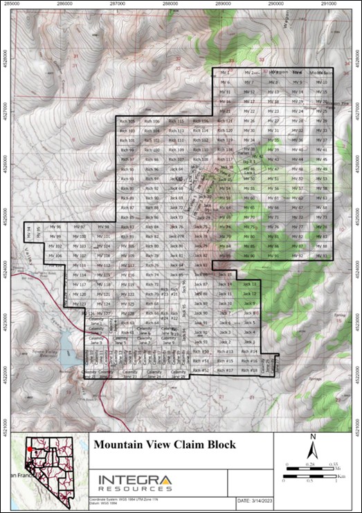
Figure provided by Integra, June, 2023.
4.2.5 Mountain View Project Obligations and Encumbrances
The following information has been summarized from the Title Opinion dated October 29, 2020, from the legal firm of Parr Brown Gee & Loveless, Attorneys at Law, located in Salt Lake City, Utah.
4.2.5.1 Mountain View Ownership of Subject Claims
According to the Title Opinion, ownership of various claims is as follows:
- Mountain View Claims (7 claims):
Undivided 5% Clover Nevada, a Nevada limited liability company.
Undivided 5% Estate of Raymond W. Wittkopp (which 5% is leased to Clover Nevada under the Wittkopp Lease).
Undivided 90% Bankruptcy successor(s) of Robert L. Helms Construction & Development Co. (Helms Construction) which interest is not leased by Clover Nevada.
- Harlen Claims (16 claims):
Undivided 50% Clover Nevada.
Undivided 50% Leslie A. Wittkopp, as trustee of the Wittkopp Family 1997 Trust (Wittkopp Trust) (which 50% is leased to Clover Nevada under the Wittkopp Lease).
Undivided 50% Clover Nevada.
Undivided 50% Wittkopp Trust (which 50% is leased to Clover Nevada under the Wittkopp Lease).
100% Clover Nevada, which claims are subject to the terms of the Wittkopp Lease).
4.2.5.2 Mountain View Leased Claims and Wittkopp Lease Royalty
With the exception of the outstanding 90% interest in the Mountain View Claims, all interests in the subject claims that are not owned by Clover Nevada are leased by Clover Nevada for exploration and mining purposes, which lease carries with it certain production royalty obligations.
Specifically, in a lease/option agreement dated June 30, 2000 (Wittkopp Lease), the vendor leased all interest in the Mountain View, Jack (except Jack 67A and Jack 77R) and the Harlen claims to Franco-Nevada Mining Corporation, Inc. (Franco-Nevada). The initial term was for 10 years, with five additional 10-year terms, expiring on June 30, 2060. The Wittkopp Lease requires that the lessee pay a net smelter return royalty (NSR) of 1.0% on minerals produced from the Harlan and the Jack claims and an NSR of 0.1% on minerals produced from the Mountain View claims. The Wittkopp Lease grants the lessee a preferential purchase right if the Wittkopp's wish to sell or otherwise transfer the Wittkopp Lease Royalty (except in the case of the death of Mr. or Mrs. Wittkopp).
The Wittkopp Lease contains an area of interest provision, such that any new mining claims staked by the lessee or lessor within one-half mile of the initial leased claims are subject to the lease agreement, including the NSR at a rate of 1.0.%. However, there is no specific provision for a claim partly inside and partly outside the specified area.
The Wittkopp Lease:
Grants the lessee an option to purchase all of the lessor's ownership interest in the leased property for US$250,000 at any time prior to achieving commercial production from the leased property, and
Obligates the lessee to purchase all of the lessor's ownership interest in the leased property for US$250,000 upon achievement of commercial production from the leased property. In both cases, however, the Wittkopp Lease Royalty expressly survives any such acquisition of the leased property.
Accordingly, the Wittkopp Lease Royalty applies to all subject claims except Rich 105 (at a royalty rate of 1.0%, except for the Mountain View Claims, where the royalty rate is only 0.1%), but the Wittkopp Lease Royalty will terminate at such time as the Wittkopp Lease terminates (except for termination through the lessee's acquisition of the leased property).
Clover Nevada is the current lessee under the Wittkopp Lease and it also owns a full or partial interest in all of the mining claims that are subject to the lease.
Under the lease, Clover Nevada must also pay to the lessor annual advance royalty payments (which can be credited in full against future production royalty obligations) and must pay the annual federal and state filing fees to maintain the leased claims.
4.2.5.3 Mountain View Other Production Royalties
In addition to the Wittkopp Lease Royalty, the following royalty obligations also burden certain of the Mountain View claims.
Franco-Nevada Royalty (Jack Claims):
In 1886, by virtue of a quit claim deed, the Jack Claims became encumbered by a production royalty. In that deed, St. Joe Gold Corporation (St. Joe) reserved to itself a 1.0% NSR on all minerals produced from the Jack Claims. Through a series of off- record corporate name changes and mergers, St. Joe became Lac Minerals (USA) Limited Liability Company (Lac Minerals), which conveyed the royalty to Franco-Nevada US. Corporation (Franco-Nevada) which remains the owner of the royalty.
Maverix Royalty (all subject claims), now Triple Flag Royalty:
All of the subject claims were part of an October, 2002 agreement between Newmont Capital Limited (Newmont), the owner and lessee at that time, and Vista Nevada Corp. The October, 2002 agreement granted to Newmont a perpetual NSR of 1.5% payable on all minerals produced from the subject claims and area of interest. The royalty may be taken in cash or in kind.
On January 19, 2023, Triple Flag Precious Metals Corp. (with its subsidiaries, Triple Flag) and Maverix Metals Inc. (Maverix) announced the successful completion of the previously announced acquisition of Maverix by Triple Flag.
Clover Nevada Royalty:
Clover Nevada reserved a net smelter returns royalty (the Clover Royalty), payable by Millennial NV and its successors, applicable to any sale of gold (and only gold) from the Original Claims. The amount of the Clover Nevada royalty is 0.05%, not subject to proportionate reduction as to production from the Mountain View claims and 0.5%, not subject to proportionate reduction, as to production from the Jack Claims, the Harlan claims and the Rich Claims held of record by RG Royalties, LLC.
As with the Wildcat Project, on June 21, 2023, Integra announced that it had received notice from Royalty Consolidation, a private company controlled by Waterton of the sale of 100% of its existing royalty interests in the Nevada Projects to a wholly owned subsidiary of Franco-Nevada. The transaction closed on June 15, 2023. No new royalties on the Nevada Projects were granted as part of the transaction between Waterton and Franco-Nevada and no net proceeds from the sale will be recognized by Integra.
4.2.5.4 Mountain View Ownership Status of Mining Claims per BLM
Official ownership of unpatented mining claims is based on the county recorder's records. The BLM also maintains ownership information for its own purposes, but that information is dependent on the actions of claimants to notify the BLM of any ownership changes. At the present time, the BLM records some discrepancies with regard to the Mountain View, Harlan and Jack claims. However, for ownership purposes, it is not necessary that the BLM records comport with the official county records.
The legal title opinion did note that there were other issues or defects in some of the paperwork for some of the claims, but these were all explained or dismissed and do not appear to affect the validity of the mineral claims. Micon recommends that Integra reviews the findings in the title opinion report and attempts to resolve any errors and omissions noted therein.
4.2.6 Mountain View Environmental Liabilities and Permitting
An environmental review of the Wildcat Project was undertaken by Great Basin for Tigren Inc. (Tigren) in September, 2020. The review was based on a site visit and visual inspection, and information provided in the 2006 Snowden Technical Report. The following information is taken from the September, 2020 review:
4.2.6.1 Mountain View Summary
Due to previous mining and exploration activities in the Project area, there are small areas of historic disturbance present. Modern exploration activities (post-1980) have been reclaimed and are readily identifiable on imagery. Many of the historic access roads are present and in use by seasonal hunters but need minor repair to allow safe exploration operations.
There are no identified issues that would prevent the Mountain View property from achieving all permits and authorizations required to commence exploration drilling operations and the potential development of the Project, based on the site visit and data that has been reviewed to date.
4.2.6.2 Mountain View Land Use Authorizations - Notices or Plan of Operations
Tigren searched the LR2000 database administered by the BLM. Data from August, 2020 were used to determine historical, existing and pending land use decisions that might affect exploration of the Project area. Data from this search determined that exploration first occurred in the area under modern authorizations issued to St. Joe America Corp. in 1983. The last exploration authorizations were issued to Newmont in 2003. All previous exploration authorizations by St. Joe, US Borax, Homestake, Canyon Resources, Newmont, and others before 2003 have been closed.
No notice level authorizations remain open. No Plans of Operations exceeding 5 acres exist in the search area.
4.2.6.3 Mountain View Land Use Designations/Uses
BLM land use plans were reviewed to determine if any special land use designations exist in the Project area. The Poodle Mountain Wilderness Study Area (WSA) lies west of the Severance resource area in the Buffalo Hills. There are no special land use designations that prevent an operator from qualifying for a Notice or a Plan of Operations under current surface management rules at 43 CFR 3809.
The Mountain View Project area lies within several wildlife use designations for sage grouse and pronghorn antelope. Wild horse management areas encroach on the eastern margins of the Project area, but do not cover the entire claim block. No special habitat constraints are identified, but future disturbance authorizations will require comparatively more baseline work than other land areas with lower wildlife values.
The Squaw Valley Reservoir, a fishable stream and reservoir, lies about 1.8 miles downgradient and west of the Severance resource area. BLM would likely impose additional attention on erosion controls during exploration operations.
The Project lies within Class 2 Visual Resource Management (VRM) lands. This VRM objective is to retain the existing character of the landscape. Reclamation requirements will be higher than in lower VRM classes but will not significantly affect future exploration or development.
4.2.6.4 Mountain View Reclamation Plan and Bonding
A reclamation plan is only required if proposed new disturbance exceeds 5 acres. Reclaimed disturbance exists in the Severance resource area that can be re-used for modern exploration operations.
4.2.6.5 Mountain View Reclamation Plan and Mine Closure Liabilities
There are no modern mine features requiring reclamation or closure. All existing disturbances are related to historic mining or modern (post-1980) exploration drilling operations.
4.2.6.6 Mountain View Permit Adequacy Future Operations
There are no permits in hand for future operations. Obtaining authorizations to begin drilling operations on public lands requires filing a Notice of Operations and posting the required reclamation bond. This is usually a 30 to 60-day process. Plans of Operations and Reclamation Permits are required when disturbance exceeds 5 acres, triggering the baseline and environmental assessment processes. The 5-acre disturbance limit is determined by accruing all project related disturbance within a 1-mile radius of the Project.
4.3 Micon QP Comments
Micon and the QPs are not aware of any significant factors or risks, other than those discussed in this section of the report, that may affect access, title or right or ability to perform work on the property by Integra or Millennial NV. It is Micon's and the QPs' understanding that further permitting and environmental studies could be required if sufficient mineralization is discovered on the properties and if further economic studies demonstrate that the mineralization is sufficient to host a mining operation.
Both the Wildcat and Mountain View properties are large enough to be able to locate and accommodate the infrastructure necessary to host any future mining operations, should sufficient economic mineralization be identified on the properties.
5.0 ACCESSIBILITY, CLIMATE, LOCAL RESOURCES, INFRASTRUCTURE AND PHYSIOGRAPHY
5.1 Climate
The Wildcat and Mountain View Projects both have semi-arid climates, with high temperatures in the summer generally in the 80°F to 90°F range and winter highs generally in the 40°F to 50°F range. Winter temperatures, however, can be below 0°F. Precipitation at the properties usually totals more than 8 inches per year, divided between winter snow, spring rain and summer thunderstorms. The evaporation potential greatly exceeds the precipitation on an average annual basis, so that the area is one with a negative water balance. Table 5.1 shows the average climatic data for the Gerlach weather station, located about 20 miles to the northwest of the Wildcat Project area and 20 miles southeast of the Mountain View Project area. Gerlach is lower in elevation than the Wildcat Project and the weather at the Project is likely to be wetter and cooler. Weather at the Mountain View Project is expected to be similar to that at the Gerlach station.
The Wildcat and Mountain View Projects are both accessible year-round by vehicle with the only limitation being the condition of dirt roads. Potential drifting winter snow and heavy spring runoff accompanied by flooding could lead sections of each Project's access road becoming impassible.
Table 5.1
Average Climatic Data - Gerlach Station
Item | Jan. | Feb. | Mar. | Apr. | May. | Jun. | Jul. | Aug. | Sept. | Oct. | Nov. | Dec. | Annual |
Average Max. Temperature (°F) | 40.7 | 48.0 | 56.2 | 63.9 | 73.0 | 81.2 | 91.1 | 90.2 | 80.7 | 68.7 | 51.7 | 40.3 | 65.5 |
Average Min. Temperature (°F) | 21.1 | 25.7 | 30.7 | 35.8 | 44.1 | 51.5 | 57.9 | 55.9 | 47.4 | 36.8 | 27.4 | 20.1 | 37.9 |
Average Total Precipitation (in) | 0.98 | 0.61 | 0.65 | 0.77 | 1.03 | 0.82 | 0.24 | 0.27 | 0.34 | 0.36 | 0.96 | 0.88 | 7.92 |
Average Total Snow Fall (in) | 4.4 | 2 | 0.7 | 0.4 | 0 | 0 | 0 | 0 | 0 | 0 | 0.6 | 3.6 | 11.8 |
Table taken from the 2006 MDA Technical Report.
5.2 Wildcat Project
5.2.1 Accessibility
The Wildcat Project is accessible from the city of Reno, Nevada, via both paved and dirt roads. Access is primarily via Interstate 80 to the town of Lovelock, at approximately 91 miles from Reno. State Route 398 from Lovelock is followed (1 mile) to the intersection with State Route 399. After 12 miles, Route 399 reaches the intersection with a good-condition dirt road, which runs to the northwest. After approximately 15.6 miles, there is an intersection with a dirt road in regular driving condition. The Project is located 4.7 miles after the intersection of this dirt road.
5.2.2 Physiography
The Project area is located in the high desert of the Basin and Range Physiographic Province. It lies in the Farrell Mining District in the Seven Troughs Range, between 5,000 and 7,500 ft above sea level. The area is rugged and generally covered by sagebrush, grasses and a few Juniper and Pinyon trees (Figure 5.1).
Figure 5.1
A Panoramic View of Main Hill (looking North-Northeast) at the Wildcat Project

Figure supplied by Integra.
5.2.3 Local Resources and Infrastructure
The Wildcat property is located 35 miles from the town of Lovelock, Nevada. Lovelock is a town of about 3,000 people, with the infrastructure to support a mining operation. Water may be available on site as springs were observed near the access road, however, power is not currently available at the site.
There are larger centres and other communities in the region that may also be used as regional supply centres, should Lovelock not have the needed supplies. Reno is located to the southwest, should access to international destinations be required.
Claims have been staked, enlarging the Project area, to accommodate the potential future construction of mining infrastructure, such as heap leach pads, mine offices and equipment maintenance areas.
5.3 Mountain View Project
5.3.1 Accessibility
The Mountain View Project is easily accessed from Reno, via 124 miles of paved routes and 2.8 miles of good condition dirt roads. Access is primarily via Intestate Highway 80 up to the intersection with paved state route 447, located 33 miles east of Reno. State route 47 runs north for 75 miles, to the town of Gerlach. At this locality, State Route 47 turns to the northeast and at 17.6 miles, once the Squaw Valley Reservoir is reached, there is a junction with a dirt road that runs to the northwest. This dirt road is generally in good driving condition up to the Project, which is located at 2.8 miles from the intersection with the paved route.
5.3.2 Physiography
The physiography of the Mountain View area is characterized by typical basin and range topography, with north to northwest trending ranges of hills and low mountains with moderate relief, separated by wide, flat bottomed gravel filled basins (Figure 5.2). Mountain peaks east of the Project are roughly at 9,000 ft and valleys are roughly 4,500 ft above sea level. Valleys in the region are typically covered by sagebrush and grasses, with scattered stands of pine trees occurring at higher elevations. The only infrastructure on the property, other than the roads, is a main transmission power line.
Figure 5.2
A View of the Mountain View Property

2020, Micon site visit.
5.3.3 Local Resources and Infrastructure
The nearest community to the Mountain View Project is Gerlach, with approximately 500 people. There are larger communities in the region that may also be used as regional supply centres, should Gerlach not have the necessary supplies. Reno, located to the southwest, should provide access to international destinations if required. It is presumed that most of the skilled workforce for any operation would come from other parts of Nevada and the surrounding states. Areas of the Mountain View property have been staked to accommodate for future mine infrastructure.
5.4 Micon QP Comments for both Wildcat and Mountain View Projects
Micon and the QPs believe that, to the extent relevant to both the Wildcat and Mountain View Projects, Integra should be able to obtain the surface access, environmental sign-off, power, water and personnel to conduct an exploration program at either Project. Micon and the QPs also believe that exploration programs and any potential mining operations could be conducted on a year-round basis.
Both the Wildcat and Mountain View properties are large enough to be able to locate and accommodate the infrastructure necessary to host any future mining operations, should sufficient economic mineralization be identified on the properties.
6.0 HISTORY
6.1 Wildcat Project
6.1.1 General Ownership and Exploration History
The majority of the information in the section was taken from the 2006 Technical Report and updated with additional data from Integra and Micon.
The history of the Wildcat property and district was taken directly from internal documents belonging to a prior property-holder, Lac Minerals (USA) Limited Liability Company (Lac Minerals). Mining at Wildcat began in the early 1900's and concentrated on epithermal quartz veins hosted within Cretaceous granodiorite. Production was small but high-grade, at less than 100,000 tons with the grade in excess of one ounce per short ton (oz/st) gold. The patented claims on the Wildcat property were located in 1906 and 1907 and patented in May, 1912 by the Seven Troughs Monarch Mines Company. Surface cuts were taken on three main surface veins: Hero, Hillside, and Wildcat. An 1,800 ft tunnel was completed in 1912 to intersect these veins at the 300 to 400 ft level. The veins were reported barren, but were wider than projected (Tullar, 1992).
Monex Explorations (Monex) purchased 5 unpatented lode claims around 1980 and worked the Tag mine intermittently. Homestake Mining Company (Homestake) took an interest in the hydrothermally altered volcanic cap northwest of the Wildcat mine area in 1982 and drilled three core holes in 1983. Based on these holes, Homestake retained an interest in the property between 1984 and 1990.
Touchstone Resources Company Inc. (Touchstone), an exploration subsidiary of Cornucopia, leased the property from Homestake in 1983. Touchstone completed a 30-hole, 6,260 ft program of reverse circulation drilling in 1984. Although Touchstone reportedly developed an "inferred reserve" of 21 million short tons grading 0.021 oz/st gold at a 1.1:1 stripping ratio (Tullar, 1992), Touchstone dropped the property in 1985. Homestake drilled one 400 ft core hole to cover the 1986/1987 assessment requirement. Kincaid Exploration and Mining Co. II (Kemco) optioned the claims in 1987 and completed a 35-hole, 6,150 ft reverse circulation drilling program in the same year. Kemco dropped the property in 1988 when the Star Valley Resources/Pactolus Corporation optioned the Homestake ground, along with the Monex ground. During 1989, the Star Valley Resource/Pactolus Corporation partnership completed 12 reverse circulation drill holes totalling 3,280 ft. The partnership dropped its interest in 1989. Homestake sold its interest in the property to Monex in 1990 but retained an underlying NSR interest. Amax optioned the property in 1991 and completed a single 500 ft reverse circulation drill hole.
Lac Minerals acquired the Wildcat Project in 1992 and conducted a significant amount of exploration mapping, sampling, geophysics and the majority of the drilling on the property. In the process, it identified a large, low-grade gold resource. Sagebrush Exploration worked on the Project during the period of 1996-1998 and completed some reverse circulation drilling on the property.
On October 30, 2003, Vista Gold Corp. (Vista) announced that it has signed agreements to acquire a 100% interest in the Wildcat Project.
On July 10, 2006, Vista announced a spin-off of its existing Nevada properties into a new publicly listed company (newco) that, concurrently with the spin-off, would acquire the Nevada mining properties of the Pescio Group. The transaction was completed by way of a court-approved plan of arrangement under the Business Corporations Act (Yukon). Under the transaction, Vista's shareholders exchanged their common shares of Vista for common shares of newco and new common shares of Vista.
On May 10, 2007, Vista and Allied Nevada Gold Corp. (Allied Nevada) announced that the plan of arrangement involving Vista, Allied Nevada and the Pescio Group had closed. The transaction resulted in the acquisition by Allied Nevada of Vista's Nevada properties and the Nevada mineral assets of the Pescio Group.
On March 10, 2015, Reuters noted that U.S.-based gold miner Allied Nevada filed for bankruptcy protection under a heavy debt load and weak metal prices.
On June 15, 2015, Allied Nevada announced that the United States Bankruptcy Court for the District of Delaware had approved the sale of Allied Nevada's exploration properties and related assets (excluding the Hycroft operation) to Clover Nevada, a wholly owned subsidiary of Waterton.
6.1.2 Mining District History and Production
Gold was discovered in Stonehouse Canyon in 1863 near Farrell (Johnson, 1977), although there was no development until 1905. Some of the mines in the district were very rich, with the Wihuja Mine reportedly averaging US$100,000/st (Johnson, 1977). By 1908, twenty-five mining companies were actively developing 117 claims in the district. The district was active between 1907 and 1962, with the years 1908-1916 having the most production.
E. E. Stuart (1909) noted that "The Hero Nevada Mines Company has the most thoroughly developed ground in the Farrell District. It is opened up by means of shafts, tunnels, drifts and crosscuts. On the Wildcat claim the shaft has reached the 200-ft level. The vein has been drifted upon for 250 ft from the 80-ft level. In this drift is ore which shows as high as US$85 per ton."
In 1863, following the original discoveries, the district was known as the Stone House District but, after the discoveries in 1908, the district was re-organized as the Farrell District. However, it is usually grouped into the Seven Troughs District in early publications. According to Francis Church Lincoln "The principal mine was the Wildcat Mine, owned by the estate of P. N. Marker from Lovelock and a shipment of rich ore was made from this mine in 1922."
Table 6.1 summarizes the production from the Seven Troughs District, including the Farrell Mining District in which the Wildcat deposit is located. Production from the Wildcat Mine is unknown; however, it is noted to have increased during the 1940's (Johnson, 1977).
Table 6.2 summarizes the production by year from 1908 to 1940 for the Seven Troughs District, including the Farrell Mining District. However, the values are noted as gross yields and include gold, silver copper and lead with no distinction.
Table 6.1
Historical Production from the Seven Troughs District
Period | Tons | Gold (oz) | Silver (oz) | Value (US$ x 000's) |
1907-1928 | 77,157 | 114,611 | 925,325 | 2,683.1 |
1930-1952 | 75,008 | 43,704 | 70,438 | 1,290.0 |
1953-1955 | 174 | 153 | 113 | 5.5 |
Total | 152,339 | 158,468 | 995,876 | 3,978.5 |
Table taken from the 2006 MDA Technical Report.
Table 6.2
Production from the Seven Troughs District by Year from 1908 to 1940 (Gold, Silver, Copper, Lead)
Production Year | Tons | Gross Yield (US$) |
1908 | 325 | 75,699 |
1909 | 1,616 | 103,143 |
1910 | 1,703 | 125,647 |
1911 | 6,821 | 683,940 |
1912 | 4,579 | 459,846 |
1913 | 809 | 53,543 |
1914 | 3,004 | 275,809 |
1915 | 5,831 | 474,511 |
1916 | 4,497 | 85,330 |
1917 | 4,148 | 50,236 |
1918 | | 57 |
1930 | 14,034 | 226,824 |
1933 | 537 | 50,856 |
1934 | 1,077 | 242,783 |
1935 | 346 | 104,077 |
1936 | 529 | 11,177 |
1937 | 1,038 | 10,046 |
1938 | 283 | 9,239 |
1939 | 3,217 | 57,988 |
1940 | 2,999 | 85,085 |
Table taken from University of Nevada Bulletin Vol. XXXVII, November 1, 1943, No. 4.
Existing mine workings are limited to short-length adits, surface trenches and one shaft, where the ruins of the wood headframe are still partly preserved (Figure 6.1). There is no evidence of recent exploration or mine workings.
Figure 6.1
View of the Old Wooden Headframe on the Historical Shaft
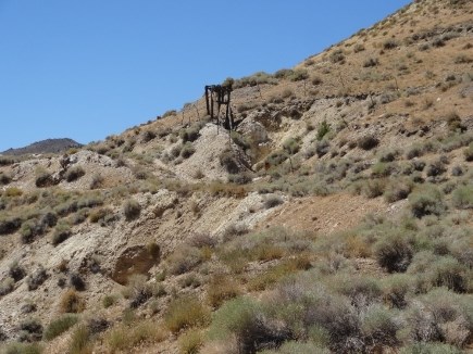
|
| Photograph taken during the August, 2022, Micon site visit. |
6.1.3 Historic Mineral Resource Estimates
6.1.3.1 1993 and 1998 Historical Resource Estimates
The mineral resources were initially estimated by Lac Minerals in 1993 using a cross-sectional method. Table 6.3 summarizes the results of this estimation, although the mineral resources were not classified.
Table 6.3
Historical Lac Minerals 1993 Wildcat Mineral Resource Estimation*
Tons (000's) | Grade (oz/ton gold) | Ounces of Gold (000's) | Grade (oz/ton silver) | Ounces of Silver (000's) |
51,904.0 | 0.020 | 1,038.1 | 0.18 | 9,342.7 |
Table extracted from the 2006 MDA Technical Report.
The 1993 mineral resource estimate in Table 6.3 is a historical, pre-NI 43-101 mineral resource estimate. The estimate is also un-classified and does not follow the currently accepted 2014 CIM terminology of classifying mineral resources.
The historical 1993 resource estimate, in common with the majority of the historical resource estimates, consists of only the final resource table which summarizes the results but makes no mention of the underlying assumptions and parameters used. The current QPs are unable to conduct sufficient work to classify the 1993 historical estimate as a current mineral resource.
In 1998, the mineral resources were estimated by MDA using a geologic model developed from cross-sections and 50 x 50 x 20 ft blocks, with the grade estimated using an inverse distance squared methodology and a 0.01 oz/ton gold cut-off grade. The results of the 1998 estimation are summarized in Table 6.4.
It should be noted that the 1998 mineral resource estimate is also a historical, pre-NI 43-101 mineral resource estimate that uses pre-CIM Standards and definitions for classification which do not follow the accepted terminology that is currently ascribed to indicated and inferred mineral resources.
None of Integra, Micon nor the QPs is treating the 1993 and 1998 historical estimates as current mineral resources and they are not being relied upon. All of the historical resource estimates noted in this section have been superseded by the estimates contained in Section 14.0 of this Technical Report.
6.1.3.2 2006 Historical Mineral Resource Estimate
The 2006 Vista Technical Report noted that: "Mineral resource estimation reported for the Wildcat property follows the guidelines of Canadian National Instrument 43-101. The resource estimate was completed in 1998 by MDA for another client. Vista Gold obtained a release for this information and no additional drilling has been completed on the Project since the resource was estimated".
The historical resources stated in the 2006 Technical Report for the Wildcat Project were stated as conforming to the definitions adopted by the Canadian Institute of Mining, Metallurgy and Petroleum (CIM) as of August 20, 2000. However, these definitions have changed and no longer conform to the 2014 CIM definitions.
2006 Methodology
MDA created a model for estimating the gold resource for the Wildcat Project from data provided to it by a number of clients. The drill hole data were checked prior to loading the data into a database; a few minor errors were discovered and corrected prior to importing the data into a Medsystem mining software database. Analytical results that were less than the detection limit were set to zero. All subsequent modelling of the Wildcat resource was performed using Medsystem.
A total of 20 density tests were completed during 2003 by Kappes, Cassiday and Associates from samples supplied by Vista.
The geologic model was based upon the geologic interpretations performed by LAC Minerals and the statistical data. The model was prepared jointly by MDA and LAC Minerals. At Hero/Tag, the Cenozoic volcanic package overlies the Cretaceous granodiorite. The contact is considered structural, though this is not yet definitive. This contact, which is one of three major controls in the Hero/Tag area, strikes northeast and dips gently to the southeast. Subparallel and generally underneath this contact are postulated low-angle faults which control some of the mineralization. A second control on the mineralization is steeply dipping, northeast striking faults/fissures which control high-grade vein material. The principal host rocks are the overlying volcanics (Tv) and the granodiorite (Kg) and, although the style of mineralization is different in these two rock types, they were not segregated for the geologic model (i.e., Zones 2 and 6) as it was beyond the precision of the underlying data.
Table 6.4
Summary of the Historical 1998 MDA Wildcat Resource Estimation
Zone | Description | Indicated Resources* | Inferred Resources* |
Tons
(000's) | Grade (oz/t
gold) | Ounces
Gold | Grade (oz/t silver) | Ounces
Silver | Tons
(000's) | Grade (oz/t gold) | Ounces
Gold | Grade (oz/t
silver) | Ounces
Silver |
2 | LG - Oxide | 22,382.5 | 0.014 | 313.4 | 0.12 | 2,685.9 | 5,039.7 | 0.014 | 70.6 | 0.12 | 604.8 |
3 | Granodiorite - Oxide | 42.3 | 0.024 | 1.0 | 1.62 | 68.5 | 3.9 | 0.024 | 0.1 | 1.62 | 6.3 |
4 | Contact - Oxide | 2,254.3 | 0.037 | 83.4 | 0.20 | 450.9 | 804.3 | 0.037 | 29.8 | 0.20 | 160.9 |
5 | HG Vein - Oxide | 7.7 | 0.331 | 2.5 | 0.33 | 2.5 | NA | 0.331 | | | |
6 | LG Non - Oxide | 17,311.5 | 0.015 | 259.7 | 0.16 | 2,769.8 | 22,502.4 | 0.015 | 337.5 | 0.16 | 3,600.4 |
7 | Contact - Non-Oxide | 1,169.2 | 0.031 | 36.2 | 0.20 | 233.8 | 746.2 | 0.031 | 23.1 | 0.20 | 149.2 |
8 | HG Vein - Non-Oxide | 3.5 | 0.025 | 0.1 | 0.12 | 0.4 | NA | 0.025 | | | |
Total | | 43,171.0 | 0.016 | 696.3 | 0.14 | 6,211.9 | 29,096.5 | 0.016 | 461.1 | 0.16 | 4,521.6 |
Notes:
- The 1998 mineral resource estimate summarized in Table 6.4 is a historical pre-NI 43-101 mineral resource estimate and the classification definitions do not follow the accepted terminology that is currently ascribed to indicated and inferred mineral resources.
- Integra is not treating the 1998 historical estimate as a current mineral resource estimate and is not relying on it.
The mineral zones used in the 2006 study are summarized below:
Low-grade disseminated - oxide: Zone 2 - This mineralization is often spatially associated with silicification and probably represents a flooding style of mineralization in Tv and weak stockwork in Kg. Grade cut-offs used to help in defining this zone along with the geology were 0.009 to 0.025 oz Au/ton.
Structurally-controlled, granodiorite-hosted - non-oxide: Zone 3 - This is a highly restricted mineralized area found in two holes just north of Main Hill. Grade cut-off used to help in defining this zone were 0.009 oz Au/ton.
Contact mineralization - oxide: Zone 4 - This mineralization is higher-grade than the enclosing disseminated-style of mineralization. Within this unit are discontinuous higher-grade (+0.05 oz Au/ton) breccias that are difficult to project with any confidence. Grade cut-offs used to help in defining this zone along with the geology were 0.025 to 0.05 oz Au/ton.
High-grade veins - oxide: Zone 5 - The veins are restricted to the granodiorite, strike northeasterly and dip moderately to steeply to the east. Grade cut-offs used to help in defining this zone along with the geology were 0.05 oz Au/ton.
Low-grade disseminated - non-oxide: Zone 6 - This mineralization is often spatially associated with silicification and probably represents a flooding style of mineralization in Tv and weak stockwork in Kg. Grade cut-offs used to help in defining this zone along with the geology were 0.009 to 0.025 oz Au/ton.
Contact mineralization - non-oxide: Zone 7 - This mineralization is higher-grade than the enclosing contact-style of mineralization. Within this unit are discontinuous higher-grade breccias that are difficult to project with any confidence. Grade cut-offs used to help in defining this zone along with the geology were 0.025 to 0.05 oz Au/ton.
High-grade veins - non-oxide: Zone 8 - The veins are restricted to the granodiorite, strike northeasterly and dip moderately to steeply to the east. Grade cut-offs used to help in defining this zone along with the geology were 0.05 oz Au/ton.
Unmineralized material or country rock - Zone 9 - Scattered, discontinuous and poorly understood mineralization exists in this unit and was modelled separately with a very restricted search range and weighting.
Mineral domains were restricted to the volcanic rocks (Tv) and granodiorite (Kg). The discontinuous scattered mineralization of Zone 9 was treated differently. First, there is some mineralization in the Cenozoic sediments, though it is quite clear that this could be merely incorporation of mineralized material in post-mineral sediments by sedimentary and/or tectonic processes. This is, therefore, considered to be highly localized and unpredictable at this point. There also are scattered areas of mineralization in the volcanic rocks and granodiorite. As these areas are distal to the contact and discontinuous, they were not incorporated in the mineral zones. However, as this does represent part of the in-situ resource, it was modelled unconstrained but with very restrictive ranges and ellipsoids. This latter material was not ever considered inferred because of the lack of geologic understanding.
The sample assay data, generally on five-foot intervals, were composited on twenty-foot benches and the cross sectionally-defined mineral zone definitions were assigned to these composites.
The Wildcat resource was modelled in Medsystem. Block sizes are 50 ft by 50 ft horizontally and 20 ft vertically. The mineral zones were digitized from cross-sections and modelled into a three-dimensional (3D) volume. These volumes were sliced on 20 ft benches, compared with the composite assay and geology data of the corresponding benches and edited if needed.
Grade modelling was restricted by unit though disregarding the oxide-sulphide boundary. Two models were prepared: one for the Indicated mineralization and a second one for Inferred mineralization. Silver was not re-estimated in the 1998 model update, and is not expected to change much from the 1994 estimate of an average grade around 0.15 oz Ag/t.
Because there was little confidence in the continuity of the higher-grade material in each zone, the higher-grade samples in each zone were not projected as far. All the estimation was done using inverse distance weighting to the third power. Kriging was not performed as the variography was not extremely well defined. Though Zones 5 and 8 (high-grade veins) were modelled, their contribution to the total resource was very small as they were restricted by geologic contacts. These high-grade veins will not have the grade continuity of the lower grade disseminated and structurally controlled mineralization and one must segregate the two. There also exists isolated and discontinuous mineralization outside of the mineral zones that could not be correlated between sections (Zone 9). These were contained in both the granodiorite as well as the clay unit. Within the granodiorite, this mineralization could add to the resource though the mineralization in the clay may not be a real resource as it is apparently made up of clasts of mineralization within a post-mineralization unit. Given the available data, these resources could not be estimated with confidence, therefore a highly restricted search range of 50 ft by 50 ft by 20 ft and a horizontal ellipsoidal projection weighting of 5 (horizontal) to 1 (vertical) was used with the same high-grade and single composite restrictions.
The first model estimated only the Indicated resource, while the second model included Inferred material. The Inferred estimation projected grades further than in the Indicated resource model. It too honoured rock types with grade projections and had the same switches restricting high grade and single sample grade projections to two thirds the range. The inferred resources should be used only to aid in making a decision on furthering the exploration of the deposits. There is geologic confidence in the Inferred model resources, though the confidence in grade is not good because of insufficient sample data to define it.
The resource for the Wildcat deposit was originally estimated based on an assumed average tonnage factor of 13.0 ft3/t, however the testwork in 2006 indicated that the average tonnage factor is 13.37 ft3/t for the volcanic breccia and 12.2 ft3/t for the intrusive. Contact mineralization was assumed to have the tonnage factor of the average of the breccia and the intrusive (12.8 ft3/t).
Table 6.5 and Table 6.6 summarizes the 2006 historical Vista mineral resources for the Indicated and Inferred mineral resources, respectively. These were based on the historical 1998 MDA resource estimate but using updated tonnage factors and a gold cut-off grade of 0.01 oz/t.
Table 6.5
Historical 2006 Wildcat Indicated Resource Estimate (0.010 oz/t gold cut-off)
Zone | Lithology | Tonnage Factor (ft3/t) | Indicated Resource* |
Tons (000's) | Grade (oz/t gold) | Gold Ounces (000's) |
2 | LG Diss-oxide | 13.37 | 18,925.4 | 0.014 | 265.0 |
3 | Granodiorite-oxide | 12.20 | NA | NA | NA |
4 | Contact MZN-oxide | 12.80 | 2,498.1 | 0.039 | 97.4 |
5 | HG Vein-oxide | 13.37 | 40.3 | 0.253 | 10.2 |
6 | LG Diss-non-oxide | 13.37 | 14,273.7 | 0.014 | 199.8 |
7 | Contact MZN-non-oxide | 12.80 | 2,081.6 | 0.038 | 79.1 |
8 | HG Vein-non-oxide | 13.37 | 289.2 | 0.098 | 28.3 |
Totals | | | 38,108.3 | 0.018 | 679.8 |
*Based on the 1998 MDA Estimate.
Table 6.6
Historical 2006 Wildcat Inferred Resource Estimate (0.010 oz/t gold cut-off)
Zone | Lithology | Tonnage
Factor
(ft3/t) | Inferred Resource* |
Tons (000's) | Grade (oz/t
gold) | Gold Ounces (000's) |
2 | LG Diss-oxide | 13.37 | 4,900.2 | 0.014 | 68.6 |
3 | Granodiorite-oxide | 12.20 | NA | NA | NA |
4 | Contact MZN-oxide | 12.80 | 816.9 | 0.039 | 31.9 |
5 | HG Vein-oxide | 13.37 | NA | NA | NA |
6 | LG Diss-non-oxide | 13.37 | 21,879.7 | 0.014 | 306.3 |
7 | Contact MZN-non-oxide | 12.80 | 757.9 | 0.038 | 28.8 |
8 | HG Vein-non-oxide | 13.37 | NA | NA | NA |
Totals: | | | 28,354.6 | 0.015 | 435.6 |
*Based on the 1998 MDA Estimate.
Notes for Table 6.5 and Table 6.6:
- The 2006 mineral resource estimates in Table 6.5 and Table 6.6 are historical. The classification definitions do not follow the accepted 2014 CIM terminology that is currently ascribed to indicated and inferred mineral resources.
- The 2006 mineral resource estimates are historical and the QPs have not done sufficient work to classify the 2006 historical estimates as current mineral resources. The underlying working models, other than the description of the work, which were the basis for the 2006 resource estimates, are not available. Thus, it is impossible for the QPs to say what work would be needed to bring the historical work into a current mineral resource estimate. None of Integra, Micon nor the QPs is treating the 2006 historical estimates as current mineral resources and Integra is not relying on them. The historical 2006 mineral resource estimate for the Wildcat Project has been superseded by the current mineral resource estimate found in Section 14 of this Technical Report.
6.1.4 Differences in Historical Versus Current Resource Classification Definitions
6.1.4.1 Historical Pre - JORC or CIM Definitions
In the period before the current standardization of mineral resource and reserve classification definitions a number of classification definitions could be applied to the mineral resources or reserves. These generally depended upon the professionals training and experience, as well the particular glossary or dictionary being used, for example:
1. A Glossary of the Mining and Mineral Industry by Albert H. Fay (Fay's Glossary) first published in 1918 and reprinted in 1947 was for the longest time the standard authoritative reference work for technical and specialized terms related to mining and mineral industries. This Glossary defined the terms:
Prospective Ore: "Ore that cannot be included as proved or probable, nor definitely known or stated in terms of tonnage. See Possible ore, also Ore expectant. (H.C. Hover, p.19)."
Possible Ore: "Ore which may exist below the lowest workings, or beyond the range of actual vision. (Min. and Met. Soc. Of Am. Bull.64, p. 262)."
Probable Ore: Any blocked ore not certain to be "in sight" and all ore that is exposed for sampling, but of which the limits and continuity have not been proved by blocking. Also, it includes any undiscovered ore of which there is a strong probability of existence. Ore that is exposed on either two or three sides. Whether two or three sides be taken as the basis will depend on the character of the deposit. (Min. and Met. Soc. Of Am. Bull.64, pp. 258 and 262).
Positive Ore: "Ore exposed on four sides in blocks of a size variously prescribed. See Ore developed also Proved ore (H.C. Hoover, p. 17). Ore which is exposed and properly sampled on four sides, in blocks of reasonable size, having in view the nature of the deposit as regards uniformity of value per ton and of the third dimension, or thickness. (Min. and Met. Soc. Of Am. Bull.64, p. 262)."
Proved Ore: "Ore where there is practically no risk of failure of continuity (H.C. Hoover, p. 19). See also Positive ore."
Ore developed: Ore exposed on four sides in blocks variously prescribed. See Positive ore, also Proved ore. (H.C. Hoover, p. 17).
Ore developing: Ore exposed on two sides. See Probable ore. (H.C. Hoover, p. 17).
Ore expectant: The whole or any part of the ore below the lowest level or beyond the range of vision. See Possible ore, also Prospective ore (H.C. Hoover p. 17).
A number of other more archaic terms were also defined in the glossary such as "Ore-in-sight" which will not be described further here.
2. A Dictionary of Mining, Mineral and Related Terms by Paul W. Thrush and the Staff of the Bureau of Mines was first published in 1968. This dictionary started out as an update to Fay's Glossary but the development of new mining and related technologies, as well as the expansion of the mineral industry, resulted in an updated and more comprehensive work of mining terminology. The dictionary defined the terms and, in some cases, where they were derived from as follows:
- Inferred Ore: "a. Ore for which quantitative estimates are largely based on broad knowledge of the geological character of the deposit and for which there are few, if any, samples of measurements. The estimates are based on an assumed continuity or repetition for which there is geologic evidence; this evidence may include comparison with deposits of similar type. Bodies that are completely concealed may be included if there is specific geologic evidence of their presence. Estimates of inferred ore should include a statement of the special limits within which the inferred ore may lie. (Forrester, P.553). b. Used essentially in the same sense as possible ore and extension ore (A.G.I.)"
Indicated Ore: "Ore for which tonnage and grade are computed partly from specific measurements, samples, or production data and partly from projection for a reasonable distance on geological evidence. The sites available for inspection, measurement and sampling are too widely or otherwise inappropriately spaced to outline the ore completely or to establish its grade throughout (Forrester, p.553)"
Measured Ore: "Ore for which tonnage is computed from dimensions revealed in outcrops, trenches, workings and drill holes and for which the grade is computed from the results of detailed sampling. The sites for inspection, sampling, and measurement are so closely spaced and the geologic character is so well defined that the size, shape and mineral content are well established. The computed tonnage and grade are judged to be accurate within limits which are stated, and no such limit is judged to differ from the computed tonnage or grade by more than 20 percent. (Forrester, pp. 552-553)"
Possible Ore: "a. A class of ore whose existence is a reasonable possibility, as based primarily upon the strength and continuity of geologic-mineralogic relationships and upon the extent of ore bodies already developed, and a measure of whose continuity is therefore available as a criterion of what may be expected as mining excavations progress into further reaches. Because of the comparative absence of mine workings which would reveal assay values, possible ore cannot be assigned a grade with any practicable certainty, nor can the quantity be expressed as a definite absolute amount. Also called extension ore. (Forrester, p. 554). Called future ore by some engineers. b. Ore exposed on only one side, its other dimensions being a matter of reasonable projection. Some engineers use an arbitrary extension of 50 to 100 feet. Others assume extension for half the exposed dimension. (McKinstry, p. 470). c. Ore which may exist below the lowest workings, or beyond the range of actual vision. (Fay)"
Probable Ore: "a. A class of ore whose occurrence is to all essential purposes reasonably assured but not absolutely certain. A definite grade can be assigned to the tons thus classified, but mining excavations have not progressed to the stage where probable tons are available to current mining, although the tonnage could become ready for withdrawal in a relatively short time. The grade assigned to many probable ore blocks may be the grade determined for continuous developed blocks. Some probable ore thus distinguished may be the essential counterpart of some measured ore as classified under the governmental plan. (Forrester, p. 554). b. Ore partly exposed by development, sampling, driving or drilling, but not fully blocked out (that is, exposed in panels). Usually, such ore ranks as probable when exposed and sampled on two or three sides. (Pryor, 3)."
Proved Ore: "Ore where there is practically no risk of failure of continuity. See also positive pre. (Fay)."
Developed Ore: "Ore is so completely exposed that its yield with respect to tonnage and tenor is essentially certain and which, in addition, is available to immediate withdrawal by the mining method being employed. (Forrester, p. 553)"
Probable Reserves: "Areas of coal or mineral lying beyond the developed reserves but still close enough to be considered proved within ordinary probability. Where the acreage of probable reserves is known from maps and surveys….."
Proved Reserves: "Ore Deposit which has been reliably established as to its volume, tonnage and quality by approved sampling, valuing and testing methods supervised by a suitably qualified person. The proved reserve is the over-ridingly important asset of the mine, and by its nature is a wasting one from the start of exploitation save insofar as it is increased by further development. (Pryor, 3). See also developed reserves. (Nelson)."
Developed Reserves: "a. The tonnage of ore which has been developed, sampled and blocked out, or exposed on at least three sides. In coal mining, the tonnage of coal known to exist by development headings. Also called assured mineral (Nelson). b. Mineral reserves proved by underground penetration. (Truscott, p. 177)."
3. Glossary of Geology edited by Robert L. Bates and Julia A Jackson (Third Edition, 1987) defined the following terms:
Inferred Ore: "Ore for which there are quantitative estimates of tonnage and grade made only in a general way, based on geologic relationships and on past mining experience, rather than on specific sampling."
Indicated Ore: "Ore for which there are quantitative estimates of tonnage and grade, made partly from inference and partly from specific sampling. Cf: inferred ore; possible ore; potential ore. Syn: probable ore."
Probable Ore; a. A syn. Of Indicated ore. b. A mineral deposit adjacent to developed ore but not yet proven by development. Cf: extension ore.
Proved Ore: "Proved reserves"
Hypothetical Resources: Undiscovered mineral resources that we may still reasonably expect to find in known mining districts (Brobst & Pratt, 1973, p. 4). Cf: identified resources; speculative resources.
Speculative Resources: Undiscovered mineral resources that may occur either in known types of deposit in a favourable geologic setting where no discoveries had yet been made, or in as-yet-unknown types of deposit that remain to be recognized (Brobst & Pratt, 1973, p. 2). Cf: hypothetical resources; identified resources.
Identified Resources: "Specific bodies of mineral bearing rock whose existence and location are known (Brobst & Pratt, 1973, p. 3). They may or may not be evaluated as to extent and grade. Identified resources include reserves and identified subeconomic resources. Cf: hypothetical resources; speculative resources."
Identified subeconomic resources: "Mineral resources that are not reserves, but that may become reserves as a result of changes in economic or legal conditions (Brobst & Pratt, 1974, p. 2). Syn: conditional resources. See also: identified resources."
Proved reserves: "Reserves of metallic and nonmetallic minerals, and of oil and gas, for which reliable quantity and quality estimates have been made. Cf: developed reserves; positive ore. Syn. Proved ore.
From the from the three volumes noted above that prior to the implementation of standard resource and reserve classifications as defined by JORC and CIM, among others, there was a wide variety of terms to classify resource and reserve estimations. The various historical nomenclatures have been rendered obsolete now that the Resource and Reserve definitions have been largely standardized across several jurisdictions worldwide.
6.1.4.2 Differences in the Historical 2000, 2005 and 2010 CIM Resource Definitions Versus Current 2014 CIM Resource Definitions
Differences 2000 to 2005 CIM Definition Standards
On August 20, 2000, the CIM Council approved the CIM Standards on "Mineral Resources and Reserves - Definitions and Guidelines". The CIM Definition Standards established definitions and guidelines for the reporting of exploration information, mineral resources and mineral reserves in Canada. The Mineral Resource and Mineral Reserve definitions were incorporated, by reference, in NI 43-101, which became effective February 1, 2001.
Subsequent to the publishing of the 2000 CIM Definition Standards, various CIM committees compiled and published more extensive documentation on mining industry standard practices for estimating mineral resources and mineral reserves. These standard practices provided more detailed guidance than that contained in the 2000 CIM Definition Standards. In November, 2004 the CIM Council adopted an update to the CIM Definition Standards to reflect the more detailed guidance available and to effect certain editorial changes required to maintain consistency with the regulations at the time. The new version of the CIM Definition Standards (adopted formally in December, 2005) also included further editorial changes required to maintain compatibility with the new version of NI 43-101 which became effective at the end of 2005. NI 43-101 was subsequently updated as of June 24, 2011.
Differences in Historical 2005 and 2010 CIM Resource Definitions Versus Current 2014 CIM Resource Definitions
The CIM Definition Standards for Mineral Resource and Reserve Estimates were updated in 2014 to harmonize Canadian definitions with other members of the Committee for Mineral Reserve International Reporting Standards (CRIRSCO). The revised Canadian standard also incorporates industry, Canadian Securities Administrators (CSA) and international requests for clarification and guidance.
The previous 2005 and 2010 Canadian definitions of a mineral resource differed from the definitions of other CRIRSCO members in two key aspects: the inclusion of "solid material" and the exclusion of the word "eventual" from the phrase "reasonable prospects for eventual economic extraction".
The Canadian definition always included the word "solid" but, until 2011, other CRIRSCO members omitted it. In 2011, it was adopted by the other CRIRSCO members to address the reporting of lithium brines as mineral resources. In a similar fashion, the CIM definitions historically excluded the word "eventual" from the phrase "reasonable prospects for eventual economic extraction" which the other members of CRIRSCO had adopted. The CIM committee added the word "eventual" to the 2014 Standards with guidance regarding its interpretation.
6.2 Mountain View Project
6.2.1 Historical Exploration and Mining
The Mountain View Project is located in the Deephole mining district and includes the old Mountain View mine, located approximately 8,000 ft north of the Severance deposit. The Mountain View vein zone averaged about 15 ft in width and cut PermoTriassic metasediments near the contact with the Granite Range batholith. The mine was originally explored from underground by the Anaconda Company in 1938, under option from the original claimants. However, no commercial mineralization was defined.
From 1939 to 1941, the Burm-Ball Co. optioned the property and produced some gold ore from a winze sunk from the main (lower) adit level. Production was said to be 1,480 oz of gold, 6,668 oz of silver, 11,000 pounds (lbs) of copper and 6,400 lbs of lead, mostly prior to 1940 (WGM, 1997). This production was followed by intermittent unsuccessful attempts to rework the mine, most recently in 1961 and 1962.
There was little exploration or mining activity from 1940 until 1984, when the Mountain View area became the focus of a significant exploration effort. The property was staked or re-staked in 1979 and there was visible activity at the time of a field examination in 1984 by Nevada Bureau of Mines and Geology (NBMG) staff geologists.
Rejuvenated exploration in the vicinity of the Mountain View mine began with St. Joe in 1984 and was followed by programs from US Borax in 1986, N.A. Degerstrom Inc. (Degerstrom) from 1988 to 1990, Westgold in 1989, Canyon Resources Corp. (Canyon) from 1992 to 1994, Homestake Mining Co. (Homestake) from 1995 to 1996 and, finally, Franco-Nevada Mining Corp. (Franco-Nevada) in 2000 and 2001.
In 1992, the Severance deposit was discovered by Canyon in drill hole MV92-6, which intersected 400 ft of 0.017 oz/t gold. Canyon was in a joint venture with Independence Mining at that time and went on to acquire 100% ownership in 1995. Subsequently, Homestake entered into a joint venture agreement with Canyon, with Homestake as operator.
Newmont acquired the property during the takeover of Franco-Nevada in February, 2002, and then sold the property to Vista Gold Corp. (Vista) in October, 2002.
As noted previously, on July 10, 2006, Vista announced a spin-off of its existing Nevada properties into a new publicly listed company (newco) that, concurrently with the spin-off, would acquire the Nevada mining properties of the Pescio Group. The transaction was completed by way of a court-approved plan of arrangement under the Business Corporations Act (Yukon).
Also as noted previously, on June 15, 2015, Allied Nevada announced that the United States Bankruptcy Court for the District of Delaware had approved the sale of Allied Nevada's exploration properties and related assets (excluding the Hycroft operation) to Clover Nevada, a wholly owned subsidiary of Waterton.
The detailed exploration and drilling history for the Mountain View Project are discussed in Sections 9.0 and 10.0, respectively.
Exploration disturbances observed during the 2020 site visit are limited to scarce access roads, partially reclaimed and some drill site footprints from the old drill campaigns. No evidence of recent activity was observed at the area visited.
6.2.2 Historical Mineral Resource Estimates
6.2.2.1 2002 Historical Snowden Mineral Resource Estimate
In 2002, Snowden conducted what is thought to be the initial mineral resource estimate on the Severance deposit at the Mountain View Project for Vista. The estimate involved statistical and geostatistical analyses of the data, 3D solids modelling of mineralization and a geostatistical interpolation of composites into 3D grade block models.
The 2002 mineral resource estimate for the Severance deposit is summarized in Table 6.7, although the economic assumptions used to define the economic parameters for the mineral resource were not specifically stated in the Snowden Technical Report.
Table 6.7
Historical 2002 Snowden Mineral Resource Estimate, Severance Deposit, Mountain View Project
Domain | Indicated | Inferred |
Tonnage (tons*1,000) | Gold Grade (oz/ton) | Tonnage
(tons*1,000) | Gold Grade (oz/ton) |
Total | 12,859 | 0.017 | 3,238 | 0.051 |
* Above a cut-off grade of 0.010 oz/ton Au.
Table derived from 2002 Snowden Technical Report.
The 2002 Snowden mineral resource estimates are historical, and the QPs have not done sufficient work to classify the estimates as current mineral resources. None of Integra, Micon or the QPs of this report is treating the historical estimates as current mineral resources and is not relying on them. Furthermore, the 2002 Snowden estimates have been superseded by the estimate contained in Section 14.0 of this Technical Report.
7.0 GEOLOGICAL SETTING AND MINERALIZATION
7.1 Regional Great Basin Geology
The Wildcat and Mountain View Projects both lie within the Great Basin, a region and geologic province within the North American Cordillera. The Great Basin is bounded by the Colorado Plateau on the east, the Sierra Nevada on the west, the Snake River Plain on the north, the Garlock fault and Mojave block on the south, and is approximately 600 km by 600 km. The majority of the Great Basin is occupied by the state of Nevada (Dickinson, 2006). The evolution of geology in the Great Basin spans from the Archean to present and is detailed by Dickinson (2006).
In the Precambrian to early Paleozoic, after the rifting of Rodinia, a miogeocline formed along the western edge of the Cordillera. This event marked the beginning of deposition of a westward thickening sedimentary package that is observed across the Great Basin today. Between the Devonian and Cretaceous time, three major orogenic events, the Antler, Sonoma and Sevier Orogenies, thrust deep-water siliciclastic rocks eastward, typically on top of shallower carbonate shelf rocks. In the Paleocene, Eocene and early-Oligocene, magmatism and volcanism, likely related to intracontinental extension, began in present-day Idaho and swept southwest across the Great Basin. This event formed numerous volcanic and intrusive units and likely had a major metallogenic influence on the Great Basin. In middle Oligocene time, an ignimbrite flare up deposited additional extrusive rocks across the Great Basin. Starting at 17 Ma, crustal extension in the Great Basin formed the Northern Nevada Rift, deposited basaltic rocks, led to the formation of numerous normal faults and formed epithermal gold deposits across the region. Present day topography reflects this most recent extensional event with young basaltic rocks atop older magmatic sedimentary rocks and countless mountain ranges separated by wide basins that are bounded by range-front normal faults.
The present-day surface geology of northwest Nevada, where both the Wildcat and Mountain View Projects are located, is at the intersection of two geologic domains, defined by John (2001) as, 1) the Western andesite assemblage, commonly referred to as the Walker Lane, and 2) the Bimodal basalt-rhyolite assemblage (Figure 7.1). Underlying the Western andesite assemblage and Bimodal basalt-rhyolite assemblage are Cretaceous granodiorites, Triassic sedimentary rocks, and Paleozoic metavolcanic rocks. Figure 7.2 is a generalized geology map of the western North American Cordillera.
Rocks within the Western andesite assemblage are interpreted to have a tectonic setting related to subduction along the continental margin arc, have a high magmatic oxidation state, and are typified by andesite-dacite, minor rhyolite and rare basalt. Gold deposits found in the Western andesite assemblage include the Comstock Lode, Goldfield and Tonopah.
The Bimodal basalt-rhyolite assemblage, the host assemblage of the Wildcat and Mountain View deposits, differs from the Western andesite assemblage in that these rocks are tectonically related to continental rifting, have a low magmatic oxidation state, and the most common rock types are basalt-mafic andesite and rhyolite, with minor trachydacite. Aside from Wildcat and Mountain View, other gold deposits found within the Bimodal basalt-rhyolite assemblage are Fire Creek, Sleeper, Midas, Florida Canyon, and Hog Ranch. Being in northwestern Nevada, where the Walker Lane (Western andesite assemblage) and Bimodal basalt-rhyolite assemblages intersect, the Project areas around Wildcat and Mountain View are clearly in a favourable geologic terrain for the formation of economic gold deposits.
Figure 7.1
The Bimodal Basalt-Rhyolite Assemblage
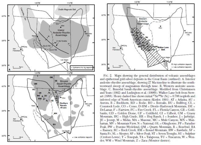
Figure supplied by Integra, June, 2023, from John (2001) see inset caption for explanation.
Figure 7.3 is a regional geology map for northwest Nevada which covers the areas of the Wildcat and Mountain View Projects.
Figure 7.2
Generalized Geology of the Western North American Cordillera
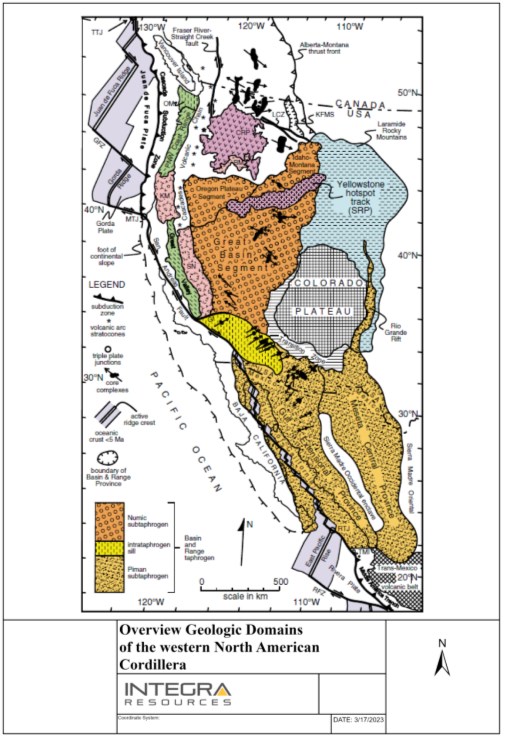
Figure supplied by Integra, June, 2023, from Dickinson (2006).
Figure 7.3
Regional Geology Map for Northwest Nevada
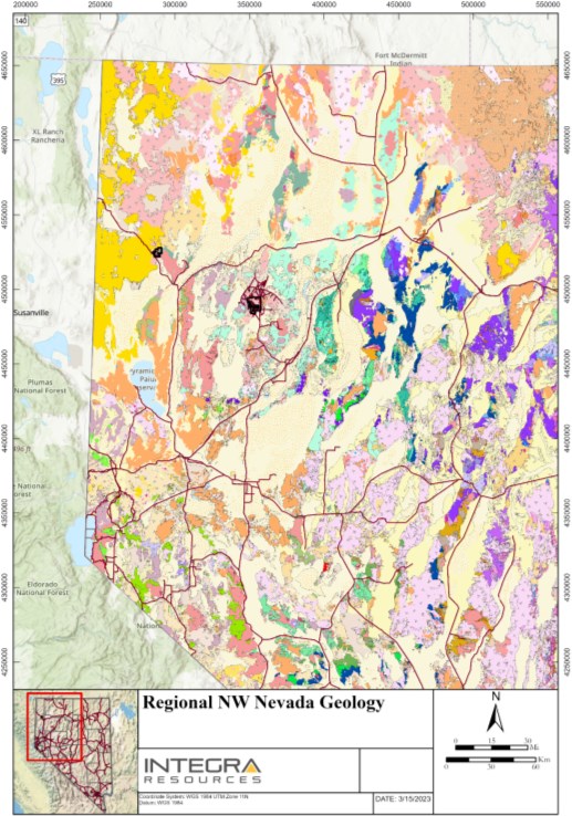
Figure supplied by Integra June, 2023, from USGS, Nevada geological Map data, Sta series: 249, USGS Open-File Report 2005-1305, https://mrdata.usgs.gov/geology/state/state.php?state=NV.
7.2 Wildcat Project Geology
The Wildcat Project lies in the Seven Troughs Range which is underlain by Triassic and Jurassic sedimentary rocks and has been intruded by Cretaceous granodiorite. Cenozoic igneous activity emplaced andesite, diorite, trachyte, trachyandesite, rhyolite and basalt domes and plugs. Cenozoic flows, pyroclastic debris, and vitrophyres of rhyolitic, trachytic and andesitic composition blanket much of the area, and these are broadly related to at least four intrusive events that are mappable on the surface at the Wildcat Project. Post-mineral and Late Cenozoic conglomerates, basalt plugs and flows, tuffs and Quaternary alluvium mask much of the area.
Deformation in the Project area is varied and locally intense. Previous workers interpreted the presence of low-angle normal faults. High-angle normal faults at the deposit and along the range front are interpreted to be related to Basin and Range faulting and regional extension. The relationship between these is uncertain, though the low angle faults have both controlled mineralization and post-dated mineralization. Figure 7.4 illustrates the property geology of the Wildcat Project.
Cataclastic deformation has been described in the granodiorite and probably played a role in controlling the mineralization.
A summary of the rock units in the Wildcat Project area is as follows:
Quaternary alluvium (Qal): localized occurrences of alluvium containing clasts of nearly all lithologies. Restricted to drainages, washes and alluvial fans in topographic low areas across the Project area.
Quaternary cover (basalt) (Qc(b)): widespread occurrences of alluvium composed almost entirely of clasts of Cenozoic basalt (Tb).
Quaternary cover (vitrophyre) (Qc(Tvit)): widespread occurrences of alluvial cover dominantly composed of Cenozoic rhyolite vitorphyre clasts (Trvit) and/or trachyandesite (Tta).
Quaternary cover (trachyandesite) (Qc(Tta)): widespread occurrences of alluvium composed of clasts of Tta and Tvit, dominantly composed of clasts of Cenozoic trachyandesite/andesite and vitrophyre.
Quarternary cover (rhyolite) (Qc(Tr)): widespread occurrences of alluvium/cover composed of Tr1 (biotite-hornblende, flow-banded rhyolite).
Quaternary cover (rhyolite-lithic lapilli tuff) (Qc(Trlt)): widespread occurrences of Quaternary cover/alluvium composed exclusively of clasts of Cenozoic rhyolite lapilli tuff material, blanketing areas adjacent to silicified lapilli tuff vents, some distal occurrences common.
Basalt (Tb): pyroxene, olivine and plagioclase. Euhedral pyroxene constitutes nearly 100% of the matrix. Typically comprising topographic high areas north and northwest of the Main Hill, locally vesicular and commonly columnar. Basalt flows and domes(?). The basalt is black, locally vesicular, post-mineralization and up to 100 ft thick in the Wildcat area.
Basaltic lithic tuff (Tblt): locally restricted occurrences of lapilli tuff composed dominantly of clasts of basalt in a scoria matrix. Described as conglomerate by Tullar and Stoeberl (1993), displays graded crossbedding in places.
Figure 7.4
Property Geology Map for the Wildcat Project
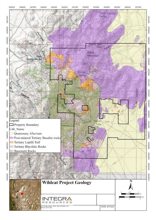
Figure supplied by Integra July, 2023.
- Trachybasalt (Ttb): flows and flow dome complexes of mafic rocks with minor plagioclase.
Trachydacite (Ttdc): flow dome complexes of flow-banded hornblende-quartz-sanadine trachydacite.
Quartz diorite (Tqd): mafic plugs and dikes with sparse plagioclase, fine- to medium-grained.
Conglomerate (Tcr): described as conglomerate by Tullar and Stoeberl (1993), likely rhyolite-clast (lapilli) ash fall tuff.
Opaline beds (Top): massive beds of opaline and jasper up to one metre thick in places. Found on the eastern flanks of KSBK mountain in Egbert Basin.
Rhyolite vitrophyre (Trvit): glassy, flow-banded, pale brown to purple in colour, lithophysae common.
Basaltic vitrophyre (Tbvt): grey black in colour, flow-banded, typically contains black obsidian (Apache tears), exact timing uncertain.
Vitrophyre lithic lapilli tuff (Tvlt): isolated outcrops of lapilli tuff composed dominantly of clasts of overlying vitrophyre, typically rhyolitic in composition.
Lithic lapilli tuff, undifferentiated (Tllt): dominantly clay-altered clasts of rhyolite or other silicic material.
Trachyandesite (Tta): vertically foliated intrusions and flows of mafic (dark purple to grey) hornblende-plagioclase trachyandesite/andesite.
Trachyandesite vitrophyre (Ttav): vitrophere in trachyandesite mafic rocks.
Rhyodacite (Trd): domes and plugs of felsic composition displaying moderate quartz phenocrysts, plagioclase, and weak flow banding in places.
Rhyolite 1 (Tr1): banded rhyolite flows and domes. Porphyritic rhyolite flows and domes prominently displaying flow-banding and foliation. fine-grained, quartz-feldspar in composition. Composition: subhedral quartz approximately 1-2 mm (approximately 30%), potassium feldspar <1 mm (approximately 40%) and plagioclase up to 1 mm (30%).
Rhyolite dikes (Tr2): hornblende-biotite rhyolite dikes similar in composition to rhyolite domes. Manifest in places across the district 1 m to 3 m wide. Composition: approximately 40% subhedral quartz <0.1 mm in size, plagioclase <0.1 mm (40%), and orthoclase up to 0.25 mm (15%). Acicular, euhedral hornblende <0.5 mm and fresh, euhedral biotite up to 0.5 mm are sparsely distributed and comprise approximately 5% of the rock.
Rhyolite 3 (Tr3): foliated, flow-banded rhyolite with euhedral biotite and hornblende. Similar to Tr1, but grey in colour, restricted to isolated outcrops in alluvium east of the main Project area.
Rhyolite-lapilli tuff vent (Tltv): silicified lapilli tuff with clasts of banded rhyolite, JTr, rarely Kgd, and porphyritic rhyolite. Strongly silicified, brecciated, typically containing moderate to abundant oxidized sulphides. Silica caps typically overlie argillic/clay-altered lapilli tuff. Frequently mineralized. Interpreted to be the same age as the Trlt (see below lithology), but just in vent form, not a widespread tuff layer.
Rhyolite-lapilli tuff (Trlt): silicified lapilli tuff containing clasts of banded and porphyritic rhyolite, JTr, and locally Kgd. Oxidized sulphides common adjacent to vents, covers the Main Hill and areas northwest towards Cow Creek. UPb in zircon age = 14.8 Ma. Main mineral-hosting lithology at Wildcat.
Andesite dikes (Ta): porphyritic, medium-grained with euhedral hornblende up to 2 mm comprising about 10%, biotite 1-2 mm in size up to 10%, and plagioclase phenocrysts up to 2 mm in size comprising about 25% of the rock, quartz <1 mm in size and matrix of very fine-grained plagioclase and biotite comprise 55% of the rock.
Andesite 2 (Ta2): fine- to coarse-grained porphyritic stocks, plugs, and dikes of intermediate composition containing hornblende and biotite 'clots' altered to chlorite with plagioclase laths up to 3 mm in size. Everywhere altered, chill margins present as fine-grained facies and are mapped as dacite. Locally hosts weak gold mineralization.
Dacite (Tda): fine-grained, buff tan, porphyritic dikes and small-volume plugs containing hornblende, biotite, and plagioclase. This unit is likely the fine-grained margins of Ta2. Locally hosts weak gold mineralization.
Granodiorite (altered) (Kgda): generally, clay altered with moderate to abundant oxidized sulphides and accompanying quartz-sulphide veins up to several centimetres in width. Alteration intensifies with proximity to lapilli tuff blanket.
Granodiorite (Kgd): biotite-granodiorite = approximately 20% mafics, including anhedral to subhedral hornblende 1-5 mm in length (approximately 50%) and euhedral to subhedral biotite 1-2 mm in length (approximately 50%). The remainder of the rock is composed of euhedral to subhedral plagioclase and potassium feldspar (approximately 1.4 mm long), and anhedral quartz (approximately 1 mm to 4 mm long). Rare outcrops of biotite-quartz pegmatite occur in places. UPb in zircon age = 102.2 Ma. Locally hosts mineralization on Main Hill.
Metasedimentary rocks of the Auld Lang Syne Group (JTr): thinly bedded sandstone and shale deposited in a shallow marine environment as described by Burke and Silberling, 1973. Locally steeply dipping.
7.3 Wildcat Project Mineralization
Precious metal mineralization at Wildcat occurs with low-temperature silica, chalcedony and pyrite and can be best-described as epithermal precious metal mineralization. The entire known deposit has a footprint approximately 1,500 m long, 1,500 m wide and 150 m deep with some areas containing significantly higher Au mineralization than others. Principal controls on the mineralization are lithologic, high-angle faults, and the contact between the granodiorite and lapilli tuff breccia.
Precious metal mineralization is identified in two lithologies at Wildcat, the granodiorite and lapilli tuff breccia. Mineralization in the granodiorite is typically limited to discontinuous quartz veins that strike north-northeast, dip steeply (70° to 80°), display localized and intense acid-bleaching (kaolinization) in the adjacent host rock, and appear to occupy a set of faults shown to predate the bulk of magmatic-hydrothermal activity in the district. Typically, these veins range in thickness from 10 cm to 2.5 m.
The aforementioned veins are most-commonly observed at the southern part of the Project, near the historical patented "Big Hero Claim" and have been dubbed "Big Hero-type (BHT)" veins.
Alteration associated with the BHT veins and Cenozoic events is abundant on the south- and west-facing slopes of the Project; the northern reaches of the Project are covered by Cenozoic volcanic rocks. Broad zones (up to 50 vertical metres in places) of acid alteration (clay (kaolinite), jarosite, goethite, and hematite) are present in the granodiorite below the contact with the overlying rhyolite/lapilli blanket.
The prominent ridge east of Big Hero ridge hosts several historic prospects located on BHT veins. Where larger BHT veins are present, zones of acid alteration in the granodiorite up to two metres wide are common. One road cut on the southwest slopes of the Main Hill in the granodiorite, referred to as "Road Cut 65" by previous property owner Allied Nevada Gold, produced gold values as high as 3.4 g/t.
Abundant cm-scale (and smaller) veins, mineralization, and alteration across this zone are proposed to be the product of circulating fluids, driven by Cenozoic magmatism and hypabyssal rhyolite intrusions and associated feeder zones at Wildcat. Grus is common in this zone as well, driven by chemical weathering of granodiorite due to alteration from the mineralizing fluids associated with feeder zones at depth.
While the granodiorite does host mineralization at the Wildcat Project, the majority of the potentially economic gold mineralization is hosted in Cenozoic rocks, specifically the 14.8 Ma lapilli tuff breccia lithology. Mineralization largely occurs in rocks that post-date or are contemporaneous with the northeast-striking fault set and associated with the emplacement of rhyolite domes, outflows, eruptive material (lapilli) and hydrothermal breccia zones at the surface and shallow depths (<500 m and approximately 275 °C).
Gold (±Ag) mineralization is relatively continuous within Cenozoic rocks, is present at the surface and is found in fine-grained, dark sulphide (reported as As-rimmed pyrite and electrum inclusions by Ford (1993)) and lesser amounts of free gold in breccia zones near the historical Wildcat Mine headframe (NBMG report: 1810-0002-85-3-272, pg. 41).
Observable Au-bearing sulphides in hand sample are common at silicified vents and breccia zones, though their abundance varies widely. The vents commonly host localized breccia, vein, and disseminated sulphide mineralization. Some of the vents may be marked on the surface by resistant, silicified rocks or buried by subtle depressions representing maars created at the time of eruption. Cleary (1994) and Ford (1993) provide thorough descriptions of mineralization in the rhyolite domes, breccias (vents), and veins at Wildcat. Ford (1993) reports grains of electrum common in sulphide mineralization in samples across the Project area.
Field mapping of the deposit shows that the main alteration types in mineralized-hosting Cenozoic rocks are silicification and clay alteration. One or both of these alteration styles are observed at nearly every outcrop mapped at the Wildcat deposit.
In the southern part of the Wildcat deposit, mineralization is spatially associated with the contact between the Cretaceous (102.2 Ma) granodiorite and the Cenozoic (14.8 Ma) lapilli tuff breccia. Numerous historical adits and shafts target this contact on the property. The principal low-grade zone that essentially encompasses all of the mineralization is tabular and dips gently to the southeast. The northwest and southern ends crop out, while the eastern end appears to weaken and die out or be cut off by post-mineral faulting.
7.4 Mountain View Project Geology
The geology around the Mountain View Project consists of Miocene volcanic and volcaniclastic sedimentary rocks, greenschist facies, Jurassic rocks, and a large granodiorite (99.9 Ma) intrusion just to the east of the property.
Mapping shows that the western portion of the Project area consists of Quaternary alluvium and Miocene rocks, including mafic tuffs, rhyolite tuffs and flows, volcaniclastic sediments and basalts. At the range front, Miocene rocks are in the hanging wall of a structural contact with Cretaceous and Jurassic rocks. The normal range front fault on the western edge of the Granite range runs northwest-southeast, dips steeply southwest, and has geometry consistent with broader Basin and Range faulting in northwestern Nevada. Figure 7.5 illustrates the regional geology surrounding the Mountain View Project.
A summary of the major rock units at the Mountain View deposit is as follows:
Late Holocene alluvial fan deposits (Q1a): sand and gravel in active or recently active alluvial fans.
Latest Pleistocene to middle Holocene alluvial fan deposits (Q1b): sands and gravels that have been deposited since the last Lake Lahontan high stand (approximately 14 ka).
Late Pleistocene alluvial fan deposits (Q2): sand and gravel deposits pre-Lake Lahontan high stand (approximately 14 ka).
Middle Pleistocene (?) alluvial fan deposits Qo: alluvial material from the middle Pleistocene.
Pleistocene-Pliocene grussy alluvial fan deposits (QTgs): sand and gravel.
Basalt lavas (Tb): late to middle Miocene aphanitic vesicular olivine-bearing basalt flows.
Tertiary Rhyolite (Tr): locally known as the Severance rhyolite, age dated to 15.4 Ma, hosts the majority of mineralization at Mountain View. Contains approximately 2-5% quartz, 3% feldspar phenocrysts in a >2 mm fine-grained groundmass (Strachan, 1987). Previous reports interpret this rhyolite as being of the same composition as the Cañon rhyolite, found west of the Severance deposit near Squaw reservoir. This report identified the Severance rhyolite and Cañon rhyolite as the same lithology.
Tuffaceous sedimentary rock (Tts): Late to middle Miocene tuffaceous sedimentary rock. Includes interbedded tuffaceous siltstones, shales, volcaniclastic sandstone, tephras, and conglomerate. Can locally included granitic dominated sandstone and conglomerate.
Cretaceous Granite (Kgd): Biotite-hornblende granodiorite, age dated at 99.9 Ma.
Jurassic Metamorphic Rocks (Jmv): Greenschist facies plagioclase-hornblende metavolcanic rocks.
Figure 7.5
Regional Geology Surrounding the Mountain View Project
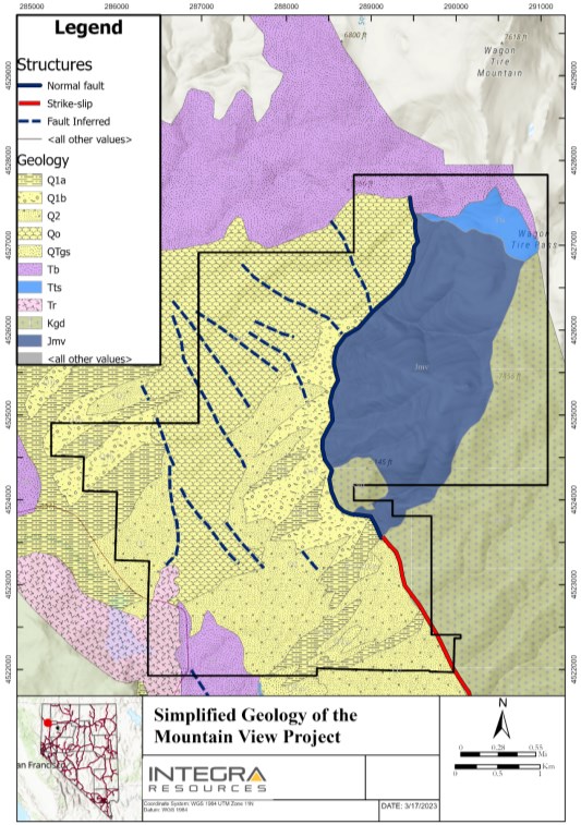
Figure supplied by Integra, June, 2023, modified from Faulds, J.E., Ramelli, A.R., 2005.
Since the late 1980s two mineralized zones, Severance and Buffalo Hills have been the target of exploration at the Mountain View Project. This report will focus on the Severance area, as that is where drilling during 2021 and 2022 was completed. Readers interested in the exploration of the Buffalo Hills zone should read previous 43-101 reports on the Mountain View Project, as the Buffalo Hills mineralized zone is not the subject of this Technical Report.
The Severance deposit is hosted in the Severance Rhyolite (15.4 Ma). The deposit is located in the hanging wall of the northwest-striking southwest-dipping range-bounding fault on the western side of the Granite range. Juxtaposed to the deposit, in the footwall side of this fault, is Cretaceous granodiorite. In only a couple of instances, the Severance rhyolite outcrops along the range front and drilling evidence suggests that it occupies an area approximately 3,200 ft long and 1,000 ft wide. Much of the Severance deposit is overlain by 500 ft to 700 ft of Quaternary alluvial cover.
A second body of rhyolite (Cañon Rhyolite) crops out near the Squaw Valley reservoir and is interpreted to extend to the northeast toward the Buffalo Hills zone, located approximately 5,000 ft to the west-northwest of Severance. The Cañon and Severance rhyolites are likely the same unit.
Structure on the property is dominated by northwest and northeast trending faults and fracture sets, though a number of north-south lineaments have been identified from aerial photographs. Major dip-slip offsets occur along the range-front fault system and these are, in turn, offset by the northeast trending structures. The latest movement on the range front fault system is interpreted to offset recent alluvium (Homestake, 1996).
7.5 Mountain View Project Mineralization
The mineralized zone at Mountain View has a roughly tabular shape striking towards the northwest and dipping steeply to the southwest. The mineralization occurs beneath unconsolidated alluvium, between approximately 400 and 1,000 ft below surface.
Two different styles of epithermal gold mineralization are recognized as occurring on the Project:
Both styles of mineralization are interpreted to be the same age and are products of the same mineralizing event. Potassium-argon dating indicates that the age of mineralization is approximately 14 to 15 Ma.
Both types of mineralization are geochemically similar, with high arsenic, mercury and antimony levels, low base metal levels, and high silver to gold ratios of approximately 7:1. Petrographic and microprobe work by Homestake on high grade gold samples from the Severance deposit has identified abundant silver selenides and coarse grains of electrum.
The high-grade zones at the Severance zone occur along northwest and east-northeast trending structures.
Low sulphidation epithermal mineralization at the Severance deposit has been interpreted as a somewhat planar zone of low to moderate grade gold mineralization hosted primarily by the Severance Rhyolite. The zone has a roughly tabular shape striking toward the northwest and dipping steeply toward the southwest, roughly parallel with the interpreted orientation of the range-front fault. The mineralization occurs beneath the unconsolidated alluvium at the top of bedrock. Several small high-grade zones are interpreted as strongly structurally controlled and are completely encompassed by lower grade mineralization. They are interpreted to have generally northwest trending and northeast trending cross-cutting orientations.
7.6 Micon QP Comments
Micon's QP has reviewed the geological information for both the Wildcat and Mountain View Projects through a review of the existing literature and previous Technical Reports for the Projects. In addition, the QP is familiar with the geological information, having previously co-authored the November, 2020 Technical Reports for both the Wildcat and Mountain View properties as well as observations made and discussions held during the August, 2022 site visit. Micon's QP believes that, given the geological nature of the Project, both expansion of the current mineralization, as well as the discovery of further secondary deposits on the mineral concessions which currently comprise the properties are highly possible. The QP recommends that Integra should continue to conduct further exploration programs that maximize coverage of the mineral concessions, in order to identify further exploration targets.
8.0 DEPOSIT TYPES
8.1 Wildcat and Mountain View Projects
Epithermal metal deposits are found across the world, are important sources of gold and silver, and typically form at <1.5 km depth and <300°C. These deposits are frequently found where volcanic arcs converge with continental tectonic plates, intra-arc, back-arc, and post-collisional rift settings. Rocks that comprise epithermal Au-Ag deposits commonly are associated with calc-alkaline to alkaline magmatism (Simmons et al., 2005). Broadly, epithermal Au-Ag deposits have two subcategories: 1) high-sulphidation and 2) low-sulphidation.
The Wildcat and Mountain deposits are both low-sulphidation (quartz-calcite-adularia-illite) epithermal gold deposits within the Bimodal basalt-rhyolite assemblage in the northwestern Great Basin. As summarized in item 7.0, epithermal deposits are common economic precious metal producers across the Great Basin and include the Sleeper, Midas, Comstock, and Fire Creek deposits.
Low sulphidation deposits, also known as 'geothermal' epithermal systems do not require a direct magmatic input, rather a deep-seated magma likely drives the circulation of hydrothermal fluids.
In low sulphidation deposits precious metals are typically observed with quartz, chalcedony, and pyrite, which drilling shows is the case at both Wildcat and Mountain View. Figure 8.1 shows the classic low sulphidation epithermal model from Hedenquist et al. (2000). Based on the depth of current drilling, the Wildcat and Mountain View Projects are interpreted to sit in the 'permeable lithology' zone, as both deposits are characterized by disseminated ore, silicification, and clay alteration outboard of mineralization.
Future targeting and drilling are utilizing the model (Figure 8.1) to infer the presence of high-grade vein-hosted ore beneath the deposits.
Research shows structural controls are important to many low-sulphidation epithermal deposits. While drilling shows that Wildcat is predominantly lithologically controlled, Mountain View displays strong structural controls along the range-front fault. Drilling evidence from Mountain View suggests that hydrothermal fluids used the range-front fault as a pathway of ascent, upon boiling, due to lower temperatures and pressures at shallower depths, precious metals were deposited along range-front fault and in permeable lithologies outboard of this fault. Geological models show that Mountain View shares many similarities with the Sleeper deposit.
Figure 8.1
Schematic Model of Mineral Zonation in Low-Sulphidation Epithermal Deposits.
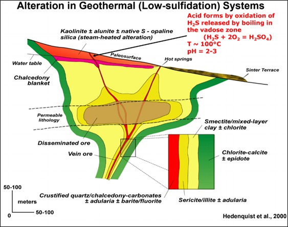
Figure supplied by Integra, June, 2023 taken from Hedenquist et al., 2000.
9.0 EXPLORATION
9.1 Wildcat Project Exploration Programs
9.1.1 Exploration Programs Pre-2021
After limited mining on high-grade veins on the property ceased in the 1940s, recent exploration started again in the 1980s. Early exploration was limited to surface mapping, sampling and core and reverse circulation drilling. Lac Minerals acquired the property in 1992 and completed the following exploration programs.
Mapping: The entire claim block and some areas beyond the boundaries have been mapped for geology. The accessible underground workings have also been mapped, along with the trenches and the roads.
Sampling: Over 1,500 rock chip samples from both surface and underground have been taken. Over 2,700 soil samples on a 250 ft by 100 ft grid have also been taken. Finally, a regional stream sediment sample program has been carried out in the northern half of the Seven Troughs Range.
Geophysics: Ground magnetics, VLF, IP and resistivity surveys have been conducted from Cow Creek (northwest of the property) southeast to and below the Hero/Tag area. This included 50,800 ft of IP and resistivity surveys in 1993 by Quantec of Reno, Nevada in the Hero/Tag and Main Hill areas and 35,300 ft of IP and resistivity surveys in the Shingle Springs and Cow Creek areas in 1994 by Bar Geophysics of Denver, Colorado.
Based on coincident IP, resistivity and magnetic anomalies, the geophysics that there is continuity of mineralization and extensions beyond existing drilling. The geophysics may be recognizing the silicified host rock with disseminated pyrite.
9.1.2 Millennial Exploration Programs: Post-2021
During 2021 and 2022 field seasons, Millennial undertook a mapping and surface sampling program with the aim of identifying areas of interest for additional exploration drilling and to promote understanding the broader mineral potential of the Wildcat Project.
The Millennial surface mapping and rock chip sampling program covered the entire 17,612-acre land position, aside from areas with post-mineral rocks or cover, where material has been deposited or transported after mineralization. Over the course of the surface sampling exploration program, 871 surface rock chip samples were collected. In areas of particular interest, identified by analysis of historical work and Millennial field mapping, sample density is higher than in areas where rocks that typically do not host mineralization are located.
When collecting samples, Millennial attempted to take the highest-grade samples, in order to get a complete understanding of the potential for gold mineralization at depth. In addition to trying to collect high-grade samples, Millennial sampled each mapped lithology on the property, thus getting a comprehensive and representative understanding of which lithologies and areas have the best potential for economic gold mineralization.
Accompanying the surface sampling program, a field mapping program of lithology, alteration, and structures was carried out by Millennial. Field mapping covered the entire Wildcat property, but particular attention was given to the main Wildcat deposit area. Mapping was done with coloured pencils and mylar and was later digitized. Structural data were collected using Brunton compasses.
Results of the mapping and exploration campaigns showed that there is good potential for additional mineralization outside of the area within the current mine design. Mapping and sampling indicate that, wherever the lapilli tuff breccia (Tltv) is located, there is likely to be gold greater than 0.25 ppm. Interpretations of mapping and sampling data north of the main Wildcat deposit, at the Cross-Roads area, show favourable potential for expanding the gold resource in this area. Moreover, sampling and mapping at the Snow Squall area, south of the main Wildcat deposit, revealed that the andesite (Ta2) can be a viable host for gold mineralization and follow up exploration is warranted at Snow Squall.
9.1.3 Integra Exploration Programs
Integra has not undertaken any exploration programs on the Wildcat Project, to date.
9.2 Mountain View Project Exploration Programs
9.2.1 Mountain View Project, Historical Exploration Programs
Before 1984, exploration at Mountain View was sporadic and concentrated around the old Mountain View mine in the late 1930s and early 1940s.
The main form of exploration since 1984 has been drilling conducted from surface.
The various exploration campaigns since the cessation of mining are summarized below.
In 1984, St. Joe undertook geophysics and seven RC drill holes in the vicinity of the Mountain View mine.
In 1986, US Borax found samples of mineralized rhyolite float in the Buffalo Hills area and drilled four short holes. Detailed documentation for this work is not available.
From 1988 to 1990, Degerstrom drilled 22 holes in the Buffalo Hills area, to follow up the discovery of high-grade float.
In 1989, Westgold consolidated ownership of the property. Mapping and sampling resulted in the discovery of mineralized float and a small outcrop of rhyolite near the Severance deposit discovery site. Westgold later merged with Independence Mining.
In the period from 1992 to 1994, Canyon formed a joint venture with Independence and carried out extensive exploration programs, including mapping, sampling, geophysical surveys and drilling. This work resulted in the discovery of the Severance deposit. Over the next two years, Canyon drilled 117 holes and acquired a 100% interest in the property.
In 1995 and 1996, Homestake formed a joint venture (as operator) with Canyon and conducted mapping, geochemistry, geophysics and trenching, and drilled a total of 69 holes to test various targets, before dissolving the joint venture.
In 2000-2001, Franco-Nevada drilled 13 holes at the Severance deposit to test the mineralization at depth and along strike to the north and south.
Vista completed two programs of RC drilling in 2003 and 2004. Vista's contractors drilled ten RC holes totaling 8,400 ft to in-fill and test the margins of the Severance deposit. The drilling programs both took approximately one month to complete, using the contract drilling companies Layne-Christensen in 2003 and Lang Exploratory Drilling, a subsidiary of Boart-Longyear, in 2004. Geological, sampling and field activities were supervised by Doe & Associates, contracted to Vista.
No surface exploration has been conducted at Mountain View property recently.
9.3 Micon QP Comments
Micon's QP has reviewed the exploration work conducted to date on both the Wildcat and Mountain View Projects and believes that the results of that exploration warrant further work to define and expand upon the existing mineralized zones on the properties.
10.0 DRILLING
10.1 Wildcat Project Drilling Programs
10.1.1 Wildcat Project Historical Drilling Programs
Table 10.1 summarizes the historical drilling programs conducted on the Wildcat property. The database contains 256 RC and core drill holes and one underground channel sample, totaling 95,466 ft. Seven drill holes are missing collar coordinate information.
Table 10.1
Summary of the Historical Wildcat Project Drilling Programs
Drill
Hole
Prefix | Company | Year | RC
Holes | RC
Footage | DD
Holes | DD
Footage | Total
Drill
Holes | Total
Footage |
SS | AMAX | 1991 | 1 | 500 | | | 1 | 500 |
TW | Star Valley/Pactolus | 1981 | 12 | 3,280 | | | 12 | 3,280 |
WC | Homestake (WC-1C, 2C and 3C) | 1983, 1986 | | | 4 | 1,000 | 4 | 1,000 |
WC | Touchstone | 1984 | 30 | 6,260 | | | 31 | 6,332 |
WK | Kemco | 1987 | 35 | 6,150 | | | 35 | 6,150 |
WN | Sagebrush | 1996-1997 | 29 | 17,085 | | | 29 | 17,085 |
WL | Lac | 1992-1994 | 116 | 52,631 | | | 116 | 52,631 |
WH | Sagebrush | 1996-1997 | 22 | 7,490 | 7 | 998 | 29 | 8,488 |
Totals | | | 245 | 93,396 | 11 | 1,998 | 257 | 95,466 |
Table extracted from 2006 MDA Technical Report.
10.1.1.1 Reverse Circulation Drilling and Logging
The RC drilling completed prior to 1990 was generally performed dry and was vertical and shallow. RC drilling in the 1990s was generally deeper and inclined. One drill hole (WK-16) was noted as appearing to have been contaminated.
The drill hole logs were completed based on chip trays collected during the drilling process.
10.1.1.2 Underground Adit
A short 72 ft adit was channel sampled and mapped (WC-5-Adit). Various maps found in the files illustrate a number of other underground workings with sample data that are not included in the database.
10.1.1.3 Core Drilling and Logging
A total of 11 HQ to NQ core drill holes have been completed on the Wildcat property. These holes were logged and the core was split for sampling. The core drill holes were completed for metallurgical testing or comparison to reverse circulation drilling.
10.1.1.4 Twin Hole Comparison
Six of the core holes can be compared to close-by reverse circulation drilling. Although the results of the comparison indicate higher average grades in the reverse circulation drilling, essentially all of the difference is from one comparison (WH-29C versus WL-1). Table 10.2 summarizes the comparison between the core holes and the close-by reverse circulation drilling.
Table 10.2
Comparison between the Core Diamond Drill Holes and the Close-by Reverse Circulation Drill Holes
Core Drill Holes | RC Holes |
Hole ID | Length
(ft) | Oz
Au/t | Oz
Ag/t | Au x
Length | Ag x
Length | Hole
ID | Length
(ft) | Oz
Au/t | Oz
Ag/t | Au x
Length | Ag x
Length |
WH-23C | 78 | 0.030 | 0.36 | 2.34 | 28.12 | WH-14 | 80 | 0.017 | 0.15 | 1.38 | 12.15 |
WH-24C | 92 | 0.005 | 0.10 | 0.43 | 9.28 | WH-12 | 90 | 0.009 | 0.12 | 0.84 | 11.00 |
WH-26C | 120 | 0.025 | 0.35 | 3.03 | 41.78 | WH-16 | 120 | 0.024 | 0.30 | 2.84 | 35.95 |
WH-27C | 300 | 0.016 | 0.26 | 4.83 | 78.78 | WH-10 | 300 | 0.017 | 0.22 | 5.15 | 65.48 |
WH-29C | 325 | 0.016 | 0.18 | 5.15 | 59.22 | WL-1 | 325 | 0.030 | 0.67 | 9.91 | 219.30 |
WC-2C | 73 | 0.032 | NA | 2.336 | NA | WK-6 | 70 | 0.008 | NA | 0.56 | NA |
Core Total: | 988 | 0.018 | 0.24 | 18.116 | 217.18 | RC Total: | 985 | 0.021 | 0.38 | 20.68 | 343.88 |
Table supplied by Integra, July, 2023.
10.1.2 Wildcat Project, Millennial Drilling Programs
In 2022, Millennial completed a 12-hole (1,297.99 m) drill program on the Wildcat Project. Table 10.3 provides a summary of the locations, bearings, dips and depths of those holes.
Table 10.3
Summary of the 2022 Millennial Drilling Program for the Wildcat Project
Drill Hole ID | Easting
(UTM) | Northing
(UTM) | Bearing
(°) | Dip
(°) | Depth
(m) |
WCCD-0001 | 351826 | 4490292 | 30 | 45 | 35.36 |
WCCD-0002 | 351826 | 4490292 | 210 | 50 | 44.81 |
WCCD-0003 | 352023 | 4490255 | 330 | 70 | 97.74 |
WCCD-0004 | 352143 | 4490363 | 300 | 65 | 131.67 |
WCCD-0005 | 352288 | 4490452 | 330 | 45 | 175.56 |
WCCD-0006 | 352132 | 4491049 | 270 | 70 | 155.91 |
WCCD-0007 | 351872 | 4490704 | 160 | 75 | 100.58 |
WCCD-0008 | 352099 | 4490816 | 90 | 50 | 92.05 |
WCCD-0009 | 352169 | 4491243 | 45 | 70 | 130.15 |
WCCD-0010 | 352077 | 4491281 | 310 | 45 | 89.92 |
WCCD-0011 | 351996 | 4491154 | 350 | 55 | 130.45 |
WCCD-0012 | 352413 | 4490652 | 320 | 65 | 119.79 |
Table supplied by Integra, June, 2023.
Millennial contracted American Drilling Corp. and InterGeo Drilling LLC for the drill program at Wildcat. Drilling was performed using a CS500 and U20-01 drill rigs. All 2022 holes were drilled using a diamond drill bit with both PQ and HQ sized core. Recovery rates during drilling averaged 90% to 100% and sampling was performed by trained Millennial employees. It is believed that there are no factors that could have materially impacted the accuracy and reliability of the results. Drill holes were reclaimed using standard techniques.
Results of Millennial's 2022 drill program at Wildcat are summarized below:
WCCD-0001 and WCCD-0002 did not return significant drilling results and were designed to provide material for metallurgical testing.
WCCD-0003 intersected 39.2 m @ 1.26 g/t Au and was also drilled to provide material for metallurgical testing and to confirm historical drilling and continuity.
WCCD-0004 intersected 41.4 m @ 0.93 g/t Au and was drilled to provide material metallurgical testing and to confirm historical drilling and continuity.
WCCD-0005 intersected 17.7m @ 0.36 g/t Au within the 2020 43-101 pit shell and 68.6 m @ 0.55 g/t Au directly below the pit shell used for the 2020 43-101Technical Report. The purpose of this hole was to gather material for metallurgical studies and to test the brecciated oxide material in the eastern part of the 2020 pit shell.
WCCD-0006 intersected 120.2 m @ 0.39 g/t Au, extending oxide mineralization below the 2020 pit shell, and was drilled for metallurgical testing and to confirm historical drill grades and continuity.
WCCD-0007 intersected 50.0 m @ 0.51 g/t Au and was drilled for metallurgical testing and to confirm historical grades and continuity.
WCCD-0008 intersected 51.8 m @ 0.36 g/t Au and was drilled for metallurgical testing in the centre of the north pit, at the highest elevation point at Wildcat.
WCCD-0009 intersected 30.5 m @ 0.40 g/t Au and was drilled to gather geotechnical data and to test the expected north-eastern highwall of the pit.
WCCD-0010 intersected 42.7 m @ 0.87 g/t Au approximately 50 m outside the 2020 pit shell. This hole was drilled to gather geotechnical data to test the northern slope of the pit.
WCCD-0011 intersected 69.5 m @ 0.29 g/t Au and was drilled to gather geotechnical data and to test the expected north-eastern highwall of the pit.
WCCD-0012 intersected 30.5 m @ 0.34 g/t Au and 54.9 m @ 0.41 g/t Au approximately 150 m outside of the 2020 oxide pit design. This intercept extended the known oxide mineralization at Wildcat.
Drill core was logged by Millennial geologists at the company's core warehouse in Lovelock, NV and data were recorded using MX Deposit.
Historical drilling provides ample evidence for the existence of a gold deposit at the Wildcat Project. Each hole drilled in 2022 intersected mineralization within the planned oxide open pit. Holes WCCD-0005, WCCD-0010 and WCCD-0012, intersected mineralization outside the previous 2020 mineral resource pit shell, suggesting that there is potential to increase the resource at the Wildcat deposit and that further exploration is warranted.
10.1.3 Wildcat Project Integra Drilling Programs
Integra has not undertaken any drilling programs on the Wildcat Project, to date.
10.2 Mountain View Project Drilling Program
10.2.1 Mountain View Project Historical Drilling Programs
A summary of the historical drilling programs conducted on the Mountain View Project from 1984 to 2004 is provided in Table 10.4.
Table 10.4
Summary of the Mountain View Project Drilling Programs from 1984-2004
Year | Company | Drilling Method/Type | Number of Drill Holes |
1984 - 1985 | St. Joe | RC | 7 |
1986 | US Borax | RC | 4 |
1988 - 1990 | Degerstrom | RC | 24 |
1991 | Independence | RC | 9 |
1992 - 1994 | Canyon | RC | 106 |
RC/DD | 11 |
1995 - 1996 | Homestake | RC | 65 |
DD | 4 |
2000 - 2001 | Franco-Nevada | RC | 10 |
DD | 3 |
2003 - 2004 | Vista | RC | 10 |
Total: | | | 253 |
Table supplied by Integra, June, 2023 and originally derived from the 2006 Snowden Technical Report.
The 2002 Snowden Technical Report contained information regarding each of the historical drilling programs.
10.2.1.1 1984 to 1994 Drilling Programs
The 2002 Snowden Technical Report noted that, between 1984 and 1994, a total of 161 drill holes were completed during several drilling campaigns on various portions of the Mountain View property. However, no documentation regarding the drilling procedures, interpretation and results of the programs was available.
10.2.1.2 1995 Homestake RC and DD Program
In 1995, Homestake completed a total of 22 RC holes (MV95-118, 120 to 128, 130 to 132, 134 to 136, and 138 to 143) totalling 18,055 ft, and 4 HQ diameter diamond drill (DD) holes (MV95-119, 129, 133, and 137) totalling 3,850 ft (the DD footage included 1,225 ft of RC pre-collar drilling).
All holes were oriented to the northeast and southwest. RC drilling was completed by Eklund Drilling of Elko, Nevada using a rubber-tired Explorer 1500 drill rig. Diamond drilling was conducted by Tonto Drilling Services Inc. (Tonto) of Salt Lake City, Utah, using a truck mounted Longyear 55 rig. Core recoveries were generally recorded as being better than 95%. Down-hole surveys were conducted on eleven of the holes to check for any deviation. The surveys were completed by Silver State Surveys from Elko, Nevada using a wireline gyroscopic survey tool. All drill hole collars were surveyed at the completion of the program, including some of the holes from previous campaigns (Homestake, 1996).
Homestake reported that drilling progress was marginally acceptable due to several factors, including difficult drilling conditions with swelling clays and hard, broken ground.
10.2.1.3 2000 and 2001 Franco-Nevada RC and DD Program
Casteel (2001) reported that the DD contractor for the 2000 and 2001 drilling programs carried out by Franco Nevada at Mountain View was Inland Pacific Drilling from Yerington, Nevada and that Hackworth Drilling completed the RC program. The objective of the programs was to test the Severance deposit at depth, below the previous drilling campaign intersections, and to test the structure along strike to the north and south.
Three attempts were made to intercept the structure down-dip with diamond drilling, but problems were encountered when drilling the clay below the rhyolite and the target was not reached. The RC drill was successful in testing the structure at depth but the results were not encouraging.
DD involved both HQ and NQ size core drilling sizes. RC rigs used were an Ingersoll-Rand TH-75 and TH-100.
Down-hole gyroscopic surveys were conducted by Silver State Survey on all holes with the collar co-ordinates determined using triangulation surveying from existing drill hole collars.
10.2.1.4 2003 and 2004 Vista RC Programs
Vista completed two programs of RC drilling at Mountain View during the months of October and November in 2003 and 2004. Vista's contractors drilled ten RC holes totaling 8,400 ft, to in-fill and test the margins of the Severance deposit. The drilling programs each took approximately one month to complete, using the contract drilling companies Layne-Christensen in 2003 and Lang Exploratory Drilling, a subsidiary of Boart-Longyear in 2004. Geological, sampling and field activities were supervised by Doe & Associates, contracted to Vista.
Three of the holes were abandoned due to caving and running sand, although measures were taken in 2004 to case and cement the holes to prevent this problem. All drill holes, except for two were oriented approximately perpendicular to the orientation of the mineralized zone.
Based on experiences with caving and running sand in drill holes during the 2003 field season, the first holes in 2004 were started with 40 ft of 6-in surface casing cemented into the hole. Drilling proceeded with tri-cone bits and a cross-over sub. Despite these efforts the first two holes were lost. The final three holes employed conventional mud rotary tools through the alluvial portion of the holes, then casing into bedrock.
Hole locations were surveyed by Doe & Associates with a hand-held Magellan Meridian Platinum GPS instrument. Snowden estimates that collar positions are known with an accuracy of two feet with this type of instrument and possibly to a greater accuracy. Down-hole surveying was done using a gyroscope at an average of 50 ft intervals. Once completed, hole collars were plugged with cement and labeled with a stamped brass tag.
Drill Hole Locations
The locations, bearings, dips and depths of the 2003 and 2004 Vista holes are summarized in Table 10.5. The locations of 2003 and 2004 Vista drill holes are shown in Figure 10.1, with previous drill holes shown as blue crosses and the Vista drill holes shown as red squares.
Table 10.5
Summary of the Drill Hole Information for the 2003 and 2004 Vista Drill Programs
Year | Drill Hole ID | Easting (UTM) | Northing (UTM) | Bearing (°) | Dip (°) | Depth (ft) |
2003 | MV03-187 | 288,968 | 4,522,643 | 064 | -54 | 500 |
2003 | MV03-188 | 289,096 | 4,522,781 | 058 | -51 | 1,000 |
2003 | MV03-189 | 289,110 | 4,522,649 | 066 | -49 | 980 |
2003 | MV03-190 | 289,101 | 4,522,713 | 061 | -49 | 940 |
2003 | MV03-191 | 288,910 | 4,522,770 | 065 | -54 | 910 |
2004 | MV04-192 | 288,964 | 4,522,658 | 060 | -50 | 520 |
2004 | MV04-193 | 288,854 | 4,522,659 | 000 | -90 | 380 |
2004 | MV04-194 | 289,158 | 4,522,852 | 000 | -90 | 1,100 |
2004 | MV04-195 | 288,864 | 4,522,783 | 056 | -61 | 1,110 |
2004 | MV04-196 | 288,853 | 4,522,658 | 061 | -72 | 960 |
Table supplied by Integra, June, 2023 and originally derived from the 2006 Snowden Technical Report.
Figure 10.1
Location of 2003 and 2004 Vista Drill Holes in Relation to Previous Drill Holes
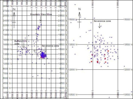
Figure taken from the 2006, Snowden Technical Report.
2003 and 2004 Drilling Results
Seven of the 2003 and 2004 Vista drill holes intersected mineralization within the Severance rhyolite:
Holes MV03-188 and MV03-190 confirmed mineralization encountered in previous drilling.
MV03-190 also extended the area of known mineralization slightly to the east. Drill hole MV03-189 intersected only 25 ft of weakly mineralized rhyolite and closed off the deposit to the south.
Drill hole MV03-191 confirmed mineralization encountered in previous drilling and extended the area of known mineralization slightly to the north.
Drill hole MV04-194 was drilled to test the northeast boundary of the mineralized zone, resulting in a slight extension in that direction.
Drill hole MV04-195 was drilled to confirm results from a previously drilled hole that terminated in significant mineralization. It encountered a deeper but relatively low-grade zone of mineralization.
Drill hole MV04-196 was drilled to test a previous drill hole that also terminated in the mineralized zone. It intersected the entire mineralized zone and extended the known zone of mineralization to the southwest.
Table 10.6 summarizes the results for Vista's 2003 and 2004 drilling at the Mountain View Project. The various mineralized intercepts are shown for each drill hole. However, areas of high-grade within the mineralized zones were not broken out on an individual basis. The depths shown are feet down-hole and intervals are approximately true widths, except for drill hole MV03-194 which was not drilled perpendicular to the mineralization.
Table 10.6
Summary of the 2003 and 2004 Mineralized Drill Hole Intersections
Drill Hole ID | Drilling Intersections | Assay Results |
From (ft) | To (ft) | Interval (ft) | Gold (oz/t) | Silver (oz/t) |
MV03-188 | 385 | 620 | 235 | 0.037 | 0.05 |
MV03-188 | 420 | 465 | 45 | 0.081 | 0.05 |
MV03-189 | 630 | 685 | 55 | 0.012 | 0.03 |
MV03-190 | 520 | 685 | 165 | 0.026 | 0.12 |
MV03-190 | 535 | 570 | 35 | 0.058 | 0.18 |
MV03-190 | 730 | 790 | 60 | 0.047 | 0.20 |
MV03-190 | 750 | 755 | 5 | 0.370 | 2.15 |
MV03-191 | 495 | 705 | 210 | 0.039 | 0.45 |
MV03-191 | 545 | 610 | 65 | 0.052 | 0.58 |
MV03-191 | 660 | 680 | 20 | 0.112 | 0.70 |
MV04-194 | 250 | 325 | 75 | 0.053 | 0.15 |
MV04-194 | 270 | 285 | 15 | 0.159 | 0.33 |
MV04-194 | 465 | 490 | 25 | 0.018 | 0.02 |
MV04-194 | 530 | 690 | 160 | 0.024 | 0.06 |
MV04-194 | 600 | 635 | 35 | 0.036 | 0.07 |
MV04-195 | 760 | 920 | 160 | 0.080 | 1.14 |
MV04-195 | 840 | 920 | 80 | 0.140 | 1.86 |
MV04-195 | 970 | 1,025 | 55 | 0.024 | 0.30 |
MV04-196 | 665 | 730 | 65 | 0.031 | 0.14 |
MV04-196 | 700 | 730 | 30 | 0.044 | 0.20 |
Source: 2006 Snowden Technical Report.
Procedures
In the 2006 Technical Report, Snowden noted that the following procedures were described by Doe & Associates as applying to the 2000 and 2004 drilling programs:
The sites selected for drilling were located by the project geological consultant using a hand-held GPS unit with an estimated accuracy of ± two feet.
Heavy drilling equipment was moved taking care to avoid vegetation damage.
The Project geological consultant checked the drill rig alignment, positioning and placement of sampling equipment prior to commencement of drilling activities.
Sample return water run-off and spillage was contained at the drill site.
Drilling and sampling activities were monitored on a regular basis by the Project geological consultant.
The drill system used standard RC rotary tri-cone and hammer bits with a crossover sub. Water and drilling muds were injected into the RC system to maintain hole integrity.
At the completion of each drill hole, the down-hole trace was surveyed using a gyroscopic instrument.
The hole collars were marked with a cement plug and brass plate in accordance with BLM requirements.
A site reclamation and seeding program was followed by Vista and Doe & Associates.
Sample bags and lithological samples were identified and stored appropriately.
10.2.2 Mountain View, Millennial Drilling Program
Millennial contracted American Drilling Corp for the drill program at the Mountain View Project which began in June, 2021 and finished in mid-April, 2022. Sites selected for drilling at the Project were selected and located by Millennial employees. Drilling equipment was mobilized with care, in order to not create any further land disturbance and not to adversely impact the environment surrounding the Project.
During the drill program, 32 holes were drilled, totalling 8,107.6 m. Two of the holes were drilled, exclusively, with reverse circulation, MVRC-0001 and MVRC-0002. Reverse circulation holes were drilled with an RC685 drill rig. Twenty-five of the holes drilled at the Mountain View Project were diamond bit core holes that all collared using a PQ hole diameter. One hole, MVCD-0015 had to be reduced twice while drilling, from PQ to HQ and HQ to NQ, due to difficult drilling conditions. Five holes (MVCD-0001A, 0011, 0012, 0013, 0014) were collared with reverse circulation drilling and then transitioned to PQ diamond core drilling. Core holes were drilled with CT14 and CT20 drill rigs. Recovery for all holes averaged 73% and sampling was performed by trained Millennial employees. While the recovery of 73% is low and should be improved in any further drilling programs, discussions during the site visit leads Micon's QP to believe that the recovery does not materially impacts the accuracy and reliability of the results, at this time. Drill holes were reclaimed using standard techniques.
A summary table of drill hole information for the Millennial drilling program at Mountain View is shown in Table 10.7.
Throughout the program, drilling conditions were difficult and nine holes (MVCD-0001, -0003, -0011, -0016, -0019, -0019A, -0020, -0025, -0027) were lost.
Table 10.7
Summary of the Drill Hole Information for the 2021 to 2022 Millennial Drilling Program
Year | Drill Hole ID | Easting (UTM) | Northing (UTM) | Bearing (°) | Dip (°) | Depth (m) |
2021 | MVCD-0001 | 288677 | 4522833 | 70 | 48 | 150.80 |
2021 | MVCD-0001A | 288677 | 4522833 | 70 | 48 | 230.12 |
2021 | MVCD-0002 | 288852 | 4522791 | 70 | 45 | 56.00 |
2021 | MVCD-0003 | 288817 | 4522885 | 70 | 90 | 234.39 |
2021 | MVCD-0004 | 289121 | 4522987 | 70 | 90 | 250.54 |
2021 | MVCD-0005 | 289018 | 4523159 | 70 | 80 | 269.74 |
2021 | MVCD-0006 | 289018 | 4523272 | 70 | 80 | 235.61 |
2021 | MVCD-0007 | 289068 | 4523242 | 70 | 80 | 186.84 |
2021 | MVCD-0008 | 288855 | 4523271 | 70 | 80 | 270.36 |
Year | Drill Hole ID | Easting (UTM) | Northing (UTM) | Bearing (°) | Dip (°) | Depth (m) |
2021 | MVCD-0009 | 288818 | 4523350 | 70 | 80 | 264.26 |
2021 | MVCD-0010 | 288909 | 4523239 | 250 | 75 | 291.08 |
2021 | MVCD-0011 | 288954 | 4522887 | 70 | 80 | 310.29 |
2021 | MVCD-0012 | 288993 | 4523098 | 70 | 80 | 283.77 |
2021 | MVCD-0013 | 288873 | 4523070 | 70 | 80 | 289.56 |
2021 | MVCD-0014 | 288642 | 4522927 | 70 | 45 | 264.57 |
2021 | MVCD-0015 | 288993 | 4523098 | 230 | 65 | 393.80 |
2021 | MVCD-0016 | 289036 | 4523101 | 220 | 60 | 178.92 |
2021 | MVCD-0016A | 289030 | 4523089 | 225 | 60 | 343.92 |
2022 | MVCD-0017 | 289068 | 4523243 | 230 | 77 | 199.34 |
2022 | MVCD-0018 | 289121 | 4523123 | 90 | 70 | 103.63 |
2022 | MVCD-0019 | 289121 | 4523123 | 225 | 83 | 71.02 |
2022 | MVCD-0019A | 289121 | 4523123 | 225 | 83 | 237.13 |
2022 | MVCD-0020 | 289061 | 4523039 | 280 | 77 | 107.29 |
2022 | MVCD-0021 | 288981 | 4523028 | 50 | 80 | 396.24 |
2022 | MVCD-0022 | 288988 | 4522911 | 0 | 85 | 407.52 |
2022 | MVCD-0023 | 288981 | 4523028 | 190 | 80 | 305.71 |
2022 | MVCD-0024 | 288877 | 4523065 | 295 | 75 | 332.23 |
2022 | MVCD-0025 | 288898 | 4523222 | 240 | 70 | 290.47 |
2022 | MVCD-0026 | 288993 | 4523098 | 225 | 65 | 339.24 |
2022 | MVCD-0027 | 288877 | 4523065 | 220 | 75 | 292.91 |
2021 | MVRC-0001 | 288985 | 4522916 | 70 | 80 | 326.14 |
2021 | MVRC-0002 | 289141 | 4523054 | 70 | 80 | 194.16 |
Table supplied by Integra June, 2023.
Historical drilling provided ample evidence for the existence of a gold deposit at the Mountain View Project, thus holes for the Millennial drilling campaign were designed to primarily collect metallurgical and geotechnical information while ensuring minimal environmental disturbance. The program was designed to confirm continuity of the mineralization in a number of areas within the deposit.
The results of Millennial's drill program at the Mountain View Project are summarized below:
MVCD-0001 intersected 32.0 m @ 0.54 g/t Au.
MVCD-0001A had significant deviation during pre-collaring and no core was drilled.
MVCD-0002 was lost in Quaternary alluvium and was not sampled.
MVCD-0003 intersected 20.5 m @ 2.31 g/t Au and intersected mineralization in the rhyolite below the designed oxide pit. This hole was designed to convert resources within the current block model from inferred to indicated, in support of an updated mineral resource.
MVCD-0004 intersected 128.3 m @ 1.73 g/t Au and confirmed mineralization within the designed oxide pit. This drill hole was designed to convert resources within the current block model from inferred to indicated and to target the feeder zone in the epithermal system in support of an updated mineral resource.
MVCD-0005 intersected 137.6 m @0.21 g/t Au and confirmed mineralization within the designed oxide pit. This hole was designed to test the lower grade portion of the pit an to test the overburden at depth on the eastern margin.
MVCD-0006 intersected 10.3 m @ 0.44 g/t Au and confirmed mineralization within the designed oxide pit. This hole was designed to test the lower grade portion of the pit and to test the overburden at depth on the eastern margin.
MVCD-0007 was designed to test the eastern extent of mineralization and complete geotechnical logging and testing for the pit wall design.
MVCD-0008 intersected 7.6 m @ 0.16 g/t Au and was drilled in the northeastern, lower grade portion, of the current pit shell. This hole successfully infilled the block model to aid in resource conversion.
MVCD-0009 was designed to test the eastern extent of mineralization and complete geotechnical logging and testing for the pit wall design.
MVCD-0010 intersected 82.6 m @ 0.13 g/t Au and was drilled in the northeastern, lower grade portion, of the current pit shell. This hole successfully infilled the block model to aid in resource conversion. Also, this hole extended mineralization 24 m beyond the current pit shell.
MVCD-0011 intersected 22.9 m @ 0.58 g/t Au and was drilled in the northeastern, lower grade portion, of the current pit shell. This hole successfully infilled the block model to aid in resource conversion.
MVCD-0012 intersected 213.1 m @ 0.17 g/t Au and was drilled in the northeastern, lower grade portion, of the current pit shell. This hole successfully infilled the block model to aid in resource conversion. Also, this hole extended mineralization 92 m beyond the current pit shell.
MVCD-0013 intersected 164.6 m @ 0.32 g/t Au and was designed to convert resources within the current block model from inferred to indicated.
MVCD-0014 did not have any significant drill results.
MVCD-0015 intersected 275.5 m @ 0.49 g/t Au in a subvertical hydrothermal breccia dike altered by silica, illite, and oxidized fine-grained sulphides. This drill hole was designed to convert resources within the current block model from inferred to indicated and to target the feeder zone in the epithermal system in support of an updated mineral resource.
MVCD-0016 was abandoned and lost due to intense clays.
MVCD-0016A intersected 232.5 m @ 0.91 g/t Au and was designed to convert high-grade resources at the bottom of the current pit shell from inferred to indicated in support of an updated mineral resource.
MVCD-0017 did not have any significant results.
MVCD-0018 intersected 6.6 m @ 0.24 g/t Au.
MVCD-0019 had significant deviation (3° over 30.48 m) and was lost when attempting to retrieve circulation.
MVCD-0019A intersected 36.6 m @ 0.29 g/t Au. Eventually this hole was lost before reaching targeted depth.
MVCD-0020 intersected 13.3 m @ 0.97 g/t Au. Eventually this hole was lost before reaching its targeted depth.
MVCD-0021 intersected 189.0 m @ 0.46 g/t Au and was designed to target a poorly defined area between the two primary high-grade breccia bodies in the centre of the Severance deposit. The results of this hole demonstrated grade continuity within the rhyolite outside of the breccia zones.
MVCD-0022 intersected 7.6 m @ 0.45 g/t Au.
MVCD-0023 intersected 125.0 m @ 0.19 g/t Au.
MVCD-0024 intersected 185.5 m @ 1.48 g/t Au and was designed as a step out hole to test the continuity and strike extent of the breccia body toward the expected feeder zone.
MVCD-0025 intersected 19.8 m @ 0.42 g/t, 15.9 m @ 0.53 g/t, and 17.1 m @ 0.61 g/t Au. This hole was drilled to collect environmental data from the proposed northwest pit wall. It unexpectedly intersected numerous large, mineralized structures.
MVCD-0026 was drilled, but the core was kept intact for future metallurgical samples.
MVCD-0027 was lost.
MVRC-0001 and MVRC-0002 were both lost due to significant amounts of water in the hole.
Upon completion of drilling, drill collar locations were surveyed with a global positioning system (GPS) unit. Drill collars were tagged with a hole identification number and cut below grade to avoid creating a hazard on the surface. Once dry, open sumps were either backfilled or left in a safe condition with wildlife exclusion fencing. No regrading or reseeding of the pads and roads was conducted in areas that are anticipated for future drilling activities.
Over 50% of the holes drilled by Millennial in 2021 and 2022 intersected mineralization, indicating a fairly continuous mineralized system. That some drill holes intersected economic gold grades outside the area of the current planned pit tends to reinforce the hypothesis that there is potential for the discovery of additional economic mineralization at the Mountain View Project.
10.2.3 Integra Drilling Programs
Integra has not undertaken any drilling programs on the Mountain View Project since merging with Millennial.
10.3 Micon QP Comments
For both the Wildcat and Mountain View Projects, Micon's QP has reviewed the information available for the previous drilling programs prior to Millennial's and Integra's involvement in the properties, as well as the information from the 2021 to 2022 Millennial drilling. Micon's QP also reviewed and discussed the drilling programs during the August, 2022 site visit. Micon's QP believes that, based on the historic and 2022 Millennial drilling programs, both the Wildcat and Mountain View properties warrant further drilling to upgrade the classification of the known resources within the main deposits and to identify further mineralized zones on the properties.
11.0 SAMPLE PREPARATION, ANALYSES AND SECURITY
11.1 Sampling Approach at the Wildcat and Mountain View Projects
11.1.1 Introduction
The following section describes the preparation, analytical and security procedures used for drill core samples collected during 2022 at Wildcat and during 2021 and 2022 at Mountain View. This sampling was used to support the current 2023 resource estimate. Samples collected prior to 2021 were validated earlier in Micon's mineral resource estimates published in the Technical Report "Resource Estimate for the Wildcat Project Persing County, Nevada United States", November 2020 and the Technical Report for the Mountain View Project Washoe County, Nevada, USA, November 2020.
11.1.2 Sample Handling and Security
The current sample handling and security procedures described below are managed by qualified personnel.
Following extraction from the core tube, diamond drill core is placed in wax-impregnated core boxes with depths marked by wooden marking blocks. The boxes are labelled with the drill hole number, the box number, and the depth interval, and then are lidded and stacked. Boxes are picked up on a regular basis and delivered to the core logging facilities. Wildcat samples are delivered to the core logging facility in Lovelock and Mountain View samples are delivered to a core logging facility in Gerlach.
At the core logging facility, drill core is marked with footage depths and recovery and rock quality are measured and recorded using MX Deposit database. Geological logs (lithology, alteration, oxidation, structures) and sample intervals are marked with aluminum tags and unique sample identification numbers, and input into MX Deposit. Drill core is then photographed and sent to the core cutting facility. Core cutters cut the drill core in half, using a Corewise Automatic Core Saw. Half the core is placed back in the core box and the other half is placed in a sample bag, labelled with the corresponding sample identification number. Boxes of half cut core are palleted and moved to core storage. Sample bags are moved to a staging area for dispatch to American Assay Laboratories (AAL).
During staging for dispatch, standard and blank samples are inserted into the sample sequence for quality assurance and quality control (QA/QC). Bagged samples are then placed in rice bags in groups of five to ten samples, depending on weight. Rice bags are labelled with a unique shipment ID and sequential numbering. A sample list and sample submittal form are inserted into the first bag for each shipment. All samples are delivered to AAL by Millennial staff. Chain of custody forms are signed by Millennial and AAL staff.
11.1.3 Assay Laboratories Accreditation and Certification
All of the samples have been prepared and analyzed at AAL in Sparks, Nevada. AAL is an independent commercial laboratory accredited effective December 1, 2020 to the ISO/IEC Standard 17025:2017 for testing and calibration laboratories.
11.2 Sample Preparation and Assaying
11.2.1 AAL Sample Preparation and Analysis
Samples are dried and crushed to a size of -6 mesh and then roll-crushed to -10 mesh. Two-kilogram splits of the -10-mesh materials are pulverized to 95% passing -150 mesh. 30-gram aliquots are then analyzed for gold by fire-assay fusion with ICP finish. Silver and 38 major, minor and trace elements are determined by ICP and ICP-MS, following a 5-acid digestion of 0.50-gram aliquots. Samples that assay greater than 10 g Au/t are re-analyzed by fire-assay fusion of 30-gm aliquots with a gravimetric finish. Samples with greater than 100 g Ag/t are also re-analyzed by fire-assay fusion with a gravimetric finish.
11.3 Quality Assurance and Quality Control
This section summarizes the 2022 QA/QC program for samples from Wildcat and Mountain View.
Calibration and repeatability of measurements are monitored by the use of Certified Reference Materials (CRM or Standards). This part of the QA/QC program allows for verification of the proper calibration of the laboratory analytical equipment (AA, ICP or ICP-MS), the possible analytical drift of equipment, and the accuracy and precision of the measurements. It assists in the detection of any potential systematic errors and identifies the need for implementation of corrective actions.
Contamination during preparation is monitored by the routine insertion of coarse barren material (a "blank"), that goes through the same sample preparation and analytical procedures as the core samples. Elevated values for blanks may indicate sources of contamination in the fire assay procedure or sample solution carry-over during instrumental finish. The blank samples used at both Wildcat and Mountain View were white pebbles or coarse marble chips purchased from a hardware store.
Samples variability and representativeness of the sampling is assessed using duplicate samples. The duplicate samples are prepared by the laboratory after the crushing of original samples. The duplicates assay informs on the repeatability of the grade, providing useful information on the nugget effect and sampling error related to the homogeneity present in the samples.
11.3.1 Wildcat QA/QC Program
11.3.1.1 Wildcat Certified Reference Materials (Standards)
A total of 54 standards were analyzed at AAL, for an insertion rate of 5.9%, in the 2022 Wildcat core drilling program. Five different Certified Reference Material (CRM) samples from Ore Research and Exploration Pty Ltd. (OREAS) were used (Table 11.1). OREAS is an independent Australian based supplier of certified reference materials for the global mining industry. OREAS is ISO 17034 accredited.
Table 11.1
Standards used by Millennial for the 2022 Wildcat Core Drilling Program
Certified Reference Material Identity | Number of Samples Used |
OREAS 250b | 14 |
OREAS 252b | 14 |
OREAS 254b | 8 |
OREAS 602b | 6 |
OREAS 603b | 12 |
Total: | 54 |
Table supplied by Integra, June, 2023.
The 2022 Wildcat average CRM results are all within ±1.5% of the expected values (Table 11.2). All assays were within ±3 standard deviations (SD) of the accepted value with three out of five having all samples within ±2SD of the accepted value. OREAS 250b and OREAS 252b each had one CRM fall above 2SD and below 3SD (Figure11.1).
Table 11.2
AAL Results for the Standards used by Millennial during the 2022 Drilling Program at the Wildcat Project
CRM | Count | Expected Gold Grade (ppm) | Observed Gold Grade (ppm) | Percent of Expected
(%) |
Average | SD | Average | SD |
OREAS 250b | 14 | 0.332 | 0.011 | 0.33 | 0.006 | 99.4% |
OREAS 252b | 14 | 0.837 | 0.028 | 0.835 | 0.012 | 99.8% |
OREAS 254b | 8 | 2.53 | 0.061 | 2.533 | 0.036 | 100.1% |
OREAS 602b | 6 | 2.29 | 0.094 | 2.298 | 0.033 | 100.3% |
OREAS 603b | 12 | 5.21 | 0.209 | 5.288 | 0.111 | 101.5% |
Total | 54 | Weighted Average | 100.2% |
Table supplied by Integra, June, 2023.
11.3.1.2 Wildcat Blank Samples Performance at AAL
In 2022, 24 blanks were submitted to AAL with the Wildcat drilling samples, for an insertion rate of 2.6%. One of the blanks assayed above the maximum error limit at 0.021 g/t Au. This batch was rerun with acceptable results before being imported into the database. A summary of blank performance at Wildcat is provided in Table 11.3 and Figure 11.2.
Table 11.3
Summary of Blank Performance at Wildcat
Description | Results |
Total Blanks | 24 |
Maximum Au g/t | 0.021 |
Minimum Au g/t | 0.0015 |
QC Failures (# and %) | 1 and 4.2% |
Table supplied by Integra, June, 2023.
Figure 11.1
Example of AAL Results for Standard OREAS 252b for the Wildcat 2022 Drill Program
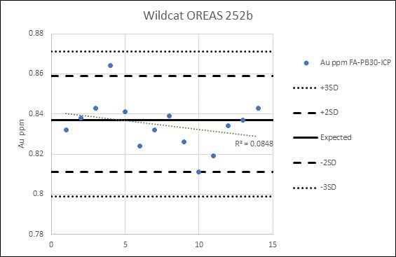
Figure supplied by Integra, June, 2023.
Figure 11.2
Graph of Blank Performance at Wildcat
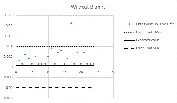
Figure supplied by Integra, June, 2023.
11.3.1.3 Wildcat Duplicate Field Samples
A total of 107 duplicate field samples were assayed at AAL for the Wildcat Project. A duplicate field sample for the 2022 core drilling programed is defined as a split of the large crush or reject sample. Figure 11.3 shows the performance of the field duplicate samples at the Wildcat Project graphically, with a high correlation between the original and duplicate sample. The mean of the duplicates (0.35317 Au g/t) is nearly identical to that of the original samples (0.35305 Au g/t).
Figure 11.3
Graph of Field Duplicate Performance at the Wildcat Project
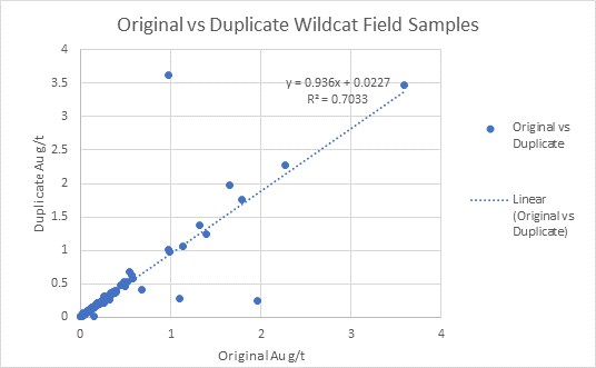
Figure supplied by Integra, June, 2023.
11.3.2 Mountain View Project QA/QC Program
11.3.2.1 Mountain View Project, Certified Reference Materials (Standards)
For the Mountain View Project, a total of 212 standards were analyzed at AAL for an insertion rate of 5.8% in the 2022 Mountain View core drilling program. Seven different CRMs from OREAS were used (Table 11.4).
Table 11.4
Standards used by Millennial for the 2021-2022 Mountain View Project Core Drilling Program
Certified Reference Material Identity | Number of Samples Used |
OREAS 231 | 9 |
OREAS 250b | 70 |
OREAS 252b | 48 |
OREAS 254b | 32 |
OREAS 262 | 1 |
OREAS 602b | 32 |
OREAS 603b | 20 |
Total: | 212 |
Table supplied by Integra, June, 2023.
The 2022 average results of the standards for the Mountain View Project are all within ±2.1% of the expected values (Table 11.5). One standard fell outside of -3SD of the accepted value, OREAS 250b (Figure 11.4). The standard that was outside ±3SD was rerun along with all samples on that assay certificate and the rerun assays were imported into the database.
Table 11.5
AAL Results of Standards used by Millennial for the 2021-2022 Drilling Program at Mountain View Program
CRM | Count | Expected Gold (ppm) | Observed Gold (ppm) | Percent of Expected (%) |
Average | SD | Average | SD |
OREAS 231 | 9 | 0.542 | 0.015 | 0.541 | 0.541 | 99.8% |
OREAS 250b | 70 | 0.332 | 0.011 | 0.325 | 0.325 | 97.9% |
OREAS 252b | 48 | 0.837 | 0.028 | 0.829 | 0.829 | 99.0% |
OREAS 254b | 32 | 2.53 | 0.061 | 2.494 | 2.494 | 98.6% |
OREAS 262 | 1 | 0.099 | 0.004 | 0.103 | N/A | N/A |
OREAS 602b | 32 | 2.29 | 0.094 | 2.285 | 2.285 | 99.8% |
OREAS 603b | 20 | 5.21 | 0.209 | 5.182 | 5.182 | 99.5% |
Total: | 212 | Weighted Average: | 98.3% |
Table supplied by Integra, June, 2023.
Figure 11.4
Example of AAL Results for Standard OREAS 250b for the Mountain View 2021 and 2022 Drill Program

Figure supplied by Integra, June, 2023.
11.3.2.2 Mountain View Project, Blank Samples Performance at AAL
A total of 101 blanks were submitted to AAL with the Mountain View Project drilling samples, for an insertion rate of 2.8%. Table 11.6 summarizes the performance of the blanks at Mountain View and Figure 11.5 shows the results graphically. Eight samples, or 7.9% of blanks, fell outside the overlimit of 0.01 g/t Au. Batches with blanks over the limit were rerun and deemed acceptable before being imported into the database.
Table 11.6
Summary of Blank Performance at Mountain View Project
Description | Results |
Total Blanks | 101 |
Maximum Au g/t | 0.074 |
Minimum Au g/t | 0.0015 |
QC Failures (# and %) | 8 and 7.9% |
Table supplied by Integra, June, 2023.
Figure 11.5
Graph of Blank Performance at Mountain View Project
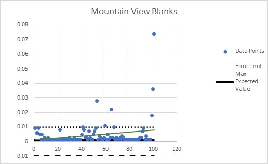
Figure supplied by Integra, June, 2023.
11.3.2.3 Mountain View Project, Duplicate Field Samples
A total of 200 duplicate field samples were assayed at AAL for the Mountain View Project. Figure 12.7 shows the performance of these field duplicate samples at graphically, with an acceptable correlation between the original and duplicate assays. The mean of the duplicates (0.215 Au g/t) is very close to that of the original sample (0.229 Au g/t).
Figure 11.6
Graph of Duplicate Performance at Mountain View Project
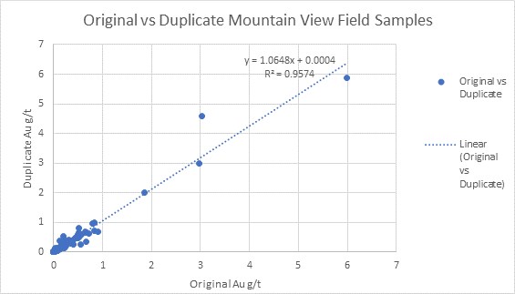
Figure supplied by Integra, June, 2023.
11.4 Micon QP Comments
Micon's QP reviewed the QA/QC programs prior to the 2022 site visit and again during the site visit. Micon's QP believes that the QA/QC programs were performed according to the best practices for exploration programs as outlined by CIM standards. Therefore, Micon's QP believes that the QA/QC program has produced results which can be used to support the mineral resource estimate that is contained in Section 14 of this report and that the mineral resource estimate can be used as the basis of the PEA which is disclosed in this Technical Report.
12.0 DATA VERIFICATION
12.1 Site Visit
The most recent site visit by Micon's QP to the Wildcat and Mountain View properties was completed between August 23 and August 26, 2022. The Wildcat Project was visited on August 24, 2022, and the Mountain View Project was visited on August 25, 2022. The site visit was conducted by William Lewis who is a Senior Geologist for Micon and an independent QP for the purposes of NI 43-101. During the site visit, Mr. Lewis was accompanied by Aaron Hagglof, a representative of Millennial.
During the site visit, Mr. Lewis focussed his inspection on the verification of drilling methodology and procedures, drill logging and sampling procedures and the QA/QC procedures. Logging procedures and sampling of the core were discussed along with the insertion of standards, blanks and duplicate samples. A number of samples from the Wildcat and Mountain View Projects were chosen for independent reassaying, under Micon's control.
Drilling was on going at the Wildcat Project at the time of the site visit and the drilling progress at Hole WCCD-0012 was observed (Figure 12.1). In addition, discussions were held regarding the general exploration program on the Wildcat property and the results that were being obtained from the wider mapping and sampling programs. The drilling at the Mountain View Project had ceased by the time of the site visit, but the locations of the drill holes were observed, along with the general conditions of the drill sites.
Figure 12.1
Drilling WCCD-0012 at the Wildcat Project August, 2022 Site Visit
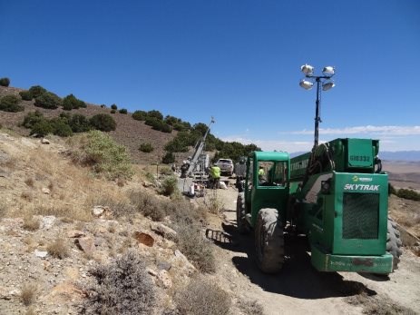
Micon August, 2022 site visit.
During the 2022 site visit, Mr. Lewis spent part of the time at Millennial's coreshack facilities (Figure 12.2), where core logging and sampling procedures were reviewed. The facilities are well laid out with ample room for logging sampling and storage of core boxes and reject/pulp samples (Figure 12.3).
Figure 12.2
Millennial Coreshack at the time of Micon's Site Visit in August, 2022
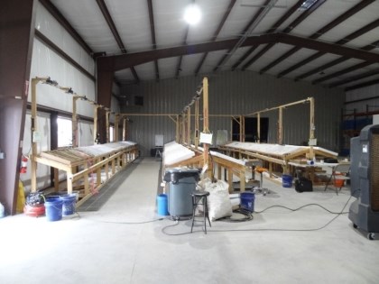
Micon August, 2022 site visit.
Figure 12.3
Millennial Storage of Pulp Samples
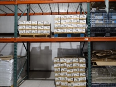
Micon August, 2022 site visit.
Figure 12.4 is a view of Wildcat drill hole WCCD-0005, which still had to be surveyed and rehabilitated at the time of the site visit.
Figure 12.4
Site of Wildcat Drill Hole WCCD-0005
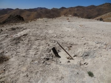
Micon August, 2022 site visit.
Figure 12.5 is a view of drill hole MVCD-0021 at the Mountain View Project.
Figure 12.5
View of Mountain View Drill Hole MVCD-0021
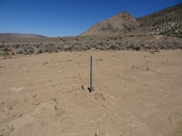
Micon August, 2022 site visit.
Figure 12.6 is a view of the Wildcat Project from the approach on its access road and Figure 12.7 is a view of the Mountain View Project from drill hole MVCD-0021.
Figure 12.6
View of the Wildcat Project from the Access Road
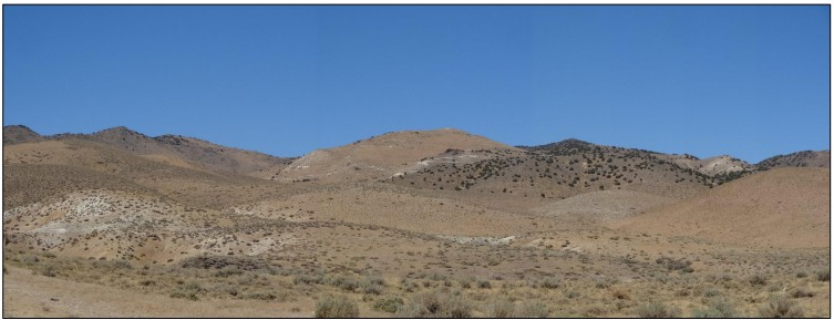
Micon August, 2022 site visit.
Figure 12.7
View of the Mountain View Project from Drill Hole MVCD-0021
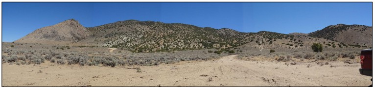
Micon August, 2022 site visit.
During the 2022 site visit, Mr. Lewis reviewed the drill hole sampling results for the Wildcat and Mountain View Projects. He chose a total of 21 pulp and reject samples distributed between both Projects to be sent from the original laboratory AAL to Bureau Veritas for check sampling.
Tables 12.1 and Table 12.2 identify the Wildcat and Mountain View Project drill samples chosen by Mr. Lewis for check assaying. However, during the collection of the Mountain View samples, it was found that two samples from among those chosen had already been sent for metallurgical testing and these were replaced by two other samples, as indicated in Table 12.2.
Table 12.3 summarizes the comparison between the original assay from AAL and the Bureau Veritas check reassays. The comparison is also graphically shown in Figure 12.8.
In general, except for two reassay samples which resulted in much higher grades during the run for screen metallics, the grade trends are similar. The similarity in grade trends allows the QP to conclude that the original assays derived from the drilling programs are of sufficient accuracy to be used in a mineral resource estimate upon which to base further economic studies for the Wildcat and Mountain View Projects.
12.2 Database Review for the Wildcat and Mountain View Projects
Micon's QP has reviewed the database for both the Wildcat and Mountain View Projects, with the review limited to the essential information required for undertaking a mineral resource estimate such as the collar, survey, assay, lithology and composites. In general, there were no issues found with the database and it is deemed sufficient to be used as the basis of a mineral resource estimate.
Table 12.1
Wildcat Project, Drill Hole Samples Chosen for Reassaying
Drill Hole ID | From (m) | To (m) | Sample Number | Original Gold Assay (ppm) | Sample Type | QA/QC Re-Assaying |
WCCD-0004 | 104.24 | 105.77 | 174949 | 0.023 | Pulp | Re-Run |
WCCD-0003 | 41.45 | 42.98 | 170663 | 0.029 | Reject | Re-Run |
WCCD-0003 | 12.5 | 14.02 | 170585 | 0.133 | Reject | Re-Run |
WCCD-0004 | 16.03 | 16.72 | 170721 | 0.183 | Pulp | Re-Run |
WCCD-0003 | 26.21 | 27.74 | 170598 | 0.304 | Reject | Re-Run |
WCCD-0004 | 57 | 58.52 | 174911 | 0.487 | Pulp | Re-Run |
WCCD-0004 | 3.66 | 5.18 | 170705 | 0.579 | Reject | Re-Run |
WCCD-0004 | 23.47 | 24.99 | 170730 | 0.611 | Pulp | Re-Run |
WCCD-0003 | 17.07 | 17.84 | 170588 | 0.996 | Reject | Re-run/Screen Metallics |
WCCD-0004 | 18.9 | 20.27 | 170725 | 1.49 | Pulp | Re-Run |
WCCD-0004 | 40.23 | 41.76 | 170748 | 5.77 | Reject | Re-run/Screen Metallics |
WCCD-0003 | 1.83 | 3.35 | 170575 | 7.56 | Reject | Re-run/Screen Metallics |
Table 12.2
Mountain View Project, Drill Hole Samples Chosen for Reassaying
Drill Hole
ID | From (m) | To (m) | Sample
Number | Original
Gold Assay
(ppm) | Grouped
Lithology | Oxidation
Type | Notes | QA/QC Re-Assaying | Notes 2 |
MVCD-0004 | 108.81 | 110.34 | 609259 | 0.018 | Qal | Oxidized | Pulp | Re-Run | |
MVCD-0015 | 296.57 | 298.09 | 346090 | 0.08 | Andesite | Fresh | Reject | Re-Run | |
MVCD-0015 | 264.57 | 266.09 | 346060 | 0.165 | Clastic Sediments | Fresh | Reject | Re-Run | |
MVCD-0004 | 153.77 | 155.14 | 609296 | 0.299 | Rhyolite | Oxidized | Pulp | Re-Run | |
MVCD-0004 | 129.84 | 131.37 | 609275 | 0.633 | Rhyolite | Oxidized | Pulp | Re-Run | |
MVCD-0004 | 166.27 | 167.64 | 609308 | 0.965 | Rhyolite | Oxidized | Reject | Re-Run | Sent for Metallurgical |
MVCD-0015 | 241.71 | 243.23 | 346043 | 1.19 | Clastic Sediments | Fresh | Reject | Re-run/Screen Metallics | |
MVCD-0004 | 124.05 | 125.58 | 609272 | 3.59 | Rhyolite | Oxidized | Reject | Re-run/Screen Metallics | Sent for Metallurgical |
MVCD-0015 | 284.38 | 285.6 | 346079 | 6.4 | Rhyolite | Fresh | Reject | Re-run/Screen Metallics | |
MVCD-0004 | 184.5 | 185.32 | 609326 | 141.733 | Rhyolite | Oxidized | Reject | Re-run/Screen Metallics | |
MVCD-0004 | 178.92 | 179.83 | 609321 | 0.985 | Rhyolite | Oxidized | Reject | Re-run | Replacement Sample |
MVCD-0024 | 144.78 | 145.69 | 172780 | 4.04 | Rhyolite | Oxidized | Reject | Re-run/Screen Metallics | Replacement Sample |
Table 12.3
Comparison of the Original AAL Assay and the BV Re-Assay
Project | Drill Hole
Number | Sample ID | From (m) | To (m) | AAL FA* (ppm) | BV FA* (ppm) | BV Screening** (ppm) | Type |
Wildcat | WCCD-0003 | 170575 | 1.83 | 3.35 | 7.56 | 9.138 | 9.73 | Reject |
Wildcat | WCCD-0003 | 170585 | 12.5 | 14.02 | 0.133 | 0.198 | 0 | Reject |
Wildcat | WCCD-0003 | 170588 | 17.07 | 17.84 | 0.996 | 1.125 | 1.14 | Reject |
Wildcat | WCCD-0003 | 170598 | 26.21 | 27.74 | 0.304 | 0.27 | 0 | Reject |
Wildcat | WCCD-0003 | 170663 | 41.45 | 42.98 | 0.029 | 0.044 | 0 | Reject |
Wildcat | WCCD-0004 | 170721 | 16.03 | 16.72 | 0.183 | 0.206 | 0 | Pulp |
Wildcat | WCCD-0004 | 170725 | 18.9 | 20.27 | 1.49 | 1.662 | 0 | Pulp |
Wildcat | WCCD-0004 | 170730 | 23.47 | 24.99 | 0.611 | 0.643 | 0 | Pulp |
Wildcat | WCCD-0004 | 170748 | 40.23 | 41.76 | 5.77 | 5.128 | 4.36 | Reject |
Wildcat | WCCD-0004 | 174911 | 57 | 58.52 | 0.487 | 0.555 | 0 | Pulp |
Wildcat | WCCD-0004 | 174949 | 104.24 | 105.77 | 0.023 | 0.022 | 0 | Pulp |
Mountain View | MVCD-0024 | 172780 | 144.78 | 145.69 | 4.04 | 4.629 | 2.7 | Reject |
Mountain View | MVCD-0015 | 346043 | 241.71 | 243.23 | 1.19 | 1.082 | 643.62 | Reject |
Mountain View | MVCD-0015 | 346060 | 264.57 | 266.09 | 0.165 | 0.17 | 0 | Reject |
Mountain View | MVCD-0015 | 346090 | 296.57 | 298.09 | 0.08 | 0.066 | 0 | Reject |
Mountain View | MVCD-0015 | 346179 | 390.45 | 391.52 | 0.005 | <0.005 | 0 | Pulp |
Mountain View | MVCD-0004 | 609259 | 108.81 | 110.34 | 0.018 | 0.018 | 0 | Pulp |
Mountain View | MVCD-0004 | 609275 | 129.84 | 131.37 | 0.633 | 0.598 | 0 | Pulp |
Mountain View | MVCD-0004 | 609296 | 153.77 | 155.14 | 0.299 | 0.283 | 0 | Pulp |
Mountain View | MVCD-0004 | 609321 | 178.92 | 179.83 | 0.985 | 0.537 | 0 | Pulp |
Mountain View | MVCD-0004 | 609326 | 184.5 | 185.32 | 141.733 | 0.587 | 428.04 | Reject |
Notes:
*FA = Fire Assay.
**Screening = Screen Metallic Assays.
Figure 12.8
Comparison between the Original Assay from AAL and the Bureau Veritas Check Re-Assays
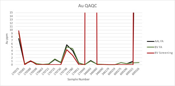
13.0 MINERAL PROCESSING AND METALLURGICAL TESTING
This section summarizes the metallurgical testing performed on samples obtained from the Wildcat and Mountain View Projects prior to Millennial's merger with Integra. Recent testwork programs have been completed using various samples of mineralization selected from both Projects. The test programs, which were undertaken by McClelland Laboratories, Inc. (McClelland), of Sparks, Nevada, were designed to provide metallurgical design criteria for the PEA.
The QP for this section of the report is Richard Gowans, P.Eng., Principal Metallurgist at Micon. Mr. Gowans has reviewed the available historical data and Millennial's selection of metallurgical samples used for the metallurgical testwork programs. The QP oversaw the metallurgical testwork completed by McClelland.
13.1 Wildcat Project
13.1.1 Historical Testwork
Cyanide leach amenability shaker tests, bottle rolls and column cyanide leach tests were conducted on mineralized samples from the Wildcat Project by Dawson Metallurgical Laboratories (Dawson) of Utah, Heinen Lindstrom Consultants (Heinen Lindstrom), McClelland and Bondar-Clegg Laboratories. A description of these testwork programs, which was derived mainly from the 2006 MDA Technical Report, is summarized in Table 13.1.
Table 13.1
Summary of Historical Metallurgical Testwork
Laboratory | Method | Duration | Sample Type | Rock
Type | Redox | Number of
Samples | Material Size |
Weight | Particle
Size |
Dawson, 1983 | bottle roll | 48 hrs | drill core composite | unknown | unknown | 1 | 100 g | -200-mesh |
Heinen-Lindstrom. 1985 | bottle roll | 48 hrs | surface | Tv | oxide | 1 | 1,000 g | -6.5 mm -35 mesh -100 mesh |
column test | 34 days | surface | Tv | oxide | 1 | 86 kg | -16 mm |
Bondar-Clegg, 1993 | cold shaker leach | 24 hrs | RC drill intervals | Tv, Kg | oxide & sulphide | 276 | 30 g | -150-mesh |
McClelland, 1993 | bottle roll | 96 hrs | RC drill composite | Tv, Kg | oxide and sulphide | 8 | 1,000 g | -140-mesh |
Hycroft 2013 | column test | 197 days | drill core composite | unknown | unknown | 1 | unknown | -25 mm -9.5 mm |
Note: Tv= tertiary volcanics, Kg = granodiorite.
The cold shaker cyanide tests indicated that the oxidized mineralization is generally amenable to cyanide leaching, with about 80% of gold extraction in 24 hours. The sulphide dissolution of gold was about half that of the oxide.
Bottle roll tests tended to show higher gold extraction with finer grinding. The bottle roll tests completed by McClelland in 1993 used "as received" RC drill cuttings (nominally -140 mesh (0.105 mm)). The results from 96-hour gold leach extractions for granodiorite and volcanics oxide, and granodiorite sulphide cuttings composites, ranged from 56% to 75%. Silver recoveries ranged from 30% to 56%. The sulphide volcanics samples tended to be less amenable to cyanidation, with gold leach extractions of between 8% and 46%, and silver recoveries between 18% and 29%.
In general, all of the bottle roll tests exhibited rapid gold extractions, with most of the recovery occurring within the first 12 hours of the tests. Silver recoveries were slower. Cyanide consumptions were low for all composites tested, ranging between 0.05 and 0.20 kg/t of NaCN, while lime consumption was 4 to 18 kg/t of lime.
The 1985 Heinen-Lindstrom column test using a mineralized surface sample and a nominal 16 mm crush size recovered between 50% and 69% of the gold in 34 days.
A more recent column test undertaken by Hycroft Resources & Development Group (a subsidiary of Allied Nevada Gold Corp), showed total gold extractions after 197 leach days of 66% and 45%, for -9.5 mm and -25 mm crushed material, respectively.
13.1.2 2022/23 McClelland Testwork
The PEA testwork program completed by McClelland in 2023 comprised column leach tests using four drill core composites, variability bottle roll leach tests on 43 drill core samples, standard crusher work index and abrasion index tests and preliminary gravity separation tests. The program also included multi-element chemical analyses and mineralogical characterization of the test column composites.
13.1.2.1 Sample Provenance and Characterization
Samples for metallurgical testing were selected by Millennial personnel. The selection criteria included main mineralization-types, oxidation, location and gold grade. These samples included broken mineralized drill core used for the column leach tests, assay rejects used for variability bottle roll leach tests and broken drill core for crusher index testing. The locations of the Wildcat metallurgical samples are provided in Figure 13.1.
Column Leach Test Composite Samples
The four heap leach composite samples included the following:
Composite 4832-001, high gold grade oxide granodiorite, average direct assay 1.94 g/t Au, 17 g/t Ag, 0.06% S (sulphide). Thirty-five samples from drill hole WCCD-0003 weighing 238 kg.
Composite 4832-002, medium gold grade oxide rhyolitic volcaniclastics, average direct assay 0.75 g/t Au, 8 g/t Ag, 0.02% S (sulphide). Thirty-eight samples from drill hole WCCD-0004 weighing 249 kg.
Composite 4832-003, low gold grade oxide rhyolitic volcaniclastics, average direct assay 0.36 g/t Au, 2 g/t Ag, 0.12% S (sulphide). Fouty-seven samples from drill hole WCCD-0006 weighing 368 kg.
Composite 4832-004, sulphide granodiorite, average direct assay 0.64 g/t Au, 5 g/t Ag, 1.07% S (sulphide). Thirty-four samples from drill hole WCCD-0004 weighing 298 kg.
Figure 13.1
Wildcat Metallurgical Samples Locations

Figure supplied by Integra, June, 2023.
The composites were selected to encompass the main mineralized ore-types that make up the Wildcat mineral resources and a range of gold grades. Micon's QP understands that oxide rhyolite volcaniclastic makes up approximately 90% of the mineralization, while the remaining 10% comprises mainly oxide granodiorite.
The four composites that were prepared for the column tests were selected by the geology team from continuous drill hole samples. Two oxide composites were prepared for the rhyolite (both within the oxide material) and two composites were prepared for the granodiorite (one oxide, one fresh).
Multi-element analyses of the four composite head samples are presented in Table 13.2 and the whole rock analyses in Table 13.3.
The results of the XRD results on the four samples are summarized in Table 13.4.
Table 13.2
Wildcat Project, Metallurgical Composite Selected Analyses
Analyte | Units | 4832-001 | 4832-002 | 4832-003 | 4832-004 |
As | mg/kg | 631 | 150.5 | 328 | 573 |
Bi | mg/kg | 0.87 | 0.17 | 0.17 | 0.50 |
C(organic) | % | 0.03 | 0.05 | 0.04 | 0.06 |
Cd | mg/kg | <0.02 | 0.03 | 0.03 | 0.09 |
Co | mg/kg | 1.0 | 1.1 | 0.4 | 9.8 |
Cr | mg/kg | 45 | 12 | 13 | 44 |
Cu | mg/kg | 11.9 | 10.6 | 5.1 | 25.6 |
Fe | % | 1.86 | 0.69 | 1.04 | 2.62 |
Hg | mg/kg | 1.47 | 0.93 | 0.93 | 0.84 |
Mo | mg/kg | 8.48 | 18.10 | 4.79 | 5.23 |
Ni | mg/kg | 1.4 | 0.9 | 1.4 | 12.9 |
Pb | mg/kg | 8.6 | 14.0 | 19.6 | 7.7 |
S(total) | % | 0.51 | 0.13 | 0.46 | 1.32 |
S(sulphide) | % | 0.06 | 0.02 | 0.12 | 1.07 |
S(sulphate) | % | 0.46 | 0.11 | 0.34 | 0.25 |
Sb | mg/kg | 44.0 | 36.2 | 26.6 | 44.4 |
Se | mg/kg | 2 | 1 | 1 | 3 |
Sr | mg/kg | 101.0 | 110.5 | 75.5 | 203 |
Te | mg/kg | 0.12 | 0.07 | <0.05 | <0.05 |
V | mg/kg | 60 | 11 | 5 | 83 |
W | mg/kg | 46.2 | 6.5 | 5.6 | 24.3 |
Zn | mg/kg | 6 | 7 | 12 | 47 |
Source: McClelland Labs, Heap Leach Testing Report.
Table 13.3
Column Metallurgical Composite Whole Rock Analyses
Analyte | 4832-001 (%) | 4832-002 (%) | 4832-003 (%) | 4832-004 (%) |
SiO2 | 73.00 | 84.52 | 78.59 | 64.82 |
Al2O3 | 11.82 | 7.54 | 9.84 | 14.84 |
Fe2O3 | 2.61 | 1.02 | 1.44 | 3.64 |
CaO | 0.10 | 0.08 | 0.05 | 2.03 |
MgO | 0.55 | 0.16 | 0.09 | 1.54 |
Na2O | 0.32 | 0.16 | 0.39 | 1.41 |
K2O | 4.06 | 4.66 | 6.54 | 3.27 |
TiO2 | 0.43 | 0.11 | 0.14 | 0.54 |
MnO | <0.01 | <0.01 | 0.01 | 0.05 |
SrO | <0.01 | <0.01 | 0.01 | 0.02 |
BaO | 0.08 | 0.07 | 0.11 | 0.09 |
Cr2O3 | 0.01 | <0.01 | <0.01 | <0.01 |
P2O5 | 0.142 | 0.037 | 0.022 | 0.182 |
Loss on ignition (LOI) | 5.55 | 1.55 | 2.33 | 6.14 |
SUM | 98.67 | 99.91 | 99.56 | 98.57 |
Source: McClelland Labs, Heap Leach Testing Report.
Table 13.4
Column Metallurgical Composite XRD Analyses
XRD Analysis (%) |
Mineral Name | 4832-001 | 4832-002 | 4832-003 | 4832-004 |
Jarosite | 6 | <3 | 5 | ---- |
Kaolinite | 15 | <3? | ---- | 7 |
K-feldspar | 20 | 24 | 35 | 17 |
Mica/Illite | 8 | <3? | <5 | 7 |
Plagioclase Feldspar | <5 | <3 | ---- | 18 |
Pyrite | | | ---- | <2 |
Quartz | 40 | 65 | 53 | 26 |
Smectite | <5? | ----- | ---- | 20 |
"Unidentified" | <5 | <5 | <5 | <5 |
XRD Clay Analysis |
-2µm Material | 9.4 | 3.4 | 14 | 19 |
Kaolinite | 25 | <3 | ---- | 14 |
K-feldspar | 11 | 36 | 10 | <3 |
Mica/Illite | 18 | <3 | 85 | 5 |
Quartz | 5 | 57 | <5 | <5 |
Sepiolite | <5? | ----- | | |
Plagioclase Feldspar | | | ---- | <3 |
Smectite | 36 | ----- | ---- | 73 |
"Unidentified" | <5 | <5 | <5 | <5 |
Source: McClelland Labs, Heap Leach Testing Report, Mineral Lab Report No.222191.
XRD analyses showed that the column composites comprised mainly quartz and feldspar. Significant amounts of clays were detected, including illite, kaolinite and smectite. Composite 4832-004 contained about 20% smectite which suggests a high risk of permeability problems and ponding during column tests.
Bottle Roll Variability Samples
A total of 43 assay rejects samples weighing approximately 7 to 21 kg each, were selected by Millennial geologists to test the leaching amenability variability of the mineralization at Wildcat. These samples were prepared by McClelland to obtain triplicate head assay samples, 1 kg of as-received material (approximately -1.7 mm) and 1 kg of ground sample (80% passing 75µm) for bottle roll tests.
The forty-three bottle roll test samples (31 from 2022 drilling and 12 from historical drilling) were selected to represent a range of gold grades and to represent two lithologies; the rhyolite (35 samples) and Cretaceous granodiorite (8 samples). The volcaniclastic rhyolite-lapilli tuff is variably silicified, can have local sepiolite, illite, kaolinite, and smectite clay alteration, and is frequently brecciated. Granodiorite mineralization is equi-granular and composed of biotite, hornblende, plagioclase, potassium feldspar and anhedral quartz. The granodiorite can be silicified and can have clay alteration. A total of 31 samples were described as oxides, 5 as transitional and 7 as fresh (sulphide).
A summary of the variability sample average gold, silver and sulphide-sulphur analyses is included in Table 13.5. This table also describes the oxidation state and lithology of the samples, which were provided by Millennial geologists.
Table 13.5
Bottle Roll Metallurgical Variability Samples Gold, Silver and Sulphide Analyses
Sample | Oxidation | Lithology1 | Average Gold
Assay (g/t) | Average Silver
Assay (g/t) | Sulphide
Sulphur (%) |
WC22-BR-003 | Oxidized | RV | 0.71 | 2.93 | 0.04 |
WC22-BR-004 | Oxidized | RV | 0.52 | 1.40 | 0.73 |
WC22-BR-005 | Oxidized | RV | 0.75 | 4.93 | 0.03 |
WC22-BR-006 | Oxidized | RV | 0.48 | 2.20 | 0.02 |
WC22-BR-007 | Oxidized | RV | 0.51 | 22.00 | 0.03 |
WC22-BR-008 | Oxidized | G | 0.51 | 3.20 | 0.06 |
WC22-BR-009 | Sulphide | RV | 0.79 | 3.67 | 0.24 |
WC22-BR-010 | Sulphide | RV | 0.76 | 2.23 | 1.01 |
WC22-BR-011 | Oxidized | RV | 0.73 | 13.33 | 0.24 |
WC22-BR-012 | Sulphide | G | 0.15 | 1.07 | 0.44 |
WC22-BR-013 | Oxidized | RV | 0.23 | 3.07 | 0.03 |
WC22-BR-014 | Oxidized | RV | 0.14 | 0.93 | 0.78 |
WC22-BR-015 | Oxidized | G | 1.29 | 21.67 | 0.03 |
WC22-BR-016 | Oxidized | G | 0.74 | 14.33 | 0.03 |
WC22-BR-017 | Sulphide | RV | 0.19 | 1.17 | 0.68 |
WC22-BR-018 | Oxidized | RV | 0.30 | 3.13 | 0.01 |
WC22-BR-019 | Oxidized | RV | 1.73 | 7.43 | 0.17 |
WC22-BR-020 | Transitional | G | 1.09 | 12.00 | 0.96 |
Sample | Oxidation | Lithology1 | Average Gold
Assay (g/t) | Average Silver
Assay (g/t) | Sulphide
Sulphur (%) |
WC22-BR-021 | Sulphide | G | 1.02 | 4.37 | 1.11 |
WC22-BR-022 | Sulphide | G | 0.16 | 2.00 | 0.84 |
WC22-BR-023 | Oxidized | RV | 0.54 | 4.97 | 0.04 |
WC22-BR-024 | Oxidized | RV | 0.45 | 3.63 | 0.05 |
WC22-BR-025 | Oxidized | RV | 0.77 | 2.87 | 0.01 |
WC22-BR-026 | Transitional | RV | 1.51 | 16.00 | 2.85 |
WC22-BR-027 | Sulphide | R | 0.27 | 2.80 | 0.93 |
WC22-BR-028 | Oxidized | RV | 0.49 | 5.40 | 0.09 |
WC22-BR-029 | Oxidized | RV | 1.39 | 2.37 | 0.11 |
WC22-BR-030 | Oxidized | RV | 0.32 | 1.67 | 0.01 |
WC22-BR-031 | Transitional | RV | 0.23 | 1.20 | 0.45 |
WC22-BR-032 | Oxidized | RV | 0.23 | 2.07 | 0.01 |
WC22-BR-033 | Oxidized | RV | 0.74 | 5.43 | 0.01 |
WC22-BR-034 | Oxidized | G | 0.46 | 4.23 | 1.07 |
WC22-BR-035 | Oxidized | RV | 0.75 | 8.03 | 0.20 |
WC22-BR-036 | Oxidized | RV | 0.37 | 3.50 | 0.01 |
WC22-BR-037 | Oxidized | RV | 0.20 | 1.03 | 0.32 |
WC22-BR-038 | Transitional | RV | 1.12 | 5.00 | 1.16 |
WC22-BR-039 | Oxidized | RV | 0.42 | 4.10 | 0.01 |
WC22-BR-040 | Oxidized | RV | 0.91 | 10.33 | 0.26 |
WC22-BR-041 | Oxidized | RV | 0.20 | 2.03 | 0.01 |
WC22-BR-042 | Oxidized | RV | 0.31 | 2.77 | 0.14 |
WC22-BR-043 | Oxidized | RV | 0.48 | 4.03 | 0.01 |
WC22-BR-044 | Oxidized | RV | 0.69 | 4.97 | 0.26 |
WC22-BR-045 | Sulphide | RV | 0.78 | 7.40 | 0.98 |
1 Lithology: R=Rhyolite, RV=Rhyolite Volcanoclastic and G=Granodiorite.
Gold and silver head grades of the variability samples varied from 0.14 to 1.79 g/t Au (average 0.61 g/t) and 1.0 to 23 g/t Ag (average 5.4 g/t).
Sulphide sulphur content varied between <0.01% to 2.85%, with the highest values tending to be in the transitional ore type samples. Three samples categorized as oxidized (WC22-BR-004, 014 and 034) had relatively high sulphide sulphur contents (>0.5%) and may have been mistakenly classified.
The variability sample assays also included total and organic carbon, total sulphur, multi-element and classic whole rock analysis.
Carbon content was generally low for all samples, which suggests a low risk of preg-robbing, although one transitional sample (WC-BR-28) had a relatively high inorganic carbon content (2.5%) and one oxide sample had an elevated organic carbon content (1.2%).
The ICP multi-element scan showed that copper content was typically low, averaging 10 g/t, mercury between 0.05 and 20 g/t, and arsenic typically below 500 g/t, although two sulphide samples were above 1,000 g/t.
A total of 61 pieces of broken drill core comprising different ore-types found within the deposit were selected by Millennial for crusher work index determinations.
The QP considers that the metallurgical samples are representative of the mineralization occurring at the Wildcat deposit.
13.1.3 Wildcat Project, Metallurgical Testing
13.1.3.1 Comminution Tests
The average Bond crusher work index test results using 61 drill core samples was approximately 7.8 kWh/t (metric). The average results for the four categorized ore-types ranged from 6.5 to 9.4 kWh/t. All ore-types were classified as "very soft".
The standard Bond abrasion index was determined for each of the four column composite samples. Granodiorite composites 4832-001 and 004 were classed as "moderately abrasive" with abrasive index values about 0.2 g, while the rhyolite volcanoclastic samples (4832-002 and 003) were classified as "very abrasive" with abrasive index values around 0.4 g.
13.1.3.2 Bottle Roll Leach Testing
Standard bottle roll leach tests were completed on each of the four column test composites, at feed sizes of 80% passing (P80) 9.5 mm and 75 µm, as well as each of the 43 variability samples at as-received sizing (about -1.7 mm) and a P80 of 75 µm. Tests were undertaken by McClelland to obtain preliminary information on the cyanide heap and agitation leach amenability of a range of different ore-types, and the influence of crush/grind size and leach residence time.
The conditions for the kinetic leach tests included pulp density of 40 wt.% solids, pH of 11.0 with hydrated lime addition and sodium cyanide concentration of 1.0 g/L NaCN. All samples with a P80 of 75 µm were operated continuously for 72 hours, with brief stoppages at predetermined intervals for sampling, while the coarse samples were leached for 96 hours, with intermittent 1 minute rolling per hour to minimize sample breakage.
These leach test results for the column test composite samples are summarized in Table 13.6. As expected, gold and silver extractions were significantly higher for the fine grind tests, compared to the P80 19.5 mm tests, although 77% gold extraction was achieved for coarse crush sample 4832-002. The sulphide sample (4832-004) tests gave low gold extractions, even with fine grinding, suggesting that the gold in this sample was "refractory".
Table 13.6
Summary of Column Composite Sample Bottle Roll Leach Test Results
Sample | Target P80 Size, mm | Gold Head Grade (g/t) | Silver Head
Grade (g/t) | Final Extraction | NaCN Consumption | Lime Addition |
Calc. | Assay | Calc. | Assay | Au (%) | Ag (%) | kg/t | Kg.t |
4832-001 | 9.5 | 1.45 | 1.94 | 17 | 17 | 30.3 | 17.8 | <0.07 | 4.6 |
4832-001 | 0.075 | 1.31 | 1.94 | 13 | 17 | 85.5 | 75.4 | 0.97 | 4.7 |
4832-002 | 9.5 | 0.61 | 0.75 | 8.9 | 8.1 | 77.0 | 22.5 | <0.07 | 0.8 |
4832-002 | 0.075 | 0.72 | 0.75 | 9.3 | 8.1 | 91.7 | 61.3 | 0.27 | 1.5 |
4832-003 | 9.5 | 0.39 | 0.36 | 2.3 | 2.3 | 51.3 | 13.0 | <0.07 | 1.1 |
4832-003 | 0.075 | 0.24 | 0.36 | 1.4 | 2.3 | 70.8 | 50.0 | 0.40 | 1.4 |
4832-004 | 9.5 | 0.54 | 0.60 | 3.8 | 4.7 | 13.0 | 13.2 | 0.10 | 1.6 |
4832-004 | 0.075 | 0.41 | 0.60 | 3.1 | 4.7 | 26.8 | 35.5 | 0.42 | 2.2 |
The gold and silver extractions for the variability bottle roll tests are presented in Figure 13.2 for the 43 as-received -1.7 mm samples and Figure 13.3 for the P80 75 µm ground samples.
Figure 13.2
-1.7 mm Variability Bottle Roll Tests - Au and Ag Recovery versus Sulphide Sulphur Content
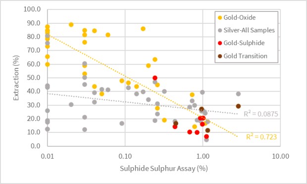
Figure 13.3
P80 75 µm Variability Bottle Roll Tests - Au and Ag Recovery versus Sulphide Sulphur Content
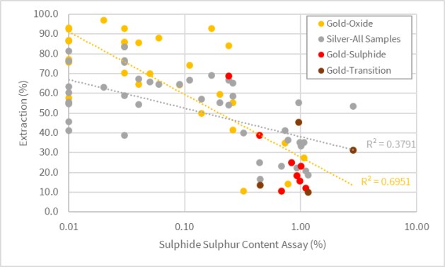
The bottle roll results presented in Figure 13.2 and Figure 13.3 show a negative trend of gold recovery with sulphide sulphur content. Both the coarse and fine-grained bottle roll tests indicated a steep drop off of gold extraction with sulphide sulphur assays higher than 0.3% S. Silver recoveries also tended to reduce with higher sulphur, although this trend was more pronounced with the P80 75 µm tests.
Table 13.7 presents the average bottle roll test results for each mineralization-type.
Table 13.7
Average Bottle Roll Leach Test Results for Each Mineralization-Type
Sample | Size | Average Head Grade | Average Extraction |
Au g/t | Ag g/t | Sulphide % | Au (%) | Ag (%) |
All Samples | P100 -1.7mm | 0.61 | 5.42 | 0.38 | 49.5 | 32.1 |
P80 75µm | 0.61 | 5.42 | 0.38 | 57.7 | 51.7 |
All Sample <0.3%S | P100 -1.7mm | 0.64 | 6.07 | 0.08 | 66.4 | 35.7 |
P80 75µm | 0.64 | 6.07 | 0.08 | 76.7 | 62.2 |
All Samples >0.3% S | P100 -1.7mm | 0.57 | 4.19 | 0.95 | 18.1 | 25.4 |
P80 75µm | 0.57 | 4.19 | 0.95 | 22.1 | 32.1 |
All Oxide | P100 -1.7mm | 0.59 | 5.61 | 0.16 | 61.2 | 35.7 |
P80 75µm | 0.59 | 5.61 | 0.16 | 69.9 | 59.3 |
Oxide - G | P100 -1.7mm | 0.75 | 10.9 | 0.30 | 52.6 | 40.3 |
P80 75µm | 0.75 | 10.9 | 0.30 | 71.8 | 64.8 |
Sample | Size | Average Head Grade | Average Extraction |
Au g/t | Ag g/t | Sulphide % | Au (%) | Ag (%) |
Oxide - RV | P100 -1.7mm | 0.57 | 4.84 | 0.13 | 62.4 | 35.0 |
P80 75µm | 0.57 | 4.84 | 0.13 | 69.6 | 58.5 |
Sulphide | P100 -1.7mm | 0.51 | 3.09 | 0.78 | 18.7 | 21.7 |
P80 75µm | 0.51 | 3.09 | 0.78 | 26.6 | 29.9 |
Transition | P100 -1.7mm | 0.99 | 8.55 | 1.36 | 21.2 | 24.6 |
P80 75µm | 0.99 | 8.55 | 1.36 | 25.1 | 36.1 |
The average results for the predominant mineralization types (oxide RV and oxide G) gave average gold extractions of 62% and 53% for -1.7 mm tests and 70% and 72% for the P80 75 µm tests, respectively. Discounting the oxide samples containing 0.3% sulphide sulphur, the average gold recoveries increased about 5% for the rhyolite samples and approximately 13% for the granodiorite material.
The classified sulphide and transition samples give average gold recoveries of around 20% for the -1.7 mm tests and about 25% for the P80 75 µm bottle rolls.
13.1.3.3 Column Leach Testing
Column leach tests were completed by McClelland on each of the four composite samples. Three crush sizes (P80 19 mm, 9.5 mm and 6.3 mm) were tested for each composite, with two additional high pressure grinding roll (HPGR) crushed tests (P80 3.4 mm and 1.7 mm) for composite 4832-003. There were 14 column tests in total. The P80 6.3 mm test samples were also produced using laboratory high pressure grinding rolls (HPGR), while conventional laboratory jaw crushers were used to prepare the two coarser test samples.
The objective of this preliminary column leach test program was to assess the amenability of the mineralization to potential heap leach technology to recovery gold and silver. The tests were prepared and operated so that data could be obtained to assess extraction rates, overall recoveries and reagent requirements.
The tests used 100 mm diameter by 3 m high columns which typically contained about 33 kg of sample, although three P80 19.5 mm tests (4832-002, 003 and 004) used 150 mm diameter columns each containing around 73 kg of sample.
Dry hydrated lime was added to all column feeds based on the bottle roll requirements and, where required, agglomeration was conducted by adding cement and water while mechanically tumbling. Aggregates were cured for 3-days in the columns prior to applying leach solution.
Leach solution, typically containing 0.5 g/l NaCN, was continuously fed to the columns at a rate of 0.20 L/min/m2 (0.005 gpm/ft2). Daily samples of pregnant solution were analyzed for Au and Ag content, cyanide concentration and pH. Pregnant solution was pumped through carbon columns to recover precious metals and the resultant barren solution was analyzed, adjusted with appropriate reagents, and recycled. Nearing the end of the leach cycle, rest periods were used to maintain higher pregnant solution tenors.
Leach solution cyanide concentration was increased on specific leach days from 0.5 to 1.0 g/L NaCN for P80 19 mm (leach day 36) and 9.5 mm (leach day 46) tests for composite 4832-003. The purpose of this adjustment was to investigate the potential of increasing recovery rates with increased cyanide solution strength.
A summary of the final column test results is presented in Table 13.8.
Table 13.8
Summary of Final Column Leach Test Results
Sample | Size (P80) | Leach/Rinse Days | Solution Applied, T sol. / t ore | Au | Ag | NaCN kg/t | Lime kg/t | Cement kg/t |
Calc. Head. g/t | Rec. % | Calc. Head g/t | Rec. % |
4832-001 | 19mm | 120 | 8.3 | 1.43 | 45.5 | 16.2 | 21.0 | 2.22 | 4.6 | - |
4832-001 | 9.5mm | 115 | 7.9 | 1.34 | 52.2 | 15.4 | 29.9 | 2.32 | 4.6 | - |
4832-001 | 6.3mm (HPGR) | 99 | 7.0 | 1.50 | 48.7 | 13.2 | 36.4 | 1.56 | - | 10 |
| | | | | | | | | | |
4832-002 | 19mm | 120 | 6.8 | 0.84 | 81.0 | 7.8 | 30.8 | 1.38 | 0.8 | - |
4832-002 | 9.5mm | 110 | 6.6 | 0.84 | 85.7 | 7.9 | 32.9 | 1.65 | 0.8 | - |
4832-002 | 6.3mm (HPGR) | 99 | 5.5 | 0.87 | 83.9 | 8.5 | 31.8 | 1.04 | - | 4 |
| | | | | | | | | | |
4832-003 | 19mm | 105 | 4.6 | 0.35 | 57.1 | 2.2 | 13.6 | 0.91 | 1.1 | - |
4832-003 | 9.5mm | 95 | 3.5 | 0.37 | 59.5 | 2.7 | 14.8 | 1.09 | 1.1 | - |
4832-003 | 6.3mm (HPGR) | 84 | 3.7 | 0.35 | 65.7 | 2.5 | 20.0 | 0.8 | 1.1 | - |
4832-003 | 3.4mm (HPGR) | 70 | 2.6 | 0.41 | 58.5 | 2.7 | 18.5 | 0.48 | - | 8 |
4832-003 | 1.7mm (HPGR) | 71 | 2.7 | 0.41 | 58.5 | 2.5 | 24.0 | 0.51 | - | 10 |
| | | | | | | | | | |
4832-004 | 19mm | 92 | 3.4 | 0.60 | 11.7 | 5.2 | 15.4 | 0.31 | - | 8 |
4832-004 | 9.5mm | 92 | 3.4 | 0.67 | 13.4 | 5.2 | 17.3 | 0.44 | - | 8 |
4832-004 | 6.3mm (HPGR) | 76 | 3.3 | 0.65 | 16.9 | 5.4 | 18.5 | 0.32 | - | 12 |
The kinetic gold recovery curves for the P80 19 mm, 9.5 mm and 6.3 mm column tests are presented in Figure 13.4, Figure 13.5 and Figure 13.6, respectively.
Gold recoveries for Composite 4832-001 (oxidized granodiorite) ranged from 46% to 52% in 99 to 120 days of leaching and rinsing. The composite was not highly sensitive to crush size and the best performance was the P80 9.5 mm test. However, there was a consistent improvement in silver extraction with smaller feed size. Compared to the other composite samples, 4832-001 had the highest cyanide consumption (1.56 to 2.32 kg/t) and required the highest lime addition (4.6 kg/t) to maintain a pH of around 10.
Figure 13.4
Column Leach Gold Recoveries - P80 19 mm
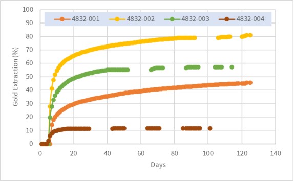
Figure 13.5
Column Leach Gold Recoveries - P80 9.5 mm
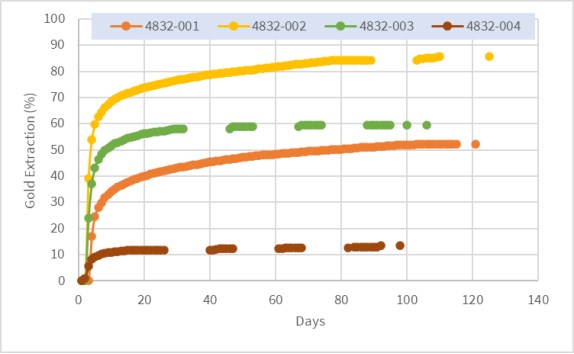
Figure 13.6
Column Leach Gold Recoveries - P80 6.3 mm (HPGR)
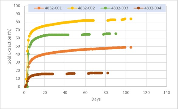
Gold recoveries for Composite 4832-002 (oxidized rhyolite volcaniclastic) ranged from 81% to 86% in 99 to 120 days of leaching and rinsing. The composite was not highly sensitive to crush size, although the best gold performance was the P80 9.5 mm test, while the silver recoveries were almost the same for all tests. Leaching was relatively rapid with about 80% gold extraction achieved in 40 days for the two smaller crush sizes, although the P80 19 mm test was slower. Compared to the other composite samples, 4832-002 had the second highest cyanide consumption (1.04 to 1.65 kg/t) but required the least lime addition (0.8 kg/t).
Gold recoveries for Composite 4832-003 (oxidized rhyolite volcaniclastic) ranged from 57% to 66% in 70 to 105 days of leaching and rinsing. The composite was not highly sensitive to crush size with respect to gold recovery, all tests from P80 19 mm to 1.7 mm achieved gold extractions of around 59%, with exception of the P80 6.3 mm test, which was 66%. Silver recoveries ranged from 14% to 24%, with better performance for P80 6.3 mm material or smaller. Leaching was relatively rapid with gold extraction essential complete after 20 days. Compared to the other composite samples, 4832-003 had the second lowest cyanide consumption (0.48 to 1.09 kg/t), lime addition was 1.1 kg/t.
Gold and silver recoveries for Composite 4832-004 (sulphide granodiorite) were low, less than 17% for Au and 19% Ag for all three tests.
Recovery by size analysis by McClelland on all column tests suggested that the oxidized samples (4832-001 to 003) would not substantially benefit from finer crushing, size fraction recoveries larger than 75 µm were all similar.
McClelland noted that there was very little slumping (typically less than 1%) during leaching for all column tests and there were no issues with solution channeling or fines migration during leaching.
Hydraulic conductivity testing showed that permeability was high for the P80 9.5 mm oxidized rhyolite vocaniclastic samples (4832-002 and 003), although it was lower for 4832-001, the oxidized granodiorite composite. These results suggest oxidized granodiorite may require cement agglomeration or blending with high permeability material.
The physical characteristics of the column leach test samples are summarized in Table 13.9.
Table 13.9
Physical Characteristics of the Wildcat Column Leach Test Samples
Composite Sample | Test No. | Feed Size | Weight
(kg) | Moisture | Bulk Density (t/m3) |
initial | Agglom. | Saturate | Retained | Initial | Final |
4832-001 | CL-1 | 80%-19mm | 32.4 | 1.3 | NA | 15.9 | 12.1 | 1.41 | 1.42 |
4832-001 | CL-2 | 80%-9.5mm | 33.2 | 1.7 | na | 21.4 | 15 | 1.47 | 1.48 |
4832-001 | CL-8 | 80%-6.3mm (HPGR) | 31.7 | 1.6 | 12.6 | 22.8 | 16.4 | 1.19 | 1.2 |
| | | | | | | | | |
4832-002 | CL-4 | 80%-19mm | 73 | 0.3 | NA | 9.1 | 7.2 | 1.43 | 1.45 |
4832-002 | CL-3 | 80%-9.5mm | 33.5 | 0.3 | NA | 11.3 | 8.2 | 1.41 | 1.42 |
4832-002 | CL-9 | 80%-6.3mm (HPGR) | 32 | ,4 | 9.9 | 16.7 | 12.2 | 1.35 | 1.36 |
| | | | | | | | | |
4832-003 | CL-5 | 80%-19mm | 71.6 | 0.8 | NA | 7.8 | 6.3 | 1.41 | 1.42 |
4832-003 | CL-7 | 80%-9.5mm | 34.5 | 0.6 | NA | 10.6 | 7.5 | 1.5 | 1.5 |
4832-003 | CL-11 | 80%-6.3mm (HPGR) | 33.2 | 0.5 | NA | 14.5 | 10.7 | 1.57 | 1.58 |
4832-003 | CL-13 | 80%-3.4mm (HPGR) | 34.8 | 0.6 | 12.8 | | | 1.21 | 1.22 |
4832-003 | CL-14 | 80%-1.7mm (HPGR) | 34.8 | 0.7 | 15.4 | | | 1.12 | 1.14 |
| | | | | | | | | |
4832-004 | CL-6 | 80%-19mm | 71 | 2.5 | 11.1 | 18.8 | 13.7 | 1.34 | 1.36 |
4832-004 | CL-10 | 80%-9.5mm | 33 | 2.3 | 12.8 | 20 | 14.5 | 1.26 | 1.27 |
4832-004 | CL-12 | 80%-6.3mm (HPGR) | 31.5 | 2.2 | 12.8 | 18.8 | 13.5 | 1.22 | 1.23 |
Source: McClelland Final Report.
The physical characteristics data showed that there was very little slumping (typically less than 1%) during leaching for all column tests and there were no issues with solution channeling or fines migration during leaching.
13.1.3.4 Other Metallurgical Tests
Additional tests completed by McClelland during this phase of metallurgical testwork included diagnostic leaching, preliminary gravity separation amenability tests and pressure oxidation tests.
Precious Metals Deportment - Diagnostic Leach Test
McClelland completed a diagnostic leach test for gold and silver deportment of composite samples 4832-001 and 003. This procedure identifies the mineral associations via wet-chemical analytical methods for gold and silver and provides an indication of potential methods for their extraction. The results for the two composite samples ground to 106 microns are shown in Table 13.10.
Table 13.10
Summary of Diagnostic Leach Test Results
Mineral Association | 4832-001 | 4832-003 |
Au (%) | Ag (%) | Au (%) | Ag (%) |
Direct cyanide soluble | 90.9 | 85.6 | 80.8 | 65.3 |
Calcite, dolomite, sulphates, pyrrhotite, iron oxides | 4.5 | 1.3 | 7.7 | 2.1 |
Pyrite, marcasite, arsenopyrite | 0.0 | 0.4 | 3.8 | 0.8 |
Carbonaceous material | 0.9 | 1.0 | 0.0 | 5.0 |
Locked in gangue | 3.6 | 11.7 | 7.7 | 26.8 |
Total | 100.0 | 100.0 | 100.0 | 100.0 |
The 4832-001 (oxidized granodiorite) composite contained nearly 91% directly cyanide soluble gold, with minor constituents associated with other minerals. Silver was 85% cyanide soluble with significant associations with gangue mineralization.
For the 4832-003 (oxidized rhyolite volcaniclastic) composite, 81% of gold was directly cyanide soluble, with significant gold associated (about 8%) with carbonates, sulphates, iron oxides and readily oxidized sulphides. Silver was 65% cyanide soluble and about 27% associated with gangue minerals.
Gravity Separation Tests
In order to determine the potential of gravity concentration to recover gold, gravity separation tests were completed using all four column composite samples. Samples were ground to P80 150 µm and fed to a laboratory 3-inch Knelson fixed bed centrifugally enhanced concentrator (MD3), the concentrate from which was cleaned using hand panning. A summary of the gravity test results is presented in Table 13.11.
Table 13.11
Summary of the Wildcat Sample Gravity Test Results
Sample | Gravity Conc. Wt.% | Cleaner Conc. Grade | Cleaner Recovery |
Au g/t | Ag g/t | Au % | Ag % |
4832-001 | 0.08 | 216 | 870 | 13.0 | 5.7 |
4832-002 | 0.14 | 26.2 | 120 | 5.4 | 2.0 |
4832-003 | 0.07 | 554 | 228 | 48.8 | 7.3 |
4832-004 | 0.08 | 25.7 | 77 | 3.2 | 1.5 |
Test results showed that composite 4832-003 responded reasonably well to gravity separation with 52% of the gold reporting to the Knelson rougher concentrate and 49% to the cleaner concentrate. McClelland noted that, despite the encouraging test result, no coarse particulate gold was identified during microscopic examination of the cleaner concentrate. The other three composites responded poorly to gravity concentration treatment.
Pressure Oxidation and Cyanidation
Pressure oxidation (POX) tests were undertaken by McClelland using column composites 4832-001 and 003 to determine if the relatively low gold extractions of these two samples were due to locking in sulphides. Samples were ground to P80 75 µm, diluted to 15 wt.% solids in acid solution (pH<2) and treated in an autoclave with oxygen for two hours at 225 °C. POX discharge solids were filtered then leached with cyanide for 72 hours.
Results for composite 4832-001 (oxidized granodiorite) gave higher gold recoveries compared to comparative untreated bottle roll tests (93% versus 85%) but lower silver recoveries, possibly due to the formation of non-soluble silver jarosite. This test suggests that about 8% of the gold is associated with carbonate or sulphide minerals.
POX tests using composite 4832-003 (oxidized rhyolite volcaniclastic) also improved the gold recovery compared to the untreated bottle roll test (87% versus 71%) but had lower silver recovery. This test infers that about 16% of the gold is locked in carbonates or sulphides.
13.2 Wildcat Project, Testwork Conclusions and Recommendations
The composite samples selected by Millennial to represent typical oxide mineralization within the Wildcat mineral resources were amenable to heap leaching. Column leach tests suggest that gold extractions of around 60% to 80% could be achieved for the predominate ore-type (oxide rhyolite volcaniclastic) under typical design conditions. Gold recoveries of about 50% from oxide granodiorite were achieved from column leach tests. Corresponding silver extractions of between 20% to 30% would be expected from oxide mineralization. Column test results using sulphide mineralization suggested that this material was not amenable to heap leaching.
Both the coarse and fine-grained bottle roll tests indicated a significant negative gold recovery versus sulphur content relationship, with a steep drop off of gold extraction with sulphide sulphur assays higher than 0.3%. Silver recoveries also tended to reduce with higher sulphur, although this trend was more pronounced with the fine grained P80 75 µm tests.
Bottle roll cyanide and lime requirements for oxide rhyolite volcaniclastic samples tested were reasonable, typically about 0.2 kg NaCN /t and 1.4 kg lime /t. However, reagent requirements for the oxide granodiorite samples were significantly higher. Corresponding cyanide consumptions for the column tests were 3 to 5 times higher, primarily due to long extended leaching times.
Hydraulic conductivity testing showed that permeability was high for the P80 9.5 mm oxidized rhyolitic vocaniclastic samples (4832-002 and 003), although it was lower for 4832-001, the oxidized granodiorite composite. This result suggest oxidized granodiorite may require cement agglomeration or blending with high permeability material.
During the column tests there was very little slumping (typically less than 1%) and there were no issues with solution channelling or fines migration during leaching.
Wildcat samples were classified as "very soft" in terms of crusher work index and "moderate to very abrasive" based on Bond abrasion index.
It is recommended that the following program of testing be undertaken during the next stage of Project development:
Additional column leaching tests to optimize conditions in terms of precious metal recovery, capital costs and operating costs.
Samples for the additional column tests should be selected to ensure that all lithologies within the mineral resources are fully represented. The known resources should also be fully spatially represented.
Further agglomeration and/or blending testwork with associated load/permeability tests should be conducted on representative samples of oxidized granodiorite.
Geochemical characterization testwork is recommended on representative feed and residue samples.
Appropriate additional comminution and hardness testing needs to be considered.
Additional variability bottle roll testwork should be undertaken to ensure that all types of mineralization within the mineral resources have been evaluated.
13.3 Mountain View Project
13.3.1 Historical Testwork
The following notes are taken from the 2002 Technical Report by Snowden:
- In 1994, Canyon carried out bottle-roll tests on twenty-two samples at Barringer Laboratories in Reno, Nevada. The samples were collected from drill holes MV93-53 as ten 20 ft composite samples from "high-grade" intercepts, and from hole MV94-54 as twelve 20 ft composites from "low-grade" intercepts. These tests were undertaken to determine the amenability of the mineralization to cyanide leaching. According to WGM (1997) the test results varied considerably, with gold recoveries ranging from about 20 to over 90%.
- In 1995, Homestake completed preliminary wet screen analyses at Kappes, Cassidy and Associates (KCA) on selected intervals from drill hole MV94-77. This testwork was completed to check for gold distribution within the sample and to test for coarse gold. The results indicated that gold reports disproportionately to the -200-mesh fraction, and that nugget effects were negligible in the samples reviewed (assaying 2.7 to 3.4 g/t Au).
13.3.2 2022/23 McClelland Testwork
The PEA testwork program completed by McClelland in 2023 for the Mountain View Project comprised column leach tests using four drill core composites, variability bottle roll leach tests on forty-three drill core samples, standard crusher work index and abrasion index tests, gravity separations tests and preliminary flotation tests using four selected sulphide variability samples. The program also included multi-element chemical analyses and mineralogical characterization of the test column composites.
13.3.2.1 Sample Provenance and Characterization
Samples for metallurgical testing were selected by Millennial geologists. The selection criteria included main ore-types, oxidation, location, and gold grade. These samples included broken mineralized drill core used for the column leach tests, assay rejects used for variability bottle roll leach tests, and broken drill core for crusher index testing. The locations of the Mountain View metallurgical samples are provided in Figure 13.7.
Figure 13.7
Mountain View Metallurgical Samples Locations
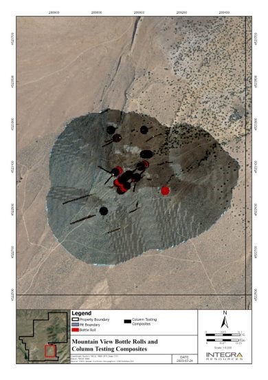
Figure supplied by Integra, June, 2023.
Mountain View Column Leach Test Composite Samples
The four heap leach composite samples included the following:
Composite 4776-001, low gold grade oxide mineralization, average direct assay 0.28 g/t Au, 3.2 g/t Ag, 0.02% S (sulphide). Forty-two samples from drill holes MVCD-0010, 0013, 0016A, 0004, 0012, 0005 and 0015, weighing 265 kg.
Composite 4776-002, medium gold grade oxide mineralization, average direct assay 0.44 g/t Au, 4.4 g/t Ag, 0.02% S (sulphide). Forty-seven samples from drill holes MVCD-0016A, 0015, 0005, 0010, 0012 and 0004, weighing 270 kg.
Composite 4776-003, high gold grade oxide mineralization, average direct assay 1.77 g/t Au, 7.6 g/t Ag, 0.02% S (sulphide). Forty-two samples from drill holes MVCD-0013, 0010, 0006, 0005, 0004, 0012, 0015, 0003 and 0008, weighing 265 kg.
Composite 4776-004, medium grade transition mineralization, average direct assay 1.18 g/t Au, 18 g/t Ag, 0.04% S (sulphide). Forty-two samples from drill holes MVCD-0015, 0016A, 0012, 0005 and 0013, weighing 260 kg.
The oxide composites were selected to provide a range of gold grades and the transition composite was selected to evaluate the metallurgical performance of material found near the oxide-sulphide boundary within the deposit. The column test material was composed mostly of rhyolitic material and tertiary alluvium (Tal).
Multi-element analyses of the four composite head samples are presented in Table 13.12and the whole rock analysis in Table 13.13.
Table 13.12
Mountain View Project, Metallurgical Composite Selected Analyses
Analyte | Units | 4776-001 | 4776-002 | 4776-003 | 4776-004 |
As | mg/kg | 64.4 | 82 | 219 | 431 |
Bi | mg/kg | 0.05 | 0.03 | 0.04 | 0.21 |
C(organic) | % | 0.04 | 0.03 | 0.04 | 0.03 |
Cd | mg/kg | 0.08 | 0.13 | 0.15 | 0.47 |
Co | mg/kg | 3.5 | 2.9 | 2.2 | 4.9 |
Cr | mg/kg | 11 | 10 | 12 | 21 |
Cu | mg/kg | 17.4 | 15 | 12 | 13.7 |
Fe | % | 1.19 | 1.18 | 1.24 | 2.24 |
Hg | mg/kg | 0.309 | 0.338 | 0.599 | 2.4 |
Mo | mg/kg | 1.98 | 2.69 | 4.57 | 5.58 |
Ni | mg/kg | 5.3 | 4 | 3.2 | 6.8 |
Pb | mg/kg | 26 | 23.7 | 23.7 | 31 |
S(total) | % | 0.03 | 0.03 | 0.04 | 0.59 |
S(sulphide) | % | 0.02 | 0.02 | 0.02 | 0.41 |
S(sulphate) | % | 0.01 | 0.01 | 0.02 | 0.18 |
Sb | mg/kg | 16.15 | 13.5 | 29.3 | 83 |
Se | mg/kg | <1 | 1 | 1 | 4 |
Sr | mg/kg | 35.6 | 28.8 | 21.5 | 51.3 |
Te | mg/kg | <0.05 | <0.05 | <0.05 | <0.05 |
V | mg/kg | 19 | 17 | 15 | 43 |
W | mg/kg | 3.5 | 6.7 | 3.7 | 13.6 |
Zr | mg/kg | 132 | 126 | 121 | 149.5 |
Zn | mg/kg | 35 | 38 | 41 | 70 |
Source: McClelland Labs, Heap Leach Testing Report.
Table 13.13
Mountain View Project, Column Metallurgical Composite Whole Rock Analyses
Analyte | 4776-001 (%) | 4776-002 (%) | 4776-003 (%) | 4776-004 (%) |
SiO2 | 75.10 | 76.22 | 77.07 | 74.12 |
Al2O3 | 12.50 | 12.00 | 11.30 | 11.50 |
Fe2O3 | 1.79 | 1.77 | 1.82 | 3.27 |
CaO | 0.27 | 0.21 | 0.14 | 0.26 |
MgO | 0.21 | 0.18 | 0.13 | 0.39 |
Na2O | 0.67 | 0.62 | 0.57 | 0.51 |
K2O | 5.69 | 5.70 | 5.93 | 6.76 |
TiO2 | 0.16 | 0.15 | 0.11 | 0.28 |
MnO | 0.02 | 0.03 | 0.04 | 0.03 |
SrO | <0.01 | <0.01 | <0.01 | <0.01 |
BaO | 0.01 | 0.01 | 0.01 | 0.03 |
Cr2O3 | <0.01 | <0.01 | <0.01 | <0.01 |
P2O5 | 0.025 | 0.022 | 0.028 | 0.082 |
Loss on ignition (LOI) | 3.06 | 2.87 | 2.38 | 2.56 |
SUM | 99.50 | 99.78 | 99.53 | 99.79 |
Source: McClelland Labs, Heap Leach Testing Report.
The XRD results on the four samples are summarized in Table 13.14.
Table 13.14
Mountain View Column Metallurgical Composite XRD Analyses
XRD Analysis (%) |
Mineral Name | 4832-001 | 4832-002 | 4832-003 | 4832-004 |
Kaolinite | 17 | 17 | 13 | 12 |
K-feldspar | 37 | 38 | 38 | 41 |
Plagioclase Feldspar | 7 | 7 | 6 | <5 |
Pyrite | ---- | ---- | ---- | <2 |
Quartz | 35 | 35 | 40 | 39 |
"Unidentified" | <5 | <5 | <5 | <5 |
XRD Clay Analysis |
-2µm Material | 11 | 10 | 15 | 8 |
Chlorite | ---- | ---- | ---- | <3? |
Kaolinite | 42 | 40 | 33 | 26 |
K-feldspar | 33 | 40 | 54 | 43 |
Mica/Illite | <5 | ---- | ---- | 10 |
Plagioclase Feldspar | ---- | <3? | ---- | ---- |
Quartz | 10 | <5 | <5 | <5 |
Smectite | 8 | 14 | 6 | 13 |
"Unidentified" | <5 | <5 | <5 | <5 |
Source: McClelland Labs, Heap Leach Testing Report, Mineral Lab Report No.222125.
XRD analyses showed that the column composites comprised mainly quartz and feldspar. Significant amounts of clays were present in all composites, mainly kaolinite but also minor smectite.
Mountain View Bottle Roll Variability Samples
A total of forty-three assay rejects samples weighing approximately 7 to 21 kg each were selected by Millennial to test the leaching amenability variability of the mineralization at Mountain View. McClelland prepared these samples to obtain triplicate head assay samples, 1 kg of as-received material (approximately -1.7 mm) and 1 kg of ground sample (80% passing 75µm) for bottle roll tests.
Millennial geologists selected the variability samples based on grade, oxidation and lithologies. Four samples were selected in the tertiary volcaniclastic alluvium (Tal) rocks described as conglomeratic and containing bomb-sized clasts of rhyolite, mafic andesitic to basaltic rocks, and other dark grey to brown sediments. Thirty-one samples were selected in the rhyolite that is variably silicified, can have local white clay alteration, and is frequently brecciated. Seven samples were selected within the volcano-sedimentary rocks (Kvs), which are estimated to be older than tertiary, medium to dark grey, can have graded bedding, matrix supported, and compositionally are andesitic to balsaltic.
The samples selected comprised 20 representing oxide mineralization, 16 in the transition zone, and six in the fresh (sulphide) rocks.
A summary of the variability sample average gold, silver and sulphide sulphur analyses is included in Table 13.15. This table also provides a description of the samples, which were provided by Millennial geologists.
Table 13.15
Mountain View Bottle Roll Metallurgical Variability Samples, Gold, Silver and Sulphide Analyses
Sample | Description1 | Average Gold Assay (g/t) | Average Silver Assay (g/t) | Sulphide Sulphur (%) |
4776-005 | LGOX-01 | 0.41 | 3.20 | < 0.01 |
4776-006 | LGOX-02 | 0.24 | 2.80 | < 0.01 |
4776-007 | LGOX-03 | 0.21 | 1.20 | < 0.01 |
4776-008 | LGOX-04 | 0.15 | 0.90 | < 0.01 |
4776-009 | LGOX-05 | 0.28 | 2.00 | < 0.01 |
Average | LGOX | 0.26 | 2.02 | 0.00 |
4776-010 | LGSU-01 | 0.16 | 2.60 | 1.73 |
4776-011 | LGSU-02 | 0.25 | 2.80 | 0.66 |
Average | LGSU | 0.21 | 2.70 | 1.20 |
4776-012 | LGTR-01 | 0.36 | 5.50 | 0.12 |
4776-013 | LGTR-02 | 0.22 | 6.60 | < 0.01 |
4776-014 | LGTR-03 | 0.17 | 1.90 | 1.10 |
Average | LGTR | 0.25 | 4.67 | 0.61 |
4776-015 | MGOX-01 | 0.43 | 2.50 | < 0.01 |
4776-016 | MGOX-02 | 0.49 | 1.40 | < 0.01 |
4776-017 | MGOX-03 | 0.53 | 3.30 | < 0.01 |
4776-018 | MGOX-04 | 0.70 | 4.80 | < 0.01 |
4776-019 | MGOX-05 | 0.36 | 4.00 | < 0.01 |
4776-020 | MGOX-06 | 0.80 | 2.50 | < 0.01 |
4776-021 | MGOX-07 | 0.50 | 8.10 | < 0.01 |
Average | MGOX | 0.54 | 3.80 | 0.00 |
4776-022 | MGSU-01 | 0.48 | 3.90 | 1.94 |
4776-023 | MGSU-02 | 5.30 | 12.00 | 3.50 |
Sample | Description1 | Average Gold
Assay (g/t) | Average Silver
Assay (g/t) | Sulphide
Sulphur (%) |
Average | MGSU | 2.89 | 7.95 | 2.72 |
4776-024 | MGTR-01 | 0.45 | 6.30 | 0.13 |
4776-025 | MGTR-02 | 0.49 | 3.20 | < 0.01 |
4776-026 | MGTR-03 | 1.12 | 6.70 | 0.55 |
4776-027 | MGTR-04 | 0.29 | 1.50 | < 0.01 |
4776-028 | MGTR-05 | 0.65 | 11.70 | 0.04 |
4776-029 | MGTR-06 | 6.96 | 6.30 | < 0.01 |
Average | MGTR | 1.66 | 5.95 | 0.24 |
4776-030 | HGOX-01 | 0.62 | 1.80 | < 0.01 |
4776-031 | HGOX-02 | 0.70 | 3.30 | < 0.01 |
4776-032 | HGOX-03 | 0.82 | 4.40 | < 0.01 |
4776-033 | HGOX-04 | 1.31 | 14.00 | < 0.01 |
4776-034 | HGOX-05 | 1.23 | 9.70 | < 0.01 |
Average | HGOX | 0.94 | 6.64 | 0.00 |
4776-035 | HGSU-01 | 1.99 | 53.00 | 0.04 |
4776-036 | HGSU-02 | 1.40 | 9.60 | 3.02 |
Average | HGSU | 1.70 | 31.30 | 1.53 |
4776-037 | HGTR-01 | 0.76 | 54.00 | 0.02 |
4776-038 | HGTR-02 | 0.48 | 31.30 | 1.55 |
4776-039 | HGTR-03 | 2.26 | 17.30 | 1.08 |
4776-040 | HGTR-04 | 1.09 | 5.30 | 0.52 |
Average | HGTR | 1.15 | 26.98 | 0.79 |
4776-041 | SHGOX-01 | 1.40 | 14.00 | < 0.01 |
4776-042 | SHGOX-02 | 1.54 | 14.00 | < 0.01 |
4776-043 | SHGOX-03 | 0.48 | 65.30 | 2.79 |
Average | SHGOX | 1.14 | 31.10 | 2.79 |
4776-044 | SHGTR-01 | 1.65 | 40.00 | 0.31 |
4776-045 | SHGTR-02 | 2.91 | 25.70 | 0.60 |
4776-046 | SHGTR-03 | 2.41 | 17.70 | 0.36 |
Average | SHGTR | 2.32 | 27.80 | 0.42 |
1, OX = oxide, TR = transition, s=sulphide, LG- low grade, MG=medium grade, HG=high grade, SHG=super high grade.
Gold and silver head grades of the variability samples varied from 0.15 to 6.96 g/t Au (average 1.07 g/t) and 0.9 to 65 g/t Ag (average 11.6 g/t).
Sulphide sulphur content varied between <0.01% to 3.50%, with the highest values tending to be in the sulphide (fresh) ore type samples.
The variability sample assays also include total and organic carbon, total sulphur, multi-element and classic whole rock analysis.
Carbon content was generally low for all samples, which suggests a minimal risk of preg-robbing, although one transitional sample (SHGTR-03) had a relatively high inorganic carbon content (4.0%).
The ICP multi-element scan showed that copper content was typically low averaging 18 g/t, mercury between 0.05 g/t and 8 g/t, and arsenic typically below 500 g/t, although five samples were above 1,000 g/t.
A total of forty-six pieces of broken drill core comprising three different ore-types found within the deposit were selected by Millennial for crusher work index determinations. These were identified as shallow rhyolite (SR), deep rhyolite (DR) and basalt/volcano sedimentary (B/VCS).
The QP considers that the metallurgical samples are representative of mineralization occurring at the Mountain View deposit.
13.3.3 Mountain View Project, Metallurgical Testing
13.3.3.1 Comminution Tests
The average Bond crusher work index test results using 46 drill core samples was approximately 5.8 kWh/t (metric). The average results for the four categorized ore-types ranged from 5.5 to 8.0 kWh/t. All ore-types were classified as "very soft."
The standard Bond abrasion index was determined for each of the four column composite samples. The oxide medium grade composite sample (4776-002) was classified as "moderately abrasive" with an index of 0.17 g while all the other three composites were classified as "abrasive", with values ranging from 0.20 to 0.30 g.
13.3.3.2 Bottle Roll Leach Testing
Standard bottle roll leach tests were completed on each of the four column test composites at feed sizes of 80% passing (P80) 9.5 mm and 75 µm, as well as each of the 42 variability samples at as-received sizing (about -1.7 mm) and a P80 of 75 µm. Tests were undertaken by McClelland to obtain preliminary information on the cyanide heap and agitation leach amenability of a range of different ore-types and the influence of crush/grind size and leach residence time.
The conditions for the kinetic leach tests included pulp density of 40 wt.% solids, pH of 11.0 with hydrated lime addition and sodium cyanide concentration of 1.0 g/L NaCN. All P80 75 µm were operated continuously for 72 hours with brief stoppages at predetermined intervals for sampling, while the coarse samples were leached for 96 hours, with intermittent 1 minute rolling per hour to minimize sample breakage.
These leach test results for the column test composite samples are summarized in Table 13.16. As expected, gold and silver extractions were significantly higher for the fine grind tests compared to the P80 19.5 mm tests. The transition sample (4776-004) tests gave lower gold extractions than the oxide composites, although the fine grind test resulted in about 88% gold extraction which suggests that the gold in this sample was not "refractory".
Table 13.16
Summary of Column Composite Sample Bottle Roll Leach Test Results
Sample | Target P80 Size, mm | Gold Head Grade (g/t) | Silver Head
Grade (g/t) | Final Extraction | NaCN Consumption | Lime Addition |
Calc. | Assay | Calc. | Assay | Au (%) | Ag (%) | kg/t | Kg.t |
4776-001 | 9.5 | 0.31 | 0.27 | 3.10 | 3.20 | 87.1 | 12.9 | 0.07 | 1.40 |
4776-001 | 0.075 | 0.27 | 0.27 | 3.30 | 3.20 | 92.6 | 33.3 | 0.08 | 0.70 |
4776-002 | 9.5 | 0.44 | 0.41 | 4.00 | 4.27 | 90.9 | 20.0 | 0.07 | 1.40 |
4776-002 | 0.075 | 0.47 | 0.41 | 4.40 | 4.27 | 95.7 | 36.4 | 0.07 | 1.10 |
4776-003 | 9.5 | 1.63 | 1.49 | 7.60 | 7.63 | 71.8 | 14.5 | 0.07 | 1.30 |
4776-003 | 0.075 | 1.91 | 1.49 | 7.30 | 7.63 | 97.9 | 39.7 | 0.60 | 0.60 |
4776-004 | 9.5 | 1.11 | 1.27 | 20.00 | 14.67 | 52.3 | 18.5 | 0.07 | 1.40 |
4776-004 | 0.075 | 1.11 | 1.27 | 16.60 | 14.67 | 88.3 | 78.3 | 0.26 | 1.00 |
The gold and silver extractions for the variability bottle roll tests are presented Figure 13.8 and Figure 13.9 for the as-received -1.7 mm samples and Figure 13.10 and Figure 13.11 for the P80 75 µm ground samples.
Figure 13.8
-1.7 mm Variability Bottle Roll Tests - Au and Ag Recovery versus Sulphide Sulphur Content
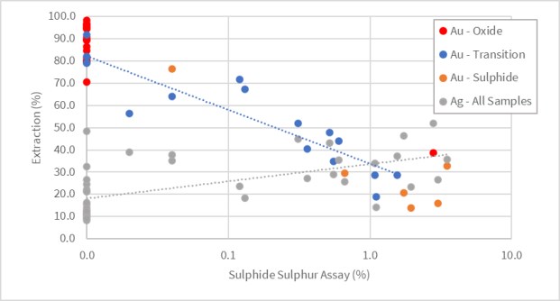
Figure 13.9
-1.7 mm Oxide Variability Bottle Roll Tests - Au and Ag Extraction versus Head Grade
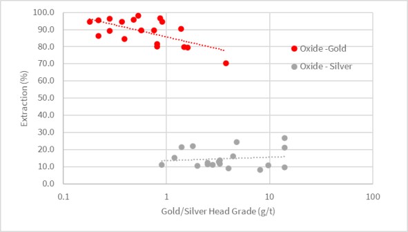
Figure 13.10
P80 75 µm Variability Bottle Roll Tests - Au and Ag Recovery versus Sulphide Sulphur Content
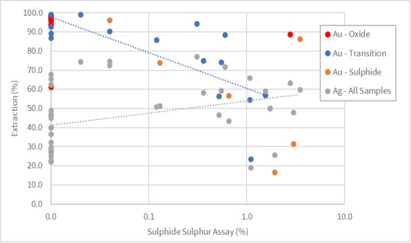
Figure 13.11
P80 75 µm Oxide Variability Bottle Roll Tests - Au and Ag Extraction versus Head Grade
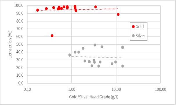
The bottle roll results presented in Figure 13.8 and Figure 13.10 show a negative trend of gold recovery with sulphide sulphur content. This relationship was more pronounced for the coarse-grained bottle roll tests than for the P80 75 µm tests. There appears to be no significant trend between silver recoveries and sulphide content.
Figure 13.9 and Figure 13.11 present the bottle roll oxide variability test gold and silver grade-recovery relationships. The gold extraction tended to reduce with higher grade for the -1.7 mm samples, while there was no significant trend for silver for coarse and fine grind tests or gold the fine ground gold tests.
Table 13.17 presents the average bottle roll test results for each mineralization-type.
The average results for the predominant oxide mineralization gave average gold and silver extractions of 89% and 15% for -1.7 mm tests and 95% and 34% for P80 75 µm tests, respectively.
The samples classified as transition give average gold recoveries of around 55% for the -1.7 mm tests and about 78% for the P80 75 µm bottle rolls. Sulphide samples give average gold recoveries of around 31% for the -1.7 mm tests and about 59% for the P80 75 µm bottle rolls.
Table 13.17
Average Bottle Roll Leach Test Results for Each Mineralization-Type
Sample | Size | Average Head Grade | Average Extraction |
Au g/t | Ag g/t | Sulphide % | Au (%) | Ag (%) |
All Samples | P100 -1.7mm | 1.07 | 11.6 | 0.48 | 66.7 | 24.1 |
P80 75µm | 1.07 | 11.6 | 0.48 | 82.6 | 46.1 |
All Oxide1 | P100 -1.7mm | 0.67 | 5.2 | <0.01 | 88.8 | 14.8 |
P80 75µm | 0.67 | 5.2 | <0.01 | 94.9 | 33.5 |
LGOX | P100 -1.7mm | 0.26 | 2.0 | <0.01 | 93.5 | 12.2 |
P80 75µm2 | 0.26 | 2.0 | <0.01 | 95.5 | 32.2 |
MGOX | P100 -1.7mm | 0.54 | 3.8 | <0.01 | 89.9 | 14.2 |
P80 75µm | 0.54 | 3.8 | <0.01 | 97.2 | 31.0 |
HGOX | P100 -1.7mm | 0.94 | 6.6 | <0.01 | 86.1 | 18.0 |
P80 75µm | 0.94 | 6.6 | <0.01 | 96.2 | 45.0 |
All Transition | P100 -1.7mm | 1.88 | 15.1 | 0.40 | 55.4 | 30.2 |
P80 75µm | 1.88 | 15.1 | 0.40 | 77.7 | 59.0 |
All Sulphide | P100 -1.7mm | 1.60 | 14.0 | 1.82 | 31.5 | 32.6 |
P80 75µm | 1.60 | 14.0 | 1.82 | 58.7 | 50.1 |
Notes: 1 Excludes SHGOX-03 with anomalous sulphide grade of 2.79% S.
2 Excludes P80 75µm test LGOX-05 due to unusually low gold recovery of 61.1%.
13.3.3.3 Column Leach Testing
Column leach tests were completed by McClelland on each of the four composite samples. Two crush sizes (P80 19 mm and 9.5 mm) were tested for each composite. There were eight column tests in total.
The objective of this preliminary column leach test program was to assess the amenability of the mineralization to potential heap leach technology to recover gold and silver. The tests were prepared and operated so that data could be obtained to assess extraction rates, overall recoveries and reagent requirements.
The tests used 150 mm diameter by 3 m high columns containing about 75 kg for the P80 19 mm tests and used 100 mm diameter by 3 m high columns containing about 35 kg for the P80 9.5 mm tests.
Dry hydrated lime was added to all column feeds based on the bottle roll requirements and where required, agglomeration was conducted by adding cement and water, while mechanically tumbling to achieve agglomeration. Aggregates were cured for 3-days in the columns prior to applying leach solution.
Leach solution, typically containing 0.5 g/l NaCN, was continuously fed to the columns at a rate of 0.20 L/min/m2 (0.005 gpm/ft2). Daily samples of pregnant solution were analyzed for Au and Ag content, cyanide concentration and pH. Pregnant solution was pumped through carbon columns to recover precious metals and the resultant barren solution was analyzed, adjusted with appropriate reagents, and recycled. Nearing the end of the leach cycle, rest periods were used to maintain higher pregnant solution tenors.
A summary of the final column test results is presented in Table 13.18.
Table 13.18
Summary of Final Column Leach Test Results
Sample | Size (P80) | Leach/Rinse Days | Solution Applied, T sol. / t ore | Au | Ag | NaCN kg/t | Lime kg/t | Cement kg/t |
Calc. Head. g/t | Rec. % | Calc. Head g/t | Rec. % |
4776-001 | 19mm | 74 | 3.1 | 0.29 | 97.0 | 3 | 10.0 | 0.69 | 1.4 | - |
4776-001 | 9.5mm | 82 | 3.4 | 0.29 | 93.1 | 3.2 | 9.4 | 0.87 | 1.4 | - |
| | | | | | | | | | |
4776-002 | 19mm | 125 | 5.0 | 0.58 | 91.4 | 4.5 | 22.2 | 1.01 | 1.4 | - |
4776-002 | 9.5mm | 111 | 3.9 | 0.46 | 95.7 | 4.3 | 20.9 | 0.93 | 1.4 | - |
| | | | | | | | | | |
4776-003 | 19mm | 164 | 9.1 | 2.56 | 71.5 | 8 | 16.3 | 1.68 | 1.3 | - |
4776-003 | 9.5mm | 171 | 9.1 | 1.72 | 87.2 | 6.5 | 18.5 | 2.14 | 1.3 | - |
| | | | | | | | | | |
4776-004 | 19mm | 164 | 9.5 | 1.25 | 65.6 | 22 | 22.7 | 1.55 | 1.4 | 8 |
4776-004 | 9.5mm | 171 | 8.7 | 1.27 | 63.0 | 21 | 28.6 | 1.88 | 1.4 | 8 |
The kinetic gold recovery curves for the P80 19 mm and 9.5 mm column tests are presented in Figure 13.12 and Figure 13.13, respectively.
Gold recoveries for Composites 4776-001 and 002 (low and medium grade oxidize mineralization) ranged from 91% to 97% in 74 to 125 days of leaching and rinsing. Gold leach rate kinetics were rapid for these two samples, with both 9.5 mm tests and the 19 mm low grade oxide test reaching 90% gold extraction in less than 15 days or less than 1 m3 of leach solution per t of mineralized sample. The medium grade oxide 19 mm test was slower but still reached over 90% gold extraction. Final silver recoveries were around 10% for both low grade oxide column tests and about 20% for both medium grade oxide tests. Compared to the other column tests, the low-grade oxide had the lowest cyanide consumption (0.69 - 0.87 kg/t) and the medium grade sample had the second lowest consumption (0.93 - 1.01 kg/t. Lime addition was 1.4 kg/t for all tests. The final column test results for these two composites were comparable to the P80 -75 µm bottle roll tests.
The gold leach kinetics for the high-grade oxide (4776-003) column tests were initially rapid, with about 70% of the final gold extraction recovered in the first 10 days and 80% in 20 days. Final gold recoveries were 72% for the 19 mm sample and 87% for the 9.5 mm test column. These results suggest that the high-grade oxide material is sensitive to crush size. Final silver extractions for this sample were less than 20%. The high-grade oxide sample had the highest cyanide consumption of the four samples (1.68 - 2.14 kg/t). Lime addition was 1.3 kg/t.
The transition mineralized composite sample tests had the lowest gold extractions with both column tests (19 mm and 9.5 mm) achieving 65% gold recovery in about 170 days. Again, gold leach kinetics were initial fast for the first 20 days (between 75% and 80% of ultimate extraction). Final silver recoveries were between 23% and 29%. This sample was not sensitive to crush size.
Figure 13.12
Mountain View Project, Program Column Leach Gold Recoveries - P80 19 mm
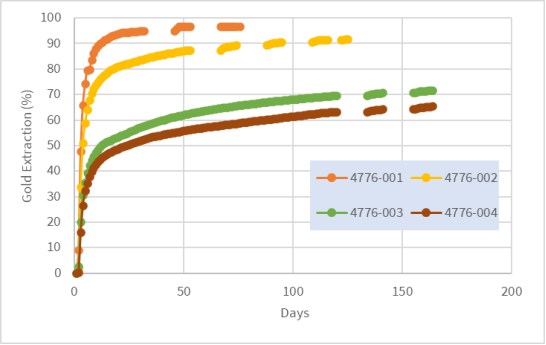
Figure 13.13
Mountain View Project, Column Leach Gold Recoveries - P80 9.5 mm
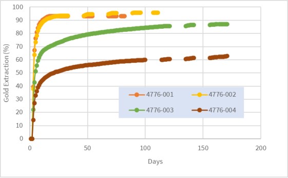
Recovery by size analysis by McClelland on all column tests suggested that the oxidized samples (4776-001 to 003) would not substantially benefit from finer crushing, size fraction recoveries larger than 75 µm were all similar.
The physical characteristics, in terms of moisture retention and bulk density, for the column tests are summarized in Table 13.19. McClelland noted that there was very little slumping (typically less than 1%) during all column tests and there were no issues with solution channeling or fines migration during leaching.
Table 13.19
Physical Characteristics of the Mountain View Column Leach Test Samples
Composite Sample | Test No. | Feed Size | Weight (kg) | Moisture (wt.% ) | Bulk Density m3/t |
Initial | Agglomerates. | Saturate | Retained | Initial | Final |
4776-001 | CL-1 | 80%-19mm | 71.0 | 0.5 | 9.3 | 16.2 | 11.7 | 1.22 | 1.23 |
4776-001 | CL-5 | 80%-9.5mm | 33.1 | 0.6 | 9.9 | 20.6 | 15.4 | 1.16 | 1.17 |
| | | | | | | | | |
4776-002 | CL-2 | 80%-19mm | 75.0 | 0.5 | 9.1 | 19.9 | 14.5 | 1.14 | 1.15 |
4776-002 | CL-6 | 80%-9.5mm | 33.5 | 0.5 | 10.7 | 19.2 | 14.5 | 1.15 | 1.16 |
| | | | | | | | | |
4776-003 | CL-3 | 80%-19mm | 74.9 | 0.3 | 7.3 | 16.3 | 13.0 | 1.25 | 1.26 |
4776-003 | CL-7 | 80%-9.5mm | 35.2 | 0.3 | 9.3 | 19.7 | 14.5 | 1.25 | 1.26 |
| | | | | | | | | |
4776-004 | CL-4 | 80%-19mm | 71.5 | 0.7 | 8.8 | 21.0 | 16.1 | 1.2 | 1.22 |
4776-004 | CL-8 | 80%-9.5mm | 33.4 | 0.6 | 10.1 | 28.9 | 21.9 | 1.14 | 1.15 |
Hydraulic conductivity testing showed that permeability was high for all the P80 19 mm oxidize samples (4776-001, 002 and 003), although it was lower for 4776-004, the transition composite.
13.3.3.4 Other Metallurgical Tests
Bench scale open circuit rougher/cleaner bulk sulphide flotation tests were completed by McClelland during this phase of metallurgical testwork, using four samples classified as medium and high-grade transition or sulphide mineralization.
Rougher concentrate gold recoveries ranged between 59% and 78% and cleaner concentrate grades 9 to 44 g/t. Rougher silver recoveries ranged between 43% and 76% and rougher sulphide sulphur recoveries ranged between 74% and 88%.
13.3.4 Mountain View Project, Conclusions and Recommendations
The composite samples selected by Millennial to represent typical oxide mineralization within the Mountain View mineral resources were amenable to heap leaching. Column leach tests suggest that high gold extractions (>90%) could be achieved under typical design conditions. Corresponding silver extractions of around 20% would be expected.
Bottle roll and column leach tests on transition mineralization, which would be found at the deposit oxide-sulphide boundaries, suggest that gold extraction from this material will be about 30% lower than oxide mineralization.
Bottle roll cyanide and lime requirements for all samples tested were reasonable, averaging 0.2 kg NaCN/t and 1.82 kg lime/t for the P80 75 µm tests. Cyanide consumptions for the column tests were relatively high (up to 2.14 kg NaCN/t), primarily due to long extended leaching times.
Hydraulic conductivity testing showed that permeability was high for all the P80 19 mm oxidize samples.
During the column tests there was very little slumping (typically less than 1%) and there were no issues with solution channeling or fines migration during leaching.
Mountain View samples were classified as "very soft" in terms of crusher work index and "moderately abrasive to abrasive" based on the Bond abrasion index.
Preliminary flotation tests on four transition and sulphide variability samples gave gold recoveries between 59% and 78%.
It is recommended that the following program of testing be undertaken during the next stage of Project development:
Additional column leaching tests to optimize conditions in terms of precious metal recovery, capital costs and operating costs. The effect of coarser crush sizes should be investigated.
Samples for the additional column tests should be selected to ensure that all lithologies within the mineral resources are fully represented. The resources should also be fully represented spatially.
Geochemical characterization testwork on representative feed and residue samples is recommended.
Appropriate additional comminution and hardness testing needs to be considered.
Additional variability bottle roll testwork should be undertaken to ensure that all types of mineralization within the mineral resources have been evaluated.
13.4 Notes Regarding Metallurgical Laboratory Certifications
All of the relevant metallurgical testwork reported in this section was conducted by McClelland Laboratories, Inc. located in Reno, Nevada. McClelland is highly respected in the mining industry and has been providing quality laboratory and consulting services to the minerals industry for over 33 years. It is fully equipped to offer metallurgical testwork service, environmental and mine characterization services, and analytical services.
McClelland is Nevada State Certified -NV-00933- for MWMP and HC Testing Procedures and Wastewater Certification on select analytes associated with MWMP and HCT. The McClelland Analytical Services Laboratory is an ISO 17025 accredited facility.
14.0 MINERAL RESOURCE ESTIMATES
14.1 Introduction
In November, 2020, Micon carried out the initial resources estimates for both the Wildcat and Mountain View Projects. This current report discusses updated mineral resource estimates for both Projects, incorporating Millennial's 2021-2022 drilling campaign. The updated resource estimates were prepared, using all available information, by Millennial's geology team which was then reviewed and verified by William J. Lewis, P.Geo., of Micon, who is an independent QP as this term is defined in NI 43-101.
This Section of the report describes the technical aspects of the June, 2023 updated resource estimate including the methodology used and key assumptions considered during the estimation process.
14.2 CIM Resource Definitions and Classifications
The mineral resources and reserves presented in this Technical Report follow the current CIM Definitions and Standards for mineral resources and reserves which were adopted by the CIM council on May 10, 2014, and includes the following resource definitions:
"Mineral Resources are sub--divided, in order of increasing geological confidence, into Inferred, Indicated and Measured categories. An Inferred Mineral Resource has a lower level of confidence than that applied to an Indicated Mineral Resource. An Indicated Mineral Resource has a higher level of confidence than an inferred Mineral Resource but has a lower level of confidence than a Measured Mineral Resource."
"A Mineral Resource is a concentration or occurrence of solid material of economic interest in or on the Earth's crus in such form, grade or quality and quantity that there are reasonable prospects for eventual economic extraction."
"The location, quantity, grade or quality, continuity and other geological characteristics of a Mineral Resource are known, estimated or interpreted from specific geological evidence and knowledge, including sampling."
"Material of economic interest refers to diamonds, natural solid inorganic material, or natural solid fossilized organic material including base and precious metals, coal, and industrial minerals."
"The term Mineral Resource covers mineralization and natural material of intrinsic economic interest which has been identified and estimated through exploration and sampling and within which Mineral Reserves may subsequently be defined by the consideration and application of Modifying Factors."
"Inferred Mineral Resource"
"An Inferred Mineral Resource is that part of a Mineral Resource for which quantity and grade or quality are estimated on the basis of limited geological evidence and sampling. Geological evidence is sufficient to imply but not verify geological and grade or quality continuity."
"An Inferred Mineral Resource has a lower level of confidence than that applying to an Indicated Mineral Resource and must not be converted to a Mineral Reserve. It is reasonably expected that the majority of Inferred Mineral Resources could be upgraded to Indicated Mineral Resources with continued exploration."
"An Inferred Mineral Resource is based on limited information and sampling gathered through appropriate sampling techniques from locations such as outcrops, trenches, pits, workings and drill holes. Inferred Mineral Resources must not be included in the economic analysis, production schedules, or estimated mine life in publicly disclosed Pre-Feasibility or Feasibility Studies, or in the Life-of-mine plans and cash flow models of developed mines. Inferred Mineral Resources can only be used in economic studies as provided under NI 43-101."
"Indicated Mineral Resource"
"An Indicated Mineral Resource is that part of a Mineral Resource for which quantity, grade or quality, densities, shape and physical characteristics are estimated with sufficient confidence to allow the application of Modifying Factors in sufficient detail to support mine planning and evaluation of the economic viability of the deposit."
"Geological evidence is derived from adequately detailed and reliable exploration, sampling and testing and is sufficient to assume geological and grade or quality continuity between points of observation."
"An Indicated Mineral Resource has a lower level of confidence than that applying to a Measured Mineral Resource and may only be converted to a Probable Mineral Reserve."
"Mineralization may be classified as an Indicated Mineral Resource by the Qualified Person when the nature, quality, quantity and distribution of data are such as to allow confident interpretation of the geological framework and to reasonably assume the continuity of mineralization. The Qualified Person must recognize the importance of the Indicated Mineral Resource category to the advancement of the feasibility of the project. An Indicated Mineral Resource estimate is of sufficient quality to support a Pre-Feasibility Study which can serve as the basis for major development decisions."
"Measured Mineral Resource"
"A Measured Mineral Resource is that part of a Mineral Resource for which quantity, grade or quality, densities, shape, and physical characteristics are estimated with confidence sufficient to allow the application of Modifying Factors to support detailed mine planning and final evaluation of the economic viability of the deposit."
"Geological evidence is derived from detailed and reliable exploration, sampling and testing and is sufficient to confirm geological and grade or quality continuity between points of observation.
A Measured Mineral Resource has a higher level of confidence than that applying to either an Indicated Mineral Resource or an Inferred Mineral Resource. It may be converted to a Proven Mineral Reserve or to a Probable Mineral Reserve."
"Mineralization or other natural material of economic interest may be classified as a Measured Mineral Resource by the Qualified Person when the nature, quality, quantity and distribution of data are such that the tonnage and grade or quality of the mineralization can be estimated to within close limits and that variation from the estimate would not significantly affect potential economic viability of the deposit. This category requires a high level of confidence in, and understanding of, the geology and controls of the mineral deposit."
14.3 CIM Estimation of Mineral Resources Best Practices Guidelines
When reviewing and verifying Integra's mineral resource estimate for Wildcat and Mountain View deposits, Micon QPs have used the CIM Estimation of Mineral Resources and Mineral Reserves Best Practice Guidelines which were adopted by the CIM Council on November 29, 2019.
14.4 Wildcat Project, Mineral Resource Estimate
14.4.1 Methodology
The geological and resource models for the Wildcat deposit were prepared using LeapFrog GEO v2021.2 (LeapFrog) and Isatis NEO mining v2022.12 (Isatis). LeapFrog was used for modelling the lithological, alteration and oxidation profiles. Isatis was used for the grade estimation, which consisted of 3D block modelling and the inverse distance cubed (ID3) interpolation method. Statistical studies, capping and variography were completed using Isatis and Microsoft Excel. Capping and validations were carried out in Isatis and Excel.
The main steps in the methodology were as follows:
Compile and validate the drill hole databases used for mineral resource estimation.
Validate the geological model and interpretation of the mineralized zones guided primarily by lithologies, honouring the geometrical orientation of the granodiorite contact with pyroclastic rocks, in addition to the local geometric influence of faults/folds.
Validate the drill hole intercepts database, compositing database and gold and silver capping values for the purposes of geostatistical analysis.
Validate the block model and grade interpolation.
Decide on and validate the criteria for mineral resource classification.
Assess the resources with "reasonable prospects for economic extraction" via open shell pit optimization.
Generate a mineral resource statement.
- Assess the factors that could affect the mineral resource estimate.
14.4.2 Wildcat Resource Database
The close-out date for the Wildcat deposit mineral resource database is December 31, 2022. The database consists of 315 validated diamond drill holes and RC holes, totalling 39,143.45 m and including 24,510 sample intervals. The database includes the 12 drill holes totalling 1,289.80 m of diamond drilling and including 935 sample intervals assayed for gold and silver, completed in 2022. Figure 14.1 shows the traces of the holes drilled at the Wildcat Project.
Figure 14.1
Wildcat Project Drilling Location Plan View
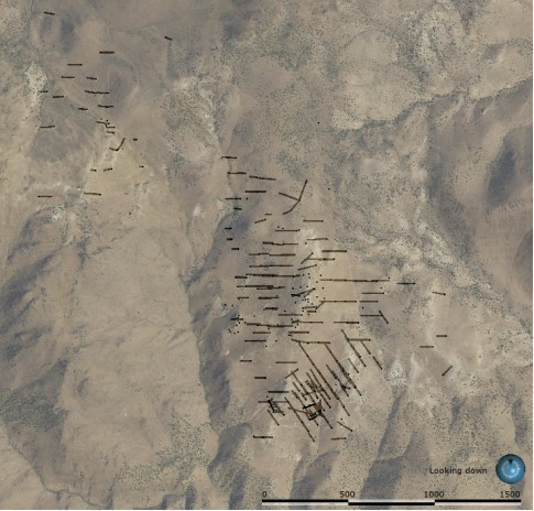
Figure supplied by Integra, June, 2023.
Figure Notes: North is up towards the top of the page and the scale bar is in metres.
The database includes validated location, survey and assay results. It also includes geotechnical, lithological, alteration, oxidation and structural descriptions taken from drill core logs.
The database covers the strike length of each mineralized domain at variable drill hole spacings, ranging from 20 m to 100 m, with an average spacing of approximately 50 m.
The Wildcat deposit is divided into 2 zones, the Main Hill zone in which most of the drilling was done, and the Cross-Road zone (to the northwest), which represents the other area of drilling.
In addition to the tables of raw data, the database includes several tables of calculated drill hole composites and wireframe solid intersections, which are required for the statistical evaluation and mineral resource block modelling.
14.4.3 Wildcat Project Geological Modelling
The Integra geological team prepared the geological model of the Wildcat deposit in LeapFrog, using surface mapping, rock or soil samples and drill holes, all completed by December 31, 2022.
A total of six lithological domains were modelled (Figure 14.2). Each domain was defined based on the lithological logs prepared by the geologist from the core or RC chips.
Figure 14.2
Wildcat 3D View, Drilling Lithologies at the Main Hill Zone (Looking Northeast)

Figure supplied by Integra, June, 2023.
Most of the mineralization at Wildcat is located within the Main Hill zone and is constrained within a permeable Volcanoclastic Rhyolitic tuff breccia, in the form of disseminated pyrite or very fine quartz-pyrite veinlets. Most of the remainder of the mineralization at Wildcat is found within a granodiorite basement, where the mineralization is mostly associated with veins (from 1 mm to 10 cm). Rhyolite is generally covered by thin Quaternary alluvium layers (from 10 cm to 2 m thick), or post mineralization basalt to the north (5 m to 50 m thick). In the inner part of the deposit, Rhyolitic intrusion (domes 15 m to 100 m radius) are present, and are generally mineralized, with similar grade/mineralization style as the Rhyolitic tuffs. A late-barren Andesitic dyke (~north-south) cross-cuts the eastern part of the resources estimate.
Most of the historical drilling was performed using RC, and only limited structural information is present in historical logs. During the 2022 drilling, some minor faults were identified, but the drill density has not allowed 3D modelling of these structures. Nevertheless, a dome shape (or antiform) can be observed on Main Hill, and this could be due either to a large fold, a relationship with the paleo-surface topography during the deposition of the Volcanoclastic Rhyolitic tuff breccia, or to the late Rhyolitic intrusions. No significant structures were found at the Cross-Road area.
In addition to the lithological model, an oxidation model was developed for the Wildcat deposit. This model is principally based on the original logs, relogging and geochemical information (ICP and cyanide shakes). During the 2022 drilling and relogging campaign, it was observed that geologists were recording the rocks as 'oxidized' when the sulphur content was low (generally below 0.3% sulphur), and this also corresponds to the area where the ratio of cyanide shakes to fire assay gold results is generally higher. Although the oxidation level varies locally in depth, the geological contact zone was used to build a smoothed 3D surface representing the oxide material compared to the underlying non-oxide material (i.e. transition and fresh rock).
14.4.4 Wildcat Project Geostatistical Analysis
All assays in the Wildcat database were flagged by lithologies and oxidation, allowing further statistical analysis. Table 14.1 presents the statistics for both gold and silver within the main lithologies; note that a few exploration holes, too far from the main area, were not included in the present resources estimate.
Table 14.1
Wildcat Project, Drill Hole Assaying Gold and Silver Statistics
| Commodity | Lithology | Defined
Count | Mean | Variance | Standard
Deviation | Coefficient
of
Variation | Minimum | Maximum |
| Gold | Andesite | 407 | 0.05 | 0.02 | 0.14 | 2.583 | 0.00 | 1.41 |
| Basalt | 184 | 0.01 | 0.01 | 0.03 | 2.118 | 0.00 | 0.21 |
| Granodiorite | 10,559 | 0.21 | 0.57 | 0.75 | 3.605 | 0.00 | 32.23 |
| Qal | 130 | 0.19 | 0.45 | 0.67 | 3.494 | 0.00 | 7.56 |
| Rhyolite | 1,770 | 0.16 | 0.06 | 0.24 | 1.465 | 0.00 | 3.59 |
| Volcaniclastic | 10,659 | 0.32 | 0.75 | 0.87 | 2.664 | 0.00 | 56.09 |
| Silver | Andesite | 407 | 0.88 | 5.20 | 2.28 | 2.593 | 0.00 | 21.74 |
| Basalt | 184 | 0.22 | 0.58 | 0.76 | 3.434 | 0.00 | 5.90 |
| Granodiorite | 10,552 | 2.44 | 69.37 | 8.33 | 3.416 | 0.00 | 320.37 |
| Qal | 130 | 1.45 | 18.81 | 4.34 | 2.999 | 0.00 | 46.50 |
| Rhyolite | 1,769 | 1.06 | 3.36 | 1.83 | 1.731 | 0.00 | 22.80 |
| Volcaniclastic | 10,650 | 3.08 | 72.14 | 8.49 | 2.757 | 0.00 | 368.23 |
Table supplied by Integra, June, 2023.
14.4.5 Wildcat Project, Contact Analysis
To determine the grade continuity between the main lithologies, contact plot analyses were performed on the raw assays. The contact plot in Figure 14.3 demonstrates that the Volcanoclastic (Rhyolitic Tuff Breccia) has a higher gold grade than other lithologies (0.32 g/t versus 0.20 g/t), but that the grade within the other lithologies close to the contact is, on average, similar to the grade found in the Volcaniclastics. Similar plots were performed for all the lithological contacts, and the same conclusion was found. Based on this information, it was decided that no hard boundary would be used during the resource estimation process, although a relatively short distance should be considered when interpolating parallel to the contact zone.
Figure 14.3
Wildcat Project, Volcanoclastic Contact Plot
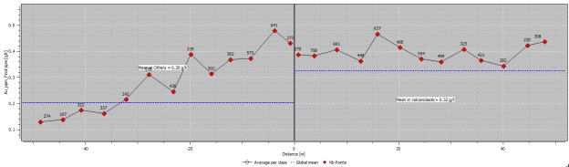
Figure supplied by Integra, June, 2023.
14.4.6 Wildcat Project, High-Grade Capping
The impact of high-grade outliers on composite data was examined using log histograms and log probability plots. Cumulative metal and mean and variance plots were analyzed for the impact of high-grade capping. Threshold indicator grades were coded and analyzed to determine spatial continuity of the high grades. The indicator variograms suggest that high-grade continuity decreases with increasing grade thresholds. From a statistical and spatial review of the composite data, the QPs are of the opinion that capping is required in order to restrict the influence of high-grade outlier assays at varying ranges.
Figure 14.4 and Figure 14.5 present the log probability plots used to select a 10 g/t capping value for gold, and a 100 g/t capping value for silver. The gold assays sensitivity to capping value are presented in Table 14.2. The 10 g/t capping value for gold represents the 99.9 percentile value and removes approximately 3% of the gold metal in the assays, which is considered reasonable for the type of deposit. Overall, the deposit is not very sensitive to capping value.
Figure 14.4
Wildcat Project, Logarithmic Probability Plots for Gold
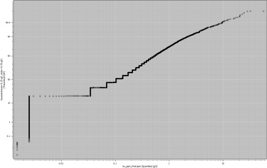
Figure supplied by Integra, June, 2023.
Figure 14.5
Wildcat Project, Logarithmic Probability Plots for Silver

Figure supplied by Integra, June, 2023.
Table 14.2
Wildcat Project, Drilling Assays Sensitivity to Capping Value
Cutoff [g/t] | Percentile [%] | Mean [g/t] | Standard
Deviation [g/t] | Coeff. of
Variation | Metal
Loss [%] |
2.00 | 98.87 | 0.22 | 0.33 | 1.487 | 12.45 |
4.00 | 99.62 | 0.23 | 0.42 | 1.792 | 7.27 |
6.00 | 99.80 | 0.24 | 0.47 | 1.982 | 5.18 |
8.00 | 99.86 | 0.24 | 0.52 | 2.139 | 3.86 |
10.00 | 99.92 | 0.25 | 0.56 | 2.265 | 2.99 |
12.00 | 99.94 | 0.25 | 0.58 | 2.359 | 2.43 |
14.00 | 99.95 | 0.25 | 0.60 | 2.443 | 2.01 |
16.00 | 99.96 | 0.25 | 0.63 | 2.526 | 1.63 |
18.00 | 99.96 | 0.25 | 0.65 | 2.601 | 1.31 |
20.00 | 99.97 | 0.25 | 0.67 | 2.671 | 1.05 |
22.00 | 99.98 | 0.25 | 0.68 | 2.722 | 0.87 |
24.00 | 99.98 | 0.25 | 0.69 | 2.764 | 0.73 |
26.00 | 99.99 | 0.25 | 0.70 | 2.798 | 0.62 |
28.00 | 99.99 | 0.25 | 0.71 | 2.833 | 0.53 |
30.00 | 99.99 | 0.25 | 0.72 | 2.858 | 0.46 |
Table supplied by Integra, June, 2023.
14.4.7 Wildcat Project, Density
During the 2022 drilling campaign, 245 density measurements were conducted on the rock by Millennial's geologists, using the immersion technique. Measurements were taken approximately every 10 m to 20 m across all lithologies and alterations. From the 245 measurements, a total of 194 were considered as acceptable, (the others failed the QA/QC process). Based on these measurements and the interpretation of the statistics, a fixed density of 2.6 g/cm3 was selected and used in the resources estimate.
14.4.8 Wildcat Project, Compositing
The assay data were flagged and analyzed to determine an appropriate composite length, in order to minimize any bias introduced by variable sample lengths. Most of the analytical samples were collected at lengths of between 0.30 m and 3.52 m with a clear mode at 1.52 m (5 ft); see Figure 14.6. Based on these observations and considering the future bench heigh (estimated approximately 9 m), a 4.5 m length composite was selected. All drill holes were composited from top to toe, for gold and silver, using capped and uncapped values, any composites with a length less than 2.25 m (50% rule) were discarded (statistics are presented in Table 14.3).
Figure 14.6
Wildcat Project, Assays Length Histogram
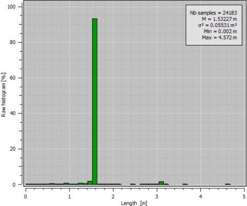
Figure supplied by Integra, June, 2023.
Table 14.3
Wildcat Project, Drilling 4.5m Composites Statistics
| Variable | Table | Defined
Count | Mean | Coefficient of
Variation | Minimum | Maximum |
| Ag ppm | Raw | 23,101 | 2.47 | 3.12 | 0.00 | 368.23 |
| Composite | 8,156 | 2.48 | 2.38 | 0.00 | 178.46 |
| Residual | 181 | 1.82 | 1.42 | 0.00 | 15.30 |
| Ag ppm Cap 100 | Raw | 23,101 | 2.40 | 2.47 | 0.00 | 100.00 |
| Composite | 8,156 | 2.41 | 1.94 | 0.00 | 96.55 |
| Residual | 181 | 1.82 | 1.42 | 0.00 | 15.30 |
| Au_ppm | Raw | 23,118 | 0.24 | 3.05 | 0.00 | 56.09 |
| Composite | 8,156 | 0.24 | 2.22 | 0.00 | 27.94 |
| Residual | 181 | 0.17 | 1.35 | 0.00 | 1.89 |
| Au_ppm Cap 10 | Raw | 23,118 | 0.24 | 2.16 | 0.00 | 10.00 |
| Composite | 8,156 | 0.24 | 1.61 | 0.00 | 8.47 |
| Residual | 181 | 0.17 | 1.35 | 0.00 | 1.89 |
| Length [m] | Raw | 23,151 | 1.53 | 0.05 | 0.002 | 4.58 |
| Composite | 8,166 | 4.48 | 0.04 | 2.28 | 4.5 |
| Residual | 182 | 3.41 | 0.19 | 2.28 | 4.49 |
Table supplied by Integra, June, 2023.
14.4.9 Wildcat Project, Variogram Analysis
The spatial distribution of gold and silver was evaluated through variogram analysis for each mineralized domain. 3D experimental variograms were generated and modelled to assess the grade continuity and to perform geostatistical validation tests (such as Discrete Gaussian Global Change of Support, Kriging Neighbourhood Analysis), as well as comparative Ordinary Kriging interpolation. After review of the variograms and the different interpolation strategies, an Inverse Distance interpolator was selected for the present resources estimate.
14.4.10 Wildcat Project, Block Model
The criteria used in the selection of block size for the Wildcat deposit include drill hole spacing, composite length, the geometry of the modelled zone and the anticipated mining methods. A block size of 15.24 m x 15.24 m x 9.144 m was used (50 ft x 50 ft x 30 ft). The block model was coded for each lithological and oxidation domains using the 50% rule. Considering the 'soft boundary' strategy, this rule does not introduce dilution, nor does it create any complication for the mine planning. No rotation was applied to the block model. The characteristics of the block model are summarized in Table 14.4.
Table 14.4
Wildcat Project, Block Model Geometry
| Description | X | Y | Z |
| Number of nodes | 176 | 190 | 74 |
| Mesh size | 15.24 m | 15.24 m | 9.144 m |
| Grid origin (center) | 350,222.82 m | 4,489,406.82 m | 1,528.57 m |
| Grid origin (corner) | 350,215.20 m | 4,489,399.20 m | 1,524.00 m |
| Min | 350,215.20 m | 4,489,399.20 m | 1,524.00 m |
| Max | 352,897.44 m | 4,492,294.80 m | 2,200.66 m |
Table supplied by Integra, June, 2023.
14.4.11 Wildcat Project, Search Ellipse and Interpolation Parameters
To respect the folded aspect of the Main Hill, as well as the 'flatter' orientation of the Cross-Road area, three different search ellipse orientations were selected. These orientations were selected manually in 3D and validated though variography (maximum range). The size of the search ellipse was set to be large enough to populate the densely informed area during the first pass and to roughly correspond to 70% of the variance of the variogram: the results of this provided a flat ellipse of 35 x 35 x 20m (Table 14.5). To populate most of the block model, a second pass with ratios equal to 2, 2 and 1.5 for X, Y and Z was used.
The block model was interpolated using an Inverse Distance to the power three (ID3), using a block discretization of 4 x 4 x 4. A minimum of 7 samples (respecting a maximum of 3 samples per hole) with a maximum of 15 samples, was used during both passes. The same interpolation strategy was used for both gold and silver grades.
Table 14.5
Wildcat Project, Search Ellipse Parameters
| Domain | X (m) | Y (m) | Z (m) | Dip | Dip Az | Pitch |
| South | 35 | 35 | 20 | 25° | 130° | 270° |
| North | 35 | 35 | 20 | 20° | 300° | 270° |
| Cross-Road | 35 | 35 | 20 | 0° | 90° | 90° |
Table supplied by Integra, June, 2023.
14.4.12 Wildcat Project, Model Validation
Mineralized domain models were validated using a variety of methods, including visual inspection of the model grades and grade distributions compared to the informing raw samples, statistical comparisons of informing composites to the model, for local and global bias and reconciliation comparing the model to observed grades from underground development.
All analyses indicated that the model follows the grade distribution of the informing composites, so that the accuracy of the model is considered to have been demonstrated. The total global comparison for each resource classification is within a 20% tolerance for bias and reconciliation. The QP considers the model to be a reasonable representation of the Wildcat mineralization, based on the current level of sampling.
14.4.12.1 Visual Inspection
Figure 14.7 provides a sectional view of the model compared with the raw informing sample data. The visual validation confirms that the block model honours the drill hole and chip sample data and justifies the capping grades.
Figure 14.7
Wildcat Project, North-South Block Model Cross Section Visual Checks (Looking West)
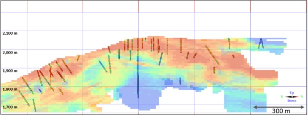
Figure supplied by Integra, June, 2023.
14.4.12.2 Statistical Comparisons
Ordinary kriging (OK) and Nearest Neighbour (NN) interpolations were performed to check for local and global bias in the model. In the global bias analysis at zero cut-off (Table 14.6), the ID3 interpolations matched well with the ID2 and OK interpolations. The NN mean estimate grade shows a lower average grade but, considering the block size versus composite size, the NN grade is probably not a good estimator of the declustered grade.
The trend and local variation of the estimated ID3 models were compared with a cell declustered composite data, using swath plots in three directions (north, east and elevation). The ID3 models show similar trends in grades, with the expected smoothing for the method when compared to the composite data. Figure 14.8 shows the swath plot in the three principal directions for the Main Hill area, as an example. In the area with good data density, the gold grade from the cell desclustering composites fit well the grade from the ID3 model.
Table 14.6
Wildcat Project, Gold Interpolation Comparison at Zero Cut-off
| | Number of blocks | Mean | Coefficient of
Variation | Minimum | Maximum |
| ID2 | 2,474,560 | 0.15 | 1.075 | 0.00 | 3.86 |
| ID3 | 2,474,560 | 0.15 | 0.991 | 0.00 | 3.62 |
| OK | 2,474,560 | 0.14 | 1.129 | 0.00 | 4.36 |
| NN | 2,474,560 | 0.11 | 1.887 | 0.00 | 8.47 |
Table supplied by Integra, June, 2023.
Figure 14.8
Wildcat Project, Gold Trend Plot: East, North and Elevation
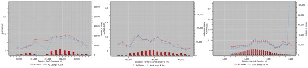
Figure supplied by Integra, June, 2023.
14.4.13 Wildcat Project, Mineral Resource Classification
The mineral resource classification was determined through manual geometric criteria deemed reasonable for the deposit by the QP. Only blocks within the Oxide zone were classified, blocks interpolated within the transition and fresh material were not considered in the resource estimation. Blocks located within the Main Hill area at a spacing of approximately 50 m x 50 m were classified as indicated, and interpolated blocks within approximately 100 m from an existing hole were classified as inferred. Considering the historical nature of the drilling at Cross-Road, no blocks were classified as indicated; although it is believed that, with additional drilling, the area could be classified as indicated. Most of the Inferred area in the Main Hill region consists of potential extension zones that will require additional infill drilling. Figure 14.9 shows a plan view the resource classification for the Wildcat Project.
Figure 14.9
Wildcat Project, Plan View of the Mineral Resource Classification
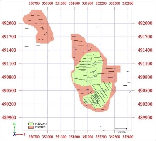
Figure supplied by Integra, June, 2023.
14.4.14 Wildcat Project, Reasonable Prospects for Eventual Economic Extraction
For the Wildcat deposit, a reasonable economic cut-off grade for the resource estimate was determined to be 0.15 g/t Au. This cut-off grade was determined using the parameters presented in Table 14.7. Micon's QP considers the selected cut-off grade of 0.15 g/t Au to be reasonable, based on the current knowledge of the Project.
In addition to the cut-off grade, an open pit shell optimizer program was run on the block model to constrain the mineral resources within a pit shell.
Table 14.7
Wildcat Project Mineral Resource Estimate Economic Parameters
| Parameters | Units | Value |
| Gold price | US$/oz | 1,800 |
| Silver price | US$/oz | 21.0 |
| Mining costs | US$/t | 2.4 |
| Processing costs | US$/t | 3.7 |
| G&A costs | US$/t | 0.5 |
| Gold Cut-off | g/t Au | 0.15 |
| Discount rate | % | 5.0 |
| Pit slope | ° | 51-54 |
| Rhyolite recovery | Au % | 73.0 |
| Granodiorite recovery | Au % | 52.0 |
| Silver Recovery | Ag % | 18.0 |
14.4.15 Wildcat Project Mineral Resource Estimate
The QP has classified the Wildcat Project mineral resource estimate as indicated and inferred mineral resources based on data density, search ellipse criteria and interpolation parameters. The resource estimate is considered to be a reasonable representation of the mineral resources of the Wildcat deposit, based on the currently available data and geological knowledge. The mineral resource estimate follows the 2014 CIM Definition Standards on Mineral Resources and Reserves. The effective date of the Mineral Resource Estimate is June 28, 2023.
Table 14.8 displays the results of the mineral resource estimate at a 0.15 g/t Au cut-off grade for the Wildcat deposit.
Table 14.8
Wildcat Deposit June, 2023, Mineral Resource Estimate Statement
| Classification | Tonnes | g/t Au | oz Au | g/t Ag | oz Ag | g/t AuEq | oz AuEq |
| Indicated | 59,872,806 | 0.39 | 746,297 | 3.34 | 6,437,869 | 0.43 | 829,152 |
| Inferred | 22,455,848 | 0.29 | 209,662 | 2.74 | 1,980,129 | 0.33 | 235,146 |
Table Notes:
(1) Effective date of the Mineral Resource Estimate is June 28, 2023.
(2) Mineral Resources that are not Mineral Reserves do not have demonstrated economic viability.
(3) William J. Lewis, P.Geo., of Micon has reviewed and verified the Mineral Resource Estimate for the Wildcat Project. Mr. Lewis is an independent Qualified Person, as defined in National Instrument 43-101, Standards of Disclosure for Mineral Projects (NI 43-101).
(4) The estimate is reported for an open-pit mining scenario, based upon reasonable assumptions. The cut-off grade of 0.15 g/t Au was calculated using a gold price of US$1,800/oz, mining costs of US$2.4/t, processing cost of US$3.7/t, G&A costs of US$0.5/t, and metallurgical gold recoveries varying from 73.0% to 52.0% and silver recoveries of 18%. The gold equivalent figures in the resource estimate are calculated using the formula (g/t Au + (g/t Ag ÷ 77.7)).
(5) An average bulk density of 2.6 g/cm3 was assigned to all mineralized rock types.
(6) The Inverse Distance cubed interpolation method was used with a parent block size of 15.24 m x 15.24 m x 9.144 m.
(7) Rounding, as required by reporting guidelines may result in minor apparent discrepancies between tonnes, grades and contained metal content.
(8) The estimate of mineral resources may be materially affected by geological, environmental, permitting, legal, title, taxation, sociopolitical, marketing, or other relevant issues.
(9) Neither Integra nor Micon's QP is aware of any known environmental, permitting, legal, title-related, taxation, socio-political, marketing or other relevant issue that could materially affect the mineral resource estimate other than any information already disclosed in this report.
14.4.16 Wildcat Project, Mineral Resource Sensitivity Analysis
Table 14.9 shows the cut-off grade sensitivity analysis of gold and silver for the updated Wildcat resource estimate. The reader should be cautioned that the figures provided in Table 14.9 should not be interpreted as mineral resource statements. The reported quantities and grade estimates at different cut-off grades are presented for the sole purpose of demonstrating the sensitivity of the mineral resource model for gold to the selection of different reporting cut-off grades. Figure 14.10 and Figure 14.11 presents the grade tonnage curves built on the cut-off grade sensitivity data presented in Table 14.9. Micon's QP has reviewed the cut-off grades used in the sensitivity analysis, and it is the opinion of the QP that they meet the test for reasonable prospects of eventual economic extraction at varying prices of gold or other underlying parameters used to calculate the cut-off grade.
Table 14.9
Wildcat Project, Gold Grade Sensitivity Analysis at Different Cut-Off Grades
| Classification | Cut-off | Tonnes | g/t Au | oz Au | g/t Ag | oz Ag |
| Indicated | 0.05 | 67,016,721 | 0.36 | 770,900 | 3.16 | 6,804,827 |
| 0.1 | 64,761,568 | 0.37 | 765,404 | 3.23 | 6,716,586 |
| 0.15 | 59,872,806 | 0.39 | 746,297 | 3.34 | 6,437,869 |
| 0.2 | 52,012,138 | 0.42 | 702,728 | 3.53 | 5,904,258 |
| 0.25 | 42,440,131 | 0.47 | 635,006 | 3.84 | 5,236,770 |
| 0.3 | 33,411,641 | 0.52 | 556,692 | 4.22 | 4,528,878 |
| 0.35 | 25,762,514 | 0.58 | 478,202 | 4.62 | 3,825,142 |
| 0.4 | 19,392,625 | 0.65 | 402,566 | 5.08 | 3,164,355 |
| 0.45 | 15,276,484 | 0.71 | 347,188 | 5.53 | 2,715,493 |
| 0.5 | 12,049,761 | 0.77 | 298,456 | 5.98 | 2,317,021 |
| 0.6 | 7,755,728 | 0.90 | 223,657 | 6.82 | 1,700,408 |
| 0.65 | 6,205,147 | 0.97 | 192,787 | 7.21 | 1,439,359 |
| 0.7 | 4,971,819 | 1.04 | 166,263 | 7.69 | 1,228,962 |
| 0.75 | 4,069,767 | 1.11 | 145,461 | 8.23 | 1,076,238 |
| 0.8 | 3,423,662 | 1.18 | 129,489 | 8.64 | 950,677 |
| 0.85 | 2,962,655 | 1.23 | 117,374 | 9.14 | 870,587 |
| 0.9 | 2,503,727 | 1.30 | 104,537 | 9.75 | 784,511 |
| 0.95 | 2,199,431 | 1.35 | 95,528 | 10.17 | 718,988 |
| Classification | Cut-off | Tonnes | g/t Au | oz Au | g/t Ag | oz Ag |
| Inferred | 0.05 | 25,515,457 | 0.27 | 219,842 | 2.62 | 2,150,330 |
| 0.1 | 24,341,745 | 0.28 | 217,068 | 2.69 | 2,101,984 |
| 0.15 | 22,455,848 | 0.29 | 209,662 | 2.74 | 1,980,129 |
| 0.2 | 17,615,915 | 0.32 | 182,950 | 2.90 | 1,643,048 |
| 0.25 | 12,239,483 | 0.37 | 145,178 | 3.24 | 1,275,913 |
| 0.3 | 7,909,184 | 0.42 | 107,855 | 3.52 | 895,212 |
| 0.35 | 5,051,117 | 0.48 | 78,604 | 3.74 | 607,127 |
| 0.4 | 3,369,700 | 0.54 | 58,751 | 3.96 | 429,367 |
| 0.45 | 2,316,862 | 0.60 | 44,596 | 4.21 | 313,932 |
| 0.5 | 1,627,724 | 0.65 | 34,229 | 4.66 | 243,747 |
| 0.6 | 691,921 | 0.80 | 17,839 | 5.69 | 126,486 |
| 0.65 | 467,070 | 0.89 | 13,360 | 6.00 | 90,072 |
| 0.7 | 358,293 | 0.96 | 11,030 | 6.26 | 72,118 |
| 0.75 | 280,671 | 1.02 | 9,246 | 6.40 | 57,735 |
| 0.8 | 229,353 | 1.08 | 7,977 | 6.68 | 49,250 |
| 0.85 | 196,386 | 1.12 | 7,098 | 6.82 | 43,064 |
| 0.9 | 162,361 | 1.18 | 6,148 | 6.66 | 34,746 |
| 0.95 | 154,645 | 1.19 | 5,924 | 6.75 | 33,539 |
Table supplied by Integra, June, 2023.
Figure 14.10
Wildcat Project, Grade Tonnage Curves for the Indicated Mineral Resources at Different Cut-Off Grades

Figure supplied by Integra, June, 2023.
Figure 14.11
Wildcat Project, Grade Tonnage Curves for the Inferred Mineral Resources at Different Cut-Off Grades
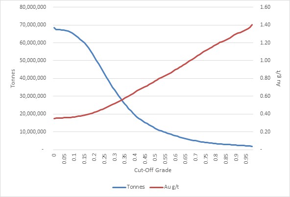
Figure supplied by Integra, June, 2023.
14.4.17 Wildcat Project, 2023 Resource Estimate, Comparison with Previous 2020 Estimate
In November, 2020, Micon conducted an NI43-101 compliant resource estimate for the Wildcat Project. Table 14.10 presents a comparison of both estimates based upon gold only. The present June, 2023 estimate represents a significant increase in the indicated category over that contained in the 2020 estimation. The increase in material classified as indicated was achieved through the 2022 Integra drilling program which demonstrated the validity of the historical data within the Main Hill area. The additional increase in mineral resources is primarily based on the new geological and oxidation models, as well as the increase in gold price used and other changes to the technical and economic assumptions.
Table 14.10
Wildcat Project, Comparison of the 2023 Mineral Resource Estimate with Previous 2020 Estimate
| Classification | November, 2020, Resource Estimate
(@ US$1,500/oz) | June, 2023, Resource Estimate
(@ US$1,800/oz) |
Tonnes
(Mt) | g/t Au
(g/t) | oz Au
(x 1,000) | Tonnes
(Mt) | g/t Au
(g/t) | oz Au
(x 1,000) |
| Indicated | - | - | - | 59,9 | 0.39 | 746 |
| Inferred | 60.8 | 0.40 | 776 | 22,5 | 0.29 | 210 |
14.5 Mountain View Project, Mineral Resource Estimate
14.5.1 Mountain View Project Methodology
The geological and resource models for the Mountain View deposit were prepared using LeapFrog GEO v2021.2 (LeapFrog) and Isatis NEO mining v2022.12 (Isatis). LeapFrog was used for modelling the lithological, alteration, and oxidation profiles. Isatis was used for the grade estimation, which consisted of 3D block modelling and the inverse distance cubed (ID3) interpolation method. Statistical studies, capping and variography were completed using Isatis and Microsoft Excel. Capping and validations were carried out in Isatis and Excel.
The main steps in the methodology were as follows:
Compile and validate the drill hole databases used for mineral resource estimation.
Validate the geological model and interpretation of the mineralized zones, guided primarily by lithologies, honouring the geometrical orientation of the granodiorite contact with pyroclastic rocks (mainly), in addition to the local geometric influence of faults/folds.
Validate the drill hole intercepts database, compositing database and gold and silver capping values for the purposes of geostatistical analysis.
Validate the block model and grade interpolation.
Decide on and validate the classification criteria for mineral resource classification.
Assess the resources with "reasonable prospects for economic extraction" via open shell pit optimisation.
Generate a Mineral Resource Estimate statement.
Assess the factors that could affect the mineral resource estimate.
14.5.2 Mountain View Resource Database
The close-out date for the Mountain View deposit mineral resource estimate database is June 28, 2023. The database consists of 260 validated diamond drill holes and RC holes, totalling 55,777.92 m and including 20,839 sample intervals. This database includes 27 2021-2022 holes, totalling 5,152.37 m of diamond drilling and including 4,023 sample intervals assayed for gold and silver, (Figure 14.12) Note: one of the 2022 holes was drilled and logged, but not sampled as it has been kept intact for future metallurgical testing.
The database also includes validated location, survey and assay results. It also includes geotechnical, lithological, alteration, oxidation and structural descriptions taken from drill core logs.
Figure 14.12
Mountain View Project, Plan View of Drilling Locations

Figure supplied by Integra, June, 2023.
Figure Notes: North is up towards the top of the page and the scale bar is in metres.
The database covers almost the entire property (covering approximately 5.3 km x 2.6 km), but most of the holes are within the main mineralized area (700 m x 500 m). The strike length of each mineralized domain was drilled at variable hole spacings, ranging from 20 m to 100 m, with an average spacing of approximately 50 m.
In addition to the tables of raw data, the database includes several tables of calculated drill hole composites and wireframe solid intersections, which are required for the statistical evaluation and mineral resource block modelling.
14.5.3 Mountain View Project, Geological Modelling
The Integra geological team prepared the geological model of the Mountain View deposit in LeapFrog, using surface mapping, rock or soil samples, and drill holes, all completed by December 31, 2022.
A total of six lithological domains were modelled (Figure 14.13). Each domain was defined based on the lithological logs compiled by geologists on core or RC chips.
Figure 14.13
Mountain View Project, 3D View of the Drilling Lithologies at the Main Hill Zone (Looking West)
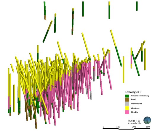
Figure supplied by Integra, June, 2023.
The lithological model at Mountain View is composed of a barren Granodiorite to the East, and a basalt basement below the main Rhyolitic dome hosting most of the resources. Locally, some undifferentiated volcano-sedimentary units (Intermediate tuffs, altered andesite vulcanite, and possibly mud lake sediments) are interbedded within the Rhyolitic dome. A thin (1 m to 10 m) layer of Tertiary detritic units (TAL) is generally mineralized (conglomerates, with mineralized rhyolitic clasts). A Quaternary Alluvium (QAL) unit (mostly unconsolidated sand) covers most of the deposit, with a thin layer to the east (1 m) going deeper to the west (up to 200 m). Most of the mineralization is constrained within 2 hydrothermal breccia domains; the one to the east has a lower brecciation with a lower average grade, while the main western breccia body presents high quartz and adularia brecciation, as well as higher grade.
The granodiorite and Quaternary Alluviums (QAL) domains are considered barren and were not used during interpolation process.
Most of the historical drilling was done using RC, and only limited structural information is present in historical logs. The Range Front Fault is the contact between the Granodiorite to the east and all the other lithologies to the west. During 2022 drilling, some minor faults were identified, and some north-south (slightly dipping west) structures were modelled; these structures are believed to be controlling some part of the mineralization and breccia orientation.
In addition to the lithological and breccia domains, an oxidation model was developed at Mountain View. This model is principally based on the original logs and geochemical information (ICP and cyanide shakes). Although the oxidation level varies locally in depth and structures, three smoothed oxidation solids were created: oxidation (where most of the sulphur is oxidized), transitional (with a mix of oxidized and unoxidized sulphur) and fresh material (where no oxidation is observed).
14.5.4 Mountain View Project, Geostatistical Analysis
All assays in the database were flagged by domains and oxidation, allowing further statistical analysis. Table 14.11 presents the statistics for both gold and silver within the main lithologies and domains; note that a few exploration holes, too far from the main area, were not included in the present resources estimate.
Table 14.11
Mountain View Project, Drilling Assay Gold and Silver Statistics
| Commodity | Lithology | Defined
Count | Mean | Variance | Standard
Deviation | Coefficient
of
Variation | Minimum | Maximum |
| Gold | East Breccia | 3,455 | 0.52 | 6.71 | 2.59 | 4.99 | 0 | 141.73 |
| West Breccia | 1,639 | 1.9 | 32.82 | 5.73 | 3.01 | 0 | 188.12 |
| Granodiorite | 145 | 0.01 | 0.01 | 0.02 | 2.61 | 0 | 0.2 |
| QAL | 960 | 0.07 | 0.03 | 0.17 | 2.63 | 0 | 2.2 |
| TAL | 352 | 0.26 | 0.35 | 0.59 | 2.24 | 0 | 7.59 |
| Basalts | 800 | 0.15 | 0.33 | 0.57 | 3.7 | 0 | 12.69 |
| Rhyolite | 7,001 | 0.1 | 0.2 | 0.45 | 4.28 | 0 | 26.6 |
| Volcano-Sedimentary | 2,452 | 0.05 | 0.17 | 0.42 | 7.66 | 0 | 17.86 |
| Silver | East Breccia | 2,711 | 1.42 | 14.38 | 3.79 | 2.66 | 0.01 | 120.00 |
| West Breccia | 1,582 | 17.81 | 1,481 | 38.48 | 2.16 | 0.05 | 760.00 |
| Granodiorite | 97 | 0.41 | 0.78 | 0.89 | 2.16 | 0.05 | 6.20 |
| QAL | 605 | 0.41 | 0.33 | 0.57 | 1.39 | 0.01 | 7.10 |
| TAL | 285 | 0.78 | 0.75 | 0.86 | 1.11 | 0.01 | 5.40 |
| Basalts | 766 | 2.07 | 39.30 | 6.27 | 3.02 | 0.01 | 122.00 |
| Rhyolite | 5,635 | 0.71 | 4.016 | 2.00 | 2.83 | 0.01 | 51.30 |
| Volcano-Sedimentary | 1,977 | 0.70 | 5.737 | 2.40 | 3.44 | 0.01 | 57.30 |
Table supplied by Integra, June, 2023.
14.5.5 Mountain View Project Contact Analysis
To determine the grade continuity between the main lithologies, contact plot analyses were performed on the raw assays. The contact plot in Figure 14.14 (upper figure) demonstrates that the West Breccia domain has a higher gold grade than other lithologies (1.9 g/t versus 0.19 g/t), and that there is a sharp change in the grade at the contact zone. Similar plots were assessed for all the domains contacts, and the same conclusion was found for the East Breccia. On the other hand, there was no significant change in grades in between the other domains (ie. Rhyolite, Basalts and Volcano-Sedimentary units) as can be seen in Figure 14.14 (bottom figure). Based on this information, it was decided that hard boundary would be used for estimation of both breccia domains, but that no hard boundary would be used for the other domains.
14.5.6 Mountain View Project, High Grade Capping
The impact of high-grade outliers on composite data was examined using log histograms and log probability plots. Cumulative metal and mean and variance plots were analyzed for the impact of high-grade capping. Threshold indicator grades were coded and analyzed to determine spatial continuity of the high grades. The indicator variograms suggest that high-grade continuity decreases with increasing grade thresholds. From a statistical and spatial review of the composite data, the QP is of the opinion that capping is required in order to restrict the influence of high-grade outlier assays at varying ranges.
Figure 14.15 presents the log probability plots used to select gold capping values for each interpolation domains. The gold assay's sensitivity to capping value for the Western Breccia is presented in Table 14.12. The 20 g/t gold capping value represents the 99.3 percentile value and removes approximately 8% of the gold metal in the assays, which is considered reasonable for the type of deposit; overall, the deposit is not very sensitive to capping values. Table 14.13 presents the different capping value for both gold and silver.
14.5.7 Mountain View Project, Density
A total of 88 pulps from 14 holes were sent to the Bureau Veritas laboratory for specific gravity measurement by pycnometry. The mean result for the rock density was 2.68 g/cm3 and this number was used for the mineral resource estimate. A density of 1.94 g/cm3 was used in the QAL. This result was derived from density measurements performed by the laboratory during the geotechnical investigations.
Figure 14.14
Mountain View Project, West Breccia and Rhyolite Contact Plots
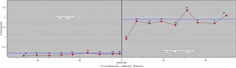
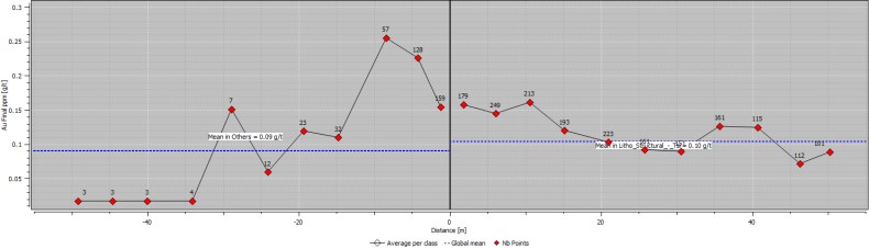
Figure supplied by Integra, June, 2023.
Figure 14.15
Mountain View Project, Logarithmic Probability Plots for Gold
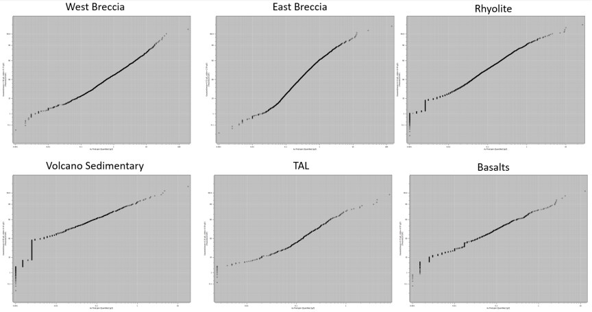
Figure supplied by Integra, June, 2023.
Table 14.12
Mountain View Project, West Breccia Drilling Assays Sensitivity to Gold Capping Value
| Cut-off [ Au g/t] | Percentile [%] | Mean
[ Au g/t] | Standard
Deviation [g/t] | Coefficient of
Variation | Metal
Loss [%] |
| 5.00 | 91.15 | 1.32 | 1.55 | 1.181 | 30.78 |
| 6.00 | 93.11 | 1.39 | 1.75 | 1.254 | 26.67 |
| 7.00 | 94.39 | 1.46 | 1.92 | 1.318 | 23.42 |
| 8.00 | 95.06 | 1.51 | 2.08 | 1.377 | 20.64 |
| 9.00 | 96.22 | 1.55 | 2.22 | 1.429 | 18.38 |
| 10.00 | 96.71 | 1.59 | 2.34 | 1.475 | 16.49 |
| 15.00 | 98.47 | 1.70 | 2.79 | 1.644 | 10.77 |
| 20.00 | 99.33 | 1.75 | 3.07 | 1.752 | 8.01 |
| 25.00 | 99.57 | 1.78 | 3.24 | 1.825 | 6.59 |
| 30.00 | 99.76 | 1.79 | 3.38 | 1.885 | 5.63 |
| 188.12 | 100.00 | 1.90 | 5.73 | 3.012 | 0.00 |
Table supplied by Integra, June, 2023.
Table 14.13
Mountain View Project, Selected Capping Value per Domain for Gold and Silver
| Commodity | Domain | Gold
Capping
(g/t) | Raw Mean
[g/t] | Capping
Mean [g/t] | Raw
Standard
Déviation
[g/t] | Capped
Standard
Déviation
[g/t] |
| Gold | East Breccia | 10 | 0.52 | 0.47 | 2.59 | 1.76 |
| West Breccia | 20 | 1.90 | 1.75 | 5.73 | 1.75 |
| TAL | 1 | 0.26 | 0.21 | 0.59 | 0.23 |
| Basalts | 10 | 0.15 | 0.15 | 0.57 | 0.50 |
| Rhyolite | 10 | 0.10 | 0.10 | 0.45 | 0.33 |
| Volcano-Sedimentary | 10 | 0.05 | 0.05 | 0.42 | 0.29 |
| Silver | East Breccia | 15 | 1.42 | 1.29 | 2.66 | 1.36 |
| West Breccia | 200 | 17.81 | 16.83 | 2.16 | 1.72 |
| TAL | 3 | 0.78 | 0.74 | 1.11 | 0.95 |
| Basalts | 60 | 2.07 | 1.99 | 3.02 | 2.51 |
| Rhyolite | 60 | 0.71 | 0.71 | 2.83 | 2.83 |
| Volcano-Sedimentary | 60 | 0.70 | 0.70 | 3.45 | 3.45 |
Table supplied by Integra, June, 2023.
14.5.8 Mountain View Project Compositing
The assay data were flagged and analyzed to determine an appropriate composite length, to minimize any bias introduced by variable sample lengths. Most of the analytical samples were collected at lengths of between 0.30 m and 3.1 m with a clear mode at 1.52 m (5 ft); see Figure 14.16. Based on these observations and considering the future bench heigh (estimated at approximately 6 m), a 3 m length composite was selected. All drill holes were composited by domain for gold and silver using capped and uncapped values, any composites with a length of less than 1.5 m (50% rule) were discarded (statistics are presented in Table 14.14)
Figure 14.16
Mountain View Project, Assay Length Histogram

Figure supplied by Integra, June, 2023.
Table 14.14
Mountain View Project, Drilling, 4.5m Composites Statistics
| Variable | Table | Defined
Count | Mean | Coefficient of
Variation | Minimum | Maximum |
Ag ppm
Cap | Raw | 16,578 | 2.12 | 9.66 | 0.01 | 200.00 |
| Composite | 8,822 | 2.12 | 8.15 | 0.01 | 139.92 |
| Residual | 130 | 2.25 | 6.03 | 0.05 | 42.15 |
| Ag ppm | Raw | 16,578 | 2.21 | 11.76 | 0.01 | 760.00 |
| Composite | 8,822 | 2.21 | 9.16 | 0.01 | 217.30 |
| Residual | 130 | 2.25 | 6.03 | 0.05 | 42.15 |
Au_ppm
Cap | Raw | 16,578 | 0.24 | 4.068 | 0.00 | 20.00 |
| Composite | 8,822 | 0.24 | 3.394 | 0.00 | 16.48 |
| Residual | 130 | 0.17 | 2.615 | 0.00 | 3.68 |
| Au_ppm | Raw | 16,578 | 0.26 | 6.990 | 0.00 | 188.12 |
| Composite | 8,822 | 0.26 | 5.140 | 0.00 | 95.91 |
| Residual | 130 | 0.17 | 2.615 | 0.00 | 3.68 |
| Length [m] | Raw | 16,578 | 1.58 | 0.37 | 0.1 | 6.1 |
| Composite | 8,822 | 2.99 | 0.04 | 1.52 | 3.00 |
| Residual | 130 | 1.44 | 0.57 | 0.01 | 3.00 |
Table supplied by Integra, June, 2023.
14.5.9 Mountain View Project Block Model
The criteria used in the selection of block size for the Mountain View resource estimate include drill hole spacing, composite length, the geometry of the modelled zone, and the anticipated mining methods. A block size of 7.62 m x 7.62 m x 6.10 m was used (25 ft x 25 ft x 20 ft). The block model was coded for each lithological and oxidation domains using the 50% rule. Considering that a hard boundary has been used for both breccia domains and that a soft boundary would be used for the other domains, this rule does not introduce dilution or create any complications for the mine planning. No rotation was applied to the block model. The characteristics of the block model are summarized in Table 14.15.
Table 14.15
Mountain View Project, Block Model Geometry
| Description | X | Y | Z |
| Number of nodes | 224 | 204 | 120 |
| Mesh size | 7.62 m | 7.62 m | 6.096 m |
| Grid origin (center) | 288,004.42 m | 4,522,204.27 m | 1,095.32 m |
| Grid origin (corner) | 288,000.61 m | 4,522,200.46 m | 1,092.27 m |
| Min | 288,000.61 m | 4,522,200.46 m | 1,092.27 m |
| Max | 289,707.49 m | 4,523,754.94 m | 1,823.79 m |
Table supplied by Integra, June, 2023.
14.5.10 Mountain View Search Ellipse and Interpolation Parameters
Two different search ellipse orientations were selected. These orientations were selected manually in 3D and validated though variography (maximum range). The size of the search ellipse was set as a mix of to be large enough to populate the densely informed area during the first pass and to roughly correspond to 70% of the variance of the variogram: the results of this provided a flat ellipse of 30 m x 20 m x 30 m (Table 14.16). To populate most of the block model, a second pass with ratios equal to 2, 2 and 1.5 for X, Y and Z was used.
Table 14.16
Mountain View Project, Search Ellipse Parameters
| Domain | X (m) | Y (m) | Z (m) | Dip (°) | Dip Azimuth (°) | Pitch (°) |
| East Breccia | 30 | 20 | 30 | 65 | 55 | 0 |
| Others | 30 | 20 | 30 | 85 | 230 | 160 |
Table supplied by Integra, June, 2023.
Block model was interpolated using an Inverse Distance cubed (ID3) using a block discretization of 3 x 3 x 3. A 3-pass interpolation strategy was used, with relaxing parameters for each pass; the parameters used for each successive pass are presented in Table 14.17.
Table 14.17
Mountain View Project, Interpolation Parameters
| Pass | Number of
Octants used | Maximum Samples
per Octant | Minimum Samples
Used | Increase Search
Ellipse Ratio |
| 1 | 4 | 4 | 9 | 1.0 |
| 2 | 4 | 4 | 5 | 2.0 |
| 3 | 4 | 4 | 5 | 3.0 |
Table supplied by Integra, June, 2023.
14.5.11 Mountain View Project Model Validation
Mineralized domain models for Mountain View were validated using a variety of methods, including visual inspection of the model grades and grade distributions compared to the informing raw samples, statistical comparisons of informing composites to the model for local and global bias, and reconciliation comparing the model to observed grades from underground development.
All analyses indicate that the model follows the grade distribution of the informing composites and the accuracy of the model is considered to have been demonstrated. The total global comparison for each resource classification is within a 20% tolerance for bias and reconciliation. The QP considers the model to be a reasonable representation of the Mountain View mineralization, based on the current level of sampling.
14.5.11.1 Visual Inspection
Figure 14.17 represents a sectional view of the model compared with the raw informing sample data. The visual validation confirms that the block model honours the drill hole and chip sample data and justifies the multiple capping grades.
Figure 14.17
Mountain View Project, North-South Block Model Cross Section Visual Checks (Looking North)

Figure supplied by Integra, June, 2023.
14.5.11.2 Statistical Comparisons
Ordinary kriging (OK) and Nearest Neighbour (NN) interpolations were performed to check for local and global bias in the models. In the global bias analysis at zero cut-off (Table 14.18), the ID3 interpolations matched well with the ID2 and OK interpolations. The NN estimated mean grade shows lower average grade but, considering the block size versus composite size, the NN grade is probably not a good estimator of the declustered grade.
The trend and local variation of the estimated ID3 models were compared with cell declustered composite data, using swath plots in three directions (north, east and elevation). The ID3 models show similar trends in grades, with the expected smoothing for the method when compared to the composite data. It must be noted that the cell declustering size has a significant impact on the weights at Mountain View, and these results should be interpreted with caution. Figure 14.18 shows the swath plot in the three principal directions. In the area with good data density, the gold grades from the cell desclustering composites fit well with the grades from the ID3 model.
Table 14.18
Mountain View Project, Gold Interpolation Comparison Cut-Off
Interpolation
Methodology | Number of
blocks | Mean | Coefficient of
Variation | Minimum | Maximum |
| ID2 | 5,483,520 | 0.13 | 2.64 | 0.00 | 8.17 |
| NN | 5,483,520 | 0.11 | 4.12 | 0.00 | 15.49 |
| ID3 | 5,483,520 | 0.13 | 2.71 | 0.00 | 8.98 |
| OK | 5,483,520 | 0.09 | 2.94 | 0.00 | 7.54 |
Table supplied by Integra, June, 2023.
Figure 14.18
Mountain View Project, Gold Trend Plot for East, North and Elevation
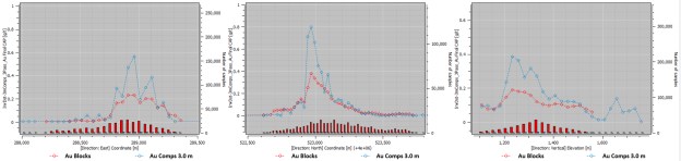
Figure supplied by Integra, June, 2023.
14.5.12 Mountain View Project, Classification
Mineral resource classification was determined through manual geometric criteria deemed reasonable for the deposit by the QP. Considering the complex 3D shape of the mineralization at the Mountain View Project, a classification based on a number of search passes was used. Blocks interpolated during the first and second passes were classified as Indicated, with blocks that were interpolated during the third pass classified as Inferred (Figure 14.19).
Figure 14.19
Mountain View Project 3D View of the Classification (Looking Northeast)
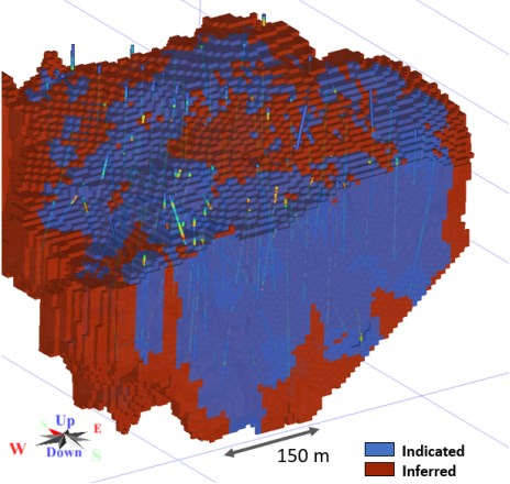
Figure supplied by Integra, June, 2023.
14.5.13 Mountain View Project, Reasonable Prospects for Eventual Economic Extraction
A reasonable economic cut-off grade for resource evaluation at the Mountain View deposit is 0.15 g/t Au. This was determined using the parameters presented in Table 14.19. The QP considers the selected cut-off grade of 0.15 g/t Au to be adequate, based on the current knowledge of the Project.
In addition to the cut-off grade, an open pit shell optimizer was undertaken on the block model to constrain the mineral resources within a conceptual pit shell. In addition to a gold price of US$1,800/oz, mining, processing and metallurgical recoveries among other parameters were used to create the conceptual pit. These parameters are summarized in Table 14.19.
Table 14.19
Mountain View Project, Mineral Resource Economic Parameters
| Parameters | Units | Value |
| Gold price | US$/oz | 1,800 |
| Silver price | US$/oz | 21.0 |
| Mining costs (QAL) | US$/t | 1.67 |
| Mining costs (Rock) | US$/t | 2.27 |
| Processing costs | US$/t | 3.1 |
| G&A costs | US$/t | 0.4 |
| Gold Cut-off | g/t Au | 0.15 |
| Discount rate | % | 5.0 |
| Pit slope (QLA) | ° | 44 |
| Pit slope (Rock) | ° | 44-50 |
| Oxide recovery | Au % | 86.0 |
| Transition recovery | Au % | 64.0 |
| Fresh recovery | Au % | 30.0 |
| Silver Recovery | Ag % | 20.0 |
Table supplied by Integra, June, 2023.
14.5.14 Mountain View Project, Mineral Resource Estimate
The QP has classified the Mountain View Project mineral resource estimate as indicated and inferred mineral resources based on data density, search ellipse criteria and interpolation parameters. The estimate is considered to be a reasonable representation of the mineral resources of the Mountain View deposit, based on the currently available data and geological knowledge. The mineral resource estimate follows the 2014 CIM Definition Standards on Mineral Resources and Reserves. The effective date of the mineral resource estimate is June 28, 2023.
Table 14.20 displays the results of the mineral resource estimate at a gold cut-off grade of 0.15 g/t for the Mountain View deposit.
Table 14.20
Mountain View Deposit June, 2023, Mineral Resource Estimate Statement
| Type | Classification | Tonnes | Gold
Grade
g/t | Ounces
Gold | Silver
Grade
g/t | Ounces
Silver | Gold
Equivalent
g/t | Gold
Equivalent
Ounces |
| Oxide | Indicated | 22,007,778 | 0.57 | 401,398 | 2.46 | 1,738,448 | 0.60 | 423,772 |
| Inferred | 3,579,490 | 0.44 | 50,716 | 1.43 | 165,049 | 0.46 | 52,840 |
| Transition | Indicated | 2,804,723 | 0.66 | 59,676 | 6.56 | 591,868 | 0.75 | 67,293 |
| Inferred | 215,815 | 0.40 | 2,750 | 3.77 | 26,184 | 0.44 | 3,087 |
| Fresh | Indicated | 3,938,017 | 0.92 | 116,970 | 8.46 | 1,071,521 | 1.03 | 130,760 |
| Inferred | 360,198 | 0.58 | 6,679 | 4.57 | 52,955 | 0.64 | 7,361 |
| Total | Indicated | 28,750,517 | 0.63 | 578,044 | 3.68 | 3,401,836 | 0.67 | 621,826 |
| Inferred | 4,155,502 | 0.45 | 60,145 | 1.83 | 244,188 | 0.47 | 63,288 |
Notes:
(1) Effective date of the Mineral Resource Estimate is June 28, 2023.
(2) Mineral Resources that are not Mineral Reserves do not have demonstrated economic viability.
(3) William J. Lewis, P.Geo., of Micon has reviewed and verified the Mineral Resource Estimate for the Mountain View Project. Mr. Lewis is an independent Qualified Person, as defined in National Instrument 43-101, Standards of Disclosure for Mineral Projects (NI 43-101).
(4) The estimate is reported for an open-pit mining scenario, based upon reasonable assumptions. The cut-off grade of 0.15 g/t Au was calculated using a gold price of US$1,800/oz, mining costs of US$1.67/t to US$2.27/t, processing cost of US$3.1/t, G&A costs of US$0.4/t, and metallurgical gold recoveries varying from 30.0% to 86.0% with a silver recovery of 20%. Gold equivalent in the Resource Estimate is calculated using the formula (g/t Au + (g/t Ag ÷ 77.7)).
(5) An average bulk density of 2.6 t/cm3 was assigned to all rock types.
(6) Inverse Distance cubed interpolation method was used with a parent block size of 7.62 m x 7.62 m x 6.10 m.
(7) Rounding as required by reporting guidelines may result in minor apparent discrepancies between tonnes, grades, and contained metal content.
(8) The estimate of mineral resources may be materially affected by geological, environmental, permitting, legal, title, taxation, sociopolitical, marketing, or other relevant issues.
(9) Neither Integra nor Micon's QP is aware of any known environmental, permitting, legal, title-related, taxation, socio-political, marketing or other relevant issue that could materially affect the mineral resource estimate, other than those disclosed in this report.
14.5.15 Mountain View Project, Mineral Resource Grade Sensitivity Analysis
Table 14.21 summarizes the cut-off grade sensitivity analysis for gold and silver for the Mountain View mineral resource estimate. The reader should be cautioned that the figures provided in Table 14.21 should not be interpreted as mineral resource statements. The reported quantities and grade estimates at different cut-off grades are presented for the sole purpose of demonstrating the sensitivity of the mineral resource model for gold to the selection of a reporting cut-off grade. Figure 14.20 and Figure 14.21 present the grade tonnage curves built on the cut-off grade sensitivity data presented in Table 14.21. Micon's QP has reviewed the cut-off grades used in the sensitivity analysis and is of the opinion that they meet the test for reasonable prospects of eventual economic extraction at varying prices of gold.
Table 14.21
Mountain View Project, Gold Grade Sensitivity Analysis at Different Cut-Off Grades
| Classification | Cut-off | Tonnes | g/t Au | oz Au | g/t Ag | oz Ag |
| Indicated | 0.05 | 40,403,411 | 0.47 | 611,331 | 2.77 | 3,603,425 |
| 0.1 | 33,505,516 | 0.55 | 596,279 | 3.25 | 3,504,450 |
| 0.15 | 28,750,517 | 0.63 | 578,044 | 3.68 | 3,401,836 |
| 0.2 | 24,655,131 | 0.70 | 555,638 | 4.13 | 3,273,399 |
| 0.25 | 20,636,857 | 0.79 | 527,273 | 4.71 | 3,126,157 |
| 0.3 | 17,607,873 | 0.89 | 501,067 | 5.30 | 3,002,439 |
| 0.35 | 15,040,896 | 0.98 | 474,722 | 5.96 | 2,884,444 |
| 0.4 | 12,825,775 | 1.09 | 448,438 | 6.72 | 2,770,464 |
| 0.45 | 11,148,152 | 1.19 | 425,832 | 7.44 | 2,665,760 |
| 0.5 | 9,921,924 | 1.28 | 407,305 | 8.10 | 2,585,043 |
| 0.6 | 8,060,436 | 1.45 | 374,797 | 9.37 | 2,428,881 |
| 0.65 | 7,261,650 | 1.54 | 358,880 | 10.06 | 2,349,158 |
| 0.7 | 6,605,735 | 1.62 | 344,764 | 10.74 | 2,280,086 |
| 0.75 | 6,092,995 | 1.70 | 332,892 | 11.34 | 2,221,263 |
| 0.8 | 5,604,020 | 1.78 | 320,793 | 11.99 | 2,160,136 |
| 0.85 | 5,141,115 | 1.87 | 308,589 | 12.67 | 2,094,668 |
| 0.9 | 4,704,754 | 1.96 | 296,388 | 13.43 | 2,031,580 |
| 0.95 | 4,347,878 | 2.04 | 285,832 | 14.17 | 1,980,755 |
| Classification | Cut-off | Tonnes | g/t Au | oz Au | g/t Ag | oz Ag |
| Inferred | 0.05 | 7,216,472 | 0.29 | 68,309 | 1.23 | 286,151 |
| 0.1 | 5,193,523 | 0.38 | 64,086 | 1.58 | 264,520 |
| 0.15 | 4,155,502 | 0.45 | 60,145 | 1.83 | 244,188 |
| 0.2 | 3,295,489 | 0.52 | 55,404 | 2.01 | 213,229 |
| 0.25 | 2,666,150 | 0.59 | 50,996 | 2.23 | 190,903 |
| 0.3 | 2,183,919 | 0.67 | 46,813 | 2.42 | 170,015 |
| 0.35 | 1,787,425 | 0.74 | 42,741 | 2.68 | 153,958 |
| 0.4 | 1,482,411 | 0.82 | 39,121 | 2.95 | 140,721 |
| 0.45 | 1,251,206 | 0.90 | 36,019 | 3.20 | 128,567 |
| 0.5 | 1,082,894 | 0.96 | 33,480 | 3.38 | 117,542 |
| 0.6 | 820,366 | 1.10 | 28,925 | 3.81 | 100,545 |
| 0.65 | 731,986 | 1.15 | 27,166 | 4.04 | 94,982 |
| 0.7 | 648,315 | 1.22 | 25,362 | 4.30 | 89,554 |
| 0.75 | 587,329 | 1.27 | 23,954 | 4.47 | 84,454 |
| 0.8 | 520,384 | 1.33 | 22,299 | 4.70 | 78,600 |
| 0.85 | 468,262 | 1.39 | 20,924 | 4.92 | 74,091 |
| 0.9 | 434,955 | 1.43 | 19,995 | 5.07 | 70,965 |
| 0.95 | 396,559 | 1.48 | 18,855 | 5.18 | 66,060 |
Table supplied by Integra, June, 2023.
Figure 14.20
Mountain View Project, Grade Tonnage Curves for the Indicated Mineral Resources at Different Cut-Off Grades
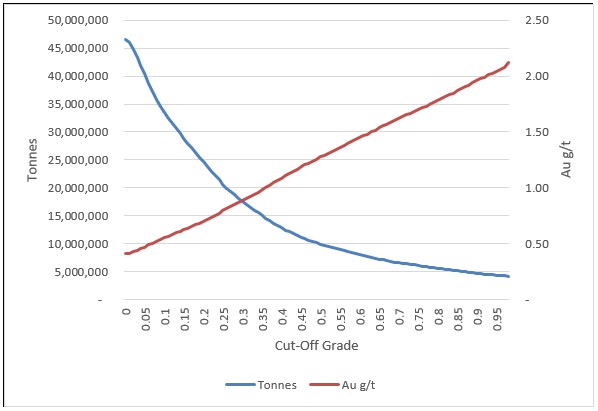
Figure supplied by Integra, June, 2023.
Figure 14.21
Mountain View Project, Grade Tonnage Curves for the Inferred Mineral Resources at Different Cut-Off Grades
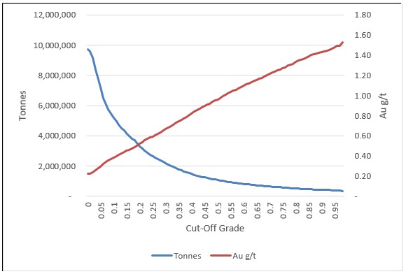
Figure supplied by Integra, June, 2023.
14.5.16 Mountain View Project, 2023 Mineral Resource Estimate Comparison with 2020 Estimate
In November, 2020, Micon conducted a NI43-101 compliant resource estimate for the Mountain View Project. Table 14.22 presents a comparison of the 2023 and 2020 estimations for gold only. The present June, 2023, mineral resource estimate represents a significant increase in the indicated category. The increase in the indicated classification was achieved due to the 2021-2022 Integra drilling program which demonstrated the validity of the historical data at the Mountain View Project. The additional resource increase was primarily driven by the new geological interpretation (definition of the high-grade Breccia domains), as well as an increased gold price and changes to the other technical and economical assumptions.
Table 14.22
Mountain View Project, Comparison between the 2023 and the 2020 Mineral Resource Estimates
| Classification | November, 2020, Mineral Resource Estimate
(@ US$1,500/oz) | June, 2023, Mineral Resource Estimate
(@ US$1,800/oz) |
Tonnes
(Mt) | Gold Grade
(g/t) | Gold Ounces
(x 1,000) | Tonnes
(Mt) | Gold Grade
(g/t) | Gold Ounces
(x 1,000) |
| Indicated | - | - | - | 28.8 | 0.63 | 578 |
| Inferred | 23.2 | 0.57 | 427 | 4.2 | 0.45 | 60 |
14.6 Factors that could Affect the Wildcat and Mountain View Mineral Resource Estimates
It is the QP's opinion that the factors set out below could affect the mineral resource estimate:
The geological interpretations and assumptions used to generate the estimation domains.
The mineralization and geologic geometry and continuity of mineralized zones.
The estimates of mineralization and grade continuity.
The treatment of high-grade gold and silver values.
The grade interpolation methods and estimation parameter assumptions.
The confidence in assumptions and methods used in the mineral resource classification.
The density and the methods used in the estimation of density.
The metal price and other economic assumptions used in the cut-off grade determination.
The input and design parameter assumptions that pertain to the open-pit mining constraints.
The assumptions as to the continued ability to access property, retain mineral and surface rights titles, maintain the operation within environmental and other regulatory permits, and maintain the social license to operate.
As of the completion of this Technical Report, no environmental, permitting, legal, title, taxation, socio-economic, marketing, political or other relevant factors are known to the QP that would materially affect the estimation of Wildcat or Mountain View Projects mineral resource estimates, other than those not discussed in this report.
14.7 Responsibility for the Wildcat and Mountain View Mineral Resource Estimates
The geologic modelling for the Wildcat and Mountain View deposits and the initial mineral resource estimate was completed by Integra's Vice President Exploration Raphael Dutaut Ph.D. P.Geo. The geological modelling and the mineral resource estimate were then reviewed and validated by William Lewis, P.Geo. of Micon. Mr. Lewis is responsible for the resource estimates discussed herein, by virtue of his independent review and verified of the work performed by Integra.
15.0 MINERAL RESERVE ESTIMATES
There are presently no mineral reserves at either the Wildcat Project or the Mountain View Project. Integra will need to conduct further work at both properties prior to undertaking a mineral reserve estimate.
16.0 MINING METHODS
The mining plan for this PEA, includes inferred mineral resources. Inferred resources are viewed as being too geologically speculative to have economic considerations applied that would enable them to be categorized as mineral reserves. Mineral resources are not mineral reserves and do not have demonstrated economic viability. There is no certainty that PEA results will be realized.
The PEA for the Wildcat and Mountain View deposits, as described in this report, uses conventional open pit truck and loader mining methods. Waste material will be loaded into 91-tonne haul trucks and transported to waste rock storage facilities. The mineralized material will be extracted from the pit, crushed and placed on a heap leach pad. Ultimate pit limits were determined through pit optimization techniques, and preliminary pit designs have been established. Production schedules have been formulated based on the resources derived from these pit designs. The following sections elaborate on the methodology employed to define the pit designs, waste dump designs, and production schedule used in this PEA.
16.1 Pit Optimization
Economic pit limit analysis was carried out using the Lerchs-Grossmann algorithm and incorporated economic and geometrical parameters estimated for the Wildcat and Mountain View Projects.
The processing methods considered included run-of-mine ROM leaching, where trucks would transport mineralized material to the leach pads, and crushed leaching, where trucks would deliver mineralized material to a crushing circuit for crushing before being transferred to the leach pad by conveyors.
Various mining and processing scenarios based on throughput rates ranging from 10,000 to 30,000 t/d, were examined to determine the optimal processing rate. Pit shells for different metal prices were generated to identify pit phases and ultimate pits for each scenario. Subsequently, the Hexagon Mine Plan Schedule Optimizer was utilized to develop production schedules and preliminary cash flows for each scenario.
16.1.1 Pit Optimization Parameters
Economic parameters were established for each production scenario, including mining costs, process costs, general and administrative (G&A) costs, dilution, and metallurgical recoveries. These parameters are summarized in Table 16.1.
Operating mining costs comparable to similar projects in Nevada were applied to all scenarios. The mining cost was further refined using the mine schedule to reflect the specific operational requirements.
Table 16.1
Pit Optimization Parameters
Parameters | Units | Wildcat
Project | Mountain View Project |
Gold price | US$/oz | 1,700 | 1,700 |
Silver price | US$/oz | 21 | 21 |
Processing cost, alluvium | US$/tonne treated | 3.7 | 3.1 |
Processing cost, oxide material | US$/tonne treated | 3.7 | 3.1 |
Processing cost, fresh material | US$/tonne treated | 3.7 | 3.1 |
WC Metallurgical recovery, gold in oxide | % | 73 | '----- |
WC Metallurgical recovery, gold in granodiorite | % | 52 | '----- |
WC Metallurgical recovery, gold in fresh | % | 10 | '----- |
MV Metallurgical recovery, gold in oxide | % | '----- | 86 |
MV Metallurgical recovery, gold in transition | % | '----- | 64 |
MV Metallurgical recovery, gold in fresh | % | '----- | 30 |
Metallurgical recovery, silver | % | 18 | 20 |
Mine dilution | % | 1 | 10 |
Mine recovery | % | 100 | 100 |
G&A | US$/tonne treated | 0.5 | 0.4 |
Mining cost in Alluvium | US$/tonne mined | 1.8 | 1.67 |
Mining cost in oxide | US$/tonne mined | 2.4 | 2.27 |
Mining cost in fresh | US$/tonne mined | 2.4 | 2.27 |
Annual discount rate | % | 5 | 5 |
WC Pit slope angle, overall | Degrees (°) | 54 | '----- |
WC Pit slope angle, Phase 2 north wall | Degrees (°) | 51 | '----- |
MV Pit slope angle, alluvium | Degrees (°) | '----- | 44 |
MV Pit slope angle, granodiorite | Degrees (°) | '----- | 50 |
MV Pit slope angle, rhyolite | Degrees (°) | '----- | 50 |
MV Pit slope angle, volcanics | Degrees (°) | '----- | 44 |
Table supplied by Integra, June, 2023.
For all pit optimization scenarios, leaching is assumed to be conducted in a valley for the Wildcat deposit and adjacent to the pit for the Mountain View deposit. A conveyor is included in the Wildcat scenario to transport crushed ore from the crusher to the leach pad.
Process costs were initially estimated based on processing models provided by the QP's estimation services and were further refined for the final mine plan.
General and administrative costs were determined based on the personnel, supplies and other expenses required to support the operation.
Recoveries were estimated based on the results of current metallurgical testwork.
While pit optimizations considered a range of metal prices, the base metal prices used were US$1,700 per ounce of gold and US$21.00 per ounce of silver.
16.1.2 Geometrical Parameters
Since the mineral resources are contained within the current property boundaries, they were not considered as restrictions during the pit optimization process. No royalty factors were directly applied to the optimization; instead, the royalties were calculated based on the final schedule, considering all permits that overlap with the properties.
Recent pit slope stability studies conducted by Alius Mine Consulting provided recommendations for the design parameters. These recommendations are discussed in Section 16.2.1.
16.1.3 Pit Optimization Results
Pit optimizations were performed utilizing both Indicated and Inferred resources.
Pit optimization using the Lerchs-Grossmann algorithm defines an excavation limit at a specific metal price. Metal prices are increased incrementally, and excavation limits or pit shells are created for each metal price. The inputs provided included the resource block model, and appropriate economic, geotechnical, and recovery parameters. Each deposit was analyzed separately, and ultimate pit shells were selected for the final designs. Additional pit shells were considered for guidance on the interior pit phases of the Wildcat and Mountain View deposits.
The selection of ultimate pits and pit phases involved a two-step process. In the first step, a set of pit shells was optimized by varying a revenue factor. The revenue factors for each deposit were varied from 0.29 to 1.18 in increments of 0.029. This resulted in a range of nested pit shells representing gold prices from US$500 to US$2,000 per ounce in increments of US$50. This process generated 31 pit shells for further analysis.
In the second step, the pit-by-pit analysis tool was employed to generate discounted operating cash flows, without including capital expenditure. Three different discounted values were developed: best, worst, and specified. The best-case value utilized each pit shell as a pit phase or pushback, taking advantage of mining more valuable material as soon as possible to enhance the discounted value. The worst case evaluated each pit shell as if mining a single pit from top to bottom, without the advantage of prioritizing higher-value material. The specified case allowed for user-specified pit shells to be used as pushbacks, providing a more realistic assessment of the discounted cash flow considering mining width constraints.
Pit optimizations were performed to determine appropriate pit phasing and ultimate limits. It should be noted that capital expenditure was not included in the optimization process, and the calculated net present value (NPV) is purely a notional value, representing only revenues and operating costs.
16.1.3.1 Wildcat Pit Optimization
The previously mentioned parameters, along with base metal prices of US$1,700 per ounce of gold and US$21.00 per ounce of silver, were utilized in the pit optimization process for the Wildcat deposit. Gold prices were varied from US$500 to US$2,000 per ounce in increments of $50 to generate the pit optimization results. Table 16.2 presents these results, showing the changes in pit parameters corresponding to each gold price increment.
Table 16.2
Wildcat Project, Pit Optimization Results
Pit Shell | Revenu
Factor | Gold
Price
(USD/oz) | Total
(Tonne) | Waste
(Tonne) | Ore
(Tonne) | Strip
Ratio | AU In Situ
Grade (g/t) | AG In Situ
Grade (g/t) | Gold In
Situ (oz) | AG In Situ
(oz) | Best Case
Disc.@ 5% | Worst Case
Disc.@ 5% |
1 | 0.29 | 500 | 6,024,905 | 596,748 | 5,428,157 | 0.11 | 0.76 | 5.99 | 132,638 | 1,044,796 | 114,933,032 | 114,933,032 |
2 | 0.32 | 550 | 10,190,641 | 884,836 | 9,305,805 | 0.10 | 0.66 | 5.26 | 198,536 | 1,573,024 | 164,120,580 | 164,119,895 |
3 | 0.35 | 600 | 13,685,934 | 1,274,034 | 12,411,900 | 0.10 | 0.63 | 4.91 | 250,360 | 1,960,802 | 201,415,534 | 200,729,573 |
4 | 0.38 | 650 | 18,688,014 | 1,561,719 | 17,126,295 | 0.09 | 0.58 | 4.60 | 319,626 | 2,534,834 | 248,581,714 | 247,011,730 |
5 | 0.41 | 700 | 22,404,573 | 1,767,513 | 20,637,060 | 0.09 | 0.56 | 4.40 | 368,353 | 2,920,545 | 279,416,923 | 276,674,252 |
6 | 0.44 | 750 | 28,373,507 | 2,200,517 | 26,172,990 | 0.08 | 0.52 | 4.14 | 438,314 | 3,482,121 | 320,589,241 | 314,979,865 |
7 | 0.47 | 800 | 32,470,872 | 2,370,058 | 30,100,814 | 0.08 | 0.50 | 4.03 | 485,209 | 3,896,301 | 346,626,142 | 339,702,676 |
8 | 0.50 | 850 | 36,724,580 | 2,647,935 | 34,076,645 | 0.08 | 0.48 | 3.92 | 529,857 | 4,297,830 | 368,922,121 | 359,006,839 |
9 | 0.53 | 900 | 42,539,072 | 2,953,203 | 39,585,869 | 0.07 | 0.46 | 3.72 | 588,957 | 4,738,874 | 395,959,726 | 383,157,479 |
10 | 0.56 | 950 | 47,943,876 | 3,254,086 | 44,689,790 | 0.07 | 0.45 | 3.59 | 640,422 | 5,162,231 | 417,335,298 | 399,812,386 |
11 | 0.59 | 1,000 | 52,667,105 | 3,610,022 | 49,057,083 | 0.07 | 0.43 | 3.53 | 682,697 | 5,562,403 | 433,475,977 | 413,438,047 |
12 | 0.62 | 1,050 | 60,600,821 | 4,898,241 | 55,702,580 | 0.09 | 0.42 | 3.47 | 744,070 | 6,210,911 | 454,329,693 | 429,139,689 |
13 | 0.65 | 1,100 | 63,820,760 | 5,116,321 | 58,704,439 | 0.09 | 0.41 | 3.44 | 770,564 | 6,491,191 | 462,520,110 | 435,523,339 |
14 | 0.68 | 1,150 | 67,184,748 | 5,474,888 | 61,709,860 | 0.09 | 0.40 | 3.40 | 796,641 | 6,740,197 | 469,723,596 | 440,007,618 |
15 | 0.71 | 1,200 | 71,181,830 | 5,866,002 | 65,315,828 | 0.09 | 0.39 | 3.37 | 825,805 | 7,084,930 | 477,221,500 | 444,538,272 |
16 | 0.74 | 1,250 | 74,274,338 | 6,161,998 | 68,112,340 | 0.09 | 0.39 | 3.34 | 847,889 | 7,310,439 | 482,270,289 | 447,449,195 |
17 | 0.76 | 1,300 | 77,802,742 | 6,504,465 | 71,298,277 | 0.09 | 0.38 | 3.30 | 872,133 | 7,566,152 | 487,008,139 | 448,842,541 |
18 | 0.79 | 1,350 | 81,335,082 | 7,026,710 | 74,308,372 | 0.09 | 0.37 | 3.26 | 894,161 | 7,785,111 | 490,788,624 | 449,096,243 |
19 | 0.82 | 1,400 | 83,013,477 | 7,202,561 | 75,810,916 | 0.10 | 0.37 | 3.24 | 905,130 | 7,900,058 | 492,401,921 | 449,349,660 |
20 | 0.85 | 1,450 | 87,214,312 | 7,855,983 | 79,358,329 | 0.10 | 0.36 | 3.21 | 929,834 | 8,198,327 | 495,469,190 | 449,111,680 |
21 | 0.88 | 1,500 | 89,492,746 | 8,153,301 | 81,339,445 | 0.10 | 0.36 | 3.19 | 943,239 | 8,329,448 | 496,741,994 | 447,796,391 |
22 | 0.91 | 1,550 | 91,594,938 | 8,401,199 | 83,193,739 | 0.10 | 0.36 | 3.17 | 955,387 | 8,473,940 | 497,652,572 | 446,564,967 |
23 | 0.94 | 1,600 | 93,553,796 | 8,752,431 | 84,801,365 | 0.10 | 0.35 | 3.15 | 966,264 | 8,594,783 | 498,236,936 | 445,863,991 |
24 | 0.97 | 1,650 | 95,221,652 | 9,004,598 | 86,217,054 | 0.10 | 0.35 | 3.13 | 974,942 | 8,678,760 | 498,519,121 | 444,673,066 |
25 | 1.00 | 1,700 | 97,008,868 | 9,269,494 | 87,739,374 | 0.11 | 0.35 | 3.11 | 984,327 | 8,784,488 | 498,610,137 | 442,857,139 |
26 | 1.03 | 1,750 | 98,840,242 | 9,523,691 | 89,316,551 | 0.11 | 0.35 | 3.10 | 993,513 | 8,888,186 | 498,479,325 | 440,619,130 |
27 | 1.06 | 1,800 | 100,549,520 | 9,939,866 | 90,609,654 | 0.11 | 0.34 | 3.08 | 1,001,361 | 8,977,666 | 498,206,581 | 438,150,352 |
28 | 1.09 | 1,850 | 102,108,483 | 10,144,606 | 91,963,877 | 0.11 | 0.34 | 3.07 | 1,008,887 | 9,071,621 | 497,797,949 | 435,968,086 |
29 | 1.12 | 1,900 | 103,521,687 | 10,301,176 | 93,220,511 | 0.11 | 0.34 | 3.05 | 1,015,740 | 9,146,028 | 497,307,863 | 433,949,680 |
30 | 1.15 | 1,950 | 105,001,301 | 10,652,387 | 94,348,914 | 0.11 | 0.34 | 3.04 | 1,022,080 | 9,213,053 | 496,716,662 | 431,991,644 |
31 | 1.18 | 2,000 | 106,347,318 | 10,841,383 | 95,505,935 | 0.11 | 0.33 | 3.02 | 1,028,171 | 9,275,021 | 496,041,840 | 430,045,759 |
Table supplied by Integra, June, 2023.
During the optimization, the focus was on the economic potential of the deposit, and as a result, the fresh unoxidized material was excluded from the analysis.
To determine the ultimate pit limits for design purposes, the US$1,200 per ounce of gold result, highlighted in Table 16.2 was selected as the best-case pit.
Figure 16.1 provides a graphical representation of the pit-by-pit analysis. The highlighted pit shell represents the maximized discounted operating cash flow, considering a gold price of US$1,700 and a silver price of US$21.00 while minimizing the capital expenditure required. This pit serves as the foundation for the ultimate pit design of the Wildcat deposit.
Figure 16.1
Wildcat Project Pit-by-Pit Graph
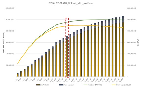
Figure supplied by Integra, June, 2023.
16.1.3.2 Mountain View Pit Optimization
The pit optimization for the Mountain View deposit was conducted using the aforementioned parameters, with gold prices ranging from US$500 to US$2,000 per ounce. The results of these optimizations are presented in Table 16.3, which displays the changes in pit parameters for each US$50 increment in gold price.
As was the case with Wildcat. the ultimate pit limit for design purposes at Mountain View, was selected as the US$1,200 per ounce of gold pit, highlighted in Table 16.3.
Figure 16.2 provides a graphical representation of the pit-by-pit analysis for the Mountain View deposit. It offers a visual depiction of the optimized pits and their corresponding discounted operating cash flows, at various gold prices.
Table 16.3
Mountain View Project, Pit Optimization Results
Pit Shell | Revenu
Factor | Gold
Price
(USD/oz) | Total
(Tonne) | Waste
(Tonne) | Ore
(Tonne) | Strip
Ratio | AU In Situ
Grade (g/t) | AG In Situ
Grade (g/t) | Gold In
Situ (oz) | AG In Situ
(oz) | Best Case
Disc.@ 5% | Worst Case
Disc.@ 5% |
1 | 0.29 | 500 | 186,879 | 53,871 | 133,008 | 0.41 | 0.55 | 1.15 | 2,349 | 4,934 | 2,582,662 | 2,582,662 |
2 | 0.32 | 550 | 41,815,949 | 30,710,602 | 11,105,347 | 2.77 | 0.65 | 3.44 | 232,865 | 1,228,191 | 201,213,707 | 201,213,707 |
3 | 0.35 | 600 | 44,634,122 | 31,845,766 | 12,788,356 | 2.49 | 0.62 | 3.19 | 255,142 | 1,310,278 | 217,241,390 | 218,301,659 |
4 | 0.38 | 650 | 46,406,969 | 32,464,189 | 13,942,780 | 2.33 | 0.60 | 3.06 | 269,054 | 1,369,501 | 226,530,593 | 227,366,185 |
5 | 0.41 | 700 | 49,383,810 | 34,039,096 | 15,344,714 | 2.22 | 0.58 | 2.94 | 287,271 | 1,450,462 | 239,562,858 | 239,013,396 |
6 | 0.44 | 750 | 57,321,648 | 38,609,621 | 18,712,027 | 2.06 | 0.56 | 3.13 | 337,229 | 1,880,985 | 266,907,370 | 263,413,716 |
7 | 0.47 | 800 | 60,975,174 | 40,076,177 | 20,898,997 | 1.92 | 0.54 | 3.01 | 362,682 | 2,025,440 | 280,678,583 | 273,874,818 |
8 | 0.50 | 850 | 66,291,072 | 42,086,043 | 24,205,029 | 1.74 | 0.52 | 2.92 | 401,806 | 2,273,566 | 299,111,750 | 288,227,072 |
9 | 0.53 | 900 | 71,154,028 | 44,126,954 | 27,027,074 | 1.63 | 0.50 | 2.87 | 435,608 | 2,497,435 | 312,679,752 | 297,519,639 |
10 | 0.56 | 950 | 82,324,192 | 53,345,161 | 28,979,031 | 1.84 | 0.51 | 2.98 | 477,606 | 2,773,783 | 330,025,604 | 310,512,271 |
11 | 0.59 | 1,000 | 85,910,994 | 55,625,236 | 30,285,758 | 1.84 | 0.51 | 2.93 | 493,785 | 2,854,663 | 336,146,155 | 314,407,869 |
12 | 0.62 | 1,050 | 87,326,567 | 56,301,844 | 31,024,723 | 1.81 | 0.50 | 2.89 | 500,991 | 2,884,670 | 338,738,058 | 315,884,645 |
13 | 0.65 | 1,100 | 91,980,219 | 59,695,509 | 32,284,710 | 1.85 | 0.50 | 2.87 | 518,637 | 2,981,289 | 344,259,485 | 317,729,442 |
14 | 0.68 | 1,150 | 92,954,846 | 59,913,526 | 33,041,320 | 1.81 | 0.50 | 2.84 | 527,705 | 3,013,277 | 345,909,165 | 318,863,507 |
15 | 0.71 | 1,200 | 96,149,134 | 62,151,602 | 33,997,532 | 1.83 | 0.49 | 2.84 | 540,941 | 3,104,831 | 348,876,226 | 319,328,993 |
16 | 0.74 | 1,250 | 106,331,492 | 69,604,846 | 36,726,646 | 1.90 | 0.48 | 2.68 | 572,565 | 3,158,879 | 357,296,909 | 317,659,116 |
17 | 0.76 | 1,300 | 107,909,352 | 70,766,478 | 37,142,874 | 1.91 | 0.48 | 2.66 | 577,088 | 3,177,900 | 358,294,441 | 317,501,297 |
18 | 0.79 | 1,350 | 111,437,438 | 73,715,200 | 37,722,238 | 1.95 | 0.48 | 2.68 | 586,291 | 3,245,880 | 359,855,192 | 317,249,340 |
19 | 0.82 | 1,400 | 113,542,471 | 75,319,449 | 38,223,022 | 1.97 | 0.48 | 2.65 | 592,129 | 3,259,830 | 360,827,907 | 316,322,613 |
20 | 0.85 | 1,450 | 114,806,289 | 76,237,736 | 38,568,553 | 1.98 | 0.48 | 2.65 | 596,684 | 3,280,992 | 361,305,134 | 315,916,999 |
21 | 0.88 | 1,500 | 115,595,879 | 76,715,200 | 38,880,679 | 1.97 | 0.48 | 2.64 | 599,839 | 3,303,987 | 361,564,967 | 315,413,830 |
22 | 0.91 | 1,550 | 116,037,588 | 76,981,534 | 39,056,054 | 1.97 | 0.48 | 2.64 | 601,406 | 3,315,028 | 361,672,737 | 315,224,561 |
23 | 0.94 | 1,600 | 121,176,921 | 80,804,509 | 40,372,412 | 2.00 | 0.48 | 2.72 | 623,556 | 3,531,959 | 362,433,168 | 312,915,554 |
24 | 0.97 | 1,650 | 124,024,363 | 82,959,845 | 41,064,518 | 2.02 | 0.48 | 2.74 | 633,733 | 3,612,401 | 362,614,702 | 311,651,971 |
25 | 1.00 | 1,700 | 126,291,247 | 84,532,536 | 41,758,711 | 2.02 | 0.48 | 2.71 | 641,932 | 3,640,941 | 362,593,173 | 310,326,220 |
26 | 1.03 | 1,750 | 127,500,833 | 85,474,883 | 42,025,950 | 2.03 | 0.48 | 2.71 | 645,057 | 3,658,819 | 362,515,458 | 309,507,305 |
27 | 1.06 | 1,800 | 129,489,559 | 86,722,440 | 42,767,119 | 2.03 | 0.48 | 2.72 | 655,328 | 3,742,575 | 362,320,337 | 308,304,521 |
28 | 1.09 | 1,850 | 132,678,256 | 89,140,739 | 43,537,517 | 2.05 | 0.47 | 2.69 | 663,216 | 3,765,356 | 361,838,175 | 304,976,786 |
29 | 1.12 | 1,900 | 134,646,272 | 90,626,473 | 44,019,799 | 2.06 | 0.47 | 2.68 | 668,838 | 3,794,796 | 361,488,981 | 303,118,994 |
30 | 1.15 | 1,950 | 136,234,111 | 91,812,411 | 44,421,700 | 2.07 | 0.47 | 2.68 | 672,688 | 3,824,161 | 361,097,840 | 301,416,845 |
31 | 1.18 | 2,000 | 139,457,627 | 94,207,070 | 45,250,557 | 2.08 | 0.47 | 2.65 | 681,340 | 3,858,820 | 360,183,674 | 298,395,398 |
Table supplied by Integra, June, 2023.
Figure 16.2
Mountain View Project, Pit-by-Pit Graph
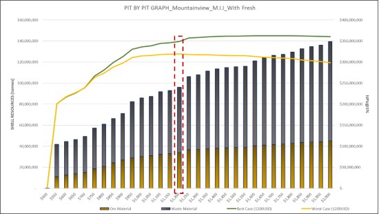
Figure supplied by Integra, June, 2023.
16.1.3.3 Combined Selected Shell
The US$1,200/oz gold price shell was chosen as the optimal pit configuration to maximize the value of the Projects, while minimizing the capital requirement. This selection was made based on a comprehensive evaluation of the pit optimization results, taking into account economic considerations and the need to optimize the balance between profitability and capital expenditure. By selecting the US$1,200/oz shell, the Projects generate value, while maintaining an efficient capital utilization strategy. Table 16.4 summarizes the combined pit optimization results.
Table 16.4
Combined Wildcat and Mountain View Project Pit Optimization Results
SHELL SELECTION FINAL PIT | Units | Wildcat | Mountain view | Total |
Gold Price for optimization | (US$/oz) | 1,700 | 1,700 | - |
Shell Number | | 15 | 15 | - |
Shell Revenue Factor | | 0.71 | 0.71 | 0.71 |
Total Tonnage | (Ktonne) | 71,182 | 96,149 | 167,331 |
Selected Shell Gold price | (US$/oz) | 1,200 | 1,200 | 1,200 |
Waste Tonnage | (Ktonne) | 5,866 | 62,152 | 68,018 |
Ore Tonnage | (Ktonne) | 65,316 | 33,998 | 99,313 |
Stripping Ratio | | 0.09 | 1.83 | 0.68 |
AU Grade | (g/t) | 0.39 | 0.49 | 0.43 |
In-Situ Gold | Koz | 826 | 541 | 1,367 |
Recovered Gold | Koz | 570 | 415 | 985 |
Ag Grade | (g/t) | 3.37 | 2.84 | 3.19 |
In-Situ Silver | oz | 7,085 | 3,105 | 10,190 |
Recovered Silver | Koz | 1,275 | 621 | 1,896 |
In situ Gold Oxide | Koz | 826 | 416 | 1,242 |
In situ Gold Transition | Koz | - | 59 | 59 |
In situ Gold Fresh | Koz | - | 66 | 66 |
Recovered Gold Oxide | Koz | 570 | 358 | 928 |
Recovered Gold Transition | Koz | - | 38 | 38 |
Recovered Gold Fresh | Koz | - | 20 | 20 |
Best case NPV DCF @ 5% | (M$) | 477 | 349 | 826 |
Table supplied by Integra, June, 2023.
16.2 Pit Designs
The pit designs were developed using the optimized pit shells and the designs was developed to ensure efficient access to the mineral resources for equipment and personnel involved in the mining operations. By aligning the pit design with the optimized pit shell, the Projects aim to optimize resource extraction, maximize productivity, and facilitate smooth operations within the pit area.
16.2.1 Pit Design Slope Parameters
While not definitive, a geotechnical study was conducted by Alius Mine Consulting for both the Wildcat and Mountain View Projects.
This study aimed to ensure that appropriate design parameters and guidelines were incorporated into the pit optimization and pit design processes at both Projects.
Figure 16.3 illustrates pit wall terminology.
Figure 16.3
Pit Wall Terminology
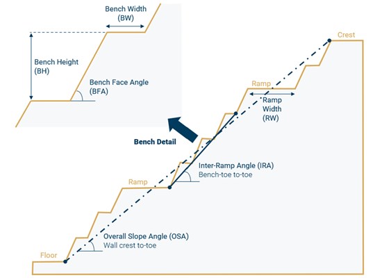
Figure supplied by Integra (modified from Read & Stacey, 2009), June, 2023.
16.2.1.1 Wildcat Slope Parameters
Based on the technical memorandum prepared by Alius Mine Consulting, the open pit wall angles for the Wildcat Project have been assessed.
The pit design involves the use of double benches, with each double bench having a height of 18.28 m. To enhance stability and safety, every other bench includes a catch bench, 8.1 m wide. A bench face angle of 75° has been assumed, resulting in an inter-ramp slope angle of 54°.
A specific critical sector was located in the north-northwest wall of the Wildcat south pit (Phase 2). In this sector, the bench face angle was reduced to 70°, and this resulted in a slightly shallower inter-ramp slope of 51°. This adjustment was made to address geotechnical concerns specific to that area. Figure 16.4 illustrates the geotechnical sectors of the Wildcat Project, highlighting the area of the north-northwest wall of the south pit.
The geomechanical slope design guidelines for the Wildcat Project are aligned with the optimization of safety, stability and the operational requirements of open pit mining. These guidelines provide a framework for the design and management of pit slopes to ensure the overall stability of the Project. The geotechnical parameters for the Wildcat deposit are summarized in Table 16.5.
Figure 16.4
Wildcat Geotechnical Sectors: North-Northwest Wall of South Pit Highlighted
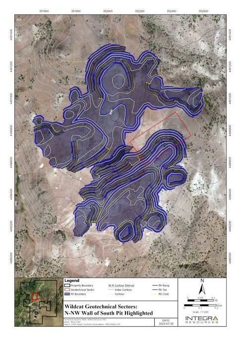
Figure supplied by Integra, July, 2023.
Table 16.5
Wildcat Geotechnical Parameters
Final Slope Design Guidelines | Units | North-Northwest Wall of
South Pit | Remaining |
Benching | | Double | Double |
Bench Height | metre | 2 x 9.14 | 2 x 9.14 |
Bench Width | metre | 8.10 | 8.10 |
Bench Face Angle | degree | 70 | 75 |
Inter-Ramp Angle | degree | 51 | 54 |
Table supplied by Integra, June, 2023.
16.2.1.2 Mountain View Pit Slope Parameters
As with the Wildcat Project, Alius Mine Consulting (Alius) has prepared a technical memorandum to assess the open pit wall angles of the Mountain View Project. The Mountain View Project geotechnical parameters are primarily dependent on rock type.
The recommendations for the Mountain View Project geotechnical parameters are summarized in Table 16.6.
Table 16.6
Mountain View Geotechnical Parameters
Final Slope Design
Guidelines | Units | Lithology |
Alluvium | Granodiorite | Rhyolite | Volcanics |
Benching | | Double | Double | Double | Double |
Bench Height | metre | 2 x 6.1 | 2 x 6.1 | 2 x 6.1 | 2 x 6.1 |
Bench Width | metre | 6.90 | 6.90 | 6.90 | 6.90 |
Bench Face Angle | degree | 65 | 75 | 75 | 65 |
Inter-Ramp Angle | degree | 44 | 50 | 50 | 44 |
Table supplied by Integra, June, 2023.
16.2.2 Bench Height
In the pit design process, the bench height was aligned with both the block model elevation and the specific mining equipment to be utilized. This alignment ensures operational efficiency and allows for reasonable selectivity during the mining activities.
For the Wildcat deposit, a bench height of 9.14 m was employed. This particular height was chosen to suit the geological characteristics of the deposit and to accommodate the equipment used in the mining operations effectively.
In the case of the Mountain View deposit, a bench height of 6.1 m was utilized. This height selection was based on similar considerations, taking into account the geological attributes and the equipment specifications necessary for efficient mining.
By aligning the bench height with the block model elevation and the equipment requirements, the pit design aims to optimize productivity, selectivity and operational performance during the mining process.
The in-pit ramps and haul roads for both the Wildcat and Mountain View Projects were designed to ensure safe operation of haul trucks and to accommodate two-way traffic. A ramp width of 30 m was utilized within the pits. This width allows for approximately 3.5 times the running width of a 90-t truck, ensuring ample space for safe passage.
In-pit ramps and surface roads were designed with a maximum gradient of 10%, although some steeper sections may exist on the inside of curves for short distances.
16.2.3 Wildcat Project, Pit Design
The Wildcat pit was divided into two main pits, each consisting of two phases and two satellite pits, resulting in a total of six phases in the design. Pit designs were engineered to ensure optimal resource extraction and maximize recovery by simultaneously mining all phases and achieving a well-blended production schedule.
The two main phases, Phase 1 and Phase 2, were further divided into initial pushbacks, denoted as Phase 1A and Phase 2A, as well as final phases. This subdivision allows for efficient sequencing of mining activities and facilitates the optimal utilization of equipment and personnel.
Figure 16.5 outlines the design of Phase 1A and Phase 2A for the Wildcat pit, while Figure 16.6 illustrates the design of Phase 1F and Phase 2F. The satellite pits are outlined in Figure 16.7.
The ultimate pit design for the Wildcat deposit, encompassing all phases and the satellite pits, is outlined in Figure 16.8. This design represents the culmination of the pit optimization process and provides for the extraction of mineral resources in an efficient and coordinated manner.
Figure 16.5
Wildcat Pit, Phase 1A (North) and Phase 2A (South)
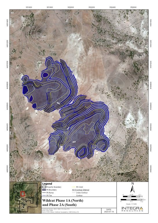
Figure supplied by Integra, July, 2023.
Figure 16.6
Wildcat Pit, Phase 1F (North) and Phase 2F (South)
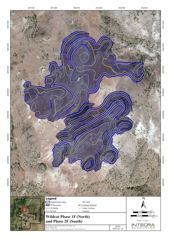
Figure supplied by Integra, July, 2023.
Figure 16.7
Wildcat Pit, Phase A (North) and Phase B (South)
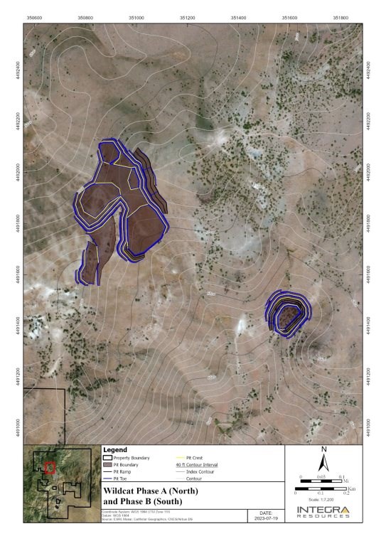
Figure supplied by Integra, July, 2023.
Figure 16.8
Wildcat Pit all Phases, Satellite Pits A and B

Figure supplied by Integra, July, 2023.
16.2.4 Mountain View Project, Pit Design
The Mountain View deposit consists of a single main pit, which is divided into two phases: Phase 1 and Phase 2. Both phases are mined simultaneously. The primary objective of the pit design was to achieve a balance between material movement flows and the cost/revenue streams.
Figure 16.9 depicts the design of Phase 1 for the Mountain View pit, showing the layout and configuration of this initial phase. Figure 16.10 displays the final design for Phase 2, representing the subsequent stage of mining activities in the pit.
By carefully sequencing the mining operations and considering bench elevation priorities, the pit design for the Mountain View deposit aims to optimize the extraction of the mineral resources while efficiently managing stripping activities. The ultimate goal is to enhance the economic viability of the Project.
16.2.5 Cut-Off Grade
The Lerchs-Grossmann pit optimization was driven by value, rather than by cut-off grades, however for scheduling purposes a cut-off grade was estimated.
Cut-off grade calculations were performed based on gold value, and for the different material types present, in order to account for varying recoveries.
The calculated cut-off grade varies from 0.09 to 0.15 g/t gold; however, due to the potential for misclassification errors at low cut-off grades, a minimum cut-off grade of 0.15 g/t of gold was used for the production scheduling. Table 16.7 summarizes the data used for the different calculated cut-off grades and the selected cut-off grade.
Table 16.7
Cut-off Grade Estimation
Description | Units | Wildcat Project | Mountain View Project |
Oxide | Oxide
Granodiorite | Oxide | Transition |
Processing cost | US$/tonne | 3.70 | 4.00 | 3.10 | 3.10 |
G&A | US$/tonne | 0.5 | 1.00 | 0.4 | 0.4 |
Gold price | US$/oz | 1,700 | 1,700 | 1,700 | 1,700 |
Recovery | % | 73 | 52 | 86 | 64 |
Selling cost | US$/oz | 5.00 | 5.00 | 5.00 | 5.00 |
Royalties | % | 2.00 | 2.00 | 4.00 | 4.00 |
Royalties | US$/oz | 34.00 | 34.00 | 68.00 | 68.00 |
Insitu COG | g/t | 0.11 | 0.15 | 0.08 | 0.10 |
Dilution | % | 1.00 | 1.00 | 10.00 | 10.00 |
Diluted COG | g/t | 0.11 | 0.15 | 0.09 | 0.12 |
Final COG | g/t | 0.15 | 0.15 | 0.15 | 0.15 |
Table supplied by Integra, June, 2023.
Figure 16.9
Mountain View Pit Phase 1
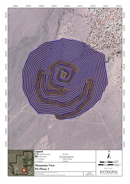
Figure supplied by Integra, July, 2023.
Figure 16.10
Mountain View Final Pit Phase 2
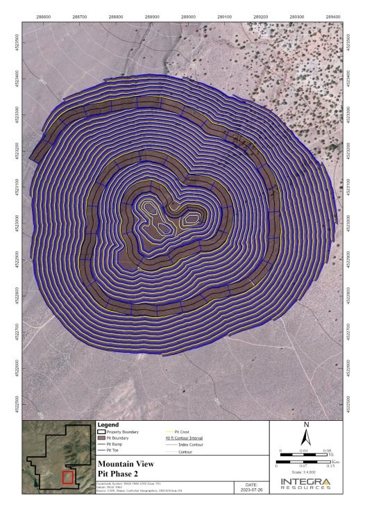
Figure supplied by Integra, June, 2023.
16.2.6 Dilution
The current cut-off grade for mine planning is 0.15 g/t gold.
The same gold cut-off grade of 0.15 g/t was used for the dilution estimation process. A dilution factor is applied in mine planning to allow for the inadvertent mining of some uneconomic waste along with the profitable mineralized material.
A grade shell for mineralization above 0.15 g/t gold inside the pit design was generated for each Project. The solid was then extruded by 0.5 m, 1 m and 2 m to simulate mining outside the mineralization boundary.
The extruded solids inventory was reported and used with a qualitative assessment to estimate the dilution for each Project. Table 16.8 shows the final dilution factors used for the mine plan.
Equipment for the Projects has been selected to provide selectivity with respect to the selected block sizes. The resource estimate has been diluted to reflect losses from mining.
Table 16.8
Dilution Factors
Project | Tonnes | Gold Grade | Gold Ounces |
Wildcat | 1 % | -1 % | 0 % |
Mountain View | 5 % | -5 % | 0 % |
Table supplied by Integra, June, 2023.
16.2.7 Mineral Resources in the PEA Conceptual Mine Plan
16.2.7.1 Wildcat Project, Mineral Resources in the Conceptual Mine Plan
The mineral resources within the final PEA pit designs for Wildcat were estimated using a volumetric report. Due to lower recovery rates in the fresh unoxidized material at the Wildcat Project, only oxidized material from the pit was included for processing in the production schedule. Additionally, a dilution factor of 1% was applied to the mineralized tonnes in the production schedule. Detailed information regarding the in-pit resources at Wildcat is provided in Table 16.9.
16.2.7.2 Mountain View Project, Mineral Resources in the Conceptual Mine Plan
The determination of resources within the final PEA pit designs for Mountain View was also estimated using a volumetric report. Additionally, a dilution factor of 5% was applied to the mineralized tonnes during the production scheduling process.
The Mountain View in-pit resources are presented in Table 16.10.
Table 16.9
Wildcat Project, Mineral Resources within the Conceptual Mine Plan
| Indicated | Inferred | Waste
(K tonne) | Total
(K tonne) | Strip
Ratio |
Phases | K
Tonnes | Au Grade
(g/t) | Gold
(Koz) | Ag Grade
(g/t) | Silver
(Koz) | K Tonnes | Au Grade
(g/t) | Gold
(Koz) | Ag grade
(g/t) | Silver
(Koz) |
WC Phase 01A | 13,905 | 0.40 | 181 | 2.44 | 1,092 | 672 | 0.39 | 8 | 214.04 | 57 | 2,786 | 17,363 | 0.19 |
WC Phase 01F | 21,637 | 0.36 | 247 | 2.80 | 1,951 | 4,457 | 0.32 | 46 | 383.68 | 566 | 5,442 | 31,535 | 0.21 |
WC Phase 02A | 16,742 | 0.46 | 249 | 4.86 | 2,617 | 1,652 | 0.34 | 18 | 199.66 | 117 | 7,042 | 25,435 | 0.38 |
WC Phase 02F | 2,457 | 0.29 | 23 | 3.97 | 313 | 780 | 0.26 | 6 | 381.51 | 80 | 3,114 | 6,351 | 0.96 |
WC Phase A | - | | - | | - | 6,174 | 0.31 | 61 | 222.37 | 439 | 1,428 | 7,602 | 0.23 |
WC Phase B | - | | - | | - | 806 | 0.37 | 9 | 232.90 | 71 | 816 | 1,622 | 1.01 |
Total | 54,741 | 0.40 | 701 | 3.39 | 5,973 | 14,540 | 0.32 | 150 | 2.85 | 1,331 | 20,627 | 89,909 | 0.30 |
Notes:
1. Wildcat Project, mineral resources in the mine plan are reported using a 0.15 g/t Au cut-off.
2. Numbers may not reconcile due to rounding.
Table 16.10
Mountain View Project, Mineral Resources within the Conceptual Mine Plan
| | Indicated | Inferred | Waste
(K tonne) | Total
(K tonne) | Strip
Ratio |
| Phases | K Tonnes | Au grade
(g/t) | Gold
(Koz) | Ag grade
(g/t) | Silver
(Koz) | K Tonnes | Au grade
(g/t) | Gold
(Koz) | Ag grade
(g/t) | Silver
(Koz) |
| MV Phase 01 | 12,464 | 0.45 | 182 | 1.73 | 693 | 1,859 | 0.31 | 18 | 97.18 | 58 | 45,417 | 59,740 | 3.17 |
| MV Phase 02 | 12,402 | 0.79 | 317 | 5.71 | 2,277 | 1,415 | 0.48 | 22 | 158.79 | 112 | 56,722 | 70,539 | 4.11 |
| Total | 24,866 | 0.62 | 499 | 3.71 | 2,970 | 3,275 | 0.38 | 40 | 1.61 | 170 | 102,138 | 130,279 | 3.63 |
Notes:
1. Mountain View Project, mineral resources in the mine plan are reported using a 0.15 g/t Au cut-off.
2. Numbers may not reconcile due to rounding.
16.3 Mine Waste Facilities
16.3.1 Wildcat Waste Disposal
The site at the Wildcat Project has varying topography with very few level areas upon which to locate a waste storage dump. Two waste dumps were designed for waste disposal in the Wildcat Project, as depicted in Figure 16.11. The south waste dump primarily accommodates material from Phase 2A and Phase 2F, while the north dump is designated for the remaining phases.
The waste dump designs were based on an assumed bench face angle of 35º, with 15-m lift heights. Catch benches measuring 24 m were incorporated on each lift, resulting in an inter-ramp angle (IRA) of 18°. Dump road width is 30 m with a maximum gradient of 10%.
In-pit dumping was also included in the mine plan.
The total dump capacity is 22.5 million tonnes, considering a swell factor of 1.25 and a loose density of 2.2 tonnes per cubic metre (t/m3). The capacities of the two waste dumps are outlined in Table 16.11.
Table 16.11
Wildcat Project, Waste Dump Capacity
Waste Dump | Cubic Metres (Millions) | Tonnage (Millions) |
South Dump | 1.3 | 2.8 |
North Dump | 9.1 | 19.7 |
Total: | 10.4 | 22.5 |
Table supplied by Integra, June, 2023.
16.3.2 Mountain View Waste Disposal
The site at Mountain View has generally slight slopes dipping to the southwest. The Mountain View Project also incorporates a waste dump, employing the same parameters as the Wildcat Project. The dump is situated south of the pit, including a 100 m buffer around the pit edge and features two main ramps to facilitate short hauling from the Phase 1 and Phase 2 pit exits (Figure 16.12).
The total dump capacity at Mountain View is 105.4 million tonnes, considering a swell factor of 1.25 and a loose density of two tonnes per cubic metre. The capacity of the waste dump is summarized in Table 16.12.
Table 16.12
Mountain View Project, Waste Dump Capacity
Waste Dump | Cubic Metres (Millions) | Tonnage (Millions) |
Waste Dump | 54.9 | 105.4 |
Table supplied by Integra, June, 2023.
Figure 16.11
Wildcat Project, Waste Dumps

Figure supplied by Integra, July, 2023.
Figure 16.12
Mountain View Project, Waste Dump
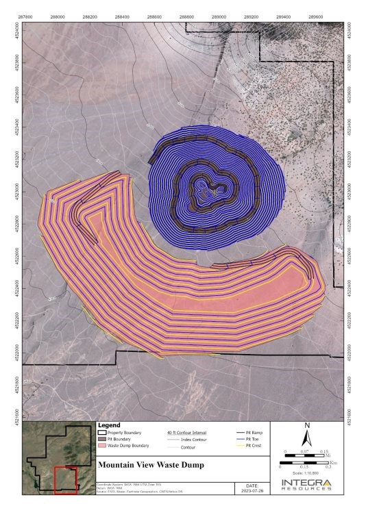
Figure supplied by Integra, June, 2023.
16.4 Mineralized Material Stockpile Facilities
Two mineralized material stockpiles have been designed, one for each Project, utilizing the waste dump design criteria. The stockpiles were designed with a bench face angle of 35º, 15-m lift heights, and catch benches of 24 m, resulting in an inter-ramp angle of 18°.
For the Wildcat Project, a small stockpile with a capacity of 0.5 million tonnes has been designed. This stockpile primarily serves the purpose of blending to maintain the granodiorite ratio in the feed below 15% (Figure 16.13).
For the Mountain View Project, a larger stockpile with a capacity of 9.2 million tonnes is planned to store mineralized material mined during the pre-stripping period before processing commences (Figure 16.14).
The stockpile capacities have been estimated using a swell factor of 1.25 and a loose density of 2.2 tonnes per cubic metre. The specific capacities of the stockpiles are summarized in Table 16.13.
Table 16.13
Mineralized Material Stockpile Capacity
Project | Cubic Metres (Millions) | Tonnage (Millions) |
Wildcat stockpile | 0.2 | 0.5 |
Mountain View Stockpile | 4.3 | 9.2 |
Table supplied by Integra, June, 2023.
16.5 Production Scheduling
The mine production schedule was created with a cutoff grade of 0.15 g/t of gold applied to all material across both Projects.
During the initial stages, various scenarios were run to determine the optimal processing rate. Scenarios ranged from 10,000 t/d to 30,000 t/d, in increments of 5,000 t/d. The best net present value (NPV) for the Wildcat Project was achieved at a processing rate of 30,000 t/d, while the Mountain View Project showed the highest NPV at a rate of 20,000 t/d.
To minimize capital requirements and maximize NPV, the two Projects have been designed to share resources and capacity. Consequently, a processing rate of 30,000 t/d was retained for both Projects. However, due to factors such as high stripping ratios, bench advance rates, and mining rate constraints, the processing capacity in the Mountain View Project is not optimized.
Figure 16.13
Wildcat Project, Mineralized Material Stockpile Design
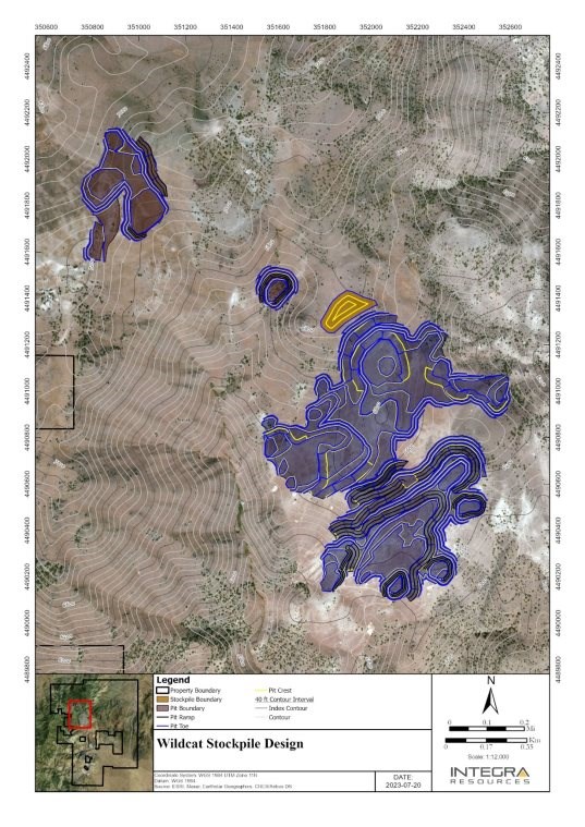
Figure supplied by Integra, June, 2023.
Figure 16.14
Mountain View Project, Mineralized Material Stockpile Design
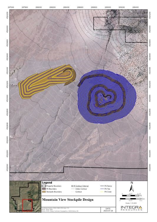
Figure supplied by Integra, June, 2023.
The scheduling process, aimed to optimize net present value (NPV) and internal rate of return (IRR). There is synergy between the Wildcat and Mountain View operations, with shared resources enhancing operational efficiency.
Production at the Wildcat Project is scheduled to commence in Year 1, with construction of Phase 1 of the heap leach pad. The objective is to maximize the processing rate and generate value to fund the expansion of the leach pad. Additional mining equipment and personnel will be acquired and allocated to the Mountain View Project from Year 5 to Year 7, during which pre-stripping activities will be initiated. Leachable material will be stockpiled during this period. In Year 7, the Wildcat Project will conclude, and the remaining mining resources will be relocated to the Mountain View Project to increase the mining rate. The processing facilities, including the crusher and plant, will be relocated from Wildcat to Mountain View, and metal production will commence at the Mountain View site in Year 7. Table 16.14 summarizes the combined Wildcat and Mountain View mine production schedule.
16.6 Mine Equipment Requirements
In this PEA, owner mining was selected over more costly contract mining. The production schedule, along with additional efficiency factors, performance curves, and productivity rates, was utilized to calculate the hours required for primary mining equipment, in order to meet the production schedule. The primary mining equipment includes drills, loaders, hydraulic shovels, and haul trucks.
In addition to the primary mining equipment, support equipment, blasting equipment, and mine maintenance equipment will also be necessary. Table 16.15 provides an overview of the yearly equipment requirements.
16.7 Mine Operations Personnel
Based on the production schedule and equipment requirements, an estimate was prepared of the required number of mine personnel. The mine is expected to operate 24 h/d, employing three crews of workers who will work on a fourteen-days on and seven-days off rotation. These crews will alternate between day shift and night shift.
The daily shift schedule will consist of two 12-hour shifts, accounting for standby time that includes startup/shutdown, lunch breaks, and operational delays. The total number of personnel required to support the mining activities is summarized in Table 16.16.
Table 16.14
Mine Production Schedule |
Project | Phases | Destinations | Units | Year1 | Year2 | Year3 | Year4 | Year5 | Year6 | Year7 | Year8 | Year9 | Year10 | Year11 | Year12 | Total |
Wildcat | Wildcat Phase1A | Expit Leach to pad | K Tonnes | 4,694 | 2,626 | 4,538 | - | 689 | 1,055 | 1,036 | - | - | - | - | - | 14,638 |
Au (g/t) | 0.38 | 0.36 | 0.41 | - | 0.43 | 0.46 | 0.48 | - | - | - | - | - | 0.40 |
Gold (Koz) | 57 | 30 | 60 | - | 10 | 16 | 16 | - | - | - | - | - | 188 |
Ag(g/t) | 2.05 | 2.19 | 2.90 | - | 3.15 | 3.22 | 1.30 | - | - | - | - | - | 2.42 |
Ag (Koz) | 309 | 185 | 423 | - | 70 | 109 | 43 | - | - | - | - | - | 1,139 |
Leach to Stockpile | K Tonnes | 73 | 12 | - | - | - | - | - | - | - | - | - | - | 85 |
Waste to Dump | K Tonnes | 859 | 493 | 514 | - | 131 | 254 | 390 | - | - | - | - | - | 2,640 |
Total Mined | K Tonnes | 5,626 | 3,131 | 5,052 | - | 820 | 1,308 | 1,426 | - | - | - | - | - | 17,363 |
Strip Ratio | W:O | 0.18 | 0.19 | 0.11 | - | 0.19 | 0.24 | 0.38 | - | - | - | - | - | 0.18 |
Wildcat Phase1F | Expit Leach to pad | K Tonnes | 5,991 | 6,967 | 2,058 | 782 | 9,430 | 552 | 575 | - | - | - | - | - | 26,354 |
Au (g/t) | 0.35 | 0.35 | 0.34 | 0.35 | 0.34 | 0.33 | 0.33 | - | - | - | - | - | 0.35 |
Gold (Koz) | 68 | 79 | 22 | 9 | 104 | 6 | 6 | - | - | - | - | - | 293 |
Ag(g/t) | 2.52 | 2.61 | 2.45 | 2.46 | 3.51 | 3.62 | 5.08 | - | - | - | - | - | 2.97 |
Ag (Koz) | 486 | 584 | 162 | 62 | 1,064 | 64 | 94 | - | - | - | - | - | 2,517 |
Leach to Stockpile | K Tonnes | - | 0 | - | - | - | - | - | - | - | - | - | - | 0 |
Waste to Dump | K Tonnes | 1,880 | 1,471 | 260 | 90 | 1,225 | 91 | 163 | - | - | - | - | - | 5,181 |
Total Mined | K Tonnes | 7,871 | 8,438 | 2,318 | 872 | 10,655 | 643 | 738 | - | - | - | - | - | 31,535 |
Strip Rati0 | W:O | 0.31 | 0.21 | 0.13 | 0.12 | 0.13 | 0.16 | 0.28 | - | - | - | - | - | 0.20 |
Wildcat Phase2A | Expit Leach to pad | K Tonnes | 233 | 1,244 | 4,354 | 10,168 | 776 | 435 | 1,219 | - | - | - | - | - | 18,428 |
Au (g/t) | 0.45 | 0.26 | 0.28 | 0.54 | 0.62 | 0.44 | 0.44 | - | - | - | - | - | 0.45 |
Gold (Koz) | 3 | 10 | 39 | 176 | 16 | 6 | 17 | - | - | - | - | - | 267 |
Ag(g/t) | 1.84 | 1.56 | 2.14 | 5.97 | 6.95 | 4.84 | 4.07 | - | - | - | - | - | 4.61 |
Ag (Koz) | 14 | 62 | 300 | 1,952 | 173 | 68 | 159 | - | - | - | - | - | 2,729 |
Leach to Stockpile | K Tonnes | 49 | 101 | 0 | - | 0 | - | - | - | - | - | - | - | 150 |
Waste to Dump | K Tonnes | 123 | 865 | 2,276 | 2,960 | 178 | 174 | 282 | - | - | - | - | - | 6,858 |
Total Mined | K Tonnes | 405 | 2,210 | 6,630 | 13,128 | 954 | 609 | 1,501 | - | - | - | - | - | 25,435 |
Strip Ratio | W:O | 0.44 | 0.64 | 0.52 | 0.29 | 0.23 | 0.40 | 0.23 | - | - | - | - | - | 0.37 |
Wildcat Phase2F | Expit Leach to pad | K Tonnes | - | - | - | - | 55 | 3,215 | - | - | - | - | - | - | 3,270 |
Au (g/t) | - | - | - | - | 0.19 | 0.28 | - | - | - | - | - | - | 0.28 |
Gold (Koz) | - | - | - | - | 0 | 29 | - | - | - | - | - | - | 30 |
Ag(g/t) | - | - | - | - | 2.19 | 3.76 | - | - | - | - | - | - | 3.74 |
Ag (Koz) | - | - | - | - | 4 | 389 | - | - | - | - | - | - | 393 |
Leach to Stockpile | K Tonnes | - | - | - | - | - | - | - | - | - | - | - | - | - |
Waste to Dump | K Tonnes | - | - | - | - | 1,249 | 1,832 | - | - | - | - | - | - | 3,081 |
Total Mined | K Tonnes | - | - | - | - | 1,304 | 5,047 | - | - | - | - | - | - | 6,351 |
Strip Ratio | W:O | - | - | - | - | 22.60 | 0.57 | - | - | - | - | - | - | 0.94 |
Wildcat Phase0A | Expit Leach to pad | K Tonnes | 32 | 114 | - | - | - | 5,176 | 914 | - | - | - | - | - | 6,236 |
Au (g/t) | 0.32 | 0.34 | - | - | - | 0.31 | 0.27 | - | - | - | - | - | 0.31 |
Gold (Koz) | 0 | 1 | - | - | - | 52 | 8 | - | - | - | - | - | 61 |
Ag(g/t) | 3.07 | 3.15 | - | - | - | 2.29 | 1.50 | - | - | - | - | - | 2.19 |
Ag (Koz) | 3 | 12 | - | - | - | 381 | 44 | - | - | - | - | - | 439 |
Leach to Stockpile | K Tonnes | - | - | - | - | - | - | - | - | - | - | - | - | - |
Waste to Dump | K Tonnes | 67 | 8 | - | - | - | 1,217 | 75 | - | - | - | - | - | 1,367 |
Total Mined | K Tonnes | 99 | 122 | - | - | - | 6,393 | 989 | - | - | - | - | - | 7,602 |
Strip Ratio | W:O | 2.07 | 0.07 | - | - | - | 0.24 | 0.08 | - | - | - | - | - | 0.22 |
Wildcat Phase0B | Expit Leach to pad | K Tonnes | - | - | - | - | - | - | 814 | - | - | - | - | - | 814 |
Au (g/t | - | - | - | - | - | - | 0.36 | - | - | - | - | - | 0.36 |
Gold (Koz) | - | - | - | - | - | - | 9 | - | - | - | - | - | 9 |
Ag(g/t) | - | - | - | - | - | - | 2.71 | - | - | - | - | - | 2.71 |
Ag (Koz) | - | - | - | - | - | - | 71 | - | - | - | - | - | 71 |
Leach to Stockpile | K Tonnes | - | - | - | - | - | - | - | - | - | - | - | - | - |
Waste to Dump | K Tonnes | - | - | - | - | - | - | 808 | - | - | - | - | - | 808 |
Total Mined | K Tonnes | - | - | - | - | - | - | 1,622 | - | - | - | - | - | 1,622 |
Strip Ratio | W:O | - | - | - | - | - | - | 0.99 | - | - | - | - | - | 0.99 |
Project | Phases | Destinations | Units | Year1 | Year2 | Year3 | Year4 | Year5 | Year6 | Year7 | Year8 | Year9 | Year10 | Year11 | Year12 | Total |
Mountain view | Mountain view Phase01 | Expit Leach to pad | K Tonnes | - | - | - | - | - | - | - | 3,983 | 3,867 | 5,191 | - | - | 13,041 |
Au (g/t) | - | - | - | - | - | - | - | 0.34 | 0.43 | 0.49 | - | - | 0.43 |
Gold (Koz) | - | - | - | - | - | - | - | 44 | 53 | 83 | - | - | 180 |
Ag(g/t) | - | - | - | - | - | - | - | 0.94 | 1.07 | 2.64 | - | - | 1.65 |
Ag (Koz) | - | - | - | - | - | - | - | 121 | 132 | 441 | - | - | 694 |
Leach to Stockpile | K Tonnes | - | - | - | - | 815 | 669 | 515 | - | - | - | - | - | 1,999 |
Waste to Dump | K Tonnes | - | - | - | - | 10,185 | 7,179 | 4,876 | 15,702 | 5,021 | 1,738 | - | - | 44,701 |
Total Mined | K Tonnes | - | - | - | - | 11,000 | 7,848 | 5,392 | 19,685 | 8,888 | 6,928 | - | - | 59,740 |
Strip Ratio | W:O | - | - | - | - | 12.49 | 10.74 | 9.47 | 3.94 | 1.30 | 0.33 | - | - | 2.97 |
Mountain view Phase02 | Expit Leach to pad | K Tonnes | - | - | - | - | - | - | - | 235 | 1,025 | 2,603 | 5,271 | 4,866 | 14,000 |
Au (g/t) | - | - | - | - | - | - | - | 0.27 | 0.28 | 0.41 | 0.81 | 0.97 | 0.74 |
Gold (Koz) | - | - | - | - | - | - | - | 2 | 9 | 34 | 137 | 152 | 334 |
Ag(g/t) | - | - | - | - | - | - | - | 0.44 | 0.47 | 1.00 | 5.56 | 8.49 | 5.27 |
Ag (Koz) | - | - | - | - | - | - | - | 3 | 15 | 84 | 942 | 1,328 | 2,373 |
Leach to Stockpile | K Tonnes | - | - | - | - | - | 1 | 507 | - | - | - | - | - | 508 |
Waste to Dump | K Tonnes | - | - | - | - | - | 3,151 | 13,102 | 5,080 | 15,087 | 12,036 | 7,013 | 562 | 56,031 |
Total Mined | K Tonnes | - | - | - | - | - | 3,152 | 13,608 | 5,315 | 16,112 | 14,639 | 12,284 | 5,427 | 70,539 |
Strip Ratio | W:O | - | - | - | - | - | 3,465.71 | 25.85 | 21.61 | 14.72 | 4.62 | 1.33 | 0.12 | 3.86 |
Total Mining | Total | Total Leach to pad | K Tonnes | 10,950 | 10,950 | 10,950 | 10,950 | 10,950 | 10,667 | 4,557 | 6,725 | 4,892 | 7,794 | 5,271 | 4,866 | 99,522 |
Au (g/t) | 0.36 | 0.34 | 0.34 | 0.52 | 0.37 | 0.32 | 0.39 | 0.33 | 0.40 | 0.47 | 0.81 | 0.97 | 0.43 |
Gold (Koz) | 128 | 121 | 121 | 184 | 129 | 111 | 57 | 72 | 62 | 117 | 137 | 152 | 1,390 |
Ag(g/t) | 2.31 | 2.39 | 2.51 | 5.72 | 3.72 | 2.99 | 2.81 | 0.91 | 0.94 | 2.09 | 5.56 | 8.49 | 3.26 |
Ag (Koz) | 812 | 843 | 885 | 2,014 | 1,311 | 1,027 | 412 | 197 | 148 | 525 | 942 | 1,328 | 10,443 |
Waste to Dump | K Tonnes | 2,929 | 2,838 | 3,050 | 3,050 | 12,968 | 13,898 | 19,696 | 20,782 | 20,108 | 13,774 | 7,013 | 562 | 120,666 |
Total Mined | K Tonnes | 14,000 | 13,901 | 14,000 | 14,000 | 24,733 | 25,000 | 25,275 | 25,000 | 25,000 | 21,568 | 12,284 | 5,427 | 220,188 |
Strip Ratio | W:O | 0.27 | 0.26 | 0.28 | 0.28 | 1.18 | 1.30 | 4.32 | 3.09 | 4.11 | 1.77 | 1.33 | 0.12 | 1.21 |
Table supplied by Integra, June, 2023.
Table 16.15
Mining Fleet Requirements
Primary Equipment | Type | Units | Year1 | Year2 | Year3 | Year4 | Year5 | Year6 | Year7 | Year8 | Year9 | Year10 | Year11 | Year12 | Max |
Production Drills | CAT md6290 | # | 3 | 3 | 3 | 3 | 4 | 4 | 3 | 2 | 3 | 4 | 3 | 2 | 4 |
Hydraulic Shovel | 200t shovel-PC3000 | # | - | - | - | - | 1 | 1 | 1 | 1 | 1 | 1 | 1 | 1 | 1 |
Hydraulic Shovel | 200t shovel-PC2000 | # | 2 | 2 | 2 | 2 | 2 | 2 | 2 | 2 | 2 | 2 | 1 | - | 2 |
Loader | WA900-8 | # | 1 | 1 | 1 | 1 | 1 | 1 | 1 | 1 | 1 | 1 | 1 | 1 | 1 |
Haul Trucks | 90T truck HD785 | # | 5 | 5 | 6 | 7 | 9 | 9 | 9 | 9 | 10 | 10 | 6 | 3 | 10 |
Support Equipment | | | | | | | | | | | | | | | |
Dozer Dump | D375A-8 | # | 1 | 1 | 1 | 1 | 2 | 2 | 2 | 2 | 2 | 2 | 1 | 1 | 2 |
Dozer Ancillary | D71PXi-24 | # | 1 | 1 | 1 | 1 | 1 | 1 | 1 | 1 | 1 | 1 | 1 | 1 | 1 |
Motor Grader | GD655 | # | 1 | 1 | 1 | 1 | 2 | 2 | 2 | 2 | 2 | 2 | 2 | 1 | 2 |
Wheel Dozer | Cat 834k | # | 1 | 1 | 1 | 1 | 1 | 1 | 1 | 1 | 1 | 1 | 1 | 1 | 1 |
Water Truck | HD758/H20 | # | 1 | 1 | 1 | 1 | 1 | 1 | 1 | 1 | 1 | 1 | 1 | 1 | 1 |
Pit pumps | 2,000 GPM Centrifugal Pumps | # | 2 | 2 | 2 | 2 | 2 | 2 | 2 | 2 | 2 | 2 | 2 | 2 | 2 |
Tow Haul | Cat Tow haul | # | 1 | 1 | 1 | 1 | 1 | 1 | 1 | 1 | 1 | 1 | 1 | 1 | 1 |
Mine Maintenance | | | | | | | | | | | | | | | |
Lube / Fuel truck | HM400/FUEL | # | 1 | 1 | 1 | 1 | 1 | 1 | 1 | 1 | 1 | 1 | 1 | 1 | 1 |
Mechanic service truck | Peterbilt 537 Service Truck w/crane | # | 2 | 2 | 2 | 2 | 2 | 2 | 2 | 2 | 2 | 2 | 2 | 2 | 2 |
Tire truck | Off-Road Tire Service Truck | # | 1 | 1 | 1 | 1 | 1 | 1 | 1 | 1 | 1 | 1 | 1 | 1 | 1 |
Blasting | | | | | | | | | | | | | | | |
Explosive truck | MMU | # | 1 | 1 | 1 | 1 | 1 | 1 | 1 | 1 | 1 | 1 | 1 | 1 | 1 |
Stemming loader | Cat 914G Stemmer | # | 1 | 1 | 1 | 1 | 1 | 1 | 1 | 1 | 1 | 1 | 1 | 1 | 1 |
Other Mine Equipment | | | - | - | - | - | - | - | - | - | - | - | - | - | - |
Light Plants | MLT4080MMH | # | 4 | 4 | 4 | 4 | 4 | 4 | 4 | 4 | 4 | 4 | 4 | 4 | 4 |
Light vehicle | F150 Pickup | # | 6 | 6 | 6 | 6 | 6 | 6 | 6 | 6 | 6 | 6 | 6 | 6 | 6 |
45 t Backhoe excavator | PC200-8 | # | 1 | 1 | 1 | 1 | 1 | 1 | 1 | 1 | 1 | 1 | 1 | 1 | 1 |
Crane | 100T crane | # | 1 | 1 | 1 | 1 | 1 | 1 | 1 | 1 | 1 | 1 | 1 | 1 | 1 |
Table supplied by Integra, June, 2023.
Table 16.16
Mine Personnel Requirements
Positions | Headcount (FTE) | Year1 | Year2 | Year3 | Year4 | Year5 | Year6 | Year7 | Year8 | Year9 | Year10 | Year11 | Year12 | Max. |
Loading Units Operators | # | 9 | 9 | 9 | 9 | 12 | 12 | 12 | 12 | 12 | 12 | 9 | 6 | 12 |
Truck Operators | # | 15 | 15 | 18 | 21 | 27 | 27 | 27 | 27 | 30 | 30 | 18 | 9 | 30 |
Drills Operators | # | 9 | 9 | 9 | 9 | 12 | 12 | 10 | 6 | 9 | 12 | 9 | 6 | 12 |
Dozers Operator | # | 3 | 3 | 3 | 3 | 6 | 6 | 6 | 6 | 6 | 6 | 3 | 3 | 6 |
Grader Operators | # | 3 | 3 | 3 | 3 | 6 | 6 | 6 | 6 | 6 | 6 | 6 | 3 | 6 |
Water Truck Operators | | 3 | 3 | 3 | 3 | 3 | 3 | 3 | 3 | 3 | 3 | 3 | 3 | 3 |
Wheel Dozer Operators | # | 3 | 3 | 3 | 3 | 3 | 3 | 3 | 3 | 3 | 3 | 3 | 3 | 3 |
Loader Operators | # | 3 | 3 | 3 | 3 | 3 | 3 | 3 | 3 | 3 | 3 | 3 | 3 | 3 |
Dozer Operators | # | 3 | 3 | 3 | 3 | 3 | 3 | 3 | 3 | 3 | 3 | 3 | 3 | 3 |
Fuel truck Operators | # | 3 | 3 | 3 | 3 | 3 | 3 | 3 | 3 | 3 | 3 | 3 | 3 | 3 |
Tow haul Operators | # | 3 | 3 | 3 | 3 | 3 | 3 | 3 | 3 | 3 | 3 | 3 | 3 | 3 |
Explosives truck Operators | # | 3 | 3 | 3 | 3 | 3 | 3 | 3 | 3 | 3 | 3 | 3 | 3 | 3 |
Mining Helpers | # | 15 | 15 | 16 | 17 | 21 | 21 | 21 | 20 | 21 | 22 | 17 | 12 | 22 |
Mechanics | | 23 | 23 | 24 | 25 | 32 | 32 | 32 | 30 | 32 | 34 | 25 | 18 | 34 |
Mine and Maintenance Supervisors | # | 4 | 4 | 4 | 4 | 4 | 4 | 4 | 4 | 4 | 4 | 4 | 4 | 4 |
Mine and Maintenance foreman | # | 3 | 3 | 3 | 3 | 3 | 3 | 3 | 3 | 3 | 3 | 3 | 3 | 3 |
Mine superintendent | # | 1 | 1 | 1 | 1 | 1 | 1 | 1 | 1 | 1 | 1 | 1 | 1 | 1 |
Mine engineers | | 3 | 3 | 3 | 3 | 3 | 3 | 3 | 3 | 3 | 3 | 3 | 3 | 3 |
Surveyors | # | 4 | 4 | 4 | 4 | 4 | 4 | 4 | 4 | 4 | 4 | 4 | 4 | 4 |
Geologist | # | 1 | 1 | 1 | 1 | 1 | 1 | 1 | 1 | 1 | 1 | 1 | 1 | 1 |
Total | # | 114 | 114 | 119 | 124 | 153 | 153 | 151 | 144 | 153 | 159 | 124 | 94 | 159 |
Table supplied by Integra, June, 2023.
17.0 RECOVERY METHODS
The overall method for the recovery of precious metals from the Wildcat and Mountain View deposits, is the same. The process will include crushing, screening to an optimal size, conveyor stacking on a heap leach pad, extraction with cyanide solution, carbon column collection, elution and refining.
17.1 Process Flow
The process flow is illustrated in Figures 17.1 and 17.2 for the Wildcat and Mountain View Projects, respectively.
The ROM ore will be truck dumped into the primary jaw crusher feed hopper. The undersize ore will be scalped prior to the jaw crusher by a grizzly screen and deposited on the secondary crusher feed conveyor. The undersize ore and primary crushed ore will be screened with oversize being further crushed by secondary and tertiary cone crushers. The material will then be dosed with lime and conveyor stacked on the leach pad.
The stacked ore will be leveled and ripped by a dozer, prior to the deployment of drip emitters. A dilute cyanide solution (NaCN) will be applied to the mineralization. The dilute cyanide solution will flow by gravity through the heap and report to a pregnant solution tank within the pregnant solution pond.
The pregnant solution will be pumped through a series of activated carbon beds to remove the gold. The barren solution will be dosed with additional cyanide and anti-scalant and re-circulated back to the heap. The activated carbon will be advanced counter current with the solution. The loaded carbon will be transferred to an acid wash / elution circuit to remove contaminants and gold from the carbon. The carbon is then re-introduced to the adsorption circuit. After year 7 of operation, loaded carbon from Wildcat will be shipped by road tankers for acid wash and elution at the Mountain View facility (approximately once or twice per week).
After stripping of metals at the adsorption-desorption-recovery (ADR) plant, the carbon will be sized, washed in dilute hydrochloric acid, neutralized, regenerated in a kiln, and then recycled into the carbon column. Some additional carbon is added to account for carbon losses in the system.
Material from the elution circuit will be refined into doré bars to be sold to a gold refinery.
17.2 Process Facilities
For each Project, the process facilities will include a single large leach pad, pregnant and barren solution ponds, an emergency drain-down pond, carbon columns, an ADR plant, a laboratory and the other associated buildings. Preliminary designs of these facilities are discussed in Section 18 of this report.
Figure 17.1
Process Flow for the Wildcat Project

Figure supplied by Integra, June, 2023.
Figure 17.2
Process Flow for the Mountain View Project
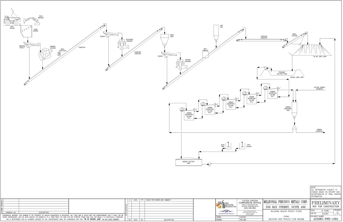
Figure supplied by Integra, June, 2023.
17.3 Energy, Water and Process Materials
Energy requirements were estimated for both Projects and are summarized in Table 17.1. A total of approximately 49,000,000 kWh/y and 40,400,000 kWh/y were estimated for the Wildcat and Mountain View Projects, respectively. Power will be generated on site, using LNG generators at an operating unit cost of approximately 0.13 US$/kWh.
Table 17.1
Energy Requirements for the Wildcat and Mountain View Projects
| Electrical Power | Wildcat Project | Mountain View Project |
Connected
(Kw) | Ave. Draw
(Kw) | Connected
(Kw) | Ave. Draw
(Kw) |
| Electrical Generation Leased Equipment | 650 | 455 | 650 | 455 |
| Primary Crushing | 650 | 455 | 650 | 455 |
| Secondary crushing and screening | 1,080 | 756 | 1,080 | 648 |
| Tertiary crushing and screening | 2,420 | 1,694 | 2,420 | 1,452 |
| Lime and cement systems | 200 | 170 | 200 | 170 |
| Conveying and stacking | 1,500 | 1,275 | 450 | 383 |
| Pads and Ponds | 600 | 510 | 600 | 510 |
| ADR Plant | 200 | 120 | 150 | 90 |
| Cyanide System | 100 | 85 | 100 | 85 |
| Air and water systems | 500 | 250 | 400 | 200 |
| Other | 400 | 163 | 50 | 33 |
| TOTAL POWER | 8,300 | 6,060 | 6,750 | 4,480 |
Table supplied by Integra, June, 2023.
Reagents and consumables (Table 17.2) were estimated using the metallurgical testwork performed at McClelland laboratory. Costs were estimated using actual quotes for all major reagents (lime, cyanide, carbon) and benchmark costs were used for other, more minor, items.
Water will be supplied from wells near the processing facility. The Wildcat Project processing facility will need approximately 800 US gallons per minute (gpm) (600 gpm at Mountain View) of make-up water to saturate new ore stacked, provide dust control, and off-set evaporation. In addition, it is estimated that 100,000 m3 of water per year (approximately 80 acre-feet) will be required for mining activities (including dust control).
Table 17.2
Reagents Requirements for the Wildcat and Mountain View Projects
| Operating Supplies | Wildcat Project | Mountain View Project |
Consumption
(t/y) | Cost
(US$/t) | Consumption
(t/y) | Cost
(US$/t) |
| Lime - CaO - for agglomeration/pH control | 24,200 | 180 | 8,260 | 180 |
| Cyanide Consumption | 3,850 | 3,300 | 1,357 | 3,300 |
| Carbon | 248 | 3,637 | 266 | 3,637 |
| Others | - | 0.08 | - | 0.05 |
| Total Unit Cost (US$/t Process) | 1.71 | 1.23 |
Table supplied by Integra, June, 2023.
17.4 Process Production Schedule
The process production schedule (Table 17.3) was developed on a yearly basis from the mine schedule detailed in Section 16. The detailed schedule was used to apply lag time for recoveries to model the time it takes to produce gold and silver after it is placed. The lagging delays includes the construction of the pipe line, the cyanide leach cycle and the assume process lockup (in solution, on carbon, in electrowinning). A lagging of the recoveries over a period of two and a half months, or about 75 days, was applied to the total leach cycles.
During the mining operation at the Wildcat Project, the crushing capacity (tertiary cone crushing) will be the limiting production factor. The mining sequence has been designed to provide a feed rate of approximately 90% of the crushing circuit availability with an average total crushing rate at 30,000 t/d. During year 7 to 8 the facilities at Wildcat will be dismantled, refurbished, and moved to the Mountain View Project, where mining will be the limiting production factor. The average daily production at the Mountain View Project is estimated at 16,000 t/day, varying from 30,000 t/d (during Mountain View first year of production) to 13,000 t/d during the last year of production.
17.5 Plant and Administrative Operations Personnel
Based on the production schedule and equipment requirements, an estimation of the required operations personnel for the heap-leach, crushing and plant operations was performed. The plant is expected to operate 24 hours per day and these crews will alternate between day shift and night shift.
The daily shift schedule will consist of two shifts of 12 hours per day, accounting for standby time that includes startup/shutdown, lunch breaks, and operational delays. The total number of personnel required to support the mining and processing activities is summarized in Table 17.4.
The general and administrative (G&A) labour requirements have been evaluated and are presented in Table 17.5.
Table 17.3
Process Production Schedule for the Wildcat and Mountain View Projects
| Project | Items | Yr1 | Yr2 | Yr3 | Yr4 | Yr5 | Yr6 | Yr7 | Yr8 | Yr9 | Yr10 | Yr11 | Yr12 | Yr13 |
| Wildcat Project | Ore Placed on Pad (kt) | 10,950 | 10,950 | 10,950 | 10,950 | 10,950 | 10,667 | 4,557 | | | | | | |
| Rec. Gold Grade Placed on Pad (g/t) | 0.26 | 0.24 | 0.24 | 0.36 | 0.26 | 0.22 | 0.23 | | | | | | |
| Rec. Silver Grade Placed on Pad (g/t) | 0.42 | 0.43 | 0.45 | 1.03 | 0.67 | 0.54 | 0.51 | | | | | | |
| Gold Recoverable (%) | 72% | 70% | 69% | 68% | 70% | 69% | 59% | | | | | | |
| Silver Recoverable (%) | 18% | 18% | 18% | 18% | 18% | 18% | 18% | | | | | | |
| Recoverable Gold Heaped (Oz) | 92,103 | 84,943 | 83,603 | 126,218 | 89,975 | 75,975 | 33,285 | 13,235 | 7,941 | | | | |
| Recoverable Silver Heaped (Oz) | 146,244 | 151,743 | 159,329 | 362,502 | 235,985 | 184,774 | 74,084 | - | - | | | | |
| Gold Production (Oz) | 73,177 | 86,414 | 83,878 | 117,461 | 97,422 | 78,852 | 42,057 | 20,074 | 7,941 | | | | |
| Silver Production (Oz) | 116,193 | 150,613 | 157,770 | 320,754 | 261,982 | 195,297 | 96,828 | 15,223 | - | | | | |
| Mountain View Project | Ore Placed on Pad (kt) | | | | | | | | 6,725 | 4,892 | 7,794 | 5,271 | 4,866 | |
| Rec. Gold Grade Placed on Pad (g/t) | | | | | | | | 0.29 | 0.34 | 0.40 | 0.66 | 0.53 | |
| Rec. Silver Grade Placed on Pad (g/t) | | | | | | | | 0.18 | 0.19 | 0.42 | 1.11 | 1.70 | |
| Gold Recoverable (%) | | | | | | | | 86% | 86% | 86% | 81% | 55% | |
| Silver Recoverable (%) | | | | | | | | 20% | 20% | 20% | 20% | 20% | |
| Recoverable Gold Heaped (Oz) | | | | | | | | 61,630 | 53,555 | 99,774 | 111,125 | 83,467 | 6,492 |
| Recoverable Silver Heaped (Oz) | | | | | | | | 39,334 | 29,595 | 104,920 | 188,420 | 265,624 | - |
| Gold Production (Oz) | | | | | | | | 48,966 | 55,215 | 90,277 | 108,793 | 89,150 | 23,642 |
| Silver Production (Oz) | | | | | | | | 31,252 | 31,596 | 89,442 | 171,263 | 249,761 | 54,580 |
| TOTAL | Gold Sales (Oz) | 72,811 | 85,982 | 83,459 | 116,874 | 96,935 | 78,458 | 41,846 | 68,695 | 62,840 | 89,826 | 108,249 | 88,705 | 23,524 |
| Silver Sales (Oz) | 115,613 | 149,860 | 156,981 | 319,150 | 260,672 | 194,320 | 96,344 | 46,242 | 31,438 | 88,995 | 170,407 | 248,512 | 54,307 |
Table supplied by Integra, June, 2023.
Table 17.4
Plant Personnel Requirements
| Type | Personnel | Number |
| Plant Administration | Plant Superintendent | 1 |
| Metallurgist | 1 |
| Total | 2 |
| Plant Operations | Plant General Foremen | 1 |
| Operations Shift Foremen | 4 |
| Crushing Plant Operators | 4 |
| Crusher Operator Labourers | 4 |
| Leach Operators | 4 |
| Leach Operator labourers | 4 |
| ADR Operators | 4 |
| Refinery Operators | 2 |
| Total: | 27 |
| Maintenance Foreman | 1 |
| Mechanics (Plant & Leach) | 1 |
| Mechanics (Crushing) | 1 |
| Plant Maintenance Planners / Clerk | 1 |
| Welders (Crushers) | 2 |
| Electricians (Plant & Leach) | 1 |
| Electricians (Crushers) | 1 |
| Artisan Labourers (Plant & Leach) | 1 |
| Artisan Labourers (Crushers) | 1 |
| Instrumentation Technicians | 1 |
| Total: | 11 |
| Chemical Laboratory | Assay Laboratory Supervisor | 1 |
| Assay Laboratory Technician (day only) | 2 |
| Lab Technicians | 4 |
| Sample courier | 4 |
| Assay Laboratory Supervisor | 1 |
| Total: | 11 |
Table supplied by Integra, June, 2023.
Table 17.5
General and Administration Personnel Requirements
| Type | Personnel | Number |
| Plant Administration | General Manager | 1 |
| Administrative Manager (Controller) | 1 |
| Office Administrator | 1 |
| H, S and S Manager | 1 |
| HR Manager | 1 |
| HR Clerk | 1 |
| Accountant | 1 |
| Warehouse Foreman | 1 |
| Warehouse Clerk | 1 |
| Safety Officer | 1 |
| Environmental Coordinator | 1 |
| Buyer | 1 |
| Total: | 12 |
Table supplied by Integra, June, 2023.
18.0 PROJECT INFRASTRUCTURE
A general arrangement drawing for the Wildcat Project infrastructure is provided in Figure 18.1 and for the Mountain View Project in Figure 18.2.
18.1 Access Roads
Primary access to the Wildcat Project is from Interstate 80 (I-80); exit I-80 at the downtown Lovelock exit and head west onto Main Street. From Main Street, turn north on Central Ave (NV-398); turn west on Pitt Road (NV-399) and continue approximately 12 miles; turn north on Seven Troughs Road and continue for about 5 miles and stay right (north) at the fork in the road; continue for approximately 11 miles and turn west (left) onto Stonehouse Canyon Road. The Wildcat Project can also be accessed by traveling southwest from Winnemucca on Jungo Road for approximately 60 miles, then traveling south on Seven Troughs Road for approximately 20 miles.
Primary access to the Mountain View Project is from Gerlach, Nevada. Take NV-447 north from Gerlach for approximately 16 miles. Turn right (east) onto the access road and continue for approximately two miles on dirt roads to reach the Project Area.
18.2 Buildings
All buildings in the Wildcat and Mountain View Projects will be designed using modified shipping containers / conexes on a concrete floor, with a prefabricated roof anchored to the containers. This will allow the buildings to accommodate storage, offices, change rooms and restrooms. The following buildings are planned for each Project: maintenance facility, warehouse, process facility, and assay laboratory. Additional personnel not accommodated within these buildings will have conex offices.
The maintenance facility will be sized to accommodate the maintenance of two CAT 777 haul trucks and will include a welding bay and lubricant storage.
The warehouse building will utilize the walls for office space, allowing the interior to be dedicated to storage.
The process facility will differ between the Projects. The Wildcat facility will be larger and will include a barren solution tank, a vertical carbon-in-column (VCIC), an elution circuit, a refining circuit, reagent tanks, carbon holding tanks and a tanker bay. The smaller Mountain View process facility will include room for a barren solution tank, a VCIC, carbon holding tanks and a tanker bay. The reagent tanks will be insulated and in containment external to the building. Both processing facilities will be placed on a concrete containment which will drain to the pregnant solution pond.
18.3 Heap Leach Pad
Integra commissioned NewFields Mining Design and Technical Services (NewFields) to complete the preliminary design of the heap leach facilities (HLF) and associated infrastructure for the Wildcat and Mountain View Projects. The preliminary design of the referenced facilities was prepared in accordance with the requirements outlined in the State of Nevada Regulations, Nevada Administrative Code (NAC) 445A Governing the Design, Construction, Operation and Closure of Mining Operations.
Both the Wildcat and Mountain View Projects will use conventional open-pit mining techniques. For both sites, mineralized material will be produced from the respective deposits, with recovery utilizing a conventional cyanide heap leach process. This will consist of a non-impounding leach pad with composite lining and solution collection systems. The Wildcat pad will have a total lined area of approximately 10.0 million square feet (ft2), and the Mountain View pad will have a total lined area of approximately 5.9 million ft2. Mineralized material for both pads is planned to be placed to a maximum height up to 330 feet, measured vertically from the liner to the top of the heap.
The Wildcat pad has a capacity of approximately 70 million metric tonnes (approximately 77.2 million short tons) of mineralized material, based on an estimated dry unit weight of 1.6 kg/m3 (100 lb/ft3). The Mountain View pad has a capacity of approximately 31 million metric tonnes (approximately 34.2 million short tons) of mineralized material, also based on an estimated dry unit weight of 1.6 kg/m3 (100 lb/ft3).
For both the Wildcat and Mountain View Projects, barren leach solution is assumed to be applied to each pad at a rate of 0.0025 gpm/ft2 to 0.003 gpm/ft2 with a total flowrate of approximately 2,500 gpm. Collection and recovery of pregnant leach solution at the toe of both pads will be via gravity flow, promoted using an integrated piping network.
For the purposes of heap sizing and stacking, the recovery cycle for the Wildcat Project was estimated at 45 days, and the recovery cycle for the Mountain View Project was estimated at 35 days.
18.3.1 Conceptual HLF, Operation Overview
The selected location for the heap leach pad (HLP) for the Wildcat Project, is shown on Figure 18.1 and the location of the HLP for the Mountain View Project is shown on Figure 18.2. Layouts of the facilities are included on Figures 18.3 and 18.4 for Wildcat and Mountain View, respectively. Both HLP sites were selected at a PEA level of design for proximity to ancillary facilities, ease of access, stormwater diversion requirements, geotechnical considerations, and to optimize both capital and operational expenditures.
For both Projects, the mineralized material will be transported to crushing facilities using haul trucks and conveyed from the crushing circuits via a series of overland and portable conveyors to radial stackers which will deposit crushed material onto the HLPs.
Both HLPs will be constructed with an initial phase allowing for two full years of mineralized material stacking, with one or more subsequent phases to achieve the ultimate capacities.
For the PEA level designs, individual lift heights were assumed to be 30 feet stacked at the angle of repose of the mineralization, with setbacks sufficient to allow for overall side slopes of three to one (3 horizontal:1 vertical).
Figure 18.1
Wildcat Project Site Layout
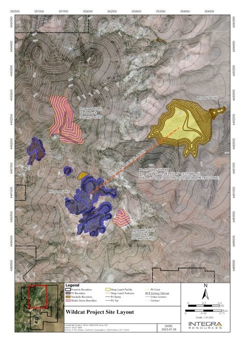
Figure supplied by Integra, June, 2023.
Figure 18.2
Mountain View Project Site Layout
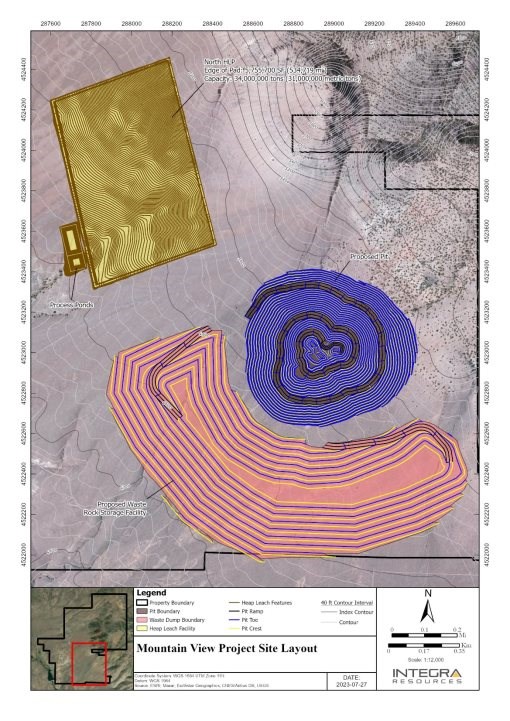
Figure supplied by Integra, June, 2023.
Figure 18.3
General Arrangement for the Wildcat Project
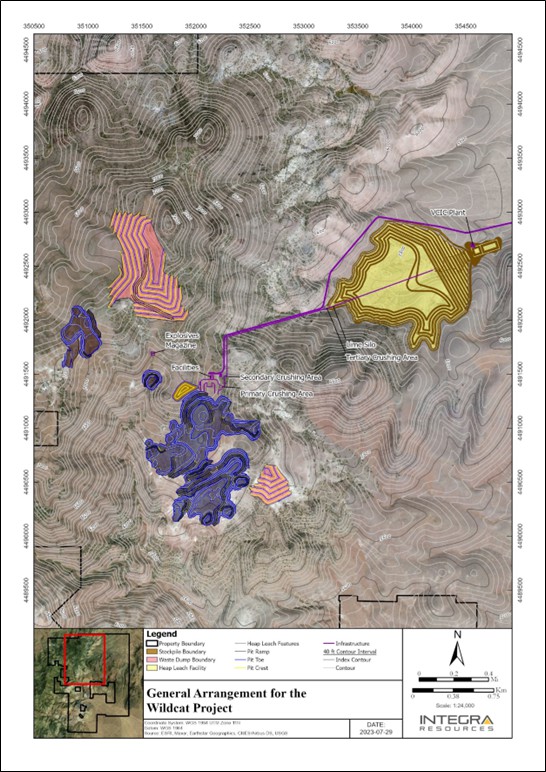
Figure supplied by Integra, June, 2023.
Figure 18.4
General Arrangement for the Mountain View Project
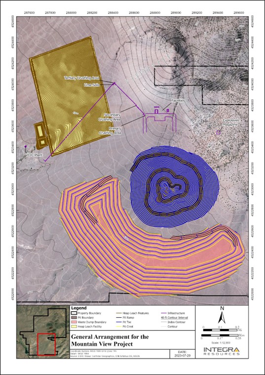
Figure supplied by Integra, June, 2023.
Current design assumptions are that both pads will use a composite lining system with an 80-mil HDPE or LLDPE liner underlain by either 12 inches of Low Permeability Soil (LPS) or a Geosynthetic Clay Liner (GCL) (if a nearby LPS source at each site cannot be established), on top of prepared subgrade.
A network of perforated collection pipes will be placed directly on the geomembrane liner and covered with overliner material comprised of crushed waste or low-grade ore to serve as a pipe and geomembrane cushion against construction and operational traffic, a filtration layer to prevent egress of soil fines through the facility, and a drainage layer to promote fluid flow into the collection pipes. Overliner depth will generally be 24 to 40 inches (thicker near the toe of the pad) but may vary and will be dependent on minimum depth requirements to allow for construction and stacking equipment utilized for the Project. Based on the site topography, the Wildcat Project will generally include collection piping in the buttress zone and along major drainages. The Mountain View Project will utilize collection piping and overliner across the entire pad surface, since the topography is relatively flat when compared to the Wildcat site.
18.3.2 Process Ponds
Process ponds for both sites are sized for 24-hour draindown of the respective HLF, plus direct precipitation falling on the pond surface, plus 10% of the 24-hour draindown for operating inventory. Event ponds are sized to contain direct precipitation on the pond surface in addition to the runoff from the respective HLP due to the 100-year, 24-hour storm event. Both ponds will be double-lined with HDPE geomembrane with a layer of geonet in between to facilitate the effective operation of the leak collection and return system (LCRS) in accordance with Nevada regulatory requirements and per industry standard best practices.
18.3.3 Stormwater Diversion
Stormwater diversions were designed to divert runoff from the upgradient watersheds around the HLFs for both sites to discharge locations for the runoff to return to natural drainage pathways. Channel sizing was based on PEA level stormwater analyses or sizing was conservatively assumed based on the local terrain and design storm event.
18.4 Process Area Geotechnical Review and Analysis
For the PEA, no geotechnical investigations were performed for either of the Project sites. Desktop studies were completed to establish general material types and bedrock outcrop frequency to aid in earthwork estimates and to identify appropriate material properties for stability analyses. It is anticipated that the soils at the Wildcat HLP site will be predominantly granular colluvium and bedrock is relatively shallow. The soils at the Mountain View HLP site are expected to be predominantly granular alluvial sediments with varying amounts of fines.
Preliminary stability analyses were performed for both facilities using Rocscience Slide2, a 2D limit equilibrium slope stability modelling software. Based on the material types assumed from the desktop studies, both the Wildcat and Mountain View HLPs achieved factors of safety greater than or equal to 1.3 and 1.05 for static and pseudostatic conditions, respectively.
For the Wildcat HLP site, a relatively flat toe buttress zone was needed due to the underlying topography. This zone will be a structural fill approximately 60 feet thick, that will consist of a flattened area at the toe of the pad to increase stability and achieve minimum factors of safety. The topography at the Mountain View HLP site is more favourable and a toe buttress is not needed.
Mineralized material samples from both Projects, obtained during exploratory drilling campaigns, were provided by Integra and tested for permeability using the Rigid Wall Constant Head Permeability test (USBR 5600). Results indicate that the material provided for testing from both sites is generally suitable for stack heights up to 330 ft. The results for some of the material from the Wildcat Project suggest that precautions such as blending or select placement within the HLP may be necessary to mitigate the lower percolation characteristics of that specific mineralized material sub-type.
18.5 Ancillary Areas
18.5.1 Wash Bay
The wash bay is designed to accommodate both heavy and light duty vehicles. The wash water is contained using a settling containment linked to the recirculating pumps. The water will have sediment settled out and oil skimmed off prior to recirculation.
18.5.2 Explosives Magazine
The explosives magazine will be built in accordance with the requirements of the Bureau of Alcohol, Tobacco, and Firearms and the Department of Homeland Security.
18.5.3 Fuel Island
The fuel island will consist of 2-40,000-gallon off-road diesel fuel tanks, 1-5,000 gallon on-road diesel fuel tank, and 1-gasoline fuel tank. These tanks will be placed in a concrete containment.
18.6 Power
The power for both Projects will be supplied by LNG generators.
19.0 MARKET STUDIES AND CONTRACTS
At the present time there is no commercial mineral production taking place on the either the Wildcat or Mountain View properties.
The primary minerals, gold and silver, identified at the Wildcat or Mountain View properties are readily traded on the world market, with benchmark prices generally based on the London market (London fix). Due to the size of the commodities market for gold and silver, any production activity from Integra's Wildcat or Mountain View Projects will not influence the commodity prices. Table 19.1 summarizes the high and low average annual London PM gold and silver price per ounce from 2000 to July 30, 2023.
In the future, Integra will need to negotiate contracts to sell any precious metals that it produces.
Table 19.1
Average Annual High and Low London PM Fix for Gold and Silver from 2000 to July 30, 2023
(Prices expressed in USD/oz)
| Year | Gold Price (USD) | Silver Price (USD) |
| High | Low | Cumulative
Average | High | Low | Cumulative
Average |
| 2000 | 312.70 | 263.80 | 279.11 | 5.45 | 4.57 | 4.95 |
| 2001 | 278.85 | 255.95 | 271.04 | 4.82 | 4.07 | 4.37 |
| 2002 | 349.30 | 277.75 | 309.73 | 4.85 | 4.20 | 4.60 |
| 2003 | 416.25 | 319.90 | 363.38 | 5.96 | 4.37 | 4.88 |
| 2004 | 454.20 | 375.00 | 409.72 | 7.83 | 5.49 | 6.67 |
| 2005 | 536.50 | 411.10 | 444.74 | 9.23 | 6.39 | 7.32 |
| 2006 | 725.00 | 524.75 | 603.46 | 14.94 | 8.83 | 11.55 |
| 2007 | 841.10 | 608.30 | 695.39 | 15.82 | 11.67 | 13.38 |
| 2008 | 1,011.25 | 712.50 | 871.96 | 20.92 | 8.88 | 14.99 |
| 2009 | 1,212.50 | 810.0 | 972.35 | 10.51 | 19.18 | 14.67 |
| 2010 | 1,421.00 | 1,058.00 | 1,224.53 | 15.14 | 28.55 | 20.19 |
| 2011 | 1,895.00 | 1,319.00 | 1,571.52 | 26.68 | 48.70 | 35.12 |
| 2012 | 1,791.75 | 1,540.00 | 1,668.98 | 37.23 | 26.67 | 31.15 |
| 2013 | 1,693.75 | 1,192.00 | 1,411.23 | 31.11 | 18.61 | 23.79 |
| 2014 | 1,385.00 | 1,142.00 | 1,266.40 | 22.05 | 15.28 | 19.08 |
| 2015 | 1,295.75 | 1,049.40 | 1,160.06 | 18.23 | 13.71 | 15.68 |
| 2016 | 1,366.25 | 1,077.00 | 1,250.74 | 20.71 | 13.58 | 17.14 |
| 2017 | 1,346.25 | 1,151.00 | 1,257.12 | 18.21 | 15.22 | 17.04 |
| 2018 | 1,354.95 | 1,178.40 | 1,268.49 | 17.52 | 13.97 | 15.71 |
| 2019 | 1,546.10 | 1,269.60 | 1,392.60 | 19.31 | 14.38 | 16.21 |
| 2020 | 2,067.15 | 1,474.25 | 1,769.64 | 28.89 | 12.01 | 20.55 |
| 2021 | 1,943.20 | 1,683.95 | 1,798.61 | 29.59 | 21.53 | 25.04 |
| 2022 | 2,039.05 | 1,628.75 | 1,800.09 | 26.18 | 17.77 | 21.71 |
| 2023* | 2,048.45 | 1,810.95 | 1,933.54 | 26.03 | 20.09 | 23.43 |
Source: www.kitco.com, London PM Fix - USD.
* Data for 2023 is as of July 30, 2023.
20.0 ENVIRONMENTAL STUDIES, PERMITTING AND SOCIAL OR COMMUNITY IMPACT
20.1 General Overview
Both of the Wildcat and Mountain View Projects will require permitting through the same state and federal regulatory agencies. County level permitting will be separate permitting paths. As a result, the type of permits required, as well as the permitting process, costs and associated timelines for both Projects will generally be similar. An overview of the permitting process follows, with additional descriptions and specifics for each Project in Section 20.2 and 20.3.
Exploration Plan of Operations/Reclamation Permit Applications (ExPO) for both Projects were submitted in 2023 to the Bureau of Land Management Winnemucca District Office (BLM) and Nevada Division of Environmental Protection - Bureau of Mining Regulation and Reclamation (NDEP-BMRR). The ExPOs will allow for large scale mineral exploration and additional baseline data collection for the mine-level projects at both sites. Exploration baseline data collection at both Projects has been conducted in support of the ExPO since 2021, with some of the data being relevant to future mine-level permitting. These baseline reports have been submitted to the BLM and are currently under review. Once accepted, the baseline data will be utilized to analyze the potential impacts of both exploration level Projects, under the National Environmental Policy Act (NEPA) which mandates federal agencies to analyze and consider likely environmental impacts of a proposed action and alternatives of a project occurring on federal land. The exploration projects will most likely be analyzed through the development of a separate Environmental Assessment (EA) for each location. Once the projects have been analyzed, exploration-level activities will be authorized by the BLM and NDEP-BMRR. No significant additional permitting will be required for exploration level operations.
If exploration is successful, Integra will then develop a Mine Plan of Operations/ Reclamation Permit Application (MPO) for each Project. Initial engagement with the BLM regarding the MPO for each Project has already occurred. Approval of the MPO requires an environmental analysis be performed by the BLM under NEPA. This analysis will be presented in either an EA or an Environmental Impact Statement (EIS), which is the major Federal permitting requirement for these Projects. The Finding of No Significant Impact (FONSI) or the Record of Decision (ROD) will be the final approval and will allow mine-level operations to proceed. Mine level activities are most often analyzed with an EIS, but can be analyzed with an EA if the operation would not result in significant impacts. A brief outline of the EIS schedule follows:
Begin baseline studies and engage with BLM (Months 1 to 24).
Prepare and submit Plan of Operations and other local and state permit applications (Months 20 to 30).
Prepare and issue draft EIS including public review (Months 25 to 42).
Final EIS and ROD (Months 42 to 44).
This schedule assumes a best-case scenario of approximately three and a half years and assumes a concurrent baseline data collection program. There are currently no known environmental issues at either Project that would drastically delay the schedule or that could impact Integra's ability extract the mineral resources.
20.2 Wildcat Project
The Wildcat Project encompasses 67 acres of private land and 17,545 ac of public lands administered by the BLM and, as a result, it is subject to both Federal and State permitting requirements. There are currently three Notices acknowledged by the BLM within the Project, area known as the Wildcat, Snow Squall, and Egbert projects. The site has been impacted by exploration drilling activities from Integra and previous operators within these five-acre Notice areas. The ExPO will incorporate all disturbance and bonding from the three notices, as well as new disturbance all totalling 400 acres.
A conceptual mine plan and facility layout have been developed as a basis for this permitting analysis. There will be one open pit and year-round mining, which is estimated at 12 million tonnes per year for a mine life of six and half years. Waste rock will be hauled to waste rock storage facilities and stacked according to permitted specifications. Mineralized material will be crushed to size by a three-stage crushing circuit with an estimated capacity of 30,000 t/d and then stacked on the heap leach pad (HLP). The HLP will be built in two phases for an estimated total capacity of 70 million tonnes and will be operated as a zero-discharge facility. Heap leaching will occur using a cyanide solution and there will be an assay laboratory and processing facility on site. Water supply will come from production wells and water rights that will be obtained within the area. Power will be generated by on-site generators. Waste disposal will be managed in accordance with NDEP regulations. This information has been utilized to develop a reclamation cost estimate (RCE) as presented in Section 20.3.4.
20.2.1 Environmental Baseline Studies
Integra has completed the following baseline studies to support exploration and mine operations at the Wildcat Project:
All data collected will be used for both exploration and mine level analysis. In addition, Integra has commenced the hydrology and geochemical baseline studies that will be required for mine level operations, but not for exploration. These studies were performed according to BLM guidelines and the BLM approved the work plans prior to the surveys. Integra will coordinate with the BLM to determine which additional baseline studies will be required to support an EA or EIS. Once determined, a BLM interdisciplinary team will review and approve the environmental baseline work plans for the required resources. They will oversee the studies and deliver comments, as necessary. These studies will be a key element of the EA or EIS to incorporate a discussion of all potential environmental impacts of the proposed action.
20.2.2 Permitting
Integra will develop a MPO which will require analysis under NEPA. The purpose and need for the Project would be to conduct open pit mining to produce silver and gold from mineralized material. This proposed action would disturb over 600 acres of land on unpatented and patented mining claims within the Project area. This Project may be analyzed under NEPA and permitted through an EA or EIS and the determination will be made upon submittal of the MPO. An EA or EIS will be developed by a third-party contractor to allow the BLM to properly analyze the proposed action. The EA or EIS will discuss environmental impacts, potential mitigation measures, and will provide a thorough analysis of baseline data/affected resources. Additional Supplemental Environmental Reports (SERs) are stand alone documents that may also be required. The EA or EIS will comply with the Nevada Instructional Memorandum (IM) from May, 2023. In accordance with the IM, an EA will take approximately six months to receive a FONSI while an EIS will take approximately one year to receive the ROD. Timelines are started after the ExPO or MPO has been submitted, all baseline data reports have been approved and SERs have been prepared for the Project.
There are additional permits that will be required for air quality, groundwater and surface water protection. Most permits have associated monitoring and fee requirements to maintain compliance. Table 20.1 lists the local, state and federal permits that will be required prior to mine-level operations. The issuing agency and purpose of the permit is also described. These application processes would be integrated and processed concurrent with the EA or EIS. It is anticipated that these permits would be obtained on a similar timeframe to the ROD and would not delay the schedule.
Table 20.1
Required Permits for the Wildcat Project
| Permit | Agency | Permit Purpose |
| Plan of Operations/NEPA Analysis, FONSI, and Record of Decision | BLM | Prevent unnecessary of undue degradation of public lands. |
| Water Pollution Control Permit - Mine | NDEP BMRR | Prevent degradation of waters of the State from mining and establishes facility design requirements. |
| Reclamation Permit | NDEP BMRR | Reclamation of surface disturbance due to exploration, mining, and mineral processing. Permit includes financial assurance requirements. |
| Permit | Agency | Permit Purpose |
| Air Quality Operating Permits | NDEP BAPC | Regulate air emissions from stationary sources. |
| Surface Area Disturbance Permit | NDEP BAPC | Regulate air emissions from surface disturbing activities. |
| Mercury Operating Permit to Construct | NDEP BAPC | Requires use of Nevada Maximum Achievable Control Technology (MACT) for all thermal units that have the potential to emit mercury. |
| Industrial Artificial Pond Permit | Nevada Department of Wildlife (NDOW) | Regulate artificial bodies of water containing chemicals that threaten wildlife. |
| Water Rights | Nevada Division of Water Resources (NDWR) | Water rights appropriation for exploration and mine-level activities. |
| Potable Water System Permit | NDEP Nevada Bureau of Safe Drinking Water | Regulate a water system for drinking water and other domestic uses. |
| Onsite Sewage Disposal System (OSDS) Permit | NDEP Bureau of Water Pollution Control (BWPC) | Regulate construction and operation of an OSDS. |
| Hazardous Materials Permit | Nevada State Fire Marshal (NSFM) | Regulate the storage of hazardous materials in excess of the amount set forth in the International Fire Code, 2006. |
| Building Inspection | NSFM | Fire prevention inspection of new, non-modular buildings in accordance with NAC 477.300 et seq. |
| Fire and Life Safety Permit | NSFM | Review of non-structural features of fire and life safety and flammable reagent storage. |
| General Industrial Stormwater Discharge Permit | NDEP BWPC | Regulates site stormwater discharges to prevent contamination in compliance with federal Clean Water Act. |
| County Road Use and Maintenance Permit/Agreement | Pershing County Building and Planning Department | May be required to regulate use and maintenance of county roads. |
Table supplied by Integra, June, 2023.
20.2.3 Social or Community Impacts
Integra has prepared socioeconomic and environmental justice baseline reports for the Wildcat exploration project. The reports focused on Pershing, Humboldt and Washoe Counties and determined that the overall economic impact of the Project would be positive but minor or negligible based on population demographics, jobs and wages, and unemployment. An estimated 200 jobs would be created from the Project and that would have minimal impact on economic resilience or strength. An environmental justice analysis of the exploration project area determined that no disproportionate impacts from direct, indirect and/or cumulative proposed actions are expected to environmental justice populations within the study area. Integra plans to engage with local stakeholders and develop initiatives that meet the needs and priorities of the neighbouring communities. Integra has initiated preliminary discussions and engagement with the Lovelock community including local county commissioners. Indigenous communities will be engaged during the both the exploration and mine level NEPA processes. Communication with the Indigenous communities will primarily occur between the BLM and Tribal Council Members.
Integra has developed a robust Environmental, Social and Governance plan and is dedicated to minimizing environmental impacts. Under the plan Integra has provided an avenue for community and other interested parties to contact the Company in case of concerns involving the Project.
20.2.4 Mine Closure Requirements and Cost
The goal of closure is to restore the Project to pre-mining conditions or better, to the extent possible utilizing BLM and NDEP approved reclamation and closure practices. Integra will regrade all required facilities, cover with growth media, and reseed with a BLM approved seed mix. All buildings will be demolished and disposed of in accordance with local, state, and federal regulations. Post-closure management will commence following Project reclamation work and will continue until the reclamation has been accepted by both the BLM and the NDEP. A comprehensive reclamation plan has been developed as part of the ExPO and is under review by both agencies. A second reclamation plan will be developed and included in the Reclamation Permit application submitted with the MPO.
Integra has prepared and submitted a reclamation cost estimate (RCE) for exploration activities, utilizing the standard reclamation cost estimator (SRCE) software developed as a cooperative effort by the NDEP-BMRR, the BLM, and the Nevada Mining Association to facilitate accuracy, completeness, and consistency in the calculation of costs for mine site reclamation. Integra will be required to update the RCE for Wildcat every three years, due to changing costs. A preliminary RCE for mine level reclamation has also been developed to address the categories shown in Table 20.2. Reclamation costs for work to be performed by Integra at the end of the mine level project are estimated to be US$11,060,000. The RCE total, including contingency and indirect costs, as mandated by the BLM and NDEP is approximately US$14,920,000. These costs are preliminary and additional studies will be required to confirm the design criteria. Integra's reclamation and remediation obligations are assumed to be secured with surety bonds, which are subject to a 1.75% annual management fee and a 15% cash collateral.
Table 20.2
Wildcat Project, Reclamation Cost Estimate
| Category | Cost (US$) | Notes |
| Earthwork/Recontouring | $3,290,000 | Calculates regrading costs by facility. |
| Revegetation/Stabilization | $505,000 | Calculates growth media and revegetation volumes by facility. |
| Detoxification/Water Treatment/Waste Disposal | $5,835,000 | Includes costs for mob/demob, evaporating HLP drain-down water, and cleanup after closure. |
| Structure, Equipment, and Facility Removal, and Misc. | $440,000 | Includes facility, fence, and equipment removal and demolition. |
| Monitoring | $450,000 | Calculated by the RCE based on acres of revegetation and field work costs. |
| Construction Management and Support | $540,000 | Calculated by the RCE based on the duration of reclamation activities. |
| Contingency and Indirect Costs | $3,860,000 | Recommended indirect costs as calculated by RCE. This number is included for bonding purposes only. |
| Total: | $14,920,000 | |
Table supplied by Integra, June, 2023.
20.3 Mountain View Project
The Mountain View Project encompasses 5,576 acres and is located entirely on public lands administered by the BLM. The Project is subject to both Federal and State permitting requirements. There is currently one Notice acknowledged by the BLM within the Project area. The Project has been impacted by exploration drilling activities from Integra and previous operators within the five-acre Notice boundary. The ExPO will incorporate all disturbance and bonding from the Notice.
A conceptual mine plan and facility layout have been developed as a basis for this permitting analysis. There will be one open pit and year-round mining which is estimated at between 12 and 24 million tonnes per year for a mine life of five years. Waste rock will be hauled to waste rock storage facilities and stacked according to permitted specifications. Mineralized material will be crushed to size by three-stage crushing with an estimated capacity of 15,000 t/d then stacked on the HLP. The HLP will be built in two phases for an estimate total capacity of 30 million tonnes. Heap leaching will occur using a cyanide solution and there will be an assay laboratory and processing facility on site. Water supply will come from production wells and water rights that will be obtained within the area. Power will be generated on-site by CAT generators. Waste disposal will be managed in accordance with Nevada Division of Environmental Protection (NDEP) regulations. This information has been utilized to provide a reclamation cost estimate (RCE) for Section 20.3.4.
20.3.1 Environmental Baseline Studies
Integra has completed or commenced the same required baseline studies at Mountain View to support exploration and mine level operations as those listed in Section 20.2.1 for the Wildcat Project.
These studies were performed according to BLM guidelines and BLM approved work plans for the exploration plan of operations. Integra will coordinate with the BLM to determine which additional baseline studies will be required to support the EA. Once determined, a BLM interdisciplinary team will review and approve the environmental baseline work plans for the required resources. They will oversee the studies and deliver comments, as necessary. These studies will be a key element of the EA to incorporate a discussion of all potential environmental impacts of the proposed action.
20.3.2 Permitting
Integra will develop a MPO that will require analysis under NEPA. The purpose and need for the Project would be to conduct open pit mining to produce silver and gold from mineralized material of the estimated mineral resources. This proposed action would disturb over 600 acres of land on unpatented and patented mining claims within the Project area. The Mountain View Project mine plan of operations requires that an EIS that must be developed by a third-party contractor to allow the BLM to properly analyze the proposed action. The EIS will discuss environmental impacts, mitigation measures, and a thorough analysis of baseline data/affected resources. Additional Supplemental Environmental Reports (SERs) are stand alone documents that may also be required. The EIS will comply with the Nevada Instruction Memorandum (IM) from May, 2023.
There are additional permits that will be required for air quality, groundwater, and surface water protection. Most permits have associated monitoring and fee requirements to maintain compliance. Table 20.3 lists the local, state, and federal permits that will be required prior to mine-level operations. The issuing agency and purpose of the permit is also described. These application processes would be integrated and processed concurrent with the EIS timeline. It is anticipated that these permits would be obtained on a similar timeframe to the ROD and would not delay the schedule.
Table 20.3
Required Permits for the Mountain View Project
| Permit | Agency | Permit Purpose |
| Plan of Operations/NEPA Analysis, FONSI, and Record of Decision | BLM | Prevent unnecessary of undue degradation of public lands. |
| Water Pollution Control Permit - Mine | NDEP-BMRR | Prevent degradation of waters of the State from mining and establishes facility design requirements. |
| Water Pollution Control Permit - Rapid Infiltration Basins | NDEP-BMRR | Prevent degradation of waters of the State from use of Rapid Infiltration Basins for dewatering purposes. |
| Reclamation Permit | NDEP-BMRR | Reclamation of surface disturbance due to exploration, mining, and mineral processing. Permit includes financial assurance requirements. |
| Air Quality Operating Permit | NDEP-BAPC | Regulate air emissions from stationary sources. |
| Mercury Operating Permit to Construct | NDEP-BAPC | Requires use of Nevada Maximum Achievable Control Technology (MACT) for all thermal units that have the potential to emit mercury. |
| Surface Area Disturbance Permit | NDEP-BAPC | Regulate air emissions from surface disturbing activities. |
| Industrial Artificial Pond Permit | Nevada Department of Wildlife | Regulate artificial bodies of water containing chemicals that threaten wildlife. |
| Water Rights | Nevada Division of Water Resources | Water rights appropriation for exploration and mine use. |
| Potable Water System Permit | NDEP Nevada Bureau of Safe Drinking Water | Regulate a water system for drinking water and other domestic uses. |
| Onsite Sewage Disposal System (OSDS) Permit | NDEP Bureau of Water Pollution Control (BWPC) | Regulate construction and operation of an OSDS. |
| Hazardous Materials Permit | Nevada State Fire Marshal (NSFM) | Regulate the storage of hazardous materials in excess of the amount set forth in the International Fire Code, 2006. |
| Building Inspection | NSFM | Fire prevention inspection of new, non-modular buildings in accordance with NAC 477.300 et seq. |
| Fire and Life Safety Permit | NSFM | Review of non-structural features of fire and life safety and flammable reagent storage. |
| General Industrial Stormwater Discharge Permit | NDEP-BWPC | Regulates site stormwater discharges to prevent contamination in compliance with federal Clean Water Act. |
| Permit | Agency | Permit Purpose |
| Encroachment Permit | NDOT | Regulate access to State Route 447 through NDOT right of way. |
| County Road Use and Maintenance Permit/Agreement | Pershing County Building and Planning Department | May be required to regulate use and maintenance of county roads. |
Table supplied by Integra, June, 2023.
20.3.3 Social or Community Impacts
Integra has prepared socioeconomic and environmental justice baseline reports for Mountain View exploration. The report focused on Washoe, Pershing, and Humboldt County and found that the analysis area has an average economic diversity and strength. This trend suggests that the low change to the workforce demands by the Project would have a negligible impact on economic resilience or strength. An estimated 200 jobs will be created by the Project. An environmental justice analysis of the Project area for the exploration project identified minority communities of concern; however, no disproportionate impacts from direct, indirect, and/or cumulative proposed action are expected to affect the communities. Integra has initiated preliminary discussions and engagement with the Washoe County Assistant Manager and Washoe County Community Outreach Coordinator. Indigenous communities will also be engaged during the EIS process. Communication with the indigenous communities will primarily occur between the BLM and Tribal Council Members. Integra has a robust Environmental, Social, and Governance plan and is dedicated to minimizing environmental impacts. The community and other interested parties can contact the Company in case of concerns involving the Project.
20.3.4 Mine Closure Requirements and Cost
The goal of closure is to restore the mine area to a productive post mining land use to the extent possible, utilizing BLM approved reclamation and closure practices. Integra will regrade all required facilities, cover with growth media, and reseed with a BLM approved seed mix. All facilities will be decommissioned, demolished, and disposed of in accordance with local, state, and federal regulations. Post-closure management will commence following Project reclamation work and will continue until the reclamation has been accepted by both the BLM and the NDEP. A comprehensive reclamation plan will be developed as part of the MPO/Reclamation Permit application.
Integra has prepared and submitted an RCE for exploration-level activities. Integra will be required to update the RCE for Mountain View every three years, due to changing costs. A preliminary RCE for mine level reclamation has also been developed to address the categories shown in Table 20.4. Reclamation costs for work to be performed by Integra at the end of the mine level project are estimated to be US$10,690,000. The RCE total, including contingency and indirect costs, is approximately US$14,415,000. These costs are preliminary and additional studies will be required to confirm the design criteria. Integra's reclamation and remediation obligations are believed to be secured with surety bonds, which are subject to a 1.75% annual management fee and a 15% cash collateral.
Table 20.4
Mountain View Project, Reclamation Cost Estimate
| Category | Cost (US$) | Notes |
| Earthwork/Recontouring | $3,395,000 | Calculates regrading costs by facility. |
| Revegetation/Stabilization | $450,000 | Calculates growth media and revegetation volumes by facility. |
| Detoxification/Water Treatment/Waste Disposal | $5,510,000 | Includes costs for mob/demob, evaporating HLP drain-down water, and cleanup after closure. |
| Structure, Equipment, and Facility Removal, and Misc. | $355,000 | Includes facility, fence, and equipment removal and demolition. |
| Monitoring | $440,000 | Calculated by the RCE based on acres of revegetation and field work costs. |
| Construction Management and Support | $540,000 | Calculated by the RCE based on the duration of reclamation activities. |
| Contingency and Indirect Costs | $3,725,000 | Recommended indirect costs as calculated by RCE. This number is included for bonding purposes only. |
| Total: | $14,415,000 | |
Table supplied by Integra, June, 2023.
21.0 CAPITAL AND OPERATING COSTS
Capital and operating costs for the Wildcat and Mountain View Projects have been developed using current and historical quotes and bulk materials costs based on similar projects, which are currently being constructed, with allowances for this project's location relative to materials manufacturing and delivery, available work force and contractor support resources. Capital costs for the Wildcat Project are presented in Table 21.1. Two scenarios have been evaluated for the Mountain View Project. The first starts Mountain View mining two years after Wildcat and progresses concurrently. The relatively close proximity of the two Projects allows the carbon from Mountain View to be processed at Wildcat. This scenario is presented in Table 21.2. The second scenario begins with the Mountain View Project following the completion of mining at the Wildcat Project. This scenario allows the mining fleet and most of the processing equipment to be relocated to Mountain View. This scenario is favorable due to the lowered capital costs and is presented in Table 21.3.
The operating cost estimates for both Projects have been developed using current reagent market price quotes from local vendors, leaching parameters from metallurgical testing performed by McCelland, and operational experience in the local area. Operating costs are presented in Tables 21.4 and 21.5, Wildcat and Mountain View Projects, respectively.
21.1 Capital Costs - Infrastructure
21.1.1 Quantities and Estimating Methodology
The capital cost estimate was developed by breaking down the cost using the associated engineering disciplines as the prime commodity accounts. These disciplines include civil (earthwork and utilities), concrete, buildings, structural, mechanical, piping, electrical and instrumentation.
This engineering discipline structure compiles the costs into a logical, industry accepted format, which facilitates the economic evaluation/analysis of the project in the actual sequence of construction. This discipline structure provides a means to compare and evaluate the costs against other similar projects.
21.1.2 Civil (Earthworks and Utilities)
No geotechnical information was available at this conceptual design level. A rough estimate of the resources and time to clear and grade the nominal processing plant and infrastructure footprint was used.
21.1.3 Concrete
The building and equipment loads were factored and the anticipated footings, slabs, piers and pedestal dimensions and subsequent volumes were developed accordingly. The cost of the Wildcat Project concrete materials was quoted (Perfect Concrete, Lovelock, NV), mixed and delivered to the Project site, at US$385 per cubic yard. (4,000 psi). The Mountain View Project concrete materials were quoted (Modern Concrete, Elko, NV) mixed on-site at US$345 plus a US$15,000 mobilization/demobilization fee.
Material costs for concrete have been applied to the various concrete structures and slabs on a cubic yard basis. Wildcat Project concrete was calculated at a total installed average rate of US$1,715 per cubic yard, complete in place. The Mountain View Project has a total installed average rate of US$1,745 per cubic yard.
This estimated concrete cost is complete in place, and includes structural excavation and backfill, cement, aggregate, additives and admixtures, batch plant mixing, transport, formwork, reinforcing steel, dowels, embeds, placing and finishing and form removal and clean-up.
21.1.4 Structural Steel
Structural steel engineering design drawings were not available in this phase.
21.1.5 Buildings
Building costs assigned to this estimate were obtained from building dimensions, utilizing empty and modified shipping containers.
21.1.6 Mechanical Equipment
The required major mechanical process equipment has been developed for the heap leach pregnant solution treatment process. Equipment pricing/costs were developed based on "budgetary" quotes from vendors, with allowances applied for the Projects' location.
The required major mechanical equipment for the maintenance facilities was derived from current and historical requirements for operations of similar size and quantity of operational equipment. Equipment pricing and costs were developed based on current and historical costs, with allowances applied for the Projects' location.
Installation was priced using historical cost data, accepted industry standard installation units and with allowances applied for this Project's location.
21.1.7 Electrical
The complete electrical requirements were not available at this conceptual phase. Costs for the required major electrical equipment, conductors, conduits, trays, boxes and miscellaneous hardware are factored.
Installation was priced using historical cost data, accepted industry standard installation units, with allowances applied for the Projects' location.
21.1.8 Instrumentation and Communication
The instrumentation, communication and control philosophy have yet to be determined. The equipment, system and programming costs used in this estimate are factored.
21.1.9 Labour Rates
Labour rate costs are based on information from the U.S. Department of Labor, Davis-Bacon Wage Determinations, Nevada (Pershing County), NV20230020 03/03/2023 (http://www.wdol.gov/dba.aspx).
Supervision, above the general foreman level, is included in the construction field indirect costs.
In general, unit man-hours for installation and performance of tasks have been developed in conjunction with construction contractor input/review or using published databases such as RS Means, Richardson's and Page & Nation.
21.1.10 Construction Field Indirect Costs
Construction field indirect costs for the Projects include mobilization-demobilization, temporary field facilities, temporary utilities, testing services, material storage, project supervision, administration labor, communications, light vehicles, cleanup and safety cost.
The construction contractor is assumed to provide its own temporary construction power and water.
The overall field indirect costs are estimated to be a factor of 15% of the major fixed plant equipment.
21.1.11 Insurance, Freight and Transportation
A factor of 7% of the major fixed plant equipment costs has been applied for the cost of insurance, freight and transportation.
21.1.12 Sales Tax
Using Nevada tax statues, a sales tax rate of 7.1% has been applied for new construction in Pershing County. The Constructed Cost for the Project, less labour, is multiplied by the 7.1% county tax rate and the resultant value is assigned to the Sales Tax.
21.1.13 Procurement
A factor of 1.5% of the plant equipment costs has been assigned for the Procurement value included in this estimate.
21.1.14 Construction Phase Services
Home office engineering support is included in the detail engineering allowance.
21.1.15 Vendor Representative Assistance, Start-up and Communication Costs
Startup and commissioning and vendor representative assistance are factored at 1.5% of the fixed plant equipment.
21.1.16 Building Permit Fees
Building permits are not included in this capital cost estimate.
21.1.17 Spare Parts
A factor of 2.5% of the fixed plant equipment costs has been applied for the spare parts.
21.1.18 Contingency
A contingency factor of 25% percent has been applied to the estimate based on experience and confidence in the information compiled and calculated.
21.1.19 Owner Costs
No owner's cost has been applied in this estimate. However, allowances were made for the owners cost in the overall economic evaluation.
21.1.20 Accuracy
This capital cost estimate for the Wildcat Mine and Mountain View Projects is based on the current conceptual engineering design level to assess/evaluate the Project concept, various development options and the overall project viability. Budgetary quotations have been collected from vendors whenever possible.
Table 21.1
General Infrastructure Estimate for the Wildcat Project
Item Description | Cost (US$) |
Direct Field Cost | 46,915,717 |
Indirect Field Cost | 3,092,829 |
Subtotal Constructed Cost | 50,008,546 |
Sales Tax (Pershing Co) | 3,210,078 |
Indirect Costs | 1,732,808 |
Subtotal Project Constructed Cost w/ Indirects | 54,951,432 |
Contingency @ 25% | 13,737,858 |
Total Project Constructed Cost w/ Contingency | 68,689,290 |
Table supplied by Integra, June, 2023.
Table 21.2
General Infrastructure Estimate for Mountain View Project
Item Description | Cost (US$) |
Direct Field Cost | 19,448,102 |
Indirect Field Cost | 4,629,289 |
Subtotal Constructed Cost | 24,076,391 |
Sales Tax (Pershing Co) | 1,620,055 |
Indirect Costs | 1,299,234 |
Subtotal Project Constructed Cost w/ Indirects | 26,995,679 |
Contingency @ 25% | 6,748,920 |
Total Project Constructed Cost w/ Contingency | 33,744,599 |
Table supplied by Integra, June, 2023.
21.2 Capital Costs - Heap Leach
Capital costs for the heap leach facility were developed and organized according to the major work areas and major commodity descriptions. These, in turn, were broken down into individual work elements. The overall divisions include site preparation, earthwork, geosynthetics, piping, and indirect costs.
This structure compiles the costs into a logical, industry accepted format, which facilitates the economic evaluation/analysis of the Project in the actual sequence of construction. This structure also provides a means to compare and evaluate the costs against other similar projects.
To minimize initial capital expenditure, the heap leach pads were designed in a phased approach. The initial phases for both projects (Phase 1) can accommodate approximately two years of production for both Wildcat and Mountain View. Phase 2 for each operation needs to be constructed during year two so that it can be utilized during year three. Table 21.3 and Table 21.4 summarize the heap leach estimates for the Wildcat and Mountain View Projects, respectively.
Table 21.3
Heap Leach Estimate for the Wildcat Project
| Item Description | Phase 1 (US$) | Phase 2 (US$) |
| Site Preparation | $2,465,272 | $2,271,496 |
| Earthworks | $15,079,805 | $13,357,247 |
| Geosynthetics | $5,329,889 | $5,363,236 |
| Pipe | $134,236 | $208,654 |
| Direct Construction Cost | $23,009,202 | $21,200,634 |
| Contingency 30% | $6,902,761 | $6,360,190 |
| Direct Construction Cost and Contingency | $29,911,962 | $27,560,824 |
| Indirects | $3,738,995 | $3,445,103 |
| Total Cost | $33,650,958 | $31,005,927 |
| Cost per HLF square foot | $7.09 | $5.85 |
| Total Cost of Each Option | $64,656,884 |
Table supplied by Integra, June, 2023.
Table 21.4
Heap Leach Estimate for Mountain View Project
| Item Description | Phase 1 (US$) | Phase 2 (US$) |
| Site Preparation | $1,037,679 | $1,224,908 |
| Earthworks | $5,353,204 | $6,355,476 |
| Geosynthetics | $2,630,218 | $3,297,885 |
| Pipe | $663,903 | $554,209 |
| Direct Construction Cost | $9,685,004 | $11,432,479 |
| Contingency 30% | $2,905,501 | $3,429,744 |
| Direct Construction Cost and Contingency | $12,590,505 | $14,862,222 |
| Indirects | $2,832,864 | $3,344,000 |
| Total Costs | $15,423,368 | $18,206,222 |
| Cost per HLF square foot | $6.76 | $5.01 |
| Total Cost of Each Option | $33,629,591 |
Table supplied by Integra, June, 2023.
21.3 Mining Capital Costs
The mining fleet will be lease-financed. Accordingly, there is no pre-production mining capital expenditure. Over the operating period, the principal portion of the lease payments is capitalized, while the interest payments are expensed.
21.4 Plant Operating Costs
21.4.1 Design Criteria
The design criteria template for Plant operating costs was provided by Micon. Wear rate factors are based on feed rate and historical values. Reagent consumption rates for leaching were derived from metallurgical testwork. Reagent consumption rates for elution and refining were provided by equipment manufacturer. Personnel was patterned after other mines in the area. Current market pricing for all reagents has been used for the operating costs.
In addition to the traditional operating costs, a US$1M/y sustaining capital provision was added to cover for the various costs not captured in the operating cost estimate (e.g. pump replacements, etc.).
21.4.2 Reagents
The following reagents are included in the operating costs:
Lime - used for pH control on the heap.
Cyanide (NaCN) - used for the leaching of gold and silver, and the elution from activated carbon. Received as a 30% solution. Solution is diluted based on operational needs.
Activated Carbon - used to collect gold from the leach solution.
Anti-Scalant - used to prevent scale build up throughout the processing plant.
Caustic (NaOH) - used in the elution circuit.
Hydrochloric Acid - used in the elution circuit.
Refining Fluxes - used in the production of doré bars.
Table 21.5 summarizes the plant operating costs for the Wildcat Project at a throughput of 11 Mt/y and Table 21.6 summarizes the costs for Wildcat leaching only for the 11 Mt/y rate. Table 21.7 summarizes the plant operating costs for the Mountain View Project at a throughput of 5.5 Mt/y and Table 21.8 summarizes the costs for Mountain View leaching only for the 5.5 Mt/y rate.
Table 21.5
Plant Operating Costs for the Wildcat Project, 11 Mt/y
| Area | Number of Employees | Cost (US$) | Cost (US$/t) |
| Operating Supplies | | $23,094,529 | $2.10 |
| Maintenance Supplies | | $1,900,000 | $0.17 |
| Electrical Power | | $7,082,974 | $0.64 |
| Process Management | 2 | $324,000 | $0.03 |
| Plant Operations | 27 | $2,081,700 | $0.19 |
| Plant Maintenance | 11 | $946,350 | $0.09 |
| Assay Laboratory | 11 | $1,116,700 | $0.10 |
| G & A Labour | 12 | $1,390,500 | $0.13 |
| G & A Expenses | | $3,371,000 | $0.31 |
Table supplied by Integra, June, 2023.
Table 21.6
Plant Operating Costs for the Wildcat Project, Leaching Only
| Area | Number of Employees | Cost (US$) | Cost (US$/t) |
| Operating Supplies | | $2,261,564 | N/A |
| Maintenance Supplies | | $175,000 | N/A |
| Electrical Power | | $857,302 | N/A |
| Process Management | 0 | 0 | N/A |
| Plant Operations | 8 | $615,600 | N/A |
| Plant Maintenance | 1 | $89,100 | N/A |
| Assay Laboratory | 1 | $72,500 | N/A |
| G & A Labour | N/A | 0 | N/A |
| G & A Expenses | N/A | $1,804,000 | N/A |
Table supplied by Integra, June, 2023.
Table 21.7
Plant Operating Costs for the Mountain View Project, 5.5 Mt/y
Area | Number of Employees | Cost (US$) | Cost (US$/t) |
Operating Supplies | | $8,998,243 | $1.64 |
Maintenance Supplies | | $1,450,000 | $0.27 |
Electrical Power | | $5,283,670 | $0.97 |
Process Management | 2 | $324,000 | $0.06 |
Plant Operations | 27 | $2,081,700 | $0.38 |
Plant Maintenance | 11 | $946,350 | $0.17 |
Assay Laboratory | 7 | $596,700 | $0.10 |
G & A Labour | 12 | $1,390,500 | $0.25 |
G & A Expenses | | $2,466,000 | $0.45 |
Table supplied by Integra, June, 2023.
Table 21.8
Plant Operating Costs for the Mountain View Project, Leaching Only
Area | Number of Employees | Cost (US$) | US$/t |
Operating Supplies | | $2,473,491 | N/A |
Maintenance Supplies | | $175,000 | N/A |
Electrical Power | | $1,645,204 | N/A |
Process Management | 1 | $189,000 | N/A |
Plant Operations | 9 | $692,550 | N/A |
Plant Maintenance | 2 | $182,250 | N/A |
Assay Laboratory | 2 | $189,000 | N/A |
G & A Labour | 0 | 0 | N/A |
G & A Expenses | | $1,259,000 | N/A |
Table supplied by Integra, June, 2023.
21.5 Mining Operating Costs
Mining operating costs were evaluated considering the annual production rate, as well as the equipment required to operate and maintain the operation. Yearly mine operating costs vary as a function of total tonnage, haulage distance, and year of operation. Table 21.9 and Table 21.10 present the average unit mining costs for Wildcat and Mountain View, respectively.
In addition to the traditional operating costs, a US$2M/y sustaining capital provision was added to cover for the various costs not captured in the operating cost estimate (e.g., truck transmissions, motor refurbish, etc.).
Table 21.9
Mining Average Operating Costs for the Wildcat Project
Area | Cost (US$/t) |
Loading | $0.19 |
Hauling | $0.29 |
Drilling | $0.13 |
Blasting | $0.41 |
Grade Control | $0.07 |
Dump maintenance | $0.03 |
Roads, Site Prep, etc. | $0.20 |
Dewatering | $0.02 |
Labour & Supervision | $0.65 |
Equipment Finance Cost | $0.10 |
Mining - Total Operating Costs US$/t mined | $2.08 |
US$/t mineralized material treated | $2.68 |
Table supplied by Integra, June, 2023.
Table 21.10
Mining Average Operating Costs for the Mountain View Project
Area | Cost ($US/t) |
Loading | $0.20 |
Hauling | $0.24 |
Drilling | $0.07 |
Blasting | $0.23 |
Grade Control | $0.04 |
Dump maintenance | $0.04 |
Roads, Site Prep, etc. | $0.17 |
Dewatering | $0.01 |
Labour & Supervision | $0.60 |
Equipment Finance Cost | $0.03 |
Mining - Total Operating Costs US$/t mined | $1.64 |
US$/t mineralized material treated | $7.21 |
Table supplied by Integra, June, 2023.
22.0 ECONOMIC ANALYSIS
22.1 Cautionary Statement
This preliminary economic assessment is preliminary in nature; it includes inferred mineral resources that are considered too speculative geologically to have the economic considerations applied to them that would enable them to be categorized as mineral reserves, and there is no certainty that the preliminary economic assessment will be realized.
The results of the economic analyses discussed herein represent forward-looking information as defined under Canadian securities law. The results depend on inputs that are subject to a number of known and unknown risks, uncertainties and other factors that may cause actual results to differ materially from those presented here.
Information that is forward-looking includes:
Mineral resource estimates.
Assumed commodity prices and exchange rates.
The proposed mine production plan.
Projected mining and process recovery rates.
Assumptions as to mining dilution.
Capital and operating cost estimates and working capital requirements.
Assumptions as to closure costs and closure requirements.
Assumptions as to environmental, permitting and social considerations and risks.
Additional risks to the forward-looking information include:
Changes to costs of production from what is assumed.
Unrecognized environmental risks.
Unanticipated reclamation expenses.
Unexpected variations in quantity of mineralized material, grade or recovery rates.
Geotechnical or hydrogeological considerations differing from what was assumed.
Failure of mining methods to operate as anticipated.
Failure of plant equipment or processes to operate as anticipated.
Changes to assumptions as to the availability and cost of electrical power and process reagents.
Ability to maintain the social licence to operate.
Accidents, labour disputes and other risks of the mining industry.
Changes to interest rates.
Changes to tax rates and availability of allowances for depreciation and amortization.
22.2 Basis of Evaluation
Micon's QP has prepared this economic assessment of the Wildcat and Mountain View Projects on the basis of a discounted cash flow model, from which the net present value (NPV) and internal rate of return (IRR) can be determined. Assessments of NPV are generally accepted within the mining industry as representing the economic value of a project, after allowing for the cost of capital invested. The Wildcat and Mountain View Projects are to be exploited sequentially and are designed to share equipment and infrastructure. Therefore, the two Projects have been evaluated as a single economic unit.
The objective of the economic analysis was to determine the potential viability of the proposed LOM production plans and schedules for Wildcat and Mountain View at the base case gold price. In order to do this, the annual cash flow arising from the base case has been forecast. The sensitivity of Project NPV and IRR to changes in base case assumptions for gold price, capital and operating costs is then examined. Gold price sensitivity can be taken as a proxy for the sensitivity to changes in grade or recovery.
22.3 Macro-Economic Assumptions
22.3.1 Exchange Rate and Inflation
All economic results are expressed in United States dollars, except where otherwise stated. Cost estimates and other inputs to the cash flow model for the Wildcat and Mountain View Projects have been prepared using constant, second quarter 2023 money terms, without provision for escalation or inflation.
22.3.2 Weighted Average Cost of Capital
In order to find the NPV of the cash flows forecast for the Wildcat and Mountain View Projects, an appropriate discount factor must be applied which represents the weighted average cost of capital (WACC) imposed on gold producers by the capital markets.
The base case NPV was calculated using an 5% discount rate. This rate is considered appropriate for the economic assessment of the Wildcat and Mountain View Project, based on a comparison to similar gold projects.
Micon's QP has also tested the sensitivity of the NPV of the Wildcat and Mountain View Projects to a range of discount rates.
22.3.3 Forecast Gold Price
The project base case has been evaluated using forecast prices of US$1,700/oz for gold and US$21.50/oz for silver. This gold price value is lower than the three-year historical rolling average and is less than current spot prices which have averaged over US$1,900/oz in H1/2023. Figure 22.1 shows the trends in spot gold price over the past ten years.
Figure 22.1
Historical Gold Price (10 years)
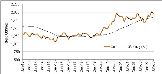
22.3.4 Taxation and Royalty Regime
The Wildcat and Mountain View Projects are subject to a Gold and Silver Excise Tax in Nevada, as well as Nevada's Net Proceeds of Minerals (NPOM) tax of 5% of net proceeds), and US federal income tax at the rate of 21% on profits.
The Wildcat property is subject to several royalty agreements. These include a US$500,000 payment due on production startup, and royalties on sales of 0.4%, 1.0% and 0.5% on various groups of claims as is more fully described in Section 4.2.2.1 of this report.
At Mountain View, a royalty of 4% is payable on all sales, as is more fully described in Section 4.2.5 of this report.
22.4 Technical Assumptions
22.4.1 Mining
Mining of Wildcat and Mountain View Projects is described in Section 16 of this report. Figure 22.2 shows the annual mine production schedule for both Projects.
22.4.2 Processing
The processing of Wildcat and Mountain View Projects is described in Section 17 of this report. Figure 22.3 shows the annual production schedule for the Projects, expressed as gold equivalent ounces. Overlap in the schedules is due to the recovery of gold from Wildcat during the heap rinsing phase.
Figure 22.2
Wildcat and Mountain View Mining Production Schedule
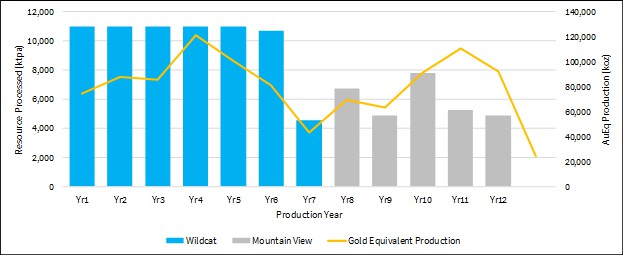
Figure 22.3
Wildcat and Mountain View Production Schedule
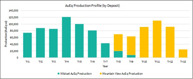
22.5 Base Case Cash Flow
The overall LOM base case cash flow for both Projects combined is summarized in Table 22.1.
Table 22.1
Summary LOM Cash Flow, Wildcat and Mountain View Projects
| Area | Item | | LOM Total | | | US$/t | | | US$/oz AuEq | |
| Revenue | Gross sales | | 1,772,503 | | | 17.81 | | | 1,700 | |
| | | | | | | | | | | |
| Cash op. costs | Mining costs | | 400,385 | | | 4.02 | | | 384 | |
| | Processing costs | | 357,220 | | | 3.59 | | | 343 | |
| | G&A costs | | 57,480 | | | 0.58 | | | 55 | |
| | Cash operating costs | | 815,085 | | | 8.19 | | | 782 | |
| | Selling expenses incl. royalties | | 63,323 | | | 0.64 | | | 61 | |
| | NV net proceeds of minerals tax | | 41,150 | | | 0.41 | | | 39 | |
| | Total cash costs | | 919,558 | | | 9.24 | | | 882 | |
| | | | | | | | | | | |
| Net cash operating margin (EBITDA) | | 852,945 | | | 8.57 | | | 818 | |
| | | | | | | | | | | |
| Capital expenditure | Wildcat | | 178,518 | | | 1.79 | | | 171 | |
| | Mountain View | | 81,124 | | | 0.82 | | | 78 | |
| | Closure provision | | 21,748 | | | 0.22 | | | 21 | |
| | Sustaining capital | | 36,000 | | | 0.36 | | | 35 | |
| | Residual value | | (12,063 | ) | | (0.12 | ) | | (12 | ) |
| Net cash flow before tax | | 547,619 | | | 5.50 | | | 525 | |
| Income tax payable | | 62,504 | | | 0.63 | | | 60 | |
| Net cash flow after tax | | 485,114 | | | 4.87 | | | 465 | |
| | | | | | | | | | |
| All-in Sustaining Cost per ounce AuEq (AISC) | | | | | | | | 973 | |
| All-in Cost per ounce AuEq (AIC) | | | | | | | | 1,175 | |
Cash Costs include site operating costs (mining, processing, site G&A), refinery costs and royalties, but exclude corporate G&A and exploration expenses. All-in Sustaining Cost (AISC) includes Cash Costs, sustaining and expansion capital, but excludes corporate G&A and exploration expenses. All-in Cost (AIC) includes AISC level costs, initial capital and equipment finance costs associated with initial capital.
The average annual LOM production at Wildcat and Mountain View is expected to be 80,000 oz AuEq per year which, at the base case metal prices of US$1,700/oz Au and US$21.50/oz Ag will generate total LOM net free cash flow of US$485 million and average annual free cash flow of US$46 million from year 1 to year 13. Corporate office general and administrative costs were not included in the LOM costs for the Projects.
The base case cash flow is equivalent to an after-tax net present value (NPV) of US$309.6 million at a discount rate of 5% and yields an internal rate of return (IRR) of 36.9%. Over the LOM period, the operating margin averages 48.1% after-tax.
At the time of announcement (June 27, 2023) spot prices of US$1,920/oz gold and US$22.00/oz silver, the forecast cash flow evaluates to an after-tax NPV5 of US$442.1 million at an annual discount rate of 5% and yields an internal rate of return (IRR) of 49.7%.
On a co-product basis, the Projects are expected to have direct cash costs of U$882/oz gold equivalent (AuEq) an All-in-Sustaining Cost (AISC) of US$973/oz AuEq, and All-in-Costs (AIC) of US$1,175/oz AuEq.
Annual cash flows are presented in Table 22.2, and are shown graphically in Figure 22.4.
Table 22.2
Annual LOM Cash Flow
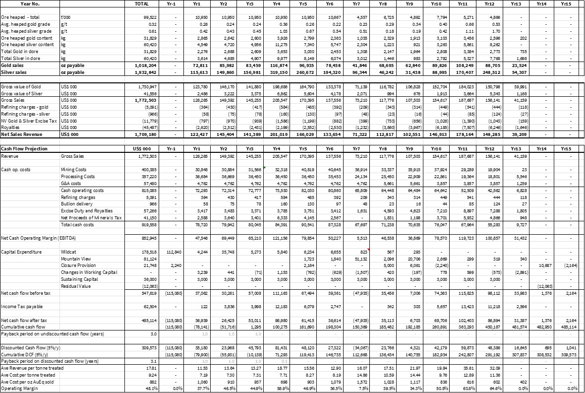
Figure 22.4
LOM Cash Flow Chart
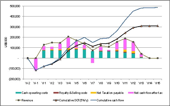
22.6 Sensitivity Study
The sensitivity of the Projects' NPV and IRR were tested over a range of ±25% around the base case values for gold price, operating costs and capital expenditure. The results are presented in Figure 22.5 and Figure 22.6, respectively.
The results show that NPV and IRR remain positive across the ranges tested. The Project is most sensitive to metal price, with NPV5 being reduced to US$52.7 million from the base case value of US$309.6M at a 25% reduction in a gold price equivalent to US$1,275/oz, yielding an IRR of 10.5% at that price.
22.6.1 Discount Rate Sensitivity
The base case discount rate of 5.0% yields NPV5 of US$309.6 million. At discount rates of 7.5% and 10.0%, NPV is reduced to US$249.3 million and US$201.2 million, respectively.
Figure 22.5
NPV Sensitivity Chart

Figure 22.6
IRR Sensitivity Chart
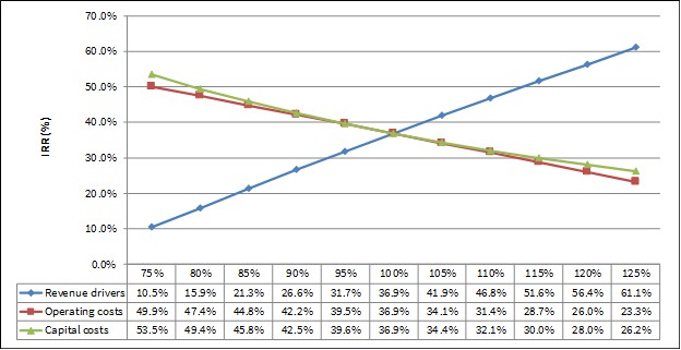
23.0 ADJACENT PROPERTIES
23.1 Wildcat Project
The Wildcat property is adjacent to the actively explored Seven Troughs mining district, where historic high-grade gold production has occurred. Two gold deposits which were mined during the 1990's are located within 50 miles of the property (Rosebud and Hycroft/Brimstone). However, there are no immediate adjacent properties that directly have an impact on the Wildcat Project.
Information regarding the Seven Troughs mining district has been compiled from private and public reports which are noted in Section 28.0 of this report. However, Micon and the QPs have been unable to verify the information in the private and public reports and the information is not necessarily indicative of the mineralization on the Wildcat property that is the subject of this report.
23.2 Mountain View Project
There are no adjacent properties in the Deephole Mining District that directly have a direct impact on the Mountain View Project.
24.0 OTHER RELEVANT DATA AND INFORMATION
All relevant data and information regarding Integra's Wildcat and Mountain View Projects are included in other sections of this Technical Report.
Neither Micon nor the QPs are aware of any other data that would make a material difference to the quality of this Technical Report or make it more understandable, or without which the report would be incomplete or misleading.
25.0 INTERPRETATION AND CONCLUSIONS
25.1 General Information
The recent diamond drilling programs to verify, extend and infill the existing information were successful in outlining the continuity and extent of the mineralization located on the Wildcat and Mountain View Projects. The drilling programs allowed Integra to undertake an updated mineral resource estimate for each Project and that estimate, which is described in Section 14 of this report, is the basis for the PEA.
25.2 Mineral Resource Estimate
25.2.1 Mineral Resource Estimate for the Wildcat Project
25.2.1.1 Wildcat Methodology
Modelling for the Wildcat deposit was performed using LeapFrog GEO v2021.2 (LeapFrog) and Isatis NEO mining v2022.12 (Isatis). LeapFrog was used for modelling the lithological, alteration, and oxidation profiles. Isatis was used for the grade estimation, which consisted of 3D block modelling and the inverse distance cube (ID3) interpolation method. Statistical studies, capping and variography were completed using Isatis and Microsoft Excel. Capping and validations were carried out in Isatis and Excel.
25.2.1.2 Wildcat Mineral Resource Database
The close-out date for the Wildcat deposit mineral resource database is December 31, 2022. The database consists of 315 validated diamond drill holes and reverse circulation (RC) holes, totalling 39,143.45 m and including 24,510 sample intervals. The database includes the 12 drill holes, totalling 1,289.80 m of diamond drilling and including 935 sample intervals assayed for gold and silver completed in 2022.
The database also includes validated location, survey and assay results as well as geotechnical, lithological, alterations, oxidation and structural descriptions taken from the drill core logs.
The database covers the strike length of each mineralized domain at variable drill hole spacings, ranging from 20 m to 100 m, with an average spacing of approximately 50m.
The Wildcat deposit is divided into 2 zones, the Main Hill zone, in which most of the drilling was conducted, and Cross-Road zone (to the north west), which represents the other area of drilling.
In addition to the tables of raw data, the database includes several tables of calculated drill hole composites and wireframe solid intersections, which are required for the statistical evaluation and mineral resource block modelling.
25.2.1.3 Wildcat Geological Modelling
The Integra geological team prepared the geological model of the Wildcat deposit in LeapFrog, using surface mapping, rock or soil samples, and drill holes, all of which were completed by December 31, 2022.
A total of six lithological domains were modelled with each domain defined based on the lithological logs prepared by the geologists from the core or RC chips.
In addition to the lithological model, an oxidation model was developed for the Wildcat deposit. This model is principally based on the original logs, relogging and geochemical information (ICP and cyanide shakes). During the 2022 drilling and relogging campaign, it was observed that geologists were recording the rocks as 'oxidized' when the sulphur content was low (generally below 0.3% sulphur). This also corresponds to the area where the ratio of cyanide shakes to fire assays gold results is generally higher. Although the oxidation level varies in depth locally, the geological contact zone was used to build a smoothed 3D surface representing the oxide material compared to the non-oxide material (i.e. transition and fresh rock).
25.2.1.4 Wildcat Geostatistical Analysis
All assays in the Wildcat database were flagged by lithologies and oxidation, allowing further statistical analysis.
25.2.1.5 Wildcat Contact Analysis
To determine the grade continuity between the main lithologies, a contact plot analysis was performed on the raw assays. The contact plot demonstrates that the Volcanoclastic (Rhyolitic Tuff Breccia) has a higher gold grade than other lithologies, but the grade within the other lithologies close to the contact is, on average, similar to the grade found in the Volcaniclastics. Similar plots were performed for all the lithological contacts, and the same conclusion was found. Based on this information, it was decided that no hard boundary would be used during the resource estimation process, although a relatively short distance should be considered when interpolating parallel to the contact zone.
25.2.1.6 Wildcat High-Grade Capping
The impact of high-grade outliers on composite data was examined using log histograms and log probability plots. Cumulative metal and mean and variance plots were analyzed for the impact of high-grade capping. Threshold indicator grades were coded and analyzed to determine spatial continuity of the high grades. The indicator variograms suggest that high-grade continuity decreases with increasing grade thresholds. From a statistical and spatial review of the composite data, the QPs are of the opinion that capping is required in order to restrict the influence of high-grade outlier assays.
The log probability plots were used to select a 10 g/t capping value for gold, and a 100 g/t capping value for silver. The 10 g/t capping value for gold represents the 99.9 percentile value and removes approximately 3% of the gold metal in the assays, which is considered reasonable for the type of deposit. Overall, the deposit is not very sensitive to capping values.
25.2.1.7 Wildcat Density
During the 2022 drilling campaign, 245 density measurements were conducted on the rock, by Millennial's geologists, using the immersion technique. Measurements were taken approximately every 10 m to 20 m across all lithologies and alterations. Based on these measurements and the interpretation of the statistics, a fixed density of 2.6 g/cm3 was selected and used in the resources estimate.
25.2.1.8 Wildcat Compositing
The assay data were flagged and analyzed to determine an appropriate composite length, in order to minimize any bias introduced by variable sample lengths. Most of the analytical samples were collected at lengths of between 0.30 m and 3.52 m with a clear mode at 1.52 m. Based on these observations and considering the future bench height, a 4.5 m length composite was selected. All drill holes were composited for gold and silver from collar to toe, using capped and uncapped values, any composites with a length less than 2.25 m were discarded.
25.2.1.9 Wildcat Variogram Analysis
The spatial distribution of gold and silver was evaluated through variogram analysis for each mineralized domain. Three dimensional experimental variograms were generated and modelled to assess the grade continuity and to perform geostatistical validation tests, as well as comparative Ordinary Kriging interpolation. After review of the variogram and the different interpolation strategies, a Inverse Distance interpolator was selected for the present resource estimate.
25.2.1.10 Wildcat Block Model
The criteria used in the selection of block size for the Wildcat deposit included drill hole spacing, composite length, the geometry of the modelled zone, and the anticipated mining methods. A block size of 15.24 m x 15.24 m x 9.144 m (50 ft x 50 ft x 30 ft) was used for the Wildcat Project. The block model was coded for each lithological and oxidation domain using the 50% rule. No rotation was applied to the block model.
25.2.1.11 Wildcat Search Ellipse and Interpolation Parameters
To respect the folded aspect of the Main Hill, as well as the 'flatter' orientation of the Cross-Road area, three different search ellipse orientations were selected. These orientations were selected manually in 3D and validated though variography.
The block model was interpolated using Inverse Distance to the power three (ID3) using a block discretization of 4 x 4 x 4. A minimum of 7 samples (respecting a maximum of 3 samples per hole) with a maximum of 15 samples, was used during both passes. The same interpolation strategy was used for both gold and silver grades.
25.2.1.12 Wildcat Mineral Resource Classification
The mineral resource classification was determined through manual geometric criteria deemed reasonable for the deposit. Only blocks within the Oxide zone were classified, blocks interpolated within the transition and fresh material were not considered in the resource estimation. Blocks located within the Main Hill area at a spacing of approximately 50 m x 50 m were classified as indicated, and interpolated blocks within approximately 100 m from an existing hole were classified as inferred. Considering the historical nature of the drilling at the Cross-Road zone, no blocks were classified as indicated. Most of the inferred area in the Main Hill region consists of potential extension zones that will require additional infill drilling.
25.2.1.13 Wildcat Reasonable Prospects for Eventual Economic Extraction
For the Wildcat deposit, a reasonable economic cut-off grade for the resource estimate was determined to be 0.15 g/t Au. This cut-off grade was determined using the parameters presented in Table 25.1.
In addition to the cut-off grade, an open pit optimizer program was run on the block model to constrain the mineral resources within a pit shell.
Table 25.1
Wildcat Project Mineral Resource Estimate Economic Parameters
| Parameters | Units | Value |
| Gold price | U$/oz | 1,800 |
| Silver price | U$/oz | 21.0 |
| Mining costs | US$/t | 2.4 |
| Processing costs | US$/t | 3.7 |
| G&A costs | US$/t | 0.5 |
| Gold Cut-off | g/t Au | 0.15 |
| Discount rate | % | 5.0 |
| Pit slope | ° | 51-54 |
| Rhyolite recovery | Au % | 73.0 |
| Granodiorite recovery | Au % | 52.0 |
| Silver Recovery | Ag % | 18.0 |
25.2.1.14 Wildcat Mineral Resource Estimate
The QP has classified the Wildcat Project mineral resource estimate as indicated and inferred mineral resources, based on data density, search ellipse criteria, and interpolation parameters. The QP considers the mineral resource estimate to be a reasonable representation of the mineral resources of the Wildcat deposit, based on the currently available data and geological knowledge. The mineral resource estimate follows the 2014 CIM Definition Standards on Mineral Resources and Reserves. The effective date of the Mineral Resource Estimate is June 28, 2023.
Table 25.2 summarizes the results of the mineral resource estimate for the Wildcat Project at a 0.15 g/t Au cut-off grade for the Wildcat deposit.
Table 25.2
Wildcat Deposit June, 2023, Mineral Resource Estimate Statement
Classification | Tonnes | g/t Au | oz Au | g/t Ag | oz Ag | g/t AuEq | oz AuEq |
Indicated | 59,872,806 | 0.39 | 746,297 | 3.34 | 6,437,869 | 0.43 | 829,152 |
Inferred | 22,455,848 | 0.29 | 209,662 | 2.74 | 1,980,129 | 0.33 | 235,146 |
Table Notes:
(1) Effective date of the Mineral Resource Estimate is June 28, 2023.
(2) Mineral Resources that are not Mineral Reserves do not have demonstrated economic viability.
(3) William J. Lewis, P.Geo., of Micon has reviewed and verified the Mineral Resource Estimate for the Wildcat Project. Mr. Lewis is an independent Qualified Person, as defined in National Instrument 43-101 Standards of Disclosure for Mineral Projects (NI 43-101).
(4) The estimate is reported for an open-pit mining scenario, based upon reasonable assumptions. The cut-off grade of 0.15 g/t Au was calculated using a gold price of US$1,800/oz, mining costs of US$2.4/t, processing cost of US$3.7/t, G&A costs of US$0.5/t, and metallurgical gold recoveries varying from 73.0% to 52.0% and silver recoveries of 18%. The gold equivalent figures in the resource estimate are calculated using the formula (g/t Au + (g/t Ag ÷ 77.7)).
(5) An average bulk density of 2.6 g/cm3 was assigned to all mineralized rock types.
(6) Inverse Distance cube interpolation method was used with a parent block size of 15.24 m x 15.24 m x 9.144 m.
(7) Rounding as required by reporting guidelines may result in minor apparent discrepancies between tonnes, grades, and contained metal content.
(8) The estimate of mineral resources may be materially affected by geological, environmental, permitting, legal, title, taxation, sociopolitical, marketing, or other relevant issues.
(9) Neither Integra nor Micon is aware of any known environmental, permitting, legal, title-related, taxation, socio-political, marketing or other relevant issue that could materially affect the mineral resource estimate other than any information already disclosed in this report.
25.2.1.15 Wildcat Cut-off Grade Sensitivity Analysis
Table 25.3 shows the cut-off grade sensitivity analysis of gold and silver for the updated mineral resource estimate for the Wildcat Project. The reader should be cautioned that the figures provided in Table 25.3 should not be interpreted as a mineral resource statement. The reported quantities and grade estimates at different cut-off grades are presented for the sole purpose of demonstrating the sensitivity of the mineral resource model for gold to the selection of a reporting cut-off grades. The QP has reviewed the cut-off grades used in the sensitivity analysis, and it is the opinion of the QP that they meet the test for reasonable prospects of eventual economic extraction at varying prices of gold.
Table 25.3
Wildcat Project, Gold Grade Sensitivity Analysis at Different Cut-Off Grades
Classification | Cut-off* | Tonnes | g/t Au | oz Au | g/t Ag | oz Ag |
Indicated | 0.05 | 67,016,721 | 0.36 | 770,900 | 3.16 | 6,804,827 |
0.1 | 64,761,568 | 0.37 | 765,404 | 3.23 | 6,716,586 |
0.15 | 59,872,806 | 0.39 | 746,297 | 3.34 | 6,437,869 |
0.2 | 52,012,138 | 0.42 | 702,728 | 3.53 | 5,904,258 |
0.25 | 42,440,131 | 0.47 | 635,006 | 3.84 | 5,236,770 |
0.3 | 33,411,641 | 0.52 | 556,692 | 4.22 | 4,528,878 |
0.35 | 25,762,514 | 0.58 | 478,202 | 4.62 | 3,825,142 |
0.4 | 19,392,625 | 0.65 | 402,566 | 5.08 | 3,164,355 |
0.45 | 15,276,484 | 0.71 | 347,188 | 5.53 | 2,715,493 |
0.5 | 12,049,761 | 0.77 | 298,456 | 5.98 | 2,317,021 |
0.6 | 7,755,728 | 0.90 | 223,657 | 6.82 | 1,700,408 |
0.65 | 6,205,147 | 0.97 | 192,787 | 7.21 | 1,439,359 |
0.7 | 4,971,819 | 1.04 | 166,263 | 7.69 | 1,228,962 |
0.75 | 4,069,767 | 1.11 | 145,461 | 8.23 | 1,076,238 |
0.8 | 3,423,662 | 1.18 | 129,489 | 8.64 | 950,677 |
0.85 | 2,962,655 | 1.23 | 117,374 | 9.14 | 870,587 |
0.9 | 2,503,727 | 1.30 | 104,537 | 9.75 | 784,511 |
0.95 | 2,199,431 | 1.35 | 95,528 | 10.17 | 718,988 |
Inferred | 0.05 | 25,515,457 | 0.27 | 219,842 | 2.62 | 2,150,330 |
0.1 | 24,341,745 | 0.28 | 217,068 | 2.69 | 2,101,984 |
0.15 | 22,455,848 | 0.29 | 209,662 | 2.74 | 1,980,129 |
0.2 | 17,615,915 | 0.32 | 182,950 | 2.90 | 1,643,048 |
0.25 | 12,239,483 | 0.37 | 145,178 | 3.24 | 1,275,913 |
0.3 | 7,909,184 | 0.42 | 107,855 | 3.52 | 895,212 |
0.35 | 5,051,117 | 0.48 | 78,604 | 3.74 | 607,127 |
0.4 | 3,369,700 | 0.54 | 58,751 | 3.96 | 429,367 |
0.45 | 2,316,862 | 0.60 | 44,596 | 4.21 | 313,932 |
0.5 | 1,627,724 | 0.65 | 34,229 | 4.66 | 243,747 |
0.6 | 691,921 | 0.80 | 17,839 | 5.69 | 126,486 |
0.65 | 467,070 | 0.89 | 13,360 | 6.00 | 90,072 |
0.7 | 358,293 | 0.96 | 11,030 | 6.26 | 72,118 |
0.75 | 280,671 | 1.02 | 9,246 | 6.40 | 57,735 |
0.8 | 229,353 | 1.08 | 7,977 | 6.68 | 49,250 |
0.85 | 196,386 | 1.12 | 7,098 | 6.82 | 43,064 |
0.9 | 162,361 | 1.18 | 6,148 | 6.66 | 34,746 |
0.95 | 154,645 | 1.19 | 5,924 | 6.75 | 33,539 |
*Base Case cut-off grades shown in bold.
25.2.2 Mineral Resource for the Mountain View Project
25.2.2.1 Mountain View Methodology
Modelling for the Mountain View deposit was performed using LeapFrog GEO v2021.2 (LeapFrog) and Isatis NEO mining v2022.12 (Isatis). LeapFrog was used for modelling the lithological, alteration, and oxidation profiles. Isatis was used for the grade estimation, which consisted of 3D block modelling and the inverse distance cube (ID3) interpolation method. Statistical studies, capping and variography were completed using Isatis and Microsoft Excel. Capping and validations were carried out in Isatis and Excel.
25.2.2.2 Mountain View Mineral Resource Database
The close-out date for the Mountain View deposit mineral resource estimate database is June 28, 2023. The Mountain View database consists of 260 validated diamond drill holes and RC holes, totalling 55,777.92 m and including 20,839 sample intervals. This database includes Millennial's 27 holes, totalling 5,152.37 m of diamond drilling and including 4,023 sample intervals assayed for gold and silver. One of the 2022 holes was drilled and logged, but not sampled, as it has been kept intact for future metallurgical testing.
The database also includes validated location, survey, and assay results along with geotechnical, lithological, alteration, oxidation and structural descriptions taken from drill core logs.
The database covers almost the entire property, but most of the holes are within the main mineralized area. The strike length of each mineralized domain was drilled at variable drill hole spacings, ranges from 20 m to 100 m, with an average spacing of approximately 50 m.
In addition to the tables of raw data, the database includes several tables of calculated drill hole composites and wireframe solid intersections, which are required for the statistical evaluation and mineral resource block modelling.
25.2.2.3 Mountain View Geological Modelling
The Integra geological team prepared the geological model of the Mountain View deposit in LeapFrog, using surface mapping, rock or soil samples, and drill holes, all completed by December 31, 2022.
A total of six lithological domains were modelled with each domain defined based on the lithological logs compiled by the geologists on core or RC chips.
The lithological model at Mountain View is composed of a barren Granodiorite to the east, and a basalt basement below the main Rhyolitic dome hosting most of the mineralization. Locally, some undifferentiated volcano sedimentary units are interbedded within the Rhyolitic dome. A thin (1 m to 10 m) layer of Tertiary detritic units is generally mineralized. A Quaternary Alluvium unit covers most of the deposit, with a thin layer to the east (1 m), going deeper to the west (up to 200 m). Most of the mineralization is constrained within two hydrothermal breccia domains; the one to the east has a lower brecciation with a lower average grade, while the main western breccia body presents high quartz and adularia brecciation as well as higher grade.
The granodiorite and Quaternary Alluvium domains are considered barren and were not used during the interpolation process.
Most of the historical drilling was done using RC, and only limited structural information is present in historical logs. The Range Front Fault comprises the contact zone between the granodiorite to the east and all other lithologies to the west. During the 2022 drilling, some minor faults were identified, and some north-south (slightly dipping west) structures were modelled; these structures are believed to be controlling a portion of the mineralization and breccias orientation.
In addition to the lithological and breccia domains, an oxidation model was developed for the Mountain View deposit. This model is principally based on the original drill logs and geochemical information (ICP and cyanide shakes). Although the oxidation level varies locally in depth and structure, three smoothed oxidation solids were created: oxidation (where most of the sulphur is oxidized), transitional (with a mix of oxidized and unoxidized sulphur) and fresh material (where no oxidation is observed).
25.2.2.4 Mountain View Geostatistical Analysis
All assays in the database were flagged by domains and oxidation, allowing further statistical analysis.
25.2.2.5 Mountain View Contact Analysis
To determine the grade continuity between the main lithologies, a contact plot analysis were performed on the raw assays. The contact plot demonstrates that the West Breccia domain has a higher gold grade than other lithologies, and that there is a sharp change in the grade at the contact zone. Similar plots were assessed for all of the domain contacts, and the same conclusion was found for the East Breccia. However, there was no significant change in grades between the other domains (ie. Rhyolite, Basalts and Volcano-Sedimentary units). Based on this information, it was decided that a hard boundary would be used for estimation of both breccia domains, but that no hard boundary would be used for the other domains.
25.2.2.6 Mountain View High-Grade Capping
The impact of high-grade outliers on composite data was examined using log histograms and log probability plots. Cumulative metal and mean and variance plots were analyzed for the impact of high-grade capping. Threshold indicator grades were coded and analyzed to determine spatial continuity of the high grades. The indicator variograms suggest that high-grade continuity decreases with increasing grade thresholds. From a statistical and spatial review of the composite data, the QPs are of the opinion that capping is required, in order to restrict the influence of high-grade outlier assays at varying ranges.
The 20 g/t gold capping value represents the 99.3 percentile value and removes approximately 8% of the gold metal in the assays, which is considered reasonable for the type of deposit; overall, the deposit is not very sensitive to capping values.
25.2.2.7 Mountain View Density
A total of 88 pulps from 14 holes were sent to the Bureau Veritas laboratory for specific gravity measurement by pycnometry. The mean result for the rock density was 2.68 g/cm3and this number was used for the mineral resource estimate. A density of 1.94 g/cm3 was used in the QAL. This result was derived from density measurements performed by the laboratory during the geotechnical investigations.
25.2.2.8 Mountain View Compositing
The assay data were flagged and analyzed to determine an appropriate composite length, to minimize any bias introduced by variable sample lengths. Most of the analytical samples were collected at lengths of between 0.30 m and 3.1 m with a clear mode at 1.52 m (5 ft). Based on these observations and considering the future bench heigh, a 3 m length composite was selected. All drill holes were composited for gold and silver by domain, using capped and uncapped values. Any composites with a length less than 1.5 m were discarded.
25.2.2.9 Mountain View Block Model
The criteria used in the selection of block size included drill hole spacing, composite length, the geometry of the modelled zone, and the anticipated mining methods. A block size of 7.62 m x 7.62 m x 6.10 m was used (25 ft x 25 ft x 20 ft). The block model was coded for each lithological and oxidation domains using the 50% rule. No rotation was applied to the block model.
25.2.2.10 Mountain View Search Ellipse and Interpolation Parameters
Two different search ellipse orientations were selected. These orientations were selected manually in 3D and validated though variography. The size of the search ellipse was set to be large enough to populate the densely informed area during the first pass and to roughly correspond to 70% of the variance of the variogram: the results of this provided a flat ellipse of 30 m x 20 m x 30 m. To populate most of the block model, a second pass was used.
The block model was interpolated using an Inverse Distance to the power of three (ID3) and a block discretization of 3 x 3 x 3. A 3-pass interpolation strategy was used, with relaxing parameters for each successive pass.
25.2.2.11 Mountain View Mineral Resource Classification
Mineral resource classification was determined through manual geometric criteria deemed reasonable for the deposit by the QP. Considering the complex 3D shape of the mineralization at the Mountain View Project, a classification based on a number of search passes was used. Blocks interpolated during the first and second passes were classified as Indicated, with blocks that were interpolated during the third pass classified as Inferred.
25.2.2.12 Mountain View Reasonable Prospects for Eventual Economic Extraction
A reasonable economic cut-off grade for resource evaluation at the Mountain View deposit is 0.15 g/t Au. This was determined using the parameters presented in Table 25.4.
In addition to the cut-off grade, an open pit shell optimizer was undertaken on the block model to constrain the mineral resources within a conceptual pit shell. In addition to a gold price of US$1,800/oz, mining, processing and metallurgical recoveries were used to create the conceptual pit. These parameters are summarized in the Table 25.4.
Table 25.4
Mountain View Project, Mineral Resource Economic Parameters
| Parameters | Units | Value |
| Gold price | U$/oz | 1,800 |
| Silver price | U$/oz | 21.0 |
| Mining costs (QAL) | US$/t | 1.67 |
| Mining costs (Rock) | US$/t | 2.27 |
| Processing costs | US$/t | 3.1 |
| G&A costs | US$/t | 0.4 |
| Gold Cut-off | g/t Au | 0.15 |
| Discount rate | % | 5.0 |
| Pit slope (QLA) | ° | 44 |
| Pit slope (Rock) | ° | 44-50 |
| Oxide recovery | Au % | 86.0 |
| Transition recovery | Au % | 64.0 |
| Fresh recovery | Au % | 30.0 |
| Silver Recovery | Ag % | 20.0 |
25.2.2.13 Mountain View Mineral Resource Estimate
The QPs have classified the Mountain View Project mineral resource estimate as indicated, and inferred mineral resources based on data density, search ellipse criteria, and interpolation parameters. The estimate is considered to be a reasonable representation of the mineral resources of the Mountain View deposit, based on the currently available data and geological knowledge. The mineral resource estimate follows the 2014 CIM Definition Standards on Mineral Resources and Reserves. The effective date of the mineral resource estimate is June 28, 2023.
Table 25.5 displays the results of the mineral resource estimate for the Mountain View deposit at a gold cut-off grade of 0.15 g/t.
Table 25.5
Mountain View Deposit June, 2023, Mineral Resource Estimate Statement
| Type | Classification | Tonnes | Gold
Grade
g/t | Ounces
Gold | Silver
Grade
g/t | Ounces
Silver | Gold
Equivalent
g/t | Gold
Equivalent
Ounces |
| Oxide | Indicated | 22,007,778 | 0.57 | 401,398 | 2.46 | 1,738,448 | 0.60 | 423,772 |
| Inferred | 3,579,490 | 0.44 | 50,716 | 1.43 | 165,049 | 0.46 | 52,840 |
| Transition | Indicated | 2,804,723 | 0.66 | 59,676 | 6.56 | 591,868 | 0.75 | 67,293 |
| Inferred | 215,815 | 0.40 | 2,750 | 3.77 | 26,184 | 0.44 | 3,087 |
| Fresh | Indicated | 3,938,017 | 0.92 | 116,970 | 8.46 | 1,071,521 | 1.03 | 130,760 |
| Inferred | 360,198 | 0.58 | 6,679 | 4.57 | 52,955 | 0.64 | 7,361 |
| Total | Indicated | 28,750,517 | 0.63 | 578,044 | 3.68 | 3,401,836 | 0.67 | 621,826 |
| Inferred | 4,155,502 | 0.45 | 60,145 | 1.83 | 244,188 | 0.47 | 63,288 |
Notes:
(1) Effective date of the Mineral Resource Estimate is June 28, 2023.
(2) Mineral Resources that are not Mineral Reserves do not have demonstrated economic viability.
(3) William J. Lewis, P.Geo., of Micon has reviewed and verified the Mineral Resource Estimate for the Mountain View Project. Mr. Lewis is an independent Qualified Person, as defined in National Instrument 43-101 Standards of Disclosure for Mineral Projects (NI 43-101).
(4) The estimate is reported for an open-pit mining scenario, based upon reasonable assumptions. The cut-off grade of 0.15 g/t Au was calculated using a gold price of US$1,800/oz, mining costs of US$1.67/t to US$2.27/t, processing cost of US$3.1/t, G&A costs of US$0.4/t, and metallurgical gold recoveries varying from 30.0% to 86.0% with a silver recovery of 20%. Gold equivalent in the Resource Estimate is calculated using the formula (g/t Au + (g/t Ag ÷ 77.7)).
(5) An average bulk density of 2.6 t/cm3 was assigned to all mineralized rock types.
(6) The Inverse Distance cubed interpolation method was used with a parent block size of 7.62 m x 7.62 m x 6.10 m.
(7) Rounding as required by reporting guidelines may result in minor apparent discrepancies between tonnes, grades, and contained metal content.
(8) The estimate of mineral resources may be materially affected by geological, environmental, permitting, legal, title, taxation, sociopolitical, marketing, or other relevant issues.
(9) Neither Integra nor Micon' QP is aware of any known environmental, permitting, legal, title-related, taxation, socio-political, marketing or other relevant issue that could materially affect the mineral resource estimate other than those disclosed in this report.
25.2.2.14 Mountain View Cut-off Grade Sensitivity Analysis
Table 25.6 summarizes the cut-off grade sensitivity analysis for gold and silver for the Mountain View mineral resource estimate. The reader should be cautioned that the figures provided in Table 1.6 should not be interpreted as a mineral resource statement. The reported quantities and grade estimates at different cut-off grades are presented for the sole purpose of demonstrating the sensitivity of the mineral resource model for gold to the selection of a reporting cut-off grade. Micon's QP has reviewed the cut-off grades used in the sensitivity analysis and is of the opinion that they meet the test for reasonable prospects of eventual economic extraction at varying prices of gold.
Table 25.6
Mountain View Project, Gold Grade Sensitivity Analysis at Different Cut-Off Grades
| Classification | Cut-off* | Tonnes | g/t Au | oz Au | g/t Ag | oz Ag |
| Indicated | 0.05 | 40,403,411 | 0.47 | 611,331 | 2.77 | 3,603,425 |
| 0.1 | 33,505,516 | 0.55 | 596,279 | 3.25 | 3,504,450 |
| 0.15 | 28,750,517 | 0.63 | 578,044 | 3.68 | 3,401,836 |
| 0.2 | 24,655,131 | 0.70 | 555,638 | 4.13 | 3,273,399 |
| 0.25 | 20,636,857 | 0.79 | 527,273 | 4.71 | 3,126,157 |
| 0.3 | 17,607,873 | 0.89 | 501,067 | 5.30 | 3,002,439 |
| 0.35 | 15,040,896 | 0.98 | 474,722 | 5.96 | 2,884,444 |
| 0.4 | 12,825,775 | 1.09 | 448,438 | 6.72 | 2,770,464 |
| 0.45 | 11,148,152 | 1.19 | 425,832 | 7.44 | 2,665,760 |
| 0.5 | 9,921,924 | 1.28 | 407,305 | 8.10 | 2,585,043 |
| 0.6 | 8,060,436 | 1.45 | 374,797 | 9.37 | 2,428,881 |
| 0.65 | 7,261,650 | 1.54 | 358,880 | 10.06 | 2,349,158 |
| 0.7 | 6,605,735 | 1.62 | 344,764 | 10.74 | 2,280,086 |
| 0.75 | 6,092,995 | 1.70 | 332,892 | 11.34 | 2,221,263 |
| 0.8 | 5,604,020 | 1.78 | 320,793 | 11.99 | 2,160,136 |
| 0.85 | 5,141,115 | 1.87 | 308,589 | 12.67 | 2,094,668 |
| 0.9 | 4,704,754 | 1.96 | 296,388 | 13.43 | 2,031,580 |
| 0.95 | 4,347,878 | 2.04 | 285,832 | 14.17 | 1,980,755 |
| Classification | Cut-off* | Tonnes | g/t Au | oz Au | g/t Ag | oz Ag |
| Inferred | 0.05 | 7,216,472 | 0.29 | 68,309 | 1.23 | 286,151 |
| 0.1 | 5,193,523 | 0.38 | 64,086 | 1.58 | 264,520 |
| 0.15 | 4,155,502 | 0.45 | 60,145 | 1.83 | 244,188 |
| 0.2 | 3,295,489 | 0.52 | 55,404 | 2.01 | 213,229 |
| 0.25 | 2,666,150 | 0.59 | 50,996 | 2.23 | 190,903 |
| 0.3 | 2,183,919 | 0.67 | 46,813 | 2.42 | 170,015 |
| 0.35 | 1,787,425 | 0.74 | 42,741 | 2.68 | 153,958 |
| 0.4 | 1,482,411 | 0.82 | 39,121 | 2.95 | 140,721 |
| 0.45 | 1,251,206 | 0.90 | 36,019 | 3.20 | 128,567 |
| 0.5 | 1,082,894 | 0.96 | 33,480 | 3.38 | 117,542 |
| 0.6 | 820,366 | 1.10 | 28,925 | 3.81 | 100,545 |
| 0.65 | 731,986 | 1.15 | 27,166 | 4.04 | 94,982 |
| 0.7 | 648,315 | 1.22 | 25,362 | 4.30 | 89,554 |
| 0.75 | 587,329 | 1.27 | 23,954 | 4.47 | 84,454 |
| 0.8 | 520,384 | 1.33 | 22,299 | 4.70 | 78,600 |
| 0.85 | 468,262 | 1.39 | 20,924 | 4.92 | 74,091 |
| 0.9 | 434,955 | 1.43 | 19,995 | 5.07 | 70,965 |
| 0.95 | 396,559 | 1.48 | 18,855 | 5.18 | 66,060 |
*Base Case cut-off grades shown in bold.
25.3 PEA Mining, Processing and Infrastructure
25.3.1 Mining
Economic pit limit analysis for both the Projects was carried out using the Lerchs-Grossmann algorithm and incorporated economic and geometrical parameters for the Wildcat and Mountain View Projects. Various mining and processing scenarios based on different throughput rates were examined.
25.3.1.1 Pit Optimization Parameters
Economic parameters were established for each scenario, encompassing mining costs, process costs, General and Administrative (G&A) costs, dilution, and metallurgical recoveries.
All throughput scenarios assume operating mining costs comparable to similar projects in Nevada. The mining cost was further refined using the mine schedule to reflect the specific operational requirements.
For all scenarios, leaching is assumed to be conducted in a valley for the Wildcat deposit and adjacent to the pit for the Mountain View deposit. A conveyor is included in the Wildcat scenario to transport crushed ore from the crusher to the leach pad.
Process costs were initially estimated based on processing models provided by the QPs estimation services and were further refined with the final mine plan.
General and administrative costs were determined based on personnel, supplies, and other expenses required to support the operation.
Recoveries were estimated based on current metallurgical testwork conducted.
While pit optimizations considered various metal prices, the base metal prices used were US$1,700 per ounce of gold and US$21.00 per ounce of silver.
Geometrical parameters typically include property boundaries, royalty boundaries, and pit slope parameters. The mineral resources at both projects are contained within the current property boundaries, and those boundaries were not considered as restrictions during the pit optimization process. No royalty factors were directly applied to the optimization; instead, the royalties were calculated based on the final schedule, considering all permits that overlap with the properties.
Recent pit slope stability studies conducted by Alius Mine Consulting provided recommendations for the design parameters. These recommendations were incorporated into the optimization work, ensuring that the pit slopes maintain stability and meet the necessary safety standards.
25.3.1.2 Wildcat Pit Optimization
In the pit optimization process for the Wildcat deposit, gold prices were varied from US$500 to US$2,000 per ounce in increments of US$50 to generate a set of nested pit shells.
During the optimization, the focus was on the economic potential of the deposit, and as a result, the unoxidized material was excluded from the analysis.
To determine the ultimate pit limits for design purposes, the US$1,200 per ounce of gold was selected as the best-case pit.
The pit shell chosen for the Wildcat Project represented the maximized discounted operating cash flow, considering a gold price of US$1,700 and a silver price of US$21.00, while minimizing the capital required. This pit serves as the foundation for the ultimate pit design of the Wildcat deposit.
25.3.1.3 Mountain View Pit Optimization
The pit optimization for the Mountain View deposit was conducted using the same parameters as those used for the Wildcat Project, with gold prices ranging from US$500 to US$2,000 per ounce.
Like Wildcat the ultimate pit limit for design purposes, representing the best-case pit, was selected at the US$1,200 per ounce of gold result.
25.3.1.4 Combined Selected Shell
The US$1,200/oz gold price shell was chosen as the optimal pit configuration to maximize the value of the Projects while minimizing the capital requirement. This selection was made based on a comprehensive evaluation of the pit optimization results, taking into account economic considerations and the need to optimize the balance between profitability and capital expenditure. By selecting the US$1,200/oz shell, the Projects generate value, while maintaining an efficient capital utilization strategy.
The pit design was developed using the optimized pit shells. This pit design was created to ensure efficient access to the mineral resources for equipment and personnel involved in the mining operations. By aligning the pit design with the optimized pit shell, the Projects aim to optimize resource extraction, maximize productivity, and facilitate smooth operations within the pit area.
25.3.1.5 Wildcat Pit Design
The Wildcat pit was divided into two main pits, each consisting of two phases, along with the addition of two satellite pits, resulting in a total of six phases in the design. Pit designs were engineered to ensure optimal resource extraction and maximize recovery by simultaneously mining all phases and achieving a well-blended production schedule.
The two main phases, Phase 1 and Phase 2, were further divided into initial pushbacks, designated as Phase 1A and Phase 2A, as well as final phases. This subdivision allows for efficient sequencing of mining activities and facilitates the optimal utilization of equipment and personnel.
The mineral resources within the final pit designs were estimated with a volumetric report. Due to lower recovery rates in the fresh unoxidized material at the Wildcat Project, only non-fresh material from the pit was included for processing in the production schedule. Additionally, a mining dilution factor of 1% was applied to the mineralized tonnes in the production schedule.
25.3.1.6 Mountain View Pit Design
The Mountain View deposit consists of a single main pit, which is divided into two phases: Phase 1 and Phase 2. Both phases are mined simultaneously. The primary objective of the pit design was to achieve a balance between material movement flows and the cost/revenue streams.
By carefully sequencing the mining operations, the pit design for the Mountain View deposit aims to optimize the extraction of valuable mineral resources while efficiently managing stripping activities. The ultimate goal is to enhance the economic viability of the Project.
The determination of resources within the final pit designs was conducted using a volumetric report. Additionally, a dilution factor of 5% was applied during the production scheduling process.
25.3.1.7 Wildcat Waste Disposal
The site at the Wildcat Project has varying topography with very few level areas upon which to locate a waste storage dump. Two waste dumps were designed for the Wildcat Project with the south waste dump primarily accommodating material from Phase 2A and Phase 2F, and the north dump being designated for the remaining phases.
The waste dump designs were based on an bench face angle of 35º, with 15-m lift heights. Catch benches measuring 24 m were incorporated on each lift, resulting in an inter-ramp angle of 18°. Dump road width is 30 m with a maximum gradient of 10%. This configuration allows for final reclamation at the overall slope. In-pit dumping was also included in the mine plan.
The total dump capacity is 22.5 million tonnes, considering a swell factor of 1.25 and a loose density of 2.2 t/m3.
25.3.1.8 Mountain View Waste Disposal
The site at Mountain View has generally slight slopes dipping to the southwest. The Mountain View Project incorporates a waste dump, employing the same parameters as the Wildcat Project. The dump is situated south of the pit, including a 100 m buffer around the pit edge and features two main ramps to facilitate short hauling from the Phase 1 and Phase 2 pit exits.
The total dump capacity at Mountain View is 105.4 million tonnes, considering a swell factor of 1.25 and a loose density of two t/cm3.
25.3.1.9 Mineralized Material Stockpile Facilities
Two mineralized material stockpiles have been designed, one for each Project. The stockpiles were designed with a bench face angle of 35º, 15-m lift heights, and catch benches of 24 m, resulting in an inter-ramp angle (IRA) of 18°.
For the Wildcat Project, a small stockpile with a capacity of 0.5 million tonnes has been designed. This stockpile primarily serves the purpose of blending to maintain the granodiorite ratio in the feed below 15%.
For the Mountain View Project, a larger stockpile with a capacity of 9.2 million tonnes is planned to store mineralized material mined during the pre-stripping period before processing commences. The stockpile capacities have been estimated using a swell factor of 1.25 and a loose density of 2.2 tonnes per cubic metre.
25.3.1.10 Production Scheduling
The mine production schedule was created with a cutoff grade of 0.15 g/t of gold applied to all material across both Projects.
During the initial stages, various scenarios were run to determine the optimal processing rate. Scenarios ranged from 10,000 t/d to 30,000 t/d, in increments of 5,000 t/d. The best Net Present Value (NPV) for the Wildcat Project was achieved at a processing rate of 30,000 t/d, while the Mountain View Project showed the highest NPV at a rate of 20,000 t/d.
To minimize capital requirements and maximize NPV, the two Projects have been are designed to share resources and capacity. Consequently, a processing rate of 30,000 t/d was retained for both Projects. However, due to factors such as high stripping ratios, bench advance rates, and mining rate constraints, the processing capacity in the Mountain View Project is not optimized.
A self-sustaining approach was employed in the scheduling process, aiming to optimize NPV and internal rate of return (IRR). There is synergy between the Wildcat and Mountain View operations, with shared resources enhancing operational efficiency.
Production at the Wildcat Project is scheduled to commence in Year 1, with construction of Phase 1 of the heap leach pad. The objective is to maximize the processing rate and generate value to fund the expansion of the leach pad. Additional mining resources will be acquired and allocated to the Mountain View Project from Year 5 to Year 7, during which pre-stripping activities will be initiated. Leachable material will be stockpiled during this period. In Year 7, the Wildcat Project will conclude, and the remaining mining resources will be relocated to the Mountain View Project to increase the mining rate. Furthermore, the processing facilities, including the crusher and plant, will be relocated from Wildcat to Mountain View, and metal production will commence at the Mountain View site in Year 7.
25.3.1.11 Mine Equipment Requirements
In this PEA, owner mining was selected over more costly contract mining. The production schedule, along with additional efficiency factors, performance curves, and productivity rates, was utilized to calculate the hours required for primary mining equipment to meet the production schedule. The primary mining equipment includes drills, loaders, hydraulic shovels, and haul trucks.
In addition to the primary mining equipment, support equipment, blasting equipment, and mine maintenance equipment will also be necessary.
25.3.1.12 Mine Operations Personnel
The estimation of required mine operations personnel is based on the production schedule and equipment requirements. The mine is expected to operate 24 h/d, employing three crews of workers who will work on a fourteen-days on and seven-days off rotation. These crews will alternate between day shift and night shift.
The daily shift schedule will consist of two 12-hour shifts per day, accounting for standby time that includes startup/shutdown, lunch breaks, and operational delays.
25.3.2 Processing
The ROM ore will be truck dumped into the primary Jaw crusher feed hopper. The undersize ore will be scalped prior to the jaw crusher by a grizzly screen and deposited on the secondary crusher feed conveyor. The undersize ore and primary crushed ore will be screened with oversize crushed by a secondary and tertiary cone crusher. Material will then be dosed with lime and conveyor stacked on the leach pad.
The stacked ore will be leveled and ripped by a dozer, prior to the deployment of drip emitters. A dilute cyanide solution (NaCN) will be applied to the ore. The dilute cyanide solution will flow through the heap by gravity and report to a pregnant solution tank within the pregnant solution pond.
The pregnant solution will be pumped through a series of activated carbon beds to remove the gold. The barren solution will be dosed with additional cyanide and anti-scalant and re-circulated to the heap. The activated carbon will be advanced counter current with the solution. The loaded carbon will be transferred to an acid wash / elution circuit to remove contaminants and gold from the carbon. The carbon will then be re-introduced to the adsorption circuit. After year 7 of operation, loaded carbon from Wildcat will be shipped by road tanker for acid wash / elution at the Mountain View facility (approximately once or twice per week).
After stripping of metals at the ADR plant, the carbon will be sized, washed in dilute hydrochloric acid, neutralized, regenerated in a kiln, and then recycled into the carbon column. Some additional carbon is added to account for carbon losses in the system.
Material from the elution circuit will be refined into doré bars to be sold.
For each of the Projects, facilities will include a single large leach pad, solution pregnant and barren ponds, an emergency drain-down pond, carbon columns, an ADR plant, a laboratory and the other associated buildings.
Energy requirements were estimated for both Projects with a total of approximately 49,000,000 kWh/y and 40,400,000 kWh/y estimated for the Wildcat and Mountain View Projects, respectively. Power will be generated on site, using LNG generators at an operating a unit costs of approximately 0.13 US$/kWh.
Reagents and consumables were estimated using the metallurgical testwork performed at McClelland laboratory, costs were estimated using quotes for all major costs (lime, cyanide, carbon) and benchmark costs for the other lesser items.
Water will be supplied from wells near the processing facility. The Wildcat Project processing facility will need approximately 800 g/m (600 g/m at Mountain View) of make-up water to saturate new mineralization stacked, provide dust control, and off-set evaporation. In addition, it is estimated that 100,000 m3 (approximately 80 acre-feet) will be required for mining activities (including dust control) per year.
The plant is expected to operate 24 hours per day. Crews will alternate between day shift and night shift. The daily shift schedule will consist of 12-hour shifts per day, accounting for standby time that includes startup/shutdown, lunch breaks, and operational delays.
25.3.3 Infrastructure
All buildings for these two Projects will be designed using modified shipping containers / conexes on a concrete floor with a prefabricated roof anchored to the containers. The following buildings are planned for both Projects: maintenance facility, warehouse, process facility, and assay laboratory. Additional personnel not accommodated within these buildings will have conex offices.
The Process facility will differ between the Projects. The Wildcat facility will be larger to include a barren solution tank, a VCIC, an elution circuit, a refining circuit, reagent tanks, carbon holding tanks, and a tanker bay. The smaller Mountain View process facility will include room for a barren solution tank, a VCIC, carbon holding tanks, and a tanker bay. The reagent tanks will be insulated and in containment external to the building. Both processing facilities will be placed on a concrete containment which will drain to the pregnant solution pond.
The preliminary designs for the Wildcat and Mountain View PEA heap leach pads were prepared in accordance with the requirements outlined in the State of Nevada Regulations, Nevada Administrative Code (NAC) 445A Governing the Design, Construction, Operation and Closure of Mining Operations.
Both the Wildcat and Mountain View Projects will use conventional open-pit mining techniques. For both sites, mineralized material will be produced from the respective deposits, with recovery utilizing a conventional cyanide heap leach process. This will consist of a non-impounding leach pad with composite lining and solution collection systems. The Wildcat pad will have a total lined area of approximately 10.0 million square feet (ft2), and the Mountain View pad will have a total lined area of approximately 5.9 million ft2. Mineralized material for both pads is planned to be placed to a maximum height up to 330 feet, measured vertically from the liner to the top of the heap.
The Wildcat pad has a capacity of approximately 70 million metric tonnes (approximately 77.2 million short tons) of mineralized material based on an estimated dry unit weight of 1.6 kg/m3 (100 lb/ft3). The Mountain View pad has a capacity of approximately 31 million metric tonnes (approximately 34.2 million short tons) of mineralized material also based on an estimated dry unit weight of 1.6 kg/m3 (100 lb/ft3).
For both the Wildcat and Mountain View Projects, barren leach solution is assumed to be applied to each pad at a rate of 0.0025 gpm/ft2 to 0.003 gpm/ft2 with a total flowrate of approximately 2,500 gpm. Collection and recovery of pregnant leach solution at the toe of both pads will be via gravity flow, promoted using an integrated piping network.
For the purposes of heap sizing and stacking, the recovery cycle for the Wildcat Project was estimated at 45 days, and the recovery cycle for the Mountain View Project was estimated at 35 days.
25.3.4 Capital and Operating Costs
The capital cost estimate for this PEA was developed using current and historical quotes and bulk materials costs based on similar projects, which are currently being constructed, with allowances for this project's location relative to materials manufacturing and delivery, available work force and contractor support resources. Two scenarios have been evaluated for the Mountain View Project. The first starts Mountain View mining two years after Wildcat and progresses concurrently. The relative proximity of the two Projects allows the loaded carbon from Mountain View to be processed at Wildcat. The second scenario begins with the Mountain View Project following the completion of mining at the Wildcat Project. This scenario allows the mining fleet and most of the processing equipment to be relocated to Mountain View. This scenario is favourable due to the lowered capital costs.
HEA developed an operating cost estimate for both the Wildcat and the Mountain View Projects using current reagent market price quotes from local vendors, leaching parameters from metallurgical testing performed by McCelland Laboratories, and operational experience in the local area.
25.4 PEA Economic Analysis
The average annual LOM production at Wildcat and Mountain View is expected to be 80,000 oz AuEq per year which, assuming base case metal prices of US$1,700/oz Au and US$21.50/oz Ag will generate total net free cash flow LOM of US$485 million and average annual free cash flow of US$46 million from year 1 to 13. Corporate office general and administrative costs were not included in the LOM costs for the Projects.
The LOM base case cash flow is summarized in Table 25.7
Table 25.7
Summary LOM Cash Flow, Wildcat and Mountain View Projects
| Area | Item | | LOM Total | | | US$/t | | | US$/oz AuEq | |
| Revenue | Gross sales | | 1,772,503 | | | 17.81 | | | 1,700 | |
| | | | | | | | | | | |
| Cash op. costs | Mining costs | | 400,385 | | | 4.02 | | | 384 | |
| | Processing costs | | 357,220 | | | 3.59 | | | 343 | |
| | G&A costs | | 57,480 | | | 0.58 | | | 55 | |
| | Cash operating costs | | 815,085 | | | 8.19 | | | 782 | |
| | Selling expenses incl. royalties | | 63,323 | | | 0.64 | | | 61 | |
| | NV net proceeds of minerals tax | | 41,150 | | | 0.41 | | | 39 | |
| | Total cash costs | | 919,558 | | | 9.24 | | | 882 | |
| | | | | | | | | | | |
| Net cash operating margin (EBITDA) | | 852,945 | | | 8.57 | | | 818 | |
| | | | | | | | | | | |
| Capital expenditure | Wildcat | | 178,518 | | | 1.79 | | | 171 | |
| | Mountain View | | 81,124 | | | 0.82 | | | 78 | |
| | Closure provision | | 21,748 | | | 0.22 | | | 21 | |
| | Sustaining capital | | 36,000 | | | 0.36 | | | 35 | |
| | Residual value | | (12,063 | ) | | (0.12 | ) | | (12 | ) |
| Net cash flow before tax | | 547,619 | | | 5.50 | | | 525 | |
| Income tax payable | | 62,504 | | | 0.63 | | | 60 | |
| Net cash flow after tax | | 485,114 | | | 4.87 | | | 465 | |
| | | | | | | | | | |
| All-in Sustaining Cost per ounce AuEq (AISC) | | | | | | | | 973 | |
| All-in Cost per ounce AuEq (AIC) | | | | | | | | 1,175 | |
The base case LOM cash flow evaluates to an after-tax net NPV of US$309.6 million at an annual discount rate of 5% and yields an IRR of 36.9%. Over the LOM period, the operating margin averages 48.1%.
At the time of announcement (June 27, 2023) spot prices of US$1,920/oz gold and US$22.00/oz silver, the forecast cash flow evaluates to an after-tax NPV5 of US$442.1 million at an annual discount rate of 5% and yields an internal rate of return (IRR).
On a co-product basis, the Projects are expected to have direct cash costs of U$882/oz gold equivalent (AuEq) an All-in-Sustaining Cost (AISC) of US$973/oz AuEq, and All-in-Costs (AIC) of US$1,175/oz AuEq.
Annual cash flows are shown graphically in Figure 25.1.
Figure 25.1
LOM Cash Flow Chart
25.5 Conclusions
25.5.1 Mineral Resource Estimate Conclusions
Micon's QP believes that the mineral resource estimate is robust enough that it can be used as the basis of further economic studies while Integra continues to further define the full nature and extent of the mineralization at the Wildcat and Mountain View Projects through its future exploration programs.
25.5.2 Risks and Opportunities
Table 25.8 identifies significant risks, potential impacts and possible risk mitigation measures that could affect the economic outcome of the Wildcat and Mountain View Projects. This excludes the external risks that apply to all mining projects such as changes in metal prices, exchange rates, availability of investment capital and change in government regulations. Significant opportunities that could improve the economics, timing and permitting of the project are also identified in this table. Further information and evaluation are required before these opportunities can be included in the Project economics.
Table 25.8
Risks and Opportunities at the Wildcat and Mountain View Projects
| Risk | Potential Impact | Possible Risk Mitigation |
| Mineral resource continuity | Widely spaced drilling in some areas | Continue infill drilling to upgrade a larger proportion of the mineral inventory to indicated and measured resources. |
| Proximity to the local communities | Possibility that the population does not accept the mining project | Maintain a pro-active and transparent strategy to identify all stakeholders and maintain a communication plan. The main stakeholders have been identified, and their needs/concerns understood. Continue to organize information sessions, publish information on the mining project, and meet with host communities. |
| Difficulty in attracting experienced professionals | The ability to attract and retain competent, experienced professionals is a key success factor. | The early search for professionals will help identify and attract critical people. It may be necessary to provide accommodation for key people (not included in project costs). |
| Metallurgical recovery | Lower recovery than estimated will negatively impact on the project economics | Additional testwork required to improve understanding of the recovery in the different lithologies. |
| Permitting challenges | Delays the permitting timeframe, and increase pre-production costs | Additional biological, geochemical, hydrogeological and archaeological baseline studies and follow-up are required. |
| Infrastructure construction and equipment | Delays, availability, and costs increase | Pro-actively contact main local suppliers and start negotiating costs and scheduling |
| Low permeability soil (LPS) source for heap leach facilities has not been identified | Increase of capital costs associated with the heap leach facility construction | Perform LPS borrow source investigations and testing programs; Minimize the use of LPS by using geosynthetic clay liner (GCL) and/or import low permeability material. |
| Overliner source for heap leach facilities has not been explicitly identified | Poor selection/inadequate testing of overliner material may inhibit effective solution collection or may cause daylighting of solution to heap leach pad(s) side slopes | Identify and test overliner sources for permeability and potential for mechanical/chemical degradation across a range of samples fully representative of each source; if it is determined that native borrow material sources are inadequate to be used as overliner as-is, identify (through additional testing) extent of processing required to achieve nominal overliner characteristics. |
| Risk | Potential Impact | Possible Risk Mitigation |
| Poor foundation (geotechnical) conditions below proposed heap leach facilities and related infrastructure locations | May need to adjust location of heap leach facilities or perform additional work to increase the suitability of the foundation below the facilities; overall stacking height may need to be reduced resulting in an expansion of footprint of facilities for similar capacity | Complete geotechnical and hydrogeological investigations and material testing programs for the heap leach facilities and related infrastructure to define foundation conditions and/or shallow ground water. |
| Potential for proposed heap leach facilities to be located above extractable resource | May need to adjust location of heap leach facilities | Perform condemnation drilling in proposed footprints of heap leach facilities. |
| Poor permeability of mineralized material placed on heap leach pad(s) | Potential to cause channeling of solution through, or blind off entire sections of the heap leach pad, thereby preventing nominal/expected precious metal recovery; may affect heap leach stability in extreme cases | Generally, perform additional permeability testing over a broader range of samples to increase overall confidence; perform additional permeability testing to verify feasibility of blending less permeable mineralized material types with more permeable mineralized material types (Wildcat); if poor permeability results persist, reduce heap leach pad height, or agglomerate as required to achieve sufficient permeability |
| Opportunities | Explanation | Potential Benefit |
| Surface definition diamond drilling | Potential to upgrade inferred resources to the indicated category | Adding indicated resources increases the economic value of the Project. |
| Surface exploration drilling | Potential to identify additional inferred resources or additional mineralized zones | Adding inferred resources or additional mineralized zones increases the economic value of the mining project. |
| Metallurgical recovery | Additional testwork may improve recoveries, mineralization permeability and reduce crushing requirements | Improve recoveries, increase revenue, reduce costs |
| Geotechnical | Increase pit design slope used | Will reduce the strip-ratio improving the project economic |
| Partial contract mining | Using contractor to perform pre-stripping early in the Project life | Could improve Project economic by delaying capital costs and reducing maintenance fees. |
| Risk | Potential Impact | Possible Risk Mitigation |
| Permit Wildcat under EA | Wildcat's Mine Plan of Operation might be granted under an EA process (rather than EIS) | Faster permitting process, less cost (pre-production). |
| Inpit dumping | Optimize inpit dumping sequence | Reduce haulage distance/time, improve productivity, decrease mining unit costs |
| Power generation conveyor | Down hill conveyor can generate electricity | Produce 'free electricity', reduce power consumption and operating costs |
26.0 RECOMMENDATIONS
26.1 Planned Expenditures and Budget Preparation
A summary of the proposed budget is presented in Table 26.1.
Integra's primary objective is to continue advancing the Wildcat Project towards completion of a pre-feasibility study. Integra plans to continue to conduct additional metallurgical testwork, and to continue to work on designing the heap leach facilities and infrastructure for the Project. Further drilling programs comprised of greenfield, definition, condemnation and metallurgical drill holes will be conducted as needed. In addition, further work towards permitting the Project will be conducted.
Integra also plans to continue engaging with all stakeholders in the areas around the Projects to ensure all stakeholders are informed regarding the development of the Projects.
Table 26.1
Wildcat and Mountain View Projects, Recommended Budget for Further Work
| Project | Type | Cost (USD/m) | Drilling Quantity (m) | Total (USD) |
| Wildcat | Greenfield exploration | 650 | 10,000 | 6,500,000 |
| Definition drilling | 600 | 4,600 | 2,760,000 |
| Condemnation drilling | 650 | 2,000 | 1,300,000 |
| Metallurgical testwork | | 960 | 1,800,000 |
| Geotechnical testwork | | 720 | 656,000 |
| Heap Leach designs | | | 1,400,000 |
| Infrastructures designs | | | 3,200,000 |
| Pre-feasibility study | | | 1,000,000 |
| Permitting MPO | | | 1,700,000 |
| TOTAL | | | 20,316,000 |
| | | | | |
| Mountain View | Geophysics | | | 250,000 |
| Greenfield exploration | 650 | 5,000 | 3,250,000 |
| Infill Drilling | 600 | 2,000 | 1,200,000 |
| Metallurgical testwork | | | 150,000 |
| Resource update | | | 100,000 |
| Permitting | | | 800,000 |
| TOTAL | | | 5,750,000 |
Micon's QP believes that given the known extent of mineralization on the properties, both the Wildcat and Mountain View Projects have the potential to host further deposits or lenses of gold, similar to those identified so far at both properties.
Micon's QPs have reviewed the budgets for the Wildcat and Mountain View properties and, in light of the observations made in this report, together with the prospective nature of the properties, believe that Integra should continue to conduct work programs on both properties to advance the Projects towards a production decision at a future date.
Micon and its QPs appreciate that the nature of the programs and expenditures may change as the further studies advance, and that the final expenditures and results may not be the same as originally proposed.
26.2 Further Recommendations
26.2.1 Geological and Resource Recommendations
The following recommendations are suggested by Micon's QPs regarding the geology and mineral resources:
1. Further infill and exploration drilling should be conducted on the main deposits at the Wildcat and Mountain View Projects to increase the confidence of the mineral resource classifications to measured and indicated within the areas of the pits and to extend the known mineralization beyond the current pit limits.
2. Further surface exploration and drilling programs should be conducted on other portions of both the Wildcat and Mountain View properties, with the goal of finding new areas of potentially economic mineralization.
3. Continue to monitor and revise, as needed, the QA/QC programs at both Projects such that these QA/QC programs continue to meet and potentially exceed best practices standards in the industry.
26.2.2 Metallurgical Recommendations
It is recommended that the following program of metallurgical testing be undertaken during the next stage of Project development:
1. Additional column leaching tests to optimize conditions in terms of precious metal recovery, capital costs and operating costs. The effect of coarser crush sizes should be investigated.
2. Samples for the additional column tests should be selected to ensure that all lithologies within the mineral resources are fully represented. The resources should also be fully represented spatially.
3. Geochemical characterization testwork on representative feed and residue samples is recommended.
4. Appropriate additional comminution and hardness testing needs to be considered.
5. Additional variability bottle roll testwork should be undertaken to ensure all types of mineralization within the mineral resources have been evaluated.
26.2.3 Geotechnical Recommendations
For future studies it is recommended that:
1. Geotechnical and laboratory investigation programs be performed for both the Wildcat and Mountain View Projects to establish baseline foundation conditions and minimum depth to groundwater below the proposed facilities to satisfy permitting requirements.
2. Geotechnical programs should also serve to identify appropriate LPS borrow and overliner sources for each site.
3. As the Projects are advanced, more detailed design studies should be completed.
26.2.4 Mining Recommendations
The following recommendations are suggested by the QPs regarding mine engineering:
1. Engineering and baseline studies are ongoing which include facility layout, open-pit design, and infrastructure evaluations. Additional studies may improve value and optimizations including additional geotechnical studies to potentially steepen pit slopes.
a. A study of geotechnical requirements for final pit slope angles to ensure optimal pit slopes are utilized.
b. A study of geotechnical requirements for final waste pad slope angles.
c. Additional trade-off studies for the pit designs and haul road access.
2. Waste Rock Characterization studies to investigate the potential for the development of Acid Rock Drainage and Metal Leaching (ARDML) due to the oxidation of sulphide minerals that are unstable under atmospheric conditions. Upon exposure to oxygen and water, sulphide minerals will oxidize, releasing metals, acidity, and sulphate.
3. Evaluation of the pumping requirements to keep pit dry at all time (surface and underground water management).
4. Drill and blast optimisation including powder factor optimization and drilling rate productivity.
5. Optimization of sequencing and fleet size to maximize productivity and decrease unit costs.
26.2.5 Infrastructure Recommendations
The following recommendations are suggested by the QPs regarding the infrastructures:
1. Optimization of the heap-leach sequencing and designs, taking into consideration the leaching rate and metallurgical kinetics.
2. Geotechnical investigations below the infrastructure (including the Heap Leach pads).
3. Optimization of the crushing facility and ADR plant designs.
4. Surface hydrogeological study covering all the infrastructure areas.
26.2.6 Permitting Recommendations
The following recommendations are suggested by the QPs regarding permitting:
1. Initiate a hydrologic baseline characterization program and prepare a numerical groundwater model.
2. Continue the geochemical baseline characterization program and commence humidity cell testing of pit wall rocks and waste rocks.
27.0 DATE AND SIGNATURE PAGES
| MICON INTERNATIONAL LIMITED | |
| | |
| | |
| "William J. Lewis" {signed and sealed as of the report date} | |
| | |
| William J. Lewis, P.Geo. | Report Date: July 30, 2023. |
| Senior Geologist | Effective Date: June 28, 2023. |
| | |
| | |
| "Richard Gowans" {signed and sealed as of the report date} | |
| | |
| Richard M. Gowans, P.Eng. | Report Date: July 30, 2023. |
| Principal Metallurgist | Effective Date: June 28, 2023. |
| | |
| | |
| "Christopher Jacobs" {signed and sealed as of the report date} | |
| | |
| Christopher Jacobs, CEng, MIMMM | Report Date: July 30, 2023. |
| President and Mining Economist | Effective Date: June 28, 2023. |
| | |
| | |
| NEWFIELDS MINING DESIGN AND TECHNICAL SERVICES | |
| | |
| "Andrew Hanson" {signed and sealed as of the report date} | |
| | |
| Andrew Hanson, P.E. | Report Date: July 30, 2023. |
| Senior Engineer | Effective Date: June 28, 2023. |
| | |
| | |
| CONVERGENT MINING, LLC | |
| | |
| "Ralston Pedersen" {signed and sealed as of the report date} | |
| | |
| Ralston Pedersen, P.E. | Report Date: July 30, 2023. |
| President and Mining Engineer | Effective Date: June 28, 2023. |
| | |
| | |
| FORTE DYNAMICS, INC | |
| | |
| | |
| "Deepak Malhotra, PhD" {signed and sealed as of the report date} | |
| | |
| Deepak Malhotra, PhD | Report Date: July 30, 2023. |
| Director of Metallurgy r | Effective Date: June 28, 2023. |
28.0 REFERENCES
28.1 General References
28.1.1 Technical Reports, Papers and Other Sources
Banks, Paul, (2015), An Update on harmonization of 2014 CIM Definition Standards, CIM Magazine, Vol. 10, No. 3, May,2015, pp 44 to 46. 41p.
Banks, Paul, (2015), Implementation of 2014 CIM Definition Standards, CIM Magazine, Vol. 10, No. 5, August,2015, pp 32 to 34.
Bates, Robert L. and Jackson, Julia A. (Editors), (Third Edition, 1987), Glossary of Geology, American Geological Institute.
Brobst, D.A., and Pratt, W.P., (1973), United States Mineral Resources, U.S. Geological Survey Professional Paper 820, 722 p.
CIM Council, (2019), CIM Estimation of Mineral Resources and Mineral Reserves Best Practices Guidelines, 74 p.
CIM Council, (2018), CIM Mineral Exploration Best Practices Guidelines, 16 p.
CIM Council, (2014), CIM Definition Standards for Mineral Resources and Mineral Reserves, 9 p.
CIM Council, (2010), CIM Definition Standards for Mineral Resources and Mineral Reserves, 10 p.
CIM Council, (2005), CIM Definition Standards for Mineral Resources and Mineral Reserves, 10 p.
Fay, Albert H., (1947), A Glossary of the Mining and Mineral Industry, Bureau of Mines Bulletin 95, 754 p.
Forrester, James Donald, (1946) Principles of Field and Mining Geology, John Wiley & Sons, Inc. New York, 647 pp.
Hoover, Herbert C., (1909), Principles of Mining.
McKinstry, Hugh Exton, (1948) Mining Geology, Prentice-Hall Inc. New York, 680 p.
Nelson, A., (1965), A Dictionary of Mining, Philosophical Library Inc., New York, 523 p.
Pryor, Edmund J., (1963), Dictionary of Mineral Technology, Mining Publications Ltd., London, 437 p.
Sillitoe, Richard H., (2022), Comments on Geology and Exploration of the Wildcat and Mountain View Epithermal Gold Projects, Nevada, Report Prepared for Millennial Precious Metals, 11 p.
Thrush, Paul W. and Staff of Bureau of Mines, (1968), a dictionary of mining, mineral, and related terms.
Truscott, S. J. (1962), Mine Economics, Mining Publications , Ltd., London, 3rd Edition, 471 p.
28.1.2 Web Based Sources of Information
https://integraresources.com/
https://www.vistagold.com/investors/news/archive
28.2 Wildcat Project Specific References
28.2.1 Technical Reports, Papers and Other Sources
Advantage Geoservices, (2017), Wildcat Resource Estimate Review, Elko Mining Group Internal Document, 2 p.
Bruce, W.R., (1980), Geology and Mineral Deposits of the Seven Troughs Mining District, Pershing County, Nevada, Unpublished SEG field trip guide
Couch, Bertrand F. and Carpenter, Jay A. (1943), Nevada's Metal and Mineral Production (1859-1940, Inclusive), Geology and Mining Series No.38, University of Nevada Bulletin Vol. XXXVII, No. 4, November 1, 1943.
Johnson, M.G., (1977), Geology and Mineral Deposits of Pershing County, Nevada Bureau of Mines Bulletin 89, Nevada Bureau of Mines.
Lewis, William J., Calles-Montijo, Rodrigo, and de Souza, Leonardo, (2020), NI 43-101 Technical Report for the Wildcat Project, Pershing County, Nevada, USA, for Millennial Silver Corp., 150 p.
Lincoln, Francis Church, ((1923), reprint 1982), Mining Districts and Mineral Resources of Nevada, Nevada.
Litchfield, D.W., (1973), The Wildhorse Gold and Silver Property, Unpublished Report
McClelland Laboratories, Inc., (1993), Report on direct Agitated Cyanidation Testwork-Wildcat Cuttings Composites, McClelland Laboratories, Inc.
MDA, (1994), Wildcat Evaluation, Report to Lac Minerals.
MDA, (1998), Wildcat Data Review, Report to Sagebrush Exploration.
MDA, (1998), Letter Report of the Wildcat Updated Resource Estimate to Sagebrush Exploration.
MDA, (2006), Updated Technical Review, Wildcat Project, Pershing County, Nevada, prepared for Vista Gold Corp. and Allied Nevada Gold Corp. by Neil Prenn.
Prenn, Neil, (2003), Updated Technical Review, Wildcat Project, Esmeralda County, Nevada, 43-101 Technical Report by Mine Development Associates, 60 p.
Richings, M.B. Wildcat Project Evaluation, Lac Minerals Internal Document
Ransom, F.L., (1909), Notes on Some Mining Districts in Humboldt County, Nevada, USGS Bulletin 414, United States Geologic Survey
Shamberger, H.A., (1972), The Story of Seven Troughs, Pershing County Nevada, Nevada Historical Press
Stuart, E.E, (1909), Nevada's Mineral Resources, State Printing Office, Carson City, Nevada, p. 123.
Tullar, K.N., (1993), Wildcat Post-1993 Drilling Resource Calculation, Internal Lac Minerals Document.
USGS, (2005) Nevada geological Map data, Sta series: 249, USGS Open-File Report 2005-1305,
Wallin, Kassidy J., (2020), Title Report, Wildcat Property, Pershing County, Nevada, by Parr Brown Gee & Loveless, Attorneys at Law for Clover Nevada LLC, 28 p.
Young, John, (2020), Wildcat Project - Environmental Review, Internal Document for Tigren Inc.by Great Basin Environmental Services, LLC., 7 p.
28.2.2 Web Based Sources of Information
https://ca.reuters.com/article/idUSL1N0WC1IW20150310
https://mrdata.usgs.gov/geology/state/state.php?state=NV
28.3 Mountain View Project Specific References
28.3.1 Technical Reports, Papers and Other Sources
Adams, H.J. et. al., 1994. Mountain View Joint Venture, Washoe County, Nevada, Summary Report of 1994 - Phase I Drilling. Internal report for the Mountain View Joint Venture, pages 12-15.
Advantage Geoservices, (2017), Elko Mining Group, Mountain View Project Mineral Resource Estimate, Internal Document, 12 p.
Casteel, M. 2001. Mountain View Project, 2000 and 2001 Drilling Programs, Franco Nevada Mining Co. Inc., Washoe County, Nevada. Internal report for Franco-Nevada 30 October, 2001.
Doe, Thomas C, 2003. 2003 Drilling Program Summary Report on the Mountain View Project, Washoe County, Nevada. Consultant's report prepared for Vista Gold. Thomas C. Doe & Associates Inc.
Doe, Thomas C, 2004. 2004 Drilling Program Summary Report on the Mountain View Project, Washoe County, Nevada. Consultant's report prepared for Vista Gold. Thomas C. Doe & Associates Inc.
Faulds, J.E., and Ramelli, A.R., (2005), Reconnaissance map of the Granite Range fault zone and adjacent areas. Washoe County, Nevada: Nevada Bureau of Mines and Geology Open File Report 05-11, scale 1:50,000, 6 p. text.
Homestake (1996), Mountain View Project 94827, 1995 Exploration Program, prepared by Morgolis J, Marlowe K, Jones D, LaBerge R.., Homestake Mining Company.
Horwitz, M. H., (1993), Mountain View Project, MV92-6 Discovery Area Progress Summary Report. Internal report for Canyon Resources Corporation Inc.
Lewis, William J., Calles-Montijo, Rodrigo, and de Souza, Leonardo, (2020), NI 43-101 Technical Report for the Mountain View Project, Washoe County, Nevada, USA, for Millennial Silver Corp., 125 p.
Panteleyev, A. (1996), Epithermal Au-Ag: Low Sulphidation, in Selected British Columbia Mineral Deposit Profiles, Volume 2 - Metallic Deposits, Lefebure, D.V. and Hoy, T., Editors, British Columbia Ministry of Employment and Investment, Open File 1996-13, pages 41-44.
Snowden, (2002), Resource Estimate Report for the Mountain View Project, Nevada, USA. NI 43-101 Technical Report prepared for Vista Gold Corp. Prepared by B. Van Brunt, Snowden Mining Industry Consultants Inc. Effective date 4 November 2002.
Snowden, (2006), Vista Gold Corp., Allied Nevada Gold Corp., Mountain View, Nevada, USA, Technical Report, 49 p.
WGM, (1997), Preliminary Review of Data on Mountain View Gold Property, Washoe County, Nevada. Watts, Griffis, and McOuat Limited report for Mountain View Gold Inc., 15 April 1997.
Vista, 2006. Form 10-K. Annual Report pursuant to Section 13 or 15(d) of the Securities Exchange Act of 1934, for the fiscal year ended 31 December, 2005. Submitted to the Securities and Exchange Commission.
Young, John, (2020), Mountain View Project - Environmental Review, Internal Document for Tigren Inc.by Great Basin Environmental Services, LLC., 7 p.
28.3.2 Web Based Sources of Information
https://www.mindat.org/loc-43209.html
https://westernmininghistory.com/mine_detail/10310432/
29.0 CERTIFICATES OF QUALIFIED PERSONS
CERTIFICATE OF QUALIFIED PERSON
William J. Lewis
As the co-author of this report for Integra Resources Corp. entitled "NI 43-101 F1 Technical Report Preliminary Economic Assessment for the Wildcat and Mountain View Projects, Pershing and Washoe Counties, Nevada, Untied States of America" dated July 30, 2023, with an effective date of June 28, 2023, I, William J. Lewis do hereby certify that:
1. I am employed by, and carried out this assignment for, Micon International Limited, Suite 601, 90 Eglinton Ave. East, Toronto, Ontario M4P 2Y3, tel. (416) 362-5135, e-mail wlewis@micon-international.com;
2. This certificate applies to the Technical Report titled "NI 43-101 F1 Technical Report Preliminary Economic Assessment for the Wildcat and Mountain View Projects, Pershing and Washoe Counties, Nevada, Untied States of America" dated July 30, 2023, with an effective date of June 28, 2023;
3. I hold the following academic qualifications:
B.Sc. (Geology) University of British Columbia 1985
4. I am a registered Professional Geoscientist with the Association of Professional Engineers and Geoscientists of Manitoba (membership # 20480); as well, I am a member in good standing of several other technical associations and societies, including:
- Association of Professional Engineers and Geoscientists of British Columbia (Membership # 20333)
- Association of Professional Engineers, Geologists and Geophysicists of the Northwest Territories (Membership # 1450)
- Professional Association of Geoscientists of Ontario (Membership # 1522)
5. I have worked as a geologist in the minerals industry for over 35 years;
6. I am familiar with NI 43-101 and, by reason of education, experience and professional registration, I fulfill the requirements of a Qualified Person as defined in NI 43-101. My work experience includes 4 years as an exploration geologist looking for gold and base metal deposits, more than 11 years as a mine geologist in underground mines estimating mineral resources and reserves and over 20 years as a surficial geologist and consulting geologist on precious and base metals and industrial minerals;
7. I have read NI 43-101 and this Technical Report has been prepared in compliance with the instrument;
8. I visited the Wildcat and Mountain View Projects between August 23 and August 26, 2022 to review the drilling programs on the property, discuss the ongoing QA/QC program and emerging geological model for the Project as well as discuss various other aspects of the Projects. Specifically the Wildcat Project was visited on August 24, 2022, for one day and the Mountain View Project was visited on August 25, 2022, for one day.
9. I have written or co-authored previous Technical Reports for the mineral property that is the subject of this Technical Report;
10. I am independent of Integra Resources Corp. and its subsidiaries according to the definition described in NI 43-101 and the Companion Policy 43-101 CP;
11. I am responsible for Sections 1.1 to 1.6, 1.8, 1.11 to 1.11.4.1, 1.11.4.6, 2 through 12, 14, 19, 20, 23, 24, 25.1, 25.2, 25.5, 26.1, 26.2.1, 26.2.6 and 28 of this Technical Report.
12. As of the date of this certificate, to the best of my knowledge, information and belief, the Technical Report contains all scientific and technical information that is required to be disclosed to make this technical report not misleading;
Report Dated this 30th day of July, 2023 with an effective date of June 28, 2023.
"William J. Lewis" {signed and sealed as of the report date}
William J. Lewis, B.Sc., P.Geo.
Senior Geologist, Micon International Limited
CERTIFICATE OF QUALIFIED PERSON
Richard M. Gowans
As the co-author of this report for Integra Resources Corp. entitled "NI 43-101 F1 Technical Report Preliminary Economic Assessment for the Wildcat and Mountain View Projects, Pershing and Washoe Counties, Nevada, Untied States of America" dated July 30, 2023, with an effective date of June 28, 2023, I, Richard Gowans do hereby certify that:
1. I am employed as a Principal Metallurgist by, and carried out this assignment for, Micon International Limited, Suite 601, 90 Eglinton Ave. East, Toronto, Ontario M4P 2Y3, tel. (416) 362-5135, e-mail rgowans@micon-international.com.
2. I hold the following academic qualifications:
B.Sc. (Hons) Minerals Engineering, The University of Birmingham, U.K. 1980.
3. I am a registered Professional Engineer of Ontario (membership number 90529389); as well, I am a member in good standing of the Canadian Institute of Mining, Metallurgy and Petroleum.
4. I am familiar with NI 43-101 and by reason of education, experience and professional registration, fulfill the requirements of a Qualified Person as defined in NI 43-101. My work experience includes over 30 years of the management of technical studies and design of numerous metallurgical testwork programs and metallurgical processing plants.
5. I have read NI 43-101 and this Technical Report has been prepared in compliance with the instrument.
6. I have not visited the Wildcat or Mountain View Projects which are the subject of this Technical Report.
7. I am independent of Integra Resources Corp. and its related entities, as defined in Section 1.5 of NI 43-101.
8. I am responsible for Sections 1.7, 1.11.4.2, 13 and 26.2.2 of this Technical Report.
9. As of the date of this certificate, to the best of my knowledge, information and belief, the Technical Report contains all scientific and technical information that is required to be disclosed to make this technical report not misleading.
Report Dated this 30th day of July, 2023 with an effective date of June 28, 2023.
"Richard Gowans" {signed and sealed as of the report date}
Richard Gowans P.Eng.
Principal Metallurgist
CERTIFICATE OF QUALIFIED PERSON
Christopher Jacobs, CEng, MIMMM
As the co-author of this report for Integra Resources Corp. entitled "NI 43-101 F1 Technical Report Preliminary Economic Assessment for the Wildcat and Mountain View Projects, Pershing and Washoe Counties, Nevada, Untied States of America" dated July 30, 2023, with an effective date of June 28, 2023, I, Christopher Jacobs, do hereby certify that:
1. I am employed as the President and Mining Economist by, and carried out this assignment for, Micon International Limited, Suite 601, 90 Eglinton Ave. East, Toronto, Ontario M4P 2Y3, tel. (416) 362-5135, email: cjacobs@micon-international.com.
2. I hold the following academic qualifications:
B.Sc. (Hons) Geochemistry, University of Reading, 1980;
M.B.A., Gordon Institute of Business Science, University of Pretoria, 2004.
3. I am a Chartered Engineer registered with the Engineering Council of the U.K.
(registration number 369178).
4. Also, I am a professional member in good standing of: The Institute of Materials, Minerals and Mining; and The Canadian Institute of Mining, Metallurgy and Petroleum (Member).
5. I am familiar with NI 43-101 and by reason of education, experience and professional registration, fulfill the requirements of a Qualified Person as defined in NI 43-101. I have worked in the minerals industry for more than 35 years; my work experience includes 10 years as an exploration and mining geologist on gold, platinum, copper/nickel and chromite deposits; 10 years as a technical/operations manager in both open-pit and underground mines; 3 years as strategic (mine) planning manager and the remainder as an independent consultant, in which capacity I have worked on a variety of deposits including gold and base metals.
6. I have not visited the either the Wildcat or Mountain View Projects that are the subject of this report.
7. I am responsible for Sections 1.10, 22 and 25.5 of this Technical Report.
8. I am independent of Integra Resources Corp. and its related entities, as defined in Section 1.5 of NI 43-101.
9. I have read NI 43-101 and the Sections of this report for which I am responsible have been prepared in compliance with the instrument.
10. As of the date of this certificate to the best of my knowledge, information and belief, the sections of this Technical Report for which I am responsible contain all scientific and technical information that is required to be disclosed to make this report not misleading.
Report Dated this 30th day of July, 2023 with an effective date of June 28, 2023.
"Christopher Jacobs" {signed and sealed}
Christopher Jacobs, CEng, MIMMM
President
CERTIFICATE OF QUALIFIED PERSON
Dr. Deepak Malhotra, PhD
As the co-author of this report for Integra Resources Corp. entitled "NI 43-101 F1 Technical Report Preliminary Economic Assessment for the Wildcat and Mountain View Projects, Pershing and Washoe Counties, Nevada, Untied States of America" dated July 30, 2023, with an effective date of June 28, 2023, I, Dr. Deepak Malhotra, PhD, do hereby certify that:
1. I am the Director of Metallurgy for Forte Dynamics, Inc. located at 120 Commerce Drive, Unit 3, Fort Collins, CO 80524, USA.
2. This certificate applies to the technical report titled "NI 43-101 Technical Report Preliminary Economic Assessment for the Wildcat and Mountain View Projects, Pershing and Washoe Counties, Nevada, United States of America," dated July 30, 2023, with an effective date of June 28, 2023 (the "Technical Report").
3. I graduated with a Master of Science in Metallurgical Engineering from Colorado School of Mines in 1973. In addition, I have obtained a PhD in Mineral Economics in 1977 from Colorado School of Mines. I am a Registered Member in good standing of the Society of Mining, Metallurgy and Exploration Inc. (SME) (License # 2006420) and a member of Canadian Institute of Mining, Metallurgy and Petroleum (CIM). I have worked as a Metallurgist/Mineral Economist for over 50 years since my graduation from university. My relevant experience includes metallurgical testwork, plant design, and troubleshooting of several dozen operations worldwide.
4. I have read the definition of "qualified person" set out in National Instrument 43-101 (NI 43-101) and certify that by reason of my education, affiliation with a professional association (as defined in NI 43-101) and past relevant work experience, I fulfill the requirements to be a "qualified person" for the purposes of NI 43-101.I am responsible for the preparation of Sections 1.9.2 to 1.9.4, 1.11.4.5, 17, 18 (except 18.3), 21 (except 21.2, 21.3 and 21.5), 25.3.2 to 25.3.4 and 26.2.5 of the Technical Report. I have not visited the properties.
5. I am independent of the issuer applying all of the tests in Section 1.5 of NI 43-101.
6. I have had no previous involvement with the project.
7. I have read NI 43-101 and Form 43-101F1 and the sections of the Technical Report I am responsible for have been prepared in compliance with that instrument and form.
8. As of the aforementioned Effective Date, to the best of my knowledge, information and belief, the sections of the Technical Report I am responsible for contains all scientific and technical information that is required to be disclosed to make the Technical Report not misleading.
Report Dated this 30th day of July, 2023 with an effective date of June 28, 2023.
"Deepak Malhotra, PhD" {signed}
Deepak Malhotra, PhD
Director of Metallurgy, Forte Dynamics Inc.
CERTIFICATE OF QUALIFIED PERSON
Andrew Hanson, P.E.
As the co-author of this report for Integra Resources Corp. entitled "NI 43-101 F1 Technical Report Preliminary Economic Assessment for the Wildcat and Mountain View Projects, Pershing and Washoe Counties, Nevada, Untied States of America" dated July 30, 2023, with an effective date of June 28, 2023, I, Andrew Hanson do hereby certify that:
1. I am employed by, and carried out this assignment for, NewFields Mining Design and Technical Services, 1301 N. McCarran Boulevard, Suite 101, Sparks, Nevada, 89431, U.S.A, tel. (775) 525-2575, e-mail ahanson@newfields.com.
2. I hold the following academic qualifications:
B.S. (Civil Engineering) University of Nevada Reno 2006
3. I am a registered Professional Engineer in good standing in the following states in the USA: Nevada (020961), Arizona (75751); and I am a member in good standing of several other technical associations and societies, including:
- American Society of Civil Engineers (Membership # 000009977661)
- Society for Mining, Metallurgy, and Exploration (Membership # 04201967)
4. I am familiar with NI 43-101 and, by reason of education, experience and professional registration, I fulfill the requirements of a Qualified Person as defined in NI 43-101. I have worked as a Civil Engineer for more than 16 years since my graduation. My experience as an engineer includes designing and managing mine development and expansion projects including tailings storage, heap leach facilities, mine waste storage, surface and process water management and other civil engineering related infrastructure.
5. I have read NI 43-101 and this Technical Report has been prepared in compliance with the instrument.
6. I have not visited either the Wildcat or Mountain View Projects that are the subject of this report.
7. I am independent of Integra Resources Corp. and its related entities, as defined in Section 1.5 of NI 43-101.
8. I am responsible for Parts of Sections 1.11.4.3, 18.3, 21.2 and 26.2.3 of this Technical Report.
9. As of the date of this certificate, to the best of my knowledge, information and belief, the Technical Report contains all scientific and technical information that is required to be disclosed to make this technical report not misleading.
Report Dated this 30th day of July, 2023 with an effective date of June 28, 2023.
"Andrew Hanson" {signed and sealed as of the report date}
Andrew Hanson, P.E.
Senior Engineer, NewFields
CERTIFICATE OF QUALIFIED PERSON
Ralston Pedersen, PE
As the co-author of this report for Integra Resources Corp. entitled "NI 43-101 F1 Technical Report Preliminary Economic Assessment for the Wildcat and Mountain View Projects, Pershing and Washoe Counties, Nevada, Untied States of America" dated July 30, 2023, with an effective date of June 28, 2023, I, Ralston Pedersen, do hereby certify that:
1. I am a mining engineer and president of Convergent Mining, LLC a consulting firm, a corporation registered in Nevada, and located in Yerington, Nevada 89447.
2. I hold the following academic qualifications:
B.Sc., Mining Engineering, University of Nevada, Reno 2017;
M.Sc. and M.B.A., University of Nevada, Reno, 2019.
3. I am a Registered Professional Mining Engineer in the state of Nevada.
(Registration number 28826).
4. I am familiar with NI 43-101 and by reason of education, experience and professional registration, fulfill the requirements of a Qualified Person as defined in NI 43-101. I have worked continuously in the minerals industry of the Western United States for more than 6 years; my experience includes both mine development, and mineral exploration.
5. I have not visited the either the Wildcat or Mountain View Projects that are the subject of this report.
6. I am responsible for Sections 1.9.1, 1.11.4.4, 15, 16, 21.3, 21.5, 25.3.1 and 26.2.4 of this Technical Report.
7. I am independent of Integra Resources Corp. and its related entities, as defined in Section 1.5 of NI 43-101.
8. I have read NI 43-101 and the Sections of this report for which I am responsible have been prepared in compliance with the instrument.
9. As of the date of this certificate to the best of my knowledge, information and belief, the sections of this Technical Report for which I am responsible contain all scientific and technical information that is required to be disclosed to make this report not misleading.
Report Dated this 30th day of July, 2023 with an effective date of June 28, 2023.
"Ralston Pedersen" {signed and sealed}
Ralston Pedersen, PE
Mining Engineer
APPENDIX I
GLOSSARY OF MINING AND OTHER RELATED TERMS
The following is a glossary of certain mining terms that may be used in this Technical Report.
| A | |
| | |
| Ag | Symbol for the element silver. |
| | |
| Assay | A chemical test performed on a sample of ores or minerals to determine the amount of valuable metals contained. |
| | |
| Au | Symbol for the element gold. |
| | |
| B | |
| | |
| Base metal | Any non-precious metal (e.g. copper, lead, zinc, nickel, etc.). |
| | |
| Bulk mining | Any large-scale, mechanized method of mining involving many thousands of tonnes of ore being brought to surface per day. |
| | |
| Bulk sample | A large sample of mineralized rock, frequently hundreds of tonnes, selected in such a manner as to be representative of the potential orebody being sampled. The sample is usually used to determine metallurgical characteristics. |
| | |
| Bullion | Precious metal formed into bars or ingots. |
| | |
| By-product | A secondary metal or mineral product recovered in the milling process. |
| | |
| C | |
| | |
| Channel sample | A sample composed of pieces of vein or mineral deposit that have been cut out of a small trench or channel, usually about 10 cm wide and 2 cm deep. |
| | |
| Chip sample | A method of sampling a rock exposure whereby a regular series of small chips of rock is broken off along a line across the face. |
| CIM Standards | The CIM Definition Standards on Mineral Resources and Mineral Reserves adopted by CIM Council from time to time. The most recent update adopted by the CIM Council is effective as of May 10, 2014. |
| | |
| CIM | The Canadian Institute of Mining, Metallurgy and Petroleum. |
| | |
| Concentrate | A fine, powdery product of the milling process containing a high percentage of valuable metal. |
| | |
| Contact | A geological term used to describe the line or plane along which two different rock formations meet. |
| | |
| Core | The long cylindrical piece of rock, about an inch in diameter, brought to surface by diamond drilling. |
| | |
| Core sample | One or several pieces of whole or split parts of core selected as a sample for analysis or assay. |
| Cross-cut | A horizontal opening driven from a shaft and (or near) right angles to the strike of a vein or other orebody. The term is also used to signify that a drill hole is crossing the mineralization at or near right angles to it. |
| | |
| Cut-off grade | The lowest grade of mineralized rock that qualifies as ore grade in a given deposit, and is also used as the lowest grade below which the mineralized rock currently cannot be profitably exploited. Cut-off grades vary between deposits depending upon the amenability of ore to gold extraction and upon costs of production. |
| D | |
| | |
| Dacite | Extrusive (volcanic) equivalent of quartz diorite. |
| | |
| Deposit | An informal term for an accumulation of mineralization or other valuable earth material of any origin. |
| | |
| Development/In-fill drilling | Drilling to establish accurate estimates of mineral resources or reserves usually in an operating mine or advanced project. |
| | |
| Dilution | Rock that is, by necessity, removed along with the ore in the mining process, subsequently lowering the grade of the ore. |
| | |
| Diorite | An intrusive igneous rock composed chiefly of sodic plagioclase, hornblende, biotite or pyroxene. |
| | |
| Dip | The angle at which a vein, structure or rock bed is inclined from the horizontal as measured at right angles to the strike. |
| | |
| Doré | A semi refined alloy containing sufficient precious metal to make recovery profitable. Crude precious metal bars, ingots or comparable masses produced at a mine which are then sold or shipped to a refinery for further processing. |
| | |
| E | |
| | |
| Epithermal | Hydrothermal mineral deposit formed within one kilometre of the earth's surface, in the temperature range of 50 to 200°C. |
| Epithermal deposit | A mineral deposit consisting of veins and replacement bodies, usually in volcanic or sedimentary rocks, containing precious metals or, more rarely, base metals. |
| | |
| Exploration | Prospecting, sampling, mapping, diamond drilling and other work involved in searching for ore. |
| | |
| F | |
| | |
| Face | The end of a drift, cross-cut or stope in which work is taking place. |
| | |
| Fault | A break in the Earth's crust caused by tectonic forces which have moved the rock on one side with respect to the other. |
| Flotation | A milling process in which valuable mineral particles are induced to become attached to bubbles and float as others sink. |
| | |
| Fold | Any bending or wrinkling of rock strata. |
| | |
| Footwall | The rock on the underside of a vein or mineralized structure or deposit. |
| | |
| Fracture | A break in the rock, the opening of which allows mineral-bearing solutions to enter. A "cross-fracture" is a minor break extending at more-or-less right angles to the direction of the principal fractures. |
| | |
| G | |
| | |
| g/t | Abbreviation for gram(s) per metric tonne. |
| | |
| g/t | Abbreviation for gram(s) per tonne. |
| Grade | Term used to indicate the concentration of an economically desirable mineral or element in its host rock as a function of its relative mass. With gold, this term may be expressed as grams per tonne (g/t) or ounces per tonne (opt). |
| | |
| Gram | One gram is equal to 0.0321507 troy ounces. |
| | |
| H | |
| | |
| Hanging wall | The rock on the upper side of a vein or mineral deposit. |
| | |
| Heap Leaching | A process used for the recovery of copper, uranium, and precious metals from weathered low-grade ore. The crushed material is laid on a slightly sloping, impervious pad and uniformly leached by the percolation of the leach liquor trickling through the beds by gravity to ponds. The metals are recovered by conventional methods from the solution. |
| | |
| High-grade | Rich mineralization or ore. As a verb, it refers to selective mining of the best ore in a deposit. |
| | |
| Host rock | The rock surrounding an ore deposit. |
| | |
| Hydrothermal | Processes associated with heated or superheated water, especially mineralization or alteration. |
| | |
| I | |
| | |
| Indicated Mineral Resource | An Indicated Mineral Resource is that part of a Mineral Resource for which quantity, grade or quality, densities, shape and physical characteristics are estimated with sufficient confidence to allow the application of Modifying Factors in sufficient detail to support mine planning and evaluation of the economic viability of the deposit. Geological evidence is derived from adequately detailed and reliable exploration, sampling and testing and is sufficient to assume geological and grade or quality continuity between points of observation. An Indicated Mineral Resource has a lower level of confidence than that applying to a Measured Mineral Resource and may only be converted to a Probable Mineral Reserve. |
| Inferred Mineral Resource | An Inferred Mineral Resource is that part of a Mineral Resource for which quantity and grade or quality are estimated on the basis of limited geological evidence and sampling. Geological evidence is sufficient to imply but not verify geological and grade or quality continuity. An Inferred Mineral Resource has a lower level of confidence than that applying to an Indicated Mineral Resource and must not be converted to a Mineral Reserve. It is reasonably expected that the majority of Inferred Mineral Resources could be upgraded to Indicated Mineral Resources with continued exploration. |
| | |
| Integra | Integra Resources Corp., including, unless the context otherwise requires, the Company's subsidiaries. |
| | |
| Intrusive | A body of igneous rock formed by the consolidation of magma intruded into other |
| K | |
| | |
| km | Abbreviation for kilometre(s). One kilometre is equal to 0.62 miles. |
| | |
| L | |
| | |
| Leaching | The separation, selective removal or dissolving-out of soluble constituents from a rock or ore body by the natural actions of percolating solutions. |
| | |
| Level | The horizontal openings on a working horizon in a mine; it is customary to work underground mines from a shaft or decline, establishing levels at regular intervals, generally about 50 m or more apart. |
| | |
| Limestone | A bedded, sedimentary deposit consisting chiefly of calcium carbonate. |
| | |
| M | |
| | |
| m | Abbreviation for metre(s). One metre is equal to 3.28 feet. |
| | |
| Marble | A metamorphic rock derived from the recrystallization of limestone under intense heat and pressure. |
| | |
| Measured Mineral Resource | A Measured Mineral Resource is that part of a Mineral Resource for which quantity, grade or quality, densities, shape, and physical characteristics are estimated with confidence sufficient to allow the application of Modifying Factors to support detailed mine planning and final evaluation of the economic viability of the deposit. Geological evidence is derived from detailed and reliable exploration, sampling and testing and is sufficient to confirm geological and grade or quality continuity between points of observation. A Measured Mineral Resource has a higher level of confidence than that applying to either an Indicated Mineral Resource or an Inferred Mineral Resource. It may be converted to a Proven Mineral Reserve or to a Probable Mineral Reserve. |
| Metallurgy | The science and art of separating metals and metallic minerals from their ores by mechanical and chemical processes. |
| | |
| Metamorphic | Affected by physical, chemical, and structural processes imposed by depth in the earth's crust. |
| | |
| Mill | A plant in which ore is treated and metals are recovered or prepared for smelting; also a revolving drum used for the grinding of ores in preparation for treatment. |
| | |
| Mine | An excavation beneath the surface of the ground from which mineral matter of value is extracted. |
| | |
| Mineral | A naturally occurring homogeneous substance having definite physical properties and chemical composition and, if formed under favourable conditions, a definite crystal form. |
| | |
| Mineral Claim/Concession | That portion of public mineral lands which a party has staked or marked out in accordance with federal or state mining laws to acquire the right to explore for and exploit the minerals under the surface. |
| Mineralization | The process or processes by which mineral or minerals are introduced into a rock, resulting in a valuable or potentially valuable deposit. |
| | |
| Mineral Resource | A Mineral Resource is a concentration or occurrence of solid material of economic interest in or on the Earth's crust in such form, grade or quality and quantity that there are reasonable prospects for eventual economic extraction. The location, quantity, grade or quality, continuity and other geological characteristics of a Mineral Resource are known, estimated or interpreted from specific geological evidence and knowledge, including sampling. Material of economic interest refers to diamonds, natural solid inorganic material, or natural solid fossilized organic material including base and precious metals, coal, and industrial minerals. The term mineral resource used in this report is a Canadian mining term as defined in accordance with NI 43-101 - Standards of Disclosure for Mineral Projects under the guidelines set out in the Canadian Institute of Mining, Metallurgy and Petroleum (the CIM), Standards on Mineral Resource and Mineral Reserves Definitions and guidelines originally adopted by the CIM Council on December 11, 2005 and recently updated as of May 10, 2014 (the CIM Standards). |
| | |
| Mineral Reserve | A Mineral Reserve is the economically mineable part of a Measured and/or Indicated Mineral Resource. It includes diluting materials and allowances for losses, which may occur when the material is mined or extracted and is defined by studies at Pre-Feasibility or Feasibility level as appropriate that include application of Modifying Factors. Such studies demonstrate that, at the time of reporting, extraction could reasonably be justified. The reference point at which Mineral Reserves are defined, usually the point where the ore is delivered to the processing plant, must be stated. It is important that, in all situations where the reference point is different, such as for a saleable product, a clarifying statement is included to ensure that the reader is fully informed as to what is being reported. The public disclosure of a Mineral Reserve must be demonstrated by a Pre-Feasibility Study or Feasibility Study. |
| N | |
| | |
| Net Smelter Return | A payment made by a producer of metals based on the value of the gross metal production from the property, less deduction of certain limited costs including smelting, refining, transportation and insurance costs. |
| NI 43-101 | National Instrument 43-101 is a national instrument for the Standards of Disclosure for Mineral Projects within Canada. The Instrument is a codified set of rules and guidelines for reporting and displaying information related to mineral properties owned by, or explored by, companies which report these results on stock exchanges within Canada. This includes foreign-owned mining entities who trade on stock exchanges overseen by the Canadian Securities Administrators (CSA), even if they only trade on Over The Counter (OTC) derivatives or other instrumented securities. The NI 43-101 rules and guidelines were updated as of June 30, 2011. |
| O | |
| | |
| Open Pit/Cut | A form of mining operation designed to extract minerals that lie near the surface. Waste or overburden is first removed, and the mineral is broken and loaded for processing. The mining of metalliferous ores by surface-mining methods is commonly designated as open-pit mining as distinguished from strip mining of coal and the quarrying of other non-metallic materials, such as limestone and building stone. |
| | |
| Outcrop | An exposure of rock or mineral deposit that can be seen on surface, that is, not covered by soil or water. |
| | |
| Oxidation | A chemical reaction caused by exposure to oxygen that results in a change in the chemical composition of a mineral. |
| | |
| Ounce | A measure of weight in gold and other precious metals, correctly troy ounces, which weigh 31.2 grams as distinct from an imperial ounce which weigh 28.4 grams. |
| | |
| oz | Abbreviation for ounce. |
| P | |
| | |
| Plant | A building or group of buildings in which a process or function is carried out; at a mine site it will include warehouses, hoisting equipment, compressors, maintenance shops, offices and the mill or concentrator. |
| | |
| Probable Reserve | A Probable Mineral Reserve is the economically mineable part of an Indicated, and in some circumstances, a Measured Mineral Resource. The confidence in the Modifying Factors applying to a Probable Mineral Reserve is lower than that applying to a Proven Mineral Reserve. |
| | |
| Proven Reserve | A Proven Mineral Reserve is the economically mineable part of a Measured Mineral Resource. A Proven Mineral Reserve implies a high degree of confidence in the Modifying Factors. |
| | |
| Pyrite | A common, pale-bronze or brass-yellow, mineral composed of iron and sulphur. Pyrite has a brilliant metallic luster and has been mistaken for gold. Pyrite is the most wide-spread and abundant of the sulphide minerals and occurs in all kinds of rocks. |
| Q | |
| | |
| Qualified Person | Conforms to that definition under NI 43-101 for an individual: (a) to be an engineer or geoscientist with a university degree, or equivalent accreditation, in an area of geoscience, or engineering, related to mineral exploration or mining; (b) has at least five years' experience in mineral exploration, mine development or operation or mineral project assessment, or any combination of these, that is relevant to his or her professional degree or area of practice; (c) to have experience relevant to the subject matter of the mineral project and the technical report; (d) is in good standing with a professional association; and (e) in the case of a professional association in a foreign jurisdiction, has a membership designation that (i) requires attainment of a position of responsibility in their profession that requires the exercise of independent judgement; and (ii) requires (A.) a favourable confidential peer evaluation of the individual's character, professional judgement, experience, and ethical fitness; or (B.) a recommendation for membership by at least two peers, and demonstrated prominence or expertise in the field of mineral exploration or mining. |
| | |
| R | |
| | |
| Reclamation | The restoration of a site after mining or exploration activity is completed. |
| | |
| S | |
| Shoot | A concentration of mineral values; that part of a vein or zone carrying values of ore grade. |
| Stockpile | Broken ore heaped on surface, pending treatment or shipment. |
| | |
| Strike | The direction, or bearing from true north, of a vein or rock formation measure on a horizontal surface. |
| | |
| Stringer | A narrow vein or irregular filament of a mineral or minerals traversing a rock mass. |
| | |
| Sulphides | A group of minerals which contains sulphur and other metallic elements such as copper and zinc. Gold and silver are usually associated with sulphide enrichment in mineral deposits. |
| | |
| T | |
| | |
| Tonne | A metric ton of 1,000 kilograms (2,205 pounds). |
| | |
| V | |
| | |
| Vein | A fissure, fault or crack in a rock filled by minerals that have travelled upwards from some deep source. |
| | |
| W | |
| | |
| Wall rocks | Rock units on either side of an orebody. The hanging wall and footwall rocks of a mineral deposit or orebody. |
| | |
| Waste | Unmineralized, or sometimes mineralized, rock that is not minable at a profit. |
| Working(s) | May be a shaft, quarry, level, open-cut, open pit, or stope etc. Usually noted in the plural. |
| | |
| Z | |
| | |
| Zone | An area of distinct mineralization. |
APPENDIX II
WILDCAT AND MOUNTAIN VIEW MINERAL CLAIM DETAILS
Wildcat Unpatented Lode Claims
| Claim Count | Claim Name | Serial No. | Lead File No. | Project |
| 1 | AX 1 | NMC1008648 | NMC1008648 | Wildcat |
| 2 | AX 2 | NMC1008649 | NMC1008648 | Wildcat |
| 3 | AX 3 | NMC1008650 | NMC1008648 | Wildcat |
| 4 | AX 4 | NMC1008651 | NMC1008648 | Wildcat |
| 5 | FC 1 | NMC1027786 | NMC1027786 | Wildcat |
| 6 | FC 2 | NMC1027787 | NMC1027786 | Wildcat |
| 7 | FC 3 | NMC1027788 | NMC1027786 | Wildcat |
| 8 | FC 4 | NMC1027789 | NMC1027786 | Wildcat |
| 9 | FC 5 | NMC1027790 | NMC1027786 | Wildcat |
| 10 | FC 6 | NMC1027791 | NMC1027786 | Wildcat |
| 11 | FC 7 | NMC1027792 | NMC1027786 | Wildcat |
| 12 | FC 8 | NMC1027793 | NMC1027786 | Wildcat |
| 13 | FC 9 | NMC1027794 | NMC1027786 | Wildcat |
| 14 | FC 10 | NMC1027795 | NMC1027786 | Wildcat |
| 15 | FC 11 | NMC1027796 | NMC1027786 | Wildcat |
| 16 | FC 12 | NMC1027797 | NMC1027786 | Wildcat |
| 17 | FC 13 | NMC1027798 | NMC1027786 | Wildcat |
| 18 | FC 14 | NMC1027799 | NMC1027786 | Wildcat |
| 19 | FC 15 | NMC1027800 | NMC1027786 | Wildcat |
| 20 | FC 16 | NMC1027801 | NMC1027786 | Wildcat |
| 21 | FC 17 | NMC1027802 | NMC1027786 | Wildcat |
| 22 | FC 18 | NMC1027803 | NMC1027786 | Wildcat |
| 23 | FC 19 | NMC1027804 | NMC1027786 | Wildcat |
| 24 | FC 20 | NMC1027805 | NMC1027786 | Wildcat |
| 25 | FC 21 | NMC1027806 | NMC1027786 | Wildcat |
| 26 | FC 22 | NMC1027807 | NMC1027786 | Wildcat |
| 27 | FC 23 | NMC1027808 | NMC1027786 | Wildcat |
| 28 | FC 24 | NMC1027809 | NMC1027786 | Wildcat |
| 29 | FC 25 | NMC1027810 | NMC1027786 | Wildcat |
| 30 | FC 26 | NMC1027811 | NMC1027786 | Wildcat |
| 31 | FC 27 | NMC1027812 | NMC1027786 | Wildcat |
| 32 | FC 28 | NMC1027813 | NMC1027786 | Wildcat |
| 33 | FC 29 | NMC1027814 | NMC1027786 | Wildcat |
| 34 | FC 30 | NMC1027815 | NMC1027786 | Wildcat |
| 35 | FC 31 | NMC1027816 | NMC1027786 | Wildcat |
| 36 | FC 32 | NMC1027817 | NMC1027786 | Wildcat |
| 37 | FC 33 | NMC1027818 | NMC1027786 | Wildcat |
| 38 | FC 34 | NMC1027819 | NMC1027786 | Wildcat |
| 39 | FC 35 | NMC1027820 | NMC1027786 | Wildcat |
| 40 | FC 36 | NMC1027821 | NMC1027786 | Wildcat |
| 41 | FC 37 | NMC1027822 | NMC1027786 | Wildcat |
| 42 | FC 38 | NMC1027823 | NMC1027786 | Wildcat |
| 43 | FC 39 | NMC1027824 | NMC1027786 | Wildcat |
| 44 | FC 40 | NMC1027825 | NMC1027786 | Wildcat |
| 45 | FC 41 | NMC1027826 | NMC1027786 | Wildcat |
| Claim Count | Claim Name | Serial No. | Lead File No. | Project |
| 46 | FC 42 | NMC1027827 | NMC1027786 | Wildcat |
| 47 | FC 43 | NMC1027828 | NMC1027786 | Wildcat |
| 48 | FC 44 | NMC1027829 | NMC1027786 | Wildcat |
| 49 | PJK 1 | NMC1076327 | NMC1076327 | Wildcat |
| 50 | PJK 2 | NMC1076328 | NMC1076327 | Wildcat |
| 51 | PJK 3 | NMC1076329 | NMC1076327 | Wildcat |
| 52 | PJK 4 | NMC1076330 | NMC1076327 | Wildcat |
| 53 | PJK 5 | NMC1076331 | NMC1076327 | Wildcat |
| 54 | PJK 6 | NMC1076332 | NMC1076327 | Wildcat |
| 55 | PJK 7 | NMC1076333 | NMC1076327 | Wildcat |
| 56 | PJK 8 | NMC1076334 | NMC1076327 | Wildcat |
| 57 | PJK 9 | NMC1076335 | NMC1076327 | Wildcat |
| 58 | PJK 10 | NMC1076336 | NMC1076327 | Wildcat |
| 59 | PJK 11 | NMC1076337 | NMC1076327 | Wildcat |
| 60 | PJK 12 | NMC1076338 | NMC1076327 | Wildcat |
| 61 | PJK 13 | NMC1076339 | NMC1076327 | Wildcat |
| 62 | PJK 14 | NMC1076340 | NMC1076327 | Wildcat |
| 63 | PJK 15 | NMC1076341 | NMC1076327 | Wildcat |
| 64 | PJK 16 | NMC1076342 | NMC1076327 | Wildcat |
| 65 | PJK 17 | NMC1076343 | NMC1076327 | Wildcat |
| 66 | PJK 18 | NMC1076344 | NMC1076327 | Wildcat |
| 67 | PJK 19 | NMC1076345 | NMC1076327 | Wildcat |
| 68 | PJK 20 | NMC1076346 | NMC1076327 | Wildcat |
| 69 | PJK 21 | NMC1076347 | NMC1076327 | Wildcat |
| 70 | PJK 22 | NMC1076348 | NMC1076327 | Wildcat |
| 71 | PJK 23 | NMC1076349 | NMC1076327 | Wildcat |
| 72 | PJK 24 | NMC1076350 | NMC1076327 | Wildcat |
| 73 | PJK 25 | NMC1076351 | NMC1076327 | Wildcat |
| 74 | PJK 26 | NMC1076352 | NMC1076327 | Wildcat |
| 75 | PJK 27 | NMC1076353 | NMC1076327 | Wildcat |
| 76 | PJK 28 | NMC1076354 | NMC1076327 | Wildcat |
| 77 | PJK 29 | NMC1076355 | NMC1076327 | Wildcat |
| 78 | PJK 30 | NMC1076356 | NMC1076327 | Wildcat |
| 79 | PJK 31 | NMC1076357 | NMC1076327 | Wildcat |
| 80 | PJK 32 | NMC1076358 | NMC1076327 | Wildcat |
| 81 | PJK 33 | NMC1076359 | NMC1076327 | Wildcat |
| 82 | PJK 34 | NMC1076360 | NMC1076327 | Wildcat |
| 83 | PJK 35 | NMC1076361 | NMC1076327 | Wildcat |
| 84 | PJK 36 | NMC1076362 | NMC1076327 | Wildcat |
| 85 | PJK 37 | NMC1076363 | NMC1076327 | Wildcat |
| 86 | PJK 38 | NMC1076364 | NMC1076327 | Wildcat |
| 87 | PJK 39 | NMC1076365 | NMC1076327 | Wildcat |
| 88 | PJK 40 | NMC1076366 | NMC1076327 | Wildcat |
| 89 | PJK 41 | NMC1076367 | NMC1076327 | Wildcat |
| 90 | PJK 42 | NMC1076368 | NMC1076327 | Wildcat |
| 91 | PJK 43 | NMC1076369 | NMC1076327 | Wildcat |
| 92 | PJK 44 | NMC1076370 | NMC1076327 | Wildcat |
| Claim Count | Claim Name | Serial No. | Lead File No. | Project |
| 93 | PJK 45 | NMC1076371 | NMC1076327 | Wildcat |
| 94 | PJK 46 | NMC1076372 | NMC1076327 | Wildcat |
| 95 | PJK 47 | NMC1076373 | NMC1076327 | Wildcat |
| 96 | PJK 48 | NMC1076374 | NMC1076327 | Wildcat |
| 97 | PJK 49 | NMC1076375 | NMC1076327 | Wildcat |
| 98 | PJK 50 | NMC1076376 | NMC1076327 | Wildcat |
| 99 | PJK 51 | NMC1076377 | NMC1076327 | Wildcat |
| 100 | PJK 52 | NMC1076378 | NMC1076327 | Wildcat |
| 101 | PJK 53 | NMC1076379 | NMC1076327 | Wildcat |
| 102 | PJK 54 | NMC1076380 | NMC1076327 | Wildcat |
| 103 | PJK 55 | NMC1076380 | NMC1076327 | Wildcat |
| 104 | PJK 56 | NMC1076382 | NMC1076327 | Wildcat |
| 105 | PJK 57 | NMC1076383 | NMC1076327 | Wildcat |
| 106 | PJK 58 | NMC1076384 | NMC1076327 | Wildcat |
| 107 | PJK 59 | NMC1076385 | NMC1076327 | Wildcat |
| 108 | PJK 60 | NMC1076386 | NMC1076327 | Wildcat |
| 109 | PJK 61 | NMC1076387 | NMC1076327 | Wildcat |
| 110 | SS #18 Fraction | NMC1100165 | NMC1100165 | Wildcat |
| 111 | WLD 1 | NMC1112414 | NMC1112414 | Wildcat |
| 112 | WLD 2 | NMC1112415 | NMC1112414 | Wildcat |
| 113 | WLD 3 | NMC1112416 | NMC1112414 | Wildcat |
| 114 | WLD 4 | NMC1112417 | NMC1112414 | Wildcat |
| 115 | WLD 5 | NMC1112418 | NMC1112414 | Wildcat |
| 116 | WLD 6 | NMC1112419 | NMC1112414 | Wildcat |
| 117 | WLD 7 | NMC1112420 | NMC1112414 | Wildcat |
| 118 | WLD 8 | NMC1112421 | NMC1112414 | Wildcat |
| 119 | WLD 9 | NMC1112422 | NMC1112414 | Wildcat |
| 120 | WLD 10 | NMC1112423 | NMC1112414 | Wildcat |
| 121 | WLD 11 | NMC1112424 | NMC1112414 | Wildcat |
| 122 | WLD 12 | NMC1112425 | NMC1112414 | Wildcat |
| 123 | WLD 13 | NMC1112426 | NMC1112414 | Wildcat |
| 124 | WLD 14 | NMC1112427 | NMC1112414 | Wildcat |
| 125 | WLD 15 | NMC1112428 | NMC1112414 | Wildcat |
| 126 | WLD 16 | NMC1112429 | NMC1112414 | Wildcat |
| 127 | WLD 17 | NMC1112430 | NMC1112414 | Wildcat |
| 128 | WLD 18 | NMC1112431 | NMC1112414 | Wildcat |
| 129 | WLD 19 | NMC1112432 | NMC1112414 | Wildcat |
| 130 | WLD 20 | NMC1112433 | NMC1112414 | Wildcat |
| 131 | WLD 21 | NMC1112434 | NMC1112414 | Wildcat |
| 132 | WLD 22 | NMC1112435 | NMC1112414 | Wildcat |
| 133 | WLD 23 | NMC1112436 | NMC1112414 | Wildcat |
| 134 | WLD 24 | NMC1112437 | NMC1112414 | Wildcat |
| 135 | WLD 25 | NMC1112438 | NMC1112414 | Wildcat |
| 136 | WLD 26 | NMC1112439 | NMC1112414 | Wildcat |
| 137 | WLD 27 | NMC1112440 | NMC1112414 | Wildcat |
| 138 | WLD 28 | NMC1112441 | NMC1112414 | Wildcat |
| 139 | WLD 29 | NMC1112442 | NMC1112414 | Wildcat |
| Claim Count | Claim Name | Serial No. | Lead File No. | Project |
| 140 | WLD 30 | NMC1112443 | NMC1112414 | Wildcat |
| 141 | WLD 31 | NMC1112444 | NMC1112414 | Wildcat |
| 142 | WLD 32 | NMC1112445 | NMC1112414 | Wildcat |
| 143 | WLD 33 | NMC1112446 | NMC1112414 | Wildcat |
| 144 | WLD 34 | NMC1112447 | NMC1112414 | Wildcat |
| 145 | WLD 35 | NMC1112448 | NMC1112414 | Wildcat |
| 146 | WLD 36 | NMC1112449 | NMC1112414 | Wildcat |
| 147 | WLD 37 | NMC1112450 | NMC1112414 | Wildcat |
| 148 | WLD 38 | NMC1112451 | NMC1112414 | Wildcat |
| 149 | WLD 39 | NMC1112452 | NMC1112414 | Wildcat |
| 150 | WLD 40 | NMC1112453 | NMC1112414 | Wildcat |
| 151 | WLD 41 | NMC1112454 | NMC1112414 | Wildcat |
| 152 | WLD 42 | NMC1112455 | NMC1112414 | Wildcat |
| 153 | WLD 43 | NMC1112456 | NMC1112414 | Wildcat |
| 154 | WLD 44 | NMC1112457 | NMC1112414 | Wildcat |
| 155 | WLD 45 | NMC1112458 | NMC1112414 | Wildcat |
| 156 | WLD 46 | NMC1112459 | NMC1112414 | Wildcat |
| 157 | WLD 47 | NMC1112460 | NMC1112414 | Wildcat |
| 158 | WLD 48 | NMC1112461 | NMC1112414 | Wildcat |
| 159 | WLD 49 | NMC1112462 | NMC1112414 | Wildcat |
| 160 | WLD 50 | NMC1112463 | NMC1112414 | Wildcat |
| 161 | WLD 51 | NMC1112464 | NMC1112414 | Wildcat |
| 162 | WLD 52 | NMC1112465 | NMC1112414 | Wildcat |
| 163 | WLD 53 | NMC1112466 | NMC1112414 | Wildcat |
| 164 | WLD 54 | NMC1112467 | NMC1112414 | Wildcat |
| 165 | WLD 55 | NMC1112468 | NMC1112414 | Wildcat |
| 166 | WLD 56 | NMC1112469 | NMC1112414 | Wildcat |
| 167 | WLD 57 | NMC1112470 | NMC1112414 | Wildcat |
| 168 | WLD 58 | NMC1112471 | NMC1112414 | Wildcat |
| 169 | WLD 59 | NMC1112472 | NMC1112414 | Wildcat |
| 170 | WLD 60 | NMC1112473 | NMC1112414 | Wildcat |
| 171 | WLD 61 | NMC1112474 | NMC1112414 | Wildcat |
| 172 | WLD 62 | NMC1112475 | NMC1112414 | Wildcat |
| 173 | WLD 63 | NMC1112476 | NMC1112414 | Wildcat |
| 174 | WLD 64 | NMC1112477 | NMC1112414 | Wildcat |
| 175 | WLD 65 | NMC1112478 | NMC1112414 | Wildcat |
| 176 | WLD 66 | NMC1112479 | NMC1112414 | Wildcat |
| 177 | WLD 67 | NMC1112480 | NMC1112414 | Wildcat |
| 178 | WLD 68 | NMC1112481 | NMC1112414 | Wildcat |
| 179 | WLD 69 | NMC1112482 | NMC1112414 | Wildcat |
| 180 | WLD 70 | NMC1112483 | NMC1112414 | Wildcat |
| 181 | WLD 71 | NMC1112484 | NMC1112414 | Wildcat |
| 182 | WLD 72 | NMC1112485 | NMC1112414 | Wildcat |
| 183 | WLD 73 | NMC1112486 | NMC1112414 | Wildcat |
| 184 | WLD 74 | NMC1112487 | NMC1112414 | Wildcat |
| 185 | WLD 75 | NMC1112488 | NMC1112414 | Wildcat |
| 186 | WLD 76 | NMC1112489 | NMC1112414 | Wildcat |
| Claim Count | Claim Name | Serial No. | Lead File No. | Project |
| 187 | WLD 77 | NMC1112490 | NMC1112414 | Wildcat |
| 188 | WLD 78 | NMC1112491 | NMC1112414 | Wildcat |
| 189 | WLD 79 | NMC1112492 | NMC1112414 | Wildcat |
| 190 | WLD 80 | NMC1112493 | NMC1112414 | Wildcat |
| 191 | WLD 81 | NMC1112494 | NMC1112414 | Wildcat |
| 192 | WLD 82 | NMC1112495 | NMC1112414 | Wildcat |
| 193 | WLD 83 | NMC1112496 | NMC1112414 | Wildcat |
| 194 | WLD 84 | NMC1112497 | NMC1112414 | Wildcat |
| 195 | WLD 85 | NMC1112498 | NMC1112414 | Wildcat |
| 196 | WLD 86 | NMC1112499 | NMC1112414 | Wildcat |
| 197 | WLD 87 | NMC1112500 | NMC1112414 | Wildcat |
| 198 | WLD 88 | NMC1112501 | NMC1112414 | Wildcat |
| 199 | WLD 89 | NMC1112502 | NMC1112414 | Wildcat |
| 200 | WLD 90 | NMC1112503 | NMC1112414 | Wildcat |
| 201 | WLD 91 | NMC1112504 | NMC1112414 | Wildcat |
| 202 | WLD 92 | NMC1112505 | NMC1112414 | Wildcat |
| 203 | WLD 93 | NMC1112506 | NMC1112414 | Wildcat |
| 204 | WLD 94 | NMC1112507 | NMC1112414 | Wildcat |
| 205 | WLD 95 | NMC1112508 | NMC1112414 | Wildcat |
| 206 | WLD 96 | NMC1112509 | NMC1112414 | Wildcat |
| 207 | WLD 97 | NMC1112510 | NMC1112414 | Wildcat |
| 208 | WLD 98 | NMC1112511 | NMC1112414 | Wildcat |
| 209 | WLD 99 | NMC1112512 | NMC1112414 | Wildcat |
| 210 | WLD 100 | NMC1112513 | NMC1112414 | Wildcat |
| 211 | WLD 101 | NMC1112514 | NMC1112414 | Wildcat |
| 212 | WLD 102 | NMC1112515 | NMC1112414 | Wildcat |
| 213 | WLD 103 | NMC1112516 | NMC1112414 | Wildcat |
| 214 | WLD 104 | NMC1112517 | NMC1112414 | Wildcat |
| 215 | WLD 105 | NMC1112518 | NMC1112414 | Wildcat |
| 216 | WLD 106 | NMC1112519 | NMC1112414 | Wildcat |
| 217 | WLD 107 | NMC1112520 | NMC1112414 | Wildcat |
| 218 | WLD 108 | NMC1112521 | NMC1112414 | Wildcat |
| 219 | WLD 109 | NMC1112522 | NMC1112414 | Wildcat |
| 220 | WLD 110 | NMC1112523 | NMC1112414 | Wildcat |
| 221 | WLD 111 | NMC1112524 | NMC1112414 | Wildcat |
| 222 | WLD 112 | NMC1112525 | NMC1112414 | Wildcat |
| 223 | WLD 113 | NMC1112526 | NMC1112414 | Wildcat |
| 224 | WLD 114 | NMC1112527 | NMC1112414 | Wildcat |
| 225 | WLD 115 | NMC1112528 | NMC1112414 | Wildcat |
| 226 | WLD 116 | NMC1112529 | NMC1112414 | Wildcat |
| 227 | WLD 117 | NMC1112530 | NMC1112414 | Wildcat |
| 228 | WLD 118 | NMC1112531 | NMC1112414 | Wildcat |
| 229 | WLD 119 | NMC1112532 | NMC1112414 | Wildcat |
| 230 | WLD 120 | NMC1112533 | NMC1112414 | Wildcat |
| 231 | WLD 121 | NMC1112534 | NMC1112414 | Wildcat |
| 232 | WLD 122 | NMC1112535 | NMC1112414 | Wildcat |
| 233 | WLD 123 | NMC1112536 | NMC1112414 | Wildcat |
| Claim Count | Claim Name | Serial No. | Lead File No. | Project |
| 234 | WLD 124 | NMC1112537 | NMC1112414 | Wildcat |
| 235 | WLD 125 | NMC1112538 | NMC1112414 | Wildcat |
| 236 | WLD 126 | NMC1112539 | NMC1112414 | Wildcat |
| 237 | WLD 127 | NMC1112540 | NMC1112414 | Wildcat |
| 238 | WLD 128 | NMC1112541 | NMC1112414 | Wildcat |
| 239 | WLD 129 | NMC1112542 | NMC1112414 | Wildcat |
| 240 | WLD 130 | NMC1112543 | NMC1112414 | Wildcat |
| 241 | WLD 131 | NMC1112544 | NMC1112414 | Wildcat |
| 242 | WLD 132 | NMC1112545 | NMC1112414 | Wildcat |
| 243 | WLD 133 | NMC1112546 | NMC1112414 | Wildcat |
| 244 | WLD 134 | NMC1112547 | NMC1112414 | Wildcat |
| 245 | WLD 135 | NMC1112548 | NMC1112414 | Wildcat |
| 246 | SS #1 | NMC243085 | NMC243085 | Wildcat |
| 247 | SS #2 | NMC243086 | NMC243085 | Wildcat |
| 248 | SS #3 | NMC243087 | NMC243085 | Wildcat |
| 249 | SS #4 | NMC243088 | NMC243085 | Wildcat |
| 250 | SS #5 | NMC243089 | NMC243085 | Wildcat |
| 251 | SS #6 | NMC243090 | NMC243085 | Wildcat |
| 252 | SS #7 | NMC243091 | NMC243085 | Wildcat |
| 253 | SS #8 | NMC243092 | NMC243085 | Wildcat |
| 254 | SS #9 | NMC243093 | NMC243085 | Wildcat |
| 255 | SS #10 | NMC243094 | NMC243085 | Wildcat |
| 256 | SS #11 | NMC243095 | NMC243085 | Wildcat |
| 257 | SS #12 | NMC243096 | NMC243085 | Wildcat |
| 258 | SS #13 | NMC243097 | NMC243085 | Wildcat |
| 259 | SS #14 | NMC243098 | NMC243085 | Wildcat |
| 260 | SS #15 | NMC243099 | NMC243085 | Wildcat |
| 261 | SS #16 | NMC243100 | NMC243085 | Wildcat |
| 262 | SS #17 | NMC243101 | NMC243085 | Wildcat |
| 263 | SS #18 | NMC243102 | NMC243085 | Wildcat |
| 264 | SS #19 | NMC243103 | NMC243085 | Wildcat |
| 265 | SS #20 | NMC243104 | NMC243085 | Wildcat |
| 266 | SS #21 | NMC243105 | NMC243085 | Wildcat |
| 267 | SS #22 | NMC243106 | NMC243085 | Wildcat |
| 268 | SS #23 | NMC243107 | NMC243085 | Wildcat |
| 269 | SS #24 | NMC243108 | NMC243085 | Wildcat |
| 270 | SS #25 | NMC243109 | NMC243085 | Wildcat |
| 271 | SS #26 | NMC243110 | NMC243085 | Wildcat |
| 272 | SS #27 | NMC243111 | NMC243085 | Wildcat |
| 273 | SS #28 | NMC243112 | NMC243085 | Wildcat |
| 274 | SS #29 | NMC243113 | NMC243085 | Wildcat |
| 275 | SS #30 | NMC243114 | NMC234085 | Wildcat |
| 276 | SS #31 | NMC243115 | NMC243085 | Wildcat |
| 277 | SS #32 | NMC243116 | NMC243085 | Wildcat |
| 278 | SS #33 | NMC243117 | NMC243085 | Wildcat |
| 279 | SS #34 | NMC243118 | NMC243085 | Wildcat |
| 280 | SS #35 | NMC243119 | NMC243085 | Wildcat |
| Claim Count | Claim Name | Serial No. | Lead File No. | Project |
| 281 | SS #36 | NMC243120 | NMC243085 | Wildcat |
| 282 | SS #37 | NMC243121 | NMC243085 | Wildcat |
| 283 | SS #38 | NMC243122 | NMC243085 | Wildcat |
| 284 | SS #39 | NMC247344 | NMC247296 | Wildcat |
| 285 | SS #40 | NMC247345 | NMC247296 | Wildcat |
| 286 | SS #41 | NMC247346 | NMC247296 | Wildcat |
| 287 | SS #42 | NMC247347 | NMC247296 | Wildcat |
| 288 | SS #43 | NMC247348 | NMC247296 | Wildcat |
| 289 | SS #44 | NMC247349 | NMC247296 | Wildcat |
| 290 | SS #45 | NMC247350 | NMC247296 | Wildcat |
| 291 | SS #46 | NMC247351 | NMC247296 | Wildcat |
| 292 | SS #47 | NMC247352 | NMC247296 | Wildcat |
| 293 | SS #48 | NMC247353 | NMC247296 | Wildcat |
| 294 | SS #49 | NMC247354 | NMC247296 | Wildcat |
| 295 | SS #50 | NMC247355 | NMC247296 | Wildcat |
| 296 | SS #51 | NMC247356 | NMC247296 | Wildcat |
| 297 | SS #52 | NMC247357 | NMC247296 | Wildcat |
| 298 | SS #53 | NMC273999 | NMC273999 | Wildcat |
| 299 | SS #54 | NMC274000 | NMC273999 | Wildcat |
| 300 | SS #55 | NMC274001 | NMC273999 | Wildcat |
| 301 | SS #56 | NMC274002 | NMC273999 | Wildcat |
| 302 | SS #57 | NMC274003 | NMC273999 | Wildcat |
| 303 | SS #58 | NMC274004 | NMC273999 | Wildcat |
| 304 | TAG 15 | NMC308231 | NMC308231 | Wildcat |
| 305 | TAG 16 | NMC308232 | NMC308231 | Wildcat |
| 306 | TAG 17 | NMC308233 | NMC308231 | Wildcat |
| 307 | TAG 18 | NMC308234 | NMC308231 | Wildcat |
| 308 | JAYTAG | NMC667930 | NMC667930 | Wildcat |
| 309 | WILDEASTER | NMC667931 | NMC667930 | Wildcat |
| 310 | TAGSS | NMC667932 | NMC667930 | Wildcat |
| 311 | SSTAG | NMC667933 | NMC667930 | Wildcat |
| 312 | EASTER NO 1 | NMC714994 | NMC714994 | Wildcat |
| 313 | EASTER NO 2 | NMC714995 | NMC714994 | Wildcat |
| 314 | TAG NO 1 | NMC714996 | NMC714994 | Wildcat |
| 315 | TAG NO 2 | NMC714997 | NMC714994 | Wildcat |
| 316 | TAG NO 3 | NMC714998 | NMC714994 | Wildcat |
| 317 | VERNAL | NMC860856 | NMC860856 | Wildcat |
| 318 | WB 1 | NMC863212 | NMC863212 | Wildcat |
| 319 | WB 2 | NMC863213 | NMC863212 | Wildcat |
| 320 | WB 3 | NMC863214 | NMC863212 | Wildcat |
| 321 | WB 4 | NMC863215 | NM863212 | Wildcat |
| 322 | WB 5 | NMC863216 | NMC863212 | Wildcat |
| 323 | WB 6 | NMC863217 | NMC863212 | Wildcat |
| 324 | WB 7 | NMC863218 | NMC863212 | Wildcat |
| 325 | WB 8 | NMC863219 | NMC863212 | Wildcat |
| 326 | WB 9 | NMC863220 | NMC863212 | Wildcat |
| 327 | WB 10 | NMC863221 | NMC863212 | Wildcat |
| Claim Count | Claim Name | Serial No. | Lead File No. | Project |
| 328 | WB 11 | NMC863222 | NMC863212 | Wildcat |
| 329 | WB 12 | NMC863223 | NMC863212 | Wildcat |
| 330 | WB 13 | NMC863224 | NMC863212 | Wildcat |
| 331 | WB 14 | NMC863225 | NMC863212 | Wildcat |
| 332 | WB 15 | NMC863226 | NMC863212 | Wildcat |
| 333 | WB 16 | NMC863227 | NMC863212 | Wildcat |
| 334 | WB 17 | NMC863228 | NMC863212 | Wildcat |
| 335 | WB 18 | NMC863229 | NMC863212 | Wildcat |
| 336 | WB 19 | NMC863230 | NMC863212 | Wildcat |
| 337 | WB 20 | NMC863231 | NMC863212 | Wildcat |
| 338 | WB 21 | NMC863232 | NMC863212 | Wildcat |
| 339 | WB 22 | NMC863233 | NMC863212 | Wildcat |
| 340 | WB 23 | NMC863234 | NMC863212 | Wildcat |
| 341 | WB 25 | NMC863235 | NMC863212 | Wildcat |
| 342 | WB 26 | NMC863236 | NMC863212 | Wildcat |
| 343 | WB 27 | NMC863237 | NMC863212 | Wildcat |
| 344 | WB 28 | NMC863238 | NMC863212 | Wildcat |
| 345 | WB 29 | NMC863239 | NMC863212 | Wildcat |
| 346 | WB 30 | NMC863240 | NMC863212 | Wildcat |
| 347 | WB 31 | NMC863241 | NMC863212 | Wildcat |
| 348 | WB 32 | NMC863242 | NMC863212 | Wildcat |
| 349 | WB 33 | NMC863243 | NMC863212 | Wildcat |
| 350 | WB 34 | NMC863244 | NMC863212 | Wildcat |
| 351 | WB 35 | NMC863245 | NMC863212 | Wildcat |
| 352 | WB 36 | NMC863246 | NMC863212 | Wildcat |
| 353 | WB 37 | NMC863247 | NMC863212 | Wildcat |
| 354 | WB 38 | NMC863248 | NMC863212 | Wildcat |
| 355 | WB 39 | NMC863249 | NMC863212 | Wildcat |
| 356 | WB 40 | NMC863250 | NMC863212 | Wildcat |
| 357 | WB 41 | NMC863251 | NMC863212 | Wildcat |
| 358 | WB 42 | NMC863252 | NMC863212 | Wildcat |
| 359 | WB 43 | NMC863253 | NMC863212 | Wildcat |
| 360 | WB 44 | NMC863254 | NMC863212 | Wildcat |
| 361 | WB 45 | NMC863255 | NMC863212 | Wildcat |
| 362 | WB 46 | NMC863256 | NMC863212 | Wildcat |
| 363 | WB 47 | NMC863257 | NMC863212 | Wildcat |
| 364 | WB 48 | NMC863258 | NMC863212 | Wildcat |
| 365 | WB 49 | NMC863259 | NMC863212 | Wildcat |
| 366 | WB 50 | NMC863260 | NMC863212 | Wildcat |
| 367 | WB 51 | NMC863261 | NMC863212 | Wildcat |
| 368 | WB 52 | NMC863262 | NMC863212 | Wildcat |
| 369 | WB 53 | NMC863263 | NMC863212 | Wildcat |
| 370 | WB 54 | NMC863264 | NMC863212 | Wildcat |
| 371 | FA 1 | NMC976166 | NMC976166 | Wildcat |
| 372 | FA 2 | NMC976167 | NMC976166 | Wildcat |
| 373 | FA 3 | NMC976168 | NMC976166 | Wildcat |
| 374 | FA 4 | NMC976169 | NMC976166 | Wildcat |
| Claim Count | Claim Name | Serial No. | Lead File No. | Project |
| 375 | FA 5 | NMC976170 | NMC976166 | Wildcat |
| 376 | FA 6 | NMC976171 | NMC976166 | Wildcat |
| 377 | FA 7 | NMC976172 | NMC976166 | Wildcat |
| 378 | FA 8 | NMC976173 | NMC976166 | Wildcat |
| 379 | FA 9 | NMC976174 | NMC976166 | Wildcat |
| 380 | FA 10 | NMC976175 | NMC976166 | Wildcat |
| 381 | FA 11 | NMC976176 | NMC976166 | Wildcat |
| 382 | FA 12 | NMC976177 | NMC976166 | Wildcat |
| 383 | FA 13 | NMC976178 | NMC976166 | Wildcat |
| 384 | FA 15 | NMC976180 | NMC976166 | Wildcat |
| 385 | FA 16 | NMC976181 | NMC976166 | Wildcat |
| 386 | FA 17 | NMC976182 | NMC976166 | Wildcat |
| 387 | FA 18 | NMC976183 | NMC976166 | Wildcat |
| 388 | FA 19 | NMC976184 | NMC976166 | Wildcat |
| 389 | FA 20 | NMC976185 | NMC976166 | Wildcat |
| 390 | FA 21 | NMC976186 | NMC976166 | Wildcat |
| 391 | FA 22 | NMC976187 | NMC976166 | Wildcat |
| 392 | FA 23 | NMC976188 | NMC976166 | Wildcat |
| 393 | FA 24 | NMC976189 | NMC976166 | Wildcat |
| 394 | FA 25 | NMC976190 | NMC976166 | Wildcat |
| 395 | FA 26 | NMC976191 | NMC976166 | Wildcat |
| 396 | FA 27 | NMC976192 | NMC976166 | Wildcat |
| 397 | FA 28 | NMC976193 | NMC976166 | Wildcat |
| 398 | FA 29 | NMC976194 | NMC976166 | Wildcat |
| 399 | FA 30 | NMC976195 | NMC976166 | Wildcat |
| 400 | FA 31 | NMC976196 | NMC976166 | Wildcat |
| 401 | FA 32 | NMC976197 | NMC976166 | Wildcat |
| 402 | FA 33 | NMC976198 | NMC976166 | Wildcat |
| 403 | FA 34 | NMC976199 | NMC976166 | Wildcat |
| 404 | FA 35 | NMC976200 | NMC976166 | Wildcat |
| 405 | FA 36 | NMC976201 | NMC976166 | Wildcat |
| 406 | FA 37 | NMC976202 | NMC976166 | Wildcat |
| 407 | FA 38 | NMC976203 | NMC976166 | Wildcat |
| 408 | FA 43 | NMC976204 | NMC976166 | Wildcat |
| 409 | FA 44 | NMC976205 | NMC976166 | Wildcat |
| 410 | FA 45 | NMC976206 | NMC976166 | Wildcat |
| 411 | FA 46 | NMC976207 | NMC976166 | Wildcat |
| 412 | FA 47 | NMC976208 | NMC976166 | Wildcat |
| 413 | FA 52 | NMC976209 | MNC976166 | Wildcat |
| 414 | FA 53 | NMC976210 | NMC976166 | Wildcat |
| 415 | FA 54 | NMC976211 | NMC976166 | Wildcat |
| 416 | FA 55 | NMC976212 | NMC976166 | Wildcat |
| 417 | FA 56 | NMC976213 | NMC976166 | Wildcat |
| 418 | FA 61 | NMC976214 | NMC976166 | Wildcat |
| 419 | FA 62 | NMC976215 | NMC976166 | Wildcat |
| 420 | FA 63 | NMC976216 | NMC976166 | Wildcat |
| 421 | FA 64 | NMC976217 | NMC976166 | Wildcat |
| Claim Count | Claim Name | Serial No. | Lead File No. | Project |
| 422 | FA 65 | NMC976218 | NMC976166 | Wildcat |
| 423 | FA 70 | NMC976219 | NMC976166 | Wildcat |
| 424 | FA 71 | NMC976220 | NMC976166 | Wildcat |
| 425 | FA 72 | NMC976221 | NMC976166 | Wildcat |
| 426 | FA 73 | NMC976222 | NMC976166 | Wildcat |
| 427 | FA 74 | NMC976223 | NMC976166 | Wildcat |
| 428 | FA 79 | NMC976224 | NMC976166 | Wildcat |
| 429 | FA 80 | NMC976225 | NMC976166 | Wildcat |
| 430 | FA 81 | NMC976226 | NMC976166 | Wildcat |
| 431 | FA 82 | NMC976227 | NMC976166 | Wildcat |
| 432 | FA 83 | NMC976228 | NMC976166 | Wildcat |
| 433 | FA 85 | NMC976230 | NMC976166 | Wildcat |
| 434 | FA 86 | NMC976231 | NMC976166 | Wildcat |
| 435 | FA 87 | NMC976232 | NMC976166 | Wildcat |
| 436 | FA 88 | NMC976233 | NMC976166 | Wildcat |
| 437 | FA 89 | NMC976234 | NMC976166 | Wildcat |
| 438 | FA 90 | NMC976235 | NMC976166 | Wildcat |
| 439 | FA 91 | NMC976236 | NMC976166 | Wildcat |
| 440 | FA 92 | NMC976237 | NMC976166 | Wildcat |
| 441 | FA 93 | NMC976238 | NMC976166 | Wildcat |
| 442 | FA 94 | NMC976239 | NMC976166 | Wildcat |
| 443 | FA 95 | NMC976240 | NMC976166 | Wildcat |
| 444 | FA 96 | NMC976241 | NMC976166 | Wildcat |
| 445 | FA 97 | NMC976242 | NMC976166 | Wildcat |
| 446 | FA 98 | NMC976243 | NMC976166 | Wildcat |
| 447 | FA 99 | NMC976244 | NMC976166 | Wildcat |
| 448 | FA 100 | NMC976245 | NMC976166 | Wildcat |
| 449 | FA 101 | NMC976246 | NMC976166 | Wildcat |
| 450 | FA 102 | NMC976247 | NMC976166 | Wildcat |
| 451 | FA 103 | NMC976248 | NMC976166 | Wildcat |
| 452 | FA 104 | NMC976249 | NMC976166 | Wildcat |
| 453 | FA 105 | NMC976250 | NMC976166 | Wildcat |
| 454 | FA 106 | NMC976251 | NMC976166 | Wildcat |
| 455 | FA 107 | NMC976252 | NMC976166 | Wildcat |
| 456 | FA 108 | NMC976253 | NMC976166 | Wildcat |
| 457 | FA 109 | NMC976254 | NMC976166 | Wildcat |
| 458 | FA 110 | NMC976255 | NMC976166 | Wildcat |
| 459 | FA 111 | NMC976256 | NMC976166 | Wildcat |
| 460 | FA 112 | NMC976257 | NMC976166 | Wildcat |
| 461 | FA 113 | NMC976258 | NMC976166 | Wildcat |
| 462 | FA 114 | NMC976259 | NMC976166 | Wildcat |
| 463 | FA 115 | NMC976260 | NMC976166 | Wildcat |
| 464 | FA 116 | NMC976261 | NMC976166 | Wildcat |
| 465 | FA 117 | NMC976262 | NMC976166 | Wildcat |
| 466 | FA 118 | NMC976263 | NMC976166 | Wildcat |
| 467 | FA 119 | NMC976264 | NMC976166 | Wildcat |
| 468 | FA 120 | NMC976265 | NMC976166 | Wildcat |
| Claim Count | Claim Name | Serial No. | Lead File No. | Project |
| 469 | FA 121 | NMC976266 | NMC976166 | Wildcat |
| 470 | FA 122 | NMC976267 | NMC976166 | Wildcat |
| 471 | FA 123 | NMC976268 | NMC976166 | Wildcat |
| 472 | FA 124 | NMC976269 | NMC976166 | Wildcat |
| 473 | FA 125 | NMC976270 | NMC976166 | Wildcat |
| 474 | FA 126 | NMC976271 | NMC976166 | Wildcat |
| 475 | FA 127 | NMC976272 | NMC976166 | Wildcat |
| 476 | FA 128 | NMC976273 | NMC976166 | Wildcat |
| 477 | FA 129 | NMC976274 | NMC976166 | Wildcat |
| 478 | FA 130 | NMC976275 | NMC976166 | Wildcat |
| 479 | FA 131 | NMC976276 | NMC976166 | Wildcat |
| 480 | FA 14 | NMC976179 | NMC976166 | Wildcat |
| 481 | FA 84 | NMC976229 | NMC976166 | Wildcat |
| 482 | WCN 1 | NV105297882 | NV105297882 | Wildcat |
| 483 | WCN 2 | NV105297883 | NV105297882 | Wildcat |
| 484 | WCN 3 | NV105297884 | NV105297882 | Wildcat |
| 485 | WCN 4 | NV105297885 | NV105297882 | Wildcat |
| 486 | WCN 5 | NV105297886 | NV105297882 | Wildcat |
| 487 | WCN 6 | NV105297887 | NV105297882 | Wildcat |
| 488 | WCN 7 | NV105297888 | NV105297882 | Wildcat |
| 489 | WCN 8 | NV105297889 | NV105297882 | Wildcat |
| 490 | WCN 9 | NV105297890 | NV105297882 | Wildcat |
| 491 | WCN 10 | NV105297891 | NV105297882 | Wildcat |
| 492 | WCN 11 | NV105297892 | NV105297882 | Wildcat |
| 493 | WCN 12 | NV105297893 | NV105297882 | Wildcat |
| 494 | WCN 13 | NV105297894 | NV105297882 | Wildcat |
| 495 | WCN 14 | NV105297895 | NV105297882 | Wildcat |
| 496 | WCN 15 | NV105297896 | NV105297882 | Wildcat |
| 497 | WCN 16 | NV105297897 | NV105297882 | Wildcat |
| 498 | WCN 17 | NV105297898 | NV105297882 | Wildcat |
| 499 | WCN 18 | NV105297899 | NV105297882 | Wildcat |
| 500 | WCN 19 | NV105297900 | NV105297882 | Wildcat |
| 501 | WCN 20 | NV105297901 | NV105297882 | Wildcat |
| 502 | WCN 21 | NV105297902 | NV105297882 | Wildcat |
| 503 | WCN 22 | NV105297903 | NV105297882 | Wildcat |
| 504 | WCN 23 | NV105297904 | NV105297882 | Wildcat |
| 505 | WCN 24 | NV105297905 | NV105297882 | Wildcat |
| 506 | WCN 25 | NV105297906 | NV105297882 | Wildcat |
| 507 | WCN 26 | NV105297907 | NV105297882 | Wildcat |
| 508 | WCN 27 | NV105297908 | NV105297882 | Wildcat |
| 509 | WCN 28 | NV105297909 | NV105297882 | Wildcat |
| 510 | WCN 29 | NV105297910 | NV105297882 | Wildcat |
| 511 | WCN 30 | NV105297911 | NV105297882 | Wildcat |
| 512 | WCN 31 | NV105297912 | NV105297882 | Wildcat |
| 513 | WCN 32 | NV105297913 | NV105297882 | Wildcat |
| 514 | WCN 33 | NV105297914 | NV105297882 | Wildcat |
| 515 | WCN 34 | NV105297915 | NV105297882 | Wildcat |
| Claim Count | Claim Name | Serial No. | Lead File No. | Project |
| 516 | WCN 35 | NV105297916 | NV105297882 | Wildcat |
| 517 | WCN 36 | NV105297917 | NV105297882 | Wildcat |
| 518 | WCN 37 | NV105297918 | NV105297882 | Wildcat |
| 519 | WCN 38 | NV105297919 | NV105297882 | Wildcat |
| 520 | WCN 39 | NV105297920 | NV105297882 | Wildcat |
| 521 | WCN 40 | NV105297921 | NV105297882 | Wildcat |
| 522 | WCN 41 | NV105297922 | NV105297882 | Wildcat |
| 523 | WCN 42 | NV105297923 | NV105297882 | Wildcat |
| 524 | WCN 43 | NV105297924 | NV105297882 | Wildcat |
| 525 | WCN 44 | NV105297925 | NV105297882 | Wildcat |
| 526 | WCN 45 | NV105297926 | NV105297882 | Wildcat |
| 527 | WCN 46 | NV105297927 | NV105297882 | Wildcat |
| 528 | WCN 47 | NV105297928 | NV105297882 | Wildcat |
| 529 | WCN 48 | NV105297929 | NV105297882 | Wildcat |
| 530 | WCN 49 | NV105297930 | NV105297882 | Wildcat |
| 531 | WCN 50 | NV105297931 | NV105297882 | Wildcat |
| 532 | WCN 51 | NV105297932 | NV105297882 | Wildcat |
| 533 | WCN 52 | NV105297933 | NV105297882 | Wildcat |
| 534 | WCN 53 | NV105297934 | NV105297882 | Wildcat |
| 535 | WCN 54 | NV105297935 | NV105297882 | Wildcat |
| 536 | WCN 55 | NV105297936 | NV105297882 | Wildcat |
| 537 | WCN 56 | NV105297937 | NV105297882 | Wildcat |
| 538 | WCN 57 | NV105297938 | NV105297882 | Wildcat |
| 539 | WCN 58 | NV105297939 | NV105297882 | Wildcat |
| 540 | WCN 59 | NV105297940 | NV105297882 | Wildcat |
| 541 | WCN 60 | NV105297941 | NV105297882 | Wildcat |
| 542 | WCN 61 | NV105297942 | NV105297882 | Wildcat |
| 543 | WCN 62 | NV105297943 | NV105297882 | Wildcat |
| 544 | WCN 63 | NV105297944 | NV105297882 | Wildcat |
| 545 | WCN 64 | NV105297945 | NV105297882 | Wildcat |
| 546 | WCN 65 | NV105297946 | NV105297882 | Wildcat |
| 547 | WCN 66 | NV105297947 | NV105297882 | Wildcat |
| 548 | WCN 67 | NV105297948 | NV105297882 | Wildcat |
| 549 | WCN 68 | NV105297949 | NV105297882 | Wildcat |
| 550 | WCN 69 | NV105297950 | NV105297882 | Wildcat |
| 551 | WCN 70 | NV105297951 | NV105297882 | Wildcat |
| 552 | WCN 71 | NV105297952 | NV105297882 | Wildcat |
| 553 | WCN 72 | NV105297953 | NV105297882 | Wildcat |
| 554 | WCN 73 | NV105297954 | NV105297882 | Wildcat |
| 555 | WCN 74 | NV105297955 | NV105297882 | Wildcat |
| 556 | WCN 75 | NV105297956 | NV105297882 | Wildcat |
| 557 | WCN 76 | NV105297957 | NV105297882 | Wildcat |
| 558 | WCN 77 | NV105297958 | NV105297882 | Wildcat |
| 559 | WCN 78 | NV105297959 | NV105297882 | Wildcat |
| 560 | WCN 79 | NV105297960 | NV105297882 | Wildcat |
| 561 | WCN 80 | NV105297961 | NV105297882 | Wildcat |
| 562 | WCN 81 | NV105297962 | NV105297882 | Wildcat |
| Claim Count | Claim Name | Serial No. | Lead File No. | Project |
| 563 | WCN 82 | NV105297963 | NV105297882 | Wildcat |
| 564 | WCN 83 | NV105297964 | NV105297882 | Wildcat |
| 565 | WCN 84 | NV105297965 | NV105297882 | Wildcat |
| 566 | WCN 85 | NV105297966 | NV105297882 | Wildcat |
| 567 | WCN 86 | NV105297967 | NV105297882 | Wildcat |
| 568 | WCN 87 | NV105297968 | NV105297882 | Wildcat |
| 569 | WCN 88 | NV105297969 | NV105297882 | Wildcat |
| 570 | WCN 89 | NV105297970 | NV105297882 | Wildcat |
| 571 | WCN 90 | NV105297971 | NV105297882 | Wildcat |
| 572 | WCN 91 | NV105297972 | NV105297882 | Wildcat |
| 573 | WCN 92 | NV105297973 | NV105297882 | Wildcat |
| 574 | WCN 93 | NV105297974 | NV105297882 | Wildcat |
| 575 | WCN 94 | NV105297975 | NV105297882 | Wildcat |
| 576 | WCN 95 | NV105297976 | NV105297882 | Wildcat |
| 577 | WCN 96 | NV105297977 | NV105297882 | Wildcat |
| 578 | WCN 97 | NV105297978 | NV105297882 | Wildcat |
| 579 | WCN 98 | NV105297979 | NV105297882 | Wildcat |
| 580 | WCN 99 | NV105297980 | NV105297882 | Wildcat |
| 581 | WCN 100 | NV105297981 | NV105297882 | Wildcat |
| 582 | WCN 101 | NV105297982 | NV105297882 | Wildcat |
| 583 | WCN 102 | NV105297983 | NV105297882 | Wildcat |
| 584 | WCN 103 | NV105297984 | NV105297882 | Wildcat |
| 585 | WCN 104 | NV105297985 | NV105297882 | Wildcat |
| 586 | WCN 105 | NV105297986 | NV105297882 | Wildcat |
| 587 | WCN 106 | NV105297987 | NV105297882 | Wildcat |
| 588 | WCN 107 | NV105297988 | NV105297882 | Wildcat |
| 589 | WCN 108 | NV105297989 | NV105297882 | Wildcat |
| 590 | WCN 109 | NV105297990 | NV105297882 | Wildcat |
| 591 | WCN 110 | NV105297991 | NV105297882 | Wildcat |
| 592 | WCN 111 | NV105297992 | NV105297882 | Wildcat |
| 593 | WCN 112 | NV105297993 | NV105297882 | Wildcat |
| 594 | WCN 113 | NV105297994 | NV105297882 | Wildcat |
| 595 | WCN 114 | NV105297995 | NV105297882 | Wildcat |
| 596 | WCN 115 | NV105297996 | NV105297882 | Wildcat |
| 597 | WCN 116 | NV105297997 | NV105297882 | Wildcat |
| 598 | WCN 117 | NV105297998 | NV105297882 | Wildcat |
| 599 | WCN 118 | NV105297999 | NV105297882 | Wildcat |
| 600 | WCN 119 | NV105298000 | NV105297882 | Wildcat |
| 601 | WCN 120 | NV105298001 | NV105297882 | Wildcat |
| 602 | WCN 121 | NV105298002 | NV105297882 | Wildcat |
| 603 | WCN 122 | NV105298003 | NV105297882 | Wildcat |
| 604 | WCN 123 | NV105298004 | NV105297882 | Wildcat |
| 605 | WCN 124 | NV105298005 | NV105297882 | Wildcat |
| 606 | WCN 125 | NV105298006 | NV105297882 | Wildcat |
| 607 | WCN 126 | NV105298007 | NV105297882 | Wildcat |
| 608 | WCN 127 | NV105298008 | NV105297882 | Wildcat |
| 609 | WCN 128 | NV105298009 | NV105297882 | Wildcat |
| Claim Count | Claim Name | Serial No. | Lead File No. | Project |
| 610 | WCN 129 | NV105298010 | NV105297882 | Wildcat |
| 611 | WCN 130 | NV105298011 | NV105297882 | Wildcat |
| 612 | WCN 131 | NV105298012 | NV105297882 | Wildcat |
| 613 | WCN 132 | NV105298013 | NV105297882 | Wildcat |
| 614 | WCN 133 | NV105298014 | NV105297882 | Wildcat |
| 615 | WCN 134 | NV105298015 | NV105297882 | Wildcat |
| 616 | WCN 135 | NV105298016 | NV105297882 | Wildcat |
| 617 | WCN 136 | NV105298017 | NV105297882 | Wildcat |
| 618 | WCN 137 | NV105298018 | NV105297882 | Wildcat |
| 619 | WCN 138 | NV105298019 | NV105297882 | Wildcat |
| 620 | WCN 139 | NV105298020 | NV105297882 | Wildcat |
| 621 | WCN 140 | NV105298021 | NV105297882 | Wildcat |
| 622 | WCN 141 | NV105298022 | NV105297882 | Wildcat |
| 623 | WCN 142 | NV105298023 | NV105297882 | Wildcat |
| 624 | WCN 143 | NV105298024 | NV105297882 | Wildcat |
| 625 | WCN 144 | NV105298025 | NV105297882 | Wildcat |
| 626 | WCN 145 | NV105298026 | NV105297882 | Wildcat |
| 627 | WCNE 24 | NV105749658 | NV105749635 | Wildcat |
| 628 | WCNE 25 | NV105749659 | NV105749635 | Wildcat |
| 629 | WCNE 26 | NV105749660 | NV105749635 | Wildcat |
| 630 | WCNE 27 | NV105749661 | NV105749635 | Wildcat |
| 631 | WCNE 28 | NV105749662 | NV105749635 | Wildcat |
| 632 | WCNE 29 | NV105749663 | NV105749635 | Wildcat |
| 633 | WCNE 30 | NV105749664 | NV105749635 | Wildcat |
| 634 | WCNE 31 | NV105749665 | NV105749635 | Wildcat |
| 635 | WCNE 32 | NV105749666 | NV105749635 | Wildcat |
| 636 | WCNE 33 | NV105749667 | NV105749635 | Wildcat |
| 637 | WCNE 34 | NV105749668 | NV105749635 | Wildcat |
| 638 | WCNE 35 | NV105749669 | NV105749635 | Wildcat |
| 639 | WCNE 36 | NV105749670 | NV105749635 | Wildcat |
| 640 | WCNE 37 | NV105749671 | NV105749635 | Wildcat |
| 641 | WCNE 38 | NV105749672 | NV105749635 | Wildcat |
| 642 | WCNE 39 | NV105749673 | NV105749635 | Wildcat |
| 643 | WCNE 40 | NV105749674 | NV105749635 | Wildcat |
| 644 | WCNE 75 | NV105749709 | NV105749635 | Wildcat |
| 645 | WCNE 76 | NV105749710 | NV105749635 | Wildcat |
| 646 | WCNE 77 | NV105749711 | NV105749635 | Wildcat |
| 647 | WCNE 78 | NV105749712 | NV105749635 | Wildcat |
| 648 | WCNE 79 | NV105749713 | NV105749635 | Wildcat |
| 649 | WCNE 80 | NV105749714 | NV105749635 | Wildcat |
| 650 | WCNE 81 | NV105749715 | NV105749635 | Wildcat |
| 651 | WCNE 82 | NV105749716 | NV105749635 | Wildcat |
| 652 | WCNE 83 | NV105749717 | NV105749635 | Wildcat |
| 653 | WCNE 84 | NV105749718 | NV105749635 | Wildcat |
| 654 | WCNE 85 | NV105749719 | NV105749635 | Wildcat |
| 655 | WCNE 86 | NV105749720 | NV105749635 | Wildcat |
| 656 | WCNE 87 | NV105749721 | NV105749635 | Wildcat |
| Claim Count | Claim Name | Serial No. | Lead File No. | Project |
| 657 | WCNE 88 | NV105749722 | NV105749635 | Wildcat |
| 658 | WCNE 89 | NV105749723 | NV105749635 | Wildcat |
| 659 | WCNE 90 | NV105749724 | NV105749635 | Wildcat |
| 660 | WCNE 91 | NV105749725 | NV105749635 | Wildcat |
| 661 | WCNE 92 | NV105749726 | NV105749635 | Wildcat |
| 662 | WCNE 93 | NV105749727 | NV105749635 | Wildcat |
| 663 | WCNE 94 | NV105749728 | NV105749635 | Wildcat |
| 664 | WCNE 95 | NV105749729 | NV105749635 | Wildcat |
| 665 | WCNE 96 | NV105749730 | NV105749635 | Wildcat |
| 666 | WCNE 97 | NV105749731 | NV105749635 | Wildcat |
| 667 | WCNE 98 | NV105749732 | NV105749635 | Wildcat |
| 668 | WCNE 99 | NV105749733 | NV105749635 | Wildcat |
| 669 | WCNE 100 | NV105749734 | NV105749635 | Wildcat |
| 670 | WCNE 101 | NV105749735 | NV105749635 | Wildcat |
| 671 | WCNE 102 | NV105749736 | NV105749635 | Wildcat |
| 672 | WCNE 103 | NV105749737 | NV105749635 | Wildcat |
| 673 | WCNE 104 | NV105749738 | NV105749635 | Wildcat |
| 674 | WCNE 105 | NV105749739 | NV105749635 | Wildcat |
| 675 | WCNE 106 | NV105749740 | NV105749635 | Wildcat |
| 676 | WCNE 107 | NV105749741 | NV105749635 | Wildcat |
| 677 | WCNE 108 | NV105749742 | NV105749635 | Wildcat |
| 678 | WCNE 109 | NV105749743 | NV105749635 | Wildcat |
| 679 | WCNE 110 | NV105749744 | NV105749635 | Wildcat |
| 680 | WCNE 111 | NV105749745 | NV105749635 | Wildcat |
| 681 | WCNE 112 | NV105749746 | NV105749635 | Wildcat |
| 682 | WCNE 113 | NV105749747 | NV105749635 | Wildcat |
| 683 | WCNE 114 | NV105749748 | NV105749635 | Wildcat |
| 684 | WCNE 115 | NV105749749 | NV105749635 | Wildcat |
| 685 | WCNE 116 | NV105749750 | NV105749635 | Wildcat |
| 686 | WCNE 117 | NV105749751 | NV105749635 | Wildcat |
| 687 | WCNE 118 | NV105749752 | NV105749635 | Wildcat |
| 688 | WCNE 119 | NV105749753 | NV105749635 | Wildcat |
| 689 | WCNE 120 | NV105749754 | NV105749635 | Wildcat |
| 690 | WCNE 121 | NV105749755 | NV105749635 | Wildcat |
| 691 | WCNE 122 | NV105749756 | NV105749635 | Wildcat |
| 692 | WCNE 123 | NV105749757 | NV105749635 | Wildcat |
| 693 | WCNE 124 | NV105749758 | NV105749635 | Wildcat |
| 694 | WCNE 125 | NV105749759 | NV105749635 | Wildcat |
| 695 | WCNE 126 | NV105749760 | NV105749635 | Wildcat |
| 696 | WCNE 127 | NV105749761 | NV105749635 | Wildcat |
| 697 | WCNE 128 | NV105749762 | NV105749635 | Wildcat |
| 698 | WCNE 129 | NV105749763 | NV105749635 | Wildcat |
| 699 | WCNE 130 | NV105749764 | NV105749635 | Wildcat |
| 700 | WCNE 131 | NV105749765 | NV105749635 | Wildcat |
| 701 | WCNE 132 | NV105749766 | NV105749635 | Wildcat |
| 702 | WCNE 133 | NV105749767 | NV105749635 | Wildcat |
| 703 | WCNE 134 | NV105749768 | NV105749635 | Wildcat |
| Claim Count | Claim Name | Serial No. | Lead File No. | Project |
| 704 | WCNE 135 | NV105749769 | NV105749635 | Wildcat |
| 705 | WCNE 136 | NV105749770 | NV105749635 | Wildcat |
| 706 | WCNE 137 | NV105749771 | NV105749635 | Wildcat |
| 707 | WCNE 138 | NV105749772 | NV105749635 | Wildcat |
| 708 | WCNE 139 | NV105749773 | NV105749635 | Wildcat |
| 709 | WCNE 140 | NV105749774 | NV105749635 | Wildcat |
| 710 | WCNE 141 | NV105749775 | NV105749635 | Wildcat |
| 711 | WCNE 142 | NV105749776 | NV105749635 | Wildcat |
| 712 | WCNE 143 | NV105749777 | NV105749635 | Wildcat |
| 713 | WCNE 144 | NV105749778 | NV105749635 | Wildcat |
| 714 | WCNE 145 | NV105749779 | NV105749635 | Wildcat |
| 715 | WCNE 146 | NV105749780 | NV105749635 | Wildcat |
| 716 | WCNE 147 | NV105749781 | NV105749635 | Wildcat |
| 717 | WCNE 148 | NV105749782 | NV105749635 | Wildcat |
| 718 | WCNE 149 | NV105749783 | NV105749635 | Wildcat |
| 719 | WCNE 150 | NV105749784 | NV105749635 | Wildcat |
| 720 | WCNE 151 | NV105749785 | NV105749635 | Wildcat |
| 721 | WCNE 152 | NV105749786 | NV105749635 | Wildcat |
| 722 | WCNE 153 | NV105749787 | NV105749635 | Wildcat |
| 723 | WCNE 154 | NV105749788 | NV105749635 | Wildcat |
| 724 | WCNE 155 | NV105749789 | NV105749635 | Wildcat |
| 725 | WCNE 156 | NV105749790 | NV105749635 | Wildcat |
| 726 | WCNE 157 | NV105749791 | NV105749635 | Wildcat |
| 727 | WCNE 158 | NV105749792 | NV105749635 | Wildcat |
| 728 | WCNE 159 | NV105749793 | NV105749635 | Wildcat |
| 729 | WCNE 160 | NV105749794 | NV105749635 | Wildcat |
| 730 | WCNE 161 | NV105749795 | NV105749635 | Wildcat |
| 731 | WCNE 162 | NV105749796 | NV105749635 | Wildcat |
| 732 | WCNE 163 | NV105749797 | NV105749635 | Wildcat |
| 733 | WCNE 164 | NV105749798 | NV105749635 | Wildcat |
| 734 | WCNE 165 | NV105749799 | NV105749635 | Wildcat |
| 735 | WCNE 166 | NV105749800 | NV105749635 | Wildcat |
| 736 | WCNE 167 | NV105749801 | NV105749635 | Wildcat |
| 737 | WCNE 168 | NV105749802 | NV105749635 | Wildcat |
| 738 | WCNE 169 | NV105749803 | NV105749635 | Wildcat |
| 739 | WCNE 170 | NV105749804 | NV105749635 | Wildcat |
| 740 | WCNE 171 | NV105749805 | NV105749635 | Wildcat |
| 741 | WCNE 172 | NV105749806 | NV105749635 | Wildcat |
| 742 | WCNE 1 | NV105749635 | NV105749635 | Wildcat |
| 743 | WCNE 2 | NV105749636 | NV105749635 | Wildcat |
| 744 | WCNE 3 | NV105749637 | NV105749635 | Wildcat |
| 745 | WCNE 4 | NV105749638 | NV105749635 | Wildcat |
| 746 | WCNE 5 | NV105749639 | NV105749635 | Wildcat |
| 747 | WCNE 6 | NV105749640 | NV105749635 | Wildcat |
| 748 | WCNE 7 | NV105749641 | NV105749635 | Wildcat |
| 749 | WCNE 8 | NV105749642 | NV105749635 | Wildcat |
| 750 | WCNE 9 | NV105749643 | NV105749635 | Wildcat |
| Claim Count | Claim Name | Serial No. | Lead File No. | Project |
| 751 | WCNE 10 | NV105749644 | NV105749635 | Wildcat |
| 752 | WCNE 11 | NV105749645 | NV105749635 | Wildcat |
| 753 | WCNE 12 | NV105749646 | NV105749635 | Wildcat |
| 754 | WCNE 13 | NV105749647 | NV105749635 | Wildcat |
| 755 | WCNE 14 | NV105749648 | NV105749635 | Wildcat |
| 756 | WCNE 15 | NV105749649 | NV105749635 | Wildcat |
| 757 | WCNE 16 | NV105749650 | NV105749635 | Wildcat |
| 758 | WCNE 17 | NV105749651 | NV105749635 | Wildcat |
| 759 | WCNE 18 | NV105749652 | NV105749635 | Wildcat |
| 760 | WCNE 19 | NV105749653 | NV105749635 | Wildcat |
| 761 | WCNE 20 | NV105749654 | NV105749635 | Wildcat |
| 762 | WCNE 21 | NV105749655 | NV105749635 | Wildcat |
| 763 | WCNE 22 | NV105749656 | NV105749635 | Wildcat |
| 764 | WCNE 23 | NV105749657 | NV105749635 | Wildcat |
| 765 | WCNE 41 | NV105749675 | NV105749635 | Wildcat |
| 766 | WCNE 42 | NV105749676 | NV105749635 | Wildcat |
| 767 | WCNE 43 | NV105749677 | NV105749635 | Wildcat |
| 768 | WCNE 44 | NV105749678 | NV105749635 | Wildcat |
| 769 | WCNE 45 | NV105749679 | NV105749635 | Wildcat |
| 770 | WCNE 46 | NV105749680 | NV105749635 | Wildcat |
| 771 | WCNE 47 | NV105749681 | NV105749635 | Wildcat |
| 772 | WCNE 48 | NV105749682 | NV105749635 | Wildcat |
| 773 | WCNE 49 | NV105749683 | NV105749635 | Wildcat |
| 774 | WCNE 50 | NV105749684 | NV105749635 | Wildcat |
| 775 | WCNE 51 | NV105749685 | NV105749635 | Wildcat |
| 776 | WCNE 52 | NV105749686 | NV105749635 | Wildcat |
| 777 | WCNE 53 | NV105749687 | NV105749635 | Wildcat |
| 778 | WCNE 54 | NV105749688 | NV105749635 | Wildcat |
| 779 | WCNE 55 | NV105749689 | NV105749635 | Wildcat |
| 780 | WCNE 56 | NV105749690 | NV105749635 | Wildcat |
| 781 | WCNE 57 | NV105749691 | NV105749635 | Wildcat |
| 782 | WCNE 58 | NV105749692 | NV105749635 | Wildcat |
| 783 | WCNE 59 | NV105749693 | NV105749635 | Wildcat |
| 784 | WCNE 60 | NV105749694 | NV105749635 | Wildcat |
| 785 | WCNE 61 | NV105749695 | NV105749635 | Wildcat |
| 786 | WCNE 62 | NV105749696 | NV105749635 | Wildcat |
| 787 | WCNE 63 | NV105749697 | NV105749635 | Wildcat |
| 788 | WCNE 64 | NV105749698 | NV105749635 | Wildcat |
| 789 | WCNE 65 | NV105749699 | NV105749635 | Wildcat |
| 790 | WCNE 66 | NV105749700 | NV105749635 | Wildcat |
| 791 | WCNE 67 | NV105749701 | NV105749635 | Wildcat |
| 792 | WCNE 68 | NV105749702 | NV105749635 | Wildcat |
| 793 | WCNE 69 | NV105749703 | NV105749635 | Wildcat |
| 794 | WCNE 70 | NV105749704 | NV105749635 | Wildcat |
| 795 | WCNE 71 | NV105749705 | NV105749635 | Wildcat |
| 796 | WCNE 72 | NV105749706 | NV105749635 | Wildcat |
| 797 | WCNE 73 | NV105749707 | NV105749635 | Wildcat |
| Claim Count | Claim Name | Serial No. | Lead File No. | Project |
| 798 | WCNE 74 | NV105749708 | NV105749635 | Wildcat |
| 799 | WCNE 173 | NV105749807 | NV105749635 | Wildcat |
| 800 | WCNE 174 | NV105749808 | NV105749635 | Wildcat |
| 801 | WCNE 175 | NV105749809 | NV105749635 | Wildcat |
| 802 | WCNE 176 | NV105749810 | NV105749635 | Wildcat |
| 803 | WCNE 177 | NV105749811 | NV105749635 | Wildcat |
| 804 | WCNE 178 | NV105749812 | NV105749635 | Wildcat |
| 805 | WCNE 179 | NV105749813 | NV105749635 | Wildcat |
| 806 | WCNE 180 | NV105749814 | NV105749635 | Wildcat |
| 807 | WCNE 181 | NV105749815 | NV105749635 | Wildcat |
| 808 | WCNE 182 | NV105749816 | NV105749635 | Wildcat |
| 809 | WCNE 183 | NV105749817 | NV105749635 | Wildcat |
| 810 | WCNE 184 | NV105749818 | NV105749635 | Wildcat |
| 811 | WCNE 185 | NV105749819 | NV105749635 | Wildcat |
| 812 | WCNE 186 | NV105749820 | NV105749635 | Wildcat |
| 813 | WCNE 187 | NV105749821 | NV105749635 | Wildcat |
| 814 | WCNE 188 | NV105749822 | NV105749635 | Wildcat |
| 815 | WCNE 189 | NV105749823 | NV105749635 | Wildcat |
| 816 | WCNE 190 | NV105749824 | NV105749635 | Wildcat |
| 817 | WCNE 191 | NV105749825 | NV105749635 | Wildcat |
| 818 | WCNE 192 | NV105749826 | NV105749635 | Wildcat |
| 819 | WCNE 193 | NV105749827 | NV105749635 | Wildcat |
| 820 | WCNE 194 | NV105749828 | NV105749635 | Wildcat |
| 821 | WCNE 195 | NV105749829 | NV105749635 | Wildcat |
| 822 | WCNE 196 | NV105749830 | NV105749635 | Wildcat |
| 823 | WCNE 197 | NV105749831 | NV105749635 | Wildcat |
| 824 | WCNE 198 | NV105749832 | NV105749635 | Wildcat |
| 825 | WCE 1 | NV105757897 | NV105757897 | Wildcat |
| 826 | WCE 2 | NV105757898 | NV105757897 | Wildcat |
| 827 | WCE 3 | NV105757899 | NV105757897 | Wildcat |
| 828 | WCE 4 | NV105757900 | NV105757897 | Wildcat |
| 829 | WCE 5 | NV105757901 | NV105757897 | Wildcat |
| 830 | WCE 6 | NV105757902 | NV105757897 | Wildcat |
| 831 | WCE 7 | NV105757903 | NV105757897 | Wildcat |
| 832 | WCE 8 | NV105757904 | NV105757897 | Wildcat |
| 833 | WCE 9 | NV105757905 | NV105757897 | Wildcat |
| 834 | WCE 10 | NV105757906 | NV105757897 | Wildcat |
| 835 | WCE 11 | NV105757907 | NV105757897 | Wildcat |
| 836 | WCE 12 | NV105757908 | NV105757897 | Wildcat |
| 837 | WCE 13 | NV105757909 | NV105757897 | Wildcat |
| 838 | WCE 14 | NV105757910 | NV105757897 | Wildcat |
| 839 | WCE 15 | NV105757911 | NV105757897 | Wildcat |
| 840 | WCE 16 | NV105757912 | NV105757897 | Wildcat |
| 841 | WCE 17 | NV105757913 | NV105757897 | Wildcat |
| 842 | WCE 18 | NV105757914 | NV105757897 | Wildcat |
| 843 | WCE 19 | NV105757915 | NV105757897 | Wildcat |
| 844 | WCE 20 | NV105757916 | NV105757897 | Wildcat |
| Claim Count | Claim Name | Serial No. | Lead File No. | Project |
| 845 | WCE 21 | NV105757917 | NV105757897 | Wildcat |
| 846 | WCE 22 | NV105757918 | NV105757897 | Wildcat |
| 847 | WCE 23 | NV105757919 | NV105757897 | Wildcat |
| 848 | WCE 24 | NV105757920 | NV105757897 | Wildcat |
| 849 | WCE 25 | NV105757921 | NV105757897 | Wildcat |
| 850 | WCE 26 | NV105757922 | NV105757897 | Wildcat |
| 851 | WCE 27 | NV105757923 | NV105757897 | Wildcat |
| 852 | WCE 28 | NV105757924 | NV105757897 | Wildcat |
| 853 | WCE 29 | NV105757925 | NV105757897 | Wildcat |
| 854 | WCE 30 | NV105757926 | NV105757897 | Wildcat |
| 855 | WCE 31 | NV105757927 | NV105757897 | Wildcat |
| 856 | WCE 32 | NV105757928 | NV105757897 | Wildcat |
| 857 | WCE 33 | NV105757929 | NV105757897 | Wildcat |
| 858 | WCE 34 | NV105757930 | NV105757897 | Wildcat |
| 859 | WCE 35 | NV105757931 | NV105757897 | Wildcat |
| 860 | WCE 36 | NV105757932 | NV105757897 | Wildcat |
| 861 | WCE 37 | NV105757933 | NV105757897 | Wildcat |
| 862 | WCE 38 | NV105757934 | NV105757897 | Wildcat |
| 863 | WCE 39 | NV105757935 | NV105757897 | Wildcat |
| 864 | WCE 40 | NV105757936 | NV105757897 | Wildcat |
| 865 | WCE 41 | NV105757937 | NV105757897 | Wildcat |
| 866 | WCE 42 | NV105757938 | NV105757897 | Wildcat |
| 867 | WCE 43 | NV105757939 | NV105757897 | Wildcat |
| 868 | WCE 44 | NV105757940 | NV105757897 | Wildcat |
| 869 | WCE 45 | NV105757941 | NV105757897 | Wildcat |
| 870 | WCE 46 | NV105757942 | NV105757897 | Wildcat |
| 871 | WCE 47 | NV105757943 | NV105757897 | Wildcat |
| 872 | WCE 48 | NV105757944 | NV105757897 | Wildcat |
| 873 | WCE 49 | NV105757945 | NV105757897 | Wildcat |
| 874 | WCE 50 | NV105757946 | NV105757897 | Wildcat |
| 875 | WCE 51 | NV105757947 | NV105757897 | Wildcat |
| 876 | WCE 52 | NV105757948 | NV105757897 | Wildcat |
| 877 | WCE 53 | NV105757949 | NV105757897 | Wildcat |
| 878 | WCE 54 | NV105757950 | NV105757897 | Wildcat |
| 879 | WCE 55 | NV105757951 | NV105757897 | Wildcat |
| 880 | WCE 56 | NV105757952 | NV105757897 | Wildcat |
| 881 | WCE 57 | NV105757953 | NV105757897 | Wildcat |
| 882 | WCE 58 | NV105757954 | NV105757897 | Wildcat |
| 883 | WCE 59 | NV105757955 | NV105757897 | Wildcat |
| 884 | WCE 60 | NV105757956 | NV105757897 | Wildcat |
| 885 | WCE 61 | NV105757957 | NV105757897 | Wildcat |
| 886 | WCE 62 | NV105757958 | NV105757897 | Wildcat |
| 887 | WCE 63 | NV105757959 | NV105757897 | Wildcat |
| 888 | WCE 64 | NV105757960 | NV105757897 | Wildcat |
| 889 | WCE 65 | NV105757961 | NV105757897 | Wildcat |
| 890 | WCE 66 | NV105757962 | NV105757897 | Wildcat |
| 891 | WCE 67 | NV105757963 | NV105757897 | Wildcat |
| Claim Count | Claim Name | Serial No. | Lead File No. | Project |
| 892 | WCE 68 | NV105757964 | NV105757897 | Wildcat |
| 893 | WCE 69 | NV105757965 | NV105757897 | Wildcat |
| 894 | WCE 70 | NV105757966 | NV105757897 | Wildcat |
| 895 | WCE 71 | NV105757967 | NV105757897 | Wildcat |
| 896 | WCE 72 | NV105757968 | NV105757897 | Wildcat |
| 897 | WCE 73 | NV105757969 | NV105757897 | Wildcat |
| 898 | WCE 74 | NV105757970 | NV105757897 | Wildcat |
| 899 | WCE 75 | NV105757971 | NV105757897 | Wildcat |
| 900 | WCE 76 | NV105757972 | NV105757897 | Wildcat |
| 901 | WCE 77 | NV105757973 | NV105757897 | Wildcat |
| 902 | WCE 78 | NV105757974 | NV105757897 | Wildcat |
| 903 | WCE 79 | NV105757975 | NV105757897 | Wildcat |
| 904 | WCE 80 | NV105757976 | NV105757897 | Wildcat |
| 905 | WCE 81 | NV105757977 | NV105757897 | Wildcat |
| 906 | WCE 82 | NV105757978 | NV105757897 | Wildcat |
| 907 | WCE 83 | NV105757979 | NV105757897 | Wildcat |
| 908 | WCE 84 | NV105757980 | NV105757897 | Wildcat |
| 909 | WCE 85 | NV105757981 | NV105757897 | Wildcat |
| 910 | WCE 86 | NV105757982 | NV105757897 | Wildcat |
| 911 | WCE 87 | NV105757983 | NV105757897 | Wildcat |
| 912 | WCE 88 | NV105757984 | NV105757897 | Wildcat |
| 913 | WCE 89 | NV105757985 | NV105757897 | Wildcat |
| 914 | SSQ 1 | NV105778292 | NV105778292 | Wildcat |
| 915 | SSQ 2 | NV105778293 | NV105778292 | Wildcat |
| 916 | SSQ 3 | NV105778294 | NV105778292 | Wildcat |
Wildcat Patented Claims
| Claim Type | Claim Name | Mineral Survey No. |
| PATENTED CLAIM | Wild Cat | 3822 |
| PATENTED CLAIM | Big Hero | 3822 |
| PATENTED CLAIM | Little Hero | 3822 |
| PATENTED CLAIM | Jay Bird | 3822 |
Mountain View Unpatented Lode Claims
| Claim Count | Claim Name | Serial No. | Lead File No. | Project |
| 1 | Mt. View 1 | NMC142372 | NMC142372 | Mt. View |
| 2 | Mt. View 2 | NMC142373 | NMC142372 | Mt. View |
| 3 | Mt. View 3 | NMC142374 | NMC142372 | Mt. View |
| 4 | Mt. View 4 | NMC142375 | NMC142375 | Mt. View |
| 5 | Mt. View 5 | NMC196207 | NMC196207 | Mt. View |
| 6 | Mt. View 6 | NMC202456 | NMC202456 | Mt. View |
| 7 | Big R 1 | NMC203087 | NMC203087 | Mt. View |
| 8 | Jack #1 | NMC253233 | NMC253233 | Mt. View |
| 9 | Jack #2 | NMC253234 | NMC253233 | Mt. View |
| Claim Count | Claim Name | Serial No. | Lead File No. | Project |
| 10 | Jack #3 | NMC253235 | NMC253233 | Mt. View |
| 11 | Jack #4 | NMC253236 | NMC253233 | Mt. View |
| 12 | Jack #5 | NMC253237 | NMC253233 | Mt. View |
| 13 | Jack #6 | NMC253238 | NMC253233 | Mt. View |
| 14 | Jack #7 | NMC253239 | NMC253233 | Mt. View |
| 15 | Jack #8 | NMC253240 | NMC253233 | Mt. View |
| 16 | Jack #9 | NMC253241 | NMC253233 | Mt. View |
| 17 | Jack #10 | NMC253242 | NMC253233 | Mt. View |
| 18 | Jack #11 | NMC253243 | NMC253233 | Mt. View |
| 19 | Jack #12 | NMC253244 | NMC253233 | Mt. View |
| 20 | Jack #13 | NMC253245 | NMC253233 | Mt. View |
| 21 | Jack #14 | NMC253246 | NMC253233 | Mt. View |
| 22 | Jack #15 | NMC253247 | NMC253233 | Mt. View |
| 23 | Jack #35 | NMC253267 | NMC253233 | Mt. View |
| 24 | Jack #38 | NMC253270 | NMC253233 | Mt. View |
| 25 | Jack #63 | NMC253295 | NMC253233 | Mt. View |
| 26 | Jack #64 | NMC253296 | NMC253233 | Mt. View |
| 27 | Jack #65 | NMC253297 | NMC253233 | Mt. View |
| 28 | Jack #68 | NMC253300 | NMC253233 | Mt. View |
| 29 | Jack #69 | NMC253301 | NMC253233 | Mt. View |
| 30 | Jack #70 | NMC253302 | NMC253233 | Mt. View |
| 31 | Jack #71 | NMC253303 | NMC253233 | Mt. View |
| 32 | Jack #72 | NMC253304 | NMC253233 | Mt. View |
| 33 | Jack #73 | NMC253305 | NMC253233 | Mt. View |
| 34 | Jack #74 | NMC253306 | NMC253233 | Mt. View |
| 35 | Jack #75 | NMC253307 | NMC253233 | Mt. View |
| 36 | Jack #76 | NMC253308 | NMC253233 | Mt. View |
| 37 | Jack #78 | NMC253310 | NMC253233 | Mt. View |
| 38 | Jack #79 | NMC253311 | NMC253233 | Mt. View |
| 39 | Jack #80 | NMC253312 | NMC253233 | Mt. View |
| 40 | Jack #81 | NMC253313 | NMC253233 | Mt. View |
| 41 | Jack #82 | NMC253314 | NMC253233 | Mt. View |
| 42 | Jack #83 | NMC253315 | NMC253233 | Mt. View |
| 43 | Jack #84 | NMC253316 | NMC253233 | Mt. View |
| 44 | Jack #85 | NMC253317 | NMC253233 | Mt. View |
| 45 | Jack #86 | NMC253318 | NMC253233 | Mt. View |
| 46 | Jack #87 | NMC253319 | NMC253233 | Mt. View |
| 47 | Jack #88 | NMC253320 | NMC253233 | Mt. View |
| 48 | Jack #89 | NMC253321 | NMC253233 | Mt. View |
| 49 | Jack #90 | NMC253322 | NMC253233 | Mt. View |
| 50 | Jack #91 | NMC253323 | NMC253233 | Mt. View |
| 51 | Jack #92 | NMC253324 | NMC253233 | Mt. View |
| 52 | Jack #93 | NMC253325 | NMC253233 | Mt. View |
| 53 | Jack #94 | NMC253326 | NMC253233 | Mt. View |
| 54 | Jack #95 | NMC253327 | NMC253233 | Mt. View |
| 55 | Jack #96 | NMC253328 | NMC253233 | Mt. View |
| 56 | Harlan 1 | NMC253656 | NMC253656 | Mt. View |
| Claim Count | Claim Name | Serial No. | Lead File No. | Project |
| 57 | Lara #1 | NMC253657 | NMC253656 | Mt. View |
| 58 | Rich #13 | NMC814670 | NMC814670 | Mt. View |
| 59 | Rich #14 | NMC814671 | NMC814670 | Mt. View |
| 60 | Rich #15 | NMC814672 | NMC814670 | Mt. View |
| 61 | Rich #16 | NMC814673 | NMC814670 | Mt. View |
| 62 | Rich #17 | NMC814674 | NMC814670 | Mt. View |
| 63 | Rich #18 | NMC814675 | NMC814670 | Mt. View |
| 64 | Rich #21 | NMC814676 | NMC814670 | Mt. View |
| 65 | Rich #22 | NMC814677 | NMC814670 | Mt. View |
| 66 | Rich #23 | NMC814678 | NMC814670 | Mt. View |
| 67 | Rich #24 | NMC814679 | NMC814670 | Mt. View |
| 68 | Rich #39 | NMC814680 | NMC814670 | Mt. View |
| 69 | Rich #50 | NMC814685 | NMC814670 | Mt. View |
| 70 | Rich #51 | NMC814686 | NMC814670 | Mt. View |
| 71 | Rich #52 | NMC814687 | NMC814670 | Mt. View |
| 72 | Jack 67A | NMC822239 | NMC822239 | Mt. View |
| 73 | Jack 77R | NMC822240 | NMC822239 | Mt. View |
| 74 | Rich 61 | NMC822249 | NMC822239 | Mt. View |
| 75 | Rich 63 | NMC822251 | NMC822239 | Mt. View |
| 76 | Rich 64 | NMC822252 | NMC822239 | Mt. View |
| 77 | Rich 66 | NMC822254 | NMC822239 | Mt. View |
| 78 | Rich 68 | NMC822256 | NMC822239 | Mt. View |
| 79 | Rich 70 | NMC822258 | NMC822239 | Mt. View |
| 80 | Rich 72 | NMC822260 | NMC822239 | Mt. View |
| 81 | Rich 74 | NMC822262 | NMC822239 | Mt. View |
| 82 | Rich 76 | NMC822264 | NMC822239 | Mt. View |
| 83 | Rich 78 | NMC822266 | NMC822239 | Mt. View |
| 84 | Rich 80 | NMC822268 | NMC822239 | Mt. View |
| 85 | Rich 81 | NMC822269 | NMC822239 | Mt. View |
| 86 | Rich 82 | NMC822270 | NMC822239 | Mt. View |
| 87 | Rich 83 | NMC822271 | NMC822239 | Mt. View |
| 88 | Rich 84 | NMC822272 | NMC822239 | Mt. View |
| 89 | Rich 85 | NMC822273 | NMC822239 | Mt. View |
| 90 | Rich 86 | NMC822274 | NMC822239 | Mt. View |
| 91 | Rich 87 | NMC822275 | NMC822239 | Mt. View |
| 92 | Rich 88 | NMC822276 | NMC822239 | Mt. View |
| 93 | Rich 89 | NMC822277 | NMC822239 | Mt. View |
| 94 | Rich 90 | NMC822278 | NMC822239 | Mt. View |
| 95 | Rich 91 | NMC822279 | NMC822239 | Mt. View |
| 96 | Rich 92 | NMC822280 | NMC822239 | Mt. View |
| 97 | Rich 93 | NMC822281 | NMC822239 | Mt. View |
| 98 | Rich 94 | NMC822282 | NMC822239 | Mt. View |
| 99 | Rich 95 | NMC822283 | NMC822239 | Mt. View |
| 100 | Rich 96 | NMC822284 | NMC822239 | Mt. View |
| 101 | Rich 97 | NMC822285 | NMC822239 | Mt. View |
| 102 | Rich 98 | NMC822286 | NMC822239 | Mt. View |
| 103 | Rich 99 | NMC822287 | NMC822239 | Mt. View |
| Claim Count | Claim Name | Serial No. | Lead File No. | Project |
| 104 | Rich 100 | NMC822288 | NMC822239 | Mt. View |
| 105 | Rich 101 | NMC822289 | NMC822239 | Mt. View |
| 106 | Rich 102 | NMC822290 | NMC822239 | Mt. View |
| 107 | Rich 103 | NMC822291 | NMC822239 | Mt. View |
| 108 | Rich 104 | NMC822292 | NMC822239 | Mt. View |
| 109 | Rich 105 | NMC822293 | NMC822239 | Mt. View |
| 110 | Rich 106 | NMC822294 | NMC822239 | Mt. View |
| 111 | Rich 107 | NMC822295 | NMC822239 | Mt. View |
| 112 | Rich 108 | NMC822296 | NMC822239 | Mt. View |
| 113 | Rich 109 | NMC822297 | NMC822239 | Mt. View |
| 114 | Rich 110 | NMC822298 | NMC822239 | Mt. View |
| 115 | Rich 111 | NMC822299 | NMC822239 | Mt. View |
| 116 | Rich 112 | NMC822300 | NMC822239 | Mt. View |
| 117 | Rich 113 | NMC822301 | NMC822239 | Mt. View |
| 118 | Rich 114 | NMC822302 | NMC822239 | Mt. View |
| 119 | Rich 115 | NMC822303 | NMC822239 | Mt. View |
| 120 | Rich 116 | NMC822304 | NMC822239 | Mt. View |
| 121 | Rich 117 | NMC822305 | NMC822239 | Mt. View |
| 122 | Rich 118 | NMC822306 | NMC822239 | Mt. View |
| 123 | Rich 119 | NMC822307 | NMC822239 | Mt. View |
| 124 | Rich 120 | NMC822308 | NMC822239 | Mt. View |
| 125 | Rich 121 | NMC822309 | NMC822239 | Mt. View |
| 126 | CALAMITY JANE 1 | NV105248126 | NV105248126 | Mt. View |
| 137 | CALAMITY JANE 2 | NV105248127 | NV105248126 | Mt. View |
| 146 | CALAMITY JANE 3 | NV105248128 | NV105248126 | Mt. View |
| 147 | CALAMITY JANE 4 | NV105248129 | NV105248126 | Mt. View |
| 148 | CALAMITY JANE 5 | NV105248130 | NV105248126 | Mt. View |
| 149 | CALAMITY JANE 6 | NV105248131 | NV105248126 | Mt. View |
| 150 | CALAMITY JANE 7 | NV105248132 | NV105248126 | Mt. View |
| 151 | CALAMITY JANE 8 | NV105248133 | NV105248126 | Mt. View |
| 152 | CALAMITY JANE 9 | NV105248134 | NV105248126 | Mt. View |
| 127 | CALAMITY JANE 10 | NV105248135 | NV105248126 | Mt. View |
| 128 | CALAMITY JANE 11 | NV105248136 | NV105248126 | Mt. View |
| 129 | CALAMITY JANE 12 | NV105248137 | NV105248126 | Mt. View |
| 130 | CALAMITY JANE 13 | NV105248138 | NV105248126 | Mt. View |
| 131 | CALAMITY JANE 14 | NV105248139 | NV105248126 | Mt. View |
| 132 | CALAMITY JANE 15 | NV105248140 | NV105248126 | Mt. View |
| 133 | CALAMITY JANE 16 | NV105248141 | NV105248126 | Mt. View |
| 134 | CALAMITY JANE 17 | NV105248142 | NV105248126 | Mt. View |
| 135 | CALAMITY JANE 18 | NV105248143 | NV105248126 | Mt. View |
| 136 | CALAMITY JANE 19 | NV105248144 | NV105248126 | Mt. View |
| 138 | CALAMITY JANE 20 | NV105248145 | NV105248126 | Mt. View |
| 139 | CALAMITY JANE 21 | NV105248146 | NV105248126 | Mt. View |
| 140 | CALAMITY JANE 22 | NV105248147 | NV105248126 | Mt. View |
| 141 | CALAMITY JANE 23 | NV105248148 | NV105248126 | Mt. View |
| 142 | CALAMITY JANE 24 | NV105248149 | NV105248126 | Mt. View |
| 143 | CALAMITY JANE 25 | NV105248150 | NV105248126 | Mt. View |
| Claim Count | Claim Name | Serial No. | Lead File No. | Project |
| 144 | CALAMITY JANE 26 | NV105248151 | NV105248126 | Mt. View |
| 145 | CALAMITY JANE 27 | NV105248152 | NV105248126 | Mt. View |
| 153 | MV 1 | NV105268771 | NV105268771 | Mt. View |
| 154 | MV 2 | NV105268772 | NV105268771 | Mt. View |
| 155 | MV 3 | NV105268773 | NV105268771 | Mt. View |
| 156 | MV 4 | NV105268774 | NV105268771 | Mt. View |
| 157 | MV 5 | NV105268775 | NV105268771 | Mt. View |
| 158 | MV 6 | NV105268776 | NV105268771 | Mt. View |
| 159 | MV 7 | NV105268777 | NV105268771 | Mt. View |
| 160 | MV 8 | NV105268778 | NV105268771 | Mt. View |
| 161 | MV 9 | NV105268779 | NV105268771 | Mt. View |
| 162 | MV 10 | NV105268780 | NV105268771 | Mt. View |
| 163 | MV 11 | NV105268781 | NV105268771 | Mt. View |
| 164 | MV 12 | NV105268782 | NV105268771 | Mt. View |
| 165 | MV 13 | NV105268783 | NV105268771 | Mt. View |
| 166 | MV 14 | NV105268784 | NV105268771 | Mt. View |
| 167 | MV 15 | NV105268785 | NV105268771 | Mt. View |
| 168 | MV 16 | NV105268786 | NV105268771 | Mt. View |
| 169 | MV 17 | NV105268787 | NV105268771 | Mt. View |
| 170 | MV 18 | NV105268788 | NV105268771 | Mt. View |
| 171 | MV 19 | NV105268789 | NV105268771 | Mt. View |
| 172 | MV 20 | NV105268790 | NV105268771 | Mt. View |
| 173 | MV 21 | NV105268791 | NV105268771 | Mt. View |
| 174 | MV 22 | NV105268792 | NV105268771 | Mt. View |
| 175 | MV 23 | NV105268793 | NV105268771 | Mt. View |
| 176 | MV 24 | NV105268794 | NV105268771 | Mt. View |
| 177 | MV 25 | NV105268795 | NV105268771 | Mt. View |
| 178 | MV 26 | NV105268796 | NV105268771 | Mt. View |
| 179 | MV 27 | NV105268797 | NV105268771 | Mt. View |
| 180 | MV 28 | NV105268798 | NV105268771 | Mt. View |
| 181 | MV 29 | NV105268799 | NV105268771 | Mt. View |
| 182 | MV 30 | NV105268800 | NV105268771 | Mt. View |
| 183 | MV 31 | NV105268801 | NV105268771 | Mt. View |
| 184 | MV 32 | NV105268802 | NV105268771 | Mt. View |
| 185 | MV 33 | NV105268803 | NV105268771 | Mt. View |
| 186 | MV 34 | NV105268804 | NV105268771 | Mt. View |
| 187 | MV 35 | NV105268805 | NV105268771 | Mt. View |
| 188 | MV 36 | NV105268806 | NV105268771 | Mt. View |
| 189 | MV 37 | NV105268807 | NV105268771 | Mt. View |
| 190 | MV 38 | NV105268808 | NV105268771 | Mt. View |
| 191 | MV 39 | NV105268809 | NV105268771 | Mt. View |
| 192 | MV 40 | NV105268810 | NV105268771 | Mt. View |
| 193 | MV 41 | NV105268811 | NV105268771 | Mt. View |
| 194 | MV 42 | NV105268812 | NV105268771 | Mt. View |
| 195 | MV 43 | NV105268813 | NV105268771 | Mt. View |
| 196 | MV 44 | NV105268814 | NV105268771 | Mt. View |
| 197 | MV 45 | NV105268815 | NV105268771 | Mt. View |
| Claim Count | Claim Name | Serial No. | Lead File No. | Project |
| 198 | MV 46 | NV105268816 | NV105268771 | Mt. View |
| 199 | MV 47 | NV105268817 | NV105268771 | Mt. View |
| 200 | MV 48 | NV105268818 | NV105268771 | Mt. View |
| 201 | MV 49 | NV105268819 | NV105268771 | Mt. View |
| 202 | MV 50 | NV105268820 | NV105268771 | Mt. View |
| 203 | MV 51 | NV105268821 | NV105268771 | Mt. View |
| 204 | MV 52 | NV105268822 | NV105268771 | Mt. View |
| 205 | MV 53 | NV105268823 | NV105268771 | Mt. View |
| 206 | MV 54 | NV105268824 | NV105268771 | Mt. View |
| 207 | MV 55 | NV105268825 | NV105268771 | Mt. View |
| 208 | MV 56 | NV105268826 | NV105268771 | Mt. View |
| 209 | MV 57 | NV105268827 | NV105268771 | Mt. View |
| 210 | MV 58 | NV105268828 | NV105268771 | Mt. View |
| 211 | MV 59 | NV105268829 | NV105268771 | Mt. View |
| 212 | MV 60 | NV105268830 | NV105268771 | Mt. View |
| 213 | MV 61 | NV105268831 | NV105268771 | Mt. View |
| 214 | MV 62 | NV105268832 | NV105268771 | Mt. View |
| 215 | MV 63 | NV105268833 | NV105268771 | Mt. View |
| 216 | MV 64 | NV105268834 | NV105268771 | Mt. View |
| 217 | MV 65 | NV105268835 | NV105268771 | Mt. View |
| 218 | MV 66 | NV105268836 | NV105268771 | Mt. View |
| 219 | MV 67 | NV105268837 | NV105268771 | Mt. View |
| 220 | MV 68 | NV105268838 | NV105268771 | Mt. View |
| 221 | MV 69 | NV105268839 | NV105268771 | Mt. View |
| 222 | MV 70 | NV105268840 | NV105268771 | Mt. View |
| 223 | MV 71 | NV105268841 | NV105268771 | Mt. View |
| 224 | MV 72 | NV105268842 | NV105268771 | Mt. View |
| 225 | MV 73 | NV105268843 | NV105268771 | Mt. View |
| 226 | MV 74 | NV105268844 | NV105268771 | Mt. View |
| 227 | MV 75 | NV105268845 | NV105268771 | Mt. View |
| 228 | MV 76 | NV105268846 | NV105268771 | Mt. View |
| 229 | MV 77 | NV105268847 | NV105268771 | Mt. View |
| 230 | MV 78 | NV105268848 | NV105268771 | Mt. View |
| 231 | MV 79 | NV105268849 | NV105268771 | Mt. View |
| 232 | MV 80 | NV105268850 | NV105268771 | Mt. View |
| 233 | MV 81 | NV105268851 | NV105268771 | Mt. View |
| 234 | MV 82 | NV105268852 | NV105268771 | Mt. View |
| 235 | MV 83 | NV105268853 | NV105268771 | Mt. View |
| 236 | MV 84 | NV105268854 | NV105268771 | Mt. View |
| 237 | MV 85 | NV105268855 | NV105268771 | Mt. View |
| 238 | MV 86 | NV105268856 | NV105268771 | Mt. View |
| 239 | MV 87 | NV105268857 | NV105268771 | Mt. View |
| 240 | MV 88 | NV105268858 | NV105268771 | Mt. View |
| 241 | MV 89 | NV105268859 | NV105268771 | Mt. View |
| 242 | MV 90 | NV105268860 | NV105268771 | Mt. View |
| 243 | MV 91 | NV105268861 | NV105268771 | Mt. View |
| 244 | MV 92 | NV105268862 | NV105268771 | Mt. View |
| Claim Count | Claim Name | Serial No. | Lead File No. | Project |
| 245 | MV 93 | NV105268863 | NV105268771 | Mt. View |
| 246 | MV 94 | NV105268864 | NV105268771 | Mt. View |
| 247 | MV 95 | NV105268865 | NV105268771 | Mt. View |
| 248 | MV 96 | NV105268866 | NV105268771 | Mt. View |
| 249 | MV 97 | NV105268867 | NV105268771 | Mt. View |
| 250 | MV 98 | NV105268868 | NV105268771 | Mt. View |
| 251 | MV 99 | NV105268869 | NV105268771 | Mt. View |
| 252 | MV 100 | NV105268870 | NV105268771 | Mt. View |
| 253 | MV 101 | NV105268871 | NV105268771 | Mt. View |
| 254 | MV 102 | NV105268872 | NV105268771 | Mt. View |
| 255 | MV 103 | NV105268873 | NV105268771 | Mt. View |
| 256 | MV 104 | NV105268874 | NV105268771 | Mt. View |
| 257 | MV 105 | NV105268875 | NV105268771 | Mt. View |
| 258 | MV 106 | NV105268876 | NV105268771 | Mt. View |
| 259 | MV 107 | NV105268877 | NV105268771 | Mt. View |
| 260 | MV 108 | NV105268878 | NV105268771 | Mt. View |
| 261 | MV 109 | NV105268879 | NV105268771 | Mt. View |
| 262 | MV 110 | NV105268880 | NV105268771 | Mt. View |
| 263 | MV 111 | NV105268881 | NV105268771 | Mt. View |
| 264 | MV 112 | NV105268882 | NV105268771 | Mt. View |
| 265 | MV 113 | NV105268883 | NV105268771 | Mt. View |
| 266 | MV 114 | NV105268884 | NV105268771 | Mt. View |
| 267 | MV 115 | NV105268885 | NV105268771 | Mt. View |
| 268 | MV 116 | NV105268886 | NV105268771 | Mt. View |
| 269 | MV 117 | NV105268887 | NV105268771 | Mt. View |
| 270 | MV 118 | NV105268888 | NV105268771 | Mt. View |
| 271 | MV 119 | NV105268889 | NV105268771 | Mt. View |
| 272 | MV 120 | NV105268890 | NV105268771 | Mt. View |
| 273 | MV 121 | NV105268891 | NV105268771 | Mt. View |
| 274 | MV 122 | NV105268892 | NV105268771 | Mt. View |
| 275 | MV 123 | NV105268893 | NV105268771 | Mt. View |
| 276 | MV 124 | NV105268894 | NV105268771 | Mt. View |
| 277 | MV 125 | NV105268895 | NV105268771 | Mt. View |
| 278 | MV 126 | NV105268896 | NV105268771 | Mt. View |
| 279 | MV 127 | NV105268897 | NV105268771 | Mt. View |
| 280 | MV 128 | NV105268898 | NV105268771 | Mt. View |
| 281 | MV 129 | NV105268899 | NV105268771 | Mt. View |
| 282 | MV 130 | NV105268900 | NV105268771 | Mt. View |
| 283 | JACK # 66 | NV101478323 | NV101478323 | Mt. View |
| 284 | JACK # 67 | NV101528216 | NV101528216 | Mt. View |