Exhibit 99.2
| 2020 REPORT ON THE MINERAL RESOURCE & RESERVE ESTIMATE FOR THE ISABELLA PEARL MINE, NEVADA |

REPORT ON THE ESTIMATE OF
MINERAL RESOURCES
and
MINERAL RESERVES
for the
ISABELLA PEARL MINE
MINERAL COUNTY, NEVADA
for
WALKER LANE MINERALS CORP.
(a wholly-owned subsidiary of Gold Resource Corp.)
Signed by:
FRED H. BROWN, PGeo
Senior Resource Geologist, GRC Nevada Inc.
J. RICARDO GARCIA, PEng
Corporate Chief Engineer, Gold Resource Corp.
BARRY D. DEVLIN, PGeo
Vice President, Exploration, Gold Resource Corp.
JOY L. LESTER, SME-RM
Chief Geologist, Gold Resource Corp.
and
GRC Nevada Inc. Technical Staff
| Effective Date: | December 31, 2019 |
| Report Date: | February 26, 2020 |
| 2020 REPORT ON THE MINERAL RESOURCE & RESERVE ESTIMATE FOR THE ISABELLA PEARL MINE, NEVADA |
TABLE OF CONTENTS
| 1 | SUMMARY | 10 | ||||
| 1.1 | Introduction and Purpose | 10 | ||||
| 1.2 | Property Description and Ownership | 10 | ||||
| 1.3 | Geology and Mineralization | 11 | ||||
| 1.4 | Exploration and Mining History | 12 | ||||
| 1.5 | Metallurgical Testing and Process Design Criteria | 12 | ||||
| 1.6 | Mineral Resource Estimate | 14 | ||||
| 1.7 | Mineral Reserve Estimate | 15 | ||||
| 1.8 | Mining Methods | 16 | ||||
| 1.9 | Mineral Processing and Recovery Methods | 17 | ||||
| 1.10 | Mine Infrastructure | 17 | ||||
| 1.11 | Environmental Studies and Permitting | 17 | ||||
| 1.12 | Conclusions and Recommendations | 19 | ||||
| 2 | INTRODUCTION | 22 | ||||
| 2.1 | Terms of Reference and Purpose of Report | 22 | ||||
| 2.2 | Qualifications of Qualified Persons | 22 | ||||
| 2.3 | Details of Inspection | 23 | ||||
| 2.4 | Sources of Information | 24 | ||||
| 2.5 | Effective Date | 24 | ||||
| 2.6 | Units of Measure | 24 | ||||
| 3 | RELIANCE ON OTHER EXPERTS | 25 | ||||
| 4 | PROPERTY DESCRIPTION AND LOCATION | 26 | ||||
| 4.1 | Property Location | 26 | ||||
| 4.2 | Mineral Titles | 28 | ||||
| 4.3 | Royalties, Agreements and Encumbrances | 29 | ||||
| 4.4 | Environmental Liabilities and Permitting | 30 | ||||
| 4.4.1 | Environmental Liabilities | 30 | ||||
| 4.4.2 | Required Permits and Status | 30 | ||||
| 4.5 | Other Significant Factors and Risks | 31 | ||||
| 5 | ACCESSIBILITY, CLIMATE, LOCAL RESOURCES, INFRASTRUCTURE AND PHYSIOGRAPHY | 32 | ||||
| 5.1 | Topography, Elevation and Vegetation | 32 | ||||
| 5.2 | Accessibility and Transportation to the Property | 32 | ||||
1
| 2020 REPORT ON THE MINERAL RESOURCE & RESERVE ESTIMATE FOR THE ISABELLA PEARL MINE, NEVADA |
| 5.3 | Climate | 33 | ||
| 5.4 | Sufficiency of Surface Rights | 33 | ||
| 5.5 | Infrastructure Availability and Sources | 34 | ||
| 5.5.1 | Power | 34 | ||
| 5.5.2 | Water | 34 | ||
| 5.5.3 | Mining Personnel | 34 | ||
| 5.5.4 | Tailings Storage Area | 34 | ||
| 5.5.5 | Waste Disposal Area | 35 | ||
| 5.5.6 | Heap Leach Pad Area | 35 | ||
| 5.5.7 | Processing Plant Site | 35 | ||
| 6 | HISTORY | 36 | ||
| 6.1 | Prior Ownership and Ownership Changes | 36 | ||
| 6.2 | Exploration and Development Results of Previous Owners | 36 | ||
| 6.3 | Historical Mineral Resource and Mineral Reserve Estimates | 37 | ||
| 6.4 | Historical Production | 38 | ||
| 6.5 | Isabella Pearl Mine Production | 38 | ||
| 7 | GEOLOGICAL SETTING AND MINERALIZATION | 39 | ||
| 7.1 | Regional Geology | 39 | ||
| 7.2 | Local and Property Geology | 41 | ||
| 7.2.1 | Lithology | 44 | ||
| 7.2.2 | Structural Geology | 44 | ||
| 7.2.3 | Alteration | 45 | ||
| 7.3 | Isabella Pearl Mineralized Zones | 47 | ||
| 7.3.1 | Extents and Continuity | 48 | ||
| 8 | DEPOSIT TYPE | 49 | ||
| 9 | EXPLORATION | 52 | ||
| 9.1 | Relevant Exploration Work | 52 | ||
| 9.1.1 | Exploration by TXAU | 52 | ||
| 9.1.2 | Exploration by WLMC | 52 | ||
| 9.2 | Significant Results and Interpretation | 53 | ||
| 9.3 | Exploration Potential Outside Mine Area | 54 | ||
| 10 | DRILLING | 56 | ||
| 10.1 | Type and Extent | 56 | ||
| 10.2 | Procedures | 58 | ||
2
| 2020 REPORT ON THE MINERAL RESOURCE & RESERVE ESTIMATE FOR THE ISABELLA PEARL MINE, NEVADA |
| 10.2.1 | RC Drilling | 58 | |||
| 10.2.2 | DDH (Core) Drilling | 59 | |||
| 10.2.3 | Downhole Surveying | 60 | |||
| 10.3 | WLMC Exploration Drilling Programs | 60 | |||
| 10.4 | Interpretation and Relevant Results | 63 | |||
| 11 | SAMPLE PREPARATION, ANALYSIS AND SECURITY | 64 | |||
| 11.1 | Historic Security Measures and Sample Preparation | 64 | |||
| 11.2 | WLMC (2016 to Present) | 64 | |||
| 11.2.1 | Security Measures | 64 | |||
| 11.2.2 | Sample Preparation and Analysis | 64 | |||
| 11.2.3 | Quality Assurance/Quality Control Procedures | 65 | |||
| 11.3 | Check Assays | 69 | |||
| 11.4 | Opinion on Adequacy | 71 | |||
| 12 | DATA VERIFICATION | 72 | |||
| 12.1 | Opinion on Data Adequacy | 72 | |||
| 13 | MINERAL PROCESSING AND METALLURGICAL TESTING | 73 | |||
| 13.1 | Metallurgical Overview | 73 | |||
| 13.2 | Mineralogy and Metallurgical Ore Types | 74 | |||
| 13.3 | Previous Metallurgical Test Work Programs | 75 | |||
| 13.4 | WLMC Metallurgical Ore Characterization Test Work Programs | 75 | |||
| 13.4.1 | Location of WLMC Metallurgical Test Drill Hole Samples | 75 | |||
| 13.4.2 | Results of WLMC Metallurgical Test Drill Hole Samples | 78 | |||
| 13.4.2.1 | Cyanide Bottle Roll Tests | 79 | |||
| 13.4.2.2 | Head Screen Analysis | 81 | |||
| 13.4.2.3 | Column Leach Test Work | 84 | |||
| 13.5 | Discussion of Metallurgical Test Gold Recovery Curves | 87 | |||
| 13.5.1 | Discussion of Bottle Roll Test Gold Recovery Curves | 87 | |||
| 13.5.2 | Discussion of Column Leach Test Gold Recovery Curves | 89 | |||
| 13.6 | Process Selection and Design Parameters | 91 | |||
| 14 | MINERAL RESOURCE ESTIMATE | 93 | |||
| 14.1 | Introduction | 93 | |||
| 14.2 | Mineral Resource Definitions | 93 | |||
| 14.2.1 | Inferred Mineral Resource | 94 | |||
| 14.2.2 | Indicated Mineral Resource | 94 | |||
3
| 2020 REPORT ON THE MINERAL RESOURCE & RESERVE ESTIMATE FOR THE ISABELLA PEARL MINE, NEVADA |
| 14.2.3 | Measured Mineral Resource | 94 | |||
| 14.3 | Database | 94 | |||
| 14.3.1 | Drill Data | 95 | |||
| 14.4 | Bulk Density | 96 | |||
| 14.5 | Wireframe Modeling | 97 | |||
| 14.5.1 | Topography | 97 | |||
| 14.5.2 | Gridded Surfaces | 99 | |||
| 14.5.3 | Mineralization Envelopes | 99 | |||
| 14.6 | Compositing | 100 | |||
| 14.7 | Exploratory Data Analysis | 101 | |||
| 14.8 | Treatment of Extreme Values | 105 | |||
| 14.9 | Continuity Analysis | 107 | |||
| 14.10 | Block Model | 107 | |||
| 14.11 | Estimation and Classification | 108 | |||
| 14.12 | Mineral Resource Estimate | 110 | |||
| 14.13 | Mineral Resource Estimate Sensitivity | 111 | |||
| 14.14 | Opinion on Adequacy | 112 | |||
| 14.15 | Validation | 113 | |||
| 14.16 | Risk Factors | 115 | |||
| 15 | MINERAL RESERVE ESTIMATE | 116 | |||
| 15.1 | Introduction | 116 | |||
| 15.2 | Mineral Reserve Definitions | 116 | |||
| 15.2.1 | Probable Mineral Reserve | 116 | |||
| 15.2.2 | Proven Mineral Reserve | 117 | |||
| 15.3 | Previous Mineral Reserve Estimates | 117 | |||
| 15.4 | Mineral Reserve Estimation | 117 | |||
| 15.5 | Mineral Reserve Estimate | 118 | |||
| 15.6 | Conversion of Mineral Resource to Mineral Reserve | 118 | |||
| 15.6.1 | Dilution | 118 | |||
| 15.6.2 | Cutoff Grade | 119 | |||
| 15.6.2.1 | Breakeven Cutoff Grade | 119 | |||
| 15.6.2.2 | Internal Cutoff Grade | 120 | |||
| 15.6.2.3 | Cut-Over Grade | 120 | |||
| 15.7 | Relevant Factors | 120 | |||
4
| 2020 REPORT ON THE MINERAL RESOURCE & RESERVE ESTIMATE FOR THE ISABELLA PEARL MINE, NEVADA |
| 16 | MINING METHODS | 121 | |||
| 16.1 | Mining Methods Summary | 121 | |||
| 17 | RECOVERY METHODS | 123 | |||
| 17.1 | Process Description Summary | 123 | |||
| 18 | MINE INFRASTRUCTURE | 126 | |||
| 18.1 | Mine Infrastructure Summary | 126 | |||
| 19 | MARKET STUDIES AND CONTRACTS | 130 | |||
| 19.1 | Contracts and Status | 130 | |||
| 20 | ENVIRONMENTAL STUDIES, PERMITTING AND SOCIAL OR COMMUNITY IMPACT | 131 | |||
| 20.1 | Required Permits and Status | 131 | |||
| 20.1.1 | Federal Permitting | 134 | |||
| 20.1.1.1 | BLM Exploration Notice of Intent (NOI) | 134 | |||
| 20.1.2 | State Permitting | 135 | |||
| 20.1.3 | Local Permitting | 135 | |||
| 20.2 | Environmental Study Results | 136 | |||
| 20.3 | Environmental Issues | 136 | |||
| 20.4 | Operating and Post-Closure Requirements and Plans | 137 | |||
| 20.5 | Post-Performance or Reclamation Bonds | 138 | |||
| 20.5.1 | Mine Closure Plan | 138 | |||
| 20.5.2 | Reclamation Measures During Operations and Mine Closure | 138 | |||
| 20.5.3 | Closure Monitoring | 139 | |||
| 20.5.4 | Reclamation and Closure Cost Estimate | 139 | |||
| 20.5.5 | 2019 Estimate of Current Closure Costs | 140 | |||
| 20.6 | Social and Community | 141 | |||
| 21 | ADJACENT PROPERTIES | 142 | |||
| 21.1 | Owner Properties | 142 | |||
| 21.2 | Third-Party Properties | 144 | |||
| 22 | OTHER RELEVANT DATA AND INFORMATION | 147 | |||
| 23 | INTERPRETATION AND CONCLUSIONS | 148 | |||
| 23.1 | Geology and Exploration | 148 | |||
| 23.2 | Mineral Resources | 148 | |||
| 23.3 | Mineral Reserves | 150 | |||
| 23.4 | Mining | 150 | |||
| 23.5 | Metallurgy and Processing | 151 | |||
5
| 2020 REPORT ON THE MINERAL RESOURCE & RESERVE ESTIMATE FOR THE ISABELLA PEARL MINE, NEVADA |
| 23.6 | Infrastructure | 152 | |
| 23.7 | Foreseeable Impacts of Risks | 152 | |
| 24 | RECOMMENDATIONS | 154 | |
| 24.1 | RC Drilling for Reserves | 154 | |
| 24.2 | DDH (Core) Drilling & Metallurgical Study | 155 | |
| 24.3 | DDH (Core) Drilling & Geotechnical Study | 155 | |
| 24.4 | Other Recommendations | 156 | |
| 25 | REFERENCES | 157 | |
| 26 | GLOSSARY | 159 | |
| 26.1 | Definition of Terms | 159 | |
| 26.2 | Abbreviations | 160 | |
| APPENDIX A | Certificates of Qualified Persons | 164 | |
| APPENDIX B | List of Mineral Claims | 168 | |
| APPENDIX C | Cross Sections | 176 | |
6
| 2020 REPORT ON THE MINERAL RESOURCE & RESERVE ESTIMATE FOR THE ISABELLA PEARL MINE, NEVADA |
LIST OF TABLES
| Table 1.1 Drilling History at the Isabella Pearl Mine (1987 – 2019) | 12 |
| Table 1.2 Summary Metallurgical Test Work Completed on Isabella Pearl Deposit | 13 |
| Table 1.3 Gold Recovery Estimate | 14 |
| Table 1.4 Mineral Resource Inventory for the Isabella Pearl Deposit | 15 |
| Table 1.5 Mineral Reserve Statement for the Isabella Pearl Deposit | 16 |
| Table 1.6 Summary of Costs for Optional Recommended Work | 21 |
| Table 6.1 MDA’s Isabella Pearl Pit Optimization Parameters | 38 |
| Table 6.2 Results of MDA’s November 2013 Mineral Reserve Estimate for the Isabella Pearl Project | 38 |
| Table 6.3 Isabella Pearl Mine Production 2019 | 38 |
| Table 7.1 Approximate Extents of Gold-Silver Deposits in the Isabella Pearl Mine Area | 48 |
| Table 10.1 Drilling History at the Isabella Pearl Mine | 56 |
| Table 10.2 Isabella Pearl Drill Hole Database Summary | 57 |
| Table 10.3 Isabella Pearl Assay Database Summary | 57 |
| Table 10.4 Significant Results 2018-2019 Drilling at Isabella Pearl | 62 |
| Table 11.1 WLMC 2016 through 2018 QA/QC Results | 66 |
| Table 11.2 WLMC 2019 Standard Reference Materials | 66 |
| Table 11.3 2018 SRM Warnings | 67 |
| Table 11.4 2019 Blank Material Warnings | 67 |
| Table 13.1 Summary Metallurgical Test Work Completed on Isabella Pearl Deposit | 73 |
| Table 13.2 Summary of Isabella Pearl Mine Core Composites Assays, KCA 2017 Program | 79 |
| Table 13.3 Summary Direct Agitated Cyanidation (Bottle Roll) Gold Test Results, KCA 2017 Program | 79 |
| Table 13.4 Summary Direct Agitated Cyanidation (Bottle Roll) Silver Test Results, KCA 2017 Program | 80 |
| Table 13.5 Summary of Head Screen Analyses | 81 |
| Table 13.6 Detailed Results of Head Screen Analysis | 82 |
| Table 13.7 Summary of Mercury and Copper in Sample, KCA 2017 Program | 83 |
| Table 13.8 Summary of Carbon and Sulfur Content, KCA 2017 Program | 84 |
| Table 13.9 Comparison of Drain Down Values and % Slump | 85 |
| Table 13.10 Summary Column Leach Test Results, KCA 2017 Program | 86 |
| Table 13.11 Summary of All Bottle Roll Tests Completed on the Isabella Pearl Mine | 88 |
| Table 13.12 Summary of All Column Leach Tests Completed on the Isabella Pearl Mine | 89 |
| Table 13.13 Summary of NaCN and Lime Consumption for the Column Leach Tests | 90 |
| Table 13.14 Bottle Roll Gold Recovery Estimate by Size Range | 91 |
| Table 13.15 Column Leach Gold Recovery Estimation by Size Range | 91 |
| Table 13.16 Gold Recovery Estimate | 92 |
| Table 13.17 NaCN and Lime Consumption | 92 |
| Table 14.1 Summary Assay Statistics | 96 |
| Table 14.2 GCP Geolocation Errors | 98 |
| Table 14.3 Constrained Composite Statistics | 102 |
| Table 14.4 Capping Thresholds | 107 |
7
| 2020 REPORT ON THE MINERAL RESOURCE & RESERVE ESTIMATE FOR THE ISABELLA PEARL MINE, NEVADA |
| Table 14.5 Experimental Semi-Variograms and Modeled Rotations | 107 |
| Table 14.6 Block Model Setup | 108 |
| Table 14.7 Mineral Resources Cutoff Calculation | 111 |
| Table 14.8 Mineral Resource Inventory for the Isabella Pearl Deposit | 111 |
| Table 14.9 Cutoff Grade Sensitivity for the Isabella Pearl Deposit | 112 |
| Table 14.10 Validation Statistics | 113 |
| Table 14.11 Estimation Risk Factors | 115 |
| Table 15.1 Mineral Reserve Statement Isabella Pearl Deposit as of December 31, 2018 | 117 |
| Table 15.2 Mineral Reserve Statement Isabella Pearl Deposit as of December 31, 2019 | 118 |
| Table 15.3 Cutoff Grade Assumptions | 119 |
| Table 18.1 Infrastructure Items and Specifications | 127 |
| Table 20.1 Permits, Licenses and Issuing Authorities for the Isabella Pearl Mine | 131 |
| Table 20.2 BLM Notice of Intent (NOI) Summary for the Isabella Pearl Mine | 134 |
| Table 20.3 Mine Closure and Reclamation Cost Estimate for the Isabella Pearl Mine as of December 31, 2019 | 140 |
| Table 24.1 Summary of Costs for Optional Recommended Work | 154 |
| Table 24.2 Detailed Budget for Proposed Exploration Drilling Mine | 155 |
LIST OF FIGURES
| Figure 4.1 General Location Map of the Isabella Pearl Mine | 27 |
| Figure 4.2 Isabella Pearl Mineral Claims Map | 28 |
| Figure 5.1 Isabella Pearl Mine Access | 33 |
| Figure 7.1 Isabella Pearl Mine Regional Geologic Map | 40 |
| Figure 7.2 Isabella Pearl Mine Stratigraphic Column | 42 |
| Figure 7.3 Isabella Pearl Mine Geologic Map | 43 |
| Figure 8.1 High Sulfidation Characteristics of the Isabella Pearl Mineralization | 49 |
| Figure 8.2 Conceptual Model for Formation of the Isabella Pearl Deposit | 50 |
| Figure 8.3 Idealized Stratigraphic Section Highlighting Mineralization Controls for Isabella Pearl | 51 |
| Figure 9.1 3D Modeling of Mineralized Structures and Faults Northwest of Isabella Pearl Deposit | 54 |
| Figure 9.2 WLMC’s Regional Land Status Highlighting Isabella Pearl and Other Important Mines and Prospects | 55 |
| Figure 10.1 Isabella Pearl Drill Hole Location Map | 57 |
| Figure 10.2 2018-2019 Drill hole Collar Locations Isabella Pearl | 61 |
| Figure 11.1 2019 SRM Performance | 67 |
| Figure 11.2 2019 Blank Material Performance | 68 |
| Figure 11.3 2019 SRM Pulp Sample Rejects Reassays | 69 |
| Figure 11.4 Au Field Duplicate Control Plot | 69 |
| Figure 11.5 Au Min Max Field Duplicate Control Plot | 70 |
| Figure 11.6 Cyanide Leach vs Fire Assay Comparison Plot | 70 |
8
| 2020 REPORT ON THE MINERAL RESOURCE & RESERVE ESTIMATE FOR THE ISABELLA PEARL MINE, NEVADA |
| Figure 13.1: Drill Hole Locations for 2017 WLMC Metallurgical Samples | 76 |
| Figure 13.2 Plan View of TXAU & WLMC Metallurgical DDH Locations | 77 |
| Figure 13.3 Section View of TXAU & WLMC Metallurgical DDH Locations (looking northwest) | 77 |
| Figure 13.4 Plan and Section of Sample Locations for WLMC Test Program in Relation to Ore Zone | 78 |
| Figure 13.5 Bottle Roll Tests Showing % Gold Extraction During Leach Period | 80 |
| Figure 13.6 Bottle Roll Tests Showing % Silver Extraction During Leach Period | 80 |
| Figure 13.7 Head Screen Analysis Showing Cumulative Weight Percent Passing Crush Size in Inches) | 83 |
| Figure 13.8 Flow Sheet for Crushed Material for Column Leach Tests | 85 |
| Figure 13.9 Column Leach Test Results Showing Cumulative Weight Percent Gold Extracted Over Days of Leach | 87 |
| Figure 13.10 Summary of Bottle Roll Test Gold Recovery by Particle Size | 89 |
| Figure 13.11 Column leach Gold Recovery Curves for Column Leach Tests Completed | 90 |
| Figure 14.1 Isometric View Looking North at Mine Drill Holes | 95 |
| Figure 14.2 Plot of RQD vs. Elevation | 97 |
| Figure 14.3 Aerial Photometry with Ground Control Points | 98 |
| Figure 14.4 Isometric View Looking North Showing Oxide Base (blue) and Granite (orange) Contacts | 99 |
| Figure 14.5 Isometric View Looking North of Pearl (red), Civit Cat North (green), Isabella (blue) and Scarlet South (brown) Mineralization Domains | 100 |
| Figure 14.6 Dot Plot of Constrained Assay Sample Lengths | 101 |
| Figure 14.7 Log-Probability Plots of Au and Ag Composites | 103 |
| Figure 14.8 RC vs. DDH Drilling Results | 104 |
| Figure 14.9 Twin Hole Au Assay Grade Comparison | 105 |
| Figure 14.10 Log-Probability Plots of Composite Capping Thresholds | 106 |
| Figure 14.11 Typical Cross-section Looking NW Showing Gold Grades (g/t) and Classification | 109 |
| Figure 14.12 Au Swath Plots | 114 |
| Figure 15.1 Isabella Pearl Cut-Over Grade | 120 |
| Figure 17.1 Simplified Schematic of Isabella Pearl Flowsheet | 125 |
| Figure 18.1 General Site Arrangement | 129 |
| Figure 21.1 Map of Properties in the Vicinity of the Isabella Pearl Mine | 146 |
9
| 2020 REPORT ON THE MINERAL RESOURCE & RESERVE ESTIMATE FOR THE ISABELLA PEARL MINE, NEVADA |
| 1 | SUMMARY |
| 1.1 | Introduction and Purpose |
This is a technical report for Walker Lane Minerals Corporation (WLMC), a wholly-owned subsidiary of Gold Resource Corporation (GRC), on its 100%-controlled Isabella Pearl mine, a producing open pit gold heap leach operation in Mineral County, Nevada. The report provides a summary of the detailed assessments of mineral resources and mineral reserves and other relevant considerations of the Isabella Pearl mine.
Mineral Reserves, as defined by Industry Guide 7 promulgated by the U.S. Securities and Exchange Commission (SEC), are that part of a mineral deposit which could be economically and legally extracted or produced at the time of the reserve determination (SEC, 1992). The mineral reserves stated in this report are effective as of December 31, 2019.
On October 31, 2018, the SEC announced that it was adopting amendments to modernize the property disclosure requirements for mining registrants, and related guidance, under the Securities Act of 1933 and the Securities Exchange Act of 1934. Under the final rules, a registrant with material mining operations must disclose specified information in Securities Act and Exchange Act filings concerning its mineral resources, in addition to its mineral reserves. The final rules provide a two-year transition period so that a registrant will not be required to begin to comply with the new rules until its first fiscal year beginning on or after January 1, 2021. The SEC states that a registrant may voluntarily comply with the new rules prior to the compliance date, subject to the SEC’s completion of necessary EDGAR reprogramming changes. WLMC has decided to adopt the new rules and will disclose mineral resources in this report.
WLMC has received all regulatory permit approvals from the Nevada Division of Environmental Protection (NDEP) and the U.S. Department of the Interior, Bureau of Land Management (BLM) for the Isabella Pearl mine. Construction of the Isabella Pearl mine was completed during 2019 and reached commercial production levels in October.
| 1.2 | Property Description and Ownership |
The Isabella Pearl mine is located in the Gabbs Valley Range, approximately 10-kilometer (6 miles) north of the town of Luning in Mineral County, Nevada. The approximate centroid of the deposit areas is N39.60°, W118.18°. The mine has good connections to the infrastructure of west-central Nevada, with access roads to the mine site linking to Nevada state route 361 and U.S. Route 95, the main highway between Reno and Las Vegas. Elevations on the projectmine site range from a minimum of 1,597 m (5,240 ft) in the valley to a maximum of 1,777 m (5,829 ft) at the uppermost elevation. Typical high desert vegetation, controlled in part by elevation, is present in the area, including Pinion Pine and
10
| 2020 REPORT ON THE MINERAL RESOURCE & RESERVE ESTIMATE FOR THE ISABELLA PEARL MINE, NEVADA |
Juniper trees, wild rosebush and several varieties of sagebrush, cacti, and short grasses. The climate is dry, semi-arid, with annual precipitation of approximately 11.4 cm (4.5 in).
The mine area covers approximately 198 hectares (490 acres) and consists of 42 unpatented lode mining claims on land owned by the U.S. government, and administered by the BLM. WLMC controls 100% interest in the Isabella Pearl claims which includes ownership of an undivided fifty percent (50%) interest and leases the remaining fifty percent (50%) interest in the 10 Isabella claims (part of the 36 unpatented lode mining claims) from a group of 6 individuals from Las Vegas, Nevada, known collectively as the “Matkin-Hayes Lease”. These claims are subject to a 3% NSR royalty.
On October 23, 2018, Ely Gold Royalties Inc., through its wholly-owned subsidiary Nevada Select Royalty, Inc., entered into an agreement with a private individual to acquire 100% of all rights and interests in 0.75% (three quarters of one percent) of the 3% NSR royalty on the 10 Isabella claims controlled by the Matkin-Hayes Lease. The remaining 29 unpatented claims comprising the Isabella Pearl mine are subject to a 3% NSR royalty in favor of TXAU Investments Ltd. (TXAU).
On March 6, 2019, WLMC acquired 100% of all rights and interests in the TDG-1, 2 and 3 claims held by Gateway Gold (USA) Corporation (Gateway) subject to a reservation of a 3% NSR royalty and royalty agreement in favor of Gateway. These 3 claims are within the Isabella Pearl mine area.
WLMC also controls an additional 454 claims covering approximately 3,240 hectares (8,000 acres) along a nearly 30 km (19 mi) trend extending northwest of the Isabella Pearl mine.
| 1.3 | Geology and Mineralization |
The Isabella Pearl mine is located in the central portion of the Walker Lane, a major northwest-trending zone on the western border of Nevada characterized by a series of closely spaced dextral strike-slip faults that were active throughout much of the middle to late Cenozoic. It is a complex zone up to 100 km (63 mi) wide and 700 to 900 km (438 to 563 mi) long that lies on the western boundary of the Basin and Range Province.
Volcanic rocks of middle Tertiary age cover much of the property and include intermediate lava flows and ignimbrite ash flow sheets. The volcanic rocks unconformably overlie Mesozoic strata including Triassic and Jurassic sedimentary units and Cretaceous and Jurassic igneous units. Tectonic activity and erosion have left an irregular, dominantly buried surface of Mesozoic rocks. Within the regional Walker Lane tectonic setting, several major fault zones trend through the property and are dominated by various splays and off set branches. The Soda Springs Valley fault zone is a major host of mineralization in the area and particularly along the Pearl fault strand.
The gold-silver mineralized zones include the Isabella, Pearl, and Civit Cat North oxide deposits and the Pearl and Civit Cat North sulfide deposits, collectively referred to in this report as the Isabella Pearl deposit. Alteration and mineral assemblages at Isabella Pearl, including widespread argillic alteration and generally abundant alunite, indicate the deposits belong to the high-sulfidation class of epithermal
11
| 2020 REPORT ON THE MINERAL RESOURCE & RESERVE ESTIMATE FOR THE ISABELLA PEARL MINE, NEVADA |
mineral deposits. K-Ar age determinations indicate the mineralization is about 19 Ma, some 7 to 10 million years younger than the age of the host rocks. This early Miocene age conforms to the age of other high-sulfidation epithermal precious-metal deposits in the Walker Lane (e.g., Goldfield and Paradise Peak).
| 1.4 | Exploration and Mining History |
The Santa Fe Mining District, in which the Isabella Pearl mine is located, dates back to the late 19th century. No work was done at Isabella Pearl area until late 1970’s, when a small amount of crushed Isabella mineral resources from surface and underground workings was put onto a small pad with the intention of developing a heap-leach operation, but the venture was abandoned. No record of gold production from this heap leach operation is available.
Modern exploration of the general area around the Isabella Pearl mine began in the early 1970’s by various companies. From 1987 through 1990, Combined Metals Reduction Company (CMRC) drilled the Isabella Pearl area during its joint venture with Homestake Mining Company (Homestake). The joint venture drilled at least 175 reverse circulation (RC) and diamond drill (core) holes (DDH) before the joint venture was terminated. TXAU conducted a DDH drilling program in early 2007 that consisted of 19 holes. This drilling was designed primarily to provide material for metallurgical testing and confirm the historic assay and geological data collected by the CMRC-Homestake joint venture. In 2008, TXAU completed 7 DDH in the Pearl deposit in order to address some issues concerning assays and insufficient quality assurance/quality control measures from prior drilling. From 2016 through 2019, WLMC executed RC and DDH drilling programs to collect representative mineralized ore grade samples in the mine area in sufficient quantity to conduct metallurgical testing and expand resources. In addition, WLMC completed a 5-hole RC condemnation drill program to ensure no mineral resources occurred where the mine/plant facilities are located. The Isabella Pearl mine drilling history is summarized in Table 1.1.
Table 1.1 Drilling History at the Isabella Pearl Mine (1987 - 2019)
| Company | Period | RC | DDH | Total | |||
| No. | Meters | No. | Meters | No. | Meters | ||
| Combined Metals-Homestake | 1987-1990 | 182 | 19,598.6 | 6 | 513.9 | 188 | 20,112.5 |
| TXAU | 2007-2008 | na | Na | 26 | 2,315.7 | 26 | 2,315.7 |
| WLMC* | 2016-2019 | 157 | 12,844.0 | 1 | 249.9 | 158 | 13,093.9 |
| WLMC Met Holes | 2016-2017 | na | Na | 3 | 484.9 | 3 | 484.9 |
| Water Wells | na | na | na | na | na | 4 | 800.0 |
| Totals | 339 | 32,442.6 | 36 | 3,564.5 | 379 | 36,807.1 | |
| * Includes 6 Air Track (AT) drill holes | |||||||
| 1.5 | Metallurgical Testing and Process Design Criteria |
The Isabella Pearl mine has been subjected to at least 9 separate programs of metallurgical test work, the most relevant being the CMRC-Homestake joint venture undertaken in 1989 and 1990, and TXAU
12
| 2020 REPORT ON THE MINERAL RESOURCE & RESERVE ESTIMATE FOR THE ISABELLA PEARL MINE, NEVADA |
commissioned in 2009. These 2 programs are considered most relevant as the work was performed on drill hole and bulk surface samples and tested for cyanide leachability. Cyanide leachability data from all test programs along with that completed by WLMC during 2017 was considered for the final process design criteria. A summary of metallurgical test work completed on the Isabella Pearl deposit is Table 1.2.
Table 1.2 Summary Metallurgical Test Work Completed on Isabella Pearl Deposit

The CMRC-Homestake joint-venture metallurgical test work focused on establishing preliminary design parameters for several process alternatives including heap leaching, conventional milling, flotation, roasting and carbon-in-pulp (CIP), and autoclave oxidation. The tests were conducted at Dawson Metallurgical Laboratories, lnc. (Dawson), McClelland Laboratories, lnc. (McClelland) and Hazen Research, lnc. (Hazen). Samples were made up from bulk samples from trenches, core composites, and intervals of chips recovered from RC drilling. Thirty-three individual composites were prepared to cover the 3 basic ore categories: Isabella oxides, Pearl oxides and Pearl sulfides.
The TXAU metallurgical program was completed on oxide and sulfide materials from DDH holes and bulk surface samples. The combined results of the bottle roll and column leach tests completed showed:
| · | A very good repeatability between samples of any given particle size, |
| · | Gold recovery for the finer size (200 Mesh) was between 86% and 95% except for one sample which had 2.7% contained sulfide, |
| · | At coarser particle size (>10 mm) gold recovery ranged from 64% to 89%, and |
| · | Column leach tests performed on P100 5/8 inch showed high gold recovery. |
In 2017, WLMC conducted a metallurgical test work program on PQ-size DDH samples from drill holes. The metallurgical samples were sent to Kappes, Cassidy & Associates (KCA) with the main purpose of confirming economic gold recovery of the high-grade core zone of the Pearl deposit as demonstrated in the earlier work. Cyanidation test work (bottle roll and column leach) also confirmed the close
13
| 2020 REPORT ON THE MINERAL RESOURCE & RESERVE ESTIMATE FOR THE ISABELLA PEARL MINE, NEVADA |
relationship between particle size and gold recovery with the greater the fines fraction the higher the gold recovery. Preliminary agglomeration and a single agglomerated column test coupled with clay identification test work confirmed that agglomeration is not required for IP ore.
Metallurgical studies indicate that total estimated gold recovery timeframes for ore leached on the heap can be expected over a four-month period. Mineral reserves above 0.61 grams per metric tonne (g/t) Au are crushed to P80 of 5/8 inch and material between 0.44 and 0.61 g/t Au is currently stored in a low-grade stockpile for either future crushing or direct placement on the heap as Run-of-Mine (ROM). Total predicted gold recovery for crushed ore is estimated at 81% and ROM material is estimated at 60% (Table 1.3). Cyanide consumption is expected to average 0.75 kg/t (1.50 lb/ton) of leach material and lime consumption is estimated to average 3.0 kg/t (6.0 lb/ton) of leach material.
Table 1.3 Gold Recovery Estimate

| 1.6 | Mineral Resource Estimate |
A mineral resource is a concentration or occurrence of material of economic interest in or on the Earth’s crust in such form, grade or quality, and quantity that there are reasonable prospects for economic extraction.
The modeling and estimation of mineral resources utilized a portion of the drill hole database compiled by WLMC consisting of:
| · | Air Track (AT): 6 drill holes for 82.0 m (269 ft) |
| · | RC: 333 drill holes for 32,360.6 m (106,170 ft) |
| · | Diamond Drill (Core) Hole (DDH): 36 drill holes for 3,564.5 m (11,695 ft) |
Mineral resource modeling was carried out on capped composites using Inverse Distance Cubed (“ID3”), Ordinary Kriging (“OK”) and Nearest Neighbor (“NN”) estimation methods. A minimum of three and a maximum of twelve composites were used for estimation, within a search ellipsoid oriented parallel with each defined structure and extending 120 m (394 ft) x 120 m (394 ft) x 30 m (98 ft). The major and semi-major axes approximate the average strike and dip directions of the mineralization in each of the three estimation areas. Both gold and silver were modeled and estimated.
14
| 2020 REPORT ON THE MINERAL RESOURCE & RESERVE ESTIMATE FOR THE ISABELLA PEARL MINE, NEVADA |
Mineral Resources at Isabella Pearl are further defined by WLMC as mineral resources within a constraining pit shell and above a defined cutoff value. The mineral resources reported herein have been constrained within a Lerchs-Grossman (LG) optimized pit shell and reported at a cutoff grade of 0.44 g/t Au (0.013 opst).
The Measured and Indicated Mineral Resources reported for Isabella Pearl contain 2.25 million tonnes (2.48 million short tons) at an average grade of 3.05 g/t Au (0.089 opst) and 18 g/t Ag (0.529 opst) (Table 1.4). Inferred Mineral Resources are estimated to be 497,100 tonnes (548,000 short tons) at an average gold grade of 1.41 g/t Au (0.041 opst) and 6 g/t Ag (0.181 opst).
Table 1.4 Mineral Resource Inventory for the Isabella Pearl Deposit, Mineral County, Nevada, USA (as of December 31, 20191 2 3 4 5)
| Class | Tonnes | Short Tons | Au (g/t) | Au (opst) | Ag (g/t) | Ag (opst) | Au (oz) | Ag (oz) |
| Measured | 893,300 | 984,700 | 5.39 | 0.157 | 34.7 | 1.013 | 154,800 | 998,000 |
| Indicated | 1,354,100 | 1,492,600 | 1.50 | 0.044 | 7.2 | 0.210 | 65,300 | 312,700 |
| Measured & Indicated | 2,247,400 | 2,477,300 | 3.05 | 0.089 | 18.1 | 0.529 | 220,100 | 1,310,700 |
| Inferred | 497,100 | 548,000 | 1.41 | 0.041 | 6.2 | 0.181 | 22,600 | 99,200 |
| 1) | Reported at a cutoff of 0.44 Au g/t (0.013 Au opst). |
| 2) | Whole block diluted estimates reported within an optimized pit shell. |
| 3) | Mineral resources do not have demonstrated economic viability. |
| 4) | Totals may not sum exactly due to rounding. |
| 5) | Mineral Resources reported are inclusive of Mineral Reserves. |
| 1.7 | Mineral Reserve Estimate |
The conversion of mineral resources to mineral reserves required accumulative knowledge achieved through LG pit optimization, detailed pit design, scheduling and associated modifying parameters. Detailed access, haulage, and operational cost criteria were applied in this process for each deposit (Isabella, Pearl and Civit Cat North, collectively known as the Isabella Pearl deposit). The mine was built in metric units and all metal grades are in g/t. The effective date of the mineral reserve estimate is December 31, 2019.
The orientation, proximity to the topographic surface, and geological controls of the Isabella Pearl mineral reserves support mining with open pit mining techniques. To calculate the mineral reserve, pits were designed following an optimized LG pit based on a $1,306/oz Au sales price. This price was chosen to create the primary guide surface based on a price sensitivity and subsequent profitability study that showed that the $1,306 pit maximized profitability while reducing capital requirements. The quantities of material within the designed pits were calculated using a cutoff grade of 0.44 g/t Au which is based on the three-year trailing average $1,306/oz Au sales price. The Isabella Pearl mine open pit Mineral Reserve Statement is presented in Table 1.5.
15
| 2020 REPORT ON THE MINERAL RESOURCE & RESERVE ESTIMATE FOR THE ISABELLA PEARL MINE, NEVADA |
The Proven and Probable Mineral Reserves reported for Isabella Pearl contain 2.25 million tonnes (2.48 million short tons) (Table 1.5) at an average gold grade of 3.05 g/t Au (0.089 opst) and 18 g/t Ag (0.529 opst).
Table 1.5 Mineral Reserve Statement for the Isabella Pearl Deposit, Mineral County, Nevada (as of December 31, 20191 2 3 4 5 6 7 8)
| Class | Tonnes | Short Tons | Au (g/t) | Au (opst) | Ag (g/t) | Ag (opst) | Au (oz) | Ag (oz) |
| Proven | 893,300 | 984,700 | 5.39 | 0.157 | 35 | 1.013 | 154,800 | 998,000 |
| Probable | 1,354,100 | 1,492,600 | 1.50 | 0.044 | 7 | 0.210 | 65,300 | 312,700 |
| Proven & Probable | 2,247,400 | 2,477,300 | 3.05 | 0.089 | 18 | 0.529 | 220,100 | 1,310,700 |
| 1. | Metal prices used for P&P reserves were $1,306 per ounce of gold and $16.32 per ounce of silver. These prices reflect the three-year trailing average prices for gold and silver. |
| 2. | The quantities of material within the designed pits were calculated using a cutoff grade of 0.44 Au g/t. |
| 3. | Mining, processing, energy, administrative and smelting/refining costs were based on 2019 actual costs for the Isabella Pearl mine. |
| 4. | Metallurgical gold recovery assumptions used were 81% for Crushed ore and 60% for ROM ore. These recoveries reflect predicted average recoveries from metallurgical test programs. |
| 5. | P&P reserves are diluted and factored for expected mining recovery. |
| 6. | Figures in tables are rounded to reflect estimate precision and small differences generated by rounding are not material to estimates |
| 7. | 100% of the pit constrained Measured & Indicated mineral resources were converted to reserves. |
| 1.8 | Mining Methods |
Isabella Pearl is a disseminated gold and silver deposit with mineralization close to the surface at an average head grade of 3.05 g/t Au and 18 g/t Ag. It was determined that mining would be performed with an open pit truck/loader operation. Initial costs were estimated and a detailed feasibility study analysis performed to determine the optimum ultimate mining limit for the operation. Based on the results of the feasibility study, pit designs were prepared and a production schedule developed to target a mining sequence that would provide the highest NPV possible. Considerable adjustments were made to the access and waste mining strategy in order to reduce haulage requirements and operating costs, which significantly improved the overall economics of this deposit.
The mine design consists of one pit accessing the Isabella, Pearl and Civit Cat North deposits, collectively known as the Isabella Pearl deposit. Open pit mining is by conventional diesel-powered equipment, utilizing a combination of blasthole drills, wheel loaders, and 91-tonne (100-short ton) trucks to handle ore and waste. Support equipment including of graders, track dozers, and water trucks also aid in the mining. Higher-grade ore (>0.61 g/t Au) is hauled to the crushing area and crushed before being placed on the leach pad. Low-grade ore between 0.44 and 0.61 g/t Au is hauled directly to the low-grade stockpile. Waste rock is stored in the waste rock facility designed in close proximity to the pit to reduce haulage costs.
16
| 2020 REPORT ON THE MINERAL RESOURCE & RESERVE ESTIMATE FOR THE ISABELLA PEARL MINE, NEVADA |
| 1.9 | Mineral Processing and Recovery Methods |
Metallurgical testwork has validated that Isabella Pearl oxidized ores are amenable to gold and silver recovery by cyanidation. The most economically effective process has been identified as conventional heap leaching of crushed ore, and to a lesser extent ROM, followed by absorption/desorption recovery (ADR) and refining to produce doré bars.
Over the life of the mine, ore will be delivered from the open pit, the majority being trucked to the crusher, and then transported to the heap leach pad via an overland conveyor and stacked onto the heap leach pad by a radial stacker. A minor amount of ROM ore shall be placed directly on the heap leach pad by truck.
| 1.10 | Mine Infrastructure |
Access to most elements of the Isabella Pearl mine is provided by newly permitted or pre-existing gravel and paved roads. The main haulage road to the waste rock dump site and the ore preparation/heap leach site were designed to accommodate 91-tonne (100-short ton) capacity mine haulage trucks, requiring two-way traffic travel and safety berms.
Electric power for the mine issupplied by three diesel-powered electric generators, one 1500 kW generator is on-line, one 1500 kW generator is on standby, and another 200 kW generator is also on standby. The generators supply power to the ADR and leaching system, the screening and crushing plant, the truck shop, the administrative offices and warehouse and ADR shop building. The 200kW generator is located near production wells to generate power for the well pumps on an as-needed basis.
The water balance required for the mine is approximately 120 gpm. Industrial (non-potable) water is being supplied from three production water wells. Permits for the WLMC production water wells have been issued by the Nevada State Engineer.
General mine infrastructure at the Isabella Pearl mine includes:
| · | Main Open Pit Mine and heap leach |
| · | Crushing Process, administrative, and othersupport facilities |
| · | Power supply and distribution |
| · | Water supply |
| 1.11 | Environmental Studies and Permitting |
The Isabella Pearl mine is located on public lands administered by the U.S. Department of the Interior, BLM. As such, the operation requires all of the identified federal permits, the most important of which are approvals of the Plan of Operations (POO) and its subsequent National Environmental Policy Act
17
| 2020 REPORT ON THE MINERAL RESOURCE & RESERVE ESTIMATE FOR THE ISABELLA PEARL MINE, NEVADA |
Evaluation (NEPA) analyses. WLMC submitted the POO and Reclamation Permit applications and the Environmental Assessment (EA). The BLM has reviewed baseline data and deemed the POO “complete” and authorized processing of the EA of the operations. The NEPA analysis was completed and a Record of Decision (ROD) issued on May 15, 2018.
WLMC has acquired the following Federal Permits and Registrations:
| · | EPA Hazardous Waste #NVR000092916 (BWM) |
| · | Explosive Permit #9-NV-009-20-8K-00321 (Ledcor CMI Inc. contract mining) |
| · | POO and Reclamation Plan #NVN86663 (BLM) |
The mine also required permits from various State of Nevada agencies including: Bureau of Air Pollution Control (BAPC), Bureau of Mining Regulation and Reclamation (BMRR), BWM, Department of Conservation and Natural Resources (DCNR), NDEP and Nevada Department of Wildlife (NDOW).
The State of Nevada requires operational mining permits regardless of land status of the mine (i.e., private or public). The following are the state permits that are required for the Isabella Pearl mine:
| · | Reclamation Permit #0387 (NDEP/BMRR) |
| · | Hazardous Waste Generator #NVR000092916 (NDEP/BWM) |
| · | Water Pollution Control Permit #NEV2009102 (NDEP/BMRR) |
| · | Emergency Release, Response, and Contingency Plan (NDEP/BMRR) |
| · | Spill Prevention, Control, and Countermeasures Plan (NDEP/BMRR) |
| · | National Pollutant Discharge Elimination System (NPDES) Permit #NVG201000 (NDEP/BWPC) |
| · | General Stormwater Permit #NVR300000 MSW-43292 (NDEP/BWPC) |
| · | Storm Water Pollution Prevention Plan (NDEP/BWPC) |
| · | Water Rights – #83484, 82498, 79096 and 83485 (changed to 89001T) (DCNR/NDWR); Permits to change the point of diversion and place of use of the water rights have been approved, for groundwater production wells |
| · | Air Quality Class II Operating Permit #AP-1041-3853 (NDEP/BAPC) |
| · | Air Quality Mercury Permit to Construct #AP-1041-3895 (NDEP/BAPC) |
| · | Air Quality Class I Operating Permit to Construct #AP-1041-3897 (NDEP/BAPC) |
| · | Industrial Artificial Pond Permit #467428 (NDOW) |
WLMC has obtained a Special Use Permit and Building Permits issued by Mineral County to construct buildings lat the Isabella Pearl mine including:
| · | Mineral County Business License #17288 (Mineral County Sheriff’s Office) |
| · | Special Use Permit #165957 (Mineral County Planning Commission) |
| · | Septic Permit #7905 and 7906 (Mineral County Building Department) |
| · | ADR Building Permit #5891 (Mineral County Fire Marshall) |
| · | Office Building Permit #7888 (Mineral County Fire Marshall) |
| · | Water Tank Building Permit #7921 (Mineral County Fire Marshall) |
18
| 2020 REPORT ON THE MINERAL RESOURCE & RESERVE ESTIMATE FOR THE ISABELLA PEARL MINE, NEVADA |
By virtue of the mine’s location and current land ownership, the mine operations were subject to reclamation financial surety requirements set by the BLM and State of Nevada. The cost associated with final reclamation and closure of the Isabella Pearl mine is currently set at $9.2 million.
| 1.12 | Conclusions and Recommendations |
Isabella Pearl is a producing gold mine with a favorable economic projection based on current operating costs and detailed life-of-mine mining and processing plan. The Isabella Pearl deposit has the grade and continuity required for on-going production.
The Isabella Pearl deposit geology is generally understood, and structural geology and alteration are the primary controls on mineralization. The core of the deposit is also relatively well-defined but recent infill and step-out drilling has materially changed the current mineral resource model, increasing the confidence level of the mineral resource estimate and allowing conversion of a significant portion of this material to mineral reserve. Drilling to the northwest of the deposit also has the potential to extend the mineral resources. In addition, reconnaissance geological mapping and rock chip sampling has delineated new, surface high-grade gold target areas further along strike to the northwest of the Isabella Pearl deposit.
Certain factors pose potential risks and opportunities, of greater or lesser degree, to the estimate as the mineral resources are based on currently available data. The highest risks associated with key estimation parameters were identified as:
| · | Core Recovery: Rock Quality Designation (RQD) results show a wide range of recoveries, which may bias assay grades. |
| · | Bulk Density: Significant voids may reduce recoverable tonnage (Specific gravity is not well constrained). |
All refractory sulfide material has been treated as waste for the Isabella Pearl estimate of mineral resources. In addition, the bottom of the optimized pit shell is designed to stay above the water table. The physical location of mineral resources is being confirmed at the mining scale using blast-hole drilling results and grade control modeling.
The conversion of mineral resources to mineral reserves required accumulative knowledge achieved through LG pit optimization, detailed pit design, scheduling and associated modifying parameters. The quantities of material within the designed pits were calculated using a cutoff grade of 0.44 g/t Au which is based on the three-year trailing average $1,306/oz Au sales price used for this mineral reserve estimate. The Proven and Probable mineral reserves as of December 31, 2019 reported for the Isabella Pearl mine, using diluted grades, is 2.25 million tonnes (2.48 million short tons) of material at an average gold grade of 3.05 g/t Au (0.089 opst) and 18 g/t Ag (0.530 opst) containing 220,100 ounces of gold and 1,310,700 ounces of silver. The mineral reserve estimate presented herein is based on technical data and information available as of December 31, 2019.
19
| 2020 REPORT ON THE MINERAL RESOURCE & RESERVE ESTIMATE FOR THE ISABELLA PEARL MINE, NEVADA |
Isabella Pearl is a disseminated gold and silver deposit with mineralization close to the surface. The mine design consists of one pit accessing the Isabella Pearl deposit. Open pit mining is by conventional diesel-powered equipment, utilizing a combination of blasthole drills, wheel loaders, and 91-tonne (100-short ton) trucks to handle ore and waste.
The Isabella Pearl oxide ore is amenable to heap leach cyanidation with a high relative recovery and fast leaching kinetics. Cyanidation test work (bottle roll and column leach), performed on representative mineral resources, confirms the close relationship between particle size and gold recovery. The greater the fines fraction the higher the gold recovery. Based on the metallurgical test work completed, total gold recovery is expected over a four-month period. Mineral resources above 0.61 g/t Au are being crushed to a P80 of 5/8 inch and placed directly on the heap. Mineral resources between 0.44 and 0.61 g/t Au are being stockpiled for either future crushing or placement on the heap as ROM. The total predicted gold recovery for crushed is 81% and 60% for ROM material. The gold recovery projection for crushed ore is based primarily on column leach test work and partly on benchmarking other heap leach operations.
The Isabella Pearl mine is economically viable at the 3-year trailing average gold price of $1,306 per ounce gold as well as at the current higher gold prices and has significant economic potential given the possibility for gold price increases in the future. Additionally, there is opportunity to expand the mineral reserve through additional drilling. Cost improvements and further optimizations are also possible.
The Isabella Pearl mine’s economic viability is generally at risk from changes in external factors which would lead to increased input costs (construction costs, operating costs), or a fall in the price of gold which would reduce revenue. A decrease in gold price would not only reduce revenue but would also reduce the amount of economically mineable ore as a decrease in metal prices could result in a higher cut-off grade. Under the current gold price environment, the mineral reserves are considered robust.
Environmental and future permitting risks include items being discovered on the mine site such as sensitive or endangered botany, or cultural artifacts, which would have the effect of extending schedules, increasing permitting costs, and potentially making permitting difficult at the Isabella Pearl mine. No environmental and permitting risks have currently been identified.
Internal risks, specific to the Isabella Pearl mine, include:
| · | Current drill spacing is considered adequate but there is a low risk of a decrease in mineral resources due to additional drilling and subsequent re-modeling and re-estimations. |
| · | Poor operational execution, with resultant cost and schedule over-runs, scope creep, and increased operating costs. This is mitigated by management overseeing production. |
| · | Predicted gold recovery from the Isabella Pearl ore is based on the results of column-leach tests and actual results could be lower than expected. This risk is deemed to be low, given the numerous metallurgical tests that have been conducted on the Isabella Pearl mineral resources during the past 30 years. |
| · | Geotechnical studies were preliminary at Isabella Pearl and additional drilling is recommended to raise the level of certainty for final pit slope angles. There is a risk that additional |
20
| 2020 REPORT ON THE MINERAL RESOURCE & RESERVE ESTIMATE FOR THE ISABELLA PEARL MINE, NEVADA |
| geotechnical studies might result in flatter pit slopes than used in this study, which would have an adverse impact on costs and mineral reserves. | ||
| · | Finding and keeping the skilled employees required to operate the Isabella Pearl mine has proven to be challenging, given its rural location. Inadequate staffing can increase operating costs by reducing operating efficiencies and increasing repair and maintenance costs. Recruiting costs might be higher than predicted. |
The qualified persons preparing this report for WLMC recommend continued open pit mining and processing the ore by screening, stacking, heap leaching and ADR to produce gold doré for sale.
Additional studies that may improve value include RC drilling to convert mineral resources to additional mineral reserves, including near-surface Isabella oxide mineralization, ddh (core) drilling for metallurgical studies of mixed oxide/sulfide mineralization, and additional geotechnical studies to optimize pit slopes. The recommendations for proposed mineral reserve, metallurgical and geotechnical drilling are shown in Table 1.6. The estimated cost for this optional work totals $1,987,000. The cost of this recommended work has not been included in the Isabella Pearl cash-flow model.
Table 1.6 Summary of Costs for Optional Recommended Work
| Description | Cost |
| RC Drilling for Mineral Reserves | $1,237,000 |
| DDH Drilling & Metallurgical Study | $380,000 |
| DDH Drilling & Geotechnical Study | $370,000 |
| Total | $1,987,000 |
Additional optimization could include an ore control methodology implementation that further minimizes sulfide material being placed on the leach pad. This sulfide material, mainly located at or near the bottom of the pit, is refractory and will need to be treated as waste.
And finally, , the following test work should be considered:
| · | Develop a geometallurgical model to further characterize mineral resources, |
| · | Blasting fragmentation study, |
| · | Additional metallurgical test work including: |
| o | Large column test work and additional ROM testing; and |
| o | Refine the relationship between gold recovery and particle size with additional crush size and column leach test work. |
21
| 2020 REPORT ON THE MINERAL RESOURCE & RESERVE ESTIMATE FOR THE ISABELLA PEARL MINE, NEVADA |
| 2 | INTRODUCTION |
| 2.1 | Terms of Reference and Purpose of Report |
This report was prepared as a technical report for WLMC, an indirect, wholly-owned subsidiary of GRC on the Isabella Pearl mine, an open pit gold heap leach operation located in Mineral County, Nevada.
The quality of information, conclusions, and estimates contained herein is consistent with the level of effort by the qualified persons, based on: 1) information available at the time of preparation, 2) data supplied by outside sources, and 3) the assumptions, conditions, and qualifications set forth in this report. The responsibility for this disclosure remains with WLMC.
This report provides mineral resource and mineral reserve estimates, and a classification of mineral reserves prepared in accordance with the SEC Industry Guide 7 ‘’Description of Property by Issuers Engaged or to be Engaged in Significant Mining Operations’’.
| 2.2 | Qualifications of Qualified Persons |
The qualified persons preparing this report are specialists in the fields of geology, exploration, mineral resource and mineral reserve estimation and classification, underground and surface mining, geotechnical, environmental, permitting, metallurgical testing, mineral processing, processing design, capital and operating cost estimation, and mineral economics.
The following individuals, by virtue of their education, experience and professional association, are considered Qualified Persons (QP) for this report and are members in good standing of appropriate professional institutions. The QPs are employees of either GRC or GRC Nevada Inc. (GRCN). Both GRCN and WLMC are wholly-owned subsidiaries of GRC, and therefore, the QPs are not independent of WLMC. QP certificates of authors are provided in Appendix A.
Mr. Brown graduated with a Bachelor of Science (B.Sc.) degree in Geology from New Mexico State University in 1987, obtained a Graduate Diploma in Engineering (Mining) in 1997 from the University of the Witwatersrand and a Master of Science (M.Sc.) in Engineering (Civil) from the University of the Witwatersrand in 2005. He is registered with the Association of Professional Engineers and Geoscientists of British Columbia as a Professional Geoscientist and the Society for Mining, Metallurgy and Exploration as a Registered Member. Mr. Brown has also worked as an Underground Mine Geologist, Mineral Resource Manager, Resident Geologist and Chief Geologist at several mines in South Africa operated by Anglo American, Anglogold and De Beers. Since 2004, before joining GRC in 2017, Mr. Brown was a Consulting Geologist specializing in mineral resource and mineral reserve estimations and reporting.
22
| 2020 REPORT ON THE MINERAL RESOURCE & RESERVE ESTIMATE FOR THE ISABELLA PEARL MINE, NEVADA |
Mr. Garcia holds a Bachelor´s degree in Industrial Engineering from Universidad de Lima (2002) and a Master´s degree in Mining Engineering and Mineral Economics from McGill University (2006). He is a Professional Engineer registered with the Association of Professional Engineers and Geoscientists of British Columbia. Mr. Garcia has over 15 years of practical experience in mining engineering and capital budgeting. He is the current Corporate Chief Engineer for Gold Resource Corp and is responsible for evaluating, improving and supporting engineering processes, systems and standards at all GRC´s operations and projects. Mr. Garcia has a robust operational background in diverse mining methods and commodities. He has held various roles in operations and all aspects of mining engineering at RPM Global (Canada), Teck’s Coal (Canada) and Copper (Chile) divisions, Hochschild Mining (Peru) and Newmont Mining Corporation (Peru).
Mr. Devlin holds a B.Sc. degree with honors in Geology, 1981, and a M.Sc., 1987, from the University of British Columbia, Vancouver Canada. He is also a Professional Geologist registered with the Association of Professional Engineers and Geoscientists of British Columbia and is a Member of the Society for Mining, Metallurgy and Exploration and the American Exploration and Mining Association. Mr. Devlin has worked more than 35 years in both exploration and mine production which includes working for several USA-companies, including US Borax and Chemical Corp., Hecla Mining Company and Gold Resource Corp.
Ms. Lester holds a B.Sc. in Geology and a M.Sc. in Geology from the South Dakota School of Mines and Technology, Rapid City, South Dakota. Ms. Lester’s industry experiences span more than 20 years and are rooted by traditional field techniques, best practices, and supplemented by modern technologies/research and includes extensive geologic mapping, hydrologic investigations, drill program design, interpretation and management, 3-D modeling, and scoping, prefeasibility, and resource and reserve reporting. Ms. Lester’s background in mining and exploration includes positions ranging from Independent Consultant, Exploration Geologist, Project Manager, and Chief Geologist for companies including Hecla Mining Company, Patagonia Gold S.A., and Gold Reserve Inc. For the past 6 years she has served as Chief Geologist for Gold Resource Corporation while overseeing exploration activities at their Oaxaca Mexico operations and exploration activities at their Nevada Mining Unit.
Other contributing authors include Richard Irvine, Chief Operating Officer, GRC (Sections 13, 16, 17, 18, 19, 21 and 22) and Alysen Tarrant, Environmental Manager, GRCN (Sections 4 and 20).
Technical data and information used in the preparation of this report also included some documents prepared by third party contractors. The authors sourced information from referenced documents as cited in the text and listed in References section of this report.
| 2.3 | Details of Inspection |
The Qualified Persons and other contributing authors referenced above and in Appendix A have visited the Isabella Pearl mine site on numerous occasions since 2016.
23
| 2020 REPORT ON THE MINERAL RESOURCE & RESERVE ESTIMATE FOR THE ISABELLA PEARL MINE, NEVADA |
| 2.4 | Sources of Information |
WLMC has relied on information and technical documents listed in the References section of this report which are assumed to be accurate and complete in all material aspects. While WLMC has carefully reviewed the available information provided, WLMC cannot guarantee its accuracy and completeness.
The reader is referred to earlier reports on mineral resources and reserves and the feasibility study for a more detailed description of the sources of information relied upon by the qualified persons of WLMC (Brown et al., 2018).
| 2.5 | Effective Date |
The effective date of this report is December 31, 2019.
| 2.6 | Units of Measure |
The metric system for weights and units has been used in this report with tons reported in metric tons (“tonnes”) consisting of 1,000 kilograms per tonne. Gold and silver ounces are reported in troy ounces converted using 31.1035 grams per troy ounce. All currency is in U.S. dollars (US$) unless otherwise stated.
24
| 2020 REPORT ON THE MINERAL RESOURCE & RESERVE ESTIMATE FOR THE ISABELLA PEARL MINE, NEVADA |
| 3 | RELIANCE ON OTHER EXPERTS |
The opinions contained herein are based in part on information provided by consultants throughout the course of the investigations in support of this mineral resource and reserve report. The qualified persons used their experience to determine if the information from previous reports was suitable for inclusion in this report and adjusted information that required amending. This report includes technical information, which required subsequent calculations to derive subtotals, totals and weighted averages. Such calculations inherently involve a degree of rounding and consequently introduce a margin of error. Where these occur, the qualified persons do not consider them to be material.
25
| 2020 REPORT ON THE MINERAL RESOURCE & RESERVE ESTIMATE FOR THE ISABELLA PEARL MINE, NEVADA |
| 4 | property description and location |
This section addresses the mine land holdings, corporate agreements, existing environmental liabilities and the permitting process.
| 4.1 | Property Location |
The Isabella Pearl mine is located in the Gabbs Valley Range, approximately 10 km (6 mi) north of the town of Luning in Mineral County, Nevada. A mine location map is shown in Figure 4.1. The mine is located within all or portions of the following Townships, Ranges, and Sections relative to the Mount Diablo Baseline and Meridian:
| · | Township 8 North, Range 34 East, Section 03; and |
| · | Township 9 North, Range 34 East, Sections 26, 27, 34 and 35. |
The approximate center of the deposit areas is N39.60°, W118.18°. The mine has good connections to the infrastructure of west-central Nevada, with access roads to the mine site linking to Nevada state route 361 and US Route 95, the main highway between Reno and Las Vegas.
26
| 2020 REPORT ON THE MINERAL RESOURCE & RESERVE ESTIMATE FOR THE ISABELLA PEARL MINE, NEVADA |

Figure 4.1 General Location Map of the Isabella Pearl Mine
27
| 2020 REPORT ON THE MINERAL RESOURCE & RESERVE ESTIMATE FOR THE ISABELLA PEARL MINE, NEVADA |
| 4.2 | Mineral Titles |
The mine area covers approximately 198 hectares (490 acres) and consists of 42 unpatented lode mining claims on land owned by the U.S. government, and administered by the BLM. Mineral claims in the mine area are shown in Figure 4.2. To verify property boundaries and claim status, claim reviews and map preparation were done by Manuel Montoya Drafting and Plotting Services of Parker, Colorado and G.I.S. Land Services of Reno, Nevada in July 2016 and February 2017, respectively. Reports on mineral tenure and status was prepared by Erwin and Thompson LLP, in 2016 (Erwin, 2016), Pat Winmill, Esq., of the law firm Parsons Behle and Latimer, PLC, in Salt Lake City, in 2008 (Winmill, 2008) and Carr (2007). A list of claims within the mine boundary controlled by WLMC, its entities, or partners, is shown in Appendix B and is current as of September 2019.
There are no Tribal, State of Nevada or U.S. Forest Service lands within the mine area.

Figure 4.2 Isabella Pearl Mineral Claims Map
28
| 2020 REPORT ON THE MINERAL RESOURCE & RESERVE ESTIMATE FOR THE ISABELLA PEARL MINE, NEVADA |
| 4.3 | Royalties, Agreements and Encumbrances |
WLMC owns an undivided fifty percent (50%) interest and leases the remaining fifty percent (50%) interest in ten (10) claims from Natasha Matkin-Hayes et al. of Las Vegas, Nevada. This affects the following claims:
| · | Isabella Claims 1, 2, 3, 12, 13, 14 and 15, and |
| · | Isabella Fractions 16, 17, 19. |
The Matkin-Hayes lease, dated April 1, 1992, was recorded by memorandum dated June 15, 1992, in Book 146 OR, page 978 (Mineral County, Nevada), and executed by Sarah D. Narkus, Natasha Matkin-Hayes, William Longhurst, John Longhurst, Caroline Merrick, Marguerite Cole, and Combined Metals Reduction Company (CRMC). TXAU Investments Ltd. (TXAU), succeeded to CMRC’s interest in the lease pursuant to a Trustee’s Deed, dated August 13, 1999, recorded May 14, 2004, Doc # 131124, executed by First American Title Insurance Company in Favor of TXAU. WLMC purchased a 50% undivided interest in lessor’s interest in the lease including a 50% interest in a 6% gross receipts production royalty, and a 50% ownership of the subject property. WLMC received an assignment of the lessee’s interest in the lease. The assignment of the lessee’s interest in the lease transferred the benefit of advance royalty payments that had been paid lessors through August 2016, in the amount of $459,800.00.
On October 23, 2018, Ely Gold Royalties Inc., through its wholly-owned subsidiary Nevada Select Royalty, Inc., entered into a binding letter agreement with a private individual to acquire 100% of all rights and interests in 0.75% (three quarters of one percent) of the 3% NSR royalty on the 10 Isabella claims controlled by the Matkin-Hayes Lease.
WLMC owns 100% interest in the remaining 26 of the 36 claims comprising the Isabella Pearl mine subject to a reservation of a 3% net smelter return (NSR) royalty and royalty agreement in favor of TXAU. This affects the following claims:
| · | Vulture Dog 1, 2, 3, 4, 5, 6, 7, 8, 10 and 22, |
| · | Soda 8, 32, 36, 37, 38, 49, 50, 51 and 52, and |
| · | Sodar 21, 33, 34, 35, 46, 47 and 48. |
On March 6, 2019, WLMC acquired 100% of all rights and interests in the TDG-1, 2 and 3 claims held by Gateway Gold (USA) Corporation (Gateway) subject to a reservation of a 3% NSR royalty and royalty agreement in favor of Gateway. These 3 claims are within the Isabella Pearl mine area.
The Isabella Pearl mine is subject to the Nevada Net Proceeds of Minerals tax, Nevada property and sales taxes, and U.S. income taxes. The Net Proceeds of Minerals tax is an “ad valorem property tax assessed on minerals when they are sold or removed from Nevada. The tax is levied on 100% of the value of the net proceeds (gross proceeds minus allowable deductions for tax purposes).” Calculation of this tax is made at 2-5%, depending on the percentage ratio of net proceeds to gross yield. Federal
29
| 2020 REPORT ON THE MINERAL RESOURCE & RESERVE ESTIMATE FOR THE ISABELLA PEARL MINE, NEVADA |
income tax is applied at 21%, allowing for depletion, depreciation, and amortization and other benefits as calculated under the federal rules for alternative minimum tax.
| 4.4 | Environmental Liabilities and Permitting |
| 4.4.1 | Environmental Liabilities |
Site investigations by Great Basin Ecology, Inc. (GBE), Elko, Nevada, in June 2009 and 2017 (Back, 2009; GBE, 2017) did not indicate any environmental liabilities or the presence of endangered plants or species.
Previous mining at the Isabella Pearl site was conducted in 1978 by a local resident, Mr. Joe Morris. A small heap leach facility was constructed with approximately 1,361 tonnes (1,500 short tons) of crushed material. All existing leach material and contaminated subgrade soil from the Joe Morris Heap Leach Pad has been placed on the WLMC heap leach pad as part of the 45.7 cm (18 in) of liner cover.
WLMC has conducted mineral exploration activities at the Isabella Pearl site and is currently liable for reclamation of the associated disturbances. Liabilities associated with the exploration activities have been incorporated into the Plan of Operations and approved by both the BLM and the State of Nevada.
| 4.4.2 | Required Permits and Status |
The Isabella Pearl mine is located approximately 8.4 km (5.2 mi) northwest of the town of Luning, at the west foot of the Gabbs Valley Range located in Mineral County, Nevada. The location and current land ownership position (i.e., public land ownership) mean that the mine is being held to permitting requirements that are determined to be necessary by Mineral County, the State of Nevada, and the U.S. Department of the Interior BLM, Stillwater District Office, Stillwater Field Office.
A comprehensive list of the required federal, state and local permits, licenses, and authorizations for the Isabella Pearl mine are presented in Section 20 of this report. To date, all of the primary permits for operation have been acquired. This includes the BLM 43 CFR § 3809 POO and State of Nevada, Department of Conservation and Natural Resources (DCNR), NDEP, BMRR NAC 519A Reclamation Permit application. The BLM has deemed the POO complete and authorized the NEPA Environmental Assessment (EA) of the operations. The NEPA analysis was completed and WLMC received a Record of Decision (ROD) on May 15, 2018.
30
| 2020 REPORT ON THE MINERAL RESOURCE & RESERVE ESTIMATE FOR THE ISABELLA PEARL MINE, NEVADA |
4.5 | Other Significant Factors and Risks |
Potential factors and risks that may affect access, title, or the right or ability to perform work on the property could include:
| · | Unidentified cultural resources |
Considerable effort has been expended on conducting surface inventories within the Isabella Pearl mine boundary. For the most part, these surveys have focused on surface features and artifacts. Given the number of cultural and archeological resources in the region, it is possible for subsurface discoveries to be made during construction of the mine facilities. Such a discovery would require mitigation that could impact the mine.
31
| 2020 REPORT ON THE MINERAL RESOURCE & RESERVE ESTIMATE FOR THE ISABELLA PEARL MINE, NEVADA |
| 5 | ACCESSIBILITY, CLIMATE, LOCAL RESOURCES, INFRASTRUCTURE AND PHYSIOGRAPHY |
| 5.1 | Topography, Elevation and Vegetation |
The mine is within the Basin and Range province, a major physiographic region of the western United States. The region is typified by north-northeast trending mountain ranges separated by broad, flat alluvium filled valleys. Locally, the mountain ranges trend northwesterly, making this area rather anomalous in relation to typical Nevada physiography. Elevations on the mine site range from a minimum of 1,597 m (5,240 ft) in the valley to a maximum of 1,777 m (5,829 ft) at the uppermost elevation.
Typical high desert vegetation, controlled in part by elevation, is present in the area, including Pinion Pine and Juniper trees, wild rosebush and several varieties of sagebrush, cacti, and short grasses.
| 5.2 | Accessibility and Transportation to the Property |
The mine site is located in Mineral County and is accessible from Hawthorne, Nevada via well maintained paved roads and maintained dirt roads. From Hawthorne, travel east on U.S. Highway 95 a distance of 40 km (25 mi) to Nevada State Route 361 which is just west of the town of Luning. Turn north on State Route 361 and travel approximately 8.4 km (5.2 mi) to the county-maintained Rabbit Springs road that turns off to the west. The mine site lies about 1.6 km (1 mi) to the north along a dirt road that turns off approximately 1.6 km (1 mi) west of State Route 361. Drill roads provide access within the mine site and are passable by high clearance two-wheel drive vehicles. The mine area, encompassing about 198 hectares (490 acres) (see Figure 5.1), is located at the west foot of the Gabbs Valley Range in all or parts of Sections 27, 34 and 35 of Township 9 North, Range 34 East and Section 3 of Township 8 North, Range 34 East, Mount Diablo Baseline & Meridian (MDB&M).
32
| 2020 REPORT ON THE MINERAL RESOURCE & RESERVE ESTIMATE FOR THE ISABELLA PEARL MINE, NEVADA |

Figure 5.1 Isabella Pearl Mine Access
| 5.3 | Climate |
The climate is dry, semi-arid, with annual precipitation of approximately 11.4 cm (4.5 in), as documented at the nearby Mina Meteorological Station. Average temperatures range from -3° to 10° C (26° to 50° F) in the winter to highs exceeding 32° C (90° F) in the summer. Historically, the record low temperature, recorded in January 2003, is -19° C (-3° F), and the record high temperature, recorded in July 2002, is 42° C (108° F). The general area is drained by numerous stream channels originating in the mountains. These are typically dry but carry some runoff onto alluvial fans and into playas during summer thunderstorms.
| 5.4 | Sufficiency of Surface Rights |
All mineral resources and mineral reserves in this report is located on unpatented claims controlled by WLMC. As described elsewhere in this report, WLMC has secured and maintained the necessary permits for exploration and development of the Isabella Pearl mine.
33
| 2020 REPORT ON THE MINERAL RESOURCE & RESERVE ESTIMATE FOR THE ISABELLA PEARL MINE, NEVADA |
| 5.5 | Infrastructure Availability and Sources |
| 5.5.1 | Power |
Power is supplied by three diesel-powered electric generators. One 1500 kW generator is on-line, one 1500 kW generator is on standby and another 200 kW generator is on standby for the production wells to generate power for the well pumps if the need arises. The total connected force in the plant, including the crushers, is approximately 1,567 hp. WLMC has installed 4,160 volt direct burial power lines from the generator yard throughout the site and to the production wells, IPPW-1, IPPW-2 and IPPW-3. Fuel for the generators is stored in two above-ground tanks on graded areas with HDPE-lined floors and berms for secondary containment to provide emergency capture of 110-percent of the largest fuel tank/vessel volume.
| 5.5.2 | Water |
Industrial water is supplied from three production water wells. Production Well #2 (IPPW-2) was completed in September 2013 to a depth of 128 m (420 ft) and is upgradient from both the heap leach and open pit. Production Well #1 was installed in October 2016 to a depth of 396 m (1,300 ft) and is located south of the processing facility. Production Well #3 was installed in August 2019 to approximately the same depth as Well #1and is also located south of the processing facility. Permits for the production water wells and a maximum of 484 acre-feet of water annually (300 gpm 24/7) have been issued by the Nevada State Engineer.
| 5.5.3 | Mining Personnel |
There is considerable expertise in mining operations and management available from population centers within about 240 km (150 mi) of the mine. Nevada is an active mining state, with emphasis on open-pit gold operations. Mining personnel have been drawn from the cities of Reno/Sparks, Carson, Fernley and Fallon, the towns of Hawthorne and Yerington, as well as from other smaller communities in west-central Nevada. WLMC manpower currently totals 49 full-time and 4 temporary employees.
| 5.5.4 | Tailings Storage Area |
The current mine plan does not include any tailings. Spent ore from the heap leach pad is contained on the synthetic liner upon which it was constructed and closed in place.
34
| 2020 REPORT ON THE MINERAL RESOURCE & RESERVE ESTIMATE FOR THE ISABELLA PEARL MINE, NEVADA |
| 5.5.5 | Waste Disposal Area |
WLMC identified the primary waste-rock disposal area in the development of the mine plan. This waste disposal area was designed as valley fill.
| 5.5.6 | Heap Leach Pad Area |
The heap leach pad site a has sufficient capacity for the planned operation and potential expansion. It is also proximal to a water source and the mining areas to optimize operational efficiency.
| 5.5.7 | Processing Plant Site |
The location of the processing plant was considered when selecting a location for the heap leach pad. The plant site is adjacent to and down-gradient of the heap leach pad.
35
| 2020 REPORT ON THE MINERAL RESOURCE & RESERVE ESTIMATE FOR THE ISABELLA PEARL MINE, NEVADA |
| 6 | HISTORY |
The Isabella Pearl mine is in the Santa Fe Mining District which lies within the Walker Lane Mineral Belt. Although the district dates back to the late 19th century, no work on the Isabella Pearl mine area was done until the 1930’s when the Gilbert brothers completed a 120m (400ft) drift at Isabella. The brothers encountered up to one ounce of gold per ton in spots, but no economic material was produced. The Gilbert brothers then worked the Civit Cat mine, located about 1.6km (1mile) to the west (different than the Civit Cat North portion of the Isabella Pearl mineral resources and reserves discussed herein), and were rumored to have produced $80,000 worth of gold.
| 6.1 | Prior Ownership and Ownership Changes |
The Isabella mine was held by B. Narkaus until 1978 and was subsequently leased by Joe Morris the same year. Mr. Morris and three partners re-located some of the Isabella claims and subsequently leased them to the Combined Metals Reduction Company (Combined Metals). In 1987, Combined Metals entered into a joint-venture with Homestake Mining Company (Homestake) to explore and develop the Isabella claims and surrounding areas. The Combined Metals-Homestake joint venture was terminated in 1990. Combined Metals continued to maintain the claims but encumbered the property by borrowing over two million dollars from Repadre International Corporation (Repadre). Repadre initiated foreclosure action in 2002, and Combined Metals immediately filed for bankruptcy to forestall the foreclosure. In March 2004, the note held by Repadre was purchased by TXAU Investments Ltd. and TXAU Development Ltd., both Texas corporations (TXAU). The Combined Metals bankruptcy action was dismissed in May 2004, the note was foreclosed on, and the Isabella Pearl mine mining claims (including the 36 claims covering the Isabella, Pearl and Civit Cat deposits) were transferred to TXAU.
On August 12, 2016, Walker Lane Mineral Corp.’s (WLMC) parent company GRC acquired all of the outstanding stock of WLMC, a private entity held by TXAU, which controlled the Isabella Pearl mine, in exchange for 2,000,000 shares of GRC’s common stock valued at $13.1 million and cash of $152,885. At the time of acquisition by WLMC, the Isabella Pearl mine, a potential open pit heap leach mine, contained a third party Proven and Probable Mineral Reserve of 191,400 gold ounces at an average grade of 2.18 g/t Au and was in advanced stages of engineering and production permitting.
| 6.2 | Exploration and Development Results of Previous Owners |
In the early 1970's, Ventures West Minerals Ltd. and Brican Resources formed a joint venture for exploration of the general area around the Isabella Pearl mine. Later in the decade, the joint venture with Westley Explorations, Inc., successor to Ventures West, discovered low-grade gold mineralization in the Santa Fe Mine area, just south of and across the highway from the Isabella Pearl mine. In 1983, the Santa Fe property was joint ventured with Lacana Gold Inc., and later 100% interest was acquired by Lacana’s successor, Corona Gold Inc. The Calvada deposit, just to the east was explored by a CoCa
36
| 2020 REPORT ON THE MINERAL RESOURCE & RESERVE ESTIMATE FOR THE ISABELLA PEARL MINE, NEVADA |
Mines Inc. - Amax Gold Inc. joint venture prior to purchase by Corona Gold. The Santa Fe and Calvada mines, along with two other satellite deposits, were subsequently developed by Corona Gold as the Santa Fe open pit mine and heap leach operation. In 1992, Corona Gold was acquired by Homestake which completed mining at Santa Fe in December 1994. In late 2008, the Santa Fe property was acquired and further explored by Victoria Gold Corp., the current owners of the property.
In 1980, Fischer-Watt Mining Company acquired claims, northwestward from the Santa Fe mine property, for the purpose of exploring for bonanza gold-silver vein systems. They completed a stream sediment geochemical survey and a rock geochemical survey in portions of the property, fluid inclusion temperature determinations, some alteration mapping, and additional claim staking. Fischer-Watt subsequently joint-ventured the property with Ventures West Minerals, and additional work included geologic mapping at a scale of 1 inch = 500 feet, additional rock chip geochemistry, limited induced polarization and resistivity geophysical surveys, and nine rotary and DDH holes in the Copper Cliffs West exploration area. Although the drill holes did not encounter economic mineralization, Fischer-Watt concluded: “…the HY system clearly warrants further evaluation”. Combined Metals subsequently entered into a joint venture agreement with Fischer-Watt in 1982. That joint venture was dissolved during 1983 with Combined Metals acquiring Fischer-Watt’s interest in the claims. These claims, along with the acquisition of additional claims and leases, including the Isabella claim group assembled by Norsemont Mining Corporation in 1984, ultimately totaled more than 1,000 claims along the northwesterly trend.
Combined Metals drilled the Isabella deposit plus a limited number of exploration holes in a few of the other exploration areas during its joint venture with Homestake from 1988 through 1990. The joint venture drilled at least 175 RC and DDH holes before the joint venture was terminated. A historic mineral resource of approximately 360,751 ounces of gold and 3,202,991 ounces of silver was estimated at that time.
TXAU conducted a DDH drilling program in early 2007 that consisted of 19 holes for a total of 1,187 m (3,894 ft) of HQ-sized core. This drilling was designed primarily to provide material for metallurgical testing and confirm the historic assay and geological data collected by the Combined Metals- Homestake joint venture at Isabella and Pearl. In 2008, TXAU completed an additional 7 DDH holes for a total of 1,129 m (3,704 ft) in the Pearl deposit in order to address some issues concerning assays and insufficient quality assurance/quality control measures from prior drilling.
| 6.3 | Historical Mineral Resource and Mineral Reserve Estimates |
Historical resource and reserve estimates were described in reports prepared by Mine Development Associates (MDA; Prenn & Gustin, 2008, 2011 & 2013). These resource and reserve estimates have been reviewed by WLMC and are considered reliable but not relevant to the updated mineral resource and mineral reserve estimates presented in this report.
37
| 2020 REPORT ON THE MINERAL RESOURCE & RESERVE ESTIMATE FOR THE ISABELLA PEARL MINE, NEVADA |
For reported mineral reserves, MDA optimized an open pit for the project using the estimated economic parameters shown in Table 6.1. The base case final pit was based on a $1,100/oz gold price. The mineral reserve estimate reported by MDA in 2013 is presented in Table 6.2.
Table 6.1 MDA’s Isabella Pearl Pit Optimization Parameters

Table 6.2 Results of MDA’s November 2013 Mineral Reserve Estimate for the Isabella Pearl Project

| 6.4 | Historical Production |
In the late 1970’s, Joe Morris placed a small amount of crushed material onto a small pad with the intention of developing a heap-leach operation, but the venture was abandoned (Diner, 1983). No record of gold production from this heap leach operation is available.
| 6.5 | Isabella Pearl Mine Production |
Since production commenced at the Isabella Pearl mine in 2019, a total of 1,464,682 tonnes of open pit ore has been mined to produce 10,883 ounces of gold and 9,752 ounces of silver (Table 6.3).
In May of 2019, WLMC began selling gold and silver doré from the Isabella Pearl mine. During the year ended December 31, 2019, WLMC sold 10,272 and 8,332 ounces of gold and silver, respectively.
Table 6.3 Isabella Pearl Mine Production 2019
| Year | Ore Mined | Gold Produced | Silver Produced |
| Tonnes | Oz | Oz | |
| 2019 | 1,464,682 | 10,883 | 9,752 |
| Totals | 1,464,682 | 10,883 | 9,752 |
38
| 2020 REPORT ON THE MINERAL RESOURCE & RESERVE ESTIMATE FOR THE ISABELLA PEARL MINE, NEVADA |
| 7 | GEOLOGICAL SETTING AND MINERALIZATION |
The following description of geology and mineralization was mainly based on work by Ekrin and Byers (1985) with modifications and minor editing excerpts from Golden (2000), Hamm (2010) and Prenn & Gustin, 2008, 2011 & 2013). Select content was deleted from excerpted text in order to condense the information for the purpose of this report. Standardizations have been made to conform to the style and nomenclature of this document.
| 7.1 | Regional Geology |
The Isabella Pearl mine is located in the central portion of the Walker Lane, a major northwest- trending zone on the western border of Nevada characterized by a series of closely spaced dextral strike-slip faults that were active throughout much of the middle to late Cenozoic. It is a complex zone up to 100km (63mi) wide and 700 to 900km (438 to 563mi) long that lies on the western boundary of the Basin and Range Province.
Volcanic rocks of middle Tertiary age cover much of the property and include intermediate lava flows and ignimbrite ash flow sheets. The volcanic rocks unconformably overlie Mesozoic strata including Triassic and Jurassic sedimentary units and Cretaceous and Jurassic igneous units. Tectonic activity and erosion have left an irregular, dominantly buried surface of Mesozoic rocks. Within the regional Walker Lane tectonic setting, several major fault zones trend through the property and are dominated by various splays and off set branches. The Soda Springs Valley fault zone is a major host of mineralization in the area and particularly along the Pearl fault strand. The combined right-lateral, post-mineral displacement along the regional faults is in excess of 10km (6mi).
A regional geologic map is presented in Figure 7.1 showing the location of the Isabella Pearl mine. A regional cross section also demonstrates the rotation of blocks like the Isabella Pearl setting.
39
| 2020 REPORT ON THE MINERAL RESOURCE & RESERVE ESTIMATE FOR THE ISABELLA PEARL MINE, NEVADA |

Figure 7.1 Isabella Pearl Mine Regional Geologic Map
| 2020 REPORT ON THE MINERAL RESOURCE & RESERVE ESTIMATE FOR THE ISABELLA PEARL MINE, NEVADA |
| 7.2 | Local and Property Geology |
The Isabella Pearl deposit is situated in the central portion of the Walker Lane geologic belt, which is a major structural zone, 90-300 km (60 to 190 miles) wide, that separates the Sierra Nevada and the Great Basin structural provinces and which extends from the Las Vegas region northwestward, beyond Reno, for a total length of 800km (500 miles). The Walker Lane zone is documented to be at least as old as 28 Ma (million years), with initial extension in a north to north-northeast direction and characterized by west-northwest to northwest-trending strike-slip faults that are primary controls for mineralization. These Tertiary-age faults are thought to be reactivated older structures present in the basement rocks.
The known pre-Tertiary basement rocks in the area include the Triassic Luning Formation, which is composed of medium to thick-bedded limestones with some dolomite and siliciclastic rocks. This formation was intruded by stocks and dikes of Jurassic or Cretaceous diorite, porphyritic quartz monzonite, and granite. These basement rocks are overlain by a thick sequence of late Oligocene ash flow tuffs that exceeds 1km (3,300ft) in thickness and includes minor associated lavas and intrusive rocks. From oldest to youngest, these Oligocene units include: (1) the Lavas of Giroux Valley; (2) the Mickey Pass Tuff, the Singatse Tuff, and the Petrified Spring Tuff, which are members of the Benton Spring Group; and (3) the Blue Sphinx Tuff. These units are overlain by the early to middle Miocene Lavas of Mount Ferguson, and they are locally crosscut by associated rhyolitic intrusions. The volcanic rocks range in age from 16 to 29 Ma. Other precious-metal districts of the central Walker Lane are temporally and spatially related to volcanic rocks of similar ages. See Figure 7.2 for a stratigraphic column of the Isabella Pearl mine area and Figure 7.3 for a map of the local and property geology.
The most voluminous volcanism occurred 28-24 Ma and included tuff units that appear to be altered by the approximately 19 Ma mineralizing event(s). From youngest to oldest these locally hydrothermally altered units, which consequently are potential host rocks, are listed as follows:
| • | Tbx brecciated tuff and lava unit Miocene or Oligocene Blue Sphinx Tuff Petrified Spring Tuff |
| • | Singatse Tuff |
| • | Mickey Pass Tuff |
| • | Lavas of Giroux Valley |
The Lavas of Giroux Valley do not outcrop within the property boundaries.
| 2020 REPORT ON THE MINERAL RESOURCE & RESERVE ESTIMATE FOR THE ISABELLA PEARL MINE, NEVADA |

Figure 7.2 Isabella Pearl Mine Stratigraphic Column
42
| 2020 REPORT ON THE MINERAL RESOURCE & RESERVE ESTIMATE FOR THE ISABELLA PEARL MINE, NEVADA |

Figure 7.3 Isabella Pearl Mine Geologic Map
| 2020 REPORT ON THE MINERAL RESOURCE & RESERVE ESTIMATE FOR THE ISABELLA PEARL MINE, NEVADA |
| 7.2.1 | Lithology |
Lithology plays a role in ore control. Age dating suggests that any unit older than the Lavas of Mount Ferguson are potential host rocks. Altered and/or mineralized volcanic outcrop areas that have been recognized to date, listed from the youngest to the oldest rocks, are as follows:
| Ÿ | The Singatse Tuff is present locally throughout the trend, and although it is not known to contain economic gold mineralization, it is commonly hydrothermally altered, particularly in the basal portion, and locally it may have acted as a cap for underlying mineralization. Alteration in this and the younger units described above may represent leakage of mineralization from the more receptive Guild Mine Member beneath. |
| Ÿ | At the south end of the trend, the Isabella deposit is hosted within moderately to poorly welded tuff in the upper rhyolitic portion, and the Pearl deposit is hosted dominantly within densely welded tuff in the lower, rhyodacite portion of the Guild Mine Member of the Mickey Pass Tuff. |
| Ÿ | The basal air fall tuff unit of the Guild Mine Member is a potentially favorable host rock. Fragments of carbon and organic trash contained within the unit could react with mineralizing fluids and precipitate precious metals in a manner very similar to the carbon circuit of a cyanide recovery plant. |
| Ÿ | The Pearl and Civit Cat sulfide mineral resources are hosted in part by the Cretaceous "granite". |
| 7.2.2 | Structural Geology |
The Walker Lane zone is documented to be at least as old as 28 Ma (million years). The Walker Lane structures can be summarily described as consisting of numerous northwesterly trending strike-slip and normal faults, along with extensional oblique fractures and other faults that formed between the northwest striking faults, and dominantly pre-mineral detachment and associated listric normal faults. These structures provided both the ground preparation and the hydrothermal conduit systems necessary for economic mineralization.
Several regional and deep penetrating fault zones trend northwest through the area of interest including the Soda Springs fault. An example of the general density and trend of faulting is illustrated in Figure 7.3, which covers the area in the vicinity of the Isabella deposit. Many more faults are present than shown, but at all practical surface map scales individual faults and related fractures and joints are so numerous, and commonly obscured by alteration, that only the principal ones have been mapped. The importance of faults and fault zones for ore localization, particularly at intersections of and at bends along them cannot be over-emphasized.
44
| 2020 REPORT ON THE MINERAL RESOURCE & RESERVE ESTIMATE FOR THE ISABELLA PEARL MINE, NEVADA |
Beginning about 19-15 Ma, large magnitude east to southeast extension, characterized by multiple sets of closely spaced normal faults plus detachment faults in more deeply exposed terranes, occurred irregularly throughout much of the Great Basin. This SE-extension direction is 70-900 in a clockwise direction from the original north to north-northeast extension direction. West-Northwest-directed Basin and Range style deformation was superimposed on the region sometime about 17-16 Ma, a tilting event is dated at approximately 10 Ma, and peak extensional strain occurred 10-7 Ma. All of this tectonic activity and erosion resulted in an irregular, dominantly buried surface of considerable relief on the Mesozoic basement rocks, which now have the appearance of protruding into the overlying Tertiary volcanic rocks.
Detachment faults have been documented along the Walker Lane structural trend. These faults occur along the unconformity between the Tertiary volcanic and the older basement rocks as well as above and below this contact. The basement rocks are not tilted, so the detachment faulting is not related to large-scale crustal extension but rather has been described as "thin-skinned", and the associated listric normal faults do not penetrate into the basement rocks. In the Gabbs Valley Range, these listric faults are documented to repetitiously extend and tilt the Tertiary strata and merge into the detachment fault at the Tertiary-Cretaceous unconformity. Listric faults are common in rocks dated approximately 29-22 Ma but uncommon in younger rocks dated about 19-15 Ma. It is concluded (literature) that the detachment and listric normal faulting occurred as a consequence of strike-slip faulting dated 24-19 Ma.
Geologists who have worked in mineralized areas along the trend have observed the following: both pre-mineral and post-mineral faults are present, which respectively have structurally prepared the host rocks and displaced mineralization; post mineral faults are commonly characterized by unconsolidated breccias rather than by slickensides; tectonic, hydrothermal, and crackle breccias are present locally; and multiple episodes of breaking and healing are documented. At least some mineralization is reported to occur along the flanks of grabens and half-grabens formed by second and third order structures.
| 7.2.3 | Alteration |
In the mine area, argillized rocks have been described as dominantly an illite-montmorillonite assemblage, with kaolinite generally restricted to narrow bands up to a few yards wide around silicified zones. Weakly argillized rocks are variably bleached and locally contain areas of less altered, propylitized rock. These weakly argillized rocks are weakly incompetent and, although the feldspars are altered, the tuffaceous groundmass is recognizable; weathered surfaces are generally rough and pitted due to the loss of feldspars; and pyrite is present at least locally. Strongly to intensely argillized rocks are white and very incompetent, weather down readily, and the original rock type is unrecognizable in the field; pyrite is generally abundant, and where oxidized the rocks are yellowish to greenish in color. Argillized rocks contain no silicification other than single quartz veinlets. Light pink alunite is present locally as replacements in feldspar sites. In some areas, this strong argillic alteration may be underlain by propylitic alteration. There may be a relationship between alteration features and the intrusions of rhyolite dikes and plugs.
45
| 2020 REPORT ON THE MINERAL RESOURCE & RESERVE ESTIMATE FOR THE ISABELLA PEARL MINE, NEVADA |
At the Isabella deposit, weak to strong argillic alteration is pervasive in the upper, poorly to moderately welded ash flow tuff, while the lower, more densely welded tuff generally appears relatively "fresh" although varying degrees of propylitic alteration are common. In the upper, less welded tuff, narrow, structurally-controlled zones of silica-pyrite, as well as the more pervasive, near-horizontal, blanket-like silica replacement bodies, cut across the tilted host rock and generally grade outward into silica-kaolinite, with local alunite envelopes, and then into pervasive illite-montmorillonite zones. This alteration assemblage is also present in the lower, densely welded tuff but there it is tightly confined around the silicification. The illite-montmorillonite zone generally grades into propylitized rocks within 0-20m (0-65 ft.); within this interval mafic minerals are altered to clusters of iron oxides around their margins and plagioclase is altered to clay minerals (possibly montmorillonite).
Calcite, an alteration product of plagioclase, is present locally as pods and veinlets. Near silicified fault zones epidote is present as small granules both in plagioclase phenocrysts and in the groundmass.
Noteworthy is the fact that silicification and argillization features overlying the Isabella deposit are essentially identical to the alteration features present elsewhere along the structural trend.
Alunite is also commonly present in silicified areas, and silicified rocks generally grade outward into argillized and then into propylitically-altered rocks. Silicification is localized by fault and shear zones, and in many areas, silica has replaced large masses of both the volcanic and granitic rocks. Gold and silver are associated with this silicification and occurs primarily within the Guild Mine Member of the Mickey Pass Tuff.
Geologic records indicate that, in many or most areas, the quartz-alunite mineral assemblage caps argillic alteration. It has been hypothesized that this assemblage may have resulted from a strong acid leaching stage originating in a vapor-dominated hydrothermal system. These silicified outcrops locally stand in bold relief as knobs and irregular ledges, and silicification can cover hundreds of square yards.
Silicified cap rocks are reddish to purplish in less altered areas and white (no sulfides) in the most intensely altered areas. They are commonly rounded, very dense and without fabric, which has been attributed to pervasive recrystallization from opaline silica to quartz. No specific conclusions have been reached regarding the relationship, if any, of this silica cap rock to gold mineralization other than to note that there is a spatial correlation between quartz-alunite alteration, faults, and localities where economic to sub-economic amounts or gold are known to be present.
Other geologic data distinguish two types of silicification that have been described: (1) strong to intense silicification is pervasive, with the rock matrix partially to completely replaced by silica and with the rock texture partially to completely destroyed; iron oxides are common, and alunite and occasional barite may be present, and (2) weak to moderate silicification described as “irregular”, with "case hardened", goethite-stained rocks that form ledges in which the feldspars are bleached. Both types of silicification may indicate concealed faults.
46
| 2020 REPORT ON THE MINERAL RESOURCE & RESERVE ESTIMATE FOR THE ISABELLA PEARL MINE, NEVADA |
| 7.3 | Isabella Pearl Mineralized Zones |
The gold-silver mineralized zones discussed in this report include the Isabella, Pearl, and Civit Cat oxide deposits and the Pearl and Civit Cat sulfide deposits, collectively referred to in this report as the Isabella Pearl deposit. Alteration and mineral assemblages at Isabella Pearl, including widespread argillic alteration and generally abundant alunite, indicate the deposits belong to the high-sulfidation class of epithermal mineral deposits. K-Ar age determinations indicate the mineralization is about 19 Ma, some 7 to 10 million years younger than the age of the host rocks. This early Miocene age conforms to the age of other high-sulfidation epithermal precious-metal deposits in the Walker Lane (e.g., Goldfield and Paradise Peak).
Silicification generally grades outward into argillization, which then grades into propylitically altered rocks. Silicification is localized by faults and shears, and in many areas, silica has replaced large masses of both the volcanic and granitic rocks. Gold is associated with this silicification, occurring primarily within the Guild Mine Member in the lower part of the Mickey Pass Tuff. This alteration assemblage is also present in the lower, more densely welded tuff characteristic of the Pearl deposit, but it is tightly confined around the core of silicification that is mineralized.
The Isabella mineralization is moderately argillized to highly siliceous, contains numerous vugs in former feldspar and pumice sites (vuggy-silica textures), and typically lacks any evidence of cross-cutting veinlets. Narrow, structurally controlled zones of silica-pyrite, as well as the more pervasive silica replacement bodies, generally grade outward into silica-kaolinite with local alunite envelopes, which in turn grade into pervasive illite-montmorillonite zones. The iron oxide minerals goethite, jarosite, and hematite are present in the siliceous groundmass. Gold occurs as very small (<10 microns) liberated particles in cavities and along fracture surfaces. Rare secondary minerals include barite, cinnabar, and scorodite. A near-horizontal zone of pervasive argillic and advanced-argillic alteration occurs above the Isabella deposit in the upper, poorly to moderately welded rhyolitic ash-flow tuff of the Guild Mine Member. Within this altered zone, alunite occurs as pseudomorphs after potassium feldspar phenocrysts and as replacements of pumice fragments.
The Pearl deposit is hosted by the lower, densely welded portion of the Guild Mine Member and, to a lesser extent, by Cretaceous granite. Mineralization is largely controlled by the northwest-striking, northeast-dipping contact zone between the granitic basement and the overlying Tertiary volcanic units. This contact may be partially or entirely faulted; this report assumes the contact is marked by the fault. Strong silicification accompanies gold mineralization and is associated with fracture fillings and replacement of the welded tuff. The mineralization is usually associated with strong brecciation. Multiple stages of fracturing and brecciation with associated silicification have been observed in drill core.
Sulfide minerals at Pearl commonly exceed ten percent (by volume) and are composed primarily of crystalline grains and aggregates of pyrite, colloform banded “melnikovite”-type pyrite, and bladed marcasite (or pyrite after marcasite) in dark microcrystalline quartz. This quartz has replaced both the
47
| 2020 REPORT ON THE MINERAL RESOURCE & RESERVE ESTIMATE FOR THE ISABELLA PEARL MINE, NEVADA |
volcanic and intrusive host rocks. In the granite, alteration has resulted in the complete leaching of feldspars and ferromagnesian silicates, and pyrite and marcasite have filled the voids left by the silicate dissolution. Rare sulfide minerals observed in thin and polished sections include arsenopyrite, pyrrhotite, galena, sphalerite, chalcocite, chalcopyrite, polybasite, and pyrargyrite. Other minerals include very minor magnetite, zircon, monazite, and rutile. Native gold has not been observed in the sulfide mineralization.
The oxidation boundary is depressed over and immediately around the Pearl deposit, with oxide mineralization extending to more than 150m (500ft) below the surface. Goethite, jarosite, and manganese oxide are common, and barite and chlorargyrite occur rarely in the siliceous groundmass. Gold within the oxide mineralization occurs both as locked and liberated particles, as well as electrum. Particles range in size from 2 to 34 microns, averaging 14 microns. The liberated particles occur as small wire-like grains in cavities, while the locked gold is encapsulated by silica or goethite.
The Civit Cat mineralization, which is relatively minor and poorly defined by drilling, lies to the northeast of Pearl and is associated with the northwest-striking, southwest-dipping Civit Cat fault. The control on mineralization by the Pearl and Civit Cat faults, which have similar strikes but opposing dips, results in northwest-trending, roughly lens-shaped zones of mineralization that flank both sides of a graben-like structural trough.
| 7.3.1 | Extents and Continuity |
Within the Isabella Pearl mine area, three gold deposits have been modeled: Isabella, Pearl and Civit Cat North. The approximate extents of each are summarized in Table 7.1. Each deposit shows internal geological and grade continuity, with a consistent direction of mineralization. The approximate dimensions of each deposit are based on grade shells constructed at a nominal 0.3 g/t Au (0.009 opst) used to limit grade interpolation in the 3D block model.
Table 7.1 Approximate Extents of Gold-Silver Deposits in the Isabella Pearl Mine Area
| Tonnage | Strike Length | Dip Length | |
| Civit Cat North | 3.4 million tonnes | 290 m | 250 m |
| Isabella | 7.1 million tonnes | 570 m | 20 m |
| Pearl | 4.0 million tonnes | 400 m | 280 m |
| Scarlet | 0.5 million tonnes | 110 m | 80 m |
48
| 2020 REPORT ON THE MINERAL RESOURCE & RESERVE ESTIMATE FOR THE ISABELLA PEARL MINE, NEVADA |
| 8 | DEPOSIT TYPE |
Alteration and mineral assemblages throughout the deposit are represented by widespread argillic alteration, generally abundant alunite, and the presence of minor amounts of base metals, all of which indicate the ore deposits to belong to the high sulfidation (acid sulfate) class of epithermal mineral deposits. Fluid inclusion data indicates the solutions that deposited the coarse-grained quartz were dilute, with a salinity of 1-2 weight percent NaCl and temperatures ranging 200 to 300° C. Temporal relationships and the thickness of the tuff units suggest that the depth of formation was more than 900m. In Figure 8.1 a red circle highlights the high sulfidation characteristics of the Isabella Pearl ore classification including the Na-rich, moderate temperature, and acid phase minerals. The geometry of the deposit is controlled by two dominant geologic features; favorable stratigraphic horizon, and structural connectivity to mineralizing fluids. In high sulfidation environments the fluids ascend via structural feeders and under acid attack particularly replaces more favorable units; in the case of Isabella Pearl the Guild Mine member of the Mickey pass Tuff was this unit. Figure 8.2 demonstrates a conceptual ore deposit model.

Figure 8.1 High Sulfidation Characteristics of the Isabella Pearl Mineralization
49
| 2020 REPORT ON THE MINERAL RESOURCE & RESERVE ESTIMATE FOR THE ISABELLA PEARL MINE, NEVADA |

Figure 8.2 Conceptual Model for Formation of the Isabella Pearl Deposit
A local stratigraphic section shown in Figure 8.3 illustrates a more specific model for mineralization at the Isabella deposit and elsewhere along the Walker Lane trend, where numerous fault zones provided the conduits necessary for hydrothermal fluids to transport gold into environments favorable for gold mineralization. The uppermost, Isabella-type deposit occurs in the upper portion of the Guild Mine Member tuff host rock. This deposit type is relatively large and of lower average grade because the tuff is less welded and consequently relatively porous, allowing the mineralizing fluids to spread beneath the overlying Singatse Tuff, which served as a relatively impermeable barrier (only the lower portion of the Singatse Tuff is altered in the vicinity of the Isabella Pearl deposit.
The stratigraphically lower Pearl-type deposit is limited to faults and fractures and is controlled in part by the basement rock contact with the overlying volcanic rocks. The deep sulfide and Pearl-type deposits are relatively high-grade because these environments were the first favorable environments encountered by ascending, mineralized, hydrothermal fluids.
50
| 2020 REPORT ON THE MINERAL RESOURCE & RESERVE ESTIMATE FOR THE ISABELLA PEARL MINE, NEVADA |

Figure 8.3 Idealized Stratigraphic Section Highlighting Mineralization Controls for Isabella Pearl
51
| 2020 REPORT ON THE MINERAL RESOURCE & RESERVE ESTIMATE FOR THE ISABELLA PEARL MINE, NEVADA |
| 9 | EXPLORATION |
| 9.1 | Relevant Exploration Work |
| 9.1.1 | Exploration by TXAU |
TXAU conducted two DDH drilling programs that were managed by HB Engineering. The first program was designed primarily to provide material for metallurgical testing, as well as to attempt to confirm the historic assay and geological data collected by the Combined Metals-Homestake joint venture. A total of 19 holes (1,187m (3,894ft)) were drilled in early 2007, including four holes into the Pearl deposit and the remaining holes into the Isabella deposit. Two holes, P-6 and P-16, were lost in bad ground and were re-drilled. P-16 recovered core to 10m (33ft), which was split and sampled; no core from P-6 was sampled.
The 2007 drill data were incorporated into the project database, and MDA was contracted to complete a 43-101-compliant Mineral Resource estimate, as well as an economic scoping study (Prenn and Gustin, 2008). These studies led to the identification of a number of deficiencies that precluded the classification of any of the resources as Measured. In order to address these deficiencies and lower project risk, TXAU completed the 2008 drill program, which consisted of 7 DDH holes for a total of 1,129m of drilling (3,704ft). Since the Pearl deposit contributes approximately 75% of the total oxide resources at Isabella Pearl, and essentially all of the sulfide resources, the 2008 drilling concentrated on the Pearl deposit.
The 2008 program included an industry standard QA/QC program, down-hole surveys were conducted on all holes, care was taken during drilling and the removal of core from the core barrel in order to maximize sample recoveries, and further specific gravity determinations were obtained from samples of the drill core. Additional QA/QC work was also completed on the 2007 drill samples, and geologic mapping of portions of the Isabella-Pearl resource area was completed.
In addition to the drilling programs, TXAU commissioned McClelland Laboratories, Inc. (McClelland) to complete metallurgical testing on a bulk surface sample and DDH composites in 2007 and 2008. The results of this test work are summarized in Section 13.
| 9.1.2 | Exploration by WLMC |
WLMC executed a DDH drill program in 2016 to collect representative mineralized ore grade samples in the mine area in sufficient quantity to conduct metallurgical testing.
The 735 m (2,411 ft) DDH drill program managed by WLMC in 2016 incorporated three PQ size core holes which were sent to the Kappes, Cassidy & Associates (KCA) facility in Reno, Nevada for metallurgical testing and one HQ size core drill hole which was analyzed for gold, silver and a multi-element suite at ALS Laboratory (ALS) in Reno, Nevada. The purpose of the three PQ core drill holes was
52
| 2020 REPORT ON THE MINERAL RESOURCE & RESERVE ESTIMATE FOR THE ISABELLA PEARL MINE, NEVADA |
to collect enough mineral resources from the Isabella and Pearl deposits to perform bulk metallurgical tests. The HQ DDH (IPDD-002 is a twin of the first PQ DDH (IPDD-001) drilled to confirm relative elemental values of the material sent for metallurgical testing over 5-foot intervals versus wider composites for metallurgical tests.
In addition to the DDH drilling WLMC, also completed six (6) shallow AT drill holes totaling 82m (269 ft) targeting shallow oxide mineralization in the Isabella Pearl mine area. Holes were completed to maximum depth 30m (99 ft.).
WLMC also conducted extensive rock-chip sampling and geological mapping adjacent to the current Isabella and Pearl deposits to the northwest of the deposits as well as minor sampling south of the Pearl deposit. A total of 196 rock chip samples were taken by WLMC in 2017 in the Scarlet anomaly immediately northwest of Isabella and Pearl deposits and analyzed by Inspectorate - Bureau Veritas Minerals Laboratory (Bureau Veritas) in Sparks, Nevada. Rock chip samples were analyzed for gold, silver and a multi-element suite. A total of 67 of the 196 rock chip samples returned greater than 0.30 ppm Au and 22 of the 196 samples returned greater than 1.000 ppm Au with a high of 9.278 ppm Au.
Several anomalous zones were delineated from the rock chip sampling and mapping including the Scarlet trend, and 3D modeling and interpretation of the data utilized Surpac software to identify additional targets. Historical drilling was widely spaced with favorable results that were not offset with additional drilling, and WLMC plans to offset these historical drill intercepts as well as test highly anomalous rock chip samples and targets generated in modeling.
| 9.2 | Significant Results and Interpretation |
The TXAU 2008 and WLMC 2016 - 2019 drill information allowed for the refinement in the modeling of the high-grade portions of the Pearl deposit, as well as the oxidized/unoxidized boundary and the contact between Tertiary volcanic and granitic rocks. These refinements are critical to the confidence in the resource estimation at Pearl. Down-hole surveys conducted on the 2008 holes indicated only minor deviations, which alleviated concerns related to the lack of down-hole survey data in the pre-2008 holes. The confirmatory drilling ultimately led to the definition of mineral reserves within the Pearl deposit.
Recent exploration by WLMC included 3D modeling created with Surpac using historical mapping, sampling and drilling as well as new gathered WLMC data (Figure 9.1). This synergy of data resulted in the definition of a high potential to develop significant targets in the “TS-37 Solid”, “Scarlet Oxide Solid” and the “TS-32 Solid” which are situated immediately northwest of the Isabella and Pearl deposits. The colored planes in the figure represent the local interpretations of major mapped fault zones in the area. The high-grade portion of the Pearl deposit is included for spatial reference.
The minor rock chip sampling south of the Pearl deposit also returned several anomalous gold assays. WLMC has also planned several drill holes to test this shallow mineralization as well.
53
| 2020 REPORT ON THE MINERAL RESOURCE & RESERVE ESTIMATE FOR THE ISABELLA PEARL MINE, NEVADA |

Figure 9.1 3D Modeling of Mineralized Structures and Faults Northwest of Isabella Pearl Deposits
| 9.3 | Exploration Potential Outside Mine Area |
WLMC also controls an additional 454 claims covering 3,240 hectares (8,000 acres) along a nearly 30 km (19 mi) trend extending northwest of the Isabella Pearl mine. Figure 9.2 highlights this current land position and significant prospects for targeting. At least twenty-four gold prospect sites have been defined by previous operators (TXAU, CMRC, Homestake and others) along the northwest trend. At least twelve are considered high priority prospective target areas under current examination by WLMC within the entire Isabella Pearl claim area.
54
| 2020 REPORT ON THE MINERAL RESOURCE & RESERVE ESTIMATE FOR THE ISABELLA PEARL MINE, NEVADA |
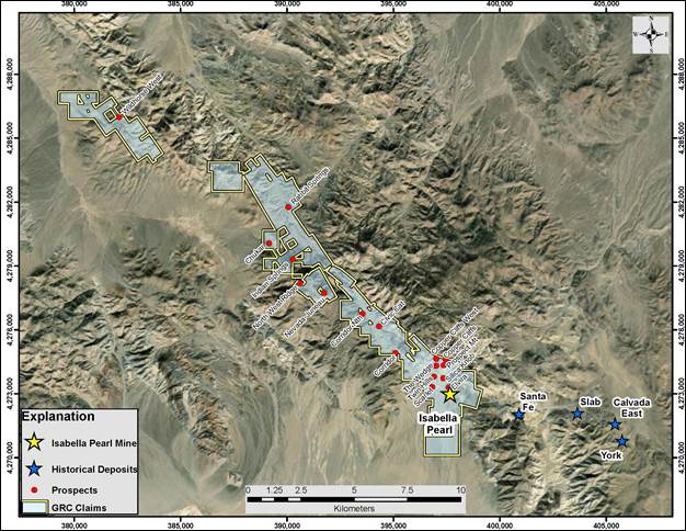
Figure 9.2 WLMC’s Regional Land Status Highlighting Isabella Pearl and Other Important Mines and Prospects
55
| 2020 REPORT ON THE MINERAL RESOURCE & RESERVE ESTIMATE FOR THE ISABELLA PEARL MINE, NEVADA |
| 10 | DRILLING |
| 10.1 | Type and Extent |
The Mineral Reserves reported herein were estimated using a drill hole database compiled by WLMC, as described below. The final mine database includes a total of 379 holes drilled by Combined Metals-Homestake, TXAU and WLMC at Isabella Pearl through 2019, including 339 RC, 33 DDH, three metallurgical DDH drill holes and four water wells. Metallurgical drill holes were submitted in their entirety for metallurgical testing and do not have individual assay results. The Isabella Pearl mine drilling history is summarized in Table 10.1, which includes drill holes shown in Figure 10.1. The Isabella Pearl drill hole and assay databases are summarized in Tables 10.2 and 10.3, respectively.
Most of the pre-TXAU and WLMC drilling was completed between 1987 and 1990 by the Combined Metals-Homestake joint venture (Golden, 2000). It should be noted that the database used by Sierra Mining reportedly included 178 Combined Metals-Homestake holes (Golden, 2000), three more than the MDA database; holes IC-34, 35, 37, and 175 are possibilities for missing holes in the MDA data based on the drill hole numbering sequence (Prenn & Gustin, 2008, 2011 & 2013).
Topographic surveying of collars was undertaken by registered professional surveyors from Nevada. All plots were delivered as stamped referenced plats along with corresponding digital data files. Verification of field locations were also validated with registered air photographs. The TXAU 2007 - 2013 drill hole collar locations were surveyed by David Rowe of Winnemucca, Nevada. Rowe also surveyed the collar locations of 100 Combined Metals-Homestake holes that could be accurately located on the ground. The WLMC 2016 - 2018 drill holes were surveyed by Kevin Haskew of Reno, Nevada. The 2019 drill hole collars were surveyed by the Isabella Pearl mine survey department.
Table 10.1 Drilling History at the Isabella Pearl Mine
| Company | Period | RC | DDH | Total | |||||
| No. | Meters | No. | Meters | No. | Meters | ||||
| Combined Metals-Homestake | 1987-1990 | 182 | 19,598.6 | 6 | 513.9 | 188 | 20,112.5 | ||
| TXAU | 2007-2008 | na | na | 26 | 2,315.7 | 26 | 2,315.7 | ||
| WLMC* | 2016-2019 | 157 | 12,844.0 | 1 | 249.9 | 158 | 13,093.9 | ||
| WLMC Met Holes | 2016-2017 | na | na | 3 | 484.9 | 3 | 484.9 | ||
| Water Wells | na | na | na | na | na | 4 | 800.0 | ||
| Totals | 339 | 36,422.6 | 36 | 3,564.4 | 379 | 36,807.1 | |||
| * Includes 6 AT drill holes | |||||||||
56
| 2020 REPORT ON THE MINERAL RESOURCE & RESERVE ESTIMATE FOR THE ISABELLA PEARL MINE, NEVADA |

Figure 10.1 Isabella Pearl Drill Hole Location Map
Table 10.2 Isabella Pearl Drill Hole Database Summary
| Description | DDH | RC | AT | H2O | Total |
| Number of drill holes | 36 | 333 | 6 | 4 | 379 |
| Total Length (m) | 3,564 | 32,361 | 82 | 800 | 36,807 |
| Average Length (m) | 99.0 | 92.2 | 13.6 | 200 | 97.1 |
| Meters Assayed | 1,951 | 30,300 | 82 | 0 | 32,333 |
| Drill Holes with Downhole Surveys | 8 | 134 | 6 | 0 | 148 |
Table 10.3 Isabella Pearl Assay Database Summary
| Assay Summary | DDH | RC | AT | Total |
| Number of Assays | 1,119 | 19,882 | 54 | 21,055 |
| Total Length (m) | 1,950.6 | 30,300.2 | 82.0 | 32,332.8 |
| Average Length (m) | 1.74 | 1.52 | 1.52 | 1.54 |
| Average Au g/t | 2.30 | 0.26 | 0.30 | 0.37 |
| Average Ag g/t | 12 | 3 | 1.04 | 3.39 |
57
| 2020 REPORT ON THE MINERAL RESOURCE & RESERVE ESTIMATE FOR THE ISABELLA PEARL MINE, NEVADA |
| 10.2 | Procedures |
| 10.2.1 | RC Drilling |
MDA extracted the following information concerning the Combined Metals-Homestake RC drilling exclusively from the drill hole logs, which unsystematically include references to drilling contractors, rig types, and drill bits. Logs are available for all historic holes in the sequence IC-38 through IC-178, except IC-54. All historic holes are believed to have been completed by RC drill rigs, with the exception of DDHholes IC-136 through IC-141.
The first notation of drill-rig type is for hole IC-38, which notes a T-4 drill. This rig type was also identified in 90 of the following holes through to hole IC-135. Hole IC-49 notes that a T-4 rig was used to drill the first 91m (299ft) of the hole, with a TH-100 drilling the bottom 151m (495ft). No references to drilling company are made until hole IC-99, which is noted as being drilled by Hackworth. Hackworth is identified as the drill contractor on 21 logs within the sequence of holes from IC-99 through IC-132. Nine of these logs suggest that holes IC-99 through IC-132 were drilled in 1989.
Drilling Services is identified as the drill contractor for 33 of the holes in the sequence from IC-142 through IC-174. A total of 43 logs from holes in this sequence note the drill type as being TH100 or TH100A. Holes IC-142 to IC-156 are noted as being drilled in 1989, while holes IC-158 through IC- 174 were drilled in 1990.
Hackworth is again noted as the drill contractor for holes IC-176 through IC-178, the latest Combined Metals-Homestake holes in the database (IC-175 is not in the database). These holes were drilled in 1990 using a TH60 rig.
Drill-bit diameters are identified on 128 of the RC logs, which indicate 5.125, 5.25, 5.5, and 6in. bit sizes. Most of the Hackworth holes were drilled with 5.5in. bits, while most Drilling Services holes were drilled with 5.25in. bits. Both drill contractors used hammer and tri-cone bits
WLMC 2016 - 2019 RC drilling was performed on diurnal shifts by New Frontier Drilling LLC (Frontier) Fallon, Nevada. Drilling equipment consisted of an RC track mounted Foremost MPD drill capable of drilling angle holes to 500m (1,500 ft). Drill was equipped with an air compressor capable of delivering sufficient free air at high enough pressure for drilling with a dual-tube drill pipe. The setup was complete with cyclone assembly with discharge through a rotary wet splitter. Drill bit size was 13.3 cm (5.25 in). The drill pipe was 10.2 cm (4 in) diameter in 3.04m (10 ft) lengths. The method employed utilized the double wall drill pipe, interchange hammer, and hammer bits to drill and sample the geologic formations. The samples were recovered through the center of the double walled pipe and the sample discharged via a cyclone. Water/fluid was injected into the airflow on an intermitted to continuous basis to assist with recovery of the sample through the wet rotating splitter. Appropriate sample bags were provided by WLMC and they were collected and bagged and tagged under geologist supervision during the drilling. The contractor conducted all operations to industry standard practices.
58
| 2020 REPORT ON THE MINERAL RESOURCE & RESERVE ESTIMATE FOR THE ISABELLA PEARL MINE, NEVADA |
In 2017, WLMC also utilized New Frontier Drilling to complete a 1,356 m (4,450 ft) RC condemnation drill program to ensure no mineral resources occurred where mine/plant facilities are currently located. The program consisted of 5 RC drill holes drilled to depths of up to 366 m (1,200 ft).
The AT drilling was completed by Merritt Construction Mina, NV utilizing an Atlas Copco portable blast hole rig modified to 4.5 inches for shallow drilling (less than 30m (99 ft)). The drill rig is supported by compressed air at a rate of 825 cubic feet per minute, with compressed air forced down the center of the rod and hammered materials returned up the outside of the rod. This drilling method was restricted to vertical hole orientation. The drilling method was dry, samples were taken for each 1.5m (5 ft), and the recovered chips were collected in 5-gallon pails and split with a portable riffle splitter. Samples were bagged at the site and transported to company’s secure storage location until submittal to ALS. The AT holes were not surveyed down-hole.
| 10.2.2 | DDH (Core) Drilling |
Combined Metals-Homestake completed a six-hole DDH drilling program in 1989. No further details concerning this program are available.
TXAU conducted a 19-hole DDH drilling program in 2007 and drilled an additional seven DDH holes in 2008. HB Engineering managed the drilling programs for TXAU. Leroy Kay Drilling Co., Inc. of Yerington, Nevada (Kay Drilling) was the drilling contractor for the 2007 program. All recovered core was HQ size (2.5 in).
The drilling contractor for the 2008 program was Sierra Madre Exploration of West Point, California (Sierra Madre). Sierra Madre used a track-mounted Longyear Casa Grande C5S rig, made in Italy specifically for drilling long DDH holes from underground. The rig is capable of drilling HQ core to depths of greater than 600m (2,000ft) and can drill angle holes on very small drill pads, which was important for the 2008 campaign. Drilling was conducted during one or two 12-hour shifts per day, depending on the availability of personnel. All holes were collared and cased to 3.05m (10ft) by tri-cone drilling, with no recovery of these intervals. Core drilling was all HQ in size and was generally completed using a 3.05m (10ft) core barrel. To help increase recovery in loose, difficult drilling conditions, a Longyear’s HQ3 system was used instead of a standard core barrel. Water pressure was used to pump the core out of the core barrel (as opposed to jarring it out with hammer blows) onto a half-pipe tray, and the core was then boxed in standard wax-coated cardboard boxes.
KB Drilling Company (KB) of Mound House, Nevada provided services for the 2016 metallurgical DDH drilling program. Two sizes of DDH drill core were utilized: a large diameter “PQ” 8.5 cm (3.35 in) for metallurgical testing, and a smaller “HQ” 63.5mm (2.5 in) for core sample and routine laboratory analyses. The 24-hr 7 days shift DDH drilling was performed with a truck mounted UDR 1500 drill capable of DDH depth penetration to 500m (1500ft), utilizing traditional mud-lubricated drilling methods. Casing utilized was 12.7 cm (5 in) and was utilized generally 10-20ft for collar stability, however in some cases hole stabilization required up to 30 ft of casing. Occasionally overburden was tri-cone
59
| 2020 REPORT ON THE MINERAL RESOURCE & RESERVE ESTIMATE FOR THE ISABELLA PEARL MINE, NEVADA |
drilled. Core was pressure removed when possible (in fractured ground) otherwise handled traditionally with rubber mallet percussion to remove. Core was place in wax treated boxes. Depth, rod change, and loss zones were noted on wood blocks in place with the drill core. Core was shipped to a WLMC locked storage in Hawthorne, Nevada twice daily at drilling shift change. After drilling holes were surveyed with the Reflex tool (described in next section) and logged paper copies of the measurements were retained by the drill site geologist. The contractor conducted all operations to industry standard practices.
| 10.2.3 | Downhole Surveying |
The database contains down-hole survey data for the 11 DDH holes (including metallurgical drill holes), 5 RC holes and 6 AT holes as listed in Table 10.2. The remaining drill holes are limited to collar surveys only.
Seven DDH holes drilled by TXAU in 2008 were surveyed by the drillers upon completion of each hole using a Reflex EZ-SHOT tool. The holes tended to steepen by 1 to 2.5 degrees and change azimuth unsystematically up to 5.5 degrees. If the pre-2008 drill holes, which do not have down-hole survey data, deviated at similar magnitudes as the 2008 holes, the lack of surveys would have no material impact on the mineralization model.
The WLMC 2016 DDH program under KB utilized a Reflex EZ-shot camera and surveys were taken at approximately 50 ft intervals as per industry standard. The data was reviewed by the competent geologist and approved for entry into the company database.
The 2017 condemnation RC drilling program utilized the Reflex EZ- Gyro and surveys were taken every 15.2 m (50 ft) as per industry standard and included a QA/QC multi-shot optimization at approximately each 30.5 m (100 ft). This data was reviewed by competent geologist and approved for entry into the company database. No extreme or unusual deviation was noted with the survey results from either campaign.
| 10.3 | WLMC Exploration Drilling Programs |
The WLMC 2017 condemnation RC drilling program sterilized all near-surface ground in the areas tested with drill holes consisting of mainly alluvium or uneconomic mineralization to final drill hole depths.
During 2018 and 2019, WLMC completed 146 in-fill and step-out RC drill holes to expand mineral resources at the Isabella Pearl mine. The drilling program utilized the New Frontier Drilling RC drill and the same industry accepted down hole Reflex surveying and laboratory analytical methods as previously. The campaign successfully intercepted additional mineralization both along known structures and increased confidence in other infill areas. Results included up to 8.574 g/t Au over 83.82m including 22.826 g/t Au over 24.38m in Hole IPRC-090 and 18.042 g/t Au over 25.91m including 28.588 g/t Au over
60
| 2020 REPORT ON THE MINERAL RESOURCE & RESERVE ESTIMATE FOR THE ISABELLA PEARL MINE, NEVADA |
6.10m in Hole IPRC-091. Figure 10.2 below highlights the collar locations, and Table 10.4 below summarizes significant results. All of the information gained will be included in the resource updates.

Figure 10.2 2018-2019 Drill Hole Collar Locations at Isabella Pearl
61
| 2020 REPORT ON THE MINERAL RESOURCE & RESERVE ESTIMATE FOR THE ISABELLA PEARL MINE, NEVADA |
Table 10.4 Significant Results 2018-2019 Drilling at Isabella Pearl

62
| 2020 REPORT ON THE MINERAL RESOURCE & RESERVE ESTIMATE FOR THE ISABELLA PEARL MINE, NEVADA |
| 10.4 | Interpretation and Relevant Results |
The Isabella Pearl database (Table 10.3) indicates that the mean gold grades of the DDH holes are significantly higher than the RC holes. The Combined Metals-Homestake and TXAU DDH were drilled primarily to collect metallurgical samples and verify important mineralized zones defined by previously drilled RC holes. The DDH therefore drilled a higher percentage of mineral resources than the RC holes, especially in the high-grade Pearl deposit. In addition, sampling of the DDH was primarily restricted to suspected mineralized intervals, while the RC holes were sampled over their entire lengths.
Drill hole logs are available for all holes except IC-1 through 37 (the earliest holes in the database) and IC-54, as well as copies of assay certificates for 147 of the holes, including all TXAU holes. A significant amount of information was collected from the drill logs and entered into spreadsheets and, where appropriate, the mine database, including the depth to water table, intervals drilled while injecting water, the amount of water returning with the RC sample cuttings, qualitative descriptions of RC sample recoveries, any comments regarding possible RC down-hole contamination noted on the drill logs, other comments written on the drill logs that pertain to water and recovery, alteration (degree of silicification), lithology (overburden, welded and overlying unwelded Mickey Pass Tuff, granite), drill bit types and diameters, drill contractors, year of drilling, rig type, assay laboratory, analytical methods, and analytical detection limits. Although the database included oxidation codes, many of these codes were derived from the coding of the drill samples by an interpreted three-dimensional surface that conflicted with the oxidation notes in the drill logs in some cases. Oxidation data (oxide-mixed-sulfide) were therefore extracted from the drill logs and incorporated into the MDA digital database.
QA/QC data were also compiled by MDA from the paper copies of the Combined Metals-Homestake assay certificates. These data include internal laboratory check analyses of the original pulps and analyses of new pulps prepared from preparation rejects or duplicate samples. The QA/QC samples are discussed further in Section 12.
An audit of the assay database by MDA led to the identification of data in the assay certificates that were not included in the TXAU database. Two RC holes, which had been re-entered and deepened sometime after the original holes were drilled, did not have the re-entry assay data in the database. Several intervals of other holes were also missing assay data. All missing assay data identified by MDA were added to the mine database.
63
| 2020 REPORT ON THE MINERAL RESOURCE & RESERVE ESTIMATE FOR THE ISABELLA PEARL MINE, NEVADA |
| 11 | SAMPLE PREPARATION, ANALYSIS AND SECURITY |
| 11.1 | Historic Security Measures and Sample Preparation |
Historic security measures and sample preparation were reported by MDA (Prenn & Gustin, 2013). This includes descriptions excerpted from Sierra Mining (Golden, 2000) for drilling programs conducted at Isabella Pearl before TXAU took control of the project. For more details, the reader is referred to earlier reports on mineral resources and reserves and the feasibility study for the Isabella Pearl mine (Brown et al., 2018).
| 11.2 | WLMC (2016 to Present) |
| 11.2.1 | Security Measures |
Sample security procedures for WLMC sample materials were established according to industry standards and included (from generation of sample at the site) secured sample transport to a local locked storage facility for holding and/or directly shipped via secured transport to the laboratory for analysis. Samples were shipped by cargo truck in lots loaded into bins with top closures, enclosed trailer, or stacked and covered and secured to the bed of transport truck (in the case of whole DDH drill hole boxes). Chain of custody forms accompanied the shipments to the reception at the assigned laboratory. No breaches of the security were reported.
| 11.2.2 | Sample Preparation and Analysis |
For the WLMC 2016 drilling program, continuous sampling was done on 1.52 m (5 ft) intervals, contingent on drilling conditions. All assay samples were processed at ALS, with additional work carried out at ALS in Vancouver, BC, Canada. WLMC has no business relationship with ALS beyond being a customer for analytical services. ALS is an accredited ISO/IEC 17025 facility.
For the WLMC 2017 - 2019 drilling programs, continuous sampling was again done on 1.52 m (5 ft) intervals, contingent on drilling conditions. However, all assay samples during the 2017 – 2019 drilling programs were processed at Bureau Veritas. WLMC has no business relationship with Bureau Veritas beyond being a customer for analytical services. Bureau Veritas is an accredited ISO/IEC 17025 facility. The umpire laboratory used for check assaying is ALS and this sampling program is currently ongoing.
All assay samples were analyzed using a 30 g FA with an AAS finish for gold (ALS code AU-AA23; Bureau Veritas code FA430)). This technique has a lower detection limit of 0.005 ppm and an upper detection
64
| 2020 REPORT ON THE MINERAL RESOURCE & RESERVE ESTIMATE FOR THE ISABELLA PEARL MINE, NEVADA |
limit of 10.00 ppm. Samples with greater than 10.00 ppm Au were re-analyzed using a 30 g FA with a gravimetric finish (ALS code Au-GRA21; Bureau Veritas code FA530).
All assay samples were also analyzed using a 0.5 g sample with aqua regia for silver (ALS code Ag-AA45; Bureau Veritas code AQ-400). This technique has a lower detection limit of 0.1 ppm for silver and an upper detection limit of 200 ppm for silver.
| 11.2.3 | Quality Assurance/Quality Control Procedures |
The 2016 through 2018 WLMC drilling program consisted of 6 AT exploration drill holes, 5 RC condemnation drill holes, 36 RC in-fill and step-out drill holes, one DDH exploration drill hole and 3 DDH metallurgical drill holes. Condemnation drill holes were only sampled if the presence of visible mineralization was noted. All Standard Reference Materials (SRM) and blanks used for the QA/QC program were obtained from Shea Clark Smith / MEG, Inc., Reno, Nevada.
The variation from the SRM mean value defines the QA/QC variance and is used to determine acceptability of the standard sample assay. Approximately 60 g of sample material was submitted per QA/QC sample. For the 2016 through 2018 WLMC drilling programs, the criteria for failure were as follows.
| a. | Assay value within 95% Confidence Interval (CI): Pass | |
| b. | Assay value outside 95% Confidence Interval: Failure | |
| c. | Blank value greater than 5 times the lower detection limit (0.025 g/t Au): Failure |
For the AT drilling program two blanks, one field duplicate and one SRM standard were inserted with the 54 samples collected. For the DDH drill hole, 3 SRM standards and 3 blanks were inserted with the 131 samples collected. For the RC drill holes, 5 SRM standards and 5 blanks were inserted with the 222 samples collected. No issues were noted with regards to the QA/QC results (Table 11.1).
65
| 2020 REPORT ON THE MINERAL RESOURCE & RESERVE ESTIMATE FOR THE ISABELLA PEARL MINE, NEVADA |
Table 11.1 WLMC 2016 through 2018 QA/QC Results
| Sample | Drill Hole | SRM Standard | Au g/t | SRM g/t | 95% CI |
| 845340 | IPAT-010 | MEG-Blank.14.01 | <0.005 | 0.003 | |
| 845375 | IPAT-016 | MEG-Au.10.01 | 0.02 | 0.022 | 0.016 - 0.027 |
| 845390 | IPAT-016 | MEG-Blank.14.01 | <0.005 | 0.003 | |
| 869075 | IPDD-002 | MEG-Au.11.17 | 2.87 | 2.693 | 2.457 - 2.928 |
| 869125 | IPDD-002 | MEG-Au.12.13 | 0.947 | 0.879 | 0.761 - 0.997 |
| 869025 | IPDD-002 | MEG-Au.13.01 | 0.322 | 0.308 | 0.279 - 0.337 |
| 869026 | IPDD-002 | MEG-Blank.14.01 | <0.005 | 0.003 | |
| 869076 | IPDD-002 | MEG-Blank.14.01 | 0.009 | 0.003 | |
| 869126 | IPDD-002 | MEG-Blank.14.01 | 0.005 | 0.003 | |
| 2970975 | IPRC-004 | MEG-Au.10.03 | 0.053 | 0.056 | 0.044 - 0.068 |
| 2970990 | IPRC-004 | MEG-Blank.14.01 | <0.005 | 0.003 | |
| 2976025 | IPRC-005 | MEG-Au.11.19 | 0.114 | 0.12 | 0.093 - 0.146 |
| 2976175 | IPRC-005 | MEG-Au.12.20 | 0.484 | 0.499 | 0.456 - 0.541 |
| 2976125 | IPRC-005 | MEG-Au.12.21 | 0.14 | 0.143 | 0.124 - 0.162 |
| 2976075 | IPRC-005 | MEG-Au.13.01 | 0.337 | 0.308 | 0.279 - 0.337 |
| 2976040 | IPRC-005 | MEG-Blank.14.01 | <0.005 | 0.003 | |
| 2976090 | IPRC-005 | MEG-Blank.14.01 | <0.005 | 0.003 | |
| 2976140 | IPRC-005 | MEG-Blank.14.01 | <0.005 | 0.003 | |
| 2976190 | IPRC-005 | MEG-Blank.14.01 | <0.005 | 0.003 | |
| 845360 | IPAT-017 | 10-15 ft | 0.611 | ||
| 845361 | IPAT-017 | Field Duplicate | 0.600 |
The 2019 WLMC drilling program consisted of 110 RC in-fill and step-out drill holes. All SRM samples were obtained from Shea Clark Smith / MEG, Inc., Reno, Nevada (Table 11.2). Blank material was sourced as “Lava Rock” (pumice) from Oxborrow Landscaping, Sparks, Nevada.
Table 11.2 WLMC 2019 Standard Reference Materials
| Standard | Au ppm | Au SD |
| MEG-Au.10.03 | 0.056 | 0.006 |
| MEG-Au.11.17 | 2.693 | 0.118 |
| MEG-Au.12.11 | 1.465 | 0.081 |
| MEG-Au.12.13 | 0.879 | 0.059 |
| MEG-Au.12.20 | 0.499 | 0.021 |
| MEG-Au.12.21 | 0.143 | 0.009 |
| MEG-Au.12.32 | 0.616 | 0.017 |
| MEG-Au.13.01 | 0.308 | 0.014 |
| MEG-Au.17.01 | 0.381 | 0.015 |
| MEG-Au.17.02 | 0.511 | 0.030 |
| MEG-Au.17.21 | 1.107 | 0.062 |
66
| 2020 REPORT ON THE MINERAL RESOURCE & RESERVE ESTIMATE FOR THE ISABELLA PEARL MINE, NEVADA |
For the SRM, a warning was defined as an assay result outside 3 times the SRM standard deviation. For the 306 SRM samples submitted, a total of five warnings were returned (Table 11.3). Performance of the remaining assays was acceptable (Figure 11.1).
Table 11.3 2019 SRM Warnings
| Sample | DHID | SRM | Au | Criteria |
| 3084920 | IPRC-122 | MEG-Au.12.20 | 0.433 | < 0.436 |
| 3085080 | IPRC-125 | MEG-Au.12.20 | 0.571 | > 0.562 |
| 3084460 | IPRC-114 | MEG-Au.12.32 | 0.564 | < 0.565 |
| 3084480 | IPRC-114 | MEG-Au.12.32 | 0.549 | < 0.565 |
| 3084660 | IPRC-118 | MEG-Au.12.32 | 0.563 | < 0.565 |

Figure 11.1 2019 SRM Performance
67
| 2020 REPORT ON THE MINERAL RESOURCE & RESERVE ESTIMATE FOR THE ISABELLA PEARL MINE, NEVADA |
For the blank material a warning was defined as an assay that exceeded five times the detection limit of 0.003 ppm (Figure 11.2). Of the 310 blanks submitted, a total of five warnings were received (Table 11.4). A check on the corresponding SRM sample results for these intervals indicated no issues associated with the individual assays. Adjacent SRM pulp sample rejects were submitted to ALS, and returned similar assay grades (Figure 11.3). There is insufficient sample material remaining for re-assaying.

Figure 11.2 2019 Blank Material Performance
Table 11.4 2019 Blank Material Warnings
| Sample | DHID | BLANK | Au | Criteria |
| 3082241 | IPRC-089 | Lava Blank | 0.018 | > 0.015 |
| 3082361 | IPRC-090 | Lava Blank | 0.196 | > 0.015 |
| 3082381 | IPRC-090 | Lava Blank | 0.024 | > 0.015 |
| 3082521 | IPRC-091 | Lava Blank | 0.113 | > 0.015 |
| 3082541 | IPRC-091 | Lava Blank | 0.033 | > 0.015 |
68
| 2020 REPORT ON THE MINERAL RESOURCE & RESERVE ESTIMATE FOR THE ISABELLA PEARL MINE, NEVADA |

Figure 11.3 2019 SRM Pulp Sample Rejects Reassays
| 11.3 | Check Assays |
For the 2019 drilling campaign, a total of 307 field duplicates were taken and submitted for assay at the same laboratory as the primary sample. There is a strong correlation between the primary and secondary assays, and no issues were noted (Figures 11.4 & 11.5)
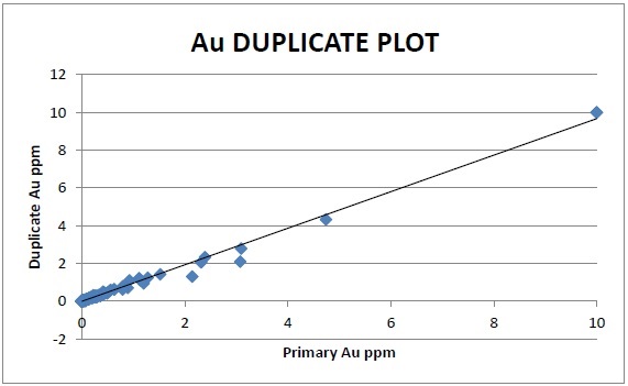
Figure 11.4 Au Field Duplicate Control Plot
69
| 2020 REPORT ON THE MINERAL RESOURCE & RESERVE ESTIMATE FOR THE ISABELLA PEARL MINE, NEVADA |

Figure 11.5 Au Min Max Field Duplicate Control Plot
For the 2019 drilling campaign, a total of 488 coarse rejects from samples that assayed above 0.20 ppm were submitted for cyanide leach assay. Cyanide leach assay results from samples within the oxide zone demonstrated an average recovery of 88% percent compared to the corresponding fire assay results. Cyanide leach assay results from samples within the sulfide zone demonstrated an average recovery of 10% percent compared to the corresponding fire assay results (Figure 11.6).

Figure 11.6 Cyanide Leach vs Fire Assay Comparison Plot
70
| 2020 REPORT ON THE MINERAL RESOURCE & RESERVE ESTIMATE FOR THE ISABELLA PEARL MINE, NEVADA |
| 11.4 | Opinion on Adequacy |
WLMC considers that the 2016 - 2019 drilling programs and the historical drilling information as reported by MDA (Prenn & Gustin, 2013), meet industry standards and have been reviewed and confirmed in sufficient detail to permit inclusion of the information in the Isabella Pearl mine database.
71
| 2020 REPORT ON THE MINERAL RESOURCE & RESERVE ESTIMATE FOR THE ISABELLA PEARL MINE, NEVADA |
| 12 | DATA VERIFICATION |
WLMC has relied heavily on information and technical documents prepared by MDA for the Data Verification sections with regards to the historical drilling programs at Isabella Pearl. For more details, the reader is referred to earlier reports on mineral resources and reserves and the feasibility study for the Isabella Pearl mine (Brown et al., 2018).
12.1 Opinion on Data Adequacy
Investigations of all aspects of current and historical data quality indicates that the quality of the information is suitable for mineral reserve estimation.
72
| 2020 REPORT ON THE MINERAL RESOURCE & RESERVE ESTIMATE FOR THE ISABELLA PEARL MINE, NEVADA |
| 13 | MINERAL PROCESSING AND METALLURGICAL TESTING |
| 13.1 | Metallurgical Overview |
This summary of metallurgical test work results and applications was prepared to provide an overview of the metallurgical understanding of the Isabella Pearl mine. This section provides a description of Isabella Pearl mineralization and metallurgical characterization of the deposit including:
| · | Mineralogy and metallurgical ore types | |
| · | Review of previous test programs with emphasis on cyanide leachability | |
| · | WLMC metallurgical test program and results | |
| · | Metal recovery and recovery rate predictions, and | |
| · | The basis of the process design criteria. |
The Isabella Pearl mine has been subjected to nine separate programs of modern metallurgical test work, the most relevant being the Combined Metals-Homestake joint venture undertaken in 1990, and TXAU in 2009. These two programs are considered of particular interest as the work was performed on drill hole samples and tested for cyanide leachability. There were many other programs where the work focused principally on alternative recovery methods such as flotation. Nonetheless, all cyanide leachability data from all test programs along with that completed by WLMC during 2017 was considered in the conclusions presented herein.
A breakdown of the test work, including a study commissioned by WLMC in 2017, are summarized in Table 13.1 below:
Table 13.1 Summary Metallurgical Test Work Completed on Isabella Pearl Deposit

73
| 2020 REPORT ON THE MINERAL RESOURCE & RESERVE ESTIMATE FOR THE ISABELLA PEARL MINE, NEVADA |
Seventy five percent of the oxide contained gold in the Isabella Pearl deposit is located below the 1,646 m bench in the Pearl Pit, and this material represents thirty five percent of all mineral resources considered in the mine plan presented herein. The importance of determining the metallurgical properties of this material cannot be overstated. The premise of the WLMC metallurgical test program undertaken by KCA in February 2017 (KCA, 2017) was twofold:
| 1. | Confirm previous cyanide leach test work results and viability of Heap Leach, Carbon Adsorption/desorption and Electrowinning gold recovery process to the Oxide mineral resources. | |
| 2. | Establish that the high-grade core of the Pearl deposit would indeed yield previously determined, gold recovery levels. |
The results of the cyanide leach test work demonstrate the straightforward and consistent nature of the Isabella Pearl metallurgy.
| · | The economic minerals of interest are gold and to a minor degree silver. | |
| · | The results are not dependent on deposit lithology or zoning; The deposit will be mined only above the water table and so refractory sulfide material below the water table is not an issue. | |
| · | A single simple cyanidation process can be used to recover gold and to a lesser degree silver. | |
| · | Fast leaching kinetics. | |
| · | Economics improve by two-stage crushing of plus 1-gram gold to ½ inch. Further test work required to develop particle size gold recovery relationship. |
| 13.2 | Mineralogy and Metallurgical Ore Types |
The mineral resources of the mine include the Civit Cat North, Isabella and Pearl oxide deposits, collectively referred to as the Isabella Pearl deposits. The origin of all these deposits is similar, widespread argillic alteration and generally abundant alunite indicate the deposits are high-sulfidation epithermal mineral deposits. K-Ar age determinations demonstrate that the mineralization is about 19 Ma. Oxide mineralization at Isabella Pearl extends over 150 meters below the surface and it should be noted that only oxidized ore is included in economics of the mine plan.
The gold-silver mineralization is closely associated with silicification, which generally grades outward into argillization, which then into propylitically altered rocks. Silicification is localized by faults and shears, and in many areas, silica has replaced large masses of both the volcanic and granitic rocks. Gold occurs as very small (<10 microns) liberated particles in cavities and along fracture surfaces. Jarosite, goethite and hematite are present in the siliceous groundmass.
In the Isabella deposit, gold in mineral resources occur as very small (<10 microns) liberated particles in cavities and along fracture surfaces and iron oxide minerals jarosite, limonite and goethite.
74
| 2020 REPORT ON THE MINERAL RESOURCE & RESERVE ESTIMATE FOR THE ISABELLA PEARL MINE, NEVADA |
In the Pearl deposit, mineralization is very siliceous, and similar in mineralization to the Isabella material. The silver/gold ratio is higher than Isabella. The gold is contained both as locked and free particles, as native and electrum in an average size of 14 micron. The mineralization is associated with goethite, limonite, jarosite and psilomelane (manganese). Sulfide mineralization occurs beneath the Pearl oxide and mixed mineral resources. The underlying sulfide material contains pyrite, pyrrhotite, galena, sphalerite, chalcopyrite, and silver as polybasite and pyrargyrite.
Natural weathering and fracture-controlled oxidation of sulfide mineralization causes formation of oxide ore (with low sulfide mineral). Gold is present as free gold, residing in iron oxide minerals or quartz, and adsorbed on clay minerals. Metallurgical test work has determined that gold is amenable to cyanidation and that the oxidized portion of these mineral deposits are metallurgically the same and will yield similar metal recovery results when processed.
| 13.3 | Previous Metallurgical Test Work Programs |
For details of previous metallurgical test work programs, the reader is referred to earlier reports on mineral resources and reserves and the feasibility study for the Isabella Pearl mine (Brown et al., 2018). The most relevant results of these programs were those completed by Combined Metals-Homestake joint-venture and TXAU, both of which tested for the application of Heap Leach and the ADR process to Isabella Pearl mineral resources. The TXAU metallurgical program was completed on DDH and a bulk surface sample. A complete description of this test work can be found in the report by MDA (Prenn and Gustin (2013). The combined results of all the bottle roll tests and column tests completed, it can be concluded that:
| · | There is very good repeatability between samples of any given particle size. | |
| · | Gold recovery for the finer size (200 mesh) was between 86% and 95% except for one sample which had 2.7% contained sulfide. | |
| · | At coarser particle size (>10 mm) gold recovery ranged from 64% to 89%. | |
| · | Column leach tests performed on P100 5/8 inch showed high gold recovery. |
| 13.4 | WLMC Metallurgical Ore Characterization Test Work Programs |
| 13.4.1 | Location of WLMC Metallurgical Test Drill Hole Samples |
In 2017, WLMC conducted a metallurgical test work program on PQ-size core samples from drill holes completed in 2016. The purpose was to evaluate process requirements to recover gold using conventional heap leaching technology. The location of metallurgical holes drilled at the Isabella Pearl deposit by WLMC in 2016 are shown in Figure 13.1. The location of the WLMC, and previous TXAU, DDH holes used in the respective metallurgical test programs are provided in Figures 13.2 and 13.3. The
75
| 2020 REPORT ON THE MINERAL RESOURCE & RESERVE ESTIMATE FOR THE ISABELLA PEARL MINE, NEVADA |
location of these drill holes in relation to the mineralized ore zones verifies the representativeness of the samples for both metallurgical test programs.

Figure 13.1: Drill Hole Locations for 2017 WLMC Metallurgical Samples
76
| 2020 REPORT ON THE MINERAL RESOURCE & RESERVE ESTIMATE FOR THE ISABELLA PEARL MINE, NEVADA |

Figure 13.2 Plan View of TXAU & WLMC Metallurgical DDH Locations (Magenta Line is Section shown in Figure 13.3)

Figure 13.3 Section View of TXAU & WLMC Metallurgical DDH Locations (looking northeast)
77
| 2020 REPORT ON THE MINERAL RESOURCE & RESERVE ESTIMATE FOR THE ISABELLA PEARL MINE, NEVADA |
| 13.4.2 | Results of WLMC Metallurgical Test Drill Hole Samples |
As previously stated, the premise of the WLMC metallurgical test program was twofold:
| 1. | Confirm previous cyanide leach test work results and viability of heap leach carbon adsorption/desorption and electrowinning gold recovery process. |
| 2. | Establish that the high-grade core of the Pearl deposit would indeed yield previously determined, gold recovery levels. |
In October and November of 2016, WLMC completed a PQ size DDH program consisting of 4 holes, totaling 735 meters. Four samples for metallurgical testing were taken from 3 of these holes: IPDD-001 (2 sample intervals), IPDD-003 (1 sample interval) and IPDD-004 (1 sample interval). The metallurgical samples were sent to the KCA metallurgical testing facility in Reno. The main purpose of the test work program was to confirm that the high-grade core zone of the Pearl deposit indicates economic gold recovery as demonstrated in earlier work by others. Two holes intercepted the Pearl deposit and one was drilled in the Isabella deposit. Figure 13.4 presents the plan and section of the DDH holes completed by WLMC in late 2016 (Note: Hole IPDD-002 was a twin hole of IPDD-001 drilled for geology and assay information). Table 13.2 below presents the results the gold and silver values of the composites used in the metallurgical test program.

Figure 13.4 Plan and Section of Sample Locations for WLMC Test Program in Relation to Ore Zone
78
| 2020 REPORT ON THE MINERAL RESOURCE & RESERVE ESTIMATE FOR THE ISABELLA PEARL MINE, NEVADA |
Table 13.2 Summary of Isabella Pearl Mine Core Composites Assays, KCA 2017 Program

| 13.4.2.1 | Cyanide Bottle Roll Tests |
A total of 61 boxes of uncut DDH core representing 1,439 kilograms of material was delivered to KCA laboratories in Reno for sample preparation and testing. The work completed consisted of head analysis (including, whole rock and QXRD), screen analysis by size fraction, comminution, bottle roll, agglomeration and column leach testing.
Table 13.3 and 13.4 present the gold and silver recovery results of the four 96-hour bottle roll tests completed on 1,000-gram samples that were pulverized to a p80 size of 200 mesh Tyler. Figures 13.5 and 13.6 show the graphical results of gold and silver extraction during the leach period for the metallurgical test samples.
In all samples tested leach kinetics were rapid, samples IPDD-003 and IPDD-004 achieved plus 93% of the total metal recovery in 2 hours. Sample IPDD-001 #1 had a low gold head grade of, 0.025 g/t Au and is therefore classified as waste. Sample IPDD-001 #2 contained 2.47% sulfides, its gold recovery did not surpass 62%.
Table 13.3 Summary Direct Agitated Cyanidation (Bottle Roll) Gold Test Results, KCA 2017 Program

79
| 2020 REPORT ON THE MINERAL RESOURCE & RESERVE ESTIMATE FOR THE ISABELLA PEARL MINE, NEVADA |

Figure 13.5 Bottle Roll Tests Showing % Gold Extraction During Leach Period
Table 13.4 Summary Direct Agitated Cyanidation (Bottle Roll) Silver Test Results, KCA 2017 Program


Figure 13.6 Bottle Roll Tests Showing % Silver Extraction during Leach Period
80
| 2020 REPORT ON THE MINERAL RESOURCE & RESERVE ESTIMATE FOR THE ISABELLA PEARL MINE, NEVADA |
| 13.4.2.2 | Head Screen Analysis |
Head screen analysis was carried out on portions of each of the four sample composites at the as received crush sizes. The objective of the head screen analysis was to determine assay grade values from select crush size fractions. Each sample was initially wet screened at 200 mesh. The minus 200 mesh material was filtered and dried. The oversized material was dried and then dry screened at ⅝, ½, ⅜ and ¼ inches, 10, 20, 35, 65, 100 and 200 mesh Tyler. The dry screened minus 200 mesh material was then combined with the wet screened material. Each separate size fraction was then weighed, and the weights reported. Each size fraction was then crushed to a nominal size of 10 mesh Tyler, as necessary.
A summary of the head screen analyses is presented in Table 13.5. The head screen analyses detail is presented in Table 13.6 and shown graphically in Figure 13.7.
Table 13.5 Summary of Head Screen Analyses

81
| 2020 REPORT ON THE MINERAL RESOURCE & RESERVE ESTIMATE FOR THE ISABELLA PEARL MINE, NEVADA |
Table 13.6 Detailed Results of Head Screen Analysis

82
| 2020 REPORT ON THE MINERAL RESOURCE & RESERVE ESTIMATE FOR THE ISABELLA PEARL MINE, NEVADA |

Figure 13.7 Head Screen Analysis Showing Cumulative Weight Percent Passing Crush Size (in inches)
In summary, the head screen analysis on the four samples exhibit similar distribution curves. The highest-grade sample IPDD-003 contained the most gold in the finest fraction as compared to the others.
Head analyses for mercury were also conducted utilizing cold vapor/atomic absorption methods. Total copper analyses were conducted utilizing inductively coupled argon plasma-optical emission spectrophotometer (ICAP-OES) as well as by fire assay – atomic adsorption (FA-AA) methods.
The results of the mercury and copper analyses are presented Table 13.7.
Table 13.7 Summary of Mercury and Copper in Sample, KCA 2017 Program

83
| 2020 REPORT ON THE MINERAL RESOURCE & RESERVE ESTIMATE FOR THE ISABELLA PEARL MINE, NEVADA |
Head analyses for carbon and sulfur were also conducted utilizing a LECO CS 230 unit. In addition to total carbon and sulfur analyses, speciation for organic and inorganic carbon, and speciation for sulfide and sulfate sulfur, were conducted. The results of the carbon and sulfur analyses are presented in Table 13.8.
Table 13.8 Summary of Carbon and Sulfur Content, KCA 2017 Program

| 13.4.2.3 | Column Leach Test Work |
The crushed material split out for column test work was blended with lime or agglomerated with cement as necessary and then loaded into a 4-inch diameter plastic column (Figure 13.8). Alkaline cyanide solution was continuously distributed onto the material through Tygon tubing. The flow rate of solution dripping onto the material was controlled with a peristaltic pump to 0.004 to 0.005 gallons per minute per square foot of column surface area.
The solution exiting each leach column was collected in the bottom (floor - PLS) tank. Leach solution was checked each cycle for pH, NaCN, Au and Ag. Copper was checked periodically. The solution was then passed through a bottle of granular activated carbon over a period of 24 hours to extract the gold and silver in solution. After passing through the bottle of activated carbon, the solution was re-assayed for pH, NaCN, Au and Ag. Sodium cyanide was then added, if necessary, to maintain the solution at "target" levels (discussed in the Test History section). The leach solution was then recycled to the material for another 24-hour leach period. Two (2) batches of leach solution were used so that while one batch was applied to each column, the other was run through carbon.
84
| 2020 REPORT ON THE MINERAL RESOURCE & RESERVE ESTIMATE FOR THE ISABELLA PEARL MINE, NEVADA |
 |  |
Figure 13.8 Flow Sheet for Crushed Material for Column Leach Tests in 4-inch Diameter Plastic Column
Preliminary agglomeration test work was conducted on portions of the crushed material. For the test work, the material was agglomerated with various additions of lime or cement. In the preliminary agglomeration testing, the agglomerated material was placed in a column with no compressive load and then tested for permeability. The purpose of the percolation tests was to examine the permeability of the material under various cement agglomeration levels. The percolation tests were conducted in small (3 inch inside diameter) columns at a range of cement levels with no compressive load applied. Two (2) tests (KCA Test Nos. 77513 F and 77513 J) failed the parameters utilized by KCA due to excessive pellet breakdown. All other tests passed the KCA parameters. However, it should be noted that the IPDD-001, 320.5’ to 469.5’ sample (KCA Sample No. 76585 B) showed overall low pH values. Once the agglomeration test work was complete, it was decided that the IPDD-003, 219.5’ to 422.0’ material should be agglomerated with cement (KCA Test No. 77517). However, a second column was run with the same material without cement agglomeration (KCA Test No. 77565). The flow rates and percent (%) slump observed in the non- agglomerated column were similar to the agglomerated column. A comparison of the drain down values and % slumps of the column leach tests on IPDD-003, 219.5’ to 422.0’ material is presented in Table 13.9.
Table 13.9 Comparison of Drain Down Values and % Slump

85
| 2020 REPORT ON THE MINERAL RESOURCE & RESERVE ESTIMATE FOR THE ISABELLA PEARL MINE, NEVADA |
Three (3) column leach tests were conducted utilizing material crushed to 100% passing ⅝ inches (IPDD-001, 320.5’ to 469.5’, IPDD-003, 219.5’ to 422.0 and IPDD-004, 0.0’ to 211.0’). During testing, the material was leached for 46 days with a sodium cyanide solution. Additionally, a column leach test was conducted utilizing material crushed to 100% passing ⅝ inches. During testing, the material was leached for 28 days with a sodium cyanide solution. The material in the column was then washed for 30 days.
The column leach test results exhibited rapid leach kinetics. The highest-grade sample IPD-003 grading 9.3 g/t Au was tested twice, first under agglomeration and then without agglomeration, both results achieved gold recovery of 88% and 89% in 46 and 28 days respectively. Sample IDD-001 grading 1.25 g/t Au and 2.47% sulfide reached a gold recovery of 62% after 46 days. Sample IPDD-004 grading 0.74 g/t Au achieved 76% recovery after 46 days. The results of the column leach test work are presented in Table 13.10 and shown graphically in Figure 13.9.
Table 13.10 Summary Column Leach Test Results, KCA 2017 Program

86
| 2020 REPORT ON THE MINERAL RESOURCE & RESERVE ESTIMATE FOR THE ISABELLA PEARL MINE, NEVADA |

Figure 13.9 Column Leach Test Results Showing Cumulative Weight Percent Gold Extracted Over Days of Leach
| 13.5 | Discussion of Metallurgical Test Gold Recovery Curves |
| 13.5.1 | Discussion of Bottle Roll Test Gold Recovery Curves |
Table 13.11 is a summary of all bottle roll tests completed on Isabella Pearl mine. These results are presented in Figure 13.10 where it is observed the very strong relationship between gold recovery and nominal particle size that is subjected to cyanidation. The relationship clearly demonstrates that the more work that is done on the mineral resources that is to be leached, i.e. crushing and grinding the greater the fines fraction, the greater the quantity of economic minerals to be liberated the greater the recovery and faster the recovery rate. This may be attributed to their very fine nature of the mineral grains and their encapsulation of gold within silica and weathering or oxidation resistant gangue minerals.
87
| 2020 REPORT ON THE MINERAL RESOURCE & RESERVE ESTIMATE FOR THE ISABELLA PEARL MINE, NEVADA |
Table 13.11 Summary of All Bottle Roll Tests Completed on the Isabella Pearl Mine

88
| 2020 REPORT ON THE MINERAL RESOURCE & RESERVE ESTIMATE FOR THE ISABELLA PEARL MINE, NEVADA |
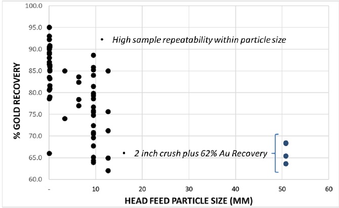
Figure 13.10 Summary of Bottle Roll Test Gold Recovery by Particle Size
| 13.5.2 | Discussion of Column Leach Test Gold Recovery Curves |
All 6 column leach tests performed on core samples from the Isabella Pearl mine are summarized in Table 13.12. The NaCN and Lime Consumption during the column leach tests are summarized in Table 13.13. Figure 13.11 presents column leach gold recovery curves for the 6 column leach tests.
The nature of the fast leach kinetics was recorded on every test, with 80 to 90 percent of total recovery occurring in the first 10 days of leaching.
Table 13.12 Summary of All Column Leach Tests Completed on the Isabella Pearl Mine

89
| 2020 REPORT ON THE MINERAL RESOURCE & RESERVE ESTIMATE FOR THE ISABELLA PEARL MINE, NEVADA |
Table 13.13 Summary of NaCN and Lime Consumption for the Column Leach Tests


Figure 13.11 Column Leach Gold Recovery Curves for Column Leach Tests Completed
90
| 2020 REPORT ON THE MINERAL RESOURCE & RESERVE ESTIMATE FOR THE ISABELLA PEARL MINE, NEVADA |
| 13.6 | Process Selection and Design Parameters |
Cyanidation test work (bottle roll and column leach), performed on representative mineral resources, confirms the close relationship between particle size and gold recovery. The greater the fines fraction the higher the gold recovery. The results of all bottle roll and column leach tests performed are summarized by size fraction and presented in Tables 13.14 and 13.15 below.
Table 13.14 Bottle Roll Gold Recovery Estimate by Size Range

Table 13.15 Column Leach Gold Recovery Estimation by Size Range

Interpreting these results, it was observed that:
| · | A high level of gold recovery (plus 90 percent) could be achieved using a grinding and milling process. The capital cost and economics of milling, however, is prohibitive given the limited amount of mineral resources, leaving the most viable option to be a heap leach process with a carbon absorption/desorption and electrowinning given low silver to gold ratio. |
| · | There exists a marked increase in gold recovery by decreasing the average size fraction of the mineral resources. Review of the combined gold recovery by bottle roll and column leach testing, determined that sizing the material to a p100 of 5/8 inch could reasonably expect a 25% increase in gold recovery (60 to 85%) over ROM size material. The tradeoff of the extra cost of crushing to gold recovery is explained in Section 17 of this document. |
Based on the metallurgical test work completed, the recoveries presented in Table 13.16 are being used for the mine. Total gold recovery is expected over a four-month period. Considering the economic parameters used in the feasibility study, mineral resources above 0.61 g/t Au are currently being crushed to P80 of 5/8 inch and material between 0.44 and 0.61 g/t Au is being sent to a low-grade stockpile for either future crushing or direct placement on the heap as ROM. Total predicted gold recovery is 81% for crushed and 60 % for ROM material.
91
| 2020 REPORT ON THE MINERAL RESOURCE & RESERVE ESTIMATE FOR THE ISABELLA PEARL MINE, NEVADA |
Table 13.16 Gold Recovery Estimate

Cyanide consumption is expected to average 0.75 kg/t (1.50 lb/ton) of leach material and lime consumption is estimated to average 3.0 kg/t (6.0 lb/ton) of leach material (Table 13.17).
Table 13.17 NaCN and Lime Consumption
| Material | Gold Recovery | NaCN Consumption | Lime Consumption |
| ROM | 60 % | 0.75 kg/t | 6.0 kg/t |
| 5/8 Crush | 81 % | 0.75 kg/t | 6.0 kg/t |
92
| 2020 REPORT ON THE MINERAL RESOURCE & RESERVE ESTIMATE FOR THE ISABELLA PEARL MINE, NEVADA |
| 14 | MINERAL RESOURCE ESTIMATE |
| 14.1 | Introduction |
On October 31, 2018, the SEC announced that it was adopting amendments to modernize the property disclosure requirements for mining registrants, and related guidance, under the Securities Act of 1933 and the Securities Exchange Act of 1934 (SEC, 2018a, 2018b). Under the final rules, a registrant with material mining operations must disclose specified information in Securities Act and Exchange Act filings concerning its Mineral Resources, in addition to its Mineral Reserves. The final rules provide a two-year transition period so that a registrant will not be required to begin to comply with the new rules until its first fiscal year beginning on or after January 1, 2021. The SEC states that a registrant may voluntarily comply with the new rules prior to the compliance date, subject to the SEC’s completion of necessary EDGAR reprogramming changes. WLMC has decided to adopt the new rules and will disclose Mineral Resources in this report.
The modeling and estimation of Mineral Resources presented herein is based on technical data and information available as of December 31, 2019. WLMC models and estimates Mineral Resources from available technical information prior to the generation of Mineral Reserves.
The modeling and Mineral Resource estimation work reported herein was mainly carried out by Fred H. Brown, P.Geo., a Qualified Person by reason of education, affiliation with a professional association and past relevant work experience as described in Section 2.2. Mr. Brown is employed as a Senior Resource Geologist by GRCN and is not independent of WLMC.
Modeling and estimation of mineral resources were carried out using the commercially available Maptek Vulcan software program, version 12.
Any statements and opinions expressed in this document are given in good faith and in the belief that such statements and opinions are not false and misleading as of the effective date of this report.
| 14.2 | Mineral Resource Definitions |
The SEC is adopting the Combined Reserves International Reporting Standards Committee (CRIRSCO) framework for reporting Mineral Resources (Miskelly, 2003). According to CRIRSCO, a Mineral Resource is a concentration or occurrence of material of intrinsic economic interest in or on the Earth’s crust (a deposit) in such form, grade or quality, and quantity that there are reasonable prospects for eventual economic extraction. The location, quantity, grade, geological characteristics and continuity of a Mineral Resource are known, estimated or interpreted from specific geological evidence and knowledge. Mineral Resources are sub-divided, in order of increasing geological confidence, into Inferred, Indicated and Measured categories. Portions of a deposit that do not have reasonable prospects for eventual economic extraction must not be included in a Mineral Resource.
93
| 2020 REPORT ON THE MINERAL RESOURCE & RESERVE ESTIMATE FOR THE ISABELLA PEARL MINE, NEVADA |
Mineral resources are not mineral reserves and do not have demonstrated economic viability. There is no guarantee that all or any part of the mineral resource will be converted into mineral reserve. Confidence in the estimate of Inferred Mineral Resources is insufficient to allow the meaningful application of technical and economic parameters.
| 14.2.1 | Inferred Mineral Resource |
An Inferred Mineral Resource is that part of a Mineral Resource for which tonnage, grade and mineral content can be estimated with a low level of confidence. It is inferred from geological evidence and assumed but not verified geological and/or grade continuity. It is based on information gathered through appropriate techniques from locations such as outcrops, trenches, pits, workings and drill holes which is limited or of uncertain quality and/or reliability. An Inferred Mineral Resource has a lower level of confidence than that applying to an Indicated Mineral Resource.
| 14.2.2 | Indicated Mineral Resource |
An Indicated Mineral Resource is that part of a Mineral Resource for which tonnage, densities, shape, physical characteristics, grade and mineral content can be estimated with a reasonable level of confidence. It is based on exploration, sampling and testing information gathered through appropriate techniques from locations such as outcrops, trenches, pits, workings, and drill holes. The locations are too widely or inappropriately spaced to confirm geological continuity and/or grade continuity but are spaced closely enough for continuity to be assumed. An Indicated Mineral Resource has a lower level of confidence than that applying to a Measured Mineral Resource but has a higher level of confidence than that applying to an Inferred Mineral Resource.
| 14.2.3 | Measured Mineral Resource |
A Measured Mineral Resource is that part of a Mineral Resource for which tonnage, densities, shape, physical characteristics, grade and mineral content can be estimated with a high level of confidence. It is based on detailed and reliable exploration, sampling and testing information gathered through appropriate techniques from locations such as outcrops, trenches, pits, workings, and drill holes. The locations are spaced closely enough to confirm geological and/or grade continuity.
| 14.3 | Database |
Mineral Resources described in this report are gold and silver bearing material that has been physically delineated by one or more of a number of methods including drilling and surface mapping and other types of sampling. This material has been found to contain a sufficient amount of mineralization of an average grade to have potential that warrants further exploration evaluation. This material is reported
94
| 2020 REPORT ON THE MINERAL RESOURCE & RESERVE ESTIMATE FOR THE ISABELLA PEARL MINE, NEVADA |
as Mineral Resources only if the potential exists for reclassification into the Mineral Reserves category. Mineral Resources cannot be classified in the Mineral Reserves category until technical, economic and legal factors have been evaluated.
The modeling and estimation reported herein utilized the drill hole database compiled by WLMC. Drill holes with assay samples within the immediate mine area were imported into a Maptek Vulcan database. The extracted drill hole database contains 379 unique collar records (Figure 14.1) and 21,055 assay records, broken down by drilling type as:
| · | AT: 6 drill holes for 82.0 m (269 ft) |
| · | RC: 333 drill holes for 32,360.6 m (106,170 ft) |
| · | DDH: 36 drill holes for 3,564.5 m (11,695 ft) |
Industry standard validation checks of the database were carried out with minor corrections made where necessary. The database was interrogated for inconsistencies in naming conventions or analytical units, duplicate entries, interval, length or distance values less than or equal to zero, blank or zero-value assay results, out-of-sequence intervals, intervals or distances greater than the reported drill hole length, inappropriate collar locations, and missing interval and coordinate fields. No significant discrepancies with the data were noted.
| 14.3.1 | Drill Data |
Drill hole distance units are reported in meters and grade units are reported as ppm. The collar coordinates were provided in the WGS 1984 UTM Zone 11N coordinate system.
The average minimum collar distance within the mine area is 19.7 m (65 ft). Summary assay statistics were tabulated for the assay data (Table 14.1).

Figure 14.1 Isometric View Looking North at Mine Drill Holes
95
| 2020 REPORT ON THE MINERAL RESOURCE & RESERVE ESTIMATE FOR THE ISABELLA PEARL MINE, NEVADA |
Table 14.1 Summary Assay Statistics
| Assay Data | Length m | Au ppm | Ag ppm |
| Mean | 1.536 | 0.37 | 3.39 |
| Median | 1.524 | 0.007 | 0.2 |
| Mode | 1.524 | 0.0001 | 0.0001 |
| Standard Deviation | 0.198 | 2.31 | 21.77 |
| CoV | 7.74 | 0.16 | 0.16 |
| Minimum | 0.609 | 0.0001 | 0.0001 |
| Maximum | 7.925 | 106.5 | 1214.1 |
| Count | 21,055 | 21,055 | 20,597 |
| 14.4 | Bulk Density |
MDA reported an average bulk density value of 2.20 tonnes per cubic meter (tonnage factor 14.6) for oxidized units and 2.40 tonnes per cubic meter (tonnage factor 13.4) for non-oxidized units (Prenn & Gustin, 2013).
A total of 38 bulk density measurements were collected by HB Engineering from TXAU geotechnical DDH core, with values ranging from 1.58 tonnes per cubic meter (tonnage factor 20.5) to 3.20 tonnes per cubic meter (tonnage factor 10.0), with a median of 2.21 tonnes per cubic meter (tonnage factor 14.5) and an average value of 2.20 tonnes per cubic meter (tonnage factor 14.6). For the current update a conservative bulk density of 2.20 tonnes per cubic meter (tonnage factor 14.6) was assigned to the model for all units.
RQD data collected by HB Engineering from TXAU geotechnical DDH drill holes also suggests the presence of multiple zones of poor recovery, fractures and voids (Figure 14.2). An additional factor may be required to accommodate the presence of voids and fractured rocks.
96
| 2020 REPORT ON THE MINERAL RESOURCE & RESERVE ESTIMATE FOR THE ISABELLA PEARL MINE, NEVADA |

Figure 14.2 Plot of RQD vs. Elevation
| 14.5 | Wireframe Modeling |
| 14.5.1 | Topography |
A topographic model covering portions of Isabella Pearl was created by WLMC staff using aerial photogrammetry collected on December 31, 2019. An Unmanned Aerial Vehicle (UAV) collected 1,352 high resolution aerial photographs over the Isabella Pearl active pit and Scarlet areas at a nominal elevation of 106 m above ground level (AGL) (Figure 14.3) and a ground sampling distance (GSD) of 1.33-inches per pixel. Cloud based processing was used to generate a high resolution orthomosaic, 3D reconstruction, a dense point cloud, and a digital elevation model (DEM). The point cloud was converted to a 3D topographic surface for modeling.
97
| 2020 REPORT ON THE MINERAL RESOURCE & RESERVE ESTIMATE FOR THE ISABELLA PEARL MINE, NEVADA |

Figure 14.3 Aerial Photometry with Ground Control Points
On board the UAV global navigation satellite system (GNSS) an electronic compass, barometric sensor, and inertial measurement unit (IMU) were used to estimate photograph geolocation. Surveyed ground control points (GCP) were used for indirect georeferencing to WGS84. Table 14.2 lists the GCP geolocation errors.
Table 14.2 GCP Geolocation Errors
| GCP | X Error (in) | Y Error (in) | Z Error (in) |
| GCP1023 | 0.3228 | 0.0748 | 0.689 |
| GCP1029 | -0.1299 | 0.4213 | -0.3031 |
| GCP1028 | 0.0315 | -0.3976 | 0.1378 |
| GCP1025 | 0.0472 | 0.2913 | -0.0157 |
| GCP1027 | -0.1575 | -0.5906 | -0.6535 |
| GCP1026 | -0.2283 | 0.4449 | -0.2559 |
| DDH1 | -0.2559 | 0.2165 | 0.3386 |
| DDH2 | -0.1535 | -0.3465 | -0.1024 |
| DDH3 | 0.0669 | 0.2598 | 0.3071 |
| DDH4 | 0.3228 | -0.1181 | -0.1575 |
| DDH5 | 0.1339 | -0.248 | 0.0118 |
| Total RMSE | 0.1947 | 0.3415 | 0.3468 |
98
| 2020 REPORT ON THE MINERAL RESOURCE & RESERVE ESTIMATE FOR THE ISABELLA PEARL MINE, NEVADA |
| 14.5.2 | Gridded Surfaces |
Gridded surfaces were developed for a water, oxidation floor and lower granite contact based on logged water and lithology contacts (Figure 14.4).
| 14.5.3 | Mineralization Envelopes |
A number of geological structures directly influence the Isabella Pearl mineralization. Vein solids and fault traces were digitized and imported into Vulcan software. Three-dimensional surfaces of the Pearl and Civit Cat faults, which separate the Mickey Pass Tuff and granitic basement, were created using the digitized fault traces and lithologic drill-hole data. The Civit Cat North, Isabella, Scarlet South and Pearl domains were modeled based on nominal 0.30 g/t Au (0.009 opst) grade shells using close spaced polygons snapped directly to drill hole assay intervals. In order to maintain zonal consistency, lower grade assay intervals were incorporated into the modeled domains where appropriate. The interpreted polygons were then consolidated into three-dimensional triangulated wireframes, which were clipped to the updated topographic surface. Modeling of the Isabella domain also incorporated blasthole results and geological features exposed during mining, and the Pearl domain has been split into a lower grade “Vein” and higher grade “Main” sub-domain. The resulting mineralization domains were used to back-tag assay and composite intervals and provide reasonable volume constraints (Figure 14.5).

Figure 14.4 Isometric View Looking North Showing Oxide Base (blue) and Granite (orange) Contacts
99
| 2020 REPORT ON THE MINERAL RESOURCE & RESERVE ESTIMATE FOR THE ISABELLA PEARL MINE, NEVADA |

Figure 14.5 Isometric View Looking North of Pearl (red), Civit Cat North (green), Isabella (blue) and Scarlet South (brown) Mineralization Domains
| 14.6 | Compositing |
The average length of assays intervals within the defined mineralization domains is 1.540 m (5.05 ft), with a mode of 1.524 m (5.00 ft) and a median length of 1.524 m (5.00 ft). A total of 95% of the constrained assays are 1.524 m (5.00 ft) in length (Figure 14.6). Assays were therefore composited to 1.524 m (5.00 ft) within the defined domains. Residual composite lengths less than 0.762 m (2.50 ft) were merged with the adjacent interval. A small number of missing intervals were treated as nulls.
100
| 2020 REPORT ON THE MINERAL RESOURCE & RESERVE ESTIMATE FOR THE ISABELLA PEARL MINE, NEVADA |

Figure 14.6 Dot Plot of Constrained Assay Sample Lengths
| 14.7 | Exploratory Data Analysis |
Summary statistics were calculated for the composite sample populations (Table 14.3). The Civit Cat North and Isabella sample populations demonstrate similar gold distributions as compared to the higher-grade Pearl mineralization. The highest average silver grade also occurs in the Pearl domain, followed by the Civit Cat North mineralization and the Isabella mineralization (Figure 14.7).
The correlation between gold and silver composite grades was also examined for each sample population. The Civit Cat North displays a moderate level of correlation with a Pearson Product-Moment Correlation Coefficient (PCC) of 0.352, while the Isabella displays a lower level of correlation with a PCC of 0.254. The Pearl (PE) Main displays a PCC of 0.224, and the PE Veins domain displays a PCC of 0.131. There are insufficient samples at this time to determine the correlation at Scarlet South.
101
| 2020 REPORT ON THE MINERAL RESOURCE & RESERVE ESTIMATE FOR THE ISABELLA PEARL MINE, NEVADA |
Table 14.3 Constrained Composite Statistics
| Au | Civit Cat North | Isabella | Pearl | Pearl Veins | Scarlet South |
| Mean | 0.68 | 0.54 | 4.82 | 1.12 | 0.71 |
| St Dev | 0.67 | 0.79 | 8.73 | 2.58 | 0.87 |
| CV | 0.99 | 1.47 | 1.81 | 2.29 | 1.22 |
| Median | 0.54 | 0.31 | 1.96 | 0.45 | 0.51 |
| Minimum | 0.001 | 0.001 | 0.001 | 0.001 | 0.027 |
| Maximum | 5.78 | 12.62 | 92.16 | 29.25 | 7.65 |
| Count | 250 | 2415 | 1155 | 436 | 110 |
| Ag | Civit Cat | Isabella | Pearl | Pearl Veins | Scarlet |
| Mean | 8.05 | 2.31 | 37.51 | 6.89 | 3.01 |
| St Dev | 16.54 | 9.10 | 82.45 | 14.73 | 6.08 |
| CV | 2.05 | 3.94 | 2.20 | 2.14 | 2.02 |
| Median | 3.83 | 0.80 | 10.39 | 2.10 | 1.30 |
| Minimum | 0.001 | 0.001 | 0.001 | 0.001 | 0.05 |
| Maximum | 147.79 | 411.40 | 1214.10 | 129.89 | 51.30 |
| Count | 250 | 2415 | 1155 | 436 | 110 |
102
| 2020 REPORT ON THE MINERAL RESOURCE & RESERVE ESTIMATE FOR THE ISABELLA PEARL MINE, NEVADA |


Figure 14.7 Log-Probability Plots of Au and Ag Composites
103
| 2020 REPORT ON THE MINERAL RESOURCE & RESERVE ESTIMATE FOR THE ISABELLA PEARL MINE, NEVADA |
The gold sample distributions for RC and DDH composites were also examined for evidence of bias in the Isabella and Pearl mineralization domains. The results suggest that RC drilling has in general slightly undervalued the DDH (DH) drilling at Pearl (Figure 14.8), which may be due in part to the observed clustering of DDH drilling in the vicinity of the high-grade portion of the Pearl domain.

Figure 14.8 RC vs. DDH Drilling Results
A single true twin is available for grade comparison and analysis: IC-145 (a vertical RC drill hole) and IP-DD-002 (a vertical DDH). The separation between collars is 5.97 m (19.58 ft). Both drill holes penetrate the center of the Pearl domain.
Visual comparison of the composite grades between the two drill holes suggests the presence of localized downhole contamination below the oxide base, with elevated grades observed in the RC drill hole compared to the DDH drill hole (Figure 14.9). Potential contamination in RC drill holes appears to be limited to beneath the oxide base; in order to accommodate for a potential bias during estimation more restrictive estimation constraints were imposed on the Pearl model.
104
| 2020 REPORT ON THE MINERAL RESOURCE & RESERVE ESTIMATE FOR THE ISABELLA PEARL MINE, NEVADA |

Figure 14.9 Twin Hole Au Assay Grade Comparison
| 14.8 | Treatment of Extreme Values |
The potential influence of extreme values during estimation was evaluated by grade capping analysis on the tagged and composited grade intervals in order. The presence of high-grade outliers was identified by disintegration analysis of the upper tails and examination of histograms and log-probability plots (Figure 14.10). Composite grades were reduced to the selected threshold prior to estimation. The Pearl capping threshold was then iteratively refined in order to minimize the relative difference between the resulting average Nearest Neighbor model and block grade estimates (Table 14.4). For the Pearl deposit an additional range restriction of 40 m (131 ft) was placed on composites equal to or greater than 50% of the capping threshold.
105
| 2020 REPORT ON THE MINERAL RESOURCE & RESERVE ESTIMATE FOR THE ISABELLA PEARL MINE, NEVADA |

Figure 14.10 Log-Probability Plots of Composite Capping Thresholds
106
| 2020 REPORT ON THE MINERAL RESOURCE & RESERVE ESTIMATE FOR THE ISABELLA PEARL MINE, NEVADA |
Table 14.4 Capping Thresholds
| Au | Ag | |||||||
| Cap g/t | Number Capped | Capped Mean | Percent Contribution | Cap g/t | Number Capped | Capped Mean | Percent Contribution | |
| Civit Cat North | 4 | 2 | 0.67 | 1% | 100 | 2 | 7.8 | 3% |
| Isabella | 10 | 2 | 0.54 | 0% | 100 | 1 | 2.2 | 6% |
| Pearl Main | 50 | 11 | 4.67 | 3% | 250 | 15 | 33.9 | 11% |
| Pearl Veins | 10 | 4 | 1.00 | 12% | 100 | 2 | 6.8 | 2% |
| Scarlet South | 2 | 4 | 0.64 | 12% | 100 | 0 | 3.0 | 0% |
| 14.9 | Continuity Analysis |
Continuity analysis was carried out on normal-score transformed variograms using composited grade intervals (Table 14.5). Only poorly defined experimental semi-variograms could be developed, but the variograms do provide information relevant to the definition of search ranges, anisotropy, and classification.
Table 14.5 Experimental Semi-Variograms and Modeled Rotations
| Domain | Au | Ag |
| Civit Cat North | 0.15 + 0.85 SPH (130, 130, 30) 235° -45° 180° | 0.40 + 0.60 SPH (130, 130, 30) 235° -45° 180° |
| Isabella | 0.10 +0.90 SPH (120,120,30) 25° -15° 0° | 0.40 + 0.60 SPH (120,120,30) 25° -15° 0° |
| Pearl | 0.13 + 0.87 SPH (70, 60, 25) 45° -35° 0° | 0.13 + 0.87 SPH (70, 60, 25) 45° -35° 0° |
| Pearl Veins | 0.20 + 0.80 SPH (100, 80, 20) 55° -50° 0° | 0.20 + 0.80 SPH (100, 100, 20) 55° -50° 0° |
| Scarlet South | NA | NA |
| 14.10 | Block Model |
A rotated block model was established across the mine with the block model limits selected so as to cover the extent of the mineral resources and accommodate a potential pit shell (Table 14.6). A parent block size of 5.0 m x 5.0 m x 6.0 m (16.4 ft x 16.4 ft x 19.7 ft) was selected as representative of the pit shell configuration and selective mining unit.
107
| 2020 REPORT ON THE MINERAL RESOURCE & RESERVE ESTIMATE FOR THE ISABELLA PEARL MINE, NEVADA |
Table 14.6 Block Model Setup
| Origin | Offset | Block Size | Sub-Cell | |
| X | 396588.043 | 1440 | 5 | 0.5 |
| Y | 4273320.014 | 850 | 5 | 0.5 |
| Z | 1400.000 | 420 | 6 | 0.5 |
| Rotation | 125 degrees | |||
The block model contains variables for Au and Ag grade estimation, bulk density, classification, drill hole spacing and oxidation state. The modeled oxide floor was used to code blocks as either oxide or sulfide.
| 14.11 | Estimation and Classification |
Inverse Distance Cubed (“ID3”), Ordinary Kriging (“OK”) and Nearest Neighbor (“NN”) estimates were carried out using capped composites. A minimum of three and a maximum of twelve composites were used for estimation, within a search ellipsoid oriented parallel with each defined structure and extending 120 m (394 ft) x 120 m (394 ft) x 30 m (98 ft). The major and semi-major axes approximate the average strike and dip directions of the mineralization in each of the three estimation areas. Based on preliminary mining results and analysis of blasthole grades, the orientation of the Isabella search ellipse was adjusted to impart a slight anisotropy with the principle axis oriented 040 degrees. Both gold and silver were modeled and estimated.
In order to provide a whole block estimate suitable for open pit mine planning and reserve reporting, the block model was regularized after estimation to a 5.0 m (16.4 ft) x 5.0 m (16.4 ft) x 6.0 m (19.7 ft) whole block estimate by volume percent and diluted at zero grade. Due to the poor quality of the variograms the whole block diluted Inverse Distance Cubed estimates were used for reserve conversion.
Classification parameters were derived from the original MDA criteria (Prenn & Gustin, 2013). The most relevant factors used in the classification process were:
| • | Drill hole spacing density |
| • | Level of confidence in the geological interpretation |
| • | Observed continuity of mineralization |
| • | Direct proximity to a drill hole |
Parent blocks were classified algorithmically by drill hole spacing geometry as follows:
| • | A block within 15.0 m (49.0 ft) of a 2008 series DDH drill hole, or the IP-DD-002 DDH drill hole, was classified as a Measured mineral resource. Only blocks within the modeled Pearl domain were classified as Measured mineral resources. |
| • | A block was classified as an Indicated mineral resource if five or more composites from at least two drill holes were used for estimation and the nearest composite was within 25.0 m (82.0 ft). |
| • | All other estimated blocks are classified as Inferred. |
108
| 2020 REPORT ON THE MINERAL RESOURCE & RESERVE ESTIMATE FOR THE ISABELLA PEARL MINE, NEVADA |
An example of a typical cross section showing the drill hole data and modeled mineral-domain envelopes in the most strongly mineralized portions of the Isabella, Pearl and Civit Cat deposits is in Figure 14.11.
WLMC is not aware of any environmental, permitting, legal, title, taxation, socio-economic, marketing, political, or other issues that could materially affect the estimation of mineral resources at Isabella Pearl.

Figure 14.11 Typical Cross-Section Looking NW Showing Gold Grades (g/t) and Classification
109
| 2020 REPORT ON THE MINERAL RESOURCE & RESERVE ESTIMATE FOR THE ISABELLA PEARL MINE, NEVADA |
| 14.12 | Mineral Resource Estimate |
A Measured Mineral Resource is that part of a mineral resource for which quantity and grade or quality are estimated on the basis of conclusive geological evidence and sampling. The level of geological certainty associated with a Measured Mineral Resource is sufficient to allow a qualified person to apply modifying factors in sufficient detail to support detailed mine planning and final evaluation of the economic viability of the deposit. A Measured Mineral Resource has a higher level of confidence than the level of confidence of either an Indicated Mineral Resource or an Inferred Mineral Resource. It may be converted to a Proven Mineral Reserve or to a Probable Mineral Reserve.
An Indicated Mineral Resource is that part of a mineral resource for which quantity and grade or quality are estimated on the basis of adequate geological evidence and sampling. The level of geological certainty associated with an Indicated Mineral Resource is sufficient to allow a qualified person to apply modifying factors in sufficient detail to support mine planning and evaluation of the economic viability of the deposit. An Indicated Mineral Resource has a lower level of confidence than the level of confidence of a Measured Mineral Resource and may only be converted to a Probable Mineral Reserve.
An Inferred Mineral Resource is that part of a mineral resource for which quantity and grade or quality are estimated on the basis of limited geological evidence and sampling. The level of geological uncertainty associated with an Inferred Mineral Resource is too high to apply relevant technical and economic factors likely to influence the prospects of economic extraction in a manner useful for evaluation of economic viability. An Inferred Mineral Resource has the lowest level of geological confidence of all mineral resources, which prevents the application of the modifying factors in a manner useful for evaluation of economic viability. An Inferred Mineral Resource, therefore, may not be converted to a mineral reserve.
Mineral resources are not mineral reserves and do not have demonstrated economic viability. There is no guarantee that all or any part of the mineral resource will be converted into mineral reserve. Confidence in the estimate of Inferred Mineral Resources is insufficient to allow the meaningful application of technical and economic parameters.
WLMC models and estimates mineral resources prior to establishing mineral reserves. Mineral resources at Isabella Pearl is further defined by WLMC as mineral resources within a constraining pit shell and above a defined cutoff value. Mineral resources reported herein has been constrained within a Lerchs-Grossman optimized pit shell and is reported at a cutoff grade of 0.44 g/t Au (0.013 opst), derived from the unit costs and recoveries listed in Table 14.7. The gold price is based on the three-year trailing average.
Measured and Indicated mineral resources reported for Isabella Pearl contain 2.25 million tonnes (2.48 million short tons) of material at an average gold grade of 3.05 g/t Au (0.089 opst) and 18 g/t Ag (0.529 opst) (Table 14.8).
110
| 2020 REPORT ON THE MINERAL RESOURCE & RESERVE ESTIMATE FOR THE ISABELLA PEARL MINE, NEVADA |
Table 14.7 Mineral Resources Cutoff Calculation
| Description | Unit | Value | ||
| Gold Price | $/oz | 1,306 | ||
| Charges | % | 0.075 | ||
| Royalty | % | 3.000 | ||
| Selling Cost | $/oz | 40.2 | ||
| Costs | Crushed | ROM | Waste | |
| Mining | $/t | 2.76 | 2.99 | 2.83 |
| Rehandling | $/t | 1.00 | 1.00 | - |
| Crushing | $/t | 3.03 | - | - |
| Processing | $/t | 5.96 | 5.96 | - |
| G&A and Energy | $/t | 5.26 | 5.26 | - |
| Rehabilitation | $/t | - | - | 0.70 |
| Processing Recovery | 81.0% | 60.0% | 0.0% |
Table 14.8 Mineral Resource Inventory for the Isabella Pearl Deposit, Mineral County, Nevada, USA (as of December 31, 20191 2 3 4 5))
| Class | Tonnes | Short Tons | Au (g/t) | Au (opst) | Ag (g/t) | Ag (opst) |
| Measured | 893,300 | 984,700 | 5.39 | 0.157 | 34.7 | 1.013 |
| Indicated | 1,354,100 | 1,492,600 | 1.50 | 0.044 | 7.2 | 0.210 |
| Meas + Ind | 2,247,400 | 2,477,300 | 3.05 | 0.089 | 18.1 | 0.529 |
| Inferred | 497,100 | 548,000 | 1.41 | 0.041 | 6.2 | 0.181 |
| 1. | Reported at a cutoff of 0.44 Au g/t (0.013 Au opst). |
| 2. | Whole block diluted estimates reported within an optimized pit shell. |
| 3. | Mineral resources do not have demonstrated economic viability. |
| 4. | Totals may not sum exactly due to rounding. |
| 5. | Mineral Resources reported are inclusive of reserves. |
The mining method is by open pit extraction and all Measured and Indicated mineral resources within the design pit shell and above cutoff have been converted to mineral reserves.
All refractory sulfide mineralization is treated as waste for the Isabella Pearl estimate of mineral resources. In addition, the bottom of the optimized pit shell will not go below the water table.
| 14.13 | Mineral Resource Estimate Sensitivity |
The sensitivity of the mineral resources inventory to changes in cutoff grade was also examined by summarizing tonnes and grade within the pit shell at varying cutoff grades (Table 14.9). The results suggest that the mineral resource estimate is relatively insensitive to changes in cutoff grade.
111
| 2020 REPORT ON THE MINERAL RESOURCE & RESERVE ESTIMATE FOR THE ISABELLA PEARL MINE, NEVADA |
Table 14.9 Cutoff Grade Sensitivity for the Isabella Pearl Deposit
| Measured | ||||||
| Cutoff (g/t) | Tonnes | Short Tons | Au (g/t) | Au (opst) | Ag (g/t) | Ag (opst) |
| 0.30 | 921,500 | 1,015,800 | 5.24 | 0.153 | 33.8 | 0.987 |
| 0.40 | 902,100 | 994,400 | 5.34 | 0.156 | 34.5 | 1.006 |
| 0.44 | 893,300 | 984,700 | 5.39 | 0.157 | 34.7 | 1.015 |
| 0.50 | 881,800 | 972,000 | 5.45 | 0.159 | 35.1 | 1.026 |
| 0.60 | 862,800 | 951,100 | 5.56 | 0.162 | 35.8 | 1.045 |
| Indicated | ||||||
| Cutoff (g/t) | Tonnes | Short Tons | Au (g/t) | Au (opst) | Ag (g/t) | Ag (opst) |
| 0.30 | 1,851,700 | 2,041,100 | 1.19 | 0.035 | 5.6 | 0.164 |
| 0.40 | 1,482,700 | 1,634,400 | 1.41 | 0.041 | 6.7 | 0.195 |
| 0.44 | 1,354,100 | 1,492,600 | 1.50 | 0.044 | 7.2 | 0.210 |
| 0.50 | 1,222,200 | 1,347,200 | 1.61 | 0.047 | 7.8 | 0.227 |
| 0.60 | 995,200 | 1,097,000 | 1.86 | 0.054 | 9.1 | 0.265 |
| Measured and Indicated | ||||||
| Cutoff (g/t) | Tonnes | Short Tons | Au (g/t) | Au (opst) | Ag (g/t) | Ag (opst) |
| 0.30 | 2,773,200 | 3,056,900 | 2.54 | 0.074 | 15.0 | 0.437 |
| 0.40 | 2,384,700 | 2,628,800 | 2.90 | 0.085 | 17.2 | 0.502 |
| 0.44 | 2,247,400 | 2,477,300 | 3.05 | 0.089 | 18.1 | 0.530 |
| 0.50 | 2,104,000 | 2,319,200 | 3.22 | 0.094 | 19.2 | 0.562 |
| 0.60 | 1,858,000 | 2,048,100 | 3.58 | 0.105 | 21.5 | 0.627 |
| 14.14 | Opinion on Adequacy |
WLMC considers that the WLMC 2016 -2019 drilling program results meet industry standards for drilling and QA/QC measures. WLMC also considers that the historical drilling results have been reviewed and confirmed in sufficient detail to permit the generation of Measured and Indicated mineral resource estimates, and that sufficient technical information is available to convert mineral resources to Proven and Probable mineral reserves.
112
| 2020 REPORT ON THE MINERAL RESOURCE & RESERVE ESTIMATE FOR THE ISABELLA PEARL MINE, NEVADA |
| 14.15 | Validation |
The undiluted block model was validated visually by the inspection of successive section lines in order to confirm that the block models correctly reflect the distribution of high-grade and low-grade assay values. Cross sections showing block grade distribution and classification of mineral resources are in Appendix C.
The undiluted block model estimates were checked for global bias by comparing the average metal grades to nearest neighbor model means (Table 14.10). A nearest neighbor estimator produces a theoretically unbiased estimate of the average value when no cutoff grade is imposed and is a reasonable basis for checking the performance of different estimation methods (typically the target comparison should be less than 5%).
| · | For Civit Cat North, global gold kriged grades averaged 1% higher than the Nearest Neighbor values and ID3 grades averaged within 1% of the Nearest Neighbor values. |
| · | For Isabella, global gold kriged grades averaged 4% lower than the Nearest Neighbor values and ID3 grades averaged within 1% of the Nearest Neighbor values. |
| · | For Pearl Veins, global gold kriged grades averaged 1% higher than the Nearest Neighbor values and ID3 grades averaged within 1% of the Nearest Neighbor values. |
| · | For Pearl Main, global gold kriged grades averaged within 1% of the the Nearest Neighbor values and ID3 grades averaged 4% higher than the Nearest Neighbor values. |
Table 14.10 Validation Statistics
| Civit Cat North | Isabella | Pearl Veins | Pearl Main | |
| Au Uncapped Composite Mean (g/t) | 0.68 | 0.54 | 1.12 | 4.82 |
| Au ID3 Block Mean (g/t) | 0.72 | 0.50 | 0.84 | 3.53 |
| Au OK Block Mean (g/t) | 0.73 | 0.48 | 0.85 | 3.41 |
| Au NN Block Mean(g/t) | 0.72 | 0.50 | 0.84 | 3.41 |
| Ag Uncapped Composite Mean (g/t) | 8.1 | 2.3 | 6.9 | 37.6 |
| Ag ID3 Block Mean (g/t) | 10.7 | 1.6 | 7.8 | 32.8 |
| Ag OK Block Mean (g/t) | 10.4 | 1.6 | 8.2 | 32.4 |
| Ag NN Block Mean (g/t) | 13.2 | 1.7 | 7.9 | 31.8 |
Swath plots were also generated as a check on potential local trends of the block estimates (Figure 14.12). This was done by plotting the mean values (with no cutoff) from the Nearest Neighbor average grade versus the average ID3 estimated grades in horizontal swaths aligned with the block model. The results demonstrate the trends are behaving within acceptable limits and indicate no significant abnormal trends in the estimates.
113
| 2020 REPORT ON THE MINERAL RESOURCE & RESERVE ESTIMATE FOR THE ISABELLA PEARL MINE, NEVADA |


Figure 14.12 Au Swath Plots
114
| 2020 REPORT ON THE MINERAL RESOURCE & RESERVE ESTIMATE FOR THE ISABELLA PEARL MINE, NEVADA |
| 14.16 | Risk Factors |
Relevant factors which may affect the estimation of mineral resources include changes to the geological, geotechnical and geometallurgical models, infill drilling to convert material to a higher classification, drilling to test for extensions to known mineral resources, collection of additional bulk density data and significant changes to commodity prices. It should be noted that these and other factors pose potential risks and opportunities, of greater or lesser degree, to the estimate as the model is based on currently available data. Risks associated with key estimation parameters are tabulated in Table 14.11.
Table 14.11 Estimation Risk Factors
| Category | Description | Risk | Potential for Adverse Impact |
| Database | Database Integrity | Assay database is compiled from historical data. | Very Low |
| Drilling | Technique | 6 AT drill holes included in estimate. | Low |
| Drilling | Technique | Infill drilling and mining have confirmed the model. | Low |
| Drilling | Contamination | Infill drilling and mining have confirmed the model. | Low |
| Drilling | Logging | Infill drilling and mining have confirmed the model. | Low |
| Drilling | Recovery | RQD results show a wide range of recoveries, which may bias assay grades. | Moderate |
| Drilling | Data Density | Drill hole spacing is ~ 19 m. | Low |
| Drilling | Survey | Only 10% of drill holes have downhole surveys. | Low |
| Geology | Geological Interpretation | Based on drill holes and field mapping. | Low |
| Geology | Oxide Base | WLMC has completed targeted drilling to determine the base of the oxide zone | Low |
| Geology | Oxide Zone | CN leach assays have quantified the impact of transitional material. | Low |
| Model | Estimation | ID3 is used for estimation. | Very Low |
| Model | Bulk Density | Significant voids may reduce recoverable tonnage. SG is not well constrained. | Moderate |
| Model | Grade Continuity | Infill drilling and mining have confirmed the model. | Low |
| Model | Economics | Reasonable cutoff grades have been applied. | Low |
| Sampling | Predominantly 1.52 m (5 ft) samples | Sample size is based on RC drilling intervals. | Very Low |
| Sampling | Quality of assay data | WLMC has relied on MDA for quality assessment of historical data. | Low |
115
| 2020 REPORT ON THE MINERAL RESOURCE & RESERVE ESTIMATE FOR THE ISABELLA PEARL MINE, NEVADA |
| 15 | MINERAL RESERVE ESTIMATE |
| 15.1 | Introduction |
The Mineral Reserve estimates presented herein were prepared according to the amendments being adopted by the SEC to modernize the property disclosure requirements for mining registrants, and related guidance, under the Securities Act of 1933 and the Securities Exchange Act of 1934 (SEC, 2018 a, b).
The mineral reserve estimate for the Isabella Pearl mine is based on technical data and information available, mainly results of drill hole sampling, as of December 31, 2019. The current mineral reserve estimate was prepared by the QPs described in Section 2.2.
| 15.2 | Mineral Reserve Definitions |
The SEC is adopting the Combined Reserves International Reporting Standards Committee (CRIRSCO) framework of applying modifying factors to indicated or measured mineral resources in order to convert them to mineral reserves (Miskelly, 2003). According to CRIRSCO, a Mineral Reserve is the economically mineable part of a Measured or Indicated Mineral Resource. It includes diluting materials and allowances for losses which may occur when the material is mined. Appropriate assessments, which may include feasibility studies, have been carried out and include consideration of and modification by realistically assumed mining, metallurgical, economic, marketing, legal, environmental, social and governmental factors. These assessments demonstrate at the time of reporting that extraction is reasonably justified. Mineral Reserves are subdivided in order of increasing confidence into Probable Mineral Reserves and Proven Mineral Reserves.
| 15.2.1 | Probable Mineral Reserve |
A Probable Mineral Reserve is the economically mineable part of an Indicated and, in some circumstances, Measured Mineral Resource. It includes diluting materials and allowances for losses which may occur when the material is mined. Appropriate assessments, which may include feasibility studies, have been carried out and include considerations of and modifications by realistically assumed mining, metallurgical, economic, marketing, legal, environmental, social and governmental factors. These assessments demonstrate at the time of reporting that extraction is reasonably justified. A Probable Mineral Reserve has a lower level of confidence than a Proven Mineral Reserve.
116
| 2020 REPORT ON THE MINERAL RESOURCE & RESERVE ESTIMATE FOR THE ISABELLA PEARL MINE, NEVADA |
| 15.2.2 | Proven Mineral Reserve |
A Proven Mineral Reserve is the economically mineable part of a Measure Mineral Resource. It includes diluting materials and allowances for losses which may occur when the material is mined. Appropriate assessments, which may include feasibility studies, have been carried out and include consideration of and modification by realistically assumed mining, metallurgical, economic, marketing, legal, environmental, social and governmental factors. These assessments demonstrate at the time of reporting that extraction is reasonably justified.
| 15.3 | Previous Mineral Reserve Estimates |
A previous estimate of Proven and Probable Mineral Reserves was released by WLMC with an effective date of December 31, 2018 (Table 15.1); previous mineral reserves were based on a gold price of $1,258/oz Au. Mineral Reserves stated in the table below are contained within and engineered pit design following the $1,080/oz Au sales price Lerchs-Grossman pit.
Table 15.1 Mineral Reserve Statement Isabella Pearl Mine, Mineral County, Nevada, as of December 31, 2018
| Class | Tonnes | Short Tons | Au (g/t) | Au (opst) | Ag (g/t) | Ag (opst) | Au (oz) | Ag (oz) |
| Proven | 720,000 | 793,000 | 5.65 | 0.165 | 35 | 1.010 | 130,700 | 801,600 |
| Probable | 2,215,000 | 2,441,000 | 1.18 | 0.034 | 5 | 0.154 | 84,100 | 375,100 |
| Proven & Probable | 2,934,000 | 3,235,000 | 2.28 | 0.066 | 12 | 0.364 | 214,800 | 1,176,700 |
| 15.4 | Mineral Reserve Estimation |
The conversion of mineral resources to mineral reserves required accumulative knowledge achieved through Lerchs-Grossmann (LG) pit optimization, detailed pit design, scheduling and associated modifying parameters. Detailed access, haulage, and operational cost criteria were applied in this process for each deposit (Isabella, Pearl and Civit Cat North). The mine was built in metric units and all metal grades are g/t.
The orientation, proximity to the topographic surface, and geological controls of the Isabella Pearl mineralization support mining of the mineral reserves with open pit mining techniques. To calculate the mineable reserve, pits were designed following an optimized LG pit based on a $1,306/oz Au sales price. This price was chosen to create the primary guide surface based on a price sensitivity and subsequent profitability study that showed that the $1,306 pit maximized profitability while reducing capital requirements. The quantities of material within the designed pits were calculated using a cutoff grade of 0.44 g/t Au which is based on the three-year trailing average $1,306/oz Au sales price observed at the time of this mineral reserve reporting.
117
| 2020 REPORT ON THE MINERAL RESOURCE & RESERVE ESTIMATE FOR THE ISABELLA PEARL MINE, NEVADA |
| 15.5 | Mineral Reserve Estimate |
The Isabella Pearl mine open pit Mineral Reserve Statement with an effective date of December 31, 2019 is presented in Table 15.2
The Proven and Probable Mineral Reserves reported for Isabella Pearl contain 2.25 million tonnes (2.48 million short tons) (Table 15.2) at an average gold grade of 3.05 g/t Au (0.089 opst) and 18 g/t Ag (0.529 opst). The mine mineral reserves are based on a gold price of $1,306/oz Au. Mineral Reserves stated in the table below are contained within and engineered pit design following the $1,306/oz Au sales price Lerchs-Grossman pit.
Table 15.2 Mineral Reserve Statement for the Isabella Pearl Deposit, Mineral County, Nevada, as of December 31, 20191 2 3 4 5 6 7 8
| Class | Tonnes | Short Tons | Au (g/t) | Au (opst) | Ag (g/t) | Ag (opst) | Au (oz) | Ag (oz) |
| Proven | 893,300 | 984,700 | 5.39 | 0.157 | 35 | 1.013 | 154,800 | 998,000 |
| Probable | 1,354,100 | 1,492,600 | 1.50 | 0.044 | 7 | 0.210 | 65,300 | 312,700 |
| Proven & Probable | 2,247,400 | 2,477,300 | 3.05 | 0.089 | 18 | 0.529 | 220,100 | 1,310,700 |
| 1. | Metal prices used for P&P reserves were $1,306 per ounce of gold and $16.32 per ounce of silver. These prices reflect the three-year trailing average prices for gold and silver. |
| 2. | The quantities of material within the designed pits were calculated using a cutoff grade of 0.44 Au g/t. |
| 3. | Mining, processing, energy, administrative and smelting/refining costs were based on 2019 actual costs for the Isabella Pearl mine. |
| 4. | Metallurgical gold recovery assumptions used were 81% for Crushed ore and 60% for ROM ore. These recoveries reflect predicted average recoveries from metallurgical test programs. |
| 5. | P&P reserves are diluted and factored for expected mining recovery. |
| 6. | Figures in tables are rounded to reflect estimate precision and small differences generated by rounding are not material to estimates |
| 7. | 100% of the pit constrained Measured & Indicated mineral resources were converted to reserves. |
| 15.6 | Conversion of Mineral Resource to Mineral Reserve |
| 15.6.1 | Dilution |
The block model created and used for the estimation of reserves explicitly models dilution. The minimum mining unit is a 5m x 5m x 6m (vertical) block and the Au grade of economically mineralized zones is diluted accordingly to the amount of uneconomic material present within each block.
118
| 2020 REPORT ON THE MINERAL RESOURCE & RESERVE ESTIMATE FOR THE ISABELLA PEARL MINE, NEVADA |
| 15.6.2 | Cutoff Grade |
In 2018, based on the estimated costs at the time, a gold cut-off grade of 0.38 g/t was defined for ROM and 0.44 g/t for Crushed. The cut-over grade was calculated at 0.61 g/t. The Cut-Over is the grade at which it is better to start crushing the material as the benefit of the extra gold recovered more than compensates the added cost of crushing.
For this reserve report, the gold cut-off grade for the deposit is estimated at 0.44 g/t based on 2019 actual costs and historical data. This is the cut-off grade that was applied to Measured and Indicated resources for conversion to Proven and Probable reserves. The internal or marginal gold cut-off grade estimated for Crushed is actually lower than the cut-off for ROM (Table 15.3). In this case, all material should be crushed. Operationally, the previously defined cut-over grade of 0.61 g/t Au will be maintained to prioritize high-grade ore going on to the heap leach pad. Ore that is between a gold grade of 0.44 g/t and 0.61 g/t Au will be sent to the low-grade stockpile for future processing.
Table 15.3 shows the cutoff grade assumptions used for the Mineral Reserve estimate.
Table 15.3 Cutoff Grade Assumptions
| Material | Cutoff Grade (g/t Au) | ||
| Break Even | Internal | Cut-Over | |
| ROM | 0.627 | 0.48 | na |
| Crushed | 0.55 | 0.44 | 0.32 |
In summary, ore, low grade and waste are currently being classified as follows:
| Waste: | 0.00 – 0.43 g/t |
| Low-Grade: | 0.44 – 0.61 g/t |
| High-Grade: | > 0.61 g/t |
| 15.6.2.1 | Breakeven Cutoff Grade |
The lowest grade of material that can be mined and processed considering all applicable costs, without incurring a loss or gaining a profit. The break-even cut-off grade assumes that the block does not have to be mined and classifies the material as ore or waste to mine or ignore respectively.
119
| 2020 REPORT ON THE MINERAL RESOURCE & RESERVE ESTIMATE FOR THE ISABELLA PEARL MINE, NEVADA |
| 15.6.2.2 | Internal Cutoff Grade |
The internal cut-off grade assumes that the block in question must be mined and determines whether it should be processed or not. It may be used to decide whether material is treated as ROM or sent to the crusher. It should not be confused with break-even cut-offs, which include an allowance for the cost of stripping.
| 15.6.2.3 | Cut-Over Grade |
If more than one processing method is applicable to a particular rock-type, then the grade at which it is more favorable to change from one processing method to another is referred to as a cut-over, rather than a cut-off. Figure 15.1 shows this effect for Isabella Pearl, where it is more expensive to crush material, but the recovery fraction is higher.

Figure 15.1 Isabella Pearl Cut-Over Grade
| 15.7 | Relevant Factors |
The Qualified Persons are not aware of any environmental, permitting, legal, title, taxation, socio-economic, marketing, political, or other issues that could materially affect the mineral reserves stated here.
120
| 2020 REPORT ON THE MINERAL RESOURCE & RESERVE ESTIMATE FOR THE ISABELLA PEARL MINE, NEVADA |
| 16 | MINING METHODS |
| 16.1 | Mining Methods Summary |
The Isabella Pearl mine design consists of one pit accessing the Isabella, Pearl and Civit Cat North deposits. Open pit mining is conducted by conventional diesel-powered equipment, utilizing a combination of blasthole drills, wheel loaders, and 91-tonne (100-short ton) trucks to define, and handle ore and waste. Support equipment includes graders, track dozers, and water trucks. Higher-grade ore (>0.61 g/t Au) is hauled to the crushing area and crushed before being placed on the leach pad. Low-grade ore between 0.44 and 0.61 g/t Au is hauled directly to the low-grade stockpile. Waste rock is stored in the waste rock facility located in close proximity to the pit to reduce haulage costs.
The final pit was designed using 6 m (20 ft) benches with a bench face angle of 68°, and an inter-ramp slope of 49.7° between a triple bench-catch of 8 m (26 ft). Haul roads were designed to 14 m (46 ft) widths for one-way traffic and 24 m (79 ft) widths for two-way traffic. These widths included an external safety berm in compliance with Mine Safety and Health Administration (MSHA) regulations. The final location of the ramps was optimized in order to reduce the overall pit slopes in areas where the pit slope was required to be less than 50°.
All ore and waste is hauled utilizing a 91-tonne (100-short ton) truck fleet. Low-grade ROM ore was initially placed on the heap leach pad with only lime addition on pad areas protected by a minimum of four feet of cover over the leach pad liner and collector piping system. Most of this material was placed in interior portions of the heap leach to minimize the difficulty of re-grading for reclamation. Currently, high-grade ore is hauled to the crusher pad stockpile to then fed to the crusher by a front-end loader. The crushed ore is then delivered to the heap by a stacker conveyor system. Low-grade ore is currently being stored in the low-grade stockpile for either future crushing or direct placement on the heap as ROM.
The mine pits will generate an estimated total of 15.8 million tonnes (17.4 million short tons) of waste rock. The dump face is at the estimated 40° angle of repose of the material. The Pearl dump is being built from the south toe upward, with the outer slopes concurrently graded to 3(Horizontal):1(Vertical). The outer faces of the graded waste are being contoured, compacted, overlain with growth medium and re-vegetated when it is practical. Contouring and re-vegetation of the top of the dump will occur during post-production reclamation.
Isabella Pearl mining operations are being conducted by a contractor. Isabella Pearl production is scheduled to mine up to 600,000 tonnes (661,400 short tons) of material (ore and waste) per month from a 2-phase pit. The Pearl zone is mined in 2 phases (Pearl Phase 1 & 2) in order to balance the high strip ratio of the upper benches and maintain an adequate cash flow balance. The current plan targets WLMC to process an approximate average of 54,400 tonnes (60,000 short tons) of ore per month over the life-of-mine. Major mining equipment currently includes one Caterpillar D8 dozer, one Caterpillar
121
| 2020 REPORT ON THE MINERAL RESOURCE & RESERVE ESTIMATE FOR THE ISABELLA PEARL MINE, NEVADA |
D9 dozer, two Caterpillar 14M motor graders, two 769 Caterpillar water trucks, two lube trucks and two mechanic’s trucks.
The mine is currently in operation 12 hours per day, 7 days per week (12/7). During production, mining operations require two crews operating on twelve-hour rotating shifts.
During mining operations, blasthole samples are collected and assayed to provide control for ore and waste segregation. The resulting information is used to assign a material type to the blocks representing the active benches. Each block is assigned a destination code based on classification of the material (high-grade ore, low-grade ore, and waste). Following assay and ore/waste designation, visual identification of waste is made by the site geologist and compared to the mine block model. The tonnage of this material is tracked by WLMC geologists and the mine production reporting system.
The reader is referred to earlier reports on mineral resources and reserves and the feasibility study for a more detailed description of the mining methods utilized at the Isabella Pearl mine (Brown et al., 2018). Specific topics covered in earlier reports include:
| · | Pit Slope Geotechnical Evaluation |
| · | Pit Optimization |
| · | Mine Design |
| · | Waste Rock Storage Design |
| · | Haulage |
| · | Mine Production Schedule |
| · | Mining Operations |
| · | Ancillary Mining Operations |
122
| 2020 REPORT ON THE MINERAL RESOURCE & RESERVE ESTIMATE FOR THE ISABELLA PEARL MINE, NEVADA |
| 17 | RECOVERY METHODS |
17.1 Process Description Summary
Metallurgical test work has validated that Isabella Pearl oxidized ores are amenable to gold and silver recovery by cyanidation. The most economically effective process has been identified as conventional heap leaching of crushed ore, and to a lesser extent ROM, followed by absorption/desorption recovery (ADR) and refining to produce doré bars. The estimated recovery of gold from crushed ore is 81%. The estimated gold recovery of ROM material placed on the heap leach is 60%.
The general layout consists of the heap leach pad area which covers about 114,000 m2 (1.5 million ft2) and provides containment for 3.1 million tonnes (3.4 million short tons) of ore. The leach pad is a modified valley fill with a double liner system. A berm ranging from 1 to 5 m (3.3 to 16.4 ft) has been constructed along the sides and downstream (south) edge of the pad. The ADR plant consists of five 2 m (7 ft) diameter vertical adsorption towers in series with a carbon screen on the barren discharge; a 2.7 tonne (3 short ton) carbon-stripping plant with a carbon conditioning and sizing screen; and barren and pregnant solution tanks. The ADR plant design flowrate is 1,400 gpm. Electro-winning is done in a 150-ft3 electrolytic cell. Smelting is done in a T-200 melt furnace.
Figure 17.1 shows a simplified schematic of the Isabella Pearl mine flowsheet. Ore is delivered from the open pit to the crusher and then transported to the heap leach pad via a series of jump/stacker conveyors and stacked onto the heap leach pad by a radial stacker. Isabella Pearl high-grade ore above the 0.61 g/t Au cutoff is crushed using a two-stage portable crushing plant with a 250-tonne (276-short ton) per hour capacity. High-grade ore is first trucked from the open pit to a stockpile located close to the primary crushing circuit. A front-end loader then feeds the high-grade ore to the crushing circuit. Ore is then placed into a stationary grizzly located above the hopper that prevents oversized material from making its way into the crusher cavity. A 1.2 m (4 ft) x 6.1 m (20 ft) vibrating grizzly feeder draws ore into the jaw crusher. The minus 5 cm (2 in) grizzly feeder undersize material bypasses the crusher and combines with crusher product on the crusher discharge belt conveyor.
Primary crushed ore, (approximately 80 percent passing 8 cm (3 in)), is conveyed to a vibrating, inclined, triple deck screen. The design of the crushing circuit is to handle a nominal 227 tonnes per hour (250 short tons per hour). The undersize fraction from the screen bypasses the secondary circuit and reports to the fine crushing product belt conveyor. Screen oversize material is conveyed to the secondary cone crusher. Secondary crushed ore, (approximately 80 percent passing 1.6 cm (5/8 in)) is returned via conveyor to the triple deck screen. The undersize fraction from the screen becomes the product of the fine crushing circuit, and reports to the fine crushing product belt conveyor. The product of the fine crushing circuit is either conveyed and stacked in a crushed ore stockpile or transported by a series of stacker conveyors to the heap leach pad. The final conveyor on the leach pad is a radial-type mobile stacker that places ore in lifts, up to 7.6 m (25 ft) in height. At its peak, the pyramidal heap will be 30 m (100 ft) high and the mean heap height will be approximately 16 m (53 ft). Lime addition is added at the
123
| 2020 REPORT ON THE MINERAL RESOURCE & RESERVE ESTIMATE FOR THE ISABELLA PEARL MINE, NEVADA |
first stacker conveyor by means of silo and screw feeder. Water sprays are utilized for dust suppression at the crusher feed hopper and at transfer points for the screened undersize material.
The pad liner system consists of 15 cm (6 in) of prepared subgrade overlain by a geomembrane sandwiched clay liner (GCL) which in turn is covered by a 60-mil high density polyethylene (HDPE) geomembrane. The heap distribution (leaching solution) system consists of two 1400 gpm pumps with variable speed controllers and a network of 15 cm (6 in), 8 cm (3 in) and 1.3 cm (½ in) piping connected to drip emitters. The ore is leached via emitters at a solution application rate of 0.005 gpm/ft2. The leachate flows by gravity through the heap and is gathered in collector piping and exits each side of the leach pad through 25.4 cm (10 in) solid HDPE pipes resting in double-lined exit notches (ditches). The primary 60-mil HDPE upper liner in the ditch is welded to the leach pad primary liner. GCL installed for secondary containment beneath the leach pad overlaps the secondary liner of the exit notches by a minimum of 6 m (20 ft). Any seepage collected between the leach pad primary and secondary liners reports to the pregnant pond or the barren/stormwater pond via the pipe containment ditches. The upper 60 mil geomembrane is covered with a minimum of 45.7 cm (18 in) of permeable ore to protect against puncture and rupture. Pregnant solution trickling through the heap is collected by 20.3 cm (8 in) HDPE piping resting on the upper geomembrane, the solution flows by gravity to solid HDPE outlet pipes resting in HDPE double-lined ditches in notches through the perimeter berm and enters shunt valve boxes located between the heap leach pad and the ponds. Pregnant solution is conveyed via the closed-circuit pregnant solution pipeline to the pregnant tank at the ADR processing plant.
The pregnant cyanide solution is pumped from the pregnant tank to a feed box in the carbon-in-column (CIC) circuit where it is contacted with activated carbon completing the extraction of the gold via carbon adsorption. The CIC circuit consists of five columns in a series. Solution from the last column overflows to the barren tank where liquid sodium cyanide, fresh water and anti-scalant is added on an as needed basis prior to the solution returning to the heap leach pad for additional leaching of the ore. The heap design allows for direction of pregnant solution to the pregnant pond or from either the pregnant pond or the barren/stormwater pond to the barren tank or between the ponds through a 0.9 m (3 ft) weir should the need arise. The pregnant strip solution is electrolyzed at the on-site facility and the cathode sludge dried, blended with fluxes, and melted to produce doré bullion for shipment to a refiner.
The reader is referred to earlier reports on mineral resources and reserves and the feasibility study for a more detailed description of the recovery methods employed at the Isabella Pearl mine (Brown et al., 2018). Specific topics covered in earlier reports include:
| · | Run-of-Mine (ROM) Processing |
| · | Primary Crushing & Fine Crushing |
| · | Heap Leach Pad & Solution Ponds |
| · | Adsorption-Desorption-Recovery (ADR) Facility |
| · | Major Process Equipment List |
| · | Assay Laboratory |
| · | Consumable Requirements |
124
| 2020 REPORT ON THE MINERAL RESOURCE & RESERVE ESTIMATE FOR THE ISABELLA PEARL MINE, NEVADA |

Figure 17.1 Simplified Schematic of Isabella Pearl Mine Flowsheet
| 2020 REPORT ON THE MINERAL RESOURCE & RESERVE ESTIMATE FOR THE ISABELLA PEARL MINE, NEVADA |
| 18 | MINE INFRASTructure |
18.1 Mine Infrastructure Summary
Access to most elements of the Isabella Pearl mine is provided by pre-existing gravel and paved roads. The main haulage road to the waste rock dump site and the ore preparation/heap leach site were designed to accommodate 91-tonne (100-short ton) capacity mine haulage trucks, requiring two-way traffic travel and safety berms.
The ADR plant, where gold and silver are stripped from pregnant solutions, are housed in a pre-engineered 21 m (69 ft) x 39 m (128.33 ft) structure consisting of steel ribs (struts) covered by insulation and tin siding, erected on a concrete slab. Two electric generators (plus fuel tanks) are in the ADR area. The west end of the ADR area is occupied by the ADR processing plant building. Pregnant solution and barren/stormwater ponds were designed to be near the center of the ADR area. The entire ADR area is enclosed by cyclone fencing.
An assay laboratory and preparation facilities are located are located east of the barren/stormwater pond. Nearby office trailers house on-site administrative staff including the general manager, mine, environmental and safety managers as well as accounting, engineering, geology, metallurgy and surveying staff. Contractors utilize a site north of the ore preparation area on which they have placed their own shop. A septic system with a leach field services the ADR plant, laboratory and offices. A second septic system services the ore preparation area, mine and contractor’s shop. A pipeline with industrial water from a non-potable water storage tank services the ADR plant, laboratory, office and contractor’s shop. Potable water for drinking is being supplied from bottles.
Power is supplied by three diesel-powered electric generators. One 1500 kW generator is on-line, one 1500 kW generator is on standby, and one 200 kW generator is on standby for the water production wells to generate power for the well pumps on an as-needed basis. The total connected electrical force in the plant, including the crushers, is approximately 1,567 hp. WLMC has installed 4,160 volt direct burial power lines from the generator yard throughout the site and to the production wells. Fuel for the generators is stored in two above-ground tanks on graded areas with HDPE-lined floors and berms for secondary containment to provide emergency capture of 110-percent of the largest fuel tank/vessel volume.
Industrial water is supplied from three production water wells. Production Well #2 (IPPW-2) was completed in September 2013 to a depth of 128 m (420 ft) and is upgradient from both the heap leach and open pit. Production Well #1 (IPPW-1) was installed in October 2016 to a depth of 396 m (1,300 ft) and is located south of the processing facility. A third production water well (Well #3) was installed in 2019, about 400 meters southwest of Well #1. Permits for the WLMC production water wells and a maximum of 484-acre feet of water annually (300 gpm 24/7) have been issued by the Nevada State
| 2020 REPORT ON THE MINERAL RESOURCE & RESERVE ESTIMATE FOR THE ISABELLA PEARL MINE, NEVADA |
Engineer. A 757,000 to 946,250 liter (200,000 to 250,000 gallon) non-potable water tank is located near contractor’s yard. The tank is approximately 13.4 m (44 ft) in diameter and 6.1 m (20 ft) high.
Specifications for the mine infrastructure are provided in Table 18.1. Figure 18.1 shows the general site arrangement layout of the facilities including location of the ADR plant to the heap leach pad, pit and waste dumps, and references to infrastructure items in Table 18.1.
The reader is referred to earlier reports on mineral resources and reserves and the feasibility study for a more detailed description of the mine infrastructure at the Isabella Pearl mine (Brown et al., 2018). Specific topics covered in earlier reports included:
| · | Haulage roads |
| · | Mine operations and support facilities |
| · | Process support facilities |
| · | Additional support facilities |
| · | Power supply and distribution |
| · | Water supply |
Table 18.1 Infrastructure Items and Specifications
| Mine Component (1) | Acres Existing Disturbance | Acres Proposed New Disturbance | Total Acres Disturbance |
| Roads | |||
| Exploration Roads, Pads and Sumps Outside of Mine Pit | 26.6(2) | 15.0(3) | 41.6 |
| Main Project Entrance, R-1 | 0 | 0.6 | 0.6 |
| Main Ore Haulage(4), R-3 | 0 | 3.3 | 3.3 |
| Haulage Road South Terminus(4), R-4 | 0 | 2 | 2 |
| Contractors’ Yard Road, R-5 | 0 | 0.2 | 0.2 |
| Operating Area Access, R-6 | 0 | 1.3 | 1.3 |
| Crusher to Pad Road, R-7 | 0 | 0.3 | 0.3 |
| Well Access, R-8 | 0 | 0.1 | 0.1 |
| Raw Water Storage Tank, R-9 | 0 | 0.2 | 0.2 |
| Existing Access North, R-10(5) | 0.8 | 0.9 | 1.7 |
| Leach Pad Perimeter Road, R-11 | 0 | 6.6 | 6.6 |
| DG Stockpile Off-haul Road(4), R-12 | 0 | 3.9 | 3.9 |
| Subtotals | 27.4 | 34.4 | 61.8 |
| Leach Pad, Mine Pits, Waste Rock Dump, Borrows and Stockpiles | |||
| Pearl Dump, D-1 | 0 | 94.8 | 94.8 |
| Heap Leach Pad | 0 | 28.1 | 28.1 |
| Disturbance in Mine Pit Area(7) | 24.1 | 24.2 | 48.3 |
| Pit Perimeter Berm | 0 | 2.8 | 2.8 |
| Growth Medium Borrow, B-1 (6) | 0 | 8.8 | 8.8 |
| DG/Granite Stockpile, BQ-1 | 0 | 4.9 | 4.9 |
| DG/Granite Borrow/Quarry, Q-1 | 0 | 9.3 | 9.3 |
| Subtotals | 24.1 | 172.9 | 197 |
| Yards | |||
| Ore Preparation Area, Y-1 | 0 | 5.6 | 5.6 |
| Contractors’ Yard, Y-2 | 0 | 1.6 | 1.6 |
127
| 2020 REPORT ON THE MINERAL RESOURCE & RESERVE ESTIMATE FOR THE ISABELLA PEARL MINE, NEVADA |
| ADR Plant Area, Y-3 | 0 | 10.8 | 10.8 |
| Employee/Visitor Parking, Y4 | 0 | 0.3 | 0.3 |
| Blasting Media Storage, Y-5 | 0 | 0.3 | 0.3 |
| Raw Water Storage Tank, Y-6 | 0 | 0.5 | 0.5 |
| Utility Corridor from Production Well IPPW-1 to IPPW-2, Y-7 | 0.4 | 3.7 | 4.1 |
| Water Lines to Crusher and Dust Suppression Loading, Y-8 | 0 | 0.8 | 0.8 |
| Contingent Water Lines, Y-9 | 2.2 | 0 | 2.2 |
| Power Line & Water Line to Crusher, Y10 | 0 | 0.2 | 0.2 |
| Subtotals | 2.6 | 23.8 | 26.4 |
| Sediment & Drainage Control | |||
| Permanent Principal Drainage, D-1(8) | 0 | 3.4 | 3.4 |
| Haul Road Drainage Diversion, D-2 | 0 | 1.2 | 1.2 |
| East Pad Diversion, D-3 | 0 | 1.7 | 1.7 |
| Ore Prep Area Diversions, D-4(9) | 0 | 0.6 | 0.6 |
| Southeast ADR Pad Diversion, D-5 | 0 | 0.2 | 0.2 |
| Growth Media Borrow Post-reclamation Drainage, D-6 | 0 | 0.6 | 0.6 |
| Subtotals | 0 | 7.7 | 7.7 |
| Grand Total | 54.1 | 238.8 | 292.9 |
Table 18.1 Notes
| 1) | R-1, R-3, A-1, A-2 etc. are SRCE ID codes. |
| 2) | Includes 24.11 acres of pre-existing exploration disturbance and 2.5 acres of recent extra-pit exploration disturbance by WLMC under BLM Notice-of-Intent (NOI) Case Number NVN 081762. |
| 3) | For contingent future exploration outside of proposed mine pit. |
| 4) | Haulage road disturbance areas include safety berms. |
| 5) | Existing public access road northward will be reclaimed. A permanent public bypass will be constructed to avoid long-term drainage channel crossing maintenance. |
| 6) | 8.84 acre expansion of 5.60 acre Ore Preparation Area to 14.44 acres Growth Media Borrow excavation. |
| 7) | Includes 21.61 acres of pre-existing disturbance and 2.5 acres of TXAU exploration disturbance in pit footprint. |
| 8) | This feature to remain permanently after reclamation. |
9) Drainage diversions will be removed during excavation of reclamation stage borrow
128
| 2020 REPORT ON THE MINERAL RESOURCE & RESERVE ESTIMATE FOR THE ISABELLA PEARL MINE, NEVADA |

Figure 18.1 General Site Arrangement
| 2020 REPORT ON THE MINERAL RESOURCE & RESERVE ESTIMATE FOR THE ISABELLA PEARL MINE, NEVADA |
| 19 | MARKET STUDIES AND CONTRACTS |
The process facility for this operation produces doré bars between 50-55% gold content. Gold bars are being weighed and assayed at the mine to establish value. The bars are shipped regularly to a commercial refiner where their value is verified. Sale prices are obtained based on world spot or London Bullion Market Association (LBMA) pricing and are easily transacted.
| 19.1 | Contracts and Status |
A market study for the gold product was not undertaken for this study. Gold is sold through commercial banks and market dealers. The gold market is stable in terms of gold sale outlets and investment interest.
This study assumes a static price curve for the gold market price. In the economic evaluations, the gold price was set at $1,306/oz based on the SEC’s guidance of using a 3-year trailing average price. This price was slightly lower than the London PM Fix Price of $1,520 on December 31, 2019, the effective date of this mineral resource and reserve estimate.
Terms for an off-take and smelting agreement are likely to be based on refinery agreements established with highly respected, internationally accredited, precious metals refineries and mints located throughout the world.
| 2020 REPORT ON THE MINERAL RESOURCE & RESERVE ESTIMATE FOR THE ISABELLA PEARL MINE, NEVADA |
| 20 | ENVIRONMENTAL STUDIES, PERMITTING AND SOCIAL OR community IMPACT |
| 20.1 | Required Permits and Status |
The Isabella Pearl mine is located approximately 8.4 km (5.2 mi) north of the town Luning, at the west foot of the Gabbs Valley Range in Mineral County, Nevada. The location and current land ownership position results in the mine being held to permitting requirements that are determined to be necessary by Mineral County, the State of Nevada, and the U.S. Department of the Interior, BLM: Carson City District Office and Stillwater Field Office.
As of December 31, 2019, all applicable environmental permits to conduct open pit mining and beneficiation activities at the Isabella Pearl mine have been approved and are in good standing. Table 20.1 below lists the environmental permits that are applicable to the Isabella Pearl mine.
Table 20.1 Permits, Licenses and Issuing Authorities for the Isabella Pearl Mine
| Permit/Approval | Issuing Authority | Permit Purpose | Status |
| Federal Permits Approval and Registrations | |||
| Mine Plan of Operations/NEPA Analysis and ROD | BLM | Prevent unnecessary or undue degradation of public lands; Initiate NEPA analysis to disclose and evaluate environmental impacts and project alternatives. | REQUIRED. Plan of Operations submitted to the BLM and subsequent NEPA analysis has been initiated. |
| Rights-of-Way (RoW) across public lands | BLM | Authorization grant to use a specific piece of public land for a certain project, such as roads, pipelines, transmission lines, and communication sites | NOT REQUIRED. No Rights-of-Ways are for operation. |
| Explosives Permit | U.S. Bureau of Alcohol, Tobacco and Firearms | Storage and use of explosives | REQUIRED of all mining operations in Nevada that store and use explosives. |
| EPA Hazardous Waste ID No. | U.S. Environmental Protection Agency (EPA) | Registration as a small-quantity generator of wastes regulated as hazardous | REQUIRED of all mining operations in Nevada that generates regulated hazardous wastes (e.g., lab wastes, etc.) |
| Notification of Commencement of Operations | Mine Safety and Health Administration | Mine safety issues, training plan, mine registration | REQUIRED of all mining operations in Nevada. |
| Biological Opinion and Consultation | U.S. Fish and Wildlife Service | Only if project Threatened or Endangered Species is determined present during the NEPA analysis of the project. | REQUIRED during the BLM EA due to Raptor status in area. Bird and Bat Conservation Plan (BBCP) may also be part of this; To be decided during NEPA analysis. |
| Federal Communications Commission Permit | Federal Communications Commission (FCC) | Frequency registrations for radio/microwave communication facilities | MAYBE, if WLMC intends to use business radios to transmit on their own frequency |
| State Permits, Authorizations and Registrations | |||
| Nevada Mine Registry | Nevada Division of | Required operations registration | REQUIRED of all mining |
131
| 2020 REPORT ON THE MINERAL RESOURCE & RESERVE ESTIMATE FOR THE ISABELLA PEARL MINE, NEVADA |
| Minerals | operations in Nevada. | ||
| Surface Area Disturbance Permit | NDEP/BAPC | Regulates airborne emissions from surface disturbance activities | REQUIRED of all surface disturbance operations in Nevada over 5 acres. |
| Class II Air Quality Operating Permit | NDEP/BAPC | Regulates project air emissions from stationary sources | REQUIRED for fugitive dust emissions and thermal emission units at lab and refinery. |
| Mercury Operating Permit to Construct | NDEP/BAPC | Program to achieve mercury reduction via add-on control technologies | REQUIRED of all precious metal processing facilities with SIC codes “1041” or “1044”, with focus on mercury emissions from thermal processing units. |
| Class 1 Air Quality Operating Permit to Construct | NDEP/BAPC | Program to achieve mercury reduction via add-on control technologies | REQUIRED of all facilities that emit more than 100 tons per year regulated pollutant or emit more than 25 tons per year total HAP or 10 tons per year of any one HAP. |
| Mining Reclamation Permit | NDEP/BMRR | Reclamation of surface disturbance due to mining and mineral processing; includes financial assurance requirements | REQUIRED. Reclamation Plan submitted as part of federal POO. Accepted under a Memorandum of Understanding (MOU) between the BLM and the NDEP. |
| Mineral Exploration Hole Plugging Permit or Waiver | NDWR | Prevents degradation of waters of the State | REQUIRED of all drilling operations in Nevada. |
| State Groundwater Permit | NDEP/BMRR | Prevents degradation of waters of the State from surface disposal, septic systems, mound septic systems, unlined ponds and overland flow | MAYBE as part of the septic system for sewage disposal. |
| Water Pollution Control Permit (WPCP) | NDEP/BMRR | Prevent degradation of waters of the state from mining, establishes minimum facility design and containment requirements | REQUIRED of all mining operations in Nevada |
| Approval to operate a Solid Waste System | NDEP/BWM | Authorization to operate an on-site landfill | NOT REQUIRED. No Solid Waste Systems are for operation. |
| Hazardous Waste Management Permit | NDEP/BWM | Management and recycling of hazardous wastes | REQUIRED of all mining operations in Nevada that generates regulated hazardous wastes (e.g., lab wastes, etc.) |
| National Pollutant Discharge Elimination System (NPDES) Permit | NDEP/BWPC | Management of site discharges | NOT REQUIRED. No point source discharges by operation. |
| General Stormwater Discharge Permit | NDEP/BWPC | General permit for stormwater discharges associated with industrial activity from metals mining activities | REQUIRED. Application for permit NVR300000 also requires preparation of Stormwater Pollution Prevention Plan (SWPPP) |
| Permit to Appropriate Water/Change Point of Diversion | NDWR | Water rights appropriation | REQUIRED. WLMC has applied for and received an appropriation of 464 acre-feet annually under Water Rights Permits 79096, 82498, 83484 and 83485. |
| Permit to Construct a Dam | NDWR | Regulate impoundment higher than 20 ft or impounding more than 20 acre-feet | NOT REQUIRED. No process water ponds will exceed the |
132
| 2020 REPORT ON THE MINERAL RESOURCE & RESERVE ESTIMATE FOR THE ISABELLA PEARL MINE, NEVADA |
| 20/20 height or impoundment thresholds. |
| Potable Water System Permit | Nevada Bureau of Safe Drinking Water | Water system for drinking water and other domestic uses (e.g., lavatories) | NOT REQUIRED. WLMC will supply bottled drinking water. |
| Septic Treatment Permit Sewage Disposal System Permit | NDEP/BWPC | Design, operation, and monitoring of septic and sewage disposal systems | REQUIRED for the septic systems at the mine site. |
| Dredging Permit | NDOW | Protection of Nevada waterways | NOT REQUIRED. No dredging. |
| Industrial Artificial Pond Permit | NDOW | Regulate artificial bodies of water containing chemicals that threaten wildlife | REQUIRED of all mining operations in Nevada that utilize open process water ponds. |
| Wildlife Protection Permit | NDOW | Stream and watershed wildlife habitat protection | NOT REQUIRED. No stream or watershed modification. |
| Hazardous Materials Permit | Nevada Fire Marshall | Store a hazardous material in excess of the amount set forth in the International Fire Code, 2006 | REQUIRED for storage of fuels and lubricant at the Isabella Pearl site. |
| License for Radioactive Material | Nevada State Health Division, Radiological Health Section | Radioactive material licensing | MAYBE, if WLMC intends to use a densitometer or similar device at site. |
| Encroachment Permit | Nevada Department of Transportation (NDOT) | Permits for permanent installations within State rights-of-way and in areas maintained by the State | NOT REQUIRED. No installations within State rights-of-way by operations. |
| Temporary Permit to Work in Waterways | NDEP/BWPC | Covers temporary working or routine maintenance in surface waters of the State, such as channel clearing and minor repairs to intake structures. | NOT REQUIRED. No work in waterways by operations. |
| State Business License | Nevada Secretary of State | License to operate in the state of Nevada | REQUIRED of all entities conducting business in the State of Nevada. |
| Retail Sales Permit or Exemption Certificate | Nevada State Department of Taxation | Permit to buy wholesale or sell retail | NOT REQUIRED. No wholesale purchasing or retail selling for operation. |
| Local Permits for Mineral County | |||
| Building Permits Mineral County Building Planning Department | Mineral County Building Planning Department | Ensure compliance with local building standards/requirements | REQUIRED for construction of buildings and septic systems. |
| Special Use Permit | Mineral County Building Planning Department | Provided as necessary under applicable zoning ordinances | REQUIRED for construction of Isabella Pearl project. |
| County Road Use and Maintenance Permit/Agreement | Mineral County Building Planning Department | Use and maintenance of county roads | NOT REQUIRED. WLMC will maintain their own roads. |
| Business License | Mineral County Building Planning Department | License for the engagement of business activities | REQUIRED for operating a business in Mineral County. |
133
| 2020 REPORT ON THE MINERAL RESOURCE & RESERVE ESTIMATE FOR THE ISABELLA PEARL MINE, NEVADA |
20.1.1 Federal Permitting
A number of federal permits and authorizations are required for mining operations located on public land administered by a federal land management agency, including, but not limited to the BLM, U.S. Department of Agriculture–Forest Service, and the National Parks Service. In the case of Isabella Pearl, the mine is located on public lands administered by the BLM. As such, the operation requires all of the identified federal permits, the most important of which are approvals of the 43 CFR § 3809 POO and its subsequent NEPA analyses. WLMC submitted the POO and Reclamation Permit application and the NEPA analysis was completed and a ROD was issued on May 15, 2018.
WLMC has acquired the following Federal Permits and Registrations:
| · | EPA Hazardous Waste #NVR000092916 (BWM) |
| · | Explosive Permit #9-NV-009-20-8K-00321 (Ledcor CMI Inc. contract mining) |
| · | POO and Reclamation Plan #NVN86663 (BLM) |
20.1.1.1 BLM Exploration Notice of Intent (NOI)
Upon completion of the POO and issuance of the ROD by the BLM, the existing exploration permit that was within the mine plan boundary was closed. The reclamation cost estimated for surface disturbance associated with ongoing exploration within the mine plan boundary is covered by the bond for the Isabella Pearl mine. This allows WLMC to continue its exploration activities within the mine plan boundary while active mining is in progress.
Surface disturbance associated with proposed exploration drilling to be conducted outside the mine plan bounday (the permitted mine area) is currently authorized under a separate BLM Notice of Intent, a summary of which, including the obligated bond amounts for reclamation, is provided in Table 20.2.
Table 20.2 BLM Notice of Intent Summary for the Isabella Pearl Mine
| Area | Serial Number | Name | Total Acres | Bond Amount Obligated |
| Scarlet Prospect | NVN-98794 | GRC Reclamation Cost Estimate | 1.66 | $11,724 |
| Total | 1.66 | $11,724 | ||
134
| 2020 REPORT ON THE MINERAL RESOURCE & RESERVE ESTIMATE FOR THE ISABELLA PEARL MINE, NEVADA |
20.1.2 State Permitting
The State of Nevada requires operational mining permits regardless of land status of the mine (i.e., private or public). The following are the state permits that are required for the Isabella Pearl mine:
| · | Reclamation Permit #0387 (NDEP/BMRR) |
| · | Hazardous Waste Generator #NVR000092916 (NDEP/BWM) |
| · | Water Pollution Control Permit #NEV2009102 (NDEP/BMRR) |
| · | Emergency Release, Response, and Contingency Plan (NDEP/BMRR) |
| · | Spill Prevention, Control, and Countermeasures Plan (NDEP/BMRR) |
| · | National Pollutant Discharge Elimination System (NPDES) Permit #NVG201000 (NDEP/BWPC) |
| · | General Stormwater Permit #NVR300000 MSW-43292 (NDEP/BWPC) |
| · | Storm Water Pollution Prevention Plan (NDEP/BWPC) |
| · | Water Rights – #83484, 82498, 79096 and 83485 (changed to 89001T) (DCNR/NDWR); Permits to change the point of diversion and place of use of the water rights have been approved, for groundwater production wells |
| · | Air Quality Class II Operating Permit #AP-1041-3853 (NDEP/BAPC) |
| · | Air Quality Mercury Permit to Construct #AP-1041-3895 (NDEP/BAPC) |
| · | Air Quality Class I Operating Permit to Construct #AP-1041-3897 (NDEP/BAPC) |
| · | Industrial Artificial Pond Permit #467428 (NDOW) |
The State of Nevada has issued the above permits, which are all in good standing as of December 31, 2019.
20.1.3 Local Permitting
WLMC has obtained the necessary Building Permits and a Special Use Permit issued by Mineral County. These permits authorized WLMC to construct the buildings located at the Isabella Pearl mine.
The following are the Mineral County permits that are required for the Isabella Pearl mine:
| · | Mineral County Business License #17288 (Mineral County Sheriff’s Office) |
| · | Special Use Permit #165957 (Mineral County Planning Commission) |
| · | Septic Permit #7905 and 7906 (Mineral County Building Department) |
| · | ADR Building Permit #5891 (Mineral County Fire Marshall) |
| · | Office Building Permit #7888 (Mineral County Fire Marshall) |
| · | Water Tank Building Permit #7921 (Mineral County Fire Marshall) |
The Special Use Permit was approved when the ROD was issued by BLM in May 2018. Mineral County has issued the remaining permits, which are all in good standing as of December 31, 2019.
135
| 2020 REPORT ON THE MINERAL RESOURCE & RESERVE ESTIMATE FOR THE ISABELLA PEARL MINE, NEVADA |
| 20.2 | Environmental Study Results |
The reader is referred to earlier reports on mineral resources and reserves and the feasibility study for a more detailed description of environmental study results at the Isabella Pearl mine (Brown et al., 2018, 2019). Specific topics covered in earlier reports included:
| · | Mine Waste Characterization and Management |
| · | Waste Rock Management Plan |
| · | Groundwater Characterization |
| o | Groundwater Quality |
| · | Surface Water Characterization |
| · | Cultural Resources Inventory |
| o | Native American Religious Concerns |
| · | Biological Resources Inventory |
| o | Vegetation |
| o | Mammals |
| o | Reptiles |
| o | Migratory Birds |
| o | Sensitive Species |
| § | BLM |
| § | State of Nevada |
| 20.3 | Environmental Issues |
Following submission by TXAU of the plan of operations in 2010, public scoping was conducted from March 15 through April 15, 2011. In five letters and four telephone calls received by the BLM, the following issues and concerns were identified:
| · | Wildlife—Potential disturbance of habitat for mule deer, pronghorn antelope, and desert bighorn sheep; |
| · | Special status species—Proximity of disturbance to a known prairie falcon nest; |
| · | Springs—The impact of mining on springs and associated wildlife; |
| · | Public access and vested rights-of-way—The status of public access to surrounding areas for recreation; |
| · | Level of NEPA analysis—What criteria were used to determine that the preparation of an EA would be appropriate, as opposed to a full environmental impact statement; |
| · | Transportation of ore—Plans to evaluate the impacts of the transportation of ore on off-site facilities; |
136
| 2020 REPORT ON THE MINERAL RESOURCE & RESERVE ESTIMATE FOR THE ISABELLA PEARL MINE, NEVADA |
| · | Water resources—Waste and ore rock characterization and potential impacts on Waters of the United States; |
| · | Cultural resources—Request for complete examination of the site for archaeological and cultural resources; |
| · | Water rights—Two claims of vested water rights for stockwater use in the area; and |
| · | Recreation—Requests by various off-road race organizers to control cross traffic during race day. |
Issues originally identified from the agency comments were concern for water quality, wildlife (including special status species), habitat, recreation, nearby spring monitoring, and quantity and quality reporting. Each of these concerns has been addressed or mitigated by the design of the project, or the implementation of Operator Committed Environmental Protection Measures and Practices (Section 2.5 of the Isabella Pearl mine POO (Welsh Hagen, 2018).
| 20.4 | Operating and Post-Closure Requirements and Plans |
As part of both the Nevada Water Pollution Control Permit (WPCP) and the BLM POO, WLMC has submitted a detailed plan for monitoring designed to demonstrate compliance with the approved POO and other Federal or State environmental laws and regulations, to provide early detection of potential problems, and to supply information that will assist in directing corrective actions, should they become necessary. The plan includes discussion on water quality in the area; monitoring locations, analytical profiles, and sampling/reporting frequency. Examples of monitoring programs which may be necessary include surface- and ground-water quality and quantity, air quality, revegetation, stability, noise levels, and wildlife mortality.
The BMRR also requires a process fluid management plan as part of the WPCP. This plan describes the management of process fluids, including the methods to be used for the monitoring and controlling of all process fluids. The plan also provides a description of the means to evaluate the conditions in the fluid management system, to be able to quantify the available storage capacity for meteoric waters and to define when and to what extent the designed containment capacity may been exceeded. The management of non-process (non-contact) stormwater around and between process facilities is a necessary part of the Nevada General Permit for Stormwater Discharges Associated with Industrial Activity from metals Mining Activities (NVR300000) and is typically detailed in the site-wide Stormwater Pollution Prevention Plan (SWPPP). These documents were prepared in conjunction with the WPCP.
WLMC has the following plans in place: environmental management plan, waste rock management plan, weed management plan, water management plan, emergency response plan, spill prevention, control and counter measure plan, spring monitoring plan, groundwater monitoring plan and stormwater pollution prevention plan.
137
| 2020 REPORT ON THE MINERAL RESOURCE & RESERVE ESTIMATE FOR THE ISABELLA PEARL MINE, NEVADA |
| 20.5 | Post-Performance or Reclamation Bonds |
The Isabella Pearl project’s location and current land ownership mean that the mine operations will be subject to reclamation financial surety requirements set by the state and federal agencies. Any operator who conducts mining operations in the State of Nevada under an approved BLM POO and/or state Reclamation Permit must file a surety with the NDEP-BMRR or federal land management agency, as applicable, to ensure that reclamation will be completed on privately owned and federal land. The surety may be: a trust fund; a bond; an irrevocable letter of credit; insurance; a corporate guarantee; or any combination thereof. The existing reclamation bond(s) associated with the exploration Notice-of-Intent (NOI) will be incorporated into the overall mine reclamation bond as part of the final authorization process. The surety will be released when all of the requirements of the permit have been fulfilled, including, but not limited to reclamation of disturbances, regrading of lands, and revegetation, as defined by the approved reclamation plan.
| 20.5.1 | Mine Closure Plan |
Both the BLM’s 43 CFR § 3809.401(b)(3) and State of Nevada’s mining regulations (NAC 519A et seq.) require closure and reclamation of mining and mineral development projects in the State of Nevada. In addition, any operator who conducts mining operations under an approved BLM POO or State Reclamation Permit must furnish a bond in an amount sufficient for stabilizing and reclaiming all areas disturbed by the operations.
After operations cease, residual process solution in the heap leach pad will be recirculated until the rate of flow from these facilities can be passively managed through evaporation from the lined process ponds or a combination of evaporation and infiltration (depending on final water quality). The waste rock dump will be re-graded and revegetated, pursuant to the approved reclamation plan. Buildings and facilities not identified for a post-mining use will be removed from the site during the salvage and site demolition phase. Reclamation and closure activities may be conducted concurrently, to the extent practical, to reduce the overall reclamation and closure costs, minimize environmental liabilities, and limit bond exposure.
The revegetation release criteria for reclaimed areas are presented in the Guidelines for Successful Revegetation for the NDEP, BLM, and U.S.D.A. Forest Service (BLM, 1998). The revegetation goal is to achieve the permitted plant cover as soon as possible.
| 20.5.2 | Reclamation Measures During Operations and Mine Closure |
In general, the reclamation plan outlined in the Isabella Pearl mine POO and submitted to both the BLM and the NDEP includes a description of the equipment, devices, and practices that WLMC proposes to use including, where applicable, plans for:
138
| 2020 REPORT ON THE MINERAL RESOURCE & RESERVE ESTIMATE FOR THE ISABELLA PEARL MINE, NEVADA |
| i. | Drill hole plugging and abandonment; |
| ii. | Regrading and reshaping; |
| iii. | Mine reclamation, including information on pit backfilling that details economic, environmental, and safety factors; |
| iv. | Riparian mitigation; |
| v. | Wildlife habitat rehabilitation; |
| vi. | Topsoil handling; |
| vii. | Revegetation; |
| viii. | Isolation and control of acid forming, toxic, or deleterious materials; |
| ix. | Removal or stabilization of buildings, structures and support facilities; and |
| x. | Post-closure management. |
In addition, the WPCP includes a plan for the permanent closure of the facility which describes the procedures, methods and schedule for stabilizing spent process materials. The plan will include:
| a. | Procedures for characterizing spent process materials as they are generated; and |
| b. | The procedures to stabilize all process components with an emphasis on stabilizing spent process materials and the estimated cost for the procedures. |
| 20.5.3 | Closure Monitoring |
Monitoring the mine facilities after closure will ensure continued compliance with reclamation requirements and preservation of the State and Federal natural resources. Applicable monitoring programs may include, and are not limited to, the following:
| · | Surface water and groundwater, quality and quantity; |
| · | Revegetation monitoring; and |
| · | Slope stability for reclaimed mine facilities. |
Long-term environmental monitoring of facilities like the heap leach pad and waste rock disposal areas is not anticipated after closure and reclamation are completed.
| 20.5.4 | Reclamation and Closure Cost Estimate |
Conceptual reclamation and closure methods were used to evaluate the various components of the project to estimate final closure costs. Version 1.4.1.017 of the Standardized Reclamation Cost Estimator (SRCE) was used to prepare this estimate. The SRCE uses first principles methods to estimate quantities, productivities and work hours required for various closure tasks based on inputs from the user. The physical layout, geometry and dimensions of the project components were based on the current understanding of the site plan and facilities layout. These included current designs for the main project components including the open pit(s), infrastructure, waste rock dumps, haul and access roads,
139
| 2020 REPORT ON THE MINERAL RESOURCE & RESERVE ESTIMATE FOR THE ISABELLA PEARL MINE, NEVADA |
heap leach pad, utilities, and process ponds. Equipment and labor costs were conservatively estimated using State and BLM-approved costs.
The costs associated with final reclamation and closure of the Isabella Pearl project are currently estimated to be $9.2 million. This total is an undiscounted internal cost to reclaim and close the facilities associated with the mining and processing project.
| 20.5.5 | 2019 Estimate of Current Closure Costs |
WLMC maintains a quarterly review of its environmental obligations as well as any updates of information related to either new regulations.
WLMC considers two levels of care in preparation of its mine closure plan for the possible future abandonment of the Isabella Pearl mine. In compliance with environmental obligations, WLMC considers two levels of care:
| · | Works and actions that are specifically identified in the current environmental regulations, or in case of modifications or new regulations arising and, |
| · | Those particular terms and conditions listed in the permissions, registers or certificates, as established in the authorization in terms of environmental impact and although not specifically identified in any order, are the result of case-specific analysis. |
A Mine Closure Plan and Reclamation Budget has been prepared by Alysen Tarrant, GRCN Environmental Manager. The budget is based on Nevada Standardized Reclamation Cost Estimator and Cost Data File provided by BLM to calculate reclamation bonding requirements for Isabella Pearl mine.
The mine closure and reclamation cost estimate for the Isabella Pearl Mine as of December 31, 2019 is presented in Table 20.3
Table 20.3 Mine Closure and Reclamation Cost Estimate for the Isabella Pearl Mine as of December 31, 2019
| Activity | Cost |
| Earthwork/Recontouring | |
| Exploration | $6,526 |
| Exploration Roads & Drill Pads | $220,715 |
| Roads | $32,932 |
| Well Abandonment | $95,837 |
| Pits | $2,972 |
| Process Ponds | $5,762 |
| Heaps | $160,367 |
| Waste Rock Dumps | $267,024 |
| Foundation and Buildings Areas | $5,468 |
| Yards, etc. | $75,433 |
| Drainage & Sediment Control | $49,404 |
| Mob/Demob | $137,385 |
| Revegetation/Stabilization | |
140
| 2020 REPORT ON THE MINERAL RESOURCE & RESERVE ESTIMATE FOR THE ISABELLA PEARL MINE, NEVADA |
| Exploration Roads & Drill Pads | $14,317 |
| Roads | $10,617 |
| Pits | $7,644 |
| Process Ponds | $187 |
| Heaps | $14,997 |
| Waste Rock Dumps | $12,746 |
| Foundation and Buildings Areas | $307 |
| Yards, etc. | $17,143 |
| Drainage & Sediment Control | $1,203 |
| Detoxification/Water Treatment/Disposal of Wastes | |
| Solid Waste - Off Site | $1,510 |
| Hazardous Materials | $14,991 |
| Hydrocarbon Contaminated Soils | $3,176 |
| Other** - IFM + PFS + Evaporation | $1,322,363 |
| Structure, Equipment and Facility Removal, and Misc. | |
| Foundation & Buildings Areas | $168,006 |
| Equipment removal | $220,077 |
| Fence removal | $66,719 |
| Fence installation | $161,735 |
| Monitoring | |
| Reclamation Monitoring and Maintenance | $64,824 |
| Ground and Surface Water Monitoring | $173,039 |
| Vacate & Backfill Septic Tanks | $7,340 |
| 20 gpm forced evaporation system | $4,798 |
| 12 months Telemetering, Labor & Equipment | $77,500 |
| Construction Management & Support | |
| Construction Management | $211,503 |
| Construction Support | $22,383 |
| Road Maintenance | $126,447 |
| Total | $3,785,397 |
| 20.6 | Social and Community |
Hawthorne, which is approximately 40 km (25 mi) west of the project, has a population of approximately 3,023 (Nevada State Demographer, 2017). It has sufficient resources to provide general amenities, housing, and services. It is the home of the Hawthorne Army Ammunition Plant, which provides much of the employment in the area.
The small town of Luning is about 10 km (6 mi) to the south of the project area. The population estimate is 98 (Nevada State Demographer, 2017) and the town provides minimal services and amenities.
Mineral County’s estimated population for 2016 was 4,449 (US Census Bureau, 2017). Based on the 2010 Census, there were 2,830 housing units in Mineral County, 590 of which were vacant. In October 2017, the Mineral County labor force was 2,104 individuals, with an unemployment rate of 5.1 percent (Nevada Department of Employment Training and Rehabilitation, 2017).
141
| 2020 REPORT ON THE MINERAL RESOURCE & RESERVE ESTIMATE FOR THE ISABELLA PEARL MINE, NEVADA |
| 21 | ADJACENT PROPERTIES |
| 21.1 | Owner Properties |
WLMC, either directly or through GRCN, a related subsidiary of parent company GRC, controls additional claims adjoining the Isabella Pearl project and several properties within a 30 km (18 mi) radius which include: Mina Gold, East Camp Douglas and County Line.
Acquisition of the WLMC unpatented lode mining claims acquired from TXAU in 2016 included an additional 305 claims along the Isabella Pearl mineralized trend to the northwest. This is in addition to the 36 claims that cover the Isabella Pearl deposit and planned mine area. The land position acquired from TXAU totals 341 unpatented lode mining claims covering approximately 2,751 hectares (6,800 acres), with 83 claims having a 3% NSR royalty and the balance having a 1% NSR royalty.
In January 2017, WLMC acquired 153 additional unpatented lode mining claims to consolidate the mineralized area surrounding of the Isabella Pearl mine. The claims were acquired from Nevada Select Royalty Inc. (Nevada Select), a wholly-owned subsidiary of Ely Gold and Minerals Inc. WLMC purchased the claims from Nevada Select for $460,000, which included shares of restricted common stock valued at $300,000, and cash of $100,000, plus a one-time advanced royalty cash payment of $60,000. Nevada Select retained a 2.5% NSR royalty on the claims. WLMC also retained the right to buy down 0.5% percent of the NSR royalty on the claims for $500,000. The newly acquired mining claims brings the total number of unpatented lode mining claims in the Isabella Pearl area to 494, covering approximately 3,642 hectares (9,000 acres). The claims extend exploration potential to the northwest along a geologic trend with mineralized outcrops and historic mine workings.
GRCN purchased the Mina Gold property from Nevada Select in August 2016. The property is located approximately 25 km (15 mi) from the Isabella Pearl project and covers an area of approximately 333 hectares (825 acres) consisting of 43 unpatented lode mining claims and 5 patented claims. Gold mineralization at Mina Gold is hosted by epithermal quartz veins occurring along fault zones in volcanic host rock outcropping at the surface. Mina Gold has been explored by over 313 historic exploration drill holes which encompass more than 16,246 m (53,300 ft) of drilling. Historic drill intercepts encountered gold at shallow depths (<60 m; 196 ft) including 7.4 g/t (0.22 opst) gold over 12.2 m (40 ft), 11.8 g/t (0.34 opst) gold over 4.6 m (15 ft) and 5.0 g/t (0.15 opst) gold over 6.1 m (20 ft). Historic metallurgical reports completed by Legend Metallurgical Laboratory, Inc. Reno, NV, includes column leach tests at minus 15 cm (6 in) rock returned 80% gold recovery in 60 days. Minus 1.3 cm (1/2 in) rock returned 75% gold recovery in 2 days. The best gold recoveries will likely require particle agglomeration prior to heap leaching. GRCN acquired 100% of the Mina Gold property from Nevada Select for $1,000,000, which included shares of restricted common stock valued at $850,000 and cash of $150,000 representing a one-time advanced royalty payment. Nevada Select retained a 3% NSR royalty on the patented claims and 2% NSR
142
| 2020 REPORT ON THE MINERAL RESOURCE & RESERVE ESTIMATE FOR THE ISABELLA PEARL MINE, NEVADA |
royalty on the unpatented claims. GRCN retained the right to buy down 1% of the NSR royalty on the patented claims for $1,000,000 and 0.5% of the NSR royalty on the unpatented claims for $500,000.
In January 2017, GRCN purchased the East Camp Douglas gold property from Diversified Inholdings, LLC. (DVI). The property is located approximately 30 km (18 mi) south of Isabella Pearl. The East Camp Douglas property covers an area of approximately 2,144 hectares (5,300 acres) consisting of 277 unpatented claims, 12 patented claims and an additional 80 hectares (200 acres) of fee lands. Precious metal epithermal mineralization at East Camp Douglas occurs as both widespread high sulfidation alteration areas and low sulfidation veins. Gold was first discovered at East Camp Douglas in low sulfidation quartz-adularia veins in 1893. Gold mining flourished in the district until 1902, with intermittent production through the 1980’s. Historic district gold production is estimated at approximately 100,000 ounces. Modern exploration (post 1960’s) by several mining and exploration companies has established modest gold targets in five separate areas in the district, with over 3,000 m (9,842 ft) of DDH core and a large exploration database. Historic drilling highlights include 22.86 m (75 ft) of 13.55 g/t (0.40 opst) gold (from 4.6 m (15 ft) down hole) and 23.86 m (78 ft) of 1.99 g/t (0.06 opst) gold (starting from surface). GRCN acquired 100% of the East Camp Douglas property from DVI for $2,000,000, which consisted of shares of restricted common stock valued at $1,000,000 and cash of $1,000,000. DVI retained a 3% NSR royalty on unpatented claims and fee lands and 1% NSR royalty on patented claims. The patented claims have an existing 2% NSR royalty to an unrelated third party.
GRCN purchased of the County Line gold property from Nevada Select in March 2018. The property is located approximately 23 km (14 mi) northeast of the Isabella Pearl project and covers an area of approximately 429 hectares (1,060 acres) consisting of 53 unpatented lode mining claims and one unpatented placer mining claim. GRCN also staked 63 additional unpatented claims around the property to strengthen the land position and exploration potential. The total land package consists of 939 hectares (2,320 acres). The County Line property is part of the Paradise Peak collection cluster of high sulfidation epithermal deposits. The district historically produced a total of 1.5 million ounces of gold and 38.9 million ounces of silver. The County Line open pit historically produced approximately 81,000 ounces of gold and 760,000 ounces silver. The Porphyry (East) Pit, located approximately 762 m (2,500 ft) southeast of the County Line pit, produced approximately 7,400 ounces of gold and 8,000 ounces silver. While both open pits represent exploration targets, other targets include “Newman Ridge” and the “Jackpot Zone”. GRCN rock chip samples obtained from the bottom of the County Line pit averaged 2.2 g/t (0.06 opst) gold with cyanide bottle-roll tests on those samples yielded an average of 94.5% gold recovery in approximately two hours. GRCN acquired 100% interest in the County Line property from Nevada Select for total cash compensation of $300,000. Nevada Select retained a 3% NSR royalty on the property claims. GRCN retained the right to buy down 1% of the NSR royalty on the claims for $1,000,000.
143
| 2020 REPORT ON THE MINERAL RESOURCE & RESERVE ESTIMATE FOR THE ISABELLA PEARL MINE, NEVADA |
| 21.2 | Third-Party Properties |
The Isabella Pearl project is situated along strong structural controls and alignments within the Walker Lane mineral belt which hosts numerous significant epithermal gold and silver deposits. The closest (<50 km; 31 mi) and most significant third-party properties include Santa Fe, Paradise Peak, Denton-Rawhide, Candelaria and Borealis. Other significant mines and mining districts located along the Walker Lane mineralized trend include Aurora, Bodie, Bullfrog, Comstock, Goldfield, Silver Peak (Mineral Ridge) and Tonopah.
The Santa Fe property, located just southeast and across the highway from the Isabella Pearl project, was mined in the early 1990’s. The Santa Fe mine reportedly produced 345,499 ounces of gold and 710,629 ounces of silver from four deposits averaging about 1.16 g/t (0.034 opst) gold and 8.6 g/t (0.25 opst) silver. This property is currently owned and being offered for sale by Victoria Gold Corp.
The Paradise Peak Mine, located about 23 km (14 mi) to the east, was mined by FMC Corp. (FMC) in the late 1980’s and early 1990’s. This mine reportedly produced 1,614,084 ounces of gold and 24,100,000 ounces of silver from six deposits at an average grade of around 3.4 g/t (0.1 opst gold-equivalent) of gold per tonne. Paradise Peak is currently on care-and-maintenance and being offered for sale by owner, Ward Enterprises Inc.
The Denton-Rawhide Mine, located about 40 km (25 mi) to the north, was opened by Kennecott-Plexus in 1990. This open-pit heap-leach mine reportedly produced 1,320,380 ounces of gold and 10,343,130 ounces of silver through 2002 with some after-mine leaching continuing for several more years. The property is currently owned by Rawhide Mining LLC, a private company, which has recently re-started open-pit and heap-leaching operations at Rawhide.
The Candelaria Mining District is located about 48 km (30 mi) to the south, just off the paved highway 95, which connects Reno with Las Vegas. The district developed into one of the richest silver districts in the state of Nevada, following discovery of high-grade veins in 1864. From 1864 until 1954, the district produced 22 million ounces of silver. Open pit mining between 1980 and 1999 resulted in the production of an additional 47 million ounces of silver. Total historical production for the property is estimated to be at least 69 million ounces of silver with a minimum of 100,000 ounces of gold also being recovered. Mineralization within the district is confined to the Candelaria Shear with high-grade veins formed along contacts of intrusive dikes within the host volcanics. Lower grade, bulk tonnage mineralization extends as a halo from the veins into the surrounding shear zone. The main orebodies vary in width from 24 m (78 ft) to 37 m (121 ft) averaging 109 to 128 g/t (3.2 to 3.7 opst) silver. In January 2017, owners SSR Mining Inc. (SSR) optioned 100% interest in the Candelaria project to Silver One Resources Inc. To exercise the option, Silver One was required to issue $1.0 million in Silver One shares upon signing, three additional annual instalments of $1.0 million in Silver One shares and assume reclamation obligations.
144
| 2020 REPORT ON THE MINERAL RESOURCE & RESERVE ESTIMATE FOR THE ISABELLA PEARL MINE, NEVADA |
The Borealis Mine, located about 56 km (35 mi) to the southwest of Isabella Pearl, was mined in the early 1900s and intermittently through the 1930s. The modern-day Borealis deposit was discovered in 1978 by Houston Oil and Minerals Co. (Houston; later bought out by Tenneco). Houston constructed an open-pit operation and began production in 1981, which continued through 1986, when Echo Bay Minerals purchased Borealis. Production continued through mine closure in 1990 with a total of 635,000 ounces of gold being produced from eight deposits at Borealis. From 1990 to 2003, the property was explored by Santa Fe Gold, Cambior and Golden Phoenix, mainly targeting the high-grade sulfide gold mineralization at depth. In 2003, the property was optioned to Borealis Mining Company LLC., a subsidiary of Gryphon Gold Corporation (Gryphon). By the end of 2004, Gryphon had earned a 70% position in the property, with Golden Phoenix retaining 30%. In January 2005, Golden Phoenix sold its remaining 30% interest to Gryphon. In February 2005, Gryphon announced a gold reserve totaling of 3.9 million tonnes (4.3 million short tons) averaging 1.16 g/t (0.034 opst) gold at Borealis. In September 2011, Gryphon began heap leaching at the Borealis mine. In January of 2013, Gryphon entered into agreement with Waterton Global Value L.P. (Waterton) on the ownership of the Borealis mining project. Efforts at the Borealis mine were not economically successful reportedly due to the falling price of gold. In 2015, operations were suspended and Waterton took control of Borealis and the property is currently on care-and-maintenance.
The most important owner and third-party adjacent properties within a 50 km (31 mi) radius of the Isabella Pearl mine are shown on Figure 21.1.
145
| 2020 REPORT ON THE MINERAL RESOURCE & RESERVE ESTIMATE FOR THE ISABELLA PEARL MINE, NEVADA |

Figure 21.1 Map of the Properties in the Vicinity of the Isabella Pearl Mine
| 2020 REPORT ON THE MINERAL RESOURCE & RESERVE ESTIMATE FOR THE ISABELLA PEARL MINE, NEVADA |
| 22 | OTHER RELEVANT DATA AND INFORMATION |
There are no other relevant data and information or explanation necessary to make the technical report understandable and not misleading.
| 2020 REPORT ON THE MINERAL RESOURCE & RESERVE ESTIMATE FOR THE ISABELLA PEARL MINE, NEVADA |
| 23 | INTERPRETATION AND CONCLUSIONS |
Isabella Pearl is a producing gold mine with a favorable economic projection based on actual operating costs and a detailed mining and processing plan.
| 23.1 | Geology and Exploration |
Precious-metal mineralization in the Isabella Pearl mine area occurs in a thick sequence of Oligocene ash flow tuffs that overlies Triassic sedimentary rocks intruded by Jurassic or Cretaceous stocks and dikes. Welded and unwelded portions of the Guild Mine Member of the Mickey Pass Tuff host several gold-silver deposits that are the focus of this report.
The Isabella is an oxide deposit that contains very small particles of gold in cavities and along fracture surfaces in poorly to moderately welded tuff. This deposit is very siliceous with pervasive silica replacement and structurally controlled zones of silica and iron oxide minerals. Both oxide and sulfide mineralization are found in the Pearl deposit, which occurs in a lower, more densely welded tuff and granite. The Pearl mineralization is associated with strong brecciation and silicification as fracture fillings and replacement of the tuff. The Civit Cat deposit is relatively minor and poorly defined by drilling. The Isabella, Pearl and Civit Cat deposits are known collectively as the Isabella Pearl deposit.
Since WLMC acquired the project in 2016, 161 holes have been drilled in the deposit for further mineral delineation and additional metallurgical testing. This included 4 holes totaling 735 meters of DDH drilling and 12,844 meters in 158 holes of RC drilling. The RC drilling total also included 5 condemnation holes totaling 1,356 m in the heap leach area and two additional ~400 m deep water wells to supply the mine’s future water needs for gold production.
The Isabella Pearl deposit geology is generally understood and structural geology and alteration are the primary controls on mineralization. The core of the deposit is also relatively well-defined but infill drilling can be expected to materially change the current mineral resource model, increasing the confidence level of the mineral resource estimate and to convert a significant portion of this material to mineral reserve. Drilling along the periphery of the deposit also has the potential to extend the mineral resources to the northwest. In addition, reconnaissance geological mapping and rock chip sampling has delineated new, surface high-grade gold target areas located along strike to the northwest of the Pearl deposit currently in production.
| 23.2 | Mineral Resources |
WLMC uses the term “mineral resources” to describe mineralization that does not constitute “mineral reserves” under U.S. reporting requirements as governed by SEC Industry Guide 7. Mineral resources are used to describe a mineralized body that has been delineated by appropriate drilling and/or
148
| 2020 REPORT ON THE MINERAL RESOURCE & RESERVE ESTIMATE FOR THE ISABELLA PEARL MINE, NEVADA |
sampling to establish continuity and supports an estimate of tonnage and an average grade of the selected metals.
Mineral resources at Isabella Pearl is further defined by WLMC as mineral resources within a constraining pit shell and above a defined cutoff value. Mineral resources reported herein has been constrained within a Lerchs-Grossman optimized pit shell and are reported at a cutoff grade of 0.44 g/t Au (0.013 opst).
Measured and Indicated mineral resources reported for Isabella Pearl contain 2.25 million tonnes (2.48 million short tons) of material at an average gold grade of 3.05 g/t Au (0.089 opst) and 18 g/t Ag (0.529 opst). Inferred Mineral Resources are estimated to be 497,100 tonnes (548,000 short tons) at an average gold grade of 1.41 g/t Au (0.041 opst) and 6 g/t Ag (0.181 opst).
The modeling and estimation of mineral resources presented herein is based on technical data and information available as of December 31, 2019. WLMC has evaluated and performed verification of the Isabella Pearl drill hole database and considers the assay data to be adequate for the estimation of the mineral resources. The extracted drill hole database contains 379 unique collar records and 21,055 assay records, broken down by drilling type as:
| · | AT: 6 drill holes for 82.00 m (269.0 ft) |
| · | RC: 333 drill holes for 32,360.6m (106,170 ft) |
| · | DDH: 36 drill holes for 3,564.5 m (11,695 ft) |
It should be noted that certain factors pose potential risks and opportunities, of greater or lesser degree, to the estimate as the model is based on currently available data. The highest risks associated with key estimation parameters were identified as:
| · | Base of Oxidation: Distribution of oxide and non-oxide mineral resources in the deposit is very complex, |
| · | Downhole Contamination: Contamination below the water table is common in RC drilling. A portion of the Pearl and Civit Cat North deposits lie near or below the water table. |
All refractory, non-cyanide-leachable sulfides were treated as waste for the Isabella Pearl estimate of mineral resources. In addition, the bottom of the optimized pit shell will not go below the water table.
The physical location of mineral resources are being confirmed at the mining scale using blast-hole drilling results and grade control modeling.
149
| 2020 REPORT ON THE MINERAL RESOURCE & RESERVE ESTIMATE FOR THE ISABELLA PEARL MINE, NEVADA |
| 23.3 | Mineral Reserves |
The conversion of mineral resources to mineral reserves required accumulative knowledge achieved through LG pit optimization, detailed pit design, scheduling and associated modifying parameters. Detailed access, haulage, and operational cost criteria were applied in this process for Isabella Pearl deposit.
The orientation, proximity to the topographic surface, and geological controls of the Isabella Pearl mineralization support mining of the mineral reserves with open pit mining techniques. To calculate the mineable reserve, pits were designed following an optimized LG pit based on a $1,306/oz Au sales price. This price was chosen to create the primary guide surface based on a price sensitivity and subsequent profitability study that showed that the $1,306 pit maximized profitability while reducing capital requirements. A pit design below market price ensures the mine will be viable even if gold prices fall to as low as $1,306 assuming there are no other major changes to the project economics. Deposit modeling at a lower gold price than the current gold price also demonstrates a positive economic upside for the project.
The quantities of material within the designed pits were calculated using a cutoff grade of 0.61 g/t Au for Crushed ore and material grading between 0.44 and 0.61 g/t Au being sent to a low-grade stockpile for either future crushing or direct placement on the heap as ROM ore. The three-year trailing average $1,306/oz Au sales price was observed at the time of this mineral reserve estimate.
The proven and probable mineral reserves reported for the Isabella Pearl project, using diluted grades, is 2.25 million tonnes (2.48 million short tons) of material at an average gold grade of 3.05 g/t Au (0.089 opst) and 18 g/t Ag (0.529 opst) containing 220,100 ounces of gold and 1,310,700 ounces of silver.
| 23.4 | Mining |
Isabella Pearl is a disseminated gold and silver deposit with mineralization close to the surface. The mine design consists of one pit accessing the Isabella Pearl deposit. Open pit mining is undertaken with conventional diesel-powered equipment, utilizing a combination of blasthole drills, wheel loaders, and 91-tonne (100-short ton) trucks to handle ore and waste. The 100-short ton mining fleet was selected as it allowed a lower mining cost. Support equipment including graders, track dozers, and water trucks aid the mining. Higher-grade ore (>0.61 g/t Au) is currently being hauled to the crushing area and crushed before being placed on the leach pad. Low-grade ore between 0.44 and 0.61 g/t Au is being sent to a low-grade stockpile and will eventually be hauled either to the crusher or directly to the leach pad depending on economic considerations. Waste rock is being stored in the waste rock facility designed in close proximity to the pit to reduce haulage costs.
The final pit was designed using 6 m (20 ft) benches, a bench face angle of 68° and an inter-ramp slope of 49.7° between a triple bench-catch of 8 m (26 ft). Haul roads were designed to 14 m (46 ft) widths for one-way traffic and 24 m (79 ft) widths for two-way traffic. These widths included an external berm.
150
| 2020 REPORT ON THE MINERAL RESOURCE & RESERVE ESTIMATE FOR THE ISABELLA PEARL MINE, NEVADA |
The final location of the ramps was optimized in order to reduce the overall pit slopes in areas where the pit slope was required to be less than 50°.
| 23.5 | Metallurgy and Processing |
The Isabella Pearl oxide ore is amenable to heap leach cyanidation with a high relative recovery and fast leaching kinetics. Cyanidation test work (bottle roll and column leach), performed on representative mineral resources, confirms the close relationship between particle size and gold recovery. The greater the fines fraction the higher the gold recovery.
Based on the metallurgical test work completed, total gold recovery is expected over a four-month period. Mineral reserves above 0.61 g/t Au are currently being crushed to a P80 of 5/8 inch and placed on the heap leach pad. During 2019, most of the ore was crushed but some lower grade material was placed on the heap as ROM. In the future, WLMC may decide to place additional ROM material, between 0.44 and 0.61 g/t Au, directly on the heap if warranted to do so. The total predicted gold recovery for crushed ore is 81% and ROM is 60%. The gold recovery projection of 81% for crushed ore is based primarily on column leach test work and partly on benchmarking other heap leach operations.
A high level of gold recovery (plus 90 percent) could be achieved using a grinding and milling process. The capital cost and economics of milling, however, is prohibitive given the current mineral reserves, leaving the most viable option to be a heap leach process with a carbon absorption/desorption and electrowinning to gold doré production given the low silver to gold ratio.
Any un-oxidized high-grade, refractory material, at or near the bottom of the pit, which is poorly amenable to cyanidation, will not be placed on the heap with the oxide ore and instead be treated as waste rock.
Processing the Isabella Pearl ore through screening, stacking, heap-leaching and ADR are basic, conventional and well understood processes that have been successfully and extensively employed throughout Nevada and worldwide.
Operating costs were based on actual costs realized during the first year of production at the Isabella Pearl mine. There is potential upside for consumable pricing through long term purchase agreements for cyanide, cement and diesel. There is also upside potential of lower maintenance and material cost in the early years of production when the equipment is new.
151
| 2020 REPORT ON THE MINERAL RESOURCE & RESERVE ESTIMATE FOR THE ISABELLA PEARL MINE, NEVADA |
| 23.6 | Infrastructure |
Electric power is being supplied by three diesel-powered electric generators, one 1500 kW generator is on-line, one 1500 kW generator is on standby, and another 200 kW generator will also be on standby. The generators are being used to supply power to the ADR and leaching system, the screening and crushing plant, the truck shop, the administrative offices,laboratory and ADR shop building. The 200kW generator is located near production wells to generate power for the well pumps if the need arises.
The use of line power supplied by NV Energy was investigated. However, permitting requirements and other uncertainties were likely to delay initial mine construction, so diesel-generated power was chosen.
The water balance required for the project is currently projected to be 120 gpm. Industrial (non-potable) water is being supplied from three production water wells. Permits for the WLMC production water wells and a maximum of 484-acre feet of water annually (300 gpm 24/7) have been issued by the Nevada State Engineer.
| 23.7 | Foreseeable Impacts of Risks |
The Isabella Pearl mine’s economic viability is generally at risk from changes in external factors which would lead to increases in input costs (eg. operating costs), or a fall in the price of gold which would reduce revenue. A decrease in gold price would not only reduce revenue but could also reduce the amount of economically mineable ore as a decrease in metal prices would result in a higher cut-off grade. Under the current gold price environment, the mineral reserves are considered robust.
Typical environmental risks include items being discovered on the mine site such as sensitive or endangered botany, or cultural artifacts, which could affect potential expansion and make additional permitting difficult at the Isabella Pearl mine. No environmental and permitting risks were identified and the BLM has issued all regulatory permits to operate the mine. Internal risks, specific to the mine include:
| · | Current drill spacing is considered adequate but there is a low risk of a decrease in mineral resources due to additional drilling and subsequent re-modeling and re-estimations. |
| · | Predicted gold recovery from the Isabella Pearl ore is based on the results of column-leach tests and expected results could be lower than expected. This risk is deemed to be low, given the numerous metallurgical tests that have been conducted on the Isabella Pearl mineral resources during the past 30 years. |
| · | Should the metallurgical efficiencies and reagent consumption rates assumed in previous studies not be generally achieved, the mine may not achieve the predicted economic performance. |
| · | Geotechnical studies were preliminary at Isabella Pearl and additional drilling is recommended to raise the level of certainty for final pit slope angles. There is a risk that additional |
152
| 2020 REPORT ON THE MINERAL RESOURCE & RESERVE ESTIMATE FOR THE ISABELLA PEARL MINE, NEVADA |
| geotechnical studies might result in flatter pit slopes than used in previous studies, which would have an adverse impact on costs and mineral reserves. |
| · | Finding and keeping the skilled employees required to operate the Isabella Pearl mine has proven to be challenging, given its rural location. Inadequate staffing could potentially increase operating costs by reducing operating efficiencies and increasing repair and maintenance costs. Recruiting costs might be higher than predicted. |
153
| 2020 REPORT ON THE MINERAL RESOURCE & RESERVE ESTIMATE FOR THE ISABELLA PEARL MINE, NEVADA |
| 24 | RECOMMENDATIONS |
The qualified persons preparing this report for WLMC recommend that the Isabella Pearl mine continue with open pit mining and processing the ore by screening, stacking, heap leaching, ADR and doré production. Some additional studies are recommended that may improve value and optimizations including additional drilling to convert mineral resources to mineral reserves, and additional geotechnical studies to possibly steepen pit slopes.
Recommendations for mineral reserve, metallurgical and geotechnical drilling at the Isabella Pearl mine are shown in Table 24.1. The estimated costs of the recommendations total $1,987,000. The cost of this recommended work has not been included in the Isabella Pearl cash-flow model.
Table 24.1 Summary of Costs for Optional Recommended Work
| Description | Cost |
| RC Drilling for Reserves | $1,237,000 |
| DDH Drilling & Metallurgical Study | $380,000 |
| DDH Drilling & Geotechnical Study | $370,000 |
| Total | $1,987,000 |
| 24.1 | RC Drilling for Mineral Reserves |
The Isabella Pearl mine will benefit from additional drilling to the northwest of the Pearl deposit, mainly on the Scarlet structures. There is already potential identified for mineral reserve expansion in this area. Once exploration drilling is completed, mineral reserve estimates will be updated, and the mine plan modified in order to incorporate any new mineral reserves. The proposed budget for 7,000 m of exploration RC drilling is shown in Table 24.2. The estimated cost of the recommended exploration drilling program is $1,237,000.
154
| 2020 REPORT ON THE MINERAL RESOURCE & RESERVE ESTIMATE FOR THE ISABELLA PEARL MINE, NEVADA |
Table 24.2 Detailed Budget for Proposed Exploration Drilling at Isabella Pearl Mine
| Description | Total Cost (USD) |
| Salaries and Wages | 140,000 |
| Health Insurance | 16,000 |
| 401K Expense | 2,000 |
| Payroll Taxes Employer | 6,000 |
| Contractors Drilling (RC) - 7,000 m | 560,000 |
| Contractors Services | 40,000 |
| Material Used by Contractors | 10,000 |
| Topographical Studies | 4,800 |
| Geophysical Studies | 200,000 |
| Laboratory Assays - 6,100 samples | 152,500 |
| Maintenance Vehicles | 200 |
| Consulting Services | 11,500 |
| Lodging | 12,000 |
| Meals | 2,800 |
| Auto Rental and Other Transport | 800 |
| Other Travel Expenses | 4,800 |
| Gasoline | 1,600 |
| Cleaning Supplies | 200 |
| Hardware, Paint and Other | 200 |
| Field Supplies and Materials | 6,000 |
| Courier Services | 1,200 |
| Machinery and Equipment Rent | 2,400 |
| Allocation of Labor Costs | 62,000 |
| Total | 1,237,000 |
| 24.2 | DDH (Core) Drilling & Metallurgical Study |
It is recommended that WLMC conduct further metallurgical test work on PQ-size core samples from holes to be drilled in Isabella Pearl deposit. The main purpose of this program is mainly column test work for:
| · | additional testing on near-surface Isabella ROM oxide mineralization; and |
| · | confirm viability of Heap Leach, Carbon Adsorption/desorption and Electrowinning gold recovery of mixed oxide/sulfide mineral resources in the Pearl deposit. |
The proposed budget for 600 m of metallurgical core drilling and related studies is $380,000.
| 24.3 | DDH (Core) Drilling & Geotechnical Study |
The qualified persons deem the current open pit and dump designs to be adequate being similar to those proposed in earlier studies. Further review of the geotechnical requirements may not be necessary. However, previous geotechnical studies have only been preliminary at Isabella Pearl and
155
| 2020 REPORT ON THE MINERAL RESOURCE & RESERVE ESTIMATE FOR THE ISABELLA PEARL MINE, NEVADA |
additional drilling is recommended as an option to raise the level of certainty for final pit slope angles. This will ensure that the most optimal pit slopes are utilized and that proper setbacks are applied to the dump toes near the final pit crest. A more detailed geotechnical study will serve to further de-risk the project and could also lead to improvements, especially if steeper slopes can be achieved in the Pearl deposit mining area. The highest-grade portion of the mineral reserve is concentrated in a very small volume of ore located at or near the bottom of the ultimate pit.
Once DDH core drilling and the geotechnical study have been completed, the open pit and dump designs should be reviewed and modified, if necessary, to reflect the new geotechnical information. The proposed budget for 900 m of geotechnical DDH core drilling and related studies is $370,000.
| 24.4 | Other Recommendations |
Once construction has finished, it is recommended that an ore control methodology be implemented that minimizes sulfide materials being placed on the leach pad. This sulfide material, also located at or near the bottom of the pit, is refractory and should be treated as waste.
In addition, the following test work should be considered:
| · | Develop a geometallurgical model to further characterize the mineral resources in the Isabella Pearl deposit, |
| · | Blasting fragmentation study, |
| · | Additional metallurgical test work including: |
| o | Large column test work, additional ROM testing. |
156
| 2020 REPORT ON THE MINERAL RESOURCE & RESERVE ESTIMATE FOR THE ISABELLA PEARL MINE, NEVADA |
| 25 | REferences |
Back, G. N., 2009, Isabella-Pearl Project Biological Baseline Survey prepared by Great Basin Ecology, Inc.
Brown, F. H., Garcia, J. R., Devlin, B. D., and Lester, J. L., 2018, Report on the estimate of mineral resources and mineral reserves for the Isabella Pearl Project, Mineral County, Nevada for Walker Lane Minerals Corp.; Gold Resource Corporation Company report, p. 251.
Carr, J., 2007, Preliminary Review of Selected Unpatented Mining Claims, Sections 26, 26, 34 and 35, T9N, R34E and Section 3, T8N, R34E, Mineral County, Nevada, 25p. plus attachments.
Diner, Y. A., 1983, The HY precious metals lode prospect, Mineral County, Nevada: Master’s thesis submitted to the Department of Applied Science, Stanford University.
Ekrin, E. B. and Byers, F.M. Jr., 1985, Geologic Map of the Gabbs Mountain, Mount Ferguson, Luning, and Sunrise Flat Quadrangles.
Erwin, T. P., 2016, Mineral Status Report Mina Project Mineral County Nevada: Confidential Legal Advice provide to Gold Resource Corporation, 34p.
Great Basin Ecology, Inc., 2017, Isabella Pearl Project Biological Survey
Golden, J., 2000, Walker Lane Property, Level I Feasibility Report for the Isabella Mine: report prepared for Combined Metals Reduction Company by Sierra Mining & Engineering, LLC, 40p. and appendices.
Hamm, J. C., 2010, Technical Report on the Walker Lane Property: report prepared for Tesoro Gold Company, 103p.
Hedenquist, J., 2017a, Exploration for Lithocap-Hosted Epithermal Deposits: private presentation to Gold Resource Corp., Nevada: August 2017
Hedenquist, J., 2017b, Observations after brief visit to Isabella Pearl property, Nevada: private report for Walker Lane Minerals Corp., 4p
Kappes, Cassiday & Associates, 2017, Isabella Pearl Project Report of Metallurgical Test Work July 2017, 178p.
Miskelly, N., 2003 Progress on International Standards for Reporting of Mineral Resources and Reserves by Norman Miskelly, Chairman, Combined Reserves International Reporting Standards Committee (CRIRSCO) dated September 20, 2003; 22 pgs.
Nevada Department of Employment, Training and Rehabilitation, 2017, www.nvdetr.org
Nevada State Demographer, 2017, www.nvdemography.org
157
| 2020 REPORT ON THE MINERAL RESOURCE & RESERVE ESTIMATE FOR THE ISABELLA PEARL MINE, NEVADA |
Prenn, N. B., and Gustin, M .M., 2008, Resource Report and Scoping Study, Isabella-Pearl Deposits, Gabbs Valley Project, Mineral County, Nevada: report prepared for TXAU Investments, Inc. by Mine Development Associates, 78p.
Prenn, N. B., and Gustin, M. M., 2011 & 2013, Pre-Feasibility Study and Updated Resource Report, Isabella-Pearl Deposits, Mineral County, Nevada: unpublished report prepared for Isabella Pearl LLC (“TXAU”), Inc. by Mine Development Associates, 127p.
SEC, 1992, Industry Guide 7: Description of property by issuers engaged or to be engaged in significant mining operations. Release No. FR-39, July 30, 1992, effective August 13, 1992, 57 Federal Register 36442.
SEC, 2018a, Securities and Exchange Commission (SEC) 17 CFR Parts 229, 230, 239, and 249, RIN 3235-AL81, Modernization of Property Disclosures for Mining Registrants, Final Rule; 453 pgs.
SEC, 2018b, Securities and Exchange Commission (SEC) Adopts Rules to Modernize Property Disclosures Required for Mining Registrants, Press Release (Release Nos. 33-10570; 34-84509; File No. S7-10-16) Dated October 31, 2018; 3 pgs.
US Census Bureau, 2017, www.census.gov
Welsh Hagen Associates, 2018, Plan of Operations and Reclamation Plan Isabella Pearl Project Luning, NV prepared for Walker Lane Minerals Corp., 81p.
Winmill, P. J., 2008, Title opinion on certain unpatented mining claims Mineral County, Nevada: private report prepared for HB Engineering Group for the benefit of TXAU Investments, 21p.
158
| 2020 REPORT ON THE MINERAL RESOURCE & RESERVE ESTIMATE FOR THE ISABELLA PEARL MINE, NEVADA |
| 26 | GLOSSARY |
| 26.1 | Definition of Terms |
The following terms used in this report shall have the following meanings:
| Adit: | A more or less horizontal drive (walk-in mine) into a hill that is usually driven for the purpose of intersecting or mining an ore body. An adit may also be driven into a hill to intersect or connect a shaft for the purpose of dewatering. Adits were commonly driven on a slight incline to enable loaded mine trucks to have the advantage of a downhill run out, while the empty (lighter) truck was pushed uphill back into the hill. The incline also allows water to drain out of the adit. An adit only becomes a tunnel if it comes out again on the hill somewhere, like a train tunnel. |
| Andesite: | An extrusive igneous, volcanic rock, of intermediate composition, with aphanitic to porphyritic texture characteristic of subduction zones (eg. western margin of South America). |
| Doré: | Unrefined gold and silver bars usually containing more than 90% precious metal. |
| Epithermal: | Used to describe gold deposits found on or just below the surface close to vents or volcanoes, formed at low temperature and pressure. |
Gram:
Gold Institute Production Cost Standard: | A metric unit of weight and mass, equal to 1/1000th of a kilogram. One gram equals .035 ounces. One ounce equals 31.103 grams.
To improve the reporting practices within the gold mining industry, the gold industry in 1996 adosted The Gold Institute Production Cost Standard, a uniform format for reporting production costs on a per-ounce basis. The purpose of the Standard is to provide analysts and other market observers with a means to make more-reliable financial comparisons of companies and their operations. |
| Hectare: | Another metric unit of measurement, for surface area. One hectare equals 1/200th of a square kilometer, 10,000 square meters, or 2.47 acres. A hectare is approximately the size of a soccer field. |
| Kilometer: | Another metric unit of measurement, for distance. The prefix “kilo” means 1000, so one kilometer equals 1,000 meters, one kilometer equals 3,280.84 feet, which equals 1,093.6 yards, which equals 0.6214 miles. |
| Mineral Resources: | Mineralization that does not constitute “mineral reserves” under U.S. reporting requirements as governed by SEC Industry Guide 7. Mineral Resources are described as a mineralized body that has been delineated by appropriate drilling and/or underground sampling to establish continuity and support an estimate of tonnage and an average grade of the selected metal(s). Mineral resources do not have demonstrated economic viability. The SEC only permits issuers to report mineral resources in tonnage and average grade without reference to contained ounces or quantities of other metals. |
| Net Smelter Return Royalty: | A share of the net revenue generated from the sale of metal produced by the mine. Usage-based payments made by one party (the “licensee”) to another (the “licensor”) for the right to ongoing use of an asset, sometimes called an intellectual property. Typically agreed upon as a percentage of gross or net revenues derived from the use of an asset or a fixed price per unit sold. |
| Ore or Ore Deposit: | Rocks that contain economic amounts of minerals in them and that are expected to be profitably mined. |
| Probable Reserves | Probable (Indicated) Reserves are those for which quantity and grade and/or quality are computed from information similar to that used for proven (measured) reserves, but the sites for inspection, sampling, and measurement are farther apart or are otherwise less adequately |
159
| 2020 REPORT ON THE MINERAL RESOURCE & RESERVE ESTIMATE FOR THE ISABELLA PEARL MINE, NEVADA |
| spaced. The degree of assurance, although lower than that for proven (measured) reserves, is high enough to assume continuity between points of observation. | |
| Proven Reserves | Proven (Measured) Reserves are those for which (a) quantity is computed from dimensions revealed in outcrops, trenches, workings or drill holes, grade and/or quality are computed from the results of detailed sampling and (b) the sites for inspection, sampling and measurement are spaced so closely and the geologic character is so well defined that size, shape, depth and mineral content of reserves are well - established. |
| Silicified: | Is combined or impregnated with silicon or silica. |
| SurpacTM | Surpac-Gemcom software for geological modeling, mine planning, design, and surveying. |
| Tonne: | A metric ton. One tonne equals 1000 kg.It is approximately equal to 2,204.62 pounds. |
| US GAAP: | United States Generally Accepted Accounting Principles |
| Volcanic domes: | These are mounds that form when viscous lava is erupted slowly and piles up over the vent, rather than moving away as lava flow. The sides of most domes are very steep and typically are mantled with unstable rock debris formed during or shortly after dome emplacement. Most domes are composed of silica-rich lava which may contain enough pressurized gas to cause explosions during dome extrusion. |
| Volcanogenic | Of volcanic origin |
| VulcanTM: | Maptek-Vulcan 3D geology and mining modeling software program |
| Conversion Table | |
| Metric System | Imperial System |
| 1 meter (m) | 3.2808 feet (ft) |
| 1 kilometer (km) | 0.6214 mile (mi) |
| 1 square kilometer (km2) | 0.3861 square mile (mi2) |
| 1 square kilometer (km2) | 100 hectares (has) |
| 1 hectare (ha) | 2.471 acres (ac) |
| 1 gram (g) | 0.0322 troy ounce (oz) |
| 1 kilogram (kg) | 2.2046 pounds (lbs) |
| 1 tonne (t) | 1.1023 short tons (T) |
| 1 gram/tonne (g/t) | 0.0292 ounce/ton (oz/t) |
Unless stated otherwise, all measurements reported here are metric and currencies are expressed in constant U.S. dollars.
| 26.2 | Abbreviations |
Other common abbreviations encountered in the text of this report are listed below:
160
| 2020 REPORT ON THE MINERAL RESOURCE & RESERVE ESTIMATE FOR THE ISABELLA PEARL MINE, NEVADA |
| ˚C | degree Centigrade |
| AA | atomic absorption |
| AAL | American Assay Laboratories, Inc. |
| AAS | Atomic Absorption Spectroscopy |
| Ag | silver |
| ALS | ALS Chemex and/or ALS USA Inc. |
| Au | gold |
| AuEq | Precious Metal Gold Equivalent (unless otherwise noted) |
| BAPC | Bureau of Air Pollution Control |
| BCY | bank cubic yard |
| BLM | Bureau of Land Management |
| BMMR | Bureau of Mining Regulation and Reclamation |
| BWM | Bureau of Waste Management |
| BWPC | Bureau of Water Pollution Control |
| Cfm | cubic feet per minute |
| Chemex | ALS Chemex and./or ALS USA Inc. |
| CIM | Canadian Institute of Mining, Metallurgy, and Petroleum |
| CIP | Carbon-in-Pulp |
| cm | centimeter |
| CMRC | Combined Metals Reduction Company |
| Combined Metals | Combined Metals Reduction Company |
| core | diamond core-drilling method |
| Cu | copper |
| Dawson | Dawson Metallurgical Laboratories, Inc. |
| DCNR | Department of Conservation and Natural Resources |
| DDH | Diamond Drill (Core)Hole |
| dmt | dry metric tonne |
| EA | Environmental Assessment |
| EPA | Environmental Protection Agency |
| FA-AA | fire assay with an atomic absorption finish |
| ft or (‘) | feet = 0.3048 metre |
| g/t | gram/tonne |
| gpt | gram/tonne |
| g Au/t | grams of gold per metric tonne |
| g | gram(s) = 0.001 kg |
| GIS | Geographic Information System |
| gpm | gallons per minute |
| GPS | Global Positioning System |
| GRC | Gold Resource Corporation |
| GRCN | GRC Nevada Inc. |
| ha | hectare(s) |
| Hazen | Hazen Research Inc. |
| HB Engineering | HB Engineering Group |
| Homestake | Homestake Mining Company |
| hp | horsepower |
| in or (“) | inch, 2.54 cm = 25.4 mm |
| IRR | Internal Rate-of-Return |
| Kay Drilling | Leroy Kay Drilling Co. |
| K-Ar | Potassium-Argon (referring to age date technique) |
| KCA | Kappes, Cassiday & Associates |
| kg | kilogram, or kg/t (kilogram per tonne) |
161
| 2020 REPORT ON THE MINERAL RESOURCE & RESERVE ESTIMATE FOR THE ISABELLA PEARL MINE, NEVADA |
| km | kilometer |
| Kva | Kilovolt-amps |
| Kw | Kilowatt |
| lb | pound |
| l | liter |
| LOM | Life-of-Mine |
| m | meter |
| Ma | million years age |
| masl | meters above sea level |
| McClelland | McClelland Laboratories Inc. |
| MDA | Mine Development Associates |
| mean | arithmetic average of group of samples |
| μm | microns |
| mi | mile |
| mm | millimeter |
| MSHA | Mine Safety and Health Administration |
| Mw | Megawatt |
| NDEP | Nevada Division of Environmental Protection |
| NDOW | Nevada Department of Wildlife |
| NDWR | Nevada Division of Water Resources |
| NEPA | National Environmental Policy Act |
| NI 43-101 | Canadian Securities Administrators’ National Instrument 43-101 |
| NOI | Notice-of-Intent |
| NPV | Net Present Value |
| NSR | Net Smelter Return |
| Opst | Ounces per short ton |
| Ounce | Troy ounce, or 31.1035 g |
| oz. | ounce |
| P80 3/4” | 80% passing a ¾” screen |
| P100 3/8” | 100% passing a 3/8” screen |
| Pb | lead |
| POO | Plan of Operations |
| ppb | parts per billion |
| ppm | parts per million = g/t |
| psi | pounds per square inch |
| RC | reverse-circulation drilling method |
| Repadre | Repadre International Corporation |
| ROD | Record of Decision |
| ROM | Run-of-Mine |
| RQD | Rock Quality Designation |
| QA/QC | Quality Assurance/Quality Control |
| QP | Qualified Person |
| SEC | Securities Exchange Commission |
| Sierra Mining | Sierra Mining & Engineering, LLC |
| SRCE | Standardized Reclamation Cost Estimator |
| SRM | Standard Reference Material |
| t, tonne | metric tonne = 1.1023 short tons |
| TXAU | TXAU Investments, Inc./TXAU Development Ltd./Isabella Pearl LLC |
| T, Ton | Imperial or short ton |
| Tpd, or tpd | tonnes per day |
| WLMC | Walker Lane Minerals Corporation |
162
| 2020 REPORT ON THE MINERAL RESOURCE & RESERVE ESTIMATE FOR THE ISABELLA PEARL MINE, NEVADA |
| WPCP | Water Pollution Control Permit |
| wt | weight |
| Zn | zinc |
163
| 2020 REPORT ON THE MINERAL RESOURCE & RESERVE ESTIMATE FOR THE ISABELLA PEARL MINE, NEVADA |
Appendix A: Certificates of Qualified Persons
FRED H. BROWN, P.GEO.
I, Fred H. Brown, do hereby certify that:
1. I have worked as a geologist continuously since my graduation from university in 1987.
2. This certificate applies to the technical report titled “Report on the Estimate of Mineral Resources and Mineral Reserves for the Isabella Pearl Project, Mineral County, Nevada” (the “Technical Report”), with an effective date of December 31, 2018.
3. I graduated with a Bachelor of Science degree in Geology from New Mexico State University in 1987. I obtained a Graduate Diploma in Engineering (Mining) in 1997 from the University of the Witwatersrand and a Master of Science in Engineering (Civil) from the University of the Witwatersrand in 2005. I am registered with the Association of Professional Engineers and Geoscientists of British Columbia as a Professional Geoscientist (#171602) and the Society for Mining, Metallurgy and Exploration as a Registered Member (#4152172).
4. I am currently employed as Senior Resource Geologist with GRC Nevada Inc., a Nevada corporation, a wholly-owned subsidiary of Gold Resource Corporation, a Colorado corporation.
5. I certify that by reason of my education, affiliation with a professional organization and past relevant work experience, I fulfill the requirements to be a “qualified person”.
My relevant experience for the purpose of the Technical Report is:
| Underground Mine Geologist, Freegold Mine, AAC | 1987-1995 |
| Mineral Resource Manager, Vaal Reefs Mine, Anglogold | 1995-1997 |
| Resident Geologist, Venetia Mine, De Beers | 1997-2000 |
| Chief Geologist, De Beers Consolidated Mines | 2000-2004 |
| Consulting Geologist | 2004-2017 |
| Senior Resource Geologist, GRCN | Present |
6. I am a co-author of this technical report and specifically responsible for part of Section 6 and Sections 11, 12 and 14.
Effective Date: December 31, 2019
{SIGNED}
[Fred H. Brown]
_______________________________
Fred H. Brown, P.Geo
164
| 2020 REPORT ON THE MINERAL RESOURCE & RESERVE ESTIMATE FOR THE ISABELLA PEARL MINE, NEVADA |
J. RICARDO GARCIA, P.ENG.
I, Ricardo Garcia, do hereby certify that:
1. I have worked as an engineer continuously since my graduation from university in 2002.
2. This certificate applies to the technical report titled “Report on the Estimate of Mineral Resources and Mineral Reserves for the Isabella Pearl Project, Mineral County, Nevada” (the “Technical Report”), with an effective date of December 31, 2018.
3. I graduated in 2002 with a Bachelor of Engineering degree in Industrial Engineering from Universidad de Lima, Lima Peru. I obtained in 2006 a Master of Engineering degree in Mining Engineering and Mineral Economics from McGill University, Montreal Canada. I am registered with the Association of Professional Engineers and Geoscientists of British Columbia as a Professional Engineer (#152677).
4. I am currently employed as Corporate Chief Engineer with Gold Resource Corporation, a Colorado corporation.
5. I certify that by reason of my education, affiliation with a professional organization and past relevant work experience, I fulfill the requirements to be a “qualified person”.
My relevant experience for the purpose of the Technical Report is:
| Business Analyst, Hochschild Mining | 2002-2003 |
| Education Assistant, Engineering and Economics, McGill University | 2004-2006 |
| Mining Engineer, Teck Resources | 2006-2012 |
| Senior Mining Engineer, RPM Global | 2012-2016 |
| Corporate Chief Engineer, Gold Resource Corp. | Jan 2016-Present |
I am a co-author of this technical report and specifically responsible for Section 15 and parts of Sections 16, 17, 18, 19, 21 and 22.
Effective Date: December 31, 2019
{SIGNED}
[J. Ricardo Garcia]
_______________________________
J. Ricardo Garcia, P.Eng
165
| 2020 REPORT ON THE MINERAL RESOURCE & RESERVE ESTIMATE FOR THE ISABELLA PEARL MINE, NEVADA |
BARRY D. DEVLIN, P.GEO.
I, Barry D. Devlin, do hereby certify that:
1. I have worked as a geologist continuously since my graduation from university in 1981.
2. This certificate applies to the technical report titled “Report on the Estimate of Mineral Resources and Mineral Reserves for the Isabella Pearl Project, Mineral County, Nevada” (the “Technical Report”), with an effective date of December 31, 2018.
3. I graduated with a Bachelor of Science degree with honors in Geology in 1981 and a Masters in Geology, 1987, from the University of British Columbia, Vancouver Canada. I am registered with the Association of Professional Engineers and Geoscientists of British Columbia as a Professional Geoscientist (#109658).
4. I am currently employed as Vice President, Exploration with Gold Resource Corporation, a Colorado corporation.
5. I certify that by reason of my education, affiliation with a professional organization and past relevant work experience, I fulfill the requirements to be a “qualified person”.
My relevant experience for the purpose of the Technical Report is:
| Project Geologist, U.S. Borax & Chemical Corp. | 1981-1984 |
| Project Geologist, Derry, Michener, Booth & Wahl/Dolly Varden Minerals | 1985-1986 |
| Chief Mine Geologist, Total Erickson Resources Ltd. | 1987 |
| Senior Project Geologist, Welcome North Mines Ltd. | 1988-1989 |
| Chief Mine Geologist/District Geologist/Exploration Manager, Hecla Mining Company | 1990-April 2007 |
| Vice President, Exploration, Endeavour Silver Corp. | May 2007-Dec 2012 |
| Vice President, Exploration, Gold Resource Corp. | Jan 2013-Present |
6. I am a co-author of this technical report and specifically responsible for Sections 1, 2, 3, 4, 5, 6, 23, 24, 25 and 26.
Effective Date: December 31, 2019
{SIGNED}
[Barry D. Devlin]
_______________________________
Barry D. Devlin, P.Geo
166
| 2020 REPORT ON THE MINERAL RESOURCE & RESERVE ESTIMATE FOR THE ISABELLA PEARL MINE, NEVADA |
JOY L. LESTER, SME-RM
I, Joy L. Lester, do hereby certify that:
1. I have worked as a geologist continuously since my graduation from university in 1996.
2. This certificate applies to the technical report titled “Report on the Estimate of Mineral Resources and Mineral Reserves for the Isabella Pearl Project, Mineral County, Nevada” (the “Technical Report”), with an effective date of December 31, 2018.
3. I graduated with a Bachelor of Science degree in Geology from the South Dakota School of Mines and Technology in 1996. I obtained a Master of Science degree in Geology from the South Dakota School of Mines and Technology in 2004.
4. I am registered with the Society for Mining, Metallurgy and Exploration; Registered Member #4119722RM.
5. I am currently employed as Chief Geologist with Gold Resource Corporation, a Colorado corporation.
6. I certify that by reason of my education, affiliation with a professional organization, and past relevant work experience, I fulfill the requirements to be a “qualified person”.
My relevant experience for the purpose of the Technical Report is:
| Exploration Geologist, Gold Reserve Inc. Km 88, Venezuela, Exploration site | 1996-1999 |
| Exploration Geologist, Hecla Venezuela, La Camorra Mine | 2002-2004 |
| Exploration Geologist, Patagonia Gold S.A, Lomada Leiva and Cap Oeste Mines | 2004-2008 |
| Senior Exploration Geologist/Project Manager Landore Resources Ltd., Ontario, Canada | 2008-2012 |
| Consultant Geologist, Exploration, Gold Resource Corp. El Aguila Mine, Oaxaca Mex | 2013-2014 |
| Chief Geologist, Gold Resource Corp., Nevada and El Aguila Mine Oaxaca Mexico | 2014-Present |
6. I am a co-author of this technical report and specifically responsible for Sections 7, 8 and 9 and part of Section 10.
Effective Date: December 31, 2019
{SIGNED}
[Joy L. Lester]
_______________________________
Joy Lester, P.Geo
167
| 2020 REPORT ON THE MINERAL RESOURCE & RESERVE ESTIMATE FOR THE ISABELLA PEARL MINE, NEVADA |
Appendix B: List of Mineral Claims
| Claim Name & No. | Type | BLM Serial No. | Loc Date | Mineral Cnty Doc | Owner | Status | Acquisition History |
| NEVADA CROWN # 1 | Unpat Lode | NMC56909 | 5/20/1944 | 36629 | WLMC | 100% Owned | Acq From TXAU |
| NEVADA CROWN # 2 | Unpat Lode | NMC56910 | 5/27/1944 | 36625 | WLMC | 100% Owned | Acq From TXAU |
| NEVADA CROWN # 5 | Unpat Lode | NMC56911 | 5/27/1944 | 36626 | WLMC | 100% Owned | Acq From TXAU |
| NEVADA CROWN # 6 | Unpat Lode | NMC56912 | 5/27/1944 | 36627 | WLMC | 100% Owned | Acq From TXAU |
| NEVADA CROWN # 7 | Unpat Lode | NMC56913 | 5/27/1944 | 36628 | WLMC | 100% Owned | Acq From TXAU |
| NEVADA CROWN # 10 | Unpat Lode | NMC56914 | 6/10/1944 | 36630 | WLMC | 100% Owned | Acq From TXAU |
| NEVADA CROWN # 11 | Unpat Lode | NMC56915 | 10/5/1971 | 12021 | WLMC | 100% Owned | Acq From TXAU |
| NEVADA CROWN 13 | Unpat Lode | NMC56917 | 10/6/1971 | 12023 | WLMC | 100% Owned | Acq From TXAU |
| NEVADA JUNEAU # 12 | Unpat Lode | NMC56919 | 10/5/1971 | 12017 | WLMC | 100% Owned | Acq From TXAU |
| NEVADA JUNEAU # 13 | Unpat Lode | NMC56920 | 10/5/1971 | 12018 | WLMC | 100% Owned | Acq From TXAU |
| NEVADA JUNEAU # 14 | Unpat Lode | NMC56921 | 10/5/1971 | 12019 | WLMC | 100% Owned | Acq From TXAU |
| NEVADA JUNEAU # 15 | Unpat Lode | NMC56922 | 10/5/1971 | 12020 | WLMC | 100% Owned | Acq From TXAU |
| VULTURE DOG # 1 | Unpat Lode | NMC84621 | 7/17/1979 | 39154 | WLMC | 100% Owned | Acq From TXAU |
| VULTURE DOG # 2 | Unpat Lode | NMC84622 | 7/17/1979 | 39155 | WLMC | 100% Owned | Acq From TXAU |
| VULTURE DOG # 3 | Unpat Lode | NMC84623 | 7/17/1979 | 39156 | WLMC | 100% Owned | Acq From TXAU |
| VULTURE DOG # 4 | Unpat Lode | NMC84624 | 7/17/1979 | 39157 | WLMC | 100% Owned | Acq From TXAU |
| VULTURE DOG # 5 | Unpat Lode | NMC84625 | 7/17/1979 | 39158 | WLMC | 100% Owned | Acq From TXAU |
| VULTURE DOG # 6 | Unpat Lode | NMC84626 | 7/17/1979 | 39159 | WLMC | 100% Owned | Acq From TXAU |
| VULTURE DOG # 7 | Unpat Lode | NMC84627 | 7/17/1979 | 39160 | WLMC | 100% Owned | Acq From TXAU |
| VULTURE DOG # 8 | Unpat Lode | NMC84628 | 7/17/1979 | 39161 | WLMC | 100% Owned | Acq From TXAU |
| VULTURE DOG # 9 | Unpat Lode | NMC84629 | 7/17/1979 | 39162 | WLMC | 100% Owned | Acq From TXAU |
| VULTURE DOG # 10 | Unpat Lode | NMC84630 | 7/17/1979 | 39163 | WLMC | 100% Owned | Acq From TXAU |
| VULTURE DOG # 11 | Unpat Lode | NMC84631 | 7/17/1979 | 39164 | WLMC | 100% Owned | Acq From TXAU |
| VULTURE DOG # 12 | Unpat Lode | NMC84632 | 7/17/1979 | 39165 | WLMC | 100% Owned | Acq From TXAU |
| VULTURE DOG # 13 | Unpat Lode | NMC84633 | 7/17/1979 | 39166 | WLMC | 100% Owned | Acq From TXAU |
| VULTURE DOG # 14 | Unpat Lode | NMC84634 | 7/17/1979 | 39167 | WLMC | 100% Owned | Acq From TXAU |
| VULTURE DOG # 15 | Unpat Lode | NMC84635 | 7/17/1979 | 39168 | WLMC | 100% Owned | Acq From TXAU |
| VULTURE DOG # 16 | Unpat Lode | NMC84751 | 7/17/1979 | 39169 | WLMC | 100% Owned | Acq From TXAU |
| CIVIT CAT # 1 | Unpat Lode | NMC117958 | 3/4/1973 | 16289 | WLMC | 100% Owned | Acq From TXAU |
| CIVIT CAT # 2 | Unpat Lode | NMC117959 | 3/4/1973 | 16290 | WLMC | 100% Owned | Acq From TXAU |
| CIVIT CAT # 3 | Unpat Lode | NMC117960 | 3/4/1973 | 16291 | WLMC | 100% Owned | Acq From TXAU |
| CIVIT CAT # 4 | Unpat Lode | NMC117961 | 3/4/1973 | 16292 | WLMC | 100% Owned | Acq From TXAU |
| CIVIT CAT # 5 | Unpat Lode | NMC117962 | 3/4/1973 | 16293 | WLMC | 100% Owned | Acq From TXAU |
| RLE # 3 | Unpat Lode | NMC133570 | 9/18/1979 | 41132 | WLMC | 100% Owned | Acq From TXAU |
| RLE # 4 | Unpat Lode | NMC133571 | 9/18/1979 | 41133 | WLMC | 100% Owned | Acq From TXAU |
| RLE # 5 | Unpat Lode | NMC133572 | 9/18/1979 | 41134 | WLMC | 100% Owned | Acq From TXAU |
| RLE # 6 | Unpat Lode | NMC133573 | 9/18/1979 | 41135 | WLMC | 100% Owned | Acq From TXAU |
| HY #203 | Unpat Lode | NMC151215 | 2/23/1980 | 44010 | WLMC | 100% Owned | Acq From TXAU |
| HY #204 | Unpat Lode | NMC151216 | 2/23/1980 | 44011 | WLMC | 100% Owned | Acq From TXAU |
| HY #205 | Unpat Lode | NMC151217 | 2/23/1980 | 44012 | WLMC | 100% Owned | Acq From TXAU |
| HY #206 | Unpat Lode | NMC151218 | 2/23/1980 | 44013 | WLMC | 100% Owned | Acq From TXAU |
| HY #207 | Unpat Lode | NMC151219 | 2/23/1980 | 44014 | WLMC | 100% Owned | Acq From TXAU |
| HY #208 | Unpat Lode | NMC151220 | 2/23/1980 | 44015 | WLMC | 100% Owned | Acq From TXAU |
| HY #209 | Unpat Lode | NMC151221 | 2/23/1980 | 44016 | WLMC | 100% Owned | Acq From TXAU |
| HY #210 | Unpat Lode | NMC151222 | 2/23/1980 | 44017 | WLMC | 100% Owned | Acq From TXAU |
| HY #211 | Unpat Lode | NMC151223 | 2/23/1980 | 44018 | WLMC | 100% Owned | Acq From TXAU |
| HY #212 | Unpat Lode | NMC151224 | 2/23/1980 | 44019 | WLMC | 100% Owned | Acq From TXAU |
| HY #213 | Unpat Lode | NMC151225 | 2/23/1980 | 44020 | WLMC | 100% Owned | Acq From TXAU |
| ISLAND # 2 | Unpat Lode | NMC218088 | 7/6/1981 | 53070 | WLMC | 100% Owned | Acq From TXAU |
| ISLAND # 4 FRAC | Unpat Lode | NMC218090 | 7/7/1981 | 53072 | WLMC | 100% Owned | Acq From TXAU |
| ISLAND # 5 | Unpat Lode | NMC218091 | 7/7/1981 | 53073 | WLMC | 100% Owned | Acq From TXAU |
| ISLAND # 6 | Unpat Lode | NMC218092 | 7/8/1981 | 53074 | WLMC | 100% Owned | Acq From TXAU |
| ISLAND # 10 | Unpat Lode | NMC218096 | 7/8/1981 | 53078 | WLMC | 100% Owned | Acq From TXAU |
| ISLAND # 11 | Unpat Lode | NMC218097 | 7/8/1981 | 53079 | WLMC | 100% Owned | Acq From TXAU |
| ISLAND # 12 | Unpat Lode | NMC218098 | 7/8/1981 | 53080 | WLMC | 100% Owned | Acq From TXAU |
| HY # 61 | Unpat Lode | NMC223041 | 9/1/1981 | 53915 | WLMC | 100% Owned | Acq From TXAU |
| HY # 66 | Unpat Lode | NMC223046 | 9/1/1981 | 53920 | WLMC | 100% Owned | Acq From TXAU |
| HY # 67 | Unpat Lode | NMC223047 | 9/1/1981 | 53921 | WLMC | 100% Owned | Acq From TXAU |
| HY # 68 | Unpat Lode | NMC223048 | 9/1/1981 | 53922 | WLMC | 100% Owned | Acq From TXAU |
| HY # 69 | Unpat Lode | NMC223049 | 9/1/1981 | 53923 | WLMC | 100% Owned | Acq From TXAU |
| HY # 70 | Unpat Lode | NMC223050 | 9/1/1981 | 53924 | WLMC | 100% Owned | Acq From TXAU |
| HY # 71 | Unpat Lode | NMC223051 | 9/1/1981 | 53925 | WLMC | 100% Owned | Acq From TXAU |
168
| 2020 REPORT ON THE MINERAL RESOURCE & RESERVE ESTIMATE FOR THE ISABELLA PEARL MINE, NEVADA |
| HY # 76 | Unpat Lode | NMC223056 | 9/1/1981 | 53930 | WLMC | 100% Owned | Acq From TXAU |
| HY # 109 | Unpat Lode | NMC223089 | 9/2/1981 | 53963 | WLMC | 100% Owned | Acq From TXAU |
| HY # 110 | Unpat Lode | NMC223090 | 9/2/1981 | 53964 | WLMC | 100% Owned | Acq From TXAU |
| HY # 115 | Unpat Lode | NMC223095 | 9/2/1981 | 53969 | WLMC | 100% Owned | Acq From TXAU |
| HY # 116 | Unpat Lode | NMC223096 | 9/2/1981 | 53970 | WLMC | 100% Owned | Acq From TXAU |
| HY # 122 | Unpat Lode | NMC223102 | 9/2/1981 | 53976 | WLMC | 100% Owned | Acq From TXAU |
| HY # 123 | Unpat Lode | NMC223103 | 9/2/1981 | 53977 | WLMC | 100% Owned | Acq From TXAU |
| HY # 124 | Unpat Lode | NMC223104 | 9/2/1981 | 53978 | WLMC | 100% Owned | Acq From TXAU |
| HY # 125 | Unpat Lode | NMC223105 | 9/2/1981 | 53979 | WLMC | 100% Owned | Acq From TXAU |
| HY # 126 | Unpat Lode | NMC223106 | 9/2/1981 | 53980 | WLMC | 100% Owned | Acq From TXAU |
| HY # 127 | Unpat Lode | NMC223107 | 9/2/1981 | 53981 | WLMC | 100% Owned | Acq From TXAU |
| HY # 128 | Unpat Lode | NMC223108 | 9/2/1981 | 53982 | WLMC | 100% Owned | Acq From TXAU |
| HY # 129 | Unpat Lode | NMC223109 | 9/2/1981 | 53983 | WLMC | 100% Owned | Acq From TXAU |
| HY # 132 | Unpat Lode | NMC223112 | 9/2/1981 | 53986 | WLMC | 100% Owned | Acq From TXAU |
| HY # 134 | Unpat Lode | NMC223114 | 9/3/1981 | 53988 | WLMC | 100% Owned | Acq From TXAU |
| HY # 135 | Unpat Lode | NMC223115 | 9/3/1981 | 53989 | WLMC | 100% Owned | Acq From TXAU |
| HY # 136 | Unpat Lode | NMC223116 | 9/3/1981 | 53990 | WLMC | 100% Owned | Acq From TXAU |
| HY # 137 | Unpat Lode | NMC223117 | 9/3/1981 | 53991 | WLMC | 100% Owned | Acq From TXAU |
| HY # 138 | Unpat Lode | NMC223118 | 9/3/1981 | 53992 | WLMC | 100% Owned | Acq From TXAU |
| HY # 139 | Unpat Lode | NMC223119 | 9/3/1981 | 53993 | WLMC | 100% Owned | Acq From TXAU |
| HY # 142 | Unpat Lode | NMC223122 | 9/3/1981 | 53996 | WLMC | 100% Owned | Acq From TXAU |
| HY # 143 | Unpat Lode | NMC223123 | 9/3/1981 | 53997 | WLMC | 100% Owned | Acq From TXAU |
| HY # 144 | Unpat Lode | NMC223124 | 9/3/1981 | 53998 | WLMC | 100% Owned | Acq From TXAU |
| HY # 145 | Unpat Lode | NMC223125 | 9/3/1981 | 53999 | WLMC | 100% Owned | Acq From TXAU |
| HY # 146 | Unpat Lode | NMC223126 | 9/3/1981 | 54000 | WLMC | 100% Owned | Acq From TXAU |
| HY # 147 | Unpat Lode | NMC223127 | 9/3/1981 | 54001 | WLMC | 100% Owned | Acq From TXAU |
| HY # 148 | Unpat Lode | NMC223128 | 9/3/1981 | 54002 | WLMC | 100% Owned | Acq From TXAU |
| HY # 149 | Unpat Lode | NMC223129 | 9/3/1981 | 54003 | WLMC | 100% Owned | Acq From TXAU |
| HY # 150 | Unpat Lode | NMC223130 | 9/3/1981 | 54004 | WLMC | 100% Owned | Acq From TXAU |
| HY # 151 | Unpat Lode | NMC223131 | 9/3/1981 | 54005 | WLMC | 100% Owned | Acq From TXAU |
| HY # 152 | Unpat Lode | NMC223132 | 9/3/1981 | 54006 | WLMC | 100% Owned | Acq From TXAU |
| HY # 153 | Unpat Lode | NMC223133 | 9/3/1981 | 54007 | WLMC | 100% Owned | Acq From TXAU |
| HY # 154 | Unpat Lode | NMC223134 | 9/3/1981 | 54008 | WLMC | 100% Owned | Acq From TXAU |
| HY # 214 | Unpat Lode | NMC223143 | 9/1/1981 | 53901 | WLMC | 100% Owned | Acq From TXAU |
| HY # 215 | Unpat Lode | NMC223144 | 9/1/1981 | 53902 | WLMC | 100% Owned | Acq From TXAU |
| HY # 216 | Unpat Lode | NMC223145 | 9/1/1981 | 53903 | WLMC | 100% Owned | Acq From TXAU |
| HY # 502 | Unpat Lode | NMC223147 | 9/2/1981 | 53905 | WLMC | 100% Owned | Acq From TXAU |
| HY # 505 | Unpat Lode | NMC223150 | 9/2/1981 | 53908 | WLMC | 100% Owned | Acq From TXAU |
| HY # 506 | Unpat Lode | NMC223151 | 9/2/1981 | 53909 | WLMC | 100% Owned | Acq From TXAU |
| HY # 508 | Unpat Lode | NMC223153 | 9/2/1981 | 53911 | WLMC | 100% Owned | Acq From TXAU |
| HY # 510 | Unpat Lode | NMC223155 | 9/2/1981 | 53913 | WLMC | 100% Owned | Acq From TXAU |
| HY # 511 | Unpat Lode | NMC223156 | 9/2/1981 | 53914 | WLMC | 100% Owned | Acq From TXAU |
| BROWN DERBY # 2 | Unpat Lode | NMC255811 | 11/18/1982 | 60125 | WLMC | 100% Owned | Acq From TXAU |
| BROWN DERBY # 3 | Unpat Lode | NMC255812 | 11/18/1982 | 60126 | WLMC | 100% Owned | Acq From TXAU |
| HARD YAKKA # 1 | Unpat Lode | NMC298881 | 1/19/1984 | 65073 | WLMC | 100% Owned | Acq From TXAU |
| HARD YAKKA # 3 | Unpat Lode | NMC298883 | 1/19/1984 | 65075 | WLMC | 100% Owned | Acq From TXAU |
| HARD YAKKA # 5 | Unpat Lode | NMC298885 | 1/19/1984 | 65077 | WLMC | 100% Owned | Acq From TXAU |
| HARD YAKKA # 6 | Unpat Lode | NMC298886 | 1/19/1984 | 65078 | WLMC | 100% Owned | Acq From TXAU |
| VULTURE DOG # 22 | Unpat Lode | NMC315752 | 6/21/1984 | 68277 | WLMC | 100% Owned | Acq From TXAU |
| HY # 300 | Unpat Lode | NMC319119 | 7/26/1984 | WLMC | 100% Owned | Acq From TXAU | |
| HY # 301 | Unpat Lode | NMC319120 | 7/26/1984 | WLMC | 100% Owned | Acq From TXAU | |
| HY # 302 | Unpat Lode | NMC319121 | 7/26/1984 | WLMC | 100% Owned | Acq From TXAU | |
| HY # 303 | Unpat Lode | NMC319122 | 7/26/1984 | WLMC | 100% Owned | Acq From TXAU | |
| HY # 304 | Unpat Lode | NMC319123 | 7/26/1984 | WLMC | 100% Owned | Acq From TXAU | |
| HY # 305 | Unpat Lode | NMC319124 | 7/26/1984 | WLMC | 100% Owned | Acq From TXAU | |
| HY # 306 | Unpat Lode | NMC319125 | 8/2/1984 | WLMC | 100% Owned | Acq From TXAU | |
| HY # 307 | Unpat Lode | NMC319126 | 8/2/1984 | WLMC | 100% Owned | Acq From TXAU | |
| HY # 308 | Unpat Lode | NMC319127 | 8/2/1984 | WLMC | 100% Owned | Acq From TXAU | |
| HY # 309 | Unpat Lode | NMC319128 | 8/2/1984 | WLMC | 100% Owned | Acq From TXAU | |
| HY # 310 | Unpat Lode | NMC319129 | 8/2/1984 | WLMC | 100% Owned | Acq From TXAU | |
| HY # 311 | Unpat Lode | NMC319130 | 8/2/1984 | WLMC | 100% Owned | Acq From TXAU | |
| HY # 600 | Unpat Lode | NMC319131 | 7/27/1984 | WLMC | 100% Owned | Acq From TXAU | |
| HY # 603 | Unpat Lode | NMC319134 | 7/27/1984 | WLMC | 100% Owned | Acq From TXAU | |
| HY # 609 | Unpat Lode | NMC319140 | 7/28/1984 | WLMC | 100% Owned | Acq From TXAU | |
| HY # 609 FRACTION | Unpat Lode | NMC319141 | 7/28/1984 | WLMC | 100% Owned | Acq From TXAU | |
| HY # 612 | Unpat Lode | NMC319144 | 7/30/1984 | WLMC | 100% Owned | Acq From TXAU | |
| HY # 615 | Unpat Lode | NMC319147 | 7/30/1984 | WLMC | 100% Owned | Acq From TXAU |
169
| 2020 REPORT ON THE MINERAL RESOURCE & RESERVE ESTIMATE FOR THE ISABELLA PEARL MINE, NEVADA |
| HY # 616 | Unpat Lode | NMC319148 | 7/30/1984 | WLMC | 100% Owned | Acq From TXAU | |
| HY # 617 | Unpat Lode | NMC319149 | 8/1/1984 | WLMC | 100% Owned | Acq From TXAU | |
| HY # 618 | Unpat Lode | NMC319150 | 8/1/1984 | WLMC | 100% Owned | Acq From TXAU | |
| HY # 619 | Unpat Lode | NMC319151 | 8/1/1984 | WLMC | 100% Owned | Acq From TXAU | |
| HY # 622 | Unpat Lode | NMC319154 | 8/1/1984 | WLMC | 100% Owned | Acq From TXAU | |
| HY # 625 | Unpat Lode | NMC319157 | 8/1/1984 | WLMC | 100% Owned | Acq From TXAU | |
| HY # 626 | Unpat Lode | NMC319158 | 7/31/1984 | WLMC | 100% Owned | Acq From TXAU | |
| HY # 627 | Unpat Lode | NMC319159 | 7/31/1984 | WLMC | 100% Owned | Acq From TXAU | |
| HY # 628 | Unpat Lode | NMC319160 | 7/31/1984 | WLMC | 100% Owned | Acq From TXAU | |
| HY # 629 | Unpat Lode | NMC319161 | 7/31/1984 | WLMC | 100% Owned | Acq From TXAU | |
| HY # 630 | Unpat Lode | NMC319162 | 7/31/1984 | WLMC | 100% Owned | Acq From TXAU | |
| HY # 631 | Unpat Lode | NMC319163 | 7/31/1984 | WLMC | 100% Owned | Acq From TXAU | |
| HY # 633 | Unpat Lode | NMC319165 | 7/31/1984 | WLMC | 100% Owned | Acq From TXAU | |
| HY # 634 | Unpat Lode | NMC319166 | 7/31/1984 | WLMC | 100% Owned | Acq From TXAU | |
| HY # 635 | Unpat Lode | NMC319167 | 7/31/1984 | WLMC | 100% Owned | Acq From TXAU | |
| HY # 636 | Unpat Lode | NMC319168 | 8/2/1984 | WLMC | 100% Owned | Acq From TXAU | |
| HY # 639 | Unpat Lode | NMC319171 | 8/2/1984 | WLMC | 100% Owned | Acq From TXAU | |
| HY # 640 | Unpat Lode | NMC319172 | 8/2/1984 | WLMC | 100% Owned | Acq From TXAU | |
| HY # 641 | Unpat Lode | NMC319173 | 8/2/1984 | WLMC | 100% Owned | Acq From TXAU | |
| HY # 642 | Unpat Lode | NMC319174 | 8/2/1984 | WLMC | 100% Owned | Acq From TXAU | |
| RLE L# 7 | Unpat Lode | NMC329930 | 9/27/1984 | WLMC | 100% Owned | Acq From TXAU | |
| CIVIT CAT # 6 | Unpat Lode | NMC340103 | 5/10/1985 | WLMC | 100% Owned | Acq From TXAU | |
| CIVIT CAT # 7 | Unpat Lode | NMC340104 | 5/10/1985 | WLMC | 100% Owned | Acq From TXAU | |
| CIVIT CAT # 8 | Unpat Lode | NMC340105 | 5/10/1985 | WLMC | 100% Owned | Acq From TXAU | |
| HY #651 | Unpat Lode | NMC366936 | 2/24/1986 | WLMC | 100% Owned | Acq From TXAU | |
| HY #652 | Unpat Lode | NMC366937 | 2/24/1986 | WLMC | 100% Owned | Acq From TXAU | |
| HY #653 | Unpat Lode | NMC366938 | 2/24/1986 | WLMC | 100% Owned | Acq From TXAU | |
| HY #654 | Unpat Lode | NMC366939 | 2/24/1986 | WLMC | 100% Owned | Acq From TXAU | |
| HY #655 | Unpat Lode | NMC366940 | 2/24/1986 | WLMC | 100% Owned | Acq From TXAU | |
| HY #656 | Unpat Lode | NMC366941 | 2/24/1986 | WLMC | 100% Owned | Acq From TXAU | |
| HY #657 | Unpat Lode | NMC366942 | 2/24/1986 | WLMC | 100% Owned | Acq From TXAU | |
| HY #658 | Unpat Lode | NMC366943 | 2/24/1986 | WLMC | 100% Owned | Acq From TXAU | |
| HY #659 | Unpat Lode | NMC366944 | 2/24/1986 | WLMC | 100% Owned | Acq From TXAU | |
| HY #660 | Unpat Lode | NMC366945 | 2/24/1986 | WLMC | 100% Owned | Acq From TXAU | |
| HY #661 | Unpat Lode | NMC366946 | 2/24/1986 | WLMC | 100% Owned | Acq From TXAU | |
| HY #662 | Unpat Lode | NMC366947 | 2/24/1986 | WLMC | 100% Owned | Acq From TXAU | |
| HY #679 | Unpat Lode | NMC381694 | 9/3/1986 | WLMC | 100% Owned | Acq From TXAU | |
| HY #680 | Unpat Lode | NMC381695 | 9/3/1986 | WLMC | 100% Owned | Acq From TXAU | |
| HY 689 | Unpat Lode | NMC381704 | 9/3/1986 | WLMC | 100% Owned | Acq From TXAU | |
| ARO # 1 | Unpat Lode | NMC392308 | 11/6/1986 | 79054 | WLMC | 100% Owned | Acq From TXAU |
| ARO # 2 | Unpat Lode | NMC392309 | 11/6/1986 | 79055 | WLMC | 100% Owned | Acq From TXAU |
| ARO # 3 | Unpat Lode | NMC392310 | 11/6/1986 | 79056 | WLMC | 100% Owned | Acq From TXAU |
| ARO # 4 | Unpat Lode | NMC392311 | 11/6/1986 | 79057 | WLMC | 100% Owned | Acq From TXAU |
| ARO # 6 | Unpat Lode | NMC392313 | 11/6/1986 | 79059 | WLMC | 100% Owned | Acq From TXAU |
| ARO # 7 | Unpat Lode | NMC392314 | 11/6/1986 | 79060 | WLMC | 100% Owned | Acq From TXAU |
| ARO # 8 | Unpat Lode | NMC392315 | 11/6/1986 | 79061 | WLMC | 100% Owned | Acq From TXAU |
| ARO # 9 | Unpat Lode | NMC392316 | 11/6/1986 | 79062 | WLMC | 100% Owned | Acq From TXAU |
| ARO # 10 | Unpat Lode | NMC392317 | 11/6/1986 | 79063 | WLMC | 100% Owned | Acq From TXAU |
| ARO # 11 | Unpat Lode | NMC392318 | 11/6/1986 | 79064 | WLMC | 100% Owned | Acq From TXAU |
| ARO # 12 | Unpat Lode | NMC392319 | 11/6/1986 | 79065 | WLMC | 100% Owned | Acq From TXAU |
| ARO # 13 | Unpat Lode | NMC392320 | 11/6/1986 | 79066 | WLMC | 100% Owned | Acq From TXAU |
| ARO # 14 | Unpat Lode | NMC392321 | 11/6/1986 | 79067 | WLMC | 100% Owned | Acq From TXAU |
| SODA # 6 | Unpat Lode | NMC405057 | 2/27/1987 | 79813 | WLMC | 100% Owned | Acq From TXAU |
| SODA # 7 | Unpat Lode | NMC405058 | 2/27/1987 | 79814 | WLMC | 100% Owned | Acq From TXAU |
| SODA # 8 | Unpat Lode | NMC405059 | 2/27/1987 | 79815 | WLMC | 100% Owned | Acq From TXAU |
| SODA # 9 | Unpat Lode | NMC405060 | 2/27/1987 | 79816 | WLMC | 100% Owned | Acq From TXAU |
| SODA # 10 | Unpat Lode | NMC405061 | 2/27/1987 | 79817 | WLMC | 100% Owned | Acq From TXAU |
| SODA # 11 | Unpat Lode | NMC405062 | 2/27/1987 | 79818 | WLMC | 100% Owned | Acq From TXAU |
| SODA # 12 | Unpat Lode | NMC405063 | 2/27/1987 | 79819 | WLMC | 100% Owned | Acq From TXAU |
| SODA # 13 | Unpat Lode | NMC405064 | 2/27/1987 | 79820 | WLMC | 100% Owned | Acq From TXAU |
| SODA # 19 | Unpat Lode | NMC405070 | 2/27/1987 | 79826 | WLMC | 100% Owned | Acq From TXAU |
| SODA # 23 | Unpat Lode | NMC405074 | 2/27/1987 | 79830 | WLMC | 100% Owned | Acq From TXAU |
| SODA # 24 | Unpat Lode | NMC405075 | 2/27/1987 | 79831 | WLMC | 100% Owned | Acq From TXAU |
| SODA # 25 | Unpat Lode | NMC405076 | 2/27/1987 | 79832 | WLMC | 100% Owned | Acq From TXAU |
| SODA # 26 | Unpat Lode | NMC405077 | 2/27/1987 | 79833 | WLMC | 100% Owned | Acq From TXAU |
| SODA # 36 | Unpat Lode | NMC405087 | 2/27/1987 | 79843 | WLMC | 100% Owned | Acq From TXAU |
| SODA # 49 | Unpat Lode | NMC405100 | 2/27/1987 | 79856 | WLMC | 100% Owned | Acq From TXAU |
170
| 2020 REPORT ON THE MINERAL RESOURCE & RESERVE ESTIMATE FOR THE ISABELLA PEARL MINE, NEVADA |
| SODA # 50 | Unpat Lode | NMC405101 | 2/27/1987 | 79857 | WLMC | 100% Owned | Acq From TXAU |
| SODA # 51 | Unpat Lode | NMC405102 | 2/27/1987 | 79858 | WLMC | 100% Owned | Acq From TXAU |
| SODA # 52 | Unpat Lode | NMC405103 | 2/27/1987 | 79859 | WLMC | 100% Owned | Acq From TXAU |
| BEN # 8 | Unpat Lode | NMC419911 | 4/28/1987 | WLMC | 100% Owned | Acq From TXAU | |
| BEN # 13 | Unpat Lode | NMC419916 | 4/29/1987 | WLMC | 100% Owned | Acq From TXAU | |
| BEN # 14 | Unpat Lode | NMC419917 | 4/29/1987 | WLMC | 100% Owned | Acq From TXAU | |
| HY #739 | Unpat Lode | NMC470073 | 1/6/1988 | WLMC | 100% Owned | Acq From TXAU | |
| HY #740 | Unpat Lode | NMC470074 | 1/6/1988 | WLMC | 100% Owned | Acq From TXAU | |
| HY #741 | Unpat Lode | NMC470075 | 1/6/1988 | WLMC | 100% Owned | Acq From TXAU | |
| HY #742 | Unpat Lode | NMC470076 | 1/6/1988 | WLMC | 100% Owned | Acq From TXAU | |
| HY #743 | Unpat Lode | NMC470077 | 1/6/1988 | WLMC | 100% Owned | Acq From TXAU | |
| HY #744 | Unpat Lode | NMC470078 | 1/6/1988 | WLMC | 100% Owned | Acq From TXAU | |
| HY #745 | Unpat Lode | NMC470079 | 1/6/1988 | WLMC | 100% Owned | Acq From TXAU | |
| HY #746 | Unpat Lode | NMC470080 | 1/6/1988 | WLMC | 100% Owned | Acq From TXAU | |
| HY #747 | Unpat Lode | NMC470081 | 1/6/1988 | WLMC | 100% Owned | Acq From TXAU | |
| HY #748 | Unpat Lode | NMC470082 | 1/6/1988 | WLMC | 100% Owned | Acq From TXAU | |
| HY #749 | Unpat Lode | NMC470083 | 1/6/1988 | WLMC | 100% Owned | Acq From TXAU | |
| GL # 4 | Unpat Lode | NMC470986 | 1/12/1988 | WLMC | 100% Owned | Acq From TXAU | |
| GL # 5 | Unpat Lode | NMC470987 | 1/12/1988 | WLMC | 100% Owned | Acq From TXAU | |
| GL # 14 | Unpat Lode | NMC470988 | 1/12/1988 | WLMC | 100% Owned | Acq From TXAU | |
| GL # 15 | Unpat Lode | NMC470989 | 1/12/1988 | WLMC | 100% Owned | Acq From TXAU | |
| GL #119 | Unpat Lode | NMC472828 | 2/4/1988 | WLMC | 100% Owned | Acq From TXAU | |
| GL #120 | Unpat Lode | NMC472829 | 2/4/1988 | WLMC | 100% Owned | Acq From TXAU | |
| GL #121 | Unpat Lode | NMC472830 | 2/4/1988 | WLMC | 100% Owned | Acq From TXAU | |
| GL #122 | Unpat Lode | NMC472831 | 2/4/1988 | WLMC | 100% Owned | Acq From TXAU | |
| GL #124 | Unpat Lode | NMC472833 | 2/4/1988 | WLMC | 100% Owned | Acq From TXAU | |
| GL #126 | Unpat Lode | NMC472835 | 2/4/1988 | WLMC | 100% Owned | Acq From TXAU | |
| GL #127 | Unpat Lode | NMC472836 | 2/4/1988 | WLMC | 100% Owned | Acq From TXAU | |
| GL #128 | Unpat Lode | NMC472837 | 2/4/1988 | WLMC | 100% Owned | Acq From TXAU | |
| GL #129 | Unpat Lode | NMC472838 | 2/4/1988 | WLMC | 100% Owned | Acq From TXAU | |
| GL #130 | Unpat Lode | NMC472839 | 2/4/1988 | WLMC | 100% Owned | Acq From TXAU | |
| GL #131 | Unpat Lode | NMC472840 | 2/4/1988 | WLMC | 100% Owned | Acq From TXAU | |
| GL #132 | Unpat Lode | NMC472841 | 2/4/1988 | WLMC | 100% Owned | Acq From TXAU | |
| GL #133 | Unpat Lode | NMC472842 | 2/4/1988 | WLMC | 100% Owned | Acq From TXAU | |
| GL #134 | Unpat Lode | NMC472843 | 2/4/1988 | WLMC | 100% Owned | Acq From TXAU | |
| GL #136 | Unpat Lode | NMC472844 | 2/4/1988 | WLMC | 100% Owned | Acq From TXAU | |
| GL #135 | Unpat Lode | NMC472845 | 2/4/1988 | WLMC | 100% Owned | Acq From TXAU | |
| GL #137 | Unpat Lode | NMC472846 | 2/4/1988 | WLMC | 100% Owned | Acq From TXAU | |
| GL #138 | Unpat Lode | NMC472847 | 2/4/1988 | WLMC | 100% Owned | Acq From TXAU | |
| GL #139 | Unpat Lode | NMC472848 | 2/4/1988 | WLMC | 100% Owned | Acq From TXAU | |
| GL #140 | Unpat Lode | NMC472849 | 2/4/1988 | WLMC | 100% Owned | Acq From TXAU | |
| GL #103 | Unpat Lode | NMC476566 | 2/19/1988 | WLMC | 100% Owned | Acq From TXAU | |
| GL #104 | Unpat Lode | NMC476567 | 2/19/1988 | WLMC | 100% Owned | Acq From TXAU | |
| GL #105 | Unpat Lode | NMC476568 | 2/19/1988 | WLMC | 100% Owned | Acq From TXAU | |
| GL #106 | Unpat Lode | NMC476569 | 2/19/1988 | WLMC | 100% Owned | Acq From TXAU | |
| GL #107 | Unpat Lode | NMC476570 | 2/15/1988 | WLMC | 100% Owned | Acq From TXAU | |
| GL #108 | Unpat Lode | NMC476571 | 2/15/1988 | WLMC | 100% Owned | Acq From TXAU | |
| GL #109 | Unpat Lode | NMC476572 | 2/15/1988 | WLMC | 100% Owned | Acq From TXAU | |
| GL #110 | Unpat Lode | NMC476573 | 2/15/1988 | WLMC | 100% Owned | Acq From TXAU | |
| GL #111 | Unpat Lode | NMC476574 | 2/15/1988 | WLMC | 100% Owned | Acq From TXAU | |
| GL #112 | Unpat Lode | NMC476575 | 2/15/1988 | WLMC | 100% Owned | Acq From TXAU | |
| GL #113 | Unpat Lode | NMC476576 | 2/15/1988 | WLMC | 100% Owned | Acq From TXAU | |
| GL #114 | Unpat Lode | NMC476577 | 2/15/1988 | WLMC | 100% Owned | Acq From TXAU | |
| GL #115 | Unpat Lode | NMC476578 | 2/15/1988 | WLMC | 100% Owned | Acq From TXAU | |
| GL #116 | Unpat Lode | NMC476579 | 2/15/1988 | WLMC | 100% Owned | Acq From TXAU | |
| GL #141 | Unpat Lode | NMC476580 | 2/15/1988 | WLMC | 100% Owned | Acq From TXAU | |
| GL #142 | Unpat Lode | NMC476581 | 2/15/1988 | WLMC | 100% Owned | Acq From TXAU | |
| GL #203 | Unpat Lode | NMC505509 | 5/24/1988 | WLMC | 100% Owned | Acq From TXAU | |
| GL #204 | Unpat Lode | NMC505510 | 5/24/1988 | WLMC | 100% Owned | Acq From TXAU | |
| GL #205 | Unpat Lode | NMC505511 | 5/23/1988 | WLMC | 100% Owned | Acq From TXAU | |
| GL #206 | Unpat Lode | NMC505512 | 5/23/1988 | WLMC | 100% Owned | Acq From TXAU | |
| GL #219 | Unpat Lode | NMC505516 | 5/23/1988 | WLMC | 100% Owned | Acq From TXAU | |
| GL #220 | Unpat Lode | NMC505517 | 5/23/1988 | WLMC | 100% Owned | Acq From TXAU | |
| GL #221 | Unpat Lode | NMC505518 | 5/23/1988 | WLMC | 100% Owned | Acq From TXAU | |
| GL #222 | Unpat Lode | NMC505519 | 5/23/1988 | WLMC | 100% Owned | Acq From TXAU | |
| GL #223 | Unpat Lode | NMC505520 | 5/23/1988 | WLMC | 100% Owned | Acq From TXAU | |
| GL #224 | Unpat Lode | NMC505521 | 5/24/1988 | WLMC | 100% Owned | Acq From TXAU |
171
| 2020 REPORT ON THE MINERAL RESOURCE & RESERVE ESTIMATE FOR THE ISABELLA PEARL MINE, NEVADA |
| GL #226 | Unpat Lode | NMC505523 | 5/24/1988 | WLMC | 100% Owned | Acq From TXAU | |
| GL #227 | Unpat Lode | NMC505524 | 5/24/1988 | WLMC | 100% Owned | Acq From TXAU | |
| GL #228 | Unpat Lode | NMC505525 | 5/24/1988 | WLMC | 100% Owned | Acq From TXAU | |
| GL #229 | Unpat Lode | NMC505526 | 5/24/1988 | WLMC | 100% Owned | Acq From TXAU | |
| GL #230 | Unpat Lode | NMC505527 | 5/24/1988 | WLMC | 100% Owned | Acq From TXAU | |
| GL # 344 | Unpat Lode | NMC520617 | 9/13/1988 | WLMC | 100% Owned | Acq From TXAU | |
| GL # 355 | Unpat Lode | NMC520628 | 9/13/1988 | WLMC | 100% Owned | Acq From TXAU | |
| GL # 370 | Unpat Lode | NMC520641 | 9/13/1988 | WLMC | 100% Owned | Acq From TXAU | |
| GL # 378 | Unpat Lode | NMC520649 | 7/26/1988 | WLMC | 100% Owned | Acq From TXAU | |
| GL # 379 | Unpat Lode | NMC520650 | 7/26/1988 | WLMC | 100% Owned | Acq From TXAU | |
| GL # 380 | Unpat Lode | NMC520651 | 7/26/1988 | WLMC | 100% Owned | Acq From TXAU | |
| GL # 381 | Unpat Lode | NMC520652 | 7/26/1988 | WLMC | 100% Owned | Acq From TXAU | |
| GL # 385 | Unpat Lode | NMC520655 | 8/30/1988 | WLMC | 100% Owned | Acq From TXAU | |
| GL # 386 | Unpat Lode | NMC520656 | 8/30/1988 | WLMC | 100% Owned | Acq From TXAU | |
| GL # 387 | Unpat Lode | NMC520657 | 8/30/1988 | WLMC | 100% Owned | Acq From TXAU | |
| GL # 390 | Unpat Lode | NMC520660 | 8/30/1988 | WLMC | 100% Owned | Acq From TXAU | |
| GL # 392 | Unpat Lode | NMC520662 | 9/1/1988 | WLMC | 100% Owned | Acq From TXAU | |
| GL # 393 | Unpat Lode | NMC520663 | 9/1/1988 | WLMC | 100% Owned | Acq From TXAU | |
| GL # 394 | Unpat Lode | NMC520664 | 9/1/1988 | WLMC | 100% Owned | Acq From TXAU | |
| GL # 395 | Unpat Lode | NMC520665 | 9/1/1988 | WLMC | 100% Owned | Acq From TXAU | |
| GL #396 | Unpat Lode | NMC559377 | 4/13/1989 | WLMC | 100% Owned | Acq From TXAU | |
| GL #397 | Unpat Lode | NMC559378 | 4/13/1989 | WLMC | 100% Owned | Acq From TXAU | |
| GL #398 | Unpat Lode | NMC559379 | 4/13/1989 | WLMC | 100% Owned | Acq From TXAU | |
| GL #399 | Unpat Lode | NMC559380 | 4/13/1989 | WLMC | 100% Owned | Acq From TXAU | |
| GL #400 | Unpat Lode | NMC559381 | 4/13/1989 | WLMC | 100% Owned | Acq From TXAU | |
| GL #401 | Unpat Lode | NMC559382 | 4/17/1989 | WLMC | 100% Owned | Acq From TXAU | |
| GL #402 | Unpat Lode | NMC559383 | 4/17/1989 | WLMC | 100% Owned | Acq From TXAU | |
| GL #403 | Unpat Lode | NMC559384 | 4/17/1989 | WLMC | 100% Owned | Acq From TXAU | |
| YO HO | Unpat Lode | NMC602526 | 7/11/1990 | WLMC | 100% Owned | Acq From TXAU | |
| SODA 37 | Unpat Lode | NMC602527 | 5/10/1990 | WLMC | 100% Owned | Acq From TXAU | |
| SODA 38 | Unpat Lode | NMC602528 | 5/10/1990 | WLMC | 100% Owned | Acq From TXAU | |
| SODA 5 | Unpat Lode | NMC636629 | 9/18/1991 | WLMC | 100% Owned | Acq From TXAU | |
| SODA 32 | Unpat Lode | NMC636630 | 9/18/1991 | WLMC | 100% Owned | Acq From TXAU | |
| HY 632 | Unpat Lode | NMC673880 | 10/4/1992 | WLMC | 100% Owned | Acq From TXAU | |
| NEW 644 | Unpat Lode | NMC814799 | 2/4/2000 | WLMC | 100% Owned | Acq From TXAU | |
| NEW COPPER CLIFFS 1 | Unpat Lode | NMC842885 | 11/13/2002 | WLMC | 100% Owned | Acq From TXAU | |
| NEW COPPER CLIFFS 2 | Unpat Lode | NMC842886 | 11/13/2002 | WLMC | 100% Owned | Acq From TXAU | |
| NEW COPPER CLIFFS 3 | Unpat Lode | NMC842887 | 11/13/2002 | WLMC | 100% Owned | Acq From TXAU | |
| NEW COPPER CLIFFS 2 | Unpat Lode | NMC842888 | 11/13/2002 | WLMC | 100% Owned | Acq From TXAU | |
| (a/k/a NEW COPPER CLIFFS 4) | WLMC | 100% Owned | Acq From TXAU | ||||
| NEW COPPER CLIFFS 5 | Unpat Lode | NMC842889 | 11/13/2002 | WLMC | 100% Owned | Acq From TXAU | |
| SOD 1 | Unpat Lode | NMC1053898 | 8/2/2011 | WLMC | 100% Owned | Acq From TXAU | |
| SOD 2 | Unpat Lode | NMC1053899 | 8/2/2011 | WLMC | 100% Owned | Acq From TXAU | |
| SOD 3 | Unpat Lode | NMC1053900 | 8/2/2011 | WLMC | 100% Owned | Acq From TXAU | |
| SOD 4 | Unpat Lode | NMC1053901 | 8/2/2011 | WLMC | 100% Owned | Acq From TXAU | |
| SOD 5 | Unpat Lode | NMC1053902 | 8/2/2011 | WLMC | 100% Owned | Acq From TXAU | |
| SOD 6 | Unpat Lode | NMC1053903 | 8/2/2011 | WLMC | 100% Owned | Acq From TXAU | |
| SOD 7 | Unpat Lode | NMC1053904 | 8/2/2011 | WLMC | 100% Owned | Acq From TXAU | |
| SOD 8 | Unpat Lode | NMC1053905 | 8/2/2011 | WLMC | 100% Owned | Acq From TXAU | |
| SOD 9 | Unpat Lode | NMC1053906 | 8/2/2011 | WLMC | 100% Owned | Acq From TXAU | |
| SOD 10 | Unpat Lode | NMC1053907 | 8/2/2011 | WLMC | 100% Owned | Acq From TXAU | |
| SOD 11 | Unpat Lode | NMC1053908 | 8/2/2011 | WLMC | 100% Owned | Acq From TXAU | |
| SOD 12 | Unpat Lode | NMC1053909 | 8/2/2011 | WLMC | 100% Owned | Acq From TXAU | |
| SOD 13 | Unpat Lode | NMC1053910 | 8/2/2011 | WLMC | 100% Owned | Acq From TXAU | |
| SOD 14 | Unpat Lode | NMC1053911 | 8/2/2011 | WLMC | 100% Owned | Acq From TXAU | |
| SOD 15 | Unpat Lode | NMC1053912 | 8/2/2011 | WLMC | 100% Owned | Acq From TXAU | |
| SOD 16 | Unpat Lode | NMC1053913 | 8/2/2011 | WLMC | 100% Owned | Acq From TXAU | |
| SOD 17 | Unpat Lode | NMC1053914 | 8/2/2011 | WLMC | 100% Owned | Acq From TXAU | |
| SOD 18 | Unpat Lode | NMC1053915 | 8/2/2011 | WLMC | 100% Owned | Acq From TXAU | |
| SODAR 20 | Unpat Lode | NMC1185560 | 11/16/2018 | 170004 | WLMC | 100% Owned | Acq From TXAU (WLMC reloc of SODA claims) |
| SODAR 21 | Unpat Lode | NMC1185561 | 11/16/2018 | 170005 | WLMC | 100% Owned | same |
| SODAR 22 | Unpat Lode | NMC1185562 | 11/16/2018 | 170006 | WLMC | 100% Owned | same |
| SODAR 33 | Unpat Lode | NMC1185563 | 11/16/2018 | 170007 | WLMC | 100% Owned | same |
| SODAR 34 | Unpat Lode | NMC1185564 | 11/16/2018 | 170008 | WLMC | 100% Owned | same |
| SODAR 35 | Unpat Lode | NMC1185565 | 11/16/2018 | 170009 | WLMC | 100% Owned | same |
| SODAR 46 | Unpat Lode | NMC1185566 | 11/16/2018 | 170010 | WLMC | 100% Owned | same |
172
| 2020 REPORT ON THE MINERAL RESOURCE & RESERVE ESTIMATE FOR THE ISABELLA PEARL MINE, NEVADA |
| SODAR 47 | Unpat Lode | NMC1185567 | 11/16/2018 | 170011 | WLMC | 100% Owned | same |
| SODAR 48 | Unpat Lode | NMC1185568 | 11/16/2018 | 170012 | WLMC | 100% Owned | same |
| ISABELLA # 12 | Unpat Lode | NMC170214 | 9/1/1980 | 45607 | WLMC | WLMC 50% Own WLMC 50% Lse | Acq From TXAU (WLMC 50% - Hayes et al 50%) |
| ISABELLA # 13 | Unpat Lode | NMC170215 | 9/1/1980 | 45608 | WLMC | same | Acq From TXAU |
| ISABELLA # 14 | Unpat Lode | NMC170216 | 9/1/1980 | 45609 | WLMC | same | Acq From TXAU |
| ISABELLA # 15 | Unpat Lode | NMC170217 | 9/1/1980 | 45610 | WLMC | same | Acq From TXAU |
| ISABELLA # 16 FRAC | Unpat Lode | NMC170218 | 9/1/1980 | 45611 | WLMC | same | Acq From TXAU |
| ISABELLA # 17 FRAC | Unpat Lode | NMC170219 | 9/21/1980 | 45612 | WLMC | same | Acq From TXAU |
| ISABELLA # 19 FRAC | Unpat Lode | NMC170221 | 9/28/1980 | 45614 | WLMC | same | Acq From TXAU |
| ISABELLA # 1 | Unpat Lode | NMC235711 | 1/30/1982 | 56931 | WLMC | same | Acq From TXAU |
| ISABELLA # 2 | Unpat Lode | NMC235712 | 1/30/1982 | 56932 | WLMC | same | Acq From TXAU |
| ISABELLA # 3 | Unpat Lode | NMC235713 | 1/30/1982 | 56933 | WLMC | same | Acq From TXAU |
| IS 1 | Unpat Lode | NMC1130461 | 9/2/2016 | 164174 | WLMC | 100% Owned | Acq From NV Select Royalty |
| IS 2 | Unpat Lode | NMC1130462 | 9/2/2016 | 164175 | WLMC | 100% Owned | Acq From NV Select Royalty |
| IS 3 | Unpat Lode | NMC1130463 | 9/2/2016 | 164176 | WLMC | 100% Owned | Acq From NV Select Royalty |
| IS 4 | Unpat Lode | NMC1130464 | 9/2/2016 | 164177 | WLMC | 100% Owned | Acq From NV Select Royalty |
| IS 5 | Unpat Lode | NMC1130465 | 9/2/2016 | 164178 | WLMC | 100% Owned | Acq From NV Select Royalty |
| IS 6 | Unpat Lode | NMC1130466 | 9/2/2016 | 164179 | WLMC | 100% Owned | Acq From NV Select Royalty |
| IS 7 | Unpat Lode | NMC1130467 | 9/2/2016 | 164180 | WLMC | 100% Owned | Acq From NV Select Royalty |
| IS 8 | Unpat Lode | NMC1130468 | 9/2/2016 | 164181 | WLMC | 100% Owned | Acq From NV Select Royalty |
| IS 9 | Unpat Lode | NMC1130469 | 9/2/2016 | 164182 | WLMC | 100% Owned | Acq From NV Select Royalty |
| IS 10 | Unpat Lode | NMC1130470 | 9/2/2016 | 164183 | WLMC | 100% Owned | Acq From NV Select Royalty |
| IS 11 | Unpat Lode | NMC1130471 | 9/4/2016 | 164184 | WLMC | 100% Owned | Acq From NV Select Royalty |
| IS 12 | Unpat Lode | NMC1130472 | 9/4/2016 | 164185 | WLMC | 100% Owned | Acq From NV Select Royalty |
| IS 13 | Unpat Lode | NMC1130473 | 9/4/2016 | 164186 | WLMC | 100% Owned | Acq From NV Select Royalty |
| IS 14 | Unpat Lode | NMC1130474 | 9/4/2016 | 164187 | WLMC | 100% Owned | Acq From NV Select Royalty |
| IS 15 | Unpat Lode | NMC1130475 | 9/4/2016 | 164188 | WLMC | 100% Owned | Acq From NV Select Royalty |
| IS 16 | Unpat Lode | NMC1130476 | 9/4/2016 | 164189 | WLMC | 100% Owned | Acq From NV Select Royalty |
| IS 17 | Unpat Lode | NMC1130477 | 9/4/2016 | 164190 | WLMC | 100% Owned | Acq From NV Select Royalty |
| IS 18 | Unpat Lode | NMC1130478 | 9/4/2016 | 164191 | WLMC | 100% Owned | Acq From NV Select Royalty |
| IS 19 | Unpat Lode | NMC1130479 | 9/4/2016 | 164192 | WLMC | 100% Owned | Acq From NV Select Royalty |
| IS 20 | Unpat Lode | NMC1130480 | 9/4/2016 | 164193 | WLMC | 100% Owned | Acq From NV Select Royalty |
| IS 21 | Unpat Lode | NMC1130481 | 9/4/2016 | 164194 | WLMC | 100% Owned | Acq From NV Select Royalty |
| IS 22 | Unpat Lode | NMC1130482 | 9/4/2016 | 164195 | WLMC | 100% Owned | Acq From NV Select Royalty |
| IS 23 | Unpat Lode | NMC1130483 | 9/4/2016 | 164196 | WLMC | 100% Owned | Acq From NV Select Royalty |
| IS 24 | Unpat Lode | NMC1130484 | 9/4/2016 | 164197 | WLMC | 100% Owned | Acq From NV Select Royalty |
| IS 25 | Unpat Lode | NMC1130485 | 9/4/2016 | 164198 | WLMC | 100% Owned | Acq From NV Select Royalty |
| IS 26 | Unpat Lode | NMC1130486 | 9/4/2016 | 164199 | WLMC | 100% Owned | Acq From NV Select Royalty |
| IS 27 | Unpat Lode | NMC1130487 | 9/4/2016 | 164200 | WLMC | 100% Owned | Acq From NV Select Royalty |
| IS 28 | Unpat Lode | NMC1130488 | 9/4/2016 | 164201 | WLMC | 100% Owned | Acq From NV Select Royalty |
| IS 29 | Unpat Lode | NMC1130489 | 9/4/2016 | 164202 | WLMC | 100% Owned | Acq From NV Select Royalty |
| IS 30 | Unpat Lode | NMC1130490 | 9/4/2016 | 164203 | WLMC | 100% Owned | Acq From NV Select Royalty |
| IS 31 | Unpat Lode | NMC1130491 | 9/4/2016 | 164204 | WLMC | 100% Owned | Acq From NV Select Royalty |
| IS 32 | Unpat Lode | NMC1130492 | 9/4/2016 | 164205 | WLMC | 100% Owned | Acq From NV Select Royalty |
| IS 33 | Unpat Lode | NMC1130493 | 9/4/2016 | 164206 | WLMC | 100% Owned | Acq From NV Select Royalty |
| IS 34 | Unpat Lode | NMC1130494 | 9/4/2016 | 164207 | WLMC | 100% Owned | Acq From NV Select Royalty |
| IS 35 | Unpat Lode | NMC1130495 | 9/4/2016 | 164208 | WLMC | 100% Owned | Acq From NV Select Royalty |
| IS 36 | Unpat Lode | NMC1130496 | 9/4/2016 | 164209 | WLMC | 100% Owned | Acq From NV Select Royalty |
| IS 37 | Unpat Lode | NMC1130497 | 9/4/2016 | 164210 | WLMC | 100% Owned | Acq From NV Select Royalty |
| IS 38 | Unpat Lode | NMC1130498 | 9/4/2016 | 164211 | WLMC | 100% Owned | Acq From NV Select Royalty |
| IS 39 | Unpat Lode | NMC1130499 | 9/4/2016 | 164212 | WLMC | 100% Owned | Acq From NV Select Royalty |
| IS 40 | Unpat Lode | NMC1130500 | 9/4/2016 | 164213 | WLMC | 100% Owned | Acq From NV Select Royalty |
| IS 41 | Unpat Lode | NMC1130501 | 9/12/2016 | 164214 | WLMC | 100% Owned | Acq From NV Select Royalty |
| IS 42 | Unpat Lode | NMC1130502 | 9/12/2016 | 164215 | WLMC | 100% Owned | Acq From NV Select Royalty |
| IS 43 | Unpat Lode | NMC1130503 | 9/12/2016 | 164216 | WLMC | 100% Owned | Acq From NV Select Royalty |
| IS 44 | Unpat Lode | NMC1130504 | 9/12/2016 | 164217 | WLMC | 100% Owned | Acq From NV Select Royalty |
| IS 45 | Unpat Lode | NMC1130505 | 9/12/2016 | 164218 | WLMC | 100% Owned | Acq From NV Select Royalty |
| IS 46 | Unpat Lode | NMC1130506 | 9/12/2016 | 164219 | WLMC | 100% Owned | Acq From NV Select Royalty |
| IS 47 | Unpat Lode | NMC1130507 | 9/12/2016 | 164220 | WLMC | 100% Owned | Acq From NV Select Royalty |
| IS 48 | Unpat Lode | NMC1130508 | 9/12/2016 | 164221 | WLMC | 100% Owned | Acq From NV Select Royalty |
| IS 49 | Unpat Lode | NMC1130509 | 9/12/2016 | 164222 | WLMC | 100% Owned | Acq From NV Select Royalty |
| IS 50 | Unpat Lode | NMC1130510 | 9/12/2016 | 164223 | WLMC | 100% Owned | Acq From NV Select Royalty |
| IS 51 | Unpat Lode | NMC1130511 | 9/12/2016 | 164224 | WLMC | 100% Owned | Acq From NV Select Royalty |
| IS 52 | Unpat Lode | NMC1130512 | 9/12/2016 | 164225 | WLMC | 100% Owned | Acq From NV Select Royalty |
| IS 53 | Unpat Lode | NMC1130513 | 9/12/2016 | 164226 | WLMC | 100% Owned | Acq From NV Select Royalty |
| IS 54 | Unpat Lode | NMC1130514 | 9/12/2016 | 164227 | WLMC | 100% Owned | Acq From NV Select Royalty |
173
| 2020 REPORT ON THE MINERAL RESOURCE & RESERVE ESTIMATE FOR THE ISABELLA PEARL MINE, NEVADA |
| IS 55 | Unpat Lode | NMC1130515 | 9/12/2016 | 164228 | WLMC | 100% Owned | Acq From NV Select Royalty |
| IS 2 | Unpat Lode | NMC1136485 | 12/10/2016 | 164811 | WLMC | 100% Owned | Acq From NV Select Royalty |
| IS 4 | Unpat Lode | NMC1136486 | 12/10/2016 | 164812 | WLMC | 100% Owned | Acq From NV Select Royalty |
| IS 56 | Unpat Lode | NMC1136487 | 9/26/2016 | 164815 | WLMC | 100% Owned | Acq From NV Select Royalty |
| IS 57 | Unpat Lode | NMC1136488 | 9/26/2016 | 164816 | WLMC | 100% Owned | Acq From NV Select Royalty |
| IS 59 | Unpat Lode | NMC1136489 | 9/26/2016 | 164817 | WLMC | 100% Owned | Acq From NV Select Royalty |
| IS 60 | Unpat Lode | NMC1136490 | 9/26/2016 | 164818 | WLMC | 100% Owned | Acq From NV Select Royalty |
| IS 61 | Unpat Lode | NMC1136491 | 9/26/2016 | 164819 | WLMC | 100% Owned | Acq From NV Select Royalty |
| IS 62 | Unpat Lode | NMC1136492 | 9/26/2016 | 164820 | WLMC | 100% Owned | Acq From NV Select Royalty |
| IS 63 | Unpat Lode | NMC1136493 | 9/26/2016 | 164821 | WLMC | 100% Owned | Acq From NV Select Royalty |
| IS 65 | Unpat Lode | NMC1136494 | 9/26/2016 | 164822 | WLMC | 100% Owned | Acq From NV Select Royalty |
| IS 66 | Unpat Lode | NMC1136495 | 9/26/2016 | 164823 | WLMC | 100% Owned | Acq From NV Select Royalty |
| IS 67 | Unpat Lode | NMC1136496 | 9/26/2016 | 164824 | WLMC | 100% Owned | Acq From NV Select Royalty |
| IS 98 | Unpat Lode | NMC1136497 | 9/27/2016 | 164825 | WLMC | 100% Owned | Acq From NV Select Royalty |
| IS 99 | Unpat Lode | NMC1136498 | 9/27/2016 | 164826 | WLMC | 100% Owned | Acq From NV Select Royalty |
| IS 100 | Unpat Lode | NMC1136499 | 9/27/2016 | 164827 | WLMC | 100% Owned | Acq From NV Select Royalty |
| IS 101 | Unpat Lode | NMC1136500 | 9/27/2016 | 164828 | WLMC | 100% Owned | Acq From NV Select Royalty |
| IS 102 | Unpat Lode | NMC1136501 | 9/27/2016 | 164829 | WLMC | 100% Owned | Acq From NV Select Royalty |
| IS 103 | Unpat Lode | NMC1136502 | 9/27/2016 | 164830 | WLMC | 100% Owned | Acq From NV Select Royalty |
| IS 104 | Unpat Lode | NMC1136503 | 9/27/2016 | 164831 | WLMC | 100% Owned | Acq From NV Select Royalty |
| IS 105 | Unpat Lode | NMC1136504 | 9/27/2016 | 164832 | WLMC | 100% Owned | Acq From NV Select Royalty |
| IS 113 | Unpat Lode | NMC1136505 | 9/29/2016 | 164833 | WLMC | 100% Owned | Acq From NV Select Royalty |
| IS 114 | Unpat Lode | NMC1136506 | 9/29/2016 | 164834 | WLMC | 100% Owned | Acq From NV Select Royalty |
| IS 115 | Unpat Lode | NMC1136507 | 9/29/2016 | 164835 | WLMC | 100% Owned | Acq From NV Select Royalty |
| IS 116 | Unpat Lode | NMC1136508 | 9/29/2016 | 164836 | WLMC | 100% Owned | Acq From NV Select Royalty |
| IS 117 | Unpat Lode | NMC1136509 | 9/29/2016 | 164837 | WLMC | 100% Owned | Acq From NV Select Royalty |
| IS 118 | Unpat Lode | NMC1136510 | 9/29/2016 | 164838 | WLMC | 100% Owned | Acq From NV Select Royalty |
| IS 120 | Unpat Lode | NMC1136511 | 9/30/2016 | 164839 | WLMC | 100% Owned | Acq From NV Select Royalty |
| IS 122 | Unpat Lode | NMC1136512 | 9/30/2016 | 164840 | WLMC | 100% Owned | Acq From NV Select Royalty |
| IS 124 | Unpat Lode | NMC1136513 | 9/30/2016 | 164841 | WLMC | 100% Owned | Acq From NV Select Royalty |
| IS 126 | Unpat Lode | NMC1136514 | 9/30/2016 | 164842 | WLMC | 100% Owned | Acq From NV Select Royalty |
| IS 128 | Unpat Lode | NMC1136515 | 9/30/2016 | 164843 | WLMC | 100% Owned | Acq From NV Select Royalty |
| IS 130 | Unpat Lode | NMC1136516 | 9/30/2016 | 164844 | WLMC | 100% Owned | Acq From NV Select Royalty |
| IS 132 | Unpat Lode | NMC1136517 | 9/30/2016 | 164845 | WLMC | 100% Owned | Acq From NV Select Royalty |
| IS 134 | Unpat Lode | NMC1136518 | 9/30/2016 | 164846 | WLMC | 100% Owned | Acq From NV Select Royalty |
| IS 200 | Unpat Lode | NMC1136519 | 12/10/2016 | 164813 | WLMC | 100% Owned | Acq From NV Select Royalty |
| IS 201 | Unpat Lode | NMC1136520 | 12/10/2016 | 164814 | WLMC | 100% Owned | Acq From NV Select Royalty |
| IW 1 | Unpat Lode | NMC1136521 | 10/14/2016 | 164847 | WLMC | 100% Owned | Acq From NV Select Royalty |
| IW 2 | Unpat Lode | NMC1136522 | 10/14/2016 | 164848 | WLMC | 100% Owned | Acq From NV Select Royalty |
| IW 3 | Unpat Lode | NMC1136523 | 10/14/2016 | 164849 | WLMC | 100% Owned | Acq From NV Select Royalty |
| IW 4 | Unpat Lode | NMC1136524 | 10/14/2016 | 164850 | WLMC | 100% Owned | Acq From NV Select Royalty |
| IW 5 | Unpat Lode | NMC1136525 | 10/14/2016 | 164851 | WLMC | 100% Owned | Acq From NV Select Royalty |
| IW 6 | Unpat Lode | NMC1136526 | 10/14/2016 | 164852 | WLMC | 100% Owned | Acq From NV Select Royalty |
| IW 7 | Unpat Lode | NMC1136527 | 10/14/2016 | 164853 | WLMC | 100% Owned | Acq From NV Select Royalty |
| IW 8 | Unpat Lode | NMC1136528 | 10/14/2016 | 164854 | WLMC | 100% Owned | Acq From NV Select Royalty |
| IW 9 | Unpat Lode | NMC1136529 | 10/14/2016 | 164855 | WLMC | 100% Owned | Acq From NV Select Royalty |
| IW 10 | Unpat Lode | NMC1136530 | 10/14/2016 | 164856 | WLMC | 100% Owned | Acq From NV Select Royalty |
| IW 12 | Unpat Lode | NMC1136531 | 10/14/2016 | 164857 | WLMC | 100% Owned | Acq From NV Select Royalty |
| IW 14 | Unpat Lode | NMC1136532 | 10/14/2016 | 164858 | WLMC | 100% Owned | Acq From NV Select Royalty |
| IW 29 | Unpat Lode | NMC1136533 | 12/8/2016 | 164859 | WLMC | 100% Owned | Acq From NV Select Royalty |
| IW 30 | Unpat Lode | NMC1136534 | 12/8/2016 | 164860 | WLMC | 100% Owned | Acq From NV Select Royalty |
| IW 31 | Unpat Lode | NMC1136535 | 12/8/2016 | 164861 | WLMC | 100% Owned | Acq From NV Select Royalty |
| IW 32 | Unpat Lode | NMC1136536 | 10/13/2016 | 164862 | WLMC | 100% Owned | Acq From NV Select Royalty |
| IW 33 | Unpat Lode | NMC1136537 | 10/13/2016 | 164863 | WLMC | 100% Owned | Acq From NV Select Royalty |
| IW 34 | Unpat Lode | NMC1136538 | 10/13/2016 | 164864 | WLMC | 100% Owned | Acq From NV Select Royalty |
| IW 35 | Unpat Lode | NMC1136539 | 10/13/2016 | 164865 | WLMC | 100% Owned | Acq From NV Select Royalty |
| IW 36 | Unpat Lode | NMC1136540 | 10/13/2016 | 164866 | WLMC | 100% Owned | Acq From NV Select Royalty |
| IW 37 | Unpat Lode | NMC1136541 | 10/13/2016 | 164867 | WLMC | 100% Owned | Acq From NV Select Royalty |
| IW 39 | Unpat Lode | NMC1136542 | 10/13/2016 | 164868 | WLMC | 100% Owned | Acq From NV Select Royalty |
| IW 41 | Unpat Lode | NMC1136543 | 10/13/2016 | 164869 | WLMC | 100% Owned | Acq From NV Select Royalty |
| IW 43 | Unpat Lode | NMC1136544 | 10/13/2016 | 164870 | WLMC | 100% Owned | Acq From NV Select Royalty |
| IW 48 | Unpat Lode | NMC1136545 | 12/9/2016 | 164871 | WLMC | 100% Owned | Acq From NV Select Royalty |
| IW 49 | Unpat Lode | NMC1136546 | 12/9/2016 | 164872 | WLMC | 100% Owned | Acq From NV Select Royalty |
| IW 50 | Unpat Lode | NMC1136547 | 12/9/2016 | 164873 | WLMC | 100% Owned | Acq From NV Select Royalty |
| IW 51 | Unpat Lode | NMC1136548 | 12/9/2016 | 164874 | WLMC | 100% Owned | Acq From NV Select Royalty |
| IW 52 | Unpat Lode | NMC1136549 | 10/13/2016 | 164875 | WLMC | 100% Owned | Acq From NV Select Royalty |
| IW 53 | Unpat Lode | NMC1136550 | 10/13/2016 | 164876 | WLMC | 100% Owned | Acq From NV Select Royalty |
174
| 2020 REPORT ON THE MINERAL RESOURCE & RESERVE ESTIMATE FOR THE ISABELLA PEARL MINE, NEVADA |
| IW 54 | Unpat Lode | NMC1136551 | 10/13/2016 | 164877 | WLMC | 100% Owned | Acq From NV Select Royalty |
| IW 55 | Unpat Lode | NMC1136552 | 10/13/2016 | 164878 | WLMC | 100% Owned | Acq From NV Select Royalty |
| IW 56 | Unpat Lode | NMC1136553 | 10/13/2016 | 164879 | WLMC | 100% Owned | Acq From NV Select Royalty |
| IW 57 | Unpat Lode | NMC1136554 | 10/13/2016 | 164880 | WLMC | 100% Owned | Acq From NV Select Royalty |
| IW 58 | Unpat Lode | NMC1136555 | 10/13/2016 | 164881 | WLMC | 100% Owned | Acq From NV Select Royalty |
| IW 59 | Unpat Lode | NMC1136556 | 10/13/2016 | 164882 | WLMC | 100% Owned | Acq From NV Select Royalty |
| IW 60 | Unpat Lode | NMC1136557 | 10/13/2016 | 164883 | WLMC | 100% Owned | Acq From NV Select Royalty |
| IW 61 | Unpat Lode | NMC1136558 | 10/13/2016 | 164884 | WLMC | 100% Owned | Acq From NV Select Royalty |
| IW 62 | Unpat Lode | NMC1136559 | 12/10/2016 | 164885 | WLMC | 100% Owned | Acq From NV Select Royalty |
| IW 63 | Unpat Lode | NMC1136560 | 12/10/2016 | 164886 | WLMC | 100% Owned | Acq From NV Select Royalty |
| IW 64 | Unpat Lode | NMC1136561 | 12/10/2016 | 164887 | WLMC | 100% Owned | Acq From NV Select Royalty |
| IW 65 | Unpat Lode | NMC1136562 | 12/10/2016 | 164888 | WLMC | 100% Owned | Acq From NV Select Royalty |
| WH 15 | Unpat Lode | NMC1136563 | 10/1/2016 | 164889 | WLMC | 100% Owned | Acq From NV Select Royalty |
| WH 16 | Unpat Lode | NMC1136564 | 10/1/2016 | 164890 | WLMC | 100% Owned | Acq From NV Select Royalty |
| WH 17 | Unpat Lode | NMC1136565 | 10/1/2016 | 164891 | WLMC | 100% Owned | Acq From NV Select Royalty |
| WH 18 | Unpat Lode | NMC1136566 | 10/1/2016 | 164892 | WLMC | 100% Owned | Acq From NV Select Royalty |
| WH 19 | Unpat Lode | NMC1136567 | 10/1/2016 | 164893 | WLMC | 100% Owned | Acq From NV Select Royalty |
| WH 20 | Unpat Lode | NMC1136568 | 10/1/2016 | 164894 | WLMC | 100% Owned | Acq From NV Select Royalty |
| WH 21 | Unpat Lode | NMC1136569 | 10/1/2016 | 164895 | WLMC | 100% Owned | Acq From NV Select Royalty |
| WH 22 | Unpat Lode | NMC1136570 | 10/1/2016 | 164896 | WLMC | 100% Owned | Acq From NV Select Royalty |
| WH 23 | Unpat Lode | NMC1136571 | 10/1/2016 | 164897 | WLMC | 100% Owned | Acq From NV Select Royalty |
| WH 24 | Unpat Lode | NMC1136572 | 10/1/2016 | 164898 | WLMC | 100% Owned | Acq From NV Select Royalty |
| WH 25 | Unpat Lode | NMC1136573 | 10/1/2016 | 164899 | WLMC | 100% Owned | Acq From NV Select Royalty |
| WH 26 | Unpat Lode | NMC1136574 | 10/1/2016 | 164900 | WLMC | 100% Owned | Acq From NV Select Royalty |
| WH 27 | Unpat Lode | NMC1136575 | 10/1/2016 | 164901 | WLMC | 100% Owned | Acq From NV Select Royalty |
| WH 28 | Unpat Lode | NMC1136576 | 10/1/2016 | 164902 | WLMC | 100% Owned | Acq From NV Select Royalty |
| WH 43 | Unpat Lode | NMC1136577 | 10/1/2016 | 164903 | WLMC | 100% Owned | Acq From NV Select Royalty |
| WH 44 | Unpat Lode | NMC1136578 | 10/1/2016 | 164904 | WLMC | 100% Owned | Acq From NV Select Royalty |
| WH 45 | Unpat Lode | NMC1136579 | 12/7/2016 | 164905 | WLMC | 100% Owned | Acq From NV Select Royalty |
| WH 46 | Unpat Lode | NMC1136580 | 12/7/2016 | 164906 | WLMC | 100% Owned | Acq From NV Select Royalty |
| WH 82 | Unpat Lode | NMC1136581 | 12/7/2016 | 164907 | WLMC | 100% Owned | Acq From NV Select Royalty |
| WH 83 | Unpat Lode | NMC1136582 | 12/7/2016 | 164908 | WLMC | 100% Owned | Acq From NV Select Royalty |
| TDG 1 | Unpat Lode | NMC989539 | 03/23/2008 | 146107 | WLMC | 100% Owned | Acq From Gateway Gold (USA) Corp. |
| TDG 2 | Unpat Lode | NMC989540 | 03/23/2008 | 146108 | WLMC | 100% Owned | Acq From Gateway Gold (USA) Corp. |
| TDG 3 | Unpat Lode | NMC989541 | 03/23/2008 | 146109 | WLMC | 100% Owned | Acq From Gateway Gold (USA) Corp. |
175
| 2020 REPORT ON THE MINERAL RESOURCE & RESERVE ESTIMATE FOR THE ISABELLA PEARL MINE, NEVADA |
Appendix C: Cross Sections

Plan map showing location of 50 m – spaced cross sections for the Isabella Pearl deposit.
Codes for Section Au Grade and Block Classification (as shown on cross sections E through N below)

176
| 2020 REPORT ON THE MINERAL RESOURCE & RESERVE ESTIMATE FOR THE ISABELLA PEARL MINE, NEVADA |

177
| 2020 REPORT ON THE MINERAL RESOURCE & RESERVE ESTIMATE FOR THE ISABELLA PEARL MINE, NEVADA |

178
| 2020 REPORT ON THE MINERAL RESOURCE & RESERVE ESTIMATE FOR THE ISABELLA PEARL MINE, NEVADA |

179
| 2020 REPORT ON THE MINERAL RESOURCE & RESERVE ESTIMATE FOR THE ISABELLA PEARL MINE, NEVADA |

180
| 2020 REPORT ON THE MINERAL RESOURCE & RESERVE ESTIMATE FOR THE ISABELLA PEARL MINE, NEVADA |

181
| 2020 REPORT ON THE MINERAL RESOURCE & RESERVE ESTIMATE FOR THE ISABELLA PEARL MINE, NEVADA |

182
| 2020 REPORT ON THE MINERAL RESOURCE & RESERVE ESTIMATE FOR THE ISABELLA PEARL MINE, NEVADA |

183
| 2020 REPORT ON THE MINERAL RESOURCE & RESERVE ESTIMATE FOR THE ISABELLA PEARL MINE, NEVADA |

184
| 2020 REPORT ON THE MINERAL RESOURCE & RESERVE ESTIMATE FOR THE ISABELLA PEARL MINE, NEVADA |

185
| 2020 REPORT ON THE MINERAL RESOURCE & RESERVE ESTIMATE FOR THE ISABELLA PEARL MINE, NEVADA |

186
| 2020 REPORT ON THE MINERAL RESOURCE & RESERVE ESTIMATE FOR THE ISABELLA PEARL MINE, NEVADA |

187
| 2020 REPORT ON THE MINERAL RESOURCE & RESERVE ESTIMATE FOR THE ISABELLA PEARL MINE, NEVADA |

188
| 2020 REPORT ON THE MINERAL RESOURCE & RESERVE ESTIMATE FOR THE ISABELLA PEARL MINE, NEVADA |

189
| 2020 REPORT ON THE MINERAL RESOURCE & RESERVE ESTIMATE FOR THE ISABELLA PEARL MINE, NEVADA |

190