Exhibit 99.4
Consolidated Tomoka
Consolidated-Tomoka Land Co.
1530 Cornerstone Blvd.,Ste. 100 (32117)
P.O. Box 10809
Daytona Beach, Florida 32120-0809
(386) 274-2202
(386) 274-1223 Facsimile
E-mail:CTLC@consolidatedtomoka.com
VIA Federal Express
October 17, 2008
Mr. David J. Winters
Wintergreen Advisers, LLC
333 Route 46 West, Suite 204
Mountain Lakes, NJ 07046
Dear Mr. Winters:
Below please find the responses of Consolidated-Tomoka Land Co. (“the Company”) to your August 29, 2008 letter. We have attached a copy of that letter and marked the question subparts consistent with our responses to those subparts. As indicated in this letter, certain additional information is enclosed.
Question # 1
A. Consistent with the Florida law on shareholder inspections, the Company made available our original source records for the specified time period on all closed sales and 1031 income property purchases, as well as our financial records, corporate minutes and various other documents. Over a period of approximately five weeks, Wintergreen Advisers, LLC (“Wintergreen”) inspected and scanned over 75,000 pages of records. We have included a separate vendor list (Exhibit A) so that Wintergreen can match the full name or vendor number with the truncated names in the financial reports.
B. Indigo Commercial Realty Inc. (“ICR”) financial records were inspected and scanned by Wintergreen as they are included in the financial statements of Indigo Development Inc. as a division.
C. Attached as Exhibit B is a list of all subsidiaries, related parties, and special purpose entities of the Company. Any financial information relating to the
Mr. David J. Winters
Wintergreen Advisers, LLC
October 17, 2008
Company’s subsidiaries or special purpose entities has been provided in the financial information previously inspected and scanned by Wintergreen.
D. To the best of our knowledge, all management presentations that were responsive to your prior requests have been provided.
E. To the best of our knowledge, all seller or subsidiary financing documents, if applicable to any such sale, were included in the contract files Wintergreen inspected and scanned, with the exception of two loan closing statements related to a MSKP Volusia Partners’ transaction and to the Building Exchange Company transaction, copies of which are attached as Exhibit C.
F. All political contributions were made by checks drawn on the donor company’s account and are shown in the financial records provided to Wintergreen. No inkind contributions were made. Charitable contributions are also shown on the financial records previously provided. The Company also transferred road impact fee credits to Halifax Habitat for Humanity as a donation toward the construction of two homes in 2008 at the rate of approximately $2,174 per home. We have agreed to donate credits for a total of twelve Habitat homes.
Wintergreen inspected and scanned all sales transactions for the last 5 years. Two sales in 2006 (the sale of a surplus building in downtown Daytona Beach to Bethune-Cookman University for a new nursing school and the sale of a 28-acre site to the City of Daytona Beach for a new police headquarters facility near an area of current development on Company property) included the Company taking a charitable deduction on the difference between the appraised value and the contract price. The Company also donated 25.5 acres to the Volusia County School Board in 2007 for the immediate construction of a new elementary school, and also donated 11.4 acres to Volusia County in 2006 for a new gun range to move the existing range away from residential development. Charitable transactions were generally disclosed in our Annual Reports on Form 10-K for the fiscal years ended December 31, 2006 and December 31, 2007.
G. There are no employment contracts.
H. See responses above.
2
Mr. David J. Winters
Wintergreen Advisers, LLC
October 17, 2008
Question # 2
A. A “Read Around” file is one or more file folders continuously routed around the office to all managers and includes, for example, such items as magazines, invitations to seminars, monthly letters from trade groups and charities, newspaper clippings, notices of new regulations, letters and thank you notes received, that may be of interest to one or more of our managers. After a read around file has been circulated, the contents are routinely thrown away. Therefore, there are no saved “read around” files for Wintergreen to inspect or scan. Enclosed is the letter referenced in the cited e-mail (Exhibit D), which relates to Halifax Hospital. This letter is in a current file on Halifax Hospital and was not part of closed sale file that Wintergreen scanned.
B. To the best of our knowledge, all responsive files and e-mails have been provided. Cornerstone Office Park Owners Association Inc. is a commercial property owners’ association that manages and maintains the platted common areas of the office complex where the Company leases its office space.
C. Charles Wayne Group Ltd. (“CWLTD”) was a development venture founded in 1987 between the Company and four local businessmen with development, building, and brokerage expertise. In 1990, the Company acquired all of those businessmen’s interests in CWLTD and later changed the name to Indigo Group Ltd. (“IGL”). IGL is a wholly owned subsidiary of the Company. Its financial records for the requested period were provided to Wintergreen for inspection and scanning. Charles Wayne Properties (“CWP”) is an unrelated company. One of the principals of CWP is one of the four CWLTD businessmen referenced above. CWP acted as the seller’s broker in some of our 1031 purchases and has brought prospective purchasers to the Company for land purchases. To the best of our knowledge, CWP was paid a commission on only one sale of Company land during the requested inspection period.
As an introduction to our responses to questions 2.D, E, and F below, the Board of Directors of the Company (the “Board”) entrusts management with the day-to-day operations of the Company’s business. Our senior management team are talented professionals who know and understand our business, and have many years of experience. They are charged with the responsibility to use their best business judgment in discharging their responsibilities including the selection of title agents, environmental consultants, engineers, surveyors, appraisers, contractors, and other consultants to assist the Company in the sale, purchase, and development of real estate. In consultant selection, management uses good
3
Mr. David J. Winters
Wintergreen Advisers, LLC
October 17, 2008
common sense and exercises sound business judgment and practices in selecting such service providers. Factors considered include, but are not limited to, price, quality of service, timeliness of service, knowledge, and expertise. Often multiple quotes are obtained for certain services or for acquisitions in other locales.
D. In Florida, the rates charged for title insurance are established by the State and are referred to by the title insurance industry as “promulgated” rates. The rates charged are based on the purchase price of the properties to be insured. Additionally, a Florida court decision allows a title agent’s portion of the promulgated rate to be negotiated. As a result, in the sale of Company properties, we have negotiated with the title insurance agents that the premium charged to the Company is typically an amount equal to approximately two-thirds (2/3) of the promulgated rate (we also routinely negotiate other closing costs). We allow the buyer, if the buyer so chooses, to select its own title agent provided that the Company is not required to pay more than approximately two-thirds (2/3) of the promulgated rate. In addition to discounting the fee, title agents must have knowledge of our properties, be professional and responsive and provide accurate and timely services.
E. Please see paragraph immediately before response D above.
F. Please see paragraph immediately before response D above. First American Title Insurance Company is one of the largest national title insurance companies and is part of First American Corporation, a Fortune 500 company. First American Title purchased Volusia Title Services, Inc. in April 2005. After the purchase, we have continued to receive excellent, quality service at competitive prices from Volusia Title. First American Exchange Co., LLC (“First American Exchange”) acts as our intermediary, and we believe that using Volusia Title and First American Exchange helps facilitate our sales that utilize Section 1031 exchanges. Our Company has no other relationship with Volusia Title Services or First American Exchange other than the business relationship disclosed herein.
First American Exchange provides the Company with 1031 intermediary services based on an agreed fee schedule. Our experience with First American Exchange has been excellent in terms of service, responsiveness, and reliability. For transactions outside of Florida, First American Exchange is one of the resources used by the Company in selecting and securing quality professionals to provide due diligence and other services in those 1031 acquisitions.
4
Mr. David J. Winters
Wintergreen Advisers, LLC
October 17, 2008
G. We are providing hard copies (Exhibit E) of the portion of the Gorter (activity) report listing all sale closings for the years 2003 to 2007. The portions not provided relate to transactions that did not close, or pending and non-publicly disclosed transactions.
H. Wintergreen has inspected and scanned the Silver Holly closing file. The sales contract provided that Tri-Square Realty, a company related to Silver Holly and the Root Company, was to be paid a “co-brokerage” commission consistent with Indigo Commercial Realty’s published commission schedule. It is very common for real estate companies to have a related or captive brokerage company for co-broking transactions, no different than the Company’s wholly owned subsidiary ICR.
As part of Mr. Voges’ employment with the Root Company, he is the resident agent and a director of Tri-Square Realty, but he is not a licensed real estate broker or salesman. He did not receive any commission or other compensation from the transaction.
Because Silver Holly is a related entity of the Root Company, which is managed by Mr. Voges, who is also a director of the Company, the Company took the necessary steps to address any potential conflict of interest on the part of the Company or Mr. Voges.
Prior to management executing the contract, it met with then Chairman of the Board, Bob D. Allen, to review the contract terms. The contract was also discussed at an Audit Committee meeting with outside auditors in attendance. This contract, which was within management’s approval authority and did not require Board approval, but was nonetheless disclosed and discussed at the next board meeting. It was determined that there was no interest that interfered in any material way with the interests of the Company because Silver Holly paid fair market price for the property and under similar market terms and conditions that would be offered to a third party buyer, including the real estate commission. The sale subsequently closed, and two office buildings were built by Silver Holly. The sale was disclosed in our Annual Report on Form 10-K for the fiscal year ended December 31, 2004 and the Proxy Statement for our 2005 Annual Meeting of Shareholders as a related party transaction.
I. See response H. above.
5
Mr. David J. Winters
Wintergreen Advisers, LLC
October 17, 2008
J. Under our Code of Business Conduct and Ethics, it is the obligation of our directors, officers, and employees to disclose any conflict of interest. This policy does not prohibit a director, officer, or employee from buying property from the Company or doing business with a company that purchased property from the Company. A conflict of interest occurs when an individual’s private interest interferes in any material way with the interests of the Company as a whole; for example, such a conflict would arise if the transaction was not an arm’s length transaction at market terms and conditions or if special consideration was given that is not available to others and results in personal gain to that director or employee.
It is permissible for officers, directors, and employees to do business with vendors that are doing business with the Company provided that their private interest does not interfere in any material way with the interests of the Company as a whole, such as by receipt of special treatment or discounts not available to others because of their position with the Company. Other than our Code of Business and Ethics (which was adopted on April 28, 2004) and our Code of Ethical Conduct for Senior Financial Officers, we do not have any additional written policies on conflicts of interest.
Question # 3.
The Company has provided the relevant information sufficient for Wintergreen to perform its evaluation, including but not limited to our development manuals, pro forma financial statements, market studies, project budgets, financial documents, and contracts for vertical construction of our Mason Commerce Center.
Question # 4.
The term “paid outside of closing” refers to the fact that no commission was paid at closing to the Company’s wholly owned subsidiary ICR. ICR is usually involved in Company transactions and named in the contract as our broker. This creates a co-broker situation common in the industry such that the buyer’s broker has an expectation to receive only one-half (1/2) of the normal commission. Because ICR is an affiliate of the parent company, a commission check is not issued to ICR. Further, ICR does not pay any commissions to Company employees related to Company transactions. A review of the financial records already provided to Wintergreen will confirm this.
6
Mr. David J. Winters
Wintergreen Advisers, LLC
October 17, 2008
Question # 5.
The Company believes that it has provided all responsive information. The sections not provided to Wintergreen were either non-responsive or contained forward-looking non-public information.
Question # 6.
A. An income property report is provided to the Board at every Board meeting. In addition, a verbal presentation is presented by management followed by Board discussion. Wintergreen was provided with copies of these Board reports. Annually, at the July Board meeting, the Board reviews the currently approved business strategy and discusses and approves any modifications. Any significant modifications are reported in our Annual Report on Form 10-K.
B. The Company is receiving full rent on 100% of its income property portfolio. One of our tenants, CVS, closed four stores after its acquisition of Eckerd drug stores. Notwithstanding a store closure, the lease remains in full force and effect with all obligations of the lessee being fulfilled. Under the leases, CVS has the sole right to sublease these properties if it chooses to do so. To date CVS has sublet two of these properties, but CVS remains obligated to the landlord under the lease terms.
C. The majority of our portfolio of income properties are triple-net leases, and as such it is the lessee’s responsibility to maintain the properties and pay all expenses. Two properties, a Best Buy and a Dick’s Sporting Goods located near Atlanta, share certain common area maintenance. The Sembler Company manages the common maintenance, and the expense is billed back to the two lessees. Regarding other Company income properties, our corporate staff, working with our lessee’s real estate/facilities managers and store managers, monitor each property including periodic site inspections by our staff.
Question # 7.
A. Wintergreen was provided with our three internal Development and Income Properties Operations Manuals, which contain the Company’s strategies, plans, and operations. In addition the Company has consistently communicated its operating plan and any changes thereto through its Annual Reports on Form 10-K and other periodic reports and press releases.
7
Mr. David J. Winters
Wintergreen Advisers, LLC
October 17, 2008
B. Most of the Company’s leases include multiple options to extend the term with adjustments in rent. Our first requirement in evaluating a potential 1031 property is the potential long-term value of the real estate. We annually reevaluate each property.
Management and the Board are aware of the various options available to the Company if the lease term expires while the property is owned by the Company. The options available include the sale of the property, the lease of the property to a similar user or the same user, and the renovation of the property for another use, which could include the sale or lease of the renovated property. Part of Management’s selection process is a short and long-term evaluation of each property based on location, strength of the market area, and opinion of potential residual value at the end of the lease term.
Question # 8.
The Company has provided this information to Wintergreen.
Question # 9.
A. The Company has provided Wintergreen with all relevant copies of e-mails sent to and received from the Ladies Professional Golf Association, LPGA International, and Buena Vista Hospitality Group (“BVHG”). The Company believes that your request to also receive copies of all e-mails between BVHG employees that were not sent to the Company is beyond the reasonable scope and stated purpose of Wintergreen’s initial request.
B. Regardless of response A above, BVHG is willing to provide copies of its employees’ e-mails relevant to LPGA International daily operations, provided that a mutually acceptable confidentially agreement is signed and that it is compensated by Wintergreen for the full direct and indirect cost of reviewing and providing such e-mails. These terms were outlined in our counsel’s letter to your counsel dated September 16, 2008.
C. Wintergreen was provided with hard copies of all relevant LPGA International financial information, which was inspected and scanned by Wintergreen. The Company has no additional obligation to provide the same information in an electronic format.
8
Mr. David J. Winters
Wintergreen Advisers, LLC
October 17, 2008
D. The Company believes that the financial information provided to Wintergreen, which included financial statements and a journal of every check written, is sufficient for Wintergreen’s stated purpose. There is no reasonable business purpose in your request to have the Company provide boxes full of information that would include such-things as weather reports, mechanics’ inspection reports, food order lists, banquet contracts, starters’ check off sheets, advertising copy, menus, and similar such items. The Company does not have the time, manpower, or other resources to allocate to provide Wintergreen with such minute detail.
E. To accommodate Wintergreen’s stated purpose, we have provided a year over year (2001-2007) comparative summary (Exhibit F) of annual operations by operating units, which include average rounds, complimentary (“comp”) golf rounds, average rates, and food and beverage ratios. LPGA capital plans were previously provided to you. We are including a current staffing level summary (Exhibit G-l). BVHG does have a charge account established. The charge account records are attached as Exhibit G-2 and show a total of $764.79 charged for meals from January 1, 2003 through September 30, 2008.
F. The former on-site General Manager of LPGA International operations, a BVHG employee, provided written and oral reports at each Board meeting. In February 2007 that employee resigned, and the LPGA International management team was subsequently reorganized. The GM position was not filled. The CEO, as president of Indigo International Inc., has been meeting regularly with the BVHG management team for LPGA International to more closely monitor performance. After the reorganization, the Board reports were changed with the Controller presenting the financial performance, and the CEO updating the Board on all operational issues. Any relevant board presentations have been provided.
G. As part of the relocation of the Ladies Professional Golf Association (“LPGA”) to Daytona Beach, the LPGA was to receive certain comp golf rounds for their players, headquarters staff, and business guests. These rounds are included within the comp golf round totals. The Company also provides 12 complimentary social memberships to key LPGA managers. The LPGA is responsible for all charges made on these membership accounts.
All LPGA International full-time employees can play golf during non-working hours on a “space available” basis. All employee rounds are counted in the comp golf round totals.
9
Mr. David J. Winters
Wintergreen Advisers, LLC
October 17, 2008
The Company currently has five full golf memberships for its senior managers. Those employees, their family members, and guests receive complimentary golf, but must pay for their personal food and merchandise. Other Company managers may play golf on the same space available basis as LPGA International employees. All Company play is included in the comp golf round totals.
The majority of our golf play is daily fee. The Club currently has 74 full golf memberships and 34 social memberships. Our former Chairman, Bob. D. Allen, currently enjoys an honorary full golf membership (no monthly dues), but pays all personal charges. There are no other honorary, complimentary, or reduced rate memberships. LPGA International or the Company donates a modest number of “complimentary” golf rounds to certain local charities for fundraising purposes. Comp golf rounds donated to charities are generally restricted to off peak play.
The Company limits this practice to local charities that it supports. The Director of Golf Operations is responsible for monitoring all comp golf rounds.
Question # 10.
The Company previously addressed this question in its May 14, 2008 response to Wintergreen. Mr. Olivari is a well-respected, local businessman and principal of a local CPA firm. The Board was interested in recruiting Mr. Olivari, in part, because of the additional expertise he would add to our Audit Committee. During initial discussions with Mr. Olivari, he disclosed that he had recently joined the Halifax Foundation Board, which raises money for special needs of Daytona Beach’s local tax-supported public hospital. This was several years after the Company closed on the sale with Halifax Hospital. He also volunteers his professional services (as do other financial experts) on Halifax Hospital’s Finance and Budget Committee, which provides budget recommendations and financial review. It is purely an advisory committee. After thorough questioning, it was determined that Mr. Olivari’s positions did not cause a conflict of interest based on the following facts:
• Mr. Olivari is not an employee or board member of Halifax Hospital.
• The sale to Halifax Hospital was consummated several years before Mr. Olivari was considered for a Company Board seat and before he volunteered his services on the Foundation Board and Finance and Budget Committee.
10
Mr. David J. Winters
Wintergreen Advisers, LLC
October 17, 2008
• The Foundation and Finance and Budget Committee have no involvement in or decision making over the Halifax land purchase or its development.
Additionally, Mr. Olivari has stated that should any Halifax Hospital issues come before the Board he would recuse himself. He likewise would recuse himself if any Company issues come before either of his voluntary positions with Halifax.
The Halifax Hospital sale did not require Halifax Hospital to build a hospital on the purchased property as approval of new hospitals is regulated by the State of Florida. It simply restricted the land to medical uses including a hospital and required Halifax to construct a hospital office building and a medical services building within two certain time periods. Halifax’s failure to meet either of these obligations would terminate the one mile non-competitive hospital restriction placed on other Company property at closing. Further, the covenants provided the Company with the option to repurchase each of the two prime corners at the original purchase price if the required buildings were not constructed by the dates specified in the covenants. Wintergreen’s assumption that Halifax’s actions to date have hurt the values of the Company’s adjacent property is incorrect.
Question # 11
The Board was not notified of any loans Mr. McMunn or his family members received from SunTrust. The Company has no policy prohibiting employees from doing business with companies that purchase Company land or have an ongoing business relationship with the Company so long as the individual’s private interest does not interfere in any material way with the interests of the Company as a whole. (See response to question #2.J)
Mr. McMunn has provided the Board with a written explanation of the personal and family SunTrust loans and his SunTrust Advisory Board position. That letter is attached as Exhibit H.
Question # 12
A. As to Wintergreen’s question #12(b), please see response to question #11 above and Exhibit H. Mr. Davison’s abilities and qualifications were well known to the
11
Mr. David J. Winters
Wintergreen Advisers, LLC
October 17, 2008
Company and its directors. When Mr. Davison announced his decision to retire from SunTrust, the Board recruited him as a Board candidate. As stated in other correspondence to you, the Company notified SunTrust of its election to repurchase the property before Mr. Davison became a member of the Board. Only the actual closing took place after his election to the Board. There are no relevant documents related to Wintergreen’s question #12(c) as the Board considered the qualifications of Mr. Davison as a director nominee not those of his then employer.
B. As the senior Volusia County bank official for SunTrust, Mr. Davison periodically executed documents such as partial releases of mortgages. No releases related to the Company’s SunTrust loan were signed by Mr. Davison after he became a director.
C. Mr. Davison was chosen for his business and banking knowledge and local contacts. SunTrust’s decision not to build a branch bank within the specified time period was the result of a change in SunTrust’s corporate strategy, and was not a consideration in our Company’s decision to vet him as a director. The contract terms provided for a mutually agreeable remedy for non-construction - repurchase at our option at the original sales price. In fact, SunTrust asked the Company to waive the build obligation to allow them to “land bank” the site for future use, which request was not granted by the Company because we did not believe it was in the Company’s best long-term interest. We believe the market value of this property at the date of the repurchase was considerably higher than that paid by SunTrust in 2004.
Question # 13
Indigo Clermont LLC is an entity that was formed for the 1031 purchase of one of our CVS stores in Clermont. Special purpose entities are utilized in reverse 1031 transactions. None of our special purpose entities have separate bank accounts. We believe that all responsive documents were produced.
Question # 14
A. We are again providing a copy of our current inventory of land available for sale or lease (Exhibit I). In March 2008, the Company met with Fred Perlstadt of Wintergreen and your independent real estate consultants and provided them with written and oral information.
12
Mr. David J. Winters
Wintergreen Advisers, LLC
October 17, 2008
B. The Company’s CEO, Chief Financial Officer, and Manager-Land Holdings work together as a committee to set asking prices for property. The Company strives to keep a diversified inventory of properties based on our master “Activity Center” plan. Prices are determined based on the location, proposed use and density. The Manager-Land Holdings monitors various real estate information, tracks current real estate closings, and contacts Realtors and appraisers to keep current on land prices and sales. This information is used to periodically modify our current price list as needed.
The Company receives feedback from our potential customers, Realtors, and appraisers that our prices are consistently at the top of the market. As Daytona Beach’s largest owner of vacant land, the Company’s pricing largely sets the market.
Because the Company prices our land at the top of the local market and generally does not discount to make a sale, the absorption of our land is naturally controlled by market conditions.
The Company’s self-development is limited to certain types of uses. For example, the Company would not attempt to self-develop such uses as schools, hospitals, hotels, franchised restaurants, and retail shopping. The self-development of office buildings with some pre-leasing, flex office warehouses, and large warehouse buildings tied to pre-leases are examples of currently approved self-development projects. We have our greatest expertise with these uses, our current staffing levels are sufficient to manage them professionally, and these projects would qualify for future 1031 tax treatment.
Question # 15
A. We believe that all relevant and responsive information has been provided.
B. The Company looks for possible large land acquisitions with potential similar to our existing land holdings, provided the purchase does not create significant new debt. During the recent real estate boom, prices were driven up to the point where it did not make business sense to acquire and hold large tracts of land for future development. With today’s real estate devaluation, it is possible that certain potential large land acquisitions will arise and make good business sense.
The 3,400-acre property mentioned was not an appropriate investment because it was overpriced, and consequently it was not presented to the Board.
13
Mr. David J. Winters
Wintergreen Advisers, LLC
October 17, 2008
C. This memo was sent to the Board and the issue had been discussed at Board meetings prior to the date of the memo. This memo related to certain ballot initiatives proposed by Volusia County that our Company, the City of Daytona Beach, and many others opposed. All amendments but one, school concurrency, were defeated. A copy of the memo is attached as Exhibit J. All relevant information requested has been provided to the best of our knowledge.
D. Your question was addressed in our response to questions 11 and 12 above. You also have copies of various Company minutes regarding your inquiry.
E. KPMG reviewed the same documents that were provided to Wintergreen. The Company has no access to any KPMG work papers.
F. KPMG, together with other audit functions, reviews Company sales closings and 1031 purchases. The Company has no access to any internal work papers of KPMG done by their employees during the audit.
G. The Audit Committee and the Board were well aware of Mr. Adams’ employment with Brown & Brown, Inc. (“Brown & Brown”), a major national insurance brokerage business headquartered in Daytona Beach. Mr. Adams, prior to his retirement, was principally engaged in Brown & Brown’s acquisitions of new insurance agencies and was not the agent for our business, nor did he receive any compensation from our account. Mr. Adams is the Board’s resident expert on insurance coverage and market rates.
Brown & Brown’s responsibilities as our independent agent are to advise the Company on suitable coverages and to bring multiple quotes for each line of business. Final selection of vendors is a management decision, not a Board decision. Consequently, Mr. Adams never voted on Company insurance coverage or the retention of Brown & Brown as our agent.
In 2006, the Company employed an out of the area independent insurance professional to review our coverages and check quotes and ratings of companies recommended. Aside from a few minor recommendations that were adopted by the Company, the report indicated that the Company was getting quality coverage from strong companies at very competitive prices.
14
Mr. David J. Winters
Wintergreen Advisers, LLC
October 17, 2008
Question # 16
Sections that are missing were not provided because they were non-responsive to your request.
Question # 17
A. To the best of our knowledge, Wintergreen has been provided with hard copies of all relevant and responsive documentation which Wintergreen scanned.
B. Grant Thornton L.L.P, (“Grant Thornton”) was engaged by the Audit Committee to document and test the Company’s system of internal controls. In that role, Grant Thornton essentially acts as the internal auditor of the Company. Pursuant to the Company’s agreement with Grant Thornton, all work product/or reports are prepared solely for the internal use of the Company’s management, employees, and Board of Directors.
C. We are providing a copy of our records retention policy (Exhibit K). Our Audit Committee has the primary responsibility for oversight of Sarbanes Oxley compliance for the Company.
It is the Company’s view that we have provided more than sufficient information and explanations to fully address all of the concerns raised in the last several Wintergreen letters.
The Company believes that the underlying and unresolved issues that have created the current strained relations involve a philosophical difference, centered around Wintergreen’s desire that the Company: (1) discontinue the outright sale of our lands in favor of self-development or land leases; (2) discontinue our 1031 tax-fee exchange and diversified reinvestment strategy into triple-net lease properties throughout the southeast; (3) discontinue our current quarterly dividend; and (4) establish an aggressive stock repurchase program.
If we have incorrectly stated any of these core differences that separate the parties, which we base on our interpretation of your prior correspondence and conversations with the Board and management, we would respectfully request that you inform us so we may properly address them.
15
Mr. David J. Winters
Wintergreen Advisers, LLC
October 17, 2008
In today’s turbulent economic and real estate markets, the Company, Wintergreen, and all of the other shareholders would best be served if we sit down and attempt to reach a consensus on the major issues of disagreement, rather than continue to exchange letters and fulfill information requests that take up valuable management time and corporate resources or both companies.
We look forward to scheduling a meeting.
Sincerely,
William H. McMunn
President and
Chief Executive Officer
Enclosures
cc: Board of Directors of Consolidated-Tomoka Land Co.
Robert F. Apgar, Esq.
David A. Jones, Esq., Holland & Knight
Tom McAleavey, Esq., Holland & Knight
16
WINTERGRBEN
ADVISERS
August 29, 2008
VIA TELECOPY AND FEDEX
Consolidated-Tomoka Land Co.
c/o Linda Crisp, Corporate Secretary
1530 Cornerstone Blvd., Suite 100
Daytona Beach, FL 32117
Re: Demand for Inspection of Corporate Records by Shareholder
Dear Ms. Crisp:
As we wrote to you on May 30, 2008, Wintergreen Advisers, LLC (the “Adviser”) may be deemed to beneficially own 1,481,474 shares of common stock, par value $1.00 per share, of Consolidated-Tomoka Land Co. (“CTO”). The Adviser desires to inspect and copy certain of CTO’s books and records. In our May 30th letter, the Adviser made a formal demand to inspect and copy such records pursuant to Section 607.1602, Florida Statutes. The inspection is being conducted pursuant to Florida law for the purposes of (a) enabling the Adviser to determine whether the affairs of CTO are being properly administered by CTO’s corporate officers and (b) ascertaining the value of CTO’s stock.
In fulfilling these purposes, the Adviser met with CTO representatives at CTO’s offices in Daytona Beach on various dates this summer to inspect and copy books and records of CTO. To date, the books and records made available to the Adviser have omitted numerous books and records described and sought in the initial demand. Although CTO is legally obligated under Florida law to be fully responsive to our initial requests, to this point CTO has been anything but fully responsive. We reiterate our initial demand and specifically demand full and complete responses. Set forth below are the items we described in our initial demand followed, on an item-by-item basis, by an explanation as to how the books and records produced to date by CTO do not adequately respond to the initial demand.
1. Documents (for purposes of this letter, the word “documents” is defined in the broadest possible terms, and includes electronic records and e-mail) related to CTO’s day-to-day financial operations over the past three years, including, but not limited to, any and all: (a) financial statements; and (b) documents showing CTO’s cash expenses, categorized by type of expense.
A Wintergreen was not provided with any electronic documents relating to CTO’s finances (i.e., files from any accounting software). There are many instances where the paper files Wintergreen scanned are truncated (see, for example, cto-
Wintergreen Advisers, LLC I 333 Route 46 West I Suite 204 I Mountain Lakes, NJ 07046
Page 2
Consolidated-Tomoka Land Co.
August 29, 2008
06-12-08-2005-IndigoDevGrp-fi-000037). Please provide all electronic documents which are responsive to our requests, whether such demands are on-site, archived or otherwise organized or maintained.
B Wintergreen was not provided financial records related to CTO subsidiary Indigo Commercial Realty. Wintergreen demands these records, both paper and electronic documents, along with financial records for any other subsidiaries not previously provided.
C Please provide a complete list of all subsidiaries, related parties, affiliated, companies, special purpose entities, etc., whether active or dormant.
D Please provide all management presentations or executive summaries, both paper and electronic format, that are responsive to all of the items in this letter (not specific to Item. 1).
E Please provide documents related to any loans outstanding on seller-financed transactions.
F Please list all political and charitable contributions made (whether in cash or in kind, such as land or services) during the request period.
G Please provide copies of all employment contracts for executives of CTO and its subsidiary companies.
H Please provide all responsive documents related to these points or confirm that none exist.
2. Documents related to CTO’s real property transactions, including Section 1031 exchanges, over the past five years, including, but not limited to: (i) closing statements; (ii) information regarding the buyers, sellers, lenders, title agents, attorneys, brokers, Section 1031 exchange consultants and any other individuals or institutions involved in such transactions; and (iii) information regarding how funds were transferred pursuant to such transactions and to whom such funds were transferred.
A A May 19, 2008 e-mail from William McMunn mentions a letter regarding the Halifax Hospital deal is in a “read around file.” Neither this file nor “read around files” related to any of CTO’s other real property transaction was produced. Please produce all these files, whether in paper or electronic format, or confirm that none exist.
B Please provide all documents relating to transactions with Cornerstone Office Park Owners Association or confirm that none exist.
C Please provide any documents describing CTO’s relationship with the Charles Wayne Group. Apparently, the Charles Wayne group was at one time affiliated
Page 3
Consolidated-Tomoka Land Co.
August 29, 2008
with CTO and now acts as a broker on many of CTO’s land sales and income property transactions. Please provide all documents that relate to fees, commissions or other consideration paid to the Charles Wayne Group, as well as all documents detailing any existing business relationships between CTO and the Charles Wayne Group, or confirm that none exist.
D CTO did not provide any information regarding why CTO routinely chooses to utilize Volusia Title Services or Equity Title and Closing Corp. as the title and/or closing agent for its land sales. Please provide any documents that explain CTO’s policy/procedure/practice in selecting such agents.
E Please provide all documents showing that third-party transaction services are put out to competitive bidding or confirm that none exist.
F Volusia Title Services also appears affiliated with First American Exchange Company, which acts as CTO’s intermediary on most of its 1031 transactions. Please provide all documents detailing any existing business relationships between CTO, Volusia Title Services and/or First American Exchange Company and any of their subsidiary and/or parent companies or confirm that none exist
G Please provide any Excel spreadsheets or other similar charts or summary documents of corporate record-keeping to organize these transactions, such as the “Garter report” mentioned several times in board minutes (e.g. cto-071408-MgmtMinutes2005-2008-000079), or confirm that none exist.
H In addition, scanned document cto-062008-2004-SilverHolly-ContNotes-000056 refers to CTO’s sale of approximately 4.5 acres of land to Silver Holly Development, LLC in December 2004 for $1.074 million. As apart of this transaction, Tri-Square Realty, Inc. received a $42,215.75 commission. CTO board member William Voges is vice president, director and registered agent of Tri-Square Realty. Please provide any documents given to the board or its audit committee that show that this transaction was reviewed and approved by independent directors, outside counsel and auditors, that the directors who approved this transaction were made aware of the commission being paid to Mr. Voges’ firm, and that Mr. Voges recused himself from the discussion or confirm that none exist.
I Was CTO’s conflict of interest policy complied with in connection with this transaction with Silver Holly? Please produce all documents concerning such compliance for this and all other transactions during the timeframe of our demand, or confirm that none exist.
J The “Code of Business Conduct and Ethics” adopted April 28, 2004 and “Code of Ethical Conduct for Senior Financial Officers” adopted February 5, 2004 state that employees and directors should avoid all actual or apparent conflicts of interest, but do not provide any policy, practice or procedure for evaluating any
Page 4
Consolidated-Tomoka Land Co.
August 29, 2008
actual, apparent or potential conflict of interest. Please provide copies of any such policy and procedures that existed before the January 23, 2007 adoption of CTO’s “Related Party Transaction Policy and Procedures” or confirm that no such documents exist.
3. Documents related to the development of CTO’s real estate properties over the past five years, including, but not limited to, any and all: (a) information regarding the developers, managers and other individuals or institutions involved in the ongoing development of such properties; and (b) advice or recommendations made in furtherance of the development of such properties, including, but not limited to, any and all documents, CTO board minutes and presentations reflecting how and why the development of the two 15,000 square foot office buildings currently under construction was accomplished.
Very few documents were produced with respect to this item. CTO spent a great deal of time and money on the development of the two 15,000 square foot office buildings, but CTO provided almost no documents, presentations, e-mails, etc. relating to these buildings (such as bids, contractor selection process, budgets, budget variances, tenant projections, commitments, updates to the board, ongoing income projections, etc. regarding the Gateway Commerce Center and any other developments for which CTO has coordinated development), and all related improvements, including clearing, drainage, zoning changes, variances and road and infrastructure development. Please provide all documents related to this or confirm that none exist.
4. Documents reflecting any and all fees paid in relation to CTO’s real property transactions and the development of CTO’s properties referenced in items 2 and 3 above, including, but not limited to: (a) to whom these fees were paid; and (b) how such fees were paid.
CTO has not produced any documents regarding any commissions paid to Indigo Commercial Realty, commissions paid by CTO to CTO employees, or information regarding “commissions paid outside closing” (see, for example, cto-06-18-08-2003-DaytonaBeachAuto-FinalDocs-000058—“ICR Paid Outside Closing”). There are multiple references to commissions paid outside closing. Please provide all documents containing this information and any policy/practice/procedure related to the payment of commissions, fees and/or any other consideration or confirm that none exist.
5. Documents reflecting CTO’s evaluation of the strategies of purchase of income properties versus the self-development of properties and other alternatives for the development of properties, including, but not limited to, any and all: (a) presentations made to the CTO board; (b) financial projections relating to such evaluation; (c) CTO board minutes from meetings regarding such evaluation; and (d) reports of consultants.
Page 5
Consolidated-Tomoka Land Co.
August 29, 2008
CTO has produced some parts of presentations on this matter, but they are not complete (see item 16 below). The required documents include presentations and summaries that were prepared for or delivered to committees or subcommittees as well as for the full board. Please provide full copies of all responsive presentations and other documents.
6. Documents reflecting the day-to-day operations of CTO’s income properties, including, but not limited to, documents reflecting: (a) the costs associated with, and the depreciation of, such properties; and (b) information relating to buyers, sellers, title agents, attorneys, brokers, managers and any other individuals or institutions involved with the purchase and ongoing business of these properties, including, but not limited to: (i) how such individuals or institutions are hired by CTO; (ii) why such individuals or institutions are hired more often than others; and (iii) how such individuals or institutions are being compensated by CTO, if at all.
A No presentations to the board or any committees or subcommittees regarding performance of income properties or management’s plans for implementing the income property strategy were produced, nor were management reports on the status of these properties or reports by entity. Please provide these documents or confirm that none exist.
B Please provide all documents showing CTO’s efforts to re-lease or otherwise realize value from all income properties which are currently unoccupied by their contracted tenants, which apparently include CVS stores in Sanford, Melbourne, Sebring and Roseland, Florida, or confirm that none exist.
C Who monitors the performance of income properties and the management companies that are responsible for the day-to-day operations of several of these properties (i.e., the Sembler Company) and how is this monitoring accomplished? Please provide all documents related to this or confirm that none exist.
7. Documents evidencing any and all plans for the numerous and geographically diverse parcels of land CTO will own once the leases on CTO’s properties described in item 6 above expire.
No documents were produced for this item. Please provide all documents related to this or confirm that none exist.
Has management or the board discussed what will be done with the various properties when the leases expire? Please provide all documents related to future plans or confirm that none exist.
8. Copies of CTO’s lease agreements for income-producing properties, including all exhibits.
Page 6
Consolidated-Tomoka Land Co.
August 29, 2008
Please provide all documents related to this or confirm that all responsive documents were produced.
9. Documents related to the day-to-day operations of the LPGA golf course since the commencement of its operations, including, but not limited to, any and all: (a) financial statements; (b) documents showing the golf course’s gross and net income and losses; and (c) CTO board minutes and presentations from meetings regarding the operation of the golf course.
A No e-mails were produced from the lpgaintenational.com e-mail domain, other than from e-mails incoming to CTO personnel from Ipgainternational.com accounts. Please provide all responsive emails from the lpgamternational.com domain as well as any other internet domains or e-mail accounts owned or controlled by CTO.
B Please provide all correspondence and e-mails between CTO and/or LPGAInternational.com, the Ladies Professional Golf Association or the management company, Buena Vista Hospitality Group (“BVHG”).
C As in item 1 above, no electronic documents or files related to the LPGA golf course’s finances were produced. Please provide all documents related to this or confirm that none exist.
D With respect to BVHG, only the contract was produced. Please provide all documents relating to the day-to-day operations of the golf course including, but not limited to, the following reports provided by BVHG (yearly, going back to inception): Annual Operating and Maintenance Plan and five-year Capital Program.
E Please provide all documents detailing staffing levels and the BVHG charge account, as well as any business-related golf privileges and complimentary memberships, or confirm that none exist. Given that CTO’s golf course operations have consistently lost money for approximately the past decade, these documents should be critical to understanding the valuation of the operation and whether or not the golf course affairs are being properly administered.
F The January 23, 2008 presentation to the board states on page cto-071408-No9-BoardPresent-Golf-l0310000306 “LPGA International operations as well as the LPGA International Financial Statements will be discussed at the Directors’ meeting,” while previous presentations provided an overview and commentary of LPGA International operations; the same is true of the April 23, 2008 presentation to the board (cto-071408-No9-BoardPresent-Golf~1031-000312). Please explain why this policy was changed and provide any documents that were provided and minutes of discussions that took-place at these board meetings or confirm that none exist.
Page 7
Consolidated-Tomoka Land Co.
August 29, 2008
G Please provide all management presentations and executive summaries that have not been produced to date regarding rounds played (both paid and complementary), and membership (both paid and complementary, including a list of all persons who hold complementary membership). What services, amenities or privileges are included in the ‘free passes’? Who has control of the passes for the free rounds of golf, greens fees, lunches, etc.? Please provide all documents related to this or confirm that none exist.
10. Documents reflecting CTO’s notification and level of awareness of Mr. Olivari’s involvement with Halifax Hospital and its supporting foundation, including, but not limited to, CTO board and committee minutes from meetings regarding Mr. Olivari’s nomination and election to the CTO board.
CTO only produced Mr. Olivari’s background file. Are there any other documents responsive to this item or more detailed documentation of discussions that were held by the board regarding Mr. Olivari’s nomination and fitness to serve as an independent director? Please provide all documents or confirm that none exist.
Please provide any documents that explain the board’s or CTO’s reasoning behind nominating Mr. Olivari to the board of directors after the entity he is associated with (Halifax Hospital) refused to build the hospital it was contractually obligated to build on land bought from CTO. This broken deal would seem to have caused great financial harm to CTO and its shareholders by depressing the value of CTO-owned land surrounding the hospital site and would therefore raise the question of why CTO would then reward Halifax Hospital by placing Mr. Olivari on the board of directors. Please provide all documents related to this or confirm that none exist.
11. Documents reflecting CTO’s notification and level of awareness that (a) William McMunn and members of his immediate family were the recipients of loans from SunTrust Bank granted during the interval between (i) the December 2004 sale by CTO subsidiary Indigo Group to SunTrust Bank of the property located at 2030 LPGA Boulevard in Daytona Beach and (ii) the June 2007 return sale of the same property by SunTrust Bank to Indigo Group and (b) Mr. McMunn sought election to and thereafter was elected in September 2005 to the board of directors of SunTrust Bank of East Central Florida.
No documents were produced that are responsive to this item. Please provide all documents related to this or confirm that none exist.
Was CTO’s board made aware of this potential conflict of interest? Please provide all documents related to this or confirm that none exist.
12. Documents related to the decision to recommend the election of William Davison, outgoing president of a SunTrust regional subsidiary, to CTO’s board of
Page 8
Consolidated-Tomoka Land Co.
August 29, 2008
directors effective April 2007, including, but not limited, to any documents that relate to the consideration, if any, given by CTO to whether (a) outstanding loans from SunTrust to CTO, (b) outstanding loans from SunTrust to Mr. McMunn and members of his immediate family, or (c) SunTrust’s failure to build its regional headquarters on the property located at 2030 LPGA Boulevard in Daytona Beach, were relevant to the recommendation of Mr. Davison’s election to CTO’s board.
A CTO only produced Mr. Davison’s background file. No documents were produced that are responsive to clauses (b) or (c) of this item. Are there any other documents responsive to this item? Please provide any documents related to this or confirm that none exist.
B In his background file, on page cto-071408-Davison-000032, Mr. Davison states that “the responsibility for the CTO banking relationship is with the bank officers who are part of the commercial banking unit located in Orlando, FL. Decisions and accountability for the CTO banking relationship are governed by these officers.” This would seem to contradict documents cto-062508-2004-SunTrustBank-000205, cto-06-16-08-2003 Bayberry_ColonyLLC-FinalDocs-000080, cto-06-16-08-2003-Bayberry_ColonyLLC-GenCorr-000218 and cto-06-16-08-2003-Bayberry_ColonyLLC-GenCorr-000219, which show that Mr. Davison clearly had a banking relationship with CTO. Please provide any documents showing that the board was made aware of this relationship, and that it was discussed and approved at the board level, or confirm that none exist.
C Please provide any documents that explain the board’s or CTO’s reasoning behind nominating Mr. Davison to the board of directors after the entity both he and CTO Chief Executive Officer William McMunn are associated with (SunTrust Bank, East Central Florida) refused to build the bank it was contractually obligated to build on land bought from CTO. The pattern established with Mr. Olivari and Mr. Davison of CTO’s board rewarding people whose affiliates refuse to honor contracts with CTO by nominating them to CTO’s board of directors raises serious doubts that the affairs of CTO are being properly administered. Within the scope and timeframe of this demand, what documents exist to provide an explanation for this phenomenon? Please provide all documents related to this or confirm that none exist.
13. Documents related to CTO’s ownership interest in, business dealings of, staffing of or acquisitions of real property in cooperation with, Indigo Clermont LLC since its formation in 2005.
Please confirm that all responsive documents were produced.
Page 9
Consolidated-Tomoka Land Co.
August 29, 2008
14. Documents reflecting the list of properties CTO has available for sale in 2008, including, but not limited to, documents showing: (a) how and why such properties were determined to be sold; and (b) the size (in acres) of such properties.
A No documents were produced that are responsive to parts (a) and (b) of this item. Please provide a current list of the properties available for sale in 2008 or confirm that none exists.
B Please provide all documents showing how CTO determines what acreage to sell and how it sets the prices, including all documents containing analysis and review of comparable listings and transactions, presentations to the board or committees or subcommittees showing that the sales prices reflect fair market value and that selling land at these prices is the best potential use of the land (versus self-development or holding the land until a future time), or confirm that no such documents exist.
15. Minutes of all meetings of the board of directors and board committees from January 1, 2005 to the present.
A Please confirm that all minutes of board, committee and sub-committee minutes of CTO and all of its subsidiaries for the requested period were produced.
B The July 27, 2005 board presentation (cto-071408-No9-BoardPresent-Golf-1031-000230) states that “management is constantly in the market for opportunities to acquire large tracts of raw land in the path of future development”; the October 26, 2005 Board presentation (cto-071408-No9-BoardPresent-Golf-1031-000239) states that “on an ongoing basis, Management will be comparing alternatives for funding wholesale acquisitions of raw land,” and the April 23, 2008 report to directors mentions the possible acquisition of a “3,400 acre raw land opportunity in Ft. Myers, FL” (cto-071408-No9-BoardPresent-Golf-1031-000308). Please provide any analysis done, presentations given to the board or otherwise prepared by management or outside advisors, and any other documents related to the strategy of acquiring further raw acreage or confirm that no such documents exist.
C Please provide all memos between CTO management and its board, such as the memorandum referenced at the bottom of page cto-071408-MgmtMinutes2005-2008-000079 (“WHM to send possible memo to the Board re: Charter Amendments after election”).
D Regarding the SunTrust repurchase (see cto-06-13-2007-BoardMinutes-000104), were any directors considered interested or related parties at the time of the transaction (given that CTO board member William Davison was President and CEO of SunTrust Bank of East Central Florida at the time, and CTO CEO William McMunn was on the board of SunTrust Bank of East Central Florida at the time)? What information, if any, was provided to the audit
Page 10
Consolidated-Tomoka Land Co.
August 29, 2008
committee, other committees or subcommittees, auditors and outside counsel regarding this potential conflict of interest? Please provide a copy of all related documents or confirm that no such documents exist.
E The board minutes state that KPMG reviewed the SunTrust transaction. Please provide the documents relating to this review or confirm that none exist.
F What other transactions has KPMG reviewed during the period covered by the Adviser’s demand for books and records? Please provide all related documents or confirm that none exist.
G The audit committee minutes do not reflect any discussion regarding the potential conflict of interest presented by CTO and LPGA International purchasing insurance policies from or through Brown & Brown, Inc., of which John C. Adams was executive vice president while also serving as a CTO board member and a member of CTO’s audit committee. Do any documents exist relating to any discussion or analysis of this potential conflict of interest? Was this potential conflict reviewed by the audit committee, outside counsel and auditors? Did Mr. Adams recuse himself from any discussions related to this matter? Please provide all documents relating to such review or confirm that no such documents exist.
16. Minutes of all meetings of the board of directors and board committees prior to January 1, 2005 relating to any of CTO’s Section 1031 exchanges or to the LPGA golf course.
Several presentations to the board are incomplete and are missing multiple pages (for example, cto071408-No9-BoardPresent-Golf-1031-000191 goes from page 13 to page 16; cto-071408-No9-BoardPresent-Golf-1031-000226 presentation starts on page 14). Please provide full copies of all management presentations given to the board and all committees and subcommittees.
17. All internal memoranda, analyses and presentations that relate to any of the foregoing items.
A Except for e-mail, no electronic documents have been produced by CTO. Surely, CTO has electronic documents, such as management presentations, executive summaries, financial accounting files, etc. These electronic documents must be produced.
B CTO produced board presentations and certifications from Grant Thornton LLP from years prior to 2005, but not for later periods. Please produce all subsequent accountants’ presentations and certifications or confirm that none exist.
Page 11
Consolidated-Tomoka Land Co.
August 29, 2008
C Finally, please provide a copy of CTO’s document retention policy, practices and procedures, and advise who at CTO has primary responsibility for Sarbanes Oxley compliance, or confirm that no such documents exist.
The Adviser requests that the documents CTO produces in response to this demand be organized in accordance with the above list. In accordance with Florida law, the Adviser is prepared to inspect and copy such additional documents at CTO’s principal office on Thursday and Friday, September 11 and 12, 2008.
Please direct any questions regarding the statutory demands contained in this correspondence to our special Florida counsel, Ronald Albert, Jr. (305.373.9474) or Mark F. Raymond (305.373.9425) of Broad and Cassel, One Biscayne Tower, 2 South Biscayne Boulevard, Miami, Florida 33131, or to our legal counsel, Patricia Poglinco (212.574.1247), or Fola Adamolekun (212.574.1320), of Seward & Kissel LLP, One Battery Park Plaza, New York, New York 10004.
Sincerely yours,
David J. Winters, Managing Member
Wintergreen Advisers, LLC
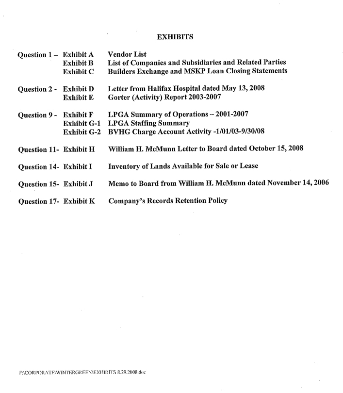
EXHIBITS
Question 1 - Exhibit A Vendor List
Exhibit B List of Companies and Subsidiaries and Related Parties
Exhibit C Builders Exchange and MSKP Loan Closing Statements
Question 2 - Exhibit D Letter from Halifax Hospital dated May 13, 2008
Exhibit E Gorter (Activity) Report 2003-2007
Question 9 - Exhibit F LPGA Summary of Operations – 2001-2007
Exhibit G-l LPGA Staffing Summary
Exhibit G-2 BVHG Charge Account Activity – 1/01/03-9/30/08
Question 11 - Exhibit H William H. McMunn Letter to Board dated October 15, 2008
Question 14 - Exhibit I Inventory of Lands Available for Sale or Lease
Question 15 - Exhibit J Memo to Board from William H. McMunn dated November 14, 2006
Question 17 - Exhibit K Company’s Records Retention Policy
QUESTION 1
Exhibit A
Vendor listings for Consolidated-Tomoka Land Co., Palms Del Mar, Indigo Development Inc., Indigo Group Inc., Indigo Group Ltd., W. Hay LLC, and Indigo International Inc.
Attached is a sample of the vendor listing pages, if you would like to see the full set (approximately 200 pages) please let us know.
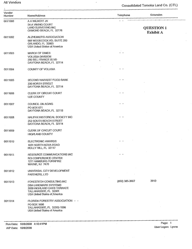
All Vendors
Consolidated Tomoka Land Co. (CTL)
Vendor Number Name/Address Telephone Extension
0011000 A A WILBERT JR 54-A VINING COURT LAND SURVEYING INC ORMOND BEACH, FL 32176 - - QUESTION 1
Exhibit A
0011002 ALZHEIMER’S ASSOCIATION 988 WOODCOCK RD. SUITE 200 ORLANDO, FL 32803 USA United States of America
0011003 MARCH OF DIMES VOLUSIA DIVISION 200 BILL FRANCE BLVD DAYTONA BEACH, FL 32114 - -
0011004 COUNTY OF VOLUSIA - -
0011005 SECOND HARVEST FOOD BANK 330 NORTH STREET DAYTONA BEACH, FL 32114 - -
0011006 CLERK OF CIRCUIT COURT LEE COUNTY - -
0011007 COUNCIL ON AGING PO BOX 671 DAYTONA BEACH, FL 32115 - -
0011008 HALIFAX HISTORICAL SOCIETY INC 252 SOUTH BEACH STREET DAYTONA BEACH, FL 32114 - -
0011009 CLERK OF CIRCUIT COURT HIGHLAND COUNTY
0011010 ELECTRONIC AWARDS 1831 NORTH NOVA ROAD HOLLY HILL, FL 32117 - -
0011011 RESOURCE COMMUNICATIONS INC RCI CONFERENCE CENTER 1211 HAMBURG TURNPIKE WAYNE, NJ 7470 - -
0011012 UNIVERSAL CITY DEVELOPMENT PARTNERS, LTD
0011013 FORESTECH CONSULTING INC DBA LANDMARK SYSTEMS 3059 HIGHLAND OAKS TERRACE TALLAHASSEE, FL 32301 USA United States of America (850) 385-3667 3910
0011014 FLORIDA FORESTRY ASSOCIATION - - PO BOX 1696 TALLAHASSEE, FL 32302-1696 USA United States of America
Run Date: 10/8/2008 4:10:41PM Page: 1
A/P Date: 10/8/2008 User Logon: Lynne
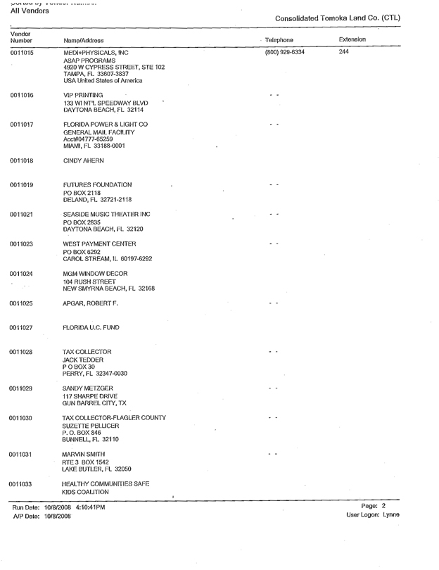
All Vendors
Consolidated Tomoka Land Co. (CTL)
Vendor Number Name/Address Telephone Extension
0011015 MEDI+PHYSICALS, INC ASAP PROGRAMS 4920 W CYPRESS STREET, STE 102 TAMPA, FL 33607-3837 USA United States of America (800) 929-6334 244
0011016 VIP PRINTING 133 Wl NT’L SPEEDWAY BLVD DAYTONA BEACH, FL 32114 - -
0011017 FLORIDA POWER & LIGHT CO GENERAL MAIL FACILITY Acct#04777-65259 MIAMI, FL 33188-0001
0011018 CINDY AHERN
0011019 FUTURES FOUNDATION PO BOX 2118 DELAND, FL 32721-2118 - -
0011021 SEASIDE MUSIC THEATER INC PO BOX 2835 DAYTONA BEACH, FL 32120 - -
0011023 WEST PAYMENT CENTER PO BOX 6292 CAROL STREAM, IL 60197-6292 - -
0011024 MGM WINDOW DECOR 104 RUSH STREET NEW SMYRNA BEACH, FL 32168
0011025 APGAR, ROBERT F. - -
0011027 FLORIDA U.C. FUND
0011028 TAX COLLECTOR JACK TEDDER P O BOX 30 PERRY, FL 32347-0030 - -
0011029 SANDY METZGER 117 SHARPE DRIVE GUN BARREL CITY, TX - -
0011030 TAX COLLECTOR-FLAGLER COUNTY SUZETTE PELLICER P. O. BOX 846 BUNNELL, FL 32110 - -
0011031 MARVIN SMITH RTE 3 BOX 1542 LAKE BUTLER, FL 32050 - -
0011033 HEALTHY COMMUNITIES SAFE KIDS COALITION
Run Date: 10/8/2008 4:10:41PM Page: 2
A/P Date: 10/8/2008 User Logon: Lynne
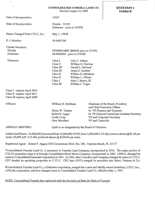
CONSOLIDATED-TOMOKA LAND CO. QUESTION 1
Revised August 19, 2008 Exhibit B
Date of Incorporation: 1910*
State of Incorporation: Florida - 5/1/93
Delaware - prior to 5/l/93#
Name Changed From CTLC, Inc.: May 1, 1993#
E.I. Number: 59-0483700
Charter Numbers:
Florida P93000014887 (800204 prior to 5/1/93)
Delaware 38-0800204 - prior to 5/l/93#
Directors: Class I John C. Adams
Class II William H. Davison
Class III Gerald L. DeGood
Class III James E. Gardner
Class II William H. McMunn
Class II William L. Olivari
Class I John C. Myers, III
Class III William J. Voges
Class I expires April 2010
Class II expires April 2011
Class III expires April 2009
Officers: William H. McMunn Chairman of the Board, President,
and Chief Executive Officer
Bruce W. Teeters Sr. VP-Finance and Treasurer
Robert F. Apgar Sr. VP-General Counsel and Assistant Secretary
Linda Crisp VP and Corporate Secretary
Gary Moothart VP and Controller
ANNUAL MEETING: April or as designated by the Board of Directors
Authorized Shares: 25,000,000 (increased from 10,000,000 5/1/93; from 5,000,000 4-25-86) common shares @ $1.00 par value; 50,000 (eff. 4-25-86) preferred shares @ $100.00 par value.
Registered Agent: Robert F. Apgar, 1530 Cornerstone Blvd., Ste. 100, Daytona Beach, FL 32117
*Consolidated-Tomoka Land Co. is successor to Tomoka Land Company, incorporated in 1910. The major portion of CTLC’s properties came to it through Consolidated Naval Stores Company, incorporated in 1902. CNSCo. changed its name to Consolidated Financial Corporation in 1961. In 1969, when Tomoka Land Company changed its name to C-TLC, CFC deeded its operating properties to C-TLC. CFC later (1971) merged its securities into Baker, Fentress & Co.
#Consolidated-Tomoka Land Co., a Delaware corporation, merged into a new and wholly owned subsidiary, CTLC, Inc., a Florida corporation, and then changed name to Consolidated-Tomoka Land Co. effective May 1, 1993.
NOTE: Consolidated Tomoka has registered with the Secretary of State for State of Georgia
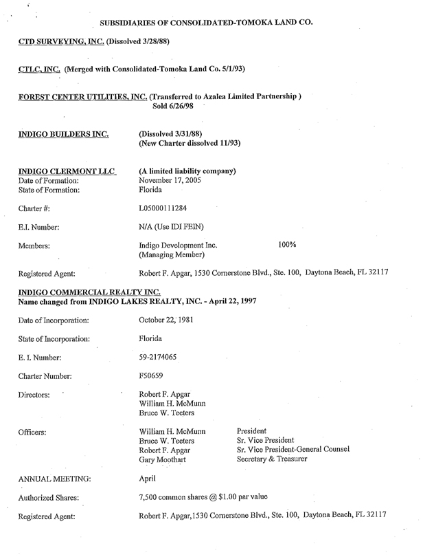
SUBSIDIARIES OF CONSOLIDATED-TOMOKA LAND CO.
CTD SURVEYING, INC. (Dissolved 3/28/88)
CTLC, INC. (Merged with Consolidated-Tomoka Land Co. 5/1/93)
FOREST CENTER UTILITIES, INC. (Transferred to Azalea Limited Partnership )
Sold 6/26/98
INDIGO BUILDERS INC. (Dissolved 3/31/88)
(New Charter dissolved 11/93)
INDIGO CLERMONT LLC (A limited liability company)
Date of Formation: November 17, 2005
State of Formation: Florida
Charter #: L05000111284
E.I. Number: N/A (Use IDI FEIN)
Members: Indigo Development Inc. 100%
(Managing Member)
Registered Agent: Robert F. Apgar, 1530 Cornerstone Blvd., Ste. 100, Daytona Beach, FL 32117
INDIGO COMMERCIAL REALTY INC.
Name changed from INDIGO LAKES REALTY, INC. - April 22,1997
Date of Incorporation: October 22, 1981
State of Incorporation: Florida
E.I. Number: 59-2174065
Charter Number: F50659
Directors: Robert F. Apgar
William H. McMunn
Bruce W. Teeters
Officers: William H. McMunn President
Bruce W. Teeters Sr. Vice President
Robert F. Apgar Sr. Vice President-General Counsel
Gary Moothart Secretary & Treasurer
ANNUAL MEETING: April
Authorized Shares: 7,500 common shares @ $1.00 par value
Registered Agent: Robert F. Apgar, 1530 Cornerstone Blvd., Ste. 100, Daytona Beach, FL 32117
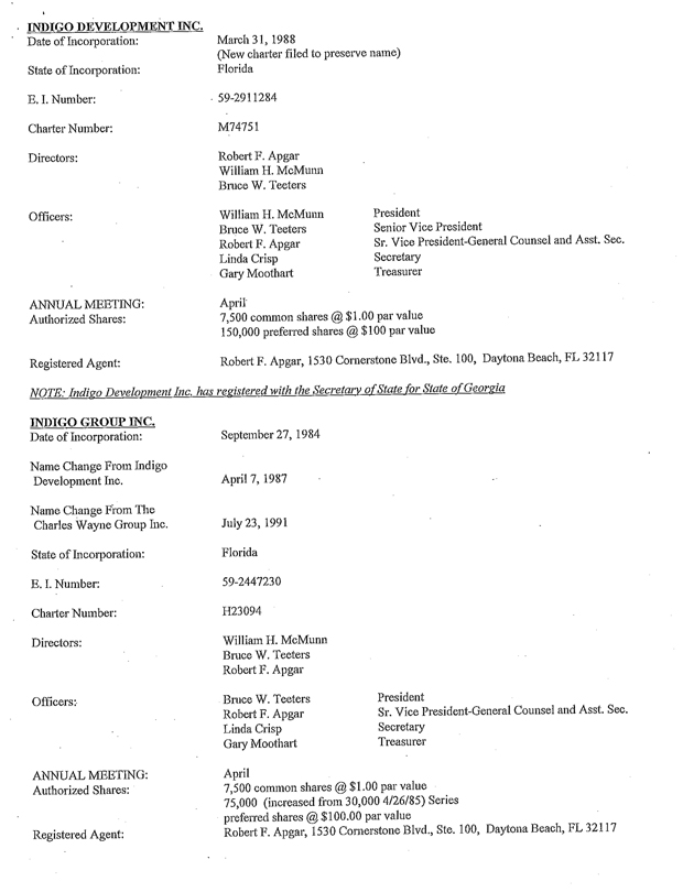
INDIGO DEVELOPMENT INC.
Date of Incorporation: March 31, 1988
(New charter filed to preserve name)
State of Incorporation: Florida
E.I. Number: 59-2911284
Charter Number: M74751
Directors: Robert F. Apgar
William H. McMunn
Bruce W. Teeters
Officers: William H. McMunn President
Bruce W. Teeters Senior Vice President
Robert F. Apgar Sr. Vice President-General Counsel and Asst. Sec.
Linda Crisp Secretary
Gary Moothart Treasurer
ANNUAL MEETING: April
Authorized Shares: 7,500 common shares @ $1.00 par value
150,000 preferred shares @ $100 par value
Registered Agent: Robert F. Apgar, 1530 Cornerstone Blvd., Ste. 100, Daytona Beach, FL 32117
NOTE: Indigo Development Inc. has registered with the Secretary of State for State of Georgia
INDIGO GROUP INC.
Date of Incorporation: September 27, 1984
Name Change From Indigo Development Inc. April 7, 1987
Name Change From The Charles Wayne Group Inc. July 23, 1991
State of Incorporation: Florida
E.I. Number: 59-2447230
Charter Number: H23094
Directors: William H. McMunn
Bruce W. Teeters
Robert F. Apgar
Officers: Bruce W. Teeters President
Robert F. Apgar Sr. Vice President-General Counsel and Asst. Sec.
Linda Crisp Secretary
Gary Moothart Treasurer
ANNUAL MEETING: April
Authorized Shares: 7,500 common shares @ $1.00 par value
75,000 (increased from 30,000 4/26/85) Series
preferred shares @ $100.00 par value
Registered Agent: Robert F. Apgar, 1530 Cornerstone Blvd., Ste. 100, Daytona Beach, FL 32117
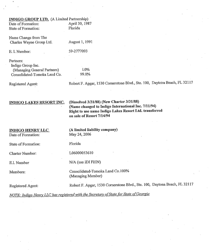
INDIGO GROUP LTD. (A Limited Partnership)
Date of Formation: April 30, 1987
State of Formation: Florida
Name Change from The
Charles Wayne Group Ltd. August 1, 1991
E.I. Number: 59-2777093
Partners:
Indigo Group Inc.
(Managing General Partners) 1.0%
Consolidated-Tomoka Land Co. 99.0%
Registered Agent: Robert F. Apgar, 1530 Cornerstone Blvd., Ste. 100, Daytona Beach, FL 32117
INDIGO LAKES RESORT INC. (Dissolved 3/31/88) (New Charter 3/31/88)
(Name changed to Indigo International Inc. 7/11/94)
Right to use name Indigo Lakes Resort Ltd.
transferred on sale of Resort 7/14/94
INDIGO HENRY LLC (A limited liability company)
Date of Formation: May 24, 2006
State of Formation: Florida
Charter Number: L06000053610
E.I. Number N/A (use IDI FEIN)
Members: Consolidated-Tomoka Land Co. 100%
(Managing Member)
Registered Agent: Robert F. Apgar, 1530 Cornerstone Blvd., Ste. 100, Daytona Beach, FL 32117
NOTE: Indigo Henry LLC has registered with the Secretary of State for State of Georgia
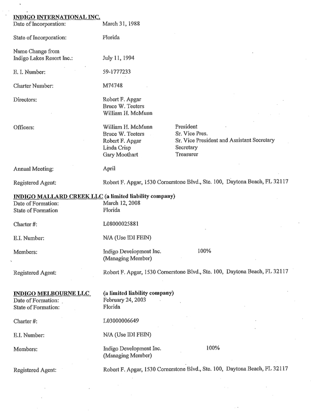
INDIGO INTERNATIONAL INC.
Date of Incorporation: March 31, 1988
State of Incorporation: Florida
Name Change from
Indigo Lakes Resort Inc.: July 11, 1994
E.I. Number: 59-1777233
Charter Number: M74748
Directors: Robert F. Apgar
Bruce W. Teeters
William H. McMunn
Officers: William H. McMunn President
Bruce W. Teeters Sr. Vice Pres.
Robert F. Apgar Sr. Vice President and Assistant Secretary
Linda Crisp Secretary
Gary Moothart Treasurer
Annual Meeting: April
Registered Agent: Robert F. Apgar, 1530 Cornerstone Blvd., Ste. 100, Daytona Beach, FL 32117
INDIGO MALLARD CREEK LLC (a limited liability company)
Date of Formation: March 12, 2008
State of Formation Florida
Charter #: L08000025881
E.I. Number: N/A (Use IDI FEIN)
Members: Indigo Development Inc. 100%
(Managing Member)
Registered Agent: Robert F. Apgar, 1530 Cornerstone Blvd., Ste. 100, Daytona Beach, FL 32117
INDIGO MELBOURNE LLC (a limited liability company)
Date of Formation: February 24, 2003
State of Formation: Florida
Charter #: L03000006649
E.I. Number: N/A (Use IDI FEIN)
Members: Indigo Development Inc. 100%
(Managing Member)
Registered Agent: Robert F. Apgar, 1530 Cornerstone Blvd., Ste. 100, Daytona Beach, FL 32117
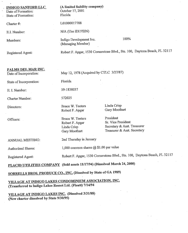
INDIGO SANFORD LLC (A limited liability company)
Date of Formation: October 17, 2001
State of Formation: Florida
Charter#: L01000017788
E.I. Number: N/A (Use IDI FEIN)
Members: Indigo Development Inc. 100%
(Managing Member)
Registered Agent: Robert F. Apgar, 1530 Cornerstone Blvd., Ste. 100, Daytona Beach, FL 32117
PALMS DEL MAR INC.
Date of Incorporation: May 12, 1978 (Acquired by CTLC 3/27/87)
State of Incorporation: Florida
E. I. Number: 59-1838037
Charter Number: 572025
Directors: Bruce W. Teeters Linda Crisp
Robert F. Apgar Gary Moothart
Officers: Bruce W. Teeters President
Robert F. Apgar Sr. Vice President
Linda Crisp Secretary & Asst. Treasurer
Gary Moothart Treasurer & Asst. Secretary
ANNUAL MEETING: 2nd Thursday in January
Authorized Shares: 1,000 common shares @ $1.00 par value
Registered Agent: Robert F. Apgar, 1530 Cornerstone Blvd., Ste. 100, Daytona Beach, FL 32117
PLACID UTILITIES COMPANY (Sold assets 11/17/94) (Dissolved March 24, 2000)
SORRELLS BROS. PRODUCE CO., INC. (Dissolved by State of GA 1989)
VILLAGE AT INDIGO LAKES CONDOMINIUM ASSOCIATION, INC. (Transferred to Indigo Lakes Resort Ltd. (Flautt) 7/14/94
VILLAGE AT INDIGO LAKES INC. (Dissolved 3/31/88)
(New charter dissolved by State 9/30/95)
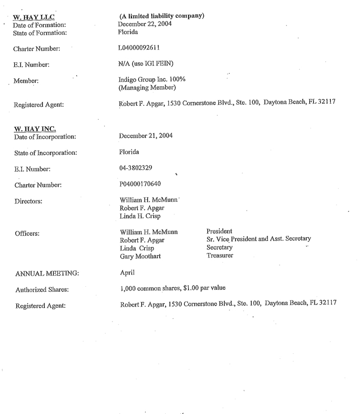
W. HAY LLC (A limited liability company)
Date of Formation: December 22, 2004
State of Formation: Florida
Charter Number: L04000092611
E.I. Number: N/A (use IGI FEIN)
Member: Indigo Group Inc. 100%
(Managing Member)
Registered Agent: Robert F. Apgar, 1530 Cornerstone Blvd., Ste. 100, Daytona Beach, FL 32117
W. HAY INC.
Date of Incorporation: December 21, 2004
State of Incorporation: Florida
B.I. Number: 04-3802329
Charter Number: P04000170640
Directors: William H. McMunn
Robert F. Apgar
Linda H. Crisp
Officers: William H. McMunn President
Robert F. Apgar Sr. Vice President and Asst. Secretary
Linda Crisp Secretary
Gary Moothart Treasurer
ANNUAL MEETING: April
Authorized Shares: 1,000 common shares, $1.00 par value
Registered Agent: Robert F. Apgar, 1530 Cornerstone Blvd., Ste. 100, Daytona Beach, FL 32117
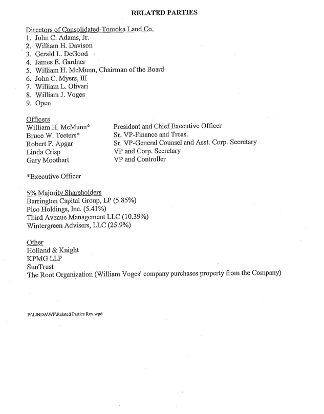
RELATED PARTIES
Directors of Consolidated-Tomoka Land Co.
1. John C. Adams, Jr.
2. William H. Davison
3. Gerald L. DeGood
4. James E. Gardner
5. William H. McMunn, Chairman of the Board
6. John C. Myers, III
7. William L. Olivari
8. William J. Voges
9. Open
Officers
William H. McMunn* President and Chief Executive Officer
Bruce W. Teeters* Sr. VP-Finance and Treas.
Robert F. Apgar Sr. VP-General Counsel and Asst. Corp. Secretary
Linda Crisp VP and Corp. Secretary
Gary Moothart VP and Controller
* Executive Officer
5% Majority Shareholders
Barrington Capital Group, LP (5.85 %)
Pico Holdings, Inc. (5.41%)
Third Avenue Management LLC (10.39%)
Wintergreen Advisers, LLC (25.9%)
Other
Holland & Knight
KPMG LLP
SunTrust
The Root Organization (William Voges’ company purchases property from the Company)
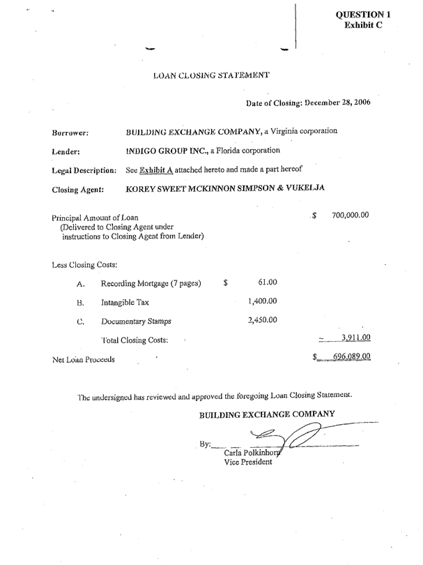
QUESTION 1
Exhibit C
LOAN CLOSING STATEMENT
Date of Closing: December 28, 2006
Borrower: BUILDING EXCHANGE COMPANY, a Virginia corporation
Lender: INDIGO GROUP INC., a Florida corporation
Legal Description: See Exhibit A attached hereto and made a part hereof
Closing Agent: KOREY SWEET MCKINNON SIMPSON & VUKELJA
Principal Amount of Loan $700,000.00
(Delivered to Closing Agent under
instructions to Closing Agent from Lender)
Less Closing Costs:
A. Recording Mortgage (7 pages) $61.00
B. Intangible Tax 1,400.00
C. Documentary Stamps 2,450.00
Total Closing Costs: 3,911.00
Net Loan Proceeds $696,089.00
The undersigned has reviewed and approved the foregoing Loan Closing Statement.
BUILDING EXCHANGE COMPANY
By:
Carla Polkinhorn
Vice President
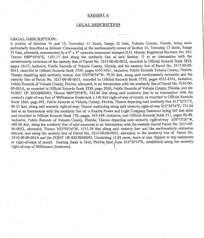
EXHIBIT A
LEGAL DESCRIPTION
LEGAL DESCRIPTION:
A portion of Sections 10 and 15, Township 15 South, Range 32 East, Volusia County, Florida, being more particularly described as follows: Commencing at the northwesterly corner of Section 15, Township 15 South, Range 32 East, aforesaid, monumented by a 4” x 4” concrete monument stamped D.D. Moody, Registered Surveyor No. 261; Thence N89°40’56”E, 1101.17 feet along the northerly line of said Section 15 to an intersection with the northwesterly extension of the easterly line of Parcel No. 5215-00-00-0032, recorded in Official Records Book 5824, pages 20-27, inclusive, Public Records of Volusia County, Florida, and the easterly line of Parcel No. 5215-00-00-0033, recorded in Official Records Book 5729, pages 4553-4561, inclusive, Public Records Volusia County, Florida; Thence departing said northerly section line N32°06’34”W, 79.94 feet, along said northwesterly extension and the easterly line of Parcel No. 5215-00-00-0033, recorded in Official Records Book 5729, pages 4553-4561, inclusive, Public Records of Volusia County, Florida, aforesaid, to an intersection with the southerly line of Parcel No. 5210-00-00-001A; as recorded in Official Records Book 5329, page 2040, Public Records of Volusia County, Florida, and the POINT OF BEGINNING; Thence N89°29’38”E, 745.84 feet along said southerly line to an intersection with the westerly right-of-way line of Williamson Boulevard, a 140 foot right-of-way of record, as recorded in Official Records Book 1866, page 992, Public Records of Volusia County, Florida; Thence departing said southerly line S13°52’51”E, 89.15 feet, along said westerly right-of-way; Thence continuing along said westerly right-of-way S13°30’14”E, 733.04 feet to an intersection with the southerly line of a Florida Power and Light Company Easement being 305 feet wide and recorded in Official Records Book 170, pages, 347-349, inclusive, and Official Records Book 511, pages 86-88, inclusive, Public Records of Volusia County, Florida; Thence departing said westerly right-of-way S36°53’26”W, 400.00 feet, along the southerly line of said easement to an intersection with the easterly line of Parcel No. 5215-00-00-0032, aforesaid; Thence N32°06’34”W, 1313.56 feet along said easterly line and the northwesterly extension thereof, and along the easterly line of Parcel No. 5215-00-00-0033, aforesaid, to the southerly line of Parcel No. 5210-00-00-001A and the POINT OF BEGINNING. Containing 12.49 acres, more or less. Subject to any easements or right-of-ways of record. Bearing Basis is Grid, Florida East Zone S13°30’14”E, established along the westerly right-of-way of Williamson Boulevard.
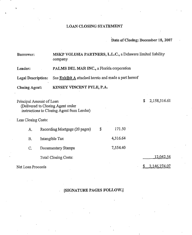
LOAN CLOSING STATEMENT
Date of Closing: December 18, 2007
Borrower: MSKP VOLUSIA PARTNERS, L.L.C., a Delaware limited liability company
Lender: PALMS DEL MAR INC., a Florida corporation
Legal Description: See Exhibit A attached hereto and made a part hereof
Closing Agent: KINSEY VINCENT PYLE, P.A.
Principal Amount of Loan $ 2,158,316.61
(Delivered to Closing Agent under instructions to Closing Agent from Lender)
Less Closing Costs:
A. Recording Mortgage (20 pages) $ 171.50
B. Intangible Tax 4,316.64
C. Documentary Stamps 7,554.40
Total Closing Costs: 12,042.54
Net Loan Proceeds $2,146,274.07
[SIGNATURE PAGES FOLLOW.]
The undersigned has reviewed and approved the foregoing Loan Closing Statement.
PALMS DEL MAR INC.,
a Florida corporation
By:
Bruce W. Teeters, President

The undersigned has reviewed and approved the foregoing Loan Closing Statement.
MSKP VOLUSIA PARTNERS, L.L.C.,
a Delaware limited liability company,
By:
Name:
Title:
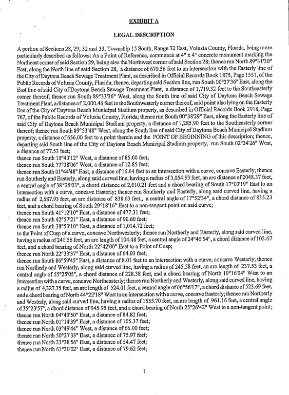
EXHIBIT A
LEGAL DESCRIPTION
A portion of Sections 28, 29, 32 and 33, Township 15 South, Range 32 East, Volusia County, Florida, being more particularly described as follows: As a Point of Reference, commence at 4” x 4” concrete monument marking the Northeast corner of said Section 29, being also the Northwest corner of said Section 28; thence run North 89°31’30” East, along the North line of said Section 28, a distance of 670.56 feet to an intersection with the Easterly line of the City of Daytona Beach Sewage Treatment Plant, as described in Official Records Book 1875, Page 1551, of the Public Records of Volusia County, Florida; thence, departing said Section line, run South 00°37’36” East, along the East line of said City of Daytona Beach Sewage Treatment Plant, a distance of 1,719.32 feet to the Southeasterly corner thereof; thence run South 89°33’36” West, along the South line of said City of Daytona Beach Sewage Treatment Plant, a distance of 2,000.46 feet to the Southwesterly corner thereof, said point also lying on the Easterly line of the City of Daytona Beach Municipal Stadium property, as described in Official Records Book 2918, Page 767, of the Public Records of Volusia County, Florida; thence run South 00°38’29” East, along the Easterly line of said City of Daytona Beach Municipal Stadium property, a distance of 1,285.90 feet to the Southeasterly corner thereof; thence run South 89°53’48” West, along the South line of said City of Daytona Beach Municipal Stadium property, a distance of 656.00 feet to a point therein and the POINT OF BEGINNING of this description; thence, departing said South line of the City of Daytona Beach Municipal Stadium property, run South 02°24’26” West, a distance of 77.53 feet;
thence run South 10°43’12” West, a distance of 85.00 feet;
thence run South 77°38’06” West, a distance of 12.85 feet;
thence run South 01°44’48” East, a distance of 16.64 feet to an intersection with a curve, concave Easterly; thence run Southerly and Easterly, along said curved line, having a radius of 3,054.93 feet, an arc distance of 2048.37 feet, a central angle of 38°25’03”, a chord distance of 2,010.21 feet and a chord bearing of South 17°03’19” East to an intersection with a curve, concave Easterly; thence run Southerly and Easterly, along said curved line, having a radius of 2,687.93 feet, an arc distance of 838.63 feet, a central angle of 17°52’34”, a chord distance of 835.23 feet, and a chord bearing of South 29°18’16” East to a non-tangent point on said curve;
thence run South 41°12’10” East, a distance of 477.31 feet;
thence run South 42°57’21” East, a distance of 90.60 feet;
thence run South 38°53’10” East, a distance of 1,014.72 feet;
to the Point of Cusp of a curve, concave Northwesterly; thence run Northerly and Easterly, along said curved line, having a radius of 241.56 feet, an arc length of 104.48 feet, a central angle of 24°46’54”, a chord distance of 103.67 feet, and a chord bearing of North 22°42’00” East to a Point of Cusp;
thence run North 22°33’37” East, a distance of 64.03 feet;
thence run South 86°59’45” East, a distance of 8.01 feet to an intersection with a curve, concave Westerly; thence run Northerly and Westerly, along said curved line, having a radius of 245.58 feet, an arc length of 237.53 feet, a central angle of 55°25’05”, a chord distance of 228.38 feet, and a chord bearing of North 10°16’04” West to an intersection with a curve, concave Northeasterly; thence run Northerly and Westerly, along said curved line, having a radius of 4,327.35 feet, an arc length of 524.01 feet, a central angle of 06°56’17”, a chord distance of 523.69 feet, and a chord bearing of North 44°22”18” West to an intersection with a curve, concave Easterly; thence run Northerly and Westerly, along said curved line, having a radius of 1555.70 feet, an arc length of 961.16 feet, a central angle of 35°23’57”, a chord distance of 945.95 feet, and a chord bearing of North 25°26’42” West to a non-tangent point;
thence run North 04°43’50” East, a distance of 84.82 feet;
thence run North 01°14’39” East, a distance of 105.37 feet;
thence run North 03°49’44” West, a distance of 66.00 feet;
thence run North 50°27’33” East, a distance of 75.97 feet;
thence run North 23°38’56” East, a distance of 54.47 feet;
thence run North 61°30’02” East, a distance of 79.62 feet;
1
thence run North 29°41’39” East, a distance of 67.52 feet;
thence run South 78°25’28” East, a distance of 111.37 feet;
thence run North 83°42’48” East, a distance of 60.34 feet;
thence run South 74°04’21” East, a distance of 84.15 feet;
thence run North 57°57’33” East, a distance of 38.01 feet;
thence run North 53°20’42” East, a distance of 31.44 feet;
thence run North 52°09’33” East, a distance of 34.82 feet;
thence run North 45°25’02” East, a distance of 127.51 feet;
thence run South 38°53’09” East, a distance of 140.66 feet;
thence run South 11°13’47” East, a distance of 93.12 feet;
thence run South 03°47’21” East, a distance of 51.61 feet;
thence run South 01°21’42” East, a distance of 43.31 feet;
to an intersection with a non-tangent curve, concave Northerly; thence run Southerly and Easterly, along said curved line, having a radius of 295.07 feet, an arc distance of 454.67 feet, a central angle of 88°17’12”, a chord distance of 411.00 feet, and a chord bearing of South 66°38’01” East to a non-tangent point;
thence run North 69°35’56” East, a distance of 53.57 feet;
thence run North 70°37’41” East, a distance of 73.19 feet;
thence run North 71°00’46” East, a distance of 36.40 feet;
to an intersection with a non-tangent curve, concave Southwesterly; thence run Southerly and Easterly, along said curved line, having a radius of 197.27 feet, an arc distance of 304.12 feet, a central angle of 88°19’51”, a chord distance of 274.89 feet, and a chord bearing of South 52°18’42” East to an intersection with a non-tangent curve, concave Westerly; thence run Southerly and Westerly, along said curved line, having a radius of 781.44 feet, an arc distance of 443.50 feet, a central angle of 32°31’04”, a chord distance of 437.57 feet, and a chord bearing of South 04°56’01” West to an intersection with a non-tangent curve, concave Easterly; thence run Southerly and Easterly, along said curved line, having a radius of 834.27 feet, an arc distance of 829.50 feet, a central angle of 56°58’06”, a chord distance of 795.75 feet, and a chord bearing of South 05°06’58” East to a non-tangent point;
thence run South 39°48’10” East, a distance of 143.82 feet;
thence run South 36°45’11” East, a distance of 106.35 feet;
thence run South 04°00’58” East, a distance of 106.35 feet;
thence run South 06°47’54” West, a distance of 60.36 feet;
thence run South 55°19’06” West, a distance of 75.14 feet;
thence run South 41°43’00” West, a distance of 205.26 feet to an intersection with a non-tangent curve, concave Easterly; thence run Southerly and Easterly, along said curved line, having a radius of 49.66 feet, an arc distance of 96.12 feet, a central angle of 110°53’37”, a chord distance of 81.80 feet, and a chord bearing of South 13°10’21” East to an intersection with a non-tangent curve, concave Northerly; thence run Southerly and Easterly, along said curved line, having a radius of 610.58 feet, an arc distance of 312.08 feet, a central angle of 29°17’07”, a chord distance of 308.69 feet, and a chord bearing of South 82°43’05” East to a non-tangent point;
thence run North 83°31’09” East, a distance of 66.55 feet;
thence run South 63°42’53” East, a distance of 56.69 feet to an intersection with a non-tangent curve, concave Northeasterly; thence run Southerly and Easterly, along said curved line, having a radius of 2,104.21 feet, an arc distance of 561.06 feet, a central angle of 15°16’38”, a chord distance of 559.40 feet, and a chord bearing of South 30°52’35” East to an intersection with the Westerly line of a Florida Power and Light Company Sub-Station, as described in Official Records Book 3783, Page 2241, of the Public Records of Volusia County, Florida; thence run South 00°36’07” East, along the Westerly line of said sub-station, a distance of 357.95 feet to the Southwesterly corner thereof; thence run South 84°07’07” East, along the South line of said sub-station, a distance of 417.14 feet to a point therein; thence, departing the boundary of said Florida Power and Light Company sub-station, run South 58°08’10” East, a distance of 30.25 feet;
thence run South 00°36’06” East, a distance of 205.59 feet;
thence run South 88°26’38” West, a distance of 50.56 feet;
2
thence run North 85°58’49” West, a distance of 91.44 feet;
thence run North 20°36’46” West, a distance of 37.92 feet;
thence run North 78°32’28” West, a distance of 48.10 feet;
thence run South 47°49’10” East, a distance of 20.99 feet;
thence run South 32°17’02” East, a distance of 52.65 feet;
thence run South 29°37’26” East, a distance of 82.23 feet;
thence run South 12°50’14” East, a distance of 42.55 feet;
thence run South 27°54’40” East, a distance of 68.29 feet;
thence run South 15°37’06” East, a distance of 36.89 feet;
thence run North 47°18’36” East, a distance of 2.35 feet;
thence run South 57°15’53” East, a distance of 40.37 feet;
thence run South 16°06’35” East, a distance of 79.39 feet;
thence run South 02°32’04” East, a distance of 35.62 feet;
thence run South 08°26’39” East, a distance of 45.45 feet;
thence run South 06°26’24” East, a distance of 46.73 feet;
thence run South 00°36’07” East, a distance of 71.11 feet;
thence run South 74°48’29” West, a distance of 90.62 feet;
thence run North 70°21’39” West, a distance of 17.94 feet;
thence run North 41°55’20” West, a distance of 50.11 feet;
thence run North 22°34’01” West, a distance of 34.44 feet;
thence run North 37°02’16” West, a distance of 54.16 feet;
thence run North 24°40’01” West, a distance of 64.23 feet;
thence run North 18°35’49” East, a distance of 23.82 feet to an intersection with a non-tangent curve, concave Southwesterly; thence run Northerly and Westerly, along said curved line, having a radius of 562.63 feet, an arc distance of 398.09 feet, a central angle of 40°32’23”, a chord distance of 389.83 feet, and a chord bearing of North 63°46’16” West to an intersection with a non-tangent curve, concave Southerly; thence run Southerly and Westerly, along said curved line, having a radius of 2,135.08 feet, an arc distance of 504.05 feet, a central angle of 13°31’35”, a chord distance of 502.88 feet, and a chord bearing of South 86°21’50” West to a non-tangent point;
thence run South 09°16’12” East, a distance of 87.24 feet;
thence run South 68°37’23” East, a distance of 68.27 feet;
thence run South 15°49’30” East, a distance of 57.61 feet;
thence run South 18°46’02” East, a distance of 29.55 feet;
thence run South 54°25’35” East, a distance of 170.82 feet;
thence run North 75°53’13” West, a distance of 267.91 feet;
thence run North 61°39’47” West, a distance of 589.66 feet to an intersection with the Easterly right-of-way line of the 200-foot wide
right-of way of LPGA Boulevard (formerly the Eleventh Street Extension) as shown on the State of Florida Department of Transportation right-of-way map, Section 79507-2602, revision dated October 29, 1974; thence run North 39°02’45” West, along said Easterly right-of-way line, a distance of 2,420.19 feet; thence, departing said Easterly right-of-way line, run North 19°26’15” East, a distance of 41.66 feet;
thence run North 41°54’39” East, a distance of 61.80 feet;
thence run North 02°01’34” West, a distance of 83.30 feet;
thence run North 66°57’31” East, a distance of 39.71 feet;
thence run North 01°25’10” East, a distance of 83.00 feet;
thence run North 30°43’16�� West, a distance of 59.45 feet;
thence run North 28°34’27” East, a distance of 81.56 feet;
thence run South 52°49’14” East, a distance of 64.72 feet;
thence run North 32°25’59” East, a distance of 46.64 feet;
thence run North 31°04’30” West, a distance of 18.65 feet;
thence run North 76°35’45” West, a distance of 42.96 feet;
3
thence run North 53°22’25” West, a distance of 106.76 feet;
thence run North 28°01’29” East, a distance of 43.76 feet;
thence run South 62°37’59” West, a distance of 45.52 feet;
thence run South 66°55’33” West, a distance of 16.58 feet;
thence run South 84°09’34” West, a distance of 74.90 feet;
thence run North 78°42’28” West, a distance of 74.30 feet;
thence run North 50°54’08” West, a distance of 72.60 feet;
thence run North 64°45’45” West, a distance of 54.12 feet;
thence run North 03°49’16” West, a distance of 74.28 feet;
thence run North 21°12’35” East, a distance of 52.81 feet;
thence run North 27°01’45” West, a distance of 72.68 feet;
thence run North 20°37’02” East, a distance of 33.71 feet;
thence run North 34°05’02” West, a distance of 352.58 feet;
thence run North 47°53’07” West, a distance of 353.14 feet;
thence run South 50°20’28” West, a distance of 112.14 feet;
thence run South 43°49’16” West, a distance of 149.77 feet;
thence run North 04°04’19” East, a distance of 172.50 feet;
thence run North 12°44’15” West, a distance of 22.63 feet;
thence run North 57°57’39” West, a distance of 53.30 feet;
thence run North 15°09’32” West, a distance of 47.89 feet;
thence run North 89°19’51” West, a distance of 63.22 feet;
thence run North 87°11’58” West, a distance of 20.34 feet;
thence run South 56°22’10” West, a distance of 71.95 feet to an intersection with the Easterly right-of-way line of the aforementioned LPGA Boulevard, said point lying on a curve, concave Easterly; thence run Northerly and Westerly, along said curved right-of-way line, having a radius of 1,841.86 feet, an arc distance of 393.62 feet, a central angle of 12°14’40”, a chord distance of 392.87 feet, and a chord bearing of North 28°01’16” West to a point therein; thence, departing said Easterly right-of-way line, run North 68°00’46” East, a distance of 55.60 feet;
thence run North 73°35’04” East, a distance of 25.28 feet;
thence run North 03°58’30” East, a distance of 28.58 feet;
thence run North 46°11’04” East, a distance of 70.07 feet;
thence run North 62°22’48” East, a distance of 60.77 feet;
thence run North 39°16’24” East, a distance of 120.48 feet to an intersection with a non-tangent curve, concave Westerly; thence run Northerly and Easterly, along said curved line, having a radius of 89.91 feet, an arc distance of 100.74 feet, a central angle of 64°11’51”, a chord distance of 95.55 feet, and a chord bearing of North 15°59’35” East to a non-tangent point;
thence run North 13°40’42” West, a distance of 102.96 feet;
thence run North 87°16’40” East, a distance of 28.74 feet;
thence run North 09°37’33” West, a distance of 554.84 feet;
thence run North 16°16’15” West, a distance of 554.84 feet;
thence run South 78°50’14” West, a distance of 68.25 feet;
thence run South 49°36’09” West, a distance of 75.20 feet;
thence run South 11°17’01” West, a distance of 40.72 feet;
thence run South 36°23’05” West, a distance of 72.35 feet to an intersection with the Easterly right-of-way line of the aforementioned LPGA Boulevard; thence run North 00°06’49” West, along said Easterly right-of-way line, a distance of 685.33 feet to the Southwesterly corner of the aforementioned City of Daytona Beach Municipal Stadium property; thence, departing said Easterly right-of-way line, run North 89°53’48” East, along the South line of said City of Daytona Beach Municipal Stadium property, a distance of 278.28 feet; thence, departing said South line of the City of Daytona Beach Municipal Stadium property, run South 08°02’46” West, a distance of 51.13 feet; thence run South 63°15’51” East, a distance of 4.89 feet;
4
thence run South 10°18’17” West, a distance of 28.68 feet;
thence run South 58°12’03” East, a distance of 36.56 feet;
thence run North 43°15’20” East, a distance of 19.52 feet;
thence run North 16°45’00” East, a distance of 35.84 feet;
thence run North 56°56’46” East, a distance of 95.13 feet to an intersection with the South line of the aforementioned City of Daytona Beach Municipal Stadium property; thence run North 89°53’48” East, along said South line, a distance of 245.34 feet to the POINT OF BEGINNING of this description, said parcel containing 174.22 acres, more or less, said parcel being subject to any other easements or rights-of-way of record.
TOGETHER WITH
A portion of Sections 28 and 29, Township 15 South, Range 32 East, Volusia County, Florida, being more particularly described as follows: As a Point of Reference, commence at 4” x 4” concrete monument marking the Northeast corner of said Section 29, being also the Northwest corner of said Section 28; thence run North 89°31’30” East, along the North line of said Section 28, a distance of 670.56 feet to an intersection with the Easterly line of the City of Daytona Beach Sewage Treatment Plant, as described in Official Records Book 1875, Page 1551, of the Public Records of Volusia County, Florida; thence, departing said Section line, run South 00°37’36” East, along the East line of said City of Daytona Beach Sewage Treatment Plant, a distance of 11.13 feet to a point therein and the POINT OF BEGINNING of this description, said point lying on a non-tangent curve, concave Northwesterly; thence, departing the boundary of said City of Daytona Beach Sewage Treatment Plant, run Southerly and Easterly, along said curved line, having a radius of 143.26 feet, an arc distance of 115.15 feet, a central angle of 46°03’19”, a chord distance of 112.08 feet and a chord bearing of South 31°37’27” East, to a non-tangent point; thence run South 81°30’49” East, a distance of 149.72 feet to an intersection with a non-tangent curve concave Southwesterly; thence run Southerly and Easterly, along said curved line, having a radius of 367.88 feet, an arc distance of 393.20 feet, a central angle of 61°14’25”, a chord distance of 374.75 feet, and a chord bearing of South 53°23’41” East to a non-tangent point;
thence run South 20°46’17” East, a distance of 738.50 feet;
thence run South 14°56’02” East, a distance of 522.74 feet;
thence run South 02°10’05” East, a distance of 520.86 feet to an intersection with a non-tangent curve concave Northeasterly; thence run Southerly and Easterly, along said curved line, having a radius of 228.28 feet, an arc distance of 316.82 feet, a central angle of 79°31’05”, a chord distance of 291.99 feet, and a chord bearing of South 35°46’10” East to a non-tangent point;
thence run South 87°53’01” East, a distance of 96.77 feet;
thence run South 00°28’47” East, a distance of 1,520.76 feet;
thence run North 06°24’36” West, a distance of 155.30 feet;
thence run North 25°50’36” West, a distance of 63.95 feet;
thence run North 76°17’57” West, a distance of 34.69 feet;
thence run North 44°06’41” West, a distance of 59.12 feet;
thence run North 89°03’07” West, a distance of 60.23 feet to an intersection with a non-tangent curve concave Easterly; thence run Southerly and Easterly, along said curved line, having a radius of 626.35 feet; an arc distance of 323.77 feet, a central angle of 29°37’02”, a chord distance of 320.18 feet, and a chord bearing of South 13°28’19” West to an intersection with a non-tangent curve concave Northwesterly; thence run Southerly and Westerly, along said curved line, having a radius of 125.08 feet, an arc distance of 258.56 feet, a central angle of 118°26’00”, a chord distance of 214.92 feet, and a chord bearing of South 59°08’59” West to an intersection with a non-tangent curve concave Southerly; thence run Northerly and Westerly, along said curved line, having a radius of 911.77 feet, an arc distance of 384.77 feet, a central angle of 24°10’45”, a chord distance of 381.93 feet, and a chord bearing of North 73°38’46” West to a non-tangent point;
thence run South 05°39’03” West, a distance of 21.64 feet;
thence run South 69°13’50” East, a distance of 90.34 feet;
5
thence run South 75°11’39” West, a distance of 54.94 feet to an intersection with a non-tangent curve concave Southwesterly; thence run Southerly and Easterly, along said curved line, having a radius of 512.12 feet, an arc distance of 470.12 feet, a central angle of 52°35’49”, a chord distance of 453.78 feet, and a chord bearing of South 31°06’11” East to anon-tangent point;
thence run South 59°55’54” East, a distance of 38.04 feet;
thence run South 15°48’33” West, a distance of 90.26 feet;
thence run South 03°09’23” East, a distance of 73.13 feet;
thence run South 08°19’47” West, a distance of 87.49 feet;
thence run South 00°10’31” East, a distance of 62.79 feet;
thence run South 76°05’50” East, a distance of 58.43 feet;
thence run South 49°52’49” West, a distance of 104.74 feet;
thence run South 29°11’34” West, a distance of 152.19 feet to an intersection with a non-tangent curve concave Northerly; thence run Southerly and Westerly, along said curved line, having a radius of 202.68 feet, an arc distance of 222.33 feet, a central angle of 62°51’04”, a chord distance of 211.35 feet, and a chord bearing of South 70°40’41” West to the Point of Tangency thereof;
thence run North 77°25’36” West, a distance of 865.19 feet;
thence run South 72°43’42” West, a distance of 17.16 feet;
thence run South 88°10’48” West, a distance of 70.54 feet;
thence run North 67°24’15” West, a distance of 15.48 feet;
thence run South 87°22’06” West, a distance of 16.05 feet;
thence run North 47°23’46” West, a distance of 19.99 feet;
thence run North 67°24’15” West, a distance of 56.11 feet;
thence run South 34°26’25” West, a distance of 21.83 feet;
thence run South 86°37’20” West, a distance of 26.22 feet;
thence run South 65°04’16” West, a distance of 7.19 feet;
thence run South 65°29’03” West, a distance of 32.06 feet;
thence run South 46°57’59” West, a distance of 74.64 feet;
thence run North 35°40’37” West, a distance of 33.38 feet;
thence run South 45°09’08” West, a distance of 66.03 feet;
thence run North 82°36’17” West, a distance of 68.46 feet;
thence run South 76°79’56” West, a distance of 54.18 feet;
thence run North 34°18’19” West, a distance of 30.21 feet;
thence run North 51°52’22” West, a distance of 13.04 feet;
thence run South 58°12’49” West, a distance of 28.36 feet;
thence run South 74°45’24” West, a distance of 54.11 feet;
thence run North 85°01’25” West, a distance of 70.68 feet;
thence run South 69°10’44” West, a distance of 49.13 feet;
thence run South 19°54’26” East, a distance of 46.39 feet;
thence run South 83°07’38” West, a distance of 75.99 feet;
thence run South 72°18’22” West, a distance of 33.52 feet;
thence run South 66°57’53” West, a distance of 43.90 feet;
thence run South 48°36’02” West, a distance of 29.19 feet;
thence run South 44°44’52” West, a distance of 62.33 feet;
thence run North 68°10’58” West, a distance of 45.66 feet;
thence run South 49°11’16” West, a distance of 21.08 feet;
thence run North 74°56’41” West, a distance of 79.19 feet;
thence run North 84°36’24” West, a distance of 63.92 feet;
thence run North 02°01’38” West, a distance of 82.21 feet;
thence run North 14°52’44” East, a distance of 22.30 feet;
6
thence run North 84°16’33” West, a distance of 9.58 feet;
thence run North 24°13’14” West, a distance of 48.15 feet;
thence run North 49°28’25” West, a distance of 84.31 feet;
thence run South 62°50’42” West, a distance of 112.86 feet;
thence run North 28°26’08” East, a distance of 91.54 feet;
thence run North 48°18’51” West, a distance of 36.12 feet;
thence run South 74°55’15” West, a distance of 36.50 feet;
thence run North 33°37’04” West, a distance of 59.46 feet;
thence run North 43°50’28” West, a distance of 64.12 feet;
thence run North 24°22’16” West, a distance of 10.54 feet;
thence run North 56°19’06” West, a distance of 38.91 feet;
thence run North 71°21’56” West, a distance of 22.44 feet;
thence run North 57°26’48” West, a distance of 83.58 feet;
thence run North 27°34’32” East, a distance of 10.76 feet;
thence run North 6°10’52” West, a distance of 62.58 feet;
thence run North 07°45’08” West, a distance of 82.98 feet;
thence run North 37°13’04” East, a distance of 112.75 feet;
thence run South 75°06’20” East, a distance of 61.03 feet;
thence run South 57°45’21” East, a distance of 44.04 feet;
thence run North 86°12’37” East, a distance of 20.08 feet;
thence run North 01°03’19” West, a distance of 64.88 feet;
thence run North 55°57’06” East, a distance of 29.86 feet;
thence run North 53°20’19” West, a distance of 19.80 feet;
thence run North 57°55’32” East, a distance of 97.71 feet;
thence run North 34°17’37” East, a distance of 88.40 feet;
thence run South 84°58’33” East, a distance of 38.16 feet;
thence run North 78°49’51” East, a distance of 61.33 feet;
thence run North 18°47’40” West, a distance of 61.76 feet;
thence run South 70°57’06” East, a distance of 31.55 feet;
thence run North 56°57’08” West, a distance of 58.40 feet;
thence run North 06°49’11” West, a distance of 5.41 feet;
thence run North 00°55’40” West, a distance of 20.28 feet;
thence run South 66°06’56” West, a distance of 18.17 feet;
thence run North 31°52’15” East, a distance of 20.94 feet;
thence run North 00°28’28” West, a distance of 19.91 feet;
thence run North 16°16’43” East, a distance of 73.20 feet;
thence run North 35°29’11” East, a distance of 33.43 feet;
thence run North 05°51’22” West, a distance of 19.76 feet;
thence run North 70°32’01” West, a distance of 54.36 feet;
thence run North 26°52’05” West, a distance of 86.37 feet;
thence run North 25°45’57” West, a distance of 60.12 feet;
thence run North 01°35’17” West, a distance of 43.16 feet;
thence run North 26°27’46” West, a distance of 40.80 feet;
thence run North 46°27’02” West, a distance of 64.61 feet;
thence run North 10°06’17” East, a distance of 49.90 feet;
thence run North 85°21’28” West, a distance of 37.79 feet;
thence run North 40°42’29” West, a distance of 18.98 feet;
thence run North 84°26’17” East, a distance of 1.43 feet;
7
thence run North 42°54’01” West, a distance of 30.67 feet;
thence run North 50°17’07” West, a distance of 16.86 feet;
thence run South 73°43’44” West, a distance of 31.77 feet;
thence run South 32°43’41” West, a distance of 58.92 feet;
thence run North 09°30’58” East, a distance of 59.15 feet;
thence run North 42°21’33” West, a distance of 67.84 feet;
thence run North 17°11’44” West, a distance of 69.60 feet;
thence run North 57°09’30” East, a distance of 50.41 feet;
thence run North 33°08’10” West, a distance of 27.88 feet;
thence run North 67°01’54” West, a distance of 42.55 feet;
thence run North 22°27’34” East, a distance of 60.33 feet;
thence run North 54°24’05” West, a distance of 26.94 feet;
thence run North 00°08’06” East, a distance of 46.64 feet;
thence run South 27°40’26” West, a distance of 37.07 feet;
thence run South 89°38’47” West, a distance of 64.17 feet;
thence run North 22°40’41” West, a distance of 79.22 feet;
thence run North 05°24’44” East, a distance of 42.58 feet;
thence run North 28°04’51” West, a distance of 65.56 feet to an intersection with the Southerly line of the City of Daytona Beach Municipal Stadium property, as described in Official Records Book 2918, Page 767, of the Public Records of Volusia County, Florida; thence run North 89°53’48” East, along said Southerly line, a distance of 204.15 feet to the Southeasterly corner thereof; thence run North 00°37’40” West, along the Easterly line of said property, a distance of 6.69 feet; thence, departing the Easterly line of said City of Daytona Beach Municipal Stadium property, run South 89°55’29” East, a distance of 50.79 feet;
thence run North 60°43’57” East, a distance of 13.55 feet;
thence run South 65°37’06” East, a distance of 18.45 feet;
thence run South 88°26’22” East, a distance of 56.13 feet;
thence run South 83°51’33” East, a distance of 17.91 feet to an intersection with a non-tangent curve concave Southwesterly; thence run Southerly and Easterly, along said curved line, having a radius of 696.26 feet, an arc distance of 485.12 feet, a central angle of 39°55’14”, a chord distance of 475.37 feet, and a chord bearing of South 48°30’37” East to a non-tangent point;
thence run South 64°58’05” East, a distance of 123.10 feet;
thence run South 21°01’10” East, a distance of 122.30 feet;
thence run South 48°24’00” East, a distance of 125.05 feet;
thence run South 58°12’03” East, a distance of 48.60 feet to an intersection with a non-tangent curve concave Southwesterly; thence run Southerly and Easterly, along said curved line, having a radius of 659.17 feet, an arc distance of 286.45 feet, a central angle of 24°53’54”, a chord distance of 284.20 feet, and a chord bearing of South 29°56’09” East to a non-tangent point;
thence run South 04°45’55” East, a distance of 50.21 feet;
thence run South 28°58’17” West, a distance of 59.60 feet to an intersection with a non-tangent curve concave Easterly; thence run Southerly and Easterly, along said curved line, having a radius of 25.00 feet; an arc distance of 49.86 feet, a central angle of 114°16’43”, a chord distance of 42.00 feet, and a chord bearing of South 11°17’59” East to a Point of Compound Curvature of a curve to the left, having a radius of 2,326.70 feet and a central angle of 23°16’46”; thence Southerly and Easterly along the arc of said curve, an arc distance of 945.35 feet, having a chord distance of 938.86 feet and a chord bearing of South 80°04’43” East, to a non-tangent point;
thence run North 69°16’33” East, a distance of 64.52 feet;
thence run North 50°41’13” East, a distance of 375.37 feet;
thence run North 07°22’40” East, a distance of 43.62 feet;
thence run North 64°06’19” West, a distance of 109.39 feet;
thence run North 52°22’04” East, a distance of 106.67 feet;
8
thence run North 14°13’40” West, a distance of 37.98 feet;
thence run North 33°38’42” West, a distance of 91.32 feet;
thence run North 23°37’09” West, a distance of 62.51 feet;
thence run North 42°28’37” West, a distance of 70.84 feet;
thence run North 30°02’57” West, a distance of 85.55 feet;
thence run North 24°46’11” West, a distance of 62.66 feet;
thence run North 49°50’45” West, a distance of 61.26 feet;
thence run North 24°05’10” West, a distance of 54.09 feet;
thence run North 18°08’51” West, a distance of 38.39 feet;
thence run North 11°22’39” West, a distance of 81.88 feet;
thence run North 21°27’23” West, a distance of 63.40 feet;
thence run North 31°30’14” West, a distance of 87.12 feet;
thence run North 09°24’38” East, a distance of 55.39 feet;
thence run North 22°28’41” West, a distance of 55.96 feet;
thence run North 21°13’48” West, a distance of 77.16 feet;
thence run North 18°18’34” West, a distance of 36.60 feet;
thence run North 24°22’20” East, a distance of 44.39 feet;
thence run North 39°07’39” West, a distance of 120.32 feet;
thence run North 04°21’01” East, a distance of 93.35 feet;
thence run North 20°54’13” West, a distance of 61.03 feet;
thence run North 36°03’04” West, a distance of 95.57 feet;
thence run North 10°17’44” East, a distance of 54.59 feet;
thence run North 15°05’02” West, a distance of 90.46 feet;
thence run North 25°11’07” East, a distance of 67.64 feet;
thence run North 42°01’45” East, a distance of 99.30 feet;
thence run South 77°18’15” East, a distance of 82.36 feet;
thence run South 26°19’13” East, a distance of 108,61 feet;
thence run South 15°16’30” East, a distance of 76.49 feet;
thence run South 25°26’40” East, a distance of 100.99 feet;
thence run South 34°52’47” East, a distance of 163.30 feet;
thence run South 02°09’18” West, a distance of 87.16 feet;
thence run South 20°14’07” East, a distance of 133.50 feet;
thence run South 00°36’54” East, a distance of 55.43 feet;
thence run North 76°39’15” East, a distance of 235.88 feet to an intersection with a non-tangent curve concave Northwesterly; thence run Northerly and Easterly, along said curved line, having a radius of 1,717.33 feet, an arc distance of 408.67 feet, a central angle of 13°38’04”, a chord distance of 407.71 feet, and a chord bearing of North 50°08’29” East to an intersection with a non-tangent curve concave Westerly; thence run Northerly and Easterly, along said curved line, having a radius of 481.45 feet, an arc distance of 365.21 feet, a central angle of 43°27’45”, a chord distance of 356.52 feet, and a chord bearing of North 12°27’56” East to a non-tangent point;
thence run North 20°01’12” West, a distance of 169.13 feet;
thence run North 37°53’36” West, a distance of 58.73 feet;
thence run North 26°34’25” West, a distance of 74.47 feet;
thence run North 58°12’03” West, a distance of 24.50 feet;
thence run South 42°24’57” West, a distance of 67.26 feet;
thence run South 87°01’18” West, a distance of 127.79 feet;
thence run North 23°08’02” West, a distance of 72.34 feet;
thence run North 66’00’53” West, a distance of 102.20 feet;
thence run North 07°34’28” West, a distance of 128.60 feet;
thence run North 16°02’55” West, a distance of 46.40 feet;
9
thence run North 44°06’52” West, a distance of 84.08 feet;
thence run North 30°40’48” West, a distance of 314.11 feet to an intersection with the Easterly line of the aforementioned City of Daytona Beach Sewage Treatment Plant property; thence run North 00°37’36” West, along said Easterly property line, a distance of 1,368.60 feet to the POINT OF BEGINNING of this description, said parcel containing 129.05 acres, said parcel also being subject to any other easements or rights of way of record.
TOGETHER WITH
A portion of Section 29, Township 15 South, Range 32 East, Volusia County, Florida, being more particularly described as follows: As a Point of Reference, commence at 4” × 4” concrete monument marking the Northeast corner of said Section 29, being also the Northwest corner of Section 28, Township 15 South, Range 32 East, Volusia County, Florida; thence run North 89°31’30” East, along the North line of said Section 28, a distance of 670.56 feet to an intersection with the Easterly line of the City of Daytona Beach Sewage Treatment Plant, as described in Official Records Book 1875, Page 1551, of the Public Records of Volusia County, Florida; thence, departing said Section line, run South 00°37’36” East, along the East line of said City of Daytona Beach Sewage Treatment Plant, a distance of 1,719.32 feet to the Southeasterly corner thereof; thence run South 89°33’36” West, along the South line of said City of Daytona Beach Sewage Treatment Plant, a distance of 2,000.46 feet to the Southwesterly corner thereof, said point also lying on the Easterly line of the City of Daytona Beach Municipal Stadium property, as described in Official Records Book 2918, Page 767, of the Public Records of Volusia County, Florida; thence run South 00°38’29” East, along the Easterly line of said City of Daytona Beach Municipal Stadium property, a distance of 355.41 feet to a point therein and the POINT OF BEGINNING of this description; thence, departing said Easterly line of the City of Daytona Beach Municipal Stadium property, run South 55°28’47” East, a distance of 174.70 feet;
thence run South 62°09’45” East, a distance of 63.24 feet;
thence run South 89°26’33” East, a distance of 69.26 feet;
thence run South 59°58’58” East, a distance of 85.16 feet;
thence run South 70°16’44” East, a distance of 35.75 feet;
thence run South 80°34’26” East, a distance of 547.25 feet to an intersection with a non-tangent curve concave Westerly; thence run Southerly and Easterly, along said curved line, having a radius of 49.30 feet, an arc distance of 134.15 feet, a central angle of 155°54’52”, a chord distance of 96.43 feet, and a chord bearing of South 02°30’07” East to an intersection with a non-tangent curve concave Northerly; thence run Southerly and Westerly, along said curved line, having a radius of 2,535.02 feet, an arc distance of 231.45 feet, a central angle of 05°13’52”, a chord distance of 231.37 feet, and a chord bearing of South 78°37’25” West to an intersection with a non-tangent curve concave Northerly; thence run Southerly and Westerly, along said curved line, having a radius of 6,960.41 feet, an arc distance of 648.72 feet, a central angle of 05°20’24”, a chord distance of 648.48 feet, and a chord bearing of South 86°13’33” West to a non-tangent point;
thence run South 73°17’38” West, a distance of 43.35 feet to an intersection with the Easterly line of the aforementioned City of Daytona Beach Sewage Treatment Plant; thence run North 00°38’29” West, along said Easterly line, a distance of 470.65 feet to the POINT OF BEGINNING of this description, said parcel containing 5.38 acres, said parcel also being subject to any other easements or rights-of-way of record.
TOGETHER WITH
A portion of Section 29, Township 15 South, Range 32 East, Volusia County, Florida, being more particularly described as follows: As a Point of Reference, commence at 4” × 4” concrete monument marking the Northeast corner of said Section 29, being also the Northwest corner of Section 28, Township 15 South, Range 32 East, Volusia County, Florida; thence run North 89°31’30” East, along the North line of said Section 28, a distance of 670.56 feet to an intersection with the Easterly line of the City of Daytona Beach Sewage Treatment Plant, as described in Official Records Book 1875, Page 1551, of the Public Records of Volusia County, Florida; thence,
10
departing said Section line, run South 00°37’36” East, along the East line of said City of Daytona Beach Sewage Treatment Plant, a distance of 1,719.32 feet to the Southeasterly corner thereof; thence run South 89°33’36” West, along the South line of said City of Daytona Beach Sewage Treatment Plant, a distance of 2,000.46 feet to the Southwesterly corner thereof, said point also lying on the Easterly line of the City of Daytona Beach Municipal Stadium property, as described in Official Records Book 2918, Page 767, of the Public Records of Volusia County, Florida; thence run South 00°38’29” East, along the Easterly line of said City of Daytona Beach Municipal Stadium property, a distance of 874.52 feet to a point therein and the POINT OF BEGINNING of this description; thence, departing said Easterly line of the City of Daytona Beach Municipal Stadium property, run South 42°52’22” East, a distance of 65.02 feet; thence run South 58°12’03” East, a distance of 17.04 feet;
thence run North 58°31’38” East, a distance of 66.46 feet;
thence run North 79°16’15” East, a distance of 76.49 feet;
thence run South 44°08’34” East, a distance of 158.05 feet;
thence run South 04°39’05” West, a distance of 91.94 feet;
thence run South 84°32’18” West, a distance of 57.01 feet;
thence run South 71°44’03” West, a distance of 47.44 feet;
thence run North 76°13’20” West, a distance of 67.22 feet;
thence run North 72°23’11” West, a distance of 74.37 feet;
thence run North 79°10’20” West, a distance of 6.08 feet;
thence run South 05°15’18” West, a distance of 88.42 feet;
thence run South 26°09’03” West, a distance of 84.43 feet to an intersection with the Easterly line of the aforementioned City of Daytona Beach Municipal Stadium property; thence run North 00°38’29” West, along said Easterly property line, a distance of 357.23 feet to the POINT OF BEGINNING of this description, said parcel containing 1.29 acres, more or less, said parcel also being subject to any other easements or rights-of-way of record.
TOGETHER WITH
A portion of the Southwest one-quarter of Section 33, Township 15 South, Range 32 East, Volusia County, Florida, being more particularly described as follows: As a Point of Reference, commence at a concrete monument marking the West 1/4 corner of said Section 33; thence run South 0l°01’10” East, along the West line of said Section 33, a distance of 364.98 feet to an intersection with the Easterly right-of-way line of the 200-foot wide right-of-way of LPGA boulevard (formerly the Eleventh Street Extension), as shown on the State of Florida Department of Transportation right-of-way map, Section 79507-2602, sheet 3, revision dated October 25, 1974; thence run South 39°02’50” East (South 39°08’15” East per said FDOT map); a distance of 384.15 feet to a point therein, said point being the POINT OF BEGINNING of this description, said point also being the Northwesterly corner of that parcel of land deeded from the County of Volusia to Indigo Group Inc., as described in Official Records Book 4190, Page 4903, of the Public Records of Volusia County, Florida; thence run along the boundary of said parcel the following courses and distances:
thence run South 61°39’47” East (South 61°45’12” East per FDOT map) a distance of 589.66 feet;
thence run South 75°51’50” East (South 75°57’15” East per FDOT map) a distance of 747.19 feet;
thence run North 74°43’54” East (North 74°38’29” East per FDOT map) a distance of 390.65 feet to a point in the Northerly right of way line of State Road 600, as shown on the aforementioned right-of-way map; thence run South 50°57’10” West (South 50°51’45” West per FDOT map), along said Northerly right of way line, a distance of 388.00 feet to the Point of Curvature of a curve to the right; thence run Northerly and Westerly, along said curved right-of-way line, having a radius of 644.00 feet, an arc distance of 1011.59 feet, a central angle of 90°00’00”, having a chord distance of 910.75 feet, and a chord bearing of North 84°02’50” West, to the Point of Tangency thereof; thence run North 39°02’50” West (North 39°08’15” West per FDOT map), along said right of way line, a distance of 656.00 feet to the POINT OF BEGINNING of this description, said parcel containing 8.65 acres, said parcel also being subject to any other easements or rights of way of record.
11
LESS
A portion of the Southwest one-quarter of Section 33, Township 15 South, Range 32 East, Volusia County, Florida, being more particularly described as follows: As a Point of Reference, commence at a concrete monument marking the West 1/4 corner of said Section 33; thence run South 0l°01’10” East, along the West line of said Section 33, a distance of 364.98 feet to an intersection with the Easterly right-of-way line of the 200-foot wide right-of-way of LPGA boulevard (formerly the Eleventh Street Extension), as shown on the State of Florida Department of Transportation right-of-way map, Section 79507-2602, sheet 3, revision dated October 25, 1974; thence run South 39°02’50” East (South 39°08’15” East per said FDOT map), a distance of 384.15 feet to a point therein, said point also being the Northwesterly corner of that parcel of land deeded from the County of Volusia to Indigo Group Inc., as described in Official Records Book 4190, Page 4903, of the Public Records of Volusia County, Florida; thence run along the boundary of said parcel the following courses and distances:
thence run South 61°39’47” East (South 61°45’12” East per FDOT map) a distance of 589.66 feet; thence run South 75°51’50” East (South 75°57’15” East per FDOT map) a distance of 747.19 feet to the POINT OF BEGINNING of this description; thence run North 74°43’54” East (North 74°38’29” East per FDOT map) a distance of 390.65 feet to a point in the Northerly right of way line of State Road 600, as shown on the aforementioned right-of-way map; thence run South 50°57’10” West (South 50°51’45” West per FDOT map), along said Northerly right of way line, a distance of 388.00 feet to the Point of Curvature of a curve to the right; thence run Southerly and Westerly, along said curved right-of-way line, having a radius of 644.00 feet, an arc distance of 85.00 feet, a central angle of 07°33’46”, having a chord distance of 84.94 feet, and a chord bearing of South 54°44’03” West, to a point therein; thence, departing said right-of-way line, run North 01°51’46” West a distance of 190.81 feet to the POINT OF BEGINNING of this description, said parcel containing 0.86 acres, said parcel also being subject to any other easements or rights of way of record.
12
02/14/2007 12:17 PM
Instrument# 2007-036129 # 1
Book.: 6007 Page: 3933
This instrument prepared by:
Robert F. Apgar, Esquire
Post Office Box 10809
Daytona Beach, Florida 32120-0809
CORRECTIVE PARTIAL RELEASE OF MORTGAGE
[This Collective Partial Release of Mortgage is given to correct that certain Partial Release of Mortgage dated January 25,2007, and recorded January 29, 2007, in Official Records Book 5997, Page 3225, of the Public Records of Volusia County, Florida, in order to Include the 1999 Modification of Promissory Note, Modification of Mortgage and Security Agreement and Other Documents dated March 31, 1999.]
KNOW ALL MEN BY THESE PRESENTS, that the property described below (“Released Property”) is hereby released and discharged from that certain 1999 Modification of Promissory Note, Modification of Mortgage and Security Agreement and Other Documents dated March 31, 1999, and recorded in Official Records Book 4421, Page 639, of the Public Records of Volusia County, Florida, made and executed by CONSOLIDATED-TOMOKA LAND CO., in favor of THE PRUDENTIAL INSURANCE COMPANY OF AMERICA, as the same has been modified from time to time, the last Note and Mortgage Modification and Additional Advance Agreement being dated July 1, 2002 and recorded in OR Book 4915, Page 3753 of the Public Records of Volusia County, Florida and as assigned to SUNTRUST BANK by Assignment of Mortgage dated July 1, 2002, and recorded August 22, 2002, in Official Records Book 4915, Page 3744, Public Records of Volusia County, Florida.
The Released Property is described as set forth on Exhibit A attached hereto and made apart hereof.
This Partial Release of Mortgage shall also serve to release those certain financing statements recorded in Official Records Book 4915, Page 3761, and in Official Records Book 4421, Page 675, as continued in Official Records Book 5224, Page 3544, Public Records of Volusia County, Florida as to the Released Property.
The undersigned owner and holder of said mortgage and financing statements does hereby release Released Property from said mortgage and consent that the same be discharged of record as to the Released Property.
WITNESS MY HAND and seal this 6 day of February, 2007.
Signed, sealed and delivered
in the presence of:
SUNTRUST BANK
Printed Name:
By: William H. Davison
Printed Name:
President and CEO
STATE OF FLORIDA
COUNTY OF VOLUSIA
I HEREBY CERTIFY that on this day before me, an officer duly authorized to take acknowledgments, personally appeared William H. Davison, President and CEO of SunTrustBank, who is known to me as the person described above and who executed the foregoing Partial Release of Mortgage and he acknowledged before me that he executed the same. He is personally known to me.
IN WITNESS WHEREOF I have set my hand and official seal in the place aforesaid this 6 day of February, 2007.
Notary Public State of Florida Robyn H Bell My Commission DD532289 Expires 05/01/2010
Notary Public, State of Florida at Large Notary Name (Printed): Robyn Bell My Commission Expires: 05/01/2010
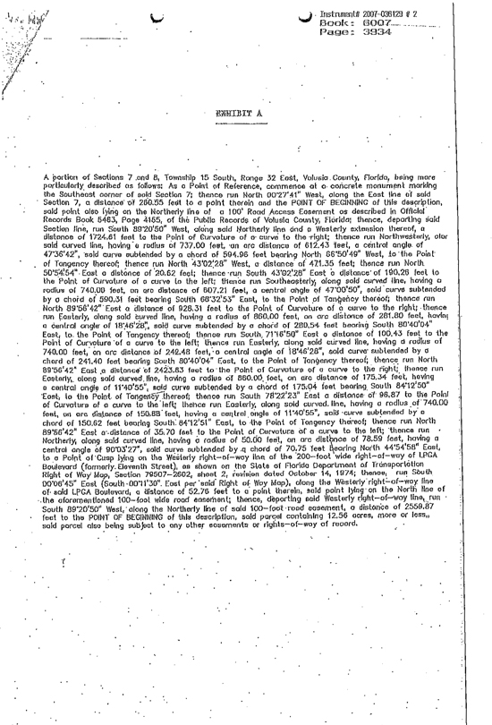
Instrument# 2007-036129 # 2
Book: 6007
Page: 3934
EXHIBIT A
A portion of Sections 7 and 8, Township 15 South, Range 32 East, Volusia County, Florida, being more particularly described as follows: As a Point of Reference, commence at a concrete monument marking the Southeast corner of said Section 7; thence run North 00°27’41” West, along the East line of said Section 7, a distance of 260.55 feet to a point therein and the POINT OF BEGINNING of this description, said point also lying on the Northerly line of a 100’ Road Access Easement as described in Official Records Book 5463, Page 4155, of the Public Records of Volusia County, Florida; thence, departing said Section line, run South 89°20’50” West, along said Northerly line and a Westerly extension thereof, a distance of 1724.61 feet to the Point of Curvature of a curve to the right; thence run Northwesterly, along said curved line, having a radius of 737.00 feet, an arc distance of 612.43 feet, a central angle of 47°36’42”, said curve subtended by a chord of 594.96 feet bearing North 66°50’49” West, to the Point of Tangency thereof; thence run North 43°02’28” West, a distance of 471,35 feet; thence run North 50°54’54” East a distance of 20.62 feet; thence run South 43°02’28” East a distance of 190.26 feet, to the Point of Curvature of a curve to the left; thence run Southeasterly, along said curved line, having a radius of 740.00 feet, an arc distance of 607.21 feet, a central angle of 47°00’50”, said curve subtended by a chord of 590.31 feet bearing South 68°32’53” East, to the Point of Tangency thereof; thence run North 89°56’42” East a distance of 928.31 feet to the Point of Curvature of a curve to the right; thence run Easterly, along said curved line, having a radius of 860.00 feet, an arc distance of 281.80 feet, having a central angle of 18°46’28”, said curve subtended by a chord of 280.54 feet bearing South 80°40’04” East, to the Point of Tangency thereof; thence run South, 71°16’50” East a distance of 100.43 feet to the Point of Curvature of a curve to the left; thence run Easterly, along said curved line, having a radius of 740.00 feet, an arc distance of 242.48 feet, a central angle of 18°46°28”, said curve subtended by a chord of 241.40 feet bearing South 80°40’04” East, to the Point of Tangency thereof; thence run North 89°56’42” East a distance of 2423.83 feet to the Point of Curvature of a curve to the right; thence run Easterly, along said curved line, having a radius of 860.00 feet, an arc distance of 175.34 feet, having a central angle of 11°40’55”, said curve subtended by a chord of 175.04 feet bearing South 84°12’50” East, to the Point of Tangency thereof; thence run South 78°22’23” East a distance of 96.87 to the Point of Curvature of a curve to the left; thence run Easterly, along said curved line, having a radius of 740.00 feet, on arc distance of 150.88 feet, having a central angle of 11°40’55”, said curve subtended by a chord of 150.62 feet bearing South 84°12’51” East, to the Point of Tangency thereof; thence run North 89°56’42” East a distance of 35.70 feet to the Point of Curvature of a curve to the left; thence run Northerly, along said curved line, having a radius of 50.00 feet, an arc distance of 78.59 feet, having a central angle of 90°03’27”, said curve subtended by a chord of 70.75 feet bearing North 44°54’58” East, to a Point of Cusp lying on the Westerly right-of-way line of the 200-foot wide right-of-way of LPGA Boulevard (formerly Eleventh Street), as shown on the State of Florida Department of Transportation Right of Way Map, Section 79507-2602, sheet 2, revision dated October 14, 1974; thence, run South 00°06’45” East (South 00°11’30” East per said Right of Way Map), along the Westerly right-of-way line of said LPGA Boulevard, a distance of 52.76 feet to a point therein, said point lying on the North line of the aforementioned 100–foot wide road easement; thence, departing said Westerly right-of-way line, run South 89°20’50” West, along the Northerly line of said 100-foot road easement, a distance of 2559.87 feet to the POINT OF BEGINNING of this description, said parcel containing 12.56 acres, more or less, said parcel also being subject to any other easements or rights-of-way of record.
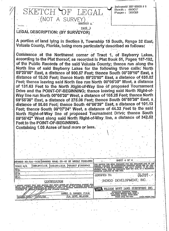
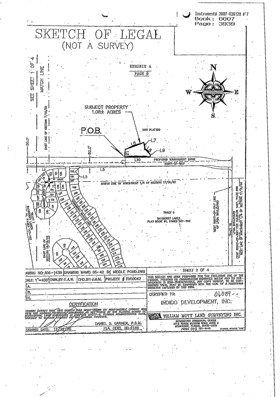
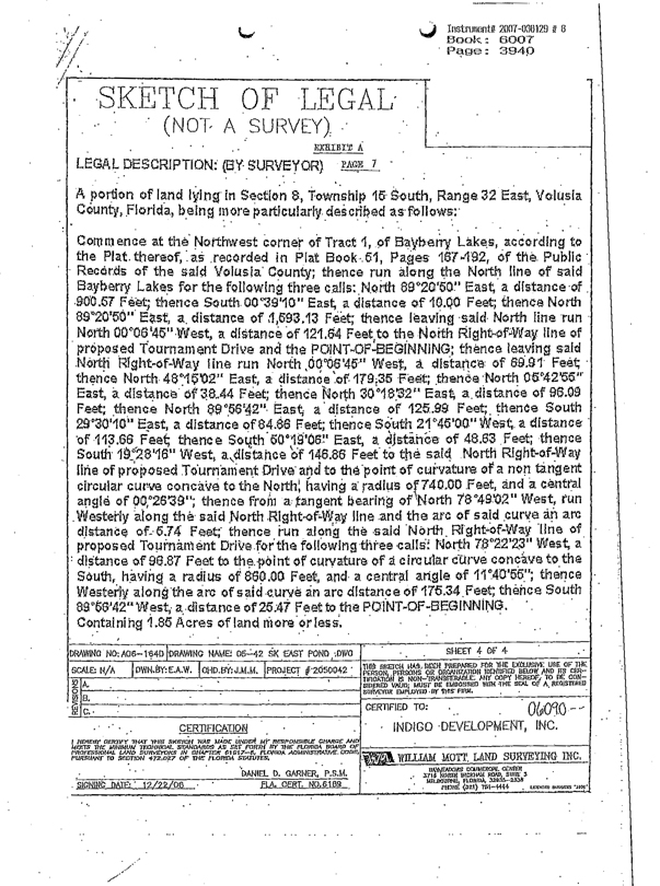
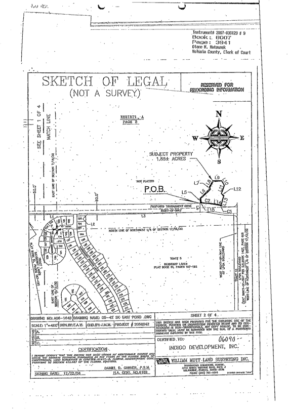

QUESTION 2
Exhibit D
HALIFAX
HEALTH
May 13, 2008
JEFF FEASEL, A.C.H.E.
PRESIDENT AND CEO
Mr. William H. McMunn, President
Indigo Development, Inc.
P.O. Box 10809
Daytona Beach, FL 32120-0809
Re: Demand to Construct the First Building
Dear Bill:
In response to your letter of April 22, 2008, regarding the formal demand letter requiring Halifax Health the begin construction of the first building. I am in receipt of your letter and will be arranging a meeting with you in the next week to review our plans to comply with the covenants of the original Land Purchase Agreement.
Cordially,
Jeff Feasel
President and C.E.O.
PO Box 9718
Daytona Beach, FL 32120
T:386.322.4771
F:386.322.4772
halifaxhealth.org
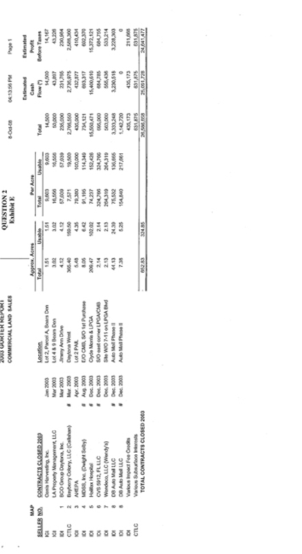
2003 GORTER REPORT QUESTION 2
COMMERCIAL LAND SALES Exhibit E 8-Oct-08 04:13:56 Page 1
Estimated Estimated
MAP Approx. Acres Per Acre Cash Profit
SELLER NO. CONTRACTS CLOSED 2003 Location Total Usable Total Usable Total Flow (*) Before Taxes
IGI Oasis Harvesting, Inc. Jan. 2003 Lot 2, Parcel A, Bears Den 1.51 1.51 9,603 9,603 14,500 14,500 14,167
IGI LA Property Management, LLC Mar. 2003 Lot 4 & 9 Bears Den 3.02 3.02 16,556 16,556 50,000 43,897 43,226
IDI 1 BCO Group Daytona, Inc. Mar. 2003 Jimmy Ann Drive 4.12 4.12 57,039 57,039 235,000 231,765 230,984
CTLC 2 Bayberry Colony, LLC (Callahan) # Mar. 2003 Daytona West 365.40 169.50 7,571 19,500 2,766,550 2,736,975 2,588,360
IGI 3 AHEPA Apr. 2003 Lot 2 PAIL 5.48 4.35 79,380 100,000 435,000 432,877 410,434
IDI 4 MDSS, Inc. (Dwight Selby) # Aug. 2003 E/O CMB, S/O 1st Purchase 8.05 6.42 91,195 114,349 734,121 693,317 692,370
IDI 5 Halifax Hospital # Dec. 2003 Clyde Morris & LPGA 209.47 102.02 74,237 152,426 15,550,471 15,400,610 15,372,121
IDI 6 CVS 5912, FL LLC # Dec. 2003 S/O east corner LPGA/CMB 2.14 2.14 324,766 324,766 695,000 684,785 684,755
IDI 7 Wendeco, LLC (Wendy’s) Dec. 2003 Site W/O 7-11 on LPGA Blvd 2.13 2.13 264,319 264,319 563,000 555,436 533,214
IDI 8 DB Auto Mall LLC # Dec. 2003 Auto Mall Phase II 44.13 24.39 75,532 136,665 3,333,248 3,230,518 3,228,303
IDI 8 DB Auto Mall LLC # Dec. 2003 Auto Mall Phase II 7.38 5.25 154,840 217,661 1,142,720 0 0
IDI Various Impact Fee Credits 435,173 435,173 211,668
CTLC Various Subsurface Interests 631,875 631,875 631,875
TOTAL CONTRACTS CLOSED 2003 652.83 324.85 26,586,658 25,091,728 24,641,477
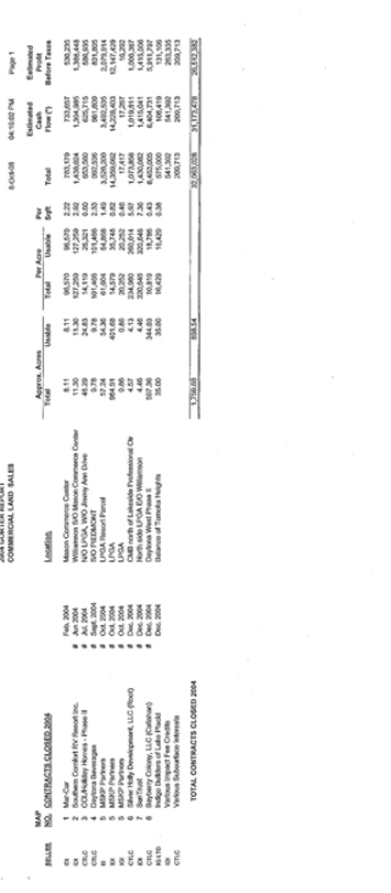
2004 GORTER REPORT
COMMERCIAL LAND SALES 8-Oct-08 04:16:02 PM Page 1
Estimated Cash Flow(*) Estimated Profit Before Taxes
Approx. Acres Per Acre Per Sqft
SELLER MAP NO. CONTRACTS CLOSED 2004 Location Total Usable Total Usable Total
IDI 1 Mar-Car Feb. 2004 Mason Commerce Center 8.11 8.11 96,570 96,570 2.22 783,179 733,657 530,235
IDI 2 Southern Comfort RV Resort Inc. # Jun 2004 Williamson S/O Mason Commerce Center 11.30 11.30 127,259 127,259 2.92 1,438,024 1,394,985 1,388,448
CTLC 3 CCL/Holiday Homes - Phase II # Jul. 2004 N/O LPGA, W/O Jimmy Ann Drive 46.29 24.83 14,119 26,321 0.60 653,560 625,715 586,935
CTLC 4 Daytona Beverages # Sept. 2004 S/O PIEDMONT 9.78 9.78 101,466 101.466 2.33 992,536 981,809 831,805
III 5 MSKP Partners # Oct. 2004 LPGA Resort Parcel 57.24 54.36 61,604 64,868 1.49 3,526,200 3,492,535 2,079,914
IDI 5 MSKP Partners # Oct. 2004 LPGA 984.91 401.68 14,579 35,748 0.82 14,359,062 14,228,403 12,147,429
IGI 5 MSKP Partners # Oct. 2004 LPGA 0.86 0.86 20,252 20,252 0.46 17,417 17,267 16,292
CTLC 6 Silver Holly Development, LLC (Root) # Dec. 2004 CMB north of Lakeside Professional Ctr 4.57 4.13 234,980 260,014 5.97 1,073,858 1,019,811 1,000,367
IDI 7 SunTrust # Dec. 2004 North side LPGA E/O Williamson 4.46 4.46 320,646 320,646 7.36 1,430,082 1,415,041 1,415,006
CTLC 8 Bayberry Colony, LLC (Callahan) # Dec. 2004 Daytona West Phase II 597.36 344.03 10,819 18,786 0.43 6,463,005 6,404,731 5,911,797
IG LTD Indigo Builders of Lake Placid Dec. 2004 Balance of Tomoka Heights 35.00 35.00 16,429 16,429 0.38 575,000 108,419 131,106
IDI Various Impact Fee Credits 541,392 541,392 263,335
CTLC Various Subsurface Interests 209,713 209,713 209,713
TOTAL CONTRACTS CLOSED 2004 1,759.88 893.54 32,063,028 31,173,478 26,512,382
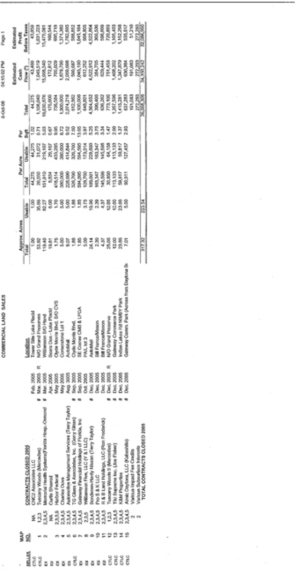
COMMERCIAL LAND SALES 8-Oct-08 04:15:02 PM Page 1
Estimated Cash Flow(*) Estimated Profit Before Taxes
Approx. Acres Per Acre Per Sqft
SELLER MAP NO. CONTRACTS CLOSED 2005 Location Total Usable Total Usable Total
CTLC NA CNC2 Associates LLC Feb. 2005 Tower Site Lake Placid 1.00 1.00 44,275 44,275 1.02 44,275 43,460 43,859
CTLC 1 1,2,3 Tuscany Woods (Mercedes) # Mar. 2005 R N/O Grand Preserves 53.92 35.66 20,550 31,072 0.71 1,108,040 1,049,519 1,031,223
IDI 2 2,3,4,5 Memorial Health Systems (Florida Hosp.-Ormond # Mar. 2005 Williamson S/O Hand 119.40 82.27 151,010 219,167 5.03 18,030,876 15,998,540 15,475,081
IGI NA Curtis Sherrod Apr. 2005 Bears Den - Lake Placid 19.81 6.00 8,834 29,167 0.67 175,000 172,812 160,544
IDI 3 2,3,5,9 Harbor Federal May 2005 Clyde Morris Blvd. S/O CVS 1.76 1.70 418,514 433,285 9.95 736,584 700,029 695,718
IDI 4 2,3,4,5 Charles Duva May 2005 Cornerstone Lot 1 5.00 5.00 380,000 380,000 8.72 1,900,000 1,879,700 1,371,380
IDI 5 2,3,4,5 Automotive Management Services (Terry Taylor) Aug. 2005 AutoMall 9.07 5.00 228,690 414.844 9.52 2.074,218 2,059,698 1,782,695
CTLC 6 2,3,4,5 TG Glass & Associates, Inc. (Gerry Glass) # Sep. 2005 Clyde Morris Blvd. 1.88 1.88 326,700 326,700 7.50 612,562 590,687 588,852
IDI 7 2,3,4,5 Gateway Financial Holdings of Florida, Inc # Sep. 2005 SE Corner CMB & LPGA 1.85 1.85 594,595 594,595 13.65 1,100,000 1,045,190 1,045,164
IGI 8 2,3,5 Williamson Five, LLC (Y & I LLC) Oct. 2005 PAIL lot 3 5.00 3.75 129,760 173,014 3.97 648,801 612,252 568,805
IDI 9 2,3,4,5 Bondesen-Hardy Nissan (Terry Taylor) # Dec. 2005 AutoMall 24.14 19.96 189,091 228,690 5.25 4,564,652 4,522,912 4,522,864
IGI 10 2,3,4,5 Pro S & K LLC Dec. 2005 Bill France/Mason 2.39 2.39 163,347 163,347 3.75 390,400 384,705 366,536
IGI 11 2,3,4,5 R & B Land Holdings, LLC (Ron Frederick) Dec. 2005 Bill France/Mason 4.37 4.37 145,598 145,598 3.34 636,262 629,444 596.609
CTLC 12 1,2,3 Tuscany Woods II (Mercedes) # Dec. 2005 R N/O Grand Preserve 25.06 12.05 30,850 64,158 1.47 773,100 751,453 720.869
CTLC 13 2,3,4.5 Tiki Supreme Inc. (Joe Fisher) # Dec. 2005 Gateway Commerce Park 12.00 12.00 113.133 113,133 2.60 1,357,596 1,468,202 1,105,403
CTLC 14 2,3,4,5 K&M Properties # Dec. 2005 Indian Lakes Rd NIMBY Park 23.66 23.66 59,817 59,817 1.37 1,415,281 1,347,879 1,152,268
CTLC 15 2,3,4,5 Almic Daytona, LLC (Kabashita) # Dec. 2005 Gateway Comm. Park (Across from Daytona B 7.01 5.00 90,911 127,457 2,93 637,283 630,384 535,617
2 Various Impact Fee Credits 191,083 191,083 51,210
2 Various Subsurface Interests 272,293 272,293 272,293
TOTAL CONTRACTS CLOSED 2005 317.32 223.54 36,668,306 34,350,242 32,086,990
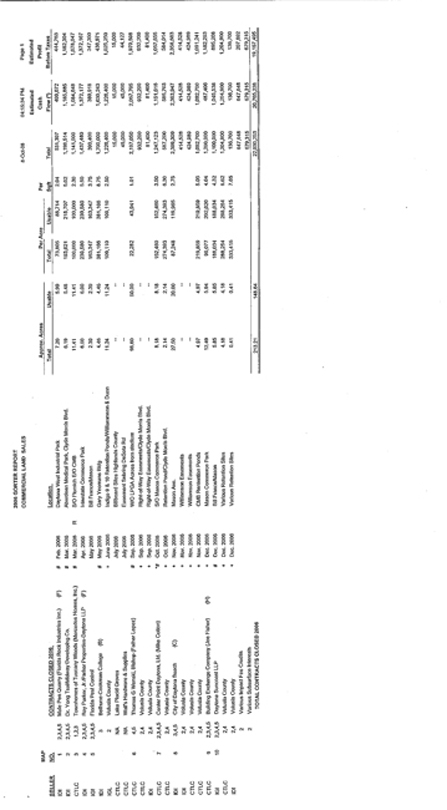
2006 GORTER REPORT
COMMERCIAL LAND SALES 8-Oct-08 04:15:34 PM Page 1
Estimated Estimated
MAP Approx. Acres Per Acre Per Cash Profit
SELLER NO. CONTRACTS CLOSED 2006 Location Total Usable Total Usable Sqft Total Flow (*) Before Taxes
IDI 1 2,3,4,5 Mule Pen Quarry (Florida Rock Industries Inc.) (F) # Feb. 2006 Daytona West Industrial Park 7.20 5.99 73,805 88,714 2.04 531,397 499,672 444,763
IDI 2 2,3,4,5 Dr. Yong Tsal/Midway Developing Co. # Mar. 2006 Aberdeen Medical Park, Clyde Morris Blvd. 6.19 5.48 193,621 218,707 5.02 1,198,514 1,185,885 1,182,304
CTLC 3 1,2,3 Townhomes of Tuscany Woods (Mercedes Homes, Inc.) # Mar. 2006 R S/O Flomich E/O CMB 11.41 11.41 100,000 100,000 2.30 1,141,000 1,084,648 1,078,047
IDI 4 2,3,4,5 Roy Parker, Jr./Parker Properties-Daytona LLP(F) Apr. 2006 Interstate Commerce Park 6.00 6.00 239,580 239,580 5.60 1,437,480 1,372,177 1,372,167
IGI 5 2,3,4,5 Florida Pest Control May 2006 Bill France/Mason 2.39 2.39 163,347 163,347 3.75 390,400 389,918 347,350
IDI 3 Bethune-Cookman College (B) # May 2006 Gary Yeomans Bldg 4.46 4.46 381,166 381,166 8.75 1,700,000 1,630,243 436,971
IGL 2 Volusia County + June 2006 Indigo 9 & 10 Retention Ponds/Williammson & Dunn 11.24 11.24 109,110 109,110 2.50 1,226,400 1,226,400 1,025,250
CTLC NA Lake Placid Groves July 2006 Billboard Sites Highlands County — — 15,000 15,000 15,000
CTLC NA Wall’s Hardware & Supplies July 2006 Easement Sebring DeSota Rd — — 45,000 45,000 44,127
CTLC 6 4,5 Thomas G Wenski, Bishop (Father Lopez) # Sep. 2006 W/O LPGA Across from stadium 98.60 50.00 22,282 43,941 1.01 2,197,050 2,067,705 1,970,598
CTLC 2,4 Volusia County + Sep. 2006 Right-of-Way Easements/Clyde Morris Blvd. — — 932,200 932,200 932,200
IDI 2,4 Volusia County + Sep. 2006 Right-of-Way Easements/Clyde Morris Blvd. — — 81,400 81,400 81,400
CTLC 7 2,3,4,5 Center Point Daytona, Ltd. (Mike Cotton) # Oct. 2006 S/O Mason Commerce Park 8.18 8.18 152,460 152,460 3.50 1,247,123 1,151,616 1,057,666
CTLC 2,4 Volusia County + Oct. 2006 Retention Pond/Clyde Morris Blvd. 2.14 2.14 274,393 274,393 6.30 587,200 585,703 584,014
IDI 8 3,4,5 City of Daytona Beach (C) + Nov. 2006 Mason Ave. 27.50 20.00 87,248 119,965 2.75 2,399,309 2,363,947 2,358,683
IDI 2,4 Volusia County + Nov. 2006 Williamson Easements — — 414,528 414,528 414,528
CTLC 2,4 Volusia County + Nov. 2006 Williamson Easements — — 424,989 424,989 424,989
CTLC 2,4 Volusia County + Nov. 2006 CMB Retention Ponds 4.97 4.97 219,859 219,859 5.05 1,092,700 1,092,700 1,091,241
CTLC 9 2,3,4,5 Building Exchange Company (Joe Fisher)(H) + Dec. 2006 Mason Commerce Park 12.49 5.94 96,077 202,020 4.64 1,200,000 487,406 1,182,293
IGI 10 2,3,4,5 Daytona Suncoast LLP # Dec. 2006 Bill France/Mason 5.85 5.85 188,034 188,034 4.32 1,100,000 1,045,538 895,208
CTLC 2,4 Volusia County + Dec. 2006 Various Retention Sites 4.18 4.18 288,254 288,254 6.62 1,204,900 1,204,900 1,204,900
IDI 2,4 Volusia County + Dec. 2006 Various Retention Sites 0.41 0.41 333,415 333,415 7.65 136,700 136,700 136,700
2 Various Impact Fee Credits 647,648 647,648 207,892
2 Various Subsurface Interests 679,315 679,315 679,315
TOTAL CONTRACTS CLOSED 2006 213.21 148.64 22,030,253 20,765,238 19,167,495
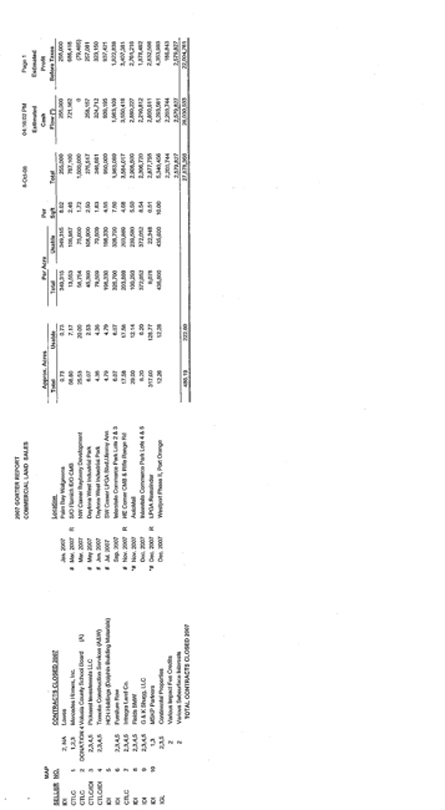
2007 GORTER REPORT
COMMERCIAL LAND SALES 8-Oct-08 04:16:02 PM Page 1
Estimated Estimated
MAP. Approx. Acres Per Acre Per Cash Profit
SELLER NO. CONTRACTS CLOSED 2007 Location Total Usable Total Usable Sqft Total Flow (*) Before Taxes
IDI 2, NA Lowes Jan. 2007 Palm Bay Walgreens 0.73 0.73 349,315 349,315 8.02 255,000 255,000 255,000
CTLC 1 1,2,3 Mercedes Homes, Inc. # Mar. 2007 R S/O Flomich E/O CMB 56.60 7.17 13,553 106,987 2.46 767,100 721,162 688,418
CTLC 2 DONATION 4 Volusia County School Board (A) Mar. 2007 NW Corner Bayberry Development 25.53 20.00 58,754 75,000 1.72 1,500,000 0 (79,465)
CTLC/IDI 3 2,3,4,5 Pickerrel Investments LLC # May 2007 Daytona West Industrial Park 6.07 2.53 45,390 108,900 2.50 275,517 258,157 257,081
CTLC/IDI 4 2,3,4,5 Tomoka Construction Services (A&W) # Jun. 2007 Daytona West Industrial Park 4.36 4.36 79,509 79,509 1.83 346,661 324,712 323,150
IDI 5 HCH Holdings (Dolphin Building Materials) # Jul. 2007 SW Corner LPGA Blvd./Jimmy Ann 4.79 4.79 198,330 198,330 4.55 950,000 939,195 937,421
IDI 6 2,3,4,5 Furniture Row Sep. 2007 Interstate Commerce Park Lots 2 & 3 6.07 6.07 326,700 326,700 7.50 1,983,069 1,963,109 1,622,838
CTLC 7 2,3,4,5 Intregra Land Co. # Nov. 2007 R NE Corner CMB & Rifle Range Rd 17.58 17.58 203,869 203,869 4.68 3,584,017 3,550,416 3,407,381
IDI 8 2,3,4,5 Fields BMW *# Nov. 2007 AutoMall 29.00 12.14 100,293 239,580 5.50 2,908,500 2,880,227 2,761,216
IDI 9 2,3,4,5 G & K Shugg, LLC Dec. 2007 Interstate Commerce Park Lot 4 & 5 6.20 6.20 372,052 372,052 8.54 2,306,720 2,210,812 1,878,492
IDI 10 1,3 MSKP Partners *# Dec. 2007 R LPGA Remainder 317.00 128.77 9,078 22,348 0.51 2,877,755 2,850,611 2,832,566
IGL 2,3,5 Continental Properties Dec. 2007 Westport Phase II, Port Orange 12.26 12.26 435,600 435,600 10.00 5,340,456 5,293,561 4,353,993
2 Various Impact Fee Credits 2,203,744 2,203,744 186,843
2 Various Subsurface Interests 2,579,827 2,579,827 2,579,827
TOTAL CONTRACTS CLOSED 2007 486.19 222.60 27,878,366 26,030,533 22,004,761
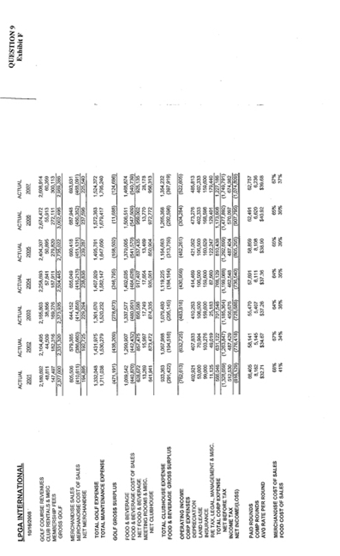
QUESTION 9
Exhibit F
LPGA INTERNATIONAL ACTUAL ACTUAL ACTUAL ACTUAL ACTUAL ACTUAL ACTUAL
10/16/2008 2001 2002 2003 2004 2005 2006 2007
GOLF COURSE REVENUES 2,180,692 2,104,495 2,165,803 2,258,693 2,404,307 2,674,472 2,608,914
CLUB RENTALS & MISC 48,811 44,509 38,856 57,841 50,895 55,913 60,359
MEMBERSHIP FEES 147,497 182,316 169,276 187,911 279,820 272,111 300,113
GROSS GOLF 2,377,000 2,331,320 2,373,935 2,504,445 2,735,022 3,002,496 2,969,386
MERCHANDISE SALES 605,506 579,385 644,152 655,049 690,418 687,948 693,631
MERCHANDISE COST OF SALES (410,611) (386,660) (414,858) (416,213) (451,131) (450,352) (468,091)
NET MERCHANDISE 194,895 192,725 229,294 238,836 239,287 237,596 225,540
TOTAL GOLF EXPENSE 1,332,048 1,431,975 1,361,670 1,407,929 1,495,761 1,572,363 1,524,372
TOTAL MAINTENANCE EXPENSE 1,711,038 1,530,279 1,520,232 1,582,147 1,647,050 1,679,417 1,795,240
GOLF GROSS SURPLUS (471,191) (438,209) (278,673) (246,795) (168,502) (11,688) (124,686)
FOOD & BEVERAGE 1,069,542 1,299,907 1,337,577 1,402,035 1,379,005 1,506,511 1,468,874
FOOD & BEVERAGE COST OF SALES (440,870) (442,432) (480,991) (484,628) (541,570) (547,509) (540,739)
NET FOOD & BEVERAGE 628,672 857,475 856,586 917,407 837,435 959,002 928,135
MEETING ROOMS & MISC. 13,269 15,997 17,749 17,654 13,469 13,770 28,178
NET CLUBHOUSE 641,941 873,472 874,335 935,061 850,904 972,772 956,313
TOTAL CLUBHOUSE EXPENSE 933,363 1,067,988 1,079,480 1,119,225 1,164,663 1,265,368 1,354,232
FOOD & BEVERAGE GROSS SURPLUS (291,422) (194,516) (205,145) (184,164) (313,759) (292,596) (397,919)
OPERATING INCOME (762,613) (632,725) (483,818) (430,959) (482,261) (304,284) (522,605) CORP EXPENSES
DEPRECIATION 402,921 407,833 410,263 414,469 421,062 473,276 485,813
LAND LEASE 53,000 70,994 106,500 106,500 106,500 402,333 402,333
INSURANCE 99,000 103,276 159,600 159,600 160,629 168,598 159,600
R/E TAX, LEGAL, MANAGEMENT & MISC. 11,125 49,019 25,183 87,560 122,247 129,401 179,440
TOTAL CORP EXPENSE 566,046 631,122 701,546 768,129 810,438 1,173,608 1,227,186
NET BEFORE TAX (1,328,659) (1,263,847) (1,185,364) (1,199,088) (1,292,699) (1,477,892) (1,749,791)
INCOME TAX 512,530 487,429 456,676 462,548 487,404 570,097 674,982
NET INCOME/(LOSS) (816,129) (776,418) (728,688) (736,540) (805,295) (907,795) (1,074,809)
PAID ROUNDS 66,405 58,141 55,470 57,691 58,859 62,491 62,757
COMP ROUNDS 8,162 5,145 5,407 6,111 8,108 6,620 6,236
AVG RATE PER ROUND $32.71 $34.67 $37.26 $37.36 $38.90 $40.92 $39.68
MERCHANDISE COST OF SALES 68% 67% 64% 64% 65% 65% 67%
FOOD COST OF SALES 41% 34% 36% 35% 39% 36% 37%
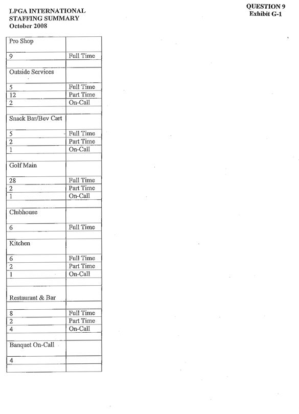
PLPGA INTERNATIONAL QUESTION 9
STAFFING SUMMARY Exhibit G-l
October 2008
Pro Shop
9 Full Time
Outside Services
5 Full Time
12 Part Time
2 On-Call
Snack Bar/Bev Cart
5 Full Time
2 Part Time
1 On-Call
Golf Main
28 Full Time
2 Part Time
1 On-Call
Clubhouse
6 Full Time
Kitchen
6 Full Time
2 Part Time
1 On-Call
Restaurant & Bar
8 Full Time
2 Part Time
4 On-Call
Banquet On-Call
4
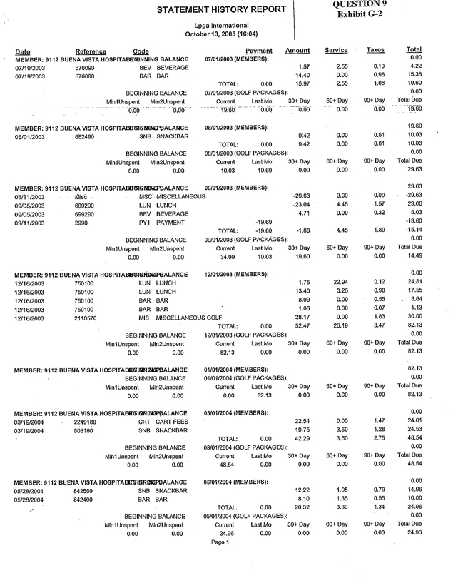
STATEMENT HISTORY REPORT Question 9
Exhibit G-2
Lpga International
October 13, 2008 (16:04)
Date Reference Code Payment Amount Service Taxes Total
MEMBER: 9112 BUENA VISTA HOSPITAL BEGINNING BALANCE 07/01/2003 (MEMBERS): 0.00
07/19/2003 676090 BEV BEVERAGE 1.57 2.55 0.10 4.22
07/19/2003 676090 BAR BAR 14.40 0.00 0.98 15.38
TOTAL: 0.00 15.97 2.55 1.08 19.60
BEGINNING BALANCE 07/01/2003 (GOLF PACKAGES): 0.00
Min1Unspent Min2Unspent Current Last Mo 30+Day 60+Day 90+Day Total Due
0.00 0.00 19.60 0.00 0.00 0.00 0.00 19.60
MEMBER: 9112 BUENA VISTA HOSPITAL BEGINNING BALANCE 08/01/2003 (MEMBERS): 19.60
08/01/2003 682490 SNB SNACKBAR 9.42 0.00 0.61 10.03
TOTAL: 0.00 9.42 0.00 0.61 10.03
BEGINNING BALANCE 08/01/2003 (GOLF PACKAGES): 0.00
Min1Unspent Min2Unspent Current Last Mo 30+Day 60+Day 90+Day Total Due
0.00 0.00 10.03 19.60 0.00 0.00 0.00 29.63
MEMBER: 9112 BUENA VISTA HOSPITAL BEGINNING BALANCE 09/01/2003 (MEMBERS): 29.63
08/31/2003 Misc. MSC MISCELLANEOUS -29.63 0.00 0.00 -29.63
09/05/2003 699280 LUN LUNCH -23.04 4.45 1.57 29.06
09/05/2003 699290 BEV BEVERAGE 4.71 0.00 0.32 5.03
09/11/2003 2990 PY1 PAYMENT -19.60 -19.60
TOTAL: -19.60 -1.88 4.45 1.89 -15.14
BEGINNING BALANCE 09/01/2003 (GOLF PACKAGES): 0.00
Min1Unspent Min2Unspent Current Last Mo 30+Day 60+Day 90+Day Total Due
0.00 0.00 34.09 10.03 19.60 0.00 0.00 14.49
MEMBER: 9112 BUENA VISTA HOSPITAL BEGINNING BALANCE 12/01/2003 (MEMBERS): 0.00
12/16/2003 750100 LUN LUNCH 1.75 22.94 0.12 24.81
12/16/2003 750100 LUN LUNCH 13.40 3.25 0.90 17.55
12/16/2003 750100 BAR BAR 8.09 0.00 0.55 8.64
12/16/2003 750100 BAR BAR 1.06 0.00 0.07 1.13
12/16/2003 2110570 MIS MISCELLANEOUS GOLF 28.17 0.00 1.83 30.00
TOTAL: 0.00 52.47 26.19 3.47 82.13
BEGINNING BALANCE 12/01/2003 (GOLF PACKAGES): 0.00
Min1Unspent Min2Unspent Current Last Mo 30+Day 60+Day 90+Day Total Due
0.00 0.00 82.13 0.00 0.00 0.00 0.00 82.13
MEMBER: 9112 BUENA VISTA HOSPITAL BEGINNING BALANCE 01/01/2004 (MEMBERS): 82.13
BEGINNING BALANCE 01/01/2004 (GOLF PACKAGES): 0.00
Min1Unspent Min2Unspent Current Last Mo 30+Day 60+Day 90+Day Total Due
0.00 0.00 0.00 82.13 0.00 0.00 0.00 82.13
MEMBER: 9112 BUENA VISTA HOSPITAL BEGINNING BALANCE 03/01/2004 (MEMBERS): 0.00
03/19/2004 2249180 CRT CART FEES 22.54 0.00 1.47 24.01
03/19/2004 803160 SNB SNACKBAR 19.75 3.50 1.28 24.53
TOTAL: 0.00 42.29 3.50 2.75 48.54
BEGINNING BALANCE 03/01/2004 (GOLF PACKAGES): 0.00
Min1Unspent Min2Unspent Current Last Mo 30+Day 60+Day 90+Day Total Due
0.00 0.00 48.54 0.00 0.00 0.00 0.00 48.54
MEMBER: 9112 BUENA VISTA HOSPITAL BEGINNING BALANCE 05/01/2004 (MEMBERS): 0.00
05/28/2004 842560 SNB SNACKBAR 12.22 1.95 0.79 14.96
05/28/2004 842400 BAR BAR 8.10 1.35 0.55 10.00
TOTAL: 0.00 20.32 3.30 1.34 24.96
BEGINNING BALANCE 05/01/2004 (GOLF PACKAGES): 0.00
Min1Unspent Min2Unspent Current Last Mo 30+Day 60+Day 90+Day Total Due
0.00 0.00 24.96 0.00 0.00 0.00 0.00 24.96
Page 1
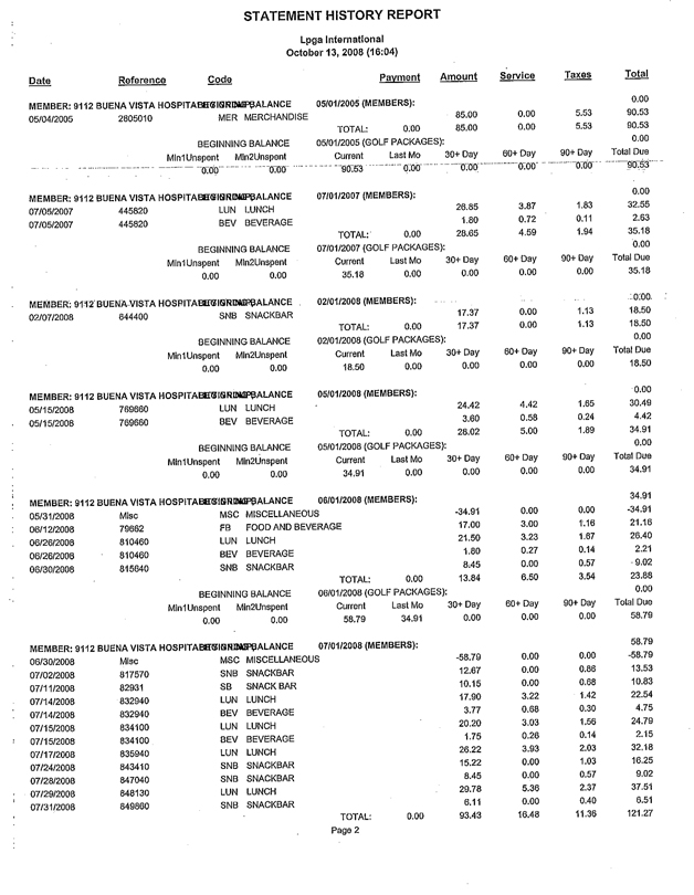
STATEMENT HISTORY REPORT
Lpga International
October 13, 2008 (16:04)
Date Reference Code Payment Amount Service Taxes Total
MEMBER: 9112 BUENA VISTA HOSPITAL BEGINNING BALANCE 05/01/2005 (MEMBERS): 0.00
05/04/2005 2805010 MER MERCHANDISE 85.00 0.00 5.53 90.53
TOTAL: 0.00 85.00 0,00 5.53 90.53
BEGINNING BALANCE 05/01/2005 (GOLF PACKAGES): 0.00
Min1Unspent Min2Unspent Current Last Mo 30+ Day 60+ Day 90+ Day Total Due
0.00 0.00 90.53 0.00 0.00 0.00 0.00 90.53
MEMBER: 9112 BUENA VISTA HOSPlTAL BEGINNING BALANCE 07/01/2007 (MEMBERS): 0.00
07/05/2007 445820 LUN LUNCH 26.85 3.87 1.83 32.55
07/05/2007 445820 BEV BEVERAGE 1.80 0.72 0.11 2.63
TOTAL: 0.00 28.65 4.59 1.94 35.18
BEGINNING BALANCE 07/01/2007 (GOLF PACKAGES): 0.00
MinlUnspent Min2Unspent Current Last Mo 30+Day 60+Day 90+Day Total Due
0.00 0.00 35.18 0.00 0.00 0.00 0.00 35.18
MEMBER: 9112 BUENA VISTA HOSPITAL BEGINNING BALANCE 02/01/2008 (MEMBERS): 0.00
02/07/2008 644400 SNB SNACKBAR 17.37 0.00 1.13 18.50
TOTAL: 0.00 17.37 0.00 1.13 18.50
BEGINNING BALANCE 02/01/2008 (GOLF PACKAGES): 0.00
Min1Unspent Min2Unspent Current Last Mo 30+Day 60+Day 90+Day Total Due
0.00 0.00 18.50 0.00 0.00 0.00 0.00 18.50
MEMBER: 9112 BUENA VISTA HOSPITAL BEGINNING BALANCE 05/01/2008 (MEMBERS): 0.00
05/15/2008 769660 LUN LUNCH 24.42 4.42 1.65 30.49
05/15/2008 766660 BEV BEVERAGE 3.60 0.58 0.24 4.42
TOTAL: 0.00 28.02 5.00 1.89 34.91
BEGINNING BALANCE 05/01/2008 (GOLF PACKAGES): 0.00
Min1Unspent Min2Unspent Current Last Mo 30+Day 60+Day 90+Day Total Due
0.00 0.00 34.91 0.00 0.00 0.00 0.00 34.91
MEMBER: 9112 BUENA VISTA HOSPITAL BEGINNING BALANCE 06/01/2008 (MEMBERS): 34.91
05/31/2008 Misc MSC MISCELLANEOUS -34.91 0.00 0.00 -34.91
08/12/2008 79662 FB FOOD AND BEVERAGE 17.00 3.00 1.16 21.16
06/26/2008 810460 LUN LUNCH 21.50 3.23 1.67 26.40
06/26/2008 810460 BEV BEVERAGE 1.80 0.27 0.14 2.21
06/30/2008 815640 SNB SNACKBAR 8.45 0.00 0.57 -9.02
TOTAL: 0.00 13.84 6.50 3.54 23.88
BEGINNING BALANCE 06/01/2008 (GOLF PACKAGES): 0.00
Min1Unspent Min2Unspent Current Last Mo 30+Day 60+Day 90+Day Total Due
0.00 0.00 58.79 34.91 0.00 0.00 0.00 58.79
MEMBER: 9112 BUENA VISTA HOSPITAL BEGINNING BALANCE 07/01/2008 (MEMBERS): 58.79
06/30/2008 Misc MSC MISCELLANEOUS -58.79 0.00 0.00 -58.79
07/02/2008 817570 SNB SNACKBAR 12.67 0.00 0.86 13.53
07/11/2008 82031 SB SNACK BAR 10.15 0.00 0.68 10.83
07/14/2008 832940 LUN LUNCH 17.90 3.22 1.42 22.54
07/14/2008 832940 BEV BEVERAGE 3.77 0.88 0.30 4.75
07/15/2008 834100 LUN LUNCH 20.20 3.03 1.56 24.79
07/15/2008 834100 BEV BEVERAGE 1.75 0.26 0.14 2.15
07/17/2008 835940 LUN LUNCH 26.22 3.93 2.03 32.18
07/24/2008 843410 SNB SNACKBAR 15.22 0.00 1.03 16.25
07/28/2008 847040 SNB SNACKBAR 8.45 0.00 0.57 9.02
07/29/2008 848130 LUN LUNCH 29.78 5.36 2.37 37.51
07/31/2008 849860 SNB SNACKBAR 6.11 0.00 0.40 6.51
TOTAL: 0.00 93.43 16.48 11.36 121.27
Page 2
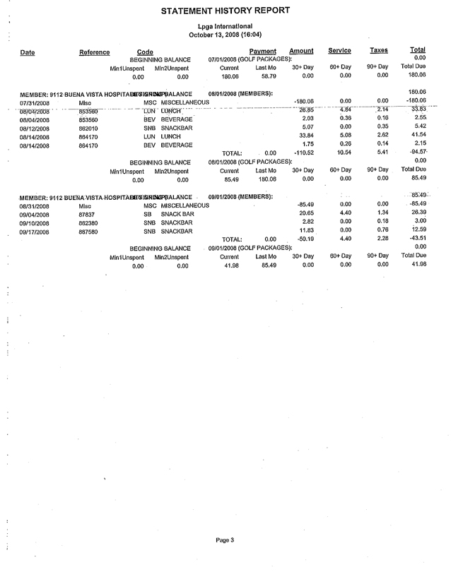
STATEMENT HISTORY REPORT
Lpga International
October 13, 2008 (16:04)
Date Reference Code Payment Amount Service Taxes Total
BEGINNING BALANCE 07/01/2008 (GOLF PACKAGES): 0.00
Min1Unspent Min2Unspent Current Last Mo 30+ Day 60+ Day 90+ Day Total Due
0.00 0.00 180.06 58.79 0.00 0.00 0.00 180.06
MEMBER: 9112 BUENA VISTA HOSPITAL BEGINNING BALANCE 08/01/2008 (MEMBERS): 180.06
07/31/2008 Misc MSC MISCELLANEOUS -180.06 0.00 0.00 -180.06
08/04/2008 853560 LUN LUNCH 26.85 4.84 2.14 33.83
08/04/2008 853560 BEV BEVERAGE 2.03 0.36 0.16 2.55
08/12/2008 862010 SNB SNACKBAR 5.07 0.00 0.35 5.42
08/14/2008 864170 LUN LUNCH 33.84 5.08 2.62 41.54
08/14/2008 864170 BEV BEVERAGE 1.75 0.26 0.14 2.15
TOTAL: 0.00 -110.52 10.54 5.41 -94.57
BEGINNING BALANCE 08/01/2008 (GOLF PACKAGES): 0.00
Min1Unspent Min2Unspent Current Last Mo 30+ Day 60+ Day 90+ Day Total Due
0.00 0.00 85.49 180.06 0.00 0.00 0.00 85.49
MEMBER: 9112 BUENA VISTA HOSPITAL BEGINNING BALANCE 09/01/2008 (MEMBERS): 85.49
08/31/2008 Misc MSC MISCELLANEOUS -85.49 0.00 0.00 -85.49
09/04/2008 87837 SB SNACKBAR 20.65 4.40 1.34 26.39
09/10/2008 882380 SNB SNACKBAR 2.82 0.00 0.18 3.00
09/17/2008 887580 SNB SNACKBAR 11.83 0.00 0.76 12.59
TOTAL: 0.00 -50.19 4.40 2.28 -43.51
BEGINNING BALANCE 09/01/2008 (GOLF PACKAGES): 0.00
Min1Unspent Min2Unspent Current Last Mo 30+ Day 60+ Day 90+ Day Total Due
0.00 0.00 41.98 85.49 0.00 0.00 0.00 41.98
Page 3
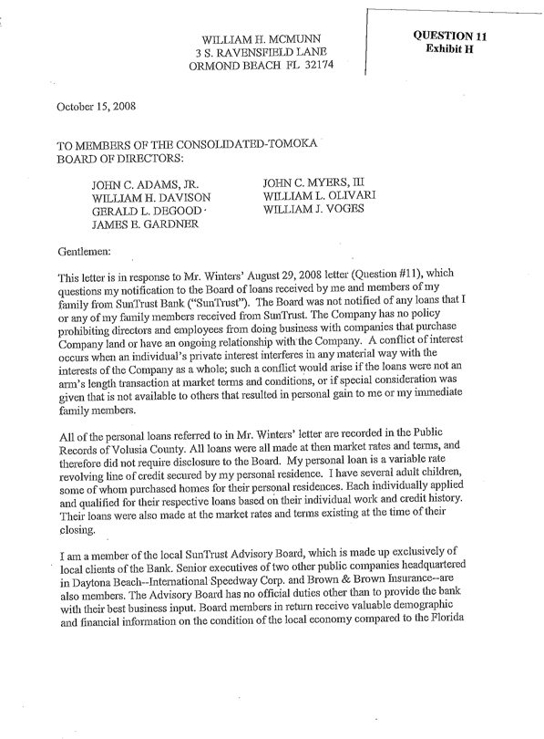
QUESTION 11
Exhibit H
WILLIAM H. MCMUNN
3 S. RAVENSFIELD LANE
ORMOND BEACH FL 32174
October 15, 2008
TO MEMBERS OF THE CONSOLIDATED-TOMOKA BOARD OF DIRECTORS:
JOHN C. ADAMS, JR.
WILLIAM H. DAVISON
GERALD L. DEGOOD
JAMES E. GARDNER
JOHN C. MYERS, III
WILLIAM L. OLIVARI
WILLIAM J. VOGES
Gentlemen:
This letter is in response to Mr. Winters’ August 29, 2008 letter (Question #11), which questions my notification to the Board of loans received by me and members of my family from SunTrust Bank (“SunTrust”). The Board was not notified of any loans that I or any of my family members received from SunTrust. The Company has no policy prohibiting directors and employees from doing business with companies that purchase Company land or have an ongoing relationship with the Company. A conflict of interest occurs when an individual’s private interest interferes in any material way with the interests of the Company as a whole; such a conflict would arise if the loans were not an arm’s length transaction at market terms and conditions, or if special consideration was given that is not available to others that resulted in personal gain to me or my immediate family members.
All of the personal loans referred to in Mr. Winters’ letter are recorded in the Public Records of Volusia County. All loans were all made at then market rates and terms, and therefore did not require disclosure to the Board. My personal loan is a variable rate revolving line of credit secured by my personal residence. I have several adult children, some of whom purchased homes for their personal residences. Each individually applied and qualified for their respective loans based on their individual work and credit history. Their loans were also made at the market rates and terms existing at the time of their closing.
I am a member of the local SunTrust Advisory Board, which is made up exclusively of local clients of the Bank. Senior executives of two other public companies headquartered in Daytona Beach—International Speedway Corp. and Brown & Brown Insurance—are also members. The Advisory Board has no official duties other than to provide the bank with their best business input. Board members in return receive valuable demographic and financial information on the condition of the local economy compared to the Florida
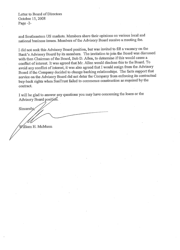
Letter to Board of Directors
October 15, 2008
Page -2-
and Southeastern US markets. Members share their opinions on various local and national business issues. Members of the Advisory Board receive a meeting fee.
I did not seek this Advisory Board position, but was invited to fill a vacancy on the Bank’s Advisory Board by its members. The invitation to join the Board was discussed with then Chairman of the Board, Bob D. Allen, to determine if this would cause a conflict of interest. It was agreed that Mr. Allen would disclose this to the Board. To avoid any conflict of interest, it was also agreed that I would resign from the Advisory Board if the Company decided to change banking relationships. The facts support that service on the Advisory Board did not deter the Company from enforcing its contractual buy-back rights when SunTrust failed to commence construction as required by the contract.
I will be glad to answer any questions you may have concerning the loans or the Advisory Board position.
Sincerely,
William H. McMunn
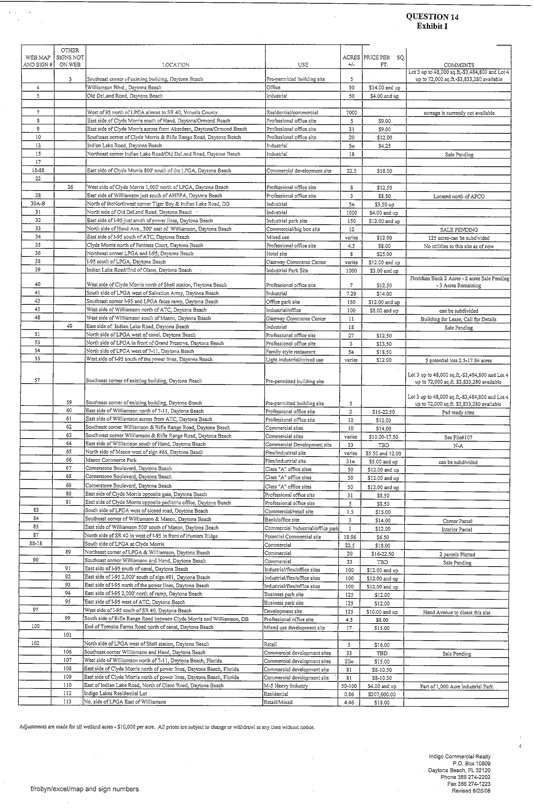
QUESTION 14 Exhibit I
OTHER WEB MAP SIGNS NOT ACRES PRICE PER SQ.
AND SIGNS ON WEB LOCATION USE +/- FT. COMMENTS
Lot 3 up to 48,000 sq.ft,-$3,484,800 and Lot 4
3 Southeast corner existing building, Daytona Beach Pre-permitted building site 5 up to 72,000 sq.ft.-$3,833,280 available
4 Williamson Blvd., Daytona Beach Office 50 $14.00 and up
5 Old DeLand Road, Daytona Beach Industrial 50 $4.00 and up
7 West of 95 north of LPGA almost to SR 40. Volusia County Residential/commercial 7000 acreage is currently not available
8 East side of Clyde Morris south of Hand Daytona/Ormond Reach Professional office site 5 $9.00
9 East side of Clyde Morris across from Aberdeen, Daytona/Ormond Beach Professional office site 31 $9.00
10 Southeast corner of Clyde Morris & Rifle Range Road, Daytona Beach Professional office site 20 $12.00
13 Indian Lake Road, Daytona Beach Industrial 5± $4.25
15 Northeast corner Indian Lake Road/Old DeLand Road, Daytona Beach Industrial 18 Sale Pending
17
18-88 East side of Clyde Morris 800’ south of the LPGA, Daytona Beach Commercial development site 22.5 $18.00
22
26 West side of Clyde Morris 1,000’ north of LPGA, Daytona Beach Professional office site 8 $12.50
28 East side of Williamson just south of AHEPA, Daytona Beach Professional office site 3 $8.50 Located north of APCO
30A-B North of the Northwest corner Tiger Bay & Indian Lake Road, DB Industrial 5± $3.50 up
31 North side of Old DeLand Road, Daytona Beach Industrial 1000 $4.00 and up
32 East side of 1-95 just south of power lines, Daytona Beach Industrial park site 150 $12.00 and up
33 North side of Hand Ave., 300’ east of Williamson, Daytona Beach Commercial/big box site 12 SALE PENDING
34 East side of 1-95 south of ATC, Daytona Beach Mixed use varies $12.00 125 acres-can be subdivided
35 Clyde Morris north of Fentress Court, Daytona Beach Professional office site 4.5 $8.00 No utilities to this site as of now
36 Northeast corner LPGA and 1-95, Daytona Beach Hotel site 8 $25.00
38 1-95 south of LPGA, Daytona Beach Gateway Commerce Center varies $12.00 and up
39 Indian Lake Road/End of Olson, Daytona Beach Industrial Park Site 1000 $3.00 and up
Floridian Bank 2 Acres - 2 acres Sale Pending
40 West side of Clyde Morris north of Shell station, Daytona Beach Professional office site 7 $12.50 - 3 Acres Remaining
41 South side of LPQA west of Salvation Army, Daytona Beach Industrial 7.29 $14.00
43 Southeast corner I-95 and LPGA faces ramp, Daytona Beach Office park site 150 $12.00 and up
45 West side of Williamson north of ATC, Daytona Beach industrial/office 100 $8.00 and up can be subdivided
48 West side of Williamson south of Mason, Daytona Beach Gateway Commerce Center 11 Building for Lease, Call for Details
49 East side of Indian Lake Road, Daytona Beach Industrial 18 Sale Pending
51 North side of LPGA west of canal, Daytona Beach Professional office site 27 $12.50
53 North side of LPGA in front of Grand Preserve, Daytona Beach Professional office site 3 $13.50
54 North side of LPGA west of 7-11, Daytona Beach Family style restaurant 5± $18.50
55 West side of 1-95 south of the power lines Daytona Beach Light industrial/mixed use varies $12.00 5 potential lots 2.5-17.84 acres
Lot 3 up to 48,000 sq.ft,-$3,484,800 and Lot 4
57 Southeast corner of existing building, Daytona Beach Pre-permitted building site up to 72,000 sq.ft. $3,833,280 available
Lot 3 up to 48,000 sq.ft,-$3,484,800 and Lot 4
59 Southeast corner of existing building, Daytona Beach Pre-permitted building site 5 up to 72,000 sq.ft. $3,833,280 available
60 East side of Williamson north of 7-11, Daytona Beach Professional office site 2 $16-22.50 Pad ready sites
61 East side of Williamson across from ATC, Daytona Beach Professional office site 10 $12.00
62 Southeast corner Williamson & Rifle Range Road, Daytona Beach Commercial sites 10 $14.00
63 Southwest corner Williamson & Rifle Range Road, Daytona Beach Commercial sites varies $10.00-17.50 See File#107
64 East side of Williamson south of Hand, Daytona Beach Commercial Development site 33 TBD N-A
65 North side of Mason west of sign #66, Daytona Beach Flex/industrial site varies $5.50 and 12.00
66 Mason Commerce Park Flex/industrial site 31± $5.00 and up can be subdivided
67 Cornerstone Boulevard, Daytona Beach Class “A” office sites 50 $12.00 and up
68 Cornerstone Boulevard, Daytona Beach Class “A” office sites 50 $12.00 and up
69 Cornerstone Boulevard, Daytona Beach Class “A” office sites 50 $12.00 and up
80 East side of Clyde Morris opposite gate, Daytona Beach Professional office site 31 $8.50
81 East side of Clyde Morris opposite pediatric office, Daytona Beach Professional office site 5 $S.50
83 South side of LPGA west of closed road, Daytona Beach Commercial/retail site 1.5 $15.00
84 Southeast corner of Williamson & Mason, Daytona Beach Bank/office site 3 $14.00 Corner Parcel
85 East side of Williamson 500’ south of Mason, Daytona Beach Commercial Industrial/office park 1 $12.00 Interior Parcel
87 North side of SR 40 in west of T-95 in front of Hunters Ridge Potential Commercial site 18.96 $6.50
88-18 South side of LPGA at Clyde Morris Commercial 22.5 $18.00
89 Northeast corner of LPGA & Williamson, Daytona Beach Commercial 20 $16-22.50 2 parcels Platted
90 Southeast corner Williamson and Hand Daytona Beach Commercial 33 TBD Sale Pending
91 East side of I-95 south of canal, Daytona Beach Industrial/flex/office sites 100 $12.00 and up
92 East side of I-95 2,000’south of sign #91, Daytona Beach Industrial/flex/office sites 100 $12.00 and up
93 East side of I-95 north of the power lines, Daytona Beach Industrial/flex/office sites 100 $12.00 and up
94 East side of I-95 2,000’ north of ramp, Daytona Beach Business park site 125 $12.00
95 East side of I-95 west of ATC, Daytona Beach Business park site 125 $12.00
97 West side of 1-95 south of SR 40, Daytona Beach Development site 125 $10.00 and up Hand Avenue to disect this site
99 South side of Rifle Range Road between Clyde Morris and Williamson, DB Professional office site 4.5 $8,00
100 End of Tomoka Farms Road north of canal, Daytona Beach Mixed use development site 17 $15.00
101
102 North side of LPGA west of Shell station, Daytona Beach Retail 5 $16.00
106 Southeast corner Williamson and Hand, Daytona Beach Commercial development sites 33 TBD Sale Pending
107 West side of Williamson north of 7-11, Daytona Beach, Florida Commercial development sites 20± $15.00
108 East side of Clyde Morris north of power lines, Daytona Beach, Florida Commercial development site 81 $8-10.50
109 East side of Clyde Morris north of power lines, Daytona Beach, Florida Commercial development site 81 $8-10.50
110 East of Indian Lake Road, North of Olson Road, Daytona Beach M-5 Heavy Industry 50-100 $4.00 and up Part of 1,000 Acre Industrial Park
112 Indigo Lakes Residential Lot Residential 0.86 $207,000.00
113 No. side of LPGA East of Williamson Retail/Mixed 4.46 $18.00
Adjustments are made for all wetland acres - $10,000 per acre. All prices are subject to change or withdrawl at any time without notice.
Indigo Commercial Realty
P.O. Box 10809
Daytona Beach, FL 32120
Phone 386 274-2202
Fax 386 274-1223
f/robyn/excel/map and sign numbers Revised 6/25/08
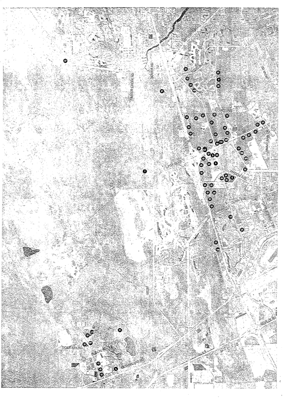
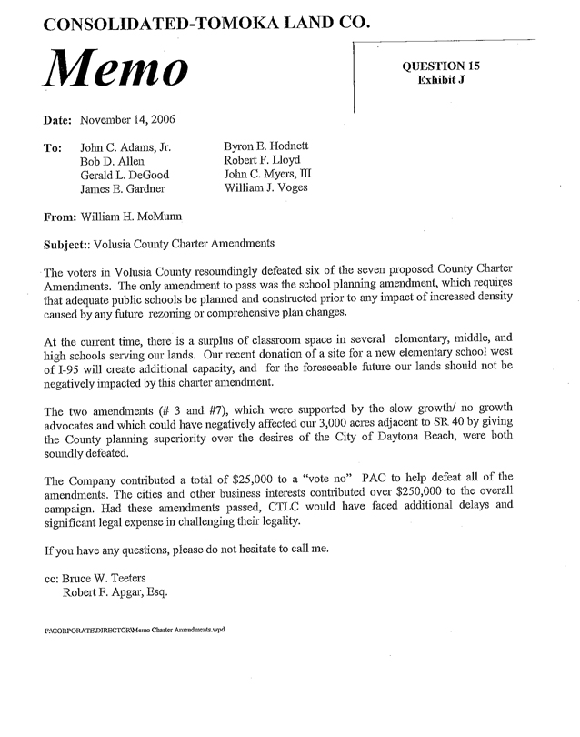
CONSOLIDATED-TOMOKA LAND CO.
QUESTION 15
Exhibit J
MEMO
Date: November 14, 2006
To: John C. Adams, Jr.
Bob D. Allen
Gerald L. DeGood
James E. Gardner
Byron B. Hodnett
Robert F. Lloyd
John C. Myers, III
William J. Voges
From: William H. McMunn
Subject: Volusia County Charter Amendments
The voters in Volusia County resoundingly defeated six of the seven proposed County Charter Amendments. The only amendment to pass was the school planning amendment, which requires that adequate public schools be planned and constructed prior to any impact of increased density caused by any future rezoning or comprehensive plan changes.
At the current time, there is a surplus of classroom space in several elementary, middle, and high schools serving our lands. Our recent donation of a site for a new elementary school west of I-95 will create additional capacity, and for the foreseeable future our lands should not be negatively impacted by this charter amendment.
The two amendments (# 3 and #7), which were supported by the slow growth/ no growth advocates and which could have negatively affected our 3,000 acres adjacent to SR 40 by giving the County planning superiority over the desires of the City of Daytona Beach, were both soundly defeated.
The Company contributed a total of $25,000 to a “vote no” PAC to help defeat all of the amendments. The cities and other business interests contributed over $250,000 to the overall campaign. Had these amendments passed, CTLC would have faced additional delays and significant legal expense in challenging their legality.
If you have any questions, please do not hesitate to call me.
cc: Bruce W. Teeters
Robert F. Apgar, Esq.
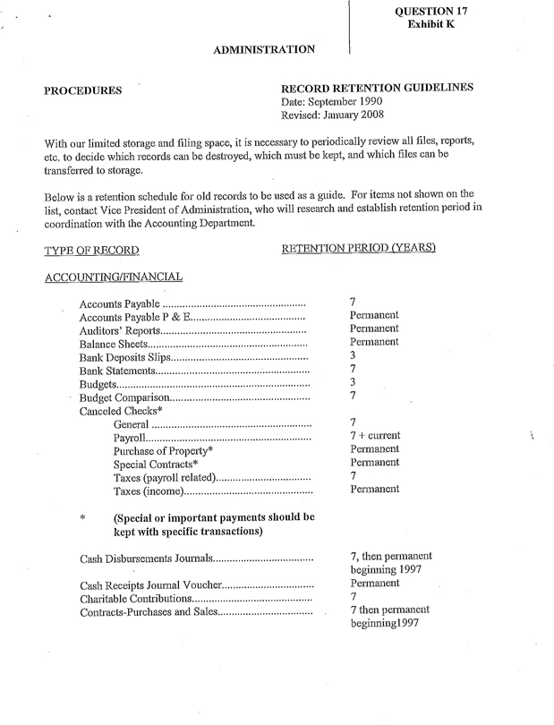
QUESTION 17
Exhibit K
ADMINISTRATION
PROCEDURES
RECORD RETENTION GUIDELINES
Date: September 1990
Revised: January 2008
With our limited storage and filing space, it is necessary to periodically review all files, reports, etc. to decide which records can be destroyed, which must be kept, and which files can be transferred to storage.
Below is a retention schedule for old records to be used as a guide. For items not shown on the list, contact Vice President of Administration, who will research and establish retention period in coordination with the Accounting Department.
TYPE OF RECORD RETENTION PERIOD (YEARS)
ACCOUNTING/FINANCIAL
Accounts Payable 7
Accounts Payable P & E Permanent
Auditors’ Reports Permanent
Balance Sheets Permanent
Bank Deposits Slips 3
Bank Statements 7
Budgets 3
Budget Comparison 7
Canceled Checks*
General 7
Payroll 7 + current
Purchase of Property* Permanent
Special Contracts* Permanent
Taxes (payroll related) 7
Taxes (income) Permanent
* (Special or important payments should be kept with specific transactions)
Cash Disbursements Journals 7, then permanent beginning 1997
Cash Receipts Journal Voucher Permanent
Charitable Contributions 7
Contracts-Purchases and Sales 7 then permanent beginning 1997
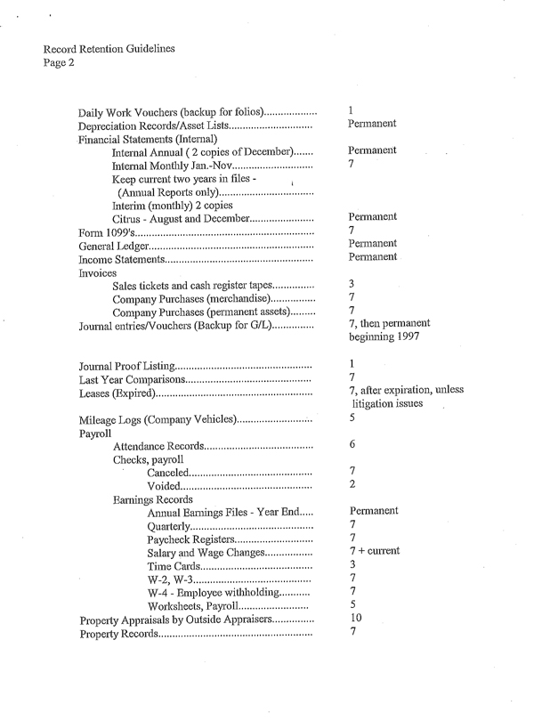
Record Retention Guidelines
Page 2
Daily Work Vouchers (backup for folios) 1
Depreciation Records/Asset Lists Permanent
Financial Statements (Internal)
Internal Annual (2 copies of December) Permanent
Internal Monthly Jan.-Nov 7
Keep current two years in files - (Annual Reports only)
Interim (monthly) 2 copies
Citrus - August and December Permanent
Form 1099’s 7
General Ledger Permanent
Income Statements Permanent
Invoices
Sales tickets and cash register tapes 3
Company Purchases (merchandise) 7
Company Purchases (permanent assets) 7
Journal entries/Vouchers (Backup for G/L) 7, then permanent beginning 1997
Journal Proof Listing 1
Last Year Comparisons 7
Leases (Expired) 7, after expiration, unless litigation issues
Mileage Logs (Company Vehicles) 5
Payroll
Attendance Records 6
Checks, payroll
Canceled 7
Voided 2
Earnings Records
Annual Earnings Files - Year End Permanent
Quarterly 7
Paycheck Registers 7
Salary and Wage Changes 7 + current
Time Cards 3
W-2, W-3 7
W-4 - Employee withholding 7
Worksheets, Payroll 5
Property Appraisals by Outside Appraisers 10
Property Records 7
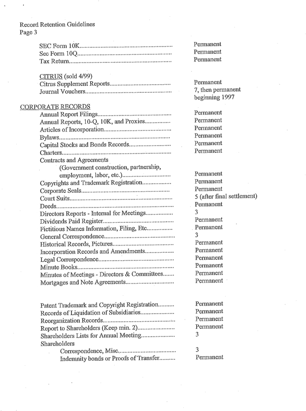
Record Retention Guidelines Page 3
SEC Form 10K Permanent
Sec Form 10Q Permanent
Tax Return Permanent
CITRUS (sold 4/99)
Citrus Supplement Reports Permanent
Journal Vouchers 7, then permanent beginning 1997
CORPORATE RECORDS
Animal Report Filings Permanent
Animal Reports, 10-Q, 10K, and Proxies Permanent
Articles of Incorporation Permanent
Bylaws Permanent
Capital Stocks and Bonds Records Permanent
Charters Permanent
Contracts and Agreements
(Government construction, partnership, employment, labor, etc.) Permanent
Copyrights and Trademark Registration Permanent
Corporate Seals Permanent
Court Suits 5 (after final settlement)
Deeds Permanent
Directors Reports - Internal for Meetings 3
Dividends Paid Register Permanent
Fictitious Names Information, Filing, Etc Permanent
General Correspondence 3
Historical Records, Pictures Permanent
Incorporation Records and Amendments Permanent
Legal Correspondence Permanent
Minute Books Permanent
Minutes of Meetings - Directors & Committees Permanent
Mortgages and Note Agreements Permanent
Patent Trademark and Copyright Registration Permanent
Records of Liquidation of Subsidiaries Permanent
Reorganization Records Permanent
Report to Shareholders (Keep min. 2) Permanent
Shareholders Lists for Annual Meeting 3
Shareholders
Correspondence, Misc 3
Indemnity bonds or Proofs of Transfer Permanent
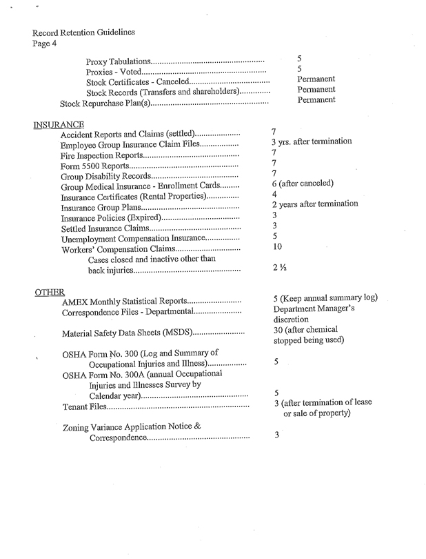
Record Retention Guidelines
Page 4
Proxy Tabulations 5
Proxies - Voted 5
Stock Certificates - Canceled Permanent
Stock Records (Transfers and shareholders) Permanent
Stock Repurchase Plan(s) Permanent
INSURANCE
Accident Reports and Claims (settled) 7
Employee Group Insurance Claim Files 3 yrs. after termination
Fire Inspection Reports 7
Form 5500 Reports 7
Group Disability Records 7
Group Medical Insurance - Enrollment Cards 6 (after canceled)
Insurance Certificates (Rental Properties) 4
Insurance Group Plans 2 years after termination
Insurance Policies (Expired) 3
Settled Insurance Claims 3
Unemployment Compensation Insurance 5
Workers’ Compensation Claims 10
Cases closed and inactive other than back injuries 2 1/2
OTHER
AMEX Monthly Statistical Reports 5 (Keep annual summary log)
Correspondence Files - Departmental Department Manager’s discretion
Material Safety Data Sheets (MSDS), 30 (after chemical stopped being used)
OSHA Form No. 300 (Log and Summary of Occupational Injuries and Illness) 5
OSHA Form No. 300A (annual Occupational Injuries and Illnesses Survey by Calendar year) 5
Tenant Files 3 (after termination of lease or sale of property)
Zoning Variance Application Notice & Correspondence 3
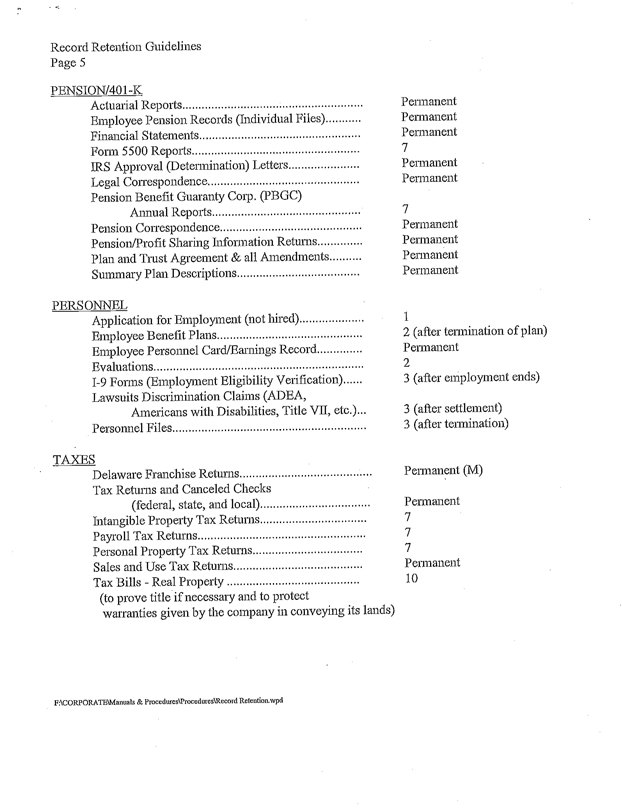
Record Retention Guidelines
Page 5
PENSION/401-K
Actuarial Reports Permanent
Employee Pension Records (Individual Files) Permanent
Financial Statements Permanent
Form 5500 Reports 7
IRS Approval (Determination) Letters Permanent
Legal Correspondence Permanent
Pension Benefit Guaranty Corp. (PBGC)
Annual Reports 7
Pension Correspondence Permanent
Pension/Profit Sharing Information Returns Permanent
Plan and Trust Agreement & all Amendments Permanent
Summary Plan Descriptions Permanent
PERSONNEL
Application for Employment (not hired) 1
Employee Benefit Plans 2 (after termination of plan)
Employee Personnel Card/Earnings Record Permanent
Evaluations 2
1-9 Forms (Employment Eligibility Verification) 3 (after employment ends)
Lawsuits Discrimination Claims (ADEA,
Americans with Disabilities, Title VII, etc.) 3 (after settlement)
Personnel Files 3 (after termination)
TAXES
Delaware Franchise Returns Permanent (M)
Tax Returns and Canceled Checks
(federal, state, and local) Permanent
Intangible Property Tax Returns 7
Payroll Tax Returns 7
Personal Property Tax Returns 7
Sales and Use Tax Returns Permanent
Tax Bills - Real Property 10
(to prove title if necessary and to protect warranties given by the company in conveying its lands)