Exhibit 99.1

| March 24, 2010 |
EXPLORATION NEWS RELEASE
SIGNIFICANT GRADES & WIDTHS CONTINUE AT
US GOLD’S EL GALLO SILVER DISCOVERY
647.0 GPT SILVER OVER 15.1 METERS, 404.0 GPT SILVER OVER 18.0 METERS &
228.3 GPT SILVER OVER 18.0 METERS
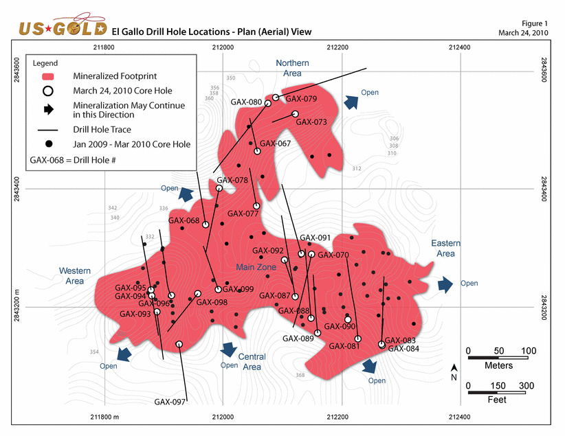
TORONTO, ONTARIO (March 24, 2010) US GOLD CORPORATION (NYSE Amex: UXG) (TSX: UXG) is pleased to announce further encouraging core drilling results from five separate areas (Fig. 1) within its El Gallo Project in Sinaloa State, Mexico. Top three best holes (of the twenty-three assayed) since our last update: 18.9 ounces of silver per ton (opt) over 49.5 ft (feet) (647.0 grams per tonne (gpt) over 15.1 meters (m)), 11.8 opt silver over 59.1 ft (404.0 gpt silver over 18.0 m) and 6.7 opt silver over 59.1 ft (228.3 gpt silver over 18.0 m).
“These results continue to demonstrate that El Gallo has significant growth potential. In order to determine the ultimate size of this discovery US Gold is planning to complete 330,000 ft (100,000 m) of core drilling this year, making it one of the largest exploration programs in Mexico. We remain on schedule to release an initial resource estimate during the second quarter of 2010; and, a preliminary economic analysis by year-end. In addition, US Gold’s regional drilling program in areas surrounding El Gallo has started on some intriguing targets,” said Rob McEwen, Chairman and CEO.
1) Central Area: Significant High-Grade Encountered
18.9 opt silver over 49.5 ft (647.0 gpt over 15.1 m)
The most important new core hole drilled in the Central Area is GAX098 (Fig. 1). It successfully extended the mineralization up-dip from hole GAX033 (7.3 opt silver over 27.1 ft (249.8 gpt over 8.3 m)) by approximately 86 ft (26 m) and laterally from hole GAX010 (31.6 opt silver over 104.0 ft (1,082.4 gpt over 31.7 m) by 69 ft (21 m). GAX098 encountered a significant intersection of high-grade that returned 18.9 opt silver over 49.5 ft (647.0 gpt over 15.1 m), further expanding the previously defined limits of mineralization. The mineralization is close to surface, starts at a vertical depth of approximately 80 ft (25 m) and remains open down-dip. Highlights from the Central Area are shown below:
Hole # | | Silver | | Length | | From | | To | | Hole # | | Silver | | Length | | From | | To | |
| | (opt) | | (ft) | | (ft) | | (ft) | | | | (gpt) | | (m) | | (m) | | (m) | |
| | | | | | | | | | | | | | | | | | | |
GAX068 | | 3.6 | | 26.2 | | 78.2 | | 104.5 | | GAX068 | | 122.7 | | 8.0 | | 23.9 | | 31.9 | |
Including | | 14.5 | | 3.9 | | 91.9 | | 95.8 | | Including | | 497.0 | | 1.2 | | 28.0 | | 29.2 | |
| | | | | | | | | | | | | | | | | | | |
GAX088 | | 5.0 | | 23.8 | | 215.7 | | 239.5 | | GAX088 | | 170.9 | | 7.3 | | 65.8 | | 73.0 | |
Including | | 30.9 | | 2.5 | | 217.7 | | 218.2 | | Including | | 1,060.0 | | 0.8 | | 65.8 | | 66.5 | |
| | | | | | | | | | | | | | | | | | | |
GAX098 | | 10.0 | | 11.1 | | 0.0 | | 11.1 | | GAX098 | | 342.5 | | 3.4 | | 0.0 | | 3.4 | |
And | | 18.9 | | 49.5 | | 143.7 | | 193.2 | | And | | 647.0 | | 15.1 | | 43.8 | | 58.9 | |
Including | | 31.6 | | 28.9 | | 158.5 | | 187.3 | | Including | | 1,084.5 | | 8.8 | | 48.3 | | 57.1 | |
Including | | 112.5 | | 2.8 | | 179.8 | | 182.4 | | Including | | 3,850.0 | | 0.9 | | 54.8 | | 55.6 | |
1
All depths indicated in table are down hole
0.73 opt Ag (25 gpt Ag) cutoff
Allowable waste interval was 19.7 ft (6 m) of < 0.73 opt Ag (25 gpt Ag)
Numbers may not add due to rounding
True widths are unknown
2) North Zone — Best Results To Date
6.7 opt Silver over 59.1 ft (228.3 gpt over 18.0 m)
Our exploration model suggests this area has the potential to host wide intersections of good grade similar to El Gallo’s Main Zone. This is highlighted by two new drill intersections that returned 6.7 opt silver over 59.1 ft (228.3 gpt over 18.0 m) and 5.3 opt silver over 79.2 ft (181.4 gpt over 24.2 m) (Figure 1). These holes represent the best results to date from the North Zone.
Hole # | | Silver | | Length | | From | | To | | Hole # | | Silver | | Length | | From | | To | |
| | (opt) | | (ft) | | (ft) | | (ft) | | | | (gpt) | | (m) | | (m) | | (m) | |
| | | | | | | | | | | | | | | | | | | |
GAX067 | | 5.3 | | 79.2 | | 16.7 | | 96.0 | | GAX067 | | 181.4 | | 24.2 | | 5.1 | | 29.3 | |
Including | | 16.2 | | 2.3 | | 51.3 | | 53.6 | | Including | | 555.0 | | 0.7 | | 15.7 | | 16.4 | |
Including | | 56.7 | | 3.3 | | 80.7 | | 84.0 | | Including | | 1,945.0 | | 1.0 | | 24.6 | | 25.6 | |
| | | | | | | | | | | | | | | | | | | |
GAX073 | | 6.7 | | 59.1 | | 0.0 | | 59.1 | | GAX073 | | 228.3 | | 18.0 | | 0.0 | | 18.0 | |
Including | | 80.5 | | 2.6 | | 21.0 | | 23.6 | | Including | | 2,760.0 | | 0.8 | | 6.4 | | 7.2 | |
| | | | | | | | | | | | | | | | | | | |
GAX077 | | 2.7 | | 60.0 | | 75.1 | | 135.2 | | GAX077 | | 92.2 | | 18.3 | | 22.9 | | 41.2 | |
Including | | 14.6 | | 3.9 | | 108.4 | | 112.4 | | Including | | 500.0 | | 1.2 | | 33.1 | | 34.3 | |
And | | 5.1 | | 1.5 | | 210.6 | | 212.1 | | And | | 174.0 | | 0.5 | | 64.2 | | 64.7 | |
| | | | | | | | | | | | | | | | | | | |
GAX078 | | 2.6 | | 83.0 | | 0.0 | | 83.0 | | GAX078 | | 88.2 | | 25.3 | | 0.0 | | 25.3 | |
Including | | 21.6 | | 3.4 | | 63.8 | | 67.3 | | Including | | 741.0 | | 1.1 | | 19.5 | | 20.5 | |
And | | 3.4 | | 21.7 | | 127.3 | | 149.0 | | And | | 115.0 | | 6.6 | | 38.8 | | 45.4 | |
| | | | | | | | | | | | | | | | | | | |
GAX079 | | 9.9 | | 11.3 | | 269.5 | | 280.0 | | GAX079 | | 339.7 | | 3.5 | | 82.2 | | 85.6 | |
Including | | 38.2 | | 2.5 | | 269.5 | | 272.0 | | Including | | 1,310.0 | | 0.8 | | 82.2 | | 82.9 | |
All depths indicated in table are down hole
0.73 opt Ag (25 gpt Ag) cutoff
Allowable waste interval was 19.7 ft (6 m) of < 0.73 opt Ag (25 gpt Ag)
Numbers may not add due to rounding
True widths are unknown
3) Western Area: Expanded 128 ft (39 m)
3.2 opt silver over 53.0 ft (108.1 gpt over 16.2 m)
Two new core holes have expanded the existing mineralized zone by approximately 128 ft (39 m) laterally (Fig. 1). Both holes intersected strong mineralization over encouraging widths. A preliminary interpretation of these results suggests that this zone may connect with a surface geochemical anomaly located to the southwest. The distance between these areas is 328 ft (100 m) (Fig. 3). Further drilling will test if these two areas are connected. Highlights are shown below.
2
Hole # | | Silver | | Length | | From | | To | | Hole # | | Silver | | Length | | From | | To | |
| | (opt) | | (ft) | | (ft) | | (ft) | | | | (gpt) | | (m) | | (m) | | (m) | |
| | | | | | | | | | | | | | | | | | | |
GAX093 | | 3.2 | | 53.0 | | 9.5 | | 62.5 | | GAX093 | | 108.1 | | 16.2 | | 2.9 | | 19.1 | |
Including | | 11.5 | | 6.6 | | 41.0 | | 47.6 | | Including | | 393.0 | | 2.0 | | 12.5 | | 14.5 | |
And | | 8.0 | | 3.8 | | 233.8 | | 237.5 | | And | | 275.0 | | 1.2 | | 71.3 | | 72.4 | |
| | | | | | | | | | | | | | | | | | | |
GAX097 | | 5.0 | | 28.1 | | 107.3 | | 135.3 | | GAX097 | | 172.9 | | 8.6 | | 32.7 | | 41.3 | |
Including | | 14.7 | | 1.3 | | 116.1 | | 117.5 | | Including | | 505.0 | | 0.4 | | 35.4 | | 35.8 | |
Including | | 37.6 | | 1.0 | | 129.8 | | 130.7 | | Including | | 1,290.0 | | 0.3 | | 39.6 | | 39.9 | |
All depths indicated in table are down hole
0.73 opt Ag (25 gpt Ag) cutoff
Allowable waste interval was 19.7 ft (6 m) of < 0.73 opt Ag (25 gpt Ag)
Numbers may not add due to rounding
True widths are unknown
4) Eastern Area: Expanded 165 ft (50 m)
Drilling in the Eastern Area extended the mineralized zone by 165 ft (50 m) laterally. The objective of the holes drilled, as highlighted below, was to extend mineralization to the south. Highlights are shown below.
Hole # | | Silver | | Length | | From | | To | | Hole # | | Silver | | Length | | From | | To | |
| | (opt) | | (ft) | | (ft) | | (ft) | | | | (gpt) | | (m) | | (m) | | (m) | |
| | | | | | | | | | | | | | | | | | | |
GAX083 | | 16.6 | | 6.1 | | 25.4 | | 31.5 | | GAX083 | | 570.1 | | 1.9 | | 7.8 | | 9.6 | |
And | | 1.8 | | 45.9 | | 101.7 | | 147.6 | | And | | 61.6 | | 14.0 | | 31.0 | | 45.0 | |
Including | | 11.3 | | 4.9 | | 129.3 | | 134.2 | | Including | | 378.0 | | 1.5 | | 39.4 | | 40.9 | |
And | | 5.4 | | 5.9 | | 249.3 | | 255.2 | | And | | 184.3 | | 1.8 | | 76.0 | | 77.8 | |
| | | | | | | | | | | | | | | | | | | |
GAX090 | | 1.4 | | 105.2 | | 0.0 | | 105.2 | | GAX090 | | 48.8 | | 32.1 | | 0.0 | | 32.1 | |
Including | | 15.3 | | 2.0 | | 103.2 | | 105.2 | | Including | | 524.0 | | 0.6 | | 31.5 | | 32.1 | |
And | | 12.6 | | 10.5 | | 248.7 | | 259.2 | | And | | 431.6 | | 3.2 | | 75.8 | | 79.0 | |
All depths indicated in table are down hole
0.73 opt Ag (25 gpt Ag) cutoff
Allowable waste interval was 19.7 ft (6 m) of < 0.73 opt Ag (25 gpt Ag)
Numbers may not add due to rounding
True widths are unknown
5) Connecting the Main and North Zones
2.9 opt silver over 112.9 ft (100.3 gpt over 34.4 m)
Testing by core drilling continues between the Main and North Zones to determine if these two areas are connected. Two new core holes have been completed and demonstrate that the distance between these two zones is closing (Fig. 1). Mineralization in this area is generally flat-lying and commonly occurs just below surface.
Hole # | | Silver | | Length | | From | | To | | Hole # | | Silver | | Length | | From | | To | |
| | (opt) | | (ft) | | (ft) | | (ft) | | | | (gpt) | | (m) | | (m) | | (m) | |
| | | | | | | | | | | | | | | | | | | |
GAX091 | | 3.6 | | 6.9 | | 0.0 | | 6.9 | | GAX091 | | 122.0 | | 2.1 | | 0.0 | | 2.1 | |
And | | 4.0 | | 46.9 | | 124.7 | | 171.6 | | And | | 135.5 | | 14.3 | | 38.0 | | 52.3 | |
Including | | 23.9 | | 3.4 | | 139.6 | | 143.0 | | Including | | 820.0 | | 1.1 | | 42.6 | | 43.6 | |
3
GAX092 | | 2.9 | | 112.9 | | 5.2 | | 118.1 | | GAX092 | | 100.3 | | 34.4 | | 1.6 | | 36.0 | |
Including | | 16.0 | | 4.1 | | 44.3 | | 48.4 | | Including | | 549.2 | | 1.3 | | 13.5 | | 14.8 | |
And | | 10.0 | | 1.8 | | 238.4 | | 240.2 | | And | | 344.0 | | 0.6 | | 72.7 | | 73.2 | |
All depths indicated in table are down hole
0.73 opt Ag (25 gpt Ag) cutoff
Allowable waste interval was 19.7 ft (6 m) of < 0.73 opt Ag (25 gpt Ag)
Numbers may not add due to rounding
True widths are unknown
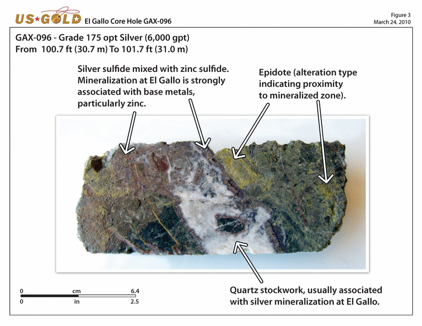
Continuity of Near Surface Mineralization Confirmed
11.8 opt silver over 59.1 ft (404.0 gpt over 18.0 m)
Ongoing delineation drilling continues to encounter thick intersections of good grade starting near surface. Very high-grade silver values were encountered over short intervals in the three holes highlighted below. Near surface mineralization at El Gallo is common throughout the project area.
Hole # | | Silver | | Length | | From | | To | | Hole # | | Silver | | Length | | From | | To | |
| | (opt) | | (ft) | | (ft) | | (ft) | | | | (gpt) | | (m) | | (m) | | (m) | |
| | | | | | | | | | | | | | | | | | | |
GAX070 | | 4.7 | | 69.9 | | 33.8 | | 103.7 | | GAX070 | | 161.7 | | 21.3 | | 10.3 | | 31.6 | |
Including | | 10.0 | | 14.8 | | 39.0 | | 53.8 | | Including | | 343.5 | | 4.5 | | 11.9 | | 16.4 | |
Including | | 32.1 | | 2.6 | | 89.2 | | 91.9 | | Including | | 1,100.0 | | 0.8 | | 27.2 | | 28.0 | |
And | | 6.7 | | 19.5 | | 318.2 | | 337.8 | | And | | 229.0 | | 6.0 | | 97.0 | | 103.0 | |
Including | | 16.3 | | 3.9 | | 333.8 | | 337.8 | | Including | | 558.0 | | 1.2 | | 101.8 | | 103.0 | |
| | | | | | | | | | | | | | | | | | | |
GAX096 | | 3.6 | | 104.8 | | 0.0 | | 104.8 | | GAX096 | | 123.9 | | 32.0 | | 0.0 | | 32.0 | |
Including | | 175.0 | | 1.0 | | 100.7 | | 101.7 | | Including | | 6,000.0 | | 0.3 | | 30.7 | | 31.0 | |
And | | 2.9 | | 14.3 | | 197.3 | | 211.6 | | And | | 101.1 | | 4.4 | | 60.2 | | 64.5 | |
| | | | | | | | | | | | | | | | | | | |
GAX099 | | 11.8 | | 59.1 | | 0.0 | | 59.1 | | GAX099 | | 404.0 | | 18.0 | | 0.0 | | 18.0 | |
Including | | 38.8 | | 9.7 | | 21.7 | | 31.3 | | Including | | 1,329.0 | | 3.0 | | 6.6 | | 9.6 | |
Including | | 15.2 | | 9.2 | | 42.0 | | 51.2 | | Including | | 521.0 | | 2.8 | | 12.8 | | 15.6 | |
Geological Technical Description of El Gallo
El Gallo is a low-sulfidation, epithermal silver deposit located within the Pie de la Sierra physiographic province of the Sierra Madre Occidental Range which is part of a Cretaceous to Tertiary magmatic arc with volcanic and associated sedimentary rocks that extends for hundreds of miles through northwestern Mexico. Cretaceous-Tertiary volcanic and volcaniclastic rocks rest upon a basement of Paleozoic and Mesozoic sedimentary and metamorphic rocks. Intrusives of Late Cretaceous and Tertiary age cut these rocks locally. Regionally, these intrusives are dominated by the granitic Sinaloa Batholith. El Gallo project is located near the margin of the Sinaloa Batholith. Other shallow-level porphyritic intrusives also occur within the project area. Silver mineralization is hosted in breccia and stockwork zones that occur primarily in the andesitic volcanic and intrusive rocks and to a lesser extent in quartz monzonite porphyry intrusive rocks. The shape of the mineralization has not yet been fully defined.
To view the 23 new core holes from this news release see Table 1. To view all 96 core holes drilled at El Gallo, please click: http://www.usgold.com/news/pdf/20090805_uxg_elgalloallholes.pdf
To view assays intervals from core holes GAX098, please click:
http://www.usgold.com/news/pdf/20100325/gax098.xls
4
ABOUT US GOLD (www.usgold.com)
US Gold Corporation is a Colorado incorporated gold and silver exploration company with a strong treasury, no debt and two significant land holdings, one in Nevada next to Barrick Gold’s multi-million ounce Cortez project, and the other in Mexico where an exciting high-grade silver discovery has been made. US Gold’s shares trade on the NYSE Amex and the Toronto Stock Exchange under the symbol UXG. US Gold has good market liquidity, trading 1.1 million shares daily, and is included in S&P/TSX and Russell indices.
QUALIFIED PERSON
This news release has been viewed and approved by John Read, US Gold’s consulting geologist, who is a Qualified Person as defined by National Instrument 43-101 and is responsible for program design and quality control of exploration undertaken by the Company at its Mexican exploration properties. Mr. Read has been active with US Gold’s Mexican exploration since January 2008 and has assisted earlier Qualified Person Steve Brown in program design and quality control since that time. Mr. Brown, US Gold’s Chief Geologist, will continue to serve as the Company’s Qualified Person in Nevada. The addition of another Qualified Persons reflects the increasing amount of exploration activity throughout the Company.
Samples from the core drilling were split on-site at the Company’s Magistral Mine property. One quarter of the split drill core was shipped to ALS Chemex in Hermosillo for sample preparation and analysis by 4-acid digestion with ICP determination for silver and fire assay for gold. Samples returning greater than 1500 ppm silver or 10 ppm gold were re-analyzed using gravimetric fire assay. Standards and blanks were inserted every 20 samples. Samples from the geochemical survey shown on Figure 2 were analyzed by US Gold’s internal lab, located at the Magistral Mine, Sinaloa Mexico, utilizing atomic absorption.
All holes were drilled with HQ bits utilizing a CS-1500 truck-mounted core drill. Samples were taken based on lithologic and/or mineralized intervals and vary in length. The true width of the mineral zone has not yet been determined.
Certain statements contained herein and subsequent oral statements made by and on behalf of the Company may contain “forward-looking statements” within the meaning of the Private Securities Litigation Reform Act of 1995. Such forward-looking statements may be identified by words such as “intends,” “anticipates,” “believes,” “expects” and “hopes” and include, without limitation, statements regarding the Company’s results of exploration, plan of business operations, potential contractual arrangements, receipt of working capital, anticipated revenues and related expenditures. Factors that could cause actual results to differ materially include, among others, those set forth in the Company’s Annual Report on Form 10-K for the fiscal year ended December 31, 2009 and other filings with the Securities and Exchange Commission, under the caption “Risk Factors”. Most of these factors are outside the control of the Company. Investors are cautioned not to put undue reliance on forward-looking statements. Except as otherwise required by applicable securities statutes or regulations, the Company disclaims any intent or obligation to update publicly these forward looking statements, whether as a result of new information, future events or otherwise.
For further information contact: | |
| |
Ian J. Ball | Mailing Address |
VP, Mexico | 99 George Street, 3rd Floor |
Tel: (647) 258-0395 | Toronto, ON M5A 2N4 |
Toll Free: (866) 441-0690 | E-mail: info@usgold.com |
Fax: (647) 258-0408 | |
5
El Gallo Silver Project: Core Holes Assays | Table 1 |
| March 24, 2010 |
Hole # | | Silver | | Length | | From | | Silver | | Length | | From | | Azimuth | | Dip | | Easting | | Northing |
| | (opt) | | (ft) | | (ft) | | (gpt) | | (m) | | (m) | | | | | | | | |
| | | | | | | | | | | | | | | | | | | | |
GAX067 | | 5.3 | | 79.2 | | 16.7 | | 181.4 | | 24.2 | | 5.1 | | 350° | | -70° | | 212057 | | 2843467 |
Including | | 16.2 | | 2.3 | | 51.3 | | 555.0 | | 0.7 | | 15.7 | | | | | | | | |
Including | | 56.7 | | 3.3 | | 80.7 | | 1,945.0 | | 1.0 | | 24.6 | | | | | | | | |
| | | | | | | | | | | | | | | | | | | | |
GAX068 | | 3.6 | | 26.2 | | 78.2 | | 122.7 | | 8.0 | | 23.9 | | 350° | | -50° | | 211970 | | 2843341 |
Including | | 14.5 | | 3.9 | | 91.9 | | 497.0 | | 1.2 | | 28.0 | | | | | | | | |
| | | | | | | | | | | | | | | | | | | | |
GAX070 | | 4.7 | | 69.9 | | 33.8 | | 161.7 | | 21.3 | | 10.3 | | 170° | | -55° | | 212148 | | 2843290 |
Including | | 10.0 | | 14.8 | | 39.0 | | 343.5 | | 4.5 | | 11.9 | | | | | | | | |
Including | | 32.1 | | 2.6 | | 89.2 | | 1,100.0 | | 0.8 | | 27.2 | | | | | | | | |
And | | 6.7 | | 19.5 | | 318.2 | | 229.0 | | 6.0 | | 97.0 | | | | | | | | |
Including | | 16.3 | | 3.9 | | 333.8 | | 558.0 | | 1.2 | | 101.8 | | | | | | | | |
| | | | | | | | | | | | | | | | | | | | |
GAX073 | | 6.7 | | 59.1 | | 0.0 | | 228.3 | | 18.0 | | 0.0 | | 250° | | -75° | | 212120 | | 2843528 |
Including | | 80.5 | | 2.6 | | 21.0 | | 2,760.0 | | 0.8 | | 6.4 | | | | | | | | |
And | | 1.3 | | 38.2 | | 80.7 | | 44.6 | | 11.7 | | 24.6 | | | | | | | | |
| | | | | | | | | | | | | | | | | | | | |
GAX077 | | 2.7 | | 60.0 | | 75.1 | | 92.2 | | 18.3 | | 22.9 | | 350° | | -65° | | 212055 | | 2843373 |
Including | | 14.6 | | 3.9 | | 108.4 | | 500.0 | | 1.2 | | 33.1 | | | | | | | | |
And | | 5.1 | | 1.5 | | 210.6 | | 174.0 | | 0.5 | | 64.2 | | | | | | | | |
And | | 3.6 | | 6.4 | | 350.2 | | 123.0 | | 2.0 | | 106.8 | | | | | | | | |
| | | | | | | | | | | | | | | | | | | | |
GAX078 | | 2.6 | | 83.0 | | 0.0 | | 88.2 | | 25.3 | | 0.0 | | 190° | | -50° | | 211991 | | 2843401 |
Including | | 21.6 | | 3.4 | | 63.8 | | 741.0 | | 1.1 | | 19.5 | | | | | | | | |
And | | 3.4 | | 21.7 | | 127.3 | | 115.0 | | 6.6 | | 38.8 | | | | | | | | |
Including | | 17.4 | | 1.0 | | 258.5 | | 596.0 | | 0.3 | | 78.8 | | | | | | | | |
| | | | | | | | | | | | | | | | | | | | |
GAX079 | | 2.6 | | 13.1 | | 95.8 | | 88.7 | | 4.0 | | 29.2 | | 70° | | -45° | | 212087 | | 2843555 |
And | | 9.9 | | 11.3 | | 269.5 | | 339.7 | | 3.5 | | 82.2 | | | | | | | | |
Including | | 38.2 | | 2.5 | | 269.5 | | 1,130.0 | | 0.8 | | 82.2 | | | | | | | | |
6
El Gallo Silver Project: Core Holes Assays | Table 1 |
| March 24, 2010 |
Hole # | | Silver | | Length | | From | | Silver | | Length | | From | | Azimuth | | Dip | | Easting | | Northing |
| | (opt) | | (ft) | | (ft) | | (gpt) | | (m) | | (m) | | | | | | | | |
| | | | | | | | | | | | | | | | | | | | |
GAX080 | | NSR | | | | | | NSR | | | | | | 220° | | -45° | | 212075 | | 2843546 |
| | | | | | | | | | | | | | | | | | | | |
GAX081 | | 1.3 | | 6.4 | | 131.6 | | 44.2 | | 2.0 | | 40.1 | | 350° | | -45° | | 212228 | | 2843150 |
And | | 1.6 | | 9.2 | | 358.6 | | 54.7 | | 2.8 | | 109.3 | | | | | | | | |
| | | | | | | | | | | | | | | | | | | | |
GAX083 | | 16.6 | | 6.1 | | 25.4 | | 570.1 | | 1.9 | | 7.8 | | 360° | | -55° | | 212269 | | 2843138 |
And | | 1.8 | | 45.9 | | 101.7 | | 61.6 | | 14.0 | | 31.0 | | | | | | | | |
Including | | 11.3 | | 4.9 | | 129.3 | | 387.0 | | 1.5 | | 39.4 | | | | | | | | |
And | | 5.4 | | 5.9 | | 249.3 | | 184.3 | | 1.8 | | 76.0 | | | | | | | | |
| | | | | | | | | | | | | | | | | | | | |
GAX084 | | NSR | | | | | | NSR | | | | | | 360° | | -75° | | 212269 | | 2843138 |
| | | | | | | | | | | | | | | | | | | | |
GAX087 | | 1.5 | | 82.0 | | 62.3 | | 50.7 | | 25.0 | | 19.0 | | 350° | | -50° | | 212122 | | 2843220 |
And | | 1.0 | | 49.7 | | 292.0 | | 33.9 | | 15.2 | | 89.0 | | | | | | | | |
| | | | | | | | | | | | | | | | | | | | |
GAX088 | | 2.5 | | 3.8 | | 39.0 | | 84.4 | | 1.2 | | 11.9 | | 350° | | -55° | | 212149 | | 2843183 |
And | | 5.0 | | 23.8 | | 215.7 | | 170.9 | | 7.3 | | 65.8 | | | | | | | | |
Including | | 30.9 | | 2.5 | | 215.7 | | 1,060.0 | | 0.8 | | 65.8 | | | | | | | | |
| | | | | | | | | | | | | | | | | | | | |
GAX089 | | 9.4 | | 1.1 | | 114.8 | | 322.0 | | 0.4 | | 35.0 | | 350° | | -60° | | 212159 | | 2843157 |
And | | 4.6 | | 1.5 | | 136.8 | | 157.0 | | 0.5 | | 41.7 | | | | | | | | |
And | | 0.9 | | 107.3 | | 200.1 | | 31.3 | | 32.7 | | 61.0 | | | | | | | | |
And | | 2.1 | | 6.6 | | 590.7 | | 70.8 | | 2.0 | | 180.1 | | | | | | | | |
| | | | | | | | | | | | | | | | | | | | |
GAX090 | | 1.4 | | 105.2 | | 0.0 | | 48.8 | | 32.1 | | 0.0 | | 0° | | -90° | | 212211 | | 2843179 |
Including | | 15.3 | | 2.0 | | 103.2 | | 524.0 | | 0.6 | | 31.5 | | | | | | | | |
And | | 12.6 | | 10.5 | | 248.7 | | 431.6 | | 3.2 | | 75.8 | | | | | | | | |
| | | | | | | | | | | | | | | | | | | | |
GAX091 | | 3.6 | | 6.9 | | 0.0 | | 122.0 | | 2.1 | | 0.0 | | 350° | | -50° | | 212132 | | 2843291 |
And | | 4.0 | | 46.9 | | 124.7 | | 135.5 | | 14.3 | | 38.0 | | | | | | | | |
Including | | 23.9 | | 3.4 | | 139.6 | | 820.0 | | 1.1 | | 42.6 | | | | | | | | |
7
El Gallo Silver Project: Core Holes Assays | Table 1 (cont) |
| March 24, 2010 |
Hole # | | Silver | | Length | | From | | Silver | | Length | | From | | Azimuth | | Dip | | Easting | | Northing |
| | (opt) | | (ft) | | (ft) | | (gpt) | | (m) | | (m) | | | | | | | | |
| | | | | | | | | | | | | | | | | | | | |
GAX092 | | 2.9 | | 112.9 | | 5.2 | | 100.3 | | 34.2 | | 1.6 | | 170° | | -75° | | 212104 | | 2843280 |
Including | | 16.0 | | 4.1 | | 44.3 | | 549.2 | | 1.3 | | 13.5 | | | | | | | | |
And | | 10.0 | | 1.8 | | 238.4 | | 344.0 | | 0.6 | | 72.7 | | | | | | | | |
| | | | | | | | | | | | | | | | | | | | |
GAX093 | | 3.2 | | 53.0 | | 9.5 | | 108.1 | | 16.2 | | 2.9 | | 170° | | -75° | | 211885 | | 2843193 |
Including | | 11.5 | | 6.6 | | 41.0 | | 393.0 | | 2.0 | | 12.5 | | | | | | | | |
And | | 8.0 | | 3.8 | | 233.8 | | 275.0 | | 1.2 | | 71.3 | | | | | | | | |
And | | 1.8 | | 22.0 | | 263.8 | | 63.2 | | 6.7 | | 80.4 | | | | | | | | |
| | | | | | | | | | | | | | | | | | | | |
GAX094 | | 1.8 | | 83.0 | | 0.0 | | 63.2 | | 25.3 | | 0.0 | | 170° | | -55° | | 211878 | | 2843222 |
| | | | | | | | | | | | | | | | | | | | |
GAX095 | | 1.5 | | 95.1 | | 36.1 | | 49.7 | | 29.0 | | 11.0 | | 350° | | -55° | | 211877 | | 2843228 |
Including | | 5.8 | | 6.6 | | 124.7 | | 200.0 | | 2.0 | | 38.0 | | | | | | | | |
And | | 2.7 | | 12.6 | | 174.4 | | 93.1 | | 3.9 | | 53.2 | | | | | | | | |
| | | | | | | | | | | | | | | | | | | | |
GAX096 | | 3.6 | | 104.8 | | 0.0 | | 123.9 | | 32.3 | | 0.0 | | 350° | | -45° | | 211910 | | 2843219 |
Including | | 175.0 | | 1.0 | | 100.7 | | 6,000.0 | | 0.3 | | 30.7 | | | | | | | | |
And | | 1.1 | | 20.2 | | 128.0 | | 38.1 | | 6.2 | | 39.0 | | | | | | | | |
And | | 2.9 | | 14.3 | | 197.3 | | 101.1 | | 4.4 | | 60.2 | | | | | | | | |
Including | | 12.5 | | 2.0 | | 197.3 | | 427.0 | | 0.6 | | 60.2 | | | | | | | | |
| | | | | | | | | | | | | | | | | | | | |
GAX097 | | 5.0 | | 28.1 | | 107.3 | | 172.9 | | 8.6 | | 32.7 | | 170° | | -45° | | 211924 | | 2843138 |
Including | | 14.7 | | 1.3 | | 116.1 | | 505.0 | | 0.4 | | 35.4 | | | | | | | | |
Including | | 37.6 | | 1.0 | | 129.8 | | 1,290.0 | | 0.3 | | 39.6 | | | | | | | | |
| | | | | | | | | | | | | | | | | | | | |
GAX098 | | 10.0 | | 11.1 | | 0.0 | | 342.5 | | 3.4 | | 0.0 | | 220° | | -45° | | 211957 | | 2843224 |
And | | 18.9 | | 49.5 | | 143.7 | | 647.0 | | 15.1 | | 43.8 | | | | | | | | |
Including | | 31.6 | | 28.9 | | 158.5 | | 1,084.5 | | 8.8 | | 48.3 | | | | | | | | |
Including | | 112.5 | | 2.8 | | 179.8 | | 3,850.0 | | 0.9 | | 54.8 | | | | | | | | |
8
El Gallo Silver Project: Core Holes Assays | Table 1 (cont) |
| March 24, 2010 |
Hole # | | Silver | | Length | | From | | Silver | | Length | | From | | Azimuth | | Dip | | Easting | | Northing |
| | (opt) | | (ft) | | (ft) | | (gpt) | | (m) | | (m) | | | | | | | | |
| | | | | | | | | | | | | | | | | | | | |
GAX099 | | 11.8 | | 59.1 | | 0.0 | | 404.0 | | 18.0 | | 0.0 | | 350° | | -60° | | 211990 | | 2844321 |
Including | | 38.8 | | 9.7 | | 21.7 | | 1,329.0 | | 3.0 | | 6.6 | | | | | | | | |
Including | | 15.2 | | 9.2 | | 42.0 | | 521.0 | | 2.8 | | 12.8 | | | | | | | | |
All depths indicated in table are down hole
0.73 opt Ag (25 gpt Ag) cutoff
Allowable waste interval was 19.7 ft (6 m) of < 0.73 opt Ag (25 gpt Ag)
Numbers may not add due to rounding
NSV = No Significant Values
9
| Figure 1 March 24, 2010 El Gallo Drill Hole Locations - Plan (Aerial) View 0 50 100 Meters 0 150 300 Feet N 211800 m 212000 212200 212400 211800 2843600 2843400 2843200 m 2843600 2843400 2843200 212000 212200 212400 350 312 310 308 306 356 358 360 342 340 336 332 354 368 GAX-067 GAX-079 GAX-080 GAX-077 GAX-092 GAX-091 GAX-070 GAX-087 GAX-088 GAX-089 GAX-090 GAX-081 GAX-083 GAX-084 GAX-078 GAX-068 GAX-099 GAX-098 GAX-093 GAX-097 GAX-094 GAX-095 GAX-096 GAX-073 Open Northern Area Open Open Open Open Open Eastern Area Central Area Western Area Main Zone Legend Mineralized Footprint March 24, 2010 Core Hole Mineralization May Continue in this Direction Drill Hole Trace Jan 2009 - Mar 2010 Core Hole GAX-068 = Drill Hole # |

| Figure 2 March 24, 2010 Southwest Zone - Current & Pending Drill Holes GAX-097 5.0 opt Ag / 28.1 ft (172.9 gpt / 8.6 m) 1,295 ft (395 m) - Untested Area Legend Completed Core hole Pending Core hole Mineral Intercept GAX-097 = Drill Hole ID High Low Geochemical Anomaly |
| Figure 3 March 24, 2010 El Gallo Core Hole GAX-096 Silver sulfide mixed with zinc sulfide. Mineralization at El Gallo is strongly associated with base metals, particularly zinc. Epidote (alteration type indicating proximity to mineralized zone). Quartz stockwork, usually associated with silver mineralization at El Gallo. GAX-096 - Grade 175 opt Silver (6,000 gpt) From 100.7 ft (30.7 m) To 101.7 ft (31.0 m) 0 6.4 cm 0 2.5 in |