January 31, 2008
Mr. Brad Skinner
Senior Assistant Chief Accountant
Division of Corporate Finance
United States Securities and Exchange Commission
Washington, D.C. 20549-7010
Via FAX: (202) 772-9368
| Re: | HuntMountain Resources (“HuntMountain” or the “company”) |
Form 10-KSB for Fiscal Year Ended December 31, 2006
Filed April 16, 2007
File No. 001-01428
Dear Mr. Skinner,
Further to our recent correspondence, the following are our responses to your letter of comment dated December 31, 2007. The company’s responses are indexed to your letter of comment:
General
| 1. | We have added the recommended disclosure to our website. |
| 2. | Maps showing the location and access to each property are attached to this correspondence. We will include these maps in any amendments that are uploaded to EDGAR.. |
| 3. | Property detail: |
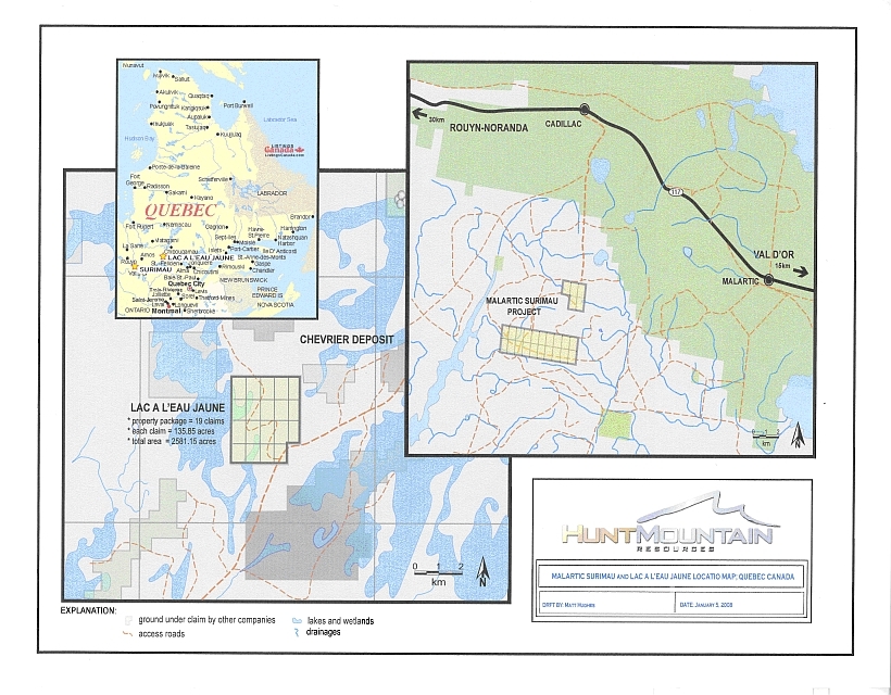
| a. | Lac a l’Eau Jaune and Malarctic Projects (the “Quebec properties”), Québec, Canada |
| i. | Nature of ownership and description of interests | |
| HuntMountain owns an exclusive option to acquire a 100% interest in the Quebec properties. In June of 2006 the company paid $70,000 to Diagnos, Inc., an unrelated third party, to establish this option. The company must drill a minimum of three holes on each Quebec property to earn a 100% interest in the Quebec properties. |
1611 N Molter Road, Suite 201 Liberty Lake, WA 99019 509-892-5287 Tel 509-892-5318 Fax www.huntmountain.com
1
ii. | Mining claim detail |
The Quebec properties consist of 46 provincial claims as follows:
Lac a l'Eau Jaune-Map Area 32G10- 21 Claims
| Claim Number | Hectars | Expiration Date | Cost to Renew | Amount of Work Necessary to Renew | ||||
| CDC 2001121 | 55.78 | 2/19/2008 | $50.00 | $1,200.00 | ||||
| CDC 2001122 | 55.78 | 2/19/2008 | $50.00 | $1,200.00 | ||||
| CDC 2001123 | 55.78 | 2/19/2008 | $50.00 | $1,200.00 | ||||
| CDC 2001124 | 55.78 | 2/19/2008 | $50.00 | $1,200.00 | ||||
| CDC 2001125 | 55.78 | 2/19/2008 | $50.00 | $1,200.00 | ||||
| CDC 2001126 | 55.79 | 2/19/2008 | $50.00 | $1,200.00 | ||||
| CDC 2001127 | 55.79 | 2/19/2008 | $50.00 | $1,200.00 | ||||
| CDC 2001128 | 55.79 | 2/19/2008 | $50.00 | $1,200.00 | ||||
| CDC 2001129 | 55.79 | 2/19/2008 | $50.00 | $1,200.00 | ||||
| CDC 2001130 | 55.79 | 2/19/2008 | $50.00 | $1,200.00 | ||||
| CDC 2001131 | 55.79 | 2/19/2008 | $50.00 | $1,200.00 | ||||
| CDC 2001132 | 55.79 | 2/19/2008 | $50.00 | $1,200.00 | ||||
| CDC 2001133 | 55.79 | 2/19/2008 | $50.00 | $1,200.00 | ||||
| CDC 2001134 | 55.79 | 2/19/2008 | $50.00 | $1,200.00 | ||||
| CDC 2001135 | 55.80 | 2/19/2008 | $50.00 | $1,200.00 | ||||
| CDC 2001136 | 55.80 | 2/19/2008 | $50.00 | $1,200.00 | ||||
| CDC 2001137 | 55.80 | 2/19/2008 | $50.00 | $1,200.00 | ||||
| CDC 2001138 | 55.80 | 2/19/2008 | $50.00 | $1,200.00 | ||||
| CDC 2001139 | 55.80 | 2/19/2008 | $50.00 | $1,200.00 | ||||
| CDC 2026347 | 55.80 | 9/26/2008 | $50.00 | $1,200.00 | ||||
| CDC 2026348 | 55.79 | 9/26/2008 | $50.00 | $1,200.00 | ||||
| $1,050.00 | $25,200.00 | |||||||
| Canadian | Canadian |
1611 N Molter Road, Suite 201 Liberty Lake, WA 99019 509-892-5287 Tel 509-892-5318 Fax www.huntmountain.com
2
Malartic Project-Map Area 32D01- 25 Claims
| Claim Number | Hectares | Expiration Date | Cost to Renew | Amount of Work Necessary to Renew | ||||
| CDC 2014813 | 57.55 | 6/5/2008 | $50.00 | $1,200.00 | ||||
| CDC 2014814 | 57.55 | 6/5/2008 | $50.00 | $1,200.00 | ||||
| CDC 2014815 | 57.54 | 6/5/2008 | $50.00 | $1,200.00 | ||||
| CDC 2014816 | 57.52 | 6/5/2008 | $50.00 | $1,200.00 | ||||
| CDC 2014817 | 57.52 | 6/5/2008 | $50.00 | $1,200.00 | ||||
| CDC 2014818 | 57.51 | 6/5/2008 | $50.00 | $1,200.00 | ||||
| CDC 2014819 | 57.51 | 6/5/2008 | $50.00 | $1,200.00 | ||||
| CDC 2014820 | 57.51 | 6/5/2008 | $50.00 | $1,200.00 | ||||
| CDC 2015858 | 57.55 | 6/11/2008 | $50.00 | $1,200.00 | ||||
| CDC 2015859 | 57.55 | 6/11/2008 | $50.00 | $1,200.00 | ||||
| CDC 2015860 | 57.55 | 6/11/2008 | $50.00 | $1,200.00 | ||||
| CDC 2015861 | 57.55 | 6/11/2008 | $50.00 | $1,200.00 | ||||
| CDC 2015862 | 57.55 | 6/11/2008 | $50.00 | $1,200.00 | ||||
| CDC 2015863 | 57.55 | 6/11/2008 | $50.00 | $1,200.00 | ||||
| CDC 2015864 | 57.55 | 6/11/2008 | $50.00 | $1,200.00 | ||||
| CDC 2015865 | 57.55 | 6/11/2008 | $50.00 | $1,200.00 | ||||
| CDC 2015866 | 57.54 | 6/11/2008 | $50.00 | $1,200.00 | ||||
| CDC 2015867 | 57.55 | 6/11/2008 | $50.00 | $1,200.00 | ||||
| CDC 2015868 | 57.54 | 6/11/2008 | $50.00 | $1,200.00 | ||||
| CDC 2015869 | 57.54 | 6/11/2008 | $50.00 | $1,200.00 | ||||
| CDC 2015870 | 57.54 | 6/11/2008 | $50.00 | $1,200.00 | ||||
| CDC 2015871 | 57.54 | 6/11/2008 | $50.00 | $1,200.00 | ||||
| CDC 2015872 | 57.54 | 6/11/2008 | $50.00 | $1,200.00 | ||||
| CDC 2015873 | 57.54 | 6/11/2008 | $50.00 | $1,200.00 | ||||
| CDC 2015874 | 57.54 | 6/11/2008 | $50.00 | $1,200.00 | ||||
| $1,250.00 | $30,000.00 | |||||||
| Canadian | Canadian |
| b. | Dun Glen Gold Project, Nevada, USA |
i. | Nature of ownership |
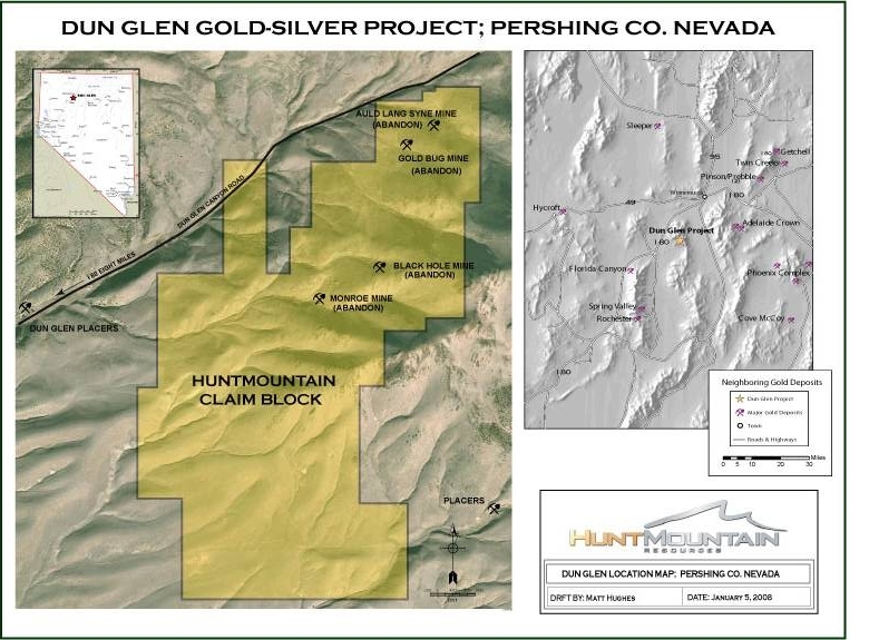
Pursuant to a 10 year lease agreement, HuntMountain holds 94 unpatented lode mining claims covering 1,700 acres in the Sierra mining district in Nevada.
ii. | Description of interests |
In early 2006, the Company entered into agreements to lease the properties comprising the Dun Glen Project with the option to purchase the claims. The initial lease/option term of the agreements is 10 years, renewable for an additional 10 years. To date the Company has made advance royalty payments totaling $67,500. Future annual advance royalty payments are as follows:
| · | 2nd Anniversary $45,000 |
| · | 3rd Anniversary $52,500 |
| · | 4th Anniversary $60,000 |
| · | 5th (and each anniversary thereafter) $72,500 |
1611 N Molter Road, Suite 201 Liberty Lake, WA 99019 509-892-5287 Tel 509-892-5318 Fax www.huntmountain.com
3
During the term of the agreement, the Company has the option to purchase 86% of the claims for $5,000 upon delivery of a copy of an approved mine plan of operations or a final feasibility study approved by the Company’s management. The seller will retain a 3% Net Smelter Return (“NSR”) royalty of which up to 2 percentage points may be purchased by the Company for $1,000,000 per percentage point. NSR is generally defined as the gross value of the metals less the costs of smelting, refining and transportation. The Company also has the option to purchase the remaining two claim blocks (or 14% of the claims) for $250,000 per block at any time during the term of the agreements. Both the sellers will retain a 3% NSR royalty on production from their respective claim block, of which up to 2 percentage points may be purchased by the Company for $875,000 per percentage point. The Company will maintain all of the claims referenced within the agreement in good standing during the lease period. The Company may terminate the lease at any time upon 60 days notice.
iii. | Mining claim detail |
See below.
1611 N Molter Road, Suite 201 Liberty Lake, WA 99019 509-892-5287 Tel 509-892-5318 Fax www.huntmountain.com
4
| Claim Name | Owner | BLM Claim Number | ||
| Black Hole #1 | Painter | NMC123920 | ||
| Black Hole #2 | Painter | NMC123921 | ||
| Monroe #1 | Painter | NMC123922 | ||
| Monroe #2 | Painter | NMC123923 | ||
| Monroe #3 | Painter | NMC123924 | ||
| M.M 1 | Painter | NMC463692 | ||
| M.M 2 | Painter | NMC463693 | ||
| M.M 8 | Painter | NMC463699 | ||
| Nevada 1 | Heckman | NMC123909 | ||
| Nevada 2 | Heckman | NMC123910 | ||
| Nevada 3 | Heckman | NMC123911 | ||
| Nevada 4 | Heckman | NMC123912 | ||
| Nevada 5 | Heckman | NMC123913 | ||
| Gus-1 | Scoonover Exploration LLC | NMC923277 | ||
| Gus-2 | Scoonover Exploration LLC | NMC923278 | ||
| Gus-3 | Scoonover Exploration LLC | NMC923279 | ||
| Gus-4 | Scoonover Exploration LLC | NMC923280 | ||
| Gus-5 | Scoonover Exploration LLC | NMC923281 | ||
| Gus-7 | Scoonover Exploration LLC | NMC923282 | ||
| Gus-8 | Scoonover Exploration LLC | NMC923283 | ||
| Gus-9 | Scoonover Exploration LLC | NMC923284 | ||
| Gus-10 | Scoonover Exploration LLC | NMC923285 | ||
| Gus-11 | Scoonover Exploration LLC | NMC923286 | ||
| Gus-12 | Scoonover Exploration LLC | NMC923287 | ||
| Gus-13 | Scoonover Exploration LLC | NMC923288 | ||
| Gus-14 | Scoonover Exploration LLC | NMC923289 | ||
| Gus-15 | Scoonover Exploration LLC | NMC923290 | ||
| Gus-16 | Scoonover Exploration LLC | NMC923291 | ||
| Gus-17 | Scoonover Exploration LLC | NMC923292 | ||
| Gus-18 | Scoonover Exploration LLC | NMC923293 | ||
| Gus-19 | Scoonover Exploration LLC | NMC923294 | ||
| Gus-20 | Scoonover Exploration LLC | NMC923295 | ||
| Gus-21 | Scoonover Exploration LLC | NMC923296 | ||
| Gus-22 | Scoonover Exploration LLC | NMC923297 | ||
| Gus-23 | Scoonover Exploration LLC | NMC923298 | ||
| Gus-24 | Scoonover Exploration LLC | NMC923299 | ||
| Gus-106 | Scoonover Exploration LLC | NMC923300 | ||
| Gus-107 | Scoonover Exploration LLC | NMC923301 | ||
| Gus-108 | Scoonover Exploration LLC | NMC923302 | ||
| Gus-109 | Scoonover Exploration LLC | NMC923303 | ||
| MTR-20 | Scoonover Exploration LLC | NMC923250 | ||
| MTR-21 | Scoonover Exploration LLC | NMC923251 | ||
| MTR-22 | Scoonover Exploration LLC | NMC923252 | ||
| MTR-23 | Scoonover Exploration LLC | NMC923253 | ||
| MTR-26 | Scoonover Exploration LLC | NMC923254 | ||
| MTR-27 | Scoonover Exploration LLC | NMC923255 | ||
| MTR-28 | Scoonover Exploration LLC | NMC923256 | ||
| MTR-29 | Scoonover Exploration LLC | NMC923257 |
1611 N Molter Road, Suite 201 Liberty Lake, WA 99019 509-892-5287 Tel 509-892-5318 Fax www.huntmountain.com
5
| Claim Name | Owner | BLM Claim Number | ||
| MTR-30 | Scoonover Exploration LLC | NMC923258 | ||
| MTR-31 | Scoonover Exploration LLC | NMC923259 | ||
| MTR-32 | Scoonover Exploration LLC | NMC923260 | ||
| MTR-33 | Scoonover Exploration LLC | NMC923261 | ||
| MTR-38 | Scoonover Exploration LLC | NMC923262 | ||
| MTR-39 | Scoonover Exploration LLC | NMC923263 | ||
| MTR-40 | Scoonover Exploration LLC | NMC923264 | ||
| MTR-41 | Scoonover Exploration LLC | NMC923265 | ||
| MTR-42 | Scoonover Exploration LLC | NMC923266 | ||
| MTR-43 | Scoonover Exploration LLC | NMC923267 | ||
| MTR-44 | Scoonover Exploration LLC | NMC923268 | ||
| MTR-45 | Scoonover Exploration LLC | NMC923269 | ||
| MTR-46 | Scoonover Exploration LLC | NMC923270 | ||
| MTR-47 | Scoonover Exploration LLC | NMC923271 | ||
| MTR-50 | Scoonover Exploration LLC | NMC923272 | ||
| MTR-51 | Scoonover Exploration LLC | NMC923273 | ||
| MTR-52 | Scoonover Exploration LLC | NMC923274 | ||
| MTR-53 | Scoonover Exploration LLC | NMC923275 | ||
| MTR-54 | Scoonover Exploration LLC | NMC923276 | ||
| Sierra-3 | Scoonover Exploration LLC | NMC923304 | ||
| Sierra-4 | Scoonover Exploration LLC | NMC923305 | ||
| Sierra-6 | Scoonover Exploration LLC | NMC923306 | ||
| Sierra-7 | Scoonover Exploration LLC | NMC923307 | ||
| Sierra-8 | Scoonover Exploration LLC | NMC923308 | ||
| Sierra-9 | Scoonover Exploration LLC | NMC923309 | ||
| Sierra-10 | Scoonover Exploration LLC | NMC923310 | ||
| Sierra-14 | Scoonover Exploration LLC | NMC923311 | ||
| Sierra-15 | Scoonover Exploration LLC | NMC923312 | ||
| Sierra-16 | Scoonover Exploration LLC | NMC923313 | ||
| Sierra-17 | Scoonover Exploration LLC | NMC923314 | ||
| Sierra-11 | Scoonover Exploration LLC | NMC923315 | ||
| Sierra-12 | Scoonover Exploration LLC | NMC923316 | ||
| Sierra-13 | Scoonover Exploration LLC | NMC923317 | ||
| Sierrra-18 | Scoonover Exploration LLC | NMC923318 | ||
| Sierrra-19 | Scoonover Exploration LLC | NMC923319 | ||
| Sierrra-20 | Scoonover Exploration LLC | NMC923320 | ||
| Sierrra-21 | Scoonover Exploration LLC | NMC923321 | ||
| Sierrra-22 | Scoonover Exploration LLC | NMC923322 | ||
| Sierrra-23 | Scoonover Exploration LLC | NMC923323 | ||
| Sierrra-24 | Scoonover Exploration LLC | NMC923324 | ||
| Sierrra-25 | Scoonover Exploration LLC | NMC923325 | ||
| Sierrra-26 | Scoonover Exploration LLC | NMC923326 | ||
| Sierrra-27 | Scoonover Exploration LLC | NMC923327 | ||
| Sierrra-28 | Scoonover Exploration LLC | NMC923328 | ||
| Sierrra-29 | Scoonover Exploration LLC | NMC923329 | ||
| Sierrra-30 | Scoonover Exploration LLC | NMC923330 |
1611 N Molter Road, Suite 201 Liberty Lake, WA 99019 509-892-5287 Tel 509-892-5318 Fax www.huntmountain.com
6
iv. | Required property payments |
To date the Company has made advance royalty payments totaling $67,500. Future annual advance royalty payments are as follows:
2nd Anniversary $45,000
3rd Anniversary $52,500
4th Anniversary $60,000
5th (and each anniversary thereafter) $72,500
In addition, annual claims maintenance equals $125.00 per claim or 11,750.00 for 94 claims. Plus annual claim filing fees of $8.50 per claim or $803.00 for 94 claims
v. | Area of claims |
1,700 acres
| c. | La Josefina, Santa Cruz Province, Argentina |
i. | Nature of ownership |
In March, 2007 HuntMountain obtained mining rights to the La Josefina property through a public bid process pending finalization of legal contract (signed in July of 2007)
ii. | Description of interests |
Pursuant to an agreement between Cerro Cazador (a wholly owned Argentine subsidiary of HuntMountain) and Fomicruz, Cerro Cazador is obligated to spend US$6 million in exploration and complete pre-feasibility and feasibility studies in a 4-year period at La Josefina in order to earn mining and production rights for a 40-year period in a joint venture partnership (“JV”) with Fomicruz. Cerro Cazador may terminate this agreement at the end of each exploration stage if results are negative. With the successful completion of positive pre-feasibility and feasibility studies at the end of the 4th year, a new company will be formed which will be 91%-owned by Cerro Cazador and 9%-owned by Fomicruz. Once production starts, Fomicruz has a one-time election to increase its interest in the company to either 19%, 29% or 49% by reimbursing Cerro Cazador 10%, 20% or 40%, respectively, of Cerro Cazador’s total investment in the project. The royalty prescribed by Federal (Argentina) mining code will be a 1% mine-mouth royalty if the operation produces doré bullion within the province, which is required in the agreement. Also, because La Josefina is a Provincial Mining Reserve with the mineral rights belonging to the province, the project will carry an additional 5 % mine-mouth royalty.
1611 N Molter Road, Suite 201 Liberty Lake, WA 99019 509-892-5287 Tel 509-892-5318 Fax www.huntmountain.com
7
iii. | Mining claim detail |
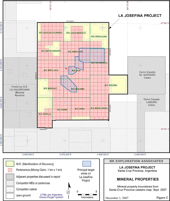
The Project includes 15 Manifestations of Discovery (Manifestacións de Descubrimiento, or simply “MDs”) totaling 52,776 hectares which are partially covered by 399 mining claims (minas or pertenencias), as shown in Figure 2 and listed in the following table:
Mineral Properties of the La Josefina Project
| M.D. | Expediente | Hectares | No. of Perts |
| Nicolás Alejandro | 409.072/F/98 | 3500 | 30 |
| Lucas Marcelo | 409.071/F/98 | 3500 | 12 |
| Sofia Luján | 409.070/F/98 | 3500 | 6 |
| Matiao Augusto | 409.069/F/98 | 3500 | 24 |
| Maria José | 409.068/F/68 | 3500 | 35 |
| Ivo Gonzalo | 409.067/F/98 | 3500 | 35 |
| Mirta Julia | 409.066/F/98 | 3500 | 35 |
| Ailin | 409.065/F/98 | 3500 | 35 |
| Mariana T. | 409.064/F/98 | 3500 | 18 |
| Benjamin | 409.063/F/98 | 3500 | 35 |
| Giuliana | 409.062/F/98 | 5100 | 25 |
| Rosella | 409.061F/98 | 3227 | 18 |
| Noemi | 409.060/F/98 | 3013 | 30 |
| Diana | 409.059/F/98 | 2995 | 25 |
| Miguel Ángel | 409.058/F/98 | 3435 | 35 |
| Julia | 409.048/F/98 | 6 | 1 |
| 52,776 399 |
1611 N Molter Road, Suite 201 Liberty Lake, WA 99019 509-892-5287 Tel 509-892-5318 Fax www.huntmountain.com
8
1611 N Molter Road, Suite 201 Liberty Lake, WA 99019 509-892-5287 Tel 509-892-5318 Fax www.huntmountain.com
9
| iv. | Required property payments |
Cerro Cazador must maintain the La Josefina mining rights by paying the annual canons due the province on the project’s 398 pertenencias. This currently amounts to approximately US$100,785 per year that can be deducted from the $ 6,000,000.00 work commitment.
v. | Area of claims |
52,770 hectares
| d. | El Gateado, Santa Cruz Province, Argentina |
i. | Nature of ownership |
In March, 2006 agents for Cerro Cazador S.A., staked claim to El Gateado thus securing 100% ownership of exploration rights for the area contained
ii. | Description of interests |
The company has the right to conduct exploration on El Gateado for a period of at least 1,000 days and retains 100% ownership of any mineral deposit found within. Should a mineral deposit be discovered, the company has the exclusive option to file for mining rights of said deposit.
iii. | Mining claim detail |
El Gateado is a exploration concession (called a Cateo) filed with the Santa Cruz Provincial mining authority under the designation “406776/DPR/06” (see La Josefina claim map above for details)
iv. | Property payments |
There was a one time filing fee of US$ 3,226.00 for El Gateado
v. | Area of claims |
10,000 hectares
1611 N Molter Road, Suite 201 Liberty Lake, WA 99019 509-892-5287 Tel 509-892-5318 Fax www.huntmountain.com
10
| e. | Bajo Pobre, Santa Cruz Province, Argentina |
i. | Nature of ownership |
In January HuntMountain Resources through its wholly-owned subsidiary Cerro Cazador S.A. signed a Letter of Intent with FK Minera S.A. to acquire a 100% interest in the Bajo Pobré gold property located in Santa Cruz Province , Argentina
ii. | Description of interests |
The Company entered into a Letter of Intent with FK Minera S.A. wherein the Company can earn up to a 100% equity interest in the Bajo Pobré property by making cash payments and exploration expenditures over a five-year earn-in period. The definitive agreement is expected to be signed in March 2007.
The required expenditures and ownership levels upon meeting those requirements are:
Year of the Agreement | Payment to FK Minera S.A. | Exploration Expenditures | Ownership | |||||||||
| First Year | $ | 50,000 | $ | 250,000 | 0 | % | ||||||
| Second Year | $ | 50,000 | $ | 250,000 | 0 | % | ||||||
| Third Year | $ | 75,000 | $ | 0 | 51 | % | ||||||
| Fourth Year | $ | 75,000 | $ | 0 | 60 | % | ||||||
| Fifth Year | $ | 75,000 | $ | 0 | 100 | % | ||||||
After the fifth year, the Company shall pay FK Minera the greater of a 1% NSR royalty on commercial production or US$100,000 per year. The Company has the option to purchase the NSR Royalty for a lump sum payment of US$1,000,000 less the sum of all royalty payments made to FK Minera to that point.
iii. | Mining claim detail |
Filed with the Santa Cruz provincial mining authority, the Bajo Pobre property is comprised of one “Manifestation of Discovery” type mining claim designated “MD Joanna Belem 409162/S/94 and 32 covering “pertenencia” type mining claims
1611 N Molter Road, Suite 201 Liberty Lake, WA 99019 509-892-5287 Tel 509-892-5318 Fax www.huntmountain.com
11
iv. | Property payments |
The required expenditures and ownership levels upon meeting those requirements are:
Year of the Agreement | Payment to FK Minera S.A. | Exploration Expenditures | Ownership | |||||||||
| First Year | $ | 50,000 | $ | 250,000 | 0 | % | ||||||
| Second Year | $ | 50,000 | $ | 250,000 | 0 | % | ||||||
| Third Year | $ | 75,000 | $ | 0 | 51 | % | ||||||
| Fourth Year | $ | 75,000 | $ | 0 | 60 | % | ||||||
| Fifth Year | $ | 75,000 | $ | 0 | 100 | % | ||||||
After the fifth year, the Company shall pay FK Minera the greater of a 1% NSR royalty on commercial production or US$100,000 per year. The Company has the option to purchase the NSR Royalty for a lump sum payment of US$1,000,000 less the sum of all royalty payments made to FK Minera to that point.
In addition there are annual claims maintenance fees of US$ 8,300.00
v. | Area of claims |
12,000 hectares
| f. | El Overo, El Alazan, and El Tordillo (non-material properties) |
| i. | Nature of ownership |
In 2006 agents for Cerro Cazador S.A., staked claim to these properties thus securing 100% ownership of exploration rights for the area contained
ii. | Description of interests |
The company has the right to conduct exploration on these properties for a period of at least 1,000 days and retains 100% ownership of any mineral deposit found within. Should a mineral deposit be discovered, the company has the exclusive option to file for mining rights of said deposit.
iii. | Mining claim detail |
These properties are exploration concessions (called Cateos) filed with the Santa Cruz Provincial mining authority under the designation “406.778/DPS/06” for El Overo, “406.777/DPS/06” for El Alazan, and “000.000/CC/06 for El Tordillo
1611 N Molter Road, Suite 201 Liberty Lake, WA 99019 509-892-5287 Tel 509-892-5318 Fax www.huntmountain.com
12
iv. | Property payments |
There was a one time filing fee of US$ 3,226.00 for each of these properties
v. | Area of claims |
10,000 hectares per property
| 4. | Mining Operation Disclosure: |
| a. | Lac a l’Eau Jaune and Malarctic Projects (the “Quebec properties”), Québec, Canada |
i. | Location and access |
The Lac à l’Eau Jaune Project is located approximately eighteen miles southwest of the Chibougamau mining camp. The project area is accessible from Chibougamau by vehicle via Road 167 south and Road 113 west toward the Chibougamau airport. The Malartic Surimau Project lies 25 miles west of the Town of Val D’or and ten miles south of the Town of Cadillac and is accessible by vehicle from Highway 117 by a maintained dirt road.
ii. | Property Title |
100% minerals rights title for these properties can be obtained from Diagnos Inc by drilling three holes in each of the three targets designated by Diagnos. To retain mineral title, claims maintenance for these properties include bi-annual CN$ 1,050.00 in renewal fees and a CD$ 25,200.00 in assessment work for Lac a l’Jaune and CN$1,250.00 renewal fee and CN$ 30,000.00 in assessment work for Malartic Surimau.
iii. | Geologic setting and mineralization |
Malartic Surimau Property:
The Archaean Malartic gold mines are located along the Larder Lake-Cadillac Fault zone, in the Abitibi sub-province of the Superior Province, some 20 km west of Val d'Or in Quebec,Canada. Historically the main mines of the district - East Canadian, Barnat, Sladen and Canadian Malartic - had produced over 162 tonnes of gold to 2000.
The district straddles the faulted contact between the mafic to ultramafic volcanics of the Piché Group to the north and the greywacke-mudstone sequence of the Pontiac Group to the south. The majority of the gold mineralization is found within the sediments where it is spatially associated with small monzonite porphyry bodies, younger diorite intrusives and crosscutting brittle (silicified) faults. The host succession has been subjected to NE trending F1 folds, asymmetric F2 folds with a SE striking penetrative S2 cleavage which is in turn paralleled by brittle faults. The monzodiorite intrusives predate F2, while a series of significant ESE trending brittle faults occur near the volcanic-sediment boundary. Two main styles of mineralization are observed, namely:
1611 N Molter Road, Suite 201 Liberty Lake, WA 99019 509-892-5287 Tel 509-892-5318 Fax www.huntmountain.com
13
1. elongate zones of disseminated auriferous pyrite in fractured and silicified greywacke and adjacent monzodiorite porphyry along ESE striking and S2 parallel faults,
2. stockwork zones of quartz-albite-K feldspar veinlets and intervening disseminated pyrite in intensely fractured and altered porphyritic monzodiorite and diorite adjacent to faults.
The alteration includes K and Na feldspar addition, carbonization and silicification in the sediments and by biotite development in the intrusives. Pyrite constitutes 5 to 10% of the altered greywackes and monzodiorites, and 5 to 20% of the mineralized diorite which also contains abundant magnetite.
Lac à l’Eau Jaune:
The Chibougamau District of northern Quebec, some 350 km to the north-east of Val d'Or, has produced in excess of 1,050 tonnes (33.75 Moz) of gold to date from a variety of styles of ore, but is mostly characterized by copper-gold vein deposits distinct from typical greenstone hosted quartz-carbonate veins. The deposits of the district range from volcanogenic massive sulphides with Cu, Zn & Ag; to gold bearing sulphide veins with associated Ag, Zn, Pb, As & Sb; to Cu-Au and Au-Cu veins with varying amounts of sulphides; and auriferous quartz veins with minor chalcopyrite. Most of the Cu-Au deposits are localized in SE trending ductile shear zones and are within meta-anorthosite and gabbroic hosts.
iv. | Work History |
As of the date of 10k filing date, no work had been done on either of the Abitibi Quebec properties and no information was known about the previous work history
1611 N Molter Road, Suite 201 Liberty Lake, WA 99019 509-892-5287 Tel 509-892-5318 Fax www.huntmountain.com
14
v. | Physical condition of plant, equipment etc. |
There is no plant, equipment or subsurface workings on either property
vi. | Description of equipment, infrastructure and/or other facilities |
There is no equipment, infrastructure or facilities on either property.
vii. | Current state of exploration |
In October of 2007 a group of Quebec professionals managed by Diagnos Inc were contracted to carry out a three phase exploration program which includes data compilation, general prospecting, geophysics and drilling. The three phases are scheduled to be completed by the forth quarter of 2008.
viii. | Total costs incurred |
US$ 35,000.00 per property or US$ 70,000 total was spent to secure the properties from Diagnos. Approximately US$17,000.00 was spent in mid 2Q of 2007 on property visits and preliminary prospecting and additional US$ 63,700.00 was spent to exploration contractors in Q4 of 2007. Total to date spent on the Quebec properties is approximately US$150,700.00
ix. | Source of water and power |
The Malartic Surimau property is crossed by the local power grid and contains large swampy areas indicative of abundant available water.
The Lac a l’Jaune property has power lines running along its border and contains multiple swamps, ponds, and lakes
x. | Neither the Lac a l’Jaune or Malartic Surimau property contain known mineral resources or reserves and any proposed work will be exploratory in nature. |
| b. | Dun Glen Gold Project, Nevada USA |
i. | Location and access |
The Dun Glen property is located in the historic Sierra mining district on the west flank of the East Range in northern Pershing County, Nevada. It lies approximately 25 miles southwest of Winnemucca and 21 miles north of the Florida Canyon Mine and can be accessed by 2X4 vehicle from U.S. Interstate 80 by a county-maintained 8-mile long dirt road.
1611 N Molter Road, Suite 201 Liberty Lake, WA 99019 509-892-5287 Tel 509-892-5318 Fax www.huntmountain.com
15
ii. | Property Title |
During the term of the agreement, the Company has the option to purchase 86% of the claims for $5,000 upon delivery of a copy of an approved mine plan of operations or a final feasibility study approved by the Company’s management. The seller will retain a 3% Net Smelter Return (“NSR”) royalty of which up to 2 percentage points may be purchased by the Company for $1,000,000 per percentage point. NSR is generally defined as the gross value of the metals less the costs of smelting, refining and transportation. The Company also has the option to purchase the remaining two claim blocks (or 14% of the claims) for $250,000 per block at any time during the term of the agreements. Both the sellers will retain a 3% NSR royalty on production from their respective claim block, of which up to 2 percentage points may be purchased by the Company for $875,000 per percentage point. The Company will maintain all of the claims referenced within the agreement in good standing during the lease period. The Company may terminate the lease at any time upon 60 days notice.
To retain and maintain claim status, the company must pay claims maintenance fees of US$11,750.00 and filing fees of US$ 803.00 annually.
iii. | Geologic setting and mineralization |
Published mapping (Johnson, 1977), which has been used as an historical reference, shows a northeast striking west dipping sequence of Triassic rocks. From bottom to top this includes the Koipato Group, Natchez Pass Formation, and Grass Valley Formation. Major northeast trending faults and minor thrust faults are also shown.
Four prospective vein zone areas occur in the 10,000 foot long vein corridor within the Weaver Rhyolite member of the Koipato Group. Three of these zones contain the Monroe-White Rock, Black Hole, and Auld Lang Syne-Golden Bell historic, gold-producing mines. The mesothermal-type veins are characterized by white milky quartz, with multistage silicification, brecciation, iron staining, and open space growth of quartz crystals. Exposures in caved stopes and adits show the veins range up to 8 feet wide. Some veins have clay along the footwall or hanging wall. The margins of mafic dikes commonly control some individual veins.
1611 N Molter Road, Suite 201 Liberty Lake, WA 99019 509-892-5287 Tel 509-892-5318 Fax www.huntmountain.com
16
The vein zone strikes range from north-south to slightly east of north. Dips are typically steeply northeast to vertical. Mineralization has historically been restricted to the quartz veins and included free gold, silver, galena, and sphalerite. These zones contain individual veins up to 2,000 feet long and up to 8 feet wide with numerous intersecting and anastamosing subsidiary veins. Exposed vertical extent is at least 600 feet from exposures on the tops of ridges to the bottom of the known workings at the valley bottoms. Producing mesothermal-type gold veins in other districts in the world have vertical extents measured in thousands of feet.
Surface sampling of outcrops, dumps, and prospects throughout the district identified the extensive quartz veining stretching from southwest of the Monroe-White Rock Zone to the Auld Lang Syne/Golden Bell on the north.
iv. | Work History |
Historic gold production within the Sierra district was recorded at 50,000 to 75,000 ounces lode gold and over 200,000 ounces of placer gold. Mineral records indicate the most productive mines were the Auld Lang Syne, Black Hole, Monroe, and Auburn. Historic mining never extended below the water table. The Dun Glen Project covers the Auld Lang Syne, Black Hole, and Monroe. Previous modern exploration was conducted by Franco-Nevada Mining Corp. which subsequently merged with Newmont Mining, and five reverse-circulation holes were drilled to fulfill the contractual obligation of the merger. Due to equipment-related logistical drilling problems only one hole was able to drill the edge of the vein-zone it targeted. Exploration work consisting of detailed geologic mapping and surface rock sampling has also been conducted by Minterra Resource Corp. and Golden Patriot Corp.
In 2006 The Company conducted additional geologic mapping and sampling comprised of approximately 1,400 rock, soil, and trench samples across the project area. A 200 line kilometer ground magnetic geophysical survey was conducted to delineate the structural setting. A four hole, 3,600 foot HQ diamond core drilling program was completed in the 4th Quarter of 2006 to test targets beneath the historic surface mine workings. Three of four holes intersected significant precious metal mineralization including five-foot assay intervals of 2.73, 1.23, 3.18, 1.77, 1.25, 0.94, 0.98, 2.21, and 1.87 grams per ton gold. Several of these intervals fell within broader mineralized halos including 155 feet grading 0.34 grams weighted average per ton and 75 feet grading 0.45 grams weighted average per ton gold. Significant silver was also intersected including five-foot assay intervals of 20.1, 26.5, 23.5, and 24.7 grams per ton (a complete table of all drill results will be attached to any amended 10K).
1611 N Molter Road, Suite 201 Liberty Lake, WA 99019 509-892-5287 Tel 509-892-5318 Fax www.huntmountain.com
17
The Company has identified gold occurrences on the property, but has not yet defined any reserves.
v. | Physical condition of plant, equipment etc. |
Only foundation remnants of the early 1900’s mining operations remain on the property. All equipment as been removed and underground workings are not generally accessible.
vi. | Description of equipment, infrastructure and/or other facilities |
Only foundation remnants of the early 1900’s mining operations remain on the property. No other facilities or equipment are present.
vii. | Current state of exploration |
No exploration is currently taking place at Dun Glen
viii. | Total costs incurred |
As of the filing date total costs incurred were approximately US$ 750,000.00 in exploration, US$ 67,500.00 in advance royalties, and US$ 12,553.00 in claims maintenance costs. (Total US$ 830,053.00)
ix. | Source of water and power |
Not known at this time
x. | The Dun Glen property does not have any known mineral reserves and any proposed work will continue to be exploratory in nature. |
| c. | La Josefina, Santa Cruz Province Argentina1 |
i. | Location and access |
The La Josefina Project is located in the north-central part of Santa Cruz Province, the southernmost of the several Argentine provinces comprising a vast, sparsely-populated, steppe-like region of southern South America known as Patagonia (Figure 1). The nearest town to the project is Gobernador Gregores (population 2,500), about 110 kilometers southwest, and the nearest Atlantic coastal town is Puerto San Julián (population 6,200), 190 kilometers southeast. The project is reached by driving east from Gobernador Gregores for 40 km on gravel Provincial Road 25 – or west from Puerto San Julián for 170 km on the same road – and then north on gravel Provincial Road 12 for 110 km. Provincial Road 12 crosses the edge of the project and continues another 240 kilometers north to the oil town of Pico Truncado (population 15,000) in the northeastern part of the province. The provincial roads are generally accessible via two-wheel drive vehicles in dry weather but can become slippery to impassable for short periods when wet. Gobernador Gregores and Puerto San Julián are both served by weekly “commuter” flights to/from Comodoro Rivadavia (population 137,000), an important industrial center and port city, 428 kilometers north of Puerto San Julián via paved highway Ruta 3. Comodoro Rivadavia serves as the region’s major supply center for the booming petroleum and mining industries and is served by several airline flights daily to Buenos Aires and other major cities in Argentina. Ruta 3, Argentina’s major coastal highway, runs from Buenos Aires on the north to Ushuaia at the southernmost tip of the continent and offers all-weather access to a number of sea ports.
___________________________
1 Portions of our response regarding the La Josefina property are from a technical report commissioned by us in 2007.
1611 N Molter Road, Suite 201 Liberty Lake, WA 99019 509-892-5287 Tel 509-892-5318 Fax www.huntmountain.com
18
ii. | Geologic setting and mineralization |
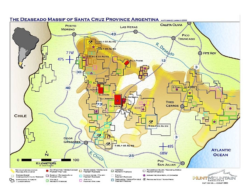
The La Josefina Project is located near the center of a large non-deformed stable platform known as the Deseado Massif, which covers an area of approximately 100,000 square kilometers in the northern third of Santa Cruz Province (Figure 3 & Appendix 1). The Deseado Massif is a virtual twin of the Somun Cura Massif encompassing parts of the adjacent provinces to the north. The two massifs are major metallotectonic features of the Patagonia region and represent the products of massive continental volcanism formed in the wake of extensional rifting caused by the breakup of the South American and African continents in Jurassic time.
The Deseado Massif is dominated by felsic volcanic and volcaniclastic rock units belonging to a few major regional sequences deposited in middle- to late-Jurassic time. The rocks are broken into a series of regional fractures that probably represent reactivated basement fracture zones. Faults active during the period of intense Jurassic extension and volcanism trend mostly NNWSSE and form a series of grabens, half-grabens and horst blocks which are tilted slightly to the east. Since Jurassic time, the rocks have been cut by normal faults of several different orientations, mainly NW-SE and ENE-WSW but have undergone only a moderate amount of compression. In general, the Jurassic rocks remain relatively undeformed and generally flat to gently dipping, except locally where close to faults, volcanic domes or similar features.
1611 N Molter Road, Suite 201 Liberty Lake, WA 99019 509-892-5287 Tel 509-892-5318 Fax www.huntmountain.com
19
The geology of the La Josefina Project Area has been mapped in detail by Moreira (2005). The project geology is essentially a scaled version of the Deseado Massif geology described above. Specifically:
| • | The project area is dominated by Jurassic-age rhyolitic volcanic units belonging to the Chon Aike Formation |
| • | There is one inlier of metamorphic basement rocks belonging to the Paleozoic age La Modesta Formation; |
| • | There are several small inliers of andesitic volcanics belonging to the Bajo Pobre Formation which is slightly older than the Chon Aike; |
| • | About half of the area is covered by thin Quaternary basalt flows (the dark areas in Figure 5 and Appendix 2); and |
| • | The project is crossed by a number of conjugate NNW-SSE and NE-SW sets of strong fault lineaments which are similar to those occurring throughout the Deseado Massif region. |
Missing (or perhaps unrecognized?) are the Jurassic-age sedimentary and volcaniclastic units of the Roca Blanca and La Matilde formations which are present at many other places in the region. Rhyolitic ignimbrites, lavas and tuffs of the Chon Aike Formation are intermittently exposed over about half of the La Josefina Project area with the remainder of the area largely concealed beneath the veneer of Quaternary basalts. Moreira (2005) subdivided the Chon Aike of the project area into nine members, each representing a separate volcanic event with generally similar sequences consisting of basal surge breccia followed by pyroclastic flows (ignimbrites), ash-fall tuffs and finally by re-worked volcaniclastic detritus. According to Moreira, the volcanism responsible for these nine episodic eruptions reached its climax over a relatively short 4-million year period in upper Jurassic time and is responsible for epithermal events that emplaced the gold-silver mineralization found in the La Josefina Project Area.
1611 N Molter Road, Suite 201 Liberty Lake, WA 99019 509-892-5287 Tel 509-892-5318 Fax www.huntmountain.com
20
Nearly all of the hundreds of gold-silver±base metals occurrences in the Deseado Massif region of southern Argentina are categorized as “low-sulfidation type epithermal vein deposits.” “Epithermal” deposits are high-level hydrothermal systems which usually form within one kilometer of the surface at relatively low temperatures, generally in the range of 50°C to 200°C. They often represent deeper parts of fossil geothermal systems with some forming hot-springs at or near the surface. The modifier “low-sulfidation” denotes a variety of epithermal deposits characteristically deficient in sulfide minerals and often called “quartz-adularia” vein systems after the two most common gangue (non-valuable) minerals in the veins. They are also sometimes known as “bonanza Au-Ag” because these deposits include many of the world’s most famous bonanza-grade gold and/or silver ore bodies. Well-known examples include Comstock (Nevada, USA), McLaughlin (California, USA), Creede (Colorado, USA), Ladolam (Lihir, Papua New Guinea), El Peñon (Chile), Guanajuato (Mexico), Hishikari (Japan) and – in the Deseado Massif region of Argentina – Mina Martha and Cerro Vanguardia. The many low-sulfidation epithermal occurrences of the Deseado Massif are products of episodic rhyolitic volcanism spread widely over a 50-million year time period and a 100,000 square kilometer area. Despite differences in space and time, they are all remarkably similar in style and origin and they closely fit the classic low-sulfidation epithermal vein model. The region’s premier deposit example and flagship operation is the Cerro Vanguardia mine, operated jointly by AngloGold Ashanti and Fomicruz S.E. Opened in 1998, the mine has produced continuously at the approximate rate of 250,000 ounces gold and 2.5 million ounces silver per year at average cash costs of US$133 to US$232 per ounce of gold (AngloGold Annual Reports, 2001-2006). The deposits are fissure vein systems localized by structures, often a meter or more wide and hundreds of meters to several kilometers long. They are comprised of quartz veins, stockworks and breccias that carry gold, silver, electrum and some sulfides, mainly pyrite, with variable, but usually small, amounts of base metal sulfides. The richest mineralization commonly occurs in dilational zones caused by structural irregularities along or down the vein. The thickening and thinning along and down the structure, often referred to as “pinch-and-swell,” is responsible for rod-like high-grade ore shoots – “bonanzas” – that are hallmarks of these systems.
1611 N Molter Road, Suite 201 Liberty Lake, WA 99019 509-892-5287 Tel 509-892-5318 Fax www.huntmountain.com
21
iii. | Work History |
In 1975, the first occurrence of metals known in the La Josefina area was publicly mentioned by the Patagonia delegation of the National Ministry of Mining who reported the presence of an old lead-zinc mine in veins very near Estancia La Josefina (Viera and Marquez, 1975). This received no further attention until 1994 when a research project by the Institute of Mineral Resources of the UNLP and the geology department of the University of Patagonia San Juan Bosco examined the occurrence. The investigation corroborated not only the presence of base metals (197 to 377 ppm Cu, 972 to 2549 ppm Pb, and 308 to 569 ppm Zn) but also found significant amounts of previously unknown precious metals (1 to 3 g/t Au and 5 to 21 g/t Ag). In 1994, immediately after the La Josefina gold-silver discovery, Fomicruz S.E. claimed the area as a Provincial Mineral Reserve and subsequently explored the project in collaboration with the Instituto de Recursos Minerales (INREMI) of La Plata University. The geology and alteration of the project area was mapped at a scale of 1:20,000, mineralized structures and zones of sinter were mapped at 1:2,500, trenches across the structures were continuously sampled and mapped at scales of 1:100 and ground geophysical surveys consisting of 6,000 m of IP resistivity and 5,750 meters of magnetic surveys were completed over sectors of greatest interest (INREMI, 1996). In 1998, after four years of exploring and advancing interest in the project, Fomicruz offered La Josefina for public bidding by international mining companies. In accordance with provincial law, the winner would continue exploring the project to earn the right to share production with Formicruz of any commercial discoveries. The bid was awarded to Minamérica S. A., a small private Argentine mining company. Minamérica dug a limited number of new trenches, initiated a program of systematic surface geochemical sampling, completed several new IP-Resistivity geophysical survey lines and drilled the first exploration holes on the project – 12 diamond core holes (HQ-size, 63.5mm diameter) totaling 800 meters in length. The results of this effort, as summarized in the Drilling chapter of this Technical report, were relatively encouraging but Minamérica nevertheless abandoned the project a year later in 1999. In 2000, Fomicruz resumed exploration of the project and continued their efforts until 2006. Pits were dug to bedrock on 100-meter grids over some of the target areas, 3,900 meters of new trenches were dug and sampled, more than 8,000 float, soil and outcrop samples were collected for geochemical analyses, some new IP-Resistivity surveys were completed under contract to Quantec Geophysical Co., and 59 diamond core holes (total 3,680 metes) were drilled to average shallow depth below surface of 55 meters. Of these holes, 37 were NQ-size core (47.6mm diameter) and 22 were HQ-size core (63.5mm). The results of the drilling are summarized in the Drilling chapter of this report. Fomicruz reports spending more than US$2.8 million in exploring and improving infrastructure on the La Josefina Project from 1994 to 2006. In late-2006, the La Josefina Project was again opened to international bidding and in May, 2007, Cerro Cazador S.A., the Argentine subsidiary of HuntMountain Resources, Inc., was awarded the right to explore the project. Details of this agreement are summarized in the previous Property Description and Location chapter of this Technical report.
The Company has identified gold occurrences on the property, but has not yet defined any reserves..
iv. | Physical condition of plant, equipment etc. |
There is no plant, or equipment at La Josefina
1611 N Molter Road, Suite 201 Liberty Lake, WA 99019 509-892-5287 Tel 509-892-5318 Fax www.huntmountain.com
22
v. | Description of equipment, infrastructure and/or other facilities |
Infrastructure present on the project include an old ranch house and several out-buildings that are currently being used and camp headquarters and core storage facilities
vi. | Current state of exploration |
Currently we have 18 staff members working at La Josefina. Activities include surface mapping and channel sampling, a 100+ line kilometer geophysical survey, and HQ diamond core drill program in progress
vii. | Total costs incurred |
Currently we have spent approximately 1.7 million US$ on exploration, camp improvements, claims maintenance and surface acquisition at La Josefina
viii. | Source of water and power |
Not known at this time
ix. | The La Josefina property does not have any known mineral reserves and any proposed work will continue to be exploratory in nature. |
| d. | Bajo Pobre, Santa Cruz Province Argentina |
i. | Location and access |
Bajo Pobre Property is located in north-central Santa Cruz province near 47 18’ 04” south latitude and 69 11’ 28” west longitude, 90 kilometers south of the town of Las Heras. It can be accessed by driving west from Las Heras on provincial route 43 for 53 kilometers then south on route 39 for 85 kilometers crossing estancias Laguna grande, El Mirasol, La Herradura and Cumbres Blancas. From there, turning south-east on the access road to Estancia Santa Cruz and traveling an additional 82 kilometers to the property boundary. The total distance of 220 kilometers can be traveled in the summer by 2X4 and normally in the winter by 4X4.
ii. | Geologic setting and mineralization |
The geology of the area is dominated by Jurassic-aged, volcanic rocks of the Bajo Pobré formation. Mineralization is characterized as epithermal in nature, comprised of numerous zones of quartz veining, vein breccias, and stock works with a cumulative strike length of more than 9 kilometers. Individual veins range from 0.5 meters to 6 meters in width
1611 N Molter Road, Suite 201 Liberty Lake, WA 99019 509-892-5287 Tel 509-892-5318 Fax www.huntmountain.com
23
iii. | Work History |
The property was discovered in 1970 and has been worked intermittently by several government entities and private companies. Serious exploration began in the 1990’s with geologic mapping and surface sampling. Assays from this sampling yielded values up to 40 grams per ton gold. Drill targets identified from surface sampling were augmented in 2002 with additional targets derived from a geophysical survey. In 2003 and 2004, the property saw a limited amount of exploration drilling which tested a small portion of these targets.
The Company has identified gold occurrences on the property, but has not yet defined any reserves.
iv. | Physical condition of plant, equipment etc. |
There is no plant, or equipment at Bajo Pobre
v. | Description of equipment, infrastructure and/or other facilities |
Infrastructure present on the project includes an old ranch house and several out-buildings.
vi. | Current state of exploration |
Currently no exploration is taking place at Bajo Pobre
vii. | Total costs incurred |
Approximately US$ 60,000 as been spent to date on Bajo Pobre for lease payments and claims maintenance.
viii. | Source of water and power |
Not known at this time
ix. | The Bajo Pobre property does not have any known mineral reserves and any proposed work will continue to be exploratory in nature. |
| e. | El Gateado, Santa Cruz Province Argentina |
i. | Location and access |
1611 N Molter Road, Suite 201 Liberty Lake, WA 99019 509-892-5287 Tel 509-892-5318 Fax www.huntmountain.com
24
The “ El Gateado ” property is located 160 kilometers NW of Puerto San Julian and 120 kilometers NE of Gobernador Gregores . The project is reached by driving east from Gobernador Gregores for 40 km on gravel Provincial Road 25 – or west from Puerto San Julián for 170 km on the same road – and then north on gravel Provincial Road 12 for 110 km. Provincial Road 12 crosses the edge of the project at this point.
ii. | Geologic setting and mineralization |
The geology of the area is dominated by Jurassic-aged, volcanic rocks of the Bajo Pobré formation. Mineralization is characterized as epithermal in nature, comprised of numerous zones of quartz veining, vein breccias, and stock works with a cumulative strike length of more than 9 kilometers. Individual veins range from 0.5 meters to 6 meters in width.
iii. | Work History |
Field reconnaissance work began in February 2006 with the completion of a topographic survey, base map generation, and a staked grid. Detailed geologic mapping and outcrop channel sampling were completed for drill target identification. In late 2006, a 1,500 meter diamond core drilling program was initiated on identified targets and completed in early 2007.
The Company has identified gold occurrences on the property, but has not yet defined any reserves.
iv. | Physical condition of plant, equipment etc. |
There is no plant, or equipment at El Gateado
v. | Description of equipment, infrastructure and/or other facilities |
There is no equipment, facilities or infrastructure present at El Gateado
vi. | Current state of exploration |
At this time no exploration is taking place at El Gateado
vii. | Total costs incurred |
A total of approximately US$ 760,000.00 as been spent on El Gateado to date for property acquisition, general prospecting and HQ diamond core drilling.
1611 N Molter Road, Suite 201 Liberty Lake, WA 99019 509-892-5287 Tel 509-892-5318 Fax www.huntmountain.com
25
viii. | Source of water and power |
Not known at this time
ix. | The El Gateado property does not have any known mineral reserves and any proposed work will continue to be exploratory in nature. |
| f. | El Overo, El Alizan and El Tordillo, Santa Cruz Province Argentina |
(NOT MATERIAL)
| 5. | La Josefina Resource Disclosure: |
| a. | All references to the La Josefina resource will be removed |
| 6. | Disclosure of grades: |
| a. | La Josefina,El Gateado and Dun Glen |
i. | All intervals containing more than one assay will be reported as a weighted average |
ii. | All reporting of grab or dump samples will be eliminated |
iii. | Highest or best drill assay reporting will be eliminated and replaced by tables reporting all drill assays |
iv. | All grades reported as “up to” or “as high as” or “as much as” or “ranging from” will be eliminated. |
v. | All statements containing grade and/or sample-width ranges will be eliminated |
vi. | Aggregated sample values from related locations will be reported as weighted averages of the lengths of the samples. |
vii. | Tables will be used whenever possible to report sample and drill data. |
viii. | Disclosure of soil samples will be reported as a weighted average over a defined area. |
ix. | No single soil sample values will be reported |
x. | All ppb values will be converted to ppm values for reporting purposes |
1611 N Molter Road, Suite 201 Liberty Lake, WA 99019 509-892-5287 Tel 509-892-5318 Fax www.huntmountain.com
26
xi. | All optimistic descriptive adjectives will be removed from reporting text. |
| 7. | Bajo Pobre Property: |
| a. | Legal Framework of cateos and pertinencia mining concessions(applicable to all HNTM Argentine holdings): |
Minerals are owned by the provinces, even when they are generally regulated by the national Mining Code. The Mining Code establishes that private property of mines is determined by legal concession.
The provinces can impose a maximum 3% mine-mouth royalty on mineral production. In the case of Santa Cruz Province, if most of the mining processes are performed in the state, coming at the end with a dore bar as the final product, the mine-mouth royalty can drop to 1%.
In addition, on 1993, the Congress approved “The Mining Investment Law” which covers all the mining stages: prospecting, exploration, extraction, milling, leaching and smelting, when this industrialization is performed by the same economic unit in the region of origin of the mineral. Mining companies needs to file a paper work to the National Mining Office in order to get an official certificate which gives several advantages. This document affords 30 years of tax stability on new mines development as well as attractive capital investment depreciation rights, advantages on provincial and municipal taxes, deduction of 100% on income taxes for the cost of investment done during prospecting and exploration studies, a special regime for amortizing investment in infrastructure machinery and equipment, exemption from income tax of profits resulting from mines and mineral rights; and certain import and export benefits alleviating taxes. By virtue of a well established mining code, new mine developments can claim a five-year federal tax holiday on production income.
1611 N Molter Road, Suite 201 Liberty Lake, WA 99019 509-892-5287 Tel 509-892-5318 Fax www.huntmountain.com
27
Exploration stages:
a) Cateos: The first step in acquiring mining rights is filing a cateo, which gives exclusive prospecting rights for the requested area for a period of time, according with the size of the obtained surface. Maximum size of each cateo is 10,000 hectares, which gives one thousands days to explore the area. A maximum of 20 cateos can be held by a single entity (individual or company) in any one province.
b) Manifestation of Discoveries: The holder of a cateo has exclusive right to establish a Manifestation of Discovery (MD) on that cateo, but MD´s can also be set without a cateo on any land not covered by someone else´s cateo. MD´s are filed as either a vein or a disseminated discovery. A square protection zone can be declared around the discovery – up to 840 hectares for a vein MD or up to 7,000 hectares for a disseminated MD. The protection zone grants the discoverer exclusive rights for an indefinite period, during which the discoverer must provide an annual report presenting a program of exploration work and investments related to the protection zone.
C) Minas (Mining claims): An MD can later be upgraded to a Mina (mine claim), which gives the holder the right to begin commercial extraction of minerals.
A period not less than sixty (60) days must elapse between the publication of the expiration of the time for exclusive exploration rights belonging to a person and the request of a Cateo by other person (Article 28, amended by Law 22259). During this period of 60 days (as amended by Law 24468), it is allowed that the owner of the Cateo makes its Manifestation of Discoveries. An additional period to make the required “formal work” up to 150 days is obtained and the exploration area is reduced to 70 zones or mining claims of 6 hectares each for vein type deposits or 35 zones of mining claims of 100 hectares each for disseminated type deposits.
1611 N Molter Road, Suite 201 Liberty Lake, WA 99019 509-892-5287 Tel 509-892-5318 Fax www.huntmountain.com
28
Actually, the final time resulting is longer, because of the time required by established procedures to do the required “formal work” and the required “legal survey”.
The Mines Notary is the officer attesting in the discovery statement to the delivery date and hour, certifying after the Mining Authorities fin out whether there is or not another petition in the zone. The certification is made after the Graphic Department verifies on a map the location of the announced discovery.
When the permission has been granted, the claims are to be defined. Once the discovery has been verified and the mine deposit confirmed, the petitioner will request the formal concession for the mine.
The explorer must compensate the surface owner for any damage incurred during the exploration activities. The surface owner can demand a previous amount of money as a compensation value.
Mining Property:
The mine concession is unlimited in time, and only ends when the exploitation ceases. It can be transferred by any of the means used for transfers of common property, and as in common real state, mining properties is subject to mortgages.
1611 N Molter Road, Suite 201 Liberty Lake, WA 99019 509-892-5287 Tel 509-892-5318 Fax www.huntmountain.com
29
The payment of an annual Lease or Mining Right of $80 (Argentinean pesos) for each claim in vein deposit and of $800 (Argentinean pesos) for each disseminated deposit, is required. The lease must be paid in advance and in two equal semi-annual instalments (June 30 and December 31).
The miner shall have to invest in the mine equipment, camps, building, roads, power plants, within the term of 5 years (Art 273) for a minimum amount of 500 times the annual Lease.
Provinces that decide to collect royalties may not receive a percentage exceeding three per cent over the “mine’s exit value” of the extracted ore.
| b. | History of Bajo Pobre Claims |
i. | Mineral rights to the Bajo Pobre project were originally applied for and granted to FK Minera prior to 1990. In 1994 agents for FK Minera filed a “Manifestation of Discovery” over the cateo designated “M.D. Johana Belen 409162/S/94” This M.D. was then covered with 32 mining claims or “minas” (pertinencias) In 2003 two additional M.D.’s were filed and granted to FK Minera under the designations “VIVA LA VIDA 406665/DPM/03” and “MI SUENO 406.666/DPM/03” these M.D.’s were later covered by 62 “minas” |
| 8. | Exploration Plans: |
| a. | La Josefina, |
i. | Geologic Justification for la Josefina exploration (applicable to all Argentine properties); the property lies on an established trend of known mineralization; contains rock types and structural settings known to host precious metal occurrences; exhibits landsat-indicated alteration consistent with other known mineral occurrences; has anomalous surface geochemistry established by industry standard sampling and assaying methodology; In addition La Josefina has an exploration history which has shown the properties potential to host economic precious metal deposits. |
1611 N Molter Road, Suite 201 Liberty Lake, WA 99019 509-892-5287 Tel 509-892-5318 Fax www.huntmountain.com
30
ii. | Exploration timetable and budget breakdown: see attached spread sheet |
iii. | Phased Program; Four exploration phases are planned for La Josefina over a five-calendar year period beginning in September of 2007 through December of 2012. Phases 1 and 2 will consist primarily of resource identification and delineation drilling. Phase 3 and 4 will be totally dependant on the results from previous phases and will likely include a combination of drilling and feasibility related tasks. |
iv. | Funding: funding of exploration activities will be dependant on the company’s ability to attain additional equity financing. |
v. | La Josefina exploration will be carried out by the company’s staff and consultants which include professional registered argentine geologists. A complete list is as follows; |
Lic. Danilo Patricio Silva, General Manager
Cdor. Raúl Bonfada, Director Suplente, Administration Buenos Aires
Lic. Jorge Washington Garay, Geologist, Project Manager
Lic. Jorge Ernesto Gíudici, Senior Geologist
Cdor. Sergio Daniel Pezzino, Administrative & Logistical Manager
Lic. José Eduardo Bustos, Geologist
Lic. Marcelo Roberto Ghidini, Geologist
Lic. Matías Albarracín, Geologist
Sr. Daniel Del Castillo, Date Base, drafting and Computers Manager
Sr. Marcelo Rodrigo Vázquez, Operative Chief
Sr. Fernando Prestinoni, Chief maintenance
Sr. Luis Arroyo, Senior prospector
Mr. Darío Orlando Reuque, technician
Mr. Marcos Antonio Torres, technician
Mr. Denis Ubaldo Cayunao, technician
Mr. Oscar Pilquil, technician
Danilo Silva and Matthew Hughes form the core of HuntMountain’s technical / exploration management team. They have known each other and worked together for more than 12 years. They have spent ten years conducting precious-metals exploration in Santa Cruz Province Argentina. During that time they performed all aspects of exploration and individually and/or collaboratively discovered numerous precious metal occurrences.
Matthew J. Hughes, Executive Vice President and C.O.O. is a geologist with eighteen years of experience in the discovery, exploration and mining of precious metals in the United States, Argentina, China, Brazil and Uzbekistan. He was directly responsible for the discovery of the producing “Mina Martha” silver lode in Santa Cruz, Argentina. He has worked as the Chief Geologist and project manager for Mundoro Mining, Inc. where he led the exploration and development of the nine million ounce “Maoling” gold deposit, thought to be the largest undeveloped gold deposit in China. He served as Senior Exploration Geologist and consultant for Yamana Resources, Minas Buenaventura, and Silver Standard Resources. Mr. Hughes has been the Vice President of Exploration for Platero Resources, Chief Mine Geologist for Kinross Candelaria Mining Co. and Exploration Geologist for NERCO Exploration and Atlas Precious Metals. He received his Bachelor of Science degree in geology from the University of Oregon.
1611 N Molter Road, Suite 201 Liberty Lake, WA 99019 509-892-5287 Tel 509-892-5318 Fax www.huntmountain.com
31
Danilo Silva, General Manager of South American Operations, also serves as the President of our wholly-owned Argentine subsidiary, Cerro Cazador, S.A. He has over 18 years of experience in the natural resources industry, including over 11 years as a geologist in base and precious metal mining exploration. Mr. Silva has served as Senior Geologist and Project Manager for Yamana Resources and Compania Minera Polimet, as Senior Geologist and country manager for Buenaventura, and as General Manager for Platero Resources. Mr. Silva has also served as a consulting geologist for several companies, including Placer Dome and Hidefield Gold. Mr. Silva holds a degree in Geological Science from the National University at Bahia Blanca in Argentina.
| b. | Bajo Pobre, |
i. | Geologic Justification for Bajo Pobre exploration (applicable to all Argentine properties); the property lies on an established trend of known mineralization; contains rock types and structural settings known to host precious metal occurrences; exhibits landsat-indicated alteration consistent with other known mineral occurrences; has anomalous surface geochemistry established by industry standard sampling and assaying methodology |
ii. | Exploration timetable and budget breakdown: see attached spread sheet |
iii. | Phased Program; Dependant on initial exploration results |
iv. | Funding: funding of exploration activities will be dependant on the company’s ability to attain additional equity financing. |
1611 N Molter Road, Suite 201 Liberty Lake, WA 99019 509-892-5287 Tel 509-892-5318 Fax www.huntmountain.com
32
v. | Bajo Pobre exploration will be carried out by the company’s Argentine staff and consultants who include professional registered geologists. A complete list is as follows; |
Lic. Danilo Patricio Silva, General Manager
Cdor. Raúl Bonfada, Director Suplente, Administration Buenos Aires
Lic. Jorge Washington Garay, Geologist, Project Manager
Lic. Jorge Ernesto Gíudici, Senior Geologist
Cdor. Sergio Daniel Pezzino, Administrative & Logistical Manager
Lic. José Eduardo Bustos, Geologist
Lic. Marcelo Roberto Ghidini, Geologist
Lic. Matías Albarracín, Geologist
Sr. Daniel Del Castillo, Date Base, drafting and Computers Manager
Sr. Marcelo Rodrigo Vázquez, Operative Chief
Sr. Fernando Prestinoni, Chief maintenance
Sr. Luis Arroyo, Senior prospector
Mr. Darío Orlando Reuque, technician
Mr. Marcos Antonio Torres, technician
Mr. Denis Ubaldo Cayunao, technician
Mr. Oscar Pilquil, technician
Danilo Silva and Matthew Hughes form the core of HuntMountain’s technical / exploration management team. They have known each other and worked together for more than 12 years. They have spent ten years conducting precious-metals exploration in Santa Cruz Province Argentina. During that time they performed all aspects of exploration and individually and/or collaboratively discovered numerous precious metal occurrences.
Matthew J. Hughes, Executive. Vice President and C.O.O. is a geologist with eighteen years of experience in the discovery, exploration and mining of precious metals in the United States, Argentina, China, Brazil and Uzbekistan. He was directly responsible for the discovery of the producing “Mina Martha” silver lode in Santa Cruz, Argentina. He has worked as the Chief Geologist and project manager for Mundoro Mining, Inc. where he led the exploration and development of the nine million ounce “Maoling” gold deposit, thought to be the largest undeveloped gold deposit in China. He served as Senior Exploration Geologist and consultant for Yamana Resources, Minas Buenaventura, and Silver Standard Resources. Mr. Hughes has been the Vice President of Exploration for Platero Resources, Chief Mine Geologist for Kinross Candelaria Mining Co. and Exploration Geologist for NERCO Exploration and Atlas Precious Metals. He received his Bachelor of Science degree in geology from the University of Oregon.
1611 N Molter Road, Suite 201 Liberty Lake, WA 99019 509-892-5287 Tel 509-892-5318 Fax www.huntmountain.com
33
Danilo Silva, General Manager of South American Operations, also serves as the President of our wholly-owned Argentine subsidiary, Cerro Cazador, S.A. He has over 18 years of experience in the natural resources industry, including over 11 years as a geologist in base and precious metal mining exploration. Mr. Silva has served as Senior Geologist and Project Manager for Yamana Resources and Compania Minera Polimet, as Senior Geologist and country manager for Buenaventura, and as General Manager for Platero Resources. Mr. Silva has also served as a consulting geologist for several companies, including Placer Dome and Hidefield Gold. Mr. Silva holds a degree in Geological Science from the National University at Bahia Blanca in Argentina.
| c. | Dun Glen Nevada, USA |
i. | Geologic Justification for Dun Glen exploration: Dun Glen is located on an established trend known to host many economic precious metal deposits; the geologic setting at Dun Glen is very similar to that of several known precious metal deposits including Florida Canyon and Spring Valley. Dun Glen fall within the historic “Sierra Mining District” which reported more than 250,000 ounces of gold production from both hard-rock and placer sources. |
ii. | Exploration timetable and budget breakdown: No Exploration is planned at this time |
iii. | Phased Program; N/A |
iv. | Funding: future funding of exploration activities will be dependant on the company’s ability to attain additional equity financing. |
v. | Dun Glen exploration will be carried out by Matthew Hughes with the aid of contract professionals. |
Matthew J. Hughes, Executive. Vice President and C.O.O. is a geologist with eighteen years of experience in the discovery, exploration and mining of precious metals in the United States, Argentina, China, Brazil and Uzbekistan. He was directly responsible for the discovery of the producing “Mina Martha” silver lode in Santa Cruz, Argentina. He has worked as the Chief Geologist and project manager for Mundoro Mining, Inc. where he led the exploration and development of the nine million ounce “Maoling” gold deposit, thought to be the largest undeveloped gold deposit in China. He served as Senior Exploration Geologist and consultant for Yamana Resources, Minas Buenaventura, and Silver Standard Resources. Mr. Hughes has been the Vice President of Exploration for Platero Resources, Chief Mine Geologist for Kinross Candelaria Mining Co. and Exploration Geologist for NERCO Exploration and Atlas Precious Metals. He received his Bachelor of Science degree in geology from the University of Oregon.
1611 N Molter Road, Suite 201 Liberty Lake, WA 99019 509-892-5287 Tel 509-892-5318 Fax www.huntmountain.com
34
| d. | Abitibi Quebec, Canada |
i. | Geologic Justification for Abitibi Quebec: the Abitibi property’s lie along an established mining trend that has produced more than 180,000,000 million ounces of gold. |
ii. | Exploration timetable and budget breakdown: see attached exploration plan and budget |
iii. | Phased Program; see attached |
iv. | Funding: future funding of exploration activities will be dependant on the company’s ability to attain additional equity financing. |
v. | Abitibi exploration will be carried out by DIAGNOS INC. references attached |
| 9. | Financial Statements: |
i. | The terms “develop”, “development” and “production” will be removed prospectively from the financial statements for the period ended December 31, 2007 , including head and footnotes and replaced as needed by “explore or exploration” |
In connection with responding to the staff’s comments, the Company acknowledges that:
| ∙ | the Company is responsible for the adequacy and accuracy of the disclosure in the filing |
| ∙ | staff comments or changes to disclosure in response to staff comments do not foreclose the Commission from taking any action with respect to the filing; and |
| ∙ | the Company may not assert staff comments as a defense in any proceeding initiated by the Commission or any person under federal securities laws of the United States. |
1611 N Molter Road, Suite 201 Liberty Lake, WA 99019 509-892-5287 Tel 509-892-5318 Fax www.huntmountain.com
35
Please do not hesitate to contact me if you require more information.
Sincerely,
HuntMountain Resources
By
________________________
Matt Hughes
Chief Operating Officer
1611 N Molter Road, Suite 201 Liberty Lake, WA 99019 509-892-5287 Tel 509-892-5318 Fax www.huntmountain.com
36
1611 N Molter Road, Suite 201 Liberty Lake, WA 99019 509-892-5287 Tel 509-892-5318 Fax www.huntmountain.com
37
1611 N Molter Road, Suite 201 Liberty Lake, WA 99019 509-892-5287 Tel 509-892-5318 Fax www.huntmountain.com
38
1611 N Molter Road, Suite 201 Liberty Lake, WA 99019 509-892-5287 Tel 509-892-5318 Fax www.huntmountain.com
39
| CERRO CAZADOR S.A. | ||||||||||||||||||
| EXPENDITURE BUDGET SUMMARY | ||||||||||||||||||
| Argentina | DRAFT | |||||||||||||||||
| Financial Year 2007 | ||||||||||||||||||
| Year 2007 | Year 2008 | All amounts in US$ 000s | ||||||||||||||||
| Cost Centre | Project | Component | Code | M7 | M8 | M9 | M10 | M11 | M12 | Subtotal | M1 | M2 | M3 | M4 | M5 | M6 | Subtotal | Total |
| Projects | La Josefina | Min Prop Costs | 1.1 | 0.0 | 0.0 | 0.0 | 0.0 | 0.0 | 0.0 | 0.0 | 55.0 | 0.0 | 1.4 | 0.0 | 55.0 | 0.0 | 111.4 | 111.4 |
| Permitting | 1.2 | 3.6 | 3.6 | 3.6 | 3.6 | 3.6 | 3.6 | 21.8 | 3.6 | 3.6 | 3.6 | 3.6 | 3.6 | 3.6 | 21.8 | 43.6 | ||
| Reconnaissance Exploration | 1.3 | 0.0 | 0.0 | 12.0 | 12.0 | 12.0 | 0.0 | 36.0 | 0.0 | 0.0 | 0.0 | 0.0 | 0.0 | 0.0 | 0.0 | 36.0 | ||
| Trenching | 1.4 | 0.0 | 0.0 | 0.0 | 45.0 | 43.0 | 47.9 | 135.9 | 0.0 | 0.0 | 0.0 | 0.0 | 0.0 | 0.0 | 0.0 | 135.9 | ||
| Detailed Exploration | 1.5 | 0.0 | 2.0 | 100.0 | 2.0 | 0.0 | 0.0 | 104.0 | 0.0 | 0.0 | 9.0 | 0.0 | 0.0 | 2.0 | 11.0 | 115.0 | ||
| Drilling DD | 1.6 | 0.0 | 85.0 | 156.5 | 162.0 | 164.0 | 79.1 | 646.6 | 0.0 | 12.0 | 133.5 | 142.0 | 142.0 | 36.6 | 466.1 | 1112.7 | ||
| Resource Estimation | 1.7 | 0.0 | 0.0 | 0.0 | 0.0 | 0.0 | 0.0 | 0.0 | 0.0 | 0.0 | 0.0 | 0.0 | 0.0 | 2.0 | 2.0 | 2.0 | ||
| Subtotal | 1 | 3.6 | 90.6 | 272.1 | 224.6 | 222.6 | 130.6 | 944.3 | 58.6 | 15.6 | 147.5 | 145.6 | 200.6 | 44.2 | 612.3 | 1556.6 | ||
| Bajo Pobre | Min Prop Costs | 2.1 | 0.0 | 0.0 | 0.0 | 0.0 | 5.0 | 0.0 | 5.0 | 0.0 | 0.0 | 0.0 | 0.0 | 5.0 | 0.0 | 5.0 | 10.0 | |
| Permitting | 2.2 | 0.0 | 0.0 | 0.0 | 0.0 | 3.6 | 3.6 | 7.2 | 3.6 | 3.6 | 3.6 | 3.6 | 0.0 | 0.0 | 14.4 | 21.6 | ||
| Access Road | 2.3 | 0.0 | 0.0 | 0.0 | 0.0 | 0.0 | 24.7 | 24.7 | 0.0 | 0.0 | 0.0 | 0.0 | 0.0 | 0.0 | 0.0 | 24.7 | ||
| Reconnaissance Exploration | 2.4 | 0.0 | 0.0 | 0.0 | 4.5 | 4.5 | 0.0 | 9.0 | 0.0 | 0.0 | 0.0 | 0.0 | 0.0 | 0.0 | 0.0 | 9.0 | ||
| Trenching | 2.5 | 0.0 | 0.0 | 0.0 | 0.0 | 20.8 | 15.8 | 36.6 | 2.0 | 0.0 | 0.0 | 0.0 | 0.0 | 0.0 | 2.0 | 38.6 | ||
| Detailed Exploration | 2.6 | 0.0 | 0.0 | 0.0 | 0.0 | 2.0 | 4.5 | 6.5 | 0.0 | 0.0 | 0.0 | 2.0 | 4.5 | 0.0 | 6.5 | 13.0 | ||
| Drilling | 2.7 | 0.0 | 0.0 | 0.0 | 0.0 | 0.0 | 0.0 | 0.0 | 12.0 | 123.5 | 102.9 | 0.0 | 0.0 | 0.0 | 238.4 | 238.4 | ||
| Resource Estimation | 2.8 | 0.0 | 0.0 | 0.0 | 0.0 | 0.0 | 0.0 | 0.0 | 0.0 | 0.0 | 0.0 | 0.0 | 0.0 | 2.0 | 2.0 | 2.0 | ||
| Subtotal | 2 | 0.0 | 0.0 | 0.0 | 4.5 | 35.9 | 48.6 | 89.0 | 17.6 | 127.1 | 106.5 | 5.6 | 9.5 | 2.0 | 268.3 | 357.3 | ||
| El Gateado | Min Prop Costs | 3.1 | 0.0 | 0.0 | 0.0 | 0.0 | 0.0 | 0.0 | 0.0 | 0.0 | 0.0 | 0.0 | 0.0 | 0.0 | 0.0 | 0.0 | 0.0 | |
| Permitting | 3.2 | 0.0 | 0.0 | 0.0 | 0.0 | 0.0 | 0.0 | 0.0 | 0.0 | 0.0 | 0.0 | 0.0 | 0.0 | 0.0 | 0.0 | 0.0 | ||
| Access Road | 3.3 | 0.0 | 0.0 | 0.0 | 0.0 | 0.0 | 11.5 | 11.5 | 0.0 | 0.0 | 0.0 | 0.0 | 0.0 | 0.0 | 0.0 | 11.5 | ||
| Reconnaissance Exploration | 3.4 | 0.0 | 0.0 | 0.0 | 0.0 | 0.0 | 0.0 | 0.0 | 0.0 | 0.0 | 0.0 | 0.0 | 0.0 | 0.0 | 0.0 | 0.0 | ||
| Trenching | 3.5 | 0.0 | 0.0 | 0.0 | 0.0 | 8.2 | 4.5 | 12.7 | 0.9 | 0.0 | 0.0 | 0.0 | 0.0 | 0.0 | 0.9 | 13.6 | ||
| Detailed Exploration | 3.6 | 0.0 | 0.0 | 0.0 | 0.0 | 0.0 | 0.0 | 0.0 | 0.0 | 0.0 | 0.0 | 0.0 | 0.0 | 0.0 | 0.0 | 0.0 | ||
| Drilling | 3.7 | 0.0 | 0.0 | 0.0 | 0.0 | 0.0 | 7.0 | 7.0 | 44.5 | 40.9 | 0.0 | 0.0 | 0.0 | 0.0 | 85.4 | 92.4 | ||
| Resource Estimation | 3.8 | 0.0 | 0.0 | 0.0 | 0.0 | 0.0 | 0.0 | 0.0 | 0.0 | 0.0 | 0.0 | 0.0 | 0.0 | 0.0 | 0.0 | 0.0 | ||
| Subtotal | 3 | 0.0 | 0.0 | 0.0 | 0.0 | 8.2 | 23.0 | 31.2 | 45.4 | 40.9 | 0.0 | 0.0 | 0.0 | 0.0 | 86.3 | 117.5 | ||
| TOTALS | Total | 3.6 | 90.6 | 272.1 | 229.1 | 266.7 | 202.2 | 121.6 | 183.6 | 254.0 | 151.2 | 210.1 | 46.2 | 2031.30 | ||||
| Cum Total | 3.6 | 94.3 | 366.4 | 595.5 | 862.3 | 1064.5 | 1186.1 | 1369.7 | 1623.7 | 1775.0 | 1985.1 | 2031.3 | ||||||
| CERRO CAZADOR S.A. | |||||||||||||||||
| La Josefina Project (1) | DRAFT | ||||||||||||||||
| BUDGET | |||||||||||||||||
| Financial Year 2007 - 2008 | |||||||||||||||||
| Year 2007 | Year 2008 | All amounts in US$ 000s | |||||||||||||||
| Component | Element | Code | M7 | M8 | M9 | M10 | M11 | M12 | Subtotal | M1 | M2 | M3 | M4 | M5 | M6 | Subtotal | Total |
| Min Prop Costs | Application Fees | 1.1.1 | 0.0 | 0.0 | 0.0 | ||||||||||||
| Maintenance Fees | 1.1.2 | 0.0 | 1.4 | 1.4 | 1.4 | ||||||||||||
| Canon | 1.1.3 | 0.0 | 55.0 | 55.0 | 110.0 | 110.0 | |||||||||||
| Subtotal | 1.1 | 0.0 | 0.0 | 0.0 | 0.0 | 0.0 | 0.0 | 0.0 | 55.0 | 0.0 | 1.4 | 0.0 | 55.0 | 0.0 | 111.4 | 111.4 | |
| Permitting | Exploration Permit | 1.2.1 | 3.6 | 3.6 | 3.6 | 3.6 | 3.6 | 3.6 | 21.8 | 3.6 | 3.6 | 3.6 | 3.6 | 3.6 | 3.6 | 21.8 | 43.6 |
| Community Activities | 1.2.2 | 0.0 | 0.0 | 0.0 | |||||||||||||
| Subtotal | 1.2 | 3.6 | 3.6 | 3.6 | 3.6 | 3.6 | 3.6 | 21.8 | 3.6 | 3.6 | 3.6 | 3.6 | 3.6 | 3.6 | 21.8 | 43.6 | |
| Reconnaissance Exploration | Geology | 1.3.1 | 0.0 | 0.0 | 0.0 | ||||||||||||
| Sampling | 1.3.2 | 0.0 | 0.0 | 0.0 | |||||||||||||
| Geochem - Analysis (BLEG) | 1.3.3 | 12.0 | 12.0 | 12.0 | 36.0 | 0.0 | 36.0 | ||||||||||
| Interp/Maps/Reports | 1.3.4 | 0.0 | 0.0 | 0.0 | |||||||||||||
| Subtotal | 1.3 | 0.0 | 0.0 | 12.0 | 12.0 | 12.0 | 0.0 | 36.0 | 0.0 | 0.0 | 0.0 | 0.0 | 0.0 | 0.0 | 0.0 | 36.0 | |
| Trenching | Backhoe, Air Compressor, Jack Hammer | 1.4.1 | 20.0 | 20.0 | 10.0 | 50.0 | 0.0 | 50.0 | |||||||||
| Mob/Demob | 1.4.2 | 2.0 | 2.0 | 4.0 | 0.0 | 4.0 | |||||||||||
| Backhoe spare points, hammer spare tools & sampling | 1.4.3 | 6.0 | 6.0 | 6.0 | 18.0 | 0.0 | 18.0 | ||||||||||
| Trailer rent | 1.4.4 | 2.0 | 2.0 | 2.0 | 6.0 | 0.0 | 6.0 | ||||||||||
| Camp rent | 1.4.5 | 0.0 | 0.0 | 0.0 | |||||||||||||
| Rock Assays | 1.4.6 | 15.0 | 15.0 | 15.0 | 45.0 | 0.0 | 45.0 | ||||||||||
| Check Assays | 1.4.7 | 6.9 | 6.9 | 0.0 | 6.9 | ||||||||||||
| QA/QC | 1.4.8 | 2.0 | 2.0 | 0.0 | 2.0 | ||||||||||||
| Surveying | 1.4.9 | 2.0 | 2.0 | 0.0 | 2.0 | ||||||||||||
| Interp/Maps/Reports | 1.4.10 | 2.0 | 2.0 | 0.0 | 2.0 | ||||||||||||
| Subtotal | 1.4 | 0.0 | 0.0 | 0.0 | 45.0 | 43.0 | 47.9 | 135.9 | 0.0 | 0.0 | 0.0 | 0.0 | 0.0 | 0.0 | 0.0 | 135.9 | |
| Detailed Exploration | Grids/Surveys | 1.5.1 | 2.0 | 2.0 | 0.0 | 2.0 | |||||||||||
| Geology - PIMA | 1.5.2 | 0.0 | 1.0 | 1.0 | 1.0 | ||||||||||||
| Geology - Fluid Inclusions | 1.5.3 | 0.0 | 1.0 | 1.0 | 1.0 | ||||||||||||
| Geology - Consultant | 1.5.4 | 0.0 | 0.0 | 0.0 | |||||||||||||
| Geochem - Analysis (Grab/Chip) | 1.5.5 | 0.0 | 9.0 | 9.0 | 9.0 | ||||||||||||
| Geophysics - Ground Mag | 1.5.6 | 100.0 | 100.0 | 0.0 | 100.0 | ||||||||||||
| Interp/Maps/Reports | 1.5.7 | 2.0 | 2.0 | 0.0 | 2.0 | ||||||||||||
| Subtotal | 1.5 | 0.0 | 2.0 | 100.0 | 2.0 | 0.0 | 0.0 | 104.0 | 0.0 | 0.0 | 9.0 | 0.0 | 0.0 | 2.0 | 11.0 | 115.0 | |
| Drilling - DD | Drill Roads/Pads | 1.6.1 | 10.0 | 10.0 | 10.0 | 10.0 | 20.0 | ||||||||||
| Grids/Surveys | 1.6.2 | 2.0 | 2.0 | 4.0 | 2.0 | 2.0 | 4.0 | 8.0 | |||||||||
| Water Supply | 1.6.3 | 7.5 | 7.5 | 7.5 | 22.5 | 7.5 | 7.5 | 7.5 | 22.5 | 45.0 | |||||||
| Mob/Demob | 1.6.4 | 10.0 | 2.0 | 12.0 | 5.0 | 10.0 | 15.0 | 27.0 | |||||||||
| Drilling Contractor | 1.6.5 | 75.0 | 120.0 | 120.0 | 45.0 | 360.0 | 120.0 | 120.0 | 120.0 | 360.0 | 720.0 | ||||||
| Logging & Sampling | 1.6.6 | 1.0 | 1.0 | 1.0 | 1.0 | 4.0 | 1.0 | 1.0 | 1.0 | 1.0 | 4.0 | 8.0 | |||||
| Core Storage / Camp Improvements | 1.6.7 | 130.0 | 20.0 | 20.0 | 170.0 | 0.0 | 170.0 | ||||||||||
| Sample Shipment | 1.6.8 | 0.0 | 0.0 | 0.0 | |||||||||||||
| Core Analysis | 1.6.9 | 13.5 | 13.5 | 13.5 | 13.5 | 54.0 | 13.5 | 13.5 | 13.5 | 40.5 | 94.5 | ||||||
| Check assays | 1.6.10 | 6.1 | 6.1 | 6.1 | 6.1 | 12.2 | |||||||||||
| QA/QC | 1.6.11 | 2.0 | 2.0 | 2.0 | 2.0 | 4.0 | |||||||||||
| Interp/Maps/Reports | 1.6.12 | 2.0 | 2.0 | 2.0 | 2.0 | 4.0 | |||||||||||
| Subtotal | 1.6 | 0.0 | 85.0 | 156.5 | 162.0 | 164.0 | 79.1 | 646.6 | 0.0 | 12.0 | 133.5 | 142.0 | 142.0 | 36.6 | 466.1 | 1112.7 | |
| Resource Estimation | Polygonal | 1.7.1 | 0.0 | 2.0 | 2.0 | 2.0 | |||||||||||
| Sectional | 1.7.2 | 0.0 | 0.0 | 0.0 | |||||||||||||
| Wireframe | 1.7.3 | 0.0 | 0.0 | 0.0 | |||||||||||||
| Computer | 1.7.4 | 0.0 | 0.0 | 0.0 | |||||||||||||
| Subtotal | 1.7 | 0.0 | 0.0 | 0.0 | 0.0 | 0.0 | 0.0 | 0.0 | 0.0 | 0.0 | 0.0 | 0.0 | 0.0 | 2.0 | 2.0 | 2.0 | |
| TOTALS | Total | 3.6 | 90.6 | 272.1 | 224.6 | 222.6 | 130.6 | 944.3 | 58.6 | 15.6 | 147.5 | 145.6 | 200.6 | 44.2 | 612.3 | 1556.6 | |
| Cum Total | 3.6 | 94.3 | 366.4 | 591.0 | 813.7 | 944.3 | 1002.9 | 1018.5 | 1166.1 | 1311.7 | 1512.3 | 1556.6 | |||||
| CERRO CAZADOR S.A. | |||||||||||||||||
| Bajo Pobre Project (2) | DRAFT | ||||||||||||||||
| BUDGET | |||||||||||||||||
| Financial Year 2007 - 2008 | |||||||||||||||||
| Year 2007 | Year 2008 | All amounts in US$ 000s | |||||||||||||||
| Component | Element | Code | M7 | M8 | M9 | M10 | M11 | M12 | Subtotal | M1 | M2 | M3 | M4 | M5 | M6 | Subtotal | Total |
| Min Prop Costs | Application Fees | 2.1.1 | 0.0 | 0.0 | 0.0 | ||||||||||||
| Maintenance Fees | 2.1.2 | 0.0 | 0.0 | 0.0 | |||||||||||||
| Canon | 2.1.3 | 5.0 | 5.0 | 5.0 | 5.0 | 10.0 | |||||||||||
| Subtotal | 2.1 | 0.0 | 0.0 | 0.0 | 0.0 | 5.0 | 0.0 | 5.0 | 0.0 | 0.0 | 0.0 | 0.0 | 5.0 | 0.0 | 5.0 | 10.0 | |
| Permitting | Exploration Permit | 2.2.1 | 3.6 | 3.6 | 7.2 | 3.6 | 3.6 | 3.6 | 3.6 | 14.4 | 21.6 | ||||||
| Community Activities | 2.2.2 | 0.0 | 0.0 | 0.0 | |||||||||||||
| Subtotal | 2.2 | 0.0 | 0.0 | 0.0 | 0.0 | 3.6 | 3.6 | 7.2 | 3.6 | 3.6 | 3.6 | 3.6 | 0.0 | 0.0 | 14.4 | 21.6 | |
| Access Road | Bulldozer | 2.3.1 | 12.0 | 12.0 | 0.0 | 12.0 | |||||||||||
| Mob/Demob | 2.3.2 | 10.0 | 10.0 | 0.0 | 10.0 | ||||||||||||
| Fuel | 2.3.3 | 1.5 | 1.5 | 0.0 | 1.5 | ||||||||||||
| Trailer rent | 2.3.4 | 1.2 | 1.2 | 0.0 | 1.2 | ||||||||||||
| Subtotal | 2.3 | 0.0 | 0.0 | 0.0 | 0.0 | 0.0 | 24.7 | 24.7 | 0.0 | 0.0 | 0.0 | 0.0 | 0.0 | 0.0 | 0.0 | 24.7 | |
| Reconnaissance Exploration | Geology | 2.4.1 | 0.0 | 0.0 | 0.0 | ||||||||||||
| Geochem - Analysis (BLEG) | 2.4.2 | 4.5 | 4.5 | 9.0 | 0.0 | 9.0 | |||||||||||
| Interp/Maps/Reports | 2.4.3 | 0.0 | 0.0 | 0.0 | |||||||||||||
| Subtotal | 2.4 | 0.0 | 0.0 | 0.0 | 4.5 | 4.5 | 0.0 | 9.0 | 0.0 | 0.0 | 0.0 | 0.0 | 0.0 | 0.0 | 0.0 | 9.0 | |
| Trenching | Bachoe, Air Compressor, Jack Hammer | 2.5.1 | 10.0 | 10.0 | 0.0 | 10.0 | |||||||||||
| Mob/Demob | 2.5.2 | 2.0 | 2.0 | 0.0 | 2.0 | ||||||||||||
| Bachoe spare points, hammer spare tools & sampling | 2.5.3 | 4.0 | 4.0 | 0.0 | 4.0 | ||||||||||||
| Trailer rent /camp rent | 2.5.4 | 2.0 | 2.0 | 4.0 | 0.0 | 4.0 | |||||||||||
| Camp rent | 2.5.5 | 0.8 | 0.8 | 0.0 | 0.8 | ||||||||||||
| Rock Assays | 2.5.6 | 12.0 | 12.0 | 0.0 | 12.0 | ||||||||||||
| Check Assays | 2.5.7 | 1.8 | 1.8 | 0.0 | 1.8 | ||||||||||||
| QA/QC | 2.5.8 | 0.0 | 0.0 | 0.0 | |||||||||||||
| Surveying | 2.5.9 | 2.0 | 2.0 | 0.0 | 2.0 | ||||||||||||
| Interp/Maps/Reports | 2.5.10 | 0.0 | 2.0 | 2.0 | 2.0 | ||||||||||||
| Subtotal | 2.5 | 0.0 | 0.0 | 0.0 | 0.0 | 20.8 | 15.8 | 36.6 | 2.0 | 0.0 | 0.0 | 0.0 | 0.0 | 0.0 | 2.0 | 38.6 | |
| Detailed Exploration | Grids/Surveys | 2.6.1 | 2.0 | 2.0 | 2.0 | 2.0 | 4.0 | ||||||||||
| Geology - PIMA | 2.6.2 | 0.0 | 0.0 | 0.0 | |||||||||||||
| Geology - Fluid Inclusions | 2.6.3 | 0.0 | 0.0 | 0.0 | |||||||||||||
| Geology - Consultant | 2.6.4 | 0.0 | 0.0 | 0.0 | |||||||||||||
| Geochem - Analysis (Grab/Chip) | 2.6.5 | 4.5 | 4.5 | 4.5 | 4.5 | 9.0 | |||||||||||
| Geophysics - Ground Mag | 2.6.6 | 0.0 | 0.0 | 0.0 | |||||||||||||
| Interp/Maps/Reports | 2.6.7 | 0.0 | 0.0 | 0.0 | |||||||||||||
| Subtotal | 2.6 | 0.0 | 0.0 | 0.0 | 0.0 | 2.0 | 4.5 | 6.5 | 0.0 | 0.0 | 0.0 | 2.0 | 4.5 | 0.0 | 6.5 | 13.0 | |
| Drilling - DD | Drill Roads/Pads | 2.7.1 | 0.0 | 10.0 | 10.0 | 10.0 | |||||||||||
| Grids/Surveys | 2.7.2 | 0.0 | 2.0 | 2.0 | 2.0 | ||||||||||||
| Water Supply | 2.7.3 | 0.0 | 7.5 | 7.5 | 7.5 | ||||||||||||
| Mob/Demob | 2.7.4 | 0.0 | 5.0 | 5.0 | 10.0 | 10.0 | |||||||||||
| Drilling Contractor | 2.7.5 | 0.0 | 100.0 | 80.0 | 180.0 | 180.0 | |||||||||||
| Logging & Sampling | 2.7.6 | 0.0 | 1.0 | 1.0 | 1.0 | ||||||||||||
| Core Storage | 2.7.7 | 0.0 | 0.0 | 0.0 | |||||||||||||
| Sample Shipment | 2.7.8 | 0.0 | 0.0 | 0.0 | |||||||||||||
| Core Analysis | 2.7.9 | 0.0 | 10.0 | 10.3 | 20.3 | 20.3 | |||||||||||
| Check assays | 2.7.10 | 0.0 | 3.6 | 3.6 | 3.6 | ||||||||||||
| QA/QC | 2.7.11 | 0.0 | 2.0 | 2.0 | 2.0 | ||||||||||||
| Interp/Maps/Reports | 2.7.12 | 0.0 | 2.0 | 2.0 | 2.0 | ||||||||||||
| Subtotal | 2.7 | 0.0 | 0.0 | 0.0 | 0.0 | 0.0 | 0.0 | 0.0 | 12.0 | 123.5 | 102.9 | 0.0 | 0.0 | 0.0 | 238.4 | 238.4 | |
| Resource Estimation | Polygonal | 2.8.1 | 0.0 | 2.0 | 2.0 | 2.0 | |||||||||||
| Sectional | 2.8.2 | 0.0 | 0.0 | 0.0 | |||||||||||||
| Wireframe | 2.8.3 | 0.0 | 0.0 | 0.0 | |||||||||||||
| Computer | 2.8.4 | 0.0 | 0.0 | 0.0 | |||||||||||||
| Subtotal | 2.8 | 0.0 | 0.0 | 0.0 | 0.0 | 0.0 | 0.0 | 0.0 | 0.0 | 0.0 | 0.0 | 0.0 | 0.0 | 2.0 | 2.0 | 2.0 | |
| TOTALS | Total | 0.0 | 0.0 | 0.0 | 4.5 | 35.9 | 48.6 | 89.0 | 17.6 | 127.1 | 106.5 | 5.6 | 9.5 | 2.0 | 268.3 | 357.3 | |
| Cum Total | 0.0 | 0.0 | 0.0 | 4.5 | 40.4 | 89.0 | 106.6 | 233.7 | 340.2 | 345.8 | 355.3 | 357.3 |
| CERRO CAZADOR S.A. | |||||||||||||||||
| El Gateado Project (3) | DRAFT | ||||||||||||||||
| BUDGET | |||||||||||||||||
| Financial Year 2007 - 2008 | |||||||||||||||||
| �� | Year 2007 | Year 2008 | All amounts in US$ 000s | ||||||||||||||
| Component | Element | Code | M7 | M8 | M9 | M10 | M11 | M12 | Subtotal | M1 | M2 | M3 | M4 | M5 | M6 | Subtotal | Total |
| Min Prop Costs | Application Fees | 3.1.1 | 0.0 | 0.0 | 0.0 | ||||||||||||
| Maintenance Fees | 3.1.2 | 0.0 | 0.0 | 0.0 | |||||||||||||
| Canon | 3.1.3 | 0.0 | 0.0 | 0.0 | |||||||||||||
| Subtotal | 3.1 | 0.0 | 0.0 | 0.0 | 0.0 | 0.0 | 0.0 | 0.0 | 0.0 | 0.0 | 0.0 | 0.0 | 0.0 | 0.0 | 0.0 | 0.0 | |
| Permitting | Exploration Permit | 3.2.1 | 0.0 | 0.0 | 0.0 | ||||||||||||
| Community Activities | 3.2.2 | 0.0 | 0.0 | 0.0 | |||||||||||||
| Subtotal | 3.2 | 0.0 | 0.0 | 0.0 | 0.0 | 0.0 | 0.0 | 0.0 | 0.0 | 0.0 | 0.0 | 0.0 | 0.0 | 0.0 | 0.0 | 0.0 | |
| Access Road | Bulldozer | 3.3.1 | 5.0 | 5.0 | 0.0 | 5.0 | |||||||||||
| Mob/Demob | 3.3.2 | 5.0 | 5.0 | 0.0 | 5.0 | ||||||||||||
| Fuel | 3.3.3 | 1.5 | 1.5 | 0.0 | 1.5 | ||||||||||||
| Trailer rent | 3.3.4 | 0.0 | 0.0 | 0.0 | |||||||||||||
| Subtotal | 3.3 | 0.0 | 0.0 | 0.0 | 0.0 | 0.0 | 11.5 | 11.5 | 0.0 | 0.0 | 0.0 | 0.0 | 0.0 | 0.0 | 0.0 | 11.5 | |
| Reconnaissance Exploration | Geology | 3.4.1 | 0.0 | 0.0 | 0.0 | ||||||||||||
| Geochem - Analysis (BLEG) | 3.4.2 | 0.0 | 0.0 | 0.0 | |||||||||||||
| Interp/Maps/Reports | 3.4.3 | 0.0 | 0.0 | 0.0 | |||||||||||||
| Subtotal | 3.4 | 0.0 | 0.0 | 0.0 | 0.0 | 0.0 | 0.0 | 0.0 | 0.0 | 0.0 | 0.0 | 0.0 | 0.0 | 0.0 | 0.0 | 0.0 | |
| Trenching | Bachoe, Air Compressor, Jack Hammer | 3.5.1 | 3.0 | 3.0 | 0.0 | 3.0 | |||||||||||
| Mob/Demob | 3.5.2 | 1.2 | 1.2 | 0.0 | 1.2 | ||||||||||||
| Bachoe spare points, hammer spare tools & sampling | 3.5.3 | 1.0 | 1.0 | 0.0 | 1.0 | ||||||||||||
| Trailer rent /camp rent | 3.5.4 | 1.2 | 1.2 | 0.0 | 1.2 | ||||||||||||
| Camp rent | 3.5.5 | 0.8 | 0.8 | 0.0 | 0.8 | ||||||||||||
| Rock Assays | 3.5.6 | 4.5 | 4.5 | 0.0 | 4.5 | ||||||||||||
| Check Assays | 3.5.7 | 0.0 | 0.9 | 0.9 | 0.9 | ||||||||||||
| QA/QC | 3.5.8 | 0.0 | 0.0 | 0.0 | |||||||||||||
| Surveying | 3.5.9 | 1.0 | 1.0 | 0.0 | 1.0 | ||||||||||||
| Interp/Maps/Reports | 3.5.10 | 0.0 | 0.0 | 0.0 | |||||||||||||
| Subtotal | 3.5 | 0.0 | 0.0 | 0.0 | 0.0 | 8.2 | 4.5 | 12.7 | 0.9 | 0.0 | 0.0 | 0.0 | 0.0 | 0.0 | 0.9 | 13.6 | |
| Detailed Exploration | Grids/Surveys | 3.6.1 | 0.0 | 0.0 | 0.0 | ||||||||||||
| Geology - PIMA | 3.6.2 | 0.0 | 0.0 | 0.0 | |||||||||||||
| Geology - Fluid Inclusions | 3.6.3 | 0.0 | 0.0 | 0.0 | |||||||||||||
| Geology - Consultant | 3.6.4 | 0.0 | 0.0 | 0.0 | |||||||||||||
| Geochem - Analysis (Grab/Chip) | 3.6.5 | 0.0 | 0.0 | 0.0 | |||||||||||||
| Geophysics - Ground Mag | 3.6.6 | 0.0 | 0.0 | 0.0 | |||||||||||||
| Interp/Maps/Reports | 3.6.7 | 0.0 | 0.0 | 0.0 | |||||||||||||
| Subtotal | 3.6 | 0.0 | 0.0 | 0.0 | 0.0 | 0.0 | 0.0 | 0.0 | 0.0 | 0.0 | 0.0 | 0.0 | 0.0 | 0.0 | 0.0 | 0.0 | |
| Drilling - DD | Drill Roads/Pads | 3.7.1 | 5.0 | 5.0 | 0.0 | 5.0 | |||||||||||
| Grids/Surveys | 3.7.2 | 2.0 | 2.0 | 0.0 | 2.0 | ||||||||||||
| Water Supply | 3.7.3 | 0.0 | 7.5 | 7.5 | 7.5 | ||||||||||||
| Mob/Demob | 3.7.4 | 0.0 | 5.0 | 5.0 | 5.0 | ||||||||||||
| Drilling Contractor | 3.7.5 | 0.0 | 30.0 | 30.0 | 60.0 | 60.0 | |||||||||||
| Logging & Sampling | 3.7.6 | 0.0 | 2.0 | 2.0 | 2.0 | ||||||||||||
| Core Storage | 3.7.7 | 0.0 | 0.0 | 0.0 | |||||||||||||
| Sample Shipment | 3.7.8 | 0.0 | 0.0 | 0.0 | |||||||||||||
| Core Analysis | 3.7.9 | 0.0 | 6.0 | 6.0 | 6.0 | ||||||||||||
| Check assays | 3.7.10 | 0.0 | 0.9 | 0.9 | 0.9 | ||||||||||||
| QA/QC | 3.7.11 | 0.0 | 2.0 | 2.0 | 2.0 | ||||||||||||
| Interp/Maps/Reports | 3.7.12 | 0.0 | 2.0 | 2.0 | 2.0 | ||||||||||||
| Subtotal | 3.7 | 0.0 | 0.0 | 0.0 | 0.0 | 0.0 | 7.0 | 7.0 | 44.5 | 40.9 | 0.0 | 0.0 | 0.0 | 0.0 | 85.4 | 92.4 | |
| Resource Estimation | Polygonal | 3.8.1 | 0.0 | 0.0 | 0.0 | ||||||||||||
| Sectional | 3.8.2 | 0.0 | 0.0 | 0.0 | |||||||||||||
| Wireframe | 3.8.3 | 0.0 | 0.0 | 0.0 | |||||||||||||
| Computer | 3.8.4 | 0.0 | 0.0 | 0.0 | |||||||||||||
| Subtotal | 3.8 | 0.0 | 0.0 | 0.0 | 0.0 | 0.0 | 0.0 | 0.0 | 0.0 | 0.0 | 0.0 | 0.0 | 0.0 | 0.0 | 0.0 | 0.0 | |
| TOTALS | Total | 0.0 | 0.0 | 0.0 | 0.0 | 8.2 | 23.0 | 31.2 | 45.4 | 40.9 | 0.0 | 0.0 | 0.0 | 0.0 | 86.3 | 117.5 | |
| Cum Total | 0.0 | 0.0 | 0.0 | 0.0 | 8.2 | 31.2 | 76.6 | 117.5 | 117.5 | 117.5 | 117.5 | 117.5 |
| CERRO CAZADOR S.A. | |||||||||||||||||
| PERSONNEL & FIELD EXPENSES (8) | |||||||||||||||||
| DRAFT | |||||||||||||||||
| BUDGET | |||||||||||||||||
| Financial Year 2007 | |||||||||||||||||
| Year 2007 | Year 2008 | All amounts in US$ 000s | |||||||||||||||
| Component | Element | Code | M7 | M8 | M9 | M10 | M11 | M12 | Subtotal | M1 | M2 | M3 | M4 | M5 | M6 | Subtotal | Total |
| General Expenses | Repairs & Maintenance | 8.1.1 | 0.20 | 0.20 | 0.20 | 0.20 | 0.80 | 0.20 | 0.20 | 0.20 | 0.20 | 0.20 | 0.20 | 1.20 | 2.00 | ||
| Spares & Tools | 8.1.2 | 0.15 | 0.15 | 0.30 | 0.15 | 0.15 | 0.30 | 0.60 | |||||||||
| Equipment Rental | 8.1.3 | 0.00 | 0.00 | 0.00 | |||||||||||||
| Electricity Generation | 8.1.4 | 0.20 | 0.20 | 0.20 | 0.20 | 0.80 | 0.20 | 0.20 | 0.20 | 0.20 | 0.80 | 1.60 | |||||
| Water Supply | 8.1.5 | 0.00 | 0.00 | 0.00 | |||||||||||||
| Waste Management | 8.1.6 | 0.00 | 0.00 | 0.00 | |||||||||||||
| General Supplies | 8.1.7 | 0.30 | 0.30 | 0.60 | 0.30 | 0.30 | 0.60 | 1.20 | |||||||||
| Office Supplies | 8.1.8 | 0.50 | 0.50 | 0.50 | 1.50 | 0.50 | 0.50 | 0.50 | 0.50 | 0.50 | 2.50 | 4.00 | |||||
| Food & Groceries | 8.1.9 | 3.00 | 3.00 | 3.00 | 2.00 | 11.00 | 2.00 | 3.00 | 3.00 | 3.00 | 2.00 | 2.00 | 15.00 | 26.00 | |||
| Medical | 8.1.10 | 0.50 | 0.50 | 1.00 | 0.50 | 0.50 | 0.50 | 1.50 | 2.50 | ||||||||
| Recreation and Community relation | 8.1.11 | 0.00 | 0.00 | 0.00 | |||||||||||||
| Safety Equip, Clothing & Field Gear | 8.1.12 | 8.00 | 8.00 | 4.00 | 4.00 | 12.00 | |||||||||||
| Subtotal | 8.1 | 0.00 | 0.00 | 12.55 | 4.20 | 4.55 | 2.70 | 24.00 | 3.40 | 4.20 | 4.55 | 8.20 | 3.35 | 2.20 | 25.90 | 49.90 | |
| Communications | Tel/Fax | 8.2.1 | 0.10 | 0.10 | 0.10 | 0.10 | 0.40 | 0.10 | 0.10 | 0.10 | 0.10 | 0.40 | 0.80 | ||||
| Internet | 8.2.2 | 0.50 | 0.50 | 0.50 | 0.50 | 2.00 | 0.50 | 0.50 | 0.50 | 0.50 | 0.50 | 0.50 | 3.00 | 5.00 | |||
| Satelite Phone | 8.2.3 | 0.40 | 0.40 | 0.40 | 0.40 | 1.60 | 0.40 | 0.40 | 0.40 | 0.40 | 0.40 | 0.40 | 2.40 | 4.00 | |||
| Satelite TV | 8.2.4 | 0.15 | 0.15 | 0.15 | 0.15 | 0.60 | 0.15 | 0.15 | 0.15 | 0.15 | 0.15 | 0.15 | 0.90 | 1.50 | |||
| Courier | 8.2.5 | 0.05 | 0.05 | 0.05 | 0.05 | 0.20 | 0.05 | 0.05 | 0.05 | 0.05 | 0.05 | 0.05 | 0.30 | 0.50 | |||
| Subtotal | 8.2 | 0.00 | 0.00 | 1.20 | 1.20 | 1.20 | 1.20 | 4.80 | 1.20 | 1.20 | 1.20 | 1.20 | 1.10 | 1.10 | 7.00 | 11.80 | |
| Bulk Fuel Storage | Petrol | 8.3.1 | 0.20 | 0.20 | 0.20 | 0.60 | 0.20 | 0.20 | 0.20 | 0.20 | 0.20 | 1.00 | 1.60 | ||||
| Diesel | 8.3.2 | 7.00 | 0.50 | 0.50 | 7.00 | 0.50 | 0.50 | 16.00 | 7.00 | 0.50 | 0.50 | 0.50 | 7.00 | 0.50 | 16.00 | 32.00 | |
| Gas | 8.3.3 | 4.00 | 0.20 | 0.20 | 4.00 | 8.40 | 0.20 | 0.20 | 4.00 | 4.40 | 12.80 | ||||||
| Subtotal | 8.3 | 11.00 | 0.50 | 0.70 | 7.40 | 0.70 | 4.70 | 25.00 | 7.20 | 0.70 | 0.90 | 0.90 | 11.20 | 0.50 | 21.40 | 46.40 | |
| Personnel | Project Manager | 8.4.1 | 6.00 | 6.00 | 6.00 | 6.00 | 6.00 | 6.00 | 36.00 | 6.00 | 6.00 | 6.00 | 6.00 | 6.00 | 6.00 | 36.00 | 72.00 |
| Senior Geologist | 8.4.2 | 6.00 | 6.00 | 6.00 | 6.00 | 6.00 | 30.00 | 6.00 | 6.00 | 6.00 | 6.00 | 6.00 | 6.00 | 36.00 | 66.00 | ||
| Field Geologists (2) | 8.4.3 | 2.10 | 4.20 | 4.20 | 4.20 | 4.20 | 4.20 | 23.10 | 4.50 | 4.50 | 4.50 | 4.50 | 4.50 | 4.50 | 27.00 | 50.10 | |
| Junior Geologists (2) | 8.4.4 | 3.50 | 3.50 | 3.50 | 3.50 | 14.00 | 3.50 | 3.50 | 3.50 | 3.50 | 3.50 | 3.50 | 21.00 | 35.00 | |||
| Student Geologists (2) | 8.4.5 | 2.00 | 2.00 | 2.00 | 2.00 | 4.00 | 6.00 | ||||||||||
| Technicians (5) | 8.4.6 | 3.50 | 3.50 | 6.00 | 6.00 | 6.00 | 6.00 | 31.00 | 6.00 | 6.00 | 6.00 | 6.00 | 6.00 | 6.00 | 36.00 | 67.00 | |
| Support Assistant (1) | 8.4.7 | 1.60 | 1.60 | 1.60 | 2.40 | 7.20 | 1.60 | 1.60 | 1.60 | 1.60 | 1.60 | 2.40 | 10.40 | 17.60 | |||
| Logistics Assistant (1) | 8.4.8 | 2.50 | 2.50 | 2.50 | 2.50 | 2.50 | 3.75 | 16.25 | 2.50 | 2.50 | 2.50 | 2.50 | 2.50 | 3.75 | 16.25 | 32.50 | |
| Adm. & Logistical Manager | 8.4.9 | 3.40 | 3.40 | 3.40 | 3.40 | 3.40 | 3.40 | 20.40 | 3.40 | 3.40 | 3.40 | 3.40 | 3.40 | 3.40 | 20.40 | 40.80 | |
| Ranch Hands (1) | 8.4.10 | 0.50 | 0.50 | 0.50 | 0.50 | 0.80 | 2.80 | 0.50 | 0.50 | 0.50 | 0.50 | 0.50 | 0.80 | 3.30 | 6.10 | ||
| Contract Labour | 8.4.11 | 4.00 | 4.00 | 4.00 | 4.00 | 16.00 | 4.00 | 4.00 | 4.00 | 4.00 | 16.00 | 32.00 | |||||
| Drafter | 8.4.12 | 0.00 | 2.00 | 2.00 | 2.00 | ||||||||||||
| Subtotal | 8.4 | 17.50 | 26.10 | 37.70 | 37.70 | 37.70 | 42.05 | 198.75 | 40.00 | 40.00 | 38.00 | 38.00 | 34.00 | 38.35 | 228.35 | 427.10 | |
| Transport | Fuels & Oils | 8.5.1 | 0.50 | 0.50 | 0.50 | 0.50 | 2.00 | 0.50 | 0.50 | 0.50 | 0.50 | 2.00 | 4.00 | ||||
| Tyres & Tubes | 8.5.2 | 0.50 | 0.50 | 1.00 | 0.50 | 0.50 | 1.00 | 2.00 | |||||||||
| Repairs & Maintenance | 8.5.3 | 0.20 | 0.20 | 0.40 | 0.20 | 0.20 | 0.40 | 0.80 | |||||||||
| Vehicle Lease -DCab (2) | 8.5.4 | 5.00 | 5.00 | 5.00 | 5.00 | 20.00 | 5.00 | 5.00 | 5.00 | 5.00 | 20.00 | 40.00 | |||||
| Vehicle Lease - SCab (1) | 8.5.5 | 2.00 | 2.00 | 2.00 | 2.00 | 8.00 | 2.00 | 2.00 | 2.00 | 2.00 | 8.00 | 16.00 | |||||
| Vehicle Lease - ATV (2) | 8.5.6 | 3.00 | 3.00 | 3.00 | 3.00 | 12.00 | 3.00 | 3.00 | 3.00 | 3.00 | 12.00 | 24.00 | |||||
| Parking/Tolls | 8.5.7 | 0.05 | 0.05 | 0.10 | 0.05 | 0.05 | 0.15 | ||||||||||
| Subtotal | 8.5 | 0.00 | 0.00 | 11.25 | 10.50 | 10.75 | 11.00 | 43.50 | 11.20 | 10.50 | 11.25 | 10.50 | 0.00 | 0.00 | 43.45 | 86.95 | |
| Travel | Accommodation | 8.6.1 | 2.00 | 2.00 | 2.00 | 2.00 | 8.00 | 2.00 | 2.00 | 2.00 | 2.00 | 2.00 | 2.00 | 12.00 | 20.00 | ||
| Meals & Refreshments | 8.6.2 | 0.20 | 0.20 | 0.20 | 0.20 | 0.80 | 0.20 | 0.20 | 0.20 | 0.20 | 0.80 | 1.60 | |||||
| Airfares | 8.6.3 | 1.50 | 1.50 | 2.00 | 2.00 | 2.00 | 2.00 | 11.00 | 2.00 | 2.00 | 2.00 | 2.00 | 1.50 | 1.50 | 11.00 | 22.00 | |
| Air Charter | 8.6.4 | 0.00 | 0.00 | 0.00 | |||||||||||||
| Airport Tax / Med / Visa | 8.6.5 | 0.00 | 0.00 | 0.00 | |||||||||||||
| Car Rent & Expenses | 8.6.6 | 0.00 | 0.00 | 0.00 | |||||||||||||
| Taxi/Bus/Train | 8.6.7 | 0.20 | 0.20 | 0.20 | 0.20 | 0.20 | 0.20 | 1.20 | 0.20 | 0.20 | 0.20 | 0.20 | 0.20 | 0.20 | 1.20 | 2.40 | |
| Tips etc | 8.6.8 | 0.00 | 0.00 | 0.00 | |||||||||||||
| Subtotal | 8.6 | 1.70 | 1.70 | 4.40 | 4.40 | 4.40 | 4.40 | 21.00 | 4.40 | 4.40 | 4.40 | 4.40 | 3.70 | 3.70 | 25.00 | 46.00 | |
| TOTALS | Total | 30.20 | 28.30 | 67.80 | 65.40 | 59.30 | 66.05 | 317.05 | 67.40 | 61.00 | 60.30 | 63.20 | 53.35 | 45.85 | 351.10 | 668.15 | |
| Cum Total | 30.20 | 58.50 | 126.30 | 191.70 | 251.00 | 317.05 | 384.45 | 445.45 | 505.75 | 568.95 | 622.30 | 668.15 | |||||

Hunt Mountain Resources
Exploration Campaign
Pro-forma Budget
As of September 17th 2007

Mandate
Based on review of existing documents regarding
Hunt Mountain Resources’ properties, DIAGNOS
proposes the three phases of the exploration
program on Eau Jaune and Surimau.
Hunt Mountain Resources’ properties, DIAGNOS
proposes the three phases of the exploration
program on Eau Jaune and Surimau.

Phases of the campaign
The subsequent three phases of the exploration
program are proposed to Hunt Mountain
Resources’ Eau Jaune and Surimau properties:
program are proposed to Hunt Mountain
Resources’ Eau Jaune and Surimau properties:
Phase 1:
Prospecting Surveys and Data Integration
Phase 2:
Detailed Surveys and Data Interpretation/Integration
Phase 3:
Diamond Drilling program

Phase 1:
Prospecting surveys/data integration October
2007
2007
The reconnaissance/prospecting field work should
be completed uniformly over the two properties in
the areas delimited by CARDS, and also over the
known showings. The proposed work includes
management, prospecting, rock sampling/assays
and basic mapping. Depending on the above
mentioned surveys’ results, DIAGNOS will
propose focusing over the more promising areas
and will put in place the Phase 2 of the exploration
program.

Phase 2:
Detailed surveys and data
interpretation/integration
Fall 2007 -Spring 2008
The further, more detailed exploration program will
include ground geophysics and interpretation of
fused geophysics and satellite imagery. Detailed
mapping will also be done. Depending on the
above mentioned surveys’ results, DIAGNOS will
set up the Phase 3 of the exploration program.
The number and length of drill holes will be
planned depending on the HuntMountain’s budget.

Phase 3: Diamond drilling 2008
The diamond drilling program will be prepared
focusing on the best found or interpreted targets. If
necessary, the stripping and channel sampling of
the key locations will be also conducted during the
third phase.
focusing on the best found or interpreted targets. If
necessary, the stripping and channel sampling of
the key locations will be also conducted during the
third phase.

Notes on Surimau Property
Despite of the negative assessment done by Mr.Laforest
on the Surimau property, DIAGNOS recommends to
renew the mining rights of those claim blocs for the next
two years. Victoria showing’s area should be explored to
enhance its value. The grades of 4.11g/t Au, 4.5% Zn,
0.88 % Ni and 0.5% Cu shouldn’t be ignored. Also, the
western part of Surimau property hasn’t been explored
as the eastern part ;yet, the western part includes the
faulted contact between the mafic vulcanite and the
quartzite, two zinc/nickel positive drill holes, and
DIAGNOS’ gold and copper predictions. Moreover, this
part includes the intersection of two regional structures
and the contact between plutonic and metamorphic rocs;
both of them coincide with DIAGNOS’ copper
predictions.

Notes on Eau Jaune Property
DIAGNOS highly recommends focusing on this property.
As mentioned in previous DIAGNOS’ report, and as
recommended by Mr. Laforest, this is a good grass-root
property. Besides of showing many characteristics of
hosting ore bodies similar to the ones found in
Chibougamau area an untested EM anomaly exists over
the target area delimited by DIAGNOS’ CARDS system.
Moreover, the magnetic geophysical anomalies over the
property show the NE-SW structural trends. The gold
occurrences near the property are associated with the
similar structural trending and the similar geological
setting (granitic rocks intruding the volcanic rocks).

Recommendations 1
DIAGNOS recommends focusing on the gold and
copper potential of Eau Jaune property.
Particularly, the field work should be under taken
in the areas identified by CARDS and the untested
EM anomaly. Also, the showings should be taken
in to consideration.
copper potential of Eau Jaune property.
Particularly, the field work should be under taken
in the areas identified by CARDS and the untested
EM anomaly. Also, the showings should be taken
in to consideration.

Recommendations 2
The required work should be done to keep all the
claims for the next two years. Because the claims’
expiry date is in February 2008, the Phase 1
should be undertaken at the latest in October
2007. The completion of the Phase 1 will secure
HuntMountain’s mining rights on both, Eau Jaune
and Surimau properties.
claims for the next two years. Because the claims’
expiry date is in February 2008, the Phase 1
should be undertaken at the latest in October
2007. The completion of the Phase 1 will secure
HuntMountain’s mining rights on both, Eau Jaune
and Surimau properties.

Recommendations 3
Depending of the field conditions and contractors’
availabilities (geophysics, satellites), the Phase 2
should be undertaken between the fall 2007 and
summer 2008. DIAGNOS recommends an
acquisition of two satellite imageries immediately.
In general, the satellite imageries taken in the late
fall are the best for the geological application.
availabilities (geophysics, satellites), the Phase 2
should be undertaken between the fall 2007 and
summer 2008. DIAGNOS recommends an
acquisition of two satellite imageries immediately.
In general, the satellite imageries taken in the late
fall are the best for the geological application.

Recommendations 4
Furthermore, depending of the field conditions and
drillers’ availabilities, Phase 3 should be
undertaken and finished in 2008.
drillers’ availabilities, Phase 3 should be
undertaken and finished in 2008.

Budget Hunt Mountain Resources
The costs presented are estimated as all inclusive,
except for all applicable taxes. The NI 43-101 will
be prepared at the end of this mandate.
except for all applicable taxes. The NI 43-101 will
be prepared at the end of this mandate.

Phase 1: prospecting surveys and data integration | 57500,00 $ | ||
Management 2 properties | 15 days | 500,00 $ | 7500,00 $ |
Study all data 2 properties | 5 days | 500,00 $ | 2500,00 $ |
Prospecting CARDS targets/showings 2 properties | 40 days/men | 1000,00 $ | 40000,00 $ |
Comparison, choice of merit property, small technical report | 10 days | 750,00 $ | 7500,00$ |
Budget HuntMountain Resources Phase 1

Phase 2: detailed surveys and data interpretation | 68500,00 $ | ||
Management | 25 days | 500,00 $ | 12500,00 $ |
Auxiliary GeoEye data | 2 images | 3000,00 $ | 6000,00 $ |
Line cutting (to decide after Phase 1) | 0 km | 450,00 $ | - |
IP (to decide after Phase 1) | 0 km | 1600,00 $ | - |
EM (to decide after Phase 1) | 0 km | 2000,00 $ | - |
Geology/Structural interpretation | 10 days | 750,00 $ | 7500,00 $ |
Assays Exploration Geochemistry and Lithogeochemistry | 100 samples | 200,00 $ | 20000,00 $ |
Data integration | 5 days | 500,00 $ | 2500,00 $ |
Detailed mapping | 20 days/men | 1000,00 $ | 20000,00 $ |
Budget HuntMountain Resources Phase 2

Budget HuntMountain Resources Phase 3
Phase 3: Diamond drilling | 45000,00 $ | ||
Management | 60 days | 500,00 $ | 30000,00 $ |
Data compiling and targeting | 10 days | 750,00 $ | 7500,00 $ |
Diamond drilling (to decode after Phase 2) | 0 meters | 120,00 $ | - |
Stripping and channel sampling (to decide after Phase 2) | 0 days | 1000,00 $ | - |
NI 43-101 report | 10 days | 750,00 $ | 7500,00 $ |