Exhibit 99.1

PREPARED FOR BARRICK GOLD
CORPORATION AND NEWMONT
CORPORATION BY NEVADA GOLD
MINES LLC
TECHNICAL REPORT ON THE
TURQUOISE RIDGE COMPLEX,
STATE OF NEVADA, USA
NI 43-101 Report
Qualified Persons:
Charles Lynn Bolin, MBA, SME (RM)
Craig Fiddes, SME (RM)
Jay Olcott, SME (RM)
Steven W. Yopps, MMSA QP
March 25, 2020
Effective Date: December 31, 2019
1655 Mountain City Hwy. - Elko, Nevada 89801

FORWARD-LOOKING INFORMATION
This Technical Report contains forward-looking statements. All statements, other than statements of historical fact, are forward-looking statements. The words “believe”, “expect”, “anticipate”, “contemplate”, “target”, “plan”, “intend”, “project”, “continue”, “budget”, “estimate”, “potential”, “may”, “will”, “can”, “could” and similar expressions identify forward-looking statements. In particular, this Technical Report contains forward-looking statements with respect to cash flow forecasts, projected capital, operating and exploration expenditure, targeted cost reductions, mine life and production rates, potential mineralization and metal or mineral recoveries, and information pertaining to potential improvements to financial and operating performance and mine life at the Turquoise Ridge and Turquoise Ridge Surface mines that may result from the shaft-sinking project. All forward-looking statements in this Technical Report are necessarily based on opinions and estimates made as of the date such statements are made and are subject to important risk factors and uncertainties, many of which cannot be controlled or predicted. Material assumptions regarding forward-looking statements are discussed in this Technical Report, where applicable. In addition to such assumptions, the forward-looking statements are inherently subject to significant business, economic and competitive uncertainties, and contingencies. Known and unknown factors could cause actual results to differ materially from those projected in the forward-looking statements. Such factors include, but are not limited to: fluctuations in the spot and forward price of commodities (including gold, diesel fuel, natural gas and electricity); the speculative nature of mineral exploration and development; changes in mineral production performance, exploitation and exploration successes; diminishing quantities or grades of reserves; increased costs, delays, suspensions, and technical challenges associated with the construction of capital projects; operating or technical difficulties in connection with mining or development activities, including disruptions in the maintenance or provision of required infrastructure and information technology systems; damage to Nevada Gold Mines LLC’s, Barrick Gold Corporation’s, or Newmont Corporation’s reputation due to the actual or perceived occurrence of any number of events, including negative publicity with respect to the handling of environmental matters or dealings with community groups, whether true or not; risk of loss due to acts of war, terrorism, sabotage, civil disturbances and pandemics; uncertainty whether the Turquoise Ridge Underground, Turquoise Ridge Surface and Vista Underground mines will meet Nevada Gold Mines LLC’s capital allocation objectives; the impact of global liquidity and credit availability on the timing of cash flows and the values of assets and liabilities based on projected future cash flows; the impact of inflation; fluctuations in the currency markets; changes in interest rates; changes in national and local government legislation, taxation, controls or regulations and/or changes in the administration of laws, policies and practices, expropriation or nationalization of property and political or economic developments in USA; failure to comply with environmental and health and safety laws and regulations; timing of receipt of, or failure to comply with, necessary permits and approvals; litigation; contests over title to properties or over access to water, power and other required infrastructure; increased costs and physical risks including extreme weather events and resource shortages, related to climate change; and availability and increased costs associated with mining inputs and labour. In addition, there are risks and hazards associated with the business of mineral exploration, development, and mining, including environmental hazards, industrial accidents, unusual or unexpected formations, ground conditions, pressures,cave-ins, flooding and gold ore losses (and the risk of inadequate insurance, or inability to obtain insurance, to cover these risks).
| Nevada Gold Mines LLC – Turquoise Ridge Complex | Page i | |
Technical Report NI 43-101 – March 25, 2020 | ||
Many of these uncertainties and contingencies can affect Nevada Gold Mines LLC’s actual results and could cause actual results to differ materially from those expressed or implied in any forward-looking statements made by, or on behalf of, Nevada Gold Mines LLC. All of the forward-looking statements made in this Technical Report are qualified by these cautionary statements. None of Nevada Gold Mines LLC, Barrick Gold Corporation, Newmont Corporation, and the Qualified Persons who authored this Technical Report undertake no obligation to update publicly or otherwise revise anyforward-looking statements whether as a result of new information or future events or otherwise, except as may be required by law.
| Nevada Gold Mines LLC – Turquoise Ridge Complex | Page ii | |
Technical Report NI 43-101 – March 25, 2020 | ||
TABLE OF CONTENTS
PAGE
1. SUMMARY | 1-1 | |||||
1.1. | Executive Summary | 1-1 | ||||
1.2. | Economic Analysis | 1-6 | ||||
1.3. | Technical Summary | 1-6 | ||||
1.4. | Conclusions and Recommendations | 1-22 | ||||
2. INTRODUCTION | 2-1 | |||||
2.1. | Sources of Information | 2-2 | ||||
2.2. | List of Abbreviations | 2-3 | ||||
3. RELIANCE ON OTHER EXPERTS | 3-1 | |||||
4. PROPERTY DESCRIPTION AND LOCATION | 4-1 | |||||
4.1. | Land Tenure | 4-1 | ||||
4.2. | Royalties | 4-2 | ||||
4.3. | Economy, Taxation, Permits, and Environmental | 4-3 | ||||
5. ACCESSIBILITY, CLIMATE, LOCAL RESOURCES, INFRASTRUCTURE AND PHYSIOGRAPHY | 5-1 | |||||
5.1. | Accessibility | 5-1 | ||||
5.2. | Climate | 5-1 | ||||
5.3. | Local Resources and Infrastructure | 5-1 | ||||
5.4. | Physiography | 5-2 | ||||
6. HISTORY | 6-1 | |||||
6.1. | Turquoise Ridge Underground | 6-1 | ||||
6.2. | Turquoise Ridge Surface and Vista Underground | 6-4 | ||||
6.3. | Production History | 6-6 | ||||
7. GEOLOGICAL SETTING AND MINERALIZATION | 7-1 | |||||
7.1. | Regional Geology | 7-1 | ||||
7.2. | Local and Property Geology | 7-4 | ||||
7.3. | Alteration | 7-15 | ||||
7.4. | Structure | 7-16 | ||||
7.5. | Mineralization | 7-21 | ||||
8. DEPOSIT TYPES | 8-1 | |||||
9. EXPLORATION | 9-1 | |||||
9.1. | Turquoise Ridge Underground | 9-1 | ||||
9.2. | Turquoise Ridge Surface and Vista Underground | 9-3 | ||||
10. DRILLING | 10-1 | |||||
10.1. | Turquoise Ridge Underground | 10-1 | ||||
10.2. | Turquoise Ridge Surface and Vista Underground | 10-3 | ||||
10.3. | Turquoise Ridge Complex Combined Core Recovery | 10-5 | ||||
| Nevada Gold Mines LLC – Turquoise Ridge Complex | Page i | |
Technical Report NI 43-101 – March 25, 2020 | ||
10.4. | Drilling Used to Support Mineral Resource Estimation | 10-6 | ||||
11. SAMPLE PREPARATION, ANALYSES AND SECURITY | 11-1 | |||||
11.1. | Turquoise Ridge Underground | 11-1 | ||||
11.2. | Turquoise Ridge Surface and Vista Underground | 11-3 | ||||
11.3. | Independent Laboratory | 11-9 | ||||
11.4. | Security | 11-10 | ||||
12. DATA VERIFICATION | 12-1 | |||||
12.1. | Turquoise Ridge Underground | 12-1 | ||||
12.2. | Turquoise Ridge Surface and Vista Underground | 12-2 | ||||
13. MINERAL PROCESSING AND METALLURGICAL TESTING | 13-1 | |||||
13.1. | Turquoise Ridge Underground | 13-1 | ||||
13.2. | Turquoise Ridge Surface and Vista Underground | 13-2 | ||||
14. MINERAL RESOURCES ESTIMATE | 14-1 | |||||
14.1. | Summary | 14-1 | ||||
14.2. | Turquoise Ridge Underground | 14-3 | ||||
14.3. | Turquoise Ridge Surface and Vista Underground | 14-16 | ||||
15. MINERAL RESERVES ESTIMATE | 15-1 | |||||
15.1. | Summary | 15-1 | ||||
15.2. | Underground Mineral Reserves | 15-3 | ||||
15.3. | Surface Mineral Reserves | 15-11 | ||||
16. MINING METHODS | 16-1 | |||||
16.1. | Turquoise Ridge Underground | 16-1 | ||||
16.2. | Vista Underground | 16-7 | ||||
16.3. | Turquoise Ridge Surface | 16-8 | ||||
17. RECOVERY METHODS | 17-1 | |||||
17.1. | Overall Process Summary | 17-1 | ||||
17.2. | Sage Mill Process Description | 17-3 | ||||
17.3. | Juniper Mill Description | 17-4 | ||||
17.4. | Leach Description | 17-4 | ||||
17.5. | Process Recovery Assumptions | 17-4 | ||||
17.6. | Stockpile and Sampling | 17-7 | ||||
17.7. | Turquoise Ridge SurfaceCut-Off Grade Assumptions | 17-9 | ||||
17.8. | Gold Production | 17-11 | ||||
17.9. | Conclusions | 17-11 | ||||
18. PROJECT INFRASTRUCTURE | 18-1 | |||||
18.1. | Infrastructure and Services | 18-1 | ||||
18.2. | Power Supply | 18-3 | ||||
18.3. | Haul Road Widening Project | 18-3 | ||||
19. MARKET STUDIES AND CONTRACTS | 19-1 | |||||
20. ENVIRONMENTAL STUDIES, PERMITTING, AND SOCIAL OR COMMUNITY IMPACT | 20-1 | |||||
20.1. | Environmental Studies | 20-1 | ||||
20.2. | Environmental Management System | 20-1 | ||||
| Nevada Gold Mines LLC – Turquoise Ridge Complex | Page ii | |
Technical Report NI 43-101 – March 25, 2020 | ||
20.3. | Plan of Operation | 20-2 | ||||
20.4. | Environmental Targets and Strategies | 20-2 | ||||
20.5. | Permits | 20-2 | ||||
20.6. | Permitting Process and Schedule for Turquoise Ridge Surface | 20-3 | ||||
20.7. | Project Closure and Reclamation | 20-4 | ||||
21. CAPITAL AND OPERATING COSTS | 21-1 | |||||
21.1. | Capital Cost Estimates | 21-1 | ||||
21.2. | Operating Cost Estimates | 21-2 | ||||
21.3. | Comments on Capital and Operating Costs | 21-4 | ||||
22. ECONOMIC ANALYSIS | 22-1 | |||||
23. ADJACENT PROPERTIES | 23-1 | |||||
24. OTHER RELEVANT DATA AND INFORMATION | 24-1 | |||||
25. INTERPRETATION AND CONCLUSIONS | 25-1 | |||||
25.1. | Accessibility, Climate, Infrastructure, and Physiography | 25-1 | ||||
25.2. | Geology and Mineral Resources | 25-1 | ||||
25.3. | Mining and Mineral Reserves | 25-2 | ||||
25.4. | Processing | 25-2 | ||||
26. RECOMMENDATIONS | 26-1 | |||||
26.1. | Geology and Mineral Resources | 26-1 | ||||
26.2. | Mining and Mineral Reserves | 26-1 | ||||
26.3. | Processing | 26-1 | ||||
27. REFERENCES | 27-1 | |||||
28. DATE AND SIGNATURE PAGE | 28-1 | |||||
29. CERTIFICATE OF QUALIFIED PERSON | 29-1 | |||||
LIST OF TABLES
PAGE
Table1-1 Mineral Resources Estimate – December 31, 2019 | 1-4 | |||
Table1-2 Mineral Reserves Estimate – December 31, 2019 | 1-5 | |||
Table6-1 Summary of Gold Production | 6-7 | |||
Table10-1 Summary of Turquoise Ridge Underground Drilling | 10-2 | |||
Table10-2 Summary of Turquoise Ridge Surface and Vista Underground Drilling | 10-4 | |||
Table10-3 Summary of Turquoise Ridge Complex Core Recovery Summary | 10-5 | |||
Table10-4 Turquoise Ridge Underground Drilling | 10-6 | |||
Table10-5 Turquoise Ridge Surface Drilling | 10-7 | |||
Table10-6 Vista Underground Drilling | 10-8 | |||
Table11-1 Turquoise Ridge Surface Specified Gravity Results | 11-4 | |||
Table12-1 2019 Resource Extraction New Holes | 12-4 | |||
Table12-2 Vulcan ISIS Database Tables and Fields Checked | 12-5 | |||
Table12-3 Downhole Survey Validation Check Comments | 12-5 | |||
Table12-4 Historical Collar Validation Check | 12-6 |
| Nevada Gold Mines LLC – Turquoise Ridge Complex | Page iii | |
Technical Report NI 43-101 – March 25, 2020 | ||
Table12-5 Turquoise Ridge Surface Model Coordinates | 12-7 | |||
Table13-1 Turquoise Ridge Surface Ore Control Matrix | 13-3 | |||
Table13-2 Number of Tests Conducted per Metallurgical Type | 13-4 | |||
Table13-3 Summary of Comminution Test Results | 13-5 | |||
Table13-4 Vista Pit Heap Leach Recovery Step Function | 13-8 | |||
Table13-5 Sage Mill Blending Criteria | 13-10 | |||
Table13-6 Turquoise Ridge Surface Refractory Ore Classification | 13-12 | |||
Table13-7 Refractory Material Guide and Destinations | 13-15 | |||
Table13-8 Oxide Material Guide and Routing Oxide | 13-16 | |||
Table13-9 Typical Sage Mill Constraints | 13-16 | |||
Table14-1 Mineral Resource Estimate – December 31, 2019 | 14-2 | |||
Table14-2 Turquoise Ridge Underground Mineral Resource Estimate – December 31, 2019 | 14-4 | |||
Table14-3 Turquoise Ridge Underground Block Model Lithologies and Codes | 14-7 | |||
Table14-4 Turquoise Ridge Underground Raw Assay and Composite Databases | 14-11 | |||
Table14-5 Turquoise Ridge Underground Block Model Setup | 14-11 | |||
Table14-6 Turquoise Ridge Underground Block Model Variables | 14-12 | |||
Table14-7 Turquoise Ridge Underground Grade Estimation Min/Max Samples | 14-13 | |||
Table14-8 Turquoise Ridge Underground Mineral ResourceCut-off Grade Parameters | 14-15 | |||
Table14-9 Turquoise Ridge Surface Mineral Resource Estimate – December 31, 2019 | 14-17 | |||
Table14-10 Vista Underground Mineral Resource Estimate – December 31, 2019 | 14-19 | |||
Table14-11 Turquoise Ridge Surface Database Extraction Model Boundaries | 14-20 | |||
Table14-12 Turquoise Ridge Surface Drill Holes in Model Boxes | 14-20 | |||
Table14-13 Turquoise Ridge Surface Drilling Summary of New Drill Holes | 14-24 | |||
Table14-14 Turquoise Ridge Surface Statistics by Domain | 14-26 | |||
Table14-15 Turquoise Ridge Surface 2019 Mega Pit Geologic Model Extents | 14-27 | |||
Table14-16 Turquoise Ridge Surface 2019 Model Tonnage Factors | 14-30 | |||
Table14-17 Turquoise Ridge Surface Model Definition Parameters | 14-31 | |||
Table14-18 Turquoise Ridge Surface Model Mineral Reserves Classification Distances | 14-35 | |||
Table14-19 Turquoise Ridge Surface ResourceCut-Off Grade Parameters | 14-37 | |||
Table14-20 Mineral Reserves Subject to Royalty Payment | 14-38 | |||
Table14-21 Mineral Resources Subject to Royalty Payment | 14-38 | |||
Table15-1 Mineral Reserves Estimate – December 31, 2019 | 15-2 | |||
Table15-2 Turquoise Ridge Underground Mineral Reserves Estimate – December 31, 2019 | 15-4 | |||
Table15-3 Turquoise Ridge Underground Reserves Cut-Off Grade Calculation | 15-6 | |||
Table15-4 Mineral Reserves Price Sensitivity (100% Basis) | 15-8 | |||
Table15-5 Vista Underground Mineral Reserves Estimate - December 31, 2019 | 15-8 | |||
Table15-6 Vista Underground Operating and Capital Cost Assumptions | 15-11 | |||
Table15-7 Vista Underground Mineral Reserves Price Sensitivity | 15-11 | |||
Table15-8 Turquoise Ridge Surface Mineral Reserves Estimate - December 31, 2019 | 15-12 | |||
Table15-9 Mega Pit Geotechnical Design Recommendations | 15-13 | |||
Table15-10 Vista Pit Geotechnical Recommendations | 15-14 | |||
Table15-11 Turquoise Ridge Surface Mining Costs | 15-15 | |||
Table15-12 Turquoise Ridge Surface Process Costs | 15-15 | |||
Table15-13 Mineral Reserves Price Sensitivity | 15-16 | |||
Table15-14 Ore Stockpiles in Proven Mineral Reserves End of Year 2019 | 15-17 | |||
Table16-1 Mine Equipment | 16-6 | |||
Table16-2 Open Pit Mine Design Parameters | 16-11 | |||
Table16-3 Open Pit Mine Equipment Fleet 2020 Business Plan | 16-29 |
| Nevada Gold Mines LLC – Turquoise Ridge Complex | Page iv | |
Technical Report NI 43-101 – March 25, 2020 | ||
Table16-4 Open Pit Equipment Productivity - 2019 | 16-29 | |||
Table17-1 CalculatedCut-Off Grades – Sulphide Mill Ore | 17-9 | |||
Table17-2 Sulphide Mill OreCut-Off Grades by Layback | 17-10 | |||
Table17-3 OxideCut-Off Grades | 17-10 | |||
Table17-4 Summary of Turquoise Ridge Complex Processing Production in 2019 | 17-11 | |||
Table21-1 Turquoise Ridge Complex LOM Capital Cost Estimate | 21-2 | |||
Table21-2 LOM Mining Costs per Tonne Mined | 21-3 | |||
Table21-3 LOM Processing Costs per Tonne Processed by Facility | 21-3 |
LIST OF FIGURES
PAGE
Figure4-1 Turquoise Ridge Location Map | 4-5 | |||
Figure4-2 Turquoise Ridge Property Map | 4-6 | |||
Figure4-3 Site Plan – Mega and Vista Pits | 4-7 | |||
Figure7-1 Regional Geology | 7-3 | |||
Figure7-2 Local Geology | 7-7 | |||
Figure7-3 Vertical Section Showing Generalized Turquoise Ridge Underground Stratigraphy | 7-8 | |||
Figure7-4 Modelled 3D Geology with Location of Cut 40 Design | 7-11 | |||
Figure7-5 General Geology of Cut 40 North Dig Face with Mine Design | 7-12 | |||
Figure7-6 Turquoise Ridge Surface Stratigraphy, with Cut 40 Interval | 7-13 | |||
Figure7-7 Spatial Relationship Between Gold Mineralization, Faults, and Folding | 7-18 | |||
Figure7-8 Relay Ramp Fault Interpretation of North-Striking Faults at Turquoise Ridge Surface | 7-19 | |||
Figure7-9 CP Fault in the Mega Pit Cut 23 South Highwall | 7-20 | |||
Figure7-10 Comus Oc3 Unit Above Upper Sill, July 2017 Block Model | 7-24 | |||
Figure7-11 Cut 40 Drill HoleTWD-02489 Core | 7-25 | |||
Figure7-12 Cut 40 Drill HoleTWD-02489 Core with Lower Grade at Basalt and Micrite Contact | 7-26 | |||
Figure9-1 Exploration Targets | 9-2 | |||
Figure10-1 Drill Collar and Resource Location Turquoise Ridge Underground | 10-9 | |||
Figure10-2 Drill Collar and Resource Location Turquoise Ridge Surface (Mega and Vista) | 10-10 | |||
Figure10-3 Drill Collar and Resource Location Turquoise Ridge Surface Vista Open Pit and Underground | 10-11 | |||
Figure11-1 Check Specific Gravity Results Turquoise Ridge Surface | 11-4 | |||
Figure11-2 Turquoise Ridge Surface Standards Box and Wisker Results for 25 Standards | 11-6 | |||
Figure11-3 Results of Nevada Gold MinesIn-house Gravel Blank | 11-7 | |||
Figure11-4 Field Duplicate QA/QC Results | 11-8 | |||
Figure11-5 Pulp Duplicate QA/QC Results | 11-8 | |||
Figure11-6 Prep Duplicate QA/QC Results | 11-9 | |||
Figure13-1 Recovery as a Function of OC and Gold Head Grade | 13-2 | |||
Figure13-2 Cut 40 Recovery Curve (% Recovery vs. TOC/oz/ton Au) | 13-7 | |||
Figure13-3 Heap Leach Recovery Time Curve | 13-9 | |||
Figure13-4 Vista Pit Oxide Leach Recovery Comparisons | 13-10 | |||
Figure13-5 Sage Mill Actual Recovery | 13-11 | |||
Figure13-6 Stockpile Locations at Turquoise Ridge Surface | 13-13 |
| Nevada Gold Mines LLC – Turquoise Ridge Complex | Page v | |
Technical Report NI 43-101 – March 25, 2020 | ||
Figure13-7 Stockpiles and Process Facilities at Turquoise Ridge Surface | 13-14 | |||
Figure14-1 Mineralized Domains – Plan View | 14-9 | |||
Figure14-2 Mega and Vista Pits Model Boundaries | 14-21 | |||
Figure14-3 2019 Mega Pit Model New Holes | 14-23 | |||
Figure14-4 2019 Vista Pits with January 2020 Topographic Surface and New Drill Holes | 14-25 | |||
Figure14-5 Mega Pit Block Model Section 50,150N in Cut 25 and Composites | 14-33 | |||
Figure14-6 Mega Pit Block Model Section 51,400N in Cut 40 and Composites | 14-34 | |||
Figure15-1 Turquoise Ridge Underground Mineral Reserves – Breakdown by Mining Region | 15-5 | |||
Figure15-2 Vista Underground Mineral Reserves and Mineral Resources | 15-10 | |||
Figure16-1 Third Shaft Execution Strategy | 16-7 | |||
Figure16-2 Turquoise Ridge Surface Infrastructure | 16-10 | |||
Figure16-3 End of Year 2019 Ultimate Mega Pit Design | 16-12 | |||
Figure16-4 End of Year 2019 Ultimate Vista Pit Design | 16-13 | |||
Figure16-5 Cut 40 Infrastructure Relocation | 16-16 | |||
Figure16-6 Cut 25 Reserve Design in Plan View | 16-19 | |||
Figure16-7 Cut 40 Reserve Design in Plan View | 16-21 | |||
Figure16-8 Mega Pit Cut 55 Triangulation | 16-23 | |||
Figure16-9 Phase 8 Reserve Design in Plan View | 16-25 | |||
Figure16-10 Vista 9 Triangulation | 16-27 | |||
Figure17-1 Turquoise Ridge Complex Process Flow Sheet | 17-2 | |||
Figure17-2 Sage Mill Recovery Curve | 17-5 |
| Nevada Gold Mines LLC – Turquoise Ridge Complex | Page vi | |
Technical Report NI 43-101 – March 25, 2020 | ||
1. SUMMARY
| 1.1. | EXECUTIVE SUMMARY |
Nevada Gold Mines LLC (Nevada Gold Mines) operates the Turquoise Ridge Complex, located in Humboldt County, Nevada, USA. Nevada Gold Mines is a joint venture between Barrick Gold Corporation (Barrick) and Newmont Corporation (Newmont), Barrick is the operator of the joint venture and owns 61.5%, with Newmont owning the remaining 38.5%. Under the joint venture, Barrick’s Turquoise Ridge Mine and Newmont’s Twin Creeks Complex were combined as a single operation, now known as Turquoise Ridge. The combined mining operation is comprised of the Turquoise Ridge Underground, Vista Underground, and Turquoise Ridge Surface (the Mega and Vista open pits).
Certain of the disclosure contained in this report will reference Barrick’s former practices for the Turquoise Ridge Underground mine (which it previously owned) and Newmont’s former practices for Turquoise Ridge Surface and Vista Underground mines (which it previously owned), rather than the consolidated practices of Nevada Gold Mines for the Turquoise Ridge Complex, either for historical purposes or because the applicable mines currently have noteworthy differences in practices. Information in this report for the period prior to July 1, 2019 in respect of any property discussed was collected or produced by the prior operator of the property (i.e., Barrick or Newmont). Nevada Gold Mines considers data from operations conducted by Barrick and Newmont to be reliable. Certain references to Nevada Gold Mines in this Technical Report also include Nevada Gold Mines’ owners and their respective predecessors, as applicable.
The purpose of this Technical Report is to support the disclosure of the Mineral Resource and Mineral Reserve estimates for the Turquoise Ridge Complex as of December 31, 2019. This Technical Report conforms to National Instrument43-101 Standards of Disclosure for Mineral Projects (NI43-101). Unless otherwise stated, all data included in this Technical Report is disclosed on a 100% basis.
Barrick is a Canadian publicly traded mining company with a portfolio of operating mines and projects based in Toronto, Ontario, Canada. Newmont is a publicly traded gold producer with a portfolio of operations and exploration projects, based in Denver, Colorado, USA. On March 10, 2019, Barrick entered into an implementation agreement with Newmont to create a joint venture combining the
| Nevada Gold Mines LLC – Turquoise Ridge Complex | Page 1-1 | |
Technical Report NI 43-101 – March 25, 2020 | ||
companies’ respective mining operations, assets, reserves and talent in Nevada, USA. This includes Barrick’s Cortez, Goldstrike, Turquoise Ridge and Goldrush properties and Newmont’s Carlin, Twin Creeks, Phoenix, Long Canyon and Lone Tree properties. On July 1, 2019, the transaction closed, establishing Nevada Gold Mines LLC and Barrick began consolidating the operating results, cash flows and net assets of Nevada Gold Mines from that date forward.
The Turquoise Ridge Complex is located in the Potosi Mining District, approximately 64 km northeast of Winnemucca, Nevada. Refractory ore is processed at the Sage autoclave, whilenon-refractory ore is processed at the Juniper oxide mill or stacked on heap leach pads. All processing facilities are located at Turquoise Ridge Surface on what was formerly Newmont’s Twin Creeks property.
Turquoise Ridge Underground produces high-grade refractory (carbonaceous/sulphide) gold ore from a long-life (currently 19 years) underground operation, accessed via two shafts and a system of internal ramps, and utilizes underhand drift and fill mining methods with cemented rock fill. Turquoise Ridge Underground is currently hoisting 2,700 tonnes of ore per day, which is expected to increase following the completion of a Third Shaft that is currently under construction. The Vista Underground is a portal and ramp accessed vein-style stoping mine with an approximately two years of mine life remaining that produces approximately 1,000 tonnes per day of ore. Turquoise Ridge Surface has been in operation for over 30 years, and the current reserve mine life is expected to extend until 2030 at approximately 71,000 tonnes moved per day. Vista Underground produces sulphide ore, while Turquoise Ridge Surface produces oxide heap leach, oxide mill, and sulphide ore.
The Barrick Mineral Resources as of December 31, 2018 at the Turquoise Ridge Underground were reported exclusive of Mineral Reserves and exclude all areas that form Mineral Reserves. Mineral Resources in this Technical Report are reported on an inclusive basis and include all areas that form Mineral Reserves, reported at a Mineral Resourcescut-off grade and associated commodity price. As a result, the 2018 Mineral Resources for the Turquoise Ridge Complex are not directly comparable to the Mineral Resources set out herein.
The total Measured and Indicated Mineral Resources for the Turquoise Ridge Complex, inclusive of Mineral Reserves, is 130 million tonnes (Mt) grading 4.30 g/t Au and contain approximately 18 million ounces (Moz) of gold as of December 31, 2019. In addition, Inferred Mineral Resources
| Nevada Gold Mines LLC – Turquoise Ridge Complex | Page 1-2 | |
Technical Report NI 43-101 – March 25, 2020 | ||
total 21 million tonnes (Mt) grading 2.7 g/t Au and contain approximately 1.8 million ounces (Moz) of gold (Table1-1). These Mineral Resources are reported at 100% basis.
The total Proven and Probable Mineral Reserves for the Turquoise Ridge Complex are estimated to be 83 million tonnes (Mt) at 5.02 g/t Au, containing approximately 13 million ounces (Moz) of gold as of December 31, 2019 (Table1-2). These Mineral Reserves are reported at 100% basis.
The Qualified Persons (QPs) are not aware of any environmental, permitting, legal, title, socioeconomic, marketing, fiscal, metallurgical, or other relevant factors which could materially affect the Mineral Resource estimates.
| Nevada Gold Mines LLC – Turquoise Ridge Complex | Page 1-3 | |
Technical Report NI 43-101 – March 25, 2020 | ||
Table 1-1 Mineral Resources Estimate – December 31, 2019
| ||||||||||||||||||||||||
| 100% Basis | Measured | Indicated | Measured + Indicated | Inferred | ||||||||||||||||||||
Tonnes (Mt) | Grade (g/t Au) | Contained Metal (Moz Au) | Tonnes (Mt) | Grade (g/t Au) | Contained Metal (Moz Au) | Tonnes (Mt) | Grade (g/t Au) | Contained Metal (Moz Au) | Tonnes (Mt) | Grade (g/t Au) | Contained Metal (Moz Au) | |||||||||||||
Surface Operations | ||||||||||||||||||||||||
Stockpile | ||||||||||||||||||||||||
Turquoise Ridge Surface | 36 | 2.00 | 2.3 | 36 | 2.00 | 2.3 | ||||||||||||||||||
Stockpile Total | 36 | 2.00 | 2.3 | 36 | 2.00 | 2.3 | ||||||||||||||||||
Open Pit | ||||||||||||||||||||||||
Mega | 2.9 | 2.76 | 0.26 | 36 | 2.26 | 2.6 | 39 | 2.30 | 2.9 | 16 | 1.7 | 0.85 | ||||||||||||
Vista | 15 | 1.25 | 0.61 | 15 | 1.25 | 0.61 | 2.0 | 1.2 | 0.080 | |||||||||||||||
Open Pit Total | 2.9 | 2.76 | 0.26 | 52 | 1.96 | 3.2 | 55 | 2.00 | 3.5 | 18 | 1.6 | 0.93 | ||||||||||||
Surface Operations Total | 39 | 2.06 | 2.6 | 52 | 1.96 | 3.2 | 90 | 2.00 | 5.8 | 18 | 1.6 | 0.93 | ||||||||||||
Underground Operations | ||||||||||||||||||||||||
Vista Underground | 0.013 | 4.97 | 0.0020 | 0.83 | 6.29 | 0.17 | 0.85 | 6.27 | 0.17 | 0.16 | 7.1 | 0.036 | ||||||||||||
Turquoise Ridge Underground | 22 | 10.00 | 7.2 | 16 | 9.23 | 4.8 | 38 | 9.68 | 12 | 2.8 | 9.2 | 0.82 | ||||||||||||
Total | 22 | 10.00 | 7.2 | 17 | 9.09 | 4.9 | 39 | 9.61 | 12 | 2.9 | 9.1 | 0.86 | ||||||||||||
Underground Operations Total | 22 | 10.00 | 7.2 | 17 | 9.09 | 4.9 | 39 | 9.61 | 12 | 2.9 | 9.1 | 0.86 | ||||||||||||
Turquoise Ridge Complex Total | 61 | 4.95 | 9.7 | 68 | 3.72 | 8.2 | 130 | 4.30 | 18 | 21 | 2.7 | 1.8 | ||||||||||||
Notes:
| 1. | Canadian Institute of Mining, Metallurgy and Petroleum (CIM) Definition Standards for Mineral Resources and Mineral Reserves dated May 10, 2014 (CIM (2014) definitions) were followed for Mineral Resources. |
| 2. | Mineral Resources are estimated using a long-term gold price of US$1,500/oz. |
| 3. | Underground Mineral Resources were estimated usingcut-off grades (COGs) of 5.04 g/t Au (Turquoise Ridge Underground) and 2.74 g/t Au (Vista Underground). Open Pit Mineral Resources COGs are 0.19 g/t Au for oxide, and 1.09 g/t Au to 2.12 g/t Au for sulphide based on gold grade, chemistry, and recovery by ore type. |
| 4. | Open Pit Mineral Resources include stockpiled material. |
| 5. | Mineral Resources are reported inclusive of Mineral Reserves. |
| 6. | Mineral Resources that are not Mineral Reserves do not have demonstrated economic viability. |
| 7. | Numbers may not add due to rounding. |
| 8. | Mineral Resources are reported on a 100% basis. Barrick’s and Newmont’s attributable shares of the Mineral Resource are 61.5% and 38.5%, respectively. |
| Nevada Gold Mines LLC – Turquoise Ridge Complex | Page 1-4 | |
Technical Report NI 43-101 – March 25, 2020 | ||
Table 1-2 Mineral Reserves Estimate – December 31, 2019
| 100% Basis | Proven | Probable | Total | |||||||||||||||
Tonnes (Mt) | Grade (g/t Au) | Contained Metal (Moz Au) | Tonnes (Mt) | Grade (g/t Au) | Contained Metal (Moz Au) | Tonnes (Mt) | Grade (g/t Au) | Contained Metal (Moz Au) | ||||||||||
Surface Operations | ||||||||||||||||||
Stockpile | ||||||||||||||||||
Turquoise Ridge Surface | 27 | 1.98 | 1.8 | 27 | 1.98 | 1.8 | ||||||||||||
Stockpile Total | 27 | 1.98 | 1.8 | 27 | 1.98 | 1.8 | ||||||||||||
Open Pit | ||||||||||||||||||
Turquoise Ridge Surface | 1.80 | 2.59 | 0.15 | 25 | 1.86 | 1.5 | 27 | 1.91 | 1.7 | |||||||||
Open Pit Total | 1.80 | 2.59 | 0.15 | 25 | 1.86 | 1.5 | 27 | 1.91 | 1.7 | |||||||||
Surface Operations Total | 29 | 2.02 | 1.9 | 25 | 1.86 | 1.5 | 55 | 1.95 | 3.4 | |||||||||
Underground Operations | ||||||||||||||||||
Turquoise Ridge Underground | 16 | 11.56 | 5.9 | 12 | 10.28 | 3.9 | 28 | 11.01 | 9.8 | |||||||||
Vista Underground | 0.0100 | 6.22 | 0.0020 | 0.73 | 6.86 | 0.16 | 0.74 | 6.86 | 0.16 | |||||||||
Total | 16 | 11.55 | 5.9 | 13 | 10.08 | 4.1 | 29 | 10.90 | 10 | |||||||||
Underground Operations Total | 16 | 11.55 | 5.9 | 13 | 10.08 | 4.1 | 29 | 10.90 | 10 | |||||||||
Turquoise Ridge Complex Total | 45 | 5.38 | 7.8 | 38 | 4.59 | 5.6 | 83 | 5.02 | 13 | |||||||||
Notes:
| 1. | CIM (2014) definitions were followed for Mineral Reserves. |
| 2. | Mineral Reserves are estimated using a long-term gold price of US$1,200/oz. |
| 3. | Underground Mineral Reserves were estimated using COGs of 7.15 g/t Au except Getchell Mine Area where a COG of 7.41 g/t Au has been used (poorer ground condition) and 3.42 g/t Au (Vista Underground). Open Pit Mineral Reserves COGs are 0.25 g/t Au for oxide, and 1.25 g/t Au to 2.28 g/t Au for sulphide, based on gold grade, chemistry, and recovery by ore type. |
| 4. | Numbers may not add due to rounding. |
| 5. | Mineral Reserves are reported on a 100% basis. Barrick’s and Newmont’s attributable shares of the Mineral Resource are 61.5% and 38.5%, respectively. |
| Nevada Gold Mines LLC – Turquoise Ridge Complex | Page 1-5 | |
Technical Report NI 43-101 – March 25, 2020 | ||
| 1.2. | ECONOMIC ANALYSIS |
An economic analysis has not been included in this Technical Report as Barrick is a producing issuer, the properties are currently in production, and there is no material expansion of current production.
| 1.3. | TECHNICAL SUMMARY |
PROPERTY DESCRIPTION AND LOCATION
The Turquoise Ridge Complex is located in Humboldt County approximately 40 km northeast of the village of Golconda, Nevada, and approximately 64 km northeast of Winnemucca, Nevada. The Turquoise Ridge Complex is located at approximately 1,615 metres above sea level (MASL) and centred near latitude 41° 12’ 58’’ S and longitude 117° 14’ 39’’ W.
LAND TENURE
TURQUOISE RIDGE UNDERGROUND
Turquoise Ridge Underground covers an aggregate area of 2,402 ha (24.02 km2), which consists of 1,145 ha (11.45 km2) of unpatented mining and mill site claims and 1,257ha (12.57 km2) of patented/fee land. The surface rights secured for Turquoise Ridge Underground are sufficient to provide the necessary space required for all expected mining and quarrying activities.
As of the end of December 2019 all material permits were in compliance or were in the process of renewal.
TURQUOISE RIDGE SURFACE AND VISTA UNDERGROUND
Turquoise Ridge Surface covers a total area of 7,925 ha (79.25 km2), of which 4,118 ha (41.18 km2) are unpatented mining claims and 3,808 ha (38.08 km2) are patented/fee lands. At Turquoise Ridge Surface, the eastern half of Section 13 (T39N, R42E, MDM) and FRM claims (Fraction claims), are subject to a 2% gross proceeds royalty, payable to Royal Gold Inc. This royalty applies to a small portion of the Mega Pit. The Fiberline project area is excluded from the Nevada Gold Mines’ joint venture area (332 ha). The Fiberline project, which is owned by Newmont, is located on the east side of the Mega Pit and currently does not encroach on the Mineral Reserve or Mineral Resource pit designs.
| Nevada Gold Mines LLC – Turquoise Ridge Complex | Page 1-6 | |
Technical Report NI 43-101 – March 25, 2020 | ||
As of the end of December 2019 all permits were in compliance or were in the process of renewal.
All Vista Underground mining activities are contained within the Turquoise Ridge Surface mining footprint and claim areas.
HISTORY
TURQUOISE RIDGE UNDERGROUND
Mining for copper, lead, and silver first began on the Turquoise Ridge Underground property in 1883. Tungsten was discovered in 1916 and mined sporadically until 1957. Gold was discovered at the present day Getchell mine site in 1933, with Getchell Mine Inc. operating the property from 1934 to 1945, producing a total of 788,875 ounces of gold. From 1960 to 2009, there was sporadic production at the Getchell mine including underground mining, open pit mining, and heap leaching of the dumps.
A deep drilling program began in 1993 in the Turquoise Ridge area. Planning and engineering for a new underground mine was completed in 1995. By mid 1998, a production shaft was completed at a depth of 555 m below the surface. In February 2000, mining was suspended at the Getchell Main underground mine. Drilling continued on the Turquoise Ridge and North Zone deposits, but due to depressed gold prices, the entire property was shut down in February 2002. Production resumed in February 2003.
As a result of operational and safety issues, Getchell Underground was placed on care and maintenance in April 2008. Full closure of the Getchell Underground mine occurred in the summer of 2009.
Barrick completed a merger with Randgold Resources on January 1, 2019. Shortly after, in March 2019, Barrick announced intent to enter into a joint venture with Newmont whereby the Nevada assets of both corporations, including Barrick’s Turquoise Ridge and Newmont’s Twin Creeks operations, would be combined in a joint venture, with Barrick serving as the mine operator. On July 1, 2019 Nevada Gold Mines was formed. Barrick is the operator of the joint venture and owns 61.5%, with Newmont owning the remaining 38.5%. Under the joint venture, Barrick’s Turquoise Ridge Mine and Newmont’s Twin Creeks Complex were combined as a single operation, now known as Turquoise Ridge. The combined mining operation is comprised
| Nevada Gold Mines LLC – Turquoise Ridge Complex | Page 1-7 | |
Technical Report NI 43-101 – March 25, 2020 | ||
of the Turquoise Ridge Underground, Vista Underground, and Turquoise Ridge Surface (the Mega and Vista open pits).
Since the inception of mining on the Getchell/Turquoise Ridge Underground property to the end of 2019, Turquoise Ridge Underground has produced approximately 6.8 million ounces of gold on a 100% basis.
TURQUOISE RIDGE SURFACE
In 1985, Gold Fields Mining Corporation (Gold Fields) discovered the Chimney Creek orebody. Nearby, Santa Fe Pacific Gold Corporation (SFPG) geologists were evaluating railroad grant sections in the Rabbit Creek area. By 1987, a strong trend was identified and drilled between the two deposits. In 1989 initial gold production commenced. Turquoise Ridge Surface (Newmont’s former Twin Creeks property) was created in 1993 by the consolidation of the Rabbit Creek Mine (Rabbit Creek) and the Chimney Creek Mine (Chimney Creek) by SFPG, following the asset exchange of Chimney Creek from Gold Fields. In May 1997, Newmont acquired the SFPG properties which remained wholly-owned by Newmont until the formation of Nevada Gold Mines in 2019. The former Rabbit Creek is located in the south end of the property, including what is now known as Mega Pit. The former Chimney Creek included the northern portion of the Mega Pit, the Vista Pit, and Vista Underground, which is located in the north end of the property near the Sage autoclave and Juniper oxide mill. On July 1, 2019, Nevada Gold Mines was formed, which now holds the Turquoise Ridge Complex.
GEOLOGY AND MINERALIZATION
TURQUOISE RIDGE UNDERGROUND
Turquoise Ridge Underground is situated within the Basin and Range province, near the northeast end of the Osgood Mountains.
The Getchell Fault, one of the most prominent structural features of the region, generally strikes north-south to north-northwest, and dips approximately 50° to the northeast in the vicinity of the mine site. The Turquoise Ridge North Zone mineralization largely mimics the orientation of the Getchell Fault, with complications from northeast and north-south structures.
The Turquoise Ridge deposit is a typical Carlin-type deposit and is characterized by structurally and stratigraphically controlled, sediment-hosted, replacement deposits containing disseminated micron sized gold. The gold occurs in arsenic-rich rims forming on pyrite, chiefly
| Nevada Gold Mines LLC – Turquoise Ridge Complex | Page 1-8 | |
Technical Report NI 43-101 – March 25, 2020 | ||
within decalcified, carbonaceous rocks. All gold bearing zones at Turquoise Ridge are located in proximity to granodiorite dikes that splay from the Osgood stock.
Lithology and structure strongly influence the geometry of the mineralization. To the north, Strataform mineralized domains exhibit strike lengths exceeding 304 m with typical thicknesses in the 61 m to 152 m range. Down dip lengths of over 304 m are common. Being dominantly stratigraphically controlled, the mineralized domains and bedding have a general north-northwest trending strike, and dip to the east (between 25° and 45°).
To the south, Strataform domains tend to strike north and dip to the east at approximately 30° to 60°. This generalized orientation is slightly different from mineralization occurring in the northern part of the deposit.
The two zones are separated by the northeast trending Turquoise Ridge shear zone, which could have contributed to the difference in alignment of the two zones.
TURQUOISE RIDGE SURFACE AND VISTA UNDERGROUND
The Turquoise Ridge Surface property lies in an alluviated valley southeast of the Dry Hills, a northeastern outlier of the Osgood Range in northern Humboldt County, Nevada. The Dry Hills is an area of gently north-dipping Upper Paleozoic carbonate sediments, stratigraphically higher than rocks in the rest of the Osgood Range, which consists mainly of Lower Paleozoic elastic sediments intruded by a large Cretaceous pluton, which forms the backbone of the Osgood Range.
A broad zone oflow-angle, west-dipping and northerly striking faults characterize a major Paleozoic thrust in the northern part of the Mega Pit. This fault contact between the Valmy and Comus Formations is correlated with the Roberts Mountains thrust. Intense shearing with attendant compressional features adjacent to the fault contact affects at least 18 m of the Comus Formation in the Mega North Pit.
The principal structural element in the Mega North Pit is the Conelea Anticline. It runs the length of the pit in a north-northwest orientation and is the most importantore-controlling structure in the Comus Formation. The fold probably developed during the Antler Orogeny when rocks of the Valmy Formation were placed above Comus rocks along the Roberts
| Nevada Gold Mines LLC – Turquoise Ridge Complex | Page 1-9 | |
Technical Report NI 43-101 – March 25, 2020 | ||
Mountains thrust. The Conelea Anticline does not affect rocks of the overlying Valmy and Etchart Formations.
Gold occurs in arsenic-rich rims or bands on pyrite grains associated with orpiment, realgar, stibnite, cinnabar and quartz. Adularia intergrown with gold-bearing arsenian pyrite in Comus mafic sills yields 40Ar/39Ar ages of 41.90 ± 0.25 and 42.11 ± 0.43 Ma (Groff et al., 1997), and 41.37 ± 0.23 and 42.13 ± 0.12 Ma (Hall et al., 2000). Four discrete pulses of alteration and related mineralization are recognized at Turquoise Ridge Surface.
Higher gold grades in the Mega North Pit occur in Comus carbonate sediments at the transition from Oc3 to Oc2 above the Upper Sill. Carbonate dominant stratigraphy transitions upward into a more tuffaceous and siliclastic sequence.
Mineralization is localized in decalcified carbonates but can occur less frequently in argillized and sulphidized basalt. Silicification is common in Comus sediments immediately adjacent to basaltic contacts with generally lower gold grades.
In the Vista Pit, stratabound high-grade oxide ore occurs primarily within pervasively decalcified sandy carbonate rocks of the lowermost Etchart near the unconformity between the Etchart and the Valmy formations. The unconformity is disrupted by northeast striking faults, forming a horst block in the central part of the pit. These and other structures contain high-grade gold in narrow zones in the Valmy formation and likely serves as feeders to the much larger stratabound orebody in the basal Etchart.
Vista Underground mineralization is largely confined to the Trench Fault shear zone. It has a mineable strike length of approximately 1,400 m and a dip length of 300 m. The ore consists of disseminated gold in arsenian pyrite and marcasite. The structure itself is a brecciated quartz-base “vein”, historically known as the Galena Vein. The mineralogy of the vein consists of milky vein quartz, fractured pyrite, massive fractured sphalerite with chalcopyrite, subhedral-euhedral pyrite, massive fracture galena, tennantite-tetrahedrite, microcrystalline quartz, sericite, and specular hematite. There is no recognized “ore horizon” within the deposit. The only constraint on the extent of gold mineralization is the surface and the 20K fault that truncates the Trench fault to the northeast.
| Nevada Gold Mines LLC – Turquoise Ridge Complex | Page 1-10 | |
Technical Report NI 43-101 – March 25, 2020 | ||
EXPLORATION STATUS
TURQUOISE RIDGE UNDERGROUND
Since acquisition of Turquoise Ridge Underground in 2006, Barrick has completed over 6,100 drill holes. The drilling programs from 2010 to 2019 were largely comprised of definition drilling to upgrade Mineral Resources adjacent to and within gaps into the Proven and Probable Mineral Reserve mining shapes.
Nevada Gold Mines maintains an aggressive exploration program principally comprising diamond drilling. Exploration is being carried out over several underground exploration targets at Turquoise Ridge Underground, including the Turquoise Ridge Corridor Fault Zone, Upper Footwall Pond, thedown-dip and northeast extension of the Footwall Pond, the North Zone and South Zone Getchell Extensions, and the Powder Hill Extension. Near mining exploration targets are also being tested in 2020 on the southern extension of the Vista Underground. The Mega and Vista pits have a number of extension targets and will be reviewed for future step out drilling. An exploration team is on site at the Turquoise Ridge Complex to start drilling between the Turquoise Ridge Underground, Turquoise Ridge Surface, and Vista Underground mining areas.
TURQUOISE RIDGE SURFACE
Gold exploration activities began in the 1930s by two local Winnemucca prospectors, who first discovered Getchell. Getchell was operated intermittently between 1938 and 1984, when FRM and First Mississippi purchased the property. Exploration drilling in 1992 and 1993, was centered on the area around the original Getchell Main pit to delineate high-grade gold mineralization that had been discovered in the footwall of the Getchell Fault. Deep drilling began in 1993 in the Turquoise Ridge Underground area. A high-grade mineralized zone was discovered at a depth of 420 m to 600 m below the surface.
In 1984, Gold Fields discovered Carlin-type mineralization in Etchart Formation limestone in the hanging wall of the Discovery fault that later became part of the Vista Pit. Stripping of the initial Vista Pit began in April 1987 and first gold was poured in November 1987. Continued exploration to the south by Gold Fields led to the discovery of mineralization in the Mega North Pit area
Exploration drilling in the area spans over 32 years. Drilling methods included mud rotary, reverse circulation (RC) and diamond core. Initial drilling by Gold Fields was a combination of
| Nevada Gold Mines LLC – Turquoise Ridge Complex | Page 1-11 | |
Technical Report NI 43-101 – March 25, 2020 | ||
shallow core and RC holes to define an oxide resource. Deeper drilling by each method followed to evaluate the refractory potential
Near-mine exploration and growth drilling has been ongoing since 1998, almost continuously since 2008. Grade control and infill drilling was restarted in that year as well. The Turquoise Ridge Complex utilizes third-party drilling contractors to conduct drilling operations for both grade-control andstep-out exploration programs.
MINERAL RESOURCES
TURQUOISE RIDGE UNDERGROUND AND VISTA UNDERGROUND
The Turquoise Ridge Underground and Vista Underground Mineral Resource estimates as of December 31, 2019, are reported in Table1-1 at COGs of 5.04 g/t Au and 2.74 g/t Au respectively, based on operating costs, gold recoveries, and a gold price of US$1,500/oz.
Measured and Indicated Mineral Resources, inclusive of Mineral Reserves, total 39 million tonnes grading 9.61 g/t Au and contain 12 million ounces of gold. In addition, Inferred Mineral Resources total 2.9 million tonnes grading 9.1 g/t Au and contain 0.86 million ounces of gold.
All computer block modeling Mineral Resource estimation routines were conducted in Imperial units and have not always been converted to metric for reporting purposes.
The Mineral Resources were estimated by conventional 3D computer block modelling based on surface and underground diamond drilling and core assaying. Geologic interpretation of the drilling data was carried out and wireframes were constructed for mineralized gold domains. Assays were composited toten-foot (3.05 m) intervals within the domains and statistical analysis was carried out to determine grade capping levels for each domain. Variography was used to determine search parameters and inverse distance squared (ID2) was employed for grade interpolation in the block model. Alternative interpolations by nearest neighbour (NN) methods were compared using swath plots for model validation. Variogram grade continuity ranges and the average distance to drill hole composites were used to classify Mineral Resources into Measured, Indicated, and Inferred categories. Grade smoothing was examined, and reconciliation with 2018 production was carried out for further validation of the estimate.
| Nevada Gold Mines LLC – Turquoise Ridge Complex | Page 1-12 | |
Technical Report NI 43-101 – March 25, 2020 | ||
The QPs are not aware of any environmental, permitting, legal, title, taxation, socio-economic, marketing, political, or other relevant factors which could materially affect the Mineral Resource estimate.
TURQUOISE RIDGE SURFACE
The Turquoise Ridge Surface Mineral Resource estimate as of December 31, 2019, is reported in Table1-1 at a COG of
0.19 g/t Au for oxide ore, and a range from 1.09 to 2.12 g/t Au for sulphide ore, based on operating costs, gold recoveries, chemistry, and a gold price of US$1,500/oz. The COGs vary by ore type and are listed in Section 15 of this Technical Report.
Measured and Indicated Mineral Resources, inclusive of Mineral Reserves, total 90 million tonnes grading 2.00 g/t Au and contain 5.8 million ounces of gold. In addition, Inferred Mineral Resources total 18 million tonnes grading 1.6 g/t Au and contain 0.93 million ounces of gold.
All computer block modeling Mineral Resource estimation routines were conducted in Imperial units and have not always been converted to metric for reporting purposes
The Mineral Resources were estimated by conventional 3D computer block modelling based on surface and underground diamond drilling and core assaying. Geologic interpretation of the drilling data was carried out and wireframes were constructed for mineralized gold domains. Assays were composited to 6.1 m intervals within the domains and statistical analysis was carried out to determine grade capping levels for each domain. Variography was used to determine search parameters and ordinary kriging (OK) and localized indicator kriging (LIK) was employed for grade interpolation in the block model. Alternative interpolations by NN methods were compared using swath plots for model validation. Variogram grade continuity ranges and the average distance to drill hole composites were used to classify Mineral Resources into Measured, Indicated, and Inferred categories. Grade smoothing was examined, and reconciliation with 2018 production was carried out for further validation of the estimate.
The QPs are not aware of any environmental, permitting, legal, title, taxation, socio-economic, marketing, political, or other relevant factors which could materially affect the Mineral Resource estimate.
| Nevada Gold Mines LLC – Turquoise Ridge Complex | Page 1-13 | |
Technical Report NI 43-101 – March 25, 2020 | ||
MINERAL RESERVES
TURQUOISE RIDGE UNDERGROUND
The Turquoise Ridge Underground Mineral Reserves are estimated using a variable COG of 7.2 g/t Au to 7.4 g/t Au, based on 2018 and 2019 operating costs and adjustments on processing costs related to the cessation of the TMA. The methodology is appropriate for a process-capped operation, however, now that there is potential for higher production rates, the COG used may be conservative. Mineral Reserve estimates are based on a gold price of US$1,200/oz.
The Turquoise Ridge Underground Proven and Probable Mineral Reserves total 28 million tonnes grading 11.01 g/t Au and containing 9.8 million ounces of gold, consisting of:
| ● | Proven Reserves of 16 million tonnes grading 11.56 g/t Au and containing 5.9 million ounces of gold. |
| ● | Probable Reserves of 12 million tonnes, grading 10.28 g/t Au and containing 3.9 million ounces of gold. |
Dilution in addition to that incorporated into the design shapes is estimated by a factor of 12% to account for backfill dilution. Mining extraction is estimated as 100%, as confirmed by reconciliation to production results.
The 2019 reconciliation results, through December, show production of higher tonnage (111%), lower grades, (92%) and higher ounces of gold (102%) than estimated for Mineral Reserves, largely through identification of additional mineralization immediately before, and during mining.
This is a long-standing pattern at Turquoise Ridge, and not, in the QP’s opinion, any cause for concern or change in estimation or operating practices. Turquoise Ridge’s practice of strategic planning based on cases including factored Inferred Resources therefore seems reasonable.
The QP is not aware of any mining, metallurgical, infrastructure, permitting, or other relevant factors that could materially affect the Mineral Reserve estimate.
VISTA UNDERGROUND
Vista Underground Proven and Probable Mineral Reserve estimate, as of December 31, 2019, totals 0.74 million tonnes grading 6.86 g/t Au and containing 0.16 million ounces of gold consisting of:
| Nevada Gold Mines LLC – Turquoise Ridge Complex | Page 1-14 | |
Technical Report NI 43-101 – March 25, 2020 | ||
| ● | Proven Mineral Reserves of 0.01 million tonnes grading 6.22 g/t Au and containing 0.0020 million ounces of gold. |
| ● | Probable Mineral Reserves of 0.73 million tonnes, grading 6.86 g/t Au and containing 0.16 million ounces of gold. |
TURQUOISE RIDGE SURFACE
The Turquoise Ridge Surface Mineral Reserve estimate, as of December 31, 2019, totals 55 million tonnes grading 1.95 g/t Au and containing 3.4 million ounces of gold, consisting of:
| ● | Proven Mineral Reserves of 29 million tonnes grading 2.02 g/t Au and containing 1.9 million ounces of gold. |
| ● | Probable Mineral Reserves of 25 million tonnes, grading 1.86 g/t Au and containing 1.5 million ounces of gold. |
The Mineral Reserve is based on a gold price of US$1,200/oz.
Mineral Reserves include 1.7 million ounces of gold contained in ore from the Mega and Vista Pits. Mineral Reserves also include 1.8 million ounces of gold contained in refractory and oxide stockpiled ore.
The QPs are not aware of any mining, metallurgical, infrastructure, permitting, or other relevant factors that could materially affect the Mineral Reserve estimate.
MINING METHODS
TURQUOISE RIDGE UNDERGROUND
Turquoise Ridge Underground is accessed via two shafts and a system of internal ramps and utilizes underhand drift and fill mining methods with cemented rockfill. Turquoise Ridge Underground also employs mechanical mining as well as sill benching as mining methods. Turquoise Ridge Underground currently has two roadheaders in operation. Ground conditions at Turquoise Ridge Underground are poor, and the Rock Mass Rating (RMR) may be less than 20, or very poor, in ore headings. The mine is currently producing 2,700 tonnes of ore per day.
Key challenges in attainment of production levels and costs are the development of sufficient stoping areas and the transition fromtop-cut development to undercut stoping. Completion of the infrastructure development in the North Zone is necessary to achieve and optimize higher production levels. The Third Shaft project is well underway and is expected to be commissioned in late 2022. The shaft will drastically decrease the haulage requirements in the North Zone.
| Nevada Gold Mines LLC – Turquoise Ridge Complex | Page 1-15 | |
Technical Report NI 43-101 – March 25, 2020 | ||
VISTA UNDERGROUND
Vista Underground consists of two portals and a system of underground ramps accessing a steeply dipping (60° to near vertical) mineralized zone where narrow-vein longitudinal stoping is used. Vista Underground has been developed to access the vein in multiple horizons with two main barrier pillars to be mined on retreat. Stope production began near the centre of the orebody and progressed upward and outward in a triangular retreat sequence utilizing cemented rock fill for void replacement. Vista Underground currently produces approximately 1,000 tpd of ore. Initially, the mine proposed using Avoca stoping methods however poor rock mass conditions were encountered in the hanging wall which limited the maximum allowable strike length of the stopes. To minimize overbreak and improve operating conditions and production, the mining method was changed to retreat long hole stoping and more active stoping faces were opened to meet the production requirements.
TURQUOISE RIDGE SURFACE
Turquoise Ridge Surface mine operates the Vista and Mega pits, as well as providing ore rehandle and surface project work at Turquoise Ridge Underground. Turquoise Ridge Surface uses conventional open pit mining methods including drilling, blasting, loading, and hauling.
Surface mining operations occur in two developed open pit areas: Vista Pit to the north and Mega Pit to the south. Vista Pit measures approximately 1.1 km north to south, 1 km east to west, and the current pit depth is over 213 m. Mining in 2019 occurred in the Vista 8 (V8) phase, which will continue to deepen the pit by another 91 m in the ultimate design. The Mega Pit measures 4 km overall north to south, and approximately 1.6 km east to west. The current pit depth is over 1,200 feet (365m) and will deepen by approximately 50 m in the ultimate design. Mining in 2019 at the Mega Pit occurred in Cut 25.
PRODUCTION SCHEDULE
Nevada Gold Mines has prepared a life of mine (LOM) production schedule based on current Mineral Reserves for the three mines (Turquoise Ridge Underground, Turquoise Ridge Surface, and Vista Underground) and the processing facility with production planned into 2039. The currently planned production rates for the underground properties at Turquoise Ridge are approximately 2,700 tonnes of ore per day at Turquoise Ridge Underground and 1,000 tonnes of ore per day at Vista Underground. The current planned mining rate for Turquoise Ridge Surface is 71,000 tpd.
| Nevada Gold Mines LLC – Turquoise Ridge Complex | Page 1-16 | |
Technical Report NI 43-101 – March 25, 2020 | ||
MINERAL PROCESSING
Historically, all of the ore mined at Turquoise Ridge Underground was processed at the Turquoise Ridge Surface Sage autoclave under a Toll Milling Agreement (TMA).
The TMA was terminated with the formation of the Nevada Gold Mines Joint Venture. Ore produced from Turquoise Ridge Underground is rehandled by Turquoise Ridge Surface and processed at the Sage autoclave. The Sage/Juniper capacity is 12,000 tpd, however, actual throughput can vary depending on ore type and constituents.
The mill includes semi-autogenous grinding (SAG) mill followed by a ball mill. The cyclone overflow reports to a thickener. Thickener underflow reports to an acidification circuit where sulphuric acid is added as necessary to ensure adequate autoclave free acid solution levels. The free acid concentration for Turquoise Ridge Underground ore needs to be maintained greater than 30 g/L. Thickener overflow solution is returned to the milling circuit. After acidification, ore slurry is added to two identical autoclaves that are operated in parallel. Two stages of flash heat recovery are utilized. Autoclave discharge is cooled before reporting to the lime neutralization circuit. Autoclave waste gas is cooled and scrubbed before discharging to the atmosphere.
Oxide ore and acidic oxidized sulphide ore slurry are combined in the neutralization circuit. After neutralization with the carbonate oxide ore and supplemental lime, the ore slurry reports to acarbon-in-leach (CIL) circuit where the ore is leached in cyanide solution to extract the gold. Final tailings slurry is pumped to the tailings containment area. Tailings settle and decant solution is reclaimed and reused in the grinding circuit.
Loaded carbon from the CIL circuit is transferred to the recovery plant. After acid washing to remove inorganic contaminants, the carbon is transferred to the pressure Zadra stripping circuit. Gold is stripped from the carbon using caustic and cyanide solution at elevated temperature and pressure. Pregnant solution from the stripping circuit is pumped to an electrowinning circuit where precious metal is removed from the solution as sludge. The sludge is filtered, dried in a mercury retort, mixed with fluxes, and refined into doré bars.
After carbon stripping, the barren carbon reports to the kiln regeneration circuit and returns to the CIL circuit.
| Nevada Gold Mines LLC – Turquoise Ridge Complex | Page 1-17 | |
Technical Report NI 43-101 – March 25, 2020 | ||
Run-of-mine (ROM) higher grade oxide ore from the Turquoise Ridge Surface ore sources are blended for gold grade, hardness, and carbonate content and fed to the Juniper Oxide Mill. The oxide mill consists of a variable speed SAG mill operating in closed circuit with a discharge screen. SAG mill product is fed to a ball mill operating in closed circuit with cyclones. Final product grind size is 90%—200 mesh. Cyclone overflow product is fed to the neutralization circuit. Here the carbonate in the oxide ore is used to neutralize the acidic autoclave discharge slurry. The combined oxide slurry and autoclave discharge slurry are further neutralized with lime before treatment in the CIL. The CIL circuit is used to concurrently leach gold from the ore and adsorb it onto activated carbon. The final tailings slurry is pumped to the tailings dam. The gold loaded carbon is stripped, acid washed, kiln reactivated, and recycled back to the CIL circuit. The gold stripped from the carbon is electrowon and refined into doré for shipment to an off site refinery.
ROM lower grade oxide ore from the Turquoise Ridge Surface sources are delivered to the Juniper heap leach pads. This ore is normally stacked in 6 m lifts. When a cell is full and ripped, drip irrigation lines are installed to apply barren cyanide solution to the top surface. The cyanide solution is used to leach gold from the ore as the solution percolates through the stacked ore and collected on an impermeable liner at the bottom of the heap. This pregnant solution is fed to acarbon-in-column (CIC) circuit to adsorb the gold onto carbon. The CIC barren solution is then recycled back to the top of the leach pad. The gold loaded carbon is stripped, acid washed, kiln reactivated, and recycled back to the CIC circuit. The gold stripped from the carbon is electrowon and refined into doré for shipment to anoff-site refinery.
MINE INFRASTRUCTURE
TURQUOISE RIDGE UNDERGROUND
Existing infrastructure at Turquoise Ridge Underground comprises:
| ● | Two shafts (7.3 m and 6.1 m diameters, 552 m and 519 m depths to collar, respectively) |
| ● | Mobile equipment mining fleet |
| ● | Limestone backfill quarry and 225 tonnes per hour backfill crushing facility |
| ● | Two Underground backfill plants (fed from surface silos) |
| ● | Two Underground shotcrete plants (fed from surface silo) |
| ● | Underground dewatering facility |
| ● | Surface compressor house |
| ● | Surface cement plant (positioned for use at Third Shaft for project support) |
| ● | Multiple surface workshop facilities |
| Nevada Gold Mines LLC – Turquoise Ridge Complex | Page 1-18 | |
Technical Report NI 43-101 – March 25, 2020 | ||
| ● | 120 kV electrical power line connection to the grid |
| ● | Office building |
| ● | Warehouse |
| ● | 3,500 gpm water treatment plant with three sets of Rapid Infiltration Basins (RIBS) |
| ● | Tailings facility |
Third Shaft Project
The Third Shaft Project at Turquoise Ridge Underground consists of sinking and equipping a 7.3 m diameter, concrete-lined shaft to 990 m total depth. Shaft infrastructure will include two skipping levels, and a shaft bottom pump level. Shaft equipping will include a headframe and collar house; hoists and hoistroom; shaft steel; surface and underground material handling; and a shaft bottom pumping system.
The new shaft will serve as a second production shaft, and provide the following advantages:
| ● | Increased ventilation capacity |
| ● | Increased hoisting capacity |
| ● | Shorter hauls underground as mining at Turquoise Ridge Underground is currently concentrated in the North Zone |
| ● | Provide a secondary escapeway for the north end of the mine |
Site preparation for the Third Shaft started in 2017, and shaft sinking began in 2019 with final commissioning expected in late 2022.
VISTA UNDERGROUND INFRASTRUCTURE AND SERVICES
Vista Underground uses the existing infrastructure of Turquoise Ridge Surface.
Existing infrastructure comprises:
| ● | Surface mobile equipment shop |
| ● | Surface cement silos (Contractor owns and operates backfill plant) |
| ● | Surface metal removal plant |
| ● | Underground dewatering/pumping infrastructure |
| ● | Surface administration buildings |
| ● | Surface dry/change house |
TURQUOISE RIDGE SURFACE INFRASTRUCTURE AND SERVICES
The main existing infrastructure comprises:
| Nevada Gold Mines LLC – Turquoise Ridge Complex | Page 1-19 | |
Technical Report NI 43-101 – March 25, 2020 | ||
| ● | Two open pits |
| ● | Three active waste dumps |
| ● | One in pit backfill waste dump |
| ● | Two active tailings facilities |
| ● | Numerous stockpiles of oxide and refractory ore, separated by chemistry and grade |
| ● | One oxide mill (Juniper) |
| ● | One refractory mill (Sage) with two autoclaves |
| ● | One active leach pad (Izzenhood) |
| ● | Refinery |
| ● | Assay lab |
| ● | Several administration buildings with locker rooms |
| ● | Dewatering and utility shop |
| ● | South mine maintenance shop area |
| ● | Two warehouses (north and south) |
| ● | Mine rescue building |
| ● | Dewatering, piezometer, and potable water wells |
| ● | Extensive dewatering and potable water pipelines |
| ● | Electrical power throughout mine site |
| ● | Fiber optic lines and network communication |
| ● | Mine radio network |
| ● | Caterpillar Minestar dispatch system |
| ● | Powder magazine area |
The addition of the Cut 40 layback to reserves will involve relocation of a section of power lines, dewatering pipelines, haul road, a waste rock facility, and an expansion of the heap leach pad. Tailings expansions are scheduled throughout the LOM.
ENVIRONMENTAL, PERMITTING AND SOCIAL CONSIDERATIONS
Over the years, many environmental studies have been completed, as required. Total permitted surface disturbance for the Turquoise Ridge Complex is approximately 10,327 hectare (ha) (103.27 km2), of which Turquoise Ridge Underground covers a total area of 2,402 ha (24.02 km2) and Turquoise Ridge Surface covers a total area of 7,925 ha (79.25 km2), respectively. The Vista Underground lies beneath and is contained within the footprint of the Turquoise Ridge Surface mining and claim areas.
| Nevada Gold Mines LLC – Turquoise Ridge Complex | Page 1-20 | |
Technical Report NI 43-101 – March 25, 2020 | ||
The Turquoise Ridge Complex maintains a number of permits for the operation, and permits are tracked carefully to ensure ongoing compliance. Nevada Gold Mines environmental staff carries out sampling, monitoring, and record keeping and are involved in permit applications and renewals as required.
There are no major challenges with respect to government relations,non-governmental organizations, social or legal issues, and community development. The Turquoise Ridge Complex has a community and social relations policy that is consistent with Barrick’s core values and governance.
There are both ongoing and active reclamation and closure activities as well as historic or legacy activities.
Ongoing reclamation activities include the Turquoise Ridge Underground and legacy Getchell mine facilities; water treatment plant and infiltration system; potable water system; wastewater treatment system; tailings impoundment; and access and haul roads. These components will be reclaimed and closed at the end of the mine life. Reclamation of the historic Getchell processing facilities and legacy areas has essentially been completed.
Ongoing reclamation activities at Turquoise Ridge Surface include sloping and regrading of waste rock facilities. Seeding of the waste dump for future plant growth and for erosion control is ongoing. Leach pads are rinsed once the gold has been recovered from the facility. A LOM reclamation schedule and cost estimate is updated annually for Turquoise Ridge Surface.
The Turquoise Ridge Complex closure costs are updated each year, with increases or decreases in disturbed areas noted and quantified; the current cost for rehabilitation and closure of the Turquoise Ridge Complex according to the calculation model is approximately $105 million for the entire site.
CAPITAL AND OPERATING COST ESTIMATES
Current LOM capital costs for the Turquoise Ridge Complex are estimated to be $1,047 million (on a 100% basis). Large capital items for the LOM include continued expenditure on the Third Shaft and associated infrastructure, Juniper and Sage Mill Tailings Expansions, Surface Mine Equipment and Replacements, and Process Upgrades and Equipment. These costs are in line with historical costs.
| Nevada Gold Mines LLC – Turquoise Ridge Complex | Page 1-21 | |
Technical Report NI 43-101 – March 25, 2020 | ||
The total operating cost has been estimated for the Turquoise Ridge Complex based on historical costs and assumptions over the LOM plan (2020 to 2039). The operating costs are considered to be appropriate for the mining and processing methods.
| 1.4. | CONCLUSIONS AND RECOMMENDATIONS |
CONCLUSIONS
In the opinion of the QPs there are no significant risks and uncertainties that could reasonably be expected to affect the reliability or confidence in the exploration information, Mineral Resource or Mineral Reserve estimates, or projected economic outcomes in this Technical Report.
ACCESSIBILITY, CLIMATE, INFRASTRUCTURE, AND PHYSIOGRAPHY
| ● | The existing and planned infrastructure, availability of staff, existing power, water, and communications facilities, and methods whereby goods can be transported to the mining operations are well-established and well-understood by Nevada Gold Mines given the decades of experience that Barrick and Newmont have from their previous mining operations on the Turquoise Ridge Complex. |
| ● | Within Nevada Gold Mines’ ground holdings, there is sufficient area to allow for the operation of all required project infrastructure, and sufficient room remains if expansions to the existing infrastructure are required. |
| ● | Mining operations can be conducted year-round. |
GEOLOGY AND MINERAL RESOURCES
| ● | The understanding of the deposit settings, lithologies, and geologic, structural, and alteration controls on mineralization is sufficient to support estimation of Mineral Resources and Mineral Reserves. |
| ● | The mineralization styles and settings are well understood and can support declaration of Mineral Resources and Mineral Reserves. |
| ● | The geological knowledge of the area is adequate to reliably inform mine planning. |
| ● | The drilling, sampling, and quality assurance/quality control (QA/QC) is appropriate for the style of mineralization. |
| ● | Nevada Gold Mines is of the opinion that the Mineral Resource estimate has been completed to industry standard and is suitable to support the disclosure of Mineral Resources and Mineral Reserves. |
| ● | Nevada Gold Mines is not aware of any environmental, permitting, legal, title, taxation, socio-economic, marketing, political, or other relevant factors which could materially affect the Mineral Resource estimate. |
| Nevada Gold Mines LLC – Turquoise Ridge Complex | Page 1-22 | |
Technical Report NI 43-101 – March 25, 2020 | ||
| ● | Exploration potential remains considerable, and Nevada Gold Mines is pursuing the growth potential both near current operations and between the Turquoise Ridge Complex’s component properties. |
MINING AND MINERAL RESERVES
| ● | In the opinion of the QPs, the mining methods used are appropriate to the geological, geotechnical, and hydrogeological characteristics of each deposit and employ conventional mining tools and mechanization. The LOM plan has been appropriately developed to maximize mining efficiencies, based on the current knowledge of geotechnical, hydrological, mining and processing information on the Turquoise Ridge Complex. |
| ● | Nevada Gold Mines is of the opinion that the Mineral Reserve estimate has been completed to industry standard and is suitable for disclosure. |
PROCESSING
| ● | The processing facilities that comprise the Turquoise Ridge Complex are adequate to meet or exceed the production forecasts from the mineralization contained within the Mineral Reserves and Mineral Resources. The ore blending strategies utilized at the Sage autoclave facility should facilitate a stable operation. |
| ● | The recovery equations that are presented have been well calibrated against actual plant data when possible or based on representative test work for future ore domains. |
| ● | The Turquoise Ridge Complex sampling and metallurgical accounting methods are reasonable and consistent with industry standards. |
| ● | The Sage autoclave and Juniper oxide mill are existing processing plants and are well suited to process Cut 40 ores. No modifications to the existing flow sheets are expected to be necessary to process Cut 40 ores. A leach pad expansion engineered design will be completed in 2020 by an outside consultant |
RECOMMENDATIONS
GEOLOGY AND MINERAL RESOURCES
| ● | Continue to work with regional exploration to capitalize on opportunities to establish continuity between ore bodies and improve the geologic model. |
| ● | Evaluate methodology for Mineral Resource classification across the various deposits looking for opportunities to improve through sharing techniques and perhaps standardising the approach. |
| ● | Continue to develop understanding of controls on geochemistry elements important for ore processing. Use this understanding to improve estimation of these elements, including domaining, estimation parameters, and validation of results. |
MINING AND MINERAL RESERVES
| ● | With Turquoise Ridge Underground production less limited by processing constraints, continue to review potential for higher mine production. |
| Nevada Gold Mines LLC – Turquoise Ridge Complex | Page 1-23 | |
Technical Report NI 43-101 – March 25, 2020 | ||
| ● | Continue to focus on reducing operating costs and optimization of Mineral Reserve and Mineral Resource pit designs at Turquoise Ridge Surface. |
| ● | Continue optimization of mechanical mining methods to increase mine throughput. |
| ● | Continue optimization scenarios at Turquoise Ridge Underground to fully capitalize upon synergies derived from termination of the TMA (reduced COG through milling cost reductions and improved throughput due to the removal of an artificial ore processing limit at the autoclave). |
| ● | Continue Vista Underground optimization through mining efficiency improvements until the end of mine life. |
PROCESSING
| ● | Future test work should be conducted at coarser grind sizes for the high grade, Turquoise Ridge Underground ore to better understand the impact on recovery when operating the Sage autoclave at increased throughput. |
| Nevada Gold Mines LLC – Turquoise Ridge Complex | Page 1-24 | |
Technical Report NI 43-101 – March 25, 2020 | ||
2. INTRODUCTION
Nevada Gold Mines LLC (Nevada Gold Mines) operates the Turquoise Ridge Complex, located in Humboldt County, Nevada, USA. Nevada Gold Mines is a joint venture between Barrick Gold Corporation (Barrick) and Newmont Corporation (Newmont), Barrick is the operator of the joint venture and owns 61.5%, with Newmont owning the remaining 38.5%. Under the joint venture, Barrick’s Turquoise Ridge Mine and Newmont’s Twin Creeks Complex were combined as a single operation, now known as Turquoise Ridge. The combined mining operation is comprised of the Turquoise Ridge Underground, Vista Underground, and Turquoise Ridge Surface (the Mega and Vista open pits).
The purpose of this Technical Report is to support the disclosure of the Mineral Resource and Mineral Reserve estimates for the Turquoise Ridge Complex as of December 31, 2019. This Technical Report conforms to National Instrument43-101 Standards of Disclosure for Mineral Projects (NI43-101). Unless otherwise stated, all data included in this Technical Report is disclosed on a 100% basis.
Barrick is a Canadian publicly traded mining company with a portfolio of operating mines and projects. Newmont is a publicly traded gold producer with a portfolio of operations and exploration projects, based in Denver, Colorado, USA. On March 10, 2019, Barrick entered into an implementation agreement with Newmont to create a joint venture combining the companies’ respective mining operations, assets, reserves and talent in Nevada, USA. This includes Barrick’s Cortez, Goldstrike, Turquoise Ridge and Goldrush properties and Newmont’s Carlin, Twin Creeks, Phoenix, Long Canyon and Lone Tree properties. On July 1, 2019, the transaction closed, establishing Nevada Gold Mines LLC and Barrick began consolidating the operating results, cash flows and net assets of Nevada Gold Mines from that date forward.
The Turquoise Ridge Complex is located in the Potosi Mining District, approximately 64 km northeast of Winnemucca, Nevada. Refractory ore is processed at the Sage autoclave, whilenon-refractory ore is processed at the Juniper oxide mill or stacked on heap leach pads. All processing facilities are located at Turquoise Ridge Surface on what was formerly Newmont’s Twin Creeks property.
| Nevada Gold Mines LLC – Turquoise Ridge Complex | Page 2-1 | |
Technical Report NI 43-101 – March 25, 2020 | ||
| 2.1. | SOURCES OF INFORMATION |
This Technical Report was prepared by the following Nevada Gold Mines employees, each of whom is a Qualified Person (QP) under NI 43-101, and who have all visited the Turquoise Ridge Complex. :
| ● | Charles Lynn Bolin, MBA, SME (RM), Chief Surface Engineer |
| ● | Craig Fiddes, SME (RM), Manager – Resource Modelling |
| ● | Jay Olcott, SME (RM), Project Manager |
| ● | Steven W. Yopps, MMSA QP, Manager - Growth Projects |
Mr. Olcott is responsible for Sections 2 to 12, 19, 20, and 23 of the Technical Report. Mr. Bolin and Mr. Fiddes share responsibility for Sections 14 to 16, 18, 21, and 22 of the Technical Report. Mr. Yopps is responsible for Section 13 and 17 of the Technical Report. All QPs share responsibility for Sections 1 and 24 to 27.
Contributing Authors:
| ● | Tyson Gibbs, SME(RM), Mineral Resource Manager Turquoise Ridge Open Pit and Underground |
| ● | Edward Tester, Turquoise Ridge Mineral Resource Growth Manager |
| ● | Kathy Steele, SME(RM) Turquoise Ridge Chief Surface Engineer |
| ● | Ben Gunn, Turquoise Ridge Chief Underground Engineer |
| ● | Jon Carlson, C.P.G., Turquoise Ridge Senior Resource Geologist |
| ● | David Thompson, PE, Turquoise Ridge Senior Underground Planning Engineer |
| ● | Yaya Hamadou, Turquoise Ridge Chief Metallurgist |
| ● | Dennis Hosack, Turquoise Ridge Environmental Manager |
| ● | Orson Tingey, Nevada Gold Mines Land Department |
The documentation reviewed, and other sources of information, are listed at the end of this Technical Report in Section 27 References.
| Nevada Gold Mines LLC – Turquoise Ridge Complex | Page 2-2 | |
Technical Report NI 43-101 – March 25, 2020 | ||
| 2.2. | LIST OF ABBREVIATIONS |
Units of measurement used in this Technical Report conform to the US standard system of weights and measures, except where metric units are noted. All currency in this Technical Report is US dollars (US$) unless otherwise noted.
| µ | micron | kVA | kilovolt-amperes | |||
| µg | microgram | kW | kilowatt | |||
| a | annum | kWh | kilowatt-hour | |||
| A | ampere | L | litre | |||
| bbl | barrels | lb | pound | |||
| Btu | British thermal units | L/s | litres per second | |||
| °C | degree Celsius | m | metre | |||
| C$ | Canadian dollars | M | mega (million); molar | |||
| cal | calorie | m2 | square metre | |||
| cfm | cubic feet per minute | m3 | cubic metre | |||
| cm | centimetre | MASL | metres above sea level | |||
| cm2 | square centimetre | m3/h | cubic metres per hour | |||
| °d | day | mi | mile | |||
| dia | diameter | min | minute | |||
| dmt | dry metric tonne | µm | micrometre | |||
| dwt | dead-weight ton | mm | millimetre | |||
| °F | degree Fahrenheit | mph | miles per hour | |||
| ft | foot | MVA | megavolt-amperes | |||
| ft2 | square foot | MW | megawatt | |||
| ft3 | cubic foot | MWh | megawatt-hour | |||
| ft/s | foot per second | oz | Troy ounce (31.1035g) | |||
| g | gram | oz/ton | ounce per short ton | |||
| G | giga (billion) | ppb | part per billion | |||
| Gal | Imperial gallon | ppm | part per million | |||
| g/L | gram per litre | psia | pound per square inch absolute | |||
| Gpm | Imperial gallons per minute | psig | pound per square inch gauge | |||
| g/t | gram per tonne | RL | relative elevation | |||
| gr/ft3 | grain per cubic foot | s | second | |||
| gr/m3 | grain per cubic metre | st | short ton | |||
| ha | hectare | stpa | short ton per year | |||
| hp | horsepower | stpd | short ton per day | |||
| hr | hour | t | metric tonne | |||
| Hz | hertz | tpa | metric tonne per year | |||
| in. | inch | tpd | metric tonne per day | |||
| in2 | square inch | US$ | United States dollar | |||
| J | joule | USg | United States gallon | |||
| k | kilo (thousand) | USgpm | US gallon per minute | |||
| kcal | kilocalorie | V | volt | |||
| kg | kilogram | W | watt | |||
| km | kilometre | wmt | wet metric tonne | |||
| km2 | square kilometre | wt% | weight percent | |||
| km/h | kilometre per hour | yd3 | cubic yard | |||
| kPa | kilopascal | yr | year |
| Nevada Gold Mines LLC – Turquoise Ridge Complex | Page 2-3 | |
Technical Report NI 43-101 – March 25, 2020 | ||
3. RELIANCE ON OTHER EXPERTS
This Technical Report has been prepared by Nevada Gold Mines. The information, conclusions, opinions, and estimates contained herein are based on:
| ● | Information available at the time of preparation of this Technical Report, |
| ● | Assumptions, conditions, and qualifications as set forth in this Technical Report. |
The properties and mineral rights are owned or controlled through various forms of ownership patents issued by the Government of the USA and by ownership of unpatented mining and mill site claims held subject to the paramount title of the USA.
Nevada Gold Mines has relied on Barrick for guidance on applicable taxes, royalties, and other government levies or interests, applicable to revenue or income from the Turquoise Ridge Complex as stated in Section 4 of this Technical Report.
Except for the purposes legislated under provincial securities laws, any use of this Technical Report by any third party is at that party’s sole risk.
| Nevada Gold Mines LLC – Turquoise Ridge Complex | Page 3-1 | |
Technical Report NI 43-101 – March 25, 2020 | ||
4. PROPERTY DESCRIPTION AND LOCATION
The Turquoise Ridge Complex includes Turquoise Underground, Turquoise Ridge Surface, and Vista Underground and is located in Humboldt County approximately 40 km northeast of the village of Golconda, Nevada, and approximately 64 km northeast of Winnemucca, Nevada (Figure 4-1). The Turquoise Ridge Complex covers a total area of 10,327 hectares (ha) (103.27 km2) (Figure 4-2). Individual claims are outlined within the boundary. Blank areas without claims are administered by the Bureau of Land Management (BLM). Project boundaries are established along the Public Land Survey by section and subsection per the official BLM master title plan for T39N, R42E, MDM and T38N, R42E, MDM.
The Turquoise Ridge Complex is located at approximately 1,615 metres above sea level (MASL) and centred near latitude 41° 12’ 58’’ S and longitude 117° 14’ 39’’ W. All Vista Underground mining activities are contained within the Turquoise Ridge Surface mining footprint and claim areas.
| 4.1. | LAND TENURE |
Mineral rights for the Turquoise Ridge Complex are managed by Nevada Gold Mines’ Land Department in Elko, Nevada. The Turquoise Ridge Complex controlling interests are held by lode and mill site unpatented mining claims, private surface and minerals, private surface only and leased minerals. All mining claims are located on public lands and administered by the BLM.
Turquoise Ridge Underground is located within the following Humboldt County Township/Range/Sections as described below:
| ● | Township 38 North, Range 42 East, MDM, Sections2-5,9-11, 13. |
| ● | Township 39 North, Range 42 East, MDM, Sections21-23,26-29,32-35. |
| ● | Township 38 North, Range 43 East, MDM, Section 6. |
Turquoise Ridge Underground covers a total area of 2,402 ha (24.02 km2), which consists of 1,145 ha (11.45 km2) of unpatented mining and mill site claims and 1,257 ha (12.57 km2) of patented/fee land. The surface projection of the Turquoise Ridge Underground workings is presented in Figure 4-2.
| Nevada Gold Mines LLC – Turquoise Ridge Complex | Page 4-1 | |
Technical Report NI 43-101 – March 25, 2020 | ||
Turquoise Ridge Surface is located within the following Humboldt County Township/Range/Sections as described below:
| ● | Township 38 North, Range 43 East, MDM., Sections3-5, 9, 15, 17. |
| ● | Township 39 North, Range 43 East, MDM., Sections3-10,15-22,27-33. |
| ● | Township 40 North, Range 43 East, MDM., Sections 31, 32. |
| ● | Township 39 North, Range 42 East, MDM., Sections 12, 13, 24, 25, 36. |
Turquoise Ridge Surface covers a total area of 7,925 ha (79.25 km2), of which 4,118 ha (41.18 km2) are unpatented mining claims and 3,808 ha (38.08 km2) are patented/fee lands. The surface projection of the Turquoise Ridge Surface workings is presented in Figure4-3. The Fiberline project area, which is owned by Newmont, is excluded from the Nevada Gold Mines’ joint venture area (332 ha). The Fiberline project is located on the east side of the Mega Pit and currently does not encroach on the Mineral Reserve or Mineral Resource pit designs.
The Turquoise Ridge Surface property controls 613 unpatented mining and mill-site claims. The Turquoise Ridge Underground property controls 246 unpatented mining and mill-site claims. The claims are located on public lands and are held subject to the paramount title of the USA. The claims are maintained on an annual basis, and do not expire as long as the maintenance fee payments are timely filed with the BLM. Details of the claims are a matter of public record, available at the BLM Land & Mineral Legacy Rehost System (LR2000 website). All mining leases and subleases are managed and reviewed on a monthly basis by the Nevada Gold Mines Land Department and all payments and commitments are paid as required by the specific agreements. Patented and fee lands require annual payment of tax assessments to Humboldt County.
All pertinent permits have been received for the operation. An Exploration Plan of Operations is in place which allows for the continued exploration of the property.
Details on permits may be found in Section 20 of this Technical Report.
| 4.2. | ROYALTIES |
In connection with the formation of Nevada Gold Mines, both Barrick and Newmont were granted a 1.5% net smelter returns royalty over the respective properties they contributed (including Barrick’s 75% interest in Turquoise Ridge Underground and Newmont’s 25%
| Nevada Gold Mines LLC – Turquoise Ridge Complex | Page 4-2 | |
Technical Report NI 43-101 – March 25, 2020 | ||
interest in the Turquoise Ridge Underground and its 100% interest in Turquoise Ridge Surface and Vista Underground). Each of these “retained royalties” is only payable once the aggregate production from the properties subject to the royalty exceeds the publicly reported reserves and resources as of December 31, 2018.
Turquoise Ridge Surfaceis subject to the following royalties:
| ● | T39N, R42E, Section 12: E2, No royalty except for a “sliver” south of Chim 136 and within the Shar 1R claim, 2% gross proceeds to Royal Gold Inc (Royal Gold). Area is less than 1 acre within Section 12. |
| ● | T39N, R42E, Section 13: E2, 2% gross proceeds to Royal Gold after 50,000 ounces of gold has been sold from this area (which threshold has been met). |
| ● | T39N, R42E, Section 24: All, No royalty except that portion within the FRM 269 claim, 2% gross proceeds to Royal Gold. Sliver north of Chim 170, less than 1 acre. |
Vista Underground
Mineral Resources and Mineral Reserves are not subject to any royalties.
Turquoise Ridge Underground
Mineral Resources and Mineral Reserves are not subject to any royalties.
The State of Nevada imposes a 5% net proceeds tax on the value of all minerals severed in the State. This tax is calculated and paid based on a prescribed net income formula which is different from book income.
| 4.3. | ECONOMY, TAXATION, PERMITS, AND ENVIRONMENTAL |
The State of Nevada is, in general, a mining friendly jurisdiction, with strong local support for mining and the associated businesses mining supports. However, the permitting environment has changed significantly, gradually increasing the necessary time to permit an operation. The QPs are of the opinion that the Cut 40 permitting will be aided by a long record of experience gained at Turquoise Ridge Surface and the success of the Mega and Vista pits. All Nevada and Federal taxes are applicable.
The QPs are not aware of any material environmental liabilities on the property. Both properties have all required permits to conduct the proposed work on them. The QPs are not aware of
| Nevada Gold Mines LLC – Turquoise Ridge Complex | Page 4-3 | |
Technical Report NI 43-101 – March 25, 2020 | ||
any other significant factors and risks that may affect access, title, or the right or ability to perform the proposed work program on the property.
| Nevada Gold Mines LLC – Turquoise Ridge Complex | Page 4-4 | |
Technical Report NI 43-101 – March 5 2020 | ||
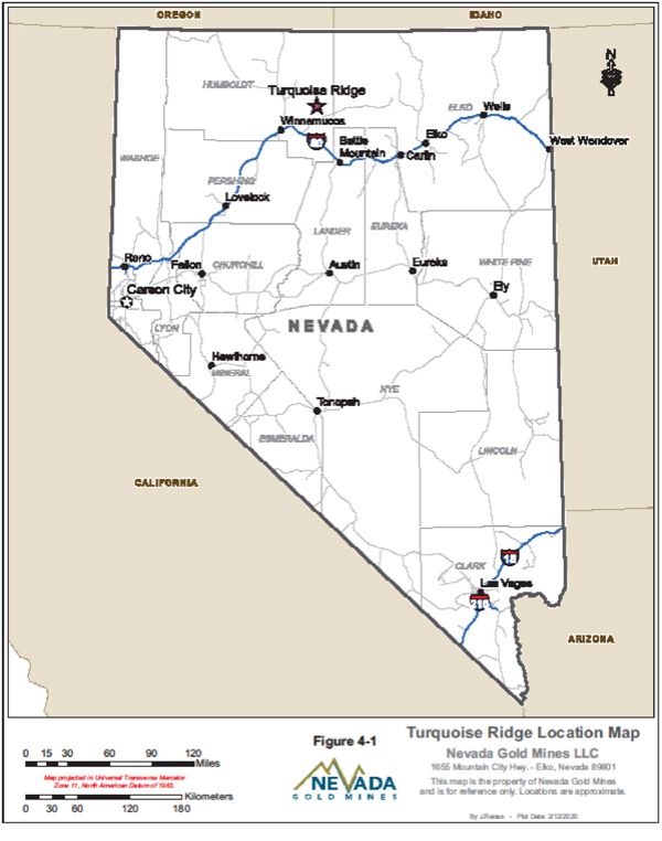
| Nevada Gold Mines LLC – Turquoise Ridge Complex | Page 4-5 | |
Technical Report NI 43-101 – March 25, 2020 | ||
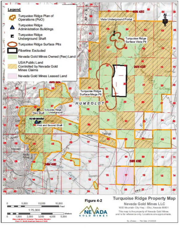
| Nevada Gold Mines LLC – Turquoise Ridge Complex | Page 4-6 | |
Technical Report NI 43-101 – March 25, 2020 | ||
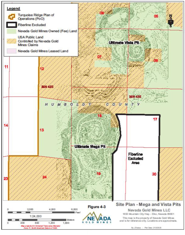
| Nevada Gold Mines LLC – Turquoise Ridge Complex | Page 4-7 | |
Technical Report NI 43-101 – March 25, 2020 | ||
5. ACCESSIBILITY, CLIMATE, LOCAL RESOURCES, INFRASTRUCTURE AND PHYSIOGRAPHY
| 5.1. | ACCESSIBILITY |
The Turquoise Ridge Complex is located in Humboldt County, Nevada, approximately 64 km northeast of Winnemucca, Nevada. The site is accessible from Interstate 80 approximately 24 km east of Winnemucca at the small town of Golconda. From Golconda, there is a paved road for 24 km followed by an improved gravel road to the mine gates (16 km to west mine gate, 24 km to the east mine gate).
The nearest airfield is the Winnemucca Airport, located 83 km southwest of the mine site by road. The nearest regional airfield is the Elko Airport, located 216 km east of the mine site by road.
| 5.2. | CLIMATE |
The climate is a semi-arid, steppe climate characterized by dry, hot summers and cold winters. Average monthly temperatures range from a low of-5ºC in December to a high of 29ºC in July. The Turquoise Ridge Complex receives an annual average of 7.6 cm of precipitation, which falls primarily as snow in the winter months, though light seasonal rains commonly occur in April and September. The Turquoise Ridge Complex operates on a year-round basis and is not regularly affected by climatic conditions. Certain types of construction activities may possibly be impacted by severe winter conditions
| 5.3. | LOCAL RESOURCES AND INFRASTRUCTURE |
Northern Nevada is an active mining area, with many large underground and open pit operations. Personnel and supplies for mining operations are relatively easily sourced from the local market, though some personnel, particularly professionals, are sourced from both out of state and foreign labour markets.
| Nevada Gold Mines LLC – Turquoise Ridge Complex | Page 5-1 | |
Technical Report NI 43-101 – March 25, 2020 | ||
The surface rights secured for the Turquoise Ridge Complex are sufficient to provide the necessary space required for all mining and quarrying activities. Sufficient land area exists on the property to accommodate all foreseeable processing plants, tailings and waste storage areas, and waste disposal areas.
The following infrastructure is available at the Turquoise Ridge Complex:
| ● | Road Access |
| ● | Electrical Power |
| ● | Propane supply |
| ● | Natural gas (North area only) |
| ● | Process water |
| ● | Telephone (Land line & Cell) |
| ● | Internet/Intranet |
Water volumes necessary for mining operations are available both through reclamation of groundwater inflows into the mine as well as water pumped to surface from several water wells which have been drilled across the property. Electrical power is supplied by one 120 kV electrical transmission line which enters the property from the southeast.
| 5.4. | PHYSIOGRAPHY |
The Turquoise Ridge Complex lies in proximity to the base of the Osgood Mountains, one of many typically north-south trending mountain ranges in the area, at approximately 1,615 MASL. These ranges vary in height, from valley floors at approximately 1,341 MASL to peaks at elevations between 1,798 MASL and 2,590 MASL.
The Turquoise Ridge Complex is located within a region classified by the United States Geological Survey (USGS) as having a moderate earthquake hazard. There is a 2.0% chance that an earthquake with a peak ground acceleration of 14% to 30% of gravity would occur within a 50 year period.
Vegetation in the vicinity of the Turquoise Ridge Complex is dominated by low dense shrubs and sage bush mixed with sparse native grasses and low flowering plants.
| Nevada Gold Mines LLC – Turquoise Ridge Complex | Page 5-2 | |
Technical Report NI 43-101 – March 25, 2020 | ||
6. HISTORY
| 6.1. | TURQUOISE RIDGE UNDERGROUND |
Mining for copper, lead, and silver first began on the Turquoise Ridge Underground property in 1883. Tungsten was discovered in 1916 and mined sporadically until 1957.
In in the fall of 1934, Edward Knight and Emmett Chase, two Winnemucca prospectors, found gold at the present day Getchell mine site. Later that year Noble H. Getchell purchased Knight’s interest in the property and in 1935, approached George Wingfield to invest, whereby Wingfield purchased Chase’s shares. From this partnership Getchell Mine Inc. (Getchell) was formed in 1935. Development of the Getchell open pit mine began and a full-scale operation was planned, including construction of a mill. Mill construction required additional financial support, so Mr. Bernard Baruch agreed to invest in the mine. In 1936, Newmont also agreed to help finance the construction of the Getchell mine as the third partner. Production began in early 1938 with first gold poured some time later and the company paying its first dividend in September of the same year.
Getchell operated the mine from 1934 to 1945, producing and selling 788,875 ounces of gold. From 1939 to 1944, the Getchell mine paid out more than $3 million in dividends. In 1941 a Cottrell electric precipitating unit was installed to collect the arsenic liberated by roasting the sulphide ore. Despite wartime restrictions on gold producers from 1943 to 1945 the Getchell mine was permitted to continue operations as it was a producer of strategic arsenic. In 1945, however, mining of gold ore was suspended due to labour and material shortages, and activities limited to underground development, reconstruction and expansion of the plant, and metallurgical research. Processing of stockpiled ore continued into 1946. The discovery of additional sources of oxidized ore enabled gold production to be resumed in 1948 and continued through to 1950.
In 1951, however, the Getchell mine ceased producing gold entirely and converted its plant to treat tungsten ore. Under authorization from the Defense Production Act of 1950, the Defense Minerals Administration and the Defense Production Administration instituted measures providing for the purchase of a standard-grade (60% tungsten trioxide) concentrate at a ceiling price of $76 per ton unit. The Getchell mine was one of the major tungsten producers in the
| Nevada Gold Mines LLC – Turquoise Ridge Complex | Page 6-1 | |
Technical Report NI 43-101 – March 25, 2020 | ||
USA. Tungsten production ceased in 1957 following the termination of the purchase program in 1956.
Following the cessation of tungsten production, Getchell began formulating plans for resuming gold operations. These plans, however, were dependent on developing solutions to several metallurgical problems pertaining to the separation of gold from the sulphide ores.
Getchell was purchased by Goldfield Consolidated Mines (Goldfield) in 1960. Goldfield modified the mill and a Dorr-Oliver fluidized solids reactor was installed to roast sulphide ores.
The mine was closed in 1967 and the mill dismantled, because the tungsten deposit was mined out.
In the mid to late 1970s the Getchell mine was purchased by Conoco Inc. (Conoco) as the price of gold was on the rise. While extensive development drilling was completed, production never began. E. I. du Pont de Nemours and Company (DuPont) purchased Conoco in 1983 and instructed Conoco to sell all mineral interests. The Getchell mine was subsequently sold via closed bids.
FRM Minerals Inc., a subsidiary of First Mississippi Corporation (First Mississippi), purchased the property from Conoco in 1984 for $5 million. Heap leaching of the dumps and a drilling program to verify gold deposits in the pit walls and below the pit floor began in 1986. A feasibility study (FS) was completed and identified the property’s reserves. In 1987, First Miss Gold Inc. (First Miss), a Nevada corporation and subsidiary of First Mississippi, was created to conduct mineral exploration and related mining activities. In October 1987, development of the Getchell open pit mine and construction of the processing facility began. By February 1989, construction of the new mine and 3,000 short tons per day (stpd) cyanide plus pressure oxidation mill was completed, and production began shortly after.
Exploration drilling centred on the area around the original Getchell Main pit until 1992. In 1993, a multi-phase exploration project was commenced. The purpose of the project was to delineate high grade gold mineralization that had been discovered in the footwall of the Getchell Fault. At the conclusion of the exploration program, an economic evaluation was undertaken to determine the feasibility of an underground mine. Planning and engineering
| Nevada Gold Mines LLC – Turquoise Ridge Complex | Page 6-2 | |
Technical Report NI 43-101 – March 25, 2020 | ||
were completed, and initial underground production began in July 1995 from the Getchell Main Underground mine (Getchell Underground).
In June 1993, the Turquoise Ridge Underground deposit was discovered at 1,800 ft (549 m) NE of the Getchell Main pit. A high grade mineralized zone was discovered at a depth of 1,400 ft to 2,000 ft (425 m to 610 m) below the surface. Based on the results of the drilling program, a FS was initiated for a second underground mine at Turquoise Ridge Underground.
In June 1996, First Miss, changed its name from First Miss Gold Inc. to Getchell Gold Corporation (Getchell Gold), also changing its state of incorporation from Nevada to Delaware. In 1996 Getchell Gold began construction of Turquoise Ridge Underground. By mid 1998, a production shaft was completed at a depth of 1,820 ft (555 m) below the surface.
Placer Dome Inc. (Placer) and Getchell Gold announced their intent to merge on December 13, 1998, and on May 27, 1999 the merger was completed. Following an initial evaluation Placer suspended production and milling operations at Turquoise Ridge Underground in July 1999, amid a rapid drop in gold prices, in order to focus on exploration and development. Underground operations at the Getchell Underground continued through to February 2000, when it was determined that additional development was required, and mining was also suspended. Placer’s development efforts focused on continued drilling of the Turquoise Ridge Underground and North Zone deposits. Due to depressed gold prices, the entire property was shut down in February 2002.
In June 2002, Placer staff defined a vision for the property, based on the concept of operating alow-tonnage, high-grade underground mine, in a safe and efficient manner. In August 2002, astart-up study was initiated to develop the defined vision into a mining plan and to assess economic impacts.
As gold prices rose in late 2002, the decision was made to restart Getchell Underground using contract mining, production began in February 2003. On April 15, 2003, Placer announced commencement of construction and the subsequentstart-up of Turquoise Ridge Underground. Effective December 23, 2003, Placer and Newmont formed the Turquoise Ridge Joint Venture (TRJV) with Placer owning a 75% interest and Newmont the remaining 25% interest in the Turquoise Ridge property, which included the Turquoise Ridge and Getchell deposits. Under the ore sale agreement, Newmont contributedpre-existing royalties and would purchase up to
| Nevada Gold Mines LLC – Turquoise Ridge Complex | Page 6-3 | |
Technical Report NI 43-101 – March 25, 2020 | ||
approximately 2,000 stpd of TRJV ore and process it cost at its nearby Twin Creeks Sage autoclave. In January 2006, Barrick acquired Placer’s 75% interest in the property as part of its acquisition of Placer.
As a result of operational and safety issues, Getchell Underground was placed on care and maintenance in April 2008. Full closure of Getchell Underground occurred in the summer of 2009.
Barrick completed a merger with Randgold Resources on January 1, 2019. Shortly after, in March 2019, Barrick announced intent to enter into a joint venture with Newmont whereby the Nevada assets of both corporations, including Barrick’s Turquoise Ridge and Newmont’s Twin Creeks operations, would be combined in a joint venture, with Barrick serving as the mine operator. On July 1, 2019 Nevada Gold Mines was formed. Barrick is the operator of the joint venture and owns 61.5%, with Newmont owning the remaining 38.5%. Under the joint venture, Barrick’s Turquoise Ridge Mine and Newmont’s Twin Creeks Complex were combined as a single operation, now known as Turquoise Ridge. The combined mining operation is comprised of the Turquoise Ridge Underground, Vista Underground, and Turquoise Ridge Surface (the Mega and Vista open pits).
Since the inception of mining on the Getchell/Turquoise Ridge Underground property to the end of 2019, the project produced approximately 6.8 million ounces of gold (Table6-1).
| 6.2. | TURQUOISE RIDGE SURFACE AND VISTA UNDERGROUND |
In 1985, Gold Fields Mining Corporation (Gold Fields) discovered the Chimney Creek orebody. Nearby, Santa Fe Pacific Gold Corporation (SFPG) geologists were evaluating railroad grant sections in the Rabbit Creek area. By 1987, a strong trend was identified and drilled between the two deposits. In 1989 initial gold production commenced. Turquoise Ridge Surface (Newmont’s former Twin Creeks property) was created in 1993 by the consolidation of the Rabbit Creek Mine (Rabbit Creek) and the Chimney Creek Mine (Chimney Creek) by SFPG, following the asset exchange of Chimney Creek from Gold Fields. In May 1997 Newmont Gold Company acquired the SFPG properties which remained wholly-owned by Newmont until the formation of Nevada Gold Mines in 2019. The former Rabbit Creek is located in the south end of the property, including what is now known as Mega Pit. The former Chimney Creek included
| Nevada Gold Mines LLC – Turquoise Ridge Complex | Page 6-4 | |
Technical Report NI 43-101 – March 25, 2020 | ||
the northern portion of the Mega Pit, and the Vista Pit which is located in the north end of the property near the Sage autoclave and Juniper oxide mill. In April 2019, Newmont and Goldcorp merged, followed by the Nevada Gold Mines joint venture with Barrick in July 2019, as discussed in Section 6.1.
Exploration drilling in the Mega North Pit by Gold Fields dates to 1986. This drilling defined an initial reserve in the Chimney Creek deposit that has since been mined by Gold Fields, SFPG and Newmont. Gold mineralization, primarily refractory, is in the Cambrian-Ordovician sedimentary and intrusive rocks of the Comus Formation, in structural and geologic domains defined by the Conelea Anticline and fault blocks.
Since 2005, Turquoise Ridge Surface long range planning has considered Cut 40 as a potential layback at higher gold prices. Researching engineering files and reports, the layback may have first been included withnon-reserve mineralization at the EOY 2009 and included as part of the Mega North Pit area in end of year reporting. The Cut 40 layback was specifically listed asnon-reserve mineralization in 2014, with 15 million tons ore at an average gold grade of 0.057 ounces per ton for 845,000 contained ounces of gold.
In February 2015, a proposal for an extensive Cut 40 study was developed, which set up the framework for alternative analysis and options to improve the economics of the deposit. In October 2016, a Turquoise Ridge Surface Growth Team was established to work on Cut 40 and Deposit 55, both areas in the Mega Pit. An approval for expenditure (AFE) for $2.8 million dollars was approved in August 2017 and Cut 40 was placed into Newmont’s Investment System as a Stage 2A project. The Cut 40 Stage 2A Bridge AFE covered metallurgical and geotechnical drilling, environmental humidity cell testing, metallurgical column testing, ore grinding, and salary costs for the Growth Team. The work and information associated with the AFE will be complete by the second quarter of 2019.
An exploration opportunity fund AFE was approved in April 2017, in the amount of $1.1 million dollars. This money was used to drill 46 holes covering over 32,500 ft (9,906 m), to provide drill spacing confidence for reserve declaration. Due to this effort, a Cut 40 ramp retreat design added 149,000 contained ounces of gold to the 2017 reserves. The conversion cost for this drill program was $7.38/oz Au.
| Nevada Gold Mines LLC – Turquoise Ridge Complex | Page 6-5 | |
Technical Report NI 43-101 – March 25, 2020 | ||
A second exploration opportunity fund AFE was approved in July 2018, requesting $2.05 million of budgeted drilling funds. The request was to fund the drilling of 36 holes for a total of 11,950 ft (3,642 m) of reverse circulation (RC) and 12,450 ft (3,795 m) of core. The program utilized available drill platforms. The estimated conversion cost for this drill program is $3.00/oz Au.
A surface drilling program targeting the Vista Underground was initiated in 2009 to 2010 to confirm the economics of the project. The intent of the program was to increase the geologic confidence in the mineralization prior to committing the funds necessary to drive an exploration drift.
The success of the surface drilling program led to the development of the North Portal and underground drifting in 2011. The drifting was used to support underground exploration drilling in the northern portion of the orebody. From January 2011 to May 2013 the South Portal and additional underground drifting were developed to support definition drilling. The project was placed on care and maintenance in May of 2013 due to economic constraints. Commercial production began in 2018.
| 6.3. | PRODUCTION HISTORY |
The history of gold production at the Turquoise Ridge Complex (100% basis) is summarized in Table6-1.
| Nevada Gold Mines LLC – Turquoise Ridge Complex | Page 6-6 | |
Technical Report NI 43-101 – March 25, 2020 | ||
Table 6-1 Summary of Gold Production
| Years | Turquoise Ridge Underground Gold Produced (oz) | Turquoise Ridge Surface and Vista Underground Gold Produced (oz) | Turquoise Ridge Complex Gold Produced (oz) | |||||||||
1938-1945 | 330,002 | 0 | 330,002 | |||||||||
1948-1950 | 46,804 | 0 | 46,804 | |||||||||
1962-1967 | 340,406 | 0 | 340,406 | |||||||||
1986-1999 | 2,029,103 | 5,930,417 | 7,959,520 | |||||||||
2000-2009 | 1,364,226 | 9,238,182 | 10,602,408 | |||||||||
2010 | 160,913 | 409,172 | 570,085 | |||||||||
2011 | 169,880 | 407,761 | 577,641 | |||||||||
2012 | 191,322 | 492,299 | 683,621 | |||||||||
2013 | 186,332 | 463,688 | 650,020 | |||||||||
2014 | 259,345 | 365,204 | 624,549 | |||||||||
2015 | 289,421 | 414,675 | 704,096 | |||||||||
2016 | 327,743 | 379,526 | 707,269 | |||||||||
2017 | 339,581 | 332,295 | 671,876 | |||||||||
2018 | 350,085 | 333,141 | 683,226 | |||||||||
2019 | 370,392 | 283,039 | 653,431 | |||||||||
Total | 6,755,555 | 19,049,399 | 25,804,954 | |||||||||
| Nevada Gold Mines LLC – Turquoise Ridge Complex | Page 6-7 | |
Technical Report NI 43-101 – March 25, 2020 | ||
7. GEOLOGICAL SETTING AND MINERALIZATION
| 7.1. | REGIONAL GEOLOGY |
The Turquoise Ridge Surface, Underground, and Vista Underground are situated within the Basin and Range province, near the northeast end of the Osgood Mountains. The Osgood Range is underlain by Cambrian Osgood Mountain Quartzite, Cambrian Preble Formation, Ordovician “Comus” Formation and the “upper plate” Valmy Formation. These units are unconformably overlain by the Permian Etchart Formation (Antler Peak Equivalent) of the Roberts Mountains overlap assemblage, and by the Triassic Golconda allochthon. These uppermost units form a belt of outcrops flanking the western and northern sides of the Osgood Range. All of these units are intruded by two generations of felsic intrusive rocks – a set of 114 Ma dacite dikes and sills at Turquoise Ridge Underground and Turquoise Ridge Surface and the 92 Ma Osgood Stock and temporally related dikes and sills (Figure7-1). To date, no Eocene intrusive rocks have been identified at the Getchell, Turquoise Ridge Surface, or Pinson camps.
The Cambrian-Ordovician rocks were deposited on the platform and slope of the western margin of the North American Craton during the breakup of the Rodinia super-continent. The basal Osgood Quartzite and Preble Formation are generally regarded to represent sourcing from a continental land mass and consist of quartz arenite (Osgood), siltstone, and shale with subordinate carbonate lenses (Preble). Carbonates of the Preble were deposited in an open shelf or upper slope marine environment and have undergone minorre-working (winnowed oolitic and algal pellet limestones, fragmented trilobites). Carbonates in the upper part of the Preble formation are time equivalent to rocks described as “Comus Formation” at Pinson and Turquoise Ridge Surface. The Ordovician Comus Formation, as it is described in the deposits of the Getchell Trend represents a significant departure from the continental derived clastic and argillaceous sediments of the Osgood and Preble formations. The Comus Formation in the footwall of the Getchell Fault is characterized as thin- to medium-bedded carbonate turbidites, slumps, and debris flows with interlayered siliciclastic turbidites and argillaceous mudstone. The carbonate beds are interpreted to be derived from a carbonatesea-mount (Cook, internal reports and field notes) somewhere east of the Osgood Range. Algal pellets,
| Nevada Gold Mines LLC – Turquoise Ridge Complex | Page 7-1 | |
Technical Report NI 43-101 – March 25, 2020 | ||
fragmented coral, and crinoids have been observed as clasts in the carbonate debris flow conglomerates.
Turquoise Ridge Underground occupies the hanging wall of the Getchell Fault, which is a major, moderately east-dipping range front structure bounding the east side of the Osgood Mountains. At Turquoise Ridge Underground, the hanging wall of the Getchell Fault consists of Ordovician seafloor basalt and mafic sills interlayered with the carbonates and siliciclastic/argillaceous sediments.
The Getchell Fault is one of the most prominent structural features of the region and plays a significant role in controlling mineralization and the distribution of rock types. The Getchell Fault generally strikes north-south to north-northwest, and dips approximately 50° to the northeast in the vicinity of Turquoise Ridge Underground. Geophysical interpretations (mostly gravity and magnetic data), coupled with limited outcrop data, suggest that several footwall splays are present north of the Getchell Underground workings, and that the fault continues to the north along several strands to the northern end of the Osgood Mountains.
The Turquoise Ridge Underground North Zone mineralization largely mimics the orientation of the Getchell Fault, with complications from northeast and north-south structures. The North Zone consists of several discrete bodies which generally strike north-northwest and dip moderately to the northeast.
| Nevada Gold Mines LLC – Turquoise Ridge Complex | Page 7-2 | |
Technical Report NI 43-101 – March 25, 2020 | ||
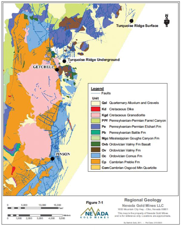
| Nevada Gold Mines LLC – Turquoise Ridge Complex | Page 7-3 | |
Technical Report NI 43-101 – March 25, 2020 | ||
| 7.2. | LOCAL AND PROPERTY GEOLOGY |
TURQUOISE RIDGE UNDERGROUND
The stratigraphy at Turquoise Ridge Underground consists of carbonaceous mudstones and limestones, tuffaceous mudstones and limestones, polylithic megaclastic debris flows, fine-grained debris flows, and basalts, all part of the Ordovician Comus Formation. This formation is divided into several stratigraphic units in the vicinity of Turquoise Ridge Underground. The sedimentary members are commonly characterized by extensive soft-sediment deformation. The units are described from bottom to top as follows:
Distal Slope Unit:This unit is characterized by planar beds, fairly undisturbed intercalated carbonaceous mudstones and limestones, with occasional graded calcarenite beds characteristic of mid to lower shelf facies. The thickness is estimated at 120 m to more than 240 m.
Proximal Slope Unit:This is a polylithic unit consisting of blocks and lenses of both carbonaceous and tuffaceous mudstones and limestones, characterized by pervasive soft sediment deformation, slumping, and debris flows. Internal contacts between the carbonaceous and tuffaceous rocks are sharp, however, lithologies cannot be correlated laterally with confidence. Carbonaceous rocks, though deformed, appear similar to those of the Distal Slope unit, whereas the tuffaceous rocks are similar those of the overlying the Powder Hill unit. Minor amounts of fragmental rocks are similar to the overlying Black Fragmental unit. Additionally, limestones reminiscent of the overlying Black Powder Hill (BPH) Limestone unit are also present. The black carbonaceous rocks are dominant within this unit except in the south, where grey and brown tuffaceous rocks are more common. The thickness of the Proximal Slope unit varies from 45 m to more than 500 m.
Black Fragmental Unit:This unit is identified by abundantpebble-sized, tabular to subangular, monolithologic micrite clasts in a carbonaceous mudstone matrix. It can also contain lenses of Proximal Slope rocks and BPH Limestones. The upper and lower contacts that bound this unit are based on the predominance of fragmental rock within the section rather than precise lithologic breaks. The thickness ranges up to approximately 90 m.
BPH Limestones:This limestone consists of thinly bedded to laminated, intercalated mudstones and micritic limestones with subordinate amounts of tuffaceous mudstone, and
| Nevada Gold Mines LLC – Turquoise Ridge Complex | Page 7-4 | |
Technical Report NI 43-101 – March 25, 2020 | ||
local black fragmental rocks. Soft-sediment deformation is pervasive. The thickness ranges up to approximately 100 m.
Powder Hill Unit:This unit is composed of a mix of grey to brown mudstones, intercalated mudstones and limestones, and fragmental rocks. The fragmental rocks have a tuffaceous mud matrix supporting micritic limestone clasts. Soft-sediment deformation is pervasive. Clasts within fragmental portions of this unit exhibit soft-sediment deformation; they do not appear to have been brittle at the time of deformation. The upper contact is bounded by basalts. The thickness of the Powder Hill unit is estimated at up to 105 m.
Basalt Unit:The upper Basalt unit consists of massive basalt with minor intercalated sedimentary layers, with a total thickness of up to 180 m.
Cretaceous Granodiorite Dikes:Fine-grained to porphyritic leucocratic granodiorite dikes crosscut all units. The largest and most continuous dike is subparallel to the Getchell Fault. The thickness of the dikes ranges up to 15 m.
These units are overlain by more basalts, mudstones, and cherts that may be part of the Ordovician-aged Valmy formation or a continuation of the Comus Formation. The thickness of this package ranges from approximately 365 m to 460 m.
Stratigraphy varies significantly from south to north. In the south, the Powder Hill unit directly overlies Proximal Slope rocks and is overlain by thin, discontinuous basalts that are part of the uppermost sequence of Comus rocks. Further north, Black Fragmental rocks appear between the Powder Hill unit and the Proximal Slope rocks. Yet further north, the BPH Limestones appear above the Black Fragmental unit and are bounded above by the Powder Hill unit.
Farthest north, the basalt, occurring above the base of the Powder Hill unit, thickens and crosscuts stratigraphy, in places down to the top contact of the Black Fragmental unit. Stratigraphy at Turquoise Ridge Underground is interpreted as having been formed in a passive continentalmid-shelf setting with a carbonate source likely to the southeast. North-dipping monoclinal folding at the north end of Turquoise Ridge Underground may be related to deep-seated normal faulting associated with basin margin rifting. The monocline affects all the units except the basalt and the overlying Comus strata. Development of this monocline possibly caused the formation of the Black Fragmental unit as a basal breccia derived from
| Nevada Gold Mines LLC – Turquoise Ridge Complex | Page 7-5 | |
Technical Report NI 43-101 – March 25, 2020 | ||
sliding of an overlying block of carbonaceous limestones, the remains of which form the BPH Limestone unit. Thick basalts in the north appear to occupy a post-monoclinal submarine canyon that cut through existing stratigraphy prior to basaltic volcanism.
The local geology is illustrated in Figure7-2 and the generalized mine stratigraphy is illustrated in Figure7-3.
| Nevada Gold Mines LLC – Turquoise Ridge Complex | Page 7-6 | |
Technical Report NI 43-101 – March 25, 2020 | ||
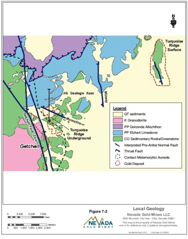
| Nevada Gold Mines LLC – Turquoise Ridge Complex | Page 7-7 | |
Technical Report NI 43-101 – March 25, 2020 | ||
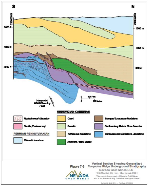
| Nevada Gold Mines LLC – Turquoise Ridge Complex | Page 7-8 | |
Technical Report NI 43-101 – March 25, 2020 | ||
TURQUOISE RIDGE SURFACE AND VISTA UNDERGROUND
Turquoise Ridge Surface lies in an alluviated valley southeast of the Dry Hills, a northeastern outlier of the Osgood Range in northern Humboldt County, Nevada. The Dry Hills is an area of gently north-dipping Upper Paleozoic carbonate sediments, stratigraphically higher than rocks in the rest of the Osgood Range, which consists mainly of Lower Paleozoic elastic sediments intruded by a large Cretaceous pluton, which forms the backbone of the Osgood Range.
Silty limestone, dolomitic siltstone, and minor tuff of the latest Cambrian-earliest Ordovician Comus Formation rest unconformably on the Preble Formation. The Comus Formation has a thickness of 460 m to 550 m and is subdivided into four informal units with gradational contacts. The lowermost Comus unit, C4, contains black, thin-bedded silty limestone and laminated silty mudstone with lesser but prominent light gray calcareous quartz sandstone interbeds and medium beds of light gray micritic limestone. Two widespread sills are recognized in C4, a coarse-grained ultramafic body up to 36 m thick consisting mainly of olivine and pyroxene with lesser amounts of phlogopite and magnetite known as the Ear peridotite, and very fine-grained,non-porphyritic basalt called the HGO sill.
Overlying C4, the C3 unit is characterized by black, thin to locally thick bedded, silty limestone, micrite, calcarenite, calcareous siltstone, and fine to coarse lapilli tuff and debris flows. One coarse lapilli tuff debris flow in C3, the Upper Tuff, is found throughout the Mega Pit and is the most important marker horizon. In addition, numerous basaltic sills intrude C3, including four that are mineralogically distinct. These intrusions include from lowest to highest stratigraphic position: a plagioclase-phyric basalt containing abundant amygdules, Main Sill, a thick sill containing fine-grained pyroxene, the Upper Sill, a very fine grained, sparsely porphyritic basaltic sill containing conspicuous euhedral plagioclase, the Upper Porphyry, and an uppermost pyroxene-bearing basalt, F2 Sill. The C3 unit is the best gold host in the Comus, in part because of its greater thickness, an abundance of relatively reactive thin-bedded silty limestone, and the presence of abundant sills, which undoubtedly localized flow of gold-bearing hydrothermal fluids. Figure7-4 is a cross section looking north through Cut 40 at the Mega Pit depicting 3D modelled geologic formations and structures. The Main and Upper Sills were modelled to emphasize the shape of the east-verging, overturned Conelea Anticline (fold hinge dashed). In most instances these mafic sills are not continuous yet have been stretched into a series of lenticular boudins.
| Nevada Gold Mines LLC – Turquoise Ridge Complex | Page 7-9 | |
Technical Report NI 43-101 – March 25, 2020 | ||
The contact between the C3 and C2 units marks the transition from dominantly thin to lesser medium-bedded lower carbonate-rich rocks to the more siliciclastic and tuff-rich rocks higher in the Comus. The contact is also marked by the occurrence of a fine-grained lapilli tuff about 4.5 m thick. The C2 unit consists of planar laminated, dolomitic siltstone, mudstone, and tuffaceous sandstone, with lesser amounts of thin-bedded silty limestone. Tuffaceous interbedded rocks are light gray in contrast to the dark gray to black carbonaceous siltstone and mudstone interbeds.
C2 contains several basaltic sills, which are difficult to correlate because all but one are fine grained andnon-porphyritic. The distinct sill in C2, the plagioclase-pyroxene porphyry, is a coarsely and abundantly (15%) porphyritic basalt with euhedral plagioclase and pyroxene phenocrysts, commonly found near the base of the C2 unit.
The uppermost unit, C1, contains abundant tuff, including two thick, coarse lapilli tuffs, each of which grades upward into a sequence of thin-bedded and laminated, fine-grained lapilli tuff. Interbedded with tuff are laminated dolomitic siltstone, silty limestone, and mudstone. A medium-grained intrusion, the Sage basalt, containing abundant glomeroporphyritic plagioclase in addition to groundmass phlogopite, is present at or near the base of C1.
The mafic and ultramafic sills and flows that comprise a large part of the Comus Formation at Turquoise Ridge Surface are alkalic and contain visible groundmass phlogopite in coarser grained units and elevated concentrations of K, Ti, and rare-earth elements. These alkalic rocks are similar to ocean island basalts (OIB) or intraplate basalts and differ greatly from the depleted character of more commonmid-ocean ridge basalt (MORB).
| Nevada Gold Mines LLC – Turquoise Ridge Complex | Page 7-10 | |
Technical Report NI 43-101 – March 25, 2020 | ||
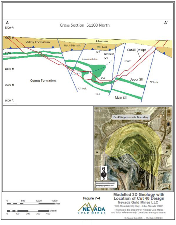
| Nevada Gold Mines LLC – Turquoise Ridge Complex | Page 7-11 | |
Technical Report NI 43-101 – March 25, 2020 | ||
Cut 40 represents a high grade refractory ore deposit located along the northern perimeter of the Mega Pit. This phase of mining would deepen Cut 24 and extend mining several hundred metres around the current pit limit. General geology of Cut 40 looking north is shown in Figure7-5.
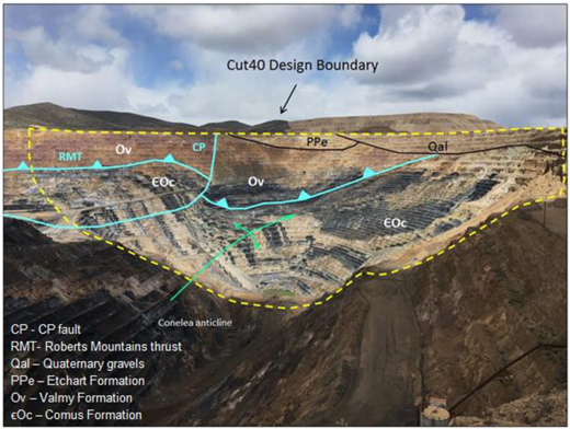
Figure 7-5 General Geology of Cut 40 North Dig Face with Mine Design
The summary that follows draws heavily from the work of Breit et al (2005) and the references therein with additions from more recent mapping and modeling (Figure7-6).
Cut 40 mineralization is hosted in complexly deformed Comus Formation carbonate and tuffaceous sediments, and locally mafic units, with some leach grade occurrences in the overlying Valmy Formation. The higher grade mineralization is hosted in the upper portion of the Comus package, mostly unit Oc3 and above.
| Nevada Gold Mines LLC – Turquoise Ridge Complex | Page 7-12 | |
Technical Report NI 43-101 – March 25, 2020 | ||
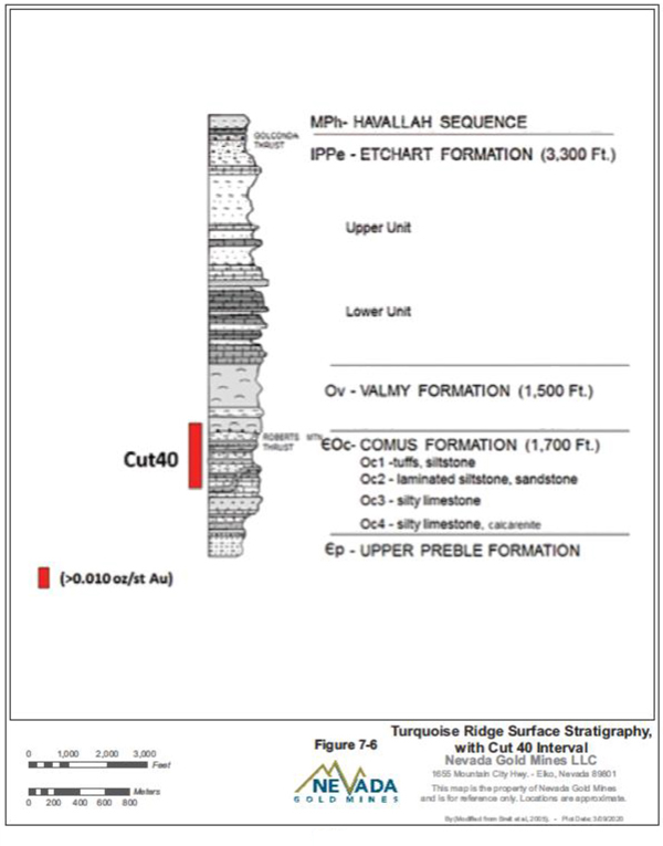
| Nevada Gold Mines LLC – Turquoise Ridge Complex | Page 7-13 | |
Technical Report NI 43-101 – March 25, 2020 | ||
The overlying Ordovician Valmy Formation is separated from the Comus by the Roberts Mountains Thrust fault. The Valmy Formation is approximately 1,000 m thick and composed predominantly of pillow basalt, massive flow basalt, hyaloclastites, siliceous mudstones, and debris flow breccias. At Turquoise Ridge Surface, the Valmy Formation has been divided into two units: the Lower and the Upper. The Vista Pit and Vista Underground are hosted in the upper unit of the Valmy Formation. Gold mineralization in these basalts tends to be concentrated in veins that form a sooty-sulphide stockwork system. The basalts of the Valmy likely formed along a volcanic rift that cut across a passive abyssal plain, thus explaining the presence of minor interbedded abyssal sediments.
The Battle Formation consists of gray, quartzite cobble conglomerate, with a gray sandy matrix, derived from the Osgood Mountains formation and is up to 9 m thick. It locally unconformably overlies the Comus in the Mega Pit area and was mineralized to a similar extent as the underlying Comus rocks. The presence of Battle Formation rocks lying unconformably on the Comus indicates that an erosional window had formed through the Valmy Formation, suggestingpre-late Paleozoic uplift and/or arching.
The rocks of the Pennsylvanian-Permian Etchart Formation unconformably overlie the Valmy Formation in most of the district. The Etchart Formation, from 930 m to 1,100 m thick, is divided into three subunits that consist of: 1) a lowermost calcareous sandstone to sandy limestone, with local quartzite pebble conglomerate at the base; 2) middle peloidal limestone, cross-bedded calcareous quartz-arenite, and quartzite/chert pebble conglomerate; and 3) upper calcareous siltstone and silty limestone. These rock types suggest deposition by settling, grain flow, and debris flow in a high-energy shelf and slope environment, subunits 1 and 2, within a deeping marine basin, subunit 3. Rocks of the lower Etchart were by far the major host for gold mineralization in the Vista deposit.
The Mississippian-Permian Havallah Sequence was emplaced above the Pennsylvanian-Permian Etchart Formation along the Golconda thrust, which is exposed in the hanging wall of the 20K fault in the northeast portion of the Vista Pit and just north of the pit in the Dry Hills. In the Vista Pit, the Havallah Formation is generally thin-bedded, light brown calcareous sandstone and lesser interbedded gray, thin-bedded chert. The Havallah elsewhere consists of mudstone, siltstone, calcareous sandstone, limestone, chert, and altered basalt.
| Nevada Gold Mines LLC – Turquoise Ridge Complex | Page 7-14 | |
Technical Report NI 43-101 – March 25, 2020 | ||
Several Cretaceous-aged dikes and sills, approximately 114Ma, play a significant role as secondary controls on gold mineralization in both the Vista Pit and in the Vista Underground. The porphyritic dacite dikes are characterized by pervasive phyllic alteration and locally are mineralized.
| 7.3. | ALTERATION |
TURQUOISE RIDGE UNDERGROUND
Thermal metamorphism associated with intrusion of the Cretaceous Osgood Stock at 92 Ma is present in the Turquoise Ridge Underground area and is characterized by ubiquitous development of biotite hornfels within the tuffaceous mudstones throughout Turquoise Ridge Underground, and formation of calc-silicate alteration within carbonates only in the southern areas where they are close to the Osgood Stock. Thermal metamorphism associated with basalts has not been recognized. Hydrothermal alteration consists of locally extensive, complete decalcification and argillization of all rock types, spotty silicification, and the addition of gold-bearing fine-grained iron sulphides, the main mineralization of the deposit and late arsenic sulphides. Hydrothermal alteration boundaries can be extremely sharp even where susceptible rocks are in direct, nonfault contact with altered rocks. To the east, mineralization is spatially related to north-south and northeast faults. All structures are considered potential conduits for gold mineralization. Calcareous rocks are the most important hosts for mineralization occurring as disseminated replacement ore bodies in the Comus and Etchart Formations. Valmy Formation basalts and related sediments host structurally controlled mineralization, such as the Vista shear zone.
TURQUOISE RIDGE SURFACE AND VISTA UNDERGROUND
As in other Carlin-type deposits, alteration is manifested mainly through decalcification of carbonate-bearing sedimentary rocks, with lesser silicification and dolomitization. Less altered Paleozoic igneous rocks are propylitized, whereas overprinting clay alteration accompanies gold-related mineralization. Cretaceous sills and dikes are altered to quartz-sericite-(illite)-pyrite.
| Nevada Gold Mines LLC – Turquoise Ridge Complex | Page 7-15 | |
Technical Report NI 43-101 – March 25, 2020 | ||
| 7.4. | STRUCTURE |
TURQUOISE RIDGE UNDERGROUND
In the mine, no major faults appear to offset either stratigraphy or the Cretaceous dikes. Faults with presumably small offsets are commonly observed underground. Some of these are probably accommodation faults associated with compaction of ore zones due to volume loss from decalcification. GoCAD modeling of RQD values indicate the presence of a northeast trending fracture zone intersecting the northern part of Turquoise Ridge Underground. Additional GoCAD modeling of 0.3 g/t and 1.7 g/t mineralization is suggestive of subtle Getchell fault parallel structures, in the form of sympathetic, north-trending, east dipping fracture zones.
Synformal and antiformal geometries within the stratigraphy are indicative of modest east to west compression; probably prior to intrusion of the undeformed Cretaceous dikes. Disharmonic soft-sediment slump folding is common and is especially well developed in the BPH limestones and the limestones and mudstones of the Powder Hill unit.
TURQUOISE RIDGE SURFACE AND VISTA UNDERGROUND
Mineralization at the Mega and Vista Pits are spatially related to north-south and northeast faults, their intersections and fault intersections with folded stratigraphy. All structures are considered potential conduits for gold mineralization. Fold hinges whether open or overturned (Conelea Anticline) are particularly favorable sites in the Mega North Pit. Calcareous rocks are the most important hosts for mineralization occurring as disseminated replacement ore bodies in the Comus and Etchart Formations. Vista Formation basalts and related sediments host structurally controlled mineralization.
ROBERTS MOUNTAINS THRUST:
A broad zone oflow-angle, west-dipping and northerly striking faults characterize a major Paleozoic thrust in the northern part of the Mega Pit. This fault contact between the Valmy and Comus Formations is correlated with the Roberts Mountains thrust shown in Figure7-6. Intense shearing with attendant compressional features adjacent to the fault contact affects at least 18 m of the Comus Formation in the Mega North Pit.
CONELEA ANTICLINE:
The principal structural element in the Mega North Pit is the Conelea Anticline, which runs the length of the pit in a north-northwest orientation and is the most importantore-controlling
| Nevada Gold Mines LLC – Turquoise Ridge Complex | Page 7-16 | |
Technical Report NI 43-101 – March 25, 2020 | ||
structure in the Comus Formation. The fold probably developed during the Antler Orogeny when rocks of the Valmy Formation were placed above Comus rocks along the Roberts Mountains thrust. The Conelea Anticline does not affect rocks of the overlying Valmy and Etchart Formations. The geometry of the anticline is complex and has been somewhat obscured by cross cutting faults, but generally it is asymmetrical, east verging and doubly plunging. The western limb dips shallowly (30º) to the west and northwest while the eastern limb is overturned and dips steeply (70º to 80º) to the west. The fold hinge opens up where it projects into the Mega North Pit highwall.
NORTHEAST FAULTS:
In the Mega North Pit northeast-striking, mostly northwest-dipping high angle faults with apparent dextral,down-to-the-north displacement cut the Conelea Anticline. These faults include the TC and DZ, shown in Figure7-7. Observed dextral offset across northeast faults in the Mega Pit is as much as 396 m. Northeast faults in the Comus Formation may have developed as either tear faults contemporaneous with folding, which accommodated differential amounts of folding, or as transverse joints that were later reactivated. These faults can reach 10 m in thickness with local intense shearing and brecciation, as observed in the Mega Pit TC fault and the Trench fault at Vista Underground.
| Nevada Gold Mines LLC – Turquoise Ridge Complex | Page 7-17 | |
Technical Report NI 43-101 – March 25, 2020 | ||
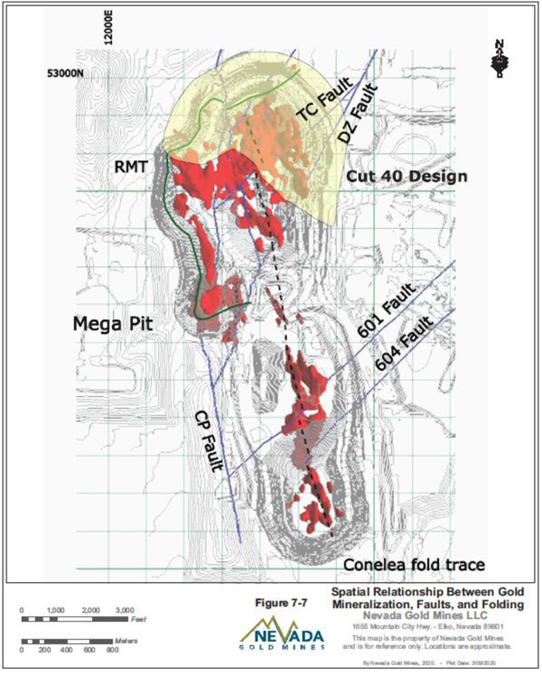
| Nevada Gold Mines LLC – Turquoise Ridge Complex | Page 7-18 | |
Technical Report NI 43-101 – March 25, 2020 | ||
NORTH-STRIKING FAULTS:
North-striking, moderate to steeply dipping faults are recognized to be bothpre- and post-mineral, and some appear to have a long lived history of continuous movement, particularly the CP fault (Figure7-8). The distribution of these faults suggests a possible right stepping nature.
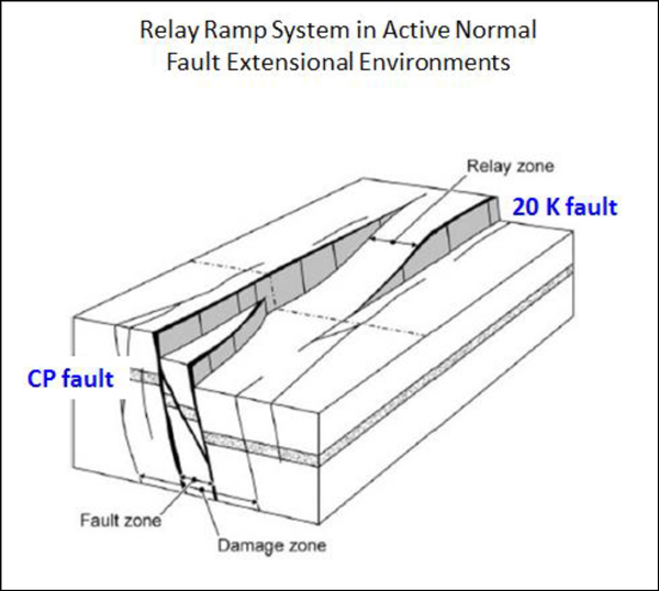
Figure 7-8 Relay Ramp Fault Interpretation of North-Striking Faults at Turquoise Ridge Surface
The north-striking faults truncate and offset the northeast faults. They also cut Quaternary age alluvium. In Figure7-9, the CP fault does not offset upper 15 m of alluvium. There is approximately 18 m of vertical displacement at the Valmy (Ov), alluvium (Qal) contact. The bench height is 12 m.
| Nevada Gold Mines LLC – Turquoise Ridge Complex | Page 7-19 | |
Technical Report NI 43-101 – March 25, 2020 | ||
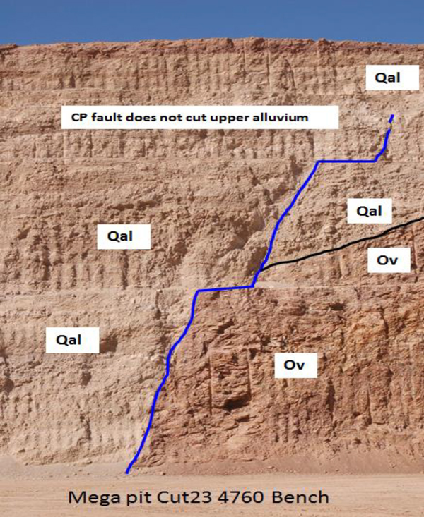
Figure 7-9 CP Fault in the Mega Pit Cut 23 South Highwall
In the Vista Pit, north-south and northeast-striking faults cut through mostly Valmy and Etchart formations. The northwest striking, northeast dipping 20K fault truncates the Trench fault. The Trench fault is in fact a shear zone approximately 2 m to 3 m thick.
| Nevada Gold Mines LLC – Turquoise Ridge Complex | Page 7-20 | |
Technical Report NI 43-101 – March 25, 2020 | ||
| 7.5. | MINERALIZATION |
TURQUOISE RIDGE UNDERGROUND
Mineralization of the Turquoise Ridge Underground deposit generally consists of disseminated,micron-sized gold occurring in arsenic-rich rims forming on pyrite, chiefly within decalcified, carbonaceous rocks. All gold bearing zones at Turquoise Ridge Underground are located in proximity to granodiorite dykes that splay from the Osgood stock. Mining and exploration activities at Turquoise Ridge Underground are centered on limestone and mudstone horizons adjacent to these dykes.
The mineralization at Turquoise Ridge Underground is located in two main zones, North and South. In the North Zone, the strongest mineralization appears to be associated with BPH Limestone, Black Fragmental rocks, and carbonaceous rocks within the Proximal Slope unit. Stratigraphic contacts between these units and contacts with the Cretaceous dikes are important primary controls on mineralization. Powder Hill rocks, Distal Slope rocks, basalts, and dikes are insignificant hosts for mineralization in the north.
The North Zone of Turquoise Ridge Underground extends over an area of 800 m x 800 m and at present consists of over
33 mineralized domains. The domains are divided into the following groups based on mode/control of mineralization:
| ● | Stratigraphic/stratabound |
| ● | Cross-stratigraphic, structurally controlled |
| ● | East-west structural |
| ● | Other |
North Zone stratigraphic mineralized domains exhibit strike lengths in excess of 305 m with typical strike dimensions in the
61 m to 152 m range. Down dip lengths of over 305 m are common. Being stratigraphically controlled, the mineralized domains and bedding have a general north-northwest trending strike, of approximately 330° to 340°, and dip shallowly to the east (between 25° and 45°). Mineralization is typically in the order of six metres to nine metres thick, but in some instances, may pinch down to less than three metres or swell out to 30 m in thickness.
North Zone cross-stratigraphic domains have been modelled at near perpendicular angles to the bedded domains. This mineralization cuts across bedding and is grouped as structural, as
| Nevada Gold Mines LLC – Turquoise Ridge Complex | Page 7-21 | |
Technical Report NI 43-101 – March 25, 2020 | ||
mineralization may be driven by low angle shearing, faulting, or joint sets. General trends of these domains are a north-northwest strike (340° to 360°) and a west dip of 10° to 20°. Widths of these domains may be in excess of 30 m.
Most of the North Zone domains are grouped as east-west stratigraphic and are economically important or currently being mined. Two of the domains are large, steeply dipping, and sheet-like with strike lengths in the order of 152 m and 305 m. Dip dimensions are approximately 48 m and 110 m, respectively. Thickness is variable but averages six metres to 12 m.
The remaining five domains in the “Other” category are irregular sheet-like bodies with various orientations. Dimensions range from 152 m to 198 m in strike length, 100 m to 122 m in dip length, and thicknesses from three metres to over 30 m.
Mineralization in the South Zone is largely restricted to the Powder Hill unit, with only minor amounts present in the upper parts of the Proximal Slope unit. Fragmental rocks of the Powder Hill unit are the most important host for mineralization, followed by tuffaceous intercalated limestones and mudstones, then by carbonaceous intercalated mudstones and limestones of the Proximal Slope unit. Mineralizing fluids appear to have interacted with favourable host rocks via discrete fault and fracture zones, although specific pathways are usually not readily identifiable.
The South Zone extends over an area of 610 m by 305 m and at present consists of over 15 mineralized domains. The domains are divided into the following groups based on mode/control of mineralization:
| ● | Cross-stratigraphic, structurally controlled |
| ● | Steeply-dipping Strataform |
| ● | Moderately-dipping Strataform |
The six cross-stratigraphic bodies strike north and are generally steeply dipping to the west or nearly vertical. Strike lengths vary from 30 m to 198 m with an average length of 122 m. Dip lengths vary from 61 m to 152 m with an average dip length of 99 m. Thicknesses average 20 m.
The South Zone Strataform domains tend to strike north and dip to the east at approximately 30° to 60°. This orientation is significantly different from the North Zone. The two zones are
| Nevada Gold Mines LLC – Turquoise Ridge Complex | Page 7-22 | |
Technical Report NI 43-101 – March 25, 2020 | ||
separated by the northeast trending Turquoise Ridge shear zone, which could have contributed to the difference in alignment of the two zones. The three steeper dipping bodies(-58°E to-80°E) have an average strike length of 70 m , average dip length of 49 m and average thickness of 12 m. The six moderately dipping(-30°E to-50°E) range from 90 m to 520 m. The average dip length is approximately 260 m and thicknesses average 30 m.
TURQUOISE RIDGE SURFACE AND VISTA UNDERGROUND
Gold occurs in arsenic-rich rims or bands on pyrite grains associated with orpiment, realgar, stibnite, cinnabar and quartz. Adularia intergrown with gold-bearing arsenian pyrite in Comus mafic sills yields 40Ar/39Ar ages of 41.90 Ma ± 0.25 Ma and 42.11 Ma ± 0.43 Ma (Groff et al., 1997), and 41.37 Ma ± 0.23 Ma and 42.13 Ma ± 0.12 Ma (Hall et al., 2000). Four discrete pulses of alteration and related mineralization are recognized at Turquoise Ridge Surface.
Higher gold grades in the Mega North Pit occur in Comus carbonate sediments at the transition from Oc3 to Oc2 above the Upper Sill (Figure7-10). Carbonate dominant stratigraphy transitions upward into a more tuffaceous and siliclastic sequence.
Mineralization is localized in decalcified carbonates but can occur less frequently in argillized and sulphidized basalt. Silicification is common in Comus sediments immediately adjacent to basaltic contacts with generally lower gold grades.
| Nevada Gold Mines LLC – Turquoise Ridge Complex | Page 7-23 | |
Technical Report NI 43-101 – March 25, 2020 | ||
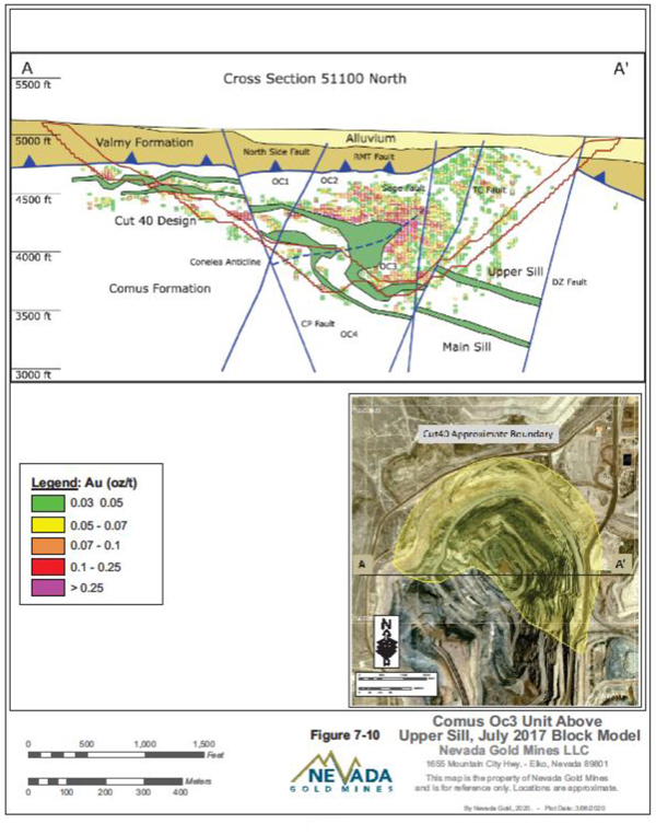
| Nevada Gold Mines LLC – Turquoise Ridge Complex | Page 7-24 | |
Technical Report NI 43-101 – March 25, 2020 | ||
A more recent Cut 40 drill holeTWD-02489 (Figure7-11 and Figure7-12) exhibits two styles of Comus Formation mineralization:
| ● | Gold in variably altered silty micrite, this is the most common occurrence. |
| ● | Gold in argillized and sulphidized basalt appears to be related to faulted and fractured intervals. Lower grade in silicified micrite can be observed at the contact with basalt. |
North and northeast striking faults with larger cumulative slip, such as the CP, TC, and DZ may have acted as feeders for mineralization, however, gold mineralization tends to be discontinuous and of lower grade along them, possibly as a result of post-mineral movement. Visible gold, however, was noted in oxidized quartz breccia material from the DZ fault zone.
North striking faults have focused gold with higher grades in and near the faults even where less favourable host rocks are present. Mega Pit Cut 23, which straddles the CP fault, is a good example.
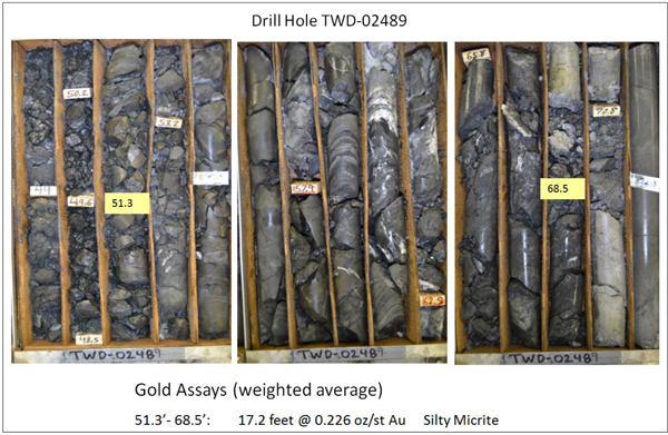
Figure 7-11 Cut 40 Drill HoleTWD-02489 Core
| Nevada Gold Mines LLC – Turquoise Ridge Complex | Page 7-25 | |
Technical Report NI 43-101 – March 25, 2020 | ||
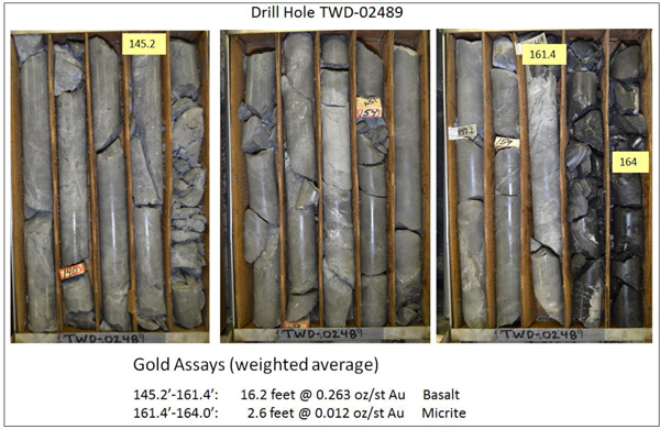
Figure 7-12 Cut 40 Drill HoleTWD-02489 Core with Lower Grade at Basalt and Micrite Contact
In the Vista Pit, stratabound high grade oxide ore occurs primarily within pervasively decalcified sandy carbonate rocks of the lowermost Etchart near the unconformity between the Etchart and the Valmy formations. The unconformity is disrupted by northeast striking faults, forming a horst block in the central part of the Vista Pit. These and other structures contain high grade gold in narrow zones in the Valmy formation and likely serve as feeders to the much larger stratabound orebody in the basal Etchart.
At Vista Underground, mineralization is largely confined to the Trench Fault shear zone. It has a mineable strike length of approximately 1,400 m and a dip length of 300 m. The ore consists of disseminated gold in arsenian pyrite and marcasite. The structure itself is a brecciated quartz-base vein, historically known as the Galena Vein. The mineralogy of the vein consists of milky vein quartz, fractured pyrite, massive fractured sphalerite with chalcopyrite, subhedral-euhedral pyrite, massive fracture galena, tennantite-tetrahedrite, microcrystalline quartz, sericite, and specular hematite. There is no recognized ore horizon within the deposit. The only constraint on the extent of gold mineralization is the surface and the 20K fault that truncates the Trench fault to the northeast.
| Nevada Gold Mines LLC – Turquoise Ridge Complex | Page 7-26 | |
Technical Report NI 43-101 – March 25, 2020 | ||
In the opinion of the QP:
| ● | The understanding of the deposit settings, lithologies, and geologic, structural, and alteration controls on mineralization is sufficient to support estimation of Mineral Resources and Mineral Reserves. |
| ● | The mineralization styles and settings are well understood and can support declaration of Mineral Resources and Mineral Reserves. |
| ● | The geological knowledge of the area is adequate to reliably inform mine planning. |
| Nevada Gold Mines LLC – Turquoise Ridge Complex | Page 7-27 | |
Technical Report NI 43-101 – March 25, 2020 | ||
8. DEPOSIT TYPES
The Turquoise Ridge Underground deposit is a typical Carlin-type deposit and is characterized by structurally and stratigraphically controlled, sediment-hosted, replacement deposits containingmicron-sized gold.
Along with the Turquoise Ridge Underground deposit, the Preble, Pinson, Getchell, and Turquoise Ridge Surface deposits collectively define the Getchell gold belt, which could be described as the northern extent of the Battle Mountain – Eureka gold belt as currently defined. It is recognized that both the Carlin and Battle Mountain – Eureka gold belts are alignments of sediment hosted gold deposits within structural windows, where autochthonous, lower-plate rocks of the Roberts Mountains thrust are exposed through allochthonous, upper-plate rocks. The origin of these structural openings is thought to be the product of multiple deformation events beginning with middle-late Devonian Antler Orogeny and continuing through at least Cretaceous time.
The Vista Underground is a high-grade refractory gold deposit located in the bottom of the Vista Phase 6 Pit. Mineralization occurs along the steeply dipping trench fault also known as the Vista Shear.
| Nevada Gold Mines LLC – Turquoise Ridge Complex | Page 8-1 | |
Technical Report NI 43-101 – March 25, 2020 | ||
9. EXPLORATION
| 9.1. | TURQUOISE RIDGE UNDERGROUND |
The Turquoise Ridge Underground deposit was discovered at a depth of 425 m to 610 m below the surface by a deep drilling program. While surface exploration has been completed on the property in the past, very little was directed at the Turquoise Ridge deposit, which was developed via drilling, deep penetration geophysical surveys, and structural mapping to extend the known dimensions of the mineralized zones.
Nevada Gold Mines has an extensive database of historic soil, rock chip geochemical sampling, and geophysical surveys (gravity, airborne electromagnetic, magnetic, controlled source audio magnetotellurics (CSAMT), magnetotellurics (MT), and seismic). Gold mineralization is not directly detectable by geophysical methods, however, surveys map subsurface properties that are useful in interpreting lithology, alteration, and structure as guides to gold mineralization.
Definition of sampling procedures, potential biases in sampling, information already collected and significant results and interpretations are located in Section 11.
EXPLORATION POTENTIAL
Nevada Gold Mines maintains an aggressive exploration program principally comprising diamond drilling. A brief description of the main targets follows (and shown in Figure9-1).
| ● | BPE Extensions – Apparently continuous mineralization at the base of the North Pillow Basalt along bothlow-angle (separate-type) and high-angle (northeast striking, northwest dipping) faults. |
| ● | Turquoise Ridge Corridor Mineralization – Apparently continuous mineralization along the known high grade Turquoise Ridge Corridor faults. |
| ● | Getchell Fault – Possibly continuous mineralization along the Getchell Fault and associated intersecting structures (BBT, Turquoise Ridge Corridor). |
| ● | Summer Camp – Poorly drilled mineralization south of Turquoise Ridge Underground in a former open pit. Possible analog to Getchell/Turquoise Ridge deposit, but at a smaller scale. |
| ● | South Zone – Lower-grade mineralization concentrated on mostlyBBT-type structures in the Second Shaft area. |
| ● | Nevada Gold Mines is also pursuing the growth potential both near current operations and between the Turquoise Ridge Complex’s component properties. |
| Nevada Gold Mines LLC – Turquoise Ridge Complex | Page 9-1 | |
Technical Report NI 43-101 – March 25, 2020 | ||
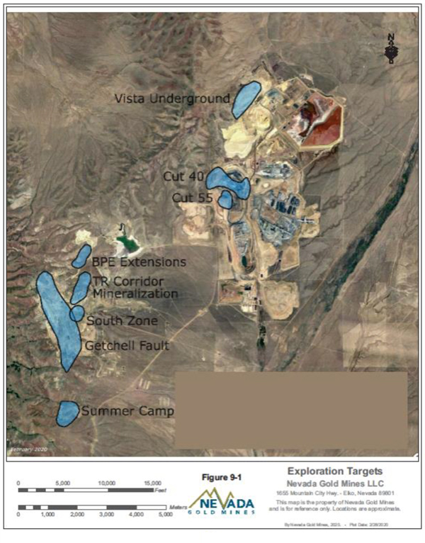
| Nevada Gold Mines LLC – Turquoise Ridge Complex | Page 9-2 | |
Technical Report NI 43-101 – March 25, 2020 | ||
| 9.2. | TURQUOISE RIDGE SURFACE AND VISTA UNDERGROUND |
In 1984, Gold Fields discovered Carlin-type mineralization in Etchart Formation limestone in the hanging wall of the Discovery fault that later became the Vista Pit. Stripping of the initial Vista Pit began in April 1987 and first gold was poured in November 1987. Continued exploration to the south in Section 18 by Gold Fields led to the discovery of mineralization in the Mega North Pit area. This blind discovery was attributed to a sagebrush biogeochemical anomaly (A. Leger, 2016).
While Gold Fields was developing the Section 18 Chimney Creek deposit, SFPG was mining the adjacent Section 19 Rabbit Creek deposit. SFPG consolidated the property in 1993 with Newmont acquiring SFPG in 1997.
Exploration drilling in the area spans over 32 years. Drilling methods included mud rotary, RC, and diamond core. Initial drilling by Gold Fields was a combination of shallow core and RC holes to define an oxide resource. Deeper drilling by each method followed to evaluate the refractory potential.
Definition of sampling procedures, potential biases in sampling, information already collected and significant results and interpretations are located in Section 11.
EXPLORATION POTENTIAL
Near mine exploration programs are principally completed with RCpre-collars and diamond core tails. Current targets include (Figure9-1):
| ● | Cut 55 – Scattered, potentially continuous mineralization beneath the Mega Pit. |
| ● | Vista Underground – Possible extension of mineralization along the Trench Fault, southwest of existing infrastructure,down-dip extents of mineralization on the Trench Fault below the water table. |
| ● | Cut 40 – Continuous mineralization below the current Mega Pit. |
| ● | Nevada Gold Mines is also pursuing the growth potential both near current operations and between the Turquoise Ridge Complex’s component properties. |
| Nevada Gold Mines LLC – Turquoise Ridge Complex | Page 9-3 | |
Technical Report NI 43-101 – March 25, 2020 | ||
| 10. | DRILLING |
Nevada Gold Mines maintains an aggressive exploration program principally comprising diamond drilling. Exploration is being carried out over several underground exploration targets at Turquoise Ridge Underground, including the Turquoise Ridge Corridor Fault Zone, Upper Footwall Pond, thedown-dip and northeast extension of the Footwall Pond, the North Zone and South Zone Getchell Extensions, and the Powder Hill Extension. Near mining exploration targets are also being tested in 2020 on the southern extension of the Vista Underground. Turquoise Ridge Surface has a number of extension targets and will be reviewed for future step out drilling. Additionally, the Turquoise Ridge Complex has an exploration team on site and budget to start drilling between the Turquoise Ridge Underground and the Mega Pit, Vista Pit and Vista Underground mining areas.
| 10.1. | TURQUOISE RIDGE UNDERGROUND |
Gold exploration activities began in the 1930s by two local Winnemucca prospectors, who first discovered Getchell. Getchell was operated intermittently between 1938 and 1984, when FRM and First Mississippi purchased the property. Exploration drilling in 1992 and 1993, was centered on the area around the original Getchell Main pit to delineate high-grade gold mineralization that had been discovered in the footwall of the Getchell Fault. Deep drilling began in 1993 in the Turquoise Ridge Underground area. A high-grade mineralized zone was discovered at a depth of 420 m to 600 m below the surface.
Since acquisition of Turquoise Ridge Underground in 2006, Barrick has completed over 6,100 drill holes. The drilling programs from 2010 to 2019 were largely comprised of definition drilling to upgrade Mineral Resources adjacent to and within gaps into the Proven and Probable Mineral Reserve mining shapes.
Table10-1 lists all the drilling completed at Turquoise Ridge Underground since 1992. Since 2009, Barrick has completed over 5,900 drill holes for a total of approximately 427 km.
| Nevada Gold Mines LLC – Turquoise Ridge Complex | Page 10-1 | |
Technical Report NI 43-101 – March 25, 2020 | ||
Table 10-1 Summary of Turquoise Ridge Underground Drilling
| Year | Number of Holes | |
| 1992-2008 | 913 | |
| 2009 | 1,872 | |
| 2010 | 336 | |
| 2011 | 241 | |
| 2012 | 432 | |
| 2013 | 648 | |
| 2014 | 864 | |
| 2015 | 262 | |
| 2016 | 294 | |
| 2017 | 280 | |
| 2018 | 267 | |
| 2019 | 422 | |
| Total | 6,831 |
Thecut-off date for the drill data for the end of year (EOY) 2019 Mineral Resource and Mineral Reserve model was June 11, 2019. All 2019 drilling to June 11, 2019 was completed in the Turquoise Ridge Underground area.
The database for the geologic and Mineral Resource models resides in Elko, Nevada, and is maintained and administered by Barrick Exploration. Paper copies of the assay certificates are maintained on site at the Turquoise Ridge Complex.
The drilling programs from 2010 to 2019 consisted predominantly of definition drilling to upgrade Mineral Resources and Mineral Reserves adjacent to and within gaps in the Proven and Probable Mineral Reserve shapes. In addition to definition drilling there were approximately 30,480 m in 174 step out and advanced exploration holes.
LOGGING PROCEDURES
Logging is conducted by Nevada Gold Mines geology staff and contract geologists. Geological information is entered directly into the acQuire database by the geologists for production holes. On advanced exploration andstep-out holes more detailed logs are collected on paper and then transferred to acQuire. Paper logs are digitized and archived.
CORE SAMPLING
Nevada Gold Mines follows conventional, industry standard practices for geologic and engineering data acquisition and sampling. Drill core is logged manually for geotechnical data
| Nevada Gold Mines LLC – Turquoise Ridge Complex | Page 10-2 | |
Technical Report NI 43-101 – March 25, 2020 | ||
and geology and photographed in a modern facility. Drill holes are logged by the Nevada Gold Mines geologist or contract logging geologist who describes the downhole lithology, structure, alteration, and mineralization. The entire length of the core is sampled. Core samples are nominally 1.5 m but can vary to a minimum of 0.3 m to respect lithological contacts, at the discretion of the geologist. All mineralized intervals selected for split core assaying are bracketed on either end with a minimum of 4.6 m of visibly unaltered core.
REVERSE CIRCULATION SAMPLING
RC drill holes are sampled on 1.5 m intervals, designated by measured intervals on the drill’s pull down apparatus (cables, chains). Drill cuttings are initially collected in a standard cyclone to reduce the sample’s velocity to a safe speed and dropped through a splitter. The splitter is actively managed to produce a sample of approximately five kilograms, but sample mass can vary from five kilograms to 15 kg. Standards, blanks, and duplicate samples are inserted/collected at the same prescribed rate as for diamond drill holes.
PRODUCTION SAMPLING
Production sampling underground consists of five kilogram samples of drill cuttings collected by the drill operators after drilling of the round, at a rate of three to five samples per round. The objective is to standardize sampling at one per 32 tonnes. Due to low Rock Mass Rating (RMR) in ore, drilling results in well fragmented muck and samples are 95% sand size.
Waste material is sampled before skipping to surface to confirm material routing. Waste round samples grading above 3.4 g/t Au arere-routed as ore.
| 10.2. | TURQUOISE RIDGE SURFACE AND VISTA UNDERGROUND |
In 1984, Gold Fields discovered Carlin-type mineralization in Etchart Formation limestone in the hanging wall of the Discovery fault that later became the Vista Pit. Stripping of the initial Vista Pit began in April 1987 and first gold was poured in November 1987. Continued exploration to the south by Gold Fields led to the discovery of mineralization in the Mega North Pit area
| Nevada Gold Mines LLC – Turquoise Ridge Complex | Page 10-3 | |
Technical Report NI 43-101 – March 25, 2020 | ||
Exploration drilling in the area spans over 32 years. Drilling methods included mud rotary, RC, and diamond core. Initial drilling by Gold Fields was a combination of shallow core and RC holes to define an oxide resource. Deeper drilling by each method followed to evaluate the refractory potential
Near-mine exploration and growth drilling has been ongoing since 1998, almost continuously since 2008. Grade control and infill drilling was restarted in that year as well. The Turquoise Ridge Complex utilizes third-party drilling contractors to conduct drilling operations for both grade-control andstep-out exploration programs.
Table10-2 lists all the drilling completed at Turquoise Ridge Surface and Vista Underground since 2016.
Table 10-2 Summary of Turquoise Ridge Surface and Vista Underground Drilling
| Year | Number of Holes | Total Drilling (m) | ||
| 2016 | 105 | 22,085 | ||
| 2017 | 15 | 2,370 | ||
| 2018 | 38 | 12,289 | ||
| 2019 | 48 | 10,945 | ||
| Total | 206 | 47,689 |
LOGGING PROCEDURES
Turquoise Ridge Surface geologists used a digital logging program developed by Newmont called Visual Logger. This program captures both geologic and geotechnical data via a computer based program that is then easily downloaded to Nevada Gold Mines’ exploration database, GED. Historic logging information was collected on paper templates and manually loaded to earlier databases. Since the consolidation of operations into the Turquoise Ridge Complex, all logging is completed directly in Acquire.
CORE SAMPLING
Samples from diamond core drilling are taken from the core tube and placed into coated cardboard boxes containing a nominal capacity of 3.05 m. Intact core may be broken to make it fit into the box slots. Drilling fluids used during coring include water based ‘mud’ systems, typically with bentonite (clay) and inorganic polymer added. The core boxes are stacked sequentially onto pallets and transported to the Turquoise Ridge Surface core shed daily. Diamond cores are logged by Nevada Gold Mines geologists after completion of the drilling. Sample intervals are recorded and provided to Nevada Gold Mines geotechnicians who
| Nevada Gold Mines LLC – Turquoise Ridge Complex | Page 10-4 | |
Technical Report NI 43-101 – March 25, 2020 | ||
photograph and then sample the core. Core may be cut by a water cooled diamond saw into1⁄2 or1⁄4 segments depending on resource category, geologic constraints or for metallurgical testing. The samples are placed inbar-coded fabric bags, loaded in metal bins, and stored at the core shed until the core shed staff oversees loading of the bins onto a transport truck provided by the commercial lab. As with the RC drill holes a paper copy sample log with hole number, length, and sample numbers is checked by geologists and technicians for consistency. Technicians then enter the information into the computer system.
RC SAMPLING
RC samples are collected at 1.5 m intervals. The drill discharge is routed through a rotary splitter at a rate and volume capacity to maintain a sample weight between two kilograms and 10 kg. Representative chip samples for each interval are collected from the waste discharge tube of the splitter and placed in a plastic tray with each compartment representing 1.5 m each, or 30 m total for an entire chip tray. RC samples are collected at the drill rig in fabric bags and closed by azip-tie. Bags are labeled withhole-ID and footage. Nevada Gold Mines supplied bar codes are affixed to each sample. Samples are placed in metal sample bins, which are taken to the core shed when the hole is complete. Nevada Gold Mines geotechnicians complete the sample submittals and oversee the loading of the bins onto transport trucks provided by the commercial laboratory.
| 10.3. | TURQUOISE RIDGE COMPLEX COMBINED CORE RECOVERY |
Table10-3 displays core recovery by location for the Turquoise Ridge Complex.
Table 10-3 Summary of Turquoise Ridge Complex Core Recovery Summary
| Location | Number of Core Holes
| Drilled Length | Length-Weighted Average Recovery (%) | |||||
(ft)
|
(m)
| |||||||
| Turquoise Ridge Surface | ||||||||
Mega Pit | 4,339 | 3,207,945 | 977,782 | 95 | ||||
Vista Pit | 3,243 | 1,500,515 | 457,357 | 85 | ||||
| Underground Areas | ||||||||
Turquoise Ridge Underground | 3,966 | 3,008,691 | 917,049 | 95 | ||||
Vista Underground | 605 | 377,369 | 115,022 | 92 | ||||
| Nevada Gold Mines LLC – Turquoise Ridge Complex | Page 10-5 | |
Technical Report NI 43-101 – March 25, 2020 | ||
In the opinion of the QP:
| ● | Drilling and logging are adequate to the understanding and definition of the ore bodies and supports declarations of Mineral Resource and Mineral Reserves at the Turquoise Ridge Complex. |
| 10.4. | DRILLING USED TO SUPPORT MINERAL RESOURCE ESTIMATION |
Drilling has historically been a mix of diamond drilling (DD) and RC across the operations, with occasional conventional and mud drilling at Mega and Vista pits. DD is the primary method currently in use at Turquoise Ridge Underground and Vista Underground. At Turquoise Surface, RC and DD are deployed for both near-mine exploration and grade control purposes.
The geometry of the mineralized bodies can be variable, largely controlled by structural and stratigraphic complexities. Uncertainty about the morphology and vertical or lateral extent is mitigated by drilling at various orientations to the mineralized body.
TURQUOISE RIDGE UNDERGROUND
Drill hole spacing at Turquoise Ridge Underground is approximately 15 to 25 meters. Variography of the local domains determines the required spacing for measured, indicated, and inferred classifications. DD accounts for just over half of the drilling used in the Mineral Resource database (Table10-4), but now currently accounts for nearly 90% of drilling activities, with drill hole diameters ranging in size from PQ to NQ (3 3/8 inches to 1 3/8 inches). RC drilling using 4.5 inch diameter borehole has been limited in recent years, as geotechnical and sample quality have been better than DD.
Table 10-4 Turquoise Ridge Underground Drilling
| Drill Type | Number of Core Holes | Drilled Length |
Percentage of Total Drilling (%) | |||||
| (ft) | (m) | |||||||
Core-(DD) | 3,070 | 533,908 | 162,735 | 53% | ||||
RC | 2,729 | 318,618 | 97,115 | 47% | ||||
Totals | 5,799 | 852,526 | 259,850 | 100% | ||||
Planned drill hole collar locations are marked up by drill services personnel using a Trimble total station to determine the location of every hole and to establish front- and back-sites for all angle holes. Drillers utilize a north-seeking azimuth aligner to ensure proper setup. After collaring the hole, drill services will pick up the collar coordinates using the Trimble. Figure
| Nevada Gold Mines LLC – Turquoise Ridge Complex | Page 10-6 | |
Technical Report NI 43-101 – March 25, 2020 | ||
10-1 illustrates the locations of core and RC collars at Turquoise Ridge Underground used in the Mineral Resource estimation.
Downhole surveys are performed on all holes. In the past, surveys were conducted using both magnetic and gyro instruments, but are now completed using a combination of north-seeking and conventional gyros. Surveys are conducted by the drillers during the drilling process either at final depth or when adverse ground conditions are encountered. International Directional Services LLC (IDS) conducts the surveys for holes collared from surface targeting mineralization at depth.
TURQUOISE RIDGE SURFACE
Drill spacing at Turquoise Ridge Surface is approximately 25 m to 35 m for the Mega Pit and approximately 20 m to 35 m for the Vista Pit (Figure10-2). Table10-5 summarizes the TR Surface drilling statistics.
Table 10-5 Turquoise Ridge Surface Drilling
| Drill type | Number of Core Holes | Drilled Length |
Percentage of Total Drilling (%) | |||||
| (ft) | (m) | |||||||
Mud | 59 | 32,647 | 9,951 | 1% | ||||
Conv | 93 | 12,725 | 3,879 | 1% | ||||
Core | 2,863 | 1,378,434 | 420,147 | 31% | ||||
RC | 6,089 | 3,284,654 | 1,001,163 | 67% | ||||
Totals | 9,104 | 4,708,460 | 1,435,139 | 100% | ||||
Planned drill hole collar locations are marked up by geologists or drill services personnel using a Trimble global positioning system (GPS) to determine the location of each hole and to establish front- and back-sites. After drilling, survey will pick up the collar coordinates using a real-time kinematic GPS.
Downhole surveys are performed on all holes using a combination of north-seeking and conventional gyros. Surveys are conducted by IDS.
VISTA UNDERGROUND
Drill spacing at Vista Underground is approximately 10 m to 25 m (Figure10-3). Table10-6 summarizes the drilling statistics for Vista Underground.
| Nevada Gold Mines LLC – Turquoise Ridge Complex | Page 10-7 | |
Technical Report NI 43-101 – March 25, 2020 | ||
Table 10-6 Vista Underground Drilling
| Drill type | Number of Core Holes | Drilled Length | Percentage of Total Drilling (%) | |||||
| (ft) | (m) | |||||||
Core | 605 | 377,369 | 420,147 | 100% | ||||
Totals | 605 | 377,369 | 420,147 | 100% | ||||
Planned drill hole collar locations are laid out by survey or geologic personnel measuring off lasers/reference points. Once center of rotation is established aTN-14 azimuth aligner tool is used to place each hole. All collars are picked up by survey using a Trimble. Previously, there was a guideline that did not require holes less than 150 feet to have a survey. However, all current holes are surveyed with the IDS tool. In 2016 and 2017, IDS performed all downhole surveys with either a maxibore or a mims north-seeking gyro depending on tool availability. In 2018 and 2019, a north seeking gyro was used to perform surveys. An azimuth aligner tool has been used for all drilling since 2016, prior to that azimuth/incline was established with front and back sights.
| Nevada Gold Mines LLC – Turquoise Ridge Complex | Page 10-8 | |
Technical Report NI 43-101 – March 25, 2020 | ||
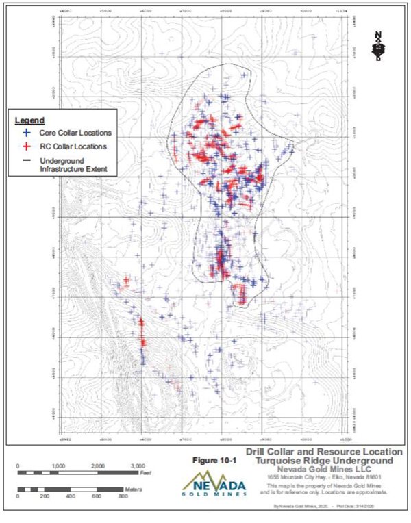
| Nevada Gold Mines LLC – Turquoise Ridge Complex | Page 10-9 | |
Technical Report NI 43-101 – March 25, 2020 | ||
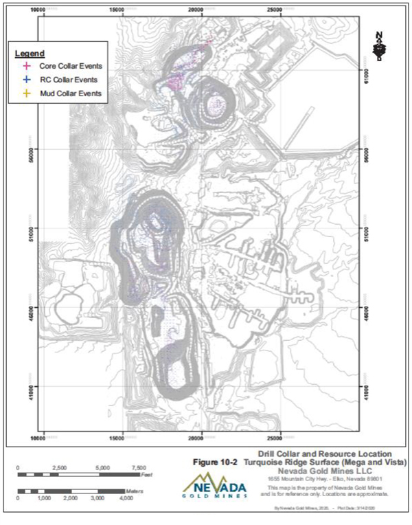
| Nevada Gold Mines LLC – Turquoise Ridge Complex | Page 10-10 | |
Technical Report NI 43-101 – March 25, 2020 | ||
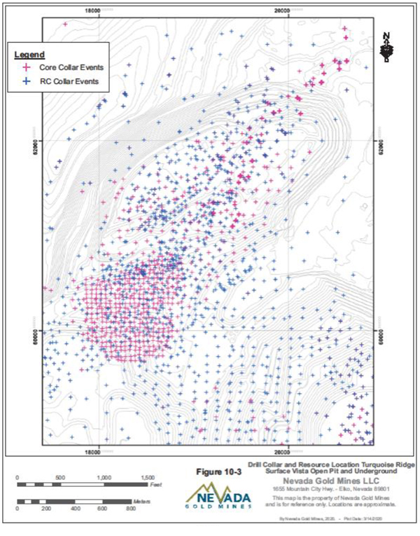
| Nevada Gold Mines LLC – Turquoise Ridge Complex | Page 10-11 | |
Technical Report NI 43-101 – March 25, 2020 | ||
11. SAMPLE PREPARATION, ANALYSES AND SECURITY
| 11.1. | TURQUOISE RIDGE UNDERGROUND |
TURQUOISE RIDGE UNDERGROUND LABORATORY
All Turquoise Ridge Underground drill holes from 2009 to 2019, inclusive, used for Mineral Resource estimation were assayed at the Turquoise Ridge Underground laboratory. The mine laboratory which analyzes production samples is not certified. Exploration drill hole samples followed a separate protocol and were assayed off site by an accredited commercial laboratory. Starting in August 2019 all assaying of drill holes were completed at ALS Mineral laboratories located in Reno, Nevada and/or Vancouver, British Colombia, Canada.
SAMPLE PREPARATION AND ANALYSIS
The procedures followed by the Turquoise Ridge Underground laboratory are as follows. Samples are dried for a minimum of eight hours at 49°C and crushed to minus 9.5 mm. The crusher is cleaned with compressed air following each sample. A weekly sieve analysis is performed to confirm the material size and adjustments are made accordingly.
The entire crushed sample is split with a Jones riffler to achieve a 150 gsub-sample which is pulverized to 90% passing 150 mesh (89 µm) using a ring and puck pulveriser. Daily sieve analyses are conducted to ensure the particle size. Every twentieth sample is pulverized separately as a separate quality assurance/quality control (QA/QC) sample for analysis at an independent laboratory.
Samples are analyzed using fire assay (FA) with a gravity finish. Every batch of 20 samples contains a standard, blank, and duplicate sample for QA/QC. If any of the three QA/QC samples returns results outside the accepted range, the entire batch isre-run.
QUALITY ASSURANCE/QUALITY CONTROL
The QA/QC program for core and production samples processed at the Turquoise Ridge Underground laboratory consists of the insertion of certified reference material (CRM) or standard, blank , and pulp duplicates as internal laboratory checks in each batch of samples.
| Nevada Gold Mines LLC – Turquoise Ridge Complex | Page 11-1 | |
Technical Report NI 43-101 – March 25, 2020 | ||
The insertion rate used is approximately 1:20 for standards, blanks, and duplicates. Duplicate samples are also sent to ALS Minerals Reno (ALS Reno) in Reno, Nevada, or ALS Minerals Vancouver (ALS Vancouver) in Vancouver, Canada for analysis.
Nevada Gold Mines purchased standards from well-known Canadian distributors CDN Resources Labs (CDN) in Vancouver, British Columbia. CDN prepares its own standardsin-house. All standards came in 100 g sealed envelopes. Standards prepared by CDN are widely employed in the industry. They represent a grade range from near-detection to nearly 34 g/t gold and include both oxide and sulphide compositions.
A Nevada Gold Minesin-house blank is a hard white pebble gravel obtained locally from Gentec and Ace Hardwares used to test for potential contamination.
CRM and blank samples are considered a failure if the assayed value is greater than two standard deviations from the expected value. When standards fall out of tolerance, the laboratory is contacted and asked to rerun five samples above and below the failed standard (or blank). Pulp duplicates are compared to the original results using the Sign Test which tests the number of positive and negative differences in sample pairs. Thet-Test is used to compare the means. The results are also analyzed using regression analysis.
Ongoing monitoring of QA/QC results is completed as assay data are received from ALS Reno and ALS Vancouver laboratories before uploading into the Turquoise Ridge Complex master database. Monthly and quarterly review and comprehensive analysis of the QA/QC results are conducted. The QA/QC program is monitored closely, and all issues identified with assay results are resolved prior to data approval and its importation into the mine database.
The QP also notes that coarse crush duplicate samples (rejects) are not used by Turquoise Ridge Underground. Coarse crush duplicates would show contamination at the sample preparation stage that would not otherwise be evident. The QP recommends that coarse crush duplicates be analyzed on a regular basis.
The QP reviewed the results for mine geology samples analyzed at the Turquoise Ridge Underground laboratory between January 1 and September 30, 2017. A total of 3,097in-house standards, 3,139 blanks, and 3,644 laboratory pulp duplicates were inserted into the sample
| Nevada Gold Mines LLC – Turquoise Ridge Complex | Page 11-2 | |
Technical Report NI 43-101 – March 25, 2020 | ||
stream during this period. There were 25 standard failures and two blank failures during this period. The pulp duplicates showed no systematic bias.
During the period from January 1, 2019 to December 17, 2019, 4,704 pulp duplicates were inserted. The Sign Test,t-Test, and regression analysis indicate that there is no systematic bias in the two sets of data. Additionally, 4,005 blanks with 5 failures, and 3,969 standards with 13 failures, were analyzed at ALS Reno.
These failure rates are acceptable and in the QP’s opinion the QA/QC results indicate that the data is acceptable for Mineral Resource estimation.
| 11.2. | TURQUOISE RIDGE SURFACE AND VISTA UNDERGROUND |
TURQUOISE RIDGE SURFACE AND VISTA UNDERGROUND LABORATORY
Legacy assay work was completed by Shasta Analytical, Barringer Labs, Legend, American Assay, Chemex and Bondar Clegg. ALS Reno and ALS Vancouver have assayed drill samples since 2002. LECO analysis is a method of estimating total organic carbon (TOC) using an instrument known as a LECO carbon analyzer by combusting the organic carbon and measuring the resulting carbon dioxide produced. Historic LECO analysis was mostly completed by the mine site lab but was moved to ALS Reno or ALS Vancouver in 2014.
DENSITY DETERMINATIONS
Twelve core samples (Table11-1) with Nevada Gold Mines calculated specifc gravity determinations were sent to ALS Reno for check analysis. A best fit regression line (Figure11-1) of the two data sets yields an acceptable 0.9984 correlation.
| Nevada Gold Mines LLC – Turquoise Ridge Complex | Page 11-3 | |
Technical Report NI 43-101 – March 25, 2020 | ||
Table 11-1 Turquoise Ridge Surface Specified Gravity Results
| Hole ID | Duplicate Type | Original Value | Check Value | Original Date | Check Date | |||||
| TWD-02435 | SG Check | 2.7512 | 2.7600 | 3/6/2017 | 4/25/2017 | |||||
| TWD-02436 | SG Check | 2.6851 | 2.7000 | 3/7/2017 | 4/25/2017 | |||||
| TWD-02449 | SG Check | 2.6196 | 2.6100 | 6/1/2017 | 8/1/2017 | |||||
| TWD-02452 | SG Check | 2.8550 | 2.8700 | 5/19/2017 | 6/2/2017 | |||||
| TWD-02454 | SG Check | 2.8862 | 2.8900 | 9/19/2017 | 11/1/2017 | |||||
| TWD-02456 | SG Check | 2.9566 | 2.9600 | 9/19/2017 | 11/1/2017 | |||||
| TWD-02462 | SG Check | 2.6976 | 2.7000 | 6/1/2017 | 8/1/2017 | |||||
| TWD-02463 | SG Check | 2.7954 | 2.8100 | 5/19/2017 | 6/2/2017 | |||||
| TWD-02464 | SG Check | 2.6518 | 2.6600 | 7/11/2017 | 8/1/2017 | |||||
| TWD-02466 | SG Check | 2.8072 | 2.8100 | 9/19/2017 | 11/1/2017 | |||||
| TWD-02471 | SG Check | 2.3421 | 2.3400 | 7/11/2017 | 8/1/2017 | |||||
| TWD-02487 | SG Check | 2.5940 | 2.6200 | 2/5/2018 | 2/16/2018 |

PARENT COLUMN HEADER | CATEGORY | DUPLICATE TYPE | R_SQUARED | |||
SG_UNK_GRAV_NGC
| DENSITY
| CHECK
| 0.9984
|
Figure 11-1 Check Specific Gravity Results Turquoise Ridge Surface
SAMPLE METHODS
Listed below are the analytical descriptions of the various assaying procedures employed by ALS Reno or ALS Vancouver.
ALSAu-AA23 testing: Fire gold AAS finish
| ● | FA Fusion with AAS finish for Au |
| ● | 30g nominal sample weight |
| ● | 0.005 ppm to 10 ppm lower/upper limit |
| Nevada Gold Mines LLC – Turquoise Ridge Complex | Page 11-4 | |
Technical Report NI 43-101 – March 25, 2020 | ||
| ● | >100 ppm over limit testing by gravimetric |
ALSAu-AA31 testing: Cyanide leach and preg rob capacity
| ● | Cyanide Leach with Au spike; AAS finish for Au |
| ● | 10g nominal sample weight |
| ● | 0.03 ppm to 500 ppm lower/upper limit |
| ● | Au-AA31a testing: |
| ● | Cyanide Leach without Au spike; AAS finish for Au |
| ● | 10g nominal sample weight |
| ● | 0.03 ppm to 500 ppm lower/upper limit |
ALSME-MS41 testing: multi-element trace elements
| ● | Aqua Regia Digestion withICP-AES andICP-MS |
| ● | 0.50 g nominal sample weight |
| ● | 51 element suite with automaticore-grade testing on over limits |
| ● | Over limits specific to each element |
LECO testing: Carbon and sulphur speciation for autoclave blending
| ● | Total Sulphur and Carbon by LECO furnace analysis |
| ● | HCI (25%) leach of carbonates with LECO furnace analysis for organic carbon (OC) |
| ● | S (sulphate) by pyrolysis and LECO furnace analysis |
| ● | 0.1 g to 0.2 g nominal sample weight |
| ● | 0.01% to 50% lower/upper limit by weight |
QUALITY ASSURANCE/QUALITY CONTROL
Nevada Gold Mines exploration drilling QA/QC information from 2002 forward was evaluated by the geology department using a variety of statistical procedures over different time periods resulting in multiple spreadsheets, reports, and memos. No critical issues were identified, but a significant number ofpre-Nevada Gold Mines legacy issues concerning assay, collar and down hole survey were documented.
The QA/QC discussion that follows evaluates gold assays in the Cut 40 area from 2017 and 2018 using a Microsoft Excel (MS Excel) spreadsheet template developed by Newmont senior consulting geologist Richard Inglis. Sampling constants K=5 anda= 0.89 used in the analysis are from a Vista Pit blast hole heterogeneity study (Bucknam and Seidel, 1996). The
| Nevada Gold Mines LLC – Turquoise Ridge Complex | Page 11-5 | |
Technical Report NI 43-101 – March 25, 2020 | ||
spreadsheet exercise generates a summary table with related graphs and charts at selected threshold levels. ALS Reno is the primary assay lab. Check pulps were submitted to American Assay lab, also located in Reno, Nevada.
STANDARD REFERENCE MATERIAL
A total of 25 standards were utilized during the multi-year drill campaign. They represent a grade range from near-detection to nearly 34 g/t gold and include both oxide and sulphide compositions. The results indicate acceptable accuracy with a minimal negative bias (Figure11-2).
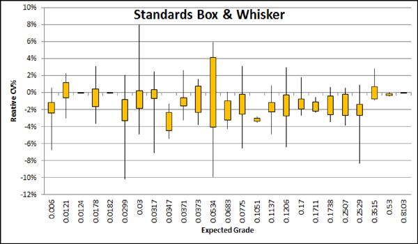
Figure 11-2 Turquoise Ridge Surface Standards Box and Wisker Results for 25 Standards
BLANKS
A Nevada Gold Minesin-house blank sourced locally from Quaternary gravel was used to test for potential contamination. Results were acceptable with less than ten percent of assays greater than 10x detection limit (Figure11-3).
| Nevada Gold Mines LLC – Turquoise Ridge Complex | Page 11-6 | |
Technical Report NI 43-101 – March 25, 2020 | ||
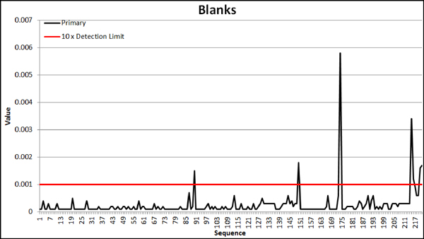
Figure 11-3 Results of Nevada Gold MinesIn-house Gravel Blank
DUPLICATE SAMPLES
Results for field duplicates (Figure11-4) and pulp/check duplicates (Figure11-5 and Figure11-6) show acceptable precision at 1s and 2s thresholds. Some noise exists above this level, mostly at the 0.00x gold grade range. Preparation duplicate precision is acceptable across all grade ranges.
| Nevada Gold Mines LLC – Turquoise Ridge Complex | Page 11-7 | |
Technical Report NI 43-101 – March 25, 2020 | ||
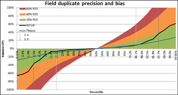
Figure 11-4 Field Duplicate QA/QC Results
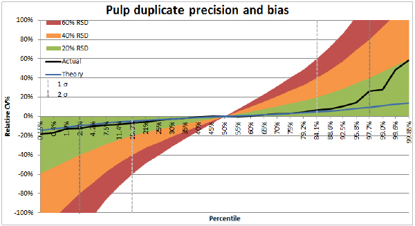
Figure 11-5 Pulp Duplicate QA/QC Results
| Nevada Gold Mines LLC – Turquoise Ridge Complex | Page 11-8 | |
Technical Report NI 43-101 – March 25, 2020 | ||

Figure 11-6 Prep Duplicate QA/QC Results
| 11.3. | INDEPENDENT LABORATORY |
ALS USA Inc. ALS Reno or ALS Vancouver are the primary independent analytical facilities for analysis of Turquoise Ridge Complex pulp samples from core and RC drilling. ALS Reno and ALS Vancouver are independent, accredited testing laboratories and conform to the requirements set out byCAN-P-1579 andCAN-P-4E (ISO/IEC 17025:2005), the Requirements for the Accreditation of Mineral Analysis Testing Laboratories and General Requirements for the Competence of Testing and Calibration Laboratories, respectively. ALS Reno and ALS Vancouver are independent of Nevada Gold Mines.
Sampling is conducted by Nevada Gold Mines personnel as described previously.
ALS Reno and ALS Vancouver uses FA with an atomic absorption spectroscopic (AAS) finish for low grade samples and FA with a gravimetric finish for AAS assays³10 g/t. A multi-element (51) analysis is performed on selected samples of interest for accessory metals and trace elements. The ALS codes arePREP-31Y for preparation,Au-AA23 andAu-GRA21 for gold, andME-MS41 for multi-element analysis:
| ● | Au-AA23: FA fusion and AAS on a 30 g aliquot (0.005 g/t Au to 10 g/t Au) |
| Nevada Gold Mines LLC – Turquoise Ridge Complex | Page 11-9 | |
Technical Report NI 43-101 – March 25, 2020 | ||
| ● | Au-GRA21: FA fusion and gravimetric finish on a 30 g aliquot (0.05 g/t Au to 1,000 g/t Au) |
| ● | ME-MS41: Aqua regia (full to partial) digestion and inductively couple plasma mass spectrometry(ICP-MS) and atomic emission spectrometry(ICP-AES) analysis determination for 51 elements |
| 11.4. | SECURITY |
Samples were transported from the drill rig to the core storage facilities at the Turquoise Ridge Complex by the drilling contractor, where the geological staff logged and sampled the core. Drill core in cardboard core boxes is currently stored on racks inside a recently built secure core storage facility until they ae transported directly to the ALS Minerals sample preparation laboratory in Reno, Nevada. Rejects and pulps are returned from the Reno laboratories to site. Pulps are stored indoors on the second floor of there-purposed drill core laboratory and are secure.
The QP is of the opinion that the sample preparation, analysis, QA/QC, and security procedures are appropriate for use in Mineral Resource estimation.
It is the QP’s opinion that Turquoise Ridge Underground should proceed with the planned adoption of utilizing an external lab for assays used in Mineral Resource estimates.
| Nevada Gold Mines LLC – Turquoise Ridge Complex | Page 11-10 | |
Technical Report NI 43-101 – March 25, 2020 | ||
12. DATA VERIFICATION
| 12.1. | TURQUOISE RIDGE UNDERGROUND |
Nevada Gold Mines has checked previous Turquoise Ridge Underground estimates and external data reviews, in addition to conducting independent reviews in 2011, 2013, 2016, 2018, and again in the preparation of this Technical Report. Nevada Gold Mines completed a variety of validation queries and routines in Vulcan to identify any remaining data entry errors. A validity check for data errors such as out of range values, missing intervals, and overlapping intervals was conducted. The database was found to be acceptable and no significant problems were identified. Nevada Gold Mines did not collect independent samples as the historical production clearly demonstrates the presence of economic mineralization.
DATABASE
The Turquoise Ridge Underground technical database is being managed by the acQuire system implemented in 2004, which replaced the previous database system. Exploration data from a variety of sources is imported into acQuire using a variety of techniques and procedures to check the integrity of the data entered. Data that is logged on paper is subject to validation usingbuilt-in program triggers that automatically check manually entered data upon upload to the database. In May 2000, Second Door Industries performed a data verification project comparingpre-2000 certificates and assay data. A total of 327,222 assays of the 343,069 recorded passed the verification process. Analytical data is uploaded from digital sources. Survey data is uploaded by the project geologist from digital survey files. Verification is performed on all digitally collected data upon upload to the main database, and includes checks on surveys, collarco-ordinates, lithology data, and assay data.
Database security and integrity is accomplished by restricting access and user level permissions that are set by the Database Manager. Once data entry and validation are completed for a drill hole, access is locked. There are procedures for updates that retain all the original information and prioritize use of the updates.
Due to the historic nature of the assay data, several different assay laboratories have been used. Several negative values below 0.00 g/t gold were in the database. Generally, laboratories have reported assays with different detection limits. It is apparent that assays
| Nevada Gold Mines LLC – Turquoise Ridge Complex | Page 12-1 | |
Technical Report NI 43-101 – March 25, 2020 | ||
returning values below detection limits have been seeded with a negative value. As this value is arbitrarily selected through the years, this value may have changed depending on the people or company in charge. Turquoise Ridge Underground has set all historic negative assay values to a 0.000 value for standardization.
As such there are now only two negative values residing in the dataset. They are-99 and-66. A-99 value represents an interval that was purposely not sampled whereas a-66 value indicates an interval of lost core, a lost sample,non-recovered interval, or shotcrete or backfill.
Reports are available for QA/QC programs dating from 2002 to present, which suggests any drilling performed by Placer has been verified and validated. Drilling data prior to Placer are included in the datasets, and the validity is assumed to be good.
The data, which has now been used extensively for the last ten years, has been corrected for location and orientation. Suspect holes are flagged and will not export. A visual examination of the drill holes, in Vulcan, show spatially valid drill hole collar locations.
Based on past evaluations and current review, it is the QP’s opinion that the data is acceptable for the purposes of overall Mineral Resource and Mineral Reserve estimation and economic assessments. Some of the data may result in minor inaccuracies in local estimates.
| 12.2. | TURQUOISE RIDGE SURFACE AND VISTA UNDERGROUND |
DATABASE
The Turquoise Ridge Surface and Vista Pit Underground drill database was created from the merger of Gold Field’s Chimney Creek and SFPG’s Rabbit Creek databases in 1993. In 1997, the drill database was transferred to Newmont’s database system and has been updated through the years as required. Since 1997, any errors found in the database require a data support request form for the database analysts to make corrections to the database, which allows for formal documentation of all database changes. Generally, the project geologist is responsible for submitting the data support request form. When the proper data support requests are received database analysts’ flag and remove questionable drill holes with collars, assays, or surveys from the approved database. After the change has been completed the
| Nevada Gold Mines LLC – Turquoise Ridge Complex | Page 12-2 | |
Technical Report NI 43-101 – March 25, 2020 | ||
project geologist reviews the amendments in the database to make sure corrections are complete.
The Newmont technical database has been managed by a team of database analysts since 2016 using anin-house developed database system known as GED (Global Exploration Database). Exploration data from a variety of sources were imported into GED using a variety of techniques and procedures to verify the integrity of the data entered. Data logged on paper is subject to validation usingbuilt-in program triggers that automatically check manually entered data loaded to the database. Nevada Gold Mines has completed the data transfer from Newmont and is now the control of the Turquoise Ridge Surface pits and Vista Underground database. Nevada Gold Mines transferred the database data from GED to acQuire.
On March 6, 2019, an approved resource data extraction was completed and received from the database analysts. The 2019 resource data extraction for Turquoise Ridge Surface and Vista Underground was compared against the equivalent 2018 resource data extraction. The database analysts, project geologist, and resource modeller perform independent data validations of the reserve extraction using the following software: Winmerge, Vulcan ISIS utility, and MS Excel and MS Access. There were seven holes removed from the 2019 resource extraction that were included in the 2018 approved resource extraction. Six of the holes were removed for bad downhole surveys(VUC-00092,VUC-00261,VUC-00262,VUC-00301,VUC-00321,VUC-00416) and one Halo exploration hole(tWE-00170) was removed because of no collar survey. There were 134 new approved holes in the 2019 resource extraction. A list of the new hole ID’s are shown in Table12-1.
| Nevada Gold Mines LLC – Turquoise Ridge Complex | Page 12-3 | |
Technical Report NI 43-101 – March 25, 2020 | ||
Table 12-1 2019 Resource Extraction New Holes
| HolelD | HolelD | HolelD | HolelD | HolelD | HolelD | HolelD | ||||||
| TWD-02540 | TWD-02564 | TWD-02586 | VUC-00507 | VUC-00529 | VUC-00549 | VUC-00569 | ||||||
| TWD-02541 | TWD-02565 | TWD-02587 | VUC-00509 | VUC-00530 | VUC-00550 | VUC-00570 | ||||||
| TWD-02542 | TWD-02566 | TWD-02588 | VUC-00510 | VUC-00531 | VUC-00551 | VUC-00593 | ||||||
| TWD-02543 | TWD-02567 | TWD-02589 | VUC-00511 | VUC-00532 | VUC-00552 | VUC-00594 | ||||||
| TWD-02545A | TWD-02568 | TWD-02590 | VUC-00512 | VUC-00533 | VUC-00553 | VUC-00595 | ||||||
| TWD-02546 | TWD-02569 | TWD-02591 | VUC-00513 | VUC-00534 | VUC-00554 | VUC-00597 | ||||||
| TWD-02547 | TWD-02570 | TWD-02592 | VUC-00514 | VUC-00535 | VUC-00555 | VUC-00598 | ||||||
| TWD-02551 | TWD-02571 | TWD-02593 | VUC-00515 | VUC-00536 | VUC-00556 | VUC-00599 | ||||||
| TWD-02552 | TWD-02572 | TWE-00203 | VUC-00516 | VUC-00537 | VUC-00557 | VUC-00614 | ||||||
| TWD-02553 | TWD-02573 | TWE-00204 | VUC-00517 | VUC-00538 | VUC-00558 | VUC-00615 | ||||||
| TWD-02554 | TWD-02574 | TWE-00205 | VUC-00518 | VUC-00539 | VUC-00559 | VUC-00616 | ||||||
| TWD-02555B | TWD-02575 | TWE-00206 | VUC-00519 | VUC-00540 | VUC-00560 | VUC-00617 | ||||||
| TWD-02556 | TWD-02576 | VUC-00499 | VUC-00520 | VUC-00541 | VUC-00561 | VUC-00618 | ||||||
| TWD-02557 | TWD-02579 | VUC-00500 | VUC-00521 | VUC-00542 | VUC-00562 | VUC-00619 | ||||||
| TWD-02558 | TWD-02580 | VUC-00501 | VUC-00522 | VUC-00543 | VUC-00563 | |||||||
| TWD-02559 | TWD-02581 | VUC-00502 | VUC-00523 | VUC-00544 | VUC-00564 | |||||||
| TWD-02560 | TWD-02582 | VUC-00503 | VUC-00524 | VUC-00545 | VUC-00565 | |||||||
| TWD-02561 | TWD-02583 | VUC-00504 | VUC-00525 | VUC-00546 | VUC-00566 | |||||||
| TWD-02562 | TWD-02584 | VUC-00505 | VUC-00526 | VUC-00547 | VUC-00567 | |||||||
| TWD-02563 | TWD-02585 | VUC-00506 | VUC-00527 | VUC-00548 | VUC-00568 | |||||||
The project geologist validated the data using the Vulcan ISIS database checking tool to assess the database for the tables and fields shown in Table12-2. The output report file from the Vulcan ISIS checking tool was imported into MS Excel and used to summarize the Vulcan output using data filtering and VLOOKUP tables. An example of the comments from the validation review are shown in Table12-3.
| Nevada Gold Mines LLC – Turquoise Ridge Complex | Page 12-4 | |
Technical Report NI 43-101 – March 25, 2020 | ||
Table 12-2 Vulcan ISIS Database Tables and Fields Checked
| Vulcan ISIS Utility Check | Table | Field | ||
Unique Location | Collar | East, North, Elevation | ||
Total Depth | Collar | TD Null Value: 0.0 | ||
| Overwrite total depth: FALSE | ||||
| Bottom Depth table: ASSAY Field: | ||||
| TO Comparison: Equal | ||||
Overlapping Intervals | Assay | Bottom Depth | ||
| To | ||||
Increasing/Decreasing Value | Survey | DEPTH Type: Increasing | ||
| Allow Equals: False | ||||
| Null Value: 0 | ||||
Maximum Consecutive Variation | Survey | INCLINATION Tolerance: 10 | ||
| Null Value: 0 | ||||
| AZIMUTH Tolerance: 20 | ||||
| Null Value: 0 | ||||
Unique Values | Collar | HOLEID | ||
Empty Table | Collar | No empty table | ||
Table 12-3 Downhole Survey Validation Check Comments
| HolelD | Error Check | File | Field | From | From
Record | To | To
Record | Comment | ||||||||
TWE-00203 | Maximum Variation | SURVEY | AZIMUTH | 258.24 | Rec=1 | 295.31 | Rec=2 | Vertical hole, O.K. | ||||||||
TWE-00205 | Maximum Variation | SURVEY | AZIMUTH | 126.09 | Rec=1 | 210.54 | Rec=2 | Vertical hole, O.K. | ||||||||
TWE-00205 | Maximum Variation | SURVEY | AZIMUTH | 221.36 | Rec=3 | 245.67 | Rec=4 | Vertical hole, O.K. | ||||||||
TWE-00205 | Maximum Variation | SURVEY | AZIMUTH | 245.67 | Rec=4 | 216.40 | Rec=5 | Vertical hole, O.K. | ||||||||
TWE-00205 | Maximum Variation | SURVEY | AZIMUTH | 192.36 | Rec=8 | 310.78 | Rec=9 | Vertical hole, O.K. | ||||||||
TWE-00205 | Maximum Variation | SURVEY | AZIMUTH | 310.78 | Rec=9 | 16.03 | Rec=10 | Vertical hole, O.K. | ||||||||
TWE-00205 | Maximum Variation | SURVEY | AZIMUTH | 16.03 | Rec=10 | 64.14 | Rec=11 | Vertical hole, O.K. | ||||||||
TWE-00170A | Maximum Variation | SURVEY | AZIMUTH | 281.70 | Rec=9 | 258.00 | Rec=10 | Near vertical part of hole | ||||||||
TWE-00170A | Maximum Variation | SURVEY | AZIMUTH | 258.00 | Rec=10 | 236.40 | Rec=11 | Near vertical part of hole |
The project geologist used an MS Excel spreadsheet using VLOOKUP functions to:
| ● | Find the HoleId in the current extraction in the prior ones. |
| ● | If the hole exists, a pass or fail ranking is returned. If the hole not present a #N/A values is returned. |
| ● | If the hole exists, in another column the prior validator’s comments are returned. This checks for the presence ofun-approval comments, indicating if a previouslyun-approved hole was extracted. |
An example of the historical collar spreadsheet used to check the new resource collars is shown in Table12-4.
| Nevada Gold Mines LLC – Turquoise Ridge Complex | Page 12-5 | |
Technical Report NI 43-101 – March 25, 2020 | ||
Table 12-4 Historical Collar Validation Check
| HolelD | Error Check | HolelD2 | Table | Easting | Northing | Elevation | Check | Comment | ||||||||||||||
TWD-01645 TWD-01653 | Unique Location Unique Location | TWD-01653 TWD-01645 | COLLAR COLLAR | | 16438.43 16438.43 |
| | 52298.924 52298.924 |
| | 4358.51 4358.51 |
| pass pass | |||||||||
TWD-01651 TWD-01677 | Unique Location Unique Location | TWD-01677 TWD-01651 | COLLAR COLLAR | | 15845.253 15845.253 |
| | 51198.504 51198.504 |
| | 4339.68 4339.68 |
| pass pass | |||||||||
TWD-01656 TWD-01657 | Unique Location Unique Location | TWD-01657 TWD-01656 | COLLAR COLLAR | | 18640.785 18640.785 |
| | 41036.849 41036.849 |
| | 3901.168 3901.168 |
| pass pass | |||||||||
TWD-01658 TWD-01659 | Unique Location Unique Location | TWD-01659 TWD-01658 | COLLAR COLLAR | | 18011.252 18011.252 |
| | 41310.654 41310.654 |
| | 3900.617 3900.617 |
| pass pass | |||||||||
TWD-01896 TWD-01897 | Unique Location Unique Location | TWD-01897 TWD-01896 | COLLAR COLLAR | | 18255.961 18255.961 |
| | 62365.473 62365.473 |
| | 5599.065 5599.065 |
| pass pass | |||||||||
TWD-02499 TWD-02500 | Unique Location Unique Location | TWD-02500 TWD-02499 | COLLAR COLLAR | | 14981.605 14981.605 |
| | 52059.238 52059.238 |
| | 5109.504 5109.504 |
| pass pass | Lost invividual collars due to over cementing Lost invividual collars due to over cementing | ||||||||
TWD-02489 TWD-02503 | Unique Location Unique Location | TWD-02503 TWD-02489 | COLLAR COLLAR | | 17479.013 17479.013 |
| | 51406.201 51406.201 |
| | 3853.48 3853.48 |
| pass pass | Same Pad as TWD-02503 Same Pad as TWD-02489 | ||||||||
VUC-00048 VUC-00049 | Unique Location Unique Location | VUC-00049 VUC-00048 | COLLAR COLLAR | | 19995.329 19995.329 |
| | 62467.719 62467.719 |
| | 4765.958 4765.958 |
| pass pass | |||||||||
VUC-00110 VUC-00111 | Unique Location Unique Location | VUC-00111 VUC-00110 | COLLAR COLLAR | | 19051.32 19051.32 |
| | 61989.21 61989.21 |
| | 4853.67 4853.67 |
| pass pass | |||||||||
VUC-00268 VUC-00269 | Unique Location Unique Location | VUC-00269 VUC-00268 | COLLAR COLLAR | | 20531.34 20531.34 |
| | 62810.95 62810.95 |
| | 4709.54 4709.54 |
| pass pass | |||||||||
Z96-0080 Z96-0081 | Unique Location Unique Location | Z96-0081 Z96-0080 | COLLAR COLLAR | | 17160 17160 |
| | 47300 47300 |
| | 4300 4300 |
| pass pass | |||||||||
Z96-0084 Z96-0085 | Unique Location Unique Location | Z96-0085 Z96-0084 | COLLAR COLLAR | | 17450 17450 |
| | 47000 47000 |
| | 4278 4278 |
| pass pass | |||||||||
Z96-0107 Z96-0122 | Unique Location Unique Location | Z96-0122 Z96-0107 | COLLAR COLLAR | | 17350 17350 |
| | 51265 51265 |
| | 4616 4616 |
| check check | Remove from approved list Remove from approved list | ||||||||
The quality of historical mud rotary gold assays used in the resource models was questioned at the geology model handoff meeting in 2018. As a result, 137 drill holes were removed from the approved reserve database extraction, additionally assays where mud rotary drilling was used were removed. The core drilling assays at the bottom of these holes remain in the approved extraction. There are eight remaining mud assays in the database extraction, and they occur where there were overlaps in the interval from the mud rotary versus core drilling.
John Ring, a Newmont Nevada Consulting Geologist II, audited the database in January 2018 and reported the results in the audit report: “Twin Creeks Cut40_55 Database audit_Final_1_30.pdf”. The database audit recommended removing the mud holes from the resource estimation approved database and noted that it was in process at the time of the audit.
The Turquoise Ridge Surface database extraction model coordinates are presented in Table12-5 and includes project codes TW and VUC. The data extraction completed March 2019 contained 7,968 drill holes. The 2018 data extraction contained 7,775 drill holes.
| Nevada Gold Mines LLC – Turquoise Ridge Complex | Page 12-6 | |
Technical Report NI 43-101 – March 25, 2020 | ||
Table 12-5 Turquoise Ridge Surface Model Coordinates
| Model Boundaries | Easting
Min | Easting
Max | Northing
Min | Northing
Max | Elevation
Min | Elevation
Max | ||||||
| Turquoise Ridge Open Pits | 9,300 | 32,300 | 26,000 | 68,400 | 2,000 | 5,800 | ||||||
Mega Pit | 13,650 | 23,040 | 37,760 | 55,940 | 2,000 | 5,800 | ||||||
Vista Pit | 16,500 | 22,500 | 56,300 | 63,500 | 3,800 | 5,680 |
Based on past evaluations and current review, it is the QP’s opinion the data extraction from March 6, 2019 is acceptable for the purposes of overall resource and reserve estimation and economic assessments. Some of the data may result in minor inaccuracies in local estimates.
The QP is of the opinion that the data verification programs undertaken on the data collected from the Turquoise Ridge Complex adequately support the geological interpretations, the analytical and database quality, and therefore support the use of the data in Mineral Resource and Mineral Reserve estimation.
| Nevada Gold Mines LLC – Turquoise Ridge Complex | Page 12-7 | |
Technical Report NI 43-101 – March 25, 2020 | ||
13. MINERAL PROCESSING AND METALLURGICAL TESTING
The following is a summary of the metallurgical test work which has been carried out on the Turquoise Ridge underground and surface operations.
| 13.1. | TURQUOISE RIDGE UNDERGROUND |
METALLURGICAL TESTING
In 2017, Hazen Research Inc. completed a series of six tests using a sample from Turquoise Ridge that had a head grade of 17.14 g/t Au and 0.6% OC and variable testing conditions. The results were consistent with the historical results; Turquoise Ridge Underground OC, though of similar concentrations, is less preg-robbing than the Mega Pit OC.
Based on the view that the underground ore domains will not change appreciably with respect to metallurgical characteristics, the QP considers historical plant data to be more representative of the recoveries that will be achieved going forward.
Figure13-1 shows the average monthly recovery as a function of OC/Au head grade from January 2014 to December 2019. In general, the correlation of daily data on a monthly basis is much better than the correlation indicated in the figure due to the varied blend of ore types and process changes over five years. For budgeting and forecasting, the linear correlation is updated to account for the most recent plant performance.
| Nevada Gold Mines LLC – Turquoise Ridge Complex | Page 13-1 | |
Technical Report NI 43-101 – March 25, 2020 | ||
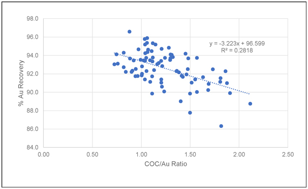
Figure 13-1 Recovery as a Function of OC and Gold Head Grade
Figure13-1 shows that, based on the very low coefficient of correlation (i.e., R2), there does not appear to be a relationship between gold recovery and the OC concentration divided by the gold head grade in oz/ton Au, as assumed by the gold recovery equation.
| 13.2. | TURQUOISE RIDGE SURFACE AND VISTA UNDERGROUND |
METALLURGICAL TESTING
The Sage autoclave has 20 years of experience processing ores very similar to Cut 40 material. This includes ore from Cut 22 and Cut 24, which were located adjacent to Cut 40. The autoclave is positioned very well to accept Cut 40 materials without significant changes to operating strategies, practices, or procedures. Equipment and experienced labour are already in place. Processing of Cut 40 material should closely follow results from processing similar Cut 22 and Cut 24 materials.
Thirty-four variability composites were subjected to autoclave studies. These composites were collected from core and pulp rejects from previously drilled holes.
| Nevada Gold Mines LLC – Turquoise Ridge Complex | Page 13-2 | |
Technical Report NI 43-101 – March 25, 2020 | ||
Samples were selected by grade range, sulphide sulphur (SS2) range, carbonate (CO3) range, and OC range. The SS2, CO3, and OC ranges were determined using the current Turquoise Ridge Surface ore control matrix and ore types (Table13-1). Classifying Cut 40 material this way allows for seamless integration of Cut 40 materials into current Sage autoclave operating, planning, and blending practices.
Table 13-1 Turquoise Ridge Surface Ore Control Matrix
Ore Type | Sulphide (%) | Carbonate (%) | OC (%) | Comments | ||||
| A | < 4 | > 4 and < 8 | < 0.6 | Med-Low Carbonate / Low Sulphide | ||||
| B | > 4 | > 4 and < 12 | < 0.6 | Medium Carbonate / High Sulphide | ||||
| C | > 4 and < 6 | < 4 | < 0.6 | Low Carbonate / Medium Sulphide | ||||
| D | < 4 | < 4 | < 0.6 | Low Carbonate / Low Sulphide | ||||
| E | any value | < 8 | > 0.6 and < 1 | Low Carbonate /Med-High Organic Carbon | ||||
| F | any value | > 12 and < 18 | < 0.6 | High Carbonate | ||||
| G | < 4 | > 8 and < 12 | < 0.6 | Med-High Carbonate / Low Sulphide | ||||
| H | > 6 | < 4 | < 0.6 | Low Carbonate / High Sulphide | ||||
| I | any value | > 18 | < 0.6 | Very High Carbonate | ||||
| K | any value | > 8 | > 0.6 and < 1 | High Carbonate /Med-High Organic Carbon | ||||
| O | any value | any value | > 1 | Very High Organic Carbon |
Turquoise Ridge Surface has anin-house bingo chart technique that is used to determine the sample requirements by categorizing an orebody into different domains based on their metallurgical performance. The number of samples to be tested is calculated using an algorithm which uses the quantum tonnes and ounces in each domain for the whole orebody. A bingo chart was constructed to determine which major ore types in Cut 40 needed to be tested. The ore types were reclassified as high sulphur (B, C, and H ore types), mid CO3 (A, D, and G), high CO3 (F and I), and high OC (E, K, and O). The grade ranges for each ore type were high grade (>3.0 g/t Au), mid grade (2.5 g/t Au to 3.0 g/t Au), andlow/cut-off grade (1.3 g/t Au to 2.5 g/t Au).
After adjustment for potential under-testing and limited sample selection availability, Table13-2 shows the autoclave test work conducted for the various metallurgical types.
| Nevada Gold Mines LLC – Turquoise Ridge Complex | Page 13-3 | |
Technical Report NI 43-101 – March 25, 2020 | ||
Table 13-2 Number of Tests Conducted per Metallurgical Type
| Ore Class | >g/t Au | Oxide | High Sulphide | Mid Carbonate | High Carbonate | High Organic | Total Start | |||||||
| High Grade | 0.000 | 0 | ||||||||||||
| ~2x Ave Grade | 0.000 | 0 | ||||||||||||
| Average Grade | 0.090 | 5 | 3 | 1 | 2 | 11 | ||||||||
| Near COG1 | 0.075 | 4 | 1 | 1 | 2 | 8 | ||||||||
| COG | 0.040 | 9 | 2 | 1 | 3 | 15 | ||||||||
| Sub COG | 0.000 | 0 | ||||||||||||
| Prior/Existing Tested Total | 0 | 18 | 6 | 3 | 7 | 34 | ||||||||
The core locations for comminution testing were selected based on safety of the drill rig locations and spatial distribution across the Cut 40 resource. A total of 13 core composites were drilled from five drill locations. Eleven samples from old drilling in Cut 40 were selected based on rock type, fragment size, and alteration and composited for a fourteenth comminution sample.
Oxide testing was not completed in time for this Technical Report, but four composites from three holes have been selected for column testing and bottle roll testing.
Ore and waste characterization were based on the full, current Turquoise Ridge Surface ore control matrix. Material with OC above one percent would be considered waste because of the preg-robbing potential of the OC.
AUTOCLAVE TESTING
Thirty-four variability composites underwent standard autoclaving and leach tests. Gold grade ranged from 1.30 g/t to 13.51 g/t with an average of 3.23 g/t. Sulphide sulphur grade ranged from 1.84% to 10.53% with an average of 5.23%. The composites had to be blended down with silica to a target of 4% SS2 for the laboratory autoclave feed. Carbonate was more varied, ranging from 0.02% to 19.12% with an average of 4.94%. Total OC averaged 0.39% and ranged from 0.03% to 0.93%. Preg-robbing carbon averaged 35.2% and ranged from 3.6% to 95.2%. The average gold recovery for the composites was 75.1% at a grinding P80 of approximately 37 microns. Recovery ranged between 34% and 96% depending on the amount ofpreg-robbing carbon within the composite. The recovery at coarser grinds and higher throughput will be approximately 4% less than the test work.
| Nevada Gold Mines LLC – Turquoise Ridge Complex | Page 13-4 | |
Technical Report NI 43-101 – March 25, 2020 | ||
COMMINUTION TESTING
Fourteen samples were sent to Newmont Metallurgical Services (NMS) for comminution testing. One of the samples tested was a composite of samples taken from previous drilling in Cut 40. The other thirteen samples were whole core samples from five drill holes. These samples were all subjected to Semi-Autogenous Grinding (SAG) Mill Comminution (SMC)/Drop Weight (DWi) tests, Bond Work Index (BWI) tests, and Abrasion Index (Ai) tests. The results of the tests are summarized in Table 13-3.
Table 13-3 Summary of Comminution Test Results
| Sample | Hole ID | From | To | SMC/Drop Weight | Bond Work Index | Abrasion Index | ||||||||||
| SG | A x b | DWi (kWh/m3) | BWi (kWh/t) | Ai (g) | ||||||||||||
| 1 | TWD-02194 | 39.8 | 82.8 | 2.54 | 56.4 | 4.50 | 14.1 | 0.1798 | ||||||||
| 2 | TWD-02195 | 29.0 | 69.0 | 2.44 | 33.9 | 7.22 | 16.4 | 0.8007 | ||||||||
| 3 | TWD-02195 | 69.0 | 91.8 | 2.51 | 35.5 | 7.11 | 13.5 | 0.4431 | ||||||||
| 4 | TWD-0859 | 764.5 | 792.8 | 2.58 | 56.7 | 4.54 | 17.0 | 0.2041 | ||||||||
| 5 | TWD-0861 | 720.0 | 736.6 | 2.48 | 35.2 | 7.01 | 16.5 | 0.1630 | ||||||||
| 6 | TWD-0861 | 736.6 | 755.0 | 2.70 | 66.9 | 4.02 | 9.8 | 0.0276 | ||||||||
| 7 | TWD-0861 | 755.0 | 785.0 | 2.60 | 54.6 | 4.76 | 15.3 | 0.1143 | ||||||||
| 8 | TWD-1158 | 332.0 | 357.0 | 2.67 | 27.9 | 9.66 | 14.9 | 0.1509 | ||||||||
| 9 | TWD-1158 | 357.0 | 376.0 | 2.68 | 39.3 | 6.83 | 12.0 | 0.0193 | ||||||||
| 10 | TWD-1158 | 376.0 | 396.0 | 2.56 | 38.8 | 6.59 | 12.0 | 0.0087 | ||||||||
| 11 | TWD-1158 | 396.0 | 417.0 | 2.67 | 34.8 | 7.62 | 20.4 | 0.3882 | ||||||||
| 12 | TWD-1158 | 417.0 | 437.0 | 2.61 | 40.6 | 6.43 | 20.9 | 0.4909 | ||||||||
| 13 | TWD-1158 | 437.0 | 465.0 | 2.56 | 42.0 | 6.11 | 18.7 | 0.2971 | ||||||||
| 14 | C401-11 | 2.47 | 53.6 | 4.60 | 16.3 | 0.2132 | ||||||||||
| Average | 2.58 | 44.0 | 6.21 | 15.6 | 0.2501 | |||||||||||
As seen in Table 13-3, the grinding properties of Cut 40 ore are variable. SMC/Drop Weight tests showed that the ore varies from moderate soft to very hard. Bond Work Index tests showed the ore can be categorized as medium to very hard; a closing screen size of 38 µm
| Nevada Gold Mines LLC – Turquoise Ridge Complex | Page 13-5 | |
Technical Report NI 43-101 – March 25, 2020 | ||
was used. Eight of the samples were classified as hard. The Abrasion Index test work shows that the ore varies greatly fromnon-abrasive to very abrasive; however, eight of the fourteen samples were slightly abrasive.
OXIDE TESTING
Testing on Cut 40 oxide is currently in progress. Results were not yet available for this Technical Report.
INTERPRETATION AND CONCLUSIONS
AUTOCLAVE TESTING
Testing showed that the Cut 40 ore is sulphidic refractory and responds well to autoclaving. The average recovery was 75.1% and was found to be a function of the total OC to gold grade ratio as is seen in the current Sage autoclave feed blend
Cut 40 ore gold recovery follows the recovery model for the Sage Mill autoclaves; it is a function of the total OC to gold grade ratio as shown in Figure13-2.
| Nevada Gold Mines LLC – Turquoise Ridge Complex | Page 13-6 | |
Technical Report NI 43-101 – March 25, 2020 | ||
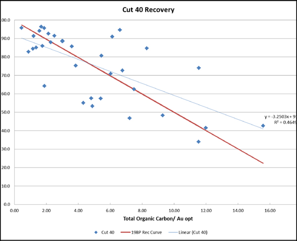
Figure 13-2 Cut 40 Recovery Curve (% Recovery vs. TOC/oz/ton Au)
This empirical gold recovery model based on total OC and gold grade has been used very successfully at the Sage autoclave for predicting metallurgical performance. This model is used for all Sage autoclave budgeting and forecasting; the curve used in the 2018 Business Metal Plan is plotted against the Cut 40 recovery results in Table 13-3. Years ofbench-top autoclave (BTAC) test work conducted at Turquoise Ridge Surface show that the BTAC results under-predict actual gold recovery in the plant; see the “BTAC Correlations” report in the Appendix for more details around BTAC versus actual plant recovery. Using the average OC to gold ratio of the Cut 40 composites, the predicted recovery using the 2019 Business Plan curve is 75.13%, only 0.03% higher than the actual average.
COMMINUTION TESTING
Two grind studies on Sage autoclave feed were completed in 2014 and 2017. The results from both studies classified Sage autoclave feed as medium to medium hard hardness. Other historic work on Sage Mill feed classifies the ore as medium hard on average. Based on the comminution testing described earlier in this section, Cut 40 ore is harder than normal
| Nevada Gold Mines LLC – Turquoise Ridge Complex | Page 13-7 | |
Technical Report NI 43-101 – March 25, 2020 | ||
Turquoise Ridge Surface ore. There is additional grind capacity in the Sage autoclave and throughput is limited by the autoclaves, not the grind circuit. Cut 40 ore will also be blended with stockpile and other material for geochemistry control, which will mitigate the effects of any grindability-induced SAG mill throughput issues from Cut 40 ore. However, these results show that there is enough hard ore that there is potential for concern. Additional work needs to be done to assess the extent of the effects of the Cut 40 ore hardness.
OXIDE TESTING
Testing on Cut 40 oxide is currently in progress. Results were not yet available for this Technical Report.
RECOVERY ASSUMPTIONS
Heap Leach
All oxide ore is currently mined from Turquoise Ridge Surface. In the Mega Pit laybacks, the heap leaching recovery was assumed to be 70%. For the Vista Pit laybacks, recoveries for metal planning assumed step function constants depending on gold grade range. The maximum recovery was set at 63% (Table 13-4).
Table 13-4 Vista Pit Heap Leach Recovery Step Function
Au Grade Range (g/t) | Leach Recovery (%) | |
| Au < 0.34 | 30 | |
| 0.34<=Au<0.51 | 45 | |
| Au>=0.51 | 63 |
Leach recovery is further defined versus time for monthly forecasting. The leach recovery curve is distributed over 36 months and is shown on Figure13-3.
| Nevada Gold Mines LLC – Turquoise Ridge Complex | Page 13-8 | |
Technical Report NI 43-101 – March 25, 2020 | ||
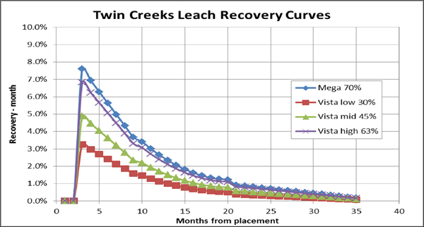
Figure 13-3 Heap Leach Recovery Time Curve
An alternative linear recovery formula was developed from column test data during the Vista 8 stage gate study work:
Leach Recovery (Vista) = (oz/ton Au) x 5.3428 + 0.46 (maximum 63%)
For the Vista Pit, a heap leaching recovery of 63% was used in long range mine planning and in COG calculations. A Vulcan script was used to calculate and store leach recovery by block for oxide material.
Juniper Mill
Mega Pit oxide mill recovery is based on a gold grade dependent equation:
Oxide Mill Recovery (Mega) = 0.0754*LN (oz/ton Au)+1.0336-0.04
Vista Pit oxide mill recovery is based on a different relationship with gold grade:
Oxide Mill Recovery (Vista) = (0.824 x (oz/ton Au) - 0.0019) / (oz/ton Au) + 0.095
Figure13-4 shows the Vista Pit oxide leach recovery comparisons.
| Nevada Gold Mines LLC – Turquoise Ridge Complex | Page 13-9 | |
Technical Report NI 43-101 – March 25, 2020 | ||
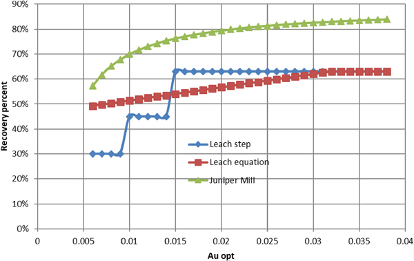
Figure 13-4 Vista Pit Oxide Leach Recovery Comparisons
Sage Mill
Turquoise Ridge Complex metallurgists developed a formula to predict recovery based on OC and gold grade:
Refractory Recovery =-0.0661 * (OC/oz/ton Au) + 1.022 capped at 96%
Sage autoclave blending criteria include limits, ranges, and ratios of the ore’s geochemical characteristics. A summary of current key criteria is shown in Table 13-5.
Table 13-5 Sage Mill Blending Criteria
| Blending Criteria | Range or Limit | |
| Sulphide Sulphur % | 3.8 – 4.1 | |
| Carbonate % | 4.5 – 5.5 | |
Ratio, Sulphide Sulphur% / Carbonate % | 0.75 – 0.9 | |
| Organic Carbon % | < 0.55 |
Sage autoclave recoveries were calculated from gold grade and OC percentages, and are stored for each refractory block in the resource block model. A block calculation script was created in Vulcan software for recovery calculation. Figure13-5 shows the actual recovery for the Sage Mill.
| Nevada Gold Mines LLC – Turquoise Ridge Complex | Page 13-10 | |
Technical Report NI 43-101 – March 25, 2020 | ||
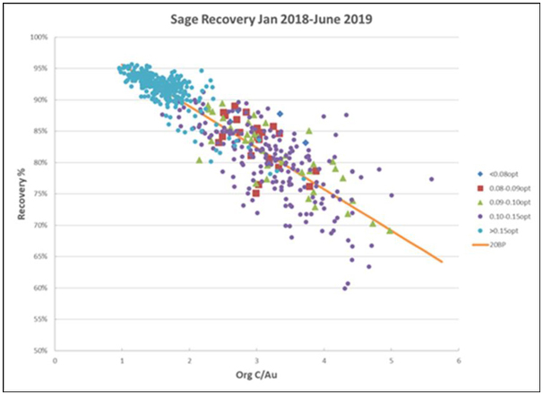
Figure 13-5 Sage Mill Actual Recovery
METALLURGICAL ASSUMPTIONS
Refractory Ore
Refractory ore is processed at the Sage autoclave. Refractory ore is mined from the Turquoise Ridge Underground, Vista Underground, and Turquoise Ridge Surface mines. An ore geochemistry based classification system is used for ore mined and routed to either the mill pad stockpiles or the outer stockpiles (Figure13-6 and Figure13-7). The standard chemistry components are percentages of OC, CO3, and SS2 as analyzed in the laboratory along with assaying for precious metals (Table 13-6).
| Nevada Gold Mines LLC – Turquoise Ridge Complex | Page 13-11 | |
Technical Report NI 43-101 – March 25, 2020 | ||
Table 13-6 Turquoise Ridge Surface Refractory Ore Classification
| Organic Carbon | Carbonate | Sulphide Sulphur | Ore Type | |||||||
| >1.0% Met O | ||||||||||
| 12 | ||||||||||
| 0.6%-1.0% | >8% | Met K | 11 | |||||||
| <8% | Met E | 10 | ||||||||
| <0.6% | >18% | Met I | 9 | |||||||
| 12%-18% | Met F | 8 | ||||||||
| 8-12% | >4% | Met B | 7 | |||||||
| <4% | Met G | 6 | ||||||||
| 4-8% | >4% | Met B | 5 | |||||||
| <4% | Met A | 4 | ||||||||
| 0-4% | >6% | Met H | 3 | |||||||
| 4%-6% | Met C | 2 | ||||||||
| 0%-4% | Met D | 1 | ||||||||
The refractory ore classifications are further divided into gold grade ranges: Sage, high grade (SH),mid-grade (SM), low grade (SL), and subgrade sulphide (SS) (Figure13-6). The routing code of ore is the combination of grade range prefix and geochemistry type letter. Table13-7 and Table 13-8 are the material guides used by ore control engineers. The gold COGs, for example the SL routings, are currently used by ore control and have been updated to comply with new reserve based COG calculations.
The refractory SS routings include materials that fall below economic gold COG by themselves but because of their geochemistry, they are fed to the Sage Mill for blending purposes. SS is added to the reserves to supplement SS in the Sage feed. The SS types that are included in the LOM process metal plan are included in the reserve. Material typesSS-B,SS-C,SS-H, and some ofSS-D are included in the reserve whileSS-A,SS-F, andSS-G are excluded from the reserve.
| Nevada Gold Mines LLC – Turquoise Ridge Complex | Page 13-12 | |
Technical Report NI 43-101 – March 25, 2020 | ||
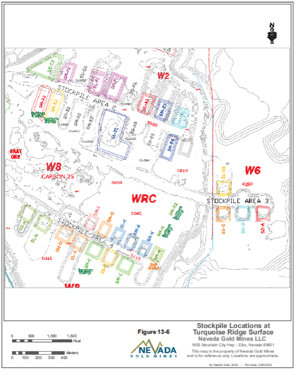
Figure 13-6 Stockpile Locations at Turquoise Ridge Surface
| Nevada Gold Mines LLC – Turquoise Ridge Complex | Page 13-13 | |
Technical Report NI 43-101 – March 25, 2020 | ||
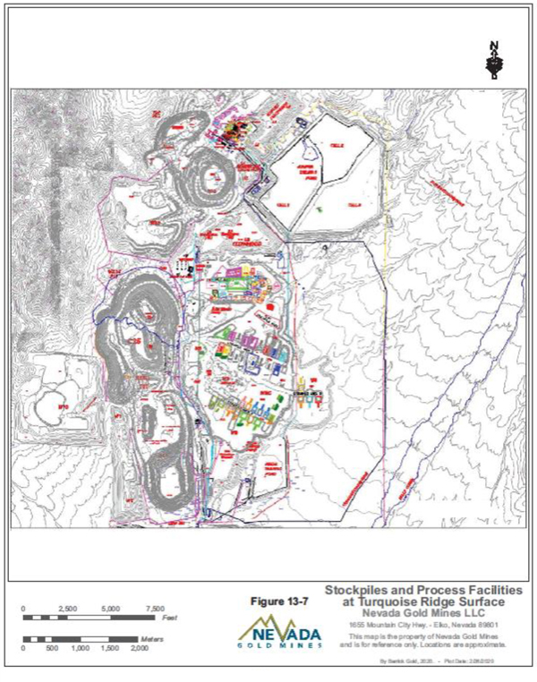
Figure 13-7 Stockpiles and Process Facilities at Turquoise Ridge Surface
| Nevada Gold Mines LLC – Turquoise Ridge Complex | Page 13-14 | |
Technical Report NI 43-101 – March 25, 2020 | ||
Table 13-7 Refractory Material Guide and Destinations
| Mega Pit Material Guide & Destinations | ||||||||||||||||||||
| Routing | Ore Type | oz/t | g/T | Au (opt) | SS (%) | CO3 (%) | Org Carb (%) | Chemistry Details | Stockpile | Comments | ||||||||||
Sage A | A8J3 | 0.120 | 4.11 | ³0.120 | < 4 | ³ 4 and < 8 | < 0.6 | Med-Low Carbonate / Low Sulfide | Sage_A1 | |||||||||||
Sage B | B8J3 | 0.120 | 4.11 | ³0.120 | ³ 4 | ³ 4 and < 12 | < 0.6 | Medium Carbonate / High Sulfide | Sage_B1 | |||||||||||
Sage C | C8J3 | 0.120 | 4.11 | ³0.120 | ³ 4 and < 6 | < 4 | < 0.6 | Low Carbonate / Medium Sulfide | Sage_C1 | |||||||||||
Sage D | D8J3 | 0.120 | 4.11 | ³0.120 | < 4 | < 4 | < 0.6 | Low Carbonate / Low Sulfide | Sage_D1 | |||||||||||
Sage E | E8J3 | 0.180 | 6.17 | ³0.180 | any value | < 8 | ³ 0.6 and < 1 | Low Carbonate / Med-High Organic Carbon | Sage_E1 | |||||||||||
Sage F | F8J3 | 0.150 | 5.14 | ³0.150 | any value | ³ 12 and < 18 | < 0.6 | High Carbonate | Sage_F1 | |||||||||||
Sage G | G8J3 | 0.120 | 4.11 | ³0.120 | < 4 | ³ 8 and < 12 | < 0.6 | Med-High Carbonate / Low Sulfide | Sage_G1 | |||||||||||
| ||||||||||||||||||||
Routing | Ore Type | oz/t | g/T | Au (opt) | SS (%) | CO3 (%) | Org Carb (%) | Chemistry Details | Stockpile | Comments | ||||||||||
SH-A | A7 | 0.090 | 3.08 | ³.090 and <.120 | < 4 | ³ 4 and < 8 | < 0.6 | Med-Low Carbonate / Low Sulfide | Sage_A1 | |||||||||||
SH-B | B7 | 0.090 | 3.08 | ³.090 and <.120 | ³ 4 | ³ 4 and < 12 | < 0.6 | Medium Carbonate / High Sulfide | SH-B2 | |||||||||||
SH-C | C7 | 0.090 | 3.08 | ³.090 and <.120 | ³ 4 and < 6 | < 4 | < 0.6 | Low Carbonate / Medium Sulfide | Sage_C1 | |||||||||||
SH-D | D7 | 0.090 | 3.08 | ³.090 and <.120 | < 4 | < 4 | < 0.6 | Low Carbonate / Low Sulfide | Sage_D1_TOP | |||||||||||
SH-E | E7 | 0.090 | 3.08 | ³.090 and <.180 | any value | < 8 | ³ 0.6 and < 1 | Low Carbonate / Med-High Organic Carbon | Sage_E1/SH_E4 | |||||||||||
SH-F | F7 | 0.090 | 3.08 | ³.090 and <.150 | any value | ³12 and <18 | < 0.6 | High Carbonate | Sage_F1 | |||||||||||
SH-G | G7 | 0.090 | 3.08 | ³.090 and <.120 | < 4 | ³ 8 and < 12 | < 0.6 | Med-High Carbonate / Low Sulfide | Sage_G1 | |||||||||||
SH-H | H7 | 0.090 | 3.08 | ³.090 and <.120 | ³ 6 | < 4 | < 0.6 | Low Carbonate / High Sulfide | SH_H2 | |||||||||||
SH-I | I7 | 0.090 | 3.08 | ³0.090 | any value | ³ 18 | < 0.6 | Very High Carbonate | SH_I | |||||||||||
SH-K | K7 | 0.090 | 3.08 | ³0.090 | any value | ³ 8 | ³ 0.6 and < 1 | High Carbonate / Med-High Organic Carbon | SH_K | |||||||||||
SH-O | O7 | 0.101 | 3.46 | ³0.101 | any value | any value | ³ 1 | Very High Organic Carbon | SH_O | |||||||||||
| ||||||||||||||||||||
Routing | Ore Type | oz/t | g/T | Au (opt) | SS (%) | CO3 (%) | Org Carb (%) | Chemistry Details | Stockpile | Comments | ||||||||||
SM-A | A6 | 0.075 | 2.57 | ³.075 and <.090 | < 4 | ³ 4 and < 8 | < 0.6 | Med-Low Carbonate / Low Sulfide | Sage_A1_Top | |||||||||||
SM-B | B6 | 0.075 | 2.57 | ³.075 and <.090 | ³ 4 | ³ 4 and < 12 | < 0.6 | Medium Carbonate / High Sulfide | SM_B | |||||||||||
SM-C | C6 | 0.075 | 2.57 | ³.075 and <.090 | ³ 4 and < 6 | < 4 | < 0.6 | Low Carbonate / Medium Sulfide | Sage_C1_Top | |||||||||||
SM-D | D6 | 0.075 | 2.57 | ³.075 and <.090 | < 4 | < 4 | < 0.6 | Low Carbonate / Low Sulfide | SM_D | |||||||||||
SM-E | E6 | 0.075 | 2.57 | ³.075 and <.090 | any value | < 8 | ³ 0.6 and < 1 | Low Carbonate / Med-High Organic Carbon | SM_E3 | |||||||||||
SM-F | F6 | 0.075 | 2.57 | ³.075 and <.090 | any value | ³12 and <18 | < 0.6 | High Carbonate | SM_F2 | |||||||||||
SM-G | G6 | 0.075 | 2.57 | ³.075 and <.090 | < 4 | ³ 8 and < 12 | < 0.6 | Med-High Carbonate / Low Sulfide | SM_G | |||||||||||
SM-H | H6 | 0.075 | 2.57 | ³.075 and <.090 | ³ 6 | < 4 | < 0.6 | Low Carbonate / High Sulfide | SM_H | |||||||||||
SM-I | I6 | 0.075 | 2.57 | ³.075 and <.090 | any value | ³ 18 | < 0.6 | Very High Carbonate | SM_I | |||||||||||
SM-K | K6 | 0.073 | 2.50 | ³.073 and <.090 | any value | ³ 8 | ³ 0.6 and < 1 | High Carbonate / Med-High Organic Carbon | SM_K | |||||||||||
Routing | Ore Type | oz/t | g/T | Au (opt) | SS (%) | CO3 (%) | Org Carb (%) | Chemistry Details | Stockpile | Comments | ||||||||||
SL-A | A5 | 0.044 | 1.51 | ³.044 and <.075 | < 4 | ³ 4 and < 8 | < 0.6 | Med-Low Carbonate / Low Sulfide | SL_A2 | |||||||||||
SL-B | B5 | 0.040 | 1.37 | ³.040 and <.075 | ³ 4 | ³ 4 and < 12 | < 0.6 | Medium Carbonate / High Sulfide | SL_B2 | |||||||||||
SL-C | C5 | 0.045 | 1.54 | ³.045 and <.075 | ³ 4 and < 6 | < 4 | < 0.6 | Low Carbonate / Medium Sulfide | SL_C | |||||||||||
SL-D | D5 | 0.047 | 1.61 | ³.047 and <.075 | < 4 | < 4 | < 0.6 | Low Carbonate / Low Sulfide | Sl-D4 | |||||||||||
SL-E | E5 | 0.073 | 2.50 | ³.073 and <.075 | any value | < 8 | ³ 0.6 and < 1 | Low Carbonate / Med-High Organic Carbon | SL_E2 | |||||||||||
SL-F | F5 | 0.044 | 1.51 | ³.044 and <.075 | any value | ³ 12 and < 18 | < 0.6 | High Carbonate | SL_F2 | |||||||||||
SL-G | G5 | 0.045 | 1.54 | ³.045 and <.075 | < 4 | ³ 8 and < 12 | < 0.6 | Med-High Carbonate / Low Sulfide | SL_G | |||||||||||
SL-H | H5 | 0.041 | 1.41 | ³.041 and <.075 | ³ 6 | < 4 | < 0.6 | Low Carbonate / High Sulfide | SL_H | |||||||||||
SL-I | I5 | 0.043 | 1.47 | ³.043 and <.075 | any value | ³ 18 | < 0.6 | Very High Carbonate | SL_I | |||||||||||
| ||||||||||||||||||||
Routing | Ore Type | oz/t | g/T | Au (opt) | SS (%) | CO3 (%) | Org Carb (%) | Chemistry Details | Stockpile | Comments | ||||||||||
SS-A | A4 | 0.035 | 1.20 | ³.035 and <.044 | < 4 | ³ 4 and < 8 | < 0.6 | Med-Low Carbonate / Low Sulfide | SS_A | |||||||||||
SS-B | B4 | 0.020 | 0.69 | ³.020 and <.039 | ³ 4 | ³ 4 and < 12 | < 0.6 | Medium Carbonate / High Sulfide | SS_B | |||||||||||
SS-C | C4 | 0.020 | 0.69 | ³.020 and <.045 | ³ 4 and < 6 | < 4 | < 0.6 | Low Carbonate / Medium Sulfide | SS_C2 | |||||||||||
SS-D | D4 | 0.036 | 1.23 | ³.036 and <.047 | < 4 | < 4 | < 0.6 | Low Carbonate / Low Sulfide | SS D | |||||||||||
SS-G | G4 | 0.035 | 1.20 | ³.035 and <.042 | < 4 | ³ 8 and < 12 | < 0.6 | Med-High Carbonate / Low Sulfide | SS_G | |||||||||||
SS-H | H4 | 0.020 | 0.69 | ³.020 and <.040 | ³ 6 | < 4 | < 0.6 | Low Carbonate / High Sulfide | SS_H | |||||||||||
| Nevada Gold Mines LLC – Turquoise Ridge Complex | Page 13-15 | |
Technical Report NI 43-101 – March 25, 2020 | ||
Table 13-8 Oxide Material Guide and Routing Oxide
| Routing | Ore Type | oz/t | g/T | Au (opt) | Sulfide (%) | Carbonate (%) | Org Carb (%) | Chemistry Details | Stockpile | Comments | ||||||||||
L2W0, L2W2 or L2W4 | Leach | 0.009 | 0.31 | ³0.009 and <0.011 | <0.5% | any | < 0.6% | Oxide Material <0.5% SS | L8 South S5 | If geosegs show decalcified or silicified, send fine material to alternate location Waste | ||||||||||
L2W0, L2W2 or L2W4 | Leach | 0.011 | 0.38 | ³0.011 and <0.022 | <0.5% | any | < 0.6% | Oxide Material <0.5% SS | L8 South S5 | If geosegs show decalcified or silicified, send fine material to V5 Decalc or other Decalc stockpile | ||||||||||
J1LC | OxMill | 0.022 | 0.75 | ³0.022 and <0.035 | ³ 0% and <1% | <5% | < 0.6% | Oxide Mill³0 and <1.0% SS | new names TBD | Low Grade, Low Carbonate Oxide | ||||||||||
J1MC | OxMill | 0.022 | 0.75 | ³0.022 and <0.035 | ³ 0% and <1% | ³5% and <15% | < 0.6% | Oxide Mill³0 and <1.0% SS | new names TBD | Low Grade, Mid Carbonate Oxide | ||||||||||
J1HC | OxMill | 0.022 | 0.75 | ³0.022 and <0.035 | ³ 0% and <1% | ³15% | < 0.6% | Oxide Mill³0 and <1.0% SS | new names TBD | Low Grade, High Carbonate Oxide | ||||||||||
J2LC | OxMill | 0.035 | 1.20 | ³0.035 and <0.050 | ³ 0% and <1% | <5% | < 0.6% | Oxide Mill³0 and <1.0% SS | new names TBD | Mid Grade, Low Carbonate Oxide | ||||||||||
J2MC | OxMill | 0.035 | 1.20 | ³0.035 and <0.050 | ³ 0% and <1% | ³5% and <15% | < 0.6% | Oxide Mill³0 and <1.0% SS | new names TBD | Mid Grade, Mid Carbonate Oxide | ||||||||||
J2HC | OxMill | 0.035 | 1.20 | ³0.035 and <0.050 | ³ 0% and <1% | ³15% | < 0.6% | Oxide Mill³0 and <1.0% SS | new names TBD | Mid Grade, High Carbonate Oxide | ||||||||||
J3LC | OxMill | 0.050 | 1.71 | ³0.050 and <0.070 | ³ 0% and <1% | <5% | < 0.6% | Oxide Mill³0 and <1.0% SS | new names TBD | High Grade, Low Carbonate Oxide | ||||||||||
J3MC | OxMill | 0.050 | 1.71 | ³0.050 and <0.070 | ³ 0% and <1% | ³5% and <15% | < 0.6% | Oxide Mill³0 and <1.0% SS | new names TBD | High Grade, High Carbonate Oxide | ||||||||||
J3HC | OxMill | 0.050 | 1.71 | ³0.050 and <0.070 | ³ 0% and <1% | ³15% | < 0.6% | Oxide Mill³0 and <1.0% SS | new names TBD | High Grade, High Carbonate Oxide | ||||||||||
J4 | OxMill | 0.070 | 2.40 | ³0.070 | ³0% and <1% | any | < 0.6% | Oxide Mill³0 and <1.0% SS | Hopper | Highest Grade Oxide | ||||||||||
L2DE | OxMill | 0.011 | 0.38 | ³0.011 and <0.022 | ³ 0% and <1% | assigned based on geosegs for OC, model uses 5% co3 | <0.6 | Oxide Mill³0 and <1.0% SS | Decalc Low Ox | Manual classification if geosegs show decalcified. Call Metallurgist and Call 76 | ||||||||||
L2SI | OxMill | 0.011 | 0.38 | ³0.011 and <0.022 | ³0.5% and <1% | any | <0.6 | Oxide Mill³0 and <1.0% SS | Silica Low Ox | Manual classification if geosegs show Silica 3. Call Metallurgist and Call 76 | ||||||||||
J1SI | OxMill | 0.022 | 0.75 | ³0.022 and <0.035 | ³0.5% and <1% | any | <0.6 | Oxide Mill³0 and <1.0% SS | Silica Low Ox | Manual classification if geosegs show Silica 3. Call Metallurgist and Call 76 | ||||||||||
J2SI | OxMill | 0.035 | 1.20 | ³0.035 and <0.050 | ³0.5% and <1% | any | <0.6 | Oxide Mill³0 and <1.0% SS | Silica Mid Ox | Manual classification if geosegs show Silica 3. Call Metallurgist and Call 76 | ||||||||||
J2SI | OxMill | 0.050 | 1.71 | ³0.050 and <0.070 | ³0.5% and <1% | any | <0.6 | Oxide Mill³0 and <1.0% SS | Silica High Ox | Manual classification if geosegs show Silica 3. Call Metallurgist and Call 76 | ||||||||||
J4SI | OxMill | 0.070 | 2.40 | ³0.070 | ³0.5% and <1% | any | <0.6 | Oxide Mill³0 and <1.0% SS | Hopper | Manual classification if geosegs show Silica 3. Call Metallurgist and Call 76 | ||||||||||
Blending constraints on feed to Sage Mill call for:
| • | SS percentages in the range of 3.6% to 4.1%. |
| • | Carbonate (CO3) percentages in the range 4.5% to 5.5%. |
| • | Ratio of SS/CO3 in the range of 0.75 to 1.0. |
| • | Organic carbon less than 0.55%. |
Blend constraints used in the processing department also include minimum and maximum annual tonnages of metallurgical types. For example, the following ranges of tonnages have been used in recent metal plans at Turquoise Ridge Surface (Table 13-9).
Table 13-9 Typical Sage Mill Constraints
Refractory Ore Type | Sage Mill Annual Tonnage Ranges | |
| A | < 1,200,000 per year | |
| B | < 480,000 per year | |
| C | 600,000 to 1,200,000 per year through 2023, then < 1,000,000 per year | |
| D | < 600,000 per year | |
| E | <420,000 per year | |
| F | <720,000 per year | |
| G | <1,200,000 per year | |
| H | <240,000 per year | |
| I | <360,000 per year | |
| K | <120,000 per year | |
| O | <120,000 per year |
| Nevada Gold Mines LLC – Turquoise Ridge Complex | Page 13-16 | |
Technical Report NI 43-101 – March 25, 2020 | ||
The process metallurgists receive the mine plan and stockpile inputs to complete the process metal plans and schedules. Turquoise Ridge Surface mine engineering is utilizing RPMGlobal software OPMS, an integrated mining and metal processing scheduling system. The process metallurgists work with the mining engineers in refining blending constraints and operational criteria to create a workable metal plan.
| Nevada Gold Mines LLC – Turquoise Ridge Complex | Page 13-17 | |
Technical Report NI 43-101 – March 25, 2020 | ||
14. MINERAL RESOURCES ESTIMATE
| 14.1. | SUMMARY |
This Technical Report has been produced by Nevada Gold Mines to support the public disclosure of the year end 2019 mineral reserve estimate at the Turquoise Ridge Complex located in northern Nevada within the United Sates.
On July 1, 2019, the Nevada Gold Mines joint venture was formed. Barrick is the operator of the joint venture and owns 61.5%, with Newmont owning the remaining 38.5%. Under the joint venture, Barrick’s Turquoise Ridge Mine and Newmont’s Twin Creeks Complex were combined as a single operation, now known as Turquoise Ridge. The combined mining operation is comprised of the Turquoise Ridge Underground, Vista Underground, and Turquoise Ridge Surface (the Mega and Vista open pits).
Key changes affecting the 2019 resource and reserves additions of the newly formed Turquoise Ridge Complex in 2019 were reserve additions within the Mega Pit (Cut 40) and Turquoise Ridge Underground. Resource additions were seen within current resource pits, including Cut 55 located in the Mega Pit and Vista 9 within the main Vista Pit. No significant changes were made at the Vista Underground except for depletion.
The total Measured and Indicated Mineral Resources for the Turquoise Ridge Complex, inclusive of Mineral Reserves, is 130 million tonnes grading 4.30 g/t Au and contain 18 million ounces of gold as of December 31, 2019. In addition, Inferred Mineral Resources total 21 million tonnes grading 2.7 g/t Au and contain 1.8 ounces of gold (Table 14-1). These Mineral Resources are reported at 100% basis.
In the QP’s opinion, the EOY 2019 Mineral Resource estimate meets or exceeds industry standards and is acceptable to support Mineral Resource estimation.
| Nevada Gold Mines LLC – Turquoise Ridge Complex | Page 14-1 | |
Technical Report NI 43-101 – March 25, 2020 | ||
Table 14-1 Mineral Resource Estimate– December 31, 2019
| 100% Basis | Measured | Indicated | Measured + Indicated | Inferred | ||||||||||||||||||||
Tonnes (Mt) | Grade (g/t Au) | Contained Metal (Moz Au) | Tonnes (Mt) | Grade (g/t Au) | Contained Metal (Moz Au) | Tonnes (Mt) | Grade (g/t Au) | Contained Metal (Moz Au) | Tonnes (Mt) | Grade (g/t Au) | Contained Metal (Moz Au) | |||||||||||||
Surface Operations | ||||||||||||||||||||||||
Stockpile | ||||||||||||||||||||||||
Turquoise Ridge Surface | 36 | 2.00 | 2.3 | 36 | 2.00 | 2.3 | ||||||||||||||||||
Stockpile Total | 36 | 2.00 | 2.3 | 36 | 2.00 | 2.3 | ||||||||||||||||||
Open Pit | ||||||||||||||||||||||||
Mega | 2.9 | 2.76 | 0.26 | 36 | 2.26 | 2.6 | 39 | 2.30 | 2.9 | 16 | 1.7 | 0.85 | ||||||||||||
Vista | 15 | 1.25 | 0.61 | 15 | 1.25 | 0.61 | 2.0 | 1.2 | 0.080 | |||||||||||||||
Open Pit Total | 2.9 | 2.76 | 0.26 | 52 | 1.96 | 3.2 | 55 | 2.00 | 3.5 | 18 | 1.6 | 0.93 | ||||||||||||
Surface Operations Total | 39 | 2.06 | 2.6 | 52 | 1.96 | 3.2 | 90 | 2.00 | 5.8 | 18 | 1.6 | 0.93 | ||||||||||||
Underground Operations | ||||||||||||||||||||||||
Vista Underground | 0.013 | 4.97 | 0.0020 | 0.83 | 6.29 | 0.17 | 0.85 | 6.27 | 0.17 | 0.16 | 7.1 | 0.036 | ||||||||||||
Turquoise Ridge Underground | 22 | 10.00 | 7.2 | 16 | 9.23 | 4.8 | 38 | 9.68 | 12 | 2.8 | 9.2 | 0.82 | ||||||||||||
Total | 22 | 10.00 | 7.2 | 17 | 9.09 | 4.9 | 39 | 9.61 | 12 | 2.9 | 9.1 | 0.86 | ||||||||||||
Underground Operations Total | 22 | 10.00 | 7.2 | 17 | 9.09 | 4.9 | 39 | 9.61 | 12 | 2.9 | 9.1 | 0.86 | ||||||||||||
Turquoise Ridge Complex Total | 61 | 4.95 | 9.7 | 68 | 3.72 | 8.2 | 130 | 4.30 | 18 | 21 | 2.7 | 1.8 | ||||||||||||
Notes:
| 1. | CIM (2014) definitions were followed for Mineral Resources. |
| 2. | Mineral Resources are estimated using a long-term gold price of US$1,500/oz. |
| 3. | Underground Mineral Resources were estimated using COGs of 5.04 g/t Au (Turquoise Ridge Underground) and 2.74 g/t Au (Vista Underground). Open Pit Mineral Resources COGs are 0.19 g/t Au for oxide, and 1.09 g/t Au to 2.12 g/t Au for sulphide based on gold grade, chemistry, and recovery by ore type. |
| 4. | Open Pit Mineral Resources include stockpiled material. |
| 5. | Mineral Resources are reported inclusive of Mineral Reserves. |
| 6. | Mineral Resources that are not Mineral Reserves do not have demonstrated economic viability. |
| 7. | Numbers may not add due to rounding. |
| 8. | Mineral Resources are reported on a 100% basis. Barrick’s and Newmont’s attributable shares of the Mineral Resource are 61.5% and 38.5%, respectively. |
| Nevada Gold Mines LLC – Turquoise Ridge Complex | Page 14-2 | |
Technical Report NI 43-101 – March 25, 2020 | ||
The QPs are not aware of any environmental, permitting, legal, title, taxation, socio-economic, marketing, political, or other relevant factors which could materially affect the Mineral Resource estimates. Definitions for resource categories used in this Technical Report are consistent with Canadian Institute of Mining, Metallurgy and Petroleum (CIM) Definition Standards for Mineral Resources and Mineral Reserves dated May 10, 2014 (CIM (2014) definitions) as incorporated by reference into NI43-101.
| 14.2. | TURQUOISE RIDGE UNDERGROUND |
Turquoise Ridge Underground produces high-grade refractory (carbonaceous/sulphide) gold ore from a long-life (19 years) underground operation, accessed via two shafts and a system of internal ramps, and utilizes underhand drift and fill mining methods with cemented rock fill. Turquoise Ridge Underground is currently hoisting 2,700 tonnes of ore per day, which is expected to increase following the completion of a Third Shaft that is currently under construction.
The Mineral Resources were estimated by conventional 3D computer block modelling based on surface and underground diamond drilling and core assaying. Geologic interpretation of the drilling data was carried out and wireframes were constructed for 33 gold mineralized domains. Assays were composited to ten foot (3.05 m) intervals within the domains and statistical analysis was carried out to determine grade capping levels for each domain. Variography was used to determine search parameters and inverse distance squared (ID2) was employed for grade interpolation in the block model. Alternative interpolations by nearest neighbour (NN) methods were compared using swath plots for model validation. Variogram grade continuity ranges and the average distance to drill hole composites were used to classify resources into Measured, Indicated, and Inferred categories. Grade smoothing was examined, and reconciliation with 2018 production was carried out for further validation of the estimate.
The underground Mineral Resources in Table14-2 are reported at a breakeven COG of 5.04 g/t Au (0.147 oz/ton Au) based on operating costs, gold recoveries, and a gold price of US$1,500/oz.
Measured plus Indicated Mineral Resources total 38 million tonnes grading 9.68 g/t Au and contain 12 million ounces of gold (inclusive of Mineral Reserves). In addition, Inferred Mineral Resources total 2.8 million tonnes grading 9.2 g/t Au and contain 0.82 million ounces of gold.
| Nevada Gold Mines LLC – Turquoise Ridge Complex | Page 14-3 | |
Technical Report NI 43-101 – March 25, 2020 | ||
Table 14-2 Turquoise Ridge Underground Mineral Resource Estimate – December 31, 2019
| 100% Basis | Measured | Indicated | Measured + Indicated | Inferred | ||||||||||||||||||||||||||||||||||||||||||||
Tonnes (Mt) | Grade (g/t Au) | Contained Metal (Moz Au) | Tonnes (Mt) | Grade (g/t Au) | Contained Metal (Moz Au) | Tonnes (Mt) | Grade (g/t Au) | Contained Metal (Moz Au) | Tonnes (Mt) | Grade (g/t Au) | Contained Metal (Moz Au) | |||||||||||||||||||||||||||||||||||||
Underground Operations | ||||||||||||||||||||||||||||||||||||||||||||||||
Turquoise Ridge Underground | 22 | 10.00 | 7.2 | 16 | 9.23 | 4.8 | 38 | 9.68 | 12 | 2.8 | 9.2 | 0.82 | ||||||||||||||||||||||||||||||||||||
Total | 22 | 10.00 | 7.2 | 16 | 9.23 | 4.8 | 38 | 9.68 | 12 | 2.8 | 9.2 | 0.82 | ||||||||||||||||||||||||||||||||||||
Notes:
| 1. | CIM (2014) definitions were followed for Mineral Resources. |
| 2. | Mineral Resources are estimated at a COG of 5.04 g/t Au (0.147 oz/ton Au), except for two mining regions that were estimated at a COG of 5.93 g/t Au (0.173 oz/ton Au). |
| 3. | Mineral Resources are estimated using a long-term gold price of US$1,500/oz. |
| 4. | A minimum mining width of 5 ft (1.5 m) was used. |
| 5. | Mineral Resources are reported inclusive of Mineral Reserves. |
| 6. | Mineral Resources that are not Mineral Reserves do not have demonstrated economic viability. |
| 7. | Numbers may not add due to rounding. |
| 8. | Tonnage factor used in model construction ranges from 0.076 to 0.082 tons per cubic foot, dependent on rock type. |
| 9. | Mineral Resources are reported on a 100% basis. Barrick’s and Newmont’s attributable shares of the Mineral Resource are 61.5% and 38.5%, respectively. |
| Nevada Gold Mines LLC – Turquoise Ridge Complex | Page 14-4 | |
Technical Report NI 43-101 – March 25, 2020 | ||
RESOURCE DOCUMENTATION
The 2019 Mineral Resource estimate is described in a comprehensive internal report entitled “Turquoise Ridge Mine, 2019 End of Year Resource Model”, covering all aspects of data collection, verification, assaying, QA/QC, data analysis, and resource estimation. The final resource files have access limited to the Nevada Gold Mines resource group.
Nevada Gold Mines modelers performed all the geological and resource model reviews and validation in Maptek Vulcan software. Exploratory Data Analysis (EDA) and database work was completed using SQL and Phinar x10 software interrogation of exported comma separated value (CSV) files from the Vulcan databases and block model used in the Mineral Resource estimate.
Database, block modeling, and resource estimation routines within this section are reported in Imperial units and have not always been converted to Metric for reporting purposes.
RESOURCE DATABASE
The Turquoise Ridge Underground database, excluding Vista Underground, is maintained in acQuire software which generates CSV text file exports for Mineral Resource and Mineral Reserve estimation.
The Mineral Resource database provided contains drill hole information available as of June 11, 2019. The Turquoise Ridge Underground database comprises a total of 16,594 drill holes containing 6,775,977 ft (2,064,317 m) of gold assays. A summary of records in the raw Turquoise Ridge Underground drill database is listed below.
| ● | Drill holes: 16,594 |
| ● | Channels: 0 |
| ● | Surveys: 236,697 |
| ● | Gold Assays: 1,163,508 |
| ● | Lithology: 493,722 |
The Turquoise Ridge Underground Mineral Resource estimate is based on 6,807 underground holes within the extents of the 2019 Mineral Resource Model.
| Nevada Gold Mines LLC – Turquoise Ridge Complex | Page 14-5 | |
Technical Report NI 43-101 – March 25, 2020 | ||
Methods and results to verify the historic drill hole data are provided in Section 10 Drilling of this Technical Report. Section 12, Data Verification, describes the resource database verification steps carried out.
Nevada Gold Mines modelers completed a variety of validation routines in Vulcan software and exploratory database queries. The validation is of sufficient quality to support the Mineral Resource estimate and meets industry standards.
EXPLORATORY DATA ANALYSIS
Nevada Gold Mines modelers analyzed the drill hole database using histograms and box plots of uncapped gold assays. They also performed a drill hole spacing analysis and stored interpolated values into the block model.
TOPOGRAPHIC SURFACES
Nevada Gold Mines has updated the surface topography every few years, with the latest Light Detection and Ranging (LiDAR) survey data obtained in 2012. The Mineral Resource model data did not utilize a topographic surface since it is entirely underground, however, a small proportion of the drill holes used in the Mineral Resource estimate were surface holes. A visual comparison between an older simplified topographic surface and the most recent, found that they coincided except where later excavation occurred. Nevada Gold Mines is of the opinion that the surface holes are positioned accurately and appropriate for inclusion in the Mineral Resource estimate.
GEOLOGICAL INTERPRETATION
Lithological models first created were based on 50 ft (15.2 m) sectional (east/west) data interpreted by Nevada Gold Mines Senior Geologists. An extensivere-logging of core photos was undertaken to identify stratigraphic contacts. The geological data previously residing in the database were either overly complex or too broad andnon-descript to model contacts. Lines were drawn in Vulcan and meshed together to create new surfaces. The surfaces were ‘booleaned’ against a triangulation covering the model extents to create closed, valid three-dimensional lithological/stratigraphic units. A refinement of this process occurred in 2010, and another update was done in 2013. This interpretation is the basis for the EOY 2019 geologic model.
| Nevada Gold Mines LLC – Turquoise Ridge Complex | Page 14-6 | |
Technical Report NI 43-101 – March 25, 2020 | ||
Nevada Gold Mines carried out an extensivere-interpretation/re-logging of downhole geology by examining the library of core photos on the Turquoise Ridge Underground property and generated 16 lithological triangulations within the lithologic model extents and flagged them into the Mineral Resource model using codes with values over 100. Some lithologies occur in multiple units (argillaceous mudstone, soft-sediment slumped micrite), so Nevada Gold Mines defined model units according to distinct lithologic characteristic in these mixed populations of rock types. Nevada Gold Mines geological staff created solids by linking wireframe surface meshes between 3D polylines, and then truncating the surfaces against a triangulation covering the model extents to create closed, valid three-dimensional lithological/stratigraphic units. Table14-3 outlines the lithological solids and corresponding numerical codes in the block model domain field.
Table 14-3 Turquoise Ridge Underground Block Model Lithologies and Codes
Lithology
|
Domain Number
| |
Ordovician Comus2-3 | 222 | |
Ordovician Comus 5 | 333 | |
Ordovician Comus 6 | 444 | |
North pillow basalt | 555 | |
Upper basalt | 666 | |
Hanging wall Cretaceous granodiorite | 888 |
STRUCTURAL INTERPRETATION
Nevada Gold Mines geological staff constructed wireframe surfaces representing five major fault groups: the Getchell group, the Turquoise Ridge group, the near-surface RMT group, the BBT group, and the Giant fault. Known mineralization often coincides with the intersection of major fault groups and previously established mineral domains. Mineralization also frequently extends away from known fault traces and into favourable stratigraphy, following porous, decalcified layers.
DOMAIN MODELLING
MINERALIZED DOMAINS
Three-dimensional mineralized domains were generated from sectional polygons digitized directly into Maptek Vulcan software, taking mineralization trends, stratigraphy, and structural controls into account. Polygons were created at nominal 25 ft (7.62 m) spacing, striking 230° (northeast-southwest normal to the Getchell Fault), snapping to drill hole intercepts whenever possible. Polygons were linked together to create mineralized domain triangulated solids. The domains modelled were constructed to an approximately 0.05 oz/ton Au (1.71 g/t Au) COG,
| Nevada Gold Mines LLC – Turquoise Ridge Complex | Page 14-7 | |
Technical Report NI 43-101 – March 25, 2020 | ||
based upon diamond drill data, underground channel sampling data, underground geological mapping, and underground mine excavations. Domains reflect hard boundaries used to constrain grade interpolation to areas of defined mineralization. A total of 33 mineralized domains were modelled for the deposit. For 2019, Nevada Gold Mines staff used Vulcan’s 3D Geologic Sculpting Tool to move and add vertices topre-existing domains. Figure14-1 shows a plan view example with the locations of the domains as well as the underground workings.
| Nevada Gold Mines LLC – Turquoise Ridge Complex | Page 14-8 | |
Technical Report NI 43-101 – March 25, 2020 | ||
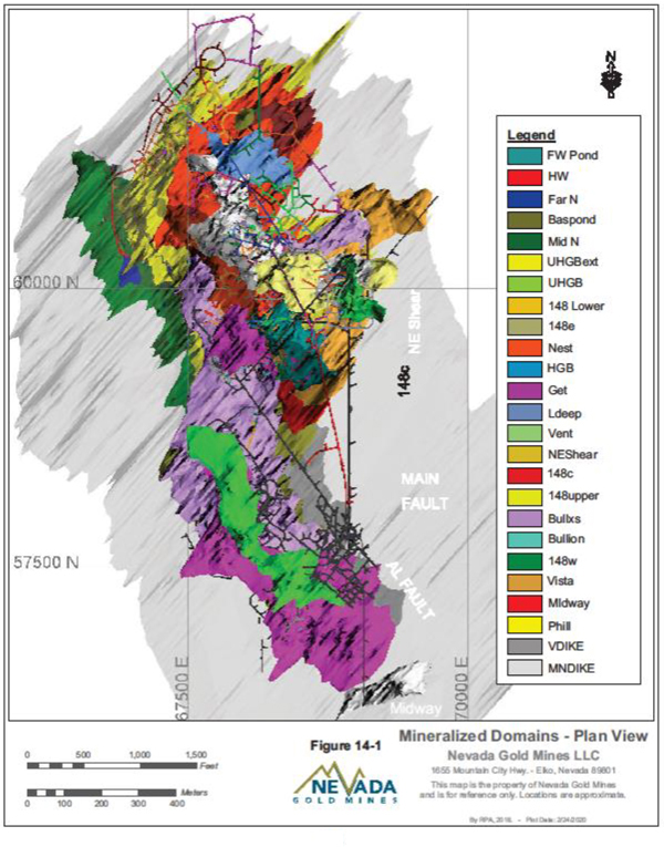
Figure 14-1 Mineralized Domains – Plan View
| Nevada Gold Mines LLC – Turquoise Ridge Complex | Page 14-9 | |
Technical Report NI 43-101 – March 25, 2020 | ||
CAPPING OF HIGH GRADE VALUES
Nevada Gold Mines applies a capping grade according to inflections on log probability plots, and tails on histograms in conjunction with decile analysis. Nevada Gold Mines modelers applied the capping thresholds to the raw assays. This approach is less likely to allow inordinately high grade to be composited with adjacent low grades, which then fall below the capping threshold. The impact of capping on the data statistics and estimated metal are evaluated with adjustments made to cap grades as required. The capping analysis is unique to each domain, with final cap grades ranging from 0.1 oz/ton Au (3.43g/t Au) to 3.0 oz/ton Au (102.86g/t Au).
DENSITY
From 2004 onwards a variety of methods were used to estimate tonnage factors for Turquoise Ridge Underground, with periodic adjustments based on reconciliation and study work. This resulted in a standard tonnage factor for mineralized domains of 12.7 ft3/ton (0.079 tons/ft3, 2.53 g/cm3) for the EOY 2016 model. Outside the mineralized domains the following tonnage factor values were assigned by rock type;
| ● | Dacitic Dikes: 13.2 ft3/ton (0.076 tons/ft3, 2.43 g/cm3) |
| ● | Comus Formation: 12.2 ft3/ton (0.082 tons/ft3, 2.63 g/cm3) |
| ● | Basalt: 11.4 ft3/ton (0.088 tons/ft3, 2.82 g/cm3) |
| ● | Granodiorite: 12.0 ft3/ton (0.083 tons/ft3, 2.66 g/cm3) |
The site has been using interchangeably ft3/ton, ton/ft3 and g/cm3.
In 2019, an interim study measured the density of all rock types plus backfill using either a caliper method, water immersion displacement or wax coated water immersion to precisely determine volumes, mass, and density. A total of 1,296 density determinations were completed. The results confirmed that the existing density assignments are reasonable for Resource estimation.
COMPOSITING
The resource model uses drill data composited to ten foot (3.05 m) lengths in mineralized domains and 20 ft (6.1 m) lengths in the surrounding lithologies. A ‘straight’ desurveyed (XYZ coordinate sample centroids derived from original FROM and TO values logged) assay composite file is also constructed for comparative statistics. Composites were split at domain
| Nevada Gold Mines LLC – Turquoise Ridge Complex | Page 14-10 | |
Technical Report NI 43-101 – March 25, 2020 | ||
boundaries and flagged with the domain character code in the ‘bound’ field which corresponds to the ‘domain’ field in the block model. Modelers then analyzed the raw assay, capped grades, and composite statistics by domain. Table14-4 summarizes the drill and composite databases.
Table 14-4 Turquoise Ridge Underground Raw Assay and Composite Databases
| Dataset | No. Drill Holes | No. Samples | Avg Length (ft) | Total Length (ft) | Avg. Length (m) | Total Length (m) | ||||||
Raw drill database (mineralized domains) | 6,977 | 583,354.00 | 5.16 | 3,010,106 | 1.57 | 917,483 | ||||||
10 ft composites (mineralized domains) | 6,977 | 321,013.00 | 9.37 | 3,007,892 | 2.86 | 916,808 | ||||||
20 ft composites (lithological domains) | 6,977 | 177,493.00 | 16.95 | 3,008,506 | 5.17 | 916,996 |
VARIOGRAPHY
Nevada Gold Mines completed variographic analyses by domain, using the 10 ft (3.05 m) or 20 ft (6.1 m) composited data. Sage 2001 software was used to determine the major, semi-major, and minor directional axes of greatest continuity. Experimental variograms were modeled using two nested spherical or exponential (practical range) structures. Isotropic, omni-directional variograms were generated for domains with sparse or poorly correlated data. Ellipses were visually checked in Vulcan using the view search ellipse function to ensure they were consistent with the underlying mineralization controls.
BLOCK MODEL
Nevada Gold Mines performed block modelling and grade estimation in Maptek’s Vulcan Version 11.2.0 software. The unrotated block model extents and sizes are shown in Table14-5. The model is limited to a block size of 5 ft x 5 ft x 2 ft (1.5 m x 1.5 m x 0.61 m) inside the mineralized domains which provides adequate resolution of the underlying geology. A description of the main block model attributes is given in Table14-6.
Table 14-5 Turquoise Ridge Underground Block Model Setup
| Scheme | Start X Offset | Start Y Offset | Start Z Offset | End X Offset | End Y Offset | End Z Offset | Block X Size | Block Y Size | Block Z Size | Block X Max | Block Y Max | Block Z Max | ||||||||||||
parent | 65500 | 54500 | 1700 | 70500 | 63500 | 4700 | 20 | 20 | 20 | |||||||||||||||
sub-blocking | 65500 | 54500 | 1700 | 70500 | 63500 | 4700 | 5 | 5 | 2 | 20 | 20 | 20 |
| Nevada Gold Mines LLC – Turquoise Ridge Complex | Page 14-11 | |
Technical Report NI 43-101 – March 25, 2020 | ||
Table 14-6 Turquoise Ridge Underground Block Model Variables
| Variables | Default | Type | Description | |||
aue | -99 | float | est gold – inverse dist | |||
domain | -99 | short | domain = bound | |||
aunn | -99 | float | est gold – near neighbor | |||
aueng | -99 | float | estimated gold for engineering | |||
categ | -99 | short | resource category | |||
density | -99 | float | will be defaulted to 0.079tns/ft3 | |||
mdist | -99 | float | distance from excavated block centroid to nearest sample | |||
ncomp | -99 | float | number of composites | |||
estflag | -99 | integer | 0=au unestimated | |||
dist | -99 | double | distance to nearest comp | |||
temp | -99 | float | temporary variable | |||
tons | -99 | float | tons | |||
twodh | -99 | float | positive value indicates the block is within 30’ of 2 samples | |||
prob200 | -99 | float | percent probability that block will exceed 0.2 oz/ton Au | |||
dspac | -99 | double | dataspacing | |||
simean | -99 | float | simulated mean | |||
risk | -99 | float | equ dspac/(aueng*100), sort of proxy for prob200 | |||
gracon | -99 | float | excavated blocks sent as ore, without backfill | |||
excav | -99 | float | excavated blocks, does not include backfill | |||
steril | -99 | float | sterilized material | |||
minreg | -99 | double | mining region | |||
tcm | -99 | float | total carboneous material. TOC | |||
rmrok | -99 | float | rock mass rating using OK | |||
rmrnn | -99 | float | rock mass rating NN estimation | |||
rmrid | -99 | double | rock mass rating using inverse distance (ID) | |||
auok | -99 | float | OK estimation | |||
temp_2 | -99 | float | temporary variable | |||
cart_dist | -99 | double | average distance to nearest three samples | |||
co3 | -99 | double | total CO3 % | |||
ctot | -99 | double | total carbon % | |||
ss2 | -99 | double | sulphur/sulphide % | |||
stot | -99 | double | total sulphur % | |||
var | -99 | double | simulation variance | |||
asb_ore | -99 | float | excavated blocks, may include backfill | |||
resv_19my | -99 | float | reserve shapes at .209 oz/ton Au | |||
rres_19my | -99 | float | resource shapes at .147 oz/ton Au | |||
lom_19my | -99 | float | lom shapes at .184 oz/ton Au | |||
augc | -99 | float | grade control estimation | |||
panam | none | name | panel name | |||
lom_19my_pt209 | -99 | double | lom shapes at 0.209 oz/ton Au |
| Nevada Gold Mines LLC – Turquoise Ridge Complex | Page 14-12 | |
Technical Report NI 43-101 – March 25, 2020 | ||
GRADE INTERPOLATION
Interpolated grades are assigned to blocks using ID2 in eight separate estimation passes, including the NN pass. The ID estimations utilize a combination of sample selection criteria and increasing search ranges (aligned with the domain-specific variogram model axes and continuity ranges) to form the basis of the classification scheme. Sample selection requires either a minimum of 1 (donut pass) or 2 and a maximum of 3 samples. A maximum of one sample per drillhole is allowed in all passes. Blocks estimated during passes 2 or 3 (donut pass) are locating samples within 80% or 40% of the total range and are deemed to be indicated. Passes 4 and 5 (donut pass) use a search ellipsoid based on less than 90% or 45% of the continuity range based on domain-specific variogram models. Blocks estimated during these passes are inferred. Passes 6 and 7 assign grade using search ellipsoids to 100% or 50% of range, but these blocks remain unclassified. Pass 8 is the NN estimate. Measured blocks require meeting additional criteria. Estimated metallurgical species at the Turquoise Ridge underground include CO3 (carbonate), CTOT (total carbon), SS2 (sulphide/sulphur), STOT(total sulphur) and TCM (total carbonaceous material). All are estimated using ordinary kriging (OK).
Table14-7 shows the minimum and maximum samples used in each estimation pass.
Table 14-7 Turquoise Ridge Underground Grade Estimation Min/Max Samples
Estimation Pass | Min Samples Per Estimate | Max Samples Per Estimate | ||
1 | 1 | 5 | ||
2 | 2 | 3 | ||
3 | 1 | 3 | ||
4 | 2 | 3 | ||
5 | 1 | 3 | ||
6 | 2 | 3 | ||
7 | 1 | 3 | ||
8 | 1 | 1 |
BLOCK MODEL VALIDATION
The block model and grade estimates were validated using several methods including comparison with data and nearest-neighbor grades (by domain and by section through the model), and visual review of estimated grades against raw data. Reconciliation of the new model with the previous version, and performance of the previous model were also used to validate this update.
| Nevada Gold Mines LLC – Turquoise Ridge Complex | Page 14-13 | |
Technical Report NI 43-101 – March 25, 2020 | ||
CLASSIFICATION
Definitions for resource categories used in this Technical Report are consistent with those used in the CIM (2014) definitions and adopted by NI43-101. In the CIM classification, a Mineral Resource is defined as ���a concentration or occurrence of solid material of economic interest in or on the Earth’s crust in such form, grade or quality and quantity that there are reasonable prospects for eventual economic extraction”. Mineral Resources are classified into Measured, Indicated, and Inferred categories. A Mineral Reserve is defined as the “economically mineable part of a Measured and/or Indicated Mineral Resource” demonstrated by studies atPre-Feasibility or Feasibility level as appropriate. Mineral Reserves are classified into Proven and Probable categories.
The Turquoise Ridge Underground classification scheme uses a combination of factors including the search pass iteration, distances to samples, and number of holes. A block will be deemed measured:
| 1. | If any part of a block was pierced by a drill hole, using a 5 ft (1.5 m) box search emanating from the block centroid, and is within a mineralized domain. |
| 2. | If a block centroid lay within a 10 ft (3.05 m) radius of any block that was mined out, within a mineralized domain. |
| 3. | If a block centroid lay within two samples from two different drill holes within a 30 ft (9.14 m) radius, within a mineralized domain. |
Indicated Resource block criteria are based on finding a minimum of two composites, from two different drill holes being found within 80% of the variogram range, within a mineralized domain. Alternatively, if a single composite is within 40% of the variogram range, it is considered indicated. These criteria are satisfied during the second and third estimation passes.
Inferred Resource block criteria are based on finding a minimum of two composites, from two different drill holes, being found within 90% of the variogram range, or a single composite within 45% of the variogram range and within a mineralized domain. The criteria are satisfied during the fourth and fifth estimation passes.
Unclassified blocks can still be estimated using a minimum of two composites within 100% of the variogram range or a single composite within 50% of the range. This occurs during the 6th or 7th pass and are used for estimation and validation purposes. The estimations remain unclassified.
| Nevada Gold Mines LLC – Turquoise Ridge Complex | Page 14-14 | |
Technical Report NI 43-101 – March 25, 2020 | ||
Modelers then run a post-processing script which assigns a zero grade toun-estimated blocks, upgrades blocks within 10 ft (3.05 m) of a block centroid that is mined out to Measured, within a mineralized domain, and upgrade blocks within 30 ft (9.14 m) radius of two composites to Measured Resource category, again if within a mineralized domain.
A visual inspection of the results on cross sections was used to ensure correct classification of blocks.
CUT-OFF GRADE
COG inputs for Turquoise Ridge underground are based on recent operating experience, projected costs, and Barrick corporate guidance. Separate Mineral Resource and Mineral Reserve COGs, based on the Mineral Resource and Mineral Reserve gold prices, are used to report the Mineral Resources and Mineral Reserves. All blocks that fail to meet the COG are classified as waste. The inputs used to determine the Mineral Resource COG of 5.04 g/t Au (0.147 oz/ton Au) are shown in Table14-8. The principal difference between the Mineral Reserve and Mineral Resource COG calculation is the gold price of US$1,200/oz Au and US$1,500/oz Au, respectively.
Table 14-8 Turquoise Ridge Underground Mineral ResourceCut-off Grade Parameters
| Description | Units | Value | ||
Mining Cost | $/tonne | 136.68 | ||
Processing Cost | $/tonne | 47.03 | ||
General and Administrative Costs | $/tonne | 32.73 | ||
Sustaining Capital Costs | $/tonne | 50.38 | ||
Total Costs | $/tonne | 266.83 | ||
Gold Metal Recovery | % | 92 | ||
Gold Selling Price | US$/oz | 1,500 | ||
Resource COG | g/t Au | 5.04 |
A resource COG of 5.93 g/t Au (0.173 oz/ton Au) was applied to the GET and TNB mining regions, due to higher mining costs incurred in more difficult ground conditions.
Nevada Gold Mines notes that the inputs to the COG do not account for upcoming changes to the operation, including higher production rates, construction of the Third Shaft, and use of road headers for mining softer ores. There is potential for COGs to be reduced over time, as discussed further in Sections 15 and 16.
| Nevada Gold Mines LLC – Turquoise Ridge Complex | Page 14-15 | |
Technical Report NI 43-101 – March 25, 2020 | ||
| 14.3. | TURQUOISE RIDGE SURFACE AND VISTA UNDERGROUND |
TURQUOISE RIDGE SURFACE
The Turquoise Ridge Surface Mineral Resources in Table14-9 are reported at a gold price of US$1,500/oz. COGs for material type vary due to gold grade, chemistry, and recovery by ore type. The resource COGs are listed in Section 13 of this Technical Report.
Measured plus Indicated Mineral Resources, inclusive of Mineral Reserves, total 90 million tonnes grading 2.00 g/t Au and contain 5.8 million ounces of gold. In addition, Inferred Mineral Resources total 18 million tonnes grading 1.6 oz/ton Au and contain 0.93 million ounces of gold (Table14-9).
| Nevada Gold Mines LLC – Turquoise Ridge Complex | Page 14-16 | |
Technical Report NI 43-101 – March 25, 2020 | ||
Table 14-9 Turquoise Ridge Surface Mineral Resource Estimate – December 31, 2019
| 100% Basis | Measured | Indicated | Measured + Indicated | Inferred | ||||||||||||||||||||
Tonnes (Mt) | Grade (g/t Au) | Contained Metal (Moz Au) | Tonnes (Mt) | Grade (g/t Au) | Contained Metal (Moz Au) | Tonnes (Mt) | Grade (g/t Au) | Contained Metal (Moz Au) | Tonnes (Mt) | Grade (g/t Au) | Contained Metal (Moz Au) | |||||||||||||
Surface Operations | ||||||||||||||||||||||||
Stockpile | ||||||||||||||||||||||||
Turquoise Ridge Surface | 36 | 2.00 | 2.3 | 36 | 2.00 | 2.3 | ||||||||||||||||||
Stockpile Total | 36 | 2.00 | 2.3 | 36 | 2.00 | 2.3 | ||||||||||||||||||
Open Pit | ||||||||||||||||||||||||
Mega | 2.9 | 2.76 | 0.26 | 36 | 2.26 | 2.6 | 39 | 2.30 | 2.9 | 16 | 1.7 | 0.85 | ||||||||||||
Vista | 15 | 1.25 | 0.61 | 15 | 1.25 | 0.61 | 2.0 | 1.2 | 0.080 | |||||||||||||||
Open Pit Total | 2.9 | 2.76 | 0.26 | 52 | 1.96 | 3.2 | 55 | 2.00 | 3.5 | 18 | 1.6 | 0.93 | ||||||||||||
Surface Operations Total | 39 | 2.06 | 2.6 | 52 | 1.96 | 3.2 | 90 | 2.00 | 5.8 | 18 | 1.6 | 0.93 | ||||||||||||
Notes:
| 1. | CIM (2014) definitions were followed for Mineral Resources. |
| 2. | COGs for material type vary due to gold grade, chemistry, and recovery by ore type. |
| 3. | Mineral Resources are estimated using a long-term gold price of US$1,500/oz. |
| 4. | Mineral Resources are reported inclusive of Mineral Reserves. |
| 5. | Mineral Resources that are not Mineral Reserves do not have demonstrated economic viability. |
| 6. | Numbers may not add due to rounding. |
| 7. | Bulk density used in model construction ranges from 2.43 to 2.63 tonnes per cubic metre, dependent on rock type. |
| 8. | Mineral Resources are reported on a 100% basis. Barrick’s and Newmont’s attributable shares of the Mineral Resource are 61.5% and 38.5%, respectively. |
| Nevada Gold Mines LLC – Turquoise Ridge Complex | Page 14-17 | |
Technical Report NI 43-101 – March 25, 2020 | ||
VISTA UNDERGROUND
The Vista Underground Measured and Indicated Mineral Resource estimate, inclusive of Mineral Reserves, as of December 31, 2019 is estimated to be 0.17 million ounces of gold (Table14-10). The resource is based on a gold price of US$1,500/oz.
| Nevada Gold Mines LLC – Turquoise Ridge Complex | Page 14-18 | |
Technical Report NI 43-101 – March 25, 2020 | ||
Table 14-10 Vista Underground Mineral Resource Estimate – December 31, 2019
| 100% Basis | Measured | Indicated | Measured + Indicated | Inferred | ||||||||||||||||||||||||||||||||||||||||||||
Tonnes (Mt) | Grade (g/t Au) | Contained Metal (Moz Au) | Tonnes (Mt) | Grade (g/t Au) | Contained Metal (Moz Au) | Tonnes (Mt) | Grade (g/t Au) | Contained Metal (Moz Au) | Tonnes (Mt) | Grade (g/t Au) | Contained Metal (Moz Au) | |||||||||||||||||||||||||||||||||||||
Underground Operations | ||||||||||||||||||||||||||||||||||||||||||||||||
Vista Underground | 0.013 | 4.97 | 0.0020 | 0.83 | 6.29 | 0.17 | 0.85 | 6.27 | 0.17 | 0.16 | 7.1 | 0.036 | ||||||||||||||||||||||||||||||||||||
Total | 0.013 | 4.97 | 0.0020 | 0.83 | 6.29 | 0.17 | 0.85 | 6.27 | 0.17 | 0.16 | 7.1 | 0.036 | ||||||||||||||||||||||||||||||||||||
Notes:
| 1. | CIM (2014) definitions were followed for Mineral Resources. |
| 2. | Mineral Resources are estimated using a long-term gold price of US$1,500/oz. |
| 3. | Mineral Resources are reported inclusive of Mineral Reserves. |
| 4. | Mineral Resources that are not Mineral Reserves do not have demonstrated economic viability. |
| 5. | Numbers may not add due to rounding. |
| 6. | Mineral Resources are reported on a 100% basis. Barrick’s and Newmont’s attributable shares of the Mineral Resource are 61.5% and 38.5%, respectively. |
| 7. | Vista Underground Mineral Resources were estimated using cut-off grades (COG) 2.74 g/t Au. |
| Nevada Gold Mines LLC – Turquoise Ridge Complex | Page 14-19 | |
Technical Report NI 43-101 – March 25, 2020 | ||
RESOURCE DOCUMENTATION
The 2019 Mineral Resource estimate is described in internal reports covering all aspects of data collection, verification, assaying, QA/QC, data analysis, and resource estimation. The final resource files have access limited to the Turquoise Ridge Complex resource modeling group.
Nevada Gold Mines notes that database and all computer block modeling resource estimation routines are reported in Imperial units and have not always been converted to Metric for reporting purposes.
RESOURCE DATABASE
The Turquoise Ridge Surface database extraction model box coordinates are shown in Table14-11 and include project codes TW and VUC. This data extraction box includes all approved data on the Turquoise Ridge Surface property. The data extraction completed March 6, 2019 contained 7,968 drill holes. The 2018 data extraction contained 7,775 drill holes.
Table 14-11 Turquoise Ridge Surface Database Extraction Model Boundaries
| Database Model Boundaries | Easting Min | Easting Max | Northing Min | Northing Max | Elevation Min | Elevation Max | ||||||
Turquoise Ridge Open Pits | 9,300 | 32,300 | 26,000 | 68,400 | 2,000 | 5,800 | ||||||
Mega Pit | 13,650 | 23,040 | 37,760 | 55,940 | 2,000 | 5,800 | ||||||
Vista Pit(s) | 16,500 | 22,500 | 56,300 | 63,500 | 3,800 | 5,680 |
Table14-12 shows how many holes are within the drill hole extraction and how many holes are in each of the Mega Pit, Vista Pit(s), and outside the surface model boxes. The Mega Pit model has five holes that cross the model boundary and the Vista Pit model has forty-five holes that cross the model boundary.
Table 14-12 Turquoise Ridge Surface Drill Holes in Model Boxes
| Description | Drill Holes | Mega Pit Model | Vista Pit(s) Model | Outside Model | ||||
Twin_Reserve_20190306 | 7,968 | 4,348 | 3,243 | 377 |
The Figure14-2 below shows the 7,968 drill holes in the data extraction and the model boundaries contain a smaller subset of the actual drill extraction.
| Nevada Gold Mines LLC – Turquoise Ridge Complex | Page 14-20 | |
Technical Report NI 43-101 – March 25, 2020 | ||
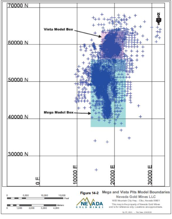
Figure 14-2 Mega and Vista Pits Model Boundaries
| Nevada Gold Mines LLC – Turquoise Ridge Complex | Page 14-21 | |
Technical Report NI 43-101 – March 25, 2020 | ||
The reserve database extraction contained 48 new drill holes drilled in 2018 and modelled in the 2019 reserve extraction inside the Mega Pit model box. Forty-seven holes are located in the Cut 40 model area and the remaining hole is in Cut 25 as shown in Figure14-3.
| Nevada Gold Mines LLC – Turquoise Ridge Complex | Page 14-22 | |
Technical Report NI 43-101 – March 25, 2020 | ||
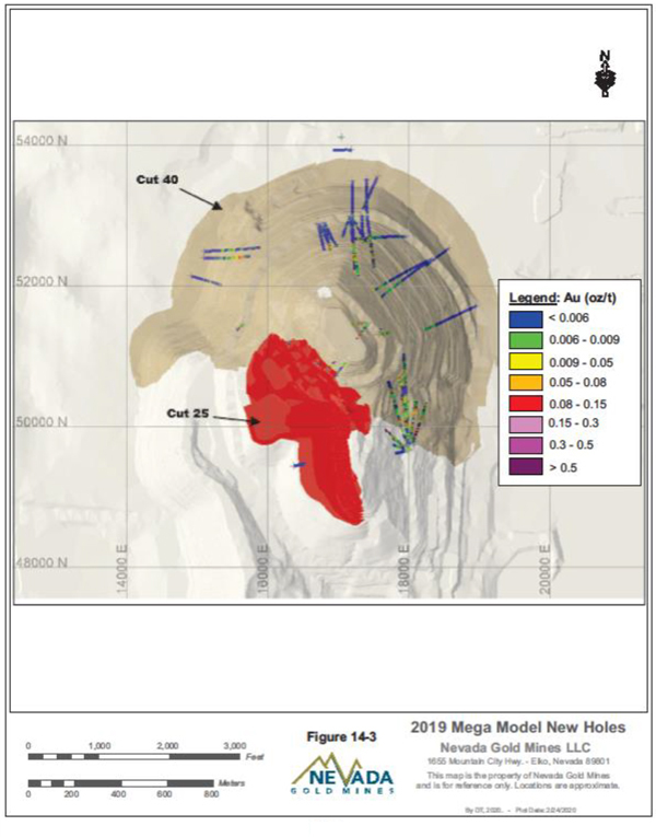
Figure 14-3 2019 Mega Pit Model New Holes
| Nevada Gold Mines LLC – Turquoise Ridge Complex | Page 14-23 | |
Technical Report NI 43-101 – March 25, 2020 | ||
The Vista Pit(s) model contains three hundred fifteen new drill holes. Ten holes are within the Vista 8 Pit design, six holes within the Vista Pit design, and two hundred ninety nine drill holes were drilled for Vista Underground and are labelled with a prefix of VUC. Sixty-three drill holes from the Vista Underground drilling directly intersect the Vista 9 Pit. The Vista Underground drilling (VUC prefix) contain ore grade assays primarily in the ore areas only and no assays outside of the ore zones. An assay grade of 0.0001 oz/ton Au was loaded to the assay intervals where no assays exist. This prevented a smearing of the high grade into areas where waste should be when building 20 ft down-hole composites and will add dilution for the surface mining methods. Figure14-4 shows the location of the Vista Pit(s) and the new drill holes.
Table14-13 summarizes the general location, summarizes the type, and total depth of new drilling in the March 6, 2019 extraction since the June 2018 extraction for both Mega and Vista Pit(s).
Table 14-13 Turquoise Ridge Surface Drilling Summary of New Drill Holes
| Area | Holes | RC (ft) | Core (ft) | Total (ft) | RC (m) | Core (m) | Total (m) | |||||||
Mega: Cut40 | 47 | 15,220 | 20,221 | 35,441 | 4,639 | 6,163 | 10,802 | |||||||
Mega: Cut25 | 1 | 0 | 803 | 803 | 0 | 245 | 245 | |||||||
Total Mega Pit | 48 | 15,220 | 21,024 | 36,244 | 4,639 | 6,408 | 11,047 | |||||||
Vista: Cut 8 | 10 | 1,920 | 2,738 | 4,658 | 585 | 834 | 1,420 | |||||||
Vista: Cut 9 | 6 | 8,570 | 10,685 | 19,255 | 2,612 | 3,257 | 5,869 | |||||||
Vista Underground | 299 | 0 | 152,226 | 152,226 | 0 | 46,398 | 46,398 | |||||||
Total Vista Pit | 315 | 10,490 | 165,648 | 176,138 | 3,197 | 50,490 | 53,687 | |||||||
Total Turquoise Ridge Surface | 363 | 25,710 | 186,672 | 212,382 | 7,836 | 56,898 | 64,734 |
| Nevada Gold Mines LLC – Turquoise Ridge Complex | Page 14-24 | |
Technical Report NI 43-101 – March 25, 2020 | ||
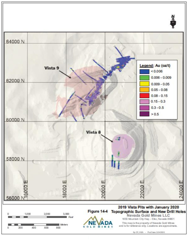
Figure 14-4 2019 Vista Pits with January 2020 Topographic Surface and New Drill Holes
| Nevada Gold Mines LLC – Turquoise Ridge Complex | Page 14-25 | |
Technical Report NI 43-101 – March 25, 2020 | ||
EXPLORATORY DATA ANALYSIS
The domains used for the Mega Pit model are using the same basic domains and structure used for the Mega Pit model since 2003. There have been updates and modifications to the domains throughout the years as new information becomes available, but it is primarily the same model. The domains used for the 2019 Mega Pit model are generally the same domains except four of the domains combined into one domain as discussed in the geologic modelling section. A table of the 2019 domain composite statistics is shown in Table14-14.
Table 14-14 Turquoise Ridge Surface Statistics by Domain
| Domain | N | Mean AuFA10 | Std Dev | cv | Max | Upper Quartile | Median | Lower Quartile | Min | 2019/2018 Avg Grade | Difference 2019/2018 AuFA Grade | |||||||||||||||||||||||||||
01_tcnLC | 1974 | 0.0319 | 0.06110 | 191.69524 | 0.76547 | 0.03817 | 0.01225 | 0.00274 | 0.00005 | 0.99898 | -0.10% | |||||||||||||||||||||||||||
02_tcnLE | 4038 | 0.0261 | 0.03692 | 141.37667 | 0.50946 | 0.03569 | 0.01275 | 0.00354 | 0.00005 | 0.98709 | -1.29% | |||||||||||||||||||||||||||
03_tcnMCs | 2796 | 0.0484 | 0.08478 | 175.19184 | 1.40293 | 0.06263 | 0.02081 | 0.00376 | 0.00005 | 0.97806 | -2.19% | |||||||||||||||||||||||||||
04_ten ME | 2282 | 0.0295 | 0.03918 | 132.86065 | 0.45900 | 0.03950 | 0.01750 | 0.00525 | 0.00005 | 0.98883 | -1.12% | |||||||||||||||||||||||||||
05_tenUC | 4208 | 0.0108 | 0.02600 | 241.00369 | 0.67028 | 0.00850 | 0.00210 | 0.00088 | 0.00005 | 0.96986 | -3.01% | |||||||||||||||||||||||||||
06_tcnUCe | 6053 | 0.0377 | 0.06310 | 167.37477 | 0.99295 | 0.05068 | 0.01489 | 0.00200 | 0.00005 | 0.99800 | -0.20% | |||||||||||||||||||||||||||
07_tcnUE | 2634 | 0.0282 | 0.03453 | 122.57489 | 0.59175 | 0.03950 | 0.01775 | 0.00550 | 0.00005 | 1.01042 | 1.04% | |||||||||||||||||||||||||||
11_tcnWP | 2623 | 0.0061 | 0.01050 | 171.63226 | 0.12455 | 0.00700 | 0.00225 | 0.00050 | 0.00005 | 0.99975 | -0.03% | |||||||||||||||||||||||||||
20_dznLE | 1703 | 0.0169 | 0.02211 | 131.06461 | 0.21625 | 0.02308 | 0.00873 | 0.00216 | 0.00005 | 1.01224 | 1.22% | |||||||||||||||||||||||||||
21_dznMC | 3789 | 0.0302 | 0.08120 | 268.47778 | 1.49967 | 0.02911 | 0.00700 | 0.00175 | 0.00005 | 1.02044 | 2.04% | |||||||||||||||||||||||||||
22_dznUCm | 4670 | 0.0303 | 0.05507 | 182.04034 | 0.97806 | 0.03476 | 0.01675 | 0.00502 | 0.00005 | 0.99791 | -0.21% | |||||||||||||||||||||||||||
23_dznUCw | 3186 | 0.0313 | 0.07534 | 240.75242 | 1.38201 | 0.03213 | 0.00683 | 0.00155 | 0.00005 | 1.00145 | 0.14% | |||||||||||||||||||||||||||
24_dznUWe | 1010 | 0.0451 | 0.06975 | 154.71568 | 0.93150 | 0.05714 | 0.02406 | 0.00733 | 0.00005 | 1.00000 | 0.00% | |||||||||||||||||||||||||||
25_dznUWNe | 2388 | 0.0141 | 0.02604 | 184.79192 | 0.42571 | 0.01652 | 0.00375 | 0.00088 | 0.00005 | 0.99903 | -0.10% | |||||||||||||||||||||||||||
27_dznUWSe | 5417 | 0.0259 | 0.04049 | 156.36426 | 0.57083 | 0.03350 | 0.01260 | 0.00223 | 0.00005 | 1.00000 | 0.00% | |||||||||||||||||||||||||||
28_dznUWSw | 4921 | 0.0262 | 0.06552 | 249.69726 | 1.31787 | 0.02209 | 0.00570 | 0.00105 | 0.00005 | 0.99167 | -0.83% | |||||||||||||||||||||||||||
29_dznCPfw_m | 9705 | 0.0188 | 0.03924 | 208.56481 | 0.93408 | 0.01925 | 0.00398 | 0.00069 | 0.00005 | 1.00289 | 0.29% | |||||||||||||||||||||||||||
30_dzs L | 8747 | 0.0155 | 0.03759 | 243.11998 | 1.33587 | 0.01405 | 0.00200 | 0.00058 | 0.00005 | 1.02366 | 2.37% | |||||||||||||||||||||||||||
31_dzsMN | 4644 | 0.0222 | 0.08066 | 363.18682 | 1.73857 | 0.01644 | 0.00460 | 0.00100 | 0.00005 | 1.00000 | 0.00% | |||||||||||||||||||||||||||
32_dzsMSn | 6923 | 0.0314 | 0.05193 | 165.24127 | 0.63756 | 0.03900 | 0.01050 | 0.00163 | 0.00005 | 1.00000 | 0.00% | |||||||||||||||||||||||||||
33_dzsMSs | 3987 | 0.0219 | 0.04100 | 187.10576 | 0.54758 | 0.02621 | 0.00223 | 0.00050 | 0.00005 | 1.00000 | 0.00% | |||||||||||||||||||||||||||
34_dzsUEn | 7945 | 0.0173 | 0.04120 | 237.54526 | 1.32225 | 0.01500 | 0.00225 | 0.00075 | 0.00005 | 1.00000 | 0.00% | |||||||||||||||||||||||||||
35_dzsUEs | 2301 | 0.0175 | 0.07207 | 411.46861 | 2.44952 | 0.01125 | 0.00200 | 0.00025 | 0.00005 | 1.00000 | 0.00% | |||||||||||||||||||||||||||
40_QAL | 10462 | 0.0023 | 0.00882 | 375.44675 | 0.30400 | 0.00200 | 0.00113 | 0.00025 | 0.00005 | 1.00843 | 0.84% | |||||||||||||||||||||||||||
41_Valmy | 29060 | 0.0032 | 0.00744 | 234.39984 | 0.36500 | 0.00250 | 0.00150 | 0.00050 | 0.00005 | 0.99945 | -0.05% | |||||||||||||||||||||||||||
Total | 137466 | 0.0181 | 0.04613 | 254.83407 | 2.44952 | 0.01675 | 0.00255 | 0.00082 | 0.00005 | 1.00900 | 0.90% | |||||||||||||||||||||||||||
EDA was completed which consisted of building boxplots, histograms, and probability distributions using arithmetic and log units. The box plotting program and script was provided by Henrique Da Silva (Newmont Principal Consulting Geostatistician) and is called boxplot4.exe. The histogram (histplt2008.exe), probability plotting programs (probplt.exe), and (plotem2008.exe) were used to build the histograms and probability plots and to combine the statistics onto one page. These programs are GSLIB programs supplied by the Centre for Computational Geostatics (CCG) in Edmonton, Alberta. Perl scripts have been designed to divide the data into separate files by domain and to generate all of the EDA plots in arithmetic and log units. Contact profile analysis was used to determine the treatment of data across estimation domain boundaries. For each domain, a distance tolerance to data in the adjacent domain(s) was defined for use in grade estimation.
| Nevada Gold Mines LLC – Turquoise Ridge Complex | Page 14-26 | |
Technical Report NI 43-101 – March 25, 2020 | ||
TOPOGRAPHIC SURFACES
Turquoise Ridge Surface original surface was imported into Vulcan from Newmont’s TSS mine planning software system in 2015 as20-foot contours. The surface triangulation topo20_twincreeks.00t was created in Vulcan and is the beginning surface for all triangulations including redox, domains, backfill, and dumps. The original surface covers all Turquoise Ridge Surface open pits property including outside the Mega and Vista Pit model boxes. The Turquoise Ridge Surface survey department regularly contracts site wide aerial surveys as required by mining activities. The aerial data is reviewed for accuracy and correctness by UAV (Drone) and VulcanI-Sight scans on a regular basis. Surface survey data is used in the construction of geologic and resource estimation models.
GEOLOGICAL INTERPRETATION
The process of creating a geologic model begins with building a model extents box to which all shapes will be trimmed. The Mega Pit model boundary coordinates are shown in Table14-15
Table 14-15 Turquoise Ridge Surface 2019 Mega Pit Geologic Model Extents
| Geologic Model Extents | Easting | Northing | Elevation | |||
| Minimum | 13,650 E | 37,760 N | 2,000 RL | |||
| Maximum | 23,040 E | 55,940 N | 5,800 RL | |||
| Block Size (ft) | 30 | 30 | 20 | |||
| Number of Blocks | 313 | 606 | 190 | |||
| Length (ft) | 9,390 | 18,180 | 3,800 |
The original topography surface was trimmed to the model extents box to create a solid below the topography as well as an air solid above the topography. This solid represents the volume of material of interest. Within the volume of interest, the new geology data based on updated geologic logging was used to update geologic interpretations, including structural, alteration, and lithologic wireframes.
TURQUOISE RIDGE SURFACE DOMAIN MODELLING
2018 Mega Pit drilling and logging information indicated the Quaternary Alluvium/Valmy Formation contact, RedOx/Refractory boundary, and the Roberts Mountains thrust (RMT) surfaces required adjustments to agree with new drilling logged features. Polylines for the RMT, Refractory, and Qal surfaces were refined as needed and a new RMT surface was built for the Valmy and Comus formation solids. These changes also impacted the geologic domain
| Nevada Gold Mines LLC – Turquoise Ridge Complex | Page 14-27 | |
Technical Report NI 43-101 – March 25, 2020 | ||
boundaries which required an update to most of the geologic domains. The domain statistics, contact plots, and domain boundaries were reviewed and indicated the domains could be combined. Final updated domain wireframes were validated for use in block model construction and compared volumetrically against the previous version and the resulting block model flagging.
The Vista Pit Vulcan geologic model was updated using the most recent fault and formation shapes from Nevada Gold Mines TSS geologic modeling software. The formation shapes were broken into fault bounded groupings, and where needed projected to the new, larger Vulcan model box. Changes from the TSS (geologic modeling software) model to the 2016 Vulcan model and copied into the 2019 Vulcan were visually validated against the drilling data
MINERALIZED DOMAINS
A series of Leapfrog Gold shells were generated with the March 6, 2019 extraction using a gold COG of
0.14 g/t Au (0.004 oz/ton Au). The final gold shell was also reviewed by the project geologist.
The Vista Pit model in 2015 did have a leapfrog gold shell at 0.12 g/t Au (0.0035 oz/ton Au) however, it was determined the shell was creating over-estimation of the grades in the blocks between 0.10 g/t Au (0.003 oz/ton Au) and 0.34 g/t Au (0.010 oz/ton Au) along the boundaries and was not used. The Vista Pit model for 2019 did have a gold leapfrog shell at 0.14 g/t Au (0.004 oz/ton Au) created in 2016 but was not used in the estimation process for the reserve model in 2019.
CAPPING OF HIGH GRADE VALUES
The capping of high grade values was addressed by compositing the individual assays into 20 ft (6.1 m) composites down the hole and also in the grade estimation process of Local Indicator Kriging (LIK). The composite data for each domain was separated into bins targeting 8% incremental frequency or 8% metal before adding a new bin to the data. The last two or three bins are reviewed by manually looking at the composites making up the bins for each domain. If there is a large difference between the highest composite and the next highest composite, the highest composite was removed in the bin analysis and then the mean or median grade of the last bin is selected as the capped grade.
| Nevada Gold Mines LLC – Turquoise Ridge Complex | Page 14-28 | |
Technical Report NI 43-101 – March 25, 2020 | ||
DENSITY
Bulk density (specific gravity SG) measurements are applied to units of variable rock density for tonnage calculations. Drill core samples4-8” (0.1 m – 0.2 m) in length are selected for SG measurements based on rock type, alteration, oxide/sulphide and ore/waste characteristics. Geologists select the samples to be tested.
The alluvium density values are highly variable as represented by test results. They ranged from 16.1 ft3/ton to 19.4 ft3/ton tonnage factors (1.99 g/cm3 to 1.65 g/cm3 specific gravity). An engineering and geology team have agreed on a final tonnage factor for alluvium of 17 ft3/ton (1.88 g/cm3).
The 2003 model had a variable tonnage factors for oxide and sulphide, waste, leach, and mill grade ore depending on 52 domains, which were used prior to 2002. Although the previous tonnage factor grid was complicated, most of the tonnage factors for oxide are 14.3 ft3/ton (2.24 g/cm3) and 13.3 ft3/ton (2.41 g/cm3) for the sulphide. Turquoise Ridge Surface has maintained the same tonnage factors at least since the 2003 model of 14.3 ft3/ton (2.24 g/cm3) for oxide and 13.3 ft3/ton (2.41 g/cm3) for sulphides. Vulcan software uses a different density factor to calculate tonnage. It is defined as 1/(tonnage factor, ft3/ton) and shown in Table14-16 for both the Mega and Vista Pit models. The oxide/sulphide, alluvium, mafic, backfill, and waste dump triangulations are coded to each block and based on the block coding the density factors are assigned using a block calculation file.
| Nevada Gold Mines LLC – Turquoise Ridge Complex | Page 14-29 | |
Technical Report NI 43-101 – March 25, 2020 | ||
Table 14-16 Turquoise Ridge Surface 2019 Model Tonnage Factors
| Description | Vulcan Density Factor (ton/ft3) | Tonnage Factor (ft3/ton) | Specific Gravity (g/cm3) | |||
Mega Pit | ||||||
Oxide | 0.070 | 14.3 | 2.24 | |||
Sulfide | 0.075 | 13.3 | 2.41 | |||
Mafic | 0.082 | 12.2 | 2.63 | |||
Alluvium (QAL) | 0.059 | 17.0 | 1.88 | |||
Backfill/Waste Dumps | 0.056 | 18.0 | 1.78 | |||
Vista Pit | ||||||
Oxide, Silica 0-1 | 0.063 | 15.8 | 2.03 | |||
Oxide, Silica 0-2 | 0.072 | 13.9 | 2.30 | |||
Sulfide | 0.077 | 13.0 | 2.46 | |||
Alluvium (QAL) | 0.059 | 17.0 | 1.88 | |||
Backfill/Waste Dumps | 0.056 | 18.0 | 1.78 | |||
COMPOSITING
Down-Hole compositing method was used for both the Mega and Vista Pits to maintain a constant sample size when compositing the mixture of vertical and angled drill holes in the database. The composite length chosen was based on the bench height of 20 ft (6.1 m) and the smallest mining unit (SMU), which is considered a 30 ft x 30 ft x 20 ft (9.1 m x 9.1 m x 6.1 m) block. This SMU is also consistent with previous reserve models for both the Mega and Vista Pits. All compositing uses the Vulcan run length routine using 20 ft (6.1 m).
Composite length is recorded in the database, and those less than 10 ft (3.05 m) are excluded during the estimation process to prevent small values from having the same weight as a sample greater than or equal to half the bench height or 10 ft (3.05 m).
VARIOGRAPHY
The Newmont Sage batch program combined with MS Excel scripts was used to calculate downhole correlograms, correlograms, and indicator correlograms. However, the TSS_Sage program was used to model the correlograms for each estimation domain.
| Nevada Gold Mines LLC – Turquoise Ridge Complex | Page 14-30 | |
Technical Report NI 43-101 – March 25, 2020 | ||
BLOCK MODEL
The Turquoise Ridge Surface model and coordinate definition parameters such as minimum and maximum coordinates, block orientation, block offset distance, block size, and number of blocks is shown in Table14-17.
Table 14-17 Turquoise Ridge Surface Model Definition Parameters
| Model | Min Easting | Max Easting | Min Northing | Max Northing | Min Elevation | Max Elevation | End X Offset | End Y Offset | End Z Offset | Block X Size | Block Y Size | Block Z Size | Bearing | Plunge | Dip | |||||||||||||||
Mega | 13650 | 23040 | 37760 | 55940 | 2000 | 5800 | 9390 | 18180 | 3800 | 30 | 30 | 20 | 90 | 0 | 0 | |||||||||||||||
Vista | 16500 | 22500 | 56300 | 63500 | 3800 | 5680 | 6000 | 7200 | 1880 | 30 | 30 | 20 | 90 | 0 | 0 |
GRADE INTERPOLATION
The Mega Pit model was estimated by OK and by Localized Indicator Kriging (LIK). The LIK model required indicator variograms to be constructed at various indicator values and also sets the grade of the highest bin which is effectively capping the high grade. The Vista Pit model was estimated using both LIK and OK. However, the OK model reconciled better than the LIK model to the blast hole block model, so the OK model was used for final Mineral Resource estimation. Estimated metallurgical species at the Mega and Vista pits include CC (carbon carbonate), OC (organic carbon), SS2(sulphide sulphur). CO3(carbonate) is calculated from the CC estimate using the relationship (CO3 = CC * 4.99618). All are estimated using inverse distance cubed (ID3) or inverse distance to the fifth power (ID5) and NN.
BLOCK MODEL VALIDATION
The Mega Pit grade estimates were reviewed against the composited assay data in both cross-section and plan. In general, theon-screen inspection of the block grade against the composite drill data indicated reasonable agreement. While reviewing the cross sections of the gold composites, blast holes, blast hole model, and the reserve model it was determined the blast holes would be the best method to optimize the LIKK-factors (Figure 14-5 and Figure 14-6).
The Mega Pit model was also validated by comparing the domains for global bias by estimation domain. Overall, the global bias check results were satisfactory, with all significant domains estimated within 10% against data grades.
The Vista Pit model global bias check was completed for the Vista HW domains CEN and South with satisfactory results. The HW_SOUTH domain shows a positive bias for the lower
| Nevada Gold Mines LLC – Turquoise Ridge Complex | Page 14-31 | |
Technical Report NI 43-101 – March 25, 2020 | ||
confidence block estimates, however for Measured and Indicated Resource estimates the bias is within 10%.
In addition, swath plots were plotted for the final grade estimates, NN grades, and the composites by domain and these support the estimates at local scale.
| Nevada Gold Mines LLC – Turquoise Ridge Complex | Page 14-32 | |
Technical Report NI 43-101 – March 25, 2020 | ||
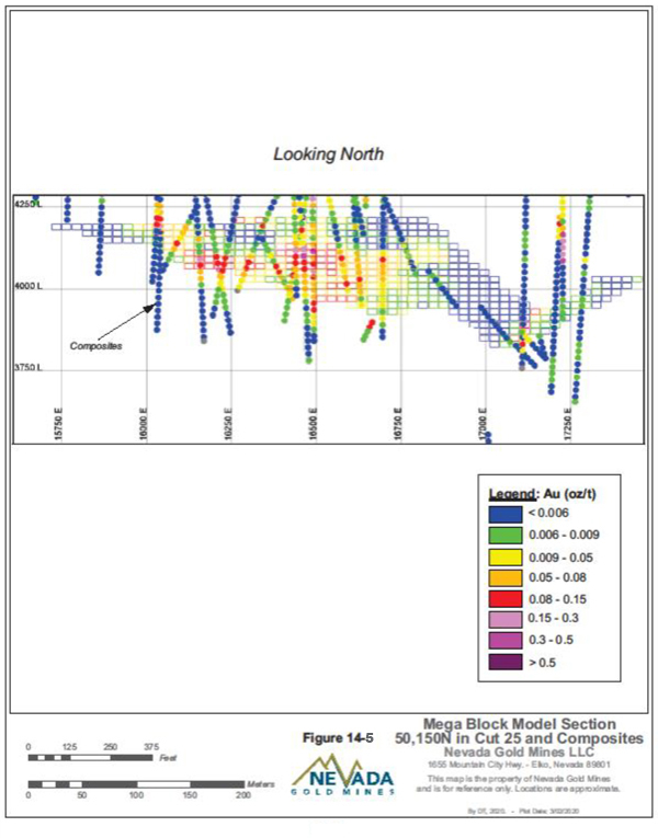
Figure 14-5 Mega Pit Block Model Section 50,150N in Cut 25 and Composites
| Nevada Gold Mines LLC – Turquoise Ridge Complex | Page 14-33 | |
Technical Report NI 43-101 – March 25, 2020 | ||
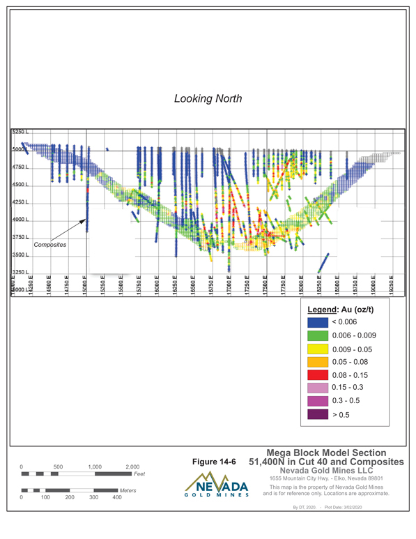
Figure 14-6 Mega Pit Block Model Section 51,400N in Cut 40 and Composites
| Nevada Gold Mines LLC – Turquoise Ridge Complex | Page 14-34 | |
Technical Report NI 43-101 – March 25, 2020 | ||
CLASSIFICATION
The following estimation confidence targets for Mineral Resource categories were used:
| ● | A Measured Resource demonstrates an estimation error within+/-15 percent at 90 percent confidence over a quarterly mining period. |
| ● | An Indicated Resource demonstrates an estimation error within+/-15 percent at 90 percent confidence over an annual mining period. |
| ● | An Inferred Resource has a lower level of confidence than that applied to Indicated Resource. It is reasonably expected that the majority of Inferred material could be upgraded to Indicated with continued exploration. |
Block estimates were compared with historic production and reconciliation to support classification applied in the model. Model classification is then reviewed with the project geologist and the mining engineer for use in drill planning and mine design (Table14-18).
The Turquoise Ridge Surface model uses a Three-Hole-Rule classification scheme, defining local drill hole spacing based on the average distance to the nearest 3 drill holes. The method uses a geometric method of assigning classification codes based on drill spacing, while also requiring a satisfactory level of continuity.
Table 14-18 Turquoise Ridge Surface Model Mineral Reserves Classification Distances
| Measured | Indicated | Inferred | ||||
Mega | £ 13 m | > 13 m and£26 m | > 26 and £ 52 m | |||
| Vista – FW Domains | £ 26 m | > 26 and £ 52 m | ||||
| Vista - FW Valmy | £ 20 m | > 20 m and £ 40 m | ||||
| Vista – FW Etchart | £ 26 m | > 26 and £ 52 m | ||||
| * average distance to closest 3 holes, 1 comp/hole | ||||||
VISTA UNDERGROUND
The Vista Underground model was updated during 2019 to include additional drilling data and geologic information collected since the dataset used for the previous (2018) model. The OZ1 and OZ2 mineralization domain wireframes were constructed using Vulcan by digitized interpretations in cross-section. The OZ1 mineralized domain represents mineralization of interest associated with the Trench Fault zone, geologically controlled at a nominal 3.43 g/t Au (0.1 oz/ton Au) COG which may be locally modified to maintain continuity of the orebody. OZ2 mineralization is relatively low confidence with limited spatial continuity and is interpreted as a foot-wall splay associated with OZ1. For the 2019 update the interpretation was adjusted to fit the additional 10 drill holes intersecting mineralization. Data was composited to 2.5 ft within estimation domains. Cap grades were investigated usingLog-probability plots
| Nevada Gold Mines LLC – Turquoise Ridge Complex | Page 14-35 | |
Technical Report NI 43-101 – March 25, 2020 | ||
and adjusted to ensure global bias in each estimation domain was minimized. The block model was constructed using 10 ft x 10 ft x 2 ftsub-blocks within the mineralized domains and a halo immediately surrounding them. Estimation parameters for OK within OZ1 were validated against current data and capped at 60 g/t Au (1.75 oz/ton Au). Secondary mineralized domain (OZ2) interpretation parameters were changed to ID3for the 2018 model, and grades were capped at 34.3 g/t Au (1.0 oz/ton Au). Estimates for SS2, OC, and CC were completed using the ID3 method for use in ore blending and potential valuation of sulphide content. Density values were updated based on the current dataset using a declustered mean data grades for each geologic domain. Estimates were validated by domain using visual review, swath plots and global bias comparisons. Resource classification used the three-hole distance method previously described, with nominal data spacing requirements of 30 ft (9.1 m), 70 ft (21.3 m), and 140 ft (42.6 m) for Measured, Indicated, and Inferred Resources, respectively.
CUT-OFF GRADE
COG inputs for Turquoise Ridge Surface are based on recent operating experience, projected costs, and Nevada Gold Mines corporate guidance. Separate Mineral Resource and Mineral Reserve COGs, based on the Mineral Resource and Mineral Reserve gold prices, are used to report the Mineral Resources and Mineral Reserves. All blocks that fail to meet the COG are classified as waste. The inputs used to determine the Mineral Resource COGs are shown in Table14-19. The principal difference between the Mineral Reserve and Mineral Resource COG calculation is the gold price of US$1,200/oz Au and US$1,500/oz Au, respectively. The COG table for Mineral Reserves and Mineral Resources is shown in Section 17.6. Mining cost varies by pit and process costs vary by rehandle costs. Oxide mill and leach recovery is dependent upon the pit as well as the grade of material. Sulphide recovery is dependent upon grade and the OC content of the material. Tailings sustaining capital is applied to both oxide and sulphide (autoclave) mill ore. The sustaining capital cost for the leach includes a heap leach pad expansion.
| Nevada Gold Mines LLC – Turquoise Ridge Complex | Page 14-36 | |
Technical Report NI 43-101 – March 25, 2020 | ||
Table 14-19 Turquoise Ridge Surface ResourceCut-Off Grade Parameters
| Description | Units | Value | ||
| Mining cost | $/tonne | 2.08 - 2.30 | ||
| Processing cost – Sage Mill | $/tonne | 24.75 - 26.59 | ||
| Processing cost – Juniper Mill | $/tonne | 7.13- 8.79 | ||
| Processing cost – Leach | $/tonne | 6.75 | ||
| General and Administrative costs | % | 12.30 | ||
| Sustaining Capital – Mining | $/tonne | 0.45 | ||
| Sustaining Capital – Sulphide Mill | $/tonne | 0.74 | ||
| Sustaining Capital – Oxide Mill | $/tonne | 0.13 | ||
| Sustaining Capital – Tailings | $/tonne | 1.34 | ||
| Sustaining Capital – Leach | $/tonne | 1.15 | ||
| Reclamation Costs – Mining | $/tonne | 0.01 | ||
| Reclamation Costs – Process | $/tonne | 0.07 | ||
| Gold Metal Recovery Sulphide Mill | % | ~80 - 96 | ||
| Gold Metal Recovery Oxide Mill | % | ~80 | ||
| Gold Metal Recovery Heap Leach | % | 30 - 70 | ||
| Gold Selling Price | $/oz | 1,500 | ||
| Resource COG | g/tonne Au | varies |
G&A, ROYALTY AND OTHER ASSUMPTIONS FOR TURQUOISE RIDGE SURFACE
General and administrative (G&A) costs are added to all operating costs at 12.3% which is a reduction from last year’s Newmont calculation at 19.2%.
In connection with the formation of Nevada Gold Mines, both Barrick and Newmont were granted a 1.5% net smelter returns royalty over the respective properties they contributed (including Barrick’s 75% interest in Turquoise Ridge Underground and Newmont’s 25% interest in the Turquoise Ridge Underground and its 100% interest in Turquoise Ridge Surface and Vista Underground). Each of these “retained royalties” is only payable once the aggregate production from the properties subject to the royalty exceeds the publicly reported reserves and resources as of December 31, 2018.
Mining lands subject to royalty are in a portion of Section 4, T39N, R42E. The royalty is in favour of Royal Gold for 2% of the gold ounces when they are processed times the current gold price. The royalty applies to gold ounces sold in excess of 50,000 ounces, from this area which was exceeded in 2008. There are no remaining royalties in Cut 25 and Vista 8. Cut 40 and the stockpiles that have material that is subject to royalties as shown in Table14-20 for Mineral Reserves and Table14-21 for Mineral Resources.
| Nevada Gold Mines LLC – Turquoise Ridge Complex | Page 14-37 | |
Technical Report NI 43-101 – March 25, 2020 | ||
Table 14-20 Mineral Reserves Subject to Royalty Payment
| Category | Area | Tonnes (t) | Grade (g/t Au) | Contained Metal (oz Au) | ||||
Proven Reserves | ||||||||
Cut 40 In Situ | 62,332 | 1.61 | 3,212 | |||||
| Stockpiles | 271,625 | 3.26 | 28,372 | |||||
Total Proven Reserve | 333,957 | 2.95 | 31,584 | |||||
Probable Reserve | ||||||||
Cut 40 In Situ | 363,172 | 1.23 | 14,296 | |||||
Total Probable Reserve | 363,172 | 1.23 | 14,296 | |||||
Total Proven and Probable Reserves | 697,129 | 2.06 | 45,880 | |||||
Table 14-21 Mineral Resources Subject to Royalty Payment
| Category | Area | Tonnes (t) | Grade (g/t Au) | Contained Metal (oz Au) | ||||
Measured Resource | ||||||||
Cut 40 In Situ | - | - | - | |||||
| Stockpiles | 361,170 | 2.23 | 25,856 | |||||
Total Measured Resource | 361,170 | 2.23 | 25,856 | |||||
Indicated Resource | ||||||||
Cut 40 In Situ | - | - | - | |||||
| Stockpiles | ||||||||
| - | - | - | ||||||
Total Measured and Indicated Resources | ||||||||
Cut 40 In Situ | - | - | - | |||||
| Stockpiles | 361,170 | 2.23 | 25,856 | |||||
Inferred Resource | ||||||||
Cut 40 In Situ | - | - | - | |||||
| Stockpiles | - | - | - | |||||
Total Inferred Resource | - | - | - | |||||
| Nevada Gold Mines LLC – Turquoise Ridge Complex | Page 14-38 | |
Technical Report NI 43-101 – March 25, 2020 | ||
15. MINERAL RESERVES ESTIMATE
| 15.1. | SUMMARY |
The Mineral Reserve estimate for the Turquoise Ridge Complex, as of December 31, 2019, is presented in Table15-1. The Mineral Reserve estimate is a combination of the open pit and underground Mineral Reserves, and stockpiles.
Proven and Probable Mineral Reserves (Table15-1) total 83 million tonnes grading 5.02 g/t Au and containing 13 million ounces of gold consisting of:
| ● | Proven Mineral Reserves of 45 million tonnes grading 5.38 g/t Au and containing 7.8 million ounces of gold. |
| ● | Probable Mineral Reserves of 38 million tonnes, grading 4.59 g/t Au and containing 5.6 million ounces of gold. |
| Nevada Gold Mines LLC – Turquoise Ridge Complex | Page 15-1 | |
Technical Report NI 43-101 – March 25, 2020 | ||
Table 15-1 Mineral Reserves Estimate – December 31, 2019
| 100% Basis | Proven | Probable | Total | |||||||||||||||
Tonnes (Mt) | Grade (g/t Au) | Contained Metal (Moz Au) | Tonnes (Mt) | Grade (g/t Au) | Contained Metal (Moz Au) | Tonnes (Mt) | Grade (g/t Au) | Contained Metal (Moz Au) | ||||||||||
Surface Operations | ||||||||||||||||||
Stockpile | ||||||||||||||||||
Turquoise Ridge Surface | 27 | 1.98 | 1.8 | 27 | 1.98 | 1.8 | ||||||||||||
Stockpile Total | 27 | 1.98 | 1.8 | 27 | 1.98 | 1.8 | ||||||||||||
Open Pit | ||||||||||||||||||
Turquoise Ridge Surface | 1.8 | 2.59 | 0.15 | 25 | 1.86 | 1.5 | 27 | 1.91 | 1.7 | |||||||||
Open Pit Total | 1.8 | 2.59 | 0.15 | 25 | 1.86 | 1.5 | 27 | 1.91 | 1.7 | |||||||||
Surface Operations Total | 29 | 2.02 | 1.9 | 25 | 1.86 | 1.5 | 55 | 1.95 | 3.4 | |||||||||
Underground Operations | ||||||||||||||||||
Turquoise Ridge Underground | 16 | 11.56 | 5.9 | 12 | 10.28 | 3.9 | 28 | 11.01 | 9.8 | |||||||||
Vista Underground | 0.0100 | 6.22 | 0.0020 | 0.73 | 6.86 | 0.16 | 0.74 | 6.86 | 0.16 | |||||||||
Total | 16 | 11.55 | 5.9 | 13 | 10.08 | 4.1 | 29 | 10.90 | 10 | |||||||||
Underground Operations Total | 16 | 11.55 | 5.9 | 13 | 10.08 | 4.1 | 29 | 10.90 | 10 | |||||||||
Turquoise Ridge Complex Total | 45 | 5.38 | 7.8 | 38 | 4.59 | 5.6 | 83 | 5.02 | 13 | |||||||||
Notes:
| 1. | CIM (2014) definitions were followed for Mineral Reserves. |
| 2. | Mineral Reserves are estimated using a long-term gold price of US$1,200/oz. |
| 3. | Underground Mineral Reserves were estimated using COGs of 7.15 g/t Au except Getchell Mine Area where a COG of 7.41 g/t Au has been used (poorer ground condition) and 3.42 g/t Au (Vista Underground). Open Pit Mineral Reserves COGs are 0.25 g/t Au for oxide, and 1.25 g/t Au to 2.28 g/t Au for sulphide, based on gold grade, chemistry, and recovery by ore type. |
| 4. | Numbers may not add due to rounding. |
| 5. | Mineral Reserves are reported on a 100% basis. Barrick’s and Newmont’s attributable shares of the Mineral Reserves are 61.5% and 38.5%, respectively. |
| Nevada Gold Mines LLC – Turquoise Ridge Complex | Page 15-2 | |
Technical Report NI 43-101 – March 25, 2020 | ||
The Mineral Reserve estimates use updated economic factors, the latest resource and geological models, geotechnical inputs, and the latest metallurgical updates. Some inputs were shared across all the operations during the preparation of the Mineral Reserve estimates. Mineral Reserves were based on the development of appropriately detailed and engineered life of mine (LOM) plans. All design and scheduling work is undertaken to a suitable level of detail by experienced engineers using mine planning software. The planning process incorporated appropriate modifying factors and the use of COGs and other technical-economic investigations.
The Mineral Reserve estimates have been prepared according to CIM (2014) definitions as incorporated by reference into NI43-101.
The QP is not aware of any mining, metallurgical, infrastructure, permitting, or other relevant factors that could materially affect the Mineral Reserve estimate.
Nevada Gold Mines notes that database and all computer block modelling reserve estimation routines are reported in imperial units and have not always been converted to metric for reporting purposes.
| 15.2. | UNDERGROUND MINERAL RESERVES |
The Mineral Reserve estimate for the Turquoise Ridge Underground and Vista Underground as of December 31, 2019, is presented in Table15-1. These Mineral Reserves are a combination of the Turquoise Ridge Underground and Vista Underground operations. Proven and Probable Mineral Reserves total 29 million tonnes grading 10.90 g/t Au and containing 10 million ounces of gold and consisting of:
| ● | Proven Mineral Reserves of 16 million tonnes grading 11.55 g/t Au and containing 5.9 million ounces of gold. |
| ● | Probable Mineral Reserves of 13 million tonnes, grading 10.08 g/t Au and containing 4.1 million ounces of gold. |
TURQUOISE RIDGE UNDERGROUND MINE
The Turquoise Ridge Underground Mineral Reserve estimate, as of December 31, 2019, is presented in Table15-2. Proven and Probable Mineral Reserves total 28 million tonnes grading 11.01 g/t Au and containing 9.8 million ounces of gold and consisting of:
| Nevada Gold Mines LLC – Turquoise Ridge Complex | Page 15-3 | |
Technical Report NI 43-101 – March 25, 2020 | ||
| ● | Proven Mineral Reserves of 16 million tonnes grading 11.56 g/t Au and containing 5.9 million ounces of gold. |
| ● | Probable Mineral Reserves of 12 million tonnes, grading 10.28 g/t Au and containing 3.9 million ounces of gold. |
Table 15-2 Turquoise Ridge Underground Mineral Reserves Estimate – December 31, 2019
| Proven | Probable | Total | ||||||||||||||||
| 100 % Basis | Tonnes (Mt) | Grade (g/t Au) | Contained Metal (Moz Au) | Tonnes (Mt) | Grade (g/t Au) | Contained Metal (Moz Au) | Tonnes (Mt) | Grade (g/t Au) | Contained Metal (Moz Au) | |||||||||
Turquoise Ridge Underground | 16 | 11.56 | 5.9 | 12 | 10.28 | 3.9 | 28 | 11.01 | 9.8 | |||||||||
Notes:
| 1. | CIM (2014) definitions were followed for Mineral Reserves. |
| 2. | Mineral Reserves are estimated at a COG of 7.2 g/t Au (0.209 oz/ton Au), except for the GET and TNB mining regions which are estimated at a COG of 7.4 g/t Au (0.216 oz/ton Au). |
| 3. | Mineral Reserves are estimated using a long-term gold price of US$1,200/oz. |
| 4. | Numbers may not add due to rounding. |
| 5. | November and December depletion amounts were estimated based on mining plans. |
| 6. | Mineral Reserves are reported on a 100% basis. Barrick’s and Newmont’s attributable shares of the Mineral Reserves are 61.5% and 38.5%, respectively. |
The Mineral Reserve estimate for Turquoise Ridge Underground is defined for ten different regions within the mine, as shown in Figure15-1.
| Nevada Gold Mines LLC – Turquoise Ridge Complex | Page 15-4 | |
Technical Report NI 43-101 – March 25, 2020 | ||
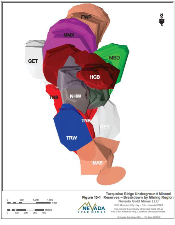
Figure 15-1 Turquoise Ridge Underground Mineral Reserves – Breakdown by Mining Region
| Nevada Gold Mines LLC – Turquoise Ridge Complex | Page 15-5 | |
Technical Report NI 43-101 – March 25, 2020 | ||
CUT-OFF GRADE
Table15-3 shows the COG calculation for Turquoise Ridge Underground.
Table 15-3 Turquoise Ridge Underground Reserves Cut-Off Grade Calculation
| Unit Cost | Units | Turquoise Ridge Underground | Getchell Mine Area | |||
Metal Price | $/oz | 1,200 | 1,200 | |||
Metallurgical Recovery | % | 92 | 93 | |||
Mining Operating Cost | $/tonne | 123.73 | 168.57 | |||
Process Operating Cost | $/tonne | 47.03 | 47.03 | |||
G&A Operating Cost | $/tonne | 32.74 | 32.74 | |||
Sustaining Capital Cost | $/tonne | 50.37 | 16.12 | |||
Total Operating Cost per TonneCut-off | $/tonne | 253.88 | 264.47 | |||
COG | g/t Au | 7.15 | 7.41 |
For the majority of the Turquoise Ridge Underground Mineral Reserve, a COG of 7.15 g/t Au has been used. In the area surrounding the Getchell Fault (Getchell Mine Area), the COG has been increased to 7.41 g/t Au due to increased mining costs induced by poor ground conditions. These COGs were applied to stope panels after dilution and ore loss had been accounted for in the panel.
QPs have performed an independent verification of the block model tonnes and grade, and in their opinion, the process has been carried out to industry standards. The QPs are not aware of any environmental, legal, title, socioeconomic, marketing, mining, metallurgical, infrastructure, permitting, fiscal, or other relevant factors that could materially affect the Mineral Reserve estimate.
MINERAL RESERVES ESTIMATION
For the stope shapes constructed for the Mineral Reserve estimate, grade shells were constructed at the reserve COG using Measured and Indicated Mineral Resource material. Stope shapes were designed to be consistent with existing excavations.
Panel by panel resolution was constructed for near-term (within atwo-year period) stope shapes, and broader shapes were used for the long-term (beyondtwo-year period). Development designs were generated concurrently for each stope shape. The design engineer used his/her judgment to avoid incorporating low grade or isolated resource blocks.
| Nevada Gold Mines LLC – Turquoise Ridge Complex | Page 15-6 | |
Technical Report NI 43-101 – March 25, 2020 | ||
Stope shapes were validated against the resource model to generate grade/tonnage estimates. These estimates were imported to a spreadsheet for tabulation for further validation and the application of unplanned dilution. Design shapes were checked for minimum tonnage and dimension considerations. In addition, previous economic studies have shown certain zones of the resource to prove uneconomic. Shapes that do not meet these qualifications are excluded from the reserve.
After the stope shapes were completed and reviewed, the details of the stope materials (tonnes, grades, classifications) were exported to MS Excel and tabulated. Finally, a provision for unplanned dilution in the form of 12% additional tonnage at zero grade to account for backfill dilution was added to the total to generate the Mineral Reserve estimate.
The Mineral Reserve estimates use updated economic factors, the latest resource and geological models, geotechnical inputs, and the latest metallurgical updates. Some inputs were shared across all the operations during the preparation of the Mineral Reserve estimates. Mineral Reserves were based on the development of appropriately detailed and engineered LOM plans. All design and scheduling work was undertaken to a suitable level of detail by experienced engineers using mine planning software. The planning process incorporated appropriate modifying factors and the use of COGs and other technical-economic investigations.
DILUTION
Underground mining budgets for 12% dilution (12% additional material removed volumetrically above neat design shapes planned at zero grade) in drift and fill mining areas to account for unplanned overbreak into host materials and previously placed backfill.
GOLD PRICE SENSITIVITY ANALYSIS
Gold price sensitivities for the Turquoise Ridge Underground Mineral Reserve were evaluated by creating LOM ore shapes at varying COGs, with resource blocks excluded from the analysis (Table15-4).
| Nevada Gold Mines LLC – Turquoise Ridge Complex | Page 15-7 | |
Technical Report NI 43-101 – March 25, 2020 | ||
Table 15-4 Mineral Reserves Price Sensitivity (100% Basis)
| Percent Change from Mineral Reserve | ||||||||
| $1,000/oz | $1,100/oz | $1,200/oz | $1,300/oz | $1,400/oz | ||||
| -17.52% | -4.91% | 0.00% | 6.11% | 9.74% | ||||
| Proven and Probable (oz Au) | ||||||||
| $1,000/oz | $1,100/oz | $1,200/oz | $1,300/oz | $1,400/oz | ||||
| 8.1M | 9.4M | 9.8M | 10.5M | 10.8M | ||||
VISTA UNDERGROUND MINE
The Vista Underground Mineral Reserves estimate, as of December 31, 2019, is presented in Table15-5. Proven and Probable Mineral Reserves total 0.74 million tonnes grading 6.86 g/t Au and containing 0.16 million ounces of gold.
Table 15-5 Vista Underground Mineral Reserves Estimate - December 31, 2019
| Proven | Probable | Total | ||||||||||||||||
| 100 % Basis | Tonnes (Mt) | Grade (g/t Au) | Contained Metal (Moz Au) | Tonnes (Mt) | Grade (g/t Au) | Contained Metal (Moz Au) | Tonnes (Mt) | Grade (g/t Au) | Contained Metal (Moz Au) | |||||||||
Vista Underground | 0.0100 | 6.22 | 0.0020 | 0.73 | 6.86 | 0.16 | 0.74 | 6.86 | 0.16 | |||||||||
Notes:
| 1. | CIM (2014) definitions were followed for Mineral Reserves. |
| 2. | Mineral Reserves are estimated at a COG of 2.74 g/t Au |
| 3. | Mineral Reserves are estimated using a long-term gold price of US$1,200 per ounce including dilution and ore loss factors. |
| 4. | Numbers may not add due to rounding. |
| 5. | Mineral Reserves are reported on a 100% basis. Barrick’s and Newmont’s attributable shares of the Mineral Reserves are 61.5% and 38.5%, respectively. |
UNDERGROUND MINE DESIGN
Drilling and geologic interpretation during 2019 had minimal impact to the OZ1 orebody. Mining depletions and other adjustments decreased the overall Mineral Reserves as depicted below. The northern extent of Levels 4200 – 4260 and the southern portion of levels 4200-4320 were shortened due to Hagby (localized infill) drilling results.
All stopes were designed, scheduled, and interrogated in Deswik using the stope optimiser and Deswik scheduler. All mining design parameters were consistent with the 2018 Mineral Reserves with the exception of dilution. In the 2018 Mineral Reserves, a constant factor of 30% additional overbreak was used in designs. In 2019, stopes were created assuming 0.3 m overbreak in the footwall and 0.9 m overbreak in the hanging wall with an additional 10% overbreak dilution added in.
| Nevada Gold Mines LLC – Turquoise Ridge Complex | Page 15-8 | |
Technical Report NI 43-101 – March 25, 2020 | ||
Figure15-2 is a longitudinal section of the Vista Underground which shows the location of the Mineral Reserves.
| Nevada Gold Mines LLC – Turquoise Ridge Complex | Page 15-9 | |
Technical Report NI 43-101 – March 25, 2020 | ||
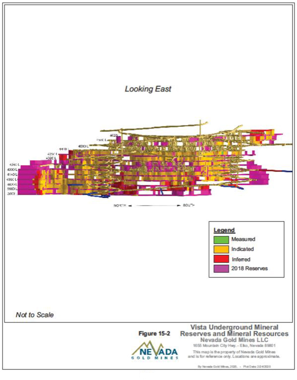
Figure 15-2 Vista Underground Mineral Reserves and Mineral Resources
| Nevada Gold Mines LLC – Turquoise Ridge Complex | Page 15-10 | |
Technical Report NI 43-101 – March 25, 2020 | ||
OPERATING AND CAPITAL COST ASSUMPTIONS
Table15-6 lists the Vista Underground operating and capital cost assumptions used for estimating the Mineral Reserve.
Table 15-6 Vista Underground Operating and Capital Cost Assumptions
| Unit Cost | Units | Vista Underground | ||
Metal Price | $/oz | 1,200.00 | ||
Metallurgical Recovery | % | 92 | ||
Mining Operating Cost | $/tonne | 120.85 | ||
Process Operating Cost | $/tonne | 34.92 | ||
G&A Operating Cost | $/tonne | 6.70 | ||
Sustaining Capital Cost | $/tonne | 23.27 | ||
Total Operating Cost per TonneCut-off | $/tonne | 185.74 | ||
COG | g/t Au | 5.27 |
GOLD PRICE SENSITIVITY ANALYSIS
Gold price sensitivities for the Vista Underground Mineral Reserve were evaluated by runs of Stope Optimizer at varying COGs, with resource blocks excluded from the analysis (Table15-7).
Table 15-7 Vista Underground Mineral Reserves Price Sensitivity
| Percent Change from Reserve | ||||||||
| $1,000/oz | $1,100/oz | $1,200/oz | $1,300/oz | $1,400/oz | ||||
| -3.0% | -1.5% | 0.00% | 0.9% | 1.4% | ||||
| Proven and Probable (oz Au) | ||||||||
| $1,000/oz | $1,100/oz | $1,200/oz | $1,300/oz | $1,400/oz | ||||
| 158,817 | 161,284 | 163,755 | 165,302 | 166,006 | ||||
| 15.3. | SURFACE MINERAL RESERVES |
TURQUOISE RIDGE SURFACE
The Turquoise Ridge Surface Mineral Reserve estimate, as of December 31, 2019, is presented in Table15-8 Proven and Probable Mineral Reserves total 55 million tonnes grading 1.95 g/t Au and containing 3.4 million ounces of gold consisting of:
| ● | Proven Mineral Reserves of 29 million tonnes grading 2.02 g/t Au and containing 1.9 million ounces of gold. |
| ● | Probable Mineral Reserves of 25 million tonnes, grading 1.86 g/t Au and containing 1.5 million ounces of gold. |
| Nevada Gold Mines LLC – Turquoise Ridge Complex | Page 15-11 | |
Technical Report NI 43-101 – March 25, 2020 | ||
The Mineral Reserve is based on a gold price of US$1,200 per ounce.
The Mineral Reserve includes 1.7 million ounces of gold contained in ore from the Mega and Vista Pits. Mineral Reserves also include 1.8 million ounces of gold contained in refractory and oxide stockpiled ore. Summary results are shown in Table15-8.
Table 15-8 Turquoise Ridge Surface Mineral Reserves Estimate - December 31, 2019
| Mine or Stockpile | Proven | Probable | Total | |||||||||||||||
Tonnes (Mt) | Grade (g/t Au) | Contained (Moz Au) | Tonnes (Mt) | Grade (g/t Au) | Contained (Moz Au) | Tonnes (Mt) | Grade (g/t Au) | Contained (Moz Au) | ||||||||||
Mega Cut 25 | 0.8 | 3.35 | 0.1 | 4.6 | 3.18 | 0.5 | 5.4 | 3.21 | 0.6 | |||||||||
Mega Cut 40 | 1.0 | 1.94 | 0.1 | 14.7 | 1.87 | 0.9 | 15.6 | 1.87 | 0.9 | |||||||||
Subtotal | 1.8 | 2.58 | 0.1 | 19.3 | 2.18 | 1.4 | 21 | 2.21 | 1.5 | |||||||||
Vista 8 | 0.0 | 0.00 | 0.0 | 6.2 | 0.86 | 0.2 | 6.2 | 0.86 | 0.2 | |||||||||
Subtotal | 0.0 | 0.00 | 0.0 | 6.2 | 0.86 | 0.2 | 6.2 | 0.86 | 0.2 | |||||||||
TotalIn-situ | 1.8 | 2.59 | 0.15 | 25 | 1.86 | 1.5 | 27 | 1.91 | 1.7 | |||||||||
Stockpiles | 27 | 1.98 | 1.8 | 0.0 | 0.00 | 0.0 | 27 | 1.98 | 1.8 | |||||||||
In-Process | 0.0 | 0.00 | 0.0 | 0.0 | 0.00 | 0.0 | 0.0 | 0.0 | 0.0 | |||||||||
Subtotal | 27 | 1.98 | 1.8 | 0.00 | 0.00 | 0.0 | 27 | 1.98 | 1.8 | |||||||||
TOTAL | 29 | 2.02 | 1.9 | 25 | 1.86 | 1.5 | 55 | 1.95 | 3.4 | |||||||||
Notes:
| 1. | CIM (2014) definitions were followed for Mineral Reserves. |
| 2. | Mineral Reserves are estimated using a long-term gold price of US$1,200/oz. |
| 3. | Open Pit Mineral Reserve COGs are 0.25 g/t Au for oxide, and 1.25 g/t Au to 2.28 g/t Au for sulphide, based on gold grade, chemistry, and recovery by ore type. |
| 4. | Numbers may not add due to rounding. |
| 5. | Mineral Reserves are reported on a 100% basis. Barrick’s and Newmont’s attributable shares of the Mineral Reserves are 61.5% and 38.5%, respectively. |
MODEL RISK ANALYSIS
The model risk is managed through annual infill drilling programs that target the three to five year window of the business plan, focussed on improving data density and quality. Additional strategies involve adjustments to estimation that include, but are not limited to, high yield restrictions and capping strategies.
MINING ASSUMPTIONS
Both Vista and Mega Pit laybacks are mined on single 20 ft (6.1 m) benches. Final bench faces are mined to near vertical withpre-splitting and buffer blasting. Inter-ramp angles (IRA) of pit slopes are designed according to recommendations by geotechnical slope zones. Slope zones are identified in the respective resource deposit models as control grids. To account for some flattening of slope angles due to ramp design in Lerchs-Grossmann (LG) cones, overall slope angles have been reduced for each layback depending on the specific ramp layouts being
| Nevada Gold Mines LLC – Turquoise Ridge Complex | Page 15-12 | |
Technical Report NI 43-101 – March 25, 2020 | ||
designed. For example, a 45° IRA slope would typically have overall LG slope angle set to 40° to 42° to account for ramps in the pit. Table15-9 lists the geotechnical design recommendations for the Mega Pit and Table15-10 lists the geotechnical design recommendations for the Vista Pit.
Table 15-9 Mega Pit Geotechnical Design Recommendations
| Area | Zone | Name | Description | IRA degrees | Bench design | |||||
South | 1 | cdzsMSnpln13_gtech | Comus Fm. Overturned limb south of the Wry Tail fault and East of the Lopear fault. | 42 | Single | |||||
South | 2 | dzsUEspln13_gtech | Comus Fm. Upright Limb south of the 604 and West of the Lopear fault. | 45 | Double | |||||
North | 3 | dzsMSspln13_gtech | Comus Fm. Overturned limb south of the 604 and east of the Lopear faults. | 42 | Single | |||||
North | 4 | cdzsUEnpln13a_gtech | Upright limb of Conelea fold, Comus Fm. | 45 | Double | |||||
South | 5 | cdzsMNpln13_gtech | Overturned limb Comus Fm. East of the Lopear and north of the Wry Tail fault. | 42 | Single | |||||
Cent | 6 | Backfill_513_gtech | Cut-21 backfill material | 36 | Single | |||||
North | 7 | TCNCPflt13_gtech | Comus Fm. Between CP and West Side faults | 38 to 45 | Single Double | |||||
North | 8 | cTCOcUL_13a_gtech | Upright limb Comus Fm. TC/DC/CP fault and west of the Conelea fold hinge | 45 | Double | |||||
North | 9 | TCOCLL13_gtech | Overturned Comus Fm. Between TC/DZ fault and east of the Conelea fold hinge | 42 | Single | |||||
North | 10 | TCSageLL13_gtech | Overturned Comus Fm. North of the TC fault and East of fold hinge | 42 | Single | |||||
North | 11 | cTCWvalmy13_gtech | Valmy Fm. Above the Roberts Mountain Thrust West side of the pit | 45 | Double | |||||
North | 12 | TCNcpwest13a_gtech | Comus Fm. West of the CP flt, north of the DZ fault. | 45 | Double | |||||
South | 13 | DZSElimb13_gtech | Overturned Comus Fm. DZ/604 faults. | 42 | Single | |||||
North | 14 | TCSagefltUL13a-gtech | Comus Fm. Upright limb Sage/TC faults | 42 | Single | |||||
North | 15 | TCEvalmy13_gtech | Valmy Fm. Above the Roberts Mountain Thrust fault on the east side of the pit. | 42 | Single | |||||
Cent. | 16 | cmpQALpln13_gtech | Alluvium- if dewatered. | 50 | Double | |||||
North | 17 | Oculs13g_gtech | Comus Fm. South of the DZ fault, upright limb of the Conelea fold, above the Lopear thrust fault. | 45 | Double | |||||
North | 18 | RMT13g_gtech | Roberts Mountain thrust fault; separates the HW Valmy from FW Comus | 38 | Single | |||||
South | 19 | W1_dump13g_gtech | W-1 Waste dump | 36 | Single |
| Nevada Gold Mines LLC – Turquoise Ridge Complex | Page 15-13 | |
Technical Report NI 43-101 – March 25, 2020 | ||
Table 15-10 Vista Pit Geotechnical Recommendations
| Zone | Name | Description | IRA degrees | Bench design | ||||
| 1 | vc_Qal_gtech13 | Alluvium- if dewatered. | 55 | Double | ||||
| 2 | Vc_Backfill_gtech13 | Vista Phase 1, 4, 5, and 6 backfill materials. | 36 | Single | ||||
| 3 | FW_PPEL_geotech13b | Vista Phase 5 upper wall. Limestone rock | 50 | Double | ||||
| 4 | FW_PPEL_disco _geotech13b | Vista Phase 4 footwall to the 20K flt. Limestone rock. | 48 | Double | ||||
| 5 | FW_Valmy_bed _geotech13a | Vista Phase 4 near the footwall of the 20K fault. | 45 | Double | ||||
| 6 | vc_FW_ValmySouth _geotech13 | Vista Phase 5 and 6. Forms the footwall of the 20K fault. | 44 | Double | ||||
| 7 | Vc_20K_gtech13a | Fault zone strikes north-south and dips 45 degrees west in Vista Phase 6 and 7. | 38 | Single | ||||
| 8 | HW_PPEU_geotech 13c | Hanging wall of the 20K fault in Vista Phase 6 and 7 (north and east highwalls). | 42 | Double | ||||
| 9 | vc_HW_PPEL_ geotech13c | Hanging wall of the 20K fault in Vista Phase 6 and 7 (south and east highwalls). | 45 | Double | ||||
| 10 | vc_Karst_geotech13 | Hanging wall of the 20K fault in Vista 7 Phase 2 (west highwall). Strong decalcification and silicification. | 40 | Single | ||||
| 11 | vc_HW_Valmy _geotech13 | Basalt flows and interbedded sediments in south Vista Phases 7 and 8. | 45 | Double |
OPERATING AND CAPITAL COST ASSUMPTIONS
Turquoise Ridge Surface operating and capital costs were compiled from cost data used in the budget. The budgeting process combined efforts from several departments of the site and regional office. Mining costs are summarized in
Table15-11 and process costs are summarized in Table15-12.
Long range mine plans were developed from regional planning department guidance and current pit and phase designs. Detailed monthly and yearly mining shapes, haulage cycle times, and preliminary metal plans were developed using software “Open Pit Metal Solutions” (OPMS) by RPMGlobal. Cost buildup was completed using the XERAS software system. Turquoise Ridge Surface site costs and drivers were uploaded to the BPC forecasting interface.
Capital costs were taken from the budget. All capital is categorized as sustaining cost for Turquoise Ridge Surface and is accounted under either mine, Sage autoclave, Juniper oxide mill, heap leach, or tailings cost centers.
| Nevada Gold Mines LLC – Turquoise Ridge Complex | Page 15-14 | |
Technical Report NI 43-101 – March 25, 2020 | ||
Table 15-11 Turquoise Ridge Surface Mining Costs
| Unit Cost | Units | Mega Pit | Vista Pit | ||||||||||||
Mining Operating Cost | $/tonne | 2.30 | 2.08 | ||||||||||||
Mining G&A Operating Cost | $/tonne | 0.28 | 0.25 | ||||||||||||
Mining Capital Operating Cost | $/tonne | 0.45 | 0.45 | ||||||||||||
Mining Reclamation Operating Cost | $/tonne | 0.006 | 0.006 | ||||||||||||
Total Mining Operating Cost | $/tonne | 3.04 | 2.79 | ||||||||||||
Table 15-12 Turquoise Ridge Surface Process Costs
| Unit Cost | Units | Sage | Juniper | Heap Leach | ||||||||||||||||
Process Operating Cost (no rehandle) | $/tonne | 24.75 | 7.13 | 6.74 | ||||||||||||||||
Process G&A Operating Cost | $/tonne | 3.05 | 0.88 | 0.67 | ||||||||||||||||
Process Capital Operating Cost | $/tonne | 2.08 | 1.48 | 1.15 | ||||||||||||||||
Process Reclamation Operating Cost | $/tonne | 0.06 | 0.06 | 0.002 | ||||||||||||||||
Total Process Operating Cost | $/tonne | 29.94 | 9.55 | 8.57 | ||||||||||||||||
Rehandle costs range from $1.65/tonne to $1.84/tonne, depending upon stockpile location. Surface mining capital cost spreadsheets calculate the LOM equipment hours by year. Mining will require replacement mining equipment and additional sustaining capital costs. The surface mining haulage truck fleet at Turquoise Ridge Surface currently operates 10 CAT
793 units. For loading equipment, Turquoise Ridge Surface operates two Hitachi hydraulic shovels (EX5500 and EX3600) and a Cat 994 loader.
MINE DESIGN CRITERIA
Mining engineering work included development and analysis of open pit designs, mine and mill plan scheduling, and waste dump options. Work to date has included LG optimal pits at various gold prices with adjustments for ore chemistry, detailed open pit mine designs, open pit phase designs, waste dump and backfill designs, haulage profile analysis, geological and geotechnical investigations, and hydrology studies. Ramps are 10% grade, and design work is completed in Vulcan.
RECONCILIATION – MINE ENGINEERING
Reconciliation reports are prepared by the mine engineering team and submitted to the Mineral Resource group weekly, monthly, and quarterly to be reviewed by site management, engineering, and geology. When poor reconciliation trends are observed, usually over two or more months, appropriate actions are taking which can include geological investigations, data review, drilling, and modeling revisions.
| Nevada Gold Mines LLC – Turquoise Ridge Complex | Page 15-15 | |
Technical Report NI 43-101 – March 25, 2020 | ||
FINANCIAL ANALYSIS
A financial analysis of Turquoise Ridge Surface laybacks was conducted to demonstrate that the reported reserves and resources are profitable at the assumed gold prices.
DEMONSTRATION OF RESERVES
Combination of the investment evaluation model (IEM) and simplified layback financial summary was used to evaluate the economics of the reserve and resource laybacks. The results are positive on free cash flow and NPV at 7% using a $1,200 gold price.
An incremental financial model proves the Cut 40 layback is profitable at a reserve gold price assumption of $1,200 per ounce. The analysis for reserve demonstration used conservative assumptions of considering only measured and indicated confidence as estimated in the resource block model. All inferred and lower confidence blocks were assumed to result in zero gold recovery. The analysis assumed these zeroed blocks incurred mining and processing costs.
PRICE SENSITIVITY ANALYSIS
The sensitivity of Mineral Reserves was tested using LG cones for the reserve laybacks and is shown in Table15-13.
Table 15-13 Mineral Reserves Price Sensitivity
| Percent Change from Reserve | ||||||||
| $1,000/oz | $1,100/oz | $1,200/oz | $1,300/oz | $1,400/oz | ||||
| -11.1% | -5.6% | - | 4.3% | 9.9% | ||||
| Proven and Probable (oz Au) | ||||||||
| $1,000/oz | $1,100/oz | $1,200/oz | $1,300/oz | $1,400/oz | ||||
| 3.2M | 3.3M | 3.4M | 3.7M | 3.9M | ||||
STOCKPILES
Table15-14 reports the EOY 2019 stockpile estimates included in the Proven Mineral Reserve. Certain stockpile chemistry averages are desirable for Sage autoclave blending and below COG material may therefore be processed for a net economic benefit.
| Nevada Gold Mines LLC – Turquoise Ridge Complex | Page 15-16 | |
Technical Report NI 43-101 – March 25, 2020 | ||
Table 15-14 Ore Stockpiles in Proven Mineral Reserves End of Year 2019
| Stockpiles as of 12/31/2019 | Tonnes (Mt) | Grade (g/t Au) | Contained (000 oz) | ||||||||||||
| Oxide Mill | 2.2 | 0.70 | 49 | ||||||||||||
| High Grade Sulphide | 1.8 | 3.53 | 209 | ||||||||||||
| Mid Grade Sulphide | 3.3 | 2.86 | 299 | ||||||||||||
| Low Grade Sulphide | 12.3 | 1.96 | 776 | ||||||||||||
| Sub Grade Sulphide | 7.9 | 1.65 | 417 | ||||||||||||
| Total Reserves Ore in Stockpiles | 27.5 | 1.98 | 1,751 | ||||||||||||
| Nevada Gold Mines LLC – Turquoise Ridge Complex | Page 15-17 | |
Technical Report NI 43-101 – March 25, 2020 | ||
16. MINING METHODS
The Turquoise Ridge Complex consists of Turquoise Ridge Underground, Vista Underground, and Turquoise Ridge Surface (consisting of the Mega and Vista Pits)). Mining dilution factors have not been disclosed in this report.
| 16.1. | TURQUOISE RIDGE UNDERGROUND |
The Turquoise Ridge Underground produces high-grade refractory (carbonaceous/sulphide) gold ores that are processed at the Sage autoclave.
The mine is accessed via two shafts and a system of internal ramps and utilizes underhand drift and fill mining methods with cemented rockfill. Ground conditions at Turquoise Ridge Underground are poor, and the RMR may be less than 20, or very poor, in ore headings. The mine is currently producing 2,700 tonnes of ore per day.
Key challenges in attainment of production levels and costs are the development of sufficient stoping areas and the transition from topcut development to undercut stoping. Completion of the infrastructure development in the North Zone is necessary to achieve and optimize higher production levels. Site preparation for a Third Shaft serving the North Zone is complete, along with erection of the headframe and hoist house and other associated structures. Sinking has commenced and project is progressing according to schedule and budget.
The adjacent Getchell mine has ceased operations and is not considered in this Technical Report.
UNDERGROUND MINING OPERATIONS
Turquoise Ridge Underground is a shaft access, mechanized mine, with an extensive system of ramps connecting the North and South zones to the shafts.
Nevada Gold Mines currently operates two shafts which were driven approximately 274 m apart into the original primary ore sources. The First Shaft has a diameter of 6.1 m and is used for both exhaust ventilation and as a secondary egress. This shaft reaches to the 1550 level of the mine (543 m below surface).
| Nevada Gold Mines LLC – Turquoise Ridge Complex | Page 16-1 | |
Technical Report NI 43-101 – March 25, 2020 | ||
The Second Shaft has a diameter of 7.3 m and is used as the ventilation intake and primary access to the mine. The shaft extends to 554 m below surface contains the sole means of bringing equipment into or out of the mine (nominal hoist capacity of 9.1 tonnes), as well as skipping ore and waste. Skips are loaded at the bottom loading pocket. There is an 80 man capacity cage with a removable deck. Both the service and production hoists are double drum hoists.
There is an extensive system of ramps within the mine, with long access ramps from the shafts to the deposits, which were discovered after shaft sinking and which are well away from the shaft location. The construction and commissioning of Third Shaft will therefore allow for shorter hauls underground and improved productivity as mining at Turquoise Ridge Underground is currently concentrated in the North Zone.
MINING METHOD
Mining started in the upper areas of the South Zone and is now moving to the more distant and lower North Zone. New infrastructure for backfill and shotcrete has been installed near the North Zone with work to complete the Third Shaft having commenced in 2017.
Ore zones may have an RMR of 20 or less, indicating that the rock is weak and ground conditions are very poor. To deal with the poor ground conditions, the mining method is typically underhand drift and fill.
Topcut levels are excavated at 4.6 m x 4.6 m and then backfilled with cemented rock fill. Undercuts are driven at 4.6 m to 6.1 m high x 4.6 m to 10.4 m wide beneath the backfill. Mining is completed using either conventional drill and blast or mechanical cutting (Roadheader).
Mining may be by successive undercuts parallel to and below the top cut or the undercuts may be driven at an angle to the topcut. The latter method has the benefit of allowing the topcut backfill to provide more of a beam over the undercuts. Undercuts are tight filled with cemented rock fill after mining has completed. Once filled, mining may take place in adjacent panels or below.
In conjunction with typical drift and fill mining, sill benching has been employed as a mining method since 2018. Sill benching consists of mining face rounds on either a topcut or an undercut drift and then drilling and shooting vertical holes to a depth of upwards of 6.1 m. This
| Nevada Gold Mines LLC – Turquoise Ridge Complex | Page 16-2 | |
Technical Report NI 43-101 – March 25, 2020 | ||
method has been employed in specific areas of the mine that have geometric opportunities in the orebody to use sill benching.
BACKFILL
Cemented rock fill (CRF) is used for backfilling stopes and is prepared in two underground batch plants, located near the shaft on the 1250 level and near the North Zone. Rock is quarried on surface and crushed before being delivered by borehole to the batch plant. Cement powder and fly ash are delivered from surface silos to the batch plant by borehole. At the batch plant, an operator oversees the preparation of backfill, which is done in approximately 10 tonne batches that are loaded into a truck. From the batch plant the backfill is loaded into trucks for delivery to the stopes in the lower parts of the mine. In the stope, the backfill is rammed tight to the back and walls.
Fifteen centimetre diameter concrete test cylinders are filled at the batch plant, so that the backfill can be tested to determine the unconfined compressive strength (UCS). Backfill at Turquoise Ridge typically has a UCS of 8.3 MPa.
GEOTECHNICAL
The ground conditions within the ore zone at the Turquoise Ridge deposit are typically poor; the ground is soft, and the RMR is low. Due to the challenging ground conditions, the underhand cut and fill method with tightly-placed, cemented rock fill is utilized.
Standard ground support utilization has historically been a mixture of split sets, resin-rebar, and, most recently, inflatable (Swellex) bolts (2.4 m, 3.7 m, and 6.1 m lengths, standard and super thicknesses) with welded wire mesh and shotcrete. In areas of increasingly poor ground, spiling/forepoling and rebar-reinforced shotcrete arches have been utilized to augment primary support.
MATERIAL HANDLING
Materials and personnel are transported into and out of the mine via the main cage. There is a large fleet of mobile equipment for the movement of men and materials throughout the mine.
Crushed rock and cement for backfill are delivered to an underground batch plant by boreholes.Pre-mixed shotcrete is delivered by borehole to the underground shotcrete plants.
| Nevada Gold Mines LLC – Turquoise Ridge Complex | Page 16-3 | |
Technical Report NI 43-101 – March 25, 2020 | ||
Ore and waste may bere-handled a number of times between the face and surface, as the material is mucked from the face to are-muck bay where it is held for a period of time while awaiting assays and a determination as to whether the material is ore or waste. From there-muck the rock is hauled by truck to the material handling drift (MHD) where it isre-handled by load-haul-dump (LHD) units to the skip loading dump. The MHD consists of four short drifts where ore and waste are dumped by truck before beingre-handled by loader. The loader further dumps them to the feeder breaker and on the skip loading.
The MHD is necessary as the ore is so soft that it will pack and plug if stored in a vertical pass. There is no storage except for the loading pocket feeder belt between the MHD and the shaft.
Waste rock, which is to be hoisted to surface, may be mucked to a short waste pass for loading into the skip or it will be hauled to an MHD for subsequent movement to the shaft.
VENTILATION
Fresh air is delivered through the Second Shaft, which is downcast, and after being passed through the mine through a series of ramps and raises, the air is then circulated through a series of working levels, ventilation raise and exhaust airways until it reaches the First Shaft which is the exhaust airway. Surface exhaust fans, located at the First Shaft, draw approximately 401 m³/sec from the mine. Active levels are ventilated with auxiliary fans before exhausting out of the mine via the First Shaft. Following the completion of the Third Shaft, the mine will install a third main ventilation fan at the First Shaft in order to increase fresh air delivery to the mine to 566.3 m³/sec.
MINE DEWATERING AND WATER TREATMENT
Dewatering at Turquoise Ridge Underground historically handled nuisance water removal in the face via two primary pump stations within the mine (newly commissioned “BBT Sump” and “Upper/Lower Dewatering”). To date, mine inflows are generally localized and manageable as small inflows at the face. Attempts through the years to dewater local mining areas have been met with mixed results due to compartmentalization/perched water.
Mine water is diverted to sumps and then to main pumping stations for settling and pumping to surface. At the main pump station, there is a clarifier, three clear water pumps, and a piston
| Nevada Gold Mines LLC – Turquoise Ridge Complex | Page 16-4 | |
Technical Report NI 43-101 – March 25, 2020 | ||
pump for pumping slimes. All material is pumped to surface in a single stage via the Second Shaft.
The clear water pumping capacity is 13,250 litres per minute, but the pumps can operate at a rate of approximately 2,600 litres per minute. Slimes are pumped on a daily basis. Water is recycled for reuse in the mine and excess water is treated in the water treatment plant before discharge to infiltration ponds.
Water is treated for arsenic and manganese removal with a ferric sulphate precipitation circuit followed by clarification and discharge. The arsenic limit was been recently reduced from 50 ppm to 10 ppm, and a new water treatment plant was commissioned in 2017 in order to comply with the lower limit.
When water isnon-compliant, it is diverted to the surface at Turquoise Ridge Underground tailings impoundment and eliminated by evaporation in the summer months. The tailings impoundment was used when the Getchell mill was operational, however, the mill has now been dismantled.
Slimes are recovered, dried, and added to the mill feed stockpiles.
MAINTENANCE AND COMMUNICATIONS
Mobile equipment maintenance shops and service bays are located within Turquoise Underground. Service trucks and tractors are used to access remote areas or provide repair and maintenance services away from the shops.
There are radio, telephone, and wireless network communications in Turquoise Ridge Underground. The radio system is a mine wide system and telephones are available at central locations.
EQUIPMENT
Underground mining activities are undertaken by Nevada Gold Mines employees with a minimal amount of contract work reserved for specialty tasks, such as shaft sinking/raise boring and drilling (exploration and infill drilling). Mining activities at Turquoise Ridge are supported by the equipment in Table16-1.
| Nevada Gold Mines LLC – Turquoise Ridge Complex | Page 16-5 | |
Technical Report NI 43-101 – March 25, 2020 | ||
Table 16-1 Mine Equipment
| Equipment | Count | Equipment | Count | |||
| Jumbo - Two Boom | 2 | LHD - R1600 | 10 | |||
| Jumbo - Single Boom | 2 | LHD - R1700 | 1 | |||
| Rock Bolter | 7 | Haul Truck - AD30 | 13 | |||
| Road Header | 2 | Haul Truck - AC2010 | 2 |
In order to support productionramp-ups forecasted in 2020-2025, the site has committed to onboarding additional drilling equipment (one electric drive jumbo with deployment in February 2020), additional haulage equipment (battery-operated, 50 tonne haul trucks, with the first deployment in February-2020), and a combination of7-m3 LHDs (both battery operated and diesel).
THIRD SHAFT PROJECT
The Third Shaft project consists of sinking and equipping a 7.3 m diameter, concrete-lined shaft to 990 m total depth. Shaft furnishings will include two skip compartments, each containing one 12.7 tonne skip, a service compartment housing the80-person cage with a capacity of 13.6 tonnes and a small Mary Anne compartment for low volume personnel movements.
The new shaft will serve as a second production shaft and is expected to provide the following advantages:
| ● | Increased ventilation capacity. |
| ● | Increased hoisting capacity. |
| ● | Shorter hauls underground. |
| ● | Provide a secondary escapeway for the north end of the mine. |
| ● | Sustain productivity as working areas move away from Second Shaft. |
| ● | Increase of mining rate to 1.4 million tonnes per annum (Mtpa). |
Site preparation and infrastructure construction for the Third Shaft started in 2017 and continued through 2019. This infrastructure included site preparation, installation of two dewatering wells, relocation of concrete batch plant facilities, construction of the shaftsub-collar, construction of the hoist building, assembly of the three hoists, headframe erection and sinking contractor temporary facilities. Shaft sinking began in 2019 with shaft sinking progressing to a depth of 149 m by the end of 2019. Shaft sinking will continue through 2020
| Nevada Gold Mines LLC – Turquoise Ridge Complex | Page 16-6 | |
Technical Report NI 43-101 – March 25, 2020 | ||
and into 2021 with shaft equipping and final surface and underground construction following through to final commissioning expected in late 2022 (Figure16-1).

Figure 16-1 Third Shaft Execution Strategy
| 16.2. | VISTA UNDERGROUND |
Vista Underground is located in a portion of the historic Vista Phase 6 pit. The mine is a longhole stoping operation that targets a narrow, steeply dipping structure with an average horizontal thickness of approximately 3.3 m. Vista Underground is currently producing 1,000 tonnes of ore per day.
The orebody is accessed by two portals and a series of spiral ramps/raises with footwall drives used to access the ore. Ore is extracted using mechanized/rubber-tired equipment to develop sill drives for drilling/mucking horizons and then stopes are mined on retreat.
Mining is currently conducted using a contractor workforce. Initially, the site intended to operate utilizing Avoca style mining, but was faced with unforeseen geotechnical issues which required transitioning to a long hole stope retreat methodology with reduced strike lengths of stopes.
Backfill is completed using CRF and run of mine (ROM) waste material where applicable. CRF is comprised of waste material from Turquoise Ridge Surface and a cement slurry and is mixed usingpit-mix processes.
MINE OPERATIONS
Vista Underground is operated by a mining contractor. The contractor supplies all underground production/development equipment and skilled labor to execute all mining activities. The site
| Nevada Gold Mines LLC – Turquoise Ridge Complex | Page 16-7 | |
Technical Report NI 43-101 – March 25, 2020 | ||
is supported with technical expertise from Turquoise Ridge Underground and a small satellite support staff of engineers, surveyors, and geologists.
GEOTECHNICAL
Vista Underground is typically able to be split into two primary domains; Waste and Vein. The Waste domain is characterized as Fair Rock (RMR rating system) and is favourable for mine development requiring average extraction processes and support. This has been demonstrated by successful exploration development to date.
The Vein domain is considered poor ground spanning a range of the ground classes (Very Poor to Fair boundaries). The dominant issue is alteration within and surrounding the Vista Vein (VV). Core drilling has identified significant occurrences of clay alteration. Clay alteration is logged ranging from1-3, 3 being the most altered/ weakest and softest clay. Sill mapping seems to provide some idea that the alteration is quite pervasive to the vein and quite continuous along strike. It is noted that some additional development and mapping was done as part of test stoping. This confirmed/ added confidence to the interpretation of the pervasive nature of the alteration envelope. The effects of this clay alteration and Poor rock mass ratings are higher support requirements and potential constrictive limits with stope sizing for stability or high dilution potential.
Ground support is achieved through the installation of a combination of inflatable rock bolts, welded wire mesh, and shotcrete.
| 16.3. | TURQUOISE RIDGE SURFACE |
The Turquoise Ridge Surface Division operates the open pits at Turquoise Ridge Surface, ore rehandle, and surface project work at Turquoise Ridge Underground. Turquoise Ridge Surface uses conventional open pit mining methods including drilling, blasting, loading, and hauling. The current planned mining rate for Turquoise Ridge Surface is 71,000 tpd. The Plan of Operations boundary includes approximately 5,260 ha of permitted surface disturbance at Turquoise Ridge Surface.
Surface mining operations occur in two developed open pit areas: Vista Pit to the north and Mega Pit to the south. Vista Pit measures approximately 1.1 km north to south, 1.0 km east to west, and the current pit depth is over 213 m. Mining in 2019 occurred in Vista 8 (V8), which
| Nevada Gold Mines LLC – Turquoise Ridge Complex | Page 16-8 | |
Technical Report NI 43-101 – March 25, 2020 | ||
will continue to deepen the pit by another 91 m in the ultimate design. Mega Pit measures 4.0 km overall north to south, and approximately 1.6 km east to west. The current pit depth is over 365 m and will deepen by approximately 48 m in the ultimate design. Mining in 2019 occurred in Cut 25. Figure16-2 is a site photo of the Turquoise Ridge Surface infrastructure.
The LOM includes the single phase design (Cut 40) on the north wall of Mega Pit, starting in 2021. The Cut 40 layback is an expansion of the north side of Mega Pit. It has been reported as a resource since 2009, formerly named “North Mega NRM”. In late 2017, part of the Cut 40 deposit (named “Cut 40 Ramp Retreat”) was declared reserve followingin-fill drilling and Optimizer work proving profitability.
Pit optimization work proves that there are blending synergies of higher sulphide material mined from Cut 40 that improve the economic value for other ore sources. The Optimizer and investment evaluation models demonstrate that Cut 40 is profitable. The Cut 40 pushback would extend process life at the Sage autoclave, providing increased free cash flow and positive NPV for Turquoise Ridge Surface.
Open pit analysis includes LG optimal pits at various gold prices, detailed open pit mine designs, open pit phase designs, waste dump and backfill designs, haulage profile analysis, geological and geotechnical investigations, hydrology studies, environmental studies, and metallurgical studies.
| Nevada Gold Mines LLC – Turquoise Ridge Complex | Page 16-9 | |
Technical Report NI 43-101 – March 25, 2020 | ||
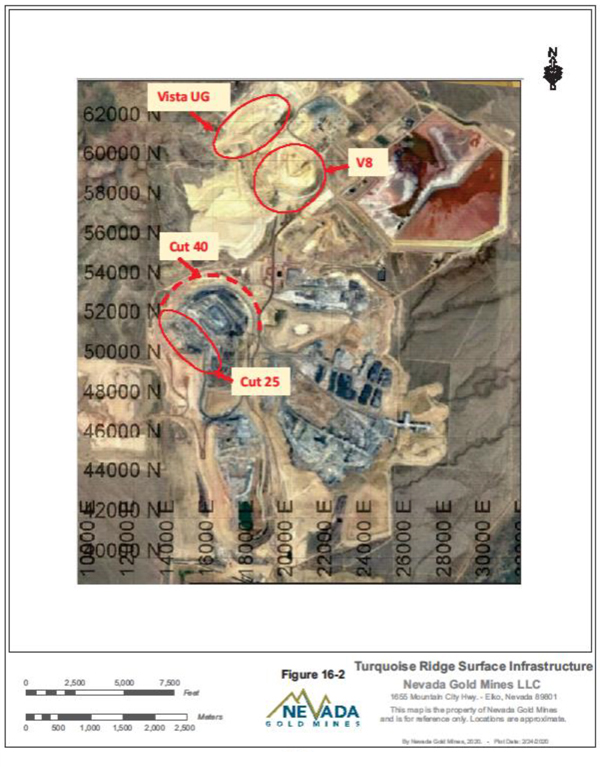
Figure 16-2 Turquoise Ridge Surface Infrastructure
| Nevada Gold Mines LLC – Turquoise Ridge Complex | Page 16-10 | |
Technical Report NI 43-101 – March 25, 2020 | ||
OPEN PIT MINING
Haul roads are designed with a width of 36 m (defined as the distance betweenmid-bench contours) for a Cat 793 haul truck type. The design practice is fortwo-way road widths to be equal to 3.5 times the truck width (7.5 m x 3.5 = 26 m) plus allowance for outside safety berm (4.9 m), plus ditches (3.1 m).
For single lane haul roads, a minimum road width of 24.3 m is used for the bottom benches of the pit. Ramp grades are designed to 10 percent. Rolling resistance is assumed to be two percent on the main haulage roads for cycle time calculations.
The pit design is based on 6.1 m benches in ore and 12.2 m benches in waste. Slopes vary based on location and geotechnical suitability. The final pit design was based on geotechnical and hydrogeological studies completed by site team members, regional experts, and third party consultants.
Table16-2 summarizes the general pit design criteria and Figure16-3 illustrates the ultimate EOY 2019 Mega Pit design and illustrates the ultimate EOY Vista Pit design.
Table 16-2 Open Pit Mine Design Parameters
| Description | Units | |
| Haul Road Width (Double Lane) | 36.5 m | |
| Haul Road Width (Single Lane) | 24.4 m | |
| Haul Road Grade | 10% | |
| Mining Bench Height - Waste | 12.2 m | |
| Mining Bench Height - Ore | 6.1 m | |
| Minimum Operating Width | 36.5 m |
The QPs reviewed the pit designs and believe that they follow good engineering practice. All haul roads are designed at a 10 percent maximum grade. There is sufficient space between phases to allow for operating room, and roads and ramps have been included in the design.
| Nevada Gold Mines LLC – Turquoise Ridge Complex | Page 16-11 | |
Technical Report NI 43-101 – March 25, 2020 | ||
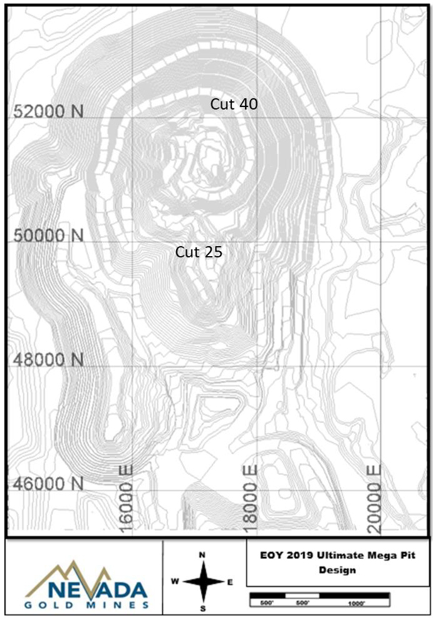
Figure 16-3 End of Year 2019 Ultimate Mega Pit Design
| Nevada Gold Mines LLC – Turquoise Ridge Complex | Page 16-12 | |
Technical Report NI 43-101 – March 25, 2020 | ||
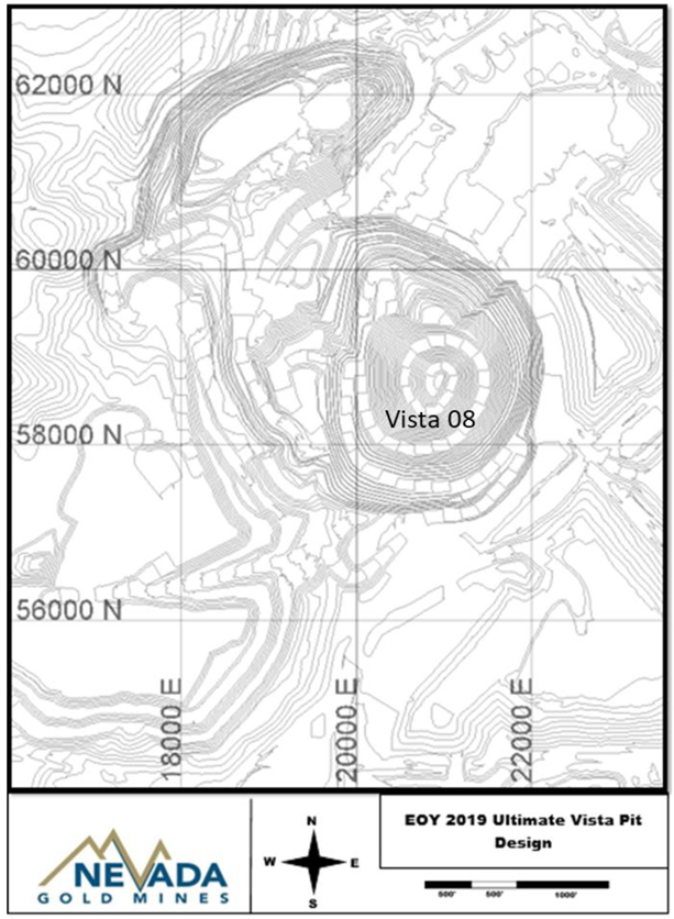
Figure 16-4 End of Year 2019 Ultimate Vista Pit Design
| Nevada Gold Mines LLC – Turquoise Ridge Complex | Page 16-13 | |
Technical Report NI 43-101 – March 25, 2020 | ||
GEOMECHANICS AND HYDROGEOLOGY
All the geotechnical data collected from the adjacent Cuts 22, 23, 24, and 25 pits from 2006 through 2019 have been compiled in the Mega North Pit geotechnical model and this historical information was used for geotechnical slope designs. These designs have been verified with additional drilling, sampling, and testing to help define the final parameters of the ultimate slopes. Additional geotechnical drilling is scheduled for 2020 to continue verification.
MINE INFRASTRUCTURE
WASTE ROCK STORAGE FACILITIES
Mine waste rock and alluvium will continue to be disposed in approved and permitted existing waste rock disposal facility areas.
The currently active mined waste rock disposal facilities have adequate capacity for LOM. New mined waste disposal facilities and backfilling opportunities analysis would decrease surface mine haulage requirements and costs. A new waste disposal facility, located on the northwest side of the Mega Pit, “NW Dump”, has been designed with a capacity of up to 27 million tonnes of waste from the upper most benches of Cut 40. The option of using “NW Dump”, if built, would reduce haulage costs but will require additional costs for site preparation, permitting, and reclamation.
After surface mining is completed in Vista 8, a short flat haul along the “Boulevard” to the mill areas would provide mined waste capacity for the upper benches of Cut 40. The alternative mined waste rock facility is continued to be used with longer uphill haulage and associated costs.
Similarly, when Cut 25 is mined out, a short haul backfill dump will be available for waste from the lower benches of Cut 40. The alternative to this backfill is the existing “Fuel Barge Backfill” into the mined out the Mega South Pit.
MINE INFRASTRUCTURE RELOCATION
In preparation for mining Cut 40, infrastructure within the mining footprint will have to be relocated (Figure16-5). Approximately 1,372 m of power line and 25 power poles would need to be removed and relocated. Approximately 1,800 m of high density polyethylene (HDPE) dewatering pipeline would have to be removed and relocated. Haulage road and access
| Nevada Gold Mines LLC – Turquoise Ridge Complex | Page 16-14 | |
Technical Report NI 43-101 – March 25, 2020 | ||
relocation will be required around the perimeter of the Cut 40 pit. The total length of road to be constructed is 2,438 m.
Equipment and facilities that would need to be removed and relocated include: the truck scales, the radio shop, the environmental storage yard, the powder magazine, and drill and blasting department storage areas and tanks.
Dewatering wells will also be affected. Two new dewatering wells will be required to lower the water table by approximately 50 m. Some dewatering wells will be decommissioned and other dewatering wells will continue to be used by excavating and lowering the well head installations.
The heap leach material from Cut 25 and Vista 8 will fit within the current leach pad configuration. While the majority of Cut 40 is refractory ore, the layback is estimated to provide 2.7 million tonnes of oxide gold heap leach for process in the LOM. A small expansion will be built southwest of the existing Izzenhood (L8) leach pad.
The costs for the infrastructure relocations, leach pad, and replacement equipment has been included in the economic analysis for Cut 40 and is shown in Figure16-5
| Nevada Gold Mines LLC – Turquoise Ridge Complex | Page 16-15 | |
Technical Report NI 43-101 – March 25, 2020 | ||
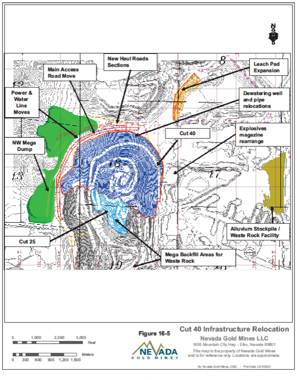
Figure 16-5 Cut 40 Infrastructure Relocation
| Nevada Gold Mines LLC – Turquoise Ridge Complex | Page 16-16 | |
Technical Report NI 43-101 – March 25, 2020 | ||
MINE ENGINEERING
Mine engineering design work in 2019 included no modification to Cut 25 and Vista 8. Cut 40 was included in Mineral Reserves after an extensive design and economic evaluation work to expand the ramp retreat in the 2018 Mineral Reserves to a full phase design in the 2019 Mineral Reserves.
Resource laybacks are important for continuing profitable production at Turquoise Ridge Surface mine as the remaining reserve laybacks are expected to be depleted in 2030, subject to potential mine life extensions. The growth team continues to focus work on the resource laybacks with the goal of extending the mine life at Turquoise Ridge Surface. The laybacks next in line include Deposit 55 (underground and open pit alternatives), and Vista 9.
MINING SUMMARY FOR 2019
Mining in Cut 25 will continue as per the business plan sequence and will continue for the next two years. Infill exploration drilling started in late 2019 and is expected to be completed in early 2020. The results from the infill drilling will be updated into the Mega Pit model to improve confidence. Mining in Cut 40 is expected to start in 2021 but permitting and initial project work is ongoing.
Vista Pit mining in 2019 continued. The mining rates in general for Vista 8 were reduced during the 2020 Budget Plan schedule. This was driven by a combination of dewatering limitations and Optimizer run guidance. Mining in Cut 40 is planned to start in 2021 through 2030. Mining in Mega Pit Cut 25 started in December 2017. Pit design modification done during late 2017, following peer review and external/internal geotechnical recommendations, is allowing the continuation of mining in Cut 25. Previously declared Cut 23 resources have been included in the Cut 55 resource layback.
Significant cost savings and process improvements have been identified and are incorporated in the business plans. The “Fuel Barge” backfill that was established as a short waste haul from Cut 23 continued to be safely operated with a dump face reaching 244 m high in 2018 and early 2019. However, independent review of the dump from consultants recommended dumping procedures be modified. The High Dump is now being operated at less than 244 m and no waste is dumped into the pit lake. Road and ramp improvements were designed by mine engineering to optimize haulage cycles. Long range and reserve work are now done entirely in Vulcan.
| Nevada Gold Mines LLC – Turquoise Ridge Complex | Page 16-17 | |
Technical Report NI 43-101 – March 25, 2020 | ||
ULTIMATE PIT LIMIT ANALYSIS
Optimized pit designs were created for each layback for Mineral Reserve and Mineral Resources. The work incorporated new inputs of model, costs, recoveries, metal pricing, and slopes. Block dollar values were calculated using scripts in Vulcan and Vulcan Pit Optimizer programs were run and are the basis for all the open pit layback designs.
OPEN PIT MINE DESIGN
MEGA PIT
Mega Pit Cut 25
Several LG cones were run for the Mega Pit layback Cut 25 in 2019. The cones were run following model and cost updates for EOY 2019 reserve estimates. The final design used for the 2018 Mineral Reserves was maintained for the EOY 2019 run (Figure16-6).
| Nevada Gold Mines LLC – Turquoise Ridge Complex | Page 16-18 | |
Technical Report NI 43-101 – March 25, 2020 | ||
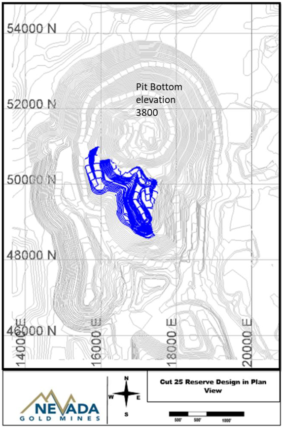
Figure 16-6 Cut 25 Reserve Design in Plan View
| Nevada Gold Mines LLC – Turquoise Ridge Complex | Page 16-19 | |
Technical Report NI 43-101 – March 25, 2020 | ||
Reserve Mega Pit Cut 40
The Cut 40 design includes reasonable stripping but provides “sulphide credit” acting as a good source for blending the unprocessed stockpiles as well as providing waste mined directly to build the tailings storage facilities (Figure16-7). Rigorous economic analysis was done to demonstrate profitability before adding to Mineral Reserves.
| Nevada Gold Mines LLC – Turquoise Ridge Complex | Page 16-20 | |
Technical Report NI 43-101 – March 25, 2020 | ||
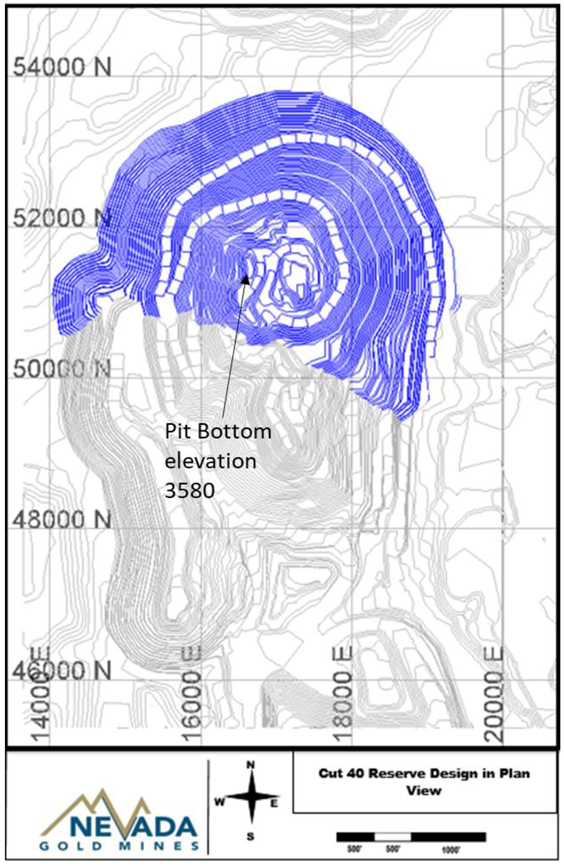
Figure 16-7 Cut 40 Reserve Design in Plan View
| Nevada Gold Mines LLC – Turquoise Ridge Complex | Page 16-21 | |
Technical Report NI 43-101 – March 25, 2020 | ||
Resource Mega Pit Cut 55
Mega Pit Cut 55, the layback in the Mega Pit deposit formerly named Cottontail, lies beneath Mega Pit Cut 23 and the central Mega Pit backfill. The deposit is now namedDeposit-55 because it is being studied as an underground mine as well as an open pit.
LG cones have defined this deposit as a potential open pit which will require excavating over 44 million tonnes of backfilled material included in the waste stripping. The deposit is considered an early resource project with a number of options to study (Figure16-8).
| Nevada Gold Mines LLC – Turquoise Ridge Complex | Page 16-22 | |
Technical Report NI 43-101 – March 25, 2020 | ||
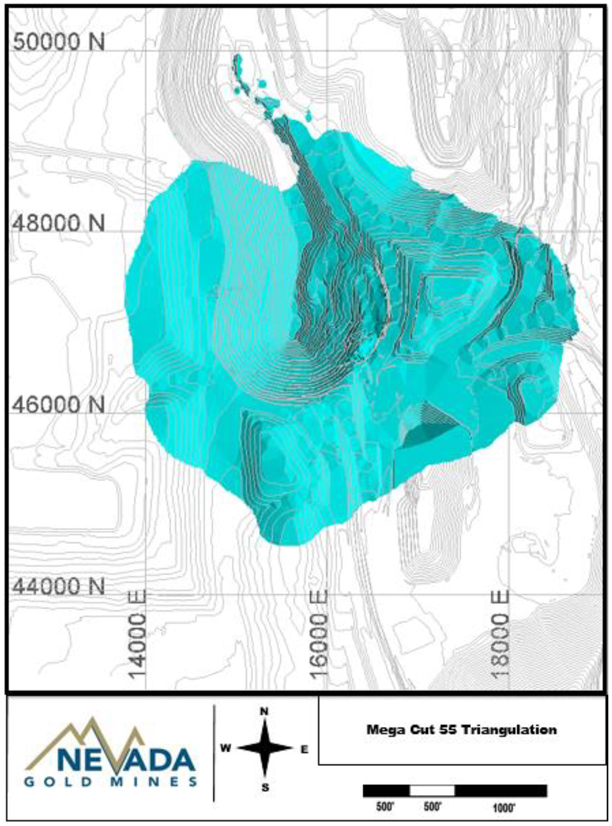
Figure 16-8 Mega Pit Cut 55 Triangulation
| Nevada Gold Mines LLC – Turquoise Ridge Complex | Page 16-23 | |
Technical Report NI 43-101 – March 25, 2020 | ||
VISTA PIT
Vista 8
The current design was originally based on higher gold prices but smaller designs for current gold price LG cones are not feasible. Vista 8 is profitable at the reserve gold price of US$1,200/oz. No new cones were run as all stripping has been done and the walls set as shown in Figure16-9.
| Nevada Gold Mines LLC – Turquoise Ridge Complex | Page 16-24 | |
Technical Report NI 43-101 – March 25, 2020 | ||
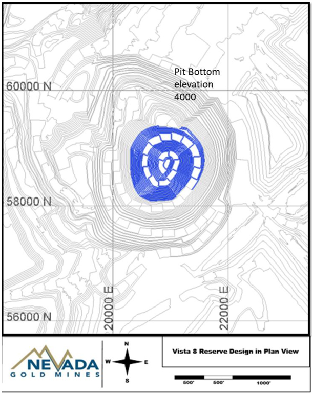
Figure 16-9 Phase 8 Reserve Design in Plan View
| Nevada Gold Mines LLC – Turquoise Ridge Complex | Page 16-25 | |
Technical Report NI 43-101 – March 25, 2020 | ||
Vista 9 Resource
The old Vista Pit was mined out as an oxide deposit, but now has reserve potential as a refractory ore open pit layback. The deposit hosts gold in mainly structurally controlled pods in the Valmy formation. The open pit design, named Vista 9, was named formerly Vista Sulphide Pit above and below the Vista Underground surface infrastructure area (Figure16-10).
With mining in Vista Underground scheduled through the early 2020’s, this deposit has been delayed from active resource development. The overall grade of the deposit is low, but the material geochemistry is favourable to the Sage Mill autoclave because of higher sulphide content and low OC.
| Nevada Gold Mines LLC – Turquoise Ridge Complex | Page 16-26 | |
Technical Report NI 43-101 – March 25, 2020 | ||
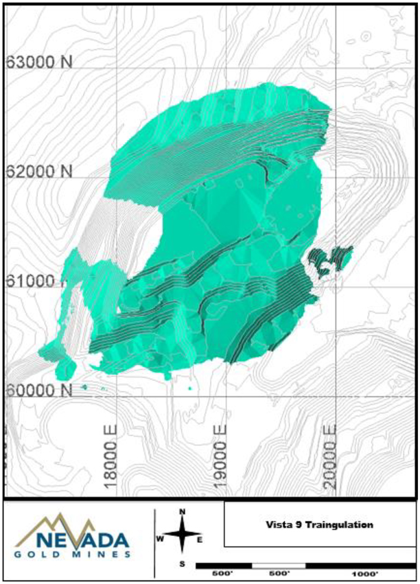
Figure 16-10 Vista 9 Triangulation
| Nevada Gold Mines LLC – Turquoise Ridge Complex | Page 16-27 | |
Technical Report NI 43-101 – March 25, 2020 | ||
MINE EQUIPMENT
The current mine equipment fleet will be used throughout the anticipated mine life to the end of 2030, as well as for stockpile rehandle and reclamation after the surface mining has ended. The current fleet is shown in Table16-3.
The loading fleet includes two Hitachi hydraulic excavators, one 5500 with high operating hours and one 3600, and a new Cat 994 Front End Loader that was delivered in 2018. The P&H 2800 electric shovel has been dismantled and shipped to the Cortez Mine for waste stripping part of the integrated mine planning synergy unlocked by the formation of Nevada Gold Mines.
The haul truck fleet currently consists of 10 Cat 793 haul trucks. An additional truck will be required for the Cut 40 waste stripping, which is expected to be transferred from another site. Haulage requirements were calculated for each mine plan alternative using Vulcan Haulage Profile tools. Truck performance and cycle time input data were entered into the Vulcan “Haulage Truck Library” for the Twin Creeks 793C fleet. Table16-4 lists the open pit equipment productivity from 2019. Capital has been included for equipment replacement in the LOM budget as the fleet equipment is retired.
Blast hole drills include one Atlas Copco DML and two Atlas Copco PV271s. Ancillary equipment includes track and wheeled dozers, graders, water trucks, and stockpile loaders.
| Nevada Gold Mines LLC – Turquoise Ridge Complex | Page 16-28 | |
Technical Report NI 43-101 – March 25, 2020 | ||
Table 16-3 Open Pit Mine Equipment Fleet 2020 Business Plan
| Class | Descriptions | # of Units | ||
Prime Loading Fleet | ||||
Excavator | Hitachi EX5500 (35 Cubic Yard Bucket) | 1 | ||
Excavator | Hitachi EX3600 (27.5 Cubic Yard Bucket) | 1 | ||
Loader | CAT 994 | 2 | ||
Hauling Fleet | ||||
Haul Truck | CAT 793C | 10 | ||
Drilling Fleet | ||||
Drill | PV-271 | 2 | ||
Drill | IRDML | 1 | ||
Support Fleet | ||||
Loader | CAT 992 | 2 | ||
Loader | CAT 988 | 2 | ||
Dozer | CAT D10 | 4 | ||
RT Dozer | CAT 834 | 1 | ||
RT Dozer | CAT 854 | 1 | ||
Grader | CAT 16G | 3 | ||
Grader | CAT 24M | 1 | ||
Water Truck | CAT 785B | 2 | ||
Water Truck | CAT 623F | 1 | ||
Scraper | CAT 637E | 1 | ||
Track Hoe | CAT330C | 1 | ||
Track Hoe | CAT245 | 1 | ||
Table 16-4 Open Pit Equipment Productivity - 2019
| Shovels | No. | Productivity (tonne\hr) | Availability (%) | Utilization (%) | Annual Hours per unit | Annual Tonnes per Fleet (000) | ||||||||||||
EX5500 | SH015 | 2,800 | 86% | 82% | 6,213 | 17,398 | ||||||||||||
EX3600 | SH020 | 1,553 | 91% | 41% | 3,273 | 5,083 | ||||||||||||
Cat 994 | Loader 7 and 245 | 1,376 | 91% | 45% | 7,129 | 9,806 | ||||||||||||
Trucks | CAT 793C | 360 | 91% | 68% | 64,983 | 23,417 | ||||||||||||
It is the QP’s opinion that there are sufficient trucks, loaders, and support equipment in the LOM plan estimate to meet the production requirements.
| Nevada Gold Mines LLC – Turquoise Ridge Complex | Page 16-29 | |
Technical Report NI 43-101 – March 25, 2020 | ||
17. RECOVERY METHODS
| 17.1. | OVERALL PROCESS SUMMARY |
The Sage autoclave processes refractory ore that contains high levels of sulphide minerals, which must be oxidized in an autoclave to liberate the gold so that it can be recovered economically.
Autoclaving uses high temperatures, high pressure, oxygen, and steam to oxidize the sulphide minerals. Once the sulphides have been oxidized, the liberated gold is recovered through cyanidation.
The Juniper Mill processes oxide ores by grinding to liberate the gold in the ore, which is then recovered through cyanidation in a combined process stream with the Sage Mill autoclave discharge.
The existing dump leach facilities consist of a standard lined pad. Material is leached in90- day cycles. Solutions are then routed to a pregnant solution pond and processed through CIC with the resulting barren solution returning to a barren pond and reapplied to the dump leach pad.
An overall process flow sheet is shown in Figure17-1.
| Nevada Gold Mines LLC – Turquoise Ridge Complex | Page 17-1 | |
Technical Report NI 43-101 – March 25, 2020 | ||
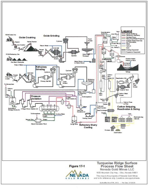
Figure 17-1 Turquoise Ridge Complex Process Flow Sheet
| Nevada Gold Mines LLC – Turquoise Ridge Complex | Page 17-2 | |
Technical Report NI 43-101 – March 25, 2020 | ||
| 17.2. | SAGE MILL PROCESS DESCRIPTION |
The Sage/Juniper capacity is 12,000 tpd, however, actual throughput can vary depending on ore type and constituents.
The mill includes a SAG mill followed by ball milling. The cyclone overflow reports to a thickener. Thickener underflow reports to an acidification circuit where sulphuric acid is added as necessary to ensure adequate autoclave free acid solution levels. The free acid concentration for Turquoise Ridge Complex ore needs to be maintained greater than 30 g/L. Thickener overflow solution is returned to the milling circuit. After acidification, ore slurry is added to two identical autoclaves that are operated in parallel. Two stages of flash heat recovery are utilized. Autoclave discharge is cooled before reporting to the lime neutralization circuit. Autoclave waste gas is cooled and scrubbed before discharging to the atmosphere.
Oxide ore and acidic oxidized sulphide ore slurry are combined in the neutralization circuit. After neutralization with the carbonate oxide ore and supplemental lime, the ore slurry reports to acarbon-in-leach (CIL) circuit where the ore is leached in cyanide solution to extract the gold. Final tailings slurry is pumped to the tailings area. Tailings settle and decant solution is reclaimed and reused in the grinding circuit.
Loaded carbon from the CIL circuit is transferred to the recovery plant. After acid washing to remove inorganic contaminants, the carbon is transferred to the pressure Zadra stripping circuit. Gold is stripped from the carbon using caustic and cyanide solution at elevated temperature and pressure. Pregnant solution from the stripping circuit is pumped to an electrowinning circuit where precious metal is removed from the solution as sludge. The sludge is filtered, dried in a mercury retort, mixed with fluxes, and refined into doré bars.
After carbon stripping, the barren carbon reports to the kiln regeneration circuit and returns to the CIL circuit.
The existing dump leach facilities consists of a standard lined pad. Material is leached in90- day cycles. Solutions are then routed to a pregnant solution pond and processed throughcarbon-in-columns (CIC) with the resulting barren solution returning to a barren pond and reapplied to the dump leach pad.
| Nevada Gold Mines LLC – Turquoise Ridge Complex | Page 17-3 | |
Technical Report NI 43-101 – March 25, 2020 | ||
| 17.3. | JUNIPER MILL DESCRIPTION |
ROM higher grade oxide ore from the Turquoise Ridge Surface sources are blended for Au grade, hardness, and carbonate content and fed to the Juniper Mill. The Juniper mill consists of a variable speed SAG mill operating in closed circuit with a discharge screen. SAG mill product is fed to a ball mill operating in closed circuit with cyclones. 1.5 MW installed power;18 ft x 6.5 ft (6 m x 2 m) 900HP SAG (Variable speed drive), turns both directions, 11.5 ft x16.5 ft (3.8 m x 5.5 m) 1150 HP ball mill. Final product grind size is 90% - 200 mesh. Cyclone overflow product is fed to the neutralization circuit. Here the carbonate in the oxide ore is used to neutralize the acidic autoclave discharge slurry. The combined oxide slurry and autoclave discharge slurry are further neutralized with lime before treatment in the CIL circuit. The CIL circuit is used to concurrently leach gold from the ore and adsorb it onto activated carbon. The final tailings slurry is pumped to the tailings containment dam. The gold loaded carbon is stripped, acid washed, kiln reactivated, and recycled back to the CIL circuit. The gold stripped from the carbon is electrowon and refined into doré for shipment to an offsite refinery.
| 17.4. | LEACH DESCRIPTION |
Run-of-mine (ROM) lower grade oxide ore from the Turquoise Ridge Surface ore sources are delivered to the Juniper heap leach pads. The ore is normally stacked in 6 meter lifts. When a cell is full and ripped, drip irrigation lines are installed to apply barren cyanide solution to the top surface. The cyanide solution is used to leach gold from the ore as the solution percolates through the stacked ore and collected on an impermeable liner at the bottom of the heap. This pregnant solution is fed to a (CIC) circuit to adsorb the gold onto carbon. The CIC barren solution is then recycled back to the top of the leach pad. The gold loaded carbon is stripped, acid washed, kiln reactivated, and recycled back to the CIC circuit. The gold stripped from the carbon is electrowon and refined into doré for shipment to an off site refinery.
| 17.5. | PROCESS RECOVERY ASSUMPTIONS |
Recovery at the Sage autoclave has been empirically modelled successfully using the total OC to gold grade ratio. This model is used in Sage Mill budgeting and forecasting, and routinely predicts recovery within 1% of actuals annually even though short term variances can exist. Results are logged daily and plotted monthly for use in monthly metallurgical accounting and production distribution calculations. Annually, the previous year’s and recent months’ data is inspected and analyzed to determine adjustments to the model necessary for use in forecasting and budgeting. Minor adjustments to the recovery curve have been made over the past few budget cycles for realized recovery improvements.
The model is used for all Turquoise Ridge Surface and Turquoise Ridge Underground, Carlin area, ore sources and concentrates, and all other materials processed at the Sage autoclave. An important advantage of using this model is that it incorporates the effects of ore blending. Ore blending has been known to be highly beneficial to material processed at the Sage autoclave, significantly improving metallurgical results.
For the 2020 LOM Business Plan, the Sage autoclave recovery equation was based on 2018 to June 2019 actuals, as seen in Figure17-2.
| Nevada Gold Mines LLC – Turquoise Ridge Complex | Page 17-4 | |
Technical Report NI 43-101 – March 25, 2020 | ||
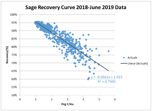
Figure 17-2 Sage Mill Recovery Curve
The Sage recovery equation for forecasting was adjusted in December 2019 to account for changes in operating parameters. To increase throughput, different grinding configurations were tested to improve slurry density, which improves throughput. The recovery impact of coarse and intermediate grind were determined from these plant trials (vs. the traditional fine grind that the recovery curve assumes). For forecasting purposes, an intermediate grind and its associated 4% recovery decrease were selected.
The recovery equation used for the EOY 2019 reserve and resource work was:
Vista Pit Recovery Curve
| ● | Continue using 2014 recovery curve based on head grade & tail grade with 9.5% increase based on 2018-2019 YTD actuals (a 3% increase compared to 19BP) |
| o | % Recovery = ((0.824*(oz/tonAu)-0.0019)/Au) +0.095 |
Mega Pit Oxide
| ● | Use 2011 Mega Pit Oxide recovery curve |
| o | % Recovery = (0.0754*ln((oz/ton Au))+1.0356)-0.04 |
| Nevada Gold Mines LLC – Turquoise Ridge Complex | Page 17-5 | |
Technical Report NI 43-101 – March 25, 2020 | ||
Sage Oxide
| ● | Recovery (based on 2016-2019 YTD Sage Oxide actuals) |
| o | Recovery = ((0.824*(oz/tonAu)-0.0019)/Au)-0.04 |
Sage Autoclaves
| ● | Org/Au Recovery Curve |
| o | New recovery curve based on 2018-2019 YTD organic/Au grade |
| ● | % Recovery =-0.0661*(OC/(oz/ton Au)) +1.022, capped at 96% |
| ● | Availability |
| o | 91% yearly average including PM (Primary Ball Mill) downtime based on 2018 & 2019 YTD data |
| o | 90.5% availability including PM downtime for 20BP plus3-day total autoclave down in July in even years for O2 plant defrost |
| o | 96% yearly average for months without PM based on 2016 & 2017 YTD data |
| o | 96.5% availability for months without PM for 20BP |
In addition to this recovery adjustment for reserves, all high OC Turquoise Ridge Surface material (direct feed and stockpile) was removed from the five year window. Any open pit material with OC greater than 0.6% was removed from 2020 to 2024, taking out all E, K, and O ore types. Historical testing and data show that these high organic open pit ore types need fine grind in order to have acceptable recovery. The preg-robbing nature of E, K, and O materials affects the recovery of all ores blended with them and shifts the recovery to the lower end of the recovery curve. High organic open pit ores have not been tested with intermediate or coarse grind, and the throughput increases due to coarse/intermediate grind do not offset the recovery losses that would likely occur by blending E, K, and O.
| 17.6. | STOCKPILE AND SAMPLING |
Underground ore is transported daily to the Sage autoclave. It is no longer stockpiled at Turquoise Ridge Underground. At the start of every month, the ore stockpile at Sage is surveyed using a drone. Twice daily, the stockpile is sampled to determine the geochemistry, gold content, and moisture content.
Specifically, the samples are assayed for OC and gold since the gold recovery formula is dependent upon the OC and gold content of the ore.
| Nevada Gold Mines LLC – Turquoise Ridge Complex | Page 17-6 | |
Technical Report NI 43-101 – March 25, 2020 | ||
In the QP’s opinion, the current sampling is thorough and appropriate. In comparison to the value of the high-grade material (i.e., approximately 0.5 oz/ton Au) that is processed, the cost of sampling and assaying is not significant.
TONNAGE DETERMINATION
Trucks are loaded by afront-end loader containing a bucket load cell to determine the weight loaded. The Loadritescales with the load scale in the loader is used to determine the weight. Haul trucks are loaded with the loader equipped with Loadritescales, these numbers are then compared to the belt scale numbers. This weight is then compared to the belt scale delivering ore to the stacker belt. Eight percent moisture is then applied as factor for both number. This weight is compared between each other and vary only 1.0 % to 1.5 %.
MOISTURE DETERMINATION
In order to obtain a moisture determination for the calculation of a dry weight, samples are taken as the trucks dump at the ROM stockpile at Turquoise Ridge Surface. The Toll Milling Agreement (TMA) stipulated that the ore is placed in a small pile which is allowed to grow to at least two truckloads. The face of the pile is sampled three times during each shift, generating three five-gallon buckets of sample per shift. The dry tons for each truckload delivered during the shift are calculated from these moisture determinations.
GOLD RECOVERY
The gold recovery is calculated at month end according to the following formula:
% Rec =a × OC/Au +b
where:
aandb are constants determined each month by Turquoise Ridge Surface from operating data,OC is the agreed organic carbon content in weight percent,Au is the agreed gold content in oz/ton Au from the stockpile.
This equation is used to allocate Sage recovery only. A different equation based on only the oxide gold grade is used to allocate Juniper recovery.
Sulphide ore recovery normally ranges from 85 to 90%. The average oxide gold recovery in 2019 was 87.4% while the average sulphide Au recovery was 88.9%. The sulphide recovery is for the entire ore blend.
| Nevada Gold Mines LLC – Turquoise Ridge Complex | Page 17-7 | |
Technical Report NI 43-101 – March 25, 2020 | ||
The 2020 LOM Sage recovery is 85.2% (entire ore blend). The Turquoise Ridge Underground only recovery is 90.2%.
For Juniper oxide recovery allocation, the oxide sources are normally always from the Turquoise Ridge Surface sources. But we do have a few different oxide source piles every month. To allocate recovery to each ore source we simply plot the daily oxide ore gold recovery versus gold grade for the month and use the following linear equation:
% Au recovery = a x Au +b
The individual ore source recoveries are then normalized to the overall monthly recovery.
Typical recovery values for Turquoise Ridge Complex ore are in the 90% to 94% range, although monthly values have been as low as 85%. The weighted average recovery was 92.9% in 2017.
For the 2020 LOM plan, a gold recovery assumption of 92.5% has been used for the Turquoise Ridge Complex. The QP agrees with the use of this value.
| 17.7. | TURQUOISE RIDGE SURFACECUT-OFF GRADE ASSUMPTIONS |
COG calculations followed the Nevada Gold Mines guidelines for incremental COG. The gold prices used were US$1,200/oz for Mineral Reserves and US$1,500/oz for Mineral Resources. The COG calculation is dependent on gold price, operating cost, and recovery (Table17-1). The Sage autoclave recovery is dependent on gold grade and organic CO3 percentage.
| Nevada Gold Mines LLC – Turquoise Ridge Complex | Page 17-8 | |
Technical Report NI 43-101 – March 25, 2020 | ||
Table 17-1 CalculatedCut-Off Grades – Sulphide Mill Ore
Gold Price (US$/oz) | Ore Type | Geochemistry Range | Sage Mill Costs | Average % OC in COG Range | Recovery from Formula (%) | Mega Pit COG (g/t Au) | ||||||||||||
| Stockpile | % SS | % CO3 | % OC | Total Cost ($) | ||||||||||||||
1,200 | A | 4 | < 4 | 4 – 8 | < 0.6 | 29.24 | 0.314 | 55.4 | 1.51 | |||||||||
1,200 | B | 5,7 | > 4 | 4 – 12 | < 0.6 | 29.24 | 0.251 | 61.0 | 1.37 | |||||||||
1,200 | C | 2 | 4 – 6 | < 4 | < 0.6 | 29.24 | 0.320 | 54.9 | 1.54 | |||||||||
1,200 | D | 1 | < 4 | < 4 | < 0.6 | 29.24 | 0.355 | 52.2 | 1.61 | |||||||||
1,200 | E | 10 | any | < 8 | 0.6 – 1.0 | 29.24 | 0.757 | 33.6 | 2.50 | |||||||||
1,200 | F | 8 | any | 12 – 18 | < 0.6 | 29.24 | 0.313 | 55.5 | 1.51 | |||||||||
1,200 | G | 6 | any | 8 – 12 | < 0.6 | 29.24 | 0.319 | 55.0 | 1.54 | |||||||||
1,200 | H | 3 | > 6 | < 4 | < 0.6 | 29.24 | 0.256 | 60.5 | 1.41 | |||||||||
1,200 | I | 9 | any | > 18 | < 0.6 | 29.24 | 0.296 | 56.9 | 1.47 | |||||||||
1,200 | K | 11 | any | > 8 | 0.6 – 1.0 | 29.24 | 0.750 | 33.9 | 2.50 | |||||||||
1,200 | O | 12 | any | any | > 1.0 | 29.24 | 1.188 | 24.3 | 3.46 | |||||||||
1,500 | A | 4 | < 4 | 4 – 8 | < 0.6 | 29.24 | 0.314 | 49.7% | 1.34 | |||||||||
1,500 | B | 5,7 | > 4 | 4 – 12 | < 0.6 | 29.24 | 0.251 | 55.4% | 1.20 | |||||||||
1,500 | C | 2 | 4 – 6 | < 4 | < 0.6 | 29.24 | 0.320 | 49.2% | 1.37 | |||||||||
1,500 | D | 1 | < 4 | < 4 | < 0.6 | 29.24 | 0.355 | 46.5% | 1.44 | |||||||||
1,500 | E | 10 | any | < 8 | 0.6 – 1.0 | 29.24 | 0.757 | 28.8% | 2.33 | |||||||||
1,500 | F | 8 | any | 12 – 18 | < 0.6 | 29.24 | 0.313 | 49.8% | 1.34 | |||||||||
1,500 | G | 6 | any | 8 – 12 | < 0.6 | 29.24 | 0.319 | 49.3 | 1.37 | |||||||||
1,500 | H | 3 | > 6 | < 4 | < 0.6 | 29.24 | 0.256 | 54.9 | 1.23 | |||||||||
1,500 | I | 9 | any | > 18 | < 0.6 | 29.24 | 0.296 | 51.2 | 1.30 | |||||||||
1,500 | K | 11 | any | > 8 | 0.6 – 1.0 | 29.24 | 0.750 | 29.0 | 2.33 | |||||||||
1,500 | O | 12 | any | any | > 1.0 | 29.24 | 1.188 | 20.4 | 3.29 | |||||||||
Notes:
| 1. | When calculating the cutoff grades and total process costs used for the LG’s, base processing cost of24.75-26.59 (shown Table14-19) are increased by $2.65 to $4.50 of additional costs to account for the general and administrative (12.3%), sustaining capital, and reclamation costs. |
The refractory COGs have increased from EOY 2018 reporting due to adjusted estimates of cost, OC content, and the recovery formula.
The resource laybacks in the Mega Pit and Vista Pit vary in OC which affects the Sage autoclave recovery for each material type (Table17-2). Vista 9 has low OC content resulting in higher estimated recovery and lower COGs.
| Nevada Gold Mines LLC – Turquoise Ridge Complex | Page 17-9 | |
Technical Report NI 43-101 – March 25, 2020 | ||
Table 17-2 Sulphide Mill OreCut-Off Grades by Layback
| Type | Mega Pit Cut 25 | Mega Pit Cut 40 | Mega Pit Cut 55 | Vista 9 | ||||||||||||
OC (%) | COG (g/t Au) | OC (%) | COG (g/t Au) | OC (%) | COG (g/t Au) | OC (%) | COG (g/t Au) | |||||||||
A | 0.314 | 1.34 | 0.267 | 1.23 | 0.305 | 1.34 | 0.091 | 0.86 | ||||||||
B | 0.251 | 1.20 | 0.236 | 1.17 | 0.267 | 1.23 | 0.059 | 0.79 | ||||||||
C | 0.32 | 1.37 | 0.298 | 1.30 | 0.262 | 1.23 | 0.075 | 0.82 | ||||||||
D | 0.355 | 1.44 | 0.339 | 1.41 | 0.268 | 1.27 | 0.031 | 0.72 | ||||||||
E | 0.757 | 2.33 | 0.698 | 2.19 | 0.782 | 2.40 | 0.7 | 2.19 | ||||||||
F | 0.313 | 1.34 | 0.285 | 1.30 | 0.306 | 1.34 | 0.046 | 0.75 | ||||||||
G | 0.319 | 1.37 | 0.241 | 1.20 | 0.316 | 1.37 | 0.057 | 0.79 | ||||||||
H | 0.256 | 1.23 | 0.25 | 1.20 | 0.194 | 1.10 | 0.176 | 1.03 | ||||||||
I | 0.296 | 1.30 | 0.28 | 1.27 | 0.334 | 1.41 | 0.033 | 0.72 | ||||||||
K | 0.75 | 2.33 | 0.719 | 2.26 | 0.759 | 2.33 | 0.75 | 2.33 | ||||||||
O | 1.188 | 3.29 | 1.115 | 3.12 | 1.223 | 3.36 | 1.1 | 3.09 | ||||||||
OXIDECUT-OFF GRADES
The oxide ore reserve source is the Vista 8 layback (Table17-2). The leach recovery formula derived by process metallurgists is as follows:
| ● | Leach Recovery % (Vista) = 63% |
| ● | Leach Recovery % (Mega) = 70% |
| ● | Juniper Mill Recovery % (Vista) = (0.824 x (oz/ton Au) - 0.0019) / (oz/ton Au) + 0.095 |
| ● | Juniper Mill Recovery % (Mega) = 0.0754*LN (oz/ton Au)+1.0356-0.04 |
Table 17 - 3 OxideCut-Off Grades
| Mega Pit | Vista Pit | |||||||
Gold Price (US$/oz) | 1,200 | 1,500 | 1,200 | 1,500 | ||||
| COG Range (g/t Au) | COG Range (g/t Au) | |||||||
Waste / Leach | 0.27 | 0.21 | 0.27 | 0.21 | ||||
Leach / Juniper Mill | 1.44 | 1.74 | 0.55 | 0.51 | ||||
Waste / Juniper Mill | NA | NA | 0.38 | 0.34 | ||||
| 17.8. | GOLD PRODUCTION |
Total gold recovered from the Turquoise Ridge Complex for 2019 was 517,792 ounces. A summary of production from the various mine to process streams can be seen below in Table17-4.
| Nevada Gold Mines LLC – Turquoise Ridge Complex | Page 17-10 | |
Technical Report NI 43-101 – March 25, 2020 | ||
Table 17-4 Summary of Turquoise Ridge Complex Processing Production in 2019
| Mine/Processing Facility | Timeframe (2019) | Contained Ounces Mined (oz) | Ounces Recovered (oz) | Recovery (%) | ||||
Turquoise Ridge Underground /Sage Mill Autoclave | Full Year (Jan-Dec) | 446,098 | 405,429 | 91 | ||||
Vista Underground /Sage Mill Autoclave | Post Merger (July-Dec) | 7,443 | 7,156 | 96 | ||||
Turquoise Ridge Surface /Sage Mill Autoclave | Post Merger(July-Dec) | 102,662 | 81,597 | 79 | ||||
Turquoise Ridge Surface /Juniper Mill Oxide Circuit | Post Merger(July-Dec) | 15,301 | 13,268 | 87 | ||||
Turquoise Ridge Surface /Heap Leach | Post Merger(July-Dec) | 12,219 | 10,343 | 85 | ||||
Turquoise Ridge Complex | Varies | 583,723 | 517,792 | 89 |
| 17.9. | CONCLUSIONS |
The Sage and Juniper Mills are existing processing plants and are well suited to process Cut 40 ores. No modifications to the existing flow sheets will be necessary to process Cut 40 ores. A leach pad expansion engineered design will be completed in 2020 by an outside consultant.
| Nevada Gold Mines LLC – Turquoise Ridge Complex | Page 17-11 | |
Technical Report NI 43-101 – March 25, 2020 | ||
18. PROJECT INFRASTRUCTURE
Project Infrastructure consists of existing facilities and a major project to sink a third production shaft.
| 18.1. | INFRASTRUCTURE AND SERVICES |
TURQUOISE RIDGE UNDERGROUND INFRASTRUCTURE AND SERVICES
Existing infrastructure comprises:
| ● | Two shafts (7.3 m and 6.1 m diameters) |
| ● | Mobile equipment mining fleet |
| ● | Limestone backfill quarry and backfill crushing facility |
| ● | Two Underground backfill plant (fed from surface silos) |
| ● | Two Underground shotcrete plants (fed from surface silo) |
| ● | Underground dewatering/pumping infrastructure |
| ● | Surface compressor house |
| ● | Surface cement plant (currently configured for Third Shaft utilization) |
| ● | Multiple surface workshop facilities |
| ● | 120 kV electrical power line connection to the grid |
| ● | Office building |
| ● | Warehouse |
| ● | 3,500 gpm (3.7 L/s) water treatment plant with three sets of Rapid Infiltration Basins (RIBS) |
| ● | Tailings facility |
| ● | Surface Water Treatment Plant |
Turquoise Ridge Underground is currently constructing a third shaft and is expected to install additional administration/dry facilities to support the upcoming expansion.
TURQUOISE RIDGE SURFACE INFRASTRUCTURE AND SERVICES
Existing infrastructure comprises:
| ● | Two open pits |
| ● | Three active waste dumps |
| ● | One in pit backfill waste dump |
| Nevada Gold Mines LLC – Turquoise Ridge Complex | Page 18-1 | |
Technical Report NI 43-101 – March 25, 2020 | ||
| ● | Two active tailings facilities |
| ● | Numerous stockpiles of oxide and refractory ore, separated by chemistry and grade |
| ● | One oxide mill (Juniper) |
| ● | One refractory mill (Sage) with two autoclaves |
| ● | One active leach pad (Izzenhood) |
| ● | Refinery |
| ● | Assay lab |
| ● | Several administration buildings with locker rooms |
| ● | Dewatering and utility shop |
| ● | South maintenance shop area |
| ● | Two warehouses (north and south) |
| ● | Mine rescue building |
| ● | Dewatering, piezometer, and potable water wells |
| ● | Extensive dewatering and potable water pipelines |
| ● | Electrical power throughout mine site |
| ● | Fiber optic lines and network communication |
| ● | Mine radio network |
| ● | Caterpillar Minestar dispatch system |
| ● | Powder magazine area |
| ● | Extensive haulage and access roads for heavy and light equipment |
| ● | Two fuel islands (service heavy and light equipment separately) |
| ● | Guard shack |
| ● | Inactive mill and tailings facility (Pinon) |
| ● | Inactive leach pad (Osgood) |
| ● | Inactive crusher structure (Juniper) |
| ● | Several inactive waste dumps |
The addition of the Cut 40 layback to reserves will involve relocation of a section of power, dewatering pipelines, haul road, a waste rock facility, and an expansion of the heap leach pad. Tailings expansions are scheduled through LOM.
| Nevada Gold Mines LLC – Turquoise Ridge Complex | Page 18-2 | |
Technical Report NI 43-101 – March 25, 2020 | ||
VISTA UNDERGROUND INFRASTRUCTURE AND SERVICES
Vista Underground is built on the existing infrastructure of Turquoise Ridge Surface.
Existing infrastructure comprises:
| ● | Surface Mobile Equipment Shop |
| ● | Surface cement silos (Contractor owns and operates backfill plant) |
| ● | Surface Metal Removal Plant |
| ● | Underground dewatering/pumping infrastructure |
| ● | Surface administration buildings |
| ● | Surface dry/changehouse |
| 18.2. | POWER SUPPLY |
The Turquoise Ridge Underground power requirements are purchased outside the local provider system under open access provisions whereby power is purchased on the open market or from the Western 102 plant (which is owned and operated by Nevada Gold Mines). In October 2005, Barrick started up the Western 102 power plant which is located approximately 15 mi east of Reno, Nevada. It has the capacity to supply 115 MW of electricity using 14 reciprocating naturalgas-fired engines, and also has a 1 MW solar plant. Western 102 provides the Turquoise Ridge Underground with the flexibility to generate its own power or buy cheaper power from other producers, with the goals of minimizing the cost of power consumed and enhancing the reliability of electricity availability. Power requirements for Turquoise Ridge Underground in 2019 were 83,751,579 kWh.
Power requirements for Turquoise Ridge Surface, Vista Underground, and the process facilities located at the Turquoise Ridge Surface property in addition to the supporting infrastructure, are satisfied by both the TS coal power plant built by Newmont (placed into operation in 2008) and grid power from NV Energy. Power requirements in 2019 at Turquoise Ridge Surface were 481,119,167 kWh.
| 18.3. | HAUL ROAD WIDENING PROJECT |
There is a connector road between the Turquoise Ridge Underground and Turquoise Ridge Surface locations that a contractor used to haul ore from Turquoise Ridge Underground to the Sage autoclave. This road and contract had been in place for several years. With the beginning
| Nevada Gold Mines LLC – Turquoise Ridge Complex | Page 18-3 | |
Technical Report NI 43-101 – March 25, 2020 | ||
of Nevada Gold Mines on July 1, 2019, permitting and design work commenced to widen out the connector road. This would allow larger mining equipment to travel between the two properties. Permitting, utility relocation, fencing and road widening was completed in January 2020.
One of the synergies of Nevada Gold Mines is the ability to move equipment and personnel between properties to ensure optimum efficiency and to maximize cost savings. There were several CAT 785 trucks that were no longer being used at other Nevada Gold Mines’ properties; these trucks were moved to Turquoise Ridge Underground. Nevada Gold Mines now self-performs the ore haulage rehandle from Turquoise Ridge Underground to the Sage autoclave. In addition, Turquoise Ridge Surface also hauls backfill for Vista Underground from the quarry pit at Turquoise Ridge Underground to optimize economics under the mine plan.
| Nevada Gold Mines LLC – Turquoise Ridge Complex | Page 18-4 | |
Technical Report NI 43-101 – March 25, 2020 | ||
19. MARKET STUDIES AND CONTRACTS
Gold is the principal commodity extracted at the Turquoise Ridge Complex and is freely traded, at prices that are widely known, so that prospects for sale of any production are virtually assured. Prices are usually quoted in US dollars per troy ounce.
| Nevada Gold Mines LLC – Turquoise Ridge Complex | Page 19-1 | |
Technical Report NI 43-101 – March 25, 2020 | ||
20. ENVIRONMENTAL STUDIES, PERMITTING, AND SOCIAL OR COMMUNITY IMPACT
| 20.1. | ENVIRONMENTAL STUDIES |
Over the years, many environmental studies have been completed, as required, which were sufficient for the granting of various permits required for operations. Total permitted surface disturbance for the Turquoise Ridge Complex is approimately10,327 ha (103.27 km2), of which Turquoise Ridge Underground covers a total area of 2,402 ha (24.02 km2) and Turquoise Ridge Surface covers a total area of 7,925 ha (79.25 km2), respectively, with Vista Underground being located below the Turquoise Ridge Surface footprint.
| 20.2. | ENVIRONMENTAL MANAGEMENT SYSTEM |
Nevada Gold Mines has an integrated environmental management system (EMS) that controls health and safety, and environmental risks. The EMSs are updated on an annual basis and audited every three years.
Routine environmental monitoring takes place across the Turquoise Ridge Complex, including dust deposition, noise, arsenic, tailings facility seepage water, as well as sample collection of drinking water, ground water, surface water, and monitoring well water.
Environmental incidents are noted in a register which forms part of the EMS. Causes and responses are identified, and once completed, the incident is closed out. There were no reported major incidents in 2019.
The site operates with a Solid and Hazardous Waste Management Plan that was revised in June of 2019; a Tailings Storage Facility Operation, Maintenance and Surveillance Manual (July 2014 and updated yearly by the Engineer of Record); and a Sampling and Analysis Plan for Water Pollution Control Permit (updated 2019).
| 20.3. | PLAN OF OPERATION |
Environmental and social criteria developed over years of operating within the Turquoise Ridge Surface Plan of Operation (PoO) and existing permits/plans includes criteria for:
| ● | Water quality |
| ● | Air quality |
| ● | Hydrocarbons management |
| ● | Waste management |
| Nevada Gold Mines LLC – Turquoise Ridge Complex | Page 20-1 | |
Technical Report NI 43-101 – March 25, 2020 | ||
| ● | Wildlife |
| ● | Cultural Resources |
| 20.4. | ENVIRONMENTAL TARGETS AND STRATEGIES |
Nevada Gold Mines’ significant environmental aspects are incorporated into the social and environmental responsibility (S&ER) planning goals and targets. Risks are managed through a Plan, Do, Check, Act process that is reviewed quarterly. Strategies include Root Cause Analysis reviews, quarterly risk based inspections, Corrective Action Effectiveness reviews, as well as internal and external audits and inspections.
Measures for adherence and maintenance of conformance to ISO 14001, the International Cyanide Management Code and DOW Jones Sustainability Index currently in place and in compliance at Turquoise Ridge Surface will remain in place for the duration and closure of the project. Turquoise Ridge Surface has maintained compliance with the International Cyanide Management Code since 1997 and with ISO 14001 since December 2010.
| 20.5. | PERMITS |
Nevada Gold Mines maintains a number of permits for the operation. These compliance permits cover areas such as air quality, water rights, wastewater treatment, tailings storage, hazardous materials storage, land reclamation, and community relations. Nevada Gold Mines maintains a legal obligation register to track permitting and ensureon-going compliance. Nevada Gold Mines environmental staff carry out sampling, monitoring, and record keeping and are involved in permit applications and renewals as required. As of the end of December 2019, all material permits were in compliance or were in the process of renewal.
Turquoise Ridge Underground operates under the following permits:
| ● | Plan of Operation(NVN-064093). |
| ● | Water Pollution Control Permits (WPCP) (NEV96009, NEV86014, NEV95113). |
| ● | Reclamation Permit 0105 and 0148. |
Turquoise Ridge Surface and Vista Underground operates under the following permits:
| ● | Plan of Operation(NVN-064094). |
| ● | WPCP(NEV-89035 &NEV-86018). |
| Nevada Gold Mines LLC – Turquoise Ridge Complex | Page 20-2 | |
Technical Report NI 43-101 – March 25, 2020 | ||
| ● | Reclamation Permit 0058. |
Turquoise Ridge Surface operations follow the same permitting, compliance, and audit schedule as the other surface mining operations of Nevada Gold Mines. The Turquoise Ridge Complex is operating in compliance in all material respects with all applicable regulations and permit requirements as required by the BLM and the Nevada Department of Environmental Protection (NDEP). Environmental Management Plans existing at the Turquoise Ridge Complex will continue to be complied for the duration and closure of the operation.
There are no major challenges with respect to government relations,non-governmental organizations, social or legal issues, and community development. A community and social relations policy is in place at the Turquoise Ridge Complex that is consistent with Barrick core values and governance.
| 20.6. | PERMITTING PROCESS AND SCHEDULE FOR TURQUOISE RIDGE SURFACE |
The changes to the Mega Pit final wall location and exposed geologic formations will require that the Pit Lake Water Quality model be revised to reflect those changes. This requires geochemical studies, which are currently underway. These studies include humidity cell testing, which may require leaching for 52 weeks or longer to generate complete data. This information is then used as model inputs to the Mega Pit Lake Water Quality model. Pit Lake modelling may be required for both the Mega and Vista Pits since water will migrate from Vista Pit to Mega Pit.
It is not expected that Cut 40 would require an amendment of the current air quality permit, as the mining would not add any emission sources to the existing facility. The project would address Energy and Climate Change as this would primarily extend the mining and processing life of Turquoise Ridge Surface.
Cut 40 will not require additional equipment, generators, or power supply. There will not be a change in carbon footprint of greater than 2,700 tonnes per year. No cost of carbon assessment is required.
| Nevada Gold Mines LLC – Turquoise Ridge Complex | Page 20-3 | |
Technical Report NI 43-101 – March 25, 2020 | ||
The stormwater plan will be updated and submitted for review to cover the Cut 40 changes. Existing facilities, permits and plans are available for waste rock storage, ore processing (mill, heap leach and tailings), waste management (hazardous andnon-hazardous), and water management.
The addition of Cut 40 will require modification of the permits, a revised reclamation cost estimate, and approval from the BLM and NDEP. Cut 40 will need to be evaluated by the Federal Land Management agency, the BLM under the National Environmental Policy Act (NEPA). No permit modifications have been submitted at the time of this Technical Report.
The proposed Cut 40 layback, waste dump, and leach pad expansion may be evaluated as an Environmental Assessment (EA) but could be determined by the agency to require evaluation as an Environmental Impact Statement (EIS) if there is potential to generate significant impacts – alternatively, the BLM could declare that impacts have been addressed previously and deliver a decision of Determination of NEPA Adequacy. Cut 40 does not require surface disturbance outside of the existing PoO Boundary. The area anticipated to be directly impacted by the Cut 40 pit shape is currently disturbed or approved for disturbance by the regulatory agencies.
The NDEP, Bureau of Mining Regulation and Reclamation would evaluate the project under the existing WPCP. The changes associated with the Cut 40 project will likely be assessed as a Major Modification to the Turquoise Ridge Surface WPCP.
| 20.7. | PROJECT CLOSURE AND RECLAMATION |
Closure and reclamation strategies and methods for the project will remain in accordance with the existing, approved Turquoise Ridge Surface and Vista Underground Closure and Reclamation Plan.
Closure and reclamation cost estimations will be included in the Turquoise Ridge Surface Reclamation Cost Estimate (RCE) update. This will include the leach pad expansion, the new waste rock facility, additional waste placed in the dumps, changes to pit backfill surfaces, the expanded pit footprint, and any new road construction or relocation of support facilities.
| Nevada Gold Mines LLC – Turquoise Ridge Complex | Page 20-4 | |
Technical Report NI 43-101 – March 25, 2020 | ||
Ongoing and active reclamation include the Turquoise Ridge Underground mine facilities; water treatment plant and infiltration system; potable water system; wastewater treatment system; tailings impoundment; and access and haul roads. These components will be reclaimed and closed at the end of the mine life. Reclamation of the historic Getchell processing facilities and legacy areas has essentially been completed.
Concurrent reclamation at the surface operations include sloping and regrading of waste rock facilities. Seeding of the waste dump for future plant growth and for erosion control is ongoing. Leach pads are rinsed once the gold has been recovered from the facility. A LOM reclamation schedule and cost estimate is updated annually.
The Turquoise Ridge Complex closure costs are updated each year, with increases or decreases in disturbed areas noted and costed; the current cost for rehabilitation and closure of the mine according to the calculation model is approximately $88 million for the entire site.
Turquoise Ridge Complex is a significant employer to members of the local communities. Stakeholder engagement activities, community development projects and local economic development initiatives contribute to the maintenance and strengthening of Nevada Gold Mines’ Social License to Operate (SLTO).
The QPs consider the extent of all environmental liabilities to which the property is subject to have been appropriately met.
| Nevada Gold Mines LLC – Turquoise Ridge Complex | Page 20-5 | |
Technical Report NI 43-101 – March 25, 2020 | ||
21. CAPITAL AND OPERATING COSTS
Capital and operating costs for the Turquoise Ridge Complex are based on extensive experience gained in the many years of operating at these mines. Sustaining (replacement) capital costs reflect current price trends. Operating costs are in line with historical averages.
| 21.1. | CAPITAL COST ESTIMATES |
Current LOM capital costs for the Turquoise Ridge Complex are estimated to be $1,047 million (on a 100% basis). Large capital items for the LOM include continued expenditure on the Third Shaft and associated infrastructure, Juniper and Sage Mill Tailings Expansions, Surface Mine Equipment and Replacements, and Process Upgrades and Equipment (Table21-1). These costs are in line with historical costs.
| Nevada Gold Mines LLC – Turquoise Ridge Complex | Page 21-1 | |
Technical Report NI 43-101 – March 25, 2020 | ||
Table 21-1 Turquoise Ridge Complex LOM Capital Cost Estimate
| Year | Sustaining Capital (US$M) | Open Pit Stripping (US$M) | Underground Development (US$M) | Capitalized Exploration (US$M) | Expansion Capital (US$M) | Total Capital (US$M) | ||||||
FY20 | 36 | 1 | 51 | 10 | 39 | 137 | ||||||
FY21 | 52 | 29 | 28 | 8 | 63 | 180 | ||||||
FY22 | 18 | 36 | 11 | 22 | 15 | 102 | ||||||
FY23 | 62 | 17 | 16 | 16 | 3 | 114 | ||||||
FY24 | 45 | 14 | 25 | 7 | - | 91 | ||||||
FY25 | 75 | 19 | 21 | 1 | 2 | 117 | ||||||
FY26 | 46 | 22 | 16 | 1 | 85 | |||||||
FY27 | 35 | - | 12 | 1 | 1 | 49 | ||||||
FY28 | 16 | - | 8 | 1 | - | 26 | ||||||
FY29 | 25 | - | 5 | 1 | - | 31 | ||||||
FY30 | 24 | - | - | 11 | - | 35 | ||||||
FY31 | 22 | - | - | 1 | - | 23 | ||||||
FY32 | 8 | - | 1 | 1 | 1 | 9 | ||||||
FY33 | 10 | - | 5 | - | - | 16 | ||||||
FY34 | 3 | - | 3 | - | - | 6 | ||||||
FY35 | 3 | - | - | - | - | 3 | ||||||
FY36 | 11 | - | - | - | - | 11 | ||||||
FY37 | 7 | - | - | - | - | 7 | ||||||
FY38 | 4 | - | - | - | - | 4 | ||||||
FY39 | 1 | - | - | - | - | 1 | ||||||
Total | 504 | 137 | 201 | 80 | 126 | 1,047 |
Notes:
| 1. | Capitalized stripping and capitalized underground development are also included in mining costs within Table21-2. |
In the opinion of the QP, the projected capital costs at the Turquoise Ridge Complex are reasonable.
| 21.2. | OPERATING COST ESTIMATES |
The total operating cost has been estimated by the Turquoise Ridge Complex based on historical costs and assumptions over the LOM plan (2020 to 2039). The operating costs are considered to be appropriate for the mining and processing methods.
| Nevada Gold Mines LLC – Turquoise Ridge Complex | Page 21-2 | |
Technical Report NI 43-101 – March 25, 2020 | ||
LOM OPERATING COSTS
Table21-2 presents the LOM mining costs per tonne mined (ore and waste) by year from theopen-pit and the underground and Table21-3 presents the processing cost per tonne processed for the LOM by process facility.
Table 21-2 LOM Mining Costs per Tonne Mined
| Year | Open Pit ($/tonne) | Underground ($/tonne) | ||
FY20 | 2.50 | 110.70 | ||
FY21 | 2.24 | 106.44 | ||
FY22 | 2.30 | 99.52 | ||
FY23 | 1.94 | 93.14 | ||
FY24 | 2.45 | 79.07 | ||
FY25 | 2.99 | 79.61 | ||
FY26 | 2.21 | 79.24 | ||
FY27 | 1.97 | 79.30 | ||
FY28 | 2.56 | 77.99 | ||
FY29 | 3.44 | 81.10 | ||
FY30 | 3.98 | 82.05 | ||
FY31 | - | 78.84 | ||
FY32 | - | 80.05 | ||
FY33 | - | 75.99 | ||
FY34 | - | 72.95 | ||
FY35 | - | 71.62 | ||
FY36 | - | 71.58 | ||
FY37 | - | 75.24 | ||
FY38 | - | 80.60 | ||
FY39 | - | 72.26 |
Notes:
| 1. | Mining costs include capitalized stripping and capitalized underground development as outlined in Table21-1. |
Table 21-3 LOM Processing Costs per Tonne Processed by Facility
| Autoclave | Mill | Leach | ||||
$/tonne | 31.32 | 9.43 | 8.40 |
LOM annual operating costs have been prepared by Nevada Gold Mines based upon the LOM plan. The QPs consider the operating cost estimates in the LOM plans to be reasonable and consistent with historical performance
| Nevada Gold Mines LLC – Turquoise Ridge Complex | Page 21-3 | |
Technical Report NI 43-101 – March 25, 2020 | ||
| 21.3. | COMMENTS ON CAPITAL AND OPERATING COSTS |
The QP has reviewed the capital and operating cost provisions for the LOM plan that supports Mineral Reserves and considers that the basis for the estimates that include mine budget data, vendor quotes, and operating experience, is appropriate to the known mineralization, mining and production schedules, marketing plans, and equipment replacement and maintenance requirements.
Appropriate provision has been made in the estimates for the expected mine operating usages including labour, fuel and power and for closure and environmental considerations.
Capital cost estimates include appropriate sustaining estimates.
| Nevada Gold Mines LLC – Turquoise Ridge Complex | Page 21-4 | |
Technical Report NI 43-101 – March 25, 2020 | ||
22. ECONOMIC ANALYSIS
This section is not required as Barrick, the operator of the Turquoise Ridge Complex, is a producing issuer, the properties are currently in production, and there is no material expansion of current production planned.
The QP has confirmed the economic viability of the Mineral Reserves through cash flow analysis.
| Nevada Gold Mines LLC – Turquoise Ridge Complex | Page 22-1 | |
Technical Report NI 43-101 – March 25, 2020 | ||
23. ADJACENT PROPERTIES
This section is not applicable for this Technical Report.
| Nevada Gold Mines LLC – Turquoise Ridge Complex | Page 23-1 | |
Technical Report NI 43-101 – March 25, 2020 | ||
24. OTHER RELEVANT DATA AND INFORMATION
No additional information or explanation is necessary to make this Technical Report understandable and not misleading.
| Nevada Gold Mines LLC – Turquoise Ridge Complex | Page 24-1 | |
Technical Report NI 43-101 – March 25, 2020 | ||
25. INTERPRETATION AND CONCLUSIONS
In the opinion of the QPs there are no significant risks and uncertainties that could reasonably be expected to affect the reliability or confidence in the exploration information, Mineral Resource or Mineral Reserve estimates, or projected economic outcomes in this Technical Report.
| 25.1. | ACCESSIBILITY, CLIMATE, INFRASTRUCTURE, AND PHYSIOGRAPHY |
| ● | The existing and planned infrastructure, availability of staff, existing power, water, and communications facilities, and methods whereby goods can be transported to the mining operations are well-established and well-understood by Nevada Gold Mines given the decades of experience that Barrick and Newmont have from their previous mining operations on the Turquoise Ridge Complex. |
| ● | Within Nevada Gold Mines’ ground holdings, there is sufficient area to allow for the operation of all required project infrastructure, and sufficient room remains if expansions to the existing infrastructure are required. |
| ● | Mining operations can be conducted year-round. |
| 25.2. | GEOLOGY AND MINERAL RESOURCES |
| ● | The understanding of the deposit settings, lithologies, and geologic, structural, and alteration controls on mineralization is sufficient to support estimation of Mineral Resources and Mineral Reserves. |
| ● | The mineralization styles and settings are well understood and can support declaration of Mineral Resources and Mineral Reserves. |
| ● | The geological knowledge of the area is adequate to reliably inform mine planning. |
| ● | The drilling, sampling, and quality assurance/quality control (QA/QC) is appropriate for the style of mineralization. |
| ● | Nevada Gold Mines is of the opinion that the Mineral Resource estimate has been completed to industry standard and is suitable to support the disclosure of Mineral Resources and Mineral Reserves. |
| ● | Nevada Gold Mines is not aware of any environmental, permitting, legal, title, taxation, socio-economic, marketing, political, or other relevant factors which could materially affect the Mineral Resource estimate. |
| ● | Exploration potential remains considerable, and Nevada Gold Mines is pursuing the growth potential both near current operations and between the Turquoise Ridge Complex’s component properties. |
| Nevada Gold Mines LLC – Turquoise Ridge Complex | Page 25-1 | |
Technical Report NI 43-101 – March 25, 2020 | ||
| 25.3. | MINING AND MINERAL RESERVES |
| ● | In the opinion of the QPs, the mining methods used are appropriate to the geological, geotechnical and hydrogeological characteristics of each deposit and employ conventional mining tools and mechanization. The LOM plan has been appropriately developed to maximize mining efficiencies, based on the current knowledge of geotechnical, hydrological, mining and processing information on the Turquoise Ridge Complex. |
| ● | Nevada Gold Mines is of the opinion that the Mineral Reserve estimate has been completed to industry standard and is suitable for disclosure. |
| 25.4. | PROCESSING |
| ● | The processing facilities that comprise the Turquoise Ridge Complex are adequate to meet or exceed the production forecasts from the mineralization contained within the Mineral Reserves and Mineral Resources. The ore blending strategies utilized at the Sage autoclave facility should facilitate a stable operation. |
| ● | The recovery equations that are presented have been well calibrated against actual plant data when possible or based on representative test work for future ore domains. |
| ● | The Turquoise Ridge Complex sampling and metallurgical accounting methods are reasonable and consistent with industry standards. |
| ● | The Sage autoclave and Juniper oxide mill are existing processing plants and are well suited to process Cut 40 ores. No modifications to the existing flow sheets are expected to be necessary to process Cut 40 ores. A leach pad expansion engineered design will be completed in 2020 by an outside consultant |
| Nevada Gold Mines LLC – Turquoise Ridge Complex | Page 25-2 | |
Technical Report NI 43-101 – March 25, 2020 | ||
26. RECOMMENDATIONS
| 26.1. | GEOLOGY AND MINERAL RESOURCES |
| ● | Continue to work with regional exploration to capitalize on opportunities to establish continuity between ore bodies and improve the geologic model. |
| ● | Evaluate methodology for Mineral Resource classification across the various deposits looking for opportunities to improve through sharing techniques and perhaps standardising the approach. |
| ● | Continue to develop understanding of controls on geochemistry elements important for ore processing. Use this understanding to improve estimation of these elements, including domaining, estimation parameters, and validation of results. |
| 26.2. | MINING AND MINERAL RESERVES |
| ● | With Turquoise Ridge Underground production less limited by processing constraints, continue to review potential for higher mine production. |
| ● | Continue to focus on reducing operating costs and optimization of Mineral Reserve and Mineral Resource pit designs at Turquoise Ridge Surface. |
| ● | Continue optimization of mechanical mining methods to increase mine throughput. |
| ● | Continue optimization scenarios at Turquoise Ridge Underground to fully capitalize upon synergies derived from termination of the TMA (reduced COG through milling cost reductions and improved throughput due to the removal of an artificial ore processing limit at the autoclave). |
| ● | Continue Vista Underground optimization through mining efficiency improvements until the end of mine life. |
| 26.3. | PROCESSING |
| ● | Future test work should be conducted at coarser grind sizes for the high grade, Turquoise Ridge Underground ore to better understand the impact on recovery when operating the Sage autoclave at increased throughput. |
| Nevada Gold Mines LLC – Turquoise Ridge Complex | Page 26-1 | |
Technical Report NI 43-101 – March 25, 2020 | ||
27. REFERENCES
Agreement for Administration of Toll Milling Agreement, 2018, January 1, 2018
Amendment to Toll Milling Agreements, 2006, agreement between Placer Turquoise Ridge Inc., Newmont GTR LLC, and Newmont USA Limited, July 21, 2014.
Newmont, 2015, 2015 Sage PR TRJV.xlsx, January 6, 2016.
Newmont, 2016, 2016 Final Sage PR TRJV.xlsx, May 5, 2017.
Newmont, 2016, TR159-101016 Processing Summary Final,
Newmont, 2016, TR159-101016 Processing Summary Final. Xlsx,
Newmont, 2017, SAGE OZ TRJV.xlsx, November 6, 2017.
Newmont, 2017, 2017 SAGE PR TRJV.xlsx, February 2, 2018.
Hazen Research, Inc., 2017, Metallurgical Test Program for Turquoise Ridge and Goldstrike Ores, September 21, 2018.
Hotz, Preston Enslovw, 1963, Geology and Mineral Deposits of the Osgood Mountains Quadrangle, Humboldt County, Nevada, Preston E. Hotz and Ronald Wilden. Washington, U.S. Government Printing Office, 1963.
Non-Conforming Ore Agreement, 2017, agreement between Barrick Turquoise Ridge Inc., as successor to the interests of Placer Turquoise Ridge Inc. (“BTRI”), Newmont GTR LLC, a Nevada limited liability company (“Newmont LLC”), and Newmont USA, May 22, 2017.
Roscoe Postle Associates Inc. 2011, Technical Report on the Turquoise Ridge Joint Venture, Nevada, USA, Prepared for Barrick Gold Corporation, September 2011.
Roscoe Postle Associates Inc. 2014, Technical Report on the Turquoise Ridge Joint Venture, Nevada, USA, Prepared for Barrick Gold Corporation, March 14, 2014.
Roscoe Postle Associates Inc. 2018, Technical Report on the Turquoise Ridge Joint Venture, Nevada, USA, Prepared for Barrick Gold Corporation, March 19, 2018.
Toll Milling Agreement between Newmont LLC (a member of the Turquoise Ridge Joint Venture) and Newmont USA Limited, 2006.
Toll Milling Agreement, 2018, agreement between Barrick Turquoise Ridge and Newmont USA Limited, January 1, 2018.
Toll Milling Agreement, 2018, agreement between Newmont GTR LLC and Newmont USA Ltd., January 1, 2018.
TRJV, Monthly QA/QC Reports, 2016 and 2017.
| Nevada Gold Mines LLC – Turquoise Ridge Complex | Page 27-1 | |
Technical Report NI 43-101 – March 25, 2020 | ||
TRJV, Quarterly Independent Laboratory Reports, 2016 and 2017.
TRJV, TR Geology, Minex Drill Programs, and Mineral Resources & Reserves, Power Point presentation by TRJV staff, December 12, 2016.
TRJV, General Introduction Geology, Mining, Processing, Two Part Power Point presentation by TRJV staff, December 12, 2016.
TRJV, 2016,159-101016 Processing Summary Final.xlsx, October 10, 2016
TRJV, 2016,160-110716 Processing Summary Final.xlsx, November 7, 2016
TRJV, 2016,161-120816 Processing Summary Final.xlsx, December 9, 2016
TRJV, 2017,162-010917 Processing Summary Final.xlsx, January 9, 2017
TRJV, 2017,163-021317 Processing Summary Final.xlsx, February 13, 2017
TRJV, 2017,165-Aug Processing Summary Final.xlsx, 2017
TRJV, 2017,165-June Processing Summary Final.xlsx, 2017
TRJV, 2017,166-052217 Processing Summary Final.xlsx, May 22, 2017
TRJV, 2017,167-062117 Processing Summary Final.xlsx, June 21, 2017
TRJV, 2017,170-091417 Processing Summary Final.xlsx, September 14, 2017
TRJV, 2017, Reconcile check off.xlsx, 2017
TRJV, 2017Year-EndCut-Off Grade Report, January 2018
TRJV, 2018 Tier 1 Plan Print.xlsx, February 15, 2018
| Nevada Gold Mines LLC – Turquoise Ridge Complex | Page 27-2 | |
Technical Report NI 43-101 – March 25, 2020 | ||
28. DATE AND SIGNATURE PAGE
This Technical Report titled “Technical Report on the Turquoise Ridge Complex, State of Nevada, USA” dated March 25, 2020, with an effective date of December 31, 2019, was prepared and signed by the following authors:
| (Signed and Sealed)Charles Lynn Bolin | ||
Dated at Elko, NV | ||
March 25, 2020 | Charles Lynn Bolin, MBA, SME (RM) | |
Chief Surface Engineer | ||
| (Signed and Sealed)Craig Fiddes | ||
Dated at Elko, NV | ||
March 25, 2020 | Craig Fiddes, SME (RM) | |
Manager – Resource Modelling | ||
| (Signed and Sealed)Jay Olcott | ||
Dated at Elko, NV | ||
March 25, 2020 | Jay Olcott, SME (RM) | |
Project Manager | ||
| (Signed and Sealed)Steve W. Yopps | ||
Dated at Elko, NV | ||
March 25, 2020 | Steve W. Yopps, MMSA (QP) | |
Manager - Growth Projects | ||
| Nevada Gold Mines LLC – Turquoise Ridge Complex | Page 28-1 | |
Technical Report NI 43-101 – March 24, 2020 | ||
29. CERTIFICATE OF QUALIFIED PERSON
CHARLES LYNN BOLIN
I, Charles Lynn Bolin, MBA, SME (RM), as an author of this report entitled “Technical Report on the Turquoise Ridge Complex, State of Nevada, USA” prepared for Barrick Gold Corporation and Newmont Corporation by Nevada Gold Mines LLC and dated March 25, 2020 with an effective date of December 31, 2019, do hereby certify that:
| 1. | I am Chief Surface Engineer at Nevada Gold Mines LLC, the operator of the Turquoise Ridge Complex. |
| 2. | I am a graduate of New Mexico Institute of Mining and Technology in 1985 with a Bachelor of Science in Mine Engineering. |
| 3. | I am registered as a SME Registered Member #4049169RM. I have worked as a mining engineer for a total of 26 years since my graduation. My relevant experience for the purpose of the Technical Report is: |
| ● | Twenty six years open pit mine engineering experience |
| ● | Chief Engineer/Technical Services Manager from 2010 at Ahafo and Akyem in Ghana, and Long Canyon and Carlin in Nevada |
| 4. | I have read the definition of “qualified person” set out in National Instrument43-101 (NI43-101) and certify that by reason of my education, affiliation with a professional association (as defined in NI43-101) and past relevant work experience, I fulfill the requirements to be a “qualified person” for the purposes of NI43-101. |
| 5. | I work at Nevada Gold Mines LLC, the operator of the Turquoise Ridge Complex. |
| 6. | I share responsibility with myco-author Craig Fiddes for Sections 14 to16 and Sections 18, 21 and 22 and related disclosure in Sections 1, 24, 25, 26, and 27 of the Technical Report. |
| 7. | I am not independent of the Issuer applying the test set out in Section 1.5 of NI43-101. |
| 8. | I have had prior involvement with the property that is the subject of the Technical Report. I first visited what became the Twin Creeks Mine as an employee of Gold Fields in 1989. I have visited the mine on several occasions from 2005 to 2018 as an employee of Newmont Mining Corporation. I visited the Turquoise Ridge Complex in 2020. |
| 9. | I have read NI43-101, and the Technical Report has been prepared in compliance with NI43-101 and Form43-101F1. |
| Nevada Gold Mines LLC – Turquoise Ridge Complex | Page 29-1 | |
Technical Report NI 43-101 – March 24, 2020 | ||
| 10. | At the effective date of the Technical Report, to the best of my knowledge, information, and belief, the Technical Report contains all scientific and technical information that is required to be disclosed to make the Technical Report not misleading. |
Dated 25th day of March, 2020
(Signed and Sealed)Charles Lynn Bolin
Charles Lynn Bolin, MBA, SME (RM)
| Nevada Gold Mines LLC – Turquoise Ridge Complex | Page 29-2 | |
Technical Report NI 43-101 – March 25, 2020 | ||
CRAIG FIDDES
I, Craig Fiddes, SME (RM), as an author of this report entitled “Technical Report on the Turquoise Ridge Complex, State of Nevada, USA” prepared for Barrick Gold Corporation and Newmont Corporation by Nevada Gold Mines LLC and dated March 25, 2020 with an effective date of December 31, 2019 do hereby certify that:
| 1. | I am Manager - Resource Modelling at Nevada Gold Mines LLC, the operator of the Turquoise Ridge Complex. |
| 2. | I am a graduate of University of Otago, New Zealand in 1998 with a BSc (Hons) Geology. |
| 3. | I am registered as a SME Registered Member #04197758. I have worked as a geologist and resource modeler for over 20 years since my graduation. My relevant experience for the purpose of the Technical Report is: Over 20 years experience in mine geology and resource modeling. |
| 4. | I have read the definition of “qualified person” set out in National Instrument43-101 (NI43-101) and certify that by reason of my education, affiliation with a professional association (as defined in NI43-101) and past relevant work experience, I fulfill the requirements to be a “qualified person” for the purposes of NI43-101. |
| 5. | I work at Nevada Gold Mines LLC, the operator of the Turquoise Ridge Complex. |
| 6. | I am share responsibility with myco-author Charles Lynn Bolin for Sections 14 to 16 and Sections 18, 21 and 22 and related disclosure in Sections 1, 24, 25, 26, and 27 of the Technical Report. |
| 7. | I am not independent of the Issuer applying the test set out in Section 1.5 of NI43-101. |
| 8. | I have had prior involvement with the property that is the subject of the Technical Report. |
| 9. | I have read NI43-101, and the Technical Report has been prepared in compliance with NI43-101 and Form43-101F1. |
| 10. | At the effective date of the Technical Report, to the best of my knowledge, information, and belief, the Technical Report contains all scientific and technical information that is required to be disclosed to make the Technical Report not misleading. |
Dated 25th day of March, 2020
(Signed and Sealed)Craig Fiddes
Craig Fiddes, SME (RM)
| Nevada Gold Mines LLC – Turquoise Ridge Complex | Page 29-3 | |
Technical Report NI 43-101 – March 24, 2020 | ||
JAY OLCOTT
I, Jay Olcott, SME (RM), as an author of this report entitled “Technical Report on the Turquoise Ridge Complex, State of Nevada, USA” prepared for Barrick Gold Corporation and Newmont Corporation by Nevada Gold Mines LLC and dated March 25, 2020 with an effective date of December 31, 2019, do hereby certify that:
| 1. | I am Project Manager at Nevada Gold Mines LLC, the operator of the Turquoise Ridge Complex. |
| 2. | I am a graduate of Brigham Young University in 2001 with a BSc Geology. |
| 3. | I am registered as a SME Registered Member #04173430. I have worked as a geologist for over 18 years since my graduation. My relevant experience for the purpose of the Technical Report is: Preparation of technical report on several of Newmont’s underground mines. |
| 4. | I have read the definition of “qualified person” set out in National Instrument43-101 (NI43-101) and certify that by reason of my education, affiliation with a professional association (as defined in NI43-101) and past relevant work experience, I fulfill the requirements to be a “qualified person” for the purposes of NI43-101. |
| 5. | I work at Nevada Gold Mines LLC, the operator of the Turquoise Ridge Complex. |
| 6. | I am responsible for Sections 5, 7 to 12, 19, 20, and 23 of the Technical Report and related disclosure in Sections 1, 24, 25, 26, and 27 of the Technical Report. |
| 7. | I am not independent of the Issuer applying the test set out in Section 1.5 of NI43-101. |
| 8. | I have had prior involvement with the property that is the subject of the Technical Report. |
| 9. | I have read NI43-101, and the Technical Report has been prepared in compliance with NI43-101 and Form43-101F1. |
| 10. | At the effective date of the Technical Report, to the best of my knowledge, information, and belief, the Technical Report contains all scientific and technical information that is required to be disclosed to make the Technical Report not misleading. |
Dated 25th day of March, 2020
(Signed and Sealed)Jay Olcott
Jay Olcott, SME (RM)
| Nevada Gold Mines LLC – Turquoise Ridge Complex | Page 29-4 | |
Technical Report NI 43-101 – March 24, 2020 | ||
STEVE W. YOPPS
I, Steve W. Yopps, MMSA (QP), as an author of this report entitled “Technical Report on the Turquoise Ridge Complex, State of Nevada, USA” prepared for Barrick Gold Corporation and Newmont Corporation by Nevada Gold Mines LLC and dated March 25, 2020 with an effective date of December 31, 2019 do hereby certify that:
| 1. | I am Manager of Growth Projects at Nevada Gold Mines LLC, the operator of the Turquoise Ridge Complex. |
| 2. | I am a graduate of Colorado School of Mines in 1984 with B. Sc. Metallurgical and Engineering and Colorado School of Mines in 1986 with M. Sc. Metallurgical and Engineering |
| 3. | I am registered as a Qualified Professional with Mining and Metallurgical Society of America. I have worked as a metallurgical engineer for over 25 years since my graduation. My relevant experience for the purpose of the Technical Report is: |
| ● | Goldstrike - Autoclave Superintendent through Process Manager 1996 – 2005 |
| ● | TRJV – Member of JVs Processing Technical Committee 2015 - 2017 |
| ● | Barrick Nevada – Cortez Roaster Project Study Manager - 2018 |
| 4. | I have read the definition of “qualified person” set out in National Instrument43-101 (NI43-101) and certify that by reason of my education, affiliation with a professional association (as defined in NI43-101) and past relevant work experience, I fulfill the requirements to be a “qualified person” for the purposes of NI43-101. |
| 5. | I work at Nevada Gold Mines LLC, the operator of the Turquoise Ridge Complex. |
| 6. | I am responsible for Sections 13 and 17 of the Technical Report and related disclosure in Sections 1, 24, 25, 26, and 27 of the Technical Report. |
| 7. | I am not independent of the Issuer applying the test set out in Section 1.5 of NI43-101. |
| 8. | I have had prior involvement with the property that is the subject of the Technical Report. |
| 9. | I have read NI43-101, and the Technical Report has been prepared in compliance with NI43-101 and Form43-101F1. |
| 10. | At the effective date of the Technical Report, to the best of my knowledge, information, and belief, the Technical Report contains all scientific and technical information that is required to be disclosed to make the Technical Report not misleading. |
Dated 25th day of March, 2020
(Signed and Sealed)Steve W. Yopps
Steve W. Yopps, MMSA (QP)
| Nevada Gold Mines LLC – Turquoise Ridge Complex | Page 29-5 | |
Technical Report NI 43-101 – March 24, 2020 | ||