Exhibit 99.1
| | | | | | |
| | Updated Independent Technical Report for the Maniitsoq Nickel-Copper-Cobalt-PGM Project, Greenland |
| |
| | Report Prepared for North American Nickel Inc. 
|
| |  |
| | Report Prepared by 
SRK Consulting (Canada) Inc. 3CN024.004 March 17, 2017 | | 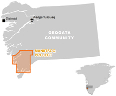
|
| | |
3CN024.004 – North American Nickel Inc. | | |
Updated Independent Technical Report for the Maniitsoq Nickel-Copper-Cobalt-PGM Project, Greenland | | Page i |
Updated Independent Technical Report for the ManiitsoqNickel-Copper-Cobalt-PGM Project, Greenland
North American Nickel Inc.
PO Box 63623 Capilano Po
North Vancouver, British Columbia
V7P 3P1
E-mail:info@northamericannickel.com
Website:www.northamericannickel.com
Tel: +1604-986-2020
Fax: +1604-986-2021
SRK Consulting (Canada) Inc.
Suite 1500, 155 University Ave
Toronto, Ontario, Canada
M5H 3B7
E-mail:toronto@srk.com
Website:www.srk.com
Tel: +1 416 601 1445
Fax: +1 416 601 9046
SRK Project Number 3CN024.004
Effective date: March 17, 2017
Signature date: March 17, 2017
Authored by:
| | |
| [“Original signed and sealed”] | | [“Original signed and sealed”] |
Jean-Francois Ravenelle, PhD, PGeo Senior Consultant | | Lars Weiershäuser, PhD, PGeo Associate Consultant |
Peer Reviewed by:
|
[“Original signed and sealed”] Glen Cole, PGeo Principal Consultant |
Cover: View of the North American Nickel exploration camp on Puiattoq Bay.
| | |
3CN024.004 – North American Nickel Inc. | | |
Updated Independent Technical Report for the Maniitsoq Nickel-Copper-Cobalt-PGM Project, Greenland | | Page ii |
IMPORTANT NOTICE
This report was prepared as a National Instrument43-101 Standards of Disclosure for Mineral Projects Technical Report for North American Nickel Inc. (North American Nickel) by SRK Consulting (Canada) Inc. (SRK). The quality of information, conclusions, and estimates contained herein are consistent with the quality of effort involved in SRK’s services. The information, conclusions, and estimates contained herein are based on: i) information available at the time of preparation, ii) data supplied by outside sources, and iii) the assumptions, conditions, and qualifications set forth in this report. This report is intended for use by North American Nickel subject to the terms and conditions of its contract with SRK and relevant securities legislation. The contract permits North American Nickel to file this report as a Technical Report with Canadian securities regulatory authorities pursuant to National Instrument43-101. Except for the purposes legislated under provincial securities law, any other uses of this report by any third party is at that party’s sole risk. The responsibility for this disclosure remains with North American Nickel. The user of this document should ensure that this is the most recent Technical Report for the property as it is not valid if a new Technical Report has been issued.
© 2017 SRK Consulting (Canada) Inc.
This document, as a collective work of content and the coordination, arrangement and any enhancement of said content, is protected by copyright vested in SRK Consulting (Canada) Inc. (SRK).
Outside the purposes legislated under provincial securities laws and stipulated in SRK’s client contract, this document shall not be reproduced in full or in any edited, abridged or otherwise amended form unless expressly agreed in writing by SRK.
| | |
3CN024.004 – North American Nickel Inc. | | |
Updated Independent Technical Report for the Maniitsoq Nickel-Copper-Cobalt-PGM Project, Greenland | | Page iii |
Executive Summary
Introduction
The Maniitsoq project is an advancednickel-copper-cobalt-PGM (platinum group metals) sulphide exploration project located on the southwest coast of Greenland. SRK Consulting (Canada) Inc. (SRK) was commissioned by North American Nickel Inc. (North American Nickel) to visit the property to review the geological setting, and available exploration core, and to prepare an updated independent technical report in compliance with Canadian Securities Administrators’ National Instrument43-101 and Form43-101F. This technical report summarizes the technical information available about the Maniitsoq project to demonstrate its merit and to support financing efforts by North American Nickel. This technical report supersedes a previous technical report with an effective date of March 24, 2016
Property Description and Ownership
The Maniitsoq property is situated in southwestern Greenland within Qeqqata Kommunia (municipality), approximately 100 kilometres north of the capital city of Nuuk and 15 kilometres east of the town of Maniitsoq. The land tenure of the Maniitsoq property consists of two contiguous exclusive Mineral Exploration licences with a total area of 2,985 square kilometres. North American Nickel holds 100 percent interest in the licences.
Accessibility, Climate, Local Resources, Infrastructure, and Physiography
The centre of the project is located at 65 degrees 18 minutes north and 51 degrees 43 minutes west. The village of Maniitsoq is situated on an island 13 kilometres west of the western edge of the project, and the city of Nuuk, Greenland’s capital, is 80 kilometres south of the southern boundary. The property is accessible year-round by helicopter or boat from Nuuk or Maniitsoq. There is no infrastructure on the property; however, the Seqi deepwater pier and a quantified watershed for hydropower are located peripheral to the project. The village of Maniitsoq has a small port and an airport with a paved runway. The port and airport operate year-round. Exploration activities have been conducted from a temporary field camp.
The climate is arctic. Most of the project area is free of ice and snow frommid-June tomid-September, the current length of the operating season. This time frame is largely dictated by the stage of exploration and the level of helicopter support. The topography ranges from broad glacial valleys and rounded hills to locally steep hills with up to 800 metres of relief. The northern part of the property, in the vicinity of the Maniitsoq Ice Cap, is particularly rugged.
History
Between 1959 and 2011, various companies carried out exploration over portions of the area now covered by the North American Nickel Maniitsoq property. The most intensive work was completed by Kryolitselskabet Øresund A/S Company (KØ) who explored the project area from 1959 to 1973, and is credited with discovering many of the currently known nickel-copper sulphide occurrences in the region. This work was instrumental in proving the nickel prospectivity of the Greenland Norite Belt. Additional exploration was carried out in the area by Cominco Ltd. and Falconbridge Limited between 1995 and 2000.
| | |
3CN024.004 – North American Nickel Inc. | | |
Updated Independent Technical Report for the Maniitsoq Nickel-Copper-Cobalt-PGM Project, Greenland | | Page iv |
Geology, Mineralization, and Deposit Type
The geology of Greenland is dominated by crystalline rocks that formed during a succession of Archean and Paleoproterozoic orogenic events. The Maniitsoq project is located within Archean rocks of the North Atlantic Craton, which is bounded to the north by the Paleoproterozoic Nagssugtoqidian orogeny and to the south by the Paleoproterozoic Ketilidian orogeny.
The Maniitsoq property is dominated by supracrustal rocks intruded by multiple phases of felsic to ultramafic intrusions and dikes of various ages. All rocks are Archean in age, except for Proterozoic mafic dikes and a suite of Paleozoic carbonatite intrusions. A group of kilometre-scale norite intrusions occur in the centre of the project area and form a north-trendingJ-shaped belt referred to as the Greenland Norite Belt. Geological mapping completed in 2015 indicates that the norite belt continues north beyond its previously known extent. The norite intrusions locally host significant nickel-copper sulphide mineralization and are the focus of the current exploration efforts. Four episodes of deformation spanning the Archean and Proterozoic have been identified in the project area.
Nickel-copper-cobalt-PGM sulphide mineralization at Maniitsoq is hosted in noritic to pyroxenitic intrusions of the Greenland Norite Belt. Well-mineralized intrusions are typically surrounded by orthogneiss. The intrusions have undergone multiple phases of folding as well as brittle to ductile faulting. Mineralized zones are composed of various proportions of nickel, copper, and iron sulphides that occur as disseminations, blebs, patches,net-textured mineralization, and semi-massive to massive breccia veins and stringers. The main sulphide phases are pyrrhotite, pentlandite, pyrite, and chalcopyrite, with nickel hosted primarily in pentlandite and copper in chalcopyrite.
The sulphide mineralization on the Maniitsoq property is considered to be typical of intrusive magmatic nickel-copper sulphide deposits where the sulphides have undergone structural modification. The Greenland Norite Belt is intruded in orthogneiss and metasedimentary rock. Interaction of the mafic and ultramafic magma with sulphur-bearing sedimentary rock may have contributed sulphur to allow precipitation of nickel and copper sulphides. The primary magmatic sulphide mineralization was later deformed and remobilized in structural sites during subsequent tectonic events.
The mineralized mafic to ultramafic Maniitsoq intrusions have attributes similar to various well-known magmatic nickel sulphide deposits including the highly deformed and metamorphosed deposits of the Thompson Nickel Belt. However, the Maniitsoq intrusions are interpreted to be approximately 3.0 Ga in age, making them some of the oldest documented district scale nickel occurrences in the world.
Exploration and Drilling
From July 2011 to September 2016, North American Nickel carried out extensive exploration and drilling programs to search fornickel-copper-cobalt-PGM sulphide deposits. Work completed subsequent to the technical report dated March 24, 2016 (Ravenelle and Weiershäuser, 2016) included 9,596 metres of core drilling, collection of oriented core, detailed mapping, 3D modelling, andfollow-up ofWordview-3 satellite data. This work was focussed primarily on testing for extensions of the known zones of nickel mineralization.
Since acquiring the Maniitsoq property, North American Nickel has progressively implemented new exploration methodologies and tools in an effort to refine targeting at property and borehole scales. These include the introduction of helicopter-borne electromagnetic surveys, modern surface-based electromagnetic, induced polarization, and gravity surveys, application ofWorlview-3 satellite imagery, implementation and consistent use of borehole electromagnetics, collection of oriented drill core, and 3D modelling at mineralized targets. This work has proven successful in discovering additional nickel-copper sulphide occurrences, targeting mineralization in the subsurface, and expanding sulphide zones.
| | |
3CN024.004 – North American Nickel Inc. | | |
Updated Independent Technical Report for the Maniitsoq Nickel-Copper-Cobalt-PGM Project, Greenland | | Page v |
The exploration strategy employed by North American Nickel involved the following steps:
| | • | | Compilation of historical exploration work and the identification and ranking of exploration targets. (Note that North American Nickel exploration targets are typically prefixed by “P” for VTEM targets and “G” for geology targets; targets are numbered sequentially). |
| | • | | Application of modern geophysical and geological techniques to expand known zones and nickel sulphide mineralization and to identify new exploration targets within the licence area. |
| | • | | Target selection and ranking of airborne electromagnetic anomalies withfollow-up field work. |
| | • | | Prioritization of electromagnetic targets based on geophysical criteria and results of field investigations. |
| | • | | Modelling of selected airborne electromagnetic anomalies. |
| | • | | Investigation by core drilling of prioritized electromagnetic targets. |
| | • | | Downhole electromagnetic surveys. |
| | • | | Ground electromagnetic surveys over selected targets followed by modelling and ranking of anomalies. |
| | • | | Follow-up drilling guided by 3D modelling of geophysical and geological data. |
| | • | | Ground-based induced polarization surveys to identify potential extensions to mineralized norite stratigraphy and to identify chargeability anomalies for drill testing. |
The exploration programs were designed tofollow-up on known nickel-copper sulphide mineralization occurrences and to explore for other nickel-copper sulphide zones throughout the property.
North American Nickel has completed 133 core boreholes (29,841 metres) on the Maniitsoq project. Of that, 42 boreholes (11,577 metres or approximately 40 percent) were completed at the Imiak Hill, Mikissoq, and Spotty Hill targets, collectively known as the Imiak Hill Complex. Nickel-copper sulphide mineralization has been intersected in boreholes at these targets as well as at a number of other locations throughout the Maniitsoq property includingP-004,P-058, andP-059,P-013,P-013 SE,P-030,P-032,P-094,P-053,P-149, andP-146.
Sample Preparation, Analysis, and Security
North American Nickel used industry best practices to collect, handle, and assay surface and core samples at the Maniitsoq project. Analytical quality control procedures include the use of control samples (blank, commercial standard reference material, and duplicate samples) in all core sample batches submitted to accredited laboratories.
Between 2012 and 2016, North American Nickel completed 29,841 metres of core drilling and submitted 8,475 core samples (excluding quality control samples) for assaying. Sample preparation and analyses were performed by several different laboratories including Activation Laboratories Ltd (Actlabs), ALS Global (ALS), SGS Canada Inc. (SGS), and MS Analytical.
Samples were routinely assayed for nickel, copper, cobalt, platinum, palladium, gold, and sulphur. Analyses for nickel, copper, cobalt and sulphur were performed either by four acid digestion or by sodium peroxide fusion and hydrochloric acid dissolution with anICP-AES/OES (inductively coupled plasma optical emission spectrometry) finish. Analyses for platinum, palladium, and gold were performed by fire assay using a30-gram charge with anICP-AES/OES orICP-MS (mass spectroscopy) finish.
SRK reviewed the sample handling and preparation procedures and those used by the independent certified laboratories contracted by North American Nickel. In the opinion of SRK, the current sampling preparation, security, and analytical procedures used by North American Nickel are consistent with generally accepted industry best practices and are, therefore, adequate for an exploration project.
| | |
3CN024.004 – North American Nickel Inc. | | |
Updated Independent Technical Report for the Maniitsoq Nickel-Copper-Cobalt-PGM Project, Greenland | | Page vi |
Data Verification
In accordance with National Instrument43-101, SRK conducted site visits to the Maniitsoq project on three occasions: July 7 to 28, 2015, July 17 to August 1, 2016, and August 20 to 30, 2016, while active drilling was ongoing. The purpose of the 2015 site visits was to review project data, examine core, and interview project personnel. The emphasis of the site visits was to review and study certain aspects of the structural geology of the project area and structural controls on the mineralization, implement best practice guidelines on the collection of oriented core data, construct 3D geology models of the various target areas, conduct structural core logging and mapping to define the structural setting of individual target areas to guide the 3D modelling work, as well as collect information for the preparation of this technical report
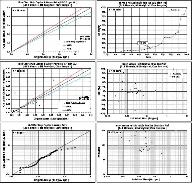
SRK aggregated the assay results of the external analytical control samples for further analysis. Blanks and certified reference material analytical data were summarized on time series plots to highlight the performance of the control samples. Paired data (preparation duplicates and umpire duplicates) were analyzed using bias charts, quantile-quantile, and relative precision plots. Overall, SRK considers that the analytical results delivered by the primary laboratories used by North American Nickel are reliable and do not present obvious evidence of analytical bias.
Mineral Processing and Metallurgical Testing
Between 2013 and 2016, North American Nickel commissioned SGS Canada Inc. of Burnaby, British Columbia to carry out four mineralogical studies by scanning electron microscopy (QEMSCAN) and electron microprobe analysis (EMPA) on selected core samples representative of the sulphide mineralization. The purpose of this work was to:
| | • | | Determine the modal mineralogy of each sample |
| | • | | Identify and quantify the nickel, copper, and iron sulphides and report on the nickel, copper, and cobalt deportment |
| | • | | Determine the liberation, association, and exposure characteristics of the nickel, copper, and iron sulphides and use these data to estimate potential recoveries |
| | • | | Assess any factors potentially impacting metallurgical recovery |
The studies indicate that pentlandite is the main nickel-bearing sulphide mineral containing in excess of 90 percent of the total nickel in each sample analyzed. In addition, potential recoveries of pentlandite, based solely on grain liberation, association, and exposure results, were estimated to be greater than 95 percent. Similar recovery estimates for chalcopyrite were greater than 85 percent in all but one sample, where recovery was 75 percent.
Conclusion and Recommendations
The Maniitsoq project is an advanced exploration project located in southwestern Greenland exploring a district scale belt of fertile Archean mafic and ultramafic intrusions fornickel-copper-cobalt-PGM sulphide mineralization. Since acquiring the property in 2011, North American Nickel has completed extensive property scale exploration with detailedfollow-up work on several targets. The exploration work completed to date has identified sulphide zones at six target areas, including Mikissoq, Spotty Hill, Imiak Hill,P-013,P-053, andP-058 (Fossilik), five of which remain open in one or more directions. In addition, nickel sulphide mineralization has been intersected at a number of other targets throughout the Greenland Norite Belt.On-going exploration continues to extend known zones of mineralization and to validate the potential for additional discoveries. The nickel-copper mineralization identified to date includes primary magmatic sulphide mineralization formed during the emplacement of the intrusions, and sulphide mineralization remobilized during subsequent tectonic events.
Based on this review, SRK concludes that the Maniitsoq project presents attractive exploration potential fornickel-copper-cobalt-PGM sulphide mineralization in a mining friendly, politically safe and stable jurisdiction.
| | |
3CN024.004 – North American Nickel Inc. | | |
Updated Independent Technical Report for the Maniitsoq Nickel-Copper-Cobalt-PGM Project, Greenland | | Page vii |
SRK concludes that this property is of merit as an exploration property that warrants further exploration expenditures.
The geological setting and character of the nickel-copper sulphide mineralization identified to date on the Maniitsoq property are of sufficient merit to justify additional exploration expenditures.
SRK recommends a work program that includes additional core drilling, geophysical surveying, geological mapping, and 3D modelling, primarily focussed on the Imiak Hill Complex and Fossilik areas where one or more discrete sulphide zones have been defined by drilling, and where multiple exploration targets remain to be tested. The proposed program, through additional core drilling, aims to evaluate the geometry, continuity, and quality of the sulphide mineralization found to date, define and test targets adjacent to these sulphide zones, continue to study the nature of structural controls on the mineralization, and refine targeting methods. Additional drilling is also warranted to test other geological and geophysical targets. It is expected that the proposed work program should aid in determining whether any of the known nickel-copper sulphide mineralized targets have the potential to host a mineral deposit warranting delineation drilling and mineral resource evaluation. In addition to the above exploration activities, SRK recommends commencing activities aimed at mitigating potential project risks by advancing social license studies and advancing baseline environmental work and generating hydro power potential data. The latter part of the proposed program is contingent on receiving a water shed prospecting license. The total cost of the recommended exploration program is estimated at C$12.4 million and includes a 5 percent contingency (Table i).
SRK is unaware of any significant factors and risks that may affect access, title, or the right, or ability, to perform the recommended exploration program.
Table i: Summary of Recommended Exploration Expenditures for 2017
| | | | | | | | | | | | |
Description | | Units | | | Unit Cost
(C$) | | | Total Cost
(C$) | |
Drilling(follow-up and regional exploration) | | | | | | | | | |
Core drilling (metres drilled, all inclusive) | | | 14,000 | | | | 255.4 | | | | 3,575,000 | |
Analytical services (samples) | | | 3,500 | | | | 50 | | | | 175,000 | |
| | | | | | | | | | | | |
Subtotal Drilling | | | | | | | | | | | 3,750,000 | |
| | | | | | | | | | | | |
Geological Studies | | | | | | | | | | | | |
Mapping, prospecting, sampling, 3D modelling, Processing ofWV-3 data | | | | | | | | | | | 500,000 | |
Mineralogical Studies | | | | | | | | | | | 75,000 | |
| | | | | | | | | | | | |
Subtotal Geology | | | | | | | | | | | 575,000 | |
| | | | | | | | | | | | |
Geophysical Surveys | | | | | | | | | | | | |
Borehole electromagnetic survey | | | | | | | | | | | 300,000 | |
Ground-based Induced Polarization survey | | | | | | | | | | | 525,000 | |
| | | | | | | | | | | | |
Subtotal Geophysics | | | | | | | | | | | 825,000 | |
| | | | | | | | | | | | |
Logistics and Administration | | | | | | | | | |
Helicopter support (2 helicopters, all inclusive) | | | 2 | | | | 1,625,000 | | | | 3,250,000 | |
Field operations, communications, and logistics | | | | | | | | | | | 2,700,000 | |
Administration and land holding costs | | | | | | | | | | | 300,000 | |
| | | | | | | | | | | | |
Subtotal Logistics and Administration | | | | | | | | | | | 6,250,000 | |
| | | | | | | | | | | | |
Corporate Social Responsibility | | | | | | | | | | | 75,000 | |
| | | | | | | | | | | | |
Health, Safety, and Environment | | | | | | | | | | | 125,000 | |
| | | | | | | | | | | | |
Infrastructure Studies | | | | | | | | | | | 200,000 | |
| | | | | | | | | | | | |
Subtotal | | | | | | | | | | | 11,800,000 | |
Contingency (5%) | | | | | | | | | | | 600,000 | |
| | | | | | | | | | | | |
Total | | | | | | | | | | | 12,400,000 | |
| | | | | | | | | | | | |
| | |
3CN024.004 – North American Nickel Inc. | | |
Updated Independent Technical Report for the Maniitsoq Nickel-Copper-Cobalt-PGM Project, Greenland | | Page viii |
Table of Contents
| | | | | | | | | | |
IMPORTANT NOTICE | | | ii | |
| |
Executive Summary | | | iii | |
Introduction | | | iii | |
Property Description and Ownership | | | iii | |
Accessibility, Climate, Local Resources, Infrastructure, and Physiography | | | iii | |
History | | | iii | |
Geology, Mineralization, and Deposit Type | | | iv | |
Exploration and Drilling | | | iv | |
Sample Preparation, Analysis, and Security | | | v | |
Data Verification | | | vi | |
Mineral Processing and Metallurgical Testing | | | vi | |
Conclusion and Recommendations | | | vi | |
| |
Table of Contents | | | viii | |
| |
List of Tables | | | xi | |
| |
List of Figures | | | xii | |
| | |
1 | | Introduction and Terms of Reference | | | 1 | |
| | 1.1 | | Scope of Work | | | 1 | |
| | 1.2 | | Work Program | | | 1 | |
| | 1.3 | | Basis of Technical Report | | | 2 | |
| | 1.4 | | Qualifications of SRK and SRK Team | | | 2 | |
| | 1.5 | | Site Visit | | | 3 | |
| | 1.6 | | Acknowledgement | | | 3 | |
| | 1.7 | | Declaration | | | 3 | |
| | |
2 | | Reliance on Other Experts | | | 5 | |
| | |
3 | | Property Description and Location | | | 6 | |
| | 3.1 | | Mineral Tenure | | | 7 | |
| | 3.2 | | Underlying Agreements | | | 9 | |
| | 3.3 | | Permits and Authorization | | | 11 | |
| | 3.4 | | Environmental Considerations | | | 11 | |
| | 3.5 | | Mining Rights in Greenland | | | 12 | |
| | | | 3.5.1 | | Mineral Prospecting Licence | | | 13 | |
| | | | 3.5.2 | | Mineral Exploration Licence | | | 13 | |
| | | | 3.5.3 | | Mineral Exploitation Licence | | | 14 | |
| | | | 3.5.4 | | Surface Rights | | | 14 | |
| | |
4 | | Accessibility, Climate, Local Resources, Infrastructure, and Physiography | | | 15 | |
| | 4.1 | | Accessibility | | | 15 | |
| | 4.2 | | Local Resources and Infrastructure | | | 15 | |
| | 4.3 | | Climate | | | 17 | |
| | 4.4 | | Physiography | | | 17 | |
| | |
5 | | History | | | 19 | |
| | |
6 | | Geological Setting and Mineralization | | | 24 | |
| | 6.1 | | Regional Geology | | | 24 | |
| | 6.2 | | Property Geology | | | 27 | |
| | |
3CN024.004 – North American Nickel Inc. | | |
Updated Independent Technical Report for the Maniitsoq Nickel-Copper-Cobalt-PGM Project, Greenland | | Page ix |
| | | | | | | | | | |
| | | | 6.2.1 | | Supracrustal Rocks | | | 29 | |
| | | | 6.2.2 | | Norite Intrusions | | | 29 | |
| | | | 6.2.3 | | Orthogneiss | | | 31 | |
| | | | 6.2.4 | | Pegmatite Stockwork | | | 31 | |
| | | | 6.2.5 | | Proterozoic and Paleozoic Units | | | 31 | |
| | 6.3 | | Structural Geology | | | 34 | |
| | | | 6.3.1 | | Structural Fabrics | | | 34 | |
| | | | 6.3.2 | | Folding | | | 34 | |
| | | | 6.3.3 | | Shearing and Faulting | | | 36 | |
| | | | 6.3.4 | | Geometry of the Norite Belt and Norite Intrusions | | | 37 | |
| | 6.4 | | Mineralization | | | 39 | |
| | | | 6.4.1 | | Magmatic Sulphide Mineralization | | | 41 | |
| | | | 6.4.2 | | Remobilized Sulphide Mineralization | | | 41 | |
| | | | 6.4.3 | | Imiak Hill Complex | | | 44 | |
| | | | 6.4.4 | | Fossilik | | | 50 | |
| | | | 6.4.5 | | P-013 | | | 54 | |
| | | | 6.4.6 | | P-030,P-032,P-061 andP-094 | | | 55 | |
| | | | 6.4.7 | | P-053 | | | 57 | |
| | | | 6.4.8 | | P-149 andP-146 | | | 58 | |
| | | | 6.4.9 | | Mineralized Regional Targets | | | 59 | |
| | |
7 | | Deposit Types | | | 60 | |
| | |
8 | | Exploration | | | 65 | |
| | 8.1 | | Introduction | | | 65 | |
| | 8.2 | | Geophysical Data and Surveys | | | 72 | |
| | 8.3 | | Field Geology, Prospecting and Drilling | | | 78 | |
| | | | 8.3.1 | | Sampling Procedures | | | 84 | |
| | 8.4 | | Comment on Exploration Targeting | | | 85 | |
| | |
9 | | Drilling | | | 86 | |
| | 9.1 | | Historical Drilling | | | 86 | |
| | 9.2 | | Drilling by North American Nickel (2012 – 2016) | | | 86 | |
| | | | 9.2.1 | | Drilling Programs | | | 87 | |
| | | | 9.2.2 | | Imiak Hill Complex | | | 90 | |
| | | | 9.2.3 | | Fossilik Target Area(P-058,P-059 andP-004) | | | 100 | |
| | | | 9.2.4 | | P-013 Target | | | 105 | |
| | | | 9.2.5 | | P-030,P-032,P-061, andP-094 Targets | | | 107 | |
| | | | 9.2.6 | | P-053 Target | | | 110 | |
| | | | 9.2.7 | | P-149 andP-146 Targets | | | 114 | |
| | | | 9.2.8 | | Regional Drilling | | | 115 | |
| | 9.3 | | Drilling and Sampling Procedures | | | 119 | |
| | 9.4 | | SRK Comments | | | 123 | |
| | |
10 | | Sample Preparation, Analyses, and Security | | | 124 | |
| | 10.1 | | Historical Sampling (1959 – 2011) | | | 124 | |
| | 10.2 | | Sampling by North American Nickel (2012 – 2016) | | | 124 | |
| | | | 10.2.1 | | Specific Gravity | | | 128 | |
| | 10.3 | | Quality Assurance and Quality Control Programs | | | 129 | |
| | 10.4 | | SRK Comments | | | 131 | |
| | |
11 | | Data Verification | | | 132 | |
| | 11.1 | | Verifications by North American Nickel | | | 132 | |
| | 11.2 | | Verifications by SRK | | | 132 | |
| | | | 11.2.1 | | Site Visit | | | 132 | |
| | | | 11.2.2 | | Verifications of Analytical Quality Control Data | | | 133 | |
| | 11.3 | | SRK Comments | | | 134 | |
| | |
3CN024.004 – North American Nickel Inc. | | |
Updated Independent Technical Report for the Maniitsoq Nickel-Copper-Cobalt-PGM Project, Greenland | | Page x |
| | | | | | | | | | |
| | | | 11.3.1 | | Performance of Analytical Control Samples 2012 to 2015 | | | 135 | |
| | |
12 | | Mineral Processing and Metallurgical Testing | | | 136 | |
| | |
13 | | Mineral Resource Estimates | | | 140 | |
| | |
14 | | Adjacent Properties | | | 141 | |
| | |
15 | | Other Relevant Data and Information | | | 142 | |
| | |
16 | | Interpretation and Conclusions | | | 143 | |
| | |
17 | | Recommendations | | | 144 | |
| | |
18 | | References | | | 146 | |
| |
APPENDIX A | | | 149 | |
| |
APPENDIX B | | | 153 | |
| |
APPENDIX C | | | 156 | |
| |
APPENDIX D | | | 160 | |
| | |
3CN024.004 – North American Nickel Inc. | | |
Updated Independent Technical Report for the Maniitsoq Nickel-Copper-Cobalt-PGM Project, Greenland | | Page xi |
List of Tables
| | | | |
Table i: Summary of Recommended Exploration Expenditures for 2017 | | | vii | |
Table 1: Mineral Exploration Licences of the Maniitsoq Project | | | 7 | |
Table 2: Minimum Annual Exploration Expenditure Required for Mineral Exploration Licences | | | 13 | |
Table 3: Historical Sulphide Showings and Analytical Highlights, Kryolitselskabet Øresund | | | 19 | |
Table 4: Summary of Deformational Events at Maniitsoq | | | 27 | |
Table 5: Summary of Geological Attributes of Nickel-bearing Intrusions, Maniitsoq Project | | | 62 | |
Table 6: Summary of Exploration Work Completed by North American Nickel | | | 68 | |
Table 7: Analytical Highlights of 2016 Surface Sampling | | | 83 | |
Table 8: Summary of Historical Drilling Completed on the Maniitsoq Project | | | 86 | |
Table 9: Summary of Drilling Completed by North American Nickel by Year | | | 87 | |
Table 10: Summary of Drilling Completed by North American Nickel by Target Area | | | 87 | |
Table 11: Salient Borehole Analytical Results, Mikissoq Target | | | 91 | |
Table 12: Salient Borehole Analytical Results, Spotty Hill Target | | | 94 | |
Table 13: Salient Borehole Analytical Results, Imiak Hill Target | | | 97 | |
Table 14: Salient Borehole Analytical Results, Fossilik Target Area | | | 100 | |
Table 15: Salient Borehole Analytical Results,P-013 Target | | | 105 | |
Table 16: Salient Borehole Analytical Results,P-030,P-032, andP-094 Targets | | | 107 | |
Table 17: Salient Borehole Analytical Results,P-053 Target | | | 112 | |
Table 18: Salient Borehole Analytical Results, Regional Targets | | | 117 | |
Table 19: Drilling Contractors and Equipment | | | 120 | |
Table 20: Summary of Analytical Laboratories and Procedures Used | | | 125 | |
Table 21: Summary of Specific Gravity Data Collected on the Maniitsoq Project | | | 128 | |
Table 22: Certified Control Samples Used on the Maniitsoq Project (2016) | | | 131 | |
Table 23: Summary of Analytical Quality Control Data for Core Samples (2016) | | | 133 | |
Table 24: Summary of Analytical Control Sample Performance in 2016 | | | 134 | |
Table 25: Description of Samples Selected for Mineralogical Studies, Maniitsoq Project | | | 136 | |
Table 26: Estimated Cost for the Exploration Program Proposed for the Maniitsoq Project | | | 145 | |
| | |
3CN024.004 – North American Nickel Inc. | | |
Updated Independent Technical Report for the Maniitsoq Nickel-Copper-Cobalt-PGM Project, Greenland | | Page xii |
List of Figures
| | | | | | |
| Figure 1: | | Location Map | | | 6 | |
| Figure 2: | | Land Tenure Map | | | 8 | |
| Figure 3: | | Area of Interest from the 2011 Acquisition Agreement Between North American Nickel and Hunter Minerals and Spar Resources | | | 10 | |
| Figure 4: | | Topography, Access, and Local Resources | | | 16 | |
| Figure 5: | | Typical Landscapes in the Project Area | | | 18 | |
| Figure 6: | | Location of Selected Sulphide Showings Discovered by Kryolitselskabet Øresund and IceFire Diamonds’ Sillissannguit Kimberlite Mini Bulk Sample Site | | | 20 | |
| Figure 7: | | Historical Airborne EM Coverage | | | 22 | |
| Figure 8: | | Greenland Principal Geological Units | | | 25 | |
| Figure 9: | | North Atlantic Archean Craton of Western Greenland (Windley and Garde, 2009) | | | 26 | |
| Figure 10: | | Detailed Geology of the Project Area | | | 28 | |
| Figure 11: | | Characteristics of Norite Intrusions at Maniitsoq | | | 30 | |
| Figure 12: | | Characteristics of Orthogneiss, Taserssuaq and Finnefjeld Intrusions at Maniitsoq | | | 32 | |
| Figure 13: | | Characteristics of the Pegmatite Stockwork | | | 33 | |
| Figure 14: | | Proterozoic Mafic Dikes | | | 33 | |
| Figure 15: | | Folds in Outcrops | | | 35 | |
| Figure 16: | | D1 Shear Zone in Core (BoreholeMQ15-076) | | | 36 | |
| Figure 17: | | D2 Shear Zones withDip-Slip Kinematics | | | 37 | |
| Figure 18: | | Map of the Fossilik Area (Modified After North American Nickel) (Structural measurements are displayed as 3D tablets) | | | 38 | |
| Figure 19: | | Nickel-bearing Mineralized Zone and Sulphide Textures at Spotty Hill; BoreholeMQ-15-075 | | | 40 | |
| Figure 20: | | Massive Pyrrhotite, Pentlandite, Pyrite and Chalcopyrite at Imiak Hill;Borehole MQ-14-037 | | | 40 | |
| Figure 21: | | Norite-Hosted Disseminated Nickel-Sulphide Mineralization at Fossilik(P-058); BoreholeMQ-15-077 | | | 41 | |
| Figure 22: | | Sulphide Breccia Veins at Mikissoq; BoreholeMQ-13-029 | | | 42 | |
| Figure 23: | | Zone of Breccia Veins and Stringers (Uphole) and Massive Sulphide Breccia (Down-hole) atP-053; BoreholeMQ-15-082 | | | 43 | |
| Figure 24: | | Pentlandite Textures atP-013SE, BoreholeMQ-16-109 (left, core) and atP-058, BoreholeMQ-14-054 (right, QEMSCAN image) | | | 43 | |
| Figure 25: | | Location of Mineralized Target Areas | | | 45 | |
| Figure 26: | | 3D Image (Looking Northeast) of Mikissoq Target Showing Geology, Sulphide Zones, and Boreholes | | | 46 | |
| Figure 27: | | 3D Image (Looking East) of Spotty Hill Target Showing Geology, Sulphide Zone, and Boreholes | | | 48 | |
| Figure 28: | | 3D Image (Looking East) of Imiak Hill Target Showing Geology, Sulphide Zones, and Boreholes | | | 49 | |
| | |
3CN024.004 – North American Nickel Inc. | | |
Updated Independent Technical Report for the Maniitsoq Nickel-Copper-Cobalt-PGM Project, Greenland | | Page xiii |
| | | | | | |
| Figure 29: | | 3D Image (Looking Northeast) ofP-058 Target Showing Geology, Sulphide Zone, and Boreholes | | | 51 | |
| Figure 30: | | Breccia Veins, Stringers, and Disseminated Nickel-Sulphide Mineralization at Fossilik(P-059), BoreholeMQ-15-078 | | | 52 | |
| Figure 31: | | Fossilik Area Surface Gossan | | | 53 | |
| Figure 32: | | Centimetre Scale Sulphide Globules in Norite atP-013; BoreholeMQ-14-068 | | | 54 | |
| Figure 33: | | Remobilized Sulphide Zone atP-013 SE; BoreholeMQ-16-109 | | | 55 | |
| Figure 34: | | Gossanous Mineralized Norite Crosscut by Network of Pegmatite Dikes | | | 56 | |
| Figure 35: | | 3D Image (Looking West) ofP-053 Target Showing Geology, Sulphide Zones and Boreholes | | | 58 | |
| Figure 36: | | Schematic Geological Settings of Nickel Sulphide Deposits | | | 61 | |
| Figure 37: | | Conceptual Tectonic Evolution of the Greenland Norite Belt (Ravenelle, 2015b) | | | 63 | |
| Figure 38: | | Schema of Mineralization Styles in the Thompson Nickel Belt | | | 64 | |
| Figure 39: | | Distribution of Geophysical Surveys completed by North American Nickel | | | 69 | |
| Figure 40: | | Location of Boreholes Drilled by North American Nickel | | | 70 | |
| Figure 41: | | Location of Samples Collected by North American Nickel | | | 71 | |
| Figure 42: | | Chargeability Results of the IP Surveys over Spotty Hill with Salient Exploration Results | | | 75 | |
| Figure 43: | | Chargeability Results of the IP Surveys over the Fossilik Area with Salient Exploration Results | | | 76 | |
| Figure 44: | | Chargeability Results of the IP Surveys over theP-030-032 Area with Salient Exploration Results | | | 77 | |
| Figure 45: | | Location of Surfaces Samples Collected in 2016; see Table 7 for Results | | | 82 | |
| Figure 46: | | Location of Drill-Tested Mineralized Target Areas | | | 89 | |
| Figure 47: | | Imiak Hill Complex Targets | | | 90 | |
| Figure 48: | | Compilation of Drilling Results at the Mikissoq Target; for Intersections refer to Table 11 | | | 92 | |
| Figure 49: | | Cross Section, Mikissoq Target, Location of Section Shown on Figure 48; for Intersections Refer to Table 11 | | | 93 | |
| Figure 50: | | Compilation of Drilling Results at the Spotty Hill Target; for Intersections Refer to Table 12 | | | 95 | |
| Figure 51: | | Longitudinal Section of Spotty Hill, looking Northeast, see Figure 50 for Location and Orientation of Section | | | 96 | |
| Figure 52: | | Compilation of Drilling Results at the Imiak Hill Target; for Intersections Refer to Table 13 | | | 98 | |
| Figure 53: | | Longitudinal Section of Imiak Hill, looking Northwest, see Figure 52 for Location and Orientation of Section | | | 99 | |
| Figure 54: | | Compilation of Drilling Results at the Fossilik Target; for Intersections Refer to Table 14 | | | 101 | |
| Figure 55: | | Inclined Longitudinal Section ofP-058 looking Northwest, see Figure 54 for Location and Orientation of Section | | | 103 | |
| Figure 56: | | Compilation of Drilling Results atP-013, for Intersections Refer to Table 15 | | | 106 | |
| Figure 57: | | Compilation of Drilling Results at theP-030 andP-032P-061, andP-094 Targets; for Intersections Refer to Table 16 | | | 109 | |
| Figure 58: | | Compilation of Drilling Results at TargetP-053; for Intersections refer to Table 17. | | | 111 | |
| | |
3CN024.004 – North American Nickel Inc. | | |
Updated Independent Technical Report for the Maniitsoq Nickel-Copper-Cobalt-PGM Project, Greenland | | Page xiv |
| | | | | | |
| Figure 59: | | Inclined Longitudinal Section ofP-053 looking Northeast, see Figure 58 for Location and Orientation of Section | | | 113 | |
| Figure 60: | | Compilation of Drilling Results at theP-146 andP-149 Targets | | | 115 | |
| Figure 61: | | Location of Selected Regional Targets | | | 116 | |
| Figure 62: | | Compilation of Drilling Results at the Quagssuk Occurrence | | | 119 | |
| Figure 63: | | Field Mounted APS Unit (white) Used to Position Foresites | | | 120 | |
| Figure 64: | | QEMSCAN Image of Polished Sample L163163 from Imiak Hill | | | 138 | |
| Figure 65: | | QEMSCAN Image of Polished Sample 4 from TargetP-030 | | | 139 | |
| | |
3CN024.004 – North American Nickel Inc. | | |
Updated Independent Technical Report for the Maniitsoq Nickel-Copper-Cobalt-PGM Project, Greenland | | Page 1 |
| 1 | Introduction and Terms of Reference |
The Maniitsoq project is an advancednickel-copper-cobalt-PGM (platinum group metals) sulphide exploration project. It is located on the southwest coast of Greenland, approximately 100 kilometres north of Nuuk, the capital of Greenland, and immediately east and south of the town of Maniitsoq north of Nuuk. North American Nickel Inc. (North American Nickel) holds 100 percent interest in the project.
In December, 2014 North American Nickel commissioned SRK Consulting (Canada) Inc. (SRK) to interpret aeromagnetic data of the Maniitsoq project. In June 2015, North American Nickel asked SRK to provide structural geology support for their 2015 exploration program. In September 2015, North American Nickel commissioned SRK to prepare a technical report following the guidelines of the Canadian Securities Administrators’ National Instrument43-101 and Form43-101F1 for the project (Ravenelle and Weiershäuser, 2016). During 2016, North American Nickel carried out additional exploration work, including 9,596 metres of core drilling, which was primarily focussed on testing for extensions of the known zones of nickel mineralization. SRK provided technical support for this program in the form of structural core logging and 3D modeling. Subsequently in December, 2016, North American Nickel commissioned SRK to prepare an updated technical report for the Maniitsoq project.
SRK understands this technical report may be used by North American Nickel to support future financing to fund additional exploration expenditures.
In the opinion of SRK, this property has merit warranting additional exploration expenditures. An exploration work program is recommended comprising core drilling, geophysical surveying, geological mapping and 3D geological modelling. The purpose of the proposed program is to investigate certain promising targets by drilling to test the depth continuity of sulphide mineralization exposed on surface, to investigate the source of certain geophysical anomalies, and, if warranted delineation drilling and mineral resource evaluation.
The scope of work, as defined in a letter of engagement executed on December 14, 2016 between North American Nickel and SRK, includes the preparation of an updated independent technical report in compliance with National Instrument43-101 and Form43-101F1 guidelines. This work involved updating and assessment of the following aspects of this project:
| | • | | Regional and local geology |
| | • | | Audit of new exploration work carried out on the project |
| | • | | Recommendations for additional work |
This assignment followed structural core logging and 3D modeling completed by SRK staff between July 17 and 31 and also August 21 and 30, 2016, while the drilling program was ongoing. During the site visit, SRK reviewed core from recent drilling and carried out 3D modeling. Furthermore, SRK reviewed exploration practices employed by North American Nickel.
| | |
3CN024.004 – North American Nickel Inc. | | |
Updated Independent Technical Report for the Maniitsoq Nickel-Copper-Cobalt-PGM Project, Greenland | | Page 2 |
The technical report was assembled in Toronto during the months of January, February, and March 2017.
| 1.3 | Basis of Technical Report |
This report supersedes the previous technical report completed by SRK in 2016 (see Ravenelle and Weiershäuser, 2016) and incorporates additional information collected by SRK during site visits performed between July 17 and 31 and August 21 and 30, 2016, and on additional information provided by North American Nickel throughout the course of SRK’s investigations. SRK has no reason to doubt the reliability of the information provided by North American Nickel. Other information was obtained from the public domain. This technical report is based on the following sources of information:
| | • | | Discussions with North American Nickel personnel |
| | • | | Inspection of the Maniitsoq project drill core and selected outcrops |
| | • | | Review of exploration data collected and documented by North American Nickel, in particular, technical sections updated, drafted or partially drafted by North American Nickel for this report |
| | • | | Additional information from public domain source |
| 1.4 | Qualifications of SRK and SRK Team |
The SRK Group comprises more than 1,400 professionals, offering expertise in a wide range of mineral resource engineering disciplines. The independence of the SRK Group is ensured by the fact that it holds no equity in any project it investigates and that its ownership rests solely with its staff. These facts permit SRK to provide its clients with conflict-free and objective recommendations. SRK has a proven track record in undertaking independent assessments of mineral resources and mineral reserves, project evaluations and audits, technical reports and independent feasibility evaluations to bankable standards on behalf of exploration and mining companies, and financial institutions worldwide. Through its work with many major international mining companies, the SRK Group has established a reputation for providing valuable consultancy services to the global mining industry.
This technical report was compiled by Lars Weiershäuser, PhD, PGeo (APGO#1504) andJean-François Ravenelle, PhD, PGeo (APGO#2159, OGQ#1062). By virtue of their education, membership of a recognized professional association, and relevant work experience, Dr. Weiershäuser and Dr. Ravenelle are independent Qualified Persons as this term is defined by National Instrument43-101.
Dr. Weiershäuser is an Associate Consultant (Geology) with SRK. He has been practising his profession continuously since 2006. He has created geological and three-dimensional models of ore deposits, evaluated the geotechnical and structural properties of ore deposits, reviewed analytical quality control sample results, and authored or contributed to numerous independent technical reports. Dr. Weiershäuser did not visit the property.
Dr. Jean-François Ravenelle, PGeo is an expert in the analysis of structural geology of high grade metamorphic rocks. He completed his doctoral thesis on the world-class Eleonore project in northern Quebec. Dr. Ravenelle specializes in the understanding of structural controls on the distribution of precious and base metals mineralization in deformed and metamorphosed terranes. Over the past 15 years, he has studied numerous economic deposits hosted in various parts of the world including
| | |
3CN024.004 – North American Nickel Inc. | | |
Updated Independent Technical Report for the Maniitsoq Nickel-Copper-Cobalt-PGM Project, Greenland | | Page 3 |
West Africa, Central Africa, Central America, South America, the United States, and Canada. He has also conducted several aeromagnetic lineament interpretations and structural analyses in polydeformed Archean terranes. Dr. Ravenelle visited the property between July 7 and 28, 2015 and again between July 17 and 31 and August 21 and 30, 2016.
Mr. Glen Cole, PGeo (APGO#1416), a Principal Consultant with SRK, reviewed drafts of this technical report prior to their delivery to North American Nickel as per SRK’s internal quality management procedures. Mr. Cole did not visit the project.
In accordance with National Instrument43-101, Dr. Ravenelle visited the Maniitsoq project, accompanied by Ms. Patricia Tirschmann of North American Nickel on three occasions: July 7 to 28, 2015, July 17 to 31, 2016, and August 21 to 30, 2016.
The purpose of the 2015 site visit was to ascertain the geology of the project area, with a specific emphasis on the structural controls on mineralization, review exploration procedures, examine core, interview project personnel, and collect all relevant information for the compilation of a technical report. The purpose of the 2016 site visits was to follow up on the elements reviewed during the first site visit, as well as implementing best practice guidelines on the collection of oriented core data, construct 3D geology models of the various target areas, and conduct structural core logging and mapping to define the structural setting of individual target areas to guide the 3D modelling work.
SRK was given full access to relevant data and conducted interviews with North American Nickel personnel to obtain information on the past exploration work, to understand procedures used to collect, record, store, and analyze historical and current exploration data.
SRK would like to acknowledge the support and collaboration provided by North American Nickel personnel for this assignment. Their collaboration was greatly appreciated and instrumental to the successful completion of this technical report. Significant contributions by Patricia Tirschmann, Vice-President Exploration of North American Nickel and the assistance of the North American technical team, were instrumental in completing this technical report and are gratefully acknowledged.
SRK’s opinion contained herein and effectiveMarch 17, 2017 is based on information collected by SRK throughout the course of SRK’s investigations. The information in turn reflects various technical and economic conditions at the time of writing this report. Given the nature of the mining business, these conditions can change significantly over relatively short periods of time. Consequentl7y, actual results may be significantly more or less favourable.
This report may include technical information that requires subsequent calculations to derive subtotals, totals, and weighted averages. Such calculations inherently involve a degree of rounding and consequently introduce a margin of error. Where these occur, SRK does not consider them to be material.
SRK is not an insider, associate or an affiliate of North American Nickel, and neither SRK nor any affiliate has acted as advisor to North American Nickel, its subsidiaries, or its affiliates in connection
| | |
3CN024.004 – North American Nickel Inc. | | |
Updated Independent Technical Report for the Maniitsoq Nickel-Copper-Cobalt-PGM Project, Greenland | | Page 4 |
with this project. The results of the technical review by SRK are not dependent on any prior agreements concerning the conclusions to be reached, nor are there any undisclosed understandings concerning any future business dealings.
| | |
3CN024.004 – North American Nickel Inc. | | |
Updated Independent Technical Report for the Maniitsoq Nickel-Copper-Cobalt-PGM Project, Greenland | | Page 5 |
| 2 | Reliance on Other Experts |
SRK has not performed an independent verification of land title and tenure information as summarized in Section 3 of this report but has relied on a list of mineral and petroleum licences in Greenland, issued by the Mineral Licence and Safety Authority (MLSA) of the Government of Greenland and provided by North American Nickel. SRK was informed by North American Nickel that there are no known litigations potentially affecting the Maniitsoq project.
| | |
3CN024.004 – North American Nickel Inc. | | |
Updated Independent Technical Report for the Maniitsoq Nickel-Copper-Cobalt-PGM Project, Greenland | | Page 6 |
| 3 | Property Description and Location |
The Maniitsoq property is situated in southern West Greenland within Qeqqata Kommunia (municipality), approximately 100 kilometres north of the capital city of Nuuk and 15 kilometres east of the town of Maniitsoq (Figure 1). The property is centred at approximately 65 degrees, 18 minutes north and 51 degrees, 43 minutes west.
Figure 1: Location Map
| | |
3CN024.004 – North American Nickel Inc. | | |
Updated Independent Technical Report for the Maniitsoq Nickel-Copper-Cobalt-PGM Project, Greenland | | Page 7 |
The Maniitsoq project consists of two contiguous exclusive Mineral Exploration licences: Sulussugut (licence number 2011/54) and Ininngui (licence number 2012/28), as listed in Table 1 and shown in Figure 2. Together, the licences cover a total area of 2,985 square kilometres. They are 100 percent owned by North American Nickel and are in good standing with the Mineral Licence and Safety Authority (MLSA, formerly the Bureau of Minerals and Petroleum). The MLSA is the Government of Greenland’s administrative authority responsible for mineral licencing and safety matters. The licences give North American Nickel the right to explore for all types of mineral resources except hydrocarbons and radioactive elements. In the event that North American Nickel finds and delineates commercially viable deposit(s) which it intends to exploit, and provided the terms of the licence have been complied with, North American Nickel is entitled to be granted an Exploitation Licence under Articles 7 and 15, Subsection 2 of the Greenland’s Mineral Resources Act.
The Sulussugut Licence (2011/54) was issued to North American Nickel in August, 2011. At that time, it covered 4,841 square kilometres. At the request of North American Nickel, it was reduced to 3,336 square kilometres at the end of 2013. North American Nickel applied for a further reduction in size at the end of 2014. The current size is 2,689 square kilometres. The Ininngui Licence (2012/28) was issued in March, 2012. The initial size was 142 square kilometres; it has subsequently been enlarged to 296 square kilometres.
Both the Sulussugut and the Ininngui licences are subject to the terms and conditions set out in the Standard Terms for Exploration Licences for Minerals (Excluding Hydrocarbons) in Greenland dated November 16, 1998 and amended September 10, 2010, June 25, 2013, July 1, 2014, and January 1, 2017 (the Standard Terms). Unofficial English translations of some, but not all of the Standard Terms, are available on the Greenland Government website (https://www.govmin.gl/minerals/terms-rules-laws-guidelines).
The Standard Terms dictate that a Mineral Exploration Licence is granted for an initial period of five years after which the licensee is entitled to a second five-year term, provided the terms of the licence have been complied with and Mineral Licence and Safety Authority has received an application from the licensee prior to December 31 in year five. At the expiration of the second licence period (years6-10), the licensee may, at the discretion of the Greenland Government, be granted a new3-year licence for years 11 to 13 provided Mineral Licence and Safety Authority has received an application from the licensee prior to December 31 in year 10, and that the licence terms have been complied with. Additional3-year licences for years 14 to 16, 17 to 19 and 20 to 22 may, at the government’s discretion, be granted provided MLSA has received an application from the licensee prior to December 31 in years 16 and 19, respectively. A licensee may apply to have a licence reduced, enlarged, or terminated at any time.
Table 1: Mineral Exploration Licences of the Maniitsoq Project
| | | | | | | | | | |
Licence No. | | Name | | Size (km2) | | | Expiration Date | |
2011/54 | | Sulussugut | | | 2,689 | | | | December 31, 2020 | |
2012/28 | | Ininngui | | | 296 | | | | December 31, 2021 | |
| | | | | | | | | | |
Total | | | | | 2,985 | | | | | |
| | | | | | | | | | |
| | |
3CN024.004 – North American Nickel Inc. | | |
Updated Independent Technical Report for the Maniitsoq Nickel-Copper-Cobalt-PGM Project, Greenland | | Page 8 |
Figure 2: Land Tenure Map
| | |
3CN024.004 – North American Nickel Inc. | | |
Updated Independent Technical Report for the Maniitsoq Nickel-Copper-Cobalt-PGM Project, Greenland | | Page 9 |
An application for the renewal of the Sulussugut Licence (2011/54) was filed with MLSA prior to the end of 2015 and the renewal addendum (years6-10) was signed by MLSA on April 11, 2016. An application for the renewal of the Ininngui Licence (2012/28) was filed with MLSA prior the end of 2016 and is currently being processed. The Sulussugut Licence is currently in its seventh year and Ininngui is in its sixth year.
Under the Standard Terms a licensee is obligated to file annual work reports, make minimum annual exploration expenditures and, from year six onward, pay annual fees. The minimum annual expenditure is the sum of a flat amount plus an amount based on the area of the licence in square kilometres (see Section 3.5.2 for details). In the first year of the licence, the area used in the calculation is the area covered by the licence at granting; in subsequent years, it is the area covered by the licence as of December 31 of the year in question. In the event exploration expenses exceed the minimum required, the difference can be credited in a later year for the same licence. However, such difference cannot be carried forward for credit more than three years.
In each year to December 31, 2015, and on both licences, North American Nickel has filed and been approved for exploration expenses exceeding the minimum required. Cumulative expenditures approved to December 31, 2015 on the Sulussugut Licence No. 2011/54 total DKK 184,113,050 and credits available to carry forward total DKK 101,303,710 (DKK 7,312,671 from 2013; DKK 55,509,353 from 2014; and DKK 59,149,846 from 2015). Cumulative expenditures approved to December 31, 2015 on the Ininngui Licence No. 2012/28 total DKK 17,584,315 and credits available to carry forward total DKK 11,602,095 (DKK 2,523,309 from 2013; DKK 5,470,428 from 2014; and DKK 6,276,098 from 2015). As of February 2, 2017, DKK 1000 approximate C$ 190.
In 2015, the Government of Greenland provided relief to licence holders by adjusting the 2015 and 2016 minimum yearly required exploration expenses to DKK 0 for licences that were 6 years or older. The adjustment was applicable for the Sulussugut Licence No. 2011/54 and the required minimum exploration expenditure for 2016 was therefore DKK 0. No reduction in area was made to the Sulussuut Licence No. 2011/54 in 2016.
The minimum exploration expenditures for 2016 was DKK 2,714,680 for the Ininngui Licence No. 2012/28. No reduction in area was made to this licence in 2016. North American Nickel has informed SRK that it believes its 2016 exploration requirements will exceed the required minimum.
In early 2017, the Government of Greenland again provided relief to licence holders by adjusting the 2017 minimum yearly required exploration expenses to DKK 0 for licences that are 6 years or older. The adjustment will be applicable to both the Sulussugut Licence No. 2011/54 and the Ininngui Licence No. 2012/28 and the required minimum exploration expenditures for 2017 will therefore be DKK 0 for both licenses.
On August 12, 2011, in conjunction with the granting of the Sulussugut Licence, North American Nickel entered into an arm’s length intellectual property and data acquisition agreement with Hunter Minerals Pty Limited (Hunter) and Spar Resources Pty Limited (Spar). Under the terms of the agreement, Hunter and Spar agreed to sell North American Nickel intellectual property rights to certain technical information, data, and recommendations pertaining to the Maniitsoq area of interest, which includes the Sulussugut and Ininngui licences (Figure 3). In consideration for the intellectual property rights North American Nickel:
| | |
3CN024.004 – North American Nickel Inc. | | |
Updated Independent Technical Report for the Maniitsoq Nickel-Copper-Cobalt-PGM Project, Greenland | | Page 10 |
| | • | | Paid C$150,000 to each of Hunter and Spar (for a total of C$300,000). |
| | • | | Issued 12,960,000 share purchase warrants, 6,480,000 to each of Hunter and Spar or their respective nominees, exercisable for a period of five years. 4,750,000 of the warrants are exercisable at a price of C$0.50 per share; 4,750,000 are exercisable at C$0.70 per share: and 3,460,000 are exercisable at C$1.00 per share. The warrants are subject to an accelerated exercise provision in the event North American Nickel relinquishes all its interests in the Maniitsoq licenses and any other mineral titles held within the Maniitsoq area of interest without receiving consideration for such relinquishment. |
| | • | | Granted to each of Hunter and Spar, or their designates, a 1.25 percent net smelter return royalty, subject to the rights of North American Nickel to reduce both royalties to a 0.5 percent net smelter return royalty upon payment to each of Hunter and Spar (or their designates) of C$1,000,000. The royalties granted to Hunter and Spar apply to any and all minerals produced from the project area and from any additional licences acquired by North American Nickel within the area of interest. |
| | • | | All warrants issued to Hunter and Spar expired in 2016 with none being exercised. |
Figure 3: Area of Interest from the 2011 Acquisition Agreement Between North American Nickel and Hunter Minerals and Spar Resources
| | |
3CN024.004 – North American Nickel Inc. | | |
Updated Independent Technical Report for the Maniitsoq Nickel-Copper-Cobalt-PGM Project, Greenland | | Page 11 |
| 3.3 | Permits and Authorization |
The Standard Terms require North American Nickel to obtain Mineral Licence and Safety Authority approval for certain exploration activities on an annual basis, such as diamond drilling, blasting, and camp construction. The Standard Terms also allow BMP/MLSA to conduct site inspections at any time. The Mineral Licence and Safety Authority has conducted inspections on two occasions (September 4, 2012 and August 2, 2014).
North American Nickel has advised SRK that they have obtained and complied with all required government permits and approvals for exploration work completed on the Maniitsoq project to date. To conduct exploration work in 2017, North American Nickel will need to submit a work plan for approval to Mineral Licence and Safety Authority no later than May 1, 2017.
| 3.4 | Environmental Considerations |
North American Nickel’s Maniitsoq project is an exploration stage project that has been ongoing since 2011. Surface disturbances resulting from work completed by North American Nickel, which has included core drilling, ground and downhole geophysical surveys, prospecting, sampling, and geological mapping, are considered minimal.
Peripheral to the Maniitsoq property are several seabird colonies, and the area is known to house a reindeer population. Concurrent with the approval of company work plans, the Mineral Licence and Safety Authority typically provides specific written instruction on how to minimize the impact on wildlife and the environment, which may include guidelines or restrictions relating to the reindeer calving or hunting seasons and to the nature of additives used in drilling operations.
North American Nickel inspects all drilling sites after completion of drilling to ensure the cleanliness of each site and also photographs each drill sitepre- and post-drilling. In 2011, North American Nickel developed anin-house health and safety document for the Maniitsoq project and updates this document on a yearly basis. This document includes procedures for the handling and reporting of fuel spills. During active field seasons, North American Nickel conducts weeklyin-camp meetings to address any concerns relating to health, safety, and the environment.
Baseline environmental studies have been undertaken in two areas relating to the Maniitsoq property, including the Imiak Hill Complex area (includes Imiak Hill, Spotty Hill, Mikissoq, previously known as Imiak North) in 2014 and the Seqi port area in 2015. The field studies were conducted in accordance with the Rules for Field Work and Reporting regarding mineral resources excluding hydrocarbon and the Guidelines for Preparing an Environmental Impact Assessment Report for Mineral Exploitation in Greenland (MRA, 2015).
In 2014, Golder Associates (Golder), based in Copenhagen, Denmark was contracted to carry out field studies related to the Imiak Hill Complex area where North American Nickel had outlined significant nickel-copper sulphide mineralization at three locations (Imiak Hill, Mikissoq, and Spotty Hill). The field work was carried out in August, 2014 within an approximately 400 square kilometre area surrounding the Imiak Hill Complex and along a potential future road corridor linking the Imiak Hill Complex to a fjord to the southwest. The program focussed on acquiring an overview of the ecological conditions within the study area and included the following data acquisition:
| | |
3CN024.004 – North American Nickel Inc. | | |
Updated Independent Technical Report for the Maniitsoq Nickel-Copper-Cobalt-PGM Project, Greenland | | Page 12 |
| | • | | A terrestrial survey, covering registration of vegetation, with focus on rare or endangered species |
| | • | | Registration of macro-invertebrates in rivers/streams, combined with water and sediment sampling |
| | • | | Collection of marine/intertidal samples (sculpins, common mussels, seaweed, and sediments) |
| | • | | Observations of birds and mammals |
| | • | | Collection of freshwater filtered andnon-filtered samples including measurements of water temperature, conductivity, and pH |
All samples (water, sediment, lichens, mussels, fish liver, and seaweed) were submitted to the Danish Centre for Environment and Energy at Arhus University in Aarhus, Denmark for storage and potential future analysis.
In 2015, INUPLAN A/S (Inuplan) of Nuuk, Greenland and Golder carried out baseline data acquisition in the area surrounding the Seqi deepwater port located at the south end of the Maniitsoq property. This work was undertaken as part of a due diligence exercise prior to the potential acquisition of the Seqi port and adjacent olivine mine. Historically, olivine mining from a dunite-peridotite complex and shipping of olivine by LKAB Minerals (Sweden) was carried out between 2007 and 2010.
As part of North American Nickel’s 2015 baseline studies, 19 composite soil samples were collected and analyzed for heavy metals (Pb, Cd, Cr, Cu, Ni, Zn and Hg) and total petroleum hydrocarbons. The screening of volatile organic components indicated no presence of volatile substances in the soil samples. The results from the chemical analysis from the laboratory were compared to the Danish Environmental Protective Agency’s protective concentration levels for residential areas and showed that all heavy metals except nickel were below the acceptable protective concentration levels. Consistently elevated nickel values were observed in all areas of the port which suggests that nickel has been added to the area by windblown dust originating from mining and production activities and by use of the dunite as road fill throughout the area.
The recent environmental surveys undertaken by Golder and INUPLAN confirm ongoing surveys by the Greenland Government in and around the Seqi port area. Results from a 2014 government study confirmed that the spread of dust and attendant nickel contamination had fallen topre-mining levels. This study also concluded that dust pollution in the area over the years will decline further as more and more dust from past operations becomes bound in the soil, covered by new vegetation or leaches into the fjord. The analysis ofbio-samples collected from the fjord in 2014 indicated that the impact on the marine environment by Seqi was effectively nil.
A survey of reindeer undertaken at Seqi during 2015 documented a small number of reindeer from the area. Only nine animals were observed, and these low numbers were attributed to extreme high temperatures during the survey period resulting in an eastward migration towards the ice cap.
| 3.5 | Mining Rights in Greenland |
Mineral resources and mineral resource activities in Greenland are governed by Greenland Parliament Act No. 7 of December 7, 2009 (the Mineral Resources Act) with amendments from Act No. 26 of December 18, 2012, Act No. 6 of June 8, 2014, and January 1, 2017. English translations of the Mineral Resources Act and amendments are available from the Greenland government websitehttps://www.govmin.gl/minerals/terms-rules-laws-guidelines. Under the Mineral Resources Act, a
| | |
3CN024.004 – North American Nickel Inc. | | |
Updated Independent Technical Report for the Maniitsoq Nickel-Copper-Cobalt-PGM Project, Greenland | | Page 13 |
company must hold a Mineral Prospecting or Mineral Exploration licence in order to conduct mineral exploration, and a Mineral Exploitation licence in order to exploit a mineral resource.
| 3.5.1 | Mineral Prospecting Licence |
A Mineral Prospecting Licence isnon-exclusive and allows the holder the right to prospect for minerals within one of threepre-defined regions on ground not covered by a Mineral Exploration or Exploitation licence. The threepre-defined regions are:
| | • | | West Greenland (area south of 78°N and west of 44°W) |
| | • | | East Greenland (area south of 75°N and east of 44°W) |
| | • | | North Greenland (area north of 78°N and west of 44°W, and the area north of 75°N and east of 44°W) |
| 3.5.2 | Mineral Exploration Licence |
A Mineral Exploration Licence is exclusive, must be at least 5 square kilometres in size and can include up to five separate areas provided the distance between any two areas is less than 100 kilometres. Licences are delineated by corner points defined by degrees and undivided minutes connected by lines of longitude and latitude in the WGS84 datum. Normally, a licence area includes only land areas, but sea areas to a certain depth may, upon application, be included.
Unless otherwise stated in the licence text, a Mineral Exploration Licence gives the licensee the right to explore for all types of mineral resources except hydrocarbons and radioactive elements.
The holder of a Mineral Exploration Licence is obligated to spend a certain minimum amount of money on approved exploration activities on an annual basis. The minimum expenditure is the sum of two amounts: a fixed per licence amount and an amount based on the size of the licence in square kilometres. Table 2 lists the current (2017) per licence and per square kilometre amounts for licence years 1 to 19. Note that these amounts are adjusted annually for changes in the Danish Consumer Price Index (for amounts pertaining to licence years 1 to 10) or the Greenlandic Consumer Price Index (for amounts pertaining to licence years 11 and beyond). The amounts listed in Table 2 do not reflect exploration expenditure reductions made by the Greenland government in 2015 and 2017, which apply on a licence by licence basis (see Section 3.1).
In year 6, and subsequent years, a licensee is required to pay an annual fee that is currently DKK 40,700 per licence (approximately C$ 7,733 at an exchange rate of DKK 1 to C$ 0.19). This fee is adjusted annually for changes in the Danish Consumer Price Index.
Table 2: Minimum Annual Exploration Expenditure Required for Mineral Exploration Licences
| | | | | | | | |
Licence Year | | Per Licence Amount
(Danish Kroner*) | | | Per km2 Amount
(Danish Kroner*) | |
1-2 | | | 162,600 | | | | 1,630 | |
3-5 | | | 325,200 | | | | 8,130 | |
6-10 | | | 650,400 | | | | 16,260 | |
11-13 | | | 1,301,000 | | | | 32,520 | |
14-16 | | | 2,602,000 | | | | 65,040 | |
17-19 | | | 5,203,000 | | | | 130,100 | |
| | * | One Danish Kroner is valued at approximately C$0.19 (January 20, 2017) |
| | |
3CN024.004 – North American Nickel Inc. | | |
Updated Independent Technical Report for the Maniitsoq Nickel-Copper-Cobalt-PGM Project, Greenland | | Page 14 |
| 3.5.3 | Mineral Exploitation Licence |
If the holder of a Mineral Exploration Licence finds and delineates one or more commercially viable deposits, and provided the terms of the licence have been complied with, the licensee is entitled to be granted a Mineral Exploitation Licence under Articles 7 and 15 Subsection 2 of the Mineral Resources Act. A request for an Exploitation Licence must be accompanied by:
| | • | | A declaration that the deposit or deposits are commercially viable and that the licensee intends to exploit them |
| | • | | A bankable feasibility study of the deposits in question |
| | • | | Proposed boundaries for the Exploitation Licence |
| | • | | An approved environmental impact assessment (EIA) |
| | • | | An approved social sustainability assessment (SSA) |
Before exploitation and related activities are initiated, the Greenland government must approve an exploitation and closure plan for the enterprise.
Under Greenland’s law there is no ownership of surface rights.
| | |
3CN024.004 – North American Nickel Inc. | | |
Updated Independent Technical Report for the Maniitsoq Nickel-Copper-Cobalt-PGM Project, Greenland | | Page 15 |
| 4 | Accessibility, Climate, Local Resources, Infrastructure, and Physiography |
The project is located along the southwest coast of Greenland between 64 degrees 53 minutes and 65 degrees 45 minutes north and 51 degrees 1 minute and 52 degrees 38 minutes west (Figure 4). The village of Maniitsoq with a population of approximately 2,500 is situated on an island 13 kilometres west of the western edge of the project, and the city of Nuuk, Greenland’s capital, is 80 kilometres south of the southern boundary. The property is accessible year-round by helicopter or boat from Nuuk or Maniitsoq. The sea lanes in the area are open year-round as a result of the Irminger and West Greenland currents, which bring warm water from the Gulf Stream northwards along the southwest coast of Greenland.
| 4.2 | Local Resources and Infrastructure |
There is no infrastructure on the property; however, a deepwater pier and quantified watershed for hydropower exist peripheral to the property.
A small pier is located 2.5 kilometres south of the property in a bay on the north side of a fjord called Niaquungunaq (Greenlandic) or Fiskefjord (Danish). The bay is situated approximately 33 kilometres inland from the mouth of the fjord. The pier was built by LKAB Minerals, a subsidiary of Minelco, in 2005 for transporting olivine from their Seqinnersuusaaq or Seqi mine. While the mine was in operation, the Seqi pier was able to accommodateHandymax-sized vessels (40,000 to 50,000 deadweight tonnage (DWT) capacity) and ore was typically shipped between June and October. Mining operations ceased in 2010 and most of the infrastructure was dismantled. However, the pier remains in place and is currently owned by the Greenland government.
The development of hydroelectric power on the southwest coast of Greenland has been regularly assessed since the 1970’s. In 2005, a detailed report published by Nukissiortfiit titled “Hydropower Resources in Greenland” (Nukissiorfiit, 2005) identified potential hydropower watersheds on the west coast of Greenland. One of the identified watersheds, located along the eastern edge of the Maniitsoq Project area, was further evaluated by SNC Lavalin International Inc. (SNC) in 2012 for London Mining PLC. The SNC study proposed a series of hydropower stations and associated transmission lines supplying the Isua iron ore project; however, this hydropower prospect was not developed due to commercial and market conditions for iron ore. In February 2017, North American Nickel applied for a prospecting license for this watershed (“06.H”). Building on the historical work, North American Nickel plans to assess the watershed further for its hydropower capacity to provide energy for a potential future mining operation.
The village of Maniitsoq has a small port and an airport with an800-metre paved runway. The port and airport operate year-round.Jet-A fuel is available at the airport, but there is node-icing equipment. Scheduled commercial flights connect Maniitsoq to Kangerlussuaq, which is located 225 kilometres to the northeast and is the largest airport in Greenland.Non-stop flights to Copenhagen operate five days a week from Kangerlussuaq. The Nuuk and Kangerlussuaq airstrips are 950 metres and 2,810 metres in length, respectively.
| | |
3CN024.004 – North American Nickel Inc. | | |
Updated Independent Technical Report for the Maniitsoq Nickel-Copper-Cobalt-PGM Project, Greenland | | Page 16 |
Figure 4: Topography, Access, and Local Resources
| | |
3CN024.004 – North American Nickel Inc. | | |
Updated Independent Technical Report for the Maniitsoq Nickel-Copper-Cobalt-PGM Project, Greenland | | Page 17 |
The capital town of Nuuk has a population of approximately 17,000 and offers European-standard supply, support, and logistics facilities including a hospital, a port, and an airport with direct flights to Reykjavik (Iceland) and connecting flights to Maniitsoq and Kangerlussuaq.
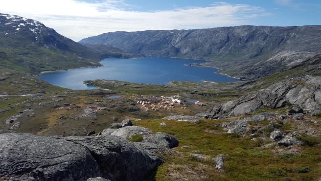
To date, most field operations have been conducted from a temporary field camp located on Puiattoq Bay at the end of Amitsuarssuk fjord. The camp, except for tent floors and some fuel, is removed at the end of each field season. A minor amount of work has also been done out of a small fishing lodge located at the head of Kangia fjord (Kangia Fishing Lodge) and from the village of Maniitsoq.
Due to the remote nature of the project area and Greenland in general, most heavy equipment has to be imported.
The climate is arctic. Temperatures at Maniitsoq’s airport (elevation 28 metre above mean sea level) typically range from-10 to 12 degrees Celsius. Temperatures are rarely below-20 degrees Celsius or above 15 degrees Celsius. Average annual precipitation is 477 millimetres. Most of the project area isice- and snow-free frommid-June tomid-September. The coldest temperatures occur frommid-December tomid-March. Hours of daylight range from nearly 23 hours at the summer solstice to just over 3 hours at the winter solstice. The current length of the operating season for exploration is typically frommid-June tomid-September. This time frame is largely dictated by stage of exploration and the level of helicopter support.
The topography ranges from broad glacial valleys and rounded hills to locally steep hills with up to 800 metres of relief. The northern part of the property, near the Maniitsoq Ice Cap, is particularly rugged. Numerous intermittent creeks and streams along with large rivers are common; the water in them tends to be shallow and fast-flowing. Water bodies range in size from tiny ponds to lakes more than 50 square kilometres in size. Examples of the local physiography are shown in Figure 5.
Typical subarctic to arctic vegetation occurs across most of the project area with till-covered locals blanketed by ground shrubs (Labrador tea, dwarf willow, and birch) and flowering plants. On average, bedrock exposure comprises 30 to 40 percent of the area; however, bedrock in valleys is often completely covered, while on hill tops bedrock exposure approaches 80 percent. Rock exposures are often covered with lichen, making it difficult to discern variations in composition and texture.
| | |
3CN024.004 – North American Nickel Inc. | | |
Updated Independent Technical Report for the Maniitsoq Nickel-Copper-Cobalt-PGM Project, Greenland | | Page 18 |
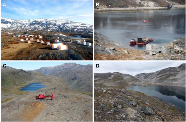
Figure 5: Typical Landscapes in the Project Area
A: North American Nickel field camp site looking south.
B: Supply barge in Puiattoq Bay near field camp site.
C: Gossan at the Pingo Ni prospect in the northern part of the project area (looking east).
D: North shore of Fossilik Lake: typical landscape in the Imiak – Fossilik area.
| | |
3CN024.004 – North American Nickel Inc. | | |
Updated Independent Technical Report for the Maniitsoq Nickel-Copper-Cobalt-PGM Project, Greenland | | Page 19 |
Between 1959 and 2011, various companies carried out exploration over portions of the area now covered by the North American Nickel Maniitsoq property, including Kryolitselskabet Øresund A/S Company (KØ), Falconbridge Limited (Falconbridge), Nunaoil A/S, Cominco, Planitonva A/S, Monopros and IceFire Diamonds A/S. The most intensive work was completed by KØ who explored the project area from 1959 to 1973 and is credited with discovering many of the currently known nickel-copper sulphide occurrences in the region. This work was instrumental in proving the nickel prospectivity of the Greenland Norite Belt. Subsequent work by other explorers did not advance the nickel-copper sulphide exploration significantly as it was either focussed on other commodities or was carried out over a very brief time frame.
Assay results from KØ drill core and surface grab samples from selected mineral occurrences are listed in Table 3, and their locations are shown in Figure 6. The most significant occurrences are hosted by noritic intrusions, which are concentrated in aJ-shaped belt referred to as the Greenland Norite Belt. The Greenland Norite Belt is approximately 75 kilometres long and up to 15 kilometres wide (Figure 6).
KØ systematically prospected the project and surrounding area from the air. Gossanous areas as small as one square metre were investigated on the ground. Where results warranted, blasting, trenching, surface geophysics, and drilling were carried out. KØ completed a total of 110 boreholes (5,705 metres) in the project area. All but six were drilled with small,man-portable Winkie drills; the average borehole length was less than 52 metres. In most cases, surface geophysical surveys were conducted prior to drilling in order to image the target and locate the boreholes accordingly. Geophysical techniques employed included magnetics, slingram electromagnetics, induced polarization (frequency domain, generalized schlumberger and pole dipole arrays), Turam and very low frequency (VLF) surveys. Resistivity andmise-a-la-masse surveys were carried out in many of the boreholes.
Table 3: Historical Sulphide Showings and Analytical Highlights, Kryolitselskabet Øresund
| | | | | | | | | | | | |
Name | | Host Rock | | Tested by
Drilling | | Year | | | Sample Type | | Notable KØ Analytical Results* |
Ikertup Kingingnera | | Ultramafic | | No | | | 1968 | | | 23 grab samples | | 0.20 to 5.00% Ni (average 1.40%) and 0.06 to 1.10% Cu (average 0.42% ) |
Iluileq South | | Norite | | No | | | 1965 | | | 21 grab samples | | <0.05 to 1.80% Ni (average 0.80%) and <0.01 to 1.25% Cu (average 0.21%) |
Miaggoq | | Ultramafic | | No | | | 1966 | | | grab sample | | 3.55% Ni, 0.11% Cu |
Site1965-41 | | Ultramafic | | No | | | 1965 | | | grab sample | | 8.40% Ni, 0.07% Cu and 0.19% Co |
Site1970-21 | | Ultramafic | | No | | | 1970 | | | grab sample | | 2.35% Ni, 0.58% Cu and 0.11% Co |
Site1972-72 | | Gneiss | | No | | | 1972 | | | grab sample | | 1.50% Ni and 0.19% Cu |
Camp Area 10 | | Norite | | Yes | | | 1968 | | | Borehole CA10-1 | | 1.74% Ni and 1.00% Cu / 0.83 m |
Fossilik II | | Norite | | Yes | | | 1968 | | | Borehole FoII-1 | | 2.24% Ni and 0.63% Cu / 12.89 m |
Imiak Hill | | Norite | | Yes | | | 1968 | | | BoreholeIm-9 | | 2.67% Ni, 0.60% Cu / 9.85 m |
Nunanguit | | Norite | | Yes | | | 1970 | | | BoreholeNu-2 | | 1.20% Ni and 0.48% Cu / 2.90 m |
Pingo | | Norite | | Yes | | | 1970 | | | BoreholePi-1 | | 0.58% Ni and 0.24% Cu / 4.16 m |
Qerrulik | | Norite | | Yes | | | 1972 | | | BoreholeQe-5 | | 0.33% Ni, 0.12% Cu / 14.50 m |
Quagssuk | | Norite | | Yes | | | 1968 | | | BoreholeQu-3 | | 1.97% Ni, 0.43% Cu / 4,95 m |
Spotty Hill | | Norite | | Yes | | | 1969 | | | BoreholeSHi-5 | | 0.52% Ni, 0.26% Cu / 12.94 m |
Sikolik East | | Nortie | | Yes | | | 1972 | | | BoreholeSik-1 | | 0.38% Ni, 0.11% Cu / 2.92m |
| * | There is insufficient information available to indicate whether the reported intervals represent true widths |
| | |
3CN024.004 – North American Nickel Inc. | | |
Updated Independent Technical Report for the Maniitsoq Nickel-Copper-Cobalt-PGM Project, Greenland | | Page 20 |
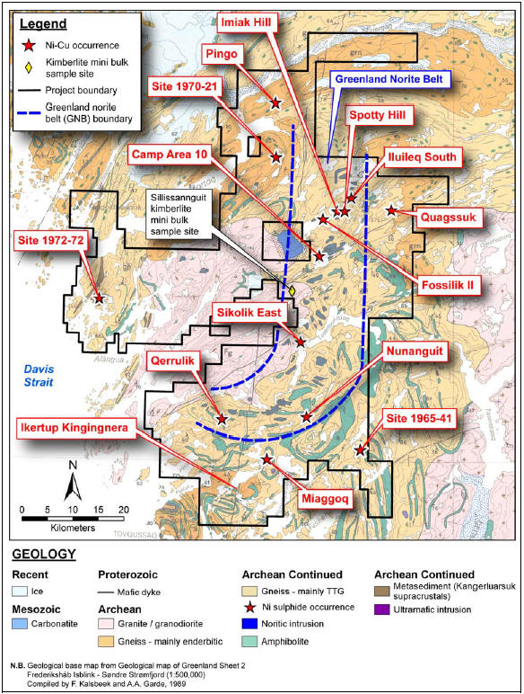
Figure 6: Location of Selected Sulphide Showings Discovered by Kryolitselskabet Øresund and IceFire Diamonds’ Sillissannguit Kimberlite Mini Bulk Sample Site
| | |
3CN024.004 – North American Nickel Inc. | | |
Updated Independent Technical Report for the Maniitsoq Nickel-Copper-Cobalt-PGM Project, Greenland | | Page 21 |
None of the exploration techniques were successful in identifying a large mineralized body. However, North American Nickel estimates that the technology used by previous operators and the local geology prevented sensors from detecting conductors at a depth greater than approximately 50 metres.
In 1993, Falconbridge confirmed the presence of highly weathered nickel-copper showings as well as the comprehensive nature of the exploration work conducted by KØ during a brief site visit. Assay values up to 1.02 percent nickel and 2.91 percent copper were obtained from surface grab samples, which were analyzed by Lakefield Research using the pyrosulphate XRF/fused disk method.
In 1994, Nunaoil A/S prospected the Kangerluarsuk supracrustal rocks on the east side of the current project area for gold and nickel mineralization. The results were generally disappointing and no nickel or gold anomalies were identified.
In 1995, Cominco Ltd. (Cominco) acquired a large licence covering most of the Greenland Norite Belt. Early in the year, prior to the field season, the companyre-examined andre-sampled core from many of the KØ boreholes and confirmed the high tenor of the nickel sulphide mineralization. (Nickel tenor is defined as the nickel content whenre-calculated to 100 percent sulphides).
In 1995, the Geological Survey of Greenland and Denmark commissioned Geoterrex Ltd. (Geoterrex) to complete an airborne magnetic and time-domain GeoTEM survey over the Greenland Norite Belt. The survey was completed between July and September, 1995 and comprised 20,446 line kilometres of which 10,546 line kilometres were within the Maniitsoq project area (Figure 7). The survey used a fixed-wing aircraft at a nominal ground clearance of 120 metres, with a line spacing of 200 metres over the central core of the Greenland Norite Belt and 400 metres elsewhere. Survey lines were oriented 80 degrees, which was not the optimum orientation given the regional geology but was mandated by the rugged topography. The rugged terrain prevented the survey plane from maintaining a consistent elevation, and up to 10 percent of the survey was flown with a ground clearance of over 300 metres.
Cominco contributed 25 percent to the cost of the GeoTEM survey in return for early access to the data. Geoterrex identified 1,557 electromagnetic anomalies. However, the vast majority of them were weak or associated with saltwater, or shallow glaciomarine sediments.
During the summers of 1995 and 1996, Cominco performed groundfollow-up on many conductors identified from the earlier airborne survey and carried out a limited ground geophysical program over two of the larger showings in the belt (Fossilik and Imiak Hill). The surface geophysical surveys consisted of magnetics,Max-Min, and GeonicsEM-47 moving loop TEM. The moving loop survey was the most effective technique, and it detected several shallow, moderately conductive(20-80 siemens) zones directly coincident with surface mineralization. After two field seasons, Cominco optioned the property to Platinova A/S, which subsequently relinquished most of the ground over the nickel-copper showings and focused exclusively on diamond exploration.
From 1996 to 1998, Platinova (with joint venture partners Aber Resources Ltd and Lexam Explorations) and Monopros Ltd. (Monopros) carried out diamond exploration. A total of 878 till and stream sediment samples were collected from the project area (838 by Platinova and 40 by Monopros). Platinova discovered two isolated boulders of weathered hypabyssal kimberlite near the centre of the project area. Platinova and Monopros completed helicopter-borne frequency domain electromagnetic (EM) and magnetic surveys (DigHEM in the case of Platinova and Aerodat in the case of Monopors) totalling 7,020 line kilometres over the central part of the project area (Figure 7).
| | |
3CN024.004 – North American Nickel Inc. | | |
Updated Independent Technical Report for the Maniitsoq Nickel-Copper-Cobalt-PGM Project, Greenland | | Page 22 |
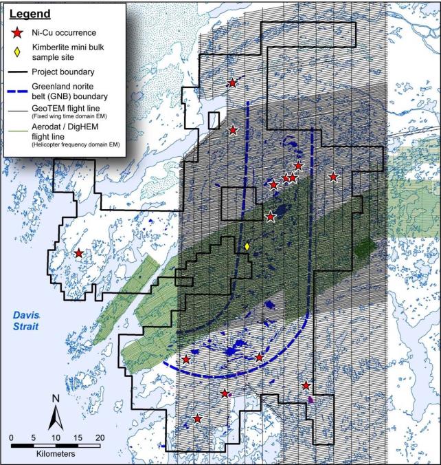
Figure 7: Historical Airborne EM Coverage
In 1998, Platinova commissioned High Sense Geophysics Limited to fly detailed(50-metre spaced orthogonal lines) helicopter magnetic surveys totalling 620 line kilometres over four selected diamond targets. None of these targets were drill tested. However, Platinova completed five boreholes in 1998 (612.5 metres) to test other targets near the mouth of Kangia fjord. BoreholesLX98-002 intersected 30 centimetres of kimberlite while the remainder intersected barren granitic gneiss and granodiorite.
| | |
3CN024.004 – North American Nickel Inc. | | |
Updated Independent Technical Report for the Maniitsoq Nickel-Copper-Cobalt-PGM Project, Greenland | | Page 23 |
At the end of 1998, both Platinova and Monopros drastically reduced the size of their licences.
In 1999, Falconbridge acquired a 386 square kilometre licence covering some of the key KØ nickel-copper showings in the northern part of the Greenland Norite Belt. Initial work focused on the following showings: Imiak Hill, Camp Area 10, Fossilik, and Quagssuk. Seven grab samples were sent for whole rock and trace element analysis, and six samples were assayed for economic elements. Nickel, copper, and cobalt were analyzed by atomic absorption using a near total multi-acid extraction. The results confirmed the nickel-rich nature of the sulphides. When recalculated to 100 percent sulphides, the nickel tenors of assay samples ranged from 6.8 to 9.5 percent nickel.
In 2000, Falconbridge increased the size of its land position to 808 square kilometres,re-sampled KØ drill core from the Imiak Hill, Fossilik II, Quagssuk, and Camp Area 10 occurrences, and conducted prospecting throughout the Greenland Norite Belt. There-sampling of the KØ drill core was complicated by the fact that previous sampling by Cominco and others often left insufficient material. Nevertheless, Falconbridge concluded that the 2000 analyses were broadly comparable to previous results. The prospecting did not result in the discovery of any new nickel-copper mineralization. Fixed loop UTEM surveys were conducted over the Fossilik, Camp Area 10, Imiak Hill, and Spotty Hill showings along survey lines oriented at 145 degrees and spaced 200 to 400 metres apart. No anomalies were detected. Following the 2000 field program, Falconbridge allowed their licences to lapse.
In 2004, NunaMinerals A/S (NunaMinerals) sampled a poorly exposed rusty zone in quartz-dioritic rocks about 350 metres south of KØ’s Ikertup Kingingnera showing in the southern part of the project area. The showing was revisited in 2005, and a composite sample was collected that yielded 0.36 grams of platinum per tonne (g/t platinum), 1.74 g/t palladium, 0.17 g/t gold, 0.80 percent nickel, and 0.30 percent copper. In 2006, NunaMinerals completed three shallow boreholes (237 metres) to test for additional mineralization beneath the occurrence. Only weak mineralization was intersected. The best intersection was 8.00 metres averaging 143 parts per billion (ppb) combined palladium and platinum and 0.20 percent nickel.
From 2006 to 2011, IceFire Diamonds AS (IceFire) sampled kimberlite dikes that occur throughout the region but concentrated particularly on the 60 degrees striking Sillissannguit trend where dikes, locally up to 2.5 metres wide, were traced discontinuously over distances of several kilometres.
In 2011, IceFire collected mini-bulk samples of kimberlite from two sites. One of these sites, Sillissannguit, is within the project area (Figure 7). The Sillissannguit sample weighed 14.3 tonnes and was shipped to Geoanalytical Laboratories Diamond Services, Saskatchewan Research Council in Saskatoon for diamond test work. A total of 193 kilograms of material was processed for microdiamond extraction by caustic fusion, and 14.1 tonnes was processed for macrodiamonds by dense media separation. The sample returned one macrodiamond in the1.18-1.70-millimetre fraction and two in the0.85-1.18 millimetre fraction. The caustic fusion sample returned no microdiamonds.
IceFire ceased exploration in the area after 2011, and its last mineral exploration licence expired in 2013.
| | |
3CN024.004 – North American Nickel Inc. | | |
Updated Independent Technical Report for the Maniitsoq Nickel-Copper-Cobalt-PGM Project, Greenland | | Page 24 |
| 6 | Geological Setting and Mineralization |
This section has been extracted from a structural geology report (Ravenelle, 2015b) prepared for North American Nickel in November 2015.
The geology of Greenland is dominated by crystalline rocks that formed during a succession of Archean and Paleoproterozoic orogenic events (Henriksen et al., 2009). The shield area is divided into three distinct provinces (Figure 8):
| | • | | Archean rocks of the North Atlantic Craton (3,200 – 2,600 Ma old; locally, units have ages up to >3,800 Ma) that were almost unaffected by Proterozoic or later orogenic activity |
| | • | | Archean terranes reworked during the Paleoproterozoic around 1,900 – 1,750 Ma ago |
| | • | | Terranes mainly composed of juvenile Paleoproterozoic rocks (2,000 – 1,750 Ma in age) |
The Maniitsoq project is located within preserved Archean rocks of the North Atlantic Craton (Figure 8). In western Greenland, the North Atlantic Craton is bounded to the north by the Paleoproterozoic Nagssugtoqidian orogeny and to the south by the Paleoproterozoic Ketilidian orogeny (Figure 8). The craton largely consists of Mesoarchean (ca. 3,075 to 2,820 Ma) orthogneisses with tonalite-trondhjemite-granodiorite (TTG) compositions (Steenfelt et al., 2005) that contain many conformable layers of metavolcanic amphibolite, anorthosite, and rare metasedimentary rocks (Windley, 1969).
The North Atlantic craton of western Greenland comprises six shearzone-bounded blocks, exposing granulite facies rocks in the north and prograde amphibolite facies rocks in the south (Windley and Garde, 2009; Figure 9). Metamorphic facies transitions are generally smooth within each block, but are abrupt and of tectonic nature at blocks’ boundaries. Local retrogression of the granulite facies rocks to amphibolite facies occurs. From south to north, the blocks are: Ivittuut, Kvanefjord, Bjørnesund, Sermilik, Fiskefjord, and Maniitsoq (Figure 9). The Fiskefjord and Sermilik blocks are separated by a structurally complex northeast-trending belt (Godthåbsfjord-Ameralik Belt; Figure 9). The belt comprises several terranes of different ages that have been accreted tectonically and folded together (Windley and Garde, 2009).
The Maniitsoq project is primarily located within the Fiskefjord block (Figure 9), which contains prograde amphibolite facies gneisses and metavolcanic belts in the south and granulite facies gneisses in the north (Windley and Garde, 2009; Figure 9). Retrograde amphibolite facies rocks occur in the centre of the block. The contact between the Fiskefjord and Maniitsoq block occurs in the northwestern corner of the project area.
| | |
3CN024.004 – North American Nickel Inc. | | |
Updated Independent Technical Report for the Maniitsoq Nickel-Copper-Cobalt-PGM Project, Greenland | | Page 25 |
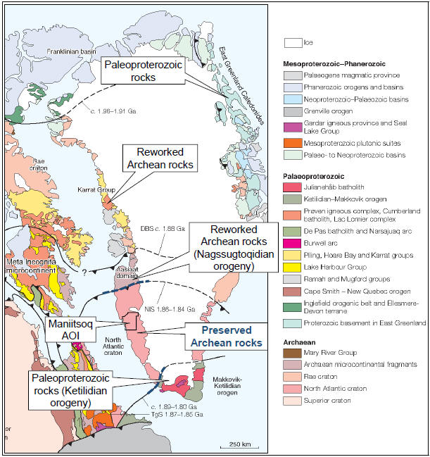
Figure 8: Greenland Principal Geological Units
Principal geological units of Eastern Canada and Greenland shown with Greenland in itspre-drift(pre-late Cretaceous) position relative to eastern Canada, simplified by Henriksen et al. (2009) afterSt-Onge et al. (2009).
| | |
3CN024.004 – North American Nickel Inc. | | |
Updated Independent Technical Report for the Maniitsoq Nickel-Copper-Cobalt-PGM Project, Greenland | | Page 26 |
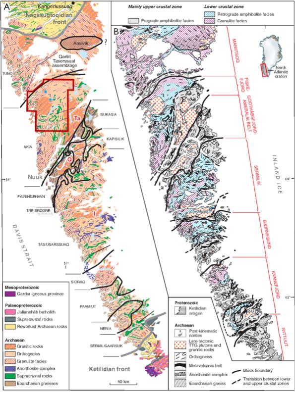
Figure 9: North Atlantic Archean Craton of Western Greenland (Windley and Garde, 2009)
A: The subdivision in terranes/blocks with distinct geological histories.
B: The subdivision in tilted blocks, each of which has granulite facies rocks in its northern parts and rocks at amphibolite facies in the south.
| | |
3CN024.004 – North American Nickel Inc. | | |
Updated Independent Technical Report for the Maniitsoq Nickel-Copper-Cobalt-PGM Project, Greenland | | Page 27 |
The Maniitsoq property is dominated by supracrustal rocks intruded by multiple phases of felsic to ultramafic intrusions and dikes of various ages. All rocks are Archean in age, except for the Proterozoic mafic dikes and the Paleozoic carbonatite intrusion. A detailed geologic map of the project area is shown in Figure 10.
Lithological units are dominated by tonalite-trondhjemite-granodiorite (TTG) gneisses dated between approximately 3,050 and 3,010 Ma (Windley and Garde, 2009; Figure 10). The TTG gneisses are cut by younger intrusions including the Taserssuaq tonalite-granodiorite dated at 2,982 ±7 Ma (Garde et al., 2000), the Qugssuk granite dated at 2,975 ±6 Ma (Garde et al., 2000), and the Finnefjeld gneiss dated at 2,975 ±7 Ma (Garde et al., 2000).
The Finnefjeld gneiss is a complex intrusion of predominantly tonalitic and trondhjemitic rocks interpreted to have been emplaced after the main granulite facies metamorphic event (Windley and Garde, 2009). The Finnefjeld gneiss is interpreted as a late-orogenic, deep-crustal, intrusive granitoid pluton (Allaart et al., 1978; Marker and Garde, 1988) or alternatively as a deeply eroded impact structure (Garde et al., 2014).
The TTG gneisses at Maniitsoq are embedded with kilometre-scale suites of mafic volcanic rocks (amphibolite) and larger enderbitic gneisses (Figure 10). A group of kilometre-scale norite intrusions occur in the centre of the project area and form the north-trendingJ-shaped Greenland Norite Belt, which is approximately 75 kilometres long and up to 15 kilometres wide. Such intrusions locally host significant nickel-copper sulphide mineralization (e.g., Imiak Hill, Spotty Hill, Mikissoq, and Fossilik) and are the focus of the current exploration work. The norite intrusions are interpreted to have been derived from ultramafic magmas that were partially contaminated with continental crust during their ascent and final emplacement (Garde 1991, 1997). Their age varies between 3,014.0+/-2.7 Ma and 3,002.3+/-5.4 Ma (Heaman, 2014).
A series of Proterozoic high-magnesium mafic dikes crosscut the area. Such dikes are typically north- or northeast-trending (Garde, 1997) and are dated ca. 2,214 ± 10 Ma (Nutman et al., 1995).
A younger Paleozoic carbonatite intrusion occurs east of the Finnejfeld gneiss and crosscuts all other rock types.
Combining aeromagnetic data with public domain information from Garde (1997) and Berthelsen (1960), Ravenelle (2015a) reconciled four episodes of deformation at Maniitsoq, spanning the Archean and Proterozoic (Table 4).
Table 4: Summary of Deformational Events at Maniitsoq
| | | | | | |
Event | | Regional
Fabrics | | Folds | | Shear Zones/ Faults |
D1
| | S1 | | F1 in primary layering, not common | | D1 shear zones, observed in drilling only |
D2
| | None | | Shallow-plunging F2 folds | | Dip-slip D2 shear zones, orientedsub-parallel to tectonic grain |
D3
| | None | | Steep-plunging F3 folds | | Strike-slip D3 shear zones, NE andNW-trending, cuts tectonic grain |
D4
| | None | | None | | Brittle faults,N- andNE-trending, locally onpre-existing shear zones |
| | |
3CN024.004 – North American Nickel Inc. | | |
Updated Independent Technical Report for the Maniitsoq Nickel-Copper-Cobalt-PGM Project, Greenland | | Page 28 |
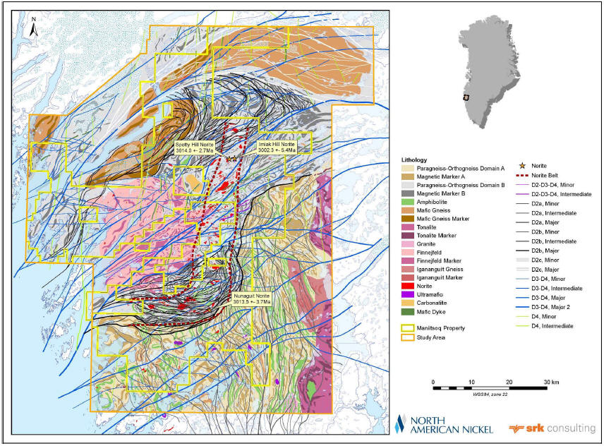
Figure 10: Detailed Geology of the Project Area
“Markers” refer to discrete markers interpreted from aeromagnetic surveys
| | |
3CN024.004 – North American Nickel Inc. | | |
Updated Independent Technical Report for the Maniitsoq Nickel-Copper-Cobalt-PGM Project, Greenland | | Page 29 |
Supracrustal lithological units include paragneiss, mafic paragneiss, and rare amphibolite. These supracrustal rocks are locally magnetic and can contain magnetite porphyroblasts. Some paragneiss have magnetite-rich bands reminiscent of banded iron formations. These magnetite-bearing paragneiss and amphibolite units represent most of the discrete magnetic markers visible on the aeromagnetic surveys. Locally, the paragneisses are rusty or gossanous and contain trace to several percent sulphides (pyrite ± pyrrhotite). Mineralization consisting of heavily disseminated to semi-massive stringer sulphides hosted in siliceous paragneisses and containing elevated copper and zinc values was intersected in drilling in the northwestern portion of the property (Takissoq West target). Voluminous paragneiss units, especially in the south portion of the project area indicate the presence of a large metamorphosed sedimentary basin over the project area. The ages of paragneiss and amphibolite sequences are currently unknown.
The norite bodies occur aspod-shaped or lenticular intrusions that can be up to 4 square kilometres in size. Less commonly, the norite bodies occur as metre-scale dikes. Their overall distribution forms a belt that wraps around the Finnefjeld intrusion (Figure 10). Their composition varies from pyroxenitic, noritic, dioritic, to quartz-dioritic compositions (Figure 11A, Figure 11B, Figure 11C). Some of these changes in composition are related to alteration caused by younger rocks crosscutting the norite. For example, some norite intrusions become richer in quartz in altered selvages of pegmatite dikes (Figure 11D). The quartz-rich compositions also commonly occur near their contacts with orthogneiss. Other changes in composition, for example an increase in feldspar proportions leading to leuconorite compositions, are interpreted to be primary (Figure 11E), and one particular phase of norite is characterized by layers of coarse-grained pyroxene crystals and is referred to as Leopard norite (Figure 11F). Leopard norite has been observed at a number of widely separated locations, particularly within larger norite intrusions. The norite intrusions are locally magnetic.
Petrographic analyses of norite and pyroxenite samples identified both cumulate andnon-cumulate textures. Both textural varieties consist primarily of orthopyroxene, clinopyroxene, plagioclase, and hornblende with subordinate amounts of biotite and opaque minerals. Pyroxenes typically show partial to extensive replacement by hornblende±biotite. Pyroxenites are locally olivine-bearing.
| | |
3CN024.004 – North American Nickel Inc. | | |
Updated Independent Technical Report for the Maniitsoq Nickel-Copper-Cobalt-PGM Project, Greenland | | Page 30 |
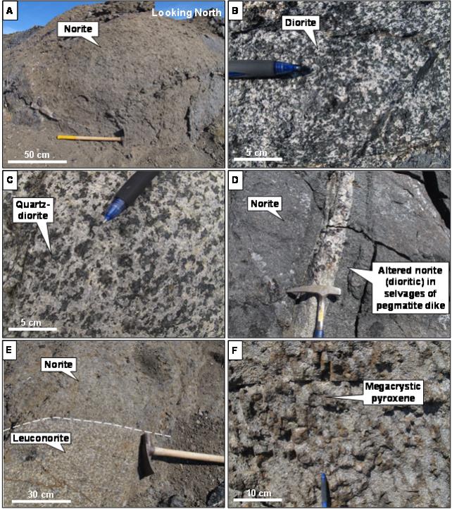
Figure 11: Characteristics of Norite Intrusions at Maniitsoq
A: Outcrop showing typical weathering in norite.
B: Dioritic part of norite intrusion.
C: Quartz-dioritic part of norite intrusion.
D: Pegmatite dike causing alteration of norite to dioritic composition.
E: Norite to leuconorite compositional layering.
F: Leopard norite with megacrystic pyroxene.
| | |
3CN024.004 – North American Nickel Inc. | | |
Updated Independent Technical Report for the Maniitsoq Nickel-Copper-Cobalt-PGM Project, Greenland | | Page 31 |
The supracrustal sequence is cut by multiple felsic intrusions attributable to the TTG orthogneisses interpreted on regional government maps. These intrusions locally occur as dikes, which are commonly foliated (Figure 12A and Figure 12B) and locally have gneissic layering (Figure 12C).
The orthogneisses include a series of younger intrusions like the Taserssuaq tonalite-granodiorite intrusion dated at 2,982 ±7 Ma (Garde et al., 2000) and the Finnefjeld gneiss dated at 2,975 ±7 Ma (Garde et al., 2000). The Taserssuaq tonalite is a massive homogenous intrusion (Figure 12D, Figure 12E). The Finnefjeld intrusion is composed locally of many felsic to intermediate phases that crosscut each other, including diorite and aplite dikes (Figure 12F). Otherwise, the Finnefjeld is gneissic and more homogeneous.
Although orthogneiss clearly postdates the paragneiss, the timing of orthogneiss relative to norite intrusions is not clear because the two rock types are of intrusive origin and it is challenging to determine which rock cuts which. However, local, fragments of norite in orthogneiss suggest that some of the orthogneiss intrusions postdate some of the norite intrusions.
A stockwork of pegmatite dikes is preferentially developed within the norite intrusions where they form complex bodies that are up to several metres wide (Figure 13A). It typically contains megacrystic biotite crystals that are up to 15 centimetres in length (Figure 13B). The stockwork was intersected in drilling at various locations including at Spotty Hill, Fossilik,P-013,P-030,P-032, andP-053. It is interpreted to have occurred late in the geological history of the region.
| 6.2.5 | Proterozoic and Paleozoic Units |
Proterozoic mafic dikes have a width of several tens of metres and are clearly visible from aerial view due to their positive topographic relief (Figure 14A and B). They are locally magnetic and have a strong magnetic susceptibility. The dikes are spatially associated with brittle faults and are dominantly north- and northeast-striking.
A Paleozoic carbonatite intrusion occurs east of the Finnefjeld gneiss and crosscuts all other rock types. Dikes related to the carbonatite intrusion have been locally intersected by drilling.
| | |
3CN024.004 – North American Nickel Inc. | | |
Updated Independent Technical Report for the Maniitsoq Nickel-Copper-Cobalt-PGM Project, Greenland | | Page 32 |
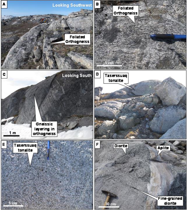
Figure 12: Characteristics of Orthogneiss, Taserssuaq and Finnefjeld Intrusions at Maniitsoq
A: Foliated orthogneiss at Fossilik.
B: Close up view of foliated orthogneiss.
C: Orthogneiss with gneissic layering.
D: Taserssuaq tonalite.
E: Close up view of Taserssuaq tonalite.
F: Multiple generations of dikes within Finnefjeld intrusion.
| | |
3CN024.004 – North American Nickel Inc. | | |
Updated Independent Technical Report for the Maniitsoq Nickel-Copper-Cobalt-PGM Project, Greenland | | Page 33 |
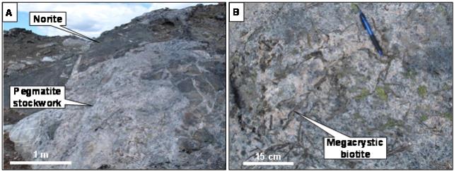
Figure 13: Characteristics of the Pegmatite Stockwork
A: Pegmatite stockwork in norite.
B: Megacrystic biotite within pegmatite stockwork.
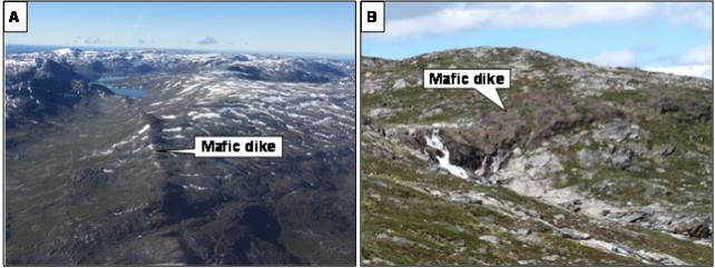
Figure 14: Proterozoic Mafic Dikes
A: Aerial view showing mafic dike.
B: Section view showing mafic dike.
| | |
3CN024.004 – North American Nickel Inc. | | |
Updated Independent Technical Report for the Maniitsoq Nickel-Copper-Cobalt-PGM Project, Greenland | | Page 34 |
The dominant regional foliation (S1) is defined by the alignment of quartz, feldspars, and mafic minerals and is typically oriented parallel to compositional layering in paragneiss and orthogneiss. The S1 foliation is interpreted to have affected the entire project area. It is typically not associated with a stretching lineation. The norite intrusions register the S1 foliation near their margins only.
A northwest-trendingsub-vertical spaced cleavage occurs throughout the project area. This spaced cleavage is not associated with folding and its impact on the geometry of the other structural elements is not considered important.
North American Nickel has identified three distinct folding events. The earliest generation of folds (F1) affects compositional layering or dike contacts, with strongly-developed axial-planar S1 foliation (Figure 15A and B). F1 folds are not common in outcrop and appear to have little impact on the property-scale map.
Two generations of folds (F2 and F3) fold the S1 foliation and the primary layering. F2 and F3 folds are not associated with an axial-planar foliation. The F2 folds are tight asymmetrical folds (Figure 15C and D) with shallow to moderate plunges. Their axial plane is orientedsub-parallel to the tectonic grain on the aeromagnetic survey and they are interpreted to coincide with the tight folds occurring in discrete magnetic markers. The plunge direction of the F2 folds changes around the Finnefjeld intrusion, from east-trending south of the Finnefjeld, to south-trending east of the Finnefjeld intrusion, mimicking the overall trend of the norite belt.
F3 folds are open folds (Figure 15E and F) with a steep plunge (average fold axis orientation of 84/169; plunge/trend) that does not vary significantly over the project area. At property-scale, F2 fold axes have been rotated about the average F3 fold axis orientation.
| | |
3CN024.004 – North American Nickel Inc. | | |
Updated Independent Technical Report for the Maniitsoq Nickel-Copper-Cobalt-PGM Project, Greenland | | Page 35 |
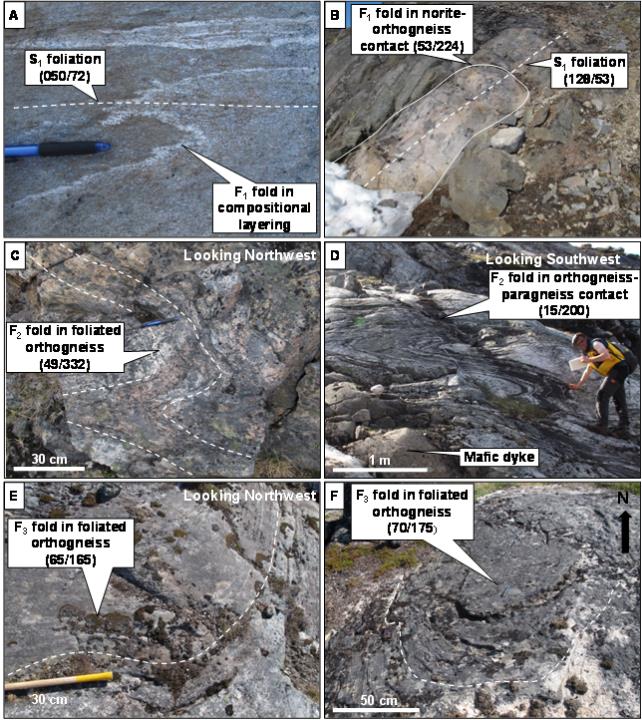
Figure 15: Folds in Outcrops
A: F1 fold in compositional layering within orthogneiss.
B: F1 fold in norite-orthogneiss contact.
C: F2Z-fold foliated orthogneiss.
D: F2S-fold in orthogneiss.
E: Gentle F3 fold in foliated orthogneiss.
F: F3 fold in foliated orthogneiss.
| | |
3CN024.004 – North American Nickel Inc. | | |
Updated Independent Technical Report for the Maniitsoq Nickel-Copper-Cobalt-PGM Project, Greenland | | Page 36 |
| 6.3.3 | Shearing and Faulting |
Several generations of shear zones with various styles, kinematics, and orientations occur in the project area. They containC-S fabrics and locally show grain size reduction and mylonitic textures.
Core observations suggest that some shear zones developed contemporaneously with S1 foliation (Figure 16). Such D1 shear zones are locally folded by F2 folds.
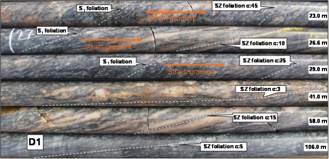
Figure 16: D1 Shear Zone in Core (BoreholeMQ15-076)
The orientation of D2 and D3 shear zones varies from northeast- to northwest-trending. The two generations of shear zones are distinguished by their kinematics: D2 shear zones are primarilydip-slip faults, whereas D3 shear zones are primarily strike-slip faults.
Field evidence fordip-slip movement along D2 shear zone includes steeply-plunging stretching lineations (Figure 17A, Figure 17B), sheath folds with steep axes (Figure 17C), and kinematic indicators observed in core (Figure 17D). D2 shear zones are interpreted to correspond to structures oriented at low angle to F2 axial traces and to the overall tectonic grain on aeromagnetic surveys, such as the Qugssuk-Ulamertoq shear zone documented by Garde (1997) in the southeast part of the project area.
Northeast-trending D3 shear zones locally cut the regional S1 foliation and lithological units (tectonic grain) at a high angle. These shear zones have strike-slip kinematics compatible with the steep plunge of F3 folds. The D3 shear zones postdate the pegmatite stockwork.
D4 north-trending faults developed in conjunction with the intrusion of Proterozoic mafic dikes, and D4 brittle faults are locally superimposed onpre-existing D2 and D3 shear zones. Brittle faults were only observed in core and are not common. In BoreholeMQ-15-074 (Mikissoq area), brittle faults occur with gouge-fill or slickensides developed within and parallel to mylonitic shear zones, showing that some shear zones have been reactivated as brittle faults.
| | |
3CN024.004 – North American Nickel Inc. | | |
Updated Independent Technical Report for the Maniitsoq Nickel-Copper-Cobalt-PGM Project, Greenland | | Page 37 |
In most cases, the mineralogy of shear zones is the same as the host rock they affect, although in some instances, shear zones are associated with retrograde metamorphic assemblages.
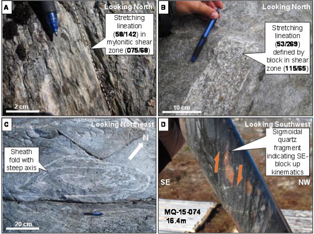
Figure 17: D2 Shear Zones withDip-Slip Kinematics
A and B: Stretching lineation nearlydown-dip on shear zone foliation.
C: Sheath fold with steep axes indicative ofdip-slip movement.
D: Sigmoidal quartz fragment in drill core indicative ofdip-slip (southeastblock-up) movement.
| 6.3.4 | Geometry of the Norite Belt and Norite Intrusions |
Norite intrusions form a belt that wraps around the Finnefjeld intrusion. Field relationships indicate that a large proportion of the norite intrusions were emplaced as lenticular intrusions that now follow the trend of the tectonic grain and stratigraphy. These intrusions have been transposed, folded, and sheared along with their host rocks. At Fossilik, detailed mapping shows a complex fold interference pattern in norite-orthogneiss contact, interpreted to result from interference between F2 and F3 folds (Figure 18).
In the northern region, two new norite intrusions have been identified, indicating that the norite belt continues towards beyond the previously known extent. Based on a change in direction of S1 foliation, North American Nickel expects that additional norite bodies may exist in a northwesterly direction from two newly discovered norite occurrences.
| | |
3CN024.004 – North American Nickel Inc. | | |
Updated Independent Technical Report for the Maniitsoq Nickel-Copper-Cobalt-PGM Project, Greenland | | Page 38 |
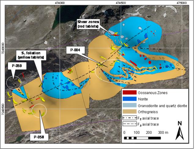
Figure 18: Map of the Fossilik Area (Modified After North American Nickel) (Structural measurements are displayed as 3D tablets)
In addition, the geometry of the norite belt has been offset by shear zones and faults. For example, in the southern part of the norite belt, a brittle-ductile shear zone mapped in the field and interpreted from aeromagnetic data appears to offset a kilometre-scale trail of norite intrusions with an apparent dextral offset. The apparent dextral offset matches dextral-normal oblique-slip kinematics identified in the field at that location.
| | |
3CN024.004 – North American Nickel Inc. | | |
Updated Independent Technical Report for the Maniitsoq Nickel-Copper-Cobalt-PGM Project, Greenland | | Page 39 |
Nickel-copper-cobalt-PGM sulphide mineralization at Maniitsoq is hosted in noritic to pyroxenitic intrusions of the Greenland Norite Belt. Well-mineralized intrusions are typically surrounded by orthogneiss. The intrusions have undergone multiple phases of folding as well as brittle to ductile faulting (Fedorowich, 2015; Ravenelle, 2015b).
Work completed in 2015 documented the occurrence of sulphide gossans in fold hinges at the Fossilik intrusion and postulated that mineralization at theP-058,P-059, and Spotty Hill targets may also occur in fold hinges. Drilling completed in 2016 documented multiple occurrences of sulphide mineralization adjacent to mylonite zones and the discovery of a new sulphide lens in what is interpreted to be a boudinaged norite body. Structural processes have played a role in there-distribution of sulphide mineralization at Maniitsoq and understanding this relationship more fully is viewed as a key element in ongoing exploration and drill targeting.
The mineralized zones are composed of various proportions of nickel, copper, and iron sulphides that occur as disseminations, blebs, patches,net-textured mineralization, and semi-massive to massive breccia veins and stringers (Figure 19). Detailed mineralogical studies (see Section 12) of mineralized samples from a number of the nickel occurrences have identified the main sulphide phases as pyrrhotite, pentlandite, pyrite, and chalcopyrite, with nickel hosted primarily in pentlandite and copper in chalcopyrite (Figure 20).
Primary magmatic sulphide mineralization commonly occurs in close proximity to remobilized sulphides. The two types of mineralization exhibit textural continua and are interpreted to have experienced recrystallization related to high grade metamorphism and melting events. Within “magmatic” sulphide zones it can be difficult to discriminate between true magmatic sulphide textures and secondary sulphide textures; however, indications of the latter include irregular sulphide patches, cloud-like disseminated sulphides, intervals of chalcopyrite-rich disseminated and blebby sulphides, and centimetre-scale composite sulphide and norite globules within norite.
| | |
3CN024.004 – North American Nickel Inc. | | |
Updated Independent Technical Report for the Maniitsoq Nickel-Copper-Cobalt-PGM Project, Greenland | | Page 40 |

Figure 19: Nickel-bearing Mineralized Zone and Sulphide Textures at Spotty Hill; BoreholeMQ-15-075
Note: Core size in all photos is BTW with a diameter of ~42 millimetres, unless otherwise stated.
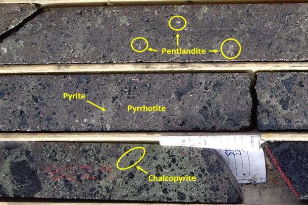
Figure 20: Massive Pyrrhotite, Pentlandite, Pyrite and Chalcopyrite at Imiak Hill;Borehole MQ-14-037
| | |
3CN024.004 – North American Nickel Inc. | | |
Updated Independent Technical Report for the Maniitsoq Nickel-Copper-Cobalt-PGM Project, Greenland | | Page 41 |
| 6.4.1 | Magmatic Sulphide Mineralization |
Magmatic nickel mineralization consists of disseminated, blebby to globular, patchy, andnet-textured sulphide hosted within norite intrusions and pyroxenite (Figure 21). Finely disseminated sulphide is irregularly distributed in many of the intrusions of the Greenland Norite Belt and contains elevated nickel ranging from 0.05 to 0.3 percent nickel. Medium grained, disseminated, blebby to globular, and locallynet-textured sulphide also forms discrete mineralized zones grading between 0.3 and 1.3 percent nickel, 0.1 to 0.3 percent copper, up to 0.1 percent cobalt, and 0.05 to 0.35 g/t combined platinum, palladium, and gold (Pt+Pd+Au). Good examples of magmatic sulphide zones occur at Spotty Hill, Pingo,P-013,P-058, and Mikissoq.
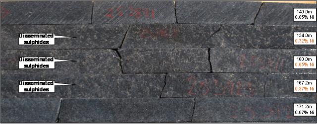
Figure 21: Norite-Hosted Disseminated Nickel-Sulphide Mineralization at Fossilik(P-058); BoreholeMQ-15-077
| 6.4.2 | Remobilized Sulphide Mineralization |
Remobilized nickel mineralization consists of semi-massive to massive sulphide breccia veins, breccia zones, stringers, and fracture fillings, which are interpreted to have been sourced from the magmatic mineralization. The remobilized sulphides are typically associated with primary magmatic sulphides within the noritic to pyroxenitic intrusions and are locally also in contact with, or in close proximity to, orthogneiss country rocks and mylonite zones (Figure 22).
| | |
3CN024.004 – North American Nickel Inc. | | |
Updated Independent Technical Report for the Maniitsoq Nickel-Copper-Cobalt-PGM Project, Greenland | | Page 42 |
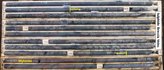
Figure 22: Sulphide Breccia Veins at Mikissoq; BoreholeMQ-13-029
Note: the core length interval presented returned 4.65% Ni, 0.33% Cu, and 0.13% Co over 9.99 metres. True width of intersection is estimated to be 6.96 metres.
The highest nickel values intersected in drilling at Maniitsoq thus far are associated with zones of sulphide breccia, breccia veins, and sulphide stringers (Figure 23) which are well developed at Imiak Hill, Mikissoq, Spotty Hill,P-053,P-058 andP-013 SE. These zones range in core length from less than one metre to eighteen metres and consist of medium to coarse grained pyrrhotite, pentlandite, pyrite, and chalcopyrite. Pyrrhotite is the dominant sulphide mineral phase. Pentlandite is ubiquitous and occurs as individual grains or aggregates of grains, locally forming chains wrapping around pyrrhotite grains (Figure 24). Chalcopyrite content is variable on asample-to-sample basis and is locally remobilized into chalcopyrite-rich stringers and veins. Pyrite content is variable from one mineralized location to another and where more abundant, lowers the overall nickel tenor (nickel tenor is defined as a nickel grade in in 100 percent sulphides).
Remobilized sulphide zones commonly yield two to four percent nickel, 0.2 to 0.8 percent copper, and 0.05 to 0.15 percent cobalt. Precious metal content is variable from zone to zone and ranges from less than 0.1 g/t Pt+Pd+Au at Imiak Hill to 1.0 g/t Pt+Pd+Au at Spotty Hill. Individual veins and stringers within these zones have multiple orientations and range from centimetre- to metre-scale in core length. Individual semi-massive to massive sulphide samples typically yield between 2.5 to 7.5 percent nickel, 0.08 to 2.5 percent copper, 0.09 to 0.25 percent cobalt and from less than 0.1 to 1.3 g/t Pt+Pd+Au.
Nickel-copper sulphide mineralization composed of a combination of both primary magmatic and remobilized sulphides has been intersected at multiple boreholes at a number of locations throughout the Maniitsoq property. These locations include Imiak Hill, Mikissoq, Spotty Hill,P-004,P-058,P-059,P-013,P-013 SE,P-030,P-032 andP-053 which are summarized in the proceeding sections.
| | |
3CN024.004 – North American Nickel Inc. | | |
Updated Independent Technical Report for the Maniitsoq Nickel-Copper-Cobalt-PGM Project, Greenland | | Page 43 |
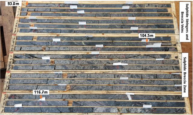
Figure 23: Zone of Breccia Veins and Stringers (Uphole) and Massive Sulphide Breccia (Down-hole) atP-053; BoreholeMQ-15-082
Note: the core interval presented averaged 1.98% Ni, 0.62% Cu, and 0.19 g/t Pt+Pd+Au over a core length interval of 23.7 metres (93.0-116.7 metres), including an interval of 12.2 metres (104.5 – 116.7 metres) grading on average 2.78% Ni, 0.36% Cu, and 0.26 g/t Pt+Pd+Au. True width of the intersection is estimated to be 16.1 metres.
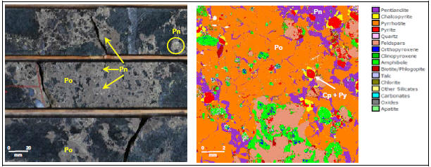
Figure 24: Pentlandite Textures atP-013SE, BoreholeMQ-16-109 (left, core) and atP-058, BoreholeMQ-14-054 (right, QEMSCAN image)
Note: Pn = Pentlandite; Po = Pyrrhotite, Cp = Chalcopyrite, Py = Pyrite
Core size is NQ with a diameter of 47.6 millimetres.
| | |
3CN024.004 – North American Nickel Inc. | | |
Updated Independent Technical Report for the Maniitsoq Nickel-Copper-Cobalt-PGM Project, Greenland | | Page 44 |
The Imiak Hill Complex comprises three separate mineralized norite intrusions that are hosted in orthogneiss. All three intrusive bodies are located within 1 to 1.5 kilometres of each other in the central portion of the Maniitsoq property (Figure 25). These mineralized occurrences include Imiak Hill, Spotty Hill, and Mikissoq. The term “Imiak Hill Complex” was given to the overall target area by North American Nickel in 2013 and has been used in various news releases by North American Nickel. Historic drilling was carried out by KØ at each of the three Imiak Hill Complex sites and resulted in significant mineralized intersections at Imiak Hill and Spotty Hill. Drilling carried out by North American Nickel has resulted in the expansion of the Imiak Hill and Spotty Hill zones and the intersection of significant mineralization at Mikissoq. Historic names of individual targets were retained by North American Nickel.
Mikissoq
The Mikissoq area is located 1.3 kilometres northwest of Spotty Hill and one kilometre northeast of Imiak Hill. Mineralized norite intrusions or boudins are hosted in country rocks consisting primarily of orthogneiss with minor paragneiss and mafic gneiss.
Initial drilling carried out in 2013 by North American Nickel tested a strong VTEM anomaly coincident with the historic Mikissoq gossan, which had returned values of up to 3.73 percent nickel in surface grab samples. Drilling conducted between 2013 and 2015 intersected three parallel zones of mineralization (HW, Central and FW) in a small, near surface norite body. The knowndown-dip extent of this shallow mineralization was limited by a borehole completed in 2015(MQ-15-074), which intersected a wide zone of orthogneiss at the target depth. Drilling carried out in 2016 to test anoff-hole electromagnetic anomaly detected from boreholeMQ-15-074 intersected a deeper norite body containing a larger tabular sulphide zone.
The norite bodies and contained sulphide zones strike northeast and dip steeply to the southeast. They are bounded on the northwest side by asub-vertical mylonite zone. The upper norite body iscross-cut by a west-striking mylonite (Figure 26). The norite bodies are separated by orthogneiss and may represent boudins of an original single intrusion. The mineralization zones in the upper and deeper norite bodies are interpreted to strike 58 degrees with dips of 78 degrees and 89 degrees to the southeast, respectively.
The shallow mineralization has been intersected over a strike extent of 25 metres and to a maximum depth of 95 metres below surface. Intersections range from 2 to 20 metres in width. Mineralization consists of disseminated to blebby sulphides with intervals of locally remobilized vein, stringer, and breccia vein sulphides, as well as sulphide fracture fillings. The fracture fillings and breccia textures, consisting of sulphides wrapping around clasts ofin-situ norite, suggest that the magmatic mineralization has undergone a component of brittle deformation as well as localized sulphide remobilization.
Assay values for the shallow mineralization vary widely depending on the amount of remobilized sulphides present in any given sample. Semi-massive to massive sulphide samples from boreholeMQ-13-029 returned values of approximately 4.5 to 7.5 percent nickel, 0.15 to 0.65 percent copper, 0.1 to 0.2 percent cobalt and up to 0.3 g/t Pt+Pd+Au. Disseminated sulphide mineralization with localized sulphide veins and stringers in boreholeMQ-13-027 returned an average value of 0.7 percent nickel and 0.3 percent copper.
| | |
3CN024.004 – North American Nickel Inc. | | |
Updated Independent Technical Report for the Maniitsoq Nickel-Copper-Cobalt-PGM Project, Greenland | | Page 45 |
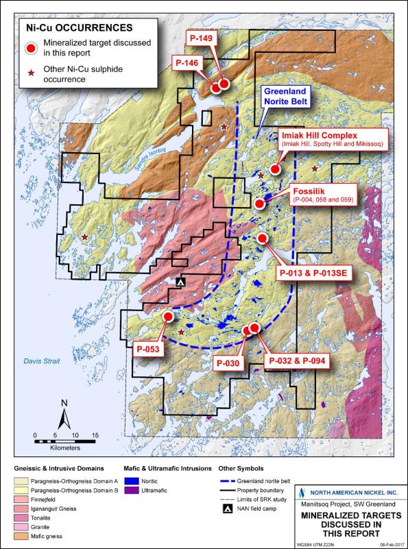
Figure 25: Location of Mineralized Target Areas
| | |
3CN024.004 – North American Nickel Inc. | | |
Updated Independent Technical Report for the Maniitsoq Nickel-Copper-Cobalt-PGM Project, Greenland | | Page 46 |
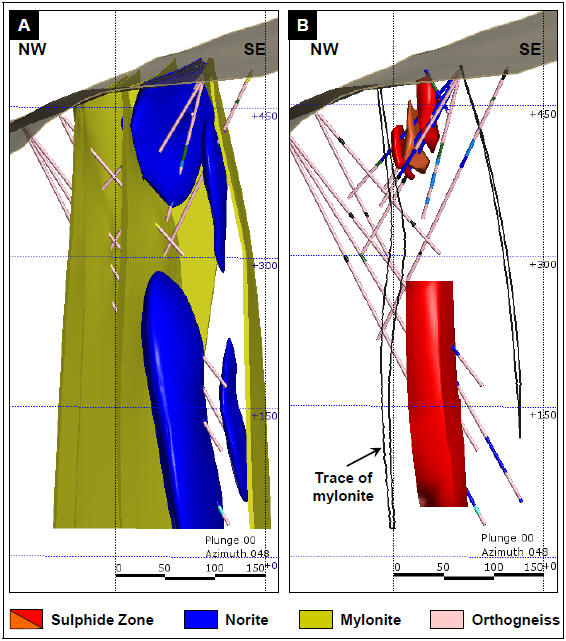
Figure 26: 3D Image (Looking Northeast) of Mikissoq Target Showing Geology, Sulphide Zones, and Boreholes
A: Modelled norite intrusions and mylonite zones
B: Modelled sulphide zones and trace of mylonite zones
| | |
3CN024.004 – North American Nickel Inc. | | |
Updated Independent Technical Report for the Maniitsoq Nickel-Copper-Cobalt-PGM Project, Greenland | | Page 47 |
The top of the deeper sulphide zone is located approximately 100 metres below the bottom edge of the shallow mineralization and has been intersected over a dip extent of 105 metres by three boreholes drilled on one section. Intersections range from 21 to 38 meters in width. The mineralization consists of coarse grained magmatic disseminations, blebs, and patches, locally with remobilized sulphide stringers and veins.
The deeper sulphide lens averages between 0.5 and 1.1 percent nickel, 0.25 and 0.55 percent copper, as well as 0.01 and 0.03 percent cobalt. The intervals with the highest sulphide content, including remobilized sulphides, typically grade between 1 and 4 percent nickel, 0.25 and 0.65 percent copper, as well as 0.02 and 0.08 percent cobalt. Combined Pt+Pd+Au values are typically less than 0.2 g/t.
Spotty Hill
The Spotty Hill intrusion is located 1.3 kilometres southeast of Mikissoq. The nickel-copper sulphide mineralization comprises a zone of disseminated to blebby magmatic sulphides with internal intersections of semi-massive to massive stringer and vein sulphides. Theup-plunge extent of the zone is represented by irregularly distributed surface gossans. The intrusion iscross-cut by a series of northeast striking and southeast dipping mylonite zones.
Prior to 2016, the mineralized zone was interpreted to be folded with the fold hinge occurring near surface at the northern end of the zone. Based on drilling and 3D modeling carried out in 2016, the mineralization is now interpreted to form a tabular body, which strikes 135 to 140 degrees, dips steeply (80 to 85 degrees) to the southwest and plunges at approximately 55 degrees to the southeast (Figure 27). The zone typically varies between two and 20 metres in width and has been delineated by drilling over 400 metres down-plunge. Thedown-dip extent of the zone is interpreted to be 150 metres in the core of zone where most of the drilling is concentrated, but is not fully defined by the current amount of boreholes and is poorly constrained at depth by a single hole. Two boreholes(MQ-13-022 andMQ-14-040) intersected a second footwall zone of disseminated and blebby sulphides at depth, the extent of which is not well defined by the current drilling.
Mineralization is hosted in pyroxenite and norite and typically consists of medium to coarse grained disseminated and blebby magmatic sulphides, locally with internal zones of semi-massive and massive patchy, stringer, and vein mineralization. Sulphide stringers, veins, and fracture fillings are interpreted to be remobilized over short distances from primary magmatic sulphides.
Disseminated to blebby mineralization commonly yields between 0.1 and 1.0 percent nickel, while semi-massive and massive sulphides yield from 2 and 8 percent nickel. The Spotty Hill mineralization is characterized by elevated platinum and palladium; typical assays returned values between 0.1 and 1.0 g/t Pt+Pd+Au. Grades typically increase with increasing nickel grades. Copper values are commonly between 0.1 and 0.5 percent but can be erratically distributed with some mineralized samples containing less than 0.1 percent copper and others up to 2 percent copper. Cobalt values are commonly between 0.01 and 0.05 percent.
| | |
3CN024.004 – North American Nickel Inc. | | |
Updated Independent Technical Report for the Maniitsoq Nickel-Copper-Cobalt-PGM Project, Greenland | | Page 48 |
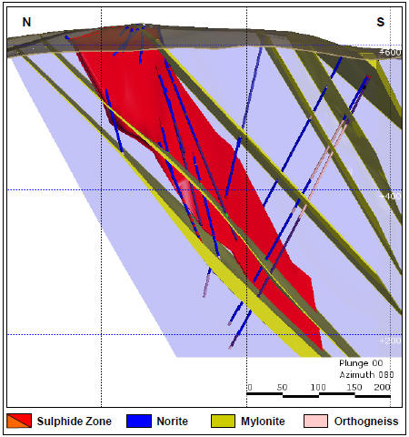
Figure 27: 3D Image (Looking East) of Spotty Hill Target Showing Geology, Sulphide Zone, and Boreholes
Imiak Hill
The Imiak Hill intrusion is located one kilometre southwest of Mikissoq and 1.5 kilometres west of Spotty Hill. The intrusion has been subjected to shearing and folding. A northeast striking mylonite zone bounds the north side of the intrusion at surface; several other mylonite zones crosscut the intrusion, including one that bounds, and may have truncated, the mineralization at depth (Fedorowich, 2015).
Mineralization at Imiak Hill was previously interpreted by North American Nickel as comprising two tabular sulphide lenses (Zones 10 and 30) striking north and plunging south with asub-vertical dip. Recent 3D modelling carried out by SRK and North American Nickel has led to an alternative interpretation whereby sulphides occur in one main tabular lens striking 75 degrees and dipping 65 degrees to the south-southeast (Figure 28). A small near surface zone of moderate grade mineralization (between 0.75 and 1.0 percent nickel) occurs in the hanging wall of the main lens and may be contiguous with the main zone as indicated by historic drilling. A parallel zone of low grade mineralization (typically between 0.1 and 0.25 percent nickel) occurs in the hanging wall to the main lens at depth. Theup-dip extent of the Imiak Hill mineralization is marked by a surface gossan approximately 80 by 100 metres in size. The main lens has been defined over a maximum strike
| | |
3CN024.004 – North American Nickel Inc. | | |
Updated Independent Technical Report for the Maniitsoq Nickel-Copper-Cobalt-PGM Project, Greenland | | Page 49 |
extent of 25 to 30 metres and dip extent of 270 meters; it is bounded on thedown-dip end by a mylonite zone at a vertical depth of 240 metres.
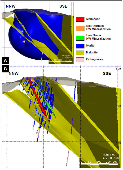
Figure 28: 3D Image (Looking East) of Imiak Hill Target Showing Geology, Sulphide Zones, and Boreholes
A: Model of norite intrusion and mylonite zones.
B: Model of sulphide zones and mylonite zones.
| | |
3CN024.004 – North American Nickel Inc. | | |
Updated Independent Technical Report for the Maniitsoq Nickel-Copper-Cobalt-PGM Project, Greenland | | Page 50 |
Mineralization is hosted in norite and leuconorite and consists of a network of remobilized semi-massive to massive sulphide veins and breccia veins collectively ranging from approximately 0.3 to 13.6 metres in width. Mineralization increases in grade with depth and sulphides consist of medium to coarse grained pyrrhotite, pentlandite, pyrite, and chalcopyrite. Semi-massive to massive sulphide samples typically grade 3 to 7 percent nickel, 0.1 to 0.2 percent cobalt and less than 0.1 g/t Pt+Pd+Au. Copper values are highly variable ranging from less than 0.1 to 6.3 percent; this broad range suggests that secondaryre-distribution of copper has occurred.
Mineralization intersected at shallow depths in boreholesMQ-12-002 andMQ-13-023 consists of heavily disseminated, blebby, patchy, and locallynet-textured magmatic sulphides, and it represents a likely source of the remobilized vein mineralization intersected at depth. Irregularly distributed, coarse blebby to patchy sulphides were intersected in the hanging wall in several boreholes(MQ-12-003,MQ-13-024 and 28;MQ-14-072). This mineralization may prove to be a good marker horizon but sulphides are sporadically distributed and contain low nickel values of approximately 0.1 percent.
Drilling in 2014 tested the southerndown-dip extent of the mineralization and intersected a mylonite zone, which is interpreted to have truncated and/or displaced the mineralization at a depth of approximately 240 metres below surface.
The Fossilik norite body is an elongated and deformed intrusion located eight kilometres to the southwest of the Imiak Hill Complex; it is approximately three to five square kilometres in size (Figure 25). Three areas of nickel-copper sulphide mineralization occur at or near the southwestern end of the intrusion, includingP-058 (historically known as Fossilik II), as well asP-004 andP-059, both of which were discovered by North American Nickel. In this area, norite intrusions are in contact with orthogneiss country rocks. Narrow (less than three metre wide) mylonite zones have been observed cutting both rock types.
TargetP-004 occurs at the tightly folded southwestern end of the large Fossilik intrusion. The mineralization is interpreted to lie in fold hinges.P-058 andP-059 are hosted within separate norite bodies located to the southwest ofP-004. It is not known whether the latter two norite intrusions are dismembered portions of the Fossilik intrusion or independent and largely unrelated intrusive bodies. Recent drilling atP-058 has shown that the mineralization occurs in close proximity to mylonite zones.
In 2016, a trend of surface gossans was discovered within the main Fossilik norite intrusion extending from known gossans located nearP-004 over a distance of 400 metres to the northeast.
P-058
TheP-058 target comprises a northeast striking and steeply northwest dipping corridor of mineralized norite hosted in orthogneiss that iscross-cut by parallel tosub-parallel mylonite zones. The mineralization consists of a tabular zone that has been intersected over a strike extent of 100 metres and extends from near surface to a vertical depth of 350 metres (Figure 29). A secondary narrow parallel zone of remobilized and magmatic sulphides occurs in the footwall.
The mineralization, which is variably hosted in norite or adjacent gneisses, consists of both disseminated to blebby magmatic sulphides and high grade remobilized massive to breccia sulphide veins and stringers. Individual remobilized massive and breccia sulphide veins range from centimetres to about one metre in width. Remobilized sulphide samples typically return high nickel
| | |
3CN024.004 – North American Nickel Inc. | | |
Updated Independent Technical Report for the Maniitsoq Nickel-Copper-Cobalt-PGM Project, Greenland | | Page 51 |
and/or copper grades of up to 6.8 percent nickel and 7.7 percent copper and commonly contain between 0.1 and 0.2 percent cobalt.
In boreholeMQ-14-054, multiple narrow veins occur over a width of 3.0 metres that average 1.72 percent nickel, 0.26 percent copper, and 0.04 percent cobalt. In boreholeMQ-16-105, the vein network averages 3.41 percent nickel, 0.28 percent copper, and 0.10 percent cobalt over a width of 4.4 metres. Norite-hosted disseminated to blebby mineralization observed in boreholesMQ-15-077 andMQ-16-105 grades between 0.55 and 0.75 percent nickel and 0.19 and 0.27 percent copper, respectively.
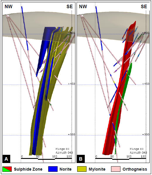
Figure 29: 3D Image (Looking Northeast) ofP-058 Target Showing Geology, Sulphide Zone, and Boreholes
A: Modelled norite intrusions and mylonite zones.
B: Modelled sulphide zones.
| | |
3CN024.004 – North American Nickel Inc. | | |
Updated Independent Technical Report for the Maniitsoq Nickel-Copper-Cobalt-PGM Project, Greenland | | Page 52 |
P-059
TheP-059 area is located approximately 250 metres northwest ofP-058. Mineralization intersected in one(MQ-15-078) of four core boreholes drilled in this area consists of heavily disseminated sulphide as well as sulphide veins and stringers which yielded 1.16 percent nickel, 1.00 percent copper and 0.27 g/t Pt+Pd+Au over a core length of 12.15 metres (Figure 30). There is insufficient information to indicate if the reported core length intervals represent true widths. The extent and orientation of the zone are unknown as it has only been intersected in one borehole.
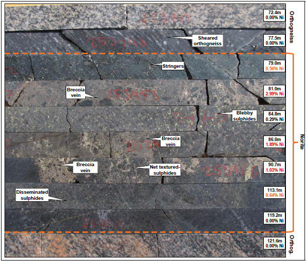
Figure 30: Breccia Veins, Stringers, and Disseminated Nickel-Sulphide Mineralization at Fossilik(P-059), BoreholeMQ-15-078
P-004
TheP-004 nickel-copper sulphide occurrence, located 550 metres to the northeast ofP-058 (Figure 25), was discovered by North American Nickel in 2013 while drilling an electromagnetic anomaly identified from the 2012 versatile time domain electromagnetic survey data. Mineralization, intersected in two boreholes, consists of disseminated sulphide and locally patchy, sulphide stringers and veins. The best intersection was obtained in boreholeMQ-13-018 and yielded 0.59 percent
| | |
3CN024.004 – North American Nickel Inc. | | |
Updated Independent Technical Report for the Maniitsoq Nickel-Copper-Cobalt-PGM Project, Greenland | | Page 53 |
nickel, 0.18 percent copper and 0.21 g/t Pt+Pd+Au over a core length of 32.19 metres, including 1.06 percent nickel, 0.23 percent copper and 0.33 g/t Pt+Pd+Au over 4.53 metres. There is insufficient information to indicate if the reported core length intervals represent true widths.
The norite intrusion is complexly folded in the area ofP-004. Based on surface mapping and borehole electromagnetic data, the mineralization intersected in boreholeMQ-13-018 is interpreted to correlate with a surface gossan occurring in a steeply northwesterly plunging fold nose.
Fossilik Surface Gossan Trend
A trend of surface gossans associated with the Fossilik intrusion was identified in 2016 while following up gossan targets generated from theWorldview-3 satellite spectral data. The sulphide gossan trend starts from known surface gossans located 400 metres northeast of targetP-004 and extends intermittently over an additional distance of 400 metres in a northeasterly direction. Several historic samples were collected in the same general area by KO, Falconbridge and Cominco in the past but either returned low nickel values or are not accurately located. The gossans consist of rusty, oxidized sulphide-bearing norite exposed in outcrop and loose scree (Figure 31). Grab samples from the gossans returned values of up to 2.36 percent nickel, 0.41 percent copper, 0.19 g/t palladium and 0.52 g/t platinum. Due to the oxidized nature of the mineralization, North American Nickel plans to obtain less oxidized,in-situ samples using a plugger sampling tool.
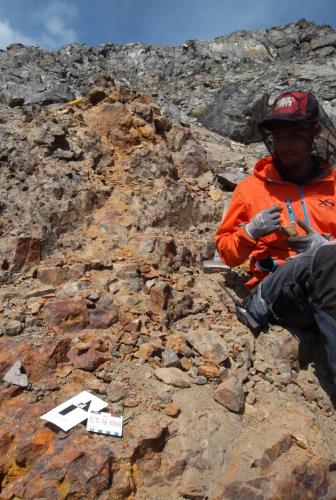
Figure 31: Fossilik Area Surface Gossan
| | |
3CN024.004 – North American Nickel Inc. | | |
Updated Independent Technical Report for the Maniitsoq Nickel-Copper-Cobalt-PGM Project, Greenland | | Page 54 |
TheP-013 area lies nine kilometres south of the Fossilik area in the central portion of the Greenland Norite Belt (Figure 25). Three electromagnetic targets,P-013 Centre, NW and SE, were identified from the 2012 and 2013 versatile time domain electromagnetic surveys. A new nickel-copper sulphide occurrence was discovered by North American Nickel while testing theP-013 Centre target. The mineralization does not outcrop and is covered by a boulder field; however,follow-up work did identify gossanous norite subcrop in the general vicinity.
Various intervals of mineralization have been intersected in boreholes but correlation from borehole to borehole is complicated by the paucity of drilling and geological data. One zone of mineralization, intersected in four boreholes, is interpreted to strike northeast over a distance of 30 to 35 metres and dip steeply to the northwest over a dip extent of 100 metres. One or more parallel zones of mineralization may exist as indicated by drilling and borehole electromagnetic data.
TheP-013 norite intrusion is hosted in orthogneisses. The mineralization consists of variable amounts of disseminated, blebby, patchy,net-textured, and semi-massive magmatic sulphides, which locally have been deformed and remobilized into stringers, veins, and fracture fillings.In-situ breccia textures are developed locally where semi-massive sulphides have been deformed and sulphides have been observed to wrap around “clasts” of norite.P-013 mineralization is also characterized by very coarse sulphide blebs or globules up to three centimetres in diameter (Figure 32). Similar coarse sulphide-rich globules have also been observed atP-030 andP-032.
The nickel and copper content of the sulphide mineralization varies from sample to sample but wider intersections typically average between 0.5 and 1.5 percent nickel as well as 0.1 and 0.5 percent copper. The nickel-copper mineralization is anomalous in precious metals, usually varying between 0.10 and 0.20 g/t Pt+Pd+Au, up to 0.77 g/t, locally.
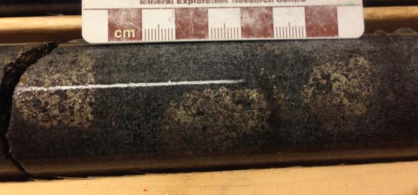
Figure 32: Centimetre Scale Sulphide Globules in Norite atP-013; BoreholeMQ-14-068
| | |
3CN024.004 – North American Nickel Inc. | | |
Updated Independent Technical Report for the Maniitsoq Nickel-Copper-Cobalt-PGM Project, Greenland | | Page 55 |
A separate target within theP-013 target area, targetP-013 SE, is located 200 metres to the southeast of theP-013 Centre area. Nickel-copper sulphide mineralization was discovered in 2016 atP-013 SE while drill-testing a borehole electromagnetic anomaly. Mineralized norite was intersected over a core length of 38.75 metres at a vertical depth of 140 metres. The sulphide mineralization consists of an upper 13.35 metre interval of remobilized massive sulphide stringers, veins, and breccia veins averaging 2.88 percent nickel, 0.80 percent copper, and 0.06 percent cobalt, followed downhole by a 25.40 metres interval containing patchy, blebby, and disseminated sulphides averaging 0.31 percent nickel and 0.23 percent copper. There is insufficient information to indicate whether the reported core length interval represents true width.
The remobilized sulphides are texturally comparable to similar zones intersected at the Imiak Hill Complex and the FossilikP-058 target (Figure 33). The size and orientation of this sulphide zone is not defined as it has only been tested with one borehole.
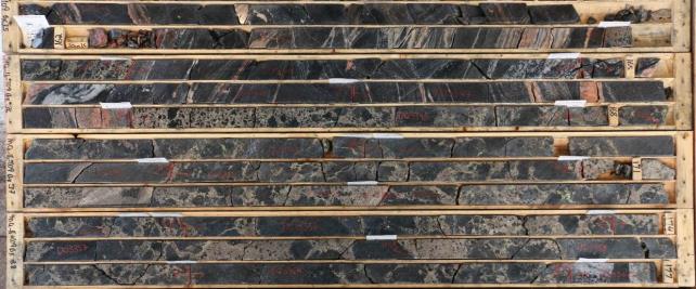
Figure 33: Remobilized Sulphide Zone atP-013 SE; BoreholeMQ-16-109
Note: the core length interval above yielded 2.88% Ni, 0.80% Cu, 0.06% Co, and 0.47 g/t Pt+Pd+Au over 13.35 metres from 166.90 to 180.25 metres. There is insufficient information to determine whether the reported core length interval represents true width.
Core size is NQ with a diameter of 47.6 millimetres.
| 6.4.6 | P-030,P-032,P-061 andP-094 |
The mineralizedP-030,P-032,P-06,1andP-094 target areas lie approximately 20 kilometres south ofP-013 (Figure 25) and 10 kilometres north of the Seqi port in the southeastern portion of the Greenland Norite Belt. In this area, several airborne geophysical anomalies coincide with a two kilometre long northeasterly striking norite intrusion hosted in orthogneiss and paragneiss. Intermittent nickel sulphide mineralization has been traced in surface gossans and in both historic and North American Nickel boreholes over a distance of 1.5 kilometres fromP-030 in the southeast, through theP-061 target to theP-032 andP-094 targets in the northeast. Locally, the norite and mineralized norite is disrupted by a network of pegmatite dikes (Figure 34) and isoff-set by late brittle faults.
| | |
3CN024.004 – North American Nickel Inc. | | |
Updated Independent Technical Report for the Maniitsoq Nickel-Copper-Cobalt-PGM Project, Greenland | | Page 56 |
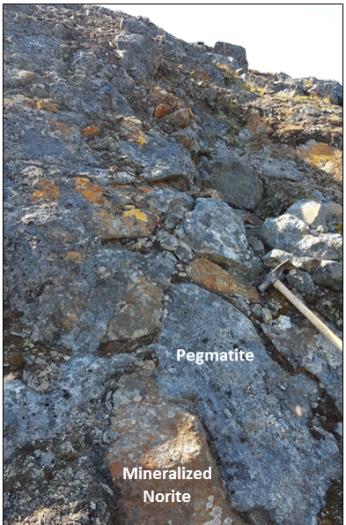
Figure 34: Gossanous Mineralized Norite Crosscut by Network of Pegmatite Dikes
(Outcrop located approximately 230 metres WSW ofP-032)
P-030 is the site of KØ’s historic Nunanguit nickel occurrence.P-032,P-061 andP-094 are located between 0.9 and 1.3 kilometres northeast of theP-030 boreholes (Figure 25).P-032 was discovered by North American Nickel in 2013 while testing an airborne electromagnetic anomaly identified by the VTEM 2012 survey.P-094 was discovered in 2016 while prospecting and drill testing a surface electromagnetic anomaly. A grab sample from theP-094 gossan graded 2.26 percent nickel, 0.67 percent copper, 0.13 percent cobalt, and 0.33 g/t Pt+Pd+Au. Anomalous nickel values were obtained in one hole completed atP-061 in 2013 to test a VTEM anomaly.
Nickel-copper sulphide mineralization has been intersected by several boreholes atP-030 andP-032 and by one borehole atP-094. The style of the mineralization is similar to that ofP-013, consisting of disseminated, blebby, and patchy sulphides, which locally are remobilized into veins, breccia veins, and fracture fillings. Sulphide intersections typically average between 0.2 and 0.8 percent nickel as well as 0.05 and 0.25 percent copper over core lengths ranging from 0.8 to 24 metres. There is insufficient information to indicate if the reported core length intervals represent true widths.
| | |
3CN024.004 – North American Nickel Inc. | | |
Updated Independent Technical Report for the Maniitsoq Nickel-Copper-Cobalt-PGM Project, Greenland | | Page 57 |
TheP-053 nickel occurrence (Figure 25) was discovered by North American Nickel through a combination of airborne geophysics, groundfollow-up, and drilling. A strong electromagnetic anomaly was identified by the 2012 airborne survey andfollow-up field work in 2013 discovered mineralized, gossanous norite in the immediate vicinity. A grab sample from the gossan yielded 0.33 percent nickel and 0.13 percent copper. Drilling in 2014 intersected narrow intervals of mineralized norite and identified three strong boreholeoff-hole electromagnetic anomalies. Additional drilling was carried out in 2015 and 2016.
Drilling, detailed mapping, and 3D modelling have defined two approximately east striking norite intrusions bounded by orthogneiss and mylonite zones and crosscut to the west by a northerly striking norite dike. The stratigraphy is interpreted to dip steeply to the south-southwest. The northern norite intrusion hosts a surface gossan which can be traced intermittently in a series of outcrops over a strike length of 125 metres. Mineralization intersected in boreholes consists of variable amounts of disseminated, blebby, and patchy sulphides, as well as remobilized sulphide stringers and semi-massive to massive sulphide breccia veins.
The mineralization occurs in two discrete tabular zones, an upper hanging wall zone and lower footwall zone (Figure 35). The mineralization is strongest proximal to a cross-cutting mylonite zone and where the host consists of inclusion-bearing norite. The hanging wall zone has been intersected in six boreholes over a strike extent of 100 metres and a dip extent of approximately 80 metres. Mineralization is open along strike to the east. The footwall zone has been intersected in four boreholes over an interpreted strike and dip extent of 75 metres and 135 metres, respectively, and remains opendown-dip. Intersections range from 0.25 to 16 metres in width.
The mineralization consists of disseminated tonet-textured to stringer mineralization as well as veins and breccia vein sulphides, which grade approximately 0.4 to 2.4 percent nickel, <0.1 to 1.7 percent copper and 0.1 to 0.35 g/t Pt+Pd+Au. The widest zone of semi-massive to massive sulphide mineralization was obtained in boreholeMQ-15-082, where individual samples yielded between 2 and 4 percent nickel, 0.2 to 0.6 percent copper,0.05 to 0.18 percent cobalt, and 0.1 to 0.40 g/t Pt+Pd+Au.
| | |
3CN024.004 – North American Nickel Inc. | | |
Updated Independent Technical Report for the Maniitsoq Nickel-Copper-Cobalt-PGM Project, Greenland | | Page 58 |
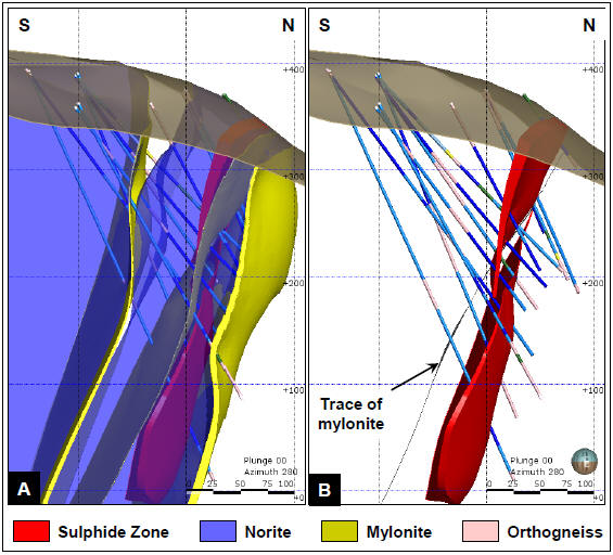
Figure 35: 3D Image (Looking West) ofP-053 Target Showing Geology, Sulphide Zones and Boreholes
A: Modelled norite intrusions, mylonite zones, and sulphide zones.
B: Modelled sulphide zones with trace of crosscutting mylonite zone.
TheP-149 andP-146 areas are located in the northern portion of the Maniitsoq property (Figure 25). The historic KØ Pingo nickel occurrence coincides with North American Nickel’sP-149 target and is hosted within a narrow northeasterly striking norite intrusion defined over a strike length of approximately 2.8 kilometres. TheP-146 target lies 200 metres along strike to the southwest and is likely part of the same norite horizon. The Pingo intrusion hosts a number of surface gossans and is intermittently mineralized along its length as indicated by surface sampling as well as drilling atP-149 andP-146. Mineralization consists primarily of disseminated sulphides typically grading 0.1 to 0.7 percent nickel. A 0.5 metre-long intersection ofnet-textured and stringer sulphides occurred in boreholeMQ-14-041atP-149.
| | |
3CN024.004 – North American Nickel Inc. | | |
Updated Independent Technical Report for the Maniitsoq Nickel-Copper-Cobalt-PGM Project, Greenland | | Page 59 |
The disseminated sulphide mineralization does not respond well to electromagnetic surveying, and at this time too few boreholes have been completed to determine the extents of the mineralization at eitherP-149 orP-146.
Surface sampling, using a plugger drill, was carried out at wide intervals along the Pingo intrusion in 2015; individual samples yielded elevated nickel and copper values of up to 0.78 percent and 0.46 percent, respectively. Prospecting and surface sampling was carried out over the interpreted southwestern extension of the Pingo norite horizon in 2016. This work extended the norite horizon by an additional 1.5 kilometres and returned values of up to 0.63 percent nickel and 0.88 percent copper from surface grab samples.
Surface sampling completed in 2015 and 2016 and the results of drilling atP-149 andP-146 indicate the potential for larger zones of near-surface disseminated sulphide mineralization within the Pingo intrusion. This target type could be evaluated by additional plugger sampling and a surface induced polarization survey.
| 6.4.9 | Mineralized Regional Targets |
Mineralized regional targets have been tested by drilling between 2013 and 2016; details are given in Section 9.
In 2016, an extensive prospecting and sampling program was carried out, largely tofollow-up gossan targets generated from theWorldview-3 satellite spectral data collected in 2015. During the course of this work, a number of nickel-copper sulphide occurrences, in addition to those noted in the preceding sections, were identified throughout the Maniitsoq property.
These newly identified mineralized occurrences consist of oxidized surface gossans containing disseminated to locally semi-massive sulphides hosted in noritic to pyroxenitic intrusions. Grab samples from several locations returned values ranging from 0.4 to 2.1 percent nickel and 0.15 to 1.0 percent copper. Details of the 2016 gossan sampling program are given in Section 8.3.
| | |
3CN024.004 – North American Nickel Inc. | | |
Updated Independent Technical Report for the Maniitsoq Nickel-Copper-Cobalt-PGM Project, Greenland | | Page 60 |
The norite and pyroxenite-hosted sulphide mineralization on the Maniitsoq property is considered to be typical of magmatic nickel-copper sulphide deposits where the sulphides have undergone structural modification.
Magmatic nickel deposits occur in mafic and ultramafic intrusions formed from mantle-derived magmas, which have accessed the crust, commonly along deep structures (Figure 36). Sulphides can segregate from the silicate magma and form droplets by several processes including the introduction of sulphur from an external source (for example assimilation of sulphur-rich country rocks), changes in the composition or physical state of the magma, which lower sulphide solubility, or a reduction in magma volume (Begg et al., 2010). The sulphide droplets scavenge metals such as nickel, copper, and platinum group elements (PGEs) from the silicate magma and can be progressively enriched by exposure to large volumes of magma. The sulphides are transported by the magma until they are deposited due to changes in flow dynamics, collecting at the base of intrusions or where changes in the geometry of the contacts with country rocks occur. Host intrusions may be sill-like or crosscutting, the latter including funnel-shaped intrusions, chonoliths, and dikes. Regional scale structures are interpreted to be important in controlling the morphology and concentration of magma along conduit systems (Lightfoot, 2007).
The magmatic segregation and accumulation of sulphide in an intrusion or conduit is influenced by a number of factors including the fractionation history of the magma, the availability of an external sulphur source, the open versus closed nature and longevity of the magmatic system, flow dynamics, and structures. A range of sulphide textures may be preserved within a host intrusion including massive, semi-massive tonet-textured, blebby, and disseminated sulphides. In many intrusions, massive and semi-massive sulphides may be concentrated at or near the base or external contacts of the intrusions and transition upwards or outwards tonet-textured and disseminated sulphides. However, in some cases, the distribution of sulphide types may be more complex, particularly where secondary structural modification has occurred. The degree to which nickel, copper, cobalt and PGEs are concentrated into the sulphides will determine the ultimate grade and metal tenor of a resultant sulphide zone. The most common magmatic sulphide minerals are pyrrhotite, pentlandite, chalcopyrite, and pyrite, with pentlandite and pyrrhotite being the nickel-bearing phases.
Nickel sulphide bodies commonly occur in clusters collectively comprising nickel “camps” or districts. Each deposit may consist of a series of individual sulphide lenses. Various classification schemes exist for the categorization of nickel-copper sulphide deposits hosted in mafic to ultramafic rocks. They are based on several key parameters including tectonic setting, age, chemistry, and whether magma emplacement was intrusive versus extrusive. Proterozoic rocks associated with rifted continental margin settings host some of the world’s most important nickel deposits and nickel districts including Thompson, Raglan, Pechenga, Jinchuan, Kabanga, and the recent Nova-Bollinger discovery in Australia.
| | |
3CN024.004 – North American Nickel Inc. | | |
Updated Independent Technical Report for the Maniitsoq Nickel-Copper-Cobalt-PGM Project, Greenland | | Page 61 |
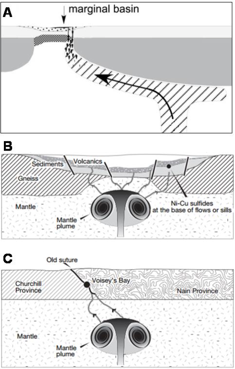
Figure 36: Schematic Geological Settings of Nickel Sulphide Deposits
A: Intrusion of magma into marginal basin (e.g. Thompson).
B: Magma feeding flood basalts (Norilsk).
C: Intrusion of magma long a suture zone (Voisey’s Bay).
(Figure A from Begg et al, 2010; Figures B and C from Barnes and Lightfoot, 2005)
| | |
3CN024.004 – North American Nickel Inc. | | |
Updated Independent Technical Report for the Maniitsoq Nickel-Copper-Cobalt-PGM Project, Greenland | | Page 62 |
The key characteristics of the nickel-bearing Greenland Norite Belt intrusions are summarized in Table 5. The Maniitsoq mineralized intrusions have several important attributes, which are similar to well-known magmatic nickel sulphides deposits.
Table 5: Summary of Geological Attributes of Nickel-bearing Intrusions, Maniitsoq Project
| | |
Geological Attribute | | Maniitsoq |
| |
| Tectonic setting | | Deep level in Archean craton consisting of granitic-granodioritic orthogneisses, amphibolites, and metasedimentary rocks. |
| |
| Evidence of large magmatic event | | 70 km long linearJ-shaped belt of mafic-ultramafic intrusions (Greenland Norite Belt). |
| |
| Composition of intrusions | | Mafic to ultramafic comprising leuconorites, norites, and pyroxenites in addition to minor peridotites. Commonly orthopyroxene-bearing. |
| |
| Range in MgO contents | | Typically 6 – 25 wt% |
| |
| Sulphides | | Magmatic and remobilized; disseminated, blebby,net-textured, semi-massive and massive stringers, veins and breccia veins; Main sulphide phases are pyrrhotite, pentlandite, chalcopyrite and pyrite. |
| |
Nickel tenors (in 100% sulphides) | | Average: 7.9 (2—10% sulphur) 7.3 (>10 % sulphur) |
| |
| Ni:Cu ratios | | Average: 3.9 (< 10% sulphur) 15.2 (>10 % sulphur) |
| |
| Ni:Co ratios | | Average: 32.1 (< 10% sulphur) 33.2 (>10 % sulphur) |
| |
| Age | | Archean: ~ 3.0 Ga (Based onU-Pb ages for zircons from 4 intrusions) |
The Greenland Norite Belt intrusions are distributed over a75-kilometre strike extent and are considered to be evidence of a large magmatic event. The linear geometry of the belt supports the theory that intrusion of magma occurred along a major structure or structural zone. The intrusions range in composition from mafic to ultramafic and are typically hosted in, or surrounded by, granitic to granodioritic gneisses. Nickel tenors are similar to those of the Thompson deposit in the Thompson Nickel Belt (Naldrett, 2004). Kokfelt et al. (2013) noted that the Greenland Norite Belt intrusions can be considered geochemically “primitive” exhibiting mantle-like magnesium numbers and high nickel contents but are also enriched in light rare earth elements.
Mapping in 2015 by SRK and North American Nickel personnel identified metasedimentary rocks throughout the Maniitsoq property providing potential evidence of the existence of an early sedimentary basin. Contact relationships indicate that the metasedimentary rocks are older than both the mafic to ultramafic intrusions and the voluminous orthogneisses. Figure 37 is a schematic representation of the geological setting at Maniitsoq including the formation of an initial sedimentary basin, intrusion of mafic and ultramafic magmas, intrusion of granitic melts, and subsequent deformation and metamorphism. In this model, sulphur-bearing sedimentary rocks represent a potential sulphur source for interaction with the Greenland Norite Belt intrusions.
| | |
3CN024.004 – North American Nickel Inc. | | |
Updated Independent Technical Report for the Maniitsoq Nickel-Copper-Cobalt-PGM Project, Greenland | | Page 63 |
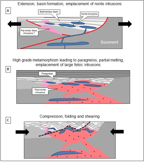
Figure 37: Conceptual Tectonic Evolution of the Greenland Norite Belt (Ravenelle, 2015b)
At Maniitsoq, the mafic to ultramafic intrusions have undergone polyphase deformation and high grade (granulite facies) metamorphism similar to the nickel deposits of the Thompson Nickel Belt. Thepod-like distribution of the Greenland Norite Belt intrusions is interpreted to be due, at least in part, to structural dismemberment of larger intrusions which is also seen in Thompson. The Maniitsoq sulphides exhibit textures indicative of disruption and remobilization, including the formation of sulphide stringers, veins, breccia veins, and fracture fillings. Recent detailed mapping, 3D modelling, and interpretation of drilling data have identified folding of the mineralized norite intrusions at the Imiak Hill Complex and Fossilik, although the effect of the folding on
| | |
3CN024.004 – North American Nickel Inc. | | |
Updated Independent Technical Report for the Maniitsoq Nickel-Copper-Cobalt-PGM Project, Greenland | | Page 64 |
mineralization is, as yet, not well defined. The nickel deposits of the Thompson Nickel Belt formed in ultramafic intrusions, which are thought to have interacted with sulphide-rich sedimentary rocks in a rifted sedimentary basin and then underwent high grade metamorphism and polyphase deformation. The intrusions are boudinaged, and the massive sulphides have been remobilized and concentrated into positions adjacent to, and in some cases away from, the host intrusions as well as into fold noses (Figure 38).
Maniitsoq differs from most other well-known nickel sulphide deposits in terms of age. The Maniitsoq mafic to ultramafic intrusions, which host nickel mineralization, are interpreted to be approximately 3.0 Ga in age, based on age dating of zircons from four separate intrusions carried out by the University of Alberta on behalf of North American Nickel on 2014 (Heaman, 2014). These ages would make the Maniitsoq nickel occurrences some of the oldest documented district scale nickel occurrences in the world.
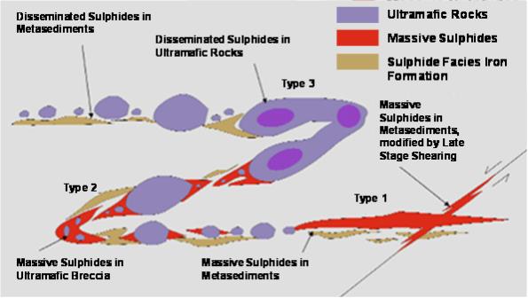
Figure 38: Schema of Mineralization Styles in the Thompson Nickel Belt
Massive sulphide mineralization can be located adjacent to ultramafic boudins and also concentrated in fold noses or modified by late stage shearing. (Collins et al., 2009; Modified after Bleeker, 1990)
| | |
3CN024.004 – North American Nickel Inc. | | |
Updated Independent Technical Report for the Maniitsoq Nickel-Copper-Cobalt-PGM Project, Greenland | | Page 65 |
From July 2011 to September 2016, North American Nickel carried out extensive exploration and drilling programs on the Maniitsoq property to search fornickel-copper-cobalt-PGM sulphide deposits. Cumulative exploration expenditures totaled C$ 36.6 million as of December 31, 2016. The exploration programs were designed tofollow-up on known nickel-copper mineralization and to explore for new nickel-copper sulphide zones throughout the regionally extensive land holdings. Field work was typically carried out between the months of June and September.
Since acquiring the Maniitsoq property, North American Nickel has progressively implemented new exploration methodologies and tools in an effort to refine targeting at both property and borehole scales. These include the introduction of helicopter-borne electromagnetic surveys, modern surface-based electromagnetic, induced polarization, and gravity surveys, application ofWorlview-3 satellite imagery, implementation and consistent use of borehole electromagnetics, collection of oriented drill core, and 3D modelling at mineralized targets. This work has proven successful in discovering additional nickel-copper sulphide occurrences, targeting mineralization in the subsurface, and expanding sulphide zones.
The exploration strategy employed by North American Nickel in the search for nickel-copper mineralization has involved the following steps:
| | • | | Compilation of historical exploration work and the identification and ranking of exploration targets. (Note that North American Nickel exploration targets are typically prefixed by “P” for VTEM targets and “G” for geology targets; targets are numbered sequentially). |
| | • | | Application of modern geophysical and geological techniques to expand known zones of nickel sulphide mineralization and to identify new exploration targets within the licence area. |
| | • | | Target selection and ranking of airborne electromagnetic anomalies withfollow-up field work. |
| | • | | Prioritization of electromagnetic targets based on geophysical criteria and results of field investigations. |
| | • | | Modelling of selected airborne electromagnetic anomalies. |
| | • | | Investigation by core drilling of prioritized electromagnetic targets. |
| | • | | Downhole electromagnetic surveys. |
| | • | | Ground electromagnetic surveys over selected targets followed by modelling and ranking of anomalies. |
| | • | | Follow-up drilling guided by 3D modelling of geophysical and geological data. |
| | • | | Ground-based induced polarization surveys to identify potential extensions to mineralized norite stratigraphy and to identify chargeability anomalies for drill testing. |
Initial exploration by North American Nickel was based on the premise that previous explorers had been successful in finding small, high-grade showings at surface, but that systematic and deeper exploration had been limited by the quality of airborne geophysical data that were acquired using fixed wing aircraft and by the lack of borehole electromagnetic data to aid in subsurface targeting. As a result, North American Nickel began the acquisition of helicopter-borne time domain electromagnetic data and the implementation of downhole electromagnetic surveys in the majority of boreholes drilled. Helicopter-borne geophysical surveys were thought to be more effective in draping
| | |
3CN024.004 – North American Nickel Inc. | | |
Updated Independent Technical Report for the Maniitsoq Nickel-Copper-Cobalt-PGM Project, Greenland | | Page 66 |
the rugged topography of the project area and thus have a significantly better chance at detecting conductors than techniques used in the past. Two types of helicopter-borne geophysical surveys were completed by North American Nickel: SkyTEM in 2011 and the Versatile Time Domain Electromagnetic system (VTEM) in 2012, 2013, and 2015.
The aforementioned exploration strategy has proven successful.Follow-up of helicopter-borne electromagnetic anomalies has resulted in the discovery of nickel sulphide occurrences, while borehole electromagnetics have been instrumental in borehole targeting and expansion of sulphide zones.
During the period July 2011 to September 2016, exploration comprised helicopter electromagnetic and magnetic surveys,follow-up ground reconnaissance, drilling, downhole geophysics, ground electromagnetic, gravity and induced polarization surveys, as well as prospecting, sampling, and mapping. Technical studies included petrographic studies of representative lithology samples, mineralogy studies of mineralized core samples, geochronology of norite intrusions, structural geology studies and 3D modeling of selected mineralized zones.
A summary of North American Nickel’s exploration by work type for each field season is summarized in Table 6. The location of geophysical surveys, drilling, and sampling are shown in Figure 39, Figure 40, and Figure 41, respectively.
In 2011, the SkyTEM survey confirmed that modern airborne electromagnetic techniques are capable of detecting new anomalies. As a result, VTEM surveys were completed in 2012, 2013, and 2015 in order to cover the Greenland Norite Belt and other selected target areas. Drilling programs were carried out in each year from 2012 to 2016, inclusive, in order to test newly identified targets and tofollow-up on known nickel-copper sulphide occurrences.
Prior to 2015, nearly half of all boreholes and 57 percent of the total drill metres were completed at the Imiak Hill Complex. In 2015, exploration focused on areas outside of the Imiak Hill Complex and a large amount of new regional exploration data was collected including a 6,696 line kilometre VTEM survey over the remainder of the Greenland Norite Belt, not previously covered (as outlined on the Maniitsoq property) and the acquisition of high resolutionWorldview-3 satellite data over the entire property. Drilling in 2015 focused on targets outside the Imiak Hill Complex and testing new regional targets.
Drilling in 2016 was focused on testing for extensions at nine mineralized targets and was successful in expanding mineralization at four of these targets (Spotty Hill, Mikissoq,P-058 andP-053). In addition, two new nickel sulphide occurrences were discovered atP-094 andP-013 SE.
North American Nickel’s exploration efforts to date have resulted in:
| | • | | Discovery of eight nickel-copper-cobalt±PGM occurrences with drill intersections includingP-004,P-013,P-013 SE,P-032,P-053,P-059,P-094, andP-146 (Figure 40) |
| | • | | Expansion of recently discovered mineralization atP-053 |
| | • | | Expansion of previously known mineralization at Imiak Hill, Mikissoq, Spotty Hill, Fossilik II(P-058), and Nunanguit(P-030) |
| | • | | Identification of numerous new airborne electromagnetic anomalies |
| | • | | Discovery of norite-hosted sulphide gossans with anomalous nickel values |
In addition, the exploration work completed to date has resulted in an improved understanding of the nature of sulphide mineralization and their geophysical signatures. It is now understood that secondary structural processes have affected the magmatic sulphide mineralization resulting in the
| | |
3CN024.004 – North American Nickel Inc. | | |
Updated Independent Technical Report for the Maniitsoq Nickel-Copper-Cobalt-PGM Project, Greenland | | Page 67 |
formation of stringers, veins, fracture fillings, and sulphide breccia veins. Locally, sulphide zones have also been disrupted by late pegmatite intrusions. The sulphide zones are commonly correlated with multiple small electromagnetic plates instead of single large plates. This geophysical response is interpreted to result from remobilization and redistribution of magmatic sulphides during deformation, which can affect the electrical connectivity of the sulphides. In some cases, the overall content and physical connectivity of sulphides may not be high enough to result in an electromagnetic anomaly, despite the mineralization containing appreciable nickel and copper grades. In 2016, North American Nickel began using surface-based induced polarization surveys as a means to identifying sulphide zones lacking good electromagnetic signatures.
| | |
3CN024.004 – North American Nickel Inc. | | |
Updated Independent Technical Report for the Maniitsoq Nickel-Copper-Cobalt-PGM Project, Greenland | | Page 68 |
Table 6: Summary of Exploration Work Completed by North American Nickel
| | | | | | | | | | | | | | | | | | | | |
Exploration Work | | 2011 | | | 2012 | | | 2013 | | | 2014 | | 2015 | | 2016 | | Total |
Core drilling | | | — | | |
| 1,550.79m
9 boreholes |
| |
| 4,265.82m
25 boreholes |
| | 8,773.00m 39 boreholes + 1 extension | | 5,655.35m 30 boreholes | | 9,595.70m 30 boreholes + 2 extensions | | 29,840.66m 133 boreholes + 3 extension |
Core assay samples | | | — | | | | 530 | | | | 1,387 | | | 2,687 | | 1,607 | | 2,264 | | 8,475 |
Whole rock samples (core) | | | — | | | | 44 | | | | — | | | 156 | | 113 | | 47 | | 360 |
Whole rock samples (surface) | | | 17 | | | | 16 | | | | 53 | | | 9 | | 117 | | 27 | | 239 |
Grab samples | | | 37 | | | | 36 | | | | 100 | | | 31 | | 211 | | 120 | | 535 |
Channel samples | | | — | | | | — | | |
| 142 in 18 channels
over 4 areas |
| | — | | — | | — | | 142 in 18 channels over 4 areas |
Airborne geophysics | |
| 2,217.1
line km in 2 blocks |
| |
| 3,612.4
line km in 10 blocks |
| |
| 971.5
line km in 9 blocks |
| | — | | 6,696.4 line km in 12 blocks | | — | | 13,497.4 line km |
Surface Electromagnetic Surveys* | | | — | | | | — | | |
| 14.0-line km
3 areas, 4 loops |
| | 86.9-line km 2 areas, 6 loops | | 61.7-line km 10 areas, 10 loops | | 13.1 km 7 areas 7 loops | | 175.7-line km 22 areas, 27 loops |
Surface Gravity Surveys | | | — | | | | — | | | | — | | | 936 stations in 2 areas | | 490 stations in 1 area | | — | | 1,426 stations in 3 areas |
Surface Induced Polarization Surveys | | | — | | | | — | | | | — | | | — | | — | | 52.8 km over 3 areas | | 52.8 km over 3 areas |
Borehole EM | | | — | | | | 8 boreholes | | | | 23 boreholes | | | 37 boreholes | | 27 boreholes | | 30 boreholes & 2 borehole extensions | | 125 boreholes |
Remote sensing satellite data acquired | | | Kompsat-2; Landsat-7 | | | | — | | |
| Ikonos, GeoEye,
WV-1,WV-2 |
| | — | | Spot 6; WV-3; NEXTMAP World 30 DSM | | — | | — |
Geological field checks** | |
| 53 sites incl.
35 GeoTEM targets |
| |
| 36 sites
incl.
36 VTEM
targets |
| |
| 91 sites incl. 87
VTEM targets &
4 geological
targets |
| | 17 sites incl. 12 VTEM targets & 5 geology targets | | 137 sites incl.133 VTEM targets, 3 geology targets & 1 remote sensing target | | 81 sites incl. 34 VTEM targets, 14 geology targets & 33 remote sensing targets | | 337 airborne EM targets, 26 geology targets and 34 remote sensing targets |
Geological mapping | | | — | | | | — | | | | — | | | Imiak Fossilik | | Fossilik P-012 P-053, P-030/P-032 | | G-017 Imiak Hill Complex P-049 P-141 | | — |
Technical studies | |
| Review of 1995
GeoTEM |
| | | — | | |
| Petrography &
mineralogy studies |
| | Petrography & mineralogy studies; age dating; structural mapping at Imiak Hill Complex and large scale desktop geology study | | Petrography & mineralogy studies; Structural geology mapping | | Mineralogy studies; structural core logging; 3D modeling; processing ofWV-3 data | | — |
| * | Includes multiple surveys at selected targets. |
| ** | Includes multiple field checks for selected targets. |
| | |
3CN024.004 – North American Nickel Inc. | | |
Updated Independent Technical Report for the Maniitsoq Nickel-Copper-Cobalt-PGM Project, Greenland | | Page 69 |
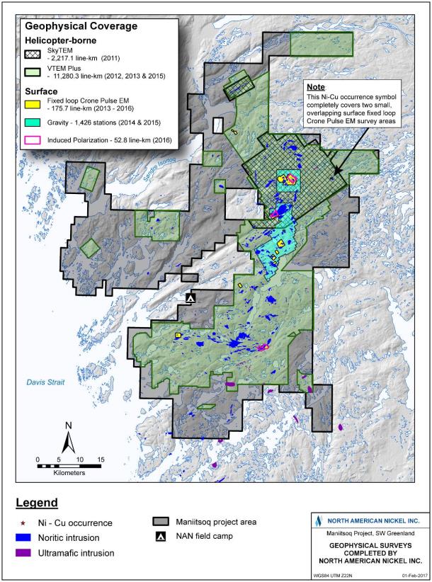
Figure 39: Distribution of Geophysical Surveys completed by North American Nickel
| | |
3CN024.004 – North American Nickel Inc. | | |
Updated Independent Technical Report for the Maniitsoq Nickel-Copper-Cobalt-PGM Project, Greenland | | Page 70 |
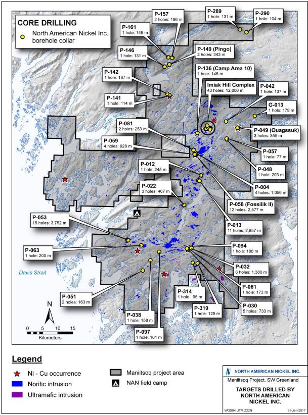
Figure 40: Location of Boreholes Drilled by North American Nickel
| | |
3CN024.004 – North American Nickel Inc. | | |
Updated Independent Technical Report for the Maniitsoq Nickel-Copper-Cobalt-PGM Project, Greenland | | Page 71 |
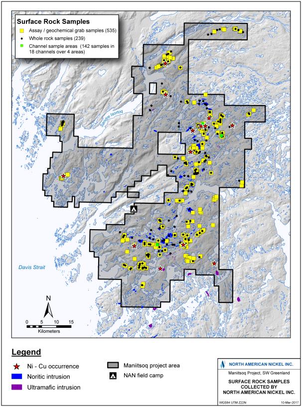
Figure 41: Location of Samples Collected by North American Nickel
| | |
3CN024.004 – North American Nickel Inc. | | |
Updated Independent Technical Report for the Maniitsoq Nickel-Copper-Cobalt-PGM Project, Greenland | | Page 72 |
| 8.2 | Geophysical Data and Surveys |
Ayear-by-year summary of the geophysical exploration carried out by North American Nickel is given below; specifications of the various geophysical surveys are described in Appendix A.
In 2011, North American Nickel purchased a 1995 GeoTEM geophysical data set from the Geological Survey of Denmark and Greenland and commissioned an independent consultant to analyze the data and identify anomalies that could indicate mineralization. A total of 52 electromagnetic anomalies were identified of which 35 were investigated by North American Nickel personnel.
Following the initial data interpretation of the older geophysical data, North American Nickel in 2011 commissioned SkyTem Surveys ApS of Beder, Denmark to carry out a helicopter-borne time domain electromagnetic survey over a small portion of the property. The survey consisted of 2,217.1 line kilometres over two areas in the northern part of the tenement, covering a combined survey area of 272 square kilometres. Lines were flown on a200-metre line spacing with100-metre line spacing in areas of known significant anomalies. The purpose of the work was to determine if a modern helicopter TEM system could detect prospective electromagnetic anomalies not previously seen by the 1995 GeoTEM survey. Three-dimensional modelling of the electromagnetic anomalies was completed by Condor Consulting of Lakewood, Colorado, who identified 86 anomalies, significantly more than previous geophysical systems. Seventeen targets were identified in Block 1, flown over the Imiak Hill, Fossilik II and Quagssuk showings, and eight targets were identified in Block 2, flown over the Pingo norite intrusion.
In 2012, North American Nickel commissioned Geotech Ltd. (Geotech) of Aurora, Ontario to perform helicopter-borne VTEM surveys over portions of the Greenland Norite Belt not covered by the 2011 SkyTEM survey, as well as survey selected target areas identified from the SkyTEM survey. The surveys comprised 3,612.4 line kilometres in ten individual survey blocks including two large areas not covered by the 2011 SkyTEM survey and eight small blocks with known geophysical anomalies. Line spacing was typically 200 metres with 100 metre line spacing and orthogonal lines over known significant conductors. The survey results were interpreted by Condor Consulting (Condor) of Lakewood, Colorado. A total of 559 anomalies were identified, from which North American Nickel personnel selected 102 exploration targets. Known nickel sulphide occurrences produce medium to strong electromagnetic responses and were rated as high priority target zones. Thirty-three selected targets were modelled. The modelling results of the VTEM anomaly at Imiak Hill indicated that historic drilling did not test the electromagnetic anomaly fully. In addition, North American Nickel commissioned Crone Geophysics and Exploration Ltd. (Crone) of Mississauga, Ontario to carry out a three-component borehole electromagnetic survey. Eight boreholes were surveyed. The results in combination with information from North American Nickel drilling indicated that the Imiak Hill mineralization remained open down plunge. The Spotty Hill mineralization was open down dip and along strike to the southeast. Untestedoff-hole conductors were noted in the boreholes drilled in the Fossilik II area.
In 2013, North American Nickel commissioned Geotech to perform additional airborne helicopter time domain electromagnetic and magnetic (VTEM) surveys. The purpose of the 2013 VTEM Plus survey was threefold: 1) To obtain electromagnetic and magnetic coverage over areas which contain norite and other mafic-ultramafic intrusions outside the Greenland Norite Belt, which had been the focus of the North American Nickel’s previous exploration work; 2) to obtain deeper electromagnetic penetration over prospective areas that were surveyed in 2011 with SkyTEM (the new VTEM Plus system has four times the dipole moment of the 2011 SkyTEM system); and 3) to detail conductors of interest detected by previous VTEM and SkyTEM surveys. A total of 971.5 line
| | |
3CN024.004 – North American Nickel Inc. | | |
Updated Independent Technical Report for the Maniitsoq Nickel-Copper-Cobalt-PGM Project, Greenland | | Page 73 |
kilometres were surveyed in nine flight blocks. Survey parameters were unchanged from the previous year with the exception of frequency. The 2012 survey was flown at 25Hz, while the 2013 survey started at 25Hz, but changed to 30Hz to reduce noise.
In both years, the surveys were carried out using a Geotech Time Domain electromagnetic (VTEMplus) system. Installation of the geophysical and ancillary equipment in an Air Greenland helicopter was carried out by a Geotech crew.
Data interpretation was completed by Condor and included identification of electromagnetic anomalies and ranked identification of target zones. A total of 431 electromagnetic responses were identified, and 142 target zones were delineated. From the 2013 VTEM data, 16 target zones were modelled. Modelling of the 2012 VTEM data was ongoing throughout 2013.
In addition to airborne geophysical data acquisition, North American Nickel commissioned Crone to carry out surface electromagnetic surveys over three mineralized zones: Fossilik II, Spotty Hill, and Quagssuk. The survey comprised 14.0 line kilometres and resulted in delineating short strike length, near surface conductors. Finally, North American Nickel again commissioned Crone to carry out a downhole surveys in 23 core boreholes drilled in 2013.
In 2014, North American Nickel continued to investigate the Imiak Hill Complex and Fossilik II showings by a surface electromagnetic survey, which comprised 86.9 line kilometres. The main goals of the survey were to:
| | • | | Identify electromagnetic conductors at a greater depth than could be detected by airborne geophysical surveys such as VTEM |
| | • | | Help define the down plunge extents and plunge direction of known mineralized zones |
| | • | | Define shallow electromagnetic conductors that may have been missed by the airborne geophysical surveys |
The survey identified an untested near-surface anomaly immediately east of Fossilik II and outlined additional depth extent of the near surface conductors at Spotty Hill, Mikissoq, and Fossilik II.
North American Nickel also completed surface-based gravity surveys over the Imiak Hill Complex and Fossilik II(P-058) showings. This work was carried out by Eastern Geophysics Limited (Eastern Geophysics) of West Pubnico, Nova Scotia. The purpose of the gravity surveys was to assist with mapping the extents of the known norite bodies by means of density contrasts between the norite intrusions and surrounding country rocks, which consist mainly of felsic gneisses. The survey consisted of 936 readings and was carried out on virtual grids with a line spacing of 200 metres and a station spacing of 50 metres. To establish the regional gradient, Eastern Geophysics took gravity readings in one kilometre step-outs from the survey areas. The gravity survey largely outlined the known extent of norite bodies.
Crone once again was commissioned to carry out downhole surveys in the 37 core boreholes drilled in 2014. These surveys indicated potential for additional mineralization at depth at Mikissoq, Spotty Hill, and Fossilik II, and identified very high priorityoff-hole targets atP-053 as well as moderate qualityoff-hole targets atP-004,P-059,P-013,P-013SE,P-030, andP-136.
In 2015, North American Nickel continued to rely heavily on geophysical tools to define exploration targets. A large helicopter-borne magnetic and electromagnetic VTEM survey was completed by Geotech. The survey covered remaining portions of the Greenland Norite Belt not previously surveyed and other areas where norite intrusions and mineral occurrences were mapped by previous explorers. A total of 6,696.4 line kilometres were completed in 12 blocks. Part of this survey covered
| | |
3CN024.004 – North American Nickel Inc. | | |
Updated Independent Technical Report for the Maniitsoq Nickel-Copper-Cobalt-PGM Project, Greenland | | Page 74 |
the same area as the previous SkyTEM coverage. The survey equipment used in this survey was similar to that of the 2012 and 2013 surveys with the addition of a second Z component coil located 15 metres vertically above the primary transmitter and receivers. Preliminary interpretation of the survey results identified approximately 60 exploration targets. Following the 2015 VTEM survey, 56.6 percent of the North American Nickel property holdings and 93.9 percent of the Greenland Norite Belt, as defined across the Maniitsoq property, were covered by VTEM surveys. The 2012 and 2013 VTEM datasets were reviewed for superparamagnetic (SPM) effects, and approximately 50 percent of the 2012 and 2013 VTEM targets were downgraded. See Appendix B for more details on SPM effects in the Maniitsoq VTEM datasets.
Similar to previous years, Crone was commissioned to carry out downhole surveys of 27 core boreholes drilled in 2015. Results of these surveys identified potential for additional mineralization at depth at Mikissoq, Spotty Hill, Fossilik II,P-013,P-059, and high priorityoff-hole targets atP-013SE andP-290.
Surface-based electromagnetic surveys were completed by Crone Geophysics over 61.7 line kilometres in 10 grids, covering mineralized norite and VTEM anomalies. The equipment was identical to that used in the previous surface geophysical surveys. Results showed significant responses on three grids(P-012,P-013, andP-053) with less significant responses outlining small conductors on theP-030/032 grid.
A surface-based gravity survey was completed by Eastern Geophysics over a 3 to 6 by 10 kilometre area south of Fossilik where multiple magnetic highs were observed to be coincident with a number of VTEM targets and norite intrusions. Data from a total of 490 stations were collected, mainly on lines spaced 500 metres apart; survey stations were spaced 250 metre apart in the area of interest; additional readings spaced one kilometre apart were taken to understand the background response. The distance between survey lines was reduced to 250 metres with survey stations spaced 125 metres apart over target areaP-013. However, no gravity anomalies were detected on these detailed lines. Several gravity anomalies were identified elsewhere on the grid and locally correlate with magnetic highs. Several potential mafic to ultramafic source rocks were observed but have not been conclusively linked to the gravity highs. Therefore, the geological significance of the highs is not understood yet.
In 2016, North American Nickel continued to use borehole and surface electromagnetic methods for borehole and exploration targeting but also implemented Induced Polarization (IP) surveys for the first time on the property. The main goals of the IP surveys were to:
| | • | | Complete a test survey at Spotty Hill to determine if high quality data could be obtained in the rocky and rugged environment |
| | • | | Carry out production surveys to identify chargeability anomalies that could be related to mineralized norite intrusions for drill testing |
North American Nickel commissioned Insight Geophysics Inc. (Insight) of Oakville, Ontario to carry out the IP surveys and to complete an initial test survey at Spotty Hill as well as production surveys at Spotty Hill, Fossilik, andP-030-032. The initial test survey consisted of comparisons between:
| | • | | Contact resistances and results using stainless electrodes and porous pots as a function of time |
| | • | | Two and four secondon-time waveforms |
| | • | | Results using various transmitter current outputs |
| | • | | Results from various arrays using both 25 and 50 metre dipoles |
| | |
3CN024.004 – North American Nickel Inc. | | |
Updated Independent Technical Report for the Maniitsoq Nickel-Copper-Cobalt-PGM Project, Greenland | | Page 75 |
The test survey determined that IP surveying was possible in the rocky and rugged environment, stainless steel electrodes were preferred over porous pots because of reduced stabilization time, the 4 secondon-time waveform resulted in lower chargeability values than the 2 secondon-time waveform, 50 metre dipole data were similar to 25 metre dipole data and increased transmitter current showed similar results in the apparent resistivity data, but chargeability increased as current increased. Production surveys comprised the collection of 52.8 line kilometres of gradient array data on 100 metre spaced lines using 50 metre dipoles. Detailed data collection using multiple transmitter-potential electrode configurations for the purpose of depth profiling and borehole targeting was carried out over selected chargeability anomalies.
Chargeability results of the IP surveys over Spotty Hill, Fossilik and theP-030-032 area are shown in Figure 42, Figure 43, and Figure 44, respectively.
The Spotty Hill IP survey identified a northwest striking trend of elevated chargeability values over a distance of 1.8 kilometres, extending from theG-004 target in the south to Mikissoq in the north (Figure 42). Several discrete chargeability highs were detected including one located halfway between Spotty Hill and Mikissoq and a coincident chargeability high and apparent resistivity low at theG-004 target south of Spotty Hill. BoreholeMQ-16-125 tested the strongest chargeability anomaly located between Mikissoq and Spotty Hill; however intersected rocks did not offer a clear explanation for the anomaly. In theG-004 area, peridotite, pyroxenite, norite, and gossans are exposed at surface in the area of the chargeability anomaly, where past grab samples returned grades of up to 0.89 percent nickel and 0.37 percent copper. This area is viewed as a potential drill target.
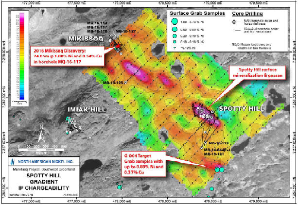
Figure 42: Chargeability Results of the IP Surveys over Spotty Hill with Salient Exploration Results
| | |
3CN024.004 – North American Nickel Inc. | | |
Updated Independent Technical Report for the Maniitsoq Nickel-Copper-Cobalt-PGM Project, Greenland | | Page 76 |
The Fossilik IP survey was carried out based on the success of surface sampling carried out in 2016, which identified a trend of nickel-copper bearing gossans extending northeast from theP-004 target. The survey identified a number of anomalies associated with the Fossilik intrusion including a 600 metre long sinuous chargeability anomaly slightly offset from, but mimicking the trend of, the newly identified surface gossan trend (Figure 43). A strong chargeability anomaly high and resistivity low was detected immediately east ofP-004 in an area of historic drilling, which intersected shallow norite-hosted mineralization. A strong chargeability anomaly was also detected northwest ofP-004 where a historic borehole intersected strongly magnetic gneisses, which may explain the source of the anomaly.
TheP-030-032 IP survey identified a number of chargeability anomalies distributed along the entire length of the norite intrusion and also occurring adjacent to the intrusion (Figure 44). Several of the anomalies can be correlated with surface gossans and mineralization intersected during drilling; the anomalies show potential extensions of the mineralized norite stratigraphy. A strong IP anomaly was detected coincident with theP-094 VTEM anomaly and surface gossan discovered in 2016. Subsequent drill testing of this target intersected norite-hosted nickel-copper sulphides (see Section 9.2.5). An additional strong chargeability anomaly was identified 400 metres north ofP-030. This anomaly was drill tested and explained by strongly magnetic quartz diorite.
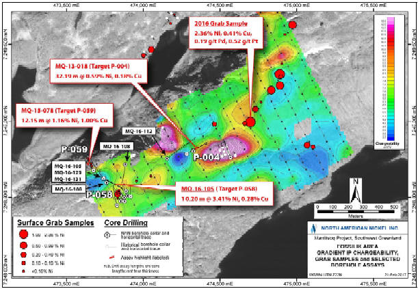
Figure 43: Chargeability Results of the IP Surveys over the Fossilik Area with Salient Exploration Results
| | |
3CN024.004 – North American Nickel Inc. | | |
Updated Independent Technical Report for the Maniitsoq Nickel-Copper-Cobalt-PGM Project, Greenland | | Page 77 |
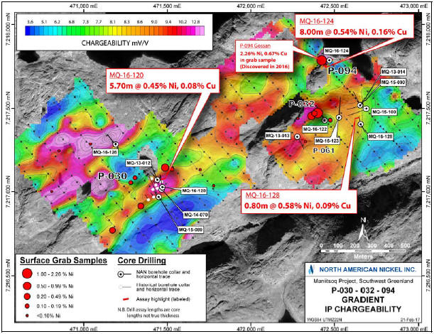
Figure 44: Chargeability Results of the IP Surveys over theP-030-032 Area with Salient Exploration Results
The IP surveys completed in 2016 identified chargeability anomalies that can be correlated with both norite-hosted sulphide mineralization and with strongly magnetic country rocks. At each survey location, certain trends of elevated chargeability values are interpreted to correlate with potential extensions of mineralized norite stratigraphy but further work is required to calibrate the magnitude of IP chargeability anomalies with the volume and grade of sulphide mineralization intersected during drilling. In addition, the collection of detailed section IP data is recommended in order to define chargeability anomalies more fully prior to drill testing.
Several small ground-based electromagnetic surveys (13.1 line kilometres in 7 grids) were carried out by Crone, covering selected regional exploration targets with VTEM anomalies. The equipment was identical to that used in previous surveys. The survey atP-049 (Quagssuk showing) detected a high quality but small conductor with limited depth extent. Well-defined, previously untested conductors with low conductivity thicknesses were defined atP-008 andP-142. Conductors with very small extents were defined atP-022 andP-094. No anomaly was detected atP-246, and only early time responses were seen atP-141. The targets defined atP-094 andP-142 were drill tested in 2016 and occurrences of mineralized norite were intersected. The target atP-008 is a potential future drill target.
| | |
3CN024.004 – North American Nickel Inc. | | |
Updated Independent Technical Report for the Maniitsoq Nickel-Copper-Cobalt-PGM Project, Greenland | | Page 78 |
Crone also carried out downhole surveys in 30 core boreholes and 2 borehole extensions drilled in 2016. The results were used to aid ongoing borehole targeting. Prior to 2016, mineralized zones were typically modeled using very small, highly conductive plates within larger areas of lower conductivity. In 2016, borehole electromagnetic surveys in the two holes drilled to test thedown-dip extent of mineralization atP-058 (Fossilik,MQ-16-105, andMQ-16-111) showed very strong anomalies that were modeled using larger plates than previously seen, indicating that the extents of strong mineralization are larger at depth. Other noteworthy borehole electromagnetic results are indications of down-plunge potential atP-001 (Mikissoq),P-055 (Spotty Hill), andP-013SE. The results also showed that small lenses of semi-massive to massive mineralization can be detected at distances of 150 metres away from the borehole if there are no other responses from proximal conductors to mask these low amplitude anomalies.
| 8.3 | Field Geology, Prospecting and Drilling |
In 2011, North American Nickel carried out a brief field program, primarily aimed at investigating known nickel occurrences and checking targets generated from the 1995 GeoTEM data. A total of 53 sites were visited. Thirty-seven grab samples were collected for assay and 17 samples were taken for whole rock analyses. No new mineral occurrences were discovered but new norite occurrences were found. The best assay results from grab samples were obtained from known nickel occurrences including metal values of up to 3.35 percent nickel and 1.28 percent copper at Quagssuk and up to 1.53 percent nickel and 0.54 percent copper at Imiak Hill.
In 2012, North American Nickel continued to assess targets identified through geophysical tools on the ground; 36 field visits to VTEM targets with 36 grab samples assayed and 16 samples sent for whole rock analyses. This work resulted in the discovery of a weakly mineralized norite intrusion at targetP-005, which yielded values of 0.27 percent nickel and 0.16 percent copper. In addition North American Nickel carried out an initial drilling program comprising nine core boreholes (1,550.8 metres). The boreholes tested targets in three areas: Imiak Hill, Spotty Hill and Fossilik II. Significant nickel + copper ± cobalt ± PGM mineralization was intersected at all three locations. A total of 530 samples were sent for assay and 44 samples for whole rock analyses.
In 2013, North American Nickel’s exploration efforts focused on Imiak Hill, Spotty Hill, and Fossilik II, and on the evaluation of regional targets identified from geophysical data. North American Nickel completed 25 core boreholes (4,266 metres) at five known nickel occurrences (Fossilik I, Imiak Hill, Mikissoq, Spotty Hill, and Quagssuk) and at six regional exploration targets(P-063,P-097,P-030,P-061,P-032, andP-013). A total of 1,387 samples were sent for assaying. Semi-massive to massive sulphide mineralization was intersected at Imiak Hill and Mikissoq and additional disseminated mineralization was intersected at Spotty Hill. The 2013 drilling program led to the recognition of the Imiak Hill Complex which is a cluster of mineralized norite intrusions that includes the Imiak Hill, Mikissoq and Spotty Hill zones, which are located within 1.5 kilometres of one another. Mineralized norite intrusions were also intersected in drilling at five of the six regional targets tested and resulted in the discovery of two previously unknown mineralized intrusions(P-013 andP-097).
A total of 91 field visits were made to 87 VTEM targets and four geological targets. A total of 100 grab samples and 53 whole rocks samples were collected and sent for lab analyses. The field program discovered five new mineralized norite intrusions at targetsP-013 (surface gossan, no samples),P-053 (0.33 percent nickel, 0.13 percent copper),P-097 (0.19 percent nickel, 0.26 percent copper),G-003 (0.38 percent nickel, 0.15 percent copper) andG-004 (0.42 percent nickel, 0.32 percent copper). Channel sampling was completed over four gossanous outcrops at Mikissoq (5 channels, 33 samples), Spotty-Hill (6 channels, 51 samples),P-057 “Pika” (3 channels,
| | |
3CN024.004 – North American Nickel Inc. | | |
Updated Independent Technical Report for the Maniitsoq Nickel-Copper-Cobalt-PGM Project, Greenland | | Page 79 |
23 samples) and target zoneP-041 (4 channels, 35 samples). In total, 18 channels were cut, and a total of 142 rock channel samples were collected and sent for assay. The highest assay values (up to 0.58 percent nickel, & 0.49 percent copper) were obtained at Mikissoq.
In 2014, North American Nickel’s exploration efforts primarily focused on testing downhole geophysical anomalies and mineralization at Imiak Hill, Spotty Hill, Mikissoq, and Fossilik II and other regional targets. The 2014 core drilling program consisted of 39 boreholes and one borehole extension (8,773 metres). A total of 2,687 samples were sent for assaying, and 156 samples were collected for whole rock analyses. Semi-massive to massive sulphides were intersected again at Imiak Hill, Spotty Hill and Mikissoq. The 2014 drilling results suggest the Imiak Hill sulphide mineralization is truncated or displaced at depth by a mylonite zone, whereas the mineralized zones at Mikissoq and Spotty Hill remained open. Fifteen regional exploration targets were tested by drilling focusing on ten geophysical targets throughout the Maniitsoq property. Norite-hosted nickel sulphide mineralization was intersected at seven of these targets:P-004,P-013,P-030,P-053,P-136,P-146 andP-149.
Two new permanent survey markers were established and the collars of 35 boreholes were surveyed using differential GPS at the Imiak Hill Complex and Fossilik by ASIAQ Greenland Survey.
A total of 17 field visits to 12 VTEM targets and five geological targets were carried out and norite was found in the vicinity of 13 targets. Sampling included 31 surface grab samples and 9 rock samples for whole rock analyses.
A structural geology study was undertaken by JFSG Consulting (Sudbury, Canada) and comprised a desktop lineament analysis and interpretation study of select areas and a three week of structural and lithological mapping program at the Imiak Hill Complex and Fossilik areas. This work identified and characterized mylonite zones and multiple generations of folds which have affected the norite intrusions and related mineralization at these two locations (John Fedorowich Structural Geology Consulting, 2015).
In December 2014, North American Nickel contracted SRK to conduct a desktop structural geology interpretation of the entire project area. The study, completed in early 2015, focused on defining the regional scale structural framework of the Maniitsoq area and the potential controls on the property-scale distribution of norite intrusions and nickel sulphide mineralization (Ravenelle, 2015b).
Geochronological work was undertaken in 2014 to determine the timing of key norite intrusions and to define better the geological history of the norite belt. Five composite batches of coarse rejects from core samples, collected from four norite intrusions, were sent to the Faculty of Science at the University of Alberta, Canada for geochronology using aU-Pb methodology on zircon. Zircons were hand-picked from each sample and imaged with cathodoluminescence prior to analysis by a Nu Plasma Inductively Coupled Plasma Mass Spectrometer. The zircon dates obtained for each sample are relatively consistent and most are near concordant yielding the following ages (Heaman, 2014):
| | | | |
| | • Fossilik Norite: | | 3,013.7 ± 2.7 Ma |
| | • Imiak Hill Norite: | | 3,002.3 ± 5.4 Ma |
| | • Spotty Hill Norite: | | 3,014.0 ± 2.7 Ma |
| | • Spotty Hill Norite: | | 3,014.2 ± 2.8 Ma |
| | • P-030 (Nunanguit) Norite: | | 3,013.5 ± 3.7 Ma |
In 2015, North American Nickel focused exploration efforts on regional targets outside of known sulphide mineralization zones. Detailed geological mapping was undertaken in four areas (Fossilik,
| | |
3CN024.004 – North American Nickel Inc. | | |
Updated Independent Technical Report for the Maniitsoq Nickel-Copper-Cobalt-PGM Project, Greenland | | Page 80 |
P-012,P-030/P-032 and P 053) and 137 exploration targets were investigated in the field. Sampling included 211 grab samples (including the 52 plugger samples) sent for assay as well as 117 whole rock samples for major and trace elements analyses. The whole rock samples were collected from norite intrusions distributed throughout the norite belt. A systematic plugger sampling program was completed on eight grids, and 52 samples were collected for assay.
As part of this program field structural geology investigations were carried out by SRK as afollow-up to the earlier desktop study. The project provided new insights into the regional geological setting, the timing of major geological events and the structural controls on the distribution of norite intrusions and associated nickel sulphide mineralization (Ravenelle, 2015b).
During the program 30 boreholes (5,655.4 metres) were drilled. Two of the thirty boreholes were completed at the Imiak Hill Complex, the others targeting previously intersected mineralization and other electromagnetic anomalies outside the Imiak Hill Complex, including ten new regional targets. A total of 1,607 and 113 samples were collected for metals and whole rock analyses, respectively. At the Imiak Hill Complex, the Spotty Hill zone was extended 80 metres down plunge. An electromagnetic survey in one of the boreholes suggested that the Mikissoq zone was open down dip.Follow-up drilling intersected additional nickel-copper sulphide mineralization atP-013,P-030,P-032,P-053, andP-058. In addition sulphide mineralization was discovered atP-059.
TheSPOT-6 satellite data purchased prior to the field season were used as base maps for the field program. North American Nickel also arranged, through DigitalGlobe of Longmont, Colorado, to acquire high spatial resolution, multi-spectralWorldview-3 satellite data across the project area. TheWorldview-3 data provide a high spatial and spectral resolution data to assist in lithological mapping and identifying new exploration targets.
In 2016, North American Nickel’s exploration efforts were focussed on testing for extensions of mineralization at nine targets (Mikissoq, Spotty Hill,P-058,P-059,P-004,P-013,P-053 andP-030 andP-032) in order to identify and prioritize one or more locations for potential delineation drilling in 2017. The 2016 core drilling program consisted of 29 boreholes and two borehole extensions (9,595.6 metres). A total of 2,264 samples were sent for assaying and 47 samples were collected for whole rock analysis. Three regional targets and were also drill tested. Highlights from the 2016 drilling program include:
| | • | | The discovery of a sulphide lens located 100 metres below previously known shallow mineralization at Mikissoq |
| | • | | The extension of existing mineralized zones at Spotty Hill,P-053, andP-058 |
| | • | | The discovery of high grade nickel-copper sulphide mineralization atP-013 SE |
| | • | | First intersections of nickel-copper sulphide mineralization at theP-094 target in theP-030-032 norite intrusion and at regional targetP-142 |
As part of the drill program, structural corere-logging and 3D modeling of mineralized zones were carried out by SRK and were used to aid in borehole targeting. Detailed mapping was carried out by North American Nickel at the Imiak Hill Complex and theG-017,P-049, andP-141 targets, primarily to support 3D modeling.
Processing of the largeWorldview-3 satellite dataset collected in 2015 was carried out bothin-house and by remote sensing consultant, Lori Wickert, of Ottawa, Ontario. Ms. Wickert carried out data verification as well as orthorectification, mosaicking, and masking of data prior to producing a standardized set of processed lithological and mineralogical map products for mapping and exploration targeting purposes. NEXTMap World 30 digital surface model (DSM) data were purchased to aid in the orthorectification of the data.In-house data processing by North American
| | |
3CN024.004 – North American Nickel Inc. | | |
Updated Independent Technical Report for the Maniitsoq Nickel-Copper-Cobalt-PGM Project, Greenland | | Page 81 |
Nickel focussed on identifying noritic target lithologies and potential sulphide gossans for fieldfollow-up.
A total of 81 field visits were carried out tofollow-upWorldview-3, geological and geophysical targets. This work included an extensive prospecting and sampling program. Sampling included 120 grab samples sent for assay as well as 27 whole rock samples for major and trace element analyses. The location of the 2016 surface grab samples are shown in Figure 45; highlights of the sampling are shown in Table 7.
| | |
3CN024.004 – North American Nickel Inc. | | |
Updated Independent Technical Report for the Maniitsoq Nickel-Copper-Cobalt-PGM Project, Greenland | | Page 82 |
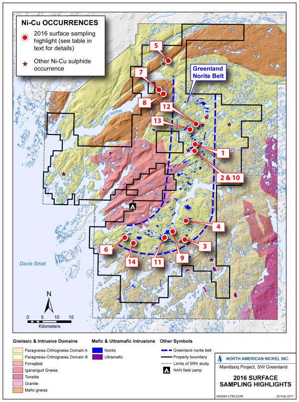
Figure 45: Location of Surfaces Samples Collected in 2016; see Table 7 for Results
| | |
3CN024.004 – North American Nickel Inc. | | |
Updated Independent Technical Report for the Maniitsoq Nickel-Copper-Cobalt-PGM Project, Greenland | | Page 83 |
Table 7: Analytical Highlights of 2016 Surface Sampling
| | | | | | |
| | | Target ID/Location | | Notable Analytical Results | | Comments |
| | | |
| 1 | | Fossilik Intrusion | | 2.36% Ni, 0.41% Cu, 0.19 g/t Pd & 0.52 g/t Pt; 1.56% Ni & 0.32% Cu; additional samples containing between 0.5% and 1.5% Ni | | 400m long trend of intermittent surface gossans located 400m NE ofP-004 and flanking parallel trend of elevated IP chargeability values. |
| | | |
| 2 | | P-246, 1.6km east ofP-004 | | 2.08% Ni, 0.81% Cu & 0.17% Co; 1.1% Ni & 0.64% Cu; additional samples containing between 0.4 and 0.9% Ni | | Series of gossans exposed near edge of lake and along steep NE facing ridge; coincident with and along strike to SW of VTEM anomaly |
| | | |
| 3 | | P-094 | | 2.26% Ni, 0.67% Cu, 0.11 g/t Pd & 0.16 g/t Pt | | Newly discovered gossan associated withP-094 geophysical anomalies. |
| | | |
| 4 | | G-028, 7 km north ofP-030 | | 0.94% Ni & 0.35% Cu | | Newly discovered gossan |
| | | |
| 5 | | Pingo Extension | | 0.63% Ni & 0.39% Cu; 0.26% Ni & 0.88% Cu; 0.13% Ni & 0.89% Cu; additional samples containing between 0.1 and 0.5% Ni | | Pingo norite horizon extended by 1.5 km to SW and hosting newly discovered gossans. |
| | | |
| 6 | | Mineralized norite intrusions located up to 2km SSE and SE ofP-053 | | 0.73% Ni, 1.02% Cu, 0.95 g/t Pd & 0.51 g/t Pt; additional samples containing between 0.1 and 0.25% Ni | | Newly discovered gossans |
| | | |
| 7 | | P-142 | | 0.76% Ni, 0.26% Cu, 0.36 g/t Pd & 0.29 g/t Pt; 0.39% Ni, 0.16% Cu, 0.24 g/t Pd & 0.18 g/t Pt | | Newly discovered gossan /rusty norite |
| | | |
| 8 | | P-141 | | 0.43% Ni & 0.21% Cu; 0.33% Ni, 0.33% Cu, 0.20 g/t Pd & 0.20 g/t Pt | | Newly discovered gossans /rusty norite |
| | | |
| 9 | | P-034, 4.5km NW ofP-030 | | 0.52% Ni & 0.36% Cu; 0.40% Ni & 0.30% Cu | | Newly discovered gossans / rusty norite |
| | | |
| 10 | | P-132, 400m east ofP-246 | | 0.41% Ni & 0.16% Cu | | Newly discovered gossan |
| | | |
| 11 | | Mineralized norite 4.5km NW ofP-030 | | 0.40% Ni & 0.16% Cu | | Newly discovered gossan? KØ sample located 200m to east |
| | | |
| 12 | | G-017, 1km WNW of Imiak Hill | | 2.32% Ni, 0.17% Cu, 0.15 g/t Pd & 0.17 g/t Pt; 1.49% Ni, 0.16% Cu, 0.10 g/t Pd & 0.13 g/t Pt | | Re-sampling of historic Camp 8 nickel sulphide occurrence |
| | | |
| 13 | | P-136 | | 1.30% Ni, 0.56% Cu & 0.11% Co | | Re-sampling of historic Camp 10 nickel sulphide occurrence |
| | | |
| 14 | | G-011 | | 0.59% Ni & 0.23% Cu | | Re-sampling of historic Qerrulik nickel sulphide occurrence |
A number of norite-hosted nickel-copper sulphide occurrences were identified, and the extents of known surface mineralization in the Fossilik,P-30-032 and Pingo areas were increased. The majority of the newly discovered occurrences coincide with, or are proximal to, geological and geophysical targets previously compiled by North American Nickel. They may represent regional exploration targets for futurefollow-up. Because many of the gossan samples are significantly oxidized,re-sampling gossans of interest using a plugger tool is recommended.
| | |
3CN024.004 – North American Nickel Inc. | | |
Updated Independent Technical Report for the Maniitsoq Nickel-Copper-Cobalt-PGM Project, Greenland | | Page 84 |
Surface samples comprising grab, channel, “plugger” and whole rock samples were collected either by North American Nickel geologists and technicians or by field helpers and prospectors working under the supervision of North American Nickel geologists. The location of all samples was recorded using hand held GPS receivers and were recorded in sample books and later transferred, along with other sample details, to the company’s digital geochemical database. Each field sample was placed in a plastic sample bag along with a uniquely numbered sample tag; a copy of the sample stub was retained in the tag book for reference. Sample tag books are retained at the company’s core shack in Sudbury, Ontario.
Surface grab, channel and plugger samples were collected to sample surface mineralization and/or target lithologies (for example norite, ultramafic rocks) while field checking and prospecting various geophysical and geological targets.
Surface grab samples typically ranged from 0.5 to 2 kilograms in weight (fist or double fist size). All efforts were made to ensure that oxidation was minimized for all mineralized samples; however, most grab samples contained some element of oxidation due to either extensive gossan development or limited rock outcrop exposure. Fresher samples were obtained by either channel sampling or plugger sampling. Rock types and sample description, especially details of mineralization, were recorded for each sample.
Channel sample locations were selected by North American Nickel geologists based on geology, mineralization and optimal outcrop condition. Sample locations were cleaned from surficial debris, and the start and end points of each full channel were recorded using a hand held GPS receivers along with the azimuth of the channels. Start and end points were spray painted on the ground for reference for the samplers. Geological technicians then marked the individual approximately 1 metre long samples with spray paint along the planned channel. Samples were sawn in such way as to exclude any spray painted rock. The depth, width and length of each individual sample was recorded and a metal tag was placed in the outcrop to mark sample locations.
Prospective plugger sample locations were assessed by a geological technician, and the freshest outcrop area was selected for sampling. A “Shaw Tool” consisting of portable core drill was used to core and extract a vertically oriented, 25 millimetre diameter sample with an average length of 30 centimetres. Sample length was typically dictated by rock conditions. Details such as rock type, depth of sample, rock quality, oxidation and magnetism were recorded for each sample. Plugger samples were collected primarily for assay purposes but a few plugger samples were also collected for whole rock analysis, where fresh samples could not be obtained by conventional surface sampling.
Surface whole rock samples, primarily ofin-situ mafic and ultramafic rocks, were collected for the purpose of geochemical identification and discrimination. Fist size samples were selected and cleaned in such a manner as to minimize or eliminate alteration and surface weathering. A rock type and sample description was recorded for each sample. In 2015, photos of many of the cleaned samples were taken for later reference. This procedure, along with photos of the sample sites, was routinely employed in 2016.
| | |
3CN024.004 – North American Nickel Inc. | | |
Updated Independent Technical Report for the Maniitsoq Nickel-Copper-Cobalt-PGM Project, Greenland | | Page 85 |
| 8.4 | Comment on Exploration Targeting |
Exploration completed to the end of 2016 has led to an increased understanding of both the geological setting and the nature of the nickel sulphide mineralization at Maniitsoq. It has also resulted in a robust project dataset comprising VTEM andWorldview-3 satellite data coverage across the Greenland Norite Belt, the entire property, respectively, and lithogeochemical data for many of the mafic to ultramafic intrusions.
The Greenland Norite Belt intrusions and contained magmatic nickel sulphide mineralization have been affected by high grade metamorphism and polyphase deformation, remobilizing magmatic sulphides into secondary structural sites and resulting in recrystallization of sulphides.
Electromagnetic geophysics methods are essential tools in nickel sulphide exploration because of the high conductance of pentlandite and pyrrhotite, and have been used extensively at Maniitsoq. The Maniitsoq sulphide zones are commonly represented by multiple small electromagnetic plates. This type of electromagnetic response is interpreted to be caused by the remobilization and disruption of primary magmatic sulphide into planar objects, which decreased their electrical connectivity.
Exploration tools currently employed in an integrated fashion for borehole targeting at the various mineralized zones include:
| | • | | Surface and borehole electromagnetic surveys |
| | • | | Detailed mapping including the collection of surface structural measurements |
| | • | | Collection of oriented core data and related structural measurements |
| | • | | 3D modelling to map structures and define the geometry of intrusions and related mineralized zones |
In 2016, surface induced polarization surveys were employed at three mineralized targets to help define the overall footprints or envelopes of mineralized zones comprising both the remobilized sulphides and the less connected disseminated sulphides.
These surveys defined trends of elevated chargeability values associated with known norite intrusions, locally containing discrete chargeability anomalies that can be correlated with known mineralization, for example at Spotty Hill. Based on these results, IP surveys are viewed as a useful exploration targeting tool to help define extensions of potentially mineralized norite intrusions and to define drill targets within them.
The methodology used for regional scale exploration targeting at Maniitsoq involves integration and analysis of the VTEM,Worldview-3, geochemical, and geological data sets to:
| | • | | Improve the resolution of geological mapping across the property |
| | • | | Differentiate between fertile and barren intrusions |
| | • | | Define the extents of fertile norite intrusions |
| | • | | Prioritize exploration targets for fieldfollow-up, surface geophysical surveys and core drilling |
| | |
3CN024.004 – North American Nickel Inc. | | |
Updated Independent Technical Report for the Maniitsoq Nickel-Copper-Cobalt-PGM Project, Greenland | | Page 86 |
Historical drilling on the Maniitsoq project area comprises 120 boreholes (6,777 metres) drilled by Kryolitselskabet Øresund A/S Company (KØ; 1959-1973), Platinova (1998), and NunaMinerals A/S (2006) as summarized in Table 8.
Table 8: Summary of Historical Drilling Completed on the Maniitsoq Project
| | | | | | | | | | | | |
Years | | Company | | Type | | Boreholes | | | Metres | |
1966 - 1973 | | Kryolitselskabet Øresund A/S Company | | Surface / Core | | | 110 | | | | 5,705 | |
1998 | | Platinova | | Surface / Core | | | 3 | | | | 237 | |
2006 | | NunaMinerals A/S | | Surface / Core | | | 7 | | | | 835 | |
| | | | | | | | | | | | |
Total | | | | | | | 120 | | | | 6,777 | |
| | | | | | | | | | | | |
KØ tested nickel-copper sulphide targets identified from their surface prospecting, sampling, and geophysical surveys. The majority of the boreholes were drilled with small,man-portable, Winkie drills. The average borehole length was less than 52 metres. This drilling intersected nickel-copper sulphide mineralization at a number of locations including Imiak Hill, Spotty Hill, Fossilik II, Camp Area 10, Nunanguit, Quagssuk, Pingo, and Qerrulik.
Platinova targeted diamond mineralization. One of three boreholes intersected a 30 centimetre-wide interval of kimberlite near the mouth of Kangia Fjord.
Drilling carried out by Nuna Minerals was located a few hundred metres south of KØ’s Ikertup Kingingnera nickel-copper sulphide occurrence in the southern part of the project area. This drilling tested a surfacenickel-copper-PGM bearing gossan but intersected only weak mineralization.
The location and results of historical boreholes was compiled by North American Nickel from work reports filed with the Greenland government. In a number of cases, North American Nickel employees have located old KØ drilling sites that can be correlated with the recorded boreholes. In these cases, GPS coordinates have been taken and the collar is typically marked with labelled wooden pickets. No detailed logs or down-hole directional surveys are available for the historical boreholes.
The KØ core is stored at Kangerlussuaq. It has beenre-sampled in the past by both Falconbridge Limited and Cominco.
| 9.2 | Drilling by North American Nickel (2012 – 2016) |
North American Nickel drilled 133 core boreholes (29,841 metres) on the Maniitsoq project. The largest amount of drilling (42 boreholes for 11,577 metres) was carried out at the Imiak Hill Complex (Mikissoq, Spotty Hill, and Imiak Hill) representing 39 percent of the total drilling. The core is stored in shipping containers at a rented facility located in Nuuk. Core storage is maintained by Xploration Services Greenland ApS.
| | |
3CN024.004 – North American Nickel Inc. | | |
Updated Independent Technical Report for the Maniitsoq Nickel-Copper-Cobalt-PGM Project, Greenland | | Page 87 |
Summaries of the drilling by year and target area are shown in Table 9 and Table 10, respectively. A complete list of all boreholes completed by North American Nickel and their physical attributes is provided in Appendix C.
Table 9: Summary of Drilling Completed by North American Nickel by Year
| | | | | | | | | | | | |
Year | | Type | | Boreholes | | | Metres | | | Targets Tested |
2012 | | Core | | | 9 | | | | 1,551 | | | Imiak Hill, Spotty Hill,P-058 (Fossilik II) &P-059 |
2013 | | Core | | | 25 | | | | 4,266 | | | Imiak Hill, Spotty Hill, Mikissoq,P-004,P-013,P-022 (Sikolik East), P-030 (Nunanguit),P-032,P-049 (Quagssuk),P-061,P-063 &P-097 |
2014 | | Core | | | 39 | * | | | 8,773 | | | Imiak Hill, Spotty Hill, Mikissoq,P-004,P-013,P-030,P-048,P-053, P-058,P-059,P-081,P-136 (Camp 10),P-146,P-149 (Pingo),P-157 &P-161 |
2015 | | Core | | | 30 | | | | 5,655 | | | Spotty Hill, Mikissoq,P-012,P-013,P-030,P-032,P-038,P-042,P-051,P-053,P-057,P-058,P-059,P-289,P-290,P-314, P-319 &G-013 (Takissoq West) |
| | | | | | | | | | | | |
2016 | | Core | | | 30 | ** | | | 9,596 | | | Spotty Hill, Mikissoq,P-004,P-013,P-013SE,P-030,P-032,P-049,P-053,P-058,P-059,P-094,P-141,P-142 & two IP targets |
| | | | | | | | | | | | |
Total | | | | | 133 | | | | 29,841 | | | |
| | | | | | | | | | | | |
* and one borehole extension ** and two borehole extensions |
Table 10: Summary of Drilling Completed by North American Nickel by Target Area
| | | | | | | | | | |
Target Area | | Boreholes | | | Metres | |
Imiak Hill Complex | | Imiak Hill | | | 18 | | | | 4,506 | |
| | Spotty Hill | | | 13 | | | | 4,139 | |
| | Mikissoq | | | 11 | | | | 2,933 | |
| | | | | | | | | | |
Fossilik | | P-058 | | | 12 | | | | 2,577 | |
| | P-059 | | | 4 | | | | 928 | |
| | P-004 | | | 4 | | | | 1,056 | |
| | | | | | | | | | |
P-013 | | | | | 11 | | | | 2,857 | |
P-030-032-094 incl.P-061 | | | 12 | | | | 2,319 | |
P-053 | | | | | 15 | | | | 3,752 | |
P-146/P-149 | | | | | 3 | | | | 474 | |
| | | | | | | | | | |
Regional Targets | | | | | 30 | | | | 4,300 | |
| | | | | | | | | | |
Total | | | | | 133 | | | | 29,841 | |
| | | | | | | | | | |
Drilling conducted by North American Nickel between 2012 and 2016 was carried out tofollow-up on historical nickel occurrences, to test new exploration targets, and tofollow-up subsequent new nickel-copper sulphide discoveries. This work has expanded the footprint of known mineralization at historical sulphide occurrences including Imiak Hill, Spotty Hill, Mikissoq,P-058 (Fossilik II),P-030 (Nunanguit), andP-149 (Pingo) and has resulted in the discovery of eight additional nickel-copper±PGM sulphide occurrences, namelyP-004,P-013,P-013 SE,P-032,P-053,P-059,P-094, andP-146. Anomalous nickel values have also been obtained from intersections at a number of regional exploration targets throughout the property. Historical and new mineral occurrences are distributed over an approximately85-kilometre distance from Pingo in the north toP-053 in the southwest.
Drilling to date at Mikissoq, Spotty Hill,P-053, andP-058 has outlined zones of mineralization, which are (with the exception of Imiak Hill) open in one or more dimensions, and which require additional drilling to define their full extents. The Mikissoq, Spotty Hill, and Imiak Hill mineralized
| | |
3CN024.004 – North American Nickel Inc. | | |
Updated Independent Technical Report for the Maniitsoq Nickel-Copper-Cobalt-PGM Project, Greenland | | Page 88 |
intrusions all occur within approximately 1.5 kilometres of each other and comprise the Imiak Hill Complex. This area is located in the central portion of the Maniitsoq property. TheP-058 target is the historic Fossilik II sulphide occurrence and is located at the south end of the Fossilik intrusion, 9.5 kilometres to the southwest of the Imiak Hill Complex. TheP-053 target is located at the southwestern end of the Greenland Norite Belt.
Drilling highlights in 2016 included the expansion of mineralized zones at Spotty Hill,P-053, andP-058, and the discovery of an additional sulphide lens at Mikissoq. In addition, high grade mineralization was discovered atP-013SE.
Although the occurrence of mineralization at the Imiak Hill Complex andP-058 areas were known from historical exploration, geophysical surveys completed by North American Nickel were instrumental in following up and expanding the footprint of known mineralization at each location. The 2012 VTEM survey flown by North American Nickel identified strong electromagnetic anomalies at each location, which were subsequently covered by ground electromagnetic surveys. Borehole surveys were routinely completed in each borehole to aid in further borehole targeting. Mineralization at theP-053 target was discovered by North American Nickel while following up an electromagnetic anomaly from the 2012 VTEM survey.
AtP-004,P-013SE,P-030-032-094,P-059,P-141,P-142,P-146, andP-149, various intervals of sulphide mineralization have been intersected, but additional drilling and/or surface geophysics is required to identify and outline discrete zones. These target areas extend from the northern to southern portions of the Greenland Norite Belt.
Results of the drilling at each of the above mineralized target areas is described in more detail below followed by a description of the regional drilling. Figure 46 shows the location of the exploration target areas.
Initial boreholes completed at the various mineralized targets were designed to test VTEM anomalies modelled as electromagnetic “plates” using Maxwell software. Boreholes were surveyed with the Crone borehole time domain Pulse electromagnetic system; results were used to help planfollow-up boreholes, typically at a step out spacing of 15 to 75 meters. At Mikissoq, Spotty Hill, Imiak Hill,P-013,P-053, andP-058, where mineralized zones have been defined, drilling was carried out on sections spaced 15 to 110 metres apart. At several locations including Imiak Hill, Spotty Hill,P-013,P-053, andP-058, multiple boreholes were drilled from the same drill platform to optimize helicopter logistics or mitigate steep or difficult topography.
| | |
3CN024.004 – North American Nickel Inc. | | |
Updated Independent Technical Report for the Maniitsoq Nickel-Copper-Cobalt-PGM Project, Greenland | | Page 89 |

Figure 46: Location of Drill-Tested Mineralized Target Areas
| | |
3CN024.004 – North American Nickel Inc. | | |
Updated Independent Technical Report for the Maniitsoq Nickel-Copper-Cobalt-PGM Project, Greenland | | Page 90 |
Drilling in the Imiak Hill Complex area was carried out to follow up mineralization intersected in historic drilling carried out by KØ, and also to test new electromagnetic targets identified by North America Nickel (Figure 46 and Figure 47). Nickel-copper sulphide mineralization comprising discrete sulphide lenses has been intersected at all three targets. The Imiak Hill Complex has received the largest amount of drilling to date and subsequently hosts the largest concentrations of mineralization outlined thus far on the Maniitsoq property.
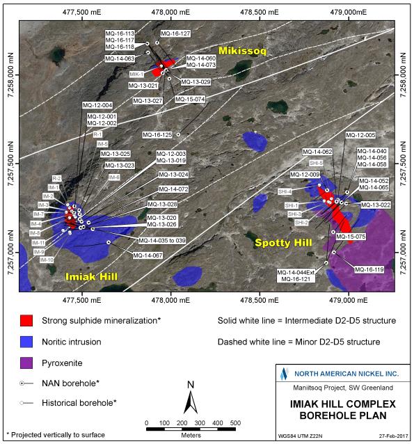
Figure 47: Imiak Hill Complex Targets
| | |
3CN024.004 – North American Nickel Inc. | | |
Updated Independent Technical Report for the Maniitsoq Nickel-Copper-Cobalt-PGM Project, Greenland | | Page 91 |
Mikissoq Target
Mikissoq is the northernmost of the three mineralized intrusions at the Imiak Hill Complex. A total of eleven boreholes (2,933 metres) have been completed to test the Mikissoq mineralization. Salient assay results are listed in Table 11. The boreholes were completed on sections spaced 15 to 45 metres apart with the majority of the drilling completed within one 30 metre wide central corridor (Figure 48).
Three boreholes(MQ-13-027,MQ-13-029, andMQ-14-073) drilled prior to 2016 intersected three shallow, parallel zones of mineralization (HW, Central and FW). In 2016, three boreholes(MQ-16-113,MQ-16-117 andMQ-16-118) intersected a previously unknown deeper, larger, tabular norite-hosted sulphide zone. Figure 49 is a vertical cross-section through the Mikissoq mineralized zones. Salient assay results are provided in Table 11.
Borehole intersections for the three shallow lenses range from 3.1 to 25.0 metres in core length; true widths, based on an azimuth of 58 degrees and a dip of 78 degrees to the southeast, are estimated to range from 2.5 to 20.0 metres. Borehole intersections for the newly discovered, deeper sulphide lens range from 47.0 to 74.0 metres in core length; true widths, based on an azimuth of 58 degrees and a dip of 89 degrees to the southeast, are estimated to range from 21.4 to 37.6 metres.
A fourth borehole completed in 2016,MQ-16-127, aimed to test for strike continuation of mineralization 45 metres to the northeast of previous 2016 boreholes. The hole intersected a wide interval of norite hosting weakly disseminated sulphides, which contained elevated nickel values of up to 0.11 percent. This weak mineralization may represent a near edge of the zone, which remains open to the southwest anddown-dip. The borehole electromagnetic response for the sulphide lens is dominated by high conductance responses that correlate with the intersections obtained on the three-hole section; however, additional weaker responses indicate the potential fordown-dip mineralization.
Table 11: Salient Borehole Analytical Results, Mikissoq Target
| | | | | | | | | | | | | | | | | | | | | | | | | | | | | | | | | | | | | | | | |
No. | | Borehole | | | From
(m) | | | To
(m) | | | Core Interval
(m) | | | True Width
(m) | | | Ni
% | | | Cu
% | | | Co
% | | | Pt+Pd+Au
g/t | | | Zone | |
1 | | | | | | | 33.84 | | | | 58.82 | | | | 24.98 | | | | 20.02 | | | | 0.71 | | | | 0.31 | | | | 0.02 | | | | 0.06 | | | | HW | |
2 | | | | | | | 66.99 | | | | 70.09 | | | | 3.10 | | | | 2.48 | | | | 0.53 | | | | 0.18 | | | | 0.02 | | | | 0.02 | | | | Central | |
3 | | | MQ-13-027 | | | | 88.25 | | | | 96.00 | | | | 7.75 | | | | 6.21 | | | | 0.76 | | | | 0.28 | | | | 0.02 | | | | 0.07 | | | | FW | |
| | | | | | | | | | | | | | | | | | | | | | | | | | | | | | | | | | | | | | | | |
4 | | | | | | | 45.00 | | | | 71.22 | | | | 26.22 | | | | 18.02 | | | | 0.48 | | | | 0.22 | | | | 0.02 | | | | 0.04 | | | | HW | |
5 | | | | | | | 82.01 | | | | 103.51 | | | | 21.50 | | | | 14.90 | | | | 0.68 | | | | 0.48 | | | | 0.02 | | | | 0.05 | | | | Central | |
6 | | | MQ-13-029 | | | | 103.51 | | | | 113.50 | | | | 9.99 | | | | 6.96 | | | | 4.65 | | | | 0.33 | | | | 0.12 | | | | 0.14 | | | | FW | |
| | | | | | | | | | | | | | | | | | | | | | | | | | | | | | | | | | | | | | | | |
7 | | | | | | | 57.75 | | | | 77.58 | | | | 19.83 | | | | 12.65 | | | | 0.76 | | | | 0.26 | | | | 0.02 | | | | 0.04 | | | | HW | |
8 | | | | | | | 88.50 | | | | 101.40 | | | | 12.90 | | | | 8.27 | | | | 0.83 | | | | 0.24 | | | | 0.02 | | | | 0.05 | | | | Central | |
9 | | | MQ-14-073 | | | | 112.54 | | | | 117.34 | | | | 4.80 | | | | 3.10 | | | | 2.10 | | | | 0.27 | | | | 0.05 | | | | 0.04 | | | | FW | |
| | | | | | | | | | | | | | | | | | | | | | | | | | | | | | | | | | | | | | | | |
10 | | | MQ-16-113 | | | | 233.75 | | | | 287.00 | | | | 53.25 | | | �� | 32.36 | | | | 0.81 | | | | 0.36 | | | | 0.02 | | | | 0.05 | | | | New | |
| | | Incl. | | | | 233.75 | | | | 238.90 | | | | 5.15 | | | | 3.12 | | | | 2.56 | | | | 0.38 | | | | 0.05 | | | | 0.12 | | | | | |
| | | And | | | | 256.00 | | | | 261.00 | | | | 5.00 | | | | 3.04 | | | | 1.10 | | | | 0.57 | | | | 0.03 | | | | 0.10 | | | | | |
| | | And | | | | 275.85 | | | | 279.65 | | | | 3.80 | | | | 2.32 | | | | 1.87 | | | | 0.28 | | | | 0.05 | | | | 0.06 | | | | | |
| | | | | | | | | | | | | | | | | | | | | | | | | | | | | | | | | | | | | | | | |
11 | | | MQ-16-117 | | | | 268.70 | | | | 342.75 | | | | 74.05 | | | | 37.59 | | | | 1.08 | | | | 0.54 | | | | 0.03 | | | | 0.11 | | | | New | |
| | | Incl. | | | | 285.70 | | | | 291.00 | | | | 5.30 | | | | 2.67 | | | | 2.10 | | | | 0.44 | | | | 0.04 | | | | 0.08 | | | | | |
| | | And | | | | 309.25 | | | | 322.90 | | | | 13.65 | | | | 6.96 | | | | 1.84 | | | | 0.64 | | | | 0.05 | | | | 0.10 | | | | | |
| | | And | | | | 329.85 | | | | 335.40 | | | | 5.55 | | | | 2.84 | | | | 1.26 | | | | 0.45 | | | | 0.03 | | | | 0.39 | | | | | |
| | | | | | | | | | | | | | | | | | | | | | | | | | | | | | | | | | | | | | | | |
12 | | | MQ-16-118 | | | | 322.00 | | | | 369.00 | | | | 47.00 | | | | 21.40 | | | | 0.51 | | | | 0.25 | | | | 0.01 | | | | 0.15 | | | | New | |
| | | Incl. | | | | 323.00 | | | | 338.00 | | | | 15.00 | | | | 6.80 | | | | 1.03 | | | | 0.32 | | | | 0.02 | | | | 0.17 | | | | | |
| | |
3CN024.004 – North American Nickel Inc. | | |
Updated Independent Technical Report for the Maniitsoq Nickel-Copper-Cobalt-PGM Project, Greenland | | Page 92 |
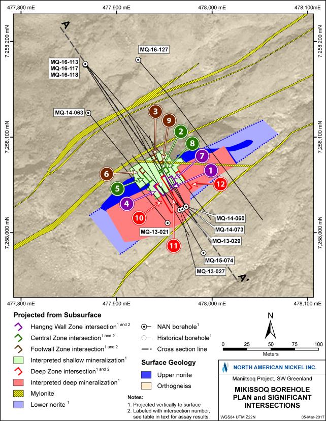
Figure 48: Compilation of Drilling Results at the Mikissoq Target; for Intersections refer to Table 11
| | |
3CN024.004 – North American Nickel Inc. | | |
Updated Independent Technical Report for the Maniitsoq Nickel-Copper-Cobalt-PGM Project, Greenland | | Page 93 |
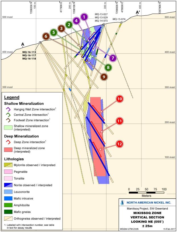
Figure 49: Cross Section, Mikissoq Target, Location of Section Shown on Figure 48; for Intersections Refer to Table 11
| | |
3CN024.004 – North American Nickel Inc. | | |
Updated Independent Technical Report for the Maniitsoq Nickel-Copper-Cobalt-PGM Project, Greenland | | Page 94 |
Spotty Hill Target
Spotty Hill is located 1.3 kilometres southeast of Mikissoq (Figure 47). The mineralized zone has been tested by thirteen boreholes (4,139 metres) on sections spaced 25 to 80 metres apart. The majority of boreholes were completed on three sections 25 metres apart (Figure 50). Boreholes drilled prior to 2014 were drilled to the southwest,sub-parallel to the interpreted dip of the zone. In 2015 and 2016, boreholes were drilled towards the northeast to intersect the target sulphide mineralization at a more favourable angle. Salient assay results are shown in Table 12.
Figure 51 presents an inclined longitudinal section for the mineralized zone. Intersections range from 3.2 to 94.0 metres in core length; true widths, based on an azimuth of 138 degrees and a dip of 82 degrees to the southwest for the disseminated zone, are estimated to range from 0.9 to 28.7 metres.
In 2014, boreholeMQ-14-044 was collared 300 metres to south of the main target area to test a separate electromagnetic anomaly interpreted from surface geophysical survey data. This borehole did not intersect any significant mineralization, but the borehole electromagnetic survey helped to define a large low conductance plate, interpreted to correlate with the Spotty Hill mineralization, which suggested that the zone continued down plunge.
In 2015, astep-out borehole(MQ-15-075) intersected sulphide mineralization 80 metres down plunge from the previously known mineralization that was intersected in boreholeMQ-13-022.
In 2016, boreholeMQ-14-044 was extended by 131.1 metres to define better anoff-hole borehole electromagnetic anomaly detected in 2014. The subsequent borehole electromagnetic survey in the extended hole defined a high conductanceoff-hole anomaly interpreted to be located down plunge of the known Spotty Hill mineralization. This anomaly was tested by boreholeMQ-16-121, which intersected sulphide mineralization 115 metres down plunge ofMQ-15-075. Two strong high conductanceoff-hole electromagnetic anomalies detected fromMQ-16-121 are located east of the hole. The zone remains open down plunge and the dip extent has not been tested fully.
Table 12: Salient Borehole Analytical Results, Spotty Hill Target
| | | | | | | | | | | | | | | | | | | | | | | | | | | | | | | | | | | | |
No. | | Borehole | | | From
(m) | | | To
(m) | | | Core Interval
(m) | | | True Width
(m) | | | Ni
% | | | Cu
% | | | Co
% | | | Pt+Pd+Au
g/t | |
1 | | | MQ-14-009 | | | | 79.00 | | | | 96.50 | | | | 17.50 | | | | 6.43 | | | | 0.27 | | | | 0.06 | | | | 0.01 | | | | 0.08 | |
| | | | | | | | | | | | | | | | | | | | | | | | | | | | | | | | | | | | |
2 | | | MQ-12-005 | | | | 63.00 | | | | 157.00 | | | | 94.00 | | | | 28.69 | | | | 0.94 | | | | 0.24 | | | | 0.03 | | | | 0.30 | |
| | | Incl. | | | | 113.00 | | | | 136.87 | | | | 23.87 | | | | 6.83 | | | | 1.70 | | | | 0.42 | | | | 0.05 | | | | 0.52 | |
| | | | | | | | | | | | | | | | | | | | | | | | | | | | | | | | | | | | |
3 | | | MQ-13-022 | | | | 196.93 | | | | 217.00 | | | | 20.07 | | | | 6.20 | | | | 0.68 | | | | 0.28 | | | | 0.02 | | | | 0.33 | |
| | | Incl. | | | | 196.93 | | | | 200.10 | | | | 3.17 | | | | 0.92 | | | | 1.60 | | | | 0.27 | | | | 0.05 | | | | 0.61 | |
| | | | | | | | | | | | | | | | | | | | | | | | | | | | | | | | | | | | |
4 | | | MQ-14-040 | | | | 242.00 | | | | 247.70 | | | | 5.70 | | | | 2.37 | | | | 0.36 | | | | 0.08 | | | | 0.01 | | | | 0.14 | |
| | | | | | | | | | | | | | | | | | | | | | | | | | | | | | | | | | | | |
5 | | | MQ-14-052 | | | | 55.70 | | | | 64.00 | | | | 8.30 | | | | 3.81 | | | | 0.25 | | | | 0.06 | | | | 0.01 | | | | 0.08 | |
| | | | | | | | | | | | | | | | | | | | | | | | | | | | | | | | | | | | |
6 | | | MQ-14-058 | | | | 167.32 | | | | 202.05 | | | | 34.73 | | | | 18.73 | | | | 0.53 | | | | 0.17 | | | | 0.02 | | | | 0.18 | |
| | | | | | | | | | | | | | | | | | | | | | | | | | | | | | | | | | | | |
7 | | | MQ-14-062 | | | | 45.20 | | | | 72.12 | | | | 26.92 | | | | 11.08 | | | | 1.16 | | | | 0.28 | | | | 0.04 | | | | 0.41 | |
| | | Incl. | | | | 62.65 | | | | 71.20 | | | | 8.55 | | | | 3.39 | | | | 2.98 | | | | 0.59 | | | | 0.10 | | | | 0.86 | |
| | | | | | | | | | | | | | | | | | | | | | | | | | | | | | | | | | | | |
8 | | | MQ-14-065 | | | | 50.00 | | | | 111.29 | | | | 61.29 | | | | 20.54 | | | | 0.66 | | | | 0.17 | | | | 0.02 | | | | 0.25 | |
| | | Incl. | | | | 79.50 | | | | 90.10 | | | | 10.60 | | | | 3.38 | | | | 1.69 | | | | 0.34 | | | | 0.05 | | | | 0.50 | |
| | | | | | | | | | | | | | | | | | | | | | | | | | | | | | | | | | | | |
9 | | | MQ-15-075 | | | | 236.45 | | | | 255.70 | | | | 19.25 | | | | 8.03 | | | | 0.92 | | | | 0.21 | | | | 0.03 | | | | 0.28 | |
| | | Incl. | | | | 236.45 | | | | 252.00 | | | | 15.55 | | | | 6.73 | | | | 1.06 | | | | 0.24 | | | | 0.04 | | | | 0.31 | |
| | | | | | | | | | | | | | | | | | | | | | | | | | | | | | | | | | | | |
10 | | | MQ-16-121 | | | | 382.25 | | | | 387.00 | | | | 4.75 | | | | 2.84 | | | | 1.59 | | | | 0.30 | | | | 0.04 | | | | 0.66 | |
| | |
3CN024.004 – North American Nickel Inc. | | |
Updated Independent Technical Report for the Maniitsoq Nickel-Copper-Cobalt-PGM Project, Greenland | | Page 95 |
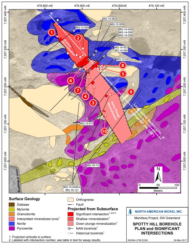
Figure 50: Compilation of Drilling Results at the Spotty Hill Target; for Intersections Refer to Table 12
| | |
3CN024.004 – North American Nickel Inc. | | |
Updated Independent Technical Report for the Maniitsoq Nickel-Copper-Cobalt-PGM Project, Greenland | | Page 96 |
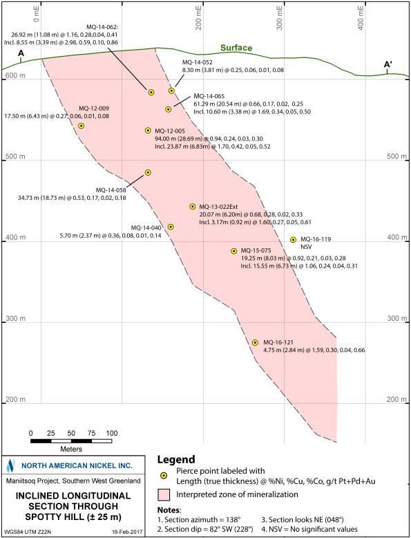
Figure 51: Longitudinal Section of Spotty Hill, looking Northeast, see Figure 50 for Location and Orientation of Section
| | |
3CN024.004 – North American Nickel Inc. | | |
Updated Independent Technical Report for the Maniitsoq Nickel-Copper-Cobalt-PGM Project, Greenland | | Page 97 |
Imiak Hill Target
The Imiak Hill target is the name-sake target of the Imiak Hill Complex and has been tested by 18 boreholes (4,506 metres). A recentre-interpretation of the mineralization based on 3D modeling has defined one main sulphide lens and two additional hanging wall zones. The latter are not well constrained by drilling. Boreholes were drilled from a series of platforms spaced approximately 15 to 45 metres apart. Between one and five boreholes were drilled from each platform, resulting in a three-dimensional borehole spacing of 15 to 30 metres. One additional borehole(MQ-14-067) is located 95 metres to the south. There-interpretation of the orientation of the Imiak Hill mineralization from north striking to east-northeast striking suggests a more favorable azimuth should be considered for any future drilling. A borehole plan map is given in Figure 52, and an inclined longitudinal section is shown in Figure 53.
Sulphide intersections typically range from 0.6 to 27.0 metres in core length. True widths, based on an azimuth of 75 degrees and a dip of 65 degrees to the south-southeast, are estimated to range from 0.3 to 14.2 metres. Salient assay results are provided in Table 13.
Astep-out borehole(MQ-14-067) was drilled to test for a down dip extension south of the mylonite zone, which truncates the mineralization (Figure 53). This borehole did not intersect any significant sulphide. A geophysical survey completed in that hole shows a low amplitudeoff-hole anomaly, interpreted to correlate with the known mineralization. No other anomalies were detected, suggesting there is no other significant sulphide mineralization in the vicinity of borehole. Recent review andre-interpretation of drilling and structural data indicates thatMQ-14-067 was not ideally positioned to intersect the zone and may lie to the east of any potential down dip extension. In addition,MQ-14-035 may not have been drilled deep enough to test for thedown-dip extent of the zone.
Table 13: Salient Borehole Analytical Results, Imiak Hill Target
| | | | | | | | | | | | | | | | | | | | | | | | | | | | | | | | | | |
No. | | Borehole | | From
(m) | | | To
(m) | | | Core Interval
(m) | | | True Width
(m) | | | Ni
% | | | Cu
% | | | Co
% | | | Pt+Pd+Au
g/t | |
| 1 | | | | | 5.32 | | | | 32.30 | * | | | 26.98 | | | | 14.20 | | | | 0.98 | | | | 0.44 | | | | 0.04 | | | | 0.01 | |
| 2 | | MQ-12-001 | | | 56.10 | | | | 59.94 | | | | 3.84 | | | | 2.07 | | | | 1.19 | | | | 0.14 | | | | 0.04 | | | | 0.01 | |
| | | | | | | | | | | | | | | | | | | | | | | | | | | | | | | | | | |
| 3 | | | | | 4.00 | | | | 23.35 | * | | | 19.35 | | | | 9.74 | | | | 0.78 | | | | 0.36 | | | | 0.03 | | | | 0.01 | |
| 4 | | MQ-12-002 | | | 55.90 | | | | 70.08 | | | | 14.18 | | | | 7.14 | | | | 1.33 | | | | 0.38 | | | | 0.04 | | | | 0.01 | |
| | | | | | | | | | | | | | | | | | | | | | | | | | | | | | | | | | |
| 5 | | MQ-13-019 | | | 112.67 | | | | 126.77 | | | | 14.10 | | | | 7.73 | | | | 1.24 | | | | 0.55 | | | | 0.05 | | | | 0.01 | |
| | | | | | | | | | | | | | | | | | | | | | | | | | | | | | | | | | |
| 6 | | MQ-13-023 | | | 75.97 | | | | 86.30 | | | | 10.33 | | | | 5.56 | | | | 1.10 | | | | 0.38 | | | | 0.04 | | | | 0.01 | |
| | | | | | | | | | | | | | | | | | | | | | | | | | | | | | | | | | |
| 7 | | MQ-13-024 | | | 135.70 | | | | 150.90 | | | | 15.20 | | | | 8.80 | | | | 2.62 | | | | 0.43 | | | | 0.09 | | | | 0.02 | |
| | Incl. | | | 136.75 | | | | 141.98 | | | | 5.23 | | | | 3.02 | | | | 5.03 | | | | 0.30 | | | | 0.16 | | | | 0.03 | |
| | | | | | | | | | | | | | | | | | | | | | | | | | | | | | | | | | |
| 8 | | MQ-13-026 | | | 156.70 | | | | 175.32 | | | | 18.62 | | | | 12.35 | | | | 4.31 | | | | 0.62 | | | | 0.14 | | | | 0.02 | |
| | | | | | | | | | | | | | | | | | | | | | | | | | | | | | | | | | |
| 9 | | MQ-13-028 | | | 182.09 | | | | 206.84 | | | | 24.75 | | | | 13.65 | | | | 3.19 | | | | 1.14 | | | | 0.11 | | | | 0.01 | |
| | | | | | | | | | | | | | | | | | | | | | | | | | | | | | | | | | |
| 10 | | MQ-14-036 | | | 266.25 | | | | 266.35 | | | | 0.10 | | | | 0.05 | | | | 0.38 | | | | 19.30 | | | | 0.03 | | | | 0.03 | |
| | | | | | | | | | | | | | | | | | | | | | | | | | | | | | | | | | |
| 11 | | MQ-14-037 | | | 220.51 | | | | 231.54 | | | | 11.03 | | | | 6.65 | | | | 3.07 | | | | 0.53 | | | | 0.08 | | | | 0.02 | |
| | Incl. | | | 220.51 | | | | 223.76 | | | | 3.25 | | | | 1.96 | | | | 6.48 | | | | 0.29 | | | | 0.17 | | | | 0.02 | |
| | | | | | | | | | | | | | | | | | | | | | | | | | | | | | | | | | |
| 12 | | MQ-14-038 | | | 228.95 | | | | 229.55 | | | | 0.60 | | | | 0.33 | | | | 6.07 | | | | 1.35 | | | | 0.14 | | | | 0.03 | |
| | | | | | | | | | | | | | | | | | | | | | | | | | | | | | | | | | |
| 13 | | MQ-14-072 | | | 173.75 | | | | 190.10 | | | | 16.35 | | | | 7.92 | | | | 2.51 | | | | 0.77 | | | | 0.08 | | | | 0.02 | |
| | Incl. | | | 179.90 | | | | 186.25 | | | | 6.35 | | | | 3.08 | | | | 3.14 | | | | 1.05 | | | | 0.10 | | | | 0.02 | |
* Intersections are from near surface hanging wall mineralization. | |
| | |
3CN024.004 – North American Nickel Inc. | | |
Updated Independent Technical Report for the Maniitsoq Nickel-Copper-Cobalt-PGM Project, Greenland | | Page 98 |
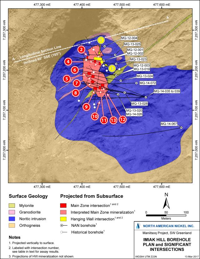
Figure 52: Compilation of Drilling Results at the Imiak Hill Target; for Intersections Refer to Table 13
| | |
3CN024.004 – North American Nickel Inc. | | |
Updated Independent Technical Report for the Maniitsoq Nickel-Copper-Cobalt-PGM Project, Greenland | | Page 99 |
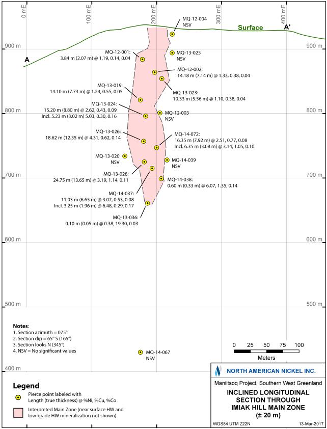
Figure 53: Longitudinal Section of Imiak Hill, looking Northwest, see Figure 52 for Location and Orientation of Section
| | |
3CN024.004 – North American Nickel Inc. | | |
Updated Independent Technical Report for the Maniitsoq Nickel-Copper-Cobalt-PGM Project, Greenland | | Page 100 |
| 9.2.3 | Fossilik Target Area(P-058,P-059 andP-004) |
Drilling in the Fossilik area has tested VTEM targetsP-058,P-059, andP-004, which are located at the southwestern end of the Fossilik norite intrusion (Figure 54). AtP-058, recent drilling has defined a tabular sulphide zone which increases in grade and width with depth. AtP-059 andP-004, the drilling information is not sufficient to define discrete zones. The three areas investigated by drilling are shown in Figure 54; salient analytical results are given in Table 14.
The nickel-copper sulphide mineralization intersected in boreholes, together with historical and new surface sampling indicates that the large Fossilik intrusion has the potential to host additional sulphide mineralization. However, the definition of drilling targets is complicated by the level of structural complexity of this area and the poor electrical response of the known sulphide occurrences and newly discovered surface gossans. The induced polarization survey carried out in 2016 has helped to identify potential new drill targets. An expansion of this survey is recommended along with continued 3D modeling of exploration data.
Table 14: Salient Borehole Analytical Results, Fossilik Target Area
| | | | | | | | | | | | | | | | | | | | | | | | | | | | | | | | | | | | |
No. | | Target
Area | | | Borehole | | From
(m) | | | To
(m) | | | Core
Interval
(m) | | | True
Width*
(m) | | Ni
% | | | Cu
% | | | Co
% | | | Pt+Pd+Au
g/t | |
| 1 | | | P-058 | | | MQ-12-006 | | | 78.90 | | | | 82.11 | | | | 3.21 | | | 1.52 | | | 0.63 | | | | 0.10 | | | | 0.04 | | | | 0.02 | |
| | | | | | | | | | | | | | | | | | | | | | | | | | | | | | | | | | | | |
| 2 | | | | | | MQ-12-007 | | | 78.24 | | | | 82.31 | | | | 4.07 | | | 2.03 | | | 0.30 | | | | 0.13 | | | | 0.01 | | | | 0.02 | |
| | | | | | | | | | | | | | | | | | | | | | | | | | | | | | | | | | | | |
| 3 | | | | | | MQ-14-053 | | | 78.00 | | | | 79.50 | | | | 1.50 | | | 0.87 | | | 0.15 | | | | 0.58 | | | | 0.01 | | | | 0.02 | |
| | | | | | | | | | | | | | | | | | | | | | | | | | | | | | | | | | | | |
| 4 | | | | | | MQ-14-054 | | | 70.60 | | | | 76.18 | | | | 5.58 | | | 3.01 | | | 1.72 | | | | 0.26 | | | | 0.04 | | | | 0.08 | |
| | | | | | Incl. | | | 70.60 | | | | 71.22 | | | | 0.62 | | | 0.33 | | | 6.18 | | | | 0.56 | | | | 0.16 | | | | 0.08 | |
| | | | | | And | | | 73.65 | | | | 74.46 | | | | 0.81 | | | 0.44 | | | 5.23 | | | | 0.07 | | | | 0.11 | | | | 0.35 | |
| | | | | | | | | | | | | | | | | | | | | | | | | | | | | | | | | | | | |
| 5 | | | | | | MQ-14-057 | | | 112.11 | | | | 113.68 | | | | 1.57 | | | 0.93 | | | 1.35 | | | | 0.10 | | | | 0.04 | | | | 0.02 | |
| | | | | | | | | | | | | | | | | | | | | | | | | | | | | | | | | | | | |
| 6 | | | | | | MQ-14-059 | | | 22.26 | | | | 24.00 | | | | 1.74 | | | 0.44 | | | 2.54 | | | | 2.75 | | | | 0.07 | | | | 0.09 | |
| | | | | | Incl. | | | 23.55 | | | | 24.00 | | | | 0.45 | | | 0.11 | | | 4.19 | | | | 7.73 | | | | 0.12 | | | | 0.10 | |
| | | | | | | | | | | | | | | | | | | | | | | | | | | | | | | | | | | | |
| 7 | | | | | | MQ-15-077 | | | 149.00 | | | | 170.50 | | | | 21.50 | | | 7.04 | | | 0.55 | | | | 0.27 | | | | 0.02 | | | | 0.08 | |
| | | | | | | | | | | | | | | | | | | | | | | | | | | | | | | | | | | | |
| 8 | | | | | | MQ-16-105 | | | 323.55 | | | | 333.75 | | | | 10.20 | | | 4.43 | | | 3.41 | | | | 0.28 | | | | 0.10 | | | | 0.13 | |
| | | | | | Incl. | | | 324.20 | | | | 328.30 | | | | 4.10 | | | 1.78 | | | 4.85 | | | | 0.29 | | | | 0.14 | | | | 0.13 | |
| | | | | | And | | | 330.90 | | | | 331.85 | | | | 0.95 | | | 0.41 | | | 6.31 | | | | 0.12 | | | | 0.18 | | | | 0.07 | |
| 9 | | | | | | MQ-16-111 | | | 392.09 | | | | 395.15 | | | | 3.06 | | | 1.04 | | | 3.93 | | | | 0.25 | | | | 0.10 | | | | 0.09 | |
| | | | | | | | | 430.70 | | | | 431.30 | * | | | 0.60 | | | NC | | | 5.64 | | | | 0.50 | | | | 0.18 | | | | 0.08 | |
| | | | | | | | | | | | | | | | | | | | | | | | | | | | | | | | | | | | |
| 10 | | | | | | MQ-16-129 | | | 222.10 | | | | 222.75 | | | | 0.65 | | | 0.46 | | | 1.24 | | | | 1.62 | | | | 0.03 | | | | 0.02 | |
| | | | | | | | | 229.35 | | | | 229.65 | * | | | 0.30 | | | NC | | | 0.61 | | | | 0.15 | | | | 0.15 | | | | 0.20 | |
| | | | | | | | | | | | | | | | | | | | | | | | | | | | | | | | | | | | |
| 11 | | | | | | MQ-16-131 | | | 255.20 | | | | 255.70 | | | | 0.50 | | | 0.27 | | | 3.05 | | | | 0.22 | | | | 0.10 | | | | 0.09 | |
| | | | | | | | | 275.20 | | | | 275.50 | * | | | 0.30 | | | NC | | | 4.83 | | | | 0.40 | | | | 0.12 | | | | 0.08 | |
| | | | | | | | | | | | | | | | | | | | | | | | | | | | | | | | | | | | |
| 12 | | | P-059 | | | MQ-15-078 | | | 79.25 | | | | 91.40 | | | | 12.15 | | | | | | 1.16 | | | | 1.00 | | | | 0.03 | | | | 0.27 | |
| | | | | | | | | | | | | | | | | | | | | | | | | | | | | | | | | | | | |
| 13 | | | P-004 | | | MQ-13-018 | | | 40.24 | | | | 72.43 | | | | 32.19 | | | | | | 0.59 | | | | 0.18 | | | | 0.02 | | | | 0.21 | |
| | | | | | Incl. | | | 51.75 | | | | 56.28 | | | | 4.53 | | | | | | 1.06 | | | | 0.23 | | | | 0.04 | | | | 0.33 | |
| 14 | | | | | | | | | 108.00 | | | | 117.00 | | | | 9.00 | | | | | | 0.42 | | | | 0.15 | | | | 0.02 | | | | 0.28 | |
| | | | | | | | | | | | | | | | | | | | | | | | | | | | | | | | | | | | |
| 15 | | | | | | MQ-14-051 | | | 231.14 | | | | 235.45 | | | | 4.31 | | | | | | 0.94 | | | | 0.17 | | | | 0.03 | | | | 0.99 | |
| * | Intersections are from footwall mineralization. There is insufficient information to estimate the true width of the footwall mineralization (NC = Not Calculated). |
| | |
3CN024.004 – North American Nickel Inc. | | |
Updated Independent Technical Report for the Maniitsoq Nickel-Copper-Cobalt-PGM Project, Greenland | | Page 101 |
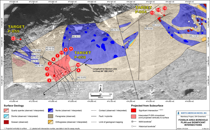
Figure 54: Compilation of Drilling Results at the Fossilik Target; for Intersections Refer to Table 14
| | |
3CN024.004 – North American Nickel Inc. | | |
Updated Independent Technical Report for the Maniitsoq Nickel-Copper-Cobalt-PGM Project, Greenland | | Page 102 |
P-058 Target
Twelve boreholes (2,577 metres) have been completed in theP-058 area (Figure 54), mainly on sections 15 to 55 metres apart. Drilling platforms were positioned to accommodate locally steep and irregular topography. Eleven of the boreholes intersected nickel-copper sulphide mineralization variably comprising high grade remobilized massive sulphide veins and stringer mineralization as well as disseminated to blebby magmatic sulphides. One borehole(MQ-15-076) tested a separate electromagnetic target located immediately east of the main target area but did not intersect any significant sulphide mineralization.
An inclined longitudinal section is shown in Figure 55. Intersections range from 0.45 to 21.5 metres in core length; true widths, based on an azimuth of 233 degrees and a dip of 80 degrees to the northwest, are estimated to range from 0.1 to 7.0 metres. A narrow parallel sulphide zone lies in the footwall to the main mineralization for which true widths have not been calculated.
| | |
3CN024.004 – North American Nickel Inc. | | |
Updated Independent Technical Report for the Maniitsoq Nickel-Copper-Cobalt-PGM Project, Greenland | | Page 103 |
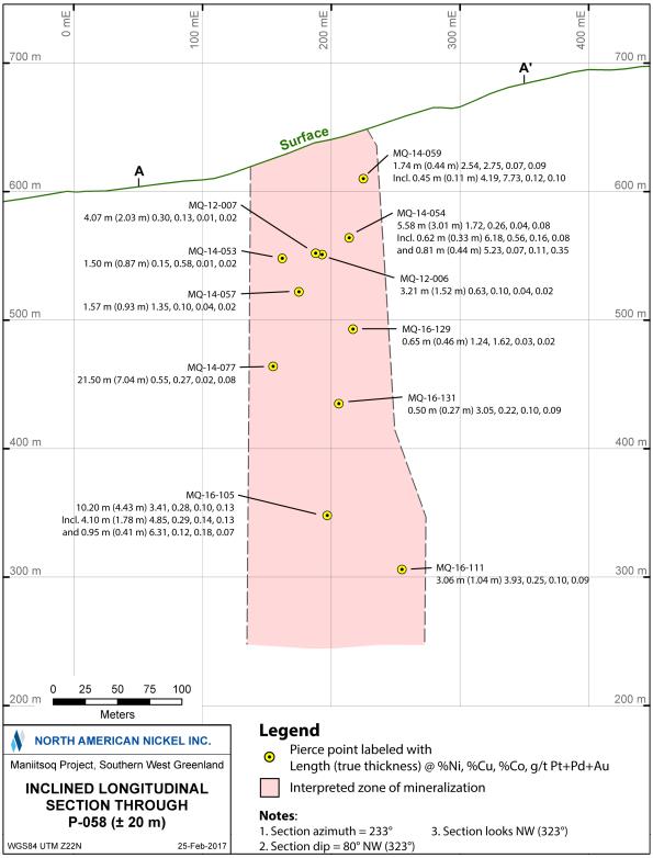
Figure 55: Inclined Longitudinal Section ofP-058 looking Northwest, see Figure 54 for Location and Orientation of Section
| | |
3CN024.004 – North American Nickel Inc. | | |
Updated Independent Technical Report for the Maniitsoq Nickel-Copper-Cobalt-PGM Project, Greenland | | Page 104 |
P-059 Target
Four boreholes (928 metres) were drilled to test an electromagnetic anomaly identified from the 2012 VTEM survey (Figure 54). The first two boreholes, completed in 2012 and 2014, did not intersect the target, but a third borehole, drilled in 2015 to test both the VTEM anomaly and borehole electromagnetic anomalies, intersected a zone of sulphide mineralization. The borehole geophysical data were subsequently modeled as three electromagnetic plates aligned to form a conductive trend. A fourth hole was completed in 2016 to test the deepest part of this conductive trend but it intersected unmineralized norite at the target depth. The borehole electromagnetic survey of this hole indicated that it narrowly missed the target and passed below the plunge of the conductive trend. The mineralization in boreholeMQ-15-078 lies up plunge of the conductive trend. The down plunge extent remains untested. The sulphide mineralization remains open, and further work is required to determine if a coherent zone of sulphide mineralization is present.
P-004 Target
Three boreholes (871 metres), completed in 2013, 2014 and 2016, respectively, have tested theP-004 VTEM target (Figure 54) two of the three intersected sulphide mineralization within the Fossilik intrusion.
Geological mapping and 3D modelling completed in 2015 show that the Fossilik intrusion is complexly folded in theP-004 area, with surface gossans occurring along the contacts between norite and orthogneiss. Sulphide mineralization intersected in boreholes is interpreted to occur near F2 fold hinges and in proximity to the margins of the norite intrusion (Ravenelle, 2015b). Based on this work and borehole geophysical data, the best intersection obtained in boreholeMQ-13-018 is interpreted to correlate with a surface gossan occurring in the nose of a steeply northwesterly plunging F2 fold. A low conductance electromagnetic plate modelled from the borehole surveys lies immediately north and down plunge of this sulphide mineralization.
In 2016, a borehole was completed to test 100 metres down plunge of the known mineralization and related borehole plates along the interpreted fold nose. HoleMQ-16-112 intersected norite but did not return any significant assays and is interpreted to have been drilled along the limb of the fold versus the targeted fold nose. A borehole electromagnetic survey of this hole identified a low conductanceoff-hole anomaly.
TheP-004 sulphide mineralization remains open and further work is required to determine if a coherent sulphide zone is present. Surface gossans and sulphide mineralization intersected in boreholes indicate the potential to identify additional mineralization along the folded norite-orthogneiss contact, potentially with larger accumulations occurring in fold nose regions.
A fourth borehole was drilled 285 metres to the east in 2014 in an area of outcropping gossanous norite, previously tested by shallow historical holes, but did not intersect any significant mineralization. However, a borehole electromagnetic survey detected anoff-hole conductor beyond the end of the hole which is untested.
| | |
3CN024.004 – North American Nickel Inc. | | |
Updated Independent Technical Report for the Maniitsoq Nickel-Copper-Cobalt-PGM Project, Greenland | | Page 105 |
Three VTEM targets in theP-013 area have been tested by a total of eleven boreholes (2,857 metres). Mineralization has been intersected at both theP-013 Centre andP-013 SE targets. One hole (161 metres) completed in 2013 to test theP-013 NW target intersected unmineralized orthogneiss.
TheP-013 (Centre) VTEM target (Figure 56) has been tested by six boreholes (1,884 metres) including one completed in 2013, two in 2014, two in 2015 and one in 2016. Due to the abundance of boulders in the area, four boreholes were completed from the same drill platform while two boreholes were completed from separate locations. All boreholes intersected varying amounts of norite-hosted nickel-copper sulphide mineralization. Salient analytical results are given in Table 15, and a borehole plan map is shown in Figure 56.
One zone of mineralization was intersected in four boreholes over a strike length of 30 to 35 metres and a dip extent of 100 metres. It has been interpreted to strike northeast and dip steeply to the northwest. Sulphide intervals intersected by drilling range from 0.40 to 15.85 metres in core length. The true widths are estimated between 0.30 to 12.0 metres based on an azimuth of 57 degrees and a dip of 81 degrees to the northwest.
Borehole electromagnetic surveys have identified clusters of moderately conductive, discrete anomalies, which correlate locally with the sulphide intervals intersected by the boreholes. The drill data and borehole electromagnetic data suggest the presence of one or more additional parallel sulphide lenses. A borehole completed in 2016 to test the down dip extent of the mineralization intersected a sheared norite-orthogneiss contact at 368 metres downhole. The hole was terminated in orthogneiss prior to target depth due to indications that the norite may beoff-set by a shear zone. The sulphide mineralization remains open along strike.
Table 15: Salient Borehole Analytical Results,P-013 Target
| | | | | | | | | | | | | | | | | | | | | | | | | | | | | | | | | | | | |
No. | | Borehole | | | From
(m) | | | To
(m) | | | Core
Interval (m) | | | True
Width* (m) | | | Ni
% | | | Cu
% | | | Co
% | | | Pt+Pd+Au
g/t | |
| P-013 Centre | |
1 | | | MQ-13-032 | | | | 150.56 | | | | 159.22 | | | | 8.66 | | | | 5.57 | | | | 0.33 | | | | 0.09 | | | | 0.01 | | | | 0.04 | |
| | | Incl. | | | | 157.21 | | | | 159.22 | | | | 2.01 | | | | 1.29 | | | | 0.88 | | | | 0.22 | | | | 0.03 | | | | 0.10 | |
| | | And | | | | 157.21 | | | | 157.61 | | | | 0.40 | | | | 0.26 | | | | 2.20 | | | | 0.70 | | | | 0.07 | | | | 0.26 | |
| | | | | | | | | | | | | | | | | | | | | | | | | | | | | | | | | | | | |
2 | | | MQ-14-066 | | | | 157.00 | | | | 168.00 | | | | 11.00 | | | | 6.68 | | | | 1.31 | | | | 0.15 | | | | 0.04 | | | | 0.07 | |
| | | Incl. | | | | 158.43 | | | | 164.28 | | | | 5.85 | | | | 3.55 | | | | 2.07 | | | | 0.12 | | | | 0.05 | | | | 0.07 | |
| | | | | | | | | | | | | | | | | | | | | | | | | | | | | | | | | | | | |
3 | | | MQ-14-068 | | | | 126.70 | | | | 142.55 | | | | 15.85 | | | | 12.06 | | | | 0.87 | | | | 0.27 | | | | 0.03 | | | | 0.09 | |
| | | Incl. | | | | 130.85 | | | | 134.25 | | | | 3.40 | | | | 2.59 | | | | 2.07 | | | | 0.34 | | | | 0.06 | | | | 0.15 | |
| | | | | | | | | | | | | | | | | | | | | | | | | | | | | | | | | | | | |
4 | | | MQ-15-079 | | | | 185.05 | | | | 195.70 | | | | 10.65 | | | | 2.93 | | | | 1.03 | | | | 0.39 | | | | 0.04 | | | | 0.06 | |
5 | | | | | | | 200.75 | | | | 206.00 | | | | 5.25 | | | | 1.43 | | | | 1.15 | | | | 0.18 | | | | 0.03 | | | | 0.07 | |
| | | | | | | | | | | | | | | | | | | | | | | | | | | | | | | | | | | | |
6 | | | MQ-15-094 | | | | 212.75 | | | | 224.70 | | | | 11.95 | | | | 5.66 | | | | 0.94 | | | | 0.44 | | | | 0.02 | | | | 0.10 | |
| | | Incl. | | | | 215.10 | | | | 217.00 | | | | 1.90 | | | | 0.90 | | | | 1.63 | | | | 0.37 | | | | 0.05 | | | | 0.08 | |
| | | And | | | | 220.20 | | | | 224.70 | | | | 4.50 | | | | 2.13 | | | | 1.23 | | | | 0.22 | | | | 0.03 | | | | 0.08 | |
| | | | | | | | | | | | | | | | | | | | | | | | | | | | | | | | | | | | |
P-013 SE | |
7 | | | MQ-16-109 | | | | 166.90 | | | | 205.65 | | | | 38.75 | | | | NC | | | | 1.19 | | | | 0.43 | | | | 0.03 | | | | 0.23 | |
| | | Incl. | | | | 166.90 | | | | 180.25 | | | | 13.35 | | | | NC | | | | 2.88 | | | | 0.80 | | | | 0.06 | | | | 0.47 | |
| | | And | | | | 180.25 | | | | 205.65 | | | | 25.40 | | | | NC | | | | 0.31 | | | | 0.23 | | | | 0.01 | | | | 0.10 | |
| * | True widths are reported for theP-013 Centre zone where the strike and dip of the sulphide zones can be estimated. There is insufficient information to estimate the true width for theP-013 SE mineralization (NC). |
| | |
3CN024.004 – North American Nickel Inc. | | |
Updated Independent Technical Report for the Maniitsoq Nickel-Copper-Cobalt-PGM Project, Greenland | | Page 106 |
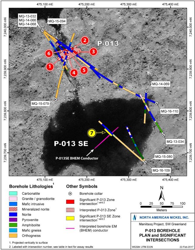
Figure 56: Compilation of Drilling Results atP-013, for Intersections Refer to Table 15
| | |
3CN024.004 – North American Nickel Inc. | | |
Updated Independent Technical Report for the Maniitsoq Nickel-Copper-Cobalt-PGM Project, Greenland | | Page 107 |
TheP-013SE VTEM and related borehole electromagnetic anomalies have been tested by four boreholes (812 metres) with one borehole completed in each of 2013, 2014, 2015, and 2016. Three of the holes did not intersect a significant conductor. However, a geophysical survey ofMQ-15-080 identified a moderate conductanceoff-hole electromagnetic anomaly at depth and to the southeast of the VTEM anomaly. This target was tested in 2016 by boreholeMQ-16-109, which newly intersected a significant zone of nickel-copper sulphide mineralization averaging 1.19 percent nickel and 0.43 percent copper over a core length of 38.8 metres. This intersection included a high grade interval returning 2.88 percent nickel, 0.80 percent copper, 0.06 percent cobalt and 0.47 g/t Pt+Pd+Au over a core length of 13.35 metres. There is insufficient information to determine if the reported core length interval represents true width.
Borehole electromagnetic results from the new hole indicate additional untesteddown-dip potential for this mineralization. In addition, borehole electromagnetic data from other boreholes in the immediate area detected a small, near surface moderate conductance anomaly that corresponds to the originalP-013SE VTEM anomaly. This conductor is also untested.
| 9.2.5 | P-030,P-032,P-061, andP-094 Targets |
TheP-030,P-032, andP-094 nickel sulphide occurrences are all hosted within a two kilometre long northeast striking norite intrusion in the southern part of the Greenland Norite Belt (Figure 46). North American Nickel has completed eleven boreholes (2,146 metres) to test these three target areas. One additional borehole (173 metres) was completed in 2013 to test theP-061 target, which is located in the same intrusion. Salient analytical results are given in Table 16. Figure 57 is a compilation map showing borehole locations and summarizing the results at this target. There is insufficient information to determine if the core length intervals reported in the proceeding sections for historical or North American Nickel boreholes in theP-030,P-032, andP-094 area represent true widths.
Table 16: Salient Borehole Analytical Results,P-030,P-032, andP-094 Targets
| | | | | | | | | | | | | | | | | | | | |
No. | | Target
Area | | Borehole | | From (m) | | To (m) | | Core
Interval (m) | | Ni % | | Cu % | | Co % | | Pt+Pd+Au
g/t | |
1 | | | | MQ-14-070 | | 22.00 | | 33.65 | | 11.65 | | 0.32 | | 0.10 | | 0.01 | | | 0.09 | |
2 | | | | | | 40.75 | | 60.85 | | 20.10 | | 0.63 | | 0.20 | | 0.02 | | | 0.18 | |
| | | | Incl. | | 53.30 | | 54.50 | | 1.20 | | 1.86 | | 0.52 | | 0.06 | | | 0.49 | |
3 | | P-030 | | | | 112.20 | | 130.00 | | 17.80 | | 0.33 | | 0.11 | | 0.02 | | | 0.26 | |
| | | | | | | | | | | | | | | | | | | | |
4 | | | | MQ-15-089 | | 33.95 | | 43.50 | | 9.55 | | 0.41 | | 0.07 | | 0.02 | | | 0.12 | |
| | | | Incl. | | 33.95 | | 34.25 | | 0.30 | | 1.33 | | 0.21 | | 0.04 | | | 0.33 | |
| | | | And | | 35.35 | | 36.60 | | 1.25 | | 0.95 | | 0.17 | | 0.03 | | | 0.28 | |
| | | | | | | | | | | | | | | | | | | | |
5 | | | | MQ-16-120 | | 86.30 | | 92.00 | | 5.70 | | 0.45 | | 0.08 | | 0.01 | | | 0.10 | |
6 | | | | | | 116.03 | | 118.00 | | 1.70 | | 0.46 | | 0.11 | | 0.01 | | | 0.34 | |
| | | | | | | | | | | | | | | | | | | | |
7 | | | | MQ-15-090 | | 71.90 | | 85.70 | | 13.80 | | 0.79 | | 0.27 | | 0.02 | | | 0.07 | |
| | | | Incl. | | 71.90 | | 77.00 | | 5.10 | | 1.06 | | 0.37 | | 0.03 | | | 0.09 | |
| | | | And | | 84.20 | | 85.70 | | 1.50 | | 2.47 | | 0.69 | | 0.08 | | | 0.23 | |
8 | | P-032 | | | | 91.35 | | 93.70 | | 2.35 | | 0.95 | | 0.21 | | 0.02 | | | 0.07 | |
| | | | | | | | | | | | | | | | | | | | |
9 | | | | MQ-15-100 | | 122.50 | | 130.50 | | 8.00 | | 0.58 | | 0.14 | | 0.02 | | | 0.06 | |
| | | | Incl. | | 125.90 | | 126.90 | | 1.00 | | 1.60 | | 0.34 | | 0.05 | | | 0.19 | |
| | | | | | | | | | | | | | | | | | | | |
10 | | | | MQ-16-122 | | 192.00 | | 216.00 | | 24.00 | | 0.23 | | 0.06 | | 0.01 | | | 0.04 | |
11 | | | | MQ-16-123 | | 131.00 | | 136.00 | | 5.00 | | 0.23 | | 0.06 | | 0.01 | | | 0.02 | |
12 | | | | MQ-16-128 | | 267.50 | | 268.30 | | 0.80 | | 0.58 | | 0.09 | | 0.02 | | | 0.09 | |
| | | | | | | | | | | | | | | | | | | | |
13 | | P-094 | | MQ-16-124 | | 55.00 | | 63.00 | | 8.00 | | 0.54 | | 0.16 | | 0.02 | | | 0.07 | |
| | |
3CN024.004 – North American Nickel Inc. | | |
Updated Independent Technical Report for the Maniitsoq Nickel-Copper-Cobalt-PGM Project, Greenland | | Page 108 |
P-030 Target
At theP-030 target (Figure 57), the historical Nunanguit nickel occurrence was tested by KØ with nine shallow core boreholes in 1970. All of the historical boreholes intersected nickel-copper sulphide mineralization. Significant intersections included 0.76 percent nickel and 0.16 percent copper over a core length of 22.1 metres in boreholeNu-1, and 1.2 percent nickel and 0.48 percent copper over a core length of 2.9 metres in boreholeNu-2
The 2012 VTEM survey carried out by North American Nickel identified an electromagnetic anomaly located immediately east of the historic boreholes. North American Nickel completed four boreholes (586 metres), one in each of years 2013 through 2016, in this area tofollow-up on the airborne anomaly, subsequent borehole electromagnetic anomalies and a new induced polarization anomaly defined in 2016. Three of the boreholes, located 25 to 50 metres apart, intersected norite-hosted sulphide mineralization. The best analytical results were obtained in boreholeMQ-14-070 that yielded 0.63 percent nickel, 0.20 percent copper, and 0.18 g/t Pt+Pd+Au over a core length of 20.1 metres, including 1.86 percent nickel, 0.52 percent copper, 0.06 percent cobalt and 0.49 g/t Pt+Pd+Au over 1.2 metres.
Based on borehole electromagnetic data, the mineralization intersected in boreholeMQ-14-070 is interpreted to plunge steeply to the southeast, suggesting that boreholeMQ-15-089 was drilled west of the main trend of mineralization. BoreholeMQ-16-120 was drilled to test an induced polarization anomaly located down plunge to the southeast ofMQ-14-070 and intersected two intervals of disseminated sulphides grading 0.45 and 0.46 percent nickel over core lengths 5.7 metres and 1.7 metres, respectively.
| | |
3CN024.004 – North American Nickel Inc. | | |
Updated Independent Technical Report for the Maniitsoq Nickel-Copper-Cobalt-PGM Project, Greenland | | Page 109 |
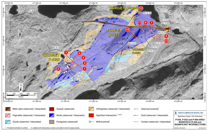
Figure 57: Compilation of Drilling Results at theP-030 andP-032P-061, andP-094 Targets; for Intersections Refer to Table 16
| | |
3CN024.004 – North American Nickel Inc. | | |
Updated Independent Technical Report for the Maniitsoq Nickel-Copper-Cobalt-PGM Project, Greenland | | Page 110 |
P-032 Target
Six boreholes (1,380 metres) have been completed by North American Nickel at theP-032 target (Figure 57) including one drilled in 2013, two in 2015 and three in 2016. Five of the boreholes, located approximately 35 to 130 metres apart, intersected norite-hosted sulphide mineralization. The best interval was intersected in boreholeMQ-15-090 and yielded 0.79 percent nickel and 0.27 percent copper over a core length of 13.8 metres, including 1.06 percent nickel and 0.37 percent copper over 5.1 metres.
TheP-032 mineralization is not well-defined by electromagnetic methods because of its electrically disconnected nature. In 2016, an induced polarization survey identified a chargeability anomaly linking surface gossans with the subsurfaceP-032 mineralization. Two of the three 2016 boreholes were drilled along this chargeability trend and intersected intervals of norite-hosted disseminated sulphides, which returned nickel values of approximately 0.25 percent over core lengths of 5.0 and 24.0 metres.
P-094
TheP-094 target consists of coincident VTEM, surface electromagnetic, and induced polarization anomalies with an associated surface gossan. One borehole (180 metres) was completed in 2016 to test this target and resulted in the discovery of subsurface norite-hosted nickel-copper sulphide mineralization (Figure 57).MQ-16-124 was targeted to intersectdown-dip of the shallow surface electromagnetic anomalies and intersected blebby, patchy, and stringer sulphide mineralization averaging 0.54 percent nickel and 0.16 percent copper over a core length of 8.0 metres.
A borehole electromagnetic survey of this hole identified a small, near surfaceoff-hole anomaly, which remains untested. TheP-094 area is interpreted to be an area of disseminated sulphides with multiple small conductors.
Fifteen boreholes (3,752 metres) have been completed atP-053 including the original hole in 2014, eight holes in 2015 and six holes in 2016. Drilling was carried out from eight separate drilling platforms spaced approximately 40 to 110 metres apart (Figure 58). Ten of the boreholes intersected variable amounts of norite-hosted sulphide mineralization. The intersections define two zones, which lie in the hanging wall and footwall, respectively, of a cross-cutting mylonite zone. One borehole was aborted andre-drilled.
An inclined longitudinal section is shown in Figure 59. Borehole intersections for the hanging wall zone range from 0.3 to 23.7 metres in core length; true widths, based on an azimuth of 117 degrees and a dip of 75 degrees to the south, are estimated to range from 0.25 to 16.1 metres. Borehole intersections for the footwall zone range from 0.5 to 6.0 metres in core length; true widths, based on an azimuth of 101 degrees and a dip of 70 degrees to the south, are estimated to range from 0.3 to 4.2 metres. Salient analytical results are shown Table 17.
The most significant sulphide intersection was in boreholeMQ-15-082, which intersected a wide hanging wall zone of sulphide stringers and semi-massive to massive sulphide breccia veins. A core length interval of 23.7 metres returned 1.98 percent nickel, 0.62 percent copper, 0.09 percent cobalt, and 0.19 g/t Pt+Pd+Au, including 2.78 percent nickel, 0.36 percent copper, 0.13 percent cobalt, and 0.26 g/t Pt+Pd+Au over 12.2 metres. The true width of the overall intersection is estimated to be 16 metres.
| | |
3CN024.004 – North American Nickel Inc. | | |
Updated Independent Technical Report for the Maniitsoq Nickel-Copper-Cobalt-PGM Project, Greenland | | Page 111 |
Drilling and borehole electromagnetic data indicate that the hanging wall zone is open along strike to the east and that the footwall zone remains open down dip.
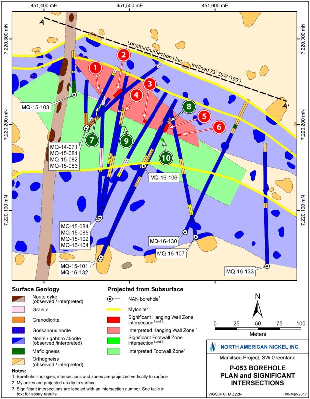
Figure 58: Compilation of Drilling Results at TargetP-053; for Intersections refer to Table 17.
| | |
3CN024.004 – North American Nickel Inc. | | |
Updated Independent Technical Report for the Maniitsoq Nickel-Copper-Cobalt-PGM Project, Greenland | | Page 112 |
Table 17: Salient Borehole Analytical Results,P-053 Target
| | | | | | | | | | | | | | | | | | | | | | | | | | | | | | | | | | |
No | | Borehole | | From
(m) | | | To
(m) | | | Core
Interval
(m) | | | True
Width
(m) | | | Ni
% | | | Cu
% | | | Co
% | | | Pt+Pd+Au
g/t | |
Hanging Wall Zone | |
1 | | MQ-14-071 | | | 108.52 | | | | 109.17 | | | | 0.65 | | | | 0.42 | | | | 0.41 | | | | 1.13 | | | | 0.02 | | | | 0.23 | |
| | | | | | | | | | | | | | | | | | | | | | | | | | | | | | | | | | |
2 | | MQ-15-082 | | | 93.00 | | | | 116.70 | | | | 23.70 | | | | 16.12 | | | | 1.98 | | | | 0.62 | | | | 0.09 | | | | 0.19 | |
| | Incl. | | | 93.00 | | | | 104.50 | | | | 11.50 | | | | 7.84 | | | | 1.12 | | | | 0.91 | | | | 0.05 | | | | 0.12 | |
| | And | | | 104.50 | | | | 116.70 | | | | 12.20 | | | | 8.28 | | | | 2.78 | | | | 0.36 | | | | 0.13 | | | | 0.26 | |
| | | | | | | | | | | | | | | | | | | | | | | | | | | | | | | | | | |
3 | | MQ-15-084 | | | 196.00 | | | | 201.60 | | | | 5.60 | | | | 4.73 | | | | 1.03 | | | | 0.34 | | | | 0.05 | | | | 0.12 | |
| | Incl. | | | 199.15 | | | | 201.05 | | | | 1.90 | | | | 1.61 | | | | 1.70 | | | | 0.20 | | | | 0.09 | | | | 0.17 | |
| | | | | | | | | | | | | | | | | | | | | | | | | | | | | | | | | | |
4 | | MQ-15-102 | | | 189.30 | | | | 189.60 | | | | 0.30 | | | | 0.25 | | | | 1.57 | | | | 1.71 | | | | 0.08 | | | | 0.34 | |
| | | | | | | | | | | | | | | | | | | | | | | | | | | | | | | | | | |
5 | | MQ-16-106 | | | 97.45 | | | | 117.50 | | | | 20.05 | | | | 13.95 | | | | 0.64 | | | | 0.25 | | | | 0.03 | | | | 0.08 | |
| | Incl. | | | 110.95 | | | | 117.50 | | | | 6.55 | | | | 4.56 | | | | 1.14 | | | | 0.33 | | | | 0.04 | | | | 0.12 | |
| | And | | | 111.65 | | | | 113.60 | | | | 1.95 | | | | 1.36 | | | | 2.12 | | | | 0.42 | | | | 0.08 | | | | 0.18 | |
| | | | | | | | | | | | | | | | | | | | | | | | | | | | | | | | | | |
6 | | MQ-16-107 | | | 192.70 | | | | 196.15 | | | | 3.45 | | | | 2.30 | | | | 1.10 | | | | 0.19 | | | | 0.04 | | | | 0.11 | |
| | | | | | | | | | | | | | | | | | | | | | | | | | | | | | | | | | |
Footwall Zone | |
7 | | MQ-15-085 | | | 229.50 | | | | 230.85 | | | | 1.35 | | | | 1.10 | | | | 0.98 | | | | 0.45 | | | | 0.05 | | | | 0.14 | |
| | | | | | | | | | | | | | | | | | | | | | | | | | | | | | | | | | |
8 | | MQ-15-101 | | | 301.90 | | | | 302.50 | | | | 0.60 | | | | 0.48 | | | | 0.72 | | | | 0.22 | | | | 0.02 | | | | 0.12 | |
| | | | | | | | | | | | | | | | | | | | | | | | | | | | | | | | | | |
9 | | MQ-16-104 | | | 294.45 | | | | 295.70 | | | | 1.25 | | | | 0.83 | | | | 2.42 | | | | 0.09 | | | | 0.09 | | | | 0.12 | |
| | Incl. | | | 295.20 | | | | 295.70 | | | | 0.50 | | | | 0.33 | | | | 4.39 | | | | 0.05 | | | | 0.15 | | | | 0.19 | |
| | | | | | | | | | | | | | | | | | | | | | | | | | | | | | | | | | |
10 | | MQ-16-132 | | | 362.00 | | | | 368.00 | | | | 6.00 | | | | 4.16 | | | | 0.50 | | | | 0.18 | | | | 0.02 | | | | 0.12 | |
| | |
3CN024.004 – North American Nickel Inc. | | |
Updated Independent Technical Report for the Maniitsoq Nickel-Copper-Cobalt-PGM Project, Greenland | | Page 113 |
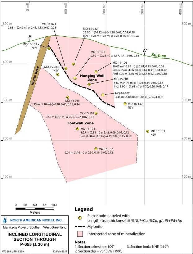
Figure 59: Inclined Longitudinal Section ofP-053 looking Northeast, see Figure 58 for Location and Orientation of Section
| | |
3CN024.004 – North American Nickel Inc. | | |
Updated Independent Technical Report for the Maniitsoq Nickel-Copper-Cobalt-PGM Project, Greenland | | Page 114 |
| 9.2.7 | P-149 andP-146 Targets |
Drilling was carried out at two locations along the 2.8 kilometre long Pingo norite intrusion located in the northern part of the Maniitsoq property (Figure 46). Figure 60 summarizes the exploration work completed at the two targets.
AtP-149, a short borehole(Pi-1) completed by KØ in 1970 (Figure 60) intersected norite-hosted disseminated sulphides which averaged 0.58 percent nickel and 0.24 percent copper over a core length of 4.16 metres. There is insufficient information to determine if the reported core length interval represents true width. Two boreholes (343 metres) were completed in the same area by North American Nickel in 2014 to test a weak electromagnetic anomaly detected by the 2013 VTEM survey. The widest sulphide interval was obtained in boreholeMQ-14-041 and yielded 0.36 percent nickel and 0.17 percent copper over a core length of 23.2 metres. A narrow interval ofnet-textured and stringer sulphides included in that interval returned 3.31 percent nickel, 0.61 percent copper and 0.27 g/t Pt+Pd+Au over 0.5 metres. There is insufficient information to determine if the reported core length intervals represent true width. The Pingo sulphide mineralization is similar to the Spotty Hill disseminated sulphide mineralization and is characterized by abundant visible pentlandite and an elevated PGM content.
AtP-146, one borehole (131 metres) completed by North American Nickel intersected two intervals of weakly disseminated sulphide in norite with the best interval yielding 0.26 percent nickel and 0.12 percent copper over a core length of 5.45 metres. There is insufficient information to determine if the reported core length interval represents true width.
Borehole electromagnetic surveys atP-149 andP-146 did not detect any significant response; the VTEM anomalies atP-146 andP-149 are interpreted to be SPM effects caused by the magnetic orthogneisses intersected in drilling.
| | |
3CN024.004 – North American Nickel Inc. | | |
Updated Independent Technical Report for the Maniitsoq Nickel-Copper-Cobalt-PGM Project, Greenland | | Page 115 |
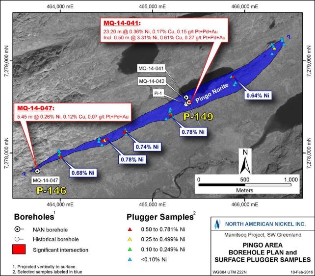
Figure 60: Compilation of Drilling Results at theP-146 andP-149 Targets
Between 2013 and 2016, 24 regional exploration targets located throughout the Maniitsoq property (excluding several noted in preceding sections) were tested by 30 core boreholes (4,300 metres) (Figure 61). Included within this drilling are the following boreholes completed at historic nickel occurrences:
| | • | | Three boreholes (355 metres; two in 2013 and one in 2016) at the Quagssuk (North American Nickel’sP-049 VTEM target) |
| | • | | One borehole (179 metres; 2015) at Takissoq West (North American Nickel’sG-013 target) |
| | • | | Three boreholes (407 metres; 2013) at Sikolik East (North American Nickel’sP-022 target) |
| | • | | One borehole (146 metres; 2014) at Camp 10 (North American Nickel’sP-136 target) |
Elevated nickel, copper, and zinc assays were obtained at a number of the regional targets (Figure 61) and are summarized below and in Table 18. There is insufficient information to determine if the reported core length intervals represent true widths.
| | |
3CN024.004 – North American Nickel Inc. | | |
Updated Independent Technical Report for the Maniitsoq Nickel-Copper-Cobalt-PGM Project, Greenland | | Page 116 |

Figure 61: Location of Selected Regional Targets
| | |
3CN024.004 – North American Nickel Inc. | | |
Updated Independent Technical Report for the Maniitsoq Nickel-Copper-Cobalt-PGM Project, Greenland | | Page 117 |
Table 18: Salient Borehole Analytical Results, Regional Targets
| | | | | | | | | | | | | | | | | | | | | | | | | | | | | | | | |
Target Area | | Borehole | | | From (m) | | | To (m) | | | Core Interval
(m) | | | Ni % | | | Cu % | | | Pt+Pd+Au
g/t | | | S % | |
P-097 | | | MQ-13-011 | | | | 31.76 | | | | 35.98 | | | | 4.22 | | | | 0.18 | | | | 0.06 | | | | 0.06 | | | | 1.26 | |
| | | | | | | | | | | | | | | | | | | | | | | | | | | | | | | | |
Sikolik East (P-022) | | | MQ-13-016 | | | | 18.65 | | | | 62.47 | | | | 43.82 | | | | 0.22 | | | | 0.07 | | | | 0.04 | | | | 1.27 | |
| | | Incl. | | | | 18.65 | | | | 21.50 | | | | 2.85 | | | | 0.68 | | | | 0.14 | | | | 0.11 | | | | 3.30 | |
| | | And | | | | 34.55 | | | | 35.23 | | | | 0.68 | | | | 1.24 | | | | 0.23 | | | | 0.19 | | | | 6.36 | |
| | | And | | | | 48.30 | | | | 49.56 | | | | 1.26 | | | | 1.44 | | | | 0.34 | | | | 0.32 | | | | 7.92 | |
| | | | | | | | | | | | | | | | | | | | | | | | | | | | | | | | |
| | | MQ-13-017 | | | | 69.08 | | | | 71.00 | | | | 1.92 | | | | 0.23 | | | | 0.07 | | | | 0.04 | | | | 1.78 | |
| | | | | | | | | | | | | | | | | | | | | | | | | | | | | | | | |
P-161 | | | MQ-16-046 | | | | 57.65 | | | | 58.00 | | | | 0.35 | | | | 0.24 | | | | 0.24 | | | | 0.02 | | | | 1.15 | |
| | | | | | | | | | | | | | | | | | | | | | | | | | | | | | | | |
Camp 10 (P-136) | | | MQ-14-048 | | | | 39.55 | | | | 39.90 | | | | 0.35 | | | | 1.35 | | | | 0.15 | | | | 0.07 | | | | 8.60 | |
| | | | | | | 45.58 | | | | 58.75 | | | | 13.17 | | | | 0.21 | | | | 0.09 | | | | 0.01 | | | | 1.46 | |
| | | Incl. | | | | 58.00 | | | | 58.75 | | | | 0.75 | | | | 0.93 | | | | 0.22 | | | | 0.03 | | | | 6.12 | |
| | | | | | | 95.00 | | | | 125.00 | | | | 30.00 | | | | 0.22 | | | | 0.09 | | | | 0.02 | | | | 1.49 | |
| | | | | | | | | | | | | | | | | | | | | | | | | | | | | | | | |
P-038 | | | MQ-15-086 | | | | 92.60 | | | | 93.00 | | | | 0.40 | | | | 0.13 | | | | 0.01 | | | | 0.03 | | | | 0.46 | |
| | | | | | | | | | | | | | | | | | | | | | | | | | | | | | | | |
P-012 | | | MQ-15-093 | | | | 112.15 | | | | 113.10 | | | | 0.95 | | | | 0.13 | | | | 0.02 | | | | 0.02 | | | | 1.68 | |
| | | | | | | 213.15 | | | | 214.00 | | | | 0.85 | | | | 0.12 | | | | 0.01 | | | | 0.03 | | | | 7.09 | |
| | | | | | | 216.65 | | | | 217.65 | | | | 1.00 | | | | 0.17 | | | | 0.12 | | | | 0.01 | | | | 14.85 | |
| | | | | | | | | | | | | | | | | | | | | | | | | | | | | | | | |
P-290 | | | MQ-15-097 | | | | 69.05 | | | | 75.00 | | | | 5.95 | | | | 0.08 | | | | 0.34 | | | | 0.08 | | | | 9.95 | |
| | | Incl. | | | | 69.05 | | | | 70.00 | | | | 0.95 | | | | 0.11 | | | | 0.72 | | | | 0.06 | | | | 16.35 | |
| | | | | | | | | | | | | | | | | | | | | | | | | | | | | | | | |
P-289 | | | MQ-15-098 | | | | 19.70 | | | | 20.40 | | | | 0.70 | | | | 0.10 | | | | 0.22 | | | | 0.08 | | | | 19.16 | |
| | | | | | | | | | | | | | | | | | | | | | | | | | | | | | | | |
P-141 | | | MQ-16-115 | | | | 54.50 | | | | 55.40 | | | | 0.90 | | | | 0.09 | | | | 0.41 | | | | 0.04 | | | | 7.56 | |
| | | | | | | | | | | | | | | | | | | | | | | | | | | | | | | | |
P-142 | | | MQ-16-116 | | | | 119.00 | | | | 120.00 | | | | 1.00 | | | | 0.34 | | | | 0.16 | | | | 0.17 | | | | 2.37 | |
| | | | | | | | |
Target Area | | Borehole | | | From (m) | | | To (m) | | | Core Interval
(m) | | | Ni % | | | Cu % | | | Zn % | | | S % | |
Takissoq West (G-013) | | | MQ-15-096 | | | | 103.25 | | | | 110.00 | | | | 6.75 | | | | 0.07 | | | | 0.33 | | | | 0.17 | | | | 11.68 | |
| | | Incl. | | | | 105.00 | | | | 106.00 | | | | 1.00 | | | | 0.12 | | | | 1.04 | | | | 0.05 | | | | 23.00 | |
| | | | | | | 125.50 | | | | 134.50 | | | | 9.00 | | | | 0.04 | | | | 0.13 | | | | 0.12 | | | | 5.41 | |
Nickel-copper sulphides associated with norite intrusions were intersected at theP-022 (Sikolik East),P-097,P-136 (Camp 10),P-141,P-142, andP-290 targets (Figure 61).Off-hole orin-hole edge borehole electromagnetic anomalies were identified atP-012,P-022 (Sikolik East),P-038,P-097,P-136 (Camp 10),P-142,P-161,P-290, andG-013 (Takissoq West).
AtP-097, one borehole was competed to test a VTEM anomaly.MQ-13-011 intersected disseminated to blebby sulphide in norite, which returned 0.18 percent nickel over 4.22 metres. The borehole survey results indicated that the VTEM anomaly was not tested. A small, near surface moderate conductanceoff-hole electromagnetic anomaly was detected but has not been tested.
AtP-142, norite, locally containing sulphide disseminations, blebs and stringers, was intersected in boreholeMQ-16-116. One sample returned 0.34 percent nickel and 0.16 percent copper over a core length of 1.0 metre from 119 to 120 metres. Two weak to moderate conductancein-hole edge borehole electromagnetic responses were detected at 100 metres and are coincident with an interval containing stringer and disseminated sulphide mineralization, which returned less than 0.1 percent nickel. Theoff-hole portions of the anomalies have not been tested.
AtP-161, located in the northern portion of the Maniitsoq property, weakly anomalous nickel and copper values were obtained in meta-gabbro in boreholeMQ-16-046 while drill testing a VTEM anomaly. A borehole electromagnetic survey identified threeoff-hole anomalies including one high conductance anomaly at the approximate depth of the anomalous metal values. The borehole survey
| | |
3CN024.004 – North American Nickel Inc. | | |
Updated Independent Technical Report for the Maniitsoq Nickel-Copper-Cobalt-PGM Project, Greenland | | Page 118 |
results indicate that the VTEM target was not intersected, and the borehole anomalies remain untested.
AtP-290, remobilized sulphide stringers and veins associated with norite were intersected in boreholeMQ-15-097 over a core length of 5.95 metres. That interval returned 0.34 percent copper including a 0.95 metre interval, which yielded 0.72 percent copper and 0.11 percent nickel. A strongoff-hole borehole electromagnetic anomaly was detected beyond the end of the borehole but has not been tested. AtP-289, sulphide veins and stringers associated with norite and possible siliceous metasedimentary rock returned weakly anomalous nickel and copper values. TheP-289 andP-290 targets were both identified from the 2015 VTEM survey and are located in the poorly explored northern portion of the Maniitsoq property (see Figure 61).
Weakly anomalous nickel values were obtained in remobilized sulphide stringers in pegmatite and gneiss in boreholeMQ-15-093 at theP-012 target and in sulphidic metasedimentary rocks in boreholeMQ-15-086 atP-038. Borehole geophysical surveys identified moderate to strongoff-hole responses, which have not been tested
The Sikolik East nickel occurrence hosted in norite was discovered in 1968 and was drill tested by KØ in 1972. Three short, historic boreholes(Sik-1, 2 & 3) were completed, two of which intersected mineralization returning values of 0.38 percent nickel and 0.11 percent copper over 2.92 metres inSik-1 and 0.15 percent nickel over 19.0 metres inSik-3. The 2012 VTEM survey identified an anomaly immediately to the southeast of the historic drilling that was tested by two boreholes.MQ-13-016 andMQ-13-017 intersected mineralized norite with values of up to 1.44 percent nickel and 0.34 percent copper over 1.26 metres (Table 18). A small near surface moderate conductanceoff-hole electromagnetic anomaly was detected fromMQ-13-016 but has not been tested.
At the Camp 10 nickel occurrence, located three kilometres south of the Imiak Hill Complex, four short KØ boreholes(CA10-1 through 4) intersected a mineralized norite returning a best value of 1.74 percent nickel and 1.0 percent copper over 0.83 metres. North American Nickel drill tested a VTEM anomaly in the immediate vicinity with one borehole.MQ-14-048 intersected several intervals of norite hosted disseminated sulphides as listed in Table 18. The borehole electromagnetic survey identified several early tomid-channeloff-hole anomalies which remain untested.
At Takissoq West (Figure 61), one historical borehole(Tak-2) intersected pyribolites (highly ferromagnesian granulite); the best interval returned 0.18 percent nickel and 0.11 percent copper over a core length of 4.1 metres. The 2015 VTEM survey identified a strong electromagnetic conductor in the immediate vicinity, tested by boreholeMQ-15-096. This borehole intersected a sequence of mafic volcanic and intrusive rock, as well as siliceous metasedimentary rock hosting two sulphide zones that contain elevated copper and zinc values over core lengths of 6.75 and 9.0 metres. The borehole electromagnetic survey detected two relatedoff-hole anomalies, suggesting that the most conductive portions of the conductors have not been tested.
The Quagssuk nickel occurrence was discovered in 1962 by aerial and surface prospecting and is a40-metre long norite gossan along a northeast striking fault zone (Figure 62). Seventy-nine rock samples collected by KØ averaged 1.8 percent nickel and 1.1 percent copper. Three short historic boreholes(QU-1, 2 & 3) intersected mineralization returning a best value of 1.97 percent nickel and 0.43 percent copper over a core length of 4.95 metres in norite. The 2012 VTEM survey identified strong anomalies over the Quagssuk occurrence that were targeted by two core boreholes in 2013. Neither borehole intersected sulphide mineralization.Re-interpretation of the VTEM data prompted a 2016 surface electromagnetic survey that defined a small high conductance near surface anomaly, the upper edge of which correlated with the historic nickel sulphide mineralization. BoreholeMQ-16-114 was completed to test 25 metres down plunge of this anomaly but did not intersect any
| | |
3CN024.004 – North American Nickel Inc. | | |
Updated Independent Technical Report for the Maniitsoq Nickel-Copper-Cobalt-PGM Project, Greenland | | Page 119 |
significant mineralization. Drilling and borehole electromagnetic results indicate that the historic mineralization has a limited depth extent.
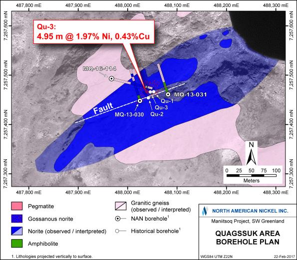
Figure 62: Compilation of Drilling Results at the Quagssuk Occurrence
| 9.3 | Drilling and Sampling Procedures |
The drilling programs completed between 2012 and 2016 used different drilling companies utilizing variously configured helicopter-portable wireline “fly” drill rigs as summarized in Table 19. The 2012 to 2015 drilling was completed using thin wall B size (BTW) coring equipment capable of recovering core 41 millimetres in diameter. The 2016 drilling was completed using BQTK and NQ coring equipment, with core diameters of 40.7 and 47.6 millimetres, respectively. All moves were carried out by helicopter. The base of operations was the exploration camp located on Puiattoq Bay at the end of Amitsuarssuk fjord (see Figure 4).
| | |
3CN024.004 – North American Nickel Inc. | | |
Updated Independent Technical Report for the Maniitsoq Nickel-Copper-Cobalt-PGM Project, Greenland | | Page 120 |
Table 19: Drilling Contractors and Equipment
| | | | |
Year | | Drilling Company | | Equipment |
| 2012 | | Cartwright Drilling Inc., Goose Bay, Labrador, Canada | | 1CDI-500 diamond drill core rig |
| | |
| 2013 | | Westcore Drilling Inc., Salmo, BC, Canada | | 1 Multi-power Products (MPP) Discovery diamond drill core rig |
| | |
| 2014 | | Cartwright Drilling Inc., Goose Bay, Labrador, Canada | | 1 CDI 500 diamond drill core rig and 1 CDI 700 diamond drill core rig |
| | |
| 2015 | | George Downing Estate Drilling Limited,Grenville-sur-la-Rouge, Quebec, Canada | | 1 Boyles JKS 300 diamond drill core rig |
| | |
| 2016 | | Boart Longyear. Calgary, Alberta, Canada | | 2 Longyear LF 70 diamond drill core rigs |
Borehole collar locations were planned and marked in the field by North American Nickel geologists using a handheld GPS receiver and compass. Each collar location was marked with a flagged wooden picket labelled with the borehole information. Photographs were then taken of the planned drill sites prior to the arrival of the drill. The drill rigs were positioned on prepared drill pads over a pegged collar location and typically aligned using positioned foresights. In some cases due to topographical constraints, markers in lieu of foresights were spray painted on rocks or positioned back sights were used. In 2014, a Reflex North finder Azimuth Pointing System (APS) tool was used to align boreholes completed by the CDI 700 drill rig to test mineralized targets including those in the Imiak Hill Complex area. In 2016, a Reflex North finder APS tool was introducedmid-program. The APS unit was affixed to a field leveling apparatus made with adjustable saw horses (Figure 63), which was then used by trained technicians to position foresights accurately. In addition, once a drill pad was built and the drill skid-frame was lowered into position, a second azimuth reading was collected using the APS aligned along the straight edge of the outside skid frame. This second reading was collected to ensure the drill rig was lined up along the correct azimuth, effectively reducing human error. The head inclination was set by the lead driller using a magnetic angle gauge. The pad preparation involved the positioning of platform timbers and the setting of anchors to secure the drill.
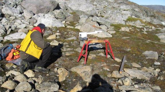
Figure 63: Field Mounted APS Unit (white) Used to Position Foresites
| | |
3CN024.004 – North American Nickel Inc. | | |
Updated Independent Technical Report for the Maniitsoq Nickel-Copper-Cobalt-PGM Project, Greenland | | Page 121 |
Upon completion of a borehole, the hole was flushed with water to facilitate downhole geophysical surveys and drill rods were extracted. The collar position was marked by a flagged wooden picket affixed with an aluminum tag denoting the borehole name, azimuth, inclination, and final borehole depth. The same information was also written on the wooden picket with a graphite lumber pencil. In selected 2012 to 2015 boreholes and in all 2016 boreholes, casing was left in the borehole in order to keep it open and facilitate future down-hole surveys or borehole deepening. In these instances, casing caps were affixed to the top of the casing. If the borehole was making water, the borehole was sealed prior to drill rig removal to prevent outflow of water.
Collar positions were recorded with a handheld GPS receiver after the completion of each borehole and after the drill rig was removed. In 2016, a third Azimuth reading was obtained by placing the APS tool directly on the drill casing. In most holes, unless the casing was not firmly seated, the ‘Casing Azimuth’ was the finalized collar azimuth recorded into the drill log. Each drill site was inspected for debris by North American Nickel personnel; finally, photographs of each drill site, showing the pegged collar location and condition of the site, were taken.
In 2014, a total of 29 historical and 41 North American Nickel borehole collars located in the Imiak Hill and Fossilik areas were surveyed by ASIAQ Greenland Survey using two Leica GPS receivers. The GPS data were post processed in order to yieldsub-metre accuracy relative to two project survey pins established earlier in 2014 by ASIAQ.
All North American Nickel boreholes were drilled at angles ranging from 45 to 80 degrees from horizontal. Down-hole surveys were completed at a nominal30-metre spacing using various down-hole direction survey equipment including a ReflexEZ-Shot electronic single shot (magnetic) device (2012, 2013,2014, and 2016) and a ReflexEZ-TRAC electronic multi-shot (magnetic) device (2014 and 2015). Both tools are solid state, electronic, magnetic-based instruments, which measure the earth’s magnetic field strength using a triaxial solid state fluxgate magnetometer and dip direction through a triaxial solid state accelerometer. Azimuth and dip readings are accurate to within ±0.35 to 0.5 degrees and ±0.2 to 0.25 degrees, respectively. Because the instrument measures the total magnetic field, any influence from the presence of magnetic rocks down-hole is known. In 2015 and 2016, if an azimuth reading was suspect due to magnetic interference recorded by the instrument, the reading was discarded and replaced with the average value of an accepted reading above and below the suspect reading. This process was carried out in order to utilize the dip from the test with the suspect azimuth.
Due to multiple consecutive poor magnetic azimuth readings and/orEZ-Shot and Crone RAD tool failures in 2016, additional downhole directional surveys were carried out using a ReflexEZ-TRAC attached to a swivel. This tool configuration allowed for older open holes to bere-surveyed post drilling. In total, 12 out of 30 of the 2016 boreholes were surveyed using the multi-shotEZ-TRAC.
Downhole directional data were also obtained for 125 of the boreholes that were surveyed with the Crone Geophysics and Exploration Ltd Pulse electromagnetic system. In order to determine the rotational position of the XY probe used in the electromagnetic surveys, a rad tool with onboard accelerometers and magnetometers was lowered down-hole, which provided borehole orientation data that can be used as an independent check on the Reflex survey data for those boreholes surveyed. Comparisons between Reflex and Rad tool data were made from 2014 onwards. Rad tool data are typically collected at five to ten metre station intervals. In 2016, data were also collected in “Continuous Reading” mode for selected holes.
In 2014, and 2015, a comparison of end of borehole positions, using the Reflex survey data, relative to the rad tool data generally showed good correlation of position with the plotted end of borehole
| | |
3CN024.004 – North American Nickel Inc. | | |
Updated Independent Technical Report for the Maniitsoq Nickel-Copper-Cobalt-PGM Project, Greenland | | Page 122 |
positions. In 2014, the average difference was 2.57 percent as a percentage relative to total borehole length with six boreholes exceeding a five percent difference. In 2015, differences were less than five percent (average of 1.27 percent) as a percentage relative to total borehole length.
In 2016, data analysis between the APS,EZ-Shot,EZ-TRAC, RAD Tool (normal and continuous reading) were completed. The average differences were 1.48 percent relative to the total borehole length between the two highest confidence datasets. Only one borehole exceeded an offset difference of greater than 5 percent.
Due to the difficulties in collecting reliable “real time” downhole directional data in 2016, collection of gyro or similar directional data, not be affected by the magnetic field, should be considered for future drilling.
Core retrieved from the boreholes was placed in wooden core trays at the drill site by a helper. Wooden blocks inscribed with depths in metres are placed after each three-metre run of core. Core was moved from the drill site to the exploration camp by helicopter.
At camp, core was examined for consistency and reordered as necessary. Trained technicians orientated and aligned the core and markedone-metre intervals on the core over the entire length of the borehole. Rock quality designation (RQD) measurements and recoveries were recorded by the technicians for each three-metre core run, and magnetic susceptibility and conductivity measurements were taken at regular intervals over the length of each borehole. These measurements were initially recorded in Excel spreadsheets and later incorporated into the digital database. Overall, core recovery averages 99.5 percent, except in localized faults and broken rock.
In 2016, oriented core was collected using the Reflex ACT III tool. Trained technicians orientated and aligned the core along a fixed horizontal angle iron using the bottom of hole (BOH) mark as a reference. Once the core was aligned and the BOH line was marked along the full length of the run (generally black in color), core was carefully placed back in the core tray. Meter marks, RQD, magnetic susceptibility and conductivity measurements were then completed as per usual procedure.
The core was logged by North American Nickel geologists, who recorded major and minor lithologies, mineralization, sulphide mineralogy, alteration, and structural features. Structural measurements (alpha angles) included mineral foliations, shear and mylonite zones, banding, lithologic contacts, dikes, and veins.X-ray fluorescence (XRF) readings were taken locally with a portable XRF gun at the geologist’s discretion, most commonly to check nickel and copper contents of mineralization. Core was then marked for sampling. All descriptive information was captured digitally using core logging software and regularly transferred to the project database. Prior to core cutting, the core boxes were photographed for future reference. The digital photos are stored as part of the project database.
In 2016, oriented core measurements (alpha and beta angles) were obtained along contacts, structures and mineralized veins. These data along with a brief geological description of the feature being measured were logged into an excel spreadsheet for each borehole. The quality of the collected data was evaluated by measuring the ‘offset’ (Lock Angle) between BOH lines from one run to another. The Lock Angle was measured in a 360 degree clock-wise fashion looking downhole from the shallow depth mark, reading the offset of the deeper interval BOH line. The Lock Angle between each of two core runs was recorded at the bottom end of the upper run and was written on the core and tabulated in a separate Excel spreadsheet for each borehole. SRK was contracted to review all of the structural measurements and associated quality control data. Their data analysis included an evaluation of recorded confidence levels and resulted in the retrieval of additional structural
| | |
3CN024.004 – North American Nickel Inc. | | |
Updated Independent Technical Report for the Maniitsoq Nickel-Copper-Cobalt-PGM Project, Greenland | | Page 123 |
measurements for selected core intervals. The finalized structural measurements were imported into the database. Planar disc-shaped surfaces representing the true strike and dip of various features were then created in GEOVIA GEMS software to aid in geological modeling.
Core sampling during the period 2012 to 2016 was completed by experienced geologists and geotechnicians working under the supervision of project managers. During core logging, the geologists set out intervals to be sampled for assay, specifically targeting intervals containing visible sulphide, and adjacent hanging wall and footwall areas. Care was taken not to span lithological contacts wherever possible. Selected ten to 15 centimetre long samples representing a range of lithologies were also collected for whole rock analyses. Sample intervals were marked directly on the core with a grease pencil, and unique numbered assay tags were inserted in the core trays with a copy of the stub retained in a tag book for reference. The sample tag books are retained in Canada, either at the company’s core facility in Sudbury, Ontario.
A reference line parallel to foliation was drawn along the core and core was sawn in half lengthwise at an angle perpendicular to the reference line using a rock saw. One half of the core was placed in a labelled plastic sample bag along with its sample tag and was sealed and sent for analysis. The other half core (with the reference line) was returned to the core box for future reference. In 2016, efforts were made to preserve the oriented BOH line on the core retained in the box, occasionally resulting in a small offset between the cutting line and the BOH line. A copy of the sample tag stub was also placed in the core tray for reference, and the sample number was written on the cut core with a grease pencil. Sample intervals ranged from 0.08 to 3.0 metres averaging 1.25 metres in length.
SRK reviewed the drilling, core logging, and sampling procedures used by North American Nickel. In the opinion of SRK, the current procedures used by North American Nickel are consistent with generally accepted industry best practices and are, therefore, adequate for an exploration project.
| | |
3CN024.004 – North American Nickel Inc. | | |
Updated Independent Technical Report for the Maniitsoq Nickel-Copper-Cobalt-PGM Project, Greenland | | Page 124 |
| 10 | Sample Preparation, Analyses, and Security |
| 10.1 | Historical Sampling (1959 – 2011) |
The borehole and surface sampling preparation, analysis, and security procedures utilized by KØ, Falconbridge, Nunaoil A/S, Cominco, Planitonva A/S, Monopross, and IceFire Diamonds A/S between 1959 and 2011 are unknown.
| 10.2 | Sampling by North American Nickel (2012 – 2016) |
From 2012 to 2016, North American Nickel completed 29,841 metres of core drilling and submitted 8,475 core samples (excluding quality control samples) from the Maniitsoq project for assaying. An additional 535 surface grab samples, 142 channel samples, and 599 lithogeochemistry samples (core and/or surface) were collected and submitted for analyses from 2011 to 2016. Sample preparation and analyses were performed by Activation Laboratories Ltd (Actlabs), ALS Global (ALS), and SGS Canada Inc. (SGS) as summarized in Table 20. The analytical laboratories used are independent commercial facilities located in Canada, Ireland, Sweden, and Greenland, as summarized below:
| | • | | Activation Laboratories Ltd. (Actlabs): The Actlabs facility in Ancaster, Ontario is accredited to ISO/IEC 17025:2005 by the Standards Council of Canada for a number of specific analytical mineral procedures including those used to assay the samples collected in 2011 and 2012 (1F2, 1C, 4Litho, 4B, 4B1, and8-4acid Assay). In 2012, the1C-OES method was performed in Nuuk, Greenland to the same standards as Actlabs’ accredited methods; the data were reviewed in Ancaster, Ontario. |
| | • | | ALS Global: The ALS facility in North Vancouver, British Columbia is accredited to ISO 9001:2008 as well as ISO/IEC 17025:2005 for a number of specific analytical mineral procedures including those used to assay the samples collected in 2014(ME-ICP61,ME-OG62 andPGM-ICP23). The ALS Loughrea, Ireland facility is accredited to ISO/IEC 17025:2005 by the Irish National Accreditation Board for a number of specific analytical procedures including several used to assay the samples collected in 2013, 2015 and 2016(ME-ICP61,PGM-ICP23,S-IR08,ME-ICP06 andME-MS81). The ALS facility in Öjebyn, Sweden is not accredited; however, this facility operates under a global quality management system, and most ALS laboratories are accredited to ISO 9000:2008. |
| | • | | SGS Canada Inc.: The SGS facility in Burnaby, British Colombia is accredited to ISO/IEC 17025:2005 by the Standards Council of Canada for a number of specific analytical mineral procedures including those used to prepare and assay the samples collected in 2014, 2015 and 2016 (ICP40B, ICP90Q and FAI313). |
| | • | | MS Analytical: The MS facility in Langley, British Columbia is accredited to ISO 9001:2008 by Intertek (QC, Canada). This facility is also accredited to ISO/IEC 17025:2005 by the International Accreditation Service (IAS) for selected methods including the fire assay portion of theFA-113 process. |
| | |
3CN024.004 – North American Nickel Inc. | | |
Updated Independent Technical Report for the Maniitsoq Nickel-Copper-Cobalt-PGM Project, Greenland | | Page 125 |
Table 20: Summary of Analytical Laboratories and Procedures Used
| | | | | | | | |
Year | | Analytical
Company | | Preparation Laboratory | | Analytical
Laboratory | | Analytical Procedures |
| 2011 | | Actlabs Greenland / Activation Laboratories Ltd. | | Nuuk, Greenland | | Ancaster, ON, Canada | | Surface Grab Samples: • Ni, Cu, Co, S & multi-elements by 4 acid digestion and ICP finish (IF2 ± code 8) • Pt, Pd, Au by (30 g) fire assay andICP-MS finish (1C) Whole Rock Samples: • Major, trace and rare earth elements by lithium metaborate/tetraborate fusion and ICP finish (4Litho and 4B1) |
| | | | |
| 2012 | | Actlabs Greenland / Activation Laboratories Ltd. | | Nuuk, Greenland | | Ancaster, ON, Canada & Nuuk, Greenland | | Core and Surface Grab Samples: • Ni, Cu, Co, S & multi-elements by 4 acid digestion and ICP finish (IF2 ± code 8; Ancaster) • Pt, Pd, Au by (30 g) fire assay andICP-OES finish(1-OES; Nuuk) Whole Rock Samples: • Major and trace elements by lithium metaborate/tetraborate fusion and ICP finish (4B; Ancaster) |
| | | | |
| 2013 | | ALS Global | | Öjebyn, Sweden | | Loughrea, Ireland | | Core and Surface Grab Samples: • Ni, Cu, Co, S & multi-elements by 4 acid digestion andICP-AES finish(ME-ICP61) • Pt, Pd, Au by (30 g) fire assay andICP-AES finish(PGM-ICP23) • Sre-analyzed by LECO for selected samples(S-IR08) • Specific gravity determination: core(OA-GRA08), pulp (OA-GRA08b) • Whole Rock Samples:Surface samples only • Major, trace and rare earth elements by lithium borate fusion andICP-AES andICP-MS finishes(ME-ICP06 &ME-MS81) • Volatile Au related elements by aqua regia digestion andICP-MS finish(ME-4ACD81) • S by LECO(S-IR08) |
| | | | |
| 2013 | | SGS Minerals Services / SGS Canada Inc. | | | | Burnaby, BC, Canada | | Mineralogical study on core: • Quantitative mineralogical assessments primarily using quantitative evaluation of minerals by scanning electron microscopy (QEMSCAN) and electron microprobe analysis (EMPA) |
| | |
3CN024.004 – North American Nickel Inc. | | |
Updated Independent Technical Report for the Maniitsoq Nickel-Copper-Cobalt-PGM Project, Greenland | | Page 126 |
Table 20: Summary of Analytical Laboratories and Procedures Used (Continued)
| | | | | | | | |
Year | | Analytical
Company | | Preparation Laboratory | | Analytical
Laboratory | | Analytical Procedures |
| 2014 | | SGS Minerals Services / SGS Canada Inc. | | Nuuk, Greenland | | Burnaby, BC, Canada | | Core and Surface Grab Samples: • Ni, Cu, Co, S & multi-elements by 4 acid digestion andICP-AES finish (GE ICP40B) • Metal overagesre-analyzed by sodium peroxide fusion andICP-AES finish (GO ICP90Q) • Pt, Pt, Au by (30g) fire assay andICP-AES finish (FAI313) • Specific gravity determinations: pulp (G PHY03V) Whole Rock Samples: • Major by lithium metaborate fusion andICP-AES(GO-ICP95A) • Trace and rare earth elements by sodium peroxide fusion andICP-AES &ACP-MS finishes(GE-ICM90A) • Quantitative mineralogical assessments primarily using QEMSCAN and EMPA |
| | | | |
| | ALS Global (Umpire Lab) | | | | North Vancouver, BC, Canada | | Umpired analysis of “prep” duplicates: • Ni, Cu, Co, S & multi-elements by 4 acid digestion andICP-AES finish(ME-ICP61 &ME-OG62) • Pt, Pd, Au by (30 g) fire assay andICP-AES finish (PGM-ICP23) |
| | | | |
| 2015 | | ALS Global | | Öjebyn, Sweden | | Loughrea, Ireland | | Core, “prep” duplicates, and Surface Grab Samples: • Ni, Cu, Co, S (and 12 additional major and trace elements) by sodium peroxide fusion, HCl dissolution andICP-AES finish(ME-ICP81) • Pt, Pd, Au by (30 g) fire assay withICP-AES finish(PGM-ICP23) • Specific gravity determination: pulp(OA-GRA08b) Whole Rock Samples: • Major, trace and rare earth elements by lithium borate fusion andICP-MS andICP-AES finishes(ME-MS81d) • Ag, As, Cd, Co, Cu, Li, Mo, Ni, Pb, Sc, Tl, Zn by four acid digestion andICO-AES finish(ME-4ACD81) • Pt, Pd, Au by (30 g) fire assay withICP-AES finish(PGM-ICP23) • S by LECO(S-IR08) |
| | | | |
| | SGS Canada Inc. (Umpire Lab) | | | | Burnaby, BC, Canada | | Umpired analysis of “pulp” replicates: • Ni, Cu & Co by sodium peroxide fusion andICP-AES finish(GO-ICP90Q) • Pt, Pt, Au by (30 g) fire assay andICP-AES finish (FAI313) • Quantitative mineralogical assessments primarily using QEMSCAN and EMPA |
| | |
3CN024.004 – North American Nickel Inc. | | |
Updated Independent Technical Report for the Maniitsoq Nickel-Copper-Cobalt-PGM Project, Greenland | | Page 127 |
Table 20: Summary of Analytical Laboratories and Procedures Used (Continued)
| | | | | | | | |
Year | | Analytical
Company | | Preparation Laboratory | | Analytical
Laboratory | | Analytical Procedures |
| 2016 | | ALS Global | | Öjebyn, Sweden | | Loughrea, Ireland | | Core, “prep” duplicates, and Surface Grab Samples: • Ni, Cu, Co, S (and 12 additional major and trace elements) by sodium peroxide fusion, HCl dissolution andICP-AES finish(ME-ICP81x) • Pt, Pd, Au by (30 g) fire assay withICP-AES finish(PGM-ICP23) • Specific gravity determination: pulp(OA-GRA08c) Whole Rock Samples: • Major, trace and rare earth elements by lithium borate fusion andICP-MS andICP-AES finishes(ME-MS81d) • Ag, As, Cd, Co, Cu, Li, Mo, Ni, Pb, Sc, Tl, Zn by four acid digestion andICO-AES finish(ME-4ACD81) • Pt, Pd, Au by (30 g) fire assay withICP-AES finish(PGM-ICP23) • S by LECO(S-IR08) |
| | | | |
| | SGS Canada Inc. (Umpire Lab) | | | | Burnaby, BC, Canada | | Umpired analysis of “pulp” replicates: • Ni, Cu & Co by sodium peroxide fusion andICP-AES finish(GO-ICP90Q) • Pt, Pt, Au by (30 g) fire assay andICP-AES finish (FAI313) • S by LECO (GE_CSA06V) • Specific gravity determination: pulp(G-PHY03V) • Quantitative mineralogical assessments primarily using QEMSCAN and EMPA |
| | | | |
| | MS Analytical (Umpire Lab) | | | | Langley, B.C., Canada | | Umpired analysis of “pulp” replicates: • Ni, Cu, Co, S (and 12 additional major and trace elements) by sodium peroxide fusion andICP-AES finish(PER-700) • Pt, Pd, Au by (30g) fire assay andICP-ES finish(FAS-113) • Specific gravity determination: pulp(SPG-410) |
Rock and core samples were prepared for assaying using conventional preparation procedures including the following:
| | • | | Actlabs Greenland: Weigh, dry, crush up to 90 percent passing 2 millimetres, split 250 grams and pulverize to 95 percent passing 105 microns. |
| | • | | SGS: Weigh, dry, crush to 80 percent passing 2 millimetres, split 250 grams and pulverize to 85 percent passing 75 microns. |
| | • | | ALS: Weigh, dry, crush to >70 percent passing 2 millimetres, split 250 grams and pulverize to > 85 percent passing 75 microns. |
Sample batches were placed in sealed and labelled rice bags on site and transported by chartered boat to the coastal port of Nuuk. In 2015, the weight of each individually bagged sample was recorded as part of the sample shipment documentation (in addition to the usual weighing of the larger rice bags). In 2016, only the weight of each larger rice bag was recorded. From Nuuk, the sample batches were transported eitherin-country (by truck) orout-of-country (by air or by boat) to a preparation facility operated by the analytical company contracted to carry out sample preparation and analysis. After preparation, pulps were sent by air courier to the analytical laboratory for analysis. Upon
| | |
3CN024.004 – North American Nickel Inc. | | |
Updated Independent Technical Report for the Maniitsoq Nickel-Copper-Cobalt-PGM Project, Greenland | | Page 128 |
receipt at the sample preparation facility, samples were logged into an online sample tracking system.
Core sample, surface grab, plugger, and channel samples were routinely assayed for nickel, copper, cobalt, platinum, palladium, gold, and sulphur as well as selected other major and/or trace elements. Analyses for nickel, copper, cobalt and sulphur and other selected elements were performed either by 4 acid digestion (2011, 2012, 2013, and 2014) or by sodium peroxide fusion and HCl dissolution (2015 and 2016) with anICP-AES/OES (inductively coupled plasma optical emission spectrometry) finish. Analyses for platinum, palladium, and gold were performed by fire assay using a30-gram charge with anICP-AES/OES orICP-MS (mass spectroscopy) finish. In 2013, selected samples werere-analyzed for sulphur by infrared combustion (LECO). Whole rock analyses were performed by borate fusion andICP-AES andICP-MS finishes.
Specific gravity data are used directly in the estimation of mineral resources and, as such, the early collection of this information can be useful in providing baseline values for mineralized zones. Specific gravity data can also be used in the interpretation of gravity data where differences in the values for mineralized target lithologies and country rocks are important.
Specific gravity of various rock types and sulphide mineralization was measured on core samples obtained during the 2013 to 2016 drilling programs. All specific gravity measurements were performed by the analytical laboratory. Specific gravity was measured on 283 core samples using a water immersion method and on 1192 pulverized core samples by pycnometry. Results summarized in Table 21 were integrated with the drilling database.
Table 21: Summary of Specific Gravity Data Collected on the Maniitsoq Project
| | | | | | | | | | | | |
Lithology / Mineralization | | MgO
% | | | Sulphur
% | | | Specific
Gravity
(pulp) | |
Massive sulphide | | | NA | | | | > 25 | % | | | 3.9 – 4.7 | |
Intrusion-hosted semi-massive, stringer/vein sulphide | | | NA | | | | > 12 –25 | % | | | 3.4 – 4.2 | |
Sulphide-bearing intrusion | | | < 15 | % | | | 5 – 12 | % | | | 3.0 – 3.5 | |
(incl. stringer/vein andnet-textured sulphide) | | | 15 - 20 | % | | | 5 – 12 | % | | | 3.4 – 3.8 | |
Sulphide-bearing intrusion | | | < 20 | % | | | 1 – 5 | % | | | 2.9 – 3.6 | |
with disseminated sulphide | | | > 20 | % | | | 1 – 5 | % | | | 3.2 – 3.5 | |
Leuconorite | | | 5 – 10 | % | | | < 1 | % | | | 2.7 – 3.2 | |
Norite | | | 10 – 20 | % | | | < 1 | % | | | 2.9 – 3.7 | |
Pyroxenite | | | > 20 | % | | | < 1 | % | | | 3.0 – 4.0 | |
Orthogneiss / granite / pegmatite | | | NA | | | | < 1 | % | | | 2.6 – 2.9 | |
In 2013, specific gravity was measured on pulp samples from selected core intersections in sulphide mineralization from the Imiak Hill and Spotty Hill targets. Specific gravity was also measured on selected core from the same boreholes for comparative purposes. In 2014, specific gravity was measured on pulp samples from eight boreholes and on core from one of the same boreholes. In 2015 and 2016, specific gravity was routinely measured on pulp samples from sulphide-bearing intervals.
For core samples, specific gravity was measured on unweathered and uncoated core samples using a water immersion method. The technique involved weighing core intervals in air and then weighing them suspended in water. Measurements were carried out on sawn half core over the full sample interval at the preparation laboratory in Nuuk (2013) and in Sweden (2014).
| | |
3CN024.004 – North American Nickel Inc. | | |
Updated Independent Technical Report for the Maniitsoq Nickel-Copper-Cobalt-PGM Project, Greenland | | Page 129 |
Specific gravity measured by pycnometry by ALS in 2013 and 2015 involved placing 3.0 grams of pulp samples into an empty pycnometer, which was then filled with solvent (either methanol or acetone) with a known SG; the pulp-solvent mixture was then weighed. In 2014, measurements completed by SGS used between five and 30 grams of a pulp sample placed in a helium gas pycnometer to determine the true volume of the sample by gas displacement. The volume of the sample was then converted into specific gravity using the weight of sample. In 2016, specific gravity was determined by helium gas pycnometry by ALS using 5.0 gram pulp samples.
Specific gravity measurements completed by umpire laboratories for 2016 pulp replicates were done by water immersion method using 50 gram samples (MS Analytical) and by helium gas pycnometer using 30 gram samples, or the largest available pulp sample up to 30 grams (SGS). In total, 43 specific gravity measurements were obtained for the pulp replicates and were compared to those obtained for the original assay pulps. With the exception of two samples, results were within ten percent of each other.
For 50 samples from one Imiak Hill and two Spotty Hill boreholes, specific gravity was measured using both core and pulp samples. Specific gravity measured by both methods compares well, usually within 10 percent of each other.
As expected, massive sulphide samples have the highest specific gravity ranging from 3.9 to 4.7 followed by semi-massive sulphide samples ranging from 3.4 to 4.2. Specific gravity of norite and pyroxenite samples containing less than one percent sulphur show significant overlap over a range of MgO contents. A closer inspection of individual samples containing up to five percent sulphur indicates that some of the overlap may be explained by the magnetite content of samples and, more rarely, by the presence of ultramafic inclusions within the norite. Barren orthogneiss samples show the lowest and most tightly grouped specific gravity ranging from 2.6 to 2.9.
| 10.3 | Quality Assurance and Quality Control Programs |
Quality control measures are typically set in place to ensure the reliability and trustworthiness of the exploration data. These measures include written field procedures and independent verifications of aspects such as drilling, surveying, sampling and assaying, data management, and database integrity. Appropriate documentation of quality control measures and regular analysis of quality control data are important as a safeguard for project data and form the basis for the quality assurance program implemented during exploration.
Analytical control measures typically involve internal and external laboratory control measures implemented to monitor the precision and accuracy of the sampling, preparation, and assaying process. They are also important to prevent samplemix-up and to monitor the voluntary or inadvertent contamination of samples.
Assaying protocols typically involve regularly duplicating and replicating assays and inserting quality control samples to monitor the reliability of assaying results throughout the sampling and assaying process. Check assaying is normally performed as an additional test of the reliability of assaying results. It generally involvesre-assaying a set number of sample rejects and pulps at a secondary umpire laboratory.
For a review of the analytical quality assurance and quality control program and the performance of analytical quality control data between 2012 and 2015 see Ravenelle and Weiershäuser (2016). In 2016, North American Nickel continued to follow its quality control program comprising the use of blanks, certified reference materials samples, preparation duplicate, and pulp replicate analyses to
| | |
3CN024.004 – North American Nickel Inc. | | |
Updated Independent Technical Report for the Maniitsoq Nickel-Copper-Cobalt-PGM Project, Greenland | | Page 130 |
monitor analytical results on anon-going basis. Compared to previous years North American Nickel reduced the types of reference materials for a more streamlined analytical quality control program.
The specification of the control samples used by North American Nickel on the Maniitsoq project is summarized in Table 22.
Commercial certified reference material (over a range of nickel, copper, cobalt, platinum, palladium, and gold grades) and sample blanks were inserted in every core sample batch of 20 core samples or a minimum of one per sample batch. Certified reference materials were sourced from CF Reference Materials Inc. of Sudbury, Ontario(CFRM-XX), Ore Research and Exploration Pty Ltd. of Melbourne, Australia, and Analytical Solutions Ltd of Mulmur, Ontario(OREAS-XX), and African Mineral Standards of Johannesburg, South Africa(AMIS-XX).
North American Nickel used five distinct control samples certified for nickel, copper, cobalt, platinum, palladium, and gold. Expected values are shown in Table 22. Sample blank material was sourced from a barren granite gneiss outcrop at the exploration camp site. North American Nickel continued to use a gold control sample (AMIS-0288) as a nickel blank. Based on indications that the gold standard from African Mineral Standards of Johannesburg did not perform as well as standards from other manufacturers (Brand, 2015), North American Nickel started to use standardOREAS-214 in tandem with AMIS-0288 for the same purposes.
In 2016, preparation duplicate samples were prepared at the ALS facility in Sweden at a rate of approximately one in 20 by passing the coarse reject through a riffle splitter a second time to yield anothersub-sample of up to 250 grams. The preparation duplicate samples were analyzed at the primary laboratory, ALS Ireland laboratory, along with other core samples. Samples were chosen to span a range of anticipated nickel grades.
A second approximately100-gram split from the original pulp prepared by ALS in Sweden was taken and labeled as pulp replicate samples. Samples were selected to span a range of anticipated nickel grades. The pulp replicate samples were sent to MS Analytical of Langley, BC, Canada, or to SGS Canada Inc. of Burnaby, BC, Canada for independent umpire testing. Samples were analyzed for nickel, copper, cobalt, platinum, palladium, and gold utilizing methods comparable to those employed by the primary laboratory.
Results from analytical quality control samples were monitored on anon-going basis to ensure reliability of analytical results delivered by the primary laboratories used. The analysis of analytical quality control data involved reviewing results against defined tolerance limits to assess precision and reliability of analytical results. The tolerance limit of blank samples is 300 ppm for nickel and/or copper. For the certified control samples the tolerance interval is set at ± 2 standard deviations of the expected values for nickel, copper, cobalt, platinum, palladium, and gold as certified.
Batches of samples containing control samples returning analytical results outside the acceptance tolerance were reviewed to assess if remedy action, includingre-assaying was necessary.
| | |
3CN024.004 – North American Nickel Inc. | | |
Updated Independent Technical Report for the Maniitsoq Nickel-Copper-Cobalt-PGM Project, Greenland | | Page 131 |
Table 22: Certified Control Samples Used on the Maniitsoq Project (2016)
| | | | | | | | | | | | | | | | | | | | | | | | | | | | | | | | | | | | |
| Control | | Ni | | | SD* | | | Cu | | | SD* | | | Co | | | SD* | | | Pt | | SD* | | Pd | | SD* | | Au | | SD* |
Sample | | (%) | | | (%) | | | (%) | | | (%) | | | (%) | | | (%) | | | ppm | | ppm | | ppm | | ppm | | ppm | | ppm |
CFRM-100 | | | 0.299 | | | | 0.015 | | | | 0.349 | | | | 0.013 | | | | 0.018 | | | | 0.001 | | | 0.322 | | 0.029 | | 0.356 | | 0.026 | | 0.167 | | 0.008 |
CFRM-101** | | | 1.191 | | | | 0.035 | | | | 0.881 | | | | 0.031 | | | | 0.036 | | | | 0.005 | | | 0.536 | | 0.032 | | 0.593 | | 0.019 | | 0.171 | | 0.009 |
CFRM-102** | | | 2.452 | | | | 0.049 | | | | 1.695 | | | | 0.071 | | | | 0.059 | | | | 0.008 | | | 0.849 | | 0.036 | | 0.904 | | 0.050 | | 0.137 | | 0.009 |
OREAS-214a*** | | | 0.014 | | | | | | | | 0.015 | | | | | | | | | | | | | | | | | | | | | | | 3.030 | | 0.082 |
AMIS-0288*** | | | 0.005 | | | | | | | | 0.010 | | | | | | | | | | | | | | | | | | | | | | | 1.660 | | 0.080 |
| ** | Provisional value for Cobalt |
| *** | uncertified values for Nickel and Copper |
SRK reviewed the sample handling and preparation procedures and those used by the independent certified laboratories contracted by North American Nickel. In the opinion of SRK, the current sampling preparation, security, and analytical procedures used by North American Nickel are consistent with generally accepted industry best practices and are, therefore, adequate for an exploration project.
| | |
3CN024.004 – North American Nickel Inc. | | |
Updated Independent Technical Report for the Maniitsoq Nickel-Copper-Cobalt-PGM Project, Greenland | | Page 132 |
| 11.1 | Verifications by North American Nickel |
The exploration work carried out on the Maniitsoq project is conducted by North American Nickel personnel and qualified subcontractors, and field work is supervised by qualified geologists. North American Nickel has implemented a series of routine verifications to ensure the collection of reliable exploration data.
Exploration data are recorded digitally to minimize data entry errors. Core logging, surveying, and sampling were monitored by qualified geologists and verified routinely for consistency. Drilling and surface geochemical data were captured in a Microsoft Office Access format. Drilling data were entered using custom logging software and are utilized and maintained using GEOVIA’s GEMS software. In 2014, North American Nickel initiated a transition from an earlier Access-based custom logging software called X_Logger to GEMSLogger software, which is fully integrated with GEMS. The logging software utilizes a series of coded pick lists selected for the project and is designed to allow easy data entry with minimal training. It also hasbuilt-in validation functions to eliminate common database errors such as duplicate sample identification number, overlaps in from/to intervals, and gaps in lithology intervals. A series ofpre-formatted reports are available for selection in the software in order to generate hard copy drill logs. GEMS hasbuilt-in validation functions and allows for the import and export of data tables in a variety of digital formats.
The digital database is maintained by a senior geologist who coordinates data import and validation. Down-hole directional surveys were vetted on a test by test basis taking into account magnetic effects, adjacent readings, and comparison to the borehole electromagnetic Rad tool readings and any additional direction data where available. Accepted tests were flagged in the logging software such that they were utilized for borehole plotting in GEMS. Analytical results were delivered electronically by the primary and umpire laboratories to North American Nickel and were examined for consistency and completeness. A comprehensive analytical quality assurance and quality control program was implemented by North American Nickel. Analytical results for control samples were reviewed and compared to set tolerances. Failures were scrutinized further and affected sample batches submitted forre-analysis where required. In 2015, North American Nickel instituted a practice whereby details of any revisions to the assay database are recorded in digital text document for reference.Back-ups of the database are performed on a regular basis, before and after any substantial changes are made to the database.
In accordance with National Instrument43-101, Dr. Jean-François Ravenelle, a Senior Consultant (Structural Geology) based out of the SRK Toronto office conducted site visits to the Maniitsoq project on three occasions: July 7 to 28, 2015, July 17 to 31, 2016, and August 21 to 30, 2016. During each site visit Dr. Ravenelle was accompanied by Patricia Tirschmann, Vice President, Exploration, of North American Nickel and other North American Nickel exploration staff.
The purpose of the 2015 site visit was to ascertain the geology of the project area, with a specific emphasis on the structural controls on mineralization, review exploration procedures, examine core,
| | |
3CN024.004 – North American Nickel Inc. | | |
Updated Independent Technical Report for the Maniitsoq Nickel-Copper-Cobalt-PGM Project, Greenland | | Page 133 |
interview project personnel, and collect all relevant information for the compilation of a technical report. The purpose of the 2016 site visits was to follow up on the elements reviewed during the first site visit, as well as implementing best practice guidelines on the collection of oriented core data, construct 3D geology models of the various target areas, and conduct structural core logging and mapping to define the structural setting of individual target areas to guide the 3D modelling work.
| 11.2.2 | Verifications of Analytical Quality Control Data |
For the verification of analytical quality control data from drilling programs between 2012 and 2015 see Ravenelle and Weiershäuser (2016).
North American Nickel provided to SRK the assay results for the quality control samples used during the 2016 sampling programs. All data were provided in Microsoft Excel spreadsheets. The data comprise analyses of blank, preparation duplicates, umpire duplicates (pulp replicate), and standard reference materials.
SRK aggregated the assay results of the external analytical control samples for further analysis. Blanks and certified reference material analytical data were summarized on time series plots to highlight the performance of the control samples. Paired data (preparation duplicates and umpire duplicates) were analyzed using bias charts, quantile-quantile, and relative precision plots.
The external analytical quality control data produced during the core drilling programs from 2016 are summarized in Table 23 and presented in graphical format in Appendix D. The external quality control data produced on this project represent approximately 23 percent of the total number of core samples submitted for assaying. The control sample frequency is adequate. North American Nickel did not produce analytical quality control data for surface grab, or plugger samples.
Table 23: Summary of Analytical Quality Control Data for Core Samples (2016)
| | | | | | | | | | | | | | |
| | | Core | | (%) | | | Total | | (%) | | | Comment |
| | | | | | | | | | | | | | |
Sample Count | | | | | 2,264 | | | | | | 2,264 | | | |
Blanks | | | | | 124 | | | 5.48% | | | 124 | | | |
Finnefjeld Gneiss | | | | | 43 | | | | | | | | | Used for Nickel and Copper |
AMIS 0288 | | | | | 46 | | | | | | | | | Used for Nickel and Copper, Gold Standard |
OREAS 214 | | | | | 35 | | | | | | | | | Used for Nickel and Copper, Gold Standard |
Standards | | | | | 205 | | | 9.05% | | | 205 | | | |
CFRM-100 | | | | | 47 | | | | | | | | | CF Reference Materials, used for Ni, Cu, Pt, Pd, Au |
CFRM-101 | | | | | 44 | | | | | | | | | CF Reference Materials, used for Ni, Cu, Co, Pt, Pd, Au |
CFRM-102 | | | | | 34 | | | | | | | | | CF Reference Materials, used for Ni, Cu, Co, Pt, Pd, Au |
AMIS 0288 | | | | | 46 | | | | | | | | | African Mineral Standards, used for Au |
OREAS 214 | | | | | 34 | | | | | | | | | Ore Research & Exploration, used for Au |
Preparation Duplicates | | | | | 99 | | | 4.37% | | | 99 | | | |
Pulp Replicates | | | | | 96 | | | 4.24% | | | 96 | | | analyzed at SGS and MS Analytical |
Field Duplicates | | | | | — | | | | | | | | | |
| | | | | | | | | | | | | | |
Total QC Samples | | | | | 524 | | | 23.14% | | | 524 | | | |
| | | | | | | | | | | | | | |
Overall, the performance of the control samples (duplicates, blanks, certified reference material) is satisfactory. The performance of standard reference material is generally good. Gold analyses for standard materialsCFRM-100 andCFRM-101 were high but generally still within the performance gates.
| | |
3CN024.004 – North American Nickel Inc. | | |
Updated Independent Technical Report for the Maniitsoq Nickel-Copper-Cobalt-PGM Project, Greenland | | Page 134 |
North American Nickel track the performance of blank samples for nickel and copper analyses, where the blank material performed well with no samples exceeding the performance gates of 300 ppm nickel and copper, less than ten times the detection limit.
Preparation duplicate samples generally performed well, especially for nickel and copper. Duplicate analyses for platinum and palladium were biased slightly high in low grades, while gold analyses were biased slightly low at low values and slightly high at high values.
Umpire pulp duplicate samples analyzed at SGS performed generally well, especially for nickel and copper. Duplicate analyses of cobalt were slightly biased towards higher values, while those for platinum and palladium were low throughout the entire range of values.
Umpire pulp duplicate samples analyzed at MS Analytical performed generally well. North American Nickel submitted a total of 28 sample pairs for analysis; statistical conclusions are not meaningful considering the small dataset. Based on the available, albeit small amount of data, SRK notes that the performance of the two umpire laboratories used by North American Nickel in 2016 (SGS and MS Analytical) is comparable.
The performance of the control samples is summarized in Table 24.
Table 24: Summary of Analytical Control Sample Performance in 2016
| | | | | | | | | | | | | | | | | | | | | | | | | | | | | | |
| | | | | Sample | | | Failures | | | | | | | Sample | | | Failures | |
| | | | | Number | | | Number | | | % | | | | | | | Number | | | Number | | | % | |
| | | | | | | | | | | | | | | | | | | | | | | | | | | | | | |
| | Ni | | | 43 | | | | 0 | | | | 0.00 | | | | | Ni | | | 34 | | | | 4 | | | | 11.76 | |
| | Cu | | | 43 | | | | 0 | | | | 0.00 | | | | | Cu | | | 34 | | | | 0 | | | | 0.00 | |
| | Ni* | | | 46 | | | | 0 | | | | 0.00 | | | CFRM-102 | | Co | | | 34 | | | | 0 | | | | 0.00 | |
Blanks | | Cu* | | | 46 | | | | 0 | | | | 0.00 | | | | | Pt | | | 34 | | | | 2 | | | | 5.88 | |
| | Ni** | | | 35 | | | | 0 | | | | 0.00 | | | | | Pd | | | 34 | | | | 0 | | | | 0.00 | |
| | Cu** | | | 35 | | | | 0 | | | | 0.00 | | | | | Au | | | 34 | | | | 3 | | | | 8.82 | |
| | | | | | | | | | | | | | | | | | | | | | | | | | | | | | |
| | Ni | | | 47 | | | | 1 | | | | 2.13 | | | AMIS 0288 | | Au | | | 46 | | | | 0 | | | | 0.00 | |
| | | | | | | | | | | | | | | | | | | | | | | | | | | | | | |
| | Cu | | | 47 | | | | 1 | | | | 2.13 | | | OREAS-214 | | Au | | | 34 | | | | 0 | | | | 0.00 | |
CFRM-100 | | Pt | | | 47 | | | | 0 | | | | 0.00 | | | | |
| | Pd | | | 47 | | | | 0 | | | | 0.00 | | | | | | | | | | | | | | | | | |
| | Au | | | 47 | | | | 5 | | | | 10.64 | | | | | | | | | | | | | | | | | |
| | | | | | | | | | | | | | | | | | | | | | | | | | | | | | |
| | Ni | | | 44 | | | | 1 | | | | 2.27 | | | | | | | | | | | | | | | | | |
| | Cu | | | 44 | | | | 0 | | | | 0.00 | | | | | | | | | | | | | | | | | |
| | Co | | | 44 | | | | 1 | | | | 2.27 | | | | | | | | | | | | | | | | | |
CFRM-101 | | Pt | | | 44 | | | | 0 | | | | 0.00 | | | | | | | | | | | | | | | | | |
| | Pd | | | 44 | | | | 3 | | | | 6.82 | | | | | | | | | | | | | | | | | |
| | Au | | | 44 | | | | 5 | | | | 11.36 | | | | | | | | | | | | | | | | | |
| * | Standard Reference Material AMIS-0288 |
| ** | Standard Reference Material OREAS_214 |
The Maniitsoq project is an advanced exploration project. The analytical results collected to date aim at identifyingnickel-copper-PGM sulphide mineralization of interest and characterizing their petrogenesis. To date no zones of sulphide mineralization have been investigated sufficiently to warrant mineral resource evaluation. The performance of analytical quality control samples used in
| | |
3CN024.004 – North American Nickel Inc. | | |
Updated Independent Technical Report for the Maniitsoq Nickel-Copper-Cobalt-PGM Project, Greenland | | Page 135 |
2016 on this project suggests that the analytical results delivered by the primary laboratories used by North American Nickel are generally reliable and do not present obvious evidence of analytical bias.
SRK identified slight biases in the analyses of duplicate samples, primarily for secondary elements associated with nickel and copper mineralization. SRK is of the opinion that these biases do not pose a risk to the reliability of the primary exploration data; however, SRK encourages North American Nickel to investigate the issues discussed above internally and in discussion with the primary and umpire laboratories in order to improve further the quality and reliability of the exploration data. Furthermore, SRK recommends North American Nickel track the performance of blank material for all potentially economic elements, not solely for nickel and copper.
| 11.3.1 | Performance of Analytical Control Samples 2012 to 2015 |
Between 2012 and 2015 North American Nickel utilized twelve different certified reference materials, including the primary three (CFRM 100, 101, and 102) used in 2016, but not counting the certified reference material AMIS-288 used as nickel blank. After the analyses of those data in 2016 (Ravenelle and Weiershäuser, 2016) SRK concluded that the performance of some of these standards was poor. SRK is satisfied that North American Nickel took action and reduced the number of standard reference materials and used only those that performed best in the past. The overall lower failure rate in 2016 compared to the previous time frame suggests that the quality control program implemented by North American Nickel was successful in improving the overall confidence in the exploration data delivered by the primary analytical laboratory.
Furthermore, SRK evaluated the performance of blank samples for all six elements routinely analyzed by North American Nickel; however, in analyzing SRK applied unrealistic performance gates, resulting in a number of blank failures. Reanalyzing the blank data from 2012 to 2015 and applying current, more realistic performance gates shows that the blank material performed well during that time frame.
| | |
3CN024.004 – North American Nickel Inc. | | |
Updated Independent Technical Report for the Maniitsoq Nickel-Copper-Cobalt-PGM Project, Greenland | | Page 136 |
| 12 | Mineral Processing and Metallurgical Testing |
Between 2013 and 2016, North American Nickel commissioned SGS Canada Inc. of Burnaby, British Columbia to carry out four mineralogical studies on representative core samples from sulphide-bearing mafic to ultramafic intrusions (Table 25). Microprobe analyses were subcontracted to McGill University in Montreal, Quebec. The initial study comprised three core samples collected from boreholes drilled in 2012 at the Imiak Hill and Spotty Hill zones (Sheridan and Downing, 2013). The second study consisted of six core samples from boreholes drilled in 2014 at theP-013,P-030,P-053,P-058, andP-149 targets (Prout and Lang, 2015). A third study includes five core samples collected from boreholes drilled in 2015 at theP-013,P-032, andP-053 targets (Prout and Lang, 2016). A fourth study consisted of four core sample from boreholes drilled in 2016 at the Mikissoq andP-058 targets (Prout and Lascelles, 2017). SGS carried out quantitative mineralogical assessments primarily using quantitative evaluation of minerals by scanning electron microscopy (QEMSCAN) and electron microprobe analysis (EMPA).
Table 25: Description of Samples Selected for Mineralogical Studies, Maniitsoq Project
| | | | | | | | | | | | | | | | |
| Sample ID | | Borehole | | Area | | Interval (m) | | Description | | Grade* |
| | | | From | | To | | | Ni (%) | | Cu (%) | | S (%) |
| | | | | | | | |
| 2013 | | | | | | | | | | | | | | | | |
| L163163 | | MQ-12-001 | | Imiak Hill | | 15.39 | | 16.00 | | Semi-massive to massive sulphide | | 4.52 | | 0.17 | | 9.06 |
| L163164 | | MQ-12-001 | | Imiak Hill | | 16.00 | | 16.94 | | Semi-massive to massive sulphide | | 3.30 | | 1.75 | | 11.8 |
| L163593 | | MQ-12-005 | | Spotty Hill | | 119.41 | | 120.57 | | Sulphide blebs, patches & stringers | | 3.36 | | 0.23 | | 14.8 |
| | | | | | | | |
| 2014 | | | | | | | | | | | | | | | | |
| 1 | | MQ-14-041 | | P-149 | | 88.90 | | 89.00 | | Disseminated sulphide | | 0.74 | | 0.43 | | 2.48 |
| 2 | | MQ-14-054 | | P-058 | | 71.10 | | 71.20 | | Massive sulphide vein | | 5.60 | | 0.40 | | 34.7 |
| 3 | | MQ-14-066 | | P-013 | | 133.90 | | 134.00 | | Semi-massive sulphide | | 2.71 | | 0.31 | | 15.4 |
| 4 | | MQ-14-070 | | P-030 | | 53.40 | | 53.50 | | Semi-massive sulphide stringer | | 3.69 | | 0.52 | | 19.6 |
| 5 | | MQ-14-070 | | P-030 | | 119.90 | | 120.00 | | Disseminated to patchy sulphide | | 1.05 | | 0.47 | | 5.50 |
| 6 | | MQ-14-071 | | P-053 | | 94.35 | | 94.50 | | Disseminated, patchy & stringer sulphide | | 1.35 | | 0.11 | | 7.78 |
| | | | | | | | |
| 2015 | | | | | | | | | | | | | | | | |
| D01618 | | MQ-15-079 | | P-013 | | 186.70 | | 186.80 | | Massive sulphide | | 3.41 | | 0.15 | | 18.2 |
| D01619 | | MQ-15-094 | | P-013 | | 222.65 | | 222.75 | | Patchy sulphide | | 2.89 | | 0.32 | | 14.2 |
| D01620 | | MQ-15-084 | | P-053 | | 108.80 | | 108.90 | | Massive breccia sulphide | | 3.58 | | 0.18 | | 23.9 |
| D01621 | | MQ-15-090 | | P-032 | | 200.50 | | 200.60 | | Massive breccia sulphide | | 2.83 | | 0.34 | | 27.6 |
| D01622 | | MQ-15-078 | | P-032 | | 85.19 | | 85.29 | | Semi-massive sulphide | | 3.93 | | 0.44 | | 18.1 |
| | | | | | | | |
| 2016 | | | | | | | | | | | | | | | | |
| D01728 | | MQ-16-105 | | P-058 | | 351.85 | | 352.05 | | Heavily disseminated/blebby sulphide | | 1.42 | | 0.10 | | 6.54 |
| D01729 | | MQ-16-117 | | Mikissoq | | 282.50 | | 282.60 | | Disseminated/blebby sulphide | | 2.10 | | 0.21 | | 7.06 |
| D01730 | | MQ-16-117 | | Mikissoq | | 285.15 | | 282.25 | | Stringer and fracture controlled sulphide | | 3.63 | | 1.07 | | 12.5 |
| D01731 | | MQ-16-113 | | Mikissoq | | 236.00 | | 236.10 | | Disseminated/blebby sulphide | | 1.84 | | 0.32 | | 7.41 |
| * | Nickel, copper, and sulphur values are those determined by SGS. See text for discussion on analytical methodology. |
The purpose of this work was to:
| | • | | Determine the modal mineralogy of each sample |
| | • | | Identify and quantify the nickel, copper, and iron sulphide minerals and report on the nickel, copper, and cobalt deportment |
| | • | | Determine the liberation, association, and exposure characteristics of the nickel, copper, and iron sulphides and use these data to estimate potential recoveries |
| | • | | Assess any factors potentially impacting metallurgical recovery |
| | |
3CN024.004 – North American Nickel Inc. | | |
Updated Independent Technical Report for the Maniitsoq Nickel-Copper-Cobalt-PGM Project, Greenland | | Page 137 |
The 2012 samples were collected from archived coarse crush rejects of the original samples as well as an approximately10-centimetre long piece of core from each sample interval. Polished epoxy mounts were prepared from the core pieces and were used for the collection of QEMSCAN images. A portion of the coarse reject material was stage-ground to 90 percent passing 150 micrometres and thensub-sampled to provide samples for chemical, QEMSCAN, and EMPA analyses. Nickel, copper, and sulphur were assayed using an atomic absorption methodology. Graphite impregnated polished epoxy grain mounts were prepared for the QEMSCAN and EMPA analyses. The QEMSCAN analysis was performed using the Particle Mineral Analysis mode of operation. All EMPA work was carried out by McGill University.
The 2014, 2015 and 2016 samples consisted of half core pieces (approximately 10 to 20 centimetres in length). One polished epoxy mount was prepared directly from each core piece and used to determine modal mineralogy by QEMSCAN analysis by Field Scan mode of operation. Between 40 and 100 grams of from each sample was also pulverized to 90 percent passing 150 micrometres in order to providesub-samples forx-ray diffraction (XRD), and QEMSCAN/EMPA analyses. Approximately 15 to 20 grams were riffle split from each sample and sent for chemical analysis including sulphur by Leco and nickel, copper, and whole rock analysis byX-ray fluorescence. An additional 10 to 12 grams were riffled and pulverized to prepare selected XRD samples. The remainder of each stage pulverized sample was further reduced to produce an approximately1-gramsub-sample for preparation of graphite impregnated polished epoxy grain mounts for the QEMSCAN (Particle Mineral Analysis mode) and EMPA analyses. Modal mineralogy data were obtained both for core and crushed samples.
The four mineralogical studies allow the following conclusions:
| | • | | The primary sulphide minerals are pyrrhotite, pentlandite, pyrite, and chalcopyrite (see Figure 64 and Figure 65); pentlandite is the main nickel-bearing mineral. |
| | • | | Gangue minerals consist predominantly of orthopyroxene, clinopyroxene, feldspars and amphibole with moderate to minor amounts of talc and minor amounts of biotite/phlogopite, chlorite, carbonate minerals, oxides, and apatite. Orthopyroxene is abundant in the Spotty Hill, Mikissoq,P-058,P-149, andP-030 samples while amphiboles are more abundant in theP-053 and Imiak Hill samples. Orthopyroxene is known to affect the froth stability in some nickel sulphide deposits. The impact of this mineral can be assessed through metallurgical testing. |
| | • | | Several samples fromP-013 and Mikissoq contained moderate amounts of talc (between 4 and 10 weight percent in crushed samples). The identification of talc was confirmed by XRD analysis. Trace amounts of talc were found in other samples but the identification is tentative. Optical microscopy using polished thin sections was recommended in order to confirm the presence of talc. Talc has hydrophobic characteristics and can have a potential impact on the recovery of pentlandite unless managed during the metallurgical process. |
| | • | | In the 2012 samples, P80ssulphide grain sizes ranged from 88 to 104 micrometres. |
| | • | | For the 2014 samples, D50sulphide grain size ranged from 33 to 43 micrometres for pentlandite, 22 to 40 micrometres for chalcopyrite, and 39 to 50 micrometres for pyrite and pyrrhotite. |
| | • | | For the 2015 samples, D50 sulphide grain size ranged from 38 to 43 micrometres for pentlandite, 19 to 32 micrometres for chalcopyrite, and 44 to 56 micrometres for pyrite and pyrrhotite. |
| | • | | For the 2016 samples, D50 sulphide grain size ranged from 42 to 46 micrometres for pentlandite, 26 to 34 micrometres for chalcopyrite, and 47 to 61 micrometres for pyrite and pyrrhotite. |
| | • | | EMPA results indicates that the average nickel content of pentlandite is 35.8 weight percent in the 2012 samples, 36.7 weight percent in the 2014 samples, 35.9 weight percent in the |
| | |
3CN024.004 – North American Nickel Inc. | | |
Updated Independent Technical Report for the Maniitsoq Nickel-Copper-Cobalt-PGM Project, Greenland | | Page 138 |
| | 2015 samples and 36.4 weight percent in the 2016 samples. The average nickel content of pyrrhotite is 0.41 percent in the 2012 samples, 0.64 percent in the 2014 samples, 0.51 percent in the 2015 samples and 0.50 weight percent in the 2016 samples. |
| | • | | Arsenic content of the sulphide minerals is very low, averaging below detection level to 0.09 weight percent. |
| | • | | Deportment derived from the QEMSCAN and EMPA data on crushed samples yielded the following results: |
| | • | | Nickel: In samples from Imiak Hill and Spotty Hill, more than 95 percent of the total nickel in each sample resides in pentlandite. Pyrrhotite contains between 2.7 and 4 percent of the nickel. In samples from the other mineralized areas, between 90 and 95 percent of the nickel resides in pentlandite with pyrrhotite containing between 1.8 and 8.7 percent of the nickel. In all samples, trace amounts of nickel also occur in mafic silicate minerals and in pyrite for the 2012 and 2014 samples. |
| | • | | Copper: All copper is hosted by chalcopyrite. |
| | • | | Cobalt: Pentlandite and pyrite are the main cobalt hosts. The amount of cobalt in each of these minerals ranges from 26.4 to 89.4 percent cobalt in pentlandite and from 10.6 to 73.6 percent in pyrite. The deportment of cobalt is linked to the relative proportions of pentlandite and pyrite in the samples. |
| | • | | Potential recovery based on grain liberation, association and exposure results ranges from 94.9 to 98.0 percent for pentlandite and from 85.4 to 96.0 percent for chalcopyrite, with the exception of a sample fromP-058 which has a lower potential recovery of 75.2 percent for chalcopyrite. |
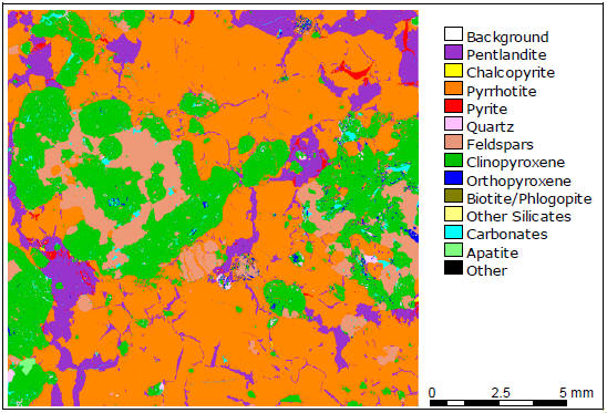
Figure 64: QEMSCAN Image of Polished Sample L163163 from Imiak Hill
(MQ-12-001, 15.39 – 16.0 m) Modified from Sheridan and Downing, 2013.
| | |
3CN024.004 – North American Nickel Inc. | | |
Updated Independent Technical Report for the Maniitsoq Nickel-Copper-Cobalt-PGM Project, Greenland | | Page 139 |
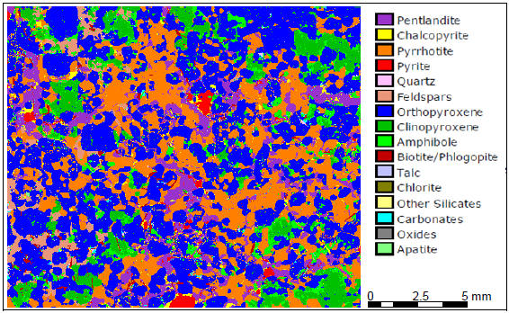
Figure 65: QEMSCAN Image of Polished Sample 4 from TargetP-030
(MQ-14-070, 53.40 – 53.50 m). Modified from Prout and Lang, 2015.
| | |
3CN024.004 – North American Nickel Inc. | | |
Updated Independent Technical Report for the Maniitsoq Nickel-Copper-Cobalt-PGM Project, Greenland | | Page 140 |
| 13 | Mineral Resource Estimates |
Mineral Resources have not been delineated on the Maniitsoq property.
| | |
3CN024.004 – North American Nickel Inc. | | |
Updated Independent Technical Report for the Maniitsoq Nickel-Copper-Cobalt-PGM Project, Greenland | | Page 141 |
There are no adjacent properties pertinent to this project.
| | |
3CN024.004 – North American Nickel Inc. | | |
Updated Independent Technical Report for the Maniitsoq Nickel-Copper-Cobalt-PGM Project, Greenland | | Page 142 |
| 15 | Other Relevant Data and Information |
There are no other relevant data available about the Maniitsoq project.
| | |
3CN024.004 – North American Nickel Inc. | | |
Updated Independent Technical Report for the Maniitsoq Nickel-Copper-Cobalt-PGM Project, Greenland | | Page 143 |
| 16 | Interpretation and Conclusions |
The Maniitsoq project is an advanced stage exploration project located in southwestern Greenland. The property comprises two exploration licences covering an area of 2,985 square kilometres. It is located in the Archean North Atlantic Craton exposed west of the Greenland ice cap.
Sporadic exploration activities for base metals and diamonds occurred between 1959 and 2011. Since acquiring the property in 2011, North American Nickel completed a number of airborne, surface, and borehole geophysical surveys in conjunction with extensive field geological investigations and core drilling aimed at exploring fornickel-copper-cobalt-PGM sulphide mineralization associated with mafic and ultramafic intrusive rocks of the Greenland Norite Belt, a 15 by 75 kilometre long district scale,J-shaped belt of Archean norite intrusions intruding supracrustal rocks. The norite intrusions are interpreted to have been derived from ultramafic magmas that were partially contaminated with continental crust during their ascent and final emplacement. They host a variety of sulphide occurrences mineralized in nickel, copper, cobalt, and precious metals.
The exploration work completed to date has defined sulphide zones hosted in noritic intrusions at six target areas, including Mikissoq, Spotty Hill, Imiak Hill,P-013,P-053, andP-058. Mineralization at five of these targets remains open in one or more directions. Significant exploration results from the 2016 drilling program included the expansion of the Spotty Hill,P-058, andP-053 sulphide zones, and the intersection of significant newly discovered mineralization at theP-013 SE and Mikissoq targets. Additional mineralized targets such asP-004,P-030,P-032,P-059,P-094, andP-149 are distributed across the full length of the Greenland Norite Belt.
The nickel-copper mineralization associated with the noritic intrusions includes primary magmatic sulphide mineralization formed during the emplacement of the intrusions, and sulphide mineralization remobilized during subsequent tectonic events. Magmatic sulphide mineralization typically consists of disseminated, blebby andnet-textured sulphides. Remobilized mineralization comprises semi-massive to massive sulphide breccia veins, breccia zones, stringers, and fracture fillings.
Between 2012 and 2016, North American Nickel drilled 133 core boreholes (29,841metres) on the Maniitsoq project, to investigate a series of geological and geophysical targets.On-going exploration continues to extend known zones of mineralization and validate the potential for additional new discoveries. The most prospective areas defined to date on the property are the Imiak Hill Complex and Fossilik, where one or more discrete sulphide zones have been defined by drilling, and where multiple exploration targets remain to be tested.
In 2015 and 2016, SRK participated in the summer field geological programs and has reviewed the exploration work completed by North American Nickel on the Maniitsoq project. The exploration work completed by North American Nickel was conducted using procedures consistent with generally accepted industry best practices.
Based on this review, SRK concludes that the Maniitsoq project presents attractive exploration potential for nickel-copper sulphide mineralization in a mining friendly, politically safe and stable, jurisdiction. SRK concludes that this property is of merit as an exploration property that warrants further exploration expenditures.
| | |
3CN024.004 – North American Nickel Inc. | | |
Updated Independent Technical Report for the Maniitsoq Nickel-Copper-Cobalt-PGM Project, Greenland | | Page 144 |
The geological setting and character of the nickel-copper sulphide mineralization identified to date on the Maniitsoq project are of sufficient merit to justify additional exploration expenditures.
SRK recommends a work program that includes additional core drilling, geophysical surveying, geological mapping, and 3D modelling. The focus of the proposed program is to conduct additional core drilling to evaluate the geometry, continuity, and quality of the sulphide mineralization found to date, define and test targets adjacent to these sulphide zones, continue to study the nature of structural controls on the mineralization, and refine targeting methods. SRK recommends commencing additionalnon-exploration activities aimed at mitigating potential project risks by advancing social license and providing baseline environmental and hydro power potential data.
The proposed work program includes:
| | • | | Step-out core drilling at sulphide zones in the Imiak Hill Complex and Fossilik areas with systematic borehole electromagnetic surveys, collection of oriented drill core, detailed mapping, and 3D modelling to aid in borehole targeting. |
| | • | | Expansion of surface induced polarization surveys at Imiak Hill and Fossilik to help define extensions of mineralized norite stratigraphy and define anomalies for drill testing. |
| | • | | Drill testing of targets adjacent to existing sulphide zones. |
| | • | | Additional geological mapping, prospecting and 3D modelling to determine potential linkages from one mineralized target area to another, and to support larger scale exploration targeting. |
| | • | | Continued structural geology, mineralogical, and geochemical studies to characterize further the controls on sulphide mineralization, as well as the attributes of the sulphide mineralization and its petrogenesis. |
| | • | | Continued geological investigations to assess and prioritize regional exploration targets and manage the property position. |
| | • | | Activities related to community engagement and local development. |
| | • | | Baseline environmental monitoring. |
| | • | | Survey of the potential for hydroelectric power generation. |
SRK considers that the implementation of the proposed work program will aid in determining if sufficient sulphide accumulations exist in the Imiak Hill Complex and Fossilik areas to warrant delineation drilling and mineral resource evaluation. It is expected that the proposed work program will also advance the understanding of the distribution and attributes of nickel-copper sulphide occurrences on the Maniitsoq project.
The total cost of the recommended exploration program is estimated at C$12.4 million (Table 26).
SRK is unaware of any significant factors and risks that may affect access, title, or the right, or ability, to perform the recommended exploration program. The planned survey for potential hydroelectric power generation is contingent on receiving a water shed prospecting license.
| | |
3CN024.004 – North American Nickel Inc. | | |
Updated Independent Technical Report for the Maniitsoq Nickel-Copper-Cobalt-PGM Project, Greenland | | Page 145 |
Table 26: Estimated Cost for the Exploration Program Proposed for the Maniitsoq Project
| | | | | | | | | | | | |
Description | | Units | | | Unit Cost
(C$) | | | Total Cost
(C$) | |
Drilling(follow-up and regional exploration) | | | | | |
Core drilling (metres drilled, all inclusive) | | | 14,000 | | | | 255.4 | | | | 3,575,000 | |
Analytical services (samples) | | | 3,500 | | | | 50 | | | | 175,000 | |
| | | | | | | | | | | | |
Subtotal Drilling | | | | | | | | | | | 3,750,000 | |
| | | | | | | | | | | | |
Geological Studies | | | | | | | | | | | | |
Mapping, prospecting, sampling, 3D modelling, Processing ofWV-3 data | | | | | | | | | | | 500,000 | |
Mineralogical Studies | | | | | | | | | | | 75,000 | |
| | | | | | | | | | | | |
Subtotal Geology | | | | | | | | | | | 575,000 | |
| | | | | | | | | | | | |
Geophysical Surveys | | | | | | | | | | | | |
Borehole electromagnetic survey | | | | | | | | | | | 300,000 | |
Ground-based Induced Polarization survey | | | | | | | | | | | 525,000 | |
| | | | | | | | | | | | |
Subtotal Geophysics | | | | | | | | | | | 825,000 | |
| | | | | | | | | | | | |
Logistics and Administration | | | | | |
Helicopter support (2 helicopters, all inclusive) | | | 2 | | | | 1,625,000 | | | | 3,250,000 | |
Field operations, communications, and logistics | | | | | | | | | | | 2,700,000 | |
Administration and land holding costs | | | | | | | | | | | 300,000 | |
| | | | | | | | | | | | |
Subtotal Logistics and Administration | | | | | | | | | | | 6,250,000 | |
| | | | | | | | | | | | |
Corporate Social Responsibility | | | | | | | | | | | 75,000 | |
| | | | | | | | | | | | |
Health, Safety, and Environment | | | | | | | | | | | 125,000 | |
| | | | | | | | | | | | |
Infrastructure Studies | | | | | | | | | | | 200,000 | |
| | | | | | | | | | | | |
Subtotal | | | | | | | | | | | 11,800,000 | |
Contingency (5%) | | | | | | | | | | | 600,000 | |
| | | | | | | | | | | | |
Total | | | | | | | | | | | 12,400,000 | |
| | | | | | | | | | | | |
| | |
3CN024.004 – North American Nickel Inc. | | |
Updated Independent Technical Report for the Maniitsoq Nickel-Copper-Cobalt-PGM Project, Greenland | | Page 146 |
Allaart, J.H., Friend, C.R.L., Hall, R.P., Jensen, S.B., Roberts, I.W.N., 1978. Continued 1:500,000 reconnaissance mapping in the Precambrian of the Sukkertoppenregion, southern West Greenland. Rapport Grønlands Geologiske Undersøgelse90, p.50-54.
Barnes, Sarah-Jane and Lightfoot, Peter C. 2005. Formation of Magmatic Nickel Sulphide Deposits And Processes Affecting Their Copper and Platinum Group Element Contents. Society of Economic Geologists 100th Anniversary Volume, pp.179-213.
Begg, G.C., Hronsky, J.A.M., Arndt, N.T., Griffin, W.L., O’Reilly, S.Y., and Hayward, N., 2010 Lithospheric, Cratonic, and geodynamic setting ofNi-Cu-PGE sulfide deposits: Economic Geology, v. 105, p. 1057-1070.
Berthelsen, A., 1960. Structural studies in thepre-Cambrian of western Greenland. Geology of Tovqussap nunâ. Bull. Grønlands Geologiske Undersøgelse 25, 223 p.
Bleeker, W., 1990. Evolution of the Thompson Nickel Belt and its nickel deposits, Manitoba, Canada. Unpublished Ph.D. thesis, University of New Brunswick, Fredericton, New Brunswick, 400 p.
Brand, N.W., 2015. Gold Homogeneity in Certified Reference Materials; A Comparison of Five Manufacturers, Explore, Newsletter for the Association of Applied Geochemists, No 169, December 2015
Buselli, G., 1982. The effect of near-surface superparamagnetic material on electromagnetic measurements, Geophysics, vol. 47; P.1315-1324.
Collins, J. G., Keller, P. D., Drennan M., Purtich, E. J., 2009. Technical Report Regarding Update to Reserves and Resources for the Bucko Lake Nickel Project, Wabowden, Manitoba. Prepared by Crowflight Minerals Inc. and P & E Mining Consultants Inc., filed on SEDAR,http://www.sedar.com/.
Fedorowich, J., 2015. Structural Mapping and Characterization ofNi-Cu Zones at Maniitsoq Project, Greenland. Report prepared for North American Nickel Inc. by John Fedorowich Structural Geology Consulting, 126 p.
Garde, A. A. 1991. Post-kinematic diorite intrusions in Archaean basement rocks around outer Fiskefjord, southern West Greenland. Bulletin of the Geological Society of Denmark 39,pp.167-177.
Garde, A.A., 1997. Accretion and evolution of an Archaean high-grade grey gneiss– amphibolite complex: the Fiskefjord area, southern West Greenland. Geol.Greenl. Surv. Bull. 177, 115 p.
Garde, A.A., Friend, C.R.L., Nutman, A.P., Marker, M., 2000. Rapid maturation and stabilisation of middle Archaean continental crust: the Akia terrane, southern West Greenland. Bulletin of the Geological Society of Denmark 47, pp.1-27.
| | |
3CN024.004 – North American Nickel Inc. | | |
Updated Independent Technical Report for the Maniitsoq Nickel-Copper-Cobalt-PGM Project, Greenland | | Page 147 |
Garde, A.A., Dyck, B., Esbensen, K. H., Johansson, L., Möller, C., 2014. The Finnefjeld domain, Maniitsoq structure, West Greenland: Differential rheological features and mechanical homogenisation in response to impacting? Precambrian Research, 255, pp.791-808
Heaman, 2014. Report onU-PbMC-ICPMS Zircon Dating of North American Nickel Gabbro Samples, Internal report for prepared for North American Nickel Inc.
Henriksen, N., Higgins, A.K., Kalsbeek, F., and Pulvertaft, T.C. 2009. Greenland from Archaean to Quaternary Descriptive text to the 1995 Geological map of Greenland, 1:2 500 000, 2nd edition, Geological Survey of Denmark and Greenland Bulletin 18, 126 p.
Kokfelt, T. F., Garde, A. A., and McDonald, I., 2013.Ni-mineralised norites and post-kinematic diorites in the Maniitsoq structure, southern West Greenland: Evidence for impact-related intrusion and source modification, p.15-28. In Adam A. Garde and Lars Lund Sørensen (Editors), Current nickel and base metal exploration in Greenland: the Copenhagen lectures, September 2013, Geological Survey of Denmark and Greenland (GEUS), Report 2013/97.
Lightfoot, P. C., 2007. Advances inNi-Cu-PGE Sulphide Deposit Models and Implications for Exploration Technologies. In B. Milkereit (Editor), Proceedings of Exploration 07: Fifth Decennial International Conference on Mineral Exploration, p.629-646.
Marker, M. and Garde, A.A. 1988. Border relations between the amphibolite facies Finnefjeld gneiss complex and granulite facies grey gneisses in the Fiskefjord area, southern West Greenland. Rapport Grønlands Geologiske Undersøgelse 140, p. 49–54.
MRA. 2015. Guidelines for Preparing an Environmental Impact Assessment (EIA) Report for Mineral Exploitation in Greenland. Mineral Resources Authority, Government of Greenland.
Naldrett, A. J., 2004. Magmatic Sulfide Deposits: Geology, Geochemistry and Exploration: Berlin, Springer, 727 p.
Nukissiorfiit, 2005. Hydropower resources in Greenland, Survey report, 59 p.
Nutman, A. P., Hagiya, H. & Maruyama, S. 1995. SHRIMPU-Pb single zircon geochronology of a Proterozoic mafic dyke, Isukasia, southern West Greenland. Bulletin of the Geological Society of Denmark 42, pp.17-22.
Prout, S. and Lascelles, M., 2017. An Investigation by High Definition Mineralogy into Four Core Samples from the Maniitsoq Project, Southwest Greenland. Report prepared for North American Nickel Inc, by SGS Minerals Services, 82 p.
Prout, S. and Lang, J., 2016. An Investigation by High Definition Mineralogy into Five Core Samples from the Maniitsoq Project, Southwest Greenland. Report prepared for North American Nickel Inc, by SGS Minerals Services, 85p.
Prout, S. and Lang, J., 2015. An Investigation by High Definition Mineralogy into Six Core Samples from the Maniitsoq Project, Southwest Greenland. Report prepared for North American Nickel Inc, by SGS Minerals Services, 105p.
Ravenelle, J. F., 2015a. Aeromagnetic Interpretation of the Maniitsoq Nickel Sulphide Project, Greenland. Report prepared for North American Nickel Inc. by SRK Consulting (Canada) Inc., 35 p.
| | |
3CN024.004 – North American Nickel Inc. | | |
Updated Independent Technical Report for the Maniitsoq Nickel-Copper-Cobalt-PGM Project, Greenland | | Page 148 |
Ravenelle, J. F., 2015b. Structural Geology Study of the Maniitsoq Nickel Sulphide Project, Greenland. Report prepared for North American Nickel Inc. by SRK Consulting (Canada) Inc., 53 p.
Ravenelle, J. F. and Weiershäuser, L., 2016. Independent Technical Report for the Maniitsoq Nickel-Copper –PGM Project, Greenland. Report prepared for North American Nickel Inc. by SRK Consulting (Canada) Inc., 174 p. available on SEDAR.
Sattel, D. and Mutton, P., 2015. The superparamagnetic response of transient AEM data: 24th International Geophysical Conference and Exhibition, ASEG-PESA, Extended Abstracts.
Sheridan, K., and Downing, S., 2013. The Mineralogical Characteristics of Three Samples of Nickel Mineralization from the Maniitsoq Project, Southwest Greenland. Report prepared for North American Nickel Inc. by SGS Minerals Services, 45p.
Steenfelt, A., Garde, A.A., Moyen,J.-F., 2005. Mantle wedge involvement in the petrogenesis of Archaean grey gneisses in West Greenland. Lithos 79, pp.207-228.Bursnall, J.T., LeClair, A.D., Moser, D.E., Percival, J.A., 1994. Structural correlation within the Kapuskasing uplift. Canadian Journal of Earth Sciences, v.31, p.1081-1095.
St-Onge, M.R., van Gool, J.A.M., Garde, A.A. & Scott, D.J. 2009. Correlation of Archaean and Palaeoproterozoic units between northeastern Canada and western Greenland: constraining thepre-collosional upper plate accretionary history of the Trans-Hudson orogen. In: Cawood, P.A. & Kroner, A. (eds): Earth accretionary systems in space and time. Geological Society Special Publication (London) 318, pp.193-235.
Windley, B.F., 1969. Anorthosites of southern West Greenland. American Association of Petroleum Geologists, Memoir, vol. 12, pp.899-915.
Windley, B.F., Garde, A.A., 2009.Arc-generated blocks with crustal sections in the North Atlantic craton of West Greenland: Crustal growth in the Archean with modern analogues. Earth Sci. Rev. 93, pp.1-30.
| | |
3CN024.004 – North American Nickel Inc. | | |
Updated Independent Technical Report for the Maniitsoq Nickel-Copper-Cobalt-PGM Project, Greenland | | Page 149 |
APPENDIX A
Geophysical Survey Specifications
For surveys between 2011 and 2016
| | |
3CN024.004 – North American Nickel Inc. | | |
Updated Independent Technical Report for the Maniitsoq Nickel-Copper-Cobalt-PGM Project, Greenland | | Page 150 |
2011 Airborne Survey
The 2011 SKYTEM survey consisted of 2,217.1 line kilometres over two areas in the northern part of the tenement, covering a combined survey area of 272 square kilometres. Lines were flown on a200-metre line spacing with100-metre line spacing in areas of known significant anomalies. The survey system was installed in a Eurocopter Aerospatiale (Astar) 350 B3 helicopter, owned and operated by Air Greenland. The instrumentation involved a time domain electromagnetic system including a data acquisition system, a magnetometer, three differential GPS receivers, two inclinometers and two altimeters. The magnetometer was a Geometrics G822A split beam cesium sensor with a peak to peak sensitivity of 0.002 nano-Tesla (nT), combined with absolute accuracy of less than 3 nT over its full operating range. Data were corrected for diurnal drift using a GEM Proton base station magnetometer with 0.01 nT resolution, and 1 nT absolute accuracy over its full temperature range. The electromagnetic equipment setup was a dual moment configuration with a Low Moment (LM) with a peak moment of ~3,140 NIA and a High Moment (HM) with a peak moment of ~150,000 NIA. The low moment system operated at a frequency of 200Hz and the high moment system operated at a frequency of 25Hz. The transmitter loop was fixed to a polygonal frame and had a circumference of 65.9 metres. Two receiver coils measured the vertical andin-line components (z and x). The survey was flown at an average speed of 70 kilometres per hour with an average terrain clearance of 56 metres for both the magnetometer and electromagnetic transmitter-receiver system. Positional information was obtained using anOEMV1-L1 GPS receiver and Trimble Bullet III GPS Antenna mounted on the towed bird. GPS data were corrected with data from a base station that was located near the helicopter landing site, providing 1metre uncertainty.
2012/2013 Airborne Surveys
The 2012 survey comprised 3,612.4 line kilometres in ten individual survey blocks. Line spacing was typically 200 metres with 100 metre line spacing and orthogonal lines over known significant conductors. The survey results were interpreted by Condor Consulting (Condor) of Lakewood, Colorado.
In 2013 a total of 971.5 line kilometres were surveyed in nine flight blocks.
In both years, the surveys were carried out using a Geotech Time Domain electromagnetic (VTEMplus) system. The geophysical survey equipment was installed in a Eurocopter Aerospatiale (Astar) 350 B3 helicopter, owned and operated by Air Greenland. Installation of the geophysical and ancillary equipment was carried out by a Geotech crew. The geophysical equipment consisted of a time-domain electromagnetic system with Z (vertical) and X(in-line) component measurements and horizontal magnetic gradiometer using two cesium magnetometers. The 2012 survey was carried out using a frequency of 25 Hz; the 2013 survey initially operated at 25Hz and switched to 30Hz to reduce the noise level. The 2012 survey had a transmitter dipole moment of 424,743 nIA and the 2013 survey had a dipole moment of 399,258 nIA. B Field measurements were calculated for both vertical andin-line components.
The horizontal magnetic gradiometer consisted of two Geometrics split-beam field magnetic sensors mounted 12.5 metres apart on a separate loop, located 10 metres vertically above the electromagnetic bird. A GPS antenna and Gyro Inclinometer was installed on the separate loop to record accurately the tilt and the position of the magnetic gradiomag bird. The data from the two magnetometers were corrected for position and orientation variations, as well as for the diurnal variations using base station data. The base station data were collected using a Geometrics Cesium vapour magnetometer with a sensitivity of 0.001 nT.
The navigation system used was a Geotech PC104 based navigation system utilizing a NovAtel’s Wide Area Augmentation System (WAAS) enabled GPS receiver, and a NovAtel GPS antenna
| | |
3CN024.004 – North American Nickel Inc. | | |
Updated Independent Technical Report for the Maniitsoq Nickel-Copper-Cobalt-PGM Project, Greenland | | Page 151 |
mounted on the helicopter tail. The positional accuracy or circular error probability (CEP) was 1.8 metres, with WAAS active, it was one metre. The second GPS antenna was installed on the additional magnetic loop together with Gyro Inclinometer. A Geometrics combined magnetometer /GPS base station was set up near the landing site for data corrections.
During the 2012 survey, helicopter was maintained at a mean altitude of 100 metres above the ground with an average survey speed of 80 kilometres per hour. This altitude allowed for an actual average electromagnetic bird terrain clearance of 69 metres and a magnetic sensor clearance of 79 metres. During the 2013 survey, the helicopter was maintained at a mean altitude of 80 metres above the ground with an average survey speed of 80 kilometres per hour, allowing for an actual average electromagnetic bird terrain clearance of 48 metres and a magnetic sensor clearance of 58 metres.
2015 Airborne Survey
The survey equipment used in this survey was similar to that of the 2012 and 2013 surveys with the addition of a second Z component coil located 15 metres vertically above the primary transmitter and receivers. Only one magnetometer sensor was used, located 13 metres vertically below the helicopter. During this survey, the helicopter was maintained at a mean altitude of 101 metres above the ground with an average survey speed of 80 kilometres per hour. This altitude allowed for an average transmitter-receiver loop terrain clearance of 62 metres and a magnetic sensor clearance of 88 metres.
2012, 2013, 2014, 2015 and 2016 BHEM Electromagnetic Surveys
Borehole electromagnetic (BHEM) surveys between 2012 and 2016 were carried out using the Crone 3 component Crone PEM borehole EM system including a 4.8 kilowatt transmitter with a 220 Volt voltage regulator powered by a generator. A Crone Digital Receiver was used to collect the field data. The synchronization between the transmitter and the receiver was maintained by a cable. The surveys utilized a time base ranging from 16.66ms (15Hz) to 150 milliseconds (1.67 Hz), with a 1.5 millisecondshut-off ramp time. Almost all surveys used inductive coil probes; surveys atP-053 and selected regional targets used a fluxgate probe. Data were typically collected at a 10 metre interval with 5 metre detailing in anomalous areas.
2013, 2014, 2015, and 2016 Ground Electromagnetic Surveys
The 2013, 2014, 2015 and 2016 surveys consisted of 14.0, 86.9, 61.7 and 13.1 line kilometres, respectively. The equipment comprised a Crone Surface Pulse electromagnetic system including a 4.8 kilowatt transmitter with a 220 Volt voltage regulator powered by a generator. A Crone Digital Receiver was used to collect the field data. The synchronization between the transmitter and the receiver was maintained by a crystal-clock. The survey utilized a time base of 50 milliseconds (5 Hz), with a 1.5 millisecondshut-off ramp time for surveys completed between 2013 and 2015, and a time base of either 16.66ms (15 Hz) or 50ms (5Hz) in 2016. Vertical (Z component) andin-line (X component) data were collected on virtual grids at a nominal survey interval of 25 to 50 metres with a few 12.5 metre stations to define better near surface anomalies. Line direction was optimized to cover each target properly, line spacing varied from 50 to 200 metres.
2014 and 2015 Gravity Surveys
The 2014 survey consisted of 936 readings on a virtual grid with a line spacing of 200 metres and a station spacing of 50 metres. One grid covered the Imiak Hill Complex (Imiak Hill, Spotty Hill and Mikissoq), and the second grid covered Fossilik II. To establish the regional gradient gravity readings in 1 kilometre step-outs from the survey areas were taken.
| | |
3CN024.004 – North American Nickel Inc. | | |
Updated Independent Technical Report for the Maniitsoq Nickel-Copper-Cobalt-PGM Project, Greenland | | Page 152 |
The 2015 survey covered a 3 to 6 by10 kilometre area south of Fossilik. The gravity survey was conducted along virtual survey lines using LaCoste & Romberg model G meters, capable of reading the earth’s gravity field with a precision of 0.001 milligal. The gravity measurements were corrected for several factors including instrumental drift, tidal variations, latitude, instrument height and station elevation variations (free air), Bouguer correction (at 2.67 g/cc) and inner-terrain corrections (Hammer zones B and C). No outer-terrain corrections were applied to these data. The gravity survey wastied-in and levelled to the Greenland Gravity Network. A gravity station in Nuuk, Greenland was used totie-in to a local gravity base established by Eastern Geophysics. The topographic elevation correction required very accurate elevation measurements using a very precise GPS receiver. Positional information was obtained using a Leica System 1230 Dual frequency RTK, DGPS systems with GLONASS option and an accuracy of 5mm + 0.5ppm horizontally and 10mm + 0.5ppm vertically. Survey lines were spaced 500 metres apart; survey stations were spaced 250 metre apart in the area of interest; additional readings spaced one kilometre apart were taken to understand the regional response. The distance between survey lines was reduced to 250 metres with survey stations spaced 125 metres apart over target areasP-013.
2016 Induced Polarization (IP) Surveys
The 2016 IP survey was carried out by Insight Geophysics using tuned gradient, pole-dipole and ‘Insight’ arrays. The surveys covered 52.8 kilometres of marked grids in three areas (Spotty Hill, Fossilik, andP-030/P-032). Grids were positioned using hand held GPS units and marked using piles of rocks with added spray paint or flagging tape for visibility. Line spacing was 100 metres, and stations were marked every 50 metres.
Data were collected using a 10 channel IRIS Instruments Elrec Pro receiver and a Walcer 10kW transmitter powered by a WalcerMG-6 generator. This receiver measures the voltage during theon-time cycle and at 20 decay times during theoff-time cycle. The waveform used had a 4 second on time cycle for the Spotty Hill andP-030/P-032 grids and 2 seconds for the Fossilik grid. Dipole spacing was 50 metres for tuned gradient surveys and 25 metres for pole-dipole and Insight array surveys.
| | |
3CN024.004 – North American Nickel Inc. | | |
Updated Independent Technical Report for the Maniitsoq Nickel-Copper-Cobalt-PGM Project, Greenland | | Page 153 |
APPENDIX B
Discussion on Superparamagnetic Effects in VTEM Data
Maniitsoq Project
| | |
3CN024.004 – North American Nickel Inc. | | |
Updated Independent Technical Report for the Maniitsoq Nickel-Copper-Cobalt-PGM Project, Greenland | | Page 154 |
The observation of unexplained anomalies in VTEM data was initially made in 2013, when boreholeMQ-13-010, designed to test VTEM targetP-063, failed to intersect a conductor. The anomaly was a one line anomaly seen in the 2012 survey data, where the line spacing was 200 metres. It was initially thought that the survey was flown parallel to the anomaly, and theP-063 target wasre-flown in 2013 at 100 metre line spacing and with an orthogonal line. The 2012one-line VTEM anomaly was not present on there-flown 2013 line.
During discussions with Crone Geophysics, who had previously seen a similar unexplained anomaly in other project data in 2012, it was suggested that the VTEM anomaly atP-063 could be related to an SPM effect. Researchers attributed the SPM effect to extremely fine grained maghemite and magnetite particles in soils (Buselli, 1982). The lack of soil at theP-063 anomaly location did not fit the typical description of SPM effects, and the reason for the unexplained anomaly was not well understood.
In 2014, boreholeMQ-14-064 targeted VTEM targetP-048, a multi-line VTEM anomaly. The borehole failed to intersect a conductor, and the subsequent Crone borehole electromagnetic survey failed to detect anoff-hole anomaly. At this point in the program, all planned holes targeting similar anomalies (stronger on B field, coincident magnetic anomaly and located on a topographic high) were put on hold pending an explanation of the “suspicious” VTEM anomalies.
A review of available data was undertaken and a third unexplained anomaly was identified. It was observed that these three unexplained VTEM anomalies had several similarities: anomaly shape was a peak on z component with nox-component response, a late time dB/dt response that is defined better on B Field, high B Field time constant, magnetic association, topographic high, and locally reduced terrain clearance of the VTEM bird. These three examples of unexplained VTEM anomalies were formally presented to Geotech in February 2015, and Geotech interpreted these anomalies as superparamagnetic (SPM) effects.
Geotech also referenced Buselli (1982) and attributed the cause of the VTEM anomalies at Maniitsoq to microscopic weathered magnetic particles in soil. Buselli (1982) had observed that TEM measurements show a t-1 time dependence at late time. Geotech showed that the decay rates of the three unexplained anomalies followed a power law decay with slope~-1 for dBz/dt, consistent with theoretical decays for SPM effects.
A review of several known bedrock conductors showed that the power law decays were well outside the range of SPM effects; this calculation is seen as the most important method to screen SPM effects from bedrock anomalies.
The 2012 and 2013 VTEM datasets were reviewed for SPM effects and approximately 50 percent of the 2012 and 2013 VTEM targets were downgraded as a result of the review.
SPM effects have a high attenuation rate with distance when compared to conductor responses (Satell and Mutton, 2015), which explains why SPM effects are seen only when the VTEM bird is close to the ground. Therefore, flying at a higher ground clearance can reduce the number of SPM effects, and using a vertical EM gradient system can help discriminate SPM effects from bedrock anomalies. In 2015, efforts were made to fly a draped survey at Maniitsoq where ground clearance was not locally reduced over topographic highs. Also, the VTEM system flown in 2015 collected EM data at two different elevations (a gradient EM system).
At this time, it is believed that the unexplained VTEM anomalies at Maniitsoq are indeed SPM effects, but they are a new class of SPM effects that had not been previously documented. The
| | |
3CN024.004 – North American Nickel Inc. | | |
Updated Independent Technical Report for the Maniitsoq Nickel-Copper-Cobalt-PGM Project, Greenland | | Page 155 |
sources of the SPM effects are interpreted to be magnetite in rocks as compared to microscopic magnetic particles in soil.
In summary, SPM effects can be identified with a high level of confidence using the following criteria: peak on z-component with nox-component response, late time dB/dt response that is defined better on B Field, high B Field time constant, magnetic association, topographic high, locally reduced terrain clearance of the VTEM bird, and power law decay with slope~-1 for dBz/dt. However, all SPM anomalies do not exhibit all these characteristics, and some slope calculations are inconclusive because of noisy data. Questionable anomalies must be verified using ground surface EM surveys.
| | |
3CN024.004 – North American Nickel Inc. | | |
Updated Independent Technical Report for the Maniitsoq Nickel-Copper-Cobalt-PGM Project, Greenland | | Page 156 |
APPENDIX C
Characteristics of Core Boreholes Completed
By North American Nickel from 2012 to 2016
| | |
3CN024.004 – North American Nickel Inc. | | |
Updated Independent Technical Report for the Maniitsoq Nickel-Copper-Cobalt-PGM Project, Greenland | | Page 157 |
List of all core boreholes completed by North American Nickel until December 2016.
| | | | | | | | | | | | | | | | | | | | | | | | | | |
Borehole-ID | | Easting
(metres)* | | | Northing
(metres)* | | | Elevation
(metres) | | | Length
(metres) | | | Azimuth
(degrees) | | | Dip
(degrees) | | | Area |
MQ-12-001 | | | 477,453.6 | | | | 7,257,223.6 | | | | 538.9 | | | | 106.07 | | | | 275.0 | | | | -45.00 | | | P-054_Imiak |
MQ-12-002 | | | 477,454.7 | | | | 7,257,223.5 | | | | 539.0 | | | | 173.12 | | | | 275.0 | | | | -70.00 | | | P-054_Imiak |
MQ-12-003 | | | 477,485.7 | | | | 7,257,187.3 | | | | 542.8 | | | | 292.00 | | | | 282.0 | | | | -73.00 | | | P-054_Imiak |
MQ-12-004 | | | 477,457.0 | | | | 7,257,259.6 | | | | 537.5 | | | | 95.40 | | | | 275.0 | | | | -45.00 | | | P-054_Imiak |
MQ-12-005 | | | 478,937.7 | | | | 7,257,296.2 | | | | 631.0 | | | | 237.13 | | | | 226.0 | | | | -65.00 | | | P-055_Spotty |
MQ-12-006 | | | 473,877.5 | | | | 7,248,499.4 | | | | 604.6 | | | | 109.11 | | | | 325.0 | | | | -50.00 | | | P-058 |
MQ-12-007 | | | 473,877.5 | | | | 7,248,499.4 | | | | 604.6 | | | | 120.70 | | | | 317.0 | | | | -50.00 | | | P-058 |
MQ-12-008 | | | 473,680.3 | | | | 7,248,676.0 | | | | 638.1 | | | | 224.94 | | | | 326.0 | | | | -68.00 | | | P-059 |
MQ-12-009 | | | 478,877.9 | | | | 7,257,350.4 | | | | 614.6 | | | | 192.32 | | | | 232.0 | | | | -60.00 | | | P-055_Spotty |
MQ-13-010 | | | 456,032.0 | | | | 7,218,322.0 | | | | 713.0 | | | | 200.00 | | | | 155.0 | | | | -50.00 | | | P-063 |
MQ-13-011 | | | 461,980.0 | | | | 7,216,150.0 | | | | 285.0 | | | | 101.00 | | | | 189.0 | | | | -50.00 | | | P-097 |
MQ-13-012 | | | 471,440.0 | | | | 7,217,072.0 | | | | 254.0 | | | | 101.00 | | | | 319.0 | | | | -50.00 | | | P-030 |
MQ-13-013 | | | 472,278.0 | | | | 7,217,331.0 | | | | 295.0 | | | | 173.00 | | | | 149.0 | | | | -60.00 | | | P-061 |
MQ-13-014 | | | 472,655.7 | | | | 7,217,520.4 | | | | 199.8 | | | | 181.00 | | | | 327.0 | | | | -60.00 | | | P-032 |
MQ-13-015 | | | 470,255.0 | | | | 7,231,757.0 | | | | 504.0 | | | | 114.82 | | | | 335.0 | | | | -60.00 | | | P-022 NW |
MQ-13-016 | | | 470,270.0 | | | | 7,231,729.0 | | | | 494.0 | | | | 116.00 | | | | 148.0 | | | | -60.00 | | | P-022 SE |
MQ-13-017 | | | 470,255.0 | | | | 7,231,757.0 | | | | 504.0 | | | | 176.00 | | | | 152.0 | | | | -62.00 | | | P-022 SE |
MQ-13-018 | | | 474,324.5 | | | | 7,248,803.1 | | | | 694.9 | | | | 182.00 | | | | 53.0 | | | | -60.00 | | | P-004 |
MQ-13-019 | | | 477,486.2 | | | | 7,257,187.2 | | | | 542.8 | | | | 176.00 | | | | 276.0 | | | | -55.00 | | | P-054_Imiak |
MQ-13-020 | | | 477,489.9 | | | | 7,257,139.2 | | | | 534.8 | | | | 209.00 | | | | 279.0 | | | | -62.00 | | | P-054_Imiak |
MQ-13-021 | | | 477,953.5 | | | | 7,258,010.2 | | | | 481.5 | | | | 155.00 | | | | 320.0 | | | | -60.00 | | | P-001_Mikkisoq |
MQ-13-022Ext | | | 478985.9 | | | | 7257276.0 | | | | 627.2 | | | | 377.00 | | | | 220.0 | | | | -65.00 | | | P-055_Spotty |
MQ-13-023 | | | 477,485.9 | | | | 7,257,215.5 | | | | 543.0 | | | | 188.00 | | | | 275.0 | | | | -59.00 | | | P-054_Imiak |
MQ-13-024 | | | 477,497.3 | | | | 7,257,173.7 | | | | 545.4 | | | | 197.00 | | | | 280.0 | | | | -60.00 | | | P-054_Imiak |
MQ-13-025 | | | 477,483.2 | | | | 7,257,238.1 | | | | 536.5 | | | | 122.00 | | | | 269.0 | | | | -45.00 | | | P-054_Imiak |
MQ-13-026 | | | 477,490.7 | | | | 7,257,139.4 | | | | 534.8 | | | | 215.00 | | | | 295.0 | | | | -65.00 | | | P-054_Imiak |
MQ-13-027 | | | 477,966.3 | | | | 7,258,023.7 | | | | 483.5 | | | | 170.00 | | | | 330.0 | | | | -48.00 | | | P-001_Mikkisoq |
MQ-13-028 | | | 477,507.3 | | | | 7,257,143.9 | | | | 536.1 | | | | 287.00 | | | | 278.0 | | | | -67.00 | | | P-054_Imiak |
MQ-13-029 | | | 477,969.1 | | | | 7,258,024.5 | | | | 483.7 | | | | 143.00 | | | | 314.0 | | | | -57.00 | | | P-001_Mikkisoq |
MQ-13-030 | | | 488,025.0 | | | | 7,257,448.0 | | | | 649.0 | | | | 98.00 | | | | 343.0 | | | | -45.00 | | | P-049 W_Quagsuk |
MQ-13-031 | | | 488,082.0 | | | | 7,257,461.0 | | | | 649.0 | | | | 116.00 | | | | 340.0 | | | | -55.00 | | | P-049 E_Quagsukk |
MQ-13-032 | | | 475,094.0 | | | | 7,239,992.0 | | | | 303.0 | | | | 221.00 | | | | 145.0 | | | | -60.00 | | | P-013 Centre |
MQ-13-033 | | | 474,922.0 | | | | 7,239,898.0 | | | | 325.0 | | | | 161.00 | | | | 320.0 | | | | -60.00 | | | P-013 NW |
MQ-13-034 | | | 475,384.0 | | | | 7,239,742.0 | | | | 304.0 | | | | 173.00 | | | | 328.0 | | | | -50.00 | | | P-013 SE |
MQ-14-035 | | | 477,560.3 | | | | 7,257,132.5 | | | | 539.7 | | | | 269.00 | | | | 271.0 | | | | -59.00 | | | P-054_Imiak |
MQ-14-036 | | | 477,560.3 | | | | 7,257,132.5 | | | | 539.7 | | | | 332.00 | | | | 269.0 | | | | -66.00 | | | P-054_Imiak |
MQ-14-037 | | | 477,560.3 | | | | 7,257,132.5 | | | | 539.7 | | | | 317.00 | | | | 282.0 | | | | -59.00 | | | P-054_Imiak |
MQ-14-038 | | | 477,560.3 | | | | 7,257,132.5 | | | | 539.7 | | | | 296.00 | | | | 281.4 | | | | -64.10 | | | P-054_Imiak |
MQ-14-039 | | | 477,560.3 | | | | 7,257,132.5 | | | | 539.7 | | | | 344.00 | | | | 293.0 | | | | -62.00 | | | P-054_Imiak |
MQ-14-040 | | | 478,991.4 | | | | 7,257,339.0 | | | | 622.3 | | | | 398.00 | | | | 218.0 | | | | -60.00 | | | P-055_Spotty |
MQ-14-041 | | | 465,365.0 | | | | 7,278,601.0 | | | | 364.0 | | | | 182.00 | | | | 154.0 | | | | -50.00 | | | P-149_Pingo |
MQ-14-042 | | | 465,395.0 | | | | 7,278,550.0 | | | | 366.0 | | | | 161.00 | | | | 330.0 | | | | -45.00 | | | P-149_Pingo |
MQ-14-043 | | | 466,375.0 | | | | 7,280,830.0 | | | | 560.0 | | | | 95.00 | | | | 345.0 | | | | -45.00 | | | P-157 |
MQ-14-044 Ext | | | 478,873.4 | | | | 7,256,941.1 | | | | 594.7 | | | | 469.10 | | | | 360.0 | | | | -65.00 | | | P-055_Spotty |
MQ-14-045 | | | 466,240.0 | | | | 7,280,755.0 | | | | 540.0 | | | | 101.00 | | | | 333.0 | | | | -45.00 | | | P-157 |
MQ-14-046 | | | 464,974.0 | | | | 7,280,925.0 | | | | 500.0 | | | | 149.00 | | | | 330.0 | | | | -50.00 | | | P-161 |
MQ-14-047 | | | 463,753.0 | | | | 7,277,801.0 | | | | 676.0 | | | | 131.00 | | | | 333.0 | | | | -70.00 | | | P-146 |
MQ-14-048 | | | 474,636.0 | | | | 7,255,775.0 | | | | 375.0 | | | | 146.00 | | | | 150.0 | | | | -50.00 | | | P-136 |
MQ-14-049 | | | 473,346.0 | | | | 7,250,129.0 | | | | 507.0 | | | | 155.00 | | | | 138.0 | | | | -59.00 | | | P-081 |
MQ-14-050 | | | 473,350.0 | | | | 7,250,040.0 | | | | 534.0 | | | | 98.00 | | | | 300.0 | | | | -55.00 | | | P-081 |
MQ-14-051 | | | 474,282.4 | | | | 7,248,784.2 | | | | 690.8 | | | | 320.00 | | | | 55.0 | | | | -62.00 | | | P-004 |
MQ-14-052 | | | 478,959.5 | | | | 7,257,280.5 | | | | 628.1 | | | | 362.00 | | | | 225.0 | | | | -55.00 | | | P-055_Spotty |
MQ-14-053 | | | 473,855.7 | | | | 7,248,475.9 | | | | 595.7 | | | | 128.00 | | | | 324.0 | | | | -45.00 | | | P-058 |
MQ-14-054 | | | 473,900.0 | | | | 7,248,510.6 | | | | 608.9 | | | | 127.00 | | | | 320.0 | | | | -50.00 | | | P-058 |
MQ-14-055 | | | 473,675.8 | | | | 7,248,671.5 | | | | 637.6 | | | | 203.00 | | | | 337.0 | | | | -75.00 | | | P-059 |
MQ-14-056 | | | 478,991.4 | | | | 7,257,339.2 | | | | 622.3 | | | | 50.00 | | | | 230.0 | | | | -57.00 | | | P-055_Spotty |
MQ-14-057 | | | 473,880.1 | | | | 7,248,473.3 | | | | 596.2 | | | | 155.00 | | | | 318.0 | | | | -50.00 | | | P-058 |
MQ-14-058 | | | 478,991.2 | | | | 7,257,339.3 | | | | 622.3 | | | | 302.00 | | | | 230.0 | | | | -51.00 | | | P-055_Spotty |
MQ-14-059 | | | 473,889.7 | | | | 7,248,540.1 | | | | 619.9 | | | | 95.00 | | | | 324.0 | | | | -66.00 | | | P-058 |
| | |
3CN024.004 – North American Nickel Inc. | | |
Updated Independent Technical Report for the Maniitsoq Nickel-Copper-Cobalt-PGM Project, Greenland | | Page 158 |
| | | | | | | | | | | | | | | | | | | | | | | | | | |
Borehole-ID | | Easting
(metres)* | | | Northing
(metres)* | | | Elevation
(metres) | | | Length
(metres) | | | Azimuth
(degrees) | | | Dip
(degrees) | | | Area |
MQ-14-060 | | | 477,972.8 | | | | 7,258,027.6 | | | | 483.7 | | | | 152.00 | | | | 330.0 | | | | -77.00 | | | P-001_Mikkisoq |
MQ-14-061 | | | 474,567.1 | | | | 7,248,761.1 | | | | 640.7 | | | | 185.00 | | | | 336.0 | | | | -46.00 | | | P-004 |
MQ-14-062 | | | 478,931.1 | | | | 7,257,285.9 | | | | 629.3 | | | | 209.00 | | | | 228.0 | | | | -60.00 | | | P-055_Spotty |
MQ-14-063 | | | 477,870.5 | | | | 7,258,125.4 | | | | 440.8 | | | | 185.00 | | | | 141.0 | | | | -50.00 | | | P-001_Mikkisoq |
MQ-14-064 | | | 484,366.0 | | | | 7,253,576.0 | | | | 705.0 | | | | 203.00 | | | | 149.0 | | | | -51.00 | | | P-048 |
MQ-14-065 | | | 478,959.3 | | | | 7,257,281.3 | | | | 628.2 | | | | 311.00 | | | | 232.0 | | | | -65.00 | | | P-055_Spotty |
MQ-14-066 | | | 475,094.0 | | | | 7,239,992.0 | | | | 303.0 | | | | 365.00 | | | | 125.0 | | | | -60.00 | | | P-013 Centre |
MQ-14-067 | | | 477,649.2 | | | | 7,257,056.3 | | | | 522.6 | | | | 495.00 | | | | 260.0 | | | | -66.00 | | | P-054_Imiak |
MQ-14-068 | | | 475,094.0 | | | | 7,239,992.0 | | | | 303.0 | | | | 232.00 | | | | 125.0 | | | | -45.00 | | | P-013 Centre |
MQ-14-069 | | | 475,342.0 | | | | 7,239,847.0 | | | | 307.0 | | | | 142.00 | | | | 183.0 | | | | -57.00 | | | P-013 SE |
MQ-14-070 | | | 471,466.0 | | | | 7,217,013.0 | | | | 241.0 | | | | 158.00 | | | | 330.0 | | | | -50.00 | | | P-030 |
MQ-14-071 | | | 451,450.0 | | | | 7,220,194.0 | | | | 373.0 | | | | 194.00 | | | | 25.0 | | | | -65.00 | | | P-053 |
MQ-14-072 | | | 477,536.7 | | | | 7,257,167.6 | | | | 540.7 | | | | 392.00 | | | | 270.0 | | | | -62.00 | | | P-054_Imiak |
MQ-14-073 | | | 477,973.0 | | | | 7,258,027.3 | | | | 484.2 | | | | 209.00 | | | | 328.0 | | | | -64.00 | | | P-001_Mikkisoq |
MQ-15-074 | | | 477,991.0 | | | | 7,257,979.0 | | | | 489.0 | | | | 305.00 | | | | 330.0 | | | | -65.00 | | | P-001_Mikkisoq |
MQ-15-075 | | | 478,913.1 | | | | 7,257,114.4 | | | | 616.1 | | | | 385.00 | | | | 38.0 | | | | -70.00 | | | P-055_Spotty |
MQ-15-076 | | | 473,919.9 | | | | 7,248,506.1 | | | | 618.7 | | | | 122.00 | | | | 354.0 | | | | -57.00 | | | P-058 |
MQ-15-077 | | | 473,830.6 | | | | 7,248,448.3 | | | | 594.0 | | | | 251.00 | | | | 344.0 | | | | -62.00 | | | P-058 |
MQ-15-078 | | | 473,678.2 | | | | 7,248,676.2 | | | | 636.7 | | | | 128.00 | | | | 315.0 | | | | -48.00 | | | P-059 |
MQ-15-079 | | | 475,125.8 | | | | 7,239,827.2 | | | | 306.8 | | | | 275.00 | | | | 12.0 | | | | -56.00 | | | P-013 Centre |
MQ-15-080 | | | 475,340.7 | | | | 7,239,677.9 | | | | 303.2 | | | | 254.00 | | | | 325.0 | | | | -68.00 | | | P-013 SE |
MQ-15-081 | | | 451,450.6 | | | | 7,220,195.5 | | | | 374.2 | | | | 86.00 | | | | 36.0 | | | | -59.00 | | | P-053 |
MQ-15-082 | | | 451,450.4 | | | | 7,220,196.9 | | | | 374.6 | | | | 220.35 | | | | 44.0 | | | | -60.00 | | | P-053 |
MQ-15-083 | | | 451,448.8 | | | | 7,220,195.6 | | | | 375.8 | | | | 146.00 | | | | 360.0 | | | | -68.00 | | | P-053 |
MQ-15-084 | | | 451,463.3 | | | | 7,220,089.6 | | | | 387.6 | | | | 259.00 | | | | 25.0 | | | | -53.00 | | | P-053 |
MQ-15-085 | | | 451,463.3 | | | | 7,220,089.6 | | | | 387.6 | | | | 266.00 | | | | 2.0 | | | | -55.00 | | | P-053 |
MQ-15-086 | | | 459,073.9 | | | | 7,213,310.0 | | | | 303.9 | | | | 158.00 | | | | 4.0 | | | | -50.00 | | | P-038 |
MQ-15-087 | | | 456,513.5 | | | | 7,209,908.7 | | | | 390.9 | | | | 20.00 | | | | 86.0 | | | | -59.00 | | | P-051 |
MQ-15-088 | | | 456,513.5 | | | | 7,209,908.7 | | | | 390.9 | | | | 143.00 | | | | 88.0 | | | | -65.00 | | | P-051 |
MQ-15-089 | | | 471,448.7 | | | | 7,216,967.9 | | | | 245.9 | | | | 189.00 | | | | 330.0 | | | | -45.00 | | | P-030 |
MQ-15-090 | | | 472,654.3 | | | | 7,217,518.3 | | | | 199.4 | | | | 209.00 | | | | 244.0 | | | | -68.00 | | | P-032 |
MQ-15-091 | | | 474,747.7 | | | | 7,212,317.1 | | | | 387.9 | | | | 125.00 | | | | 145.0 | | | | -55.00 | | | P-319 |
MQ-15-092 | | | 473,136.2 | | | | 7,212,511.3 | | | | 482.1 | | | | 95.00 | | | | 180.0 | | | | -60.00 | | | P-314 |
MQ-15-093 | | | 475,829.9 | | | | 7,241,671.9 | | | | 526.5 | | | | 245.00 | | | | 237.0 | | | | -62.00 | | | P-012 |
MQ-15-094 Ext | | | 475,095.4 | | | | 7,239,995.5 | | | | 310.3 | | | | 346.50 | | | | 135.0 | | | | -72.00 | | | P-013 |
MQ-15-095 | | | 484,341.4 | | | | 7,253,908.8 | | | | 725.3 | | | | 77.00 | | | | 360.0 | | | | -58.00 | | | P-057 |
MQ-15-096 | | | 493,733.1 | | | | 7,261,413.1 | | | | 550.2 | | | | 179.00 | | | | 130.0 | | | | -62.00 | | | G-013 W_Takisoq |
MQ-15-097 | | | 490,957.1 | | | | 7,289,293.7 | | | | 620.1 | | | | 104.00 | | | | 4.0 | | | | -55.00 | | | P-290 |
MQ-15-098 | | | 488,761.3 | | | | 7,290,207.1 | | | | 539.1 | | | | 131.00 | | | | 340.0 | | | | -61.00 | | | P-289 |
MQ-15-099 | | | 484,131.2 | | | | 7,259,552.1 | | | | 625.4 | | | | 137.00 | | | | 315.0 | | | | -60.00 | | | P-042 |
MQ-15-100 | | | 472,688.3 | | | | 7,217,498.2 | | | | 210.2 | | | | 209.00 | | | | 240.0 | | | | -57.00 | | | P-032 |
MQ-15-101 | | | 451,465.3 | | | | 7,220,042.9 | | | | 394.4 | | | | 334.00 | | | | 22.0 | | | | -53.00 | | | P-053 |
MQ-15-102 | | | 451,463.2 | | | | 7,220,089.7 | | | | 389.0 | | | | 254.00 | | | | 11.0 | | | | -47.00 | | | P-053 |
MQ-15-103 | | | 451,435.3 | | | | 7,220,234.9 | | | | 371.2 | | | | 86.00 | | | | 358.0 | | | | -53.00 | | | P-053 |
MQ-16-104 | | | 451,465.6 | | | | 7,220,091.6 | | | | 391.3 | | | | 348.00 | | | | 11.8 | | | | -68.00 | | | P-053 |
MQ-16-105 | | | 473,739.1 | | | | 7,248,622.8 | | | | 658.2 | | | | 411.00 | | | | 110.7 | | | | -73.00 | | | P-058 |
MQ-16-106 | | | 451,516.4 | | | | 7,220,151.8 | | | | 362.6 | | | | 179.00 | | | | 29.1 | | | | -61.00 | | | P-053 |
MQ-16-107 | | | 451,577.5 | | | | 7,220,069.0 | | | | 359.5 | | | | 243.00 | | | | 351.3 | | | | -51.00 | | | P-053 |
MQ-16-108 | | | 473,762.1 | | | | 7,248,597.1 | | | | 655.0 | | | | 372.00 | | | | 322.0 | | | | -57.00 | | | P-059 |
MQ-16-109 | | | 475,339.4 | | | | 7,239,676.1 | | | | 304.6 | | | | 243.00 | | | | 309.4 | | | | -53.00 | | | P-013 SE |
MQ-16-110 | | | 475,367.2 | | | | 7,239,818.4 | | | | 307.3 | | | | 444.00 | | | | 292.5 | | | | -59.00 | | | P-013 |
MQ-16-111 | | | 473,884.8 | | | | 7,248,714.7 | | | | 683.7 | | | | 477.00 | | | | 184.4 | | | | -76.00 | | | P-058 |
MQ-16-112 | | | 474,157.5 | | | | 7,248,752.5 | | | | 680.7 | | | | 369.00 | | | | 51.0 | | | | -52.00 | | | P-004 |
MQ-16-113 | | | 477,867.3 | | | | 7,258,175.3 | | | | 431.7 | | | | 334.00 | | | | 145.7 | | | | -52.00 | | | P-001_Mikkisoq |
MQ-16-114 | | | 487,967.5 | | | | 7,257,492.9 | | | | 634.3 | | | | 141.00 | | | | 103.2 | | | | -51.00 | | | P-049 |
MQ-16-115 | | | 465,330.5 | | | | 7,268,356.9 | | | | 578.5 | | | | 114.00 | | | | 121.1 | | | | -48.00 | | | P-141 |
MQ-16-116 | | | 464,622.6 | | | | 7,268,798.0 | | | | 595.1 | | | | 187.10 | | | | 300.2 | | | | -53.00 | | | P-142 |
MQ-16-117 | | | 477,867.5 | | | | 7,258,176.0 | | | | 431.5 | | | | 383.00 | | | | 144.2 | | | | -58.00 | | | P-001_Mikkisoq |
MQ-16-118 | | | 477,867.3 | | | | 7,258,176.4 | | | | 430.8 | | | | 450.00 | | | | 133.9 | | | | -64.00 | | | P-001_Mikkisoq |
MQ-16-119 | | | 478,917.1 | | | | 7,257,000.5 | | | | 594.8 | | | | 387.00 | | | | 38.9 | | | | -52.00 | | | P-055_Spotty |
MQ-16-120 | | | 471,470.5 | | | | 7,217,028.0 | | | | 237.8 | | | | 138.00 | | | | 350.6 | | | | -58.00 | | | P-030 |
| | |
3CN024.004 – North American Nickel Inc. | | |
Updated Independent Technical Report for the Maniitsoq Nickel-Copper-Cobalt-PGM Project, Greenland | | Page 159 |
| | | | | | | | | | | | | | | | | | | | | | | | | | |
Borehole-ID | | Easting
(metres)* | | | Northing
(metres)* | | | Elevation
(metres) | | | Length
(metres) | | | Azimuth
(degrees) | | | Dip
(degrees) | | | Area |
MQ-16-121 | | | 478,873.0 | | | | 7,256,941.5 | | | | 595.4 | | | | 459.00 | | | | 22.5 | | | | -58.00 | | | P-055_Spotty |
MQ-16-122 | | | 472,441.8 | | | | 7,217,427.9 | | | | 278.7 | | | | 266.00 | | | | 329.2 | | | | -67.00 | | | P-032 |
MQ-16-123 | | | 472,52,7.4 | | | | 7,217,444.9 | | | | 249.2 | | | | 213.00 | | | | 7.4 | | | | -56.00 | | | P-032 |
MQ-16-124 | | | 472,470.1 | | | | 7,217,784.3 | | | | 183.7 | | | | 180.00 | | | | 234.1 | | | | -51.00 | | | P-094 |
MQ-16-125 | | | 478,041.3 | | | | 7,257,664.3 | | | | 518.4 | | | | 428.50 | | | | 44.4 | | | | -55.00 | | | IP_IHC Area |
MQ-16-126 | | | 471,191.1 | | | | 7,217,283.8 | | | | 227.9 | | | | 147.00 | | | | 319.3 | | | | -60.00 | | | IP_P-030 North |
MQ-16-127 | | | 477,922.6 | | | | 7,258,180.8 | | | | 448.3 | | | | 447.00 | | | | 138.8 | | | | -64.00 | | | P-001_Mikkisoq |
MQ-16-128 | | | 472,657.8 | | | | 7,217,406.0 | | | | 197.4 | | | | 302.00 | | | | 344.7 | | | | -80.00 | | | P-032 |
MQ-16-129 | | | 473,744.8 | | | | 7,248,624.2 | | | | 657.5 | | | | 265.00 | | | | 118.3 | | | | -52.00 | | | P-058 |
MQ-16-130 | | | 451,565.2 | | | | 7,220,074.5 | | | | 363.2 | | | | 345.00 | | | | 25.0 | | | | -62.00 | | | P-053 |
MQ-16-131 | | | 473,744.1 | | | | 7,248,624.2 | | | | 657.2 | | | | 316.50 | | | | 117.2 | | | | -64.00 | | | P-058 |
MQ-16-132 | | | 451,466.3 | | | | 7,220,045.3 | | | | 392.9 | | | | 423.00 | | | | 24.5 | | | | -65.00 | | | P-053 |
MQ-16-133 | | | 451,660.8 | | | | 7,220,035.0 | | | | 336.9 | | | | 369.00 | | | | 0.5 | | | | -68.00 | | | P-053 |
| * | Coordinates based on World Geodetic System 1984 Datum, UTM Zone Z22N |
| | |
3CN024.004 – North American Nickel Inc. | | |
Updated Independent Technical Report for the Maniitsoq Nickel-Copper-Cobalt-PGM Project, Greenland | | Page 160 |
APPENDIX D
Analytical Quality Control Data and
Relative Precision Charts
Core Sample Data 2016
| | |
3CN024.004 – North American Nickel Inc. | | |
Updated Independent Technical Report for the Maniitsoq Nickel-Copper-Cobalt-PGM Project, Greenland | | Page 161 |
Relative Precision Charts
In order to assess the accuracy and precision of analytical quality control data, SRK routinely analyzes those data. Analytical quality control data typically comprises analyses from standard reference material, blank samples, and a variety of duplicate data. Analyses of data from standard reference material and blank samples typically involve time series plots to identify extreme values (outliers) or trends that may indicate issues with the overall data quality. In order to assess the repeatability of assay data, a number of tests can be performed, of which most rely on certain statistical tools. Based on extensive experience, SRK routinely plots and assesses the following charts for duplicate data:
| | • | | Quantile-quantile(Q-Q) plots |
| | • | | Ranked half absolute relative deviation (HARD) plot |
| | • | | Mean versus half relative deviation (HRD) plots |
Bias Chart
Bias charts, or scatter plots, are the most basic tools to assess the sameness or repeatability of duplicate assay data. Original data are plotted directly against duplicate data in a Cartesian coordinate system and, in case of perfect repeatability, form a straight line, the identity line. In reality, duplicate data are never perfect and form a data cloud about the expected distribution. Furthermore, the bias chart is useful in recognizingnon-linear relationships in the data distribution, or bias of one data set towards higher or lower values as represented in a data distribution above or below the identity line. In order to assess quickly the degree of variability, it is helpful to mark the area representing the expected value plus and minus a certain percentage of that value. SRK recommends 10 percent. Especially at higher values, poorly performing duplicate samples are easily recognized on this type of plot as single data points.
In order to analyze data with lower values, it is typically useful to analyze the lower end of values separately for a greater degree of resolution. Assay data near the detection limit often plot outside of the ±10 percent envelope because the absolute allowable variability based on the envelope is very small. However, this distribution is typically of no concern.
Quantile- Quantile Plot
While the bias chart compares assay values directly, the quantile-quantile plot is used to compare the probability distribution of the original and duplicate data sets. Because quantile-quantile plots compare distributions rather than absolute values, direct data pairs are not needed (although this aspect is less important in analyzing duplicate data). The main use for the analysis of analytical quality control data is to assess the shape of the data distribution because the shape of the plotted curve indicates whether the data in one data set are more dispersed or skewed than in the other data set. This case would result in a deviation of the plotted line from the 45 degree line.
Ranked Half Absolute Relative Deviation Plot
The half absolute relative deviation (HARD) is the ratio between the absolute (always positive) difference between two duplicate data values and their mean divided by two, expressed as a percent value. The smaller this number is, the more accurate are the two assays. The HARD typically increases towards smaller assay values due to the inherently low average value found in the denominator of the ratio.
The ranked HARD plot is used to assess the precision of the duplicate data. Because all values are calculated as absolute values, no bias can be detected in this type of plot. However, it is useful to
| | |
3CN024.004 – North American Nickel Inc. | | |
Updated Independent Technical Report for the Maniitsoq Nickel-Copper-Cobalt-PGM Project, Greenland | | Page 162 |
show the percentage of duplicate assay values with unsatisfactory accuracy. Typically, SRK considers HARD values above 10 percent as unsatisfactory. Almost all duplicate data sets have a small percentage of assay pairs with a HARD value greater than 10 percent. Typically, data sets with 80 percent or more HARD values below 10 percent are considered satisfactory. However, geological factors, such as an extreme nugget effect, will influence the distribution and must be taken into considerations when interpreting this type of chart.
Mean versus Half Relative Deviation Plot
The mean versus half relative deviation plot is a graphical tool used to assess the accuracy of a data pair. No precision is being assessed. The half relative deviation (HRD) is the ratio between the difference between two duplicate data values and their mean divided by two, expressed as a percent value.
Plotting the HRD not only results in a visual representation of the accuracies in the data set, but will also indicate any bias in the data. A typical plot of this type will have a sideways facing funnel shape with the wide end toward lower mean values, where HRD values are higher and a narrow right side where mean values are higher, and the HRD values are typically lower. In case of low overall accuracy, the funnel shaped distribution becomes less well-defined and in extreme cases assumes the shape of an unordered point cloud. Bias is detected when the funnel shape is not symmetrical around the horizontal centre line at HRD of zero percent.
Mean Versus Half Absolute Relative Deviation Plot
The mean versus half absolute relative deviation plot is very similar to the mean versus half relative deviation plot discussed above. Both are graphical tools to assess the accuracy of a data pair, and neither assesses precision. However, where the plot above assesses the accuracy based on relative differences, the mean versus half absolute relative deviation plot takes into account absolute differences only. Since the differences in data pairs are given as absolute values, no bias can be detected. Plotting the HARD values on a logarithmic scale provides for a better resolution of the data in the lower range of overall data difference.
| | |
3CN024.004 – North American Nickel Inc. | | |
Updated Independent Technical Report for the Maniitsoq Nickel-Copper-Cobalt-PGM Project, Greenland | | Page 163 |
Time Series Plots for Certified Reference MaterialCFRM-100 Assayed by ALS in 2016
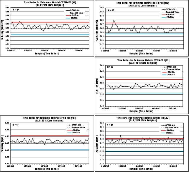
| | |
3CN024.004 – North American Nickel Inc. | | |
Updated Independent Technical Report for the Maniitsoq Nickel-Copper-Cobalt-PGM Project, Greenland | | Page 164 |
Time Series Plots for Certified Reference MaterialCFRM-101 Assayed by ALS in 2016
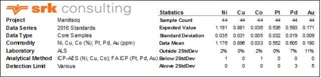
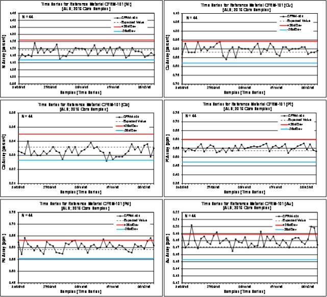
| | |
3CN024.004 – North American Nickel Inc. | | |
Updated Independent Technical Report for the Maniitsoq Nickel-Copper-Cobalt-PGM Project, Greenland | | Page 165 |
Time Series Plots for Certified Reference MaterialCFRM-102 Assayed by ALS in 2016
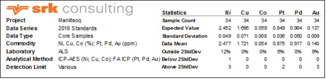
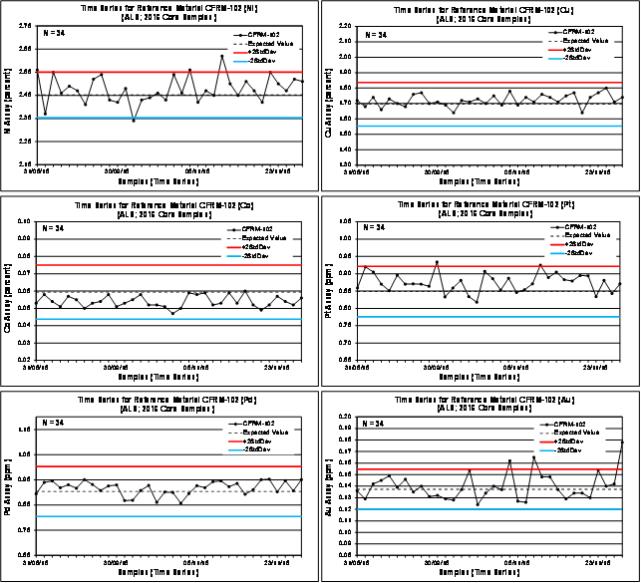
| | |
3CN024.004 – North American Nickel Inc. | | |
Updated Independent Technical Report for the Maniitsoq Nickel-Copper-Cobalt-PGM Project, Greenland | | Page 166 |
Time Series Plots for Certified Reference Material AMIS 0288 and OREAS 214 Assayed by ALS in 2016
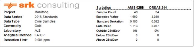
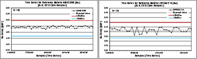
| | |
3CN024.004 – North American Nickel Inc. | | |
Updated Independent Technical Report for the Maniitsoq Nickel-Copper-Cobalt-PGM Project, Greenland | | Page 167 |
Time Series Plots for Field Blanks (Finnefjeld Gneiss) and Nickel-Copper Blanks (AMIS 0288) and OREAS 214 Assayed by ALS in 2016
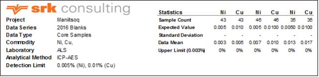
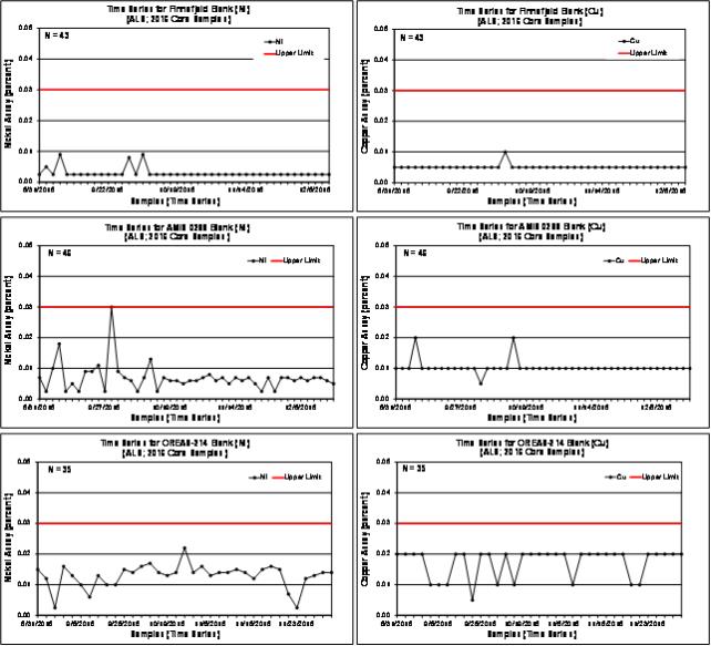
| | |
3CN024.004 – North American Nickel Inc. | | |
Updated Independent Technical Report for the Maniitsoq Nickel-Copper-Cobalt-PGM Project, Greenland | | Page 168 |
Bias Charts and Precision Plots for Preparation Duplicate Samples Assayed by ALS in 2016

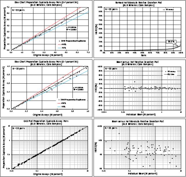
| | |
3CN024.004 – North American Nickel Inc. | | |
Updated Independent Technical Report for the Maniitsoq Nickel-Copper-Cobalt-PGM Project, Greenland | | Page 169 |
Bias Charts and Precision Plots for Preparation Duplicate Samples Assayed by ALS in 2016

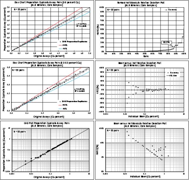
| | |
3CN024.004 – North American Nickel Inc. | | |
Updated Independent Technical Report for the Maniitsoq Nickel-Copper-Cobalt-PGM Project, Greenland | | Page 170 |
Bias Charts and Precision Plots for Preparation Duplicate Samples Assayed by ALS in 2016
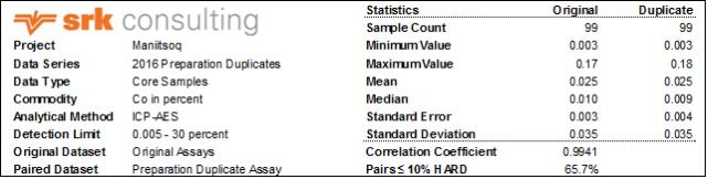
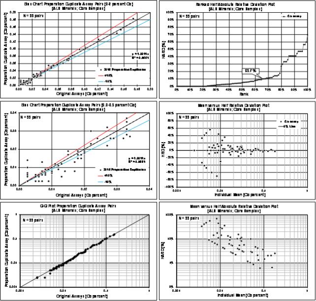
| | |
3CN024.004 – North American Nickel Inc. | | |
Updated Independent Technical Report for the Maniitsoq Nickel-Copper-Cobalt-PGM Project, Greenland | | Page 171 |
Bias Charts and Precision Plots for Preparation Duplicate Samples Assayed by ALS in 2016
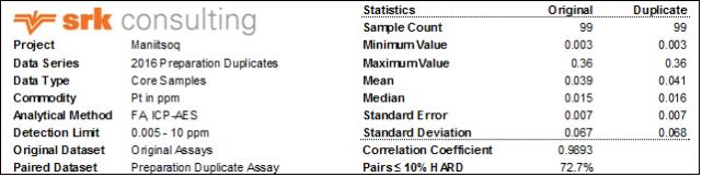
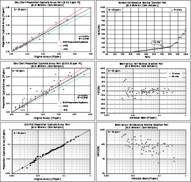
| | |
3CN024.004 – North American Nickel Inc. | | |
Updated Independent Technical Report for the Maniitsoq Nickel-Copper-Cobalt-PGM Project, Greenland | | Page 172 |
Bias Charts and Precision Plots for Preparation Duplicate Samples Assayed by ALS in 2016
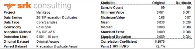
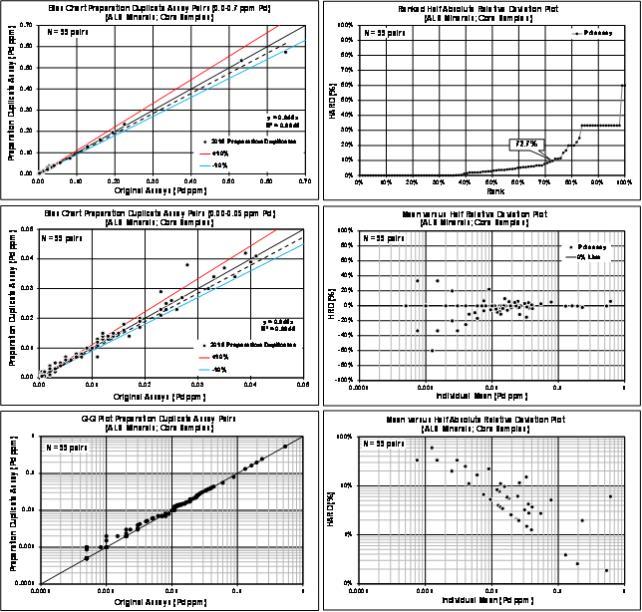
| | |
3CN024.004 – North American Nickel Inc. | | |
Updated Independent Technical Report for the Maniitsoq Nickel-Copper-Cobalt-PGM Project, Greenland | | Page 173 |
Bias Charts and Precision Plots for Preparation Duplicate Samples Assayed by ALS in 2016

| | |
3CN024.004 – North American Nickel Inc. | | |
Updated Independent Technical Report for the Maniitsoq Nickel-Copper-Cobalt-PGM Project, Greenland | | Page 174 |
Bias Charts and Precision Plots for Umpire Duplicate Samples Assayed by ALS and SGS in 2016
| | |
3CN024.004 – North American Nickel Inc. | | |
Updated Independent Technical Report for the Maniitsoq Nickel-Copper-Cobalt-PGM Project, Greenland | | Page 175 |
Bias Charts and Precision Plots for Umpire Duplicate Samples Assayed by ALS and SGS in 2016
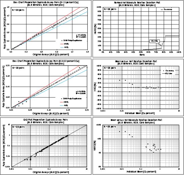
| | |
3CN024.004 – North American Nickel Inc. | | |
Updated Independent Technical Report for the Maniitsoq Nickel-Copper-Cobalt-PGM Project, Greenland | | Page 176 |
Bias Charts and Precision Plots for Umpire Duplicate Samples Assayed by ALS and SGS in 2016
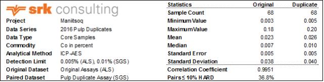
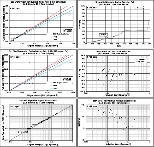
| | |
3CN024.004 – North American Nickel Inc. | | |
Updated Independent Technical Report for the Maniitsoq Nickel-Copper-Cobalt-PGM Project, Greenland | | Page 177 |
Bias Charts and Precision Plots for Umpire Duplicate Samples Assayed by ALS and SGS in 2016
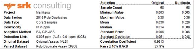
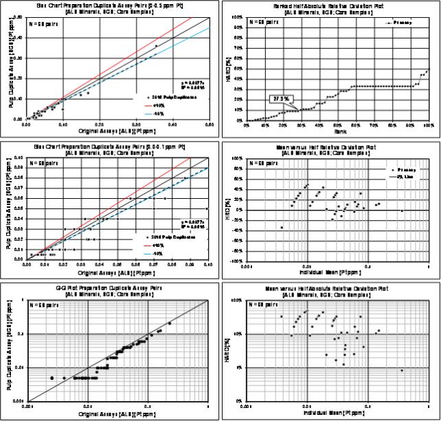
| | |
3CN024.004 – North American Nickel Inc. | | |
Updated Independent Technical Report for the Maniitsoq Nickel-Copper-Cobalt-PGM Project, Greenland | | Page 178 |
Bias Charts and Precision Plots for Umpire Duplicate Samples Assayed by ALS and SGS in 2016

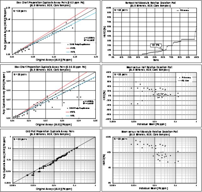
| | |
3CN024.004 – North American Nickel Inc. | | |
Updated Independent Technical Report for the Maniitsoq Nickel-Copper-Cobalt-PGM Project, Greenland | | Page 179 |
Bias Charts and Precision Plots for Umpire Duplicate Samples Assayed by ALS and SGS in 2016
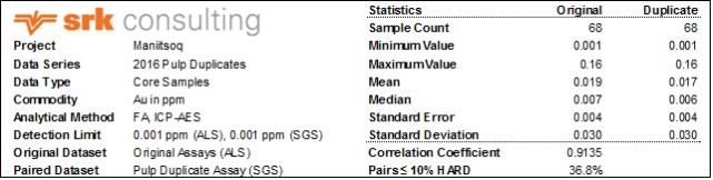
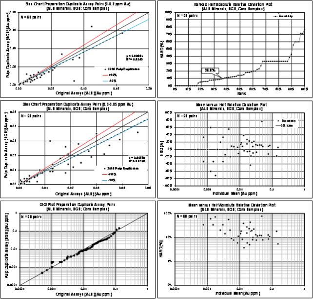
| | |
3CN024.004 – North American Nickel Inc. | | |
Updated Independent Technical Report for the Maniitsoq Nickel-Copper-Cobalt-PGM Project, Greenland | | Page 180 |
Bias Charts and Precision Plots for Umpire Duplicate Samples Assayed by ALS and MS Analytical in 2016
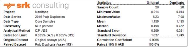
| | |
3CN024.004 – North American Nickel Inc. | | |
Updated Independent Technical Report for the Maniitsoq Nickel-Copper-Cobalt-PGM Project, Greenland | | Page 181 |
Bias Charts and Precision Plots for Umpire Duplicate Samples Assayed by ALS and MS Analytical in 2016
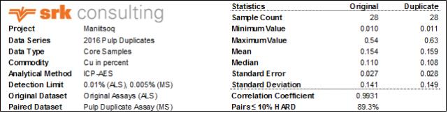
| | |
3CN024.004 – North American Nickel Inc. | | |
Updated Independent Technical Report for the Maniitsoq Nickel-Copper-Cobalt-PGM Project, Greenland | | Page 182 |
Bias Charts and Precision Plots for Umpire Duplicate Samples Assayed by ALS and MS Analytical in 2016
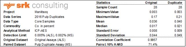
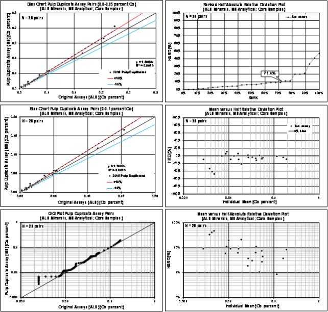
| | |
3CN024.004 – North American Nickel Inc. | | |
Updated Independent Technical Report for the Maniitsoq Nickel-Copper-Cobalt-PGM Project, Greenland | | Page 183 |
Bias Charts and Precision Plots for Umpire Duplicate Samples Assayed by ALS and MS Analytical in 2016

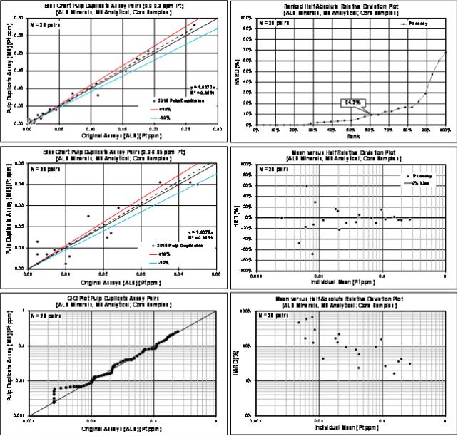
| | |
3CN024.004 – North American Nickel Inc. | | |
Updated Independent Technical Report for the Maniitsoq Nickel-Copper-Cobalt-PGM Project, Greenland | | Page 184 |
Bias Charts and Precision Plots for Umpire Duplicate Samples Assayed by ALS and MS Analytical in 2016
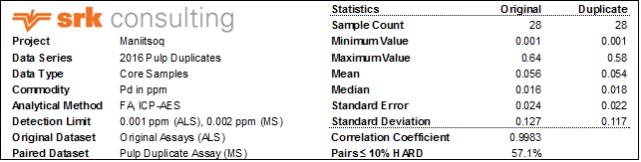
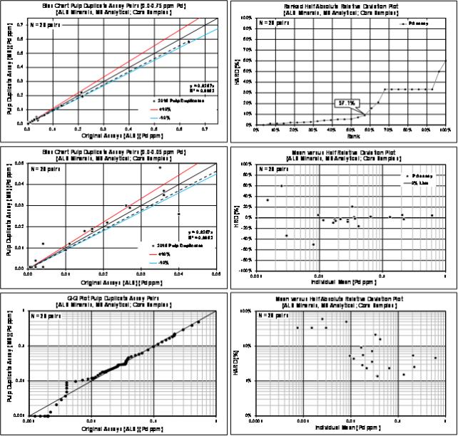
| | |
3CN024.004 – North American Nickel Inc. | | |
Updated Independent Technical Report for the Maniitsoq Nickel-Copper-Cobalt-PGM Project, Greenland | | Page 185 |
Bias Charts and Precision Plots for Umpire Duplicate Samples Assayed by ALS and MS Analytical in 2016