[ ] Preliminary Information Statement
[ ] Confidential, for Use of the Commission Only
[X] Definitive Information Statement

HYBRED INTERNATIONAL, INC.
A Colorado Corporation
(Name of Registrant As Specified In Charter)
370 West Pleasentview Avenue, Hackensack, New Jersey 07601 CIK № 0000823544
Payment of Filing Fee (Check the appropriate box):
[X ] No fee required.
[ ] Fee computed on table below per Exchange Act Rules 14c-5(g) and 0-11.
| 1 | Title of each class of securities to which transaction applies: | Common, Preferred A, B and C classes | |
| 2 | Aggregate number of securities to which transaction applies: | All | |
| 3 | Per unit price or other underlying value of transaction computed pursuant to Exchange Act Rule 0-11 (set forth the amount on which the filing fee is calculated and state how it was determined): | N/A | |
| 4 | Proposed maximum aggregate value of transaction: | $XXX,XXX | |
| Transaction fee | 0.0001161% | $0.00 | |
| 5 | Total fee paid | $0.00 |
[ ] Fee paid previously with preliminary materials.
[ ] Check box if any part of the fee is offset as provided by Exchange Act Rule 0-11(a)(2) and identify the filing for which the offsetting fee was paid previously. Identify the previous filing by registration statement number, or the Form or Schedule and the date of its filing.
| 1) Amount Previously Paid: | $0.00 |
| 2) Form, Schedule or Registration Statement No.: | N/A |
| 3) Filing Party: | N/A |
| 4) Date Filed: | N/A |
Effective Date of the vote: Wednesday, 5 October 2011
ITEMS VOTED UPON
● We Are Not Asking You for a Proxy and You are Requested Not To Send Us a Proxy
● This is an executive summary for convenience purposes only. Full descriptions and explanations are more fully detailed herein.
| Item | Notes |
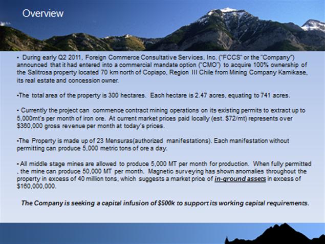
| Acquisition of Asset | Hybred has acquired a title to certain [name of mines] mines in Chile. Furthermore, the company may issue such securities in the process of acquiring the mining assets as may be reasonable and prudent in the view of management and upon the terms and conditions negotiated by management. |
| Change of primary business Line | Management feels that Hybred has not fully realized the potential of the horseshoe business model, due to the flagging economy and resultant purchases of exotic horseshoes. Hybred has also come across an astounding opportunity in the rare earth (mining) sector, which is an outperforming sector. |
| Change of Company name | To reflect the additional business line and shift in focus of Hybred from horseshoes to mining, Hybred is proposing a change in the name of the company to All Grade Mining, Inc. |
| Adjustment of Articles of Incorporation and Bylaws | Hybred is voting to make such necessary adjustments to the Articles of Incorporation and Bylaws, if any, to facilitate the this vote in so much as to change the name of the corporation, |
Furnish the information called for by all of the items of Schedule 14A of Regulation 14A (other than Items 1(c).2, 4 and 5 thereof) which would be applicable to any matter to be acted upon at the meeting if proxies were to be solicited in connection with the meeting. Notes A, C, D, and E to Schedule 14A are also applicable to Schedule 14C.
ii
Item A. Date, time and place information.
| The Parties compromising the majority vote herein voted on [date of vote], in favor of the business combination. |
| b. | No proxies are being solicited because a majority of holders, sufficient to vote affirmatively for the measures and have an overall majority, have already voted affirmatively for the actions, herein described. |
Item B. Revocability of proxy.
The proxies, already voted affirmatively for the change in name and issuance of securities for the acquisition of assets.
Item C. Dissenters' right of appraisal.
Pursuant to Colorado law, Title 7 §113-102 (1.3, any party seeking appraisal, or dissenters, shall have no rights for a corporation listed on a national exchange. All other dissenters have a right of judicial appraisal under Title 7 §113 of the Colorado code and must notify the Company in writing within 30 days sent to the Company’s attorney address, listed herein and will be entitled to fair value as determined by the weighted average cost of sell in, determined by the market makers on the bid averaged by bid size.
Item D Persons Making the Solicitation
Item E. Interest of Certain Persons in Matters to Be Acted Upon
| a. | No Proxies were solicited before furnishing this Proxy Statement. |
i) Gary Kouletas, who is the CEO of Hybred; ii) Angelo Kouletas, who is a relative of Gary Kouletas; Martin Honig, who is or was counsel to Hybred; Michael and Robert Honig, who are relatives of Martin Honig, Esq; Marshal Shichtman, Esq. who is securities counsel to Hybred.
As of the shareholder list dated 28 September 2011
| Holder | Amount of Shares | Percent of Class |
| Total votes in favor | 86,750,000 | 53.14% |
| Votes necessary | 81,682,759 + 1 | |
| Votes in Favor | 86,750,000 | |
| Total Outstanding | 163,365,5191 |
No cumulative voting is authorized or used.
1 6,000,000 common shares were disgorged from Meadow Vista Financial Corp. by Order of the SEC, dated 9 Fevruary 2011 (See Litigation Release № 21847)
iii
Total Majority and Insider holders
As of 18 January 2011
Number of Shares of common stock Beneficially Owned(2) | Percentage of common stock Outstanding(3) | |
| Insert people and shares for vote | ||
| Kouletas, Gary | 63,515,043 | 38.88% |
| Spitzer, Paul | -0- | 0% |
| (1) Unless otherwise stated above, the address of beneficial owner is c/o Hybred International, Inc., 370 West Pleasantview Avenue Hackensack , New Jersey 07601. | |
| (2) Beneficial ownership of each person is shown as calculated in accordance with Rule 13d-3 of the Securities Exchange Act of 1934, which includes all securities that the person, directly, or indirectly through an contract, arrangement, understanding, relationship or otherwise has or shares voting power which includes the power to vote or direct the voting of a security, or investment power, which includes the power to dispose, or direct the disposition of such security. |
The following table sets forth compensation awarded to, earned by or paid to our Chief Executive Officer and the four other most highly compensated executive officers for the years ended December 31, 2010 and 2009 (collectively, the “Named Executive Officers”).
| SUMMARY COMPENSATION TABLE | |||||||||
Name and principal position | Year | Salary | Bonus | Stock Awards | Option Awards | Non-Equity Incentive Plan Compensation | Nonqualified Deferred Compensation Earnings | All Other Compensation | Total |
| Gary Kouletas, CEO | 2009 | $150,000 | 0 | 0 | 0 | 0 | 0 | 0 | 0 |
| 2010 | $150,000 | 0 | 0 | 0 | 0 | 0 | 0 | 0 | |
| none, sec/treas. | 2009 | 0 | 0 | 0 | 0 | 0 | 0 | 0 | 0 |
| 2008 | 0 | 0 | 0 | 0 | 0 | 0 | 0 | 0 | |
| OUTSTANDING EQUITY AWARDS AT DECEMBER 31, 2010 | |||||||||
| OPTION AWARDS | STOCK AWARDS | ||||||||
| Name | Number of Securities Underlying Unexercised Options (#) Exercisable | Number of Securities Underlying Unexercised Options (#) Unexercisable | Equity Incentive Plan Awards: Number of Securities Underlying Unexercised Unearned Options (#) | Option Exercise Price ($) | Option Expiration Date | Number of Shares or Units of Stock That Have Not Vested (#) | Market Value of Shares or Units of Stock That Have Not Vested ($) | Equity Incentive Plan Awards: Number of Unearned Shares, Units or Other Rights That Have Not Vested (#) | Equity Incentive Plan Awards: Market or Payout Value of Unearned Shares, Units or Other Rights That Have Not Vested (#) |
| Gary Kouletas | 0 | 0 | 0 | 0 | 0 | 0 | 0 | 0 | 0 |
| 0 | 0 | 0 | 0 | 0 | 0 | 0 | 0 | 0 | |
iv
Employment Contracts
We do not have an employment contract with any executive officer.
We have made no Long Term Compensation payouts.
Director Compensation
| DIRECTOR COMPENSATION | |||||||
| Name | Fees Earned or Paid in Cash | Stock Awards | Option Awards | Non-Equity Incentive Plan Compensation | Change in Pension Value and Nonqualified Deferred Compensation Earnings | All Other Compensation | Total |
| Gary Kouletas | 0 | 0 | 0 | 0 | 0 | 0 | 0 |
| Spitzer, Paul | 0 | 0 | 0 | 0 | 0 | 0 | 0 |
Our directors do not receive compensation for their attendance at meetings of the board of directors.
All of our officers and/or directors will continue to be active in other companies. All officers and directors have retained the right to conduct their own independent business interests.
It is possible that situations may arise in the future where the personal interests of the officers and directors may conflict with our interests. Such conflicts could include determining what portion of their working time will be spent on our business and what portion on other business interest. To the best ability and in the best judgment of our officers and directors, any conflicts of interest between us and the personal interests of our officers and directors will be resolved in a fair manner which will protect our interests. Any transactions between us and entities affiliated with our officers and directors will be on terms which are fair and equitable to us. Our Board of Directors intends to continually review all corporate opportunities to further attempt to safeguard against conflicts of interest between their business interests and our interests.
v
| DIRECTOR COMPENSATION | |||||||
| Name | Fees Earned or Paid in Cash | Stock Awards | Option Awards | Non-Equity Incentive Plan Compensation | Change in Pension Value and Nonqualified Deferred Compensation Earnings | All Other Compensation | Total |
| Gary Kouletas(1) | 0 | 0 | 0 | 0 | 0 | 0 | 0 |
| Spitzer, Paul | 0 | 0 | 0 | 0 | 0 | 0 | 0 |
Item I. Independent Public Accountants.
The instant Special meeting in lieu of a shareholder meeting does not pertain to Hybred’s accountant.
Hybred is not altering its compensation plan(s) at this juncture. However, Hybred reserves all rights to a compensation adjustment at a future time; which will be duly processed.
No issuances are associates with this vote in the primary sense. However, this votes ratifies the issuance of securities in the prior 14C, upon management’s discretion, to sell securities to fund the acquisition of the Salitrosa mine.
No Class(es) of securities are modified, or to be modified, by the contemplated transaction.
Financial Statements from Hybred’s most recent financials, are hereby incorporated by reference.
Hybred International, Inc. has entered into contracts to acquire the Salitrosa mine in Chile.
See attached exhibits for description on the Salitrosa mine.
None.
vi
None.
Item R. Matters not Required to be Submitted.
None.
The name of the Company, Hybred International, Inc. is going to be changed from Hybred International, Inc. to All Grade Mining, Inc.
None.
-We Are Not Asking You for a Proxy and
You are Requested Not To Send Us a Proxy-
N/A
We Are Not Asking You for a Proxy and You are Requested Not To Send Us a Proxy
| Gary Kouletas, who is the CEO and Chairperson of Hybred beneficially holds 38.88% of the shares of Hybred. Mr. Kouletas does not stand to directly fiscally benefit from this business combination. |
None.
Only one Notice of Internet Availability of Proxy Materials is being delivered to multiple security holders sharing an address unless the registrant has received contrary instructions from one or more of the security holders;
Hybred undertakes to deliver promptly, upon written or oral request, a separate copy of the Notice of Internet Availability of Proxy Materials to a security holder at a shared address to which a single copy of the documents was delivered. Security holders can notify the registrant that the security holder wishes to receive a separate copy of the Notice of Internet Availability of Proxy Materials, by written notification to the law offices of Marshal Shichtman & Associates, P.C., 1 Old Country Road, Suite 360, Carle Place, New York 11514, (516) 741-5222.
vii
SIGNATURES
Pursuant to the requirements of the Securities Exchange Act of 1934, the registrant has duly caused this report to be signed on its behalf by the undersigned hereunto duly authorized.
As of the Effective Date
Hybred International, Inc.
/s/________________________
By: Gary Kouletas, CEO
Exhibit List:
A – Ground Magnetic Survey
B – Memorandum of Understanding
C – Power Point Presentation
viii
Exhibit A – Ground Magnetic Survey
Report on
Ground Magnetic Surveys
conducted at the
Salitrosa Project
Region III, Chile
on behalf of
Success Mining Chile Limited
ix
By: Joe Jordan
May, 2010
Project: P136B
Argali Geofisica E.I.R.L
Dr. Galvarino Rossi 02824
Antofagasta, Chile
56-55-387554
09-497-1187 cellular
x
Abstract
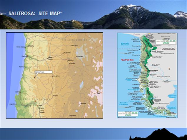
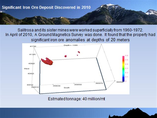
During April, 2010, Argali Geofisica Chile E.I.R.L. (Argali) conducted ground magnetic surveys at the Salitrosa Project in Region III, Chile, on behalf of Success Mining Chile Limited (Success). The Salitrosa Project is located 70 km north of Copiápo in Region III, Chile. The objective of the ground magnetic surveys was to evaluate the property for economic magnetite mineralization.
The ground magnetic survey was conducted with a line spacing of 200 m and detailed spacing of 50 m over anomalous areas. Readings were acquired as a continuous profile on E-W lines once every 1 second or an approximate station spacing of approximately 0.5 to 1.5 m. Survey control was maintained with a high quality GPS system within the magnetometer. Complete UTM coordinates and elevation data were acquired simultaneously with each magnetic reading. A total of 234 km were acquired.
A checkpoint was measured twice daily with all the magnetometers. Repeatability of the corrected magnetic readings was usually within 2 nT, and the GPS UTM coordinate repeatability was within 2 m of the average value. The GPS datum for the ground magnetic survey was Provisional South America 1956 (N. Chile, south of 19 degrees latitude), corrected to surveyed drill coordinates from Escondida Project (Success).
The magnetic data have outlined numerous anomalies indicative of narrow zones of magnetite on or near the surface. Some of the zones may crop out, so trenching and geologic mapping may expose shallow, narrow resources. Drilling the narrow zones is not recommended until trenching and mapping are completed and results are evaluated. There is a potential for a total of several million tons of shallow magnetic material distributed in multiple small pods and veins near the surface. However, the grades, widths and economic viability are not yet known, and 3D inversion modeling over narrow zones is not effective.
The largest anomaly occurs in the NW portion of the grid near 358900E, 7041580N. This zone appears to consist of 2 or 3 vein-like magnetic features from 10 to 30 m wide over a width of approximately 130 m and a strike length of perhaps 250 m. The vein-like features strike NW, dip SE, and may converge at depth. The modeled magnetic susceptibility of 0.7 (SI) indicates that economic iron mineralization is likely present. Total estimated tonnage of this shallow target is about 4 to 10 Mt to 100 m depth. Several drill holes could test this target area.
i
Table of Contents
| Page | |
| Abstract | i |
| Table of Contents | ii |
| 1.0 Introduction | 1 |
| 2.0 Ground Magnetics | |
| 2.1 Survey Equipment | 3 |
| 2.2 Survey Parameters | 3 |
| 2.3 Survey Procedures | 4 |
| 2.4 GPS Datum and Correction | 4 |
| 2.5 Data Processing | 5 |
| 2.6 Magnetic Data Maps | 5 |
| 2.7 3D Inversions | 6 |
| 3.0 Discussion | |
| 3.1 Targets and Inversion Models | 8 |
| 4.0 Summary and Recommendations | 12 |
ii
Appendices
Appendix A: Survey Coverage
Appendix B: Maps
List of Figures
| Figure 1. Project Location Map | 1 |
| Figure 2. Line Location Map and Elevation Contours | 2 |
| Figure 3. Pole Reduced Grid and 3D Inversion Model | 7 |
| Figure 4. North 3D Inversion: Magnetic Susceptibility at 0.5 (SI) | 9 |
| Figure 5. North 3D Inversion: Plan View at 1030 m Elevation | 10 |
Figure 6. North 3D Inversion: Cross section through strongest anomalies | 10 |
Figure 7. South 3D Inversion: Cross section at 7038650N | 11 |
| Figure 8. South 3D Inversion: Cross section at 7039050N | 11 |
iii
1.0 Introduction
| Client Contact: | Max Wu, RubensMendonca |
| Success Mining Chile Limited | |
| Survey Type: | Ground Magnetics (continuous profile) |
| Line Spacing: 50, 200 m | |
| Internal GPS control | |
| Datum: Prov S. America 1956 (N. Chile) | |
| Corrected to surveyor’s coordinates | |
| Survey Coverage: | 234 km |
| Date: | April, 2010 |
| Project Location: | 70 km north of Copiapo, Region III |
| UTM: 360.000E, 7.040.000N |
Figure 1. Location map of the Salitrosa Project, Region III, Chile.
1

Figure 2. Location Map of the Salitrosa Project showing the
Elevation Contours and the Magnetic Survey Lines.
2
2.0 Ground Magnetic Survey
2.1 Survey Equipment
| Base: | GEM systems GSM-19 |
| Rover: | GEM systems GSM-19 v7.0 walking mag with internal GPS |
The ground magnetic survey was conducted with four GEM Systems GSM-19 Overhauser magnetometers. One served as a base station, and the others as rovers.
2.2 Survey Parameters
| Station Interval: | continuous profile readings every 1.0 seconds |
| (approximate station spacing: 0.4 to 1.5 m) | |
| Line Spacing: | 50, 200 m (Lines surveyed east-west) |
| Magnetic Declination: | -0.7° (World Data Center for Solid Earth Geophysics) |
| Magnetic Inclination: | -25.2° |
Magnetic Field Strength (FT): | 23516 nT (average calculated value for this position) |
| Datum for processing: | 23800 nT (approximate value at base station) |
| Base Station Checkpoint: | 361.102E, 7.042.148N, 23695 nT after correction |
| Line Positioning/GPS control: | High quality internal GPS system |
| UTM Datum: | Prov S. America 1956 (N. Chile), corrected to surveyors |
3
2.3 Survey Procedures
The base station magnetometer was set to record variations in the earth’s magnetic field at 4 second intervals. The rover unit was synchronized with the base station so that the data could be corrected for the diurnal magnetic field variation. The rover unit was set to record a continuous profile of readings along the line. Readings were acquired every 1.0 seconds, or an average station spacing of 0.2 to 1.5 m, depending on the walking pace. A high quality internal GPS system was used to record the UTM coordinates and elevation simultaneously with each magnetic reading.
To ensure constant levelling and to estimate day-to-day variation in GPS accuracy, a checkpoint was established close to the base station. Measurements were made with each instrument in the morning prior to surveying and in the afternoon after surveying. After diurnal correction, the magnetic readings should be approximately the same all the time. In general, the majority of the readings were within 1 nT of the average. The GPS UTM repeatability of the checkpoint was usually within 2 m of the average.
2.4 GPS Datum and Correction
The magnetic data were acquired with the internal GPS and the Provisional South America 1956 datum (Northern Chile, south of 19 degrees). This datum is the standard datum used for most mineral exploration in northern Chile. The coefficients are: dX= -270, dY=183, dZ=-390. In order to ensure that the magnetometer GPS UTM coordinates are consistent with land-based surveyed coordinates used for survey monuments and drilling, four different drill holes from the nearby Escondida Project (Success Mining) were surveyed with the magnetometers and compared with both surveyor coordinates (PSA 56,N. Chile) and with hand held GPS coordinates (PSA56 mean), see Table 1.
Based on comparison of the magnetometer and surveyor UTM coordinates, a shift of +0m East and +29 m North was calculated. Consequently, +0 m and +29m were added to the easting and northing of the magnetic data prior to processing the data and making the maps. All maps and final data have been corrected to the surveyor’s coordinates. This shift is typical of other projects in the area.
4
Table 1. Comparison of UTM coordinates (Mags, GPS, Surveyor) at Escondida
| Escondida | (Surv-Mag) | |||||
| Drill Holes | Surveyor1 | MAG32 | MAG62 | MAG72 | HandGPS3 | Difference4 |
| DHM-1 | 379630 | 379628 | 379629 | 379630 | 379649 | 1 |
| 7056290 | 7056262 | 7056262 | 7056264 | 7056252 | 27.33 | |
| DHM-4 | 380430 | 380431 | 380432 | 380430 | 380448 | -1 |
| 7056570 | 7056542 | 7056540 | 7056540 | 7056528 | 29.33 | |
| DHM-5 | 380600 | 380600 | 380601 | 380601 | 380620 | -0.67 |
| 7056800 | 7056769 | 7056770 | 7056769 | 7056759 | 30.67 | |
| DHM-6 | 380660 | 380663 | 380662 | 380661 | 380680 | -2 |
| 7056940 | 7056909 | 7056909 | 7056912 | 7056900 | 30 | |
| Average | Easting | -0.67E | ||||
| Difference | Northing | 29.33N |
1 UTM coordinates from Success Mining surveyor (PSA1956, N. Chile datum).
2 UTM coordinates from three magnetometers (PSA1956, N. Chile datum).
3 UTM coordinates from hand held GPS unit (PSA1956, mean datum).
4 difference in UTM coordinates between magnetometers and surveyor.
5
2.5 Data Processing
Cultural features are limited to scattered debris from mine workings. In the SE corner of the grid, several small mines are being operated on a small-scale. No data were acquired in these areas due to property boundary constraints.
Pole Reduction
Reduction to the pole is a data processing technique that calculates the total magnetic intensity data as if the inducing magnetic field had a 90° inclination, i.e. anomalies take approximately the same form that would be observed at the magnetic pole (see Figure 2). Pole reduction procedures can be difficult to apply successfully near the magnetic equator (<±10° inclination) because the north-south amplitude corrections tend to amplify noise and some minor north-south features. A solution to this problem is to reduce the amplitude correction to 40° so that the north-south striations caused by the amplification of noise are minimized.
Analytic Signal
The analytic signal of the total magnetic field can improve the interpretation of total magnetic field data at low magnetic latitudes. The amplitude of analytic signal anomalies combines all vector components of the field (X, Y, and Z) into a constant. The amplitude of the analytic signal of the total magnetic field produces maxima over magnetic contacts. An important characteristic of the analytic signal is that it is independent of the direction of magnetization of the source. The direction of magnetization, which may vary depending on the level of induced magnetization, remnant magnetization and magnetic anisotropy, is removed by the process of calculating the analytic signal.
2.6 Magnetic Data Maps
The following maps are presented in Appendix B:
| · | Total Field Map (Shaded and contours) |
| · | Pole Reduced Map (Shaded and contours) |
| · | Analytic Signal Map |
| · | Elevation contours |
6
2.7 3D Inversion of the Magnetic Data
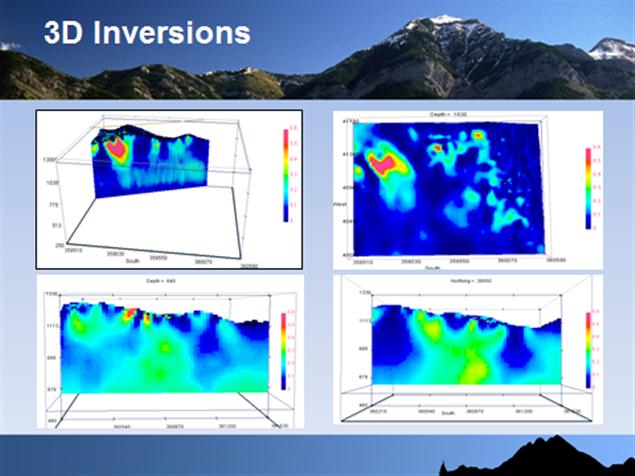
The ground magnetic data were inverted with the MAG3D inversion code from the University of British Columbia. The inversion creates a 3D model of the magnetic susceptibility that fits the observed total field magnetic data. The magnetic susceptibility is directly related to the magnetite content of most rocks. Consequently, the 3D susceptibility model provides a good model of the subsurface magnetite distribution. As with most geophysical inversions, it is important to understand that many different models will fit the data equally well; there is not one perfect solution. The model that is presented is that which fits the data to a prescribed limit and also minimizes an objective function algorithm that defines the desired characteristics of the parameters being solved by the inversion. The MAG3D susceptibility model is smoothly varying and large discrete jumps in the susceptibility are not permitted. Consequently, the resulting model will inevitably be smoother than the actual magnetic susceptibility distribution in the earth and will tend to overestimate the thickness of narrow bodies and to underestimate the maximum magnetic susceptibility.
Two 3D inversion models were prepared:
| Inversion | East limits | North limits | Area | Mesh | ||
| North | 358500 | 360600 | 7040000 | 7041800 | 2.1x1.8 km | 20x20m |
| South | 360200 | 361550 | 7038000 | 7040300 | 1.35x2.3 km | 20x20m |
7

Figure 3. Pole Reduced grid and two 3D inversion zones: North and South
8
3.0 Discussion
3.1 Targets and Inversion Models
Strong magnetic anomalies are observed throughout the Salitrosa Project. Most of the total field anomalies range from 25,000 to 26,000; however, amplitudes exceed 27,000 in several areas. Large, strong anomalies indicative of large zones of high-grade magnetite with deep roots are not observed. In general, the strong anomalies are narrow and are indicative of narrow zones of magnetite on or near the surface. There are literally hundreds on anomalies, so narrow zones of magnetite are common throughout the central portion of the grid. However, many of the anomalies are only 1 to 5 m wide. Wider anomalies are less common but present in several areas in both the north and south portion of the grid.
The 3D inversion is designed to model magnetic sources that are reasonably large in comparison to the line spacing and the inversion mesh cell. With a line spacing of 50 m and mesh cell size of 20 m, both the North and the South 3D inversion will most effectively model magnetic sources at least 30 to 50 m wide. Narrower and shorter bodies will not be modeled well. Narrow, shallow magnetite bodies are better interpreted on the plan views of the Total Field and Pole Reduced. The objective of the 3D inversions was to model the larger magnetic sources.
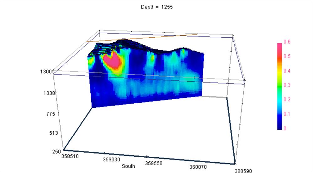
North
Figure 4 shows a view of the North Inversion 3D model at 0.5 (SI) susceptibility. Figure 5 shows a plan view of the inversion model at an elevation of 1030 m, and Figure 6 shows a cross section through the strongest anomalies. The strongest anomaly on the North block is centered near 358900E, 7041220N. The zone appears to consist of 2 or 3 narrow vein-like magnetite sources that strike NW and dip to the NE. The approximate width of the veins is 10 to 30 m and the strike length is perhaps 200 m. The 3D inversion indicates that the veins may coalesce at depth with a modeled susceptibility up to 0.7 (SI) units which is typically associated with high magnetite content. The modeled depth extent is perhaps 200 m, although it is possible that narrow zones of mineralization may extend more deeply. Estimated volume of the North target is about 3 Mt to 10 Mt, assuming 100 m depth extent. Several short drills would be required to confirm the widths and grades of this target.
9
Other anomalies in the northern part of the grid are much smaller with limited strike length and small potential volume. However, there are several zones where tight contours on the Pole Reduced maps are clearly revealing small pods of magnetite near the surface. The most promising zone is near 359865E, 7041582. Although the zone may be too small to warrant drilling at this stage, trenching with a backhoe may uncover shallow pods of economic mineralization.
South
The South zone hosts a multitude of narrow magnetic anomalies that are indicative of shallow zones of magnetite on or near the surface. However, there are no large anomalies indicative of large zones of high-grade magnetite with significant depth extent.
The 3D inversion is complicated by the presence of the many small anomalies on the surface. No large, deep zones of high magnetic susceptibilities are outlined by the 3D inversion, although several small shallow zones reach 0.5 (SI). There is some indication that the many narrow zones may extend to depth where they converge towards the center (Figures 7 and 8). The modeled magnetic susceptibility is less than 0.3 (SI), suggesting that the average magnetite content will be less than economic, perhaps 15%. Some narrower zones of higher grade are likely present; however, the average grade over large widths is expected to be low. Note that magnetic susceptibilities of 0.3 are consistent with IOCG mineralization, so copper mineralization is a possible target.
10
Figure 4. North 3D Inversion showing magnetic susceptibilities greater than 0.5 (SI)
The principal anomaly is centered near 358900E, 7041220N.
11
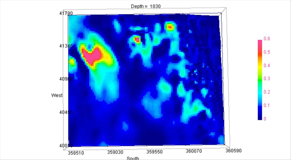
Figure 5. North 3D inversion showing plan view at Elevation 1030 m
12
Figure 6. North 3D Inversion and angular cross-sectional view through the principal anomaly and smaller anomalous zone in the northern portion of the map. The principal anomaly is clearly much larger than the other anomalies.

Figure 7. South 3D Inversion showing cross-section at 7038650N
13
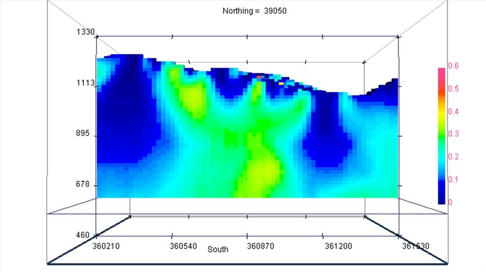
Figure 8. South 3D Inversion showing cross-section at 7039050N. Multiple narrow shallow zones are observed. The narrow zones appear to coalesce into a deeper central zone with strongly elevated average magnetic susceptibility of about 0.3 (SI); however, the average grade is expected to be lower than other iron deposits in the area.
4.0 Summary and Recommendations
The magnetic data have outlined numerous anomalies indicative of narrow zones of magnetite on or near the surface. The narrower anomalies cannot be accurately modeled with the 3D inversion, so it is necessary to use the Total Field and Pole Reduced maps for locating the anomalies. Some of the zones may crop out, so they can be evaluated further through careful geologic mapping and sampling. Some zones may be tested with shallow trenches or holes prepared by backhoe. Most of the zones are too small and narrow to warrant drill holes until the magnetite sources are mapped and evaluated on the ground. If mapping and trenching results are encouraging, then shallow drill holes are recommended. There is a potential for encountering a total of several million tons of magnetic material at shallow depths within the many anomalous zones; however, the grade and widths of the magnetic material need to be tested. Copper mineralization may be present and should be evaluated.
14
The largest anomaly occurs in the NW portion of the grid near 358900E, 7041580N. This zone appears to consist of 2 or 3 vein-like magnetic features from 10 to 30 m wide over a width of approximately 130 m and a strike length of perhaps 250 m. The vein-like features strike NW and dip SE. The magnetic zones may coalesce at depths of about 100 m where the inversion model returns high magnetic susceptibilities over 0.7 (SI). The magnetite may extend to 200 m or more depth. The estimated tonnage of this shallow target is about 3 to 10 Mt to 100 m depth. Several drill holes could test this target area.
Additional interpretation will be conducted jointly with Success geologists.
Respectfully submitted,
Joe Jordan, M.Sc.
Argali Geofisica E.I.R.L
15
Appendix A
Survey Coverage: Salitrosa Project
| Line | From | To | Total | Line | From | To | Total | |
| 7038000 | 357000 | 361100 | 4100 | 7040050 | 359700 | 361500 | 1800 | |
| 7038050 | 360250 | 361250 | 1000 | 7040100 | 359650 | 361500 | 1850 | |
| 7038100 | 360250 | 361250 | 1000 | 7040150 | 359600 | 361500 | 1900 | |
| 7038150 | 360250 | 361250 | 1000 | 7040200 | 357000 | 363000 | 6000 | |
| 7038200 | 357000 | 361100 | 4100 | 7040250 | 359500 | 361500 | 2000 | |
| 7038250 | 360250 | 361250 | 1000 | 7040300 | 359450 | 361500 | 2050 | |
| 7038300 | 360250 | 361250 | 1000 | 7040350 | 359400 | 360700 | 1300 | |
| 7038350 | 360250 | 361250 | 1000 | 7040400 | 357000 | 363000 | 6000 | |
| 7038400 | 357000 | 363000 | 6000 | 7040450 | 358886 | 360700 | 1814 | |
| 7038450 | 360250 | 361250 | 1000 | 7040500 | 358809 | 360700 | 1891 | |
| 7038500 | 360250 | 361250 | 1000 | 7040550 | 358732 | 360700 | 1968 | |
| 7038550 | 360250 | 361250 | 1000 | 7040600 | 357000 | 363000 | 6000 | |
| 7038600 | 357000 | 363000 | 6000 | 7040650 | 358577 | 360700 | 2123 | |
| 7038650 | 360250 | 361250 | 1000 | 7040700 | 358500 | 360700 | 2200 | |
| 7038700 | 360250 | 361250 | 1000 | 7040750 | 358500 | 360700 | 2200 |
16
| 7038750 | 360250 | 361250 | 1000 | 7040800 | 357000 | 363000 | 6000 | |
| 7038800 | 357000 | 361150 | 4150 | 7040850 | 358500 | 360700 | 2200 | |
| 7038800 | 362250 | 363000 | 750 | 7040900 | 358500 | 360700 | 2200 | |
| 7038850 | 360250 | 361250 | 1000 | 7040950 | 358500 | 360700 | 2200 | |
| 7038900 | 360250 | 361250 | 1000 | 7041000 | 357000 | 363000 | 6000 | |
| 7038950 | 360250 | 361250 | 1000 | 7041050 | 358500 | 360700 | 2200 | |
| 7039000 | 357000 | 363000 | 6000 | 7041100 | 358500 | 360700 | 2200 | |
| 7039050 | 360250 | 361500 | 1250 | 7041150 | 358500 | 360200 | 1700 | |
| 7039100 | 360250 | 361500 | 1250 | 7041200 | 357000 | 363000 | 6000 | |
| 7039150 | 360250 | 361500 | 1250 | 7041250 | 358500 | 360200 | 1700 | |
| 7039200 | 357000 | 363000 | 6000 | 7041300 | 358500 | 360700 | 2200 | |
| 7039250 | 360250 | 361500 | 1250 | 7041350 | 358500 | 360200 | 1700 | |
| 7039300 | 360250 | 361500 | 1250 | 7041400 | 357000 | 363000 | 6000 | |
| 7039350 | 360250 | 361500 | 1250 | 7041450 | 358500 | 360200 | 1700 | |
| 7039400 | 357000 | 363000 | 6000 | 7041500 | 358500 | 360700 | 2200 | |
| 7039450 | 360250 | 361500 | 1250 | 7041550 | 358500 | 360200 | 1700 | |
| 7039500 | 360250 | 361500 | 1250 | 7041600 | 357000 | 363000 | 6000 | |
| 7039550 | 360200 | 361500 | 1300 | 7041700 | 360200 | 360700 | 500 | |
| 7039600 | 357000 | 363000 | 6000 | 7041800 | 357000 | 363000 | 6000 | |
| 7039650 | 360100 | 361500 | 1400 | 7042000 | 357000 | 363000 | 6000 | |
| 7039700 | 360050 | 361500 | 1450 | 7042200 | 357000 | 363000 | 6000 |
17
| 7039750 | 360000 | 361500 | 1500 | 7042400 | 357000 | 363000 | 6000 | |
| 7039800 | 357000 | 363000 | 6000 | 7042600 | 357000 | 363000 | 6000 | |
| 7039850 | 359900 | 361500 | 1600 | 7042800 | 357000 | 363000 | 6000 | |
| 7039900 | 359850 | 361500 | 1650 | 7043000 | 357000 | 363000 | 6000 | |
| 7039950 | 359800 | 361500 | 1700 | Total | 234196 | |||
| 7040000 | 357000 | 363000 | 6000 |
Appendix B
Maps
Salitrosa Project
Total Field
Reduced to the Pole
Analytic Signal
Elevation Contours
18
Exhibit C – Memorandum of understanding
MEMORANDUM OF UNDERSTANDING
MEMORANDUM OF UNDERSTANDING made this day of August, 2011 by and between Hybred International. Inc. ("Hybred") and Foreign Commerce Consultative Services, Inc. ("FCC").
BACKGROUND
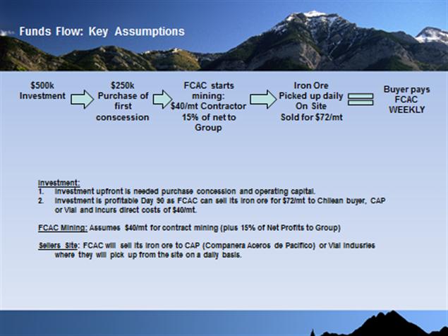
Hybred has simultaneously herewith entered into a certain Assignment and Assumption Agreement with Foreign Commerce Assesores Chile S. A. ("FCA"), an affiliate of FCC, whereby Hybred assumed FCA's obligations under a certain Option Contract between FCA and Sociedad Contractual Minera Kamikase, a Chilean corporation, with respect to the purchase of an iron ore mine located in the Republic of Chile, and kn own as the Saltirosa Mine at a purchase price of $3,250,000, plus a continuing interest equal to 15% of the profit from the sale of iron ore. As a condition of Hybred's execution of the Assignment and Assumption Agreement, FCC has agreed to perform all necessary mining operations and with respect to the Saltirosa Mine in consideration of the terms and conditions contained herein.
19
1. FCC agrees to perform all mining operations at the Saltirosa Mine necessary to extract the iron ore located therein, and supervise and conduct all marketing and sales programs to assure the commercial feasibility of the operations.
2. FCC in its sole discretion, may sub-contract the mining operations to such third parties who have the necessary expertise and financial ability to conduct such operations in a professional manner and in conformance with local procedures ordinarily employed in similar situations in the Republic of Chile.
3. FCC has advised Hybred that it anticipates to expend approximately $32 (US Dollars) per metric ton in the production of the iron ore, and anticipates that the Mine will, when fully operational, produce approximately 40,000 metric tons per month, and will show a profit of approximately $40( US Dollars) per metric ton. FCC estimates that the Mine will reach maximum production within nine (9) months from the date of commencement of operations.
4. All mining expenses shall be paid from the gross revenues generated from the sale of the Mine's iron ore, except that Hybred shall advance $250,000 (US Dollars) to FCC on account of such expenses on or before August 31, 2011.
5. Hybred shall pay to FCC as a management fee in consideration of the services to be rendered, as described above, a monthly sum equal to $2.50 (US Dollars) for each metric ton of iron ore produced and sold to third party purchasers each and every month that the Mine is operational.
20
6. In addition to the monthly management fee described in Paragraph 5 hereinabove, Hybred agrees to pay to FCC 20% of the monthly profit from mining operations each and every month that the Mine is operational.
7. The parties understand and recognize that the within Memorandum of Understanding has been entered into by the parties as an expression of their good faith, and fairly represents their understanding with respect to their respective obligations hereunder. the parties agree to enter into a more formal agreement encompassing the terms and conditions contained herein within ten (10) days from the date hereof. In the event such formal document is not executed with such ten (10) day period, the within Memorandum of Understanding shall be binding upon the parties hereto and enforceable in accordance with its terms and conditions.
8. This Memorandum of Understanding shall be interpreted under the laws of the State of New Jersey without regard to any conflict of law provisions of any other jurisdiction.
IN WITNESS WHEREOF, This Memorandum of Understanding was executed the day and year first above written.
21
HYBRED INTERNATIONAL, INC.
By___________________________
FOREIGN COMMERCE CONSULTATIVE SERVICES, INC
By______________________________
22
Exhibit C – Power Point Presentation
23
24
25
26

27

28
29

30

31

32

33

34

35
36
37

38
39

40