Exhibit 99.2
![]()

CERTIFICATE OF QUALIFIED PERSON
I, Jon Carlson, P.Geo., am employed as the Manager of Strategic Planning for the Ekati Operation with Dominion Diamond Corporation, whose office is situated at 1102-4920 52nd Street, Yellowknife, NT X1A 3T1.
This certificate applies to the technical report entitled “Ekati Diamond Mine, Northwest Territories, Canada, NI 43-101 Technical Report” that has an effective date of 31 January 2015 (the “technical report”).
I am a Professional Geologist member of the Association of Professional Engineers, Geologists and Geophysicists of the Northwest Territories (#L833). I graduated from West Virginia University with a Bachelor’s Degree in Geology in 1979; and from the Colorado State University with a Masters Degree in Economic Geology in 1983.
I have practiced my profession for 32 years. I have been directly involved in diamond exploration and project development and have been continuously engaged with the discovery, exploration, evaluation and development of the Ekati Diamond Mine in the Northwest Territories, Canada since 1992.
As a result of my experience and qualifications, I am a Qualified Person as defined in National Instrument 43–101-Standards of Disclosure for Mineral Projects (NI 43–101).
I have worked in the Ekati project area for 22 years, the last eight years of which I have had direct involvement with mine site operations.
I am responsible for Sections 1.1, 1.2, 1.5, 1.6, 1.7, 1.8, 1.9, 1.13, 1.23, 1.24; Section 2, Section 3, Section 4, Section 5, Section 6, Section 7, Section 8, Section 9, Section 10, Section 11, Section 12, Section 14.10, Section 23, Section 24, Sections 25.1, 25.4, 25.5, 25.6, 25.7, 25.8, 25.17, 25.18, Section 26, Section 27, and Appendix A of the technical report.
I am not independent of Dominion Diamond Corporation as independence is described by Section 1.5 of NI 43–101.
I have previously co-authored a technical report on the Ekati Operation as follows:
- Heimersson, M., and Carlson, J., 2013: Ekati Diamond Mine, Northwest Territories, Canada, NI 43-101 Technical Report: Report prepared for Dominion Diamond Corporation, effective date 10 April 2013.
I have read NI 43–101 and the sections of the technical report for which I am responsible have been prepared in compliance with that Instrument.
| Dominion Diamond Corporation | |
| 1102-4920 52nd Street | www.ddcorp.ca |
| Yellowknife, NT X1A 3T1 |
As of the effective date of the technical report, to the best of my knowledge, information and belief, the sections of the technical report for which I am responsible contain all scientific and technical information that is required to be disclosed to make those sections of the technical report not misleading.
Dated: 12 March 2015
“Signed and sealed”
Jon Carlson, P.Geo.
| Dominion Diamond Corporation | |
| 1102-4920 52nd Street | www.ddcorp.ca |
| Yellowknife, NT X1A 3T1 |

CERTIFICATE OF QUALIFIED PERSON
I, Peter John Ravenscroft, FAusIMM, am the owner of Burgundy Mining Advisors Limited, whose office address is Marron House, Virginia & Augusta Streets, P.O. Box N-8326, Nassau, Bahamas.
This certificate applies to the technical report entitled “Ekati Diamond Mine, Northwest Territories, Canada, NI 43-101 Technical Report” that has an effective date of 31 January 2015 (the “technical report”).
I am a Fellow of the Australasian Institute of Mining and Metallurgy (membership number 205218). I graduated from the University of Cape Town in 1979 with a Bachelor of Science degree in Mathematical Statistics, and from the Ecole des Mines de Paris in 1985 with the equivalent of a Masters degree in Geostatistics.
I have practiced my profession for 35 years. I have been directly involved in resource and reserve estimation, mine planning and project evaluation for a wide range of commodities, including over ten diamond properties in Africa, Australia and Canada.
As a result of my experience and qualifications, I am a Qualified Person as defined in National Instrument 43–101 -Standards of Disclosure for Mineral Projects(NI 43–101).
I visited the Ekati Operation betweenMarch 10–13, 2014, and November 3–6, 2014.
I am responsible for Sections 1.11, 1.12, 1.13, 1.14, 1.15, 1.23, 1.24; Section 2; Section 3; Section 14; Section 15; Sections 16.4.8, 16.8, 16.9; Sections 18.3, 18.4, 18.5, 18.6, 18.7, 18.8, 18.9, 18.10; Sections 20.5.5, 20.6; Sections 21.1.11, 21.1.14, 21.2.1, 21.2.2, 21.2.3, 21.3; Section 22.2.10, 22.3, 22.4, 22.5; Sections 25.10, 25.11, 25.13, 25.15, 25.16, 25.17, 25.18, Section 26 and Section 27 of the technical report.
I am independent of Dominion Diamond Corporation as independence is described by Section 1.5 of NI 43–101.
I have been involved with the Ekati Operation since 2013 and have conducted detailed technical work, including reviews of all relevant resource models and supervision of updated resource estimation for the Jay, Sable, Fox and Misery Satellite pipes.
I have read NI 43–101 and the sections of the technical report for which I am responsible have been prepared in compliance with that Instrument.
As of the effective date of the technical report, to the best of my knowledge, information and belief, the sections of the technical report for which I am responsible contain all scientific and technical information that is required to be disclosed to make those sections of the technical report not misleading.
Dated: 12 March 2015
“Signed”
| Peter Ravenscroft, FAusIMM | |
| Burgundy Mining Advisors Limited | |
| Registered Office: Marron House, Virginia & Augusta Streets, | |
| P.O. Box N-8326, Nassau, Bahamas | www.burgundymining.com |
CERTIFICATE OF QUALIFIED PERSON
I, Chantal Lavoie, P.Eng., am employed with Dominion Diamond Corporation as the Chief Operating Officer and President of the Ekati Diamond Mine, whose office is situated at 1102-4920 52nd Street, Yellowknife, NT X1A 3T1.
This certificate applies to the technical report entitled “Ekati Diamond Mine, Northwest Territories, Canada, NI 43-101 Technical Report” that has an effective date of 31 January 2015 (the “technical report”).
I am a Professional Engineer, member of the Professional Engineers of Ontario (#100153256) and the Northwest Territories and Nunavut Association of Professional Engineers and Geoscientists (#1671). I graduated from Université Laval (Québec) with a Bachelor of Applied Sciences – Mining Engineering in 1986.
I have practiced my profession for 29 years. I have mining experience in both open pit and underground operations, including 10 years specific to the diamond industry where I have been involved in the design, construction, commissioning and operations aspects of diamond mines.
As a result of my experience and qualifications, I am a Qualified Person as defined in National Instrument 43–101 -Standards of Disclosure for Mineral Projects (NI 43–101).
I have worked in the Ekati Operation for two years.
I am responsible for Sections 1.3, 1.4, 1.10, 1.16, 1.17, 1.18, 1.19, 1.20, 1.21, 1.22, 1.23, 1.24; Section 2; Section 3; Section 13; Sections 16.1, 16.2, 16.3, 16.4.1, 16.4.2, 16.4.3, 16.4.4, 16.4.5, 16.4.6, 16.4.7, 16.5, 16.6, 16.7, 16.8, 16.9, Section 17, Section 18, Section 19, Section 20.1, 20.2, 20.3, 20.4, 20.5.1, 20.5.2, 20.5.3, 20.5.4, 20.6; Section 21.1.1, 21.1.2, 21.1.4, 21.1.6, 21.1.8, 21.1.10, 21.1.12, 21.1.13, 21.2, 21.3, Section 22, Section 25.2, 25.3, 25.9, 25.11, 25.12, 25.13, 25.14, 25.15, 25.16, 25.17, 25.18, Section 26 and Section 27of the technical report.
I am not independent of Dominion Diamond Corporation as independence is described by Section 1.5 of NI 43–101.
I have not previously authored a technical report on the Ekati Operation. I have been involved with the operation for the past two years in my role as Chief Operating Officer and President.
I have read NI 43–101 and the sections of the technical report for which I am responsible have been prepared in compliance with that Instrument.
As of the effective date of the technical report, to the best of my knowledge, information and belief, the sections of the technical report for which I am responsible contain all scientific and technical information that is required to be disclosed to make those sections of the technical report not misleading.
Dated: 12 March 2015
“Signed and sealed”
Chantal Lavoie, P.Eng.
| Dominion Diamond Corporation | |
| 1102-4920 52nd Street | www.ddcorp.ca |
| Yellowknife, NT X1A 3T1 |
 |
| CERTIFICATE OF QUALIFIED PERSON |
I, John Cunning, P.Eng., am employed as a Principal and Geotechnical Engineer with Golder Associates Ltd., with a business address at Suite 200 - 2920 Virtual Way, Vancouver, BC, V5M 0C4.
This certificate applies to the technical report entitled “Ekati Diamond Mine, Northwest Territories, Canada, NI 43-101 Technical Report” that has an effective date of January 31, 2015 (the “technical report”).
I am a member of the Association of Professional Engineers and Geoscientists of the Northwest Territories and Nunavut (Licensee L1870) and the Association of Professional Engineers and Geoscientists of British Columbia (Member 22325). I graduated from the University of Alberta with a Bachelor degree in Civil Engineering in 1991 and a Master’s degree in Geotechnical Engineering in 1994.
I have practiced my profession continuously since 1994. My relevant experience includes project management, engineering, and construction of mineral projects in the Northwest Territories, Nunavut and British Columbia, Canada.
As a result of my experience and qualifications, I am a Qualified Person as defined in National Instrument 43–101 - Standards of Disclosure for Mineral Projects (NI 43–101).
I visited the Ekati Operation between January 20 and 23, 2014.
I am responsible for portions of Sections 2.1, 2.2, 2.3; Section 16.4.8; Sections 21.1.11, 21.1.14, 21.3; Sections 25.15, 25.18.1; Section 26, and Section 27 and all of Sections 21.1.3, 21.1.5, 21.1.7, and 21.1.9 of the technical report.
I am independent of Dominion Diamond Corporation as independence is described by Section 1.5 of NI 43–101.
I have not previously authored a technical report on the Ekati Operation. I have been involved with the Ekati Operation since May 2013 during which time I participated in the Jay project pre-feasibility study.
I have read NI 43–101 and the sections of the technical report for which I am responsible have been prepared in compliance with that Instrument.
As of the effective date of the technical report, to the best of my knowledge, information and belief, the sections of the technical report for which I am responsible contain all scientific and technical information that is required to be disclosed to make those sections of the technical report not misleading.
Dated March 12, 2015.
“Signed and Sealed’
John Cunning, P.Eng.
| Golder Associates Ltd. |
| Suite 200 - 2920 Virtual Way, Vancouver, BC, V5M 0C4 |
| Tel: +1 (604) 296 4200 Fax: +1 (604) 298 5253 www.golder.com |
| Golder Associates: Operations in Africa, Asia, Australasia, Europe, North America and South America |
| Golder, Golder Associates and the GA globe design are trademarks of Golder Associates Corporation. |
| Ekati Diamond Mine Northwest Territories, Canada NI 43-101 Technical Report |
| CONTENTS | |||
| 1.0. | SUMMARY | 1-1. | |
| 1.1. | Project Setting | 1-1. | |
| 1.2. | Mineral Tenure and Royalties | 1-2. | |
| 1.3. | Permits and Agreements | 1-3. | |
| 1.4. | Environment and Social Licence | 1-5. | |
| 1.5. | Geology and Mineralization | 1-6. | |
| 1.6. | Exploration | 1-7. | |
| 1.7. | Drilling | 1-8. | |
| 1.8. | Sampling | 1-9. | |
| 1.9. | Quality Assurance, Quality Control, and Data Verification | 1-10. | |
| 1.10. | Metallurgical Test Work | 1-10. | |
| 1.11. | Mineral Resource Estimates | 1-11. | |
| 1.12. | Mineral Resource Statement | 1-14. | |
| 1.13. | Target for Additional Exploration | 1-16. | |
| 1.14. | Mineral Reserve Estimates | 1-17. | |
| 1.15. | Mineral Reserve Statement | 1-18. | |
| 1.16. | Mining Recovery | 1-20. | |
| 1.16.1. Open Pit Mining | 1-20. | ||
| 1.16.2. Underground Mining | 1-20. | ||
| 1.16.3. Grade Control | 1-21. | ||
| 1.16.4. Geotechnical | 1-21. | ||
| 1.16.5. Hydrogeological | 1-22. | ||
| 1.17. | Process Recovery | 1-22. | |
| 1.18. | Infrastructure | 1-23. | |
| 1.19. | Mine Plans | 1-24. | |
| 1.20. | Capital and Operating Cost Estimates | 1-24. | |
| 1.21. | Economic Analysis | 1-26. | |
| 1.22. | Sensitivity Analysis | 1-31. | |
| 1.23. | Conclusions | 1-32. | |
| 1.24. | Recommendations | 1-32. | |
| 2.0. | INTRODUCTION | 2-1. | |
| 2.1. | Terms of Reference | 2-2. | |
| 2.2. | Qualified Persons | 2-2. | |
| 2.3. | Site Visits and Scope of Personal Inspection | 2-2. | |
| 2.4. | Effective Dates | 2-4. | |
| 2.5. | Information Sources and References | 2-4. | |
| 2.6. | Exemptive Relief Approval | 2-5. | |
| 2.7. | Previous Technical Reports | 2-6. | |
| 3.0. | RELIANCE ON OTHER EXPERTS | 3-1. | |
| 4.0. | PROPERTY DESCRIPTION AND LOCATION | 4-1. | |
| 4.1. | Property and Title in the Northwest Territories | 4-1. | |
| 4.1.1. Mineral Tenure | 4-1. | ||
| March 2015 | TOC i |
| Ekati Diamond Mine Northwest Territories, Canada NI 43-101 Technical Report |
| 4.1.2. | Surface Rights | 4-3. | ||
| 4.1.3. | Royalties | 4-4. | ||
| 4.1.4. | Environmental Impact Assessment | 4-4. | ||
| 4.1.5. | Taxation | 4-4. | ||
| 4.2. | Project Ownership | 4-4. | ||
| 4.3. | Property Agreements | 4-5. | ||
| 4.3.1. | Core Zone Joint Venture | 4-5. | ||
| 4.3.2. | Buffer Zone Joint Venture | 4-5. | ||
| 4.3.3. | Impact and Benefit Agreements | 4-5. | ||
| 4.4. | Mineral Tenure | 4-6. | ||
| 4.5. | Surface Rights | 4-12. | ||
| 4.6. | Water Rights | 4-12. | ||
| 4.7. | Royalties and Encumbrances | 4-12. | ||
| 4.7.1. | Mining Tax | 4-12. | ||
| 4.7.2. | Misery Royalty | 4-12. | ||
| 4.8. | Permits | 4-13. | ||
| 4.9. | Environmental Liabilities | 4-13. | ||
| 4.10. | Native Title | 4-14. | ||
| 4.11. | Social License | 4-14. | ||
| 4.12. | Comments on Property Description and Location | 4-14. | ||
| 5.0. | ACCESSIBILITY, CLIMATE, LOCAL RESOURCES, INFRASTRUCTURE, AND PHYSIOGRAPHY | 5-1. | ||
| 5.1. | Accessibility | 5-1. | ||
| 5.2. | Climate | 5-1. | ||
| 5.3. | Local Resources and Infrastructure | 5-1. | ||
| 5.4. | Physiography, Vegetation and Fauna | 5-2. | ||
| 5.5. | Comments on Accessibility, Climate, Local Resources, Infrastructure, and Physiography | 5-3. | ||
| 6.0. | HISTORY | 6-1. | ||
| 7.0. | GEOLOGICAL SETTING AND MINERALIZATION | 7-1. | ||
| 7.1. | Regional Geology | 7-1. | ||
| 7.2. | Project Geology | 7-4. | ||
| 7.3. | Deposits | 7-6. | ||
| 7.3.1. | Koala | 7-6. | ||
| 7.3.2. | Koala North | 7-10. | ||
| 7.3.3. | Fox | 7-13. | ||
| 7.3.4. | Misery | 7-17. | ||
| 7.3.5. | Pigeon | 7-24. | ||
| 7.3.6. | Sable | 7-27. | ||
| 7.3.7. | Jay | 7-30. | ||
| 7.3.8. | Lynx | 7-34. | ||
| 7.4. | Mineralogy | 7-37. | ||
| 7.5. | Comments on Geological Setting and Mineralization | 7-38. | ||
| 8.0. | DEPOSIT TYPES | 8-1. | ||
| March 2015 | TOC ii |
| Ekati Diamond Mine Northwest Territories, Canada NI 43-101 Technical Report |
| 8.1. | Comment on Deposit Type | 8-5. | ||
| 9.0. | EXPLORATION | 9-1. | ||
| 9.1. | Grids and Surveys | 9-1. | ||
| 9.2. | Mapping | 9-1. | ||
| 9.2.1. | Surface Mapping | 9-1. | ||
| 9.2.2. | Mine Mapping | 9-1. | ||
| 9.3. | Geochemical Sampling | 9-3. | ||
| 9.4. | Geophysics | 9-3. | ||
| 9.4.1. | Airborne Geophysical Surveys | 9-3. | ||
| 9.4.2. | Ground Geophysical Surveys | 9-5. | ||
| 9.4.3. | Core Hole Seismic Surveys | 9-5. | ||
| 9.5. | Petrology, Mineralogy, and Research Studies | 9-5. | ||
| 9.6. | Exploration Potential | 9-6. | ||
| 9.7. | Comments on Exploration | 9-12. | ||
| 10.0. | DRILLING | 10-1. | ||
| 10.1. | Drill Methods | 10-1. | ||
| 10.1.1. | RC Drilling | 10-10. | ||
| 10.1.2. | Core Drilling | 10-10. | ||
| 10.1.3. | Sonic Drilling | 10-11. | ||
| 10.2. | Geological Logging | 10-12. | ||
| 10.2.1. | RC Drilling | 10-12. | ||
| 10.2.2. | Core Drilling | 10-12. | ||
| 10.3. | Recovery | 10-13. | ||
| 10.4. | Collar Surveys | 10-13. | ||
| 10.4.1. | RC Drilling | 10-13. | ||
| 10.4.2. | Core Drilling | 10-13. | ||
| 10.5. | Down-hole Surveys | 10-13. | ||
| 10.5.1. | RC Drilling | 10-13. | ||
| 10.5.2. | Core Drilling | 10-14. | ||
| 10.6. | Underground Test Hole Data | 10-15. | ||
| 10.7. | Geotechnical Drilling | 10-15. | ||
| 10.8. | Sample Length/True Thickness | 10-17. | ||
| 10.9. | Drill Data by Major Kimberlite | 10-17. | ||
| 10.9.1. | Koala | 10-17. | ||
| 10.9.2. | Koala North | 10-19. | ||
| 10.9.3. | Fox | 10-19. | ||
| 10.9.4. | Misery | 10-20. | ||
| 10.9.5. | Misery Satellites | 10-21. | ||
| 10.9.6. | Pigeon | 10-22. | ||
| 10.9.7. | Sable | 10-22. | ||
| 10.9.8. | Jay | 10-23. | ||
| 10.9.9. | Lynx | 10-23. | ||
| 10.10. | Comments on Drilling | 10-24. | ||
| 11.0. | SAMPLE PREPARATION, ANALYSES, AND SECURITY | 11-1. | ||
| 11.1. | Bulk Sampling Methods | 11-1. | ||
| March 2015 | TOC iii |
| Ekati Diamond Mine Northwest Territories, Canada NI 43-101 Technical Report |
| 11.1.1. | Koala | 11-1. | ||
| 11.1.2. | Koala North | 11-2. | ||
| 11.1.3. | Misery | 11-2. | ||
| 11.1.4. | Misery Satellites | 11-3. | ||
| 11.1.5. | Pigeon | 11-3. | ||
| 11.1.6. | Jay | 11-3. | ||
| 11.1.7. | Lynx | 11-4. | ||
| 11.2. | RC Sampling Methods | 11-4. | ||
| 11.2.1. | RC Sample Tonnage Calculation | 11-5. | ||
| 11.2.2. | Slough Diamond Allocation | 11-6. | ||
| 11.3. | Sampling | 11-7. | ||
| 11.4. | Sampling Error | 11-8. | ||
| 11.5. | Density Determinations | 11-9. | ||
| 11.6. | Sample Plant Operations | 11-10. | ||
| 11.7. | Quality Assurance and Quality Control | 11-13. | ||
| 11.8. | Databases | 11-14. | ||
| 11.8.1. | Database Management | 11-14. | ||
| 11.9. | Sample Storage | 11-15. | ||
| 11.10. | Sample Security | 11-15. | ||
| 11.11. | Valuation Parcels | 11-16. | ||
| 11.11.1. Koala | 11-16. | |||
| 11.11.2. Koala North | 11-18. | |||
| 11.11.3. Fox | 11-18. | |||
| 11.11.4. Misery Main and Misery Satellite Pipes | 11-19. | |||
| 11.11.5. Pigeon | 11-21. | |||
| 11.11.6. Sable | 11-22. | |||
| 11.11.7. Jay | 11-23. | |||
| 11.11.8. Lynx | 11-27. | |||
| 11.12. | Comments on Sample Preparation, Analyses, and Security | 11-27. | ||
| 12.0. | DATA VERIFICATION | 12-1. | ||
| 12.1. | Down Hole Deviation Survey Accuracy | 12-1. | ||
| 12.2. | Database Verification | 12-1. | ||
| 12.2.1. | Geological Data | 12-1. | ||
| 12.2.2. | Survey Data | 12-2. | ||
| 12.2.3. | Bulk Density Data | 12-2. | ||
| 12.2.4. | Geotechnical Data | 12-2. | ||
| 12.2.5. | Database Maintenance | 12-3. | ||
| 12.3. | Sample Plant Audits | 12-3. | ||
| 12.4. | Comments on Data Verification | 12-4. | ||
| 13.0. | MINERAL PROCESSING AND METALLURGICAL TESTING | 13-5. | ||
| 13.1. | Metallurgical Test Work | 13-5. | ||
| 13.1.1. | Plant Design Test Work | 13-5. | ||
| 13.1.2. | Current Testing | 13-6. | ||
| 13.2. | Recovery Estimates | 13-7. | ||
| 13.2.1. | Incidental Fine Diamond Recovery | 13-8. | ||
| March 2015 | TOC iv |
| Ekati Diamond Mine Northwest Territories, Canada NI 43-101 Technical Report |
| 13.2.2. | HMS Sinks Screens | 13-8. | ||
| 13.3. | Metallurgical Variability | 13-10. | ||
| 13.3.1. | Bulk Sampling | 13-10. | ||
| 13.3.2. | Coarse Tail Rejects | 13-10. | ||
| 13.4. | Deleterious Elements | 13-10. | ||
| 13.5. | Comments on Mineral Processing and Metallurgical Testing | 13-11. | ||
| 14.0. | MINERAL RESOURCE ESTIMATES | 14-1. | ||
| 14.1. | Geological Models | 14-1. | ||
| 14.2. | Block Models | 14-1. | ||
| 14.3. | Block Model Validation | 14-4. | ||
| 14.4. | Classification Support | 14-4. | ||
| 14.5. | Estimation Methodology by Kimberlite Pipe | 14-5. | ||
| 14.5.1. | Koala | 14-5. | ||
| 14.5.2. | Koala North | 14-12. | ||
| 14.5.3. | Fox | 14-13. | ||
| 14.5.4. | Misery | 14-17. | ||
| 14.5.5. | Misery Satellites | 14-22. | ||
| 14.5.6. | Pigeon | 14-24. | ||
| 14.5.7. | Sable | 14-30. | ||
| 14.5.8. | Jay | 14-35. | ||
| 14.5.9. | Lynx | 14-38. | ||
| 14.6. | Final Classification of Mineral Resources | 14-40. | ||
| 14.6.1. | Koala | 14-40. | ||
| 14.6.2. | Koala North | 14-41. | ||
| 14.6.3. | Fox | 14-41. | ||
| 14.6.4. | Misery | 14-41. | ||
| 14.6.5. | Pigeon | 14-41. | ||
| 14.6.6. | Sable | 14-41. | ||
| 14.6.7. | Jay | 14-41. | ||
| 14.6.8. | Lynx | 14-42. | ||
| 14.7. | Reasonable Prospects of Eventual Economic Extraction | 14-42. | ||
| 14.7.1. | Diamond Reference Value | 14-42. | ||
| 14.7.2. | Conceptual Mine Designs for Resource Reporting | 14-44. | ||
| 14.7.3. | Stockpiles | 14-45. | ||
| 14.8. | Mineral Resource Statement | 14-45. | ||
| 14.9. | Factors That May Affect the Mineral Resource Estimates | 14-47. | ||
| 14.10. | Target for Additional Exploration | 14-48. | ||
| 14.10.1. Coarse Reject Material | 14-48. | |||
| 14.11. | Comments on Mineral Resource Estimates | 14-49. | ||
| 15.0. | MINERAL RESERVE ESTIMATES | 15-1. | ||
| 15.1. | Estimate Basis | 15-1. | ||
| 15.2. | Mineral Reserve Estimation – Open Pits | 15-2. | ||
| 15.2.1. | Mineral Reserve Estimation Procedure | 15-2. | ||
| 15.2.2. | Misery | 15-3. | ||
| 15.2.3. | Pigeon | 15-4. | ||
| March 2015 | TOC v |
| Ekati Diamond Mine Northwest Territories, Canada NI 43-101 Technical Report |
| 15.2.4. | Lynx | 15-4. | ||
| 15.2.5. | Jay | 15-4. | ||
| 15.3. | Mineral Reserve Estimation – Underground | 15-5. | ||
| 15.3.1. | Control of Waste Dilution | 15-5. | ||
| 15.3.2. | Koala | 15-5. | ||
| 15.4. | Mineral Reserve Statement | 15-9. | ||
| 15.5. | Factors That May Affect the Mineral Reserve Estimates | 15-10. | ||
| 15.6. | Comments on Mineral Reserve Estimates | 15-10. | ||
| 16.0. | MINING METHODS | 16-1. | ||
| 16.1. | Introduction | 16-1. | ||
| 16.2. | Geotechnical | 16-1. | ||
| 16.2.1. | Gas | 16-2. | ||
| 16.3. | Hydrogeology | 16-2. | ||
| 16.4. | Open Pit Operations | 16-3. | ||
| 16.4.1. | Design Considerations | 16-3. | ||
| 16.4.2. | Explosives | 16-5. | ||
| 16.4.3. | Grade Control | 16-5. | ||
| 16.4.4. | Open Pit Geotechnical | 16-5. | ||
| 16.4.5. | Misery Open Pit | 16-5. | ||
| 16.4.6. | Pigeon Open Pit | 16-9. | ||
| 16.4.7. | Lynx Open Pit | 16-12. | ||
| 16.4.8. | Jay Open Pit | 16-15. | ||
| 16.5. | Underground Operations | 16-19. | ||
| 16.5.1. | Underground Mining Method Selection | 16-19. | ||
| 16.5.2. | Dilution and Recovery | 16-19. | ||
| 16.5.3. | Koala Underground | 16-20. | ||
| 16.5.4. | Consideration of Marginal Cut-Off Grades for Underground | 16-26. | ||
| 16.5.5. | Underground Access and Materials Handling | 16-26. | ||
| 16.5.6. | Underground Mine Ventilation | 16-29. | ||
| 16.5.7. | Explosives | 16-30. | ||
| 16.6. | Mining Equipment | 16-30. | ||
| 16.6.1. | Open Pit | 16-30. | ||
| 16.6.2. | Underground | 16-32. | ||
| 16.7. | Consideration of Process Plant Throughput Rates | 16-32. | ||
| 16.8. | Mine Plan | 16-33. | ||
| 16.8.1. | Mineral Reserves Base Case Mine Plan | 16-33. | ||
| 16.8.2. | Operating Case Mine Plan | 16-33. | ||
| 16.9. | Comments on Mining Methods | 16-36. | ||
| 17.0. | RECOVERY METHODS | 17-1. | ||
| 17.1. | Process Flowsheet | 17-1. | ||
| 17.2. | Plant Design | 17-3. | ||
| 17.3. | Product/Materials Handling | 17-4. | ||
| 17.4. | Energy, Water, and Process Materials Requirements | 17-4. | ||
| 17.5. | Considerations Relating to Ore Sources in Development | 17-5. | ||
| 17.5.1. | Misery | 17-5. | ||
| March 2015 | TOC vi |
| Ekati Diamond Mine Northwest Territories, Canada NI 43-101 Technical Report |
| 17.5.2. | Pigeon | 17-6. | ||
| 17.5.3. | Jay | 17-7. | ||
| 17.6. | Comments on Recovery Methods | 17-8. | ||
| 18.0. | PROJECT INFRASTRUCTURE | 18-1. | ||
| 18.1. | Road and Logistics | 18-1. | ||
| 18.1.1. | Ice Road | 18-1. | ||
| 18.1.2. | Air Transport | 18-1. | ||
| 18.1.3. | Haul Roads | 18-1. | ||
| 18.2. | Infrastructure | 18-2. | ||
| 18.3. | Waste Storage Facilities | 18-3. | ||
| 18.4. | Processed Kimberlite Storage Facilities | 18-4. | ||
| 18.5. | Water Management | 18-4. | ||
| 18.6. | Power and Electrical | 18-6. | ||
| 18.7. | Fuel | 18-7. | ||
| 18.8. | Water Supply | 18-7. | ||
| 18.9. | Communications | 18-7. | ||
| 18.10. | Comments on Infrastructure | 18-8. | ||
| 19.0. | MARKET STUDIES AND CONTRACTS | 19-1. | ||
| 19.1. | Reference Market | 19-1. | ||
| 19.2. | Market Fundamentals | 19-2. | ||
| 19.3. | Long Term Price and Mining Limits | 19-4. | ||
| 19.4. | Contracts | 19-7. | ||
| 19.5. | Comments on Market Studies and Contracts | 19-8. | ||
| 20.0. | ENVIRONMENTAL STUDIES, PERMITTING, AND SOCIAL OR COMMUNITY IMPACT | 20-1. | ||
| 20.1. | Permitting | 20-1. | ||
| 20.1.1. | Environmental Agreement | 20-1. | ||
| 20.1.2. | Surface Leases and Land Use Permits | 20-1. | ||
| 20.1.3. | Water Licence | 20-6. | ||
| 20.1.4. | Fisheries Act Authorizations | 20-6. | ||
| 20.1.5. | Navigable Waters Protection Act Authorizations | 20-7. | ||
| 20.2. | Monitoring Activities and Studies | 20-7. | ||
| 20.2.1. | Water Quality | 20-7. | ||
| 20.2.2. | Aquatic Effects Monitoring Program | 20-9. | ||
| 20.2.3. | Fish Habitat Compensation Works | 20-10. | ||
| 20.2.4. | Seepage | 20-11. | ||
| 20.2.5. | Waste Management Plan | 20-11. | ||
| 20.2.6. | Wildlife Effects Monitoring | 20-12. | ||
| 20.2.7. | Re-vegetation | 20-12. | ||
| 20.2.8. | Air Quality (AQMP) | 20-12. | ||
| 20.2.9. | Geotechnical Inspections | 20-13. | ||
| 20.3. | Environmental Liabilities | 20-13. | ||
| 20.4. | Closure and Reclamation Plan | 20-13. | ||
| 20.5. | Considerations of Social and Community Impacts | 20-15. | ||
| 20.5.1. | Impact Benefit Agreements | 20-15. | ||
| March 2015 | TOC vii |
| Ekati Diamond Mine Northwest Territories, Canada NI 43-101 Technical Report |
| 20.5.2. | Socio-Economic Agreement | 20-15. | |||
| 20.5.3. | Community Development Programs | 20-15. | |||
| 20.5.4. | Traditional Knowledge | 20-16. | |||
| 20.5.5. | Proposed Jay Development | 20-16. | |||
| 20.6. | Comments on Environmental Studies, Permitting, and Social or Community Impact | 20-17. | |||
| 21.0. | CAPITAL AND OPERATING COSTS | 21-1. | |||
| 21.1. | Capital Cost Estimates | 21-1. | |||
| 21.1.1. | Koala Basis of Estimate | 21-1. | |||
| 21.1.2. | Misery, Pigeon and Lynx Basis of Estimate | 21-1. | |||
| 21.1.3. | Jay Basis of Estimate | 21-2. | |||
| 21.1.4. | Misery, Pigeon, and Lynx Labour Assumptions | 21-2. | |||
| 21.1.5. | Jay Labour Assumptions | 21-2. | |||
| 21.1.6. | Misery, Pigeon, and Lynx Material Costs | 21-2. | |||
| 21.1.7. | Jay Material Costs | 21-2. | |||
| 21.1.8. | Misery, Pigeon and Lynx Contingency | 21-2. | |||
| 21.1.9. | Jay Contingency | 21-2. | |||
| 21.1.10. | Misery, Pigeon and Lynx Development Capital Costs | 21-3. | |||
| 21.1.11. | Jay Development Capital Costs | 21-3. | |||
| 21.1.12. | Sustaining Capital Costs | 21-4. | |||
| 21.1.13. | Capital Cost Summary Excluding Jay | 21-4. | |||
| 21.1.14. | Capital Cost Summary Including Jay | 21-5. | |||
| 21.2. | Operating Cost Estimates | 21-6. | |||
| 21.2.1. | Basis of Estimate Excluding Jay | 21-6. | |||
| 21.2.2. | Basis of Estimate Including Jay | 21-6. | |||
| 21.2.3. | Mine Operating Costs | 21-8. | |||
| 21.2.4. | Process Operating Costs | 21-8. | |||
| 21.2.5. | Infrastructure Operating Costs | 21-9. | |||
| 21.2.6. | General and Administrative Operating Costs | 21-9. | |||
| 21.2.7. | Owner (Corporate) Operating Costs | 21-9. | |||
| 21.2.8. | Operating Cost Summary | 21-9. | |||
| 21.3. | Comments on Capital and Operating Costs | 21-10. | |||
| 22.0. | ECONOMIC ANALYSIS | 22-1. | |||
| 22.1. | Methodology Used | 22-1. | |||
| 22.2. | Financial Model Parameters | 22-1. | |||
| 22.2.1. | Mineral Resource, Mineral Reserve, and Mine Life | 22-2. | |||
| 22.2.2. | Metallurgical Recoveries | 22-2. | |||
| 22.2.3. | Operating Costs | 22-2. | |||
| 22.2.4. | Capital Costs | 22-2. | |||
| 22.2.5. | Royalties | 22-2. | |||
| 22.2.6. | Working Capital | 22-3. | |||
| 22.2.7. | Taxes | 22-3. | |||
| 22.2.8. | Closure Costs and Salvage Value | 22-3. | |||
| 22.2.9. | Inflation | 22-3. | |||
| 22.2.10. | Diamond Prices | 22-3. | |||
| March 2015 | TOC viii |
| Ekati Diamond Mine Northwest Territories, Canada NI 43-101 Technical Report |
| 22.3. | Financial Results | 22-6. | |
| 22.4. | Sensitivity Analysis | 22-9. | |
| 22.5. | Comments on Economic Analysis | 22-10. | |
| 23.0. | ADJACENT PROPERTIES | 23-1. | |
| 24.0. | OTHER RELEVANT DATA AND INFORMATION | 24-1. | |
| 25.0. | INTERPRETATION AND CONCLUSIONS | 25-1. | |
| 25.1. | Mineral Tenure and Royalties | 25-1. | |
| 25.2. | Permits | 25-1. | |
| 25.3. | Environment and Social Licence | 25-2. | |
| 25.4. | Geology and Mineralization | 25-3. | |
| 25.5. | Exploration | 25-3. | |
| 25.6. | Drilling | 25-3. | |
| 25.7. | Sampling | 25-3. | |
| 25.8. | Quality Assurance, Quality Control, and Data Verification | 25-4. | |
| 25.9. | Metallurgical Test Work | 25-4. | |
| 25.10. | Mineral Resource and Mineral Reserve Estimates | 25-4. | |
| 25.11. | Mining Recovery | 25-5. | |
| 25.12. | Process Recovery | 25-5. | |
| 25.13. | Infrastructure | 25-6. | |
| 25.14. | Markets | 25-6. | |
| 25.15. | Capital and Operating Costs | 25-7. | |
| 25.16. | Economic Analysis | 25-7. | |
| 25.17. | Conclusions | 25-7. | |
| 25.18. | Risks and Opportunities | 25-7. | |
| 25.18.1. Risks | 25-8. | ||
| 25.18.2. Opportunities | 25-8. | ||
| 26.0. | RECOMMENDATIONS | 26-1. | |
| 27.0. | REFERENCES | 27-1. | |
| TABLES | ||
| Table 1-1: | Diamond Reference Value Assumptions as at 31 October 2014 | 1-13. |
| Table 1-2: | Mineral Resource Statement | 1-15. |
| Table 1-3: | Mineral Reserves Statement | 1-19. |
| Table 1-4: | Life-of-Mine Capital and Operating Cost Estimate, Mineral Reserves Base Case Mine Plan | 1-25. |
| Table 1-5: | Life-of-Mine Capital and Operating Cost Estimate, Operating Case Mine Plan | 1-26. |
| Table 1-6: | Economic Analysis Summary, Mineral Reserves Base Case Mine Plan | 1-29. |
| Table 1-7: | Economic Analysis Summary, Operating Case Mine Plan | 1-30. |
| Table 1-8: | NPV Sensitivity Analysis under Mineral Reserve Base Case Mine Plan (estimate base case is highlighted) | 1-31. |
| Table 1-9: | NPV Sensitivity Analysis under Operating Case Mine Plan (estimate base case is highlighted) | 1-31. |
| March 2015 | TOC ix |
| Ekati Diamond Mine Northwest Territories, Canada NI 43-101 Technical Report |
| Table 4-1: | Core Zone Mineral Lease Summary Table | 4-7. |
| Table 4-2: | Buffer Zone Mineral Lease Summary Table | 4-8. |
| Table 6-1: | Production History | 6-3. |
| Table 9-1: | Airborne Geophysical Surveys | 9-4. |
| Table 9-2: | Pipes with Exploration Potential – Diamond Drilling | 9-8. |
| Table 10-1: | Drill Summary Table | 10-2. |
| Table 11-1: | Reference Diamond Value (October 2014) for Koala Phase 5 (RVK) | 11-17. |
| Table 11-2: | Reference Diamond Value (October 2014) for Koala Phase 6 (VK) | 11-17. |
| Table 11-3: | Reference Diamond Value (October 2014) for Koala Phase 7 (VK/MK) | 11-18. |
| Table 11-4: | Reference Diamond Value (October 2014) for Koala North | 11-18. |
| Table 11-5: | Reference Diamond Value (October 2014) for Fox | 11-19. |
| Table 11-6: | Reference Diamond Value (October 2014) for Misery Main, Misery South, Misery Southwest Extension and Misery Northeast | 11-20. |
| Table 11-7: | Reference Diamond Value (October 2014) for Pigeon RVK | 11-22. |
| Table 11-8: | Reference Diamond Value (October 2014) for Pigeon MK | 11-22. |
| Table 11-9: | Reference Diamond Value (October 2014) for Sable | 11-23. |
| Table 11-10: | Reference Diamond Value (October 2014) for Lynx | 11-27. |
| Table 13-1: | Plant Design Test Work Summary | 13-5. |
| Table 14-1: | Model Details | 14-2. |
| Table 14-2: | Dry Bulk Density Estimation Parameters, Koala | 14-7. |
| Table 14-3: | Grade Estimation Parameters, Koala | 14-9. |
| Table 14-4: | Kriging Output Variables Used for Koala Underground Mineral Resource Classification | 14-11. |
| Table 14-5: | Variogram Ranges, Pigeon Dry Bulk Density Estimate | 14-26. |
| Table 14-6: | Variogram Ranges, Pigeon Moisture Estimate | 14-27. |
| Table 14-7: | Grade Estimation Parameters, Pigeon | 14-29. |
| Table 14-8: | Diamond Reference Value Assumptions as at 31 October 2014 | 14-44. |
| Table 14-9: | Mineral Resource Statement | 14-46. |
| Table 15-1: | Summary of Dilution and Mining Recovery Factors For Open Pit Operations | 15-3. |
| Table 15-2: | Mineral Reserves Statement | 15-9. |
| Table 16-1: | Ekati RMR Ratings by Kimberlite Pipe | 16-2. |
| Table 16-2: | Misery Open Pit Design Parameters | 16-7. |
| Table 16-3: | Pigeon Design Parameters | 16-10. |
| Table 16-4: | Lynx Design Parameters | 16-13. |
| Table 16-5: | Slope Design Parameters, Jay | 16-17. |
| Table 16-6: | Open Pit Mobile Equipment Fleet | 16-31. |
| Table 16-7: | Underground Mobile Equipment Fleet | 16-32. |
| Table 16-8: | Mineral Reserves Base Case Mine Plan Production | 16-34. |
| Table 16-9: | Operating Case Mine Plan Production | 16-35. |
| Table 20-1: | Surface Lease Summary Table | 20-2. |
| Table 20-2: | Land Use Permit Summary Table | 20-2. |
| Table 21-1: | Jay Project Dike, Roads, and Pipelines Estimated Construction Capital Costs Expense Based on Pre-feasibility Level Design | 21-4. |
| Table 21-2: | Capital Cost Estimate excluding Jay | 21-5. |
| Table 21-3: | Jay Capital Cost Estimate (based on 2015 pre-feasibility study) | 21-5. |
| Table 21-4: | Operating Costs for Mineral Reserve Base Case Mine Plan Excluding Jay, FY16–21 | 21-6. |
| March 2015 | TOC x |
| Ekati Diamond Mine Northwest Territories, Canada NI 43-101 Technical Report |
| Table 21-5: | Operating Costs for Operating Case Mine Plan Excluding Jay, FY16–21 | 21-6. |
| Table 21-6: | Reclamation Cost Estimate | 21-10 |
| Table 22-1: | Price Forecast by Pipe by Fiscal Year | 22-5 |
| Table 22-2: | Mineral Reserves Base Case Mine Plan Cash Flow Analysis Table (includes post-operational closure costs to FY 39) | 22-7 |
| Table 22-3: | Operating Case Plan Cash Flow Analysis Table (includes post-operational closure costs to FY 39) | 22-8 |
| Table 22-4: | NPV Sensitivity Analysis under Mineral Reserve Base Case Mine Plan (estimate base case is highlighted) | 22-9 |
| Table 22-5: | NPV Sensitivity Analysis under Operating Case Mine Plan (estimate base case is highlighted) | . 22-9 |
FIGURES | ||
| Figure 2-1: | Project Location Plan | 2-1. |
| Figure 4-1: | Mineral Tenure Map | 4-10. |
| Figure 4-2: | Mineral Tenure Map showing Kimberlite Locations by Lease | 4-11. |
| Figure 7-1: | Regional Geology Map | 7-3. |
| Figure 7-2: | Bedrock Geology Map | 7-5. |
| Figure 7-3: | Surface Plan, Koala Pipe | 7-8. |
| Figure 7-4: | Isometric Cross-Section, Koala Pipe | 7-9. |
| Figure 7-5: | Surface Plan, Koala North | 7-11. |
| Figure 7-6: | Isometric Cross Section, Koala North | 7-12. |
| Figure 7-7: | Surface Plan, Fox Pipe | 7-15. |
| Figure 7-8: | Isometric Cross-Section, Fox Pipe | 7-16. |
| Figure 7-9: | Surface Plan, Misery Pipe | 7-18. |
| Figure 7-10: | Isometric Cross-Section, Misery Pipe | 7-19. |
| Figure 7-11: | Three-Dimensional Geological Models of Misery Main, South and Southwest Extension | 7-21. |
| Figure 7-12: | Three-Dimensional Geological Models of (a) Misery Northeast and (b) Southeast Complex | 7-23. |
| Figure 7-13: | Plan View, Pigeon Pipe | 7-25. |
| Figure 7-14: | Isometric Cross Section, Pigeon Pipe | 7-26. |
| Figure 7-15: | Plan View, Sable Pipe | 7-28. |
| Figure 7-16: | Isometric Cross-Section, Sable Pipe | 7-29. |
| Figure 7-17: | Plan View, Jay Pipe | 7-32. |
| Figure 7-18: | Isometric Cross-Section, Jay Pipe | 7-33. |
| Figure 7-19: | Plan View, Lynx Pipe | 7-35. |
| Figure 7-20: | Isometric Cross-Section, Lynx Pipe | 7-36. |
| Figure 8-1: | Kimberlite Deposit Types and Forms | 8-3. |
| Figure 9-1: | Simplified Geomorphology Map | 9-2. |
| Figure 9-2: | Exploration Potential Map | 9-11. |
| Figure 10-1: | Ekati Project Drill Collar Location Map | 10-8. |
| Figure 10-2: | Map Showing Location of All Drill Holes With Insets for Pipes with Reported Mineral Resources | 10-9. |
| Figure 10-3: | Geotechnical Drill Hole Location Plan with Insets | 10-16. |
| Figure 11-1: | Sample Plant Flowsheet | 11-12. |
| Figure 11-2: | Fancy Yellow Diamonds from Misery (46.5 ct – left, 23.9 ct – right) | 11-21. |
| Figure 11-3: | Size Distribution of Reverse Circulation Sample Parcels Overlain on Misery Test Pit | 11-24. |
| Figure 11-4: | Size Distribution of Reverse Circulation Sample using Misery Test Pit Curve for >+11 Sizes | 11-25. |
| Figure 11-5: | Cumulative Contribution to Estimated Price from Each Size Class | 11-26. |
| Figure 13-1: | Schematic Flowsheet showing the Control Points for the Bottom Cut-off | 13-8. |
| Figure 13-2: | Effect of Sinks Screens Panel Size Change | 13-9. |
| Figure 15-1: | Section through the PGCA Koala Model Showing Mixing and Wall Dilution | 15-7. |
| March 2015 | TOC xi |
| Ekati Diamond Mine Northwest Territories, Canada NI 43-101 Technical Report |
Figure 16-1: | Conceptual Layout Plan, Jay | 16-15. |
| Figure 16-2: | 3-D View of Koala, Koala North, and Panda Open Pit and Underground Mines | 16-21. |
| Figure 16-3: | Koala Underground – 3-D View Showing Development | 16-23. |
| Figure 16-4: | Concentric Arrangement of Draw Points in the Incline Cave below 1970L. | 16-24. |
| Figure 16-5: | Koala Ore Handling System | 16-28. |
| Figure 17-1: | Process and Recovery Flowsheet | 17-2. |
| Figure 19-1: | Rough and Polished Diamond Price Index | 19-2. |
| Figure 19-2: | Rough Diamond Market – Percentage Share by Value | 19-3. |
| Figure 19-3: | Global Rough Carat Production | 19-5. |
| Figure 19-4: | Rough Diamond Production Value versus Demand Forecast | 19-6. |
| Figure 20-1: | Surface Lease Plan | 20-3. |
| Figure 20-2: | Sable Road Corridor Plan | 20-4. |
| Figure 20-3: | Water Monitoring Point Sites | 20-8. |
| Figure 21-1: | Mining Operating Costs for Jay, FY21–31 | 21-7. |
| Figure 21-2: | Operating Costs for Jay, FY21–31 | 21-8. |
| APPENDICES | |
| Appendix A: | Mineral Claims |
| March 2015 | TOC xii |
| Ekati Diamond Mine Northwest Territories, Canada NI 43-101 Technical Report |
| 1.0 | SUMMARY |
Mr. Jon Carlson, P. Geo., Mr. Peter Ravenscroft, FAusIMM, Mr. Chantal Lavoie, P. Eng., and Mr John Cunning, P.Eng., (collectively the Qualified Persons, or QPs) on behalf of Dominion Diamond Corporation (Dominion), have prepared a technical report (the Report) on the Ekati Diamond Mine (also referred to as the Ekati Project) in the Northwest Territories, Canada.
On November 13, 2012, Dominion and its wholly-owned subsidiary, Dominion Diamond Holdings Ltd., entered into share purchase agreements with BHP Billiton Canada Inc. (BHP Billiton), and various affiliates to purchase all of BHP Billiton’s diamond assets, including its controlling interest in the Ekati Diamond Mine, as well as the associated diamond sorting and sales facilities in Yellowknife, Northwest Territories and Antwerp, Belgium.
Dominion uses a wholly-owned subsidiary, Dominion Diamond Holdings Ltd. as the holding entity for the Ekati Project in the Northwest Territories. The participating entities for the Ekati Project are two indirectly wholly-owned subsidiaries of Dominion Diamond Holdings Ltd., Dominion Diamond Ekati Corporation for the Core Zone, and Dominion Diamond Resources Corporation for the Buffer Zone. In this Report, the name Dominion is used interchangeably for the parent and subsidiary companies.
This Report provides an update to the Mineral Resources, Mineral Reserves, and the mine plan for the Ekati Project and supports disclosures in Dominion’s news release of 27 January 2015, entitled “Dominion Diamond Corporation Announces Jay Project Pre-Feasibility Study Results”.
The Report uses Canadian English, Canadian dollars, the metric system of units, and an assumption of a 100% ownership basis unless otherwise specified.
| 1.1 | Project Setting |
The Ekati Diamond Mine is located near Lac de Gras, approximately 300 km northeast of Yellowknife and 200 km south of the Arctic Circle in the Northwest Territories of Canada.
This area is within the Canadian sub-arctic; cold winter conditions predominate for the majority of the year, with approximately five months of spring/summer/fall weather each year when day-time temperatures are above freezing. Mining activities are conducted year-round.
| March 2015 | Page 1-1 |
| Ekati Diamond Mine Northwest Territories, Canada NI 43-101 Technical Report |
Road access to the Ekati operation is by a winter ice road that is typically open for 8–10 weeks out of the year, from mid-January to late March. The ice road is built each year as a joint venture between the Ekati Diamond Mine, the two other operating diamond mines in the region, the Diavik and Snap Lake mines, and the Gahcho Kué mine that is under construction. All heavy freight except emergency freight is transported to the site by truck over the ice road. The Ekati Project has an all-season runway and airport facilities suitable to accommodate large airplanes. Air transport is used year round for transport of all personnel to and from the site as well as light or perishable supplies, and as required for emergency freight.
The mine site is within the continuous permafrost zone. The topography across the property is generally flat with local surface relief rising up to 20 m. The terrestrial vegetation community is composed of species adapted to freezing temperatures, low nutrients and localized areas of drought and standing water. The Ekati Project area is predominately wildlife habitat, with limited human use, mainly for hunting.
| 1.2 | Mineral Tenure and Royalties |
The Ekati Project was acquired from BHP Billiton Canada Inc. in April 2013. The Project consists of two joint ventures, the Core Zone and the Buffer Zone Joint Ventures. A portion of the tenure originally held under the two joint venture agreements has subsequently been relinquished.
The Core Joint Venture is held 88.9% by Dominion and 11.1% by Dr. Stewart Blusson. It encompasses 175 mining leases, totalling 172,991.9 ha. Mineral Resource estimates have been performed for the Koala, Koala North, Misery Main, Misery South, Misery Southwest Extension, Pigeon, Sable and Fox kimberlites in the Core Joint Venture area. Mineral Resources were converted to Mineral Reserves for the Koala, Misery Main, and Pigeon kimberlites.
The Buffer Joint Venture is held 65.3% by Dominion and 34.7% by Archon Minerals Ltd. It contains 106 mining leases covering 89,151.6 ha. Mineral Resource estimates have been performed for the Jay and Lynx kimberlites within the Buffer Joint Venture area. Mineral Resources were converted to Mineral Reserves for the Jay and Lynx kimberlites.
All mining leases were legally surveyed by licensed surveyors. Annual lease payment requirements have been met as required.
Two royalties are payable. One is to the Government of the Northwest Territories (the NWT Royalty), and the second is payable to a third-party on production from the Misery Main, Misery South, and Misery Southwest Extension.
The NWT Royalty payable is either 13% of the value of output of the mine, or an amount calculated based on a sliding scale of royalty rates dependent upon the value of output of the mine, ranging from 5% for value of output between $10,000 and $5 million to 14% for value of output over $45 million.
| March 2015 | Page 1-2 |
| Ekati Diamond Mine Northwest Territories, Canada NI 43-101 Technical Report |
The Misery royalty is payable on kimberlite production from the Misery Main, Misery South, and Misery Southwest Extension, such that C$18.76 per tonne mined and processed is payable on the first 428,390 tonnes, and C$23.42 per tonne mined and processed is payable on the next 544,000 tonnes.
| 1.3 | Permits and Agreements |
Within the Ekati mineral leases, there are eight surface leases, which provide tenure for operational infrastructure. All mine project developments are within these surface leases. Surface leases were issued for 30-year terms under the Territorial Lands Act and Territorial Lands Regulations for six of the eight leases. The surface leases for the Misery site and road was amended in 2014 to explicitly allow for the construction and use of a power distribution line from the central Ekati Mine power generating plant to the Misery site.
Six of the surface leases will expire in 2026. The Pigeon surface lease was renewed in December 2012, and now also extends to 2026. The Sable lease will expire in 2015. Section 10 of the Territorial Lands Regulations provides for the renewal of surface leases for a further 30 year term with appropriate engagement with Aboriginal communities.
In the opinion of the responsible QPs, it is a reasonable expectation that the Sable lease can be renewed, as renewal is a straightforward administrative exercise with the Lands Department of the Aboriginal Affairs, and Northern Development Canada.
Additional permits will be required to support planned mining at the Jay project.
Dominion has impact benefit agreements (IBAs) with four groups: Tlicho, Akaitcho, North Slave Metis Alliance and Hamlet of Kugluktuk/Kitikmeot Inuit Association. The IBAs establish requirements for funding, training, preferential hiring, business opportunities, and communications. Although the terms of the IBAs are confidential, the responsible QPs consider the agreements to be similar to other agreements of this type that have been negotiated with Aboriginal groups in Canada. The agreements extend over the current life-of-mine.
The Mackenzie Valley Resource Management Act came into effect after issuance of six original surface leases and before issuance of the Pigeon and Sable surface leases. Therefore, land use permits issued by the Wek´èezhìi Land and Water Board are also required for the Pigeon and Sable sites. Dominion has three granted Type A land-use permits that cover the area of the Sable and Pigeon pits and the Sable haul road. Issue permits have a five-year term with a possible one-time extension of two years, which was requested and approved in 2014. All three land-use permits were issued in 2009 and expire in September 2016. The responsible QPs consider that it is a reasonable expectation that, with appropriate engagement, the permits can be reissued in 2016.
| March 2015 | Page 1-3 |
| Ekati Diamond Mine Northwest Territories, Canada NI 43-101 Technical Report |
Dominion is also a joint holder of three surface leases, one licence of occupation and one Land Use Permit for the winter road. These permits are managed by a Winter Road Joint Venture.
An exploration land use permit is required to conduct exploration activities on the mining leases outside of the areas covered by the Federal surface leases or other land use permits. The previous exploration land use permit was allowed, by the previous mine operator, to expire in October 2009. A new exploration land use permit was requested by Dominion and received in the fall of 2013. Dominion also holds Land Use Permits for the Misery power line, and for the Lynx open pit.
The Ekati Project has two Navigable Waters Protection Act Authorizations for structures interfering with navigation, and holds four fisheries authorizations which permit the mine to alter fish habitat in specified circumstances. Community and regulatory engagement in support of a fisheries authorization for the proposed Lynx operation is well advanced, and this authorization can reasonably be anticipated to be received prior to the planned commencement of fisheries work at Lynx Lake in the summer of 2015. Dominion is also pursuing the allowable Exemption from Navigable Waters Authorization for Lynx Lake.
Dominion currently holds one water licence, which was issued by the Wek´èezhìi Land and Water Board. This licence provides for mining at all established areas plus allows for mining of the Pigeon, Lynx and Sable pipes. The licence is required to be renewed by August 2021.
Some of the permits granted to the Ekati Diamond Mine at the start of operations will continue to approach expiry dates and must be renewed. In some cases, the legislation under which the permits were granted has been revised, or discharge/emissions standards have altered in the interim. In these instances it is possible that renewal of the permits will require modifications to existing practices so as to comply with any permit conditions that may be imposed by the appropriate regulator. While there is a reasonable expectation that the permits will be renewed, additional data collection or supporting studies on discharges/emissions may be required.
| March 2015 | Page 1-4 |
| Ekati Diamond Mine Northwest Territories, Canada NI 43-101 Technical Report |
| 1.4 | Environment and Social Licence |
Dominion operates the Ekati Project under an Environmental Agreement with the Government of Canada and the Government of the Northwest Territories that was concluded in 1997. The agreement is binding over the life-of-mine until full and final reclamation has been completed. The Environmental Agreement provides for an Independent Environmental Monitoring Agency which acts as an independent reviewer representing the public interest.
A number of environmental monitoring programs are in place, and include ongoing assessments of water quality, aquatic effects, fish habitat compensation measures, site reclamation projects, waste rock storage area seepage, wildlife effects, air quality, and geotechnical stability of engineered structures.
Compliance with environmental requirements and agreements is reported publicly on an annual basis through the Water Licence, Environmental Agreement, Fisheries Act Authorizations and other means.
Version 2.4 of the Ekati Mine Interim Closure and Reclamation Plan (ICRP) was approved by the Wek´èezhìi Land and Water Board in November 2011. Various updates to the ICRP have been approved through the Annual Reclamation Progress Report.
Dominion provided an updated estimate of reclamation security to the Wek´èezhìi Land and Water Board in March 2013. The proposed security estimate was $225 million for existing development areas and Pigeon (currently under development), plus an additional $9 million to be provided in future at least 60 days prior to construction at the Sable open pit.
Regulatory review of the updated security estimate by the Wek´èezhìi Land and Water Board and other governmental agencies resulted in a determination of $253 million, plus an additional $9 million to be provided in future at least 60 days prior to construction at the Sable open pit. The subsequent 2014 “Lynx” amendment of the water licence requires that security of $2.8 million be provided in future at least 60 days prior to construction of the Lynx open pit.
Dominion has provided the required security and has proposed various amendments that are under review by the Wek´èezhìi Land and Water Board. Amendments are based primarily on the results of on-going reclamation optimization studies conducted by Dominion. Additionally, security of approximately $43 million is held by the Government of the Northwest Territories as security for reclamation and related activities at the Ekati Mine pending completion of a review by the Government of the Northwest Territories of duplication between the security required under the Water Licence and security held by the Government of the Northwest Territories under the Environmental Agreement.
| March 2015 | Page 1-5 |
| Ekati Diamond Mine Northwest Territories, Canada NI 43-101 Technical Report |
Dominion has also provided a $20 million guarantee required under the Environmental Agreement and $1.5 million security required under the Fisheries Act Authorizations.
The current and expected environmental impact of the operation is well identified and subsequent closure and remediation requirements have been sufficiently studied and budgeted for in the opinion of the responsible QPs. Monitoring programs are in place.
Dominion currently holds the appropriate social licenses to operate. A Socio-Economic Agreement was concluded with the Government of the Northwest Territories, and has been in place since 1996. Four IBAs have also been concluded; current relationships with each of the IBA groups are considered positive and are maintained through regular meetings and communications. Dominion currently provides financial support for projects that support the development of long-term sustainable community initiatives. Dominion also tries to incorporate the use of traditional knowledge in monitoring programs by involving communities in the programs and teaching the environmental staff the traditional way of the land.
| 1.5 | Geology and Mineralization |
Bedrock at the Ekati Project is dominated by Archean granitoids, intruded by meta-greywackes of the YK Supergroup and transected by Proterozoic mafic dykes. No younger cover sediments are preserved. Bedrock is overlain by Quaternary glacial deposits which are generally less than 5 m thick.
The 45 to 75 Ma kimberlites, part of the Lac de Gras kimberlite field, intrude both the granitoids and metasediments. The kimberlites are mostly small pipe-like bodies (surface area predominantly <3 ha but can reach as much as 20 ha) that typically extend to projected depths of 400–600 m below the current land surface. Kimberlite distribution is controlled by fault zones, fault intersections and dyke swarms.
The kimberlites are made up almost exclusively of volcaniclastic olivine-rich volcaniclastic kimberlite (VK), with lesser mud-rich, re-sedimented volcaniclastic kimberlite (RVK) and primary volcaniclastic kimberlite (PVK). In rare cases (e.g. Pigeon), pipes are dominated by or include significant proportions of magmatic kimberlite (MK). Economic mineralization is mostly limited to olivine-rich re-sedimented volcaniclastic and primary volcaniclastic types.
| March 2015 | Page 1-6 |
| Ekati Diamond Mine Northwest Territories, Canada NI 43-101 Technical Report |
Diamond grades are highly variable. Estimated average grades for kimberlites that have been bulk sampled range from less than 0.05 cpt to more than 4 cpt.
The geological understanding of the settings, lithologies, structural and alteration controls on kimberlite emplacement, and kimberlite continuity and geometry in the different pipes is sufficient to support estimation of Mineral Resources and Mineral Reserves.
Group 1 kimberlites (coherent or magmatic kimberlite) represent the vast majority of primary diamond deposits that are presently being exploited. The Ekati kimberlites are considered to be examples of a Group 1 kimberlite deposit and display most of the typical features of Group 1 kimberlite pipes. Based on this model, the exploration programs completed to date are appropriate to the mineralization style and setting.
| 1.6 | Exploration |
The early stages of diamond exploration consisted of heavy mineral sampling from fluvial and glaciofluvial sediments on a scale of tens of kilometres. Follow-up till sampling of a tighter scale coupled with ground geophysics pinpointed the Point Lake kimberlite pipe which was subsequently confirmed as diamondiferous kimberlite by core drilling. The entire property was then intensively explored using helicopter-borne total field magnetic (TFM), electromagnetic (EM) and very low frequency electromagnetic (VLF) surveys. The targets defined from the airborne geophysics were prioritised for drilling by collecting till samples along lines perpendicular to the dominant flow direction of the last glaciation. The extent and compositional characteristics of kimberlite indicator mineral dispersion trains were evaluated. Ground geophysical surveys including TFM, EM and gravity have enabled more precise target discrimination and estimates of pipe size. Final exploration sweeps of the property were carried out using an improved airborne EM system with tighter line spacing and reduced sensor height and with BHP Billiton’s airborne gravity gradiometer.
Approximately 350 geophysical and/or indicator dispersion targets were drilled, with a total of 150 kimberlites discovered on the Core Zone and Buffer Zone properties. The kimberlites were prioritized using microdiamond and indicator mineral chemistry. Forty kimberlite occurrences were subsequently tested for diamond content using reverse circulation (RC) drilling and/or surface bulk samples. Significant macrodiamond results were obtained on 17 pipes.
There has been no exploration of the Ekati Project area for new kimberlites since 2007. The exploration programs completed to date are appropriate to the styles of the kimberlite pipes within the Project. Significant exploration potential remains in the Project area, with 12 kimberlite pipes identified as potentially warranting additional evaluation.
| March 2015 | Page 1-7 |
| Ekati Diamond Mine Northwest Territories, Canada NI 43-101 Technical Report |
| 1.7 | Drilling |
A total of 1,345 diamond holes (250,129 m), 28 sonic drill holes (848 m) and 494 RC holes (100,123 m) have been completed on the Project to 31 December 2014.
Core drilling using synthetic diamond-tipped tools and/or carbide bits is used to define the pipe contacts, wall-rock conditions, and internal geology. An initial drill pattern around each pipe is completed, and depending on the results, additional drilling may be required to further delineate potential problem areas. Core drilling is also used to obtain geotechnical and hydrogeological data. In the key kimberlite areas where Mineral Resources have been estimated, a total of 803 core drill holes (144,012 m) were completed.
Sonic drilling is used to core both soil and bedrock along proposed civil construction projects such as dike alignments. The primary objective of sonic drilling is to characterize the nature and variation of the soil layers beneath the proposed civil work and to determine the depth to bedrock. Recovered soil is geotechnically logged and geotechnical laboratory testing is performed on selected samples. A total of 26 sonic drill holes (677 m) were completed in the areas of possible Jay dike alignments investigated during the winter 2014 geotechnical investigation program to support the 2015 Jay project pre-feasibility study
Diamonds for grade estimation and valuation are obtained by RC drilling and/or by bulk sampling in underground or open pit bulk sample mines. Samples are processed through an on-site sample plant. In the key kimberlite areas where Mineral Resources have been estimated, a total of 289 RC holes (62,653 m) were completed.
Core and RC logging is performed by trained staff. Digital geological and geotechnical logging is completed and core is photographed before being stored in the attached unheated core storage building. A small sub-sample (approximately 300 cm3) of RC drill material is taken for every two metres of drilling within kimberlite and a representative portion of this material (approximately 50 to 100 cm3) is washed and retained; these drill chips are examined and described macroscopically and under binocular microscope.
All core and RC drill hole collars are surveyed with total station global positioning system instruments (GPS) prior to and after drilling. The responsible QPs consider that the drill hole collar location error is minimal.
| March 2015 | Page 1-8 |
| Ekati Diamond Mine Northwest Territories, Canada NI 43-101 Technical Report |
For core holes, down-hole surveys were done with industry standard instruments (e.g. Maxibor and Century Geophysical Corporation gyroscope). Three Century Geophysical Corporation tools, including the “9095” tool (for gyroscopic deviation surveying); the “9065” three arm calliper; and the “9511” tool (conductivity induction and natural gamma readings), are used on all RC holes.
Samples are taken from core holes for determination of dry bulk density and moisture content of host rock and kimberlite. Sample spacing has historically varied from 1 m to 10 m in kimberlite and every 10 m in host rock. Density determination methods are in line with leading industry practices, and are performed using wax immersion methods.
In the opinion of the responsible QPs, the quantity and quality of the lithological, geotechnical, density, collar and down hole survey data collected in the drill programs are sufficient to support Mineral Resource and Mineral Reserve estimation.
| 1.8 | Sampling |
Conventional concepts of sample preparation and analysis do not apply to diamonds. Diamonds from large samples must be physically separated from their host rock and evaluated on a stone by stone basis. To accomplish that, all bulk samples, from RC drilling or underground/surface operations, must be processed and the diamonds separated and collected. To do that, a sample plant is required. Sample plants are essentially scaled-down process plants designed to handle a few tonnes to tens of tonnes per hour.
Bulk sampling and RC sampling provide information on the size distribution and value of the diamonds in a pipe. The underground samples yielded large diamond parcels (more than 2,000 ct) for valuation purposes and, due to the large individual sample sizes (ca. 40 to 70 t each) and very close spacing of samples (ca. 3 m), provided key data on the effect of increased sample support on grade statistics and on spatial continuity of diamond grades. During RC drilling, an initial 100 to 200 t sample is taken from each prioritized kimberlite pipe and, if encouraging results are obtained, more extensive sampling campaigns are undertaken to provide sufficient grade and diamond value data to support classification of resources. The density and spatial distribution of RC drill holes between pipes varies considerably and depends on a number of factors including pipe size, geologic complexity and grade characteristics relative to economic cut-offs.
Sampling methods are acceptable, meet industry-standard practices for diamond operations, and are acceptable for Mineral Resource and Mineral Reserve estimation and mine planning purposes.
| March 2015 | Page 1-9 |
| Ekati Diamond Mine Northwest Territories, Canada NI 43-101 Technical Report |
Sampling error has the potential to cause over- or under-estimation of diamond grade. For both RC and drift bulk samples, it is typically not possible to measure fundamental grade sample error (e.g. check assays) as the entire sample is processed. Dominion considers that the precision of the diamond weight estimates is high, because concentrates are double picked by different qualified sorters and audits are undertaken on the double picked concentrates.
The quality of the analytical data is reliable and sample preparation, analysis, and security are generally performed in accordance with diamond exploration best practices and industry standards.
| 1.9 | Quality Assurance, Quality Control, and Data Verification |
Data verification is undertaken on geological, geotechnical, survey and bulk density data collected. Data are reviewed for accuracy by the Resource and/or Production Geologists and corrected as necessary. The findings of this data validation process are summarized and any modifications to the database are reviewed by appropriate staff prior to implementation of those changes.
A reasonable level of verification has been completed during the exploration and production phases, and no material issues would have been left unidentified from the verification programs undertaken. Because of the uncertainties inherent in establishing local grade estimates (sample support size), estimation of Measured Mineral Resources is not supported.
| 1.10 | Metallurgical Test Work |
Metallurgical test work has been carried out at the Ekati Project site using both the main process plant (production trials) and a similarly configured smaller test plant (approximately 10 t/h). Production trials have been completed at various times for the open pit operations (including Fox, Misery and Koala) and during pre-feasibility-level studies for Koala North and Pigeon (test pits).
The sample plant is utilised for grade model validation for the current operations, testing of new kimberlite sources as possible process plant feed (e.g. satellite kimberlite intrusions and reprocessed plant rejects) and periodic recovery audits for the main process plant. The processing circuit comprises crushing, scrubbing, sizing, heavy media separation and final diamond recovery using both X-ray sorting and grease table methods.
Strict security protocols are in place at the recovery area of the main process plant and for the sample plant and are similar for both plants.
| March 2015 | Page 1-10 |
| Ekati Diamond Mine Northwest Territories, Canada NI 43-101 Technical Report |
| 1.11 | Mineral Resource Estimates |
Mineral Resources are estimated for the Koala, Koala North, Fox, Misery, Misery South, Misery Southwest Extension, Misery Northeast, Pigeon, Sable, Jay and Lynx kimberlite pipes.
Resource estimation is a two-step process at Ekati. The first step is to develop three-dimensional object models for key geological domains, analyse spatial sample data in relation to geological domains, and validate their application. The second step is to create a block model storing the spatial distribution of relevant parameters.
In general, kimberlite pipes are roughly ovoid in plan-view, and taper consistently at depth. Vulcan™ and LeapFrog™ software are used to develop three-dimensional wireframe models of the kimberlite pipes and internal lithological divisions. Drill hole boundary intersections and surface geophysical outlines are used to define the outer boundary. The lower limits of models are based on the lowest drill hole (RC or diamond) intersection. Internal domain boundaries are typically modelled as planar surfaces. Internal dilution (e.g. granitic xenoliths) is modelled as enclosed volumes assuming sub-rounded, sub-horizontal shapes. The geological models are refined and updated with mining development and production data.
Block models are built for Mineral Resource estimates for kimberlite pipes that are deemed to have prospects of economic extraction and are periodically updated as new data are collected, or as required to meet reporting requirements and for engineering studies. The block models contain an extensive set of variables to provide a mining block model suitable for both resource evaluation and mine planning. Selective mining unit (SMU) sizes in the block models vary, based on the intended mining method. SMU size is jointly agreed to by the modelling geologist and mining engineers and is appropriate to the drill hole spacing, mining scale, and overall geometry of each pipe.
RC sampling programs provide diamond grade and size frequency distribution data for grade estimation. For resource estimates completed in 2014, the base grade estimation variable was the stones per metre cubed from +1.0 mm diamonds or, in fact, a subset of stones over a representative set of size fractions chosen to obviate the effects of poor recovery of small stones and variability in recovery of large stones.
Where feasible, non-mineralized units (i.e. granitic xenoliths >2 m in size) are modelled separately. Waste kimberlite, mud, and xenoliths <2 m in size are considered part of the models, and are therefore included in the Mineral Resource estimate as internal dilution.
| March 2015 | Page 1-11 |
| Ekati Diamond Mine Northwest Territories, Canada NI 43-101 Technical Report |
The grade variable for the Jay, Sable, and Fox pipes was modeled in 2014 as stones per metre cubed (spm3) of a stable size fraction, and then converted on a block-by-block basis to carats per metre cubed (cpm3) using a factor to map the estimated variable onto the chosen size frequency distribution. In all other pipes grade is estimated directly from sampled cpm3 values. Dry bulk density in t/m3 and moisture content in percent were estimated into the block model. On a block-by-block basis, grade in carats per tonne was calculated by dividing the block cpm3 grade by the block dry bulk density value.
Drill spacing studies were conducted to support mineral resource classification confidence category assignments. No Measured Mineral Resources have been classified. Drill hole spacing classification is typically as follows:
| • | Indicated – less than 60 m to nearest sample; | |
| • | Inferred – less than 90 m to nearest sample. |
In certain deposits, such as Koala, the kriging variance was also used to support classification categories. In models estimated in 2014, the weight attributed to the mean in the simple kriging process was used to support classification.
Kimberlite value (US$/tonne) is equal to the average grade (carats per tonne) multiplied by average diamond value (US$/carat) multiplied by a recovery factor. For the Mineral Resources at Ekati, a slot screen size cut-off of 1.0 mm is used and a 100% recovery factor is assumed.
The diamond value is estimated for each size cut-off using exploration or production sample parcels and process plant partition curves and is validated using recent sales prices. Using the diamond reference values from the exploration and production parcels, the current diamond recovery profile of the Ekati processing plant and prices from Ekati’s October 2014 rough diamond sale, Dominion has modelled the approximate rough diamond price per carat for each of the Ekati kimberlite types, shown in Table 1-1. For the purposes of this Mineral Resource estimate it has been assumed that there is a 2.5% per annum real price growth during the life of the mine excluding the current year in which pricing is assumed to be flat.
| March 2015 | Page 1-12 |
| Ekati Diamond Mine Northwest Territories, Canada NI 43-101 Technical Report |
Table 1-1: Diamond Reference Value Assumptions as at 31 October 2014
| Joint Venture Agreement Area | Kimberlite Pipe and Domain | US$/carat at 1.0 mm |
| Core Zone | Koala Ph5 (RVK) | $314 |
| Koala Ph6 (VK) | $372 | |
| Koala Ph7 (VK/MK) | $395 | |
| Koala North | $404 | |
| Fox TK | $306 | |
| Misery Main | $86 | |
| Misery Southwest Extension | $86 | |
| Misery South | $86 | |
| Misery Northeast | $86 | |
| Pigeon RVK Pigeon MK Sable RVK/VK | $188 $160 $162 | |
| Buffer Zone | Jay (average) Lynx RVK/VK | $64 $241 |
Notes to Accompany Diamond Reference Value Table:
| 1. | Diamond reference value is based upon diamonds that would be recovered by the current Ekati process plant (1.0 mm effective cut-off); | |
| 2. | There is no recovery adjustment required for Mineral Reserves (assumed 100% diamond recovery relative to the respective Mineral Resource grade estimates); | |
| 3. | RVK = resedimented volcaniclastic kimberlite; VK = olivine-rich volcaniclastic kimberlite; MK = magmatic kimberlite; TK = tuffisitic kimberlite. |
Conceptual pit designs for the Mineral Resources amenable to open pit mining methods (Misery, Pigeon, Sable, Jay and Lynx) were completed using Whittle shell analysis. Parameters used in pit shell analysis varied by kimberlite, and ranges included:
| • | Overall pit slope angles vary considerably and were selected to meet the particular design requirements for each pipe, ranging from 35–62º; | |
| • | Mining costs: $5–8/wet metric tonnes (wmt); | |
| • | Processing costs: $16–26/dry metric tonnes (dmt); | |
| • | G&A costs: $17–29/dmt. |
Conceptual underground designs for Koala North were based on a sub-level retreat mining method utilising 20 m sub-levels and operating costs that ranged from $38–$63/dmt. The operating cost range is based on mining cost changes for each elevation within the mine plan.
| March 2015 | Page 1-13 |
| Ekati Diamond Mine Northwest Territories, Canada NI 43-101 Technical Report |
Conceptual underground designs for Koala were based on a sub-level cave mining method utilising 20 m sub-levels and a $38–63/dmt operating cost range.
Conceptual underground designs for Fox were based on a 130 m deep block cave mining method and a $50–84/dmt operating cost range.
The classification of stockpiles is based on the Mineral Resource confidence classification for each kimberlite source. Active stockpiles were surveyed as at 31 January 2015. The Fox crater domain kimberlite and run-of-mine stockpiles are included in the 2014 stockpile estimates.
| 1.12 | Mineral Resource Statement |
The Mineral Resource statement is reported in accordance with the 2014 CIM Definition Standards. Mineral Resources take into account geological, mining, processing and economic constraints, and have been defined within a conceptual stope design or a conceptual open pit shell. Depletion has been included in the estimates. No Measured Mineral Resources are estimated.
The qualified person for the Mineral Resource estimates is Mr. Peter Ravenscroft, FAusIMM, of Burgundy Mining Advisors Ltd., an independent mining consultant. Mineral Resources are reported inclusive of Mineral Reserves. Dominion cautions that Mineral Resources that are not Mineral Reserves do not have demonstrated economic viability. Mineral Resource estimates are presented in Table 1-2. Mineral Resources are reported effective 31 January 2015 on a 100% basis.
Factors which may affect the Mineral Resource estimates include: diamond book price and valuation assumptions; changes to the assumptions used to estimate the diamond carat content; conceptual block cave and open pit design assumptions; geotechnical, mining and process plant recovery assumptions; and the effect of different sample-support sizes between RC drilling and underground sampling.
| March 2015 | Page 1-14 |
| Ekati Diamond Mine Northwest Territories, Canada NI 43-101 Technical Report |
Table 1-2: Mineral Resource Statement
| Classification | Joint Venture Agreement Area | Kimberlite Pipe | Tonnes (millions) | Grade (cpt) | Carats (millions) |
| Indicated | Core Zone | Koala Underground | 6.6 | 0.8 | 5.0 |
| Fox Underground | 35.2 | 0.3 | 9.8 | ||
| Misery Main | 3.7 | 4.5 | 16.8 | ||
| Pigeon | 12.0 | 0.5 | 5.9 | ||
| Sable | 15.4 | 0.9 | 14.0 | ||
| Stockpiles | 0.1 | 0.4 | 0.02 | ||
| Subtotal Indicated (Core Zone only) | 72.9 | 0.7 | 51.4 | ||
| Indicated | Buffer Zone | Jay | 48.2 | 1.9 | 90.6 |
| Lynx | 1.3 | 0.8 | 1.0 | ||
| Subtotal Indicated (Buffer Zone only) | 49.4 | 1.9 | 91.6 | ||
| Total Indicated | 122.3 | 1.2 | 143.0 | ||
| Inferred | Core Zone | Koala Underground | 0.1 | 0.9 | 0.1 |
| Koala North Underground | 0.1 | 0.5 | 0.1 | ||
| Fox Underground | 2.0 | 0.3 | 0.7 | ||
| Misery Main | 0.8 | 2.9 | 2.3 | ||
| Misery South | 0.7 | 1.1 | 0.7 | ||
| Misery Southwest Extension | 2.2 | 2.2 | 4.9 | ||
| Misery Northeast | 0.1 | 0.9 | 0.1 | ||
| Pigeon | 1.7 | 0.4 | 0.8 | ||
| Sable | 0.3 | 0.9 | 0.3 | ||
| Stockpiles | 6.8 | 0.2 | 1.3 | ||
| Subtotal Inferred (Core Zone) | 14.8 | 0.8 | 11.2 | ||
| Inferred | Buffer Zone | Jay | 4.2 | 2.1 | 8.6 |
| Lynx | 0.3 | 0.8 | 0.2 | ||
| Subtotal Inferred (Buffer Zone) | 4.4 | 2.0 | 8.8 | ||
| Total Inferred | 19.3 | 1.0 | 20.0 |
Notes to Accompany Mineral Resource Table.
| 1. | Mineral Resources have an effective date of 31 January 2015. The Mineral Resources estimate was prepared under the supervision of Mr. Peter Ravenscroft, FAusIMM, of Burgundy Mining Advisors Ltd., an independent mining consultancy. Mr. Ravenscroft is a Qualified Person within the meaning of National Instrument 43-101. | |
| 2. | Mineral Resources are reported on a 100% basis. Dominion has an 88.9% participating interest in the Core Zone Joint Venture and a 65.3% participating interest in the Buffer Zone Joint Venture. | |
| 3. | Mineral Resources are reported inclusive of Mineral Reserves. Mineral Resources that are not Mineral Reserves do not have demonstrated economic viability. | |
| 4. | Mineral Resources are reported at +1.0 mm (diamonds retained on a 1.0 mm slot screen). | |
| 5. | Mineral Resources have been classified using a rating system that considers drill hole spacing, volume and moisture models, grade, internal geology and diamond valuation, mineral tenure, processing characteristics and geotechnical and hydrogeological factors, and, depending on the pipe, may also include kriging variance. | |
| 6. | Mineral Resources amenable to open pit mining methods include Misery, Pigeon, Sable, Jay and Lynx. Conceptual pit designs for open cut Mineral Resources (Misery, Pigeon, Sable, Jay and Lynx) were completed using Whittle shell analysis. Parameters used in pit shell analysis varied by kimberlite and ranges included: overall pit slope angles were selected to meet the particular design requirements for each pipe and range from 35–62º, mining costs of C$5–8/wmt, processing costs of C$16–26/dmt, general and administrative costs of C$17 29/dmt and diamond valuations that ranged from US$64–$241 per carat. |
| March 2015 | Page 1-15 |
| Ekati Diamond Mine Northwest Territories, Canada NI 43-101 Technical Report |
| 7. | Mineral Resources amenable to underground mining methods include Koala, Koala North and Fox Underground. Conceptual underground designs for Koala North were based on a sub-level retreat mining method utilising 20 m sub-levels and C$38–63/dmt operating cost. Conceptual underground designs for Koala were based on a sub-level cave mining method utilising 20 m sub-levels and C$38–63/dmt operating cost. Conceptual underground designs for Fox were based on a 130 m deep block cave mining method and C$50 84/dmt operating cost. Operating costs vary by elevation within the deposits. Diamond valuations ranged from US$299–$404 per carat. | |
| 8. | Stockpiles are located near the Fox open pit and were mined from the uppermost portion of the Fox open pit operation (crater domain kimberlite). Minor run of mine stockpiles (underground and open pit) are maintained at or near the process plant and are available to maintain blending of kimberlite sources to the plant. | |
| 9. | Tonnes are reported as millions of metric tonnes, diamond grades as carats per tonne (cpt), and contained diamond carats as millions of contained carats. | |
| 10. | Tables may not sum as totals have been rounded in accordance with reporting guidelines. |
| 1.13 | Target for Additional Exploration |
A target for additional exploration has been estimated, based on the allowance in National instrument 43-101 Section 2.3 (2) to report the potential quantity and grade, expressed as ranges, of a target for further exploration. Dominion cautions that the potential quantity and grade of the target for additional exploration is conceptual in nature. There has been insufficient exploration and/or study to define the target for additional exploration as Mineral Resources. It is uncertain if additional exploration will result in the target for additional exploration being delineated as Mineral Resources.
Coarse reject tails have been stockpiled at Ekati since the start of production in 1998 to the present. Several production periods have been identified during which high-grade feed sources were blended through the process plant using coarser de-grit screens (1.6 mm slot) compared to the current 1.2 mm configuration. In addition, the re-crush circuit was not utilised during these periods.
A production test for grade and diamond recovery was completed in November 2013. A sample of 20,734 dmt was excavated from the coarse rejects dump and was treated through the main processing plant using the existing plant operating parameters. A total of 12,931 carats was recovered for an overall grade of 0.62 cpt. The diamond parcel was valued on the July 2013 Dominion Price Book and an average value of $93 per carat was obtained.
Based on the production test and previous modeling, the tonnage, grade and diamond value of the coarse ore rejects is estimated at 2.0 to 4.0 M dmt at 0.4 to 0.8 cpt and US$70 to $120 per carat, respectively.
Coarse reject material was introduced to the plant feed in July 2014. During 2014–2015, approximately 459,000 carats were recovered from 704,000 dmt of coarse ore rejects as incremental feed to the Ekati processing plant.
| March 2015 | Page 1-16 |
| Ekati Diamond Mine Northwest Territories, Canada NI 43-101 Technical Report |
| 1.14 | Mineral Reserve Estimates |
Mineral Reserve estimation is based on Indicated Mineral Resources and supported by either a pre-feasibility-level or a feasibility-level study. Mineral Reserves were estimated for the Koala, Misery, Pigeon, Jay and Lynx pipes, and active stockpile materials.
Koala is mined as a sub-level/incline cave, similar to a block cave. The Misery open pit is undergoing a pushback, and stripping started at the Pigeon open pit in 2014. Mining has not yet commenced at the Jay and Lynx pits. The Panda, Koala, Beartooth and Fox open pits are mined out. The Panda and Koala North underground operations are also fully depleted.
Geotechnical parameters used during open pit mine design include inter-ramp, and inter-bench angles, structural domains determined from wall mapping and geotechnical drilling. Underground geotechnical considerations are more focused on ground support, and monitoring of ground movement.
There are no grade control programs. However, grade verification of block models is carried out periodically by collecting and processing run-of-mine underground and open pit development samples (typically 50 tonnes each). Generally all kimberlitic material within the resource models is considered to be economic, and is either processed directly or stockpiled for possible future processing.
There are two types of waste dilution, internal and external, for the Ekati kimberlites; one is accounted for in the Mineral Resource block model and Mineral Resource estimate and the second is applied as part of Mineral Reserve estimation. The dilution and mining recovery factors for open pit operations have been applied based on operating experience gained since mining commenced in 1998. For underground operations, waste removal practices have been applied to the estimation of waste dilution and mining recovery, and include an assessment of the amount of waste rock visible such that ore-dominant draw points (≥75% kimberlite) are loaded to the crusher and conveyor system for delivery to the process plant. Waste rock dominant draw points (≤75% to ≥25% kimberlite) are designated as rocky ore and are stored separately in remucks then later hauled to the surface using the truck system where it is stockpiled for sorting by the surface ore sorters (backhoes) in good visibility conditions. Material with >75% granite is designated as waste and is hauled to the surface waste dumps.
Diamond recovery factors were historically applied based on parameters established during evaluation of recovered diamonds collected from bulk samples, and were specific to each kimberlite deposit and contained geologic domain. Improvements to small diamond recovery were made in the process plant during 2014 and the plant has been demonstrated now to be operating at an effective 1.0 mm cut-off size. For Mineral Reserve estimates 100% recovery relative to estimated Mineral Resources is now assumed.
| March 2015 | Page 1-17 |
| Ekati Diamond Mine Northwest Territories, Canada NI 43-101 Technical Report |
| 1.15 | Mineral Reserve Statement |
Mineral Reserve estimates have been converted from material classed as Indicated Mineral Resources under the 2014 CIM Definition Standards. Consideration of the environmental, permitting, legal, title, taxation, socio-economic, marketing and political factors support the estimation of Mineral Reserves.
Mr. Peter Ravenscroft, FAusIMM, is the QP for the estimate. Mineral Reserves have an effective date of 31 January, 2015. Mineral Reserves are summarized in Table 1-3 by kimberlite pipe. No Proven Mineral Reserves have been estimated.
Factors which may affect the Mineral Reserve estimates include diamond price assumptions; grade model assumptions, underground mine design, open pit mine design, geotechnical, mining and process plant recovery assumptions, practical control of dilution, changes to capital and operating cost estimates and variations to the permitting, operating or social license regime assumptions, in particular if permitting parameters are modified by regulatory authorities during permit renewals.
| March 2015 | Page 1-18 |
| Ekati Diamond Mine Northwest Territories, Canada NI 43-101 Technical Report |
Table 1-3: Mineral Reserves Statement
| Classification | Joint VentureAgreement Area | Kimberlite Pipe | Tonnes (millions) | Grade (cpt) | Carats (millions) |
| Probable | Core Zone | Koala (underground) | 4.0 | 0.6 | 2.3 |
| Misery (open pit) | 3.0 | 4.7 | 14.2 | ||
| Pigeon (open pit) | 7.4 | 0.5 | 3.6 | ||
| Stockpiles (surface) | 0.1 | 0.4 | 0.02 | ||
| Subtotal Probable (Core Zone only) | 14.5 | 1.4 | 20.2 | ||
| Probable | Buffer Zone | Jay (open pit) | 45.6 | 1.9 | 84.6 |
| Lynx (open pit) | 1.1 | 0.9 | 1.0 | ||
| Subtotal Probable (Buffer Zone only) | 46.7 | 1.9 | 85.6 | ||
| Total Probable | 61.2 | 1.8 | 105.8 |
Notes to Accompany Mineral Reserves Table.
| 1. | Mineral Reserves have an effective date of 31 January 2015. The Mineral Reserves were prepared under the supervision of Mr. Peter Ravenscroft, FAusIMM, of Burgundy Mining Advisors Ltd., an independent mining consultancy. Mr. Ravenscroft is a Qualified Person within the meaning of National Instrument 43-101. | |
| 2. | Mineral Reserves are reported on a 100% basis. | |
| 3. | Dominion is operator and has an 88.9% participating interest in the Core Zone Joint Venture area where Mineral Reserves are estimated for the Koala, Misery, and Pigeon kimberlites and stockpiles. Dominion is operator and has a 65.3% participating interest in the Buffer Zone Joint Venture area where Mineral Reserves are estimated for the Jay and Lynx kimberlites. | |
| 4. | The reference point for the definition of Mineral Reserves is at the point of delivery to the process plant. | |
| 5. | Mineral Reserves are reported at +1.0 mm (effective cut-off of 1.0 mm). | |
| 6. | Mineral Reserves that will be, or are mined using open pit methods include Misery, Pigeon, Lynx and Jay. Mineral Reserves are estimated using the following assumptions: Misery open pit design assumed dilution of 4% waste and mining recovery of 98% diluted material; Pigeon open pit design assumed dilution of 6% waste and mining recovery of 98% diluted material, Lynx open pit design assumed dilution of <2% waste and mining recovery of 98% diluted material. Jay open pit design assumed dilution of 2% waste and mining recovery of 98% diluted material. | |
| 7. | Koala Mineral Reserves are mined using underground mining methods. The Koala Mineral Reserves estimate assumed an overall dilution of 4% and mining recovery of 87% of the diluted material. | |
| 8. | Stockpiles are minor run-of-mine stockpiles (sourced from underground and open pit) that are maintained at or near the process plant and are available to maintain blending of kimberlite sources to the plant. | |
| 9. | Tonnes are reported as metric tonnes, diamond grades as carats per tonne, and contained diamond carats as millions of contained carats. | |
| 10. | Tables may not sum as totals have been rounded in accordance with reporting guidelines. |
| March 2015 | Page 1-19 |
| Ekati Diamond Mine Northwest Territories, Canada NI 43-101 Technical Report |
| 1.16 | Mining Recovery |
The Koala underground mine is in production. Pre-stripping of the Pigeon and Misery open pits is underway with production to start in 2015 and 2016, respectively. The Lynx open pit is scheduled to start pre-stripping in 2016 and production in 2017. The Jay open pit is scheduled to start pre-stripping in 2019 and production in 2020.
| 1.16.1 | Open Pit Mining |
Dewatering of lake systems that have developed over the kimberlite pipes is generally required prior to commencement of open pit mining activities. The roughly circular open pits are mined with using conventional truck-shovel operations and are developed in benches that are typically 10 or 15 m high.
The open pits at Ekati are relatively small. Design pit slopes vary significantly between waste and kimberlite and are established based on detailed geotechnical and hydrogeological studies and operational requirements for each pipe.
Phased mining has been used at the Misery and Pigeon pipes, and is planned for the Jay pipe. Due to the small size of the Lynx pit, phased mining will not be used. A single circular access ramp around the perimeter of a pit is developed progressively as the benches are mined. Waste rock is hauled to a designated waste rock storage area and dumped to an engineered design. Kimberlite is hauled directly from the pit benches to the process plant except for Misery and Lynx, where it is/will be first dumped on a temporary ore storage pad.
The main truck loading and haulage equipment currently in use are diesel hydraulic shovel/excavators with a bucket capacity of 12 m3 and 90 t capacity off-road haul trucks. The Jay mine plan assumes 90 t capacity off-road haul trucks for ore, and 190 t capacity trucks for waste haulage. The main loading units selected for Jay were 17 m3 loaders and 26 m3 shovels. Haulage road trains are planned to be trialled at Misery and used at Jay.
| 1.16.2 | Underground Mining |
The Koala mine was developed with sub-levels spaced 20 m apart vertically and 5 m x 5 m draw points on a 14.5 m spacing (centre to centre). The highest elevation production sub-level is located at 2050L, approximately 160 m below the base of the former Koala open pit. Ore production from the draw points is a combination of the blasted kimberlite and caved kimberlite that lies above the blasted zone through to the pit. As production proceeds, the top of the cave zone below the pit is constantly being drawn down, and the level and profile of the surface expression of the cave zone is closely monitored. Below sub-level 1850L the mine transitions to an incline cave with the lowest production level located at 1810L.
| March 2015 | Page 1-20 |
| Ekati Diamond Mine Northwest Territories, Canada NI 43-101 Technical Report |
Kimberlite is transported from the mines via a 1.37 m wide conveyor system hung via chain from the back of the conveyor ramp. The system consists of four main underground conveyor sections plus a surface “stacker” conveyor, with a transfer arrangement between each conveyor. All production mucking is carried out using load haul dump (LHD) vehicles, tramming to the remuck bays or loading 45 t capacity diesel haulage trucks. Ore is dumped into an ore pass system, and fed to a 500 t/h primary mineral sizer before loading onto the 2.4 km long conveyor system from Koala to the process plant. On surface, the radial stacking conveyor discharges to an 8,000 t surface stockpile.
| 1.16.3 | Grade Control |
There are no grade control programs. However, grade verification of block models is carried out periodically by collecting and processing run-of-mine underground and open pit development samples (typically 50 t each). Generally all kimberlitic material within the Mineral Resource models is considered to be economic, and is either processed directly or stockpiled for possible future processing.
| 1.16.4 | Geotechnical |
The major kimberlite lithologies in the production pipes have a wide range of measured strengths that range between very poor to upper fair rock mass (RMR) ratings. The granitic rocks and schist rocks at Ekati range between fair to excellent quality and the majority of the granite is good quality.
Separate geotechnical assessments have been conducted for each pipe that is being mined, and will be conducted on future deposits. These investigations are designed to quantify geotechnical domains in detail.
Geotechnical parameters used during open pit mine design include inter ramp, and inter-bench angles, structural domains determined from wall mapping and geotechnical drilling. Pit wall designs are reviewed using commercially available software to ensure appropriate wall angles, and catch bench widths are safe and efficient. The following geotechnical monitoring programs are performed in the active open pits: observational logs; instrumentation (prism, time domain reflectometry (TDR), thermistors and multi-point borehole extensometer (MPBX)); photogrammetry; mapping; slope stability radar (SSR) and the use of regular field inspections by geotechnical engineers.
| March 2015 | Page 1-21 |
| Ekati Diamond Mine Northwest Territories, Canada NI 43-101 Technical Report |
Underground geotechnical considerations are more focused on ground support, and monitoring of ground movement. The following underground geotechnical programs are in place in to ensure the long term stability of infrastructure required for the continuation of underground mining at Ekati: drive closure monitoring; surveillance photographs; structural mapping; and instrumentation including extensometers, thermistors, TDR and “smart cable” extensometer-enabled cable bolts. Daily visual inspections of ground and ground support conditions in development and production workings are also an integral part of the geotechnical program.
| 1.16.5 | Hydrogeological |
As host rocks have been faulted and overprinted there is potential for hydraulic conductivity or storage. Kimberlite has very low hydraulic conductivity (measured at Koala, Panda, Misery and Fox pits) and the intensity of kimberlite fracturing has little effect; however, kimberlite has a high storage capacity due to its porosity. The chemical properties of groundwater collected and pumped from the underground are monitored.
Studies conducted indicate that groundwater is currently not recharged from surface water bodies at an observable rate.
| 1.17 | Process Recovery |
The Ekati process plant has a capacity of 15,500 t/d; the current and budgeted throughput rate is 12,320 dmt per operating day (without planned maintenance). Kimberlite processing and diamond recovery at Ekati involves:
| • | Primary crushing – redundancy with primary, secondary and reclaim sizers; | |
| • | Stockpile – used as a buffer between plant and crushing; | |
| • | Secondary crushing (cone crusher); | |
| • | Scrubbing and de-gritting; | |
| • | Tertiary crushing (high pressure grinding rolls); | |
| • | Heavy media separation; | |
| • | Recovery; |
| − | Wet high intensity magnetic separation; | |
| − | Wet X-ray sorting; | |
| − | Drying; | |
| − | Dry single particle X-ray sorting; |
| March 2015 | Page 1-22 |
| Ekati Diamond Mine Northwest Territories, Canada NI 43-101 Technical Report |
| − | Grease table; |
| • | Diamond concentrate packaging and preparation for transport to the Yellowknife sorting and valuation facility. |
A sample plant located next to the process plant building is used to regularly check diamond recovery and grade control.
| 1.18 | Infrastructure |
Ekati is an operating mine and key infrastructure on site includes the open pits, underground mines, sample and process plants, waste rock storage and processed kimberlite storage facilities, buildings (mobile and permanent), pipelines, pump stations, electrical systems, quarry site, camp pads and lay-downs, ore storage pads, roads, culverts and bridges, airstrip, helipad, and mobile equipment.
Active deposition of fine processed kimberlite is ongoing into Cells A and C of the Long Lake Containment Facility and the mined-out Beartooth pit. Containment cell expansions and the Beartooth pit will provide capacity to 2019 with the mined-out Panda and Koala pits available to provide additional capacity beyond that date as required. Additional permits would be required to use the mined-out pits for processed kimberlite storage.
Waste rock storage areas are designed for placement of rock excavated from the open pits and underground mine; rock stored is primarily granite. Waste rock storage areas also contain and store other materials including coarse kimberlite rejects, low-grade kimberlite stockpiles, metasediments, land-fill and land-farm. There is sufficient space in the waste rock storage areas for current Mineral Reserves requirements.
The primary water management structures are the Bearclaw Lake dam and pipeline (used to divert water around the former Beartooth operations), Panda diversion dam and channel (use to divert water around the Panda and Koala mining areas), and the Pigeon stream diversion (to divert water around the Pigeon open pit).
A containment dike is proposed to allow safe mining activity for the proposed Jay operation. A diversion channel, the Sub-Basin B Diversion Channel, will be constructed to minimize the amount of natural runoff to be managed within the diked area.
Open pit mine water is collected via the in-pit dewatering systems that are designed to maintain safe and reliable operations in active mining areas. Water that enters the underground mining operations is managed through a series of sumps that ultimately direct the underground mine water to a single dewatering sump from where it is pumped to surface. Surface mine water (run-off over mine areas that is collected in various sumps) is pumped or trucked to the Long Lake Containment Facility.
| March 2015 | Page 1-23 |
| Ekati Diamond Mine Northwest Territories, Canada NI 43-101 Technical Report |
The operations are not on a grid. Diesel generators on site provide power to the mining operations and ancillary facilities.
Freshwater for Ekati operations is permitted to be drawn from Grizzly Lake, Little Lake, Thinner Lake (Misery Camp), and Two Rock Lake. The Long Lake Containment Facility and Two Rock Sedimentation Pond are makeup sources for process use as required.
Site-wide communications consist of radio, phone, local area network (LAN), wireless internet and mining fleet management systems. Onsite communications are provided by microwave link from Yellowknife to Ekati which is operated by a local telecommunications company, Northwestel.
| 1.19 | Mine Plans |
The Report presents two mine plans and two economic analyses based on those mine plans. The Mineral Reserves Base Case Mine Plan is the base case mine plan for the Project, and is based on Mineral Reserves only. This plan assumes production from Misery, Pigeon and Lynx and Jay open pits, and the Koala underground operations.
The Misery South and Misery Southwest Extension kimberlitic material is being excavated and separately stockpiled during the pre-stripping operations of the Misery Main pipe. It is planned to process the material through the Ekati plant under the Operating Case Mine Plan, which is a scenario that has the Misery South and Misery Southwest Extension material included in addition to that in the Mineral Reserves Base Case Mine Plan. Investors are cautioned that Mineral Resources that are not Mineral Reserves do not have demonstrated economic viability and are further cautioned that the Operating Case Mine Plan includes Inferred Mineral Resources that are considered too speculative geologically to have the economic considerations applied to them that would enable them to be categorized as Mineral Reserves, and there is no certainty that the Operating Case Mine Plan will be realized.
| 1.20 | Capital and Operating Cost Estimates |
Capital and operating costs are based on the “FY16 Budget and Five-Year Plan” which was based on 4.35 Mt of mill feed being processed annually. Dominion uses a fiscal year (FY) that runs from February of one year to January of the following year, e.g. FY16 runs from February 2015 to January 2016 such that there is only one month of calendar year 2016 in the Dominion 2016 fiscal year.
| March 2015 | Page 1-24 |
| Ekati Diamond Mine Northwest Territories, Canada NI 43-101 Technical Report |
Capital costs are estimated by project study level, and/or projected infrastructure requirements. The majority of the sustaining capital is for equipment replacement, excluding equipment replacement to execute pre-production stripping.
No contingency was applied to the Misery, Pigeon, and Lynx operations, nor has it been applied to sustaining capital for these deposits. A contingency of 18% was added to the construction cost estimate items for the proposed Jay operation.
The estimated capital costs are applicable to both the Mineral Reserves Base Case Mine Plan and the Operating Case Mine Plan as there is currently no differences in capital expenditure expected.
Mining and processing operating costs were reduced to reflect the amount of mining and tonnes processed in the Mineral Reserves Base Case Mine Plan and the Operating Case Mine Plan. Operating cost estimates for Jay were compiled based on the mining schedule, equipment requirements, and the expected support equipment and labour requirements necessary.
The life-of-mine operating and capital cost estimates are presented in Table 1-4 for the Mineral Reserves Base Case Mine Plan and in Table 1-5 for the Operating Case Mine Plan.
Table 1-4: Life-of-Mine Capital and Operating Cost Estimate, Mineral Reserves Base Case Mine Plan
| Cost Area | $ Canadian (millions) |
| Development Capital | 965 |
| Sustaining Capital | 339 |
| Total Operating Costs | 5,479 |
| Reclamation Costs | 250 |
| Marketing Costs | 208 |
| March 2015 | Page 1-25 |
| Ekati Diamond Mine Northwest Territories, Canada NI 43-101 Technical Report |
Table 1-5: Life-of-Mine Capital and Operating Cost Estimate, Operating Case Mine Plan
| Cost Area | $ Canadian (millions) |
| Development Capital | 965 |
| Sustaining Capital | 339 |
| Total Operating Costs | 5,538 |
| Reclamation Costs | 250 |
| Marketing Costs | 208 |
| 1.21 | Economic Analysis |
The results of the economic analysis to support Mineral Reserves represent forward-looking information that is subject to a number of known and unknown risks, uncertainties and other factors that may cause actual results to differ materially from those presented here.
Forward-looking statements in this Report include, but are not limited to, statements with respect to future diamond valuations and diamond sales contracts, the estimation of Mineral Reserves and Mineral Resources, the realization of Mineral Reserve estimates, the timing and amount of estimated future production, costs of production, capital expenditures, costs and timing of the development of new kimberlite pipes, permitting time lines for development of new pipes or treatment of stockpiles, requirements for additional capital, exchange rate assumptions, in particular the US$ to $Canadian exchange rate, government regulation of mining operations, accidents, labour disputes and other risks of the mining industry, environmental risks, unanticipated reclamation expenses, continuation of the social licence to operate, and title disputes or claims.
Without limiting the generality of the above risk statements, some specific risks can come from changes in parameters as mine and process plans continue to be refined. These include possible variations in Mineral Resource and Mineral Reserve estimates, grade or recovery rates; diamond reference value estimate assumptions; geotechnical considerations during mining and geotechnical and hydrogeological considerations during Jay dike construction and operation, including impacts of mud rushes, pit wall failures, or dike integrity; failure of plant, equipment or processes to operate as anticipated if granite or clay content of ore increases over the assumptions used in the mine plan; modifications to existing practices so as to comply with any future permit conditions that may be imposed by the appropriate regulator; and delays in obtaining regulatory approvals and lease renewals.
| March 2015 | Page 1-26 |
| Ekati Diamond Mine Northwest Territories, Canada NI 43-101 Technical Report |
To support estimation of Mineral Reserves, Dominion prepared an economic analysis to confirm that the economics based on the Mineral Reserves could repay life-of-mine operating and capital costs. The Ekati Diamond Mine was evaluated on an after-tax, project stand-alone, 100% equity-financed basis at the project level, using a 7% discount rate. The diamond price forecast used assumes a 2.5% annual increase from average calendar 2014 prices and is based on the Dominion Price Book of 31 October 2014 pipe valuations. The October Price Book was used as a proxy for the average price from calendar 2014 as the price level at that time was close to the average price level for the calendar year.
Financial models were prepared using a financial year end of January 31.
The financial analysis is based on two cases.
| • | The Mineral Reserves Base Case Mine Plan is based on Probable Mineral Reserves of 61.1 Mt grading 1.7 cpt. The mine life based on the Mineral Reserves Base Case Mine Plan is 16 years, to FY31; | |
| • | The Operating Case Mine Plan is based on Probable Mineral Reserves of 61.1 Mt grading 1.7 cpt, and Inferred Mineral Resources in the Misery South and Misery Southwest Extension areas of 3.3 Mt grading 2.0 cpt. The Operating Case Mine Plan also has a mine life of 16 years, to FY31. |
Direct and indirect operating costs are estimated at $5,479 million in the Mineral Reserves mine plan, and $5,598 million in the Operating Case mine plan. Marketing costs, royalty payments and estimated reclamation costs are included as separate line items to the operating cost estimate in the financial analysis. The Mineral Reserves Base Case Mine Plan and the Operating Case Mine Plan capital costs are estimated at $965 million of development capital and $339 million of sustaining capital for each plan.
The Northwest Territories royalty payable (NWT Royalty) is the lessor of (i) 13% of the value of output of the mine, or (ii) an amount calculated based on a sliding scale of royalty rates dependent upon the value of output of the mine, ranging from 5% for value of output between $10,000 and $5 million to 14% for value of output over $45 million. For modelling purposes an illustrative NWT Royalty calculation has been used, calculated as 13% of modelled free cash flow. The cash flow analysis does not include provision for the Misery royalty as the analysis is provided on a 100% ownership basis.
The taxation treatment in the economic analyses is applied to the Ekati Diamond Mine as a stand-alone whole entity and on a simplified basis. The joint venture partners in the Ekati Diamond Mine are separate parties, each of which are responsible for their own corporate income taxes. For modelling purposes an illustrative income tax calculation has been used calculated as 26.5% of modelled free cash flow post Northwest Territory royalty. The 26.5% rate is based on the 2015 Federal corporate income tax rate of 15% and the 2015 Northwest Territories corporate income tax rate of 11.5% .
| March 2015 | Page 1-27 |
| Ekati Diamond Mine Northwest Territories, Canada NI 43-101 Technical Report |
Results of the financial analysis using the Mineral Reserves Base Case Mine Plan indicated positive economics until the end of mine life in FY31, and supported the declaration of Mineral Reserves. Over the life of mine outlined in the Mineral Reserves mine plan, assuming a 7% discount rate, the NPV is approximately $1.08 billion and the pre-tax cumulative cash flow is approximately $2.54 billion. The payback period is approximately four years and the after-tax internal rate of return (IRR) is 31%.
In the Operating Case Mine Plan, also assuming a 7% discount rate, the NPV is approximately $1.51 billion and the pre-tax cumulative cash flow is approximately $3.05 billion. In this case, given that the mine is generating an immediate positive cash flow, payback period and IRR calculations are not relevant. Investors are cautioned that Mineral Resources that are not Mineral Reserves do not have demonstrated economic viability and are further cautioned that the Operating Case Mine Plan includes Inferred Mineral Resources that are considered too speculative geologically to have the economic considerations applied to them that would enable them to be categorized as Mineral Reserves, and there is no certainty that the Operating Case Mine Plan will be realized.
Table 1-6 provides a life-of-mine summary for the Mineral Reserves Base Case Mine Plan. Table 1-7 provides the life-of-mine summary for the Operating Case Mine Plan.
| March 2015 | Page 1-28 |
| Ekati Diamond Mine Northwest Territories, Canada NI 43-101 Technical Report |
Table 1-6: Economic Analysis Summary, Mineral Reserves Base Case Mine Plan
| Area | Item | Unit | Kimberlite | Mineral ReserveMine Plan Totals |
| Waste mined | Total | Mt | 254.37 | |
| Ore mined | Underground | Mt | Koala | 3.96 |
| Open Pit | Mt | Misery | 3.03 | |
| Mt | Pigeon | 7.4 | ||
| Mt | Lynx | 1.09 | ||
| Mt | Jay | 45.61 | ||
| Grade | Underground | cpt | Koala | 0.59 |
| Open Pit | cpt | Misery | 4.7 | |
| cpt | Pigeon | 0.49 | ||
| cpt | Lynx | 0.82 | ||
| cpt | Jay | 1.85 | ||
| Processing | Total Tonnes Processed | Mt | 61.12 | |
| Total Carats Recovered | cpt | 105.66 | ||
| Cash Inflow | C$ M | 11,502 | ||
| Costs | Development Capital | C$ M | 965 | |
| Sustaining Capital | C$ M | 339 | ||
| Total Operating Costs | C$ M | 5,479 | ||
| Reclamation Costs | C$ M | 250 | ||
| Marketing Costs | C$ M | 208 | ||
| Cash Outflow | C$ M | 7,241 | ||
| Net Cash Flow before Taxes | C$ M | 4,261 | ||
| Tax | NWT Royalty (13% of pre-tax free cash flow) | C$ M | 620 | |
| Income Tax (26.5% of post-NWT Royalty free cash flow) | C$ M | 1,100 | ||
| Cash Flow | Revenue Less Costs | C$ M | 2,540 | |
| Net Present Value at 7% discount rate | C$ M | 1,078 | ||
Notes to Accompany Cash Flow Table
| (1) | Value by pipe weighted by production from each pipe. | |
| (2) | Tax calculation is illustrative (i.e. applies basic taxes on the year that production and revenue is incurred). | |
| (3) | The cash flow table is provided on a 100% ownership basis. Dominion has an 88.9% participating interest in the Core Zone Joint Venture and a 65.3% participating interest in the Buffer Zone Joint Venture. |
| March 2015 | Page 1-29 |
| Ekati Diamond Mine Northwest Territories, Canada NI 43-101 Technical Report |
Table 1-7: Economic Analysis Summary, Operating Case Mine Plan
| Area | Item | Unit | Kimberlite | Operating CaseMine Plan Totals |
| Waste mined | Total | Mt | 236.38 | |
| Ore mined | Underground | Mt | Koala | 3.96 |
| Open Pit | Mt | Misery | 3.03 | |
| Mt | Pigeon | 7.4 | ||
| Mt | Lynx | 1.09 | ||
| Mt | Jay | 45.61 | ||
| Mill feed mined | Open Pit | Mt | Misery South | 0.58 |
| Mt | Misery SW Ext. | 2.7 | ||
| Grade | Underground | cpt | Koala | 0.59 |
| Open Pit | cpt | Misery | 4.7 | |
| cpt | Pigeon | 0.49 | ||
| cpt | Lynx | 0.82 | ||
| cpt | Jay | 1.85 | ||
| cpt | Misery South | 1.1 | ||
| cpt | Misery SW Ext | 2.22 | ||
| Processing | Total Ore Tonnes Processed | Mt | 61.12 | |
| Total Ore Carats Recovered | cpt | 105.66 | ||
| Total Mill Feed Tonnes Processed | Mt | 3.28 | ||
| Total Mill Feed Carats Recovered | cpt | 6.63 | ||
| Cash Inflow | C$ M | 12,175 | ||
| Costs | Development Capital | C$ M | 965 | |
| Sustaining Capital | C$ M | 339 | ||
| Total Operating Costs | C$ M | 5,538 | ||
| Reclamation Costs | C$ M | 250 | ||
| Marketing Costs | C$ M | 208 | ||
| Cash Outflow | C$ M | 7,301 | ||
| Net Cash Flow before Taxes | C$ M | 4,875 | ||
| Tax | NWT Royalty (13% of pre-tax free cash flow) | C$ M | 660 | |
| Income Tax (26.5% of post-NWT Royalty free cash flow) | C$ M | 1,170 | ||
| Cash Flow | Revenue Less Costs | C$ M | 3,045 | |
| Net Present Value at 7% discount rate | C$ M | 1,506 | ||
Notes to Accompany Cash Flow Table
| (1) | Value by pipe weighted by production from each pipe. | |
| (2) | Tax calculation is illustrative (i.e. applies basic taxes on the year that production and revenue is incurred). | |
| (3) | The cash flow table is provided on a 100% ownership basis. Dominion has an 88.9% participating interest in the Core Zone Joint Venture and a 65.3% participating interest in the Buffer Zone Joint Venture. |
| March 2015 | Page 1-30 |
| Ekati Diamond Mine Northwest Territories, Canada NI 43-101 Technical Report |
| 1.22 | Sensitivity Analysis |
The sensitivity of the Ekati Project under the Mineral Reserves Base Case Mine Plan assumptions to changes in metal price, diamond grade, operating costs, capital costs and the US$ to $Canadian exchange rate is summarized in Table 1-8. The sensitivity of the mine under the Operating Case Mine Plan assumptions is summarized in Table 1-9. In both tables, net present value at a 7% real discount rate is used as the indicator to evaluate the impact of varying the diamond prices, the grade, the capital costs, the operating costs and the Canadian/US dollar exchange rate on the Ekati Project economics. For the variables in the sensitivity analysis, a ±10% change was applied.
The analysis demonstrated that the Ekati Mine is most sensitive to variations in diamond parcel valuations and diamond grades, less sensitive to fluctuations in exchange rate estimates and operating costs, and least sensitive to changes in the capital cost assumptions.
Table 1-8: NPV Sensitivity Analysis under Mineral Reserve Base Case Mine Plan (estimate base case is highlighted)
| Parameter | Financial Sensitivity NPV ($ Million) | ||
| - 10% Change | Base Case | + 10% Change | |
| Price | 631 | 1,078 | 1,519 |
| Grade | 631 | 1,078 | 1,519 |
| Capital Costs | 1,158 | 1,078 | 997 |
| Operating Costs | 1,323 | 1,078 | 830 |
| US$/C$ Foreign Exchange Rate | 1,444 | 1,078 | 774 |
Table 1-9: NPV Sensitivity Analysis under Operating Case Mine Plan (estimate base case is highlighted)
| Parameter | Financial Sensitivity NPV ($ Million) | ||
| - 10% Change | Base Case | + 10% Change | |
| Price | 1,024 | 1,506 | 1,954 |
| Grade | 1,024 | 1,506 | 1,954 |
| Capital Costs | 1,572 | 1,506 | 1,433 |
| Operating Costs | 1,731 | 1,506 | 1,263 |
| US$/C$ Foreign Exchange Rate | 1,879 | 1,506 | 1,170 |
| March 2015 | Page 1-31 |
| Ekati Diamond Mine Northwest Territories, Canada NI 43-101 Technical Report |
| 1.23 | Conclusions |
Mineral Resources have been estimated for eight kimberlite pipes/complexes: Koala, Koala North, Fox, Misery, Pigeon, Sable, Lynx, and Jay. Mineral Reserves were estimated for the Koala, Misery, Pigeon, Jay and Lynx pipes, and active stockpile materials. Based on the Mineral Reserve estimates and the assumptions detailed for the Mineral Reserves Base Case Mine Plan in this Report, the Ekati Project has positive project economics to 2031, when the current Mineral Reserves will be exhausted.
Mineral Resources that are not included in either the current Mineral Reserve Base Case Mine Plan or the Operating Case Mine Plan include Sable, a portion of Koala underground, and Fox Deep. Of these, Sable represents the most significant opportunity, due to its high estimated diamond price, potential for development via a large open pit, and advanced permitting. The coarse processed kimberlite, along with Sable and Fox Deep represent future plant feed upside potential, and some or all of this mineralization may be able to be incorporated in the life-of-mine plan once sufficient additional work has been undertaken. There is also upside potential to treat low-grade stockpiles, primarily derived from open pit mining at the Fox kimberlite, if the grades in the stockpiles can be demonstrated to be economic.
| 1.24 | Recommendations |
A single-phase, multi-part work program has been outlined. No portion of the work program is dependent on the results of completion of another. The total program is estimated to cost approximately $26.25 million.
For the current operations (Koala UG, Misery Pushback pit, Pigeon pit), recommended work includes determining the feasibility of future development below the current Koala underground mine, a revised resource estimate for the Misery Main kimberlite, production testing of Misery Main, continuation of bulk sampling of the Misery satellite pipes, and geotechnical drilling and optimization of the pit design at Pigeon. This work is estimated at $3 million.
A feasibility study should be completed on the Jay project; this work program is estimated at $15 million and includes provision for an additional large diameter reverse circulation drilling program. The budget estimate does not include permitting and environmental costs.
| March 2015 | Page 1-32 |
| Ekati Diamond Mine Northwest Territories, Canada NI 43-101 Technical Report |
The Sable kimberlite should be the subject of a pre-feasibility study and a large diameter reverse circulation drilling program should be completed. This drill program is underway. The estimate for completion of the study, including drilling costs, is $6 million.
A scoping-level engineering study should be completed to evaluate the mining potential for the Fox Deep area. This work is estimated at $2 million, and does not include provision for any additional drill testing that may be required.
Additional work is recommended to be undertaken in relation to the Ekati process plant, and should include continuation of debottlenecking efforts and investigation as to whether installation of a small diamond recovery circuit can be economically supported. A scoping-level study investigating the small diamond recovery circuit is estimated at approximately $250,000.
| March 2015 | Page 1-33 |
| Ekati Diamond Mine Northwest Territories, Canada NI 43-101 Technical Report |
| 2.0 | INTRODUCTION |
Mr Jon Carlson, P. Geo., Mr Peter Ravenscroft, FAusIMM, Mr Chantal Lavoie, P. Eng., and Mr John Cunning, P.Eng., (collectively the Qualified Persons or QPs) on behalf of Dominion Diamond Corporation (Dominion), have prepared a technical report (the Report) on the Ekati Diamond Mine (also referred to as the Ekati Project) in the Northwest Territories, Canada (Figure 2-1).
Figure 2-1: Project Location Plan
![]()
| March 2015 | Page 2-1 |
| Ekati Diamond Mine Northwest Territories, Canada NI 43-101 Technical Report |
The Ekati Diamond Mine was acquired from BHP Billiton Canada Inc. (BHP Billiton) on 10 April, 2013 and included BHP Billiton’s controlling interest in the Ekati Diamond Mine as well as the associated diamond sorting and sales facilities in Yellowknife, Northwest Territories and Antwerp, Belgium.
Dominion uses a wholly-owned subsidiary, Dominion Diamond Holdings Ltd., as the holding entity for the Ekati Project in the Northwest Territories. The participating entities for the Ekati Project are two indirectly wholly-owned subsidiaries of Dominion Diamond Holdings Ltd., Dominion Diamond Ekati Corporation for the Core Zone, and Dominion Diamond Resources Corporation for the Buffer Zone. In this Report, the name Dominion is used interchangeably for the parent and subsidiary companies.
| 2.1 | Terms of Reference |
This Report provides an update to the Mineral Resources, Mineral Reserves, and the mine plan for the Ekati Project and supports disclosures in Dominion’s news release of 27 January 2015, entitled “Dominion Diamond Corporation Announces Jay Project Pre-Feasibility Study Results” (the news release).
| 2.2 | Qualified Persons |
The following serve as the qualified persons (QPs) for this Technical Report as defined in National Instrument 43-101, Standards of Disclosure for Mineral Projects:
| • | Mr. Jon Carlson, P.Geo., Manager of Strategic Planning for the Ekati Operation, Dominion; | |
| • | Mr. Peter Ravenscroft, FAusIMM, Burgundy Mining Advisors Ltd.; | |
| • | Mr. Chantal Lavoie, P. Eng., Chief Operating Officer and President of the Ekati Diamond Mine, Dominion; | |
| • | Mr John Cunning, P.Eng., Principal, Geotechnical Engineer, Golder Associates Ltd., (Golder Associates). |
| 2.3 | Site Visits and Scope of Personal Inspection |
The responsible QPs have either visited site on the dates indicated below, or are full-time employees at the mine.
Mr. Jon Carlson has worked at the Ekati Project site for 22 years. His QP scope of personal inspection of the site has been undertaken as part of his role as the Manager of Strategic Planning. Mr. Carlson has visited kimberlite occurrences, supervised exploration programs during the period where exploration was active on the Ekati Project; inspected drill core and RC cuttings, visited drill platforms and sample cutting and logging areas; visited bulk sample sites; discussed geology and mineralization with Ekati Project staff; reviewed geological interpretations with staff; supervised and reviewed modeling efforts; audited and reviewed on-site data including reviews of budgets, exploration programs and sample results; visited the open pit and underground workings; and viewed the locations of key infrastructure.
| March 2015 | Page 2-2 |
| Ekati Diamond Mine Northwest Territories, Canada NI 43-101 Technical Report |
Mr. Peter Ravenscroft has visited the site on two occasions within the last 12 months, from March 10–13 2014, and November 3–6 2014. He has visited mine operations at Koala underground mine, Misery open pit mine and has examined the processing plant on two separate visits. He has inspected the Jay project site during the 2014 drilling campaign and visited the bulk sample plant. Mr. Ravenscroft has held extensive discussions with Dominion corporate personnel, as well as with Ekati management, geological, mining, processing and strategic planning staff. In addition in his capacity as a consultant to Dominion he has conducted detailed technical work, including reviews of all relevant resource models and supervision of updated resource estimation for the Jay, Sable, Fox and Misery Satellite pipes.
Mr. Chantal Lavoie has worked at the Ekati Project for two years. His QP scope of personal inspection of the site has been undertaken as part of his role as the Chief Operating Officer and President of the Ekati Diamond Mine. In this role, Mr. Lavoie has the overall responsibility for the operational activities at the Project site including mine technical services (geology, geotechnical, mine, planning and scheduling), surface and underground mining, processing, maintenance and associated support services. He participates directly in all aspects associated with the execution of annual business plans; has performed detailed reviews of operational performance, process plant efficiencies, mining technical designs and financial performance; participates to discussions and decision process associated with long term strategic planning.
Mr. John Cunning has visited the site from January 20 to 23, 2014, as part of preparations and planning for the Jay winter 2014 geotechnical and hydrogeological drilling program. In his capacity as a consultant to Dominion he has supervised the capital development cost estimates for the construction of the proposed dike at Jay, its associated infrastructure, including roads and pumping infrastructure and the planned truckshop.
| March 2015 | Page 2-3 |
| Ekati Diamond Mine Northwest Territories, Canada NI 43-101 Technical Report |
| 2.4 | Effective Dates |
There are a number of effective dates pertinent to the Report, as follows:
| • | Database close-out date for Koala, Koala North, Fox, Pigeon, Misery Main, Misery South, Misery Southwest Extension, Misery Northeast, Sable, Jay, Lynx and stockpile material: 31 January 2015; | |
| • | Effective date of the Mineral Resource estimates: 31 January 2015; | |
| • | Effective date of the Mineral Reserve estimates: 31 January 2015; | |
| • | Date of the supply of the last information on mineral tenure and property ownership: 31 December 2014; | |
| • | Date of the economic analysis that supports Mineral Reserve estimation: 31 January 2015. |
The overall Report effective date is taken to be 31 January 2015 and is based on the date of the Mineral Reserve estimates and the economic analysis supporting the Mineral Reserves.
| 2.5 | Information Sources and References |
The primary data sources for Report compilation include:
| • | Competent Persons Reports that were prepared by Ekati staff on an annual basis from 1993 to 2012 for the previous owner, BHP Billiton; | |
| • | Dominion Diamond Corporation, Golder Associates Ltd., and Burgundy Mining Advisors Ltd., 2015: Jay Project Pre-Feasibility Study: report prepared for Dominion, January, 2015; | |
| • | Mineral Services Canada Inc., 2015: Misery Satellites, 2015 Resource Estimates: report prepared for Dominion, February, 2015. |
Dominion has also used the information and references cited in Section 27 as information sources for the Report.
Additional information on the operations was provided to the responsible QPs from Dominion and Ekati employees in specialist discipline areas as required. Selected Golder Associates and Mineral Services Canada Inc. (Mineral Services) staff also provided input in the areas where the companies had provided specialist services in support of the Jay pre-feasibility study and the Mineral Resource estimate for the Misery South and Misery Southwest Extension kimberlites, respectively. Mineral Services staff also contributed to the Section 7 write-up.
| March 2015 | Page 2-4 |
| Ekati Diamond Mine Northwest Territories, Canada NI 43-101 Technical Report |
The Report uses Canadian English and the metric system of units unless otherwise noted.
Cost estimates are provided as Canadian dollar figures unless otherwise indicated. The pre-feasibility study for the Jay kimberlite was prepared primarily using Canadian dollars, however, US dollars were used for some estimates. The news release dated 27 January 2015 on the Jay project assumed a Canadian dollar to US dollar exchange rate for calendar 2015 of 1.135, and 1.10 for calendar 2016 and thereafter.
The Jay pre-feasibility study used metric units. The Mineral Resource estimate for the Misery pipe and satellite deposits also used metric units.
All figures and illustrations have been prepared by Dominion staff for inclusion in this Report unless otherwise noted.
The underground mining operations use a modifying factor to convert metres above mean sea level (m amsl) elevations to mining levels, whereby the number 2,000 is added to amsl. Thus the underground 1800L would correspond to -200 m amsl and the 1770L corresponds to the -230 m amsl.
Dominion uses a fiscal year (FY) that runs from February of one year to January of the following year, e.g. FY16 runs from February 2015 to January 2016 such that there is only one month of calendar year 2016 in the Dominion 2016 fiscal year.
Mineral Resource, Mineral Reserve, mine plan, capital and operating cost and economic analysis tables in the Report are presented on a 100% ownership basis.
| 2.6 | Exemptive Relief Approval |
Dominion applied for, and was granted, exemptive relief from the Ontario Securities Commission, as principal regulator, on July 18, 2014, in relation to the inclusion of Misery South and Misery Southwest Extension Inferred Mineral Resources in the alternate economic analysis plan termed the Operating Case Mine Plan, discussed in Section 16, Section 21 and Section 22 of the Report.
| March 2015 | Page 2-5 |
| Ekati Diamond Mine Northwest Territories, Canada NI 43-101 Technical Report |
| 2.7 | Previous Technical Reports |
Dominion has previously filed the following technical report on the Ekati Project:
| • | Heimersson, M., and Carlson, J., 2013: Ekati Diamond Mine, Northwest Territories, Canada, NI 43-101 Technical Report: Report prepared for Dominion Diamond Corporation, effective date 10 April 2013. |
| March 2015 | Page 2-6 |
| Ekati Diamond Mine Northwest Territories, Canada NI 43-101 Technical Report |
| 3.0 | RELIANCE ON OTHER EXPERTS |
This section is not relevant to the Report as advice was sought from Dominion’s internal experts in the fields of legal, political, environmental, and tax matters relevant to the technical report as required in support of Report preparation.
| March 2015 | Page 3-1 |
| Ekati Diamond Mine Northwest Territories, Canada NI 43-101 Technical Report |
| 4.0 | PROPERTY DESCRIPTION AND LOCATION |
The Ekati Diamond Mine is located near Lac de Gras, approximately 300 km northeast of Yellowknife and 200 km south of the Arctic Circle in the Northwest Territories of Canada.
The approximate Ekati Project centroid is located at 64.7°N, 110.6°W, which is the location of the Ekati airstrip. The project coordinate system adopted for x and y locations is UTM Zone 12 tied to a NAD 83 datum.
| 4.1 | Property and Title in the Northwest Territories |
Information in this subsection is based on data in the public domain (Aboriginal Affairs and Northern Development Canada, 2014; Government of the Northwest Territories, 2014; and Fasken Martineau DuMoulin, 2006), and has not been independently verified by the responsible QPs. | |
The Northwest Territories has undergone a period of devolution, which resulted during April 2014 in the transfer of primary authority over most public lands, resources and waters in the Northwest Territories from the Government of Canada to the Government of the Northwest Territories (GNWT). | |
| 4.1.1 | Mineral Tenure |
Mineral rights in the Northwest Territories are held by the Government. Under the current legislation (Northwest Territories and Nunavut Mining Regulations) in the Northwest Territories and Nunavut, there are four types of mineral tenure: |
| • | Licence to Prospect; | |
| • | Permit to Prospect; | |
| • | Mineral Claim; | |
| • | Mining Lease. |
Licence to Prospect
A license grants the holder the right to prospect for minerals on public lands open for mineral exploration. Licences are granted on an annual basis.
| March 2015 | Page 4-1 |
| Ekati Diamond Mine Northwest Territories, Canada NI 43-101 Technical Report |
Permit to Prospect
A Permit to Prospect allows a prospector to explore for minerals in a three-year period for areas located south of the 68th parallel of north latitude and for a five-year period for areas located north of the 68th parallel. The areas are one quarter of a mineral claim staking sheet (1:50,000 scale map) and vary in size from 20,557 to 71,661 acres (8,319 to 22,900 hectares). Any area of further interest to the holder must be converted to a mineral claim(s) prior to permit expiry provided the work requirements for the specified period have been completed.
Mineral Claim
The area of a mineral claim cannot exceed 2,582.5 acres (1,045 hectares). A mineral claim includes all areas lying within its boundaries, including those covered by water.
A mineral claim staked can be held for up to 10 years from the date of recording. If not converted to a mineral lease on or before the 10 year grant-date anniversary, the claim will lapse.
One of the requirements to take a mineral claim to lease includes a legal survey to demarcate the boundaries of the mineral claim.
To register a claim it must be physically staked by marking the corners and the boundaries of a rectangular area with posts in accordance with the Northwest Territories and Nunavut Mining Regulations.
Once a mineral claim is properly located, the locator must record the mineral claim with the Mining Recorder with 60 days from the date of locating the claim. The application includes a sketch map showing the position of the claim, and a fee equal to $0.10 per acre ($0.25/ha) for the area contained within the claim. After a mineral claim is recorded, the holder must perform representation work to keep the claim in good standing. During the two-year period immediately following the date the mineral claim is recorded, the holder must perform representation work of at least $4.00 per acre. During each subsequent one year period, the holder must perform representation work of at least $2.00 per acre.
To maintain the mineral claim, within 30 days of the anniversary of the claim, the holder has to submit a statement of representation work, an assessment report, and pay a fee of $0.10 per acre ($0.25/ha) .
Mineral Leases
Mineral leases are converted from mineral claims under the following circumstances
| March 2015 | Page 4-2 |
| Ekati Diamond Mine Northwest Territories, Canada NI 43-101 Technical Report |
| • | The value of the ore to be removed from the claim exceeds $100,000, unless the purpose of removal is for assay and testing; | |
| • | Representation work has reached a total value of $10/acre ($24.71/ha); | |
| • | A legal boundary survey of the claim has been recorded; | |
| • | The right to the claim(s) to be leased is not under dispute. |
A lease has a 21-year term and can be renewed for a further 21 years. There is an annual rent of $1/acre ($2.47/ha) for the first 21-year term, and $2/acre ($4.94/ha) for subsequent renewal periods. The rent payable can be reduced by 50% on filing representation work.
A Mining Lease is required to bring a property into commercial production.
Legislative Changes
Under the legislative changes promulgated in 2014, the application for conversion from a mineral claim to a mineral lease must be made before the 9th anniversary of the grant date, and there will be a one year extension period for preparing and filing the required boundary survey. Mineral claim sizes have been amended such that the maximum mining claim size is 1,250 hectares, and mineral claims will not be renewable after the 10-year anniversary.
Mineral claim and mineral lease payment obligations have been transitioned to the metric system and will be payable on hectares rather than the current acreage payment requirements.
| 4.1.2 | Surface Rights |
Public lands are lands owned by the Federal or Provincial Governments. Administration of public lands, including minerals for the Northwest Territories and Nunavut, is based on the Territorial Lands Act and its regulations. The Regulations under the Territorial Lands Act that deal with mineral tenure, leasing and royalties are the Northwest Territories and Nunavut Mining Regulations, formerly known as the Canada Mining Regulations Under the current Northwest Territories and Nunavut Mining Regulations, a party may prospect for minerals and stake mineral claims on any public lands covered under the Territorial Lands Act. | |
A surface lease is required under the Territorial Lands Act if a project will require the use of public land anywhere in the Northwest Territories for longer than two years. |
| March 2015 | Page 4-3 |
| Ekati Diamond Mine Northwest Territories, Canada NI 43-101 Technical Report |
| 4.1.3 | Royalties |
All mines in the Northwest Territories that are located on Crown lands must pay royalties. Currently, royalties are calculated on the value of the output of the mine for each financial year, and equal the lesser of: |
| • | 13% of the value of output of the mine; or | |
| • | An amount calculated based on a sliding scale of royalty rates dependent upon the value of output of the mine, ranging from 5% for value of output between $10,000 and $5 million to 14% for value of output over $45 million. |
| 4.1.4 | Environmental Impact Assessment |
There are two assessment and regulatory processes in the Northwest Territories: the Mackenzie Valley Resource Management Act (MVRMA) which applies to all regions of the Northwest Territories except the Inuvialuit Settlement Region, where the process set out in the Inuvialuit Final Agreement applies. The Ekati Project is regulated under the MVRMA.
As part of the MVRMA permitting process, land and water boards conduct a preliminary screening as the initial stage of Environmental Impact Assessment. Based on a public review, the land and water board determines whether or not a permit is issued at that time or if further environmental impact assessment is necessary through referral to the Mackenzie Valley Review Board. Both Boards and other select government agencies also have the authority for direct referral.
If an Environmental Assessment or Environmental Impact Review is deemed necessary, this is conducted by the MVRB and, when completed, the project returns to the land and water board for final regulatory permitting.
| 4.1.5 | Taxation |
Taxation assumptions used in the economic analysis are discussed in Section 22. | |
| 4.2 | Project Ownership |
On November 13, 2012, Dominion Diamond Corporation and its wholly-owned subsidiary, Dominion Diamond Holdings Ltd. entered into share purchase agreements with BHP Billiton Canada Inc., and various affiliates to purchase all of BHP Billiton’s diamond assets, including its controlling interest in the Ekati Diamond Mine as well as the associated diamond sorting and sales facilities in Yellowknife, Northwest Territories and Antwerp, Belgium. |
| March 2015 | Page 4-4 |
| Ekati Diamond Mine Northwest Territories, Canada NI 43-101 Technical Report |
On 9 July 2014, C. Fipke Holdings Ltd sold its interests in the Core and Buffer Zones to the other joint venture participants. Section 4.3 describes the current ownership and joint venture percentage holdings. | |
| 4.3 | Property Agreements |
| 4.3.1 | Core Zone Joint Venture |
A group of 175 mining leases, totalling 172,991.9 ha forms the Core Zone Joint Venture. The parties to the joint venture, and their respective interests, are: |
| • | Dominion Diamond Holdings Ltd. through wholly-owned subsidiary Dominion Diamond Ekati Corporation | 88.9%; | |
| • | Dr. Stewart L. Blusson | 11.1%. |
The Core Zone Joint Venture operates under the Northwest Territories Diamonds Joint Venture Agreement – Core Zone Property dated 17 April 1997.
| 4.3.2 | Buffer Zone Joint Venture |
The Buffer Zone Joint Venture contains 106 mining leases covering 89,151.6 ha. The parties to the joint venture, and their respective interests, are: |
| • | Dominion Diamond Holdings Ltd. through wholly-owned subsidiary Dominion Diamond Resources Corporation | 65.3%; | |
| • | Archon Minerals Ltd | 34.7%. |
The Buffer Zone Joint Venture is operated through the Northwest Territories Diamonds Joint Venture Agreement – Buffer Zone Property dated 17 April 1997. | |
| 4.3.3 | Impact and Benefit Agreements |
Impact and Benefit Agreements (IBAs) were concluded with the four aboriginal communities, Tlicho, Akaitcho Treaty 8, North Slave Métis, and the Inuit of Kugluktuk, who were impacted by the mine's operations prior to the commencement of mining. | |
The IBAs establish requirements for funding, training, preferential hiring, business opportunities, and communications. Although the terms of the IBAs are confidential, the responsible QPs consider the agreements to be similar to other agreements of this type that have been negotiated with Aboriginal groups in Canada. The agreements extend over the current life of mine. |
| March 2015 | Page 4-5 |
| Ekati Diamond Mine Northwest Territories, Canada NI 43-101 Technical Report |
| 4.4 | Mineral Tenure |
When the two joint venture agreements were concluded, the mineral tenure was larger than the current ground holdings, as a number of leases have since been relinquished. | |
The Ekati mining lease block currently comprises 281 mining leases that cover an area of approximately 262,144 ha. The Core JV includes 175 mining leases, totalling 172,991.9 ha. The Buffer JV contains 106 mining leases (89,151.6 ha). Mineral tenure ownership details are as summarized in Section 4.3.1 and Section 4.3.2. | |
Lease data are summarized in Table 4-1 (Core Zone) and Table 4-2 (Buffer Zone). Appendix A contains a full lease list by lease number. Locations of the outlines of the mineral leases in each joint venture area are shown in Figure 4-1; Figure 4-2 shows the locations of the various kimberlite pipes with Mineral Resource estimates in relation to the Ekati Project boundaries. | |
All mining leases were legally surveyed by licensed surveyors. |
| March 2015 | Page 4-6 |
| Ekati Diamond Mine Northwest Territories, Canada NI 43-101 Technical Report |
Table 4-1: Core ZoneMineral LeaseSummary Table
| LeaseNumber | Joint Venture Name | NTS Map SheetNumbers | Issue Date | Expiry Date | Yearly PaymentRequired ($) | Hectares |
| 3473–3502 | Dominion Diamond Ekati Corporation (88.9%); and Dr. Stewart L. Blusson (11.1%) | 076D 09, 10 | 10-Apr-1996 | 10-Apr-2017 | $66,729 | 27,004 |
| 3507–3509 | Dominion Diamond Ekati Corporation (88.9%); and Dr. Stewart L. Blusson (11.1%) | 076D 09 | 10-Apr-1996 | 10-Apr-2017 | $4,266 | 1,726 |
| 3513–3514 | Dominion Diamond Ekati Corporation (88.9%); and Dr. Stewart L. Blusson (11.1%) | 076D 09 | 10-Apr-1996 | 10-Apr-2017 | $4,949 | 2,003 |
| 3518–3522 | Dominion Diamond Ekati Corporation (88.9%); and Dr. Stewart L. Blusson (11.1%) | 076D 09, 10, 15, 16 | 10-Apr-1996 | 10-Apr-2017 | $12,240 | 4,953 |
| 3589–3597 | Dominion Diamond Ekati Corporation (88.9%); and Dr. Stewart L. Blusson (11.1%) | 076D 15, 16 | 26-Jun-1997 | 26-Jun-2018 | $22,129 | 8,955 |
| 3803–3806 | Dominion Diamond Ekati Corporation (88.9%); and Dr. Stewart L. Blusson (11.1%) | 076D 15, 16 | 5-Nov-1999 | 5-Nov-2020 | $9,890 | 4,002 |
| 3807–3837 | Dominion Diamond Ekati Corporation (88.9%); and Dr. Stewart L. Blusson (11.1%) | 076D 10, 11, 14, 15, 16 | 17-Nov-1999 | 17-Nov-2020 | $75,991 | 30,753 |
| 3848 | Dominion Diamond Ekati Corporation (88.9%); and Dr. Stewart L. Blusson (11.1%) | 076D 16 | 16-Aug-1999 | 16-Aug-2020 | $2,578 | 1,043 |
| 3849–3856 | Dominion Diamond Ekati Corporation (88.9%); and Dr. Stewart L. Blusson (11.1%) | 076D 15, 16 | 5-Nov-1999 | 5-Nov-2020 | $17,269 | 6,989 |
| 3857–3877 | Dominion Diamond Ekati Corporation (88.9%); and Dr. Stewart L. Blusson (11.1%) | 076D 09, 10, 15, 16 | 17-Nov-1999 | 17-Nov-2020 | $51,729 | 20,934 |
| 3895 | Dominion Diamond Ekati Corporation (88.9%); and Dr. Stewart L. Blusson (11.1%) | 076D 15 | 2-Jun-2000 | 2-Jun-2021 | $2,476 | 1,002 |
| 3896 | Dominion Diamond Ekati Corporation (88.9%); and Dr. Stewart L. Blusson (11.1%) | 076D 15 | 17-Jul-2000 | 17-Jul-2021 | $2,566 | 1,038 |
| 3897–3922 | Dominion Diamond Ekati Corporation (88.9%); and Dr. Stewart L. Blusson (11.1%) | 076D 09, 11, 14, 15 | 2-Jun-2000 | 2-Jun-2021 | $63,921 | 25,868 |
| 3932–3940 | Dominion Diamond Ekati Corporation (88.9%); and Dr. Stewart L. Blusson (11.1%) | 076D 11, 14, 15, 16 | 2-Jun-2000 | 2-Jun-2021 | $22,433 | 9,079 |
| 3945–3971 | Dominion Diamond Ekati Corporation (88.9%); and Dr. Stewart L. Blusson (11.1%) | 076D 09, 10, 11, 14, 16 | 2-Jun-2000 | 2-Jun-2021 | $68,307 | 27,643 |
| March 2015 | Page 4-7 |
| Ekati Diamond Mine Northwest Territories, Canada NI 43-101 Technical Report |
Table 4-2: Buffer ZoneMineral LeaseSummary Table
| LeaseNumber | Joint Venture Name | NTS Map SheetNumbers | Issue Date | Expire Date | Yearly PaymentRequired($) | Hectares |
| 3486–3487 | Dominion Diamond Resources Corporation (65.3%), and Archon Minerals Ltd. (34.7%) | 076D 09 | 10-Apr-1996 | 10-Apr-2017 | $6,469 | 2,618 |
| 3503–3506 | Dominion Diamond Resources Corporation (65.3%), and Archon Minerals Ltd. (34.7%) | 076D 09 | 10-Apr-1996 | 10-Apr-2017 | $6,483 | 2,624 |
| 3519–3512 | Dominion Diamond Resources Corporation (65.3%), and Archon Minerals Ltd. (34.7%) | 076D 09 | 10-Apr-1996 | 10-Apr-2017 | $7,754 | 3,138 |
| 3515–3517 | Dominion Diamond Resources Corporation (65.3%), and Archon Minerals Ltd. (34.7%) | 076D 09 | 10-Apr-1996 | 10-Apr-2017 | $4,227 | 1,710 |
| 3541–3943 | Dominion Diamond Resources Corporation (65.3%), and Archon Minerals Ltd. (34.7%) | 076C 12; 076D 09 | 27-Jul-2001 | 27-Jul-2022 | $4,568 | 1,849 |
| 3975–3976 | Dominion Diamond Resources Corporation (65.3%), and Archon Minerals Ltd. (34.7%) | 076C 12; 076D 09 | 27-Jul-2001 | 27-Jul-2022 | $4,439 | 1,797 |
| 3977–3978 | Dominion Diamond Resources Corporation (65.3%), and Archon Minerals Ltd. (34.7%) | 076C 12; 076D 09 | 1-Nov-2001 | 1-Nov-2022 | $4,308 | 1,743 |
| 3979 | Dominion Diamond Resources Corporation (65.3%), and Archon Minerals Ltd. (34.7%) | 076C 12; 076D 09 | 27-Jul-2001 | 27-Jul-2022 | $2,414 | 977 |
| 3980 | Dominion Diamond Resources Corporation (65.3%), and Archon Minerals Ltd. (34.7%) | 076D 09 | 1-Nov-2001 | 1-Nov-2022 | $2,442 | 988 |
| 3981–3984 | Dominion Diamond Resources Corporation (65.3%), and Archon Minerals Ltd. (34.7%) | 076D 09, 16 | 27-Jul-2001 | 27-Jul-2022 | $10,124 | 4,097 |
| 3985 | Dominion Diamond Resources Corporation (65.3%), and Archon Minerals Ltd. (34.7%) | 076D 09 | 1-Nov-2001 | 1-Nov-2022 | $2,574 | 1,042 |
| 3986–3990 | Dominion Diamond Resources Corporation (65.3%), and Archon Minerals Ltd. (34.7%) | 076C 12; 076D 09 | 27-Jul-2001 | 27-Jul-2022 | $9,178 | 3,714 |
| 3991–3993 | Dominion Diamond Resources Corporation (65.3%), and Archon Minerals Ltd. (34.7%) | 076D 16 | 1-Nov-2001 | 1-Nov-2022 | $7,657 | 3,099 |
| 4003 | Dominion Diamond Resources Corporation (65.3%), and Archon Minerals Ltd. (34.7%) | 076D 15 | 1-Nov-2001 | 1-Nov-2022 | $2,522 | 1,021 |
| 4010–4027 | Dominion Diamond Resources Corporation (65.3%), and Archon Minerals Ltd. (34.7%) | 076D 09, 15, 16 | 1-Nov-2001 | 1-Nov-2022 | $34,108 | 13,803 |
| 4028–4031 | Dominion Diamond Resources Corporation (65.3%), and Archon Minerals Ltd. (34.7%) | 076C 12; 076D 09, 16 | 27-Jul-2001 | 27-Jul-2022 | $9,511 | 3,849 |
| 4032–4035 | Dominion Diamond Resources Corporation (65.3%), and Archon Minerals Ltd. (34.7%) | 076D 15, 16 | 1-Nov-2001 | 1-Nov-2022 | $9,717 | 3,932 |
| 4036–4039 | Dominion Diamond Resources Corporation (65.3%), and Archon Minerals Ltd. (34.7%) | 076C 12; 076D 09 | 27-Jul-2001 | 27-Jul-2022 | $9,805 | 3,968 |
| 4040–4043 | Dominion Diamond Resources Corporation (65.3%), and Archon Minerals Ltd. (34.7%) | 076C 12, 076D 12 | 1-Nov-2001 | 1-Nov-2022 | $8,113 | 3,283 |
| 4273–4277 | Dominion Diamond Resources Corporation (65.3%), and Archon Minerals Ltd. (34.7%) | 076D 09, 10 | 16-Nov- 2001 | 16-Nov- 2022 | $8,084 | 3,272 |
| March 2015 | Page 4-8 |
| Ekati Diamond Mine Northwest Territories, Canada NI 43-101 Technical Report |
| LeaseNumber | Joint Venture Name | NTS Map SheetNumbers | Issue Date | Expire Date | Yearly PaymentRequired($) | Hectares |
| 4281–4282 | Dominion Diamond Resources Corporation (65.3%), and Archon Minerals Ltd. (34.7%) | 076D 10 | 16-Nov-2001 | 16-Nov-2022 | $5,128 | 2,075 |
| 4287–4290 | Dominion Diamond Resources Corporation (65.3%), and Archon Minerals Ltd. (34.7%) | 076D 10 | 16-Nov-2001 | 16-Nov-2022 | $8,368 | 3,386 |
| 4351–4372 | Dominion Diamond Resources Corporation (65.3%), and Archon Minerals Ltd. (34.7%) | 076D 09, 10, 16 | 16-Nov-2001 | 16-Nov-2022 | $46,707 | 18,902 |
| 4380 | Dominion Diamond Resources Corporation (65.3%), and Archon Minerals Ltd. (34.7%) | 076D 16 | 16-Nov-2001 | 16-Nov-2022 | $2,465 | 997 |
| 4532–4533 | Dominion Diamond Resources Corporation (65.3%), and Archon Minerals Ltd. (34.7%) | 076 D10 | 16-Nov-2001 | 16-Nov-2022 | $3,131 | 1,267 |
| March 2015 | Page 4-9 |
| Ekati Diamond Mine Northwest Territories, Canada NI 43-101 Technical Report |
Figure 4-1: Mineral Tenure Map
Note: Within the context of the joint venture agreements, that portion of licence 3516 which hosts the Misery deposit (refer to inset figure), is considered to be part of the Core Zone.
| March 2015 | Page 4-10 |
| Ekati Diamond Mine Northwest Territories, Canada NI 43-101 Technical Report |
Figure 4-2: Mineral Tenure Map showing Kimberlite Locations by Lease
| March 2015 | Page 4-11 |
| Ekati Diamond Mine Northwest Territories, Canada NI 43-101 Technical Report |
Annual lease payments to the Northwest Territories comprise $1.00 per acre for the duration of the 21-year lease period. Payments increase to $2.00 per acre if a second 21-year term is granted after application to the Northwest Territories for the extension. All payments were up to date as at the Report effective date. | |
| 4.5 | Surface Rights |
Within the Ekati mineral leases, there are eight surface leases, which provide tenure for operational infrastructure. All mine project developments are within these surface leases. Six of the eight surface leases were issued for 30-year terms under the Territorial Lands Act and Territorial Lands Regulations. Dominion also holds six Class A land use permits (Sable Road, Sable Pit and associated activities, and Pigeon Pit and associated activities, Misery power line, Lynx open pit, and exploration activities throughout the claim block). | |
Additional information on the surface leases is provided in Section 20. | |
| 4.6 | Water Rights |
Water rights and water licences for the Ekati Project are discussed in Section 20. | |
| 4.7 | Royalties and Encumbrances |
| 4.7.1 | Mining Tax |
The current royalty payable to the Government of Northwest Territories is discussed in Section 4.1.3. | |
| 4.7.2 | Misery Royalty |
| At the time of discovery, the Misery kimberlite pipe was included in the Buffer Zone Joint Venture. The joint venture partners amended the Core Zone Joint Venture to include the Misery pipe in 1999. The Misery Royalty is a royalty agreement payable on kimberlite tonnes mined and processed from Misery Main, Misery South, and Misery Southwest Extension. | |
The royalty was amended in 2008 such that it is now paid to a non-profit organization and is applied as follows: |
| • | First 428,390 tonnes – C$18.76 per tonne mined and processed (applying a 3.3% dilution factor); | |
| • | Next 544,000 tonnes – C$23.42 per tonne mined and processed (applying a 3.3% dilution factor). |
| March 2015 | Page 4-12 |
| Ekati Diamond Mine Northwest Territories, Canada NI 43-101 Technical Report |
The royalty will be closed out after the mining and processing of the total 972,390 tonnes of kimberlite at the royalty rates indicated in the above bullet points.
In July 2014, Inferred Mineral Resources were reported for the Misery South and Misery Southwest Extension kimberlite deposits. As these satellite kimberlites are mined within the Misery pushback pit, they are included in the Misery Royalty agreement.
As at January 31, 2015, a total of 490,471 wet metric tonnes of Misery satellite (Misery South and Misery Southwest Extension) kimberlite (inclusive of the 3.3% dilution factor) have been mined and processed. The royalty has been paid out as follows:
| • | 428,390 wet metric tonnes at a rate of C$18.76; | |
| • | 62,081 wet metric tonnes at a rate of C$23.42 |
The remaining Misery Royalty (after 31 January 2015) equates to:
| • | 481,919 wet metric tonnes at a rate of $23.42 per tonne mined and processed (applying a 3.3% dilution factor). |
| 4.8 | Permits |
An exploration land use permit is required to conduct exploration activities on the mining leases outside of the areas covered by the Federal surface leases or other land use permits. The previous exploration land use permit was allowed, by the previous mine operator, to expire in October 2009. A new exploration land use permit was requested by Dominion and received in fall 2013. | |
Permit requirements in support of mining operations are discussed in Section 20. | |
| 4.9 | Environmental Liabilities |
Current environmental liabilities comprise those to be expected of an active mining operation that is exploiting a number of kimberlite pipes, and includes open pits, processing plant, infrastructure buildings, water retention dams and dikes, waste rock storage facilities, and access roads. | |
The environmental permitting and closure plan is discussed in more detail in Section 20. |
| March 2015 | Page 4-13 |
| Ekati Diamond Mine Northwest Territories, Canada NI 43-101 Technical Report |
| 4.10 | Native Title |
The Ekati mineral tenure lies within a land area that is claimed by both the Dogrib (Tlicho Nation) and the Akaitcho Treaty 8. | |
The Tlicho Nation land claim has been settled with the Federal Government and the settlement had no material impact on the mining operations at Ekati. | |
The Akaitcho Treaty 8 land claim is still to be resolved. | |
The Tlicho and Akaitcho Treaty 8 have executed an agreement of cooperative management for the lands covered by the Ekati Project area. | |
The North Slave Metis and Inuit also exercised traditional use of the region. | |
| 4.11 | Social License |
Information on the mine’s social licence to operate is presented in Section 20. | |
| 4.12 | Comments on Property Description and Location |
In the opinion of the responsible QPs, the information discussed in this section supports the estimation of Mineral Resources and Mineral Reserves, based on the following: |
| • | Information provided by Dominion supports that the mining tenure held is valid and is sufficient to support estimation of Mineral Resources and Mineral Reserves; | |
| • | Dominion holds sufficient surface rights in the Ekati Project area to support the mining operations, including access and power line; | |
| • | Royalties are payable on production from the Misery pipe to a third-party, and on all production to the Government; | |
| • | Dominion holds the appropriate permits under local, Territorial and Federal laws to allow mining operations; | |
| • | The appropriate environmental permits have been granted for Ekati Diamond Mine operation (refer to Section 20); | |
| • | At the effective date of this Report, environmental liabilities are limited to those that would be expected to be associated with an operating diamond mine with production from several kimberlite pipes (refer to Section 20); |
| March 2015 | Page 4-14 |
| Ekati Diamond Mine Northwest Territories, Canada NI 43-101 Technical Report |
| • | Dominion is not aware of any significant environmental, social or permitting issues that would prevent continued exploitation of the deposit; however, renewal of surface leases will require engagement with Aboriginal groups; | |
| • | To the extent known, there are no other significant factors and risks known to Dominion that may affect access, title, or the right or ability to perform work on the property. |
| March 2015 | Page 4-15 |
| Ekati Diamond Mine Northwest Territories, Canada NI 43-101 Technical Report |
| 5.0 | ACCESSIBILITY, CLIMATE, LOCAL RESOURCES, INFRASTRUCTURE, AND PHYSIOGRAPHY |
| 5.1 | Accessibility |
Road access to the Ekati Diamond Mine is by a winter ice road that is seasonal in nature. The ice road is 475 km long, is constructed largely (86%) across lakes, and connects from the permanent all-weather road east of Yellowknife to the main Ekati complex via the Misery haulage road. Typically the road is open 8–10 weeks a year, from mid-January to late March. | |
The ice road is built each year and is a joint venture between the Ekati, Diavik, Gahcho Kué, and Snap Lake mines. All heavy freight except emergency freight is transported to the site by truck over the ice road. | |
The Ekati Project has an all-season runway and airport facilities suitable to accommodate large airplanes such as the Hercules C-140 and Boeing 737 jets. Air transport is used year round for transport of all personnel to and from the site as well as light or perishable supplies, and, as required, emergency freight. | |
| 5.2 | Climate |
This area is within the Canadian sub-arctic; cold winter conditions predominate for the majority of the year, with approximately three months when day-time temperatures are consistently above freezing. | |
The mean annual temperature at the mine site is -10º C. The warmest average monthly temperature is 12º C in July. The coldest average monthly temperature is -28ºC in January, although extremes have reached below -50º C. The site is generally windy with velocities averaging 20 km/hr on typical days and the 100 year extreme exceeding 90 km/hr. Precipitation annual average is 345 mm, and consists of relatively equal amounts of rain and snow. | |
Available daylight ranges from a minimum of four hours per day in December to a maximum of 22 hours in June. | |
The mine operates 24 hours per day year-round, except during white-out conditions. | |
| 5.3 | Local Resources and Infrastructure |
Infrastructure supporting the Ekati Project is discussed in Section 18. |
| March 2015 | Page 5-1 |
| Ekati Diamond Mine Northwest Territories, Canada NI 43-101 Technical Report |
The closest community to Ekati is Wekweeti, located 180 km to the southwest. Yellowknife, the capital city of the Northwest Territories, is 310 km to the southwest of the mine. The nearest large city to Yellowknife is Edmonton, located due south via an 18-hour drive or accessed by several daily flights offered by four commercial airlines.
| 5.4 | Physiography, Vegetation and Fauna |
The topography across the property is generally flat with local surface relief rising up to 20 m, and terrain elevation ranging up to 100 m in total relief over the region.
The most distinctive physical features of the landscape are eskers, sinuous ridges of granular material deposited by glaciers. Eskers are important as wildlife habitat and also as construction material sources.
Bedrock generally outcrops at surface over the mine area, or is partially overlain by a thin (up to 5 m thick) veneer of Quaternary sediments consisting mainly of silty gravel, sand and organic matter. The overburden is thicker in some areas due to esker occurrence.
The watersheds within the Ekati Project area drain into Lac de Gras, then to the Coppermine River, which flows north westerly to the Arctic Ocean near the community of Kugluktuk. There are more than 8,000 lakes within the 266,300 hectare claim block.
Approximately one-third of the Ekati Project area is covered by typically oligotrophic1 water bodies. The low terrain has resulted in a diffuse drainage pattern, and streams typically meander in braided channels through extensive boulder fields between lakes and ponds. High flows are recorded during spring run-off, while low flows or intermittent stream channels are typical in late summer.
The site is within the continuous permafrost zone. In this area, the layer of permanently frozen subsoil and rock is generally 300 m deep and overlain by a 1–3 m active layer that thaws during summer. Talik (unfrozen) zones occur beneath water bodies and, depending on the thermal storage capacity of the lake, may fully penetrate the permafrost horizon.
The terrestrial vegetation community is composed of species adapted to freezing temperatures, low nutrients and localized areas of drought and standing water. The short growing season, cool soil temperatures, and lack of soil development limit the establishment of productive, diverse plant communities. The most common vegetation communities are mats of low shrubs, including dwarf birch, Labrador tea, crowberry and bearberry. Lichen communities are found in areas with very thin layers of soil.
_______________________
1 a body of water which is poor in dissolved nutrients and usually rich in dissolved oxygen
| March 2015 | Page 5-2 |
| Ekati Diamond Mine Northwest Territories, Canada NI 43-101 Technical Report |
Taller shrubs such as willows and scrub birch are found in sheltered areas such as ravines and along streams where there are depressions in the depth of the permafrost. The vegetation surrounding lakes and streams is dominated by lichen-covered boulders interspersed with depressions containing dense, spongy peat mats of moss and lichen.
The Ekati Project area is predominately wildlife habitat, with human use for hunting and fishing. The Bathurst caribou herd migrates through the area to access spring calving and winter forage grounds. Grizzly bears, wolves, foxes, wolverines and small mammals are also present at various times of the year. Most bird species are only summer residents but include loons, sandpipers, passerines and a few raptor species. Ravens and snowy owls are present year-round. The lakes support predominantly lake trout, round whitefish, slimy sculpin, ninespine stickleback, cisco, longnose sucker and Arctic grayling.
| 5.5 | Comments on Accessibility, Climate, Local Resources, Infrastructure, and Physiography |
In the opinion of the responsible QPs: |
| • | There is sufficient suitable land available within the mineral tenure held by Dominion for processed kimberlite disposal, mine waste disposal, and installations such as the process plant and related mine infrastructure. All necessary infrastructure has been built on site to support the existing operations at Koala, Koala North, and Misery. Additional minor infrastructure is planned for the Pigeon project; | |
| ||
| • | A review of the existing power and water sources, manpower availability, and transport options (refer also to Section 18) indicate that there are reasonable expectations that sufficient labour and infrastructure will continue to be available to support estimation of Mineral Resources, Mineral Reserves, and the mine plan based on the Mineral Reserves. |
| March 2015 | Page 5-3 |
| Ekati Diamond Mine Northwest Territories, Canada NI 43-101 Technical Report |
| 6.0 | HISTORY |
The discovery of kimberlites in the Lac de Gras region was the result of systematic heavy mineral sampling over a ten year period by prospectors Dr. Charles E. Fipke and Dr. Stewart Blusson. By late 1989, Dia Met Minerals Ltd. (Dia Met) was funding the programs and began staking mineral claims in the region. After making significant indicator mineral finds in the area, Dia Met approached BHP as a potential partner. The Core Zone Joint Venture agreement between BHP, Dia Met, Charles Fipke and Stewart Blusson was subsequently signed in August 1990. Dia Met was acquired by BHP in 2001.
The first diamond-bearing kimberlite pipe on the property was discovered by drilling in 1991. An Addendum to the Core Zone Joint Venture in October 1991 gave BHP the right to acquire additional mineral claims within 22,500 feet of the exterior boundaries of the then property area. The claims acquired as a result became the Buffer Zone Joint Venture claims.
To date, exploration activities have included till sampling, airborne and ground geophysical surveys, and drill programs. Approximately 350 geophysical and/or indicator dispersion targets were drilled, with a total of 150 kimberlites discovered on the Core Zone and Buffer Zone properties. The kimberlites were prioritized using microdiamond and indicator mineral chemistry. Forty kimberlite occurrences were subsequently tested for diamond content using reverse circulation (RC) drilling and/or surface bulk samples. Significant macrodiamond results were obtained on 17 pipes. There has been no exploration of the Ekati Project area for new kimberlites since 2007.
Baseline environmental data were collected throughout the NWT Diamonds Project area (as the Ekati Project was then known) from 1993 to 1996. In 1995, BHP Billiton submitted its Environmental Impact Statement (EIS) for the NWT Diamonds Project to the Federally-appointed Environmental Assessment Review Panel. After a comprehensive review, the Government of Canada approved the development of the NWT Diamonds Project in November 1996.
In 1998, the Project was renamed Ekati Diamond Mine after the Tlicho word meaning “fat lake”. Construction of the mine began in 1997, open pit mining operations commenced in August 1998, and the Ekati Diamond Mine officially opened on October 14, 1998.
| March 2015 | Page 6-1 |
| Ekati Diamond Mine Northwest Territories, Canada NI 43-101 Technical Report |
As at 31 January 2015, the mining status includes:
| • | Open pit mining operations commenced in August 1998 at the Panda pipe, and continued through June 2003. Underground production from the Panda pipe began in June 2005 and completed in 2010. The Panda kimberlite pipe is fully depleted; | |
| • | The Misery open pit operation commenced in 2002 and was completed in 2006. Production from the Misery stockpiles continued to 2007. Pre-stripping at Misery for a pushback pit commenced in 2011 and the operation is active; | |
| • | The Koala open pit operation commenced in 2003 and was completed in 2007. Underground production from the Koala pipe began in June 2007 and the operation is currently active; | |
| • | The Koala North underground trial mine was operated from 2003 to 2004. Commercial underground mining at Koala North began in 2010 and the operation is currently active; | |
| • | The Beartooth open pit operation commenced in 2004 and was completed in 2008. The Beartooth kimberlite pipe is depleted and the open pit is being used for fine processed kimberlite deposition; | |
| • | The Fox open pit operation commenced in 2005 and was completed in 2014. |
In 2011, a major milestone was reached when Ekati achieved production of 50 million carats of diamonds. Table 6-1 summarizes the Ekati Project production history from the mine opening in October 1998 to 31 January 2015.
| March 2015 | Page 6-2 |
| Ekati Diamond Mine Northwest Territories, Canada NI 43-101 Technical Report |
Table 6-1: Production History
| Fiscal Year | Metric Tonnes Processed (x 1,000) | Carats Recovered (x 1,000) | Grade (carats per tonne) | |
| 1999 | 1,565 | 1,230 | 0.79 | |
| 2000 | 3,377 | 2,777 | 0.82 | |
| 2001 | 3,199 | 2,800 | 0.88 | |
| 2002 | 3,354 | 4,562 | 1.36 | |
| 2003 | 4,310 | 5,424 | 1.26 | |
| 2004 | 4,446 | 6,853 | 1.54 | |
| 2005 | 4,595 | 4,522 | 0.98 | |
| 2006 | 4,297 | 3,197 | 0.74 | |
| 2007 | 4,539 | 4,030 | 0.89 | |
| 2008 | 4,411 | 4,188 | 0.95 | |
| 2009 | 4,762 | 4,026 | 0.85 | |
| 2010 | 4,895 | 3,811 | 0.78 | |
| 2011 | 4,692 | 3,133 | 0.67 | |
| 2012 | 4,482 | 2,231 | 0.50 | |
| 2013 | 3,079 | 1,216 | 0.40 | |
| 2014 | 3,381 | 1,677 | 0.49 | |
| 2015 | 4,131 | 3,158 | 0.76 | |
| TOTAL | 67,515 | 58,835 | 0.87 |
Notes to Accompany Production History Table:
| 1. | Fiscal year 1999: from 1 June 1998 to 31 May 1999. | |
| 2. | Fiscal year 2000: from 1 June 1999 to 30 June 2000 (13 months). | |
| 3. | Fiscal year 2001 to fiscal year 2012: from 1 July to 30 June to reflect BHP Billiton’s fiscal year. | |
| 4. | Fiscal year 2013: reflects the period from 1 July 2012 to 9 April 2013. | |
| 5. | Fiscal year 2014 (partial year): reflects period from 10 April 2013 (Ekati transaction) to 31 January 2014. | |
| 6. | Fiscal year 2015: reflects the period from 1 February 2014 to 31 January 2015. |
| March 2015 | Page 6-3 |
| Ekati Diamond Mine Northwest Territories, Canada NI 43-101 Technical Report |
| 7.0 | GEOLOGICAL SETTING AND MINERALIZATION |
| 7.1 | Regional Geology |
This regional geological context was sourced from Nowicki et al., (2003). |
The Ekati Project area is underlain by the Slave Structural Province, one of several Archean cratons, which together constitute the nucleus around which the North American continent evolved. The Slave Province is a granite-greenstone terrane that grew by tectonic accretion around a pre-3 Ga nucleus that is preserved in the central and western parts of the province, with a Neoarchean juvenile arc in the east.
Rock types within the Slave Province can be assigned to three broad lithostratigraphic groups: metasedimentary schists, migmatites, and various syn- and post-tectonic intrusive complexes.
The metasediments represent a metamorphosed greywacke sequence and are widespread in the central and southern portions of the Ekati Project area. Typically the metasediments are fine-grained with a high proportion of sheet silicates and generally foliated. Sulphide minerals are present at trace concentrations but occasionally at concentrations of up to 2% at centimetre scale. Locally, up to 5% sulphides are observed on a centimetre scale.
The metasediments are intruded by voluminous neo-Archean granitoids. Syntectonic (ca. 2.64 to 2.60 Ga) tonalites and granodiorites occur predominantly in the central and northern portions of the property, while post-tectonic (ca. 2.59 to 2.58 Ga) granites (two-mica granite and biotite granite) form large plutons in the eastern and northeastern portions of the property. The granodiorites are generally white to grey in colour, medium to coarse-grained and weakly foliated to massive. Locally, contains rounded biotite-rich mafic xenoliths ranging from 10 to 150 mm in size and rare cubic pyrite grains (up to 2 mm). The granodiorite has an average modal composition of 40% quartz, 45% feldspar and 15% biotite. In weakly altered zones, 1 to 3% epidote may be present. The two-mica granite contains fine to coarse-grained quartz, potassium feldspar, and plagioclase, with 3 to 15% biotite and muscovite. Tourmaline laths up to 0.5 cm by 3.5 cm have been observed. Pegmatite phases are common. Sulphide minerals are rarely observed, and if present only in trace amounts.
The western part of the Ekati Project area is dominated by migmatites which reflect melting of metasediments due to widespread granite intrusion and associated heat input.
| March 2015 | Page 7-1 |
| Ekati Diamond Mine Northwest Territories, Canada NI 43-101 Technical Report |
Dykes of five major Proterozoic diabase dyke swarms (ages varying from 2.23 to 1.27 Ga) intrude the Archean rocks. The dykes are a few centimetres to more than 30 m wide and classified as magnetic and non-magnetic. Generally, they are near vertical with sharp or fractured contacts of variable orientation. Magnetic dykes are very dark grey to black, fine-grained, and contain magnetite and traces of pyrite, chalcopyrite, with lesser amounts of pyrrhotite. Sulphide mineral concentrations of up to 2% are rarely observed but only over widths of a few centimetres. Non-magnetic dykes have very similar overall composition to magnetic dykes except that they lack abundant magnetite.
The kimberlite intrusions are of Phanerozoic age (i.e. younger than ~530 Ma). Erosion of the kimberlite pipes resulted in surface depressions, many of which became permanent, shallow lakes, which typically have several metres of silty sand sediments deposited on the lake bed.
The Wisconsinan Laurentide ice-sheet deposited glacial till, glaciofluvial eskers and related kames in the Lac de Gras area. Three glacial transport directions have been recognised: early transport to the southwest, followed by transport to the west, and finally by flow to the northwest.
Bedrock generally crops out at surface across the Ekati Project area, or can partially overlain by a thin (up to 5 m thick) veneer of Quaternary sediments. Based on geomorphology work, these sediments consist mainly of silty gravel, sands, and organic matter.
A general geology plan of the Lac de Gras area is included as Figure 7-1.
| March 2015 | Page 7-2 |
| Ekati Diamond Mine Northwest Territories, Canada NI 43-101 Technical Report |
Figure 7-1: Regional Geology Map
![]()
Note: Geologic map of the Slave craton in northwestern Canada (reproduced from Tappe et al., 2013; modified from Bleeker, 2003). The Ekati Diamond Mine is shown in relation to other producing mines in the region (Diavik and Snap Lake) as well as the outline of the Lac de Gras kimberlite field (dashed ellipse). The northeast–southwest-trending dashed lines delineate the northern, central, and southern lithospheric mantle domains as recognized from kimberlite- borne xenocrystic garnet compositions. The diamond symbols show the locations of currently active kimberlite-hosted diamond mines. Dominion holds interests in the Ekati and Diavik deposits. The remaining diamond occurrences are held by third parties and are not part of the Ekati project.
| March 2015 | Page 7-3 |
| Ekati Diamond Mine Northwest Territories, Canada NI 43-101 Technical Report |
| 7.2 | Project Geology |
The Ekati kimberlite pipes are part of the Lac de Gras kimberlite field which is located in the central Slave craton. The kimberlites intrude both granitoids and metasediments. They define several linear trends and are typically associated with dykes and lineaments. There is no dominant or unique structural association of the kimberlites. A bedrock geology map of the Ekati Project area is provided as Figure 7-2 and includes the locations of the known kimberlite occurrences.
None of the sedimentary cover has been preserved. Fine-grained sediments have been preserved as xenoliths and disaggregated material in kimberlite which indicates that some sedimentary cover was present at the time of the kimberlite emplacement.
The Ekati kimberlites range in age from 45 to 75 Ma. They are mostly small pipe-like bodies (surface areas are mostly <3 ha but can extend to as much as 20 ha) that typically extend to projected depths of 400–600 m below the current land surface. Kimberlite distribution is controlled by fault zones, fault intersections and dyke swarms.
Pipe infill can be broadly classified into six rock types:
| • | Magmatic kimberlite (MK) – hypabyssal; | |
| • | Tuffisitic kimberlite (TK); | |
| • | Primary volcaniclastic kimberlite (PVK); | |
| • | Olivine-rich volcaniclastic kimberlite (VK); | |
| • | Mud-rich, resedimented volcaniclastic kimberlite (RVK); | |
| • | Kimberlitic sediments. |
With few exceptions, the kimberlites are made up almost exclusively of volcaniclastic VK, including very fine- to medium-grained kimberlitic sediments, RVK and PVK. RVK represents pyroclastic material that has been transported (e.g. by gravitational slumping and flow processes) from its original location (likely on the crater rim) into the open pipe and has undergone varying degrees of reworking with the incorporation of surficial material (mudstone and plant material). In rare cases (e.g. Pigeon), pipes are dominated by or include significant proportions of MK.
While occasional peripheral kimberlite dykes are present, geological investigations undertaken to date do not provide any evidence for the presence of complex root zones or markedly flared crater zones.
| March 2015 | Page 7-4 |
| Ekati Diamond Mine Northwest Territories, Canada NI 43-101 Technical Report |
Figure 7-2:BedrockGeology Map
| March 2015 | Page 7-5 |
| Ekati Diamond Mine Northwest Territories, Canada NI 43-101 Technical Report |
Economic mineralization is mostly limited to olivine-rich re-sedimented volcaniclastic and primary volcaniclastic types. Approximately 10% of the 150 known kimberlite pipes in the Ekati Project are of economic interest or have exploration potential. | |
Diamond grades are highly variable. Estimated average grades for kimberlites that have been bulk sampled range from less than 0.05 cpt to more than 4 cpt. | |
| 7.3 | Deposits |
| 7.3.1 | Koala |
The Koala kimberlite pipe occurs near the central portion of the Ekati Project area. Koala is hosted in biotite granodiorite of the Koala Batholith. Open pit mining of the pipe was completed to optimal pit limits, and underground mining is in progress. | |
Mining and modelling work undertaken to date indicate that Koala has a roughly ovoid outline in plan view (approximately 5.7 ha, 380 m by 275 m) and a steep-sided inverted cone morphology that tapers inwards at 75° to 80°. Below 100 m above mean sea level (amsl), the pipe morphology becomes increasingly complex, with significant pinching and swelling, ledges and overhangs. The shape and features of the Koala pipe are in many cases coincident with identified geologic structures such as faults. It is interpreted that the kimberlite exploited, or conversely, was constrained by, pre- existing geological structures in the granitic country rock into which it intruded. | |
The Koala pipe is occupied by a sub-horizontally layered sequence of distinctive kimberlite units. In contrast to the majority of the Ekati kimberlites, these units display well-defined contacts or transitions that, in most cases, can be correlated across the pipe, allowing construction of a three-dimensional model of the pipe's internal geology. | |
Seven major phases (geological domains) have been identified: |
| • | Phase 1: a thick upper sequence of well graded material, the lower portion of which is dominated by coarse-grained, olivine-rich VK; | |
| ||
| • | Phase 2: a second smaller zone of graded kimberlite underlying Phase 1 in certain holes and suggesting the presence of more than one graded sequence; | |
| ||
| • | Phase 3: a considerably more mud-rich zone of intermixed mud-rich and olivine- rich RVK; | |
| ||
| • | Phase 4: a distinctive siltstone marker unit characterised by abundant wood fragments; |
| March 2015 | Page 7-6 |
| Ekati Diamond Mine Northwest Territories, Canada NI 43-101 Technical Report |
| • | Phase 5: a very thick mud-rich RVK unit with minor, gradational variations in olivine content divided into a monotonous largely granite-free thick upper zone (5A) and a basal zone characterised by the presence of abundant large granite blocks (5B); | |
| ||
| • | Phase 6: a major phase dominated by competent, relatively homogeneous, olivine- and juvenile lapillus-rich, probable PVK; | |
| ||
| • | Phase 7: a deep, volumetrically relatively minor phase characterized by the presence of significant amounts of MK, intermixed with lesser VK. |
Phases 5 through 7 comprise the mineralization that is currently exploited by underground mining.
The deposit model has a coherent kimberlite being emplaced into a roughly cylindrical diatreme shape within the host granite/granodiorite rocks. This kimberlite is Phase 7. The kimberlitic material was further excavated by a later explosive vent which removed much of the diatreme, leaving behind remnants of the earlier Phase 7 kimberlite, largely at depth and as a rim along the margin of the diatreme. The crater (empty diatreme) was then filled partially with pyroclastic air-fall kimberlite making up Phase 6. Later, material sloughing off the crater rim and walls filled the remaining upper crater with re-sedimented kimberlite which includes Phase 5, Phase 4, Phase 3, Phase 2 and Phase 1.
Figure 7-3 is a plan of the kimberlite. Figure 7-4 is an isometric view of the Koala pipe, illustrating the morphology of the deposit, internal geological phases, development, and drill hole data.
| March 2015 | Page 7-7 |
| Ekati Diamond Mine Northwest Territories, Canada NI 43-101 Technical Report |
Figure 7-3:Surface Plan, Koala Pipe
Note: Kimberlite triangulations are of the geological model prior to mining. Final open pit outline is shown. Grey = pit design. Drill hole trace are coded by drill hole type, black = RC, red = core, green = Koala Pipe. Grid is as labelled (50 x 50 m). Data are current to end January 2015.
| March 2015 | Page 7-8 |
| Ekati Diamond Mine Northwest Territories, Canada NI 43-101 Technical Report |
Figure 7-4:Isometric Cross-Section, Koala Pipe
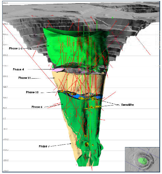
Note: Pit base and underground operations are shown as at end January 2015. Grey = pit design. Drill hole trace are coded by drill hole type, green = RC, red = core. Elevation is as labelled (50 m spacing). Kimberlite phases are labeled as described in Section 7.3.1
| March 2015 | Page 7-9 |
| Ekati Diamond Mine Northwest Territories, Canada NI 43-101 Technical Report |
| 7.3.2 | Koala North |
The Koala North kimberlite pipe is a small body (approximately 0.5 hectares surface area, 90 m by 50 m in surface diameter) situated directly between the Panda and Koala pipes.
Geological logging of drill holes at Koala North indicates that it is composed exclusively of VK, with an olivine-poor variety being the dominant kimberlite lithology. The VK is generally dark grey and contains 10 to 30% glassy pale green fine-grained partially serpentinised olivine macrocrysts and 5 to 10% pebble-sized, sub-rounded biotite granite, autolithic kimberlite, and mudstone xenoliths. These occur in a matrix of grey to black, very fine grained, serpentine-group minerals. Centimetre-scale bedding is moderately well developed. The VK occasionally contains both fresh and thermally-altered wood fragments.
A dark brown to black serpentinised mudstone occurs as rare discontinuous boulders to blocks a few metres in size. This material is poorly compacted, laminated and fissile, generally lacking olivine and other kimberlitic components. Non-kimberlitic, possibly Phanerozoic friable fine sand occurs as erratic blocks in the form of siltstone and conglomerate.
The intersections of the sedimentary material are several metres thick and appear to be remnants of quartz sandstone and lesser conglomerate consisting of pebble sized well-rounded varieties of brown and black mud/siltstones in an extensively well-sorted white quartz sand matrix. The matrix appears weakly cemented by less than 1% calcite. The sand/silt units are interpreted to be xenolithic blocks of lithified material that were deposited by fluvial processes and later reworked by erosional and eruptive events.
A wedge of moderately strong VK occurs at depth along the northern and eastern margins of the pipe. This unit is distinguished by 15 to 35% pale yellowish-green 1 to 6 mm broken to sub-rounded olivine macrocrysts and well-formed 1 to 4 mm pellets of macrocrysts, autoliths and xenoliths. Xenolithic components include mudstones, well-rounded unaltered granite cobbles and rare carbonized black wood fragments. The matrix is grey to black and is rarely serpentinised.
Modelling work undertaken to date indicates that Koala North has a roughly circular outline in plan view and a steep-sided inverted cone morphology that tapers inwards at 85º to 90º. Figure 7-5 is a plan view and Figure 7-6 is an isometric view of Koala North. Near surface (above 390 m amsl), the pipe flares to the southeast with a shallow dip, while at depth (below 250 m amsl), the pipe is interpreted to dip to the northwest. These changes in pipe morphology are likely fault controlled.
| March 2015 | Page 7-10 |
| Ekati Diamond Mine Northwest Territories, Canada NI 43-101 Technical Report |
Figure 7-5:Surface Plan, Koala North
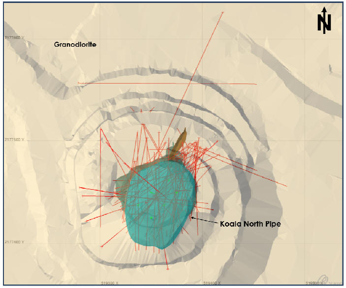
Note: Data used are as at end January 2015. Grey = pit design. Drill hole trace are coded by drill hole type, green = RC, red = core. Blue = Koala North Pipe. Grid is as labelled (100 x 100 m).
| March 2015 | Page 7-11 |
| Ekati Diamond Mine Northwest Territories, Canada NI 43-101 Technical Report |
Figure 7-6:Isometric CrossSection, Koala North
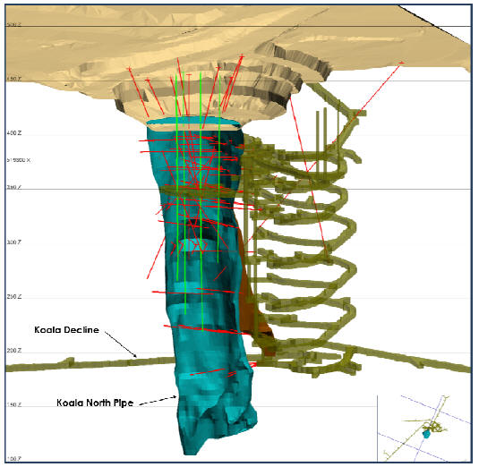
Note: Kimberlite triangulation is original model, shown against current topography and glory hole. Data used are as at end January, 2015; section is looking north (northing 7177435), and no incline is used. Brown = final pit and glory hole, grey = underground mine workings, drill hole trace green = RC, red = core. Green = Koala North kimberlite pipe. Elevation is as labelled (50 m spacing).
| March 2015 | Page 7-12 |
| Ekati Diamond Mine Northwest Territories, Canada NI 43-101 Technical Report |
| 7.3.3 | Fox |
The Fox kimberlite pipe covers an area of 17 ha at surface (500 m by 435 m) and is situated approximately 9 km southwest of the Koala pipe. The Fox pipe is hosted by granodiorite of the Koala Batholith.
The Fox pipe consists of two major domains: the crater and diatreme facies, respectively. The approximate crater/diatreme geological boundary occurs at an elevation of 300 to 315 m amsl; the planned run-of-mine material is entirely contained within the diatreme zone. Large rafted blocks of granite are entrained internally throughout the pipe.
The crater is dominated by mud-rich RVK. This kimberlite is massively to crudely bedded, and contains variable amounts of fine- to medium- grained altered olivine macrocrysts and scattered small mudstone clasts set in a very fine-grained muddy to silty matrix. Large rafts of broken xenolithic material occur at the base of the crater domain.
The Fox diatreme can be categorised into four main material types:
| • | Tuffisitic kimberlite breccia (TKB); | |
| • | Tuffisitic kimberlite (TK); | |
| • | Volcaniclastic kimberlite (VK); | |
| • | Granite or granite-rich zones. |
TKB is distinctly different from kimberlites in any of the other development pipes at Ekati. It is characterised by a massive texture, high in-situ granite content (mostly small altered clasts), relatively high olivine content and a matrix dominated by variably clay-altered serpentine (as opposed to the clastic silt/mud that dominates the VK and RVK varieties). Granite is highly fragmented and characteristically includes 30%, small (less than 1 cm) microxenoliths or xenocrysts of feldspar and biotite derived from disaggregation of the granite. All olivine is pervasively altered to serpentine. Several varieties of TKB have been identified.
TK is texturally similar to TKB but is characterised by a relatively fine-grain size with respect to olivine, xenocrysts and xenoliths. Granite occurs mostly as fine (less than 1 cm) altered fragments with relatively minor, scattered larger xenoliths. Xenoliths exceeding 5 cm are rare. Clay content within TK appears to be intermediate between those in VK (high) and TKB (moderate).
| March 2015 | Page 7-13 |
| Ekati Diamond Mine Northwest Territories, Canada NI 43-101 Technical Report |
VK is a volumetrically small component mostly associated with the contact zones and granite breccia zones in the lower part of the open pit. VK is characterised by a dark silty to muddy, typically friable matrix with varying amounts of fine- to medium-grained altered olivine. Based on core logging and comparison with similar rock types of other Ekati kimberlite pipes, the clay content of VK is expected to be high. The xenolith content of VK is variable but generally low or very low. This is particularly true of xenoliths exceeding 5 cm, which are rare (on average 1 every 5 m in drill core) and xenoliths greater than 10 cm, which are extremely uncommon. Microxenoliths comprise approximately 15% of VK on average. In contrast with TK and TKB, small xenoliths (less than 5 cm) within VK are often not significantly altered. All larger xenoliths (greater than 5 cm) are fresh.
Internal granite occurs as evenly distributed small, commonly altered fragments within kimberlite (1 mm to 10 cm) and as large fresh xenolith blocks (20 cm to approximately 20 m in size). The latter are not evenly distributed and are concentrated primarily in a granite-dominated breccia zones occupying the lower portion of the open pit. They are also prevalent at the margins of the diatreme, close to the wall-rock contacts.
Modelling work undertaken to date indicates that the Fox pipe has a roughly square shape in plan view and a steep-sided inverted cone morphology that tapers inwards at 70° to 75°. Figure 7-7 is a plan view, and Figure 7-8 is an isometric view of the Fox kimberlite. The pipe flares to the northeast at 200 m amsl, resulting in a large embayment at this elevation.
| March 2015 | Page 7-14 |
| Ekati Diamond Mine Northwest Territories, Canada NI 43-101 Technical Report |
Figure 7-7:Surface Plan, Fox Pipe
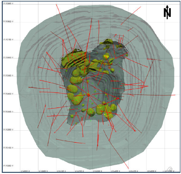
Note: Data used are as at end of open pit mining operations. Colour key: dark grey = TK, yellow = xenoliths, light grey = pit outline as at end of pit life (May 2014). Drill hole trace colours: red = DDH, green = RC. Grid is as labelled (100 x 100 m).
| March 2015 | Page 7-15 |
| Ekati Diamond Mine Northwest Territories, Canada NI 43-101 Technical Report |
Figure 7-8:Isometric Cross-Section, Fox Pipe
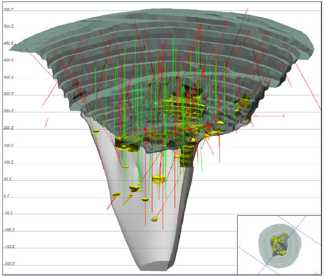
Note: Figure looks northwest (azimuth 302°) with a slight incline (-12°), inset picture shows section line. Data used are as at end January 2015. Colour key: light grey = TK, yellow = xenoliths, dark grey = final pit outline (end May 2014). Elevation is as labelled (50 m spacing). Drill hole trace colours: red = DDH, green = RC.
| March 2015 | Page 7-16 |
| Ekati Diamond Mine Northwest Territories, Canada NI 43-101 Technical Report |
| 7.3.4 | Misery |
The Misery kimberlite complex is located in the southeastern portion of the Ekati main claim block, 30 km from the Ekati production plant and 7 km northeast of the Diavik diamond mine. Misery Main is the largest pipe in this cluster of six main known kimberlite bodies (Main pipe, South pipe, Southwest Extension, Southeast Complex, Northeast pipe and East dyke) and several small dykes and other intrusive bodies in the area.
The kimberlites were emplaced at approximately 56 Ma at the contact between Archean biotite schist (meta-greywacke) and two-mica granite when the area was overlain by poorly consolidated mudstones, siltstones and shale. These rocks are found as xenoliths in varying abundances and relative proportions throughout the kimberlites; some of the kimberlites additionally comprise varying amounts of disaggregated mud as a matrix component. Re-sedimented volcaniclastic kimberlite (RVK) and coherent kimberlite (CK) are the dominant textural varieties of kimberlite found in the complex; pyroclastic kimberlite (PK) is less common. Kimberlite–wall rock contacts are typically sharp and readily identified; the country rock surrounding the bodies is weakly brecciated or un-brecciated.
Misery Main
Misery Main is a small steep-sided pipe with a pre-mining surface expression of approximately 90 m by 175 m (1.5 ha). The pipe is infilled predominantly with RVK ranging from dark, mud-rich to coarse grained, very olivine-rich material. Variable amounts of carbonized wood, mudstone, siltstone, granite and biotite schist xenoliths, peridotitic and eclogitic garnet and altered peridotite xenoliths are present. In places, well defined, fine-scale bedding is evident, generally characterized by variations in the abundance and grain size of olivine. Bedding angles appear to be highly variable with both shallow and steeply dipping beds present. Minor fine-grained sedimentary material is also present.
Coarse- and fine-grained RVK varieties spatially occur together. Although a contact between these varieties is interpreted from grade, bulk density and moisture data, a geological hard boundary is not obvious and, likely, is a transitional lithological contact.
Figure 7-9 is a plan view, and Figure 7-10 is an isometric view of the Misery Main pipe and surrounding satellite bodies.
| March 2015 | Page 7-17 |
| Ekati Diamond Mine Northwest Territories, Canada NI 43-101 Technical Report |
Figure 7-9:Surface Plan,Misery Pipe
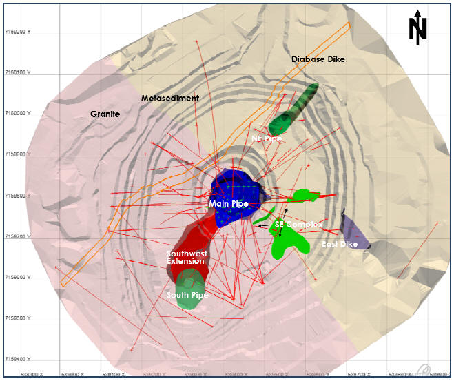
Note: Data used are as at end January 2015. Grid is as labelled (100 x 100 m).
| March 2015 | Page 7-18 |
| Ekati Diamond Mine Northwest Territories, Canada NI 43-101 Technical Report |
Figure 7-10:Isometric Cross-Section,Misery Pipe
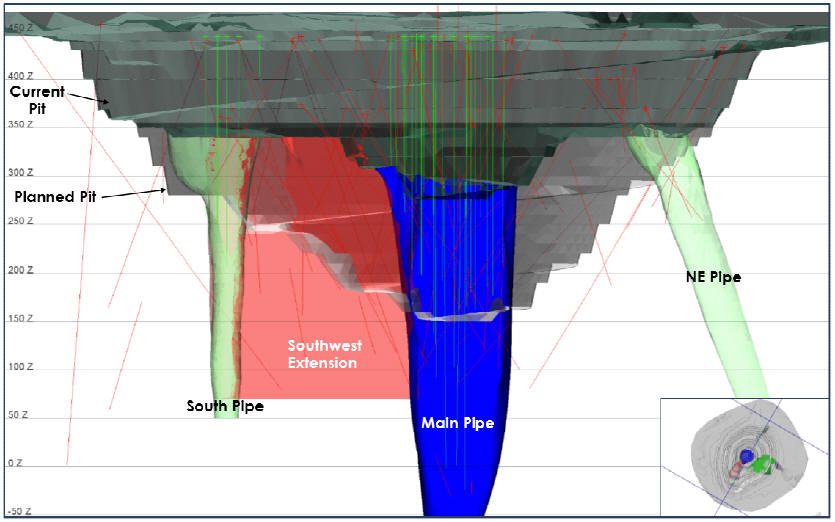
Note: section is looking northwest (296º) with a slight incline (-2º), inset picture shows section line. Red = Southwest Extension, blue = Main Pipe, green = South Pipe, dark grey = pit outline as of end January 2015, silver–grey = final pit design, drill hole trace: red = core hole, green = RC. Elevation is as labelled (50 m spacing).
| March 2015 | Page 7-19 |
| Ekati Diamond Mine Northwest Territories, Canada NI 43-101 Technical Report |
Misery South and Misery Southwest Extension
Mineral Services were retained to perform an updated Mineral Resource estimate for the Misery South and Misery Southwest Extension areas. Information from that work is summarized in this section.
Integration of new drilling information acquired in 2014 with existing data has resulted in revisions to previous model assumptions. The new data indicate that there is no support for a geological boundary between Misery South and Misery Southwest Extension. For the purposes of reporting Mineral Resources, however, a geographic boundary has been placed in the approximate location of the contact in the previous model and used to subdivide the internal geological domains. The boundary between the Misery Southwest Extension and the Misery Main pipe remains not well determined or understood. Figure 7-11 provides a section through the current model for Misery South and Misery Southwest Extension.
Due to the geological complexity observed in the Misery South and Misery Southwest Extension drill cores, the various kimberlite and country rock units have been composited into four geological domains for the purpose of three-dimensional modelling: domains K2, K5 and K7 constitute the main infill material within the Misery South and Misery Southwest Extension, and each consists mainly of kimberlite units KIMB2, KIMB5 and KIMB7, respectively.
KIMB2 is a dark brown, massive, very fine to fine grained variably mud- or olivine-rich RVK that is characterized by the variable presence of large sediment xenoliths of mainly grey–tan siltstone. KIMB5 (encompassing variants KIMB5A and KIMB5B) is dark grey, diffusely very thickly bedded, fine to medium grained and variably olivine-rich. Texturally, the majority of KIMB5A is classified as possible PK, whereas KIMB5B is assigned to RVK. KIMB7 (encompassing variants KIMB7A and KIMB7B) is grey-brown, variably bedded, fine to medium grained and variably olivine-rich. KIMB7A is well bedded and comprised entirely of olivine-rich and very olivine-rich RVK. KIMB7B is diffusely bedded or massive and comprised of less olivine-rich RVK and mud-rich RVK. Of the kimberlite units identified in Misery South and Misery Southwest Extension to date, KIMB7 is the most comparable to the main infill material in the Misery Main pipe.
| March 2015 | Page 7-20 |
| Ekati Diamond Mine Northwest Territories, Canada NI 43-101 Technical Report |
Figure 7-11: Three-DimensionalGeologicalModels ofMisery Main, South andSouthwestExtension
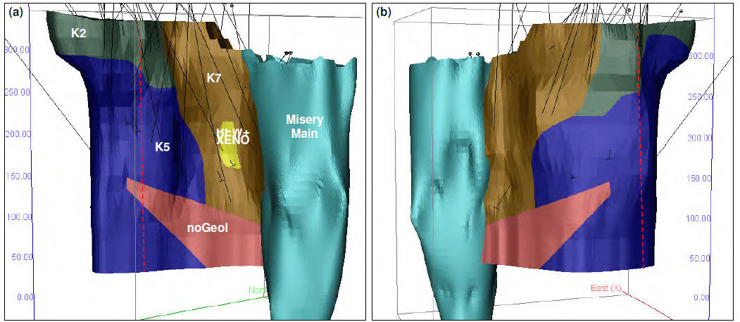
Note: Inclined views to the (a) northwest and (b) southeast of the Misery South and Misery Southwest Extension geological model showing internal geological domains K2 (green), K5 (dark blue), K7 (brown), RFW+XENO (yellow) and NoGeol (pink) in relation to Misery Main (light blue) and the traces of delineation drill holes. The position of the geographic divide between Misery South and Misery Southwest Extension is also shown (red vertical dashed line). Data used are current as at end January 2015.
| March 2015 | Page 7-21 |
| Ekati Diamond Mine Northwest Territories, Canada NI 43-101 Technical Report |
Large (> 1 m drill intercept) country rock xenoliths interpreted to occur within the body have been included in these domains. Each domain additionally contains minor amounts of uncorrelated kimberlite (denoted as “requires further work”, or RFW).
Domain RFW+XENO represents a zone in which RFW and country rock xenoliths appear to be concentrated, representing a greater degree of complexity and dilution than apparent in the surrounding K7 domain. The previous extent of the lower ‘no geology’ zone has been reduced in the updated model; the significantly reduced upper ‘no geology’ zone has been included in the K7 domain.
Misery Northeast
Misery Northeast is a small steep-sided pipe that plunges steeply towards the northeast (Figure 7-12a). The pipe volume and morphology are poorly constrained by drilling to date. A single drill hole through the center of the pipe intersected a variably olivine-rich RVK unit referred to as KIMB8, as well as several large mudstone xenoliths and thin intervals of coherent/pyroclastic kimberlite. The Misery Northeast pipe infill has been modelled as a single domain (K8).
Misery Southeast Complex
The limited information available for Misery Southeast suggests a pipe and sheet complex comprised of VK and CK. The CK is texturally similar to that observed in the other satellite intrusions and appears to occur as a series of sub-horizontal and steeply dipping sheets likely emplaced prior to the pipe. No internal domains have been differentiated in Misery Southeast to date (Figure 7-12b).
The remaining bodies, including the East dyke, appear to consist entirely of macrocrystic coherent kimberlite and are interpreted to be small precursor intrusions. Available evidence suggests that the coherent bodies form dykes and small plugs that appear to trend outwards from a focal point co-incident with the Misery Main pipe. None of the bodies transect Misery Main or Misery South/Misery Southwest Extension, suggesting that they probably pre-date these pipes.
| March 2015 | Page 7-22 |
| Ekati Diamond Mine Northwest Territories, Canada NI 43-101 Technical Report |
Figure 7-12: Three-DimensionalGeologicalModels of (a)MiseryNortheast and (b)SoutheastComplex
Note: Inclined views towards the northwest of (a) Misery Northeast (K8 domain) showing the delineation diamond drill holes used to constrain the geological model, and (b) the Misery Southeast Complex geological model showing the delineation drill holes relevant to the model. Data used are current as at end January 2015.
| March 2015 | Page 7-23 |
| Ekati Diamond Mine Northwest Territories, Canada NI 43-101 Technical Report |
| 7.3.5 | Pigeon |
The Pigeon kimberlite pipe is located 5 km northwest of the Koala pipe. The Pigeon kimberlite occurs along a regional, transitional lithological contact between syn-tectonic granitoid rocks and Yellowknife Supergroup metasedimentary rocks that run southeast-northwest orientation (Kjarsgaard, 2001). Two parallel diabase dykes intrude in a north–south direction adjacent to the Pigeon pipe. The pipe is overlain by anomalously thick (up to 30 m) rolling ground moraine, composed of boulders, gravel with lesser sand and silt.
Pigeon is estimated at approximately 3.5 ha at surface (275 m by 140 m) and is a steep-sided pipe. It is oblong along a northwest to southeast axis and is referred to as having a south lobe and north lobe.
The Pigeon pipe contains four kimberlitic domains:
| • | Upper Crater (UC) domain: a thick sequence of mud-rich, variably olivine-rich, lithic RVK; | |
| • | Lower Crater (LC) domain: texturally-complex VK characterised by variable alteration and a high proportion of granitoid country rock xenoliths with minor amounts of mud and shale; | |
| • | Magmatic domain (MK): texturally complex rocks with both magmatic and volcaniclastic textures and variable dilution with common granitoids and extremely rare mud and shale. In general it is a massive MK consisting of olivine macrocrysts and phenocrysts in a dark, very fine grained crystalline matrix; | |
| • | Intrusive South Crater (SC) domain: located along the southernmost portion of the pipe and are characterised by massive, fine grained autolithic MK with low abundance of olivine macrocrysts and with conspicuous fragments of diabase xenoliths. This unit was not sampled for grade but it is considered to have low diamond-carrying capacity due to unfavourable geochemistry and microdiamond results. |
There is a distinct but variable zone of wall rock xenoliths extending from the base of the Upper Crater domain to the top of the Magmatic domain.
Figure 7-13 is a deposit plan view, and Figure 7-14 is an isometric view of the Pigeon kimberlite pipe illustrating the morphology of the deposit.
| March 2015 | Page 7-24 |
| Ekati Diamond Mine Northwest Territories, Canada NI 43-101 Technical Report |
Figure 7-13: Plan View,Pigeon Pipe
Note: Geological model is current to end January 2015. Grid is as labelled (100 x 100 m). Wall rock contacts change gradually; the black dashed line represents the change from almost 100% metasediments to granite mixed with metasediment.
| March 2015 | Page 7-25 |
| Ekati Diamond Mine Northwest Territories, Canada NI 43-101 Technical Report |
Figure 7-14:Isometric CrossSection,Pigeon Pipe
Note: Geological model, pit design and drilling are current to end January 2015. The section looks northeast (36º) with a slight incline (-15º). Grey = pit outline. Drill hole traces are coded by drill hole type, green = RC, red = core. Green = Upper Crater, purple = Lower Crater, pale blue = Magmatic Kimberlite, yellow = Xenoliths. Elevation is as labelled (50 m spacing).
| March 2015 | Page 7-26 |
| Ekati Diamond Mine Northwest Territories, Canada NI 43-101 Technical Report |
| 7.3.6 | Sable |
The Sable kimberlite pipe is located approximately 16 km northeast of the Ekati process plant complex.
The Sable pipe is hosted by Archean two-mica granite. Linear magnetic features have been observed under and adjacent to Sable Lake and are interpreted to be mafic dykes. The pipe lies under Sable Lake and is covered by water and boulder- and gravel-dominated glacial till overburden.
The pipe sub-surface area is approximately 2 ha and surface dimensions of 180 m by 140 m. It has an irregular triangular outline in plan view and a steep-sided vase shape; the pipe at approximately 200 m below surface is wider (2.4 ha) than the top or bottom of the model.
The Sable kimberlite contains two main VK lithologies:
| • | Olivine-rich RVK (ORVK): massive, matrix-supported, kimberlite with less than 30% fine- to medium-grained olivine, scattered mudstone clasts, rare small granite xenoliths and common wood fragments set in a dark, fine-grained matrix dominated by mud; | |
| • | Very olivine-rich VK (vOVK): clast-supported, very olivine-rich VK with common mudstone clasts, scattered granite xenoliths and carbonised wood fragments. Olivine content commonly exceeds 50% and due to the significantly lower proportion of muddy matrix material, the kimberlite is generally pale to dark greenish-brown/grey in colour. |
Kimberlite intersections have been assigned to two major domains based on drill core observations. An Upper Crater domain is characterised by a significant proportion of RVK. This kimberlite type generally dominates the upper portion of the kimberlite with increasing amounts of interbedded pale vOVK occurring with depth. The Lower Crater domain is dominated by vOVK, with the presence of scattered large (4 to 15 cm) granite xenoliths. The domain boundary is currently defined at the point below which matrix supported ORVK becomes an insignificant component.
Figure 7-15 is a plan view and Figure 7-16 is an isometric view of the Sable kimberlite pipe.
| March 2015 | Page 7-27 |
| Ekati Diamond Mine Northwest Territories, Canada NI 43-101 Technical Report |
Figure 7-15: Plan View, Sable Pipe
Note: Data used are current to end January 2015. Grid is as labelled (100 x 100 m). Wall rock is predominantly two-mica granite.
| March 2015 | Page 7-28 |
| Ekati Diamond Mine Northwest Territories, Canada NI 43-101 Technical Report |
Figure 7-16:Isometric Cross-Section, Sable Pipe
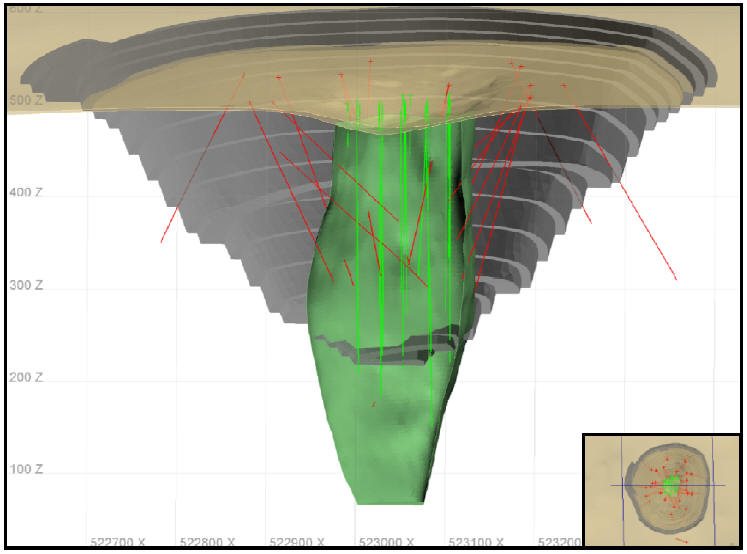
Note: Data used are as at end January 2015. Section is looking north (northing 7192970) with a slight incline (-11º). Brown = layer of overburden, grey = pit design, green = Sable Pipe. Drill hole traces are coded by drill hole type, green = RC, red = core. Elevation is as labelled (100 m spacing).
| March 2015 | Page 7-29 |
| Ekati Diamond Mine Northwest Territories, Canada NI 43-101 Technical Report |
| 7.3.7 | Jay |
The Jay kimberlite pipe is located in the southeastern corner of the property, about 25 km southeast of the Ekati main camp, and about 7 km north–northeast of the Misery Main pipe.
The Jay pipe is hosted within granitic rocks, ranging from granite to granodiorite in composition. A regional contact with meta-sedimentary rocks occurs to the west, and a diabase dyke trending approximately east–west occurs to the north of the pipe. Regional structures interpreted from geophysics extend east–west to the north of Jay and north–south to the west of Jay. The east–west structure to the north of Jay is partly associated with the diabase dyke; however, other zones of increased jointing have also been recognised in two core holes. The north–south structure is associated with the metasediment–granite contact and re-occurs throughout the 80 m drilled intersection of metasediments.
The pipe is under Lac du Sauvage, overlain by about 30 m of water and 5 to 10 m of overburden.
The plan surface area of Jay is approximately 13 ha, and it has an extent of 375 m by 350 m. Jay has a roughly circular outline in plan view and a steep-sided vase shape. The sides of the pipe are interpreted to be roughly planar with minor concavities and bulges. The shape, particularly the north side, is believed to be coincident with geological structures.
The pipe is divided into the following three domains:
| • | Resedimented volcaniclastic kimberlite (RVK): uppermost 110 to 170 m in stratigraphic thickness. Small-scale chaotic bedding is present which is defined by waves of silty to sandy laminates, and variations in olivine abundance. Variable amounts and sizes of black, pale grey, blue-grey, blue-green, brown, and tan coloured mudstones and siltstone xenoliths are present. In core intersections, the RVK domain is comprised of repeating, large-scale graded mega-beds defined by mud, breccia, and olivine content. The upper portion of the mega-beds is composed of olivine-poor, mud- and clay-rich unconsolidated mudstone to RVK. Small-scale bedding is present but is very-fine grained. Rare shale breccia is present; | |
| • | Transitional Kimberlite (MIX): 30 to 70 m thick package of interbedded RVK and volcaniclastic kimberlite (VK) material of varying degrees of alteration. The transition from RVK to MIX is indistinct and is marked by the appearance of small interbeds of fresh to highly altered, dark to pale coloured VK; |
| March 2015 | Page 7-30 |
| Ekati Diamond Mine Northwest Territories, Canada NI 43-101 Technical Report |
| • | PVK: Primarily olivine-rich, competent, grey-blue to green PVK with partially altered olivine set in a serpentinised matrix. The upper contact of the VK domain is marked by the absence of RVK and presence of highly-altered, pale-coloured VK material. Small, irregularly shaped, mudstone and granitic xenoliths are present, but decrease in abundance with depth. |
These domains are sub-horizontal and are interpreted to extend the width of the pipe. Boundaries between the domains are transitional in nature.
Figure 7-17 is a plan view, and Figure 7-18 is an isometric view of the Jay kimberlite pipe.
| March 2015 | Page 7-31 |
| Ekati Diamond Mine Northwest Territories, Canada NI 43-101 Technical Report |
Figure 7-17: Plan View, Jay Pipe
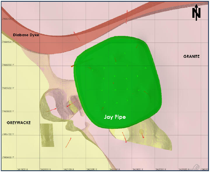
Note: Data are as at end January 2015. Grid is as labelled (50 x 50 m).
| March 2015 | Page 7-32 |
| Ekati Diamond Mine Northwest Territories, Canada NI 43-101 Technical Report |
Figure 7-18:Isometric Cross-Section, Jay Pipe
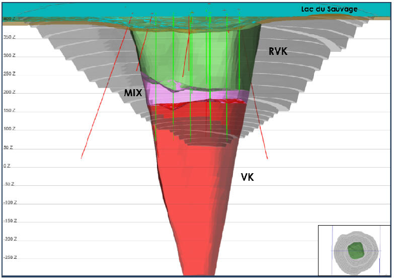
Note: Data are as at end January 2015. Section is looking north (northing 7195925) with a slight incline (-9º). Colour key: red = VK, pink = mix zone (RVK and VK), green = RVK, grey = final pit design, blue = water (Lac du Sauvage). Drill hole traces are coded by drill hole type: black = RC, red = core. Elevation is as labelled (100 m spacing).
| March 2015 | Page 7-33 |
| Ekati Diamond Mine Northwest Territories, Canada NI 43-101 Technical Report |
| 7.3.8 | Lynx |
The Lynx kimberlite pipe occurs in the southeastern portion of the Ekati property about 30 km from the Ekati main site facilities and approximately 3 km to the southwest of the Misery pipe.
The Lynx pipe is hosted by two-mica granite. The area immediately surrounding the Lynx pipe is transected by numerous probable diabase dykes, one of which runs very close to the northwestern margin of the pipe. The pipe lies within a small lake and is covered by approximately 18 to 30 m of water as well as boulder- and gravel-dominated glacial till that is 10 to 17 m thick.
The Lynx pipe has an elongated, steep-sided pipe morphology. In plan, the pipe is roughly tear-shaped (approximately 0.7 ha surface area, 150 m by 65 m) with the narrow portion of the pipe extending towards the west. The available drilling data suggest that the more voluminous eastern portion of the pipe tapers inwards sharply.
The pipe is divided into an upper Crater phase and lower Volcaniclastic phase. Drilling undertaken to date suggests that the volcaniclastic phase forms a steeply dipping wedge underlying the crater phase, and extends up into the eastern portion of the pipe. These phases have been defined as separate geological domains.
The Crater phase is dominated by olivine-rich RVK with 15 to 50% partially altered to fresh medium- to coarse-grained olivine macrocrysts set in a dark, mud-like matrix. Also present are minor amounts of small (generally less than 2 to 3 cm) grey to black mudstone clasts; between 1 and 3% rounded, fresh granite xenoliths ranging from approximately 1 to 10 cm; and occasional wood fragments. Lesser amounts of olivine-poor RVK (similar to above, but with less than 15% olivine) and minor interbedded epiclastic kimberlite are also present.
The Volcaniclastic phase consists of very olivine-rich PVK which contains between 40% and 70% coarse-grained, fresh to altered, olivine macrocrysts set in a microcrystalline, serpentine-dominated matrix. Other components include relatively abundant rimmed magma clasts, autoliths of RVK (1 to 5%), and common granite xenoliths (5 to 15%).
Figure 7-19 is a plan view and Figure 7-20 is an isometric view of the Lynx kimberlite pipe.
| March 2015 | Page 7-34 |
| Ekati Diamond Mine Northwest Territories, Canada NI 43-101 Technical Report |
Figure 7-19: Plan View, Lynx Pipe

Note: Data used are current to end January 2015. Grey = pit design. Drill hole traces are coded by drill hole type: green = RC, red = core. Green = Lynx Pipe. Grid is as labelled (50 x 50 m).
| March 2015 | Page 7-35 |
| Ekati Diamond Mine Northwest Territories, Canada NI 43-101 Technical Report |
Figure 7-20:Isometric Cross-Section, Lynx Pipe
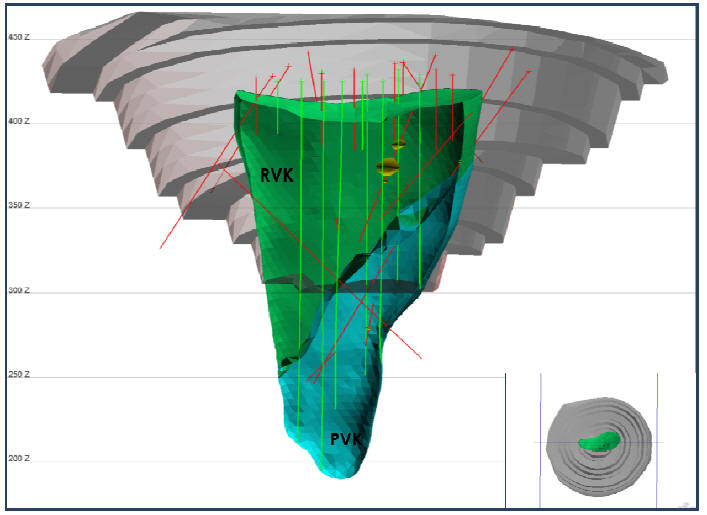
Note: Data used are current to end January 2015. Section is looking north (northing 7158110) with a slight incline (-6º). Brown = layer of overburden, grey = pit design. Drill hole traces are coded by drill hole type, green = RC, red = core. Green = RVK, blue = PVK. Elevation is as labelled (50 m spacing).
| March 2015 | Page 7-36 |
| Ekati Diamond Mine Northwest Territories, Canada NI 43-101 Technical Report |
| 7.4 | Mineralogy |
Ekati kimberlite is predominately volcaniclastic and epiclastic material. The mineralogy is relatively simple with olivine and serpentine comprising approximately 60–70% of the rock. The following summary of the typical mineralogy is primarily based on studies completed at Panda and Koala:
• | Serpentine – Mg3Si2O5(OH)4: Serpentine typically occurs as very fine-grained (<0.01 mm), grey or brown, massive to acicular aggregates in the fine-grained kimberlite matrix. It is also a common alteration product of olivine (see below); | |
| • | Olivine – (Mg,Fe)2SiO4: Olivine is typically highly fractured and varies in size from 0.1 mm to as large as 20 mm in diameter. In mud rich RVK, olivine may be altered to serpentine. Electron microprobe analysis of olivine from kimberlite shows these to be forsteritic (MgSiO4) in composition, with MgO contents placing these in the Fo90 to Fo94 range. Olivine is the primary host of the Ni found in kimberlites (typically contains between 0.2 and 0.3 wt% Ni); | |
| • | Oxides: The oxides within the kimberlite are found within the fine-grained matrix and are approximately 1 to 10 µm in diameter. They are usually minerals that belong to the perovskite, ilmenite and various spinel groups and contain varying amounts of Ca, Ti, Mg, Fe, Al, and Mg; | |
• | Phlogopite – K2Mg6Si6Al2O20(OH)4: Phlogopite is the only primary mica mineral found within the kimberlite. The crystals are long thin tabular and commonly kinked. Concentrations are typically in less than 5%. When altered, phlogopite commonly breaks down to clays and chlorite; | |
| • | Pyroxene – (Mg,Ca,Fe)2Si2O6: Pyroxene within the kimberlite is estimated at approximately 5% and occurs as scattered sub-rounded to sub-angular crystals. Two varieties may occur, chrome diopside (a Ca and Mg-rich clinopyroxene) and enstatite (a Ca-poor, Mg-rich orthopyroxene). Cr-diopside is characterised by a distinctive apple-green colour and is by far the dominant pyroxene in kimberlite. Enstatite is pale green, and alters easily to serpentine and other clay minerals; | |
| • | Garnet – (Mg,Fe,Ca)3(Al,Cr)2Si3O6: Garnet is one of the key mineral indicators for kimberlite but it makes up very low percentage of samples usually less than 5%. It occurs as highly fractured grains with a wide range in colour including red, purple, pink, orange and colourless varieties. The garnets may be partially to completely altered, and most have kelyphitic rims as a product of the alteration. The majority of the garnets within the Koala kimberlite are Mg-rich Cr-pyropes; |
| March 2015 | Page 7-37 |
| Ekati Diamond Mine Northwest Territories, Canada NI 43-101 Technical Report |
| • | Calcite – CaCO3: Calcite is one of the primary components of the groundmass material within the pelletal and juvenile lapilli found within the kimberlite. Typical concentrations of calcite vary from 2.5 to 5.0 wt%; | |
| ||
| • | Wood: Kimberlites at Ekati typically contain fragments of wood that was incorporated into the pipe during deposition. The wood fragments identified are related to the redwood Sequoia and Metasequoia genera and are found relatively fresh and unmineralized. Fragments up to one metre size are common in Panda and Koala open pits but the size and abundance decrease with depth. | |
| ||
| • | Mud Xenoclasts: Depending on the lithological unit mud can make up a reasonable percentage of a given kimberlite unit. These xenoclasts range in size from millimetres to centimetres and are usually uniformly fine grained, dark grey to black in colour and can have portions made up of kimberlitic minerals such as olivine and serpentine but with the majority consisting of smectite, quartz and pyrite; | |
| ||
| • | Sulphide and Sulphate: Sulphide (and/or sulphate) minerals are typically restricted to the mud xenoclast phases and muddy matrix in kimberlite. They are present as very fine grained framboidal grains ranging in size from 0.5µm to 10 µm in diameter. Energy dispersive spectrometric analysis (EDS) indicates that the likely sulphate phase is gypsum or anhydrite. Comparative sulphide studies between mud xenoliths and the kimberlite ore, reveal that the latter had lower sulphide (0.21 wt%) and sulphate (0.14 wt%) content as compared with the former (2.54 wt% and 0.27 wt%, respectively); | |
| ||
| • | Clay Mineralogy: Clay is a dominant component of mud-rich RVK where it occurs both as an alteration product, and as fine-grained argillaceous material originally derived from surface sediments (mud) that were incorporated into the kimberlite. XRD analysis indicates that the clays are dominated by smectite-group minerals; | |
| ||
| • | Volatile Organic Compounds: During the 1996 Sable RC bulk sampling program, a hydrocarbon-based smell was detected emanating from collected kimberlite drill cuttings. Samples were obtained and sent to ALS Environmental for volatile organic compound (VOC) analyses. In 2001, additional samples were collected from drill core and sent to ALS Environmental. The analysis confirms the presence of hydrogen sulphide, methane, and carbon monoxide in headspace samples, in addition to benzene, toluene, and xylene. |
| 7.5 | Comments on Geological Setting and Mineralization |
| March 2015 | Page 7-38 |
| Ekati Diamond Mine Northwest Territories, Canada NI 43-101 Technical Report |
In the responsible QPs’ opinion, the geological understanding of the settings, lithologies, structural and alteration controls on kimberlite emplacement, and kimberlite continuity and geometry in the different pipes is sufficient to support estimation of Mineral Resources and Mineral Reserves.
| March 2015 | Page 7-39 |
| Ekati Diamond Mine Northwest Territories, Canada NI 43-101 Technical Report |
| 8.0 | DEPOSIT TYPES |
This section provides a generalised description of kimberlite diamond deposits, outlining the geological and mineralisation model that formed the basis for kimberlite exploration and evaluation work at Ekati. It is derived from a Mineral Services Canada memo to Dominion Diamond Corp. (Mineral Services Canada, 2013).
The primary source rocks for diamonds that are presently being mined worldwide are Group 1 and Group 2 kimberlites and lamproites (Levinson et al., 2002). Of these rocks, Group 1 kimberlites represent the vast majority of primary diamond deposits that are presently being worked, and the Ekati Diamond Mine is one such example.
Kimberlites are mantle-derived ultramafic magmas (>150 km depth) that transport diamonds together with the rocks from which the diamonds are directly derived (primarily peridotite and eclogite) to the earth’s surface (e.g. Mitchell, 1986; Mitchell 1995). They are considered to be hybrid magmas comprising a mixture of incompatible-element enriched melt (probably of carbonatitic composition) and ultramafic material from the lower lithosphere that is incorporated and partly assimilated into the magma (Russell et al., 2012).
The products of direct crystallisation of Group 1 kimberlite magma (referred to as coherent or magmatic kimberlite) are typically dominated by olivine set in a fine-grained matrix commonly rich in serpentine and/or carbonate as well as varying amounts of phlogopite, monticellite, melilite, perovskite and spinel (chromite to titanomagnetite) and a range of accessory minerals (Mitchell, 1995). While some olivine crystallises directly from the kimberlite magma on emplacement (to form phenocrysts), kimberlites generally include a significant mantle-derived (xenocrystic) olivine component that typically manifest as large (>1 mm) rounded crystals. In addition to olivine, kimberlites also commonly contain significant quantities of other mantle-derived minerals, the most common and important being garnet, Cr-diopside, chromite and ilmenite. These minerals, commonly referred to as indicator minerals, are important for kimberlite exploration and evaluation as they can be used both to find kimberlites (by tracing indicator minerals in surface samples) and to provide early indications of their potential to contain diamonds (Nowicki et al., 2007; Cookenboo and Grütter, 2010).
The texture and components observed in coherent kimberlites can be substantially modified by dilution with wall-rocks or surface sediments, as well as by sorting and elutriation (removal of fines) processes occurring in volcanic environments (Mitchell, 1986; Nowicki et al., 2008; Scott Smith and Smith, 2009).
| March 2015 | Page 8-1 |
| Ekati Diamond Mine Northwest Territories, Canada NI 43-101 Technical Report |
The emplacement of kimberlite at or just below the surface of the crust is influenced by many factors which include the following:
| • | Characteristics of the magma (volatile content, viscosity, crystal content, volume of magma, temperature etc.); | |
| • | Nature of the host rocks (i.e. unconsolidated mud vs. hard granite); | |
| • | The local structural setting; | |
| • | The local and regional stress field; | |
| • | The presence of water. |
Kimberlites at surface are manifested as either sheet-like intrusions (dykes or sills) or irregular shaped intrusions and volcanic pipes. The sheets and irregular intrusions are typically emplaced along pre-existing planes of weakness in the country rock, and do not involve explosive volcanic activity. The pipes are generated by explosive volcanic activity related to the degassing of magma, or the interaction of mama and water, or a combination of both these processes (e.g. Mitchell, 1986; Lorenz et al, 1999; Sparks et al, 2006).
Due to the wide range of settings for kimberlite emplacement, as well as varying properties of the kimberlite magma itself (most notably volatile content), kimberlite volcanoes can take a wide range of forms and be in-filled by a variety of deposit types (e.g. Field and Scott Smith, 1999). This range is illustrated schematically in Figure 8-1.
| March 2015 | Page 8-2 |
| Ekati Diamond Mine Northwest Territories, Canada NI 43-101 Technical Report |
Figure 8-1: Kimberlite Deposit Types and Forms
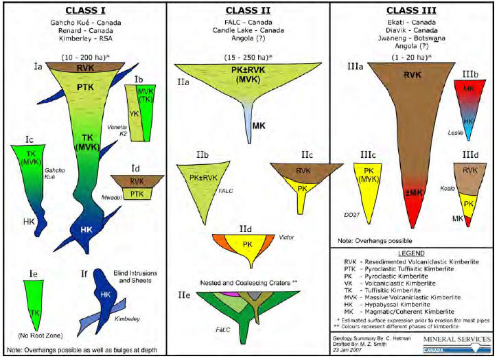
| March 2015 | Page 8-3 |
| Ekati Diamond Mine Northwest Territories, Canada NI 43-101 Technical Report |
Volcanic kimberlite bodies range in shape from steep-sided, carrot-shaped pipes (diatremes) to flared champagne-glass or even “pancake” like crater structures. While diatremes are often interpreted to generally be overlain by a flared crater zone, there are few instances where both zones are preserved (e.g. the Orapa kimberlite in Botswana; Fox kimberlite at Ekati). These volcanic structures are infilled by a very wide range of volcaniclastic kimberlite types, ranging from massive, minimally texturally modified pyroclastic kimberlite, to highly modified pyroclastic and resedimented volcaniclastic deposits that have been variably affected by dilution, sorting, and removal of fines (e.g. Field and Scott-Smith, 1999; Nowicki et al., 2004; Skinner and Marsh, 2004).
The Ekati kimberlites are primarily steep-sided volcanic pipes that are mostly filled with volcaniclastic material interpreted to be resedimented and lesser primary volcaniclastic (pyroclastic) kimberlite (Nowicki et al., 2004). While narrow hypabyssal kimberlite dykes are present, these are not volumetrically significant. These mostly appear to predate kimberlite and are commonly transected by the volcanic pipes. Coherent kimberlite is present in some pipes either as late stage intrusive material emplaced into volcaniclastic kimberlite (e.g. Koala), or as large pipe-filling bodies (e.g. Leslie; Grizzly), refer to Figure 8-1.
Kimberlites commonly show physical property contrasts with the rocks into which they are emplaced. As a result, in most cases, kimberlites generate geophysical anomalies that can be detected by airborne and ground geophysical surveys (e.g. Macnae, 1995). Properties that are most relevant in kimberlite exploration are magnetic susceptibility, electrical conductivity and specific gravity.
Diamonds also represent a xenocryst mineral within kimberlite as they are primarily formed and preserved in the deep lithospheric mantle (depths > ~150 km), generally hundreds of millions to billions of years before the emplacement of their kimberlite hosts (Gurney, 1989). The diamonds are “sampled” by the kimberlite magma and transported to surface together with the other mantle-derived minerals described above. Diamonds themselves occur in such low concentrations (even in economic kimberlites) that they are rarely useful for locating kimberlites and, following discovery, large samples are required in order to directly assess the diamond grade potential of a kimberlite (e.g. Rombouts, 1995; Dyck et al., 2004).
In general, diamonds can vary significantly within and between different kimberlite deposits in terms of total concentration (i.e. diamond grade in cpt), particle size distribution and physical characteristics (e.g. colour, shape, clarity and surface features). The value of each diamond, and hence the overall average value of any given diamond population, is governed by the size and physical characteristics of the stones.
| March 2015 | Page 8-4 |
| Ekati Diamond Mine Northwest Territories, Canada NI 43-101 Technical Report |
The overall concentration of diamonds in a kimberlite unit or domain is dependent on several factors (Nowicki et al., 2007), including:
| • | The extent to which the source magma has interacted with and sampled potentially diamondiferous deep lithospheric mantle; | |
| • | The diamond content of that mantle (diamonds are only present locally and under specific pressure temperature conditions in the mantle); | |
| • | The extent of resorbtion of diamond by the kimberlite magma during it ascent to surface and prior to solidification; | |
| • | Physical sorting and/or winnowing processes occurring during volcanic eruption and deposition; | |
| • | Dilution of the kimberlite with barren wall-rock material or surface sediment (in the case of crater deposits). |
At Ekati, the extent of mantle sampling, the degree of dilution by wall-rock and surface sediments and volcanic sorting processes are considered to be the main factors controlling variation in total diamond grade. The diamond size distribution characteristics are inherited from the original population of diamonds sampled from the mantle but can be affected by a number of secondary processes, including resorbtion and sorting during eruption and deposition of volcaniclastic kimberlite deposits.
The physical characteristics of the diamonds are largely inherited from the primary characteristics of the diamonds in their original mantle source rocks but can be affected by processes associated with kimberlite emplacement and eruption (e.g. Gurney et al., 2004). Most notable of these are:
| • | Formation of late stage coats of fibrous diamond either immediately prior to or at the early stages of kimberlite emplacement; | |
| • | Chemical dissolution (resorbtion) by the kimberlite magma resulting in features ranging from minor etching to complete dissolution of the diamonds; | |
| • | Physical breakage of the diamonds during turbulent and in some cases explosive emplacement processes. |
| 8.1 | Comment on Deposit Type |
In the opinion of the responsible QPs, the Ekati kimberlites are considered to be examples of a Group 1 kimberlite deposit and display most of the typical features of Group 1 kimberlite pipes. Based on this model, the exploration programs completed to date are appropriate to the mineralization style and setting.
| March 2015 | Page 8-5 |
| Ekati Diamond Mine Northwest Territories, Canada NI 43-101 Technical Report |
With reference to the generalised deposit model and characteristics of the mineralisation described in this section, the aim of the exploration and evaluation work documented in this Report is, and has been, to:
| 1. | Undertake indicator mineral sampling of surface materials (primarily esker and till deposits) to detect the presence and track down the location of kimberlite bodies; | |
| 2. | Implement airborne and ground-based magnetic, electromagnetic and gravity surveys to locate kimberlites; | |
| 3. | Drill test and adequately sample each body for petrography, indicator minerals and diamonds, and analyse and interpret the results from these samples to confirm the presence of kimberlite and support prioritisation of kimberlites for advanced evaluation work; | |
| 4. | Delineate and interpret the external and internal geology of prioritised deposits so that 3-D models can be produced which reliably represent each body; | |
| 5. | Evaluate prioritised kimberlites by means of bulk sampling and processing to recover diamonds for estimation of the grade and average diamond value of the main geological domains present. |
| March 2015 | Page 8-6 |
| Ekati Diamond Mine Northwest Territories, Canada NI 43-101 Technical Report |
| 9.0 | EXPLORATION |
This section contains a summary of the information on the exploration programs conducted that are described in Heimersson and Carlson (2013). The reader is referred to this earlier technical report for additional program details.
| 9.1 | Grids and Surveys |
The UTM Nad83 Zone 12N is the basis for all survey data. The digital elevation model (DEM) was interpolated from 1 m, 2 m and 5 m contour data from an airborne survey flown in 2002 by Eagle Mapping.
| 9.2 | Mapping |
| 9.2.1 | Surface Mapping |
Bedrock mapping of the Ekati property and surrounding area was undertaken by the Geological Survey of Canada between 1994 and 2001 (Thomason and Kerswill, 1994; Kjarsgaard et al., 1994a, b; Kjarsgaard et al., 1999; Kjarsgaard, 2001). The resultant maps were augmented and modified by Ekati geologists based on airborne magnetic data (e.g. Kirkley, 1994).
Helmstaedt (2002) undertook a detailed review, compilation, and interpretation of previously published and internal Ekati geological work in the area and integrated this with high-resolution aeromagnetic data to provide an updated bedrock map of the Ekati property. A simplified version of this map is presented in Figure 7-2 in Section 7.
A detailed geomorphology map (1:10,000) of glacial overburden material was compiled by Mr. Roger Thomas during 2000. A simplified version of this map is included as Figure 9-1. The geomorphology map was used in combination with field observations to interpret heavy mineral sampling results.
| 9.2.2 | Mine Mapping |
As each bench is exposed in the open pits, kimberlite/wall-rock and internal domain contacts are geologically mapped and surveyed. Specific geological information, such as olivine and granite content is collected as indicators of grade. Open pit wall mapping is done with a photogrammetry system. This allows large sections of wall to be photographed, and imported into Vulcan for processing of structural features.
| March 2015 | Page 9-1 |
| Ekati Diamond Mine Northwest Territories, Canada NI 43-101 Technical Report |
Figure 9-1: Simplified Geomorphology Map
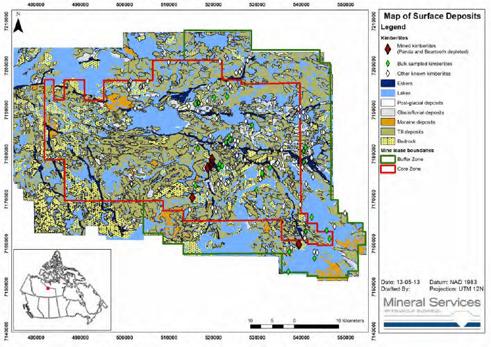
| March 2015 | Page 9-2 |
| Ekati Diamond Mine Northwest Territories, Canada NI 43-101 Technical Report |
During underground mining all major structures are mapped for geotechnical purposes as new levels are developed. This allows continuous updates of the fault and hydrological models and highlights any changes in discontinuity sets or rock competency. Within the kimberlite, development headings are visited regularly in order to maintain a record of kimberlite contacts, lithologies, physical properties, hydrology and relative grade.
| 9.3 | Geochemical Sampling |
The early stages of exploration for diamonds in the Northwest Territories consisted of territory-wide regional heavy mineral sampling from fluvial and glaciofluvial sediments on a scale of tens of kilometres (Fipke et al., 1995).
Property-wide (Core Zone and Buffer Zone) heavy mineral till sampling programs were carried out through the summers of 1990, 1991 and 1992, and nearly 6,000 till samples were collected. A total of approximately 15,000 till samples were taken across the Core Zone and Buffer Zone properties during the project exploration phase until exploration ceased in 2007.
Till samples were also used to prioritise airborne geophysical anomalies for drilling by collecting till samples at 250 m intervals along lines perpendicular to the dominant ice flow direction. The extent and chemistry of the indicator minerals dispersion trains were evaluated and used in combination with ground geophysical surveys to pinpoint drill targets.
| 9.4 | Geophysics |
| 9.4.1 | Airborne Geophysical Surveys |
Initial ground geophysical test surveys pinpointed the kimberlite target under Point Lake and prompted the flying of the entire property with helicopter-borne total field magnetics (TFM), electromagnetics (EM) and very low frequency electromagnetics (VLF). These programs were instrumental in detecting possible kimberlite pipes and in prioritising anomalies for diamond drilling. Table 9-1 summarizes the airborne programs completed on the Ekati property.
| March 2015 | Page 9-3 |
| Ekati Diamond Mine Northwest Territories, Canada NI 43-101 Technical Report |
Table 9-1: Airborne Geophysical Surveys
| Year | Program | Contractor | Details | Comment |
| 1991 to 1993 | Helicopter-borne EM, TFM and VLF surveys | DIGHEMV | Core Zone and Buffer Zone; 125 m line spacing; 30 m EM bird height. High-sensitivity caesium vapour magnetometer and VLF EM system. Magnetometer sensor was towed in a bird that was 15 m above the EM bird and 10 m below the helicopter | The majority of the significant kimberlite pipes in the Ekati mine plan were targeted in 1992 through to 1994 using these data |
| 1996 | TFM Minimag system | High Sense Geophysics | Nominal 20 m agl sensor height | Beartooth kimberlite was identified in 1996. Twenty additional kimberlites were drill confirmed in 1998. |
| 1999 to 2000 | Helicopter-borne EM, TFM and VLF surveys | V DIGHEMV | Magnetometer installed inside the EM bird, and with GPS navigation and positioning technology. 100 m line spacing and 25 m bird spacing. | Numerous kimberlite discoveries, of which the most significant attributable to the survey was the Lynx kimberlite |
| 2000 | Airborne gravity gradiometer | Sander Geophysics | Property-wide. | Gravity gradient anomalies typically reflected bedrock density contrasts as well as changes in overburden thickness. Known kimberlite pipes were mostly detected by the system and a few new anomalies were drilled and confirmed as kimberlite |
| 2006 | Falcon helicopter survey | Fugro | This system included a gravity gradiometer, a horizontal gradient pair of magnetometers, and high resolution Resolve EM coils. The survey line direction was north–south, except for a few smaller blocks which were flown using east–west oriented survey lines. The line spacing was 50 m. The nominal flying height was 60 m. A wide variety of geophysical images were produced including digital elevation model, total magnetic intensity, first vertical derivative of total magnetic intensity, vertical gravity gradient, Fourier gravity grids, and Resolve co-planar at various frequencies (in-phase and quadrature responses). | A number of targets were identified on the Central, Misery, Sable and other smaller blocks |
| March 2015 | Page 9-4 |
| Ekati Diamond Mine Northwest Territories, Canada NI 43-101 Technical Report |
| 9.4.2 | Ground Geophysical Surveys |
Ground geophysics including TFM, EM (mostly horizontal loop EM), gravity, ground penetrating radar, bathymetry, and limited seismic surveys were used to enable more precise kimberlite/non-kimberlite target discrimination and estimates of pipe size.
Ground geophysical surveys were completed on the majority of the drill targets and were completed on all of the pipes with reported Mineral Resource estimates.
The airborne and ground survey results were used in combination to improve target resolution while retaining the regional geophysical context.
| 9.4.3 | Core Hole Seismic Surveys |
A limited core hole seismic survey was conducted by Vibrometric in January 2005 for the Koala pipe volume. Two underground boreholes were used as a test for the geophysical delineation of kimberlites. The aim of the technique was to obtain the most spatial information about the Koala pipe geometry possible from drill holes.
However, a full seismic program was not completed; some of the planned survey holes were blocked at shallow depths, replacement of a lost receiver string in a hole directly impacted the program budget, and a desire to keep the drill program schedule on target contributed to the cancellation of the program.
The limited data proved that the borehole seismic technique can augment drill hole pierce points with seismically-determined pipe wall contacts. Additional evaluation in the use of core hole seismic surveys may be warranted for delineation of large pipes.
| 9.5 | Petrology, Mineralogy, and Research Studies |
Extensive geoscientific research work has been undertaken on the Ekati property and samples derived from the Ekati Project area. This research covers a wide range of topics and disciplines including kimberlite geology and petrology, mantle petrology, diamonds, geochronology, palynology and paleontology, resource estimation and mining.
Many of the key publications on the Ekati Project are found in the proceedings of the 8th and 9th International Kimberlite Conferences (Mitchell et al., 2004; Foley et al., 2009).
| March 2015 | Page 9-5 |
| Ekati Diamond Mine Northwest Territories, Canada NI 43-101 Technical Report |
| 9.6 | Exploration Potential |
There has been no exploration of the Ekati Project area for new kimberlites since 2007.
In most cases, individual kimberlite pipes were discovered based on coincident geophysical anomalies (magnetic and electromagnetic), with varying support from indicator mineral dispersion features. With the exception of a few outcropping kimberlites, initial discovery was via core drilling. In most cases, the discovery and initial exploration holes either drilled vertically from the frozen ice surface, or were angled and offset from the pipe, thereby generally providing initial pierce points. These, together with information on the pipe outline derived from geophysical data, provide an initial indication of the size of the body and supported first-pass estimates of potential kimberlite tonnages.
Kimberlite indicator mineral (KIM) compositions played a significant role in the successful exploration program that led to the development of the Ekati Mine. After discovery of the first kimberlite at Point Lake, which was followed by the subsequent identification of over 150 kimberlite bodies within the Ekati joint venture claim areas, the use of KIM geochemistry was adopted to prioritize likely high grade phases for follow-up bulk sampling and/or diamond drilling programs.
The method involves selecting representative samples, largely from diamond drill core material, and recovering a full suite of KIM’s from each sample, in such a way as to eliminate selection bias. The recovered grains (garnet, chromite, ilmenite, clinopyroxene) were analyzed by electron microprobe for major elements and by inductively-coupled plasma mass spectrometry (ICPMS) for nickel.
The Mantle Mapper software, developed by Mineral Services Pty Ltd., incorporates a scoring system that rates the potential for each of the two main diamond paragenesis found in kimberlites, i.e. peridotitic and eclogitic. The scoring system is based on the abundance of specific compositional varieties of garnet and chromite known to be associated with diamonds, refined by consideration of thermal information derived from nickel thermometry in conjunction with mantle geotherms based on peridotite xenolith and clinopyroxene thermobarometry. The Mantle Mapper data and scores were presented in an integrated format for final expert review and classification of each sample as A, B, C or D, reflecting the range from forecast high grade to essentially barren diamond content.
Concurrently with the KIM investigation, micro-diamonds were recovered from separate samples of the same kimberlite units sampled for KIMs. Recovered diamonds were weighed and described, and samples were ranked based on the abundance, size distribution and quality of diamonds. In addition, the kimberlite units were described petrographically in terms of a carefully defined set of criteria to provide information on diamond carrying capacity. These assessments, along with other relevant economic factors such as size, location and internal geology, were integrated into overall prospectivity assessments.
| March 2015 | Page 9-6 |
| Ekati Diamond Mine Northwest Territories, Canada NI 43-101 Technical Report |
Subsequent bulk sampling confirmed the validity of this approach. Of the kimberlite pipes that have been mined out (Panda, Fox open pit, and Beartooth) or are currently being mined (Koala, Koala North, and Misery), all economic units are categorised as A-rated or B-rated phases. A number of other pipes on the property with reported mineral resources (e.g. Pigeon, Lynx, Sable and Jay) also are uniformly categorised by strong KIM scores. Other pipes of interest with strong scores included Point Lake, Phoenix, Leslie, Cardinal, Gazelle, Impala and Pegasus. Small bulk samples taken at a few C and D rated kimberlites confirmed very low grades and validated the scoring system.
In addition to contributing to the early stage development of the Ekati Diamond Mine, the approach outlined in this contribution demonstrated at an early stage that some G10 type peridotitic garnets in mantle beneath the Slave Craton are too shallow to be in the diamond stability field, and that the peridotitic/eclogitic diamond source ratio in the kimberlites can vary widely.
Kimberlite pipes were selected for initial bulk sampling primarily based on microdiamond and indicator mineral analyses of the drill core or surface samples. In some cases, pipe perimeter outlines from ground geophysics provided a means for designing RC drill hole patterns to obtain representative initial bulk samples without the need for delineation core drilling.
The bulk samples (typically 50 to 200 tonnes) were processed in a 10 tonne per hour heavy media separation plant which was constructed on site.
Table 9-2 summarizes diamond drilling for pipes currently considered to possess exploration potential. Bulk sample results (RC drilling) and summary data of the exploration potential pipes are provided in Table 9-3. Figure 9-3 shows pipe locations.
Sample grades for the exploration pipes range from 0.1 cpt at Falcon East to 2.3 cpt at Piranha. The exploration potential of these pipes is influenced by a number of factors including diamond grade, diamond quality, internal kimberlite geology, pipe size, pipe location, setting and distance to infrastructure. Further work is warranted for a number of the exploration potential pipes, particularly the larger pipes and/or the kimberlites with high sample grades.
| March 2015 | Page 9-7 |
| Ekati Diamond Mine Northwest Territories, Canada NI 43-101 Technical Report |
Table 9-2: Pipes withExplorationPotential –DiamondDrilling
| Pipe Name | Joint Venture | Year | Number of Drill Holes | Drill Hole Type | Total Metres Drilled (m) | Maximum Hole Depth (m) |
| Point Lake | Core Zone | 1991 | 1 | NQ core | 280 | 198 |
| 2006 | 1 | NQ core | 401 | 283 | ||
| Subtotal | 2 | 681 | 481 | |||
| Phoenix | Core Zone | 1998 | 2 | NQ core | 675 | 262 |
| Subtotal | 2 | 675 | 262 | |||
| Leslie | Core Zone | 1995 | 2 | 6” core | 410 | 240 |
| 1996 | 10 | NQ core | 2,548 | 432 | ||
| Subtotal | 12 | 2,958 | 672 | |||
| Grizzly | Core Zone | 1992 | 1 | NQ core | 366 | 259 |
| Subtotal | 1 | 366 | 259 | |||
| Falcon | Core Zone | 1992 | 1 | NQ core | 268 | 188 |
| 1993 | 2 | NQ core | 523 | 255 | ||
| Subtotal | 3 | 791 | 443 | |||
| Falcon East | Core Zone | 1993 | 1 | NQ core | 275 | 195 |
| Subtotal | 1 | 275 | 195 | |||
| Falcon South | Core Zone | 1993 | 1 | NQ core | 327 | 231 |
| Subtotal | 1 | 327 | 231 | |||
| Cardinal | Buffer Zone | 1999 | 3 | NQ core | 407 | 104 |
| 2008 | 1 | NQ core | 251 | 251 | ||
| 2014 | 3 | NQ core | 664 | 260 | ||
| Subtotal | 7 | 1,322 | 615 | |||
| Gazelle | Buffer Zone | 1995 | 1 | NQ core | 328 | 231 |
| March 2015 | Page 9-8 |
| Ekati Diamond Mine Northwest Territories, Canada NI 43-101 Technical Report |
| 1997 | 1 | NQ core | 400 | 283 | ||
| Subtotal | 2 | 728 | 514 | |||
| Piranha | Buffer Zone | 1997 | 9 | NQ core | 1,621 | 264 |
| Subtotal | 9 | 1,621 | 264 | |||
| Impala | Buffer Zone | 2001 | 1 | NQ core | 240 | 184 |
| Subtotal | 1 | 240 | 184 | |||
| Pegasus | Buffer Zone | 2000 | 1 | NQ core | 194 | 137 |
| 2001 | 3 | NQ core | 328 | 119 | ||
| Subtotal | 4 | 522 | 256 |
| March 2015 | Page 9-9 |
| Ekati Diamond Mine Northwest Territories, Canada NI 43-101 Technical Report |
Table 9-2: Pipes withExplorationPotential –ReverseCirculationDrilling
| Pipe | Joint Venture | Size (ha) | Sample Year | Sample Type | Est. Dry Tonnes | Total Carats | Sample Grade (cpt) | De-grit Screen (mm) |
| Point Lake | Core Zone | 13.0 | 1992 | 15 cm RC | 160.0 | 101.0 | 0.6 | 1 |
| 2006 | 35 cm RC | 108.9 | 68.2 | 0.6 | 1 | |||
| Subtotal | 268.9 | 169.2 | 0.6 | 1 | ||||
| Phoenix | Core Zone | 1.4 | 1992 | 15 cm RC | 8.3 | 15.1 | 1.8 | 1 |
| 1999 | 35 cm RC | 106.1 | 149.2 | 1.4 | 1 | |||
| Subtotal | 114.4 | 164.4 | 1.4 | 1 | ||||
| Leslie | Core Zone | 4.0 | 1993 | 27 cm RC | 152.0 | 61.7 | 0.4 | 1 |
| 1995 | 27–31 cm RC | 679.5 | 223.6 | 0.3 | 0.5 | |||
| Subtotal | 831.5 | 285.3 | 0.3 | 0.5 to 1 | ||||
| Grizzly | Core Zone | 16.0 | 1993 | 27 cm RC | 20.2 | 18.0 | 0.9 | 1 |
| 1995 | 31 cm RC | 139.0 | 66.6 | 0.5 | 0.5 | |||
| Subtotal | 159.2 | 89.4 | 0.6 | 0.5 to 1 | ||||
| Falcon | Core Zone | 15.0 | 1994 | 27 cm RC | 280.7 | 92.7 | 0.3 | 1 |
| Falcon East | Core Zone | 0.8 | 1994 | 27 cm RC | 181.2 | 18.0 | 0.1 | 1 |
| Falcon South | Core Zone | 1.8 | 1994 | 27 cm RC | 15.9 | 17.3 | 1.1 | 1 |
| Cardinal | Buffer Zone | 0.8 | 2005 | 44.45 cm RC | 70.8 | 65.2 | 0.9 | 1 |
| 2007 | 44.45 cm RC | 137.2 | 148.3 | 1.1 | 1 | |||
| Subtotal | 207.9 | 213.5 | 1.0 | 1 | ||||
| Piranha | Buffer Zone | 0.2 | 1999 | 35 cm RC | 87.4 | 203.4 | 2.3 | 1 |
| Gazelle | Buffer Zone | 0.6 | 1999 | 35 cm RC | 240.7 | 141.4 | 0.6 | 1 |
| Impala | Buffer Zone | 1.8 | 2002 | 35 cm RC | 77.5 | 32.7 | 0.4 | 1 |
| Pegasus | Buffer Zone | 1.8 | 2002 | 35 cm RC | 98.4 | 42.9 | 0.4 | 1 |
| March 2015 | Page 9-10 |
| Ekati Diamond Mine Northwest Territories, Canada NI 43-101 Technical Report |
Figure 9-2:ExplorationPotential Map
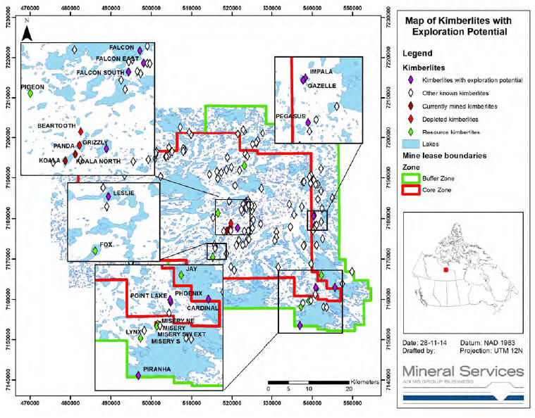
| March 2015 | Page 9-11 |
| Ekati Diamond Mine Northwest Territories, Canada NI 43-101 Technical Report |
| 9.7 | Comments on Exploration |
In the opinion of the responsible QPs, the exploration programs completed to date are appropriate to the style of the kimberlite pipes within the Ekati Project. Significant exploration potential remains in the Ekati Project area, with 12 kimberlite pipes identified as potentially warranting additional evaluation.
| March 2015 | Page 9-12 |
| Ekati Diamond Mine Northwest Territories, Canada NI 43-101 Technical Report |
| 10.0 | DRILLING |
Drilling completed on the Ekati Project between 1991 and 28 November 2014 is summarized, by pipe, in Table 10-1. Drilling includes 1,345 core holes (250,129 m), 28 sonic drill holes (848 m) and 494 RC holes (100,123 m). There has been no additional drilling since 28 November.
A drill collar location map is included for the Ekati Project area (includes discovery drill holes and all follow-up drilling through 2014) as Figure 10-1, and an inset for the areas of much closer spaced drilling is included in Figure 10-2.
Drill hole collars and orientations for drilling completed on the kimberlite pipes that have resource estimates is included in the figures for each pipe in Section 7 of this Report.
| 10.1 | Drill Methods |
Core drilling is used to define the pipe contacts, wall-rock conditions, and internal geology but is not used for grade estimation. Core drilling is also used to obtain geotechnical and hydrogeological data.
Sonic drilling is used to core both soil and bedrock along proposed civil construction projects such as dike alignments. The primary objective of sonic drilling is to characterize the nature and variation of the soil layers beneath the proposed civil work and to determine the depth to bedrock. Recovered soil is geotechnically logged and geotechnical laboratory testing is performed on selected samples.
Diamonds for grade estimation and valuation are obtained by one or a combination of RC drilling, bulk sampling, and sampling of kimberlite in active underground and open pit exposures. Samples are processed through an on-site sample plant.
| March 2015 | Page 10-1 |
| Ekati Diamond Mine Northwest Territories, Canada NI 43-101 Technical Report |
Table 10-1: DrillSummary Table
| Kimberlite Locality Name | Property | Discovery Year | Easting UTM | Northing UTM | Core # of Holes | Total Meterage | RC # of Holes | Total Meterage | |
| Aaron | Core Zone | 1997 | 531,190 | 7,176,690 | 2 | 454 | 0 | 0 | |
| Alexis | Core Zone | 1993 | 515,675 | 7,173,600 | 3 | 932 | 0 | 0 | |
| Anaconda | Core Zone | 1996 | 502,350 | 7,190,290 | 1 | 222 | 0 | 0 | |
| Antelope | Core Zone | 1995 | 538,030 | 7,188,970 | 2 | 260 | 0 | 0 | |
| Arnie | Core Zone | 1992 | 532,960 | 7,177,000 | 0 | 0 | 8 | 622 | |
| Barbara | Core Zone | 1997 | 522,730 | 7,173,480 | 1 | 127 | 0 | 0 | |
| Barracuda | Buffer Zone | 1997 | 543,588 | 7,158,000 | 3 | 329 | 0 | 0 | |
| Beartooth | Core Zone | 1996 | 519,750 | 7,178,855 | 71 | 12,750 | 19 | 3,057 | |
| Beaver | Core Zone | 1993 | 516,750 | 7,191,600 | 1 | 136 | 1 | 108 | |
| Bighorn | Buffer Zone | 2001 | 540,793 | 7,177,830 | 1 | 177 | 0 | 0 | |
| Bison | Buffer Zone | 1995 | 542,290 | 7,179,220 | 1 | 353 | 0 | 0 | |
| Blackbear | Core Zone | 1993 | 519,725 | 7,177,000 | 1 | 266 | 0 | 0 | |
| Boa | Core Zone | 1996 | 505,170 | 7,196,475 | 2 | 294 | 0 | 0 | |
| Bobcat | Core Zone | 2000 | 520,780 | 7,188,050 | 1 | 215 | 0 | 0 | |
| Brent | Core Zone | 1994 | 530,800 | 7,174,540 | 1 | 209 | 0 | 0 | |
| Cardinal | Buffer Zone | 1999 | 545,710 | 7,162,970 | 7 | 1322 | 5 | 920 | |
| Caribou | Buffer Zone | 1993 | 541,430 | 7,188,400 | 1 | 158 | 0 | 0 | |
| Caribou West | Core Zone | 1995 | 539,630 | 7,188,580 | 1 | 280 | 0 | 0 | |
| Centennial | Core Zone | 2001 | 524,810 | 7,177,150 | 1 | 122 | 0 | 0 | |
| Chad | Core Zone | 1999 | 531,180 | 7,175,380 | 3 | 513 | 0 | 0 | |
| Char | Buffer Zone | 2001 | 517,350 | 7,162,720 | 1 | 178 | 0 | 0 | |
| Cheetah | Core Zone | 1996 | 518,885 | 7,195,030 | 1 | 158 | 0 | 0 | |
| Cobra | Core Zone | 1996 | 500,935 | 7,195,715 | 1 | 245 | 0 | 0 | |
| Cobra South | Core Zone | 1996 | 501,119 | 7,195,653 | 1 | 142 | 0 | 0 | |
| Coral | Core Zone | 2003 | 503,565 | 7,195,180 | 1 | 276 | 0 | 0 |
| March 2015 | Page 10-2 |
| Ekati Diamond Mine | |
| Northwest Territories, Canada | |
| NI 43-101 Technical Report |
| Kimberlite Locality Name | Property | Discovery Year | Easting UTM | Northing UTM | Core # of Holes | Total Meterage | RC # of Holes | Total Meterage | |
| Cougar | Core Zone | 1999 | 520,206 | 7,192,798 | 1 | 164 | 2 | 505 | |
| Coyote | Core Zone | 1997 | 516,310 | 7,191,525 | 1 | 139 | 0 | 0 | |
| Crab | Core Zone | 1994 | 525,300 | 7,179,720 | 1 | 302 | 0 | 0 | |
| Crow | Core Zone | 2001 | 525,080 | 7,177,670 | 1 | 163 | 0 | 0 | |
| Cub-1 | Core Zone | 1994 | 522,000 | 7,177,350 | 2 | 375 | 4 | 435 | |
| Cub-2 | Core Zone | 1994 | 523,125 | 7,176,900 | 1 | 252 | 0 | 0 | |
| Cub-3 | Core Zone | 1997 | 524,535 | 7,177,110 | 2 | 477 | 0 | 0 | |
| Darkwing | Core Zone | 2000 | 523,391 | 7,182,771 | 2 | 476 | 0 | 0 | |
| Dingo | Core Zone | 1997 | 514,490 | 7,190,800 | 1 | 258 | 0 | 0 | |
| Eagle | Core Zone | 2007 | 540,825 | 7,161,250 | 2 | 634 | 0 | 0 | |
| Eel | Core Zone | 2001 | 521,150 | 7,173,421 | 1 | 118 | 0 | 0 | |
| Elk | Buffer Zone | 1995 | 541,480 | 7,184,650 | 2 | 631 | 0 | 0 | |
| Emu | Core Zone | 1999 | 522,609 | 7,181,601 | 1 | 133 | 0 | 0 | |
| Falcon | Core Zone | 1992 | 523,550 | 7,184,100 | 2 | 523 | 14 | 2,513 | |
| Falcon East | Core Zone | 1993 | 523,790 | 7,183,300 | 1 | 275 | 5 | 1,224 | |
| Falcon South | Core Zone | 1993 | 522,820 | 7,182,740 | 1 | 327 | 3 | 411 | |
| Falcon West | Core Zone | 2000 | 519,350 | 7,184,160 | 1 | 198 | 0 | 0 | |
| Fifty | Buffer Zone | 1995 | 540,940 | 7,181,505 | 4 | 992 | 0 | 0 | |
| Fisher | Core Zone | 2000 | 523,313 | 7,195,905 | 1 | 225 | 0 | 0 | |
| Flamingo | Core Zone | 1998 | 523,063 | 7,183,493 | 2 | 321 | 0 | 0 | |
| Flying V | Core Zone | 1994 | 509,945 | 7,200,755 | 1 | 197 | 0 | 0 | |
| Fox | Core Zone | 1992 | 515,270 | 7,170,420 | 143 | 29,924 | 83 | 19,965 | |
| Garter | Core Zone | 1996 | 507,990 | 7,196,535 | 2 | 465 | 0 | 0 | |
| Gazelle | Buffer Zone | 1995 | 540,430 | 7,180,660 | 7 | 1,769 | 7 | 1,375 | |
| Giraffe | Buffer Zone | 1998 | 542,240 | 7,186,690 | 2 | 479 | 5 | 1,007 | |
| Glory | Buffer Zone | 1996 | 542,970 | 7,156,550 | 2 | 315 | 1 | 315 |
| March 2015 | Page 10-3 |
| Ekati Diamond Mine Northwest Territories, Canada NI 43-101 Technical Report |
| Kimberlite Locality Name | Property | Discovery Year | Easting UTM | Northing UTM | Core # of Holes | Total Meterage | RC # of Holes | Total Meterage | |
| Grizzly | Core Zone | 1992 | 521,400 | 7,177,740 | 1 | 366 | 5 | 1,007 | |
| Hawk | Core Zone | 1992 | 535,580 | 7,181,030 | 4 | 790 | 0 | 0 | |
| Horseshoe | Core Zone | 2000 | 527,122 | 7,178,708 | 1 | 213 | 0 | 0 | |
| Hugo | Buffer Zone | 1997 | 549,890 | 7,166,880 | 1 | 240 | 0 | 0 | |
| Husky | Core Zone | 1994 | 516,005 | 7,191,375 | 1 | 148 | 4 | 146 | |
| Hyena | Buffer Zone | 1999 | 539,800 | 7,190,630 | 2 | 240 | 0 | 0 | |
| Impala | Buffer Zone | 2001 | 540,561 | 7,180,793 | 1 | 240 | 2 | 455 | |
| Jaeger | Core Zone | 1992 | 539,770 | 7,168,840 | 7 | 1,627 | 0 | 0 | |
| Jaguar | Buffer Zone | 1999 | 523,075 | 7,201,615 | 1 | 258 | 0 | 0 | |
| Jay | Buffer Zone | 1993 | 542,330 | 7,165,950 | 16 | 3,872 | 17 | 4,979 | |
| Kanga | Buffer Zone | 1999 | 526,000 | 7,198,700 | 2 | 298 | 0 | 0 | |
| Kaska | Core Zone | 1993 | 527,350 | 7,187,405 | 2 | 279 | 0 | 0 | |
| Kaspa | Core Zone | 2000 | 522,830 | 7,183,390 | 1 | 151 | 0 | 0 | |
| Kathy | Core Zone | 1997 | 520,590 | 7,167,275 | 2 | 356 | 0 | 0 | |
| Kestrel | Core Zone | 2000 | 534,416 | 7,183,460 | 2 | 309 | 0 | 0 | |
| Kia | Core Zone | 2007 | 515,865 | 7,172,650 | 1 | 242 | 0 | 0 | |
| Kit | Core Zone | 1997 | 516,595 | 7,191,575 | 0 | 0 | 2 | 182 | |
| Koala | Core Zone | 1992 | 518,750 | 7,176,950 | 272 | 46,478 | 49 | 11,002 | |
| Koala North | Core Zone | 1996 | 519,400 | 7,177,365 | 71 | 8,017 | 6 | 1,236 | |
| Koala West | Core Zone | 1997 | 517,975 | 7,176,850 | 3 | 502 | 0 | 0 | |
| Kodiak | Core Zone | 2000 | 524,000 | 7,175,100 | 3 | 261 | 0 | 0 | |
| Kodiak South | Core Zone | 2003 | 524,204 | 7,174,870 | 1 | 288 | 0 | 0 | |
| Kokanee | Core Zone | 2002 | 538,144 | 7,173,493 | 1 | 21 | 0 | 0 | |
| Kudu | Core Zone | 1995 | 540,460 | 7,189,460 | 2 | 315 | 0 | 0 | |
| Lemming | Buffer Zone | 1997 | 523,858 | 7,195,311 | 1 | 258 | 0 | 0 | |
| Leopard | Core Zone | 1997 | 517,380 | 7,191,300 | 1 | 203 | 0 | 0 |
| March 2015 | Page 10-4 |
| Ekati Diamond Mine Northwest Territories, Canada NI 43-101 Technical Report |
| Kimberlite Locality Name | Property | Discovery Year | Easting UTM | Northing UTM | Core # of Holes | Total Meterage | RC # of Holes | Total Meterage | |
| Leslie | Core Zone | 1992 | 515,950 | 7,173,150 | 12 | 2,957 | 20 | 4,810 | |
| Lioness | Core Zone | 2002 | 534,681 | 7,178,000 | 0 | 0 | 1 | 66 | |
| Llama | Core Zone | 1997 | 537,510 | 7,182,830 | 1 | 145 | 0 | 0 | |
| LS-1 | Buffer Zone | 1997 | 546,400 | 7,161,120 | 3 | 393 | 2 | 330 | |
| LS-2 | Buffer Zone | 1993 | 547,520 | 7,163,880 | 1 | 154 | 0 | 0 | |
| Lynx | Buffer Zone | 1999 | 537,300 | 7,158,140 | 27 | 3,121 | 16 | 2,340 | |
| Mamba | Core Zone | 1996 | 507,975 | 7,197,205 | 1 | 222 | 0 | 0 | |
| Mandarin | Core Zone | 2000 | 523,606 | 7,182,625 | 2 | 198 | 0 | 0 | |
| Mantaray | Core Zone | 2001 | 523,464 | 7,173,964 | 4 | 580 | 0 | 0 | |
| Mark | Core Zone | 1993 | 531,210 | 7,175,690 | 0 | 0 | 2 | 464 | |
| Medusa | Core Zone | 2000 | 501,341 | 7,196,560 | 1 | 276 | 0 | 0 | |
| Misery East | Core Zone | 1993 | 539,715 | 7,159,690 | 138 | 29,805 | 0 | 0 | |
| Misery Main | Core Zone | 1993 | 539,430 | 7,159,840 | 45 | 8,829 | |||
| Misery Northeast | Core Zone | 2003 | 539,526 | 7,159,960 | 0 | 0 | |||
| Misery South | Core Zone | 1993 | 539,540 | 7,159,725 | 7 | 956 | |||
| Misery Southeast | Core Zone | 2003 | 539,320 | 7,159,580 | 0 | 0 | |||
| Misery SW Extension | Core Zone | 2002 | 539,485 | 7,159,783 | 0 | 0 | |||
| Mongoose | Core Zone | 1997 | 500,921 | 7,194,584 | 1 | 267 | 0 | 0 | |
| Moose | Core Zone | 1996 | 516,510 | 7,189,745 | 1 | 175 | 0 | 0 | |
| Mustang | Buffer Zone | 1995 | 542,640 | 7,175,040 | 1 | 167 | 0 | 0 | |
| Nancy | Core Zone | 1995 | 515,380 | 7,180,260 | 2 | 383 | 0 | 0 | |
| Nanuk | Core Zone | 2000 | 521,480 | 7,200,965 | 2 | 352 | 0 | 0 | |
| Nora | Core Zone | 1994 | 514,685 | 7,167,655 | 2 | 562 | 0 | 0 | |
| One Fifty | Core Zone | 2002 | 537,790 | 7,188,875 | 1 | 99 | 0 | 0 | |
| Osprey | Core Zone | 1997 | 524,200 | 7,183,260 | 1 | 203 | 0 | 0 | |
| Ostrich | Core Zone | 1998 | 525,570 | 7,182,900 | 1 | 261 | 0 | 0 |
| March 2015 | Page 10-5 |
| Ekati Diamond Mine Northwest Territories, Canada NI 43-101 Technical Report |
| Kimberlite Locality Name | Property | Discovery Year | Easting UTM | Northing UTM | Core # of Holes | Total Meterage | RC # of Holes | Total Meterage | |
| Palomino | Buffer Zone | 1997 | 545,060 | 7,184,970 | 1 | 152 | 0 | 0 | |
| Panda | Core Zone | 1993 | 519,665 | 7,177,950 | 137 | 23,002 | 36 | 8,365 | |
| Panther | Core Zone | 1995 | 521,925 | 7,191,800 | 2 | 347 | 0 | 0 | |
| Peacock | Core Zone | 1998 | 524,030 | 7,184,400 | 1 | 295 | 0 | 0 | |
| Pegasus | Buffer Zone | 2000 | 540,710 | 7,178,327 | 4 | 522 | 2 | 534 | |
| Peregrine | Core Zone | 1997 | 524,027 | 7,183,291 | 1 | 173 | 0 | 0 | |
| Phantom | Buffer Zone | 1999 | 537,750 | 7,159,085 | 3 | 494 | 0 | 0 | |
| Phoenix | Core Zone | 1998 | 540,950 | 7,162,900 | 2 | 675 | 14 | 1,213 | |
| Pigeon | Core Zone | 1994 | 516,500 | 7,181,350 | 68 | 11,487 | 36 | 7,662 | |
| Pinto | Buffer Zone | 2001 | 540,255 | 7,177,010 | 1 | 148 | 0 | 0 | |
| Piranha | Buffer Zone | 1997 | 537,030 | 7,153,500 | 10 | 1,673 | 2 | 476 | |
| Point Lake | Core Zone | 1991 | 541,030 | 7,162,620 | 2 | 681 | 27 | 4,519 | |
| Python | Core Zone | 1996 | 503,760 | 7,195,290 | 1 | 252 | 0 | 0 | |
| Rat | Core Zone | 1994 | 501,490 | 7,173,500 | 2 | 626 | 0 | 0 | |
| Rat East | Core Zone | 2005 | 501,590 | 7,173,500 | 1 | 163 | 0 | 0 | |
| Rattler | Core Zone | 1996 | 501,142 | 7,196,155 | 1 | 259 | 0 | 0 | |
| Raven | Core Zone | 1998 | 524,976 | 7,181,978 | 1 | 188 | 0 | 0 | |
| Redwing | Core Zone | 2007 | 523,330 | 7,182,470 | 1 | 190 | 0 | 0 | |
| Roger | Core Zone | 1994 | 521,780 | 7,174,700 | 1 | 273 | 0 | 0 | |
| Ronza | Core Zone | 2000 | 508,361 | 7,196,930 | 1 | 297 | 0 | 0 | |
| Roo | Buffer Zone | 1995 | 526,045 | 7,198,575 | 2 | 266 | 0 | 0 | |
| Sable | Core Zone | 1995 | 523,090 | 7,193,025 | 38 | 9,197 | 33 | 6,740 | |
| Scorpion | Core Zone | 1995 | 531,620 | 7,167,990 | 1 | 325 | 0 | 0 | |
| Shark | Buffer Zone | 1997 | 542,930 | 7,158,120 | 4 | 744 | 3 | 154 | |
| Sheiba | Core Zone | 2002 | 537,890 | 7,173,303 | 1 | 47 | 0 | 0 | |
| Shrew | Core Zone | 1997 | 518,640 | 7,192,005 | 1 | 213 | 0 | 0 |
| March 2015 | Page 10-6 |
| Ekati Diamond Mine Northwest Territories, Canada NI 43-101 Technical Report |
| Kimberlite Locality Name | Property | Discovery Year | Easting UTM | Northing UTM | Core # of Holes | Total Meterage | RC # of Holes | Total Meterage | |
| Smokey | Core Zone | 1997 | 524,096 | 7,177,034 | 1 | 196 | 0 | 0 | |
| Sparrow | Core Zone | 1994 | 524,860 | 7,183,135 | 1 | 248 | 0 | 0 | |
| Springbok | Core Zone | 1995 | 539,390 | 7,190,240 | 1 | 97 | 0 | 0 | |
| Stallion | Buffer Zone | 1999 | 541,120 | 7,173,470 | 1 | 141 | 0 | 0 | |
| Sue | Core Zone | 1996 | 518,650 | 7,171,325 | 1 | 325 | 0 | 0 | |
| Taz | Buffer Zone | 1995 | 525,165 | 7,198,350 | 3 | 781 | 0 | 0 | |
| Tiger | Core Zone | 1996 | 519,860 | 7,192,610 | 1 | 145 | 0 | 0 | |
| Ursa | Core Zone | 1996 | 519,860 | 7,178,128 | 1 | 276 | 0 | 0 | |
| Viper | Core Zone | 1996 | 504,255 | 7,195,430 | 2 | 288 | 0 | 0 | |
| Vulture | Core Zone | 1993 | 522,340 | 7,182,200 | 1 | 289 | 0 | 0 | |
| Wallaby | Buffer Zone | 1995 | 527,685 | 7,201,165 | 3 | 691 | 0 | 0 | |
| Wapati | Buffer Zone | 1999 | 540,950 | 7,188,310 | 1 | 306 | 0 | 0 | |
| Waterbuck | Buffer Zone | 2000 | 542,230 | 7,192,265 | 1 | 172 | 0 | 0 | |
| Whitetail | Buffer Zone | 1995 | 542,490 | 7,182,375 | 1 | 249 | 0 | 0 | |
| Wildcat | Buffer Zone | 1999 | 522,805 | 7,202,065 | 2 | 397 | 0 | 0 | |
| Wildebeast | Buffer Zone | 2000 | 540,489 | 7,178,218 | 3 | 419 | 2 | 244 | |
| Wolf | Core Zone | 2001 | 519,765 | 7,168,085 | 1 | 64 | 0 | 0 | |
| Wolverine | Core Zone | 1998 | 521,288 | 7,176,855 | 3 | 629 | 3 | 679 | |
| Wombat | Buffer Zone | 1993 | 526,400 | 7,199,250 | 4 | 1,527 | 0 | 0 | |
| Zach | Core Zone | 1996 | 529,700 | 7,172,100 | 3 | 894 | 1 | 280 | |
| Zebra | Buffer Zone | 1995 | 541,160 | 7,178,480 | 2 | 231 | 0 | 0 | |
| N/A (no intersection) | Combined | n/a | n/a | n/a | 97 | 19,058 | 0 | 0 | |
| Totals | 434 | 82,581 | 159 | 30,866 |
| March 2015 | Page 10-7 |
| Ekati Diamond Mine Northwest Territories, Canada NI 43-101 Technical Report |
Figure 10-1: EkatiProject Drill CollarLocation Map
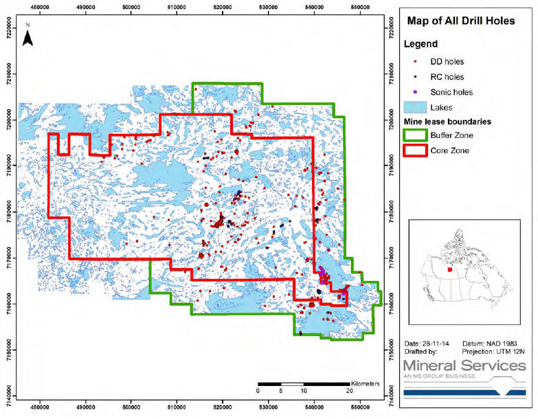
| March 2015 | Page 10-8 |
| Ekati Diamond Mine Northwest Territories, Canada NI 43-101 Technical Report |
Figure 10-2: MapShowingLocation of All Drill Holes With Insets for Pipes withReportedMineralResources
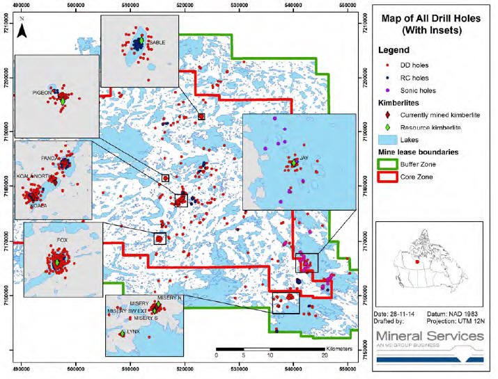
| March 2015 | Page 10-9 |
| Ekati Diamond Mine Northwest Territories, Canada NI 43-101 Technical Report |
| 10.1.1 | RC Drilling |
Kimberlite pipes with demonstrated potential, based on initial evaluation and delineation work, are tested for commercial size diamonds by means of vertical large-diameter RC drill sampling. In most cases, RC drilling is undertaken during winter from the frozen lake surface. This approach was selected as the most cost effective means of obtaining a spatially representative, adequately-sized sample of the kimberlites, most of which occur under lakes and are, therefore, not readily accessible to surface excavation.
The diameter of drill holes employed prior to 1995 ranges from 27 to 71 cm, but from 1995 onwards, the hole diameter was standardized to between 31 and 45 cm. Logistical difficulties and safety concerns precluded drilling and sampling of larger diameter RC holes from the lake surfaces.
Following initiation of mining, evaluation work continued with RC drilling, typically from within the open pit. This generated critical data for evaluation of the lower portions of the ore bodies that are less accessible to drilling from surface and permitted drilling of large diameter RC holes providing improved spatial resolution of grade data (smaller sample intervals corresponding to planned benches or levels). The latter is particularly important where significant vertical changes in geology and/or diamond grade occur over scales of less than 30 m (e.g. Koala).
The initial drill pattern for an RC program is planned to maximize both vertical and horizontal sample coverage. Planned drill hole collar locations and depths are designed to reach a maximum depth within kimberlite while giving maximum lateral spread.
Diamonds are not typically added to the samples (no spikes used). Security procedures are in place to ensure very limited access to the sample collection areas. Additionally, sample plant audits are undertaken to verify the recovery process.
| 10.1.2 | Core Drilling |
Core drilling using synthetic diamond-tipped tools and/or carbide bits is used to define the pipe contacts, wall-rock conditions, and internal geology. An initial drill pattern around each pipe is completed, and depending on the results, additional drilling may be required to further delineate potential problem areas.
Core drilling used standard core barrels, and synthetic diamond or carbide bits, reaming shells, and casing shoes. Hole diameters used to date include HQ (63.5 mm core diameter), NQ (46.7 mm) and BQ (36.5 mm).
| March 2015 | Page 10-10 |
| Ekati Diamond Mine Northwest Territories, Canada NI 43-101 Technical Report |
Oriented core is used for geotechnical investigation of the wall rocks, and is not employed in kimberlite. Orientation tools include clay imprint, ACT tool, and optical/acoustic televiewing.
| 10.1.3 | Sonic Drilling |
Sonic drilling is used to core both soil and bedrock along proposed dike alignment options at locations such as the Jay kimberlite where lake water depths are greater than 6 m, and hydraulic head acting on the proposed dike will be greater.
The primary objective of the sonic drilling is to characterize the nature and variation of the soil layers beneath the proposed dike and to determine the depth to bedrock. Recovered soil is geotechnically logged and geotechnical laboratory testing is performed on selected samples.
The sonic drilling method uses relatively high frequency mechanical vibration, down-pressure and optional rotation to advance an inner drill string and an outer casing. A one-piece core barrel with a 150 mm diameter is threaded onto the bottom of the inner drill string and obtains samples. The core barrel and outer casing are advanced by fracturing, shearing and/or displacing the formation materials. Resonant frequency within the drill string and outer casing allow the inertia of the drill bit and casing shoe, respectively, to fracture relatively hard materials. In relatively soft formations, it is possible to advance the drill string and casing using down-pressure alone.
When drilling through sediments and glacial till, the drill string and outer casing are advanced independently. The drill bit face on the core barrel is advanced approximately 1.5 m below the outer casing shoe using down-pressure, vibration and/or rotation. The outer casing shoe is then advanced to approximately 0.3 m above the drill bit face using down-pressure, vibration, rotation and water flushing to avoid trapping material between the core barrel and the outer casing. The core barrel and drill string are retracted from the outer casing to bring the core barrel sample to the surface. A hole rod (a drill rod with a drainage hole) is installed above the core barrel to drain water from the drill rods during core barrel retraction. Core barrel samples are then extruded into plastic liner bags that are supported by aluminium sample trays. A plastic core catcher is generally installed within the core barrel when advancing through the sediment and glacial till materials.
A wet coring method is used when drilling into bedrock materials and through suspected boulders. The hole rod is replaced with a standard rod and the core barrel is advanced using vibration, rotation and water flushing to cool the drill bit. Once the drill bit is advanced below suspected boulders the hole rod is re-installed and water flushing during coring will be stopped. Where bedrock is encountered, wet coring is used to advance the core barrel approximately 2 m into the bedrock formation.
| March 2015 | Page 10-11 |
| Ekati Diamond Mine Northwest Territories, Canada NI 43-101 Technical Report |
After reaching the final depth of investigation at each borehole location, in-situ hydraulic conductivity testing is carried out. This may be carried out using a downhole packer system or with the temporary installation of a standpipe piezometer. Once this testing is completed, the packer or the temporary standpipe are removed from the bore hole. A cement-bentonite grout is placed in each borehole before retracting the outer casing.
| 10.2 | Geological Logging |
| 10.2.1 | RC Drilling |
A small sub-sample (approximately 300 cm3) of RC drill material (drill chips) is taken for every two metres of drilling within kimberlite and a representative portion of this material (approximately 50 to 100 cm3) is washed and retained. The drill chips are examined and described macroscopically and under binocular microscope. As the drill sample consists of small rock fragments and drill fines, RC chip logs are less precise than those obtained from core logging. Dominion staff consider that an accuracy of approximately ±1 m is possible when combining chip geology with downhole geophysical logs.
| 10.2.2 | Core Drilling |
Core drill holes are logged in detail by trained kimberlite geologists and/or by trained geotechnical consultants. Geological logging is undertaken on a 1:100 scale using logging sheets specifically developed for the Ekati Diamond Mine. Digital geological and geotechnical logging is completed and the core is photographed before being stored in the attached unheated core storage building.
Geological logging utilizes a digital logging form for both wall-rock lithology, kimberlite/wall-rock contacts, and internal kimberlite lithology. Wall-rock is logged by rock-type, mineralogy, alteration, rock strength, and major structures. Kimberlite core is examined macroscopically and using a binocular microscope to determine the following key lithological parameters on 5 m intervals, or following lithological breaks: concentration of macrocrystic olivine, matrix composition, abundance and type of country-rock xenoliths, approximate abundance of indicator minerals, rock fabric, colour, and alteration.
Kimberlite lithologies are classified according to a kimberlite classification scheme standard to the industry.
| March 2015 | Page 10-12 |
| Ekati Diamond Mine Northwest Territories, Canada NI 43-101 Technical Report |
Colour photographs are taken of delineation drill core and used to verify significant contacts and lithologies as well as provide a permanent record of the drill core. These photographs are annotated with the unit names and lithological contacts.
| 10.3 | Recovery |
Within wall rock, typical recoveries are 95 to 100% for both core and RC drill holes. In kimberlite, the core recoveries can be as low as 20% and as high as 95%, but are more typically in the 75 to 85% range. For RC drill holes, kimberlite recoveries may range from 50% to over 100% in cases of in hole sloughing. The recovery is largely a function of the hardness of the kimberlite.
| 10.4 | Collar Surveys |
| 10.4.1 | RC Drilling |
All RC drill hole collars are surveyed using a real time global positioning system (RTGPS) instrument prior to and after drilling; these have an accuracy of ±10 mm. Ekati staff consider that the drill hole collar location error is minimal.
| 10.4.2 | Core Drilling |
All surface core hole collar positions are surveyed using a RTGPS, providing an accuracy of ±0.01 m. Hole collar, dip and azimuth are verified by surveying the top and bottom of the in-hole drill steel and then calculating the initial azimuth and dip of the hole at surface.
| 10.5 | Down-hole Surveys |
| 10.5.1 | RC Drilling |
Three Century Geophysical Corporation tools, including the “9095” tool – for gyroscopic deviation surveying; the “9065” tool – three arm calliper; and the “9511” tool – conductivity induction and natural gamma, are used on all RC holes:
| • | Gyroscopic deviation: used to incrementally (usually in 3 m intervals) measure drill hole deviation from vertical and provide azimuth and dip determinations; | |
| • | Three arm calliper: provides a measure of hole diameter for determining sample volumes. Run up the open holes directly after the drill steel is removed from the hole, the arms are spring loaded and press against the sides of the open drill hole. Repeat runs indicate that the data are repeatable and that the data have an accuracy of approximately 1 cm. The calliper is calibrated against the known casing diameter. The minimum reach of the calliper is the hole diameter and the maximum reach is 220 cm (89”) to 241 cm (95”) depending on the model; |
| March 2015 | Page 10-13 |
| Ekati Diamond Mine Northwest Territories, Canada NI 43-101 Technical Report |
| • | Natural Gamma: measures the amount of naturally occurring gamma radiation from potassium, uranium, or thorium sources approximately every 2 cm. In the case of many Lac de Gras kimberlites, the principal source of gamma radiation is potassium feldspar in granitoids or potassium ions in non-kimberlitic clay. The gamma logs are particularly useful for determining the location of the water and sediment interface in lakes, the location of the overburden and kimberlite contact, and the location of Phanerozoic sedimentary rock or country-rock boulders in kimberlite; | |
| • | Conductivity Induction: measures conductivity a few centimetres into the drill hole wall approximately every 2 cm and is an index for clay content. Clay content decreases from RVK to olivine-rich ORVK to PVK, and therefore conductivity increases and these rock-types can be discerned. |
Down-hole directional surveys of RC holes are performed using a gyroscopic instrument.
| 10.5.2 | Core Drilling |
Downhole surveys were done with one of four survey instruments: EZ-shot, Lightlog, Maxibor, or Century Geophysics 9096 Gyroscope. Currently, only Maxibor and gyroscope are used as they proved to be the most consistent. Some testing has been done and the two methods produced almost identical results for the same drill hole.
The maximum error in the drill hole location for holes less than 100 m long is about 1 m, while the locations of longer holes (100 to 600 m) are accurate to within approximately 1 m per 100 m drilled over the entire length of the drill hole.
In 2004, survey precision and accuracy was tested by coring two holes of significant length (300 m) collared by the surface surveyors to target an underground heading location provided by underground surveyors. Both holes resulted in absolute error of less than the anticipated +3 m of error when they breached the underground workings. This validated the surface and underground location surveys of two discrete points (drill and drill target), and indicated that the down-hole deviation surveys are providing useable modelling data.
Previous mining has intersected old large diameter drill holes (open and grouted) which have been used to validate and confirm the drill hole survey. When drill holes are encountered in the UG mine, the intersection is surveyed using DGPS and compared to known drill holes in the area to determine which drill hole was intersected.
| March 2015 | Page 10-14 |
| Ekati Diamond Mine Northwest Territories, Canada NI 43-101 Technical Report |
There are no known instances where surveyed intersections did not closely coincide with down-hole drill hole surveys.
| 10.6 | Underground Test Hole Data |
During the development phase of each underground level, test holes to probe the ore /waste rock contact are routinely drilled with the Tamrock Solo long hole drill in order to provide additional production scale ore body delineation. The test holes (flat and down holes) improve ore/waste contact definition to an ideal density of one hole per 12 m.
| 10.7 | Geotechnical Drilling |
The locations of the drill holes completed specifically for geotechnical purposes are shown in Figure 10-3.
Geotechnical logging of core from core holes was completed to determine rock mass rating (RMR) according to the Laubscher system. For key holes, core is oriented using an ACT (ACE) tool, and detail structural logging was completed. In 2009, an acoustic and optical televiewer system was introduced to augment the structural logging program in waste rocks at the Misery pipe.
The following geotechnical parameters were determined for all core drill holes.
| • | Percentage core recovery; | |
| • | Rock quality designation (RQD); | |
| • | Fracture frequency; | |
| • | Point load strength index; | |
| • | Joint condition and water. |
Rock samples are collected following a core drill core sampling procedure and are occasionally shipped for off-site testing at an accredited third-party materials testing facility. Strength index testing included the following: unconfined compressive strength (UCS), triaxial strength, direct strength, shear strength, Poisson’s ratio, and Young’s modulus evaluation.
| March 2015 | Page 10-15 |
| Ekati Diamond Mine Northwest Territories, Canada NI 43-101 Technical Report |
Figure 10-3:Geotechnical Drill HoleLocation Plan with Insets
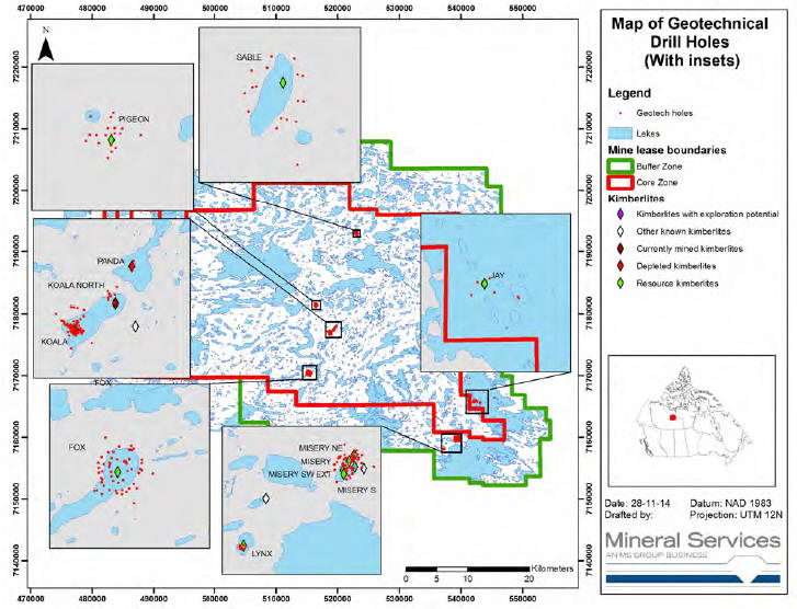
| March 2015 | Page 10-16 |
| Ekati Diamond Mine Northwest Territories, Canada NI 43-101 Technical Report |
Measurements suitable for pit wall stability study were obtained with an oriented core device to provide information on the orientation of joints, faults, bedding planes and other structures. A clay print device was used. An eccentrically-loaded core barrel was packed with modelling clay at the bottom, dropped down the hole, and an imprint of the core stub was recovered. The clay imprint was matched to the top of the core for the run and a reference line is scribed down the entire length of the core. The orientations of planar features were determined with reference to the scribe line and the core axis.
The geotechnical logs and data are recorded on paper logging sheets, captured and verified digitally into Excel spreadsheets and made available for required geotechnical review.
| 10.8 | Sample Length/True Thickness |
The kimberlite bodies are typically pipe like with near-vertical contacts with the host rock. Thus, the relationship between the drill hole angle and true thickness of the kimberlite is not relevant. Grade sampling is generally done using vertical RC drill holes. The RC drill holes have gyroscopic surveys to adjust for horizontal deviation.
| 10.9 | Drill Data by Major Kimberlite |
| 10.9.1 | Koala |
Since 1992, a total of 268 drill holes have been completed at the Koala pipe, including 48 RC holes, 145 surface core holes and 75 underground core holes.
The discovery NQ hole was drilled into Koala in August 1992. The core was analysed for microdiamonds and the positive results prompted planning of a bulk sample program. Seven RC drill holes were completed by Specialty Drilling Services (SDS) during the winter of 1993. The results indicated that the pipe had strong economic potential but was characterised by multiple geological units with variable diamond content.
Two core drilling programs followed in 1993 and 1994 to provide metallurgical samples for process plant design work, the correlation of diamond grade with geological domain, pipe delineation, and bulk density measurements.
The preliminary bulk sample results indicated grade variation associated with geological domains. Reverse circulation drilling programs were thus selected over underground methods for subsequent bulk sampling programs at Koala. Additional RC and core drilling programs were conducted in 1994 and 1995. These programs produced the first core hole intersections and grade results in the deeper Phase 6 portion of the pipe. The 1994–1995 drilling campaigns also provided adequate resource data to complete an open pit mine plan and indicated that the deeper portion below the planned pit bottom had strong economic potential.
| March 2015 | Page 10-17 |
| Ekati Diamond Mine Northwest Territories, Canada NI 43-101 Technical Report |
Four core holes were drilled in each of 1997 and 1998. During 2002, 10 RC holes were drilled from the Koala pit from elevations ranging from 2,390 m to 2,360 m. These holes were designed to bulk sample both the open pit and underground resources. Also in 2002, 50 core holes were drilled to improve the definition of the Koala pipe model mostly within the zones of the open pit. The deep core holes provided additional pierce points for a conceptual resource model. However, none of the 2002 RC holes successfully sampled the targeted PVK unit at depth.
A follow-up drilling campaign was carried out in summer 2003 after open pit mining had lowered the collar elevation from 2,300 m to 2,290 m. Pilot core holes were completed at the proposed deep drill hole locations providing lithological control and granite xenolith locations prior to the RC drilling. Four deep RC holes (17.5” diameter) were subsequently completed yielding significant grade data. The drilling of an additional 39 core holes in 2003 further improved the definition of the Koala pipe model and allowed for a more detailed definition and evaluation of the phases in both the remaining open pit and underground resource estimate areas.
An underground core drilling program was undertaken in conjunction with the Koala feasibility bulk sample program to acquire additional geological and geotechnical data and for a test of the down hole seismic method. The drilling was immediately met with drilling and logistical challenges which resulted in achieved drill rates less than half of the predicted rates. As a result, approximately 40% of the holes did not penetrate through to the far side (southwest) of the pipe.
The core drilling program was extended to July from April 2005 and finally an in-pipe program from the 2050 bulk sample drift was added to acquire wall intersections on the far side of the pipe. The in-pipe drilling also proved to be difficult. Nevertheless, the program added 90 new pipe wall intersections to the database. The average drill hole intersection spacing for the main portion of the Koala underground resource was improved to 41 m on average. Drill spacing is appreciably closer on the northeastern side of the pipe than on the southwestern side.
All surface drill hole collar positions were surveyed using differential GPS methods. Down hole surveys were carried out with one of four survey instruments, either an EZ-shot, Light log, Maxibor, or gyroscope. The majority of the drill holes utilised Maxibor or gyroscope for the down hole surveys. Underground core holes were surveyed by Procon contract surveyors using either a Leica PCR703 or Trimble S6 reflectorless electronic total station instrument.
| March 2015 | Page 10-18 |
| Ekati Diamond Mine Northwest Territories, Canada NI 43-101 Technical Report |
A combination of diamond drilling and test probe drilling has been carried out through the life of the Koala mine to further define internal geology and pipe wall contacts. The data have been used to inform the geological block model for periodic model revisions.
| 10.9.2 | Koala North |
The two discovery drill holes were completed in 1996. Four follow-up core holes were completed in 1997. During 1998, six 12¼ inch RC holes were drilled, and provided 36 valid samples, totalling 200 dry tonnes and 126 carats. All drill holes intersected the Koala North pipe and a total of 1,075 m of kimberlite was drilled. Samples were collected on 30 m intervals.
In 1999–2001, 10 geotechnical drill holes were completed.
A test pit was excavated in November, 2000 into the upper portion of Koala North to provide a bulk sample.
From 2002 to 2004, a total of 38 underground core holes were completed. Underground development commenced in 2003. In total, 21 core holes intersected kimberlite providing 34 kimberlite/wall-rock contacts.
A combination of diamond drilling and test probe drilling has been carried out through the life of the Koala North mine to further define internal geology and pipe wall contacts. The data have been used to inform the geological block model for periodic model revisions.
| 10.9.3 | Fox |
Discovery hole 92-01 (NQ core) was drilled in 1992. The first bulk sampling campaign was conducted in late February and March of 1993 with eleven 105/8 inch (26.99 cm) RC holes.
As a result of this sampling, a decline was collared in September 1993. The decline was drifted through 1,395.4 m of granite before entering the kimberlite on May 6, 1994. Within the granite portion of the decline, 14 remuck bays, 42 safety bays, three drill stations and two transformer bays would approximately equate to an additional 220 m of drifting. The kimberlite portion of the decline was completed with 99 rounds equalling 301.1 m, bringing the total length of the decline to 1,696.5 m. As with the granite portion, remuck bays, safety bays and drill stations were also a part of the kimberlite drifting. The additional drifting of one remuck, one drill station and three safety bays in kimberlite approximately equate to 35 m. The volume of the kimberlite portion was measured to be 3,706.77 m3, including additional drifting. Within the pipe, 421.64 m3of granite was encountered.
| March 2015 | Page 10-19 |
| Ekati Diamond Mine Northwest Territories, Canada NI 43-101 Technical Report |
Two raises were started in early November 1994. Raise #1 followed the same path as core hole FUC3-2 for a length of 55.8 m and an approximate volume of 179.22 m3. Raise #2 was located at the end of the decline and followed core hole FUC4-9. Total length and approximate volume were 51.10 m and 155.15 m3, respectively.
Concurrently with drifting, delineation drilling began in March 1994 from surface. Seven HQ and NQ holes were drilled with only one successful entry into the diatreme. An underground BQ core rig was mobilized in April 1994 and pipe delineation from underground began. Two drill stations were utilized in the granite and five hole were drilled with four kimberlite intersections. The drill was then moved into the first drill station in the kimberlite. With one drill hole in this station, it became apparent that a larger rig would be necessary. An HQ rig was mobilized in early August 1994 at the completion of the drifting. Eleven holes were drilled, eight of which intersected the pipe/wall rock contact. Two raises, following two upward drill holes, were started in early November 1994. Raise #1 and Raise #2 were 55.80 m and 51.10 m in length, respectively. Four 12¼ inch (31.12 cm) RC holes were drilled in the 1995 winter drilling program to provide infill information and correlation of grade to the raise and decline bulk samples.
In 2000, five 13.75 inch RC holes were drilled during a 1,200 m program to explore the potential of the crater kimberlite and upgrade the diatreme kimberlite grade model. A first pass program to drill geotechnical holes perpendicular to the pit wall and third pass delineation program of the pipe wall was completed with 5,400 m of HQ/NQ drilling in 2001.
In 2004 and 2005, 61 additional 13.75 inch RC holes (14,694 m) were drilled to significantly improve the pipe grade model.
From 2004 to the Report effective date, 56 core holes (11,966 m) were drilled for internal geology and pipe wall definition.
| 10.9.4 | Misery |
RC drilling programs were completed at Misery Main in 1994, 1995, and 2008. The 1994 winter drilling program utilized small diameter drill holes (30 m down hole sample composites) and the drill holes were not callipered. The grade and valuation data indicated the high potential of Misery. These data are excluded from the grade model due to poorly-constrained sample sizes.
| March 2015 | Page 10-20 |
| Ekati Diamond Mine Northwest Territories, Canada NI 43-101 Technical Report |
The drill holes were gyroscopically surveyed and calliper surveyed where possible; however due to significant hole caving, calliper surveys were difficult to obtain and in many cases, not reliable at depth. The 1995 sample intervals were processed at Koala Camp pilot plant with 0.5 mm slot de-grit screens in order to allow for evaluation of small diamond potential. Samples were then sieved to 1 mm.
The 2008 sample intervals were processed at the Ekati sample plant with 1.2 mm slot de-grit screens which is the current main process plant screen aperture. Samples were sieved to 1 mm.
The raw grade data were adjusted using partition data for estimating recovery at 1.0 mm slot and 1.2 mm slot screen sizes for comparison with the main process plant. Four RC drill holes were drilled in 2008 to provide additional grade data in deeper portions of the pipe. The drill holes were down hole surveyed and callipered; however, again calliper surveys were difficult to obtain. The RC sample intervals were processed at the Ekati sample plant using a 1.2 mm slot.
During 2013, a total of seven diamond drill holes for 929 m were completed within the Misery pushback open pit for pipe wall definition and microdiamond sampling of the Misery satellite pipes.
From the discovery drill hole in 1993, through December 2014, a total of 134 core holes for 29,577 m were completed at Misery Main primarily for pipe definition and geotechnical purposes.
| 10.9.5 | Misery Satellites |
Mineral Services were retained to perform an updated Mineral Resource estimate for the Misery South and Misery Southwest Extension areas. Information from that work is summarized in this section.
Thirty-five diamond drill holes have intersected Misery South and Misery Southwest Extension in drilling campaigns conducted in 1993, 1997, 2001, 2002, 2003, 2008, 2009, 2010 and 2014. Current diamond drilling provides sparse coverage of Misery South and Misery Southwest Extension to approximately 150 m amsl, below which there are virtually no constraints on the pipe shell position. Misery South was sampled during RC drilling campaigns in 1994 and 1995; however, the grade data were not deemed adequate to support Mineral Resource estimation.
Misery Northeast is delineated by five diamond drill holes providing only three pierce points, all of which occur above 280 m amsl. The pipe volume, morphology and internal geology are constrained at a low level of confidence to approximately 250 m amsl, below which there is no information.
| March 2015 | Page 10-21 |
| Ekati Diamond Mine Northwest Territories, Canada NI 43-101 Technical Report |
Misery Southeast has been intersected by 18 diamond drill holes. Drill density is sparse in relation to the complex morphology of the pipe and sheet complex.
| 10.9.6 | Pigeon |
From discovery in 1994 of Pigeon, to the end of the most recent delineation and geotechnical drill program in 2007, a total of 88 drill holes, both diamond drill holes and RC, totalling almost 17,000 m, have been completed. Diamond drilling in 2012 included four core holes for pipe definition (410 m) and seven geotechnical holes (971 m).
| 10.9.7 | Sable |
Since 1995, a total of 71 drill holes have been completed at Sable Pipe, including 33 RC holes and 38 diamond drill holes.
The NQ-diameter discovery hole (ECH95-25, 347 m) drilled into Sable in August 1995 was analysed for microdiamonds. Positive results prompted an RC drilling bulk sample program in 1996. During May to July of 1996, 13 land-based NQ-diameter core holes (2,951 m) were drilled for pipe delineation. Thirty-three 12¼ inch RC drill holes (6,740 m) were drilled during the winter of 1996. Twenty-three holes intersected kimberlite and were completed successfully. The rest missed kimberlite or were abandoned due to difficult drilling.
A second program of 17 NQ-diameter core holes (4223 m) was drilled in 2001 to acquire geotechnical data and additional pipe boundary contacts. In the fall of 2005 one NQ core hole (197 m) was drilled into the pipe. In August and September of 2006, six NQ core holes (1479 m) including three geotechnical and three delineation holes were completed.
Of the 33 RC holes, 22 were considered valid for support of grade analysis and estimation. The remaining drill holes were excluded due to QC issues (e.g. incomplete holes or invalid down hole survey data). Twenty-three RC holes and 26 core holes were used for geological modelling. All 26 core holes were logged for geology and geotechnical data. Seven core holes were oriented for geological structure logging.
All but three collar positions of completed drill holes were surveyed using differential GPS. Down hole surveys of core holes were carried out with either a Maxibor or gyroscopic survey instrument. Four core holes were not surveyed for deviation due to deteriorating weather, ice and/or down hole conditions. Three of the four holes lacking down hole surveys also lack initial collar direction surveys. The planned azimuth and dip of the core holes were used in the absence survey data. These limited data were scrutinized and are considered sufficiently accurate for analysis modelling of the pipe shape and volume. The inaccuracy of the boundary contact positions are reflected in the variability of the radial coordinates of the pipe boundary contacts.
| March 2015 | Page 10-22 |
| Ekati Diamond Mine Northwest Territories, Canada NI 43-101 Technical Report |
| 10.9.8 | Jay |
The Jay kimberlite was discovered in 1993 by a 151 m core drill hole (93-01). In 2005, two delineation core holes (JDC-01 and JDC-02) totalling 500 m, provided the first two boundary pierce point data for the pipe.
Nine delineation core holes (JDC-03 to JDC-13, JDC-07 and 12 abandoned) and two geotechnical holes (JDC-14 and 15) totalling 3,077 m were completed in 2007. The geotechnical holes drilled to the southwest of the kimberlite detected a large regional structure and the presence of regional geological contacts. In 1996, five RC drill holes (12.25 inch diameter) were completed at Jay for a total of 1,379 m. In 2006, 11 RC drill holes (17.5 inch diameter) were completed for a total of 3,457 m.
A comprehensive drilling program was completed in the Jay area during the winter of 2014. The program included sonic drilling for engineering dike design (26 drill holes for 677 m), sonic drilling within the kimberlite pipe (two drill holes for 171 m), diamond drilling for engineering dike design (18 drill holes, 587 m) and diamond drilling for geotechnical and geohydrology purposes related to open pit design (seven drill holes, 2,877 m).
| 10.9.9 | Lynx |
The discovery hole (NQ core) was drilled in August 1999. Two follow-up core drill holes (NQ core) and five 31.12 cm diameter RC holes were drilled in 2000 with the aim of better delineating the pipe and obtaining an initial bulk sample to assess diamond grade and quality. The RC drilling yielded a total sample weight of 170 dry tonnes.
Additional delineation core drilling (in the form of nine short vertical NQ core holes) and RC drill sampling (seven 31.12 cm diameter holes) was undertaken in 2001 to better constrain the Lynx kimberlite resource. An additional 173 dry tonnes of kimberlite were sampled during the 2001 RC program.
In 2003, six internal geology core holes (942 m) and eight geotechnical core holes were completed (928 m).
| March 2015 | Page 10-23 |
| Ekati Diamond Mine Northwest Territories, Canada NI 43-101 Technical Report |
| 10.10 | Comments on Drilling |
In the opinion of the responsible QPs, the quantity and quality of the lithological, geotechnical, collar and down-hole survey data collected in the exploration and infill drill programs are sufficient to support Mineral Resource and Mineral Reserve estimation as follows:
| • | Core logging meets industry standards for kimberlite exploration; | |
| ||
| • | Collar surveys and down-hole surveys have been performed using industry- standard instrumentation; | |
| ||
| • | Recovery from core and RC drill programs is acceptable; | |
| ||
| • | Drill orientations are generally appropriate; | |
| ||
| • | Drill orientations were shown in the example cross-sections in Section 7 for each pipe that has a Mineral Resource estimate, and can be seen to appropriately test the mineralization. The sections display typical drill-hole orientations for the pipes; | |
| ||
| • | Sampling methodologies are discussed in Section 11.0; | |
| ||
| • | Metallurgical recoveries are discussed in Section 13.0. |
| March 2015 | Page 10-24 |
| Ekati Diamond Mine Northwest Territories, Canada NI 43-101 Technical Report |
| 11.0 | SAMPLE PREPARATION, ANALYSES, AND SECURITY |
Conventional concepts of sample preparation and analysis do not apply to diamonds. Diamonds from large samples must be physically separated from their host rock and evaluated on a stone by stone basis. To accomplish that, all bulk samples, from RC drilling or underground/surface operations, must be processed and the diamonds separated and collected. To do that, a sample plant is required. Sample plants are essentially scaled down process plants designed to handle a few tonnes to tens of tonnes per hour.
| 11.1 | Bulk Sampling Methods |
In the case of the Fox and Koala kimberlites, underground exploration drifts (and raises at Fox) were excavated into the pipes, primarily to provide additional information on the size distribution and value of the diamonds. The underground samples yielded large diamond parcels (more than 2,000 ct) for valuation purposes and, due to the large individual sample sizes (ca. 40 to 70 t each) and very close spacing of samples (ca. 3 m), provided key data on the effect of increased sample support on grade statistics and on spatial continuity of diamond grades.
Single-source open-pit, production-scale sampling is occasionally carried out through the use of the process plant. The plant is purged and cleaned of blended production prior to processing and a chain-of-custody system is used to ensure proper sampling quality assurance and quality control (QA/QC).
| 11.1.1 | Koala |
Phase 5 RVK Unit
The deepening of the Koala open pit to 210 m amsl to remove barren Phase 4 woody siltstone kimberlite from the proposed underground low-grade sub-level block caving zone presented an opportunity to collect a run-of-mine bulk sample of the underlying Phase 5 low grade RVK unit.
A total of 808.8 wet tonnes were crushed and processed. A total of 136 ct were recovered from 664 dry tonnes for an average grade of 0.20 cpt.
Phase 6 PVK Unit
In mid-2005, an underground access drift was driven through the centre of the kimberlite pipe on the 2050L (50 m amsl) of the proposed Koala underground mine. Drift dimensions were approximately 4.5 m x 4.5 m. The total lateral advance of the bulk sample drift totalled 70.4 m with approximately 4,998 mucked (wet) tonnes over 21 rounds. Ten individual drift rounds (even rounds i.e. alternating, KBS2050-02 through KBS2050-20) were delivered one at a time to the mobile MMD1000 primary crusher by the underground haul trucks and D300 gravel trucks. Individual sample weights ranged from approximately 120–250 wet tonnes.
| March 2015 | Page 11-1 |
| Ekati Diamond Mine Northwest Territories, Canada NI 43-101 Technical Report |
The separate sample parcels were combined to produce a single KBS-2050 parcel for the valuation of Phase 6. A total of 4,975 ct were obtained and size sorted into the DTC valuation size categories.
| 11.1.2 | Koala North |
A test pit was excavated in 2000 into the upper portion of Koala North between the top of the pipe (at ~430 m amsl and 400 m amsl). The pit generated 47,000 dry tonnes of kimberlite at an average grade of about 0.5 cpt and producing approximately 25,000 ct. Mapping of the pit provided an accurate indication of the pipe outline and morphology at shallow levels.
The material excavated from the pit was processed through the processing plant to provide a large parcel of diamonds for valuation purposes.
| 11.1.3 | Misery |
The diamond valuation data utilized for the NWT Diamonds project feasibility study for the Misery open pit mine was based upon advanced RC exploration programs in 1995. Drill hole intervals were combined into six samples by elevation range, varying in size from 109 ct to 791 ct. The individual samples were described and valued. In 2009, the samples were combined into a single parcel weighing 3,197 ct.
To obtain a larger and more representative population for Misery main pipe, a production test was carried out from 30 September to 7 October 2004. The feed source was the Misery low grade stockpile (dominantly mud-rich RVK). Approximately 47,000 dry tonnes of Misery-only kimberlite was processed through Ekati’s main process plant during the production trial period. A total of 71,062 ct were recovered during the entire trial period for a recovered grade (1.6 mm slot screen) of 1.52 cpt. The total diamond production from Day 3 and Day 4 (October 5–6, 2004) was kept separate for valuation. The parcel was cleaned and sized at the sorting and valuation facility in Yellowknife. The final cleaned/sized parcel totalled 33,578 ct.
A four hole RC drilling program was carried out in early 2008 in order to provide additional grade data for the deeper portions of the Misery pipe (below the final extent of the open pit). Diamonds recovered from the 15 m drill hole intervals were combined into parcels according to geological domain. The diamond parcels were cleaned and valued so that a qualitative comparison could be made between the diamond populations.
| March 2015 | Page 11-2 |
| Ekati Diamond Mine Northwest Territories, Canada NI 43-101 Technical Report |
| 11.1.4 | Misery Satellites |
Mineral Services were retained to perform an updated Mineral Resource estimate for the Misery South and Misery Southwest Extension areas. Information from that work is summarized in this section.
Surface bulk sampling of the Misery satellite bodies has been undertaken in 2005, 2013 and 2014. In all cases, the samples were processed using the Ekati pilot sample plant at a bottom cut-off of 1.0 mm. In 2013 three bulk sampling trials were completed at Misery South, yielding 8.3, 21.9 and 57.7 carats for grades of 0.2 cpt, 0.3 cpt and 1.35 cpt, respectively. Three bulk samples were also collected from Misery Southwest Extension in 2013 and 2014, and yielded 53.5, 124.1 and 194.6 carats for grades of 1.77 cpt, 1.94 cpt and 1.93 cpt, respectively. In 2014 two bulk samples were collected from Misery Southeast, and yielded 49.4 and 10.5 carats for grades of 0.72 cpt and 0.12 cpt, respectively. Two bulk samples were collected from Misery Northeast in 2014 and similarly processed, yielding 73.2 and 65.4 carats for grades of 0.95 cpt and 0.93 cpt, respectively.
| 11.1.5 | Pigeon |
In 2009, a decision was made to collect a large bulk sample from the Pigeon Crater Domain (RVK). The test pit would allow for metallurgical testing of the Pigeon RVK kimberlite in the Ekati process plant and would increase the valuation parcel size to allow for a more robust valuation parcel (≥ 5,000 carats). Between January and May 2010, over one million wet metric tonnes of overburden was mined at Pigeon to allow the extraction of 45,000 wmt of RVK kimberlite. A total of 33,480 dry metric tonnes was subsequently batch processed in the main process plant, resulting in the recovery of 15,355 ct (0.46 cpt). The remaining kimberlite was stockpiled. This production diamond parcel was cleaned, sized and photographed in the sorting and valuation facility in Yellowknife.
| 11.1.6 | Jay |
Two RC bulk sample campaigns have been completed at Jay to date, collecting 223 valid samples totalling 1,142 dry tonnes. Both RC programs were completed during the winter from the frozen lake surface by SDS Drilling (now Boart Longyear).
| March 2015 | Page 11-3 |
| Ekati Diamond Mine Northwest Territories, Canada NI 43-101 Technical Report |
In 1996, five RC holes (J-01 through J-05) were drilled in the central to south-west portion of the Jay kimberlite. The 1996 drilling was sampled over 30 m lengths, and provided 41 samples totaling 238 tonnes and yielding 453 carats. Samples were collected on 30 m intervals from 31.1 cm diameter (12¼ inch) RC holes. Sample volume estimates were made from down-hole calliper data. However, in two cases, the calliper tool did not reach the hole bottom. Samples without complete calliper data are considered invalid and are not used for grade estimation. The samples were processed through an on-site dense-media separator; the concentrates were shipped off site for final processing and picking.
Eleven additional RC holes were drilled in 2006 (J-06 through J-17, J-13 abandoned) to create a roughly 50 m spaced grid across the pipe. The 2006 drilling was sampled over 15 m lengths, and resulted in 203 samples totaling 1,030 tonnes and producing 1,763 carats. Sample volume estimates were made from down-hole calliper data.
The dry bulk density database is currently based on 415 samples, collected from diamond and RC drilling. Comparison of the collected data indicates that the RC dry bulk density measurements are valid.
| 11.1.7 | Lynx |
I12 RC holes were drilled and sampled in 2000 at Lynx (LX-1 through LX-12). The program produced 262 carats from 60 valid sample intervals totalling 175.6 m3 of kimberlite. Samples were collected on 30 m intervals from 31.1 cm diameter RC holes. Sample volume estimates were made from down-hole calliper data, samples without calliper data were considered invalid. In four instances (LX-01, 03, 08 and 09) slough samples were collected and re-apportioned within the hole.
Samples collected were from two lithological domains, an upper RVK and deeper PVK domain. Contact analysis does not show a change in grade across the lithological domains, they are modeled as a single domain. Bulk samples were processed via DMS methods, and X-ray and grease table diamond recovery.
| 11.2 | RC Sampling Methods |
All drill material is dewatered by screening to +30 Tyler square mesh (greater than 0.425 mm) and collected in 1,300 L bags. Samples are collected in three to five bag lots (12 to 30 m intervals), are then shipped to the on-site bulk sample plant where composites are prepared for processing. The purpose of collecting the relatively small samples (12 to 30 m composites) is to evaluate vertical as well as lateral variations in grade. The minimum sample size (2 to 3 t) facilitates efficient processing through the sample treatment plant and provides a representative grade sample.
| March 2015 | Page 11-4 |
| Ekati Diamond Mine Northwest Territories, Canada NI 43-101 Technical Report |
Drill cuttings are composited over 12 to 30 m intervals (depending on hole diameter) to provide samples typically ranging from 5 to 9 t. This sample configuration was selected to ensure that the majority of samples yielded at least 30 diamonds to mitigate the effect of variable diamond particle size, while still providing a reasonable degree of vertical spatial resolution. Increased sample size would require longer samples that severely limit the resolution obtainable. The size of individual samples is relatively small and results in a high inherent nugget effect, typically ranging from 50 to 80% of the total variance.
In general, an initial 100 to 200 t sample is taken from each prioritized kimberlite pipe and, if encouraging results are obtained, more extensive sampling campaigns are undertaken to provide sufficient grade and diamond value data to support classification of Mineral Resources. The density and spatial distribution of RC drill holes between pipes varies considerably and depends on a number of factors including pipe size, geologic complexity and grade characteristics relative to economic cut-offs.
Ekati geological technicians are present at all times at the drill site and control on-site sampling. Their responsibilities include:
| • | Quality control and assurance of accuracy for each sampling interval; | |
| • | Recording significant changes in drilling conditions (e.g. squeezing, slough); | |
| • | Observations of lithology; | |
| • | Sample consistency and timing; | |
| • | Controlling bag movement and timing at the drill and transport to the bulk sample plant. |
Security personnel monitor the kimberlite sampling process to deter theft and/or spiking of samples.
| 11.2.1 | RC Sample Tonnage Calculation |
Measuring the total sample weight of kimberlite at the RC rig site is not possible because fine-grained kimberlite material and water are immediately screened off during the drilling process. Consequently, sample tonnes are estimated from sample volume (derived from calliper log data) and a corresponding dry bulk density value.
The theoretical volume (Vt) of each sample is calculated asVt = pi * r2 x h, wherer is the radius of the drill bit andh is the height interval.
| March 2015 | Page 11-5 |
| Ekati Diamond Mine Northwest Territories, Canada NI 43-101 Technical Report |
The estimated volume (Ve) of each sample is calculated from the calliper data. The volume of each 2.0 cm interval (disc) measured by the calliper is calculated using the above formula, withr being the hole radius as measured by the calliper tool. The total volume is then determined by summing the individual disc volumes over the length of the sample.
Calliper diameters that are smaller than idealised hole diameters indicate squeezing. For intervals affected by squeezing, data are corrected such that the minimum radius equals that of the idealised hole. For drill hole intervals with missing surveyed volumes or exceeding the limits of the calliper, volumes were estimated using the relationship between another callipered volume and relative sample weights within the same domain and where possible within the same drill hole.
Volume calculations are verified by experienced personnel to ensure that calliper data corresponds to the sample intervals and that appropriate correction procedures are applied.
| 11.2.2 | Slough Diamond Allocation |
Slough occurs when material falls from the drill hole wall to the bottom of the hole, where it is circulated to surface with the “as-drilled” material. Attempts to mitigate the influence of slough are managed by collecting separate slough bags, which are processed separately, whenever sloughing is suspected. Sloughing may be indicated when more material than the ideal is collected over a given interval of drilling. The slough diamonds recovered are allocated to the overlying samples in the drill hole. The Ekati geological technician monitors and controls the collection of slough bags.
Calliper diameters that are larger than the idealised hole diameters indicate sloughing. The discrepancy between theoretical and estimated volumes provides an indication of the degree of sloughing of the drill hole and is called the slough factor (S%).S% is calculated asS% = 100* (Ve – Vt) / Vt.
Diamonds from slough samples as carats (ctslough) and number of stones (#slough) are allocated to the overlying RC samples in proportion to the amount of sloughing that has occurred (S%) and the number of carats and stones collected in the interval (Ctsample, #sample). An allocation factor (AFCtsample, AF#sample) is calculated for each sample as follows, where Σ is the sum of all samples to which the slough diamonds will be allocated:
AFCtsample = (S%sample / ΣS%) x (ctsample/ ΣCt);
AF#sample= (S%sample / ΣS%) x (#sample / Σ#).
| March 2015 | Page 11-6 |
| Ekati Diamond Mine Northwest Territories, Canada NI 43-101 Technical Report |
The number of slough carats and stones allocated to each sample (Ctsloughper sample,#slough per sample) is calculated as follows:
Ctsloughper sample= ctsloughx (AFCtsample/ ΣAFCt);
#sloughpersample= #sloughx (AF#sample/ ΣAF#).
Ctsloughper sampleand #slough per sampleare added to the results of each sample to produce an adjusted carat weight and stone count for each sample (AdjCtsample,Adj#sample).
AdjCtsample= Ctsample+ Ctsloughper sample;
Adj#sample= #sample+ #slough per sample.
| 11.3 | Sampling |
The drill sample collection process is designed to ensure that a representative, unbiased and uncontaminated sample is collected intact at the drill. A closed-loop circulation system is used for undersized material and water. This allowed larger and deeper holes to be drilled as the drill hole wall could be conditioned with products that prevented the walls from collapsing prior to reaching the target depth. RC drilling has been noted as a potential source of stone damage from the bit itself or high-pressure transport around sharp corners.
A study comparing the Misery RC parcel to the Misery production parcel showed a slight increase in breakage; however, breakage is deemed too insignificant to incorporate into grade estimation. Preliminary tests were carried out in early RC programs (winter 1993) but were discontinued due to the difficulties encountered in the picking of the tracer diamonds.
Diamonds are recovered and weighed from each sample using duplicate processes at every point to minimise loss (recirculating oversize through the sample plant, duplicate X-ray sorting and duplicate hand-picking). The errors detected from these processes are not quantifiable.
Density tracer beads are used to monitor and adjust the density of the heavy medium in the sample plant and ensure efficient recovery of heavy mineral concentrates from grade samples. To control the effectiveness of diamond extraction, the processed kimberlite concentrate fractions have been audited for missed stones with an additional X-ray pass and a double grease table pass. Hand sorting is an efficient method of diamond recovery from concentrate and concentrates are routinely double picked (by different sorters). Third pass auditing has been useful to confirm hand sorting efficiencies.
| March 2015 | Page 11-7 |
| Ekati Diamond Mine Northwest Territories, Canada NI 43-101 Technical Report |
The concentrates were sorted by trained Ekati technicians in areas where personnel movement and product control are strictly monitored, either at the sorting and valuation facility in Yellowknife or at the Ekati sort house (final recovery area). Sorting of non-magnetic material was conducted in two passes by having a second sorter audit the first sorter. The first sorter picks the entire size fraction of a given sample and records the count. The second sorter re-picks the entire size fraction of a given sample to make sure no stones have been missed, and weighs all stones for that sample found. These data are recorded in GBIS.
Diamonds from individual samples are sized using Pierre round aperture sieves to provide stone size distribution information. Picking data are double checked for accuracy during the sieving procedure as the inventory of sieved stones is verified against the picked stone data through a recount and reweigh. Stones are sieved in a manner as to reduce the risk of losing small stones. After sieving, all size fractions are recombined, recounted, and reweighed. This final total is compared with the sum of all Pierre size fraction counts and weights and the initial weight and count for verification that no stones have been lost or miscounted.
The Ekati valuation parcels are stored at Dominion’s Toronto sorting facility.
The carat weight method was utilised for all Ekati grade estimates prior to 2014. The method is simply based on total carat weight for all diamonds retained on a circular 1 mm aperture sieve divided by the estimated total sample weight (dry tonnes). In 2014 a method of grade estimation using stone density data (stones per cubic metre) and diamond size distributions was introduced, and has been implemented for the Jay, Sable and Fox Mineral Resource estimates.
| 11.4 | Sampling Error |
Sampling error has the potential to cause over- or under-estimation of grade. For both RC and drift bulk samples, it is typically not possible to measure fundamental grade sample error (e.g. check assays) as the entire sample is processed.
The majority of exploration samples were processed with a 1.0 mm slot de-gritting screen. The exceptions are the 1995 Misery RC samples which were processed utilizing a 0.5 mm slot de-gritting screen; and the 2008 Misery samples, which were processed utilizing a 1.2 mm slot de-gritting screen. Although all final parcels are screened at 1.0 mm (circular aperture) and only the +1.0 mm diamonds are reported, there is a minor error associated with normalizing the data from the different de-grit screens.
| March 2015 | Page 11-8 |
| Ekati Diamond Mine Northwest Territories, Canada NI 43-101 Technical Report |
Dominion considers that the precision of the diamond weight estimates is high, because concentrates are double picked by different qualified sorters and audits are undertaken on the double picked concentrates. A detailed audit report was completed by BHPB for the 2006 underground drift sampling at Koala. Results were the weight percentage of stones recovered in third picks (generally coated, fibrous and/or small) is generally less than 0.5%.
Recovered diamonds from RC samples are weighed after the sorted diamonds are combined from the various fractions (e.g. X-ray and grease table passes) for each drill hole interval. Diamonds are then sieved with Pierre sieves (circular aperture) prior to weighting. Recovered diamond weights are recorded in carats to two decimal places. The balances used are subjected to regular testing every twelve months by a technician from the Fisher Scientific office located in Edmonton, Alberta. Balances are recalibrated biweekly on average and following any move or displacement.
There is a small error introduced for the RC grade samples as the diamonds are not cleaned for individual drill hole intervals. Diamonds are cleaned after the smaller drill hole interval samples (i.e. RC grade samples) are combined into parcels related to geologic domains. Combined RC sample parcels are then sorted by size and quality for diamond value estimates. Sample error can arise from the non-allocation or misallocation of slough diamonds in RC drill holes. The potential error resulting from misallocation of slough diamonds is considered to be a small fraction of the total slough diamond carat weight due to the reallocation procedure described previously.
RC sample grades are stated as weight or number per volume (carats per cubic metre or stones per cubic metre) to three decimal places for analysis and estimation. The accuracy of the RC drill hole volume estimates are therefore critical to the reported RC sample grade.
| 11.5 | Density Determinations |
Samples are taken from core holes for determination of dry bulk density and moisture content of host rock and kimberlite. The samples were not coated or wrapped prior to weighing in water which can introduce a measurement error for samples that were unusually porous.
Sample spacing has historically varied from 1 m to 10 m in kimberlite (generally 2–3 m intervals) and every 5 to 10 m in host rock.
The procedure used is as follows:
| • | 60 mm samples are weighed in air (mair) and water (mwater); |
| March 2015 | Page 11-9 |
| Ekati Diamond Mine Northwest Territories, Canada NI 43-101 Technical Report |
| • | 20 mm samples are crushed and re-weighed in air (m); | |
| • | 20 mm samples are dried in oven for 24 hours and re-weighed (mdry); | |
| • | Moisture content (%) calculated as:w = 100 * (m - mdry) / m; | |
| • | In situ (wet) bulk density calculated as:BDwet= mair/ (mair- mwater); | |
| • | Dry bulk density (BDdry) calculated as:BDdry= BDwet* (1 – w/100). |
Dry bulk density in wall rocks is determined using similar methods to those employed for drill core; however the sample spacing is determined by one sample per representative geologic unit, and by lithologic distribution.
| 11.6 | Sample Plant Operations |
Until 2003, all samples used for grade and value estimates were processed through a pilot processing plant at Koala Camp. Concentrate was shipped to Reno, Nevada where it was processed and picked by experience personnel. In 2003, the pilot plant was dismantled and the site was reclaimed. An improved on-site sample plant was constructed within the main process plant and was commissioned in early 2003. RC drill samples and run of mine bulk samples were processed in the sample plant to provide grade and diamond size distribution/quality data.
The sample plant is essentially a scaled-down version of the Ekati process plant with similar process flow design. The primary difference between the process plant and the sample plant is the cut-off size; a cut-off size of 1.2 mm is used at the process plant, whereas the sample plant cut-off size can be changed at any time depending on the samples being processed. RC samples are generally processed using 1.0 mm slot de-grit screens.
Another difference between the process plant and sample plant is the absence of magnetic separation (both wet high intensity magnetic separation (WHIMS) and high intensity magnetic separation (HIMS)) in the sample plant.
The sample plant consists of five modules: crushing, feed preparation, heavy media separation, recovery and thickening:
| • | Crushing: Run-of-mine (ROM) bulk samples are sized to 100% -300 mm through the MMD 1000 sizer before it is delivered to the sample plant. The -300 mm sized material is delivered to the sample plant where it is crushed to -75 mm by a toothed jaw crusher. The crushed material is further reduced to -40 mm by a galaxy sizer before it is pumped to the feed preparation circuit. RC samples are not run through the jaw crusher, but go through all other crushing steps; |
| March 2015 | Page 11-10 |
| Ekati Diamond Mine Northwest Territories, Canada NI 43-101 Technical Report |
| • | Feed Preparation: the galaxy sizer product is scrubbed through a 6 ft x 8 ft scrubber before it is washed and sized on the feed preparation screen as follows: | |||
| ||||
- Any +20 mm material is sent to the cone crusher for size reduction to -8 mm; | ||||
| • | Any -20 +1 mm material is sent to HMS circuit; | |||
| ||||
| • | Any -1 mm material is sent to the desand circuit; | |||
|
| |||
| • | Heavy Media Separation (HMS): -20+1 mm material is pumped to the HMS circuit. The material is first washed before it is mixed with ferrosilicon slurry having a specific gravity of 2.65 and fed to a cyclone at 160 psi. The heavy SG material is recovered as sink material and sent to the recovery circuit as HMS concentrate. The light SG material is rejected as float material. -6+1 mm float material is rejected as tails while +6 mm float material is re-crushed through a double roll crusher (DRC) to -4 mm. The re-crushed product from the DRC is fed back to the feed preparation for another round of processing. The ferrosilicon slurry is washed from the float and sink material and recovered by a magnetic separator; | |||
| ||||
| • | Recovery: The HMS concentrate is pumped to a dewatering screen before it is stored in a bin for later processing through the recovery circuit. The dewatered HMS concentrate is processed through a two-pass flow-sort X-ray unit, the flow is controlled to produce a monolayer to avoid shadowing. The X-ray tails are processed through a grease table before it is rejected as coarse tails on CV05; | |||
| • | Thickening: all -1 mm effluent from the feed preparation and HMS circuits is pumped to the desand circuit where it is processed through a cyclone. The cyclone overflow (D80 of 100 µm) is fed to the thickener. The cyclone underflow is dewatered through 0.5 mm aperture screen. The -0.5 mm effluent is sent to the thickener while the +0.5 mm material is rejected to coarse tails conveyor. Coagulants (Magnafloc 156™) and flocculants (Magnafloc 356™) are used in the settling of fine tails in the thickener. The overflow water is recycled and reused in the sample plant. | |||
Figure 11-1 illustrates the typical sample plant recovery process from a run of the mine sample to sorting and valuation.
| March 2015 | Page 11-11 |
| Ekati Diamond Mine Northwest Territories, Canada NI 43-101 Technical Report |
Figure 11-1: Sample Plant Flowsheet
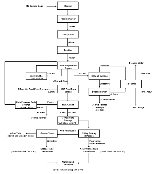
| March 2015 | Page 11-12 |
| Ekati Diamond Mine Northwest Territories, Canada NI 43-101 Technical Report |
Prior to 2003, concentrate from the Koala pilot processing (DMS) plant was delivered in sealed drums to a BHP Billiton diamond recovery plant in Reno, Nevada. Initial processing of the concentrates derived from the DMS plant was similar that described above and screened samples into three different size fractions (+4 mm; -4+2 mm; 2+1 mm or -2+0.5 mm).
Diamond concentrates were produced for each of these fractions using X-ray sorting (Flow Electronics XR 2/19 SW, wet feed type, two-channel, single-pass sorter machine) with the X-ray tails being processed over grease tables to recover non-fluorescent diamonds. A minimum of two passes through the X-ray sorter and grease tables was required and the machine was spiked for quality control prior to each run using X-ray luminescent tracers to monitor diamond recovery efficiency. Grease table audits of the X-ray rejects and random triple manual picking audits of the concentrates result in minor recoveries of small stones. Results of the audits are not applied to the grade data (as the audit data are limited to a small number of samples) and are only used for QA/QC purposes.
All diamond concentrates (pre- and post-2003) from the X-ray sorter and grease tables are dried and weighed, and are double picked for diamonds by experienced diamond sorters with training in diamond identification. X-ray and grease table diamond quantities and weights are recorded separately. After the diamonds are extracted, weighed, and counted, the diamonds are then screened into size fractions and the sieved fractions are weighed and counted. A bottom screen cut-off of 1.0 mm (circular aperture) is utilised for exploration diamond parcels. The total carat weight per sample (pre-cleaned) is used for grade estimation. Individual sieve data are used to address any anomalous stone size distributions and investigate for the effects of large stones within a sample.
The stones from each sample are grouped together and acid cleaned to remove silicate contaminants and coatings on diamond. The cleaned diamonds are re-sieved and described in terms of size, colour, colour intensity, shape, and clarity by trained diamond geologists. Parcels are then sized into Diamond Trading Company (DTC) sales categories and are shipped to the Antwerp marketing office for detailed valuation by trained diamond sorting staff and for storage.
| 11.7 | Quality Assurance and Quality Control |
Prior to running a sample through the sample plant, a visual inspection of the equipment is performed by certified sample plant technicians, especially screens to replace worn panels; the screens are also washed to mitigate contamination between samples.
| March 2015 | Page 11-13 |
| Ekati Diamond Mine Northwest Territories, Canada NI 43-101 Technical Report |
The gap of the cone crusher is monitored to produce -8mm material and the double roll crusher to produce -4mm material. Tracer tests are frequently performed on the heavy media separation (HMS) circuit and on the recovery circuit to monitor their efficiency. Once processed, the samples are kept until the results are known as another pass might be required if there’s a reason to believe that the results are not right.
A grease table is prepared and cleaned for each sample as well as recovery bins are emptied. The x-ray and grease table concentrate are transferred to the sort house and double picked by highly qualified diamond sorters in order to recover all the diamonds.
After valuation from the Antwerp office, the diamonds parcels are sent back to the sorting and valuation facility (SVF) in Yellowknife and kept indefinitely and available for further analysis.
| 11.8 | Databases |
| 11.8.1 | Database Management |
Dominion maintains a site-wide Records Information Management (RIM) system using digital filing. All non-digital information relevant to the Mineral Resource has been scanned and is stored in this system. All digital data not compatible with Ekati’s digital filing system (e.g. Vulcan files) are stored on file servers at Ekati and Yellowknife.
Data are captured as follows:
| • | Geological Data: Currently, data are recorded into GBIS, a commercially-available software system. Legacy data were captured in a variety of formats including paper, Excel, and PDA/Access. Paper files per drill hole are filed both at Ekati and have been scanned and stored in Dominion’s document management system. Transcription errors are first reduced by double checking keyed data. GBIS data are validated and rechecked by logical routines for transcription errors, out of range errors, and down-hole sequencing. The intact pipe wall and pipe stratigraphy drill core intersections are retained at the Ekati core logging facility; | |
| • | Downhole Survey Data: Down-hole survey data are currently stored in GBIS whereas legacy data which has yet to be imported into the database are stored in Vulcan and Excel. Downhole survey data that are collected through Maxibor or gyroscope, are verified in the field. The data are matched with survey (RTGPS method) collar data, and uploaded electronically into the database by the data collector. The results are further verified by drill hole plots and sections. Raw downhole survey files are retained by drill hole and stored with the drill core photos and/or other non-database related information. Single shot (EZ Shot) survey data are added to the database manually after corrections are applied for magnetic declination; |
| March 2015 | Page 11-14 |
| Ekati Diamond Mine Northwest Territories, Canada NI 43-101 Technical Report |
| • | Sieve Data: All sieve data are entered in GBIS with built-in quality control measures, verified by a second party, and total stone counts and weights (carats) per sample are calculated using GBIS. Legacy grade data are maintained in a series of Vulcan files by kimberlite. These are stored on the file server. | |
| • | Physical Properties Data: All electronically-collected data (e.g. calliper, downhole geophysical surveys), is uploaded directly to the GBIS database through a series of software macro that were developed as part of the system design. The raw data files are stored in individual drill hole folders. All other data that are associated with the drill holes are entered directly into GBIS. | |
| Security of the database is maintained through permissions determined at log in by each user. Backups of the digital data are regularly performed. | ||
| 11.9 | Sample Storage |
Core is stored at Ekati in a large sprung structure or outside on pallets. Development and delineation holes are stored on-site; kimberlite is kept in the core storage sprung for protection from the elements, while wall-rock is stored outside at the mine site as it can withstand harsh weather conditions and freeze-thaw cycles.
The core logging facility is located adjacent to the core storage sprung structure. Up to 2,000 m of core can be fed into the core logging facility and, if frozen, is thawed then logged on a roller conveyor system.
Reverse circulation chip samples are also stored at the Ekati core logging facility in water tight containers for future reference.
| 11.10 | Sample Security |
A card-locked door controls the access to the sample plant and strategically installed cameras operate in sensitive areas such as the recovery plant, the sample plant is a high-risk area where 100% of the employees are searched by a security officer prior to exiting the area.
For each sample, the X-ray concentrate and the grease table goods are transferred to the sort house for diamond sorting. Each sample is kept separate from the process plant goods and individually labelled for shipment to the sorting and valuation facility located in Yellowknife. The sample goods are individually sieved and cleaned in Yellowknife and then sent to Antwerp for valuation.
| March 2015 | Page 11-15 |
| Ekati Diamond Mine Northwest Territories, Canada NI 43-101 Technical Report |
The sample plant facility is a high-security area with similar protocols to the main plant recovery area.
During RC drilling programs for large-scale samples, the RC drilling area is monitored by an Ekati site security officer and access is limited to essential personnel only.
| 11.11 | Valuation Parcels |
| 11.11.1 | Koala |
Valuation parcels used to constrain the Koala underground diamond price estimates (Phases 5, 6 and 7) include RC drilling samples, underground drift sampling at approximately the 2050L (50 m amsl; samples were taken during the feasibility study) and run-of-mine (ROM) samples from the lowermost open pit and underground development rounds.
The approach for diamond value estimation for the Koala kimberlite phases was to apply diamond price data from the Koala underground drift sample (4,975 carats) for industry standard DTC size categories (-3+1 DTC, -5+3 DTC, -7+5 DTC, -9+7 DTC, -9+11 DTC, all +11 DTC categories) in combination with the stone size distribution data specific to each phase to enable diamond reference values and recoveries to be calculated for the current effective processing plant cut-off size (1.0 mm).
The diamond reference values presented for Koala correspond to the October 2014 Reference Price Book utilised by Dominion.
The Phase 5 (RVK) valuation is based on stone size distribution from RC drill hole intervals and ROM open pit sampling of the Phase 5 kimberlite. The total parcel size for the stone size distribution data set is 436 carats. Note that a coarseness factor of 5% is applied for Phase 5 due to the small parcel size (larger diamond sizes are likely under-represented in this diamond population).
The diamond reference value for Koala Phase 5 (October 2014) at an effective 1.0 mm cut-off is US$299 per carat with a modelled diamond recovery of 100% (Table 11-1).
| March 2015 | Page 11-16 |
| Ekati Diamond Mine Northwest Territories, Canada NI 43-101 Technical Report |
Table 11-1: Reference Diamond Value (October 2014) for Koala Phase 5 (RVK)
| Category DTC # | Fraction Wt. (%) | Average US$/ct | |
| +11 (all) | 41.2 | $629 | |
| -11+9 | 15.6 | $89 | |
| -9+7 | 12.7 | $75 | |
| -7+5 | 21.1 | $59 | |
| -5+3 | 8.4 | $50 | |
| -3+1 | 1.1 | $23 | |
| Total | 100.0 | $299 | |
| 5% adj. | $314 |
The Koala Phase 6 (VK) valuation is based on the stone size distribution data and valuation data of a 4,975 carat parcel obtained from underground drift sampling. The diamond reference value for Koala Phase 6 (October 2014) at an effective 1.0 mm cut-off is US$372 per carat with a modelled diamond recovery of 100% (Table 11-2).
Table 11-2: Reference Diamond Value (October 2014) for Koala Phase 6 (VK)
| Category DTC # | Fraction Wt. (%) | Average US$/ct | |
| +11 (all) | 54.3 | $629 | |
| -11+9 | 12.3 | $89 | |
| -9+7 | 9.1 | $75 | |
| -7+5 | 17.8 | $59 | |
| -5+3 | 5.5 | $50 | |
| -3+1 | 1.1 | $23 | |
| Total | 100.0 | $372 |
The Koala Phase 7 (VK/MK) valuation is based on stone size distribution from underground development run of mine sampling of the Phase 7 kimberlite. The total parcel size for the stone size distribution data set is 368 carats. The diamond reference value for Koala Phase 7 (October 2014) at an effective 1.0 mm cut-off is US$395 per carat with a modelled diamond recovery of 100% (Table 11-3).
| March 2015 | Page 11-17 |
| Ekati Diamond Mine Northwest Territories, Canada NI 43-101 Technical Report |
Table 11-3: Reference Diamond Value (October 2014) for Koala Phase 7 (VK/MK)
| Category DTC # | Fraction Wt. (%) | Average US$/ct | |
| +11 (all) | 58.0 | $629 | |
| -11+9 | 13.6 | $89 | |
| -9+7 | 10.1 | $75 | |
| -7+5 | 15.3 | $59 | |
| -5+3 | 3.0 | $50 | |
| -3+1 | 0.1 | $23 | |
| Total | 100.0 | $395 |
| 11.11.2 | Koala North |
The Koala North valuation is based on stone size distribution and valuation from underground development run of mine sampling and RC parcels (231 carats). The diamond reference value for Koala North (October 2014) at an effective 1.0 mm cut-off is US$404 per carat with a modelled diamond recovery of 100% (Table 11-4).
Table 11-4: Reference Diamond Value (October 2014) for Koala North
| Category DTC # | Fraction Wt. (%) | Average US$/ct | |
| +11 (all) | 44.8 | $812 | |
| -11+9 | 13.5 | $89 | |
| -9+7 | 10.0 | $89 | |
| -7+5 | 20.2 | $66 | |
| -5+3 | 8.8 | $55 | |
| -3+1 | 2.6 | $26 | |
| Total | 100.0 | $404 |
| 11.11.3 | Fox |
The Fox (TK) valuation is based on stone size distribution data from a 2,062 carat parcel obtained from an underground exploration drift at an approximate elevation range of 175–200 m coupled with diamond price data from a production test (21,928 carats). The production test was carried out in October 2009 on the Fox 240 bench. The resulting valuation parcel data were subsequently re-indexed using Dominion price points and the average carat values per size were applied to the decline size distribution data set. The diamond reference value for Fox (October 2014) at an effective 1.0 mm cut-off is US$306 per carat with a modelled diamond recovery of 100% (Table 11-5).
| March 2015 | Page 11-18 |
| Ekati Diamond Mine Northwest Territories, Canada NI 43-101 Technical Report |
Table 11-5: Reference Diamond Value (October 2014) for Fox
| Category DTC # | Fraction Wt. (%) | Average US$/ct | |
| +11 (all) | 47.9 | $543 | |
| -11+9 | 15.9 | $107 | |
| -9+7 | 11.6 | $93 | |
| -7+5 | 19.0 | $78 | |
| -5+3 | 5.2 | $59 | |
| -3+1 | 0.4 | $27 | |
| Total | 100.0 | $306 |
| 11.11.4 | Misery Main and Misery Satellite Pipes |
The analysis of Misery exploration parcels confirms that the diamonds exploitable from the deeper portion of the pipe have similar quality characteristics to the diamonds in the upper portion of the orebody that were mined by open pit methods between October 2001 and December 2003, and were recovered during processing from stockpiles up until November 2007.
The diamond valuation data utilized for the internal feasibility study for the Misery open pit mine was based upon advanced RC exploration programs in 1995 and 2008. Drill hole intervals from the 1995 program were combined into six samples by elevation range, varying in size from 109 carats to 791 carats and later were combined into a single parcel weighing 3,197 carats. The 2008 RC sample totalled 743 carats.
A production test was carried out from 30 September to 7 October 2004. The feed source was a Misery run-of-mine stockpile (dominantly mud-rich RVK). Approximately 47,000 dry tonnes of Misery-only kimberlite was processed through Ekati’s main processing plant during the production trial period. A total of 71,062 carats were recovered during the entire trial period for a recovered grade (1.6 mm slot screen) of 1.52 carats per tonne. The total diamond production from Day 3 and Day 4 (October 5–6, 2004) was kept separate for valuation. The parcel was cleaned and sized at the Yellowknife Sorting Valuation Facility (SVF). The final cleaned/sized parcel totalled 33,578 carats.
The complete Misery Day 3–4 diamond parcel (33,578 carats) was detail value sorted at the BHP Billiton Diamonds Antwerp office in December 2004. A total of 953 value categories (price points) were distinguished for Misery within the standard DTC size categories. The Price Book data were subsequently re-indexed to the October 2014 Dominion Price Book.
| March 2015 | Page 11-19 |
| Ekati Diamond Mine Northwest Territories, Canada NI 43-101 Technical Report |
The average price per carat data (for each DTC size category) were applied along with the size distribution data for the 1995 exploration samples and process plant recovery factors to estimate the average carat value at 1 mm effective cut-off.
The diamond reference value for Misery Main and its satellite intrusions (Misery South, Misery Southwest Extension and Misery Northeast) at an effective 1.0 mm cut-off is US$86 per carat with a modelled diamond recovery of 100% (Table 11-6).
Table 11-6: Reference Diamond Value (October 2014) for Misery Main, Misery South, Misery Southwest Extension and Misery Northeast
| Category DTC # | Fraction Wt. (%) | Average US$/ct | |
| +11 (all) | 19.5 | $235 | |
| -11+9 | 14.5 | $59 | |
| -9+7 | 13.3 | $43 | |
| -7+5 | 30.6 | $39 | |
| -5+3 | 16.4 | $48 | |
| -3+1 | 5.8 | $27 | |
| Total | 100.0 | $86 |
This includes an additional factor of +5% value per carat for large yellow fancy diamonds that are unique for Ekati to the Misery pipes (Figure 11-2).
| March 2015 | Page 11-20 |
| Ekati Diamond Mine Northwest Territories, Canada NI 43-101 Technical Report |
Figure 11-2: Fancy Yellow Diamonds from Misery (46.5 ct – left, 23.9 ct – right)
![]()
| 11.11.5 | Pigeon |
The Pigeon diamond valuation estimate is based on the combined diamond value dataset from a production parcel (15,355 carats) obtained from a trial pit in early 2010 and smaller RC drilling diamond parcels (687 carats). The diamond size distribution data from RC drilling campaigns sampling two kimberlite domains (RVK and MK) are used in combination with the overall price data to estimate domain specific average diamond values and recovery factors. Studies of distinct parcels from different areas of the pipe indicate similar diamond size distribution (slightly coarser for the RVK domain) and similar diamond characteristics.
The diamond reference value for Pigeon RVK (October 2014) at an effective 1.0 mm cut-off is US$188 per carat with a modelled diamond recovery of 100% (Table 11-8) and the diamond reference value for Pigeon MK (October 2014) at an effective 1.0 mm cut-off is US$160 per carat (Table 11-9). Both estimates include a 5% coarseness factor which has been applied due to the small parcel sizes defining the two domains (388 carats for the RVK parcel and 298 carats for the MK parcel, respectively).
| March 2015 | Page 11-21 |
| Ekati Diamond Mine Northwest Territories, Canada NI 43-101 Technical Report |
Table 11-7: Reference Diamond Value (October 2014) for Pigeon RVK
| Category DTC # | Fraction Wt. (%) | Average US$/ct | |
| +11 (all) | 38.6 | $357 | |
| -11+9 | 16.0 | $77 | |
| -9+7 | 10.5 | $68 | |
| -7+5 | 19.6 | $69 | |
| -5+3 | 10.0 | $57 | |
| -3+1 | 5.3 | $38 | |
| Total | 100.0 | $179 | |
| 5% adj. | $188 |
Table 11-8: Reference Diamond Value (October 2014) for Pigeon MK
| Category DTC # | Fraction Wt. (%) | Average US$/ct | |
| +11 (all) | 30.0 | $357 | |
| -11+9 | 14.9 | $77 | |
| -9+7 | 10.4 | $68 | |
| -7+5 | 22.7 | $69 | |
| -5+3 | 13.0 | $57 | |
| -3+1 | 9.0 | $38 | |
| Total | 100.0 | $152 | |
| 5% adj. | $160 |
| 11.11.6 | Sable |
An RC drilling campaign was carried out to provide grade and diamond value estimates for the Sable pipe in 1996. The original Sable valuation parcels were divided into six packets according to pipe sector and vertical depth range. Grade and diamond distribution data do not indicate significant diamond content or size distribution differences between the VK and RVK domains. For these reasons, it was decided to combine the parcels into a single parcel for re-valuation in January 2006.
The diamond reference value for Sable (October 2014) at an effective 1.0 mm cut-off is US$156 per carat with a modelled diamond recovery of 100% (Table 11-9).
| March 2015 | Page 11-22 |
| Ekati Diamond Mine Northwest Territories, Canada NI 43-101 Technical Report |
Table 11-9: Reference Diamond Value (October 2014) for Sable
| Category DTC # | Fraction Wt. (%) | Average US$/ct | |
| +11 (all) | 29.4 | $443 | |
| -11+9 | 11.4 | $56 | |
| -9+7 | 10.5 | $47 | |
| -7+5 | 21.1 | $48 | |
| -5+3 | 15.1 | $38 | |
| -3+1 | 12.6 | $35 | |
| Total | 100.0 | $162 |
| 11.11.7 | Jay |
Diamonds collected during the 1996 and 2006 RC drilling campaigns were grouped into parcels for grade and value estimates. Five valuation parcels totalling 2,237carats were available for the diamond value estimation. The 1996 RC samples were divided into two parcels (RVK and VK), whereas, the 2006 samples were separated into three parcels (RVK, Transitional, and VK).
Size distribution differences with depth were used to derive expected diamond prices in US$ per carat per 15 m bench for use in the evaluation of Mineral Reserves. This involved using the reference prices in dollars per carat per size class, as discussed below, and applying these reference prices to localized stone size distributions.
Estimated diamond price per size class was produced by Dominion following the March 2014 resorting of the combined RC sample parcels and an updated valuation to mid-2014 prices. This resulted in an overall average estimated price for the Jay goods of US$56.58 per carat, as well as an estimated price per size class interval, which was used as the reference price curve for determination of average prices per bench.
The size distributions shown in Figure 11-3 were based on Pierre sieve data collected on individual samples during the RC drilling program at Jay.
| March 2015 | Page 11-23 |
| Ekati Diamond Mine Northwest Territories, Canada NI 43-101 Technical Report |
Figure 11-3: Size Distribution of Reverse Circulation Sample Parcels Overlain on Misery Test Pit
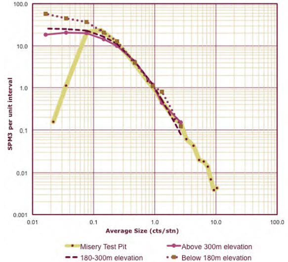
Although reasonably well defined, the size distributions are based on limited sampling information (approximately 400 carats above 300 m amsl and approximately 900 carats in both of the other depth ranges, for a total of 2,237 carats) and do not necessarily represent the full Jay size distribution. Misery Main pipe has a similar size distribution to Jay but more extensive sampling within the coarse diamond sizes. The Jay curves in Figure 11-3 are overlain on the size distribution curve for a Misery production sample from a test pit mined in 2002, which yielded some 33,500 carats. The Misery test sample was processed using a 1.6 mm bottom cut-off size relative to the Jay RC samples at 1.0 mm, explaining the sharp fall-off in recovery of very small stones. However, the portion of the curve above about 0.4 carats/stone (+11 size class) is considered representative of the full size distribution.
| March 2015 | Page 11-24 |
| Ekati Diamond Mine Northwest Territories, Canada NI 43-101 Technical Report |
The close alignment of the three size distribution curves, especially for the larger stones +11 sieve size, is remarkable, and it would appear to be a reasonable assumption that the Misery size frequency distribution could be substituted for the Jay curve for stones larger than +11.
A derived complete distribution for the RC samples in the three elevation ranges is shown in Figure 11-4, with the size distribution of stones larger than +11 replaced by +11 stones from the Misery curve. It was concluded that for price modelling purposes the size distribution curves be determined as a combination of the sampled size curves for the smaller -11 stones, and of the Misery test pit curve for the larger stones.
Figure 11-4: Size Distribution of Reverse Circulation Sample using Misery Test Pit Curve for >+11 Sizes
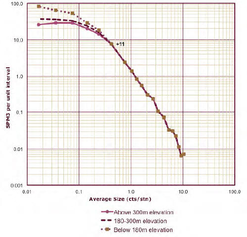
It is noted, however, that the Misery test pit sample shows the recovery of a number of larger stones (greater than five carats per stone), while no stones of this size were recovered in the Jay RC samples. This might be considered a sample size effect, in that the 2,237 carats recovered from Jay represents a much smaller parcel than the 33,500 carats from Misery. The Monte Carlo simulation exercise showed that a parcel of 2,237 carats would be expected to have, at a P10/P90 level, one to six stones of five carats or larger. This analysis further showed a probability of some 3% of having no stones of this size in a 2,237 carat parcel, indicating that the absence of these stones in the Jay RC samples is unlikely to be a statistical sampling effect. Other issues, such as diamond breakage in RC drilling, may explain the apparent absence of larger stones at Jay, or there may indeed be a natural curtailment of the distribution.
| March 2015 | Page 11-25 |
| Ekati Diamond Mine Northwest Territories, Canada NI 43-101 Technical Report |
Given the above, three cases of underlying size distribution are presented for comparison:
| • | Use of the modelled Jay size frequency distribution with no adjustment; | |
| • | Use of a blend of the actual Jay distribution up to +9 size classes and the Misery curve for +11 classes, but not including any stones 5 carats or greater; | |
| • | Use of a blend of the actual Jay curve and the full Misery curve including all large stones. |
The impact of these three different cases on the overall estimated diamond price is shown in Figure 11-5, which gives the cumulative contribution to overall price of each of the size classes for a number of different cases. Substitution of the Misery curve for stones +11 size class and larger has a large impact for stones four grainer and above, even if the distribution is curtailed at five carats and below.
Figure 11-5: Cumulative Contribution to Estimated Price from Each Size Class
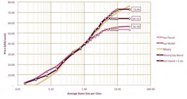
| March 2015 | Page 11-26 |
| Ekati Diamond Mine Northwest Territories, Canada NI 43-101 Technical Report |
The Misery size frequency distribution curve is likely a better representation of what the underlying Jay curve would be if more carats had been recovered, particularly in the +4 grainer to four carat range, and that this would be a realistic central case on which to base economic analysis. The actual Jay distribution would represent a downside case, and potential upside in the shape of potential recovery of larger stones would be represented by the case with the full Misery size distribution.
This modelling results in an estimated average price of $56.58 for the low case, $64.11 for the mid case, and $73.04 for the high case. The selected diamond reference case for Jay is the mid case (US$64 per carat).
| 11.11.8 | Lynx |
Diamonds collected during the 2002 and 2003 RC drilling campaigns were grouped into parcels for grade and value estimates. A total of 277 carats comprise the overall Lynx valuation parcel.
The diamond reference value for Lynx (October 2014) at an effective 1.0 mm cut-off is US$300 per carat with a modelled diamond recovery of 100% (Table 11-10).
Table 11-10: Reference Diamond Value (October 2014) for Lynx
| Category DTC # | Fraction Wt. (%) | Average US$/ct | |
| +11 (all) | 47.4 | $466 | |
| -11+9 | 11.3 | $45 | |
| -9+7 | 9.8 | $35 | |
| -7+5 | 17.1 | $41 | |
| -5+3 | 9.4 | $33 | |
| -3+1 | 5.1 | $21 | |
| Total | 100.0 | $241 |
| 11.12 | Comments on Sample Preparation, Analyses, and Security |
The responsible QPs are of the opinion that the quality of the diamond recovery and valuation data are sufficiently reliable (also see discussion in Section 12.0) to support Mineral Resource and Mineral Reserve estimation, and that sample preparation, analysis, and security are generally performed in accordance with exploration best practices and industry standards as follows:
| • | Data are collected following industry-standard sampling protocols; |
| March 2015 | Page 11-27 |
| Ekati Diamond Mine Northwest Territories, Canada NI 43-101 Technical Report |
| • | Sample collection and handling of core was undertaken in accordance with industry-standard practices, with procedures to limit potential sample losses and sampling biases; | |
| • | Bulk samples in the form of underground exploration drifts, test pits, or production- scale open-pit sampling were also collected in accordance with industry-standard practices, with procedures to limit potential sample losses and sampling biases; | |
| • | Large-scale RC sampling was undertaken in accordance with industry-standard practices, with procedures to limit potential sample losses and sampling biases. RC sample intervals were composited over 12 to 30 m intervals (depending on hole diameter) to provide samples typically ranging from 5 to 9 t; the sample intervals were selected appropriately to ensure each composite contained at least 30 diamonds to mitigate the effect of variable diamond particle sizes; | |
| • | Bulk density determination procedures are consistent with industry-standard procedures, and there are sufficient bulk density determinations to support tonnage estimates; | |
| • | Sample tonnes are estimated from sample volume (derived from calliper log data) and a corresponding dry bulk density value. In accordance with best practices, the resulting volume calculations are verified by experienced personnel to ensure that calliper data correspond to the sample intervals and that appropriate correction procedures are applied; | |
| • | Diamonds are recovered and weighed from each sample using appropriate duplicate processes at every point to minimise loss; | |
| • | Up until 2014, sample grades were defined by the total carat weight for all diamonds retained on a circular 1 mm aperture sieve divided by the estimated sample volume. These grades were used directly in Mineral Resource estimation. From 2014 the grade estimation method has used stones per cubic meter combined with size frequency distributions, which is considered a more appropriate method; | |
| • | The sample plant is essentially a scaled-down version of the Ekati process plant with similar process flow design; because of this similarity it is considered that the smaller sample parcels processed through the plant reflect the recoveries that would be expected from the Ekati process plant; | |
| • | Diamond valuations used for Mineral Resource and Mineral Reserve estimates are based, depending on pipe, on a combination of RC and bulk samples. Diamond reference values correspond to Dominion October 2014 Price Book. Valuation figures vary by pipe and domain; |
| March 2015 | Page 11-28 |
| Ekati Diamond Mine Northwest Territories, Canada NI 43-101 Technical Report |
| • | In some cases factors have been applied to average diamond prices to account for coarseness of the distribution, or the presence of fancy stones. Improved methods of estimating diamond price are being developed by Dominion that will obviate the need for factors; | |
| ||
| • | Data are appropriately managed through a dedicated database. Data that were collected were subject to validation, using in-built program triggers that automatically checked data on upload to the database; | |
| • | Verification is performed on all digitally-collected data on upload to the main database, and includes checks on surveys, collar co-ordinates, geological/geotechnical logging, and diamond sampling and valuation data. The checks are appropriate, and consistent with industry standards; | |
| ||
| • | Sample security is in line with industry practices for diamond operations. A card- locked door controls the access to the sample plant and strategically installed cameras operate in sensitive areas; in such areas, 100% of the personnel are searched by a security officer prior to exiting the area; | |
| ||
| • | Sample storage is in line with industry standards; sample retention policies are well established and appropriate to the mineralization style. |
| March 2015 | Page 11-29 |
| Ekati Diamond Mine Northwest Territories, Canada NI 43-101 Technical Report |
| 12.0 | DATA VERIFICATION |
| 12.1 | Down Hole Deviation Survey Accuracy |
A study of down-hole deviation survey accuracy was undertaken at Koala to determine the uncertainty of drill hole position. Deviation error for surface holes drilled in 1994 and 1995 was assumed to be higher than the error from holes drilled later and surveyed with more accurate tools. According to Reflex Technologies, the instrument manufacturer, the error for the EZ-Shot tool is 1º per 100 m (1.7 m per 100 m). Reflex Technologies also reports the error for the Maxibor tool used for holes drilled in 2002 onwards as 0.6º per 100 m (1 m per 100 m). These specifications were verified in part at Ekati from drill holes tested with multiple surveys.
In addition, several grouted drill holes observed during open pit mining of the Panda kimberlite were accurately surveyed and their coordinates were found to be within the expected error after comparison with the drill hole survey data.
Confirmation of down hole survey error was also made by comparison of drill hole pierce point positions with surveyed kimberlite boundaries in the open pit (recognizing that there is up to ±3 m error in the surveyed kimberlite contacts). Drill hole pierce point positions are conformable with surveyed kimberlite boundaries to within an average of ±2.2 m per 100 m of drill length.
Additionally, drill hole survey error assumptions were confirmed by core drilling at Panda. Two completed cable holes successfully intersected a 5.0 m wide target drift at depths of over 300 m.
The expected maximum survey instrument error, 1.7 m per 100 m was used to derive the error peripheral limits, herein termed “error circle” at pierce point contacts from surveyed holes for volume range analysis modelling. An error of 5.6 m per 100 m or two standard deviations of the average measured deviation from the underground core drilling program was used to derive error circles for core holes where downhole surveys were partially or completely estimated.
| 12.2 | Database Verification |
| 12.2.1 | Geological Data |
All drill hole data are recorded either on paper logging sheets or digitally. In the case of paper logging sheets, the data are captured and verified into MS Excel spreadsheets, and made available for review.
| March 2015 | Page 12-1 |
| Ekati Diamond Mine Northwest Territories, Canada NI 43-101 Technical Report |
The QA/QC process for the hard copy and digital data is as follows:
| • | The MS Excel spreadsheets are double-checked for transcription errors by Resource and/or Production Geologists; | |
| • | Data are imported from the GBIS database into a Vulcan™ project database; | |
| • | Vulcan™ automates searching for transcription errors (e.g. down hole ‘from’ depth always less than ‘to’ depth), out of range errors (e.g. grade above database limit), and down hole sequencing (e.g. total hole depth inconsistent with grade sample length); | |
| • | After this preliminary error-checking, all hardcopy and digital data for each drill hole are validated by the Resource Geologist. |
| 12.2.2 | Survey Data |
All survey data are reviewed for accuracy by the Resource and/or Production Geologists and corrected as necessary. Geological domains and down hole survey data are reviewed to check accuracy. The findings of this data validation process are summarized and any modifications to the database are reviewed by the Resource Geologist prior to implementation. | |
| 12.2.3 | Bulk Density Data |
All bulk density data are reviewed for accuracy by the Resource and/or Production Geologists and corrected as required. The findings of this data validation process are summarized and any modifications to the database are reviewed by the Resource Geologist prior to implementation. | |
| 12.2.4 | Geotechnical Data |
The corrected electronic files from geophysical logging are loaded into the geological project database (GBIS and Vulcan databased) and validated and rechecked by logical routines for more complex transcription errors (i.e. down hole from depth always less than to depth), out of range errors (i.e. values above or below above database limits, and down hole sequencing (i.e. total hole depth inconsistent with sampled length). The geotechnical data are then reviewed by independent geotechnical consultants during development studies as directed by the mine site Technical Services department. |
| March 2015 | Page 12-2 |
| Ekati Diamond Mine Northwest Territories, Canada NI 43-101 Technical Report |
| 12.2.5 | Database Maintenance |
All digital data required to re-create the Mineral Resource estimate are secured in a central Vulcan™ project database at the Ekati Project site. Once finalized the Vulcan™ database is considered the master version from which all data are exported or read. Importing and modifying the master is controlled with user hierarchy, file and record locking, limit checking, independent auditing, spot checks, data validation, ‘meta’ data documentation, and security/redundancy subroutines. The resource and production geologists maintain the Vulcan™ project databases and metadata documentation. These are employed to secure the data and maintain an audit trail of the deposit database. | |
| 12.3 | Sample Plant Audits |
Comprehensive audits were carried out on the Ekati sample plant in September 2006 upon completion of a contract project with Peregrine Diamonds Ltd. There were no concerns noted and the sample plant was found to be operating with very high efficiency rates. It was recommended that an annual audit of the Sample Plant be carried out using an Ekati control parcel and purged exploration sample concentrates.
The initial annual sample plant audit was completed in January 2007. A composite sample (202 kg) was prepared by combining four Koala RC concentrate tails from drill hole K-24. The first pass results of the four samples (K24-14, 17, 21 and S4) totalled 31.16 carats. The composite sample was run through the final recovery circuit three times to purge the sample from remaining diamonds. A total of 3.17 carats were recovered in the purge stages. Approximately 91% of the diamonds by carat weight were recovered in the original sample process (i.e. after the first pass final recovery circuit). The recovery ranged from 65.6% for the grease table to 96.3% by the X-ray circuit. The X-ray circuit (two X-ray units in parallel) yielded significantly higher recovery rates.
The purged (barren) composite concentrate sample was then spiked with a control parcel from the Misery pipe (53.49 carats). The spiked concentrate was run through a first pass recovery using the same procedures as for typical exploration samples (i.e. single pass through two X-ray sorting units and single pass over grease table). The overall recovery of the introduced Misery diamonds after the first pass recovery was approximately 92% by carat weight. Almost all of the diamonds were recovered via the X-ray circuit. The grease table recovery was negligible for the first pass of the audit test.
The concentrate was then run through second and third pass recoveries using the same procedures as for the first pass (i.e. single pass through two X-ray sorting units and single pass over grease table). An additional 3.31 carats were recovered from the second pass concentrates including 0.71 carats from the grease table. Overall, most of the second pass recoveries were in the two smallest size fractions. Approximately 1.2 carats were recovered from the third pass concentrates (2.2% of the total carat weight of the spike parcel).
| March 2015 | Page 12-3 |
| Ekati Diamond Mine Northwest Territories, Canada NI 43-101 Technical Report |
The overall recovery for the three passes (53.89 carats) slightly exceeded the spike parcel size (53.49 carats) indicating that the sample concentrate had not been completely purged. The recoveries were normalized by backing out the extra recoveries in the smaller size ranges so that the maximum recovery by size category was 100%. The normalized total recovery was approximately 99% by carat weight. All 43 stones (19.89 carats) from the largest size category (+2.8 mm) were recovered. For the +2.0 mm category, the recovery was 97.7% by weight (17.57 carats recovered versus 17.98 carats in the Misery spike parcel). It was not possible to accurately assess the two smallest size fractions due to the additional diamonds recovered from the sample concentrate.
The audit is considered to provide strong evidence that the Ekati sample plant was operating at high efficiency. The overall recovery in terms of value (92%) and carat weight (92%) for the first pass audit suggested that a second pass through recovery was not critical for most applications (e.g. grade control, follow-up bulk samples). The use of a second pass for the audit test increased the overall recovery to 98% in terms of value.
| 12.4 | Comments on Data Verification |
The responsible QPs consider that a reasonable level of verification has been completed during the exploration and production phases, and no material issues would have been left unidentified from the verification programs undertaken. Because of the uncertainties inherent in establishing local grade estimates (sample support size), no Measured Mineral Resources have been estimated. |
| March 2015 | Page 12-4 |
| Ekati Diamond Mine Northwest Territories, Canada NI 43-101 Technical Report |
| 13.0 | MINERAL PROCESSING AND METALLURGICAL TESTING |
| 13.1 | Metallurgical Test Work |
| 13.1.1 | Plant Design Test Work |
The studies summarized in Table 13-1 were completed in support of the original plant design.
Table 13-1: Plant Design Test Work Summary
| Laboratory | Testing Performed | |
| Dia Met plant, Fort Collins, Colorado | Pilot-scale processing of bulk drill samples | |
| BHP Minerals' facility, Reno, Nevada | Downstream processing of the pilot plant concentrates for diamond recovery | |
| Krupp-Polysius, KHD Humboldt Wedag, LLCF | High pressure grinding roll (HPGR) test work | |
| Allied Colloids | Flocculant requirement determination by pipe | |
| Eimco, Outokumpu Mintec | Settling tests on samples from Koala, Panda, Fox and Misery | |
| Eimco, Outokumpu Mintec | High rate thickening test work small-scale test units | |
| Hazen Research | Grindability test work on Koala core samples | |
| Nordberg | Water flush crushing tests by on Fox and Panda bulk sample material and Leslie surface material | |
| Steffen Robertson & Kirsten | Rock strength property determinations | |
| Jenike and Johanson | Material flow property test work on Panda and Fox bulk sample material | |
| Pipeline Systems Incorporated; Georgia Iron Works | Processed kimberlite pumping test work on Fox and Panda bulk sample material |
Since plant construction, additional work has included:
| • | Conversion from a one feed source (Panda) operation to multiple feed source plant operation (Panda, Koala, Koala North, Misery, Fox, and Beartooth); | |
| • | Expansion of the nameplate operation rate from 9.0 kt/d to 12.5 kt/d; | |
| • | Tying-in underground feed and testing the impact of underground metal and additives (e.g. shotcrete) from Beartooth, Koala North and Panda; | |
| • | Completion of scheduled sampling for crushability testing as required for the material in the Mineral Reserves mine plan; | |
| • | Revision of the 1995-designed scrubbing, settling and thickening plant treatment envelope through direct drill core sampling of additional resources in the Mineral Reserves mine plan; |
| March 2015 | Page 13-5 |
| Ekati Diamond Mine Northwest Territories, Canada NI 43-101 Technical Report |
• | Performing ongoing monitoring of mineralogy and metallurgical behaviour of heavy media concentrations and other minor variables of exploration samples collected for on-site bulk sample treatment. |
| 13.1.2 | Current Testing |
Metallurgical test work is carried out at the Ekati Project site using both the main process plant (production trials) and a similarly configured smaller test plant (approximately 10 t/h). Production trials have been completed at various times for the open pit operations (including Fox, Misery and Koala) and during pre-feasibility-level studies for Koala North and Pigeon (test pits).
The sample plant is utilised for grade model validation for the current operations, testing of new kimberlite sources as possible process plant feed (e.g. satellite kimberlite intrusions and reprocessed plant rejects) and periodic recovery audits for the main process plant. The processing circuit comprises crushing, scrubbing, sizing, heavy media separation and final diamond recovery using both X-ray sorting and grease table methods.
Strict security protocols are in place at the recovery area of the main process plant and for the sample plant and are similar for both plants.
The process plant head feed is sampled daily for moisture content and the moisture is adjusted regularly to reflect the results. The plant feed conveyor (CV005) is calibrated every five weeks during the outage as well as coarse rejects conveyor (CV017). Dominion also performs a flocculant and coagulant strength test on a monthly basis to verify reagent dosing rates. There is a small metallurgical laboratory in the processing plant that is capable of completing size analysis of all feed streams in the plant. A sample program is in place whereby 17 samples can be taken from strategic locations for analysis.
Within the heavy media separation (HMS) area the density is manually checked twice per shift and any adjustments to the instruments are completed as required. In the HMS area the magnetic separator effluent and material on the floats screen is sampled several times per shift for ferrosilicon (FeSi) losses.
Random tracer tests are completed periodically; the tracers are non-magnetic, fluorescing and a range of sizes and densities is used. The tests audit HMS and recoveries for efficiency. In the recovery area each X-ray unit also receives a tracer test every three weeks as a part of regular preventative maintenance.
| March 2015 | Page 13-6 |
| Ekati Diamond Mine Northwest Territories, Canada NI 43-101 Technical Report |
Strict security protocols (including mandatory searches and video surveillance) are in place at the recovery area of the main process plant and for the sample plant and are similar for both plants.
| 13.2 | Recovery Estimates |
Recovery of diamonds is a function of many variables including process plant configuration (e.g., primary sizers and crushing circuit, de-grit screens, heavy media cyclones, final recovery using X-ray and grease table separation), kimberlite feed characteristics (e.g. clay content, inclusion of granite and/or other country rock fragments) and metallurgical variability.
Diamond processing plants are designed to target a given size range based on the overall economic value distribution of the diamonds in the plant feed. The plant overall top cut-off represents the maximum feed size to HMS and the overall bottom cut-off represent the minimum feed size to HMS. These figures are normally quoted as nominal values in millimetres, and represent the screen aperture size of the screens that make the final size classifications. The effective cut-offs can differ from the nominal values due to factors such as screen wear, screen aperture shape, particle shape and screening efficiency.
At the Ekati Mine, the overall top cut-off is controlled by the top deck of Screen 2 (secondary scrubber discharge screen) and has a nominal value of 28 mm. The overall bottom cut-off is controlled by the top decks of Screens 3 and 4, which are de-gritting screens, and the decks on Screens 7 and 10 (HMS feed preparation screens). The overall bottom cut-off currently has a nominal value of 1.2 mm. The overall bottom cut-off must be maintained on all screens downstream that handle HMS concentrate (i.e. the sinks screens and all of the screens in the recovery plant).
In order to improve the control over the overall process plant bottom cut-off size of 1.2 mm, a stricter set of tolerances was adopted for changing out screen panels on the de-grit and feed preparation screens in October 2013. Prior to this date, panels were allowed to wear to 1.7 mm effective slot widths or greater. Since October 31, 2013, however, panels are to be changed if they exceed 1.5 mm effective slot width. This change has had a positive overall impact on plant recovery efficiency, but because this slight change in tolerance is being applied to material at close to run-of-mine grade, the impact would not be as significant as the change to the sinks screen size in October 2013 (see discussion in Section 13.2.2).
Figure 13-1 shows a basic flow through the process plant, highlighting the areas where the overall bottom cut-off is controlled.
| March 2015 | Page 13-7 |
| Ekati Diamond Mine Northwest Territories, Canada NI 43-101 Technical Report |
Figure 13-1: Schematic Flowsheet showing the Control Points for the Bottom Cut-off
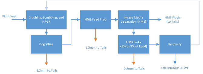
Note: Figure dated February 2015.
| 13.2.1 | Incidental Fine Diamond Recovery |
Any given diamond processing plant will have a specific nominal overall bottom cut-off, but will always recover some diamonds that are smaller than the bottom cut-off due to screening inefficiency. These “incidentals” are stones that are small enough to pass through the screens, but do not, because the screening process is not 100% efficient. If a screen is loaded beyond the design capacity, or the screen panels are performing poorly, the screening efficiency will decrease resulting in more fine material misreporting to the screen oversize stream.
| 13.2.2 | HMS Sinks Screens |
The sinks drain and rinse screens (or sinks screens) are the final washing step for all concentrate before it is transferred into the recovery plant. Material that passes through the rinse section of the sinks screens is lost to HMS effluent which is pumped to the fine processed kimberlite containment facility via the thickeners.
It is standard practice in diamond processing plants to have a sinks screen cut-off size that is one or two screen aperture sizes smaller than the overall plant cut-off size. The best theoretical practice is to use square aperture panels, but in reality, slotted apertures provide better drainage and ‘wear-life vs. open-area’ profiles than square panels.
In October 2013, Ekati’s processing plant sinks screen panels (mostly 1.2 mm x 14 mm long slot apertures) were replaced with 0.8 mm x 8.8 mm screen panels.
| March 2015 | Page 13-8 |
| Ekati Diamond Mine Northwest Territories, Canada NI 43-101 Technical Report |
The change in screen size from 1.2 mm to 0.8 mm in October 2013 had a significant impact on the number of stones recovered in the 0.8 mm to 2.0 mm range (particularly for finer diamond distributions such as Misery). Figure 13-2 shows the overall size frequency distribution for the date ranges before (red) and after (blue) the sinks screen change. There is also an adjusted line (shown in green in Figure 13-2) that reflects the distribution for the November period if it is normalized to the slightly higher overall grade of 0.43 cpt for the September period.
Figure 13-2: Effect of Sinks Screens Panel Size Change
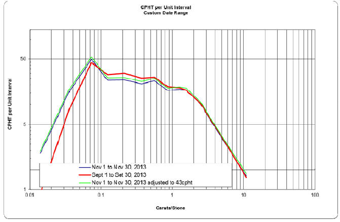
Note: Figure prepared February 2015.
Since the modifications to the processing plant in late 2013, its effective size cut-off is essentially equivalent to the sample plant (1.0 mm slot). Therefore, the overall diamond recovery factor used in the estimation of the Mineral Reserves is 100% relative to the reported Mineral Resources. The differences in diamond qualities (price points) and size distribution (stone size frequency distributions) per source are reflected by different diamond value estimates (refer to Section 11.11).
Partition curves were historically used to simulate recovery differences between the exploration samples and run-of-mine production and to model the resulting value change; this practice has been discontinued.
| March 2015 | Page 13-9 |
| Ekati Diamond Mine Northwest Territories, Canada NI 43-101 Technical Report |
| 13.3 | Metallurgical Variability |
| 13.3.1 | Bulk Sampling |
The large-scale and bulk sampling programs described in Section 11 were used to evaluate the metallurgical variability of the kimberlite domains to be treated through the Ekati processing plant. Samples were selected from a range of depths within the deposits. Large bulk samples were taken for the Koala underground mine using an exploration drift and for Pigeon open pit using a test pit (Section 11.1).
Metallurgical testing for the Misery satellite pipes (Misery South and Misery Southwest Extension) have been based on in-pit samples (up to 100 dmt) through the Ekati sample plant.
Indirect metallurgical information is provided by processing of RC drill samples through the sample plant and by test work on drill core.
| 13.3.2 | Coarse Tail Rejects |
A coarse ore reject sample is considered to be representative of the operating conditions of the plant, and is a timed sample taken over an hour of production to represent the whole 24 hours. The variability of the results can be attributed to the sampling methodology, the variability of the grade itself, the accuracy of the scales from which the calculations are based on, and on the performance of the recovery plant.
The coarse tail reject audits measure the performance of the main plant up to the recovery circuit as the samples are taken. The performance of the plant is generally above 90% recovery by weight and more than 96% recovery by value to an effective cut-off of 1.0 mm. A low recovery is a concern and can either come from an inefficient liberation in the high pressure grinding roll (HPGR) circuit or from a poor separation in the HMS circuit
| 13.4 | Deleterious Elements |
There are no deleterious elements in diamonds processing. However, a high amount of clay and/or granite can create processing challenges.
A high clay or moisture content in kimberlite material or kimberlite fines can lead to blockages in the HPGR circuit and conveyor chutes, and clumping of wet, sticky fines across the sink, de-grit and HMS feed preparation screens. Dominion typically manages the clay and moisture-rich feed through blending strategies.
| March 2015 | Page 13-10 |
| Ekati Diamond Mine Northwest Territories, Canada NI 43-101 Technical Report |
The presence of granite in the feed in high content increases the recirculating load between the HPGR and the secondary scrubber and decreases the quality of the feed to the HMS. It also displaces kimberlite in the plant feed which leads to the processing of material with no value. The granite that makes it to the recovery circuit is non-magnetic and sometimes fluoresces under the X-rays increasing the percentage of rejects in the final diamond concentrate. High granite content is also a concern for the sizers as it contributes to wear, damage and increases the probability of sizer stalls, resulting in plant downtime. Dominion manages the granite load by using a surface ore-sorting program to reduce waste rock feed to the plant.
The increased compressive strength of the waste granite can also cause process upsets, and is typically limited to 5% of overall plant feed in general operating practice. High granite loads can also cause bottlenecking of the secondary water flush cone crusher, increased recirculating load between the HPGR and the secondary scrubber, increased feed to the HMS circuit, and an increase in feed reporting to the recovery circuit through the HMS sinks. Once reporting to recovery, mineralised granite can be problematic to separate from diamonds in the automated recovery circuit as it tends to be non-magnetic, and the minerals associated with the rock tend to fluoresce, resulting in ejections and intermingling with diamond product.
Tramp metal can also cause process issues. The current design of the underground conveyor system has four magnets, the first of which is on a wide picking belt designed to spread the muck, facilitating metal removal. The remaining magnets are located at transfer points along the underground conveyor. A metal detector is also used to identify large pieces of tramp metal. The primary concern with respect to metal is damage to the roll segments, roll bearings, or even the drive of the HPGR.
| 13.5 | Comments on Mineral Processing and Metallurgical Testing |
In the opinion of the responsible QPs,
| • | Metallurgical test work and associated analytical procedures were performed by recognized testing facilities, and the tests performed were appropriate to the mineralization type; | |
| • | Samples selected for testing were representative of the various kimberlite types and domains; | |
| • | Industry-standard studies were performed as part of process development and initial plant design. Subsequent production experience and focused investigations have guided plant expansions and process changes; |
| March 2015 | Page 13-11 |
| Ekati Diamond Mine Northwest Territories, Canada NI 43-101 Technical Report |
| • | Recovery estimates are based on appropriate metallurgical test work and confirmed with production data, and are appropriate for the various kimberlite domains; | |
| • | While there are no deleterious elements in diamonds processing, high granite or clay quantities can lead to process difficulties. These are managed by a combination of surface sorting and blending of different kimberlite domains; | |
| • | Development of the Pigeon and Jay kimberlites will require careful attention to the quantities of sediments/fines and heavy mineral content in the plant feed (refer to Section 17.5.2 and Section 17.5.3); | |
| • | Development of the Jay kimberlite will also require assessment of the overall processability of the material, based on bulk sample processing through the sample plant, and additional clay characterization test work. |
| March 2015 | Page 13-12 |
| Ekati Diamond Mine Northwest Territories, Canada NI 43-101 Technical Report |
| 14.0 | MINERAL RESOURCE ESTIMATES |
Resource estimation is a two-step process at Ekati. The first step is to develop three-dimensional object models for key geological domains, analyse spatial sample data in relation to geological domains, and validate their application. The second step is to create a block model storing the spatial distribution of relevant parameters.
| 14.1 | Geological Models |
In general, kimberlite pipes are roughly ovoid in plan-view, and taper consistently at depth. Vulcan™ and LeapFrog™ software are used to develop three-dimensional wireframe models of the kimberlite pipes and internal lithological divisions. Drill hole boundary intersections and surface geophysical outlines are used to define the outer boundary. The lower limits of models are based on the lowest drill hole (RC or diamond) intersection. Internal domain boundaries are typically modelled as planar surfaces. Internal dilution (e.g. granitic xenoliths) is modelled as enclosed volumes assuming sub-rounded, sub-horizontal shapes. The geological models are refined and updated with mining development and production data.
For pipes with sufficient drill hole contact data, studies of volume uncertainty using probabilistic methods have been conducted. Where drill hole data are not sufficient, deterministic range cases were constructed to illustrate risk around the volume estimate. Refinement of these techniques is on-going.
Statistical and geostatistical analyses of grade, density, and moisture content are performed to characterize the distributions of these variables. Contact analysis is used to support both hard and soft boundaries. Data are reviewed for outliers, and outlying samples are treated depending on their genesis. Pangeos™, WinGslib™, Vulcan™, and Snowden Supervisor™ software packages have been used to analyse data. All data are de-surveyed to the midpoint of the sample and no compositing is done.
| 14.2 | Block Models |
Block models are built for mineral resource estimates for kimberlite pipes that are deemed to have prospects of economic extraction. Block models are periodically updated as new data are collected (i.e. completion of a drill program) or as required for reporting and economic studies. Table 14-1 summarizes the latest model dates for each kimberlite pipe where Mineral Resources are estimated, model block sizes and the modelling method used.
| March 2015 | Page 14-1 |
| Ekati Diamond Mine Northwest Territories, Canada NI 43-101 Technical Report |
Table 14-1: Model Details
| Pipe | Model Block Size (m) | Date of Latest Model Revision | Modelling Method | |
| Koala | 5 x 5 x 5 | September 2014 | Ordinary Kriging (OK) | |
| Koala North | 5 x 5 x 5 | August 2014 | Inverse Distance Squared (ID2) | |
| Fox | 15 x 15 x 10 | November 2014 | Simple Kriging (SK) | |
| Misery | 15 x 15 x 10 | October 2013 | Ordinary Kriging | |
| Pigeon | 10 x 10 x 10 | December 2014 | Ordinary Kriging | |
| Sable | 15 x 15 x 15 | March 2014 | Simple Kriging | |
| Lynx | 10 x 10 x 10 | September 2013 | Ordinary Kriging | |
| Jay | 15 x 15 x 15 | May 2014 | Simple Kriging |
Vulcan™ and Pangeos™ software have been used by resource geologists to create block models. All data are compiled in a Vulcan™ block model (.bmf). Grade models are estimated using a linear estimator, such as kriging or inverse distance, or simulated using sequential Gaussian simulation (SGS). When simulated, typically 100 equally probable realizations were created, and the average of these realizations (e-type model) was used as the block model estimate.
Block models contain an extensive set of variables to provide a mining block model suitable for both resource evaluation and mine planning. Block model variables typically include, but are not limited to, the following:
| • | Grade; | |
| • | Density; | |
| • | Domain; | |
| • | Geotechnical, metallurgical, and environmental variables; | |
| • | Diamond recovery; | |
| • | Diamond price. |
Block sizes for economic deposits are chosen to be appropriate for mine development and production. For instance, block dimensions in the vertical dimension are equal to the planned bench height or sub-level height in the case of underground mining. Overall block model dimensions are large enough to accommodate reasonable prospects of economic extraction as determined by a pit optimization algorithm or underground mine design For simulated models, the block size is about one-tenth of the sample spacing and takes into account processing time for large models. Simulated models are then up-scaled to the mineral resource block size.
| March 2015 | Page 14-2 |
| Ekati Diamond Mine Northwest Territories, Canada NI 43-101 Technical Report |
For simulated models, the block size is about one-tenth of the sample spacing and takes into account processing time for large models. Simulated models are then upscaled to the mineral resource block size.
Selective mining unit (SMU) size is jointly agreed by the modelling geologist and mining engineers appropriate to the drill hole spacing, mining scale, and overall geometry of the pipe.
For recent mineral resource estimates completed in 2014 for the Jay, Sable, and Fox pipes the focus was on producing robust estimates of grade per bench rather than local block grade estimates and without emphasis on SMU size. The use of simulation as an estimation tool is being replaced with Simple Kriging of stone density in all updated resource estimates.
Grade Estimation/Interpolation Methods
RC sampling programs provide diamond grade and size frequency distribution data for grade estimation.
In general, the procedure for grade estimation is as follows:
| • | Data validation; | ||
| • | Exploratory data analysis (EDA) including: | ||
| – | Visualization; | ||
| – | Univariate and multivariate statistical analyses; | ||
| • | Modelling (testing nearest neighbour (NN), inverse distance (ID), ordinary kriging (OK), simple kriging (SK), and historically, SGS, including: | ||
| – | Trend analysis; | ||
| – | Cell declustering; | ||
| – | Data transformation (if required); | ||
| – | Variography; | ||
| – | Modelling and sensitivity analysis; | ||
| – | Validation; | ||
| • | Post processing and up-scaling (if required); | ||
| • | Uncertainty analysis (if required); | ||
| • | Migration to Vulcan™ (if the model is constructed in Pangeos™). | ||
| March 2015 | Page 14-3 |
| Ekati Diamond Mine Northwest Territories, Canada NI 43-101 Technical Report |
In block models estimated prior to 2014, an interval grade was estimated in carats per metre cubed from the +1.0 mm (diamonds retained on 1 mm square aperture sieve) total carat weight of each pilot plant sample. For resource estimates completed in 2014, the base grade estimation variable was the stones per metre cubed from +1.0 mm diamonds or, in fact, a subset of stones over a representative set of size fractions chosen to obviate the effects of poor recovery of small stones and variability in recovery of large stones.
Where feasible, non-mineralized units (i.e. granitic xenoliths >2 m in size) are modelled separately. Waste kimberlite, mud, and xenoliths <2 m in size are considered part of the models, and are therefore included in the Mineral Resource estimate as internal dilution.
The grade variable for the Jay, Sable, and Fox pipes was modeled in 2014 as stones per metre cubed (spm3) of a stable size fraction, and then converted on a block-by-block basis to carats per metre cubed (cpm3) using a factor to map the estimated variable onto the chosen size frequency distribution. In all other pipes grade is estimated directly from sampled cpm3 values. Dry bulk density in t/m3 and moisture content in percent were estimated into the block model. On a block-by-block basis, grade in carats per tonne was calculated by dividing the block cpm3 grade by the block dry bulk density value.
| 14.3 | Block Model Validation |
The block grade estimates were validated by histograms, visual checks of estimated block grades versus sample grades, comparing the univariate statistics, swath plots in three dimensions, and quantile–quantile (QQ) plots.
No significant errors or biases were identified as a result of the validation process.
| 14.4 | Classification Support |
Drill spacing studies were conducted to support mineral resource classification confidence category assignments. No Measured Mineral Resources have been classified. Drill hole spacing classification is as follows for all deposits, unless otherwise specified:
| • | Indicated – less than 60 m to nearest sample; | |
| • | Inferred – less than 90 m to nearest sample. |
| March 2015 | Page 14-4 |
| Ekati Diamond Mine Northwest Territories, Canada NI 43-101 Technical Report |
In certain deposits, such as Koala, the kriging variance was also used to support classification categories. In models estimated in 2014, the weight attributed to the mean in the simple kriging process was used to support classification.
| 14.5 | Estimation Methodology by Kimberlite Pipe |
Mineral resource estimates vary slightly between pipes, and the details are described by kimberlite pipe in the following sub-sections. | |
| 14.5.1 | Koala |
There are three kimberlite domains distinguished for the Koala underground (Phases 5, 6, and 7). However, a single resource estimate is reported for the pipe. | |
Geological Models | |
A total of 184 drill holes, including 31 RC holes, 83 surface core holes, and 70 underground core holes inform the underground resource models. The 2210 m bench bulk sample, the 2050L bulk sample drift, and development samples from 1870L and 1850L provide additional geological and grade support. In total, 135 pierce points control the current geological model. Seven geological domains (phases) were modelled within the Koala pipe. | |
Phases 1 through 3 were mined out during open pit mining. A small remnant of Phase 4 kimberlite remained at the bottom of the open pit prior to underground caving operations. Phases 5A and 5B largely remained intact before underground mining and are part of the low-grade buffer overlaying the Phase 6 and Phase 7 material during underground mining. The mine plan has been designed to preferentially draw Phase 6 material, which has the highest value, and Phase 5 and Phase 7 material as a secondary priority. Wireframe models for internal xenoliths were developed within Phase 5, Phase 6 and Phase 7. During the 62 months to date of mining, the caving material has mixed (as expected); therefore, material mined from a given draw-point may include components of granodiorite waste, Phase 5, Phase 6, and Phase 7 kimberlite material. | |
Geotechnical Assessment | |
The key structural element of the granitoid country rocks is a complex en-echelon fault zone, called the Giant fault zone. It is interpreted to extend from west to east along approximately two-thirds of the northern margin of the Koala pipe. Variably-spaced jointing in the country rocks is believed to be associated with kimberlite cooling and/or lithification. |
| March 2015 | Page 14-5 |
| Ekati Diamond Mine Northwest Territories, Canada NI 43-101 Technical Report |
Variable Estimation
Block Models
The model constructed in Vulcan™ software for grade, density and moisture estimation uses a regular block size of 5 m by 5 m by 5 m without partial percentage or sub-blocking. All domain boundaries were considered hard estimation boundaries with blocks estimated within these domains only by composites which lie within the domain.
Approximately 186 RC and drift samples, totalling approximately 2,400 m, or 1,300 m3of material (not including the pit samples) were available within the sample database used by SRK to update the Koala grade estimate for Phases 6 and 7. This equates to approximately 3,200 tonnes of material. Approximately 85 RC samples are located in Phase 6 and nine RC samples are located in Phase 7.
Bulk Density
The kimberlite bulk density database for the Phases 4, 5A and 5B kimberlite estimate consisted of 579 legacy samples and 505 samples collected and processed for the Koala underground bulk sample program for a total of 1,084 kimberlite density samples
The mean kimberlite density increased with depth through Phases 4, 5A and 5B. The mean kimberlite density also increases with depth through Phase 6 except near the top of the domain where the kimberlite exhibits significant and extensive alteration. There is no apparent trend with depth in Phase 7.
Outlier analysis was conducted on bulk density samples from Phases 6 and 7. Both low and high dry bulk density values were considered for special treatment. Values below 1.5 g/cm3and greater than 3.5 g/cm3were considered to be spurious and were eliminated from the data. In total, two low dry bulk density values, one from each of the Phase 6 and Phase 7 domains, were removed.
Continuity analysis of the dry bulk density sample data Phases 6 and 7 resulted in variogram ranges of 10 m in the Z-direction of 10 m, 70 m in the X-direction, and 50 m in the Y-direction.
Ordinary kriging in Vulcan™ was to estimate dry bulk density. Inverse distance weighted to the second power and nearest neighbour models were also constructed for validation purposes. The average dry bulk density for the three reworked domains, Phases 4, 5A and 5B combined, is 2.00 t/m3, the same as the bulk density of Phase 5A. The bulk density of Phase 6 is 25% higher and the bulk density of Phase 7 is 33% higher than the mean of the reworked kimberlite domains.
| March 2015 | Page 14-6 |
| Ekati Diamond Mine Northwest Territories, Canada NI 43-101 Technical Report |
Two estimation passes were used to mitigate the smoothing effect of the ordinary kriging. Estimation parameters are as summarized in Table 14-2.
Table 14-2: Dry Bulk Density Estimation Parameters, Koala
| Phase | Pass 1 | Pass 2 | Pass 3 | ||
| Phase 6 | Maximum Empty Adjacent Octants | 6 | Not applicable | Not applicable | |
| Minimum Number of Composites | 8 | 6 | 4 | ||
| Maximum Number of Composites | 24 | 24 | 24 | ||
| Maximum Number Composites per Drill hole | 6 | 5 | 4 | ||
| Number of Drill Holes Required | 2 | 2 | 1 | ||
| Major Axis Search Distance (m) | 70 | 140 | 800 | ||
| Semi-Major Axis Search Distance (m) | 50 | 100 | 571 | ||
| Minor Search Distance (m) | 10 | 20 | 114 | ||
| Phase 7 | Maximum Empty Adjacent Octants | 6 | Not applicable | Not applicable | |
| Minimum Number of Composites | 6 | 5 | 3 | ||
| Maximum Number of Composites | 24 | 24 | 24 | ||
| Maximum Number Composites per Drill hole | 5 | 4 | 4 | ||
| Number of Drill Holes Required | 2 | 2 | 1 | ||
| Major Axis Search Distance (m) | 70 | 140 | 1500 | ||
| Semi-Major Axis Search Distance (m) | 50 | 100 | 1071 | ||
| Minor Search Distance (m) | 10 | 20 | 214 |
The mean dry bulk density of the Koala pipe host rock (granodiorite) is 2.73 t/m³. The estimate is reasonably well-supported by 181 samples and sample variance is extremely low.
Moisture
A moisture model was developed to assist the production scheduling of wet tonnes of ore. An ordinary kriged block model estimate was generated following data analyses. A total of 1,084 kimberlite moisture samples were available for analysis. Four moisture samples from granodiorite wall rock (GD) in the core hole database were not used.
Moisture data from Phases 4, 5A and 5B were combined for analysis, and Phase 6 and Phase 7 were combined into a second domain. Hard boundaries were used between the domain groups for estimation.
Ordinary kriging was selected as the estimator for Phases 4, 5A, and 5B based on the results of the bulk density analysis and block estimate. Inverse distance weighting to the second power (ID2) was used to estimate moisture content in Phases 6 and 7. As with the bulk density block estimate, a strategy of two kriging passes was used. Search restrictions from the neighbourhood analysis for the bulk density block estimate were used as a starting point for the moisture block estimate. Soft boundaries between individual domains were used within the combined domains. However the minimum and maximum numbers of moisture samples required to estimate a block was reduced compared to the dry bulk density numbers.
| March 2015 | Page 14-7 |
| Ekati Diamond Mine Northwest Territories, Canada NI 43-101 Technical Report |
Grade
The Koala underground grade estimate is based on an ordinary-kriged block estimate of RC grade samples for Phases 4 and 5A and multi-support kriging of RC and drift round bulk samples for Phase 5B, 6 and 7.
In 2012, SRK Consultants (SRK) were requested to update Phase 6 and Phase 7 estimates.
All grade sample data are bulk sample analyses. Most samples are RC bulk samples; however, both pit and drift-based bulk samples have also been collected and processed. Sample data which fell at least partially within the Phase 6 or Phase 7 domains were used. The samples vary significantly in terms of sample size, volume, tonnage and drill hole interval length.
Drift samples have extremely high volume and mass in 3 m pseudo drill hole samples. RC samples vary as well in terms of sample volume and mass as sample intervals and hole diameters changed between drill programs. The bulk of the RC samples had relatively similar lengths at approximately 12 m, while the drift samples were estimated to have lengths of only 3 m.
The three-dimensional solids representing the interpreted domain boundaries were used to generate rock code fields within the database. These intervals were used to generate subsets of sample data which were used for outlier analysis and composite sample data.
No capping or outlier restrictions were utilized for the Phase 6 domain data. Two Phase 7 composites were capped at a value of 2.12 cpm3 (approximately 0.8 cpt). One of the capped Phase 7 samples represents a portion of a relatively high-grade sample that crossed the boundary from the Phase 6 kimberlite into the Phase 7 domain and therefore may result from “contamination” from the significantly higher-grade Phase 6 domain. Capping of the Phase 7 composites resulted in the average grade dropping from 1.59 cpm3 to 1.48 cpm3.
The analysis of the diamond grade variography was completed on the raw sample data. Only the Phase 6 domain had sufficient points to create a representative variogram and only the RC data were utilized in the construction of the variogram model used for estimation. In the X–Y plane, the correlation was found to extend to approximately 70 m in both directions. In the Z dimension, the correlation was approximately 35 m, or half the X–Y distance.
| March 2015 | Page 14-8 |
| Ekati Diamond Mine Northwest Territories, Canada NI 43-101 Technical Report |
No variogram analysis was possible for the Phase 7 domain, because there are insufficient sample points and spatial distribution of those samples to accurately model continuity. Where required for interpolation, the Phase 6 variogram models were assumed to be appropriate for the Phase 7 domain.
Estimation was completed using OK, NN and ID2 methods. Grade estimates using OK and ID2 estimation was completed in three passes, with increasingly less conservative parameters in each subsequent pass. Blocks estimated in earlier passes were not estimated in the successive passes. Search ellipses were aligned with the directions of continuity determined by the variography. The first search pass was set at the full range of the variogram, while the second and third were set at increasingly longer ranges so that after the third pass, all kimberlite blocks were estimated. The spatial distribution of the samples within the Koala Phase 6 and Phase 7 domains is somewhat clustered; therefore, grades needed to be extrapolated with long search distances to populate all blocks. Parameters used in the interpolation are listed in Table 14-3.
Table 14-3: Grade Estimation Parameters, Koala
| Phase | Pass 1 | Pass 2 | Pass 3 | ||
| Phase 6 | Maximum Empty Adjacent Octants | 6 | Not applicable | Not applicable | |
| Minimum Number of Composites | 8 | 6 | 3 | ||
| Maximum Number of Composites | 12 | 9 | 8 | ||
| Maximum Number Composites per Drill hole | 4 | 4 | 4 | ||
| Number of Drill Holes Required | 2 | 2 | 1 | ||
| Major Axis Search Distance (m) | 70 | 150 | 300 | ||
| Semi-Major Axis Search Distance (m) | 70 | 150 | 300 | ||
| Minor Search Distance (m) | 35 | 75 | 150 | ||
| Phase 7 | Maximum Empty Adjacent Octants | 6 | Not applicable | Not applicable | |
| Minimum Number of Composites | 6 | 5 | 3 | ||
| Maximum Number of Composites | 8 | 7 | 7 | ||
| Maximum Number Composites per Drill hole | 4 | 4 | 4 | ||
| Number of Drill Holes Required | 2 | 2 | 1 | ||
| Major Axis Search Distance (m) | 70 | 150 | 400 | ||
| Semi-Major Axis Search Distance (m) | 70 | 150 | 400 | ||
| Minor Search Distance (m) | 35 | 75 | 200 |
| March 2015 | Page 14-9 |
| Ekati Diamond Mine Northwest Territories, Canada NI 43-101 Technical Report |
In 2014, the block model was updated with three new bulk samples collected from the 1870 and 1850 level development. The same estimation method established by SRK in 2012 was used to complete the 2014 model.
SRK utilized the OK estimate as the final estimate for both grade and density within the Phase 6 domain. However, within the Phase 7 domain, SRK utilized the ID2 estimate because it better represented the data and because the variograms from Phase 6 may not be appropriate for the Phase 7 domain. Estimation within the Phase 7 domain was based on the relatively few grade and density samples which are spatially restricted, which results in large uncertainty on the local grade estimates, although the estimated global grade for the domain is considered sufficiently robust for classification of Indicated Mineral Resources.
Depletion
The Koala mining depletion is calculated by subtracting annual production from the previous year-end mineral resources. The January 2015 Mineral Resource was estimated using reconciled plant production of Koala tonnes, which is simply subtracted from the previous period to report mine depletion.
Risk Assessment
Phases 4, 5A and 5B
Four deterministic pipe volume range models were created to assess the volume uncertainty in the estimates. Estimates did not indicate significant differences so the volume uncertainty is considered to be low.
The uncertainty of the geological domain contacts is assumed to be low and will not materially impact the estimated value of the resource.
The uncertainty in the dry bulk density (density) estimate for the Koala underground resource was evaluated using sequential Gaussian simulation (SGS), and no significant issues were identified as the results indicated low variance.
The uncertainty in the resource grade estimate for the principal area of the resource was quantified using conditional simulation of the RC and bulk sample drift samples. The global grade variability for Phase 5 (includes Phase 5A and Phase 5B) showed that the expected average grade for Phase 5 is 0.38 cpt with a maximum range of variation between ± 12%. The expected average grade for Phase 6 is 1.83 cpt with a possible range of variation of ± 7%. All variation is given at the P90/P10 levels.
| March 2015 | Page 14-10 |
| Ekati Diamond Mine Northwest Territories, Canada NI 43-101 Technical Report |
Phase 6 and Phase 7
Samples are generally clustered in the upper core of Phase 6 and samples within Phase 7 do not extend to the limits of the domain. This sample dataset creates some uncertainty in the global estimation which leads to a higher uncertainty in the local estimation. The sample distribution within each domain and the spatial distribution of the samples create differences in confidence between regions in each of the domains.
A simulation study to simulate grades of 5 by 5 by 5 m selective mining units (SMU), based on simulations of carats per tonne (cpt) grades in Phase 6 and Phase 7 of the Koala kimberlite pipe, was undertaken to provide equally probable SMU based grade control models.
Two major steps were applied to produce simulations of the cpt grades:
| • | Simulation based on cpt global grade distribution designed directly from the assay data; | |
| • | Simulation based on cpt global pessimistic and optimistic grade distributions designed from bootstrapping |
The P10/P90 realizations indicate that average grades in Koala Phase 6 can lie between 1.67 and 2.03 cpt, while within Koala Phase 7 the range of grades may be between 0.47 and 0.61 cpt.
Initial Classification
The Koala underground resource classification was based on four kriging output variables that provide quantifiable measures of error, the degree of extrapolation and sample support of the block grade estimates (Table 14-4). The conditional bias slope of regression and kriging efficiency provides the measures of kriging error.
Table 14-4: Kriging Output Variables Used for Koala Underground Mineral Resource Classification
| Class | Conditional Bias Slope Of Regression | Kriging Efficiency | Distance (m) | Number Of Octants | |
| Indicated | 0.6 to 0.8 | 0.25 to 0.50 | 50 to 60 | 3 to 5 | |
| Inferred | 0.3 to 0.6 | 0.00 to 0.25 | 60 to 90 | 2 |
| March 2015 | Page 14-11 |
| Ekati Diamond Mine Northwest Territories, Canada NI 43-101 Technical Report |
The number of octants used provides an indication of the amount of extrapolation and the average Cartesian distance (with the exception the average anisotropic distance was used for Phase 6) to the grade samples provides a measure of the sample support. A conditional bias slope of regression of 0.6 and a kriging efficiency of 0.5 were used as thresholds for classification of Indicated material. A conditional bias slope of regression threshold of 0.8 was used for Measured.
The variance of the pipe contact and geological boundaries were not considered for the provisional resource classification. However, the positions of the RC grade samples are grouped mainly in the middle of the pipe resulting in lower classification of blocks on the pipe/granodiorite contact reflecting the lower confidence in the pipe edge blocks as expected.
Classification of all material above the 1810 m level were made to reflect the sample density, and overall mine plan for Koala. As such, there is no Measured Resource in any of the geologic phases, and all blocks are now classified as Indicated. There were minor Inferred blocks along the margins of the pipe, which were combined with the Indicated blocks to reflect the mining method employed. This resulted in negligible changes to overall grade and tonnage.
| 14.5.2 | Koala North |
Geological Models
The Koala North geological model was constructed using as-mined contact polygons from open pit mapping, underground draw point mapping, underground test hole data, and core and RC drill hole data.
In total, 51 pierce points from diamond drill holes, 235 pierce points from test holes, and underground contact mapping control the current geological model. No geological domains were modelled within the Koala North pipe. Data included:
| • | 645 dry bulk density and moisture samples were available for analysis; | |
| • | 36 RC samples were available for grade analysis. |
A three-dimensional wire-frame model was constructed for the Koala North pipe volume estimate using Leapfrog™ and Vulcan™.
| March 2015 | Page 14-12 |
| Ekati Diamond Mine Northwest Territories, Canada NI 43-101 Technical Report |
Variable Estimation
The Koala North block model uses a 5 m x 5 m x 5 m block size for all variables modelled. The block model is calculated to 90 m amsl, which corresponds to the 2090L in the mine.
A new block model was created in 2014, and incorporated seven new development bulk samples, and updated pipe shells from test holes. The pipe shows a definite reduction in size with depth, and the development of the lower levels of the mine have been adjusted to reflect the narrow shape. The lowest levels (2140 and 2115) have been reduced to two and one draw points respectively. The amount of kimberlite remaining to be mined is negligible (<0.1 Mt) and as such a decision to downgrade the classification of all remaining kimberlite to Inferred Mineral Resources was taken based on these factors.
| 14.5.3 | Fox |
Geological Models
The Fox geological models were created using as-mined contacts, all available core hole contact data, and selected RC contact data. RC contacts were not used to reduce the pipe size as the contact cannot be confirmed to be wall rock rather than a large xenolith; however, RC holes were used to expand or adjust the contact where needed.
The pipe model has been updated to reflect the current as mined pit surface which is now wholly within the Crater/TK facies. The surveyed surface was generated and applied to the pipe, producing a solid representing the remaining resource between 140 and -70 elevations. Prior to this, the Fox geologic model was updated using pipe wall contacts from wall mapping between the 260 and 200 benches in the open pit. Constraining contours at 2 m intervals between these levels were created to get the shell to more closely adhere to the observed contacts particularly near the “ledge” in the northeast, and the northwest boulder zone.
The Crater/TK contact was modelled from RC and DDH geology data, and production blast hole drilling. Although at least two TK domains have been recognized, the variations between these domains are slight and a geological model was created. There is an opportunity for improvement to the Fox geological model by modelling the TK domains and testing their correlation to grade and density.
Xenoliths were initially modelled using indicator kriging on a 3 x 3 x 3 m scale. The xenolith model was re-interpreted, and remodelled to increase confidence in spatial distribution of xenolith material in the mining areas. Simple inverse distance estimations were run multiple times with varying ellipsoid ratio sizes, compared to kriging around a 3:1 ellipsoid that was used in the previous model. Grade shells were created around the estimation runs and two grade shells were merged together using best fit method.
| March 2015 | Page 14-13 |
| Ekati Diamond Mine Northwest Territories, Canada NI 43-101 Technical Report |
Data included:
| • | A total of 899 RC samples (299 from the crater and 600 from the TK domains) are available for grade modelling; | |
| • | Only the remaining material in the diatreme domain was modeled, as there is no crater remaining post-open pit; | |
| • | A total of 620 RC samples (20 from the crater which extend into the diatreme and 600 wholly within the diatreme domain) are used in this model; | |
| • | 43 samples were excluded as they were mostly composed of granitic xenolith material; | |
| • | Grade was modeled using spm3of the +3 to –9 DTC sieve sizes, a conversion factor was applied to get cpm3; | |
| • | Grade outlier threshold for the stable size fraction modeling variable is 12 spm3; | |
| • | Grade outliers were identified and their area of influence limited to 15 x 15 x 15 m; | |
| • | An updated resource model for Fox was created in 2014. Simple kriging was used for grade, and the density was not remodeled. The final cpt variable was calculated from the density and spm3model; | |
| • | These variables were modelled at a 15 x 15 x 10 m block size. Geological domains were updated with geologic mapping, diamond drill contacts, and test holes. |
Geotechnical Assessment
Geotechnical assessment of the remaining resource is limited to a small number (<10) oriented diamond drill holes, and detailed mapping which was carried out during the open pit mining phase. There are a few general conclusions to be drawn from this historic work, including:
| • | Major geologic contacts in the wall rock and at the kimberlite wall rock contacts are conduits for water; |
| March 2015 | Page 14-14 |
| Ekati Diamond Mine Northwest Territories, Canada NI 43-101 Technical Report |
| • | In some areas the kimberlite wall rock contact is relatively flat (<45º), which, in conjunction with water, can cause slope instability in the kimberlite left behind from mining; | |
| • | Areas that are mined solely in kimberlite, and have kimberlite high walls, drainage of the remaining kimberlite and the contact are imperative to maintain stability. |
High-angle structures in the wall rock, where they intersect, have been known to create wedge-type failures.
Variable Estimation
Block Models
The block model uses a 15 x 15 x 10 m block size. No partial percentage or sub-blocking was used.
Bulk Density
The bulk density database is quite extensive for diatreme values but lacking in crater values. Surface drilling from 1994 provided most of the crater values. Seventy crater samples were compiled for a dry bulk density average of 1.72 g/cm3.
The diatreme bulk densities were obtained primarily from the underground exploration drift excavations and associated drilling. Samples were collected every round for the underground excavations. For the first 21 rounds of the decline, only one bulk density sample was taken per round. For the remainder of the decline, one sample was taken per truck load of kimberlite for a total of 449 samples. The bulk densities were averaged to attain one number per round. Only one sample per round was taken in the raises, as a single round filled only one truck. The bulk density samples for the underground drilling were taken every 2 m through the kimberlite and every 4 m in the granite.
A total of 1,101 diatreme samples were collected to determine an average dry bulk density of 2.18 g/cm3for the entire diatreme. The bulk densities of the diatreme were divided by elevation into three distinct intervals. From the top of the diatreme (285 m) to the 157 m elevation, a dry bulk density of 2.14 g/cm3was averaged from 761 samples. The second elevation break, from 157 to 82 m, produced an average of 2.24 g/cm3from 181 samples. The lowest bulk density interval, 82 to -108 m elevation, has a value of 2.33 g/cm3averaged from 159 samples.
The granite bulk density determinations were divided into wall rock and xenoliths with 50 and 71 samples, respectively. The average dry bulk densities for the above granite lithologies are 2.76 and 2.70 g/cm3, respectively, for an overall granite average of 2.73 g/cm3. The diabase encountered was also grouped into wall rock and xenoliths. Six wall rock samples and one xenolith sample were collected with average dry bulk density of 2.91 g/cm3and 2.89 g/cm3, respectively, for a total diabase average of 2.91 g/cm3.
| March 2015 | Page 14-15 |
| Ekati Diamond Mine Northwest Territories, Canada NI 43-101 Technical Report |
The mean density for each facies was used to estimate tonnages.
Moisture
No moisture samples are contained in the block model. A blanket moisture of 12% is applied across the ore body to calculate wet metric tonnes. It is recommended that the actual moisture content be established.
Grade
Each RC grade sample represents a 30 m interval of kimberlite. The diamonds were recovered using an effective 1 mm bottom size cut-off. Grade distribution within and between the main facies was determined through visual examination of the drill hole traces coloured for grade together with the geological solids.
There appears to be a downward gradational grade change from TK to the deep tuffisitic kimberlite (DTK) largely unaffected by the granite breccia layers. The TK–DTK facies are considered one domain for statistical analysis. Additional grade information exists for the underground decline and two raises but was excluded due to the different statistical support for the bulk samples compared to the RC drilling.
Resource grades are based on the RC sample data with an effective bottom stone-size cut-off of 1.0 mm. These grades take into account the observed wall rock dilution.
Grade estimation was completed using the spm3 calculated over a stable size fraction of the recovered diamonds and simple kriging (SK). The entire parcel of diamonds for the TK/Crater domain was used and the mean grade for use in SK was determined for the appropriate internal zone. An area of lower average grade and smaller average carat/stone has been noted from B180 to B80; this area and the areas above and below have their own SK mean assigned. As is explained in more detail for Jay, final block grades were determined by conversion of the estimated spm3 values to cpm3 using the size frequency distribution. Grade values in carats per tonne for each block were computed by dividing the estimated cpm3 values by the appropriate dry bulk density estimate.
| March 2015 | Page 14-16 |
| Ekati Diamond Mine Northwest Territories, Canada NI 43-101 Technical Report |
Depletion
The Fox depletion was calculated by subtraction using two triangulations created in and exported from Vulcan™. Each triangulation was created using survey surfaces and the current pit design.
Risk Assessment
Bulk density data sampling is widespread throughout the deposit, and sample determinations show minimal variation. Routine sampling of run-of-mine material is collected and analysed on site as a check to the model. Again, little variation is noted, therefore density is not considered to constitute appreciable risk to the model.
The grade uncertainty is considered to be very low in Fox. Very little variability is observed in the deposit, as determined by grade samples processed at the on-site sample plant.
Initial Classification
Previously probabilistic classification was performed on all estimated blocks. Classification was done treating all blocks on a given elevation as a single panel. At each elevation, a quarterly and annual production range were estimated based on tonnes. Using these ranges, 80% and 95% confidence intervals were calculated for each elevation on a quarterly and annual production rate and used to classify each panel. All blocks were classified as Indicated Mineral Resources as per the distance to sample point-based criteria.
In the latest 2014 update, the block model underwent a reclassification of the resource based on weight of the mean used in the SK block estimation (weight-on-mean) and the proximity of drilling. The weight-on-mean increases quickly as the blocks get further away from the samples and is a direct measure of the uncertainty in the block grade estimate. An Indicated classification is denoted by a 0 to 0.7 weight-on-mean, and Inferred is denoted by 0.7 to 0.8 weight-on-mean. Classifications are then assigned by bench corresponding to an overall assessment of weights on mean by bench.
| 14.5.4 | Misery |
The Misery bulk density and moisture database comprises 897 samples (500 from RC drilling and 397 from DDH). A total of 171 RC samples were analysed for grade after 35 samples were removed from the database due to poor confidence in the calliper surveys due to hole caving. In 1995, RC samples were processed through the Koala DMS at 0.5 mm and sieved to 1 mm. The 2008 RC samples collected from the deep portion of the Misery pipe were processed through the Ekati sample plant at 1.2 mm. Previously-collected samples were converted to 1.2 mm for estimation using the calculated recovery factor. The block model was then converted back to 1 mm for reporting purposes.
| March 2015 | Page 14-17 |
| Ekati Diamond Mine Northwest Territories, Canada NI 43-101 Technical Report |
Geological Models
A three-dimensional wire-frame model was constructed for the Misery pipe volume estimate using LeapFrog™ and Vulcan™. The Misery Main pipe model was modelled from in-pit mapping of the 270 m amsl kimberlite outline, 27 core holes (24 of which were within the resource model area), and two RC drill holes. A three-dimensional (wire-frame mesh) model was constructed for all drilled bodies and lithologies. The Main pipe was modelled to -60 m amsl, and is constrained by 29 drill-hole contacts, with the lowest contact at -17 m amsl.
Geotechnical Assessment
The most prominent structures in the host rock include a northeast–southwest-trending diabase dyke and the contact between the granite and the biotite schist. Other large scale structures identified generally trend northeast–southwest (parallel to the diabase dyke), northwest–southeast (parallel to the granite-schist contact) or north–south.
Observations in the existing open pit suggest good quality conditions for the granite and fair to good quality for the biotite schist and diabase dyke. The granite is generally good to very good quality, decreasing slightly (becoming fair to good) near surface due to near-surface stress relief effects. The rock quality of the granite near the diabase dyke is generally classified as good. Near the Misery Southwest Extension kimberlite there may be a small zone (<1 m) of lower rock quality immediately adjacent to the contact. A zone of increased fracturing is commonly observed in the granite immediately around the kimberlite satellite pipes. This increase in fracturing is also apparent at the granite-schist contact zone which is also located in the proximity to the Southeast kimberlite pipe. The diabase rock is generally of good quality, whereas the majority of the metasedimentary rocks can be classed from fair to good.
The Misery pit is monitored by two ground probe radars. These are located near the pit crest, and monitor the entire exposed wall. Ground movements can be detected to sub millimetre accuracy. A series of geotechnical and operational alarms have been established to notify geotechnical personnel of increased movement rates, and operational personnel of movements that indicate imminent failure, at which point operational personnel are removed from the mine, until geotechnical staff has cleared the alarm after inspection.
| March 2015 | Page 14-18 |
| Ekati Diamond Mine Northwest Territories, Canada NI 43-101 Technical Report |
Variable Estimation
Block Models
Misery Main was modelled as a single domain. Given the limitations of drill hole spacing and smallest likely minable unit, a block size of 15 m x 15 m x 10 m was selected.
Bulk Density
The kimberlite dry bulk density database consists of 897 samples; 500 of which are from RC chips, and 397 are from diamond drill core. Data indicates two distinct density domains, materials with a dry bulk density less than 2 g/cm3 and greater than 2 g/cm3. This boundary is approximately coincident with the boundary between olivine-rich and olivine-poor kimberlite.
Statistical analysis indicated there is a shift in the dry bulk density values between drill core and RC dry bulk density samples. This shift was corrected by ~+0.1 g/cm3 and RC data combined with the drill core data for geostatistical analysis and estimation. The mean density overall for the Misery Main kimberlite is 1.92 g/cm3; values ranged from 1.12 –2.68 g/cm3. The mean dry bulk density of drill core for the satellite kimberlites and wall rock domains were:
| • | Southwest Extension: 2.04 g/cm³; | |
| • | South Pipe: 1.97 g/cm³; | |
| • | Southeast Complex: 2.53 g/cm³; | |
| • | East Dyke: 2.36 g/cm³; | |
| • | Northeast Pipe: 2.36 g/cm³; | |
| • | Granite: 2.64 g/cm³; | |
| • | Metasediment : 2.74 g/cm³; | |
| • | Diabase: 3.07 g/cm³. |
Ordinary kriging was used to interpolate density values. Estimations were generally adversely affected by the gap in the bulk density data between 80 m and 0 m elevations which is below the lowest levels of the Mineral Resource estimate.
| March 2015 | Page 14-19 |
| Ekati Diamond Mine Northwest Territories, Canada NI 43-101 Technical Report |
Moisture
The moisture values were obtained using bench average moisture values, based on the trend between moisture percentage and elevation. Although, most moisture data were obtained from drill core, RC data were added to the dataset by shifting the data to account for the different drilling technique. Bench averages were calculated by binning each moisture data point based on 105 m intervals. The average moisture value for each bin was calculated and a trend line was fitted to these actual averages to determine the average moisture value for each bench. Bench averages were used versus estimations to ensure that the resource model was fit for purpose. For mining and processing calculations, a global average of 10.71% was used for the Misery Main kimberlite. The mean moisture of drill core for the satellite kimberlite and wall rock domains was:
| • | Southwest Extension: 12%; | |
| • | South Pipe: 12%; | |
| • | Southeast Complex: 4%; | |
| • | East Dyke: 4%; | |
| • | Northeast Pipe: 12%; | |
| • | Granite: 0%; | |
| • | Metasediment: 0%; | |
| • | Diabase: 0%. |
Grade
The grade data set consisted of 171 valid RC grade samples from the Main Pipe after 35 samples were removed due to data confidence. Confidence ratings were applied to samples based on the presence and quality of calliper data. Samples with very low confidence ratings (i.e. absent or compromised calliper data) were removed from the data set. Diamond data, sample volume, and slough allocation for all samples were verified for the 2010 revision.
A screen cut-off of 1.2 mm was used to process the 2008 RC grade samples whereas the 1995 samples were processed at 0.5 mm. Because a consistent dataset is required for resource modeling, the 1995 samples were therefore recalculated to 1.2 mm using a recovery a factor of 0.72. For resource reporting, diamond grades were converted to 1 mm to be consistent with all other Ekati Mineral Resources. A factor of 1.126 was used to convert the resource block model diamond recovery from the 1.2 mm to 1 mm.
| March 2015 | Page 14-20 |
| Ekati Diamond Mine Northwest Territories, Canada NI 43-101 Technical Report |
The deepest grade sample, referenced at the midpoint of RC bulk sample is located at -17 m amsl. The Misery grade estimate is based on an OK block estimate of RC sample grade reported in carats per m³ into one geological domain.
Risk Assessment
Due to the low variance and large number of dry bulk density samples, the variability in the density estimate is considered to be an insignificant component of resource risk.
The overall level of confidence in the volumetric estimation of the Misery pipe, based on the current geological model suggests that potential errors in global volumes are likely to be less than 10%, but errors per level will be higher. Specifically, errors are less than 4% to 90 m amsl, but rise to 7% below 90 m amsl due to lack of control information below this depth. On a bench by bench analysis, there is an increasing uncertainty with depth and the difference between the model and the average simulation per level rises from 1.4% at the 260 m level to approaching 20% at the deeper levels.
Carats per cubic metre were modelled as the grade variable. The average of multiple realizations, or an E-type model, was used to calculate ranges in order to quantify uncertainty. The increase in grade uncertainties towards the margins of pipe is noteworthy due to lower density sampling.
Initial Classification
Initial classification of the kimberlite was based on SGS and drill hole spacing.
The resource was first classified using probabilistic classification on a bench by bench basis. The result of this was the resource estimate was classified as Indicated to 130 m amsl and Inferred below this level.
The drill spacing study had the following spacing requirements:
| • | Indicated – less than 60 m to nearest sample; | |
| • | Inferred �� less than 90 m to nearest sample. |
Combining these methods of classification, the Mineral Resource blocks were provisionally classified as Indicated from surface to 130 m amsl and Inferred between 130 m and 90 m amsl.
| March 2015 | Page 14-21 |
| Ekati Diamond Mine Northwest Territories, Canada NI 43-101 Technical Report |
| 14.5.5 | Misery Satellites |
Mineral Services were retained to perform an updated Mineral Resource estimate for the Misery South and Misery Southwest Extension areas. Information from that work is summarized in this section.
Several of the Misery kimberlite complex satellite bodies have undergone further exploration and evaluation as part of the Misery Expansion Project. A revised evaluation of available data for the Misery South and Southwest Extension kimberlites in June 2014 led to classification of these satellites as Inferred Mineral Resources.
The updated resource estimate for Misery South and the Misery Southwest Extension in this Report is based on evaluation work involving drill core microdiamond sampling and surface bulk sampling carried out subsequent to the June 2014 interim estimate.
The completed work program included limited drilling and sampling of the Misery Northeast pipe and a resource estimate based on these data. This work was undertaken by Mineral Services Canada Inc. (Mineral Services).
Geological Models
Integration of new drilling information acquired in 2014 with existing data has resulted in revision of the previously reported geological model for Misery South and Misery Southwest Extension, involving minor adjustments to the pipe shell model and significant modification of the internal domain model.
The 3D geological models of the Misery South, Southwest Extension, Northeast and Southeast satellite bodies were constructed using Vulcan™ and Geovia™ software.
Three main kimberlite domains K2, K5 and K7 (each consisting mainly of kimberlite units KIMB2, KIMB5 and KIMB7, respectively) have been modelled, two of which extend across the previously modelled (but not drill defined) boundary between Misery South and Misery Southwest Extension. Although there is no geological boundary separating Misery South and Misery Southwest Extension, a geographic boundary has been used to subdivide the domains for reporting of resource estimates.
The current Misery South and Misery Southwest Extension model is considered to be a slightly conservative, low confidence representation of the pipe to 150 m amsl, below which drill control is substantially lower, and as such the volume is not sufficiently well constrained to allow for classification at an Inferred level of confidence.
Information obtained from the 2014 drill program facilitated a significant reduction in the extent of the previously modelled upper ‘no geology’ domain (MSC10/044R).
| March 2015 | Page 14-22 |
| Ekati Diamond Mine Northwest Territories, Canada NI 43-101 Technical Report |
While a small portion of this historical domain remains uninformed by drilling and sampling, due to its relatively small size (6% of the Misery South and Misery Southwest Extension volume within the final pit shell), this zone has been included in the K7 domain for resource estimation purposes.
The geological model for Misery Northeast can also be classified to an Inferred level of confidence to the elevation of the deepest pierce point (approximately 280 m amsl), but the degree of confidence in the volume below this level is too low to support inclusion in the current resource estimate.
Drill core logging and petrographic analysis indicate a reasonable degree of geological continuity within the geological domains of Misery South and Misery Southwest Extension. Variable dilution from large siltstone xenoliths is apparent in K2 drill core and in conjunction with diamond results supports subdivision of K2 into sub-domains K2-S and K2-SWE for resource estimation purposes.
Volume, Bulk Density and Tonnage
Estimates of the total volume of kimberlitic material below the current surface were produced by intersecting the model solids with the January 31, 2015 pit topography, and were constrained at depth to an elevation of 150 m amsl. Mineral Resources within the designed mine plan were constrained by intersection with the final pushback pit shell.
Dry bulk density estimates per domain were calculated as averages of sample dry bulk density values from 2014 drill cores; the estimates approximate the historical estimates used in the June 2014 resource estimate. The degree of overall resource uncertainty resulting from variability in the bulk density data is considered to be low.
Grade
The technique used for grade estimation is based on the concept of using calibrated microdiamond data to estimate diamond grade. For the Misery satellite estimates, drill core microdiamond data were used, in conjunction with micro- and macro-diamond data from bulk sampling, to estimate diamond grade for each of the domains.
With the exception of Misery Southeast, global diamond grades were estimated based on best estimate total content diamond size frequency distribution models for each geological domain. The total content size frequency distribution s reflect the combined size distribution of micro-diamonds and macro-diamonds within each domain. Macro-diamond data were not available for domains K5 and K7 in Misery South and Misery Southwest Extension, and in these cases estimates of grade rely largely on micro-diamond results, and are thus considered of relatively lower confidence.
| March 2015 | Page 14-23 |
| Ekati Diamond Mine Northwest Territories, Canada NI 43-101 Technical Report |
Recovery factors were applied to the total content size frequency distribution models to facilitate estimation of recoverable (+1.0 mm) grades. The grade estimates for Misery South and Misery Southwest Extension range from a low of 0.9 cpt for K5-S and K5-SWE to a high of 2.6 cpt for K7. Ranges in estimated grades (low- and high-case estimates) reflect potential error in the estimates determined from apparent variations in stone frequency within the geological domains and/or from evaluation of the sensitivity of the resultant grade estimate to reasonable changes in the size frequency distribution model. There is a high degree of uncertainty associated with the K7 estimate, but also the potential for significant upside to the currently modelled recoverable grade from this domain. Bulk sampling of confirmed K7 material is required to further evaluate this possibility.
| 14.5.6 | Pigeon |
Geological Models
A three-dimensional wire-frame model was constructed for the Pigeon pipe volume using LeapFrog™ and Vulcan™. The model is based on based on geophysical interpretation, 45 diamond drill holes, and four RC drill intersections; however, drilling in the northwest lobe is limited with one contact above 280 m amsl, and six below. The deepest boundary point is 7 m amsl, well below the planned open pit.
Based largely on drill hole geological contacts, a series of solid Vulcan™ domains were created for the resource block model for each of the distinct geological units including:
| • | Upper Crater (UC) domain; | |
| • | Lower Crater (LC) domain; | |
| • | South Crater (SC) domain; | |
| • | Magmatic (MX) domain; | |
| • | Granite xenoliths inside the Pigeon pipe; | |
| • | Diabase dykes surrounding the pipe; | |
| • | Topography (Vulcan™ surface created as a sub-set of the mine site topographic map); | |
| • | Bedrock surface (base of overburden). |
| March 2015 | Page 14-24 |
| Ekati Diamond Mine Northwest Territories, Canada NI 43-101 Technical Report |
The wall-rock lithology was not modelled due to the complex nature of the host rock geology.
Approximately 352 RC samples were available to support Mineral Resource estimation, totalling approximately 6,300 m. However, not every sample was utilized in the Mineral Resource estimation process. The data from the 50,000 t open pit sample were not utilized in the estimation, but were utilized for validation of the updated grade estimates.
A best-fit waste model of waste xenoliths was constructed by 3D radial gridding of xenolith drill core intervals composited to 2 m. An anisotropic search ellipsoid ratio of 3:3:2 was used for 3D gridding in LeapFrog™ to represent the tabular form of the waste xenolith “rafts”. Waste xenolith tonnage uncertainty was estimated from multiple SGS realizations of the probability of xenoliths occurring in drill hole data.
Only the kimberlite domain models and xenolith models were used in the estimation process, although waste blocks were coded using the overburden, topography and diabase models.
The composite length was determined by analysing the sample lengths. Approximately 63% of the samples are shorter than or equal to 15 m, so this was the length utilized for all composites. Most samples have length intervals of either 15 m (60%) or 30 m (19%).
Hydrogeological Assessment
Groundwater inflow is not anticipated to be encountered for any of the Pigeon open pit design options based on the low permeability of the rock within the proposed pit shells, the lack of known permeable faults encountered during drilling (and/or observed via lineations), and the extensive development and depth of regional permafrost.
Geotechnical Assessment
The Pigeon area has more similarities to the Misery area than any of the other pipe areas. Schistosity, foliation, and bedding which is developed in the metasediments impact the discontinuity development in these rocks. Such an environment generally results in a greater continuity of discontinuities paralleling foliation and potentially relic bedding.
| March 2015 | Page 14-25 |
| Ekati Diamond Mine Northwest Territories, Canada NI 43-101 Technical Report |
Variable Estimation
Block Model
The block size is 10 x 10 x 10 m. No partial percentage or sub-blocking was used. Blocks were deemed in or out of a solid model based on the location of the centroid only.
Bulk Density
In total, 1,578 dry bulk density samples from 41 drill holes were utilized for the estimation. Five dry bulk density samples were not included in the analysis due to abnormally high or low values and/or suspect data values. In three cases, this was due to unreasonable moisture content values, while in two cases this was because of high density outliers greater than 3 g/cm3.
Variogram ranges for the dry bulk density estimation were as indicated in Table 14-5.
Table 14-5: Variogram Ranges, Pigeon Dry Bulk Density Estimate
| Major AxisRange (m) | Semi-Major AxisRange (m) | Minor AxisRange (m) | ||
| Upper Crater | 22 105 | 10 56 | 10 40 | |
| Lower Crater | 48 96 | 40 60 | 10 20 | |
| MK | 77 200 | 37 81 | 28 56 | |
| South Crater | 40 60 | 40 60 | 40 60 |
Moisture
A total of 1,543 moisture samples from 41 drill holes were used in estimation. Samples with moisture content values less than 1% and greater than 25% were identified as outliers. Forty samples were discarded due to abnormally high or low values and/or suspect data values. Table 14-6 summarizes the variogram ranges used in the moisture estimate.
| March 2015 | Page 14-26 |
| Ekati Diamond Mine Northwest Territories, Canada NI 43-101 Technical Report |
Table 14-6: Variogram Ranges, Pigeon Moisture Estimate
| Major AxisRange (m) | Semi-Major AxisRange (m) | Minor AxisRange (m) | ||
| Upper Crater | 28 135 | 28 92 | 21 55 | |
| Lower Crater | 28 135 | 28 92 | 21 55 | |
| MK | 50 185 | 46 109 | 40 62 | |
| South Crater | 40 60 | 40 60 | 40 60 |
Grade
The grade estimation relied on the sampling from 35 RC drill holes. Each drill hole included between one and fourteen samples and the total aggregate sample interval is 5,954 m. This equates to approximately 727 m3 of sampled material with a mass of approximately 1,480 tonnes from 310 samples. Approximately 730 carats were derived from this sampling. A further 15,000 carats was recovered from the open pit bulk sample collected during 2010.
The Pigeon grade model is based on a total of 310 valid grade samples. The samples are fairly evenly distributed with 172 grades samples from the Crater domains and 137 grade samples from the Coherent (MK) domain. A total of four RC holes were drilled in the northwest lobe, generating 36 grade samples. The deepest grade sample referenced at the mid-point of the RC bulk sample is at 23 m amsl.
One high-grade outlier from the Lower Crater domain was removed from the dataset to prevent overstatement of the grade estimate. Sample grades were reviewed for diamond counts, sample volume, and the allocation of waste xenoliths and slough dilution.
Samples collected near the overburden contact were not used in estimation due to contamination with overburden as well as uncertain volumes. Samples with large granite xenoliths were not used as these volumes were modelled into a separate domain and assumed to be zero grade.
Raw grade sample data were coded into the UC, LC and MK domains. The compositing process was not allowed to utilize samples from outside the domain being composited. There are no samples in the SC domain and therefore grade was not estimated in the SC domain. The first method of compositing involved compositing the samples into 15 m lengths using Surpac™ and a best fit algorithm within each domain. This method was used for the grade estimation process.
| March 2015 | Page 14-27 |
| Ekati Diamond Mine Northwest Territories, Canada NI 43-101 Technical Report |
A second compositing method was used for simulation whereby RC samples were manually regularized to adjust for sample length. Samples greater than 20 m were split into two even length samples with identical grade values, while shorter intervals were left at their original length.
Only one grade sample within the MK domain was considered to require restriction. This sample was capped from an original value of 4.99 cpm3 to a value of 3.25 cpm3. The western half of the MK domain search ellipse anisotropy was adjusted and the octant restrictions on the second estimation pass within the MK domain were removed.
The Pigeon grade variography analysis was difficult to model and resulted in noisy variograms, relatively high nugget values, and short ranges of continuity. Geological context was utilized to assure that an appropriate direction of continuity was selected for each domain. In the UC and LC domains, the orientation was selected to be generally sub-horizontal, parallel to the UC–LC contact. Within the MK unit, there is less geological certainty on the direction of continuity and it was found that a stronger vertical continuity existed. Results were simplified into geological sensible variograms which generally aligned with the analysis. There was insufficient data in the LC domain to complete the analysis, so the UC variogram was used for both UC and LC domains.
Estimation was completed for each data type using several methods including OK, ID2 and NN. Grade estimation using OK and ID2 estimation was completed in three passes, with increasingly less conservative search parameters in each subsequent pass. Blocks estimated in the earlier pass were not estimated in the successive passes.
Search ellipses were aligned with the directions of continuity determined by the variography. The first search pass was set at the full range of the variogram, while the second and third were set at increasingly longer ranges so that after the third pass, all kimberlite blocks were estimated. The spatial distribution of the samples within the Pigeon domains are somewhat clustered; therefore, grades needed to be extrapolated with long search distances to populate all blocks.
Estimation parameters are summarized in Table 14-7. The search ellipse of the MK domain was originally setup with anisotropy, similar to the variogram, with the major continuity in the vertical direction. However, this was found to lead to overestimation of grade in the relatively unsampled western half of the domain; as a result, the estimation ellipse was made isotropic.
| March 2015 | Page 14-28 |
| Ekati Diamond Mine Northwest Territories, Canada NI 43-101 Technical Report |
Table 14-7: Grade Estimation Parameters, Pigeon
| Pass 1 | Pass 2 | Pass 3 | |||
| UC and LC Domains | Maximum Empty Adjacent Octants | 5 | 6 | Not applicable | |
| Minimum Number of Composites | 5 | 3 | 2 | ||
| Maximum Number of Composites | 8 | 8 | 8 | ||
| Maximum Number Composites per Drill Hole | 4 | 2 | 3 | ||
| Number of Drill holes Required | 2 | 2 | 1 | ||
| Major Axis Search Distance (m) | 60 | 120 | 150 | ||
| Semi-Major Axis Search Distance (m) | 40 | 80 | 100 | ||
| Minor Search Distance (m) | 30 | 60 | 75 | ||
| MK Domain | Maximum Empty Adjacent Octants | 5 | Not applicable | Not applicable | |
| Minimum Number of Composites | 5 | 3 | 2 | ||
| Maximum Number of Composites | 8 | 8 | 4 | ||
| Maximum Number Composites per Drill Hole | 4 | 2 | 3 | ||
| Number of Drill holes Required | 2 | 2 | 1 | ||
| Major Axis Search Distance (m) | 80 | 16 | 240 | ||
| Semi-Major Axis Search Distance (m) | 80 | 16 | 240 | ||
| Minor Search Distance (m) | 80 | 16 | 240 |
Risk Assessment
A simulation model was built to simulate grades in cpm3 in SMUs within the Pigeon kimberlite. From a total of 50 simulations, five realizations were chosen for conversion from point grades to SMU block grades. These five realizations were selected to represent pessimistic, typical, and optimistic possibilities of grade distribution within each phase of the Pigeon kimberlite, with the pessimistic and optimistic selections at two confidence limits; 80% and 95%. The simulated grades were analyzed on 15 m benches and 60 m benches. These bench intervals were used as proxies to approximate quarterly and annual mining units in order to provide assistance with classification. In addition, the simulation data were blocked at the 15 m block model size used for estimation.
The simulations indicated that at a 95% confidence interval, average true grades in the UC domain are between 0.83 and 0.92 cpm3. Within the MK domain, the range was between 0.93 and 1.07 cpm3. The largest differences are likely within the LC domain where the actual grade lies between 1.03 and 1.29 cpm3. The grade distribution within Pigeon is relatively well quantified and each domain appears to have a global uncertainty of less than +-10%. The simulation did not account for the unknown associated with larger volumes of unsampled material in the MK domain below the 200 m level.
| March 2015 | Page 14-29 |
| Ekati Diamond Mine Northwest Territories, Canada NI 43-101 Technical Report |
Initial Classification
The block classification was based on the following:
| • | Blocks within the UC, LC and MK domains, which lie above an elevation of 240 m amsl, should be classed as Measured; |
| - | Blocks in this zone indicate low probability of differing from the estimated values, are well supported by spatially well distributed data, and are relatively close to sample data; | |
| - | Kimberlite volume is estimated with relatively high confidence; |
| • | Blocks within UC, LC and MK domains which lie below this threshold but above 200 m amsl should be classed as Indicated; |
| - | Samples in this zone show slightly higher potential for differing from estimated values and are, on average, further from sample data; | |
| - | Kimberlite volume estimates have relatively moderate confidence; |
| • | All other blocks within the UC, LC and MK domains and above the 150 m level, should be considered as Inferred; |
| - | These blocks are generally estimated in the second and third pass and are relatively far from sample data and larger volumes of this material are estimated from relatively few samples; | |
| - | Estimate of kimberlite volume has relatively lower confidence. |
| 14.5.7 | Sable |
Geological Models
The Sable drill hole database contains 33 drill hole pipe boundary contacts acquired from 31 drill holes. The Sable bulk density and moisture database comprises over 600 kimberlite samples analysed for dry bulk density and moisture. A total of 23 RC sample holes provided 186 grade samples for the Sable grade estimate.
A three-dimensional topographical surface model was created in Vulcan™ software from 34 drill hole collar location data, the digital elevation model (DEM) and Sable Lake bathymetry data. The DEM was interpolated from the 1 m, 2 m and 5 m contour data from the 2002 Eagle Mapping airborne survey.
| March 2015 | Page 14-30 |
| Ekati Diamond Mine Northwest Territories, Canada NI 43-101 Technical Report |
A three-dimensional solid model of overburden was created using Vulcan™. The average overburden thickness of 1.7 m on land was reproduced by translating the DEM down by 1.7 m in elevation. The modelled overburden thickness under Sable Lake varies from approximately 5 m to 15 m.
A solid model of the diabase dyke situated to the east of the Sable pipe on the edge of the open pit area was modelled from core hole contact data. Two surface meshes, of the dyke hanging wall and footwall contacts were created.
A three-dimensional wire-frame model was constructed for the Sable pipe volume estimate using LeapFrog™ automated three-dimensional radial gridding software and Vulcan™. The solid-mesh pipe model was created through several iterations of 3D gridding of the geophysical outline, the drill hole kimberlite pipe boundary intersections (hard data) with additional control points (soft data) digitized manually in Vulcan™.
Geotechnical Assessment
Based upon interpretation of individual drill hole stereonets, there appear to be two domainal bounds within the proposed Sable pit area. One potential domain bound is likely a fault along the long axis of Sable Lake. A potential second domain bound is a potential fault cutting in from the east side of the southern end of Sable Lake.
The mean compressive strength of the Sable granite is approximately 123 MPa with a standard deviation of around 24 MPa. This material may be classed as strong rock.
Joints within the felsic host rocks at Sable are likely quite planar and continuous. The discontinuities do not undulate substantially and have only minor interlocking of asperities. They are very tight, having a minimal joint aperture.
Most of the rock can be classed from fair to good (RMR = 40 to 80). Only a small percentage of the rock mass is below RMR=40. Those areas that are below RMR=40 are likely fractured due to local faulting. As this bound (RMR=40) is generally considered the minimum at which the rock mass will control pit slopes, it can be assumed that the stability of the pit wall will be governed by structurally controlled failures.
Variable Estimation
In previous models SGS was selected to estimate the variables and quantify the uncertainty for the dry bulk density, moisture, grade and volume. The E-type model or average of the 100 SGS realizations was selected for the estimates for dry bulk density, moisture and grade as it closely approximates the kriged estimate.
| March 2015 | Page 14-31 |
| Ekati Diamond Mine Northwest Territories, Canada NI 43-101 Technical Report |
In the 2014 model update the grade was estimated using simple kriging of a stable size fraction in spm3. The dry bulk density, moisture and volume were retained from the previous estimates.
Block Models
The previous model is based on three block models which were created for the resource estimate. The principal block model contains a full set of variables anticipated for the resource estimate, metallurgy, mine planning, and geotechnical, environmental considerations. The sub models contain only the rock type model to firstly, constrain the SGS between mineralization and waste and secondly, to permit scaling up of the SGS E-type models the principal block model dimensions. All block models were created in Vulcan™. The sub-models were imported into Pangeos™ for SGS (2.5 m dimensions) then rescaled to 5 m x 5 m x 15 m for import into the principal block model.
In 2014 a new block model was created to remodel the grade using simple kriging of a stable size fraction for spm3. This required re-blocking of the previous model from 5 m x 5 m x 15 m to 15 m x 15 m x 15 m. The required variables were re-blocked, retaining the dry bulk density and previously modeled cpm3; however, moisture content was not re-blocked but was later applied to the model by bench average.
Bulk Density
The Sable pipe host rock (predominantly two mica granite) dry bulk density estimate averaged 2.66 g/cm³, and is supported by 212 samples.
The kimberlite bulk density database comprises 622 samples. Bulk density samples were collected on average every 2.0 m in kimberlite.
Exploratory data analysis (EDA) was conducted on the kimberlite bulk density sample data to identify and describe the populations. The mean density increases generally with depth. This trend may be a result of compaction from the increasing load of the predominantly mud-rich reworked kimberlite with depth. The bulk density of the reworked kimberlite domains may also increase due to increased concentration of heavy minerals due to preferential sorting.
The global continuity for all kimberlite bulk density sample data was analyzed in three investigations: omni-directional (no anisotropy), horizontal and vertical (two directions of anisotropy) and fully anisotropic (three directions). The experimental variograms were modelled and used for SGS. An average of 100 SGS realizations, which closely approximates an ordinary kriged estimate, was selected as the Sable kimberlite dry bulk density estimate. The average dry bulk density for Sable is 2.22 g/cm3 at an 80% probability.
| March 2015 | Page 14-32 |
| Ekati Diamond Mine Northwest Territories, Canada NI 43-101 Technical Report |
The volume model and dry bulk density estimate are combined through a block model manipulation in Vulcan™ to arrive at the tonnage estimate.
Moisture
The Sable pipe granitic host rock moisture analyses results are very low. The minimum host rock moisture is 0.0%, the maximum is 0.74% and the mean is 0.13%. For mine planning purposes the assumed moisture content for granitic host rock was 0.0%.
Kimberlite moisture content was found to generally decrease with depth. This trend may be associated with a reduction in pore space due to compaction from the increasing load of the overlying kimberlite or increasing separation distance from a water source (e.g. Sable Lake).
Grade
Stones per unit volume of sieve size fractions with reliable recovery (spm3+3-9) was used as the grade variable. Hard geological or grade domain boundaries were not used in the estimate because EDA suggests that lithological boundaries are poorly defined and the SGS data accurately reproduced the target histogram, statistics and covariance models. This was confirmed in the data analysis completed prior to the current model.
There were no grade or stone outliers identified in the sample database.
The RC sample population shows a high degree of variability in the number of stones per sample, but there is no apparent trend. There is likewise no clear evidence of any differences in stone counts between the RVK and VK domains. The RC sample grades show similar findings as does a comparison of average stone size per sample. The RC grade sample population used to produce the 2014 grade estimate contains 186 valid sample grades. The grade estimation variable (spm3+3-9) has a normal distribution with a standard deviation of 8.04, and mean of 21.41. The coefficient of variance is low at 0.38. The minimum is 0.4 spm3 of the +3-9 sieve sizes, and the maximum is 80.1. The RC sample grades are noticeably lower in the top 30 m of the Upper Crater and peak at about 330 m amsl. The average RC sample grade decreases from about 330 m amsl to about 285 m amsl.
| March 2015 | Page 14-33 |
| Ekati Diamond Mine Northwest Territories, Canada NI 43-101 Technical Report |
The conclusions reached from the EDA are as follows:
| • | The contact between the Upper and Lower Crater lithological domains is gradational; | |
| • | The grade of the Mud-rich Volcaniclastic unit is similar to the Lower Crater though is not well sampled. |
Grade estimation was performed by SK of the spm3 in the combined +3-9 size fraction, and converting to cpm3 grades via an adjustment factor onto the overall size frequency distribution. Final grades in carats per tonne per block were then computed using the estimated block dry bulk density value.
This approach returned a result that was similar to the previous model, but addressed some of the variability within the sample database, thus allowing for a more robust model.
Risk Assessment
The radial method of quantifying kimberlite pipe volume uncertainty was used, which employs SGS to generate a set of equi-probable realizations of the boundary contact data unrolled to a two dimensional space. The minimum to maximum volume range was determined to be 20% asymmetrically distributed from -6.6 to +13.4%, and it was concluded that there was a high confidence of the pipe volume model. Two additional uncertainty analyses, with increasing soft data support, were run to determine the drill hole spacing potentially required to reduce the volume uncertainty. Results indicated that the volume uncertainty is low and no additional boundary delineation was warranted on this basis alone.
The SGS used to estimate the Sable kimberlite dry bulk density was also used to quantify the uncertainty of the estimate. The average values were calculated for each of the 100 simulations to determine the uncertainty of the average dry bulk density estimate. The expected mean is 2.22 g/cm³, with a range of 4%, distributed across the mean at -1.9% and +2.1% . The range at an 80% confidence interval is ±1%. The results of the analysis indicate very little uncertainty or risk in the kimberlite dry bulk density estimate. The uncertainty in the dry bulk density estimate increases when smaller units of production are considered. For instance, the uncertainty analysis for 15 m benches indicates considerably higher uncertainty on certain benches. The variability on the bench mean at the top of the pipe is approximately ±2% increasing to ±13% on the 345 bench. The high variability is likely related to the variability of kimberlite lithology. The associated risk to the scheduling of dry tonnage in the Upper Crater can be mitigated by collecting additional bulk density samples.
| March 2015 | Page 14-34 |
| Ekati Diamond Mine Northwest Territories, Canada NI 43-101 Technical Report |
The previous models risk assessment is still applicable. The average values were calculated for each of the simulations to determine the uncertainty of the average grade. The results indicating that the risk to the grade estimate is low. In order to understand the grade variability for Sable kimberlite over production volumes the variability on a bench scale was determined. The bench-scale ranges are significantly higher than the global ranges.
Uncertainty associated with the price estimate is closely related to parcel size. A parcel greater than 3,000 carats may be required prior to Dominion approving the project for development.
Initial Classification
Mineral Resources were previously classified on a probabilistic basis; this has been confirmed by the data analysis completed for the current model, based on the weight on the mean used when modeling each block. The current model has classified only Indicated. One block model level below the lowest RC grade sample level was classified as Inferred. The variance of the pipe contact and geological boundaries was not incorporated into the resource classification.
| 14.5.8 | Jay |
Geological Models
A three-dimensional wire-frame model was constructed for the Jay pipe using Vulcan™ software. The construction of the model was based on the surface geophysical outline and all kimberlite wall-rock contacts from drilling. The model was developed in plan on 15 m bench levels by digitising polygon outlines of the pipe perimeter that best fit drill hole data and are consistent with current understanding of kimberlite geology. A triangulated mesh was constructed in Vulcan™ utilizing the digitised pipe outlines.
The modelled pipe wall below the current level of drilling was projected to depth at a constant slope of approximately 80 degrees based on the drilled portion of the pipe. The lowest contact drilled is at +35 m amsl and the pipe was projected to -275 m amsl.
The Jay pipe was modelled from 13 diamond drill hole and RC drill hole contacts and the 2005 surface geophysical interpretation. Internal domains were modelled from one additional diamond drill hole and 12 RC drill holes. Data included:
| • | The Jay bulk density and moisture database comprising more than 415 kimberlite samples; |
| March 2015 | Page 14-35 |
| Ekati Diamond Mine Northwest Territories, Canada NI 43-101 Technical Report |
| • | 229 RC samples that were used to model the Jay grade estimate. |
Geotechnical Assessment
Geotechnical and hydrogeological investigations were carried out in 2014 to further assess the site geology and complete a pre-feasibility level pit slope geotechnical design. The assumption is that mining can be performed using a water containment dike with an open pit mining method.
The structural model for the proposed Jay pit indicates the occurrence of northwest–southeast and east–west trending faults. The majority of the faults identified during investigations are favourably oriented with respect to pit walls, and routine geological structural mapping may be used during mining to confirm the presence, orientation and character of faults and other large scale structures. There is a diabase dyke that intersects the north wall of the proposed Jay pit that could potentially act as a groundwater barrier. Additional boreholes will be drilled during the feasibility study to confirm the presence of large-scale structures.
A local-scale numerical hydrogeological model was developed to characterize the hydrogeological conditions in the Jay area. Hydrogeological investigations indicated the presence of a zone with increased hydraulic conductivity which may result in higher inflows into the pit. Additional hydrogeological testing will be conducted to constrain the location, orientation, extents, and hydraulic conductivity of this zone.
Information collected during the 2014 Jay field investigation has increased the level of confidence in the geotechnical and hydrogeological characteristics of the rock mass in the Jay area.
Variable Estimation
Block Models
The block model is orthogonal to the NAD83 geographic reference system (not rotated). The spatial extent of the block model accommodates a proposed large open pit mine design and enclosing dike.
Block cell dimensions (15 x 15 x 15 m) were chosen on the basis of estimation accuracy, vertical sample spacing, and compatibility with mine design. RC sampling was done on 15 m breaks, but because horizontal spacing is over 50 m, it is not practical to set the block size to the horizontal sample spacing.
| March 2015 | Page 14-36 |
| Ekati Diamond Mine Northwest Territories, Canada NI 43-101 Technical Report |
Bulk Density
From statistical analyses, the RVK and MIX domains were combined and separated from the VK domain. A strong linear trend of increasing dry bulk density was noted through the RVK-MIX domain.
Density was estimated using bench averages though the RVK-MIX density domain to replicate the analysed trend, whereas a global average was applied for the VK domain.
Moisture
For moisture, the three geological domains, RVK, MIX and VK, were honoured. A trend of decreasing moisture with depth was interpreted for the RVK domain. Moisture was estimated using bench averages through the RVK domain and global averages for the MIX and VK domains.
Grade
The geological domains are interpreted to be closely related, with the MIX domain a mixture of the RVK above and VK below. This large-scale relationship is rare in Ekati kimberlites, and the relationship between the geological domains and grade is not as evident as other pipes.
Grade estimation was updated in 2014 to use the stone density method rather than the SGS of carats per cubic metre (cpm3) grade used in the previous 2008 model.
Direct interpolation of cpm3 grades into a block model can lead to local biases due to the influence of anomalous stone sizes in the relatively small RC samples. The method used in the 2014 update obviates this by using the stone density (spm3) as the underlying grade variable, and then adjusting this to a cpm3 grade by reference to an underlying size frequency distribution curve. In effect, the variable used is not spm3, but a subset of the entire stone size distribution based on the most representative size classes—in this case, the combined +5 and +3 size classes.
Estimation of spm3 in the block model is done by SK. In the Jay pipe, there is a marked vertical trend in grades, particularly in the RVK rock type, and this is modelled by using a three-bench moving average grade as the underlying mean value.
The spm3 grades were converted to cpm3 grades using an assumption of the underling stone size frequency distribution. In the Jay pipe, there are observed trends in size distribution with depth. There is a coarser stone size distribution in the upper elevations of the pipe and a much greater preponderance of smaller stones below 180 m amsl, corresponding to the VK rock type. These trends were introduced into the model by using a different conversion factor per bench to map estimated spm3 grades onto final cpm3 grades.
| March 2015 | Page 14-37 |
| Ekati Diamond Mine Northwest Territories, Canada NI 43-101 Technical Report |
Risk Assessment
The previously-used modeling approach was to determine cpm3 for each sample, adjust for any outlier samples, usually by capping the grade, and then interpolation using OK or SGS. This method has some limitations:
| • | Anomalously high values from a small amount of large stones, or if the larger size fractions are not well represented this greatly affects the cpm3 for a sample; | |
| • | Can be significantly impacted by sample plant recovery, if the sample plant is not calibrated and cleaned properly the loss of the smaller size fractions requires manual capping of extreme values; | |
| • | Requires a factor to represent process plant performance; | |
| • | cpm3is a function of stone size and stone density. The first is influenced by the physical sorting process and the second is completely dependent on the diamonds sampled from the mantle as the kimberlite ascended, which are two distinct geological processes. |
Initial Classification
Resource classification is based on the weight on the SK mean as the blocks are modeled. The results are considered by bench, with Indicated Mineral Resources reported from 375 m to 45 m elevation, and Inferred Mineral Resources reported below 45 m elevation.
| 14.5.9 | Lynx |
Geological Models
The Lynx pipe and internal domains were modelled from 23 diamond drill hole and 12 RC drill hole contacts. Data included:
| • | The Lynx bulk density database comprises over 228 kimberlite samples; | |
| • | 60 RC samples were used to model the Lynx grade estimate. |
A three-dimensional (wire-frame) pipe model was constructed for Lynx using Leapfrog™ and Vulcan™ software. The construction of the model was based on geological interpretations of the pipe shape using geophysical data and delineation and RC drilling. The model was developed in plan for each bench by digitising polygons of the pipe perimeter that is a best fit of available data. Where the data permitted significant interpretation of the position of the pipe perimeter, a conservative approach was taken and kimberlite / wall-rock contacts were generally assumed to be straight. The perimeter of the pipe near surface is reasonably well constrained by RC drilling and the detailed shallow core drilling program undertaken in 2001 (LXDC-01 to 09) but, only four drill holes intersect the pipe margins at depth resulting in considerable uncertainty in the pipe model below the 350 elevation level.
| March 2015 | Page 14-38 |
| Ekati Diamond Mine Northwest Territories, Canada NI 43-101 Technical Report |
Geotechnical Assessment
Given the limited data available a geotechnical assessment is not possible at this time.
Variable Estimation
Block Models
The Lynx model used a block size of 10 m x 10 m x 10 m, with no percentage or sub-blocking applied.
Bulk Density
The available dry bulk density data for Lynx (n = 216) were evaluated with respect to lithology (i.e. kimberlitic mudstone, ash-rich tuff, olivine-rich tuff, primary volcaniclastic breccia), phase and elevation in the pipe.
The data do indicate broad variations in kimberlite density with elevation and lithology. In particular, while there is a large amount of overlap, olivine-rich tuff (ORT) is generally denser than ash-rich tuff (ART) which, in turn, is denser than kimberlitic mudstone (KBMS). Density values for primary volcaniclastic kimberlite (PVK) suggest an overall higher density than any of these crater-phase lithologies. This apparent difference is believed to primarily reflect the greater depth at which the PVK occurs in the pipe and it is likely that the depth-corrected range in bulk density for this material is very similar to that of ORT. This is supported by the fact that ART samples occurring at depth within the volcaniclastic phase show a significantly elevated density relative to those occurring at shallower levels. Similarly, the shallowest PVK samples have density values at the lower end of the full range displayed by this material and are consistent with the density range displayed by ORT at the same level in the pipe.
In 2013 SRK completed a new block model for Lynx, using OK and ID2. The estimates were performed for dry bulk density on a block by block basis. Grade was simply estimated by dividing cpm3 and the dry bulk density. The model uses 10 x 10 x 10 m blocks, and is divided into two main domains (RVK and PVK).
| March 2015 | Page 14-39 |
| Ekati Diamond Mine Northwest Territories, Canada NI 43-101 Technical Report |
Moisture
Samples were taken from the 1999 and 2000 drill core holes for determination of bulk density and moisture content of host geology (granite) and the kimberlite density within the pipe. Two samples of approximately 6 cm (for bulk density) and 2 cm (for moisture content) in length, respectively, were taken every 2 m in kimberlite and every 10 m in granite.
Risk Assessment
No risk assessment was carried out on grade. The diamond parcel size for Lynx is small (277 carats) and this represents the greatest area of uncertainty for the Mineral Resource estimate.
Initial Classification
Blocks are classified as either Indicated or Inferred Mineral Resources, based on the distance to the sample grade point.
| 14.6 | Final Classification of Mineral Resources |
Ekati uses pipe-by-pipe risk assessments to qualify mineral resources. Each pipe is evaluated based on internal geology, sample density, dry bulk density by geologic domain, moisture, and evaluation parcel size. Consideration is given to geotechnical conditions, either known or postulated in the surrounding country rock, and occasionally processability of the kimberlite is evaluated if known. These assessments are discussed in detail for each pipe above.
The responsible QPs consider these risk assessments when assessing the resources reported, and the classification for each resource type by pipe.
| 14.6.1 | Koala |
The resource is constrained vertically at the 1,770L by decreasing tonnes available per developed underground level due to deposit size and geometry.
All resources are classified as Indicated in the current model. The size of the evaluation parcel, and grade uncertainty, due to decreasing sample points, with depth are the main considerations for this classification.
| March 2015 | Page 14-40 |
| Ekati Diamond Mine Northwest Territories, Canada NI 43-101 Technical Report |
| 14.6.2 | Koala North |
Due to the small number of tonnes remaining, and the uncertainty in the recovery of blasted material, all resources are considered Inferred. | |
| 14.6.3 | Fox |
There are no Fox open pit Mineral Resources remaining. The Mineral Resources at Fox are classified on the basis of a conceptual underground mining operation. | |
| 14.6.4 | Misery |
Although the pipe is extensively drilled with tight RC drill hole density, there is uncertainty associated with sample grade variability, excessive kimberlite sloughing in some RC holes, and use of different de-grit slot sizes in the sample plant for the various RC campaigns (0.5 mm slot for 1995, 1.2 mm slot for 2008). The resource is limited to 90 m RL based on a maximum Whittle™ assessment and the option to apply alternative mining practices. | |
The probabilistic grade results, combined with risk assessed parameters, are that the Resource is classified as Indicated to 130 m amsl, with Inferred from 130 m amsl to 90 m amsl. | |
| 14.6.5 | Pigeon |
Pigeon Mineral Resources are classified primarily as Indicated with minimal Inferred. This classification is based on the risk assessment parameters, and is primarily due to uncertainty in the locations of the contacts in the northwestern portion of the pipe. | |
The Mineral Resource estimate is limited to 225 m amsl based on a maximum Whittle™ assessment. | |
| 14.6.6 | Sable |
All Sable Mineral Resources are classified as Indicated due to limited overall diamond parcel size, uncertainty in internal geology, and minimal density data below 250 m amsl. The resource is limited to 135 m amsl as this is the lowest confirmed kimberlite intersection, and further confirmed by a maximum Whittle™ assessment. | |
| 14.6.7 | Jay |
The previous probabilistic classification resulted in minimal Measured material being reported around sample points, the majority of the pipe being classified as Indicated, and Inferred being reported where sampling was sparse. All Measured material was downgraded to Indicated. |
| March 2015 | Page 14-41 |
| Ekati Diamond Mine Northwest Territories, Canada NI 43-101 Technical Report |
All resources for Jay are considered to be Indicated Mineral Resources with minor Inferred Mineral Resources at depth. This is due to the relatively small overall diamond parcel (~2,200 carats) and limited information on internal geology and density data. The Indicated Mineral Resource is limited to 45 m amsl, which corresponds with lowest RC grade sample, while Inferred Mineral Resources are defined between 0 and 45 m amsl. | |
| 14.6.8 | Lynx |
All Lynx resources are Indicated Mineral Resources based on the small overall diamond parcel (~270 carats). The resource is limited to 210 m amsl based on a maximum Whittle™ assessment. | |
| 14.7 | Reasonable Prospects of Eventual Economic Extraction |
| 14.7.1 | Diamond Reference Value |
Kimberlite value (US$/tonne) is equal to average grade (carats per tonne) multiplied by average diamond value (US$/carat) multiplied by a recovery factor. For the Ekati Mineral Resources, a slot screen size cut-off of 1.0 mm is used and a 100% recovery factor is assumed. | |
The diamond value estimate is relatively complicated compared to most commodities. Diamonds occur in a vast array of sizes, colours and qualities with a price variation up to three orders of magnitude for a single diamond size. Diamonds within a kimberlite range in quality from very low-value boart (fibrous diamond) to very high gem-quality stones. More than 3,000 categories comprise the current Ekati diamond Price Book. Average diamond value is a function of diamond size distribution and diamond quality/colour. The highest value populations (e.g. Koala) have both a coarse size distribution and high proportion of high-quality white stones. | |
Uncertainty associated with diamond value estimation is related directly to parcel size assuming a detailed, well constrained value sort. The uncertainty due to parcel size can be estimated using Monte Carlo random testing of very large production parcels. The ideal parcel size for commercial kimberlite evaluation is approximately 5,000 carats. However, there are cost and time constraints in obtaining very large diamond parcels at Ekati due to the difficult setting of the pipes (typically situated in lakes with >10 m of glacial overburden) and the remote location of the mine. The evaluation is sequential due to multiple pipe development and time constraints (winter bulk sampling programs). |
| March 2015 | Page 14-42 |
| Ekati Diamond Mine Northwest Territories, Canada NI 43-101 Technical Report |
The valuation of the diamond parcels is periodically updated to a more recent Price Book to ensure that the diamond values are representative of current sorting categories and market conditions. Prices in the Price Book are updated with each sale. To facilitate economic analysis, all the pipe valuations are carried out on a common fixed Price Book, and the Diamond Price Index is then applied to reflect market movement relative to the date when the Price Book was set. For planning purposes these reference values are estimated on an annual basis and as reference values for application of the price forecast.
The diamond value is estimated for each size cut-off using exploration or production sample parcels and process plant partition curves and is validated using recent sales prices. The average diamond value (diamond reference value) is estimated for each pipe (and in some cases multiple geological domains within a pipe) using exploration and/or production parcels ranging in size from several hundred carats to tens of thousands of carats. These diamond parcels have been valued on Dominion’s Price Book and are adjusted for current market conditions.
Using the diamond reference values from the exploration and production parcels, the current diamond recovery profile of the Ekati processing plant and prices from Dominion’s October 2014 rough diamond sale, Dominion has modelled the approximate rough diamond price per carat for each of the Ekati kimberlite types, shown in Table 14-8. For the purposes of this model it has been assumed that there is a 2.5% per annum real price growth during the life of the mine, excluding the current year in which pricing is assumed to be flat.
| March 2015 | Page 14-43 |
| Ekati Diamond Mine Northwest Territories, Canada NI 43-101 Technical Report |
Table 14-8: Diamond Reference Value Assumptions as at 31 October 2014
| Joint VentureAgreement Area | Kimberlite Pipeand Domain | US$/carat at1.0 mm |
| Core Zone | Koala Ph5 (RVK) | $314 |
| Koala Ph6 (VK) | $372 | |
| Koala Ph7 (VK/MK) | $395 | |
| Koala North | $404 | |
| Fox TK | $306 | |
| Misery Main | $86 | |
| Misery SW Ext | $86 | |
| Misery South | $86 | |
| Misery NE | $86 | |
| Pigeon RVK | $188 | |
| Pigeon MK | $160 | |
| Sable RVK/VK | $162 | |
| Buffer Zone | Jay (average) | $64 |
| Lynx RVK/VK | $241 |
Notes to Accompany Diamond Reference Value Table:
| 1. | Diamond reference value is based upon diamonds that would be recovered by the current Ekati process plant (1.0 mm effective cut-off); | |
| 2. | There is no recovery adjustment required for Mineral Reserves (assumed 100% diamond recovery relative to the respective Mineral Resource grade estimates). |
| 14.7.2 | Conceptual Mine Designs for Resource Reporting |
Conceptual pit designs for Mineral Resources amenable to open pit mining methods (Misery, Pigeon, Sable, Jay and Lynx) were completed using Whittle shell analysis. Parameters used in pit shell analysis varied by kimberlite, and ranges included:
| • | Overall pit slope angles vary considerably and were selected to meet the particular design requirements for each pipe, ranging from 35–62º; | |
| • | Mining cost assumptions of $5–8/wmt; | |
| • | Processing costs of $16–26/dmt; | |
| • | G&A of costs $17–29/dmt. |
| March 2015 | Page 14-44 |
| Ekati Diamond Mine Northwest Territories, Canada NI 43-101 Technical Report |
Conceptual underground designs for Koala North were based on a sub-level retreat mining method utilising 20 m sub-levels and operating costs that ranged from $38-63/dmt, depending on elevation. | |
Conceptual underground designs for Koala were based on a sub-level cave mining method utilising 20 m sub-levels and a $38–63/dmt operating cost range, which was also dependent on elevation. | |
Conceptual underground designs for Fox were based on a 130 m deep block cave mining method and a $50–84/dmt operating cost range. | |
| 14.7.3 | Stockpiles |
The classification of stockpiles is based on the resource classification for each source. Active stockpiles are surveyed at the end of January. Two active stockpiles are included in the 2015 stockpile estimates. Stockpiles are from Fox, which consists of numerous rows from the 190 and 180 benches which require sorting prior to processing, and run of mine Koala and Koala North. | |
| 14.8 | Mineral Resource Statement |
This Mineral Resource statement is reported in accordance with the 2014 CIM Definition Standards. Mineral Resources take into account geologic, mining, processing and economic constraints, and have been defined within a conceptual stope design or a conceptual open pit shell. Depletion has been included in the estimates. | |
The qualified person for the Mineral Resource estimate is Mr. Peter Ravenscroft, FAusIMM, of Burgundy Mining Advisors Ltd, an independent mining consultancy. | |
Mineral Resources are reported inclusive of Mineral Reserves. Dominion cautions that Mineral Resources that are not Mineral Reserves do not have demonstrated economic viability. | |
Mineral Resources are reported effective 31 January 2015 on a 100% basis. Dominion has an 88.9% participating interest in the Core Zone Joint Venture and a 65.3% participating interest in the Buffer Zone Joint Venture. Mineral Resource estimates are presented in Table 14-9 by kimberlite pipe. No Measured Mineral Resources are reported. |
| March 2015 | Page 14-45 |
| Ekati Diamond Mine Northwest Territories, Canada NI 43-101 Technical Report |
Table 14-9: Mineral Resource Statement
| Classification | Joint VentureAgreement Area | Kimberlite Pipe | Tonnes(millions) | Grade(cpt) | Carats(millions) |
| Indicated | Core Zone | Koala Underground | 6.6 | 0.8 | 5.0 |
| Fox Underground | 35.2 | 0.3 | 9.8 | ||
| Misery Main | 3.7 | 4.5 | 16.8 | ||
| Pigeon | 12.0 | 0.5 | 5.9 | ||
| Sable | 15.4 | 0.9 | 14.0 | ||
| Stockpiles | 0.1 | 0.4 | 0.02 | ||
| Subtotal Indicated (Core Zone only) | 72.9 | 0.7 | 51.4 | ||
| Indicated | Buffer Zone | Jay | 48.2 | 1.9 | 90.6 |
| Lynx | 1.3 | 0.8 | 1.0 | ||
| Subtotal Indicated (Buffer Zone only) | 49.4 | 1.9 | 91.6 | ||
| Total Indicated | 122.3 | 1.2 | 143.0 | ||
| Inferred | Core Zone | Koala Underground | 0.1 | 0.9 | 0.1 |
| Koala North Underground | 0.1 | 0.5 | 0.1 | ||
| Fox Underground | 2.0 | 0.3 | 0.7 | ||
| Misery Main | 0.8 | 2.9 | 2.3 | ||
| Misery South | 0.7 | 1.1 | 0.7 | ||
| Misery Southwest Extension | 2.2 | 2.2 | 4.9 | ||
| Misery Northeast | 0.1 | 0.9 | 0.1 | ||
| Pigeon | 1.7 | 0.4 | 0.8 | ||
| Sable | 0.3 | 0.9 | 0.3 | ||
| Stockpiles | 6.8 | 0.2 | 1.3 | ||
| Subtotal Inferred (Core Zone) | 14.8 | 0.8 | 11.2 | ||
| Inferred | Buffer Zone | Jay | 4.2 | 2.1 | 8.6 |
| Lynx | 0.3 | 0.8 | 0.2 | ||
| Subtotal Inferred (Buffer Zone) | 4.4 | 2.0 | 8.8 | ||
| Total Inferred | 19.3 | 1.0 | 20.0 |
Notes to Accompany Mineral Resource Table.
| 1. | Mineral Resources have an effective date of 31 January 2015. The Mineral Resources estimate was prepared under the supervision of Mr. Peter Ravenscroft, FAusIMM, of Burgundy Mining Advisors Ltd., an independent mining consultancy. Mr. Ravenscroft is a Qualified Person within the meaning of National Instrument 43-101. | |
| 2. | Mineral Resources are reported on a 100% basis. Dominion has an 88.9% participating interest in the Core Zone Joint Venture and a 65.3% participating interest in the Buffer Zone Joint Venture. | |
| 3. | Mineral Resources are reported inclusive of Mineral Reserves. Mineral Resources that are not Mineral Reserves do not have demonstrated economic viability. | |
| 4. | Mineral Resources are reported at +1.0 mm (diamonds retained on a 1.0 mm slot screen). | |
| 5. | Mineral Resources have been classified using a rating system that considers drill hole spacing, volume and moisture models, grade, internal geology and diamond valuation, mineral tenure, processing characteristics and geotechnical and hydrogeological factors, and, depending on the pipe, may also include kriging variance. | |
| 6. | Mineral Resources amenable to open pit mining methods include Misery, Pigeon, Sable, Jay and Lynx. Conceptual pit designs for open cut Mineral Resources (Misery, Pigeon, Sable, Jay and Lynx) were completed using Whittle shell analysis. Parameters used in pit shell analysis varied by kimberlite and ranges included: overall pit slope angles were selected to meet the particular design requirements for each pipe and range from 35–62º, mining costs of C$5–8/wmt, processing costs of C$16–26/dmt, general and administrative costs of C$17 29/dmt and diamond valuations that ranged from US$64–$241 per carat. |
| March 2015 | Page 14-46 |
| Ekati Diamond Mine Northwest Territories, Canada NI 43-101 Technical Report |
| 7. | Mineral Resources amenable to underground mining methods include Koala, Koala North and Fox Underground. Conceptual underground designs for Koala North were based on a sub-level retreat mining method utilising 20 m sub-levels and C$38–63/dmt operating cost. Conceptual underground designs for Koala were based on a sub-level cave mining method utilising 20 m sub-levels and C$38–63/dmt operating cost. Conceptual underground designs for Fox were based on a 130 m deep block cave mining method and C$50 84/dmt operating cost. Operating costs vary by elevation within the deposits. Diamond valuations ranged from US$299–$404 per carat. | |
| 8. | Stockpiles are located near the Fox open pit and were mined from the uppermost portion of the Fox open pit operation (crater domain kimberlite). Minor run-of-mine stockpiles (underground and open pit) are maintained at or near the process plant and are available to maintain blending of kimberlite sources to the plant. | |
| 9. | Tonnes are reported as millions of metric tonnes, diamond grades as carats per tonne (cpt), and contained diamond carats as millions of contained carats. | |
| 10. | Tables may not sum as totals have been rounded in accordance with reporting guidelines. |
| 14.9 | Factors That May Affect the Mineral Resource Estimates |
Factors which may affect the Mineral Resource estimates include:
| • | Diamond price and valuation assumptions; | |
| • | Changes to the assumptions used to estimate diamond carat content (e.g. bulk density estimation, grade model methodology); | |
| • | Geological interpretation (internal kimberlite domains and/or pipe contacts); | |
| • | Changes to design parameter assumptions that pertain to block cave designs; | |
| • | Changes to design parameter assumptions that pertain to open pit design; | |
| • | Changes to geotechnical, mining assumptions; | |
| • | Changes to process plant recovery estimates if the diamond size in certain domains is finer or coarser than currently assumed; | |
| • | The effect of different sample-support sizes between RC drilling and underground sampling or other larger-scale sampling programs; | |
| • | Diamond parcel sizes for the pipes with estimates that are not in production or planned for production. |
| March 2015 | Page 14-47 |
| Ekati Diamond Mine Northwest Territories, Canada NI 43-101 Technical Report |
| 14.10 | Target for Additional Exploration |
One target for further exploration has been estimated, based on the allowance in National instrument 43-101 Section 2.3 (2) to report the potential quantity and grade, expressed as ranges, of a target for further exploration. | |
Dominion cautions that the potential quantity and grade of the target for additional exploration is conceptual in nature. There has been insufficient exploration and/or study to define the target for additional exploration as Mineral Resources, and it is uncertain if additional exploration will result in the target for additional exploration being delineated as Mineral Resources. | |
| 14.10.1 | Coarse Reject Material |
Since the start of production in September 1998, a number of changes and upgrades have been made to the Ekati process plant. One of the key operating parameters for the process plant is the configuration of the de-grit and HMS sink screens. Selection of the optimum de-grit screen size (slot screen aperture) is based on diamond recovery considerations and overall process plant throughput feed constraints (smaller slot screen apertures may limit the front end capacity of the process plant). The current de-grit screens at the process plant have a slot aperture width of 1.2 mm and have been operating at this configuration since July 2007, when the slot screen aperture width was reduced from 1.6 mm to 1.2 mm. The configuration of the HMS sink screens impacts recovery of incidental diamonds. The HMS sink slot screen apertures were reduced from mainly 1.2 mm width to 0.85 mm width in October 2013 (refer to Section 13.2). | |
A second key operating parameter impacting diamond recovery is the re-crush circuit. The process plant can relatively easily be configured to enhance diamond recovery by re-crushing -25 mm HMS float material. The -25 mm fragments can be re-directed to the HPGR by changing several screens on the top decks of the HMS. Re-crush of the HMS floats improves diamond recovery by liberating small diamonds in the float chips. However, the use of the re-crush circuit can negatively impact overall plant throughput rates by creating a bottleneck at the HPGR. Consequently, the re-crush circuit was only historically sporadically used at Ekati. | |
The final contributing factor to the potential loss of diamonds to the coarse reject tails is the feed grade (and stone size distribution) to the process plant. Historically, the process plant has been fed kimberlite from a wide variety of source kimberlite pipes and geological domains. The periods of greatest interest are the production months from the high-grade areas of the Koala open pit and the original Misery open pit. |
| March 2015 | Page 14-48 |
| Ekati Diamond Mine Northwest Territories, Canada NI 43-101 Technical Report |
Thus, in taking all of these factors into consideration it can be concluded that the timeframe for when there would be the greatest potential of diamond grade in the coarse rejects would be from February 2003 through until September 2006.
The tonnage estimate of the tail rejects is based on truck counts (Wenco® system). The preliminary grade estimate was based on reconciling loss from the head feed using the recovery partition curves (i.e. diamonds passing through a 1.6 mm slot) plus an estimate of diamonds locked in the -25 mm HMS float chips (approximated at 10% of head feed grade based on re-crush tests). The Wenco® data on the trucks included coordinates of where the material was dumped along with the date of the material which enables Dominion to determine approximately where the highest potential material is located.
A production test for grade and diamond recovery was completed in November 2013. A sample of 20,734 dmt was excavated from the coarse rejects dump and was treated through the main processing plant using the existing operating parameters (1.2 mm slot de-grit screens, 0.85 mm slot aperture HMS sink screens). The re-crush circuit was not deployed. A total of 12,931 carats were recovered for an overall grade of 0.62 cpt. The diamond parcel was valued on the July 2013 Dominion Price Book and an average value of $93 per carat was obtained.
Based on the production test and previous modeling, the tonnage, grade and diamond value of the coarse ore rejects is estimated at 2.0 to 4.0 million dmt at 0.4 to 0.8 cpt and US$70 to $120 per carat, respectively.
Coarse reject material was introduced to the plant feed in July 2014. During FY15, approximately 459,000 carats were recovered from 704,000 dmt of coarse ore rejects as incremental feed to the Ekati processing plant.
| 14.11 | Comments on Mineral Resource Estimates |
The responsible QPs are of the opinion that the Mineral Resources for the Ekati Mine have been estimated to industry best practices, and conform to the definitions in CIM (2014). |
| March 2015 | Page 14-49 |
| Ekati Diamond Mine Northwest Territories, Canada NI 43-101 Technical Report |
| 15.0 | MINERAL RESERVE ESTIMATES |
| 15.1 | Estimate Basis |
Mineral Reserve estimation is based on Indicated Mineral Resources and supported by either a pre-feasibility-level or a feasibility-level study. Mineral Reserves were estimated for the Koala, Misery, Pigeon, Jay and Lynx pipes, and active stockpile materials. Koala is mined as a sub-level/incline cave (SLC), similar to a block cave. The Misery open pit is undergoing a pushback, and stripping started at Pigeon open pit in 2014. Mining has not yet commenced at the Jay and Lynx pits. The Panda, Koala, Beartooth and Fox open pits are mined out. The Panda underground is also fully depleted. | |
Geotechnical parameters used during open pit mine design include inter-ramp and inter-bench angles, structural domains determined from wall mapping, and geotechnical drilling. Underground geotechnical considerations are more focused on ground support, and monitoring of ground movement. | |
There are no grade control programs. However, grade verification of block models is carried out periodically by collecting and processing run-of-mine open pit development samples (typically 50 tonnes each). Generally all kimberlitic material within the resource models is considered to be economic, and is either processed directly or stockpiled for possible future processing. | |
Diamond recovery factors are applied based on parameters established during evaluation of recovered diamonds collected from bulk samples, and are specific to each kimberlite deposit and contained geologic domain. The process plant currently uses 1.2 mm slotted de-grit screen sizes and 0.85 mm slot HMS sink screens. The overall diamond recovery for the processing plant is effectively 100% relative to the sample plant diamond recovery rate (refer to Section 13.2). For the Ekati Mineral Reserves, it is therefore not necessary to apply a diamond recovery factor. | |
There are two types of waste dilution for the Ekati kimberlites; one is accounted for in the Mineral Resource block model and Mineral Resource estimate and the second is applied as part of Mineral Reserve estimation. These are: |
| • | Internal (geological) dilution: This is a result of blocks of barren granitic rock (xenoliths) or low grade mud/siltstone-rich zones scattered randomly within the kimberlite that cannot be separated during mining. The method of sampling to date takes into account dilution in the overall resource grade estimate; |
| March 2015 | Page 15-1 |
| Ekati Diamond Mine Northwest Territories, Canada NI 43-101 Technical Report |
| • | External (mining or contact) dilution: This is a result of blast over break, and/or digability, and/or sloughing of country rock at the kimberlite pipe contact, and is applied during the Mineral Reserve estimation process. |
In general, excessive external waste dilution by wall rock is minimized by controlled blasting practices and pre-sorting in the open pit or stockpile area. A production geologist controls accidental (mucking/dumping) and xenolithic waste rock dilution through small equipment sorting at the kimberlite feed stockpiles. During this process, mining recovery losses can occur.
| 15.2 | Mineral Reserve Estimation – Open Pits |
| 15.2.1 | Mineral Reserve Estimation Procedure |
Dominion uses a Whittle optimizer based on the Lerchs–Grossmann (LG) algorithm to determine the optimum pit shell for surface mining. The maximum profit pit size for an orebody is determined based on the grades in the geological model, pit slopes, and the economic price/cost assumptions employed for the analysis. | |
The optimum pit shell analysis is used as the basis of a pit design constructed with parameters such as ramp width, grade and bench angles as outlined in Section 16. Using the current mine pit design and geological block model a set of mine quantities are calculated. Mine quantities are imported into the mine scheduling software before the various diamond recovery, mining recovery and dilution factors are applied to estimate the Mineral Reserve. | |
Production scheduling of the Mineral Reserve is achieved by considering mining rules (e.g. equipment allocation, development sequence, bench progression rate, process dependencies such as bench preparation, drilling, loading, and blasting) and capacity constraints while seeking to achieve production targets, which may be plant feed, total material movement, or truck hours. | |
There is clear visible and hardness distinction between the kimberlite material and the granite/metasediment host rock which allows for effective ore:waste determination. Open pit production sequencing practises have significantly reduced the waste dilution in the Ekati open pits by taking kimberlite first, applying stand-off blasting practices from the contact and using the excavators to ‘scrape’ the contact clean. If mechanical sorting of the blasted material is required, it is done under supervision of the production geology team. | |
Dilution and mining recovery factors for the Misery, Pigeon, Lynx and Jay open pits are summarised in Table 15-2. |
| March 2015 | Page 15-2 |
| Ekati Diamond Mine Northwest Territories, Canada NI 43-101 Technical Report |
Table 15-1: Summary of Dilution and Mining Recovery Factors For Open Pit Operations
| Open Pit | Dilution | Mining Recovery(of diluted waste) | |
| Misery | 4% | 98% | |
| Pigeon | 6% | 98% | |
| Lynx | <2% | 98% | |
| Jay | 2% | 98% |
The dilution and mining recovery factors for open pit operations have been applied based on operating experience gained since mining commenced in 1998. | |
| 15.2.2 | Misery |
The Misery main pipe will be mined by open pit methods. Phase 1 of the Misery open pit was operated from 2002 to 2008 with 3.7 Mt of kimberlite being mined and processed, following which mining was suspended and the operation mothballed. Phase 2 production is scheduled in the Mineral Reserve mine plan to start in 2016 from the Main Misery pipe and will continue through to the end of 2018. The Misery open pit mining operation is described in detail in Section 16.4.5. | |
The Mineral Reserve was estimated based on the Misery Main resource block model that was updated in April 2010 and the open pit design completed during the execution of Misery Phase 2. | |
All of the Misery Main kimberlite pipe will be removed for processing as there is no identified internal waste or low-grade kimberlite. Once kimberlite mining starts, the kimberlite will be transported to a surface run-of-mine (ROM) stockpile area on top of the existing waste dump, where waste rock will be separated, if required, by mechanical means before transport to the processing plant. | |
Misery open cut design assumed dilution of 4% waste. The dilution percentage was calculated by applying a one meter skin of barren waste along the pipe contact. It was assumed that this waste material would not be separated during mining. The amount of dilution as a percentage of each mining bench is dependent on the kimberlite to waste ratio. The first three benches have significant dilution (25.5% at 300 m amsl, 29% at 290 m amsl, 7.1% at 280 m amsl), then dilution averages approximately 4% from the 270 to 180 m amsl benches, falling to zero at the 150 m amsl level. | |
After accounting for dilution, a mining recovery of 98% was based on previous operating experience where there is no internal dilution, and a clear distinction between kimberlite and the host rock. |
| March 2015 | Page 15-3 |
| Ekati Diamond Mine Northwest Territories, Canada NI 43-101 Technical Report |
| 15.2.3 | Pigeon |
The Pigeon open pit is located 6 km north from the Ekati process plant and main operational hub. A test pit for diamond valuation was completed in 2010. Pigeon will be mined as a phased pit with production from this pipe scheduled in the Mineral Reserves mine plan to start in 2015 and extend through to 2019. Kimberlite will be hauled directly from the pit benches 6 km to the ROM stockpile area adjacent to the processing plant. The Pigeon open pit mining operation is described in Section 16.4.6.
The Mineral Reserve was estimated based on the Pigeon 2014 resource block model and an updated open pit design.
All of the Pigeon kimberlite will be removed for processing as there is no identified internal waste or low-grade kimberlite. Waste rock will be separated from kimberlite, to the extent possible, by mechanical means at the pit bench and hauled to the final waste rock storage area.
Pigeon open cut design assumed dilution of 6% waste, which was considered a reasonable estimate, based on previous experience at Fox and Misery open pits.
After accounting for dilution, a mining recovery of 98% diluted material was based on previous operating experience where there is no internal dilution, and a clear distinction between kimberlite and the host rock.
| 15.2.4 | Lynx |
The Mineral Reserve was estimated based on the Lynx 2013 resource block model and an internal open pit design based on Whittle analysis. | |
Costs, mining recovery, and dilution were based on the nearby operating Misery pit and on the processing facility at the Ekati main camp, which would handle the ore from the Lynx pit. Additional ore transport costs were estimated to allow for the stockpiling and transportation to Ekati by long-haul truck. | |
| 15.2.5 | Jay |
Costs, mining recovery, and dilution were based on the nearby operating Fox and Misery pits and on the processing facility at the Ekati main camp, which would handle the ore from the Jay pit. Additional ore transport costs were estimated to allow for the stockpiling and long haul from a proposed ore stockpile at the Jay pit to the Ekati processing plant. |
| March 2015 | Page 15-4 |
| Ekati Diamond Mine Northwest Territories, Canada NI 43-101 Technical Report |
The Mineral Reserve was estimated based on the Jay resource block model that was updated in 2014 and the open pit design developed for the Jay pre-feasibility study completed in 2014.
Production is planned to begin in 2020, ramping up to full production in 2021. The Jay open pit mining operation is described in Section 16.4.8.
Based on the size of the ultimate pit, the depth of the overburden and previous studies, a phased mining approach is proposed. The Jay open cut design assumed dilution of 2% waste. After accounting for dilution, a mining recovery assumption of 98% diluted material was based on previous operating experience where there is no internal dilution, and a clear distinction between kimberlite and the host rock.
| 15.3 | Mineral Reserve Estimation – Underground |
| 15.3.1 | Control of Waste Dilution |
During mining, some waste rock will be removed through sorting at the draw-point, as well as at the grizzly and sizer reject chute. | |
The distinction between ore and waste is apparent in the draw points; however, primary sorting is limited to an assessment of the amount of waste rock visible. This assessment allows determination of the transport method to the process plant. Ore- dominant draw points (≥75% kimberlite) are loaded to the crusher and conveyor system for delivery to the process plant. Waste rock dominant draw points (≤75% to ≥25% kimberlite) are designated as rocky ore and are stored separately in remucks then later hauled to the surface using the truck system where it is stockpiled for sorting by the surface ore sorters (excavators) in good visibility conditions. Material with >75% granite is designated as waste and is hauled to the surface waste dumps. | |
These waste removal practices have been applied to the estimation of waste dilution and mining recovery. | |
| 15.3.2 | Koala |
The Koala Underground has been in operation for the last five years. Since production started at Koala underground at the end of 2007 to the end of 2014 over 5.7 Mt of kimberlite have been mined and processed from this part of the pipe. The Koala underground mine is fully operational and is scheduled to be in production through to 2020. The Koala underground mining operation is described in Section 16.5.3. | |
The Mineral Reserve was estimated in two steps: |
| March 2015 | Page 15-5 |
| Ekati Diamond Mine Northwest Territories, Canada NI 43-101 Technical Report |
| • | Firstly, the Mineral Resources contained within the planned mining shapes in the mine design were estimated. The estimate was supplemented with dilution from kimberlite not classified as Indicated Mineral Resources and external dilution from granite wall rock. This diluted material was the estimated Mineral Reserve prior to mining. | |
| • | Secondly, remaining Mineral Reserves, after mining started and production was ongoing, were estimated on a regular basis. Power Geotechnical Cellular Automata (PGCA) software was used to estimate the Koala Mineral Reserve by depleting processed tonnes from the geological block model then modelling productive draw down of the cave until the end of mine life in 2020. |
PGCA models cave flow using cellular automata, a regular grid of cells where each cell is assigned a probability to move. The model simulates extraction by allowing the cells to move on the basis of their relative location and rules governing cave flow dynamics as established through marker trials at a number of SLC mines throughout the world.
Figure 15-1 shows the PGCA model depleted to approximately 1910L. PGCA software is accessible for use by site-based engineers and is used to estimate both short-term scheduling outcomes and longer-term Mineral Reserve outcomes.
| March 2015 | Page 15-6 |
| Ekati Diamond Mine Northwest Territories, Canada NI 43-101 Technical Report |
Figure 15-1: Section through the PGCA Koala Model Showing Mixing and Wall Dilution
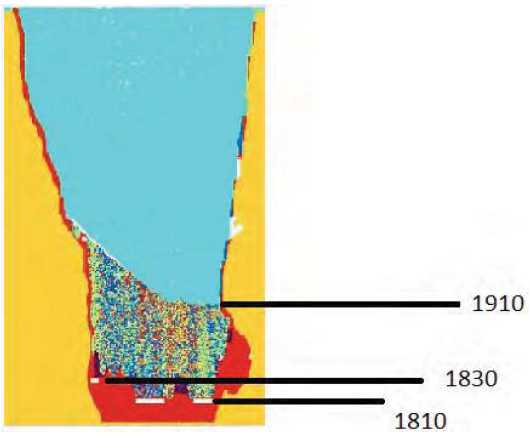
Note: levels are spaced at 20 m intervals. Cyan = air; yellow = host rock/granite; red = kimberlite and multi-coloured is caved material (kimberlite + dilution)
PGCA software was used to deplete underground production from 2007 to the end of 2014 from the geological block model. The model was depleted using actual level by level and draw point by draw point production records calibrated to actual tonnes processed through the plant. The depletion was verified by checking that the PGCA depleted geological model aligned with the Mineral Resource estimate in terms of remaining tonnes and contained carats.
Future production from the Koala cave was then modelled by simulating the production schedule based on the estimated Mineral Reserves. In turn, the schedule was developed from first principles using actual productivity observed in the current Koala operation.
The Koala mine experiences external waste dilution from the kimberlite/granite contact and internal waste dilution from entrained xenoliths. Estimates from diamond drill core intersection fracture frequency analysis resulted in an allowance of a 2 m thick zone around the full circumference and full height of the deposit in the pipe for external waste dilution. Internal waste dilution includes large xenoliths on the contact of the lower-grade kimberlite located between the open pit and the top of the SLC. Because of the bulk nature of the mining method all kimberlite in the pipe has the potential to be produced from a draw point. For Koala the kimberlite dilution is estimated to average 4%. Both external and internal waste dilution are incorporated in the PGCA cave simulation.
| March 2015 | Page 15-7 |
| Ekati Diamond Mine Northwest Territories, Canada NI 43-101 Technical Report |
As the cave is drawn down, higher-grade material in the lower area of the mine will be diluted by lower grade material lying between the open pit and the SLC operation, Draw control strategies are used to minimise mixing between the higher grade material close to draw points and the lower grade material from above. Mixing of different material types is simulated in the PGCA model.
It is not practical to employ a shut-off grade strategy for the Koala cave. Grade cannot be determined by visual inspection alone and sampling is not viable due to the sample support needed in contrast with the mining capacity. Draw control of cave operations is based on level by level draw management plans which are embedded in the production schedule. In the Mineral Reserve mine plan the Koala underground has been scheduled to produce at a maximum rate of 1.1 Mtpa in 2015 with reducing production rates over the remaining six years through 2020.
Previous work assumed that a minimum 60 m residual blanket of highly-diluted material would be required above the last production level. This blanket would protect the production levels from risk events associated with pit wall failures and subsequent mud inrush or air blast events. The current Mineral Reserve maintains this 60 m residual blanket. However, the thickness of the residual blanket will require further review throughout the remaining mine life, based on precedent industry practice and experience.
Overall dilution of 4% has been assumed. After accounting for dilution, the mining recovery of kimberlite was estimated during the Koala underground feasibility study at 87%. This estimate was calculated by estimating the amount of kimberlite material projected to be lost during:
| • | Waste rock removal at production draw points; | |
| • | Removal of waste rock at sizer reject chute; | |
| • | Separation of kimberlite from waste rock during surface sorting; | |
| • | Kimberlite that is not extracted from the cave is left in the residual 60 m blanket. |
| March 2015 | Page 15-8 |
| Ekati Diamond Mine Northwest Territories, Canada NI 43-101 Technical Report |
| 15.4 | Mineral Reserve Statement |
Mineral Reserve estimates are based on material classed as Indicated Mineral Resources with dilution applied. Consideration of the environmental, permitting, legal, title, taxation, socio-economic, marketing and political factors support the estimation of Mineral Reserves.
The Mineral Reserves estimate was prepared under the supervision of Mr. Peter Ravenscroft, FAusIMM, of Burgundy Mining Advisors Ltd., an independent mining consultancy.
Mineral Reserves are summarized in Table 15-3 by kimberlite pipe and have an effective date of 31 January, 2015. No Proven Mineral Reserves have been estimated.
Table 15-2: Mineral Reserves Statement
| Classification | Joint VentureAgreement Area | Kimberlite Pipe | Tonnes(millions) | Grade(cpt) | Carats(millions) |
| Probable | Core Zone | Koala (underground) | 4.0 | 0.6 | 2.3 |
| Misery (open pit) | 3.0 | 4.7 | 14.2 | ||
| Pigeon (open pit) | 7.4 | 0.5 | 3.6 | ||
| Stockpiles (surface) | 0.1 | 0.4 | 0.02 | ||
| Subtotal Probable (Core Zone only) | 14.5 | 1.4 | 20.2 | ||
| Probable | Buffer Zone | Jay (open pit) | 45.6 | 1.9 | 84.6 |
| Subtotal Probable (Buffer Zone only) | Lynx (open pit) | 1.1 | 0.9 | 1.0 | |
| 46.7 | 1.9 | 85.6 | |||
| Total Probable | 61.2 | 1.8 | 105.8 |
Notes to Accompany Mineral Reserves Table.
| 1. | Mineral Reserves have an effective date of 31 January 2015. The Mineral Reserves were prepared under the supervision of Mr. Peter Ravenscroft, FAusIMM, of Burgundy Mining Advisors Ltd., an independent mining consultancy. Mr. Ravenscroft is a Qualified Person within the meaning of National Instrument 43-101. | |
| 2. | Mineral Reserves are reported on a 100% basis. | |
| 3. | Dominion is operator and has an 88.9% participating interest in the Core Zone Joint Venture area where Mineral Reserves are estimated for the Koala, Misery, and Pigeon kimberlites and stockpiled materials. Dominion is operator and has a 65.3% participating interest in the Buffer Zone Joint Venture area where Mineral Reserves are estimated for the Jay and Lynx kimberlites. | |
| 4. | The reference point for the definition of Mineral Reserves is at the point of delivery to the process plant. | |
| 5. | Mineral Reserves are reported at +1.0 mm (effective cut-off of 1.0 mm). | |
| 6. | Mineral Reserves that will be, or are mined using open pit methods include Misery, Pigeon, Lynx and Jay. Mineral Reserves are estimated using the following assumptions: Misery open pit design assumed dilution of 4% waste and mining recovery of 98% diluted material; Pigeon open pit design assumed dilution of 6% waste and mining recovery of 98% diluted material, Lynx open pit design assumed dilution of <2% waste and mining recovery of 98% diluted material. Jay open pit design assumed dilution of 2% waste and mining recovery of 98% diluted material. | |
| 7. | Koala Mineral Reserves are mined using underground mining methods. The Koala Mineral Reserves estimate assumed an overall dilution of 4% and mining recovery of 87% of the diluted material. |
| March 2015 | Page 15-9 |
| Ekati Diamond Mine Northwest Territories, Canada NI 43-101 Technical Report |
| 8. | Stockpiles are minor run-of-mine stockpiles (sourced from underground and open pit) that are maintained at or near the process plant and are available to maintain blending of kimberlite sources to the plant. | |
| 9. | Tonnes are reported as metric tonnes, diamond grades as carats per tonne, and contained diamond carats as millions of contained carats. | |
| 10. | Tables may not sum as totals have been rounded in accordance with reporting guidelines. |
| 15.5 | Factors That May Affect the Mineral Reserve Estimates |
Factors that may affect the Mineral Reserve estimates include:
| • | Diamond Price Book and valuation assumptions; | |
| • | Changes to the assumptions used to estimate diamond carat content; | |
| • | Changes to design parameter assumptions that pertain to the block cave designs, and cave flow modelling including the impact of potential mud rush events; | |
| • | Appropriate dilution control being able to be maintained; | |
| • | Changes to design parameter assumptions that pertain to open pit design, including the estimation of granite xenolith distribution and geotechnical constraints; | |
| • | Mining and metallurgical recovery assumptions; | |
| • | Changes to capital and operating cost estimates, in particular to fuel cost assumptions; | |
| • | Changes to royalty payment assumptions; | |
| • | Variations to the permitting, operating or social license regime assumptions, in particular if permitting parameters are modified by regulatory authorities during permit renewals |
| 15.6 | Comments on Mineral Reserve Estimates |
The responsible QPs are of the opinion that the Mineral Reserves for the Ekati Diamond Mine appropriately consider modifying factors, have been estimated using industry best practices, and conform to the CIM (2014) definitions.
| March 2015 | Page 15-10 |
| Ekati Diamond Mine Northwest Territories, Canada NI 43-101 Technical Report |
| 16.0 | MINING METHODS |
| 16.1 | Introduction |
Operators at Ekati now have 17 years of continuous open pit mining experience in five separate pipes since mining commenced in 1998. This experience provides reliable technical and cost information on which to determine the feasibility and design of future open pits. Since underground mining beneath the Panda open pit started in 2004, the Ekati operators now have 11 years of continuous underground mining experience. | |
The Koala underground mine is in production. Pre-stripping of the Pigeon and Misery open pits is underway with production to start in 2015 and 2016, respectively. The Lynx open pit is scheduled to start pre-stripping in 2015 and production in 2016. The Jay open pit is scheduled to start pre-stripping in 2019 and production in 2020. | |
| 16.2 | Geotechnical |
The rock mass rating system used for logging and mapping at Ekati is based on Laubscher rock mass rating (RMR) system where the following ratings equate to different rock strengths: |
| • | 0–20: Very poor; | |
| • | 21–40: Poor; | |
| • | 41–60: Fair; | |
| • | 61–80: Good; | |
| • | 81–100: Excellent. |
The major kimberlite lithologies in the production pipes have a wide range of measured strengths that range between very poor to upper fair (RMR) ratings (Table 16-1). The granitic rocks and schist rocks at Ekati range between fair to excellent quality and the majority of the granite is good quality.
| March 2015 | Page 16-1 |
| Ekati Diamond Mine Northwest Territories, Canada NI 43-101 Technical Report |
Table 16-1: Ekati RMR Ratings by Kimberlite Pipe
| Pipe | Lithology | RMR Range | RMR Average | |
| Misery | Schist | 40–80 | 53 | |
| Granite | 40–80 | 60 | ||
| Kimberlite | — | 49 | ||
| Diabase | — | 57 | ||
| Koala | Granite | — | 92* | |
| Phase 6/7 Kimberlite | — | 88* | ||
| RVK Kimberlite | — | 73* |
*Note: RMR 76 rock classification system
Separate geotechnical assessments have been conducted for each pipe that is being mined, and will be conducted on future deposits. These investigations are designed to quantify geotechnical domains in detail.
| 16.2.1 | Gas |
During the surface and underground mining and diamond drilling carried out to date, limited noxious gas concentrations have been encountered, although some organic material is present in the kimberlite. | |
| 16.3 | Hydrogeology |
The presence of abundant bedrock at surface, a thin, largely low permeability soil cover, and permafrost encourages surface runoff. Mean annual runoff coefficients of 1.0 (pit), 0.5 (tundra and plant site) and 0.05 to 0.25 (waste rock stock piles) have been estimated from a 2009 review of all pit pumping and stream hydrology data that was conducted for Ekati by Rescan Environmental Services. | |
As host rocks have been faulted and overprinted there is potential for hydraulic conductivity or storage. Kimberlite has very low hydraulic conductivity (measured at Koala, Panda, Misery and Fox pits) and the intensity of kimberlite fracturing has little effect; however, kimberlite has a high storage capacity due to its porosity. | |
Using the knowledge gained from packer testing of the drill holes, Westbay data, and in-pit observations, a general hydrogeological model for Ekati assumes four hydrogeological units that control the groundwater flow: |
| • | Permafrost is considered impermeable with a specific yield of zero; | |
| • | Kimberlite with a very low bulk permeability (K), but a reasonable specific yield; |
| March 2015 | Page 16-2 |
| Ekati Diamond Mine Northwest Territories, Canada NI 43-101 Technical Report |
| • | Weakly fractured granite away from the influence of a pipe with a low K and low specific yield; | |
| • | Fractured granite surrounding the kimberlite pipe with a moderate K and low yield. |
The chemical properties of groundwater collected and pumped from the underground are monitored. Prior to December 2009 all mine discharge water was pumped into the Long Lake Containment Facility. Post April 2010, underground mine discharge water was pumped into the Beartooth pit, whereas post June 2010, the majority of underground discharge is pumped into the Panda glory hole. Distinct seasonal variations in both the quality and quantity of the water being discharged from the underground operations are evident.
Surface water chemistry has a different signature than that of groundwater samples. Studies conducted suggest that there is no indication that groundwater is currently recharged from surface water bodies at an observable rate. This is as expected because the permafrost layer is several hundred metres thick and the only hydraulic connectivity to surface is through low permeability talik zones underlying larger lakes.
Underground mine water chemistry is fully dependent on the proportions of deep high total dissolved solids (TDS) groundwater mixed with surface-derived water that enters the underground mine through the open bottoms of the Panda and Koala pits. Groundwater sampled from initial hydraulic packer testing is consistent with typical deep Canadian Shield groundwater. This brackish water, dominantly Ca-Na-Cl type, has increasing TDS with depth.
The proposed Jay operation will be the first Ekati open pit to be developed within a water retention dike in a large lake. Further detail on the hydrogeological characteristics of the Jay area is given in Section 16.4.8.
| 16.4 | Open Pit Operations |
| 16.4.1 | Design Considerations |
The kimberlite pipes at Ekati are approximately circular in plan view and are generally located within granite, a competent host rock. The ore–waste boundary is abrupt and is readily distinguished by rock type. Ultimate vertical mining depths are 300 m at Misery, 190 m at Pigeon, 140 m at Lynx, and 360 m at Jay. | |
The open pits are currently mined using conventional truck-shovel operations and are developed in benches that are typically 10 m high. The Jay pit, due to the presence of overburden and significant re-sedimented kimberlite, will have double bench (30 m) configuration in granite and metasediment, single bench (15 m) configuration in kimberlite, and single bench (10 m) configuration in the overburden. |
| March 2015 | Page 16-3 |
| Ekati Diamond Mine Northwest Territories, Canada NI 43-101 Technical Report |
Design pit slopes vary significantly between waste and kimberlite and are established based on detailed geotechnical and hydrogeological studies and operational requirements for each pipe.
Phased mining has been used at the Misery and Pigeon pipes, and is planned for the Jay pipe. Due to the small size of the Lynx pit, phased mining will not be used.
A single circular access ramp around the perimeter of the pit is developed progressively as the benches are mined. Waste rock is hauled to a designated waste rock storage area and dumped to an engineered design. Kimberlite is hauled directly from the Pigeon pit benches to the process plant. For all other open pit operations, additional kimberlite storage and handling is required.
Kimberlite ore is selectively mined on the basis of visual delimitation. Ongoing high wall stability monitoring is routine and slope re-design and/or risk mitigation works are performed as required.
Where possible, open pit mining equipment is standardised with what is already in use on site. The selection of the similar parameter equipment for new pits minimises equipment operator and maintenance training needs and reduces warehouse spares inventory. Furthermore, the mobile mining and servicing fleet will be widely shared with the entire Ekati site.
The main truck loading and haulage equipment currently in use are diesel hydraulic shovel/excavators with a bucket capacity of 12 m3and 90 t capacity off-road haul trucks. The Jay mine plan assumes 90 t capacity off-road haul trucks for ore, and 190 t capacity trucks for waste haulage. The main loading units selected for Jay were 17 m3 loaders and 26 m3 shovels.
Production blast holes are 270 mm or 251 mm diameter drilled on a 5.25 m by 6.0 m equilateral pattern with 10 m bench heights. The planned Jay operation will have a production blasting pattern that will accommodate the 15 m bench heights. Wall control blasting practices including pre-shear firings on the perimeter of the pit excavation enhance final high wall stability. Wall control procedures on the final pit walls consists of drilling 165 mm presplit blast holes on a 2.0 m spacing on the pit perimeter, followed by a row of 270 mm wall control blast holes on a 3.0 m burden and 4.0 m spacing, then a second row at a 5.0 m by 5.0 m spacing before switching to the standard production pattern.
| March 2015 | Page 16-4 |
| Ekati Diamond Mine Northwest Territories, Canada NI 43-101 Technical Report |
Double or triple benching is used for the final pit walls when in granite.
| 16.4.2 | Explosives |
Blast hole loading is provided by a ‘down-the-hole’ service from an on-site explosives supply contractor and supervised by the Ekati blasting team. Since the blast holes are frequently wet, a gassed emulsion explosive doped with 30% AN prill is used both in waste and kimberlite blasting. | |
| 16.4.3 | Grade Control |
There are no empirical grade control programs. However, grade verification of block models is carried out periodically by collecting and processing run-of-mine open pit development samples (typically 50 t each). Generally all kimberlitic material within the resource models is considered to be plant feed, and is either processed directly or stockpiled for possible future processing. | |
| 16.4.4 | Open Pit Geotechnical |
The following geotechnical monitoring programs are performed in the active open pits: observational logs; instrumentation (prism, time domain reflectometry (TDR), thermistors and multi-point borehole extensometer (MPBX)); photogrammetry; mapping; and regular inspections by geotechnical engineers. Bench reliability plots are developed for each active pit and allow for the identification of catch bench non- compliance. | |
Photogrammetry is the main operational tool used for in-pit mapping. This tool allows for the rapid and safe assessment of structures on the pit high walls. | |
Two GroundProbe slope stability monitoring radars are installed at the top of Misery Pit and measure wall movement through a series of continuous scans over the pit walls. Monitoring alarms have been established to alert mine operations of increased movement in order to ensure operations personnel are removed from any impending ground fall areas. | |
| 16.4.5 | Misery Open Pit |
Status and Design | |
Phase 1 of the Misery open pit was operated from 2002 to 2008 with 3.7 Mt of kimberlite being mined and processed, following which mining was suspended. An internal feasibility study was subsequently completed on mining Phase 2 of the Misery pit and the decision was made to proceed with recommencement of mining. Production of kimberlite is scheduled to start in 2016 from Misery Main. |
| March 2015 | Page 16-5 |
| Ekati Diamond Mine Northwest Territories, Canada NI 43-101 Technical Report |
A plan view and an isometric view of the Misery pit are shown in Section 7 as Figure 7-9 and Figure 7-10 respectively.
A trade-off study was completed during the feasibility study to determine the optimal open pit methodology, sequence, production rate, schedules and equipment fleet to mine the Misery open pit. Technical inputs and historic data for this work were provided from the previous Phase 1 mining operation at Misery as well as from the Fox and other open pits.
At the Report effective date, the mining operation was fully underway with all required infrastructure complete and mobile equipment procured and mobilized except some of the ore haulage trucks. Waste stripping was started in September 2011, and to the end of December 2014 a total of 37.7 Mt of the waste rock and satellite kimberlite had been excavated.
The Misery pipe is located 29 km from the process plant and main operational hub. To improve efficiencies and logistics, a satellite infrastructure facility including equipment workshop and camp was constructed with completion at the end of August 2012. The locations of the Misery pipe, main camp, and access road connecting them to the Ekati plant was included in Figure 2-1 in Section 2 of the Report.
Misery Geotechnical
Rock mass quality was assessed using the available data from relevant boreholes, RMR, and observations and data from the open pit. The granite is generally good to very good quality, decreasing slightly (becoming fair to good) near surface due to near-surface stress relief effects. Information on the diabase is limited to core photos from two boreholes and observations of the MacKenzie-trend diabase dykes elsewhere. This information indicates that the rock is of good quality with a fracture frequency of approximately two to three fractures per metre. The majority of the metasediment can be classed from fair to good (RMRL = 40 to 80). The slope analysis for the Misery pit was carried out by Zostrich Geotechnical. The model is predictive on a number of failure modes for various slope heights. These include:
| • | Bench scale wedge and plane shear (fabric controlled); | |
| • | Inter-ramp scale wedge and plane shear (fabric or fault controlled); | |
| • | Overall slope failure (fault controlled). |
| March 2015 | Page 16-6 |
| Ekati Diamond Mine Northwest Territories, Canada NI 43-101 Technical Report |
The maintained catch bench width was planned to be 11 m for the 30 m high bench. With the addition of the Southwest Extension domain, a bench face angle of 39° was applied. A 50° bench face angle for the remaining kimberlite was utilized in the mine design.
Design parameters for the Misery open pit are shown in Table 16-2.
Table 16-2: Misery Open Pit Design Parameters
| Design Parameters | Design | Unit | |
| Bench Height | 10 | m | |
| Ramp Width | 26 | m | |
| Ramp Grade | 10 | % | |
| Geotechnical Parameters | Design | Unit | |
| Overall slope angle in kimberlite main pipe and satellite pipes | 50 | deg | |
| Overall slope angle in kimberlite southwest extension | 50 | deg | |
| Overall slope angle in overburden | 35 | deg | |
| Minimum diameter pit bottom | 50 | m | |
| Minimum pushback width | 50 | m |
Hydrogeology and Dewatering
The depth of permafrost at Misery is estimated to extend to 0 m amsl (surface at 465 m amsl). Taliks, unfrozen portions of ground surrounded by permafrost, are thought to occur below the Lac de Gras, Mist Lake and the Misery pit (formerly the site of Misery Lake). These lakes with taliks below them may facilitate water movement along faults and fractures into the Misery pipe. A survey of structural zones in the area indicates that a lineament may exist that may connect Lac de Gras with the Misery pit and may provide seepage from the lake to the Misery pipe, although water ingress was not encountered during previous exploration drilling and mining activities.
Minimal groundwater inflows in the order of 2.5 L/s into the pit are expected due to the presence of permafrost. Because of the limited storage capacity of the bedrock and the absence of ice-free fractures, water recharge is unlikely to be significant.
A study of estimated inflows during a 1-in-10 and 1-in-100 “wet” year rainfall event indicated that the pumping capacity of the existing surface water management system is sufficient to handle high precipitation periods. As a result, the existing surface pumping and storage facilities are adequate for open pit operations.
| March 2015 | Page 16-7 |
| Ekati Diamond Mine Northwest Territories, Canada NI 43-101 Technical Report |
The dewatering system of the open-pit mine consists of a skid-mounted diesel pumping system with a sump located at the pit bottom and moved as surface mining develops. High density plastic piping connects the pump/sump system to discharge mine water into King Pond.
Operations
Open pit mining has commenced with pre-stripping of the waste “donut” around the current Phase 1 Misery open pit from surface to 280 m amsl. Kimberlite production starts at 280 m amsl through to 150 m amsl. The operation will have a life of six years from start of waste stripping to final kimberlite extraction.
There is clear distinction between the kimberlite material and the granite/metasediment host rock which will allow for effective ore waste determination. All of the Misery Main kimberlite pipe will be removed for processing as there is no identified internal waste.
Dilution is expected to be minimal, especially on lower benches, with mechanical sorting at the bench and clean up along the ore/waste contact during mining, supervised by production geologists.
For Misery, the fleet combination employed consists of hydraulic shovel/excavators with a bucket capacity of 12 m3,90 t capacity off-road haul trucks, rotary blast hole rig drilling at 270 mm diameter and a diesel ITH hammer drill rig capable of drilling a 152 mm or 203 mm diameter hole size up to 30 m in length. The standardized equipment fleet is provided in Section 16.6.
ROM waste rock is hauled to the Misery waste rock storage area.
Once Main Pipe ore mining starts, the kimberlite will be transported to surface ROM stockpile areas located adjacent to the base of the existing waste dump. The kimberlite on the transfer pad will then be loaded into 80 t capacity long haulage trucks for transport to the process plant. Currently Ekati has a fleet of six of these trucks. A haulage road train has been purchased, and will be tested during the Misery mining operation. It is planned to purchase additional haulage road trains to support the proposed Jay operation.
Satellite Pipes
Substantial quantities of the Southwest Extension and South kimberlite pipes are known to be, in part, within the limits of the stripping operation for the Main pipe and some of this kimberlite will be mined in order to access the Main pipe. This kimberlite is not currently included in the mine plan that is based on the estimated Mineral Reserves, but represents Project upside potential that is considered in the Operating Case Mine Plan (refer to Section 16.8). A strategy has been developed to evaluate these pipes on an on-going basis as they become accessible by mining during stripping for the Main pipe. Satellite kimberlite pipe locations are located external to the Main pipe and can be clearly distinguished from each other. This kimberlite material is being stockpiled separately from the Main pipe kimberlite. Clear stockpile management and waste management procedures have been established to prevent cross contamination of the Main and satellite kimberlite phases. Satellite kimberlites evaluated to have no economic value will be treated as waste in accordance with the waste rock storage plan.
| March 2015 | Page 16-8 |
| Ekati Diamond Mine Northwest Territories, Canada NI 43-101 Technical Report |
| 16.4.6 | Pigeon Open Pit |
Status and Design | |
The Pigeon open pit is located 6 km north of the Ekati process plant and main operational hub. A 200 m long connector haul road connects the Pigeon pit to the existing Sable all-weather haul road. A test pit for diamond valuation was completed in 2010. The Pigeon open pit will be mined as a two-phase pit. Production from this pipe is scheduled in the Mineral Reserves mine plan to start in late 2015. | |
A plan and isometric view of the Pigeon pipe is shown in Section 7 as Figure 7-13 and Figure 7-14 respectively. | |
For design the optimum pit shell was determined using the Whittle Four X™ optimizer. It determines the maximum profit pit size for the ore body, based on the grades in the geological model, pit slopes, and the economic price/cost assumptions employed for the analysis. From the Whittle™ optimization pit outline three different pits were designed using the Vulcan™ software. After detailed review by the mine design team, one pit design was selected and the Mineral Reserves contained inside this pit estimated and used for the final scheduling using Deswik™ software. | |
Kimberlite will be hauled directly from the pit benches by 90 t capacity trucks to the ROM stockpile area adjacent to the processing plant. For waste stripping, a blanket of overburden till will be removed followed by the waste rock and trucked using the same 90 t trucks to a permanent waste dump location. | |
Development of the Pigeon pit will remove the Pigeon Pond and a portion of the Pigeon Stream. A 450 m long Pigeon Stream diversion channel has been constructed to realign the Pigeon Stream and provide a permanent fish habitat. In addition, a series of water diversion berms are being constructed along the limits of the open pit perimeter in conjunction with a perimeter access road. |
| March 2015 | Page 16-9 |
| Ekati Diamond Mine Northwest Territories, Canada NI 43-101 Technical Report |
At the Report effective date, the mining operation had commenced on the Phase 1 pit, with all required infrastructure complete, and mobile equipment procured and mobilized. Infrastructure at the Pigeon open pit is minimal due to the close proximity of the pit to the main Ekati operational hub. Waste stripping commenced in September 2014.
Pigeon Geotechnical
The key geotechnical issue for Pigeon is the understanding of the wall-rock geology and structure. The host rock geology includes granite, granitic gneiss and metasediments and diabase dykes. A review of core logs and photographs undertaken by Mineral Services Canada in 2006 resulted in the reclassification of the majority of the wall rock domain from biotite granite to interbedded granitoids and metasediments.
The stability of the wall rock will be a key constraint on the second-stage mine design and pit slope angles. Conservative pit slope angles have been used for the current designs and further analysis and mapping of the structure and foliation/schistosity is planned prior to second-stage mining. This may result in a further optimized pit design.
Design parameters for the Pigeon open pit operation are as indicated in Table 16-3.
Table 16-3: Pigeon Design Parameters
| Design Parameters | Design | Unit | |
| Bench Height | 10 | M | |
| Bench Width | 11 | M | |
| Ramp Width | 26 | M | |
| Ramp Grade | 10 | % | |
| Face angle | 82 | deg | |
| Minimum pushback width | 50 | M | |
| Geotechnical Parameters | Azimuth | Overall Slope Angle | |
| 210 | 52 | ||
| 270 | 55 | ||
| 310 | 49 | ||
| 15 | 55 | ||
| 90 | 55 | ||
| 140 | 37 | ||
| 180 | 47 |
Notes: Azimuth = bearing angle measured from north; overall slope angle includes allowance for bench height, berm width and ramp width
Additional mining parameters are:
| March 2015 | Page 16-10 |
| Ekati Diamond Mine Northwest Territories, Canada NI 43-101 Technical Report |
| • | Maintain 30 m distance from the Pigeon Stream diversion channel; | |
| • | Maintain 50 m distance from the current haul road; | |
| • | As per Table 16-3, the planned bench height will be 10 m and the pit will be triple benched to 30 m in granite. |
During operations ongoing programs of structural mapping, controlled perimeter blasting and ongoing high wall condition scaling will be required.
Hydrogeology and Dewatering
The Pigeon open pit development will encompass Pigeon Pond and intersect Pigeon Stream. Most of the overland flow generated in the Pigeon Stream catchment, an approximate 10 km2 area, will be directed around mining activities by the Pigeon Stream diversion channel. The remaining portion of the catchment reporting to the pit is approximately 55 ha in size. Surface diversion berms will be used to manage overland flows in the pit catchment area. This option will divert 70 to 90% of the overland flows that would otherwise report to the pit. Surface hydrology was evaluated based on three design events: freshet, a 1:10 12-hour rainfall and a 1:100 24-hour rainfall.
The pit itself comprises a significant portion of the catchment area. Precipitation falling into the pit cannot be managed by surface diversion works; therefore, any direct precipitation into the pit will need to be managed with in-pit sumps and pumping. A high-flow system will be required to manage the large storm events. A low-flow system will also likely be required to manage lower daily volumes. In-pit sumps have been sized to accommodate summer storm events. Freshet volumes are significantly large and sump containment is not practical; however, some of the freshet volume may be accommodated by the sumps depending on the duration and severity of a given freshet event.
Estimated peak flows into the pit during summer storm events are 0.4 m3/s for both summer storm events. Approximately 1,900 m of piping with an elevation gain of 180 m would be required to pump water from the base of the pit to the crest. Assuming a pumping rate of 0.25 m3/s, sumps of 3,700 m3 and 1,800 m3 would be required for the 1:10 and 1:100 year events respectively.
Pre-stripping dewatering will be directed to the Long Lake Containment Facility and will be undertaken during summer months. Mine water that accumulates in the pit during production (estimated at approximately 74 km3 per annum) will be pumped, with utilization of perimeter sumps, to the Long Lake Containment Facility. The addition of Pigeon mine water to the Long Lake Containment Facility is not expected to influence the operations ability to meet existing effluent quality requirements.
| March 2015 | Page 16-11 |
| Ekati Diamond Mine Northwest Territories, Canada NI 43-101 Technical Report |
Operations
The current Ekati system of open pit operation management has been extended to include Pigeon operations and all the equipment will be maintained at the Ekati truckshop. The operations are supported with mobile support and supply trucks (crew buses, explosive, fuel, water, sewage, etc.) from the main Ekati operational hub. Power is to be supplied by a dedicated generator.
Minimal surface infrastructure is required to operate the Pigeon pit. A small lunch room, field office complex and washroom facilities are located near the pit. This will also be used as an emergency storm shelter with first aid room and emergency supplies. Personnel will be bussed in from the operations hub at shift start and end in a similar manner to Fox pit.
Kimberlite will be hauled directly from the pit benches 6 km to the ROM stockpile area adjacent to the processing plant. Waste rock will be hauled to the final waste rock storage area. Pigeon’s equipment fleet consists of hydraulic shovel / excavators with a bucket capacity of 12 m3,90 t capacity off-road haul trucks, rotary blast hole rig drilling at 270 mm diameter and a diesel ITH hammer drill rig capable of drilling a 152 mm or 203 mm diameter hole size up to 30 m in length. The standardized equipment fleet is discussed in Section 16.6.
| 16.4.7 | Lynx Open Pit |
Status and Design | |
The planned Lynx open pit is located 3 km southwest from the existing Misery pit. A 1 km long connector haul road will be constructed to connect Lynx pit to the existing winter road. Production from this pipe is scheduled in the Mineral Reserves mine plan to start in 2017. | |
Plan and isometric views of the Lynx pipe are included in Section 7 as Figure 7-19 and Figure 7 20 respectively. | |
Kimberlite will be hauled by 90 t capacity trucks directly from the pit benches to a new stockpile area adjacent to the Misery haul road. For waste stripping, a blanket of overburden till will be removed followed by the waste rock, and trucked using the same 90 t trucks to a permanent waste dump location. | |
Development of the Lynx pit will involve dewatering of the Lynx Lake. |
| March 2015 | Page 16-12 |
| Ekati Diamond Mine Northwest Territories, Canada NI 43-101 Technical Report |
The equipment fleet was modelled in the XERAS™ maintenance model in use at Ekati, which is linked to the Deswik™ mining schedule and XERAS™ financial costing model. The haulage fleet was optimized in TALPAC™ and Deswik™. Fleet requirements as developed within the XERAS™ maintenance model were optimized for the entire Ekati Diamond Mine production schedule, which provides significant equipment capital savings.
Geotechnical
Geotechnical logging of core from core holes drilled at Lynx was completed to determine rock mass rating (RMR) according to the Laubscher system. Measurements suitable for the pit wall stability study were obtained with an oriented core device to provide information on the orientation of joints, faults, bedding planes, and other structures. Due to the close proximity of the Lynx pit to the Misery pit, it is reasonable to assume the country rock to be similar between the two sites.
The Lynx pit walls will be in granite. If the rock masses at Lynx exhibit similar high strengths and good quality to Misery, failure through the rock masses would be unlikely to occur and the main consideration for rock slope failure mechanisms would be through structural controlled mechanisms at either a small scale or at a larger scale.
Design parameters for the Lynx open pit operation are as indicated in Table 16-4.
Table 16-4: Lynx Design Parameters
| Design Parameters | Design | Unit | |
| Bench Height | 10 | M | |
| Bench Width | 11 | M | |
| Ramp Width | 26 | M | |
| Ramp Grade | 10 | % | |
| Face angle | 82 | deg | |
| Minimum pushback width | 50 | M | |
| Geotechnical Parameters | Azimuth | Overall Slope Angle | |
| 210 | 52 | ||
| 270 | 55 | ||
| 310 | 49 | ||
| 15 | 55 | ||
| 90 | 55 | ||
| 140 | 37 | ||
| 180 | 47 |
Notes: Azimuth = bearing angle measured from north; overall slope angle includes allowance for bench height, berm width and ramp width
During operations ongoing programs of structural mapping, controlled perimeter blasting and ongoing high wall condition scaling will be required.
| March 2015 | Page 16-13 |
| Ekati Diamond Mine Northwest Territories, Canada NI 43-101 Technical Report |
Hydrogeology and Dewatering
Shallow groundwater flow occurs in a seasonally active zone that is limited to the overburden and weathered bedrock. Groundwater flow rates and directions in this shallow system are controlled by topography and presence of coarser-grained overburden sediments. Potential shallow groundwater seepage through the overburden in the saddle zone located in the northern area of the current Lynx Lake may occur into the Lynx open pit. The amount of water present is anticipated to be small due to the small local catchment area. However, if this seepage is found to be of a magnitude that represents a risk to pit wall stability or mine operations, a runoff water deflection structure may be constructed to direct this water around the open pit during mine operations.
Based on experience at the other open pits at the Ekati Mine and on drill investigations carried out at the nearby Misery pit, it is reasonable to assume that the Lynx pit will be excavated wholly within permafrost with no connection to the deep, sub-permafrost groundwater regime.
Operations
The current Ekati system of open pit operation management will be extended to include the Lynx and Jay operations, and the equipment will be maintained at the Misery truckshop. The operations will be supported with mobile support and supply trucks (crew buses, explosive, fuel, water, sewage, etc.) from the Misery site. Power will be supplied by a dedicated generator.
Minimal surface infrastructure is required to operate the Lynx pit other than a small lunch room, field office complex and washroom facilities. This will also be used as an emergency storm shelter with first aid room and emergency supplies. Personnel will be bussed in from the Misery camp at shift start and end.
Kimberlite will be hauled directly from the pit benches to the Misery stockpile area. Waste rock will be hauled to the final waste rock storage area. For the Lynx pit, it is planned that the Ekati standardized equipment fleet combination would be employed consisting of hydraulic shovel / excavators with a bucket capacity of 12 m3,90 t capacity off-road haul trucks, rotary blast hole rig drilling at 270 mm diameter and a diesel ITH hammer drill rig capable of drilling a 152 mm or 203 mm diameter hole size up to 30 m in length. The standardized equipment fleet is discussed in Section 16.6.
| March 2015 | Page 16-14 |
| Ekati Diamond Mine Northwest Territories, Canada NI 43-101 Technical Report |
The equipment fleet for the Lynx open pit will be a combination of new equipment as well as continued usage of the existing open pit fleet.
| 16.4.8 | Jay Open Pit |
Status and Design | |
The planned Jay open pit is located about 7 km from the existing Misery pit and about 30 km from the Ekati process plant. | |
A pre-feasibility study for the proposed operation was completed in January 2015, and evaluated two cases, a base case and a potential expansion case. Sensitivity analyses were done in Whittle to compare the effect of resource classification, mining cost, processing cost, and diamond price on the pit shell, and to confirm whether the planned dewatering dike would be large enough to encompass any future potential pit expansion. | |
Plan and isometric views of the Jay pipe are included in Section 7 as Figure 7-17 and Figure 7-18 respectively. The proposed mine design layout as envisaged in the pre-feasibility study for the Jay operation is included as Figure 16-1. | |
Figure 16-1: Conceptual Layout Plan, Jay |
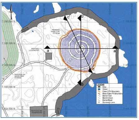
| March 2015 | Page 16-15 |
| Ekati Diamond Mine Northwest Territories, Canada NI 43-101 Technical Report |
An isolation dike is required to segregate mining activities from Lac du Sauvage. The dike will comprise a semi-circular ring dike extending from shoreline, and use techniques already employed for similar dikes used by third-party operators at Diavik and Meadowbank.
There will be only one primary access route to connect the mining operation at Jay to the Misery Road, and this road will be the only road crossing the Lac du Sauvage esker. The Jay Project will then make use of the existing road between the Misery site and the Ekati main camp. Minor additional roads will be constructed to connect the mining operation to the Misery camp, allow for access to the Jay waste rock storage facility, and support dewatering operations.
Two new, temporary, small, kimberlite stockpile areas are proposed as part of the Jay development, in addition to the existing stockpile area at the Ekati processing plant.
Granite rock is required for construction of roads, pads, and the dike. Initially, the granite rock for road construction will be obtained from Lynx pit mining. Once the roads reach the shore of Lac du Sauvage, a quarry located within the footprint of the Jay waste rock storage facility may be used as an additional source of granite rock.
The Jay waste rock storage facility will be located west of Lac du Sauvage. Waste rock from the Jay pit will be mainly non-potentially acid generating granite (estimated 70%), with the remainder being metasediments and overburden.
Ore production is set to begin in 2020 (fiscal year 2021), with half of the production (2.19 Mt dry) in the first year, ramping up to full production (4.35 Mt dry) in the following year. Mining activities will remove 45.6 Mt of kimberlite and about 182 Mt of waste material, for an overall strip ratio of 3.99:1 (waste:ore). Currently, mining is scheduled to be completed in 2031.
For design purposes, the optimum pit shell was determined using Whittle. The designed pit is approximately 960 m by 900 m and has a surface area of approximately 60 ha. The distance from the dike to the closest edge of the ultimate pit shells is approximately 100 m. The design pit has a 34 m wide ramp, double bench (30 m) configuration in granite and metasediment, single bench (15 m) configuration in kimberlite, and single bench (10 m) configuration in the overburden.
The equipment fleet for the Jay open pit will be a combination of new equipment as well as continued usage of the existing open pit fleet. The mine plan assumes that 90 t trucks will be used for ore hauling and 190 t trucks will be used for waste hauling. The main loading units selected were 17 m3 loaders and 26 m3 shovels. The 17 m3 loaders will be used to load waste into the 190 t haul trucks and ore into the 90 t haul trucks, whereas the shovels will only load waste into the 190 t haul trucks. The maximum number of 190 t haul trucks required to achieve the proposed schedule is 14, required in 2023 (fiscal year 2024). The required 90 t haul truck count gradually increases, as the pit gets deeper, to a maximum requirement for five of these trucks in 2030.
| March 2015 | Page 16-16 |
| Ekati Diamond Mine Northwest Territories, Canada NI 43-101 Technical Report |
The mining operation will primarily use the existing infrastructure already in place at the Misery site; however, the project design assumes a new truckshop will be constructed at Misery.
Geotechnical
Pit slope angles recommended by Golder Associates in 2014 are based on the results of detailed kinematic stability assessments. In addition, Golder Associates conducted limit equilibrium stability analyses to assess the potential for overall slope failure. The stability analyses, using the recommended inter-ramp slope angles, indicate that the overall pit slopes would meet the minimum design acceptance criteria of factor of safety greater than or equal to 1.3. Slope design parameters for the Jay open pit operation are as indicated in Table 16-5.
Table 16-5: Slope Design Parameters, Jay
| Rock Type | Wall Dip Direction (°) | Bench FaceAngle (°) | BenchHeight (m) | BermWidth (m) | Inter-rampAngle (°) | OverallSlopeAngle (°) |
| Granitoid | 180 to 330 | 75 | 30 | 11.5 | 57 | 52 |
| 330 to 060 | 65 | 30 | 11.5 | 50 | 45 | |
| 060 to 120 | 65 | 30 | 12 | 49 | 44 | |
| 120 to 180 | 75 | 30 | 12 | 56 | 51 | |
| Metasediments | 330 to 120 | 60 | 30 | 11.5 | 46 | 41 |
Hydrogeology and Dewatering
Lac du Sauvage is generally a shallow lake, which is suitable for developing an in-lake dike and exposing the lakebed overlying the Jay pipe. The dike will be designed to meet local regulations and the Canadian Dam Association’s Dam Safety Guidelines (CDA, 2013). The dike will be constructed within the lake before dewatering.
The Project conceptual dike design includes the following general components:
| • | A broad rockfill shell; |
| March 2015 | Page 16-17 |
| Ekati Diamond Mine Northwest Territories, Canada NI 43-101 Technical Report |
| • | A central zone of crushed aggregates (fine and coarse filters); | |
| • | A composite low-permeability element along the centreline of the dike. |
Geotechnical instrumentation will be installed within the dike structure and foundation to monitor the performance of the dike during dewatering and operation. The instrumentation will monitor the physical performance of the dike to confirm that the structure is operating according to the design intent. Monitoring will continue until the dike is breached at closure.
A diversion channel (Sub-Basin B Diversion Channel) will be constructed before dewatering to intercept and divert runoff from Sub-Basin B to Lac du Sauvage south of the Jay dike. The diversion design is considered appropriate to mitigate the risk of pit flooding during extreme seasonal peaks. The channel design will allow for fish movement, and will consider caribou crossing requirements.
Two runoff sumps will be located in a natural depression within the diked area west of the planned Jay pit. The Jay runoff sumps will collect surface mine water that drains toward the diked area.
As part of the water management system, pumping systems will be constructed between the Jay site and the Misery pit, and from the Misery pit to the Lynx pit. Each pumping system will consist of a pump station and a pipeline.
Operations
Existing infrastructure at Ekati main camp and Misery camp will be used for the Project, where practical. The mine design includes, in addition:
| • | Construction of a new truckshop at the Misery site; | |
| • | Continued use of the existing Misery site, including use of the mined-out Misery pit as a water management facility during project dewatering and operations; | |
| • | Incorporation of the development of Lynx pit into the Jay development plan as a source of construction materials and as a water management facility during dewatering to back-flood the pit as part of closure; | |
| • | Construction of a laydown area near the Misery waste rock storage facility for crushing and stockpiling construction materials to be sourced from the Lynx pit. |
A power line is being constructed between the Ekati main camp power plant and the Misery camp site and is expected to be in service by the end of 2015. For the Jay Project, an approximately 5 km long power line, which will branch off from the new power line running from Ekati to Misery, will be built to the Jay pit area to feed the dewatering pump systems.
| March 2015 | Page 16-18 |
| Ekati Diamond Mine Northwest Territories, Canada NI 43-101 Technical Report |
| 16.5 | Underground Operations |
| 16.5.1 | Underground Mining Method Selection |
Underground mining methods have been used to extract kimberlite below the Koala North, Panda and Koala open pits. The Koala North underground mine was originally developed as a test mine to prove the sub-level retreat (SLR) mining method for use at Ekati. The Panda pipe below the Panda open pit was then successfully mined by SLR. Valuable knowledge in underground mining at Ekati was gained from mining at both Koala North and Panda pipes. This knowledge was used to guide the selection and design of the mining method for the Koala underground mine. Both the Panda and Koala North Mineral Reserves are fully depleted. | |
Several mining methods were considered for Koala with sub-level cave (SLC) selected as having the highest, risk-weighted net present value (NPV) of the options considered. SLC mining development has been completed to the 1810L as of March 2014. | |
In 2011, it was recognised that recovery of the Koala pipe could be improved by utilising a hybrid SLC/block cave mining method employing draw points arranged in an offset concentric ring configuration on final production levels. Four production levels on 20 m vertical spacing are currently in operation extracting the Koala Mineral Reserve material. The mining method employed at Koala is now known locally as incline caving. | |
| 16.5.2 | Dilution and Recovery |
No grade determination of kimberlite is possible at the face of the production draw point. However, differentiation of kimberlite and waste material is possible at the face, primarily based on rock colour and shape. | |
Dilution from waste rock is primarily from the kimberlite pipe wall contact, with some internal waste from entrained granite boulder zones. During mining, some waste rock is removed through sorting at the draw-point, as well as at the sizer reject chute. Kimberlite which has been mixed with significant amounts of waste material is stored separately in remucks as ‘rocky ore’ and hauled to surface by truck for sorting in good visibility conditions. |
| March 2015 | Page 16-19 |
| Ekati Diamond Mine Northwest Territories, Canada NI 43-101 Technical Report |
Mixing of ore and waste material is limited as much as possible through the use of good draw control practices. These practices include close monitoring of draw rates and physical scans of the exposed open stope surface to ensure an even rate of draw is maintained across the broken kimberlite / waste material to prevent early waste migration.
| 16.5.3 | Koala Underground |
Status and Design | |
The Koala Underground has been in operation for approximately seven years (Table 16-5). | |
Since production started at Koala underground at the end of 2007 to the end of January 2015 approximately 5.7 Mt of kimberlite has been mined and processed from this part of the pipe. | |
Figure 7-3 and Figure 7-4 in Section 7 present a plan and isometric view, respectively, of the Koala pipe. A composite 3-D view of the Koala, Koala North and Panda underground mines is shown in Figure 16-2. |
| March 2015 | Page 16-20 |
| Ekati Diamond Mine Northwest Territories, Canada NI 43-101 Technical Report |
Figure 16-2: 3-D View of Koala, Koala North, and Panda Open Pit andUnderground Mines
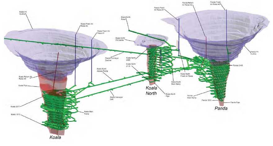
Note: Figure is schematic and has no scale.
| March 2015 | Page 16-21 |
| Ekati Diamond Mine Northwest Territories, Canada NI 43-101 Technical Report |
The Koala mine employs a combination SLC and block cave (BC) mining method known locally as incline caving. The 2050L was the first SLC level mined, and was located 180 m below the Koala open pit floor. From the 2050L to 1970L, ore was extracted using the SLC method only with 14.5 m draw point spacing and 20 m sub-level spacing. Below the 1970L, mining was initially conducted using the SLC method followed by the setting up of an incline cave mining draw point layout with the last draw point level on the 1810L.
SLC levels are accessed from the footwall side of the orebody with retreat from the hanging wall to footwall side of the orebody. Level development consists of waste access from the ramp, with multiple lateral access crosscuts into the ore. Longhole drills are used to drill the ore section above the drift, in an up-hole ring pattern. Blasting on each sub-level starts at the ore/waste contact opposite the access, and retreats, following an approximately straight-line front with adjacent drifts being mined at similar rates.
In a cave mine, mass flow is key to preventing early onset dilution and for mitigating inrush potential. Trials using markers in the broken ore at Ekati have shown narrower than predicted draw cones which can create “chimneys” rather than the desired mass flow during drawdown of the ore. Therefore, a greater number of draw points are required to produce interaction between draw cones and promote mass flow than were originally planned.
As result of this information a re-design of lower production levels of Koala was completed. This re-design increased the number of draw points thereby enabling even access to the cave footprint for mass flow, and also included an update to the overall geometry of the pipe limits as identified via additional core drilling.
To ensure ore recovery of the Koala orebody is maximised, incline caving is employed on 1970L and below. The transition to incline caving occurred gradually with final production horizons located on 1970L, 1850L, 1830L and 1810L. Intermediate levels between 1970L and 1850L were extracted by SLC.
Given the shape and size of the orebody, incline caving allows sufficient coverage over the footprint for final draw down. The main difference between the SLC operation and the incline cave is that the cave goes from a dynamic (drill and blast) to static state of mining. After initial planned draw from the final rings in each SLC drift is completed, overdraw is strategically targeted over the four permanent production levels to maximise carat recovery while minimising mud inrush potential.
Figure 16-3 is a 3-D view of Koala underground showing the various kimberlite phases and mine development.
| March 2015 | Page 16-22 |
| Ekati Diamond Mine Northwest Territories, Canada NI 43-101 Technical Report |
Figure 16-3: Koala Underground – 3-D View Showing Development
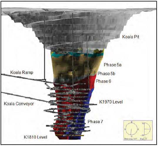
1970L is also the main materials handling horizon and so also includes ore storages and access to the base of the conveyor not present on lower levels. Figure 16-4 illustrates improved draw via the evenly-spaced draw cones achieved by utilising concentrically-placed draw cones on progressively lower levels.
| March 2015 | Page 16-23 |
| Ekati Diamond Mine Northwest Territories, Canada NI 43-101 Technical Report |
Figure 16-4: Concentric Arrangement of Draw Points in the Incline Cave below 1970L.
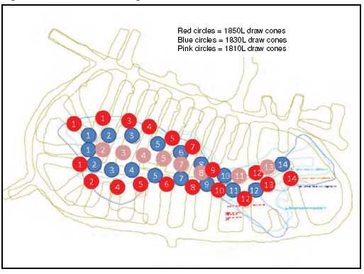
Koala Geotechnical
The Koala cave was induced in accordance with the feasibility study design. The cave initially broke through to the base of the Koala pit after approximately six months of production in May 2008, and in December 2014 the majority of the kimberlite rock mass in the base of the pit was showing greater than 130 m of vertical movement down. Phase 5 material, originally located in the crown pillar between the Koala SLC and open pit has caved and now starting to report to draw points as far down as 1830L.
Ongoing development of the glory hole is measured using terrestrial survey methods (prisms and I-SiTE™ surveys) and is photographed regularly from fixed points.
The following underground geotechnical programs are in place in to ensure the long term stability of infrastructure required for the continuation of underground mining at Ekati: drive closure monitoring; surveillance photographs; structural mapping; and instrumentation including extensometers, thermistors, TDR and “smart cable” extensometer-enabled cable bolts. Daily visual inspections of ground and ground support conditions in production workings are also an integral part of the geotechnical program.
| March 2015 | Page 16-24 |
| Ekati Diamond Mine Northwest Territories, Canada NI 43-101 Technical Report |
Production Draw Control
A shift-by-shift cave draw plan is developed and compliance is measured daily. As part of the duties of the draw control technicians, mud inrush risk assessment in each draw point is performed. The status of each draw point is identified on the daily draw control plan issued to operations. Periodic inspections of all active draw points in the mine are performed to assess wet muck flow potential, hang ups, geotechnical concerns, and geologic conditions.
Koala Hydrology and Hydrogeology
The hydrogeologic model for Koala was constructed on the understanding that groundwater movement is dominated by fracture flow within the granodiorite rock mass. Consequently, development of a structural model for the fault systems influencing groundwater flow was a key step in understanding the groundwater regime.
The surface diversion system (ditches, sumps, adit and pumps) removes approximately 85,000 m3 from the annual average inflow based on available pumping data. The surface diversion system was designed for a 1:100 year storm event.
The in-pit diversions collect from a further 0.22 km2 of in-pit areas removing approximately 23,000 m3 of annual runoff. The in-pit diversions will minimize any overflow to underground from the area of the pit above 2300 elevation, provided that a storm greater than the 1:10 year average does not occur.
Groundwater inflows are estimated over the winter months when it is assumed that surface water is frozen and so all water pumped from underground is groundwater. Groundwater inflows progressively increased from production start in 2007 through to 2010. Since 2010, the drawdown in the groundwater regime appears to have stabilized with relatively constant year on year groundwater flows.
Mud Rushes
Wet muck flow events, called mud rushes, have occurred in the Koala workings, in particular during extraction of the Phase 5 kimberlite material, which has a high moisture content and degrades readily, and future mud rushes are possible.
For a mud rush to occur, four elements must be present: mud-forming material, water, disturbance and a discharge point through which the mud and water can enter the workings. Only two of these components are manageable (disturbance and water). Dominion is treating any wet draw point (>15%) moisture that has a significant amount of fines (>25%) as a high-risk area during operations.
| March 2015 | Page 16-25 |
| Ekati Diamond Mine Northwest Territories, Canada NI 43-101 Technical Report |
Key initiatives to mitigate mud inrush are:
| • | Redesign of the lower levels of Koala (1970L, 1850L, 1830L and 1810L) to improve drainage; | |
| • | Improved drainage infrastructure between 1970L and 1930L; | |
| • | Redesign of the lower levels to promote mass flow; | |
| • | Tele-remote mucking for all at risk areas of the mine; | |
| • | Adherence to even, controlled draw; | |
| • | Exclusion areas for human access into risk areas during active cave draw; approved access only after level scans and mud rush risk inspections; | |
| • | Improved surface water management to minimise water ingress to the cave including: |
| - | Installation of strategic surface sumps and pumping capacity to limit run-off to Koala pit; | |
| - | Multiple runoff capture points along the Koala pit ramp. |
| 16.5.4 | Consideration of Marginal Cut-Off Grades for Underground |
Cut-off grades are not used for underground mining either in initial planning or in operations. All kimberlite/waste reporting to the draw points is removed until fixed draw tonnages have been reached for cave management purposes. | |
| 16.5.5 | Underground Access and Materials Handling |
The Koala, Koala North, and Panda pipes are located in a row and relatively close to each other. The initial underground development and infrastructure was provided for the Koala North underground test mine and then for the Panda underground. Both an access ramp and a conveyor ramp were constructed to access these two mines and later this infrastructure was extended to Koala underground. | |
Access from surface to the Koala and mine for personnel and materials is provided via a 5.5 m wide x 5.5 m high ramp driven at a -13% gradient. A second 6.0 m wide x 5.0 m high ramp at a -15% gradient is used to transport kimberlite from the mine via a conveyor system. The conveyor ramp daylights adjacent to the process plant (via surface portal) and continues to the upper third of the Panda pipe with an additional leg developed to the Koala pipe. The 1.37 m (54 inch) wide conveyor system is hung via chain from the back of the ramp and consists of four main underground conveyor sections plus a surface “stacker” conveyor, with a transfer arrangement between each conveyor. | |
| March 2015 | Page 16-26 |
| Ekati Diamond Mine Northwest Territories, Canada NI 43-101 Technical Report |
All production mucking from the draw points is carried out using load haul dump (LHDs) units tramming to the remuck bays or loading 28 t capacity diesel haulage trucks. Ore from Koala is either dumped directly into the grizzly or stored in one of three remucks on Koala 1970L, and fed to a sizer and conveyor system which joins the main conveyor system from Panda to the process plant. A magnet and metal detector are used on this conveyor for tramp metal removal to protect the conveyor belt and upstream systems.
On surface, the radial slewing stacking conveyor discharges to ROM surface stockpiles with a capacity of approximately 8,000 t.
All waste and rocky ore from underground is hauled to surface via the Koala North ramp utilizing 28 t capacity diesel haulage trucks. Waste granite is removed to the main waste rock dump by surface operations crews. The rocky ore is sorted, i.e. the granite is removed, and the resulting ‘clean’ kimberlite is trucked to the process plant. The Koala ore handling system is shown in Figure 16-5.
| March 2015 | Page 16-27 |
| Ekati Diamond Mine Northwest Territories, Canada NI 43-101 Technical Report |
Figure 16-5: Koala OreHandlingSystem
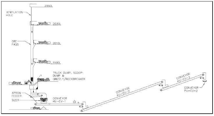
Note: Figure dated 2006; levels are at 20 m intervals.
| March 2015 | Page 16-28 |
| Ekati Diamond Mine Northwest Territories, Canada NI 43-101 Technical Report |
Typically, crushers (single or double toggle jaw, or gyratory type) are employed in underground metal mines; however, the material characteristics of the Ekati kimberlite prevent consistent and reliable flow through these types of crushers. Mineral sizers, with their rotary crushing action have proven very effective with this ore type. A MMD1000 primary sizer unit is installed in the Koala ore handling system; which is designed to accept “oversize” feed as large as 1,000 mm in any dimension into the sizing chamber with a crushed product output size of 150 mm or less. The rated crushing capacity of this unit is 500 t/h.
To provide secondary egress from the production mining levels, 2.1 m x 2.1 m escapeway raises equipped with ladders are installed between the production mining levels.
The escapeways in Koala are located next to the fresh air raise access on the extraction drift. This placement provides positive air pressure for the escapeway. The positive pressure prevents smoke originating from draw points west of the escapeway from entering the escapeway ladder system.
| 16.5.6 | Underground Mine Ventilation |
The underground mines at Ekati are ventilated using a push system which consists of two primary fans for Koala mine and one primary fan for the Panda mine area. The air is pushed underground via raise bored shafts to the top of each mine from where a series of inverse raises feed fresh air to each level and haulage way. Surface primary fans are equipped with heaters to ensure the air entering the mine is approximately 4°C. The main purpose of heating the air is to prevent water from freezing, particularly dewatering pipes.
The Koala mine is ventilated using two 600 HP 101.25” diameter fans located on top of KFAR#1 and KFAR#2 raise-bored shafts. These fans push approximately 400 kcfm of fresh air into the mine. KFAR#1 ventilates all of the active levels while KFAR#2 ventilates the haulage ramp. Return air from Koala production levels is exhausted via KRAR#3 raise. Air flow on each level in Koala comes down the fresh air raise (FAR) on the east side of the level and is exhausted to the return air raise (RAR) on the west side of the level. The ramp and the conveyor in Koala are also used as a secondary return airway.
As mining is complete on each level, the level is sealed from the ventilation circuit. This helps to maintain ventilation pressures as mining progresses down.
The Panda area is ventilated by one 600HP 101.25” diameter fan located on top of PFAR#1 raise bored shaft. This fan pushes approximately 200 kcfm of fresh air into the mine. It feeds fresh air to the conveyor drift and the materials supply ramp. A small quantity of air also exhausts up the Panda RAR#2 raise-bored shaft to allow for adequate ventilation of the 2145L workshop.
| March 2015 | Page 16-29 |
| Ekati Diamond Mine Northwest Territories, Canada NI 43-101 Technical Report |
| 16.5.7 | Explosives |
No explosives are currently used for Mineral Reserve recovery in underground operations at Koala. | |
| 16.6 | Mining Equipment |
| 16.6.1 | Open Pit |
The existing Ekati open pit equipment fleet has proven to be functional in its application at the Panda, Koala, Beartooth, Misery and Fox pit operations. With the similar mining methods at Pigeon and Lynx and in order to maintain a flexible, single mine operation, equipment for Pigeon and Lynx pit mining will be standardised to what is used currently at the Misery mine. | |
Equipment standardization is considered critical as part of the design phase as it minimizes the downstream effects on: |
| • | Recruitment and training requirements – operational and maintenance; | |
| • | Maintenance plans and procedures; | |
| • | Spare parts procurement and warehousing including inventory levels. |
Standardizing equipment at Ekati also allows the use of suppliers who are already familiar with the requirements of Ekati and can accommodate them more readily.
The standard truck loading and haulage equipment consists of hydraulic shovel/excavators with a bucket capacity of 12 m3and 90 t capacity off-road haul trucks. A CAT 992G front end loader is used as a back-up loading unit for the primary excavator and shovel. There are two 170 t capacity haul trucks in the fleet which are used for various haul routes around the Ekati main site. A fleet of 80 t capacity Haulmax haulage trucks will be used for the 29 km ore haul from the Misery stockpile area. The Jay pre-feasibility study assumes the use of 90 t trucks for ore hauling and 190 t trucks for waste hauling. Loading equipment will include 17 m3 wheel loaders and 26 m3 shovels, together with a 16 m3 hydraulic shovel.
Currently the main production drill is a rotary blast hole rig drilling at 270 mm or 251 mm diameter holes for the larger production blasting away from the high walls and kimberlite blasting. A diesel ITH hammer drill rig capable of drilling a 152 mm or 203 mm diameter hole size up to 30 m in length is used for the high wall ‘pre shear’ pattern and the ‘trim / buffer’ patterns on each 10 m deep bench adjacent to the final high wall. A top hammer rig is used for secondary drilling for hard bench toes, oversize material and to assist in the pit.
| March 2015 | Page 16-30 |
| Ekati Diamond Mine Northwest Territories, Canada NI 43-101 Technical Report |
Support equipment for the mining operation includes a CAT D10 track dozer for mine surface civil construction, dump construction and maintenance and a CAT 16 wheeled grader for road construction and maintenance. Some support equipment is and will be shared with the main Ekati hub. These will include a water truck for haul road dust suppression and drill service water transport, sewage and solid waste management vehicles, mechanical / electrical maintenance service trucks, and other support light vehicles. Fixed equipment includes pit perimeter light plants and in-pit pumps.
The open pit mobile equipment fleet at Ekati is shown in Table 16-6.
Table 16-6: Open Pit Mobile Equipment Fleet
| Mobile Equipment | Capacity | No. Units | |
| Sandvik D90KS Rotary Drill | — | 1 | |
| Atlas Copco Pit Viper 275 Rotary Drill | — | 1 | |
| Sandvik D75KS Rotary Drill | — | 1 | |
| IR45 Hammer Drill | — | 3 | |
| Sandvik Ranger DX800 Drill | — | 2 | |
| Caterpillar 777 Haul Truck | 90 t | 24 | |
| Caterpillar 789 Haul Truck | 170 t | 2 | |
| Haulmax Haul Truck | 80 t | 6 | |
| Komatsu PC1800 Excavator | 11 m3 | 2 | |
| Hitachi EX1900 Shovel | 12 m3 | 1 | |
| Cat 6018 Excavator | 10 m3 | 2 | |
| Caterpillar 992 Loader | 9.45 m3 | 7 | |
| Caterpillar 375 Excavator | 4.4 m3 | 1 | |
| Caterpillar 390D Excavator | 4.6 m3 | 1 | |
| Caterpillar D10 Dozer | — | 7 | |
| Caterpillar 16H/M Grader | — | 8 | |
| Caterpillar 777B/C 100T Truck - Haul/Sand/Water | — | 3 | |
| Caterpillar 988G/H Wheeled Loader | 6.4 m3 | 2 | |
| Caterpillar IT28 Wheeled Loader | — | 3 |
| March 2015 | Page 16-31 |
| Ekati Diamond Mine Northwest Territories, Canada NI 43-101 Technical Report |
A haulage road train has been purchased, and will be tested during the Misery mining operation. It is planned to purchase additional haulage road trains to support the proposed Jay operation.
| 16.6.2 | Underground |
The underground mobile equipment fleet at Ekati is shown in Table 16-7.
Table 16-7: Underground Mobile Equipment Fleet
| Mobile Equipment | Capacity | No. Units | |
| Elphinstone R2900 LHD Loader | 10.5 t | 2 | |
| Elphinstone R1700G LHD Loader | 8.0 t | 8 | |
| Caterpillar Elphinstone AD45 Haul Truck | 28 t | 7 | |
| Tamrock Axera D07 S-260-C Jumbo | — | 1 | |
| Maclean Bolter | — | 1 | |
| Tamrock Longhole Solo 07-7F | — | 2 | |
| 420EIT Wheeled Loader Shotcreter | — | 2 | |
| Caterpillar IT28G Wheeled Loader | — | 4 | |
| CAT120 Grader | — | 2 | |
| Getman A64 ANFO Truck | — | 1 | |
| Getman A64 Scissor Lift | — | 1 |
| 16.7 | Consideration of Process Plant Throughput Rates |
Process plant throughput rates significantly increased in 2003 with the decommissioning of the re-crush circuit and again in 2009 with the upgrade of the cone crusher.
Since 2010 the throughput rate has decreased slightly due to the end of production from Panda underground, decommissioning of surface miners in Fox pit and the mining of the xenolith zone in the Fox pit.
Going forward, providing the same resource availability and process parameter assumptions are maintained, the process plant is expected to deliver a daily average of between 11,900 and 12,300 dmt.
| March 2015 | Page 16-32 |
| Ekati Diamond Mine Northwest Territories, Canada NI 43-101 Technical Report |
| 16.8 | Mine Plan |
| 16.8.1 | Mineral Reserves Base Case Mine Plan |
The Mineral Reserves Base Case Mine Plan provided in Table 16-9 is the base case mine plan for the Project, and is based on Mineral Reserves only. This plan assumes production from Misery, Pigeon and Lynx and Jay open pits, and the Koala underground operations. | |
| 16.8.2 | Operating Case Mine Plan |
Substantial quantities of kimberlite within the Misery South and Misery Southwest Extension occur within the stripping limits of the Misery pushback open pit, which was optimized based on Probable Mineral Reserves. | |
The Inferred Mineral Resource estimate for the Misery South and Misery Southwest Extension kimberlites is based on information obtained from drill core, microdiamond sampling, and surface bulk sampling (refer to Sections 10, 11 and 14). | |
The Misery South and Misery Southwest Extension kimberlitic material is being excavated and separately stockpiled during the pre-stripping operations of the Misery Main pipe. It is planned to process the material through the Ekati plant under the Operating Case Mine Plan (Table 16-10), which is a scenario that has the Misery South and Misery Southwest Extension material included in addition to that in the Mineral Reserves Base Case Mine Plan. The Misery South and Misery Southwest Extension material is approximately 6% of the Operating Case Mine Plan mill feed. Misery South and Misery Southwest Extension material was processed in FY15, when the material made up 19% of the plant feed, and will continue to be processed in FY16, and FY17, when the material will make up 37% and 34% respectively of the plant feed in those years. | |
Investors are cautioned that Mineral Resources that are not Mineral Reserves do not have demonstrated economic viability and are further cautioned that the Operating Case Mine Plan includes Inferred Mineral Resources that are considered too speculative geologically to have the economic considerations applied to them that would enable them to be categorized as Mineral Reserves, and there is no certainty that the Operating Case Mine Plan will be realized. |
| March 2015 | Page 16-33 |
| Ekati Diamond Mine Northwest Territories, Canada NI 43-101 Technical Report |
Table 16-8:MineralReserves Base Case Mine PlanProduction
| Item | Mineral Reserve Base Case Mine Plan Totals | FY16 | FY17 | FY18 | FY19 | FY20 | FY21 | FY22 | FY23 | FY24 | FY25 | FY26 | FY27 | FY28 | FY29 | FY30 | FY31 | ||
| Waste mined (Mt) | Total | 254.37 | 18.81 | 19.85 | 20.23 | 9.48 | 3.94 | 24.81 | 33.36 | 33.65 | 32.42 | 17.02 | 13.77 | 10.98 | 7.88 | 5.13 | 2.47 | 0.57 | |
| Ore mined (Mt) | Underground | Koala | 3.96 | 1.10 | 0.91 | 0.72 | 0.70 | 0.43 | 0.09 | — | — | — | — | — | — | — | — | — | — |
| Open Pit | Misery | 3.03 | 0.00 | 0.69 | 1.07 | 0.71 | 0.24 | 0.31 | — | — | — | — | — | — | — | — | — | — | |
| Pigeon | 7.40 | 0.81 | 0.23 | 0.38 | 1.89 | 2.30 | 1.80 | — | — | — | — | — | — | — | — | — | — | ||
| Lynx | 1.09 | — | 0.02 | 0.76 | 0.30 | — | — | — | — | — | — | — | — | — | — | — | — | ||
| Jay | 45.61 | — | — | — | — | — | 1.98 | 4.35 | 4.35 | 4.35 | 4.34 | 4.34 | 4.34 | 4.34 | 4.34 | 4.34 | 4.51 | ||
| Grade (cpt) | Underground | Koala | 0.59 | 0.70 | 0.56 | 0.51 | 0.53 | 0.61 | 0.69 | — | — | — | — | — | — | — | — | — | — |
| Open Pit | Misery | 4.70 | 3.72 | 4.33 | 4.63 | 5.02 | 4.88 | 4.88 | — | — | — | — | — | — | — | — | — | — | |
| Pigeon | 0.49 | 0.45 | 0.40 | 0.53 | 0.45 | 0.53 | 0.50 | — | — | — | — | — | — | — | — | — | — | ||
| Lynx | 0.82 | — | 0.72 | 0.84 | 0.77 | — | — | — | — | — | — | — | — | — | — | — | — | ||
| Jay | 1.85 | — | — | — | — | — | 1.36 | 1.30 | 1.44 | 1.66 | 1.75 | 1.88 | 1.97 | 2.08 | 2.25 | 2.28 | 2.15 |
| March 2015 | Page 16-34 |
| Ekati Diamond Mine Northwest Territories, Canada NI 43-101 Technical Report |
Table 16-9:Operating Case Mine PlanProduction
| Item | Operating Case Mine Plan Totals | FY16 | FY17 | FY18 | FY19 | FY20 | FY21 | FY22 | FY23 | FY24 | FY25 | FY26 | FY27 | FY28 | FY29 | FY30 | FY31 | ||
| Waste mined (Mt) | Total | 236.38 | 5.44 | 15.22 | 20.23 | 9.48 | 3.94 | 24.81 | 33.36 | 33.65 | 32.42 | 17.02 | 13.77 | 10.98 | 7.88 | 5.13 | 2.47 | 0.57 | |
| Ore mined (Mt) | Underground | Koala | 3.96 | 1.10 | 0.91 | 0.72 | 0.70 | 0.43 | 0.09 | — | — | — | — | — | — | — | — | — | — |
| Open Pit | Misery | 3.03 | 0.00 | 0.69 | 1.07 | 0.71 | 0.24 | 0.31 | — | — | — | — | — | — | — | — | — | — | |
| Pigeon | 7.40 | 0.81 | 0.23 | 0.38 | 1.89 | 2.30 | 1.80 | — | — | — | — | — | — | — | — | — | — | ||
| Lynx | 1.09 | — | 0.02 | 0.76 | 0.30 | — | — | — | — | — | — | — | — | — | — | — | — | ||
| Jay | 45.61 | — | — | — | — | — | 1.98 | 4.35 | 4.35 | 4.35 | 4.34 | 4.34 | 4.34 | 4.34 | 4.34 | 4.34 | 4.51 | ||
| Mill feed mined (Mt) | Open Pit | Misery South | 0.58 | 0.29 | 0.28 | 0.01 | — | — | — | — | — | — | — | — | — | — | — | — | — |
| Misery SW Ext. | 2.70 | 0.84 | 0.68 | 0.13 | 0.67 | 0.23 | 0.16 | — | — | — | — | — | — | — | — | — | — | ||
| Grade (cpt) | Underground | Koala | 0.59 | 0.70 | 0.56 | 0.51 | 0.53 | 0.61 | 0.69 | — | — | — | — | — | — | — | — | — | — |
| Open Pit | Misery | 4.70 | 3.72 | 4.33 | 4.63 | 5.02 | 4.88 | 4.88 | — | — | — | — | — | — | — | — | — | — | |
| Pigeon | 0.49 | 0.45 | 0.40 | 0.53 | 0.45 | 0.53 | 0.50 | — | — | — | — | — | — | — | — | — | — | ||
| Lynx | 0.82 | — | 0.72 | 0.84 | 0.77 | — | — | — | — | — | — | — | — | — | — | — | — | ||
| Jay | 1.85 | — | — | — | — | — | 1.36 | 1.30 | 1.44 | 1.66 | 1.75 | 1.88 | 1.97 | 2.08 | 2.25 | 2.28 | 2.15 | ||
| Misery South | 1.10 | 1.10 | 1.10 | 1.10 | — | — | — | — | — | — | — | — | — | — | — | — | — | ||
| Misery SW Ext | 2.22 | 2.22 | 2.22 | 2.22 | 2.22 | 2.22 | 2.22 | — | — | — | — | — | — | — | — | — | — |
| March 2015 | Page 16-35 |
| Ekati Diamond Mine Northwest Territories, Canada NI 43-101 Technical Report |
Koala is currently in production as an inclined cave underground operation and is scheduled to finish in 2020.
Pre-stripping is in progress at Misery open pit with expected production from the Misery Main pipe occurring in the summer of 2016 and completion of mining in 2018.
Pre-stripping of material from Pigeon open pit is in progress with mining of kimberlite projected to commence in late 2015 and finishing in 2019.
Pre-stripping of material from Lynx open pit is scheduled to start in December 2016 with mining of kimberlite commencing in 2017 and finishing in 2018.
Pre-stripping of material from the Jay open pit is scheduled to start in 2019 with mining of kimberlite commencing in 2020 and finishing in 2030.
| 16.9 | Comments on Mining Methods |
In the opinion of the responsible QPs, |
| • | The estimated mine life for the Mineral Reserves Base Case Mine Plan, based on the Mineral Reserves estimated in Section 15, is 16 years; | |
| • | Open pit mining will be carried out using a mixed shovel fleet and trucks; the equipment selection is appropriate for the open pit mine plans; | |
| • | Underground equipment selection is appropriate for the underground mine plans; | |
| • | Ventilation requirements for the underground operations are appropriate to the mining method selected; | |
| • | There is sufficient space within the waste rock storage areas for the waste projections over the Mineral Reserves Base Case Mine Plan; | |
| • | Mine design has incorporated geotechnical and hydrogeological considerations appropriate to the Ekati Project setting and mining methods employed; |
The key risks to achieving the Mineral Reserves Base Case Mine Plan have been identified through a risk analysis workshop that involved representatives from the planning, operations, maintenance and health, safety, environment and community departments.
Key risks identified included:
| • | Sustained inability to meet Koala underground production target or early closure of the mine due to deterioration in operating conditions; |
| March 2015 | Page 16-36 |
| Ekati Diamond Mine Northwest Territories, Canada NI 43-101 Technical Report |
| • | Obtaining permits and approvals for the proposed Jay operation; | |
| • | Appropriate water management for the Jay operation; | |
| • | Permit renewals being obtained in a timely basis, such as for the Sable road; | |
| • | Granting of permits for additional fine processed kimberlite storage. |
Risks to the Koala underground operation have been actively managed by
| • | Introduction of tele-remote mucking that removes operators from potential mud rush exposure and ensures continuity of operations; | |
| • | Minimization of water ingress to the cave through maintaining surface dewatering infrastructure; | |
| • | Redesign and upgrades to drainage infrastructure throughout Koala underground levels. |
| March 2015 | Page 16-37 |
| Ekati Diamond Mine Northwest Territories, Canada NI 43-101 Technical Report |
| 17.0 | RECOVERY METHODS |
| 17.1 | Process Flowsheet |
The Ekati process plant has a capacity of 15,500 t/d; the current and budgeted throughput rate is 12,320 dmt per operating day (without planned maintenance). Kimberlite processing and diamond recovery at Ekati involves: |
| • | Primary crushing – redundancy with primary, secondary and reclaim sizers; | |
| • | Stockpile – used as a buffer between plant and crushing; | |
| • | Secondary crushing (cone crusher); | |
| • | Scrubbing and De-gritting; | |
| • | Tertiary crushing (high pressure grinding rolls); | |
| • | Heavy media separation; | |
| • | Recovery; |
| - | Wet high intensity magnetic separation; | |
| - | Wet X-ray sorting; | |
| - | Drying; | |
| - | Dry single particle X-ray sorting; | |
| - | Grease table; |
| • | Diamond concentrate packaging and preparation for transport to the Yellowknife sorting and valuation facility. |
A sample plant located next to the process plant building is used to regularly check diamond recovery and grade control.
The plant flowsheet is included as Figure 17-1.
| March 2015 | Page 17-1 |
| Ekati Diamond Mine Northwest Territories, Canada NI 43-101 Technical Report |
Figure 17-1:Process andRecoveryFlowsheet
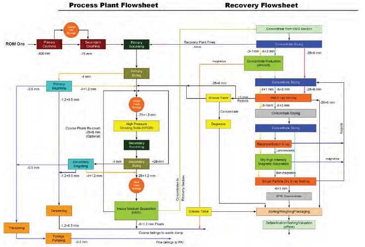
Note: ROM = Run of Mine; HPGR = High Pressure Grinding Rolls; HMS = Heavy Medium Separation; PKI = Processed Kimberlite Impoundment; SPS = Single Particle Sorting; mm = millimetre. Figure prepared 2015.
| March 2015 | Page 17-2 |
| Ekati Diamond Mine Northwest Territories, Canada NI 43-101 Technical Report |
| 17.2 | Plant Design |
The process plant was designed by Fluor Daniel Wright Signet in 1995 utilizing standard diamond liberation, concentration and recovery processes. The plant was commissioned at the end of 1998 and was at full production in 1999.
The current plant flowsheet uses conventional diamond process technology and consists of the following main process areas:
| • | Primary crushing, where the ore is fed to a dump pocket by a truck or front end loader and crushed using a primary MMD1300 mineral sizer. A second, MMD1000 mineral sizer operated in parallel is required to meet target plant throughput. ROM ore is reduced to approximately -300 mm by primary crushing; | |
| • | Secondary crushing where a cone crusher reduces the primary crusher product to -75 mm; | |
| • | Tertiary crushing where high pressure grinding rolls liberate locked diamonds from the ore, undamaged, and in the critical feed size range of -75 +1.2 mm; | |
| • | Primary and secondary scrubbing, and screening where crushed ore is wet scrubbed, screened to produce clean and suitably sized material for further size reduction (-75 +1.2 mm), and concentrated by HMS treatment (-25 +1.2 mm); | |
| • | Primary and secondary de-gritting where unwanted fines (-1.2 mm) are separated from ore; | |
| • | Two HMS modules where washed and sized feed (-25 +1.2 mm) is separated on the basis of density into diamond-bearing concentrate and a processed kimberlite stream. The processed kimberlite stream is discarded to the processed kimberlite stockpile area. The diamond-bearing concentrate reports to the recovery plant; | |
| • | An optional re-crush loop where -28+8mm HMS floats can be re-crushed with the high pressure grinding roll to further liberate locked diamonds. Automated diverter gates to allow on-the-fly toggling of the re-crush loop were added in 2014. The re- crush option is used when there is sufficient capacity in the high pressure grinding roll and HMS circuits; | |
| • | Diamond recovery where diamonds are extracted from HMS concentrates using a combination of sizing screens, wet and dry high intensity magnetic separation, X-ray sorting, grease tables and hand sorting. Plus 1 mm recovery plant rejects are recycled to the HPGR and the -1 mm recovery plant rejects are routed to the primary scrubbing circuit; | |
| • | Fines and coarse rejects disposal where the -0.5 mm slimes fraction is thickened and pumped to the Long Lake Containment Facility area and the grits fraction (-1.2 +0.5 mm) is combined with the HMS processed kimberlite (-25+1.2 mm or -8+1.2 mm with re-crush loop enabled) and conveyed to a stockpile outside the plant before being loaded and trucked to a coarse processed kimberlite facility. |
| March 2015 | Page 17-3 |
| Ekati Diamond Mine Northwest Territories, Canada NI 43-101 Technical Report |
The on-going operation of the process plant, together with additional data collected from a small bulk sample plant, has resulted in the mitigation of most processing issues. The result is a residual list of key issues that are monitored either because the risk remains significant due to a treatment variable (e.g. clay behaviour), or, the material source has yet to be sampled and characterised in detail.
| 17.3 | Product/Materials Handling |
Each morning, an assigned operator gathers the daily drop from each of the X-ray and grease table streams where it is collected and brings it into the weighing room. A visual sorting is done on the +6 mm X-ray concentrate to remove non-diamond material. The weight of total concentrate from each stream is recorded to monitor daily results.
Every two to three days, the resulting concentrate from each stream is collected into a “parcel”, where is weighed and packaged up in sealed, labeled bags. Twice weekly, these parcels are gathered up, sealed, and shipped to the Sorting Valuation Facility (SVF) in Yellowknife. Given that the sort house is a high-risk area, card-locked doors control access and strategically installed cameras operate in sensitive areas to monitor the daily activities. All product is stored in the vault after it is weighed and packaged. A sealed shipment is prepared and released to security for transport to the SVF.
At the SVF, the parcels are re-weighed and received into the diamond management tracking system (DMTS) database. The -6 mm X-ray concentrate and grease table concentrate are visually sorted to remove non-diamond material, using a high intensity magnetic separator (HIMS) to aid in separating the non-magnetic diamonds from the magnetic and paramagnetic non-diamond material. The diamonds from the X-ray streams are then batched together, sieved and weighed according to size fraction. The diamonds from grease table streams are batched, sieved and weighed separately.
| 17.4 | Energy, Water, and Process Materials Requirements |
Approximately 31 MW of primary power generating capacity is available from seven 4.4 MW caterpillar diesel generator sets. The site typically operates five generating units in winter and four in summer. An additional four 0.75 MW auxiliary units are provided as standby capacity. Installed generating capacity is sufficient to operate the process plant throughout the Mineral Reserves mine plan.
| March 2015 | Page 17-4 |
| Ekati Diamond Mine Northwest Territories, Canada NI 43-101 Technical Report |
Process water is sourced from the reliable site water reclaim system. The raw water tank capacity is 475,000 gallons which is continually filled. Approximately 185,000 gallons is reserved for firefighting emergencies.
In order to treat the process slurry, chemicals such as coagulant, flocculant, and salt are used to settle the material in the thickeners prior to discharge. Thickened tails are pumped into the Long Lake Containment Facility, and overflow is re-used as process water.
| 17.5 | Considerations Relating to Ore Sources in Development |
| 17.5.1 | Misery |
Misery ore was processed as part of the blend from 2001 to 2007 with a blend varying between 10 to 25% of total plant feed and on a few trial occasions 100% Misery ore was fed to the process plant. No special processing issues were ever attributed to the Misery ore regardless of its proportion in the blend.
Misery ore contains a significant proportion of small diamonds (less than 0.2 carats per stone). The fine diamond losses can be monitored by collecting a sample of the coarse tails and processing it in the sample plant. If significant quantities of small diamonds are recovered (i.e. entrained with the coarse tails), the option of running the HPGR re-crush loop more regularly (+8/-25 mm material from HMS to HPGR) would have to be considered. In addition, because of the negative impact of the HPGR re-crush loop on the plant throughput, it would have to be determined if it would be more beneficial to run short campaigns of 100% Misery ore with the HPGR re-crush loop running instead of blending the Misery ore daily with the HPGR re-crush loop running consistently and thus affecting the plant throughput for long periods of time. The re-crush loop was re-commissioned in December 2014, and can be turned on or off depending on the blending strategy.
Special attention would be required on the screen panels of the de-grit screens to monitor the wear rate. The nominal cut-off of 1.2 mm is achieved at the beginning of the screen panel life. As the panels wear, the slot widths increase. Currently, the screen panels are changed out at a point when the apertures wear to a width of 1.5 mm. The ideal strategy to batch process Misery ore would be immediately after a plant shutdown since the screen panels would have been recently replaced and are in their best condition (increasing recovery of small diamonds).
A surface ore-sorting program, similar to that already used at Koala, will be required to reduce waste rock feed to the plant. It is particularly important that the content of granite be reduced during break-in periods for the cone crusher when the mantle and/or bowl are replaced. The metasediment (schist) waste will be a low volume dilutant in the ore and is anticipated not to be at risk of impacting processing of Misery ore.
| March 2015 | Page 17-5 |
| Ekati Diamond Mine Northwest Territories, Canada NI 43-101 Technical Report |
No changes to reagent consumption are expected with the inclusion of Misery material in the plant feed.
| 17.5.2 | Pigeon |
Pigeon plant feed is planned to enter the process plant from 2015 through to 2019. Initially Pigeon makes up a small proportion of the plant feed; however, from 2018 onwards Pigeon makes up approximately 50% of the plant feed. At present no changes to the process flowsheet or physical operation of the process plant are required to process Pigeon ore.
Pigeon ore is relatively high in ‘stickiness’ compared to other Ekati plant feeds processed thus far. This has resulted in chute plugging during parcel mill trials. In addition a high proportion of fines were liberated, causing screen and heavy media circuit overload. Finally Pigeon ore generates a relatively high proportion of olivine-rich concentrate (3% compared to the normal 1.3% seen in blended feed) reporting to the recovery circuit.
A 35,000 dmt sample of Pigeon Upper Crater Domain kimberlite was mined and 33,000 dmt was processed through the process plant immediately following a routine shutdown in June 2010.
With the current process plant configuration, running 100% Pigeon feed negatively impacts the throughput rate of the process plant due to fines and concentrate overload. Recovery of Pigeon was calculated at 95.6% based on the results of the bulk sample test and a processed kimberlite audit through the sample plant (this value is higher than that calculated for the material (88% at a 1.2 mm screen)). If no additional work is carried out on the plant, running 100% Pigeon ore feed will result in a maximum calculated process plant feed rate of 12,000 dmt/day (at a 1.2 mm screen size).
It is typical (examples Fox and Koala), for the uppermost RVK kimberlite to have fine, sticky material. Generally, the kimberlite properties are seen to improve with depth. If this trend is seen at Pigeon then the bulk sample test would represent a “worst case” scenario in terms of these processing characteristics.
The heavy mineral content could result in the recovery section of the process plant becoming a bottle neck. Under current operating conditions this would only occur when Pigeon is 100% of the feed stock. The bottleneck could be overcome by; blending Pigeon feed, diverting wet X-ray tails or increasing the recovery capacity. Additional testing during production would be needed to confirm the significance of the heavy mineral content risk.
| March 2015 | Page 17-6 |
| Ekati Diamond Mine Northwest Territories, Canada NI 43-101 Technical Report |
Additionally, the Pigeon bulk sample showed a higher percentage of material reporting to the Long Lake Containment Facility, which may pose a risk in terms of processed kimberlite capacity. If this is the case then alternate processed kimberlite deposition strategies may need to be considered (e.g. deposition into the abandoned Panda pit and underground operation).
Several processing challenges were identified throughout the Pigeon bulk trial. Amongst other critical aspects, the determination of the expected quantities of sediments/fines and heavy mineral content will be critical to the success of correctly determining the production rates for processing Pigeon ore in 2018–2019.
No changes to the process plant configuration are required to process Pigeon ore. It is calculated that the addition of 7.2 M dmt of Pigeon ore feed to the Ekati ore stream results in the following additions to the processed kimberlite stream:
| • | 2.6 M dmt of coarse tail rejects; | |
| • | 16.2 Mm3 of fine processed kimberlite discharged to the Long Lake Containment Facility; | |
| • | 13.2 Mm3 of waste water discharged to the Long Lake Containment Facility and ultimately the receiving environment. |
| 17.5.3 | Jay |
Processing of Jay ore will commence under the proposed mine plan during 2020, as the current Mineral Reserves are being depleted. This will require that the process plant is prepared for a return to single feed processing. The overall processing strategy for Jay ore will be to optimize the processing plant circuit for Jay-only feed through process plant trials of 100% Jay-only feed, and metallurgical test work of ROM samples. It is expected that during the ramp-up of Jay ore, there will be other ore sources (e.g. Pigeon) available for blending to lower the risk of Jay-only feed in the first year of production.
The key characteristics of the Jay pipe that are likely to have an impact on the overall plant throughput are:
| March 2015 | Page 17-7 |
| Ekati Diamond Mine Northwest Territories, Canada NI 43-101 Technical Report |
| • | Ore competency: the upper portion of Jay pipe is characterized by weak friable resedimented volcaniclastic kimberlite (RVK) which is similar to Misery Main pipe; the lower portion of Jay pipe is infilled with altered volcaniclastic kimberlite (VK), which is more competent than the overlying RVK but is still relatively weak (lower rock strength than the Koala Underground kimberlite); | |
| • | Heavy mineral content: the Jay kimberlite domains have an intermediate heavy mineral content relative to known Ekati ore types (more than Misery but less than the Koala Underground feed). The heavy minerals consist of olivine, garnets, chrome diopsides, and oxide minerals (plus trace diamond); | |
| • | Magnetic susceptibility: the Jay kimberlite core has very low magnetic susceptibility and magnetite appears only in trace quantities; | |
| • | X-ray fluorescence profile: Jay diamonds appear to have a similar X-ray fluorescence profile to Misery; | |
| • | Diamond size distribution: overall, the diamond size distribution appears to be similar to Misery; | |
| • | Settling characteristics: the settling characteristics, as modeled by clay behavioural studies, are expected to be more difficult than most of the current feeds but less problematic than Fox feed; | |
| • | Stickiness: the uppermost portion of the Jay pipe has a high content of mudstone and clay and has a high moisture content (up to 25%); it will likely have high stickiness and will present processing challenges. |
Paterson & Cooke Consulting Scientists (Pty) Ltd (South Africa) conducted a study in 2006 that reviewed the clay contents of the Fox, Jay, Pigeon and Sable kimberlites. All four kimberlites were noted to contain problematic smectite group clays. However, the study concluded that the majority of the samples from Jay, Pigeon and Sable would not likely cause sedimentation behaviour problems in the processing plant. Fox material had the highest smectite content, and the study found Fox material to be the most problematic, which was consistent with observations made during the eventual processing of Fox material.
| 17.6 | Comments on Recovery Methods |
The responsible QPs are of the opinion that:
| • | There are 17 years of production history that allow for a reasonable assessment of plant performance in a production setting. There are no data or assumptions in the Mineral Reserves mine plan that are significantly different from previous plant operating experience, previous production throughputs and recoveries, or the Ekati Project background history; |
| March 2015 | Page 17-8 |
| Ekati Diamond Mine Northwest Territories, Canada NI 43-101 Technical Report |
| • | The current process facilities are appropriate to the kimberlite types that will be mined from the various domains outlined in the Mineral Resource and Mineral Reserve block models; | |
| • | The flowsheet, equipment and infrastructure are appropriate to support the mine plans; | |
| • | As there are a number of kimberlite sources being treated, the plant will produce variations in recovery due to changes in kimberlite type and domains being processed. These variations are expected to trend to the forecast recovery value for quarterly or longer reporting periods; | |
| • | Granite, clay, and tramp metal content of material sent to the plant requires monitoring, and a blending strategy is typically used; | |
| • | Material from the Pigeon open pit will need to be monitored to ensure limited impact from sediments/fines and heavy mineral content on the plant; | |
| • | Processing of the Jay kimberlite will require minor modifications to the process plant. Due to the expected high clay content in the upper portion of the Jay kimberlite pipe, combined with limited blending options available during the initial processing stages for Jay, plant upgrades are being considered to better handle the sticky material and the expected reduction in overall process utilization; | |
| • | Reagent consumptions and process conditions are based on both test work and production data. The operating costs associated with these factors in the Mineral Reserves mine plan is considered appropriate given the nature of the kimberlites to be processed; | |
| • | There are sufficient processed kimberlite storage options available to support the mine plans. |
| March 2015 | Page 17-9 |
| Ekati Diamond Mine Northwest Territories, Canada NI 43-101 Technical Report |
| 18.0 | PROJECT INFRASTRUCTURE |
| 18.1 | Road and Logistics |
| 18.1.1 | Ice Road |
The Ekati Project site is located 310 km north east of Yellowknife and is accessible by land only via a winter ice road that is open typically for 8–10 weeks each year from mid-January to the end of March. The winter road is constructed each year as a joint venture between the Ekati, Diavik, Gahcho Kué, and Snap Lake mines.
Each mine shares the cost of construction, maintenance, operation and closure of the annual winter road. The length of winter road to the Ekati site is 475 km.
Fuel, large equipment and heavy consumables are freighted to site on the winter road. Ekati freight varies between 1,800 and 4,000 trucks per year. Critical to achieving the mine plans are the logistics of planning and expediting the delivery of freight required for a full year of operation over the winter road in a period of approximately two months.
| 18.1.2 | Air Transport |
Ekati has an all-weather gravel airstrip that is 1,950 m long with an aircraft control building. The airport is equipped with runway lighting and approach system, navigational aids, radio transmitters and weather observation equipment. | |
Hercules C140 or combi-configuration passenger/freight aircrafts are used to transport fresh produce, light freight, and equipment to site. General freight is flown to the site throughout the year averaging 4–5 Hercules C140 flights per week. | |
Passengers, both employees and contractors, are transported to the mine on charter flights. | |
| 18.1.3 | Haul Roads |
Transportation of material from the Misery kimberlite to either the waste rock stockpile or the Ekati process plant is via already-established mine roads. | |
Transportation of material from the Jay and Lynx kimberlites will use the existing Misery haul road. An extension to the haul road will be constructed from the Misery pit to the Jay site. |
| March 2015 | Page 18-1 |
| Ekati Diamond Mine Northwest Territories, Canada NI 43-101 Technical Report |
| 18.2 | Infrastructure |
The buildings and infrastructure facilities at Ekati include all buildings (mobile and permanent), pipelines, pump stations, electrical systems, quarry site, camp pads and laydowns, ore storage pads, roads, culverts and bridges, airstrip, helipad, and mobile equipment. Key infrastructure was shown on Figure 2-1. | |
The principal facilities at Ekati include: |
| • | Main accommodations complex: Consists of 940 sleeping accommodation rooms, dining, kitchen, and recreation areas, first aid station, emergency response / mine rescue stations and maintenance shops. A sewage treatment plant, water treatment facility and incinerator room adjoin the main accommodations building; | |
| • | Power plant; | |
| • | Process plant; | |
| • | Bulk sampling plant; | |
| • | Truckshop/offices/warehouse complex: This provides for heavy and light vehicle maintenance, heated warehouse storage, change rooms, an environmental laboratory and administration offices; | |
| • | Bulk lubrication facility: Situated adjacent to the truckshop and holds bulk lubricant and glycol. |
Ancillary buildings located within the Ekati main camp area include:
| • | Ammonium nitrate (AN) storage facility: Has a capacity of 16,500 t; | |
| • | Emulsion plant; | |
| • | Waste management building: Wastes to be sent off site are prepared for transport at this building; | |
| • | Site maintenance shed and sprung facility: This is used for shipping and receiving, during winter road operations and for aircraft freight; | |
| • | Airport building: This is the control point for all Ekati flight operations; | |
| • | Geology and helicopter facility: There are a number of small structures on the Geology Laydown pad which support exploration drilling and helicopter flight operations. |
Surface facilities to support the Koala North and Koala underground operations include two maintenance shops, a warehouse, an office complex/change house, a compressor building and batch plant (for mixing concrete), a cold storage building, and a one million litre fuel tank located within a bermed area.
| March 2015 | Page 18-2 |
| Ekati Diamond Mine Northwest Territories, Canada NI 43-101 Technical Report |
Construction of a complete satellite stand-alone facility near the Misery open pit was completed at the end of 2012. The principal facilities at Misery include an accommodation complex consisting of single occupant rooms with a capacity of 115 persons, kitchen complex, recreation room and exercise gym, mine office and dry, mine maintenance shop and wash bay, generator farm and substation, fuel tank farm with off-loading and dispensing capabilities, and an incinerator with a waste-handling facility.
To support the planned Jay operations, a new truckshop will be constructed at Misery.
| 18.3 | Waste Storage Facilities |
Waste rock storage areas are designed for placement of rock excavated from the open pits and underground mine, which is predominantly granite. Several different types of granites referred to as quartz diorite, granodiorite, two-mica granite and pegmatite have been identified in the region but for the purpose of waste rock management planning, these rock types can be classified as granite.
Waste rock storage areas also contain and store other materials including coarse kimberlite rejects (in the Panda/Koala/Beartooth waste rock storage area), low grade kimberlite stockpiles (in the Fox waste rock storage area), metasediments (in the Misery, Pigeon, and to a minor extent, the Panda/Koala/Beartooth waste rock storage areas; metasediments will also be contained in the Jay waste rock storage area), landfill (Panda/Koala/Beartooth and Misery waste rock storage areas), and land-farm (Panda/Koala/Beartooth waste rock storage area).
Locations of the various waste rock storage areas for the majority of the mining operations were shown in Figure 2-1. The locations and layout for the Jay facility were indicated in Figure 16-1.
The waste rock storage areas are typically constructed by means of inset lifts approximately 10 to 20 m deep with natural rock face repose angles of approximately 35º. The lifts are offset in a manner such that the overall slope angle will be less than or equal to 25º. Waste rock storage area heights are generally planned to remain less than 50 m above the highest topographic point over which the waste rock storage area extends. However, in the case of the Jay facility, the height will reach 65 m, overall height will be higher than the target of 50 m set out in the Ekati Mine waste rock and ore management plan; this difference is due to several desired setback distances from the Jay esker, Lac du Sauvage and smaller waterbodies and streams.
| March 2015 | Page 18-3 |
| Ekati Diamond Mine Northwest Territories, Canada NI 43-101 Technical Report |
The waste rock storage areas are constructed based on the original approved plans which stated they would remain as permanent structures, frozen into permafrost, after mining was completed. The design of the waste rock storage areas has evolved to incorporate measures that enhance the natural process for freezing into permafrost.
| 18.4 | Processed Kimberlite Storage Facilities |
The Long Lake Containment Facility is used for the containment of fine processed kimberlite (refer to Figure 2-1). Crushed and washed kimberlite generated during processing is separated at the process plant and the fine fraction is sent to the Long Lake Containment Facility by slurry pipeline. Components at the Long Lake Containment Facility include five containment cells, three filter dikes, the outlet dam, access roads and pipelines. The accessible storage capacity of three of the containment cells was mostly utilised by the end of 2014. Additional capacity will be provided by a combination of extension of two of these cells, raising one of the dikes. The fourth licensed deposition area is not currently planned to be used except as contingency or for future developments.
In addition, the mined-out Beartooth pit has been used since late 2012 for kimberlite fines containment, with material also sent to the pit via slurry pipeline from the process plant.
The containment cell expansions and Beartooth pit will provide capacity to 2019 with the mined-out Panda, Koala and Fox pits available to provide additional capacity beyond that date if required. From 2020, the annual deposition of tailings will be about 5 Mm3 per year for processing plant throughput of 4.3 Mtpa. The estimated storage capacity for the Koala and Panda open pits is approximately 90 Mm3. With these two pits, there should be adequate sufficient processed kimberlite storage capacity for the life of the planned Jay open pit operation.
Mine water discharged into the containment facilities is expected to fluctuate seasonally with large volumes being pumped during the spring freshet. Additionally, after a significant rain event, large volumes of water collected in the camp sumps need to be pumped out. After freeze-up there is a reduction in the volumes pumped, with the main contributors being the indoor sumps.
| 18.5 | Water Management |
Three primary diversions have been constructed at Ekati, the Bearclaw Lake dam and pipeline, Panda diversion dam and channel, and Pigeon stream diversion.
| March 2015 | Page 18-4 |
| Ekati Diamond Mine Northwest Territories, Canada NI 43-101 Technical Report |
The Bearclaw (frozen-core) dam is required to divert water around the Beartooth pit for the duration of operational use of the Beartooth pit. Flow is diverted using a pump/pipeline which diverts surface drainage from Bearclaw Lake around the Beartooth pit and into Upper Panda Lake.
The Panda diversion (frozen-core) dam and channel was completed in 1997 to divert water from North Panda Lake around the Panda and Koala mining areas and into Kodiak Lake. The Panda diversion channel provides stream fish habitat to compensate for loss of streams that used to connect Panda, Koala and Kodiak lakes as well as other streams in the Ekati footprint. The Panda diversion dam and channel are designed and required by the authorizations to be permanent structures.
The Pigeon stream diversion diverts surface flow around the area of the proposed Pigeon open pit. In 2013, the channel had been constructed but flow had not been diverted, allowing for the controlled flushing of sediment from placed construction materials. In 2014, the Pigeon stream diversion was connected and flow was diverted. The Pigeon stream diversion is designed to provide stream fish habitat to compensate for loss of streams that used to connect Pigeon Stream and Pigeon Pond. The Pigeon stream diversion is designed and required by the authorization to be a permanent structure.
As noted in Section 16.4.8, a containment dike is proposed to allow safe mining activity for the Jay pipe. A diversion channel, the Sub-Basin B Diversion Channel, will be constructed to minimize the amount of natural runoff to be managed within the diked area.
The objective for the wastewater management systems is to discharge water to the receiving environment that meets the water licence discharge criteria and to ensure no significant adverse environmental effect occurs to the downstream receiving environment.
Surface mine water (run-off over mine areas that is collected in various sumps) is pumped or trucked to the Long Lake Containment Facility.
Open pit mine water is collected via the in-pit dewatering systems that are designed to maintain safe and reliable operations in active mining areas. At the mined-out Panda and Koala open pits no dewatering occurs because of safety risks to people working within the pit; clean surface runoff is diverted prior to entering these pits where feasible and other water enters the underground workings and is managed as underground mine water. Fox pit water, combined with the intercepted surface water is pumped into the Long Lake Containment Facility. Prior to 2009, water was pumped or trucked out of the Beartooth pit to the Long Lake Containment Facility. In 2009, the Beartooth pit ceased mining operations and water was no longer removed from the pit. Misery pit water is pumped to the King Pond Settlement Facility.
| March 2015 | Page 18-5 |
| Ekati Diamond Mine Northwest Territories, Canada NI 43-101 Technical Report |
Water that enters the underground mining operations is managed through a series of sumps that ultimately direct the underground mine water to a single dewatering sump from where it is pumped to surface. Underground mine water can also be used as drill water. Prior to December 2009, underground mine water was pumped to the Long Lake Containment Facility. Beginning in December 2009, underground mine water has been pumped to the mined-out Beartooth pit.
There are two main sources of sewage: sanitary sewage system at the main site and sewage from remote work sites (e.g. Fox pit and Misery site).
An enclosed sanitary sewage treatment plant to treat all domestic wastewater has both primary and secondary levels of treatment. The final treated effluent is pumped to the process plant where it is mixed with the fine processed kimberlite before being discharged to various cells of the Long Lake Containment Facility.
Sewage collected from the underground operations surface buildings and from the underground workings is trucked to the main camp sewage treatment facility. Sewage generated at remote washroom facilities (e.g. Fox pit and Misery site) is trucked to the main camp sewage treatment facility.
| 18.6 | Power and Electrical |
Ekati’s main power plant consists of seven 4.4 MW diesel generator sets operating at 4,160 V. It provides power to the process operations, accommodations and truckshop/office complex. Waste heat from the power plant diesel engines is recovered by means of glycol heat exchangers to heat buildings and process water. The average load is approximately 16 to 17 MW with daily and seasonal fluctuations.
The Misery operation will utilize three 455 kW stand-alone diesel generators connected to a common synchronized power distribution system. The power distribution systems utilize the infrastructure remaining from the previous Misery operation. Site power cabling is located underground and terminated at the respective buildings. The site power distribution system has two distribution centers, the synchronized power distribution center and a second power distribution system located at the accommodations complex.
An approximately 5 km long power line is planned to branch off from the new power line running from Ekati to Misery to service the proposed operations at Jay. To minimize the voltage drop, a 69 kV system has been selected, with substations at the Jay pit and at the Misery crusher. These substations will supply 4,160 V and lower voltages as required.
| March 2015 | Page 18-6 |
| Ekati Diamond Mine Northwest Territories, Canada NI 43-101 Technical Report |
| 18.7 | Fuel |
Fuel storage on site has capacity of 98 M litres. A central bulk fuel tank farm, which contains eight tanks and approximately 68 M litres, is located at the Main Camp. Other fuel tank farms are currently located at the Misery, Fox and Koala North sites. The fuel tanks are double lined and housed within bermed areas on an impervious liner. | |
To support the logistics of delivery of the fuel to site, Ekati leases a tank farm in Yellowknife with a capacity of 80 M litres. | |
| 18.8 | Water Supply |
Freshwater for Ekati operations is permitted to be drawn from Grizzly Lake, Little Lake, Thinner Lake (Misery Camp), and Two Rock Lake. The Long Lake Containment Facility and Two Rock Sedimentation Pond are makeup sources for process use as required. | |
Process plant fine processed kimberlite are deposited in the north section of the Long Lake Containment Facility while the raw water required for operations is taken in the south section, where the fine processed kimberlite have settled and clear water is available. The Long Lake Containment Facility is a closed-loop system. | |
The Misery project does not include any standalone site specific water treatment facilities; potable water is trucked from Ekati. It is expected that on average two trips per day will be required to maintain potable water levels at Misery when the camp is at maximum capacity of 115 people. | |
The accommodations complex is equipped with four waste water storage tanks, each with a capacity of 8,400 US gallons, located with the utilities services building adjacent to the accommodation complex. | |
All sanitary waste is collected at the Misery site and transported to Ekati for treatment at the waste water treatment plant. | |
| 18.9 | Communications |
Onsite communications are provided by microwave link from Yellowknife to Ekati which is operated by a local telecommunications company, Northwestel. The microwave link has dedicated bandwidth to provide voice, data and internet services. Also located at site is a backup satellite connection that has lower capacity than the main microwave link but can be utilised as required. |
| March 2015 | Page 18-7 |
| Ekati Diamond Mine Northwest Territories, Canada NI 43-101 Technical Report |
Internal site communications are provided by radio, phone, LAN and wireless internet. A fleet management system, Wenco®, is also utilised to track material movement and equipment status.
Communications at Misery are provided by an extension of the microwave link from the main Ekati camp.
| 18.10 | Comments on Infrastructure |
In the opinion of the responsible QPs, the existing infrastructure is appropriate to support the Mineral Reserves mine plan to 2019, and to support Mineral Resource and Mineral Reserve estimates. Dominion is proposing to extend the Ekati mine life beyond the currently anticipated closure date of 2019 by developing the Jay pipe. |
| March 2015 | Page 18-8 |
| Ekati Diamond Mine Northwest Territories, Canada NI 43-101 Technical Report |
| 19.0 | MARKET STUDIES AND CONTRACTS |
| 19.1 | Reference Market |
Rough diamonds are not homogenous and are generally sold directly by producers with prices based on proprietary sorting and pricing systems that cover the range of size and quality characteristics for that particular producer.
Like most diamond mines, Ekati recovers a broad range of diamonds sizes and qualities that need to be sorted into technical categories to be evaluated. Each technical category can be represented with a price per carat collectively making up a Price Book. Each deposit has its own unique mix of diamond categories resulting in an overall average price per carat that acts as a basis for sales forecasts and financial analysis.
Dominion has a well-established, sorting, pricing and sales organization that has been in operation for over 10 years. Dominion has developed an assortment and Price Book that comprises over 8,000 sorted categories. Sorting of the full Ekati production, as well as Dominion’s share of the Diavik diamond mine production, is conducted in Dominion’s Yellowknife and Toronto offices. Dominion aggregates similar categories into boxes that are sold 10 times a year through its wholly-owned subsidiaries operating in Antwerp, Belgium and Mumbai, India. The sales clients are generally larger diamond traders and polishers based in the major diamond cutting and polishing centres of India and Israel along with some specific customers in the United States and Belgium.
Rough diamond sales are conducted in US dollars on a cash basis. Dominion does not make any future price contracts, although it does offer to commit a regular supply of goods to established clients. To ensure that the prices achieved are a true reflection of the market, Dominion may auction a cross-section of the diamonds along with any “specials” – high quality fancy colored or large stones that are sold individually. The prices achieved at each sale are used to update Dominion’s proprietary Price Book that is then used to model the average price of each deposit to the latest market prices.
Although there is no industry-standard rough diamond price benchmark, various consulting groups and trade bodies, as well as other diamond mining companies, do publish prices achieved at sales and estimates of the overall market aggregate price changes. The prices achieved by Dominion, when adjusted for changes in quality of the diamond mined, closely match the published prices movements, an example of which is shown in Figure 19-1.
| March 2015 | Page 19-1 |
| Ekati Diamond Mine Northwest Territories, Canada NI 43-101 Technical Report |
Figure 19-1: Rough and Polished Diamond Price Index
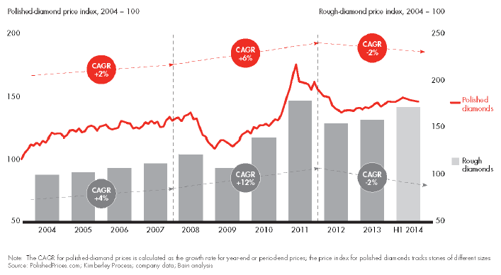
Note: Source: Bain & Company 2014. CAGR = cumulative annual price growth; H1 2014= first half 2014; % = percent.
Given Dominion’s expertise in marketing diamonds, it does not use third parties to value its goods, but relies entirely upon its own sorting and valuation methods for internal analysis, mine planning, and financial modelling.
| 19.2 | Market Fundamentals |
The worldwide demand for rough diamonds is dependent upon the demand for polished diamonds that are used in jewellery. Only about 2% of the value of natural diamonds are used for industrial purposes and, although diamonds are treasured as a store of value, the formal investment market for diamonds is practically negligible, when compared to other precious materials.
Historically rough diamond prices have been relatively stable and the average annual increase has been a few percentage points greater than the growth in worldwide gross domestic product. The gem diamond market has been supply-constrained, particularly in the last century while De Beers had a dominant position, and demand has been driven by successful marketing that has associated diamonds with emotional attachments. Diamond engagement rings have become a major component of jewellery sales and underpin demand even during economic downturns.
| March 2015 | Page 19-2 |
| Ekati Diamond Mine Northwest Territories, Canada NI 43-101 Technical Report |
However, this century has seen some fundamental changes in supply as De Beers’ share of the rough market has declined from a high of about 80% in the 1980s to about 40% in 2013 with the emergence of Alrosa, Rio Tinto, and Dominion as competitive sources of supply. In particular, De Beers sold down its strategic stockpile of diamonds in the years following its privatisation in 2001, and so could no longer act as the “swing supplier.” As a result, the rough diamond market is now purely driven by supply-demand with producers selling though production. This has resulted in some increase in price volatility although this is still at low levels compared with other commodities, not least because there is no financial trading platform for diamonds (Figure 19-2).
Figure 19-2: Rough Diamond Market – Percentage Share by Value
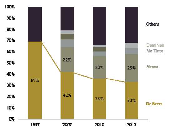
Note: Source: Bain & Company 2014.
Diamond jewellery demand fluctuates, and is affected by numerous factors, including worldwide economic trends, particularly in the major markets of US, Japan, China and India. Diamond jewellery sales compete for discretionary consumer spending on luxury goods and, to a lesser degree, holidays and high-end electronics. Consumption of luxury goods in general is strongly linked to regional disposable incomes and size of an aspirational middle class, which in turn is linked to gross domestic product. Diamond demand has benefitted from the growth in worldwide gross domestic product (GDP) and, particularly in recent years, the rapid development of the Indian and Chinese middle classes.
| March 2015 | Page 19-3 |
| Ekati Diamond Mine Northwest Territories, Canada NI 43-101 Technical Report |
Although polished and rough diamond prices are intrinsically linked, there are a number of short term factors that have a significant impact on rough prices, such as the Indian rupee exchange rates. A notable factor in recent years has been the tightening of liquidity by banks that has constrained manufacturer’s ability to fund rough diamond purchases. As a result, dealers and manufacturers have reduced stock levels and this has kept prices for new production subdued. Although these factors do result in rough diamonds prices being more volatile than polished prices, they are generally short lived, and pricing inevitably reverts to a fundamental supply demand balance over time.
| 19.3 | Long Term Price and Mining Limits |
No forward market for rough diamonds exists to provide external long run pricing trends. The reasons for this are rooted in the lack of homogeneity in quality and absence of agreed standards for classifying and pricing the diamonds. Consequently, diamond price forecasts are dependent upon the fundamental views of future supply and demand.
Various independent diamond market forecasts are produced by specialist companies, financial institutions, and respected major consulting groups, such as McKinsey and Bain & Company. Dominion regularly reviews these reports together with its own market intelligence when formulating its own view of future diamonds prices.
As demand is dependent upon economic factors, market analysts generally consider a range of views about the health of the world economy. Although there remains concern about Europe’s economic recovery, political stability in Asian countries, and the slowing economic growth in China and India, the consensus view is generally a positive one.
Demand for diamonds is expected to continue to increase in nearly all economic scenarios, driven by strong fundamental economic factors including growth in disposable income and the continued emergence of a middle-class in developing countries, as well as a robust US economy. There are some potential risks specific to diamond demand including synthetic diamonds, impact of social awareness, and the growth of the recycled diamonds market, but most market analysts feel that all these issue can continue to be well managed by the industry.
| March 2015 | Page 19-4 |
| Ekati Diamond Mine Northwest Territories, Canada NI 43-101 Technical Report |
Universally, all diamond market forecasts predict that supply will be constrained. Mid- to long-term production levels are well understood given that most of the major sources are already in production and new developments that are in the pipeline are well-defined (Figure 19-3).
Figure 19-3: Global Rough Carat Production
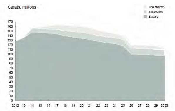
Note: Source: McKinsey 2014.
New finds generally take at least 7-10 years to get to production and often much longer, although there have been some notable exceptions such as the Marange operation in Zimbabwe. Other notable constraints on supply include the following factors:
| • | Mature mines are facing declining production and increasing costs with depth. Kimberlite deposits by their nature are typically vertical structures that taper with depth with a distinct ore/waste boundary that is defined by the lithology. As such, open pit mines face increasing cash costs as stripping ratios and haulage cycle times increase with depth and mining becomes more constrained. For those open pit mines of sufficient quality, the option to go underground involves significant capital investment, higher ore dilution, and even greater constraints on production rate; |
| March 2015 | Page 19-5 |
| Ekati Diamond Mine Northwest Territories, Canada NI 43-101 Technical Report |
| • | There exists no inventory of undeveloped Mineral Resources of sufficient scale and quality to offset ore depletion. This is the case despite significant investment in exploration over the past 25 years. The last discoveries of significance were Ekati and Diavik in 1991 and 1994 respectively; | |
| • | Greenfield and brownfield projects globally are facing increasingly onerous local beneficiation hurdles, as well as cost escalation. |
De Beers compared McKinsey’s production forecast with a smoothed demand scenario that reflects continued US recovery and above average growth in India and China over the next 10 years. The comparison, based in nominal 2013 rough dollar prices, demonstrates the resulting widening disparity between supply and demand as shown in Figure 19-4.
Figure 19-4: Rough Diamond Production Value versus Demand Forecast
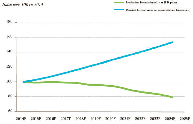
Note: Source: De Beers ‘Diamond Insight Report’, September 2014.
| March 2015 | Page 19-6 |
| Ekati Diamond Mine Northwest Territories, Canada NI 43-101 Technical Report |
The most recent in-depth study of the diamonds industry (Bain & Company’s Global Diamond Report 2014 – published in December 2014) makes the following conclusions for their base case forecasts:
| • | Global long-term rough-diamond demand is expected to continue to grow at 4–5% per year from 2013 through 2024; | |
| • | China, India, and the US will continue to drive diamond consumption and will account for the lion’s share of new demand for diamond jewelry; | |
| • | The global supply volume of rough diamonds is expected to grow by a compound annual rate of 3.8% until 2019 and then decline by 1.8% from 2019 through 2024; | |
| • | From 2014 through 2018, the demand growth rate is expected to exceed that of supply. Starting in 2019, the difference between the growth rates will widen by up to 6 percentage points. Demand is projected to continue its long-term growth trajectory, supported by the outlook for strong market and economic fundamentals, and supply is projected in line with the reduction in global production levels. |
On the basis that the consensus view of is healthy and continued demand growth against a long-term supply constraint, Dominion uses a base case whereby rough diamond prices will rise at a long term average rate of 2.5% per annum in real terms from FY2015 for the whole life of the Ekati Mine.
| 19.4 | Contracts |
The Ekati Mine has a Socio-Economic Agreement with the Government of the Northwest Territories, along with Impact and Benefit Agreements with local aboriginal groups. Within these agreements, the Ekati Mine has committed to developing contracts with Northern and Aboriginal businesses, wherever commercially viable. Furthermore, the Ekati Mine is committed to supporting and developing sustainable businesses, and encourages local and Aboriginal business owners to examine opportunities to develop joint ventures with existing and established businesses.
The major contracts, valued at greater than $5M CAD, that the Ekati Mine currently has in place with Northern and/or Aboriginal businesses are:
| • | BBE – freight management and passenger movement services; | |
| • | Bellanca Developments – office building lease; | |
| • | Finning Canada – mobile equipment maintenance; | |
| • | First Air – charter aircraft services for cargo; |
| March 2015 | Page 19-7 |
| Ekati Diamond Mine Northwest Territories, Canada NI 43-101 Technical Report |
| • | Kete Whii / Procon Joint Venture – underground mining labour; | |
| • | Kingland Ford – light vehicle maintenance; | |
| • | Major Drilling – winter drilling programs; | |
| • | Northcan Freighters – winter road freight transportation services; | |
| • | Northern Industrial Sales – general hardware supplies; | |
| • | Polar Explosives – blasting material supply and services; | |
| • | RTL – fuel tank farm lease; | |
| • | Sandvik Mining and Construction – drill and parts supply; | |
| • | Summit Air – charter aircraft passenger services; | |
| • | Tire North – tire supply and services; | |
| • | Tli Cho Air / Air Tindi – charter aircraft passenger services; | |
| • | Tli Cho Domco – catering and janitorial services; | |
| • | Tli Cho Landtran – winter road freight transportation services; | |
| • | Tli Cho Logistics / Ventures West – fuel transportation services; | |
| • | Tundra Site Services – temporary labour hire. |
The Ekati Diamond Mine emphasizes competitive sourcing, and typically enters into two- to three-year terms for operational contracts, such as those listed above. Contractor employees make up an estimated half of the Ekati Diamond Mine workforce, and are well-integrated within the workplace culture.
| 19.5 | Comments on Market Studies and Contracts |
In the opinion of the responsible QPs:
| • | Dominion is currently able to market diamond production from the Ekati Diamond Mine; | |
| • | The pricing forecasts are based on assumptions provided by Dominion’s marketing group and represent a best estimate, given there exists no forward market for rough diamonds to provide external long run pricing trends; | |
| • | The price forecasts are acceptable to support Mineral Resource and Mineral Reserve estimation, and use in the cash flow analysis; | |
| • | Existing contracts are typical of and consistent with standard industry practices. |
| March 2015 | Page 19-8 |
| Ekati Diamond Mine Northwest Territories, Canada NI 43-101 Technical Report |
| 20.0 | ENVIRONMENTAL STUDIES, PERMITTING, AND SOCIAL OR COMMUNITY IMPACT |
| 20.1 | Permitting |
Ekati is predominantly regulated through an Environmental Agreement and permits with the following key agencies:
| • | Government of Northwest Territories (GNWT); | |
| • | Wek´èezhìi Land and Water Board; | |
| • | Fisheries and Oceans Canada (DFO). |
| 20.1.1 | Environmental Agreement |
Ekati entered into an Environmental Agreement (January, 1997, amended April, 2003) with the Government of Canada (represented by Aboriginal Affairs and Northern Development Canada (AANDC)) and the GNWT which provides environmental obligations in addition to those under then applicable legislation;
Key provisions include:
| • | Funding of an independent environmental monitoring agency to serve as a public watchdog; | |
| �� | ||
| • | Submission of environmental reports and management plans (including reclamation plans); | |
| • | Provide security deposits and guarantee. |
The Environmental Agreement provides for the Independent Environmental Monitoring Agency and continues in effect until full and final reclamation of the Ekati Project site is completed.
Compliance with environmental requirements and agreements is reported publicly by Ekati on an annual basis.
| 20.1.2 | Surface Leases and Land Use Permits |
Dominion holds eight surface leases issued subject to the Territorial Lands Act.
The Mackenzie Valley Resource Management Act came into effect after issuance of the six original surface leases and before issuance of the Pigeon and Sable surface leases. Therefore, land use permits issued by the Wek´èezhìi Land and Water Board were also required for the Pigeon and Sable sites.
| March 2015 | Page 20-1 |
| Ekati Diamond Mine Northwest Territories, Canada NI 43-101 Technical Report |
Dominion has six Class A land use permits (Sable haul road, Sable open pit and associated activities, Pigeon open pit and associated activities, Misery power line, Lynx open pit and associated activities, and exploration activities). The surface leases for the Misery site and road were amended in 2014 to explicitly allow for the construction and use of a power distribution line from the central Ekati Diamond Mine power generating plant to the Misery site.
Table 20-1 summarizes the surface lease information. Table 20-2 summarizes the Class A land use permit information. The locations of the surface leases are shown in Figure 20-1 and Figure 20-2.
Table 20-1: Surface Lease Summary Table
| Surface Lease Number | Area (ha) | Infrastructure within Lease | |
| 76D/9-3-2 | 1,144.04 | Misery open pit, facilities and road | |
| 76D/9-4-2 | 12 | Misery Camp | |
| 76D/10-2-2 | 6,023 | Koala, Panda and Fox open pits and facilities. | |
| 76D/10-3-2 | 3,701 | Long Lake containment facility | |
| 76D/10-4-2 | 110 | Airstrip and facilities | |
| 76D/15-4-2 | 998 | Sable open pit and facilities | |
| 76D/10-5-2 | 155 | Main Camp | |
| 76D/10-7-2 | 324.6 | Pigeon open pit and facilities | |
| Total | 12,467.6 |
Table 20-2: Land Use Permit Summary Table
| Class A Land Use Permit # | Class A Land Use Permit # | |
| W2008F0009 | Sable haul road | |
| W2008D0007 | Mining and associated activities on Sable Lease | |
| W2008D0008 | Mining and associated activities on Pigeon Lease | |
| W2013C0005 | Exploration activities | |
| W2013D0006 | Lynx open pit | |
| W2014I0001 | Misery power line |
| March 2015 | Page 20-2 |
| Ekati Diamond Mine Northwest Territories, Canada NI 43-101 Technical Report |
Figure 20-1: Surface Lease Plan
Note: Figure courtesy Rescan, 2013.
| March 2015 | Page 20-3 |
| Ekati Diamond Mine Northwest Territories, Canada NI 43-101 Technical Report |
Figure 20-2: Sable Road Corridor Plan
![]()
Note: Figure courtesy Rescan, 2013.
| March 2015 | Page 20-4 |
| Ekati Diamond Mine Northwest Territories, Canada NI 43-101 Technical Report |
The Pigeon surface lease was renewed in December 2012, and now also extends to 2026. The Sable surface lease will expire in 2015. It is a reasonable expectation that the Sable surface lease can be renewed in the opinion of the responsible QPs.
Section 10 of the Territorial Lands Regulations provides for the renewal of these surface leases for a further 30 year term with appropriate engagement with Aboriginal communities.
Class A land use permits have a five-year term with a possible one-time two-year extension, which was requested and approved in 2014. There is a reasonable expectation that, with appropriate engagement, the permits can be reissued as needed upon their respective expiry dates.
Dominion is also a joint holder of three surface leases, one licence of occupation, and one Land Use Permit for the Tibbet-to-Contwoyto winter road. These permits are jointly held with Diavik Diamond Mines and DeBeers Canada Inc., and are managed by a Winter Road Joint Venture (i.e., not directly managed by Dominion).
In support of planned operations at the Jay pipe, a Type A land use permit will be required for the area around Lac du Sauvage that is outside the boundaries of the pre-Mackenzie Valley Resource Management Act surface leases. The land use permit would include extraction of waste rock and kimberlite, construction of a water diversion structure, construction of a site access road, and the other activities required for mining of the Jay pipe. As the surface leases that are in place for the existing operations at the Ekati Mine do not cover the Jay area, a new surface lease will also be required.
Dominion submitted an application to the Wek´èezhìi Land and Water Board in October 2013 for the Jay land use and surface use permits. The Jay proposal was referred by the Department of Aboriginal Affairs and Northern Development Canada to the Mackenzie Valley Environmental Impact Review Board for an environmental assessment in November 2013. The review process for the Project is underway. Throughout the environmental assessment review process, Dominion will continue to provide information to regulatory authorities, parties to the review process, and most specifically the Mackenzie Valley Environmental Impact Review Board, so they can issue a decision on the environmental assessment to the Ministers for review in early 2016. Following approval of the environmental assessment, Dominion will be eligible to proceed through the regulatory process for issuance of a water licence (see Section 20.1.3) and a land use permit.
| March 2015 | Page 20-5 |
| Ekati Diamond Mine Northwest Territories, Canada NI 43-101 Technical Report |
| 20.1.3 | Water Licence |
Dominion currently holds one water licence, which was issued by the Wek´èezhìi Land and Water Board and went into effect on July 30, 2013. The licence will expire on August 18, 2021 but can be renewed.
This licence provides for mining at all established areas plus allows for mining of the Pigeon, Lynx, and Sable pipes.
The water licence entitles Dominion to divert water from Upper Panda Lake to Kodiak Lake, and to use water and dispose of waste for the purpose of mining the Panda, Koala, Koala North, Misery, Lynx and Fox kimberlite pipes and for operating the processing facilities and infrastructure associated with diamond mining within the Koala, Misery, King–Cujo and Desperation–Carrie Watersheds of the Lac de Gras basin.
The water licence also entitles Dominion to use water; dewater Sable, Pigeon, Lynx, and Beartooth Lakes for the purpose of mining; to drawdown Two Rock Lake, divert the Pigeon Stream around the Pigeon pit; pipe water from the Bearclaw Lake outflow around Beartooth pit, use water from Ursula and Upper Exeter Lake; deposit processed kimberlite into the Beartooth pit for the purpose of creating a pit lake; and dispose of waste for industrial undertakings in diamond mining and processing, production and associated uses in the Koala, Pigeon and Sable watersheds.
For the planned Jay operation, an amendment to the existing water license will be required. The amended water license would authorize water use and waste deposition associated with the extraction of waste rock and kimberlite, construction of a water diversion structure, drawdown and fish-out of the main body of Lac du Sauvage, open pit and underground mining, placement of waste rock, reclamation, and other activities required for mining of the Jay pipe.
| 20.1.4 | Fisheries Act Authorizations |
Ekati has four fisheries authorizations (Section 35(2) authorizations for the harmful alteration, disturbance or destruction (HADD) of fish habitat), which permit the mine to alter fish habitat in specified circumstances and one compensation agreement in place:
| • | SCA96021 (with compensation agreement): covers all areas except Sable, Pigeon, Beartooth, and Misery; | |
| • | SCO1111: Covers the Desperation and Carrie Ponds (Misery area); |
| March 2015 | Page 20-6 |
| Ekati Diamond Mine Northwest Territories, Canada NI 43-101 Technical Report |
| • | SC00028: Covers King Pond (Misery area); | |
| • | SC99037: Covers the Sable, Pigeon and Beartooth areas. |
The proposed Jay operation will have effects on fish and fish habitat from construction of the dike in Lac du Sauvage, and from dewatering and fish-out within the diked area. An authorization under theFisheries Act is required for these activities. Dominion will continue to work with the Department of Fisheries and Oceans Canada on the details of the offsetting requirements for the Jay project.
Community and regulatory engagement in support of a fisheries authorization for the Lynx project is well advanced, and this authorization can reasonably be anticipated to be received prior to the planned commencement of fisheries work at Lynx Lake in summer 2015. Dominion is also pursuing the allowable Exemption from Navigable Waters Authorization for Lynx Lake.
| 20.1.5 | Navigable Waters Protection Act Authorizations |
Ekati has two Navigable Waters Protection Act Authorizations for structures interfering with navigation (as defined by the Act):
| • | Ekati water works: bridges, crossings, dikes, intakes, disposal: expires 16 December 2021; | |
| • | Sable, Pigeon, Beartooth water works: intakes, dewatering, dams, jetty, diversions, habitat structure, processed kimberlite containment: expires 17 July 2027; | |
| • | For the Jay Project, Dominion will require, and will apply for, an exemption under Section 24 of theNavigation Protection Actthat would enable dewatering within the isolated portion of Lac du Sauvage inside the dike. Dominion will, after opting- in under Section 4(1), apply for an Approval under Section 5(1) for other works, including dike construction in Lac du Sauvage. |
| 20.2 | Monitoring Activities and Studies |
| 20.2.1 | Water Quality |
Water quality has been monitored continuously over the 16 year mine life at numerous monitoring points (Figure 20-3).
| March 2015 | Page 20-7 |
| Ekati Diamond Mine Northwest Territories, Canada NI 43-101 Technical Report |
Figure 20-3: Water Monitoring Point Sites
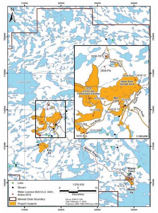
| March 2015 | Page 20-8 |
| Ekati Diamond Mine Northwest Territories, Canada NI 43-101 Technical Report |
Surface discharge from the Long Lake Containment Facility to Leslie Lake is a licensed discharge location.
Under the water licence, discharge criteria need to be met at the Long Lake Containment Facility discharge point (Koala watershed) and the compliance record is excellent.
Run-off from waste rock dumps occurs primarily during freshet and is less or absent at other times of the year. Runoff is primarily to ground and not directly to water bodies. Seepage water is sampled and tested at least twice per year for compliance and trends in water quality, with excellent compliance.
Water from the Misery Pit is pumped (when required) to the King Pond settling facility and then discharged to the environment once discharge criteria have been met.
Dominion has provided all required surveillance network program (SNP) data to the Wek´èezhìi Land and Water Board.
| 20.2.2 | Aquatic Effects Monitoring Program |
Aquatic effects are monitored annually, typically at 18 lakes and 15 streams, as part of the aquatic effects monitoring program (AEMP).
Monitoring evaluates physical, chemical, and biological components of the aquatic ecosystem: hydrology, physical limnology, lake and stream water quality, phytoplankton, zooplankton, sediment quality and lake and stream benthos. Meteorological data are also reported in the AEMP because of their relationship to site hydrology.
The Koala watershed contains the majority of the Ekati infrastructure including the main camp, the process plant, the Panda, Koala, Koala North, Fox, and Beartooth open pits and associated waste rock storage areas, the Long Lake Containment Facility, and the airstrip.
In the Koala watershed, the aquatic effects monitoring program examines waters downstream of the Long Lake Containment Facility including the Long Lake Containment Facility discharge (SNP station 1616-30), Leslie Lake, Leslie–Moose Stream, Moose Lake, Moose–Nero Stream, Nema Lake, Nema–Martine Stream, Slipper Lake, Slipper–Lac de Gras Stream.
The internal-watershed reference area (Vulture Lake, Vulture-Polar Stream) is located 5 km upstream of the Ekati camp at the north end of the Koala Watershed. Although the Lower Panda diversion channel, Kodiak Lake, and Kodiak–Little Stream are not downstream of the Long Lake Containment Facility, they are monitored and evaluated as part of the aquatic effects monitoring program because of their proximity to mine operations.
| March 2015 | Page 20-9 |
| Ekati Diamond Mine Northwest Territories, Canada NI 43-101 Technical Report |
Grizzly Lake is the source of potable water for the Ekati Main Camp, and was added to the aquatic effects monitoring program as an evaluated lake in 2009. The northern bay of Lac de Gras near the inflow from Slipper Lake is also monitored because it is considered to be part of the area that may be influenced by mine activities as the Koala watershed flows into this area of the lake.
The King–Cujo Watershed contains the Misery Camp, Misery pit and associated waste rock storage areas, and the King Pond settling facility. All of the aquatic effects monitoring program sampling locations in the King–Cujo Watershed are within the zone of influence of the mine. In the King–Cujo Watershed, monitored locations include the King Pond settling facility discharge (SNP station 1616-43), Cujo Lake, Cujo Outflow Stream and Christine–Lac du Sauvage Stream. The western part of Lac du Sauvage near the inflow from Christine Lake is also considered to be part of the area that may be influenced by the mine because the King–Cujo Watershed flows into this area of the lake.
The aquatic effects monitoring program sampling also includes two external watershed reference lakes and streams (Nanuq and Counts lakes and their outflows) that are located outside of the zone of influence of the mine. Nanuq Lake is located in the northeast corner of the Ekati claim block approximately 26 km from the nearest possible mine influence. Counts Lake is located southeast of Ekati Main Camp, approximately halfway between the camp and Misery Lake and is approximately 5 km from the closest reach of Misery Road, which is the nearest mine influence for this lake.
| 20.2.3 | Fish Habitat Compensation Works |
Ekati currently operates under four Fisheries Authorizations. These authorizations provide approval to conduct work that results in the harmful alteration, disruption, or destruction (HADD) of fish habitat.
Panda Diversion
Monitoring the Panda diversion channel has successfully demonstrated that it provides effective fish habitat, as documented by DFO. Upon completion of relatively minor physical habitat features, the Authorization will be closed. The channel is used by seven fish species (Arctic grayling, burbot, slimy sculpin, lake chub, round whitefish, longnose sucker, and lake trout) and provides spawning and feeding habitat, as well serving as a migration corridor between Kodiak Lake and North Panda Lake.
| March 2015 | Page 20-10 |
| Ekati Diamond Mine Northwest Territories, Canada NI 43-101 Technical Report |
Nero–Nema Stream Monitoring Program
The Nero–Nema Stream is a short, wide stream that flows from Nero Lake to Nema Lake in the Koala watershed. During the winter of 2002 to 2003, an open-span bridge for the Fox access road was installed over Nero–Nema Stream. The construction of this bridge resulted in a loss of fish habitat, specifically spawning habitat for Arctic grayling. From 2005 to 2007, eight gravel enhancement pads were installed upstream and downstream of the bridge. These gravel enhancement pads were successful and the Fisheries Act Authorisation was fully satisfied with a release issued by the DFO.
| 20.2.4 | Seepage |
Seepage is monitored at several locations at each of the four active waste rock dumps. Seepage surveys have been conducted for the past 10 years and publicly reported by Dominion. There have been no environmental compliance issues noted. | |
| 20.2.5 | Waste Management Plan |
The waste management plan was approved by the Wek’èezhìi Land and Water Board in August 2014. The waste management plan includes the following plans: |
| • | Hydrocarbon management plan; | |
| • | Solid landfill waste management plan; | |
| • | Hazardous waste management plan; | |
| • | Incinerator management plan. |
The waste management plan also references the waste rock and ore storage management plan and the wastewater and processed kimberlite management plan. Version 4.1 of the waste rock and ore storage management plan was approved by the Wek’èezhìi Land and Water Board in May 2014. The plan incorporates updates of the acid/alkaline rock drainage (ARD) and geochemical characterization and management plan that had been prepared since 2007 as a separate document, such that the waste rock and ore storage management plan is a comprehensive document.
Version 4.1 of the wastewater and processed kimberlite management plan was approved by the Wek’èezhìi Land and Water Board in May 2014.
| March 2015 | Page 20-11 |
| Ekati Diamond Mine Northwest Territories, Canada NI 43-101 Technical Report |
Annual reports on the ongoing waste rock sampling program are also reported to the Wek’èezhìi Land and Water Board. The operational geochemical test results validate the initial characterisation and waste rock management plans.
| 20.2.6 | Wildlife Effects Monitoring |
A wildlife effects monitoring program is performed each year. The monitoring program includes assessing site-specific effects on caribou, wolverine, grizzly bear, wolf, birds, fox, and other species that may interact with the Ekati Mine site. Ekati takes part in government-led initiatives for regional monitoring and has contributed to government- led regional programs for caribou, wolverine and grizzly bear. | |
| 20.2.7 | Re-vegetation |
Dominion has been conducting reclamation research and field studies in support of the reclamation goals outlined in the Interim Closure and Reclamation Plan for the mine. | |
Re-vegetation has been conducted and is assessed at the Long Lake Containment Facility, Culvert Camp, Fred’s Channel, Esker South, Old Camp Road, Misery topsoil stockpile, Koala topsoil stockpile, Fay Bay, and at the Pigeon Stream diversion, and Panda diversion channel. |
Re-vegetation research has focused on:
| • | Assessment of potential for vegetation of camp pads and laydown areas; | |
| • | Vegetation of fine processed kimberlite at the Long Lake Containment Facility; | |
| • | Development of reclamation research plans for closure criteria. |
| 20.2.8 | Air Quality (AQMP) |
The Ekati air quality monitoring program comprises the following components: |
| • | Air emissions and greenhouse gas calculations; | |
| • | Total suspended particulate matter (TSP) measurements through Partisol samplers; | |
| • | Continuous ambient air sampling (NOx, SO, TSP and PM2.5); | |
| • | Dustfall monitoring; | |
| • | Snow sampling; |
| March 2015 | Page 20-12 |
| Ekati Diamond Mine Northwest Territories, Canada NI 43-101 Technical Report |
| • | Lichen sampling. |
Emissions calculations and high volume air sampling have been conducted yearly since the start of the program, while snow and lichen sampling programs have been conducted every three years. Results from the AQMP suggest that management measures implemented at Ekati are currently effective at mitigating the effects of the mine on air quality. | |
| 20.2.9 | Geotechnical Inspections |
A requirement of the water license is annual independent geotechnical inspections of dams, dikes and water holding facilities at the Ekati Diamond Mine. Since construction these inspections have been carried out by EBA Engineering of Yellowknife. No significant issues have been raised. | |
| 20.3 | Environmental Liabilities |
Current environmental liabilities comprise those to be expected of an active mining operation that is exploiting a number of kimberlite pipes, and includes open pits, processing plant, infrastructure buildings, a processed kimberlite storage facility, waste rock storage facilities, and access roads. | |
| 20.4 | Closure and Reclamation Plan |
Version 2.4 of the Ekati Mine interim closure and reclamation plan was approved by the Wek´èezhìi Land and Water Board in November 2011. The Ekati Diamond Mine is required under Water Licence W2009L2-0001 and the Environmental Agreement to have a closure plan in place for the Ekati Diamond Mine during active mining operations, and to update that plan on a regular basis and/or when there is a significant change to the Mineral Reserves mine plan. A final closure and reclamation plan will be required two years prior to mine closure. | |
The Interim Closure and Reclamation Plan is developed with input from Impact Benefit Agreement communities and regulatory agencies, and incorporates specific reclamation activities and objectives detailed in conformance documents that include water licences, the Environmental Agreement, land use permits, and land leases. | |
Reclamation of the mine site is guided by the reclamation goal to return the Ekati Project site to viable, and wherever practicable, self-sustaining ecosystems that are compatible with a healthy environment, human activities, and the surrounding environment. Closure objectives are used to guide reclamation activities through the use of closure criteria and performance based standards that measure the performance of closure activities in successfully meeting closure objectives. |
| March 2015 | Page 20-13 |
| Ekati Diamond Mine Northwest Territories, Canada NI 43-101 Technical Report |
Development of the Jay pipe will require changes to the Interim Closure and Reclamation Plan, which are primarily related to new reclamation activities at Lac du Sauvage, and an amended pit back-flooding approach for the Lynx, Misery, Panda, and Koala open pits.
| • | Reclamation of the Jay pit will involve removal of buoyant or hazardous materials, and submergence beneath Lac du Sauvage. Removal of equipment from the open pit can begin upon completion of open-pit mining activities, and flooding with water can begin upon completion of equipment removal. It is estimated that natural lake water levels will be re-established by back-flooding using waters primarily sourced from Lac du Sauvage, and that the back-flooding will take approximately four years. Water quality within the back-flooded diked area will meet pre-defined acceptability criteria before permanent breaching of the dike or return to natural flow paths | |
| • | The Misery open pit will be utilized as a water management facility during the mining of the Jay pipe. At completion of the Project, a portion of the mine water contained within the Misery pit will be pumped to the bottom of the Jay pit, and the remaining water within the pit will be covered by freshwater from a combination of precipitation, runoff, and lake water from Lac du Sauvage. | |
| • | The Lynx open pit will be used for the storage and management of lake water containing elevated total suspended solids pumped from Lac du Sauvage during the dewatering phase of the Jay operation. The suspended sediment will settle out and the pit will be monitored to confirm water quality is suitable for discharge before the Lynx pit lake overflow to Lac de Gras is re-established | |
| • | The Panda and Koala open pits are the primary deposition locations for processed Jay kimberlite. Reclamation of the Panda and Koala open pits would proceed by pumping freshwater into the pits as a “cap” overlying the processed kimberlite and, possibly, residual mine water. This pumping scenario is an improvement over the current proposed reclamation because substantively less freshwater is required |
The ICRP will be amended to include these activities. Other aspects of reclamation of Ekati Mine would proceed as described in the existing interim closure and reclamation plan. Community and regulatory engagement will continue to be an important component for closure and reclamation planning.
Dominion provided an updated estimate of reclamation security to the Wek’èezhìi Land and Water Board in March 2013. The proposed security estimate was $225 million for existing development areas and Pigeon (currently under development), plus an additional $9 million to be provided in future at least 60 days prior to construction at the Sable open pit. Regulatory review of the updated security estimate by the Wek’eezhii Land and Water Board and other governmental agencies resulted in a determination of $253 million, plus an additional $9 million to be provided in future at least 60 days prior to construction at the Sable open pit.
| March 2015 | Page 20-14 |
| Ekati Diamond Mine Northwest Territories, Canada NI 43-101 Technical Report |
The subsequent 2014 ‘Lynx’ amendment of the water licence requires that security of $2.8 million be provided in future at least 60 days prior to construction of the Lynx open pit.
Dominion has provided the required security and has proposed various amendments that are under review by the Wek’èezhìi Land and Water Board. Amendments are based primarily on the results of on-going reclamation optimization studies conducted by Dominion.
Additionally, security of approximately $43 million is held by the GNWT as security for reclamation and related activities at the Ekati Diamond Mine pending completion of a review by the GNWT of duplication between the security required under the Water Licence and security held by the GNWT under the Environmental Agreement.
Dominion has also provided a $20 million guarantee required under the Environmental Agreement and a $1.5 million security required under the Fisheries Act Authorizations.
| 20.5 | Considerations of Social and Community Impacts |
| 20.5.1 | Impact Benefit Agreements |
As noted in Section 4.3.3, there are four impact benefit agreements that have been concluded with Aboriginal groups.
| 20.5.2 | Socio-Economic Agreement |
A Socio-Economic Agreement was concluded with the Government of the Northwest Territories, and has been in place since 1996. This agreement addresses the economic benefits and social impacts of the Ekati operation on the Northwest Territories, and establishes northern and northern-aboriginal hiring targets and northern business spend targets. The agreement also provides a vehicle for joint industry-government community training and northern recruitment programs.
| 20.5.3 | Community Development Programs |
Dominion provides financial support for projects that support the development of long-term sustainable community initiatives, including:
| March 2015 | Page 20-15 |
| Ekati Diamond Mine Northwest Territories, Canada NI 43-101 Technical Report |
| • | Physical projects such as community centres; | |
| • | Cultural programs such as sharing of traditional knowledge; | |
| • | Community social support programs such as women’s transitional housing programs and at-risk youth programs. |
| 20.5.4 | Traditional Knowledge |
Dominion tries to incorporate the use of traditional knowledge in monitoring programs by involving communities in the programs and teaching the environmental staff the traditional way of the land. Currently, several annual visits are paid by Elders and youth to the Ekati Project site.
Dominion holds several traditional knowledge-oriented community outreach events annually:
| • | Community visits; | ||
| • | Cultural workshops at the Ekati Diamond Mine; | ||
| • | Funding for community programs, including “Breakfast for Learning” and youth career programs; | ||
| • | Funding for community events such as: | ||
| – | Cultural program in N’dilo; | ||
| – | Education programs in Dettah; | ||
| – | The Tlicho Annual Gathering, the Lutsel K’e Annual Spiritual Gathering, and the Kugluktuk Annual Fishing Derby. | ||
| 20.5.5 | Proposed Jay Development |
The focus of Dominion’s engagement efforts for the planned Jay operation has, and continues to be, directed towards parties that will likely be the most directly affected if the Project is implemented or is not implemented. The engagement includes potentially affected Aboriginal communities, other Northerners, government and regulatory agencies, and the Independent Environmental Monitoring Agency.
Dominion held a series of information workshops during 2014 for communities, regulators, governments, and parties to the environmental assessment process to explain the proposed Jay operation and the contents of the Developer’s Assessment Report. Dominion is also developing a visualization program to assist in explaining the Project in the environmental assessment hearing and in meetings with communities and stakeholders. This visualization program will include a physical model that will be used in engagement activities and computer generated images that show the various stages of the Project.
| March 2015 | Page 20-16 |
| Ekati Diamond Mine Northwest Territories, Canada NI 43-101 Technical Report |
Dominion will also continue with its current practice of quarterly engagement meetings and with additional engagement, as required, through written exchanges, public meetings, and face-to-face meetings and workshops to discuss specific issues of interest and to maintain two-way dialogue about the Jay mine proposal with the affected parties.
| 20.6 | Comments on Environmental Studies, Permitting, and Social or Community Impact |
In the opinion of the responsible QPs, the permitting, environmental and social licence requirements to operate the Ekati Diamond Mine are well understood and Mineral Resource and Mineral Reserve estimation can be supported.
Some of the permits granted to the Ekati Diamond Mine at the start of operations are nearing their expiry dates and must be renewed. In some cases, the legislation under which the permits were granted has been revised, or discharge/emissions standards have altered in the interim. In these instances it is possible that renewal of the permits will require modifications to existing practices so as to comply with the permit conditions that may be imposed by the appropriate regulator. While there is a reasonable expectation that the permits will be renewed, additional data collection or supporting studies on discharges/emissions may be required.
It is possible that future changes in water quality discharge limits or unanticipated future changes in water quality due to processing of kimberlite ore could result in the need for additional water management facilities. Adaptive management is practiced to alert mine management and regulators of new trends in water quality data, thereby providing adequate time for implementation of preventative actions before environmental impacts or fines would occur.
Various amendments to the Fisheries Act (including the possible inclusion of diamond mines into the Metal Mine Effluent Regulations (MMER)) have been implemented or proposed by the Federal Government and these could affect permitting of new projects at the Ekati Mine. As a group, Canadian diamond mines have sought for several years the regulatory certainty provided to other types of mines through Schedule 2 of the MMER. The Schedule 2 process allows for regulatory approval of processed kimberlite disposal into certain waters that fall under jurisdiction of the Fisheries Act, where this has been demonstrated to be the most reasonable approach. Canadian diamond mines are involved in the current Environment Canada consultation process on proposed changes to the MMER in an attempt to gain this regulatory certainty on the basis of fairness across the mining industry.
| March 2015 | Page 20-17 |
| Ekati Diamond Mine Northwest Territories, Canada NI 43-101 Technical Report |
The regulatory reform of the Canadian Environmental Assessment Act (CEAA) does not affect the Ekati Diamond Mine because the Mackenzie Valley Resource Management Act supersedes the CEAA in the Northwest Territories.
The Mackenzie Valley Resource Management Act was amended in March 2014 to include time limits for both the Mackenzie Valley Environmental Impact Review Board and Minsters Response. The proposed Jay operation falls under the environmental assessment with hearing process, and therefore the Mackenzie Valley Environmental Impact Review Board process has a time limit of 16 months and the Ministerial review a time limit of five months. There is a risk associated with the environmental assessment review timelines assumed for the Jay project, due to the need to have approvals in place to mine the Jay pipe so production at the Ekati Project can continue after 2019.
| March 2015 | Page 20-18 |
| Ekati Diamond Mine Northwest Territories, Canada NI 43-101 Technical Report |
| 21.0 | CAPITAL AND OPERATING COSTS |
Capital and operating costs are based on the “FY16 Budget and Five-Year Plan” which was based on 4.35 Mt of ore being processed annually. Mining and processing costs were reduced to reflect the amount of mining and tonnes processed in the Mineral Reserves Base Case Mine Plan and the Operating Case Mine Plan.
Investors are cautioned that the Operating Case Mine Plan includes Inferred Mineral Resources that are considered too speculative geologically to have the economic considerations applied to them that would enable them to be categorized as Mineral Reserves, and there is no certainty that the Operating Case Mine Plan will be realized.
Capital and operating costs are reported on a financial year end date of 31 January.
| 21.1 | Capital Cost Estimates |
The capital cost estimate is the same for the Mineral Reserves Base Case Mine Plan and the Operating Case Mine Plan.
| 21.1.1 | Koala Basis of Estimate |
No capital is included for the Koala underground, as all costs for this operation are considered to be sunk costs. Minor sustaining capital provision has been made for equipment replacement at Koala.
| 21.1.2 | Misery, Pigeon and Lynx Basis of Estimate |
Capital costs are estimated by project study level, and/or projected infrastructure requirements:
| • | The Misery open pit is in execution with all infrastructure work completed. The majority of the Misery capital costs for FY16 and FY17 are pre-production stripping costs and fleet equipment; | |
| • | The Pigeon open pit is in execution with all infrastructure work completed and the majority of the capital costs for Pigeon in FY16 are pre-stripping costs and fleet equipment; | |
| • | The Lynx open pit is in execution with infrastructure construction of all-season road access, a dewatering pipeline, and fish-out activities to be completed during FY16, with pre-stripping to be completed in FY17. |
| March 2015 | Page 21-1 |
| Ekati Diamond Mine Northwest Territories, Canada NI 43-101 Technical Report |
The majority of the sustaining capital is for equipment replacement, excluding equipment replacement to execute pre-production stripping.
| 21.1.3 | Jay Basis of Estimate |
The planned Jay operation is in the study phase, and the capital cost estimates are based on a pre-feasibility study completed in January 2015. As with the other open pit operations, the majority of the sustaining capital is for equipment replacement, excluding equipment replacement to execute pre-production stripping.
| 21.1.4 | Misery, Pigeon, and Lynx Labour Assumptions |
The headcount for the Misery, Pigeon, and Lynx operations for pre-production waste stripping and project management is based the “FY16 Budget and Five-Year Plan”, and on assumptions and rates used in the FY16 budget.
| 21.1.5 | Jay Labour Assumptions |
The proposed Jay operation headcount is based on a pre-feasibility level engineering estimate of 250 people per rotation on site during project construction.
| 21.1.6 | Misery, Pigeon, and Lynx Material Costs |
Misery, Pigeon, and Lynx material costs are based on drill and blast rates and fleet assumptions submitted for the “FY16 Budget and Five-Year Plan”.
| 21.1.7 | Jay Material Costs |
The material costs for the planned Jay operation were developed as a first-principle, resource-based model prepared from the estimated pre-feasibility design material quantities.
| 21.1.8 | Misery, Pigeon and Lynx Contingency |
The remaining capital to be spent at Misery, Pigeon, and Lynx is for equipment, which has already been ordered, and for pre-stripping where costs are well constrained. Therefore no contingency was applied to these projects, nor has it been applied to sustaining capital.
| 21.1.9 | Jay Contingency |
For the projected Jay operation, a contingency of 18% has been added to the construction cost estimates items (roads, dike, pumping system, engineering and construction management, fish-out, truckshop, and power connection). The overall capital expenditure estimate includes a contingency of $91 million or 14% of the total.
| March 2015 | Page 21-2 |
| Ekati Diamond Mine Northwest Territories, Canada NI 43-101 Technical Report |
| 21.1.10 | Misery, Pigeon and Lynx Development Capital Costs |
In FY16 $105 million is forecast for Misery development capital, followed by $9 million in FY17. In FY16 $24 million is forecast for Pigeon development capital. In FY16 $6 million is forecast for Lynx development capital, followed by $23 million in FY17. No further development capital is forecast for Misery, Pigeon, and Lynx after these investments are complete.
| 21.1.11 | Jay Development Capital Costs |
For the proposed Jay operation, the primary capital development cost will be the construction of the dike and its associated infrastructure, including roads and pumping infrastructure, which amounts to $405 million. Engineering, construction quality control and quality assurance, and construction management are estimated at 12% of this total, or an additional $49 million, and the fish-out of the dike is estimated at $6 million. Table 21-1 presents a breakdown of these costs.
Jay project equipment costs are estimated to be $100 million, which includes the purchase of 14 haul trucks, two hydraulic shovels, two front-end loaders, a dozer, and other support equipment. The maximum fleet required for construction would be 24 haul trucks, but the capital cost estimate is based on renting the 10 extra trucks that would be required for only a single construction season. Table 21-3 presents a breakdown of these costs.
To support a large truck fleet at Jay, which is remote from the main Ekati Mine site infrastructure, a new truckshop will be required at the Misery site at a cost of $35 million.
The estimated pre-stripping cost for the first phase of mining at Jay is $36 million. Other capital costs include rockfill quarrying costs at $14 million, a power line from Misery to Jay at $10 million, and construction support at $9 million.
| March 2015 | Page 21-3 |
| Ekati Diamond Mine Northwest Territories, Canada NI 43-101 Technical Report |
Table 21-1: Jay Project Dike, Roads, and Pipelines Estimated Construction Capital Costs Expense Based on Pre-feasibility Level Design
| Item Number | Work activity | Estimated cost $ millions | |
| Roads, pipeline benches, diversion channel and laydown areas | |||
| 1 | Roads, pipeline benches, diversion channel and laydown areas | 20 | |
| Dike construction | |||
| 2 | Turbidity curtains | 18 | |
| 3 | Rockfill, excavation for filters (shallow and intermediate sections) and silt removal in deep sections and placement of filter zones, densification | 120 | |
| 4 | Cut-off wall construction | 24 | |
| 5 | Grouting (includes bedrock, contact and jet grouting) | 117 | |
| 6 | Dewatering ramp construction | 2 | |
| 7 | Pumping systems (PS1, PS2, PS3 and temporary Misery to Lynx) | 96 | |
| 8 | Dike instrumentation | 8 | |
| Sub-Total | 405 | ||
| Engineering, construction quality control and quality assurance, construction management at 12% contractor estimated price | 49 | ||
| Allowance for fish-out | 6 | ||
| Total Estimated Construction Cost | 460 | ||
| 21.1.12 | Sustaining Capital Costs |
Sustaining capital costs are forecast to range from $15–$45 million, based on the “FY16 Budget and Five-Year Plan”. From FY21 to FY26, sustaining capital is forecast to be $25 million annually, based on an assessment of the average long-term equipment and infrastructure replacement requirements of the mine. From FY27 to FY32 onwards, sustaining capital is forecast to gradually decrease to zero as the end of mine life is approached.
| 21.1.13 | Capital Cost Summary Excluding Jay |
Table 21-2 shows currently estimated sustaining and mine development capital from FY16 onward for the Ekati operation excluding Jay.
| March 2015 | Page 21-4 |
| Ekati Diamond Mine Northwest Territories, Canada NI 43-101 Technical Report |
Table 21-2: Capital Cost Estimate excluding Jay
| Fiscal Year | Sustaining $ millions | Development $ millions | Total $ millions | |
| 2016 | 49 | 130 | 179 | |
| 2017 | 37 | 75 | 112 | |
| 2018 | 27 | — | 27 | |
| 2019 | 21 | — | 21 | |
| 2020 | 21 | — | 21 | |
| 2021 | 21 | — | 21 | |
| Totals | 176 | 205 | 381 |
| 21.1.14 | Capital Cost Summary Including Jay |
Table 21-3 shows currently-estimated mine development capital from FY16 onward for the planned Jay operation.
Table 21-3: Jay Capital Cost Estimate (based on 2015 pre-feasibility study)
| Item | Capital Cost Estimate Total $ millions | Capital Cost Estimate by Calendar Year $ millions | |||||
| 2015 | 2016 | 2017 | 2018 | 2019 | |||
| Roads, dike, and pumping systems | 405 | 40 | 140 | 184 | 42 | ||
| Engineering, construction QC/QA and construction management | 49 | 3 | 11 | 11 | 11 | 11 | |
| Fish-out | 6 | 2 | 2 | 1 | |||
| Pre-stripping | 36 | 36 | |||||
| Equipment | 100 | 7 | 62 | 31 | |||
| Quarry operation | 14 | 7 | 7 | ||||
| Power connection | 10 | 5 | 5 | ||||
| Truckshop | 35 | 14 | 21 | ||||
| Owner’s team construction support | 9 | 3 | 3 | 3 | |||
| Miscellaneous equipment | 6 | 2 | 2 | 2 | |||
| Contingency | 91 | 3 | 13 | 28 | 37 | 11 | |
| Total capital cost expense | 760 | 26 | 147 | 224 | 252 | 111 | |
| March 2015 | Page 21-5 |
| Ekati Diamond Mine Northwest Territories, Canada NI 43-101 Technical Report |
| 21.2 | Operating Cost Estimates |
Operating cost estimates reflect the two mining scenarios. | |
| 21.2.1 | Basis of Estimate Excluding Jay |
Operating costs for ore sources excluding Jay are determined using the “FY16 Budget and Five-Year Plan” which was based on 4.35 million tonnes of ore being processed annually. Mining and processing costs were reduced to reflect the amount of mining and tonnes processed in the Mineral Reserves Base Case Mine Plan and the Operating Case Mine Plan.
The operating cost estimates are presented in Table 21-4 for the Mineral Reserves Base Case Mine Plan, and in Table 21-5 for the Operating Case Mine Plan. In these tables, overhead costs include items such as administrative, health and safety, training and camp-related costs. Mining costs include open pit and underground mining costs as well as maintenance, support, and communication costs.
Table 21-4: Operating Costs for Mineral Reserve Base Case Mine Plan Excluding Jay, FY16–21
| Operating Costs By Responsibility | FY16 | FY17 | FY18 | FY19 | FY20 | FY21 | ||
| Processing Costs | $ million | 26 | 27 | 46 | 55 | 47 | 35 | |
| Mining Costs | $ million | 226 | 300 | 333 | 275 | 221 | 68 | |
| Overhead Costs | $ million | 80 | 71 | 71 | 71 | 71 | 35 | |
| Total Operating Costs | $ million | 332 | 397 | 451 | 401 | 339 | 138 |
Table 21-5: Operating Costs for Operating Case Mine Plan Excluding Jay, FY16–21
| Operating Costs By Responsibility | FY16 | FY17 | FY18 | FY19 | FY20 | FY21 | ||
| Processing Costs | $ million | 40 | 40 | 43 | 56 | 44 | 34 | |
| Mining Costs | $ million | 251 | 311 | 333 | 275 | 221 | 68 | |
| Overhead Costs | $ million | 80 | 71 | 71 | 71 | 71 | 35 | |
| Total Operating Costs | $ million | 372 | 422 | 446 | 403 | 336 | 138 |
| 21.2.2 | Basis of Estimate Including Jay |
Operating cost estimates for Jay were compiled based on the mining schedule, equipment requirements, and the expected support equipment and labour requirements necessary to mine the Jay pit. The estimated equipment, labour, and consumables required for each year of production were based on the Ekati pits in production, and first-principle calculations and checks.
| March 2015 | Page 21-6 |
| Ekati Diamond Mine Northwest Territories, Canada NI 43-101 Technical Report |
The sum of the mine operating costs was then added to the ore transport cost (ore stockpile to processing plant), the processing cost, and the camp cost. The additional costs were based on the FY15 budget, excluding mining costs.
The yearly mining operating cost estimate by major activities is shown in Figure 21-1.
Figure 21-1: Mining Operating Costs for Jay, FY21–31
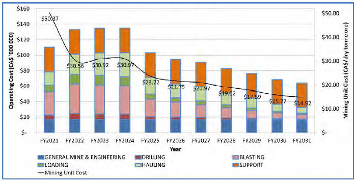
The yearly total operating costs, which includes the cost associated with ore stockpiling, transporting, and processing, along with camp and other costs, is shown in Figure 21-2.
| March 2015 | Page 21-7 |
| Ekati Diamond Mine Northwest Territories, Canada NI 43-101 Technical Report |
Figure 21-2: Operating Costs for Jay, FY21–31
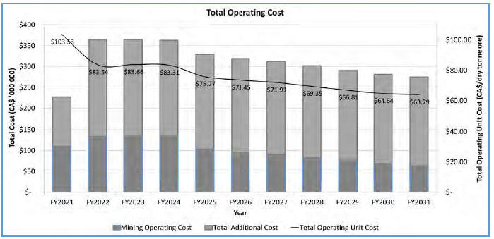
Over the life of the Jay pipe, the average unit mining cost will be $4.80/t (dry total material) or $23.97/t (dry ore). The additional costs, including processing, transportation, and mining camp costs, are estimated to be $51.11/t (dry processed ore). The average total operating unit cost is estimated to be $75/t (dry processed ore).
| 21.2.3 | Mine Operating Costs |
Direct surface and underground mining costs are based upon the headcount, drill and blast rates and fleet assumptions used in the “FY16 Budget and Five-Year Plan”. The base case mining costs are based on the Mineral Reserves Base Case Mine Plan and production schedule. The operating case mining costs are based on the Operating Case Mine Plan and production schedule.
| 21.2.4 | Process Operating Costs |
Direct processing costs are based upon the headcount, reagent consumption rates and consumables assumptions used the “FY16 Budget and Five-Year Plan”, which was based on a throughput of 4.35 million tonnes of ore processed annually, and the process plant running at maximum capacity. Process plant operating costs in both the Mineral Reserves Base Case production schedule and the Operating Case production schedule have been reduced assuming labour cost is step-variable, reflecting either 24/7 or 12/7 operating shifts, and all other costs vary proportionately to process plant throughput.
| March 2015 | Page 21-8 |
| Ekati Diamond Mine Northwest Territories, Canada NI 43-101 Technical Report |
| 21.2.5 | Infrastructure Operating Costs |
Infrastructure costs are based upon the headcount and consumables assumptions used in the “FY16 Budget and Five-Year Plan”. These costs are assumed to be fixed and are not reduced with the lower production rates in the Mineral Reserves Base Case Mine Plan and Operating Case Mine Plan production schedules. | |
| 21.2.6 | General and Administrative Operating Costs |
General and Administrative costs are based upon the headcount and operating expenses in the “FY16 Budget and Five-Year Plan”. These costs are assumed to be fixed and are not reduced with the lower production rates in the Mineral Reserves and Operating Case production schedules. | |
| 21.2.7 | Owner (Corporate) Operating Costs |
No corporate operating costs are included in the operating cost forecast. | |
| 21.2.8 | Operating Cost Summary |
Currently estimated life-of-mine operating costs are based on Dominion’s operating experience, using present-day dollar terms. Given the remote location of the Ekati Diamond Mine, a large portion of the operating expenditure is fixed, with the major cost items being labour and fuel (for both power and equipment).
Marketing costs, private royalties and estimated reclamation costs are not included in the Mineral Reserves Base Case Mine Plan and Operating Case Mine Plan totals in Section 21. These were included as separate line items in the economic analysis in Section 22.
Dominion sorts its rough diamonds in Antwerp, Belgium, Toronto, Canada and Mumbai, India and then distributes the resulting sales parcels to its Belgian and Indian subsidiaries for sale. The models are based on production sales revenue (assume that all diamonds are sold in the year of production). Marketing costs that average $13 million per annum are based on the “FY16 Budget and 5 Year Plan”.
The reclamation costs of $251 million were based on Ekati’s closure cost model that includes all activities required by the approved Interim Closure and Reclamation Plan. The timeframe and cost estimate for reclamation has been updated to reflect the development of Jay. Jay will push out the reclamation obligations of the main Ekati site infrastructure, it will create new obligations to reclaim new project-specific development, and it will reduce the costs of reclaiming the balance of the Ekati property. The net effects of these changes are summarized in Table 21-6 to the end of the major expenditure in 2044. From FY37 to FY41, an annual expenditure of $6.3 million is assumed, with $3.6 million expended annually from FY42 to FY44. Post FY44, the closure estimate assumes that an additional $0.1 million will be required per annum until FY54, for an additional total expenditure of $1 million over that 10 year period.
| March 2015 | Page 21-9 |
| Ekati Diamond Mine Northwest Territories, Canada NI 43-101 Technical Report |
Table 21-6: Reclamation Cost Estimate
| Fiscal Year | Reclamation excluding Jay $ Millions | Reclamation including Jay $ Millions | Jay Net Reclamation Impact $ Millions | |
| 2016 | — | — | — | |
| 2017 | 2 | 2 | — | |
| 2018 | 2 | 2 | — | |
| 2019 | 2 | 2 | — | |
| 2020 | 2 | 2 | — | |
| 2021 | 6 | 5 | (1) | |
| 2022 | 111 | 5 | (106) | |
| 2023 | 29 | 5 | (24) | |
| 2024 | 44 | 4 | (40) | |
| 2025 | 6 | 4 | (3) | |
| 2026 | 6 | 4 | (3) | |
| 2027 | 6 | 4 | (3) | |
| 2028 | 6 | 4 | (3) | |
| 2029 | 6 | 4 | (3) | |
| 2030 | 6 | 4 | (3) | |
| 2031 | 6 | 4 | (3) | |
| 2032 | 4 | 74 | 70 | |
| 2033 | 4 | 28 | 25 | |
| 2034 | 4 | 43 | 40 | |
| 2035 | 0.1 | 6 | 6 | |
| 2036 | 0.1 | 6 | 6 | |
| Post-2036 to 2044 | 1 | 43 | 43 | |
| Totals | 254 | 251 | (3) |
| 21.3 | Comments on Capital and Operating Costs |
The responsible QPs consider that the information discussed in this section supports the estimation of Mineral Reserves, based on the following:
| March 2015 | Page 21-10 |
| Ekati Diamond Mine Northwest Territories, Canada NI 43-101 Technical Report |
| • | Capital and operating cost estimates for the Mineral Reserves Base Case Mine Plan are based on the “FY16 Budget and Five-Year Plan”, the estimated equipment, labour, and consumables required for each year of production, first- principle calculations and checks, and the estimated Mineral Reserves reported in Section 15; | |
| • | The capital costs are estimated by project study level, and/or projected infrastructure requirements; | |
| • | For both the Mineral Reserves Base Case Mine Plan and the Operating Case Mine Plan, capital costs are estimated at $965 million of development capital and $339 million of sustaining capital for each plan. Remaining Misery pipe development is estimated at $136 million. Remaining Pigeon project development is estimated at $22 million. Lynx project development is estimated at $47 million. Jay pipe development is estimated at $760 million; | |
| • | A large portion of the operating expenditure is fixed, with the major cost items being labour and fuel (for both power and equipment); | |
| • | Direct and indirect operating costs are estimated at $5.48 billion in the Mineral Reserves Base Case Mine Plan, and $5.60 billion in the Operating Case Mine Plan. Current reclamation costs are estimated at $251 million including the effects of Jay development; | |
| • | Operating costs can be affected by the duration of the period available for usage of the ice road to bring in supplies, and by changes in fuel prices, as all electricity is generated by diesel on site. |
| March 2015 | Page 21-11 |
| Ekati Diamond Mine Northwest Territories, Canada NI 43-101 Technical Report |
| 22.0 | ECONOMIC ANALYSIS |
The results of the economic analysis to support Mineral Reserves represent forward-looking information that is subject to a number of known and unknown risks, uncertainties and other factors that may cause actual results to differ materially from those presented here.
Forward-looking statements in this Report include, but are not limited to, statements with respect to future diamond valuations and diamond sales contracts, the estimation of Mineral Reserves and Mineral Resources, the realization of Mineral Reserve estimates, the timing and amount of estimated future production, costs of production, capital expenditures, costs and timing of the development of new kimberlite pipes, permitting time lines for development of new pipes or treatment of stockpiles, requirements for additional capital, exchange rate assumptions, in particular the US$ to $Canadian exchange rate, government regulation of mining operations, accidents, labour disputes and other risks of the mining industry, environmental risks, unanticipated reclamation expenses, continuation of the social licence to operate, and title disputes or claims.
Without limiting the generality of the above risk statements, some specific risks can come from changes in parameters as mine and process plans continue to be refined. These include possible variations in Mineral Resource and Mineral Reserve estimates, grade or recovery rates; diamond reference value estimate assumptions; geotechnical considerations during mining and geotechnical and hydrogeological considerations during Jay dike construction and operation, including impacts of mud rushes, pit wall failures, or dike integrity; failure of plant, equipment or processes to operate as anticipated if granite or clay content of ore increases over the assumptions used in the mine plan; modifications to existing practices so as to comply with any future permit conditions that may be imposed by the appropriate regulator; and delays in obtaining regulatory approvals and lease renewals.
| 22.1 | Methodology Used |
To support estimation of Mineral Reserves, Dominion prepared an economic analysis to confirm that the economics based on the Mineral Reserves could repay life-of-mine operating and capital costs. The Ekati Diamond Mine was evaluated on an after-tax, project stand-alone, 100% equity-financed basis at the project level, using diamond valuations as at 31 October 2014 and a 7% discount rate.
| 22.2 | Financial Model Parameters |
The model was prepared on a financial year end of January 31.
| March 2015 | Page 22-1 |
| Ekati Diamond Mine Northwest Territories, Canada NI 43-101 Technical Report |
| 22.2.1 | Mineral Resource, Mineral Reserve, and Mine Life |
The financial analysis is based on two cases.
The Mineral Reserves Base Case Mine Plan is based on Probable Mineral Reserves of 61.1 Mt grading 1.7 cpt. The mine life based on the Mineral Reserves Base Case Mine Plan is 16 years, to FY31.
The Operating Case Mine Plan is based on Probable Mineral Reserves of 61.1 Mt grading 1.7 cpt, and Inferred Mineral Resources in the Misery South and Misery Southwest Extension areas of 3.3 Mt grading 2.0 cpt. The Operating Case Mine Plan also has a mine life of 16 years, to FY31. Investors are cautioned that Mineral Resources that are not Mineral Reserves do not have demonstrated economic viability, and are further cautioned that the Operating Case Mine Plan includes Inferred Mineral Resources that are considered too speculative geologically to have the economic considerations applied to them that would enable them to be categorized as Mineral Reserves, and there is no certainty that the Operating Case Mine Plan will be realized.
| 22.2.2 | Metallurgical Recoveries |
Mineral Reserves are reported at +1.0 mm (diamonds retained on a 1.0 mm slot screen). The current forecast production rate for Ekati main process plant is 4.35 million dry tonnes per annum.
| 22.2.3 | Operating Costs |
Direct and indirect operating costs are estimated at $5,479 million in the Mineral Reserves mine plan, and $5,598 million in the Operating Case mine plan. Marketing costs, royalty payments and estimated reclamation costs are included as separate line items to the operating cost estimate in the financial analysis. | |
| 22.2.4 | Capital Costs |
The Mineral Reserves Base Case Mine Plan and the Operating Case Mine Plan capital costs are estimated at $965 million of development capital and $339 million of sustaining capital for each plan. | |
| 22.2.5 | Royalties |
The NWT Royalty payable is either 13% of the value of output of the mine, or an amount calculated based on a sliding scale of royalty rates dependent upon the value of output of the mine, ranging from 5% for value of output between $10,000 and $5 million to 14% for value of output over $45 million. For modelling purposes, an illustrative royalty calculation has been used calculated as 13% of modelled free cash flow.
| March 2015 | Page 22-2 |
| Ekati Diamond Mine Northwest Territories, Canada NI 43-101 Technical Report |
The cash flow analysis does not include provision for the Misery royalty (see Section 4.7.2) as the analysis is provided on a 100% ownership basis.
| 22.2.6 | Working Capital |
Movements in working capital are not incorporated in the economic analysis. This applies to rough diamond stocks in inventory at the start of the first year, supplies inventory, accounts receivable and payable. | |
| 22.2.7 | Taxes |
The taxation treatment in this analysis is applied to the Ekati Diamond Mine as a stand-alone whole entity and on a simplified basis. The joint venture partners in the Ekati Diamond Mine are separate parties, each of which are responsible for their own corporate income taxes.
For modelling purposes an illustrative corporate tax calculation has been used calculated as 26.5% of modelled free cash flow post the NWT Royalty. The 26.5% rate is based on the 2015 Federal corporate income tax rate of 15% and the 2015 Northwest Territories corporate income tax rate of 11.5% .
| 22.2.8 | Closure Costs and Salvage Value |
A total of $251 million is assumed in the financial analysis to cover life-of-mine closure cost expectations out to 2044 (refer to Section 21.2.8 for a full discussion on closure cost estimates).
| 22.2.9 | Inflation |
Inflation is not considered in the financial analysis. All figures are presented on a real basis in 2014 Canadian dollars.
| 22.2.10 | Diamond Prices |
Dominion sorts its rough diamonds in Antwerp, Belgium, Toronto, Canada and Mumbai, India and then distributes the resulting sales parcels to its Belgium and Indian subsidiaries for sale. The models are based on production sales revenue (assume that all diamonds are sold in the year of production).
| March 2015 | Page 22-3 |
| Ekati Diamond Mine Northwest Territories, Canada NI 43-101 Technical Report |
The diamond price forecast used assumes a 2.5% annual increase from average calendar 2014 prices and is based on the Dominion Price Book of 31 October 2014 pipe valuations. The October Price Book was used as a proxy for the average price from calendar 2014 as the price level at that time was close to the average price level for the calendar year.
The price forecast by pipe by fiscal year is presented in Table 22-1 for the period of estimated active mine life to FY31.
Marketing costs are based on an allocation of Dominion’s FY16 budget of about $13 million per annum. The financial analysis has allocated marketing costs of $208 million over the Mineral Reserves mine plan.
| March 2015 | Page 22-4 |
| Ekati Diamond Mine Northwest Territories, Canada NI 43-101 Technical Report |
Table 22-1: PriceForecast by Pipe by Fiscal Year
| Item | FY16 | FY17 | FY18 | FY19 | FY20 | FY21 | FY22 | FY23 | FY24 | FY25 | FY26 | FY27 | FY28 | FY29 | FY30 | FY31 | |||
Price (US$/ct) | Underground | Koala | 354.71 | 363.58 | 372.67 | 381.99 | 391.54 | 401.32 | — | — | — | — | — | — | — | — | — | — | |
Open Pit | Misery | 88.15 | 90.35 | 92.61 | 94.93 | 97.30 | 99.73 | — | — | — | — | — | — | — | — | — | — | ||
| Misery South | 88.15 | 90.35 | 92.61 | 94.93 | 97.30 | 99.73 | — | — | — | — | — | — | — | — | — | — | |||
| Misery SW Ext. | 88.15 | 90.35 | 92.61 | 94.93 | 97.30 | 99.73 | — | — | — | — | — | — | — | — | — | — | |||
| Pigeon | 184.78 | 189.40 | 194.14 | 198.99 | 203.97 | 209.06 | — | — | — | — | — | — | — | — | — | — | |||
| Lynx | 247.03 | 253.20 | 259.53 | 266.02 | 272.67 | 279.49 | — | — | — | — | — | — | — | — | — | — | |||
| Jay | — | — | — | — | — | 78.21 | 81.33 | 85.20 | 86.19 | 87.87 | 88.45 | 88.37 | 88.09 | 86.59 | 86.37 | 84.00 |
| March 2015 | Page 22-5 |
| Ekati Diamond Mine Northwest Territories, Canada NI 43-101 Technical Report |
| 22.3 | Financial Results |
Results of the financial analysis using the Mineral Reserves Base Case Mine Plan indicated positive economics until the end of mine life in FY31, and supported the declaration of Mineral Reserves.
Over the life of mine outlined in the Mineral Reserves mine plan, assuming a 7% discount rate, the NPV is $1.08 billion and the pre-tax cumulative cash flow is $2.54 billion. The payback period is approximately four years and the after-tax internal rate of return (IRR) is 31%.
The cash flow analysis based on the Mineral Reserves Base Case Mine Plan to FY39 is included as Table 22-2.
In the Operating Case mine plan, also assuming a 7% discount rate, the NPV is $1.51 billion and the pre-tax cumulative cash flow is $3.05 billion. In this case, given that the mine is generating an immediate positive cash flow, payback period and IRR calculations are not relevant. Investors are cautioned that Mineral Resources that are not Mineral Reserves do not have demonstrated economic viability and are further cautioned that the Operating Case Mine Plan includes Inferred Mineral Resources that are considered too speculative geologically to have the economic considerations applied to them that would enable them to be categorized as Mineral Reserves, and there is no certainty that the Operating Case Mine Plan will be realized.
The cash flow analysis based on the Operating Case Mine Plan to FY39 is included in Table 22-3.
| March 2015 | Page 22-6 |
| Ekati Diamond Mine | |
| Northwest Territories, Canada | |
| NI 43-101 Technical Report |
Table 22-2:MineralReserves Base Case Mine Plan Cash FlowAnalysis Table(includes post-operationalclosure costs to FY 39)
| Item | Mineral Reserve Base Case Mine Plan Totals | FY16 | FY17 | FY18 | FY19 | FY20 | FY21 | FY22 | FY23 | FY24 | FY25 | FY26 | FY27 | FY28 | FY29 | FY30 | FY31 | FY32 | FY33 | FY34 | FY35 | FY36 | FY37 | FY38 | FY39 | ||
| Waste mined (Mt) | Total | 254.37 | 18.81 | 19.85 | 20.23 | 9.48 | 3.94 | 24.81 | 33.36 | 33.65 | 32.42 | 17.02 | 13.77 | 10.98 | 7.88 | 5.13 | 2.47 | 0.57 | — | — | — | — | — | — | — | — | |
| Ore mined (Mt) | Underground | Koala | 3.96 | 1.10 | 0.91 | 0.72 | 0.70 | 0.43 | 0.09 | — | — | — | — | — | — | — | — | — | — | — | — | — | — | — | — | — | — |
| Open Pit | Misery | 3.03 | 0.00 | 0.69 | 1.07 | 0.71 | 0.24 | 0.31 | — | — | — | — | — | — | — | — | — | — | — | — | — | — | — | — | — | — | |
| Pigeon | 7.40 | 0.81 | 0.23 | 0.38 | 1.89 | 2.30 | 1.80 | — | — | — | — | — | — | — | — | — | — | — | — | — | — | — | — | — | — | ||
| Lynx | 1.09 | — | 0.02 | 0.76 | 0.30 | — | — | — | — | — | — | — | — | — | — | — | — | — | — | — | — | — | — | — | — | ||
| Jay | 45.61 | — | — | — | — | — | 1.98 | 4.35 | 4.35 | 4.35 | 4.34 | 4.34 | 4.34 | 4.34 | 4.34 | 4.34 | 4.51 | — | — | — | — | — | — | — | — | ||
| Grade (cpt) | Underground | Koala | 0.59 | 0.70 | 0.56 | 0.51 | 0.53 | 0.61 | 0.69 | — | — | — | — | — | — | — | — | — | — | — | — | — | — | — | — | — | — |
| Open Pit | Misery | 4.70 | 3.72 | 4.33 | 4.63 | 5.02 | 4.88 | 4.88 | — | — | — | — | — | — | — | — | — | — | — | — | — | — | — | — | — | — | |
| Pigeon | 0.49 | 0.45 | 0.40 | 0.53 | 0.45 | 0.53 | 0.50 | — | — | — | — | — | — | — | — | — | — | — | — | — | — | — | — | — | — | ||
| Lynx | 0.82 | — | 0.72 | 0.84 | 0.77 | — | — | — | — | — | — | — | — | — | — | — | — | — | — | — | — | — | — | — | — | ||
| Jay | 1.85 | — | — | — | — | — | 1.36 | 1.30 | 1.44 | 1.66 | 1.75 | 1.88 | 1.97 | 2.08 | 2.25 | 2.28 | 2.15 | ||||||||||
| Processing | Total Tonnes Processed | Mt | 61.12 | 1.94 | 1.85 | 2.93 | 3.61 | 2.98 | 4.19 | 4.35 | 4.35 | 4.35 | 4.34 | 4.34 | 4.34 | 4.34 | 4.34 | 4.34 | 4.51 | — | — | — | — | — | — | — | — |
| Total Carats Recovered | cpt | 105.66 | 1.16 | 3.58 | 6.16 | 5.03 | 2.67 | 5.18 | 5.64 | 6.27 | 7.23 | 7.59 | 8.16 | 8.56 | 9.03 | 9.76 | 9.91 | 9.72 | — | — | — | — | — | — | — | — | |
| Revenue | Average Price | US$/ct | 297.56 | 132.26 | 126.17 | 140.22 | 174.90 | 116.29 | 81.33 | 85.20 | 86.19 | 87.87 | 88.45 | 88.37 | 88.09 | 86.59 | 86.37 | 84.00 | — | — | — | — | — | — | — | — | |
| Exchange Rate | US$/C$ | 0.88 | 0.91 | 0.91 | 0.91 | 0.91 | 0.91 | 0.91 | 0.91 | 0.91 | 0.91 | 0.91 | 0.91 | 0.91 | 0.91 | 0.91 | 0.91 | 0.91 | 0.91 | 0.91 | 0.91 | 0.91 | 0.91 | 0.91 | 0.91 | ||
| Cash Inflow | C$ M | 11,502 | 390.48 | 521.43 | 855.47 | 776.48 | 512.87 | 663.04 | 504.91 | 587.49 | 685.81 | 734.03 | 794.16 | 832.08 | 874.83 | 929.15 | 941.17 | 898.21 | — | — | — | — | — | — | — | — | |
| Costs | Development Capital | C$ M | 965 | 157 | 222 | 224 | 252 | 111 | — | — | — | — | — | — | — | — | — | — | — | — | — | — | — | — | — | — | — |
| Sustaining Capital | C$ M | 339 | 49 | 37 | 27 | 21 | 21 | 21 | 25 | 25 | 25 | 25 | 25 | 20 | 10 | 5 | 2 | 1 | — | — | — | — | — | — | — | — | |
| Total Operating Costs | C$ M | 5,479 | 332 | 397 | 451 | 401 | 339 | 341 | 363 | 365 | 365 | 329 | 321 | 313 | 302 | 290 | 281 | 288 | — | — | — | — | — | — | — | — | |
| Reclamation Costs | C$ M | 250 | — | 2 | 2 | 2 | 2 | 5 | 5 | 5 | 4 | 4 | 4 | 4 | 4 | 4 | 4 | 4 | 74 | 28 | 43 | 6 | 6 | 6 | 6 | 6 | |
| Marketing Costs | C$ M | 208 | 13 | 13 | 13 | 13 | 13 | 13 | 13 | 13 | 13 | 13 | 13 | 13 | 13 | 13 | 13 | 13 | — | — | — | — | — | — | — | — | |
| Cash Outflow | C$ M | 7,241 | 551 | 671 | 716 | 689 | 485 | 379 | 406 | 407 | 407 | 371 | 363 | 349 | 328 | 312 | 300 | 306 | 74 | 28 | 43 | 6 | 6 | 6 | 6 | 6 | |
| Net Cash Flow before Taxes | C$ M | 4,261 | (161) | (150) | 139 | 88 | 28 | 284 | 99 | 180 | 279 | 363 | 431 | 483 | 547 | 617 | 642 | 592 | (74) | (28) | (43) | (6) | (6) | (6) | (6) | (6) | |
| Tax | NWT Royalty (13% of pre-tax free cash flow) | C$ M | 620 | — | — | 18 | 11 | 4 | 37 | 13 | 23 | 36 | 47 | 56 | 63 | 71 | 80 | 83 | 77 | — | — | — | — | — | — | — | — |
| Income Tax (26.5% of post-NWT Royalty free cash flow) | C$ M | 1,100 | — | — | 32 | 20 | 6 | 65 | 23 | 42 | 64 | 84 | 99 | 111 | 126 | 142 | 148 | 137 | — | — | — | — | — | — | — | — | |
| Cash Flow | Revenue Less Costs | C$ M | 2,540 | (161) | (150) | 89 | 56 | 18 | 181 | 63 | 115 | 178 | 232 | 276 | 309 | 350 | 395 | 410 | 379 | (74) | (28) | (43) | (6) | (6) | (6) | (6) | (6) |
| Net Present Value at 7% discount rate | C$ M | 1,078 | |||||||||||||||||||||||||
Notes to Accompany Cash Flow Table | ||
(1) | Value by pipe weighted by production from each pipe. | |
(2) | Tax calculation is illustrative (i.e. applies basic taxes on the year that production and revenue is incurred). | |
(3) | The cash flow table is provided on a 100% ownership basis. Dominion has an 88.9% participating interest in the Core Zone Joint Venture and a 65.3% participating interest in the Buffer Zone Joint Venture. | |
| March 2015 | Page 22-7 |
| Ekati Diamond Mine Northwest Territories, Canada NI 43-101 Technical Report |
Table 22-3:Operating Case Plan Cash FlowAnalysis Table(includes post-operationalclosure costs to FY 39)
| Item | Operating Case Mine Plan Totals | FY16 | FY17 | FY18 | FY19 | FY20 | FY21 | FY22 | FY23 | FY24 | FY25 | FY26 | FY27 | FY28 | FY29 | FY30 | FY31 | FY32 | FY33 | FY34 | FY35 | FY36 | FY37 | FY38 | FY39 | ||
| Waste mined (Mt) | Total | 236.38 | 5.44 | 15.22 | 20.23 | 9.48 | 3.94 | 24.81 | 33.36 | 33.65 | 32.42 | 17.02 | 13.77 | 10.98 | 7.88 | 5.13 | 2.47 | 0.57 | — | — | — | — | — | — | — | — | |
| Ore mined (Mt) | Underground | Koala | 3.96 | 1.10 | 0.91 | 0.72 | 0.70 | 0.43 | 0.09 | — | — | — | — | — | — | — | — | — | — | — | — | — | — | — | — | — | — |
| Open Pit | Misery | 3.03 | 0.00 | 0.69 | 1.07 | 0.71 | 0.24 | 0.31 | — | — | — | — | — | — | — | — | — | — | — | — | — | — | — | — | — | — | |
| Pigeon | 7.40 | 0.81 | 0.23 | 0.38 | 1.89 | 2.30 | 1.80 | — | — | — | — | — | — | — | — | — | — | — | — | — | — | — | — | — | — | ||
| Lynx | 1.09 | — | 0.02 | 0.76 | 0.30 | — | — | — | — | — | — | — | — | — | — | — | — | — | — | — | — | — | — | — | — | ||
| Jay | 45.61 | — | — | — | — | — | 1.98 | 4.35 | 4.35 | 4.35 | 4.34 | 4.34 | 4.34 | 4.34 | 4.34 | 4.34 | 4.51 | — | — | — | — | — | — | — | — | ||
| Mill feed mined (Mt) | Open Pit | Misery South | 0.58 | 0.29 | 0.28 | 0.01 | — | — | — | — | — | — | — | — | — | — | — | — | — | — | — | — | — | — | — | — | — |
| Misery SW Ext. | 2.70 | 0.84 | 0.68 | 0.13 | 0.67 | 0.23 | 0.16 | — | — | — | — | — | — | — | — | — | — | — | — | — | — | — | — | — | — | ||
| Grade (cpt) | Underground | Koala | 0.59 | 0.70 | 0.56 | 0.51 | 0.53 | 0.61 | 0.69 | — | — | — | — | — | — | — | — | — | — | — | — | — | — | — | — | — | — |
| Open Pit | Misery | 4.70 | 3.72 | 4.33 | 4.63 | 5.02 | 4.88 | 4.88 | — | — | — | — | — | — | — | — | — | — | — | — | — | — | — | — | — | — | |
| Pigeon | 0.49 | 0.45 | 0.40 | 0.53 | 0.45 | 0.53 | 0.50 | — | — | — | — | — | — | — | — | — | — | — | — | — | — | — | — | — | — | ||
| Lynx | 0.82 | — | 0.72 | 0.84 | 0.77 | — | — | — | — | — | — | — | — | — | — | — | — | — | — | — | — | — | — | — | — | ||
| Jay | 1.85 | — | — | — | — | — | 1.36 | 1.30 | 1.44 | 1.66 | 1.75 | 1.88 | 1.97 | 2.08 | 2.25 | 2.28 | 2.15 | ||||||||||
| Misery South | 1.10 | 1.10 | 1.10 | 1.10 | — | — | — | — | — | — | — | — | — | — | — | — | — | — | — | — | — | — | — | — | — | ||
| Misery SW Ext | 2.22 | 2.22 | 2.22 | 2.22 | 2.22 | 2.22 | 2.22 | — | — | — | — | — | — | — | — | — | — | — | — | — | — | — | — | — | — | ||
| Processing | Total Ore Tonnes Processed | Mt | 61.12 | 1.94 | 1.85 | 2.93 | 3.61 | 2.98 | 4.19 | 4.35 | 4.35 | 4.35 | 4.34 | 4.34 | 4.34 | 4.34 | 4.34 | 4.34 | 4.51 | — | — | — | — | — | — | — | — |
| Total Ore Carats Recovered | cpt | 105.66 | 1.16 | 3.58 | 6.16 | 5.03 | 2.67 | 5.18 | 5.64 | 6.27 | 7.23 | 7.59 | 8.16 | 8.56 | 9.03 | 9.76 | 9.91 | 9.72 | — | — | — | — | — | — | — | — | |
| Total Mill Feed Tonnes Processed | Mt | 3.28 | 1.12 | 0.96 | 0.14 | 0.67 | 0.23 | 0.16 | — | — | — | — | — | — | — | — | — | — | — | — | — | — | — | — | — | — | |
| Total Mill Feed Carats Recovered | cpt | 6.63 | 2.17 | 1.82 | 0.30 | 1.48 | 0.51 | 0.35 | — | — | — | — | — | — | — | — | — | — | — | — | — | — | — | — | — | — | |
Revenue | Average Price | US$/ct | 160.89 | 118.15 | 124.57 | 129.85 | 162.46 | 115.08 | 81.33 | 85.20 | 86.19 | 87.87 | 88.45 | 88.37 | 88.09 | 86.59 | 86.37 | 84.00 | — | — | — | — | — | — | — | — | |
| Exchange Rate | US$/C$ | 0.88 | 0.91 | 0.91 | 0.91 | 0.91 | 0.91 | 0.91 | 0.91 | 0.91 | 0.91 | 0.91 | 0.91 | 0.91 | 0.91 | 0.91 | 0.91 | 0.91 | 0.91 | 0.91 | 0.91 | 0.91 | 0.91 | 0.91 | 0.91 | ||
| Cash Inflow | C$ M | 12,175 | 607.83 | 701.97 | 885.75 | 929.94 | 567.33 | 700.80 | 504.91 | 587.49 | 685.81 | 734.03 | 794.16 | 832.08 | 874.83 | 929.15 | 941.17 | 898.21 | — | — | — | — | — | — | — | — | |
| Costs | Development Capital | C$ M | 965 | 157 | 222 | 224 | 252 | 111 | — | — | — | — | — | — | — | — | — | — | — | — | — | — | — | — | — | — | — |
| Sustaining Capital | C$ M | 339 | 49 | 37 | 27 | 21 | 21 | 21 | 25 | 25 | 25 | 25 | 25 | 20 | 10 | 5 | 2 | 1 | — | — | — | — | — | — | — | — | |
| Total Operating Costs | C$ M | 5,538 | 372 | 422 | 446 | 403 | 336 | 342 | 363 | 365 | 365 | 329 | 321 | 313 | 302 | 290 | 281 | 288 | — | — | — | — | — | — | — | — | |
| Reclamation Costs | C$ M | 250 | — | 2 | 2 | 2 | 2 | 5 | 5 | 5 | 4 | 4 | 4 | 4 | 4 | 4 | 4 | 4 | 74 | 28 | 43 | 6 | 6 | 6 | 6 | 6 | |
| Marketing Costs | C$ M | 208 | 13 | 13 | 13 | 13 | 13 | 13 | 13 | 13 | 13 | 13 | 13 | 13 | 13 | 13 | 13 | 13 | — | — | — | — | — | — | — | — | |
| Cash Outflow | C$ M | 7,301 | 591 | 696 | 712 | 690 | 483 | 380 | 406 | 407 | 407 | 371 | 363 | 349 | 328 | 312 | 300 | 306 | 74 | 28 | 43 | 6 | 6 | 6 | 6 | 6 | |
| Net Cash Flow before Taxes | C$ M | 4,875 | 17 | 6 | 174 | 240 | 85 | 321 | 99 | 180 | 279 | 363 | 431 | 483 | 547 | 617 | 642 | 592 | (74) | (28) | (43) | (6) | (6) | (6) | (6) | (6) | |
| Tax | NWT Royalty (13% of pre-tax free cash flow) | C$ M | 660 | 2 | 1 | 23 | 31 | 11 | 42 | 13 | 23 | 36 | 47 | 56 | 63 | 71 | 80 | 83 | 77 | — | — | — | — | — | — | — | — |
| Income Tax (26.5% of post-NWT Royalty free cash flow) | C$ M | 1,170 | 4 | 1 | 40 | 55 | 20 | 74 | 23 | 42 | 64 | 84 | 99 | 111 | 126 | 142 | 148 | 137 | — | — | — | — | — | — | — | — | |
| Cash Flow | Revenue less Costs | C$ M | 3,045 | 11 | 4 | 111 | 153 | 54 | 205 | 63 | 115 | 178 | 232 | 276 | 309 | 350 | 395 | 410 | 379 | (74) | (28) | (43) | (6) | (6) | (6) | (6) | (6) |
| Net Present Value at 7% discount rate | C$ M | 1,506 | |||||||||||||||||||||||||
| Notes to Accompany Cash Flow Table | ||
| (1) | Value by pipe weighted by production from each pipe. | |
| (2) | Tax calculation is illustrative (i.e. applies basic taxes on the year that production and revenue is incurred). | |
| (3) | The cash flow table is provided on a 100% ownership basis. Dominion has an 88.9% participating interest in the Core Zone Joint Venture and a 65.3% participating interest in the Buffer Zone Joint Venture. | |
| March 2015 | Page 22-8 |
| Ekati Diamond Mine Northwest Territories, Canada NI 43-101 Technical Report |
| 22.4 | Sensitivity Analysis |
The sensitivity of the Ekati Project under the Mineral Reserve Base Case Mine Plan assumptions to changes in metal price, diamond grade, operating costs, capital costs and US$ to $Canadian exchange rates is summarized in Table 22-4. The sensitivity the mine under the Operating Case Mine Plan assumptions is summarized in Table 22-5. In both tables, net present value at a 7% real discount rate is used as indicator to evaluate the impact of varying the diamond prices, the grade, the capital costs, the operating costs and the Canadian/US dollar exchange rate on the Ekati Project economics. For the variables in the sensitivity analysis, a ±10% change applied.
Table 22-4: NPV Sensitivity Analysis under Mineral Reserve Base Case Mine Plan (estimate base case is highlighted)
| Parameter | Financial Sensitivity NPV ($ Million) | |||
| - 10% Change | Base Case | + 10% Change | ||
| Price | 631 | 1,078 | 1,519 | |
| Grade | 631 | 1,078 | 1,519 | |
| Capital Costs | 1,158 | 1,078 | 997 | |
| Operating Costs | 1,323 | 1,078 | 830 | |
| US$/C$ Foreign Exchange Rate | 1,444 | 1,078 | 774 | |
Table 22-5: NPV Sensitivity Analysis under Operating Case Mine Plan (estimate base case is highlighted)
| Parameter | Financial Sensitivity NPV ($ Million) | |||
| - 10% Change | Base Case | + 10% Change | ||
| Price | 1,024 | 1,506 | 1,954 | |
| Grade | 1,024 | 1,506 | 1,954 | |
| Capital Costs | 1,572 | 1,506 | 1,433 | |
| Operating Costs | 1,731 | 1,506 | 1,263 | |
| US$/C$ Foreign Exchange Rate | 1,879 | 1,506 | 1,170 | |
The analysis demonstrated that the Ekati Diamond Mine is most sensitive to variations in diamond parcel valuations and diamond grades, less sensitive to fluctuations in exchange rate estimates and operating costs, and least sensitive to changes in the capital cost assumptions.
| March 2015 | Page 22-9 |
| Ekati Diamond Mine Northwest Territories, Canada NI 43-101 Technical Report |
| 22.5 | Comments on Economic Analysis |
Based on the assumptions detailed in the financial analysis of both the Mineral Reserves Base Case Mine Plan and the Operating Case Mine Plan, the Ekati Project demonstrates positive economics over the mine life.
Mineral Resources that are not included in either the current Mineral Reserve plan or the Operating Case plan include Sable, a portion of Koala underground, and Fox Deep.
Of these deposits, Sable represents the most significant opportunity, due to its high estimated diamond price, potential for development via a large open pit, and advanced permitting.
The coarse processed kimberlite, along with Sable and Fox Deep mineralization represent future plant feed upside potential, and some or all of this mineralization may be able to be incorporated in the life-of-mine plan once sufficient additional work has been undertaken.
There is also upside potential to treat low-grade stockpiles, primarily derived from open pit mining at the Fox kimberlite if the grades in the stockpiles can be demonstrated to be economic.
| March 2015 | Page 22-10 |
| Ekati Diamond Mine Northwest Territories, Canada NI 43-101 Technical Report |
| 23.0 | ADJACENT PROPERTIES |
There are no adjacent properties that are relevant to this Report.
| March 2015 | Page 23-1 |
| Ekati Diamond Mine Northwest Territories, Canada NI 43-101 Technical Report |
| 24.0 | OTHER RELEVANT DATA AND INFORMATION |
There are no additional data that are relevant to this Report.
| March 2015 | Page 24-1 |
| Ekati Diamond Mine Northwest Territories, Canada NI 43-101 Technical Report |
| 25.0 | INTERPRETATION AND CONCLUSIONS |
The QPs, as authors of this Report, have reviewed the data for the Ekati Project and have reached the following conclusions and interpretations in their areas of responsibility.
| 25.1 | Mineral Tenure and Royalties |
Mineral tenure is held under two joint venture agreements. All mining leases were legally surveyed by licensed surveyors. Annual lease payment requirements have been met as required.
Two royalties are payable. One is to the Government, the second is payable to a third-party on production from the Misery pipe.
| 25.2 | Permits |
Within the Ekati mineral leases, there are eight surface leases, which provide tenure for operational infrastructure. All mine project developments are within these surface leases. Six of the surface leases will expire in 2026. The Pigeon surface lease was renewed in December 2012, and now also extends to 2026. The Sable lease will expire in 2015. Section 10 of the Territorial Lands Regulations provides for the renewal of these surface leases for a further 30 year term with appropriate engagement with Aboriginal communities.
Additional permits will be required to support planned mining at the Jay pipe.
Dominion has three granted Type A land-use permits that cover the area of the Sable and Pigeon pits and the Sable haul road. Issue permits have a five-year term with a possible one-time extension of two years, which was requested and approved in 2014. All three land-use permits were issued in 2009 and expire in September 2016.
Dominion is also a joint holder of three surface leases, one licence of occupation and one Land Use Permit for the winter road. These permits are managed by a Winter Road Joint Venture.
The Ekati Project has two Navigable Waters Protection Act Authorizations for structures interfering with navigation, and holds four fisheries authorizations which permit the mine to alter fish habitat in specified circumstances.
Dominion currently holds one water licence, which was issued by the Wek´èezhìi Land and Water Board. This licence provides for mining at all established areas plus allows for mining of the Pigeon, Lynx and Sable pipes. The licence is required to be renewed by August 2021.
| March 2015 | Page 25-1 |
| Ekati Diamond Mine Northwest Territories, Canada NI 43-101 Technical Report |
Some of the permits granted to Ekati at the start of operations are nearing their expiry dates and must be renewed. In some cases, the legislation under which the permits were granted has been revised, or discharge/emissions standards have altered in the interim. In these instances it is possible that renewal of the permits will require modifications to existing practices so as to comply with the permit conditions that may be imposed by the appropriate regulator. While there is a reasonable expectation that the permits will be renewed, additional data collection or supporting studies on discharges/emissions may be required.
| 25.3 | Environment and Social Licence |
Dominion operates Ekati under an Environmental Agreement with the Government of Canada and the Government of the Northwest Territories that was concluded in 1997. The agreement is binding over the life-of-mine.
A number of environmental monitoring programs are in place, and include ongoing assessments of water quality, aquatic effects, fish habitat compensation measures, site reclamation projects, waste rock storage area seepage, wildlife effects, air quality, and geotechnical stability of engineered structures.
Compliance with environmental requirements and agreements is reported publicly on an annual basis through the Water Licence, Environmental Agreement, Fisheries Act Authorizations and other means.
Version 2.4 of the ICRP was approved by the Wek´èezhìi Land and Water Board in November 2011. Various updates to the ICRP have been approved through the Annual Reclamation Progress Report.
Dominion has sufficiently addressed the environmental impact of the operation, and subsequent closure and remediation requirements that Mineral Resources and Mineral Reserves can be estimated, and that the mine plan is appropriate and achievable. Monitoring programs are in place.
The Ekati Diamond Mine currently holds the appropriate social licenses to operate. Impact and Benefit Agreements were concluded with four Aboriginal communities.
| March 2015 | Page 25-2 |
| Ekati Diamond Mine Northwest Territories, Canada NI 43-101 Technical Report |
| 25.4 | Geology and Mineralization |
The geological understanding of the settings, lithologies, and structural and alteration controls on mineralization in the different pipes is sufficient to support estimation of Mineral Resources and Mineral Reserves. The geological knowledge of the pipes is also considered sufficiently acceptable to reliably inform mine planning.
The mineralization style and setting is well understood and can support estimation of Mineral Resources and Mineral Reserves. The kimberlite pipes in the Ekati Project area display most of the typical features of kimberlite pipes. They are mostly small pipe-like bodies (surface area mostly <3 ha but up to 20 ha) that typically extend to projected depths of 400–600 m below the current land surface.
| 25.5 | Exploration |
The exploration programs completed to date are appropriate to the style of the deposit and prospects. The research work supports Dominion’s genetic and affinity interpretations for the deposits.
| 25.6 | Drilling |
Core drilling is used to define the pipe contacts, wall-rock conditions, and internal geology but is not used for grade estimation. Core drilling is also used to obtain geotechnical and hydrogeological data. Diamonds for grade estimation and valuation are obtained by RC drilling and/or by bulk sampling in underground or open pit mines.
The quantity and quality of the lithological, geotechnical, density, collar and down hole survey data collected in the drill programs are sufficient to support Mineral Resource and Mineral Reserve estimation.
| 25.7 | Sampling |
The density and spatial distribution of RC drill holes between pipes varies considerably and depends on a number of factors including pipe size, geologic complexity and grade characteristics relative to economic cut-offs.
Sampling methods are acceptable, meet industry-standard practices for diamond operations, and are acceptable for Mineral Resource and Mineral Reserve estimation and mine planning purposes.
Sampling error has the potential to cause over- or under-estimation of diamond grade. For both RC and drift bulk samples, it is typically not possible to measure fundamental grade sample error (e.g. check assays) as the entire sample is processed. The responsible QPs consider that the precision of the diamond weight estimates is high because concentrates are double picked by different qualified sorters and audits are undertaken on the double picked concentrates.
| March 2015 | Page 25-3 |
| Ekati Diamond Mine Northwest Territories, Canada NI 43-101 Technical Report |
The quality of the analytical data is reliable and sample preparation, analysis, and security are generally performed in accordance with exploration best practices and industry standards.
| 25.8 | Quality Assurance, Quality Control, and Data Verification |
Regular data verification programs have been undertaken on the data collected from the Ekati Project. Findings of these programs acceptably support the geological interpretations and the database quality, and therefore support the use of the data in Mineral Resource and Mineral Reserve estimation, and in mine planning.
| 25.9 | Metallurgical Test Work |
Metallurgical test work and associated analytical procedures were performed by recognized testing facilities, and the tests performed were appropriate to the various kimberlite domains.
Industry-standard studies were performed as part of process development and initial plant design. Subsequent production experience and focused investigations have guided plant expansions and process changes. Recovery estimates are based on appropriate metallurgical test work and confirmed with production data, and are appropriate to the partition curves for the various kimberlite domains.
The major element that can affect process plant performance is the presence of granite xenoliths in the plant feed. Typically, granite-containing feed is limited to 10% of the process throughput.
Feed with a high clay content can also result in poorer plant performance. Development of the Pigeon and Jay kimberlites will require careful attention to the quantities of sediments/fines and heavy mineral content in the plant feed.
| 25.10 | Mineral Resource and Mineral Reserve Estimates |
Mineral Resources and Mineral Reserves are reported using the 2014 CIM Definition Standards.
| March 2015 | Page 25-4 |
| Ekati Diamond Mine Northwest Territories, Canada NI 43-101 Technical Report |
Mineral Resources take into account geological, mining, processing and economic constraints, and have been defined within a conceptual stope design or a conceptual open pit shell. Depletion has been included in the estimates. No Measured Mineral Resources are reported.
Factors which may affect the Mineral Resource estimates include: diamond Price Book and valuation assumptions; changes to the assumptions used to estimate diamond carat content, block cave designs, open pit designs, geotechnical, mining and process plant recovery assumptions, and the effect of different sample-support sizes between RC drilling and underground sampling.
Mineral Reserves were estimated for the Koala, Koala North, Fox, Jay, Misery and Pigeon pipes, and for stockpile materials.
Additional factors which may affect the Mineral Reserve estimates include appropriate dilution control being able to be maintained, changes to capital and operating cost estimates, in particular to fuel cost assumptions, and variations to the permitting, operating or social license regime assumptions, in particular if permitting parameters are modified by regulatory authorities during permit renewals.
| 25.11 | Mining Recovery |
Underground and open pit mine plans are appropriately developed to maximize mining efficiencies, based on the current knowledge of geotechnical, hydrogeological, mining and processing information on the Ekati Diamond Mine. The predicted mine life to 2031 in the Mineral Reserves Base Case Mine Plan is achievable based on the projected annual production rate and the Mineral Reserves estimated. There is project upside potential if some or all of the mineralization that is in Mineral Resources that has not been converted to Mineral Reserves can be demonstrated with appropriate studies to support such conversion.
The equipment and infrastructure requirements required for life-of-mine operations are well understood. Conventional mining equipment is, and will continue to be used to support the mining activities. The fleet requirements are appropriate to the planned production rate and methods outlined in the mine plan.
| 25.12 | Process Recovery |
The Ekati process plant has a capacity of 15,500 t/d; the current and budgeted throughput rate is 12,320 dmt per operating day (without planned maintenance).
| March 2015 | Page 25-5 |
| Ekati Diamond Mine Northwest Territories, Canada NI 43-101 Technical Report |
The process plant is operational, and there are 17 years of production history that allow for a reasonable assessment of plant performance in a production setting. There are no data or assumptions in the mine plan that are significantly different from previous plant operating experience, previous production throughputs and recoveries, or the Ekati Project background history.
The metallurgical process is conventional for the diamond industry. HMS and X-ray are the primary methods of extracting diamonds from processed kimberlite.
The current process facilities are appropriate, and the existing process facilities will support the current life-of-mine plan.
As there are a number of kimberlite sources being treated, the plant will produce variations in recovery due to changes in kimberlite type and domains being processed. These variations are expected to trend to the forecast recovery value for quarterly or longer reporting periods. Granite, clay and tramp metal can cause issues with plant performance.
Reagent consumptions and process conditions are based on both test work and production data. The operating costs associated with these factors are considered appropriate given the nature of the kimberlites to be processed.
| 25.13 | Infrastructure |
Ekati is an operating mine and key infrastructure on site includes the open pits, underground mines, sample and process plants, waste rock storage and processed kimberlite storage facilities, buildings (mobile and permanent), pipelines, pump stations, electrical systems, quarry site, camp pads and laydowns, ore storage pads, roads, culverts and bridges, airstrip, helipad, and mobile equipment.
The existing infrastructure, availability of staff, the existing power, water, and communications facilities, the methods whereby goods are transported to the mine, and any planned modifications or supporting studies are sufficiently well-established, or the requirements to establish such, are well understood by Dominion, and can support the estimation of Mineral Resources and Mineral Reserves and the mine plan.
| 25.14 | Markets |
The pricing forecasts are based on assumptions provided by Dominion’s marketing group and represent a best estimate, given there exists no forward market for rough diamonds to provide external long run pricing trends. Forecasts are considered acceptable to support the Mineral Reserves and mine plan assumptions.
| March 2015 | Page 25-6 |
| Ekati Diamond Mine Northwest Territories, Canada NI 43-101 Technical Report |
| 25.15 | Capital and Operating Costs |
The operating and capital cost estimates are appropriate to the estimated Mineral Reserves and Mineral Reserves mine plan assumptions.
| 25.16 | Economic Analysis |
Using the assumptions detailed in this Report, the Ekati Diamond Mine has positive economics until the end of the mine life.
The results of a sensitivity analysis demonstrate that the Mineral Reserve estimates are most sensitive to variations in diamond parcel valuations, diamond grades, and foreign exchange fluctuations, less sensitive to fluctuations in operating cost estimates, and least sensitive to changes in the capital cost assumptions.
| 25.17 | Conclusions |
In the opinion of the responsible QPs, the Ekati Project that is outlined in this Report has met its objectives.
Mineral Resources and Mineral Reserves have been estimated, a mine has been constructed, mining and milling operations are performing as expected, and reconciliation between mine production and the Mineral Resource model is acceptable. This indicates the data supporting the Mineral Resource and Mineral Reserve estimates were appropriately collected, evaluated and estimated, and the original objective of identifying mineralization that could support mining operations has been achieved.
The Ekati Project retains upside potential for mine-life extensions. The Misery satellite pipes and the coarse processed kimberlite, together with the Sable and Fox Deep Mineral Resources represent future plant feed upside potential, and some or all of this mineralization may be able to be incorporated in the life-of-mine plan once sufficient additional work has been undertaken to support estimation of higher-confidence Mineral Resources and eventual conversion to Mineral Reserves. There is also potential to treat low-grade stockpiles, primarily derived from open pit mining at the Fox kimberlite if the grades in the stockpiles can be demonstrated to be economic.
| 25.18 | Risks and Opportunities |
The Ekati Diamond Mine is a long-established operation with a clear understanding of challenges facing Dominion in exploiting the kimberlite pipes. The following risks and opportunities are noted.
| March 2015 | Page 25-7 |
| Ekati Diamond Mine Northwest Territories, Canada NI 43-101 Technical Report |
| 25.18.1 | Risks |
Risks that can affect the mining operations, mine plan, recovery, environmental, social licence and permitting assumptions and therefore the Mineral Reserve estimates include mud rushes and geotechnical conditions that could cause pit wall or dike failures, diamond pricing forecasts, fuel prices, environmental compliance requirements that may become cost or permit prohibitive, and non-renewal of surface leases or permits.
| 25.18.2 | Opportunities |
Mineral Resources that are not included in either the current Mineral Reserve plan or the Operating Case plan include Sable, a portion of Koala underground, and Fox Deep. Of these deposits, Sable represents the most significant opportunity, due to its high estimated diamond price, potential for development via a large open pit, and advanced permitting.
The coarse processed kimberlite, along with Sable and Fox Deep Mineral Resources represent future plant feed upside potential, and some or all of this mineralization may be able to be incorporated in the life-of-mine plan once sufficient additional work has been undertaken. There is also upside potential to treat low-grade stockpiles, primarily derived from open pit mining at the Fox kimberlite if the grades in the stockpiles can be demonstrated to be economic.
| March 2015 | Page 25-8 |
| Ekati Diamond Mine Northwest Territories, Canada NI 43-101 Technical Report |
| 26.0 | RECOMMENDATIONS |
A single phase work program is recommended as follows. No portion of the work program is dependent on the results of completion of another.
For the current operations (Koala underground, Misery pushback pit, and the Pigeon pit) the following work should be conducted:
| • | Determine the feasibility of future development below the current Koala underground mine. Work would include a diamond drilling program to better define the kimberlite pipe under the lowest existing mining level to support a potential resource estimate (estimated program cost = $1 million); | |
| • | A revised resource estimate for the Misery Main kimberlite should be completed, utilizing the stone density estimation methodology (estimated program cost = $50,000); | |
| • | Complete production test of Misery Main as soon as ore is exposed in the Misery Pushback pit. This would enable optimization of diamond recovery and a better constrained diamond price estimate (estimated program cost $1 million); | |
| • | Continue bulk sampling of the Misery satellite pipes to monitor the production grades for Misery South and Misery Southwest Extension and to assess other smaller satellite intrusions exposed during mining operations (estimated program cost $0.5 million); | |
| • | Continue geotechnical drilling and optimize pit design at Pigeon (estimated program cost $0.5 million); | |
| • | The overall cost estimate for the programs totals approximately $3 million. |
In support of feasibility-level studies on the Jay project, the following work should be conducted:
| • | Additional large diameter reverse circulation drilling is planned at Jay for winter 2015 and/or winter 2016 to provide a larger diamond parcel for valuation purposes. On completion of this program, a revised grade and resource block model will need to be produced; | |
| • | Complete feasibility-level capital cost estimation and engineering design, document the study in a feasibility-level report; | |
| • | The estimated overall approximate cost to bring the Jay studies to a feasibility level (including the drilling program) is $15 million (excludes environmental and permitting costs) |
| March 2015 | Page 26-1 |
| Ekati Diamond Mine Northwest Territories, Canada NI 43-101 Technical Report |
For the Sable kimberlite, the following work should be conducted, some of which has already commenced:
| • | A large diameter reverse circulation drilling program is underway (winter 2015) at Sable with the objective of sampling approximately 2,000 tonnes of kimberlite to increase the valuation parcel and reduce uncertainty on the diamond price estimate; | |
| • | Complete a pre-feasibility study in support of potential declaration of Mineral Reserves for Sable; | |
| • | The estimated total cost to complete a pre-feasibility study on the Sable deposit, including the drilling program, is approximately $6 million. |
For the Fox Deep Mineral Resource, the following work program is recommended:
| • | Evaluate if a deep drilling program is warranted to evaluate untested portions of the pipe at depth; | |
| • | Complete scoping study for large scale underground development; | |
| • | The estimated total cost for this work is about $2 million (excluding the drilling program). |
Additional work is recommended to be undertaken in relation to the Ekati process plant:
| • | Continued optimization of the processing plant to improve diamond recovery; | |
| • | Evaluate whether installation of a small diamond recovery circuit can be economically supported; | |
| • | The estimated total cost for a scoping study to assess a small diamond recovery circuit is about $250,000. |
| March 2015 | Page 26-2 |
| Ekati Diamond Mine Northwest Territories, Canada NI 43-101 Technical Report |
| 27.0 | REFERENCES |
Aboriginal Affairs and Northern Development Canada, 2014: Northwest Territories Devolution: accessed 3 December 2014, https://www.aadnc-aandc.gc.ca/eng/1352398433161/1352400493640.
BHP Billiton Canada Inc., 2006: Ekati Diamond Mine Koala Underground Feasibility Study Section 5.1. ; unpublished internal report.
BHP Billiton Canada Inc., 2009: Review of Effluent Quality Criteria for the Sable Site: unpublished supporting information prepared for submission to the Wek´èezhìi Land and Water Board on Renewal of Water Licence MV2001L2-0008.
Canadian Dam Association (CDA), 2013: Dam Safety Guidelines 2007, 2013 edition.
Canadian Institute of Mining, Metallurgy and Petroleum (CIM), 2003a: Estimation of Mineral Resources and Mineral Reserves, Best Practice Guidelines: Canadian Institute of Mining, Metallurgy and Petroleum, November 23, 2003, http://www.cim.org/committees/estimation2003.pdf.
Canadian Institute of Mining, Metallurgy and Petroleum (CIM), 2003b: Guidelines for the Reporting of Diamond Exploration Results – Final: CIM Standing Committee, Canadian Institute of Mining, Metallurgy and Petroleum, posted to http://www.cim.org/committees/diamond_exploration_final.pdf, 6 p.
Canadian Institute of Mining, Metallurgy and Petroleum (CIM), 2014: CIM Standards for Mineral Resources and Mineral Reserves, Definitions and Guidelines: Canadian Institute of Mining, Metallurgy and Petroleum, 10 May, 2014,
Canadian Securities Administrators (CSA), 2011: National Instrument 43-101, Standards of Disclosure for Mineral Projects, Canadian Securities Administrators.
Carlson, J., 2010: FY10 Diamond Value Dossiers, in: Ekati Diamond Mine Resource Development Plan (RDP) FY10: unpublished internal BHP Billiton report.
Carlson, J.A., Kirkley, M.B., Ashley, R.M., Moore, R.O., and Kolebaba, M.R. 1995: Geology and Exploration of Kimberlites on the BHP / Dia Met Claims, Lac de Gras Region, Northwest Territories, Canada: Sixth International Kimberlite Conference, Novosibirsk, Extended Abstracts, pp. 98–100.
Carlson, J.A., Kirkley, M.B., Thomas, E.M., and Hillier, W.D., 1998: Recent Canadian Kimberlite Discoveries: Seventh International Kimberlite Conference, Cape Town, v. 1, pp. 81–89.
Cartigny P., Farquhar J., Thomassot E., Harris J.W., Wing B., Masterson A., McKeegan K., Stachel T., 2009: A Mantle Origin for Paleoarchean Peridotitic Diamonds from the Panda Kimberlite, Slave Craton: Evidence from13C-,15N- and33,34S-Stable Isotope Systematics: Lithos, v. 112(S 2). pp. 852–864.
| March 2015 | Page 27-1 |
| Ekati Diamond Mine Northwest Territories, Canada NI 43-101 Technical Report |
Cookenboo, H.O. and Grtter, H.S., 2010: Mantle-Derived Indicator Mineral Compositions As Applied To Diamond Exploration: Geochemistry: Exploration, Environment Analysis, v. 10, pp. 81–95.
Crawford, B.A., Hetman, C.H., Nowicki, T., Baumgartner, M. and Harrison, S., 2009: The Geology and Emplacement of the Pigeon Kimberlite, Ekati Diamond Mine, Northwest Territories, Canada: Lithos, v. 112S, pp. 501–512.
Creaser, R.A., Grutter, H., Carlson, J. and Crawford, C., 2004: Macrocrystal Phlogopite Rb-Sr Dates for the Ekati Property Kimberlites, Slave Province, Canada: Evidence For Multiple Intrusive Episodes in the Paleocene and Eocene: Lithos, v. 76, pp. 399–414.
Dominion Diamond Corporation, Golder Associates Ltd. and Burgundy Mining Advisors Ltd., 2015: Jay Project Pre-Feasibility Study: report prepared for Dominion, January, 2015.
Dyck, D.R., Oshust, P.A., Carlson, J.A., Nowicki, T.E. and Mullins, M.P., 2004: Effective Resource Estimates for Primary Diamond Deposits of the Ekati Diamond Mine, Canada: Lithos, v. 76, pp. 317–335.
Fasken Martineau DuMoulin, 2006: Chapter 213: Crown Lands: Fasken Martineau DuMoulin report, accessed 3 December 2014, http://www.fasken.com/files/upload/ch%20213.pdf
Fedortchouk Y., Matveev S., Carlson J.A., 2010: H2O and CO2 in Kimberlitic Fluid As Recorded By Diamonds And Olivines In Several Ekati Diamond Mine kimberlites, Northwest Territories, Canada: Earth and Planetary Science Letters, v. 289, pp. 549–559.
Field, M. and Scott Smith, B.H, 1999: Contrasting Geology And Near-Surface Emplacement Of Kimberlite Pipes In Southern Africa and Canada:in: Proceedings of the Seventh International Kimberlite Conference, Cape Town, 1999, pp. 214–237.
Fipke, C.E., Dummett, H.T., Moore, R.O., Carlson, J.A., Ashley, R.M., Gurney, J.J., and Kirkley, M.B. 1995: History of the Discovery of Diamondiferous Kimberlite in the Northwest Territories, Canada: Sixth International Kimberlite Conference, Novosibirsk, Extended Abstracts, p. 158–160.
Foley, S., Aulbach, S., Brey, G., Grutter, H., Hofer, H., Jacob, D., Lorenz, F., Stachel, T. and Woodland, A., 2009: Ninth International Kimberlite Conference Proceedings: Lithos, v.112 (two volumes).
| March 2015 | Page 27-2 |
| Ekati Diamond Mine Northwest Territories, Canada NI 43-101 Technical Report |
Government of the Northwest Territories, 2014: Mining Regulations, R-015-2014, In Force April 1, 2014: office consolidation prepared by Legislation Division, Department of Justice, 90 p.
Gurney, J.J., 1989: Diamonds:in: Ross, J., Jaques, A.L., Ferguson, J., Green, D.H., O'Reilly, S.Y., Danchin, R.V. and Janse, A.J.A.,eds: Kimberlites and Related Rocks, Proceedings of the Fourth International Kimberlite Conference, Geological Society of Australia, Sydney, N.S.W., Australia, pp. 935–965.
Gurney, J.J., Hildebrand, P.H., Carlson, J.C., Fedortchouk, Y. and Dyck, D.R., 2004: The Morphological Characteristics of Diamonds from the Ekati Property, Northwest Territories, Canada: Lithos, v. 76, pp. 21–38.
Harrison, S., 2011: Ekati Diamond Mine Resource Development Plan (RDP): unpublished internal BHP Billiton report.
Harrison, S., Leuangthong, Oy, Crawford, B. and Oshust, P., 2009: Uncertainty-based Grade Modelling of Kimberlite: A Case Study of the Jay Kimberlite Pipe, Ekati Diamond Mine, Canada: Lithos, v. 112S, pp. 73–82.
Harrison, S., Woodward, R., and Barros, N., 2011: June 2011 Mineral Resource and Ore Reserve Competent Persons Report, Ekati Diamond Mine, BHP Billiton: unpublished internal BHP Billiton report, dated June 30, 2012.
Harrison, S., Woodward R., and Barros N., 2012: June 2012 Mineral Resource and Ore Reserve Competent Persons Report, Ekati Diamond Mine, BHP Billiton: unpublished internal BHP Billiton report dated June 30, 2012.
Heimersson, M., and Carlson, J., 2013: Ekati Diamond Mine, Northwest Territories, Canada, NI 43-101 Technical Report: Report prepared for Dominion Diamond Corporation, effective date 10 April 2013
Helmstaedt, 2002. Bedrock Geology of the EkatiTM Property: unpublished MSC02/10R, Mineral Services Canada Consulting Report prepared for BHP Billiton.
Heaman, L.M., Kjarsgaard, B.A. and Creaser, R.A., 2004: The Temporal Evolution of North American Kimberlites: Lithos, v. 76, pp. 377–397.
Jakubec, J., Long, L., Nowicki, T., and Dyck, D., 2004: Underground Geotechnical Investigations at Ekati Mine – Koala North: Case Study: Lithos, v. 76, pp. 337–345.
Kirkley, M., 1994: Regional and Local Geology of the Lac de Gras Kimberlite Region and the BHP/DIAMET Kimberlite Pipes: unpublished BHP report prepared for RESCAN Environmental Services Ltd, 18 p.
| March 2015 | Page 27-3 |
| Ekati Diamond Mine Northwest Territories, Canada NI 43-101 Technical Report |
Kjarsgaard, B.A., 2001: Lac de Gras Kimberlite Field, Slave Province, 1:250,000 Geology Map and Descriptive Notes: Geological Survey of Canada Open File 3238.
Kjarsgaard, B.A., 2007a: Kimberlite Pipe Models: Significance for Exploration:in Proceedings of Exploration 07: Fifth Decennial International Conference on Mineral Exploration,ed. B. Milkereit: pp. 667–677.
Kjarsgaard, B.A. 2007b: Kimberlite Diamond Deposits:in Mineral Deposits of Canada: A Synthesis of Major Deposit-types, District Metallogeny, The Evolution of Geological Provinces, and Exploration Methods,ed. W.D. Goodfellow, Special Publication 5, Mineral Deposits Division, Geological Association of Canada, pp. 245–272.
Kjarsgaard, B.A., Jacob, Z.J., and Spark, R.S., 1999: Preliminary Geology, Exeter Lake, 76D/15, Northwest Territories: Geological Survey of Canada Open File Map 3702, scale 1:50,000.
Kjarsgaard, B.A., Spark, R.N., and Jacob, Z.J., 1994a: Preliminary Geology, Koala, 76D/10, Northwest Territories: Geological Survey of Canada Open File Map 2966, scale 1:50,000.
Kjarsgaard, B.A., Spark, R.N., and Jacob, Z.J., 1994b: Preliminary Geology, Ursula Lake, 76D/16, Northwest Territories: Geological Survey of Canada Open File Map 2967, scale 1:50,000.
Leuangthong, O., and Deutsch, C.V., 2003: Stepwise Conditional Transformation for Simulation of Multiple Variables: Mathematical Geology, Vol. 35, No. 2, p. 155–171.
Levinson, A.A., Gurney, J.J., and Kirkley, M.B., 2002: Diamond Sources and Production: Past, Present, and Future: Gems and Gemology, Winter 2002, pp. 234–254.
Lockhart, G., Grutter, H., and Carlson, J., 2004: Temporal, Geomagnetic and Related Attributes Of Kimberlite Magmatism at Ekati, Northwest Territories, Canada: Lithos, v. 76, pp. 665–682.
Lorenz, V., Zimanowski, B., Buttner, R. and Kurszlaukis, S., 1999: Formation of Kimberlite Diatremes by Explosive Interaction of Kimberlite Magma with Groundwater: Field and Experimental Aspects: in: Proceedings of the Seventh International Kimberlite Conference, Cape Town, 1999, pp. 522–528.
Macnae, J., 1995: Applications of Geophysics for the Detection and Exploration of Kimberlites and Lamproites: Journal of Geochemical Exploration, v. 53, pp. 213–243.
| March 2015 | Page 27-4 |
| Ekati Diamond Mine Northwest Territories, Canada NI 43-101 Technical Report |
Menzies, A., Westerlund, K., Grutter, H., Gurney, J., Carlson, J., Fung, A., and Nowicki, T., 2004: Peridotitic Mantle Xenoliths from Kimberlites on the Ekati Diamond Mine property, N.W.T., Canada: Major Element Compositions and Implications for the Lithosphere beneath the Central Slave Craton: Lithos, v. 76, pp. 395–412.
Mineral Services Canada Inc., 2013: Description of Kimberlite Diamond Deposits: unpublished memorandum prepared by Mineral Services Canada for Dominion Diamond Corp., 13 May, 2013.
Mineral Services Canada Inc., 2015: Misery Satellites, 2015 Resource Estimates: report prepared for Dominion, February, 2015.
Mitchell R.H., 1986: Kimberlites: Mineralogy, Geochemistry and Petrology: Plenum Press, New York, 442 p.
Mitchell, R. H., 1995: Kimberlites, Orangeites, and Related Rocks: New York, Plenum Press, 410 p.
Mitchell, R.H., Grutter, H.S., Heaman, L.M., Scott Smith, B.H., and Stachel, T., 2004: Eighth International Kimberlite Conference Selected Papers: Lithos, v. 76 (two volumes).
Nassichuk, W.W., and Dyck, D.R., 1998: Fossils Recovered From Kimberlite Pipes in the Lac de Gras Field, Slave Province, Northwest Canada: Geological Implications: Seventh International Kimberlite Conference, Cape Town, Extended Abstracts, pp. 612–614.
Nowicki, T., Carlson, J., Crawford, B., Lockhart, G., Oshust, P., and Dyck, D., 2003: Field Guide to the Ekati Diamond Mine:in: Slave Province and Northern Alberta Field Trip Guidebook,ed. B.A. Kjarsgaard, pp. 39–59.
Nowicki, T., Crawford, B., Dyck, D., Carlson, J., McElroy, R., Oshust, P., and Helmstaedt, H., 2004: The Geology of Kimberlite Pipes of the Ekati property, Northwest Territories, Canada:in: Mitchell, R.H., et al.eds, Eighth International Kimberlite Conference Selected Papers, Vol. 1, pp. 1–17.
Nowicki, T.E., Moore, R.O.M., Gurney, J.J. and Baumgartner, M.B., 2007: Diamonds and Associated Heavy Minerals In Kimberlite: A Review Of Key Concepts And Applications.in: Mange, M.A and Wright, D.T.eds. Developments in Sedimentology, v. 58, p. 1235-1267, Elsevier.
Nowicki, T.E., Porritt, L., Crawford, B., and Kjarsgaard, B., 2008: Geochemical Trends in Kimberlites of the Ekati Property, Northwest Territories, Canada: Insights on Volcanic and Resedimentation Processes: Journal of Volcanology and Geothermal Research, v. 174, pp. 117–127.
| March 2015 | Page 27-5 |
| Ekati Diamond Mine Northwest Territories, Canada NI 43-101 Technical Report |
Paterson and Cooke Ltd., 2006: Clay Behavioural Analysis and Slurry Coagulation Study on Four Kimberlite Ore Bodies from Ekati Mine, Report No. FLR-EKT-8045.R01, prepared for BHP Billiton Diamonds Inc., 64 p.
Rollo, H.A., 2003: Processed Kimberlite – Water Interactions in Diamond Mine Waste, Ekati Diamond Mine, NWT, Canada: unpublished MSc. thesis submitted to Department of Geological Sciences and Geological Engineering at Queen’s University.
Rombouts, L., 1995: Sampling and Statistical Evaluation of Diamond Deposits: Journal of Geochemical Exploration, v. 53, pp. 351–367.
Russell, J.K., Porritt, L.A., Lavallée, Y., and Dingwell, B., 2012: Kimberlite Ascent By Assimilation-Fuelled Buoyancy: Nature, v. 481, pp. 352–357.
Porritt, L.A., Cas, R.A.F., and Crawford, B.B., 2008: In-Vent Column Collapse as an Alternative Model For Massive Volcaniclastic Kimberlite Emplacement: An Example from the Fox Kimberlite, Ekati Diamond Mine, NWT, Canada: Journal of Volcanology and Geothermal Research, v. 174, pp. 90–102.
Scott Smith, B.H., and Smith, C.S., 2009: The Economic Implications Of Kimberlite Emplacement: Lithos, v. 112S, pp. 10–22.
Skinner, E.M.W., and Marsh, J.S., 2004: Distinct Kimberlite Pipe Classes with Contrasting Eruption Processes: Lithos, v. 76, pp. 183–200.
Sparks, R.S.J., Baker, L., Brown, R.J., Field, M., Schumacher, J., Stripp, G., and Walters, A.L., 2006: Dynamics of Kimberlite Volcanism: Journal of Volcanology and Geothermal Research, v. 155, p.18–48.
Stasiuk, L.D., Sweet, A.R., and Issler, D.R., 2006: Reconstruction of Burial History Of Eroded Mesozoic Strata Using Kimberlite Shale Xenoliths, Volcaniclastic And Crater Facies, Northwest Territories, Canada: International Journal of Coal Geology, v. 65, pp. 129–145.
Tappe, S., Pearson, G.D., Kjarsgaard, B.A., Nowell, G., and Dowall, D., 2013: Mantle Transition Zone Input to Kimberlite Magmatism near a Subduction Zone: Origin of Anomalous Nd–Hf Isotope Systematic at Lac de Gras, Canada: Earth and Planetary Science Letters, 2013.
Tappert R., Stachel T., Harris J.W., Shimizu, N., and Brey G.P., 2005: Mineral Inclusions in Diamonds from the Panda Kimberlite, Slave Province, Canada: European Journal of Mineralogy v. 17, pp. 423–440.
Thompson, P. H., and Kerswill, J. A., 1994: Preliminary Geology of the Winter Lake - Lac de Gras area, District of MacKenzie, Northwest Territories: Geological Survey of Canada Open File Map 2740 (revised), scale 1:250,000.
| March 2015 | Page 27-6 |
| Ekati Diamond Mine Northwest Territories, Canada NI 43-101 Technical Report |
Thurstun, D, 2011: Ekati Diamond Mine FY12 5 Year Plan (5YP): unpublished internal BHP Billiton report.
Thurstun, D., 2012. Ekati Diamond Mine Life of Asset Plan (LOA): unpublished internal BHP Billiton report.
Westerlund K.J., Shirey S.B., Richardson S.H., Carlson R.W., Gurney J.J., and Harris J.W., 2006: A Subduction Wedge Origin for Paleoarchean Peridotitic Diamonds and Harzburgites from the Panda Kimberlite, Slave Craton: Evidence from Re–Os Isotope Systematics: Contributions to Mineralogy and Petrology, v. 152, pp.275-294.
Wright, K.-J., 1999: Possible Structural Controls of Kimberlites in the Lac de Gras Region, Central Slave Province, Northwest Territories, Canada: unpublished MSc thesis, Queen's University, Kingston, Ontario, 150 p.
Yeates, G., and Hodson, D., 2006: Resource Classification – Keeping the End in Sight: Sixth International Mining Geology Conference, pp. 97–104.
| March 2015 | Page 27-7 |
| Ekati Diamond Mine Northwest Territories, Canada NI 43-101 Technical Report |
Appendix A
Mineral Tenure Claims List
| March 2015 | Appendix A |
| Ekati Diamond Mine Northwest Territories, Canada NI 43-101 Technical Report |
Core Zone Claims
| Mining Lease | Original Claim ID | Anniversary Date | Expiry Date | Area Acres | Area Hectares | NTS Sheet (main) | NTS Sheet (minor) |
| 3473 | B 13 | 1996 Apr 10 | 2017 Apr 10 | 2,597.4 | 1,051.1 | 076D10 | |
| 3474 | B 14 | 1996 Apr 10 | 2017 Apr 10 | 2,369.7 | 959.0 | 076D10 | |
| 3475 | B 15 | 1996 Apr 10 | 2017 Apr 10 | 2,420.8 | 979.7 | 076D10 | |
| 3476 | B 16 | 1996 Apr 10 | 2017 Apr 10 | 2,473.6 | 1,001.0 | 076D10 | |
| 3477 | B 17 | 1996 Apr 10 | 2017 Apr 10 | 2,600.6 | 1,052.4 | 076D10 | |
| 3478 | B 18 | 1996 Apr 10 | 2017 Apr 10 | 2,342.5 | 948.0 | 076D10 | 076D09 |
| 3479 | A 13 | 1996 Apr 10 | 2017 Apr 10 | 2,377.1 | 962.0 | 076D10 | |
| 3480 | A 14 | 1996 Apr 10 | 2017 Apr 10 | 2,517.8 | 1,018.9 | 076D10 | |
| 3481 | A 15 | 1996 Apr 10 | 2017 Apr 10 | 2,417.7 | 978.4 | 076D10 | |
| 3482 | A 16 | 1996 Apr 10 | 2017 Apr 10 | 2,462.0 | 996.3 | 076D10 | |
| 3483 | A 17 | 1996 Apr 10 | 2017 Apr 10 | 2,417.9 | 978.5 | 076D10 | |
| 3484 | A 18 | 1996 Apr 10 | 2017 Apr 10 | 2,474.0 | 1,001.2 | 076D10 | 076D09 |
| 3488 | T 13 | 1996 Apr 10 | 2017 Apr 10 | 2,544.8 | 1,029.8 | 076D10 | |
| 3489 | T 14 | 1996 Apr 10 | 2017 Apr 10 | 2,523.2 | 1,021.1 | 076D10 | |
| 3490 | T 15 | 1996 Apr 10 | 2017 Apr 10 | 2,419.2 | 979.0 | 076D10 | |
| 3491 | T 16 | 1996 Apr 10 | 2017 Apr 10 | 2,544.4 | 1,029.7 | 076D10 | |
| 3492 | T 17 | 1996 Apr 10 | 2017 Apr 10 | 2,420.7 | 979.6 | 076D10 | |
| 3493 | T 18 | 1996 Apr 10 | 2017 Apr 10 | 2,607.2 | 1,055.1 | 076D10 | 076D09 |
| 3494 | T 19 | 1996 Apr 10 | 2017 Apr 10 | 2458.6 | 994.9 | 076D09 | |
| 3495 | T 20 | 1996 Apr 10 | 2017 Apr 10 | 2464.4 | 997.3 | 076D09 | |
| 3496 | B 19 | 1996 Apr 10 | 2017 Apr 10 | 2,494.0 | 1,009.3 | 076D09 | 076D10 |
| 3497 | B 20 | 1996 Apr 10 | 2017 Apr 10 | 2,510.9 | 1,016.1 | 076D09 | |
| 3498 | B 21 | 1996 Apr 10 | 2017 Apr 10 | 2,593.4 | 1,049.5 | 076D09 | |
| 3499 | B 22 | 1996 Apr 10 | 2017 Apr 10 | 2,303.5 | 932.2 | 076D09 | |
| 3500 | B 23 | 1996 Apr 10 | 2017 Apr 10 | 2,359.4 | 954.8 | 076D09 | |
| 3501 | B 24 | 1996 Apr 10 | 2017 Apr 10 | 2,509.7 | 1,015.6 | 076D09 | |
| 3502 | B 25 | 1996 Apr 10 | 2017 Apr 10 | 2,504.1 | 1,013.4 | 076D09 | |
| 3507 | E 26 | 1996 Apr 10 | 2017 Apr 10 | 1,102.1 | 446.0 | 076D09 | |
| 3508 | E 27 | 1996 Apr 10 | 2017 Apr 10 | 803.1 | 325.0 | 076D09 | |
| 3509 | E 28 | 1996 Apr 10 | 2017 Apr 10 | 2,360.7 | 955.3 | 076D09 | |
| 3513 | E 24 | 1996 Apr 10 | 2017 Apr 10 | 2,411.7 | 976.0 | 076D09 | |
| 3514 | E 25 | 1996 Apr 10 | 2017 Apr 10 | 2,537.7 | 1,027.0 | 076D09 | |
| 3518 | C 14 | 1996 Apr 10 | 2017 Apr 10 | 2512.0 | 1016.6 | 076D15 | 076D10 |
| 3519 | C 15 | 1996 Apr 10 | 2017 Apr 10 | 2383.5 | 964.6 | 076D15 | 076D10 |
| 3520 | C 16 | 1996 Apr 10 | 2017 Apr 10 | 2463.1 | 996.8 | 076D15 | 076D10 |
| 3521 | C 17 | 1996 Apr 10 | 2017 Apr 10 | 2503.9 | 1013.3 | 076D15 | 076D10 |
| 3522 | C 18 | 1996 Apr 10 | 2017 Apr 10 | 2377.5 | 962.2 | 076D15 | 076D10, |
| March 2015 | Appendix A |
| Ekati Diamond Mine Northwest Territories, Canada NI 43-101 Technical Report |
| Mining Lease | Original Claim ID | Anniversary Date | Expiry Date | Area Acres | Area Hectares | NTS Sheet (main) | NTS Sheet (minor) |
| 076D16, 076D09 | |||||||
| 3589 | M 17 | 1997 Jun 26 | 2018 Jun 26 | 2,424.3 | 981.1 | 076D15 | |
| 3590 | M 18 | 1997 Jun 26 | 2018 Jun 26 | 2,405.4 | 973.4 | 076D15 | 076D16 |
| 3591 | M 19 | 1997 Jun 26 | 2018 Jun 26 | 2,499.7 | 1,011.6 | 076D16 | |
| 3592 | D 16 | 1997 Jun 26 | 2018 Jun 26 | 2,379.6 | 963.0 | 076D15 | |
| 3593 | D 17 | 1997 Jun 26 | 2018 Jun 26 | 2591.6 | 1048.8 | 076D15 | |
| 3594 | D 18 | 1997 Jun 26 | 2018 Jun 26 | 2452.6 | 992.5 | 076D15 | 076D16 |
| 3595 | W 15 | 1997 Jun 26 | 2018 Jun 26 | 2404.8 | 973.2 | 076D15 | |
| 3596 | W 16 | 1997 Jun 26 | 2018 Jun 26 | 2524.7 | 1021.7 | 076D15 | |
| 3597 | W 17 | 1997 Jun 26 | 2018 Jun 26 | 2446.3 | 990.0 | 076D15 | |
| 3848 | D19 | 1999 Aug 16 | 2020 Aug 16 | 2,577.9 | 1,043.3 | 076D16 | |
| 3803 | W 12 | 1999 Nov 05 | 2020 Nov 05 | 2334.3 | 944.7 | 076D15 | |
| 3804 | W 13 | 1999 Nov 05 | 2020 Nov 05 | 2665.0 | 1078.5 | 076D15 | |
| 3805 | W 14 | 1999 Nov 05 | 2020 Nov 05 | 2395.6 | 969.5 | 076D15 | |
| 3806 | C 3 | 1999 Nov 05 | 2020 Nov 05 | 2,495.3 | 1,009.8 | 076D14 | 076D11 |
| 3849 | D20 | 1999 Nov 05 | 2020 Nov 05 | 1,841.8 | 745.3 | 076D16 | |
| 3850 | D21 | 1999 Nov 05 | 2020 Nov 05 | 1,915.3 | 775.1 | 076D16 | |
| 3851 | D22 | 1999 Nov 05 | 2020 Nov 05 | 2,025.5 | 819.7 | 076D16 | |
| 3852 | D23 | 1999 Nov 05 | 2020 Nov 05 | 2,019.4 | 817.2 | 076D16 | |
| 3853 | D24 | 1999 Nov 05 | 2020 Nov 05 | 1,969.1 | 796.9 | 076D16 | |
| 3854 | F15 | 1999 Nov 05 | 2020 Nov 05 | 2,442.1 | 988.3 | 076D15 | |
| 3855 | F16 | 1999 Nov 05 | 2020 Nov 05 | 2,457.8 | 994.6 | 076D15 | |
| 3856 | F17 | 1999 Nov 05 | 2020 Nov 05 | 2,598.2 | 1,051.4 | 076D15 | |
| 3807 | T 12 | 1999 Nov 17 | 2020 Nov 17 | 2,517.2 | 1,018.7 | 076D10 | |
| 3808 | C 8 | 1999 Nov 17 | 2020 Nov 17 | 2488.3 | 1007.0 | 076D15 | 076D10 |
| 3809 | C 9 | 1999 Nov 17 | 2020 Nov 17 | 2408.8 | 974.8 | 076D15 | 076D10 |
| 3810 | C 10 | 1999 Nov 17 | 2020 Nov 17 | 2396.5 | 969.8 | 076D15 | 076D10 |
| 3811 | C 11 | 1999 Nov 17 | 2020 Nov 17 | 2427.6 | 982.4 | 076D15 | 076D10 |
| 3812 | C 12 | 1999 Nov 17 | 2020 Nov 17 | 2395.7 | 969.5 | 076D15 | 076D10 |
| 3813 | C 13 | 1999 Nov 17 | 2020 Nov 17 | 2558.2 | 1035.3 | 076D15 | 076D10 |
| 3814 | A 8 | 1999 Nov 17 | 2020 Nov 17 | 2,305.9 | 933.2 | 076D10 | |
| 3815 | A 9 | 1999 Nov 17 | 2020 Nov 17 | 2,510.5 | 1,015.9 | 076D10 | |
| 3816 | A 10 | 1999 Nov 17 | 2020 Nov 17 | 2,264.3 | 916.3 | 076D10 | |
| 3817 | A 11 | 1999 Nov 17 | 2020 Nov 17 | 2,557.1 | 1,034.8 | 076D10 | |
| 3818 | A 12 | 1999 Nov 17 | 2020 Nov 17 | 2,453.3 | 992.8 | 076D10 | |
| 3819 | A 2 | 1999 Nov 17 | 2020 Nov 17 | 2531.0 | 1024.2 | 076D11 | |
| 3820 | A 3 | 1999 Nov 17 | 2020 Nov 17 | 2,391.9 | 968.0 | 076D11 | |
| 3821 | A 4 | 1999 Nov 17 | 2020 Nov 17 | 2,609.2 | 1,055.9 | 076D11 | |
| 3822 | T 2 | 1999 Nov 17 | 2020 Nov 17 | 2,584.3 | 1,045.8 | 076D11 | |
| 3823 | T 5 | 1999 Nov 17 | 2020 Nov 17 | 2,362.7 | 956.2 | 076D14 | |
| 3824 | W 18 | 1999 Nov 17 | 2020 Nov 17 | 2337.3 | 945.9 | 076D15 | 076D16 |
| March 2015 | Appendix A |
| Ekati Diamond Mine Northwest Territories, Canada NI 43-101 Technical Report |
| Mining Lease | Original Claim ID | Anniversary Date | Expiry Date | Area Acres | Area Hectares | NTS Sheet (main) | NTS Sheet (minor) |
| 3825 | W 19 | 1999 Nov 17 | 2020 Nov 17 | 2,457.7 | 994.6 | 076D16 | |
| 3826 | W 20 | 1999 Nov 17 | 2020 Nov 17 | 2,503.5 | 1,013.1 | 076D16 | |
| 3827 | W 21 | 1999 Nov 17 | 2020 Nov 17 | 2,369.7 | 959.0 | 076D16 | |
| 3828 | W 22 | 1999 Nov 17 | 2020 Nov 17 | 2,441.9 | 988.2 | 076D16 | |
| 3829 | W 23 | 1999 Nov 17 | 2020 Nov 17 | 2,450.0 | 991.5 | 076D16 | |
| 3830 | W 24 | 1999 Nov 17 | 2020 Nov 17 | 2,459.6 | 995.4 | 076D16 | |
| 3831 | W 2 | 1999 Nov 17 | 2020 Nov 17 | 2,559.2 | 1,035.7 | 076D14 | |
| 3832 | W 3 | 1999 Nov 17 | 2020 Nov 17 | 2452.0 | 992.3 | 076D14 | |
| 3833 | W 4 | 1999 Nov 17 | 2020 Nov 17 | 2266.0 | 917.0 | 076D14 | |
| 3834 | W 5 | 1999 Nov 17 | 2020 Nov 17 | 2542.7 | 1029.0 | 076D14 | |
| 3835 | W 6 | 1999 Nov 17 | 2020 Nov 17 | 2417.9 | 978.5 | 076D14 | |
| 3836 | W 7 | 1999 Nov 17 | 2020 Nov 17 | 2446.3 | 990.0 | 076D14 | 076D15 |
| 3837 | W 8 | 1999 Nov 17 | 2020 Nov 17 | 2525.1 | 1021.9 | 076D15 | |
| 3857 | M14 | 1999 Nov 17 | 2020 Nov 17 | 2,528.3 | 1,023.2 | 076D15 | |
| 3858 | M15 | 1999 Nov 17 | 2020 Nov 17 | 2,482.6 | 1,004.7 | 076D15 | |
| 3859 | M16 | 1999 Nov 17 | 2020 Nov 17 | 2,457.1 | 994.4 | 076D15 | |
| 3860 | T21 | 1999 Nov 17 | 2020 Nov 17 | 2,570.1 | 1,040.1 | 076D09 | |
| 3861 | T22 | 1999 Nov 17 | 2020 Nov 17 | 2,338.8 | 946.5 | 076D09 | |
| 3862 | T23 | 1999 Nov 17 | 2020 Nov 17 | 2,510.6 | 1,016.0 | 076D09 | |
| 3863 | T24 | 1999 Nov 17 | 2020 Nov 17 | 2,490.4 | 1,007.8 | 076D09 | |
| 3864 | A19 | 1999 Nov 17 | 2020 Nov 17 | 2,371.1 | 959.5 | 076D09 | 076D10 |
| 3865 | A20 | 1999 Nov 17 | 2020 Nov 17 | 2,646.0 | 1,070.8 | 076D09 | |
| 3866 | A21 | 1999 Nov 17 | 2020 Nov 17 | 2,422.3 | 980.3 | 076D09 | |
| 3867 | A22 | 1999 Nov 17 | 2020 Nov 17 | 2,458.7 | 995.0 | 076D09 | |
| 3868 | A23 | 1999 Nov 17 | 2020 Nov 17 | 2,535.1 | 1,025.9 | 076D09 | |
| 3869 | A24 | 1999 Nov 17 | 2020 Nov 17 | 2,353.5 | 952.4 | 076D09 | |
| 3870 | C19 | 1999 Nov 17 | 2020 Nov 17 | 2501.8 | 1012.5 | 076D16 | 076D09 |
| 3871 | C20 | 1999 Nov 17 | 2020 Nov 17 | 2467.9 | 998.7 | 076D16 | 076D09 |
| 3872 | C21 | 1999 Nov 17 | 2020 Nov 17 | 2347.6 | 950.1 | 076D16 | 076D09 |
| 3873 | C22 | 1999 Nov 17 | 2020 Nov 17 | 2390.4 | 967.3 | 076D16 | 076D09 |
| 3874 | C23 | 1999 Nov 17 | 2020 Nov 17 | 2503.9 | 1013.3 | 076D16 | 076D09 |
| 3875 | C24 | 1999 Nov 17 | 2020 Nov 17 | 2427.1 | 982.2 | 076D16 | 076D09 |
| 3876 | D14 | 1999 Nov 17 | 2020 Nov 17 | 2,396.6 | 969.9 | 076D15 | |
| 3877 | D15 | 1999 Nov 17 | 2020 Nov 17 | 2,528.7 | 1,023.3 | 076D15 | |
| 3895 | W9 | 2000 Jun 02 | 2021 Jun 02 | 2475.6 | 1001.8 | 076D15 | |
| 3896 | W10 | 2000 Jul 17 | 2021 Jul 17 | 2565.9 | 1038.4 | 076D15 | |
| 3897 | W11 | 2000 Jun 02 | 2021 Jun 02 | 2535.3 | 1026.0 | 076D15 | |
| 3898 | A5 | 2000 Jun 02 | 2021 Jun 02 | 2,340.0 | 947.0 | 076D11 | |
| 3899 | A6 | 2000 Jun 02 | 2021 Jun 02 | 2,508.1 | 1,015.0 | 076D11 | |
| 3900 | A7 | 2000 Jun 02 | 2021 Jun 02 | 2,464.1 | 997.2 | 076D11 | |
| 3901 | C4 | 2000 Jun 02 | 2021 Jun 02 | 2,554.2 | 1,033.7 | 076D14 | 076D11 |
| March 2015 | Appendix A |
| Ekati Diamond Mine Northwest Territories, Canada NI 43-101 Technical Report |
| Mining Lease | Original Claim ID | Anniversary Date | Expiry Date | Area Acres | Area Hectares | NTS Sheet (main) | NTS Sheet (minor) |
| 3902 | C5 | 2000 Jun 02 | 2021 Jun 02 | 2,496.0 | 1,010.1 | 076D14 | 076D11 |
| 3903 | C6 | 2000 Jun 02 | 2021 Jun 02 | 2,390.7 | 967.5 | 076D14 | 076D11 |
| 3904 | C7 | 2000 Jun 02 | 2021 Jun 02 | 2,498.9 | 1,011.3 | 076D14 | 076D11 |
| 3905 | T4 | 2000 Jun 02 | 2021 Jun 02 | 2,530.7 | 1,024.1 | 076D11 | |
| 3906 | A25 | 2000 Jun 02 | 2021 Jun 02 | 2,542.8 | 1,029.0 | 076D09 | |
| 3907 | T25 | 2000 Jun 02 | 2021 Jun 02 | 2,435.8 | 985.7 | 076D09 | |
| 3908 | D3 | 2000 Jun 02 | 2021 Jun 02 | 2,620.0 | 1,060.3 | 076D14 | |
| 3909 | D4 | 2000 Jun 02 | 2021 Jun 02 | 2,496.7 | 1,010.4 | 076D14 | |
| 3910 | D5 | 2000 Jun 02 | 2021 Jun 02 | 2,494.2 | 1,009.4 | 076D14 | |
| 3911 | D6 | 2000 Jun 02 | 2021 Jun 02 | 2,484.3 | 1,005.4 | 076D14 | |
| 3912 | D7 | 2000 Jun 02 | 2021 Jun 02 | 2,288.1 | 926.0 | 076D14 | 076D15 |
| 3913 | M8 | 2000 Jun 02 | 2021 Jun 02 | 2,328.2 | 942.2 | 076D15 | |
| 3914 | M9 | 2000 Jun 02 | 2021 Jun 02 | 2,508.6 | 1,015.2 | 076D15 | |
| 3915 | M10 | 2000 Jun 02 | 2021 Jun 02 | 2,384.5 | 965.0 | 076D15 | |
| 3917 | M12 | 2000 Jun 02 | 2021 Jun 02 | 2,486.9 | 1,006.4 | 076D15 | |
| 3918 | M13 | 2000 Jun 02 | 2021 Jun 02 | 2,298.1 | 930.0 | 076D15 | |
| 3919 | F11 | 2000 Jun 02 | 2021 Jun 02 | 2500.9 | 1012.1 | 076D15 | |
| 3920 | F12 | 2000 Jun 02 | 2021 Jun 02 | 2,464.4 | 997.3 | 076D15 | |
| 3921 | F13 | 2000 Jun 02 | 2021 Jun 02 | 2,427.8 | 982.5 | 076D15 | |
| 3922 | F14 | 2000 Jun 02 | 2021 Jun 02 | 2,360.2 | 955.1 | 076D15 | |
| 3932 | C2 | 2000 Jun 02 | 2021 Jun 02 | 2,646.0 | 1,070.8 | 076D14 | 076D11 |
| 3933 | M21 | 2000 Jun 02 | 2021 Jun 02 | 2,422.7 | 980.4 | 076D16 | |
| 3934 | M23 | 2000 Jun 02 | 2021 Jun 02 | 2,611.4 | 1,056.8 | 076D16 | |
| 3935 | D8 | 2000 Jun 02 | 2021 Jun 02 | 2,651.6 | 1,073.1 | 076D15 | |
| 3936 | D9 | 2000 Jun 02 | 2021 Jun 02 | 2,431.3 | 983.9 | 076D15 | |
| 3937 | D10 | 2000 Jun 02 | 2021 Jun 02 | 2,305.9 | 933.2 | 076D15 | |
| 3938 | D11 | 2000 Jun 02 | 2021 Jun 02 | 2,552.0 | 1,032.8 | 076D15 | |
| 3939 | D12 | 2000 Jun 02 | 2021 Jun 02 | 2,499.7 | 1,011.6 | 076D15 | |
| 3940 | D13 | 2000 Jun 02 | 2021 Jun 02 | 2,312.9 | 936.0 | 076D15 | |
| 3945 | T6 | 2000 Jun 02 | 2021 Jun 02 | 2,579.4 | 1,043.8 | 076D14 | |
| 3946 | T7 | 2000 Jun 02 | 2021 Jun 02 | 2,485.7 | 1,005.9 | 076D14 | |
| 3947 | T8 | 2000 Jun 02 | 2021 Jun 02 | 2,633.0 | 1,065.5 | 076D10 | |
| 3948 | T9 | 2000 Jun 02 | 2021 Jun 02 | 2,406.6 | 973.9 | 076D10 | |
| 3949 | T10 | 2000 Jun 02 | 2021 Jun 02 | 2,494.3 | 1,009.4 | 076D10 | |
| 3950 | T11 | 2000 Jun 02 | 2021 Jun 02 | 2,376.4 | 961.7 | 076D10 | |
| 3951 | C1 | 2000 Jun 02 | 2021 Jun 02 | 2,654.9 | 1,074.4 | 076D14 | 076D11 |
| 3952 | C101 | 2000 Jun 02 | 2021 Jun 02 | 2,569.6 | 1,039.9 | 076D14 | 076D11 |
| 3953 | C25 | 2000 Jun 02 | 2021 Jun 02 | 2,587.0 | 1,046.9 | 076D16 | 076D09 |
| 3954 | D25 | 2000 Jun 02 | 2021 Jun 02 | 2,139.6 | 865.9 | 076D16 | |
| 3955 | W25 | 2000 Jun 02 | 2021 Jun 02 | 2,652.7 | 1,073.5 | 076D16 | |
| 3956 | D1 | 2000 Jun 02 | 2021 Jun 02 | 2,596.3 | 1,050.7 | 076D14 |
| March 2015 | Appendix A |
| Ekati Diamond Mine Northwest Territories, Canada NI 43-101 Technical Report |
| Mining Lease | Original Claim ID | Anniversary Date | Expiry Date | Area Acres | Area Hectares | NTS Sheet (main) | NTS Sheet (minor) |
| 3957 | D2 | 2000 Jun 02 | 2021 Jun 02 | 2,577.6 | 1,043.1 | 076D14 | |
| 3958 | D101 | 2000 Jun 02 | 2021 Jun 02 | 2371.5 | 959.7 | 076D14 | |
| 3959 | E29 | 2000 Jun 02 | 2021 Jun 02 | 2,476.0 | 1,002.0 | 076D09 | |
| 3960 | T3 | 2000 Jun 02 | 2021 Jun 02 | 2,384.3 | 964.9 | 076D11 | |
| 3961 | W1 | 2000 Jun 02 | 2021 Jun 02 | 2,665.2 | 1,078.6 | 076D14 | |
| 3962 | W101 | 2000 Jun 02 | 2021 Jun 02 | 2,536.8 | 1,026.6 | 076D14 | |
| 3963 | M20 | 2000 Jun 02 | 2021 Jun 02 | 2,497.7 | 1,010.8 | 076D16 | |
| 3964 | M22 | 2000 Jun 02 | 2021 Jun 02 | 2,658.4 | 1,075.8 | 076D16 | |
| 3965 | M24 | 2000 Jun 02 | 2021 Jun 02 | 2,526.8 | 1,022.6 | 076D16 | |
| 3966 | M101 | 2000 Jun 02 | 2021 Jun 02 | 2,732.0 | 1,105.6 | 076D14 | |
| 3967 | M2 | 2000 Jun 02 | 2021 Jun 02 | 2,658.1 | 1,075.7 | 076D14 | |
| 3968 | M3 | 2000 Jun 02 | 2021 Jun 02 | 2,456.1 | 993.9 | 076D14 | |
| 3969 | M25 | 2000 Jun 02 | 2021 Jun 02 | 2,629.5 | 1,064.1 | 076D16 | |
| 3970 | M6 | 2000 Jun 02 | 2021 Jun 02 | 2,487.3 | 1,006.6 | 076D14 | |
| 3971 | M7 | 2000 Jun 02 | 2021 Jun 02 | 2,473.9 | 1,001.2 | 076D14 |
Buffer Zone Claims
| Mining Lease | Original Claim ID | Anniversary Date | Expiry Date | Area Acres | Area Hectares | NTS Sheet (main) | NTS Sheet (minor) |
| 3485 | ED 52 | 1996 Apr 10 | 2017 Apr 10 | 2,485.5 | 1,005.9 | 076D09 | |
| 3486 | ED 53 | 1996 Apr 10 | 2017 Apr 10 | 2,524.5 | 1,021.6 | 076D09 | |
| 3487 | ED 54 | 1996 Apr 10 | 2017 Apr 10 | 1,459.4 | 590.6 | 076D09 | |
| 3503 | ED 69 | 1996 Apr 10 | 2017 Apr 10 | 1,045.2 | 423.0 | 076D09 | |
| 3504 | ED 70 | 1996 Apr 10 | 2017 Apr 10 | 1,677.8 | 679.0 | 076D09 | |
| 3505 | ED 26 | 1996 Apr 10 | 2017 Apr 10 | 2,497.3 | 1,010.6 | 076D09 | |
| 3506 | ED 66 | 1996 Apr 10 | 2017 Apr 10 | 1,262.9 | 511.1 | 076D09 | |
| 3510 | ED 20 | 1996 Apr 10 | 2017 Apr 10 | 2,653.1 | 1,073.7 | 076D09 | |
| 3511 | ED 21 | 1996 Apr 10 | 2017 Apr 10 | 2,402.6 | 972.3 | 076D09 | |
| 3512 | ED 22 | 1996 Apr 10 | 2017 Apr 10 | 2,698.7 | 1,092.1 | 076D09 | |
| 3515 | ED 23 | 1996 Apr 10 | 2017 Apr 10 | 1,560.2 | 631.4 | 076D09 | |
| 3516 | ED 24 | 1996 Apr 10 | 2017 Apr 10 | 1,566.1 | 633.8 | 076D09 | |
| 3517 | ED 25 | 1996 Apr 10 | 2017 Apr 10 | 1,100.3 | 445.3 | 076D09 | |
| 3941 | ED68 | 2001 Jul 27 | 2022 Jul 27 | 1,947.4 | 788.1 | 076C12 | 076D09 |
| 3942 | ED72 | 2001 Jul 27 | 2022 Jul 27 | 981.5 | 397.2 | 076D09 | 076C12 |
| 3943 | ED64 | 2001 Jul 27 | 2022 Jul 27 | 1,639.4 | 663.4 | 076C12 | |
| 3975 | ED67 | 2001 Jul 27 | 2022 Jul 27 | 2,200.8 | 890.6 | 076D09 | |
| 3976 | ED71 | 2001 Jul 27 | 2022 Jul 27 | 2,238.6 | 905.9 | 076D09 |
| March 2015 | Appendix A |
| Ekati Diamond Mine Northwest Territories, Canada NI 43-101 Technical Report |
| Mining Lease | Original Claim ID | Anniversary Date | Expiry Date | Area Acres | Area Hectares | NTS Sheet (main) | NTS Sheet (minor) |
| 3979 | ED28 | 2001 Jul 27 | 2022 Jul 27 | 2,414.3 | 977.0 | 076C12 | 076D09 |
| 3981 | ED74 | 2001 Jul 27 | 2022 Jul 27 | 2,646.0 | 1,070.8 | 076D09 | |
| 3982 | ED75 | 2001 Jul 27 | 2022 Jul 27 | 2,372.7 | 960.2 | 076D09 | |
| 3983 | GO4 | 2001 Jul 27 | 2022 Jul 27 | 2,604.5 | 1,054.0 | 076D16 | |
| 3984 | GO5 | 2001 Jul 27 | 2022 Jul 27 | 2,501.0 | 1,012.1 | 076D16 | |
| 3986 | ED76 | 2001 Jul 27 | 2022 Jul 27 | 1,995.9 | 807.7 | 076D09 | |
| 3987 | ED77 | 2001 Jul 27 | 2022 Jul 27 | 2,031.7 | 822.2 | 076D09 | |
| 3988 | ED78 | 2001 Jul 27 | 2022 Jul 27 | 2,045.2 | 827.7 | 076D09 | |
| 3989 | ED62 | 2001 Jul 27 | 2022 Jul 27 | 1,497.2 | 605.9 | 076D09 | |
| 3990 | ED63 | 2001 Jul 27 | 2022 Jul 27 | 1,607.5 | 650.5 | 076C12 | 076D09 |
| 4028 | ED58 | 2001 Jul 27 | 2022 Jul 27 | 2,064.8 | 835.6 | 076C12 | |
| 4029 | ED56 | 2001 Jul 27 | 2022 Jul 27 | 2,365.2 | 957.2 | 076D09 | |
| 4030 | ED57 | 2001 Jul 27 | 2022 Jul 27 | 2,617.0 | 1,059.0 | 076C12 | 076D09 |
| 4031 | GO23 | 2001 Jul 27 | 2022 Jul 27 | 2,464.2 | 997.2 | 076D16 | |
| 4036 | ED55 | 2001 Jul 27 | 2022 Jul 27 | 1,731.5 | 700.7 | 076D09 | |
| 4037 | ED59 | 2001 Jul 27 | 2022 Jul 27 | 2,597.8 | 1,051.3 | 076D09 | 076C12 |
| 4038 | ED60 | 2001 Jul 27 | 2022 Jul 27 | 2,841.2 | 1,149.8 | 076C12 | 076D09 |
| 4039 | ED61 | 2001 Jul 27 | 2022 Jul 27 | 2,634.0 | 1,066.0 | 076C12 | |
| 3977 | ED27 | 2001 Nov 01 | 2022 Nov 01 | 2,558.2 | 1,035.3 | 076D09 | |
| 3978 | ED29 | 2001 Nov 01 | 2022 Nov 01 | 1,749.9 | 708.2 | 076C12 | |
| 3980 | ED73 | 2001 Nov 01 | 2022 Nov 01 | 2,442.3 | 988.4 | 076D09 | |
| 3985 | GO6 | 2001 Nov 01 | 2022 Nov 01 | 2,574.4 | 1,041.8 | 076D16 | |
| 3991 | GO10 | 2001 Nov 01 | 2022 Nov 01 | 2,525.3 | 1,021.9 | 076D16 | |
| 3992 | GO11 | 2001 Nov 01 | 2022 Nov 01 | 2,560.1 | 1,036.0 | 076D16 | |
| 3993 | GO12 | 2001 Nov 01 | 2022 Nov 01 | 2,571.8 | 1,040.8 | 076D16 | |
| 4003 | AM59 | 2001 Nov 01 | 2022 Nov 01 | 2,521.7 | 1,020.5 | 076D15 | |
| 4010 | AM72 | 2001 Nov 01 | 2022 Nov 01 | 1,218.7 | 493.2 | 076D15 | |
| 4011 | AM60 | 2001 Nov 01 | 2022 Nov 01 | 2,617.7 | 1,059.4 | 076D15 | |
| 4012 | AM61 | 2001 Nov 01 | 2022 Nov 01 | 2,475.4 | 1,001.7 | 076D15 | |
| 4013 | AM62 | 2001 Nov 01 | 2022 Nov 01 | 2,489.8 | 1,007.6 | 076D15 | |
| 4014 | AM63 | 2001 Nov 01 | 2022 Nov 01 | 2,540.0 | 1,027.9 | 076D15 | 076D16 |
| 4015 | AM64 | 2001 Nov 01 | 2022 Nov 01 | 1,788.2 | 723.7 | 076D16 | |
| 4016 | AM73 | 2001 Nov 01 | 2022 Nov 01 | 1,334.2 | 539.9 | 076D15 | |
| 4017 | AM74 | 2001 Nov 01 | 2022 Nov 01 | 1,260.2 | 510.0 | 076D15 | |
| 4018 | AM75 | 2001 Nov 01 | 2022 Nov 01 | 1,222.6 | 494.7 | 076D15 | |
| 4019 | AM76 | 2001 Nov 01 | 2022 Nov 01 | 1,331.8 | 539.0 | 076D15 | 076D16 |
| 4020 | AM77 | 2001 Nov 01 | 2022 Nov 01 | 905.1 | 366.3 | 076D16 | |
| 4021 | AM65 | 2001 Nov 01 | 2022 Nov 01 | 2,561.8 | 1,036.7 | 076D16 | |
| 4022 | GO27 | 2001 Nov 01 | 2022 Nov 01 | 1,643.9 | 665.3 | 076D16 | |
| 4023 | GO28 | 2001 Nov 01 | 2022 Nov 01 | 1,556.1 | 629.7 | 076D16 | |
| 4024 | GO29 | 2001 Nov 01 | 2022 Nov 01 | 1,589.5 | 643.3 | 076D16 |
| March 2015 | Appendix A |
| Ekati Diamond Mine Northwest Territories, Canada NI 43-101 Technical Report |
| Mining Lease | Original Claim ID | Anniversary Date | Expiry Date | Area Acres | Area Hectares | NTS Sheet (main) | NTS Sheet (minor) |
| 4025 | GO13 | 2001 Nov 01 | 2022 Nov 01 | 2,350.0 | 951.0 | 076D16 | 076D09 |
| 4026 | GO14 | 2001 Nov 01 | 2022 Nov 01 | 2,611.9 | 1,057.0 | 076D16 | 076D09 |
| 4027 | GO15 | 2001 Nov 01 | 2022 Nov 01 | 2,611.2 | 1,056.7 | 076D16 | 076D09 |
| 4032 | GO22 | 2001 Nov 01 | 2022 Nov 01 | 2,500.0 | 1,011.7 | 076D16 | |
| 4033 | GO24 | 2001 Nov 01 | 2022 Nov 01 | 2,359.3 | 954.8 | 076D16 | |
| 4034 | GO30 | 2001 Nov 01 | 2022 Nov 01 | 2,418.0 | 978.5 | 076D16 | |
| 4035 | GO31 | 2001 Nov 01 | 2022 Nov 01 | 2,439.7 | 987.3 | 076D15 | 076D16 |
| 4040 | ED65 | 2001 Nov 01 | 2022 Nov 01 | 450.3 | 182.2 | 076C12 | |
| 4041 | GO7 | 2001 Nov 01 | 2022 Nov 01 | 2,518.9 | 1,019.3 | 076D16 | |
| 4042 | GO8 | 2001 Nov 01 | 2022 Nov 01 | 2,484.0 | 1,005.2 | 076D16 | |
| 4043 | GO9 | 2001 Nov 01 | 2022 Nov 01 | 2,659.8 | 1,076.4 | 076D16 | |
| 4273 | ED42 | 2001 Nov 16 | 2022 Nov 16 | 1,657.2 | 670.6 | 076D10 | |
| 4274 | ED43 | 2001 Nov 16 | 2022 Nov 16 | 1,809.3 | 732.2 | 076D10 | |
| 4275 | ED44 | 2001 Nov 16 | 2022 Nov 16 | 1,512.4 | 612.0 | 076D10 | |
| 4276 | ED45 | 2001 Nov 16 | 2022 Nov 16 | 1,647.8 | 666.8 | 076D10 | |
| 4277 | ED46 | 2001 Nov 16 | 2022 Nov 16 | 1,457.7 | 589.9 | 076D10 | 076D09 |
| 4281 | ED11 | 2001 Nov 16 | 2022 Nov 16 | 2,634.2 | 1,066.0 | 076D10 | |
| 4282 | ED12 | 2001 Nov 16 | 2022 Nov 16 | 2,494.3 | 1,009.4 | 076D10 | |
| 4287 | ED9 | 2001 Nov 16 | 2022 Nov 16 | 2,561.5 | 1,036.6 | 076D10 | |
| 4288 | ED10 | 2001 Nov 16 | 2022 Nov 16 | 2,532.5 | 1,024.8 | 076D10 | |
| 4289 | ED40 | 2001 Nov 16 | 2022 Nov 16 | 1,591.9 | 644.2 | 076D10 | |
| 4290 | ED41 | 2001 Nov 16 | 2022 Nov 16 | 1,682.1 | 680.7 | 076D10 | |
| 4351 | GO16 | 2001 Nov 16 | 2022 Nov 16 | 1,662.8 | 672.9 | 076D16 | |
| 4352 | GO17 | 2001 Nov 16 | 2022 Nov 16 | 1,711.9 | 692.8 | 076D16 | |
| 4353 | GO18 | 2001 Nov 16 | 2022 Nov 16 | 1,601.4 | 648.1 | 076D16 | |
| 4354 | GO25 | 2001 Nov 16 | 2022 Nov 16 | 1,630.9 | 660.0 | 076D16 | |
| 4355 | GO26 | 2001 Nov 16 | 2022 Nov 16 | 1,657.2 | 670.6 | 076D16 | |
| 4356 | GO1 | 2001 Nov 16 | 2022 Nov 16 | 2,659.9 | 1,076.4 | 076D16 | |
| 4357 | GO2 | 2001 Nov 16 | 2022 Nov 16 | 2,502.6 | 1,012.7 | 076D16 | |
| 4358 | GO19 | 2001 Nov 16 | 2022 Nov 16 | 2,380.7 | 963.4 | 076D16 | |
| 4359 | GO20 | 2001 Nov 16 | 2022 Nov 16 | 2,484.8 | 1,005.6 | 076D16 | |
| 4360 | GO21 | 2001 Nov 16 | 2022 Nov 16 | 2,586.0 | 1,046.5 | 076D16 | |
| 4361 | ED47 | 2001 Nov 16 | 2022 Nov 16 | 1,939.3 | 784.8 | 076D09 | |
| 4362 | ED48 | 2001 Nov 16 | 2022 Nov 16 | 1,450.5 | 587.0 | 076D09 | |
| 4363 | ED49 | 2001 Nov 16 | 2022 Nov 16 | 1,642.8 | 664.8 | 076D09 | |
| 4364 | ED50 | 2001 Nov 16 | 2022 Nov 16 | 1,543.6 | 624.7 | 076D09 | |
| 4365 | ED51 | 2001 Nov 16 | 2022 Nov 16 | 1,554.0 | 628.9 | 076D09 | |
| 4366 | ED13 | 2001 Nov 16 | 2022 Nov 16 | 2,510.8 | 1,016.1 | 076D10 | |
| 4367 | ED14 | 2001 Nov 16 | 2022 Nov 16 | 2,378.9 | 962.7 | 076D10 | |
| 4368 | ED15 | 2001 Nov 16 | 2022 Nov 16 | 2,609.3 | 1,056.0 | 076D10 | |
| 4369 | ED16 | 2001 Nov 16 | 2022 Nov 16 | 2,310.0 | 934.8 | 076D10 |
| March 2015 | Appendix A |
| Ekati Diamond Mine Northwest Territories, Canada NI 43-101 Technical Report |
| Mining Lease | Original Claim ID | Anniversary Date | Expiry Date | Area Acres | Area Hectares | NTS Sheet (main) | NTS Sheet (minor) |
| 4370 | ED17 | 2001 Nov 16 | 2022 Nov 16 | 2,773.7 | 1,122.5 | 076D10 | 076D09 |
| 4371 | ED18 | 2001 Nov 16 | 2022 Nov 16 | 2,785.8 | 1,127.4 | 076D09 | |
| 4372 | ED19 | 2001 Nov 16 | 2022 Nov 16 | 2,330.3 | 943.0 | 076D09 | |
| 4380 | GO3 | 2001 Nov 16 | 2022 Nov 16 | 2,464.6 | 997.4 | 076D16 | |
| 4532 | ED38 | 2001 Nov 16 | 2022 Nov 16 | 1,612.5 | 652.5 | 076D10 | |
| 4533 | ED39 | 2001 Nov 16 | 2022 Nov 16 | 1,518.9 | 614.7 | 076D10 |
| March 2015 | Appendix A |