 FISCHER-WATT GOLD COMPANY, INC.
_______________________________________________________________________
2582 Taft Court, Lakewood, CO 80215
Ph: 303-232-0292 Fx: 303-232-0399
info@fischer-watt.com
May 2, 2008
Ms. Jill Davis
Branch Chief
US SEC
Washington
DC 20549-7010
Re: Fischer-Watt Gold Company, Inc.
Form 10-K for the Fiscal Year Ended January 31, 2007
Filed on April 27, 2007
Form 10-QSB for the Quarterly Period Ended October 31, 2007
Filed on December 12, 2007
File No. 000-17386
Dear Ms. Davis,
In response to your letter of January 25, 2008, we offer the following answers to your comments in the same numbered order as in your letter.
Consolidated Balance Sheets, page F-3
1.
Fischer-Watt held the property in Mexico through its 65% interest in Minera Montoro S.A. de C.V. (“Montoro”). In December 2005, Fischer-Watt agreed to sell its 65% interest in Montoro to Nexvu Capital Corp. (“Nexvu”). Under the terms of the agreement, Nexvu acquired the shares in three stages or tranches.
Since Nexvu purchased the shares in three separate instalments, the Company recorded three separate transactions. For the year ended January 31, 2006, the Company recorded a $50,000 deposit on the first tranche of shares. Since this was a non-refundable deposit, the Company reported $50,000 of other income in its January 31, 2006 statement of operations.
In April 2006, Nexvu assigned its interest in the agreement to Rogue River Resources Inc. (“Rogue River”). For the year ended January 31, 2007, the Company sold the first tranche of shares in exchange for $695,000 in cash, and received $75,000 in extension payments from Nexvu / Rogue River. For the year ended January 31, 2008, the Company sold the second and third tranches of shares in exchange for $1,490,000 in cash, and received $75,000 in extension payments from Rogue River. The Company reported these amounts as other income in its statement of operations both years.
The sale of the Mexican property was not a sale with the assets transferred immediately and three separate payments to be made against a receivable. The sale was a share sale, and each instalment represented the sale of one-third of the total shares in the Mexican corporation that held the property being acquired. There was no assurance at any time during the process that the purchaser would acquire the remaining two-thirds of the Mexican company. Based on this approach, there never was a receivable as the purchaser could have declined to participate further. Each one-third sale of shares was a complete transaction in itself.
Because the Company has expensed its exploration costs, the interest in Montoro was not included as an asset on the Company’s balance sheet. Consequently, the income from the sale is included as other income in the statement of operations, and no proceeds of the sale are shown in the investing section of the statement of cash flows.
Consolidated Statements of Operations, page F-4
2.
The statements of operations have been revised to include stock compensation and stock option expense as general and administrative expenses.
3.
Because the Company has expensed its exploration costs, the interest in Montoro was not included as a long-lived asset on the Company’s balance sheet. Consequently, the income from the sale has been shown as “Other Income” on the statement of operations. The sale of the interest in Montoro was not in the normal course of business. The business of the Company is exploration and development, not selling of properties.
Note 1, Accounting Policies, page F-8
4.
The Company is in the exploration stage as defined in Industry Guide 7, engaged in the search for mineral deposits or reserves. The Company’s engineering analysis is not sufficient, under the definitions of proven or probable reserves contained in Industry Guide 7, for the Company to classify its resource as “Reserves”. In accordance with existing literature, including Financial Reporting Interpretations and Guidance published by the Division of Corporate Finance on March 31, 2001, all exploration costs incurred to date have been expensed.
The Company policy, which has been applied on a consistent basis since incorporation, has been to expense all exploration expenses, unless drilling information determines there is inherent value to warrant further drilling. To date, the Company has determined that none of its property expenditures have provided sufficient positive data to consider the expenditures being capitalized.
Note 7, Transaction with Related Parties, page F-15
5.
The Company has restated the January 31, 2007 financial statements to reflect the forgiveness of debt as a credit to additional paid-in capital.
Form 10-QSB for the Quarterly Period Ended October 31, 2007
Note 2, Mineral Properties, page 6
6.
The repurchase occurred in December 2005. The percentage of ownership before this repurchase was 43.4% and 65% after the repurchase.
7.
The Company assigned a value of $360,000 to the options granted to The Astra Ventures Inc. based on the following assumptions: expected life of 5, 7 and 10 years, stock price of $0.05 per share at date of grant, dividend yield of 0%, expected volatility of 1.239 and risk-free interest rate of 4.0%.
The Company followed the provisions of Statement of Financial Accounting Standards No. 123, and included the proforma effect of the option grants in Note 5 of the Form 10-KSB for the year ended January 31, 2007 and therefore no accounting entries were required.
Item 3, Controls and Procedures, page 15
8.
The word “significant” has been removed from the disclosure.
Engineering Comments
9, 10, 11, 12 and 13.
The property descriptions have been updated to include all the disclosures as noted in your comment letter. A map for each of the properties has been included. We have attached a copy of our current property descriptions disclosure as at April 30, 2008.
Closing Comments
All the changes noted above in numbers 2, 5, 8, 9, 10, 11, 12 and 13 have been incorporated in our latest 10-KSB filing for the year ended January 31, 2008 that was filed on April 30, 2008.
Fischer-Watt Gold Company, Inc. acknowledges that:
the Company is responsible for the adequacy and accuracy of the disclosure in the filing;
staff comments or changes to disclosure in response to staff comments do not foreclose the Commission from taking any action with respect to the filing; and
the Company may not assert staff comments as a defense in any proceeding initiated by the Commission or any person under the federal securities laws of the United States.
We trust that you will find all the above in order. If you have any further questions please contact me.
Sincerely,
FISCHER-WATT GOLD COMPANY, INC.
/s/ Peter Bojtos
Peter Bojtos P.Eng.
President and CEO
The following is extracted from Fischer-Watt Gold Company, Inc.’s Form 10-KSB for the year ended January 31, 2008 and filed April 30, 2008.
Item 2. DESCRIPTION OF PROPERTY
SUMMARY
The following is a description of the Company's mineral properties. The Company holds an interest in a mineral property in Arizona and in Nevada.
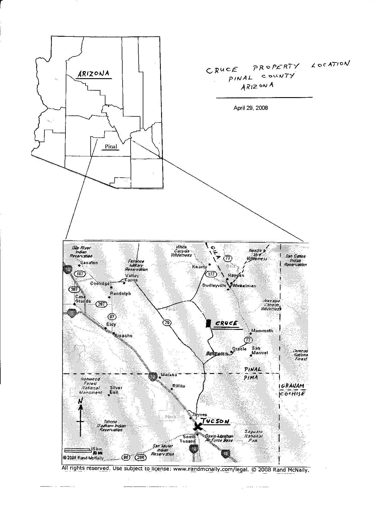
CRUCE PROJECT
The Company, on June 10, 2006, entered into an agreement with private individuals regarding the Cruce exploration project. This property is located in northwest Pinal County, Arizona in T8S, R14E, section 16 and has a history of gold and copper exploration. The Company acquired a 100% interest in the mineral lease for $15,000 and the issuance of 100,000 restricted common shares of its stock. The vendors will retain a 2% Net Smelter Return royalty and received an advance royalty of $20,000 on the first anniversary of the agreement and will receive $25,000 on subsequent anniversaries. These advance royalties will be deductible from future production royalty payments.
Location
The original property is situated on a 60 acre State lease identified as permit number 08-108712. The Company has now staked additional lode claims, designated as CR 3 – 45, on surrounding BLM ground covering an area of approximately 760 acres. The property lies about 30 miles north of Tucson, AZ. The county maintained Willow Springs Road, accessible year-round from Oracle Junction, crosses the property. A high-voltage transmission line cuts across the property. There is no other infrastructure in the area.
Geology
Gold mineralization on the property is hosted within faulted blocks in well-altered sections of the pre-Cambrian age Oracle granite. Stockwork-type gold mineralization has developed within a highly altered, mylonitised, intrusive rock unit now exposed at the surface. To the east, the area is covered by Tertiary age volcanic rocks.
History
Adits, shallow shafts and pits of unknown historic age are in evidence on the property. Early work by prospectors was centered around the Hot Boy inclined shaft. This shaft was deepened to a depth of 165 feet by a Mr. Cruce who made several shipments of ore before abandoning the property.
In the early 1960's the Inspiration Copper Company carried out a 20 hole diamond drilling program in search of copper. Hydrothermally altered rocks containing copper mineralization were encountered but, due to a complicated land situation, Inspiration did not continue its exploration.
In the early 1980's, core drilling north-east of the Hot Boy shaft by a private partnership reportedly intercepted 106 feet of gold mineralization grading 0.044 ounces of gold per ton (oz.Au/t). This included an intercept of 0.153 oz.Au/t from surface to a depth of 24 feet. Strong gold mineralization in this area was further substantiated in 1987 by a reverse circulation drill hole that intersected 0.054 oz.Au/t from a depth of 30 feet to 60 feet. This included a 5 foot interval of 0.198 oz.Au/t.
A work program in 1986 and 87 included surface rock chip and soil sampling on a 200 x 100 foot grid over a 7,000 foot strike length. Approximately 330 rock samples defined several north-south elongate geochemical anomalies exceeding 1 part per million (ppm) gold. Of particular interest, southeast of the Hot Boy shaft, was a 2.6 ppm rock chip zone measuring about 500 feet across in an east-west direction and 1,200 feet north-south. The work program included an 11 hole reverse-circulation drill campaign totaling 705 feet. Highlights of this drilling included 30 feet of 0.054 oz.Au/t, 15 feet of 0.015 oz.Au/t and 30 feet of 0.023 oz.Au/t.
Between 1988 and 1990, Freeport McMoRan Gold Company carried out geological mapping, a four line Induced Polarization and Resistivity geophysical survey and a wide-spaced 14 hole reverse-circulation drilling program totaling 5,805 feet. Hole CR-4 from surface to a depth of 60 feet returned an average grade of 0.032 oz.Au/t.
Current Exploration
In July 2007, Fischer-Watt completed its first, limited, soil and rock-chip geochemical survey on the property. This first pass survey, along with geological mapping, covered an area of about 1,000 x 1,500 meters. Over two hundred samples were taken at approximately 20 meter intervals on a sampling grid with 40 meter line spacing.
This survey located two parallel zones of anomalous gold mineralization trending north-northwest and dipping gently to the east, referred to as the East and West Zones. Both these zones appeared to extend beyond the limits of the initial survey grid.
On the east side of the sampling grid theEast Zone anomaly, lying immediately adjacent to the Hot Boy shaft, was identified as extending for over 100 meters with several gold-in-soil analyses grading in the 1000 to 1650 parts-per-billion (ppb) range. Two historical holes drilled some distance to the east intersected gold mineralization near surface, indicating that the surface anomaly dips gently to the east. Further surface geochemical sampling has now extended the East Zone for up to 450 meters along a south-southeast trend from the Hot Boy shaft. The zone ranges in widths from 30 to 70 meters with the core of this anomaly being identified by 5 samples exceeding 1 part per million (ppm) gold, with the highest being 1.678 ppm. This is the strongest anomaly defined on the property to date.
In addition, evidence was also found of the possible existence of higher-grade veins that could represent the feeder system to the stockworks seen in surface outcrops. Two notable rock-chip samples assayed at 0.455 and 0.223 oz.Au/t. Follow-up work at these localities will be carried out to identify potential high-grade vein systems that may have acted as feeders into the diffuse lower grade mineralization.
Sampling on the west side of the grid identified theWest Zone anomaly over a 75 meter width and 250 meter length as a greater than 500 ppb gold-in-soil anomaly with one analysis at 2405 ppb. A hole in the center of this area, designated as CR-4 and drilled by Freeport Gold Inc. in the early 1990’s, reportedly encountered mineralization grading 0.032 oz.Au/t from surface to a depth of 60 feet. The zone remains open at both its north and south ends and recent sampling indicates that there may be an extension of the zone lying approximately 100 meters to the north.
Further geochemical surveys and geological mapping has resulted in the identification of two additional anomalous zones; the South zone to the southeast of the West zone and the Copper Oxide zone to the southeast of the East zone anomalies.
At the south end of the project area theSouth Zone has been identified based on the silicification and gossanous textures along contact boundaries of a 2 meter wide aplite dike for a 200 meter length. Continuing north for a further 300 meters is a 75 to 100 meter wide exposure of sheared and brecciated rocks with a lot of old surface workings and prospect pits. Rock samples assaying up to 0.5 oz.Au/t have been collected on the surface.
The fourth area, referred to as theCopper Oxide Zone,is a recently identified area where a series of east and southeast dipping faults have been recognized as potential conduits for mineralizing fluids giving rise to a surface geochemical copper anomaly.
All the geochemical samples were analysed for multi-elements by International Plasma Labs Ltd. in Richmond, B.C. Canada.
During the first quarter of 2008, Fischer-Watt carried out its first drill program on the property. The Company used an Air-track drill rig to drill a close-spaced grid of 63 shallow holes to test three of the four anomalous zones; the East, West and Copper Oxide zones. Holes were drilled along a series of east-west oriented lines spaced 30 or 60 meters apart with holes along each line being 10 or 20 meters apart. The holes were about 80 feet in depth with 5,000 feet of drilling being completed. Readers are cautioned that an Air-track drill is used solely as a reconnaissance tool since the hole is unlined which may result in some contamination of samples. However, it provides an excellent, low-cost method of collecting indicative samples.
East Zone
A total of 33 vertical holes were drilled along 8 lines for a total footage of 2,574 feet. Gold mineralization is found within a mylonitised series of shear-faults cutting through the pre-Cambrian age granite. The mineralization has been traced by this drilling for a distance of 700 feet along strike, and down-dip for about 250 feet. To the east, the zone becomes covered by a layer of Tertiary age volcanic rocks where drilling to test the continuation of the zone has not yet been carried out. Continuity of mineralization was good throughout the zone.
Each of the drill holes was approximately 80 feet deep and samples were taken in each hole over 10 foot intervals along the entire length of each hole. Of the 33 holes drilled in this area, 24 of them contained mineralization of at least 0.007 oz.Au/t over 10 feet. Of these, the following 14 vertical holes returned stronger and longer sections of mineralization:
Hole # | oz.Au/t | interval ft. |
A-5 | 0.033 | 70 |
A-6 | 0.017 | 30 |
A-8 | 0.015 | 60 |
A-9 | 0.014 | 70 |
A-10 | 0.022 | 40 |
B-5 | 0.011 | 50 |
C-4 | 0.010 | 80 |
C-5 | 0.020 | 40 |
D-3 | 0.023 | 40 |
E-4 | 0.019 | 60 |
E-6 | 0.026 | 70 |
E-8 | 0.020 | 50 |
F-1 | 0.015 | 40 |
F-2 | 0.017 | 40 |
West Zone
A total of 23 holes were drilled along 10 lines for a total footage of 1,802 feet. The geological setting, and the strike and dip of the mineralization, is the same as in the East Zone. This drilling has traced the mineralization along strike for about 800 feet and down-dip for about 250 feet. The zone remains open to the northwest where gossanous outcrops can be seen on the surface. Beyond this area there are numerous surface pits that were dug by earlier prospectors giving an indication that the mineralization continues in this direction.
Of the 23 holes drilled in this zone, 21 of them returned assays with at least 0.007 oz.Au/t over 10 feet. The following 12 holes returned stronger and longer sections of mineralization:
|
|
| All holes are vertical |
Hole # | oz.Au/t | interval ft. | unless otherwise noted |
|
|
|
|
M-2 | 0.014 | 40 |
|
N-1 | 0.019 | 50 |
|
O-2 | 0.023 | 80 |
|
O-3 | 0.036 | 30 |
|
O-4 | 0.016 | 60 |
|
P-3 | 0.017 | 80 |
|
R-1 | 0.015 | 70 | -60 west |
S-1 | 0.027 | 50 | -50 west |
T-1 | 0.018 | 80 |
|
T-2 | 0.025 | 80 | -60 west |
T-3 | 0.014 | 40 | -60 west |
U-1 | 0.013 | 70 | -65 west |
Copper Oxide Zone
A total of 7 holes were drilled along 4 lines for a total of 570 feet in this zone. The continuity of the copper and gold mineralization is good throughout the zone but at sub-economic grades. The highest copper grade encountered was 0.72 % Cu over 10 feet at a depth of 60–70 feet in hole I-1, which was the hole collared furthest to the east. A prospective target therefore remains untested here where mineralization is inferred to continue down-dip along the detachment fault.
All the drill samples were analyzed by fire-assay at Jacobs Assay Office in Tucson, AZ.
The results of this drill program indicate that Fischer-Watt has located two zones of pervasive low-grade gold mineralization.. Each of these two zones strikes in a northwest direction, has a true thickness of about 50 foot, lies just below the surface, and dips gently to the east at about 30 degrees. Gold mineralization on the Cruce property is therefore in a favorable structural setting that could be amenable to open-pit mining.As a result of this success, Fischer-Watt will be drawing up plans to continue with its exploration and evaluation of this property.
The Cruce project currently has no reserves and there is no assurance that the project will advance from its present exploration stage. All of Fischer-Watt’s exploration on the property to date has been carried out under the supervision of the Company’s geological consultant, Mr. N. Barr, a qualified and experienced geologist with extensive local geological knowledge. The property has also been physically examined in the field on several occasions by the Company’s President, Mr. P. Bojtos P.Eng., who is a qualified geologist.
The work programs to date have cost approximately $80,000, which was funded from the Company’s treasury. The Company expects to continue with exploration on this property over the coming year.
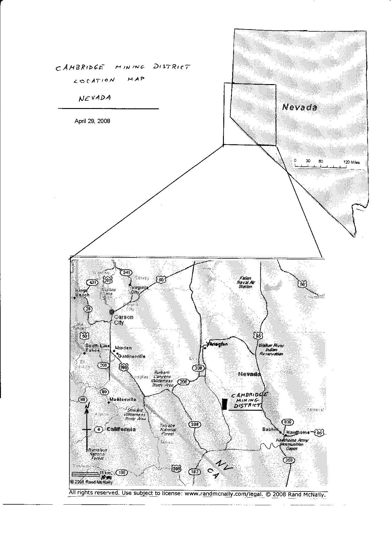
CAMBRIDGE MINING DISTRICT PROJECT
On August 1, 2006, the Company entered into an option agreement with Grandcru Resources Corporation ("Grandcru") of Vancouver B.C. to acquire Grandcru's rights to 19 claims in the Cambridge Mining District located 23 miles south of Yerrington, Nevada, in Lyon county. Under the terms of the agreement Fischer-Watt could acquire a 100% interest in the property by completing the following:
Cash payments to an underlying claim holder of:
$10,000 on August 25, 2006
$15,000 on August 25, 2007
$20,000 on August 25, 2008
$25,000 on August 25, 2009
and cash payments to Grandcru of:
$10,000 on August 30, 2007
$15,000 on August 30, 2008
$20,000 on August 30, 2009
$25,000 on August 30, 2010
and by satisfying annual work commitments on the property of:
$50,000 in the first year of the agreement
$75,000 in the second year of the agreement
$125,000 in the third year of the agreement
$150,000 in the fourth year of the agreement
Upon completion of the above, Fischer-Watt will have earned a 100% interest in the property subject to a 2% Net Smelter Return royalty to the underlying claim holder and a 2% Net Smelter Return royalty to Grandcru. These two royalties may be purchased by Fischer-Watt for $2,000,000 and $1,500,000 respectively.
Location
The property, in T10N, R27E, section 1 is comprised of 18 lode claims, identified as CMV 1 –18, and 1 placer claim, identified as CM 1, located entirely on BLM ground in the historic Cambridge Mining District. It covers an area of approximately 360 acres, at a moderate elevation of approximately 5,400 feet above Sea Level. The property can be accessed by car year round via county maintained roads. There is no infrastructure at the site.
Geology
The District is in the Walker Lane geological trend of western Nevada. The Cambridge Vein is a structurally complex, shear hosted, north-south trending, quartz vein system. The veining is hosted in a weakly altered to unaltered coarse-grained quartz monzonite granitoid of Cretaceous age. The veining is believed to be of a mesothermal nature and contains high-grade gold in places. The vein is known to extend along a strike of 1,200 meters and dips at approximately 60 degrees west. There are flexures along the strike and dip of the vein along with intersecting structures and splays. This geological complexity increases the potential of high-grade shoots occurring along the vein as well as multiple vein systems.
History
The mineralization in the area was discovered in the 1860's and mining commenced shortly thereafter. Two shafts were sunk to a depth of 150 feet and were subsequently deepened to 250 feet. The property then became idle until 1940 when the Cambridge Mining Company deepened the North shaft to 400 feet. The vein was reported to be 5 to 7 feet wide at that depth. The mine was shut down in 1942 by the war order and no mining has been carried out since.
No exploration drilling has ever been carried out on the property. In a recent surface sampling campaign, by others, it was found that one third of the 32 samples taken along the outcropping vein had grades greater than 10 ppm gold, with several being over 30 ppm.
Current Exploration
The Company carried out exploration programs during the summer and fall of 2007 under the supervision of the Company’s consulting Geologist, Mr. M. Johnson, a qualified and experienced geologist. The property has been physically examined in the field by both Mr. Johnson and the Company’s President, Mr. P. Bojtos P.Eng., a qualified geologist. The work included a surface geological assessment followed by an application for a drilling permit and a subsequent drilling campaign designed to help trace the vein's geometry as well as help determine where high-grade gold shoots may occur.
In October 2007, Fischer-Watt completed a four-hole drill program to explore the down-dip potential of the Cambridge vein. A total of 1,280 feet of reverse-circulation drilling tested a 300 foot length of the vein’s north-east trending strike down to a depth of about 200 feet below its surface outcrop. This enabled Fischer-Watt's geologists to define the extent of the gold mineralization.
Although weak mineralization was encountered in the holes it appears that the vein has low economic potential. All the samples were analysed at American Assay Laboratories Inc. in Sparks, NV. Fischer-Watt does not intend to carry out any additional work and will therefore relinquish the property back to the optionor. The project has no reserves.
The work program cost approximately $50,000, which was funded from the Company’s treasury.