Exhibit 99.5

PURE NICKEL INC.
ANNUAL INFORMATION FORM
FOR FISCAL YEAR ENDED NOVEMBER 30, 2010
January 28, 2011
PURE NICKEL INC.
ANNUAL INFORMATION FORM
TABLE OF CONTENTS
| ITEM 1: | CORPORATE STRUCTURE |
Incorporation
We were incorporated under the Company Act (British Columbia) on April 29, 1987 as Nevada Star Resource Corp. and we changed our name to Pure Nickel Inc. on March 27, 2007. On April 7, 2009, we were continued under the Canada Business Corporations Act (CBCA). Our registered and principal office is located at 95 Wellington Street West, Suite 900, Toronto, Ontario M5J 2N7. Our telephone number is (416) 644-0066 and website address iswww.purenickel.com.
Corporate Structure
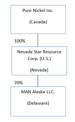
The diagram below sets out our organizational structure as at February 1, 2011 and the jurisdictions in which we were incorporated or continued. Nevada Star Resource Corp. (U.S.) is a wholly-owned subsidiary of Pure Nickel Inc and it has a 70% ownership of MAN Alaska LLC, a company that holds the assets of the MAN Alaska project.
| ITEM 2: | GENERAL DEVELOPMENT OF THE BUSINESS |
Three-Year History
We are principally engaged in the acquisition, development, and operation of mineral properties and exploration for, in particular, nickel, platinum group elements (PGEs), copper, gold, silver and associated base and precious metals. We also seek option and joint venture agreements where appropriate to advance certain mineral properties and enhance shareholder value. We operate in Canada and the United States. In the United states we operate through our wholly-owned subsidiary, Nevada Star Resource Corp. (U.S.) and through our joint venture partnership in MAN Alaska LLC.
At the start of 2008, we had the following properties in our portfolio:
- MAN and Salt Chuck in Alaska
1
- Fond du Lac in Saskatchewan
- William Lake, Tower and Manibridge in Manitoba
- POV, Nuvilik, SR1, HPM, East Hudson (joint venture with SOQUEM) and Forgues in Quebec
- Harp Lake in Newfoundland
- Rainbow in Nunavut
- Copper King, Milford in Utah
2008 Highlights
Exploration in 2008 was focused on the Willam Lake and MAN properties. At William Lake an extensive drilling (7,526 metre) and geophysical program was completed and at MAN a small drilling and geophysical program was executed. Advancement on our Manibridge and HPM/Forgues properties was accomplished as the result of drilling programs conducted by our option partners, Crowflight Minerals Inc. and Manicougan Minerals Inc. respectively. Details of the programs are outlined in the Mineral Property section of Item 3.
On February 21, 2008 we granted Rockcliff Resources Inc. an option to earn up to 70% interest in the Tower VMS property which is comprised of 35 mining claims located at the northern edge of the William Lake property.
On May 15, 2008 we relinquished our rights to the East Hudson properties in Quebec.
On June 5, 2008 we granted Minergy Ltd., a private company, an option to earn up to 70% interest in 393 mining claims comprising the Nuvilik and POV properties located in the Raglan district in Quebec.
On October 31, 2008 we granted ITOCHU Corporation, a large Japanese conglomerate, an option to earn up to 75% interest in the MAN, Alaska property. Pursuant to the agreement Itochu reimbursed us for expenditures incurred in 2008 and 2009 at MAN to a combined amount of US$6.5 million ($7.6 million). On an ongoing basis, exploration activity may be funded through 2014 to a total of US$40 million ($42 million) subject to ITOCHU exercising its option to continue at the end of the 2009 Exploration season and associated report publication and 2013. Under the terms of the Agreement, ITOCHU can earn a 60% interest in MAN by incurring an aggregate of US$30 million ($31.5 million) of exploration expenditures over the first six years of the option period. Once ITOCHU has earned a 60% interest, it has the option to earn-in an additional 15% interest in the Property by incurring an additional US$10 million ($10.5 million) of exploration expenditures during the seventh year of the Agreement. The agreement provides for the acceleration of the earn-in timetable, and we will also earn a 10% management fee and will remain as operator.
2009 Highlights
Exploration in 2009 was focused on our MAN property where our option partner ITOCHU Corporation funded the program which included 4,200 metres of drilling, and comprehensive airborne and ground geophysical surveys. The Fond du Lac property was advanced as the result of a ZTEM (Z-Axis Tipper Electromagnetic system) airborne survey used to identify mineralization below depths of 500 metres. At the SR1 property a ground based field survey was utilized to check anaomalies and anomaly trends previously identified. Details of the programs are outlined in the Mineral Property section of Item 3.
In June 2009, we filed an action for declaratory relief against Western Utah Copper Company (WUCC) in the United States District Court, Utah requesting for interpretation of and the status and rights under an agreement regarding certain royalties we are entitled to receive from production at WUCC property. On July 20, 2009, WUCC filed an answer and counterclaim, and on August 10, 2009, we filed a response to the counterclaim. We believe that the counterclaim is without merit.
2
In May 2009, we were informed by the Quebec Ministry of Natural Resources that the 148 claims that comprise the POV property were no longer open for exploration work. The claims fell within a boundary for a proposed provincial park and certain exploration milestones needed to be reached in order to extend the development of the park. Pure Nickel and its option partner Minergy Ltd. were aware of the proposed park since the property came to the company through the Xstrata property purchase in August 2007 and formally relinquished the claims in May.
On November 18, 2009 our Option partner Manicouagan Minerals made the required option payment and exploration expenditures to earn a 50% interest in the HPM/Forgues property.
2010 Highlights
Exploration on 2010 was focused on the MAN property where our option partner ITOCHU Corporation funded the program which included 6700 metres of drilling. Additional staking of ground adjacent to the Rainbow property followed by a Mobile Metal Ion (MMI) survey was also completed. Our option partner on the Tower property, Rockcliff Resources Inc., commenced drilling in 2010. Details of the programs are outlined in the Mineral Projects section of Item 3.
On March 5, 2010 we extended the time for our option partner, Rockcliff Resources Inc. to perform the exploration work required under the agreement with us for our Tower property. In consideration for extending the time Rockcliff Resources granted us 1,250,000 common share purchase warrants exercisable at $1.50 per share and an expiry of the earlier of February 21, 2013 or two years after Rockcliff is able to commence exploration of the Tower property,
On March 23, 2010 we announced that we did not renew the Harp Lake, Labrador claims. The decision was based on the low potential of the Harp Lake property in relation to our other property claims.
On March 25, 2010 ITOCHU Corporation, our partner on the MAN Alaska property, vested its interest in the property. ITOCHU had expended the required funds on exploration to vest a 20% interest however in consideration of increasing the 2010 exploration budget and compressing the time period for the second tranche of the option earn-in we granted ITOCHU the right to vest a 30% interest in 2010. A new company was created called MAN Alaska LLC to hold the MAN property claims. MAN Alaska LLC is jointly owned (70% Nevada Star Resource Corp (U.S) and 30% ITC Mineral Resources Development (U.S.A) Inc, a wholly owned subsidiary of ITOCHU Corporation.
On April 30, 2010 the Board of Pure Nickel appointed R. David Russell as the Chairman of the Board.
In May 2010, WUCC and its parent company Copper King Mining Company filed for Chapter 11 bankruptcy, new management is attempting to reorganize the business. Our litigation, with repect to the declatory judgment was automatically stayed due to to the Chapter 11 filing. On August 27, 2010, WUCC filed a new action against Nevada Star, this action is similar to the counterclaims made in response to the original lawsuit.We believe this action is without merit.
On June 8, 2010 we announced that we had staked an additional 19 claims adjacent to our existing Rainbow claims in Nunavut.
3
On July 7, 2010 we announced that our option agreement with Minergy Ltd. on the Nuvilik property in Quebec was terminated.
Significant Acquisitions
We did not complete any significant acquisitions during the fiscal year ended November 30, 2010.
| ITEM 3: | DESCRIPTION OF THE BUSINESS |
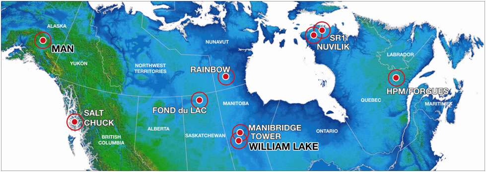
Pure Nickel in the business of acquiring, exploring and developing mineral properties, primarily those containing nickel, platinum group elements (PGEs), copper, gold, silver and associated base and precious metals. We have a practice of taking undeveloped properties with the expectation of developing them to a level where an ore body is indicated or likely. If an ore body is indicated or likely, we look to develop a joint venture or purchase option with a larger mining company to further develop the property and, if justified, to take the property into production. In all cases, we would retain a percentage of ownership, in the case of a partnership, or receive a percentage royalty from the production of product resulting from a mining operation. Our property portfolio as of November 30, 2010, is identified in the map below. Three of our mineral properties with a book value of $13.2 million (34% of the total mineral properties book value) at November 30, 2010 are located in the United States of America.
Markets and Products
Pure Nickel has no sales and does not currently produce or distribute any minerals or ore from its properties.
Revenues for the Last Two Financial Years
Pure Nickel’s revenues for each of the last fiscal years consisted solely of interest income from cash deposits. Such interest was earned on funds raised from equity financings.
Specialized Skill and Knowledge
Most aspects of our business require specialized skills and knowledge. Such skills and knowledge include the areas of geology, geophysics, mine development, mining, metals marketing, finance and accounting. Management has many of these skills, however, from time to time it will be necessary to locate and retain employees or consultants to assist in these areas.
4
Competitive Conditions
We compete with other mineral exploration companies for the acquisition of mining claims and leases and for qualified personnel to develop and explore the property portfolio. Following a slump in commodity prices in recent years, the recovery in commodity prices has resulted in increased demand for exploration properties.
Business Cycle and Seasonality
If any of our properties are put into production, the business would be cyclical but not seasonal. Demand for nickel as well as the other minerals and metals we explore for changes in accordance with worldwide economic cycles.
Changes to Contracts
We do not reasonably expect that any part of our business will be negatively affected in the current financial year due to the renegotiation or termination of contracts or sub-contracts.
Environmental Protection and Social Policies
Our activities are subject to legislation related to their environmental impact. In addition to setting performance standards, government regulation of the industry requires extensive monitoring and reporting activities. Our activities have, and continue to be, in compliance in material all respects with applicable environmental legislation.
Prior to commencing any exploration program, we are committed to informing local communities of our proposed exploration plans including the geographic scope, type and location of work applications, employment opportunities and skill requirements. The intent is to gain the cooperation, participation and confidence of local communities so that the exploration program can be designed and undertaken to the mutual benefit of all. Important benefits to the communities in the early stages of a program come about through job opportunities. We are committed to collaborating with local governments to establish and participate in training programs to help local residents acquire the necessary skills to qualify for the jobs that will become available. Our Environmental Policy and Health and Safety Policy are available on our website atwww.purenickel.com/s/Governance.asp.
Bankruptcy and Similar Procedures
There has not been any voluntary or involuntary bankruptcy, receivership or similar proceedings against us or any of our subsidiaries within the three most recently completed financial years or the current financial year.
Material Reorganizations
There has not been any material reorganization of Pure Nickel or any of its subsidiaries within the three most recently completed financial years. The corporate holding structure has been simplied as follows: MAN Alaska LLC, a Delaware company, was created to hold the assets of the MAN Alaska project. On November 30, 2010 we amalgamated our Canadian subsidiary, PNI Corp, with Pure Nickel Inc. The surviving entity is called Pure Nickel Inc. We also merged our Washington subsidiary, Nevada Star Resource Corp., with our Nevada subsidiary: the surviving entity is the Nevada company, Nevada Star Resource Corp. (U.S.).
5
Employees
As of November 30, 2010, we employed five people, (three on a full-time basis), and retained four individuals on contracts for service. In addition, we employ numerous other outside contractors on a fee-for-service basis for conducting exploration activities.
Mineral Projects
We have mineral rights to numerous properties in various stages of exploration in North America. A summary of the properties is presented in the table below and detailed descriptions follow.
| Property | Location | Claims area (approx.) | Comments |
| MAN | Alaska (400 km NE of Anchorage, 265 km SE of Fairbanks) | 40,380 hectares | The property is currently in the early exploration stage. We regard MAN as one of our more important properties and on November 5, 2008 announced an option agreement with ITOCHU Corporation. On March 23, 2010 ITOCHU vested a 30% interest in the property– see page 3. |
| WilliamLake1 | Manitoba (70 km from Grand Rapids) | 30,553 hectares | We consider William Lake to be one of our premier properties. An extensive exploration program in the winter of 2008 was conducted. |
| TowerProperty1 | 7,627 hectares | On February 21, 2008, we granted an option to Rockcliff Resources Inc. under which they may earn up to a 70% interest in the Tower claims, which are located within the northern portion of the William Lake claim block. Rockcliff commenced exploration in October 2010. | |
| Salt Chuck | Alaska, Prince of Wales Island | 1,082 hectares | The property is currently in the early exploration stage. It is located near the historic past producing Salt Chuck mine which was active between 1919 and 1941 with a reported production of 300,000 tons of copper sulphide ore grading 0.95% Cu , 2.0 g/t (grams per ton) Pd, 1.1 g/t Au, and 5.7 g/t Ag. |
| Fond du Lac2 | Saskatchewan (20 km NW of Stony Rapids) | 19,713 hectares | The property is currently in the early exploration stage. We consider Fond du Lac to be one of our more promising properties; results from two exploration programs have yielded encouraging results. |
| Manibridge1 | Manitoba (128 km SW of Thompson) | 274 hectares | We have a 50-50 joint venture agreement with Crowflight Minerals Inc. to explore for deposits. Each of us contributes properties and funds for preliminary exploration activities. We also have an option to earn a 50% interest from Crowflight in an area surrounding the joint venture area by spending $1.5 million over a three year period. |
| Forgues andHPM1 | Quebec (180 km NW of Sept Isles) | 1,168 hectares | Manicouagan Minerals Inc. has earned a 50% interest in the property by making the required options and exploration expenditures. |
| Raglan1:SR1, Nuvilik | Quebec | 45,680 hectares | The properties are currently in the early exploration stage. In November 2010 we decided not to renew the SR1 claims as they expire over the next several months. |
6
| Property | Location | Claims area (approx.) | Comments |
| Rainbow1 | Nunavut (380 km NW of Churchill, and 612 km N of Thompson) | 19,850 hectares | The property is currently in the early exploration stage. In 2010 soil geochemical survey was completed. |
| Copper King,Milford | Utah | 2,830 hectares | The properties are operated by Western Utah Copper Company and its parent company Copper King Mining Corporation. Our agreement is to receive 1% of net proceeds from the first 10 million pounds of copper produced, 1.5% of net proceeds on all copper produced thereafter and 2% of net smelter proceeds on all other minerals produced. Total royalties are capped at US$10 million ($10.5 million) and may be subject to a 12% interest in the net profits from copper production of certain claims held by a group of private investors that includes a director of the Company, and a 2% net smelter return royalty on certain claims (held by the property vendor). Also, please see narrative above. |
1Properties were part of a property purchase from Xstrata Nickel terms included:
- a net smelter royalty of 2% on each property with Pure Nickel having the right to reacquire 1% by payment of $1,000,000 with respect to a particular property at any time up to twelve months after commercial production has been achieved on that property;
- off-take and marketing rights for all concentrate or product produced from the Properties; and
- the right to retain one back-in right to 50% for any one (only) of any mining project with an economic threshold of 15,000,000 tons of resources.
2Property is subject to a 0.5% NSR
I. MAN, ALASKA
The information contained in this section was prepared by Larry Hulbert, D.Sc., P. Geol., and Quentin Gall, Ph.D. The information contained in this section is a non-compliant National Instrument 43-101 resource.
A. Property Description, Location and Accessibility
The MAN project is located approximately 265 kilometres southeast of Fairbanks and 400 kilometres northeast of Anchorage along the southern flank of the Alaska Range. The map below shows the property location.
The MAN project is comprised of State and Federal mining claims encompassing an area of 40,380 hectares. The project property falls within the Fairbanks, Chitina and Talkeetna recording districts. All claims are 70% owned by Nevada Star Resource Corp. (U.S.), a wholly-owned subsidiary of Pure Nickel and 30% ITC Mineral Resources Development (U.S.A) Inc, a wholly owned subsidiary of ITOCHU Corporation. The project area covers four prospective areas containing favourable rock types and mineralization: Canwell Complex, Rainy Complex, Alpha Complex and Beta Complex.
7
MAN Property Location
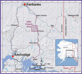
The Richardson and Denali highways traverse the southeast portion and southern perimeter respectively of the project area. The Trans-Alaska Pipeline runs parallel to the Richardson Highway. Helicopters offer the best means of accessing remote parts of the project area. Snowmobiles (winter) and ATVs (summer) can also be used to access the least-rugged areas. The nearest community is the hamlet of Paxson, which is situated at the junction of the Denali and Richardson highways.
B. Geological Setting
Regional Geology
The Mount Hayes Quadrangle, in which the MAN Project is located, is dominated by the geology of the central Alaska Range and foothills on its southern flank. The Denali Fault bisects the eastern Alaska Range, and splays to the north and west in the central Alaska Range just north of the project area. The project area lies primarily within the Wrangellia geological terrane, but does include the Maclaren geological terrane along its northern edge. Regionally, the prospective Wrangellia Terrane extends for over 2,000 km from Alaska to the southern tip of British Columbia.
Property Geology
The Maclaren Terrane is bordered to the north by the Denali Fault and to the south by the Broxson Gulch thrust. The Wrangellia Terrane, which is bordered to the north by the Broxson Gulch thrust (in the project area), is subdivided into the Slana River subterrane to the north of Eureka Creek and the Tangle subterrane to the south.
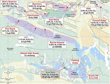
Magmatic sulphide mineralization is associated with Triassic ultramafic and mafic intrusions into the Slana and Tangle subterranes. The four main ultramafic-mafic complexes have been identified within the project area: Alpha, Beta, Rainy Creek and Canwell (see Map). Approximately 50 surface nickel occurrences have been identified to date from these four major ultramafic-mafic complexes; the grades for some of these surface showings are shown on the map.
8
MAN Project Geology and Main Showings.
C. Exploration
History
The area now encompassed by the MAN Project has been prospected for its placer Au potential since 1903, and placer Pt-Pd and in-situ Cu-Ni mineralization since 1953. More recent geological, geochemical and geophysical exploration programs by ACNC / Fort Knox (1991-1997), Nevada Star Resource Corp. (U.S.) (1998-2003) and Anglo American Exploration (U.S.A.) Inc. (2004-2005), has focused on the in-situ Ni-Cu-PGE sulphide mineralization in the ultramafic-mafic intrusive complexes. The 2007 exploration program by Pure Nickel Inc. consisted of a helicopter-borne VTEM, a magnetometer survey, a soil-sampling program, and 3,359 metres of drilling.
2008 Exploration Program
The 2008 exploration program focused on diamond drilling which targeted geophysical anomalies, particularly VTEM conductors, in the Beta Complex. Drilling in 2008 was limited to three completed holes (one abandoned) due to poor drilling conditions. The drilling did intercept wide zones of disseminated sulphides, including 0.50 metre grading 1.39% Ni and 1.27% Cu.
2009 Exploration program
The 2009 drill program completed 4,200 metres of drilling in seven holes, a new ZTEM airborne survey (Z axis Tipper Electromagnetic system), extensive geological mapping and proprietary fluxgate time domain ground EM surveys (full waveform streaming multi sensor fluxgate array). The 2009 geophysical programs (ground fluxgate TEM, ZTEM, and BHEM) were considered a great success and have yielded very compelling geophysical targets, which are the best discovered to date on the MAN property.
Three drill holes were completed in the 30km long Alpha Complex and four holes were completed in southern Beta Complex. Newly completed 2D modeling of 2009 ZTEM data and previous 3D inversions of aeromagnetic data, as well as several widely spaced deep drill holes show a consistent presence of abnormally thick ultramafic bodies with localized deep feeders. This year’s results add to the evidence that the MAN property is the main intrusive centre for Triassic magmatism that generate the extensive nickel, copper and PGE (platinum group elements) bearing ultramafic intrusions and coeval lavas within the Alaska, Yukon and BC, segments of the Wrangelia terrain. Drill results to date come from the holes targeted using the proprietary ground time domain EM survey (TEM), in conjunction with the new ZTEM airborne survey and previous ground gravity and VTEM airborne surveys.
9
Highlights from the 2009 MAN drilling results include:
| DrillHole | From | To | Corelength | Nickel |
| PNI-09-19 | 75.2 | 132.5 | 57.32 | 0.138 |
| PNI-09-19 | 459.7 | 524.4 | 64.62 | 0.119 |
| PNI-09-20 | 30.1 | 111.0 | 80.8 | 0.207 |
| PNI-09-20 | 275 | 356.1 | 81.1 | 0.274 |
| Including | 324 | 354 | 30 | 0.302 |
| PNI-09-21 | NSV | |||
| PNI-09-22 | 472 | 476.7 | 4.7 | 0.270 |
| PNI-09-23 | 16.46 | 124.6 | 108.14 | 0.158 |
| PNI-09-24 | 150.7 | 356.3 | 205.6 | 0.189 |
| including | 328 | 340 | 12 | 0.239 |
| PNI-09-24 | 416 | 438 | 22 | 0.212 |
| PNI-09-24 | 515 | 529 | 14 | 0.254 |
| PNI-09-24 | 533 | 668.5 | 135.5 | 0.228 |
| Including | 538 | 554 | 16 | 0.254 |
| Including | 593 | 597 | 4 | 0.444 |
| PNI-09-25 | 513.5 | 515.5 | 2 | 0.410 |
| PNI-09-25 | 804.4 | 808 | 3.6 | 0.299 |
| PNI-09-25 | 917 | 971 | 54 | 0.174 |
| PNI-09-25 | 1002.5 | 1030 | 27.5 | 0.208 |
NSV:No significant values.
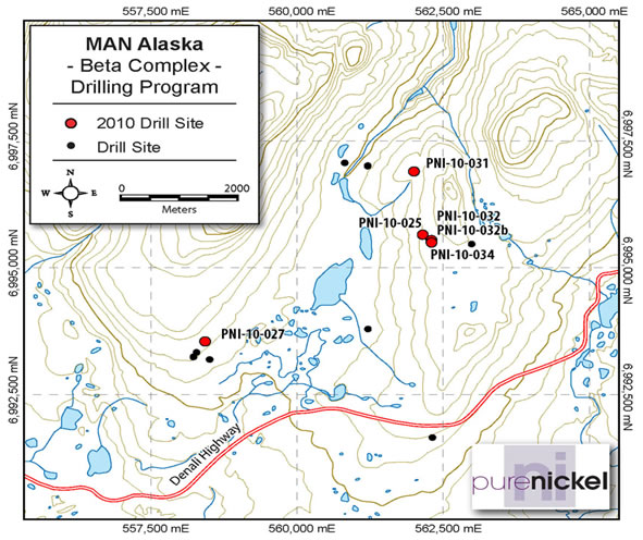
2010 Exploration Program
During the 2010 exploration program we completed approximately 6700 metres of drilling, in a total of nine holes; six holes on the 30 km long Alpha Complex and three holes on the southern Beta complex. Analysis of over 3,400 assay core samples has revealed stratigraphic horizons in the Alpha and Beta Complexes that have elevated platinum and palladium values strongly suggesting that stratiform PGE mineralization (platinum + palladium) is present, similar to that found in other stratiform PGE bearing complexes elsewhere in the world. Laterally extensive platinum and palladium cyclicity patterns have been recognized over a distance greater than 2.7 kilometers in the Alpha complex. In addition intersections of massive sulphide in narrow seams where discovered returning economic grades of nickel and copper.
Highlights from the 2010 drill program include:
| 1. | Two discrete PGE-enriched horizons have been identified on the Alpha Complex. |
10
| 2. | The shallowest and thinnest PGE horizon (~ 12 m) was intersected at approximately 100-130m below surface and can be correlated in drill holes PNI-10-028,033,035 and 036 over a strike length of 2.67 km. | |
| 3. | A thick (> 20 meters) disseminated sulphide horizon averaging 2.47% sulphide in drill hole PNI- 10-036 is also observed in hole PNI-10-028 at least 2.67 km apart. The relatively high Pt + Pd concentrations in rocks with such low sulphide content, and the associated well developed metal cyclicity recorded in these rocks is a characteristic feature of low-sulphide PGE-enriched environments that host reef type PGE mineralization. | |
| 4. | Drill hole PNI-10-036 returned combined Pt + Pd assays of 318ppb over greater than 20m. In previous year’s (2003) drill hole FL-009 (located 1.2 km east of PNI-10-036) returned assays of 1175 ppb Pt and 1022 ppb Pd (returning a combined Pt + Pd of 2.197 gms/ton) over 2.7 meters in rock with an average sulphide content of 2.97 %. This suggests that a favourable magmatic environment was operative to develop Platinum Group Element enriched horizons in the central portion of the Alpha Complex. | |
| 5. | Hole PNI-10-036 returned a combined Pt and Pd value of 252.8 ppb over 165.9 metres. Typical background value of combined Pt and Pd in a peridotite ranges from 2.8 ppb to 29 ppb (Crocket J. H., 2002, Platinum-Group Element Geochemistry of Mafic and Ultramafic Rocks. CIM Special Volume 54, p. 177-210). | |
| 6. | Several thin (7-11cm) semi-massive nickel and copper sulphide zones were intersected in drill holes PNI-10-028 and 10-035 on the Alpha Complex, returned a maximum of 3.42% Ni and 4.27% Cu (see table below). | |
| 7. | Several drill holes (PNI-01-028, 029, 030, 033, 035, 036) encountered multiple disseminated sulphides zones ranging from 14.9 m to 139.75 m in thickness of disseminated nickel mineralization returning grades greater than 0.23% Ni (see table below). |
Significant assay results and their corresponding breakdown from the 2010 drill holes are tabulated below along with drill hole information. The lengths reported are drill intersected core lengths and do not represent true widths.
Ni and Cu intersections from 2010 Drilling
| Borehole | Area | From (m) | To (m) | Length (m) | Ni (%) | Cu (%) |
| PNI-10-028 | Alpha | 383 | 453 | 70 | 0.25 | |
| PNI-10-028 | Alpha | 462.38 | 462.45 | 0.07 | 0.7 | 0.4 |
| (SMS) | ||||||
| PNI-10-028 | Alpha | 615 | 681 | 66 | 0.23 | |
| PNI-10-029 | Alpha | 309 | 357 | 48 | 0.25 | |
| PNI-10-029 | Alpha | 358 | 399 | 41 | 0.24 | |
| PNI-10-029 | Alpha | 564 | 652 | 88 | 0.28 | |
| including | Alpha | 624 | 631 | 7 | 0.35 | |
| PNI-10-030 | Alpha | 479 | 511 | 32 | 0.24 | |
| PNI-10-031 | Beta | 445.5 | 446.6 | 1.1 | 1.76 | |
| PNI-10-033 | Alpha | 350 | 391.3 | 41.3 | 0.23 | |
| PNI-10-035 | Alpha | 308.1 | 323 | 14.9 | 0.25 | 0.08 |
| PNI-10-035 | Alpha | 345 | 362.7 | 17.7 | 0.28 | |
| PNI-10-035 | Alpha | 363 | 379 | 16 | 0.31 | |
| PNI-10-035 | Alpha | 391 | 415 | 24 | 0.30 | |
| PNI-10-035 | Alpha | 600 | 739.75 | 139.75 | 0.23 |
11
| Borehole | Area | From (m) | To (m) | Length (m) | Ni (%) | Cu (%) |
| Including (SMS) | Alpha | 713.74 | 713.85 | 0.11 | 3.42 | 4.27 |
| PNI-10-036 | Alpha | 188 | 255.55 | 67.55 | 0.25 | |
| PNI-10-036 | Alpha | 284 | 311 | 27 | 0.33 | 0.13 |
| including | Alpha | 288 | 290 | 2 | 0.44 | 0.33 |
| PNI-10-036 | Alpha | 319 | 354 | 35 | 0.28 | 0.15 |
| including | Alpha | 319 | 333 | 14 | 0.30 | 0.15 |
| PNI-10-036 | Alpha | 396 | 426 | 30 | 0.31 | 0.14 |
| PNI-10-036 | Alpha | 451 | 483 | 32 | 0.23 | |
| PNI-10-036 | Alpha | 503 | 553 | 50 | 0.24 |
Note: SMS = semi massive sulphide up ranging from 12.53% to 23.73% sulphide.
Pt + Pd intersections from the 2010 drilling program
| Borehole | Area | From (m) | To (m) | Length (m) | Pt + Pd ppb |
| PNI-10-027 | Beta | 724 | 732 | 8 | 202.7 |
| PNI-10-028 | Alpha | 349 | 368 | 19 | 164.0 |
| PNI-10-028 | Alpha | 426 | 445 | 19 | 167.7 |
| PNI-10-029 | Alpha | 253 | 307 | 54 | 158.3 |
| PNI-10-030 | Alpha | 407 | 412 | 5 | 172.6 |
| PNI-10-030 | Alpha | 471 | 517 | 46 | 185.0 |
| PNI-10-031 | Beta | 93 | 104 | 11 | 150.6 |
| PNI-10-031 | Beta | 332 | 341 | 9 | 178.6 |
| PNI-10-031 | Beta | 353 | 359 | 6 | 211.1 |
| PNI-10-031 | Beta | 503 | 504 | 1 | 1049.6 |
| PNI-10-032b | Beta | 63.8 | 64.94 | 1.14 | 835.5 |
| PNI-10-035 | Alpha | 197 | 205 | 8 | 161.5 |
| PNI-10-035 | Alpha | 308.1 | 323 | 12.9 | 195.8 |
| PNI-10-036 | Alpha | 121 | 128 | 7 | 408.1 |
| PNI-10-036 | Alpha | 219 | 236 | 17 | 200.1 |
| PNI-10-036 | Alpha | 260.5 | 426 | 165.9 | 252.8 |
| including | Alpha | 286 | 310 | 24 (DS) | 318.1 |
| including | Alpha | 317 | 323 | 6 | 310.4 |
| including | Alpha | 327 | 335 | 8 | 297.1 |
| including | Alpha | 337 | 354 | 17 | 273.3 |
| including | Alpha | 383 | 386 | 3 | 340.6 |
| including | Alpha | 396 | 426 | 30 | 261.1 |
Note: DS = disseminated sulphide. Average content is 2.47% sulphide (ranging from 0.26% to 4.8% sulphide)
12
2010 and Historic Drill Hole Locations - Alpha

2010 and Historic Drill Hole Locations - Beta
13
D. Sampling Method and Approach
Drill Core
Samples were collected on a regular basis and commonly continuous sampling is completed when drilling ultramafic rocks in areas were little or no previous drilling has been completed. In thick ultramafic bodies, samples are commonly collected every 2 metres (1.20 to 1.80 metres true thickness intervals) throughout the unit. Sampling never crosses a rock type boundary. Standards and blanks are inserted at a rate of 1 each per 25 and 50 samples respectively to ensure analytical precision. Any visual sulphides would result in 100% sampling of the core.
After being logged, sawn, tagged and placed in a rugged plastic bag and sealed, all core samples were grouped and packaged in sealed containers and shipped by transport truck to Alaska Assay Laboratories, Fairbanks, for preparation. The prepared samples (pulps) were then shipped via courier to Acme Analytical Laboratories (Vancouver) Ltd (in 2008, 2010) and TSL Laboratories, (Saskatoon) (in 2009) for assay and, or whole rock analysis. All assay samples were analyzed for trace element abundance using fire-assay fusion or Aqua Regia digestion and ICP-MS.
Pure Nickel utilizes standard quality assurance and quality control (QC) policies and procedures in all aspects of sample collection to sample analysis in the laboratories. The QA/QC programs were developed from guidelines published by the International Standards Organization (ISO), and are under the supervision of Dr. Larry Hulbert, P. Geo.
E. Mineral Resource and Mineral Reserve Estimates
There are currently no mineral resources or mineral reserve estimates on the MAN Property.
II. WILLIAM LAKE, MANITOBA
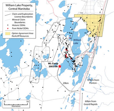
Rights to the William Lake property were obtained in August 2007 from Xstrata Nickel. The information contained in this section was updated by a senior geologist at Xstrata in February 2007 and then by our Project Geologist Quentin Gall in January and December 2008. In addition, a NI 43-101 report prepared by Scott Wilson Roscoe Postle Associates Inc. in November 2007, entitled “Technical Report on the William Lake Property, Grand Rapids, Manitoba, Canada”, is available on SEDAR (www.sedar.com), and on our company’s website.
A. Property Location, Description and Access
The William Lake property surrounds William Lake in west-central Manitoba and is comprised of 30,553 ha, 107 claims, plus one exploration license. William Lake is approximately 70 kilometres north of the town of Grand Rapids, as shown in the map below. Geologically, the William Lake property is located within the sub-Paleozoic extension of the Thompson Nickel Belt (TNB).
The William Lake property is accessible by Highway 6, which dissects three of the eastern-most property claims as well as the Tower claims north of Little Limestone Lake. The Tower property is described in Section III and shaded brown in the figure below. A network of unpaved logging and drill roads, including all-season roads, leading from Highway 6 provides access to other parts of the property. Lakes within the William Lake property are accessible by float or ski equipped fixed-wing planes; and all claims and licenses are accessible by helicopter.
14
William Lake Property Claim Map
B. Geology Setting
Regional Geology
The Thompson Nickel Belt (TNB) is host to several massive to disseminated Ni-sulphide deposits. The belt forms a 10 to 35 km wide, northeast-southwest striking zone of variably reworked Archean gneisses unconformably overlain by Proterozoic Ospwagan Group supracrustal rocks. These lithologies were intruded by ultramafic bodies of komatiitic affinity as well as by mafic to ultramafic dykes and granitic plutons. All of the rocks in the exposed portion of the TNB have been reworked during the 1.9 Ga to 1.7 Ga Hudsonian Orogeny and have been subjected to polyphase deformation and metamorphism (typically amphibolite facies).
The belt is located along the northwestern margin of the Superior craton and is in fault contact with the rocks of the Churchill Province along the Churchill-Superior Boundary Zone. A regional gravity low and a distinctive linear regional aeromagnetic signature characterize the belt and have enabled the southern extension of the Thompson Nickel Belt to be traced, below platformal cover, as far south as South Dakota. The William Lake Project is located over the interpreted Sub-Paleozoic extension of the TNB.
The TNB hosts a number of massive to disseminated nickel sulphide deposits, most notably Inco Limited’s (“Inco”) Thompson (120Mt @ 2.5% Ni), Birchtree (29Mt @ 2.0% Ni) and Pipe (22Mt @ 1.0% Ni) mines. The deposits are genetically associated with ultramafic bodies and can be classified into two broad categories: “Bucko-type” deposits hosted within the Archean basement gneisses and “Thompson-type” deposits hosted within the Proterozoic Ospwagan Group metasedimentary rocks. The largest and highest grade deposits are the Thompson-type which occur specifically within the Pipe Formation of the Ospwagan Group. These deposits are thought to have formed where the ultramafic sills have intruded the sulphide facies iron formation and have assimilated sedimentary sulphur, resulting in the segregation and accumulation of magmatic nickel sulphides. Subsequent high grade metamorphism and polyphase deformation has, in some cases, remobilized the massive nickel sulphides away from the now boudinaged ultramafic source rocks into the host metasediments.
15
On the Sub-Paleozoic properties, the TNB rocks are buried beneath 50 to 200 m of Paleozoic dolomite, limestone and sandstone. Drilling and geophysical data indicate that the geology is very similar to that of the Thompson area. Multiple folded belts of Ospwagan stratigraphy, locally intruded by mineralized and barren ultramafic bodies underlie the Paleozoic sediments. Pipe Formation sulphide facies iron formations are abundant and are commonly thicker than those in the Thompson area (metres to 10s of metres versus centimetres to metres thick).
Property Geology
The William Lake property is located within the interpreted southern Sub-Paleozoic extension of the TNB. This interpretation is based on both geophysical and drill data. Paleozoic cover typically ranges from 70-200 m in thickness and consists of flat-lying Silurian to Ordovician age limestone and dolomite underlain by a thin package of sandstones and shales belonging to the Winnipeg Formation.
Geophysical data and drill data form the basis for interpreting the Sub-Paleozoic TNB geology. The geological setting has many similarities to the Thompson area. Lithologies intersected in drilling include basement gneisses (few holes only), supracrustal rocks interpreted to be Ospwagan Group, and ultramafic intrusions.
C. Exploration
Exploration of the William Lake project area started in the late 1960s and various drill programs continued through the 1980s. Falconbridge Exploration carried out a comprehensive and high quality program starting in 1989 which continued to 2002. Details of the Falconbridge results is outlined in the NI 43-101 Report that is filed on sedar and was prepared in November 2007 by Scott Wilson Roscoe Postle Associates Inc. Drilling in the 1960s to early 1980s, intersected ultramafic rock. Available data indicated mainly background Ni contents with the highest value being 0.44% over 0.15m.
2007 and 2008 Exploration
1. 2007 Airborne Geophysical Survey
The airborne geophysical program was initiated to better define electromagnetic and magnetic anomalies in the William Lake claims, which are known to be caused by sulphide mineralization in, and adjacent to, northwest-trending ultramafic rocks. In December 2007, Geotech Ltd. of Aurora, Ontario, carried out a 1,159 line kilometres helicopter-borne geophysical survey for the company, over the entire William Lake Trend property. Flight lines were 150 metres or 200 metres apart and flown in an east-west direction, with north-south tie lines. Infill flight line spacing was either 75 metres or 100 metres. Principal geophysical sensors included a VTEM system and a cesium magnetometer.
2. 2007-2008 Drilling Program
The first phase of a 2007-2008 drill program began on November 8, 2007 and shut down on December 16, 2007. The second phase started in early January 2008 and was completed in March 2008
16
The surface drill program was completed on April 8th with a total of 7525 meters in 15 holes completed on budget. The drilling was completed on five zones within the 15 km William Lake trend. The winter’s program was testing nickel bearing horizons identified by the historical drilling. In view of the previous wide spaced drilling (up to 250 meters apart) one of the main objectives of the program was to establish the continuity of the known mineralization to provide confidence to work towards a mineral estimation for a 43-101- compliant resource on one or more sections. Testing for the continuity of mineralization included drilling above, below and on strike of the known zones at 50 to 100 m step outs. Drill results from the first phase of drilling are set out in the table below.
Phase 1 Drill Results
| Drill Hole | From (meters) | To (meters) | Core Length (meters) | Core Length (feet) | Nickel % |
| WL08-PNI-350 | 543.95 | 546.37 | 2.42 | 7.94 | 0.55 |
| and | 550.37 | 552.94 | 2.57 | 8.43 | 0.64 |
| and | 600.70 | 605.85 | 5.15 | 16.90 | 0.84 |
| Incl. | 604.55 | 605.85 | 1.3 | 4.27 | 2.11 |
| and | 611.85 | 615.35 | 3.5 | 11.48 | 0.50 |
| WL08-PNI-351 | 347.34 | 347.84 | 0.5 | 1.64 | 1.11 |
| WL08-PNI-352 | No significant values | ||||
| WL08-PNI-353 | Drill hole did not reach target | ||||
| WL08-PNI-354 | 459.29 | 471.29 | 12 | 39.37 | 0.32 |
| and | 542.71 | 561.67 | 18.86 | 61.88 | 0.38 |
| Incl. | 542.71 | 551.97 | 9.28 | 30.45 | 0.47 |
| and | 569.82 | 583.82 | 14 | 45.93 | 0.50 |
| Incl. | 569.82 | 573.82 | 4 | 13.12 | 0.79 |
| and | 592.60 | 596.19 | 3.59 | 11.78 | 0.65 |
| and | 605.04 | 608.35 | 3.31 | 10.86 | 0.66 |
| and | 619.06 | 636.22 | 17.16 | 56.30 | 0.51 |
| Incl. | 631.06 | 636.22 | 5.16 | 16.93 | 0.70 |
| and | 651.36 | 662.42 | 11.06 | 36.29 | 0.57 |
| and | 659.36 | 662.42 | 3.06 | 10.04 | 0.93 |
| and | 705.85 | 713.50 | 7.65 | 25.10 | 0.89 |
| Incl. | 707.85 | 713.50 | 5.65 | 18.54 | 1.02 |
| WL08-PNI-355 | 387.00 | 391.00 | 4 | 13.12 | 0.85 |
| and | 413.00 | 417.00 | 4 | 13.12 | 0.63 |
| and | 439.65 | 443.00 | 3.35 | 10.99 | 0.62 |
| and | 441.00 | 466.37 | 25.37 | 83.23 | 0.44 |
| Incl. | 457.00 | 459.00 | 2 | 6.56 | 1.00 |
| and | 490.00 | 495.64 | 5.64 | 18.50 | 0.74 |
| and | 594.86 | 597.60 | 2.74 | 8.99 | 1.68 |
| Incl. | 594.86 | 595.86 | 1 | 3.28 | 3.43 |
17
| Drill Hole | From (meters) | To (meters) | Core Length (meters) | Core Length (feet) | Nickel % |
| and | 599.31 | 599.81 | 0.5 | 1.64 | 1.18 |
| WL08-PNI-357 | 391.48 | 400.58 | 9.1 | 29.86 | 0.89 |
| Incl. | 395.58 | 398.58 | 3 | 9.84 | 1.00 |
| and | 477.75 | 481.75 | 4 | 13.12 | 0.53 |
Phase two drilling focused on new zones identified by the VTEM survey, as well as previously identified nickel bearing horizons with little previous drilling and/or poor understanding of the mineralization, were also explored.
Drilling on zones 56 N and 21 W at William Lake discovered a significant new nickel-enriched sulphidic iron formation adjacent to an ultramafic intrusion that hosts numerous thick disseminated Ni-sulphide intervals. This association and the high Ni/Cu ratios is described by Bleeker (1990) at Inco's Pipe II and Thompson ore deposit located in the northern portion of the Thompson Nickel Belt (TBN). The Pure Nickel discovery is the first find of ore-grade and near ore grade Ni-enriched intersections of sulphidic iron formation in the southern extension of the Thompson Nickel Belt. As seen at the Thompson and Pipe II deposits, these type of sulphidic iron formations when Ni-enriched can constitute ore and form as much as 50% of the total tonnage of the deposit. Although most macroscopic characteristics of the Ni-enriched iron formations are similar to those of their low nickel counterparts, Ni grades can range anywhere from slightly above those in the barren sulphides to the maximum grades observed in adjacent massive magmatic sulphides (e.g. 3% Ni at Pipe II and 10-12% Ni at Thompson). Results from the second phase drilling are set out in the table below.
Phase 2 Drill Results
| Drill Hole | From (meters) | To (meters) | Core Length (meters) | Core Length (feet) | Nickel % |
| WL08-PNI-358 | 201.93 | 380.95 | 179.02 | 587.33 | 0.21 |
| WL08-PNI-359 | 146 | 317.8 | 171.8 | 563.64 | 0.45 |
| Including | 150.4 | 155 | 4.96 | 16.27 | 0.72 |
| Including | 166.44 | 170.44 | 4 | 13.12 | 0.66 |
| Including | 197.1 | 317.8 | 120.7 | 395.99 | 0.50 |
| Including | 229.59 | 242.44 | 12.85 | 42.16 | 0.66 |
| Including | 303.8 | 317.8 | 14 | 45.93 | 0.67 |
| and | 321.8 | 467.8 | 146 | 479.00 | 0.29 |
| WL08-PNI-360 | Failed to reach target | ||||
| WL08-PNI-360B | 402.37 | 410.57 | 8.2 | 26.90 | 0.86 |
| Including | 402.37 | 404.6 | 2.23 | 7.32 | 1.09 |
| and | 414.27 | 426.42 | 12.15 | 39.86 | 0.91 |
| Including | 414.27 | 421.65 | 7.38 | 24.21 | 1.12 |
18
| Drill Hole | From (meters) | To (meters) | Core Length (meters) | Core Length (feet) | Nickel % |
| Including | 418.11 | 421.11 | 3 | 9.84 | 1.45 |
| Including | 423.78 | 426.42 | 2. 64 | 8.66 | 1.05 |
| WL08-PNI-361 | No significant values | ||||
| WL08-PNI-362 | 175.12 | 186.74 | 11.62 | 38.12 | 0.22 |
| and | 189.52 | 229.13 | 39.61 | 129.95 | 0.21 |
| and | 229.72 | 260.33 | 30.61 | 100.43 | 0.20 |
| and | 262.75 | 366.99 | 104.25 | 342.02 | 0.19 |
| WL08-PNI-363 | 253.31 | 264.24 | 10.93 | 35.86 | 0.27 |
| and | 292.67 | 302.67 | 10 | 32.81 | 0.21 |
| and | 310.75 | 316.64 | 5.89 | 19.32 | 0.35 |
| and | 354.06 | 360.6 | 6.54 | 21.46 | 0.22 |
| and | 363.6 | 372.09 | 8.49 | 27.85 | 0.40 |
| and | 374.09 | 377.35 | 3.26 | 10.70 | 0.23 |
2010 Exploration
A small TEM ground geophysical survey was conducted in March 2010 over the W22 area. The survey was successful in identifying a strong conductor underlying a weaker conductor that had been detected earlier by VTEM and by Falconbridge surveys. Future exploration would suggest an initial drill target would be this strong conductor. Then, following more extensive TEM surveying, further drilling would target portions of the known zones expected to be better defined by the TEM as to depth, size and configuration.
D. Sampling Method and Approach
Drill core (in 2007/08) was logged on site by Aurora's geologist. Core was cut, one half was retained and stored on site for reference, and one half was sent for analysis. QA/QC programs employ the insertion of blanks and CANMET certified reference material at regular intervals as quality control. Additional standards, blanks and duplicate analyses were also employed by the analytical laboratory.
Core samples were delivered to TSL Laboratories Inc. preparation facility in Saskatoon for crushing and pulverizing. Pulps were geochemically analyzed for nickel, copper, cobalt and sulphur and samples containing over 0.50% copper or nickel were reanalyzed with an assay technique using an aqua regia digestion for both methods. The aqua regia technique generally determines only the soluble sulphide nickel that is present and does not determine the amount of silicate nickel that may be present.
E. Mineral Resource and Mineral Reserve Estimates
There are currently no mineral resources or mineral reserve estimates on the William Lake Property.
19
III. TOWER, MANITOBA
Rockcliff Resources Inc. has an option on the Tower property to earn a 70% interest. Under the terms of the option, Rockcliff must pay us $150,000 in incremental payments over four years and is required to incur aggregate exploration expenditures totaling $4,000,000 over four years; $2,000,000 over two years to earn a 50% working interest and a further $2,000,000 to earn a further 20% working interest. Dallas Davis, P.Eng is the Qualified Person under the definition of National Instrument 43-101 Standards of Disclosures is responsible for the technical information in this AIF relating to the Tower VMS Property.
A. Property Location, Description and Access
The Tower property is comprised of 35 claims contiguous with the northeastern portion of the William Lake Property. In 2000, Xstrata discovered the Tower Copper-Gold Zone during routine drill testing of geophysical targets along the Thompson Nickel Belt (TNB). The name “Tower” was given to the discovery because of close proximity to one of the towers supporting the major north-south electrical power transmission line which passes through the property. A more detailed description of the property location is given in the William Lake section above.
B. Geology
A detailed description of the regional geology is presented in the William Lake geology section above. The Tower property mineralization consists of polymetallic base and precious metal sulphides of possible VMS (volcanic massive sulphide) origin. The current target of drilling, the Tower Copper-Gold Zone, is a multi-zoned system rich in copper, gold, zinc and silver. Nine widely spaced (200m drill centers) drill holes were complted by Xstrata in years 2000 and 2001, including the hole which discovered the Tower Copper-Gold Zone. These holes and the downhole geophysics outlined an extensive steeply dipping sheet of sulphides with a minimum strike length of 700m and a minimum vertical depth of 700m.
C. Exploration
In 2000 Xstrata discovered the Tower Zone during routine drill testing of TNB geophysical anomalies interpreted to reflect sulphide nickel deposits.
In 2010, Rockcliff completed the first phase of a diamond drill and borehole program on the Tower Property, focusing on the VMS (copper-gold) style mineralized horizon known as the Tower Zone. Multiple VMS systems and a high grade gold vein were identified.
Significant assay results from the first phase of drilling and their corresponding coordinates and information are tabulated below. The lengths reported are drill intersected core lengths and do not represent true widths.
Phase One Tower Drill Results
| Borehole | From (m) | To (m) | Length (m) | Copper (%) | Gold (g/t) | Zinc (% ) | Silver (g/t ) | Grid N/E/Azimuth/Dip/Depth |
| TP10-001 | 234.35 | 237.00 | 2.65 | 3.4 | 1.2 | 0.7 | 18.6 | 1N/2+13W/100/45/296m |
| includes | 234 | 236.00 | 2.00 | 4.5 | 1.5 | 0.9 | 24.3 | |
| includes | 234.85 | 235.70 | 0.85 | 10.5 | 3.6 | 2.0 | 56.1 | |
| TP10-002 | 367.65 | 370.25 | 2.60 | 3.6 | 0.5 | 1.4 | 19.0 | 1N/2+13W/100/65/422m |
20
| includes | 368.85 | 370.25 | 1.40 | 6.4 | 0.8 | 2.3 | 33.9 | |
| includes | 369.05 | 370.25 | 1.20 | 7.4 | 0.9 | 2.7 | 29.2 | |
| TP10-003 | 490.00 | 493.00 | 3.00 | 0.3 | 0.01 | 0.1 | 2.1 | 1N/2+13W/100/70/603m |
| includes | 490.00 | 490.20 | 0.20 | 2.3 | 0.03 | 0.02 | 6.0 | |
| TP10-004 | 212.30 | 214.65 | 2.65 | 7.0 | 2.0 | 1.3 | 32.1 | 3N/0+95W/90/55/290m |
| includes | 213.95 | 214.95 | 1.00 | 11.5 | 2.7 | 2.0 | 49.7 | |
| TP10-005 | 293.20 | 300.65 | 7.45 | 3.3 | 0.3 | 0.8 | 17.6 | 3N/0+95W/90/67/380m |
| includes | 298.00 | 300.40 | 2.40 | 9.8 | 0.9 | 2.2 | 51.5 | |
| TP10-006 | 412.20 | 414.80 | 2.60 | 2.0 | 0.4 | 0.5 | 8.9 | 3N/0+95W/90/72/461 (GOLD-COPPER VEIN) |
| includes | 414.25 | 414.45 | 0.20 | 11.8 | 1.87 | 2.7 | 46.5 | |
| and | 427.55 | 427.80 | 0.25 | 1.3 | 27.4 | 0.86 | 31.4 |
IV. FOND DU LAC, SASKATCHEWAN
The information contained in this section was prepared by Larry Hulbert, D.Sc., P.Geol., and Quentin Gall, Ph.D Geol., and is also derived from the Report on Organic Soil Sampling, Airborne and Ground Geophysics and Diamond Drilling Fond Du Lac Property (Axis Lake Technical Report) prepared by Gary Vivian B.Sc, MSc., P. Geol. Each of Mr. Hulbert and Mr. Vivian is a “qualified person” as such term is defined in NI 43-101. A copy of the Axis Lake Technical Report is filed on SEDAR.
A. Property Location, Description and Access
Location
The Fond du Lac property is located in northern Saskatchewan, east of Lake Athabasca and immediately north of the Fond du Lac River and the community of Stony Rapids as shown on the map below. The property consists of six contiguous claims with a combined area of 19,713 ha. Pure Nickel is the registered claim holder, and owns 100% of the property.
Fond du Lac Project Property Location.

21
The centre of the property is located just 15 km northwest of Stony Rapids, Saskatchewan, at latitude 59° 22.1' North and Longitude 104° 0.7' West. Access is via float or ski-equipped fixed-wing aircraft, readily available for charter from Yellowknife, Northwest Territories, or Stony Rapids. Helicopter chartering is also available. Stony Rapids has year round road access and offers a wide range of supply and transportation services to the mining and exploration industry. There are daily direct flights connecting Stony Rapids to Saskatoon and Regina.
B. Geology Setting
Regional Geology
The Fond du Lac Property is located in the Tantato domain, Stony Rapids area, and north-northeast of Lake Athabasca. The Tantato domain is at the triangular apex of a magnetically defined elliptical area, known as the East Athabasca mylonite zone, along the trend of the Snowbird tectonic zone. It exists at the eastern margin of the Rae Province and is adjacent to the Cree Lake Zone of the Hearne Province. The Tantato domain is defined as a triangular area underlain by granulite to upper amphibolite facies metamorphosed sediments, volcanics, and granitoids folded into a broad, southeast-plunging synform (Hanmer et al., 1991).
Property Geology
The Fond du Lac Property covers the upper deck of the Tantato domain, described in a regional context above.
Diatexite is most prevalent in the lower part of the upper deck; however, it is intercalated with metanorite and metapyroxenite in the upper part as well. It is white/grey to tan in colour, strongly gneissic and mylonitized and garnet±opx±graphite bearing. Ultramylonite to protomylonite with a tonalitic to granitic fine-grained ribbon mylonite matrix is recognized in outcrop and drill core.
In the Fond du Lac area, the thin diatexitic mylonite intervals separate mafic granulite sheets of distinctly different composition and fabric, and indicate either a tectonic stacking of the intercalated units, or a later emplacement of the mafic granulites.
Exploration
The original discovery of nickel-copper mineralization was made by Frederick Mining in 1958. Exploration from that time has included trenching, airborne and ground geophysical surveys, and diamond drilling; most of this data has been lost or was not submitted for assessment. Information concerning previous work on the claims and their environs was gathered from assessment files available through the Saskatchewan Department of Mines.
The original property was staked in January of 2005, followed by a VTEM airborne survey flown in March-April of 2005. Additional staking was undertaken to cover airborne responses lying outside of the original block. Organic soil sampling was undertaken in June and September of 2005 and September of 2006. During June of 2005, a cursory mapping and exploration program was conducted with the soil sampling to look at the geology around Axis Lake, Rae Lake, Currie Lake, MacDonald Point and Carp River area as follow-up to the areas of significant airborne EM responses. In January of 2006, a line cutting and UTEM survey were completed over the Axis Lake, Rae Lake and Currie Lake horizons. As a follow-up to all of these programs, drilling started in May of 2006.
22
2006 Diamond Drill Program
A total of 2,258 metres of a proposed 4,000-metres drill program were completed. Seven diamond drill holes were completed and an eighth underway when camp had to be evacuated from the threat of a fire. The results of the 2006 drilling program revealed a new perspective on the geology and mineralization present in the East Zone. Nickel was present in all seven drill holes.
2007 Diamond Drill Program
The main exploration program in 2007 was a drilling program that focused on the south side of an unnamed lake east of Axis Lake, and northeast and east of Rea Lake. The drill targets included 2006 targets that could not be drilled due to a forest fire, areas where Ni- and Cu-in-soil anomalies were identified from the 2005 soil-sampling program, and areas where coincident magnetic-electromagnetic VTEM (2005) / UTEM (2006) anomalies were identified. Between April 30 and July 6, 2007,a diamond drilling program completed 19 drill holes for a total of 3,127 metres. Results were press released on August 15, and September 13, 2007.
2009 Exploration
A ZTEM or Z-Axis Tipper Electromagentic system airborne EM survey was conducted by Geotech Ltd. The purpose of the surevy was to test ZTEM capability in identifying potential along strike and deep extension of the known Ni-Cu mineralization below 500 feet. From the survey we were able to identify a new anomaly northwest of the known Axis Lake Ni-Cu mineralized horizon and south of Currie Lake.
C. Sampling and Data Verification
Since the inception of the exploration program, Aurora Geosciences Ltd., Yellowknife, has been the operator of the program. The soil sampling, ground geophysics and diamond drilling have all occurred under the supervision of Aurora. Aurora personnel, under the supervision of Gary Vivian (Qualified person under the NI 43-101), have been on site for QA/QC of all data collection and sampling verification. All organic soil sampling, drill core sampling and ground geophysical surveying has been under chain of custody command of Aurora.
D. Mineral Resource
The published mineral resource through assessment filings of 3,400,000 tons of 0.66% Ni and 0.35% Cu is a non-compliant NI 43-101 resource. The Axis Lake Technical Report neither relies on nor supports this resource.
V. SALT CHUCK PROPERTY, ALASKA
The information contained in this section is compiled from a report prepared for Pure Nickel by Rodney Blakestad (contracted P. Geol.) in May, 2007, and by Pure Nickel’s Project Geologist Quentin Gall in January and December 2008.
23
A. Property Location and Description
The project area is located in southeast Alaska on Prince of Wales Island, approximately 70 kilometres northwest of Ketchikan, Alaska. Access to the property is by ferry from Ketchikan and then by paved and gravel road. The property is comprised of Federal claims occupying an area of 1,082 ha.
B. Geology Setting
The Salt Chuck mafic-ultramafic complex occurs in a folded succession of Paleozoic sedimentary and volcanic rocks and Paleozoic to Mesozoic intrusive rocks comprising the Alexander Terrane of southeastern Alaska. The mafic-ultramafic igneous complex trends over about 7 kilometres by 1.6 kilometres in outcrops aligned on a northwest axis.
C. History and Exploration
Copper-gold-silver mineralization was identified at the Salt Chuck, Rush and Brown Mine, and Venus mine in the early 1900s. Little is known of the early exploration history, however the U.S. Bureau of Mines conducted several investigations of Salt Chuck during 1942-44, and Newmont Exploration investigated the property in 1968.
There is no history of NI 43-101 compliant Mineral Resource-Mineral Reserve estimates for the area of interest. During WW-II, the Bureau of Mines (BoM) conducted surface exploration and underground investigations, including limited drilling. Results of that work indicated 133,356 metric tonnes (147,000 short tons) of ore grading 0.69% Cu, 0.25 g/t Au and 3.0 g/t Ag. The cut off grade was 0.2 % Cu and palladium was not determined with accuracy due to lack of assays. An equal amount of similar grade material was calculated as inferred ore. BoM also conducted beneficiation tests and determined that the ore is amenable to flotation concentration. The results of these investigations is fragmentary and of historical interest only, as metal prices and mining methods are now much different than during 1942-44.
The Salt Chuck mine was initially known as the Goodro or Joker prospect. It was originally located in 1905 by Charles Goodro and operated as an intermittent underground mine until 1915. At that time, the ore was hand sorted and shipped with grades reported to be 4% Cu, 4.25 g/t Au and 4.25 g/t Ag. Platinum was identified in the ore in 1915, but it was not until 1917 that palladium was identified.
The Salt Chuck Mining Co. took over mining operations from 1916 to1923 with a milling capacity of 27 t/day. The company was reorganized in 1923 under the name Alaska Palladium Mining Co., and mill capacity was increased to 272 t/day, until it closed in 1926.
Alaska Gold & Metals Co. operated the property from 1934 through early 1941. Reported production from 1916 through 1941 was 300,000 t of copper sulphide ore grading 0.95% Cu, 2.0 g/t Pd, 1.1 g/t Au and 5.7 g/t Ag; with recovery of 2.81 million kg Cu and 9,000 kg Pd, with important credits in gold and silver. No production has taken place since then.
VI. MANIBRIDGE, MANITOBA
The information contained in this section was obtained as part of the bid processes with Xstrata; it was updated an Xstrata Senior Geologist in February, 2007, and by our consulting project geologist Quentin Gall in January and December 2008.
24
A. Property Location and Description
The property is located 128 km southwest of Thompson and 32 km southwest of the town of Wabowden. The Manibridge property consists of two claims; Ore 5 and Ore 6, each of which is 135 hectares. The two claims cover the shaft, ore body and tailings pond of the former operating mine.
B. Geology Setting
The ultramafic rock, which hosts the nickel sulphides at Manibridge, is an elongate body 3.2 km in length conformable with the enclosing gneissic rocks. It has a maximum width of 150 metres at its southern end and thins gradually to 30 metres in width towards the north. Although the Ni bearing sulphides occur sporadically throughout the entire length of the body, the ore producing section is restricted to a 180 metres strike length at the southernmost end, coinciding with the area of greatest width.
C. History and Exploration
The discovery hole was drilled in February 1963, as part of a systematic follow up to airborne and ground geophysical programs in the southern portion of the Manitoba Nickel Belt.
Ground geophysical surveys indicated that the airborne anomaly could be caused by an ultramafic body, and a decision to drill it was taken. The second hole drilled intersected the NE fringe of the high grade ore zone. A production decision was announced in June 1969, on a mineral inventory calculation derived from 26 surface drill holes cutting the mineralized zone. At this stage 51 holes had been drilled on the property for a total of 13,532 metres.
Production started in June 1971. The operation ran into continual problems, never reaching design production levels (250,000 t.p.y. milled and 13,700,000 lbs Ni). The mine was closed in June 1977, when economic reserves were exhausted. The crown pillar has since collapsed and the mine workings are no longer accessible.
Initial Mineral Inventory: 1,409,000 tons (including 15% dilution) at 2.25% Ni, 0.27% Cu to a depth of 1250 feet. Recovered grades (including smelting and refining losses): 1.65% Ni, 0.125% Cu and 0.02% Co. Smelting: 1971-1975 concentrate was shipped to Sudbury for smelting. 1976-1977 concentrate was smelted in Thompson on a toll basis and matte shipped to Sudbury for further refining.
The original geological interpretation, mineral inventory, feasibility and mine engineering planning and design were all done on the basis of information from 26 surface drill holes. This is probably the single key factor leading to the mines ultimate financial losses. As underground development proceeded it became clear that the deposit was much more complexly shaped than the simple tabular body interpreted from surface data.
On November 15, 2007, we entered into a 50-50 Joint Venture Agreement with Crowflight Minerals Inc. to explore for and develop nickel deposits on properties controlled by both parties proximal to, and including, the past producing Manibridge Nickel Mine. Properties contributed to the joint venture are outlined in the map below.
25
Crowflight/Pure Nickel Joint Venture Area

Crowflight is the operator of the joint venture. Drilling in 2008 resulted in the discovery of two new zones of mineralization located within 400 metres of the past-producing ore body; confirming an extension of the deposit itself at depth. Six holes were drilled for a total of 2,496 metres. Downhole EM surveys were conducted on each drill hole. The table below summarizes results from the 2008 drill program.
Summary of 2008 Drill Results
| Hole-ID | From | To | Width (m) | Width (feet) | Ni% |
| MN08-01 | 134.10 | 137.26 | 3.16 | 10.37 | 0.95 |
| and | 169.50 | 186.25 | 16.75 | 54.95 | 1.38 |
| incl. | 177.25 | 186.25 | 9.00 | 29.53 | 1.51 |
| MN08-02 | 438.25 | 443.70 | 5.45 | 17.88 | 1.18 |
| MN08-03 | Hole Lost in Casing | ||||
| MN08-04 | 434.86 | 465.78 | 30.92 | 101.44 | 0.95 |
| incl. | 455.20 | 461.50 | 6.30 | 20.67 | 1.37 |
26
| Hole-ID | From | To | Width (m) | Width (Feet) | Ni% |
| MN08-05 | No significant results | ||||
| MN08-06 | No significant results |
VII. HPM (also referred to as HPE)/FORGUES, QUEBEC
The information contained in this section was obtained as part of the bid processes with Xstrata Nickel, it was updated by an Xstrata Nickel Senior Geologist in February 2007, and by Pure Nickel’s consulting project geologist Quentin Gall in January and December 2008.
On November 6, 2007, we entered into an option agreement with Manicouagan Minerals Inc. whereby Manicouagan Minerals could earn up to 70% interest in the 39 mining claims comprising the HPM and Forgues properties in Québec. In November 2009 we announced that Manicouagan Minerals had made the required option payments and exploration expenditures to earn a fifty percent interest in the property.
A. Property Location and Description
The HPM and Forgues properties are located approximately 290 kilometres north of Baie Comeau and 180 kilometres north-northwest of Sept-Îles. The properties can be accessed by Route 389, an all weather road connecting Baie-Comeau to Fermont to Labrador City. It is paved up to Hydro Québec Manic 5 power plant.
The HPM property consists of 14 map-staked claims, covering an area of 748.37 hectares. The Forgues property consists of 25 ground-staked claims covering an area of 400 hectares.
B. Geology Setting
The Manicouagan Metamorphic Complex is located north of Sept-Îles in the Grenville geological province. The 100 by 50 kilometres metamorphic complex contains several gabbroic plugs, ultramafic dykes and anorthosite intrusions intruding a granulitic assemblage. The gabbroic intrusions have variable dimensions but five of them are larger than 20 square kilometres. They are dominated by gabbro norites with pyroxene and olivine rich cumulate horizons.
In the HPM property, Ni-Cu sulphides occur as massive sulphide breccia veins and disseminated sulphide zones with broad intervals of 5 to 15% disseminated to net-textured pyrrhotite and chalcopyrite.
In the Forgues property, Ni-Cu sulfide occurrences are associated with ultramafic dyke- mineralization consisting of net-textured and disseminated sulfides in peridotites. Surface occurrences returned assay values of 0.75% Cu, 0.36% Ni. Noritic gabbro mineralization consists of finely disseminated sulfides and small veins of massive sulfides near shear zones. Associated showings returned assay values of 0.59% Ni and 0.89% Cu, and 1.1% Ni and 0.9% Cu. Within enclosing basic granulites mineralization is both disseminated and as veins of sulphides. Best grab sample contained 0.32% Cu and 0.66% Ni.
27
C. History and Exploration
HPM
Exploration has been conducted over the entire HPM area since the 1960s (1960-61 Québec Cartier Mining, 1971 Dynamic Mining Exploration Limited; 1977 Hudson Bay Mining Limited and 1987 Lac Minerals Limited)
1991-1992: Falconbridge Limited conducted reconnaissance exploration over the eastern half of the Manicouagan Complex resulting in the discovery of several Ni-Cu sulphide occurrences. Falconbridge Ltd. then undertook a detailed compilation, and a helicopter borne EM survey was flown over the central part of the area totaling 1,000 line kilometres. This led to the implementation of reconnaissance mapping and lithogeochemical sampling programs over the entire granulite complex in order to understand the geological environment of the Manicouagan Complex. More than a dozen gabbroic intrusions were recognized, including the East and West Gabbros. Sampling along the contact zone of the East Gabbro returned values of 0.4 % Ni, 0.35% Cu and 207 ppb Pt.
1999: Reinterpretation of Federal Government magnetic and gravity surveys led to the conclusion that the eastern third of the Haut Plateau Complex could be an uplifted fault block. A total of 3,146 line kilometres of time domain (THEM) magnetic helicopter-borne survey was completed during the winter over the eastern half of the Complex. Most AEM conductors coincided with formational magnetite-graphite bearing paragneisses except for some in the vicinity of the East Gabbro intrusion that coincided with nickel bearing sulphides. A massive sulphide lens with rounded fragments of surrounding rocks returned values of up 1.98% Ni (Barre de Fer showing). Average grade from three samples taken in the pit was 1.67% Ni, 1.04% Cu and 0.17% Co.
2000: Work continued with line cutting (82 line kilometres), detailed mapping, magnetic and UTEM ground geophysical surveys (55 line kilometres) were completed over the Barre de Fer and PYC showings and adjacent EM conductor axis outlined in the 1999 THEM-magnetic helicopter-borne survey. The UTEM survey outlined a strongly conductive zone coincident with the Barre de Fer showing. The conductor was interpreted as a shallow dipping, 200 metres long sheet that has a dip extent of 100 metres and a thickness of 25-30 metres. The conductor is also associated with a magnetic anomaly
2001: Drilling was completed at the PYC (1 drill hole totaling 80 metres) and Barre de Fer (5 drill holes totaling 1,132 metres) showings. At the Barre de Fer showing, three holes intersected semi-massive to massive sulphide mineralization in olivine-bearing gabbronorite and ultramafic rock over a north-south strike length of 220 metres, dipping 30 to 35° to the northeast. DDH151-01 intersected two sulphide zones which assayed 1.47% Ni over 3.75 metres and 1.58% Ni over 5.8 metres, including 2.63% Ni over 2.5 metres. DDH151-02, located 120 metres to the north, intersected 1.48% Ni over 9.4 metres, including 2.14% Ni over 2.85 metres. DDH151-06, located 100 metres north of DDH151-02, intersected 1.32% Ni over 10.4 metres.
2002: During March and April 2002, Rockwell Ventures (as part of an Option Agreement with Falconbridge) completed a 1,771 metres (7 drill holes) drilling program to establish the character, tenor, strike, dip and continuity along strike and down dip of the massive sulphide breccia veins encountered by Falconbridge in 2001. Drilling confirmed the grades in the massive sulphide breccia veins and continuity of the mineralization over a 200-metre strike length. Hole RCW2002 had multiple intersections, including 4.15 metres of 2.34% Ni, 0.54% Cu and 0.17% Co from 39.45 to 43.60 metres, and 7.4 metres of 1.71% Ni, 1.11% Cu and 0.12% Co from 141.65 to 149.05 metres. Other holes (FL151-05 extension and RCW2005) intersected broad zones of disseminated mineralization like FL151-04, occurring down dip of the massive sulphide breccia veins and hosted by a previously unknown norite intrusion.
28
A THEM helicopter-borne survey was also completed. Preliminary interpretation of the data indicated areas of quality anomalies coincident with prospective geology. The proposed 3,265 line-kilometres survey had to be shortened due to technical problems and very bad weather, and Rockwell deciding to demobilize the drilling camp. All proposed reconnaissance lines in the western half the Haut Plateau were flown as well as the top priority area around the East Gabbro Intrusion. Preliminary interpretation of the data has indicated areas of quality anomalies coincident with prospective geology.
In 2008 our option partner, Manicouagan Minerals Inc., completed an exploration program which included an airborne EM and magnetic (AeroTEM II) survey, follow-up ground HLEM and magnetometer surveys, ground prospecting and a 3,388 metres of drilling program. In total 17 diamond drill holes were completed. The table below summarizes some of the results for the Barre de Fer prospect that have been released to date.
2008 Drill Results
| HoleID | From | To | Length | Ni | Cu | Co |
| (m) | (m) | (m)* | (%) | (%) | (ppm) | |
| HPM0801 | 78.60 | 84.07 | 5.47 | 2.34 | 0.97 | 1237 |
| HPM0802 | 87.79 | 95.26 | 7.47 | 1.59 | 0.76 | 885 |
| HPM0803 | 79.82 | 123.00 | 43.18 | 1.74 | 0.9 | 904 |
| HPM0804 | 47.73 | 62.79 | 15.06 | 1.72 | 0.66 | 888 |
| HPM0805 | 209.80 | 229.45 | 19.65 | 0.46 | 0.17 | 216 |
| HPM0808 | 104.96 | 106.12 | 1.16 | 1.71 | 0.25 | 965 |
| HPM0809 | 147.46 | 149.40 | 1.94 | 2.07 | 0.84 | 1084 |
| HPM0810 | 121.39 | 123.46 | 2.07 | 0.63 | 0.08 | 341 |
| HPM0811 | 47.27 | 48.78 | 1.51 | 2.20 | 0.77 | 1133 |
| HPM0815 | 35.3 | 39.2 | 3.9 | 0.54 | 0.15 | 333 |
| HPM0817 | 61.4 | 68.6 | 7.2 | 1.44 | 0.69 | 736 |
*True widths unknown
FORGUES
In 1993, 70 claims were ground staked for a total of 1,120 hectares. Geological reconnaissance and prospecting was carried out and several new Ni occurrences were found associated with ultramafic dykes yielding higher Ni values than those hosted by the norites.
In 1997, a helicopter-borne magnetic-EM survey was flown over the original 70 claims. Previously untested AEM conductors from the 1992 survey and new ones from the 1997 survey were ground checked. Several new showings were discovered with channel samples returning up to 1.79% Ni and 0.18% Cu over 0.35 metres. These showings were located in the eastern part of the Toulnustuc gabbro intrusion and 34 claims were staked forming the Forgues extension block. These new claims are contiguous to the main property. Line cutting (44.6 kilometres) and ground geophysical survey (magnetic-VLF for 44.6 kilometres and HEM for 36.7 kilometres) were conducted on those newly acquired claims. Several new conductors were outlined.
In 1998, work consisted in overburden trenching of the best Max-Min conductors as defined by the 1997 surveys. A total of 12 trenches were blasted during the ten day summer program. Mineralization occurred in all trenches and consisted of wide zones of altered gabbro injected by scattered veinlets of massive to semi-massive pyrrhotite and chalcopyrite. Two trenches 50 metres apart reported assays of 0.68% Ni, 0.50% Cu and 0.16% Co over 5.1 metres and 0.70% Ni, 0.41% Cu and 0.17% Co over 7.55 metres in a massive sulfide lens carrying fragments of enclosing rock units.
29
In 2001, one hole (DDH 131-01 totaling 98.00 metres) was drilled to test a conductor coinciding with surface mineralization outlined in trench # 12 (0.70% Ni, 0.41% Cu and 0.17% Co over 7.55 metres). Four massive sulphides veins were intersected in mineralized section of granulitic gabbro between 59.10 and 65.35 metres. Their width varied between 0.40 metre and 1.05 metres. Best analytical results gave 8,302ppm Ni over 0.40 metre.
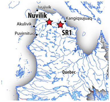
VIII. NUVILIK, QUÉBEC
The information contained in this section was obtained as part of the bid processes with Xstrata Nickel, it was updated by an Xstrata Nickel Senior Geologist in February 2006, and by Pure Nickel’s consulting project geologist Quentin Gall in January and December 2008.
A. Property Location and Description
The Nuvilik property is located in the central part of the Cape Smith Belt approximately 90 kilometres south of the coastal Inuit community of Salluit, and 80 kilometres west-southwest of the Raglan Mine complex. A permit was originally taken in 1995 over the main showings. In December 2002 and July 2003 additional claims were taken and the property now comprises 245 claims covering 9,980 hectares separated into two distinct blocks; the Main and NKS blocks. The map below shows the location of the property.
Location of Nuvilik Property
30
B. Geology Setting
The Cape Smith Belt in northern Québec is host to the Raglan Mine which has mineral reserves (proven and probable) of 14.85 million tonnes grading 2.80% Ni and 0.77% Cu, with a mineral resource (measured and indicated) of 3.39 Mt at 2.42% Ni and 0.80% Cu, and (inferred) 7.7 million tonnes at 3.0% Ni and 0.8% Cu (Falconbridge Ltd., Annual Report 2005).
This mineralization occurs within the Raglan Horizon that occurs at the base of the Chukotat Group. The mineralization is located at, or near the base of embayment features in ultramafic subvolcanic to volcanic complexes. The footwall is either gabbro or sediments. Ultramafic rocks to the south of the Raglan Horizon (South Raglan Trend) have garnered significant attention in past 7 years due to the discovery of significant Ni-Cu-PGE deposits and occurrences in some of these intrusions. Examples of which include the Mesamax deposit (Canadian Royalties Inc.). These intrusions comprise linear concordant and discordant ultramafic sills and dykes that intrude the volcano-sedimentary sequences of the Povungnituk Group, and have been interpreted as part of the Chukotat event. The information gathered from the airborne survey, along with the historical geological data suggests that the ultramafic units occurring in the western portion of the Cape Smith Belt share many geological similarities with the rocks of the Raglan Horizon and have the potential to host significant economic Ni-Cu-PGE mineralization.
C. History and Exploration
Nuvilik
The presence of significant Ni-Cu-(PGE) sulfide occurrences including the historical Ekwan showing (1.8% Ni and 0.8% Cu over 6.5 metres, 1957) illustrates the potential of the Nuvilik Property to host Ni-Cu-PGE deposits. Historical drilling in the vicinity of the main showings includes 15 packsack drill holes totaling 148 metres in 1957 by Ekwan River Mines Ltd., and 6 drill holes totaling 1,037 metres by Falconbirdge Ltd. in 1996 and 1997. More recent work has shown that high tenor sulphides are present within ultramafic rocks in the eastern part of the property as well (0.5% Ni, 0.8g/t PGE with only 0.6% S). In the southern part of the Nuvilik Main block, a Zn-Pb-Ag showing is associated with a sequence of felsic pyroclastic and dolomitic rocks. Samples with greater than 2% Zn have been identified along a horizon that extends for at least 2 kilometres. Exposure in this area is relatively poor and there is no record of drilling on the showing.
An AeroTEM airborne EM and magnetic survey was flown in 2004 that identified several unexplained conductive anomalies. Some of these conductors are concordant with, or occur in the vicinity of, previously mapped ultramafic units and historical Ni-Cu-PGE occurrences (Ekwan Showing).
The property was optioned to Minergy Ltd, a private South African company, in June 2008. Minergy’s 2008 exploration program included:
- Geophysical interpretation over the entire license, 99.25 km2
- VTEM survey in 2 blocks totaling ~417 line km
- Environmental survey of historical drill sites at Ekwan Lake
- Field follow-up (prospecting and grab sampling) of Zn targets identified from previous work and geophysical interpretation. In the NKS block, 16 samples collected with up to 2.87% Cu in 5 analyzed samples.
31
IX. SR1 PROJECT
The information contained in this section was obtained as part of the bid processes with Xstrata Nickel, it was updated by an Xstrata Nickel Senior Geologist in February 2007, and by Pure Nickel’s Project Geologist Quentin Gall in January and December 2008. In November 2010 we decided to let the SR1 claims lapse the information contain in this report is for historical purposes.
A. Property Location and Description
The SR1 property is located approximately 55 kilometres southwest of the coastal Inuit community of Kangiqsujuaq, and 40 kilometres southeast of the Donaldson airport. The Raglan Mine has an airport at Donaldson and Kangiqsujuaq is a small Inuit community with an Airport. Travel to the Property is only by helicopter.
The SR1 property is (at the most) 45 kilometres long by 14 kilometres wide, covering a surface of 35,724 hectares. It comprises 864 claims acquired from January to July 2003.
B. Geology and Setting
The SR1 property is located in the south-eastern part of the Cape Smith Belt. The property is underlain by rocks of the Beauparlant and Lamarche sub-groups and metasediments are the most common rock type (quartzites, pelites and semi-pelites and platformal sediments such as oxide-facies iron formations, dolomites, and magnetite bearing quartzites). The contact with the Archean in the SR1 block is a disconformity in which there is an observed pebble conglomerate directly overlying the Archean gneisses. This unit is overlain by ironstones, oxide iron formation and magnetite bearing quartzites. The metamorphic grade is generally higher in the southern parts of the belt and the rocks are commonly sheared and foliated. Metamorphic grade is at lower amphibolite facies.
Thick units of Povungnituk basalts, mostly massive flows commonly occur within the sedimentary sequence. Most of them have been previously mapped as gabbro. Mafic and ultramafic sills are rare and in the middle and eastern part of the SR1 block. The ultramafics consists of thin deformed talc carbonate altered sills with a weak magnetic feature. In the western part of SR1 the ultramafic sills are not so altered although they have been deformed.
In the northwestern portion of the SR1 block, several ultramafic intrusions contain disseminated to semi-massive sulphides (Spirit and Spirit South). The ultramafic rocks are intrusive into metasedimentary rocks consisting of pelites and graphitic argillites. Partially digested xenoliths of basalt are commonly found near the contacts of the ultramafic intrusions. Graphitic and sulphidic rocks have been identified in between the hills (peridotite) and explain some of the conductors. Most of the significant Ni and PGE value were collected proximal to this contact. The altered pyroxenite returned anomalous values for Ni, Cu and PGE with best values obtained of 0.29% Ni, 0.32% Cu, 0.01ppm Au, 0.06ppm Pt and 0.22ppm Pd for 4.96% S.
On the Spirit South Grid thin flat lying ultramafic sill formed of a core of peridotite and a pyroxenite margin was mapped. The underlying rocks consist of dolomite and dolomitic sandstones and the overlying rocks consist of massive basalt. Magmatic sulphides were identified in the peridotite as disseminations. The best value obtained from this area was 0.24% Ni, 0.16% Cu, 0.05 Pt and 0.16 ppm Pd for 5.27% S. This area was covered with a magnetic- and HLEM-survey totaling 5.94 line kilometres. Several EM anomalies and conductive zoned were outlined. A Crone TDEM survey was also conducted to investigate potentially deep-seated conductors that could have been missed or misidentified. Only weak conductors were detected, but they may also represent deep seated features.
32
C. History and Exploration
Exploration in the southern portion of the Cape Smith Belt (i.e., South Raglan) in Northern Québec was sparked anew in 2003, by the Ni-Cu-PGE sulfide discoveries announced by Canadian Royalties Inc. (Mesamax, Tootoo and TK). At that time Falconbridge Ltd. took out several claim blocks (SR1, SR2, SR3, SR4, and SR5) in the South Belt, and initiated a regional exploration project to investigate the potential of the ultramafic rocks.
In 2003, a total of 2,778.2 line kilometres of AeroTEM survey was flown followed with ground checking of the EM conductors.
In 2004, Soil geochemical sampling was performed mostly in lowlands where conductors appear to be buried underneath glacial sediments. Samples were collected in order to form lines that cut through the targeted conductor’s axis. A total of 397 samples were collected.
In 2005, ground surveys were conducted (HLEM, magnetic and CRONE TEM) over an area located north-northwest of the claim blocks where a favourable setting was identified in prior years. Detailed geological mapping was also conducted.
In 2008, Pure Nickel Inc. contracted Geotech Ltd. to conduct an airborne VTEM and magnetometer survey over the SR1 property. Operating out of Wakeham Bay, Québec, a total of 1096 line-kilometres were flown along north-south flight lines that were 300 metres apart. A number of conductive and magnetic anomalies were identified.
In 2009 a helicopter supported Pure Nickel team field-checked anomalies and anomaly trends identified by the 2008 VTEM survey. Serveral occurrences of disseminated sulphide mineralization were discovered in and near mafic intrusives and one previously unmapped area of frost heave tentatively interpreted to be ultramafic. Multi-element ICP (inductively-coupled plasma emission spectrometry) analyses by ALS Chemex have been received on the 141 grab samples from sites with either visible sulphides or a rusty appearance. Nickel ranged from 500 to 2000 ppm in 18 of the samples, copper from 1000 to 19300 ppm (1.93%) in 17 samples and cobalt from 75 to 175 ppm in 18 samples. Selected samples, including several from mineralization discovered by Falconbridge (now Xstrata) near the northwest end of the property, returned up to 0.061 ppm platinum and 0.199 ppm palladium. Mr. Dallas Davis, P. Eng. is the designated Qualified Person (Q.P) for the SR1 Project.
X. RAINBOW, NUNAVUT
The information contained in this section was obtained as part of the bid processes with Xstrata Nickel, it was updated in February 2005 by Xstrata and by our consulting project geologist (Dallas Davis) in January 2011.
A. Property Location and Description
The property is located 350 kilometres (km) southwest of Baker Lake, Nunavut. In 2010 we expanded the property by staking an additional 19 mineral claims. The Rainbow Property now consists of twenty three claims occupying 20,000 ha.
The project area is 260 km west of the nearest community, Arviat, and 380 km northwest of Churchill, the closest railhead and seaport. Both communities are on Hudson Bay. A tented field camp to support the most recent exploration activities in 2004 by Falconbridge (now Xstrata) was located 10 km southeast of the property at Cullaton Lake near the abandoned Cullaton Lake airstrip (98° 29.75’W/61° 19.33’N), and past producing gold mine which is currently owned by Barrick Gold Corporation. Access to the camp is possible via fixed wing aircraft to Cullaton Lake airstrip (gravel strip, 4500 feet long, capable of taking HS748 aircraft).
33
B. Geology Setting
The Rainbow property takes its name from Rainbow Lake in the southwestern end of the claim group. The claims encompass a southwest portion of the Archean Rankin-Ennadai Greenstone Belt in the Kivalliq District of Nunavut. The predominant rock types are basalt-andesite volcanics, clastic metasediments, iron formations, and ultramafic flows. An indeterminant series of komatiitic and basaltic flows are noteworthy in the southwest portion of the property length. Nickeliferous sulphide occurs as fine disseminations and massive sulphide boulders associated with komatiitic peridotites in an outcroparea referred to as the Main Zone showing. This nickel mineralization was discovered by Inco Limited in 1952. Subsequent work by Noranda in 1977, not only confirmed the presence of the Main Zone showing, but also resulted in discovery of two glacially transported massive sulphide boulders one and two km southeast of the Main Zone., The Noranda report lists assays for grab samples from these boulders as 4.6% and 7.4% nickel (Ni), respectively.
C. History and Exploration
Prior to a $1.48 -million nickel-focused exploration program conducted by Falconbridge in 2004, the most significant work on the property was undertaken by Inco (1952-53, 1997), and Noranda (1977, 1992).
Inco discovered the nickel mineralization at Rainbow Lake (Main Zone showing) during a reconnaissance program completed in 1952. Inco never filed reports on their activities, however later in 1995 they reacquired the ground and carried out a reconnaissance mapping and sampling program. This report was filed with the Government. In this report it is mentioned that in 1953 five drill holes were completed, however no drill results were reported. The best surface grab sample from the Inco programs, and documented in the 1997 report, returned 2.85% Ni from the location known as the Main Zone showing. Field evidence of the 1953 Inco drilling was found at three locations during the course of the 2004 Falconbridge field work. All holes were drilled using AXT core size, and approximately 840 feet of drilling was completed.
From 1975-77, Noranda prospected and mapped parts of the area mainly for gold, however high grade nickel mineralization was discovered in the form of massive sulphide boulders. Massive sulphide boulders from the area known as the Main Zone showing discovered originally by Inco, assayed up to 2.65% Ni. Two glacially transported massive sulphide boulders were located between one to two kilometres southeast of the Main Zone showing assayed 4.6% and 7.4% Ni respectively. Noranda also documented assays of a sample collected one kilometre west of the Main Zone, this area was referred to in 2004 as the Camp showing, and a 1977 Noranda sample assayed 3% Ni. In 1990-91, Noranda focused their exploration on the possibility of large tonnage komatiitic nickel deposits, and, although they were unsuccessful in duplicating the high grade boulder sample results obtained in their 1977 work, the Main Zone showing was located and samples assayed up to 2.65% Ni.
In 1995, Inco staked claims and carried out reconnaissance mapping and sampling, they again located the Main Zone showing, with grab samples returning assays ranging between 1.92 to 2.33% Ni from massive boulders.
34
In 2004, Falconbridge carried out an exploration program which consisted of geological mapping, sampling and prospecting, and airborne Geotem survey, ground HLEM surveys and 1,012 metres of diamond drilling in six holes.
Falconbridge’s geological field work confirmed the presence of anomalous nickel occurring in the area referred to as the Main Zone Nickel showing. Fifteen boulder samples were taken from the Rainbow Main Zone area, the site of previously discovered anomalous nickel grade boulders and outcrop, centered on UTM 6801461N / 506325E. Five massive sulphide boulder samples assayed from 1.93% to 2.23% Ni, 0.25% to 0.27% Cu and 30.1% to 37.4% S. Ten disseminated to net textured sulphide samples assayed from 0.38% to 0.67% Ni, 0.08% to 0.10% Cu and 5.54% to 9.71% S.
One semi-massive sulphide boulder was collected in the vicinity of a quartz veined sulphide- and oxide-iron formation at UTM coordinates 6801599N and 507577E. This boulder assayed 1.34 g/t Au and 27.3% S. A second sample collected 0.9 kilometre to the southeast of this location, at UTM coordinates 6800828N / 508014E, from an outcrop of oxide iron formation assayed 3.39 g/t Au and 1.09% S. A third sample collected 1.8 kilometres to the southeast of this location, at UTM coordinates 6799464N / 509123E, on Inuit-owned land package AR-36, assayed 8.97 g/t Au and 2.96% S from an outcrop of oxide iron formation.
On a regional scale, a sample of oxide iron formation in outcrop, with fine dark bands of magnetite, trace sulphide and minor biotite, chlorite and quartz, was collected 17 kilometres northeast of the original Rainbow claims. This sample, located at UTM coordinates 6814487N / 532212E, assayed 26.5 g/t Au and 2.69% S. A geological field duplicate sample from this location assayed 18.25 g/t Au and 2.54% S. This location and the associated magnetic features contiguous to the original claims staked in May were staked between October 27-28, 2004.
In addition to the geological work, a 1,808 line kilometres airborne electromagnetic (AEM) survey using Fugro’s Geotem system was also completed over the property at 200 metres line spacing. Interpretation of this data by Falconbridge geophysicists identified the presence of 18 moderate to high conductance B-Field anomalies, four anomalies were explained by sulphide bearing iron formations, one anomaly was explained by a sulphidic metasediment, eleven anomalies were not conclusively explained. However two of the unexplained targets are suspected to be associated with sulphide iron formations, yet no outcrop was found, and only sulphide bearing boulder samples in the vicinity of these conductors support this interpretation. One of the unexplained conductors is located in the vicinity of a surface boulder sample of semi-massive sulphide-quartz breccia which assayed 0.38% Ni and 13.9% S. Surrounding outcrops in this area consist of mafic amphibolites interpreted to be mafic volcanic flows.
In the area of the Main Zone nickel occurrence and historically documented high grade boulder samples, a 54 line kilometres ground geophysical grid was established. During August, 54 line kilometres of total field magnetics, and 41 line kilometres of horizontal loop electromagnetic (HLEM) data was collected. Interpretation of this data by Falconbridge geophysicists identified the presence of 18 weak to moderately conductive targets (5-15 Siemen range), several of these targets occur spatially in the Main Zone area of mineralization and are associated with disseminated and gossanous ultramafic and mafic volcanic flow outcrops. The best of these targets were drill tested.
From August 22 to September 10, 2004, a 1,012 metres NQ diamond drill program in six holes was completed in the vicinity of the Main Zone showing to test the surface showing (0.38 to 2.23% Ni). Four holes intersected disseminated sulphides with nickel grades less than 0.5% (RB04-01,-03 to -06). One hole (RB04-02) intersected a narrow 0.5 metre internal of semi-massive sulphides which assayed 0.79% Ni and 9.93% S with a low nickel tenor of 2.87% Ni in 100% sulphides.
35
Significantly, one hole, RB-04 intersected 13.10 g/t Au and 4.73% S over 2.14 metres, including 24.20 g/t and 7.88% S over one metre, associated with 10 to 15% sulphide stringers and silicifiction at the base of a mafic volcanic unit.. This hole is located 1.1 kilometres west and south of the Main Zone nickel showing.
In summary, work by Falconbridge in 2004 confirmed the presence of nickel mineralization near Rainbow Lake in the area referred to as the Main Zone. Mineralization occurs in outcrop and drill section as fine low grade and tenor disseminations within komatiitc peridotites assaying less than 0.8% Ni (grab and drill core). Massive sulphide boulders were located on surface at one location, called the Main Zone showing, five massive sulphide samples assayed from this location ranged between 1.93% to 2.23% Ni (with 30.1 to 37.4% S). Higher grade boulders discovered by Noranda in 1977 were not located in the field, and previous work of Inco and subsequent work of Noranda (1992) and Inco (1995) also failed to locate the high grade samples mentioned in the 1977 Noranda report.
2010 Exploration by Pure Nickel Inc.
In September 2010, a Mobile Metal Ion (MMI) geochemistry soil sampling program was conducted. The test program, best described as an Orientation Survey, was to determine effectiveness of the MMI soil geochemical method for detecting buried gold and nickel occurrences discovered by Falconbridge drilling in 2004 for nickel deposits in an area of komatiitic volcanics and iron formation. In order to determine the anomalous pattern of elements occurring in association with gold and nickel, all samples were subjected by SGS to their MMI-M package whereby 53 elements are reported.
To test the gold potential, two sets of 33 MMI soil samples were collected along a 625-m north-south line on which Falconbridges’s 2004 drill hole RB04-04 had returned13.15 g/t gold over 2.14m The first set was sampled at a depth of 0 to 15 cm below the organic soil layer and a second set of 33 samples from a depth of 15 to 30 cm in each of the sampling holes. Distance between sample sites varied from 2m to over 20m along the line and above the gold intersection in RB04-04.
Higher MMI Response Ratio values for gold were obtained above and for 90m to the south the RB04-04 intersection of 13.15 g/t gold at a vertical depth of 40m. These results appear to indicate a southward continuation of the drill-intersected gold mineralization which occurs in a quartz carbonate alteration zone between iron formation and a mafic volcanic.
XI. COPPER KING MILFORD PROPERTY, UTAH
This project is also referred to as Wetsern Utah Copper Company (WUCC) Property.
A. Property Description
The Copper King Milford Property is located in South Western Utah and is North East of the town of Milford. The mineral rights occupy approximately 7,000 acres.
B. Exploration
There was extensive drilling on the claims in 1998 and a feasibility study was commissioned that year. The results of the study were positive for the production of up to 54 million pounds of copper over a five-year production life. However due to low copper prices at the time, the anticipated plant and production facilities were never constructed and the claims were not put into production. The property was optioned to Western Utah Copper Corporation (WUCC), now called Copper King Mining Corp in 2002.
36
C. Option Agreement
The Copper King, Milford properties were being operated by Copper King Mining Corporation (including its subsidiary, Western Utah Copper Company – “WUCC”). Under the terms of the original agreement with WUCC we were to receive 1% of the net proceeds from the first 10 million pounds of copper produced, 1.5% of net proceeds on all copper produced thereafter and 2% of net smelter proceeds on all other minerals produced. Total royalties were capped at US$10 million ($10.3 million) and may have been subject to a net profits interest on copper production from certain claims (held by a group of private investors that include one of our directors) which will not exceed US$1.2 million ($1.2 million) in the aggregate. In addition there may have been a 2% net smelter return royalty on certain claims, held by another party.
In November 2008, WUCC failed to put our claims into production in accordance with the terms of the agreement, thereby entitling us (through our subsidiary) to exercise our option to reacquire the claims. In June 2009, after repeated attempts to confirm the precise production status of this project, we launched an action asking the Federal Court in Utah to decide the following:
| 1. | Was WUCC in production in accordance with our agreement? | |
| 2. | Didforce majeureapply? | |
| 3. | If they were not in production and force majeure did not apply, do we have the right to take back our claims under the agreement? |
Western Utah Copper Company filed a counterclaim to our original action. We believe the counterclaim is without merit.
On January 28, 2010, we advised WUCC that we were exercising our option to reacquire the claims.
In May 2010, WUCC and its parent company filed for Chapter 11 bankruptcy and appointed a new Chief Executive Officer. The company has significant secured and unsecured debts and today its current assets are likely worth far less than the outstanding loans. New management is attempting to reorganize the business. Our litigation was automatically stayed due to the Chapter 11 filing.
We have requested that the court lift the stay in connection with our litigation as we believe that resolution of our claims is a critical element in the bankruptcy. We await the court’s decision.
On August 27, 2010, a new action was launched against us by WUCC. This action is very similar to the counterclaims made in response to our original lawsuit. Management is of the opinion the court actions and related claims by WUCC are without merit and that the most likely outcome is that management of the property, upon which the operation’s concentrate mill is located, will revert back to us. Failing that, we believe that the actions taken by us will ensure that the agreement under which we filed the claim for declaratory relief remains in place and is confirmed by the court. However, the outcome of litigation is always uncertain.
Risk Factors
Any investment in our common shares involves a high degree of risk. In addition to the other information presented in this Annual Information Form, you should consider the following risk factors carefully in evaluating Pure Nickel Inc., our business, and the mineral exploration and mining industry.
37
We have a limited operating history and as a result there is no assurance we can operate profitably or with a positive cash flow.
We are an exploration stage company. Our operations are subject to all the risks inherent in the establishment of an exploration stage enterprise and the uncertainties arising from the absence of a significant operating history. Investors should be aware of the difficulties normally encountered by mineral exploration companies and the high rate of failure of such enterprises. The likelihood of success must be considered in light of the problems, expenses, difficulties, complications and delays encountered in connection with the exploration of the mineral properties that we plan to undertake. These potential problems include, but are not limited to, unanticipated problems relating to exploration, and additional costs and expenses that may exceed current estimates. The amounts disbursed by us in the exploration of the mineral claims may not result in the discovery of mineral deposits. Problems such as unusual or unexpected formations of rock or land and other conditions are involved in mineral exploration and often result in unsuccessful exploration efforts. If the results of future exploration programs do not reveal viable commercial mineralization, we may decide to abandon our claims and in fact have abandoned some already.
If we do not obtain additional financing, our business will fail and investors could lose their investment.
We had cash and equivalents of $1,799,715 and working capital was $3,843,307 at November 30, 2010. We do not currently generate revenues or cash flows from operations (except for interest income and payments that are credited to mineral resources on the balance sheet rather than being identified as revenues in our statement of operations). Our business plan calls for substantial investment and costs in connection with the exploration of our mineral properties. In order to maintain certain of our property claims, we must incur certain minimum exploration expenditures on an ongoing basis. There can be no assurance that we will have the funds required to make such expenditures or that those expenditures will result in positive cash flow. There are no arrangements in place for additional financing and there is no assurance that we will be able to find such financing if required.
We are an exploration company with an accumulated deficit of $14,016,092 as at November 30, 2010. With ongoing cash requirements for exploration, development and new operating activities, it will be necessary to raise substantial funds from external sources. If we do not raise these funds, we will be unable to pursue our business activities, and our investors could lose their investment. If we are able to raise funds, investors could experience a dilution of their interests that would negatively affect the market value of the shares.
Because there is no assurance that we will generate revenues, we face a high risk of business failure.
We have not earned any revenues to date and have never had positive cash flow. Before being able to generate revenues, we will incur substantial operating and exploration expenditures without receiving any revenues. If we are unable to generate significant revenues from our activities, we will not be able to earn profits or continue operations. Based upon current plans, we expect to incur significant operating losses in the future. We cannot guarantee that we will be successful in raising capital to fund these operating losses or generate revenues in the future. There is no assurance that we will ever generate any operating revenues or ever achieve profitable operations. If we are unsuccessful in addressing these risks, our business may fail and our investors could lose some or all of their investment.
38
There are no known reserves of minerals on our mineral claims and there is no assurance that we will find any commercial quantities of minerals.
We have not found any mineral reserves on our claims and there can be no assurance that any of the mineral claims under exploration contain commercial quantities of any minerals. Even if commercial quantities of minerals are identified, there can be no assurance that we will be able to exploit the reserves or, if we are able to exploit them, that it can be done on a profitable basis. Substantial expenditures will be required to locate and establish mineral reserves, to develop metallurgical processes and to construct mining and processing facilities at a particular site, and substantial additional financing may be required. It is impossible to ensure that the exploration or development programs planned by us will result in a profitable commercial mining operation. The decision as to whether a particular property contains a commercial mineral deposit and should be brought into production will depend on the results of exploration programs and/or feasibility studies, and the recommendations of duly qualified engineers and geologists. Several significant factors will be considered, including, but not limited to: (i) the particular attributes of the deposit, such as size, grade and proximity to infrastructure; (ii) metal prices, which are highly cyclical; (iii) government regulations, including regulations relating to prices, taxes, royalties, land tenure, land use, importing and exporting of minerals and environmental protection; (iv) ongoing costs of production; and (v) availability and cost of additional funding. The effect of these factors cannot be accurately predicted, but the combination of these factors may result in us receiving no return or an inadequate return on invested capital.
Because of the speculative nature of the exploration of natural resource properties, there is substantial risk that our business will fail.
While the discovery of a commercially viable ore body may result in substantial rewards, few mineral properties which are explored are ultimately developed into producing mines. There is no assurance that any of the claims that we will explore or acquire will contain commercially exploitable reserves of minerals. Exploration for natural resources is a speculative venture involving substantial risk. Even a combination of careful evaluation, experience and knowledge may not eliminate such risk. Hazards such as unusual or unexpected geological formations, formation pressures, fires, power outages, labour disruptions, flooding, cave-ins, landslides, and the inability of us to obtain suitable machinery, equipment or labour are all risks involved with the conduct of exploration programs and the operation of mines.
Development and exploration activities depend, to one degree or another, on adequate infrastructure. Reliable roads, bridges, power sources and water supply are important determinants, which affect capital and operating costs. Unusual or infrequent weather phenomena, sabotage, government or other interference in the maintenance or provision of such infrastructure could adversely affect our operations, financial condition and results of operations.
We are subject to market factors and volatility of commodity prices beyond our control.
The marketability of mineralized material that we may acquire or discover will be affected by many factors beyond our control. These factors include market fluctuations in the prices of minerals sought which are highly volatile, the proximity and capacity of natural resource markets and processing equipment, and government regulations, including regulations relating to prices, taxes, royalties, land tenure, land use, importing and exporting of minerals and environmental protection. The effect of these factors cannot be predicted, but may result in a very low or negative return on invested capital. Prices of certain minerals have fluctuated widely, particularly in recent years, and are affected by numerous factors beyond our control. Future mineral prices cannot be accurately predicted. A severe decline in the price of a mineral being produced or expected to be produced by us would have a material adverse effect on us, and could result in the suspension of our exploration programs or mining operations.
39
Our stock price could be volatile.
Market prices of securities of many public companies have experienced significant fluctuations in price that have not been related to the operating performance, underlying asset values or prospects of such companies. The market price of our common shares has been and is likely to remain volatile. Results of exploration activities, the price of nickel, future operating results, changes in estimates of our performance by securities analysts, market conditions for natural resource companies in general, and other factors beyond our control could cause a significant decline of the market price of our common shares.
If we do not make certain payments or fulfill other contractual obligations, we may lose our option rights and interests in our joint ventures.
We may, in the future, be unable to meet our share of costs incurred under option or joint venture agreements to which we are a party and we may have our interest in the properties subject to such agreements reduced as a result. Furthermore, if other parties to such agreements do not meet their share of such costs, we may be unable to finance the cost required to complete programs. The loss of any option rights or interest in joint ventures would have a material, adverse effect on us.
We may not have good title to our mining claims, potentially impairing our value.
Our mineral property interests may be subject to prior unregistered agreements of transfers or native land claims, and title may be affected by undetected defects. There can be no assurance that we will be able to obtain the required mining and other permits for any of our mineral projects, if, as, and when mining operations come viable at such mining projects.
If key employees or consultants leave the company, we will be harmed since we are heavily dependent upon them for all aspects of our activities.
We are dependent upon key employees and contractors, the loss of any of whom could have a negative impact on our ability to operate the business and could cause a decline in the value of, or cash flows from, our properties or additional costs resulting from a delay in development or exploration of properties.
If we do not comply with all applicable regulations, we may be forced to halt our business activities and/or incur significant expense.
We are subject to government and environmental regulations. Permits from a variety of regulatory authorities are required for many aspects of exploration, mining operations and reclamation. We cannot predict the extent to which future legislation and regulation could cause additional expense, capital expenditures, restrictions, and delays in the development of our Canadian and/or U.S. properties, including those with respect to unpatented mining claims.
Failure to comply with applicable environmental laws, regulations and permitting requirements may result in enforcement actions including orders issued by regulatory or judicial authorities that may result in operations ceasing or being curtailed; and may include corrective measures requiring capital expenditures, installation of additional equipment, or other expensive and/or time-consuming remedial actions. Parties engaged in the exploration or development of exploration properties may be required to compensate those suffering loss or damage by reason of such parties’ activities and may have civil or criminal fines or penalties imposed for violations of applicable laws or regulations.
40
Our activities are not only subject to extensive federal, provincial, state and local regulations controlling the exploration and mining of mineral properties, but also the possible effects of such activities upon the environment as well as costs, cancellations and delays resulting from lobbying activities of environmental groups. Future legislation and regulations could cause additional disbursements, capital expenditures, restrictions and delays in the development of our properties, the extent of which cannot be predicted. Also, as noted above, permits from a variety of regulatory authorities are required for many aspects of mine operation and reclamation. In the context of environmental permitting, including the approval of reclamation plans, we must comply with known standards, existing laws and regulations that may entail greater or lesser costs and delays, depending on the nature of the activity to be permitted and how stringently the regulations are implemented by the permitting authority. If we become more active on our properties, compliance with environmental regulations may increase our costs. Such compliance may include feasibility studies on the surface impact of proposed operations; costs associated with minimizing surface impact, water treatment and protection, reclamation activities including rehabilitation of sites, ongoing efforts at alleviating the mining impact on wildlife, and permits or bonds as may be required to ensure our compliance with applicable regulations. The costs and delays associated with such compliance may result in us deciding not to proceed with exploration, development or mining operations on any mineral properties.
Exercise of outstanding options, and other future issuances of securities will result in dilution of our common shares.
As of November 30, 2010, there were 67,832,226 common shares issued and outstanding as well as options as set out in the Share Capital note above.
The holders of the options are given an opportunity to profit from a rise in the market price of the common shares with a resulting dilution in the interest of the other shareholders. Our ability to obtain additional financing during the period such rights are outstanding may be adversely affected and the existence of the rights may have an adverse effect on the price of the common shares. The holders of options may exercise such securities at a time when we would otherwise be able to obtain any needed capital by a new offering of securities on terms more favourable than those provided by those outstanding rights.
The increase in the number of common shares issued and outstanding and the possibility of sales of such shares may depress the market price of our common shares. In addition, as a result of any such issuances the votes of existing shareholders will be diluted.
| ITEM 4: | DESCRIPTION OF CAPITAL STRUCTURE |
General Description of Capital Structure
Our share capital consists of an unlimited number of common shares without par value carrying one vote per authorized share. As at November 30, 2010, there were 67,832,226 common shares issued and outstanding. The following summary of certain terms of the our common shares does not purport to be complete and is subject to, and is qualified in its entirety by reference to, all of the provisions of our articles of amalgamation and by-laws and applicable law. Copies of our articles of amalgamation and bylaws are available upon request to the head office.
The holders of the common shares are entitled to:
- one vote for each common share held at all meetings of shareholders of Pure Nickel; and
41
- receive, rateably, the remaining property of the company after payment or provision for its liabilities in the event of the liquidation, dissolution or winding up, whether voluntary or involuntary, or any other distribution of the assets of the company among its shareholders for the purpose of winding up its affairs.
The holders of common shares have no pre-emptive, redemption, subscription or conversion rights. Modifications to the rights, privileges, restrictions and conditions attached to the common shares (including creation of another class of shares that rank prior to or on parity with them) requires an affirmative vote of two-thirds of the votes cast at a meeting of the holders of common shares.
| ITEM 5: | MARKET FOR SECURITIES |
Market Information
Our Common Shares are currently listed for trading on the TSX under the symbol “NIC” as well as on the NASD over-the-counter bulletin board (“OTCBB”) in the United States under the stock symbol “PNCKF”.
Trading Price and Volume
The tables set out below present the high and low sale prices for the Common Shares and trading volume, on a monthly basis on each of the TSX and OTCBB during the fiscal year ended November 30, 2010.
TSX (Canadian dollars)
Month and Year | High $ | Low $ | Volume |
| November 2010 October 2010 September 2010 August 2010 July 2010 June 2010 May 2010 April 2010 March 2010 February 2010 January 2010 December 2009 | 0.20 0.205 0.165 0.155 0.195 0.195 0.205 0.21 0.245 0.165 0.17 0.185 | 0.16 0.15 0.13 0.135 0.14 0.14 0.15 0.185 0.13 013 0.13 0.125 | 1,946,600 2,263,548 1,332,326 621,405 1,499,050 1,980,820 1,260,407 1,816,280 5,151,517 1,388,721 1,845,269 5,483,845 |
42
NASD OTCBB (US dollars)
Month and Year | High $ | Low $ | Volume |
| November 2010 October 2010 September 2010 August 2010 July 2010 June 2010 May 2010 April 2010 March 2010 February 2010 January 2010 December 2010 | 0.21 0.195 0.1648 0.1355 0.19 0.185 0.2007 0.22 0.225 0.1588 0.1577 0.1635 | 0.16 0.15 0.121 0.1233 0.135 0.141 0.145 0.171 0.121 0.125 0.12 0.125 | 86,820 72,081 101,100 42,400 98,035 119,500 132,877 90,532 304,400 101,110 129,330 698,872 |
Prior Sales
We do not have any class of securities (other than stock options issued pursuant to our stock option plan or warrants issued pursuant to private placements) outstanding which are not listed or quoted on a market place.
| ITEM 6: | DIVIDENDS |
We currently intend to retain future earnings, if any, to finance the growth and development of our business. During the last three fiscal years ended November 30, 2010, we did not pay any dividends and we do not intend to pay dividends in the foreseeable future.
| ITEM 7: | DIRECTORS AND OFFICERS |
Directors of the Corporation
The names, provinces and country of residence, period during which each has served as a director where applicable, positions held with the company and principal occupation for the past five years of the directors and executive officers are as set out below. The term of office of each current director will expire at the next annual meeting or when his or her successor is duly elected or appointed. The directors who are members of the Audit Committee and Nominating, Corporate Governance and Compensation Committees are noted below.
43
| Name, Province and Country of | ||
| Residence and Position | Became a | Principal occupation (for the past five years |
| with the Corporation | Director | unless otherwise shown) |
| David R. McPherson(2) St. Catherines, Ontario, Canada Chief Executive Officer and President | 2007 | Mr. McPherson became CEO and President on December 20, 2007. From 2001-2006 Mr. McPherson served as Vice President of First Ontario Credit Union leading strategy development, product and marketing groups. From 2006 to December 2007 Mr. McPherson was as an independent consultant. |
| Robert Angrisano Seattle, Washington, United States Chairman | 1999 | Mr. Angrisano was Chairman of the Board of Pure Nickel from December 2007 to April 2010 and president of Nevada Star Resource Corp between 2005 and March 2007; CEO of Nevada Star from May, 2006 to March 27, 2007. Mr. Angrisano has spent over 35 years in senior levels of management at various high tech companies. Mr. Angrisano is a Fire Commissioner for Kittitas County Fire District #8 (a publicly elected position) and holds various positions in non-industry related Boards and Steering Committees. |
| Harry Blum Toronto, Ontario, Canada(1) Director | 2007 | Managing Partner of Collins Barrow Toronto LLP public accountants (joined predecessor firm in 1992). |
| R. David Russell Centennial, Colorado, United States(1) (2) Director | 2006 | Mr. Russell became Chairman of the Board of Pure Nickel in April 2010. He was President and CEO of Apollo Gold Corporation from 2002 to July 2010. |
| W.S. (Steve) Vaughan(2) Toronto, Ontario, Canada Director | 2007 | Partner, Heenan Blaikie LLP since 2007. Partner, McMillan Binch Mendelson LLP February between 2002 and 2007. |
| Constantine Salamis(2) Morin Heights, Québec, Canada Director | 2007 | Mr. Salamis is a mining engineer. Mr. Salamis founded Manicouagan Minerals in 2004 and continues to serve on its Board of Directors. Mr. Salamis has also completed geological evaluation projects for the World Bank and the United Nations. |
| Jeffrey D. Sherman Toronto, Ontario, Canada Chief Financial Officer | __ | Mr. Sherman was appointed CFO in February, 2008. Mr. Sherman is a Chartered Accountant and MBA. From 2003 to 2005, Mr. Sherman served as CFO of VisualSonics Inc., and from 2003 to present Mr. Sherman has been President of Anagram Services, a consulting company. |
| Lisa Buchan Toronto, Ontario, Canada Corporate Secretary | __ | Ms. Buchan was appointed Corporate Secretary in April 2008. Ms Buchan is a Chemical Engineer and MBA. Ms. Buchan has been the Business Manager of Pure Nickel since January 2007. Prior to joining Pure Nickel Ms. Buchan was an independent consultant. |
____________________
| (1) | Member of Audit Committee, Corporate Governance and Nominating Committee, and Compensation Committee. |
| (2) | Member of the Technical, Health, Safety and Environmental Committee |
44
As at November 30 2010, the directors and executive officers beneficially owned in the aggregate, directly or indirectly, or over which control or direction was exercised 3,088,346 issued and outstanding Common Shares or 4.6 %of the Common Shares issued and outstanding.
Corporation Cease Trade Orders and Bankruptcies
To the best of our knowledge, except as set out below, no director or officer or principal shareholder of Pure Nickel is, as at the date hereof, or has been within the last ten years prior to the date hereof, (a) subject to a cease trade order, an order similar to a cease trade order or an order that denied a company access to any exemption under securities legislation that was in effect for a period of more than 30 consecutive days that was issued while the director or officer of Pure Nickel was acting in the capacity as director, chief executive officer or chief financial officer of that company; (b) subject to a cease trade order, an order similar to a cease trade order or an order that denied a company access to any exemption under securities legislation that was in effect for a period of more than 30 consecutive days that was issued after the director or officer ceased to be a director, chief executive officer or chief financial officer of that company and which resulted from an event that occurred while that person was acting in such capacity; (c) a director or executive officer of any company that, while that person was acting in that capacity, or within a year of that person ceasing to act in that capacity, became bankrupt, made a proposal under any legislation relating to bankruptcy or insolvency or was subject to or instituted any proceedings, arrangement or compromise with creditors or had a receiver, receiver manager or trustee appointed to hold its assets; or (d) became bankrupt, made a proposal under any legislation relating to bankruptcy or insolvency, or became subject to or instituted any proceedings, arrangement or compromise with creditors, or had a receiver, receiver manager or trustee appointed to hold his assets.
Mr. Blum is a director of First Metals Inc. which announced on January 7, 2009 that it had filed a Notice of Intention to Make a Proposal under the Bankruptcy and Insolvency Act, and it subsequently filed a proposal to its creditors under Part III of that Act on April 17, 2009, which was approved by the Ontario Superior Court of Justice on June 18, 2009.
Mr. Vaughan believes, but has no actual knowledge of the facts, that Windy Mountain Explorations Ltd. (a copper/molybdenum exploration and development company focused on a property in Northern Quebec) made an assignment in bankruptcy, etc. in 2003. He was a Director of Windy Mountain up to approximately that time.
Mr. Vaughan was a director of Copper Mesa Mining Corporation, formerly Ascendant Copper Corporation, (a mineral exploration and development company focused on copper exploration in Ecuador), at the time that the company became subject to a cease trade order issued by the British Columbia Securities Commission on April 8, 2009, the Autorité des marchés financiers (Quebec Securities Commission) on April 9, 2009 and the Ontario Securities Commission on April 13, 2009 for failure to file an Annual Information Form for the year ended December 31, 2008, audited annual financial statements for the year ended December 31, 2008 and Management Discussion and Analysis relating to the audited annual financial statements for the year ended December 31, 2008. The cease trade order was revoked on June 13, 2009, June 16, 2009 and June 15, 2009 in the provinces of British Columbia, Quebec and Ontario, respectively. The company again became subject to a cease trade order issued by the British Columbia Securities Commission on August 24, 2009, the Autorité des marchés financiers on August 26, 2009 and the Ontario Securities Commission on August 27, 2009 for failure to file interim financial statements for the period ended June 30, 2009 and Management Discussion and Analysis relating to the interim financial statements for the period ended June 30, 2009. Subsequently Copper Mesa ceased dong business because of lack of funding although it has not, to his knowledge, been liquidated or become bankrupt. He resigned from the company on July 9, 2010. To his knowledge, there have been no criticisms or findings against him.
Penalties and Sanctions
None of the directors or executive officer of Pure Nickel or, to the best of our knowledge, shareholders holding sufficient Common Shares to materially affect the control of the company have been subject to:
| (i) | any penalties or sanctions proposed by a court relating to securities legislation or by a securities regulatory authority or have entered into a settlement agreement with a securities regulatory authority, or | |
| (ii) | any other penalties or sanctions imposed by a court or regulatory body that would likely be considered important to a reasonable investor in making an investment decision. |
Conflicts of Interest
Three areas for potential conflicts of interest may exist: First, one of our directors also acts as our legal counsel and provides various legal services throughout the year. Second, one of our directors is the founder and a significant shareholder of Manicouagan Minerals which is a 50/50% joint venture partner on one of the Company’s properties. Lastly, one of our directors is part of a group of investors that may have a net profit interest in copper production of the Western Utah Copper Company (WUCC)/Copper King property. Such directors are required by law, however, to act honestly and in good faith with a view to the best interest of Pure Nickel and its shareholders and to disclose any personal interest which they may have in any material transaction which is proposed to be entered into with Pure Nickel and to abstain from voting as a director for the approval of any such transaction.
45
| ITEM 8: | LEGAL PROCEEDINGS AND REGULATORY ACTIONS |
We are not aware of any litigation outstanding, threatened or pending as of the date hereof by or against Pure Nickel except as set out herein. In 2009 we (through a subsidiary) filed an action for declaratory relief against Western Utah Copper Company (WUCC) in the United States District Court, Utah, requesting interpretation of and the status and rights under an agreement. WUCC filed an answer and counterclaim, and, the Company filed a response to the counterclaim. On January 28, 2010, we advised WUCC that we were exercising our option to reacquire the claims. In May 2010, WUCC and its parent company filed for Chapter 11 bankruptcy and appointed a new chief executive officer. WUCC has significant secured and unsecured debts and its assets appear to be less than its outstanding loans. Our litigation was automatically stayed due to the Chapter 11 filing, and we have requested that the court lift the stay in connection with the litigation as we believe that resolution of its claims is a critical element in the bankruptcy. On August 27, 2010, a new action was launched against the Company by WUCC which is very similar to the counterclaims made in response to the Company’s original lawsuit.
Management is of the opinion the court actions and related claims by WUCC are without merit and that the most likely outcome is that management of the property, upon which the operation’s concentrate mill is located, will revert back to the Company. Failing that, the Company believes that the actions taken by it will ensure that the agreement under which it filed the claim for declaratory relief remains in place and will be confirmed by the court. However, the outcome of litigation is always uncertain During the fiscal year ended November 30, 2010, we were not subject to:
| (a) | any penalties or sanctions imposed by a court relating to securities legislation or by a securities regulatory authority; | |
| (b) | any other penalties or sanctions imposed by a court or regulatory body that would likely be considered important to a reasonable investor in making an investment decision; or | |
| (c) | any settlement agreements entered into with a court relating to securities legislation or with a securities regulatory authority. |
| ITEM 9: | INTEREST OF MANAGEMENT AND OTHERS IN MATERIALTRANSACTIONS |
No directors or executive officers of Pure Nickel, and no person or company that is the direct or indirect beneficial owner of, or who exercises control or direction over, more than 10% of our issued and outstanding Common Shares or any of their respective associates or affiliates, has or has had a material interest, direct or indirect, in any transaction, whether proposed or concluded, which had, or may have, a material effect on us or our subsidiaries within the three most recently completed financial years or during the current financial year.
46
| ITEM 10: | TRANSFER AGENTS AND REGISTRARS |
Our transfer agent and registrar for our Common Shares is Computershare Trust Company of Canada in Toronto, Ontario.
| ITEM 11: | MATERIAL CONTRACTS |
Other than contracts entered into in the ordinary course of business, no material contracts were entered into.
| ITEM 12: | INTERESTS OF EXPERTS |
Names of Experts
Our auditors are SF Partnership, LLP, Chartered Accountants; they were reappointed by shareholders at our annual general meeting held on April 28, 2010. SF Partnership, LLP, Chartered Accountants audited our financial statements for the fiscal year ended November 30, 2010.
The following are qualified persons as defined by NI 43-101 for our exploration and development projects: Dr. Larry Hulbert, Chief Consulting Geologist, Mr. Phillip Mudry, Chief Exploration Consultant and Mr. Dallas Davis, Consulting Geologist. The foregoing individual’s profession or business gives authority to a statement made by them as having prepared or certified a part of that document or a report or valuation described in this AIF. All qualified persons are under contract with Pure Nickel.
Interests of Experts
Dr. Larry Hulbert is the only person or company named or referred to under this Item that beneficially owns, directly or indirectly, 1% or more of any class of Pure Nickel’s outstanding Common Shares. Dr. Hulbert owns 1.02% of the outstanding Common Shares.
| ITEM 13: | ADDITIONAL INFORMATION |
Words importing the singular number, where the context requires, include the plural and vice versa and words importing any gender include all genders. All dollar amounts herein are in Canadian dollars, unless otherwise stated.
In this AIF the terms “we”, “us”, “our” and “ours” refer to Pure Nickel.
Additional information relating to Pure Nickel may be found on SEDAR at www.sedar.com.
Additional financial information is provided in our consolidated financial statements and management’s discussion and analysis for our financial year ended November 30, 2010.
Additional information concerning Pure Nickel can also be found on Pure Nickel’s web site at www.purenickel.com.
Forward-Looking Statements
This annual information form and the documents incorporated by reference herein contain “forward-looking statements”. These forward-looking statements may include, among other things, statements with respect to Pure Nickel Inc.’s business strategy, plans, outlook, long-term growth in cash flow, earnings per share and shareholder value, projections, targets and expectations as to reserves, resources, results of exploration (including targets) and related expenses, property acquisitions, mine development, mine operations, mine production costs, drilling activity, sampling and other data, recovery improvements, future production levels, capital costs, expenditures for environmental matters and technology, and completion dates for the various development stages of mines, future mineral prices (including the long-term estimated prices used in calculating Pure Nickel’s mineral reserves). Generally, these forward-looking statements can be identified by the use of forward-looking terminology such as “anticipate”, “project”, “target”, “believe”, “estimate”, “expect”, “intend”, “should” and similar expressions. Forward-looking statements are subject to known and unknown risks, uncertainties and other factors that may cause Pure Nickel’s actual results, level of activity, performance or achievements to be materially different from those expressed or implied by such forward-looking statements, including:
47
uncertainties and costs related to Pure Nickel’s exploration and development activities, such as those associated with determining whether mineral reserves exist on a property;
uncertainties related to feasibility studies that provide estimates of expected or anticipated economic returns from a mining project;
uncertainties related to the accuracy of reserve and resource estimates and estimates of future production and future cash and total costs of production;
changes in, and the effects of, the laws, regulations and government policies affecting operations, particularly laws, regulations and policies; and
changes in general economic conditions, the financial markets and in the demand and market price for minerals and commodities, such as diesel fuel, electricity and other forms of energy, and fluctuations in exchange rates.
This list is not exhaustive of the factors that may affect any forward-looking statements. These and other factors should be considered carefully and readers should not place undue reliance on such forward-looking statements. Pure Nickel does not undertake to update any forward-looking statements that are incorporated by reference herein, except in accordance with applicable securities laws.
48
Glossary of Technical Terms
AeroTEM | Helicopter-borne Time Domain Electromagnetic System: a helicopter-borne electromagnetic system used to identify potential deposits based upon conductive properties. |
AIF | This annual information form |
BHEM | Bore Hole Electro Magnetic: an imaging system that involves placing a transmitter and receiver in a borehole, and the underlying geological structure is viewed by a process similar to medical tomographic imaging. This creates an image of the structure from a series of flat cross-sectional images. |
Board of Directors | The board of directors of Pure Nickel Inc |
breccia | A rock in which angular fragments are surrounded by a mass of finer-grained material. |
Business Day | Any day on which commercial banks are generally open for business other than a Saturday, Sunday or a day observed as a holiday under the laws of Ontario; or the federal laws of Canada |
chalcopyrite | A sulphide mineral of copper and iron; the most common ore mineral of copper. |
concentrate | A fine, powdery product of the milling process containing a high percentage of valuable metal. |
diamond drill(ing) | A rotary type of rock drill in which the cutting is done by abrasion rather than percussion. The cutting bit is set with diamonds and is attached to the end of long hollow rods through which water or other fluid is pumped to the cutting face as a lubricant. The drill cuts a core of rock that is recovered in long cylindrical sections, two centimeters or more in diameter. |
disseminated | Ore carrying small particles of valuable minerals spread more or less uniformly through the host rock. |
exploration stage | The search for mineral deposits which are not in either the development or production stage. |
feasibility study | An economic study assessing whether a mineral deposit can be mined profitably, by estimating costs of a mine and the potential revenues from production. |
grade | The metal content of rock with precious metals. Grade can be expressed as troy ounces or grams per tonne of rock. |
hectare | A metric unit of surface measurement equivalent to 10,000m² |
igneous | A type of rock which has been formed from magma, a molten substance from the earth’s core. |
intrusion | A body of igneous rock formed by the consolidation of magma intruded into other rocks, in contrast to lavas, which are extruded upon the surface. |
km | Kilometres |
laws | All statues, regulations, statutory rules, orders, judgments, decrees and terms and conditions of any grant of approval, permission, authority, permit or license of any court, government entity, statutory body or self-regulatory authority (such as the TSX) |
m | Metres |
mafic | Igneous rock composed mostly of dark, iron and magnesium-rich minerals. |
MAN Property | Pure Nickel’s MAN Alaska property |
matte | A homogenous nickel-iron-sulphur product of smelting processes with minor impurities. In the context of nickeliferous laterite processing, a nickel-iron-sulphur intermediate, forming a feed for nickel refineries. |
metasedimentary. | Originally sedimentary rocks which have been subsequently affected by the process of metamorphism |
metamorphic | A type of rock which, through heat and pressure, has been changed from igneous or sedimentary rock. |
49
| mineral reserve | National Instrument 43-101Standards of Disclosure for Mineral Projectsof the Canadian Securities Administrators, adopting the definition of the Canadian Institute of Mining, Metallurgy and Petroleum (CIM), defines a ‘mineral reserve’ as the economically mineable part of a Measured or Indicated Mineral Resource demonstrated by at least a Preliminary Feasibility Study (a comprehensive study of the viability of a mineral project that has advanced to a stage where the mining method has been established and an effective method of mineral processing has been determined and includes a financial analysis based on reasonable assumptions of technical, engineering, legal, operating, economic, social, and environmental factors and the evaluation of other relevant factors which are sufficient for a Qualified Person (an individual who is an engineer or geoscientist with at least five years of experience in mineral exploration, mine development or operation or mineral project assessment, or any combination of these; has experience relevant to the subject matter of the mineral project and the technical report; and is a member or licensee in good standing of a professional association), acting reasonably, to determine if all or part of the Mineral Resource may be classified as a Mineral Reserve). This study must include adequate information on mining, processing, metallurgical, economic and other relevant factors that demonstrate, at the time of reporting, that economic extraction can be justified. A Mineral Reserve includes diluting materials and allowances for losses that may occur when the material is mined. Mineral Reserves are sub-divided in order of increasing confidence into Probable Mineral Reserves and Proven Mineral Reserves. A Probable Mineral Reserve has a lower level of confidence than a Proven Mineral Reserve. |
50
mineral resource | National Instrument 43-101Standards of Disclosure for Mineral Projectsof the Canadian Securities Administrators, adopting the definition of the Canadian Institute of Mining, Metallurgy and Petroleum (CIM), defines a ‘Mineral Resource’ as a concentration or occurrence of diamonds, natural solid inorganic material, or natural solid fossilized organic material including base and precious metals, coal and industrial minerals in or on the Earth’s crust in such form and quantity and of such a grade or quality that it has reasonable prospects for economic extraction. The location, quantity, grade, geological characteristics and continuity of a Mineral Resource are known, estimated or interpreted from specific geological evidence and knowledge. Mineral Resources are sub-divided, in order of increasing geological confidence, into Inferred, Indicated and Measured categories. An Inferred Mineral Resource has a lower level of confidence than that applied to an Indicated Mineral Resource. An Indicated Mineral Resource has a higher level of confidence than an Inferred Mineral Resource but has a lower level of confidence than a Measured Mineral Resource. |
Net Smelter Royalty | A royalty calculated on the net smelter return is essentially calculated on the amount received by the mine or mill owner from the sale of the mineral product to the treatment plant that converts the output of the mill to marketable metal. From the gross proceeds received there may be deductions for costs incurred by the owner after the product leaves the mine property and before sale, such as the costs of: transportation, insurance or security, penalties, sampling and assaying, refining and smelting, and marketing. No deductions are made for the operating costs of the mine-mill complex. (from B.J. Barton,Canadian Law of Mining (Calgary: Institute of Resources Law, 1993) at 461.) |
NI 43-101 | Canadian Securities Administrators, National Instrument 43-101Standards ofDisclosure for Mineral Projects |
ore | A mixture of minerals and host rock from which at least one metal can be extracted at a profit. |
patent | The ultimate stage of holding a mineral claim, after which no more assessment work is necessary because all mineral rights have been earned. |
51
PGE | Platinum Group Elements include platinum, palladium, rhodium, iridium, osmium, and ruthenium. They commonly occur together in nature and are among the most scarce of the metallic elements. |
prospect | (noun) The possibility of future success for economic minerals based on geological, geophysical, geochemical and other criteria. |
production stage | Companies engaged in the exploitation of a mineral deposit (reserve). |
qualified person | As individual who is an engineer or geoscientist with at least five years experience in mineral exploration, mine development or operation or mineral project assessment, or any combination of these; has experience relevant to the subject matter of the mineral project and the Technical Report; and is a member or licensee in good standing of a professional association. |
quartz | A mineral composed of silicon dioxide. A crystalline form of silica. |
reserve | A known resource that can be exploited for profit with available technology under existing political and economic conditions. |
royalty | An amount of money paid at regular intervals, or based on production, by the lessee or operator of an exploration or mining property to the current or former owner of the mineral interests. Generally based on a certain amount per unit weight or a percentage of the total production, revenues or profits. |
shear | The deformation of rocks by lateral movement along innumerable parallel planes, generally resulting from pressure and producing such metamorphic structures as cleavage and schistosity. |
strike | The direction, or bearing, from true north of a vein or rock formation measured on a horizontal surface. |
sulphide | A compound of sulphur and some other element; most base-metal ore minerals are sulphides. |
tonne | Metric ton, 1,000 kilograms, equal to 2,205 pounds. |
trenching | A trench is defined as a narrow underground excavation that is deeper than it is wide, and is no wider than 15 feet (4.5 meters). |
TSX | Toronto Stock Exchange |
ultramafic | A term used to describe igneous rock or magmas that are rich in iron and magnesium and very poor in silica. |
vein | A tabular body of rock typically of narrow thickness and mineralized occupying a fault, shear, fissure or fracture crosscutting another pre-existing rock. |
VTEM | The VTEM (Versatile Time-Domain Electromagnetic) survey is the leading airborne geophysical system in use today and is particularly suited to the identification of copper-zinc massive sulphide deposits |
| Pd | Palladium |
| Pt | Platinum |
| Cu | Copper |
| Ni | Nickel |
| Au | Gold |
| Ag | Silver |
| Zn | Zinc |
| Pb | Lead |
52