UNITED STATES
SECURITIES AND EXCHANGE COMMISSION
Washington, D.C. 20549
Form 6-K
REPORT OF FOREIGN PRIVATE ISSUER PURSUANT TO RULE 13a-16 OR 15d-16 UNDER THE SECURITIES EXCHANGE ACT OF 1934
For the month of January 2006
Commission File Number 0-24096
QUEENSTAKE RESOURCES LTD.
999 18th Street, Suite 2940, Denver, CO 80202
(Address of principal executive offices)
Indicate by check mark whether the registrant files or will file annual reports under cover of Form 20-F or Form 40 F.
Form 20-F ý Form 40 F o
Indicate by check mark whether by furnishing the information contained in this Form the registrant is also thereby furnishing the information to the Commission pursuant to Rule 12g3-2(b) under the Securities Exchange Act of 1934.
Yeso No ý
If “Yes” is marked, indicate below the file number assigned to the registrant in connection with Rule 12g3-2(b):
DOCUMENTS FILED: | Press Release NR2006-02 January 18, 2006 | |
DESCRIPTION: | Queenstake’s Drilling at Starvation Canyon Continues to Hit High Grade Gold Mineralization | |
DOCUMENTS FILED: | Press Release NR2006-04 January 25, 2006 | |
DESCRIPTION: | Queenstake’s Drilling Expands High-Grade Mineralization at Smith, SSX and Steer Mines |
SIGNATURES
Pursuant to the requirements of the Securities Exchange Act of 1934, the registrant has duly caused this report to be signed on its behalf by the undersigned, thereunto duly authorized.
|
| QUEENSTAKE RESOURCES LTD. | ||
|
| (Registrant) | ||
|
|
| ||
Date | January 25, 2006 |
| By | “Dorian L. Nicol”“ (signed) |
|
| (Signature) | ||
|
|
| ||
|
| Dorian L. Nicol, President & CEO | ||
| NEWS RELEASE |
|
|
|
|
News Release 2006-02 |
| January 18, 2006 |
SEC file number 0-24096 |
|
|
Queenstake’s Drilling at Starvation Canyon
Continues to Hit High Grade Gold Mineralization
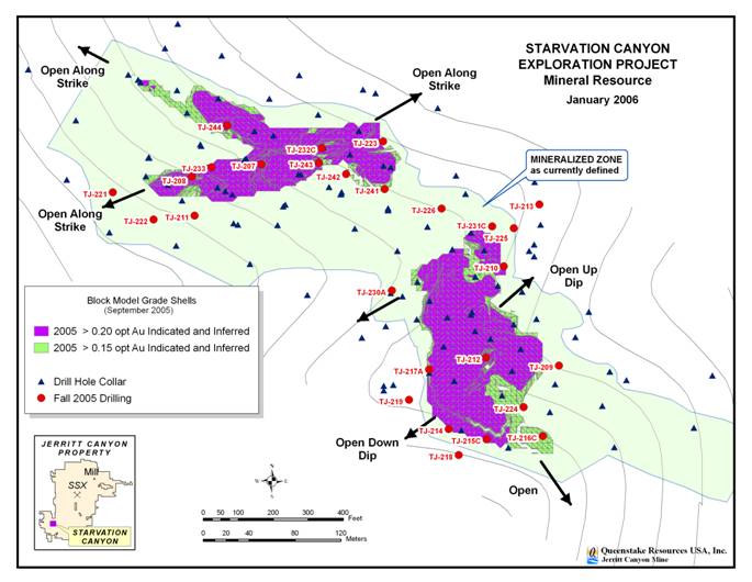
Denver, Colorado – January 18, 2006 – Queenstake Resources Ltd.’s (TSX:QRL, AMEX:QEE) recently completed exploration program(1) at the Starvation Canyon project intercepted high grade mineralization with substantial intervals, extending the mineralized zone to the south. Two holes, TJ-216C and TJ-242, had intercepts of 60 feet of 0.357 ounce of gold per ton (opt) or 18.3 meters of 12 grams of gold per tonne (gpt), and 45 feet of 0.413 opt or 13.7 meters of 14 gpt, respectively.
Commenting on the drill results, Dorian L. (Dusty) Nicol, President and Chief Executive Officer of Queenstake, said, “These results from the Starvation Canyon project reinforce our belief that this project has tremendous potential to become another substantial Jerritt Canyon deposit at a higher grade than most of our current mine reserves. The two holes with high-grade mineralized intervals in excess of 0.35 opt (>12 gpt) were particularly significant as they lie on the southern edge of the mineralized zone, which remains open to the south and southeast. We will pursue step out drilling and further definition drilling beginning in spring 2006.”
In October through early December 2005, 27 drill holes totaling 15,544 feet (4,737.8 meters) of reverse circulation(2) and core drilling(2) were completed at Starvation Canyon, located 12 miles southwest of the Jerritt Canyon mill on private land owned by Queenstake. This second phase of 2005 drilling was designed to extend the margins of the deposit as well as better define areas within the resource shape through tighter spaced drilling. The results from the drilling program will be incorporated into the resource block modeling(3) for calculation of indicated and inferred resources(3) for year-end 2005.
The mineralized zone at Starvation Canyon lies above the water table in an area of steep topography and could be readily accessed by portal from the hillside. Mineralization remains open along both directions (northeast and southwest; northwest and southeast) of each of the two principal controlling structures. Starvation Canyon appears to be part of a mineralized trend with a strike length of approximately 4.5 miles. This trend appears comparable geographically and geochemically to the mineralized trends in the northern and central parts of the Jerritt Canyon district that have combined to produce over seven million ounces of gold since 1981.
Of the 27 holes drilled in this program, 13 intercepted 10 feet (3.1 meters) or more of gold mineralization with an average grade above 0.15 opt (5 gpt); these holes are tabulated in the following table.
1
Table 1: Starvation Canyon Results Highlights(2), (4), (5)
Hole # |
| Dip |
| From |
| To (feet) |
| Length |
| Grade |
| Drill Type |
|
TJ-210 |
| -90 |
| 500 |
| 520 |
| 20 |
| 0.296 |
| RC |
|
TJ-212 |
| -90 |
| 600 |
| 630 |
| 30 |
| 0.380 |
| RC |
|
TJ-214 |
| -90 |
| 630 |
| 645 |
| 15 |
| 0.210 |
| RC |
|
TJ-215C |
| -90 |
| 650 |
| 660 |
| 10 |
| 0.167 |
| Core |
|
TJ-216C |
| -90 |
| 660 |
| 720 |
| 60 |
| 0.357 |
| Core |
|
TJ-221 |
| -90 |
| 165 |
| 175 |
| 10 |
| 0.208 |
| RC |
|
TJ-230A |
| -80 |
| 450 |
| 460 |
| 10 |
| 0.303 |
| RC |
|
TJ-232C |
| -80 |
| 430 |
| 495 |
| 65 |
| 0.292 |
| Core |
|
TJ-233 |
| -90 |
| 305 |
| 315 |
| 10 |
| 0.300 |
| RC |
|
TJ-241 |
| -90 |
| 390 |
| 405 |
| 15 |
| 0.293 |
| RC |
|
TJ-242 |
| -90 |
| 400 |
| 445 |
| 45 |
| 0.413 |
| RC |
|
TJ-243 |
| -90 |
| 425 |
| 455 |
| 30 |
| 0.233 |
| RC |
|
TJ-244 |
| -90 |
| 340 |
| 350 |
| 10 |
| 0.154 |
| RC |
|
Queenstake Resources Ltd. is a gold mining and exploration company based in Denver, Colorado. Its principal asset is the wholly owned Jerritt Canyon district in Nevada. Jerritt Canyon has produced over seven million ounces of gold since 1981. Current production at the property is from underground mines. The Jerritt Canyon district comprises over 100 square miles of geologically prospective ground and represents one of the largest contiguous exploration properties in Nevada.
Notes:
(1) A complete data set, from which the drill results highlighted in this news release were derived, is available as an Appendix to this news release under the Investor Information/News section on the Company’s website, www.queenstake.com.
(2) Surface drilling uses either core or reverse circulation methods for near-mine and surface exploration programs at Jerritt Canyon. Reverse circulation drilling has demonstrated accuracy in ore control definition drilling and for resource conversion at Jerritt Canyon’s mines. However, reverse circulation drilling can result in a lower degree of confidence and less geologic information than core drilling.
(3) “Resources” or “resource” used in this news release are as defined in National Instrument 43-101 of the Canadian Securities Administrators and are not terms recognized or defined by the U.S. Securities and Exchange Commission (SEC). For further information, please refer to the risk factors and definitions of reserves and resources in the Company’s filings on SEDAR and with the SEC on the Company’s website, www.queenstake.com. The Qualified Person for the technical information contained in this news release is Mr. Dorian L. (Dusty) Nicol, President and Chief Executive Officer of Queenstake.
The Starvation Canyon gold resource block model is constrained within an interpreted 3-dimensional geologic wireframe boundary and uses an Inverse-Distance to the third power interpolation algorithm. This methodology is the same as was used for the EOY 2004 resource calculation. However, the new drilling data has allowed for adjustments to the wireframe boundaries and refinement of the search ellipse orientation, resulting in greater continuity of high-grade mineralization.
(4) Samples from surface drilling were analyzed using standard fire assay techniques at American Assay Laboratories in Nevada. Intercepts are reported as drilled and are not necessarily “true width.”
(5) A description of the geology, sampling procedures and the Company’s laboratory Quality Assurance/Quality Control procedures are described in the Company’s National Instrument 43-101 Technical Report filed on Sedar on February 23, 2005. This report is available under Investor Information/Financial Information/Sedar Filings at www.queenstake.com.
2
February 23, 2005. This report is available under Investor Information/Financial Information/Sedar Filings at www.queenstake.com.
For further information call:
Wendy Yang, 303-297-1557 ext. 105
800-276-6070
Email – info@queenstake.com Web – www.queenstake.com
Cautionary Statement – This news release contains “Forward-Looking Statements” within the meaning of Section 21E of the United States Securities Exchange Act of 1934, as amended and the Private Securities Litigation Reform Act of 1995. All statements, other than statements of historical fact, included in this release, and Queenstake’s future plans are forward-looking statements that involve various risks and uncertainties. Such forward-looking statements include, without limitation, (i) estimates and projections of reserves and resources, (ii) estimates and opinions regarding geologic and mineralization interpretation and (iii) estimates of exploration investment and scope of exploration programs. There can be no assurance that such statements will prove to be accurate, and actual results and future events could differ materially from those anticipated in such statements, in particular the estimates do not include input cost increases that could occur in the future. Forward-looking statements are based on the estimates and opinions of management on the date the statements are made, and Queenstake does not undertake any obligation to update forward-looking statements should conditions or management’s estimates or opinions change. Forward-looking statements are subject to risks, uncertainties and other factors, including gold and other commodity price volatility, political and operational risks, which are described in the Company’s 2004 Annual Report on Form 40-F on file with the Securities and Exchange Commission as well as the Company’s other SEC filings.
3
APPENDIX
Map 1: Starvation Canyon Project
4
| NEWS RELEASE |
|
|
|
|
News Release 2006-04 |
| January 25, 2006 |
SEC file number 0-24096 |
|
|
Queenstake’s Drilling Expands High-Grade Mineralization
at Smith, SSX and Steer Mines
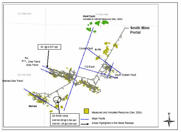
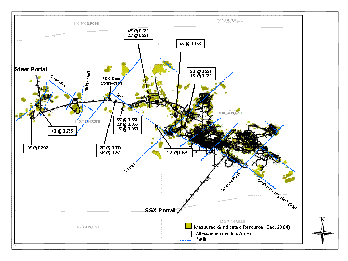
Denver, Colorado – January 25, 2006 – Queenstake Resources Ltd. (TSX:QRL, AMEX:QEE) continued to intercept high grade gold mineralization in its recent near-mine drilling, extending the Mahala deposit at the Smith Mine in and around an access ramp for underground mining. In addition, encouraging drilling results at the drift connecting the SSX and Steer mines has expanded the mineralization in this new prospective area. Drilling results from the SSX-Steer connection included one drill hole intercepting 65 feet of 0.677 ounce of gold per ton (opt) or 19.8 meters of 23 grams per tonne (gpt).
Underground drilling in other zones of the recently connected SSX and Steer mines identified additional mineralization. Underground reverse circulation(1) and core(1) drilling was part of the near-mine exploration program(2) conducted at the Smith, SSX and Steer mines from September 2005 through early January 2006.
Commenting on the exploration results, President and Chief Executive Officer Dorian L. (Dusty) Nicol said, “The positive results from the Mahala deposit at the Smith Mine have expanded the mineralization, especially around the access ramp at Mahala, potentially allowing easier recovery of the mineralization. Pending incorporation of these results into a new mine model, the results reinforce the potential to extend the mine life at Smith beyond 2008. Turning to the SSX-Steer connection, this is exciting new ground for further drilling this year and we have ordered a second drill for the SSX-Steer complex to enable us to accelerate this program.”
All results highlighted in this news release are outside of the year-end 2004 resource boundary and represent extensions of mineralization, which could add to reserves and resources(3). The results will be incorporated in new mine models that will be used in the estimation of reserves and resources for year-end 2005.
The Mahala results were from 76 reverse circulation and core holes totaling 17,005 feet or 5,183 meters completed. The Mahala deposit, part of the Smith Mine, commenced commercial production in August 2005. At the 6630 Ramp at Mahala, three reverse circulation holes had intercepts of 55 feet of 0.354 opt (16.8 meters of 12 gpt), 35 feet of 0.264 opt (10.7 meters of 9 gpt) and 10 feet of 0.351 opt (3.1 meters of 12 gpt), respectively.
The prospective target in Zone 2 at the Smith Mine is in mineralization associated with two parallel dikes. This target remains open to the west. Follow up drilling to expand the mineralization at Mahala and along Zone 2 to the west is underway in 2006. The following table shows drill intercepts at the Smith Mine of 10 feet or more at a grade of 0.25 opt or higher (>3 meters of approximately 9 gpt or better). The dike trends and Mahala ramps are shown in Map 1 in the Appendix.
5
Table 1: Smith Mine-Mahala Deposit Results Highlights(4), (5)
Hole # |
| From |
| To |
| Length |
| Grade |
| Drill Type |
|
|
|
|
|
|
|
|
|
|
|
| |
C40173 |
| 45 |
| 90 |
| 45 |
| 0.279 |
| RC |
|
C40168 |
| 0 |
| 25 |
| 25 |
| 0.301 |
| RC |
|
and |
| 50 |
| 105 |
| 55 |
| 0.354 |
|
|
|
C40169 |
| 5 |
| 40 |
| 35 |
| 0.264 |
| RC |
|
C40165 |
| 40 |
| 60 |
| 20 |
| 0.292 |
| RC |
|
C40175 |
| 20 |
| 45 |
| 25 |
| 0.292 |
| RC |
|
C40184 |
| 0 |
| 15 |
| 15 |
| 0.292 |
| RC |
|
C40218 |
| 240 |
| 250 |
| 10 |
| 0.351 |
| RC |
|
Zone 4 - 6760 |
|
|
|
|
|
|
|
|
|
|
|
C40221 |
| 0 |
| 20 |
| 20 |
| 0.290 |
| RC |
|
C40228 |
| 110 |
| 130 |
| 20 |
| 0.298 |
| RC |
|
C40230 |
| 10 |
| 30 |
| 20 |
| 0.342 |
| RC |
|
C40234 |
| 95 |
| 105 |
| 10 |
| 0.526 |
| RC |
|
C40249 |
| 105 |
| 125 |
| 20 |
| 0.265 |
| RC |
|
C40279 |
| 170 |
| 180 |
| 10 |
| 0.320 |
| RC |
|
C40283 |
| 70 |
| 85 |
| 15 |
| 0.430 |
| RC |
|
R4 and R11 Dike Trends |
|
|
|
|
|
|
|
|
|
|
|
LX-619 |
| 0 |
| 15 |
| 15 |
| 0.311 |
| Core |
|
LX-620 |
| 0 |
| 20 |
| 20 |
| 0.325 |
| Core |
|
LX-623 |
| 155 |
| 185 |
| 30 |
| 0.537 |
| Core |
|
At the SSX-Steer complex, 242 reverse circulation and core holes totaling 24,420 feet or 7,443 meters were completed. Three reverse circulation holes in Zone 5 of the SSX-Steer drift connection encountered high-grade mineralized intervals of 65 feet of 0.677 opt (19.8 meters of 23) as mentioned on page one, 45 feet of 0.368 opt (13.7 meters of 13 gpt) and 10 feet of 0.559 opt (3.1 meters of 19 gpt), respectively. Other highlighted results from SSX and Steer are shown in Map 2 in the Appendix. All of these areas will be followed up with further drilling in 2006. The following table shows drill intercepts from the SSX and Steer mines of 10 feet or more at a grade of 0.25 opt or higher (>3.1 meters of 9 gpt or better).
Table 2: SSX-Steer Complex Results Highlights(4), (5)
Hole # |
| From |
| To |
| Length |
| Grade |
| Drill Type |
|
Zone 1 (SSX) |
|
|
|
|
|
|
|
|
|
|
|
Z13277 |
| 20 |
| 110 |
| 90 |
| 0.349 |
| RC |
|
and |
| 115 |
| 180 |
| 65 |
| 0.598 |
|
|
|
and |
| 195 |
| 205 |
| 10 |
| 0.332 |
|
|
|
Z13287 |
| 210 |
| 235 |
| 25 |
| 0.864 |
| RC |
|
Z13288 |
| 50 |
| 70 |
| 20 |
| 0.443 |
| RC |
|
Z13289 |
| 35 |
| 55 |
| 20 |
| 0.360 |
| RC |
|
Z13290 |
| 50 |
| 65 |
| 15 |
| 0.419 |
| RC |
|
6
Hole # |
| From |
| To |
| Length |
| Grade |
| Drill Type |
|
Zone 2 (SSX) |
|
|
|
|
|
|
|
|
|
|
|
Z23305 |
| 0 |
| 25 |
| 25 |
| 0.412 |
| RC |
|
Z23313 |
| 30 |
| 40 |
| 10 |
| 0.352 |
| RC |
|
Z23314 |
| 0 |
| 35 |
| 35 |
| 0.272 |
| RC |
|
Z23323 |
| 0 |
| 15 |
| 15 |
| 0.288 |
| RC |
|
and |
| 55 |
| 70 |
| 15 |
| 0.698 |
|
|
|
Z23342 |
| 0 |
| 15 |
| 15 |
| 0.607 |
| RC |
|
Z23343 |
| 0 |
| 10 |
| 10 |
| 0.318 |
| RC |
|
Z23346 |
| 0 |
| 45 |
| 45 |
| 0.307 |
| RC |
|
with |
| 35 |
| 45 |
| 10 |
| 0.508 |
|
|
|
Z23350 |
| 0 |
| 30 |
| 30 |
| 0.476 |
| RC |
|
with |
| 10 |
| 20 |
| 20 |
| 0.616 |
|
|
|
Z23356 |
| 0 |
| 15 |
| 15 |
| 0.259 |
| RC |
|
Zone 4 (SSX) |
|
|
|
|
|
|
|
|
|
|
|
Z41062 |
| 10 |
| 35 |
| 25 |
| 0.273 |
| RC |
|
Z41066 |
| 30 |
| 40 |
| 10 |
| 0.248 |
| RC |
|
Z41069 |
| 20 |
| 40 |
| 20 |
| 0.511 |
| RC |
|
Z41070 |
| 10 |
| 45 |
| 35 |
| 0.457 |
| RC |
|
Z41073 |
| 5 |
| 20 |
| 15 |
| 0.275 |
| RC |
|
Z41083 |
| 35 |
| 80 |
| 45 |
| 0.586 |
| RC |
|
Z41085 |
| 0 |
| 15 |
| 15 |
| 0.532 |
| RC |
|
Z41086 |
| 0 |
| 30 |
| 30 |
| 0.462 |
| RC |
|
Z41089 |
| 0 |
| 75 |
| 75 |
| 0.286 |
| RC |
|
Z41093 |
| 0 |
| 15 |
| 15 |
| 0.253 |
| RC |
|
Z41094 |
| 0 |
| 30 |
| 30 |
| 0.234 |
| RC |
|
and |
| 55 |
| 65 |
| 10 |
| 0.475 |
|
|
|
Z41097 |
| 0 |
| 30 |
| 30 |
| 0.285 |
| RC |
|
Z41103 |
| 35 |
| 55 |
| 20 |
| 0.323 |
| RC |
|
Z41115 |
| 20 |
| 50 |
| 30 |
| 0.252 |
| RC |
|
Z41122 |
| 85 |
| 95 |
| 10 |
| 0.318 |
| RC |
|
Z41125 |
| 25 |
| 45 |
| 20 |
| 0.425 |
| RC |
|
Z41131 |
| 5 |
| 25 |
| 20 |
| 0.356 |
| RC |
|
Z41132 |
| 10 |
| 45 |
| 35 |
| 0.438 |
| RC |
|
Z41139 |
| 0 |
| 20 |
| 20 |
| 0.305 |
| RC |
|
Z41148 |
| 100 |
| 110 |
| 10 |
| 0.432 |
| RC |
|
Z41153 |
| 90 |
| 100 |
| 10 |
| 0.417 |
| RC |
|
and |
| 120 |
| 130 |
| 10 |
| 0.587 |
|
|
|
Z41163 |
| 0 |
| 15 |
| 15 |
| 0.292 |
| RC |
|
7
Hole # |
| From |
| To |
| Length |
| Grade |
| Drill Type |
|
Zone 5 (SSX-Steer connection) |
|
|
|
|
|
|
|
|
|
|
|
Z50544 |
| 110 |
| 130 |
| 20 |
| 0.291 |
| RC |
|
Z50550 |
| 105 |
| 115 |
| 10 |
| 0.559 |
| RC |
|
and |
| 125 |
| 170 |
| 45 |
| 0.232 |
|
|
|
Z50561 |
| 0 |
| 20 |
| 20 |
| 0.255 |
| RC |
|
Z50563 |
| 0 |
| 10 |
| 10 |
| 0.252 |
| RC |
|
Z50564 |
| 0 |
| 45 |
| 45 |
| 0.368 |
| RC |
|
Z50565 |
| 0 |
| 10 |
| 10 |
| 0.318 |
| RC |
|
Z50567 |
| 35 |
| 45 |
| 10 |
| 0.375 |
| RC |
|
Z50592 |
| 70 |
| 95 |
| 25 |
| 0.399 |
| RC |
|
Z50593 |
| 70 |
| 135 |
| 65 |
| 0.677 |
| RC |
|
Z50601 |
| 125 |
| 135 |
| 10 |
| 0.439 |
| RC |
|
Z50612 |
| 250 |
| 270 |
| 20 |
| 0.339 |
| RC |
|
Z50618 |
| 50 |
| 65 |
| 15 |
| 0.950 |
| RC |
|
Z50622 |
| 60 |
| 70 |
| 10 |
| 0.389 |
| RC |
|
and |
| 185 |
| 205 |
| 20 |
| 0.866 |
|
|
|
SX-980 |
| 433 |
| 455 |
| 22 |
| 0.639 |
| Core |
|
Zone 6 (SSX) |
|
|
|
|
|
|
|
|
|
|
|
Z60343 |
| 10 |
| 25 |
| 15 |
| 0.295 |
| RC |
|
Z60344 |
| 0 |
| 35 |
| 35 |
| 0.259 |
| RC |
|
Zone 7 (Steer) |
|
|
|
|
|
|
|
|
|
|
|
X70006 |
| 50 |
| 60 |
| 10 |
| 0.302 |
| RC |
|
X70015 |
| 25 |
| 50 |
| 25 |
| 0.345 |
| RC |
|
X70016 |
| 18.5 |
| 6.5 |
| 25 |
| 0.392 |
| RC |
|
X70033 |
| 10 |
| 25 |
| 15 |
| 0.389 |
| RC |
|
X70034 |
| 0 |
| 10 |
| 10 |
| 0.495 |
| RC |
|
Queenstake Resources Ltd. is a gold mining and exploration company based in Denver, Colorado. Its principal asset is the wholly owned Jerritt Canyon mining district in Nevada. Jerritt Canyon has produced over seven million ounces of gold since 1981. Current production at the property is from underground mines. The Jerritt Canyon district comprises over 100 square miles of geologically prospective ground and represents one of the largest contiguous exploration properties in Nevada.
# # #
Notes:
(1) Underground drilling uses either core or reverse circulation (RC) methods for near-mine exploration programs at Jerritt Canyon. Reverse circulation drilling has demonstrated accuracy in ore control definition drilling and for resource conversion at Jerritt Canyon’s mines. However, reverse circulation drilling can result in a lower degree of confidence and less geologic information than core drilling.
(2) A complete data set, from which the drill results highlighted in this news release were derived, is available as an Appendix to this news release under the Investor Information/News section on the Company’s website, www.queenstake.com.
(3) “Resources” or “resource” used in this news release are as defined in National Instrument 43-101 of the Canadian Securities Administrators and are not terms recognized or defined by the U.S. Securities and Exchange Commission (SEC). Mineral resources are not reserves and do not have demonstrated economic viability. For further information,
8
please refer to the risk factors and definitions of reserves and resources in the Company’s filings on SEDAR and with the SEC on the Company’s website, www.queenstake.com. The Qualified Person for the technical information contained in this news release is Mr. Dorian L. (Dusty) Nicol, President and Chief Executive Officer of Queenstake.
(4) Results presented in this news release were analyzed using standard fire assay techniques at the Company’s Jerritt Canyon laboratory. Intercepts are reported as drilled and are not necessarily “true widths,” which have not yet been calculated.
(5) A description of the geology, sampling procedures and the Company’s laboratory Quality Assurance/Quality Control procedures are described in the Company’s National Instrument 43-101 Technical Report filed on Sedar on February 23, 2005. This report is available under Investor Information/Financial Information/Sedar Filings at www.queenstake.com.
For further information call:
Wendy Yang, 303-297-1557 ext. 105
800-276-6070
Email – info@queenstake.com Web – www.queenstake.com
Cautionary Statement – This news release contains “Forward-Looking Statements” within the meaning of applicable Canadian securities regulations and Section 21E of the United States Securities Exchange Act of 1934, as amended and the Private Securities Litigation Reform Act of 1995. All statements, other than statements of historical fact, included in this release, and Queenstake’s future plans are forward-looking statements that involve various risks and uncertainties. Such forward-looking statements include, without limitation, (i) estimates and projections of reserves and resources, (ii) estimates and opinions regarding geologic and mineralization interpretation and (iii) estimates of exploration investment and scope of exploration programs. There can be no assurance that such statements will prove to be accurate, and actual results and future events could differ materially from those anticipated in such statements, in particular the estimates do not include input cost increases that could occur in future. Forward-looking statements are based on the estimates and opinions of management on the date the statements are made, and Queenstake does not undertake any obligation to update forward-looking statements should conditions or management’s estimates or opinions change. Forward-looking statements are subject to risks, uncertainties and other factors, including gold and other commodity price volatility, political and operational risks, which are described in the Company’s 2004 Annual Information Form filed on SEDAR and 2004 Annual Report on Form 40-F on file with the Securities and Exchange Commission as well as the Company’s other regulatory filings.
9
APPENDIX
Map 1: Smith Mine – Mahala Deposit
10
Map 2: Steer-SSX Complex
11