Exhibit 99.1
RENEWAL ANNUAL INFORMATION FORM
FOR THE FINANCIAL YEAR ENDED DECEMBER 31, 2005
March 20, 2006
Suite 1560, 200 Burrard Street
Vancouver, BC V6C 3L6
GOLDCORP INC.
RENEWAL ANNUAL INFORMATION FORM
FOR THE FINANCIAL YEAR ENDED DECEMBER 31, 2005
TABLE OF CONTENTS
| | | | | |
| DESCRIPTION | | PAGE NO. | |
| | | 1 | |
| | | 3 | |
| | | 5 | |
| | | 9 | |
| | | 9 | |
| | | 9 | |
| | | 9 | |
| | | 10 | |
| | | 10 | |
| | | 20 | |
| | | 26 | |
| | | 37 | |
| | | 48 | |
| | | 64 | |
| | | 71 | |
| | | 74 | |
| | | 86 | |
| | | 100 | |
| | | 100 | |
| | | 101 | |
| | | 106 | |
| | | 110 | |
| | | 111 | |
| | | 111 | |
| | | 111 | |
| | | 113 | |
| | | 114 | |
| | | | | |
| | | | |
INTRODUCTORY NOTES
Cautionary Note Regarding Forward-Looking Statements
This annual information form contains “forward-looking statements” within the meaning of the United States Private Securities Litigation Reform Act of 1995 and applicable Canadian securities legislation. Forward-looking statements include, but are not limited to, statements with respect to the future price of gold, silver and copper, the estimation of mineral reserves and resources, the realization of mineral reserve estimates, the timing and amount of estimated future production, costs of production, capital expenditures, costs and timing of the development of new deposits, success of exploration activities, permitting time lines, currency exchange rate fluctuations, requirements for additional capital, government regulation of mining operations, environmental risks, unanticipated reclamation expenses, title disputes or claims and limitations on insurance coverage. Generally, these forward-looking statements can be identified by the use of forward-looking terminology such as “plans”, “expects” or “does not expect”, “is expected”, “budget”, “scheduled”, “estimates”, “forecasts”, “intends”, “anticipates” or “does not anticipate”, or “believes”, or variations of such words and phrases or state that certain actions, events or results “may”, “could”, “would”, “might” or “will be taken”, “occur” or “be achieved”. Forward-looking statements are subject to known and unknown risks, uncertainties and other factors that may cause the actual results, level of activity, performance or achievements of Goldcorp Inc. (“Goldcorp”) to be materially different from those expressed or implied by such forward-looking statements, including but not limited to: risks related to the integration of acquisitions; risks related to international operations; risks related to joint venture operations; actual results of current exploration activities; actual results of current reclamation activities; conclusions of economic evaluations; changes in project parameters as plans continue to be refined; future prices of gold, silver and copper; possible variations in ore reserves, grade or recovery rates; failure of plant, equipment or processes to operate as anticipated; accidents, labour disputes and other risks of the mining industry; delays in obtaining governmental approvals or financing or in the completion of development or construction activities, as well as those factors discussed in the section entitled “Description of the Business — Risk Factors” in this annual information form. Although Goldcorp has attempted to identify important factors that could cause actual results to differ materially from those contained in forward-looking statements, there may be other factors that cause results not to be as anticipated, estimated or intended. There can be no assurance that such statements will prove to be accurate, as actual results and future events could differ materially from those anticipated in such statements. Accordingly, readers should not place undue reliance on forward-looking statements. Goldcorp does not undertake to update any forward-looking statements that are incorporated by reference herein, except in accordance with applicable securities laws.
Currency Presentation and Exchange Rate Information
This annual information form contains references to United States dollars and Canadian dollars. All dollar amounts referenced, unless otherwise indicated, are expressed in United States dollars and Canadian dollars are referred to as “Canadian dollars” or “C$”.
The high, low, average and closing exchange rates for Canadian dollars in terms of the United States dollar for each of the three years ended December 31, 2005, as quoted by the Bank of Canada, were as follows:
| | | | | | | | | | | | | |
| | | Year ended December 31 |
| | | 2005 | | 2004 | | 2003 |
| High | | | C$1.2841 | | | | C$1.3968 | | | | C$1.5747 | |
| Low | | | 1.1507 | | | | 1.1774 | | | | 1.2924 | |
Average(1) | | | 1.2118 | | | | 1.3018 | | | | 1.4015 | |
| Closing | | | 1.1659 | | | | 1.2036 | | | | 1.2924 | |
| | |
| (1) | | Calculated as an average of the daily noon rates for each period. |
On March 17, 2006, the closing exchange rate for Canadian dollars in terms of the United States dollar, as quoted by the Bank of Canada, was US$1.00 = C$1.1589.
Gold, Silver and Copper Prices
Gold Prices
The high, low, average and closing afternoon fixing gold prices in United States dollars per troy ounce for each of the three years ended December 31, 2005, as quoted on the London Bullion Market, were as follows:
| | | | | | | | | | | | | |
| | | Year ended December 31 |
| | | 2005 | | 2004 | | 2003 |
| High | | $ | 536 | | | $ | 454 | | | $ | 416 | |
| Low | | | 411 | | | | 375 | | | | 320 | |
| Average | | | 444 | | | | 410 | | | | 363 | |
| Closing | | | 513 | | | | 436 | | | | 416 | |
On March 17, 2006, the closing afternoon fixing gold price in United States dollars per troy ounce, as quoted on the London Bullion Market, was $553.
Silver Prices
The high, low, average and closing afternoon fixing silver prices in United States dollars per troy ounce for each of the three years ended December 31, 2005, as quoted on the London Bullion Market, were as follows:
| | | | | | | | | | | | | |
| | | Year ended December 31 |
| | | 2005 | | 2004 | | 2003 |
| High | | $ | 9.23 | | | $ | 8.29 | | | $ | 5.97 | |
| Low | | | 6.39 | | | | 5.50 | | | | 4.37 | |
| Average | | | 7.31 | | | | 6.67 | | | | 4.88 | |
| Closing | | | 8.83 | | | | 6.82 | | | | 5.97 | |
On March 17, 2006, the closing afternoon fixing silver price in United States dollars per troy ounce, as quoted on the London Bullion Market, was $10.37.
Copper Prices
The high, low, average and closing afternoon fixing copper prices in United States dollars per pound for each of the three years ended December 31, 2005, as quoted on the London Metal Exchange, were as follows:
| | | | | | | | | | | | | |
| | | Year ended December 31 |
| | | 2005 | | 2004 | | 2003 |
| High | | $ | 2.11 | | | $ | 1.49 | | | $ | 1.05 | |
| Low | | | 1.39 | | | | 1.13 | | | | 0.70 | |
| Average | | | 1.67 | | | | 1.30 | | | | 0.81 | |
| Closing | | | 2.08 | | | | 1.49 | | | | 1.05 | |
On March 17, 2006, the closing afternoon fixing copper price in United States dollars per pound, as quoted on the London Metal Exchange, was $2.35.
-2-
CORPORATE STRUCTURE
Goldcorp Inc. (“Goldcorp” or the “Corporation”) is a corporation governed by theBusiness Corporations Act(Ontario) (the “OBCA”). Effective November 1, 2000, the Corporation amalgamated with CSA Management Inc. (“CSA”) pursuant to a statutory plan of arrangement (the “CSA Arrangement”) under the OBCA. Prior to the CSA Arrangement, Goldcorp was the continuing corporation formed on March 31, 1994 by the amalgamation of a predecessor corporation of Goldcorp, Dickenson Mines Limited and CSA Management Limited pursuant to a statutory plan of arrangement under the OBCA.
Pursuant to Articles of Amendment dated May 10, 2002, the authorized capital of the Corporation was altered by subdividing all of the then issued and outstanding common shares of the Corporation on the basis of two new common shares for one then existing common share (the “Subdivision”). All references to Common Shares in this annual information form are to post-Subdivision shares.
The Corporation’s head office is located at Suite 1560, Waterfront Centre, 200 Burrard Street, Vancouver, British Columbia, V6C 3L6 and its registered office is located at Suite 2100, 40 King Street West, Toronto, Ontario, M5H 3C2.
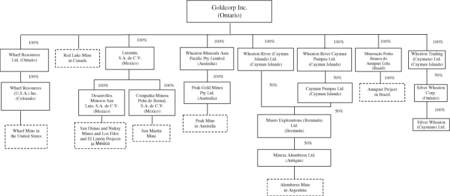
The following chart illustrates the Corporation’s principal subsidiaries (collectively, the “Subsidiaries”), together with the governing law of each company and the percentage of voting securities beneficially owned or over which control or direction is exercised by the Corporation. As used in this annual information form, except as otherwise required by the context, reference to the “Corporation” or “Goldcorp” means, collectively, Goldcorp Inc. and the Subsidiaries.
-3-
GENERAL DEVELOPMENT OF THE BUSINESS
Goldcorp is engaged in the acquisition, exploration, development and operation of precious metal properties. The principal products and sources of cash flow for Goldcorp are derived from the sale of gold, silver and copper. Goldcorp’s primary operating properties consist of one of the highest-grade gold deposits in the world, the Red Lake mine (the “Red Lake Mine”) in Ontario, Canada, a 37.5% interest in the Bajo de la Alumbrera gold-copper mine (the “Alumbrera Mine”) in Argentina, a 100% interest in each of the San Dimas gold-silver mine (the “San Dimas Mine”), the San Martin gold-silver mine (the “San Martin Mine”) and the Nukay gold-silver mine (the “Nukay Mine”) in Mexico, and a 100% interest in the Peak gold mine (the “Peak Mine”) in Australia. Goldcorp also has 100% interests in the Los Filos gold development stage project (the “Los Filos Project”) in Mexico and the Amapari gold project (the “Amapari Project”) in Brazil. The Corporation also produces gold at the Wharf mine (the “Wharf Mine”) in the historic lead mining area in the Black Hills of South Dakota in the United States.
Goldcorp also owns approximately 59% of TSX-listed Silver Wheaton Corp. (“Silver Wheaton”), a mining company with 100% of its revenue from silver production.
Barrick-Placer Dome Transaction
On October 31, 2005, Goldcorp announced that it had entered into an agreement with Barrick Gold Corporation (“Barrick”) to acquire certain mining assets and interests of Placer Dome Inc. (“Placer Dome”) in the event that Barrick is successful in its bid to acquire Placer Dome. The Placer Dome assets to be acquired (collectively, the “Placer Dome Assets”) include the Campbell Mine in Ontario and the Porcupine and Musselwhite joint ventures in Ontario, Placer Dome’s Canadian exploration properties, 100% of Placer Dome’s 50% interest in the La Coipa gold-silver mine in Chile, and a 40% interest in the Pueblo Viejo development project in the Dominican Republic. The consummation of this transaction would increase Goldcorp’s annual gold production by approximately 50% to more than 2 million ounces at a total cash cost of less than $150 per ounce. Proven and probable gold reserves would increase by approximately 72%.
On December 22, 2005, Goldcorp confirmed its previous agreement to acquire the Placer Dome Assets from Barrick upon successful completion of the proposed Barrick-Placer Dome transaction. The purchase price payable by Goldcorp will be $1.485 billion in cash. In order to fund the proposed acquisition of the Placer Dome Assets, Goldcorp intends to use a portion of its current cash balances and existing credit facilities of over $1.4 billion. Closing of the acquisition is subject to execution of certain definitive agreements and receipt of all regulatory approvals and third-party consents. Goldcorp anticipates that it will acquire the Placer Dome Assets from Barrick in April 2006.
Virginia Transaction
Goldcorp has entered into an agreement with Virginia Gold Mines Inc. (“Virginia”) to acquire Virginia’s Éléonore gold project in James Bay, Québec pursuant to a plan of arrangement. Goldcorp will issue approximately 19.6 million Common Shares to complete the transaction. Closing of the transaction is subject to execution of definitive agreements, approval by Virginia shareholders, court approval and receipt of all regulatory approvals. Goldcorp anticipates that the transaction will close during April 2006.
Glencore Transaction
On February 23, 2006, Silver Wheaton announced that it had agreed to purchase 4.75 million ounces of silver per year, for a period of 20 years, from Glencore International AG (“Glencore”), equivalent to the production from Glencore’s Yauliyacu mining operations in Perú. Silver Wheaton will pay an upfront payment of $285 million, comprised of $245 million in cash and a $40 million promissory note, and $3.90 per ounce of silver delivered under the contract (subject to an inflationary adjustment after three years).
Yauliyacu is a low-cost silver/lead/zinc mine located in central Perú which has been in continuous operation for more than 100 years and is expected to produce an average of 6 million ounces of silver per year during the term of the contract. In the event that silver produced at Yauliyacu in any year totals less than 4.75
-5-
million ounces, the amount sold to Silver Wheaton in subsequent years will be increased to make up for the shortfall, so long as production allows.
During the term of the contract, Silver Wheaton will have a right of first refusal on any future sales of silver streams from the Yauliyacu mine and a right of first offer on future sales of silver from any other mine currently owned by Glencore. In addition, Silver Wheaton will also have an option to extend the 20 year term of the silver purchase agreement in five year increments, on substantially the same terms as the existing agreement, subject to an adjustment related to silver price expectations at the time and other factors. Closing of the transaction is subject to execution of definitive agreements and receipt of all regulatory approvals and third-party consents.
Wheaton Transaction
On April 15, 2005, Goldcorp completed its merger (the “Wheaton Merger”) with Wheaton River Minerals Ltd. (“Wheaton”) pursuant to which it issued approximately 143.1 million Common Shares. In connection with the Wheaton Merger, effective February 24, 2005 and March 17, 2005, respectively, Ian Telfer, the former Chairman and Chief Executive Officer of Wheaton, was appointed Chief Executive Officer, President and a director of Goldcorp, effective February 24, 2005, Robert McEwen, the former Chairman and Chief Executive Officer of Goldcorp, was appointed as the non-executive Chairman of Goldcorp (Mr. McEwen subsequently resigned on October 29, 2005), and, effective February 24, 2005, the board of directors of Goldcorp was expanded and reconstituted to comprise ten members, five of which were directors of Goldcorp (Robert R. McEwen, David R. Beatty, Brian W. Jones, Dr. Donald R.M. Quick and Michael L. Stein) and five of which were directors of Wheaton (Ian W. Telfer, John P. Bell, Lawrence I. Bell, Douglas Holtby and Antonio Madero). The Corporation’s business acquisition report dated and filed on April 5, 2005 relating to the Wheaton Merger is incorporated by reference in this annual information form and a copy of such business acquisition report is available under the Corporations’s profile atwww.sedar.com.
Bermejal Gold Deposit
On March 31, 2005, Luismin, a wholly-owned subsidiary of Wheaton, acquired the Bermejal gold deposit located in Mexico from Minera El Bermejal, S. de R.L. de C.V., a joint venture of Industrias Peñoles S.A. de C.V. and Newmont Mining Corporation, for cash consideration of $70 million. Studies were conducted in 2005 to combine the Los Filos and Bermejal deposits and fully optimize the potential economies of scale. As a result, it is anticipated that a feasibility study combining the two deposits will be completed in March 2006.
A former 8.5 kilometre dirt road leading to Los Filos and Bermejal was broadened and paved as part of the Los Filos project scope and it is fully operational. Construction is underway on some of the primary infrastructure, such as offices, maintenance shops, warehouse and core storage facilities, and such will be utilized in the mining of the combined deposits. Metallurgical testing for Bermejal, together with geotechnical testing and design and permitting work for the revised and now centrally located heap leach pad, has been completed. Commercial production is now projected to commence at the end of the first quarter of 2007.
Silver Wheaton Transaction
On October 15, 2004, Wheaton entered into a silver purchase agreement (the “Silver Purchase Agreement”) with Chap Mercantile Inc. (since renamed Silver Wheaton), Luismin, Silver Wheaton (Caymans) Ltd. (“Silver Wheaton Caymans”), a wholly-owned subsidiary of Silver Wheaton, and Wheaton Trading (Caymans) Ltd. (“Wheaton Trading”), a wholly-owned subsidiary of Wheaton, pursuant to which Silver Wheaton agreed to purchase 100% of the silver produced by Luismin from its Mexican mining operations which include the Tayoltita, Santa Rita and Central Block mines in the San Dimas district, the San Martin Mine, the San Pedrito project, the Nukay Mine and the Los Filos Project (the “Luismin Mines”) for an upfront payment of C$46 million in cash and 108 million common shares of Silver Wheaton, plus a payment equal to the lesser of (a) $3.90 per ounce of delivered refined silver (subject to an inflationary price adjustment after October 15, 2007); and (b) the then prevailing market price per ounce of silver (the “Silver Wheaton Transaction”).
-6-
Wheaton Trading has agreed to sell to Silver Wheaton Caymans a minimum of 120 million ounces of silver (the “Luismin Minimum Amount”) within a period of 25 years following the closing of the Silver Wheaton Transaction (the “Luismin Guarantee Period”). If at the end of the Luismin Guarantee Period, the total number of ounces of silver sold by Wheaton Trading to Silver Wheaton Caymans is less than the Luismin Minimum Amount, Wheaton Trading will be required to pay a penalty to Silver Wheaton Caymans equal to the Luismin Minimum Amount less the number of ounces of silver actually sold during the Luismin Guarantee Period, multiplied by $0.50. Further, Silver Wheaton is obligated to pay 50% of any capital expenditures made by Luismin at its mining operations in excess of 110% of the projected capital expenditures outlined in the agreement.
As a result of the Silver Wheaton Transaction, Wheaton became an indirect holder of 108 million common shares of Silver Wheaton. Goldcorp currently owns approximately 59% of the outstanding common shares of Silver Wheaton. Goldcorp has a pre-emptive right until October 15, 2007, whereby so long as Goldcorp owns, directly or indirectly, at least 20% of the outstanding Silver Wheaton common shares, it has the right to maintain its pro-rata interest in Silver Wheaton should Silver Wheaton issue or sell any common shares or securities convertible into or exercisable or exchangeable for common shares pursuant to an equity financing or an acquisition, merger, corporate reorganization or similar transaction for the fair market value of the equity securities issued pursuant to the financing or other transaction.
In connection with the Silver Wheaton Transaction, Wheaton entered into an administration and management services agreement (the “Silver Wheaton Services Agreement”) with Silver Wheaton whereby Silver Wheaton has agreed to pay a monthly fee to Wheaton for use of a portion of its office facilities and the services of its personnel. In connection with the Wheaton Transaction (see “Wheaton Transaction” below), Goldcorp has assumed Wheaton’s responsibilities under the Silver Wheaton Services Agreement. Also in connection with the Silver Wheaton Transaction, Ian Telfer, President and Chief Executive Officer of Goldcorp, was appointed as a director of Silver Wheaton, Eduardo Luna, Executive Vice-President of Goldcorp and President of Luismin, was appointed as Chairman, Interim Chief Executive Officer and a director of Silver Wheaton, and Peter Barnes, Executive Vice-President and Chief Financial Officer of Goldcorp, was appointed as Executive Vice-President and Chief Financial Officer of Silver Wheaton.
Amendment to the Silver Purchase Agreement
On February 13, 2006, Goldcorp and Silver Wheaton, currently a 59%-owned subsidiary of Goldcorp, announced that they have agreed to amend the Silver Purchase Agreement in connection with an increase in Goldcorp’s investment in exploration and development at the San Dimas Mine in order to increase ore production (gold and silver) at the mine by approximately 35% by 2009.
Goldcorp and Silver Wheaton have agreed to amend the existing agreement, increasing the Luismin Minimum Amount by 100 million ounces, to 220 million ounces, and waiving any capital expenditure contributions previously required to be paid by Silver Wheaton. In consideration for these amendments, Silver Wheaton will issue to Goldcorp 18 million common shares, representing approximately 9.8% of the outstanding shares of Silver Wheaton, and a $20 million promissory note, increasing Goldcorp’s ownership to approximately 62%, or 126 million common shares of Silver Wheaton. Closing of the transaction is conditional upon completion of definitive documentation and receipt of all requisite regulatory approvals, including the approval of the TSX. Goldcorp anticipates that the transaction will close in March 2006.
For further information regarding Silver Wheaton, see Silver Wheaton’s annual information form dated March 16, 2006 to be filed under Silver Wheaton’s profile atwww.sedar.com.
Acquisition of Amapari Project
In January 2004, Wheaton completed the acquisition of the Amapari Project in Brazil by acquiring all of the outstanding shares of EBX Gold Ltd., the owner of the Amapari Project, for $25 million in cash, 33 million common shares of Wheaton and 21,516,000 Series “B” common share purchase warrants of Wheaton (now, Goldcorp Series “B” common share purchase warrants, each entitling the holder to purchase 0.25 of a Common Share for C$3.10 until August 25, 2008).
-7-
Since this acquisition, Wheaton has conducted a successful infill and step-out drilling program. Studies have demonstrated that open pit mining of a portion of the sulphide reserves is feasible, and the consequent decrease in operating costs per tonne has resulted in a significant amount of lower grade material becoming economically mineable. During 2005, the Life of Mine plan was updated incorporating revised cost estimates and exchange rates. Recent significant price rises in major consumerables (oil, truck tires, steel, cyanide and lime) as well as the 32% appreciation of the Real against the United States dollar since construction commenced has lead to a revision of the operating costs. Gold production commenced in the third quarter of 2005 with the pouring of the first gold on September 23, 2005. A total of 24,715 ounces of gold was poured in 2005.
Acquisition of Los Filos Project, Nukay Mine and Interest in El Limón Gold Deposit
In September 2003, Wheaton entered into agreements with Teck Cominco Limited (“Teck Cominco”) and Miranda Mining Corporation (“Miranda”) to acquire a 100% interest in the Los Filos Project, a 100% interest in the Nukay Mine and a 21.2% interest (of which 14% is a carried interest) in the El Limón gold deposit, each located in Guerrero State, Mexico, for $87 million in cash. On November 3, 2003, Wheaton acquired a 30% interest in the Los Filos Project, a 100% interest in the Nukay Mine and a 21.2% interest in the El Limón gold deposit as a result of its acquisition of all of the outstanding shares of Miranda for $38.6 million. Wheaton acquired the remaining 70% interest in the Los Filos Project from Teck Cominco for $48.4 million.
Metallurgical testing at the Los Filos Project during 2004 has shown that a large amount of lower grade material previously defined as uneconomic can be profitably run-of-mine leached. Since acquisition, drilling and metallurgical improvements have increased the global measured and indicated mineral resource ounces at Los Filos by 41%. Environmental activities are well advanced, environmental permits required for development of infrastructure and development of Los Filos were obtained in November 2004 and May 2005, respectively, and environmental permits for Bermejal were obtained in January 2006. In May 2005, the standalone Los Filos feasibility study was completed, however, as a result of the acquisition of the Bermejal gold deposit, new studies were performed, focusing on the integration of the two deposits. It is anticipated that the new feasibility study will be completed in March 2006, with production projected to commence in the first quarter of 2007.
An extensive drilling program at both Los Filos and Bermejal deposits was carried out to confirm existing data and explore further potential. Exploration of regional targets continues.
Acquisition of Alumbrera and Peak Mines
In January 2003, Wheaton entered into a letter of intent with Rio Tinto Limited, a subsidiary of Rio Tinto plc (“RTP”), pursuant to which Wheaton agreed to acquire an indirect 25% interest in the Alumbrera Mine and a 100% interest in the Peak Mine for an aggregate purchase price of $210 million. In February 2003, Wheaton raised C$333.5 million pursuant to a private placement, issuing 230 million common shares of Wheaton and 57.5 million Series “A” common share purchase warrants of Wheaton (now, Goldcorp Series “A” common share purchase warrants, each entitling the holder to purchase 0.25 of one Common Share for C$1.65 until May 30, 2007. In March 2003, the net proceeds from this financing were used to fund the purchase price for the acquisition of Wheaton’s 25% interest in the Alumbrera Mine and 100% of the Peak Mine. The acquisition of the 25% interest in the Alumbrera Mine was effected through the acquisition of a 50% interest in Musto Explorations (Bermuda) Limited (“MEB”). MEB holds a 50% interest in Minera Alumbrera Limited (“MAL”) which owns and operates the Alumbrera Mine. The Peak Mine is owned and operated by Peak Gold Mines Pty Limited (“PGM”).
In June 2003, Wheaton acquired an additional 12.5% interest in the Alumbrera Mine for $90 million by exercising its pre-emptive rights and accepting an offer from BHP Billiton’s wholly-owned subsidiary, Rio Algom Limited, to acquire BHP Billiton’s 25% interest in the Alumbrera Mine. Northern Orion Resources Limited participated equally with Wheaton in the acquisition of this interest, resulting in Wheaton owning a 37.5% interest in the Alumbrera Mine.
Until June 2003, MIM Holdings Inc. (“MIM”) owned the additional 50% of MAL and acted as operator of the Alumbrera Mine. On June 24, 2003, Xstrata plc (“Xstrata”) acquired 100% of MIM and MIM was subsequently de-listed from the Australian Stock Exchange on June 30, 2003. Xstrata currently operates the Alumbrera Mine.
-8-
DESCRIPTION OF THE BUSINESS
Goldcorp is engaged in the acquisition, exploration, development and operation of precious metal properties. The Corporation continues to investigate and negotiate the acquisition of additional precious metal mining properties or interests in such properties. There is no assurance that any such investigations or negotiations will result in the completion of an acquisition.
Principal Products
The Corporation’s principal product is gold. As a result of the Wheaton Transaction, in addition to gold, the Corporation also produces silver and copper. There is a worldwide gold, silver and copper market into which the Corporation can sell and, as a result, the Corporation will not be dependent on a particular purchaser with regard to the sale of the gold, silver and copper which it produces.
Competitive Conditions
The precious metal mineral exploration and mining business is a competitive business. The Corporation competes with numerous other companies and individuals in the search for and the acquisition of attractive precious metal mineral properties. The ability of the Corporation to acquire precious metal mineral properties in the future will depend not only on its ability to develop its present properties, but also on its ability to select and acquire suitable producing properties or prospects for precious metal development or mineral exploration.
Operations
Raw Materials
The Corporation has gold mineral reserves at the Red Lake Mine in Ontario, Canada, the Wharf Mine in South Dakota, United States and the Amapari Project in Brazil, gold and silver mineral reserves at Luismin’s mining properties in Mexico, and gold and copper mineral reserves at the Peak Mine in Australia and the Alumbrera Mine in Argentina.
Environmental Protection Requirements
The Corporation’s mining, exploration and development activities are subject to various levels of federal, provincial and state laws and regulations relating to the protection of the environment, including requirements for closure and reclamation of mining properties. See disclosure regarding environmental matters under the respective descriptions of the Corporation’s mineral projects herein for further details.
Employees
As at December 31, 2005, the Corporation had 21 full-time employees working at its head office in Vancouver, British Columbia, 2 full-time employees working at its office in Toronto, Ontario, 145 salaried employees at the Red Lake Mine, 81 hourly and 24 salaried employees at the Wharf Mine, approximately 2,536 workers at the Luismin operations in Mexico, 248 workers at the Peak Mine in Australia and 1,280 workers at the Amapari Project in Brazil. Luismin workers include 1,605 contractors, 637 hourly unionized workers and 294 salaried employees. Peak workers include 195 employees and 53 contractors. Amapari workers include 77 Staff, 577 hourly unionized workers and 626 contractors.
Goldcorp has contracted the underground portion of the Red Lake Mine to Dynatec Corporation (“Dynatec”) of Richmond Hill, Ontario. Under the terms of a three-year agreement expiring on December 31, 2006, Dynatec provides all mining services. At December 31, 2005, there were 320 contract employees at the Red Lake Mine related to mining services.
-9-
Foreign Operations Risks
The Corporation currently owns 37.5% of the Alumbrera Mine in Argentina, the Peak Mine in Australia, the Amapari Project in Brazil, and several operations in Mexico, including the San Dimas Mines, the San Martin Mine and the Nukay Mine, the Los Filos-Bermejal project and 21.2% of the El Limón exploration project. Any changes in regulations or shifts in political attitudes in such foreign countries are beyond the control of the Corporation and may adversely affect its business. Future development and operations may be affected in varying degrees by such factors as government regulations (or changes thereto) with respect to the restrictions on production, export controls, income taxes, expropriation of property, repatriation of profits, environmental legislation, land use, water use, land claims of local people and mine safety. The effect of these factors cannot be accurately predicted. See “Description of the Business — Risk Factors — Foreign Operations” and “Description of the Business — Risk Factors — Foreign Subsidiaries”.
Environmental Policy
Goldcorp has implemented an environmental policy which states that the Corporation and its subsidiaries are committed to the protection of life, health and the environment for present and future generations. Resources will be focused to achieve shareholder profitability in all operations without neglecting Goldcorp’s commitment to sustainable development. The needs and culture of the local communities will be respected. All employees are responsible for incorporating into their planning and work the actions necessary to fulfill this commitment.
To meet these responsibilities, Goldcorp and its subsidiaries will provide its employees with the necessary resources to:
| | • | | Design, construct, operate and close the Corporation’s facilities to comply with applicable local regulations and laws and to meet international guidelines. |
| |
| | • | | Promote employee commitment and accountability to this policy and enhance their capabilities in its implementation through the use of integrated management systems. |
| |
| | • | | Promote the development and implementation of effective, realistic systems to minimize risks to health, safety and the environment. |
| |
| | • | | Be proactive in community development programs so the communities are not reliant on the mines for their future. |
| |
| | • | | Communicate openly with employees, local stakeholders and governments on the Corporation’s plans, programs and performance. |
| |
| | • | | Work cooperatively with government agencies, local communities, educational institutions and suppliers to achieve safe handling, use and disposal of all of the Corporation’s materials, resources and products. |
| |
| | • | | Use the best technologies to continuously improve the safe, efficient use of resources, processes and materials. |
Risk Factors
The operations of the Corporation are speculative due to the high-risk nature of its business which is the acquisition, financing, exploration, development and operation of mining properties. These risk factors could materially affect the Corporation’s future operating results and could cause actual events to differ materially from those described in forward-looking statements relating to the Corporation.
Exploration, Development and Operating Risk
Although Goldcorp’s activities are primarily directed towards mining operations and the development of mineral deposits, its activities also include the exploration for and development of mineral deposits.
-10-
Mining operations generally involve a high degree of risk. Goldcorp’s operations are subject to all the hazards and risks normally encountered in the exploration, development and production of gold, silver and copper, including unusual and unexpected geologic formations, seismic activity, rock bursts, cave-ins, flooding and other conditions involved in the drilling and removal of material, any of which could result in damage to, or destruction of, mines and other producing facilities, damage to life or property, environmental damage and possible legal liability. Although adequate precautions to minimize risk will be taken, milling operations are subject to hazards such as equipment failure or failure of retaining dams around tailings disposal areas which may result in environmental pollution and consequent liability.
The exploration for and development of mineral deposits involves significant risks which even a combination of careful evaluation, experience and knowledge may not eliminate. While the discovery of an ore body may result in substantial rewards, few properties which are explored are ultimately developed into producing mines. Major expenses may be required to locate and establish mineral reserves, to develop metallurgical processes and to construct mining and processing facilities at a particular site. It is impossible to ensure that the exploration or development programs planned by Goldcorp or any of its joint venture partners will result in a profitable commercial mining operation. Whether a mineral deposit will be commercially viable depends on a number of factors, some of which are: the particular attributes of the deposit, such as size, grade and proximity to infrastructure; metal prices which are highly cyclical; and government regulations, including regulations relating to prices, taxes, royalties, land tenure, land use, importing and exporting of minerals and environmental protection. The exact effect of these factors cannot be accurately predicted, but the combination of these factors may result in Goldcorp not receiving an adequate return on invested capital.
There is no certainty that the expenditures made by Goldcorp towards the search and evaluation of mineral deposits will result in discoveries of commercial quantities of ore.
Environmental Risks and Hazards
All phases of Goldcorp’s operations are subject to environmental regulation in the various jurisdictions in which it operates. These regulations mandate, among other things, the maintenance of air and water quality standards and land reclamation. They also set forth limitations on the generation, transportation, storage and disposal of solid and hazardous waste. Environmental legislation is evolving in a manner which will require stricter standards and enforcement, increased fines and penalties for non-compliance, more stringent environmental assessments of proposed projects and a heightened degree of responsibility for companies and their officers, directors and employees. There is no assurance that future changes in environmental regulation, if any, will not adversely affect Goldcorp’s operations. Environmental hazards may exist on the properties on which Goldcorp holds interests which are unknown to Goldcorp at present and which have been caused by previous or existing owners or operators of the properties.
Government approvals and permits are currently, and may in the future be, required in connection with Goldcorp’s operations. To the extent such approvals are required and not obtained, Goldcorp may be curtailed or prohibited from continuing its mining operations or from proceeding with planned exploration or development of mineral properties.
Failure to comply with applicable laws, regulations and permitting requirements may result in enforcement actions thereunder, including orders issued by regulatory or judicial authorities causing operations to cease or be curtailed, and may include corrective measures requiring capital expenditures, installation of additional equipment, or remedial actions. Parties engaged in mining operations or in the exploration or development of mineral properties may be required to compensate those suffering loss or damage by reason of the mining activities and may have civil or criminal fines or penalties imposed for violations of applicable laws or regulations.
Amendments to current laws, regulations and permits governing operations and activities of mining and exploration companies, or more stringent implementation thereof, could have a material adverse impact on Goldcorp and cause increases in exploration expenses, capital expenditures or production costs or reduction in levels of production at producing properties or require abandonment or delays in development of new mining properties.
-11-
Production at certain of Goldcorp’s mines involves the use of sodium cyanide which is a toxic material. Should sodium cyanide leak or otherwise be discharged from the containment system then Goldcorp may become subject to liability for clean up work that may not be insured. While all steps will be taken to prevent discharges of pollutants into the ground water and the environment, Goldcorp may become subject to liability for hazards that it may not be insured against.
Environmental Risks at the Alumbrera Mine
Despite design considerations at the Alumbrera Mine, a seepage plume, characterized by elevated concentrations of calcium and sulphate, has developed in the natural groundwater downstream of the tailings facility, currently within MAL’s concession. A series of pump back wells have been established to capture the seepage. It will be necessary to augment the pump back wells over the life of the mine in order to contain the plume within the concession and to provide for monitoring wells for the Vis Vis River. Based on the latest ground water model, the pump back system will need to be operated for several years after mine closure.
The concentrate pipeline at the Alumbrera Mine crosses areas of mountainous terrain, significant rivers, high rainfall and active agriculture. Although various control structures and monitoring programs have been implemented, any rupture of the pipeline poses an environmental risk from spillage of concentrate.
Goldcorp did not obtain any indemnities from the vendors of its 37.5% interest in the Alumbrera Mine against any potential environmental liabilities that may arise from operations, including, but not limited to, potential liabilities that may arise from the seepage plume or a rupture of the pipeline.
Environmental Risks at the Peak Mine
Enesar Consulting Pty Ltd. (formerly NSR Consultants Pty Ltd.) conducted independent environmental audits of the PGM tenements in June 2002 and April 2004. No high ranking environmental issues were identified during the audits. PGM has operated within the statutory conditions of its operating licenses to date. PGM is using the standard ISO 14001 as a guideline for its environmental health and safety management system.
PGM has a responsibility under Australian law to reclaim the environmental impacts of historic mining as well as current mining activities on its leases. PGM contracted NSR Consultants in 2000 to prepare an updated conceptual closure plan for the PGM tenements to ensure that PGM has sufficient planning and financial provision available. Ten sites of historic mining and exploration activities and four locations of current and proposed mining activities requiring rehabilitation were identified. Reclamation, particularly of the historic areas on the PGM tenements, has been on-going in recent years, and revegetation trials have been initiated. Reclamation work at the historic sites has included backfilling, covering and fencing shafts, donation and relocation of historic equipment, reshaping waste rock and tailings areas to control stormwater runoff and erosion, and removing rubbish.
It was recognized by PGM that localized acid mine drainage is a potential issue at Queen Bee, and PGM has completed rehabilitation to address this issue. Sulfide waste rock from the New Cobar mines is segregated for either backfilling in the underground mines or encapsulated in the waste rock dump. Cover trials for reclamation of the tailings dam are ongoing and closure costs were updated in 2005 to reflect the results of the trials to date. Given the semi-arid climate of Cobar, acid mine drainage is not expected to pose a significant burden. Additional costs may, or may not, be required once additional studies and the requirements for closure are better understood.
PGM estimated the future cost for closure to be $8.06 million as at December 31, 2005. PGM has a bank guarantee in favour of the Minister of Mineral Resources (New South Wales) in an amount of $4.62 million.
Luismin Tailings Management Risks
Although the design and operation of tailings containment sites in the San Dimas district complies with existing permits and legal requirements in Mexico, existing tailings containment sites do not comply with international guidelines. Tailings containment sites which existed at the time of acquisition were not subjected to comprehensive geotechnical investigation before construction, normal safety factors in dam design, seepage monitoring or control, nor controls on public or wildlife access to cyanide solution ponds or pumping installations.
-12-
These are being addressed by Luismin and investments are currently being made to upgrade the containment structures and tailings operations to bring them in line with accepted practices. Enforcement of regulatory requirements in Mexico is becoming more stringent and can be expected to become more aligned with international guidelines in the future. See “Description of the Business — Luismin Mines, Mexico — San Dimas District (Tayoltita, Santa Rita and Central Block Mines) — Tailings Management” and “Description of the Business — Luismin Mines, Mexico — San Martin — Environmental Issues with San Martin Tailings Management”.
Goldcorp will be required to make further expenditures to maintain compliance with applicable environmental regulations. Goldcorp may incur environmental liability for mining activities conducted both prior to and during its ownership of the Luismin operations. To the extent that Goldcorp is subject to uninsured environmental liabilities, the payment for such liabilities would reduce funds otherwise available and could have a material adverse effect on Goldcorp. Should Goldcorp be unable to fund fully the cost of remedying an environmental problem, Goldcorp may be required to suspend operations or enter into interim compliance measures pending completion of required remediation, which could have a material adverse effect on Goldcorp.
Goldcorp did not obtain any indemnities from the vendors of Luismin against any potential environmental liabilities, including, but not limited to, those that may arise from possible failure of the San Antonio tailings dam and seepage occurring from the tailings area at the San Martin operation.
Permitting
Goldcorp’s operations in Mexico, Brazil, Argentina, Australia, Canada and the United States are subject to receiving and maintaining permits from appropriate governmental authorities. Although the Luismin Mines, the Amapari Project, the Alumbrera Mine, the Peak Mine, the Red Lake Mine and the Wharf Mine currently have all required permits for their operations as currently conducted, there is no assurance that delays will not occur in connection with obtaining all necessary renewals of such permits for the existing operations, additional permits for any possible future changes to operations, or additional permits associated with new legislation. Prior to any development on any of its properties, Goldcorp must receive permits from appropriate governmental authorities. There can be no assurance that Goldcorp will continue to hold all permits necessary to develop or continue operating at any particular property.
Infrastructure
Mining, processing, development and exploration activities depend, to one degree or another, on adequate infrastructure. Reliable roads, bridges, power sources and water supply are important determinants, which affect capital and operating costs. Unusual or infrequent weather phenomena, sabotage, government or other interference in the maintenance or provision of such infrastructure could adversely affect Goldcorp’s operations, financial condition and results of operations.
Business Interruption Risks at the Alumbrera Mine
The failure or rupture of the pipeline, depending on the location of such occurrence, could result in significant interruption of operations of MAL and could adversely affect Goldcorp’s financial condition and results of operations.
The Alumbrera Mine is located in a remote area of Argentina. On average, more than 2,000 people are transported by road and more than 1,200 people are transported by air, to and from the mine site every month. A serious accident involving a bus or plane could result in multiple fatalities. The disruption of these services could also result in significant disruption to the operations of MAL and have an adverse effect on the financial condition and operations of Goldcorp.
Uncertainty in the Estimation of Ore/Mineral Reserves and Mineral Resources
The figures for Ore/Mineral Reserves and Mineral Resources contained in this annual information form are estimates only and no assurance can be given that the anticipated tonnages and grades will be achieved, that the indicated level of recovery will be realized or that Ore/Mineral Reserves could be mined or processed profitably.
-13-
There are numerous uncertainties inherent in estimating Ore/Mineral Reserves and Mineral Resources, including many factors beyond Goldcorp’s control. Such estimation is a subjective process, and the accuracy of any reserve or resource estimate is a function of the quantity and quality of available data and of the assumptions made and judgments used in engineering and geological interpretation. Short-term operating factors relating to the Ore/Mineral Reserves, such as the need for orderly development of the ore bodies or the processing of new or different ore grades, may cause the mining operation to be unprofitable in any particular accounting period. In addition, there can be no assurance that gold, silver or copper recoveries in small scale laboratory tests will be duplicated in larger scale tests under on-site conditions or during production.
Fluctuation in gold, silver or copper prices, results of drilling, metallurgical testing and production and the evaluation of mine plans subsequent to the date of any estimate may require revision of such estimate. The volume and grade of reserves mined and processed and recovery rates may not be the same as currently anticipated. Any material reductions in estimates of Ore/Mineral Reserves and Mineral Resources, or of Goldcorp’s ability to extract these Ore/Mineral Reserves, could have a material adverse effect on Goldcorp’s results of operations and financial condition.
Uncertainty Relating to Inferred Mineral Resources
Inferred mineral resources that are not mineral reserves do not have demonstrated economic viability. Goldcorp’s ten year mine plan for the Luismin mining operations includes approximately 68% of production based on inferred mineral resources. Due to the uncertainty which may attach to inferred mineral resources, there is no assurance that inferred mineral resources will be upgraded to proven and probable mineral reserves as a result of continued exploration.
Need for Additional Ore/Mineral Reserves
Because mines have limited lives based on proven and probable ore/mineral reserves, Goldcorp must continually replace and expand its ore/mineral reserves as its mines produce gold, silver and copper. The life-of-mine estimates included in this annual information form for each of the Luismin Mines, the Red Lake Mine, the Alumbrera Mine, the Peak Mine and the Amapari Project may not be correct. Goldcorp’s ability to maintain or increase its annual production of gold, silver and copper will be dependent in significant part on its ability to bring new mines into production and to expand ore/mineral reserves at existing mines.
Luismin has an estimated mine life of five years based on proven and probable mineral reserves. Historically, Luismin has sustained operations through the conversion of a high percentage of inferred mineral resources to mineral reserves. The Red Lake Mine has an estimated mine life of 12 years. The Amapari Project has an estimated mine life of 11 years. The Alumbrera Mine has an estimated mine life of 11 years. Goldcorp does not anticipate that further exploration at the Alumbrera Mine will result in a material increase to ore reserves. The Peak Mine currently has an estimated mine life of nine years based on the existing resources and reserves. It is expected that this can be extended by further exploration.
Commodity Prices
The price of the Common Shares, Goldcorp’s financial results and exploration, development and mining activities have previously been, or may in the future be, significantly adversely affected by declines in the price of gold, silver and copper. Gold, silver and copper prices fluctuate widely and are affected by numerous factors beyond Goldcorp’s control such as the sale or purchase of gold and silver by various central banks and financial institutions, interest rates, exchange rates, inflation or deflation, fluctuation in the value of the United States dollar and foreign currencies, global and regional supply and demand, and the political and economic conditions of major gold, silver and copper-producing countries throughout the world. The price of gold, silver and copper has fluctuated widely in recent years, and future serious price declines could cause continued development of and commercial production from Goldcorp’s properties to be impracticable. Depending on the price of gold, silver and copper, cash flow from mining operations may not be sufficient and Goldcorp could be forced to discontinue production and may lose its interest in, or may be forced to sell, some of its properties. Future production from Goldcorp’s mining properties is dependent on gold, silver and copper prices that are adequate to make these properties economic.
-14-
Furthermore, reserve calculations and life-of-mine plans using significantly lower gold, silver and copper prices could result in material write-downs of Goldcorp’s investment in mining properties and increased amortization, reclamation and closure charges.
In addition to adversely affecting Goldcorp’s reserve estimates and its financial condition, declining commodity prices can impact operations by requiring a reassessment of the feasibility of a particular project. Such a reassessment may be the result of a management decision or may be required under financing arrangements related to a particular project. Even if the project is ultimately determined to be economically viable, the need to conduct such a reassessment may cause substantial delays or may interrupt operations until the reassessment can be completed.
Copper concentrate from the Alumbrera Mine is shipped to smelters in Europe, India, the Far East, Canada and Brazil. Transportation costs of copper concentrate could increase substantially due to an increase in the price of oil or a shortage in the number of vessels available to ship concentrate to smelters.
Commodity Hedging
Currently Goldcorp’s policy is not to hedge future metal sales, however, this policy may change in the future. Hedging of metal sales may require margin activities. Sudden fluctuations in the price of the metal being hedged could result in margin calls that could have an adverse effect on the financial position of Goldcorp.
There is no assurance that a commodity-hedging program designed to reduce the risk associated with fluctuations in metal prices will be successful. Hedging may not protect adequately against declines in the price of the hedged metal. Although hedging may protect Goldcorp from a decline in the price of the metal being hedged, it may also prevent Goldcorp from benefiting fully from price increases.
Exchange Rate Fluctuations
Exchange rate fluctuations may affect the costs that Goldcorp incurs in its operations. Gold, silver and copper is sold in US dollars and Goldcorp’s costs are incurred principally in Canadian dollars, Mexican pesos, Argentine pesos, Brazilian reals and Australian dollars. The appreciation of non-US dollar currencies against the US dollar can increase the cost of gold, silver and copper production in US dollar terms. From time to time, Goldcorp transacts currency hedging to reduce the risk associated with currency fluctuations. There is no assurance that its hedging strategies will be successful. Currency hedging may require margin activities. Sudden fluctuations in currencies could result in margin calls that could have an adverse effect on Goldcorp’s financial position.
Land Title
Although the title to the properties owned and proposed to be acquired by Goldcorp were reviewed by or on behalf of Goldcorp, no formal title opinions were delivered to Goldcorp and, consequently, no assurances can be given that there are no title defects affecting such properties. Title insurance generally is not available, and Goldcorp’s ability to ensure that it has obtained secure claim to individual mineral properties or mining concessions may be severely constrained. Goldcorp has not conducted surveys of the claims in which it holds direct or indirect interests and, therefore, the precise area and location of such claims may be in doubt. Accordingly, Goldcorp’s mineral properties may be subject to prior unregistered liens, agreements, transfers or claims, including native land claims, and title may be affected by, among other things, undetected defects. In addition, Goldcorp may be unable to operate its properties as permitted or to enforce its rights with respect to its properties.
Competition
The mining industry is competitive in all of its phases. Goldcorp faces strong competition from other mining companies in connection with the acquisition of properties producing, or capable of producing, precious and base metals. Many of these companies have greater financial resources, operational experience and technical capabilities than Goldcorp. As a result of this competition, Goldcorp may be unable to maintain or acquire attractive
-15-
mining properties on terms it considers acceptable or at all. Consequently, Goldcorp’s revenues, operations and financial condition could be materially adversely affected.
Additional Capital
The mining, processing, development and exploration of Goldcorp’s properties, may require substantial additional financing. Failure to obtain sufficient financing may result in delaying or indefinite postponement of exploration, development or production on any or all of Goldcorp’s properties or even a loss of property interest. There can be no assurance that additional capital or other types of financing will be available if needed or that, if available, the terms of such financing will be favourable to Goldcorp. Low gold prices during the five years prior to 2002 adversely affected Goldcorp’s ability to obtain financing, and low gold, silver and copper prices could have similar effects in the future.
Government Regulation
The mining, processing, development and mineral exploration activities of Goldcorp are subject to various laws governing prospecting, development, production, taxes, labour standards and occupational health, mine safety, toxic substances, land use, water use, land claims of local people and other matters. Although Goldcorp’s mining and processing operations and exploration and development activities are currently carried out in accordance with all applicable rules and regulations, no assurance can be given that new rules and regulations will not be enacted or that existing rules and regulations will not be applied in a manner which could limit or curtail production or development. Amendments to current laws and regulations governing operations and activities of mining and milling or more stringent implementation thereof could have a substantial adverse impact on Goldcorp.
Foreign Operations
The majority of Goldcorp’s foreign operations are currently conducted in Mexico, Argentina, Australia and Brazil, and as such Goldcorp’s operations are exposed to various levels of political, economic and other risks and uncertainties. These risks and uncertainties vary from country to country and include, but are not limited to, terrorism; hostage taking; military repression; expropriation; extreme fluctuations in currency exchange rates; high rates of inflation; labour unrest; the risks of war or civil unrest; expropriation and nationalization; renegotiation or nullification of existing concessions, licenses, permits and contracts; illegal mining; changes in taxation policies; restrictions on foreign exchange and repatriation; and changing political conditions, currency controls and governmental regulations that favour or require the awarding of contracts to local contractors or require foreign contractors to employ citizens of, or purchase supplies from, a particular jurisdiction.
Changes, if any, in mining or investment policies or shifts in political attitude in Mexico, Argentina, Australia and Brazil may adversely affect Goldcorp’s operations or profitability. Operations may be affected in varying degrees by government regulations with respect to, but not limited to, restrictions on production, price controls, export controls, currency remittance, income taxes, expropriation of property, foreign investment, maintenance of claims, environmental legislation, land use, land claims of local people, water use and mine safety.
Failure to comply strictly with applicable laws, regulations and local practices relating to mineral right applications and tenure, could result in loss, reduction or expropriation of entitlements, or the imposition of additional local or foreign parties as joint venture partners with carried or other interests.
The occurrence of these various factors and uncertainties cannot be accurately predicted and could have an adverse effect on Goldcorp’s operations or profitability.
Labour and Employment Matters
While Goldcorp has good relations with both its unionized and non-unionized employees, production at the Luismin mining operations and at the Alumbrera and Peak mines is dependant upon the efforts of Goldcorp’s and MAL’s employees. In addition, relations between Goldcorp and its employees may be impacted by changes in the scheme of labour relations which may be introduced by the relevant governmental authorities in whose jurisdictions Goldcorp carries on business. Adverse changes in such legislation or in the relationship between Goldcorp or MAL
-16-
with its employees may have a material adverse effect on Goldcorp’s business, results of operations and financial condition.
Dependence on Dynatec
Goldcorp does not employ its own underground mining personnel at the Red Lake Mine. Goldcorp has outsourced its needs for underground mining personnel at the Red Lake Mine under a contract with Dynatec which expires on December 31, 2006. During development of the mine in 1999 and 2000, Dynatec was the underground development and construction contractor and, since completion, has continued as the underground mining services contractor. Under the contract, Dynatec will receive incentive payments for achieving specified levels of tonnage production. Goldcorp relies exclusively on Dynatec to bring ore at the Red Lake Mine to the surface for processing. Any interruption in, or problems with, the mining services provided by Dynatec could lead to disruption of mining operations at the Red Lake Mine and adversely affect Goldcorp’s gold production.
Economic and Political Instability in Argentina
The Alumbrera Mine is located in Argentina. There are risks relating to an uncertain or unpredictable political and economic environment in Argentina.
In response to the political and economic instability in Argentina, in January 2002, the government announced the abandonment of the one to one peg of the Argentina peso to the U.S. dollar. During the economic crisis, Argentina defaulted on foreign debt repayments and, from November 2002 to January 2003, Argentina defaulted on the repayment on a number of official loans to multinational organizations. In January 2003, the International Monetary Fund agreed to reschedule certain debt owed by Argentina and approved a short term credit line to repay debts to multinational organizations that could not be postponed.
There is the risk of political violence and increased social tension in Argentina as a result of the economic performance and Argentina has experienced an increase in civil unrest, crime and labour unrest. In addition, the government has also renegotiated or defaulted on contractual arrangements. Roadblocks (piqueterou) by members of the local communities, unemployed people and unions can occur on most national and provincial routes without notice. There have been some minor disruptions to access routes near the mine site which did not affect the supply of goods to the mine. Although there has not been any recurrence of disruptions in the past year, there is no assurance that disruptions will not occur in the future which will affect the supply of goods.
Certain events could have significant political ramifications to MAL in Argentina. In particular, serious environmental incidents such as contamination of groundwater and surface water downstream of the tailings dam due to uncontrolled migration of the sulphate plume or other events, may occur which would constitute a major breach of Environmental Impact Report (“EIR”) commitments.
The Alumbrera mining prospects are owned by YMAD, a quasi-governmental mining company, pursuant to an Argentine mining law which granted YMAD such rights. YMAD has granted a mining lease to MAL pursuant to the UTE Agreement (see “Description of the Business — Alumbrera Mine, Argentina — Property Description and Location” for details regarding the UTE Agreement). Significant political changes in Argentina which impact foreign investment and mining in general, or YMAD or MAL’s rights to the Alumbrera mining prospects in particular, could adversely impact MAL’s ability to operate the Alumbrera Mine.
Certain political and economic events such as: (i) the inability of MAL to obtain U.S. dollars in a lawful market of Argentina; (ii) acts or failures to act by a government authority in Argentina; and (iii) acts of political violence in Argentina, could have a material adverse effect on MAL’s ability to operate the Alumbrera Mine.
Foreign Subsidiaries
Goldcorp is a holding company that conducts operations through foreign (Mexican, Argentinian, Brazilian, Bermudian, Australian, Cayman Island and Antiguan) subsidiaries, joint ventures and divisions, and substantially all of its assets are held in such entities. Accordingly, any limitation on the transfer of cash or other assets between the parent corporation and such entities, or among such entities, could restrict Goldcorp’s ability to fund its operations
-17-
efficiently. Any such limitations, or the perception that such limitations may exist now or in the future, could have an adverse impact on Goldcorp’s valuation and stock price.
Insurance and Uninsured Risks
Goldcorp’s business is subject to a number of risks and hazards generally, including adverse environmental conditions, industrial accidents, labour disputes, unusual or unexpected geological conditions, ground or slope failures, cave-ins, changes in the regulatory environment and natural phenomena such as inclement weather conditions, floods, hurricanes and earthquakes. Such occurrences could result in damage to mineral properties or production facilities, personal injury or death, environmental damage to Goldcorp’s properties or the properties of others, delays in mining, monetary losses and possible legal liability.
Although Goldcorp maintains insurance to protect against certain risks in such amounts as it considers to be reasonable, its insurance will not cover all the potential risks associated with a mining company’s operations. Goldcorp may also be unable to maintain insurance to cover these risks at economically feasible premiums. Insurance coverage may not continue to be available or may not be adequate to cover any resulting liability. Moreover, insurance against risks such as environmental pollution or other hazards as a result of exploration and production is not generally available to Goldcorp or to other companies in the mining industry on acceptable terms. Goldcorp might also become subject to liability for pollution or other hazards which may not be insured against or which Goldcorp may elect not to insure against because of premium costs or other reasons. Losses from these events may cause Goldcorp to incur significant costs that could have a material adverse effect upon its financial performance and results of operations.
Acquisition Strategy
As part of Goldcorp’s business strategy, it has sought and will continue to seek new mining and development opportunities in the mining industry. In pursuit of such opportunities, Goldcorp may fail to select appropriate acquisition candidates or negotiate acceptable arrangements, including arrangements to finance acquisitions or integrate the acquired businesses and their personnel into Goldcorp. Goldcorp cannot assure that it can complete any acquisition or business arrangement that it pursues, or is pursuing, on favourable terms, or that any acquisitions or business arrangements completed will ultimately benefit Goldcorp’s business.
Joint Ventures
Goldcorp holds an indirect 37.5% interest in the Alumbrera Mine, the other 12.5% and 50% interests being held indirectly by Northern Orion, and Xstrata, respectively. Goldcorp’s interest in the Alumbrera Mine is subject to the risks normally associated with the conduct of joint ventures. The existence or occurrence of one or more of the following circumstances and events could have a material adverse impact on Goldcorp’s profitability or the viability of its interests held through joint ventures, which could have a material adverse impact on Goldcorp’s future cash flows, earnings, results of operations and financial condition: (i) disagreement with joint venture partners on how to develop and operate mines efficiently; (ii) inability of joint venture partners to meet their obligations to the joint venture or third parties; and (iii) litigation between joint venture partners regarding joint venture matters.
Market Price of the Corporation’s Securities
The Common Shares, the First Warrants, the U.S. Dollar Warrants, the Series A Warrants, the Series B Warrants and the Series C Warrants are listed on the TSX. The Common Shares, the Series A Warrants and the Series C Warrants are also listed on the New York Stock Exchange (the “NYSE”). Securities of mining companies have experienced substantial volatility in the past, often based on factors unrelated to the financial performance or prospects of the companies involved. These factors include macroeconomic developments in North America and globally and market perceptions of the attractiveness of particular industries. The price of the Common Shares, the First Warrants, the U.S. Dollar Warrants, the Series A Warrants, the Series B Warrants and the Series C Warrants are also likely to be significantly affected by short-term changes in gold, silver or copper prices or in its financial condition or results of operations as reflected in its quarterly earnings reports.
-18-
As a result of any of these factors, the market price of the Common Shares, the First Warrants, the U.S. Dollar Warrants, the Series A Warrants, the Series B Warrants and the Series C Warrants at any given point in time may not accurately reflect Goldcorp’s long-term value. Securities class action litigation often has been brought against companies following periods of volatility in the market price of their securities. Goldcorp may in the future be the target of similar litigation. Securities litigation could result in substantial costs and damages and divert management’s attention and resources.
Dilution to Goldcorp Shareholders
As of March 17, 2006, 341,164,634 Common Shares were outstanding. The Corporation also has outstanding First Warrants to purchase 6,237,400 Common Shares at a price of C$20.00 per 2.08 Common Shares until May 13, 2009, U.S. Dollar Warrants to purchase 8,299,408 Common Shares at a price of $25.00 per 2.08 Common Shares until April 30, 2007, Series A Warrants to purchase an additional 12,239,630 Common Shares at a price of C$1.65 per 0.25 of a Common Share until May 30, 2007, Series B Warrants to purchase 16,033,081 Common Shares at a price of C$3.10 per 0.25 of a Common Share until August 25, 2008, Series C Warrants to purchase 11,635,930 Common Shares at a price of C$1.65 per 0.25 of a Common Share until May 30, 2007, and options or rights to purchase 12,821,559 Common Shares at prices ranging from C$3.25 to C$28.84 per share with expiry dates ranging from May 2006 to March 2016. During the life of the warrants, options and other rights, the holders are given an opportunity to profit from a rise in the market price of the Common Shares with a resulting dilution in the interest of the other shareholders. Goldcorp’s ability to obtain additional financing during the period such warrants, options or other rights are outstanding may be adversely affected and the existence of such warrants, options or other rights may have an adverse effect on the price of the Common Shares. The holders of the warrants, options and other rights may exercise such securities at a time when Goldcorp would, in all likelihood, be able to obtain any needed capital by a new offering of securities on terms more favourable than those provided by the outstanding warrants, options or other rights.
The increase in the number of Common Shares in the market upon exercise of any of such convertible securities and the possibility of sales of such shares may have a depressive effect on the market price of the Common Shares. In addition, as a result of such additional Common Shares being issued, the voting power of the Corporation’s existing shareholders will be substantially diluted.
Future Sales of Common Shares by Existing Shareholders
Sales of a large number of Common Shares in the public markets, or the potential for such sales, could decrease the trading price of the Common Shares and could impair Goldcorp’s ability to raise capital through future sales of Common Shares. Goldcorp has previously completed private placements at prices per share which are lower than the current market price of the Common Shares. Accordingly, a significant number of shareholders of Goldcorp have an investment profit in the Common Shares that they may seek to liquidate. Substantially all of the Common Shares can be resold without material restriction either in the United States, in Canada or both.
Key Executives
Goldcorp is dependent on the services of key executives, including its President and Chief Executive Officer and a small number of highly skilled and experienced executives and personnel. The loss of these persons or Goldcorp’s inability to attract and retain additional highly skilled employees may adversely affect its business and future operations.
Conflicts of Interest
Certain of the directors and officers of Goldcorp also serve as directors and/or officers of other companies involved in natural resource exploration and development and consequently there exists the possibility for such directors and officers to be in a position of conflict. Any decision made by any of such directors and officers involving Goldcorp will be made in accordance with their duties and obligations to deal fairly and in good faith with a view to the best interests of Goldcorp and its shareholders. In addition, each of the directors is required to declare and refrain from voting on any matter in which such directors may have a conflict of interest in accordance with the procedures set forth in theBusiness Corporations Act(Ontario) and other applicable laws.
-19-
Technical Information
CIM Standards Definitions
The estimated mineral reserves and mineral resources for the Red Lake Mine, the Wharf Mine, the Luismin Mines and the Los Filos Project have been calculated in accordance with the Canadian Institute of Mining, Metallurgy and Petroleum (“CIM”) — Definitions Adopted by CIM Council on December 11, 2005 (the “CIM Standards”) which were adopted by the Canadian Securities Administrators’ National Instrument 43-101Standards of Disclosure for Mineral Projects(“NI 43-101”). The following definitions are reproduced from the CIM Standards:
The term “Mineral Resource”means a concentration or occurrence of natural, solid, inorganic or fossilized organic material in or on the Earth’s crust in such form and quantity and of such grade or quality that it has reasonable prospects for economic extraction. The location, quantity, grade, geological characteristics and continuity of a Mineral Resource are known, estimated or interpreted from specific geological evidence and knowledge. Mineral Resources are sub-divided, in order of increasing geological confidence, into Inferred, Indicated and Measured categories.
The term “Inferred Mineral Resource”means that part of a Mineral Resource for which quantity and grade or quality can be estimated on the basis of geological evidence and limited sampling and reasonably assumed, but not verified, geological and grade continuity. The estimate is based on limited information and sampling gathered through appropriate techniques from locations such as outcrops, trenches, pits, workings and drill holes.
The term “Indicated Mineral Resource”means that part of a Mineral Resource for which quantity, grade or quality, densities, shape and physical characteristics, can be estimated with a level of confidence sufficient to allow the appropriate application of technical and economic parameters, to support mine planning and evaluation of the economic viability of the deposit. The estimate is based on detailed and reliable exploration and testing information gathered through appropriate techniques from locations such as outcrops, trenches, pits, workings and drill holes that are spaced closely enough for geological and grade continuity to be reasonably assumed.
The term “Measured Mineral Resource”means that part of a Mineral Resource for which quantity, grade or quality, densities, shape, physical characteristics are so well established that they can be estimated with confidence sufficient to allow the appropriate application of technical and economic parameters, to support production planning and evaluation of the economic viability of the deposit. The estimate is based on detailed and reliable exploration, sampling and testing information gathered through appropriate techniques from locations such as outcrops, trenches, pits, workings and drill holes that are spaced closely enough to confirm both geological and grade continuity.
The term “Mineral Reserve”means the economically mineable part of a Measured or Indicated Mineral Resource demonstrated by at least a Preliminary Feasibility Study. This study must include adequate information on mining, processing, metallurgical, economic and other relevant factors that demonstrate, at the time of reporting, that economic extraction can be justified. A Mineral Reserve includes diluting materials and allowances for losses that may occur when the material is mined.
The term “Probable Mineral Reserve”means the economically mineable part of an Indicated Mineral Resource and, in some circumstances, a Measured Mineral Resource demonstrated by at least a Preliminary Feasibility Study. This study must include adequate information on mining, processing, metallurgical, economic and other relevant factors that demonstrate, at the time of reporting, that economic extraction can be justified.
The term “Proven Mineral Reserve”means the economically mineable part of a Measured Mineral Resource demonstrated by at least a Preliminary Feasibility Study. This study must include adequate information on mining, processing, metallurgical, economic and other relevant factors that demonstrate, at the time of reporting, that economic extraction is justified.
-20-
JORC Code Definitions
The estimated ore reserves and mineral resources for the Alumbrera Mine, the Peak Mine and the Amapari Project have been calculated in accordance with the current (1999) version of the Australasian Code for Reporting of Mineral Resources and Ore Reserves (the “JORC Code”), the Australian worldwide standards. The JORC Code has been accepted for current disclosure rules in Canada under NI 43-101. The following definitions are reproduced from the JORC Code:
The term “Mineral Resource”means a concentration or occurrence of material of intrinsic economic interest in or on the Earth’s crust in such form and quantity that there are reasonable prospects for eventual economic extraction. The location, quantity, grade, geological characteristics and continuity of a Mineral Resource are known, estimated or interpreted from specific geological evidence and knowledge. Mineral Resources are sub-divided, in order of increasing geological confidence, into Inferred, Indicated and Measured categories.
The term “Inferred Mineral Resource”means that part of a Mineral Resource for which tonnage, grade and mineral content can be estimated with a low level of confidence. It is inferred from geological evidence and assumed but not verified geological and/or grade continuity. It is based on information gathered through appropriate techniques from locations such as outcrops, trenches, pits, workings and drill holes which may be limited or of uncertain quality and reliability.
The term “Indicated Mineral Resource”means that part of a Mineral Resource for which tonnage, densities, shape, physical characteristics, grade and mineral content can be estimated with a reasonable level of confidence. It is based on exploration, sampling and testing information gathered through appropriate techniques from locations such as outcrops, trenches, pits, workings and drill holes. The locations are too widely or inappropriately spaced to confirm geological and/or grade continuity but are spaced closely enough for continuity to be assumed.
The term “Measured Mineral Resource”means that part of a Mineral Resource for which tonnage, densities, shape, physical characteristics, grade and mineral content can be estimated with a high level of confidence. It is based on detailed and reliable exploration, sampling and testing information gathered through appropriate techniques from locations such as outcrops, trenches, pits, workings and drill holes. The locations are spaced closely enough to confirm geological and/or grade continuity.
The term “Ore Reserve”means the economically mineable part of a Measured or Indicated Mineral Resource. It includes diluting materials and allowances for losses which may occur when the material is mined. Appropriate assessments, which may include feasibility studies, have been carried out, and include consideration of and modification by realistically assumed mining, metallurgical, economic, marketing, legal, environmental, social and governmental factors. These assessments demonstrate at the time of reporting that extraction could reasonably be justified. Ore Reserves are sub-divided in order of increasing confidence into Probable Ore Reserves and Proved Ore Reserves.
The term “Probable Ore Reserve”means the economically mineable part of an Indicated, and in some circumstances Measured Mineral Resource. It includes diluting materials and allowances for losses which may occur when the material is mined. Appropriate assessments, which may include feasibility studies, have been carried out, and include consideration of and modification by realistically assumed mining, metallurgical, economic, marketing, legal, environmental, social and governmental factors. These assessments demonstrate at the time of reporting that extraction could reasonably be justified.
The term “Proved Ore Reserve”means the economically mineable part of a Measured Mineral Resource. It includes diluting materials and allowances for losses which may occur when the material is mined. Appropriate assessments, which may include feasibility studies, have been carried out, and include consideration of and modification by realistically assumed mining, metallurgical, economic, marketing, legal, environmental, social and governmental factors. These assessments demonstrate at the time of reporting that extraction could reasonably be justified.
-21-
The foregoing definitions of Ore Reserves and Mineral Resources as set forth in the JORC Code have been reconciled to the definitions set forth in the CIM Standards. If the Ore Reserves and Mineral Resources for the Alumbrera Mine, the Peak Mine and the Amapari Project were estimated in accordance with the definitions in the CIM Standards, there would be no substantive difference in such Ore Reserves and Mineral Resources.
Cautionary Note to United States Investors Concerning Estimates of Measured, Indicated and Inferred Resources
This section uses the terms “Measured”, “Indicated” and “Inferred” Resources. United States investors are advised that while such terms are recognized and required by Canadian regulations, the United States Securities and Exchange Commission does not recognize them. “Inferred Mineral Resources” have a great amount of uncertainty as to their existence, and as to their economic and legal feasibility. It cannot be assumed that all or any part of an Inferred Mineral Resource will ever be upgraded to a higher category. Under Canadian rules, estimates of Inferred Mineral Resources may not form the basis of feasibility or other economic studies.United States investors are cautioned not to assume that all or any part of Measured or Indicated Mineral Resources will ever be converted into Mineral Reserves. United States investors are also cautioned not to assume that all or any part of an Inferred Mineral Resource exists, or is economically or legally mineable.
Average Total Cash Costs
“Average total cash costs” figures are calculated in accordance with a standard developed by The Gold Institute, which was a worldwide association of suppliers of gold and gold products and included leading North American gold producers. The Gold Institute ceased operations in 2002, but the standard is the accepted standard of reporting cash costs of production in North America. Adoption of the standard is voluntary and the cost measures presented herein may not be comparable to other similarly titled measures of other companies. Costs include mine site operating costs such as mining, processing, administration, royalties and production taxes, but are exclusive of amortization, reclamation, capital, development and exploration costs. These costs are then divided by ounces sold to arrive at the total cash costs of sales. The measure, along with sales, is considered to be a key indicator of a company’s ability to generate operating earnings and cash flow from its mining operations. This data is furnished to provide additional information and is a non-GAAP measure. It should not be considered in isolation as a substitute for measures of performance prepared in accordance with GAAP and is not necessarily indicative of operating costs presented under GAAP.
Summary of Ore Reserve/Mineral Reserve and Mineral Resource Estimates
Ore Reserve/Mineral Reserve Estimates
The following table sets forth the estimated Ore Reserves/Mineral Reserves for the Red Lake Mine, the Alumbrera Mine, the Luismin properties, the Peak Mine, the Wharf Mine and the Amapari Project as of December 31, 2005:
-22-
Proved/Proven and Probable Ore/Mineral Reserves(1)(10)
| | | | | | | | | | | | | | | | | | | | | | | | | | | | | | | |
| | | | | Grade | | Contained Metal |
| Deposit | | Category | | Tonnes | | Gold | | Silver | | Copper | | Gold | | Silver | | Copper |
| | | | | (000s) | | (grams | | (grams | | (%) | | (ounces) | | (ounces) | | (pounds) |
| | | | | | | per tonne) | | per tonne) | | | | (000s) | | (000s) | | (000s) |
Red Lake Mine(2) | | Proven | | | 800 | | | | 63.05 | | | | — | | | | — | | | | 1,620 | | | | — | | | | — | |
| | | Probable | | | 2,030 | | | | 50.42 | | | | — | | | | — | | | | 3,300 | | | | — | | | | — | |
| | | | | | | | | | | | | | | | | | | | | | | | | | | | | | | |
| | | | | | | | | | | | | | | | | | | | | | | | | | | | | | | |
| | | Proven + Probable | | | 2,830 | | | | 53.98 | | | | — | | | | — | | | | 4,920 | | | | — | | | | — | |
| | | | | | | | | | | | | | | | | | | | | | | | | | | | | | | |
| | | | | | | | | | | | | | | | | | | | | | | | | | | | | | | |
Alumbrera Mine(3) | | Proved | | | 135,000 | | | | 0.51 | | | | — | | | | 0.46 | | | | 2,210 | | | | — | | | | 1,369,000 | |
| (Goldcorp’s 37.5% interest) | | Probable | | | 8,630 | | | | 0.43 | | | | — | | | | 0.42 | | | | 120 | | | | — | | | | 80,000 | |
| | | | | | | | | | | | | | | | | | | | | | | | | | | | | | | |
| | | | | | | | | | | | | | | | | | | | | | | | | | | | | | | |
| | | Proved + Probable | | | 143,630 | | | | 0.51 | | | | — | | | | 0.46 | | | | 2,330 | | | | — | | | | 1,449,000 | |
| | | | | | | | | | | | | | | | | | | | | | | | | | | | | | | |
| | | | | | | | | | | | | | | | | | | | | | | | | | | | | | | |
Luismin(4) | | Proven | | | 1,420 | | | | 7.04 | | | | 447 | | | | — | | | | 320 | | | | 20,400 | | | | — | |
| — San Dimas | | Probable | | | 1,830 | | | | 5.23 | | | | 401 | | | | — | | | | 310 | | | | 23,600 | | | | — | |
| | | | | | | | | | | | | | | | | | | | | | | | | | | | | | | |
| | | | | | | | | | | | | | | | | | | | | | | | | | | | | | | |
| | | Proven + Probable | | | 3,250 | | | | 6.02 | | | | 421 | | | | — | | | | 630 | | | | 44,000 | | | | — | |
| | | | | | | | | | | | | | | | | | | | | | | | | | | | | | | |
| | | | | | | | | | | | | | | | | | | | | | | | | | | | | | | |
Luismin(4) | | Proven | | | 310 | | | | 3.36 | | | | 47 | | | | — | | | | 30 | | | | 500 | | | | — | |
| — San Martin | | Probable | | | 580 | | | | 4.43 | | | | 46 | | | | — | | | | 80 | | | | 900 | | | | — | |
| | | | | | | | | | | | | | | | | | | | | | | | | | | | | | | |
| with San Pedrito | | | | | | | | | | | | | | | | | | | | | | | | | | | | | | |
| | | | | | | | | | | | | | | | | | | | | | | | | | | | | | | |
| | | Proven + Probable | | | 900 | | | | 4.05 | | | | 47 | | | | — | | | | 120 | | | | 1,300 | | | | — | |
| | | | | | | | | | | | | | | | | | | | | | | | | | | | | | | |
| | | | | | | | | | | | | | | | | | | | | | | | | | | | | | | |
Luismin(5) | | Proven | | | 750 | | | | 6.27 | | | | — | | | | — | | | | 150 | | | | — | | | | — | |
| — Nukay | | Probable | | | 980 | | | | 5.68 | | | | — | | | | — | | | | 180 | | | | — | | | | — | |
| | | | | | | | | | | | | | | | | | | | | | | | | | | | | | | |
| | | | | | | | | | | | | | | | | | | | | | | | | | | | | | | |
| | | Proven + Probable | | | 1,730 | | | | 5.94 | | | | — | | | | — | | | | 330 | | | | — | | | | — | |
| | | | | | | | | | | | | | | | | | | | | | | | | | | | | | | |
| | | | | | | | | | | | | | | | | | | | | | | | | | | | | | | |
Luismin(6) | | Proved | | | 25,160 | | | | 0.88 | | | | — | | | | — | | | | 710 | | | | — | | | | — | |
| — Los Filos | | Probable | | | 177,840 | | | | 0.66 | | | | — | | | | — | | | | 3,790 | | | | — | | | | — | |
| | | | | | | | | | | | | | | | | | | | | | | | | | | | | | | |
| with Bermejal | | | | | | | | | | | | | | | | | | | | | | | | | | | | | | |
| | | | | | | | | | | | | | | | | | | | | | | | | | | | | | | |
| | | Proved + Probable | | | 202,650 | | | | 0.69 | | | | — | | | | — | | | | 4,500 | | | | — | | | | — | |
| | | | | | | | | | | | | | | | | | | | | | | | | | | | | | | |
| | | | | | | | | | | | | | | | | | | | | | | | | | | | | | | |
Peak Mine(7) | | Proved | | | 920 | | | | 5.67 | | | | — | | | | 0.72 | | | | 170 | | | | — | | | | 15,000 | |
| | | Probable | | | 1,150 | | | | 6.01 | | | | — | | | | 0.70 | | | | 220 | | | | — | | | | 18,000 | |
| | | | | | | | | | | | | | | | | | | | | | | | | | | | | | | |
| | | | | | | | | | | | | | | | | | | | | | | | | | | | | | | |
| | | Proved + Probable | | | 2,060 | | | | 5.86 | | | | — | | | | 0.71 | | | | 390 | | | | — | | | | 32.000 | |
| | | | | | | | | | | | | | | | | | | | | | | | | | | | | | | |
| | | | | | | | | | | | | | | | | | | | | | | | | | | | | | | |
Wharf Mine(8) | | Proven | | | 3,730 | | | | 1.13 | | | | — | | | | — | | | | 140 | | | | — | | | | — | |
| | | Probable | | | 70 | | | | 0.69 | | | | — | | | | — | | | | 0 | | | | — | | | | — | |
| | | | | | | | | | | | | | | | | | | | | | | | | | | | | | | |
| | | | | | | | | | | | | | | | | | | | | | | | | | | | | | | |
| | | Proven + Probable | | | 3,810 | | | | 1.12 | | | | — | | | | — | | | | 140 | | | | — | | | | — | |
| | | | | | | | | | | | | | | | | | | | | | | | | | | | | | | |
| | | | | | | | | | | | | | | | | | | | | | | | | | | | | | | |
Amapari(9) | | Proved | | | 5,830 | | | | 2.13 | | | | — | | | | — | | | | 400 | | | | — | | | | — | |
| | | Probable | | | 11,240 | | | | 2.61 | | | | — | | | | — | | | | 940 | | | | — | | | | — | |
| | | | | | | | | | | | | | | | | | | | | | | | | | | | | | | |
| | | | | | | | | | | | | | | | | | | | | | | | | | | | | | | |
| | | Proved + Probable | | | 17,206 | | | | 2.43 | | | | — | | | | — | | | | 1,343 | | | | — | | | | — | |
| | | | | | | | | | | | | | | | | | | | | | | | | | | | | | | |
| | | | | | | | | | | | | | | | | | | | | | | | | | | | | | | |
Total | | Proved/Proven | | | | | | | | | | | | | | | | | | | 5,750 | | | | 20,900 | | | | 1,384,000 | |
| | | Probable | | | | | | | | | | | | | | | | | | | 8,940 | | | | 24,500 | | | | 98,000 | |
| | | | | | | | | | | | | | | | | | | | | | | | | | | | | | | |
| | | Proved/Proven | | | | | | | | | | | | | | | | | | | 14,690 | | | | 45,400 | | | | 1,481,000 | |
| | | + Probable | | | | | | | | | | | | | | | | | | | | | | | | | | | | |
| | |
| (1) | | All Mineral Reserves or Ore Reserves have been calculated as of December 31, 2005 in accordance with the CIM Standards or the JORC Code. The JORC Code has been accepted for current disclosure rules in Canada under NI 43-101. |
| |
| (2) | | The Mineral Reserves for the Red Lake Mine set out in the table above have been estimated by Stephen McGibbon, P.Geo., Red Lake Exploration Manager of Goldcorp, who is a qualified person under NI 43-101 and audited by Watts, Griffis and McOuat Limited (“WGM”). The Mineral Reserves are classified as proven and probable, and are based on the CIM Standards. See “Description of the Business — Red Lake Mine, Ontario — Mineral Reserve and Mineral Resource Estimates” for further details. |
| |
| (3) | | The Ore Reserves for the Alumbrera Mine set out in the table above have been estimated by Luis Rivera, MAusIMM at Minera Alumbrera Limited who is a qualified person under NI 43-101 and a competent person under the JORC Code. The Mineral Reserves |
-23-
| | |
| | | are classified as proved and probable, and are based on the JORC Code. See “Description of the Business — Alumbrera Mine, Argentina — Ore Reserve and Mineral Resource Estimates” for further details. |
| |
| (4) | | The Mineral Reserves for the San Dimas mines and the San Martin mine set out in the table above have been estimated by Reynaldo Rivera, MAusIMM at Luismin who is a qualified person under NI 43-101. The Mineral Reserves are classified as proven and probable, and are based on the CIM Standards. See “Description of the Business — Luismin Mines, Mexico — Mineral Reserve and Mineral Resource Estimates” for further details. |
| |
| (5) | | The Mineral Reserves for the Nukay mine set out in the table above have been estimated by Reynaldo Rivera, MAusIMM at Luismin who is a qualified person under NI 43-101. The Mineral Reserves are classified as proven and probable, and are based on the CIM Standards. See “Description of the Business — Luismin Mines, Mexico — Mineral Reserve and Mineral Resource Estimates” for further details. |
| |
| (6) | | The Mineral Reserves of the Los Filos Project set out in the above table have been estimated by Mike Hester, P.E. of Independent Mining Consultants, Tucson, who is a qualified person under NI 43-101. The Mineral Reserves are classified as proven and probable, and are based on the CIM Standards. See “Description of the Business — Los Filos Project, Mexico — Mineral Reserve and Mineral Resource Estimates” for further details. |
| |
| (7) | | The Ore Reserves for the Peak Mine set out in the table above have been estimated by Joe Ranford, MAusIMM at Peak Gold Mines Pty Ltd. who is a qualified person under NI 43-101 and a competent person under the JORC Code. The Mineral Reserves are classified as proved and probable, and are based on the JORC Code. See “Description of the Business — Peak Mine, Australia — Ore Reserve and Mineral Resource Estimates” for further details. |
| |
| (8) | | The Mineral Reserves for the Wharf Mine set out in the table above have been estimated by Ken Nelson, Wharf Geological Engineer of Goldcorp, and audited by Randy V.J. Smallwood, P.Eng., of Goldcorp, who is a qualified person under NI 43-101. The Mineral Reserves are classified as proven and probable, and are based on the CIM Standards. See “Description of the Business — Wharf Mine, South Dakota — Mineral Reserve and Mineral Resource Estimates” for further details. |
| |
| (9) | | The Ore Reserves for the Amapari Project set out in the table above have been estimated by Rodrigo Mello, MAusIMM at Mineração Pedra Branca do Amapari Ltda. who is a qualified person under NI 43-101 and a competent person under the JORC Code. The Mineral Reserves are classified as proved and probable, and are based on the JORC Code. See “Description of the Business — Amapari Project, Brazil — Ore Reserve and Mineral Resource Estimates” for further details. |
| |
| (10) | | Numbers may not add up due to rounding. |
Mineral Resource Estimates
Cautionary Note to United States Investors Concerning Estimates of Measured, Indicated and Inferred Resources
This section uses the terms “Measured”, “Indicated” and “Inferred” Resources. United States investors are advised that while such terms are recognized and required by Canadian regulations, the United States Securities and Exchange Commission does not recognize them. “Inferred Mineral Resources” have a great amount of uncertainty as to their existence, and as to their economic and legal feasibility. It cannot be assumed that all or any part of an Inferred Mineral Resource will ever be upgraded to a higher category. Under Canadian rules, estimates of Inferred Mineral Resources may not form the basis of feasibility or other economic studies.United States investors are cautioned not to assume that all or any part of Measured or Indicated Mineral Resources will ever be converted into Mineral Reserves. United States investors are also cautioned not to assume that all or any part of an Inferred Mineral Resource exists, or is economically or legally mineable.
-24-
The following table sets forth the estimated Mineral Resources for the Red Lake Mine, the Alumbrera Mine, the Luismin properties, the Peak Mine, the Amapari Project and El Limón as of December 31, 2005:
Measured, Indicated and Inferred Mineral Resources(1)(10)(11)
(excluding Proved/Proven and Probable Mineral Reserves)
| | | | | | | | | | | | | | | | | | | | | | | | | | | | | | | |
| | | | | | | | | Grade | | Contained Metal |
| Deposit | | Category | | Tonnes | | Gold | | Silver | | Copper | | Gold | | Silver | | Copper |
| | | | | (000s) | | (grams | | (grams | | (%) | | (ounces) | | (ounces) | | (pounds) |
| | | | | | | per tonne) | | per tonne) | | | | (000s) | | (000s) | | (000s) |
Red Lake Mine(2) | | Measured | | | 300 | | | | 11.77 | | | | — | | | | — | | | | 120 | | | | — | | | | — | |
| | | Indicated | | | 1,730 | | | | 14.60 | | | | — | | | | — | | | | 810 | | | | — | | | | — | |
| | | | | | | | | | | | | | | | | | | | | | | | | | | | | | | |
| | | Measured + Indicated | | | 2,030 | | | | 14.17 | | | | — | | | | — | | | | 930 | | | | — | | | | — | |
| | | | | | | | | | | | | | | | | | | | | | | | | | | | | | | |
| | | Inferred | | | 1,590 | | | | 30.55 | | | | — | | | | — | | | | 1,570 | | | | — | | | | — | |
| | | | | | | | | | | | | | | | | | | | | | | | | | | | | | | |
Alumbrera Mine(3) | | Measured | | | 7,130 | | | | 0.36 | | | | — | | | | 0.37 | | | | 80 | | | | — | | | | 58,000 | |
| (Goldcorp’s 37.5% interest) | | Indicated | | | 1,500 | | | | 0.40 | | | | — | | | | 0.40 | | | | 20 | | | | — | | | | 13,000 | |
| | | | | | | | | | | | | | | | | | | | | | | | | | | | | | | |
| | | Measured + Indicated | | | 8,630 | | | | 0.37 | | | | — | | | | 0.38 | | | | 100 | | | | — | | | | 71,000 | |
| | | | | | | | | | | | | | | | | | | | | | | | | | | | | | | |
| | | Inferred | | | — | | | | — | | | | — | | | | — | | | | — | | | | — | | | | — | |
| | | | | | | | | | | | | | | | | | | | | | | | | | | | | | | |
Luismin(4) | | Measured | | | — | | | | — | | | | — | | | | — | | | | — | | | | — | | | | — | |
| — San Dimas | | Indicated | | | — | | | | — | | | | — | | | | — | | | | — | | | | — | | | | — | |
| | | | | | | | | | | | | | | | | | | | | | | | | | | | | | | |
| | | Measured + Indicated | | | — | | | | — | | | | — | | | | | | | | — | | | | — | | | | — | |
| | | | | | | | | | | | | | | | | | | | | | | | | | | | | | | |
| | | Inferred | | | 17,270 | | | | 3.17 | | | | 321 | | | | — | | | | 1,760 | | | | 178,140 | | | | — | |
| | | | | | | | | | | | | | | | | | | | | | | | | | | | | | | |
Luismin(4) | | Measured | | | 20 | | | | 0.73 | | | | 204 | | | | — | | | | 0 | | | | 200 | | | | — | |
| — San Martin | | Indicated | | | 200 | | | | 0.87 | | | | 234 | | | | — | | | | 10 | | | | 1,500 | | | | — | |
| | | | | | | | | | | | | | | | | | | | | | | | | | | | | | | |
| with San Pedrito | | Measured + Indicated | | | 220 | | | | 0.86 | | | | 231 | | | | — | | | | 10 | | | | 1,700 | | | | — | |
| | | | | | | | | | | | | | | | | | | | | | | | | | | | | | | |
| | | Inferred | | | 2,870 | | | | 2.81 | | | | 111 | | | | — | | | | 260 | | | | 10,300 | | | | — | |
| | | | | | | | | | | | | | | | | | | | | | | | | | | | | | | |
Luismin(5) | | Measured | | | — | | | | — | | | | — | | | | — | | | | — | | | | — | | | | — | |
| — Nukay | | Indicated | | | 7,170 | | | | 3.02 | | | | — | | | | — | | | | 700 | | | | — | | | | — | |
| | | | | | | | | | | | | | | | | | | | | | | | | | | | | | | |
| | | Measured + Indicated | | | 7,170 | | | | 3.02 | | | | — | | | | — | | | | 700 | | | | — | | | | | |
| | | | | | | | | | | | | | | | | | | | | | | | | | | | | | | |
| | | Inferred | | | 8,510 | | | | 4.03 | | | | — | | | | — | | | | 1,100 | | | | — | | | | — | |
| | | | | | | | | | | | | | | | | | | | | | | | | | | | | | | |
Luismin(6) | | Measured | | | 3,220 | | | | 0.78 | | | | — | | | | — | | | | 80 | | | | — | | | | — | |
| — Los Filos | | Indicated | | | 12,960 | | | | 0.68 | | | | — | | | | — | | | | 280 | | | | — | | | | — | |
| | | | | | | | | | | | | | | | | | | | | | | | | | | | | | | |
| with Bermejal | | Measured + Indicated | | | 16,180 | | | | 0.70 | | | | — | | | | — | | | | 360 | | | | — | | | | — | |
| | | | | | | | | | | | | | | | | | | | | | | | | | | | | | | |
| | | Inferred | | | 10,920 | | | | 0.49 | | | | — | | | | — | | | | 170 | | | | — | | | | — | |
| | | | | | | | | | | | | | | | | | | | | | | | | | | | | | | |
Peak Mine(7) | | Measured | | | 810 | | | | 4.33 | | | | — | | | | 1.00 | | | | 110 | | | | — | | | | 18,000 | |
| | | Indicated | | | 1,020 | | | | 5.24 | | | | — | | | | 1.15 | | | | 170 | | | | — | | | | 26,000 | |
| | | | | | | | | | | | | | | | | | | | | | | | | | | | | | | |
| | | Measured + Indicated | | | 1,820 | | | | 4.84 | | | | — | | | | 1.09 | | | | 280 | | | | — | | | | 44,000 | |
| | | | | | | | | | | | | | | | | | | | | | | | | | | | | | | |
| | | Inferred | | | 2,000 | | | | 10.20 | | | | — | | | | 0.45 | | | | 650 | | | | — | | | | 20,000 | |
| | | | | | | | | | | | | | | | | | | | | | | | | | | | | | | |
Amapari(8) | | Measured | | | 1,553 | | | | 1.50 | | | | — | | | | — | | | | 75 | | | | — | | | | — | |
| | | Indicated | | | 1,829 | | | | 1.73 | | | | — | | | | — | | | | 102 | | | | — | | | | — | |
| | | | | | | | | | | | | | | | | | | | | | | | | | | | | | | |
| | | Measured + Indicated | | | 3,382 | | | | 1.62 | | | | — | | | | — | | | | 177 | | | | — | | | | — | |
| | | | | | | | | | | | | | | | | | | | | | | | | | | | | | | |
| | | Inferred | | | 6,128 | | | | 5.09 | | | | — | | | | — | | | | 1,002 | | | | — | | | | — | |
| | | | | | | | | | | | | | | | | | | | | | | | | | | | | | | |
El Limón(9) | | Measured | | | — | | | | — | | | | — | | | | — | | | | — | | | | — | | | | — | |
| (Goldcorp’s 21.2% Interest) | | Indicated | | | — | | | | — | | | | — | | | | — | | | | — | | | | — | | | | — | |
| | | | | | | | | | | | | | | | | | | | | | | | | | | | | | | |
| | | Measured + Indicated | | | — | | | | — | | | | — | | | | | | | | — | | | | — | | | | | |
| | | | | | | | | | | | | | | | | | | | | | | | | | | | | | | |
| | | Inferred | | | 6,500 | | | | 3.27 | | | | — | | | | — | | | | 680 | | | | — | | | | — | |
| | | | | | | | | | | | | | | | | | | | | | | | | | | | | | | |
Total | | Measured | | | | | | | | | | | | | | | | | | | — | | | | — | | | | — | |
| | | Indicated | | | | | | | | | | | | | | | | | | | — | | | | — | | | | — | |
| | | | | | | | | | | | | | | | | | | | | | | | | | | | | | | |
| | | Measured + Indicated | | | | | | | | | | | | | | | | | | | — | | | | — | | | | — | |
| | | | | | | | | | | | | | | | | | | | | | | | | | | | | | | |
| | | Inferred | | | | | | | | | | | | | | | | | | | — | | | | — | | | | — | |
| | |
| (1) | | All Mineral Resources have been calculated as of December 31, 2005 in accordance with the CIM Standards or the JORC Code. |
| |
| (2) | | The Mineral Resources for the Red Lake Mine set out in the table above have been estimated by Stephen McGibbon, P.Geo., Red Lake Exploration Manager of Goldcorp, who is a qualified person under NI 43-101 and audited by WGM. The Mineral Resources are |
-25-
| | |
| | | classified as measured, indicated and inferred, and are based on the CIM Standards. See “Description of the Business — Red Lake Mine, Ontario — Mineral Reserve and Mineral Resource Estimates” for further details. |
| |
| (3) | | The Mineral Resources for the Alumbrera Mine set out in the table above have been estimated by Luis Rivera, MAusIMM at Minera Alumbrera Limited who is a qualified person under NI 43-101 and a competent person under the JORC Code. The Mineral Resources are classified as measured and indicated, and are based on the JORC Code. See “Description of the Business — Alumbrera Mine, Argentina — Ore Reserve and Mineral Resource Estimates” for further details. |
| |
| (4) | | The Mineral Resources for the San Dimas mines and the San Martin mine set out in the table above have been estimated by Reynaldo Rivera, MAusIMM at Luismin who is a qualified person under NI 43-101. The Mineral Resources are classified as inferred, and are based on the CIM Standards. See “Description of the Business — Luismin Mines, Mexico — Mineral Reserve and Mineral Resource Estimates” for further details. |
| |
| (5) | | The Mineral Resources for the Nukay mine set out in the table above have been estimated by Reynaldo Rivera, MAusIMM at Luismin who is a qualified person under NI 43-101. The Mineral Resources are classified as measured, indicated and inferred, and are based on the CIM Standards. See “Description of the Business — Luismin Mines, Mexico — Mineral Reserve and Mineral Resource Estimates” for further details. |
| |
| (6) | | The Mineral Resources for the Los Filos Project set out in the table above have been estimated by Neil Burnes, P.Geo., at Snowden Mineral Industry Consultants who is a qualified person under NI 43-101. The Mineral Resources are classified as measured, indicated and inferred, and are based on the CIM Standards. See “Description of the Business — Los Filos Project, Mexico — Mineral Reserve and Mineral Resource Estimates” for further details. |
| |
| (7) | | The Mineral Resources for the Peak Mine set out in the table above have been estimated by Rex Berthelsen, MAusIMM at Peak Gold Mines Pty Ltd. who is a qualified person under NI 43-101 and a competent person under the JORC Code. The Mineral Resources are classified as measured, indicated and inferred, and are based on the JORC Code. See “Description of the Business— Peak Mine, Australia — Ore Reserve and Mineral Resource Estimates” for further details. |
| |
| (8) | | The Mineral Resources for the Amapari Project set out in the table above have been estimated by Rodrigo Mello, MAusIMM at Mineração Pedra Branca do Amapari Ltda. who is a qualified person under NI 43-101 and a competent person under the JORC Code. The Mineral Resources are classified as measured, indicated and inferred, and are based on the JORC Code. See “Description of the Business — Amapari Project, Brazil — Ore Reserve and Mineral Resource Estimates” for further details. |
| |
| (9) | | The Mineral Resources for the El Limón deposits set out in the table above have been estimated by James N. Grey, P.Geo. and Al N. Samis, P.Geo., both at Teck Cominco Ltd. who are each qualified persons under NI 43-101. The Mineral Resources are classified as inferred, and are based on the CIM Standards. |
| |
| (10) | | Mineral Resources are not known with the same degree of certainty as Mineral Reserves and do not have demonstrated economic viability. |
| |
| (11) | | Numbers may not add up due to rounding. |
Red Lake Mine, Canada
Property Description and Location
The Red Lake Mine, located in Red Lake, Ontario, Canada (in the heart of the Red Lake gold camp of north-western Ontario) has been in operation since 1948. The property on which the Red Lake Mine is located comprises 58 patented mineral claims held by Goldcorp covering approximately 2,348 acres, which, on the west side, share a common boundary with Placer Dome (CLA) Ltd.’s (“Placer Dome”) Campbell Mine. Goldcorp also holds mineral claims covering approximately 83,400 additional acres of prospective mineral ground in the Red Lake area. Goldcorp also has joint ventures with other exploration companies over mineral claims covering approximately 59,400 additional acres of prospective mineral ground in the Red Lake Area. Access to the property is by road and by air.
The Red Lake Mine resumed commercial production on January 1, 2001, with actual mining of the high-grade ore commencing in the second half of 2000. The production from the Red Lake Mine has had a significant positive impact on the Corporation’s financial position and operating results.
Accessibility, Climate, Local Resources, Infrastructure and Physiography
The Red Lake area is accessible by paved highway (Hwy 105), which joins the Trans Canada Highway at Vermilion Bay, east of Kenora. Red Lake is 175 kilometres north of the Trans Canada Highway. Commercial air service to/from Thunder Bay and Winnipeg is available with several flights scheduled daily to each community.
The weather is generally fair with bright blue skies and lots of sunshine. The temperature in January is –20 Celsius, with an average snow accumulation of 35 centimetres. Temperature in July is +25 Celsius, with 62 millimetres of precipitation. The days are short in winter, but long and very pleasant in the summer months.
The Red Lake Mine is located in the picturesque ‘Sunset Country’ region of Northwestern Ontario, Canada. The Municipality of Red Lake is comprised of five towns: Madsen and McKenzie Island (outlying communities),
-26-
Red Lake, Cochenour, and Balmertown, the home of the Red Lake Mine. Red Lake has a population of approximately 5,000.
The Red Lake Mine uses water from three separate sources:
| | 1. | | Potable water is supplied by the Municipality of Red Lake via a 5-kilometre pipeline from the main treatment plant located in the town of Cochenour. The mine consumes approximately 33 million litres per year. Potable water is used for domestic purposes only. |
| |
| | 2. | | Mill process water is supplied from the adjacent Balmer Lake. A dedicated “floating” pump station delivers the water to a storage tank in the mill which in turn supplies water to the milling process. Current MOE permits allow us to use just over 3 million litres per day. Consumption from this source totals 460 million litres annually. |
| |
| | 3. | | Another source of untreated process water comes from the Sandy Bay (Red Lake) pumping station, operated by the neighbouring Campbell Mine. The station, located approximately 5-kilometres away, supplies water to the mine site via an 8-inch diameter pipeline, and to the McEwen Shaft site via a 12-inch diameter line. This untreated water is used primarily for the underground mining process. Annual consumption is close to 500 million litres. |
Peak electricity demand for the RLM site is 13 megawatts and annual consumption is just over 100 gigawatt-hours. Power is provided to the Red Lake Mine via a 44 kilovolt transmission line from Hydro One’s transformer station in Red Lake. Once it reaches the RLM electrical substation, it is transformed to the various distribution voltages used on site (4,160V; 2,300V; 600V; etc.). The McEwen Shaft site is supplied via a separate and dedicated 44 kilovolt transmission line, also from the Hydro One station in Red Lake. Emergency power is provided by a series of diesel-powered generating units: a 1.2 megawatt unit for hoisting (#1 and #2 shafts); a 0.5 megawatt unit for the processing plant; and a 0.75 megawatt unit for the mine hoists at the McEwen Shaft.
The terrain in the vicinity of the mine at Red Lake is gently rolling with various forms of glacial cover. The Red Lake Area boasts the best fishing and hunting in the province. Thousands of lakes, beaches, lush rolling forests and abundant wildlife enhance the beauty of the area. Fly-in camps are available for those who want a taste of wilderness. Much of the area is still untouched and is accessible only by air or canoe.
History
It was 1926, the last of the era’s great gold stampedes when the bush plane began to succeed the dog team as the prospector’s means of access to bush-land, when the Red Lake Gold Rush began. Early efforts to locate viable stakes were unsuccessful. Prospectors left the area in frustration. In 1944, as World War II was coming to an end, two enterprising young men, John Brewis and Arthur White, started new exploratory drilling in what is now known as Balmertown and struck gold. This was the first in a long line of successes.
Dickenson Mines Limited was incorporated and in March of 1945, drilling started. These two men started the mine with a tree as a ginpole, a diamond drill winch hoist, a forty-five gallon drum bucket and a jack-hammer, steam powered by a wood boiler salvaged from the bush. One year later, in March 1946, a contract with Ontario Hydro for electric power had been signed, and essential mine buildings were near completion.
In July, the head frame was up, the shaft collar poured and sinking had been started. A depth of 543 feet was reached, with stations at four levels, within six months. By the end of 1946, 8,750 feet of cross cuts, drifts and raises had been carved from the rock; average value of the ore was $11.80 a ton, gold was worth $35.00 an ounce. In 1947, Highway 105 was completed, linking Red Lake with the Trans-Canada Highway, 170 miles to the south. Road access also marked the beginning of two new and soon to be major industries for the region: logging and tourism. The first gold at the mine (now the “Red Lake Mine”) was poured on January 21, 1949.
At the end of 1994, the Red Lake Mine was a marginal operation. Whilst it had operated since 1948, it had been starved of capital and its performance had always been overshadowed by its “wealthy neighbour” to the west — the Campbell Mine. Conventional wisdom said the Red Lake Mine was finished. Goldcorp challenged this belief at
-27-
the beginning of 1995 when a $7 million exploration program was initiated that lead to the discovery of our high grade zone of gold mineralization.
This discovery was announced in March 1995 and the grades were incredible — nine holes averaging 9.08 ounces of gold per ton across 7.5 feet. The mineralization was discovered at a depth and location previously thought to have no potential.
In 1996, the Red Lake Mine produced at an annualized rate of 53,000 ounces of gold at a cash cost of $360 per ounce. After the completion of a feasibility study in 1998 and the construction and development of the new Red Lake Mine, full production was achieved by Jan.1, 2001. Since then, the mine has been producing over 500,000 ounces per year at cash costs below $100 per ounce, making it Canada’s largest gold producer and one of the world’s lowest cost producers from 2001 to 2005.
Geological Setting
Goldcorp’s Red Lake Mine lies in the eastern part of the Red Lake Precambrian Greenstone Belt. This belt is made up of an older assemblage of ultramafic, mafic and felsic volcanic rocks with a sedimentary sequence. These rocks are cut by a number of felsic and mafic dykes.
Most of the gold mineralization within the Red Lake Mine’s boundaries is within, or adjacent to, major deformation zones. These zones may have occurred late in the deformation period which, in turn, is thought to be related to the nearby granitic intrusive.
The deposits at the Red Lake Mine are made up of a number of sub-parallel groups of linear deposits which are interpreted to lie along the north and south limbs of a major fold. Ore lens widths may vary from a few inches to several feet and may be from tens of feet to over 100 feet in length. Overlapping lenses have permitted ore bodies to be developed and mined over lengths in some instances in excess of 1,000 feet and widths of up to 60 feet.
The deposits generally strike from northwest to southeast, and are dipping to the southwest. Individual ore lenses in the zones are plunging to the west. Fifteen major and thirteen minor steeply dipping zones have been identified to date. Current ongoing underground and surface exploration work indicates that other major zones exist.
Each of the 15 major zones and 13 minor zones indicated above consist of several parallel to sub-parallel zones. Apart from variations in physical attributes and dimensions, the zones vary from well-defined veins to more indistinct zones of silica-sulphide mineralization. The zones vary mineralogically in sulphide content and gold distribution. The two major types of gold mineralization consist of high grade quartz carbonate sulphide mineralization grading 2.23 ounces of gold per ton (“opt”) and the lower grade sulphide zone grading 0.39 ounces per tonne. To reflect that variation, the zones have been grouped into two categories, the high grade zones (the “High Grade Zone”) and the sulphide zones (the “Sulphide Zone”).
Fold axes that trend northwest and north to northeast indicate at least two directions of principal stress during the formation and deformation of the Red Lake belt. The dominant northwest-trending, steeply southwest-dipping foliation is defined by carbonate veinlets, narrow zones of silicification, pillow elongation, sulphide streaks and a well-developed foliation in the ultramafic rocks.
The overall structure of the mine area consists of a shallow to steeply E to W-plunging syncline-anticline-syncline fold train. This fold geometry is defined largely on the distribution of an ultramafic marker horizon intersected in mine development and drill core.
Faults and shear zones were developed contemporaneous with folding, resulting in block movement along a mainly northwest-southeast trend. Much of the movement was of a cyclical nature, constantly brecciating and resealing the structure before and during orebody formation.
Structures at the mine exhibit three trends: conformable northwest, north-south and east-west. The conformable structures are most common and are subparallel to the foliation. The vein systems follow these structures. Complex vein arrays are those which also include the north-south and east-west components. The arrays
-28-
are most common near high angle mafic-ultramafic contacts. The High Grade Zone occurs in such an environment where enhanced dilatency developed and was sustained over a long period of time. Its geometry will combine both conformable and complex vein arrays overprinted by replacement mineralization.
Exploration
Most of the historic production at the Red Lake Mine has been from sulphide mineralization. Since February 1995, when the High Grade Zone was discovered, Goldcorp commenced an exploration and development program at the Red Lake Mine. Approximately 2.85 million feet of diamond drilling has been completed between the surface and the 52 Level to December 31, 2005. In order to facilitate exploration and development, production in 1995 and 1996 was reduced. A labour dispute, which began in June 1996 and ended in May 2000, resulted in the cessation of gold production while exploration and development continued.
During 2005, Goldcorp continued with its exploration and development program at the Red Lake Mine, completing approximately 400 diamond drill holes for 223,000 feet of diamond drilling. At year’s end, the quantity of the High Grade Zone reserves remained about 2% below 2004 year end results. Ounces mined out in 2005 were not completely replaced. High Grade Zone Mineral Reserves in the proven and probable category were estimated at approximately 4.37 million contained ounces of gold at a grade of 83.40 grams per tonne.
Drilling in 2005 focused on shallower exploration targets than in the past and the definition of the Sulphide Zones between 30 and 39 Levels. Limited drilling was done on the Far East Zones from the 34 Level (5,000 ft below surface). Drilling confirmed the extension of High Grade Zone to a depth of 8,500 feet below surface. Drilling in the Sulphide Zones upgraded the Mineral Reserve and Mineral Resource base, resulting in more ounces at a better grade (14.14 grams per tonne in 2005 vs 13.33 grams per tonne in 2004).
For the period January 1, 1996 to December 31, 2005, Goldcorp spent $100 million in exploration and other related expenditures at the Red Lake Mine. During 2005, $13 million was expended on exploration and related development at the Red Lake Mine.
In 2006, Goldcorp is continuing the exploration of the Red Lake Mine in order to further expand the reserve base. As the High Grade Zone at Red Lake is still a relatively new discovery, Goldcorp believes that additional reserves may be discovered. In particular, Goldcorp is focused on further exploration for potential reserves around the High Grade Zone, including lateral extensions east and west targeting Footwall 3 (“FW3) and Footwall 4 (“FW4”) systems.
Mineralization
In general, there are three types of ore mineralization encountered at the Red Lake Mine, namely vein type ore, disseminated sulphide ore and replacement ore. Vein ore has been dominant in the upper levels at the northwest end of the mine. With depth, vein dips become shallower and change in mineralogy from quartz-carbonate-arsenopyrite-pyrite to quartz-carbonate-pyrrhotite-arsenopyrite assemblages.
Sulphide ore containing disseminated gold-bearing pyrrhotite and pyrite mineralization is found in combination with replacement type ore within the Sulphide and High Grade Zone of No. 2 Shaft.
Replacement ore refers to areas that have been permeated or flooded with gold-bearing silica (± sulphide). Mineralogically, the replacement zones can be quite variable.
The High Grade Zone consists of quartz-carbonate veins and breccia structures and arsenopyrite replacement ore within altered basalts and altered ultramafic rocks. The alteration consists of chlorite, biotite, silica, carbonitization and minor actinolite. The mineralization is characterized by consistent distribution of both coarse and fine flecks of native gold, fine acicular arsenopyrite and pyrrhotite. Accessory mineralization includes chalcopyrite and sphalerite. Stibnite has been noted in only a handful of drillholes.
-29-
Drilling
Drilling is completed with a combination of NQ, BQ and AQ core with the smaller core being used for the shorter hole delineation and definition programs. At 30 level and above, the database exceeds 21,000 surface and underground diamond drill holes.
The information used for the resource estimation of the High Grade Zone and the Sulphide Zone below 30 level consists of collar locations, downhole surveys, raw assays and lithology data for a series of 5,300 BQ, NQ, AQ and AQTK diamond drillholes exceeding 2,500,000 feet of drilling. The current database contains the total available information at and below 30 level. All of the holes have been used for the modeling and resource estimation. Diamond drilling below the 30 level has been concentrated within a block of ground 4,000 feet long and 4,000 feet high, which extends to 8,000 feet below surface. The principal accesses for drilling the zones is 30 level, 34 level, 37 level as well as 32, 33, 35, 36, 37 and 38 sub-levels. Bazooka-style definition drilling was also completed from within the stopes themselves when access was available. The intent of our definition/exploration program has been to outline the mineralization at 100-foot centres followed by delineation and detailed definition drilling at 25-foot to 50-foot intervals with shorter drillholes from shorter range. There is almost no core loss and recovery is estimated at over 98%.
The collars of all drillholes are surveyed and tied into the mine grid. Downhole surveys have been conducted in a systematic manner on all drillholes since 1995 utilizing Sperry-Sun and Icefield Multishot, Light-Log, Gyro and Tropari instruments and Reflex Maxibor units. Some audit surveys were completed with a Reflex Maxibor unit. Occasionally, a survey is unsuccessful and requires resurveying. Not all of these resurveys have been completed to date. Many of the holes below 30 level are surveyed with Sperry-Sun, Light-Log, Reflex Maxibor at 100 foot, 50 foot or 10 foot intervals. Deviation in the holes is generally acceptable and predictable.
All drillholes are logged using computer codes for the various rock types, mineralization, alteration characteristics, structural and geotechnical data. The shear structures containing the various ore zones are logged in detail to establish zone width and a sampling interval. Some sections of core with high-grade visible gold mineralization are kept in safe storage under lock and key to ensure that no core is lost or replaced.
Sampling & Analysis
All identified mineralized structures are whole-sampled or by taking half core that has been split using a diamond saw. Since production began in early 2000, many delineation drill holes and all definition drill holes are whole grabbed rather than cut. All exploration drill core continues to be cut with the half core retained. Half core is saved for future reference, part of which has been sent for metallurgical testing. Sample lengths are typically two to three feet in length or shorter in the higher-grade sections. Since 1998, an effort has been made to standardize sample lengths at 2 foot intervals in mineralized zones.
During the original silling program in 2000, an effort was made to collect two rows of chip samples from the face and/or walls of each blast in ore. Generally, the rows were two to four feet apart. For all other cuts, sampling reverted to one row from two for each blast. These samples are most often collected at the mid-lift elevation. A weighted average for grade was determined for each blast based on the assay results of those samples influencing the grade of the volume blasted. In most cases, these were face samples only. Occasionally, wall samples were also used to determine grade when the geometry of the ore or the direction of access into the ore warranted their use. The volume used to calculate the blast grade was the estimated volume preceding the face.
Muck sampling is used extensively during mining. Muck samples were collected from the majority of the ore blasts during the silling and subsequent mining. Generally 5 muck samples were collected per blast except in the case of silling, where two sets of five muck samples were collected.
Testhole sampling is used at the mine as a grade control tool. Generally, test holes are 8 feet long and 3 samples are collected from each. Testholes are not used for grade calculation purposes. Rather they are used as an indication that ore may be located in the walls of the heading. This information may lead to further slashing, as required.
-30-
The chip sample and muck sample data are combined daily into the ORE REPORT database, which is used as a monitoring center for ongoing progress.
Assaying
Samples prior to 1995 were fire assayed by Goldcorp’s onsite lab. This data makes up the majority of the data included in the sulphide resource and reserve estimate.
All samples from the High Grade Zone have been assayed for gold at Chemex Labs, SGS Mineral Services or TSL Laboratories using primarily fire assay with a gravimetric or AA finish, depending on the anticipated grade of the sample. Metallic screen assay methods are sometimes requested for samples with visible gold or for samples where fire assay results reported more than 20 ounces of gold per ton. There appears to be no overall difference in results between metallic screen and regular assay methods.
Routine assay checks with standards are conducted on an ongoing basis. The mine’s routine practice is to insert two standards and three blanks per 100 samples collected. A detailed analysis of the QA/QC program is attached in the Appendix.
For 2005, the cutting procedure has be revised to cut only sample assays that are in excess of the mean plus three standard deviations as calculated on a per zone basis in the HGZ, except for the HW5, HWA and HW7 subzones, where the previous practice of mean plus four standard deviations remains unchanged.
The historical 2-5-10 cutting procedure is used for most resource calculations on the sulphide zones. The 2-5-10 rule involves reducing assays greater than 10 oz Au/ton to 10 oz, samples grading between 5 and 10 oz Au/ton are reduced to 5 oz, and samples grading between 2 and 5 oz are reduced to 2 oz. In the Far East Zone drilled from 16 level, a mean plus one standard deviation cut is used.
Security of Samples
Core is logged and sampled, and half cores are stored in a fenced and locked yard behind the main gate at the Red Lake Mine. The main gate is manned by security personnel 24 hours a day and access to the yard is limited to authorized exploration and mine geology personnel. Samples are collected and shipped to commercial assay laboratories from this location. Sample pulps and field splits are also stored in secure facilities.
Mineral Reserve and Mineral Resource Estimates
The following table sets forth the estimated Mineral Reserves for the Red Lake Mine as of December 31, 2005:
Proven and Probable Mineral Reserves(1)(2)(3)(4)
| | | | | | | | | | | | | | | |
| Deposit | | Category | | Tonnes | | Gold Grade | | Contained Gold |
| | | | | (000s) | | (grams per tonne) | | (ounces) |
| | | | | | | | | (000s) |
| High Grade Zone | | Proven | | | 610 | | | | 77.89 | | | | 1,538 | |
| | | Probable | | | 1,020 | | | | 86.74 | | | | 2,831 | |
| | | Proven + Probable | | | 1,630 | | | | 83.40 | | | | 4,369 | |
| | | | | | | | | | | | | | | |
| Sulphide Zone | | Proven | | | 190 | | | | 13.78 | | | | 82 | |
| | | Probable | | | 1,020 | | | | 14.21 | | | | 465 | |
| | | Proven + Probable | | | 1,200 | | | | 14.14 | | | | 547 | |
| | | | | | | | | | | | | | | |
Total | | Proven | | | 800 | | | | 63.05 | | | | 1,620 | |
| | | Probable | | | 2,030 | | | | 50.42 | | | | 3,296 | |
| | | Proven + Probable | | | 2,830 | | | | 53.98 | | | | 4,916 | |
| | |
| (1) | | The Mineral Reserves for the Red Lake Mine set out in the table above have been estimated by Stephen McGibbon, P.Geo., Exploration Manager, Red Lake Mine of Goldcorp, who is a qualified person under NI 43-101 and audited by WGM. The Mineral Reserves are classified as proven and probable, and are based on the CIM Standards. |
-31-
| | |
| (2) | | Dilution is estimated at 41% for High Grade Zone. Sulphide Zone Mineral Reserves are estimated with dilution included at variable rates based on historical mining experience. |
| |
| (3) | | Cut-off values are calculated at a price of $400 per troy ounce of gold.
|
| |
| (4) | | Numbers may not add up due to rounding. |
The following table sets forth the estimated Mineral Resources for the Red Lake Mine as of December 31, 2005:
Measured, Indicated and Inferred Mineral Resources(1)(2)(3)(4)
| | | | | | | | | | | | | | | |
| Deposit | | Category | | Tonnes | | Gold Grade | | Contained Gold |
| | | | | (000s) | | (grams per tonne) | | (ounces) |
| | | | | | | | | | | | | (000s) |
| High Grade Zone | | Measured | | | 2 | | | | 120.00 | | | | 7 | |
| | | Indicated | | | 280 | | | | 29.69 | | | | 265 | |
| | | Measured + Indicated | | | 280 | | | | 30.28 | | | | 272 | |
| | | Inferred | | | 670 | | | | 46.99 | | | | 1,017 | |
| | | | | | | | | | | | | | | |
| Sulphide Zone | | Measured | | | 300 | | | | 11.12 | | | | 108 | |
| | | Indicated | | | 1,450 | | | | 11.71 | | | | 562 | |
| | | Measured + Indicated | | | 1,750 | | | | 11.61 | | | | 670 | |
| | | Inferred | | | 920 | | | | 18.54 | | | | 534 | |
| | | | | | | | | | | | | | | |
Total | | Measured | | | 300 | | | | 11.77 | | | | 115 | |
| | | Indicated | | | 1,730 | | | | 14.60 | | | | 827 | |
| | | Measured + Indicated | | | 2,030 | | | | 14.17 | | | | 942 | |
| | | Inferred | | | 1,590 | | | | 30.55 | | | | 1,551 | |
| | |
| (1) | | The Mineral Resources for the Red Lake Mine set out in the table above have been estimated by Stephen McGibbon, Exploration Manager, Red Lake Mine of Goldcorp, who is a qualified person under NI 43-101 and audited by WGM. The Mineral Resources are classified as measured, indicated and inferred, and are based on the CIM Standards. |
| |
| (2) | | Dilution is estimated at 41% for High Grade Zone. Sulphide Zone Mineral Reserves are estimated with dilution included at variable rates based on historical mining experience. |
| |
| (3) | | Cut-off values are calculated at a price of $450 per troy ounce of gold.
|
| |
| (4) | | Numbers may not add up due to rounding. |
The extent of mineralization in the Red Lake Mine has not been fully delineated.
Mineral Processing and Metallurgical Testing
The RLM ore zones are characterized generally as quartz carbonates containing varying amounts of free milling gold which is easily recoverable by gravity (Knelson Concentrators) or leaching with cyanide. The percentage of free milling gold ranges from 85%-93% in the high grade zone and 65%-93% in the lower grade sulphide zone. The remainder of the gold is associated with sulphides with 80%-95% of that gold locked in Arsenopyrite.
The High Grade Zone ore processed to date has averaged 56% gravity recovery, 33% cyanide leach recovery and 8% refractory sulphide recovery. The total plant recovery from the start-up in 2000 until December 2005 has been 96.73% with 2.71% losses to final plant tails and an additional 0.56% penalty for concentrate treatment. The concentrate treatment losses are the charges imposed upon us by the Campbell and Goldstrike mines as part of agreements in treating our concentrate through their autoclaves. Numerous gold deportment studies, including QemScan analysis on our final tailings samples have shown that over 95% of the gold lost to tailings is in the form of ultra-fine locked or unliberated particles mainly associated with the quartz carbonates. Recovery of these particles would require an extensive increase of grinding horsepower to produce a finer grind. Grinding finer could increase overall costs beyond the value of the gold and could also negatively affect the consistency of the underground paste. A new Vertimill being installed as part of an expansion project in 2006 will allow testing to determine both costs and benefits or negative impacts of finer grinding prior to having to treat the higher tonnage in 2007/2008. The original design parameters modeled a grind size of 80% passing 74 microns but we have consistently run at over 90% passing 74 microns since the start of the project, already grinding finer than planned, because the grinding circuit was oversized from the start.
-32-
The Lower Grade sulphide zone was mined and milled from 1948 until the strike in 1996. Average plant recoveries ranged from 85%-95%. However the recoveries were impacted by how often and how hard the flotation circuit was run. The last 10 years of the process did not have a local sulphide treatment facility available and the concentrate had to be shipped off site to be treated. Unfortunately because of low metal prices for some of the time and the extremely low grade of the flotation concentrate (1.0 opt as opposed to our current grade of 3.5 opt) it made a lot of this material uneconomical to treat off site. A majority of the flotation concentrate produced during those last 10 years was stockpiled (which was shipped off site from 2002-2005) or the flotation circuit was not even run, which resulted in a lower plant recovery. Lab testing of the sulphide zone drill core is planned in 2006 and 2007 to determine potential recoveries of blended high grade ore with the lower grade sulphide ore.
Mining Operations
Two shafts service the Red Lake Mine. The #1 Shaft extends from the surface to a depth of 3,600 feet. The deepest working level of the #1 Shaft is 23 Level at a depth of 3,400 feet. The 23 Level connects #1 Shaft to #2 Shaft (internal winze) via a 3,400 foot drift. The #2 Shaft extends from 23 Level to below 38 Level and terminates at a depth of 5,700 feet below the surface. The levels are approximately 150 feet apart. The top of the High Grade Zone is located above 30 Level and extends down to 52 Level, for a vertical distance of approximately 3,300 feet. The mine is serviced by an internal ramp from 21 Level to just above 43-2 sub at the end of 2005. The ramp will reach 43-1 Sub in 2006.
Mining in the High Grade Zone employs ramp access cut and fill methods (underhand and overhand with paste backfill). Depending on the geometry of each individual zone, jumbo or jackleg drills are used to mine the material. LHD equipment (1.0-yard to 3.5-yard capacity) is used to muck the material from the stopes to the internal ore passes. Track haulage systems on 34 Level and 37 Level move the material to the shaft passes. The material is then loaded into skips through #7 loading pocket on 38 Level, and hoisted up the #2 Shaft to 23 Level. On 23 Level, haulage trains transfer material to the #1 Shaft systems, where it is hoisted to the surface. The hoists and loading pockets are all fully or semi-automated, and the haulage locomotives are all remote equipped, in order to increase operating efficiencies and reduce labour.
Goldcorp is not currently mining the Sulphide Zone, but these zones are developed for future mining as required.
Red Lake Mine Expansion
The Corporation is also sinking a new shaft (the “McEwen Shaft”) and work is progressing fairly well. It is scheduled to be completed to its final depth of 1,926 metres (6,320 feet) in late 2007. To date, a total of approximately $88 million has been expended on the project, and total remaining expenditures to complete the expansion are forecasted to be approximately $80 million (based on a C$:US$ exchange rate of 1.2). As of the end of December 2005, the McEwen Shaft was at a depth of 1,408 metres (4,619 feet).
Production
The 2005 annual gold production at the Red Lake Mine was 616,414 ounces, of which 564,363 ounces were from bullion gold and 52,051 ounces from concentrate at an average cash production cost of $93 per ounce sold. This production made the Red Lake Mine Canada’s largest gold producer in 2005, for the fifth consecutive year.
-33-
The following table sets out the production data at the Red Lake Mine for each year in the three-year period ended December 31, 2005.
Red Lake Mine Production Statistics
| | | | | | | | | | | | | |
| | | Year ended December 31 |
| | | 2005 | | 2004 | | 2003 |
| Tons of ore milled | | | 259,261 | | | | 246,822 | | | | 242,082 | |
| Average mill head grade (opt) | | | 2.40 | | | | 2.25 | | | | 2.20 | |
Average bullion recovery rate (%)(1) | | | 88.7 | | | | 90.3 | | | | 88.6 | |
| Ounces of gold produced | | | 616,414 | | | | 551,866 | | | | 532,038 | |
| Ounces of gold sold | | | 814,187 | | | | 365,256 | | | | 610,334 | |
| Operating cost per ounce: | | | | | | | | | | | | |
| Cash production cost ($) | | | 93 | | | | 92 | | | | 80 | |
| Non-cash cost ($) | | | 38 | | | | 36 | | | | 31 | |
| | | | | | | | | | | | | |
| Total operating cost ($) | | | 131 | | | | 128 | | | | 111 | |
| | |
| (1) | | The average bullion recovery rate does not include the ounces reclaimed from refractory gold contained in the concentrate which is custom treated. This was 57,819 ounces in 2004 and 52,051 ounces in 2005. At the end of 2005 there remains 3,312 ounces in this concentrate material stockpiled on site.. |
In 2005, the sale of production resulted in revenue of $439.2 million for the Corporation. In 2004, sales accounted for $198.1 million in revenue for the Corporation and, in 2003, sales accounted for $224.0 million in revenue for the Corporation.
Milling Operations
The original mill was built in 1948 and was dismantled in early 2000. Construction of a new mill took place during 2000. The new process facilities consist of three separate plants: the Crushing Plant; Processing Plant; and Paste Fill Plant. Commissioning of the Crushing Plant began in February 2000, the Processing Plant’s commissioning phase commenced in early July 2000 with the first gold bar being poured on August 1, 2000 and commissioning of the Paste Fill Plant began in August 2000. Commercial production began on January 1, 2001.
The Crushing Plant is a two-stage process which reduces underground ore from roughly 12 inches to 3/8 inches. Underground ore is fed to the Jaw Crusher and sizing screen. Screen oversize is crushed in the Cone Crusher and screen undersize is conveyed to the Processing Plant for gold extraction.
Unit operations in the Processing Plant include grinding, gravity concentrating, cyanidation, carbon-in-pulp, carbon elution and reactivation, electrowinning, bullion smelting/refining, cyanide destruction, flotation, and concentrate handling. Three types of gold occur in the Red Lake Mine ore requiring these various unit operations.
Coarse gold is recovered from the ore via the gravity concentrating circuit. Here, concentrate generated in two Knelson Concentrators is upgraded on a Diester Table, to a concentration of approximately 75% gold, and directly smelted into bullion. The bullion is then shipped to the refinery for later sale into the spot market. During 2005, the gravity circuit recovered 55% of the gold from the processing plant feed.
Finer grain gold is dissolved in the cyanidation circuit in which sodium cyanide is introduced to the process stream. This portion of the gold is dissolved from a solid state into solution. Gold is removed from solution and onto granular carbon particles, still contained in the process pulp. Values from the carbon are removed in the Carbon Strip Plant, in which a high grade gold bearing solution (loaded eluate) is generated. This loaded eluate, or pregnant solution, reports to two electrowinning cells where, under an applied voltage and current density, gold precipitates out of solution and back into its solid state as “cathode sludge”. This sludge is also directly smelted into bullion for subsequent shipment to the refinery. During 2005, 34% of the gold contained in the Processing Plant feed was recovered in the Cyanidation Circuit.
The refractory component of the ore is gold that is extremely fine and locked in arsenopyrite and pyrite minerals (sulphides). During 2005, 9% of the gold in the Processing Plant feed was contained in the sulphide
-34-
concentrate. Conventional milling methods are not capable of recovering this type of gold. The Red Lake Mine’s Processing Plant employs a typical sulphide flotation circuit generating a bulk sulphide concentrate. This concentrate is subjected to further treatment for gold extraction on a custom processing basis. It is shipped to either Barrick Gold’s Goldstrike Mine or Placer Dome’s Campbell Mine. From August 1, 2000 until December 31, 2005, 60,670 tons have been shipped for a credit of 213,889 ounces of gold. A concentrate stockpile of approximately 3,312 ounces remains on site which will be shipped during the 2006 shipping season when above freezing temperatures allow reclaim of the thawed concentrate.
After extraction of the gold, cyanide is destroyed in the Processing Plant, using the INCO SO2 Air/Effluent treatment process which oxidizes the cyanide component and precipitates heavy metals. The process stream (tailings) reports to the Paste Fill Plant where most of the water is removed and the pulp is stored. This material is either discharged to the Tailings Management Area or sent underground for use as backfill. This plant is a semi-batch process, which implies that all aspects of the plant are continuous with the exception of the discharge of paste to the Underground Distribution System. Here, a tailings filter cake is generated, cement and water is added and mixing occurs. Once the proper consistency is achieved, the paste is discharged underground to flow by gravity to the mined out areas.
Markets and Contracts
Gold concentrate is sold under contract to Barrick Goldstrike Mines Inc. The contract is an open-ended agreement which allows either party to curtail treatment with three months notice. Treatment quantities are at the discretion of the Goldcorp Red Lake Mine. Goldstrike has no capacity limitations. The concentrate processed in 2005 was 28,843 ounces and the 2006 forecast is approximately 17,500 ounces.
Doré bullion is refined under contract by Johnson Matthey in Brampton, Ontario.
Environmental Considerations
The Red Lake Mine is in compliance in all material respects with applicable provincial and federal environmental requirements.
The Red Lake Mine has tailings management facilities consisting of a primary treatment pond, a secondary treatment pond and Balmer Lake, which, since the 1940s, has been used as a tertiary polishing pond by Goldcorp’s Red Lake Mine as well as by the Campbell Mine. Both the Red Lake Mine and the Campbell Mine have shared a common effluent discharge point, known as “L2”, to Balmer Creek, which is downstream from Balmer Lake. The L2 discharge point has been regulated under a Ministry of the Environment (Ontario) (the “MOE”) Certificate of Approval (“COA”) and was more recently also designated as the provincial Municipal Industrial Strategy for Abatement (“MISA”) discharge point.
New federal environmental requirements (theMetal Mining Effluent Regulations(“MMER”)), which were passed in June 2002 and became effective in December 2002, require Goldcorp, among other things, to meet certain specified effluent discharge limits at a discharge point separate from the Campbell Mine, thereby making the L2 discharge point unacceptable for purposes of the MMER. As part of its commitment to comply with both provincial and federal environmental requirements, Goldcorp had previously designated a new discharge point, known as “G1”, from its secondary tailings pond to Balmer Lake as the planned future discharge point for purposes of both provincial and federal environmental requirements.
Discussions with Environment Canada (“EC”) and the MOE ensued as part of an aggressive program being implemented by Goldcorp to ensure that Goldcorp continues to be in compliance with the effluent discharge limits under applicable provincial and federal requirements, including the MMER. This aggressive program includes the following:
| | • | | In May 2003, an application was submitted by Goldcorp to the MOE for an amendment to the provincial Industrial Sewage Certificate of Approval to modify the Red Lake Mine’s tailings management system. |
| |
| | • | | The second phase of a diversion ditch has been completed so that clean surface run-off from the north side |
-35-
| | | | of Goldcorp’s tailings facilities flows directly into Balmer Lake rather than through the tailings ponds, thereby reducing loadings on the tailings ponds. |
| | • | | Splitter Dyke # 1 has been raised to increase effluent retention time in the tailings facility, which will reduce both ammonia levels and suspended solids in the discharge. |
| |
| | • | | Splitter Dyke #2 was raised and a water control structure installed to gain use of approximately 30% of the tailings facility that has not been used. |
| |
| | • | | Water from the secondary tailings pond will be evaluated in the mill as process water, thereby reducing water flows exiting the tailings facility. |
| |
| | • | | A review of water treatment options to remove dissolved arsenic from any water that passes through the tailings facilities was completed in 2005. Water collected behind the secondary tailings pond dam will be treated through a ferric sulphate water treatment system before discharge. |
| |
| | • | | Goldcorp determined that the use of a snowmaking treatment process to treat ammonia in tailings water would not achieve the intended water quality. The feasibility of incorporating a wetland into the tailings facility to treat for ammonia will be examined during the tailings management area expansion described below. |
| |
| | • | | An investigation into the feasibility of using thickened dry stack tailings to extend the life of the facility was undertaken in 2005. Detailed engineering for this technique will be completed in 2006. |
| |
| | • | | The tailings facility will require expansion to accommodate additional mine and mill production in the near future. A review of potential expansion sites is complete and work is now focused on geotechnical and hydrogeologic surveys to design the expansion area. The MOE have been involved with all study designs. An application to amend the current COA for the Sewage Works will be submitted to the MOE in 2007, prior to the initiation of the necessary work. |
The immediate need to achieve compliance during 2003 to meet federal compliance standards at the new discharge location forced work to begin before the provincial COA amendment was approved. Charges were laid by the MOE for work without approval. Goldcorp appeared in court in November 2005 to plead guilty to two counts of altering a sewage works without prior approval, which is an administrative offence.
The capital cost of above program in 2005 was approximately $1 million.
In 2005, a geotechnical consultant conducted an annual inspection of all tailings facility dams required under the Ministry of Natural Resources (Ontario)Dam Guidelines. All structures were found to be in good order.
A controlled discharge into Balmer Lake during May 2005 was in compliance with the arsenic effluent discharge requirements in the MMER through the application of ferric sulphate to Secondary Pond water. A second discharge period in July and a third in October-November 2005 were again compliant with arsenic values due to ferric addition. Ammonia levels were not toxic to any test organisms during all discharge periods.
Goldcorp is in compliance in all material respects with the other non-effluent related requirements in the MMER applicable to the Red Lake Mine. In this regard, all quarterly and annual reports were submitted along with the requirement of a Background Information report and proposed Study Design. In 2005, the Red Lake Mine received approval of the submitted Study Design by EC and executed the Study to meet the Environmental Effects Monitoring (“EEM”) section of the federal Regulations.
In September 1999, the MOE issued a Control Order to Goldcorp to conduct technical investigations to obtain an improved understanding of recent elevated arsenic concentrations in Balmer Lake and which then would be used to develop a long-term management plan for the watershed. A similar order was issued to Placer Dome in relation to its Campbell Mine. In 2002, both Goldcorp and Placer Dome completed the interpretation of the studies
-36-
provided for in the 1999 Balmer Lake Watershed Management Plan. Results were submitted and a presentation made to the MOE in July 2004.
Contingency guidelines have been developed in response to the new MMER requirements to complement the previously implemented formal Spill Response Plan. Spill response containers have been assembled to handle small-scale spills and approximately 30 on-site employees have been trained to respond to such spills. New staff attended a spill management-training workshop and existing staff attended a refresher program in 2005.
EC has also passed new legislation, theEnvironmental Emergency (E2) Regulations, which required Goldcorp to register sodium hydroxide and propane stored at the Red Lake Mine. This Regulation requires spill response exercises to be completed on an annual basis at the existing mine site and the new McEwen Shaft expansion site. These drills were completed and results reported to the federal government in 2005.
As required by the previously filed Mine Closure Plan, the Red Lake Mine was inspected by a representative of the Ministry of Northern Development and Mines (Ontario) (“MNDM”) in September 2005. No major incidents were noted. Any amendments to the COA for the tailings facilities which are ultimately required as part of the above-noted program, would also have to be reviewed by the MNDM. They have requested that an application to amend the Closure Plan amendment be submitted on or before April 30, 2006. Work has begun on known issues that will be scrutinized by MNDM during Closure Plan amendment discussions. These include groundwater, acid drainage and long-term tailings stability. The Corporation has posted a bond with the MNDM in the amount of $1.4 million in connection with these matters, but this is to be substantially increased. The new amount for Financial Assurance will be substantially increased. This project remains on schedule.
Capital Costs
Since 1999, the Red Lake Mine has expended capital on upgrading the old Dickenson mine infrastructure, constructing a new mill, administration building, warehouse and dry, sinking a new shaft, developing a ramp system to access the Red Lake high grade ore zone (HGZ) and exploration to both extend the Red Lake HGZ and the sulphide ore zone.
In the RLM life-of-mine plan, projections are made for future capital expenditures from 2006 to 2016. Capital includes sustaining development, exploration, completion of the McEwen Shaft, expansion of the mobile fleet for use at the McEwen shaft when production is increased in 2008 and a new tailings treatment plant.
Taxes
Both Ontario provincial and Canadian federal tax are levied on the proceeds from the RLM operations. Income tax, after appropriate eligible deductions, is imposed at 37.6%.
Production Estimates
The RLM operation is expected to draw the majority of its economic value from the sale of gold in doré bullion. In addition, a concentrate containing gold will be produced for sale. All of the production is derived from ore mined at the underground operations from the High Grade Zone. The total scheduled ore to be mined and processed, and the gold output, are approximately 4.4 million tonnes and approximately 7,529,000 ounces of gold, over a period of approximately twelve years. Production in 2006 is expected to be approximately 605,000 ounces of gold.
Alumbrera Mine, Argentina
Property Description and Location
The Alumbrera Mine consists of the following five facilities, with support offices located in Tucumán, Catamarca City, Rosario and Buenos Aires:
| | • | | an open pit mine, processing facilities and central administration offices at Alumbrera, Catamarca; |
-37-
| | • | | a 316-kilometre concentrate slurry pipeline through Catamarca and Tucumán Provinces; |
| |
| | • | | a 202-kilometre, 220 kilovolt power line from the project’s substation at El Bracho, Tucumán; |
| |
| | • | | a filter plant and rail loading facilities at Cruz del Norte, Tucumán; and |
| |
| | • | | a port, handling facilities and train maintenance facilities at San Martìn near Rosario, Santa Fé. |
The open pit mine is located on a 600 hectare mining lease at Alumbrera, near Belen in northwestern Argentina, 1,100 kilometres northwest of Buenos Aires. The mining lease encompasses all mineralized areas of the deposit. Immediate mine infrastructure and other mine facilities cover an additional permitted surface area of 5,200 hectares. The mine is located in a valley west of the easternmost range of the Andes at an elevation of 2,600 metres above sea level.
The Alumbrera Mine processes ore through conventional crushing, grinding, sulphide flotation and gravity gold circuits. Concentrate slurry from the processing facilities is pumped 316 kilometres to a filter plant at Cruz del Norte. Concentrates from the filter plant are shipped 830 kilometres by rail from Cruz del Norte, Tucumán to Puerto Alumbrera. The port is located in San Martín, Rosario in the Province of Santa Fé. The port operation and maintenance facilities are contained within a 12 hectare lease which includes a rail-switching yard with approximately 8,200 metres of rail. Port facilities include a rail car unloading building and 50,000 tonne storage shed.
All mining prospects in the Farallón Negro district, the region including Alumbrera, are enclosed by a 344 square kilometre national mineral reserve and are owned and administrated by Yacimientos Mineros de Agua de Dionisio (“YMAD”), a quasi-government mining company. MAL has the right to exploit the Alumbrera Mine pursuant to an agreement between MAL and YMAD (the “UTE Agreement”) signed in April 1994, as amended. The UTE Agreement defines the working relationship between the parties, including royalty obligations, and requires that ownership of certain of the infrastructure revert to YMAD after completion of operations.
Royalties
MAL is required to pay a 3% royalty (the “Boca Mina Royalty”) to the provincial government of Catamarca. The royalty is calculated on the value of mineral substances at the mine mouth after certain allowable deductions. Allowable deductions include all processing and transportation costs, but exclude mining costs and all depreciation. MAL commenced payments of the Boca Mina Royalty in 1998.
Under the terms of the UTE Agreement, MAL is also obliged to pay a royalty to YMAD equal to 20% of net proceeds after capital recovery and other adjustments to begin in the fiscal year following the one in which positive net proceeds are realized. Prior to this occurring, MAL is obligated to pay YMAD each fiscal year, beginning after the second full fiscal year following the commencement of commercial production and ending the year in which MAL begins to pay the net proceeds royalty, an advance royalty equal to (i) if net income is less than $1 million, 5% of net income; or (ii) if net income is more than $1 million, the greater of 5% of net income and $1 million only after the capital recovery and certain other adjustments, which have not occurred to date under the UTE Agreement methodology for this calculation.
Accessibility, Climate, Local Resources, Infrastructure and Physiography
Alumbrera is about 1,100 kilometres northwest of Buenos Aires and six hours by paved and dirt roads from the airport at San Miguel de Tucumán. Located in Hualfin District, Belen Department, Catamarca Province, the deposit is 95 kilometres northeast of the town of Belen and approximately 50 road-kilometres northwest of Andalgalà. The project is served by air and all-weather roads. MAL has scheduled flights and road transport to and from Tucumán and Catamarca and the mine site. On average, more than 2,100 people are transported by road and more than 2,500 people are transported by air every month.
-38-
The climate is arid to semi-arid with topography and vegetation similar to the Arizona-Sonora desert. The Alumbrera Mine is near the boundary between the Sierras Pampeanas and Puna physiographic provinces and the area is sparsely populated. Average mean temperature is 17 to 18 degrees Celsius and average minimum and maximum temperatures range between 8 and 10 degrees Celsius and 22 and 27 degrees Celsius. Temperatures can be as low as minus 10 degrees Celsius in the winter and as high as 40 degrees Celsius in the summer. Average mean rainfall is 160 millimetres, occurring predominantly during the months of December through March. Light snows can occur in the winter.
Mine site infrastructure includes offices, a warehouse, a laboratory, a medical centre, a permanent camp and workshops. Site facilities include two accommodation camps, catering, medical and indoor and open-air recreation facilities. The mine’s main water supply originates from a bore field, Campo Arenal, and is delivered to the mine site through a 30-kilometre pipeline. The mine maintains a 1.7 million cubic metre water reservoir. A 202-kilometre long 220-kilovolt power line provides electrical power to the mine site from a substation at El Bracho, Tucumán. The power line, with 530 transmission towers, was constructed to provide access to the national power grid.
Topographically, (prior to commencement of mining) the deposit at the Alumbrera Mine was a bowl-shaped, ellipsoidal depression oriented northeast-southwest surrounded by ridges formed mostly by andesitic breccia of the Farallón Negro volcanics. The floor of the bowl covers an area of 2.5 square kilometres. It is characterized by altered yellowish and reddish rocks that are the oxidized and weathered “surface rind” of hydrothermally altered and mineralized zones that were easily weathered in the recent geologic past, thereby forming the bowl.
History
The Alumbrera area has been known for its veins of copper and gold deposits and alum since at least the 19th century. Small-scale mining activity took place at the end of the 19th century and during the early 20thcentury at the southern edges of the present mine area. In 1950, the Alto la Alumbrera veins were sampled by the government for copper and gold. In 1963, a mapping and geochemical survey defining a deposit of disseminated/scattered copper was conducted. In 1969, YMAD carried out a thorough geological geochemical prospecting program and completed four short drill holes.
From 1973 to 1976, the government carried out a geophysical study (induced polarization and magnetism) and commenced a drilling program. Drilling was completed over several years with 6,000 metres drilled from 1974 to 1976. YMAD carried out resource mapping and evaluation from available drill holes. From 1975 to 1982, there was intermittent drilling to complete a total of 18,970 metres and 71 drill holes for the period 1968 to 1981.
From 1985 to 1988, YMAD investigated open pit mining and heap leaching of ore from the central gold-rich oxidized zone. An additional 1,283 metres of drilling, averaging 50 metres per hole, was completed. Feasibility studies were prepared in 1986 and 1988.
From 1992 to 1993, another feasibility study was conducted. Geological exploration activity included geotechnical investigations, a core relogging program and a diamond drilling program, mineralogical assessments and a complete reinterpretation of the deposit geology. A geology and metal grade block model of the deposit was generated.
In October 1994, MAL completed a 20-hole, 8,000-metre diamond drillhole program. Drilling was concentrated in the southern flank of the orebody and within the area to be mined during the first five years of the open pit life. In 1995, MAL commenced mining activities in the mine area. In August 1997, project commissioning commenced with the processing of the first ore from the mine. In December 1999, the mine achieved production and performance tests under terms of project financing.
MEB negotiated an interest in the project from YMAD in 1990, establishing MAL as the entity to exploit the deposit in 1993. MIM purchased a 50% interest in MAL in 1994. MEB, with a 50% remaining interest in MAL, was subsequently acquired by Rio Algom Ltd. and North Ltd. in 1995. RTP acquired North Ltd. in August 2000. Billiton acquired Rio Algom Ltd. in October 2000. BHP and Billiton merged during 2001 to form BHP Billiton. In 2003 Wheaton acquired the RTP 25% indirect interest in Alumbrera together with 50% of BHP Billiton’s indirect
-39-
interest in Alumbrera. Also in 2003, MIM was acquired by Xstrata. As a result, Xstrata holds a 50% interest in, and are the operators of, the Alumbrera Mine. Wheaton holds a 37.5% interest and a third party holds a 12.5% interest.
Geological Setting
Regional Geology
Alumbrera was emplaced in the late Miocene Farallón Negro — Capillitas volcanic flow and breccia complex, situated in the Sierra de Capillitas. This high-potassium calc-alkaline shoshonitic to banakitic volcanism is the easternmost expression of subduction related volcanism which appears to have developed in block-faulted areas on Palaeozoic crystalline basement along the Andean Cordillera in the late Miocene. The Farallón Negro complex lies near the boundary of nearly flat and 30-degree east dipping segments of the subducting Nazca Plate, a discontinuity expressed by the east-west boundary between the Puna and Sierras Pampeanas provinces, by a 50-kilometre right-lateral offset in the Andes crest and by the east-west trend of Neogene volcanoes of the Ojos de Salado chain west of Alumbrera and the Farallón Negro centre.
Alumbrera and its host stratovolcano lie between two northeast-trending lineaments, the Hualfin and Aconquija, which may have localized volcanism and mineralization in tension fractures between them. The volcanism was controlled by sinistral pull-apart tectonics along a major northwest trending lineament. The Farallón Negro volcanic and intrusive complex was a stratovolcano formerly up to 6 kilometres high and approximately 16 kilometres in diameter, which evolved from more mafic pyroxene andesites to more hornblende and biotite bearing andesites and dacites. Volcanism was followed by the emplacement of the mineralization-related dacite porphyries. The location of the dacite porphyries coincides with the eruptive centres of the former andesite-dacite stratovolcano, whose roots they intruded.
Deposit Geology
The Alumbrera alkalic dacite porphyries were intruded about 8 million years ago into the roots of the Farallón Negro volcano. The intrusion-generated large-scale hydrothermal circulation resulted in alteration and mineralization of the porphyry itself and its volcanic host rocks. Subsequent erosion has exposed the upper part of the volcano and its porphyry system to a level that is favourable for mining.
The Farallón Negro host rocks are about 90% autobrecciated flows in a thick-bedded sequence of fragment-poor to fragment-crowded weakly to strongly porphyritic potassic andesite. The remaining 10% is comprised of lithic and non-porphyritic flow units.
The primary mineralized rocks of Alumbrera consist of a series of porphyritic intrusions. A total of seven distinctive porphyritic intrusions have been recognised, which form stocks (earliest units) and dyke-like bodies (youngest units) that extend to the outer edge of the deposit with some of the dykes forming a radial pattern around the central stocks. Geochemically the dacites are typical for subduction-related potassic igneous rocks (shoshonites) from mature continental arc settings.
Exploration
The mining rights to the Alumbrera Mine are limited to a 2,000 metre by 3,000 metre rectangle (600 hectares in size) approximately centred on the open pit mine. This area, referred to as the contract area, is slightly larger than the ultimate pit rim dimensions. No exploration is conducted by MAL outside of the contract area.
Because of the very limited area of mineral rights involved and the dominance of the area by the open pit mine, further exploration work will be limited.
Mineralization
The mineralogy of the primary (unweathered) ore consists of chalcopyrite (± bornite), native gold and pyrite. Gold occurs mainly in chalcopyrite. Gold values correlate closely with copper values in primary mineralization and ratios are very consistent through the deposit.
-40-
Ore grades correlate with lithology. The highest copper-gold grades are associated with intense potassic (quartz-magnetite) alteration of two of the earliest mineralized porphyritic intrusions and in adjacent biotized or potassium feldspar altered andesites. Younger porphyries are less mineralized or barren. The majority of the copper is primary and occurs as chalcopyrite in disseminated grains and in veinlets. Copper and gold are positively correlated with gold occurring in association with early pyrite-chalcopyrite-magnetite as free gold grains in the 10 to 50 micron range. The economic-grade sulphide mineralization extends upward almost to surface.
The upper portion of the orebody has been subject to weathering and can be sub-divided into two distinct zones, an upper, thin, leached zone, and a lower sulphide enriched zone. The leached zone contains oxide and carbonate copper minerals, including soluble species. Gold values appear largely unaffected by leaching. The sulphide-enriched zone is complex and contains chalcocite, covellite, native copper and chalcopyrite in varying proportions. The intensity of chalcocite decreases with depth and is absent in fresh (primary) ore. Leaching and oxidation near the surface generally does not extend to deeper than 30 metres.
Drilling
The Alumbrera Mine has been worked on by at least four different companies with numerous drilling campaigns since YMAD commenced work in 1969. Both reverse circulation and diamond drilling has been performed, however, the database is composed predominantly of diamond core data. The diamond drill programs were completed using both N-sized core (“NQ”) and H-sized core (“HQ”) long-year Q-series drilling systems (47.6 millimetres and 63.5 millimetres core diameter, respectively).
270 holes were drilled on a nominal 50 metre by 50 metre pattern over the entire deposit. However, due to shorter lengths on some holes, this density decreases somewhat at the deepest pit elevations. All holes were drilled on N75o/N255o oriented sections, with dips varying between vertical and minus 60o. This orientation was chosen so as to best outline faults in the dominant fault strike direction, many of which have material post-mineralization movement or control the intrusion of the host porphyry and mineralizing fluids.
After the 1998-99 resource definition drilling program it became apparent that it was necessary to drill a few more holes to increase data density at the deeper elevations of the pit. This was required in order to improve geological controls on the model and upgrade some of the indicated resources to the measured category based on the models used to estimate mineral resources and Kriging variances seen during grade interpolation. An additional 14 holes were drilled to fill in areas of low confidence. This drilling highlighted that the economic mineralization was open at depth and that it could be potentially exploited by an expansion of the existing open pit.
A significant drilling program was conducted during 2004, resulting in the addition of more than two years of operating life to the Alumbrera Mine. Additional drilling following up on favourable results received in 2004 was conducted in 2005 and these results are currently being evaluated.
Sampling and Analysis
Exploration samples are sawn (core) or split (reverse circulation) and sent to ALS Chemex (“ALS”) in Mendoza for further preparation and analysis, following which the assay results were reported by ALS.
Exploration samples were analysed for gold using a 50 gram fire assay with a flame AAS finish after nitric acid/aqua regia digestion of the bead. This method has a detection limit of 0.01 parts per million and is suitable for the low gold grades seen at Alumbrera. Samples were analysed for copper and silver using an aqua regia mixed-acid digestion and elemental determination by flame AAS. The detection limit for copper and silver by this method are 100 parts per million and 1.0 parts per million, respectively.
Minor element analyses have been routinely carried out on approximately 10% of samples to determine base line quantities of potentially toxic metals available to be released into the environment. Samples were randomly selected and analyzed for antimony, arsenic, bismuth, cadmium, lead, mercury, molybdenum, selenium, tellurium and zinc. Additional sampling was conducted in areas identified to have lead and zinc bearing veins.
-41-
Sulphur and sulphate analyses were also conducted in order to estimate the amount of pyrite within the deposit.
Drill Core Samples
During logging, the MAL geologist selects the portions of each hole to be sampled based primarily on mineralization. Using visual inspection, the location of the 0.15% copper boundary would be estimated and sampling would commence approximately 50 metres before this estimated position. Samples were selected on three-metre intervals regardless of lithologic contacts and geological variation in the core. Once selected, the core to be sampled was sawn in half with a diamond saw and one half of the core retained. All sampling and core storage took place at the core logging facility.
Reverse Circulation Samples
Reverse circulation samples were collected in the field at the drill rig over 3-metre intervals after being split in the ratio 3:1 at the sampler. The smaller sample was sent for analysis and the larger fraction retained on site for the duration of the drill program and then discarded.
Sample Quality
The program set up to monitor the quality of the assay database consisted of the following procedures:
| • | | the use of internal standards by the laboratory; |
| |
| • | | the use of MAL submitted standard samples with each sample batch; |
| |
| • | | regular re-analysis of pulps by the laboratory; |
| |
| • | | re-analysis of pulps as requested by MAL; |
| |
| • | | check analysis of randomly selected pulps by a second laboratory; and |
| |
| • | | 1/4 core re-sampling of selected sample intervals mixed with each batch. |
Data validation protocols are built into the date-entry system used by MAL to prevent hole-depth, over-lapping logging/sampling intervals or hole-name validation errors.
Security of Samples
MAL’s core logging and storage facility is located in the administration and warehouse building cluster beside the concentrator. These facilities are secure from entry by non-MAL personnel. Exploration samples are shipped from this location using scheduled mine delivery trucks.
Ore Reserve and Mineral Resource Estimates
Ore Reserves and Mineral Resources are estimated using the JORC Code. See “Technical Information — JORC Code Definitions” for JORC Code definitions.
-42-
The following table sets forth the estimated Ore Reserves for Goldcorp’s 37.5% interest in the Alumbrera Mine as of December 31, 2005:
Proved and Probable Ore Reserves(1)(2)(3)
| | | | | | | | | | | | | | | | | | | | | |
| | | | | | | Grade | | Contained Metal |
| Category | | Tonnes | | Gold | | Copper | | Gold | | Copper |
| | | (000s) | | (grams per tonne) | | (%) | | (ounces) | | (pounds) |
| | | | | | | | | (000s) | | (000s) |
| Proved in Stockpile | | | 37,500 | | | | 0.40 | | | | 0.35 | | | | 480 | | | | 289,000 | |
| Proved | | | 97,500 | | | | 0.55 | | | | 0.50 | | | | 1,730 | | | | 1,079,000 | |
| Probable | | | 8,630 | | | | 0.43 | | | | 0.42 | | | | 119 | | | | 79,000 | |
| | | | | | | | | | | | | | | | | | | | | |
Proved + Probable | | | 143,630 | | | | 0.51 | | | | 0.46 | | | | 2,330 | | | | 1,449,000 | |
| | |
| (1) | | The Ore Reserves for the Alumbrera Mine set out in the table above have been estimated by Luis Rivera, MAusIMM at MAL who is a qualified person under NI 43-101 and a competent person under the JORC Code. The Ore Reserves are classified as Proved and Probable, and are based on the JORC Code. |
| |
| (2) | | Ore Reserves are based on a life-of-mine production schedule generated from pit optimisation studies on the new resource block model and are reported on the basis of a recoverable payable copper equivalent cut-off grade of 0.32%, with the equivalent grade taking into account copper and gold grades, prices, metallurgical recoveries and realisation costs. The recoverable payable copper equivalent cut-off grade of 0.32% represents in-situ copper and gold grades generally in the range of 0.15% copper, 0.26 grams of gold per tonne to 0.25% copper, 0.11 grams of gold per tonne. |
| |
| (3) | | Numbers may not add up due to rounding. |
The following table sets forth the estimated Mineral Resources for Wheaton’s 37.5% interest in the Alumbrera Mine as of December 31, 2005:
Measured and Indicated Mineral Resources(1)(2)
| | | | | | | | | | | | | | | | | | | | | |
| | | | | | | Grade | | Contained Metal |
| Category | | Tonnes | | Gold | | Copper | | Gold | | Copper |
| | | (000s) | | (grams per tonne) | | (%) | | (ounces) | | (pounds) |
| | | | | | | | | (000s) | | (000s) |
| Measured | | | 7,130 | | | | 0.36 | | | | 0.37 | | | | 80 | | | | 58,000 | |
| Indicated | | | 1,500 | | | | 0.40 | | | | 0.40 | | | | 20 | | | | 13,000 | |
| | | | | | | | | | | | | | | | | | | | | |
Measured + Indicated | | | 8,630 | | | | 0.37 | | | | 0.38 | | | | 100 | | | | 71,000 | |
| | |
| (1) | | The Mineral Resources for the Alumbrera Mine set out in the table above have been estimated by Luis Rivera, MAusIMM at MAL who is a qualified person under NI 43-101 and a competent person under the JORC Code. The Mineral Resources are classified as Measured and Indicated, and are based on the JORC Code. |
| |
| (2) | | Mineral Resources are not known with the same degree of certainty as Mineral Reserves and do not have demonstrated economic viability. |
Mineral Processing and Metallurgical Testing
The economic mineralogy of the primary, unweathered ore consists of chalcopyrite, native gold and pyrite in a simple textural relationship. Chalcopyrite occurs in disseminated grains and in veinlets; copper and gold are positively correlated, with the gold occurring as free grains or, more usually, as inclusions within the chalcopyrite. As a classic porphyry copper-gold deposit, it is expected that the ore should respond to conventional sulphide flotation for recovery of gold bearing copper concentrate.
There is a wide range of metallurgical testing and operating experience available and planned in support of strategic planning and development.
The feasibility study metallurgical testing confirmed the amenability of the orebody to conventional copper porphyry processing. Although the programme was possibly not as systematic in establishing the metallurgical
-43-
response of the orebody as has been the case on other similar projects, Micon considers that the testing adequately addressed all the expected issues and generated appropriate criteria for process design. These criteria have been generally confirmed by operating experience to date.
MAL decided in 2001 to install a third grinding line and a pebble crushing circuit in order to meet the objective of maintaining concentrate production at lower ore grades over the life-of-mine. MAL has increased the capacity of the rougher flotation circuit which was successfully commissioned in 2004 and is now operating at design levels. During 2005, approval was obtained for the construction and installation of an additional Ball Mill which is scheduled to be commissioned towards the end of 2006.
Mining Operations
Standard truck and shovel mining techniques operations are employed in the open pit mine, utilizing 42 cubic metre shovels and 220 tonne haul trucks to move both ore and waste. Mining is carried out on 17-metre benches, with 2-metre sub-drill, which suit the size of the equipment necessary for the production rate.
Current mineral reserves have a low waste to ore ratio of an average of 1.82:1 for the 2006 life-of-mine plan. Operation of the mine is carried out at an elevated cut-off grade, which is reduced over the mine life to the economic cut-off grade. This practice requires that some ore be stockpiled for later processing.
The mining rate in 2005 marginally exceeded 314,000 tonnes per day for a total of approximately 114 million tonnes of material mined, comprised of approximately 32 million tonnes of ore and 80 million tonnes of waste. The total material mined is planned to average 304,000 tonnes per day, approximately 111 million tonnes per annum, for 2006 to 2008.
MAL employs approximately 1,145 permanent staff and 630 operational and service contractors. Argentina is a highly unionized country with industry-based unions and very prescriptive labour agreements. The current labour agreement was renegotiated in 2003 and is in effect for a four year period.
Milling Operations
The original plant uses a conventional porphyry copper flotation circuit with proven, large scale equipment. The plant produces two products, a copper flotation concentrate containing the major gold credit and doré bullion from gravity recovery of coarser free gold. The original design capacity was 80,000 tonnes per day with a utilisation of 94%. Provision was made for expansion to 100,000 tonnes per day by the addition of a third grinding line, in order to maintain metal production as the ore grade decreases.
MAL has increased the capacity of the original plant to approximately 100,000 tonnes per day by the addition of the third grinding circuit, albeit using smaller equipment than that already installed. The expansion also included a pebble crushing circuit to handle critical size material from the semi-autogenous grinding (“SAG”) mills, of which about 1 to 1.5 million tonnes, at 0.4% copper, already had been accumulated. The planned utilization for 2006 is 93.9%. MAL identified that the ball mill capacity was the limiting factor to additional throughput in the expanded plant and that a low capital option to increase throughput by approximately 10% to 110,000 tonnes per day was the installation of an additional 6.1 metre diameter, 9.34 long ball mill.
The project design includes a modification of the cyclone feed flow to grinding lines 1 and 2. By extracting a portion of the cyclone feed flow and redirecting it to the new ball mill, extra capacity is achieved in lines 1 and 2. This will optimize the operation by reducing the recirculation of pulp into the existing ball mills therefore operating more efficiently, increasing throughput and achieving a lower average grind size. This circuit will no longer be the bottle-neck, resulting in an increase in SAG mill throughput.
The new mill configuration will have the flexibility to operate with a variable number of cyclones in each battery diverting flow to the new circuit and directing the crushed pebbles flow to SAG 1, 2, 3, or new ball mill. This will allow the plant to operate more efficiently under any plant restriction, whether the restriction is in the SAG or ball mills. It is anticipated that commissioning of this extension to the circuit will occur in the last quarter of 2006.
-44-
Although the cleaner flotation circuit is a constraint to feed metal, this will not be a problem except on the softest, high grade ore, as lower ore grade will compensate for the increased throughput. MAL has not identified any other areas that require expansion, although it acknowledges that increased utilisation in most areas is required.
The mined ore is crushed in a 1,540 millimetre by 2,770 millimetre gyratory crusher. The crushed ore is conveyed 1.7 kilometres to an 80,000 tonne live capacity stockpile. The ore is drawn from the stockpile by apron feeders to conveyors feeding three parallel grinding circuits. The two original grinding lines each consist of an 11 metre diameter, 5.14 metre long SAG mill and two 6.1 metre diameter, 9.34 metre long ball mills operating in closed circuit with hydrocyclones. The third grinding line, which was commissioned in August 2002, consists of a 8.53 metre diameter, 4.27 metre long SAG mill and a 5.03 metre diameter 8.84 metre long ball mill, both of which are reconditioned second-hand units. It has been the practice to remove and stockpile the minus 35 millimetre critical size pebbles from the SAG mill discharge when processing harder ores with lower throughput rate. A circuit was commissioned in August 2002 for crushing the stockpiled pebbles and the newly generated pebbles, as required. The pebbles are conveyed via a surge bin to a crusher operating in open circuit and the crushed pebbles will be conveyed via a surge bin to each of the three SAG mill feed conveyors.
SAG and ball mill discharge is pumped to a cluster of hydrocyclones, one cluster for each ball mill. Hydrocyclone underflow discharges to the ball mill feed, with a minor proportion diverted via two centrifugal gravity concentrators for each cluster, for removal of coarser free gold. Hydrocyclone overflow at 80% passing 150 microns gravitates to the flotation circuit. The gravity concentrate is transferred to the secure gold room for further cleaning and smelting with fluxes to bullion.
After conditioning with reagents, the hydrocyclone overflow passes to the rougher flotation circuit consisting of 32 100 cubic metre mechanical flotation cells. MAL has expanded the flotation capacity to allow further ore residence time, thus improving recoveries in difficult ore types. This expansion was successfully commissioned in mid-2004. Rougher concentrate is reground in one or two 5.0 metre diameter, 7.32 metre long ball mills operating in closed circuit with hydrocyclones, and centrifugal gravity concentrators for further free gold recovery. The reground rougher concentrate passes to the cleaner flotation section, consisting of 14 pneumatic flotation cells arranged for two stages of cleaning and a cleaner scavenger, all in closed circuit. The concentrate from the second stage cleaner is the final product and the tailings from the cleaner scavenger are now recirculated to the rougher circuit, although as commissioned these cells operated in open circuit producing final tailings.
Final concentrate is thickened to 63% solids in two 30 metre diameter thickeners and for storage in surge tanks before being pumped via a 316 kilometre long, 175 millimetre diameter pipeline to MAL’s filter plant near Tucumán. Positive displacement pumps at the mine site and two booster stations elevate the concentrate to a high point from where it flows by gravity 150 kilometres to the filter plant. At the filter plant, the concentrate is stored in surge tanks and thickened prior to being fed into three 120 cubic metre continuous belt filter presses, which reduce the moisture content to 7.5%. The filters discharge to a storage building, where a front-end loader reclaims the filter cake for rail transport 830 kilometres to the port near Rosario.
Tailings from the process plant flow by gravity pipeline for 8.5 kilometres to an engineered, centreline dam constructed across the Vis Vis canyon. Distribution is effected by spigotting along the upstream face of the dam. Supernatant water is pumped back to the process plant and seepage is collected downstream of the dam and pumped back. The dam is raised using waste rock with a core of selected material and remains a significant capital cost throughout the life of the mine. MAL retains Knight Piesold as its consultant for tailings dam management and construction quality control.
Markets and Contracts
MAL’s objective has been to sell 90% to 95% of its concentrate production through frame contracts, with the balance for sale into the spot market. This has reduced the annual average treatment and refining charges and provided short-term flexibility of production, sales and revenue. In this way, the project is able to utilize the market conditions to their optimum advantage. Marketing is managed by MAL and Xstrata copper marketing personnel.
-45-
Environmental Considerations
MAL, in its capacity as the operator of the Alumbrera Mine, is responsible for compliance with the commitments made in the main environmental permit for the Alumbrera Mine and the cost of reclamation and closure. MAL is committed to stabilizing tailings and waste rock against potential acid generation and water pollution and, to this end, is conducting studies to verify that closure plans will successfully achieve these requirements. Other activities include contaminated land remediation, removal and stabilization of potentially acid generating road base material, securing pit safety and closure of infrastructure. Ongoing environmental management is recognized as part of routine operations and associated costs are included in the project’s financial plan. Studies are ongoing to verify measures for controlling acid generation from waste rock and tailings materials at closure, including cover modeling studies, vegetation assessments, and groundwater modeling studies. MAL makes provisions for reclamation and closure in its life-of-mine plans and financial statements, however, MAL is not required to post a bond in connection with its reclamation and closure obligations and no cash provisions are being made. MAL’s closure planning is an ongoing process that is refined as the operations plans are revised and operational and monitoring data are evaluated. Closure costs for the Alumbrera Mine are revised on an annual basis.
Permitting
The main environmental permit is the original EIR, which was prepared to World Bank guidelines and was approved in 1997 as part of the project approval process. The EIR must be updated bi-annually as two separate reports for approval by the Tucumán and Catamarco provincial authorities, and is scheduled to be updated for submittal to both provinces during 2006. Under the terms of the UTE Agreement, MAL is responsible for compliance with the commitments made in the EIR and the cost of reclamation and closure. There are currently no significant areas of non-compliance. Other statutory environmental controls are the water license associated with the fresh water supply from Campo Arenal (Catamarca) and the filter plant discharge license (Tucumán).
In addition to the direct statutory controls, the UTE Agreement contains requirement for consultation with YMAD on strategic environmental management issues, including closure options.
Third party auditors are utilized to review key environment areas such as tailings storage facility design, construction and management. Through Xstrata and the other shareholders, MAL conducts regular audits of its environment programs to ensure that corporate, community and statutory standards have been adequately identified and are being adhered to.
Compliance
Under the terms of the UTE Agreement, commitments made in the EIR reside with MAL. In response to these commitments, MAL has revised its environmental management system to comply with the International Standard ISO14001. Various initiatives have been taken and are ongoing to ensure compliance, which is demonstrated by routine monitoring of air and water quality against background levels. Certification is expected in 2006.
Of particular significance is the commitment to minimize impacts to the quality of groundwater and surface water, which is implemented by intercepting and pumping back surface and near surface groundwater downstream of the tailings storage facility. Despite design considerations, a seepage plume, containing elevated concentrations of calcium and sulphate, has developed in the natural groundwater downstream of the facility, albeit currently well within MAL’s concession, due to the area’s complex structural geology. A series of pump back wells have been established to capture the seepage. The pump back wells will be augmented over the life of the mine in order to contain the plume within the concession and monitoring wells will be provided for the Vis Vis River. A groundwater flow and solute transport model completed in 2002 for the Vis Vis River was recalibrated in 2005 to include the latest results of all environmental studies and monitoring data. The results of the recalibration confirmed the need to operate the pump back system for several years after mine closure. Recalibration will be conducted periodically to help MAL ascertain the efficiency of its pumpback system and monitoring program over the life of the project.
-46-
The other potentially significant environmental risk lies with the concentrate pipeline. This pipeline crosses areas of mountainous terrain, significant rivers, high rainfall and active agriculture. Any rupture of the pipeline poses an environmental risk from spillage of concentrate. Subsequently, control structures and river crossing protection have been, and continue to be, installed in order to minimize the risk of breakage and spillage, a program of geotechnical inspection has been implemented to monitor landslide risk areas, and routine physical surveillance of the pipeline route is carried out.
Reclamation and Closure
Although YMAD has the right to retain certain project infrastructure, the UTE Agreement and 1997 Mining Lease Agreement between MAL and YMAD state that, on final termination of commercial production, MAL is legally responsible for reclamation and closure costs in its capacity as operator of the Alumbrera Mine. MAL is committed to stabilizing tailings and waste rock against potential acid generation and water pollution and, to this end, is conducting studies to verify that closure plans will successfully achieve these requirements. Other activities include contaminated land remediation, removal and stabilization of potentially acid generating road base material, securing pit safety and closure of infrastructure. The ultimate requirement is to achieve final landforms that do not require MAL’s presence post closure.
MAL has prepared an Interim Mine Closure Plan in response both to commitments in the EIR and to meet the requirements of those existing shareholders who are signatories to the Australian Minerals Council Code for Environmental Management. MAL’s closure planning is an ongoing process that is refined as the operations plans are revised and operational and monitoring data are evaluated. Closure costs are revised on an annual basis.
Studies are ongoing to verify measures for controlling acid generation from waste rock and tailings materials at closure. Preliminary modelling of potential capping designs for the top surface of the waste rock dump and the tailings dam was completed in January 2003. Field trials were then established to ascertain the actual standards for the final model. In addition, a local vegetation assessment program was initiated in 2004 to ascertain the feasibility of revegetation using native species on the final capping system. A re-calibration of the cover modelling will be completed in 2006. Sources of suitable capping material within the mining lease will be identified in 2006, and studies to confirm material properties and volumes will start during 2007.
Bond-Posting
MAL makes provisions for reclamation and closure in its life-of-mine plan and financial statements, however, MAL is not required to post a bond in connection with its reclamation and closure obligations and no cash provisions are being made.
Capital Costs
The Alumbrera Mine was commissioned in 1998 after the expenditure of approximately $1.233 billion of project development capital. After additional capital expenditure of approximately $79 million in 1999, on-going annual sustaining and project capital has been expended since that time at a rate of approximately $26 million per fiscal year. Approximately $17.6 million was expended in fiscal 2005. Capital expenditures in 2006 are budgeted to be approximately $23.7 million for sustaining capital and $11.6 million for expansion capital (additional ball mill).
Taxes
MAL is subject to taxation in the form of income tax and IVA tax, the latter of which is applicable to purchases of goods and services at a rate of 21%. Full reimbursements for IVA tax are available to exporting mining companies.
The statutory tax rate of MAL is 30% as compared to the statutory tax rate of 35% for non-mining companies. This rate is protected under a fiscal stability regime which also provides for favoured treatment in terms of special deductions for interest paid on foreign loans.
-47-
Potential changes to the tax regime, resulting from the current Argentine political, economic and social crisis, are and have been a risk to the estimated levels of future cash flow. However, it is not expected that any increased taxation would have a material effect on the value of the property or on cash flow, given the existing protection of fiscal stability under the Mining Investment Law granted by the government to the project.
Production Estimates
The MAL operation is expected to draw the majority of its economic value from the sale of copper and gold in concentrate. In addition, a doré containing gold and silver is produced on-site. Production is derived from ore mined at the Alumbrera Mine. The total scheduled ore to be mined and processed, and the gold and copper output, are approximately 380 million tonnes, approximately 4.6 million ounces of gold and approximately 1.5 million tonnes of copper, respectively, over a period of approximately 10 years. Production in 2006 is expected to be 627,000 ounces of payable gold and 182,000 tonnes of payable copper in concentrate.
Luismin Mines, Mexico
Luismin’s mining properties are each operated by wholly-owned subsidiaries of Luismin and include: the Tayoltita, Santa Rita and Central Block mines in the San Dimas district, on the border of Durango and Sinaloa States; the San Martin Mine in the State of Querétaro; and the Nukay Mine in Guerrero State. A description of the mines in the San Dimas district, the San Martin Mine and the Nukay Mine is set forth below. The three districts hold 78 exploration and exploitation concessions with a total area of approximately 36,300 hectares. This extensive land ownership covers the mines, as well as the most prospective surrounding areas and forms an important asset for Luismin’s future exploration programs. Luismin also holds numerous exploration projects throughout Mexico, most of which are in the grassroots stage of development and several properties being explored by junior mining companies.
Most of the mines are underground operations using primarily mechanized cut-and-fill mining methods. After milling, cyanidation, precipitation and smelting, doré bars are poured and then transported for refining to Salt Lake City, Utah. Gold and silver production from the Luismin mining properties during the year ended December 31, 2005 was 165,000 ounces of gold and 7,730,000 ounces of silver.
San Dimas District (Tayoltita, Santa Rita and Central Block Mines)
Prior to 2004, the three Luismin mines in the San Dimas district were treated as separate mining units with production from the Tayoltita and Santa Rita mines processed at the Tayoltita mill and production from the San Antonio mine processed at the San Antonio mill. Late in 2003, the San Antonio mill was placed on care and maintenance and closed, and, with all mine production to be processed through the Tayoltita mill, a reclassification was made into three new mining units: Tayoltita, Santa Rita and the Central Block (which includes the San Antonio mine). During 2003, the three operations were also merged and centralized into a single operation under the same management. It is reported now as San Dimas.
Property Description and Location
Luismin’s three operating mines in the San Dimas district, on the border of Durango and Sinaloa States, are the Tayoltita, Santa Rita and Central Block mines which are located 125 kilometres northeast from Mazatlan, Sinaloa or approximately 150 kilometres west of the city of Durango. These properties are surveyed and contained in a contiguous block. The properties cover an area of 22,720 hectares and are held by Desarrollos Mineros San Luis, S.A. de C.V., a wholly-owned subsidiary of Luismin. All the ore is now sent to the Tayoltita Mill, since the San Antonio Mill has been placed on care and maintenance.
Accessibility, Climate, Local Resources, Infrastructure and Physiography
The San Dimas district is accessed by aircraft in a 45 minute flight from either Mazatlan or Durango, or by driving ten hours from the city of Durango. Most of the personnel and light supplies for the San Dimas mines arrive on Luismin’s regular flights from Mazatlan and Durango. Heavy equipment and supplies are brought in by road from Durango or via a rough road which follows the river bed to San Ignacio but the road is only accessible for
-48-
about six months of the year during the dry season. San Ignacio is connected by 70 kilometres of paved roads to Mazatlan.
The Santa Rita mining area is located three kilometres upstream from Tayoltita. The ore from the Santa Rita mine is trucked along a winding road that follows the Piaxtla River to the Tayoltita mill. The Central Block mining area is located seven kilometres west of the Tayoltita mine in the State of Sinaloa. The mine is accessed, from Tayoltita, by a three kilometre long road along the north side of the Piaxtla River and bypassing the town of Tayoltita, to the portal of the San Luis Tunnel, through the tunnel and from the exit, by road, or along the San Vicente River bed to the San Antonio mill. Infrastructure at the San Antonio mine includes a mill, small campsite, warehouse, analytical fire assay laboratory and maintenance shops. The mill was placed on care and maintenance in November 2003.
The San Dimas district is located in the central part of the Sierra Madre Occidental, a mountain range characterized by very rugged topography with steep, often vertical walled valleys and narrow canyons. Elevations vary from 2,400 metres above mean sea level on the high peaks to elevations of 400 metres above mean sea level in the valley floor of the Piaxtla River.
Regionally, the climate is variable from the coast to the high plateau. The climate of the San Dimas area is semi-tropical, characterized by relatively high temperatures and humidity, with hot summers (maximum about 35 degrees Celsius) and mild winters. At higher elevations in the Sierra, frosty nights occur in the winter (November to March). The majority of the precipitation occurs in the summer (June through September), however, tropical rainstorms during October to January can result in considerable additional rainfall. The total average annual rainfall varies from about 66 to 108 centimetres. Weather does not affect the operations and mining is carried out throughout the year in the San Dimas district.
Trees grow sufficiently on the higher ridges to support a timber industry while the lower slopes and valleys are covered with thick brush, cactus and grasses. Subsistence farming, ranching, mining and timber cutting are the predominant activities of the region’s population. Tayoltita is the most important population centre in the area with approximately 8,000 inhabitants, including mining company personnel. Population outside the mining and sawmill camps is sparse.
Water for the mining operations is obtained from wells and from the Piaxtla River. The town of Tayoltita obtains its water supply from an underground thermal spring at the Santa Rita mine. Electrical power is provided by a combination of their own power systems and by the Federal Power Commission’s supply system. Luismin operates hydroelectric and back-up diesel generators which are interconnected with the Federal Power Commission’s supply system.
Luismin employs a combination of union and contracted workforce at the San Dimas operations with a total current workforce of 984 with 589 at Tayoltita, 145 at Santa Rita and 250 in the San Antonio/Central Block. Out of the total workforce, approximately 473 contractors are engaged in the San Dimas operations.
History
The San Dimas district has experienced a long mining history. Precious metal production was first reported in 1757. The Spanish continued working several of the mines until the start of the Mexican War of Independence (1810). Mining activity in the district then decreased and did not start-up again until the 1880s when the Tayoltita mine was acquired by the San Luis Mining Company. Later the Contraestaca (San Antonio) mine was discovered along with several large bonanza grade orebodies.
In 1904, the first cyanide mill in Mexico was built at Tayoltita. By 1940, the Candelaria mine had been mined out and the Candelaria and Contraestaca mines were purchased by the San Luis Mining Company.
A mining law introduced in 1959 in Mexico required that the majority of a Mexican mining company be held by Mexicans and forced the sale of 51% of the shares of the San Luis Mining Company to Mexicans. In 1961, Minas de San Luis S.A. de C.V. was formed and assumed operations of the mine. In 1978, the remaining 49% interest was obtained by Luismin.
-49-
Historical production through 2004 from the San Dimas district is estimated at 672 million ounces of silver and 9.55 million ounces of gold, placing the district third in Mexico for precious metal production after Pachuca and Guanajuato. Production from the San Dimas district during 2005 was approximately 115,900 ounces of gold and 7.4 million ounces of silver, while production in 2004 was approximately 85,000 ounces of gold and 6.2 million ounces of silver.
Geological Setting
The general geological setting of the San Dimas district is comprised of two major volcanic successions totalling approximately 3,500 metres in thickness; the Lower Volcanic Group (“LVG”) and the Upper Volcanic Group (“UVG”) separated by an erosional and depositional unconformity.
The LVG is of Eocene age predominantly composed of andesites and rhyolitic flows and tuffs and has been locally divided into five units. The LVG outcrops along the canyons formed by major westward drainage systems and have been intruded by younger members of the batholith complex of granitic to granodioritic composition. The Socavón rhyolite is the oldest volcanic unit in the district, its lower contact destroyed by the intrusion of the Piaxtla granite.
More than 700 metres thick, the Socavón rhyolite is host for several productive veins in the district. Overlying the Socavón rhyolite is the 20 to 75 metres thick, well bedded Buelna andesite. The Buelna andesite is overlain by the Portal rhyolite, ranging in thickness from 50 to 250 metres.
The overlying productive andesite is more than 750 metres in thickness and has been divided into two varieties based on grain size, but is of identical mineralogy.
The overlying Camichin unit, composed of purple to red interbedded rhyolitic and andesite tuffs and flows, is more than 300 metres thick. It is the host rock of most of the productive ore shoots of Patricia, Patricia 2, Santa Rita and other lesser veins in the Santa Rita mine.
The Las Palmas Formation, at the top of the LVG, is made up of green conglomerates at the base and red arkoses and shales at the top, with a total thickness of approximately 300 metres. This unit outcrops extensively in the Tayoltita area.
The UVG overlies the eroded surface of the LVG unconformably. In the San Dimas district, the UVG is divided into a subordinate lower unit composed mainly of lavas of intermediate composition called Guarisamey andesite and an upper unit called the Capping rhyolite. The Capping rhyolite is mainly composed of rhyolitic ash flows and air-fall tuffs and is up to 1,500 metres thick in the eastern part of the district however within most of the district is about 1,000 metres thick.
The San Dimas district lies within an area of complex normal faulting along the western edge of the Sierra Madre Occidental. Compressive forces first formed predominantly east-west and east-northeast tension gashes, that were later cut by transgressive north-northwest striking slip faults. The strike-slip movements caused the development of secondary north-northeast faults, with right lateral displacement.
Five major north-northwest-trending normal faults divide the district into five tilted fault blocks generally dipping 35º to the east. In most cases, the faults are post ore in age and offset both the LVG and UVG. All major faults display northeast-southwest extension and dip from near vertical to less than 55º.
Exploration
Typical of epithermal systems, the silver and gold mineralization at the San Dimas district exhibits a vertical zone with a distinct top and bottom that Luismin has termed the Favourable Zone. At the time of deposition, this Favourable Zone was deposited in a horizontal position paralleling the erosional surface of the LVG on which the UVG was extruded.
-50-
This favourable, or productive, zone at San Dimas is some 300 to 600 metres in vertical extent and can be correlated, based both on stratigraphic and geochronologic relationships, from vein system to vein system and from fault block to fault block. Using this concept of the dip of the unconformity at the base of the UVG, Luismin is able to infer the dip of the Favourable Zone and with considerable success explore and predict the Favourable Zone in untested areas.
At the Tayoltita deposit, silver-gold ratios have been a useful exploration tool. In most of the veins, detailed studies have shown that silver-gold ratios increase progressively within the ore zone with the contours strongly elongated along the strike of the vein. The horizontal elongations of the silver-gold ratios are thought to represent the former flow path of the ore fluids which were subhorizontal at the time of the ore deposition suggesting ore shoots can be found along these possible fluid paths.
Luismin applies a 30% probability factor to the volume of the Favourable Zone to estimate the volume/tonnage of Inferred Mineral Resources that will later be discovered in the zone. For more than 30 years, Luismin has historically and successfully applied the 30% factor. The factor was originally developed by comparing the explored area of the active veins at that time (San Luis, Guadalupe, Arana, Cedral, etc.) to the mined out area plus the Mineral Reserve area.
Deposit Types and Mineralization
The deposits of the San Dimas district are high grade, silver-gold-epithermal vein deposits characterized by low sulphidation and adularia-sericitic alteration formed. As is common in epithermal deposits, the hydrothermal activity that produced the epithermal vein mineralization began a few million years after the intrusion of the closely associated plutonic rocks and several million years after the end of the volcanism that produced the rocks that host the hydrothermal systems. Older veins appear more common in the eastern part of the district whereas younger veins are found in the western part.
The mineralization is typical of epithermal vein structures with banded and drusy textures. Within the district, the veins occupy east-west trending fractures except in southern part of Tayoltita where they strike mainly northeast and in the Santa Rita mine where they strike north-northwest. The veins were formed in two different systems. The east-west striking veins were the first system developed, followed by a second system of north-northeast striking veins. Veins pinch and swell and commonly exhibit bifurcation, horse-tailing and cymoidal structures. The veins vary from a fraction of a centimetre in width to 15 metres, but average 1.5 metres. They have been followed underground from a few metres in strike-length to more than 1,500 metres. Three major stages of mineralization have been recognized in the district: (1) an early stage; (2) an ore forming stage; and (3) a late stage quartz. Three distinct sub-stages of the ore forming stage also have been identified, each characterized by distinctive mineral assemblages with ore grade mineralization always occurring in the three sub-stages: (1) quartz-chlorite-adularia; (2) quartz-rhodonite; and (3) quartz-calcite. The minerals characteristic of the ore forming stage are composed mainly of white, to light grey, medium to coarse grained crystalline quartz with intergrowths of base metal sulphides (sphalerite, chalcopyrite and galena) as well as pyrite, argentite, polybasite, stromeyerite, native silver and electrum.
The ore shoots within the veins have variable strike lengths (5 to 600 metres), however, most average 150 metres in strike length. Down-dip extensions are up to 200 metres but are generally less than the strike length.
Drilling
Exploration of the Favourable Zone at the San Dimas district is done both by diamond drilling and by underground development work. Diamond drilling is predominantly done from underground stations due to the rugged topography, and the distances from the surface locations to the targets. All exploration drilling and the exploration underground development work is done in-house by Luismin. Diamond drilling is of NQ/HQ size with excellent core recoveries (in the range of +95%) at a cost of approximately $61 per metre.
Luismin conducts a continuous program of exploration/development diamond drilling throughout the year at each of its mines with its own rigs. Twelve diamond drill rigs and crews are employed in the mines. Generally, two rigs are stationed at the San Martin Mine with eight rigs in the mines at San Dimas.
-51-
Sampling Method and Approach
Other than the control samples collected at the mill for material balance, two principal types of samples are collected daily from the mine workings: (1) samples of the mineralized zones exposed by the mine workings; and, (2) samples of the diamond drill core from the exploration/development drilling. Samples are also collected, but on a less routine basis, from mine cars and from the blasted rock pile in a stope.
Individual samples collected from a mineral shoot in certain veins can show considerable variation both vertically and horizontally in the vein as observed by samples from subsequent slices of the stope or from samples taken from the top of the pile of blasted rock in the stope compared to the samples from the back. Grade control in these veins is achieved in part by the considerable number of samples taken.
Drill core samples, after being sawn in half, are bagged, tagged and sent to the mine assay laboratory. Several hundreds of samples are collected and processed every month at the mine assay laboratory.
Sample Preparation, Analysis and Security
In the San Dimas district, the mine workings are sampled under the direction of the Luismin Geological Department initially across the vein, at 1.5 metres (5 feet) intervals, with splits along the sample line taken to reflect geological changes. No sample length is greater than 1.5 metres. Once the ore block has been outlined and the mining of the block begun, the sample line spacing may be increased to three metres. Sampling is done by chip-channel sampling, approximately 10 centimetres wide, cut across the vein. Sample chips of similar size are collected on a canvas sheet, then broken into smaller sized fragments, coned and quartered to produce a 1 to 2 kilogram sample, which is sent for fire assay to the mine assay laboratory. Sampled intervals are clearly marked on the underground rock faces with spray paint.
Samples are crushed, homogenized, ground and split at the mine assay laboratory to produce a 10 gram representative pulp sample for fire assaying. Routine quality control is carried out with every tenth sample repeated as a check assay done at the mine assay laboratory, and check assays between the Luismin mine laboratories. Routine assaying of standards is also carried out at the mine assay laboratory.
Luismin has not routinely sent samples from the mines to outside laboratories for check assays. In 2000, Luismin sent a suite of 199 samples (approximately 40 from each deposit) to three laboratories, DMC Durango, Bondar Clegg and Barringer, for check assays for silver and gold. These samples were also assayed at the Tayoltita, San Antonio and San Martin laboratories. In general, there was good correlation between the San Dimas laboratories and the outside laboratories and between the San Dimas laboratories.
Luismin’s experience has shown considerable variation in grade within the mineralized shoots of the veins, and sampling of the muck piles is not routinely carried out.
Mineral Reserve and Mineral Resource Estimates
Luismin’s policy is to develop and maintain a Mineral Resource base of over 20 years with respect to its overall operations by converting, through development, the Mineral Resources into Mineral Reserves on a yearly basis.
Rather than calculating Mineral Reserves/Mineral Resources over a minimum mining width and then applying corrections for dilution and mine losses to determine Mineral Reserves, the method presently used by Luismin is to estimate the reserve in each of the underground mining blocks by using the conventional mining block estimation methods for underground mines and later applying a tonnage and grade correction to determine mineable Mineral Reserves.
Mineral Reserves and Mineral Resources are estimated using the CIM Standards. See “Description of the Business — CIM Standards Definitions” for CIM Standards definitions.
-52-
The following table sets forth the estimated Mineral Reserves for the three properties in the San Dimas district as of December 31, 2005:
Proven and Probable Mineral Reserves(1)(2)(3)(4)(5)(6)
| | | | | | | | | | | | | | | | | | | | | | | |
| | | | | | | | | Grade | | Contained Metal |
| Deposit | | Category | | Tonnes | | Silver | | Gold | | Silver | | Gold |
| | | | | (000s) | | (grams per tonne) | | (grams per tonne) | | (000 ounces) | | (000 ounces) |
| Tayoltita | | Proven | | | 456 | | | | 413 | | | | 3.76 | | | | 6,100 | | | | 60 | |
| | | Probable | | | 789 | | | | 359 | | | | 3.53 | | | | 9,100 | | | | 90 | |
| | | Proven + Probable | | | 1,245 | | | | 379 | | | | 3.61 | | | | 15,200 | | | | 150 | |
| | | | | | | | | | | | | | | | | | | | | | | |
| Santa Rita | | Proven | | | 168 | | | | 358 | | | | 2.48 | | | | 1,900 | | | | 10 | |
| | | Probable | | | 279 | | | | 388 | | | | 3.15 | | | | 3,500 | | | | 30 | |
| | | Proven + Probable | | | 447 | | | | 376 | | | | 2.90 | | | | 5,400 | | | | 40 | |
| | | | | | | | | | | | | | | | | | | | | | | |
| San Antonio/ | | Proven | | | 795 | | | | 485 | | | | 9.88 | | | | 12,400 | | | | 250 | |
| Central Block | | Probable | | | 765 | | | | 443 | | | | 7.74 | | | | 11,000 | | | | 190 | |
| | | Proven + Probable | | | 1,560 | | | | 468 | | | | 8.83 | | | | 23,500 | | | | 440 | |
| | | | | | | | | | | | | | | | | | | | | | | |
Total | | Proven | | | 1,418 | | | | 447 | | | | 7.04 | | | | 20,400 | | | | 320 | |
| | | Probable | | | 1,833 | | | | 401 | | | | 5.23 | | | | 23,600 | | | | 310 | |
| | | Proven + Probable | | | 3,251 | | | | 421 | | | | 6.02 | | | | 44,000 | | | | 630 | |
| | |
| (1) | | The Mineral Reserves for the properties in the San Dimas district set out in the table above have been estimated by Reynaldo Rivera, MAusIMM at Luismin who is a qualified person under NI 43-101 and a competent person under the JORC Code. |
| |
| (2) | | Cut-off grades, based on total operating costs for Tayoltita, Santa Rita and San Antonio, were $51.14 per tonne. |
| |
| (3) | | All Mineral Reserves are diluted. |
| |
| (4) | | The tonnage factor is 2.7 tonnes per cubic metre. |
| |
| (5) | | Cut-off values are calculated at a price of $6.00 per troy ounce of silver and $400 per troy ounce of gold. |
| |
| (6) | | Numbers may not add up due to rounding. |
The following table sets forth the estimated Mineral Resources for the three properties in the San Dimas district as of December 31, 2005:
Inferred Mineral Resources(1)(2)(3)(4)(5)(6)
(excluding Proven and Probable Mineral Reserves)
| | | | | | | | | | | | | | | | | | | | | |
| | | | | | | Grade | | Contained Metal |
| Deposit | | Tonnes | | Silver | | Gold | | Silver | | Gold |
| | | (000s) | | (grams per tonne) | | (grams per tonne) | | (000 ounces) | | (000 ounces) |
| Tayoltita | | | 7,978 | | | | 321 | | | | 2.87 | | | | 82,400 | | | | 740 | |
| | | | | | | | | | | | | | | | | | | | | |
| Santa Rita | | | 4,056 | | | | 329 | | | | 2.29 | | | | 42,900 | | | | 300 | |
| | | | | | | | | | | | | | | | | | | | | |
| San Antonio/ Central Block | | | 5,235 | | | | 314 | | | | 4.3 | | | | 52,800 | | | | 720 | |
| | | | | | | | | | | | | | | | | | | | | |
Total | | | 17,270 | | | | 321 | | | | 3.17 | | | | 178,100 | | | | 1,760 | |
| | |
| (1) | | The Inferred Mineral Resources for the properties in the San Dimas district set out in the table above have been estimated by Reynaldo Rivera, MAusIMM at Luismin who is a qualified person under NI 43-101 and a competent person under the JORC Code. |
| |
| (2) | | Cut-off grades, based on total operating costs for Tayoltita, Santa Rita and San Antonio, were $51.14 per tonne. |
| |
| (3) | | All Mineral Resources are diluted.
|
| |
| (4) | | The tonnage factor is 2.7 tonnes per cubic metre. |
| |
| (5) | | Cut-off values are calculated at a price of $7.00 per troy ounce of silver and $450 per troy ounce of gold. |
| |
| (6) | | Mineral Resources are not known with the same degree of certainty as Mineral Reserves and do not have demonstrated economic viability. |
-53-
Mining Operations
Underground gold and silver mining operations are carried out at the Tayoltita, Santa Rita and San Antonio/Central Block mines. The operations employ cut-and-fill mining with LHD equipment and primary access is provided by adits and internal ramps from an extensive tunnel system through the steep mountainous terrain. All milling operations are now carried out at a central milling facility at Tayoltita. The ore processing is by conventional cyanidation followed by zinc precipitation of the silver and gold followed by refining to doré. The San Antonio mill was placed on care and maintenance in November 2003 with all milling consolidated to the Tayoltita mill and all former San Antonio mine production considered part of the Central Block mine operation.
Tayoltita Mine
The Tayoltita mine is the oldest operating mine in the San Dimas area. The main access is a 4.4 kilometre tunnel from a portal approximately 400 metres northeast of the Tayoltita mill. About 570,000 cubic feet per minute of ventilation air is supplied by a combination of natural flow from the access tunnel as well as fan driven through a system of raises. Raises for ventilation and ore and waste passes are typically developed with boring machines.
The mining method employs mechanized cut-and-fill mining on vein mineralization using waste rock as backfill. The veins vary from 1 to 3 metres in width and generally dip at 75º to 80º.
Production drilling is completed with jackleg drills or single boom jumbos depending on the vein thickness. Ore is hauled from the stoping areas, using LHD equipment, then by rail haulage to surface through the main access tunnel. The rail haulage has a trolley system using eight tonne cars.
Santa Rita Mine
The Santa Rita mine main access is by adit approximately three kilometres to the northeast of the Tayoltita mill site. The mining method employs cut-and-fill mining on vein mineralization. The vein dip can vary from subvertical to as low as 35º. In some of the flatter lying areas, the vein thickness allows for a room and pillar mining operation. Ventilation is maintained by three exhaust fans providing 530,000 cubic feet of air per minute.
The ore haulage is by LHD equipment either to an internal shaft or directly to rail haulage on the main access tunnel where 2.5-tonne rail cars are used on a trolley line to surface. The shaft employs a double drum hoist with 2.2-tonne skips. A tunnel excavation to connect the rail haulage to the Tayoltita tunnel has been completed and will reduce, when the trolley is completed by the second quarter of 2006, ore transport costs by the elimination of the transfer to trucks at surface. With the haulage integrated into the Tayoltita haulage system, it will provide for more blending of the mill ore supply.
San Antonio and Central Block
The San Antonio mine is located northwest of Tayoltita and is connected by 20 kilometres of winding dirt road over the mountains. In 2001, the San Luis tunnel was completed which provides for easier access between San Antonio and Tayoltita as well as integration of support services of the two locations.
Mining operations at San Antonio work veins that vary in thickness from one to six metres and employ mechanized cut-and-fill mining methods. Ventilation is by a combination of natural and fan forced methods supplying 290,000 cubic feet of air per minute to the operations. Ore haulage is by a combination of LHD equipment with highway type trucks used to haul the ore to the Tayoltita mill.
The San Antonio site includes a mill and some limited accommodation for the workforce. The mill operation was shutdown in November 2003 and all milling consolidated at the expanded Tayoltita mill facility. Following the San Antonio mill shutdown, all underground production was integrated into the Central Block mine area. Ore haulage from the Central Block mine utilizes a short tunnel on the north side of the Piaxtla River that provides ore haulage to the Tayoltita mill and bypasses the townsite. The decision to terminate the San Antonio milling operations was made primarily due to the exhaustion of the tailings storage capacity. Efficiencies have been realized by a central milling facility for the San Dimas area.
-54-
Milling Operations
The San Dimas district now has one milling facility at Tayoltita to process the production from the three active mining areas in San Dimas. The Tayoltita mill has a conventional process flowsheet that employs cyanidation and zinc precipitation for recovery of the gold and silver. The mill currently has an installed leaching capacity of 2,100 tonnes per day. Due to current higher grades from the mining operations, the mill is operating at lower throughput. In 2005, the Tayoltita mill averaged throughput of 1,538 tonnes per day with recoveries of 91% silver and 96.1% gold and total production of 7,380,755 ounces of silver and 115,913 ounces of gold.
The Tayoltita mill presently employs three-stage crushing and two-stage ball milling to achieve 80% passing 200 mesh. Leaching is completed in a series of tanks providing 72 hours of leach residence time. The pregnant solution is recovered in a counter current decant (“CCD”) circuit with the gold and silver recovered from solution in a zinc precipitation circuit. Two positive displacement pumps operating in parallel move a high density tailings slurry to a box canyon east of the mill site for permanent disposal. Refining uses an induction furnace to produce 1,000 ounce silver and gold doré bars.
The Tayoltita mill has undergone a series of plant expansions over its operating life. An expansion at Tayoltita in 2005 increased the nominal capacity to 2,100 tonnes per day to replace the capacity required for shutdown of the San Antonio mill.
The plant expansion to 2,100 tonnes per day included a new cone crusher and dust collection/system and the installment of a 1,000 hp ball mill providing two stage grinding. The expansion retrofitted a number of existing tanks for higher capacity for solid liquid separation. Included in the expansion were increased automation and process control as well as a general upgrade of the plant power distribution and control system.
Environmental
Luismin’s practice in the design and operation of tailings containment sites complies with the requirements of Mexico and with the permits issued for the dams in use at San Dimas; however, improvements are being made to bring all of the tailings dam designs and operations into compliance with international guidelines. Various assessments and geotechnical testing have been carried out in the past three years to investigate the safety of the dams, design remediation measures and improve the operational performance of the tailings facilities, and various construction works and operational procedures to increase dam safety and improve management of the tailings operations have been initiated. Because the level of environmental impact was more extensive at San Martin, priority has been given in remediation of this site. With the remediation and stabilization works underway at the Luismin Mines and the work planned for the future, Luismin’s operations have moved considerably forward in bringing the tailings operations into compliance with international guidelines since acquisition of the operations by Wheaton.
Tailings Management
At the time of Wheaton’s acquisition of the Luismin operations, the practice in the design and operation of tailings containment sites in the San Dimas district complied with the requirements of Mexico and with the permits issued for the dams. To bring the facilities into compliance with international guidelines, a series of improvements were identified as necessary to reduce risk as well as the potential environmental impact. Since the acquisition, a number of improvements have been made and extensive work is planned to further improve the standard of the tailings operation.
Luismin’s past practice has been to discharge tailings from the cyanidation mills to unlined structures designed to settle the solids and collect solutions for recycling to the milling operations. The containment dams were typically constructed with cyclone underflow with the overflow draining to decant structures in the central portion of the dam. Previously, the tailings containment sites had not been subjected to comprehensive geotechnical investigations before construction, normal safety factors in dam design nor monitoring or control of seepage.
-55-
The deficiencies with the tailings management aspect of the operations are being addressed by Luismin and capital investments are currently being made to upgrade the containment structures and tailings operations to bring them in line with international guidelines. In 2004, $1.1 million was spent with an additional expenditure of $1.3 million in 2005. Environmental requirements in Mexico can be expected to become more aligned with international guidelines in the future. The planned capital expenditures and changes to upgrade the Luismin tailings management are expected to continue to comply with the operating standards required in Mexico, and to ultimately achieve compliance with international guidelines.
Tayoltita Tailings
The very rugged mountainous terrain and steep walled canyons in the San Dimas district have presented formidable challenges to the tailings management as the scale of operations grew and storage areas were depleted. The Tayoltita operation has developed numerous tailings disposal sites in the valley near the mill and, in more recent years, a tailings dam has been constructed in a valley to the east of the mill. At that time the operation relied on ten pumping stations to elevate the tailings slurry to the containment site. The tailings and solution return pipelines were suspended across the river valley on cable supports without any provisions for spill containment in the event of a pipeline failure.
The historical tailings management practice has been to gradually build containment basins on the steep hillsides using thickened tailings while continuously decanting the solutions for recycle to the mill. On abandonment, the dried tailings have been left to dehydrate and efforts to establish a natural vegetation cover have been undertaken. The abandoned dams in the area are subject to erosion and instability until remediation measures are taken. On three of the older tailings dams near the Tayoltita mill, the land has been reclaimed for use as a soccer field, a softball field and a garden nursery.
Monitoring of the Piaxtla River downstream of the Tayoltita tailings deposits has not shown any environmental impact on the water quality.
Under the current San Dimas plan, the Tayoltita mill operation and future expansion will process all ore mined in the district with all tailings deposited in the currently active tailings disposal dam. Since the acquisition by Wheaton in 2002, significant capital improvements have been made at the Tayoltita tailings operation and further improvements to the dam and operating practices are planned.
The ten relay tailings slurry pumping stations have been replaced with two positive displacement pumps operating in parallel with the capacity to pump high density tailings the full distance to the dam. High capacity thickeners have been added to the mill to increase the tailings density and reduce the solution containment, hydrostatic heads, and return capacity required at the tailings dam. At the river crossing, the tailings pipelines are suspended in a spill recovery trough with provision to divert any spills into a containment area. A filtration plant to allow for dry placement of tailings will be installed in 2006 which will reduce cyanide and water consumption. As of December 2005, the foundations were finished and some of the plant equipment is already in place.
Construction of the initial phase of an earthen berm against the downstream side of the dam has been completed to increase the safety factor of the containment structure. The project includes the construction of a seepage drainage and collection system below the dam. A series of groundwater monitoring wells will be installed in 2006 to monitor the performance of the tailings facility and seepage collection system.
San Antonio Tailings
Due primarily to the exhausted capacity of the tailings dam, the San Antonio mill operation was shutdown in 2003. The tailings facility is located in a turn in a steep walled river canyon downstream of the mill operation. The river has been diverted through two tunnels which have been excavated in the canyon wall on the inside of the river bend. A third tunnel for road access has been excavated and also serves as an additional channel for the river in high flow periods. In the 2002 due diligence by Wheaton, the primary concern identified with the San Antonio tailings facility over the long term was stability of the dams and maintenance of the diversion tunnels, and the ability of the facility to withstand an extreme storm event, hurricane or an earthquake.
-56-
Since the shutdown of the mill operations, some of the risk has been removed by elimination of the hydrostatic head in the tailings facility and diversion of a local drainage channel. It has been proposed that the dam safety factor be increased by extending the concrete wall on the upstream dam and protection of the downstream dam by covering it with mine waste rock. These measures would also decrease the erosion potential of the tailings. Some of this work was initiated while options to close and reclaim the tailings facility were studied.
Luismin has now received approval to reclaim the San Antonio tailings facility by stabilizing the dams in their current location, subject to the submittal of an environmental assessment that demonstrates the validity of the plan in the second quarter of 2006. Expenditures in 2004 totalled $0.11 million and expenditures in 2005 were $1.3 million. An access road has been constructed and buttressing of the tailings dams with compacted tailings, rock and roller-compacted concrete began in the fourth quarter of 2005. Completion of the reclamation work is expected at the end of 2007.
San Martin
Property Description and Location
Compañía Minera Peña de Bernal S.A. de C.V., a wholly-owned subsidiary of Luismin, holds the mining concessions covering 12,992 hectares at the San Martin project in the State of Querétaro.
The San Martin project presently consists of two underground mines, San José and San Martin. The San Martin deposit/mine is approximately 700 metres north-northeast of the San José deposit/mine. Luismin commenced mining early in 1994 on the San José deposit with an open pit operation that was later abandoned and mining continued underground.
The San Martin project is located northwest of Mexico City, approximately 50 kilometres east of the City of Querétaro, in the State of Querétaro. The mine is near the towns of Tequisquiapan and Ezequiel Montes, and is immediately to the north of the town of San Martin, which has a population of approximately 2,000.
Accessibility, Climate, Local Resources, Infrastructure and Physiography
Access to the San Martin project, from the City of Querétaro is approximately 40 kilometres southeast, on the Querétaro to Mexico main highway to the city of San Juan del Rio, then 35 kilometres northeast to the town of Ezequiel Montes, then approximately 3 to 5 kilometres from Ezequiel Montes to the town of San Martin.
The climate in the mine area is semi-arid, characterized by relatively low rates of precipitation. Average annual rainfall is 479 millimetres with about 95% occurring during the summer months. The average annual temperature is 12 degrees Celsius.
The San Martin mine is located along the west margin of a dacitic dome that rises to the north as a series of smooth prominent hills to an elevation of 2,100 metres above mean sea level, approximately 400 metres above the generally flat landscape that predominates to the south. Much of the flat countryside is irrigated for the cultivation of grain crops. Several maguey plantations for the production of Tequila are also present in the area. The hillside is covered with small scrub bushes and grasses suitable typically for the raising of goats.
The infrastructure at the San Martin mine is typical of a small mining operation with the site composed of mine offices, repair shops, laboratory, warehouse and eating facilities for mine personnel. Water is supplied to the mine site from the underground operations. Electrical power is supplied by the Federal Power Commission. The mine has two emergency generators, 500 kilowatts and 200 kilowatts, to supply power to the mill during a power failure.
Most of the mine personnel are contract labour who live in the nearby villages and towns. The City of Querétaro is a major urban centre. The total workforce is 299, of which 123 are contractors.
-57-
History
The deposit was discovered in the eighteenth century and high grade mineralization reportedly was exploited for approximately 40 years, however no production records exist. The first records show the Ajuchitlan Mining and Milling Company produced an estimated 250,000 tonnes at a grade of 15 grams of gold per tonne and 100 grams of silver per tonne between 1900 and 1924.
In 1982, Mexico declared a 6,300 hectares National Reserve over the area. In 1986, Luismin reached an agreement to work in the National Reserve and initiated an exploration program in 1988.
Mining began in 1993 at 300 tonnes per day, and in early 1994, production began from open pit operations on the San José deposit. Production figures for the 12 years from 1994 to 2005 are shown in the table below. The capacity of the plant was increased to 1,100 tonnes per day during the third quarter of 2005, and the current rate of production is 856 tonnes per day.
| | | | | | | | | | | | | |
| Year | | Tonnes | | Gold (grams per tonne) | | Silver (grams per tonne) |
| 1994 | | | 134,118 | | | | 3.19 | | | | 35 | |
| 1995 | | | 146,774 | | | | 3.54 | | | | 39 | |
| 1996 | | | 187,691 | | | | 3.40 | | | | 44 | |
| 1997 | | | 219,827 | | | | 3.27 | | | | 43 | |
| 1998 | | | 224,279 | | | | 3.45 | | | | 50 | |
| 1999 | | | 242,295 | | | | 3.46 | | | | 46 | |
| 2000 | | | 284,490 | | | | 3.60 | | | | 55 | |
| 2001 | | | 287,520 | | | | 3.74 | | | | 66 | |
| 2002 | | | 268,451 | | | | 4.26 | | | | 71 | |
| 2003 | | | 276,481 | | | | 4.29 | | | | 82 | |
| 2004 | | | 272,734 | | | | 4.47 | | | | 83 | |
| 2005 | | | 282,392 | | | | 3.91 | | | | 68 | |
Geological Setting
The mineralization at the San Martin mine occurs within a tabular breccia zone striking northeast and dipping 70º to 90º east. It occurs within Upper Cretaceous black limestone and calcareous shales of the Soyatal Mexcala Formation and varies in width from one to 10 metres but averages about three metres. The breccia zone appears in a structural window on the western side of a Tertiary Rhyolite Dome and has been explored along strike for more than 1,800 metres. The zone appears to be spatially associated with rhyolite dykes and six separate orebodies have been discovered along the zone. These orebodies are believed to be all related to one mineralization event that post mineral faulting broke it into six separate bodies. The faulting has resulted in vertical offsets up to 100 metres and horizontal offsets to 500 metres.
The breccia zone appears to have developed perpendicular to the direction of greatest stress and parallel to the direction of compression. Locally the mineralization in the upper part of the vertical zone gradually arches to the west to form a horizontal, tabular zone.
Exploration
Exploration at the San Martin mine is concentrated along the strike length of the breccia zone and the east part of the dome. The exploration is carried out using a similar approach to the other Luismin properties. In-house diamond drilling initially tests selected targets, which is followed by underground development that outlines mineral reserves. Target selection is assisted by geophysical surveying that has included magnetics, induced polarization and resistivity. The resistivity surveys have been particularly successful in outlining the quartz breccia and several promising resistivity anomalies to the northeast remain to be tested.
Exploration is also carried out approximately 50 kilometres west of San Martin at the San Pedrito project and has been concentrated on the Paulina and Santa Maria veins.
-58-
Deposit Type and Mineralization
The deposit is an epithermal precious metal (silver-gold) type related to Tertiary rhyolitic intrusives.
Mineralization occurs as electrum and silver selenide minerals associated principally with quartz and lesser calcite. Evidence of multiple intrusions of quartz with banding and drusy crystal masses observed in the brecciated zone are indicative of open space deposition.
Drilling
Drilling at San Martin is done by mine staff (drilling crews) with the exploration/development drilling carried out continuously by two diamond drilling rigs owned by Luismin. Additional drilling support is brought in on a contract basis as needed. Currently, about 60% of the total drilling is performed by contractors.
Sampling Method and Approach
Sampling of diamond drill core and underground channel chip sampling are carried out in the same manner as at Luismin’s San Dimas mines. Samplers at San Martin have been trained at the San Dimas mines.
Sample Preparation, Analysis and Security
The San Martin mine has been awarded the Mexican Quality Award which is similar to International Standards ISO 9001 for quality control in the overall mining operations. Sample preparation, crushing, grinding, homogenization and splitting procedures are similar to those conducted at the other Luismin assay laboratories.
Re-assaying of every 10th sample, assaying of standard samples, and the practice of sending samples to other Luismin laboratories is routine.
Mineral Reserve and Mineral Resource Estimates
Mineral Reserves and Mineral Resources are estimated using the CIM Standards. See “Description of the Business — CIM Standards Definitions” for CIM Standards definitions.
The following table sets forth the estimated Mineral Reserves for the San Martin mine as of December 31, 2005:
Proven and Probable Mineral Reserves(1)(2)(3)(4)(5)(6)
| | | | | | | | | | | | | | | | | | | | | |
| | | | | | | Grade | | Contained Metal |
| Category | | Tonnes | | Silver | | Gold | | Silver | | Gold |
| | | (000s) | | (grams per tonne) | | (grams per tonne) | | (000 ounces) | | (000 ounces) |
| Proven | | | 314 | | | | 47 | | | | 3.36 | | | | 500 | | | | 30 | |
| Probable | | | 580 | | | | 46 | | | | 4.43 | | | | 900 | | | | 80 | |
| | | | | | | | | | | | | | | | | | | | | |
Total | | | 894 | | | | 47 | | | | 4.05 | | | | 1,300 | | | | 120 | |
| | |
| (1) | | The Mineral Reserves for the San Martin mine set out in the table above have been estimated by Reynaldo Rivera, MAusIMM at Luismin who is a qualified person under NI 43-101 and a competent person under the JORC Code. |
| |
| (2) | | Cut-off grades, based on total operating costs, were $33.05 per tonne. |
| |
| (3) | | All Mineral Reserves are diluted. |
| |
| (4) | | The tonnage factor is 2.7 tonnes per cubic metre. |
| |
| (5) | | Cut-off values are calculated at a price of $6.00 per troy ounce of silver and $400 per troy ounce of gold. |
| |
| (6) | | Numbers may not add up due to rounding. |
-59-
\
The following table sets forth the estimated Mineral Resources for the San Martin mine as of December 31, 2005:
Inferred Mineral Resources(1)(2)(3)(4)(5)(6)
(excluding Proven and Probable Mineral Reserves)
| | | | | | | | | | | | | | | | | | | | | |
| | | | | | | Grade | | Contained Metal |
| | | Tonnes | | Silver | | Gold | | Silver | | Gold |
| | | (000s) | | (grams per tonne) | | (grams per tonne) | | (000 ounces) | | (000 ounces) |
| Measured | | | 24 | | | | 204 | | | | 0.73 | | | | 200 | | | | 0 | |
| Indicated | | | 200 | | | | 234 | | | | 0.87 | | | | 1,500 | | | | 10 | |
| Measured + Indicated | | | 224 | | | | 231 | | | | 0.86 | | | | 1,700 | | | | 10 | |
| Inferred | | | 2,871 | | | | 111 | | | | 2.81 | | | | 10,300 | | | | 260 | |
| | |
| (1) | | The Inferred Mineral Resources for the San Martin mine set out in the table above have been estimated by Reynaldo Rivera, MAusIMM at Luismin who is a qualified person under NI 43-101 and a competent person under the JORC Code. The above Mineral Resources includes the San Pedrito project. |
| |
| (2) | | Cut-off grades based on total operating cost were $33.05 per tonne. |
| |
| (3) | | All Mineral Reserves are diluted. |
| |
| (4) | | The tonnage factor is 2.7 tonnes per cubic metre. |
| |
| (5) | | Cut-off values are calculated at a price of $7.00 per troy ounce of silver and $450 per troy ounce of gold. |
| |
| (6) | | Mineral Resources are not known with the same degree of certainty as Mineral Reserves and do not have demonstrated economic viability. |
Mining Operations
The San Martin operation consists of underground mining and milling facilities with a current capacity of 1,100 tonnes per day. The San Martin mill operation processes flotation concentrates from two other mining operations as well as processing the ore produced from the San Martin underground operation. Unlike the San Dimas operations of Luismin, the San Martin mine is primarily a gold mine with some silver production. In 2005, the mill processed 282,392 tonnes at a grade of 3.91 grams of gold per tonne and 68 grams of silver per tonne. The San Martin operation has the lowest cost per tonne of the Luismin operations at $34 per tonne of ore milled due primarily to the geometry of the orebody and the more compact site which reduces ore haulage. In addition, the tailings dam is down gradient from the mill site.
The main mine access is by tunnels with portals located less than 300 metres from the mill site. Ventilation is provided by natural means as well as surface mounted fans. The mine employs mechanized cut-and-fill using waste rock from development to backfill stoping areas. The ore is transported from the stopes with load haul dump equipment to ore passes for loading of highway type trucks for ramp haulage to the mill.
To improve the safety of the underground operations, the stoping method has been changed to employ only horizontal drilling. Previously drilling in the stopes was upwards into the back and required the use of cages to provide some protection from falling material characteristic in the weak ore zone formation. The San Martin mineralization at higher elevations is a manto type, and is up to 6 metres thick. Mineralization at depth narrows to veins with dips of 80° to 85°.
To better control the ground conditions in the ore zone, shotcrete is used. The shotcrete is applied with mobile units equipped with a mixer and an articulated application arm. In the main access and ramps, ground conditions are typically good and minimal ground support is required. The San Martin mine is operated with a combination of contractor and company workforce.
Milling Operations
The San Martin mill is a conventional cyanidation mill with a rated capacity of 900 tonnes per day. The mill flowsheet employs fine crushing, ball milling and tower milling followed by cyanide leaching. Gold and silver is recovered with zinc precipitation and is refined to doré.
-60-
In 2005, the San Martin mill operated at an average rate of 856 tonnes per day and achieved recoveries of 56.7% silver and 92.4% gold. Total production was 349,073 ounces of silver and 32,819 ounces of gold. The San Martin mill also processes flotation concentrates from two independently owned operations. These concentrates are produced at the La Guitarra mine, which was previously owned by Luismin, and another small operation which is independently owned and operated.
The San Martin mill was expanded to a capacity of 1,100 tonnes per day and a tailings filtration plant to provide for dry handling and stacking of the tailings has been installed.
Environmental Issues with San Martin Tailings Management
In 2002, at the time of Wheaton’s acquisition of Luismin, the San Martin tailings had a number of issues with the operation that required attention to reduce environmental risk and eliminate the impact the tailings operation was having on the area. Progress to correct the deficiencies with the tailings operation is ongoing.
Filtered tailings at the San Martin operation are deposited in two active impoundment cells covering an area of approximately 10 hectares. The cells are located in valley fill style construction with the containment dams built with compacted filtered tailings. The current height of the cell containment is approximately 32 metres above the valley bottom.
In 2002, the tailings dam was subjected to both geotechnical and hydrological investigations. Lower than acceptable safety factors with the tailings dam structures were found as well as seepage of tailings water on the downstream side of the containment dam. Both down gradient monitoring and water balances of the San Martin tailings operation indicated that seepage was occurring from the tailings area with cyanide detected in groundwater down gradient from the tailings dam. The lands adjacent to the tailings dam were purchased and dewatering wells were established to pump contaminated groundwater back to the mill circuit. Subsequently, water sampling further downstream has shown containment, as no continuation of the cyanide plume downstream was detected.
A reinforcing berm of compacted fill was built along the downstream toe of the tailings dam to increase the dam safety factor. The downstream side of the reinforcing berm has been constructed at a 2:1 slope. A trench was excavated and a French drain system was constructed down gradient of the dam to intercept seepage. The seepage is collected in a sump for recycle back to the mill. The French Drain trench has been backfilled and the area re-vegetated.
A tailings filtration plant was completed and has been commissioned. It employs three drum filters on the mill tailings flow to produce a filtered tailings product for conveyance to the tailings dam. The solution flow to the tailings facility and the associated hydraulic heads and potential for seepage has been substantially reduced. It also supplies a material for underground backfill when required as well as material that can be used for compacted fill for the tailings containment dam.
The tailings filtration solution is recycled directly back to the mill circuit, which reduces reagent consumption as well as the cost of solution pumping from the tailings dam operation.
Markets and Contracts for the San Dimas and San Martin Mines
Gold and silver doré in the form of bullion produced from the mines is shipped to Met-Mex Peñoles in Torreon Coahuila in Mexico, as well as the Johnson Matthey refinery in Salt Lake City, Utah. The terms of the refinery contract provide for payment of 99.8% of the gold and silver content with treatment and refining charges of $4.25 per kilogram received, in Mexico; and $0.14 per troy ounce of doré and refining charges of $1.00 per troy ounce of gold outturned in the United States. Outturn of metal is due 20 days following receipt of the bullion at the refinery, but usually there is a possibility to advance precious metals contents as soon as the precious metals get into the refineries. All of the silver produced from the Luismin Mines is purchased by Silver Wheaton at a price equal to the lesser of (a) $3.90 per ounce of delivered refined silver (subject to an inflationary price adjustment after October 15, 2007); and (b) the then prevailing market price per ounce of silver. Wheaton Trading has agreed to sell to Silver Wheaton Caymans a minimum of 120 million ounces of silver within a period of 25 years following the closing of
-61-
the Silver Wheaton Transaction. See “General Development of the Business — Silver Wheaton Transaction” for further details.
The Luismin doré is a clean product with few impurities. In addition to the current refinery used by Luismin, there are numerous other refineries around the world which could be used to process the doré.
Luismin has used hedging in the past to considerable advantage in sales prices realized, but terminated virtually all hedge positions in September 2001.
Capital Costs for the San Dimas and San Martin Mines
Capital costs have been estimated by Luismin in three general categories for the next 25 years for the San Martin and San Dimas operations. These include capital to sustain the existing operations, capital investment to expand the production capacity in the short term, and capital to remove currently identified risks with tailings management facilities as well as bring the tailings operating practices in line with international guidelines.
The estimates have been developed internally by Luismin with some input of external consultants for more specialized areas in the mill expansions and tailings dam projects.
Capital Expenditures for Environmental Mitigation and Upgrade of Tailings Management Practice
The environmental capital expenditures planned for 2005 and 2006 are primarily for remediation work on existing tailings operations at three mine sites that were identified by an environmental due diligence review completed by SRK Consulting for Wheaton in February 2002. The SRK cost estimates for the environmental work have subsequently been updated with more extensive site investigations and more detailed planning of the field work required.
Since the acquisition by Wheaton, the remediation work on the San Martin tailings dam has been given higher priority due to the discovery of the seepage of cyanide solutions downstream of the tailings dam. This work has progressed well and the environmental risk and impact have been eliminated. A tailings filtration plant to provide for dry handling and stacking of tailings has been commissioned and a reinforcing berm of compacted fill has been placed at the toe of the tailings dam.
In the San Dimas district, the initial phase of construction work for stabilizing the main Tayoltita tailings dam has been completed and the construction work on the buttress of the upstream San Antonio tailings dams has been initiated. A filtration plant and dry stacking of tailings is under construction for the Tayoltita tailings operation to compliment the high density positive displacement pumping operation installed in 2003.
Capital Expenditures for Expansion of Production
The capital requirements to meet the planned changes and expansions to the mill operations have been estimated by the Luismin internal engineering group. To reduce capital requirements, Luismin is using some refurbished used equipment, a fairly common practice for major processing equipment procurement which has the added advantage of reducing delivery times.
The mill expansion at Tayoltita was to replace the capacity resulting from the shutdown of the San Antonio milling operations as well as bring the capacity up to 2,100 tonnes per day as part of the planned expansion and update of the operation. This capacity will better utilize the mining capacity available from the three mining operations and contribute to a lower unit cost structure. Since 2002, the capacity at Tayoltita has been increased by 62%.
An increase in mining and milling capacity at San Martin was carried out to raise the capacity from 900 tonnes per day to 1,100 tonnes per day.
-62-
Taxes for the San Dimas and San Martin Mines
Corporations in Mexico are taxed only by the Federal Government. Mexico has a general system for taxing corporate income, ensuring that all of a corporation’s earnings are taxed only once, in the fiscal year in which profits are obtained. There are two federal taxes in Mexico that apply to the Luismin operations; an asset tax and a corporate income tax. Corporations have to pay a federal tax on assets at 1.8% of the average value of assets less certain liabilities. Corporate income tax is credited against this tax. Mexican corporate taxes are calculated based on gross revenue deductions for all refining and smelting charges, direct operating costs, and all head office general and administrative costs; and depreciation deductions. The 2005 corporate tax rate in Mexico is 29%.
Statutory Profit Sharing for the San Dimas and San Martin Mines
Under Mexican Federal Labour Law, Luismin has to distribute a 10% annual profit sharing to its employees based on taxable income. Historically, profit sharing has been minimized through the use of effective tax planning.
Production Estimates for the San Dimas and San Martin Mines
The current Luismin mine plan includes Inferred Mineral Resources and an expansion plan to reduce operating costs and increase production. This production forecast extends over a period of 21 years and more accurately reflects the return that can be expected for the capital expenditure currently planned. The 21 year production schedule requires the inclusion of Inferred Mineral Resources in the latter part of the period. If future operations were to be limited only to the current Proven and Probable Mineral Reserve base, the current capital expenditure plan would be considerably reduced. There is no assurance that the Inferred Mineral Resources will be converted into Mineral Reserves.
Mineral Resources are not Mineral Reserves and do not have demonstrated economic viability. Due to the uncertainty which may attach to Inferred Mineral Resources, there is no assurance that Inferred Mineral Resources will be upgraded to Proven and Probable Mineral Reserves as a result of continued exploration. The 21 year production schedule is a preliminary assessment which is preliminary in nature and includes Inferred Mineral Resources that are too speculative geologically to have economic considerations applied to them to enable them to be categorized as Mineral Reserves. There is no certainty that the preliminary assessment will be realized.
The inclusion of Inferred Mineral Resources in the current Luismin production schedule is supported by the following:
| | • | | Production has been sustained from the San Dimas deposits for more than 200 years; |
| |
| | • | | Luismin has been successfully conducting the mine operations at San Dimas for 19 years; |
| |
| | • | | In the main production area at San Dimas, Luismin has been able to achieve a conversion of approximately 91% of the Inferred Mineral Resources into Mineral Reserves; |
| |
| | • | | In the secondary production area at San Martin, Luismin has been able to achieve a conversion of more than 100% of the Inferred Mineral Resources into Mineral Reserves; |
| |
| | • | | Luismin operating practice has been to convert Mineral Resources into Mineral Reserves after drifting in the mineralization and completion of sampling and mining of the headings; and |
| |
| | • | | Due to the combination of ever expanding production requirements, better access to capital, the well understood geology and economic zone of the mineralization, and the historical success of the operations, Luismin will be better positioned to support their mine development and Mineral Reserve definition with a normal level of diamond drilling prior to mining. This should provide for a higher level of Mineral Reserve definition prior to mining. |
-63-
The Luismin operations are currently on a significant capital investment program that will consolidate production, address a series of environmental issues at all mines and achieve a lower cost structure in the future operations.
Los Filos Projects, Mexico
Los Filos is a development project consisting of two open pit mines (Los Filos and Bermejal) with common process and ancillary facilities, which is wholly-owned by Luismin and is located in the Nukay mining district of central Guerrero State, Mexico. Initially, the Los Filos feasibility study was scheduled for release in April 2005, however acquisition of El Bermejal deposit from Newmont — Peñoles early in 2005 required the development and integration of a combined Filos — Bermejal feasibility study which will be completed in the first quarter of 2006 with production projected to commence in 2007. All necessary surface rights were granted in 2004 for the Los Filos pit, and in 2005 for the Bermejal pit. An extensive community relations program has been in place since the beginning of the project with excellent results. To date, feasibility level studies are yielding positive results for the project economics. An extensive drilling program at both Los Filos and Bermejal deposits was carried out to confirm existing data and explore further potential. Exploration of regional targets continues.
Property Description and Location
The Los Filos Project is located in the Nukay mining district of central Guerrero State in southern Mexico, approximately 230 kilometres south of Mexico City. This district hosts the Nukay, Aguita and Subida, Guadalupe, El Carmen, Lucero, and San Juan mines.
Accessibility, Climate, Local Resources, Infrastructure and Physiography
The Los Filos Project is located in the Sierra Madre del Sur physiographic province of southern Mexico. The property is accessible from Highway 95, a major, paved route between Mexico City and Acapulco. At the village of Mezcala on Highway 95, a former 8.5 kilometers dirt road leading to Los Filos and Bermejal areas was broaden and paved as part of the Los Filos project scope and it is fully operational. Driving time from Mexico City is approximately three hours.
The Nukay district is served by hydroelectric power from the Caracol dam on the Balsas River. There is a network of local roads. The principal centre of population is Mezcala. International airports are located at Mexico City and Acapulco and there are a number of regional airports, principally serving the southern Pacific coast. Potable water is available from local springs and wells.
The state capital of Guerrero is Chilpacingo de los Bravos, approximately 40 kilometers south of Mezcala. Guerrero is mountainous except for the southeastern coastal strip. The Balsas River is the principal river in the state, and is crossed by Highway 95 close to Mezcala. The mountain regions are relatively dry and temperate. Average high temperatures range between 21 degrees Celsius in December and January and 27 degrees Celsius in April and May. Average low temperatures vary between 7 degrees Celsius in December through February and 13 degrees Celsius in June. The wettest months are June through September, with average precipitation of 140 to 160 millimetres. Precipitation in the winter months is around 10 millimetres.
Mezcala lies at an altitude of 500 metres. The topography is rugged and the relief reaches 2,000 metres to the west of Mezcala. Valley slopes are steep and covered with hardwood forest while the valley bottoms are generally farmed.
History
Most of the early exploration and mining activity in this area was focused on the neighbouring Nukay claim prior to the discovery of the Los Filos Project in 1995.
The Los Filos area was only subject to sporadic prospecting through the twentieth century until Teck Corporation (“Teck”) became interested in the Nukay area in 1993 and completed an agreement (the “Nukay Agreement”) with Minera Miral S.A. de C.V. (“Minera Miral”) which was in the process of buying out the owners
-64-
of Minera Nukay, S.A. de C.V. (“Minera Nukay”). Minera Nuteck was formed by Teck to hold the Nuteck properties.
Minera Nuteck conducted a regional exploration and drilling campaign around the neighbouring Nukay operations, focusing on the potential for mineralized skarns around the targets. The discovery hole for the Los Filos deposit was drilled in August 1995.
Work in 1996 focused on the delineation of the Los Filos and Pedregal prospects which were subsequently found to be one continuous deposit. In 1997, delineation drilling at Los Filos continued. Scoping studies and metallurgical testwork were undertaken by Teck in the period between 1998 and 2002.
Geological Setting
The Los Filos Project is located in the Morelos-Guerrero Basin in southern Mexico. The roughly circular basin is occupied by a thick sequence of Mesozoic platform carbonate sediments comprising the Morelos, Cuautla and Mezcala Formations, and has been intruded by a number of granitoid bodies.
Gold, silver and base metal mineralization is spatially and temporally related to the emplacement of early Tertiary porphyritic diorites, tonalites and granodiorites into the upper Cretaceous carbonate sequence.
Regional Geology
The carbonate sequence of the Morelos-Guerrero Basin is underlain by Precambrian and Paleozoic basement rocks. The majority of the metallic mineralization (gold and massive sulphide) is hosted by the Morelos Formation which is a Cretaceous-age medium-bedded to massive fossiliferous limestone up to 900 metres thick. The Cuautla and Mezcala Formations are made up of shales and thin-bedded limestones. The Cretaceous rocks and granitoid intrusions are unconformably overlain by a sequence of intermediate volcanic rocks and alluvial sediments (red sandstones and conglomerates) of similar age.
Gold, silver and base metal mineralization in the Nukay area is spatially and temporally related to the emplacement of early Tertiary porphyritic diorites, tonalites and granodiorites into the carbonate sequence of the upper Cretaceous Morelos Formation. Mineralization is either hosted by, or spatially associated with, marble formed during contact metamorphism of the carbonates. Massive magnetite, hematite, goethite and jasperoidal silica, with minor associated pyrite, pyrrhotite, chalcopyrite and native gold typically occur in the veins and metasomatic replacement bodies that developed at the contacts between the platform carbonates and intrusives.
The Nukay area lies along the crest of an antiform or uplifted ridge, 6 to 8 kilometres wide and trending north-northeast. The age and genesis of the anticlinal feature has not been established but is believed to be related to compressional forces during the late Cretaceous Laramide orogenic event.
Regional mineralization styles comprise the skarn-hosted and epithermal precious metal deposits and volcanogenic massive sulphides. In Guerrero, these occur as two adjacent arcuate belts, with the gold belt lying to the east and on the concave margin of the massive sulphide belt. Both are approximately 30 kilometres wide and over 100 kilometres long, from northwest to southeast, between Mochitlán and Telolapan. Skarnhosted and epithermal precious metal deposits include Todos Santos, Nukay, Bermejal and Mochitlán. Volcanogenic massive sulphide deposits (gold-silver-lead-zinc-copper) include Campo Seco, Farallon and Rey de Plata.
Local Geology
In the Los Filos area, which includes both Los Filos and Bermejal deposits, mineralization is associated with two diorite to granodiorite stocks that were emplaced in carbonate rocks of the upper Cretaceous Morelos Formation. The stocks, known as East and West, and Bermejal are early Tertiary in age and resulted in high temperature calc-silicate and oxide metasomatic alteration (skarn) assemblages that were followed by distinct meso- to epithermal alteration. The Los Filos deposit formed along the north, east and southern margins of the East stock that geologic evidence and argon dating have indicated is slightly older than the West stock.
-65-
The differing morphology of the East and West Nukay stocks is believed to reflect different structural controls during emplacement. The exposure of the West stock is roughly circular and about 1.3 kilometres in diameter. The East stock is elongate in a north-south direction. It is about 1.4 kilometres long and 0.5 to 0.7 kilometres wide in the south but in the north, a western lobe extends for 1 kilometre in a west-southwest to east-northeast direction.
Similar to West stock, El Bermejal is a circular stock about 600 meters in diameter with an important structural control on the mineralization. The first structural system was regional northwest trending faulting, interpreted as of deep seated origin. It is of late-Cretaceous age and does not cut Tertiary volcans. This system appears to control the distribution of the ore-forming stocks at Guadalupe-Bermejal.
Marble beds consistently dip away from the margins of the East stock, indicating that the diorite was emplaced during active doming of the Morelos Formation. In contrast, the West and Bermejal stocks generally have steep-sided, simple contacts and does not show any sill-like extensions, suggesting that it was passively emplaced during a period of tectonic quiescence.
The East stock comprises three distinct intrusive phases: early quenched diorite; granodiorite; and late beta-quartz granodiorite, i.e., granodiorite with 7% or more beta-quartz phenocrysts.
Quenched diorite forms an annular sill along the east half of the stock that dips radially away from the contacts. Along radial cross-sections, the sill exhibits a crude sygmoidal morphology that indicates emplacement along sub-horizontal extensional shear couples which developed during stock emplacement and doming of wall rock carbonates. The diorite cooled extremely rapidly as shown by spherulitic devitrification and cherty groundmass textures. The lack of exo-skarn development along sill contacts also indicates rapid cooling. In contrast, endoskarn alteration developed strongly throughout the sill, resulting in hard, brittle rock which readily fractured and brecciated during subsequent structural movement. No significant gold mineralization was introduced during the emplacement and endoskarn alteration of the diorite.
The main East stock was intruded and crystallized as granodiorite, subsequent to emplacement of the sill. Within and peripheral to the principal stock contacts, strong subhorizontal shearing during crystallization allowed the formation of similarly subhorizontal sill-like bodies of beta-quartz (i.e., quartz enriched) granodiorite. The leading edges of the beta-quartz sills appear to have aggressively assimilated carbonate wall rocks. The dominant alteration associated with beta-quartz granodiorite is magmatichydrothermal quartz and/or orthoclase veining. The intensity and spatial distribution suggest that these rocks were the primary source of gold mineralizing hydrothermal fluids.
The diorite phase which hosts the Los Filos deposit in the East stock is absent in the West and Bermejal stocks. Granodiorite and beta-quartz granodiorite phases are both present in the West and Bermejal stocks. Faulting in the West stock includes local contact-related and low-angle fractures and some high-angle faults, but very little of the pervasive low-angle structures that host the distinctive alteration of the East stock. Thus, the West stock appears to be dominated by simple, steep sided contacts with structural control inferred to be from a few highangle, west-northwest and north-northeast trending zones.
The West stock is believed to have intruded rocks already affected by intrusion of the East stock. As a result, the already warmed host rocks allowed a greater degree of contact skarn alteration and prolonged fluid interaction due to slower cooling.
Extensive karst formation has resulted in numerous caverns and sinkholes. Typically, a mantle of caliche up to 10 metres thick has developed on the carbonate rocks at surface.
The majority of mineralization at Los Filos is hosted within the highly fractured to brecciated diorite sill. The beta-quartz granodiorites are believed to be the source of this mineralization.
Alteration associated with mineralization is extremely varied and ranges from high temperature metasomatic to lower temperature epithermal alteration. The most characteristic and prevalent alteration types, however, are hosted by both beta-quartz granodiorite and diorite sill rocks as follows: orthoclase mantling, flooding
-66-
and veining; quartz flooding and veining; calcite veining; sericite, illite, smectite, kaolinite alteration; sulphide mineralization, i.e., pyrite, chalcopyrite, arsenopyrite, bismuth minerals, tetradymite; and hypogene iron oxides, i.e., hematite-specularite, goethite.
There is a distinct mineralogic zonation across the Los Filos deposit: quartz veining is relatively dominant within or adjacent to beta-quartz granodiorites, i.e., the “proximal” part of the mineralized system; a transition zone in which quartz veining decreases sharply, while sulphide and calcite-quartz veining increases; calcite veining is dominant towards the far edges of the diorite sill, i.e., the “distal” part of the system.
Gold grades peak in the transition zone and coincide with the dominance of pure sulphide veins.
Exploration
Fully documented exploration on the Los Filos gold deposits dates from the early-1990s.
An initial due diligence program was undertaken by Teck in 1993 in order to confirm the resource potential of the Nukay deposit. The Nukay pit was mapped, outlying prospects examined and 1,970 metres of RC rotary drilling was completed in 19 holes.
In 1994, initial drilling activities focused on the Nukay skarn deposit and Teck completed districtwide geologic mapping and sampling, lithogeochemical and magnetometer surveys, detailed prospect evaluations and a total of 14,511 metres of RC rotary drilling in 84 holes on the Nukay deposit, the Subida prospect and the Aguita prospect and on various other targets on the property.
Drilling of a magnetic anomaly on Mag Ridge to test for a Nukay-style iron-skarn body encountered significant thickness of mineralization in oxidized, altered intrusive rock below the marble contact. Two drill holes resulted in the recognition of a new style of mineralization with the potential for large tonnage, bulk-mineable deposits.
A 1995 program consisted of district-wide geologic mapping, grid lithogeochemical sampling, a time-domain electromagnetic (TEM) survey, road-cut mapping and sampling and the drilling of 19,128 metres in 90 holes. Exploration holes were drilled on several promising targets, including the Crestón Rojo, Pedregal and Los Filos prospects and were followed by wide-spaced drilling around the successful prospect holes. Delineation drilling continued on the Pedregal zone which became part of the Los Filos deposit.
During 1996, work was focused on the exploration and delineation of the Los Filos and Pedregal prospects that were found to be two portions of one continuous deposit. A total of 156 RC rotary and 44 core holes was completed on a grid 1,200 metres long and 350 metres wide. Extensive mapping, sampling, density measurements and metallurgical testing were also completed on the Los Filos deposit.
In 1997, delineation drilling continued on the Los Filos deposit, for a total of 29,219 metres in 133 RC rotary holes. This drilling extended the area of known mineralization to the northwest and southwest. The 35-metre drilling grid covered an area of 1,400 metres by 400 metres. In 1997, metallurgical bottle-roll tests and column tests on low- and medium-grade core samples were carried out. Klohn-Crippen was retained to complete a preliminary geotechnical assessment of the project.
The exploration phase of work on the Los Filos deposit was essentially completed in March 1998.
In 1997, a scoping level study was completed on Los Filos by Teck, based on data available at the end of 1996. In 1998, Teck completed a pre-feasibility level assessment using all of the drilling data for Los Filos available at the end of 1997.
During 1999, Minera Nuteck continued metallurgical testwork, environmental studies and a sediment control study and completed aerial photography over the Los Filos site in order to facilitate planning for site access and the potential location of a heap leach pad. In 2000, further work in preparation for a feasibility study on Los Filos was undertaken, including geological modelling, a 37-hole, 7,105-metre confirmatory drilling program, a study
-67-
on the structural geology, further metallurgical testwork, environmental permitting studies and a review of capital cost estimates.
Deposit Geology and Mineralization
Gold and silver mineralization at Los Filos is associated with skarn formation along the contact zones between the carbonate sediments of the Morelos Formation and the diorites and granodiorites of the East and West, and Bermejal stocks. Mineralization is either hosted by, or is spatially associated with, marble formed during contact metamorphism of the carbonates.
Gold mineralization at Los Filos is associated with the late-stage, hematite-associated alteration in veins and breccias, ie. narrow (typically less than 4 centimeters) quartz-hematite-gold (+calcite) veins and which typically return very high gold grades when selectively sampled; and hematite-altered cataclastic breccia (ie. mill breccia) which consists primarily of clay and finely-ground/comminuted wallrock, with entrained clasts of wallrock, quartz-hematite-gold veins and massive hematite (around exo-skarn occurrences), and are consistently mineralized.
Until 2001, the description of the Los Filos property geology was influenced by the alteration terminology used and this resulted in potential problems in identifying and describing lithologies. In 2001, a thorough geological reinterpretation, based on extensive field work, was completed. Drill holes were relogged based on lithologic terms with the degree of alteration used as descriptive terminology.
The major ore bodies at El Bermejal consist of iron-gold skarn with minor amounts of copper and silver at the instrusive-limestone contact. Ore bodies also occur with endoskarn and are disseminated within the hydrothermally altered intrusive rocks. At El Bermejal, mineralization is distributed around the granodiorite stock, both at the limestone contact and within the intrusion.
Drilling
An aggregate of 553 drill holes and 119,554 metres were drilled on the Los Filos deposit by Teck. The majority of drilling, 109,190 metres was RC rotary drilling while the remaining 10,364 metres was cored. The Los Filos drill holes were completed on spacing of approximately 35 metres. In the same manner Newmont — Peñoles aggregated 5,445 holes and 97,150 meters on El Bermejal deposit.
During 2004 and 2005 Luismin undertook a diamond drilling program of 145 drill holes for 30,356 meters in Los Filos deposit, and 53 drill holes for 15,207 meters in Bermejal.
Sampling and Analysis
RC rotary drill cuttings were sampled at intervals of 1.52 metres. The material was split at the drill into several portions of 12 kilograms or less. Of these, the “assay split” was shipped to the assay laboratory, and the “second split” was stored on the property. A third split was supplied to Minera Nukay for analysis at its mine assay laboratory. In the case of drilling on the Aguita deposit, a fourth split was supplied to a representative of Minera Guadalupe.
In regards to sampling of diamond drilling core it was split by half. One half sent to the laboratory for assay in 4 kilogram samples, and the other half kept at the site for further studies or verification as needed.
A handful of rock chips from each sample interval was collected and logged by the onsite geologist.
Sample Preparation, Security and Data Verification
Sample splits were shipped principally to ALS Chemex in Guadalajara. Pulps prepared in Guadalajara were sent for assay to the Chemex laboratory in Vancouver.
Exploration samples and drill samples are stored in a secure warehouse at the Los Filos mine site under the sole custody of the geology superintendent.
-68-
Gold assays were run using a one assay-ton (30-gram) charge, with atomic absorption finish. Assays exceeding 10 grams per tonne were re-analysed using fire assay with gravimentric finish. Copper and silver assays were performed using a one-gram charge, aqua regia digestion and atomic absorption analysis. Silver values exceeding 100 grams per tonne were reanalyzed using a one-ton fire assay with gravimetric finish.
All of the ALS Chemex pulps are housed at the Los Filos storage facility in Mezcala.
ALS Chemex represents that its laboratories “operate according to the guidelines set out in ISO/IEC Guide 25 — “General requirements for the competence of calibration and testing laboratories” and that it ensures “compliance to the ISO 9002 standard adopted by the company”. ALS Chemex has attained ISO 9002 registration at all of its North American laboratories, including Mexico. ALS Chemex participates in a number of external round robin monitoring programs, including Geostats and Canmet’s Proficiency Testing Program.
Mineral Reserve and Mineral Resource Estimates
Mineral Reserves and Mineral Resources are estimated using the CIM Standards. See “Technical Information — CIM Standard Definitions” for CIM Standard definitions.
The following table sets forth the estimated Mineral Reserves for the Los Filos and Bermejal projects as of December 31, 2005:
Proven and Probable Mineral Reserves(1)(2)(3)
| | | | | | | | | | | | | | | |
| | | Category | | Tonnes | | Gold | | Contained Gold |
| | | | | (000s) | | (grams per tonne) | | (000 ounces) |
| Los Filos | | Proven | | | 11,700 | | | | 1.34 | | | | 500 | |
| Crush/Leach | | Probable | | | 18,520 | | | | 1.61 | | | | 960 | |
| Mineable Reserve | | Proven + Probable | | | 30,221 | | | | 1.50 | | | | 1,460 | |
| | | | | | | | | | | | | | | |
| Los Filos | | Proven | | | 25,160 | | | | 0.88 | | | | 710 | |
| Total Mineable | | Probable | | | 41,590 | | | | 0.94 | | | | 1,260 | |
| Reserve | | Proven + Probable | | | 66,750 | | | | 0.92 | | | | 1,970 | |
| | | | | | | | | | | | | | | |
| Bermejal | | Proven | | | — | | | | — | | | | — | |
| Mineable Reserve | | Probable | | | 135,899 | | | | 0.58 | | | | 2,530 | |
| | | Proven + Probable | | | 135,899 | | | | 0.58 | | | | 2,530 | |
| | |
| (1) | | The Mineral Reserves for the Los Filos and Bermejal deposits set out in the table above have been estimated by Mike Hester, PE, of Independent Mining Consultants, Tucson who is a qualified person under NI 43-101. |
| |
| (2) | | Cut-off grade for the Los Filos deposit was 0.22 grams of gold per tonne wholly contained within a pit optimization shell defined by using $425 per ounce of gold. |
| |
| (3) | | Cut-off grade for the El Bermejal deposit was 0.20 grams of gold per tonne wholly contained within a pit optimization shell defined by using $425 per ounce of gold. |
-69-
The following table sets forth the estimated Mineral Resources for the Los Filos and Bermejal projects as of December 31, 2005:
Measured, Indicated and Inferred Mineral Resources(1)(2)(3)(4)
| | | | | | | | | | | | | | | |
| | | Category | | Tonnes | | Gold | | Contained Gold |
| | | | | (000s) | | (grams per tonne) | | (000 ounces) |
| Los Filos | | Measured | | | 3,221 | | | | 0.78 | | | | 80 | |
| | | Indicated | | | 7,455 | | | | 0.81 | | | | 190 | |
| | | Measured + Indicated | | | 10,676 | | | | 0.80 | | | | 270 | |
| | | Inferred | | | 1,923 | | | | 0.69 | | | | 40 | |
| | | | | | | | | | | | | | | |
| Bermejal | | Measured | | | — | | | | — | | | | — | |
| | | Indicated | | | 5,507 | | | | 0.50 | | | | 90 | |
| | | Measured + Indicated | | | 5,507 | | | | 0.50 | | | | 90 | |
| | | Inferred | | | 9,000 | | | | 0.45 | | | | 130 | |
| | |
| (1) | | The Mineral Resources for the Los Filos and Bermejal deposits set out in the table above have been estimated by Neil Burns, P.Geo., formerly of Snowden Mineral Industry Consultants who is a qualified person under NI 43-101. |
| |
| (2) | | Cut-off grade for the Los Filos deposit was 0.22 grams of gold per tonne wholly contained within a pit optimization shell defined by using $425 per ounce of gold. |
| |
| (3) | | Cut-off grade for the El Bermejal deposit was 0.20 grams of gold per tonne wholly contained within a pit optimization shell defined by using $425 per ounce of gold. |
| |
| (4) | | Mineral Resources are not known with the same degree of certainty as Mineral Reserves and do not have demonstrated economic viability. Prices used were $450 per ounce of gold. |
Mineral Processing and Metallurgical Testing
Generally, the metallurgical testwork suggests that heap leaching of material from the Los Filos and Bermejal deposits is likely to provide average recoveries of the order of 72% of the contained gold for crushed ore, and 59% for run of mine ore. The testwork to date has also indicated that the majority of the gold occurs as native gold and electrum and is, therefore, free-milling and not refractory.
Environmental Considerations
Permitting and public consultation activities for Los Filos began in 2004 and the environmental permits required for the installation of infrastructure were obtained in the fourth quarter of 2004. Luismin retained SRK Consulting in 2004 to manage the environmental and social baseline studies and the production of the related permit documents for the mining and processing activities.
With the acquisition of Bermejal in early 2005, the permit documents for the Los Filos mining and processing activities were modified to incorporate a centrally-located heap leach pad that would also serve the Bermejal ore. The environmental permit was awarded in the second quarter of 2005. Permit documents for modifying the project to include the mining of the Bermejal ore body were submitted in the fourth quarter of 2005, and the environmental permit was obtained in January 2006.
Environmental impact assessment and permitting documents were prepared in accordance with Mexican and international environmental requirements. The environmental management system and environmental and social management plans are being developed and implemented to meet Mexican and international environmental guidelines.
Lease agreements for all land required for the Los Filos-Bermejal projects were obtained from the nearby communities in 2004 and 2005. Public consultation and community assistance and development programs have been developed and will be ongoing throughout the project.
-70-
Nukay Mine, Mexico
On November 3, 2003, the Nukay mine was acquired through the acquisition of Miranda, along with the Los Filos Project and the 21.2% interest in the El Limón joint venture with Teck Cominco Ltd.
Nukay is a small producing gold mine which is wholly-owned by Luismin and is located in the Nukay mining district of central Guerrero State in southern Mexico, immediately northwest of the Los Filos project. The Nukay operations include the Nukay mill, the Nukay and La Aguita open-pit mines and an underground mine that produces ore from two ore bodies (La Subida and San Andres). Mining of the Nukay and La Aguita deposits is by conventional open-pit mining methods utilizing front-end loaders and trucks. Mine facilities include a mine office, equipment depot, compressed air and a maintenance shop. Ore from the underground mines is trammed to the surface via a 320-metre long adit and trucked to the mill or to a stockpile at the mine site. There is currently only gold production from the Nukay mine.
Property Description and Location
The Nukay operations include the Nukay mill, the Nukay and La Aguita open pit mines and an underground mine that produces ore from two zones (La Subida and San Andres). The mining operations are located in the Nukay Mining District of central Guerrero State, immediately northwest of the Los Filos Project.
The Nukay mill is located approximately 2 kilometres from the town of Mezcala, in the municipality of Eduardo Neri, in the state of Guerrero, Mexico, approximately 230 kilometres south of Mexico City and 180 kilometres north of Acapulco. The closest cities are Iguala, located about 40 kilometres north of the plant, and Chilpancingo de los Bravos, the state capital of Guerrero, located about 40 kilometres south of the plant.
Accessibility, Climate, Local Resources and Physiography
Access to the operations is through the nearby village of Mezcala. From Mexico City, Mezcala can be reached from highway 95, a major, paved route between Mexico City and Acapulco. From Mezcala, access to the Nukay mine is along 12 kilometres of winding dirt roads.
The Nukay mine and mill are located within the Sierra Madre del Sur physiographic province of southern Mexico. The Balsas River is the principal river in the state, and is crossed by Highway 95 close to Mezcala.
The average annual rainfall is 751.4 millimetres. Average monthly precipitation ranges from 140 to 160 millimeters in the wettest months of June through September. Less than 10 millimetres of precipitation per month occurs during the driest months of December through April. The area is subjected to high intensity precipitation events during the hurricane season. The average temperature in the Mezcala region is 28.9 degrees Celsius.
The land required for the Nukay facilities is leased from Mezcala. In 2004, the Nukay lease agreement was terminated and the land was incorporated into one lease agreement with the Mezcala community for both the Nukay and Los Filos facilities. No residential structures or dwellings are located near the mill. Some fields located east of the tailings facility are cultivated. Luismin employs a combination of union and contracted workforce at Nukay. Currently there are 108 contractors out of a 212 total workforce, including salaried employees. Most of the mine workforce live in Mezcala and nearby villages.
Construction of 11 houses for the employees started in 2005 and is expected to be concluded by the first quarter of 2006.
The Nukay district has a reasonably well-developed infrastructure, including hydroelectric power from the Caracol dam on the Balsas River, a network of good roads, communications facilities and regional airports. Potable water is available from local springs and wells. Process water for the Nukay plant is pumped from the nearby Balsas River.
-71-
Mezcala lies at an altitude of 500 metres within the Balsas River valley. The topography is rugged and the relief reaches 2,000 metres to the west of Mezcala. Valley slopes are steep while the valley bottoms are generally farmed.
History
Minera Guadalupe S.A. de C.V. (“Minera Guadalupe”) purchased the Nukay gold deposit in 1938. Between 1938 and 1940 development of the underground mine occurred but no production was reported during this period. In 1946, Minera Guadalupe resumed development and commenced production after building a 100-tonne per day cyanide agitation leach plant at the village of Mazapa, some distance north of the mine site. The mining operation was closed in 1961. Production during the 15-year period is reported to be about 500,000 tonnes averaging 18 grams per tonne gold.
In 1983 the claim block was leased to a newly-formed operating company, Minera Nukay. Open pit mining of the Nukay deposit began in January 1984 with waste removal and mining from the upper benches. The mine was developed on five-meter benches with front-end loaders and trucks.
During 1984 and 1985 ore was processed at a government-owned flotation mill near Mezcala. In 1987 the Nukay mill, a 100-tonne per day cyanide leach Merrill-Crowe operation, was built near Mezcala. The plant was expanded to 350 tonnes per day in 1994 and was expanded again in 1997 to 400 tonnes per day. Production from the La Aguita open pit mine commenced in May 1995. Underground development of the Subida mine began in August 1995; ore production commenced in August 1996. Development of the Independencia deposit was initiated in 2001.
Geological Setting
The Nukay Mine neighbours the Los Filos Project, and is located in the Morelos-Guerrero Basin in southern Mexico. For further details regarding the geological setting and regional geology, see “Description of the Business — Los Filos Project, Mexico — Geological Setting”.
Exploration
The Nukay District Property has been extensively explored since 1993. During 2005, more than 13,487 metres were drilled to explore some underground targets at the Nukay Mine. The exploration proved the extension of the skarn-gold bodies at Nukay , Subida-Independencia, Arroyo Hondo and Aguita areas.
Drilling and Sampling
Most of the exploration activity and expenditures on the Nukay property to date have been related to drilling. Total drilling to December 31, 2005 has been 38 holes and 13,487 metres. The total metreage includes core drilling. All drilling operations are performed by outside contractors employing skid-mounted diamond drills with NQ and HQ wireline equipment. Drill core is recovery of an average of 90%. Sampling is taken according to the mineralized zones. The samples taken are not more than 1.50 metres. Splits are then shipped to either ALS Chemex in Guadalajara or San Luis Potosi for preparation and assaying. At least one split is stored on the property for future reference. Cuttings are visually logged by experienced geologists at the drillsite. Composites of drill cuttings are sometimes collected for metallurgical testing.
Diamond drill core is also logged on-site and sections are selected for assaying based on lithology and alteration, split in half at selected intervals, bagged and shipped to the laboratory.
Assaying
Samples of drill cuttings and drill core are prepared and assayed by standard procedures at both the Chemex facilities.
-72-
Approximately 2.5% of the splits from the exploration core samples are routinely re-assayed to confirm initial results and, if the check assays are at variance with the original assay, a second split sample is assayed.
Mineral Reserve and Mineral Resource Estimates
Mineral Reserves and Mineral Resources are estimated using the CIM Standards. See “Description of the Business — CIM Standards Definitions” for CIM Standard definitions.
The following table sets forth the estimated Mineral Reserves for the Nukay mine as of December 31, 2005:
Proven and Probable Mineral Reserves(1)(2)(3)(4)(5)
| | | | | | | | | | | | | |
| Category | | Tonnes | | Gold Grade | | Contained Gold |
| | | (000s) | | (grams per tonne) | | (000 ounces) |
| Proven | | | 749 | | | | 6.27 | | | | 150 | |
| Probable | | | 983 | | | | 5.68 | | | | 180 | |
| | | | | | | | | | | | | |
Proven + Probable | | | 1,731 | | | | 5.94 | | | | 330 | |
| | |
| (1) | | The Mineral Reserves for the Nukay mine set out in the table above have been estimated by Reynaldo Rivera, MAusIMM at Luismin who is a qualified person under NI 43-101 and a competent person under the JORC Code. |
| |
| (2) | | Cut-off grades ranged from 3.09 grams of gold per tonne, dependent on mining method and location. |
| |
| (3) | | The tonnage factor is 3.5 tonnes per cubic metre. Cut off $41.86 per tonne. |
| |
| (4) | | Cut-off values were calculated at a price of $400 per troy ounce of gold. |
| |
| (5) | | Numbers may not add up due to rounding. |
The following table sets forth the estimated Mineral Resources for the Nukay mine as of December 31, 2005:
Measured, Indicated and Inferred Mineral Resources(1)(2)(3)(4)(5)(6)
| | | | | | | | | | | | | |
| Category | | Tonnes | | Gold Grade | | Contained Gold |
| | | (000s) | | (grams per tonne) | | (000 ounces) |
| Measured | | | — | | | | — | | | | — | |
| Indicated | | | 7,169 | | | | 3.02 | | | | 700 | |
| Measured + Indicated | | | 7,169 | | | | 3.02 | | | | 700 | |
| Inferred | | | 8,506 | | | | 4.03 | | | | 1,100 | |
| | |
| (1) | | The Mineral Resources for the Nukay mine set out in the table above have been estimated by Reynaldo Rivera, MAusIMM at Luismin who is a qualified person under NI 43-101 and a competent person under the JORC Code. The Mineral Resources are classified as measured, indicated and inferred, and are based on the CIM Standards. |
| |
| (2) | | Cut-off grades ranged from 0.7 to 3.0 grams of gold per tonne, dependent on mining method and location. |
| |
| (3) | | The tonnage factor is 3.5 tonnes per cubic metre. |
| |
| (4) | | Cut-off values were calculated at a price of $450 per troy ounce of gold. |
| |
| (5) | | Numbers may not add up due to rounding. |
| |
| (6) | | Mineral Resources are not known with the same degree of certainty as Mineral Reserves and do not have demonstrated economic viability. |
Mining Operations
Mining of the Nukay and La Aguita deposits is by conventional open-pit mining methods utilizing front-end loaders and trucks. Mine facilities include a mine office, equipment depot, compressed air and a maintenance shop. Underground mining is done by the traditional cut and fill method. Ore from the underground mines is trammed to the surface via a 320-metre long adit and trucked to the mill or to a stockpile at the mine site.
Mine production during 2005 was 122,438 tonnes at 4.64 grams of gold per tonne. Total gold production during 2005 was 16,269 ounces of gold. Currently 75% of production comes from the underground operations.
-73-
Milling Operations
The Nukay mill uses the cyanide process and Merrill Crowe precipitation. Run-of-mine ore is fed to a three-stage closed circuit crushing plant. Crushed ore is fed to two ball mills via two storage bins. Sodium cyanide solution is added to the ball mills. The milled ore is sent to a classifier where the pulp is separated from the pregnant solution. The pregnant solution is sent to filters and then to the Merrill Crowe precipitation unit. The precipitate is melted in a crucible to produce doré.
Gold recovery during 2005 averaged 89%.
The tailings facility is comprised of four ring dike cells. Deposition is rotated between cells to allow tailings in the cells that have reached capacity to dry. Dried tailings are purchased by cement companies, which excavate and haul the tailings from the dry cells to local cement plants.
Environmental Upgrades
In July 2003, a joint environmental due diligence of the Nukay mine and mill was conducted by SRK Consulting and Luismin during Wheaton’s due diligence. A geotechnical review of the tailings facility was conducted by Knight Piesold during the due diligence.
Numerous environmental concerns were identified during the due diligence, including overtopping of the tailings cells, improper discharge of process solutions containing high copper concentrations to site soils, improper disposal of small quantities or hazardous wastes, and permit deficiencies and irregularities. The hazardous waste has since been cleaned up and sent to a permitted hazardous waste facility in Mexico. During 2005, a Peroxide plant was constructed in the site to reduce the copper concentration in the tailings.
In June 2004, Luismin entered into an agreement with the Mexican government to bring the project into compliance with Mexican environmental regulations. An independent environmental audit was conducted to identify all permit deficiencies and an action plan prepared for remediation. During 2005, extensive work was done to implement the action plan and, as a result, the operation now complies with all the requirements to receive the Clean Industry Certificate. The investment made during 2005 to bring the Nukay operations into compliance with the Mexican environmental laws, as identified during the 2004 Nukay audit, was $0.5 million.
Peak Mine, Australia
Property Description and Location
The PGM properties, comprised of New Cobar, Chesney, New Occidental, Peak and Perseverance deposits, are situated in the vicinity of Cobar which is located approximately 700 kilometres west of Sydney, New South Wales, Australia. The PGM properties include a 100% interest in four consolidated mining leases, a mining lease and two contiguous exploration licences. The leases and licenses cover approximately 300 square kilometres surrounding the Peak Mine. In addition, PGM has a 90% beneficial interest in the Cobar West joint venture with Dominion Gold Operations Pty Ltd. and owns or has joint venture interests in tenements covering approximately 600 square kilometres. There is a royalty payable to the State of New South Wales of 3% of gross revenue from the PGM properties.
Principal mining activities are conducted at the Peak Mine, an underground mine and processing facility. However, actual mining at the Peak deposit ceased in October 2002 and underground mining and development is currently occurring at the New Occidental and Perseverance deposits. Both deposits are accessed by the Peak shaft and utilize the mining and processing infrastructure of the Peak Mine. Surface mining of oxide and sulphide ores at the New Cobar deposit ceased on completion of a small open pit mine in 2004. Surface oxide mineralization is also known to exist at the Chesney and Peak deposits. Undeveloped sulphide mineralization occurs at the New Cobar and Chesney deposits and remains at the Peak Mine. A feasibility study for underground mining at New Cobar was completed and the project was completed in September 2005.
-74-
Accessibility, Climate, Local Resources, Infrastructure and Physiography
The Peak Mine is accessed by a sealed road and regional road access is provided by an all weather highway between Sydney and Adelaide through Cobar. A freight rail service is also available in Cobar. A regional airport services Cobar with regular commercial flights to Dubbo connecting to Sydney. Concentrates are transported by road and rail to ports on the east coast of Australia and subsequently shipped to overseas smelters.
The Cobar region has a semi-arid climate and receives on average about 352 millimetres of rainfall per year. Temperatures range from an average temperature of 16 degrees Celsius in the winter to 34 degrees Celsius in the summer. There are no permanent waterbodies on the consolidated mining leases. Weather does not significantly affect PGM’s mining operations and mining is conducted year-round.
The Cobar Water Board supplies untreated water to the Peak Mine via a 130-kilometre dedicated pipeline from the Bogan River west of Nyngan. PGM is entitled to 1,890 million litres per year, although it currently uses on average 300 million litres per year. PGM has agreed to allocate an amount of its entitlement to the Cornish, Scottish and Australian (the “CSA”) copper mine and, as a result, except in certain circumstances, is not allowed to consume more than 1,000 million litres of its water allocation. The Peak Mine itself actually produces some water, which is recycled through the operation. Potable water is pumped from the Cobar Shire Council’s water treatment plant to the site.
Maximum electricity consumption demand is 8.2 mega volt amps and annual consumption is approximately 56.4 gigawatt hours. Power is provided to the Peak Mine via a 132 kilovolt transmission line to a substation at the Peak Mine where it is converted to 11 kilovolts for use on site or transformed on site to lower voltages. Emergency power is available from two 0.8-megawatt diesel generating units on-site which are owned by PGM.
The landscape is predominantly flat, composed of sandy plains with minor undulations. Cobar is situated at 250 metres above sea level. Vegetation is largely semi-arid low woodland, with minor creeks and rivers (usually dry) lined by taller eucalypt species.
History
There has been sporadic gold mining in the Cobar district since the 1870s. The district was better known for its copper deposits and was one of Australia’s main sources of copper at the turn of the 20th century. Numerous small gold deposits were discovered in the late 1880s, with the Occidental, New Cobar, Chesney and Peak producing gold in the late 1800s. The greatest period of activity at the Peak Mine was from 1896 to 1911. Most gold mining in the Cobar district ceased by 1920.
The second phase of sustained mining in the district began in 1935, when New Occidental Gold Mines NL re-opened and operated the Occidental Mine as the New Occidental Mine. The New Cobar (or Fort Bourke) and Chesney mines also re-opened in 1937 and 1943, respectively. Mining again ceased in the district with the closing of the New Occidental Mine in 1952. Between 1935 and 1952, the New Occidental Mine had produced 700,000 ounces of gold.
Exploration by various companies was conducted through the late 1940s and continues. The Peak Mine deposit was discovered in 1981 and PGM was formed to develop the deposit in 1987. Between 1982 and 1985 a total of 30,840 metres were drilled to delineate the Peak Mine deposit. Production commenced at the Peak Mine in 1992.
Subsequent exploration and investigations lead to the development of the New Occidental and Perseverance deposits.
Exploration at the Fort Bourke Hill historic workings, including shallow and deep diamond drilling, was conducted from 1989. Following the temporary loss of access to the Peak Mine shaft in mid-1998, PGM developed a trial open pit mine, the New Cobar mine, in October 1998, that continued until March 1999, extracting
-75-
approximately 105,000 tonnes of ore. This positive result lead to the mining of the New Cobar open pit which produced in excess of 1,000,000 tonnes of ore prior to completion in February 2004.
Other exploration targets include the Chesney copper-gold, Gladstone, Dapville and Great Cobar deposits that have been identified through on-going exploration activities in the historic mining district.
Geological Setting
The PGM deposits are found in the Cobar mineral field, a mining district stretching over a 60 kilometre section of the north-south trending eastern margin of the Cobar Basin.
The deposits of the Cobar field are characterized by a diversity of metal assemblages, from zinc-lead-silver at the Elura deposit to the north through the copper-zinc-lead-silver CSA deposit immediately north of the town of Cobar, to the copper (Great Cobar), copper-gold (New Cobar, Chesney and Perseverance), gold (New Occidental) and gold-copper-zinc-lead-silver deposits (Peak) south of town. This southern, gold-rich section of the Cobar mineral field is known as the Cobar gold field.
The Cobar gold field is defined as the 10 kilometre long belt of historical gold mines that extend northwards from the Peak area to the Tharsis workings, immediately north of the township of Cobar. Cobar gold deposits are attractive from the perspective that they tend to be high-grade discrete bodies, which are ideally suited to underground extraction. The gold mineralization typically demonstrates excellent metallurgical recoveries and often yields considerable base metal by-products.
The deposits of the Cobar gold field are structurally controlled vein deposits and hosted by shear zones. They are typically steeply dipping, cleavage-parallel, generally north plunging lodes of short strike length (100 to 300 metres) and narrow width (less than 20 metres), but extensive down plunge extensions (in excess of 1,000 metres).
Exploration
The Cobar gold field is a mature mining camp that has been extensively explored for gold near surface. The controls on mineralization are well understood and the location of the two principal controlling structures, the Great Chesney Fault and the Peak Shear are well known.
Recent PGM exploration efforts have focused on examining unexplored or under-explored sections of these two faults and are expected to continue to focus on these structures in the near future. The principal method of exploration is by diamond core drilling, reverse circulation drilling and down the hole electromagnetic surveys. Induced polarization surveys and geochemical sampling of shallow drill holes or soils are used during the early stages of exploration. PGM currently plans for exploration and evaluation expenditures of Australian $3.2 million in 2006.
PGM staff conduct all exploration programs on the PGM leases. Such exploration programs may include the use of drilling or geophysical contractors, but such work is supervised by PGM employees. In 2003, PGM secured a joint lease agreement over the Rookery South tenements and is actively reviewing other tenements and prospects in the region.
Mineralization
The mineralization is typically associated with extensive silicification, chlorite alteration and a gangue mineralogy dominated by pyrrhotite, pyrite and to a lesser extent, magnetite. The Cobar gold deposits are steeply dipping pipe-like bodies with short surface dimensions but considerable vertical extent. Mineralization occurs within high strain zones and is localized in zones of dilation that typically form around flexures in the shears caused by lithological competency contrasts. Base metal mineralization is present along most of the shear systems within the Cobar gold field, and in places attains economic significance. The gold mineralization, in contrast, occurs in very discrete high-grade bodies focused in the zones of maximum dilation.
-76-
Drilling
PGM’s current standard practice is to drill exploration diamond drill holes with HQ, stepping down to NQ/NQ2 core at between 100 and 300 metres depth or when drilling problems are encountered. Delineation drilling of stope blocks for upgrading to Measured Mineral Resources is performed with LTK48-sized core. The sample volume of 1 metre of full LTK48 core is very close to the volume of 1 metre of half NQ core thereby minimizing change of support issues for resource estimation using both sample types.
Reverse circulation drilling is conducted with 130 to 140 millimetres face-sampling bits to minimize contamination from material in the drill hole walls. Reverse circulation drilling samples are collected in a cyclone operated by the crew of the rig. Samples are then logged by the geologist and a representative split sent to the laboratory for assay.
Surface drill data available for the Mineral Resource estimate at the New Cobar Mine were acquired in 16 discrete drill programs completed between 1973 and 1997. Of the holes drilled, 444 were selected for use in the Mineral Resource estimate. In 1996 and 1997, a deeper diamond drill program was completed in order to evaluate the sulphide mineralization at the New Cobar Mine.
During the last period of production at the Chesney deposit, underground diamond drill holes began to be used for grade control. Several programs of surface drilling have been conducted at the prospect with a new program conducted in 2004 and continuing into 2005. A number of holes were drilled to depths between 350 metres and 800 metres. The oxide mineralization on the property has been drill tested to approximately 100 metres below surface using 100 face-sampling reverse circulation drill holes and 47 percussion drill holes. In addition, several HQ/NQ-sized diamond drill holes tested the deposit at deeper levels below the water table. This drilling was completed in five different drill programs between 1987 and 2001. Of the holes drilled, 147 were selected for use in the Mineral Resource estimate. The unoxidized mineralization at Chesney has been drill tested to approximately 550 metres below surface by NQ/NQ2 diameter diamond drill holes. In addition, 16 AX and EX underground diamond core holes were drilled from the lowest level of the mine (270 metres below surface). In total, 71 holes have been used to estimate the tonnage and grade of the mineralized system immediately below and in the hangingwall of historic workings.
New Occidental Mineral Resource estimates are based on 429 drill holes from drilling campaigns between 1945 and 2005.
Four drilling campaigns were completed in the Peak Mine area between 1997 and 2000, plus a sporadic series of diamond drill holes between 1948 and 1995. The results of 80 drill holes from such programs were used in the Peak oxide resource estimates. The reverse circulation drill programs were sampled every 2 metres and the diamond drill core was sampled on various intervals of less than 2 metres. The underground mine at Peak was in operation from 1992 to 2002. It has a very large and extensive database of exploration and delineation drill holes, underground mapping, muck sampling and production reconciliation data from which to estimate and reconcile a resource. Since the last Mineral Resource estimate all new holes have been drilled using underground drills, LTK48-sized core and whole-core sampling. These are the same drill rigs as currently being used at New Occidental and Perseverance.
Almost all underground drilling at the Perseverance deposit was completed using HQ, NQ/NQ2 and LTK48-sized drilling equipment, except for a few wedged holes which were completed using heavy duty CHD-series drill rods. HQ-sized equipment was used to establish collars and complete up to 300 metres of parent hole to facilitate off-hole wedging and directional drilling. LTK48 core was used to assess the upper margin of Zone A. Zones B, C and D are drilled much more sparsely. The results of 310 drill holes were used in the Perseverance Mineral Resource estimates.
-77-
Sampling and Analysis
Reverse Circulation Samples
Reverse circulation drilling samples are collected by a cyclone operated by the crew of the rig. Samples are then logged by the geologist and a representative split is sent to the laboratory for assay.
PGM uses face-sampling hammers to minimize sample contamination from drill hole walls and riffle splitters to reduce samples in the field to a size small enough to be pulverized in an LM5 mill without having to resplit/recombine.
Sampling strategies are devised for individual projects depending on requirements. The sampled intervals can be 1, 2 or 4-metre composites depending on the accuracy required. One-metre samples are retained to allow more detailed analyses at a later date.
Core Samples
Sample intervals are selected and sample numbers issued by the geologist during logging to cover all potentially mineralized intersections. The decision to sample is based on the presence of significant quartz veining, alteration mineralogy (usually silicification) and/or sulphides. Sample intervals are generally laid out every 1 metre through the mineralized zone, although lesser lengths may be used if a sharp mineralization contact is reached before the end of the last full-metre sample in a zone. Not all core in the hanging wall or footwall, typically consisting of barren Great Cobar Slate or Chesney Formation, is analysed.
One-metre long samples are taken from half HQ/NQ or whole LTK48 core. HQ/NQ samples are split with a saw, cutting the core at right angles to cleavage, and half of the core is retained on site for future reference. (The volume of these two sample types is very similar so that support issues remain the same for resource estimation). Unsampled mine production core from delineation drilling is discarded. Samples are bagged and collected and blank and standard samples inserted into the numbering stream.
Samples are then packaged for shipment to the laboratory. PGM assays all of its drill core samples at outside commercial laboratories. The onsite mine laboratory is used only for process control and underground muck samples.
Sample Quality
Core recovery has generally been very high and is not considered to be causing any difficulties with sample representivity. Reverse circulation drilling recoveries are generally good with local problems near old mine openings and some open fractures in the ground. The location of areas with recovery problems is known and can be plotted.
PGM has chosen to use a relatively large drill core size in order to minimize known problems with sampling of small high-grade shoots within the deposits. The drill case size appears to affect the estimation of contained gold within the shoots since mill head grades from these areas have historically been somewhat higher than the ore reserve estimates.
PGM uses outside assay laboratories for all core and reverse circulation chip analysis, whether for exploration or delineation drilling results. All core is analysed for gold, copper, lead, zinc and silver. Other elements may be assayed for depending on the deposit. PGM uses both Analabs and ALS, both registered with the National Association of Testing Authorities in Australia, for contract analytical work and different drill programs or exploration projects will be given to either laboratory. Since 1996, PGM has completed regular checks of assay laboratories and submitted analytical blanks with samples.
PGM has prepared safety diagrams to check the sample reduction and comminution steps during sample preparation to ensure that representative subsamples are maintained at all stages.
-78-
PGM uses a quality control and checking system to validate the precision and accuracy of the gold and, to a lesser extent, copper assays, and to monitor cleanliness in sample preparation. The quality control system consists of standards, blanks, repeats, pulp duplicates, screen fire assays, inter-laboratory check assaying and inter-laboratory check screen fire assaying.
Data validation protocols are built into the date-entry system used by PGM.
Security of Samples
Core is logged and sampled, and half cores are stored in a fenced and locked yard behind the main gate at the Peak Mine. The main gate is manned by security personnel 24 hours a day and access to the yard is limited to authorized exploration and mine geology personnel. Samples are collected and shipped to commercial assay laboratories from this location. Sample pulps and field splits of reverse circulation samples are also stored in secure facilities.
-79-
Ore Reserve and Mineral Resource Estimates
Ore Reserves and Mineral Resources are estimated using the JORC Code. See “Technical Information — JORC Code Definitions” for JORC Code definitions.
The following table sets forth the estimated Ore Reserves for the Peak Mine as of December 31, 2005:
Proved and Probable Ore Reserves(1)(2)(3)(4)
| | | | | | | | | | | | | | | | | | | | | | | |
| | | | | | | | | Grade | | Contained Metal |
| Deposit | | Category | | Tonnes | | Gold | | Copper | | Gold | | Copper |
| | | | | (000s) | | (grams per tonne) | | (%) | | (000 ounces) | | (000 pounds) |
| Peak | | Proved | | | | | | | | | | | | | | | | | | | | |
| | | Probable | | | 228 | | | | 7.49 | | | | 0.58 | | | | 60 | | | | 2,910 | |
| | | | | | | | | | | | | | | | | | | | | | | |
| | | Proved + Probable | | | 228 | | | | 7.49 | | | | 0.58 | | | | 60 | | | | 2,910 | |
| | | | | | | | | | | | | | | | | | | | | | | |
| New Occidental | | Proved | | | 251 | | | | 7.24 | | | | 0.18 | | | | 60 | | | | 990 | |
| | | Probable | | | 226 | | | | 5.85 | | | | 0.12 | | | | 40 | | | | 600 | |
| | | | | | | | | | | | | | | | | | | | | | | |
| | | Proved + Probable | | | 477 | | | | 6.58 | | | | 0.15 | | | | 100 | | | | 1,590 | |
| | | | | | | | | | | | | | | | | | | | | | | |
| Perseverance | | Proved | | | 235 | | | | 6.73 | | | | 1.46 | | | | 50 | | | | 7,560 | |
| | | Probable | | | 82 | | | | 8.41 | | | | 1.30 | | | | 20 | | | | 2,340 | |
| | | | | | | | | | | | | | | | | | | | | | | |
| | | Proved + Probable | | | 317 | | | | 7.16 | | | | 1.42 | | | | 70 | | | | 9,900 | |
| | | | | | | | | | | | | | | | | | | | | | | |
| Surface Stockpiles | | Proved | | | 354 | | | | 3.73 | | | | 0.63 | | | | 40 | | | | 4,930 | |
| | | Probable | | | — | | | | — | | | | — | | | | — | | | | — | |
| | | | | | | | | | | | | | | | | | | | | | | |
| | | Proved + Probable | | | 355 | | | | 3.73 | | | | 0.63 | | | | 40 | | | | 4,930 | |
| | | | | | | | | | | | | | | | | | | | | | | |
| New Cobar (underground) | | Proved | | | 76 | | | | 6.26 | | | | 0.67 | | | | 20 | | | | 1,120 | |
| | | Probable | | | 343 | | | | 5.97 | | | | 0.71 | | | | 70 | | | | 5,370 | |
| | | | | | | | | | | | | | | | | | | | | | | |
| | | Proved + Probable | | | 419 | | | | 6.02 | | | | 0.70 | | | | 80 | | | | 6,500 | |
| | | | | | | | | | | | | | | | | | | | | | | |
| Chesney Sulphides | | Proved | | | — | | | | — | | | | — | | | | — | | | | — | |
| | | Probable | | | 192 | | | | 5.08 | | | | 1.27 | | | | 30 | | | | 5,380 | |
| | | | | | | | | | | | | | | | | | | | | | | |
| | | Proved + Probable | | | 192 | | | | 5.08 | | | | 1.27 | | | | 30 | | | | 5,380 | |
| | | | | | | | | | | | | | | | | | | | | | | |
| Reclaim Stockpiles | | Proved | | | — | | | | — | | | | — | | | | — | | | | — | |
| | | Probable | | | 75 | | | | 2.00 | | | | 0.65 | | | | 10 | | | | 1,070 | |
| | | | | | | | | | | | | | | | | | | | | | | |
| | | Proved + Probable | | | 75 | | | | 2.00 | | | | 0.65 | | | | 10 | | | | 1,070 | |
| | | | | | | | | | | | | | | | | | | | | | | |
Total | | Proved | | | 916 | | | | 5.67 | | | | 0.72 | | | | 170 | | | | 14,600 | |
| | | Probable | | | 1,145 | | | | 6.01 | | | | 0.70 | | | | 220 | | | | 17,670 | |
| | | | | | | | | | | | | | | | | | | | | | | |
| | | Proved + Probable | | | 2,062 | | | | 5.86 | | | | 0.71 | | | | 390 | | | | 32,280 | |
-80-
| | |
| (1) | | The Ore Reserves for the Peak Mine deposits set out in the table above have been estimated by Joe Ranford, MAusIMM at PGM who is a qualified person under NI 43-101 and a competent person under the JORC Code. The Ore Reserves are classified as Proved and Probable, and are based on the JORC Code. |
| |
| (2) | | The Ore Reserves were estimated using either a two-dimensional kriging method or a three-dimensional kriging method, constrained by geological and grade domains. |
| |
| (3) | | The following table sets forth the cut-off net smelter return values for the Mineral Reserve estimates by zone. Appropriate recovery and dilution factors have been applied to each zone: |
| | | | | |
| Deposit | | Cut-Off Net Smelter Return Values |
| | | (A$ per tonne) |
| Peak | | A$65 to A$85 |
| New Occidental | | | A$94 | |
| Perseverance | | | A$94 | |
| New Cobar | | | A$91 | |
| Chesney | | | A$91 | |
| (4) | | Numbers may not add up due to rounding. |
The following table sets forth the estimated Mineral Resources for the Peak Mine as of December 31, 2005:
Measured, Indicated and Inferred Mineral Resources(1)(2)(3)(4)(5)(6)
(excluding Proved and Probable Ore Reserves)
| | | | | | | | | | | | | | | | | | | | | | | |
| | | | | | | | | Grade | | Contained Metal |
| Deposit | | Category | | Tonnes | | Gold | | Copper | | Gold | | Copper |
| | | | | (000s) | | (grams per tonne) | | (%) | | (000 ounces) | | (000 pounds) |
| Peak | | Measured | | | 45 | | | | 5.84 | | | | 0.36 | | | | 10 | | | | 360 | |
| | | Indicated | | | 125 | | | | 4.72 | | | | 1.00 | | | | 20 | | | | 2,760 | |
| | | Measured + Indicated | | | 170 | | | | 5.02 | | | | 0.83 | | | | 30 | | | | 3,120 | |
| | | Inferred | | | 106 | | | | 12.27 | | | | 0.26 | | | | 40 | | | | 610 | |
| | | | | | | | | | | | | | | | | | | | | | | |
| New Occidental | | Measured | | | 118 | | | | 8.29 | | | | 0.25 | | | | 30 | | | | 650 | |
| | | Indicated | | | 49 | | | | 8.01 | | | | 0.14 | | | | 10 | | | | 150 | |
| | | Measured + Indicated | | | 167 | | | | 8.21 | | | | 0.22 | | | | 40 | | | | 800 | |
| | | Inferred | | | 452 | | | | 8.03 | | | | 0.14 | | | | 120 | | | | 1,400 | |
| | | | | | | | | | | | | | | | | | | | | | | |
| Perseverance | | Measured | | | 139 | | | | 10.04 | | | | 1.53 | | | | 50 | | | | 4,690 | |
| | | Indicated | | | 220 | | | | 9.53 | | | | 1.00 | | | | 70 | | | | 4,860 | |
| | | Measured + Indicated | | | 360 | | | | 9.73 | | | | 1.21 | | | | 110 | | | | 9,550 | |
| | | Inferred | | | 1,074 | | | | 12.04 | | | | 0.61 | | | | 420 | | | | 14,440 | |
| | | | | | | | | | | | | | | | | | | | | | | |
| New Cobar (underground) | | Measured | | | 76 | | | | 6.50 | | | | 0.60 | | | | 20 | | | | 1,000 | |
| | | Indicated | | | 199 | | | | 5.70 | | | | 0.66 | | | | 40 | | | | 2,900 | |
| | | Measured + Indicated | | | 275 | | | | 5.92 | | | | 0.64 | | | | 50 | | | | 3,900 | |
| | | Inferred | | | 355 | | | | 6.92 | | | | 0.42 | | | | 80 | | | | 3,290 | |
| | | | | | | | | | | | | | | | | | | | | | | |
| Chesney (oxide) | | Measured | | | 429 | | | | 0.84 | | | | 1.18 | | | | 10 | | | | 11,150 | |
| | | Indicated | | | 154 | | | | 1.45 | | | | 0.95 | | | | 10 | | | | 3,230 | |
| | | Measured + Indicated | | | 583 | | | | 1.00 | | | | 1.12 | | | | 20 | | | | 14,370 | |
| | | Inferred | | | 1 | | | | 1.48 | | | | 0.46 | | | | 0 | | | | 10 | |
-81-
| | | | | | | | | | | | | | | | | | | | | | | |
| | | | | | | | | Grade | | Contained Metal |
| Deposit | | Category | | Tonnes | | Gold | | Copper | | Gold | | Copper |
| | | | | (000s) | | (grams per tonne) | | (%) | | (000 ounces) | | (000 pounds) |
| Chesney (sulphide) | | Measured | | | — | | | | — | | | | — | | | | — | | | | — | |
| | | Indicated | | | 269 | | | | 3.30 | | | | 2.01 | | | | 30 | | | | 11,930 | |
| | | Measured + Indicated | | | 269 | | | | 3.30 | | | | 2.01 | | | | 30 | | | | 11,930 | |
| | | Inferred | | | 7 | | | | 3.08 | | | | 1.58 | | | | 0 | | | | 230 | |
| | | | | | | | | | | | | | | | | | | | | | | |
Total | | Measured | | | 807 | | | | 4.33 | | | | 1.00 | | | | 110 | | | | 17,860 | |
| | | Indicated | | | 1,017 | | | | 5.24 | | | | 1.15 | | | | 170 | | | | 25,820 | |
| | | | | | | | | | | | | | | | | | | | | | | |
| | | Measured + Indicated | | | 1,824 | | | | 4.84 | | | | 1.09 | | | | 280 | | | | 43,680 | |
| | | | | | | | | | | | | | | | | | | | | | | |
| | | Inferred | | | 1,995 | | | | 10.20 | | | | 0.45 | | | | 650 | | | | 19,970 | |
| | |
| (1) | | The Mineral Resources for the Peak Mine deposits set out in the table above have been estimated by Rex Berthelsen, MAusIMM at PGM who is a qualified person under NI 43-101 and a competent person under the JORC Code. The Mineral Resources are classified as Measured, Indicated and Inferred, and are based on the JORC Code. |
| |
| (2) | | The Mineral Resources were estimated using two-dimensional and three-dimensional ordinary kriged block models, constrained by geological and grade domains. |
| |
| (3) | | A$73 net smelter return cut-off was applied to all in-situ Mineral Resources, along with appropriate recoveries. |
| |
| (4) | | Included in the Mineral Resources are portions of Ore Reserve stope outlines which have been classified as an Inferred Mineral Resource and mineralized material above the deposit/zone cut-off grade, with adequate continuity, in areas where mining may be possible but has not yet been demonstrated to be economic. Excluded from the Identified Mineral Resources are mined material and material unlikely to be converted to reserve status for engineering or technical reasons and remnant stope pillars, skins and other material sterilized as a result of mining as well as discontinuous mineralization. |
| |
| (5) | | Mineral Resources are not known with the same degree of certainty as Mineral Reserves and do not have demonstrated economic viability. |
| |
| (6) | | Numbers may not add up due to rounding. |
Mineral Processing and Metallurgical Testing
The original and now depleted Peak ore zones are characterized generally as high copper, with high gold recovery; high gravity recoverable gold; and high sulphide, with lower gold recovery requiring longer leach time.
The New Cobar open pit ore processed to date is a combination of sulphide and oxide copper and gold mineralization. Testing indicates gold recovery of over 93% from cyanide leaching. Although it will continue to be processed by blending with other ore, it is planned that stockpile ores will be processed over time until 2010. During 2005, sulphide ore was processed in addition to the oxide. The metallurgical of the partial oxide (POX) are difficult and as a result 300,000 tonnes of ore was written off. Testwork continues with this ore to ascertain the best process in which to treat this ore.
The New Occidental ore, which constituted approximately 60% of the process feed during 2005 will decline and finish in 2009. The ore has been subjected to a comprehensive testing program that commenced in 1996 with initial mineralogical studies. This testing program confirmed the benefit of finer grinding to 80% passing 53 microns and extending the leach time from the current 22 hours to 48 hours. Analysis of performance through the circuit suggests fine grinding to only 75 microns is required if the flotation circuit is operating.
Drill core samples from Perseverance have also been subjected to a comprehensive programme of mineralogical examination and testing using PGM’s site specific laboratory procedure and other procedures. In addition to testing of Perseverance alone, testing was also conducted on blends with New Occidental ore at the finer grind required for the latter. The testing showed that Perseverance ore is similar to the high copper Peak ore, with gold recovery of over 94% using Peak conditions and copper recovery of over 65% to a good quality concentrate. Blending was found to be of benefit to total gold recovery, despite lower gravity recovery with the fine grind required for New Occidental ore, because of a fine-grained gold component in the Perseverance ore and recovery of the New Occidental refractory gold to the copper concentrate.
-82-
Mining Operations
Mine production operations are located in three distinct underground zones, with ore stockpiled from the recently completed open pit operation at New Cobar. Current mining is from zones which are contiguous to, or nearby, earlier mined out areas. The three underground operations are known as New Occidental, Perseverance and New Cobar. Production operations have been underway at New Occidental since December 2001, while development commenced at Perseverance in October 2002 with production commencing in July 2003. The New Cobar open pit mine was completed in February 2004, with the mined ore stockpiled for subsequent treatment. The New Cobar underground development commenced in June 2004 and was commissioned in September 2005.
The New Occidental and Perseverance orebodies are accessed from the Peak Mine infrastructure which allows 45 and 545-tonne truck haulage from the two zones to the Peak Mine crushing and hoisting infrastructure. Ore from New Occidental and Perseverance is hauled to the Peak Mine crushing station, where a Jaques jaw crusher is installed. Crushed ore is loaded into the 10-tonne skip and hoisted to the surface, where it is stockpiled for milling. The Peak Mine infrastructure includes a 5.3-metre diameter concrete-lined shaft to a depth of 740 metres. The hoisting system is designed to provide capacity in excess of 600,000 tonnes per year. The main winder is a ground-mounted, friction winder running a single 10-tonne pay load skip, counterweighted by a 30-man cage connected by four 28-millimetre head ropes and two 40-millimetre tail ropes. The auxiliary winder is a ground-mounted, single drum winder hoisting a double deck, six-man cage, on fixed guides, in a bratticed compartment in the shaft. Like the main cage, the auxiliary winder can be operated in automatic, semi-automatic and manual modes.
The New Occidental and Perseverance zones operate on the same shift roster, namely, two 12 hour shifts per day, 365 days per year. The workforce undertaking the New Occidental and Perseverance mining operations has transferred from the Peak Mine as production from the Peak Mine decreased. Contractors carry out the diamond drilling operations and mobile maintenance.
Recently completed drilling has identified significant down-dip extensions to the New Occidental Perseverance and Peak orebodies. Study work is planned to determine the feasibility of further mining in these areas. The opportunity to mine remnant ore around the original Peak Mine is also being examined.
New Occidental
A 3.2 kilometre long, 5 metres wide by 4.5 metres high haulage drive developed north from the Peak Mine connects the base of the New Occidental mine to the Peak workings. Mining of the New Occidental commenced at the bottom of the then known resource and is progressing up towards the historic New Occidental mine workings. These workings were dewatered from the surface via the original mine’s shaft. The New Occidental operations consist of large size development headings, nominally 5 metres wide by 5.2 metres high, but can be wider to allow the full width of the orebody to be mined out (up to a maximum width of 6.5 metres). A development is located in the hangingwall sandstones. Development utilizes Twin-boom Tamrock Minimatic electro-hydraulic jumbos, with stope drilling carried out by an Atlas Copco Simba M6C rig. Ore loading utilizes Elphinstone, 7 cubic metre, loaders with truck haulage, via the internal ramp and the decline, to the crusher at the Peak Mine shaft. The loaders are equipped with tele-remote control capability to permit access into stopes, for recovery of broken ore under unsupported openings.
The feasibility study for New Occidental was based on a required production of 450,000 tonnes per year. Given the relatively small size of the orebody and, hence, the available tonnes per vertical metre, the rate of vertical extraction is high. This, in turn, imposes the challenge of ensuring that development is maintained sufficiently far ahead of stoping to permit the orderly sequence of in-fill exploration drilling, detailed definition drilling, stope planning and blast-hole drilling.
Perseverance
Four zones of mineralization have been identified within the Perseverance system. The zone which is the closest to the Peak Mine (Zone A) has the highest density of drilling and level of geologic understanding and is the
-83-
zone currently being mined. Zones B and D are the subject of mining studies with access to these areas currently being developed.
Mining methods, similar to those used at New Occidental, are proposed for Perseverance. A geotechnical assessment was carried out by consultants, Barrett Fuller & Partners, in order to advise on pillar sizes and stope spans, etc. Mine plans call for production from a depth of approximately 850 metres below surface to approximately 1,060 metres below surface. The stoping sequence is planned from bottom to top, with a crown pillar of 12 metres separating two zones of mining, from which production can be achieved concurrently. Stoping production commenced in October 2003. Estimates of mining cost are based on historical Peak Mine costs adjusted to suit depth, location and geological and geotechnical conditions.
New Cobar
The New Cobar open pit operation extracted the near surface remnant ore with the mining of the pit completed in March 2004. Some 450,000 tonnes of sulphide, partially oxidized and oxide ore remain stockpiled, for blending with underground ore, and processed over the current life of the mine.
A feasibility study for the New Cobar underground was completed in May 2004. Development of the new underground commenced in June 2004, involving a decline developed from within the open pit. Mining methods used are similar to those used at New Occidental and Perseverance. Mine plans call for production to commence below the historic underground workings (approximately 200 metres below the surface) to a depth of approximately 600 metres. The opportunity to access the Chesney underground resource from New Cobar has been investigated and plans are in place to drive to the Old Chesney shaft. Stoping commenced in October 2005 and will continue until 2011. Estimates of mining cost are based on historical Perseverance and New Occidental mine costs adjusted to suit depth, location and geological and geotechnical conditions.
Milling Operations
The original flexible process design required by the variability of the Peak Mine ore zones, consisting of SAG milling, gravity, sulphide flotation, cyanide leaching, carbon in leach adsorption, electrowinning and bullion production, has facilitated the introduction of new ore sources with different mineralogical and metallurgical characteristics. The original plant capacity of 450,000 tonnes per year was increased incrementally through improvements in bottlenecks and maintenance to 660,000 tonnes per year of hard sulphide ore. The production criteria for the following years is to increase throughput to at least 750,000 tonnes per year, 365 days per year, 24 hours per day and 96% utilisation, on a blend of hard sulphide ore, softer oxide and partially oxidised ore.
Ore is crushed underground to a nominal top size of 150 millimetres and is delivered to a 6,000 tonne live capacity stockpile. Three reciprocating plate feeders deliver ore to the SAG mill feed conveyor from the stockpile. A separate bin equipped with a static grizzly and a reciprocating plate feeder delivers New Cobar ore to the SAG mill feed conveyor. The bin is fed by front-end loader from a stockpile of trucked ore.
Gold and silver are recovered in a gravity circuit with Knelson concentrators, then concentrated in the gold room with shaking tables followed by an acid digest to remove unwanted sulphide and then smelted in a gas fired furnace to produce gold doré bars.
Gold, silver and copper are also recovered as a copper concentrate in a column flotations circuit. The flotation concentrate is thickened, dewatered and stockpiled prior to transporting to the smelter.
The third method of gold and silver recovery is with cyanidation in a tank leach circuit. The flotation tailings are pumped to a series of two leach tanks and seven absorption tanks. Cyanide and activated carbon are used to recover the gold and silver. A solution of heated caustic cyanide is used in the stripping circuit to recover the gold and silver from the carbon. An electrowinning circuit in the gold room recovers the gold and silver from the strip circuit solution. The resulting sludge is smelted into gold doré bars.
Leach tailings are pumped to a thickener. High-density thickener underflow is pumped to a central discharge tailings storage facility. Water is reclaimed from the thickener overflow and reused within the process.
-84-
Markets and Contracts
Copper concentrate is sold under contract to Glencore International AB. The contract is for all concentrate produced and expires in 2008. Annual production is estimated at 18,000 DMT grading 18% copper and 70 grams of gold per tonne. Penalty elements include bismuth, lead and zinc.
Doré bullion is refined under contract by the Perth Mint.
Environmental Considerations
Enesar Consulting Pty Ltd. (formerly NSR Consultants Pty Ltd.) conducted independent environmental audits of the PGM tenements in June 2002 and April 2004. No high ranking environmental issues were identified during the audits. PGM has operated within the statutory conditions of its operating licences to date. PGM is using the standard ISO 14001 as a guideline for its environmental health and safety management system.
PGM has a responsibility under state law to reclaim the environmental impacts of historic mining as well as current mining activities on its leases. PGM contracted NSR Environmental Consultants Pty Ltd. in 2000 to prepare an updated conceptual closure plan for the PGM tenements to ensure that PGM has sufficient planning and financial provision available. Ten sites of historic mining and exploration activities and four locations of current and proposed mining activities requiring rehabilitation were identified. Reclamation, particularly of the historic areas on the PGM tenements, has been on-going in recent years, and revegetation trials have been initiated. Reclamation work at the historic sites has included backfilling, covering and fencing shafts, donation and relocation of historic equipment, reshaping waste rock and tailings areas to control stormwater runoff and erosion, and removing rubbish.
It was recognized by PGM that localized acid mine drainage is a potential issue at Queen Bee, and PGM has completed rehabilitation to address this issue. Sulfide waste rock from the New Cobar mines is segregated for either backfilling in the underground mines or encapsulated in the waste rock dump. Cover trials for reclamation of the tailings dam are ongoing and closure costs were updated in 2003 to reflect the results of the trials to date. Given the semi-arid climate of Cobar, acid mine drainage is not expected to pose a significant burden. Additional costs may, or may not, be required once additional studies and the requirements for closure are better understood.
PGM estimated the future cost for closure to be $8.06 million as at December 31, 2005. PGM has a bank guarantee in favour of the Minister of Mineral Resources (New South Wales) in an amount of $4.62 million.
Capital Costs
Since 1999, capital has been, and continues to be expended, on the development of the New Occidental zone, the Perseverance zone, the New Cobar underground project and upgrades to the mill.
In the PGM life-of-mine plan, projections are made for future capital expenditures from 2005 to 2012. The development costs are incurred and expensed under an operating account, some of which is capitalized. Other items of capital in this expenditure include underground fans and ducting, underground mobile equipment and on-going replacement capital.
Taxes
Both New South Wales state and Australian federal tax are levied on the proceeds from the PGM operations. Federal income tax, after appropriate eligible deductions, is imposed at 30%, while New South Wales state tax effectively is a mining royalty set at approximately 3% of gross revenue, before treatment charges and all other costs. Payroll tax of approximately 6% is incurred on the payroll.
Production Estimates
The PGM operation is expected to draw the majority of its economic value from the sale of gold in doré bullion. In addition, a concentrate containing copper, gold and silver will be produced for sale. Most of the
-85-
production is derived from ore mined at the underground operations from the New Occidental, Perseverance and New Cobar zones which is supplemented by relatively large open cut stockpile material. The total scheduled ore to be mined and processed, and the gold and copper output, are approximately 5.9 million tonnes, approximately 1,181,000 ounces of gold and approximately 95.1 million pounds of copper, respectively, over a period of approximately eight years. Production in 2006 is expected to be approximately 148,939 ounces of gold and approximately 8.6 million pounds of copper.
Amapari Project, Brazil
Property Description and Location
The Amapari Project is located in Amapa State in northern Brazil, approximately 200 kilometres northwest of the state capital of Macapa (population of approximately 300,000), a port city on the north bank of the Amazon River estuary. The Amapari Project consists of a developed open-pit and heap leach operation and an undeveloped sulphide (CIL) milling operation sourcing ore from open pits and an undeveloped underground operation.
Mineral title in Brazil is controlled and guided by principles embodied in the Federal Constitution and by the Brazilian Mining Code, as amended. Constitutional Amendment Number 6 of August, 1995 removed previous restrictions on foreign ownership control of mineral resources.
The Federal Constitution of 1988 vests ownership of the mineral resources of the country in the Brazilian Federal State. It encompasses the principle of separation of ownership of the surface rights and sub-surface mineral rights. The Mining Code covers all aspects of claiming and holding mineral rights. It is administered by the National Department of Mineral Production (“Departmento Nacional de Producao Mineral”, or “DNPM”).
The Amapari Project property covers approximately 251,000 hectares comprising a series of mostly contiguous claim blocks and a Mining Concession application. The claims were held by six entities, namely AngloGold Ashanti Brasil Ltda. (21,865 hectares), Mineração Tanagra Ltda. (39,664 hectares), Mineração Dorica Ltda. (22,480 hectares), Mineração Vale dos Reis Ltda. (44,397 hectares, Mineração Serra da Canga Ltda. (29,325 hectares), Mineração Pedra Branca do Amapari Ltda. (89,072 hectares in exploration) plus the Mining Concession area in the name of Mineração Pedra Branca do Amapari Ltda. (3,971 hectares). The areas of the three former entities are in process of cession to Mineração Pedra Branco do Amapari and the areas of the Mineração Vale dos Reis is in process of cession to Mineração Serra da Canga Ltda. (70% Goldcorp owned).
By agreement dated May 21, 2003 all rights and responsibilities in the Amapari property held by AngloGold and its subsidiaries were transferred to Mineração Pedra Branca do Amapari Ltda. (“MPBA”), a wholly-owned subsidiary of EBX. On January 9, 2004, 100% ownership of MPBA was acquired by Wheaton.
Although there are various conditions and requirements attached to the holding of mineral claims at various stages, the work on the Amapari Project has progressed to the stage where mineral resources have been delineated and feasibility studies have been completed, leading to an application (by Itajobi/AngloGold) for a Mining Concession over an area covering the mineral resources and adjacent areas necessary for a mining operation. Granting of the Mining Concession involves environmental licencing, a procedure carried out by the State Agency for the Environment. The process comprises three licencing steps: (1) Preliminary Licence (“LP”); (2) Installation (Construction) Licence (“LI”);and (3) Operational Licence (“LO”).
The LP was issued October 23, 2002, the LI was issued on August 29, 2003 and the LO was issued on February 25, 2005. The LO permits the immediate commencement of commercial production and is valid for one year. This licence is renewable for an identical period, provided that the annual mining report is presented to the authorities and that Goldcorp complies with the environmental and mining regulations.
The area covered by the Mining Concession (3,971.42 hectares) has been legally surveyed as required for issuing the Mine Concession statement.
Surface rights covering the Mining Concession are held by the federal government of Brazil. The administration of the Mining Concession area was previously transferred within the Federal Government
-86-
administration to INCRA (Instituto Nacional de Reforma Agraria) — the National Institute for Colonization and Agrarian Reform, for the purposes of being included in the National Agrarian Reform Program. As the result of applications from Itajobi and MPBA, INCRA’s regional office (Amapa) issued on August 22, 2003 a final report confirming that the area, in fact, is not suitable for agriculture, and should likewise be excluded from the National Agrarian Reform Program. On September 16, 2004, INCRA (through Ordinance No. 676), declared that the area is not suitable for land reform and transferred the surface rights to the Federal Property Authority (Secretaria do Patrimônio da União). MPBA has applied to the SPU to obtain surface rights over the area covering the Mining Concession. These surface rights should be granted as a matter of course and Goldcorp believes there are no grounds for opposition.
Accessibility, Climate, Local Resources, Infrastructure and Physiography
Macapa is served by scheduled airline service, mainly via the city of Belem in Para State. From Macapa, about 100 kilometres of paved road, followed by a similar length of unpaved road, runs to the town of Pedra Branca do Amapari (population 4,000), 180 kilometres from Macapa, and to Serra do Navio (population 3,300), about 15 kilometres from the project site. Serra do Navio is, essentially, a mining town established in the 1950s when manganese mining commenced nearby. A heavy duty railway was built to connect the area with the port of Porto Santana, near Macapa. Although the manganese operation was shut down in 1998, the railway continues to operate on a low-key basis. The local towns have been well maintained and much of the mining work force has remained. Electrical power is supplied by the federal government-owned public utility Eletronorte.
The project site is one of gentle hilly relief, between 200 and 300 metres above sea level. The project is just north of the equator and the climate is tropical, that is, warm and humid. The rainy season is year-round, with about 75% falling in the first six months of the year. Annual rainfall averages 2,350 millimetres. Average annual temperature is 30 degrees Celsius. Except in areas of human habitation, the ground is covered by dense tropical forest.
The area of the Mining Concession applied for is sufficient for the open-pit and underground operations designed on the known mineral resources, including areas for heap leach pads and waste rock disposal.
History
Manganese was discovered in the region shortly after the second world war and this led to the establishment of a major mining operation at Serra do Navio in the 1950s by Industria e Comerciode Minerios S/A (ICOMI) and Bethlehem Steel.
Exploration in the project area was carried out jointly by Anglo American and ICOMI in the 1970s, resulting in the location of base metal and gold geochemical soil anomalies and the finding of garimpeiro alluvial gold workings. Exploration ceased in 1978 with the departure of ICOMI from the joint venture.
A re-evaluation of the early data in 1992, plus further activities of garimpeiros, led to Anglo American applying for and obtaining claims from DNPM over the area of interest. Field work, based on a model of gold mineralization associated with iron formation, was restarted in 1994. This resulted in the discovery of the mineralized shear zone and the subsequent intensive exploration work which led to the estimation of mineral resources in 1996, subsequently revised in 1998. After the formation of, and transfer of Anglo American’s rights to, AngloGold in 1998, further work, particularly an infill drilling campaign in 1999, resulted in the mineral resources being updated in 2001. A feasibility study by AngloGold on the oxide resources was completed in October 2002.
The property was acquired by EBX in May 2003 (together with senior AngloGold staff employed on the project). EBX carried out a feasibility study based on the AngloGold feasibility study for the oxide mineral resources and produced a pre-feasibility study for the mining of the sulphide mineral resources.
The property was acquired by Wheaton in January 2004, without any loss of key personnel. A corporate office was opened in Rio to support the construction. Activities started immediately to study and expand the deposit and to construct the mine facilities. The first gold pour was on September 23, 2005 and commercial production is expected to commence in the first quarter of 2006.
-87-
Geological Setting
The Amapari Project area is located within the Guyana Craton in what has been described as the Maroni-Itacaiunas Mobile Belt, a tectonic unit running from Venezuela through the Guyanas into Amapa and Para States.
The western part of the project area (about 25% of the property) is underlain by basement gneiss. The balance of the property area is underlain by ortho-amphibolite and meta-sedimentary rocks of the Vila Nova Group. The metasediments are similar to what has been named the Serra do Navio Formation in the nearby manganese mining area. These units are intruded by granitic pegmatites, diabase dykes and gabbro.
The gold mineralization is associated with iron and carbonate-rich units of the chemical sedimentary unit known as the William Formation. This unit is comprised of a basal calc-magnesian domain made up of carbonate schist and calc-silicates, and an iron domain of banded iron formations (“BIF”). The chemical sedimentary unit is overlain by amphibole and quartz-amphibole schist that, in turn, grade into mica schist and muscovite quartzite. A north-south shear zone appears to have acted as a conduit for gold-bearing hydrothermal fluids resulting in gold mineralization to various degrees in all the reactive rocks, particularly the BIF.
Exploration
Initial exploration activities in the 1970s produced strong lead-zinc soil geochemical anomalies in the Amapari area where a BIF outcrop was found in the vicinity of garimpeiro workings. Exploration work was suspended in 1978, recommenced in 1994 and was discontinued in 2001. This exploration effort comprised broad-scale investigations such as geological mapping, geochemical and geophysical surveys, leading to the discovery of the mineralized shear zone in 1994. This was followed by intensive investigation of the mineralized zone, consisting primarily of RC drilling, auger drilling and diamond drilling.
The Amapari Project comprises almost a quarter million hectares around the known mineral resources and mineral reserves. Much of this area, extensively covered by heavy tropical vegetation, remains essentially unexplored in any detail. Goldcorp has implemented an aggressive campaign to expand Mineral Resources which to date has resulted in an increase of approximately 10% in contained gold in the Mineral Reserves. The work is progressing on three of the exploration targets deemed as highest priority.
Deposit Geology and Mineralization
Mineralized zones found indicate high-temperature hydrothermal activity with skarn-type characteristics. Such mineralization has been found, to various degrees, in all of the reactive rocks in the area, particularly the BIF. Designating some of the mineralization as skarn, at least in part, is based on the textures and the presence of mineral assemblages such as garnet, diopside-hedenbergite, actinolite, epidote, hornblende, vesuvianite and apatite with indications of a temperature of formation above 474 degrees Celsius, plus the presence of minor copper-lead-zinc.
Gold and other metals were carried by metasomatic fluids through channels resulting from shearing and faulting. The presence of pegmatites indicates a possible granitic intrusion at depth as the source of the mineralizing fluids.
Deep tropical weathering and oxidation produced near-surface saprolitic mineral deposits overlying the primary sulphide mineralization.
The locus for the mineralization on the property comprising the Amapari Project is a north-south shear zone exhibiting intense hydrothermal alteration, particularly silicification and sulphidation, bearing auriferous pyrrhotite and pyrite. The alteration is most intense in BIF, followed by amphibolite, carbonate schist and calc-silicate rocks. The presence of superimposed foliation, brecciation and silicification indicates some remobilization of the auriferous mineralization.
The mineralization occurs in a series of deposits over a 7 kilometre strike length of the shear zone along a north-south line of topographic ridges. These deposits have been named Urucum in the northern part of the zone
-88-
and Tapereba in the southern part. Higher grades are associated with the more intensely hydrothermally-altered rocks. The mineralization may be classified as primary sulphide mineralization and oxide mineralization derived from the primary sulphides.
Sulphide Mineralization
The primary mineralization consists of a series of sulphide-bearing lenses striking north-south to north-northwest-south-southeast, dipping 75 to 90o East, and plunging N10o West, at about 18o at the northern (Urucum) end of the mineralized zone and increasing to 27o at the southern (Tapereba) end. Individual lenses achieve a thickness of several metres. Sulphide content is generally in the range of 5% to 10%. Pyrrhotite and pyrite are the predominant sulphide minerals, pyrrhotite being more prevalent in the Urucum area with pyrite increasing southwards toward Tapereba. Sulphides present in lesser amounts include chalcopyrite, sphalerite, galena, arsenopyrite and marcasite. Sulphides are found also as disseminations and fracture fillings on the margins of the mineralized bodies.
Gold occurs primarily with the phyrrhotite (Urucum) and the pyrite (Tapereba). Studies show that the gold occurs as free gold, that is, not tied into the crystal lattice of the sulphide minerals (and, hence, easily liberated during processing).
In the northern Urucum end, the exploration work has outlined two parallel deposits separated by 20 metres to 30 metres. One deposit, consisting of four individual lenses, is located in BIF, while the second deposit, comprising three closely spaced shoots, is hosted by amphibolite and calc-silicate rocks. In the Tapereba zone, two clusters of lenses, separated by 1,350 metres, have been outlined in amphibolite/calc-silicates.
Oxide Mineralization
Intense tropical weathering, reaching down 100 metres to 130 metres, has caused the formation of saprolite, that is, thein situoxidation of the primary sulphide mineralization. The saprolite consists mainly of iron oxides and hydroxides, clay and silica. These saprolite bodies follow the strike, dip and plunge of the massive sulphides. As well, extensive blankets of gold-bearing colluvium, up to 10 metres thick and made up of laterite/saprolite fragments in a ferruginous clay-sand mix, overly the saprolite. Together, gold-bearing saprolite and colluvium are referred to as “oxide mineralization”.
Drilling
Drilling on the project was carried out in three major campaigns, an initial campaign between 1995 and 1998, a subsequent in-fill drilling campaign in 1999 and the current in-fill and step out campaign, developed by Goldcorp, which commenced early in 2004 and is still in progress.
The initial drilling program comprised RC, diamond drilling and auger drilling. The majority of the drilling of the oxide mineralization was by means of RC, while a program of auger drilling was carried out in an investigation of the mineralized colluvium. A diamond drilling program investigated the primary sulphide mineralization, as well as the overlying oxide mineralization. The initial drilling program (1995-98) was done by contractors, SETA Servicos Tecnicos Minerais Ltda, GeoService Ltda and Servsonda Ltda. The later in-fill drilling campaign (1999) was carried out by Diana Drill Ltda. The current in-fill and step out campaign started with RC drilling carried out by Geosedna Ltda., later substituted by diamond drilling by Rede Engenharia Ltda.
RC drill holes were laid out on sections 100 metres apart across geochemically anomalous zones, with holes drilled at 40 metres intervals along these sections. Subsequently, an in-fill RC drill program was completed to produce an overall section line spacing of 50 metres. Samples were taken every metre. With the mineralized zones typically dipping about 60 degrees East, and the holes angled at 60 degrees West, the true thickness of a one-metre sample is about 85 centimetres. For more steeply angled holes, the true thickness would be proportionately less. As of December 31, 2005, a total of 45,205 metres of RC drilling were completed in 749 holes.
The objective of the diamond drilling program was to investigate both the saprolite mineralization and the sulphide mineralization below it. However, the hole locations were laid out such that the program also served as an
-89-
in-fill drilling program for the oxide mineralization defined by the RC drilling pattern. In general, the diamond drill sections were spaced 100 metres apart. Diamond drilling was also used to check the accuracy of RC holes, as twin holes. As of December 31, 2005, a total of 80,041 metres of diamond drilling were completed in 528 holes.
The auger drilling program was carried out primarily to investigate the mineralized colluvium immediately above and adjacent to the sub-outcrops of the mineralized shoots and to cover all areas with gold-in-soil geochemical values greater than 100 parts per billion. Holes were vertical and usually less than 10 metres deep. Samples were taken for every 1 metre of penetration.The auger grid spacing was 50 metres by 40 metres. A total of 7,533 metres of auger drilling was completed in 887 holes before Wheaton acquired the Amapari Project. With further exploration and grade control activities, auger has been used intensively in drill grids up to 5 metres by 5 metres. As of December 31, 2005 a total of 1,534 holes have been completed, representing 11,842 metres of auger drilling.
Sampling and Analysis
Sampling at the Amapari Project advanced from early regional exploration activities which led to the identification of mineralization, through RC, auger and diamond drilling on which the mineral resource estimation is based, to sampling for pilot plant metallurgical testing for determining processing parameters to be considered in a feasibility study. Geochemical sampling, RC drilling sampling, diamond drilling core sampling, auger drilling sampling and channel sampling were completed on the Amapari Project in accordance with standard industry practice.
All regular samples from the project during the initial exploration and drilling campaign (1995-98) were sent to the NOMOS Laboratory in Rio de Janeiro or to the MMV Laboratory in Nova Lima for analysis. Soil samples were dried and screened to minus 80 mesh for analysis. Other samples were crushed and ground and homogenized to appropriate standards in preparation for assaying. NOMOS, a Brazilian laboratory utilized by numerous mining companies, is certified by the Conselho Regional de Quimica do Rio de Janeiro. MMV Laboratory is a division of Anglo American’s “Mineracao Morro Velho” gold mine, specialized in gold analysis in ore and exploration sampling.
For the second, or in-fill, drilling campaign in 1999, all samples were analysed at Lakefield Geosol Ltda. (part of the international SGS Lakefield Research group) in Belo Horizonte, Minas Gerais province. Lakefield Geosol is an ISO9002 certified facility, specializing in the minerals industry.
Other than for geochemical samples, all gold determinations were carried out by standard fire assay procedures. A 50 gram fraction of sample was mixed with flux and smelted at 1,200 degrees Celsius, with the gold collected by lead oxide. The prill obtained was dissolved in aqua regia with the gold content being determined by atomic absorption. This analytical procedure had a detection limit of 10 parts of gold per billion for rock and core and 1 part of gold per billion for soils.
For base metal determinations, a 2 gram sample was digested in hot aqua regia, neutralized with 40 millimetres of ammonium acetate, and analyzed for copper, zinc, lead, nickel, cobalt and chromium by atomic absorption. Arsenic was determined colorimetrically. Detection limits for the procedure were 1 part per million, except for chromium which was 10 parts per million and arsenic which was 5 parts per million.
Quality Control and Data Verification
At the NOMOS laboratory, internal quality control was carried out by means of standards and blanks. To each batch of 45 samples, two artificial standards, one sample standard and two blank samples (one made up of reagents, one quartz) were added, bringing each batch to 50 analyses. By this means, the accuracy of the analytical procedures were determined by the standard samples; the reagent blank measures any reagent contamination and the quartz blank determines the extent, if any, of contamination during the sample preparation process. At least 30% of the samples of varying grades in each group were subjected to repeat analysis.
-90-
In 1995-98, during the initial drilling campaign, the Amapari Project operators included blind duplicate samples as an independent external check on the NOMOS laboratory. In every batch of 30 RC samples, one was repeated. The results of the duplicate assays on the pairs of samples agreed satisfactorily to Micon.
Also during this period, duplicate samples were sent to both NOMOS and to Mineração Morro Velho (“MMV”), Anglo American’s operating mining company in Brazil. The results showed agreement between the two laboratories.
For the in-fill drilling program of 1999, AngloGold used Lakefield Geosol in Belo Horizonte, Brazil for sample analysis. As part of its quality control program, AngloGold, in 1999-2000, carried out an inter-laboratory test comprising a series of standards and 16 Amapari Project samples sent to eight different laboratories. The results showed that the Lakefield Geosol results were acceptable. However, the results also showed that the NOMOS and MMV laboratories, used as the prime laboratory and the check laboratory, respectively, during the earlier drilling campaign, were biased high. As a check on the earlier results, AngloGold submitted 592 of the old samples to Lakefield Geosol for analysis.
The results confirmed that a high bias existed in the original NOMOS and MMV assay data. An analysis of the results showed that the bias was irrespective as to sample type, that is, RC, diamond core, auger or channel. However, the overall bias was strongly influenced by a few obviously erratic results (wrong sample picked up, incorrect labelling, etc.). After removal of these erratic samples, it was established that the NOMOS and MMV bias was restricted to higher grade samples, that is, above 10 grams of gold per tonne. Accordingly, a corrective formula was devised to apply to the old NOMOS and MMV data. This resulted in a very small decrease in the grade of the oxide composites.
The Lakefield Geosol data used in the NOMOS and MMV tests were subjected to outside testing by sending 58 of the 592 samples to ALS Chemex S.A. for re-assay in 2001 which confirmed the Lakefield results.
For sulphide mineralization, there was agreement between the results obtained by NOMOS and MMV, but, as far as Micon can determine, these results were not subjected to the outside laboratory testing described above for the oxide mineralization. However, Micon is of the opinion that there is a high degree of confidence to the results because MMV is an operating company well-experienced in the assaying of sulphide gold ores.
Ore Reserve and Mineral Resource Estimates
Ore Reserves and Mineral Resources are estimated using the JORC Code. See “Technical Information — JORC Code Definitions” for JORC Code definitions.
Because of their distinct characteristics resulting in two very different mining and recovery processes and different economic parameters, the Mineral Reserves and Mineral Resources are divided into two categories, namely “oxide” and “sulphide”. Oxide ores are heap leachable, while sulphide materials are millable with direct cyanidation.
All Ore Reserves and Mineral Resources are located in the concession block for which a mining concession has been received by MPBA.
Ore Reserve and Mineral Resource Estimates
The oxide and sulphide Open Pittable Mineral Reserves are based on a series of open-pits and ore processing through either a heap leach or sulphide process plant. An updated in-house mine planning study undertaken in 2005, utilizing updated technical parameters, cost data and a resource block model was used in the pit optimization and design of the Ore Reserves. The updated resource block model utilized additional geological and drilling data collected during 2005. This included 13,215 metres of diamond drilling and enhanced geological information made available by eight months of mining operations, which included data from 20,000 grade control samples.
-91-
For the Mineral Resource estimate, pit optimization shells using a gold price of $450 per ounce were run and resources contained within these shell were used for reporting resources.
The sulphide orebody also has an underground mineable portion. Mineable Ore Reserves were estimated using mining solids, each designed to estimate an appropriate dilution factor.
The following table sets forth the estimated Ore Reserves for the Amapari Project as of December 31, 2005:
Proved and Probable Ore Reserves(1)(2)(3)
| | | | | | | | | | | | | | | |
| Category | | Category | | Tonnes | | Gold Grade | | Contained Gold |
| | | | | (000s) | | (grams per tonne) | | (000 ounces) |
| Oxide | | Proved | | | 3,217 | | | | 2.26 | | | | 230 | |
| — Tapereba | | Probable | | | 5,060 | | | | 2.24 | | | | 360 | |
| | | | | | | | | | | | | | | |
| | | Proved + Probable | | | 8,276 | | | | 2.25 | | | | 600 | |
| | | | | | | | | | | | | | | |
| Oxide | | Proved | | | 1,600 | | | | 1.61 | | | | 80 | |
| Urucum | | Probable | | | 2,432 | | | | 1.81 | | | | 140 | |
| | | | | | | | | | | | | | | |
| | | Proved + Probable | | | 4,032 | | | | 1.73 | | | | 220 | |
| | | | | | | | | | | | | | | |
| Oxide | | Proved | | | — | | | | — | | | | — | |
| Stock pile | | Probable | | | 143 | | | | 0.96 | | | | 0 | |
| | | | | | | | | | | | | | | |
| | | Proved + Probable | | | 143 | | | | 0.96 | | | | 0 | |
| | | | | | | | | | | | | | | |
| Sulphide Open Pit | | Proved | | | 111 | | | | 3.00 | | | | 10 | |
| Tapereba | | Probable | | | 633 | | | | 2.66 | | | | 50 | |
| | | | | | | | | | | | | | | |
| | | Proved + Probable | | | 744 | | | | 2.71 | | | | 70 | |
| | | | | | | | | | | | | | | |
| Sulphide Open Pit | | Proved | | | 829 | | | | 2.31 | | | | 60 | |
| Urucum | | Probable | | | 1,544 | | | | 3.29 | | | | 160 | |
| | | | | | | | | | | | | | | |
| | | Proved + Probable | | | 2,373 | | | | 2.95 | | | | 230 | |
| | | | | | | | | | | | | | | |
| Sulphide | | Proved | | | 69 | | | | 3.94 | | | | 10 | |
| Underground | | | | | | | | | | | | | | |
| Urucum | | Probable | | | 1,568 | | | | 4.32 | | | | 220 | |
Total | | Proved | | | 5,826 | | | | 2.12 | | | | 400 | |
| | | Probable | | | 11,380 | | | | 2.58 | | | | 950 | |
| | | | | | | | | | | | | | | |
| | | Proved + Probable | | | 17,206 | | | | 2.43 | | | | 1,340 | |
| | |
| (1) | | Based on a gold price of $400 per ounce. |
| |
| (2) | | The Ore Reserves set out in the table above have been estimated by Rodrigo Mello, MAusIMM at Mineração Pedra Branca do Amapari Ltda. who is a qualified person under NI 43-101 and a competent person under the JORC Code. The Mineral Reserves are classified as proved and probable, and are based on the JORC Code. |
| |
| (3) | | Numbers may not add up due to rounding. |
-92-
The following tables set forth the estimated oxide Mineral Resources for the Amapari Project as of December 31, 2005:
Measured, Indicated and Inferred Mineral Resources(1)(2)(3)(4)(5)
| | | | | | | | | | | | | | | |
| Category | | Category | | Tonnes | | Gold Grade | | Contained Gold |
| | | | | (000s) | | (grams per tonne) | | (000 ounces) |
| Oxide | | Measured | | | 271 | | | | 0.93 | | | | 10 | |
| — Tapereba | | Indicated | | | 572 | | | | 0.99 | | | | 20 | |
| | | | | | | | | | | | | | | |
| | | Inferred | | | 506 | | | | 2.50 | | | | 40 | |
| | | | | | | | | | | | | | | |
| Oxide | | Measured | | | 205 | | | | 0.84 | | | | 10 | |
| Urucum | | Indicated | | | 45 | | | | 1.51 | | | | 0 | |
| | | | | | | | | | | | | | | |
| | | Inferred | | | 136 | | | | 2.10 | | | | 10 | |
| | | | | | | | | | | | | | | |
| Sulphide | | Measured | | | 72 | | | | 2.12 | | | | 10 | |
| — Tapereba | | Indicated | | | 234 | | | | 2.09 | | | | 20 | |
| | | | | | | | | | | | | | | |
| | | Inferred | | | 1,339 | | | | 5.6 | | | | 240 | |
| | | | | | | | | | | | | | | |
| Sulphide | | Measured | | | 1,005 | | | | 1.74 | | | | 60 | |
| Urucum | | Indicated | | | 978 | | | | 2.09 | | | | 70 | |
| | | | | | | | | | | | | | | |
| | | Inferred | | | 4,147 | | | | 5.33 | | | | 710 | |
| | | | | | | | | | | | | | | |
Total | | Measured | | | 1,553 | | | | 1.50 | | | | 80 | |
| | | Indicated | | | 1,829 | | | | 1.73 | | | | 100 | |
| | | Measured+Indicated | | | 3,382 | | | | 1.62 | | | | 180 | |
| | | | | | | | | | | | | | | |
| | | Inferred | | | 6,128 | | | | 5.09 | | | | 1,000 | |
| | |
| (1) | | Based on a gold price of $ 450 per ounce. |
| |
| (2) | | The Mineral Resources set out in the table above have been estimated by Rodrigo Mello, MAusIMM at Mineração Pedra Branca do Amapari Ltda. who is a qualified person under NI 43-101 and a competent person under the JORC Code. The Mineral Resources are classified as Measured, Indicated and Inferred, and are based on the JORC Code. |
| |
| (3) | | Numbers may not add up due to rounding. |
| |
| (4) | | Represents the Resource (including Inferred material) excluding that portion of the resource that, together with dilution, comprises the Reserves. |
| |
| (5) | | Dilution of approximately 15% applied to Oxide and Sulphide Underground Resources, 35% to Sulphide Open Pit Resources. |
Mining Operations
Given the near surface location of the major zones of oxidized mineralization and the local topography, it was decided that initial development of the mineral resource would be by open-pit methods. The exploitation of the oxide mineral resources by open-pit mining and heap leaching of agglomerated crushed ore was evaluated in a July 2003 feasibility study. This study utilizes and updates an earlier feasibility study prepared by AngloGold. An extension to this feasibility study, in the form of a pre-feasibility study for an underground mine to exploit the underlying sulphide resource when the oxide resources are depleted, has also been prepared. Goldcorp intends to carry out a detailed feasibility study after further drilling has been carried out and the geological and metallurgical aspects of the sulphide zones are better understood.
It may be possible to accelerate the development and production phases of the sulphide mineral reserve from those shown in the pre-feasibility study, to increase total annual gold production in the later phases of the Amapari Project, however, there is no assurance that this will occur.
The combined open-pit and underground operations, recovering oxide and sulphide mineral resources is expected to result in the output of almost 2 million ounces of gold over a period of 12 years, with a peak annual
-93-
production of approximately 180,000 ounces and a sustained output of approximately 150,000 ounces per year during the later years of pit production and during the subsequent period of underground operations.
Construction of the Amapari Project proceeded through 2005 with the first gold being poured in the third quarter of 2005. A total of 918,000 tonnes have been stacked on the leach pads and placed under irrigation. Commissioning also continued through the fourth quarter of 2005 on the hydrometallurgical plant, with a total of 24,715 ounces of gold being poured in 2005. Construction of the main Workshop, Reclaimer and Spent Ore Conveyor system was completed. The Spent Ore system will be commissioned in January 2006 when the reclaiming of spent ore is scheduled.
Open pit mining is well advanced with permanent haul road access and waste dump development completed for five pits providing for flexibility in the mine plan. The mining fleet was fully equipped with all the larger excavator and truck fleet commissioned and placed into operations during the last quarter of 2005. In 2005, a total of 7.4 million tonnes of waste was mined and 1.2 million tonnes of ore mined and delivered to the leach stacking and low grade stockpiles.
Infill diamond drilling in the main pits continued throughout 2005 to assist long term open pit and underground mine planning. Exploration work programs were conducted at Urucum East (1 kilometre east of the existing planned pits) where diamond drilling following up on a chargeability anomaly is occurring. Ground geophysical surveys have commenced at the Timbo prospect (located along the main project access road) where previously a 3 kilometre trend of prospective terrain was outlined. Exploration work programs consisting of mapping and sampling were undertaken on three other projects within the 120 kilometre long tenement package.
At December 31, 2005, direct construction costs for the project totalled $83 million. These costs were impacted by the strong Brazilian currency, which appreciated against the United States dollar by 32% since construction commenced. This currency appreciation, together with oil and steel price increases, has increased these costs by a total of approximately $27 million. Also, additional expenditures of $24 million have been incurred, which were originally anticipated in 2006 and future years, in order to increase mining flexibility. These expenditures primarily relate to additional mining fleet and pre-stripping costs. Pre-operating costs were capitalized during the year as the project had not achieved commercial production.
Open-Pit Operations
Using the resource block model, the pit slope recommendations, and the expected operating costs based on the mining and milling methods selected, an open-pit mining plan was designed and the mineral reserve was determined. The method followed the conventional approach using a Whittle4X shell based on a 0.7 grams of gold per tonne cut-off grade at a gold price of $375 per ounce, followed by optimization and final mine design incorporating ramps and benches. The final pit was optimized using only measured and indicated mineral resources in the oxide mineralization.
Proposed Underground Operations
The sulphide mineral resources are present in three zones. Goldcorp plans to access these zones via declines from surface. The declines will traverse some 90 metres to 120 metres of weak saprolite before encountering competent hard rock. In the saprolite, 5.5 metre × 5.5 metre openings, with reinforcement of steel ribs and wire mesh and shotcrete, will be utilized. In the lower, hard rock, 5 metre × 5 metre declines are planned to be driven with only local support on an as-required basis.
Goldcorp currently expects that access to the orebody will be via sub-levels, at 20 metre vertical intervals, from the main ramps in the footwall of the orebody. Ventilation and services are planned via excavations in the hangingwall of the orebody, which Goldcorp plans to connect to the main ramp at each sub-level.
Goldcorp intends to use mobile electrical substations that will be moved as the mine deepens. The objective is to concentrate the production in a few producing stopes simultaneously, thus reducing the requirement of equipment and manpower.
-94-
Milling Operations and Recoverability
Heap Leach of Oxide Mineralization
The results of testwork confirmed that conventional heap leaching would provide an economical recovery level on the oxidized mineralization. Tests have indicated that gold recovery approaching 95% could be achieved under test conditions in a 50-day leach period. On this basis, it is anticipated that a 90% gold recovery under normal operating conditions under a 70-day leach cycle is achievable. However, as the percentage of saprolite in the plant feed increases in the latter phases of the mining of the oxide mineralization, it may result in a slower rate of gold recovery from the heaps.
Heaps are single lifts, each 8 metres high, placed with conventional conveyors and stackers. The ore is crushed in a three-stage process to minus 1 inch before agglomeration. A typical heap cycle is 126 days including 70 days leaching, 20 days neutralization, 10 days washing, 10 days drainage and the rest for heap construction and removal to waste. Cyanide consumption is estimated at 0.5 kilograms per tonne. There are a total of 4 pads each with a nominal capacity of 250,000 tonnes. The pregnant solution will then follow the conventional route of adsorption, desorbtion, and electrowinning.
Processing of Sulphide Mineralization
The metallurgical design for the sulphide mineralization was carried out by Natrontec Ltda., an experienced Brazilian process design and engineering company, based on a limited amount of testwork. In 1995, Minorco carried out three conventional cyanide bottle roll leaching tests, at the Nova Lima Anglo Research Laboratory, on sulphide ore from the Amapari Project. The gold recovery averaged 92.79%, using 0.62 kilograms per tonne of cyanide with a residence time of 14 hours. The average grade was 6.15 grams of gold per tonne.
In June 2003, EBX carried out, under Natrontec supervision, five additional leaching tests at the NOMOS laboratory in Brazil, using 30 kilograms of sulphide ore obtained from seven mineralized intercepts in diamond drill holes. The average gold recovery was 96.17% using 0.7 kilograms per tonne of cyanide, with a residence time of 7 hours. The average head grade was 4.23 g/t Au. The samples used for the metallurgical testwork were selected from widely spaced locations across the sulphide ore zones.
From the 86 drilling intervals used in the sulphide mineral resource evaluation, a sample of 7 intervals (8%) was chosen for metallurgical tests. The intervals chosen are representative of the deposit, although the indicated mineral resources are better represented than the inferred mineral resources. Given the limited sample size, a degree of risk exists in the estimates of recovery and flowsheet design. However, since a CIL circuit is proposed, this risk is not considered excessive for this stage of pre-feasibility study. Further testwork is planned for a final feasibility study.
In June 2003, EBX also carried out two work index tests at the Centro de Tecnologia Mineral-CETEM (a Brazilian Mineral Research Institute). The results of these tests showed an average work index of 12.8 kilowatt hours per tonne.
The main premise of the plant design for the sulphide ore project based on these tests results, is utilization of some of the heap leach process facilities that will be installed for treatment of the oxide ore at the Amapari Project. The plant is designed to process one million tonnes per year of sulphide ore, grading 4.51 grams of gold per tonne, with a recovery of 94%, producing on average 4.2 tonnes of gold (135,000 ounces per year).
It is assumed that a conventional treatment route will be adopted, comprising primary, secondary and tertiary crushing, grinding via a ball mill, followed by CIL leaching. The milling and classification circuit and CIL leach train will be located adjacent to the constructed heap leach carbon regeneration, elution and electro-winning facilities of the open-pit mine.
The tailings will initially be deposited in the exhausted open-pits 1 and 2 of the Tapereba D orebody, which are located at less than 800 metres to the east of the plant. These sites are expected to provide a volume of 1.2 million m3 for storage of tailings, also contributing to the topographic restoration of the area. Assuming a density of
-95-
1.5 t/m3 for the material, it may be possible to deposit 1.8 million tonnes of material in these sites. The remaining material, around 3.2 million tonnes, are expected to be deposited in a valley, some 500 metres to the south of the metallurgical plant. Both areas will be prepared with leak detection systems and waterproofed with PVC lining. At the outflow point of the dams, the water chemistry will be monitored to avoid release of contaminants to the environment.
Markets and Contracts
The product transported from the Amapari Project is gold doré bars refined on site and sold on international markets.
Environmental and Permitting Considerations
Brazil has a well established series of procedures in federal, state and local laws and regulations governing environmental and permitting matters. Since the Amapari Project is situated within the Amazon Region, these procedures are more stringent and more thoroughly scrutinized.
AngloGold previously made substantial progress towards obtaining all required approvals for the commencement of mining at the Amapari Project. AngloGold and its consultants completed a significant number of environmental studies on the Amapari Project, although most of these studies addressed the environmental considerations associated with the open-pit mining of oxide ore. Studies associated with the underground mining of sulphide ore are less advanced, however Goldcorp anticipates that it will be able to complete required studies before underground operating permits are required.
Comprehensive environmental studies and management plans, including an Environmental Impact Assessment, an Environmental Monitoring Plan, and a Rehabilitation Plan were carried out by AngloGold, and submitted to the State Secretariat for the Environment as part of the licensing process. The final required environmental permit, the Operation License, was obtained in February 2005.
An environmental management system and environmental management plans have been developed and implemented for the project. The aim of the environmental management plans is to meet all legislative requirements, minimize any possible environmental impacts and rehabilitate disturbed areas. The environmental management plans include monitoring and implementation of necessary remedial measures in relation to surface water, mine, plant and workshop effluents, air quality and gaseous emissions, noise and vibrations, plus licensing, rehabilitation of degraded areas, storage of residues, sanitation, internal and external auditing, and monitoring and control of impacts in areas adjacent to the project area.
Enesar, an internationally recognized consulting firm, conducted an independent environmental assessment of the project in January 2004. Key recommendations include comprehensive geochemical characterization of construction materials and mine and beneficiation wastes, improvements in stormwater management and planning, and improvements in environmental monitoring and management procedures. Environmental Geochemistry International (EGi) was retained in 2004 to carry out the geochemical characterization studies for the oxide project. Geochemical characterization studies for the sulphide project were initiated in the fourth quarter of 2005, and will be ongoing throughout the project for verification purposes.
A detailed water balance was developed in 2005 which verified the design capacities of the process solution ponds and process water treatment plant.
The key environmental concerns of the sulphide mining operation relate to the tailings and waste rock dumps. A comprehensive environmental management and closure plan will be developed in 2006, incorporating the results of the geochemical characterization studies and the mitigation and management measures required to prevent acid generation from the sulphide tailings and waste rock materials.
-96-
Taxes
Corporate Income Tax
Corporations in Brazil are generally subject to income tax at a rate of 25% plus a social contribution tax of 9% of accounting income for a theoretical composite tax rate of 34%. These tax rates are subject to change by the Brazilian legislature. Tax holidays exist to encourage the development of certain regions of the country.
The State of Amapa is in a Brazilian income tax incentive zone where new projects can apply for a tax holiday in respect of corporate income tax. Accordingly, Goldcorp qualifies to receive a 75% tax reduction for a maximum of 10 years on the 25% income tax normally payable on income and non-refundable additives assessed upon profits generated by the Amapari Project. As a result of this tax reduction, the tax rate used in the Amapari Project cash flow model is 6.25% for the years 2006 to 2013, and 25% (full tax) thereafter. In addition to this incentive, another law is in place to encourage re-investment in the region. This permits the recovery of 30% of the income tax payable for use of expansion or extension of existing projects.
The gold from the Amapari Project will be sold to external market as a commodity. A tax on financial transactions would only be applicable if the gold is traded as a financial asset.
As an exporter of gold, the Amapari Project will be exempt from revenue taxes and trade taxes on sales.
State Royalty
The Amapari Project is subject to a state royalty of 1% of gross revenue, 65% to be paid to the municipality of Pedra Branca do Amapari, 23% to the State Government and 12% to the Federal Government. The Amapari Project also is subject to a royalty of 1% payable to a community social fund.
Production Estimates
Metal recoveries are estimated dependent on ore type processed, oxide or sulphide, with an average value for recovery over the life of the mine of 91.5% of in situ gold.
The proposed facilities at Amapari, for a base case scenario, will produce almost 2 million ounces of gold over a period of approximately 12 years, with a maximum annual output of approximately 188,000 ounces, in the second year and an average production of approximately 135,000 ounces per year for the last six years.
Mine Life
The current Life of Mine plan has operations at the Amapari Project continuing for 12 years until 2018. The oxide ore is forecasted to be exhausted in 2011 and the exploitation and processing of the sulphide ore commences.
Advanced exploration opportunities exist at the Amapari Project which, Goldcorp believes, have the potential to significantly extend the life of both the oxide operation and sulphide operations.
-97-
Wharf Mine, United States
The Wharf Mine property consists of title to, or leases (held by, Wharf Resources (U.S.A.), Inc. (“Wharf”), which is 100% owned by Wharf Resources Ltd.), on 449 patented and 98 unpatented mining claims, covering
-98-
approximately 4,205 mineral acres and 3,626 surface acres. Wharf Resources Ltd. is 100% owned by Goldcorp. The Wharf Mine is situated within the Black Hills and is four miles west of Lead in the Bald Mountain Mining District of South Dakota. The property consists of several areas of adjoining gold mineralization amenable to open pit mining. Wharf holds title to the surface and mineral rights of the claims. All of the Wharf Mine’s total proven and probable reserves are on patented claims.
Mining at the Annie Creek Pit began in 1983 and was completed in October 1992. Mining was completed in the North Foley Pit and Portland Pit during 2002. During 2004, removal of overburden material continued and ore production was exclusively from the Trojan Pit portion of the Wharf expansion project. Spent material is currently being disposed of in the mined out Foley Pit.
Wharf Expansion Area
The Wharf expansion area, located immediately to the east of the Foley and Annie Creek Pits, consists of the Trojan, American Eagle and North Greater Portland deposits, all of which are currently being mined by open pit methods. The South Dakota Department of Environment and Natural Resources (“DENR”) issued a mining/milling permit for the Wharf expansion project in June 1998. This permit has extended the mine life to approximately 2007 at the current production rate.
Geology
Gold production is from both replacement sedimentary deposits and fracture disseminated igneous deposits. Steeply dipping fracture systems and zones of favourable porosity, permeability and structure of both sedimentary and intrusive rocks control ore deposition.
The Cambrian Deadwood Formation sedimentary sequence hosts generally higher grade mineralization within large manto-like deposits. Tertiary igneous rock units contain extensive lower grade mineralization in areas of intensive alteration and fracturing.
Development
During 2005, 2004 and 2003, $3.2 million, $6.2 million and $8.5 million, respectively, were expended on plant and equipment and capitalized pre-stripping development at the Wharf Mine.
Mineral Reserve and Mineral Resource Estimates
The following table sets forth the estimated Mineral Reserves for the Wharf Mine as of December 31, 2005:
Proven and Probable Mineral Reserves(1)(2)(3)(4)
| | | | | | | | | | | | | |
| Category | | Tonnes | | Gold Grade | | Contained Gold |
| | | (000s) | | (grams per tonne) | | (ounces) |
| | | | | | | (000s) |
| Proven | | | 3,733 | | | | 1.13 | | | | 140 | |
| Probable | | | 73 | | | | 0.69 | | | | 0 | |
| Proven + Probable | | | 3,806 | | | | 1.12 | | | | 140 | |
| | |
| (1) | | Drill results, geological boundaries, the mine plan, current mining costs and process recovery rates have all been considered in estimating Mineral Reserves. The average strip ratio is 0.8 to 1 for Mineral Reserves. |
| |
| (2) | | The Mineral Reserves for the Wharf Mine set out in the table above have been estimated by Ken Nelson, Wharf Geological Engineer of Goldcorp, and audited by Randy V.J. Smallwood, P.Eng., of Goldcorp, who is a qualified person under NI 43-101. The Mineral Reserves are classified as proven and probable, and are based on the CIM Standards. |
| |
| (3) | | Cut-off values are maintained at 0.013 ounces per tonne.
|
| |
| (4) | | Numbers may not add up due to rounding. |
There are currently no Mineral Resources for the Wharf Mine.
-99-
Production
The following table sets out the production data at the Wharf Mine for each year in the three-year period ended December 31, 2005.
Wharf Mine Production Statistics
| | | | | | | | | | | | | |
| | | Year ended December 31 | |
| | | 2005 | | | 2004 | | | 2003 | |
| Tons of ore milled (000s) | | | 3,044 | | | | 3,049 | | | | 3,587 | |
| Tons of waste removed (000s) | | | 6,104 | | | | 9,234 | | | | 10,835 | |
| Ratio of waste to ore | | | 2.00:1 | | | | 3.03:1 | | | | 3.02:1 | |
| Tons processed (000s) | | | 3,000 | | | | 3,036 | | | | 3,593 | |
| Average grade of gold processed (opt) | | | 0.030 | | | | 0.028 | | | | 0.029 | |
| Ounces of gold produced | | | 62,471 | | | | 76,119 | | | | 70,817 | |
| Ounces of gold sold | | | 80,911 | | | | 62,320 | | | | 67,602 | |
| Operating cost per ounce: | | | | | | | | | | | | |
| Cash production cost ($) | | | 272 | | | | 234 | | | | 258 | |
| Royalties and severance taxes ($) | | | 33 | | | | 21 | | | | 18 | |
| Non-cash cost ($) | | | 93 | | | | 104 | | | | 87 | |
| Total operating cost ($) | | | 398 | | | | 359 | | | | 363 | |
In 2005, there were 62,471 ounces of gold produced and 80,911 ounces of gold sold for revenue of $36.0 million. In 2004, there were 76,119 ounces of gold produced and 62,320 ounces of gold sold for revenue of $26.1 million. In 2003, there were 70,817 ounces of gold produced and 67,602 ounces of gold sold for revenue of $24.9 million.
Mining and Processing
The Wharf Mine uses an open pit mining method consisting of drilling, blasting and then separating the mineralized rock from non-mineralized material. Mineralized rock is crushed, transported and loaded onto four lined pads, where it then undergoes a cyanide solution leaching process to extract the gold. Next, gold bearing solutions are recovered through a carbon-in-leach process, followed by stripping, electrowinning and refining. Finally, the doré is shipped to a refinery.
The leached rock remaining on the pads is rinsed and neutralized. This rock is then placed in specific areas to be graded, topsoil added and seeded.
The remaining ore that is recoverable from the Trojan pit has shown an overall slower recovery. Beginning in 2003, Pads three and four were allowed to have extended leaching time. This extra time increased the recovery and confirmed that longer time during leaching would yield more recovery. Mine plans were modified to allow for optimum recovery. It was determined that a rate of mining and processing of three million tons per year, down from the previous four million tons per year, would compensate and provide the right mix of extended leach time for the ore. The Wharf Mine consequently has adjusted its life of mine plan to operate at the three million tons of ore per year rate.
Environmental Matters
As of December 31, 2004, Goldcorp had posted with the DENR financial assurances for Wharf Resources (USA) Inc. in the amount of approximately $19.3 million, including $10.7 million for reclamation, $8.1 million for post-closure financial assurance, and $20,000 for exploration permits and $405,000 for cyanide financial assurance. To satisfy the DENR’s requirement, Goldcorp has provided reclamation deposits of $1.1 million and letters of credit in the amount of $18.2 million.
State statutes provide for a 30-year post-closure period; however, the Board of Minerals and Environment (South Dakota) has the authority to increase or decrease that time period based on compliance with water quality standards and the continued effectiveness of reclamation. The post closure bond calculations assumed 50 years of water treatment would be required based on a pathway and fate analysis conducted for selenium in 2001. At the time compliance with both surface and ground water quality is achieved and final reclamation areas continue to demonstrate a self-sustaining growth, the post-closure period may be shortened to five years with the approval of the Board of Minerals.
Other Projects
El Limón Gold Deposit, Mexico
Goldcorp holds a 21.2% interest in the El Limón gold deposit (of which 14% is a carried interest) with Teck Cominco owning the remaining 78.8%. Goldcorp’s interest in El Limón was acquired through the acquisition of Miranda in November 2003. The El Limón project consists of a series of skarn related gold deposits located 15 kilometres north-west of the Los Filos Project.
During 2004, Teck Cominco continued drilling the Los Guajes West and the El Limón Sur deposits, with 38 diamond drill holes totalling 5,800 metres completed on the two deposits. In addition, metallurgical sampling and testing was completed with positive results. With the new drilling, Teck Cominco has completed an updated Inferred Mineral Resource estimate for all four zones. This Inferred Mineral Resource estimate is reported within a $400 gold optimized pit shell, assuming recoveries of 90%.
The following table sets forth the estimated Mineral Resources for Goldcorp’s 21.2% interest in the El Limón gold deposit as of December 31, 2005:
Inferred Mineral Resources(1)(2)(3)(4)
| | | | | | | | | | | | | |
| Deposit | | Tonnes | | Gold Grade | | Contained Gold |
| | | (000s) | | (grams per tonne) | | (000 ounces) |
| El Limón | | | 3,674 | | | | 3.00 | | | | 354 | |
| El Limón Sur | | | 187 | | | | 1.94 | | | | 12 | |
| Los Guajes | | | 640 | | | | 3.55 | | | | 73 | |
| Los Guajes West | | | 1,997 | | | | 3.80 | | | | 244 | |
| | | | | | | | | | | | | |
Total | | | 6,498 | | | | 3.27 | | | | 683 | |
| | |
| (1) | | All Mineral Resources have been calculated as of December 31, 2005, in accordance with the CIM Standards. See “Technical Information — CIM Standards Definitions” for CIM Standard definitions. |
| |
| (2) | | The Mineral Resources for the El Limón gold deposit set out in the table above have been estimated by James N. Grey, P.Geo., and Al N. Samis, P.Geo., at Teck Cominco, both of whom are qualified persons under NI 43-101. The Mineral Resources are classified as inferred and are based on the CIM Standards. |
| |
| (3) | | Mineral Resources are not known with the same degree of certainty as Mineral Reserves and do not have demonstrated economic viability. |
| |
| (4) | | Numbers may not add up due to rounding. |
Teck Cominco continues to advance this project, with infill drilling to increase confidence scheduled on the four main deposits and additional exploration work on several other targets on the property. Further metallurgical testwork will also be completed during 2005.
Golden Bear Mine
Goldcorp owns the Golden Bear Mine in northwestern British Columbia through its wholly-owned subsidiary, North American Metals Corp. The Golden Bear Mine was a seasonal operation that operated from about April to October annually. All mining was completed at the end of the 2000 operating season with 2001 as its last year of commercial production. Reclamation activities began in 2000 and were essentially completed during the summer of 2004 except for the access road. Reclamation consisted of activities such as the removal of plant and equipment, re-sloping of dumps, re-vegetation and closure of the access road. Provincial inspectors have approved work completed to date and the mine site reclamation bond has been reduced to a level suitable for ensuring long-term monitoring of the local water streams continues.
DIVIDENDS
Dividend payments were initiated in February 2001 after the Red Lake Mine successfully entered commercial production. Since such time, Goldcorp has increased the dividend payment four times for a total increase of 260%.
Goldcorp made dividend payments of $0.025 per share in March and June 2002 and dividend payments of $0.03 per share in September and December 2002.
On January 14, 2003, the Corporation increased its total annual dividend payment to $0.15 per share from $0.12 per share. The frequency of the dividend payments increased from four times to six times per year (every two months). On December 16, 2003, the Corporation increased its annual dividend payment by 20% to $0.18 per share and increased the frequency of payments to 12 times per year such that shareholders of the Corporation receive twelve monthly payments of $0.015 per share.
The first monthly dividend payment to shareholders was on December 19, 2003 at $0.015 per share. On January 13, 2004, Goldcorp also paid a special dividend of $0.10 per share.
-100-
In connection with the Wheaton Transaction, on February 28, 2005, the Corporation paid a special dividend (the “Special Dividend”) of $0.50 per share.
Although Goldcorp expects to continue paying an annual cash dividend, the timing and the amount of the dividends to be paid by Goldcorp will be determined by the Board of Directors of Goldcorp from time to time based upon, among other things, cash flow, the results of operations and financial condition of Goldcorp and its subsidiaries, the need for funds to finance ongoing operations, compliance with credit agreements and other instruments, and such other considerations as the Board of Directors of Goldcorp considers relevant.
DESCRIPTION OF CAPITAL STRUCTURE
The authorized share capital of the Corporation consists of an unlimited number of Common Shares. As of March 17, 2006, 341,164,634 Common Shares were issued and outstanding. Holders of Common Shares are entitled to receive notice of any meetings of shareholders of the Corporation, to attend and to cast one vote per Common Share at all such meetings. Holders of Common Shares do not have cumulative voting rights with respect to the election of directors and, accordingly, holders of a majority of the Common Shares entitled to vote in any election of directors may elect all directors standing for election. Holders of Common Shares are entitled to receive on a pro-rata basis such dividends, if any, as and when declared by the Corporation’s board of directors at its discretion from funds legally available therefor and upon the liquidation, dissolution or winding up of the Corporation are entitled to receive on a pro-rata basis the net assets of the Corporation after payment of debts and other liabilities, in each case subject to the rights, privileges, restrictions and conditions attaching to any other series or class of shares ranking senior in priority to or on a pro-rata basis with the holders of Common Shares with respect to dividends or liquidation. The Common Shares do not carry any pre-emptive, subscription, redemption or conversion rights, nor do they contain any sinking or purchase fund provisions.
-101-
TRADING PRICE AND VOLUME
Common Shares
The Common Shares are listed and posted for trading on the NYSE under the symbol “GG” and on the Toronto Stock Exchange (the “TSX”) under the symbol “G”. The Corporation’s options trade on the American Stock Exchange, the Chicago Board of Options Exchange and the Pacific Stock Exchange in the United States and on the Montreal Exchange in Canada.
The Corporation is a member of all the major North American and International gold indices, including the TSX’s S&P/TSX Canadian Gold Index, the FTSE London Gold Mines Index, the Philadelphia Stock Exchange’s Gold Index (XAU), the AMEX’s Gold Bugs’ Index (HUI), the AMEX Gold Miners Index (GDM) and the Barron’s Gold Mines Index (GMI).
The following table sets forth information relating to the trading of the Common Shares on the TSX for the months indicated.
| | | | | | | | | | | | | |
| | | High | | Low | | |
| Month | | (C$) | | (C$) | | Volume |
| January | | | 18.14 | | | | 16.31 | | | | 27,325,023 | |
| February | | | 17.89 | | | | 16.26 | | | | 44,929,561 | |
| March | | | 18.67 | | | | 16.51 | | | | 50,207,206 | |
| April | | | 17.48 | | | | 15.11 | | | | 27,124,454 | |
| May | | | 17.27 | | | | 15.30 | | | | 34,264,947 | |
| June | | | 19.77 | | | | 17.04 | | | | 45,008,935 | |
| July | | | 19.93 | | | | 18.33 | | | | 24,007,992 | |
| August | | | 22.18 | | | | 19.83 | | | | 36,720,253 | |
| September | | | 24.75 | | | | 21.81 | | | | 55,555,015 | |
| October | | | 24.73 | | | | 20.57 | | | | 59,707,223 | |
| November | | | 25.57 | | | | 22.85 | | | | 37,314,845 | |
| December | | | 26.58 | | | | 22.45 | | | | 49,680,845 | |
The price of the Common Shares as reported by the TSX at the close of business on December 30, 2005 was C$25.90 and on March 17, 2006 was C$32.38.
-102-
First Warrants
The common share purchase warrants issued in 1999 (the “First Warrants”), each First Warrant now entitling the holder to purchase 2.08 Common Shares (up from 2.00 as a result of the Special Dividend) at a price of C$20.00 at any time before May 13, 2009, are listed and posted for trading on the TSX under the symbol “G.WT”. The following table sets forth information relating to the trading of the First Warrants on the TSX for the months indicated.
| | | | | | | | | | | | | |
| | | High | | Low | | |
| Month | | (C$) | | (C$) | | Volume |
| January | | | 18.45 | | | | 16.40 | | | | 6,998 | |
| February | | | 18.49 | | | | 16.05 | | | | 11,698 | |
| March | | | 20.18 | | | | 16.25 | | | | 72,250 | |
| April | | | 16.99 | | | | 14.02 | | | | 17,350 | |
| May | | | 17.20 | | | | 14.00 | | | | 25,449 | |
| June | | | 21.60 | | | | 16.00 | | | | 35,550 | |
| July | | | 21.00 | | | | 19.03 | | | | 5,890 | |
| August | | | 26.00 | | | | 21.50 | | | | 116,919 | |
| September | | | 31.00 | | | | 25.00 | | | | 101,473 | |
| October | | | 30.00 | | | | 23.50 | | | | 101,122 | |
| November | | | 32.44 | | | | 28.00 | | | | 117,071 | |
| December | | | 35.74 | | | | 27.11 | | | | 23,763 | |
The price of the First Warrants as reported by the TSX at the close of business on December 30, 2005 was C$34.92 and on March 17, 2006 was C$46.00.
U.S. Dollar Warrants
The common share purchase warrants issued in April 2002 (the “U.S. Dollar Warrants”), each U.S. Dollar Warrant now entitling the holder to purchase 2.08 Common Shares (up from 2.00 as a result of the Special Dividend) at a price of $25.00 at any time before April 30, 2007, are listed and posted for trading on the TSX under the symbol “G.WT.U”. The following table sets forth information relating to the trading of the U.S. Dollar Warrants on the TSX for the months indicated.
| | | | | | | | | | | | | |
| | | High | | Low | | |
| Month | | ($) | | ($) | | Volume |
| January | | | 7.99 | | | | 6.95 | | | | 308,400 | |
| February | | | 8.00 | | | | 6.25 | | | | 67,749 | |
| March | | | 9.95 | | | | 6.45 | | | | 160,000 | |
| April | | | 7.25 | | | | 5.20 | | | | 12,400 | |
| May | | | 6.00 | | | | 4.00 | | | | 33,300 | |
| June | | | 9.44 | | | | 6.26 | | | | 52,439 | |
| July | | | 9.91 | | | | 8.80 | | | | 54,050 | |
| August | | | 14.12 | | | | 9.75 | | | | 72,850 | |
| September | | | 19.00 | | | | 14.30 | | | | 157,200 | |
| October | | | 16.80 | | | | 13.50 | | | | 40,300 | |
| November | | | 20.20 | | | | 16.00 | | | | 14,050 | |
| December | | | 22.00 | | | | 17.00 | | | | 6,618 | |
The price of the U.S. Dollar Warrants as reported by the TSX at the close of business on December 29, 2005 was $22.00 and on March 17, 2006 was $32.00.
-103-
Series A Warrants
In connection with the Wheaton Transaction, the Wheaton Series “A” common share purchase warrants were de-listed from the TSX and the AMEX at the end of the day on April 15, 2005, became Series “A” common share purchase warrants (the “Series A Warrants”) of Goldcorp and were listed on the TSX under the symbol “G.WT.A” and on the NYSE under the symbol “GG.WS.A” commencing on April 18, 2005. Each Series A Warrant entitles the holder to purchase 0.25 of a Common Share at a price of C$1.65 at any time before May 30, 2007. The following table sets forth information relating to the trading of the Series A Warrants on the TSX for the months indicated.
| | | | | | | | | | | | | |
| | | High | | Low | | |
| Month | | (C$) | | (C$) | | Volume |
April(1) | | | 2.65 | | | | 2.18 | | | | 261,245 | |
| May | | | 2.64 | | | | 2.11 | | | | 588,075 | |
| June | | | 3.26 | | | | 2.61 | | | | 2,057,310 | |
| July | | | 3.34 | | | | 2.95 | | | | 2,759,445 | |
| August | | | 3.87 | | | | 3.32 | | | | 1,005,658 | |
| September | | | 4.51 | | | | 3.69 | | | | 546,903 | |
| October | | | 4.45 | | | | 3.55 | | | | 457,139 | |
| November | | | 4.75 | | | | 4.09 | | | | 925,000 | |
| December | | | 5.06 | | | | 3.97 | | | | 11,088,425 | |
| | |
| (1) | | The Series A Warrants commenced trading on the TSX on April 18, 2005. |
The price of the Series A Warrants as reported by the TSX at the close of business on December 30, 2005 was C$4.85 and on March 17, 2006 was C$6.54.
Series B Warrants
In connection with the Wheaton Transaction, the Wheaton Series “B” common share purchase warrants were de-listed from the TSX at the end of the day on April 15, 2005, became Series “B” common share purchase warrants (the “Series B Warrants”) of Goldcorp and were listed on the TSX under the symbol “G.WT.B” commencing on April 18, 2005. Each Series B Warrant entitles the holder to purchase 0.25 of a Common Share at a price of C$3.10 at any time before August 25, 2008. The following table sets forth information relating to the trading of the Series B Warrants on the TSX for the months indicated.
| | | | | | | | | | | | | |
| | | High | | Low | | |
| Month | | (C$) | | (C$) | | Volume |
April(1) | | | 1.53 | | | | 1.30 | | | | 102,311 | |
| May | | | 1.59 | | | | 1.25 | | | | 239,730 | |
| June | | | 1.94 | | | | 1.50 | | | | 1,154,221 | |
| July | | | 1.97 | | | | 1.68 | | | | 1,342,979 | |
| August | | | 2.59 | | | | 1.95 | | | | 2,201,314 | |
| September | | | 3.13 | | | | 2.35 | | | | 1,139,299 | |
| October | | | 3.05 | | | | 2.10 | | | | 1,624,930 | |
| November | | | 3.40 | | | | 2.70 | | | | 1,051,410 | |
| December | | | 3.60 | | | | 2.60 | | | | 3,266,749 | |
| | |
| (1) | | The Series B Warrants commenced trading on the TSX on April 18, 2005. |
The price of the Series B Warrants as reported by the TSX at the close of business on December 30, 2005 was C$3.55 and on March 17, 2006 was C$5.00.
-104-
Series C Warrants
In connection with the Wheaton Transaction, the Wheaton undesignated common share purchase warrants were de-listed from the TSX and the AMEX at the end of the day on April 15, 2005, became Series “C” common share purchase warrants (the “Series C Warrants”) of Goldcorp and were listed on the TSX under the symbol “G.WT.C” and on the NYSE under the symbol “GG.WS.C” commencing on April 18, 2005. Each Series C Warrant entitles the holder to purchase 0.25 of a Common Share at a price of C$1.65 at any time before May 30, 2007. The following table sets forth information relating to the trading of the Series C Warrants on the TSX for the months indicated.
| | | | | | | | | | | | | |
| | | High | | Low | | |
| Month | | (C$) | | (C$) | | Volume |
April(1) | | | 2.65 | | | | 2.25 | | | | 239,871 | |
| May | | | 2.70 | | | | 2.15 | | | | 638,907 | |
| June | | | 3.27 | | | | 2.62 | | | | 3,866,255 | |
| July | | | 3.34 | | | | 2.94 | | | | 2,138,000 | |
| August | | | 3.89 | | | | 3.31 | | | | 1,527,550 | |
| September | | | 4.51 | | | | 3.75 | | | | 1,363,620 | |
| October | | | 4.35 | | | | 3.53 | | | | 1,859,609 | |
| November | | | 4.76 | | | | 4.06 | | | | 4,636,918 | |
| December | | | 5.00 | | | | 3.96 | | | | 10,758,432 | |
| | |
| (1) | | The Series C Warrants commenced trading on the TSX on April 18, 2005. |
The price of the Series C Warrants as reported by the TSX at the close of business on December 30, 2005 was C$4.85 and on March 17, 2006 was C$6.45.
-105-
DIRECTORS AND OFFICERS
The following table sets forth the name, province/state and country of residence, position held with the Corporation and principal occupation of each person who is a director and/or an officer of the Corporation.
| | | | | |
| Name, | | | | |
| Province/State and | | | | |
| Country of Residence | | Position(s) with the Corporation | | Principal Occupation |
Douglas Holtby(1)(3)(5)
British Columbia, Canada | | Chairman of the Board and Director since 2005 | | President and Chief Executive Officer of Arbutus Road Investments Inc. and MKC Capital (private investment companies) |
| | | | | |
David R. Beatty(3)
Ontario, Canada | | Director since 1994 | | Chairman and Chief Executive Officer of Beatinvest Limited (an investment company) |
| | | | | |
John P. Bell(2)(4)
British Columbia, Canada | | Director since 2005 | | Chairman of Coast Cranberries |
| | | | | |
Lawrence I. Bell(1)(3)(4)
British Columbia, Canada | | Director since 2005 | | Non-Executive Chairman of the British Columbia Hydro and Power Authority |
| | | | | |
Brian W. Jones(1)
Missouri, United States | | Director since 1990 | | President and Chief Executive Officer of New Heights International LLC (an investment company) |
| | | | | |
Antonio Madero(2)
Mexico City, Mexico | | Director since 2005 | | Founder Chairman and Chief Executive Officer of SANLUIS Corporación, S.A. de C.V. |
| | | | | |
Dr. Donald R.M. Quick(2)(4)
Ontario, Canada | | Director since 2000 | | Private Investor Chairman and Chief Executive Officer of the MPI |
| | | | | |
Michael L. Stein(2)(3)
Ontario, Canada | | Director since 2000 | | Group (a private investment company) and Chairman of CAP REIT |
| | | | | |
Ian W. Telfer(6)
British Columbia, Canada | | President, Chief Executive Officer and
a Director since 2005 | | President and Chief Executive Officer of Goldcorp |
| | | | | |
Peter D. Barnes(7)(8)
British Columbia, Canada | | Executive Vice-President and Chief Financial Officer | | Executive Vice-President and Chief Financial Officer of Goldcorp and Silver Wheaton Corp. |
| | | | | |
Lindsay Hall(8)
British Columbia, Canada | | Executive Vice-President | | Executive Vice-President of Goldcorp |
| | | | | |
Russell Barwick(7)
Sydney, Australia | | Executive Vice-President and Chief Operating Officer | | Executive Vice-President and Chief Operating Officer of Goldcorp |
| | | | | |
Eduardo Luna(7)
Mexico City, Mexico | | Executive Vice-President | | Executive Vice-President of Goldcorp, and Chairman and Interim Chief Executive Officer of Silver Wheaton Corp. |
| | | | | |
Rohan Hazelton(7)
British Columbia, Canada | | Corporate Controller | | Corporate Controller of Goldcorp |
| | | | | |
Paula Rogers(9)
British Columbia, Canada | | Corporate Treasurer | | Corporate Treasurer of Goldcorp |
| | | | | |
Paul M. Stein(10)
Ontario, Canada | | Corporate Secretary | | Partner, Cassels Brock & Blackwell LLP (law firm) |
| | | | | |
Anna M. Tudela(9)
British Columbia, Canada | | Director, Legal and Assistant Corporate Secretary | | Director, Legal and Assistant Corporate Secretary of Goldcorp and Silver Wheaton Corp. |
-106-
| | |
| (1) | | Member of the Audit Committee. |
| |
| (2) | | Member of the Compensation Committee. |
| |
| (3) | | Member of the Nominating and Corporate Governance Committee. |
| |
| (4) | | Member of the Health, Safety and Environmental Committee. |
| |
| (5) | | Mr. Holtby was appointed Chairman of the Board on October 29, 2005. |
| |
| (6) | | Mr. Telfer was appointed Chief Executive Officer and President of the Corporation on February 24, 2005 and March 17, 2005, respectively. |
| |
| (7) | | Messrs. Barnes, Barwick, Luna and Hazelton were appointed officers of the Corporation on March 17, 2005. |
| |
| (8) | | Effective April 19, 2006, Mr. Hall will be appointed Chief Financial Officer of the Corporation and Mr. Barnes will resign from his positions as Executive Vice-President and Chief Financial Officer of the Corporation. |
| |
| (9) | | Ms. Rogers and Tudela were appointed officers of the Corporation on August 15, 2005.
|
| |
| (10) | | Mr. P. Stein was appointed Corporate Secretary of the Corporation on March 17, 2005. |
The principal occupations of each of the Corporation’s directors and executive officers within the past five years are disclosed in the brief biographies set forth below.
Douglas M. Holtby — Chairman of the Board and Director.Mr. Holtby is a Chartered Accountant. He is currently the Chairman of the Board and President and Chief Executive Officer of two private investment companies, Arbutus Road Investments Inc. and MKC Capital. From June 1989 to June 1996, Mr. Holtby was President, Chief Executive Officer and a director of WIC Western International Communications Ltd., from 1989 to 1996, he was Chairman of Canadian Satellite Communications Inc., from 1998 to 1999, he was a Trustee of ROB.TV and CKVU, from 1974 to 1989, he was President of Allarcom Limited and, from 1982 to 1989, he was President and a shareholder of Allarcom Pay Television Limited.
David R. Beatty — Director.Mr. Beatty is currently the Chairman and Chief Executive Officer of Beatinvest Limited (an investment company), Managing Director of the Canadian Coalition for Good Governance and Professor of Strategy and Director of the Clarkson Centre for Business Ethics at the University of Toronto. He also serves on the boards of the Bank of Montreal, FirstService Corporation, Garbell Holdings Ltd., Husky Injection Molding Systems Ltd. and Inmet Mining Corporation. He was previously Chairman and Chief Executive Officer of Old Canada Investment Corporation Limited.
John P. Bell — Director.Mr. John Bell is currently the non-executive Chairman of Coast Cranberries and an independent director of Taiga Forest Products Ltd. and Taiga Building Products Ltd. Mr. John Bell was Canadian Ambassador to the Ivory Coast from 1984 to 1987 and then Ambassador to Brazil from 1987 to 1990. He also served as High Commissioner to Malaysia from 1993 to 1996. Mr. Bell was special advisor to the Canadian Minister of Foreign Affairs and Head of the Canadian Delegation on environment issues during the lead-up to the Earth Summit in Rio de Janeiro in June 1992, and was Canada’s chief negotiator at the Earth Summit.
Lawrence I. Bell — Director.Mr. Lawrence Bell is the non-executive Chairman of both the British Columbia Hydro and Power Authority and Powerex Corp. From August 2001 to November 2003, Mr. Bell was Chairman and Chief Executive Officer of the British Columbia Hydro and Power Authority and, from 1987 to 1991, he was Chairman and Chief Executive Officer of the British Columbia Hydro and Power Authority. He is also a director of Hardwoods Distribution Income Fund, International Forest Products Limited and Miramar Mining Corporation and is former Chairman of the University of British Columbia Board of Directors. Prior to these positions, Mr. Bell was Chairman and President of the Westar Group and Chief Executive Officer of Vancouver City Savings Credit Union. In the province’s public sector, Mr. Bell has served as Deputy Minister of Finance and Secretary to the Treasury Board.
Brian W. Jones — Director.Mr. Jones is President and Chief Executive Officer of New Heights International LLC (an investment company) and is a director of several corporations.
Antonio Madero — Director.Mr. Madero is the founder, Chairman and Chief Executive Officer of SANLUIS Corporación, S.A. de C.V., a Mexican-based global publicly-held company and world leader manufacturer of suspensions, brake components and systems for the automotive industry, which clients include General Motors, Toyota, Nissan, Ford, DaimlerChrysler, BMW, Mercedes-Benz, with operations in Brazil, Mexico and the United States. Mr. Madero holds an MBA from Harvard University and a degree in Mining and Metallurgical engineering from the National University of Mexico. Mr. Madero is a director of Deere & Company;
-107-
Alfa, S.A. de C.V; Grupo Industrial Saltillo, S.A. de C.V., Grupo México, S.A. de C.V., Grupo Posadas, S.A. de C.V., the National Museum of Art, Mexico, and the New York Philharmonic Orchestra. Mr. Madero is a retired member of the International Advisory Council of J.P. Morgan Chase, New York; a member and former Chairman of the Mexican Businessmen Council; Founder and Honorary Life Chairman of the Fundación México en Harvard; member of the Chairman’s Council of the Museum of Modern Art, New York; member of the Committee on University Resources at Harvard University; a founder and member of the Advisory Committee of the David Rockefeller Centre for Latin American Studies at Harvard University; a member of The Trilateral Commission; the Governing Board of the Universidad Panamericana; and Chairman’s council, Americas Society, New York. Mr. Madero has received many recognitions and awards from Mexican businesses, education and civic organizations and from Harvard University.
Dr. Donald R.M. Quick — Director.Dr. Quick was a director of CSA Management Inc. from 1996 to 2000 and has been a director of the Company since 2000. Dr. Quick is a private investor. He graduated from the University of Western Ontario in 1973. He received his Director of Chiropractic in 1977 from the Canadian Memorial Chiropractic College. Dr. Quick is a Fellow of the International Academy of Clinical Acupuncture. In 1990, he took the Canadian Securities Course.
Michael L. Stein — Director.Mr. Stein is Chairman and Chief Executive Officer of the MPI Group Inc. (a private investment company) and Founder and Chairman of Canadian Apartment Properties Real Estate Investment Trust. He was previously the Chairman and Chief Executive Officer of Canadian Apartment Communities Inc. and Canadian Apartment Management Inc. He was a director of CSA Management Inc. from 1994 to 2000.
Ian W. Telfer — President, Chief Executive Officer and Director.Mr. Telfer has been Chief Executive Officer and President of Goldcorp since February 24, 2005 and March 17, 2005, respectively, and Chairman and Chief Executive Officer of Wheaton prior to such time since September 2001. Mr. Telfer has over 20 years experience in the precious metals business. As a founding director of TVX Gold Inc., he served as its President and Chief Executive Officer during the first ten years and has also held positions as a director of Lihir Gold, and President and Chief Executive Officer of Vengold Inc.
Peter D. Barnes — Executive Vice-President and Chief Financial Officer.Mr. Barnes was Executive Vice-President of Wheaton from February 2003 to April 2005, Chief Financial Officer of Wheaton from July 2003 to April 2005, and has been Executive Vice-President and Chief Financial Officer of Silver Wheaton since October 2004, and Executive Vice-President and Chief Financial Officer of Goldcorp since March 2005. Prior to joining Wheaton, from September 1996 to March 2002, he was Chief Financial Officer of Crew Development Corporation and, from October 2000 to March 2002, he was President and Chief Financial Officer of Crew Development Corporation where he was instrumental in building the company over a period of five years. Mr. Barnes is a Chartered Accountant with over 15 years of senior financial experience, and holds a BSc in Economics from the University of Hull, England.
Lindsay Hall — Executive Vice-President.Mr. Hall was appointed Executive Vice-President of Goldcorp on March 3, 2006 and will be appointed Chief Financial Officer of Goldcorp on April 19, 2006. He is the former Executive Vice-President and Chief Financial Officer of Placer Dome. Mr. Hall is a Chartered Accountant with strong financial credentials, which include being Vice-President of Finance at West Coast Energy, Chief Financial Officer of Duke Americas in Houston, and Treasurer of Duke Energy Inc.
Russell Barwick — Executive Vice-President and Chief Operating Officer.Mr. Barwick was Executive Vice-President of Wheaton and Managing Director of Wheaton Asia-Pacific Operations from February 2003 to April 2005, Chief Operating Officer of Wheaton from 2004 to April 2005 and has been Chief Operating Officer of Goldcorp Inc. since March 2005. Prior to joining Wheaton, from July 2000 to October 2001, he was Managing Director and Chief Executive Officer of Newcrest Mining Limited and, from July 1996 to July 2000, he was a Director of Placer Dome Asia-Pacific. Mr. Barwick is a Mining Engineer with over 30 years experience in the mining industry. He has worked in Australia, the Americas and developing countries in the Asia-Pacific region.
Eduardo Luna — Executive Vice-President.Mr. Luna was Executive Vice-President of Wheaton from June 2002 to April 2005, and has been Chairman and Interim Chief Executive Officer of Silver Wheaton since October 2004, Executive Vice-President of Goldcorp since March 2005 and President of Luismin, S.A. de C.V.
-108-
since 1991. He holds a degree in Advanced Management from Harvard University, an MBA from Instituto Tecnologico de Estudios Superiores de Monterrey and a Bachelor of Science in Mining Engineering from Universidad de Guanajuato. He held various executive positions with Minera Autlan for seven years and with Industrias Peñoles for five years. He is the former President of the Mexican Mining Chamber and the former President of the Silver Institute. He serves as Chairman of the Advisory Board of the Faculty of Mines at the University of Guanajuato and of the Mineral Resources Council in Mexico.
Rohan Hazelton — Corporate Controller.Mr. Hazelton joined Wheaton in November 2002 and became Corporate Controller of Wheaton in October 2004. He was appointed as Corporate Controller and an officer of Goldcorp on March 17, 2005. Prior to joining Wheaton, he worked at a large international accounting firm. He is a Chartered Accountant and holds a B.A. in Math & Economics from Harvard University.
Paula Rogers — Corporate Treasurer.Ms. Rogers joined Wheaton as Corporate Treasurer in October 2004. She was appointed as Corporate Treasurer and officer of Goldcorp on August 15, 2005. Prior to joining Wheaton, she held the positions of Assistant Treasurer, Corporate Reporting Manager and Tax Manager at Finning International Inc. over a period of nine years. Ms. Rogers is a Chartered Accountant and holds a Bachelor of Commerce from the University of British Columbia.
Paul M. Stein — Corporate Secretary.Mr. Stein was Corporate Secretary of Wheaton from 1991 to April 2005, and has been Corporate Secretary of Silver Wheaton since October 2004 and Corporate Secretary of Goldcorp since March 2005. Mr. Stein is a Partner at the law firm of Cassels Brock & Blackwell LLP, and has practiced law with Cassels Brock & Blackwell LLP since 1995. Mr. Stein practices in the area of corporate and securities law with an emphasis on mining, corporate finance and mergers and acquisitions. Mr. Stein acts as lead counsel for a number of public clients that have been involved in mergers, corporate reorganizations and takeover bids, going-private transactions, spin-off transactions, corporate finance and corporate governance matters. Mr. Stein is listed as one of the world’s leading mining practitioners in The International Who’s Who of Mining Lawyers 2004 publication and is recognized as one of the leading lawyers in Canada in the 2005 Lexpert/American Lawyer Guide.
Anna M. Tudela — Director, Legal and Assistant Corporate Secretary.Ms. Tudela joined Goldcorp in June 2005 and was appointed Director, Legal and Assistant Corporate Secretary on August 15, 2005. She has more than 20 years of experience in the Securities and Corporate Finance areas. She is also Director, Legal and Assistant Corporate Secretary of Silver Wheaton Corp. and Manager of Roundtables of the Forum for Women Entrepreneurs BC. Prior to joining Goldcorp, Ms. Tudela worked in the Securities and Corporate Finance Department of Davis & Company LLP. Ms. Tudela was Corporate Secretary of Diamond Fields Resources Inc., 1995-1996.
Directors are elected at each annual meeting of Goldcorp’s shareholders and serve as such until the next annual meeting or until their successors are elected or appointed.
As at March 20, 2006, the directors and executive officers of Goldcorp, as a group, beneficially owned, directly or indirectly, or exercised control or direction over 232,936 Common Shares, representing less than one percent of the total number of Common Shares outstanding before giving effect to the exercise of options or warrants to purchase Common Shares held by such directors and executive officers. The statement as to the number of Common Shares beneficially owned, directly or indirectly, or over which control or direction is exercised by the directors and executive officers of Goldcorp as a group is based upon information furnished by the directors and executive officers.
Cease Trade Orders, Bankruptcies, Penalties and Sanctions
No director or executive officer of Goldcorp or a shareholder holding a sufficient number of securities of Goldcorp to affect materially the control of the Corporation is, or within the ten years prior to the date hereof has been, a director or executive officer of any company (including Goldcorp) that, while that person was acting in that capacity, (i) was the subject of a cease trade or similar order or an order that denied the relevant company access to any exemption under securities legislation for a period of more than 30 consecutive days; (ii) was subject to an event that resulted, after the director or executive officer ceased to be a director or executive officer, in the company being the subject of a cease trade or similar order or an order that denied the relevant company access to any exemption under securities legislation for a period of more than 30 consecutive days; or (iii) within a year of that person ceasing to act in that capacity, became bankrupt, made a proposal under any legislation relating to bankruptcy or insolvency or was subject to or instituted any proceedings, arrangement or compromise with creditors or had a
-109-
receiver, receiver manager or trustee appointed to hold its assets, other than (a) David Beatty who was a director of a mining company when it made an application under the CCAA on January 7, 2005; (b) Lawrence Bell who was a director of a mining company when it filed a plan of reorganization under Chapter 11 on December 22, 1998; (c) Michael Stein who was a director of a retail company when it filed for voluntary assignment in bankruptcy on July 11, 2000 under theBankruptcy and Insolvency Act (Canada) and was subject to a cease trade order by the Ontario Securities Commission on July 21, 2000; and (d) Ian Telfer who was a Vice Chairman of a technology company when it made an assignment in bankruptcy on July 31, 2001.
No director or executive officer of Goldcorp or a shareholder holding a sufficient number of securities of Goldcorp to affect materially the control of the Corporation has, within the ten years prior to the date hereof, become bankrupt, made a proposal under any legislation relating to bankruptcy or insolvency, or become subject to or instituted any proceedings, arrangement or compromise with creditors, or had a receiver, receiver manager or trustee appointed to hold the assets of the director, officer or shareholder.
Conflicts of Interest
To the best of Goldcorp’s knowledge, and other than as disclosed in this annual information form, there are no known existing or potential conflicts of interest between Goldcorp and any director or officer of Goldcorp, except that certain of the directors and officers serve as directors and officers of other public companies, specifically Lexam and Silver Wheaton, and therefore it is possible that a conflict may arise between their duties as a director or officer of Goldcorp and their duties as a director or officer of such other companies. See “Description of the Business — Risk Factors — Potential Conflicts of Interest”.
INTEREST OF MANAGEMENT AND OTHERS IN MATERIAL TRANSACTIONS
Other than as described below and elsewhere in this annual information form, since January 1, 2003, no director, executive officer or 10% shareholder of the Corporation or any associate or affiliate of any such person or company, has or had any material interest, direct or indirect, in any transaction that has materially affected or will materially affect the Corporation or any of its subsidiaries.
In May 2001, Wheaton entered into an agreement (the “Endeavour Services Agreement”) with Endeavour Financial Corporation (“Endeavour”) pursuant to which Endeavour agreed to assist Wheaton to find and finance acquisitions and mergers for Wheaton. The original agreement was to expire in May 2002, however, it has subsequently been extended on a month to month basis. The Endeavour Services Agreement requires Wheaton to pay to Endeavour $10,000 per month and a success fee to be negotiated based on the value of any acquisitions, dispositions or financings undertaken by the Corporation. In June 2002, Endeavour received a success fee equal to $1,200,000 in connection with the acquisition of Luismin. In March 2003, Endeavour received a fee of $643,000 for financial advisory services in connection with a private placement. In June 2003, Endeavour received a fee of $1,530,000 for financial advisory services in connection with a $50 million term loan and a $25 million revolving credit facility. In August 2004, Endeavour received a fee of $1,256,000 for consulting and financial advisory services in connection with a $300 million acquisition facility. Endeavour also received $5 million for services related to the Wheaton Transaction. A former director of Wheaton, Neil Woodyer, is Managing Director of Endeavour and another former director of Wheaton, Frank Giustra, is Chairman of Endeavour. Both Messrs. Woodyer and Giustra resigned as directors of Wheaton in July 2004.
In October 2004 in connection with the Silver Wheaton Transaction, Wheaton entered into the Silver Wheaton Services Agreement with Silver Wheaton whereby Silver Wheaton has agreed to pay a monthly fee to Wheaton for the use of a portion of its office facilities and the services of its personnel. Ian Telfer, the former Chairman and Chief Executive Officer of Wheaton, is a director of Silver Wheaton, Eduardo Luna, the former Executive Vice-President and a director of Wheaton, is Chairman, Interim Chief Executive Officer and a director of Silver Wheaton, and Peter Barnes, the former Executive Vice-President and Chief Financial Officer of Wheaton, is Executive Vice-President and Chief Financial Officer of Silver Wheaton. Fees paid to Goldcorp under the Silver Wheaton Services Agreement for the year ended December 31, 2005 totalled $416,000.
-110-
During the financial year ended December 31, 2005, the Corporation sold its holdings in three marketable securities to a company owned by Robert McEwen, the former non-Executive Chairman and Chief Executive Officer of the Corporation. These were non-brokered transactions which were executed at market value based on the average of the TSX closing price for the ten trading days prior to the sale agreements, resulting in proceeds to the Corporation totaling approximately $4 million. During the financial year ended December 31, 2005, the Corporation sold its share ownership of Lexam Explorations Inc. to a company owned by Mr. McEwen for proceeds of $300,000.
TRANSFER AGENT AND REGISTRAR
The transfer agent and registrar for the Common Shares in Canada is CIBC Mellon Trust Company at its principal offices in Vancouver, British Columbia and Toronto, Ontario. The co-transfer agent and registrar for the Common Shares in the United States is Mellon Investor Services LLC at its principal offices in Jersey City, New Jersey.
The warrant agent for the First Warrants, the U.S. Dollar Warrants, the Series A Warrants, the Series B Warrants and the Series C Warrants is CIBC Mellon Trust Company at its principal offices in Vancouver, British Columbia and Toronto, Ontario.
MATERIAL CONTRACTS
The only material contracts entered into by the Corporation within the financial year ended December 31, 2005 or before such time that are still in effect, other than in the ordinary course of business, are as follows:
| 1. | | The $500 million credit facility, available under the Corporation’s profile atwww.sedar.com, filed on January 11, 2006; and |
| |
| 2. | | The bid support and purchase agreement with Barrick dated October 30, 2005 available under the Corporation’s profile atwww.sedar.com, filed on November 9, 2005. |
INTERESTS OF EXPERTS
The following individuals are the qualified persons as defined by NI 43-101 in connection with the Mineral Reserve and Mineral Resource estimates contained in this annual information form:
| 1. | | Stephen McGibbon, P.Geo., at the Red Lake mine is the qualified person responsible for the Mineral Reserve and Mineral Resource estimates for the Red Lake Mine. |
| |
| 2. | | Reynaldo Rivera, MAusIMM, at Luismin is the qualified person responsible for the Mineral Reserve and Mineral Resource estimates for the San Dimas and San Martin mines. |
| |
| 3. | | Reynaldo Rivera, MAusIMM, at Luismin and Gary Giroux, P.Eng., at Micon are the qualified persons responsible for the Mineral Reserve and Mineral Resource estimates for the Nukay mine. |
| |
| 4. | | Mike G. Hester FAusIMM, at Independent Mining Consultants is the qualified person responsible for the Mineral Reserve estimates for the Los Filos Project. |
| |
| 5. | | Neil Burns, P.Geo., at Snowden Mineral Industry Consultants is the qualified person responsible for the Mineral Resource estimates for the Los Filos Project. |
| |
| 6. | | James N. Grey, P.Geo., and Al Samis, P.Geo., at Teck are the qualified persons responsible for the Mineral Resource Estimates for the El Limon project. |
-111-
| 7. | | Luis Rivera, MAusIMM, at MAL is the qualified person responsible for the Mineral Reserve and Mineral Resource estimates for the Alumbrera Mine. |
| |
| 8. | | Joe Ranford, MAusIMM, at PGM is the qualified person responsible for the Mineral Reserve estimates for the Peak Mine. |
| |
| 9. | | Rex Berthelsen, MAusIMM, at PGM is the qualified person responsible for the Mineral Resource estimates for the Peak Mine. |
| |
| 10. | | Rodrigo Mello, MAusIMM, at Mineração Pedra Branca do Amapari Ltda. is the qualified person responsible for the Mineral Reserve and Mineral Resource estimates for the Amapari Project. |
| |
| 11. | | Randy V.J. Smallwood, P.Eng., at Goldcorp is the qualified person responsible for the Mineral Reserve and Mineral Resource estimates for the Wharf mine. |
The following are the technical reports prepared in accordance with NI 43-101 from which certain technical information relating to the Corporation’s mineral projects contained in this annual information form has been derived:
| 1. | | Alumbrera Mine and Peak Mine — Harry Burgess, P.Eng., B. Terrence Hennessey, P.Geo., and David T. Wells, C.Eng., all of Micon, prepared a NI 43-101 report for Wheaton entitled “Technical Report on Mining and Processing Assets of Peak Gold Mines, in New South Wales, Australia and Minera Alumbrera Ltd., in Argentina” dated January 2003. |
| |
| 2. | | Luismin Mines — Velasquez Spring, P.Eng., Senior Geologist at WGM, and G. Ross MacFarlane, P.Eng., Senior Associate Operations Engineer at WGM, prepared a NI 43-101 report for Wheaton entitled “An audit of the Mineral Reserves/Resources Tayoltita, Santa Rita, San Antonio, and San Martin Mines as of December 31, 2004 for Wheaton River Minerals Ltd.” dated March 9, 2005. |
| |
| 3. | | Los Filos Project — Gary H. Giroux, P.Eng., MASc., a principal of Giroux Consultants Ltd. and a Senior Associate of Micon, prepared a NI 43-101 report for Wheaton entitled “Report on the Los Filos Gold Deposit Guerrero, Mexico” dated September 2003. |
| |
| 4. | | Amapari Project — Harry Burgess, P.Eng., D. W. Hooley, BSc(Eng.), and Kenneth A. Grace, P.Eng., all of Micon, prepared a NI 43-101 report for Wheaton entitled “Review of the Amapari Project Amapa State, Brazil” dated November 2003. |
Each of such reports are available on SEDAR atwww.sedar.com and a summary of such reports is contained in this annual information form under “Description of the Business — Technical Information”.
None of Micon, WGM, nor Messrs. Burgess, Hennessey, Wells, Giroux, Hooley, Grace, Spring or MacFarlane, held any securities of the Corporation or of any associate or affiliate of the Corporation when they prepared the reports referred to above or following the preparation of such reports nor did they receive any direct or indirect interest in any securities of the Corporation or of any associate or affiliate of the Corporation in connection with the preparation of such reports.
None of Micon, WGM, its directors, officers or employees, nor Messrs. Burgess, Hennessey, Wells, Giroux, Hooley, Grace, Spring or MacFarlane, is currently expected to be elected, appointed or employed as a director, officer or employee of the Corporation or of any associate or affiliate of the Corporation.
Deloitte & Touche LLP are the independent auditors of the Corporation.
-112-
AUDIT COMMITTEE
The Corporation’s Audit Committee is responsible for monitoring the Corporation’s systems and procedures for financial reporting and internal control, reviewing certain public disclosure documents and monitoring the performance and independence of the Corporation’s external auditors. The committee is also responsible for reviewing the Corporation’s annual audited financial statements, unaudited quarterly financial statements and management’s discussion and analysis of financial results of operations for both annual and interim financial statements and review of related operations prior to their approval by the full board of directors of the Corporation.
The Audit Committee’s charter sets out its responsibilities and duties, qualifications for membership, procedures for committee member removal and appointments and reporting to the Corporation’s board of directors. A copy of the charter is attached hereto as Schedule “A”.
The members of the Corporation’s current Audit Committee are Mr. Douglas M. Holtby (Chairman), Mr. Lawrence I. Bell and Mr. Brian W. Jones. Prior to March 17, 2005, the Audit Committee was composed of Mr. Jones (Chairman), Mr. Goldsack and Mr. Stein. Each of Messrs. Holtby, Bell and Jones are independent and financially literate within the meaning of Multilateral Instrument 52-110Audit Committees(“MI 52-110”). In addition to being independent directors as described above, all members of the Audit Committee must meet an additional “independence” test under MI 52-110 in that their directors’ fees are the only compensation they, or their firms, receive from the Corporation and that they are not affiliated with the Corporation. The meaning of independence under MI 52-110 is set out in Schedule “A” to the Audit Committee’s charter.
The Audit Committee has met seven times in 2005 and each of Messrs. Holtby, Bell and Jones were present.
Relevant Education and Experience
Set out below is a description of the education and experience of each audit committee member that is relevant to the performance of his responsibilities as an audit committee member:
| | | Douglas M. Holtby — Mr. Holtby is a Chartered Accountant in both Alberta and British Columbia. He is Chairman of the Board, President and Chief Executive Officer of two private investment companies, Arbutus Road Investments Inc. and MKC Capital. From June 1989 to June 1996, Mr. Holtby was President, Chief Executive Officer and a director of WIC Western International Communications Ltd., from 1989 to 1996, he was Chairman of Canadian Satellite Communications Inc., from 1998 to 1999, he was a Trustee of ROB.TV and CKVU, from 1974 to 1989, he was President of Allarcom Limited and, from 1982 to 1989, he was President and a shareholder of Allarcom Pay Television Limited. |
| |
| | | Lawrence I. Bell — Mr. Bell is the non-executive Chairman of both the British Columbia Hydro and Power Authority and Powerex. From August 2001 to November 2003, Mr. Bell was Chairman and Chief Executive Officer of the British Columbia Hydro and Power Authority and, from 1987 to 1991, he was Chairman of the British Columbia Hydro and Power Authority. He is also a Director of International Forest Products and Shato Holdings Ltd. and is Chairman of the University of British Columbia Board of Governors. Prior to these positions, Mr. Bell was Chairman and President of the Westar Group and Chief Executive Officer of Vancouver City Savings Credit Union. In the province’s public sector Mr. Bell has served as Deputy Minister of Finance and Secretary to the Treasury Board. |
| |
| | | Brian W. Jones — Mr. Jones has served as a member and Chairman of Goldcorp’s Audit Committee for a total of 10 years. He has been the President and Chief Executive Officer of three companies during the past 18 years, currently New Heights International, Inc., a private investment company, based in St. Louis, Missouri. |
Pre-Approval Policies and Procedures
The Audit Committee’s charter sets out responsibilities regarding the provision of non-audit services by the
-113-
Corporation’s external auditors. This policy encourages consideration of whether the provision of services other than audit services is compatible with maintaining the auditor’s independence and requires Audit Committee pre-approval of permitted audit and audit-related services.
External Auditor Service Fees
Audit Fees
The aggregate audit fees billed by the Corporation’s external auditors for the financial year ended December 31, 2005 were $1,794,000 (by KPMG LLP for the financial year ended December 31, 2004 — $394,000).
Audit-Related Fees
The aggregate audit-related fees billed by the Corporation’s external auditors for the financial year ended December 31, 2005 were $299,500 (by KPMG LLP for the financial year ended December 31, 2004 — $202,000). Details of such billings are provided below:
| | | | | |
| • Due diligence | | $ | 62,500 | |
| • Internal controls over financial reporting advisory services | | | 237,000 | |
| | | | |
| | | $ | 299,500 | |
| | | | |
Tax Fees
The aggregate tax fees in respect of tax compliance, tax advice and tax planning billed by the Corporation’s external auditors for the financial year ended December 31, 2005 were $805,000 (by KPMG LLP for the financial year ended December 31, 2004 — $Nil).
All Other Fees
The aggregate non-audit fees billed by the Corporation’s external auditors for the financial year ended December 31, 2005 were $Nil (by KPMG LLP for the financial year ended December 31, 2004 — $108,000).
ADDITIONAL INFORMATION
Additional information relating to the Corporation can be found on SEDAR atwww.sedar.com; on the United States Securities and Exchange Commission website atwww.sec.gov; or on Goldcorp’s website atwww.goldcorp.com. Additional information, including directors’ and officers’ remuneration and indebtedness, principal holders of the Corporation’s securities and securities authorized for issuance under equity compensation plans is contained in the management information circular of the Corporation dated March 20, 2006 which will be available on SEDAR atwww.sedar.com. Additional financial information is provided in the Corporation’s audited consolidated financial statements and management’s discussion and analysis for the financial year ended December 31, 2005.
-114-
SCHEDULE “A”
GOLDCORP INC.
AUDIT COMMITTEE CHARTER
| I. | | PURPOSE |
| |
| | | The Audit Committee is a committee of the Board of Directors (the “Board”) of Goldcorp Inc. (“Goldcorp” or the “Company”). The primary function of the Audit Committee is to assist the Board in fulfilling its financial reporting and controls responsibilities to the shareholders of the Company and the investment community. The external auditors will report directly to the Audit Committee. The Audit Committee’s primary duties and responsibilities are: |
| | A. | | overseeing the integrity of the Company’s financial statements and reviewing the financial reports and other financial information provided by the Company to any governmental body or the public and other relevant documents; |
| |
| | B. | | assisting the Board in oversight of the Company’s compliance with legal and regulatory requirements; |
| |
| | C. | | recommending the appointment and reviewing and appraising the audit efforts of the Company’s independent auditor, overseeing the non-audit services provided by the independent auditor, overseeing the independent auditor’s qualifications and independence and providing an open avenue of communication among the independent auditor, financial and senior management and the Board of Directors; |
| |
| | D. | | assisting the Board in oversight of the performance of the Company’s internal audit function; |
| |
| | E. | | serving as an independent and objective party to oversee and monitor the Company’s financial reporting process and internal controls, the Company’s processes to manage business and financial risk, and its compliance with legal, ethical and regulatory requirements; |
| |
| | F. | | preparing Audit Committee report(s) as required by applicable regulators; and |
| |
| | G. | | encouraging continuous improvement of, and fostering adherence to, the Company’s policies, procedures and practices at all levels. |
| II. | | COMPOSITION AND OPERATIONS |
| | A. | | The Committee shall operate under the guidelines applicable to all Board committees, which are located in item 31(vii) of Tab A-6, Board Guidelines. |
| |
| | B. | | The Audit Committee shall be comprised of at least three directors, all of whom are “independent” as such term is defined in the Board Guidelines (Tab A-6). |
| |
| | C. | | In addition, unless otherwise authorized by the Board, no director shall be qualified to be a member of the Audit Committee if such director (i) is an “affiliated person”, as defined in Appendix One, or (ii) receives (or his/her immediate family member or the entity for which such director is a director, member, partner or principal and which provides consulting, legal, investment banking, financial or other similar services to the Company), directly or indirectly, any consulting, advisory, or other compensation from the Company other than compensation for serving in his or her capacity as member of the Board and as a member of Board committees. |
| | D. | | All members shall, to the satisfaction of the Board of Directors, be “financially literate” as defined in Appendix One, and at least one member shall have accounting or related financial management expertise to qualify as a “financial expert” as defined in Appendix One. |
| |
| | E. | | If a Committee member simultaneously serves on the audit committees of more than three public companies, the Committee shall seek the Board’s determination as to whether such simultaneous service would impair the ability of such member to effectively serve on the Company’s audit committee and ensure that such determination is disclosed. |
| |
| | F. | | The Committee shall meet at least four times annually, or more frequently as circumstances require. The Committee shall meet within 45 days following the end of each of the first three financial quarters to review and discuss the unaudited financial results for the preceding quarter and the related MD&A and shall meet within 90 days following the end of the fiscal year end to review and discuss the audited financial results for the year and related MD&A prior to their publishing. |
| |
| | G. | | The Committee may ask members of management or others to attend meetings and provide pertinent information as necessary. For purposes of performing their audit related duties, members of the Committee shall have full access to all corporate information and shall be permitted to discuss such information and any other matters relating to the financial position of the Company with senior employees, officers and independent auditors of the Company. |
| |
| | H. | | As part of its job to foster open communication, the Committee should meet at least annually with management and the independent auditor in separate executive sessions to discuss any matters that the Committee or each of these groups believe should be discussed privately. In addition, the Committee or at least its Chair should meet with the independent auditor and management quarterly to review the Company’s financial statements. |
| |
| | I. | | Each of the Chairman of the Committee, members of the Committee, Chairman of the Board, independent auditors, Chief Executive Officer, Chief Financial Officer or Secretary shall be entitled to request that the Chairman of the Audit Committee call a meeting which shall be held within 48 hours of receipt of such request. |
| III. | | RESPONSIBILITIES AND DUTIES |
| |
| | | To fulfill its responsibilities and duties the Audit Committee shall: |
| | A. | | Create an agenda for the ensuing year. |
| |
| | B. | | Review and update this Charter at least annually, as conditions dictate. |
| |
| | C. | | Describe briefly in the Company’s annual report and more fully in the Company’s Management Information Circular the Committee’s composition and responsibilities and how they were discharged. |
| |
| | D. | | Documents/Reports Review |
| | i) | | Review with management and the independent auditors, the Company’s interim and annual financial statements, management discussion and analysis, earnings releases and any reports or other financial information to be submitted to any governmental and/or regulatory body, or the public, including any certification, report, opinion, or review rendered by the independent auditor for the purpose of recommending their approval to the Board prior to their filing, issue or publication. The Chair of the Committee may represent the entire Committee for purposes of this review in circumstances where time does not allow the full Committee to be available. |
-A2-
| | ii) | | Review analyses prepared by management and/or the independent auditor setting forth significant financial reporting issues and judgments made in connection with the preparation of the financial statements, including analyses of the effects of alternative GAAP methods on the financial statements. |
| |
| | iii) | | Review the effect of regulatory and accounting initiatives, as well as off balance sheet structures, on the financial statements of the Company. |
| |
| | iv) | | Review policies and procedures with respect to directors’ and officers’ expense accounts and management perquisites and benefits, including their use of corporate assets and expenditures related to executive travel and entertainment, and review the results of the procedures performed in these areas by the independent auditor, based on terms of reference agreed upon by the independent auditor and the Audit Committee. |
| |
| | v) | | Review expenses of the Non-Executive Board Chair, CEO, CFO and COO annually. |
| |
| | vi) | | Ensure that adequate procedures are in place for the review of the Company’s public disclosure of financial information extracted or derived from the issuer’s financial statements, as well as review any financial information and earnings guidance provided to analysts and rating agencies, and periodically assess the adequacy of those procedures. |
| | i) | | Recommend to the Board and approve the selection of the independent auditor, consider the independence and effectiveness and approve the fees and other compensation to be paid to the independent auditor. |
| |
| | ii) | | Monitor the relationship between management and the independent auditor including reviewing any management letters or other reports of the independent auditor and discussing any material differences of opinion between management and the independent auditor. |
| |
| | iii) | | Review and discuss, on an annual basis, with the independent auditor all significant relationships they have with the Company to determine their independence and report to the Board of Directors. |
| |
| | iv) | | Review and approve requests for any non-audit services to be performed by the independent auditor and be advised of any other study undertaken at the request of management that is beyond the scope of the audit engagement letter and related fees. Pre-approval of non-audit services is satisfied if: |
| | a) | | The aggregate amount of non-audit services not pre-approved expected to constitute no more than 5% of total fees paid by issuer and subsidiaries to external auditor during fiscal year in which the services are provided; |
| |
| | b) | | the Company or a subsidiary did not recognize services as non-audit at the time of the engagement; and |
| |
| | c) | | the services are promptly brought to Committee’s attention and approved prior to completion of the audit. |
| | v) | | Ensure disclosure of any specific policies or procedures adopted by the Committee to satisfy pre-approval requirements for non-audit services by the Company’s external auditor. |
-A3-
| | vi) | | Review the relationship of non-audit fees to audit fees paid to the independent Auditor, to ensure that auditor independence is maintained. |
| |
| | vii) | | Ensure that both the audit and non-audit fees are disclosed to shareholders by category. |
| |
| | viii) | | Review the performance of the independent auditor and approve any proposed discharge and replacement of the independent auditor when circumstances warrant. Consider with management and the independent auditor the rationale for employing accounting/auditing firms other than the principal independent auditor. |
| |
| | ix) | | At least annually, consult with the independent auditor out of the presence of management about significant risks or exposures, internal controls and other steps that management has taken to control such risks, and the fullness and accuracy of the organization’s financial statements. Particular emphasis should be given to the adequacy of internal controls to expose any payments, transactions, or procedures that might be deemed illegal or otherwise improper. |
| |
| | x) | | Arrange for the independent auditor to be available to the Audit Committee and the full Board as needed. Ensure that the auditors report directly to the Audit Committee and are made accountable to the Board and the Audit Committee, as representatives of the shareholders to whom the auditors are ultimately responsible. |
| |
| | xi) | | Oversee the work of the independent auditors engaged for the purpose of preparing or issuing an audit report or performing other audit, review or attest services. |
| |
| | xii) | | Ensure that the independent auditors are prohibited from providing the following non-audit services and determining which other non-audit services the independent auditors are prohibited from providing: |
| | a) | | bookkeeping or other services related to the accounting records or financial statements of the Company; |
| |
| | b) | | financial information systems design and implementation; |
| |
| | c) | | appraisal or valuation services, fairness opinions, or contribution-in-kind reports; |
| |
| | d) | | actuarial services; |
| |
| | e) | | internal audit outsourcing services; |
| |
| | f) | | management functions or human resources; |
| |
| | g) | | broker or dealer, investment adviser or investment banking services; |
| |
| | h) | | legal services and expert services unrelated to the audit; and |
| |
| | i) | | any other services which the Public Company Accounting Oversight Board determines to be impermissible. |
| | xiii) | | Approve any permissible non-audit engagements of the independent auditors, in accordance with applicable legislation. |
-A4-
| | F. | | Financial Reporting Processes |
| | i) | | In consultation with the independent auditor review the integrity of the organization’s financial and accounting controls and reporting processes, both internal and external. |
| |
| | ii) | | Consider the independent auditor’s judgments about the quality and appropriateness, not just the acceptability, of the Company’s accounting principles and financial disclosure practices, as applied in its financial reporting, particularly about the degree of aggressiveness or conservatism of its accounting principles and underlying estimates and whether those principles are common practices or are minority practices. |
| |
| | iii) | | Consider and approve, if appropriate, major changes to the Company’s accounting principles and practices as suggested by management with the concurrence of the independent auditor and ensure that the accountants’ reasoning is described in determining the appropriateness of changes in accounting principles and disclosure. |
| | i) | | Discuss with independent auditors (i) the auditors’ internal quality-control procedures; and (ii) any material issues raised by the most recent internal quality-control review, or peer review, of the auditors, or by any inquiry of investigation by governmental or professional authorities, within the preceding five years, respecting one or more independent audits carried out by the auditors, and any steps taken to deal with any such issues. |
| |
| | ii) | | Reviewing and approving hiring policies for employees or former employees of the past and present independent auditors. |
| |
| | iii) | | Establish regular and separate systems of reporting to the Audit Committee by each of management and the independent auditor regarding any significant judgments made in management’s preparation of the financial statements and the view of each as to appropriateness of such judgments. |
| |
| | iv) | | Review the scope and plans of the independent auditor’s audit and reviews prior to the audit and reviews being conducted. The Committee may authorize the independent auditor to perform supplemental reviews or audits as the Committee may deem desirable. |
| |
| | v) | | Following completion of the annual audit and quarterly reviews, review separately with each of management and the independent auditor any significant changes to planned procedures, any difficulties encountered during the course of the audit and reviews, including any restrictions on the scope of work or access to required information and the cooperation that the independent auditor received during the course of the audit and reviews. |
| |
| | vi) | | Review any significant disagreements among management and the independent auditor in connection with the preparation of the financial statements. |
| |
| | vii) | | Where there are significant unsettled issues the Committee shall ensure that there is an agreed course of action for the resolution of such matters. |
| |
| | viii) | | Review with the independent auditor and management significant findings during the year and the extent to which changes or improvements in financial or accounting practices, as approved by the Audit Committee, have been implemented. This review |
-A5-
| | | | should be conducted at an appropriate time subsequent to implementation of changes or improvements, as decided by the Committee. |
| | ix) | | Review activities, organizational structure, and qualifications of the CFO and the staff in the financial reporting area and see to it that matters related to succession planning within the Company are raised for consideration at the full Board. |
| | H. | | Ethical and Legal Compliance |
| | i) | | Review management’s monitoring of the Company’s system in place to ensure that the Company’s financial statements, reports and other financial information disseminated to governmental organizations, and the public satisfy legal requirements. |
| |
| | ii) | | Review, with the Company’s counsel, legal and regulatory compliance matters, including corporate securities trading policies, and matters that could have a significant impact on the organization’s financial statements. |
| |
| | iii) | | Review implementation of compliance with the Sarbanes-Oxley Act, Ontario Securities Commission requirements and other legal requirements. |
| |
| | iv) | | Ensure that the CEO and CFO provide written certification with annual and interim financial statements and MD&A and the Annual Information Form. |
| | i) | | Make inquires of management and the independent auditors to identify significant business, political, financial and control risks and exposures and assess the steps management has taken to minimize such risk to the Company. |
| |
| | ii) | | Ensure that the disclosure of the process followed by the Board and its committees, in the oversight of the Company’s management of principal business risks, is complete and fairly presented. |
| |
| | iii) | | Review management’s program of risk assessment and steps taken to address significant risks or exposures, including insurance coverage. |
| | i) | | Conduct or authorize investigations into any matters within the Committee’s scope of responsibilities. The Committee shall be empowered to retain independent counsel, accountants and other professionals to assist it in the conduct of any investigation. |
| |
| | ii) | | Establish procedures for the receipt, retention and treatment of complaints received by the Company regarding accounting, internal accounting controls, or auditing matters; and the confidential, anonymous submission by employees of concerns regarding questionable accounting or auditing matters. |
| |
| | iii) | | Ensure disclosure in the Annual Information Form if, at any time since the commencement of most recently completed financial year, the issuer has relied on any possible exemptions for Audit Committees. |
| |
| | iv) | | Perform any other activities consistent with this Charter, the Company’s Articles and By-laws and governing law, as the Committee or the Board deems necessary or appropriate. |
-A6-
| | A. | | The Committee Chair has the responsibility to make periodic reports to the Board, as requested, on audit and financial matters relative to the Company. |
| |
| | B. | | The Committee shall report its discussions to the Board by maintaining minutes of its meetings and providing an oral report at the next Board meeting. |
| |
| | C. | | The minutes of the Audit Committee should be filed with the Corporate Secretary. |
-A7-