Exhibit 99.1
ANNUAL INFORMATION FORM
FOR THE FINANCIAL YEAR ENDED DECEMBER 31, 2008
March 13, 2009
Suite 3400, 666 Burrard Street
Vancouver, BC V6C 2X8
GOLDCORP INC.
ANNUAL INFORMATION FORM
FOR THE FINANCIAL YEAR ENDED DECEMBER 31, 2008
TABLE OF CONTENTS
| | | | | |
| DESCRIPTION | | PAGE NO. | |
| | | | | |
| | | 1 | |
| | | 4 | |
| | | 6 | |
| | | 11 | |
| | | 11 | |
| | | 11 | |
| | | 11 | |
| | | 12 | |
| | | 13 | |
| | | 15 | |
| | | 20 | |
| | | 20 | |
| | | 20 | |
| | | 29 | |
| | | 30 | |
| | | 38 | |
| | | 47 | |
| | | 47 | |
| | | 58 | |
| | | 62 | |
| | | 77 | |
| | | 90 | |
| | | 90 | |
| | | 90 | |
| | | 92 | |
| | | 99 | |
| | | 100 | |
| | | 100 | |
| | | 101 | |
| | | 103 | |
| | | 104 | |
| | | A-1 | |
INTRODUCTORY NOTES
Cautionary Note Regarding Forward-Looking Statements
This annual information form contains “forward-looking statements” within the meaning of the United States Private Securities Litigation Reform Act of 1995 and applicable Canadian securities legislation. Forward-looking statements include, but are not limited to, statements with respect to the future price of gold, silver, copper, lead and zinc, the estimation of mineral reserves and resources, the realization of mineral reserve estimates, the timing and amount of estimated future production, costs of production, capital expenditures, costs and timing of the development of new deposits, success of exploration activities, permitting time lines, currency exchange rate fluctuations, requirements for additional capital, government regulation of mining operations, environmental risks, unanticipated reclamation expenses, title disputes or claims and limitations on insurance coverage. Generally, these forward-looking statements can be identified by the use of forward-looking terminology such as “plans”, “expects” or “does not expect”, “is expected”, “budget”, “scheduled”, “estimates”, “forecasts”, “intends”, “anticipates” or “does not anticipate”, or “believes”, or variations of such words and phrases or state that certain actions, events or results “may”, “could”, “would”, “might” or “will be taken”, “occur” or “be achieved”. Forward-looking statements are subject to known and unknown risks, uncertainties and other factors that may cause the actual results, level of activity, performance or achievements of Goldcorp Inc. to be materially different from those expressed or implied by such forward-looking statements, including but not limited to: risks related to the integration of acquisitions; risks related to international operations; risks related to joint venture operations; actual results of current exploration activities; actual results of current reclamation activities; conclusions of economic evaluations; changes in project parameters as plans continue to be refined; future prices of gold, silver, copper, lead and zinc; possible variations in ore reserves, grade or recovery rates; failure of plant, equipment or processes to operate as anticipated; accidents, labour disputes and other risks of the mining industry; delays in obtaining governmental approvals or financing or in the completion of development or construction activities, as well as those factors discussed in the section entitled “Risk Factors” in this annual information form. Although Goldcorp Inc. has attempted to identify important factors that could cause actual results to differ materially from those contained in forward-looking statements, there may be other factors that cause results not to be as anticipated, estimated or intended. There can be no assurance that such statements will prove to be accurate, as actual results and future events could differ materially from those anticipated in such statements. Accordingly, readers should not place undue reliance on forward-looking statements. Forward-looking statements in this annual information form are as of March 12, 2009. Goldcorp Inc. does not undertake to update any forward-looking statements that are incorporated by reference herein, except in accordance with applicable securities laws.
Currency Presentation and Exchange Rate Information
This annual information form contains references to United States dollars and Canadian dollars. All dollar amounts referenced, unless otherwise indicated, are expressed in United States dollars and Canadian dollars are referred to as “Canadian dollars” or “C$”.
The high, low, average and closing exchange rates for Canadian dollars in terms of the United States dollar for each of the three years in the period ended December 31, 2008, as quoted by the Bank of Canada, were as follows:
| | | | | | | | | | | | | |
| | | Year ended December 31 |
| | | 2008 | | 2007 | | 2006 |
| High | | | C$1.3008 | | | | C$1.1853 | | | | C$1.1726 | |
| Low | | | 0.9711 | | | | 0.9170 | | | | 1.0990 | |
Average(1) | | | 1.0660 | | | | 1.0748 | | | | 1.1342 | |
| Closing | | | 1.2180 | | | | 0.9913 | | | | 1.1654 | |
| | |
| (1) | | Calculated as an average of the daily noon rates for each period. |
On March 12, 2009, the closing exchange rate for Canadian dollars in terms of the United States dollar, as quoted by the Bank of Canada, was US$1.00 = C$1.2791.
Gold, Silver, Copper, Lead and Zinc Prices
Gold Prices
The high, low, average and closing afternoon fixing gold prices in United States dollars per troy ounce for each of the three years in the period ended December 31, 2008, as quoted by the London Bullion Market Association, were as follows:
| | | | | | | | | | | | | |
| | | Year ended December 31 |
| | | 2008 | | 2007 | | 2006 |
| High | | $ | 1,011.25 | | | $ | 841.10 | | | $ | 725.00 | |
| Low | | | 712.50 | | | | 608.40 | | | | 524.75 | |
| Average | | | 871.96 | | | | 695.39 | | | | 603.46 | |
| Closing | | | 869.75 | | | | 833.75 | | | | 632.00 | |
On March 12, 2009, the closing afternoon fixing gold price in United States dollars per troy ounce, as quoted on the London Bullion Market Association, was $925.25.
Silver Prices
The high, low, average and fixing silver prices in United States dollars per troy ounce for each of the three years in the period ended December 31, 2008, as quoted by the London Bullion Market Association, were as follows:
| | | | | | | | | | | | | |
| | | Year ended December 31 |
| | | 2008 | | 2007 | | 2006 |
| High | | $ | 20.92 | | | $ | 15.82 | | | $ | 14.94 | |
| Low | | | 8.88 | | | | 11.67 | | | | 8.83 | |
| Average | | | 14.99 | | | | 13.38 | | | | 11.55 | |
| Closing | | | 10.79 | | | | 14.76 | | | | 12.90 | |
On March 12, 2009, the fixing silver price in United States dollars per troy ounce, as quoted on the London Bullion Market Association, was $12.84.
Copper Prices
The high, low, average and official cash settlement copper prices in United States dollars per pound for each of the three years in the period ended December 31, 2008, as quoted on the London Metal Exchange, were as follows:
| | | | | | | | | | | | | |
| | | Year ended December 31 |
| | | 2008 | | 2007 | | 2006 |
| High | | $ | 4.076 | | | $ | 3.765 | | | $ | 3.986 | |
| Low | | | 1.256 | | | | 2.370 | | | | 2.058 | |
| Average | | | 3.153 | | | | 3.233 | | | | 3.053 | |
| Closing | | | 1.316 | | | | 3.028 | | | | 2.853 | |
On March 12, 2009, the official cash settlement copper price in United States dollars per pound, as quoted on the London Metal Exchange, was $1.585.
-2-
Lead Prices
The high, low, average and official cash settlement lead prices in United States dollars per pound for each of the three years in the period ended December 31, 2008, as quoted on the London Metal Exchange, were as follows:
| | | | | | | | | | | | | |
| | | Year ended December 31 |
| | | 2008 | | 2007 | | 2006 |
| High | | $ | 1.553 | | | $ | 1.809 | | | $ | 0.816 | |
| Low | | | 0.383 | | | | 0.716 | | | | 0.416 | |
| Average | | | 0.947 | | | | 1.177 | | | | 0.583 | |
| Closing | | | 0.459 | | | | 1.167 | | | | 0.774 | |
On March 12, 2009, the official cash settlement lead price in United States dollars per pound, as quoted on the London Metal Exchange, was $0.558.
Zinc Prices
The high, low, average and official cash settlement zinc prices in United States dollars per pound for each of the three years in the period ended December 31, 2008, as quoted on the London Metal Exchange, were as follows:
| | | | | | | | | | | | | |
| | | Year ended December 31 |
| | | 2008 | | 2007 | | 2006 |
| High | | $ | 1.275 | | | $ | 1.906 | | | $ | 2.088 | |
| Low | | | 0.475 | | | | 1.007 | | | | 0.868 | |
| Average | | | 0.853 | | | | 1.478 | | | | 1.480 | |
| Closing | | | 0.535 | | | | 1.094 | | | | 1.946 | |
On March 12, 2009, the official cash settlement zinc price in United States dollars per pound, as quoted on the London Metal Exchange, was $0.539.
-3-
CORPORATE STRUCTURE
Goldcorp Inc. (“Goldcorp” or the “Corporation”) is a corporation governed by theBusiness Corporations Act(Ontario). Effective December 1, 2006, the Corporation amalgamated with Glamis Gold Ltd. (“Glamis”).
The Corporation’s head office is located at Suite 3400, Park Place, 666 Burrard Street, Vancouver, British Columbia, V6C 2X8 and its registered office is located at Suite 2100, 40 King Street West, Toronto, Ontario, M5H 3C2.
The following chart illustrates the Corporation’s principal subsidiaries (collectively, the “Subsidiaries”), together with the governing law of each company and the percentage of voting securities beneficially owned or over which control or direction is exercised by the Corporation, as well as the Corporation’s principal mineral properties. As used in this annual information form, except as otherwise required by the context, reference to “Goldcorp” or the “Corporation” means, collectively, Goldcorp Inc. and the subsidiaries.
-4-
GOLDCORP PRINCIPAL SUBSIDIARIES AND NI 43-101 MATERIAL MINERAL PROJECTS
| | |
| (1) | | Companies in Mexico require a minimum of two shareholders. All of these subsidiaries are wholly-owned, directly or indirectly, by Goldcorp. |
| |
| (2) | | This subsidiary is wholly-owned, directly or indirectly, by Goldcorp.
|
| |
| (3) | | Goldcorp directly or indirectly owns 37.5% of the Alumbrera Mine. |
-5-
GENERAL DEVELOPMENT OF THE BUSINESS
Goldcorp is engaged in the acquisition, exploration, development and operation of precious metal properties in Canada, the United States, Mexico and Central and South America. The principal products and sources of cash flow for Goldcorp are derived from the sale of gold, silver and copper, however, in the future, it is expected that the sale of lead and zinc will be a source of cash flow for Goldcorp. Goldcorp’s mineral properties by jurisdiction are as follows:
Canada and the United States
| | • | | a 100% interest in the Red Lake gold mines (the “Red Lake Gold Mines”) in Canada, a 72% interest held by Goldcorp and a 28% interest held by Goldcorp Canada Ltd., a wholly-owned subsidiary of the Corporation (“Goldcorp Canada”) (the Red Lake Gold Mines are considered to be a material mineral project to Goldcorp), including a 100% interest in the Bruce Channel deposit (the “Cochenour Deposit”) in Canada; |
| |
| | • | | a 100% interest in the Porcupine gold mine (the “Porcupine Mine”) in Canada, a 49% interest held by Goldcorp and a 51% interest held by Goldcorp Canada; |
| |
| | • | | a 100% interest in the Musselwhite gold mine (the “Musselwhite Mine”) in Canada, a 32% interest held by Goldcorp and a 68% interest held by Goldcorp Canada; |
| |
| | • | | a 66 ⅔% interest in the Marigold gold mine (the “Marigold Mine”) in the United States; |
| |
| | • | | a 100% interest in the Wharf gold mine (the “Wharf Mine”) in the United States; |
| |
| | • | | a 100% interest in the Éléonore gold project (the “Éléonore Project”) in Canada; |
| |
| | • | | a 40% interest in the South Arturo gold exploration project (the “South Arturo Project”) in the United States; and |
| |
| | • | | a 100% interest in the Imperial gold exploration project (the “Imperial Project”) in the United States. |
Mexico
| | • | | a 100% interest in the Los Filos gold-silver mine (the “Los Filos Mine”) in Mexico (the Los Filos Mine is considered to be a material mineral project to Goldcorp) including a 100% interest in the Nukay gold mine (the “Nukay Mine”) in Mexico; |
| |
| | • | | a 100% interest in the El Sauzal gold mine (the “El Sauzal Mine”) in Mexico; |
| |
| | • | | a 100% interest in the San Dimas gold-silver mines (the “San Dimas Mines”) in Mexico; |
| |
| | • | | a 100% interest in the Peñasquito gold-silver-lead-zinc project (the “Peñasquito Project”) in Mexico (the Peñasquito Project is considered to be a material mineral project to Goldcorp), including a 100% interest in the Noche Buena gold-silver project (the “Noche Buena Project”) in Mexico; |
| |
| | • | | a 100% interest in the El Limon gold exploration project (the “El Limon Project”) in Mexico; and |
| |
| | • | | a 35% interest in the San Nicolas gold-silver-copper-zinc exploration project (the “San Nicolas Project”) in Mexico. |
-6-
Central and South America
| | • | | a 37.5% interest in the Bajo de la Alumbrera gold-copper mine (the “Alumbrera Mine”) in Argentina (the Alumbrera Mine is considered to be a material mineral project to Goldcorp); |
| |
| | • | | a 100% interest in the Marlin gold-silver mine (the “Marlin Mine”) in Guatemala (the Marlin Mine is considered to be a material mineral project to Goldcorp); |
| |
| | • | | a 100% interest in the San Martin gold mine (the “San Martin Mine”) in Honduras (in reclamation); |
| |
| | • | | a 40% interest in the Pueblo Viejo gold-silver-copper development stage project (the “Pueblo Viejo Project”) in the Dominican Republic (the Pueblo Viejo Project is considered to be a material mineral project to Goldcorp); |
| |
| | • | | a 100% interest in the Cerro Blanco gold-silver project (the “Cerro Blanco Project”) in Guatemala; and |
| |
| | • | | a 100% interest in the Escobal silver-gold-silver project (the “Escobal Project”) in Guatemala. |
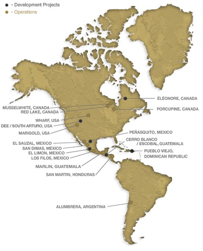
The following map illustrates the Corporation’s properties which are located in Canada, the United States, Mexico and Central and South America.
-7-
Goldcorp Canada owns an approximate 66% equity interest, on an as-converted basis, in Terrane Metals Corp. (“Terrane”), an exploration and mine development company focused on the development of the Mt. Milligan copper-gold and Berg copper-molybdenum-silver projects in British Columbia, Canada, which is listed on the TSXV under the symbol “TRX”. Terrane has granted Goldcorp the right to maintain its pro rata equity position in Terrane as long as Goldcorp is required to include Terrane’s financial information on a consolidated basis in Goldcorp’s financial statements.
Gold Eagle Acquisition
On September 25, 2008, Goldcorp completed its acquisition of Gold Eagle Mines Ltd. (“Gold Eagle”) (the “Gold Eagle Acquisition”). In connection with the Gold Eagle Acquisition, each Gold Eagle share was exchanged for either C$13.60 in cash; 0.292 of a common share of Goldcorp (generally, each whole common share is referred to herein as a “Common Share”) and $0.0001 in cash; or any combination thereof, subject to proration. In aggregate, C$725.8 million in cash and 15.6 million Common Shares were paid and issued to Gold Eagle shareholders. Goldcorp’s acquisition of the Cochenour Deposit through the Gold Eagle Acquisition secures control of eight kilometres of strike length along the prolific Red Lake trend in Ontario, Canada. The Cochenour Deposit is southwest of the Red Lake Gold Mines and contiguous to the Cochenour-Willans project.
Sale of Silver Wheaton Shares
On December 7, 2006, Goldcorp sold 18 million common shares of Silver Wheaton Corp. (“Silver Wheaton”) pursuant to a public offering for proceeds to Goldcorp of approximately C$217.9 million. Following such sale, the Corporation owned approximately 48% of Silver Wheaton. On February 14, 2008, Goldcorp sold its remaining 108 million common shares of Silver Wheaton (the “Silver Wheaton Sale”) pursuant to a public offering for gross proceeds to Goldcorp of C$1.566 billion. The Corporation currently does not own any common shares of Silver Wheaton.
Acquisition of Remaining Interests in Porcupine and Musselwhite Mines and Sale of La Coipa Mine
On December 21, 2007, the Corporation completed the acquisition of the 49% joint venture interest in the Porcupine Mine and the 32% joint venture interest in the Musselwhite Mine held by Kinross Gold Corporation in exchange for Goldcorp’s 50% stake in the La Coipa silver-gold mine in Chile and $206.5 million in cash. As a result of this transaction, the Porcupine Mine is owned by Goldcorp Canada (51% interest) and Goldcorp Inc. (49% interest) and the Musselwhite Mine is owned by Goldcorp Canada (68% interest) and Goldcorp Inc. (32% interest), in each case as joint ventures.
Sale of 25% of Life of Mine Silver Production from Peñasquito Project
On July 24, 2007, the Corporation completed the sale to Silver Wheaton of 25% of the life of mine silver production from the Peñasquito Project for a cash payment of $485 million. The agreement also requires Silver Wheaton to pay an ongoing per-ounce payment equal to the lesser of $3.90 (subject to annual inflationary adjustments) and the prevailing market price per ounce of silver delivered under the contract.
As a result of this transaction, Silver Wheaton extended Goldcorp’s right to maintain its pro rata interest in Silver Wheaton to December 31, 2009 so long as it owned at least 20% of Silver Wheaton. As a result of the Silver Wheaton Sale, Goldcorp no longer owns any of the issued and outstanding shares in Silver Wheaton. Silver Wheaton also retained a right of first refusal on any further sales of silver streams from Peñasquito for the life of the mine as long as Goldcorp maintained at least a 20% interest in Silver Wheaton. As a result of the Silver Wheaton Sale, Silver Wheaton’s right of first refusal on any further sales of silver streams from Peñasquito for the mine life was extinguished.
Sale of Amapari and Peak Mines
On April 3, 2007 and April 27, 2007, respectively, the Corporation completed the sale of the Amapari gold mine (the “Amapari Mine”) located in Brazil and the Peak gold mines (the “Peak Mines”) located in Australia (the “Peak Mines Sale”) to Peak Gold Ltd. (“Peak Gold”). In consideration for the acquisition of the Amapari Mine and
-9-
the Peak Mines, Peak Gold issued to Goldcorp 155 million common shares of Peak Gold with a value on issuance of $100 million, and paid $200 million in cash, respectively. Peak Gold (now New Gold Inc.) entered into a three year non-competition agreement with Goldcorp under which it agreed not to acquire any mineral interest in the Americas with reasonably expected annual production exceeding 200,000 ounces of gold or in any property worldwide that is within 20 kilometres of any Goldcorp property.
Sale of San Martin Mine, Mexico
On January 31, 2007, Goldcorp completed the sale of the San Martin mine in Mexico to Starcore International Ventures Ltd. (“Starcore”) for $24,000,000 and 4,729,000 common shares in the capital of Starcore.
Glamis Acquisition
On November 4, 2006, Goldcorp completed its acquisition of Glamis (the “Glamis Acquisition”). In connection with the Glamis Acquisition, each Glamis share was exchanged for 1.69 Goldcorp shares and $0.0001 in cash, resulting in former Glamis shareholders holding approximately 40% of the total issued and outstanding common shares (the “Common Shares”) of Goldcorp and Goldcorp shareholders holding approximately 60% of the total issued and outstanding common shares of Goldcorp. The assets acquired by Goldcorp included a 100% interest in the Peñasquito Project, a 100% interest in the Marlin Mine, a 662/3% interest in the Marigold Mine, a 100% interest in the El Sauzal Mine and a 100% interest in the San Martin Mine. The Corporation filed a business acquisition report dated January 17, 2007 relating to the Glamis Acquisition and a copy of such report is available under the Corporation’s profile atwww.sedar.com.
Sale of Mt. Milligan
On July 24, 2006, the Corporation completed the sale of Mt. Milligan and certain other Canadian exploration interests to Terrane. Goldcorp acquired these interests from Barrick in May 2006. In consideration, the Corporation received 240 million convertible Series A preferred shares of Terrane at a price of C$0.50 per share. The preferred shares are convertible into common shares of Terrane at the option of Goldcorp at any time without any further consideration. As of July 24, 2006 (the date of the transaction), on an as-converted basis, Goldcorp would have owned an 81% equity interest in Terrane’s issued and outstanding shares. Due to subsequent action by Terrane, Goldcorp’s interest on an as-converted basis has been diluted to an approximate 66% equity interest. The preferred shares are not entitled to dividends, are non-transferable without the prior written consent of Terrane, are non-redeemable, non-retractable, non-voting and if not previously converted will be automatically converted into common shares on the 20th anniversary of their issuance.
Warrant Transaction
In June 2006, Goldcorp received proceeds of more than $450 million upon the early exercise of five series of listed common share purchase warrants. These proceeds were subsequently used to repay credit facilities drawn down to fund the acquisition of Placer Dome (CLA) Limited (“Placer CLA”).
Placer CLA Acquisition
On May 12, 2006, Goldcorp acquired all of the issued and outstanding shares of Placer CLA from Barrick Gold Corporation (“Barrick”) for a purchase price of approximately $1.6 billion (the “Placer CLA Acquisition”). The assets acquired by Goldcorp included a 100% interest in the Campbell Complex, a 50% interest in the La Coipa Mine, a 40% interest in the Pueblo Viejo Project, a 51% interest in the Porcupine Mine and a 68% interest in the Musselwhite Mine. Goldcorp used a portion of its then current cash balances and existing credit facilities to fund the Placer CLA Acquisition. The Corporation filed a business acquisition report dated July 26, 2006 relating to the Placer CLA Acquisition and a copy of such report is available under the Corporation’s profile atwww.sedar.com.
Acquisition of Virginia Gold Mines
On March 31, 2006, Goldcorp completed the acquisition of Virginia Gold Mines Inc., and retained the Éléonore Project in the James Bay region of Québec, pursuant to a plan of arrangement. Goldcorp is continuing
-10-
exploration and development on the Éléonore property.
DESCRIPTION OF THE BUSINESS
Goldcorp is engaged in the acquisition, exploration, development and operation of precious metal properties. The Corporation continues to investigate and negotiate the acquisition of additional precious metal mining properties or interests in such properties. There is no assurance that any such investigations or negotiations will result in the completion of an acquisition.
Principal Products
The Corporation’s principal product is gold. In addition to gold, the Corporation also produces silver and copper. The Corporation is expected to be a future producer of lead and zinc from the Peñasquito Project. There are worldwide gold, silver, copper, lead and zinc markets into which the Corporation can sell and, as a result, the Corporation will not be dependent on a particular purchaser with regard to the sale of the gold, silver, copper, lead and zinc which it produces.
Competitive Conditions
The precious metal mineral exploration and mining business is a competitive business. The Corporation competes with numerous other companies and individuals in the search for and the acquisition of attractive precious metal mineral properties. The ability of the Corporation to acquire precious metal mineral properties in the future will depend not only on its ability to develop its present properties, but also on its ability to select and acquire suitable producing properties or prospects for precious metal development or mineral exploration.
Operations
Raw Materials
The Corporation has (i) gold mineral reserves at the Red Lake Gold Mines, the Porcupine Mine, the Musselwhite Mine, the Marigold Mine, the Wharf Mine, the El Sauzal Mine and the Nukay Mine; (ii) gold and silver mineral reserves at the Los Filos Mine, the San Dimas Mines and the Marlin Mine; (iii) gold and copper mineral reserves at the Alumbrera Mine; (iv) gold, silver and copper mineral reserves at the Pueblo Viejo Project; and (v) gold, silver, lead and zinc mineral reserves at the Peñasquito Project.
Environmental Protection Requirements
The Corporation’s mining, exploration and development activities are subject to various levels of federal, provincial and state laws and regulations relating to the protection of the environment, including requirements for closure and reclamation of mining properties. See disclosure regarding environmental matters under the respective descriptions of the Corporation’s mineral projects herein for further details.
-11-
Employees
As at December 31, 2008, the Corporation had the following employees and contractors:
| | | | | | | | | | | | | | | | | |
| Location | | Full-Time Salaried | | Hourly (Non-Union) | | Hourly (Union) | | Contractors |
| | | | | | | | | | | | | | | | | |
| Vancouver Office | | | 61 | | | | 0 | | | | 0 | | | | 4 | |
| Toronto Office | | | 19 | | | | 0 | | | | 0 | | | | 0 | |
| Reno Office | | | 14 | | | | 0 | | | | 0 | | | | 0 | |
Mexico Offices(1) | | | 97 | | | | 0 | | | | 0 | | | | 26 | |
| Red Lake Gold Mines | | | 254 | | | | 593 | | | | 0 | | | | 347 | |
| Porcupine Mine | | | 206 | | | | 211 | | | | 272 | | | | 0 | |
| Musselwhite Mine | | | 416 | | | | 2 | | | | 0 | | | | 6 | |
| Marigold Mine | | | 31 | | | | 195 | | | | 0 | | | | 0 | |
| Wharf Mine | | | 23 | | | | 126 | | | | 0 | | | | 3 | |
| Éléonore Project | | | 36 | | | | 9 | | | | 0 | | | | 186 | |
| Los Filos Mine | | | 145 | | | | 0 | | | | 446 | | | | 823 | |
| El Sauzal Mine | | | 102 | | | | 195 | | | | 0 | | | | 105 | |
| San Dimas Mines | | | 101 | | | | 0 | | | | 409 | | | | 555 | |
| Nukay Mine | | | 36 | | | | 0 | | | | 79 | | | | 92 | |
| Peñasquito Project | | | 178 | | | | 598 | | | | 0 | | | | 745 | |
| Marlin Mine | | | 977 | | | | 112 | | | | 0 | | | | 512 | |
| San Martin Mine | | | 7 | | | | 28 | | | | 0 | | | | 104 | |
| Cerro Blanco Project | | | 16 | | | | 58 | | | | 0 | | | | 119 | |
| | | | | | | | | | | | | | | | | |
| | | | 2,719 | | | | 2,127 | | | | 1,206 | | | | 3,627 | |
| | |
| (1) | | This represents the Corporation’s regional offices in Mexico. |
The above table does not include employees at the Alumbrera Mine and the Pueblo Viejo Project for which the Corporation only owns 37.5% and 40% repectively, and is not the operator.
Foreign Operations Risks
The Corporation currently owns 662/3% of the Marigold Mine in the United States, 100% of the Wharf Mine in the United States, 40% of the South Arturo Project in the United States, 100% of the Imperial Project in the United States, 100% of the Los Filos Mine in Mexico, 100% of the El Sauzal Mine in Mexico, 100% of the San Dimas Mines in Mexico, 100% of the Peñasquito Project in Mexico, 100% of the El Limon Project in Mexico, 35% of the San Nicolas Project in Mexico 37.5% of the Alumbrera Mine in Argentina, 100% of the Marlin Mine in Guatemala, 100% of the San Martin Mine in Honduras, 40% of the Pueblo Viejo Project in the Dominican Republic, 100% of the Cerro Blanco Project in Guatemala and 100% of the Escobal Project in Guatemala. Any changes in regulations or shifts in political attitudes in such foreign countries are beyond the control of the Corporation and may adversely affect its business. Future development and operations may be affected in varying degrees by such factors as government regulations (or changes thereto) with respect to the restrictions on production, export controls, income taxes, expropriation of property, repatriation of profits, environmental legislation, land use, water use, land claims of local people and mine safety. The effect of these factors cannot be accurately predicted. See “Risk Factors — Foreign Operations”, “Risk Factors — Subsidiaries” and “Risk Factors — Indigenous Peoples”.
Environmental Policy
Goldcorp has implemented an environmental and sustainability policy which states that the Corporation and its subsidiaries are committed to the protection of life, health and the environment for present and future generations. Resources will be focused to achieve shareholder profitability in all operations without neglecting Goldcorp’s commitment to sustainable development. The needs and culture of the local communities will be respected. All employees are responsible for incorporating into their planning and work the actions necessary to fulfill this commitment.
-12-
To meet these responsibilities, Goldcorp will provide its employees with the necessary resources to:
| | • | | Design, construct, operate and close the Corporation’s facilities to comply with applicable local regulations and laws and to meet international guidelines. |
| |
| | • | | Promote employee commitment and accountability to the environmental policy and enhance employees’ capabilities in the implementation through the use of integrated management systems. |
| |
| | • | | Promote the development and implementation of effective systems to minimize risks to health, safety and the environment. |
| |
| | • | | Be proactive in community development programs so the communities are not reliant on the mines for their future. |
| |
| | • | | Communicate openly with employees, local stakeholders and governments on the Corporation’s plans, programs and performance. |
| |
| | • | | Work cooperatively with government agencies, local communities, educational institutions and suppliers to achieve safe handling, use and disposal of all of the Corporation’s materials, resources and products. |
| |
| | • | | Use the best technologies to continuously improve the safe, efficient use of resources, processes and materials. |
Technical Information
CIM Standards Definitions
The estimated mineral reserves and mineral resources for the Red Lake Gold Mines, the Porcupine Mine, the Musselwhite Mine, the Marigold Mine, the Wharf Mine, the Éléonore Project, the South Arturo Project, the Imperial Project, the Los Filos Mine, the El Sauzal Mine, the San Dimas Mines, the Nukay Mine, the Peñasquito Project, the Marlin Mine, the Pueblo Viejo Project, the Cerro Blanco Project, the Escobal Project, the Noche Buena Project, the San Nicolas Project and the El Limon Project have been calculated in accordance with the Canadian Institute of Mining, Metallurgy and Petroleum (“CIM”) — Definitions Adopted by CIM Council on December 11, 2005 (the “CIM Standards”) which were adopted by the Canadian Securities Administrators’ National Instrument 43-101Standards of Disclosure for Mineral Projects(“NI 43-101”). The following definitions are reproduced from the CIM Standards:
The term “Mineral Resource”means a concentration or occurrence of natural, solid, inorganic or fossilized organic material in or on the Earth’s crust in such form and quantity and of such grade or quality that it has reasonable prospects for economic extraction. The location, quantity, grade, geological characteristics and continuity of a Mineral Resource are known, estimated or interpreted from specific geological evidence and knowledge. Mineral Resources are sub-divided, in order of increasing geological confidence, into Inferred, Indicated and Measured categories.
The term “Inferred Mineral Resource”means that part of a Mineral Resource for which quantity and grade or quality can be estimated on the basis of geological evidence and limited sampling and reasonably assumed, but not verified, geological and grade continuity. The estimate is based on limited information and sampling gathered through appropriate techniques from locations such as outcrops, trenches, pits, workings and drill holes.
The term “Indicated Mineral Resource”means that part of a Mineral Resource for which quantity, grade or quality, densities, shape and physical characteristics, can be estimated with a level of confidence sufficient to allow the appropriate application of technical and economic parameters, to support mine planning and evaluation of the economic viability of the deposit. The estimate is based on detailed and reliable exploration and testing information gathered through appropriate techniques from locations such as outcrops, trenches, pits, workings and drill holes that are spaced closely enough for geological and grade continuity to be reasonably assumed.
-13-
The term“Measured Mineral Resource”means that part of a Mineral Resource for which quantity, grade or quality, densities, shape, physical characteristics are so well established that they can be estimated with confidence sufficient to allow the appropriate application of technical and economic parameters, to support production planning and evaluation of the economic viability of the deposit. The estimate is based on detailed and reliable exploration, sampling and testing information gathered through appropriate techniques from locations such as outcrops, trenches, pits, workings and drill holes that are spaced closely enough to confirm both geological and grade continuity.
The term“Mineral Reserve”means the economically mineable part of a Measured or Indicated Mineral Resource demonstrated by at least a Preliminary Feasibility Study. This study must include adequate information on mining, processing, metallurgical, economic and other relevant factors that demonstrate, at the time of reporting, that economic extraction can be justified. A Mineral Reserve includes diluting materials and allowances for losses that may occur when the material is mined.
The term“Probable Mineral Reserve”means the economically mineable part of an Indicated Mineral Resource and, in some circumstances, a Measured Mineral Resource demonstrated by at least a Preliminary Feasibility Study. This study must include adequate information on mining, processing, metallurgical, economic and other relevant factors that demonstrate, at the time of reporting, that economic extraction can be justified.
The term“Proven Mineral Reserve”means the economically mineable part of a Measured Mineral Resource demonstrated by at least a Preliminary Feasibility Study. This study must include adequate information on mining, processing, metallurgical, economic and other relevant factors that demonstrate, at the time of reporting, that economic extraction is justified.
JORC Code Definitions
The estimated ore reserves and mineral resources for the Alumbrera Mine have been calculated in accordance with the current (1999) version of the Australasian Code for Reporting of Mineral Resources and Ore Reserves (the “JORC Code”), the Australian worldwide standards. The JORC Code has been accepted for current disclosure rules in Canada under NI 43-101. The following definitions are reproduced from the JORC Code:
The term “Mineral Resource”means a concentration or occurrence of material of intrinsic economic interest in or on the Earth’s crust in such form and quantity that there are reasonable prospects for eventual economic extraction. The location, quantity, grade, geological characteristics and continuity of a Mineral Resource are known, estimated or interpreted from specific geological evidence and knowledge. Mineral Resources are sub-divided, in order of increasing geological confidence, into Inferred, Indicated and Measured categories.
The term “Inferred Mineral Resource”means that part of a Mineral Resource for which tonnage, grade and mineral content can be estimated with a low level of confidence. It is inferred from geological evidence and assumed but not verified geological and/or grade continuity. It is based on information gathered through appropriate techniques from locations such as outcrops, trenches, pits, workings and drill holes which may be limited or of uncertain quality and reliability.
The term “Indicated Mineral Resource”means that part of a Mineral Resource for which tonnage, densities, shape, physical characteristics, grade and mineral content can be estimated with a reasonable level of confidence. It is based on exploration, sampling and testing information gathered through appropriate techniques from locations such as outcrops, trenches, pits, workings and drill holes. The locations are too widely or inappropriately spaced to confirm geological and/or grade continuity but are spaced closely enough for continuity to be assumed.
The term“Measured Mineral Resource”means that part of a Mineral Resource for which tonnage, densities, shape, physical characteristics, grade and mineral content can be estimated with a high level of confidence. It is based on detailed and reliable exploration, sampling and testing information gathered through appropriate techniques from locations such as outcrops, trenches, pits, workings and drill holes. The locations are spaced closely enough to confirm geological and/or grade continuity.
-14-
The term“Ore Reserve”means the economically mineable part of a Measured or Indicated Mineral Resource. It includes diluting materials and allowances for losses which may occur when the material is mined. Appropriate assessments, which may include feasibility studies, have been carried out, and include consideration of and modification by realistically assumed mining, metallurgical, economic, marketing, legal, environmental, social and governmental factors. These assessments demonstrate at the time of reporting that extraction could reasonably be justified. Ore Reserves are sub-divided in order of increasing confidence into Probable Ore Reserves and Proved Ore Reserves.
The term“Probable Ore Reserve”means the economically mineable part of an Indicated, and in some circumstances Measured Mineral Resource. It includes diluting materials and allowances for losses which may occur when the material is mined. Appropriate assessments, which may include feasibility studies, have been carried out, and include consideration of and modification by realistically assumed mining, metallurgical, economic, marketing, legal, environmental, social and governmental factors. These assessments demonstrate at the time of reporting that extraction could reasonably be justified.
The term“Proved Ore Reserve”means the economically mineable part of a Measured Mineral Resource. It includes diluting materials and allowances for losses which may occur when the material is mined. Appropriate assessments, which may include feasibility studies, have been carried out, and include consideration of and modification by realistically assumed mining, metallurgical, economic, marketing, legal, environmental, social and governmental factors. These assessments demonstrate at the time of reporting that extraction could reasonably be justified.
The foregoing definitions of Ore Reserves and Mineral Resources as set forth in the JORC Code have been reconciled to the definitions set forth in the CIM Standards. If the Ore Reserves and Mineral Resources for the Alumbrera Mine were estimated in accordance with the definitions in the CIM Standards, there would be no substantive difference in such Ore Reserves and Mineral Resources.
Average Total Cash Costs
“Average total cash costs” figures are calculated in accordance with a standard developed by The Gold Institute, which was a worldwide association of suppliers of gold and gold products and included leading North American gold producers. The Gold Institute ceased operations in 2002, but the standard is the accepted standard of reporting cash costs of production in North America. Adoption of the standard is voluntary and the cost measures presented herein may not be comparable to other similarly titled measures of other companies. Costs include mine site operating costs such as mining, processing, concentrate treatment and refining charges, administration, royalties and production taxes, but are exclusive of depreciation and depletion, reclamation, capital, long-term development and exploration costs and Alumbrera’s export retention tax. These costs are then reduced from by-product sales revenue and divided by ounces sold to arrive at the total cash costs per ounce. The measure, along with sales, is considered to be a key indicator of a company’s ability to generate operating earnings and cash flow from its mining operations. This data is furnished to provide additional information and is a non-GAAP measure. It should not be considered in isolation as a substitute for measures of performance prepared in accordance with GAAP and is not necessarily indicative of operating costs presented under GAAP. A reconciliation of total cash costs per ounce (by-product) to the Corporation’s consolidated financial statements is on page 39 of the 2008 Management Discussion and Analysis.
Summary of Ore Reserve/Mineral Reserve and Mineral Resource Estimates
Ore Reserve/Mineral Reserve Estimates
The following table sets forth the estimated gold, silver and copper Ore Reserves/Mineral Reserves for the Red Lake Gold Mines, the Porcupine Mine, the Musselwhite Mine, the Marigold Mine, the Wharf Mine, the Los Filos Mine, the El Sauzal Mine, the San Dimas Mines, the Nukay Mine, the Peñasquito Project, the Alumbrera Mine, the Marlin Mine and the Pueblo Viejo Project as of December 31, 2008:
-15-
Proved/Proven and Probable Gold, Silver and Copper Ore/Mineral Reserves(1)(8)
| | | | | | | | | | | | | | | | | | | | | | | | | | | | | | | | | |
| | | | | | | | | | | Grade | | Contained Metal |
| Deposit | | Category | | Tonnes | | Gold | | Silver | | Copper | | Gold | | Silver | | Copper |
| | | | | | | (millions) | | (grams | | (grams | | (%) | | (millions of | | (millions of | | (millions of |
| | | | | | | | | per tonne) | | per tonne) | | | | ounces) | | ounces) | | pounds) |
| | | | | | | | | | | | | | | | | | | | | | | | | | | | | | | | | |
Red Lake Gold Mines(2) | | Proven | | | 1.17 | | | | 30.99 | | | | — | | | | — | | | | 1.16 | | | | — | | | | — | |
| | | Probable | | | 7.24 | | | | 12.02 | | | | — | | | | — | | | | 2.80 | | | | — | | | | — | |
| | | | | | | | | | | | | | | | | | | | | | | | | | | | | | | | | |
| | | Proven + Probable | | | 8.41 | | | | 14.65 | | | | — | | | | — | | | | 3.96 | | | | — | | | | — | |
| | | | | | | | | | | | | | | | | | | | | | | | | | | | | | | | | |
| | | | | | | | | | | | | | | | | | | | | | | | | | | | | | | | | |
| Porcupine Mine | | Proven | | | 28.14 | | | | 1.39 | | | | — | | | | — | | | | 1.26 | | | | — | | | | — | |
| | | Probable | | | 15.50 | | | | 2.10 | | | | — | | | | — | | | | 1.05 | | | | — | | | | — | |
| | | | | | | | | | | | | | | | | | | | | | | | | | | | | | | | | |
| | | Proven + Probable | | | 43.64 | | | | 1.64 | | | | — | | | | — | | | | 2.30 | | | | — | | | | — | |
| | | | | | | | | | | | | | | | | | | | | | | | | | | | | | | | | |
| | | | | | | | | | | | | | | | | | | | | | | | | | | | | | | | | |
| Musselwhite Mine | | Proven | | | 7.41 | | | | 6.12 | | | | — | | | | — | | | | 1.46 | | | | — | | | | — | |
| | | Probable | | | 2.90 | | | | 6.30 | | | | — | | | | — | | | | 0.59 | | | | — | | | | — | |
| | | | | | | | | | | | | | | | | | | | | | | | | | | | | | | | | |
| | | Proven + Probable | | | 10.31 | | | | 6.17 | | | | — | | | | — | | | | 2.04 | | | | — | | | | — | |
| | | | | | | | | | | | | | | | | | | | | | | | | | | | | | | | | |
| | | | | | | | | | | | | | | | | | | | | | | | | | | | | | | | | |
| Marigold Mine | | Proven | | | 18.02 | | | | 0.79 | | | | — | | | | — | | | | 0.46 | | | | — | | | | — | |
| (Goldcorp’s 66 ⅔% | | Probable | | | 28.18 | | | | 0.62 | | | | — | | | | — | | | | 0.57 | | | | — | | | | — | |
| | | | | | | | | | | | | | | | | | | | | | | | | | | | | | | | | |
| interest) | | Proven + Probable | | | 46.20 | | | | 0.69 | | | | — | | | | — | | | | 1.02 | | | | — | | | | — | |
| | | | | | | | | | | | | | | | | | | | | | | | | | | | | | | | | |
| | | | | | | | | | | | | | | | | | | | | | | | | | | | | | | | | |
| Wharf Mine | | Proven | | | 10.53 | | | | 0.79 | | | | — | | | | — | | | | 0.27 | | | | — | | | | — | |
| | | Probable | | | 1.26 | | | | 0.75 | | | | — | | | | — | | | | 0.03 | | | | — | | | | — | |
| | | | | | | | | | | | | | | | | | | | | | | | | | | | | | | | | |
| | | Proven + Probable | | | 11.79 | | | | 0.78 | | | | — | | | | — | | | | 0.30 | | | | — | | | | — | |
| | | | | | | | | | | | | | | | | | | | | | | | | | | | | | | | | |
| | | | | | | | | | | | | | | | | | | | | | | | | | | | | | | | | |
Los Filos Mine(3) | | Proven | | | 54.50 | | | | 0.85 | | | | 5.9 | | | | — | | | | 1.49 | | | | 10.3 | | | | — | |
| | | Probable | | | 142.04 | | | | 0.65 | | | | 5.4 | | | | — | | | | 2.98 | | | | 24.7 | | | | — | |
| | | | | | | | | | | | | | | | | | | | | | | | | | | | | | | | | |
| | | Proven + Probable | | | 196.53 | | | | 0.71 | | | | 5.5 | | | | — | | | | 4.47 | | | | 35.0 | | | | — | |
| | | | | | | | | | | | | | | | | | | | | | | | | | | | | | | | | |
| | | | | | | | | | | | | | | | | | | | | | | | | | | | | | | | | |
| El Sauzal Mine | | Proven | | | 4.27 | | | | 2.50 | | | | — | | | | — | | | | 0.34 | | | | — | | | | — | |
| | | Probable | | | 1.34 | | | | 3.05 | | | | — | | | | — | | | | 0.13 | | | | — | | | | — | |
| | | | | | | | | | | | | | | | | | | | | | | | | | | | | | | | | |
| | | Proven + Probable | | | 5.60 | | | | 2.63 | | | | — | | | | — | | | | 0.47 | | | | — | | | | — | |
| | | | | | | | | | | | | | | | | | | | | | | | | | | | | | | | | |
| | | | | | | | | | | | | | | | | | | | | | | | | | | | | | | | | |
| San Dimas Mines | | Proven | | | 1.69 | | | | 5.81 | | | | 381.3 | | | | — | | | | 0.32 | | | | 20.7 | | | | — | |
| | | Probable | | | 3.40 | | | | 4.77 | | | | 362.2 | | | | — | | | | 0.52 | | | | 39.6 | | | | — | |
| | | | | | | | | | | | | | | | | | | | | | | | | | | | | | | | | |
| | | Proven + Probable | | | 5.09 | | | | 5.11 | | | | 368.5 | | | | — | | | | 0.84 | | | | 60.3 | | | | — | |
| | | | | | | | | | | | | | | | | | | | | | | | | | | | | | | | | |
| | | | | | | | | | | | | | | | | | | | | | | | | | | | | | | | | |
| Nukay Mine | | Proven | | | 1.07 | | | | 9.45 | | | | — | | | | — | | | | 0.32 | | | | — | | | | — | |
| | | Probable | | | 1.22 | | | | 7.90 | | | | — | | | | — | | | | 0.31 | | | | — | | | | — | |
| | | | | | | | | | | | | | | | | | | | | | | | | | | | | | | | | |
| | | Proven + Probable | | | 2.29 | | | | 8.62 | | | | — | | | | — | | | | 0.64 | | | | — | | | | — | |
| | | | | | | | | | | | | | | | | | | | | | | | | | | | | | | | | |
| | | | | | | | | | | | | | | | | | | | | | | | | | | | | | | | | |
Peñasquito Project(4) | | Proven | | | 561.21 | | | | 0.63 | | | | 33.9 | | | | — | | | | 11.39 | | | | 611.5 | | | | — | |
| Mill | | Probable | | | 447.73 | | | | 0.36 | | | | 25.2 | | | | — | | | | 5.25 | | | | 362.1 | | | | — | |
| | | | | | | | | | | | | | | | | | | | | | | | | | | | | | | | | |
| | | Proven + Probable | | | 1,008.94 | | | | 0.51 | | | | 30.0 | | | | — | | | | 16.63 | | | | 973.6 | | | | — | |
| | | | | | | | | | | | | | | | | | | | | | | | | | | | | | | | | |
| | | | | | | | | | | | | | | | | | | | | | | | | | | | | | | | | |
Peñasquito Project(4) | | Proven | | | 57.80 | | | | 0.20 | | | | 18.4 | | | | — | | | | 0.36 | | | | 34.3 | | | | — | |
| Heap Leach | | Probable | | | 124.65 | | | | 0.11 | | | | 9.4 | | | | — | | | | 0.43 | | | | 37.8 | | | | — | |
| | | | | | | | | | | | | | | | | | | | | | | | | | | | | | | | | |
| | | Proven + Probable | | | 182.45 | | | | 0.14 | | | | 12.3 | | | | — | | | | 0.80 | | | | 72.1 | | | | — | |
| | | | | | | | | | | | | | | | | | | | | | | | | | | | | | | | | |
| | | | | | | | | | | | | | | | | | | | | | | | | | | | | | | | | |
Alumbrera Mine(5) | | Proved | | | 132.00 | | | | 0.40 | | | | — | | | | 0.40 | | | | 1.70 | | | | — | | | | 1,164 | |
| (Goldcorp’s 37.5% | | Probable | | | 3.75 | | | | 0.29 | | | | — | | | | 0.33 | | | | 0.04 | | | | — | | | | 27 | |
| | | | | | | | | | | | | | | | | | | | | | | | | | | | | | | | | |
| interest) | | Proved + Probable | | | 135.75 | | | | 0.40 | | | | — | | | | 0.40 | | | | 1.73 | | | | — | | | | 1,191 | |
| | | | | | | | | | | | | | | | | | | | | | | | | | | | | | | | | |
| | | | | | | | | | | | | | | | | | | | | | | | | | | | | | | | | |
Marlin Mine(6) | | Proven | | | 4.24 | | | | 5.77 | | | | 158.9 | | | | — | | | | 0.79 | | | | 21.6 | | | | — | |
| | | Probable | | | 10.56 | | | | 3.92 | | | | 94.5 | | | | — | | | | 1.33 | | | | 32.1 | | | | — | |
| | | | | | | | | | | | | | | | | | | | | | | | | | | | | | | | | |
| | | Proven + Probable | | | 14.80 | | | | 4.45 | | | | 112.9 | | | | — | | | | 2.12 | | | | 53.7 | | | | — | |
| | | | | | | | | | | | | | | | | | | | | | | | | | | | | | | | | |
| | | | | | | | | | | | | | | | | | | | | | | | | | | | | | | | | |
Pueblo Viejo Project(7) | | Proven | | | 4.63 | | | | 3.52 | | | | 22.6 | | | | 0.12 | | | | 0.52 | | | | 3.4 | | | | 12 | |
| (Goldcorp’s 40% | | Probable | | | 84.85 | | | | 3.09 | | | | 18.0 | | | | 0.09 | | | | 8.44 | | | | 49.2 | | | | 170 | |
| | | | | | | | | | | | | | | | | | | | | | | | | | | | | | | | | |
| interest) | | Proven + Probable | | | 89.48 | | | | 3.11 | | | | 18.3 | | | | 0.09 | | | | 8.96 | | | | 52.5 | | | | 182 | |
| | | | | | | | | | | | | | | | | | | | | | | | | | | | | | | | | |
| | | | | | | | | | | | | | | | | | | | | | | | | | | | | | | | | |
Total | | Proved/Proven | | | | | | | | | | | | | | | | | | | 21.83 | | | | 701.8 | | | | 1,176 | |
| | | Probable | | | | | | | | | | | | | | | | | | | 24.45 | | | | 545.5 | | | | 197 | |
| | | | | | | | | | | | | | | | | | | | | | | | | | | | | | | | | |
| | | Proved/Proven + | | | | | | | | | | | | | | | | | | | | | | | | | | | | |
| | | Probable | | | | | | | | | | | | | | | | | | | 46.28 | | | | 1,247.3 | | | | 1,373 | |
| | | | | | | | | | | | | | | | | | | | | | | | | | | | | | | | | |
| | |
| (1) | | All Mineral Reserves or Ore Reserves have been calculated in accordance with the CIM Standards or the JORC Code. The JORC Code has been accepted for current disclosure rules in Canada under NI 43-101. All Mineral Reserves and Ore Reserves have been reported as of December 31, 2008. |
| |
| (2) | | The Mineral Reserves for Red Lake Gold Mines set out in the table above have been estimated by Stephane Blais, P.Eng., Red Lake Gold Mines, who is a qualified person under NI 43-101. The Mineral Reserves are classified as proven and probable, and are based on the CIM Standards. See “Description of the Business — Mineral Properties — Canada and the United States — Red Lake Gold Mines, Canada — Mineral Reserve and Mineral Resource Estimates” for further details. |
-16-
| | |
| (3) | | The Mineral Reserves for the Los Filos Mine set out in the table above have been estimated by Robert H. Bryson, MMSA, Vice President, Engineering of Goldcorp, who is a qualified person under NI 43-101. The Mineral Reserves are classified as proven and probable, and are based on the CIM Standards. See “Description of the Business — Mineral Properties — Mexico — Los Filos Mine, Mexico — Mineral Reserve and Mineral Resource Estimates” for further details. |
| |
| (4) | | The Mineral Reserves for the Peñasquito Project set out in the table above have been estimated by Robert H. Bryson, MMSA, Vice President, Engineering of Goldcorp, who is a qualified person under NI 43-101. The Mineral Reserves are classified as proven and probable, and are based on the CIM Standards. See “Description of the Business — Mineral Properties — Mexico — Peñasquito Project, Mexico — Mineral Reserve and Mineral Resource Estimates” for further details. |
| |
| (5) | | The Ore Reserves for the Alumbrera Mine set out in the table above have been estimated by Julio Bruna Novillo, AusIMM, Xstrata Copper, who is a qualified person under NI 43-101 and a competent person under the JORC Code. The Mineral Reserves are classified as proved and probable, and are based on the JORC Code. See “Description of the Business — Mineral Properties — Central and South America — Alumbrera Mine, Argentina — Ore Reserve and Mineral Resource Estimates” for further details. |
| |
| (6) | | The Mineral Reserves for the Marlin Mine set out in the table above have been estimated by Michael G. Hester, FAusIMM, B.Sc., M.S., Independent Mining Consultants, Inc., and Andrew S. Tripp, P.Eng., Montana Exploradora de Guatemala, who are qualified persons under NI 43-101. The Mineral Reserves are classified as proven and probable, and are based on the CIM Standards. See “Description of the Business — Mineral Properties — Central and South America — Marlin Mine, Guatemala — Mineral Reserve and Mineral Resource Estimates” for further details. |
| |
| (7) | | The Mineral Reserves for the Pueblo Viejo Project set out in the table above have been estimated by personnel of Barrick Gold Corporation, who are qualified persons under NI 43-101. The Mineral Reserves are classified as proven and probable, and are based on the CIM Standards. See “Description of the Business — Mineral Properties — Central and South America — Pueblo Viejo Project, Dominican Republic — Mineral Reserve and Mineral Resource Estimates” for further details. |
| |
| (8) | | Numbers may not add up due to rounding. |
The following table sets forth the estimated lead and zinc Mineral Reserves for the Peñasquito Project — Mill as of December 31, 2008:
Proven and Probable Lead and Zinc Mineral Reserves(1)(2)(3)
| | | | | | | | | | | | | | | | | | | | | |
| | | | | | | Grade | | Contained Metal |
| Category | | Tonnes | | Lead | | Zinc | | Lead | | Zinc |
| | | (millions) | | (%) | | (%) | | (millions of | | (millions of |
| | | | | | | | | pounds) | | pounds) |
| |
| Proven | | | 561.21 | | | | 0.36 | | | | 0.77 | | | | 4,437 | | | | 9,587 | |
| Probable | | | 447.73 | | | | 0.27 | | | | 0.59 | | | | 2,633 | | | | 5,776 | |
| | | | | | | | | | | | | | | | | | | | | |
| Proven + Probable | | | 1,008.94 | | | | 0.32 | | | | 0.69 | | | | 7,070 | | | | 15.364 | |
| | | | | | | | | | | | | | | | | | | | | |
| | |
| (1) | | All Mineral Reserves have been calculated in accordance with the CIM Standards. |
| |
| (2) | | The Mineral Reserves for the Peñasquito Project set out in the table above have been estimated by Robert H. Bryson, MMSA, Vice President, Engineering of Goldcorp, who is a qualified person under NI 43-101. The Mineral Reserves are classified as proven and probable, and are based on the CIM Standards. See “Description of the Business — Mineral Properties — Mexico — Peñasquito Project, Mexico — Mineral Reserve and Mineral Resource Estimates” for further details. |
| |
| (3) | | Numbers may not add up due to rounding. |
Mineral Resource Estimates
Cautionary Note to United States Investors Concerning Estimates of Measured, Indicated and Inferred
Resources
This section uses the terms “Measured”, “Indicated” and “Inferred” Resources. United States investors are advised that while such terms are recognized and required by Canadian regulations, the United States Securities and Exchange Commission does not recognize them. “Inferred Mineral Resources” have a great amount of uncertainty as to their existence, and as to their economic and legal feasibility. It cannot be assumed that all or any part of an Inferred Mineral Resource will ever be upgraded to a higher category. Under Canadian rules, estimates of Inferred Mineral Resources may not form the basis of feasibility or other economic studies.United States investors are cautioned not to assume that all or any part of Measured or Indicated Mineral Resources will ever be converted into Mineral Reserves. United States investors are also cautioned not to assume that all or any part of an Inferred Mineral Resource exists, or is economically or legally mineable.
The following table sets forth the estimated gold, silver and copper Mineral Resources for the Red Lake Gold Mines, the Porcupine Mine, the Musselwhite Mine, the Marigold Mine, the Wharf Mine, the Éléonore Project, the South Arturo Project, the Imperial Project, the Los Filos Mine, the El Sauzal Mine, the San Dimas Mines, the Nukay Mine, the Peñasquito Project, the Marlin Mine, the Pueblo Viejo Project, the Cerro Blanco Project, the
-17-
Escobal Project, the Noche Buena Project and the San Nicolas Project as of December 31, 2008 and the El Limon Project as of November 3, 2004:
Measured, Indicated and Inferred Gold, Silver and Copper Mineral Resources(1)(7)(8)
(excluding Proved/Proven and Probable Mineral Reserves)
| | | | | | | | | | | | | | | | | | | | | | | | | | | | | | | |
| | | | | | | | | Grade | | Contained Metal |
| Deposit | | Category | | Tonnes | | Gold | | Silver | | Copper | | Gold | | Silver | | Copper |
| | | | | (millions) | | (grams | | (grams | | (%) | | (millions of | | (millions of | | (millions of |
| | | | | | per tonne) | | per tonne) | | | | ounces) | | ounces) | | pounds) |
| |
| | | | | | | | | | | | | | | | | | | | | | | | | | | | | | | |
Red Lake Gold Mines(2) | | Measured | | | 0.75 | | | | 25.18 | | | | — | | | | — | | | | 0.61 | | | | — | | | | — | |
| | | Indicated | | | 3.10 | | | | 14.94 | | | | — | | | | — | | | | 1.49 | | | | — | | | | — | |
| | | | | | | | | | | | | | | | | | | | | | | | | | | | | | | |
| | | Measured + Indicated | | | 3.85 | | | | 16.95 | | | | — | | | | — | | | | 2.10 | | | | — | | | | — | |
| | | | | | | | | | | | | | | | | | | | | | | | | | | | | | | |
| | | Inferred | | | 5.72 | | | | 18.75 | | | | — | | | | — | | | | 3.45 | | | | — | | | | — | |
| | | | | | | | | | | | | | | | | | | | | | | | | | | | | | | |
| Porcupine Mine | | Measured | | | 12.04 | | | | 1.73 | | | | — | | | | — | | | | 0.67 | | | | — | | | | — | |
| | | Indicated | | | 45.57 | | | | 1.53 | | | | — | | | | — | | | | 2.25 | | | | — | | | | — | |
| | | | | | | | | | | | | | | | | | | | | | | | | | | | | | | |
| | | Measured + Indicated | | | 57.61 | | | | 1.57 | | | | — | | | | — | | | | 2.92 | | | | — | | | | — | |
| | | | | | | | | | | | | | | | | | | | | | | | | | | | | | | |
| | | Inferred | | | 4.09 | | | | 5.64 | | | | — | | | | — | | | | 0.74 | | | | — | | | | — | |
| | | | | | | | | | | | | | | | | | | | | | | | | | | | | | | |
| Musselwhite Mine | | Measured | | | 0.30 | | | | 7.66 | | | | — | | | | — | | | | 0.08 | | | | — | | | | — | |
| | | Indicated | | | 1.38 | | | | 5.95 | | | | — | | | | — | | | | 0.27 | | | | — | | | | — | |
| | | | | | | | | | | | | | | | | | | | | | | | | | | | | | | |
| | | Measured + Indicated | | | 1.69 | | | | 6.25 | | | | — | | | | — | | | | 0.34 | | | | — | | | | — | |
| | | | | | | | | | | | | | | | | | | | | | | | | | | | | | | |
| | | Inferred | | | 4.38 | | | | 5.86 | | | | — | | | | — | | | | 0.83 | | | | — | | | | — | |
| | | | | | | | | | | | | | | | | | | | | | | | | | | | | | | |
| Marigold Mine | | Measured | | | 5.93 | | | | 0.57 | | | | — | | | | — | | | | 0.11 | | | | — | | | | — | |
| (Goldcorp’s 66 ⅔% | | Indicated | | | 22.51 | | | | 0.55 | | | | — | | | | — | | | | 0.40 | | | | — | | | | — | |
| | | | | | | | | | | | | | | | | | | | | | | | | | | | | | | |
| interest) | | Measured + Indicated | | | 28.44 | | | | 0.55 | | | | — | | | | — | | | | 0.51 | | | | — | | | | — | |
| | | | | | | | | | | | | | | | | | | | | | | | | | | | | | | |
| | | Inferred | | | 29.87 | | | | 0.48 | | | | — | | | | — | | | | 0.46 | | | | — | | | | — | |
| | | | | | | | | | | | | | | | | | | | | | | | | | | | | | | |
| Wharf Mine | | Measured | | | 2.06 | | | | 0.82 | | | | — | | | | — | | | | 0.05 | | | | — | | | | — | |
| | | Indicated | | | 1.77 | | | | 0.65 | | | | — | | | | — | | | | 0.04 | | | | — | | | | — | |
| | | | | | | | | | | | | | | | | | | | | | | | | | | | | | | |
| | | Measured + Indicated | | | 3.83 | | | | 0.74 | | | | — | | | | — | | | | 0.09 | | | | — | | | | — | |
| | | | | | | | | | | | | | | | | | | | | | | | | | | | | | | |
| | | Inferred | | | 0.46 | | | | 0.86 | | | | — | | | | — | | | | 0.01 | | | | — | | | | — | |
| | | | | | | | | | | | | | | | | | | | | | | | | | | | | | | |
| Éléonore Project | | Measured | | | — | | | | — | | | | — | | | | — | | | | — | | | | — | | | | — | |
| | | Indicated | | | 7.05 | | | | 10.05 | | | | — | | | | — | | | | 2.28 | | | | — | | | | — | |
| | | | | | | | | | | | | | | | | | | | | | | | | | | | | | | |
| | | Measured + Indicated | | | 7.05 | | | | 10.05 | | | | — | | | | — | | | | 2.28 | | | | — | | | | — | |
| | | | | | | | | | | | | | | | | | | | | | | | | | | | | | | |
| | | Inferred | | | 7.39 | | | | 12.75 | | | | — | | | | — | | | | 3.03 | | | | — | | | | — | |
| | | | | | | | | | | | | | | | | | | | | | | | | | | | | | | |
| South Arturo Project | | Measured | | | — | | | | — | | | | — | | | | — | | | | — | | | | — | | | | — | |
| (Goldcorp’s 40% | | Indicated | | | 12.47 | | | | 1.59 | | | | 9.1 | | | | — | | | | 0.64 | | | | 3.6 | | | | — | |
| | | | | | | | | | | | | | | | | | | | | | | | | | | | | | | |
| interest) | | Measured + Indicated | | | 12.47 | | | | 1.59 | | | | 9.1 | | | | — | | | | 0.64 | | | | 3.6 | | | | — | |
| | | | | | | | | | | | | | | | | | | | | | | | | | | | | | | |
| | | Inferred | | | 0.83 | | | | 0.43 | | | | 5.0 | | | | — | | | | 0.01 | | | | 0.1 | | | | — | |
| | | | | | | | | | | | | | | | | | | | | | | | | | | | | | | |
| Imperial Project | | Measured | | | 67.88 | | | | 0.59 | | | | — | | | | — | | | | 1.29 | | | | — | | | | — | |
| | | Indicated | | | 14.88 | | | | 0.51 | | | | — | | | | — | | | | 0.24 | | | | — | | | | — | |
| | | | | | | | | | | | | | | | | | | | | | | | | | | | | | | |
| | | Measured + Indicated | | | 82.76 | | | | 0.58 | | | | — | | | | — | | | | 1.53 | | | | — | | | | — | |
| | | | | | | | | | | | | | | | | | | | | | | | | | | | | | | |
| | | Inferred | | | 43.83 | | | | 0.40 | | | | — | | | | — | | | | 0.56 | | | | — | | | | — | |
| | | | | | | | | | | | | | | | | | | | | | | | | | | | | | | |
Los Filos Mine(3) | | Measured | | | 3.35 | | | | 1.04 | | | | 4.4 | | | | — | | | | 0.11 | | | | 0.5 | | | | — | |
| | | Indicated | | | 51.61 | | | | 0.72 | | | | 4.3 | | | | — | | | | 1.19 | | | | 7.1 | | | | — | |
| | | | | | | | | | | | | | | | | | | | | | | | | | | | | | | |
| | | Measured + Indicated | | | 54.96 | | | | 0.74 | | | | 4.3 | | | | — | | | | 1.30 | | | | 7.6 | | | | — | |
| | | | | | | | | | | | | | | | | | | | | | | | | | | | | | | |
| | | Inferred | | | 68.57 | | | | 0.60 | | | | 5.2 | | | | — | | | | 1.33 | | | | 11.4 | | | | — | |
| | | | | | | | | | | | | | | | | | | | | | | | | | | | | | | |
| El Sauzal Mine | | Measured | | | 1.16 | | | | 1.49 | | | | — | | | | — | | | | 0.06 | | | | — | | | | — | |
| | | Indicated | | | 3.25 | | | | 1.53 | | | | — | | | | — | | | | 0.16 | | | | — | | | | — | |
| | | | | | | | | | | | | | | | | | | | | | | | | | | | | | | |
| | | Measured + Indicated | | | 4.41 | | | | 1.52 | | | | — | | | | — | | | | 0.22 | | | | — | | | | — | |
| | | | | | | | | | | | | | | | | | | | | | | | | | | | | | | |
| | | Inferred | | | 0.09 | | | | 1.90 | | | | — | | | | — | | | | 0.01 | | | | — | | | | — | |
| | | | | | | | | | | | | | | | | | | | | | | | | | | | | | | |
| San Dimas Mines | | Measured | | | — | | | | — | | | | — | | | | — | | | | — | | | | — | | | | — | |
| | | Indicated | | | — | | | | — | | | | — | | | | — | | | | — | | | | — | | | | — | |
| | | | | | | | | | | | | | | | | | | | | | | | | | | | | | | |
| | | Measured + Indicated | | | — | | | | — | | | | — | | | | — | | | | — | | | | — | | | | — | |
| | | | | | | | | | | | | | | | | | | | | | | | | | | | | | | |
| | | Inferred | | | 15.14 | | | | 3.29 | | | | 316.4 | | | | — | | | | 1.60 | | | | 154.0 | | | | — | |
| | | | | | | | | | | | | | | | | | | | | | | | | | | | | | | |
| Nukay Mine | | Measured | | | 1.31 | | | | 9.27 | | | | — | | | | — | | | | 0.39 | | | | — | | | | — | |
| | | Indicated | | | 1.71 | | | | 7.58 | | | | — | | | | — | | | | 0.42 | | | | — | | | | — | |
| | | | | | | | | | | | | | | | | | | | | | | | | | | | | | | |
| | | Measured + Indicated | | | 3.01 | | | | 8.32 | | | | — | | | | — | | | | 0.81 | | | | — | | | | — | |
| | | | | | | | | | | | | | | | | | | | | | | | | | | | | | | |
| | | Inferred | | | 3.74 | | | | 6.06 | | | | — | | | | — | | | | 0.73 | | | | — | | | | — | |
-18-
| | | | | | | | | | | | | | | | | | | | | | | | | | | | | | | |
| | | | | | | | | Grade | | Contained Metal |
| Deposit | | Category | | Tonnes | | Gold | | Silver | | Copper | | Gold | | Silver | | Copper |
| | | | | (millions) | | (grams | | (grams | | (%) | | (millions of | | (millions of | | (millions of |
| | | | | | per tonne) | | per tonne) | | | | ounces) | | ounces) | | pounds) |
| |
| | | | | | | | | | | | | | | | | | | | | | | | | | | | | | | |
Peñasquito Project(4) | | Measured | | | 111.22 | | | | 0.23 | | | | 18.5 | | | | — | | | | 0.81 | | | | 66.2 | | | | — | |
| Mill | | Indicated | | | 503.73 | | | | 0.23 | | | | 18.4 | | | | — | | | | 3.73 | | | | 298.0 | | | | — | |
| | | | | | | | | | | | | | | | | | | | | | | | | | | | | | | |
| | | Measured + Indicated | | | 614.95 | | | | 0.23 | | | | 18.4 | | | | — | | | | 4.53 | | | | 364.1 | | | | — | |
| | | | | | | | | | | | | | | | | | | | | | | | | | | | | | | |
| | | Inferred | | | 705.62 | | | | 0.23 | | | | 17.0 | | | | — | | | | 5.13 | | | | 385.0 | | | | — | |
| | | | | | | | | | | | | | | | | | | | | | | | | | | | | | | |
Peñasquito Project(4) | | Measured | | | 5.76 | | | | 0.05 | | | | 4.1 | | | | — | | | | 0.01 | | | | 0.8 | | | | — | |
| Heap Leach | | Indicated | | | 30.40 | | | | 0.06 | | | | 5.0 | | | | — | | | | 0.06 | | | | 4.9 | | | | — | |
| | | | | | | | | | | | | | | | | | | | | | | | | | | | | | | |
| | | Measured + Indicated | | | 36.15 | | | | 0.06 | | | | 4.9 | | | | — | | | | 0.07 | | | | 5.6 | | | | — | |
| | | | | | | | | | | | | | | | | | | | | | | | | | | | | | | |
| | | Inferred | | | 39.62 | | | | 0.09 | | | | 7.9 | | | | — | | | | 0.12 | | | | 10.1 | | | | — | |
| | | | | | | | | | | | | | | | | | | | | | | | | | | | | | | |
Marlin Mine(5) | | Measured | | | 0.31 | | | | 1.80 | | | | 98.0 | | | | — | | | | 0.02 | | | | 1.0 | | | | — | |
| | | Indicated | | | 1.35 | | | | 1.42 | | | | 36.7 | | | | — | | | | 0.06 | | | | 1.6 | | | | — | |
| | | | | | | | | | | | | | | | | | | | | | | | | | | | | | | |
| | | Measured + Indicated | | | 1.65 | | | | 1.49 | | | | 48.1 | | | | — | | | | 0.08 | | | | 2.6 | | | | — | |
| | | | | | | | | | | | | | | | | | | | | | | | | | | | | | | |
| | | Inferred | | | 1.78 | | | | 3.48 | | | | 108.1 | | | | — | | | | 0.20 | | | | 6.2 | | | | — | |
| | | | | | | | | | | | | | | | | | | | | | | | | | | | | | | |
Pueblo Viejo Project(6) | | Measured | | | 1.58 | | | | 1.86 | | | | 12.7 | | | | 0.09 | | | | 0.09 | | | | 0.6 | | | | 3 | |
| (Goldcorp’s 40% | | Indicated | | | 45.03 | | | | 1.93 | | | | 11.3 | | | | 0.07 | | | | 2.79 | | | | 16.4 | | | | 71 | |
| | | | | | | | | | | | | | | | | | | | | | | | | | | | | | | |
| interest) | | Measured + Indicated | | | 46.61 | | | | 1.93 | | | | 11.4 | | | | 0.07 | | | | 2.89 | | | | 17.0 | | | | 74 | |
| | | | | | | | | | | | | | | | | | | | | | | | | | | | | | | |
| | | Inferred | | | 4.73 | | | | 2.02 | | | | 21.6 | | | | 0.04 | | | | 0.31 | | | | 3.3 | | | | 4 | |
| | | | | | | | | | | | | | | | | | | | | | | | | | | | | | | |
| Cerro Blanco Project | | Measured | | | — | | | | — | | | | — | | | | — | | | | — | | | | — | | | | — | |
| | | Indicated | | | 2.52 | | | | 15.64 | | | | 72.0 | | | | — | | | | 1.27 | | | | 5.8 | | | | — | |
| | | | | | | | | | | | | | | | | | | | | | | | | | | | | | | |
| | | Measured + Indicated | | | 2.52 | | | | 15.64 | | | | 72.0 | | | | — | | | | 1.27 | | | | 5.8 | | | | — | |
| | | | | | | | | | | | | | | | | | | | | | | | | | | | | | | |
| | | Inferred | | | 1.35 | | | | 15.31 | | | | 59.6 | | | | — | | | | 0.67 | | | | 2.6 | | | | — | |
| | | | | | | | | | | | | | | | | | | | | | | | | | | | | | | |
Escobal Project | | Measured | | | — | | | | — | | | | — | | | | — | | | | — | | | | — | | | | — | |
| | | Indicated | | | — | | | | — | | | | — | | | | — | | | | — | | | | — | | | | — | |
| | | | | | | | | | | | | | | | | | | | | | | | | | | | | | | |
| | | Measured + Indicated | | �� | — | | | | — | | | | — | | | | — | | | | — | | | | — | | | | — | |
| | | | | | | | | | | | | | | | | | | | | | | | | | | | | | | |
| | | Inferred | | | 7.23 | | | | 0.69 | | | | 623.8 | | | | — | | | | 0.16 | | | | 145.0 | | | | — | |
| | | | | | | | | | | | | | | | | | | | | | | | | | | | | | | |
| Noche Buena Project | | Measured | | | — | | | | — | | | | — | | | | — | | | | — | | | | — | | | | — | |
| | | Indicated | | | — | | | | — | | | | — | | | | — | | | | — | | | | — | | | | — | |
| | | | | | | | | | | | | | | | | | | | | | | | | | | | | | | |
| | | Measured + Indicated | | | — | | | | — | | | | — | | | | — | | | | — | | | | — | | | | — | |
| | | | | | | | | | | | | | | | | | | | | | | | | | | | | | | |
| | | Inferred | | | 75.10 | | | | 0.39 | | | | 6.9 | | | | — | | | | 0.94 | | | | 16.6 | | | | — | |
| | | | | | | | | | | | | | | | | | | | | | | | | | | | | | | |
| San Nicolas Project | | Measured | | | 0.66 | | | | 0.96 | | | | 46.5 | | | | 0.73 | | | | 0.02 | | | | 1.0 | | | | 11 | |
| (Goldcorp’s 35% interest) | | Indicated | | | 27.33 | | | | 0.47 | | | | 28.6 | | | | 1.34 | | | | 0.41 | | | | 25.1 | | | | 809 | |
| | | | | | | | | | | | | | | | | | | | | | | | | | | | | | | |
| | | Measured + Indicated | | | 27.99 | | | | 0.48 | | | | 29.0 | | | | 1.33 | | | | 0.43 | | | | 26.1 | | | | 819 | |
| | | | | | | | | | | | | | | | | | | | | | | | | | | | | | | |
| | | Inferred | | | 2.46 | | | | 0.37 | | | | 23.8 | | | | 1.28 | | | | 0.03 | | | | 1.9 | | | | 69 | |
| | | | | | | | | | | | | | | | | | | | | | | | | | | | | | | |
| El Limon Project | | Measured | | | — | | | | — | | | | — | | | | — | | | | — | | | | — | | | | — | |
| | | Indicated | | | — | | | | — | | | | — | | | | — | | | | — | | | | — | | | | — | |
| | | | | | | | | | | | | | | | | | | | | | | | | | | | | | | |
| | | Measured + Indicated | | | — | | | | — | | | | — | | | | — | | | | — | | | | — | | | | — | |
| | | | | | | | | | | | | | | | | | | | | | | | | | | | | | | |
| | | Inferred | | | 6.50 | | | | 3.27 | | | | — | | | | — | | | | 0.68 | | | | — | | | | — | |
| | | | | | | | | | | | | | | | | | | | | | | | | | | | | | | |
Total | | Measured | | | | | | | | | | | | | | | | | | | 4.31 | | | | 70.0 | | | | 14 | |
| | | Indicated | | | | | | | | | | | | | | | | | | | 17.67 | | | | 362.5 | | | | 880 | |
| | | | | | | | | | | | | | | | | | | | | | | | | | | | | | | |
| | | Measured + Indicated | | | | | | | | | | | | | | | | | | | 21.98 | | | | 432.5 | | | | 893 | |
| | | | | | | | | | | | | | | | | | | | | | | | | | | | | | | |
| | | Inferred | | | | | | | | | | | | | | | | | | | 20.99 | | | | 736.2 | | | | 73 | |
| | |
| (1) | | All Mineral Resources have been calculated in accordance with the CIM Standards or the JORC Code. The JORC Code has been accepted for current disclosure rules in Canada under NI 43-101. All Mineral Resources have been reported as of December 31, 2008, except for the El Limon Project, which are reported as of November 3, 2004. |
| |
| (2) | | The Mineral Resources for Red Lake Gold Mines set out in the table above have been estimated by Dean Crick P.Geo. and Chris Osiowy, P.Geo., each of Red Lake Gold Mines, who are qualified persons under NI 43-101. The Mineral Resources are classified as measured, indicated and inferred, and are based on the CIM Standards. See “Description of the Business — Mineral Properties — Canada and the United States — Red Lake Gold Mines, Ontario — Mineral Reserve and Mineral Resource Estimates” for further details. |
| |
| (3) | | The Mineral Resources for the Los Filos Mine set out in the table above have been estimated by Reynaldo Rivera, MAusIMM, Vice President, Exploration of Luismin who is a qualified person under NI 43-101. The Mineral Resources are classified as measured, indicated and inferred, and are based on the CIM Standards. See “Description of the Business — Mineral Properties — Mexico — Los Filos Mine, Mexico — Mineral Reserve and Mineral Resource Estimates” for further details. |
| |
| (4) | | The Mineral Resources for the Peñasquito Project set out in the table above have been estimated by Fred H. Brown, CPG, PrSciNat, who is a qualified person under NI 43-101. The Mineral Resources are classified as measured, indicated and inferred, and are based on the CIM Standards. See “Description of the Business — Mineral Properties — Mexico — Peñasquito Project, Mexico — Mineral Reserve and Mineral Resource Estimates” for further details. |
| |
| (5) | | The Mineral Resources for the Marlin Mine set out in the table above have been estimated by Michael G. Hester, FAusIMM, B.Sc., M.S., Independent Mining Consultants, Inc., and Andrew S. Tripp, P.Eng., Montana Exploradora de Guatemala, who are qualified persons under NI 43-101. The Mineral Resources are classified as measured, indicated and inferred, and are based on the CIM Standards. See “Description of the Business — Mineral Properties — Central and South America — Marlin Mine, Guatemala — Mineral Reserve and Mineral Resource Estimates” for further details. |
| |
| (6) | | The Mineral Resources for the Pueblo Viejo Project set out in the table above have been estimated by personnel of Barrick Gold Corporation, who are qualified persons under NI 43-101. See “Description of the Business — Mineral Properties — Central and South America — Pueblo Viejo Project, Dominican Republic — Mineral Reserve and Mineral Resource Estimates” for further details. |
-19-
| | |
| (7) | | Mineral Resources are not known with the same degree of certainty as Mineral Reserves and do not have demonstrated economic viability. Inferred Mineral Resources have a great amount of uncertainty as to their existence and as to whether they can be mined legally or economically. It cannot be assured that all or part of the Inferred Mineral Resources will ever be upgraded to a higher category. |
| |
| (8) | | Numbers may not add up due to rounding. |
The following table sets forth the estimated lead and zinc Mineral Resources for the Peñasquito Project, the Pueblo Viejo Project and the San Nicolas Project as of December 31, 2008:
Measured, Indicated and Inferred Lead and Zinc Mineral Resources(1)(4)
(excluding Proven and Probable Mineral Reserves)
| | | | | | | | | | | | | | | | | | | | | | | |
| | | | | | | | | Grade | | Contained Metal |
| Deposit | | Category | | Tonnes | | Lead | | Zinc | | Lead | | Zinc |
| | | | | (millions) | | (%) | | (%) | | (millions of | | (millions of |
| | | pounds) | | pounds) |
| | | | | | | | | | | | | | | | | | | | | | | |
Peñasquito Project(2) | | Measured | | | 111.22 | | | | 0.19 | | | | 0.55 | | | | 466 | | | | 1,349 | |
| Mill | | Indicated | | | 503.73 | | | | 0.19 | | | | 0.55 | | | | 2,110 | | | | 6,108 | |
| | | | | | | | | | | | | | | | | | | | | | | |
| | | Measured + Indicated | | | 614.95 | | | | 0.19 | | | | 0.55 | | | | 2,576 | | | | 7,456 | |
| | | | | | | | | | | | | | | | | | | | | | | |
| | | Inferred | | | 705.62 | | | | 0.18 | | | | 0.56 | | | | 2,816 | | | | 8,758 | |
| | | | | | | | | | | | | | | | | | | | | | | |
Pueblo Viejo Project(3) | | Measured | | | 6.21 | | | | — | | | | 0.82 | | | | — | | | | 113 | |
| (Goldcorp’s 40% | | Indicated | | | 129.88 | | | | — | | | | 0.63 | | | | — | | | | 1,815 | |
| | | | | | | | | | | | | | | | | | | | | | | |
| interest) | | Measured + Indicated | | | 136.09 | | | | — | | | | 0.64 | | | | — | | | | 1,928 | |
| | | | | | | | | | | | | | | | | | | | | | | |
| | | Inferred | | | 4.73 | | | | — | | | | 0.29 | | | | — | | | | 30 | |
| | | | | | | | | | | | | | | | | | | | | | | |
| San Nicolas Project | | Measured | | | 0.66 | | | | — | | | | 3.60 | | | | — | | | | 52 | |
| | | Indicated | | | 27.33 | | | | — | | | | 1.80 | | | | — | | | | 1,085 | |
| | | | | | | | | | | | | | | | | | | | | | | |
| | | Measured + Indicated | | | 27.99 | | | | — | | | | 1.84 | | | | — | | | | 1,137 | |
| | | | | | | | | | | | | | | | | | | | | | | |
| | | Inferred | | | 2.46 | | | | — | | | | 1.43 | | | | — | | | | 78 | |
| | | | | | | | | | | | | | | | | | | | | | | |
Total | | Measured | | | | | | | | | | | | | | | 466 | | | | 1,514 | |
| | | Indicated | | | | | | | | | | | | | | | 2,110 | | | | 9,008 | |
| | | | | | | | | | | | | | | | | | | | | | | |
| | | Measured + Indicated | | | | | | | | | | | | | | | 2,576 | | | | 10,521 | |
| | | | | | | | | | | | | | | | | | | | | | | |
| | | Inferred | | | | | | | | | | | | | | | 2,816 | | | | 8,866 | |
| | |
| (1) | | All Mineral Resources have been calculated in accordance with the CIM Standards. |
| |
| (2) | | The Mineral Resources for the Peñasquito Project set out in the table above have been estimated by Fred H. Brown, CPG, PrSciNat, who is a qualified person under NI 43-101. The Mineral Resources are classified as measured, indicated and inferred, and are based on the CIM Standards. See “Description of the Business — Mineral Properties — Mexico — Peñasquito Project, Mexico — Mineral Reserve and Mineral Resource Estimates” for further details. |
| |
| (3) | | The Mineral Resources for the Pueblo Viejo Project set out in the table above have been estimated by the personnel of Barrick Gold Corporation, who are qualified persons under NI 43-101. The Mineral Resources are classified as measured, indicated and inferred, and are based on the CIM Standards. See “Description of the Business — Mineral Properties — Central and South America — Pueblo Viejo Project, Dominican Republic — Mineral Reserve and Mineral Resource Estimates” for further details. |
| |
| (4) | | Numbers may not add up due to rounding. |
Mineral Properties
CANADA AND THE UNITED STATES
The Corporation’s properties in Canada and the United States include Red Lake Gold Mines, the Cochenour Deposit, the Porcupine Mine, as a joint venture, the Musselwhite Mine, as a joint venture, the Marigold Mine, the Wharf Mine, the Éléonore Project, the South Arturo Project and the Imperial Project.
RED LAKE GOLD MINES, CANADA
Red Lake Gold Mines, an Ontario partnership, was formed on April 2, 2007 between Goldcorp Canada as to a 28% interest and Goldcorp Inc. as to a 72% interest for the principal purpose of operating and developing the combined operations of the Red Lake Complex and the Campbell Complex, each located at or about the town of Red Lake, in the province of Ontario, and to carry out all activities in connection with or ancillary thereto. In 2008, the gold production from Red Lake Gold Mines amounted to 629,176 ounces of gold at a total cash cost of $302 per ounce. Combining the existing mineral reserves with the expectation of significant mineral resource conversion to mineral reserves, the Red Lake Gold Mines has an expected mine life through to 2023.
-20-
Dean Crick, M.Sc., P.Geo., Stephane Blais, P.Eng. and Anthony Stechishen, P.Geo. prepared a technical report in accordance with NI 43-101 entitled “The Red Lake Gold Mines Property — Red Lake Mining Division, Northern Ontario” dated November 17, 2006 (the “Red Lake Gold Mines Report”). Dean Crick, Stephane Blais and Anthony Stechishen are each qualified persons under NI 43-101. The following description of the properties held by Red Lake Gold Mines has been summarized, in part, from the Red Lake Gold Mines Report and readers should consult the Red Lake Gold Mines Report to obtain further particulars regarding the properties held by the Red Lake Gold Mines. The Red Lake Gold Mines Report is available for review on the SEDAR website located atwww.sedar.com under the Corporation’s profile.
Property Description and Location
The properties held by Red Lake Gold Mines cover approximately 2,335 hectares located in the Red Lake Mining Division within the District of Kenora in northwestern Ontario. The Red Lake Gold Mines’ properties are located in the Canadian Shield, approximately 180 kilometres north of Dryden, Ontario. The Red Lake Complex consists of 89 patented claims covering 1,254 hectares and the Campbell Complex consists of 77 patented mineral claims covering 1,084 hectares. The Red Lake Gold Mines’ properties have been legally surveyed for all of the patented claims.
Accessibility, Climate, Local Resources, Infrastructure and Physiography
The Red Lake Gold Mines’ properties are located in the Municipality of Red Lake in northwestern Ontario, Canada. The Municipality of Red Lake is comprised of the towns of Madsen and McKenzie Island, Red Lake, Cochenour, Balmerstown, Starratt Olsen and Flat Lake. The Red Lake area is accessible by Highway 105, which joins the Trans Canada Highway at Vermilion Bay, 175 kilometres south and 100 kilometres east of Kenora, Ontario. Commercial air service from Thunder Bay and Winnipeg to the community is available several times a day.
The climate in the Red Lake area is typical of a northern continental boreal climate with warm summers and cold winters.
The Municipality of Red Lake has a population of approximately 5,500. Other industries in the Municipality of Red Lake include logging and tourism. Local infrastructure is well developed in the Red Lake area, with all the amenities needed for operations by Red Lake Gold Mines available locally. Potable water is supplied by the Municipality. Process water is taken from Balmer Lake and Sandy Bay. Ontario Hydro supplies power. Each of the Red Lake and Campbell Complexes has 30 megawatts of transformer capability but is limited to 26 megawatts by the incoming line. There are multiple transformers throughout the Red Lake and Campbell Complexes, which step voltage down to 4,160, 2,300 and 575 volts.
The Red Lake area has topography typical of the Canadian Shield with irregular hummocky hills and discontinuous ridges created by glaciofluvial material and till. These are separated by depressions and hollows occupied by lakes, ponds and muskeg. Much of the Red Lake region is undeveloped and is accessible only by air or boat. The natural vegetation is predominantly black spruce, fir, tamarack and pine. In the better drained elevated areas the vegetation changes to poplar, birch, willow, alder and mountain ash with a variety of shrubs.
Bedrock outcrops are scattered and consist of less than 5% of the surface area. Soil in the vicinity is characterized by a 30 to 50 centimetre layer of topsoil overlying compact sand with traces of clay, gravel, scattered cobbles and boulders. Low-lying areas contain silty-clay sediments that were deposited in glacial lakes.
History
The first recorded prospecting in the Red Lake district was carried out by the Northwestern Ontario Exploration Company in 1887, but gold was not discovered in the district until 1922. A brief summary of the Red Lake and Campbell Complexes follows.
-21-
Red Lake Complex
Red Lake was first staked during the Red Lake Gold Rush in 1926. In 1944, the property was re-staked and Dickenson Red Lake Mines Limited was incorporated. Production mining began in 1948 at a rate of 125 tons per day and increased to 500 tons per day in the 1970s, with grades varying between 0.45 and 0.61 ounces of gold per ton. In the early 1980s, the mill capacity was increased to 1,000 tons per day and long-hole stoping was introduced which resulted in a severe drop in production grade. Cut-and-fill mining was subsequently re-introduced and production was increased to about 1,000 tons per day by 1993/4 with the grade ranging from 0.25 and 0.34 ounces of gold per ton. The average recovery rate was 82%. An exploration diamond drilling program initiated in 1995 within the lower levels of the mine resulted in the discovery of a cluster of high grade gold veins between the 30 and 39 levels of the mine (the “High Grade Zone”).
Between June 1996 and late 1999, operations were suspended due to a strike. Mine staff and outside contractors maintained essential services and supported the exploration program on the property. In September 1998, the feasibility of mining the High Grade Zone Mineral Reserves through a combination of existing mine infrastructure, new development and a new processing facility purchased from Cameco Corporation was studied. An operating plan was developed to mine the Mineral Reserves by the mechanized cut-and-fill stope method at a rate of 6,000 tons per day or 219,000 tons per year.
Mining from the High Grade Zone began in early 2000 and test milling began in July. By year-end, full rated production was achieved with a small stockpile of several thousand tons of crushed ore remaining on surface. Since production restarted in 2000, the exploration to increase resources has focused on the High Grade Zone.
The #3 shaft (the “#3 Shaft”) was developed from January 2004 to January 2007 to a depth of 6,314 feet. The muck handling system for the #3 Shaft was commissioned at the end of 2008. The mine ventilation is in the process of being upgraded. The first phase of the upgrade was completed in March 2008 and has increased the amount of air being supplied to the bottom section of the mine to 400,000 cubic feet per minute. The second phase of the ventilation upgrade is expected to be completed in the second quarter of 2009.
Since the beginning of operations in 1948 until the end of 2008, 10.67 million tons of ore have been processed at an average head grade of 0.744 ounces per ton to produce 7.37 million ounces of gold. In 2008, 319,853 tons of ore at an average head grade of 1.386 ounces per ton were processed and 429,166 ounces of gold were poured.
Campbell Complex
The Campbell claims were staked in 1926. Subsequently, there was a period of claim cancellations and restaking of the area. In 1944, George and Colin Campbell restaked the area. In this period, Campbell Red Lake Mines was incorporated and Dome Mines purchased an option that eventually resulted in Dome Mines acquiring a 57% ownership interest in the company.
In 1946, after further exploration had been carried out, a four-compartment shaft with four levels was sunk to a depth of 182 metres. Mill construction began in 1948 and the mill went into operation the following year reaching a capacity of 300 tons per day soon after the beginning of operations. By 1953, the shaft was further deepened to 655 metres and soon after a deeper higher grade zone was discovered at the 14th level. The next 30 years of production at Campbell remained consistent.
A new phase of investment began following the merger between Campbell, Dome and Placer Development to form Placer Dome Inc. (“Placer Dome”). This led to the installation of an autoclave, replacing the roasting at the Campbell mill, development of a decline from levels 27 to 30, a mill flotation circuit upgrade, construction of paste fill plant and the commissioning of the Reid Shaft in 1999, which enabled the discovery and development of the DC Zone.
-22-
Since the beginning of operations in 1949 until the end of 2008, 21.28 million tons of ore have been processed at an average head grade of 0.593 ounces per ton to produce 11.74 million ounces of gold. In 2008, 523,923 tons of ore at an average head grade of 0.393 ounces per ton were processed and 195,068 ounces of gold were poured.
Geological Setting
Regional Geology
The Red Lake greenstone belt is situated in the western portion of the Uchi Subprovince, a typical Achaean granite-greenstone terrain containing eastward trending belts of volcanic and sedimentary rocks and syn-volcanic intrusives. The rocks consist of volcanic and sedimentary assemblages representing magmatic and erosional events occurring over a period of approximately 300 million years.
The Red Lake greenstone belt outcropping is defined by an east-northeast orientated bow tie shaped, anticline, roughly 40 kilometres long and 20 kilometres across. Two perpendicular axes of mirror symmetry trend east-northeast and southwest defining the bow tie and intersecting at the Dome Stock near Red Lake. The most prominent axis trends east-northeast defining a broad antiform with older rocks of the Balmer Assemblage occupying the hinge flanked by younger rocks of the Huston and Confederation assemblages on its northern and southern flanks. Between the oldest and youngest assemblages is a regional unconformity, overlain by the Huston conglomerate. At each end of the anticline, late-orogenic plutons stope up into the greenstone; the Killala-Baird batholith in the west, and the Walsh Lake pluton and Cat Island pluton in the east.
The Balmer assemblage, predominantly tholeiitic and komatiitic mafic to ultramafic extrusive rocks, hosts the gold-bearing ore and constitutes over 50% of the Red Lake greenstone belt rocks. The sequence is disconformably overlain by a volcaniclastic/clastic sequence, the Bruce Channel assemblage prominent in the east and the Slate Bay assemblage in the southwest. The Trout Bay assemblage is characterized by predominantly mafic tholeiitic extrusive rocks. A laterally extensive polymict conglomerate belonging to the Huston assemblage marks an angular unconformity between Mesoarchean and Neoarchean strata and is overlain by dominantly calc-alkalic felsic volcanic rocks belonging to the Confederation assemblage.
Large-scale folding and steep fault systems dominate the eastern part of the Red Lake greenstone belt. Northeast trending synclines and anticlines occur northeast of McKenzie Island west of East Bay. On the eastern side of East Bay, a major fold with a northwest trending fold axis occurs in Bateman and Balmer Townships. In the area surrounding Red Lake Gold Mines, horizons of ultramafics within the basalt-dominated stratigraphy created complex geometries through competency contrast during the mechanical interaction of folding. High strain corridors characterized by pervasive foliation and cleavage development along mafic, ultramafic contacts are clearly distinguishable features using surface mapping and geophysics.
Quartz-carbonate veining and alteration developed around mafic-ultramafic contacts, particularly fold hinges and in the damage zones of small and large displacement fault/shear zones. Continued shortening and foliation development caused rotation of conjugate shear zones towards parallelism with F2 fold axial surface orientations, producing strong deformation and strain partitioning. Further shortening resulted in strong near-vertical extension and locally the development of reverse faults.
Auriferous, siliceous, sulphidic alteration and quartz veining, overprinting earlier quartz-carbonate veins, began to develop at this stage, apparently after the bulk of strain and displacements on major fault systems. Minor strike slip movements on fault systems, reflecting at least local changes in the orientation of stress axes, contributed to the dilation and replacement, particularly in ultramafic/mafic defined fold hinge zones abutting fault system.
Metamorphism
Owing to the volume of late tectonic granitic plutons, a complex history of metamorphic events exists which arises from episodes of burial, crustal thickening, thrusting, baking by felsic intrusions of all sizes and ages, and late hydrothermal alterations focussed along shear zones. Within the Red Lake greenstone belt the alteration is characterized by greenschist metamorphic mineral assemblages, but with amphibolite facies mineral assemblages in
-23-
areas close to the major plutons.
Local Geology
The gold bearing zones of the Red Lake and Campbell Complexes occur on the eastern flank of a D2, high strain corridor, known locally as the Cochenour-Gullrock Lake deformation zone or Red Lake Mines trend. These units are subparallel to a regional foliation that strikes from 100° to 120° azimuth, dipping southwest from 65° to 80°.
At broad scales, the Red Lake Gold Mines trend appears to be hosted by a steeply plunging reclined F2 fold system with south-southwest-dipping axial surface, outlined by the Bruce Channel contact to the north, south and east, and cored by the Balmer mafic-ultramafic assemblage. This fold system has undergone significant modification by a system of steeply-to-moderately southwest dipping fault zones which are interpreted to have developed during D2 deformation, a northeast-southwest oriented shortening.
The D2 event, comprised of progressive northeast-southwest shortening, resulted in the dismemberment of the F2 folds along axial planar shear structures, displacing the steeply plunging parasitic mafic/ultramafic fold hinges into discrete litho-structural domains.
Site Geology
The Red Lake Gold Mines’ properties are underlain mainly by tholeiitic basalt and locally by komatiitic basalt of the Balmer assemblage. The mine sequence is completed by peridotitic komatiite, rhyolite and associated mafic intrusions of the Balmer assemblage. The steeply plunging south-southwest folded package is unconformably overlain by felsic volcaniclastics, clastic and chemical sedimentary rocks of the Bruce Channel assemblage defining an enveloping syncline-anticline couplet based on younging directions, with the synform hinge located on the northside of the Campbell Complex, east of the HG Young shaft underneath Balmer Lake and the anticlinal hinge in the south central portion of the former partywall boundary and east at the Red Lake Complex. The prominent fabric at the site is the S2 cleavage, trending northwest-southeast, axial planar of the F2 folding, plunging steeply to the south-southwest.
The major mineralized zones, although hosted in basalt, are associated with a central ultramafic unit, which is a highly carbonatized and altered unit, believed to be either volcanic or plutonic in origin.
Hydrothermal alteration at the Red Lake Gold Mines’ properties can be subdivided into three main phases: (1) an early alteration subdivided into (a) carbonatization and pervasive biotite (potassic) alteration and (b) early silicification and aluminosilicate-bearing alteration; (2) main-stage vein phase of barren dolomite to ankerite, cockade breccias and sheeted veinlet zones with chloritic alteration; and (3) a mineralization phase with quartz-sericite +/- cordierite alteration and a late episode of veinlet controlled biotite +/- tourmaline alteration.
The mineralized system at the Red Lake Gold Mines’ properties is a wedge-shaped zone above roughly 27 level which widens upwards and is constrained by bounding fault structures on the northeast and southwest flanks. This wedge is defined by steeply south-dipping and south to south-southwestern plunging litho-structural packages of ultramafic and rhyolitic bodies, enveloped mainly by metabasalts. These bodies outline dismembered folds which also plunge steeply to the south to south-southwestern. Fold hinges are preserved between a series of steeply south-dipping and north-west to west-northwest-striking fault zones separating the detached folds, these major curviplanar fault/shear zones developed in fold limb positions and are approximately axial plane parallel.
Exploration
Despite a prolific mining history since 1949, minimal exploration activity and development were focused in proximity to the former boundary between the Red Lake and Campbell Complexes which appears to transect the centroid of the ore body. Recently developed inter-mine connections provide operational flexibility and staging platforms for exploration of the internal property boundary targets. Deep exploration depends upon critical development away from the ore body for quality evaluation of highly sought after high grade vein structures to depth.
-24-
The current high priority exploration targets include the High Grade Zone and associated footwall sulphides, the Party Wall Zone, the Deep Campbell Zone, the internal property boundary opportunities, the upper Red Lake sulphides, and surface, bulk mining opportunities. The exploration targets are characterized by relatively smaller high grade vein structures and laterally extensive footwall, lower grade, sulphide ore structures.
Mineralization
In general, there are three types of mineralization zones encountered at the Red Lake Gold Mines’ properties, namely vein type ore, disseminated sulphide ore and replacement ore. Structures at the site exhibit three trends: conformable northwest, north-south and east-west. The conformable structures are most common and are sub-parallel to the foliation. The vein systems follow these structures. Complex vein arrays are those which also include the north-south and east-west components. The arrays are most common near high angle mafic-ultramafic contacts. The High Grade Zone occurs in such an environment where enhanced dilatency developed and was sustained over a long period of time. Its geometry will combine both conformable and complex vein arrays overprinted by replacement mineralization.
The ore veins are normally structurally controlled; averaging 1.5 to 1.8 metres in width and extending over strike lengths ranging from 30 to 300 metres. Sulphide replacement zones vary from 3 to 12 metres in width and extend over a strike length of 120 to 180 metres. Gold mineralization zones in the Balmer assemblage of the Red Lake Gold Mines trend can be broadly subdivided into two morphological groups: planar to curviplanar zones and plunging zones.
Drilling
Diamond drilling has been carried out at the Red Lake Gold Mines’ properties since the beginning of operations. Over the years, various lithological descriptions have been developed for each of the complexes and these have continued to develop and change. Since the merger of the Campbell and Red Lake Complexes, the Corporation has developed a new lithological coding system that incorporates both the old systems.
In 2008, 692,436 feet of definition, delineation and exploration diamond drilling was conducted by Red Lake Gold Mines.
Red Lake Complex
The Mineral Resources and Mineral Reserves at and above the 30 level are based on over 21,000 surface and underground drill holes. Currently, the below 30 level database for the High Grade Zone and the sulphide zones contains about 5,963 diamond drill holes totalling more than 2.9 million feet of drilling.
Exploration drill core is transported to the core facility in sealed boxes. Upon arrival it is marked up by a geologist and then geologically logged while wet. All drill core is logged using computer codes for the various rock types, mineralization, alteration characteristics and structural/geotechnical data. The shear structures containing the various mineralized zones are logged in detail to establish the zone width and sampling interval. Sections of core with high grade visible mineralization are transferred into safe locked storage to ensure that no core is lost or replaced, prior to shipping for assay.
Campbell Complex
The Campbell drill hole database consists of a total of about 28,000 diamond drill holes, drilled from underground and surface. The channel sample database is comprised of over 87,000 channel cuts. Drill core sample security is maintained throughout the year with geological supervision of transport of the core from the underground/surface drill site, through to the logging facility and to the in-house assay laboratory.
All drill hole collars are surveyed by mine surveyors, and down hole surveys are taken either with a Maxibore survey instrument at 5 foot intervals or an acid test/Tropari every 100 feet. Most of the drill holes greater than 1,000 feet are surveyed using the Maxibore method. All stopes will have channel sampling taken every 8-15
-25-
feet to fill in the gaps from diamond drill intercepts. More recently, Reflex and Ranger electronic compass single-shot survey tests are conducted every 100-150 feet down the hole, especially for drill holes exceeding 500 feet in length.
Half of the core is kept for the majority of exploration and all grassroots exploration drill programs. All holes are logged for lithology, alteration, structure and veining/mineralization and RQD where applicable.
Sampling and Analysis
Rigorous sampling is done during production for grade control and correlation with Mineral Reserves estimates and production at the Red Lake Gold Mines. At Red Lake, muck and chip sampling is performed on a blast by blast basis by the production geology team, while muck sampling at Campbell is done by the miner during the mucking process. Muck samples are used to provide a general guide and back-up information for day-to-day operations, while test holes are required to ascertain that no mineralization is missed in the walls of the stope.
The reconciled grade on a stope-by-stope basis is variable between reserves and actual production, but shows reasonable correlation over a longer period of time through averaging of several cut and fill lifts or multiple long-hole blocks in the same ore lens.
Sample Preparation, Analyses and Security
Drilling, sampling, analysis, data stewardship, ore body modeling and mine planning are carried out in accordance with NI 43-101 industry standards. Regular internal auditing of the Mineral Reserve and Mineral Resource estimation processes and procedures are conducted. The sampling and analytical methods are believed to be appropriate for the style and type of mineralization. Mine geological staff has verified all databases used to generate the geological models and Mineral Resource estimates.
As a general rule, exploration drilling, especially in new areas of potential or Inferred Mineral Resources, is sampled by taking half core using a diamond saw. Geologists mark the core saw cut using a lumber crayon. The remaining half core is saved for future reference, part of which may be used for metallurgical testing. The remaining portion of the core is stored on site. However, delineation and definition drill holes are sent as whole core for assaying.
Sample lengths are typically in the one to three foot range, and usually shorter in the higher grade sections. Low-grade rock and waste are typically sampled over two to three foot lengths, averaging 2.20 feet, while very high grade sections are sampled over 0.5 to 2.0 foot intervals with an average of 1.60 feet. The sampling strategy is conducted diligently striking a balance between approaching a consistent sampling interval for improved population statistics while maintaining respect for geologic boundaries.
Standard fire assay procedures with a gravimetric or AA finish (depending on the anticipated grade of the sample) are carried out on all assays of production samples. Process, most definition, muck and chip data assays are generated using the in-house assay laboratory. Quality assurance/quality control practices/procedures are monitored on a regular basis to ensure low assay contamination and consistent data accuracy. Overflow sampling and the majority of exploration and surface channel, blast hole and diamond drill hole assays are analyzed at the SGS Lab in Red Lake or the ALS Chemex Lab in Vancouver, British Columbia.
Metallic screen assay methods are done at SGS in Red Lake for samples with visible gold or for samples where fire assay results reported more than 20 ounces of gold per ton. However, there appears to be no significant difference in results between metallic screen and regular assay methods.
Exploration assay checks (duplicates and re-runs) are conducted regularly on the pulps and rejects and at the discretion of the geologist submitting the samples where assays did not match physical observations of mineralization.
All samples have barcode tags and are scanned into the computer at sample receiving. Upload of assays is conducted by electronic transfer of certified assay data. Hard copy, official assay certificates are archived.
-26-
Mineral Resource and Mineral Reserve Estimates
The following table sets forth the estimated Mineral Reserves for Red Lake Gold Mines as of December 31, 2008:
Proven and Probable Mineral Reserves(1)(2)(3)(4)(5)
| | | | | | | | | | | | | |
| Category | | Tonnes | | Grade | | Contained Metal |
| | | (millions) | | (grams per tonne) | | (millions of ounces) |
| Proven | | | 1.17 | | | | 30.99 | | | | 1.16 | |
| Probable | | | 7.24 | | | | 12.02 | | | | 2.80 | |
| | | | | | | | | | | | | |
| Proven + Probable | | | 8.41 | | | | 14.65 | | | | 3.96 | |
| | | | | | | | | | | | | |
| | |
| (1) | | The Mineral Reserves for Red Lake Gold Mines set out in the table above have been estimated by Stephane Blais, P.Eng., Red Lake Gold Mines, who is a qualified person under NI 43-101. The Mineral Reserves are classified as proven and probable, and are based on the CIM Standards. |
| |
| (2) | | Based on a gold price of $725 per ounce and an exchange rate of 1.2.
|
| |
| (3) | | The estimated metallurgical recovery rate is 95% to 97%. |
| |
| (4) | | The average, diluted, cut-off grade for Mineral Reserves is 0.26 ounces per tonne (8.9 grams per tonne), with a minimum cut-off grade of 0.12 ounces per tonne (4.1 grams per tonne) depending on the zone and mining method. Resource models are diluted to minimum horizontal widths of 7 to 9 feet (2.12 to 2.74 metres) at a zero grade. |
| |
| (5) | | Numbers may not add up due to rounding. |
The following table sets forth the estimated Mineral Resources for Red Lake Gold Mines as of December 31, 2008:
Measured and Indicated Mineral Resources(1)(2)(3)(4)(5)
(excluding Proven and Probable Mineral Reserves)
| | | | | | | | | | | | | |
| Category | | Tonnes | | Grade | | Contained Metal |
| | | (millions) | | (grams per tonne) | | (millions of ounces) |
| Measured | | | 0.75 | | | | 25.18 | | | | 0.61 | |
| Indicated | | | 3.10 | | | | 14.94 | | | | 1.49 | |
| | | | | | | | | | | | | |
| Measured + Indicated | | | 3.85 | | | | 16.95 | | | | 2.10 | |
| | | | | | | | | | | | | |
| Inferred | | | 5.72 | | | | 18.75 | | | | 3.45 | |
| | |
| (1) | | The Mineral Resources for Red Lake Gold Mines set out in the table above have been estimated by Dean Crick, M.Sc., P.Geo. and Chris Osiowy, P.Geo., each of Red Lake Gold Mines, who are qualified persons under NI 43-101. The Mineral Resources are classified as measured, indicated and inferred, and are based on the CIM Standards. |
| |
| (2) | | Based on a gold price of $850 per ounce and an exchange rate of 1.2. |
| |
| (3) | | The average, diluted, cut-off grade for Mineral Resources is 0.26 ounces per tonne (8.9 grams per tonne), with a minimum cut-off grade of 0.12 ounces per tonne (4.1 grams per tonne) depending on the zone and mining method. The in situ block model has been diluted to minimum horizontal widths of 4 to 6 feet (1.22 to 1.83 metres). |
| |
| (4) | | Mineral Resources are not known with the same degree of certainty as Mineral Reserves and do not have demonstrated economic viability. |
| |
| (5) | | Numbers may not add up due to rounding. |
Mineral Processing and Metallurgical Testing
Red Lake Complex
The original Red Lake mill was built in 1948 and was dismantled in early 2000. Construction of a new mill took place during 2000. The new process facilities consist of three separate plants: the crushing plant, the processing plant and the paste fill plant. Commissioning of the crushing plant began in February 2000, the processing plant’s commissioning phase commenced in early July 2000 with the first gold bar being poured on August 1, 2000 and commissioning of the paste fill plant began in August 2000. Commercial production began on January 1, 2001. The mill throughput capacity is 1,250 tonnes per day.
-27-
Unit operations in the processing plant include grinding, gravity concentrating, cyanidation, carbon-in-pulp, carbon elution and reactivation, electrowinning, bullion smelting/refining, cyanide destruction, flotation and concentrate handling. Three types of gold occur in the Red Lake Gold Mines ore requiring these various unit operations.
Campbell Complex
The Campbell mill was designed in 1949 to treat free milling and refractory gold ore at a rate of 360 tonnes per day. The throughput has been gradually increased over the years to the current 1,850 tonnes per day.
Conventional crushing and grinding is followed by gravity concentration to recover free milling gold. Refractory gold, finely disseminated in the arsenopyrite and pyrite matrix, is recovered by flotation followed by pressure oxidation, neutralization and CIL.
Mining Methods
The mining methods currently in use at Red Lake Gold Mines are grouped into four categories: overhand cut and fill, underhand cut and fill, pillar recovery and longhole. The methods were chosen for, among other things, the following reasons: (a) to selectively mine highly variable and complex ore structures, allowing for full production geology control of each ore blast; (b) to reduce dilution in order to make the most of the limited available hoisting capacity by optimizing the grade of the ore hoisted; (c) to mitigate the potential for and damage from seismic events by controlling the open mining span, providing better control of the mining sequence and minimizing the creation of sill pillars; (d) to maximize ore recovery; and (e) to develop methods that could be applied to future mine expansion at depth.
Environmental Considerations and Permitting
Red Lake Gold Mines operates under the Corporation’s environmental and sustainability policy which commits the operation to a defined standard of environmental stewardship. Red Lake Gold Mines has developed a series of management programs for environmental activities, tailings management and occupational health and safety that enable the Corporation to reach its commitments.
All requisite material permits have been obtained for the mining and continued development of the site and are in good standing. Federal and provincial environmental legislation is recognized through policies and practices on the site that ensure compliance. The most comprehensive on-site environmental program covers the tailings effluent monitoring. A mine closure plan has been submitted to the Ministry of Northern Development and Mines and the technical portion of the document has been accepted. The tailing ponds are situated in Balmer Township.
At the Campbell Complex, a nine hectare wetland was constructed to reduce the concentrations of copper, ammonia and low levels of other contaminants occurring in the discharge from waste rock and tailings pond facilities. The metals are removed through naturally occurring water treatment as the discharge water moves through the wetlands during the ice-free season. This process made the Campbell Complex one of the first gold mines in Ontario to use natural, microbial forces to produce a non-toxic discharge. This system is being introduced to the Red Lake Complex.
The tailings management facility is currently undergoing modifications to address current mill and mine effluent characteristics to ensure discharge water meets all provincial and federal regulations.
Gold Eagle Acquisition
On September 25, 2008, Goldcorp completed the Gold Eagle Acquisition, acquiring the Cochenour Deposit and securing control of eight kilometres of strike length along the prolific Red Lake Mines trend in Ontario. The property is located immediately south of the historic past producing McKenzie Red Lake Mine (651,156 ounces produced), includes the past producing Gold Eagle Mine (40,000 ounces produced), and covers the southerly, down-plunge extension of the past producing Cochenour—Willans project (1,240,000 ounces produced). These past producers are all located on Goldcorp owned ground.
-28-
The exploration of the Cochenour Deposit was initiated with the objective to test the down-plunge extension of the Cochenour-Willans project onto the property. The third hole into the program during February 2004, the “discovery” hole, hit the Cochenour Deposit and ongoing drilling has continued to expand upon the potential of the discovery. Since 2004 to the end of 2007, a total of 165 holes and wedges have been completed for a total of 103,078 metres of drilling. In 2008, the combined drilling before and after acquisition added another 66 holes and wedges totalling 58,838 metres. The drilling to the end of 2007 has intersected the Cochenour Deposit from 750 to 2,350 metres below surface along a strike length of approximately 1,000 metres. The Cochenour Deposit is open at depth and along strike to the south. The Cochenour Deposit is also open to the north along strike onto Goldcorp’s Cochenour-Willans property.
A surface diamond drill program has been initiated to explore the “GAP” zone, the potential connection between the “upper main zone” of the Cochenour Deposit and the down-plunge extensions of the known Cochenour ore structures. The geologic setting of the Cochenour—Willans project and the Cochenour Deposit are similar with the exception that so-called “black-line faults” that cut the orebodies into smaller blocks at Cochenour-Willans were not observed in the Cochenour Deposit drilling. This would suggest the Cochenour Deposit mineralization is more intact down-plunge of the Cochenour orebody. The significant mineralization occurs in areas of intense carbonate alteration and silica flooding that locally contains disseminated pyrite, arsenopyrite, chalcopyrite and vestiges of older quartz-carbonate veins. Visible gold is a common occurrence.
Development of this discovery zone will be integrated with the Corporation’s adjoining assets as a single, comprehensive project, sharing mine infrastructure, ore processing facilities and human talent with Red Lake Gold Mines, thus minimizing capital and operating costs. Goldcorp’s continued district consolidation efforts are designed to sustain this world-class operation for decades into the future.
MEXICO
The Corporation’s properties in Mexico include the Los Filos Mine, the El Sauzal Mine, the San Dimas Mines, the Nukay Mine, the Peñasquito Project and the Noche Buena Project. During 2007, construction and commissioning of the Los Filos project was completed and Los Filos achieved commercial production, as defined by Canadian generally accepted accounting principles, as of January 1, 2008.
Corporate profits in Mexico are taxed only by the Federal Government. Through 2007, there were two federal taxes in Mexico that applied to Goldcorp’s operations in Mexico; an asset tax and a corporate income tax. For fiscal year 2007, corporations paid a federal tax on assets at the rate of 1.25% of the average value of assets. Corporate income tax is credited against this tax. Mexican corporate income tax is calculated based on gross revenue less deductions for all refining and smelting charges, direct operating costs, all head office general and administrative costs, and depreciation deductions. During 2007 and 2008 the corporate income tax rate in Mexico was 28%.
During 2007 the Government of Mexico legislated a Single Rate Business Tax (“SRBT”) which became effective as of January 1, 2008, and repealed the asset tax as of that date as well. The SRBT is a minimum tax that applies in addition to the corporate income tax. The tax is applicable to the taxpayer’s net income from the (i) sale of goods; (ii) performance of independent services; and (iii) lease of goods at the rate of 16.5% during 2008, 17% during 2009 and 17.5% as of 2010. The base to which the SRBT is applied is determined by deducting from gross income certain items, such as expenses associated to purchasing goods, rendering independent services, and leasing goods, or expenses incurred in connection with the administration of such activities. Some expenses that are deductible in determining taxable income for income tax purposes, such as salaries, are not deductible in determining the SRBT. However, certain tax credits are available to offset the SRBT, including income tax paid during the same fiscal year; a credit on certain salary-related expenses and social security contributions paid by an employer; a credit on losses; and monthly SRBT payments. The SRBT follows a cash flow system, which could distort the crediting of income tax against the SRBT. Finally, special rules apply to certain taxpayers, such as corporate groups like Goldcorp that file consolidated tax returns. In addition, the SRBT law provides special rules to deal with the transition from the asset tax to the SRBT, as well as with the deduction of investments acquired prior to the entering into force of the SRBT law.
-29-
LOS FILOS MINE, MEXICO
The Los Filos Mine consists of two open pit mines (Los Filos and Bermejal) with common process and ancillary facilities, which is wholly-owned by Desarrollos Mineros San Luis, S.A. de C.V., a Mexican company indirectly wholly-owned by the Corporation; and a small supplementary underground mine and milling facility owned by Compañía Minera Nukay, S.A. de C.V, also a Mexican company indirectly wholly-owned by the Corporation. All of these installations are located in the Nukay mining district of central Guerrero State, Mexico.
The first gold pour at Los Filos took place in June 2007 and commercial production was achieved on January 1, 2008. Production during 2008 at Los Filos was 189,345 ounces of gold at a cash cost of $373 per ounce; the supplementary underground operation produced 24,298 ounces of gold during 2008 at a cash cost of $672 per ounce. The combined production at Los Filos, open pit and underground (which was previously known as the Nukay mine), was 213,643 ounces of gold at a cash cost of $411 per ounce.
At the beginning of the third quarter of 2008, movement of ground underneath the west edge of the heap leach pad required remedial actions to be implemented to restore stability; including relocation of some 500,000 tonnes of ore, suspension of solution placement in the area of influence of ground movement, construction of a buttress in the pregnant ponds area, and modification of original heap leach pad stacking sequence. This situation adversely affected ore placement and process solution flow throughout the third quarter. After redesign of ore placement schedules, production levels recovered during the fourth quarter. Construction of a large buttress along the west edge is planned to further secure heap leach pad stability. Construction of the third stage of the heap leach pad is being accelerated for additional operational flexibility and the first cells on this stage were placed into production prior to the end of 2008. Monitoring of the heap leach pad is continuing and the monitoring data indicate that the pad is currently stable.
Progress was attained during 2008 on engineering design of modifications to the crushing and agglomeration system; however, construction of the modifications was postponed, pending further analysis of the integration of the Nukay underground operations with the Los Filos open pit operations. Construction of the second stage of the heap leach pad was completed on schedule during 2008.
P. John Barton, B.Sc.(Eng.), ARSM, MAusIMM, Consultant to Snowden Mining Industry Consultants Inc., Andrew F. Ross, M.Sc., P.Geo. at Snowden Mining Industry Consultants Inc., Michael G. Hester, FAusIMM, B.Sc., M.S., at Independent Mining Consultants, Inc., Daniel W. Kappes, P.Eng., B.Sc., M.Sc., President of Kappes Cassiday & Associates, and John F. Lupo, Ph.D., P.E., formerly at URS Australia Pty Ltd., prepared a technical report in accordance with NI 43-101 entitled “Technical Report NI 43-101F1 Los Filos Project, Mexico” dated March 31, 2006 (the “Los Filos Report”). P. John Barton, Andrew F. Ross, Michael G. Hester, Daniel W. Kappes and John F. Lupo are each qualified persons under NI 43-101. The following description of the Los Filos Mine has been summarized, in part, from the Los Filos Report and readers should consult the Los Filos Report to obtain further particulars regarding the Los Filos Mine. The Los Filos Report is available for review on the SEDAR website located atwww.sedar.com under the Corporation’s profile.
Property Description and Location
The Los Filos Mine is located in the Nukay mining district of central Guerrero State in southern Mexico, approximately 230 kilometres south of Mexico City. Both the mine and the adjacent Nukay mining operations lie within the southern part of the Morelos National Mineral Reserve (Morelos Sur) which covers a total of 47,600 hectares and was formally controlled by the Consejo Recursos Minerales, an agency of the government of Mexico. The Los Filos Mine consists of 20 different concessions totalling 4,962 hectares within the municipality of Eduardo Neri, Guerrero, Mexico.
Accessibility, Climate, Local Resources, Infrastructure and Physiography
The Los Filos Mine is located in the Sierra Madre del Sur physiographic province of southern Mexico. The property is accessible from Highway 95, a major, paved route between Mexico City and Acapulco. At the village of Mezcala on Highway 95, a former 8.5 kilometre dirt road leading to Los Filos and Bermejal areas was broadened
-30-
and paved as part of the Los Filos Mine development and is fully operational. Driving time from Mexico City is approximately three hours.
The Los Filos Mine is located near established power and road infrastructure at Mezcala and near centers of supply for materials and workers at Chilpancingo, Iguala and Cuernavaca.
Although topographic variations result in different climate types at the project, a very hot, semi-dry climate is the predominate climate at the site. The average annual temperature ranges between 22 degrees Celsius to a low of 18 degrees Celsius. The average annual precipitation is 590 millimetres. The months with the most rainfall are June through August. Very little precipitation (less than 5% of the average annual rainfall) occurs between November and April. However, the project area can be affected by tropical storms and hurricanes which can result in short term high precipitation events.
The area is characterized by large limestone mountains divided by wide valleys. The slopes of the hills vary from very flat to strong slopes. The maximum elevation in the project area, 1,820 metres above mean sea level is the summit of Bermejal hill. The valley of Carrizalillo lies at an altitude of 1,000 to 1,100 metres above mean sea level. A total of 255 plant species were identified in the vicinity of the project area. Three of such plant species are protected; however, these protected species are all located outside of the proposed disturbance areas and will not be impacted by the project.
The power supply for the Los Filos Mine is supplied through the local utility service, Comisión Federal de Electricidad. Power is supplied from the main feeder at Mezcala at 115 kV to a 25.0 MVA substation located on the Los Filos Mine property. The substation is designed to allow for expansion for future needs by an additional 12.5 MVA. An emergency power plant was constructed during the first quarter of 2008 to provide back-up power for the leach pumps and the gold recovery plant.
The Los Filos Mine is a heap leach operation utilizing multiple lift, single use leach pad. Crush-leach grade ore will be processed by crushing, agglomeration and heap leaching once modifications to the crushing and agglomeration system are completed. Crushing includes a two-stage, closed circuit system. The crushing circuit will operate seven days per week, twenty hours per day. Until modifications to the crushing circuit are successfully completed, ore is being placed directly on the leach pad as run-of-mine (“ROM”).
History
Los Filos
Much of the early exploration and mining activity in the area was focused on the neighbouring Nukay claim prior to the discovery of the Los Filos Mine in 1995. The Los Filos area was only subject to sporadic prospecting through the twentieth century until Teck Corporation (“Teck”) became interested in the Nukay property in 1993 and completed an agreement (the “Nukay Agreement”) with Minera Miral S.A. de C.V. which was in the process of buying out the owners of Minera Nukay, S.A. de C.V.
Minera Nuteck S.A. de C.V. (“Minera Nuteck”) was formed by Teck and Miranda Mining Development Corporation and conducted regional exploration and a drilling campaign around the Nukay operations, focusing on the potential for mineralized skarns around the targets. The discovery hole for the Los Filos deposit was drilled in August 1995.
Work in 1996 focused on the delineation of the Los Filos and Pedregal prospects which were subsequently found to be one continuous deposit. In 1997, delineation drilling at Los Filos continued. Scoping studies and metallurgical testwork were undertaken by Teck in the period between 1998 and 2002.
In November 2003, Goldcorp gained 100% ownership of Los Filos through the purchase of Miranda Mining Development Corporation (“Miranda”) and agreements with Teck. In 2004, additional delineation, drilling, geotechnical and environmental studies and metallurgical testwork were conducted as an initial part of the feasibility study.
-31-
The Nukay Mine was acquired along with the Los Filos Mine. It includes the Nukay mill and an underground mine that produces ore from two zones (La Subida and San Andres). The mining operations are located in the Nukay Mining District of central Guerrero State, immediately northwest of the Los Filos Mine. The property covers an area of 597 hectares. In 2008, the Nukay Mine was integrated with the Los Filos operations as Los Filos underground mine.
Bermejal
The Bermejal deposit was overlooked due to low gold grades at surface and the negative results of diamond drilling by Draco and the Consejo de Recursos Minerales. Little attention was paid to this area until 1986 when geologists from Industrias Peñoles S.A. de C.V. (“Peñoles”) sampled jasperoids within an extensive oxidation zone on top of Cerro Bermejal. Anomalous values showed a zone of 1.2 grams of gold per tonne. In 1988, geophysicists recognized strong magnetic and induced polarization anomalies and in 1989, Peñoles started a detailed exploration program for bulk mineable gold deposits. Peñoles completed a prefeasibility study in 1994 with an estimated 1,000,000 ounces of recoverable gold to be mined by a 13,000 TPD open pit and heap leaching operation.
During 2003, the Corporation (formerly Wheaton River Minerals Ltd.) evaluated the Bermejal deposit and conducted a due diligence review of the project. Subsequently a number of pits and adits were excavated to obtain bulk samples for validation of the local grade estimates and to provide representative material for metallurgical testwork.
On March 22, 2005, Luismin acquired the Bermejal gold deposit from Minera El Bermejal, S. de R.L. de C.V., a joint venture of Peñoles and Newmont Mining Corporation (“Newmont”). At the time of purchase the mineral resource estimate was 93.6 million tones at a grade of 0.79 grams of gold per tonne in the Indicated Mineral Resource category, as estimated by Peñoles. The Bermejal mineral resource reported in February 2005 used a 0.35 grams of gold per tonne cut-off and a $400 gold price.
Due diligence metallurgical studies on the Bermejal mineralization for heap leach amenability were initiated and additional diamond core drilling has been conducted to delineate the mineral resources amenable to open pit mining. In 2005, further metallurgical, geotechnical, and engineering studies were undertaken resulting in the integration of Bermejal and Los Filos into one comprehensive mining operation.
Geological Setting
Regional Geology
The Los Filos and Bermejal deposits are located in the Mezcala district in southern Mexico. This region of southern Mexico is underlain by a cratonic assemblage, approximately 2,000 metres thick of moderately to strongly folded Mesozoic platform carbonate and clastic rocks. The deposits lie near the centre of a large circular-shaped feature known as the Morelos-Guerrero Basin. The basinal sequence is composed of the Morelos, Cuautla and Mezcala Formations. The most important of these formations is the Morelos Formation, which is the thickest and most wide spread of the three. It is Cretaceous in age and predominantly a medium-bedded to massive fossilferous limestone and hosts most of the mineralization in the region including the Los Filos and Bermejal deposits. The Morelos Formation is up to 900 metres thick in places, and is overlain by share and thin-bedded limestone of the Cuautla and Mezcala Formations.
The sedimentary formations were subsequently intruded by granodioritic plutons and related phases of dioritic stocks and dike intrusive bodies. The associated hydrothermal activities lead to the local development of alteration halos in the sediments surrounding the intrusives, including the formation of hornfels in argillaceous formations and, more importantly, marble within calcareous formations.
The Cretaceous sediments and granitoid intrusions are unconformably overlain by a sequence of intermediate volcanic rocks and alluvial sediments (red sandstones and conglomerates) which partially cover the region.
-32-
Regional structures in the Morelos-Guerrero Basin include sets of northeast-and-northwest-striking faults and fractures which cut both the carbonate sequence and the intrusives. The distribution of intrusive bodies in northwest-trending belts is thought to reflect the control on their emplacement by northwest trending faults.
Los Filos Deposit Geology
In the Los Filos area, mineralization is associated with a diorite sill and granodiorite bodies that were emplaced in carbonate rocks of the upper Cretaceous Morelos Formation. The stocks comprise the area described as East Stock and are early Tertiary in age. Mineralization resulted from high temperature calc-silicate and oxide metasomatic alteration (skarn) assemblages that were followed by distinct meso-to epithermal alteration in the intrusives and the carbonates. Hematite and magnetite are typical skarn minerals, but diopside which is more usually recognized in skarn assemblages, is not present. The Los Filos deposit formed along the north, east and southern margins of the East stock that geologic evidence and argon dating have indicated is slightly older than the West stock.
The differing morphology of the East and West Nukay stocks is believed to reflect different structural controls during emplacement. The exposure of the West stock is roughly circular and about 1.3 kilometres in diameter. The East stock is elongated in a north-south direction and is about 1.4 kilometres long and 0.5 kilometres to 0.7 kilometres wide in the south but in the north, a western long extends for 1 kilometre in a west-southwest to east-northeast direction.
The deposit is hosted primarily by the diorite sill that dips between 20º and 50º to the east away from the East stock. The diorite was emplaced into a large, moderately-dipping, active structure that parallels bedding in the marble country rocks. The sill has a sigmoidal shape that starts out roughly flat at the stock, extends east at a moderate dip for about 200 metres, then thins and flattens out again at depth. Contained within the sill are thin, discontinuous slabs of marble that dip with the sill, interpreted to be structurally-bounded slivers of wall rock that were caught up in the diorite during emplacement. In the south-central portion of the deposit there is semi-circular gap in the sill, with holes drilled in the gap showing only marble to depths of 250 metres or more.
On the western edge of the sill, the diorite grades into granodiorite of the main intrusive. The juncture where the sill meets the stock occurs at the point where the sill daylights and erosion has exposed the upper portions of the sill along with some of the contained marble xenoliths.
Beneath the diorite sill, moderately east-dipping stubby bodies and fingers of granodiorite project into the carbonate wall rocks away from the East stock, forming a lower sill that generally parallels the dip of the upper diorite sill. A thin sliver of marble lies between the diorite sill and the lower granodiorite sill over much of the deposit. The lower-sill intrusive bodies extend, at most, halfway across the drilled cross-sections. These intrusive projections become less pronounced with depth, and the stock becomes essentially vertical a few hundred metres below the sill.
In the north-central portion of the deposit, several of the eastern-most holes encountered thickness of several hundred metres or more of granodiorite beneath the diorite sill and above it.
Bermejal Deposit Geology
Geology at the Bermejal deposit consists of calcareous and argillaceous rocks of Cretaceous age which are intruded by granodiorite stocks of Tertiary age, forming metasomatic halos at their contacts. Tertiary volcanics partly cover the area. Iron-gold mineralization is best developed at the granodiorite-limestone contacts and also within endoskarn. Endoskarn shows incipient garnetization and marmorization that decreases outward. Major pulses of gold and quartz mineralization occurred later, accompanied by strong retrograde alteration. The retrograde alteration stage destroyed the prograde calc-silicate mineral phases, resulting in chlorite, epidote and other hydrosilicate minerals. Second enrichment of gold and to a lesser extent copper, within the oxidation zone is common.
The major mineralized bodies at Bermejal consist of iron-gold skarn with minor amounts of copper and silver at the intrusive-limestone contact. Mineralized bodies also occur with endoskarn and are disseminated within
-33-
the hydrothermally altered intrusive rocks. Surface drilling defined four mineralized bodies around the Bermejal stocks: the Anomaly, BD-3, Tajo-Mez and North Contact Zones. With the exception of the Anomalia zone that dips to 30º to 40º SE, the other zones have almost vertical dips. Quartz-FeOx, high grade gold veins, stockwork and disseminated mineralization are locally important. The quartz-FeOx and high-grade gold veins are hosted by both limestones and intrusive rocks. Stockworks and disseminated mineralization are restricted to the intrusion. Examples of high grade veins can be found at the San Miguel and Guadalupe areas. At Bermejal, all zones are mostly oxide ores. At depths of more than 250 metres, oxidation is pervasive and continuous while minor sulphides occur locally. Sulphides are also found toward the core of Cerro El Bermejal. Although most gold is associated with massive iron oxide bodies at the intrusive-limestone contact, there is also gold within structures, quartz veins and the pyroxene skarn zone.
At Bermejal, mineralization is distributed around the granodiorite stock, both at the limestone contact and within the intrusion. The extent of the limestone replacement is minor compared to that of endoskarn. Thickness of the zones varies from 10 to 150 metres with an average of 80 metres. Mineralization extends continuously all around the apophysis of the intrusion which is approximately 600 metres in diameter. The shape of the deposit mimics a shell around the domic shape of the intrusive. Important structural controls that strike north-south and east-west accounts for bends and widening of zones at the Tajo-Mez and Contacto Norte areas.
Exploration
There is no documentation available to describe the exploration programs on the Bermejal gold deposit prior to 2005 which meets the requirement of NI 43-101. The information available for the Los Filos site provided below predates NI 43-101 and does not necessarily conform to the language set out therein.
Subsequent to Wheaton River purchase of Miranda and of Luismin in November 2003, exploration continued at Los Filos with the drilling of 81 diamond core drill holes and at Bermejal with the drilling of 36 diamond core holes.
Fully documented exploration on the Los Filos gold deposits dates back to the early 1990s. The discovery hole for the Los Filos deposit was drilled in 1995. The 1995 program undertaken by Minera Nuteck consisted of district-wide geologic mapping, grid lithogeochemical sampling, a time-domain electromagnetic survey, road-cut mapping and sampling and drilling of 19,128 metres in 90 holes. The program included part of the area that was eventually delineated as the Los Filos deposit.
During 1996, work focused on the exploration and delineation of the Los Filos and Pedregal prospects that were found to be two portions of one continuous deposit. A total of 156 reverse circulation (“RC”) rotary and 44 core holes were completed at approximate spacing of 35 metres on a grid 1,200 metres long and 350 metres wide. Extensive mapping, sampling, density measurements, and metallurgical testing were also completed on the Los Filos deposit.
In 1997, delineation drilling continued on the Los Filos deposit, for a total of 29,219 metres in 133 RC rotary holes. This drilling extended the area of known mineralization to the northwest and southwest. The 35 metre drilling grid covered an area of 1,400 metres by 400 metres. In 1997, metallurgical bottle-roll tests and column tests on low-and medium-grade core samples were carried out. Klohn-Crippen was retained to complete a preliminary geotechnical assessment of the project.
The exploration phase of work on the Los Filos deposit was essentially completed in March 1998.
In 1997, a scoping level study was completed on Los Filos by Teck, based on data available at the end of 1996. In 1998, Teck completed a prefeasibility level assessment using all of the drilling data for Los Filos available at the end of 1997. During the last quarter of 1998, Minera Nuteck initiated discussions with Peñoles/Newmont regarding the potential for a common processing arrangement for Los Filos and the Bermejal deposit.
During 1999, Minera Nuteck continued metallurgical testwork, environmental studies, and a sediment control study and completed aerial photography over the Los Filos site in order to facilitate planning for site access and the potential location of a heap leach pad. In 2000, further work in preparation for a feasibility study on Los
-34-
Filos was undertaken, including geological modeling, a 37-hole, 7,105 metre confirmatory drilling program, a study on the structural geology, further metallurgical testwork, environmental permitting studies, and a review of capital cost estimates.
During 2007, a regional and local geophysical survey was performed to provide information that may be useful in identifying new drilling targets. The survey identified various magnetic anomalies related to iron-skarn bodies along the Guerrero Gold Belt. A 100 x 25 metre grid was used for local survey and geologic mapping.
Mineralization
Approximately 75% of gold mineralization at Los Filos-Bermejal is hosted within the diorite sill and around the granodiorite stock. Mineralization is structurally controlled by breccias and quartz-hematite-gold (+calcite) veins.
Drilling
An aggregate of 532 holes and 119,250 metres were drilled on the Los Filos site as of August 2005. At Los Filos, the majority of drilling, 86,350 metres, has been RC with the remaining 32,900 metres drilled as core over an area measuring approximately 1.3 kilometres north-south by 400 metres east-west. Los Filos drilling sections were completed on approximately 35 metre spacing.
An aggregate of 566 holes and 105,837 metres were drilled on the Bermejal site as of September 2005. As at Los Filos, the majority of drilling at Bermejal, 80,554 metres, has been RC with the remaining 25,283 metres drilled as core. As at Los Filos, Bermejal drill holes were completed on approximately 35 metre spacing.
With regard to the pre-2003 drilling, the available documentation shows that Minera Nuteck used industry accepted drilling techniques to evaluate the Los Filos deposits. The Bermejal drill hole database and documentation acquired from Minera El Bermejal is being updated and it is understood that the required fields for drill, type, hole size, recovery and contractor for pre-2005 drilling will be included. Industry standard drilling techniques have been used at Los Filos and Bermejal for post-2003 drilling.
Since mining operations at Los Filos and Bermejal began in 2005, exploration drilling has focused on targets outside the Los Filos and Bermejal deposits. The primary target of interest is called the 4P. The target consists of four areas: Creston Rojo, Zona 70, Conchita and El Grande. The 4P project is located along the ridge in the west part of the Los Filos intrusive. During 2007, 40 diamond holes were drilled at the 4P project for a total of 7,918 metres. During 2008, 107 holes were drilled, 53 were diamond holes and 54 were done by reverse circulation. Results of this drilling were successful as the 4P deposit has been added to the 2008 year end mineral reserves for Los Filos.
Sampling and Analysis
Core logging and sampling procedures are in accordance with standard industry practice.
Since 2003, diamond drilling and sampling protocols have been conducted as follows: geologists selected target areas of potential mineralization based on geological sections and interpretations. Identification codes were assigned to the drill holes. Drilling normally commenced with HQ hole size and was reduced to NQ and sometimes BQ in areas of bad ground. Initially the core for metallurgical testing was drilled with a UDR 650 rig with PQ rods to recover a large volume of core. Down hole surveys were taken every 50 metres with a Reflex EZ-Shot instrument which also reported magnetism and temperature. Initially, the core was transported 13 kilometres to a core shack in Mezcala, however, since construction of the core shack on site was completed in mid-2006, all core has been processed on site. All core boxes are numbered consecutively and marked with hole identification and drilling interval contained in the box. Core is photographed and video recorded from collar to toe, these digital files are stored on hard disc.
Geological logging is completed in the following manner: core is measured and recoveries calculated; RQD measurements are taken by measuring the sections of core greater than 10 centimetres that were not fractured over
-35-
lengths of 5 metres; and rock hardness measurements are recorded on a scale of 0-5 with O being very soft and 5 being very hard. All discontinuities are classified by type and thickness and discontinuity orientations were recorded as 0º-30º, 30º-60º and 60º-90º.
Security of Samples
Geological logging is completed in the following manner: the drilling commencement and completion dates, core diameter, overall length and collar coordinates are recorded. The geological log records lithology, percent of phenocrysts, feldspars, plagioclase, biotite, quartz, pyroxenes, garnets, calcite, hematite, limotite and clays. Sample intervals are recorded and numbered. Core samples are cut with 220 volt Rockman saws or split with Hydrasplit manual hydraulic splitters, taking lithological contacts into account, as determined by the geologist. PQ core are cut into sections: 75% for metallurgical testing, 12.5% for assaying and 12.5% were stored in the core box in the core shack, NQ core is also cut into three sections but only 50% for metallurgical testing, 25% for assaying and 25% was stored. Cut samples are bagged and numbered in polyethylene bags. When approximately 400 samples have been accumulated they are transported to Chemex’s Guadalajara laboratory, which is located approximately 800 kilometres from Los Filos. At the laboratory, Chemex employees sign off for the specific samples bags received and assume responsibility of the sample. Samples undergo thirty-four element analyses and results are generally received within fifteen days. Assay results are compiled by company geologists.
Mineral Reserve and Mineral Resource Estimates
The following table sets forth the estimated Mineral Reserves for the Los Filos Mine as of December 31, 2008:
Proven and Probable Mineral Reserves(1)(2)(3)(4)
| | | | | | | | | | | | | | | | | | | | | |
| | | | | | | Grade | | Contained Metal |
| Category | | Tonnes | | Gold | | Silver | | Gold | | Silver |
| | | (millions) | | (grams per tonne) | | (grams per tonne) | | (millions of
ounces) | | (millions of
ounces) |
| | | | | | | | | | | | | | | | | | | | | |
| Proven | | | 54.50 | | | | 0.85 | | | | 5.9 | | | | 1.49 | | | | 10.3 | |
| Probable | | | 142.04 | | | | 0.65 | | | | 5.4 | | | | 2.98 | | | | 24.7 | |
| | | | | | | | | | | | | | | | | | | | | |
| Proven + Probable | | | 196.53 | | | | 0.71 | | | | 5.5 | | | | 4.47 | | | | 35.0 | |
| | | | | | | | | | | | | | | | | | | | | |
| | |
| (1) | | The Mineral Reserves for the Los Filos Mine set out in the table above have been estimated by Robert H. Bryson, MMSA, Vice President, Engineering of Goldcorp, who is a qualified person under NI 43-101. |
| |
| (2) | | Cut-off grade for the Los Filos deposit and the Bermejal deposit was 0.22 grams of gold per tonne wholly contained within a pit optimization shell defined by using $725 per ounce of gold. |
| |
| (3) | | The estimated metallurgical recovery rate is 55% to 72% for gold and 5% for silver.
|
| |
| (4) | | Numbers may not add up due to rounding |
The following table sets forth the estimated Mineral Resources for the Los Filos Mine as of December 31, 2008:
Measured, Indicated and Inferred Mineral Resources(1)(2)(3)(4)(5)
| | | | | | | | | | | | | | | | | | | | | |
| | | | | | | Grade | | Contained Metal |
| Category | | Tonnes | | Gold | | Silver | | Gold | | Silver |
| | | (millions) | | (grams per tonne) | | (grams per tonne) | | (millions of
ounces) | | (millions of
ounces) |
| | | | | | | | | | | | | | | | | | | | | |
| Measured | | | 3.35 | | | | 1.04 | | | | 4.4 | | | | 0.11 | | | | 0.5 | |
| Indicated | | | 51.61 | | | | 0.72 | | | | 4.3 | | | | 1.19 | | | | 7.1 | |
| | | | | | | | | | | | | | | | | | | | | |
| Measured + Indicated | | | 54.96 | | | | 0.74 | | | | 4.3 | | | | 1.30 | | | | 7.6 | |
| | | | | | | | | | | | | | | | | | | | | |
| Inferred | | | 68.57 | | | | 0.60 | | | | 5.2 | | | | 1.33 | | | | 11.4 | |
| | |
| (1) | | The Mineral Resources for the Los Filos Mine set out in the table above have been estimated by Reynaldo Rivera, MAusIMM, Vice President, Exploration of Luismin, who is a qualified person under NI 43-101. |
| |
| (2) | | Cut-off grade for the Los Filos deposit and the Bermejal deposit was 0.22 grams of gold per tonne wholly contained within a pit optimization shell defined by using $850 per ounce of gold. |
-36-
| | |
| (3) | | Cut-off grade for the 4P deposit was 0.22 grams of gold per tonne. |
| |
| (4) | | Mineral Resources are not known with the same degree of certainty as Mineral Reserves and do not have demonstrated economic viability. |
| |
| (5) | | Numbers may not add up due to rounding. |
Mining Operations
During 2008, a total of 22.1 million tonnes of ore with an average grade of 0.615 grams of gold per tonne and 22.5 million tonnes of waste were mined from the Los Filos pits. A total of 437,195 contained gold ounces were mined during the year.
After a shift re-design, production is now scheduled in three eight-hour shifts per day seven days per week, compared to the two ten-hour shifts previously in place. Mining equipment includes three front-end loaders, five hydraulic shovels, 13 90-tonne haul trucks, 14 140-tonne haul trucks and other auxiliary equipment. Drilling is performed with seven rotary drills. Maintenance of mine equipment is covered by two MARC contracts.
Mineral Processing and Metallurgical Testing
Flow rate to the ADR plant carbon columns increased consistently during 2008, from 43,000 cubic metres per day reported as of December 31, 2007, to current average levels of 70,000 cubic metres per day on average. As of December 31, 2008, an average of 680 ounces were adsorbed per day in the carbon columns.
The third stage of the heap leach pad is currently under construction and is expected to be completed by the end of May 2009.
A total of 189,345 ounces of gold were produced at Los Filos in 2008 which represents an average recovery of 40% of the total ounces placed on the leach pad project to date.
Environmental Considerations and Permitting
Environmental permits are required from various Mexican Federal, State and Municipal agencies. The most important and complex environmental permit required for the project is the environmental license of Licencia Ambiental Unica (“LAU”). The authorization of the LAU is based on the approval of an environmental impact assessment, an environmental risk study and land use change authorization. All of these environmental permits have been obtained.
Other important permits include the Concession Title for Groundwater Extraction and a Wastewater Discharge Permit. The extraction of water from mines is regulated by Mexican law and no permit is required to extract mine water. However, the use of mine water requires an agreement with the National Water Commission (“CNA”) and payment of the corresponding water right. The use of surface water or groundwater from a source other than a mine is regulated under Mexican law and a water concession must be obtained from the CNA. Application to the CNA for water usage rights has been filed and approvals received during 2006. The discharge of wastewater to national water bodies is regulated by CNA. A permit is required for most industrial discharges. A detailed water balance prepared for the project indicates that the ponds have the capacity to contain all process solutions, and no discharges from the process facilities will be required. Four sewage discharge permits for employee housing and office facilities were solicited and are pending authorization.
The following additional permits were granted to the Los Filos Mine: an explosive usage permit was granted by Mexican Military authorities early in 2005, approval of the 115 kilovolt transmission line and Los Filos main substation, and a franchise for diesel auto-consumption station granted by Pemex.
The environmental management system and environmental and social management plans are being developed and implemented to meet Mexican and international environmental guidelines. Compliance reports on Land Usage and Environmental Impact Assessment for 2008 were prepared and delivered to the Federal Environmental Agency (SEMARNAT) as required.
-37-
Lease agreements for all land required for the Los Filos-Bermejal projects were obtained from the nearby communities in 2004 and 2005. Public consultation and community assistance and development programs have been developed and will be ongoing throughout the project. A needs assessment was performed for the Carrizalillo, Mezcala and Mazapa communities in order to define and implement sustainable development strategies in the surrounding area. Implementation of such strategies started during the last quarter of 2007.
Los Filos Underground
The Nukay operations include the Nukay mill, the Nukay and La Aguita open pit mines and an underground mine that produces ore from two zones (La Subida and San Andres). The mining operations are located in the Nukay Mining District of central Guerrero State, immediately northwest of the Los Filos Mine. The properties cover an area of 597 hectares and are held by Desarrollos Mineros San Luis, S.A. de C.V., an indirect wholly-owned subsidiary of the Corporation. Currently, all of Nukay’s production comes from underground operations. Gold production during 2008 was 24,298 ounces of gold at a total cash cost of $672 per ounce. Gold production of approximately 235,000 ounces is expected for the remaining mine life through to 2018.
PEÑASQUITO PROJECT, MEXICO
The Peñasquito Project is an open pit mining operation with two separate process facilities for oxide ore and sulphide ore. The Peñasquito Project is in development and construction has begun. Detailed engineering design is over 78% complete, equipment deliveries have commenced, and project infrastructure is being built. Metallurgical testing, exploration drilling and in-fill definition drilling are continuing. The oxide ore is processed through a heap leach/Merrill-Crowe facility that started operating in February 2008. The first gold pour at the Peñasquito Project from the oxide circuit was on May 10, 2008. Production continued to ramp up through the remainder of 2008. The sulphide ore will be processed through a mill/flotation facility, the first grinding line of which is scheduled to start in mid 2009.
Robert H. Bryson, MMSA, Fred H. Brown, CPG,Pr. Sci. Nat.,Reynaldo Rivera, AusIMM and M. Guy Butcher, MAusIMM, prepared a technical report in accordance with NI 43-101 entitled “Peñasquito Project Technical Report” dated March 10, 2009 (the “Peñasquito Report”). Robert H. Bryson, Fred H. Brown, Reynaldo Rivera and M. Guy Butcher are each qualified persons under NI 43-101. The following description of the Peñasquito Project has been summarized, in part, from the Peñasquito Report and readers should consult the Peñasquito Report to obtain further particulars regarding the Peñasquito Project. The Peñasquito Report is available for review on the SEDAR website located atwww.sedar.com under the Corporation’s profile.
Property Description and, Location
Goldcorp owns, through its wholly-owned Mexican subsidiary, Minera Peñasquito, S.A. de C.V. (“Minera Peñasquito”), 100% of the mineral rights to a large area covering approximately 39,000 hectares located in the north-eastern portion of the State of Zacatecas in north-central Mexico (the “Peñasquito Property”). The closest major town is Concepción del Oro which lies approximately 27 kilometres east of the Peñasquito Property on Mexican highway 54, a well maintained, paved highway which links the major cities of Zacatecas (in the state of Zacatecas), approximately 250 kilometres to the southwest with Saltillo (in the state of Coahuila) approximately 125 kilometres to the northeast.
Investigations on the Peñasquito Property have identified several major sulphide mineralization zones with significant values of silver, gold, zinc and lead. The Peñasquito Report considers the economic development of three zones, the Peñasco (the “Peñasco Zone”), the Azul (the “Azul Zone”) and the Chile Colorado (the “Chile Colorado Zone”), which have been the subject of most of the geological and metallurgical investigations to date (collectively the “Peñasquito Project”). In addition to the sulphide mineralization, the three zones also have substantial oxide ore caps which contain recoverable gold and silver. The gold and silver recovered from the oxide ores have been included in the Peñasquito Project economic evaluation.
Goldcorp holds a number of exploitation and exploration mineral claims associated with the development of the Peñasquito Project that expire between 2011 and 2050.
-38-
A 2% net smelter return royalty is owed to Royal Gold, Inc. (as a result of its acquisition of the royalty from Kennecott Canada Explorations Inc. (“Kennecott”) in 2006) on production from both the Peñasco Zone and the Chile Colorado Zone.
Further mineralization is known to exist in areas known as the Las Palmas, Chamisal, and Northeast Azul targets. Limited information has been obtained on these latter deposits.
There is no previous mine development of any form in the immediate area of the Chile Colorado or Peñasco deposits and as such no environmental liabilities are attached to the property.
Accessibility, Climate, Local Resources, Infrastructure and Physiography
Accessibility and Infrastructure
An adequate network of road and rail services exists in the region to support the Peñasquito Project. The Peñasquito Project can be accessed by turning west off of Highway 54 approximately 25 kilometres south of Concepción del Oro, then traveling approximately 15 kilometres to the town of Mazapil and then a further 12 kilometres west from Mazapil. The road is paved to approximately 6 kilometres west of Mazapil, and after that, the road becomes a well-maintained gravel road. A system of gravel roads to the west connect to Cedros and eventually to Torreon and the Torreon/Fresnillo highway. To the south, a gravel road connects to the same Highway 54. There is one railhead approximately 100 kilometres to the west.
A high voltage power line was completed and a 400 kv substation energized on site. An additional 69 kv substation and several 34.5 kv substations have been constructed and energized at facilities throughout the property.
A man camp has been built to house and support 2,000 workers. Given the mining experience in the area and the high unemployment rate, there is expected to be an adequate pool of mining personnel available.
There is adequate space for development of the process facilities and the tailings and waste areas. The tailings disposal will be constructed as a four-sided containment area using alluvial material for a starter dam and tailings for raising the embankment. In general, this is a very favourable site for development.
Water
The National Water Law and its regulations control all water use in Mexico. Comisión Nacional del Agua (“CNA”) is the responsible agency. Applications are submitted to this agency indicating the annual water needs for the mine operation and the source of water to be used. The CNA grants water concessions according to the availability in the source area.
A national water use permit to pump up to 35 million cubic metres per year has been approved. Based on the completed studies, a 4.6 million cubic metres per year concession was obtained on August 26, 2006 and an additional water concession of 9.1 million cubic metres per year was received in early 2008. Once proof of beneficial use can be established (anticipated to occur in 2009) and additional 10 to 15 million cubic metres per year concession is expected.
Dewatering wells from the open pit area are being pumped at an average rate of 8,000 cubic metres per day. Most of this water is being used by the mine, leach pad and construction. Cedros Basin water supply wells are being pumped at an average daily rate of 22,000 cubic metres. This rate is planned to nearly double over the coming year. Currently, this water is being placed into the tailings reservoir for storage and will be used at startup. Total water stored by the end of February 2009 is approximately 1,400,000 cubic metres.
Surface Rights
Surface rights in the vicinity of the Peñasco Zone and the Chile Colorado Zone are held by private individuals and three Ejidos. Signatures indicating agreement to the granting of access to Minera Peñasquito have
-39-
been obtained from all three of the Ejidos and nearly all the private owners. Goldcorp is currently in negotiations to finalize surface rights for minor land positions still held by some private owners.
An Ejido is a communal ownership of land recognized by the federal laws in Mexico. While mineral rights are administered by the federal government through federally issued mining concessions, an Ejido controls surface rights over communal property through a board of directors which is headed by a president. An Ejido may also allow individual members of the Ejido to obtain title to specific parcels of land and thus the right to rent or sell the land. Relations with the Ejidos and communities remain positive.
Climate
The climate in the area of the Peñasquito Project is generally dry with precipitation being limited for the most part to a rainy season of June and July. Annual precipitation for the area is approximately 700 millimetres, most of which falls in the rainy season. Temperatures range between 20 degrees Celsius and 30 degrees Celsius in the summer and 0 degrees Celsius and 15 degrees Celsius in the winter.
Physiography
The Peñasquito Project area lies within a wide valley bounded to the north by the Sierra El Mascaron and the south by the Sierra Las Bocas. Except for one small outcrop, the area is covered by up to 30 metres of alluvium. The terrain is generally flat, rolling hills. Vegetation is mostly scrub, with cactus and coarse grasses. The prevailing elevation of the Peñasquito Property is approximately 1,900 metres above sea level.
History
The region in which the Peñasquito Property is located has a strong tradition of mining going back to the mid 1500s when silver mining first started in the region and the city of Zacatecas was founded. Up until the 19th century, 20% of all silver mined in the world was reportedly mined from the region surrounding the city of Zacatecas. Mining remains active in the State of Zacatecas.
Some limited exploration of the Peñasquito Project area was carried out during the 1950s, however, it was not until 1994 when Kennecott initiated a comprehensive exploration program in the project area that the size and potential of the mineralized system were recognized.
Western Copper Holdings Ltd. (“Western Copper”) acquired 100% of the Peñasquito Project from Kennecott in March 1998. On August 24, 2000, Western Copper optioned the Peñasquito Property to Mauricio Hochschild & Cia Ltda. (“Hochschild”), a Peruvian company. During the fourth quarter of 2000, Hochschild completed a 14 hole, 4,601 metre drill program, with 11 holes drilled in the Chile Colorado Zone. However, Hochschild returned the property to Western Copper after spending more than $1 million on drilling and land payments.
In 2002, Western Copper resumed active drilling of the Peñasquito Property. Western Copper changed its name to Western Silver Corporation (“Western Silver”) in 2003 and continued drilling into April 2006. Western Copper and Western Silver drilled a total of 443 holes (220,880 metres) in the period from 1998 to 2006. Glamis acquired Western Silver on May 3, 2006. Glamis continued drilling from May 2006 through its merger with Goldcorp in November 2006. Goldcorp continued aggressive drilling of the Peñasquito Property through the end of 2008. From May 2006 to December 2008, Glamis and Goldcorp drilled a total of 261,383 metres of core in 383 holes.
Geological Setting
The regional geology is dominated by Mesozoic sedimentary rocks intruded by Tertiary stocks of intermediate composition (granodiorite and quartz monzonite). The sedimentary rocks formed in the Mexico Geosyncline, a 2.5-kilometre thick series of marine sediments deposited during the Jurassic and Cretaceous Periods consisting of a 2,000-metre thick sequence of carbonaceous and calcareous turbidic siltstones and interbedded sandstones underlain by a 1,200 to 2,000-metre thick limestone sequence.
-40-
The Mesozoic sedimentary units of the Mazapil area were folded into east-west arcuate folds, cut by northeast- and north-striking faults, and intruded by Tertiary granodiorite, quartz monzonite, and quartz-feldspar porphyry. Tertiary stocks are exposed in the ranges, but not in the valley at Peñasquito. Two diameter-style breccia pipes, believed to be related to quartz-feldspar porphyry stocks beneath the Peñasquito area, explosively penetrated Caracol sedimentary units, and probably breached the surface and erupted. These two diatremes, Peñasco and Brecha Azul, are the principal hosts for gold-silver-zinc-lead mineralization at Peñasquito. There is a single outcrop of altered breccia near the center of the Peñasco pipe. Weak sulphide mineralization outcrops on the west side of the outcrop, representing the uppermost expression of much larger mineralized zones below.
Both breccia pipes are believed to have erupted and breached the surface. Their eruption craters and ejecta aprons have since been eroded away, and the current bedrock surface at the Peñasquito Property is estimated to be on the order of 50 to 100 metres below the original paleo surface. Both of the breccia pipes sit within a hydrothermal alteration shell consisting of a central sericite-pyrite-quartz (phyllic) alteration assemblage, surrounding sericite-pyrite-quartz-calcite assemblage, and peripheral chlorite-epidote-pyrite (propylitic) alteration halo.
Mineralization
Sulphide mineralization occurs in the Chile Colorado deposit, in the Peñasco deposit hosted in the outcrop breccia, in the Luna Azul and Northeast Azul deposits hosted in the Azul Breccia, and at other smaller targets on the Peñasquito project.
The Peñasco deposit is in the east half of the outcrop breccia directly above the projected throat of the breccia pipe. In plan view, it is ovoid in shape, at least 1,000 metres wide in an east direction and 900 metres long in a north direction, and has formed around a complex series of small quartz-porphyry stocks and dikes with some felsite dikes. It is composed of disseminations and veinlets of medium to coarse-grained sphalerite-galena-argentite, other unidentified silver sulfosalts, minor tetrahedrite-polybasite and common gangue of calcite-rhodochrosite-quartz-fluorite.
The intrusive rocks themselves are also often mineralized. Mineralization also extends upwards along the north and south contacts of the outcrop breccia. At the south contract, it extends upwards in the mixed clast breccia adjacent to the northwest faults that cut the breccia pipe. The most common mineral host is the intrusive hydrothermal breccia. This breccia is the dominant rock below the 1,600 metre level. It also is widely distributed as a halo around the porphyry stocks and dikes. The porphyry often appears to brecciate into the intrusive hydrothermal breccia as it passes upwards. Mineralization is present in the upper mixed clast breccia along the south contact, the quartz-feldspar porphyry intrusive breccia and, to a lesser extent, the quartz-porphyry dikes. The felsite dikes are at times also good mineral hosts.
The Chile Colorado silver-zinc-lead mineralization normally occurs as both veining and narrow fracture filling, hosted in weakly silicified sandstone, siltstone or shale. The mineralization has been interpreted to represent stockworks, localized by a north-south trending fracture zone, extending south from the Azul diatreme.
Sphalerite and galena associated with carbonate and pyrite occur locally as massive veins. Pyrite, sphalerite and galena often occur as discrete crystals and disseminations within sandstone and siltstone units surrounding the diatremes. Late-stage carbonates and pyrite fracture fillings occur throughout the Caracol sedimentary sequence distal to the primary mineralized zones at Peñasquito.
Exploration
Kennecott completed numerous air and ground based geophysical surveys on the Peñasquito concessions between 1994 and 1997. The aeromagnetic survey of the region defined an eight kilometres by four kilometres, north-south trending magnetic high centered roughly on the Peñasco Breccia. These surveys provided an understanding of the relationship of Peñasquito mineralization to underlying intrusions (magnetometer surveys), located sulphide stockworks (IP surveys), and discovered the Brecha Azul diatremes (gravity survey). The
-41-
successful identification and location of sulphide stockworks led directly to the initial “ore-grade” discovery at Chile Colorado.
In 2004, Western Silver initiated additional CSAMT and IP surveys that extended coverage on the older lines, and extended coverage to the east of the pre-existing coverage. The geophysical database for the Peñasquito Project area now provides a detailed geophysical database that images changes in geology and has identified other targets of interest.
Kennecott completed an extensive rapid air blast (“RAB”) drilling campaign across much of the Peñasquito Project area after the discovery of the Chile Colorado deposit. This program, designed to systematically test the entire project area, consisted of 250 holes. The holes penetrated the extensive overburden cover and collected chip samples from the top few metres of bedrock. Twenty-eight of the RAB holes in this campaign by Kennecott were drilled within and immediately adjacent to the Peñasco Zone. The geochemical survey results identified broad zinc, lead, gold and silver anomolies that warranted further exploration. Exploration drilling results have subsequently confirmed significant mineralization in the Peñasco Zone.
Exploration has continued uninterrupted since 2002. Between one and nine exploration drill rigs have been on site at any given time since then. To the date of the resource estimate set out below under “Mineral Reserve and Mineral Resource Estimates”, 969 drill holes totalling 528,748 metres have been drilled. Drill data up to and including hole #GP-594 (for which final assays were received on November 28, 2008) have been used to estimate mineral resources. A total of 801 drill holes within the mineralized zone were selected for geological modeling and mineral resource estimation.
Drilling
The Peñasquito Project has been drilled by different operators over several campaigns, beginning with Kennecott in 1995 and extending through Western Copper/Western Silver, Mauricio Hochschield, Glamis and Goldcorp. Drilling has focused on the exploration of three principal areas: the original Chile Colorado Zone, the Brecha Azul Zone (Azul Breccia, Northeast Azul NE and Luna Azul) and the Peñasco Zone (including El Sotol). Work for the latest resource and reserve update concentrated on in-fill exploration drilling of the Peñasco Zone and the Brecha Azul Zone.
The following table summarizes exploration drilling performed and assayed to March 10, 2009 on the Peñasquito Property. This data has been used in the preparation of the resource estimates used in the Peñasquito Report. Additional exploration drilling is ongoing.
| | | | | | | | | |
| | | TOTAL DRILL HOLES |
| CATEGORY | | Number | | Metres |
Holes in Database(1) | | | 969 | | | | 528,747 | |
| Hochschild Holes Excluded for Resource Estimate | | | 14 | | | | 4,601 | |
| PP (water wells) Series Excluded for Resource Estimate | | | 7 | | | | 2,064 | |
| Holes Peripheral to the Area of Computer Model | | | 147 | | | | 57,527 | |
| Holes Used for Resource Estimate including condemnation | | | 801 | | | | 464,555 | |
| | |
| (1) | | 15,135 metres are reverse circulation drilling; the balance are core. |
-42-
Sampling, Analysis, Security and Data Verification
Due to the alluvial cover, the vast majority of resource sampling at the Peñasquito Project has been done using diamond core drilling with minor (6%) of drilling being reverse circulation. Most diamond drilling is HQ size core, but narrowing to NQ diameter at depth in the longer holes. Drill hole spacing is generally on 50 metre centres in the main deposits spreading out to 400 metre spaced holes in the condemnation zones. Drilling covers an area approximately 8,000 metres east-west by 4,500 metres north-south with the majority of holes concentrated in an area 2,100 metres east-west by 2,800 metres north-south.
Minera Peñasquito samples drill holes from bedrock to final depth (not all samples are submitted for assay particularly in condemnation areas). The standard sample interval is 2.0 metres. Some samples are limited to geological boundaries and are less than 2.0 metres in length. A senior Goldcorp geologist examines the core, defines the primary sample contacts, and designates the axis along which to cut the core. Special attention in veined areas was taken to ensure representative splits were made perpendicular and not parallel to veins.
Geological logging is very detailed and follows the geological legend on a regional scale. Once the core has been measured, marked, photographed, and logged geotechnically and geologically, the core boxes are brought to the diamond saw cutting stations located at the project site. The core is sawed in half by Goldcorp employees. One-half of every sample is placed into a heavy plastic bag that the splitter’s helper has previously marked with the drill hole and sample number and the sample tag has been inserted into the plastic bag. Standard reference material samples and blanks are inserted into the sample stream going to the assay laboratory in a documented sequence on a frequency of one standard reference sample for every 20 samples for drilling phases up to 17 and for drill phase 18, one Peñasquito standard (prepared by METCON Research of Tuscon, Arizona) for every 30 samples and one blank sample of limestone for every 50 samples.
The plastic bags are placed into large sacks and picked up by an ALS Chemex transport truck which delivers them directly to ALS Chemex Laboratories (“ALS”) in Guadalajara, Mexico approximately twice per week, where the samples are prepped and pulped. Pulps are then sent to ALS in Vancouver, British Columbia where they are assayed and checked. At present ALS is Minera Peñasquito’s primary assay lab. Check samples are sent to Acme Laboratories (“Acme”) of Vancouver, British Columbia. For check assaying, every 40th pulp is selected by ALS and shipped to Acme for re-assay. Every 50th assay prep course reject is selected and ALS prepares a new pulp of each and completes a set of analyses using the same procedures and methods as in the original assays. Both ALS and Acme are ISO9002-certified laboratories and both use industry standard sample preparation procedures.
The sample preparation procedures on site before shipment to the laboratory have been independently reviewed and deemed secure and adequate. The quality assurance and quality control (the “QA/QC”) procedures employed by Minera Peñasquito have been independently reviewed by Mine Development Associates of Reno, Nevada in 2005, 2006 and 2007 and P&E Mining Consultants of Brampton, Ontario in 2008.
Based on a review of Minera Peñasquito’s sample preparation, analysis, security, and QA/QC procedures to date with respect to database verification, the database used for the resource estimates is deemed to be accurately compiled and maintained, and is suitable for use in mineral resource estimation.
The Peñasquito Report states that no significant problems were identified during reviews of the drilling data, that the holes appear to have been properly located and downhole-surveyed and to have recovered an adequate sample (core recovery during the later Minera Peñasquito campaigns averaged 97.8%).
Almost all of the drilled intervals are assayed for gold, silver, lead and zinc. The significant exception is the condemnation holes, which are assayed every two metres out of 20 metres unless a geologic inspection dictates otherwise. The bulk of the assay database is compiled directly from the original lab’s electronic files of assay certificates. Data entry errors have been checked by comparison of selected samples (about 5% of the database) against the original lab’s electronic files. The error rate was deemed acceptable.
The check assay data was supplemented by performing numerous paired comparisons of grades from different drilling and assaying campaigns, including those for which no check assays are available. The results show no evidence to indicate that any of the Minera Peñasquito and Kennecott database assays are affected by large
-43-
analytical or sample preparation biases. However, they do suggest that the Hochschild grades are quite heavily high-biased relative to the Minera Peñasquito and Kennecott grades for gold, silver and zinc. No Hochschild samples were available for re-assay, so the precautionary decision was taken not to use the Hochschild assays when estimating grades in the resource model. The paired-comparison reviews did not detect any biases between core and reverse circulation drilling (about 6% of the exploration drilling is reverse circulation).
Mineral Reserve and Mineral Resource Estimates
The following table sets forth the estimated Mineral Reserves for the Peñasquito Project as of December 31, 2008:
Proven and Probable Mineral Reserves(1)(2)(5)(6)(7)
| | | | | | | | | | | | | | | | | | | | | | | | | | | | | | | | | | | | | | | |
| | | | | | | | | Grade | | Contained Metal |
| Deposit | | Category | | Tonnes | | Gold | | Silver | | Lead | | Zinc | | Gold | | Silver | | Lead | | Zinc |
| | | | | (millions) | | (grams | | (grams | | (%) | | (%) | | (millions | | (millions | | (millions | | (millions |
| | | | | | | per tonne) | | per tonne) | | | | | | of ounces) | | of ounces) | | of pounds) | | of pounds) |
| |
|
| Peñasquito Project | | Proven | | | 561.21 | | | | 0.63 | | | | 33.9 | | | | 0.36 | | | | 0.77 | | | | 11.39 | | | | 611.5 | | | | 4,437 | | | | 9,587 | |
Mill(3) | | Probable | | | 447.73 | | | | 0.36 | | | | 25.2 | | | | 0.27 | | | | 0.59 | | | | 5.25 | | | | 362.1 | | | | 2,633 | | | | 5,776 | |
| | | | | | | | | | | | | | | | | | | | | | | | | | | | | | | | | | | | | | | |
| | | Proven + Probable | | | 1,008.94 | | | | 0.51 | | | | 30.0 | | | | 0.32 | | | | 0.69 | | | | 16.63 | | | | 973.6 | | | | 7,070 | | | | 15,364 | |
| | | | | | | | | | | | | | | | | | | | | | | | | | | | | | | | | | | | | | | |
Peñasquito Project Heap Leach(4) | | Proven | | | 57.80 | | | | 0.20 | | | | 18.4 | | | | — | | | | — | | | | 0.36 | | | | 34.3 | | | | — | | | | — | |
| | Probable | | | 124.65 | | | | 0.11 | | | | 9.4 | | | | — | | | | — | | | | 0.43 | | | | 37.8 | | | | — | | | | — | |
| | | | | | | | | | | | | | | | | | | | | | | | | | | | | | | | | | | | | | | |
| | | Proven + Probable | | | 182.45 | | | | 0.14 | | | | 12.3 | | | | — | | | | — | | | | 0.80 | | | | 72.1 | | | | — | | | | — | |
| | | | | | | | | | | | | | | | | | | | | | | | | | | | | | | | | | | | | | | |
| | |
| (1) | | The Mineral Reserve estimates for the Peñasquito Project set out in the table above have been prepared under the supervision of Robert H. Bryson, MMSA, Vice President, Engineering of Goldcorp, who is a qualified person under NI 43-101. The Mineral Reserves are classified as proven and probable, and are based on the CIM Standards. |
| |
| (2) | | Based on a gold price of $725 per ounce, a silver price of $12.00 per ounce, a lead price of $0.50 per pound and a zinc price of $0.80 per pound. |
| |
| (3) | | The estimated metallurgical recovery rate for the Peñasquito Project (Mill) is 5% to 64% for gold, 5% to 65% for silver, 63% to 72% for lead and 60% to 75% for zinc. |
| |
| (4) | | The estimated metallurgical recovery rate the Peñasquito Project (Heap Leach) is 50% for gold and 22% for silver. |
| |
| (5) | | The Proven and Probable Mineral Reserves have been calculated using NSR (Net Smelter Return) cut-off grades and assuming the Mineral Reserves metals prices set forth above. These cut-off grades are: $4.90 NSR for Peñasco-Azul sulphide feed and $5.30 NSR for Chile Colorado sulphide feed. A run-of-mine , heap leach process for gold and silver has been defined for the oxide materials at an NSR cut-off of $0.90 for Peñasco-Azul and $0.95 for Chile Colorado. |
| |
| (6) | | Proven and Probable Mineral Reserves are a subset of Measured and Indicated Mineral Resources. |
| |
| (7) | | Numbers may not add up due to rounding. |
The following table sets forth the estimated Mineral Resources for the Peñasquito Project as of December 31, 2008:
-44-
Measured, Indicated and Inferred Mineral Resources(1)(2)(3)(4)(5)
(excluding Proven and Probable Mineral Reserves)
| | | | | | | | | | | | | | | | | | | | | | | | | | | | | | | | | | | | | | | |
| | | | | | | | | Grade | | Contained Metal |
| | | Category | | Tonnes | | Gold | | Silver | | Lead | | Zinc | | Gold | | Silver | | Lead | | Zinc |
| | | | (millions) | | (grams | | (grams | | (%) | | (%) | | (millions | | (millions | | (millions | | (millions |
| | | | | | per tonne) | | per tonne) | | | of ounces) | | of ounces) | | of pounds) | | of pounds) |
| |
|
| Peñasquito Project | | Measured | | | 111.22 | | | | 0.23 | | | | 18.5 | | | | 0.19 | | | | 0.55 | | | | 0.81 | | | | 66.2 | | | | 466 | | | | 1,349 | |
| Mill | | Indicated | | | 503.73 | | | | 0.23 | | | | 18.4 | | | | 0.19 | | | | 0.55 | | | | 3.73 | | | | 298.0 | | | | 2,110 | | | | 6,108 | |
| | | | | | | | | | | | | | | | | | | | | | | | | | | | | | | | | | | | | | | |
| | | Measured + Indicated | | | 614.95 | | | | 0.23 | | | | 18.4 | | | | 0.19 | | | | 0.55 | | | | 4.53 | | | | 364.1 | | | | 2,576 | | | | 7,456 | |
| | | | | | | | | | | | | | | | | | | | | | | | | | | | | | | | | | | | | | | |
| | | Inferred | | | 705.62 | | | | 0.23 | | | | 17.0 | | | | 0.18 | | | | 0.56 | | | | 5.13 | | | | 385.0 | | | | 2,816 | | | | 8,758 | |
| Peñasquito Project Heap Leach | | Measured | | | 5.76 | | | | 0.05 | | | | 4.1 | | | | — | | | | — | | | | 0.01 | | | | 0.8 | | | | — | | | | — | |
| | Indicated | | | 30.40 | | | | 0.06 | | | | 5.0 | | | | — | | | | — | | | | 0.06 | | | | 4.9 | | | | — | | | | — | |
| | | | | | | | | | | | | | | | | | | | | | | | | | | | | | | | | | | | | | | |
| | | Measured + Indicated | | | 36.15 | | | | 0.06 | | | | 4.9 | | | | — | | | | — | | | | 0.07 | | | | 5.6 | | | | — | | | | — | |
| | | | | | | | | | | | | | | | | | | | | | | | | | | | | | | | | | | | | | | |
| | | Inferred | | | 39.62 | | | | 0.09 | | | | 7.9 | | | | — | | | | — | | | | 0.12 | | | | 10.1 | | | | — | | | | — | |
| | |
| (1) | | The Mineral Resource estimates for the Peñasquito Project set out in the table above have been prepared by Fred H. Brown, CPG, Independent Geological Consultant, who is a qualified person under NI 43-101. The Mineral Resources are classified as measured, indicated and inferred, and are based on the CIM Standards. |
| |
| (2) | | Mineral Resources are based on a gold price of $850 per ounce, a silver price of $14.00 per ounce, a lead price of $0.60 per pound and a zinc price of $1.00 per pound. |
| |
| (3) | | Mineral Resources are not known with the same degree of certainty as Mineral Reserves and do not have demonstrated economic viability. |
| |
| (4) | | Numbers may not add up due to rounding. |
| |
| (5) | | The Proven and Probable Mineral Resources have been calculated using NSR (Net Smelter Return) cut-off grades and assuming the Mineral Reserves metals prices set forth above. These cut-off grades are: $4.90 NSR for Peñasco-Azul sulphide feed and $5.30 NSR for Chile Colorado sulphide feed. A run-of-mine , heap leach process for gold and silver has been defined for the oxide materials at an NSR cut-off of $0.90 for Peñasco-Azul and $0.95 for Chile Colorado. |
Mining Operations
During 2008, a total of 9.5 million tonnes of oxide ore, with an average grade of 0.264 grams per tonne of gold and 35.0 grams per tonne of silver for a total of 80,712 contained ounces of gold and 10,692,899 contained ounces of silver, were delivered to the leach facility. An additional 0.55 million tonnes of sulphide ore with an average grade of 0.194 grams per tonne of gold, 26.78 grams per tonne of silver, 0.49% lead and 0.31% zinc were stockpiled. A total of 58.2 million tonnes of waste were mined from the Peñasco pit.
Production is scheduled in two twelve-hour shifts per day; seven days per week. Mining equipment includes three front-end loaders, four electric shovels, 41 290-tonne haul trucks and other auxiliary equipment. Drilling is performed with seven rotary drills. Maintenance of mine equipment is covered by two MARC contracts.
Mineral Processing and Metallurgical Testing
Metallurgical tests have revealed that process plant recoveries in the Peñasco and Chile Colorado/Azul pits correlate with four basic lithologic categories: breccia, intrusive, north sediments and south sediments. Tests have further revealed that these four categories should each be further subdivided into normal lead and low lead categories (where low lead is defined as less than 0.10% lead content).
Numerous metallurgical test programs have been completed. The majority of this work consisted of flotation testing and mineralogical studies, particularly on material representing the sulphide plant mill feed for the first five years and on ore types which showed opportunity for improved metal recovery. Results of the recent testing has provided for improved metal recovery assumptions in what is termed low lead material (less than 0.10% lead content) as well as revised recovery assumptions in the sediment (Caracol) lithology.
Mineralized material containing gold, silver, lead and zinc will be mined and processed utlizing conventional semi-autogenous grinding mill/ball milling with metal recovery through a flotation process. A lead and a zinc concentrate will be shipped off site to smelters.
-45-
The Peñasquito Project is being built to initially process a nominal 25,000 metric tonnes per day of oxide ore and 50,000 tonnes per day of sulphide ore. Over the first three years of operation, continued construction and expansion of the sulphide plant will provide for a rate increase to a nominal 130,000 tonnes per day.
Ore placement on the heap leach pad began in February 2008. On April 8, 2008, ore leaching was initiated and the first gold pour occurred on May 10, 2008. As of December 31, 2008, a total of 9.5 million tonnes of ore with an average grade of 0.264 grams per tonne of gold were placed on the leach pad.
A total of 22,417 ounces of gold and 1,354,843 ounces of silver were produced at Minera Peñasquito in 2008 which represents an average recovery of 27.8% of the total gold ounces and 12.7% of silver ounces placed on the leach pad.
Construction of the sulfide circuit continued throughout 2008 with engineering 78% completed and 84% of the initial capital costs spent or committed. The first line of the mill flotation plant is expected to reach mechanical completion in mid 2009 with a ramp-up schedule of 15 months to reach full capacity.
Mine Plan
The mine plan will provide sulphide ore to a mill flotation plant that will produce two concentrates for sale: a lead concentrate and a zinc concentrate. Both concentrates will have gold and silver credits. Likewise, the mine plan will provide oxide and mixed ores to a heap leach operation that will produce a silver and gold doré.
The mine plan provides for a combined production schedule for both sulphide and oxide ores from both the Peñasco and Chile Colorado zones. Commercial sulphide production is scheduled for 22 years. Pre-stripping started in the Peñasco pit in 2007. The Peñasco pit will provide the only sulphide mill feed through 2017 and will continue to provide mill feed through 2028. Waste stripping will begin in Chile Colorado in 2018 and sulphide ore will be mined during 2018 through 2031. The sulphide mill feed will be from both pits during 2018 and 2028.
Midway through 2009, sufficient sulphide ore will be available such that the mill operation can begin under a six month start-up and commissioning mode. Commercial mill production is scheduled to begin in 2010 and is planned to continue through 2031 at an annual mining rate of 46.8 million tonnes of sulphide ore per year. The total material mined per year will increase over the first four years to peak at 216.0 million tonnes per year (617,000 tonnes per day). The production rate increases will correspond to significant increases in the equipment quantities of the mining fleet.
Based on cash flow estimates in the Peñasquito Report, the payback of the initial capital investment in the Peñasquito Project will be realized in 7.1 years and a milling mine life of 23 years.
Markets and Contracts for Sale
The markets for the lead and zinc concentrates from Peñasquito are worldwide with smelters both within Mexico and overseas being likely customers. The overseas smelters are located in Asia, North America and Europe. Metals prices are quoted for lead and zinc on the London Metals Exchange and for gold and silver by the London Bullion Market Association. The metal payable terms, and smelter treatment and refining charges for both the lead and zinc concentrate represent “typical” terms for the market.
All contracts are within industry norms. No hedging or forward sales contracts have been entered into. On July 24, 2007, Goldcorp and Silver Wheaton Corp. (“SLW”) entered into a transaction whereby SLW acquired 25% of the silver produced from the Peñasquito project for the life of mine, for an upfront cash payment of $485 million. SLW will pay Goldcorp a per ounce cash payment of the lesser of $3.90 and the prevailing market price (subject to an inflationary adjustment commencing in 2011), for silver delivered under the contract. Goldcorp has provided a completion guarantee to Silver Wheaton that the Peñasquito mine will be constructed with certain minimum production criteria by certain dates.
-46-
Environmental Permitting
Goldcorp has received all permits required for mine and mill construction of a 150,000 metric tonnes per day (planned at 130,000 tonnes per day) mill operation for the Peñasquito project. For the most part, federal laws regulate mining in Mexico, but there are some project components subject to state or local approval. The Secretary of Environment and Natural Resources (“SEMARNET”) is the chief agency regulating environmental matters in Mexico. The three SEMARNAT permits needed to begin mine construction, the Environmental Impact Assessment (“EIA”), the Risk Study and the Land Use Change have been obtained. The approvals granted include the primary project EIA and the high voltage transmission line EIA. A land use license from the municipality of Mazapil, an archaeological release letter from the National Institute of Anthropology & History and an explosives permit from the National Secretary of Defence have been obtained.
Taxes
The Peñasquito Report calculates taxes on a project basis in accordance with published Mexican taxation legislation effective in 2007. In the Peñasquito Report, income tax was calculated at a rate of 28% of taxable income after 2007 and an allowance for employee profit sharing was been included. Based on this analysis, total federal income tax paid over the life of the mine is anticipated to be in excess of $1.7 billion. However, as discussed under the heading “Mexico” above, during 2007 the Government of Mexico adopted the SRBT which became effective as of January 1, 2008, and repealed the asset tax as of that date. The Peñasquito Report does not include an assessment of the effect of the SRBT on the Peñasquito Project.
Optimization and detailed design for the Peñasquito Project is continuing and certain of the project parameters may change as such work progresses. No smelting, refining or transportation contracts have yet been entered into.
Noche Buena Project
The Noche Buena Project is a mid-stage exploration project that was acquired by the Corporation as part of the Peñasquito Project. Noche Buena is located in north-eastern Zacatecas state, Mexico 20 kilometres northwest of the town of Conception de Oro and 4 kilometres north of Minera Peñasquito. The Noche Buena property comprises some 24 square kilometres and is contiguous with the northern border of the Peñasquito land position. Historic mining has occurred on the property with the last production being about 1990. The property comprises a porphyritic granodiorite-quartz monzonite porphyry intrusive complex. Recrystallized (marbleized) limestone with locally skarnified dirty carbonate forms a halo up to 800 metres-wide around the principal granodiorite stock. Subsequent quartz monzonite stocks, dikes, and sills are strongly altered to quartz-sericite-pyrite-(clay). Both sulfide and deep oxide mineralization are present.
The drilling database consists of 60 diamond drill holes (10 of which were drilled by a previous owner) totaling 32,500 metres. This drill data was used to create a geologic model to calculate the resource. Based on the oxide only portion of this model, an inferred mineral resource has been established for the Noche Buena Project.
CENTRAL AND SOUTH AMERICA
The Corporation’s properties in the Central and South America region include the Alumbrera Mine, the Marlin Mine, the San Martin Mine, the Pueblo Viejo Project, the Cerro Blanco Project and the Escobal Project. During 2008, leaching was essentially completed at the San Martin Mine and closure procedures were initiated.
ALUMBRERA MINE, ARGENTINA
B. Terrence Hennessey, P.Geo., Micon International Limited (“Micon”), Mani M. Verma, P.Eng., Associate, Micon and David T. Wells, C.Eng., Senior Metallurgist, Micon, prepared a technical report in accordance with NI 43-101 entitled “An Updated Technical Report on the Mineral Reserves of Minera Alumbrera Ltd., Catamarca, Argentina” dated February 13, 2009 (the “Alumbrera Report”). B. Terrence Hennessey, Mani M. Verma and David T. Wells are each qualified persons under NI 43-101. The following description of the Alumbrera Mine has been summarized from the Alumbrera Report and readers should consult the Alumbrera Report to obtain
-47-
further particulars regarding the Alumbrera Mine. The Alumbrera Report is available for review on the SEDAR website located atwww.sedar.com under Goldcorp’s profile.
Property Description and Location
The Alumbrera Mine, 37.5% owned by the Corporation, consists of five separate facilities spanning three Argentine Provinces with support offices located in Tucumán, Catamarca City, Rosario and Buenos Aires:
| | • | | the open pit mine, processing facilities, camp accommodations and central administration offices at Alumbrera, Catamarca; |
| �� |
| | • | | a 316-kilometre concentrate slurry pipeline through Catamarca and Tucumán Provinces; |
| |
| | • | | a 202-kilometre, 220 kilovolt power line from the project’s substation at El Bracho, Tucumán; |
| |
| | • | | the filter plant and rail loading facilities at Cruz del Norte, Tucumán; and |
| |
| | • | | the port, handling facilities and train maintenance facilities at San Martìn near Rosario, Santa Fé. |
The open pit mine is located on a 600 hectare mining lease at Alumbrera, near Belen in northwestern Argentina, 1,100 kilometres northwest of Buenos Aires. The mining lease encompasses all mineralized areas of the deposit. Immediate mine infrastructure and other mine facilities cover an additional permitted surface area of 5,200 hectares. The mine is located in a valley west of the easternmost range of the Andes at an elevation of 2,600 metres above sea level.
The Alumbrera Mine processes ore through conventional crushing, grinding, sulphide flotation and gravity gold circuits. Concentrate slurry from the processing facilities is pumped 316 kilometres to the filter plant at Cruz del Norte. Concentrates from the filter plant are shipped 830 kilometres by rail from Cruz del Norte, Tucumán to Puerto Alumbrera. The port is located in San Martín, Rosario in the Province of Santa Fé. The port operation and maintenance facilities are contained within a 12 hectare lease which includes a rail-switching yard with approximately 8,200 metres of rail. Port facilities include a rail car unloading building and 50,000 tonne storage shed. Since 2008, molybdenum concentrate has also been produced at the Alumbrera Mine.
All mining prospects in the Farallón Negro district, the region including Alumbrera, are enclosed within a 344 square kilometre national mineral reserve and are owned and administrated by Yacimientos Mineros de Agua de Dionisio (“YMAD”), a statutory entity and a quasi-government mining company. The mining lease that encloses the Alumbrera deposit was granted to Minera Alumbrera Ltd., the operator of the Alumbrera Mine (“MAA”) by agreement in April 1994 for an initial period of 20 years. The relationship, rights and obligations between YMAD and MAA are set out in an agreement between the parties (the “UTE Agreement”). The agreement defines the working relationship between the parties including royalty obligations and requires that ownership of the facilities and infrastructure revert to YMAD after completion of operations.
The Alumbrera Mine is owned and managed by MAA. MAA is indirectly owned by Xstrata Copper (Xstrata, a division of Xstrata plc) (50%), the Corporation (37.5%)) and Yamana Gold Inc. (formerly Northern Orion Resources Inc. (“NOR”) (12.5%)). MAA is owned 50% by Mount Isa Pacific Pty. Ltd. and 50% by Musto Explorations (Bermuda) Ltd. (“MEB”). Mount Isa Pacific Pty. Ltd. is wholly-owned by Xstrata. MEB is indirectly owned 75% by Goldcorp and 25% by Yamana Gold Inc.
Royalties
MAA is required to pay a 3% royalty (the “Boca Mina Royalty”) to the provincial government of Catamarca. The royalty is calculated on the value of mineral substances at the mine mouth after certain allowable deductions. Allowable deductions include all processing and transportation costs, but exclude mining costs and all depreciation. MAA commenced payments of the Boca Mina Royalty in 1998.
-48-
MAA is also obliged to pay a royalty to YMAD equal to 20% of net proceeds after capital recovery, management fees and movement in working capital. During 2008, the Corporation recorded YMAD royalty expenses of $126 million (2007 — $111 million).
Accessibility, Climate, Local Resources, Infrastructure and Physiography
Alumbrera is about 1,100 kilometres northwest of Buenos Aires and six hours by paved and dirt roads from the airport at San Miguel de Tucumán. Located in Hualfin District, Belen Department, Catamarca Province, the deposit is 95 kilometres northeast of the town of Belen and approximately 50 road-kilometres northwest of Andalgalà. The project is served by air and all-weather roads. MAA has scheduled flights to and from Tucumán and Catamarca and the mine site, and bus transport to and from both Catamarca and Tucumán.
The climate is arid to semi-arid with topography and vegetation similar to the Arizona-Sonora desert. The Alumbrera Mine is near the boundary between the Sierras Pampeanas and Puna physiographic provinces and the area is sparsely populated. Average mean temperature is 17 to 18 degrees Celsius and average minimum and maximum temperatures range between 8 and 10 degrees Celsius and 22 and 27 degrees Celsius. Temperatures of minus 10 degrees Celsius in the winter and 40 degrees Celsius in the summer can be reached. Average mean rainfall is 160 millimetres, occurring predominantly during the months of December through March. Light snows can occur in July.
Mine site infrastructure includes offices, a warehouse, a laboratory, a medical centre, a permanent camp and workshops. Site facilities include accommodations, catering, medical and indoor and open-air recreation facilities. The mine’s main water supply originates from a bore field, Campo Arenal, and is delivered to the mine site through a 30-kilometre pipeline. The mine maintains a 1.7 million cubic metre water reservoir. A 202-kilometre long 220-kilovolt power line provides electrical power to the mine site from a substation at El Bracho, Tucumán. The power line, with 530 transmission towers, was constructed to provide access to the national power grid.
Topographically, (prior to commencement of mining) the deposit at the Alumbrera Mine was a bowl-shaped, ellipsoidal depression oriented northeast-southwest surrounded by ridges formed mostly by andesitic breccia of the Farallón Negro volcanics. The floor of the bowl covers an area of 2.5 square kilometres. It was characterized by altered yellowish and reddish rocks that are the oxidized and weathered “surface rind” of hydrothermally altered and mineralized zones that were easily weathered in the recent geologic past, thereby forming the bowl.
History
The Alumbrera area has been known for its veins of copper and gold deposits and alum since at least the 19th century. Small-scale mining activity took place at the end of the 19th century and during the early 20thcentury at the southern edges of the present mine area. In 1950, the Alto de la Alumbrera veins were sampled by the government for copper and gold. In 1963, a mapping and geochemical survey defining a deposit of disseminated/scattered copper was conducted. In 1969, YMAD carried out a thorough geological geochemical prospecting program and completed four short drill holes.
From 1973 to 1976, the government carried out a geophysical study (induced polarization and magnetism) and commenced a drilling program. Drilling was completed over several years with 6,000 metres drilled from 1974 to 1976. YMAD carried out resource mapping and evaluation from available drill holes. From 1975 to 1982, there was intermittent drilling to complete a total of 18,970 metres and 71 drill holes for the period 1968 to 1981.
From 1985 to 1988, YMAD investigated open pit mining and heap leaching of ore from the central gold-rich oxidized zone. An additional 1,283 metres of drilling, averaging 50 metres per hole, was completed. Feasibility studies were prepared in 1986 and 1988.
From 1992 to 1993, another feasibility study was conducted. Geological exploration activity included geotechnical investigations, a core relogging program and a diamond drilling program, mineralogical assessments and a complete reinterpretation of the deposit geology. A geology and metal grade block model of the deposit was generated.
-49-
In October 1994, Alumbrera completed a 20-hole, 8,000-metre diamond drillhole program. Drilling was concentrated in the southern flank of the ore body and within the area to be mined during the first five years of the open pit life. In 1995, Alumbrera commenced mining activities in the mine area. In August 1997, project commissioning commenced with the processing of the first ore from the mine. In December 1999, the mine achieved production and performance tests under terms of project financing.
MEB acquired an interest in the Alumbrera project from YMAD in 1990, and established MAA as the entity to exploit the deposit in 1993. M.I.M. Holdings Limited (“MIM”) purchased a 50% interest in MAA in 1994. MEB, with a 50% remaining interest in MAA, was subsequently acquired by Rio Algom Ltd. and North Ltd. in 1995. Rio Tinto Limited acquired North Ltd. in August 2000. Billiton acquired Rio Algom Ltd. in October 2000. BHP and Billiton merged during 2001 to form BHP Billiton. In 2003, Goldcorp acquired Rio Tinto Limited’s 25% indirect interest in MAA together with 50% of BHP Billiton’s indirect interest in MAA. The remaining 50% of BHP Billiton’s indirect interest in MAA was acquired by a subsidiary of NOR. In 2007, a subsidiary of Yamana Gold Inc. acquired NOR. As a result, as of December 31, 2008, Xstrata indirectly holds a 50% interest in MAA, Goldcorp indirectly holds a 37.5% interest in MAA, and Yamana Gold Inc. indirectly holds a 12.5% interest in MAA.
Geological Setting
Regional Geology
The Alumbrera deposit was emplaced in the late Miocene Farallón Negro — Capillitas volcanic flow and breccia complex, situated in the Sierra de Capillitas. This high-potassium calc-alkaline shoshonitic to banakitic volcanism is the easternmost expression of subduction related volcanism which appears to have developed in block-faulted areas on Palaeozoic crystalline basement along the Andean Cordillera in the late Miocene. The Farallón Negro complex lies near the boundary of nearly flat and 30-degree east dipping segments of the subducting Nazca Plate, a discontinuity expressed by the east-west boundary between the Puna and Sierras Pampeanas provinces, by a 50-kilometre right-lateral offset in the Andes crest and by the east-west trend of Neogene volcanoes of the Ojos de Salado chain west of Alumbrera and the Farallón Negro centre.
The Alumbrera deposit and its host stratovolcano lie between two northeast-trending lineaments, the Hualfin and Aconquija, which may have localized volcanism and mineralization in tension fractures between them. The volcanism was controlled by sinistral pull-apart tectonics along a major northwest trending lineament. The Farallón Negro volcanic and intrusive complex was a stratovolcano formerly up to 6 kilometres high and approximately 16 kilometres in diameter, which evolved from more mafic pyroxene andesites to more hornblende and biotite bearing andesites and dacites. Volcanism was followed by the emplacement of the mineralization-related dacite porphyries. The location of the dacite porphyries coincides with the eruptive centres of the former andesite-dacite stratovolcano, whose roots they intruded.
Deposit Geology
The Alumbrera alkalic dacite porphyries were intruded about 8 million years ago into the roots of the Farallón Negro volcano. The intrusion-generated large-scale hydrothermal circulation resulted in alteration and mineralization of the porphyry itself and its volcanic host rocks. Subsequent erosion has exposed the upper part of the volcano and its porphyry system to a level that is favourable for mining.
The Farallón Negro host rocks are about 90% autobrecciated flows in a thick-bedded sequence of fragment-poor to fragment-crowded weakly to strongly porphyritic potassic andesite. The remaining 10% is comprised of lithic and non-porphyritic flow units.
The primary mineralized rocks of the Alumbrera deposit consist of a series of porphyritic intrusions. A total of seven distinctive porphyritic intrusions have been recognised, which form stocks (earliest units) and dyke-like bodies (youngest units) that extend to the outer edge of the deposit with some of the dykes forming a radial pattern around the central stocks. Geochemically the dacites are typical for subduction-related potassic igneous rocks (shoshonites) from mature continental arc settings.
-50-
Exploration
The mining rights to the Alumbrera Mine are limited to a 2,000 metre by 3,000 metre rectangle (600 hectares in size) approximately centred on the open pit mine. This area, referred to as the contract area, is slightly larger than the ultimate pit rim dimensions. No exploration is conducted by MAA outside of the contract area.
MAA has recently acquired from YMAD some new concessions outside the contract area and exploration commenced on these concessions in early 2009.
Mineralization
The mineralogy of the primary, unweathered ore consists of chalcopyrite native gold, molybdenite and pyrite. Gold occurs mainly in chalcopyrite. Gold values correlate closely with copper values in primary mineralization and ratios are very consistent through the deposit.
Ore grades correlate with lithology. The highest copper-gold grades are associated with intense potassic (quartz-magnetite) alteration of two of the earliest mineralized porphyritic intrusions and in adjacent biotized or potassium feldspar altered andesites. Younger porphyries are less mineralized or barren. The majority of the copper is primary and occurs as chalcopyrite in disseminated grains and in veinlets. Copper and gold are positively correlated with gold occurring in association with early pyrite-chalcopyrite-magnetite as free gold grains in the 10 to 50 micron range. The economic-grade sulphide mineralization extends upward almost to surface.
The upper portion of the ore body (now mined out) has been subject to weathering and can be sub-divided into two distinct zones, an upper, thin, leached zone, and a lower sulphide enriched zone. The leached zone contains oxide and carbonate copper minerals, including soluble species. Gold values appear largely unaffected by leaching. The sulphide-enriched zone is complex and contains chalcocite, covellite, native copper and chalcopyrite in varying proportions. The intensity of chalcocite decreases with depth and is absent in fresh (primary) ore. Leaching and oxidation near the surface generally does not extend to deeper than 30 metres.
Drilling
The Alumbrera Mine has been worked on by at least four different companies with numerous drilling campaigns since YMAD commenced work in 1969. Both reverse circulation and diamond drilling has been performed, however, the database is composed dominantly of diamond core data. The diamond drill programs were completed using both N-sized core (“NQ”) and H-sized core (“HQ”) (47.6 millimetres and 63.5 millimetres core diameter, respectively).
436 holes were drilled on a nominal 50 metre by 50 metre pattern over the entire deposit. However, due to shorter lengths on some holes, this pattern density decreased somewhat at the deepest pit elevations. All holes were drilled on N75o/N255o oriented sections, with dips varying between vertical and minus 60o. This orientation was chosen so as to best outline faults in the dominant fault strike direction, many of which have material post-mineralization movement or control the intrusion of the host porphyry and mineralizing fluids.
After the 1998-99 resource definition drilling program it became apparent that it was necessary to drill a few more holes to increase data density at the deeper elevations of the pit. This was required in order to improve geological controls on the model and upgrade some of the indicated resources to the measured category based on the models used to estimate mineral resources and Kriging variances seen during grade interpolation. Additional holes in a combination of shorter HQ and longer NQ holes were drilled to fill in areas of low confidence.
Definition drilling has been ongoing as opportunities to better locate mineralized/unmineralized contacts and requirements to improve the model have been recognized. Subsequent to the 2007 resource estimate, 77 holes consisting of 27,655 metres were drilled for use in the 2008 resource estimate. This drilling was to be targeted at fine tuning the geological model and optimizing the final years of the pit.
-51-
Sampling and Analysis
Exploration samples were sawn (core) or split (reverse circulation) and sent to ALS Chemex (“ALS”) in Mendoza for further preparation and analysis, following which the assay results were reported by ALS.
Exploration samples were analysed for gold using a 50 gram fire assay with a flame AAS finish after nitric acid/aqua regia digestion of the bead. This method has a detection limit of 0.01 parts per million and is suitable for the low gold grades seen at the Alumbrera Mine. Samples were analysed for copper and silver using an aqua regia mixed-acid digestion and elemental determination by flame AAS. The detection limit for copper and silver by this method are 100 parts per million and 1.0 parts per million, respectively.
Minor element analyses have been routinely carried out on approximately 10% of samples. Samples were randomly selected and analyzed for antimony, arsenic, bismuth, cadmium, lead, mercury, molybdenum, selenium, tellurium and zinc. Additional sampling was conducted in areas identified to have lead and zinc bearing veins.
Sulphur and sulphate analyses were also conducted in order to estimate the amount of pyrite within the deposit.
Drill Core Samples
During logging, the Alumbrera geologist selects the portions of each hole to be sampled based primarily on mineralization. Using visual inspection, the location of the 0.15% copper boundary would be estimated and sampling would commence approximately 50 metres before this estimated position. Samples were generally selected on three-metre intervals regardless of lithologic contacts and geological variation in the core. Once selected, the core to be sampled was sawn in half with a diamond saw and one half of the core retained. All sampling and core storage took place at the core logging facility.
Reverse Circulation Samples
Reverse circulation samples were collected in the field at the drill rig over 3-metre intervals. 20 kilogram samples are collected after being split in the ratio 3:1. The smaller sample was sent for analysis and the larger fraction retained on site for the duration of the drill program and then discarded.
Sample Quality
The program set up to monitor the quality of the assay database consisted of the following procedures:
| | • | | the use of internal standards by the laboratory; |
| |
| | • | | the use of Alumbrera submitted standard samples with each sample batch; |
| |
| | • | | regular re-analysis of pulps by the laboratory; |
| |
| | • | | re-analysis of pulps as requested by Alumbrera; |
| |
| | • | | check analysis of randomly selected pulps by a second laboratory; and |
| |
| | • | | 1/4 core re-sampling of selected sample intervals mixed with each batch. |
Data validation protocols are built into the data-entry system used by Alumbrera to prevent hole-depth, over-lapping logging/sampling intervals or hole-name validation errors.
-52-
Security of Samples
MAA’s core logging and storage facility is located in the administration and warehouse building cluster beside the concentrator. These facilities are secure from entry by non-MAA personnel. Exploration samples are shipped from this location using scheduled mine delivery trucks.
Ore Reserve and Mineral Resource Estimates
The following table sets forth the estimated Ore Reserves for Goldcorp’s 37.5% interest in the Alumbrera Mine as of December 31, 2008:
Proved and Probable Ore Reserves(1)(2)(3)(4)(5)
| | | | | | | | | | | | | | | | | | | | | |
| | | | | | | Grade | | Contained Metal |
| Category | | Tonnes | | Gold | | Copper | | Gold | | Copper |
| | | (millions) | | (grams per tonne) | | (%) | | (millions of
ounces) | | (millions of
pounds) |
| | | | | | | | | | | | | | | | | | | | | |
| Proved | | | 132.00 | | | | 0.40 | | | | 0.40 | | | | 1.70 | | | | 1,164 | |
| Probable | | | 3.75 | | | | 0.29 | | | | 0.33 | | | | 0.04 | | | | 27 | |
| | | | | | | | | | | | | | | | | | | | | |
| Proved + Probable | | | 135.75 | | | | 0.40 | | | | 0.40 | | | | 1.73 | | | | 1,191 | |
| | | | | | | | | | | | | | | | | | | | | |
| | |
| (1) | | The Ore Reserves for the Alumbrera Mine set out in the table above have been estimated by Julio Bruna Novillo, AusIMM, Xstrata Copper, who is a qualified person under NI 43-101 and a competent person under the JORC Code. The Ore Reserves are classified as proved and probable, and are based on the JORC Code. |
| |
| (2) | | Based on a gold price of $700 per ounce and a copper price of $2.50 per pound.
|
| |
| (3) | | The estimated metallurgical recovery rate is 75% for gold and 89% for copper. |
| |
| (4) | | Ore Reserves are based on a life-of-mine production schedule generated from pit optimization studies on the new resource block model and are reported on the basis of a recoverable payable copper equivalent cut-off grade of 0.19%, with the equivalent grade taking into account copper and gold grades, prices, metallurgical recoveries and realisation costs. |
| |
| (5) | | Numbers may not add up due to rounding. |
As of December 31, 2008, there are no Mineral Resources for the Alumbrera Mine.
Mineral Processing and Metallurgical Testing
The economic mineralogy of the primary, unweathered ore consists of chalcopyrite, native gold and pyrite in a simple textural relationship. Chalcopyrite occurs in disseminated grains and in veinlets; copper and gold are positively correlated, with the gold occurring as free grains or, more usually, as inclusions within the chalcopyrite. As a classic porphyry copper-gold deposit, it is expected that the ore should respond to conventional sulphide flotation for recovery of gold bearing copper concentrate.
As a project now commencing its 12th full year of production, there is a wide range of metallurgical testing and operating experience available and planned, including:
| | • | | original feasibility studies and process design laboratory and pilot scale testing; |
| |
| | • | | post-commissioning laboratory and plant scale process optimization; and |
| |
| | • | | post-commissioning laboratory testing and simulation studies in support of strategic planning and development. |
The original study metallurgical testing confirmed the amenability of the ore body to conventional copper porphyry processing. Although the program was not as systematic in establishing the metallurgical response of the ore body as has been the case on other similar projects, the testing adequately addressed all the expected issues and generated appropriate criteria for process design. These criteria have been generally confirmed by operating experience to date.
-53-
MAA increased the throughput of the original plant by the addition of the third grinding line and a pebble crushing circuit in order to meet the objective of maintaining concentrate production at lower ore grades over the life-of-mine. MAA increased the capacity of the rougher flotation circuit in 2004 and a further expansion of the rougher flotation and regrind capacity was completed in 2008. During 2005, approval was obtained for the construction and installation of an additional ball mill which was commissioned in 2006.
Mining Operations
Standard truck and shovel mining techniques operations are employed in the open pit mine, utilizing 42 cubic metre shovels and 220 tonne haul trucks to move both ore and waste. Mining is carried out on 17-metre benches, with 2-metre sub-drill, which suit the size of the equipment necessary for the production rate.
Current mineral reserves have a low waste to ore ratio of an average of 1.75:1 for the 2008 life-of-mine plan. Operation of the mine is carried out at an elevated cut-off grade, which is reduced over the mine life to the economic cut-off grade. This practice requires that some ore be stockpiled for later processing.
The mining rate in 2008 was approximately 272,300 tonnes per day for a total of approximately 99 million tonnes of material mined, comprised of approximately 28 million tonnes of ore and 71 million tonnes of waste. The total material mined is planned to increase to an average of 349,200 tonnes per day, approximately 127 million tonnes during 2012, after which time waste stripping reduces significantly.
MAA employs approximately 1,400 permanent staff and 800 contractors. Argentina is a highly unionized country with industry-based unions and very prescriptive labour agreements. The current labour agreement was renegotiated in 2007 and is in effect for a four year period.
Milling Operations
The original plant uses a conventional porphyry copper flotation circuit with proven, large scale equipment. The plant produces three products, a copper flotation concentrate containing the major gold credit; doré bullion from gravity recovery of coarser free gold and, since July 2008, a molybdenum flotation concentrate. The original design capacity was 80,000 tonnes per day with a utilisation of 94%. Provision was made for expansion to 100,000 tonnes per day by the addition of a third grinding line, in order to maintain metal production as the ore grade decreases.
MAA increased the throughput of the original plant to approximately 100,000 tonnes per day by the addition of the third grinding circuit, albeit using smaller equipment than that already installed. The expansion also included a pebble crushing circuit to handle critical size material from the semi-autogenous grinding (“SAG”) mills, of which about 1 to 1.5 million tonnes, at 0.4% copper, already had been accumulated. MAA identified that the ball mill capacity was the limiting factor to additional throughput in the expanded plant and that a low capital option to increase throughput by approximately 10% to 110,000 tonnes per day was the installation of an additional 6.1 metre diameter, 9.34 long ball mill.
The mined ore is crushed in a 1,540 millimetre by 2,770 millimetre gyratory crusher. The crushed ore is conveyed 1.7 kilometres to an 80,000 tonne live capacity stockpile. The ore is drawn from the stockpile by apron feeders to conveyors feeding three parallel grinding circuits. The two original grinding lines each consist of an 11 metre diameter, 5.14 metre long SAG mill and two 6.1 metre diameter, 9.34 metre long ball mills operating in closed circuit with hydrocyclones. The third grinding line, which was commissioned in August 2002, consists of a 8.53 metre diameter, 4.27 metre long SAG mill and a 5.03 metre diameter 8.84 metre long ball mill, both of which are reconditioned second-hand units. It has been the practice to remove and stockpile the minus 35 millimetre critical size pebbles from the SAG mill discharge in order to maintain acceptable throughput rate when processing harder ore types. A circuit was commissioned in August 2002 for crushing the stockpiled pebbles and the newly generated pebbles, as required. The pebbles are conveyed via a surge bin to a fourth long ball mill and cyclone circuit, or to a SAG mill feed conveyor, as appropriate.
SAG and ball mill discharge is pumped to a cluster of hydrocyclones, one cluster for each ball mill. Hydrocyclone underflow discharges to the ball mill feed, with a minor proportion diverted via two centrifugal gravity concentrators for each cluster, for removal of coarser free gold. Hydrocyclone overflow at 80% passing 150
-54-
microns gravitates to the flotation circuit. The gravity concentrate is transferred to the secure gold room for further cleaning and smelting to doré.
After conditioning with reagents, the hydrocyclone overflow passes to the rougher flotation circuit consisting of 32 100 cubic metre mechanical and 10 160 cubic metre flotation cells, the latter installed in mid-2004. A further 10 160 cubic metre mechanical flotation cells were commissioned in 2008. Rougher concentrate is reground in one or two 5.0 metre diameter, 7.32 metre long ball mills operating in closed circuit with hydrocyclones. The reground rougher concentrate passes to the cleaner flotation section, consisting of 14 pneumatic flotation cells and 10 flotation columns, arranged for two stages of cleaning and a cleaner scavenger, all in closed circuit. The concentrate from the second stage cleaner is the final product and the tailings from the cleaner scavenger are recirculated to the rougher circuit, although as commissioned these cells operated in open circuit producing final tailings. A major expansion and modification of the cleaner circuit is scheduled for completion in the second quarter of 2009.
Final copper concentrate is thickened to 63% solids in two 30 metre diameter thickeners and for storage in surge tanks before being pumped via a 316 kilometre long, 175 millimetre diameter pipeline to MAA’s filter plant near Tucumán. Positive displacement pumps at the process plant and two booster stations elevate the concentrate to a high point from where it flows by gravity 150 kilometres to the filter plant. At the filter plant, the concentrate is stored in surge tanks and thickened prior to being fed into three 120 cubic metre continuous belt filter presses, which reduce the moisture content to 7.5%. The filters discharge to a storage building, where a front-end loader reclaims the filter cake for rail transport 830 kilometres to the port near Rosario.
Tailings from the process plant flow by gravity pipeline for 8.5 kilometres to an engineered, centreline dam constructed across the Vis Vis canyon. Distribution is effected by spigotting along the upstream face of the dam. Supernatant water is pumped back to the process plant and seepage is collected downstream of the dam and pumped back. The dam is raised using waste rock with a core of selected material and remains a significant capital cost throughout the life of the mine. MAA retains Knight Piésold as its consultant for tailings dam management and construction quality control.
Markets and Contracts
Sales and marketing operate from the port facilities working in conjunction with Xstrata Dubai. Hiroshi Ueda (former MIM Japan) is retained through an agency agreement for annual contracts into the Far East and for general market intelligence in this region.
As at December 31, 2008, MAA reported that it had nine copper concentrate sales agreements in place. The lowest annual commitment is for 20,000 to 30,000 tonnes and the largest is for 120,000 tonnes. Three contracts expired on December 31, 2008; the latest expiry date is December 31, 2012. All the smelter locations are in the Far East except for one in Canada. MAA’s 2008 and 2009 sales strategy is to maintain short-term flexibility during the period when the operation is in transition to lower metallurgical recovery and projected increase in concentrate grade. Delivery flexibility in current contracts will be used as a buffer against concentrate production shortfall. Subsequently, renewal of long-term contracts with European smelters on more favourable terms and synergy with Xstrata regional smelters are under consideration. MAA’s clean concentrate offers potential for European smelters that blend with dirty concentrates to meet increasingly strict environmental requirements.
The entire gold doré production is sold to Johnson Matthey’s refinery in Brampton, Canada. The current contract has an expiry date of June 30, 2008 but continues to be in effect pursuant to an evergreen clause.
The entire molybdenum concentrate production has been sold to the Alonorte roaster in Antofagasta, Chile under a contract that expired at the end of December 2008. The 2009 production is being tendered to different roasters.
Environmental Considerations
MAA, in its capacity as the operator of the Alumbrera Mine, is responsible for compliance with the commitments made in the main environmental permit for the Alumbrera Mine and the cost of reclamation and
-55-
closure. MAA is committed to stabilizing tailings and waste rock against potential acid generation and water pollution and, to this end, is conducting rehabilitation trials on the tailings management facility and waste rock dumps. Other activities include contaminated land remediation, removal and stabilization of potentially acid generating road base material, securing pit safety and closure of infrastructure. Ongoing rehabilitation is recognized as part of routine operations and associated costs are included in the project’s financial plan.
Permitting
The main environmental permit is the original Environmental Impact Statement (“EIS”), which was prepared to 1988 World Bank guidelines and was approved in 1997 as part of the project approval process. The EIS must be updated bi-annually as two separate reports (“EIR”) for approval by the Tucumán and Catamarca provincial authorities. The Catamarca EIR was submitted in early 2007 and approved by mid-year. The Tucumán EIR was submitted in 2008. Under the terms of the UTE Agreement, MAA is responsible for compliance with the commitments made in the EIR and the cost of reclamation and closure. There are currently no significant areas of non-compliance. Other statutory environmental controls are the water license associated with the fresh water supply from Campo Arenal (Catamarca), the filter plant discharge license (Tucumán); and the Environmental Compliance Report for the port facilities (Santa Fé).
In addition to the permitting process, the UTE Agreement contains a requirement for consultation with YMAD on strategic issues, including closure.
Third party consultants are utilized to review key environmental areas such as waste dump, tailings management facility design, construction and management. In conjunction with Xstrata, MAA conducts regular audits of its environmental programs to ensure that corporate, community and statutory standards have been adequately identified and are being adhered to.
Compliance
Under the terms of the UTE Agreement, commitments made in the EIS reside with MAA. In response to these commitments, MAA has revised its environmental management system to comply with the International Standard ISO14001. Various initiatives have been taken and are ongoing to ensure compliance, which is demonstrated by routine monitoring of air and water quality against background levels. MAA obtained ISO14001 certification of its environmental management system for the majority of the facilities, except for the mine, in 2005 and recertification in 2008. Work to implement ISO14001 certification for the mine will commence in 2009.
Of particular significance is the commitment to zero discharge, which is implemented by intercepting and pumping back surface and near surface groundwater downstream of the tailings storage facility. Despite design considerations, a seepage plume, has developed in the natural groundwater downstream of the facility, albeit currently well within MAA’s concession, due to the area’s complex structural geology. A series of pump back wells have been established to capture the seepage. The pump back wells will be augmented over the life of the mine in order to contain the plume within the concession and monitoring wells are provided downstream of the tailings management facility in the Vis Vis River.
The other potentially significant environmental risk lies with the concentrate pipeline. This pipeline crosses areas of mountainous terrain, significant rivers, high rainfall and active agriculture. Any rupture of the pipeline poses an environmental risk from spillage of concentrate. Subsequently, control structures and river crossing protection have been, and continue to be, installed in order to minimize the risk of breakage and spillage, a program of geotechnical inspection has been implemented to monitor landslide risk areas, and routine physical surveillance of the pipeline route is carried out.
Reclamation and Closure
Although the fixed assets of the project revert to YMAD on final termination of commercial production, MAA is legally responsible for reclamation and closure costs in its capacity as operator of the Alumbrera Mine. MAA is committed to stabilizing tailings and waste rock against potential acid generation and water pollution and, to this end, is conducting rehabilitation trials on the tailings management facility and waste rock dumps. Other
-56-
activities committed to include contaminated land remediation, removal and stabilization of potentially acid generating road base material, securing pit safety and closure of infrastructure. The ultimate requirement is to achieve final landforms that do not require MAA’s presence post closure.
MAA has prepared an Interim Mine Closure Plan in response both to commitments in the EIS and to meet Xstrata’s corporate requirements. MAA’s closure planning is an ongoing process that is refined as operations plans are revised and operational and monitoring data are evaluated. Closure costs are revised on an annual basis.
Ongoing rehabilitation is recognized as part of routine operations and associated costs are included in the project’s financial plan. Testing is being conducted in order to generate information regarding the potential for acid generation from waste materials and testing of capping materials is ongoing. Progressive rehabilitation has commenced, with the placement of barren core material on final batters of the northwest waste dump. MAA makes provisions, and budgets funds, for reclamation within its annual life of mine plans.
Bond-Posting
MAA makes provisions for reclamation and closure in its life-of-mine plan and financial statements, however, MAA is not required to post a bond in connection with its reclamation and closure obligations and no cash provisions are being made.
Capital Costs
The Alumbrera Mine was commissioned in 1998 after the expenditure of approximately $1.233 billion of project development capital. After additional capital expenditure of approximately $79 million in 1999, on-going annual sustaining and project capital has been expended since that time at a rate of approximately $26 million per fiscal year. Capital expenditures in 2005, 2006 and 2007 were approximately $17.6 million, $46.8 million and $66.6 million, including sustaining and expansion capital. Capital expenditures in 2008 were approximately $63.1 million. Budgeted capital for 2009 is estimated at $38.3 million.
Taxes
MAA is subject to taxation in the form of income tax and IVA tax, the latter of which is applicable to purchases of goods and services at a rate of 21%. Full reimbursements for IVA tax are available to exporting mining companies.
The statutory tax rate of MAA is 30% as compared to the statutory tax rate of 35% for non-mining companies. This rate is protected under a fiscal stability regime which also provides for favoured treatment in terms of special deductions for interest paid on foreign loans.
In December 2007, the Argentinean Government unilaterally decided to levy export duties on mining companies operating in the country, including MAA, contrary to a 1993 fiscal stability agreement guaranteeing no change to the tax regime for 30 years. In order to continue shipping concentrate produced at the Alumbrera Mine to foreign smelters, MAA has paid the 10 percent export retentions under protest. MAA has initiated appropriate legal actions seeking to have the imposition of the export duties reversed. Xstrata and Goldcorp have communicated their objections to the Government’s action to President Fernandez de Kirchner and other Government officials.
Production Estimates
The Alumbrera operation is expected to draw the majority of its economic value from the sale of copper and gold in concentrate. In addition, a doré containing gold and silver is produced on-site. Production is derived from ore mined at the Alumbrera Mine. The total remaining scheduled ore to be mined and processed, and the gold and copper output, are approximately 136 million tonnes, approximately 1.7 million ounces of gold and approximately 1,191 million pounds of copper, respectively, over a period of approximately nine years (100% basis). Production in 2009 is expected to be 423,000 ounces of payable gold and 134,000 tonnes of payable copper in concentrate (100% basis).
-57-
MARLIN MINE, GUATEMALA
James S. Voorhees, P.Eng., formerly at Glamis, prepared an amended technical report dated November 11, 2003 entitled “Marlin Project Technical Report” (the “Marlin Report”). Mr. Voorhees is a qualified person under NI 43-101. The following description of the Marlin Mine has been summarized, in part, from the Marlin Report and readers should consult the Marlin Report to obtain further particulars regarding the Marlin Mine. The Marlin Report is available for review on the SEDAR website located atwww.sedar.com under Glamis’ profile.
Project Description and Location
The Marlin Mine is 100% owned by Montana Exploradora de Guatemala, S.A., a wholly-owned subsidiary of the Corporation. It is located in the northern section of the province of San Marcos in the municipality of San Miguel Ixtahuacan in western Guatemala, approximately 140 kilometres northwest of the capital, Guatemala City.
The project consists of one 200 hectare exploitation concession and 10,000 hectares of exploration concession. Approximately 550 small properties have been purchased by the Corporation and steps are being taken to have title to surface rights registered in the Corporation’s name. All of the surface rights in the vicinity of the project area are believed to be privately controlled, but few of the owners possess written title to their land.
Guatemalan mining law provides three types of licenses. The licenses are reconnaissance, exploration and exploitation. A reconnaissance license has a six month period of duration with the possibility of renewal for an additional six month period. This license can cover an area from 500 to 3,000 square kilometres and upon application it can be converted to an exploitation license. An exploration license covers an area of up to 100 square kilometres and has a term of three years with the possibility of extension for two additional two year terms. With each extension the surface area should be reduced by 50 percent. An exploitation license follows from the exploration license and has a 25 year term with an extension for a second 25 year term upon application. It covers a maximum of 20 square kilometres. Surface rights fees are payable with all types of licenses and a royalty of one percent is payable at the exploitation stage. The one percent royalty is shared equally between the state and the municipality where the project is situated.
All environmental regulatory permits, licenses and authorizations required to carry out planned operations at the Marlin Mine have been obtained and are in good standing.
Accessibility, Climate, Local Resources, Infrastructure and Physiography
The Marlin Mine is 25 kilometres by air west-southwest of the town of Huehuetenango or 300 kilometres by paved and gravel roads from Guatemala City. The Corporation has completed substantial improvements on roads leading into and roads within the project area.
The climate is predominantly warm and dry with well defined wet and dry seasons. The majority of the 1,088 millimetres of average annual rainfall occurs from April to October. The average yearly temperature in the area is approximately 25 degrees Celsius. Typically high temperatures are estimated to reach 40 degrees Celsius with low temperatures falling to 3 degrees Celsius.
Power for the mine is obtained from a local power broker and is provided via a 27 kilometre power line built by the Corporation and dedicated to the Marlin Mine.
Water is provided from two deep wells that encounter fracture-controlled water sources. No water is pumped from the Rio Tzala as originally envisioned. Water is stored in a small pond and gravity distributed throughout the property.
Topography at the project site is characterized by moderate to steep terrain with elevations ranging from 1,800 to 2,300 metres above sea level.
History
The Marlin deposit was discovered in western Guatemala through regional grass-roots exploration in 1998 by Montana Exploradora, S.A. and was later purchased by Francisco Gold Corporation (“Francisco”) in 2000. In June 2002,
-58-
Francisco shareholders approved a Plan of Arrangement between Glamis and Francisco that merged Francisco into Glamis and effectively transferred control of the Marlin Mine to Glamis. With the Guatamalan government’s issuance of environmental permits and the key exploitation license, construction on the project commenced early in 2004. In the second quarter of 2004, the Glamis board increased the original development budget from $120 million to $140 million to incorporate additional capacity and reflect the increased costs of construction materials. Mill capacity expanded by more than 20 percent to 5,000 tonnes per day.
Geological Setting
The Marlin district is located 15 to 20 kilometres south of the Cuilco-Chixoy-Polichic Fault, a major sinistral transform fault that separates the North American and Central American cratons. Tertiary movement is documented to be over 150 kilometres. The Marlin deposit is on a projection of a southern splay off of the Polochic fault system. The northern side of the Polochic fault system contains Mesozoic sediments. The south side of the Polochic fault contains Paleozoic schist, gneiss and granite and a series of Tertiary mafic volcanic eruptive events composed mostly of dacitic to andesitic tuff, lahar and andesitic to basaltic flows. These eruptive units are separated by thin beds of waterlain sediments composed mostly of shale and tuffaceous shale. These older volcanics are covered by thick eruptive units of Quaternary and recent dacitic volcanic ash. The Marlin deposit is located within the Tertiary mafic eruptive unit. The deposit trends in the same direction as the Polochic fault system.
There are four major lithologic units present at the Marlin site: quaternary pyroclastic deposits, marlin andesites, tertiary voclaniclastic sequence and porphyric dykes.
Mineralization
The mineralization lies on the eastern portion of a two kilometre east-west trending vein system, which is one of several parallel vein systems identified in the Marlin district. Most of the mineralization is in quartz veins and quartz vein stockwork within a Tertiary-age, dacitic, lithic tuff of the Marlin formation or within south-dipping tectonic breccia zones within the Tertiary Volcaniclastic Sequence. A small part of the mineralization is in calcite veins. Drilling to date has confirmed geological continuity along strike to include the Cochis and the Main Zone.
The mineralization is consistent over an east-west distance of 1,500 metres and is up to 300 metres wide. A 150 by 75 metre on surface layer of weathered vein “rubble” overlies the main zone of Marlin. Clay alteration consisting of illite and kaolinite forms adjacent to the veins although not abundant. Post mineralization faults have produced shear zones within the mineralization. Approximately 9 percent of the mineralization and 30 percent of the reserves found to date are oxide. The remaining is non-oxide. The non-oxide mineralization contains pyrite at concentrations of one to three percent.
Exploration
In 2005, exploration activities concentrated on drilling two of the several veins which have been identified in the area of the Marlin Mine. A total of 27 holes were completed during the year at the West Vero zone located 0.7 kilometres south of the main Marlin zone. The Rosa vein was also drilled from the underground mine. Additionally, in-fill drilling at the La Hamaca deposit located 3 kilometres north of Marlin allowed for the conversion of 152,000 ounces of gold resources to reserves.
In 2006, exploration activities concentrated on continued drilling of the West Vero and Agel areas adjacent to the Marlin Mine. A total of 37 holes were completed during the year at the West Vero and Agel zones. Some infill drilling was also carried out at the La Hamaca deposit.
In 2007, exploration focused on definition of additional reserves in the Marlin West exention zone, conversion of West Vero zone resources to reserves and advancement of the exploration drift towards the Coral zone, a satellite occurrence located one kilometre north of Marlin. During the year, a total of 24 holes were drilled for a total of 11,410 metres at West Marlin, 21 holes were drilled for a total of 7,647 metres at West Vero and 187 metres of underground drift development towards Coral was completed.
In 2008, exploration continued to focus activities on the West Vero zone, West Marlin extension and the Coral drift. As of December 31, 2008, 7,601 metres of drilling were carried out at West Vero, consisting of 17 holes, 7,346 metres
-59-
of drilling were carried out at West Marlin, consisting of 19 holes, and 316 metres of drift were completed in the Coral drift as well as 519 metres of drilling in one hole to reach the Coral zone.
Drilling
The Marlin Mine has been drilled nearly continuously since Francisco discovered the property and began drilling in 2001. Francisco completed 72 core holes totalling 7,606 metres. The drilling was concentrated around the outcrop of gold mineralization and its extension into the subsurface. The average drill-hole depth is 106 metres. After purchasing the property from Francisco in 2002, Glamis concentrated on expanding the mineralization down dip and along strike with a combination of 150 rotary, 119 rotary/core holes (rotary pre-collared) and 97 shallow holes drilled in the rubble zone.
Rotary drilling was the primary source of sample collection in 2002. Shallow RZG holes were drilled evaluating the surficial “rubble zone” a regolith which contains higher than average grade mineralization. The average depth of these holes is 14 metres. Sample intervals of the RC drilling is 1.5 metres. During 2003, rotary drilling was primarily used to pre-collar core holes. The rotary holes were drilled to a point above the lower grade domain. Sample interval of the RC drilling is 1.5 metres.
Glamis used core drilling predominantly to determine the geometry and grade of the high grade quartz vein. Holes are collared using H size core and reduce to N as drilling conditions dictate. Sample interval of the core drilling averages 1.56 metres and varies from a minimum of 0.01 metres to 6.09 metres.
Subsequent to operational start-up, surface and underground exploration drilling has continued on a regular basis. As of December 31, 2008, the Corporation had drilled and received analytical assay data on 1,405 drill holes (reverse circulation and core) totalling 231,967 metres.
Sampling and Analysis
Rotary samples collected from 43/4 inch, face-sampling, hammer-drilled reverse circulation holes are initially collected in a five-gallon bucket. The weight is then recorded and the sample placed into the hopper of a Gilson splitter. The process is repeated until the entire 1.5 metre sample is collected. The total weight is recorded on the sample sheet along with the sample identification and the time of day collected. Weights are only recorded for the dry portion of the drill hole. The Gilson splitter is set to split the sample into two halves, one half is retained and the other half is wasted. The remaining 50 percent is placed into the hopper again and another 50 percent split is made. The two samples are placed into pre-labeled plastic sample bags, one for assay and the other is stored. An air hose and nozzle is provided for blowing out the Gilson splitter, pan and buckets. A geologist is assigned to the rotary rig to supervise sample collection and log geology.
The diamond drill core is collected and placed in wooden core boxes made locally on site. The core is washed to obtain a clean surface for geologic and geotechnical logging and placed in a covered logging facility. All core is photographed on print film. Core is sawn longitudinally with a diamond saw and half the core, on a nominal 1.5 metre interval broken at lithologic boundaries, is placed in a pre-labeled plastic bag. The other core holes are shipped to Chemex’s Hermosillo, Mexico laboratory for preparation. After preparation, the samples were shipped for assaying to either Rocky Mountain Geochemical’s laboratory in Reno, Nevada or Chemex Labs in Vancouver, British Columbia. Since June 2002, when Glamis began the second drilling program, splits from the core holes are shipped to a facility operated by Inspectorate’s laboratory in Sparks, Nevada for assay. Unused core from both drilling campaigns is available for inspection on site.
Inspectorate uses their rock sample preparation on the Marlin samples. Thoroughly dried samples are reduced to greater than 80 percent passing 10 mesh using a two stage crushing procedure, jaw and roll mill. After homogenization, a 300 gram split is obtained using a Jones riffle splitter. The split is further reduced to greater than 90 percent passing 150 mesh. Clean sand is employed in pulverization between all samples. The sand then is inserted into the sample stream one per batch where it is reported as a blank sample.
Gold and silver is estimated for each sample using fire assay. Samples that exceed three grams per tonne of gold and 200 grams per tonne of silver are automatically submitted for fire assay-gravimetric finish. If geologists identify visible gold in the core, the sample is submitted for 5 assay tonne analysis.
-60-
Bulk density determination was performed on 92 core samples. The distribution of density samples within the mineralized area is sufficient for resource estimation.
Although the number of quartz determinations appears low, the confidence interval at 95 percent is an acceptable 3 percent. The number of determinations in the rubble zone is also low but the zone only contains 300,000 tonnes.
Security of Samples
Both independent laboratories used in the Marlin Mine exercise quality control in the form of duplicates, standard reference materials and blanks.
Glamis established a limited QA/QC program focused on coarse reject and pulp reject checks. A frequency of 1 in 20 pulps is systematically submitted to the check lab (Chemex Labs, Nevada) for gold and silver analysis. Coarse rejects are also submitted to the check lab.
Samples analyzed at Inspectorate and Chemex were paired and examined on scatterplots. In general, the check and primary labs agree within an overall average of less than 5 percent.
Mineral Reserve and Mineral Resource Estimates
The following table sets forth the estimated Mineral Reserves for the Marlin Mine as of December 31, 2008:
Proven and Probable Mineral Reserves(1)(2)(3)(4)
| | | | | | | | | | | | | | | | | | | | | |
| | | | | | | Grade | | Contained Metal |
| Category | | Tonnes | | Gold | | Silver | | Gold | | Silver |
| | | (millions) | | (grams per tonne) | | (grams per tonne) | | (millions of
ounces) | | (millions of
ounces) |
| | | | | | | | | | | | | | | | | | | | | |
| Proven | | | 4.24 | | | | 5.77 | | | | 158.9 | | | | 0.79 | | | | 21.6 | |
| Probable | | | 10.56 | | | | 3.92 | | | | 94.5 | | | | 1.33 | | | | 32.1 | |
| | | | | | | | | | | | | | | | | | | | | |
| Proven + Probable | | | 14.80 | | | | 4.45 | | | | 112.9 | | | | 2.12 | | | | 53.7 | |
| | | | | | | | | | | | | | | | | | | | | |
| | |
| (1) | | The Mineral Reserves for the Marlin Mine set out in the table above have been estimated by Michael G. Hester, FAusIMM, B.Sc., M.S., Independent Mining Consultants, Inc. and Andrew S. Tripp, P.Eng., Montana Exploradora de Guatemala, who are qualified persons under NI 43-101. |
| |
| (2) | | Based on a gold price of $725 per ounce and a silver price of $12.00 per ounce. |
| |
| (3) | | The estimated metallurgical recovery rate is 92% for gold and 65% for silver. |
| |
| (4) | | Numbers may not add up due to rounding |
The following table sets forth the estimated Mineral Resources for the Marlin Mine as of December 31, 2008:
Measured, Indicated and Inferred Mineral Resources(1)(2)(3)
| | | | | | | | | | | | | | | | | | | | | |
| | | | | | | Grade | | Contained Metal |
| Category | | Tonnes | | Gold | | Silver | | Gold | | Silver |
| | | (millions) | | (grams per tonne) | | (grams per tonne) | | (millions of
ounces) | | (millions of
ounces) |
| | | | | | | | | | | | | | | | | | | | | |
| Measured | | | 0.31 | | | | 1.80 | | | | 98.0 | | | | 0.02 | | | | 1.0 | |
| Indicated | | | 1.35 | | | | 1.42 | | | | 36.7 | | | | 0.06 | | | | 1.6 | |
| | | | | | | | | | | | | | | | | | | | | |
| Measured + Indicated | | | 1.65 | | | | 1.49 | | | | 48.1 | | | | 0.08 | | | | 2.6 | |
| | | | | | | | | | | | | | | | | | | | | |
| Inferred | | | 1.78 | | | | 3.48 | | | | 108.1 | | | | 0.20 | | | | 6.2 | |
| | |
| (1) | | The Mineral Resources for the Marlin Mine set out in the table above have been estimated by Michael G. Hester, FAusIMM, B.Sc., M.S., Independent Mining Consultants, Inc. and Andrew S. Tripp, P.Eng., Montana Exploradora de Guatemala, who are qualified persons under NI 43-101. |
| |
| (2) | | Based on a gold price of $850 per ounce and a silver price of $12.00 per ounce.
|
| |
| (3) | | Numbers may not add up due to rounding. |
-61-
Operations
The Marlin Mine has both conventional open pit mining operations with 11 cubic metre loaders and 90 tonne trucks for moving the ore, and underground mining operations which employ five cubic metre loaders and 30 tonne trucks for ore haulage. Support equipment includes blasthole drills, drilling/bolting machines, track dozers, motor graders and water trucks to maintain the road surfaces, dumps and operating benches.
The mill is designed to treat a nominal 1.82 million tonnes per year of ore. Ore is fed through a crusher prior to being introduced into the grinding circuit. Milling is conducted in a semi-autogenous grinding mill/ball mill circuit. The pulp produced by the milling is subjected to tank leaching with cyanide. After leaching the ores in the large tanks, the pulp is “washed” in a series of settling units (counter-current decantation). This effectively produces two products: a clear gold and silver bearing solution and also a pulp without precious metal values. The gold and silver solution is sent to the refinery where the metals are precipitated out of solution through the addition of zinc. This precipitate is filtered and smelted to produce doré bars.
The Marlin Mine commenced production in December 2005. In 2006, the first year of production, the Marlin Mine produced 160,900 ounces of gold and 1,598,400 ounces of silver. In 2007, the Marlin Mine produced 227,200 ounces of gold and 2,837,300 ounces of silver at a total cash cost of $144 per ounce (by-product) and $253 per ounce (co-product). In 2008, the Marlin Mine produced 241,367 ounces of gold and 3,212,594 ounces of silver at a total cash cost of $191 per ounce (by-product) and $321 per ounce (co-product). The Corporation expects production from the Marlin Mine through to 2015.
PUEBLO VIEJO PROJECT, DOMINICAN REPUBLIC
Herbert A. Smith, P.Eng., Principal Mining Engineer, AMC Mining Consultants (Canada) Ltd. (“AMC”), Patrick R. Stephenson, FAusIMM (CP), Principal Geologist, Regional Manager and Director, AMC, Christopher A. Carr, P.Eng., Senior Geotechnical Engineer, Rescan Environmental Services Ltd., and Murray (Guy) Butcher, MAusIMM, Group Metallurgist of Goldcorp, prepared a technical report in accordance with NI 43-101 entitled “Pueblo Viejo Gold Project, Dominican Republic Technical Report” dated May 1, 2008 (the “Pueblo Viejo Report”). Herbert A. Smith, Patrick R. Stephenson, Christopher A. Carr, and Murray (Guy) Butcher are each qualified persons under NI 43-101. The following description of the Pueblo Viejo Project has been summarized, in part, from the Pueblo Viejo Report and readers should consult the Pueblo Viejo Report to obtain further particulars regarding the properties held by the Pueblo Viejo Project. The Pueblo Viejo Report is available for review on the SEDAR website located atwww.sedar.com under the Corporation’s profile.
Property Description and Location
The Pueblo Viejo Project is located in the central part of the Dominican Republic on the Caribbean island of Hispaniola in the province of Sanchez Ramirez. The project is 15 kilometres west of the provincial capital of Cotui and approximately 100 kilometres northwest of the national capital of Santo Domingo. The Pueblo Viejo Project is situated on the Montenegro Fiscal Reserve which covers an area of 4,880 hectares.
The central region of the Dominican Republic is dominated by the Cordillera Central mountain range, which runs from the Haitian border in the east to the Caribbean Sea in the south. The Pueblo Viejo Project is located at the head of the Arroyo Margajita Valley in the eastern portion of the Cordillera Central where local topography ranges from 565 metres at Loma Cuaba to approximately 65 metres at the Hatillo Reservoir. The Arroyo Margajita Valley is orientated east-west, approximately 1 kilometre in width, and confined by a series of hills with an average elevation of 300 metres above sea level. The site is characterized by rugged and hilly terrain covered with subtropical wet forest and scrub cover. Forest capacity is limited by slope, topography, and soil movement.
Access to the Pueblo Viejo Project from Santo Domingo is by a four lane, paved highway (Autopista Duarte) that is the main route between Santo Domingo and the second largest city, Santiago. This highway connects to a single lane, secondary Highway #17 at the town of Piedra Blanca, approximately 78 kilometres from Santo Domingo. This secondary highway is a two lane, paved highway that passes through the towns of Piedra Blanca and Maimón on the way to Cotui. The gatehouse for the mine is 22 kilometres from Piedra Blanca.
-62-
The main port facility in the Dominican Republic is Haina in Santo Domingo. Other port facilities are located at Puerto Plata, Boca Chica and San Pedro de Macoris.
The Pueblo Viejo Project site has been a non-operating gold mine since June 1999. It currently consists of several mine site components including two old tailings impoundments (Las Lagunas and Mejita), two main pit areas (Monte Negro and Moore), and several smaller pit areas and mine rock piles. There are no deep depressions or large lakes associated with the pits. Small stockpiles are distributed irregularly throughout the pit areas, and larger piles are found on the periphery of the larger pits. Infrastructure still in operation includes water supply, power station, housing, recreational facilities, and two acid drainage treatment plants (only one is working, as of December 2007). There are also a significant number of abandoned structures.
History
The earliest mining records at Pueblo Viejo date from 1505, although Spanish explorers encountered Arawak Indians actively mining the deposits in the late 1400s. The Spanish exploited the deposits until 1525, when the mine was abandoned in favour of newly discovered deposits on the American mainland.
During the 1960s, several companies inspected the property but no serious exploration was conducted until Rosario Resources Corporation of New York became interested in 1969. Although exploration was at first focused on sulphides, exploration discovered an oxide deposit of significant tonnage and gold grade.
In 1972, Rosario Dominicana S.A. (40% Rosario resources, 40% Simplot Industries, and 20% Dominican Republic Central Bank) was incorporated. Construction started in 1973 and open pit mining of the oxide deposits started in the Moore area in 1975. In 1979, the Central Bank purchased all foreign-held shares in the mine.
Gold and silver production from oxide, transitional, and sulphide ores occurred from 1975 to 1999. Production over that period totalled 5.5 million ounces of gold and 25.2 million ounces of silver. The oxide ore was effectively mined out in 1992 and a carbon-in-leach (“CIL”) plant was installed to treat the transitional ore. Depletion of the transitional ore occurred in 1997 and sulphide ore was processed with low recoveries until closure in June 1999.
Lacking funds and technology to process the sulphide ore, Rosario attempted two bidding processes (in 1992 and 1996) to joint venture the property. Both attempts (1992 and 1996) to privatize/joint venture the property failed.
In November 1996, Rosario Dominicana selected Salomon Brothers (Salomon Smith Barney) to coordinate a process to find a strategic partner to rehabilitate the operation and to determine the best technology to economically exploit the sulphide resource. Three companies were involved in the privatization process: GENEL JV, Mount Isa Mines (“MIM”), and Newmont. The privatization process was never completed but each of the three companies conducted work on the property for their evaluations.
The GENEL JV was formed in 1996 as a 50:50 joint venture between El Dorado Gold Corporation and Gencor Inc. (later Gold Fields Inc.) to pursue their common interest in Pueblo Viejo. The GENEL JV expended $6 million between 1996 and 1999 in studying the project and advancing the privatization process. Studies included diamond drilling, developing a new geological model, mining studies, evaluation of refractory ore milling technologies, socioeconomic evaluation and financial analysis.
MIM also conducted a due diligence program in conjunction with their evaluation of Pueblo Viejo in the privatization process. MIM proposed to carry out a pilot plant and use ultra-fine grinding/ferric sulphate leaching.
Newmont had proposed to carry out a pilot plant for ore roasting/bioheap oxidation. Newmont collected samples for analysis, but no results are available.
During the year 2000, the Dominican Republic invited international bids for the leasing and mineral exploitation of the Pueblo Viejo sulphide deposits. Placer Dome Inc. participated in the bid process and on
-63-
July 2, 2001, its subsidiary Placer Dome America Holding Corporation presented a Technical and Financial Offer to the Dominican Republic committee. PVDC (then known as Placer Dome Dominicana Corporation), an affiliate of Placer Dome America Holding Corporation, was awarded the bid and the parties signed a Letter of Intent on August 4, 2001, pursuant to which the parties negotiated a special lease agreement (the “SLA”) for the Montenegro Fiscal Reserve. The SLA was subsequently ratified by the Dominican National Congress, was published in the Official Gazette of the Dominican Republic on May 21, 2003, and became effective on July 29, 2003 (the “Approval Date”). PVDC is a Barbados corporation that is legally registered in the Dominican Republic with Dirección General de Impuestos Internos.
In September 2005, PVDC completed a Feasibility Study on the Pueblo Viejo Project. An Environmental Impact Assessment (the “EIA”) for the mine was completed in late 2005 and presented to the Dominican State in November 2005. Approval of the EIA was received in December 2006 from the Ministry of Environment.
However, in February 2006, Barrick Gold Corporation acquired Placer Dome Inc. and in May 2006 completed the process of merging the companies. At the same time, Barrick sold a 40% stake in the Pueblo Viejo Project to Goldcorp Inc. Following the acquisition of Placer by Barrick, Barrick decided to engage Fluor, Hatch and SNC-Lavalin to review and update the 2005 Feasibility Study for Pueblo Viejo Project. Fluor was given the responsibility to review the process plant and infrastructure as well as compile the entire updated Capital Expenditure estimate. Hatch was awarded the pressure oxidation and oxygen plant review. SNC-Lavalin was charged with the power plant and transmission line review and update. The combined review and update of the 2005 Feasibility Study for the Pueblo Viejo Project continued through 2007 and resulted in the Pueblo Viejo Feasibility Study. In conjunction with the preparation of the Pueblo Viejo Feasibility Study, the Pueblo Viejo Project EIA was updated in September 2007. An updated EIA was filed in 2008.
On February 26, 2008, PVDC gave Project Notice to the Government of the Dominican Republic pursuant to the SLA and delivered the Pueblo Viejo Feasibility Study to the Government.
Special Lease Agreement
The SLA between the Dominican State and PVDC governs the development and operation of the Pueblo Viejo Project. This agreement was approved by the Congress of the Dominican Republic on July 29, 2003. The SLA provides PVDC with the right to operate the Pueblo Viejo Project for a 25 year period commencing when PVDC gives Project Notice. PVDC has the right to automatically renew the term of the lease for an additional 25 years at its sole option (50 years in total). The agreement provides for another 25 year extension with mutual agreement between both parties (75 years in total).
Under the SLA, PVDC is obligated to make the following payments to the Dominican Republic: certain fixed payments due upon achieving certain milestones; a Net Smelter Return Royalty; a Net Profits Interest; a tax on income, and a withholding tax on interest paid on loans. In addition, an Environmental Reserve Fund to be held in an offshore escrow account is to be funded during operations until the escrowed funds are adequate to discharge PVDC’s closure reclamation obligations.
Excluding exchange commissions, PVDC is to be exempt from all forms of taxes, permits, licenses, fees and duties, sales taxes, gross revenue taxes, value-added taxes (Impuesto a la Transferencia de Bienes Industrializados y Servicios), customs export duties and excise taxes, on all goods, services and rights produced, sold or leased that relate to the activities in connection with the construction, operations, and closure of the Leased Properties.
The Dominican State will, at its sole cost and expense, remediate and rehabilitate, or otherwise mitigate all historic environmental matters. However, upon PVDC giving the Dominican State a Project Notice, PVDC shall assume the responsibilities for all historic environmental matters within the boundaries of the “Development Areas” designated in the Project Feasibility Study. In addition, the Dominican State shall, in compliance with the applicable Environmental and Social Guidelines and Policies, and at its sole cost and expense, relocate and pay all indemnification and other compensation due to certain persons with valid claims to land within the Montenegro Fiscal Reserve.
-64-
On February 27, 2009, President Leonel Fernandez stated in a speech to the National Assembly of the Dominican Republic that the Dominican State has reached a satisfactory negotiation with PVDC by which the SLA will be modified. Once the final language of the amendment is developed, the amendment will be submitted to the National Assembly for approval. PVDC anticipates that the amended SLA, if approved, will facilitate the development of the Pueblo Viejo Project.
Geological Setting and Mineralization
The Pueblo Viejo precious and base metal deposit consists of high sulphidation or acid sulphate epithermal gold, silver, copper, and zinc mineralization that was formed during the Cretaceous Age island arc volcanism. The two main areas of alteration and mineralization are the Monte Negro and Moore deposits.
Pueblo Viejo is situated in the Los Ranchos Formation, a series of volcanic and volcaniclastic rocks that extend across the eastern half of the Dominican Republic, generally striking northwest and dipping southwest. The Pueblo Viejo Member of the Los Ranchos is a restricted sedimentary basin approximately 3 kilometres north-south by 2 kilometres east-west. The basin is filled with lacustrine deposits that range from coarse conglomerate deposited at the edge of the basin, to thinly bedded, carbonaceous sandstone, siltstone, and mudstone deposited further from the paleo-shoreline. To the south, the Pueblo Viejo Member is unconformably overlain by the Hatillo Limestone Formation by means of a low angle, southwest dipping thrust fault.
The Moore deposit is located at the eastern margin of the Pueblo Viejo member sedimentary basin. Stratigraphy consists of finely bedded carbonaceous siltstone and mudstone (PV sediments) overlying horizons of spilite (basaltic-andesite flows), volcanic sandstone, and fragmental volcaniclastics. The Monte Negro deposit is located at the northwestern margin of the sedimentary basin. Stratigraphy consists of interbedded carbonaceous sediments ranging from siltstone to conglomerate that are interlayered with volcaniclastic flows. Metallic mineralization in the deposit areas is primarily pyrite with lesser amounts of sphalerite and enargite. Pyrite mineralization occurs as disseminations, layers, replacements, and veins. Sphalerite and enargite mineralization is primarily in veins, but disseminated sphalerite has been noted in core.
Studies have determined that there were two stages of advanced argillic alteration, both associated with precious metal mineralization. A third stage of mineralization occurred when hydro-fracturing of the silica cap produced pyrite-sphalerite-enargite (Stage III) veins with silicified haloes. Individual Stage III veins have a mean width of 4 centimetres and are typically less than 10 centimetres wide. Stage III veins contain the highest precious and base metal values and are more widely distributed in the upper portions of the deposits. The most common vein minerals are pyrite, sphalerite, and quartz with lesser amounts of enargite, barite, and pyrophyllite.
Gold is intimately associated with pyrite veins, disseminations, replacements, and layers within the zones of advanced argillic alteration. Gold values generally are the highest in zones of silicification or strong quartz-pyrophyllite alteration. These gold-bearing alteration zones are widely distributed in the upper parts of the deposits and tend to funnel into narrow feeder zones. Stage III sulphide veins also have higher gold values than replacement-style mineralization. The most common form of gold is sub-microscopic gold within pyrite, where it is present as both solid solution within the crystal structure of the pyrite and as colloidal-size microinclusions (<0.5 microns). The proportions of the different forms and carriers of gold vary significantly throughout the Moore and Monte Negro deposits. Generally, the majority of gold is found as sub-microscopic gold in microcrystalline, disseminated, or porous pyrite.
Of all the elements, assays for silver consistently have the strongest correlation with gold. Silver has a strong association with Stage III sulphide veins where it occurs as the minerals Ag, Sb-sulphides (pyrargyrite), Ag-tellurides (hessite), Au, Ag-tellurides (sylvanite, petzite), and Ag-bearing tetrahedrite. The majority of the zinc occurs as sphalerite; primarily in Stage III sulphide veins and secondary as disseminations. The majority of copper occurs as enargite hosted in Stage III sulphide veins. Only trace amounts of chalcocite and chalcopyrite have been recorded.
Many rock types based on both lithological and structural domain boundaries were used in the geological block model. However, rock types were divided into five different categories based on metallurgical properties.
-65-
Drilling and Verification of Data
Drilling campaigns have been conducted by most of the participating companies in the Pueblo Viejo Project over the years, including Rosario, GENEL JV, MIM, PDDC and PVDC.
Prior Drilling Campaigns
Rosario employed several drilling methods during the exploration and development phases at Pueblo Viejo. Geological information was recorded on paper log-forms or graphic logs for all core, RC, and percussion drill holes. Detailed geology logs are available for only the RS-series rotary holes. Assay intervals and results were handwritten onto separate paper forms. The combination of drill hole name and from-to assay intervals was used to identify the samples. Unique sample numbers were not used. No photos of the core were taken. These practices were common for the period in which the drilling was undertaken. The majority of the Rosario drill holes were vertical. Drill hole spacing ranges from 20 metres to 80 metres, with a nominal overall spacing of 50 metres. No down-hole surveys were performed. The type of instrumentation used for surveying collar locations is not documented. Core recoveries were reported to be approximately 50% in areas of mineralization and within silicified material. Poor drill core recovery in gold deposits is a common source of recovery-induced grade biases.
In 1996, the GENEL JV drilled 20 holes at the Pueblo Viejo Project site, 11 in the Moore deposit and 9 in the Monte Negro deposit. Swiss-Boring was contracted to do the drilling using HQ core size. All holes were drilled at an angle. Down-hole surveys were performed but there is no record of the type of instruments used for the surveys. The GENEL JV used a GPS system to locate drill holes and to survey the existing pits.
In late 1996 and into 1997, MIM drilled 31 holes at the Pueblo Viejo Project site, 15 at the Moore deposit and 16 at the Monte Negro deposit. Geocivil was contracted to do the drilling. Core size was HQ with occasional reductions to NQ as necessary to complete the holes. Five holes were vertical and 26 were drilled at an angle. Apparently no down-hole surveys were performed on these holes. There is no record of instrumentation used to survey collar locations. Original data documentation is not available from this drilling campaign for database confirmation, thus, the laboratory that analyzed the samples or the methodology used cannot be confirmed. Source certificates for confirmation of the database results are not available. Drill logs were entered into Excel, and assays presented as printouts.
Surveying methods for the GENEL JV holes are considered by PVDC to be of an accuracy suitable to support resource estimates. The accuracy of collar and down-hole surveys for Rosario and MIM drill holes cannot be confirmed but is assumed by PVDC to be accurate enough to support resource estimates.
Placer Dome Dominicana Corporation (“PDDC”) completed 3,039 m of core drilling in 18 holes during 2002 and 15,424 metres of core drilling in 111 holes during 2004. The drilling was a part of the resource confirmation program conducted by the PDDC geological team. The drilling was completed using thin-walled NQ rods that produce NTW (57 millimetres) core. All but one of the core holes drilled by PDDC were angle-holes, allowing for a better representation of the vertical sulphide veining. PDDC drilled with oriented core to calculate the true orientations of bedding, veining, and faulting in the deposit areas. A down-hole crayon-marking system was used to mark the bottom of the core. The system proved to be successful, and down-hole structures showed similar orientations to those measured at the surface. PDDC was the only company to attempt oriented core drilling at Pueblo Viejo. All core samples were sawn in half, with half sent for analysis and the other half kept as a record at the site. Samples were normally collected at 2 metre intervals. Sample intervals were shortened at lithological, structural, or alteration contacts.
PVDC Drilling Campaign
PVDC completed 10,015 metres of core drilling in 53 holes during 2006 as part of a resource confirmation program. The following criteria were set for selecting drill targets:
| | • | | Six holes for 1,506 metres to identify mineralization along high-grade trends and potential mineralization with high priority targets near the pits. |
| |
| | • | | Forty-two holes for 7,293 metres to test open mineralization along pit edges and to define inferred |
-66-
| | | | resources along the pit edges. |
| |
| | • | | Five holes for 1,216 metres were drilled to test the pit bottom. |
| |
| | • | | All drill holes were angle holes to optimize the information cut. |
The drilling was completed using thin-walled NQ rods that produce NTW (57 millimetres) core. Some holes were started on PQ and some holes were reduced to 42 millimetres. All the core holes drilled by PVDC were angle holes, allowing for a better representation of the vertical sulphide veining. All core samples were sawn in half, with half sent for analysis and the other half kept as a record at the site. Samples were normally collected at 2 metre intervals. Sample intervals were shortened at lithological, structural, or alteration contacts. Drill pads were marked with wooden pegs after using GPS to find the pre-selected locations. In areas where the GPS signal was weak, the Rosario bench map and IKONOS satellite images were used. Holes were aligned using foresite and backsite pegs.
Two or three down-hole surveys were completed in all PVDC drill holes using a Sperry-Sun single-shot survey camera. Surveys were spaced every 60 metres to 75 metres and deviation of the drill holes was minimal. Azimuth readings were corrected to true north by subtracting 10 degrees. After completion, a wooden post marked with the drill hole number was placed in the collar of every hole. Final drill hole locations were then surveyed in UTM coordinates by a professional surveyor, translated into the mine coordinate system (truncated UTM), and entered into the drill hole database.
Geologic information generated by the PVDC 2006 drill program was imported directly into the Project database and imported into Vulcan to generate sections for resources modelling. Assays were incorporated in the database electronically. The following geological data were recorded on the geology log with reference to assay intervals:
| | • | | Lithology — type, interval in metres. |
| |
| | • | | Assay — interval, sample number (interval normally 2 metres but intervals were also cut at lithology changes or major structures). |
| |
| | • | | Oxidation — oxide, transitional, or sulphide facies. |
| |
| | • | | Alteration — type, intensity. |
| |
| | • | | Veining — type, estimated percentage. |
| |
| | • | | Disseminated Sulphides — type, percentage. |
Geotechnical collection was done using the same software to capture directly the information. Most of the geotechnical information generated by the program was collected and recorded by technicians under the supervision of a geologist. The data were recorded on custom-made forms and later entered into Excel spreadsheets. The following geotechnical data were recorded with reference to drill intervals:
| | • | | Drill interval — From-To, and length in metres of block-to-block intervals; 1.5 metres under normal drilling conditions. |
| |
| | • | | Core recovery. |
| |
| | • | | Sum of core pieces greater than 10 centimetres — RQD calculated by Excel. |
| |
| | • | | Fracture count — number of natural fractures per interval. |
| |
| | • | | Oriented — whether or not drill interval was successfully marked with orienting crayon. |
A grand total of 67,127 metres were drilled in 2007, from which 26,547 metres were done for definition drilling, condemnation and limestone purposes. In 2008, more than 10,000 metres of additional drilling were carried out.
Validation of Historic Drilling Information
Validation of the historical drilling information was addressed as part of the 2005 Pueblo Viejo Technical Report. To evaluate the possible biases between drill types, and to validate the historical Rosario and MIM drilling information, two tests were performed at that time. Those tests were performed before the 2006 PVDC drilling. The pseudo-twin assay pair test compared assays from PVDC and previous drilling programs. The second test was a cross section review.
-67-
The pseudo-twin assay pair test compared results from nearby holes by searching for Rosario samples near the PVDC holes. Search radii were selected by PVDC to pair assays of different drilling campaigns to assess the similarity of assay grade distributions of the pairs. After examination, PVDC concluded the QQ plots indicate that the Rosario and PVDC drilling campaigns reflect similar assay distributions.
Declustered QQ plots were constructed and the conclusions made by PVDC were confirmed by a contractor. In grade ranges below 2 grams per tonne, Rosario drilling appears to be biased slightly high compared to PVDC drilling; however, above 2 grams per tonne and below 6 grams per tonne, the assays fit a line x = y reasonably well. Above 6 grams per tonne, Rosario drilling appears generally biased high, relative to PVDC drilling.
The assays on cross sections were reviewed and the similarity of the MIM, GENEL JV, Rosario and PVDC drilling was assessed. In general, there is close agreement of the orientation, tenor, and thickness of mineralization between drilling campaigns. PVDC drill holes with prefix PD and GT were drilled preferentially across mineralization. Six Rosario drill holes are crossed by seven PVDC drill holes and indicate similar gold grade and thickness of mineralization. Collectively, the drill holes indicate a sharply inclined top of mineralization. The Rosario drill hole indicates similar grade and mineralization thickness when compared to the MIM and PVDC drill holes.
Approximately 2.5% of the Rosario data have been verified against original documents. Extensive evaluations of the possible bias introduced by various drilling procedures have been undertaken by Fluor, PAH, PVDC, and AMEC. After reviewing the drill data, AMEC was of the opinion that the Rosario core, RC and some Rosario conventional rotary data (pre-1975 and some Rosario RS-series) are generally reliable. There may be some bias in the RC data but those holes have been individually evaluated and obvious problems have been eliminated. The risk involved in using those data is judged to be acceptable. Drilling types that have produced questionable results have been excluded from the database and were not used by PVDC in preparing the resource estimate.
GENEL JV data have been verified against original documents and are believed to be reliable. MIM data have not been verified against original documents and there is some risk involved with using those data. AMEC compared those data to nearby PDDC data and found that the MIM holes indicated mineralized zones with very similar tenors and thicknesses as the PDDC and Rosario data. The risk involved with using the MIM data is considered acceptable. PDDC data have been verified against original documents and are believed to be reliable.
Sampling Method and Approach
No information is available concerning the sampling strategies used by Rosario during their drilling programs. The record suggests that Rosario generally sampled core on 2 metre intervals with some samples based on lithology. RC holes were generally sampled on 2 metre intervals. This approach is appropriate for the style of mineralization and mining methods that will probably be used.
GENEL JV sampled on 2 metre intervals. The core was split into thirds and one-third was used for the analytical sample. The remainder could be archived or split again for metallurgical test work. This approach is appropriate for the style of mineralization and mining methods that will probably be used.
From the record, it appears that MIM samples were collected on 2 metre intervals with adjustments for lithological boundaries. There is no documentation of the approach.
Core sampling procedures were described by PDDC in 2004. Sample intervals were normally 2 metre long but were shortened at lithological, structural, or major alteration contacts. Prior to marking the sample intervals, geotechnicians photographed and geotechnically logged the core, then a geologist quick-logged the core, marking all the geological contacts. Geotechnicians then marked the sample intervals and assigned sample numbers. After the sample intervals were marked, the geologist logged the core in detail and the core was sent for sampling where it was split into two halves using a core saw. PDDC procedures are consistent with the type of mineralization and the type of mining envisioned for the Pueblo Viejo Project.
-68-
The 2006 PVDC diamond drilling core-sampling procedures were comparable to the procedure used by PDDC in their last drilling campaign. Geotechnical and geological descriptions were performed using comparable sets of data collection. The core was photographed. Sample intervals were normally 2 metre long but shortened according to the geology and mineralization when needed. Three-metre samples were used in the waste area.
Sample Preparation, Analyses and Security
Rosario
The fire assay and other analytical procedures in use up to the time of the Stone & Webster (1992) study were reported to be of industry standard. No details are available regarding the sample preparation and analytical procedures used. It is only known that the samples were analyzed using the fire assaying technique for gold and silver, the LECO combustion furnace method for carbon and sulphur, and AA (atomic absorption) for copper and zinc. No details are available on crush sizes, sub-sample sizes, or final pulp sample weights used during sample preparation.
For the sulphide drilling program which started in 1984, two assay labs were present at site, a mainline lab responsible for gold, silver, copper, zinc, and iron analyses, and a sulphide lab responsible for carbon and sulphur analyses. Sample preparation methods are not documented for this period of sample analysis.
Security of the samples after removal from the hole is not documented.
GENEL JV
GENEL JV samples were apparently prepared on site by GENEL JV personnel. This is not explicitly stated in the GENEL JV report but is inferred from the discussion in the report. A one-third split of the core was crushed to -10 mesh, homogenized by passing the sample through a Gilson splitter three times. The sample was then down-sized to about 400 grams using a Gilson splitter. This sample was then packaged and sent to Chemex Labs Ltd. in Vancouver, BC, Canada (Chemex) where presumably, the final pulverization was completed. In the GENEL JV report, the final pulp grain size is not stated.
The samples were then assayed at Chemex for Au, Ag, Zn, Cu, S, and C. The procedures are not stated in the report. A 32 element ICP analysis (G-32 ICP) was performed on each sample.
Security measures utilized by GENEL JV are not documented.
MIM
No details are available on the sample preparation, analytical procedures, or security measures for the MIM samples.
Core from Rosario, MIM, and GENEL JV drilling was previously stored in inadequate storage facilities where severe oxidation of the remaining core has rendered the core relatively useless.
PDDC
During the 2002 and 2004 program, drill core was sawn in half with a diamond blade saw at site. All of the second half of the 2002 core was consumed in metallurgical testwork. The archived half of 2004 core was stored on site for future reference in suitable storage conditions. The other half was placed in plastic sample bags marked with the appropriate sample number and sealed with a numbered security tag (zap-strap). The manager of the drilling company drove the samples from the site to the airport unaccompanied by any PDDC employee. The core samples were sent to Vancouver using airfreight and were received by ALS. No record was kept of the state of the security tags when logged into ALS.
Initial splitting of the core on site was the only aspect of sample preparation performed by employees of PDDC. The split samples were then sent to commercial laboratories for sample preparation and analysis.
-69-
PVDC
The 2006 PVDC drill core was sawn in half with a diamond blade saw at site. The entire second half of core was kept for records and future metallurgical test work. The archived half of the core was stored on site for future reference in suitable storage conditions. The other half was placed in plastic sample bags marked with the appropriate sample number and sealed with a numbered security tag (zap-strap). The core samples were sent to Vancouver using airfreight and were received by ALS. Initial splitting of core on site was the only aspect of sample preparation performed by employees of PVDC. The split samples were then sent to commercial laboratories for sample preparation and analysis.
The core samples were assayed for gold, silver, copper, and zinc. In addition to these elements, multi-element analysis was performed. Sulphur and carbon assays are in the process of being completed using LECO furnaces.
Sampling by PVDC has been performed appropriately for the style of mineralization present at Pueblo Viejo. Sampling of the pre-PVDC samples may have been adequate but there is little in the way of documentation to confirm this. Sample preparation for the Rosario and MIM samples has not been documented.
Preparation of samples from the PVDC drill programs used initial crush specifications less than that generally used for gold deposits. The 90th percentile relative error for 21 duplicate samples assayed is about 23% which is higher than is generally expected (15%) for pulp duplicates. This is a very small data set from which to draw conclusions but if it is representative of the whole, much of the relative error is probably related to sample preparation procedures. A similar review of duplicate samples analyzed by GENEL JV indicates that that program had a 90th percentile relative error of about 14% which is within the expected range.
QA/QC Procedures
QA/QC procedures have varied significantly during the history of work at Pueblo Viejo. During the time of Rosario’s operation, QA/QC consisted of two batches of check assays sent to a second laboratory without duplicate, blank, or standard samples. Although the QA/QC was substandard relative to current industry practice, it must be viewed in its historical context and check assaying was the industry standard for QA/QC at that time.
MIM sample data lack any QA/QC validation. The quality of those data is indeterminate. There is no reason to believe that there are any problems with those data but the quality cannot be directly evaluated. Comparison of the tenor and thickness of mineralized zones defined by the MIM data with tenor and thickness of mineralized zones defined by the PVDC and GENEL JV indicate that the grades are similar.
PDDC relied on two standards and check assaying for QA/QC. No duplicate samples were analyzed, and the check analysis program included no certified reference materials or blank samples.
The QA/QC procedure used for the 2006 PVDC drilling program consisted of the introduction of blanks, commercial standards for gold, and core duplicates into the sampling process.
| | • | | Each batch was submitted with 75 samples, of which 6 were QC control (2 blanks, 2 standards, and 2 core duplicates). |
| |
| | • | | The blanks were a local limestone, the same used during the Placer campaign. |
| |
| | • | | The standards were purchased from Rocklab of New Zealand and correspond to the gold range of the deposit. These standards were used for most of the year. |
| |
| | • | | Five custom, reference materials were prepared by PVDC using the mineralization from Pueblo Viejo. The gold grade range corresponds to the range of the Project. |
| |
| | • | | The core duplicates were also inserted approximately every thirtieth sample. |
Mineral Processing and Metallurgical Testing
The metallurgical history of the Pueblo Viejo Project has been summarized by Pincock, Allen & Holt
-70-
(PAH). Defining an economic processing method for the sulphide phase of this Project has been challenged by the high sulphur to gold ratio in mineralization and by the wide distribution of gold in various mineralogical facies, not easily concentrated with one metallurgical process. PAH identified 15 different metallurgical processes that were evaluated by various companies between 1973 and 2001.
Following the award of the SLA, PVDC selected a fairly straightforward process based on pressure oxidation of the whole ore followed by CIL cyanidation for recovery of the gold and silver. One innovation, a hot cure on the slurry from the autoclave, is designed to reduce lime consumption by solid basic ferric sulphate in the cyanide leaching circuit, in favour of the neutralization of dissolved ferric sulphate in the liquid phase by limestone in the HDS circuit. Autoclaving of the whole ore entails greater capital and operating costs than treating a concentrate but the increment in operating cost is limited because of its dependence more on sulphur throughput rather than total solid throughput. The increment in gold recovery with whole ore pressure oxidation is significant, gold recoveries are projected to vary with ore type from 89.4% to 95.5%. These projections are supported by an extensive test program completed at SGS Lakefield in Peterborough. The SGS Lakefield program included a 10-day continuous autoclave and cyanidation pilot plant campaign. Further confirmation of the process design parameters was achieved with another continuous pressure oxidation pilot plant campaign conducted at the Barrick Technology Centre in Vancouver in July 2006.
Mineral Reserve and Resource Estimates
The following table sets forth the estimated Mineral Reserves for Goldcorp’s 40% interest in the Pueblo Viejo Project as of December 31, 2008:
Proven and Probable Mineral Reserves(1)(2)(3)(4)
| | | | | | | | | | | | | | | | | | | | | | | | | | | | | |
| | | | | | | Grade | | | Contained Metal | |
| Category | | Tonnes | | | Gold | | | Silver | | | Copper | | | Gold | | | Silver | | | Copper | |
| | | (millions) | | | (grams per
tonne) | | | (grams per
tonne) | | | (%) | | | (millions of
ounces) | | | (millions of
ounces) | | | (millions of
pounds) | |
| | | | | | | | | | | | | | | | | | | | | | | | | | | | | |
| Proven | | | 4.63 | | | | 3.52 | | | | 22.6 | | | | 0.12 | | | | 0.52 | | | | 3.4 | | | | 12 | |
| Probable | | | 84.85 | | | | 3.09 | | | | 18.0 | | | | 0.09 | | | | 8.44 | | | | 49.2 | | | | 170 | |
| | | | | | | | | | | | | | | | | | | | | | |
| Proven + Probable | | | 89.48 | | | | 3.11 | | | | 18.3 | | | | 0.09 | | | | 8.96 | | | | 52.5 | | | | 182 | |
| | | | | | | | | | | | | | | | | | | | | | |
| | |
| (1) | | The Mineral Reserves for Pueblo Viejo Project set out in the table above have been estimated by personnel of Barrick Gold Corporation, who are qualified persons under NI 43-101. The Mineral Reserves are classified as proven and probable, and are based on the CIM Standards. |
| |
| (2) | | Based on a gold price of $725 per ounce, a silver price of $13.50 per ounce, and a copper price of $2.00 per pound. |
| |
| (3) | | The estimated metallurgical recovery rate is 88% to 95% for gold and 86% to 89% for silver. |
| |
| (4) | | Numbers may not add up due to rounding. |
The following table sets forth the estimated gold, silver and copper Mineral Resources for Goldcorp’s 40% interest in the Pueblo Viejo Project as of December 31, 2008:
-71-
Measured, Indicated and Inferred Gold, Silver and Copper Mineral Resources(1)(2)(3)(4)
(excluding Proven and Probable Mineral Reserves)
| | | | | | | | | | | | | | | | | | | | | | | | | | | | | |
| | | | | | | Grade | | Contained Metal |
| Category | | Tonnes | | Gold | | Silver | | Copper | | Gold | | Silver | | Copper |
| | | (millions) | | (grams per
tonne) | | (grams per
tonne) | | (%) | | (millions of
ounces) | | (millions of
ounces) | | (millions of
pounds) |
| | | | | | | | | | | | | | | | | | | | | | | | | | | | | |
| Measured | | | 1.58 | | | | 1.86 | | | | 12.7 | | | | 0.09 | | | | 0.09 | | | | 0.6 | | | | 3 | |
| Indicated | | | 45.03 | | | | 1.93 | | | | 11.3 | | | | 0.07 | | | | 2.79 | | | | 16.4 | | | | 71 | |
| | | | | | | | | | | | | | | | | | | | | | | | | | | | | |
| Measured + Indicated | | | 46.61 | | | | 1.93 | | | | 11.4 | | | | 0.07 | | | | 2.89 | | | | 17.0 | | | | 74 | |
| | | | | | | | | | | | | | | | | | | | | | | | | | | | | |
| Inferred | | | 4.73 | | | | 2.02 | | | | 21.6 | | | | 0.04 | | | | 0.31 | | | | 3.3 | | | | 4 | |
| | |
| (1) | | The Mineral Resources for Pueblo Viejo Project set out in the table above have been estimated by personnel of Barrick Gold Corporation, who are qualified persons under NI 43-101. The Mineral Resources are classified as measured, indicated and inferred, and are based on the CIM Standards. |
| |
| (2) | | Mineral Resources are not known with the same degree of certainty as Mineral Reserves and do not have demonstrated economic viability. |
| |
| (3) | | Based on a gold price of $850 per ounce, a silver price of $14.50 per ounce and a copper price of $2.50 per pound. |
| |
| (4) | | Numbers may not add up due to rounding |
The following table sets forth the estimated zinc Mineral Resources for Goldcorp’s 40% interest in the Pueblo Viejo Project as of December 31, 2008:
Measured, Indicated and Inferred Zinc Mineral Resources(1)(2)(3)(4)
(excluding Proven and Probable Mineral Reserves)
| | | | | | | | | | | | | |
| | | | | | | Grade | | Contained Metal |
| Category | | Tonnes | | Zinc | | Zinc |
| | | (millions) | | (%) | | (millions of pounds) |
| | | | | | | | | | | | | |
| Measured | | | 6.21 | | | | 0.82 | | | | 113 | |
| Indicated | | | 129.88 | | | | 0.63 | | | | 1.815 | |
| | | | | | | | | | | | | |
| Measured + Indicated | | | 136.09 | | | | 0.64 | | | | 1.928 | |
| | | | | | | | | | | | | |
| Inferred | | | 4.73 | | | | 0.29 | | | | 30 | |
| | |
| (1) | | The Mineral Resources for Pueblo Viejo Project set out in the table above have been estimated by personnel of Barrick Gold Corporation, who are qualified persons under NI 43-101. The Mineral Resources are classified as measured, indicated and inferred, and are based on the CIM Standards. |
| |
| (2) | | Mineral Resources are not known with the same degree of certainty as Mineral Reserves and do not have demonstrated economic viability. |
| |
| (3) | | Based on a 1.4 grams per tonne of gold cut-off grade. |
| |
| (4) | | Numbers may not add up due to rounding. |
Mining Operations
The Pueblo Viejo deposits are located in two major areas, the Monte Negro pit and the Moore pit. The process chosen to treat the Pueblo Viejo ore requires a significant amount of limestone slurry and lime. Three areas have been identified for limestone, the plant limestone deposit, the Los Quemados limestone deposit, and the Las Lagunas deposit. All limestone deposits are within 2 kilometres of the Moore pit.
The first stage pit is located in the existing Monte Negro pit. There is no need for pre-stripping of this pit before operations start as the ore is already exposed. There is, however, a need for pre-stripping of the plant limestone quarry to provide access, and to produce aggregates needed for road construction. The access ramp east of the Moore pit will have to be developed during pre-production to provide access to the primary crushers.
The pit stages were chosen to facilitate the early extraction of the most profitable ore. Elevated cut-off grades were also used for this purpose. A total of 80.1 million tonnes of low-grade material will be stockpiled for re-processing at the end of the pit life.
The pit wall slopes vary from 38 degrees to 50 degrees based on testwork and analysis completed by Piteau Associates in 2004. Bench height is 10 metres. Ramps were designed with a width of 26 metres and a gradient of 10%.
-72-
Mining equipment consists of 34 haul trucks (135 t), 3 hydraulic excavators (15 m3), and 2 front-end loaders, 4 x 200 millimetre drills and other support equipment. The same equipment will work in the ore pits and the limestone quarry. The cost of quarrying the limestone used for processing has been allocated to the milling cost.
Mine dewatering will be an ongoing expense. Most of the dewatering will be required from sumps within the pits after heavy rain. A program of dewatering wells and in-pit dewatering holes will also be required.
The limestone reserves for Los Quemados have been estimated from limited drill information. Limited information is available for estimating the plant and Las Lagunas limestone reserves. Five drill holes were completed in the plant limestone quarry in early 2005. Analysis of the samples indicated that the limestone from the plant quarry is not suitable for processing into slurry and lime, but can be used for building roads and dams. The limestone reserves for each area were estimated in 2005 to total 77 million tonnes. The total amount of processing and construction limestone required for the mine life is 138 million tonnes. There are numerous limestone formations in the vicinity of Pueblo Viejo. A Diamond Drill Hole program being conducted by PVDC shows that limestone reserves are still available on site, and it is assumed that the difference between requirements and actual reserves (61 million tonnes) will be obtained from other limestone formations on the property itself. Early exploration results from an area adjacent to Las Lagunas (the Lagunas Extension) are positive and indicate that a large part of the difference can be obtained from this area.
The limestone is required for the following purposes:
| | • | | Produce limestone slurry for use in the process |
| |
| | • | | Produce lime from a kiln for use in the process |
| |
| | • | | Produce aggregate for raising the tailings dam |
| |
| | • | | Produce aggregate for road maintenance |
The total average amount of limestone required from the quarries is 22,500 t/d.
All waste rock from the Moore and Monte Negro pits will be hauled to the El Llagal tailings pond to minimize/stop the generation of acid rock drainage by submerging the waste rock under the tailings and water. An 8 kilolmetres road will have to be constructed to link the pit area to the tailings pond.
In the latter half of 2008, work in the plant limestone quarry was initiated.
Processing/Metallurgy
The Pueblo Viejo deposit consists of the Moore and Monte Negro ore bodies, where five metallurgical ore types have been identified and defined. The ore deposits are complex and pose a particular challenge in finding an economical process for gold and silver recovery. Most of the gold and silver in the ore are intimately associated, and mostly in solid solution, with the pyrite. As a result, chemical breakdown of the sulphide minerals, as well as removal of reactive and cyanide-consuming copper and zinc minerals, is required to achieve good gold and silver recoveries. Many chemical processing techniques were investigated, but only pressure oxidation of the whole ore followed by cyanidation of gold and silver in a CIL circuit produced satisfactory and optimum results. This process is energy intensive and its economic viability depends mainly on the availability of inexpensive and reliable power.
Gold and silver production is projected to average approximately 1.0 M oz/a and 4.4 M oz/a respectively during the first five years of operation and 0.73 M oz/a and 3.1 M oz/a respectively for the entire mine life. Approximately 6,150 t/a (13.5 M lb) of by-product copper metal will be produced from the copper recovery plant. Gold recovery is projected to vary between 87% and 95%, but will average 91.5%. Silver recovery is estimated to average 87% over the entire mine life. Average copper recovery is estimated at 88%.
The autoclave circuit will be designed to oxidize initially an average of 1,200 t/d of sulphur, with 1,600 t/d capacity after expansion. As a result of the varying sulphur content of the mill feed, the processing rate will range from 12,000 t/d (high sulphur) to 18,000 t/d (low sulphur) to 24,000 t/d (after expansion). The rest of the process plant will be designed to handle the maximum process throughput.
-73-
The proposed process plant will consist of the following major unit operations:
| | • | | Run-of-mine (ROM) crushing |
| |
| | • | | Grinding (SAG and ball milling) |
| |
| | • | | Pebble crushing |
| |
| | • | | Pressure oxidation |
| |
| | • | | Hot curing |
| |
| | • | | Counter current decantation (CCD) thickener washing |
| |
| | • | | Ferric precipitation |
| |
| | • | | Copper recovery |
| |
| | • | | High density sludge neutralization |
| |
| | • | | Silver enhancement, lime boil |
| |
| | • | | Oxidized slurry cooling |
| |
| | • | | Carbon-in-leach (CIL) |
| |
| | • | | Refining |
| |
| | • | | Cyanide destruction |
| |
| | • | | Tailings disposal |
In the milling process, the ore is ground to its optimum grind of 80% passing 80 µm, and pressure-oxidized in autoclaves for 60 to 75 minutes at a temperature of 230 degrees Celsius and a pressure of 3,450 kPa. The autoclave product is discharged to a flash tank where heat is released, cooling the slurry to the 105 degrees Celsius level. It will then gravity feed to the hot cure circuit where the slurry temperature is maintained at 105 to 99 degrees Celsius for 12 hours to dissolve any basic ferric sulphate that formed during autoclaving.
The hot-cured slurry is pumped to the three-stage CCD washing circuit to remove more than 99% of the sulphuric acid and the dissolved metal sulphates from the slurry. The thickener underflow is pumped to the lime boil preheat vessel where it is reheated to 95 degrees Celsius using steam from the autoclave flash tank.
The lime boil breaks down the jarosites to liberate the silver. The lime boil slurry is cooled to 40 degrees Celsius in a slurry cooling tower and pumped to the CIL circuit where gold and silver are extracted using cyanide and activated carbon.
The overflow (acidic liquor) from CCD Thickener #1 is split to the autoclave flash steam quench vessels and to the iron precipitation circuit. The two streams are then recombined in the iron precipitation tanks where limestone is added to reduce the acidity and precipitate iron. The iron slurry flows to the iron precipitation settler where the iron sludge is separated and sent to the HDS circuit. The iron-free solution is treated in the copper recovery plant to recover the copper in solution. In this plant, H2S is added to precipitate the copper as CuS. The precipitate is thickened and filtered to produce market-grade copper concentrate. The copper-free solution from the copper recovery plant is treated with limestone and lime to neutralize the remaining acid and precipitate the other metal sulphates to form high density sludge (HDS). The sludge is thickened in the HDS thickener and pumped to the tailings pond along with the CIL tailings. The thickener overflow is recycled to the CCD wash circuit as dilution water.
Loaded carbon from the CIL circuit is forwarded to the refinery for acid washing and elution. Gold and silver are recovered from the pregnant eluate by electrowinning (EW). The EW sludge is filtered, dried, and retorted to remove the mercury and smelted to produce bullion bars. The barren carbon is reactivated and recycled back to the CIL circuit.
The CIL tailings slurry gravity-flows over the safety screens to the cyanide destruction circuit. The conventional SO2/air process will be used to reduce the cyanide content of the CIL tailings solution from more than 100 mg/L cyanide to less than 20 mg/L cyanide. The detoxified slurry, together with the HDS circuit sludge, is pumped to the tailings pond.
The tailings storage area will be located in the El Llagal valley located approximately 3.5 kilometres south of the plant site. The tailings facility will store tailings from the CIL circuit, blended with the chemical precipitate
-74-
produced by the neutralization circuit. The waste rock from the open pits will also be disposed of in this facility. The ultimate storage capacity of the tailings impoundment facility is expected to be 383 M m3, sufficient to contain all of the tailings, waste rock and HDS precipitate to be generated over the life of the Pueblo Viejo Project, and runoff water from the design flood event.
The tailings system facility consists of two dams, which are proposed to be rockfill dams with a saprolite core. The rockfill will provide stability and resistance to earthquake and the saprolite core will provide an impermeable barrier to retain water. The transition from the fine-grained core to rockfill will be through two filter zones of sand and gravel. The saprolite will be obtained from local borrow areas and the rockfill from the Las Lagunas limestone quarry, and possibly other areas at the plant site if suitable properties can be confirmed with additional exploration.
The Project is situated in a seismically active area. The design of the dams at site was based on the maximum credible earthquake, with a peak ground acceleration of 0.6 gravity and a magnitude of 8.2. The starter dam will be designed to provide sufficient storage capacity for 1.5 years of full-scale tailings generation, waste rock, and HDS precipitate production. Subsequent dam raises would then be constructed on an annual basis and be sized to provide storage capacity for the subsequent years’ production of tailings, waste rock, and HDS precipitate.
In addition to solids storage, each cell in the tailings facility is sized to provide storage for an operating pond and for extreme precipitation events. Water will be pumped from the operating ponds for reclaim or treatment. In addition, an operating volume will be needed to keep waste rock and much of the tailings flooded.
Emergency spillways are required at all times during the operating period and closure spillways will be required at the end of the mine life. The spillways located through the abutment ridges will be sufficiently large to release the 1-in-100 year rainfall event after storing the design extreme precipitation events. The closure spillways will be sized to release the 24 hour probable maximum precipitation event. The spillways will be armoured up to a sufficient distance from the dam such that any erosion of the channel will not threaten the dam structure itself.
The diversion of fresh water from the upper reaches of the Arroyo El Llagal will benefit the tailings system by reducing input volumes during the operating period, making the pond easier to manage and reducing the amount of water requiring treatment. A small dam and pump station in the upper El Llagal valley will capture any runoff bypassing the diversion channel and will pump it up into the channel. This dam will be moved upstream or enlarged as the basin is progressively filled. Later in the mine life when the impoundment elevation reaches the elevation of the diversion channel, the pipeline from the diversion dam will be extended to bypass the tailings facility.
The seepage through the tailings dam is expected to be modest, and any seepage water will be collected in a pond at the base of the dam and pumped back to the impoundment. In addition, monitoring wells will be used around the perimeter of the basin to monitor groundwater quality. Pumping wells will be used to capture seepage if required.
Excess water from the tailings pond can be discharged to the Maguaca River or to the Margajita River. The Maguaca River is not the preferred option at this time, as the Dominican Government currently discharges water from the Mejita tailings dam into the Maguaca. To ensure that water discharge will meet relevant environmental standards, an additional treatment plant has been included for the eventual discharges from El Llagal tailings dam.
Limestone and Lime Plant Facilities
The limestone and lime required for plant operations will be mined and produced on site. Ground limestone and lime will be required to neutralize the acidic liquor and to control the pH in the CIL circuit. Lime will also be used to adjust the pH of the effluent after water treatment.
The proposed limestone and lime systems will consist of the following major components:
| | • | | Limestone primary crushing, conveying, screening, and surge bin |
| |
| | • | | Limestone grinding (SAG and ball milling) |
| |
| | • | | Lime kilns |
-75-
| | • | | Lime slaker (ball mill) |
| |
| | • | | Lime mixing and storage system |
Water Management and Supply
The Hatillo and Hondo Reservoirs are expected to supply fresh water for the process plant. Reclaimed water from the El Llagal tailings containment pond is expected to be used only as supplementary water supply under drought and flood situations, because chlorides and gypsum in this reclaim water would build up to unacceptable levels if recycled to the process plant.
Barge-mounted pumps at the larger Hatillo Reservoir will pump fresh water to the Hondo Reservoir for make-up purposes. Fresh water will then be pumped and piped to the camps and to the fresh water storage pond northeast of the plant site.
Fresh water for construction at the plant, such as earthworks conditioning, is expected to be taken from the Hondo Reservoir or pumped temporarily from the Maguaca River and stored in the existing 25 metre diameter by 12 metre high fire water tank, located south of the plant. Two spillage ponds at either side of the Maguaca River are expected to be used to store water for the construction of the El Llagal dam and southern haul roads.
Potable water is expected to be supplied by treating and chlorinating fresh water from the Hondo Reservoir. A raw water tank will be installed south of the construction camp, and is expected to remain in place in the future. The raw water tank will supply fire and potable water through a treatment plant for the camps and plant site during construction. During operations, fire and process water for the plant site will be supplied from a freshwater storage pond.
The proposed plant site is located on top of a ridge between two drainage catchments. Where possible, runoff from the process plant will be directed to the Arroyo Margajita drainage area to keep it separate from the storm water runoff from the old facilities. Where this is not practical, collection ponds will capture the run-off before it is pumped to the new water management system or returned to the process plant to serve as make-up water.
Power Supply
Power requirements will vary from 150 MW at a process rate of 18,000 t/d to 200 MW at 24,000 t/d. Although the situation has improved somewhat in 2006-2007, power supply from the national grid in the Dominican Republic remains unreliable and is not currently a preferred option for operation of the Pueblo Viejo Project, as the selected ore processing route requires a reliable supply of power.
Construction power for the Project is expected to be provided by small 1 MW portable diesel-fired power plants. During mine operation, emergency power is expected to be provided by five, 3 MW diesel generators that feed power into the main substation switchgear for distribution to critical loads, such as lighting, communication and computer equipment, and process equipment necessary for preventing the sanding-out of tanks and blockage of lines that contain slurries.
Since 2006, PVDC has been evaluating alternative power supply options, which include construction of a new dedicated power plant for the Pueblo Viejo Project, partnering with a third party interested in constructing a new power plant in the Dominican Republic, or acquiring one or more existing power generating facilities to be dedicated to the Project. A variety of potential site locations have been considered in the course of these evaluations. During 2008, agreements for the purchase of the two barge-mounted power plants, with a combined nominal capacity of 110 megawatts, and a land based power plant, with a nominal capacity of 98 megawatts, were completed.
Construction Activities
In 2008, approval of the EIA was received from the government and the updated feasibility study was accepted. Demolition activities were initiated at the old plant site and by December 31, 2008 were approximately on schedule and near completion.
-76-
Key orders for major equipment were placed, with some initial deliveries of mining equipment by December 31, 2008.
RISK FACTORS
The operations of the Corporation are speculative due to the high-risk nature of its business which is the acquisition, financing, exploration, development and operation of mining properties. These risk factors could materially affect the Corporation’s future operating results and could cause actual events to differ materially from those described in forward-looking statements relating to the Corporation.
Exploration, Development and Operating Risk
Although Goldcorp’s activities are primarily directed towards mining operations, its activities also include the exploration for and development of mineral deposits.
Mining operations generally involve a high degree of risk. Goldcorp’s operations are subject to all the hazards and risks normally encountered in the exploration, development and production of gold, silver, copper, lead and zinc including unusual and unexpected geologic formations, seismic activity, rock bursts, cave-ins, flooding and other conditions involved in the drilling and removal of material, any of which could result in damage to, or destruction of, mines and other producing facilities, damage to life or property, environmental damage and possible legal liability. Although appropriate precautions to mitigate these risks are taken, milling operations are subject to hazards such as equipment failure or failure of retaining dams around tailings disposal areas which may result in environmental pollution and consequent liability.
The exploration for and development of mineral deposits involves significant risks which even a combination of careful evaluation, experience and knowledge may not eliminate. While the discovery of an ore body may result in substantial rewards, few properties which are explored are ultimately developed into producing mines. Major expenses may be required to locate and establish mineral reserves, to develop metallurgical processes and to construct mining and processing facilities at a particular site. It is difficult to ensure that the exploration or development programs planned by Goldcorp or any of its joint venture partners will result in a profitable commercial mining operation. Whether a mineral deposit will be commercially viable depends on a number of factors, some of which are: the particular attributes of the deposit, such as size, grade, metallurgy and proximity to infrastructure; metal prices which are highly cyclical; and government regulations, including regulations relating to prices, taxes, royalties, land tenure, land use, importing and exporting of minerals and environmental protection. The exact effect of these factors cannot be accurately predicted, but the combination of any of these factors may result in Goldcorp not receiving an adequate return on invested capital.
There is no certainty that the expenditures made by Goldcorp towards the search and evaluation of mineral deposits will result in discoveries of commercial quantities of ore.
Environmental Risks and Hazards
Goldcorp’s operations are subject to environmental regulation in the various jurisdictions in which it operates. These regulations mandate, among other things, the maintenance of air and water quality standards and land reclamation. They also set forth limitations on the generation, transportation, storage and disposal of solid and hazardous waste. Environmental legislation is evolving in a manner which will likely require stricter standards and enforcement, increased fines and penalties for non-compliance, more stringent environmental assessments of proposed projects and a heightened degree of responsibility for companies and their officers, directors and employees. There is no assurance that future changes in environmental regulation, if any, will not adversely affect Goldcorp’s results of operations. Environmental hazards may exist on the properties on which Goldcorp holds interests which are unknown to Goldcorp at present and which have been caused by previous or existing owners or operators of the properties.
Government approvals and permits are currently, and may in the future be, required in connection with Goldcorp’s operations. To the extent such approvals are required and not obtained, Goldcorp may be curtailed or
-77-
prohibited from continuing its mining operations or from proceeding with planned exploration or development of mineral properties.
Failure to comply with applicable laws, regulations and permitting requirements may result in enforcement actions thereunder, including orders issued by regulatory or judicial authorities causing operations to cease or be curtailed, and may include corrective measures requiring capital expenditures, installation of additional equipment, or remedial actions. Parties engaged in mining operations or in the exploration or development of mineral properties may be required to compensate those suffering loss or damage by reason of the mining activities and may have civil or criminal fines or penalties imposed for violations of applicable laws or regulations.
Amendments to current laws, regulations and permits governing operations and activities of mining and exploration companies, or more stringent implementation thereof, could have a material adverse impact on Goldcorp and its results of operations and cause increases in exploration expenses, capital expenditures or production costs or reduction in levels of production at producing properties or require abandonment or delays in development of new mining properties.
Production at certain of Goldcorp’s mines involves the use of sodium cyanide which is a toxic material. Should sodium cyanide leak or otherwise be discharged from the containment system then Goldcorp may become subject to liability for clean up work that may not be insured. While appropriate steps will be taken to prevent discharges of pollutants into the ground water and the environment, Goldcorp may become subject to liability for hazards that it may not be insured against. Goldcorp became a signatory to the International Cyanide Code in July 2007. For more information regarding the International Cyanide Code, please refer to the International Cyanide Management Institute website located atwww.cyanidecode.org.
Environmental Risks at the Red Lake Gold Mines
Three main issues are being addressed by Red Lake Gold Mines, which primarily relate to historical operations. These are groundwater issues, the Balmer Lake watershed and underground arsenic trioxide storage.
A seepage plume from the tailings storage facility at the Campbell Complex was identified in the mid 1990s. Goldcorp conducts ongoing monitoring of the groundwater downgradient of the tailings facility and reports the results to the Ontario Ministry of the Environment (the “MOE”) as part of a leachate contingency program which was established in 2005. No additional remediation has been required by the MOE at this time and additional assessments were completed as outlined in the contingency program through 2008, including further refinement of groundwater models, site investigations and the proactive design of a potential pump back system. Routine groundwater monitoring programs are also being completed at the Red Lake and Cochenour facilities.
The Balmer Lake watershed was used historically as a tertiary polishing pond and has been receiving water from the Red Lake Complex since the 1940s. In September 1999, the MOE issued a Control Order to the Red Lake and Campbell Complexes to conduct technical investigations to obtain an improved understanding of then recent elevated arsenic concentrations in Balmer Lake. These studies have been ongoing to understand the current ecosystem in the lake and to develop a long-term management plan for the watershed. Over the past several years, Red Lake Gold Mines has been successful at maintaining arsenic concentrations below the applicable discharge criteria. Several site specific water quality criteria for arsenic are being developed for the watershed, which will establish the long-term water management criteria for final closure of the facilities. Completion of the site specific criteria using the resident species approach are pending government agency interaction.
Arsenic trioxide stored underground at the Campbell mine poses a potential long-term storage risk as the material could leach into groundwater when dewatering of the mine is no longer required at closure. The current mine life at the Red Lake and Campbell Complexes is 14 years. Red Lake Gold Mines has established financial assurance to fund up to 100 years of pumping following mine closure to maintain water levels below the level of the arsenic trioxide storage facilities. A pilot scale arsenic trioxide recovery project was completed and successful at removing the arsenic material from the underground workings and processing in the mill circuit. If the remaining arsenic trioxide is removed from the underground prior to mine closure, the long-term liability associated with closure will be removed. In 2008, this project remained on care and maintenance due to on-site exploration activities which may have provided an alternate removal method in the future.
-78-
The above-noted liabilities are included in the site closure plans and associated financial assurance. Goldcorp may be required to meet additional compliance or remediation measures as legislation continues to change, which may have an impact on the financial costs of the operations.
Environmental Risks at the Equity Silver Mine
The Equity Silver mine (the “Equity Silver Mine”) is a former open pit and underground mine located south-east of Houston in north central British Columbia. The Equity Silver Mine operated from 1980 to 1994 and then closed due to depletion of the economic ore.
In 1981, shortly after the mine opened, acid rock drainage (“ARD”) was found to be occurring from the oxidization of sulphide minerals contained in the mined rock. The ARD from the mine site is collected and processed in one of two lime treatment plants to neutralize the acid and remove metals prior to discharging the treated water back to the environment. The majority of the reclamation work completed at the site has been directed towards minimizing the production of ARD and protecting the surrounding environment. At closure, the mine rock storage areas were re-sloped and covered with a compacted clay cap to reduce water and oxygen infiltration. The clay cover reduced the volume of ARD produced from the mine rock storage areas, but there is still a significant volume of ARD produced annually that requires collection and treatment.
The flooded tailings impoundment reduces the risk of the sulphide tailings from producing ARD, but the water retaining dams remain a liability in the future.
Future environmental liabilities at the site are uncertain as regulatory requirements may change, and the complex nature of the waste rock dumps and cover are not fully understood. Goldcorp expects to be collecting and treating ARD at the Equity Silver Mine site indefinitely.
San Dimas Tailings Management Risks
Although the design and operation of tailings containment sites in the San Dimas district complies with existing permits and legal requirements in Mexico, existing tailings containment sites do not comply with international guidelines. Tailings containment sites which existed at the time of acquisition were not subjected to comprehensive geotechnical investigation before construction, normal safety factors in dam design, seepage monitoring or control, or controls on public or wildlife access to cyanide solution ponds or pumping installations. The deficiencies with the tailings management aspect of the operations are being addressed and capital investments were initiated in 2005 to upgrade the containment structures and tailings operations to bring them in line with international guidelines.
During 2008, the preparation works for the expansion of the Cupias tailings dam with filtered tailings were completed. These works included the construction of the toe berm and principal sub-drain and the diversion works to control run-off water. At the back part of the old tailings dam, two sumps were constructed to control contact water; the first (50,000m3 capacity) allows for the recovery of rainwater that falls on the tailings dam, to be pumped back to the process. The second sump is used for emergencies only, and would enable any overflow water to be neutralized prior to release.
Also during 2008, a scaled model was used to determine the hydraulic design of the final spillway of the San Antonio tailings dam. The spillway is a rectangular channel with an outlet designed to minimize erosion of the slopes. The spillway was completed in early 2008 and monitored throughout the wet season. Outstanding for 2009 is the final structural design and construction of the cover of the downstream slope in accordance with the hydraulic design.
Goldcorp anticipates that further expenditures will be required to maintain compliance with applicable environmental regulations, which are becoming more stringent and can be expected to become more aligned with international guidelines in the future. Goldcorp may incur environmental liability for mining activities conducted both prior to and during its ownership of the San Dimas operations. To the extent that Goldcorp is subject to uninsured environmental liabilities, the payment for such liabilities would reduce funds otherwise available and
-79-
could have a material adverse effect on Goldcorp. Should Goldcorp be unable to fund fully the cost of remedying an environmental problem, Goldcorp may be required to suspend operations or enter into interim compliance measures pending completion of required remediation, which could have a material adverse effect on Goldcorp.
Goldcorp did not obtain any indemnities from the vendors of Luismin against any potential environmental liabilities, including, but not limited to, those that may arise from possible failure of the San Antonio tailings dam.
Environmental Risks at the Marigold Mine and the South Arturo Project
The old milling operations at Goldcorp’s Marigold Mine and South Arturo Project (acquired in connection with the Glamis Acquisition) have tailing impoundments that have known leakage as detected by monitoring wells. Leakage of tailings seepage solutions could cause environmental damage. Based on third party studies of these facilities and their associated seepage, Goldcorp does not believe that groundwater resources have been affected and Goldcorp has successfully completed remediation measures to halt the leakage as approved by the Nevada Department of Environmental Protection and Bureau of Land Management.
Climate Change Risks
Goldcorp acknowledges climate change as an international and community concern. Goldcorp supports and endorses various initiatives for voluntary actions consistent with international initiatives on climate change. The Corporation is committed to reducing energy consumption and greenhouse gas emissions and it promotes energy efficiency at all of its operations.
In addition to voluntary actions, governments are moving to introduce climate change legislation and treaties at the international, national, state/provincial and local levels. Where legislation already exists, regulation relating to emission levels and energy efficiency is becoming more stringent. Some of the costs associated with reducing emissions can be offset by increased energy efficiency and technological innovation. However, if the current regulatory trend continues, Goldcorp expects this will result in increased costs at some of its operations.
Sea level rise:Goldcorp’s operations are not directly threatened by current predictions of sea level rise. All of the Corporation’s operations are located well inland at elevations from 100 metres to 4,000 metres above sea level. However, changes in sea levels could affect ocean transportation and shipping facilities which are used to transport supplies, equipment and personnel to Goldcorp’s operations and products from those operations to world markets.
Extreme weather events:Extreme weather events (such as increased frequency or intensity of hurricanes, increased snow pack, prolonged drought) have the potential to disrupt operations at the Corporation’s mines. Where appropriate, Goldcorp’s facilities have developed emergency plans for managing extreme weather conditions, however, extended disruptions to supply lines could result in interruption to production.
Resource shortages:Goldcorp’s facilities depend on regular supplies of consumables (diesel, tires, etc.) and reagents to operate efficiently. In the event that the effects of climate change cause prolonged disruption to the delivery of essential commodities, then Goldcorp’s production efficiency is likely to be reduced.
The Western Climate Initiative(“WCI”): is a cooperative effort of U.S. states and Canadian provinces (including British Columbia, Manitoba, Ontario, and Quebec) that are collaborating to identify policies to reduce greenhouse gas (“GHG”) emissions, including the design and implementation of a regional cap-and-trade program. The design for the WCI cap-and-trade program is comprehensive. When it is fully implemented in 2015, the WCI program will cover up to 90 percent of the GHG emissions in WCI partner states and provinces. Goldcorp will continue to monitor developments in the WCI and its potential impacts on operations.
Goldcorp will continue to assess energy efficiency opportunities across all of its operations with the goal of reducing both costs and greenhouse gas emissions. Goldcorp routinely collates data on energy use and greenhouse gas emissions. These data are reported annually in the Corporation’s Sustainability Report and in its submission to the Carbon Disclosure Project and is available on the Corporation’s website in May or June of each year.
-80-
Permitting
Goldcorp’s operations in Argentina, Canada, the Dominican Republic, Guatemala, Honduras, Mexico and the United States are subject to receiving and maintaining permits from appropriate governmental authorities. Although Goldcorp’s mining operations currently have all required permits for their operations as currently conducted, there is no assurance that delays will not occur in connection with obtaining all necessary renewals of such permits for the existing operations, additional permits for any possible future changes to operations, or additional permits associated with new legislation. Prior to any development on any of its properties, Goldcorp must receive permits from appropriate governmental authorities. There can be no assurance that Goldcorp will continue to hold all permits necessary to develop or continue operating at any particular property.
Peñasquito Development and Marketing Risk
The Peñasquito Project is currently at the construction stage of its development. Construction and development of the project is subject to numerous risks, including, but not limited to, delays in obtaining equipment, material and services essential to completing construction of the project in a timely manner; changes in environmental or other government regulations; currency exchange rates; labour shortages; and fluctuation in metal prices. There can be no assurance that the construction will continue in accordance with current expectations or at all.
Concentrates containing combinations of gold, silver, lead and zinc will be produced in large quantities at Peñasquito and loaded onto highway road vehicles and/or rail cars for transport to in-country smelters or to sea ports for export to foreign smelters in markets such as Asia, Europe and North America. This type of process involves a high level of environmental and financial risk. Goldcorp could be subject to potential significant increases in road and maritime transportation charges and refinery charges. Transportation of such concentrate is also subject to numerous risks including, but not limited to, delays in delivery of shipments, road blocks, terrorism, weather conditions and environmental liabilities in the event of an accident or leak. Goldcorp could be subject to limited smelter availability and capacity and could also face the risk of a potential interruption of business from a third party beyond its control, which in both cases could have a material adverse affect on Goldcorp’s operations and revenues. There is no assurance that smelting, refining or transportation contracts for the Peñasquito products will be entered into on acceptable terms or at all.
Economic and Political Instability in Argentina
The Alumbrera Mine is located in Argentina. There are risks relating to an uncertain or unpredictable political and economic environment in Argentina.
In January 2008, the Argentinean Government unilaterally decided to levy export duties on mining companies operating in the country, contrary to a 1993 fiscal stability agreement with MAA, the operator of the Alumbrera Mine, guaranteeing no change to the tax regime for 30 years. Goldcorp and its partner at the Alumbrera Mine, Xstrata, are among 14 companies that have been affected by the government’s decision to eliminate exemptions from export duties. In order to continue shipping concentrate produced at Alumbrera to foreign smelters, MAA has paid export retentions of 10% under protest. MAA has initiated appropriate legal actions seeking to have the imposition of the export duties reversed. Xstrata and Goldcorp have communicated their objections to the Government’s action to President Cristina Fernandez de Kirchner and other Government officials.
During an economic crisis in 2002-2003, Argentina defaulted on foreign debt repayments and on the repayment on a number of official loans to multinational organizations. In addition, the Government has renegotiated or defaulted on contractual arrangements. The actions of the Argentine Government with respect to the export duties and its other contractual commitments to MAA and other foreign investors indicates that the Argentine Government may alter or impose requirements or policies that may adversely affect Goldcorp’s investment in MAA.
There also is the risk of political violence and increased social tension in Argentina and Argentina has experienced periods of civil unrest, crime and labour unrest. Roadblocks (piqueterou) by members of the local communities, unemployed people and unions can occur on most national and provincial routes without notice.
-81-
There have been some minor disruptions to access routes near the mine site which to date have not materially affected the supply of goods to the mine. There is no assurance that disruptions will not occur in the future which could materially affect the supply of goods to the mine.
Certain events could have significant political ramifications to Alumbrera in Argentina. In particular, serious environmental incidents such as contamination of groundwater and surface water downstream of the tailings dam due to uncontrolled migration of the sulphate plume or other events, may occur which would constitute a major breach of Environmental Impact Report (“EIR”) commitments.
The Alumbrera mining prospects are owned by YMAD, a quasi-governmental mining company, pursuant to an Argentine mining law which granted YMAD such rights. YMAD has granted a mining lease to Alumbrera pursuant to the UTE Agreement (see “Description of the Business — Alumbrera Mine, Argentina — Property Description and Location” for details regarding the UTE Agreement). Significant political changes in Argentina which impact foreign investment and mining in general, or YMAD or Alumbrera’s rights to the Alumbrera mining prospects in particular, could adversely impact MAA’s ability to operate the Alumbrera Mine.
Certain political and economic events such as: (i) the inability of Alumbrera to obtain U.S. dollars in a lawful market of Argentina; (ii) acts or failures to act by a government authority in Argentina; and (iii) acts of political violence in Argentina, could have a material adverse effect on Alumbrera’s ability to operate the Alumbrera Mine.
Economic and Political Instability in Guatemala
The Marlin Mine is located in Guatemala. There are risks relating to an uncertain or unpredictable political and economic environment in Guatemala.
Guatemala has a history of political unrest. Guatemala suffered an armed conflict for 36 years, which was finally resolved through a peace agreement reached with the country’s internal revolutionary movement in 1996. The last political crisis in Guatemala occurred in 1983 and constitutional government was not restored until 1985. Renewed political unrest or a political crisis in Guatemala could adversely affect Goldcorp’s business and results of operations.
Guatemala suffers from social problems, such as a high crime rate and uncertain land tenure for many indigenous people, which could have adverse effects on the Marlin Mine. Such adverse effects could result from the efforts of third parties to manipulate local populations into encroaching on the Marlin Mine land, challenging the boundaries of such land, impeding Marlin Mine activities through roadblocks or other public manifestations or attacking Marlin Mine assets or personnel.
As of January 2008, a new president, municipal authorities and Congress were elected. This could result in changes in government policies as the new president has already shown support for anti-mining laws such as a moratorium on mining licenses, which could adversely affect the Marlin Mine.
Business Interruption Risks at the Alumbrera Mine
Concentrate slurry from the processing facilities at the Alumbrera Mine is pumped via a 316-kilometre concentrate slurry pipeline through Catamarca and Tucumán Provinces to a filter plant at Cruz del Norte. Concentrates from the filter plant are shipped 830 kilometres by rail from Cruz del Norte, Tucumán to Puerto Alumbrera. The failure or rupture of the pipeline or the interruption of rail service, depending on the location of such occurrence, could result in significant interruption of operations of Alumbrera and could adversely affect Goldcorp’s financial condition and results of operations. In addition to the interruption of business during the period that the pipeline or rail line is not in service, a failure or rupture of the pipeline or an accident involving the rail service that involved environmental consequences could adversely affect the ability of Alumbrera to use these means to transport concentrate from the mine to world markets. Alternative shipping methods may not be viable for a variety of reasons.
The Alumbrera Mine is located in a remote area of Argentina. On average, more than 2,000 people are transported by road and more than 1,200 people are transported by air, to and from the mine site every month. A
-82-
serious accident involving a bus or plane could result in multiple fatalities. The disruption of these services could also result in significant disruption to the operations of Alumbrera and have an adverse effect on the financial condition and operations of Goldcorp.
Uncertainty in the Estimation of Ore/Mineral Reserves and Mineral Resources
The figures for Ore/Mineral Reserves and Mineral Resources contained in this annual information form are estimates only and no assurance can be given that the anticipated tonnages and grades will be achieved, that the indicated level of recovery will be realized or that Ore/Mineral Reserves could be mined or processed profitably. There are numerous uncertainties inherent in estimating Ore/Mineral Reserves and Mineral Resources, including many factors beyond Goldcorp’s control. Such estimation is a subjective process, and the accuracy of any reserve or resource estimate is a function of the quantity and quality of available data and of the assumptions made and judgments used in engineering and geological interpretation. Short-term operating factors relating to the Ore/Mineral Reserves, such as the need for orderly development of the ore bodies or the processing of new or different ore grades, may cause the mining operation to be unprofitable in any particular accounting period. In addition, there can be no assurance that gold, silver or copper recoveries in small scale laboratory tests will be duplicated in larger scale tests under on-site conditions or during production.
Fluctuation in gold, silver, copper, zinc or lead prices, results of drilling, metallurgical testing and production and the evaluation of mine plans subsequent to the date of any estimate may require revision of such estimate. The volume and grade of reserves mined and processed and recovery rates may not be the same as currently anticipated. Any material reductions in estimates of Ore/Mineral Reserves and Mineral Resources, or of Goldcorp’s ability to extract these Ore/Mineral Reserves, could have a material adverse effect on Goldcorp’s results of operations and financial condition.
Uncertainty Relating to Inferred Mineral Resources
Inferred mineral resources that are not mineral reserves do not have demonstrated economic viability. The San Dimas Mines’ life of mine plans run from 10 to 20 years which include approximately 68% of production based on inferred mineral resources. Due to the uncertainty which may attach to inferred mineral resources, there is no assurance that inferred mineral resources will be upgraded to proven and probable mineral reserves as a result of continued exploration.
Need for Additional Mineral Reserves and Mineral Resources
Goldcorp must continually explore to replace and expand its Mineral Reserves and Mineral Resources as its mines produce gold, silver and copper. The life-of-mine estimates included in this annual information form for each of Goldcorp’s operating mines are based on Goldcorp’s best estimate given the information available to the Corporation. These estimates may not be correct. Goldcorp’s ability to maintain or increase its annual production of gold, silver and copper depends in significant part on its ability to find new Mineral Reserves and Mineral Resources and bring new mines into production, and to expand Mineral Reserves and Mineral Resources at existing mines.
-83-
Goldcorp’s operating mineral properties have the following estimated mine lives:
| | | | | |
| Property | | Estimated Mine Life |
| | | | | |
| Red Lake Gold Mines | | 14 years | | |
| Porcupine Mine | | 6 years | | |
| Musselwhite Mine | | 8 years | | |
| Marigold Mine | | 7 years | | |
| Wharf Mine | | 3 years | | |
| El Sauzal Mine | | 3 years | | |
| Los Filos Mine | | 8 years | | |
| San Dimas Mines | | 21 years | | |
| Nukay Mine | | 7 years | | |
| Alumbrera Mine | | 8 years | | |
| Marlin Mine | | 8 years | | |
| Peñasquito Project | | 22 years | | |
| Pueblo Viejo Project | | 26 years | | |
The above mine lives (except in the case of the Red Lake Gold Mines and the San Dimas Mines) are based on Proven and Probable Mineral Reserves only and could be extended significantly by either:
| | a. | | The conversion of existing Mineral Resources to Mineral Reserves; or |
| |
| | b. | | The addition of new Mineral Reserves and new Mineral Resources which are subsequently converted to Mineral Reserves. |
In the case of the Red Lake Gold Mines and the San Dimas Mine both the Mineral Resources and the Mineral Reserves have been utilized in calculating the respective life of mine because of:
| | a. | | The inability of these underground mines to drill out all mineralization; |
| |
| | b. | | The decades-long history in these locations of converting Mineral Resources to Mineral Reserves; and |
| |
| | c. | | The absence of anything in the geological understanding of these ore bodies that suggests this will change. |
Commodity Prices
The price of the Common Shares, Goldcorp’s financial results and exploration, development and mining activities have previously been, or may in the future be, significantly adversely affected by declines in the price of gold, silver, copper, lead and zinc. Gold, silver, copper, lead and zinc prices fluctuate widely and are affected by numerous factors beyond Goldcorp’s control such as the sale or purchase of metals by various central banks and financial institutions, interest rates, exchange rates, inflation or deflation, fluctuation in the value of the United States dollar and foreign currencies, global and regional supply and demand, and the political and economic conditions of major metals-producing countries throughout the world. The price of gold, silver, copper, lead and zinc has fluctuated widely in recent years, and future serious price declines could cause continued development of and commercial production from Goldcorp’s properties to be impracticable. Depending on the price of gold, silver, copper, lead and zinc, cash flow from mining operations may not be sufficient and Goldcorp could be forced to discontinue production and may lose its interest in, or may be forced to sell, some of its properties. Future production from Goldcorp’s mining properties is dependent on gold, silver, copper, lead and zinc prices that are adequate to make these properties economic.
Furthermore, reserve calculations and life-of-mine plans using significantly lower gold, silver, copper, lead and zinc prices could result in material write-downs of Goldcorp’s investment in mining properties and increased amortization, reclamation and closure charges.
In addition to adversely affecting Goldcorp’s reserve estimates and its financial condition, declining commodity prices can impact operations by requiring a reassessment of the feasibility of a particular project. Such a
-84-
reassessment may be the result of a management decision or may be required under financing arrangements related to a particular project. Even if the project is ultimately determined to be economically viable, the need to conduct such a reassessment may cause substantial delays or may interrupt operations until the reassessment can be completed.
Copper concentrate from the Alumbrera Mine is shipped to smelters in Europe, India, the Far East, Canada and Brazil. Lead and zinc concentrates will also be shipped from the Peñasquito Project. Transportation costs of metal concentrates could increase substantially due to an increase in the price of oil or a shortage in the number of vessels available to ship concentrate to smelters.
Commodity Hedging
Currently Goldcorp’s policy is to not hedge future gold sales, however, this policy may change in the future. Goldcorp may, in the future, hedge lead and zinc to manage exposure to fluctuations in those metals.
There is no assurance that a commodity-hedging program designed to reduce the risk associated with fluctuations in metal prices will be successful. Hedging may not protect adequately against declines in the price of the hedged metal. Although hedging may protect Goldcorp from a decline in the price of the metal being hedged, it may also prevent Goldcorp from benefiting fully from price increases.
Exchange Rate Fluctuations
Exchange rate fluctuations may affect the costs that the Corporation incurs in its operations. Gold, silver and copper are sold in United States dollars and the Corporation’s costs are incurred principally in United States dollars, Canadian dollars, Mexican pesos, Argentine pesos, Guatemalan quetzal and Honduran lempira. The appreciation of non-United States dollar currencies against the United States dollar can increase the cost of gold, silver and copper production and capital expenditures in United States dollar terms. Goldcorp has a Risk Management Policy that includes hedging to reduce the risk associated with currency fluctuations. The Corporation has entered into Canadian dollar and Mexican peso forward purchase contracts subsequent to December 31, 2008 to purchase the respective foreign currencies at pre-determined US dollar amounts. These contracts were entered into to normalize operating expenses incurred by the Corporation’s foreign operations expressed in US dollar terms. In accordance with its Risk Management Policy, the Corporation may hedge up to 50% of its annual Canadian dollar and Mexican peso operating expenditures.
Land Title
Although the title to the properties owned and proposed to be acquired by Goldcorp were reviewed by or on behalf of Goldcorp, no formal title opinions were delivered to Goldcorp and, consequently, no assurances can be given that there are no title defects affecting such properties. Title insurance generally is not available, and Goldcorp’s ability to ensure that it has obtained a secure claim to individual mineral properties or mining concessions may be severely constrained. Goldcorp has not conducted surveys of the claims in which it holds direct or indirect interests and, therefore, the precise area and location of such claims may be in doubt. Accordingly, Goldcorp’s mineral properties may be subject to prior unregistered liens, agreements, transfers or claims, including native land claims, and title may be affected by, among other things, undetected defects. In addition, Goldcorp may be unable to operate its properties as permitted or to enforce its rights with respect to its properties.
Portions of Goldcorp’s mineral reserves come from unpatented mining claims in the United States. There is a risk that any of Goldcorp’s unpatented mining claims could be determined to be invalid, in which case Goldcorp could lose the right to mine mineral reserves contained within those mining claims. Unpatented mining claims are created and maintained in accordance with the General Mining Law of 1872. Unpatented mining claims are unique United States property interests, and are generally considered to be subject to greater title risk than other real property interests due to the validity of unpatented mining claims often being uncertain. This uncertainty arises, in part, out of the complex federal and state laws and regulations under the General Mining Law of 1872. Unpatented mining claims are always subject to possible challenges of third parties or contests by the federal government. The validity of an unpatented mining claim, in terms of both its location and its maintenance, is dependent on strict compliance with a complex body of federal and state statutory and decisional law.
-85-
In recent years, the United States Congress has considered a number of proposed amendments to the General Mining Law of 1872. If adopted, such legislation, among other things, could impose royalties on gold production from unpatented mining claims located on United States federal lands, result in the denial of permits to mine after the expenditure of significant funds for exploration and development, reduce estimates of mineral reserves and reduce the amount of future exploration and development activity on United States federal lands, all of which could have a material and adverse affect on Goldcorp’s cash flow, results of operations and financial condition.
Competition
The mining industry is competitive in all of its phases. Goldcorp faces strong competition from other mining companies in connection with the acquisition of properties producing, or capable of producing, precious and base metals. Many of these companies have greater financial resources, operational experience and technical capabilities than Goldcorp. As a result of this competition, Goldcorp may be unable to maintain or acquire attractive mining properties on terms it considers acceptable or at all. Consequently, Goldcorp’s revenues, operations and financial condition could be materially adversely affected.
Additional Capital
The mining, processing, development and exploration of Goldcorp’s properties, may require substantial additional financing. Failure to obtain sufficient financing may result in delaying or indefinite postponement of exploration, development or production on any or all of Goldcorp’s properties or even a loss of property interest. There can be no assurance that additional capital or other types of financing will be available if needed or that, if available, the terms of such financing will be favourable to Goldcorp. Low gold prices during the five years prior to 2002 adversely affected Goldcorp’s ability to obtain financing, and low gold, silver, copper, lead and zinc prices could have similar effects in the future.
Current Global Financial Condition
Current global financial conditions have been subject to increased volatility, with numerous financial institutions having either gone into bankruptcy or having to be rescued by government authorities. Access to financing has been negatively impacted by both sub-prime mortgages in the United States and elsewhere and the liquidity crisis affecting the asset-backed commercial paper market. As such, the Corporation is subject to counterparty risk and liquidity risk. The Corporation is exposed to various counterparty risks including, but not limited to: (i) through financial institutions that hold the Corporation’s cash; (ii) through companies that have payables to the Corporation, including concentrate customers; (iii) through the Corporation’s insurance providers; (iv) through the Corporation’s lenders; and (v) through companies that have received deposits from the Corporation for the future delivery of equipment. The Corporation is also exposed to liquidity risks in meeting its operating expenditure requirements in instances where cash positions are unable to be maintained or appropriate financing is unavailable. These factors may impact the ability of the Corporation to obtain loans and other credit facilities in the future and, if obtained, on terms favourable to the Corporation. If these increased levels of volatility and market turmoil continue, the Corporation’s planned growth could be adversely impacted and the trading price of the Corporation’s securities could be adversely affected.
Infrastructure
Mining, processing, development and exploration activities depend, to one degree or another, on adequate infrastructure. Reliable roads, bridges, power sources and water supply are important determinants, which affect capital and operating costs. Unusual or infrequent weather phenomena, sabotage, community, government or other interference in the maintenance or provision of such infrastructure could adversely affect Goldcorp’s operations, financial condition and results of operations.
Government Regulation
The mining, processing, development and mineral exploration activities of Goldcorp are subject to various laws governing prospecting, development, production, taxes, labour standards and occupational health, mine safety,
-86-
toxic substances, land use, water use, land claims of local people and other matters. Although Goldcorp’s mining and processing operations and exploration and development activities are currently carried out in accordance with all applicable rules and regulations, no assurance can be given that new rules and regulations will not be enacted or that existing rules and regulations will not be applied in a manner which could limit or curtail production or development. Amendments to current laws and regulations governing operations and activities of mining and milling or more stringent implementation thereof could have a substantial adverse impact on Goldcorp.
Foreign Operations
The majority of Goldcorp’s foreign operations are currently conducted in Argentina, the Dominican Republic, Guatemala, Honduras, Mexico and the United States, and as such Goldcorp’s operations are exposed to various levels of political, economic and other risks and uncertainties. These risks and uncertainties vary from country to country and include, but are not limited to, terrorism; hostage taking; military repression; expropriation; extreme fluctuations in currency exchange rates; high rates of inflation; labour unrest; the risks of war or civil unrest; renegotiation or nullification of existing concessions, licenses, permits and contracts; illegal mining; changes in taxation policies; restrictions on foreign exchange and repatriation; and changing political conditions, currency controls and governmental regulations that favour or require the awarding of contracts to local contractors or require foreign contractors to employ citizens of, or purchase supplies from, a particular jurisdiction.
Changes, if any, in mining or investment policies or shifts in political attitude in Argentina, the Dominican Republic, Guatemala, Honduras, Mexico and the United States may adversely affect Goldcorp’s operations or profitability. Operations may be affected in varying degrees by government regulations with respect to, but not limited to, restrictions on production, price controls, export controls, currency remittance, income taxes, expropriation of property, foreign investment, maintenance of claims, environmental legislation, land use, land claims of local people, water use and mine safety.
Failure to comply strictly with applicable laws, regulations and local practices relating to mineral right applications and tenure, could result in loss, reduction or expropriation of entitlements, or the imposition of additional local or foreign parties as joint venture partners with carried or other interests.
The occurrence of these various factors and uncertainties cannot be accurately predicted and could have an adverse effect on Goldcorp’s operations or profitability.
Labour and Employment Matters
While Goldcorp has good relations with both its unionized and non-unionized employees, production at Goldcorp’s mining operations and at the Alumbrera Mine is dependant upon the efforts of Goldcorp’s and Alumbrera’s employees. In addition, relations between Goldcorp and its employees may be impacted by changes in the scheme of labour relations which may be introduced by the relevant governmental authorities in whose jurisdictions Goldcorp carries on business. Adverse changes in such legislation or in the relationship between Goldcorp or Alumbrera with its employees may have a material adverse effect on Goldcorp’s business, results of operations and financial condition.
Subsidiaries
Goldcorp is a holding company that conducts operations through Canadian and foreign (Antiguan, Argentinian, Barbadian, Bermudian, Cayman Island, Guatemalan, Honduran, Mexican and American) subsidiaries, joint ventures and divisions, and a significant portion of its assets are held in such entities. Accordingly, any limitation on the transfer of cash or other assets between the parent corporation and such entities, or among such entities, could restrict Goldcorp’s ability to fund its operations efficiently. Any such limitations, or the perception that such limitations may exist now or in the future, could have an adverse impact on Goldcorp’s valuation and stock price.
-87-
Insurance and Uninsured Risks
Goldcorp’s business is subject to a number of risks and hazards generally, including adverse environmental conditions, industrial accidents, labour disputes, unusual or unexpected geological conditions, ground or slope failures, cave-ins, changes in the regulatory environment and natural phenomena such as inclement weather conditions, floods, hurricanes and earthquakes. Such occurrences could result in damage to mineral properties or production facilities, personal injury or death, environmental damage to Goldcorp’s properties or the properties of others, delays in mining, monetary losses and possible legal liability.
Although Goldcorp maintains insurance to protect against certain risks in such amounts as it considers to be reasonable, its insurance will not cover all the potential risks associated with a mining company’s operations. Goldcorp may also be unable to maintain insurance to cover these risks at economically feasible premiums. Insurance coverage may not continue to be available or may not be adequate to cover any resulting liability. Moreover, insurance against risks such as loss of title to mineral property, environmental pollution, or other hazards as a result of exploration and production is not generally available to Goldcorp or to other companies in the mining industry on acceptable terms. Goldcorp might also become subject to liability for pollution or other hazards which may not be insured against or which Goldcorp may elect not to insure against because of premium costs or other reasons. Losses from these events may cause Goldcorp to incur significant costs that could have a material adverse effect upon its financial performance and results of operations.
Acquisition Strategy
As part of Goldcorp’s business strategy, it has sought and will continue to seek new mining and development opportunities in the mining industry. In pursuit of such opportunities, Goldcorp may fail to select appropriate acquisition candidates or negotiate acceptable arrangements, including arrangements to finance acquisitions or integrate the acquired businesses and their personnel into Goldcorp. Goldcorp cannot assure that it can complete any acquisition or business arrangement that it pursues, or is pursuing, on favourable terms, or that any acquisitions or business arrangements completed will ultimately benefit Goldcorp’s business.
Joint Ventures
Goldcorp holds an indirect 37.5% interest in the Alumbrera Mine, the other 12.5% and 50% interests being held indirectly by Yamana Gold Inc. and Xstrata Plc, respectively. Goldcorp holds an indirect 40% interest in the Pueblo Viejo Project, an indirect 662/3% interest in the Marigold Mine and an indirect 40% interest in the South Arturo Project, the remaining interest in each of these properties being held indirectly by Barrick Gold Corporation. Goldcorp’s interest in these properties is subject to the risks normally associated with the conduct of joint ventures. The existence or occurrence of one or more of the following circumstances and events could have a material adverse impact on Goldcorp’s profitability or the viability of its interests held through joint ventures, which could have a material adverse impact on Goldcorp’s future cash flows, earnings, results of operations and financial condition: (i) disagreement with joint venture partners on how to develop and operate mines efficiently; (ii) inability of joint venture partners to meet their obligations to the joint venture or third parties; and (iii) litigation between joint venture partners regarding joint venture matters.
Indigenous Peoples
Various international and national laws, codes, resolutions, conventions, guidelines, and other materials relate to the rights of indigenous peoples. Goldcorp operates in some areas presently or previously inhabited or used by indigenous peoples. Many of these materials impose obligations on government to respect the rights of indigenous people. Some mandate that government consult with indigenous people regarding government actions which may affect indigenous people, including actions to approve or grant mining rights or permits. The obligations of government and private parties under the various international and national materials pertaining to indigenous people continue to evolve and be defined. The Corporation’s current and future operations are subject to a risk that one or more groups of indigenous people may oppose continued operation, further development, or new development of Goldcorp’s projects or operations. Such opposition maybe directed through legal or administrative proceedings or expressed in manifestations such as protests, roadblocks or other forms of public expression against the Corporation’s activities. Opposition by indigenous people to the Corporation’s operations may require
-88-
modification of or preclude operation or development of the Corporation’s projects or may require the Corporation to enter into agreements with indigenous people with respect to the Corporation’s projects.
Market Price of the Corporation’s Securities
The Common Shares and the common share purchase warrants of the Corporation (the “Warrants”) are listed on the Toronto Stock Exchange (the “TSX”) and the New York Stock Exchange (the “NYSE”). Securities of mining companies have experienced substantial volatility in the past, often based on factors unrelated to the financial performance or prospects of the companies involved. These factors include macroeconomic developments in North America and globally and market perceptions of the attractiveness of particular industries. The price of the Common Shares and the Warrants are also likely to be significantly affected by short-term changes in gold, silver or copper prices or in its financial condition or results of operations as reflected in its quarterly earnings reports.
As a result of any of these factors, the market price of the Common Shares and the Warrants at any given point in time may not accurately reflect Goldcorp’s long-term value. Securities class action litigation often has been brought against companies following periods of volatility in the market price of their securities. Goldcorp may in the future be the target of similar litigation. Securities litigation could result in substantial costs and damages and divert management’s attention and resources.
Future Sales of Common Shares by Existing Shareholders
Sales of a large number of Common Shares in the public markets, or the potential for such sales, could decrease the trading price of the Common Shares and could impair Goldcorp’s ability to raise capital through future sales of Common Shares. Goldcorp has previously completed private placements at prices per share which are lower than the current market price of the Common Shares. Accordingly, a significant number of shareholders of Goldcorp have an investment profit in the Common Shares that they may seek to liquidate. Substantially all of the Common Shares can be resold without material restriction either in the United States, in Canada or both.
Key Executives
Goldcorp is dependent on the services of key executives, including its President and Chief Executive Officer, Chief Financial Officer, Chief Operating Officer and a small number of highly skilled and experienced executives and personnel. The loss of these persons or Goldcorp’s inability to attract and retain additional highly skilled employees may adversely affect its business and future operations.
Conflicts of Interest
Certain of the directors and officers of Goldcorp also serve as directors and/or officers of other companies involved in natural resource exploration and development and consequently there exists the possibility for such directors and officers to be in a position of conflict. Any decision made by any of such directors and officers involving Goldcorp will be made in accordance with their duties and obligations to deal fairly and in good faith with a view to the best interests of Goldcorp and its shareholders. In addition, each of the directors is required to declare and refrain from voting on any matter in which such directors may have a conflict of interest in accordance with the procedures set forth in theBusiness Corporations Act(Ontario) and other applicable laws.
-89-
DIVIDENDS
During the three financial years ended December 31, 2008, 2007 and 2006, the Corporation has paid monthly dividends to shareholders in the amount of $0.015 per share. On February 28, 2005, in connection with the merger with Wheaton River Minerals Ltd., the Corporation paid a special dividend of $0.50 per share.
Although Goldcorp expects to continue paying an annual cash dividend, the timing and the amount of the dividends to be paid by Goldcorp will be determined by the Board of Directors of Goldcorp from time to time based upon, among other things, cash flow, the results of operations and financial condition of Goldcorp and its subsidiaries, the need for funds to finance ongoing operations, compliance with credit agreements and other instruments, and such other considerations as the Board of Directors of Goldcorp considers relevant.
DESCRIPTION OF CAPITAL STRUCTURE
The authorized share capital of the Corporation consists of an unlimited number of Common Shares. As of March 12, 2009, 729,861,746 Common Shares were issued and outstanding. Holders of Common Shares are entitled to receive notice of any meetings of shareholders of the Corporation, to attend and to cast one vote per Common Share at all such meetings. Holders of Common Shares do not have cumulative voting rights with respect to the election of directors and, accordingly, holders of a majority of the Common Shares entitled to vote in any election of directors may elect all directors standing for election. Holders of Common Shares are entitled to receive on a pro-rata basis such dividends, if any, as and when declared by the Corporation’s board of directors at its discretion from funds legally available therefor and upon the liquidation, dissolution or winding up of the Corporation are entitled to receive on a pro-rata basis the net assets of the Corporation after payment of debts and other liabilities, in each case subject to the rights, privileges, restrictions and conditions attaching to any other series or class of shares ranking senior in priority to or on a pro-rata basis with the holders of Common Shares with respect to dividends or liquidation. The Common Shares do not carry any pre-emptive, subscription, redemption or conversion rights, nor do they contain any sinking or purchase fund provisions.
TRADING PRICE AND VOLUME
Common Shares
The Common Shares are listed and posted for trading on the NYSE under the symbol “GG” and on the TSX under the symbol “G”. The following table sets forth information relating to the trading of the Common Shares on the TSX for the months indicated.
| | | | | | | | | | | | | |
| | | High | | Low | | |
| Month | | (C$) | | (C$) | | Volume |
| |
| January 2008 | | | 40.61 | | | | 32.90 | | | | 101,121,019 | |
| February 2008 | | | 43.78 | | | | 34.75 | | | | 69,213,645 | |
| March 2008 | | | 45.89 | | | | 37.21 | | | | 96,864,175 | |
| April 2008 | | | 43.60 | | | | 34.73 | | | | 69,263,385 | |
| May 2008 | | | 43.66 | | | | 34.50 | | | | 63,467,891 | |
| June 2008 | | | 48.41 | | | | 38.50 | | | | 68,296,691 | |
| July 2008 | | | 52.48 | | | | 37.68 | | | | 90,457,716 | |
| August 2008 | | | 39.52 | | | | 31.11 | | | | 85,849,849 | |
| September 2008 | | | 38.39 | | | | 26.60 | | | | 130,993,177 | |
| October 2008 | | | 36.45 | | | | 17.77 | | | | 137,182,783 | |
| November 2008 | | | 35.00 | | | | 21.87 | | | | 113,526,960 | |
| December 2008 | | | 39.55 | | | | 25.57 | | | | 100,584,482 | |
The price of the Common Shares as quoted by the TSX at the close of business on December 31, 2008 was C$38.39 and on March 12, 2009 was C$36.48.
-90-
Warrants
The Warrants are listed and posted for trading on the NYSE under the symbol “GGWS” and on the TSX under the symbol “G.WT.G”. The following table sets forth information relating to the trading of the Warrants on the TSX for the months indicated.
| | | | | | | | | | | | | |
| | | High | | Low | | |
| Month | | (C$) | | (C$) | | Volume |
| |
| January 2008 | | | 13.00 | | | | 9.95 | | | | 128,456 | |
| February 2008 | | | 16.25 | | | | 11.03 | | | | 88,469 | |
| March 2008 | | | 16.99 | | | | 14.00 | | | | 106,142 | |
| April 2008 | | | 15.80 | | | | 10.00 | | | | 77,608 | |
| May 2008 | | | 15.30 | | | | 11.25 | | | | 57,316 | |
| June 2008 | | | 16.99 | | | | 12.10 | | | | 54,407 | |
| July 2008 | | | 18.67 | | | | 12.50 | | | | 71,411 | |
| August 2008 | | | 13.05 | | | | 8.01 | | | | 63,060 | |
| September 2008 | | | 13.20 | | | | 9.00 | | | | 33,865 | |
| October 2008 | | | 12.75 | | | | 4.95 | | | | 104,525 | |
| November 2008 | | | 8.85 | | | | 5.00 | | | | 675,466 | |
| December 2008 | | | 12.20 | | | | 6.07 | | | | 84,741 | |
The price of the Warrants as quoted by the TSX at the close of business on December 31, 2008 was C$12.20 and on March 12, 2009 was C$10.20.
-91-
DIRECTORS AND OFFICERS
The following table sets forth, as of January 1, 2009, the name, province/state and country of residence, position held with the Corporation and principal occupation of each person who is a director and/or an executive officer of the Corporation.
| | | | | |
| Name, | | | | |
| Province/State and | | | | |
| Country of Residence | | Position(s) with the Corporation | | Principal Occupation |
| | | | | |
Ian W. Telfer
British Columbia, Canada | | Chairman of the Board and a Director (director since February 2005) | | Chairman of the Board of Goldcorp |
| | | | | |
Douglas M. Holtby(3)
British Columbia, Canada | | Vice Chairman of the Board and Lead Director (director since February 2005) | | President and Chief Executive Officer of Arbutus Road Investments Inc. (a private investment company) |
| | | | | |
John P. Bell(2)(4)
British Columbia, Canada | | Director since February 2005 | | Independent Director |
| | | | | |
Lawrence I. Bell(1)(3)(4)
British Columbia, Canada | | Director since February 2005 | | Chairman of Canada Line (Rapid Transit) Project |
| | | | | |
Beverley A. Briscoe(1)(3)
British Columbia, Canada | | Director since April 2006 | | President of Briscoe Management Limited |
| | | | | |
Peter J. Dey(2)(3)
Ontario, Canada | | Director since June 2006 | | Chairman of Paradigm Capital Inc. |
| | | | | |
C. Kevin McArthur
Nevada, United States | | Director since November 2006 | | Advisor to the Chief Executive Officer of Goldcorp |
| | | | | |
P. Randy Reifel(4)
British Columbia, Canada | | Director since November 2006 | | President of Chesapeake Gold Corp. |
| | | | | |
A. Dan Rovig(1)(2)
Nevada, United States | | Director since November 2006 | | Independent Consultant |
| | | | | |
Kenneth F. Williamson(1)(2)(3)
Ontario, Canada | | Director since November 2006 | | Independent Consultant |
| | | | | |
Charles A. Jeannes
British Columbia, Canada | | President and Chief Executive Officer | | President and Chief Executive Officer of Goldcorp |
| | | | | |
Lindsay A. Hall
British Columbia, Canada | | Executive Vice President and Chief Financial Officer | | Executive Vice President and Chief Financial Officer of Goldcorp |
| | | | | |
Steve P. Reid
British Columbia, Canada | | Executive Vice President and Chief Operating Officer | | Executive Vice President and Chief Operating Officer of Goldcorp |
| | | | | |
George Burns
Ontario, Canada | | Vice President, Canada and United States | | Vice President, Canada and United States of Goldcorp |
| | | | | |
Salvador Garcia
Mexico, Mexico | | Vice President, Mexico | | Vice President, Mexico of Goldcorp |
| | | | | |
Tim Miller
Guatemala City, Guatemala | | Vice President, Central and South America | | Vice President, Central and South America of Goldcorp |
-92-
| | | | | |
| Name, | | | | |
| Province/State and | | | | |
| Country of Residence | | Position(s) with the Corporation | | Principal Occupation |
| | | | | |
John Allan
British Columbia, Canada | | Vice President, Sustainable Development | | Vice President, Sustainable Development of Goldcorp |
| | | | | |
Gerard Atkinson
British Columbia, Canada | | Vice President, Human Resources, Corporate and Canada | | Vice President, Human Resources, Corporate and Canada of Goldcorp |
| | | | | |
Robert Bryson
British Columbia, Canada | | Vice President, Engineering | | Vice President, Engineering of Goldcorp |
| | | | | |
David L. Deisley
British Columbia, Canada | | Vice President, General Counsel | | Vice President, General Counsel of Goldcorp |
| | | | | |
Rohan Hazelton
British Columbia, Canada | | Vice President, Finance | | Vice President, Finance of Goldcorp |
| | | | | |
Wendy Louie
British Columbia, Canada | | Vice President, Assistant Controller | | Vice President, Assistant Controller of Goldcorp |
| | | | | |
Ronald McLean
British Columbia, Canada | | Vice President, Human Resources, United States and Latin America | | Vice President, Human Resources, United States and Latin America of Goldcorp |
| | | | | |
Barry Olson
Washington, United States | | Vice President, Project Development | | Vice President, Project Development of Goldcorp |
| | | | | |
Mark Olson
British Columbia, Canada | | Vice President, Information Technology | | Vice President, Information Technology of Goldcorp |
| | | | | |
Paula Rogers
British Columbia, Canada | | Vice President, Treasurer | | Vice President, Treasurer of Goldcorp |
| | | | | |
Charles Ronkos
Reno, Nevada | | Vice President, Exploration | | Vice President, Exploration of Goldcorp |
| | | | | |
Colette Rustad
British Columbia, Canada | | Vice President, Controller | | Vice President, Controller of Goldcorp |
| | | | | |
Mark A. Ruus
British Columbia, Canada | | Vice President, Tax | | Vice President, Tax of Goldcorp |
| | | | | |
Cheryl A. Sedestrom
Reno, Nevada | | Vice President, Metals Marketing | | Vice President, Metals Marketing of Goldcorp |
| | | | | |
Anna M. Tudela
British Columbia, Canada | | Vice President, Regulatory Affairs and Corporate Secretary | | Vice President, Regulatory Affairs and Corporate Secretary of Goldcorp |
| | | | | |
Jeff Wilhoit
British Columbia, Canada | | Vice President, Investor Relations | | Vice President, Investor Relations of Goldcorp |
| | |
| (1) | | Member of the Audit Committee. |
| |
| (2) | | Member of the Compensation Committee. |
| |
| (3) | | Member of the Nominating and Corporate Governance Committee. |
| |
| (4) | | Member of the Sustainability, Environment, Health and Safety Committee. |
The principal occupations of each of the Corporation’s directors and executive officers within the past five years are disclosed in the brief biographies set forth below.
Ian W. Telfer — Chairman of the Board and Director.Mr. Telfer was appointed Chairman of the Board of the Corporation effective November 15, 2006. Prior thereto, he was President and Chief Executive Officer of the
-93-
Corporation since March 17, 2005 and Chairman and Chief Executive Officer of Wheaton River Minerals Ltd. prior to such time since September 2001. Mr. Telfer has over 25 years experience in the precious metals business. He has served as a director and/or officer of several Canadian and international companies. Mr. Telfer is a Chartered Accountant. He holds a Bachelor of Arts degree from the University of Toronto and a Masters in Business Administration from the University of Ottawa.
Douglas M. Holtby — Vice Chairman of the Board and Lead Director.Mr. Holtby is the Vice Chairman of the Board and Lead Director of the Corporation. He is also President and Chief Executive Officer of a private investment company, Arbutus Road Investments Inc., and a director of Silver Wheaton Corp. From 1974 to 1989, he was President of Allarcom Limited, from 1982 to 1989, he was President of Allarcom Pay Television Limited, from 1989 to 1996, he was President, Chief Executive Officer and a director of WIC Western International Communications Ltd. and Chairman of Canadian Satellite Communications Inc., from 1998 to 1999, he was a Trustee of ROB.TV and CKVU. He is a Chartered Accountant and was recently elected to the Fellowship of Chartered Accountants by the Institute of Chartered Accounts of British Columbia.
John P. Bell — Director.Mr. John Bell was Canadian Ambassador to the Ivory Coast from 1984 to 1987 and then Ambassador to Brazil from 1987 to 1990. He also served as High Commissioner to Malaysia from 1993 to 1996. Mr. Bell was special advisor to the Canadian Minister of Foreign Affairs and Head of the Canadian Delegation on environment issues during the lead-up to the Earth Summit in Rio de Janeiro in June 1992, and was Canada’s chief negotiator at the Earth Summit. Mr. Bell has been Chief Federal Negotiator for the Indian Affairs and has served on several not-for-profit boards of directors. Mr. Bell is also an independent director of Taiga Building Products Ltd. and JER Envirotech International Corp. He holds a Bachelor of Commerce degree and an Honorary Doctorate of Laws from the University of British Columbia.
Lawrence I. Bell — Director.Mr. Lawrence Bell is the Chairman of Canada Line (Rapid Transit) Project and served as the non-executive Chairman of British Columbia Hydro and Power Authority until December 2007. From August 2001 to November 2003, Mr. Bell was Chairman and Chief Executive Officer of British Columbia Hydro and Power Authority and, from 1987 to 1991, he was Chairman and Chief Executive Officer of British Columbia Hydro and Power Authority. He is also a director of Capstone Mining Corp., International Forest Products Limited and Silver Wheaton Corp. and is former Chairman of the University of British Columbia Board of Directors. Prior to these positions, Mr. Bell was Chairman and President of the Westar Group and Chief Executive Officer of Vancouver City Savings Credit Union. In the province’s public sector, Mr. Bell has served as Deputy Minister of Finance and Secretary to the Treasury Board. He holds a Bachelor of Arts degree and an Honorary Ph.D. from the University of British Columbia. He also holds a Masters of Arts degree from San José State University.
Beverley A. Briscoe — Director.Ms. Briscoe has been President of Briscoe Management Limited since 2004. From 2003 to 2007, she was Chair of the Industry Training Authority for BC, from 1997 to 2004, she was President and owner of Hiway Refrigeration Limited, from 1994 to 1997, she was Vice President and General Manager of Wajax Industries Limited, from 1989 to 1994, she was Vice President, Finance of Rivtow Group of Companies and, from 1983 to 1989, she was Chief Financial Officer of various operating divisions of The Jim Pattison Group. Ms. Briscoe is currently a director of Ritchie Bros. Auctioneers Inc. and a number of non-profit organizations. She is a Chartered Accountant and was recently elected to the Fellowship of Chartered Accountants by the Institute of Chartered Accounts of British Columbia. She holds a Bachelor of Commerce degree from the University of British Columbia.
Peter J. Dey — Director.Mr. Dey is a well known senior corporate executive and an experienced corporate director. He is Chairman of Paradigm Capital Inc., an independent investment dealer, and Chairman of Addax Petroleum Corporation. He is also a director of Redcorp Ventures Ltd. and Alpine Canada. He is a former Chairman of the Ontario Securities Commission and former Chairman of Morgan Stanley Canada, and he was a Senior Partner of Osler, Hoskin & Harcourt. In 1994, he chaired the Toronto Stock Exchange Committee on Corporate Governance, and has since been involved with developing global corporate governance standards as Chairman of the Private Sector Advisory Group of the Global Corporate Governance Forum. He holds a Masters of Laws degree from Harvard University, a Bachelor of Laws degree from Dalhousie University and a Bachelor of Science degree from Queen’s University.
-94-
C. Kevin McArthur — Director.Mr. McArthur was the President and Chief Executive Officer of the Corporation from November 15, 2006 to December 31, 2008 and was appointed as a director of the Corporation effective November 15, 2006. Mr. McArthur will continue through 2009 as an Advisor to the new Chief Executive Officer of the Corporation. He was previously President and Chief Executive Officer of Glamis since January 1, 1998 and served in a variety of management positions with Glamis since 1988. Prior to working with Glamis, Mr. McArthur held a variety of operating and engineering positions with BP Minerals and Homestake Mining Company. He holds a Bachelor of Science degree in Mining Engineering from the Mackay School of Mines, the University of Nevada.
P. Randy Reifel — Director.Mr. Reifel is President and a director of Chesapeake Gold Corp. that explores for precious metals in Mexico and Central America. Mr. Reifel was appointed to the Board in November 2006. Prior thereto, he had been a director of Glamis since June 2002 following the acquisition of Francisco Gold Corp. In 1993, Mr. Reifel founded and served as President and a director of Francisco Gold Corp. which discovered the El Sauzal gold deposit in Mexico and the Marlin gold deposit in Guatemala. Mr. Reifel holds a Bachelor of Commerce degree and a Masters of Science degree in Business Administration from the University of British Columbia.
A. Dan Rovig — Director.Mr. Rovig was appointed to the Board in November 2006. Prior thereto, he had been a director and Chairman of the Board of Glamis since November 1998. Before his appointment as Chairman, Mr. Rovig served first as President of Glamis from September 1998 until his appointment as a director and the President and Chief Executive Officer of Glamis and its subsidiaries from November 1989 to August 1997 when he retired. Prior to 1988, Mr. Rovig was an executive officer of British Petroleum Ltd., including its subsidiaries Amselco Minerals Inc. and BP Minerals America for five years. He holds a Bachelor of Science in Mining Engineering and a Masters of Science in Mineral Dressing Engineering from Montana College of Mineral Science and Technology. He is also a registered member of the Society for Mining, Metallurgy and Exploration, and the Geological Society of Nevada.
Kenneth F. Williamson — Director.Mr. Williamson was appointed to the Board in November 2006. Prior thereto, he had been a director of Glamis since 1999. He was Vice Chairman, Investment Banking at Midland Walwyn/Merrill Lynch Canada Inc. from 1993 to 1998. He has worked in the securities industry for more than 25 years, concentrating on financial services and the natural resource industries in the United States and Europe. Mr. Williamson is a director of a number of companies in the natural resource sector. He holds a Bachelor of Applied Science (P.Eng.) degree from the University of Toronto and a Masters in Business Administration from the University of Western Ontario.
Charles A. Jeannes — President and Chief Executive Officer.Mr. Jeannes was appointed President and Chief Executive Officer of the Corporation effective January 1, 2009. He previously held the role of Executive Vice President, Corporate Development of the Corporation from November 2006 until December 2008. From 1999 until the completion of the acquisition of Glamis, he was Executive Vice President, Administration, General Counsel and Secretary of Glamis. Prior to joining Glamis, Mr. Jeannes worked for Placer Dome, most recently as Vice President of Placer Dome North America. He holds a Bachelor of Arts degree from the University of Nevada and graduated from the University of Arizona School of Law with honours in 1983. He practiced law from 1982 until 1994 and has broad experience in mining transactions, public and private financing, permitting and international regulation.
Lindsay A. Hall — Executive Vice President and Chief Financial Officer.Mr. Hall was appointed Chief Financial Officer and Executive Vice President of the Corporation on April 19, 2006 and March 3, 2006, respectively. He is the former Executive Vice President and Chief Financial Officer of Placer Dome. Mr. Hall is a Chartered Accountant with strong financial credentials, which include being Vice President of Finance at West Coast Energy, Chief Financial Officer of Duke Energy Americas in Houston, and Treasurer of Duke Energy Inc.
Steve P. Reid — Executive Vice President and Chief Operating Officer.Mr. Reid was appointed Chief Operating Officer of the Corporation effective January 1, 2007 and, prior thereto, Executive Vice President, Canada and USA effective concurrently with the completion of the Placer CLA Acquisition. Mr. Reid is a mining engineer with 30 years of extensive international experience in both the operating and business aspects of the mining industry. Prior to joining Goldcorp, he worked for Placer Dome as the Country Manager for the Canadian operations. He spent a total of 13 years working for Placer Dome, holding numerous corporate, mine management
-95-
and operating roles worldwide. Mr. Reid has also worked in leadership positions for Kingsgate Consolidated and Newcrest Mining Limited, where he was responsible for running operations throughout Asia and Australia.
George Burns — Vice President, Canada and United States.Mr. Burns was appointed Vice President, Canada and United States of the Corporation effective August 8, 2007. Mr. Burns has over 29 years of experience in the mineral sector, including executive, operations, development and engineering leadership roles in gold, copper and coal operations. Prior to joining the Corporation, Mr. Burns was Vice President and Chief Operating Officer of Centerra Gold Inc. Mr. Burns served in various capacities for Asarco, including Vice President of Mining as well as numerous capacities for Cyprus Minerals Corporation and he began his career with the Anaconda Company in 1978. Mr. Burns received a Bachelor of Science degree in Mining Engineering from the Montana College of Mineral Science and Technology in 1982.
Salvador Garcia — Vice President, Mexico.Mr. Garcia was appointed Vice President, Mexico on May 20, 2008. Since February 2007 he has held the role as Director of Goldcorp Mexico and was Director General for the Mexico region until May 2008. Mr. Garcia has held several postions at Luismin since 1986, including Mine Supervisor at San Dimas District, Mine Superintendent, Assistant Manager, and San Dimas Manager. Prior to this, he worked as Chief Mine Production in San Martin, Zacatecas for Industrial Minera Mexico (Grupo Mexico) until 1985. He received his B.S. in Mining Engineering from the University of Guanajuato in 1978. Mr. Garcia is a member of the Mexican Mining Engineers, Metallurgists and Geologists Association and a member of the Board of the Mexican Mining Chamber.
Tim Miller — Vice President, Central and South America.Mr. Miller was appointed Vice President, Central and South America of the Corporation effective May 2, 2007. Mr. Miller has had the responsibility for Goldcorp’s Central Amercian businesses at Marlin, San Martin and Cerro Blanco. He has a B.Sc. degree in Chemistry from the University of New Mexico and an Masters in Business Administration from Webster University. He worked with Gold Fields North America at gold mines in New Mexico and California, and spent several years working in gold mining in West Africa. He joined Glamis in 2000 and was instrumental to the permitting, design and construction of the San Martin and Marlin mines in Honduras and Guatemala.
John Allan — Vice President, Sustainable Development.Mr. Allan was appointed Vice President, Sustainable Development of the Corporation effective March 7, 2007. Mr. Allan is an environmental scientist with 28 years experience in various environmental roles in the mining industry. Prior to joining the Corporation, he held the position of Group Manager, Environment with Newcrest Mining Limited for a period of eight years. He has held senior environmental roles with RGC Limited and Rio Tinto, being responsible for environmental performance of operations in Australia, South East Asia and North America.
Gerard Atkinson — Vice President, Human Resources, Corporate and Canada.Mr. Atkinson joined the Corporation in May 2006 and was appointed Vice President, Human Resources, Corporate and Canada of the Corporation effective May 2, 2007. Mr. Atkinson has 20 years experience in senior human resources roles in the mining industry and in the oil and gas industry with Duke Energy Gas Transmission and Trans Canada Pipelines. Mr. Atkinson holds a Bachelor of Commerce degree from the University of Durham in England.
Robert Bryson — Vice President, Engineering.Mr. Bryson was appointed Vice President, Engineering of the Corporation effective January 1, 2007. Prior to the completion of the Glamis Acquisition, he served one year as Vice President, Engineering of Glamis and the seven years prior to that as Glamis’ Marigold Mine Engineering Manager and then General Manager. Mr. Bryson holds a Bachelor of Science degree in Mining Engineering from the University of Nevada. He has 27 years of experience in both the operating and engineering aspects of the mining industry with emphasis on resource and reserve reporting. He is a qualified person under NI 43-101.
David L. Deisley — Vice President, General Counsel.Mr. Deisley has 20 years experience in the mining industry. From April 2000 to August 2007, Mr. Deisley was employed by Barrick Gold Corporation or one of its subsidiaries as legal counsel in Chile (2000 to 2002) and the United States (2003 to 2007). Immediately prior to joining Goldcorp in September 2007, Mr. Deisley was employed as Regional Counsel, North America by Barrick Gold of North America, Inc. Prior to joining Barrick, Mr. Deisley was a partner with Parsons Behle & Latimer where he served as head of the firm’s natural resource and environmental practice group for five years.
-96-
Rohan Hazelton — Vice President, Finance.Mr. Hazelton was appointed Vice President, Finance of the Corporation effective November 15, 2006 and, prior thereto, he was Corporate Controller of the Corporation since March 17, 2005. Mr. Hazelton joined Wheaton in November 2002 and became Corporate Controller of Wheaton in October 2004. Prior to joining Wheaton, he worked at Arthur Andersen. He is a Chartered Accountant and holds a Bachelor of Arts degree in math and economics from Harvard University.
Wendy Louie — Vice President, Assistant Controller.Ms. Louie served as Vice President, Controller of the Corporation from November 15, 2006 to May 2, 2007 when she was appointed Vice President, Assistant Controller. Prior to joining the Corporation, from May 2003 to May 2006, she was a Senior Tax Manager at Ernst & Young, and prior thereto, over a period of nine years, held various financial reporting positions at Duke Energy Gas Transmission (formerly Westcoast Energy Inc.), ultimately as Director of Corporate Accounting. Ms. Louie is a Chartered Accountant and holds a Bachelor of Commerce degree from the University of British Columbia.
Ronald McLean — Vice President, Human Resources, United States and Latin America.Mr. McLean was appointed Vice President, Human Resources, United States and Latin America of the Corporation effective May 2, 2007. From June 2006 until the completion of the Glamis Acquisition, Mr. McLean was Vice President, Human Resources of Glamis. Prior thereto, he was with Placer Dome Inc. for 11 years, the last eight years as Vice President, Latin America and United States in Santiago, Chile and subsequently in Denver, Colorado. Prior thereto, Mr. McLean spent 17 years with Cominco Ltd. as its Human Resources Manager and Superintendent at a number of operations in Canada’s arctic, Alaska and southern British Columbia.
Barry Olson — Vice President, Project Development.Mr. Olson was appointed Vice President, Project Development on October 30, 2008. Prior thereto, he served as the Vice President, Chief Operating Officer, Luismin, Mexico from May 2007 to October 2008. From August 2006 until the completion of the Glamis Acquisition, Mr. Olson was Vice President, Director, Mexican Operations of Glamis. He has a Bachelor of Science degree in Metallurgical Engineering and a Masters of Science degree in Mining Engineering from the University of Idaho. Prior to joining Glamis, from 2001 to August 2006, Mr. Olson was Vice President, General Manager for Coeur d’Alene Mines Corp. at its Rochester mine and Senior Vice President, Operations for mines in Chile and Argentina. Mr. Olson has extensive experience in design, construction and managing mines in Nevada, California, Chile and Argentina.
Mark Olson — Vice President, Information Technology.Mr. Olson joined the Corporation in March 2006 and was appointed Vice President, Information Technology of the Corporation effective May 2, 2007. Mr. Olson is responsible for providing strategic direction, guidance and leadership in the area of information technology to all of Goldcorp’s operations. Prior to joining the Corporation, he spent seven years with Deloitte & Touche LLP in an information technology consulting role, and 10 years with Teck Cominco Limited as a mine controller where his responsibilities included information technology at specific mine sites.
Paula Rogers — Vice President, Treasurer.Ms. Rogers has been Vice President, Treasurer of the Corporation since January 1, 2007, prior thereto she was Treasurer of the Corporation since August 15, 2005 and, prior thereto, she was Corporate Treasurer of Wheaton since October 2004. Prior to joining Wheaton, she held the positions of Assistant Treasurer, Corporate Reporting Manager and Tax Manager at Finning International Inc. over a period of nine years. Ms. Rogers is a Chartered Accountant and holds a Bachelor of Commerce degree from the University of British Columbia.
Charles Ronkos — Vice President, Exploration.Mr. Ronkos was appointed Vice President, Exploration of the Corporation effective January 1, 2007. From 1999 until the completion of the Glamis Acquisition, Mr. Ronkos worked most recently as Vice President, Exploration of Glamis. He was employed with Glamis since 1992, seven of those years with Rayrock Resources Inc. prior to its acquisition by Glamis. He holds a Bachelor of Arts degree from the Wittenberg University and graduated from the University of Nevada with a Master of Science degree in 1981. His 30 year career includes assignments with Rio Algom, Battle Mountain Gold, Pegasus, Hecla and Cordex.
Colette Rustad—Vice President, Corporate Controller.Ms. Rustad was appointed Vice President, Corporate Controller of the Corporation effective May 2, 2007. Ms. Rustad has over 19 years experience as an international finance professional in the mining/resource/finance industries. During her 11 year tenure at Placer Dome Inc., she held senior leadership positions that included Vice President, Chief Financial Officer, Africa, based
-97-
in Johannesburg; Director, Global Audit Services and Treasurer, North America. During her eight years tenure at Ernst & Young, Toronto, she specialized in both audit and tax in the financial institution and resources industries. She is a member of the Institute of Chartered Accountants of Ontario and British Columbia; completed the Advanced Management Program, The Wharton Business School, The University of Pennsylvania; and has a Bachelor of Commerce degree from the University of Calgary.
Mark Ruus — Vice President, Tax.Mr. Ruus was appointed Vice President, Tax of the Corporation effective November 15, 2006, having joined the Corporation in July 2006. He is responsible for global tax planning, tax-related support of corporate development and finance activities and tax compliance. Before joining the Corporation, Mr. Ruus was Vice President, Taxation for Placer Dome where he played leading tax roles for 10 years. Prior to this he spent 14 years with Price Waterhouse (pre-merger with Coopers & Lybrand) servicing primarily international resource companies. Mr. Ruus is a Chartered Accountant and holds a Bachelor of Commerce degree from the University of Calgary.
Cheryl A. Sedestrom — Vice President, Metals Marketing.Ms. Sedestrom was appointed Vice President, Risk Management on January 1, 2007 and subsequently appointed Vice President, Metals Marketing on May 20, 2008. From 2000 until the completion of the Glamis Acquisition, Ms. Sedestrom served as Vice President, Chief Financial Officer and Treasurer of Glamis. Ms. Sedestrom is a Certified Public Accountant and holds a M.B.A. in accounting as well as a B.A. in political science, both from the University of Michigan. Ms. Sedestrom has over 20 years of experience in the mining and mining-related industries with Glamis, Goldman Sachs & Co., including the J. Aron commodity-trading division, Hecla Mining Company and Coopers and Lybrand.
Anna M. Tudela — Vice President, Regulatory Affairs and Corporate Secretary.Ms. Tudela was appointed Vice President, Regulatory Affairs on May 20, 2008. Prior thereto, she served as Director, Regulatory Compliance from August 2007 to May 2008, was appointed Corporate Secretary on May 2, 2007 and served as Director, Legal and Assistant Corporate Secretary from August 15, 2005 to May 2, 2007. Ms. Tudela has more than 20 years of experience in the securities and corporate finance areas. She is also involved in Roundtables of the Forum for Women Entrepreneurs BC. Prior to joining Goldcorp, Ms. Tudela worked in the Securities and Corporate Finance Department of Davis LLP. Ms. Tudela was Corporate Secretary of Diamond Fields Resources Inc. from 1995 to 1996 and Director, Legal and Assistant Corporate Secretary of Silver Wheaton from July 2005 to October 2007.
Jeffrey Wilhoit — Vice President, Investor Relations.Mr. Wilhoit was appointed Vice President, Investor Relations of the Corporation effective January 1, 2007. From November 2005 until the completion of the Glamis Acquisition, Mr. Wilhoit served as Director, Investor Relations of Glamis. Prior thereto, from November 1996 to November 2005, Mr. Wilhoit served as Vice President of the Financial Relations Board (FRB), an investor relations consulting company based in Chicago, Illinois.
Directors are elected at each annual meeting of Goldcorp’s shareholders and serve as such until the next annual meeting or until their successors are elected or appointed.
As at March 12, 2009, the directors and executive officers of Goldcorp, as a group, beneficially owned, directly or indirectly, or exercised control or direction over 5,387,643 Common Shares, representing less than one percent of the total number of Common Shares outstanding before giving effect to the exercise of options or warrants to purchase Common Shares held by such directors and executive officers. The statement as to the number of Common Shares beneficially owned, directly or indirectly, or over which control or direction is exercised by the directors and executive officers of Goldcorp as a group is based upon information furnished by the directors and executive officers.
Cease Trade Orders, Bankruptcies, Penalties and Sanctions
No director or executive officer of the Corporation is, or within ten years prior to the date hereof has been, a director, chief executive officer or chief financial officer of any company (including the Corporation) that, (i) was subject to a cease trade order, an order similar to a cease trade order or an order that denied the relevant company access to any exemption under securities legislation, that was in effect for a period of more than 30 consecutive days, that was issued while the director or executive officer was acting in the capacity as director, chief executive
-98-
officer or chief financial officer; or (ii) was subject to a cease trade order, an order similar to a cease trade order or an order that denied the relevant company access to any exemption under securities legislation, that was in effect for a period of more than 30 consecutive days, that was issued after the director or executive officer ceased to be a director, chief executive officer or chief financial officer and which resulted from an event that occurred while that person was acting in the capacity as director, chief executive officer or chief financial officer.
No director or executive officer of the Corporation, or a shareholder holding a sufficient number of securities of the Corporation to affect materially control of the Corporation, (i) is, or within ten years prior to the date hereof has been, a director or executive officer of any company (including the Corporation) that, while that person was acting in that capacity, or within a year of that person ceasing to act in that capacity, became bankrupt, made a proposal under any legislation relating to bankruptcy or insolvency or was subject to or instituted any proceedings, arrangement or compromise with creditors or had a receiver, receiver manager or trustee appointed to hold its assets, other than Ian Telfer who was Vice Chairman of a technology company when it made an assignment in bankruptcy on July 31, 2001; or (ii) has, within ten years prior to the date hereof, become bankrupt, made a proposal under any legislation relating to bankruptcy or insolvency, or become subject to or instituted any proceedings, arrangement or compromise with creditors, or had a receiver, receiver manager or trustee appointed to hold the assets of the director, executive officer or shareholder.
No director or executive officer of the Corporation, or a shareholder holding a sufficient number of securities of the Corporation to affect materially the control of the Corporation, has been subject to (i) any penalties or sanctions imposed by a court relating to securities legislation or by a securities regulatory authority or has entered into a settlement agreement with a securities regulatory authority; or (ii) any other penalties or sanctions imposed by a court or regulatory body that would likely be considered important to a reasonable investor in making an investment decision.
Conflicts of Interest
To the best of Goldcorp’s knowledge, and other than as disclosed in this annual information form, there are no known existing or potential conflicts of interest between Goldcorp and any director or officer of Goldcorp, except that certain of the directors and officers serve as directors and officers of other public companies, specifically Silver Wheaton Corp. and Uranium One Inc., and therefore it is possible that a conflict may arise between their duties as a director or officer of Goldcorp and their duties as a director or officer of such other companies. See “Risk Factors — Conflicts of Interest”.
INTEREST OF MANAGEMENT AND OTHERS IN MATERIAL TRANSACTIONS
Other than as described below and elsewhere in this annual information form, since January 1, 2006, no director, executive officer or 10% shareholder of the Corporation or any associate or affiliate of any such person or company, has or had any material interest, direct or indirect, in any transaction that has materially affected or will materially affect the Corporation or any of its subsidiaries.
In March 2006, the Corporation and Silver Wheaton amended their silver purchase agreement, increasing the minimum number of ounces of silver to be delivered over the 25 year contract period by 100 million ounces, to 220 million ounces, and waiving any capital expenditure contributions previously required to be paid by Silver Wheaton. In consideration for these amendments, Silver Wheaton issued to the Corporation 18 million common shares, representing approximately 9.8% of the then outstanding shares of Silver Wheaton, and a $20 million one year non-interest bearing promissory note. Eduardo Luna, former Executive Vice President of the Corporation, is Chairman of the board of directors of Silver Wheaton and each of Lawrence I. Bell and Douglas M. Holtby are directors of both the Corporation and Silver Wheaton.
In April 2007, the Corporation completed the sale of the Amapari Mine and the Peak Mines to Peak Gold. As a result of the sale, Goldcorp became a holder of approximately 22% of the then outstanding common shares of Peak Gold. In connection with the transaction, Julio Carvalho, the Corporation’s former Executive Vice President, Central and South America, was appointed President and Chief Executive Officer of Peak Gold and Ian Telfer, the
-99-
Corporation’s Chairman of the Board, was appointed as a director of Peak Gold. See “General Development of the Business — Sale of the Amapari Mine and the Peak Mines” for further details.
In July 2007, the Corporation completed the sale to Silver Wheaton of 25% of the life of mine silver production from the Peñasquito Project for a cash payment of $485 million. Eduardo Luna, former Executive Vice President of the Corporation, is Chairman of the board of directors of Silver Wheaton and each of Lawrence I. Bell and Douglas M. Holtby are directors of both the Corporation and Silver Wheaton. See “General Development of the Business — Sale of 25% of Life of Mine Silver Production from Peñasquito Project” for further details.
In December 2006, the Corporation sold 18 million common shares of Silver Wheaton pursuant to a public offering for proceeds to the Corporation of approximately C$217.9 million. Eduardo Luna, former Executive Vice President of the Corporation, is Chairman of the board of directors of Silver Wheaton and each of Lawrence I. Bell and Douglas M. Holtby are directors of both the Corporation and Silver Wheaton. In February 2008, the Corporation completed the sale of its 108 million common shares of Silver Wheaton for aggregate gross proceeds to the Corporation of C$1.566 billion. This represented the sale of all of the Corporation’s remaining interest in Silver Wheaton. Each of Lawrence I. Bell and Douglas M. Holtby are directors of both the Corporation and Silver Wheaton. See “General Development of the Business — Sale of Silver Wheaton Shares” for further details.
TRANSFER AGENT AND REGISTRAR
The transfer agent and registrar for the Common Shares in Canada is CIBC Mellon Trust Company at its principal offices in Vancouver, British Columbia and Toronto, Ontario. The co-transfer agent and registrar for the Common Shares in the United States is Mellon Investor Services LLC at its principal offices in Jersey City, New Jersey.
The warrant agent for the Warrants is CIBC Mellon Trust Company at its principal offices in Vancouver, British Columbia and Toronto, Ontario. The co-transfer agent and registrar for the Warrants in the United States is Mellon Investor Services LLC at its principal offices in Jersey City, New Jersey.
MATERIAL CONTRACTS
The only material contract entered into by the Corporation within the financial year ended December 31, 2008 or before such time that is still in effect, other than in the ordinary course of business, is the $1.5 billion credit facility, available under the Corporation’s profile atwww.sedar.com.
-100-
INTERESTS OF EXPERTS
The following table sets out the individuals who are the qualified persons as defined by NI 43-101 in connection with the Mineral Reserve and Mineral Resource estimates for the Corporation’s mineral projects on a property material to the Corporation set out opposite their name(s) and contained in this annual information form:
| | | |
| Mineral Property | | Qualified Person(s) |
| | | |
| Red Lake Gold Mines | | Stephane Blais, P.Eng. at Red Lake Gold Mines (Mineral Reserves)
Dean Crick, M.Sc., P.Geo. at Red Lake Gold Mines (Mineral Resources)
Chris Osiowy, P.Geo. at Red Lake Gold Mines (Mineral Resources) |
| | | |
| Los Filos Mine | | Robert H. Bryson, MMSA, Vice President, Engineering of Goldcorp (Mineral Reserves) |
| | | Reynaldo Rivera, MAusIMM, Vice President, Exploration of Luismin, S.A. de C.V. (Mineral Resources) |
| | | |
| Peñasquito Project | | Robert H. Bryson, MMSA, Vice President, Engineering of Goldcorp (Mineral Reserves) |
| | | Fred H. Brown, CPG, Independent Geological Consultant (Mineral Resources) |
| | | |
| Alumbrera Mine | | Julio Bruna Novillo, AusIMM at Xstrata Copper |
| | | |
| Marlin Mine | | Michael G. Hester, FAusIMM, B.Sc., M.S., Independent Mining Consultants, Inc. |
| | | Andrew S. Tripp, P.Eng., Montana Exploradora de Guatemala |
| | | |
| Pueblo Viejo Project | | Personnel of Barrick Gold Corporation |
-101-
The following are the technical reports prepared in accordance with NI 43-101 from which certain technical information relating to the Corporation’s mineral projects on a property material to the Corporation contained in this annual information form has been derived:
| 1. | | Red Lake Gold Mines — Dean Crick, M.Sc., P.Geo., Stephane Blais, P.Eng. and Anthony Stechishen, P.Geo. prepared a report in accordance with NI 43-101 for Goldcorp entitled “The Red Lake Gold Mines Property, Red Lake Mining Division, Northern Ontario” dated November 17, 2006. |
| 2. | | Los Filos Mine — P. John Barton, B.Sc.(Eng.), ARSM, MAusIMM, Consultant to Snowden Mining Industry Consultants Inc., Andrew F. Ross, M.Sc., P.Geo. at Snowden Mining Industry Consultants Inc., Michael G. Hester, FAusIMM, B.Sc., M.S., at Independent Mining Consultants, Inc., Daniel W. Kappes, P.Eng., B.Sc., M.Sc., President of Kappes Cassiday & Associates, and John F. Lupo, Ph.D., P.E., formerly at URS Australia Pty Ltd., prepared a report in accordance with NI 43-101 for Goldcorp entitled “Technical Report NI 43-101F1 Los Filos Project, Mexico” dated March 31, 2006. |
| 3. | | Peñasquito Project — Robert H. Bryson, MMSA, Vice President, Engineering of Goldcorp, Fred H. Brown, CPG, Independent Geological Consultant, Reynaldo Rivera, MAusIMM, Vice President, Exploration of Luismin, and Murray (Guy) Butcher, MAusIMM, Group Metallurgist of Goldcorp, prepared a report in accordance with NI 43-101 for Goldcorp entitled “Peñasquito Project Technical Report” dated March 10, 2009. |
| 4. | | Alumbrera Mine — B. Terrence Hennessey, P.Geo., Mani M. Verma, P.Eng., and David T. Wells, C.Eng., all at Micon International Limited, prepared a report in accordance with NI 43-101 for Goldcorp entitled “An Updated Technical Report on the Mineral Reserves of Minera Alumbrera Ltd., Catamarca, Argentina” dated February 13, 2009. |
| 5. | | Marlin Mine — James S. Voorhees, P.Eng., formerly of Glamis Gold Ltd., prepared a report in accordance with NI 43-101 for Glamis Gold Ltd. entitled “Marlin Project Technical Report” dated November 11, 2003. |
| 6. | | Pueblo Viejo Project — Herbert A. Smith, P.Eng., Principal Mining Engineer, AMC Mining Consultants (Canada) Ltd. (“AMC”), Patrick R. Stephenson, FAusIMM (CP), Principal Geologist, Regional Manager and Director, AMC, Christopher A. Carr, P.Eng., Senior Geotechnical Engineer, Rescan Environmental Services Ltd., and Murray (Guy) Butcher, MAusIMM, Group Metallurgist of Goldcorp, prepared a report in accordance with NI 43-101 for Goldcorp entitled “Pueblo Viejo Gold Project, Dominican Republic Technical Report” dated May 1, 2008. |
Each of such reports are available on SEDAR atwww.sedar.com and a summary of such reports is contained in this annual information form under “Description of the Business — Mineral Properties”.
None of the aforementioned firms or persons held any securities of the Corporation or of any associate or affiliate of the Corporation when they prepared the reports referred to above or following the preparation of such reports nor did they receive any direct or indirect interest in any securities of the Corporation or of any associate or affiliate of the Corporation in connection with the preparation of such reports.
None of the aforementioned firms or persons, nor any directors, officers or employees of such firms, are currently expected to be elected, appointed or employed as a director, officer or employee of the Corporation or of any associate or affiliate of the Corporation.
Deloitte & Touche LLP are the independent registered chartered accountants of the Corporation.
-102-
AUDIT COMMITTEE
The Corporation’s Audit Committee is responsible for monitoring the Corporation’s systems and procedures for financial reporting and internal control, reviewing certain public disclosure documents and monitoring the performance and independence of the Corporation’s external auditors. The Audit Committee is also responsible for reviewing the Corporation’s annual audited consolidated financial statements, unaudited interim consolidated financial statements and management’s discussion and analysis of financial results of operations for both annual and interim consolidated financial statements and review of related operations prior to their approval by the full board of directors of the Corporation.
The Audit Committee’s charter sets out its responsibilities and duties, qualifications for membership, procedures for committee member removal and appointments and reporting to the Corporation’s board of directors. A copy of the charter is attached hereto as Schedule “A”.
The members of the Corporation’s current Audit Committee are Beverley Briscoe (Chair), Lawrence I. Bell, A. Dan Rovig and Kenneth F. Williamson. Each of Ms. Briscoe and Messrs. Bell, Rovig and Williamson are independent and financially literate within the meaning of Multilateral Instrument 52-110Audit Committees(“MI 52-110”). In addition to being independent directors as described above, all members of the Audit Committee must meet an additional “independence” test under MI 52-110 in that their directors’ fees are the only compensation they, or their firms, receive from the Corporation and that they are not affiliated with the Corporation. The meaning of independence under MI 52-110 is set out in Schedule “A” to the Audit Committee’s charter.
The Audit Committee met six times in 2008. Each of Lawrence I. Bell, Beverley A. Briscoe, A. Dan Rovig and Kenneth F. Williamson were present at all six meetings.
Relevant Education and Experience
Set out below is a description of the education and experience of each audit committee member that is relevant to the performance of his or her responsibilities as an audit committee member:
| | | Beverley A. Briscoe —Ms. Briscoe has been President of Briscoe Management Limited since 2004. From 2003 to 2007, she was Chair of the Industry Training Authority for BC, from 1997 to 2004, she was President and owner of Hiway Refrigeration Limited, from 1994 to 1997, she was Vice President and General Manager of Wajax Industries Limited, from 1989 to 1994, she was Vice President, Finance of Rivtow Group of Companies and, from 1983 to 1989, she was Chief Financial Officer of various operating divisions of The Jim Pattison Group. Ms. Briscoe is currently a director of Ritchie Bros. Auctioneers Inc. and a number of non-profit organizations. She is a Chartered Accountant and was recently elected to the Fellowship of Chartered Accountants by the Institute of Chartered Accounts of British Columbia. She holds a Bachelor of Commerce degree from the University of British Columbia. |
| | | Lawrence I. Bell —Mr. Lawrence Bell is the Chairman of Canada Line (Rapid Transit) Project and served as the non-executive Chairman of British Columbia Hydro and Power Authority until December 2007. From August 2001 to November 2003, Mr. Bell was Chairman and Chief Executive Officer of British Columbia Hydro and Power Authority and, from 1987 to 1991, he was Chairman and Chief Executive Officer of British Columbia Hydro and Power Authority. He is also a director of Capstone Mining Corp., International Forest Products Limited and Silver Wheaton Corp. and is former Chairman of the University of British Columbia Board of Directors. Prior to these positions, Mr. Bell was Chairman and President of the Westar Group and Chief Executive Officer of Vancouver City Savings Credit Union. In the province’s public sector, Mr. Bell has served as Deputy Minister of Finance and Secretary to the Treasury Board. He holds a Bachelor of Arts degree and an Honorary Ph.D. from the University of British Columbia. He also holds a Masters of Arts degree from San José State University. |
| | A. Dan Rovig —Mr. Rovig was appointed to the Board in November 2006. Prior thereto, he had been a director and Chairman of the Board of Glamis since November 1998. Before his appointment as Chairman, Mr. Rovig served first as President of Glamis from September 1998 until his appointment as a director and the President and Chief Executive Officer of Glamis and its subsidiaries from November 1989 to August |
-103-
| | 1997 when he retired. Prior to 1988, Mr. Rovig was an executive officer of British Petroleum Ltd., including its subsidiaries Amselco Minerals Inc. and BP Minerals America for five years. He holds a Bachelor of Science in Mining Engineering and a Masters of Science in Mineral Dressing Engineering from Montana College of Mineral Science and Technology. He is also a registered member of the Society for Mining, Metallurgy and Exploration, and the Geological Society of Nevada. |
| | | Kenneth F. Williamson —Mr. Williamson was appointed to the Board in November 2006. Prior thereto, he had been a director of Glamis since 1999. He was Vice Chairman, Investment Banking at Midland Walwyn/Merrill Lynch Canada Inc. from 1993 to 1998. He has worked in the securities industry for more than 25 years, concentrating on financial services and the natural resource industries in the United States and Europe. Mr. Williamson is a director of a number of companies in the natural resource sector. He holds a Bachelor of Applied Science (P.Eng.) degree from the University of Toronto and a Masters in Business Administration from the University of Western Ontario. |
Pre-Approval Policies and Procedures
The Audit Committee’s charter sets out responsibilities regarding the provision of non-audit services by the Corporation’s independent registered chartered accountants. This policy encourages consideration of whether the provision of services other than audit services is compatible with maintaining the auditor’s independence and requires Audit Committee pre-approval of permitted audit and audit-related services.
External Auditor Service Fees
Audit Fees
The aggregate audit fees billed by the Corporation’s independent registered chartered accountants for the financial year ended December 31, 2008 were $5,537,600 (for the financial year ended December 31, 2007 — $5,661,600).
Audit-Related Fees
The aggregate audit-related fees billed by the Corporation’s independent registered chartered accountants for the financial year ended December 31, 2008 were $60,700 (for the financial year ended December 31, 2007 — $Nil).
Tax Fees
The aggregate tax fees in respect of tax compliance, tax advice and tax planning billed by the Corporation’s independent registered chartered accountants for the financial year ended December 31, 2008 were $194,700 (for the financial year ended December 31, 2007 — $353,700).
All Other Fees
The aggregate non-audit fees billed by the Corporation’s independent registered chartered accountants for the financial year ended December 31, 2008 were $Nil (for the financial year ended December 31, 2007 — $Nil).
ADDITIONAL INFORMATION
Additional information relating to the Corporation can be found on SEDAR atwww.sedar.com; on the United States Securities and Exchange Commission website atwww.sec.gov; or on Goldcorp’s website atwww.goldcorp.com. Additional information, including directors’ and officers’ remuneration and indebtedness, principal holders of the Corporation’s securities and securities authorized for issuance under equity compensation plans is contained in the management information circular of the Corporation dated March 27, 2009 which will be available on SEDAR atwww.sedar.com. Additional financial information is provided in the Corporation’s audited consolidated financial statements and management’s discussion and analysis for the financial year ended December 31, 2008.
-104-
SCHEDULE “A”
GOLDCORP INC.
AUDIT COMMITTEE CHARTER
I. PURPOSE
The Audit Committee is a committee of the Board of Directors (the “Board”) of Goldcorp Inc. (“Goldcorp” or the “Company”). The primary function of the Audit Committee is to assist the Board in fulfilling its financial reporting and controls responsibilities to the shareholders of the Company and the investment community. The external auditors will report directly to the Audit Committee. The Audit Committee’s primary duties and responsibilities are:
| | A. | | overseeing the integrity of the Company’s financial statements and reviewing the financial reports and other financial information provided by the Company to any governmental body or the public and other relevant documents; |
| | B. | | assisting the Board in oversight of the Company’s compliance with legal and regulatory requirements; |
| | C. | | recommending the appointment and reviewing and appraising the audit efforts of the Company’s independent auditor, overseeing the non-audit services provided by the independent auditor, overseeing the independent auditor’s qualifications and independence and providing an open avenue of communication among the independent auditor, financial and senior management and the Board of Directors; |
| | D. | | assisting the Board in oversight of the performance of the Company’s internal audit function; |
| | E. | | serving as an independent and objective party to oversee and monitor the Company’s financial reporting process and internal controls, the Company’s processes to manage business and financial risk, and its compliance with legal, ethical and regulatory requirements; |
| | F. | | preparing Audit Committee report(s) as required by applicable regulators; and |
| | G. | | encouraging continuous improvement of, and fostering adherence to, the Company’s policies, procedures and practices at all levels. |
II. COMPOSITION AND OPERATIONS
| | A. | | The Committee shall operate under the guidelines applicable to all Board committees. |
| | B. | | The Audit Committee shall be comprised of at least three directors, all of whom are “independent” as such term is defined in the Board Guidelines. |
| | C. | | In addition, unless otherwise authorized by the Board, no director shall be qualified to be a member of the Audit Committee if such director (i) is an “affiliated person”, as defined in Appendix One, or (ii) receives (or his/her immediate family member or the entity for which such director is a director, member, partner or principal and which provides consulting, legal, investment banking, financial or other similar services to the Company), directly or indirectly, any consulting, advisory, or other compensation from the Company other than compensation for serving in his or her capacity as member of the Board and as a member of Board committees. |
| | D. | | All members shall, to the satisfaction of the Board of Directors, be “financially literate” as defined in Appendix One, and at least one member shall have accounting or related financial management expertise to qualify as a “financial expert” as defined in Appendix One. |
-A1-
| | E. | | If a Committee member simultaneously serves on the audit committees of more than three public companies, the Committee shall seek the Board’s determination as to whether such simultaneous service would impair the ability of such member to effectively serve on the Company’s audit committee and ensure that such determination is disclosed. |
| | F. | | The Committee shall meet at least four times annually, or more frequently as circumstances require. The Committee shall meet within 45 days following the end of each of the first three financial quarters to review and discuss the unaudited financial results for the preceding quarter and the related MD&A and shall meet within 90 days following the end of the fiscal year end to review and discuss the audited financial results for the year and related MD&A prior to their publishing. |
| | G. | | The Committee may ask members of management or others to attend meetings and provide pertinent information as necessary. For purposes of performing their audit related duties, members of the Committee shall have full access to all corporate information and shall be permitted to discuss such information and any other matters relating to the financial position of the Company with senior employees, officers and independent auditors of the Company. |
| | H. | | As part of its job to foster open communication, the Committee should meet at least annually with management and the independent auditor in separate executive sessions to discuss any matters that the Committee or each of these groups believe should be discussed privately. In addition, the Committee or at least its Chair should meet with the independent auditor and management quarterly to review the Company’s financial statements. |
| | I. | | Each of the Chairman of the Committee, members of the Committee, Chairman of the Board, independent auditors, Chief Executive Officer, Chief Financial Officer or Secretary shall be entitled to request that the Chairman of the Audit Committee call a meeting which shall be held within 48 hours of receipt of such request. |
III. RESPONSIBILITIES AND DUTIES
To fulfill its responsibilities and duties the Audit Committee shall:
| | A. | | Create an agenda for the ensuing year. |
| | B. | | Review and update this Charter at least annually, as conditions dictate. |
| | C. | | Describe briefly in the Company’s annual report and more fully in the Company’s Management Information Circular the Committee’s composition and responsibilities and how they were discharged. |
| | D. | | Documents/Reports Review |
| | i) | | Review with management and the independent auditors, the Company’s interim and annual financial statements, management discussion and analysis, earnings releases and any reports or other financial information to be submitted to any governmental and/or regulatory body, or the public, including any certification, report, opinion, or review rendered by the independent auditor for the purpose of recommending their approval to the Board prior to their filing, issue or publication. The Chair of the Committee may represent the entire Committee for purposes of this review in circumstances where time does not allow the full Committee to be available. |
| | ii) | | Review analyses prepared by management and/or the independent auditor setting forth |
-A2-
| | | | significant financial reporting issues and judgments made in connection with the preparation of the financial statements, including analyses of the effects of alternative GAAP methods on the financial statements. |
| |
| | iii) | | Review the effect of regulatory and accounting initiatives, as well as off balance sheet structures, on the financial statements of the Company. |
| |
| | iv) | | Review policies and procedures with respect to directors’ and officers’ expense accounts and management perquisites and benefits, including their use of corporate assets and expenditures related to executive travel and entertainment, and review the results of the procedures performed in these areas by the independent auditor, based on terms of reference agreed upon by the independent auditor and the Audit Committee. |
| |
| | v) | | Review expenses of the Non-Executive Board Chair and CEO quarterly. |
| |
| | vi) | | Ensure that adequate procedures are in place for the review of the Company’s public disclosure of financial information extracted or derived from the issuer’s financial statements, as well as review any financial information and earnings guidance provided to analysts and rating agencies, and periodically assess the adequacy of those procedures. |
| | i) | | Recommend to the Board and approve the selection of the independent auditor, consider the independence and effectiveness and approve the fees and other compensation to be paid to the independent auditor. |
| | ii) | | Monitor the relationship between management and the independent auditor including reviewing any management letters or other reports of the independent auditor and discussing any material differences of opinion between management and the independent auditor. |
| | iii) | | Review and discuss, on an annual basis, with the independent auditor all significant relationships they have with the Company to determine their independence and report to the Board of Directors. |
| | iv) | | Review and approve requests for any non-audit services to be performed by the independent auditor and be advised of any other study undertaken at the request of management that is beyond the scope of the audit engagement letter and related fees. Pre-approval of non-audit services is satisfied if: |
| | a) | | The aggregate amount of non-audit services not pre-approved expected to constitute no more than 5% of total fees paid by issuer and subsidiaries to external auditor during fiscal year in which the services are provided; |
| | b) | | the Company or a subsidiary did not recognize services as non-audit at the time of the engagement; and |
| | c) | | the services are promptly brought to Committee’s attention and approved prior to completion of the audit. |
| | v) | | Ensure disclosure of any specific policies or procedures adopted by the Committee to satisfy pre-approval requirements for non-audit services by the Company’s external auditor. |
-A3-
| | vi) | | Review the relationship of non-audit fees to audit fees paid to the independent Auditor, to ensure that auditor independence is maintained. |
| | vii) | | Ensure that both the audit and non-audit fees are disclosed to shareholders by category. |
| | viii) | | Review the performance of the independent auditor and approve any proposed discharge and replacement of the independent auditor when circumstances warrant. Consider with management and the independent auditor the rationale for employing accounting/auditing firms other than the principal independent auditor. |
| | ix) | | At least annually, consult with the independent auditor out of the presence of management about significant risks or exposures, internal controls and other steps that management has taken to control such risks, and the fullness and accuracy of the organization’s financial statements. Particular emphasis should be given to the adequacy of internal controls to expose any payments, transactions, or procedures that might be deemed illegal or otherwise improper. |
| | x) | | Arrange for the independent auditor to be available to the Audit Committee and the full Board as needed. Ensure that the auditors report directly to the Audit Committee and are made accountable to the Board and the Audit Committee, as representatives of the shareholders to whom the auditors are ultimately responsible. |
| | xi) | | Oversee the work of the independent auditors engaged for the purpose of preparing or issuing an audit report or performing other audit, review or attest services. |
| | xii) | | Ensure that the independent auditors are prohibited from providing the following non-audit services and determining which other non-audit services the independent auditors are prohibited from providing: |
| | a) | | bookkeeping or other services related to the accounting records or financial statements of the Company; |
| |
| | b) | | financial information systems design and implementation; |
| |
| | c) | | appraisal or valuation services, fairness opinions, or contribution-in-kind reports; |
| |
| | d) | | actuarial services; |
| |
| | e) | | internal audit outsourcing services; |
| |
| | f) | | management functions or human resources; |
| |
| | g) | | broker or dealer, investment adviser or investment banking services; |
| |
| | h) | | legal services and expert services unrelated to the audit; and |
| |
| | i) | | any other services which the Public Company Accounting Oversight Board determines to be impermissible. |
| | xiii) | | Approve any permissible non-audit engagements of the independent auditors, in accordance with applicable legislation. |
-A4-
| | F. | | Financial Reporting Processes |
| | i) | | In consultation with the independent auditor review the integrity of the organization’s financial and accounting controls and reporting processes, both internal and external. |
| |
| | ii) | | Consider the independent auditor’s judgments about the quality and appropriateness, not just the acceptability, of the Company’s accounting principles and financial disclosure practices, as applied in its financial reporting, particularly about the degree of aggressiveness or conservatism of its accounting principles and underlying estimates and whether those principles are common practices or are minority practices. |
| |
| | iii) | | Consider and approve, if appropriate, major changes to the Company’s accounting principles and practices as suggested by management with the concurrence of the independent auditor and ensure that the accountants’ reasoning is described in determining the appropriateness of changes in accounting principles and disclosure. |
| | i) | | Discuss with independent auditors (i) the auditors’ internal quality-control procedures; and (ii) any material issues raised by the most recent internal quality-control review, or peer review, of the auditors, or by any inquiry of investigation by governmental or professional authorities, within the preceding five years, respecting one or more independent audits carried out by the auditors, and any steps taken to deal with any such issues. |
| |
| | ii) | | Reviewing and approving hiring policies for employees or former employees of the past and present independent auditors. |
| |
| | iii) | | Establish regular and separate systems of reporting to the Audit Committee by each of management and the independent auditor regarding any significant judgments made in management’s preparation of the financial statements and the view of each as to appropriateness of such judgments. |
| |
| | iv) | | Review the scope and plans of the independent auditor’s audit and reviews prior to the audit and reviews being conducted. The Committee may authorize the independent auditor to perform supplemental reviews or audits as the Committee may deem desirable. |
| |
| | v) | | Following completion of the annual audit and quarterly reviews, review separately with each of management and the independent auditor any significant changes to planned procedures, any difficulties encountered during the course of the audit and reviews, including any restrictions on the scope of work or access to required information and the cooperation that the independent auditor received during the course of the audit and reviews. |
| |
| | vi) | | Review any significant disagreements among management and the independent auditor in connection with the preparation of the financial statements. |
| |
| | vii) | | Where there are significant unsettled issues the Committee shall ensure that there is an agreed course of action for the resolution of such matters. |
| |
| | viii) | | Review with the independent auditor and management significant findings during the year and the extent to which changes or improvements in financial or accounting practices, as approved by the Audit Committee, have been implemented. This review should be conducted at an appropriate time subsequent to implementation of changes or |
-A5-
| | | | improvements, as decided by the Committee. |
| | ix) | | Review activities, organizational structure, and qualifications of the CFO and the staff in the financial reporting area and see to it that matters related to succession planning within the Company are raised for consideration at the full Board. |
| | H. | | Ethical and Legal Compliance |
| | i) | | Review management’s monitoring of the Company’s system in place to ensure that the Company’s financial statements, reports and other financial information disseminated to governmental organizations, and the public satisfy legal requirements. |
| |
| | ii) | | Review, with the Company’s counsel, legal and regulatory compliance matters, including corporate securities trading policies, and matters that could have a significant impact on the organization’s financial statements. |
| |
| | iii) | | Review implementation of compliance with the Sarbanes-Oxley Act, Ontario Securities Commission requirements and other legal requirements. |
| |
| | iv) | | Ensure that the CEO and CFO provide written certification with annual and interim financial statements and MD&A and the Annual Information Form. |
| | i) | | Make inquires of management and the independent auditors to identify significant business, political, financial and control risks and exposures and assess the steps management has taken to minimize such risk to the Company. |
| |
| | ii) | | Ensure that the disclosure of the process followed by the Board and its committees, in the oversight of the Company’s management of principal business risks, is complete and fairly presented. |
| |
| | iii) | | Review management’s program of risk assessment and steps taken to address significant risks or exposures, including insurance coverage. |
| | i) | | Conduct or authorize investigations into any matters within the Committee’s scope of responsibilities. The Committee shall be empowered to retain independent counsel, accountants and other professionals to assist it in the conduct of any investigation. |
| |
| | ii) | | Establish procedures for the receipt, retention and treatment of complaints received by the Company regarding accounting, internal accounting controls, or auditing matters; and the confidential, anonymous submission by employees of concerns regarding questionable accounting or auditing matters. |
| |
| | iii) | | Ensure disclosure in the Annual Information Form if, at any time since the commencement of most recently completed financial year, the issuer has relied on any possible exemptions for Audit Committees. |
| |
| | iv) | | Perform any other activities consistent with this Charter, the Company’s Articles and By-laws and governing law, as the Committee or the Board deems necessary or appropriate. |
-A6-
| | A. | | The Committee Chair has the responsibility to make periodic reports to the Board, as requested, on audit and financial matters relative to the Company. |
| |
| | B. | | The Committee shall report its discussions to the Board by maintaining minutes of its meetings and providing an oral report at the next Board meeting. |
| |
| | C. | | The minutes of the Audit Committee should be filed with the Corporate Secretary. |
-A7-