FORM 6-K
SECURITIES AND EXCHANGE COMMISSION
Washington, D.C. 20549
Report of Foreign Issuer
Pursuant to Rule 13a-16 or 15d-16 of
the Securities Exchange Act of 1934
For the month ofNovember 2006
Tyler Resources Inc.
(Translation of registrant's name into English)
#500, 926 - 5th Ave. S.W.
Calgary, Alberta T2P 0N7
(Address of principal executive offices)
[Indicate by check mark whether the registrant files or will file annual reports under cover Form 20-F or Form 40-F.
Form 20-F X Form 40-F
[Indicate by check mark whether the registrant by furnishing the information contained in this Form is also thereby furnishing the information to the Commission pursuant to rule 12g3-2(b) under the Securities Exchange Act of 1934.
Yes No X
[If "Yes" is marked, indicate below the file number assigned to the registrant in connection with Rule 12g3-2(b): 82-
SIGNATURES
Pursuant to the requirements of the Securities Exchange Act of 1934, the registrant has duly caused this report to be signed on its behalf by the undersigned, thereunto duly authorized.
Tyler Resources Inc.
(Registrant)
Date November 20, 2006
“Barbara O’Neill”
Barbara O'Neill, Secretary
Yes No X
[If "Yes" is marked, indicate below the file number assigned to the registrant in connection with Rule 12g3-2(b): 82-
TYLER RESOURCES INC.
#500, 926 – 5TH Avenue S.W., Calgary, Alberta, T2P 0N7 Phone: (403) 269-6753, Fax: (403) 266-2606
TSX VENTURE SYMBOL: TYS
NEWS FOR RELEASE: November 17, 2006
NEWS RELEASE 06-28
For Further Information Contact: Jean Pierre Jutras at 1-403-269-6753
Web: www.tylerresources.com
Tyler Resources files independent resource estimate report confirming the discovery of a solid deposit at Bahuerachi and Mexico’s 4th largest mineralized copper porphyry system
Tyler Resources Inc. is pleased to report the receipt and filing on Sedar of the supporting documentation and full NI 43-101 compliant independent resource estimate prepared by Associated Mining Consultants Ltd. (under contract to Associated Geosciences Ltd) in support of its independent resource estimate calculation as released on September 25th, 2006. The report will be posted on our website at www.tylerresources.com/reports.php.
Financing Update
The Company and its agent Jennings Capital Inc. are working on finalizing the previously announced financing. The closing is expected to occur shortly, and an update will be provided once that milestone is achieved.
About Tyler
Tyler Resources is a junior exploration company focused on base and precious metals exploration in Mexico. Tyler’s primary project is the Bahuerachi property, which hosts a large mineralized porphyry-skarn copper (Au, Ag, Mo, Zn) complex. The Company is in the advanced stage of a 35,000 meter combined diamond and reverse circulation drilling program scheduled to be completed during 2006, making it one of the most active Canadian junior exploration companies operating in Mexico.
The Qualified Person responsible for the design and implementation of the Field Program as well as the preparation of this news release was J. P. Jutras, P.Geol., and President/CEO of the Company. The portion of this release which contains data pertaining to the resource estimate was reviewed by Keith McCandlish, P.Geol, on behalf of Associated Geosciences Ltd. who has acting as the Independent Qualified Person and has prepared the Resource Estimate Report.
“Jean Pierre Jutras”
Jean Pierre Jutras
President/CEO/Director
The TSX Venture Exchange has neither approved nor disapproved of the contents of this press release.
Cautionary language: This news release uses the terms “inferred resources” and “indicated resources”. The Company advises investors that although these terms are recognized and required by Canadian securities regulations (under National Instrument 43-101 Standards of Disclosure for Mineral Projects), the US Securities and Exchange Commission does not recognize these terms. Investors are cautioned not to assume that any part or all of the mineral resources in these categories will ever be converted into reserves. In addition, “inferred resources” have a great amount of uncertainty as to their existence, and economic and legal feasibility. It cannot be assumed that any part of an inferred mineral resource will ever be upgraded to a higher category. Under Canadian rules, estimates of inferred mineral resources may not form the basis of feasibilit y or pre-feasibility studies, or economic studies except for a "preliminary assessment" as defined under National Instrument 43-101. Under US rules, Investors are cautioned not to assume that part or all of an inferred resource exists, or is economically or legally mineable. Except for the historical and present factual information contained herein, the matters set forth in this news release, including words such as “expects”, “projects”, “plans”, “anticipates” and similar expressions, are forward-looking information that represents management of Tyler’s internal projections, expectations or beliefs concerning, among other things, future operating results and various components thereof or the economic performance of Tyler. The projections, estimates and beliefs contained in such forward-looking statements necessarily involve known and unknown risks and uncertainties, which may cause Tyler’s actual performance and financial results in future pe riods to differ materially from any projections of future performance or results expressed or implied by such forward-looking statements. These risks and uncertainties include, among other things, those described in Tyler’s filings with the Canadian securities authorities. Accordingly, holders of Tyler shares and potential investors are cautioned that events or circumstances could cause results to differ materially from those predicted. Tyler disclaims any responsibility to update these forward-looking statements.
| Project No.: 03PM69 | Final Report |
![]()
Resource Estimate: Tyler Resources Inc.
Bahuerachi Deposit,
Chihuahua State, Mexico
Prepared for:
Tyler Resources Inc.,
Calgary, Alberta
Prepared by:
J.P. Jutras, P.Geol.,
Tyler Resources Inc.
&
Keith McCandlish, P, Geol.,
Associated Geosciences Ltd.,
Calgary, Alberta
November, 2006 |
| Resource Estimate: | Project No.: 03PM69 |
| Tyler Resources Inc. Bahuerachi Property, | |
| Chihuahua State, Mexico | |
| Prepared for: Tyler Resources Inc. | i |
EXECUTIVE SUMMARY
- The 6,488 ha Bahuerachi Project located in Chihuahua State, Mexico has been exploredintermittently by Tyler Resources Inc. since 1993 when it was first acquired as a near-surface copper oxide deposit.
- Tyler is the sole owner of the property.
- Tyler Resources Inc. retained Associated Geosciences Ltd. (AGL) to complete anindependent mineral resource estimate on the property and consequent technical report asrequired by National Instrument 43-101.
- A mineral resource estimate has been prepared based on drilling data acquired from theinception of the 2003 drilling program through to July 15th, 2006 for the project’s MainZone and publicly released by the Company on September 25th, 2006.
- This report was prepared under the direction of J.P. Jutras, P.Geol., President, TylerResources Inc. (“Tyler”) and Keith McCandlish, P.Geol., Vice President & GeneralManager , Associated Geosciences Ltd. (“AGL”).
- The property has numerous and extensive historical workings reportedly dating back tothe late 1700’s under the Spanish colonial rule. Mining at that time was directed towardsthe extraction and treatment of surface and underground copper oxide ores that weretreated on site with the use of wood-fired blast furnaces.
- Work to date has outlined a mineralized complex with overall surface widths and gradescomparable to that of historical or present economic producers within a porphyry-skarnstyle complex and related epithermal mineralization model.
- Numerous zones of mineralization have been identified on the property, the mostsignificant of which has been drilled to the point where a mineral resource estimate couldbe prepared.
- The mineral resources in the Main Zone of the Bahuerachi porphyry complex, at a 0.2%Cu cutoff, are estimated to be 134.69 Mt grading 0.49% copper, 0.05 g/t gold, 4.25 g/tsilver, 0.009 % molybdenum and 0.08% zinc in the indicated category and an additional134.22 Mt grading 0.36% copper, 0.03 g/t gold, 2.11 g/t silver, 0.005% molybdenum and0.2% zinc in the inferred category.
- Preliminary metallurgical test work on various mineralized domains have indicated noobstacles to recoveries of various metals from mineralized materials tested by standardrecovery methods as currently widely used in the industry.
| November 17, 2006 |  |
| Resource Estimate: | Project No.: 03PM69 |
| Tyler Resources Inc. Bahuerachi Property, | |
| Chihuahua State, Mexico | |
| Prepared for: Tyler Resources Inc. | ii |
- Findings to date support the continuation of work on the property by initiating a scopingstudy based on the findings of the current resource estimate calculation, continuingexploration efforts to both upgrade and expand the current resource base and pursueregional exploration on new targets of merit.
| November 17, 2006 | |
| Resource Estimate: | Project No.: 03PM69 |
| Tyler Resources Inc. Bahuerachi Property, | |
| Chihuahua State, Mexico | |
| Prepared for: Tyler Resources Inc. | iii |
TABLE OF CONTENTS
| EXECUTIVE SUMMARY | i | ||||
| TABLE OF CONTENTS | iii | ||||
| 1.0 | INTRODUCTION | 2 | |||
| 1.1 | Reliance on Other Experts | 2 | |||
| 1.2 | Sources of Data | 3 | |||
| 1.3 | Disclaimers | 3 | |||
| 1.4 | Units | 4 | |||
| 1.5 | Effective Date | 3 | |||
| 2.0 | PROPERTY LOCATION AND DESCRIPTION | 5 | |||
| 2.1 | Property Location | 5 | |||
| 2.2 | Property Description | 5 | |||
| 2.3 | Summary of Mexican Mining Law | 6 | |||
| 2.4 | Permits and Liabilities | 7 | |||
| 2.5 | Accessibility, Climate, Physiography, Local Resources and Infrastructure | 8 | |||
| 2.5.1 | Accessibility | 8 | |||
| 2.5.2 | Climate and Physiology | 8 | |||
| 2.5.3 | Local Resources and Infrastructure | 8 | |||
| 3.0 | PROPERTY HISTORY | 11 | |||
| 3.1 | Exploration | 11 | |||
| 3.1.1 | Exploration Prior to 1994 | 10 | |||
| 3.1.2 | Exploration Since 1994 | 10 | |||
| 4.0 | GEOLOGICAL SETTING | 15 | |||
| 4.1 | Regional Geology | 15 | |||
| 4.2 | Property Geology | 15 | |||
| 5.0 | DEPOSIT TYPE | 17 | |||
| 6.0 | MINERALIZATION | 19 | |||
| 6.1 | Main Zone Porphyry (Cu-Au-Mo +/- Ag, Zn, Pb) | 21 | |||
| 6.1.1 | Intrusive Rocks | 20 | |||
| 6.1.1.1 | QFP | 20 | |||
| 6.1.1.2 | Hornblende Porphyry | 20 | |||
| 6.1.1.3 | FR (Feldspar Porphyry) | 20 | |||
| 6.1.1.4 | Diorite | 21 | |||
| 6.1.2 | Post Mineralization Dikes | 21 | |||
| 6.1.3 | Sharns | 21 | |||
| November 17, 2006 | |
| Resource Estimate: | Project No.: 03PM69 |
| Tyler Resources Inc. Bahuerachi Property, | |
| Chihuahua State, Mexico | |
| Prepared for: Tyler Resources Inc. | iv |
| 6.1.4 | Sheeted Quartz Veins and Mineralized Intrusions | 22 | ||
| 6.1.5 | Mineralized Sediments | 22 | ||
| 6.2 | South Porphyry Lobe/Mina Mexicana (Cu-Au) | 24 | ||
| 6.3 | North Porphyry Lobe/Colome (Cu-Au) | 24 | ||
| 6.4 | Los Alisos (Au-Ag) | 25 | ||
| 6.5 | San Juan (Ag, Pb, Zn) | 26 | ||
| 6.6 | San Marcos (Cu, Au, Ag, Zn, Pb) | 30 | ||
| 6.7 | Cuesta Colorada (Cu, Au, Ag, Zn, Pb) | 34 | ||
| 6.8 | North Skarn Area | 40 | ||
| 6.9 | Other Showings | 40 | ||
| 7.0 | SAMPLING METHOD AND APPROACH | 41 | ||
| 7.1 | 2001 Sampling | 41 | ||
| 7.2 | 2003 Underground Sampling | 41 | ||
| 7.3 | Phase I and II Drilling | 41 | ||
| 7.3.1 | Reverse Circulation Drilling | 41 | ||
| 7.3.2 | Diamond Drilling | 42 | ||
| 7.3.3 | Down Hole Surveys | 42 | ||
| 8.0 | SAMPLE PREPARATION, ANALYSES AND SECURITY | 44 | ||
| 8.1 | Prior Practices | 44 | ||
| 8.2 | Current Practices | 45 | ||
| 8.2.1 | Standards | 45 | ||
| 8.2.2 | Duplicate Samples | 46 | ||
| 9.0 | DATA VERIFICATION | 49 | ||
| 9.1 | Independent Data Verification | 48 | ||
| 9.1.1 | Recommendations | 51 | ||
| 9.2 | Review of Analytical Database for Resource Modelling | 52 | ||
| 9.2.1 | Validation of Sampling and Check Sampling | 53 | ||
| 10.0 | ADJACENT PROPERTIES | 60 | ||
| 11.0 | MINERAL PROCESSING AND METALLURGICAL TESTING | 61 | ||
| 12.1 | Process Research Associates Ltd. | 60 | ||
| 12.0 | MINERAL RESOURCE AND MINERAL RESERVE ESTIMATES | 63 | ||
| 12.1 | Mineral Resource Estimates | 62 | ||
| 12.1.1 | Survey Data | 62 | ||
| 12.1.2 | Resource Database | 62 | ||
| 12.2 | Geological Modeling | 63 | ||
| 12.2.1 | Principles | 63 | ||
| 12.2.2 | Structural Control | 63 | ||
| November 17, 2006 | |
| Resource Estimate: | Project No.: 03PM69 |
| Tyler Resources Inc. Bahuerachi Property, | |
| Chihuahua State, Mexico | |
| Prepared for: Tyler Resources Inc. | v |
| 12.2.3 | Model Boundaries | 64 | |||
| 12.3 | Statistical Analysis of Sample Data | 66 | |||
| 12.3.1 | Sampling and Compositing | 66 | |||
| 12.3.1.1 | Quartz Feldspar Porphyry | 66 | |||
| 12.3.1.2 | Skarn | 67 | |||
| 12.3.1.3 | Global Statistical Analysis and Cutting of | ||||
| High-grade Values | 67 | ||||
| 12.4 | Assessment of Grade Continuity – Spatial Statistics | 70 | |||
| 12.4.1 | Variography | 69 | |||
| 12.5 | Block Modelling | 84 | |||
| 12.5.1 | Block Model Dimensions | 84 | |||
| 12.5.2 | Structural and Geological Constraints | 84 | |||
| 12.5.3 | Grade Interpolation | 85 | |||
| 12.5.4 | In-situ(Bulk) Density | 86 | |||
| 12.6 | Validation | 87 | |||
| 12.6.1 | Kringing Efficiency (KE) | 87 | |||
| 12.6.2 | Graphically | 87 | |||
| 12.6.3 | Graphing | 89 | |||
| 12.7 | Mineral Resource | 96 | |||
| 12.7.1 | Resource Classification | 196 | |||
| 12.8 | Mineral Reserve Estimates | 107 | |||
| 13.0 | OTHER RELEVANT DATA | 109 | |||
| 14.0 | INTERPRETATIONS AND CONCLUSIONS | 110 | |||
| 14.1 | Interpretations | 110 | |||
| 14.2 | Conclusions | 110 | |||
| 15.0 | RECOMMENDATIONS | 111 | |||
| 16.0 | REFERENCES | 112 | |||
| 17.0 | CERTIFICATES OF QUALIFICATIONS | 113 | |||
| 17.1 | Keith McCandlish, P.Geol. | 113 | |||
| 17.2 | J.P. Jutras, P.Geol. | 115 | |||
| 18.0 | SIGNATURE PAGE | 116 | |||
| November 17, 2006 | |
| Resource Estimate: | Project No.: 03PM69 |
| Tyler Resources Inc. Bahuerachi Property, | |
| Chihuahua State, Mexico | |
| Prepared for: Tyler Resources Inc. | vi |
| LIST OF TABLES | |||
| Table | 2.1 | Bahuerachi concessions | 4 |
| Table | 2.2 | Bahuerachi concessions | 4 |
| Table | 6.1 | Drill holes 05-RC-8 to 11, most significant intersections | 24 |
| Table | 6.2 | Chip samples results from the San Juan prospect | 29 |
| Table | 6.3 | Chip samples results from the San Marcos prospect | 32 |
| Table | 6.4 | Chip samples results from the Cuesta Colorada prospect | 38 |
| Table | 6.5 | Significant intervals for diamond drill holes BAH-74 and BAH-80 | 39 |
| Table | 9.1 | Drill hole sample data | 52 |
| Table | 9.2 | Diamond drillhole data base sample | 52 |
| Table | 9.3 | Reverse circulation drill hole data base sample | 53 |
| Table | 9.4 | Drill hole sample data | 53 |
| Table | 9.5 | Check sample data | 54 |
| Table | 11.1 | Head assay grades | 60 |
| Table | 12.1 | QFP Cu | 70 |
| Table | 12.2 | QFP Zn | 71 |
| Table | 12.3 | QFP Pb | 72 |
| Table | 12.4 | QFP Mo | 73 |
| Table | 12.5 | QFP Fe | 74 |
| Table | 12.6 | QFP Au | 75 |
| Table | 12.7 | QFP Ag | 76 |
| Table | 12.8 | SKARN Cu | 77 |
| Table | 12.9 | SKARN Zn | 78 |
| Table | 12.10 | SKARN Pb | 79 |
| Table | 12.11 | SKARN Mo | 80 |
| Table | 12.12 | SKARN Fe | 81 |
| Table | 12.13 | SKARN Au | 82 |
| Table | 12.14 | SKARN Ag | 83 |
| Table | 12.15 | Block model geometry | 84 |
| Table | 12.16 | Variogram parameters | 86 |
| Table | 12.17 | Bulk Densities | 88 |
| Table | 12.18 | Total resources | 99 |
| Table | 12.19 | 0.2% Cu Cutoff | 101 |
| Table | 12.20 | 0.3% Cu Cutoff | 102 |
| November 17, 2006 | |
| Resource Estimate: | Project No.: 03PM69 |
| Tyler Resources Inc. Bahuerachi Property, | |
| Chihuahua State, Mexico | |
| Prepared for: Tyler Resources Inc. | vii |
| LIST OF FIGURES | |||
| Figure | 2.1 | General Location Map | 5 |
| Figure | 2.2 | Concession Blocks | 7 |
| Figure | 3.1 | Known mineralized zones at Bahuerachi-2001 | 12 |
| Figure | 5.1 | Geological model Bahuerachi | 16 |
| Figure | 6.1 | General location sketch map Bahuerachi project mineralized zones | 19 |
| Figure | 6.2 | The San Juan adit | 27 |
| Figure | 6.3 | Sketch Map of the San Juan workings showing geology and chip samples | 28 |
| Figure | 6.4 | Photographs from San Marcos | 30 |
| Figure | 6.5 | Sketch map of the San Marcos workings showing geology and chip samples | 31 |
| Figure | 6.6 | Photographs of Questa Colorada saddle | 35 |
| Figure | 6.7 | Sketch map of the Cuesta Colorada prospect showing simplified geology | 36 |
| Figure | 6.8 | Bedded gray limestone | 37 |
| Figure | 6.9 | The adit at Cuesta Colorada | 38 |
| Figure | 7.1 | Drillholes drilled | 41 |
| Figure | 9.1 | Cu%vsC-Cu% | 54 |
| Figure | 9.2 | Zn%vsC-Zn% | 54 |
| Figure | 9.3 | Fe%vsC-Fe% | 55 |
| Figure | 9.4 | Fe%vsC-Fe% | 55 |
| Figure | 9.5 | Fe%vsC-Fe% | 56 |
| Figure | 9.6 | Mo%vsC-Mo% | 56 |
| Figure | 9.7 | Ag ppmvsC-Ag ppm | 57 |
| Figure | 9.8 | Ag ppmvsC-Ag ppm | 57 |
| Figure | 12.1 | Fault blocks | 64 |
| Figure | 12.2 | Sedimentary interpretation | 65 |
| Figure | 12.3 | QFP and skarn interpretation | 65 |
| Figure | 12.4 | QFP Cu | 70 |
| Figure | 12.5 | QFP Zn | 71 |
| Figure | 12.6 | QFP Pb | 72 |
| Figure | 12.7 | QFP Mo | 73 |
| Figure | 12.8 | QFP Fe | 74 |
| Figure | 12.9 | QFP Au | 75 |
| Figure | 12.10 | QFP Ag | 76 |
| Figure | 12.11 | SKARN Cu | 77 |
| Figure | 12.12 | SKARN Zn | 78 |
| Figure | 12.13 | SKARN PB | 79 |
| Figure | 12.14 | SKARN Mo | 80 |
| Figure | 12.15 | SKARN Fe | 81 |
| Figure | 12.16 | SKARN AU | 82 |
| Figure | 12.17 | SKARN Ag | 83 |
| Figure | 12.18 | Block model colour codes | 85 |
| Figure | 12.19 | Graphical validation of blocksvsdrill hole data | 88 |
| November 17, 2006 | |
| Resource Estimate: | Project No.: 03PM69 |
| Tyler Resources Inc. Bahuerachi Property, | |
| Chihuahua State, Mexico | |
| Prepared for: Tyler Resources Inc. | 1 |
| Figure | 12.20 | Graphical validation of blocksvsdrill hole data | 88 |
| Figure | 12.21 | Validation of Cu for QFP | 89 |
| Figure | 12.22 | Validation of Zn for QFP | 90 |
| Figure | 12.23 | Validation of Pb for QFP | 90 |
| Figure | 12.24 | Validation of Mo for QFP | 91 |
| Figure | 12.25 | Validation of Fe for QFP | 91 |
| Figure | 12.26 | Validation of Au for QFP | 92 |
| Figure | 12.27 | Validation of Ag for QFP | 92 |
| Figure | 12.28 | Validation of Cu for SKN | 93 |
| Figure | 12.29 | Validation of Zn for SKN | 93 |
| Figure | 12.30 | Validation of Pb for SKN | 94 |
| Figure | 12.31 | Validation of Mo for SKN | 94 |
| Figure | 12.32 | Validation of Fe for SKN | 95 |
| Figure | 12.33 | Validation of Au for SKN | 95 |
| Figure | 12.34 | Validation of Ag for SKN | 96 |
| Figure | 12.35 | Indicated resource grade tonnage | 100 |
| Figure | 12.36 | Inferred resource grade tonnage | 100 |
| Figure | 12.37 | Plan view of grade distribution @ 0.2% Cu cut-off | 103 |
| Figure | 12.38 | Plan view of grade distribution @ 0.3% Cu cut-off | 104 |
| Figure | 12.39 | Plan view of grade distribution @ 0.4% Cu cut-off | 105 |
| Figure | 12.40 | Plan view of grade distribution @ 0.5% cut-off | 106 |
| November 17, 2006 | |
| Resource Estimate: | Project No.: 03PM69 |
| Tyler Resources Inc. Bahuerachi Property, | |
| Chihuahua State, Mexico | |
| Prepared for: Tyler Resources Inc. | 2 |
1.0 INTRODUCTION
The 6,488 ha Bahuerachi Project located in Chihuahua State, Mexico has been explored intermittently by Tyler Resources Inc. since 1993 when it was first acquired for its potential as a near-surface copper-oxide deposit.
Tyler is the sole owner of the claims which constitute the Bahuerachi property through its wholly owned Mexican subsidiary Recursos Tyler S.A. De C.V.
Associated Geosciences Ltd. (AGL) has been retained by Tyler Resources Inc. to provide ongoing project management assistance on the Bahuerachi Project. This report details a mineral resource estimate for the Main Zone porphyry.
The project is comprised of a mineralized (Cu-Au-Mo +/- Ag, Zn, Pb) calc-alkaline porphyry-skarn complex of Laramide age, intruding Cretaceous volcano-sedimentary strata. The main zone is composed of three related porphyry lobes, the Main Zone porphyry, South/Goat porphyry and the North porphyry lobe. At this time, sufficient drilling has been conducted in the Main Zone porphyry-skarn complex to permit the estimation of a mineral resource. Wide space drilling has encountered mineralized intersections in both the South/Goat porphyry and North Lobe porphyry which warrant follow up work. The total strike length of the mineralized porphyry complex is approximately 4 km with widths ranging between less than 100 m to in excess of 500 m.
A number of other mineralized occurrences have also been identified on the property and consist of additional skarn targets (North Skarn); other base and precious metal mineralized skarns with mesothermal quartz veining overprint (San Juan, San Marcos, Cuesta Colorada) as well as distal epithermal style systems (Los Alisos).
The current technical report was prepared to conform to the requirements of National Instrument 43-101 and the TSX Venture Exchange for an independent report supporting the first time issuance of a mineral resource estimate on a material property.
1.1 Reliance on Other Experts
Numerous authors have contributed to the preparation of this technical report including staff from Tyler Resources Inc. and Associated Geosciences Ltd.
This report was prepared under the direction of J.P. Jutras, P.Geol., President, Tyler Resources Inc. (“Tyler”) and Keith McCandlish, P.Geol., Vice President & General Manager, Associated Geosciences Ltd. (“AGL”).
Contributions from Shane Ebert, Ph.D., P.Geo. Vice President Exploration, Tyler Resources Inc. have been incorporated into the report. Mr. J.P. Jutras, P.Geol. has acted as the “Qualified
| November 17, 2006 | |
| Resource Estimate: | Project No.: 03PM69 |
| Tyler Resources Inc. Bahuerachi Property, | |
| Chihuahua State, Mexico | |
| Prepared for: Tyler Resources Inc. | 3 |
Person” on behalf of Tyler Resources Inc. for the Bahuerachi project and has been responsible for the design, conduct and supervision in the field for programs conducted by Tyler on and in the area of the property since 1998.
The geological model and resource estimate were completed by Riaan Herman and Susan O’Donnell of Associated Geosciences Ltd.
Section 12.0 -Mineral Processing and Metallurgical Testing has been summarized from a report prepared by Process Research Associates Ltd.
While AGL has relied on these experts, Mr. McCandlish, P.Geol. as an independent “Qualified Person” as defined in National Instrument 43-101 takes full responsibility for the technical content of this report.
1.2 Sources of Data
Seven short exploration programs were conducted on the property and surrounding claims to 2003. The data relating to these programs was summarized in a technical report prepared by Associated Mining Consultants Ltd. dated November 27, 2003 entitled:
Technical Report and Summary Valuation of the Tyler Resources Inc. Bahuerachi Property Chihuahua State, Mexico
Programs since 2003 consisted of a Phase 1 drill program consisting of 12 short diamond drill holes totaling 1,084 m in April to June of 2004, subsequently followed by a larger Phase 2 program of combined core and reverse circulation drilling which started in September 2004 and continues to this day with in excess of 36,656 m drilled in an additional 167 holes.
1.3 Disclaimers
Reliance on technical reports published for Tyler by other authors has been substantially verified by subsequent field work. Data from previous Tyler reports on the property has been found to be qualitatively reliable and adequate for the stage of exploration where the data was collected.
Although not required to provide an opinion on the validity of the claims within the scope of this report, the authors are satisfied that evidence of title for each of the concessions is adequate and acceptable by prevailing industry standards with respect to the current stage of exploration on the property. Nevertheless, there is no guarantee that Title to mining properties held by the Company or its subsidiaries will not be challenged or impugned by third parties or that the applicable governmental authorities will not revoke, or significantly alter the conditions of the mineral properties. There is no certainty that the current rights represented by mineral properties or any additional rights applied for, will be granted or renewed on terms satisfactory to the Company.
| November 17, 2006 | |
| Resource Estimate: | Project No.: 03PM69 |
| Tyler Resources Inc. Bahuerachi Property, | |
| Chihuahua State, Mexico | |
| Prepared for: Tyler Resources Inc. | 4 |
1.4 Units
All measurement units in this report conform to metric usage within the context of the International System of Units (SI) except where stated otherwise. Gold weights may be expressed in grams (g) or ounces Troy (31.10347 g). Currencies are expressed in United States Dollars (US$) unless otherwise stated.
The terms “mineral resource” and/or “mineral reserve” conform to the usage defined in theCIM Standards on Mineral Resources and Reserves, which usage is, mandated in NI 43-101.
1.5Effective Date
The effective date of the resource estimate presented in this report is September 22, 2006. The report has an effective date of November 17th 2006. This later date was designed to permit Keith McCandlish, P.Geol. to complete a current site visit.
| November 17, 2006 | |
| Resource Estimate: | Project No.: 03PM69 |
| Tyler Resources Inc. Bahuerachi Property, | |
| Chihuahua State, Mexico | |
| Prepared for: Tyler Resources Inc. | 5 |
2.0 PROPERTY LOCATION AND DESCRIPTION
2.1 Property Location
Bahuerachi lies in southwestern Chihuahua State, Mexico, about 5 km northeast of the Sinaloa state boundary (Figure 2.1) . The closest town is La Reforma, Sinaloa, located some 8 km to the south. A small village of less than 100 inhabitants (Bahuerachi) is located on the western portion of the permit area. The property is also located some 25 km west of the El Sauzal gold mine owned by Glamis Gold Ltd.
2.2 Property Description
The Property presently consists of six mining concessions totaling 6,488 ha as follows:
Table 2.1: Bahuerachi Concessions
| Concession | Title Number | Area (ha) | Date Issued | Expiry | Type |
| Bahuerachi | T 211781 | 500 | 2000 | July 2050 | Exploitation |
| Bahuerachi Dos | T 215572 | 2,788 | 2002 | March 2052 | Exploitation |
| Bahuerachi Tres | T 215511 | 30 | 2002 | February 2008 | Exploration |
| Bahuerachi Cuatro | T 226593 | 1,237.54 | 2006 | February 2056 | Exploitation |
| Bahuerachi Cinco | T 225440 | 1,938.89 | 2005 | September 2011 | Exploration |
| Bahuerachi Seis | T 226595 | 300 | 2006 | February 2056 | Exploitation |
The original Bahuerachi property was acquired by Tyler Resources Inc. on behalf of a Joint-Venture between Tyler and Golden Rule Resources Inc. (subsequently CDG Investments Inc.) in 1994 from a Mexican national, Ing. Luis Palafox. The Bahuerachi Dos property was acquired by staking by the joint-venture in 1995 and the Bahuerachi Tres concession was staked in 2002 (Figure 2.2) . The Bahuerachi Cuatro, Cinco and Seis were subsequently acquired by staking in 2005 and 2006
The original two concessions were the subject of an earn-in option agreement whereby Tyler/CDG could earn up to a 95% working interest by expending US$2,000,000 in exploration. Upon earning a 95% working interest in the claims, the Joint-Venture then had the option to convert the underlying property vendors 5% residual interest to a 10% net profits interest (NPI), which could be purchased for $500,000.
In 2003, Tyler Resources consolidated title of the property by purchasing the CDG interest in the Joint-Venture for 13,336,000 shares of Tyler Resources at a deemed value of CDN$0.06.
The 1998 formal Agreement recognized that the joint venture had earned an 83.39% interest into the claims and contemplated that the joint-venture would earn 1% of the 16.61% interest still held by the original property owner for every further US$100,000 spent on exploration for a period of five years. The five year period was further extended in 2003 by three additional years, to October 2006, with an increase of the purchase price for the 10% NPI from $500,000 to
| November 17, 2006 | |
| Resource Estimate: | Project No.: 03PM69 |
| Tyler Resources Inc. Bahuerachi Property, | |
| Chihuahua State, Mexico | |
| Prepared for: Tyler Resources Inc. | 6 |
$700,000. Exploration expenditures since signing of the 1998 Agreement have totaled well in excess of $10 million, allowing for the completion of Tyler’s earn-in requirements into the Bahuerachi 1 and 2 titles.
In October of 2006, Tyler Resources elected to convert the underlying property vendor to a 10% NPI and purchased the royalty, extinguishing all further obligations to third parties and acquiring ownership and title to 100% of the Bahuerachi 1 and 2 claims, while maintaining 100% ownwership of the Bahuerachi 3 to 6 claims.

Figure 2.1: General Location Map
2.3 Summary of Mexican Mining Law
The Republic of the United States of Mexico has a well established system of mineral land tenure. Mexican mining law is based on Article 27 of the Constitution which establishes that all minerals found on Mexican territory are owned by the federal republic. The Mining Law of 1992 and the current Regulations (enabled in 1999) regulate or administer Article 27. All land in Mexico is available for claiming other than existing mining concessions or applications, areas reserved from mining, maritime zones and certain federally regulated areas.
The term concession refers to mining lots which may be of two types. An exploration concession has a six year permit period while an exploitation title is valid for 50 years and renewable for one
| November 17, 2006 | |
| Resource Estimate: | Project No.: 03PM69 |
| Tyler Resources Inc. Bahuerachi Property, | |
| Chihuahua State, Mexico | |
| Prepared for: Tyler Resources Inc. | 7 |
additional period. At any time during the term of an exploration concession the holder may apply for an exploitation permit. The two concession types have a different tax regime.
All concessions must be registered with the Public Registry of Mining. Title to a concession is evidenced through registration of the issuance. Concessions have maintenance obligations comprised of assessment work commitments and the payment of mining duties.
Only Mexican nationals or Mexican incorporated companies (there are no restrictions on foreign ownership of such entities) may hold concessions.
Assessment work reports must be filed in May of each year. The Mining Regulations specify the minimum obligations required for exploration and exploitation concessions. Mining duties are based on the size of the concession and the number of years held. Mining duties are payable in advance in January and July of each year.
Concessions holders do not automatically acquire surface rights and access permission must be negotiated with the landowner. Tyler Resources has negotiated unrestricted surface access rights to all of its priority exploration targets with the local agrarian community for a period of 10 years (to 2016).
2.4 Permits and Liabilities
Annual environmental reports have been filed for the property since work began in 1996 and the last inspection on the property was conducted by government officials in 2006, during the current drilling program.
The current round of exploratory and definition drilling and the building of the necessary access roads is be adequately covered by the existing permit(“Informe Preventivo”), the latest version of which was submitted and approved in 2005 for the current exploration work.
Tyler is responsible for the maintenance in good standing of the claims under Mexican Mining Law, including all statutory filings and tax payments. Tyler currently pays annual mining duties of approximately $12,000. Current expenditures are sufficient to address work assessment requirements through the foreseeable future.
| November 17, 2006 | |
| Resource Estimate: | Project No.: 03PM69 |
| Tyler Resources Inc. Bahuerachi Property, | |
| Chihuahua State, Mexico | |
| Prepared for: Tyler Resources Inc. | 8 |

Figure 2.2: Concession Blocks
Figure 2.2 are the latest survey plans utilized to register the Bahuerachi Cuatro exploration concession.
2.5Accessibility, Climate, Physiography, Local Resources and Infrastructure
2.5.1 Accessibility
Access to the property is by secondary unpaved roads from the local supply and administrative center of Choix, Sinaloa. Access to Choix from Highway 15, the Main Coast Highway, isvia El Fuerte from either El Carrizo (106 km) or from Los Mochis (126 km). Commercial air service is available to Los Mochis.
The 4-5 hour drive to Bahuerachi from Choix includes a short ferry crossing over the Rio Fuerte which has recently been flooded by the construction of an irrigation/hydroelectric dam. This dam now generates electrical power close to the property, an important consideration in terms of an eventual mining operation. Access to the property is possible year round through the state maintained all-weather gravel road linking Choix (Sinaloa) to Urique (Chihuahua). This road services the village of Bahuerachi located on the western edge of the permit area. Access to the project’s main mineralized zone from the village of Bahuerachi was constructed during the Joint-
| November 17, 2006 | |
| Resource Estimate: | Project No.: 03PM69 |
| Tyler Resources Inc. Bahuerachi Property, | |
| Chihuahua State, Mexico | |
| Prepared for: Tyler Resources Inc. | 9 |
Venture’s 1996-97 drilling program and is in relatively good condition with only a few areas that tend to wash out during the rainy season. With a minimum amount of seasonal upkeep, travel to the camp and the main mineralized zone is possible year round by four wheel drive vehicles.
Access throughout the property is by a network of drill and access roads as well as foot/burro trails, including well developed trails in Arroyo Reforma and several major tributary drainages.
Access to the area is also possible using an all weather road from the city of Choix to the El Sauzal project located roughly 25 km to the west of Bahuerachi. From El Sauzal, the road network connects in the regional administrative center of Cienneguita, with roads allowing access to Baheurachi from the North. The importance of this road is the presence of a bridge across Rio Fuerte with a maximum load rate of 35 t, making access to its northern shore possible without using the ferry services that have occasionally bottlenecked access to the project area to date.
2.5.2 Climate and Physiography
The climate on the property is typical of this area of the Sierra Madre with a dry, arid climate for most of the year punctuated by typically heavy rains during the period from September to November. The terrain is rugged to extreme, rising abruptly from main valleys at about 200 m ASL to peaks at 1,300 m.
2.5.3 Local Resources and Infrastructure
A limited population base is present on and around the property which is primarily engaged in subsistence farming and small-scale cattle ranching. There is no local industry and people have been steadily leaving the area due to lack of work.
The closest town, La Reforma, offers limited health services (nursing station) as well as phone/fax services and a poorly stocked country store selling essential supplies. Supplies such as food, electrical/mechanical supplies and fuel are typically sourced out of the cities of Choix, El Fuerte or Los Mochis where a wide range of products can be found. Supply trips to supply centers from the property can usually be completed in one to two days either using the southern or northern routes.
Electrical power is not presently available on the property and the closest hydroelectric power generating facility is located roughly 25 km to the south west of the property, at Huites on the El Fuerte River. The amount of power generated at that facility and its availability are not known to the authors. The current power grid extends to the village of La Reforma, 8 km south of the property.
The closest railway link to the property is located roughly 25 km to the west of the property.
| November 17, 2006 | |
| Resource Estimate: | Project No.: 03PM69 |
| Tyler Resources Inc. Bahuerachi Property, | |
| Chihuahua State, Mexico | |
| Prepared for: Tyler Resources Inc. | 10 |
Water is present year round on the property in the major arroyos, such as Arroyo Reforma which crosses the property in a north-south direction.
A significant camp facility has been built over the years by Tyler Resources at the Main Zone. It is comprised of a large restored stone house with a tin roof with kitchen and eating quarters as well as sleeping quarters. The camp can easily accommodate up to 70 people in air conditioned concrete and tin roof buildings. Adequate sanitary facilities, core sawing and storage areas, laundry and drying facilities have also been constructed on site. Fuel storage areas with proper spill containment areas have been built which can accommodate up to 5,000 L of gasoline, 10,000 L of diesel and 16,000 L of water. Electricity on site is provided by a 70 kw diesel generator and a 35 kw backup diesel generator.
Drinking water is available either by filtering water from local arroyos or obtained from an artesian well which was drilled at the camp and has been tested for its use as drinking water.
| November 17, 2006 | |
| Resource Estimate: | Project No.: 03PM69 |
| Tyler Resources Inc. Bahuerachi Property, | |
| Chihuahua State, Mexico | |
| Prepared for: Tyler Resources Inc. | 11 |
2.0PROPERTY HISTORY
2.1Exploration
3.1.1 Exploration Prior to 1994
The property has numerous and extensive historical workings reportedly dating back to the late 1700’s under Spanish colonial rule. Mining at that time was directed towards the extraction and treatment of surface and underground copper oxide ores that were treated on site with the use of wood-fired blast furnaces. The highest density of these surface and underground workings are located in what is now known as the ‘Main Zone’. Grab samples of oxide mineralization from historical workings often grade in the 10%-30% copper range. Although it is not known if gold and silver were historically recovered at the property, it is noted that the highest density of workings occur in the southern portion of the system and where the highest precious metal values have been recognized at surface to date.
Abundant slag from historical smelting activity is found in a number of areas on the property, namely at the Main Zone camp, Colome, the village of Bahuerachi itself and along Arroyo San Francisco, near the southern end of the Mina Mexicana zone as recognized to date.
The area has reportedly first been evaluated for its potential to host a porphyry copper deposit by Asarco in the 1970’s. At that time, Asarco reportedly drilled eight widely spaced holes, some of which intersected high grade copper oxide mineralization. Asarco’s regional exploration efforts, which included work on the Santo Thomas and Piedras Verdes deposits in the area, were terminated at about that time. Luis Palafox, (formerly with Asarco) staked the Bahuerachi property in 1992 and offered it to the Joint-Venture in 1993.
Although, according to available records, the property has been visited by numerous large companies over the years, little actual modern exploration work has been done previous to Tyler’s programs and none of this work was conducted outside of the original showing (now the Main Zone).
3.1.2 Exploration Since 1994
Significant changes since the Joint-Venture programs began (1994) include development of road access, recognition of much larger mineralized systems as well as the discovery of new types and styles of mineralization.
The initial focus of exploration by the Joint-Venture in 1994 was two-fold. Initial drilling was to define a small SX-EW (solvent extraction-electrowinning) near surface copper oxide resource within the Main Zone. Regional prospecting programs were conducted intermittently to expand the Main Zone as well as find additional mineralized zones. Small regional work programs were also undertaken over the years to evaluate multiple other showing in the area of Bahuerachi.
| November 17, 2006 | |
| Resource Estimate: | Project No.: 03PM69 |
| Tyler Resources Inc. Bahuerachi Property, | |
| Chihuahua State, Mexico | |
| Prepared for: Tyler Resources Inc. | 12 |
The discovery of the El Sauzal gold deposit some 25 km to the east of Bahuerachi in 1996 provided the drive to evaluate mineralization of other types than the previously considered copper-oxide showings. Evaluation of potential for base and precious metals on the property since 1996 has resulted in the discovery of multiple gold and base metal occurrences that were previously undocumented.
The 1997 drilling campaign at Bahuerachi was conducted to evaluate the near surface copper-oxide potential of the property. In the absence of better geological controls, it was conducted on a theoretical 50 m centre grid to cover an area of roughly 400 m by 200 m over what was believed to be the core of the mineralized system. Initial holes were planned as vertical holes to evaluate a possible near-surface, sub-horizontal zone of copper oxide enrichment (oxide blanket). Although mineralization was found to be widespread, even outside the higher grade replacement zones, drill hole location and drilling directions did not allow for adequate testing of the higher grade zones or the mineralized intrusion as defined by subsequent work. Core recovery also reportedly averaged only 70% over the program with heavy losses in altered, mineralized sections as well as within intrusive sections.
Plotting of the 1997 drill holes on the 2001 geological map shows that 10 of the 18 holes were located in the sediments and volcanics outside of the main skarns or mineralized dacitic intrusion (quartz-feldspar porphyry or QFP). Only two holes were collared in the high grade replacement skarn zones but were poorly oriented in terms of recently established geological controls. Regardless of this deficiency, results of the 2001 drilling include the following reported statistics which remain valid in the context of future exploration on the property: cumulative 166 m of drill intersections in the exoskarn averaged 1.17% copper with a range of 0.23% -2.34% copper, cumulative 111 m in altered andesites (and sediments) was found to average 0.58% copper with a range of 0.28% -0.86% copper and a cumulative 59.7 m of intersections of copper mineralization in the altered dacitic intrusion was found to grade 0.67% copper with a range of 0.28% -1.28% copper. All of these ranges are well within the type of values expected within an economic porphyry style system and associated high grade skarn zones. Only in a few limited instances were assays for other elements (Au, Ag, Zn) carried out in 1997.
Other prospecting programs conducted during this period allowed for the accumulation of local to regional scale data which has greatly enhanced the understanding of the mineralization and its potential at Bahuerachi. A greater understanding of regional stratigraphy and structure allows for the integration of punctual data and evaluation of overall potential for each occurrence. Numerous mineralized showings have been identified on the property outside of the Main Zone (Colome, Mina Mexicana, Los Alisos, Cuesta Colorada, San Juan, San Marcos) (Figure 4.1) . All of those showings are considered genetically related to some degree.
The purpose of the 2001 surface exploration program was to examine known showings with the objective of determining geological controls and settings for existing mineralization. Previous datasets from prospecting programs offered punctual data in terms of mineralized occurrences
| November 17, 2006 | |
| Resource Estimate: | Project No.: 03PM69 |
| Tyler Resources Inc. Bahuerachi Property, | |
| Chihuahua State, Mexico | |
| Prepared for: Tyler Resources Inc. | 13 |
but without further mapping, this data could not adequately be used to outline the potential of any one area as true widths of mineralized systems could not be determined with reasonable certainty. The 2001 program was successful in outlining minimum surface length and widths for mineralization at the Main Zone (west skarn), Mina Mexicana and Los Alisos. It also provided for greater understanding of the geological context and controls on the known mineralization and as such, created the base necessary for drilling recommendations on the property.
![]()
Figure 3.1: Known Mineralized Zones at Bahuerachi-2001
The Main Zone, San Juan, Colome and Cuesta Colorada are all directly (spatially) associated with quartz-feldspar porphyry intrusions.
A short program was conducted in August of 2003 in conjunction with a number of field property visits with third parties. The short program centered around the partial rehabilitation of a historical adit which penetrated the intrusion and related skarns underneath the Main Zone for a significant distance. The program objectives were to collect data at depth which in conjunction
| November 17, 2006 | |
| Resource Estimate: | Project No.: 03PM69 |
| Tyler Resources Inc. Bahuerachi Property, | |
| Chihuahua State, Mexico | |
| Prepared for: Tyler Resources Inc. | 14 |
with the 2001 surface data would allow for the generation of an interpretative cross-section across the system.
In January of 2004, a full spectrum (magnetics, electromagnetics and radiometrics) helicopter borne airborne geophysical survey with 100 m line spacing was flown to cover the main Bahuerachi claims where a significant porphyry/skarn complex had been identified by surface mapping. The results of the survey outlined a faint magnetic response over the known porphyry, and a number of other regional scale targets were identified that warranted follow up work.
In April of 2004, a short core drilling program consisting of 12 drill holes for a total of 1,084 m was conducted to test for continuation at depth of mineralized porphyry and skarn units mapped and sampled at surface. The program successfully confirmed continuation at depths of all mineralized units recognized at surface over a strike length of approximately 800 m. The success of this program laid the basis for the expanded follow up phase II drill program whose objective it was to test the entire length of the known porphyry complex, as well as conduct first pass drilling of other targets identified by previous and ongoing work.
The Phase II drill program began in September of 2004 and has been ongoing to the present. Over this period, sufficient data was obtained from the drilling in the Main Zone to estimate a mineral resource in the Main Zone.
In total from September 2004 to October 21st, 2006, 71 reverse circulation drill holes were drilled for a total of 9,407 m and 93 diamond drill holes were completed for a total of 27,250 m. Drilling is currently ongoing.
| November 17, 2006 | |
| Resource Estimate: | Project No.: 03PM69 |
| Tyler Resources Inc. Bahuerachi Property, | |
| Chihuahua State, Mexico | |
| Prepared for: Tyler Resources Inc. | 15 |
4.0 GEOLOGICAL SETTING
4.1 Regional Geology
The geology of northwestern Mexico is dominated by the Sierra Madre Occidental, a belt of Cretaceous to Tertiary volcanic rocks extending southeasterly from the US border for 1,400 km. These rocks comprise a lower (45 to 100 million year old) sequence of andesitic flows and pyroclastic rocks, uncomformably overlain by a distinctive, upper (27 to 34 million year old) ignimbrite complex. The upper complex, probably the most extensive of its type on earth, is up to 1 km thick. A thick sequence of Triassic-Cretaceous volcano-sedimentary rocks is exposed between the Pacific Coast and the western slopes of the Sierra Madre. Cretaceous and Tertiary intrusive rocks occur in a belt, 60 km-100 km wide, immediately inland of the coast.
4.2 Property Geology
At the property scale, a large range of the units previously described are exposed by the presence of an erosional window through the late Tertiary volcanic sequence.
At the base of the sequence, the Triassic-Cretaceous age volcano-sedimentary units are well exposed and consist of interbedded sediments (conglomerates, sandstones, siltstones), carbonates and limy sediments as well as andesitic volcanic flows. Field observations where bedding relationships can readily be observed indicate that these units were folded although fold geometry and amplitude have not yet been defined. Evidence for thrusting is also present on a regional scale.
These units are locally overlain by the Tertiary andesitic, pyroclastic and ignimbrite flows and are intruded by a series of intrusions ranging in composition from dioritic to rhyolitic.
An important intrusive complex consisting of multiple intrusive phases ranging in composition from mafic (dioritic/andesitic) to felsic (rhyolitic) is present on the property. Regionally, the core of this complex is exposed over a north-south distance of at least 10 km by a minimum width of 3 km although its total extent is not known at present. The best exposures of this complex occur along arroyo Reforma from the north end of the Property to the town of La Reforma and then southerly to the El Fuerte River. Most of the intrusive complex consists of fault bound (post emplacement faults?) dyke like bodies with a volumetrically dominant dacitic core.
The main body of interest at Bahuerachi consists of a 4 km long predominantly dacitic mineralized porphyry intrusion of Laramide age (+/- 65.7 million years) cut by post mineral dykes of andesitic to rhyolitic composition which post date the mineralization. The geochemistry of the complex indicates a typical calc-alkaline intrusive system. Sulphide bearing garnet to pyroxene dominated skarn bodies are found both on the edges of and within the porphyry complex itself (exoskarns and endoskarns), and typically carry higher grades of copper, silver, gold and zinc than the associated porphyry bodies.
| November 17, 2006 | |
| Resource Estimate: | Project No.: 03PM69 |
| Tyler Resources Inc. Bahuerachi Property, | |
| Chihuahua State, Mexico | |
| Prepared for: Tyler Resources Inc. | 16 |
Current mapping and drilling data as well as preliminary evaluation of chemical/metal zoning over the 4 km of strike length of the complex would suggest that the larger porphyry body has been faulted, and that displacement along fault boundaries are exposing different emplacement levels or depths for the South/Goat porphyry (deepest), the Main Zone porphyry and the North porphyry (top of system). At this time, only the main Zone Porphyry has been drilled in sufficient detail to allow for a mineral resource estimate.
Large scale faulting is observed on the property and some of the late faults have been intruded by flow-banded rhyolite dykes. Important fault systems occur in both roughly north-south and east-west directions. Important displacement in the >100 m range can be inferred using the unconformity at the base of the Tertiary ignimbrite complex as a marker horizon. To the northeast of the property, Cretaceous carbonate units and sedimentary rocks can be seen at the same topographic level as tertiary ignimbrites across the valley of arroyo Cieneguita which marks a major north-south fault structure. This particular fault structure, which is well exposed in the dry creek bed, is characterized by a thick section of coarse, polymictic fault breccia. The importance of faulting is crucial in terms of the exploration model as creating zones of structural weakness and/or dilation propitious for the emplacement of magmas and subsequent mineralizing fluids.
| November 17, 2006 | |
| Resource Estimate: | Project No.: 03PM69 |
| Tyler Resources Inc. Bahuerachi Property, | |
| Chihuahua State, Mexico | |
| Prepared for: Tyler Resources Inc. | 17 |
5.0 DEPOSIT TYPE
The numerous occurrences of mineralization identified to date on the property can all genetically be tied into an intrusion driven/hosted porphyry-style and related epithermal mineralization model. The genetic model used as a reference for continued exploration on the property and the relationships between known mineralized zones to date are illustrated in Figure 5.1

Figure 5.1: Geological Model Bahuerachi
The Main Zone, Colome and Mina Mexicana are interpreted to be at the ‘porphyry’ level while other zones such as Cuesta Colorada, San Juan are distal to the core of the system.
Within the context of this model, the Main Zone area represents a low-grade, mineralized porphyry core and associated base and precious metal skarn system. Colome and Mina Mexicana, as described below, are also considered to be representative of this type of mineralization.
Distal base/precious metal rich skarns and mesothermal vein systems are seen at San Marcos, San Juan and Cuesta Colorada.
| November 17, 2006 | |
| Resource Estimate: | Project No.: 03PM69 |
| Tyler Resources Inc. Bahuerachi Property, | |
| Chihuahua State, Mexico | |
| Prepared for: Tyler Resources Inc. | 18 |
The Los Alisos gold-silver epithermal breccia system is considered a distal hydrothermal system related to late hydrothermal phases associated with intrusion emplacement. It is hosted within volcano-sedimentary rocks of Cretaceous age. Examples of economically significant gold-silver epithermal deposits or advanced projects in Mexico are numerous and include Reyna De Oro, Venturina, the Ocampo camp, Dolores and Tayoltita.
Known deposits which are used as models for further exploration on the property include the Grasberg copper-gold deposits of West Papua, and the Bingham porphyry copper-gold and associated base metal skarn deposits of the south-western United States. In particular, the geological environments of the Grasberg and Bingham deposits have many similarities to the Bahuerachi district where alkalic intrusive complexes intrude folded limestone strata and are associated with porphyry-style and skarn related copper-gold mineralization.
Even with limited development and exploration in the area, a significant amount of exploration and mining activity has or presently is taking place in the general area of the Bahuerachi Property.
Past producers in the Bahuerachi area include Lluvia De Oro (Au-Ag) and La Reforma (Au-Ag-Pb-Zn-Cu). The El Sauzal gold deposit discovered in 1995 by Francisco Gold is located 25 km east from the Property has been put into production by Glamis Gold Ltd. This deposit is a high sulphidation oxidized gold-bearing vein system hosted in volcano sedimentary rocks with a reported total resource base of 3.3 million ounces of gold at a 0.5 g/t gold cutoff.
Both the Alcaparra system and the Santo Thomas property, located within 15 km to the south of Bahuerachi have previously been evaluated as potentially economic porphyry type system, although with limited success to date.
The Lluvia De Oro mine, a past producer located roughly 5 km south of the south-east corner of the Bahuerachi Property, has a recorded production of 100,000 t grading 95 g/t Au and 850 g/t Ag from structurally controlled high grade bonanza style shoots/veins and mantos in limestones. Remaining lower grade resources within silica replaced limestones has been reported as 1.37 Mt grading 1.99 g/t Au and 22.75 g/t Ag. Little to no modern exploration has been conducted on site since the final phase of mining in the 1950’s. Lluvia De Oro is hosted in similar units as those seen on the Property and both the host lithologies as well as important structural features bounding the deposit have been observed to continue onto Bahuerachi.
The La Reforma mine which was operated by Penoles until the late 1970’s consisted of a predominantly sediment hosted massive sulphide skarn body associated with a quartz feldspar porphyry dyke. Reported production was 2 Mt grading 0.4 g/t Au, 91.6 g/t Ag, 0.63% Cu, 1.9% Pb and 7.4% Zn. The Reforma mine was located roughly 6 km to the south of the Bahuerachi Property. No intrusion hosted copper mineralization, stockwork or endoskarn mineralization was reported at La Reforma.
| November 17, 2006 | |
| Resource Estimate: | Project No.: 03PM69 |
| Tyler Resources Inc. Bahuerachi Property, | |
| Chihuahua State, Mexico | |
| Prepared for: Tyler Resources Inc. | 19 |
6.0MINERALIZATION
There are presently eight identified zones of mineralization on the property as well as a few early stage prospects. Each of the zones is described in greater detail below. Of these, only the Main Zone porphyry has seen any significant trenching work, mapping, and has had sufficient drilling conducted on it to reach the stage of an initial resource estimation. Widely-spaced drilling has been carried out at a number of the other prospects (South Porphyry, North Porphyry/Colome, Los Alisos, North Skarn). The limited drilling in each of the areas has identified new mineralized occurrences; however at this stage the targets outside of the Main Zone porphyry remain open and insufficient drilling has been carried out to bring the targets to the resource stage.
The main porphyry complex at Bahuerachi is exposed over 4 km of strike length, with widths varying from tens of metres to in excess of 600 m-700 m. It is currently interpreted that the Main Complex itself has been structurally dismembered into three major porphyry lobes (Main Zone porphyry, South/Goat porphyry and North porphyry) each of which is now exposed at surface but represent different paleodepth levels. This working hypothesis is supported by observations relating to metal zoning, porphyry textures and stratigraphic relationships. Metal zoning includes generally higher grade molybdenum values representing deeper emplacement levels in the south, with copper/zinc ratios showing increasing zinc levels to the north, a typical deep to shallow zonation. Porphyritic rocks exhibit more holocrystallline textures in the south (deeper), coarse crowded porphyry in the central portion of the complex (Main Zone porphyry) and finer grained (shallow) phases in the north. Finally, while the porphyry stocks in the South/Goat porphyry and Main Zone porphyry are typical intrusions, they have been observed to sill out in flat lying sheets in the North porphyry. Stratigraphy, mostly the main limestone-marble marker unit and related high grade skarns, shows a downdropping in the 100+ metre range at the fault boundary between the Main Porphyry Zone and North porphyry.
Exploration implications that arise from the current observation are that the South/Goat porphyry remains a valid target for Mo dominated Mo-Cu-Ag intrusive hosted mineralization, while the North porphyry may remain prospective for extensions of the Main Zone porphyry at depth. High grade skarns typical of the Main Zone have already been identified by drilling in the North porphyry area at depth.
| November 17, 2006 | |
| Resource Estimate: | Project No.: 03PM69 |
| Tyler Resources Inc. Bahuerachi Property, | |
| Chihuahua State, Mexico | |
| Prepared for: Tyler Resources Inc. | 20 |

Figure 6.1:
| November 17, 2006 | |
| Resource Estimate: | Project No.: 03PM69 |
| Tyler Resources Inc. Bahuerachi Property, | |
| Chihuahua State, Mexico | |
| Prepared for: Tyler Resources Inc. | 21 |
6.1 Main Zone Porphyry (Cu-Au-Mo +/- Ag, Zn, Pb)
Through the main drilled porphyry zone, several phases of porphyry have been identified. They are, in order of importance, 1) Coarse crowded quartz-feldspar porphyry (QFP) with an aphanitic matrix, 2) coarse crowded QFP with a hollocrystalline matrix, and 3) feldspar-biotte +/- hornblende porphyry with an aphanitic matrix. These are all cut by post-mineral rhyolite and andesite dikes. Coarse crowded QFP with aphanitic matrix has been identified as the best host for copper mineralization, with wide zones of high grade porphyry (>0.7% copper) being common, with grades locally in excess of 3% copper and related gold and silver. This unit exhibits variable potassic and phyllic alteration as well as variable quartz veining. Hollocrystaline QFP typically has copper grades up to at least 0.8% Cu but is generally low grade, with a background around 0.1% -0.2 % copper. Later feldspar-biotite porphyry phases are generally barren, although, locally may host quartz-chalcopyrite veins demonstrating a late copper pulse. These units are more completely described below.
6.1.1 Intrusive Rocks
6.1.1.1 Quartz Feldspar Porphyry (QFP)
Rocks designated as feldspar-quartz-biotite +/- hornblende porphyry (QFP) show a considerable range in phenocryst abundance and size, and occur in matrixes ranging from aphanatic to hollocrystalline. Four readily distinguishable phases of QFP have been mapped and recognized in drill core. In simplified geology maps, these phases are grouped together as the undifferentiated QFP complex.
1. Coarse crowded QFP (>30% phenocrysts).
2. Non crowded QFP (<30% phenocrysts).
3. Fine grained QFP.
4. Porphyritic to equigranular QFP with a hollocrystalline ground mass.
6.1.1.2 Hornblende Porphyry
This porphyry phase is similar to the normal QFP, however fine laths of hornblende can be seen through the unit constituting 5%-15% of the rock. This unit can locally be mineralized.
6.1.1.3 Feldspar Porphyry (FP)
The last significant intrusive phase in the porphyry complex consists of a quartz deficient feldspar porphyry unit (FP) which has not been observed to be affected by significant alteration and has always cut previous, mineralized porphyry units. Cross cutting relationships show it to be a late phase of porphyry which was emplaced after or very late with regards to the main mineralizing events.
| November 17, 2006 | |
| Resource Estimate: | Project No.: 03PM69 |
| Tyler Resources Inc. Bahuerachi Property, | |
| Chihuahua State, Mexico | |
| Prepared for: Tyler Resources Inc. | 22 |
6.1.1.4 Diorite
Diorites are an equigranular intrusive phase with no free quartz, 40%-60% plagioclase feldspars, hornblende and biotite. It is typically magnetic with fine grained magnetite disseminated throughout. This unit has not been observed to carry mineralization, is relatively fresh and exhibits no alteration. It is a late phase that has been observed to cross cuts other mineralized units.
6.1.2 Post Mineralization Dikes
A number of rhyolite and andesite (younger) dykes cut the mineralized system in a generally north south trending corridor. Rhyolite dikes are the most abundant and are light to dark grey, aphanitic to locally porphyrytic, and typically exhibit intrusive flow banding. They have been observed in the district to cut and intrude the base of the tertiary Upper Volcanic sequence. They contain phenocrysts of feldspar (typically K-feldspar)–quartz-biotite-hornblende and, locally may contain minor magnetite. These are cut by andesite dikes which are fine to medium grained with textures ranging from aphanitic to porhyritic and light to dark gray or green in color. A less abundant generation of fine grained quartz eye – biotite-feldspar rhyolite dikes are interpreted to be the youngest dikes, and are locally cut by andesite dikes.
The post mineral dykes are typically barren, however, in the near surface oxidation profile, copper oxides were deposited within the dykes in the form of tennorite, malachite and azurite.
There are abundant post mineral dikes throughout the east part of the property, including through the Colome and San Juan-San Marcos prospects and the east side of the main QFP and porphyry copper zone. While these dikes may represent a significant amount of dilution in some areas they do not affect a large portion of the Main Zone, especially along the west side of the mineralized complex.
6.1.3 Skarns.
Generally high-grade skarns have been observed and intersected in drilling crossing three major lithological units. Endoskarns, which are typically garnet rich, form both as sheets within zones of brecciation in the porphyry as well as discontinuous pods. Exoskarns are typically well developed in either the limestone/marble units, in which case they tend to be garnet dominated, very high grade and restricted to zones tens of metres thick along the contact of the limestone and porphyry, or can be seen to be developed in the calc-silicate sedimentary package underlying the limestone units, in which case they tend to be dominated by pyroxene with minor garnets. Skarn development tends to be less restricted in the calc-silicate units, however grades in this skarn type tend to be somewhat lower than in the garnet dominated skarns.
All skarn units are cut by abundant anhydrite flooding and veining, with anhydrite constituting anywhere from a few percent to locally in excess of 30% of the skarn groundmass.
| November 17, 2006 | |
| Resource Estimate: | Project No.: 03PM69 |
| Tyler Resources Inc. Bahuerachi Property, | |
| Chihuahua State, Mexico | |
| Prepared for: Tyler Resources Inc. | 23 |
6.1.4 Sheeted Quartz Veins and Mineralized Intrusion
Disseminated sulphide mineralization (chalcopyrite, molybdenite and minor bornite) can locally be observed in the Main Zone porphyry, however the majority of the mineralization is related to a number of sulphide bearing quartz vein stockworks and locally quartz poor and sulphide rich stockworks. A number of these stockwork types have been recognized in mapping and in drill core and are described in rough chronological order below. While cross cutting relationships between these vein types usually hold, some overlaps indicate complex emplacement and overlapping of the different mineralizing pulses. In a general sense, the following events representing mineralized pulses can be observed:
1. Disseminated pyrite-chalcopyrite-molybdenite in porphyry groundmass.
2. Pyrite-chalcopyrite bearing quartz veins.
3. Quartz, chalcopyrite-molybdenite, minor pyrite stockworks.
4. Sheeted quartz veins with molybdenite and minor chalcopyrite.
5. Sulphide bearing (chalcopyrite) stockworks and silica flooding.
6. Chlorite (replacing fine grained biotite) dominated breccia pipes crosscutting all previous units and mineralized stockworks.
7. Molybdenite sulphide stockwork, cutting late breccias.
Anhydrite veining and locally flooding events appear to have been reoccurring at different phases of the mineralizing pulses.
Alteration varies in intensity from strongly potassic in the core of the system (development of secondary orthoclase and biotite, anhydrite flooding) commonly overprinted by a later phyllic alteration phase, to an extensive propyllitic halo dominated by pyrite, silicification, epidote and minor sericite. Due to post mineral faulting, proximal and distal alterations are often juxtaposed without transition across fault boundaries. Other alteration minerals seen at some of the transition phases include magnetite, chlorite and tourmaline.
6.1.5 Mineralized Sediments.
The host volcano-sedimentary sequence is locally known to carry significant grades of copper mineralization to a distance of up to 250 m away from the main mineralized porphyry complex in the Main Zone. At surface, this is mostly seen as networks of millimeter to centimeter sized chrysocolla/azurite filled fractures in altered medium to fine grained sediments and volcanic rocks (andesites). Mineralized sheeted quartz veins are common in both the footwall and hangingwall sedimentary package to the main zone porphyry, with veining density varying from a few veins per metre to in excess of 100+ veins per metre. Deep weathering is common in the sedimentary units, resulting in a locally well developed leach cap underlain by a copper oxide rich profile which transitions into a chalcocite blanket which varies in thickness from a few metres to in excess of 100 m.
| November 17, 2006 | |
| Resource Estimate: | Project No.: 03PM69 |
| Tyler Resources Inc. Bahuerachi Property, | |
| Chihuahua State, Mexico | |
| Prepared for: Tyler Resources Inc. | 24 |
6.2 South Porphyry Lobe/Mina Mexicana (Cu-Au)
The South Zone porphyry contains a large variety of intrusive phases. In addition to the property wide rhyolite and andesite dikes, the South Zone also contains several phases of QFP, a porphyritic hornblende-feldspar phase, and equigranular diorite. The intrusive complex in the south is roughly 1.3 km in strike length with widths ranging between 200 to 500 m.
While the typical coarse crowded porphyry which is volumetrically dominant in the Main Zone porphyry has been observed at surface and intersected in drilling in the southern area, the dominant porphyry phase is holocrystalline and generally coarser grained in nature. Mineralized quartz vein stockworks cut both the crowded and holocrystalline QFP. Significant skarn development has been identified in the South Porphyry in the area known as Mina Mexicana.
A total of 14 combined reverse circulation and diamond drill holes have been drilled in the southern porphyry and Mina Mexican System, confirming the presence of widespread Cu-Mo-Ag mineralization which will require follow up drilling.
The most significant drill intersections to date in the South/Goat porphyry include 59 m grading 0.41% copper, 6.3 g/t silver and 0.007% molybdenum (DDH BAH-72) and 39.8 m grading 0.36% copper, 0.03 g/t gold, 2.7 g/t silver and 0.007% molybdenum (DDH BAH-70) in porphyry and 117.3 m grading 0.31% copper, 0.02 g/t gold and 4.2 g/t silver in skarn dominated mineralization at Mina Mexicana (DDH BAH-34).
6.3 North Porphyry Lobe/Colome (Cu-Au)
The North pophyry lobe is an extensive zone of porphyry emplacement occurring as stocks, dykes and sills. It is currently interpreted that the North porphyry area represents a faulted and downdropped northwards extension of the Main Zone porphyry. Near surface, low grade copper dominated mineralization has been outlined in porphyry and veined sediments by wide spaced shallow drilling, and current drilling is currently focused on targeting the high grade mineralized skarn units at depth which correlate well with known skarns from the Main Zone porphyry. Alteration is generally stronger surrounding the high grade skarn units with well in excess of 100-150 + metres of strong calc-silicate development in the sediments and weakly mineralized skarning developed around the target high grade mineralized skarn units.
The North porphyry lobe covers an area of roughly 2.3 km in strike length, with widths ranging from 200 m - 700 m.
The northern limit of the North pophyry zone is an area where the porphyry bodies are in contact with a thick limestone unit, forming sporadically mineralized skarns over a strike length in excess of 1.2 km (Colome area). To date, the skarn units have been found to contain various
| November 17, 2006 | |
| Resource Estimate: | Project No.: 03PM69 |
| Tyler Resources Inc. Bahuerachi Property, | |
| Chihuahua State, Mexico | |
| Prepared for: Tyler Resources Inc. | 25 |
amounts of locally high grade copper, zinc, gold and silver mineralization. The mineralization to date has generally been of a discontinuous nature.
Approximately 21 drill holes (core and RC) totaling in excess of 6,000 m have been drilled in the North Porphyry Zone, with the most significant intersections including 121.6 m grading 0.5% copper, 6.1 g/t silver and 0.008% molybdenum (DDH BAH-90) and 59.15 m grading 0.59% copper, 9.2 g/t silver and 0.87% zinc in skarn (DDH BAH-96).
6.4 Los Alisos (Au-Ag)
The Los Alisos area is located some 1,200 m to the west of the Main Zone and topographically higher by roughly 300 m. The core of the mineralized zone as it is known to date is located some 100 m from the access road to the Main Zone, and is now accessible by drill access roads leading up to the mineralized area.
The Los Alisos system consists of a broad epithermal quartz stockwork-breccia zone hosted in sediments and andesitic volcanic/volcaniclastic rocks. The core zone of strong brecciation/veining/silicification has been mapped over 150 m in length by 60 m in width. A broader area of alteration and mineralization roughly 500 m in length by 150 m in width has been outlined around the core zone.
Previous surface sampling across a representative section returned a composite value of 3.15 g/t gold and 19 g/t silver across a minimum interpreted true width of 21 m. Historical grab samples in this area have returned grades of up to 7.2 g/t gold, 200 g/t silver, 10.70% zinc and 10% lead.
Reverse circulation drill holes 05-RC-8 to 11 were drilled to do a first pass testing of the Los Alisos epithermal system. The following intersections confirmed the mineralized nature of the zone.
Table 6.1: Drill Holes 05-RC-8 to 11, most significant intersections
| Hole # | From (m) | To (m) | Interval (m) | Gold (g/t) | Silver (g/t) | Zinc (%) |
| 05-RC-8 | 16.76 | 24.38 | 7.62 | 3.0 | 34 | 0.53 |
| including | 19.81 | 21.33 | 1.52 | 9.84 | 18.6 | 0.94 |
| 05-RC-9 | 22.86 | 32 | 9.14 | 2.18 | 182 | Anomalous |
| including | 25.9 | 27.43 | 1.52 | 9.62 | 822 | Anomalous |
| and | 35.05 | 47.24 | 12.19 | 2.7 | 38.7 | 1.57 |
| including | 44.2 | 45.72 | 1.52 | 9.53 | 111 | 4.32 |
Drill holes RC 8 to 11 were drilled on two fences located 50 m apart and trending across the main veins as mapped at surface. All holes intersected strong quartz vein and veinlet stockwork zone alteration. The zone of stockworking, which contains anomalous to low grade silver and gold mineralization was identified over 50 m in strike length, across approximately 30 m in width and to a maximum tested depth of 65 m. Holes RC 8 and 9 intersected high-grade mineralization related to quartz vein emplacement in a coarse grained, altered porphyritic
| November 17, 2006 | |
| Resource Estimate: | Project No.: 03PM69 |
| Tyler Resources Inc. Bahuerachi Property, | |
| Chihuahua State, Mexico | |
| Prepared for: Tyler Resources Inc. | 26 |
volcanic rock. Holes RC 8 and 9 intersected high grade bonanza style mineralization whereas Holes RC 10 and 11 intersected weakly mineralized zones.
Los Alisos represents the discovery of a new style of mineralization at Bahuerachi and illustrates the target rich environment of the property. Further work will be planned to follow up on this discovery, including trenching and diamond drilling as the Main Zone exploration schedule allows.
6.5 San Juan (Ag, Pb, Zn)
Data from the San Juan prospect previous to 2003 was summarized in a previous report. New data for work conducted since 2003 is presented here.
The San Juan prospect contains an old adit and a few small working. Mineralization consists of centimeter size blebs and disseminations of galena and sphalerite with traces of chalcopyrite, and occurs in carbonate-quartz-calc silicate-sulfide veins, calc-silicate altered marble, and coarse bleached marble adjacent to a porphyry contact. The known zone with sulfides has been traced over a 50 m long by 25 m wide area and the zone is open to the southwest and along the intrusive contact to the east and west.
The zone contains 4 or 5 high grade ‘veins’ composed of coarse crystals of calcite and fine grained pale green calcite, minor pale green pyroxene, and minor green fibrous-radiating vesuvianite or pyroxene, and 5%-15% blebs and clots 1 cm-15 cm in size of galena and sphalerite. These veins trend 155º to 161° and dip steeply to the west. Surrounding these veins, disseminated galena and sphalerite occur in dense fine grained calc-silicate altered rock and coarse bleached marble. This lower grade halo has been traced continuously for over a width of 12 m and it is inferred to be at least 25 m wide.
In 2001 nine grab samples were taken from within the adit and from the dump in front of the adit. These samples show the mineralization is dominated by high Pb (>5%) and Zn (0.5 to >5%), moderate Ag (13 to 151 g/t), and elevated Au (trace to 0.2 g/t) and Cd (trace to >0.1%) .
In September 2006 representative chip samples have been taken across and slightly oblique to the zone. One set was taken in the adit, roughly perpendicular to the main vein and returned 2.3% Pb, 1.5% Zn, 17.2 g/t Ag, and 0.03 g/t Au over 10 m (samples 645963 to 67). A 2.1 m chip samples across the main vein contained 11.6% Pb, 0.5% Zn, 57.9 g/t Ag, and 0.07 g/t Au (sample 645968). A second set of chip samples was taken along a small cliff southwest of the adit and returned 0.86% Pb, 0.73% Zn, and 4.8 g/t Ag over 12 m. Chip sample locations are shown on Figure 6.2, and the results are presented in Table 6.3. The preliminary assessment of the zone indicates there is an area at least 50 m long by 25 m wide with low grade Pb and Zn mineralization, around 0.8 to 2.3% Pb and 0.7 to 1.5% Zn, centered on a narrow, roughly 2 m wide, higher grade core with up to 11% Pb, 3% Zn, and 58 g/t Ag.
| November 17, 2006 | |
| Resource Estimate: | Project No.: 03PM69 |
| Tyler Resources Inc. Bahuerachi Property, | |
| Chihuahua State, Mexico | |
| Prepared for: Tyler Resources Inc. | 27 |
The area has potential for more San Juan style mineralization. A modest dipping limestone unit wraps around the steeply dipping topography in the area and has been traced discontinuously all the way from San Juan to near the San Marcos showing (roughly 1700 m). Much of the limestone bed has been altered to fine grained light green ‘calc-silicate rock’ plus quartz and locally fine grained garnet and diopside (epidote, actinolite, quartz, calcite, vesuvianite). Numerous areas with minor galena-chalcopyrite and sphalerite have been seen along the zone. Several dikes and bodies of QFP occur adjacent to the favorable bed creating a geologic setting similar to that at San Juan.
| November 17, 2006 | |
| Resource Estimate: | Project No.: 03PM69 |
| Tyler Resources Inc. Bahuerachi Property, | |
| Chihuahua State, Mexico | |
| Prepared for: Tyler Resources Inc. | 28 |

Figure 6.2:The San Juan Adit with a small ‘ore’ dump in the foreground. B) Mineralization exposed along a small cliff southwest of the adit. C) Two meter wide, steeply dipping high grade calcite-calc silicate-sulfide vein exposed in the adit. D) Chip sampling within the San Juan Adit. E) Close up of high grade vein in (C) showing coarse white calcite with lessor quartz (and minor calc-silicates) and blebs of galena up to 15 cm in size. D) A sample of mineralization with coarse euhedral calcite and fine grained pale green calc-silicate and centimeter size blebs of galena and sphalerite.
| November 17, 2006 | |
| Resource Estimate: | Project No.: 03PM69 |
| Tyler Resources Inc. Bahuerachi Property, | |
| Chihuahua State, Mexico | |
| Prepared for: Tyler Resources Inc. | 29 |

Figure 6.3: Sketch map of the San Juan workings showing geology and chip sample locations.
| November 17, 2006 | |
| Resource Estimate: | Project No.: 03PM69 |
| Tyler Resources Inc. Bahuerachi Property, | |
| Chihuahua State, Mexico | |
| Prepared for: Tyler Resources Inc. | 30 |
Table 6.2: Chip samples results from the San Juan prospect.
| Au | Ag | Cu | Pb | Zn | |||
| Sample | Type | Description | ppm | ppm | ppm | ppm | ppm |
| 645957 | 2 m chip | calc-silic altered intrusive, | 0.025 | 10.6 | 109 | 13300 | 12300 |
| calcite+qtz veins | |||||||
| 645958 | 2 m chip | white calcite abundant sulfides | <0.005 | 1.3 | 24 | 3030 | 2450 |
| 645959 | 2 m chip | grey marble with veining and | <0.005 | 0.7 | 12 | 2080 | 2350 |
| calc-silicate | |||||||
| 645960 | 2 m chip | calc silicate and white to grey | <0.005 | 4.5 | 39 | 13900 | 6840 |
| marble | |||||||
| 645961 | 2 m chip | white marble with thin grey | <0.005 | 4.1 | 9 | 1475 | 1825 |
| sulfide veins | |||||||
| 645962 | 2 m chip | white marble with thin grey | 0.014 | 7.5 | 49 | 18100 | 17900 |
| sulfide veins | |||||||
| 645963 | 2 m chip | calcite-quartz-sulfide vein | 0.007 | 8.2 | 13 | 12500 | 4230 |
| 645964 | 2 m chip | calcite-quartz-sulfide vein | 0.053 | 25.2 | 43 | 12000 | 16800 |
| 645965 | 2 m chip | sugary siliceous calcitic rock | 0.012 | 11.9 | 63 | 19500 | 4590 |
| with sulfides | |||||||
| 645966 | 2 m chip | sugary siliceous calcitic rock | 0.031 | 25.2 | 94 | 44900 | 21200 |
| with sulfides | |||||||
| 645967 | 2 m chip | sugary siliceous calcitic rock | 0.048 | 15.6 | 88 | 26900 | 29100 |
| with sulfides | |||||||
| 645968 | 2.1 m chip | sulfides granular quartz and | 0.071 | 57.9 | 1110 | 116000 | 5440 |
| coarse calcite |
6.6 San Marcos (Cu, Au, Ag, Zn, Pb)
Data from the San Marcos prospect prior to 2003 was summarized in a previous report. New data for work conducted since 2003 is presented here.
The San Marcos prospect is located in the south east part of the property and host at least two historic adits and other minor workings. Exposure in the area is poor and very little prospecting has been done outside the main workings. Past workings are focused along a gently dipping quartz-carbonate-sulfide vein. The Upper Adits contain two openings connecting to a roughly 10 m by 18 m oval shaped room with a few short irregular workings off of it. The Lower Adit follows the main quartz vein and is about 35 m long.
| November 17, 2006 | |
| Resource Estimate: | Project No.: 03PM69 |
| Tyler Resources Inc. Bahuerachi Property, | |
| Chihuahua State, Mexico | |
| Prepared for: Tyler Resources Inc. | 31 |
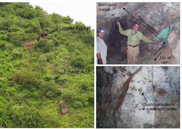
Figure 6.4: Photographs from San Marcos. A) The Upper and Lower San Marcos adits exposed along a shrub and tree covered hillside. B) The main quartz-carbonate vein exposed in the Lower Adit. The vein is 2 m wide and contains a brecciated upper contact cemented with quartz-carbonate. Note the strong Cu-oxides within the vein. C) One to 5 cm wide chalcopyrite blebs within the quartz-carbonate vein in the Lower Adit.
In September 2006 the zone was sketch mapped and 20 chips samples were taken (Fig. 6.4, 6.5) . Several chip samples were taken across the main quartz veins and samples were taken in the surrounding calc-silicate altered rocks which contain minor quartz veins, sulfides, and locally Cu-oxides. Sampling was designed to determine the average grade of the high-grade vein as well as grades in the adjacent wall rocks to help evaluate the width potential of the zone.
| November 17, 2006 | |
| Resource Estimate: | Project No.: 03PM69 |
| Tyler Resources Inc. Bahuerachi Property, | |
| Chihuahua State, Mexico | |
| Prepared for: Tyler Resources Inc. | 32 |

Figure 6.5: Sketch map of the San Marcos workings showing geology and chip sample locations.
The main quartz-carbonate vein at San Marcos is 2 m to 4 m wide, strikes roughly east west (between 76º-110º) and dips to the north at 48º-60º. The vein has been traced for 80 m along strike and is lost under cover at both ends. The vein is exposed over a vertical extent of 50 m and is open at depth. The vein is composed mostly of white to clear sugary quartz with patchy calcite and about 2%-8% chalcopyrite-pyrite-specularite-galena occurring as 1 cm-5 cm blebs within quartz-carbonate. The margins of the vein are locally brecciated with angular to sub angular wallrock clasts cemented in a quartz-carbonate matrix. A second north to northwest trending (160º), steeply dipping vein intersects the main vein in the Upper Adit. This vein is 80 cm wide and contains blebs of galena and chalcopyrite. Patchy small irregular quartz veins occur in the rocks surrounding the main veins. Seven chip samples were collected from the main vein, ranging from 1.3 m-4 m in length (samples 645925, 33, 34, 37, 38, 39, 43). The seven samples average 1.7% Cu (range 0.6% -3.2%), 0.43% Pb (range 0.01% -2.79%), 0.07% Zn, (range 0.02 to 0.14%), 79.6 g/t Ag, (range 17.7 to 208 g/t), and 0.12 g/t Au (range 0.008 to 0.67 g/t). Additional chip samples from a relatively complex area at the Upper adit where two or more veins intersect contain 0.05% -3.2% Cu, 0.01% -0.8% Pb, 21 g/t-477 g/t Ag, and 0.01 g/t-0.07 g/t Au (samples 645924, 30, 32, 35).
Wallrocks surrounding the veins are green to multicolored calc-silicate to fine grain skarn. They appear to be composed mostly of epidote, garnet, pyroxene and salmon colored feldspar(?). The protolith is uncertain. Chip sampling of wallrocks immediately north of the main vein near the
| November 17, 2006 | |
| Resource Estimate: | Project No.: 03PM69 |
| Tyler Resources Inc. Bahuerachi Property, | |
| Chihuahua State, Mexico | |
| Prepared for: Tyler Resources Inc. | 33 |
upper adit returned an average of 0.8% Cu, 0.2% Pb, 223 g/t Ag, and 0.03 g/t Au over 8 m (samples 645927, 28, 29, 31). A 2 m chip sample of wallrock just south of the upper adit returned 1.5% Cu, 0.2% Pb, 0.1% Zn, 8.8 g/t Ag, and 0.01 g/t Au (sample 645926). In this area significant mineralization occurs over a width of at least 20 m and is open. At the lower adit wallrocks to the north of the vein average 0.1% Cu, 7.6 g/t Ag, and 0.01 g/t Au over 6 m (samples 645940, 41, 42) and a 1.5 chip sample south of the vein contained 1.2% Cu and 0.2% Zn.
Chip sampling results confirm the relatively high grade nature of the main vein at San Marcos and also demonstrate good potential for larger zones of mineralization surrounding the main vein. The presence of high silver content in the main vein and in the rocks surrounding the vein is significant.
The San Marcos veins cut calc-silicate alteration, and therefore post date it. The relationship, if any, to calc-silicate or skarn formation is unknown and the origin of the veins is uncertain. The veins do not contain epithermal textures and it is suspected that they are deeper and higher temperature than epithermal veins. The veins share some common characteristics with some of the quartz-carbonate-sulfide veins in the Butte district, Montana, which are thought to have formed at relatively deep levels peripheral to or above a porphyry-Cu related hydrothermal system.
Table 6.3: Chip samples results from the San Marcos prospect.
| Au | Ag | Cu | Pb | Zn | |||
| Sample | Type | Description | ppm | ppm | ppm | ppm | ppm |
| 645924 | 2 m chip | yellow-brown garnet, epidote, qtz | 0.054 | 58 | 2450 | 1525 | 403 |
| veins | |||||||
| 645925 | 2 m chip | calc-silic + skarn alt, fine grained | 0.04 | 208 | 21700 | 27900 | 384 |
| garnet | |||||||
| 645926 | 2 m chip | siliceous, epi-chlor alt. With f.g. | 0.013 | 8.8 | 14500 | 1885 | 1260 |
| sulfides | |||||||
| 645927 | 2 m chip | Tan-green-brown fg seds. qtz veinlets | 0.006 | 25.2 | 5010 | 2040 | 263 |
| with sulfide | |||||||
| 645928 | 2 m chip | Tan-green-brown fg seds. qtz veinlets | 0.032 | 303 | 16800 | 1915 | 469 |
| with sulfide | |||||||
| 645929 | 2 m chip | Tan-green-brown fg seds. qtz veinlets | 0.038 | 261 | 5310 | 1115 | 165 |
| with sulfide | |||||||
| 645930 | 1.5 m chip | Strong malachite staining, mm veinlets | 0.074 | 477 | 32000 | 6950 | 775 |
| of qtz+ccpy | |||||||
| 645931 | 2 m chip | Tan-green-brown fg seds. qtz veinlets | 0.044 | 303 | 4910 | 3480 | 187 |
| with sulfide | |||||||
| 645932 | 1.5 m chip | light grey, qtz rich, wallrock + qtz vein | 0.011 | 21.5 | 1980 | 124 | 577 |
| 645933 | 1.5 m chip | grey, qtz rich, skarn alt, f.g garnet, | 0.008 | 152 | 32000 | 717 | 1220 |
| abundant malachite | |||||||
| 645934 | 2 m chip | qtz-carbonate, skarn alt. strong | 0.009 | 42.7 | 15300 | 132 | 207 |
| veining, cm size sulfide |
| November 17, 2006 | |
| Resource Estimate: | Project No.: 03PM69 |
| Tyler Resources Inc. Bahuerachi Property, | |
| Chihuahua State, Mexico | |
| Prepared for: Tyler Resources Inc. | 34 |
| 645935 | 2 m chip | Galena mineralization in calc | 0.026 | 45.3 | 533 | 8220 | 243 |
| silc alt seds. | |||||||
| 645936 | 1.5 m chip | Fine grained tan-green seds | <0.005 | 4.9 | 11700 | 365 | 2080 |
| 645937 | 2 m chip | qtz-carbonate, skarn alt, strong | 0.672 | 84.6 | 22900 | 550 | 774 |
| veining | |||||||
| 645938 | 1.3m | Qtz+carbonate vein material, | 0.013 | 17.7 | 6210 | 123 | 562 |
| abundant ccpy blebs | |||||||
| 645939 | 4.0 m chip | Qtz+carbonate vein material | 0.03 | 25.8 | 11200 | 136 | 695 |
| 645940 | 2 m chip | siliceous calc-silic alt, partial | <0.005 | 3.1 | 1680 | 53 | 426 |
| skarn and veins | |||||||
| 645941 | 2 m chip | siliceous calc-silic alt. | 0.008 | 4.9 | 1340 | 154 | 292 |
| 645942 | 2 m chip | siliceous calc-silic alt. | 0.03 | 14.7 | 802 | 101 | 281 |
| 645943 | 3.0m chip | Qtz+carbonate vein material | 0.053 | 26.1 | 10500 | 441 | 1400 |
| with sulfide blebs |
6.7 Cuesta Colorada (Cu, Au, Ag, Zn, Pb)
Data from the Cuesta Colorada prospect previous to 2003 was summarized in a previous report. New data for work conducted since 2003 is presented here.
Cuesta Colorada is located in the south part of the property adjacent to a large prominent knob of gray limestone. Only one small adit is known in the area and very little exploration work has been conducted.
Along a saddle on the north side of the limestone knob beds of limestone, skarn, with minor sandstone and conglomerate are exposed. The beds strike 110° to 155° and dip 25° to 32° to the northeast. Minor mineralization occurs at the upper contact of the main limestone bed, where massive limestone is interbedded with sandstone and conglomerate, then gives way upsection to a thick sequence of conglomerate-sandstone-silt or mudstone. Skarn to fine grained calc-silicate alteration has partially replaced limestone beds, and silicification and calc-silicate minerals locally occur in the matrix of quartz rich sandstones and conglomerates. Individual skarn beds are 10 cm to about 1 m thick, and most outcrops contain about 30% skarn beds and 70% limestone or sandstone beds. Pale green fine grained pyroxene, epidote, fine grained garnet, quartz, and locally pyrite, galena, and chalcopyrite have been identified in the skarn beds. Many of the skarn beds contain minor green Cu-oxide stains. Silicification and quartz veins are notable in the sandstone and conglomerate and in marble on the east side of the saddle.
An adit occurs 100 m northeast of the saddle and contains a 10 cm-20 cm wide E-W trending quartz vein plus minor zones of silicification and patchy zones of weathered Fe, Cu, and Zn oxides with minor pale green pyroxene skarn. Malachite, azurite, smithsonite, chalcopyrite, and galena have been identified at the adit. The quartz vein consists of white to clear granular quartz with euhedral quartz crystals and possibly contained about 5%-10% sulfides prior to weathering. Quartz veining is relatively abundant in the limestone adjacent to the adit, and a 2 m wide vein which strikes 170° and dips 78° east is exposed 40 m south of the adit. The quartz veins have
| November 17, 2006 | |
| Resource Estimate: | Project No.: 03PM69 |
| Tyler Resources Inc. Bahuerachi Property, | |
| Chihuahua State, Mexico | |
| Prepared for: Tyler Resources Inc. | 35 |
similar sugary textures and sulfide mineralogy as the veins at San Marco, although they contain more abundant euhedral quartz crystals and open space vugs.
A feldspar-biotite-hornblende-quartz porphyry is exposed 75 m east of the adit. The porphyry is chlorite altered and no veins were observed. The extent of the porphyry has not been determined.
Eight chip samples were taken across variably skarned limestone or sandstone-conglomerate bearing outcrop in the Saddle area, 4 samples were taken in the adit, and one chip sample was taken from the quartz vein south of the adit. The eight samples from the saddle area contained 0.1% -3% Zn, trace to 0.4% Cu, 2 g/t-162 g/t Ag, and trace to 0.2 g/t Au (samples 645944 to 51). These samples were taken over a 75. Sampling within the small adit contained a length weighted average of 4.7% Zn, 0.91% Pb, 0.37% Cu, 61.5 g/t Ag, and 0.16 g/t Au over 5.5 m (samples 645952, 53, 54). A composite grab from a 30 cm wide quartz vein in the adit returned 1.55 g/t Au, 98 g/t Ag, 1.4% Pb, 0.15% Zn, and 0.08% Cu (samples 645955). A 2 m wide quartz vein located 40 m south of the adit returned 0.34 g/t Au, 51.4 g/t Ag, 0.14% Cu, 0.22% Pb, and 0.47% Zn over 1.5 m (sample 645956).
| November 17, 2006 | |
| Resource Estimate: | Project No.: 03PM69 |
| Tyler Resources Inc. Bahuerachi Property, | |
| Chihuahua State, Mexico | |
| Prepared for: Tyler Resources Inc. | 36 |

Figure 6.6: Photographs of Questa Colorada saddle. A) From Limestone cliff looking north toward the saddle. B) View of the saddle looking south toward the limestone knob.
| November 17, 2006 | |
| Resource Estimate: | Project No.: 03PM69 |
| Tyler Resources Inc. Bahuerachi Property, | |
| Chihuahua State, Mexico | |
| Prepared for: Tyler Resources Inc. | 37 |

Figure 6.7:Sketch map of the Cuesta Colorada propect showing simplified geology and sample locations.
A prominent and very linear limestone cliff on the east side of Cuesta Colorada is likely a fault scarp. Exposure is very limited around this suspected fault, but steeply dipping NNW trending fractures are abundant in the limestone along the scarp. Limited outcrop suggests there is limestone to the west of the fault and porphyry to the east. Skarning and quartz veining appear to increase to the east, and the limestone becomes bleached and marbleized to the east, indicating a heat source on the east side. Although no large zones of potentially economic mineralization are
| November 17, 2006 | |
| Resource Estimate: | Project No.: 03PM69 |
| Tyler Resources Inc. Bahuerachi Property, | |
| Chihuahua State, Mexico | |
| Prepared for: Tyler Resources Inc. | 38 |
currently exposed at Cuesta Colorada the zone around the adit is poorly exposed and has seen very little exploration work. The covered limestone-porphyry contact adjacent to the adit is prospective for mineralization and could be a target with at least hundreds of metres of strike potential.
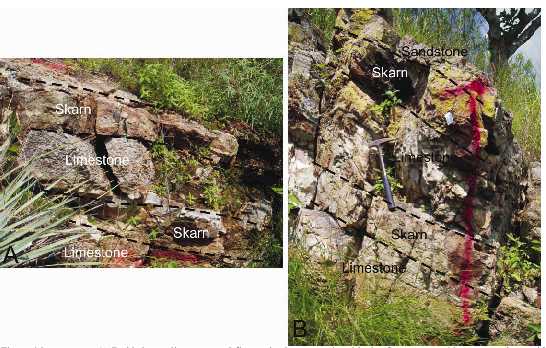
Figure 6.8:A) Bedded gray limestone and fine grained green replaced beds of pyroxene-epidote-garnet skarn with minor Cu-oxides and locally sulfides. Sample 645949 is from this site. B) Bedded gray limestone, skarn, and sandstone (top). Sample 645947 is from this site.
| November 17, 2006 | |
| Resource Estimate: | Project No.: 03PM69 |
| Tyler Resources Inc. Bahuerachi Property, | |
| Chihuahua State, Mexico | |
| Prepared for: Tyler Resources Inc. | 39 |

Figure 6.9: A) The adit at Cuesta Colorada. B) Photo of the adit roof with a quartz vein, iron oxides and skarn and marble. C) Outcrop just south of the adit showing skarn beds and veinlets within marble.
Table 6.4: Chip samples results from the Cuesta Colorada prospect.
| Sample | Type | Description | Au | Ag | Cu | Pb | Zn |
| ppm | ppm | ppm | ppm | ppm | |||
| 645944 | 1.25m | calc-silic alt. yellow-brown garnet, | 0.054 | 43.6 | 1115 | 1480 | 12300 |
| chip | CuOx | ||||||
| 645945 | 1.25m | calc-silic alt. yellow-brown garnet, | 0.044 | 15.4 | 1505 | 1370 | 12000 |
| chip | CuOx | ||||||
| 645946 | 1m chip | marble with pods of calc-silic and | 0.069 | 46.9 | 3980 | 1765 | 13200 |
| skarn | |||||||
| 645947 | 1.5m chip | yellow-brown garnet pyroxene skarn | 0.196 | 162 | 593 | 9680 | 13900 |
| 645948 | 3m chip | limestone with thin seams of skarn | <0.005 | 7 | 75 | 298 | 1155 |
| 645949 | 2m chip | limestone with thin seams of skarn | 0.005 | 1.9 | 45 | 172 | 1425 |
| 645950 | 1.5m chip | conglomerate limestone contact | 0.02 | 15 | 1825 | 1295 | 30300 |
| 645951 | 2m chip | f.g calc-silic and gar-pyrox skarn | 0.019 | 27.6 | 1480 | 345 | 2000 |
| 645952 | 2m chip | Marble, with silic, Cu and Zn oxides | 0.168 | 103 | 7340 | 9660 | 59500 |
| 645953 | 2m chip | Marble, with silic, Cu and Zn oxides | 0.149 | 48.4 | 1200 | 6580 | 15700 |
| 645954 | 1.5m chip | Marble, with silic, Cu and Zn oxides | 0.157 | 23.6 | 2190 | 11700 | 72000 |
| 645955 | Composite | vein of white to clear suggary quartz | 1.55 | 98 | 799 | 14200 | 1530 |
| 645956 | 1.5m chip | 2m wide quartz vein | 0.336 | 51.4 | 1395 | 2230 | 4680 |
| November 17, 2006 | |
| Resource Estimate: | Project No.: 03PM69 |
| Tyler Resources Inc. Bahuerachi Property, | |
| Chihuahua State, Mexico | |
| Prepared for: Tyler Resources Inc. | 40 |
6.8 North Skarn Area
Massive skarn zones, related to an extensive copper-in-soil anomaly, were identified over an area of roughly 500 m by 800 m in the north central part of the property. Topography reveals massive skarn replacement formations over 240 m vertically. Other skarn zones are known in the area and mapping is ongoing to tie in the known skarn outcrops with other showings over a target area in excess of 1 km by 1 km.
Results from first pass drilling at the North Skarn confirmed that the target hosts locally significant copper mineralization, including 19.5 m grading 0.57% copper, as well as locally elevated values of silver, gold and molybdenum. These findings are consistent with the identification of a new mineralized center distinct from the Main Zone where the bulk of the drilling has been conducted to date.
Table 6.5: Significant intervals for diamond drill holes BAH-74 and BAH-80.
| From | To | Interval | Copper | Gold | Silver | Zinc | |||
| Hole | (m) | (m) | (m) | (%) | (g/t) | (g/t) | (%) | Mo (%) | Rock Type |
| BAH-74 | 6.71 | 9.75 | 3.04 | - | 0.45 | - | 0.20 | - | Skarn |
| and | 80.6 | 100.1 | 19.5 | 0.57 | - | 1.2 | - | - | Skarn |
| and | 105.9 | 114 | 8.1 | 0.34 | - | - | - | - | Skarn |
| and | 157 | 158.5 | 1.5 | 0.78 | - | 1.8 | 0.26 | - | Skarn/Breccia |
| BAH-80 | 30.1 | 37 | 6.9 | 0.39 | - | 1.3 | - | 0.003 | Skarn |
| and | 62 | 70 | 8.0 | 0.30 | - | - | - | - | Skarn |
True widths are interpreted to be 90-100% of intervals as quoted.
The North Skarn occurrence represents a large scale target with significant amounts of metal transport, recrystallization and replacement of local hosts rocks. Further work in this area consists of regional reinterpretation of surface and drill data, as well as additional surface mapping and sampling. The skarn itself may be caused by the presence of a new unexposed porphyry system as a driver to the skarn formation, as is seen in the Main Zone to the south east.
6.9 Other Showings
Numerous other mineralized showings, both of skarn type copper/zinc, mesothermal style veins and hydrothermal gold-silver dominated mineralization have been summarily sampled on the property. Surface work continues in these areas as the Company expands its efforts to bring forward other sizeable exploration targets to the drill stage.
Mineral occurrences identitfied to date are consistent with the typical distribution and zoning of mineralization in a classical porphyry district with the more volatile elements (zinc, silver, gold) being deposited in intermediate to distal settings around the main porphyry system which acts as a regional heat source for the introduction and remobilization of metals on a regional basis.
| November 17, 2006 | |
| Resource Estimate: | Project No.: 03PM69 |
| Tyler Resources Inc. Bahuerachi Property, | |
| Chihuahua State, Mexico | |
| Prepared for: Tyler Resources Inc. | 41 |
7.0 SAMPLING METHOD AND APPROACH
7.1 2001 Sampling
Sampling during the 2001 program was conducted within the Main Zone as representative, continuous chip samples in 11 sections. Grab samples have been treated as point data which do not allow for true width/grade determinations.
Four sections within the Main Zone were partially re-sampled in duplicate during 2001 with one set of samples collected by a third party consultant who maintained custody of samples during the program. Comparison analysis of the assay results by Associated Mining Consultants Ltd. confirms that sampling methodology was adequate during the program and that sample results were reliable.
Estimates of minimum interpreted true widths for continuous chip sample sections was made by consensus by the three geologists involved on the project and have taken into account the following factors: geology, topography, geological controls on mineralization and degree of exposure along particular sections.
Sample security and integrity during the field program and subsequent transport of samples to the ALS-Chemex lab facilities to Hermosillo was insured through the use of individually numbered, tamper proof plastic tags. No issues of tampering or missing tags were reported by the Hermosillo lab upon receipt of the samples from the field and samples were in the custody of Tyler personnel at all times before delivery to ALS-Chemex.
7.2 2003 Underground Sampling
Underground channel/chip samples were collected by staff from Mineras Cascabel S.A. de C.V. (a consulting/exploration services group based in Hermosillo, Mexico) and Tyler Resources Inc. Keith McCandlish, P.Geol. was present during the sample collection phase.
Approximately 280 m of adit was cleaned by the removal of bat guano (dry bat guano may be a significant health risk due to the presence of the histoplasmosis parasite) and permitting dammed water to freely exit. One wall of the adit was cleaned of all secondary oxide mineralization to expose a fresh face. The secondary oxides are clear evidence of continued leaching of copper and zinc minerals from the host rock.
Continuous chip samples ranging in length between 1 m-2 m were chiseled by hand from the freshly exposed wall and collected in a sample rig placed directly under the sample interval. The hard nature of the host material precluded this being considered as a true channel sample, however, in AMCL’s opinion the samples are representative.
| November 17, 2006 | |
| Resource Estimate: | Project No.: 03PM69 |
| Tyler Resources Inc. Bahuerachi Property, | |
| Chihuahua State, Mexico | |
| Prepared for: Tyler Resources Inc. | 42 |
7.3Phase I and II Drilling
The figure below depicts the drillhole distribution throughout the project area:

Figure 7.1: Drillholes drilled. Red = DD blue = RC
Drilling on the project comprises both reverse circulation and diamond drilling methods. Tyler currently has two contractors on site: Drift Exploration Drilling Inc. operating as Conservation De Queretaro S.A. de C.V. (reverse circulation) and B.D.W. International Drilling of Mexico S.A. de C.V.
7.3.1Reverse Circulation Drilling
Reverse circulation drilling comprises both air drilling with a face sampling hammer (the preferred option) and wet drilling with a rotary bit. Dry samples are split at the rig in a riffle splitter whereas the wet samples are split in a hydrocyclone.
Chips are logged and a representative set of chips retained in plastic chip containers.
| November 17, 2006 | |
| Resource Estimate: | Project No.: 03PM69 |
| Tyler Resources Inc. Bahuerachi Property, | |
| Chihuahua State, Mexico | |
| Prepared for: Tyler Resources Inc. | 43 |
7.3.2Diamond Drilling
Two new Longyear LF 90 core rigs with PQ heads have been brought on site to improve core recoveries which were initially very poor due to the fractured nature of the rock. Current practice involves starting a PQ size hole and dropping the core size to NQ as drilling conditions warrant. The core is placed in plastic core trays at the drill rig and collected daily by the geologists.
During the site visit, the core driller’s were observed mishandling the core including the placing of core pieces in an incorrect position and orientation in the core boxes, over breaking of the core and incorrect positioning of the depth markers in the core boxes. Field staff indicated that they spent considerable time depth correcting and reconstructing the core prior to logging. The core drillers and helpers require more stringent field supervision and training to ensure that core integrity is maintained at the rig.
The core is logged and marked for sampling by the geologist. The core is split on site using a diamond saw and half of the core retained on site in a core shed. Sample intervals in some cases are up to 2 m although sampling is constrained by lithology.
7.3.3 Down Hole Surveys
There were 20 diamond drill holes with down-hole surveys (12%). Six were done in the holes drilled in the 2005 drilling campaign, and the remaining 14 in holes drilled in 2006 (70%).
Down hole surveying was done in 20 of the 52 holes drilled deeper than 250 m (38%), and in 15 of 27 holes deeper than 400 m (56%), and 6 of the 9 holes drilled in access of 500 m (67%). A chart plotting the difference of measured and planned position of the holes are depicted below.
From this chart it is clear that holes drilled to a depth of 250 m did not deviate more than 20 m from the planned position. Of these 12 holes surveyed, 12 had deviations measured less than 10 m, or less than 4% deviation on depth. The holes greater than 250 m deviated up to 40 m and with one hole deviating 44 m (total depth 506 m or 8.7% deviation on depth). From the linear equation it can be seen that the average deviation for holes up to 250 m is 3.8% and the total deviation for all the holes that were surveyed were 4.7% compared to length drilled.
| November 17, 2006 | |
| Resource Estimate: | Project No.: 03PM69 |
| Tyler Resources Inc. Bahuerachi Property, | |
| Chihuahua State, Mexico | |
| Prepared for: Tyler Resources Inc. | 44 |

These deviations are not excessive although all holes drilled to depths greater than 200 m should routinely be surveyed down hole.
Data from all programs including assay sheets and core logs have been retained on file.
| November 17, 2006 | |
| Resource Estimate: | Project No.: 03PM69 |
| Tyler Resources Inc. Bahuerachi Property, | |
| Chihuahua State, Mexico | |
| Prepared for: Tyler Resources Inc. | 45 |
8.0 SAMPLE PREPARATION, ANALYSES AND SECURITY
Associated Mining Consultants Ltd. prepared a letter report dated June 09, 2004 with recommendations for the implementation of a quality assurance (QA) and quality control (QC) program for the handling of drilling samples from the Phase II exploration program at Bahuerachi. Prior to this, Tyler Resources Inc. did not have s systematic on-going quality assurance (QA) program in place for the Bahuerachi project. Some quality control (QC) was provided by independent data verification as well as the laboratory’s internal procedures.
Quality assurance (QA) refers to a plan for implementing practices which ensure that appropriate measures have been taken to ensure sample integrity, appropriate sample preparation and analytical methods, and internal and external checks of the accuracy and precision of assay data. Part of quality assurance is making sure that the laboratory follows, and reports on, its own internal quality assurance and quality control procedures.
Quality control (QC) refers to the actual procedures used to verify the accuracy and precision of the data received.
As the Bahuerachi exploration project proceeds, Tyler Resources has implemented a comprehensive QA/QC program to ensure the validity of the sample analytical data.
Tyler has now implemented a program of geotechnical logging including the determination of the rock quality designation (RQD) as well as fracture density, type and filling.
8.1 Prior Practices
During Phase I drilling, HQ (or NQ) sized core wass transported in open boxes from the drill site to the camp core logging facility. The core recovery is calculated and the core is geologically logged. Samples intervals are marked by the geologist and are generally constrained by lithological breaks. Sample intervals were as great as 2 m due to poor core recovery.
The poor condition of the core suggested that core recovery estimates were a “best guess”.
The core from the marked sample intervals was cut in half using a diamond saw by a site geologist.
The poor, “rubbly”, condition of the core makes accurate sampling difficult and Tyler is cautioned that some of the assays from Phase I drilling should be considered as indicative of the presence of mineralization but not necessarily representative of the grade of any particular interval.
Obviously where there has been good core recovery, greater than 80%-85%, there can be a reasonable expectation that the grade is representative of that cored interval. However, where
| November 17, 2006 | |
| Resource Estimate: | Project No.: 03PM69 |
| Tyler Resources Inc. Bahuerachi Property, | |
| Chihuahua State, Mexico | |
| Prepared for: Tyler Resources Inc. | 46 |
variable recoveries or areas of poor recovery exceeding 2-3 runs occur then it becomes difficult to extrapolate the grade over an extended interval. Another issue arises when a zone of good recovery between areas of poor recovery occur which can lead to loss of depth control in the sample.
The samples are then bagged and a number of sample bags are placed together in rice sacks and sealed with individual number tamper proof security seals. Rice sacks are security tagged. On a regular basis samples are transported to the town of Choix where they are transferred to a vehicle provided by the sample preparation facility in Hermosillo, Mexico.
At the ALS-Chemex sample preparation facility, the received samples were weighed, dried and crushed to 70 % <2 mm. After riffle splitting the coarse samples were pulverized to 85 % <75µm and shipped to the ALS-Chemex facility in North Vancouver, British Columbia, Canada for analysis.
The samples undergo a multi-element geochemical analysis procedure for 34 elements (Method Code ME-ICP 41). This involves anaqua regiapartial digestion followed by an instrumental analytical method, inductively coupled plasma-atomic emission spectroscopy. This method may under-report certain elements such as aluminum, calcium, chromium, potassium and magnesium (as well as many resistate elements) due to the partial digestion and should not be used to develop any geochemical ratios using these elements.
Gold (Au) is determined using a 30 g fire-assay with an atomic absorption finish (Method Code Au-AA23). Where the multi-element procedure indicates that the concentration of copper (Cu), lead (Pb) and zinc (Zn) are >10,000 ppm (or 1 %) or 100 ppm in the case of silver (Ag), then these samples are re-analyzed using an ore grade methodology (Method Codes Cu, Ag, Pb or Zn-AA46). This involves anaqua regiadigestion followed by an atomic absorption finish.
8.2 Current Practices
Two components of external quality control have been implemented. These involve the use of “Standards” or “Reference Controls” as well as a program based on the submission of duplicate samples.
8.2.1 Standards
Standards or reference controls for various metals can be readily purchased in Canada from CANMET. These samples are very finely ground and readily obvious when submitted with core or other geochemical samples. If the sample preparation facility is in-house or independent of the laboratory then these standards can be inserted at that stage as a check on the laboratory. This procedure will eventually fail if the standards appear different from the local lithologies as the laboratory will eventually determine the expected value of the standards and there will be a tendency (conscious or otherwise) to report the required values.
| November 17, 2006 | |
| Resource Estimate: | Project No.: 03PM69 |
| Tyler Resources Inc. Bahuerachi Property, | |
| Chihuahua State, Mexico | |
| Prepared for: Tyler Resources Inc. | 47 |
Therefore, standards (at a minimum of two concentrations, low and high) should be prepared from local materials whenever possible. Local standards will also minimize potential matrix effects from different source materials. AMCL recommended a sample of QFP for a high-grade standard and a sample of the sediments for a low-grade standard. Care should be chosen in selecting a sample that does not contain a significant iron content as this causes well documented interferences in ICP analytical methods. The sample volume should be sufficient to last for a substantial period of exploration.
High and low-grade certified standards have been prepared under the supervision of Mr. Barry Smee, P.Geol.
The sample should be thoroughly mixed in a paddle type (cement) mixer and dry ground in a pilotscale rod or ball mill. If only small equipment is available for grinding then batch grinding could be used, followed by re-mixing in the paddle mixer. In order to check the homogeneity of the sample spread it out on a plastic sheet and select ten areas for multipoint sampling. Submit the sub-samples for analysis and repeat mixing sampling and assaying as required. Once the homogeneity has been established then samples should be sent to a number of different labs to establish the “expected value” for the standard. When the bulk is homogenous it is better to divide out sub-samples of the required weight into individual packets as a bulk mass will undergo segregation over time.
As the sample preparation facility used by Tyler Resources is owned and operated by the analytical laboratory it will be very difficult to insert external controls that the laboratory will not recognize. Having said this, there is still value in preparing a low and high grade reference control material which can be included in various random sample analytical batches. This will become important in a larger program. As well, the standards can be used as a check on a second laboratory.
8.2.2 Duplicate Samples
A program of duplicate samples is the preferred system for ensuring the accuracy and precision of the analytical data. The following practices have been implemented for the Bahuerachi project:
- In this case, where the sample preparation facility is notindependent of the laboratory, both laboratory pulps (assayrejects) and coarse rejects should be returned to Tyler Resources.
Approximately 5 %-10 % of these, covering a range of lithologiesand concentrations (of all of the principal elements of interest),should be re-submitted to the primary laboratory in new bags withnew numbers for re-analysis. The assay repeats will checkanalytical errors and the coarse rejects will check samplepreparation and analytical errors.
| November 17, 2006 | |
| Resource Estimate: | Project No.: 03PM69 |
| Tyler Resources Inc. Bahuerachi Property, | |
| Chihuahua State, Mexico | |
| Prepared for: Tyler Resources Inc. | 48 |
- Approximately 5% of the core sample intervals should be split andsubmitted to the sample preparation facility under different samplenumbers. A limited number of laboratory pulps and coarse rejectsfrom these samples should be submitted to a second laboratory asan external check on laboratory bias.
Field sampling procedures are appropriate and sample quality has improved with better core recovery.
The analytical procedures currently used by Tyler resources are generally appropriate for this stage of exploration. The potentially mineralized samples comprise various lithologies which have been variably altered, undergone metasomatic processes (skarn) and may be comprised of oxidized material (± secondary sulphides such as chalcocite) as well as primary sulphide minerals.
The basicaqua regiadigestion should be adequate for most samples, however, multi-acid digestion should be tried on several duplicate samples from the next program to ensure complete reporting of the elements of interest.
Due to the presence of variable degrees of oxidation, samples should be submitted (on a routine basis for) for total sulphurvssulphide sulphur.
Where there is good core recovery in the oxidized zone, Tyler Resources may wish to consider the selective use of sequential copper analyses. This method reports sulfuric acid soluble copper (nonsulphide), cyanide soluble copper, and total copper. This type of analysis produces data which may be very valuable to a major considering involvement in the project.
10,000 ppm is the upper detection limit for copper, zinc and lead using Method Code ME-ICP41. Tyler Resources should re-analyze samples containing concentrations of these elements >5,000 ppm (possibly 2,500 ppm in the case of copper) using an atomic absorption (AAS) method.
The majority of the recommendations of this report have been implemented with the exception of copper sequential analysis and geotechnical logging. Tyler has implemented these last two recommendations as of the date of the report.
| November 17, 2006 | |
| Resource Estimate: | Project No.: 03PM69 |
| Tyler Resources Inc. Bahuerachi Property, | |
| Chihuahua State, Mexico | |
| Prepared for: Tyler Resources Inc. | 49 |
9.0 DATA VERIFICATION
9.1Independent Data Verification
Data verification for the August 2003 underground sampling program was carried out, independently, by Keith McCandlish, P.Geol., of Associated Mining Consultants Ltd. (AMCL).
The samples were bagged, labeled, sealed and returned to the base camp. At the camp the samples were opened and logged, photographed and representative chips collected for mineral identification by J.P. Jutras. Keith McCandlish selected eleven samples from different lithologies which were then split in the field and the split re-bagged with a different field sample number. Tyler was not permitted to observe this procedure. All of the samples bags were sealed by Keith McCandlish and subsequently placed in 20 L plastic pails which were then sealed using AMCL tamper proof seals. The pails were shipped by burro to the village of La Reforma and by truck to the ALS-Chemex sample preparation facility in Hermosillo, Mexico accompanied at all times by the authors. Some plastic pails were opened and inspected by Mexican Federal Police in a routine drug inspection. Opened pails were re-sealed and all were delivered to ALS-Chemex.
At the ALS-Chemex sample preparation facility, the received samples were weighed, dried and crushed to 70% <2 mm. After riffle splitting the coarse samples were the samples were pulverized to 85% <75µm and shipped to the ALS-Chemex facility in North Vancouver, British Columbia, Canada.
The samples were subjected to two analytical procedures: gold was determined using a 30 g fire assay fusion with an atomic absorption spectroscopic finish (Method Code Au-AA25). The samples were also subject to analysis for 34 individual elements using a single acid (aqua regia) digestion followed by analysis by inductively coupled plasma-atomic emission spectroscopy (Method Code ME-ICP41).
Some discrepancies in the analytical results between the original samples and the field splits were considered to be of significance, not withstanding the coarse nature of the mineralization and the crude method of field splitting (cone and quarter). Coarse rejects of the split samples were shipped from the ALS-Chemex facility in Hermosillo directly to SGS-Lakefield in Lakefield, Ontario. As well, pulp rejects of the same samples were shipped from ALS-Chemex in North Vancouver to SGS-Lakefield.
These samples were analyzed for gold using a 30 g fire assay fusion with a gravimetric finish. The remnant material was subject to a three acid digestion with analytical determination for copper, zinc, and silver by X-ray fluorescence (XRF). A multi-acid digestion was chosen since it results in a more complete digestion of the host material (particularly important given the complex mineralogy) and should result in more representative results.
| November 17, 2006 | |
| Resource Estimate: | Project No.: 03PM69 |
| Tyler Resources Inc. Bahuerachi Property, | |
| Chihuahua State, Mexico | |
| Prepared for: Tyler Resources Inc. | 50 |
As a result of this check assay program, it was determined that the discrepancies in results were due to the coarse nature of the mineralization and poor sampling technique (in terms of field splitting) rather than any problem with sample preparation or analytical method.
AMCL also selected two drill holes (04BAH-DDH4 and 04BAH-DDH 7) from Phase I drilling (May-June, 2004) for re-sampling as they had reasonable recoveries over a range of intervals. Selected sample intervals (which had already been submitted to the laboratory) were chosen to cover a range of lithological types and potential copper concentrations (based on the observed presence or absence of various, multiple copper oxide and sulphide minerals). The remaining half core was resawn, sampled and submitted to the laboratory using different sample numbers. The samples were mixed in with other core samples being shipped at the same time. Coarse rejects and laboratory pulps from these samples as well as the original core split were be sent to a second laboratory for analyses.
At the ALS-Chemex sample preparation facility in Hermosillo, Mexico the received drilling samples were weighed, dried and crushed to 70% <2 mm. After riffle splitting the coarse samples were pulverized to 85% <75µm and shipped to the ALS-Chemex facility in North Vancouver, British Columbia, Canada for analysis. On occasion samples were shipped to the ALS-Chemex facility in Durango, Mexico.
The samples undergo a multi-element geochemical analysis for 34 elements (Method Code ME-ICP 41). This involves anaqua regia (nitric acid or HNO3and hydrochloric acid or HCl) partial digestion followed by the determination of elemental concentration using an instrumental analytical method: inductively coupled plasma-atomic emission spectroscopy (ICP-AES). This method will under-report certain elements such as aluminum, calcium, chromium, potassium and magnesium (as well as many resistate elements) due to the partial digestion and should not be used to develop any geochemical ratios using these elements.
Gold (Au) is determined using a 30 g fire-assay pre-concentration with an atomic absorption finish (Method Code Au-AA23).
Where the multi-element procedure indicates that the concentration of copper (Cu), lead (Pb) and zinc (Zn) are >10,000 ppm (1%) or >100 ppm in the case of silver (Ag), then these samples are re-analyzed using an ore grade methodology (Method Codes Cu, Ag, Pb or Zn-AA46). This involves anaqua regia digestion followed by an atomic absorption finish. In all cases, the partialaqua regia digestion may under-report the concentrations of base metals, depending on mineralogy, however, previous analytical work requested by AMCL for Tyler suggests that the single acid digestion is complete, at least for copper and zinc.
Laboratory pulp samples provide a check on the laboratory performance while coarse reject samples provide a check on both the sample preparation facility as well as the laboratory.
| November 17, 2006 | |
| Resource Estimate: | Project No.: 03PM69 |
| Tyler Resources Inc. Bahuerachi Property, | |
| Chihuahua State, Mexico | |
| Prepared for: Tyler Resources Inc. | 51 |
In the case of Tyler original sample number 258346 and AMCL ¼ core replicate sample number 258960, ALS-Chemex did not ship the original coarse reject or laboratory pulp material corresponding to sample number 258346 to SGS-Lakefield.
Coarse reject and laboratory pulp material corresponding to Tyler original sample number 258356 were sent to SGS-Lakefield in error. There is no associated ¼ core replicate sample. This data is still useful and has been included as an additional (14th sample).
The analytical techniques used by SGS-Lakefield were chosen by AMCL to mimic the procedures used by ALS-Chemex as closely as possible.
Coarse reject samples are re-crushed, if required, to 90% - 95% <2mm. The crushed samples are riffle split in a Jones riffle to obtain a 200 g sample. The split sample is milled using a ring and puck and then transferred to a vibratory mill for final milling. Samples are milled to 90% - 95% passing 200 mesh.
The samples undergo a multi-element geochemical analysis procedure for 32 elements (Method Code ICP12B). This analytical procedure is very similar to that used by ALS-Chemex and described above.
Copper and zinc were also reported using an ore grade methodology involving anaqua regia digestion followed by an atomic absorption finish (Method Code AA70) in addition to the ICP12B procedure. SGS-Lakefield was requested to remove 10,000 ppm upper detection limits that they normally place on this method for consistency of reporting with the ALS-Chemex results. This upper detection limit is only in place due to the single acid digestion.
Silver which can be reported as part of this multi-element suite (and was by ALS-Chemex) was analyzed by SGS Lakefield using a different methodology. Gallium (Ga), boron (B), mercury (Hg), sulfur (S), thallium (Tl) and uranium (U) were reported by ALS-Chemex but not by SGS-Lakefield. Lithium (Li), tin (Sn), yttrium (Y) and zirconium (Zr) were reported by SGS-Lakefield but not by ALS-Chemex.
Gold (Au) was determined using a 30 g fire-assay pre-concentration with an inductively coupled plasma-emission spectroscopic finish (Method Code FAI303).
Silver (Ag) was determined using anaqua regia digestion with an atomic absorption finish (Method Code AAS12E).
The results of all the analyses have been compiled in a single Excelè spreadsheet which is attached to this letter report.
The correlation between the original Tyler assay data from ALS-Chemex and the coarse reject and laboratory pulp re-analysis at SGS-Lakefield across all of the elements analyzed is excellent.
| November 17, 2006 | |
| Resource Estimate: | Project No.: 03PM69 |
| Tyler Resources Inc. Bahuerachi Property, | |
| Chihuahua State, Mexico | |
| Prepared for: Tyler Resources Inc. | 52 |
As well, correlation between the ¼ core replicate samples analyzed at ALS-Chemex and the pulp and coarse reject analysis at SGS-Lakefield is generally very good. Two ¼ core replicate samples (258963, 258962) showed an unacceptable degree of variability in copper results between the ALS-Chemex analysis and both the SGS-Lakefield analyses of the laboratory pulp and coarse reject. One ¼ core replicated sample showed an unacceptable degree of variability between the SGS-Lakefield coarse reject analysis and the other two analyses. Duplicates and duplicate analyses by different methods report within a very narrow range. In all three cases, the coarse reject analysis completed by SGS-Lakefield most closely correlates with the analytical results for the original ¼ core sample possibly suggesting a minor sample preparation problem at ALS-Chemex. These were all submitted to ALS-Chemex in the same shipment. While this is a minor issue, it does point out the importance of on-going QA/QC procedures.
Different ¼ core samples arenot the same sample and may, particularly in gold assays, aid in establishing the presence of a nugget effect. The correlation between the ¼ core replicate samples and the original Tyler ¼ core sample assay data is generally very good, suggesting that there is no nugget effect present as would be expected in this type of geological environment.
9.1.1 Recommendations
There is no reason that Tyler Resources should not continue to use the facilities of ALS-Chemex.
ALS-Chemex should be instructed to report the results of internal duplicate analyses on all assay certificates.
During the Phase II drilling Tyler implemented the QA/QC program described previously in Section 8.0. This program was successful in identifying and correcting a significant mix-up in sample numbering at the laboratory. AGL has had full access to all of this information and approximately 10% of the assay database was checked against the original assay certificates.
9.2 Review of Analytical Database for Resource Modelling
A total of 13,838 samples were submitted for analysis. These samples were from diamond drilling (10,071) as well as reverse circulation drilling (3,767). No analytical data was received for the 1997 series of holes. There has been a significant increase in sample submissions over the last three years, but the splits per year between DD and RC has dropped in 2006. The table below depicts results from the sample submissions done.
| November 17, 2006 | |
| Resource Estimate: | Project No.: 03PM69 |
| Tyler Resources Inc. Bahuerachi Property, | |
| Chihuahua State, Mexico | |
| Prepared for: Tyler Resources Inc. | 53 |
Table 9.1: Drill Hole Sample Data
| Number | RC | DD | DD% | Samples per Year | |||||
| 2004 | 1231 | 459 | 772 | 62.7 | % | 8.9 | % | ||
| 2005 | 5339 | 927 | 4412 | 82.6 | % | 38.6 | % | ||
| 2006 | 7268 | 2381 | 4887 | 67.2 | % | 52.5 | % | ||
| 13838 | 3767 | 10071 | 72.8 | % | 100.0 | % | |||
| 27.2 | % | 72.8 | % |
Sampling for both sets of drilling were submitted to the same laboratory and the results were entered into spreadsheets for both the RC and diamond drilling holes. The samples were analyzed for the following elements using inductively coupled plasma-atomic emission spectroscopy.
| Au ppm, Ag ppm, Al %, As ppm, B ppm, Ba ppm, Be ppm, Bi ppm, Ca %, Cd ppm, Co ppm, Cr ppm, Cu ppm, Fe %, Ga ppm, Hg ppm, K %, La ppm, Mg %, Mn ppm, Mo ppm, Na %, Ni ppm, P ppm, Pb ppm, S %, Sb ppm, Sc ppm, Sr ppm, Ti %, Tl ppm, U ppm, V ppm, W ppm, Zn ppm |
Table 9.2: Diamond Drill Hole Data Base Sample
| November 17, 2006 | |
| Resource Estimate: | Project No.: 03PM69 |
| Tyler Resources Inc. Bahuerachi Property, | |
| Chihuahua State, Mexico | |
| Prepared for: Tyler Resources Inc. | 54 |
Table 9.3: Reverse Circulation Drill Hole Data Base Sample

9.2.1 Validation of Sampling and Check Sampling
A total of 3.1% of the Diamond Drilling samples were directed toward quality control. Samples were submitted for check analysis on a regular basis; however this interval was changed over time. No samples from the Reverse Circulation drilling was submitted for Check samples.
Table 9.4: Drill Hole Sample Data
| % Check | |||||||||
| Number | RC | DD | Check | (DD) | |||||
| 2004 | 1,231 | 459 | 759 | 13 | 1.7 | % | |||
| 2005 | 5,339 | 927 | 4,223 | 189 | 4.3 | % | |||
| 7,268 | 2,381 | 4,776 | 111 | 2.3 | % | ||||
| 13,838 | 3,767 | 9,758 | 313 | 3.1 | % | ||||
| 27.2 | % | 70.5 | % | 2.3 | % |
Looking at the individual statistics we see that there is a good correlation between the original and check samples submitted for analysis. This correlation is depicted in the table below where the average grade, minimum and maximum grades for the two data sets are given.
| November 17, 2006 | |
| Resource Estimate: | Project No.: 03PM69 |
| Tyler Resources Inc. Bahuerachi Property, | |
| Chihuahua State, Mexico | |
| Prepared for: Tyler Resources Inc. | 55 |
Table 9.5: Check Sample Data
| cu_% | zn_% | pb_% | fe_% | mo_% | au_ppm | ag_ppm | ||
| Minimum | 0.000 | 0.001 | - | 0.120 | - | - | - | |
| Original | Maximum | 2.860 | 2.620 | 0.394 | 28.100 | 0.156 | 0.306 | 100.000 |
| Sample | Average | 0.268 | 0.057 | 0.009 | 3.488 | 0.007 | 0.025 | 2.987 |
| Minimum | 0.000 | 0.001 | - | 0.120 | - | - | - | |
| Check | Maximum | 3.840 | 2.790 | 0.464 | 29.000 | 0.176 | 0.330 | 119.000 |
| Sample | Average | 0.272 | 0.054 | 0.008 | 3.463 | 0.007 | 0.024 | 3.072 |
The figures below depict the statistics for the 313 check samples compared to the original sampling.

Figure 9.1: Cu%vs C-Cu%

Figure 9.2: Zn%vs C-Zn%
| November 17, 2006 | |
| Resource Estimate: | Project No.: 03PM69 |
| Tyler Resources Inc. Bahuerachi Property, | |
| Chihuahua State, Mexico | |
| Prepared for: Tyler Resources Inc. | 56 |

Figure 9.3: Pb%vs C-Pb%

Figure 9.4: Fe% vs C-Fe%
| November 17, 2006 | |
| Resource Estimate: | Project No.: 03PM69 |
| Tyler Resources Inc. Bahuerachi Property, | |
| Chihuahua State, Mexico | |
| Prepared for: Tyler Resources Inc. | 57 |
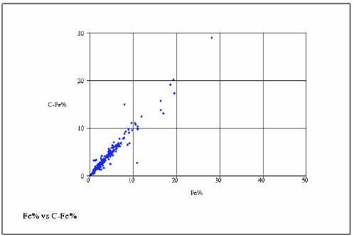
Figure 9.5: Fe% vs C-Fe%

Figure 9.6: Mo%vs C-Mo%
| November 17, 2006 | |
| Resource Estimate: | Project No.: 03PM69 |
| Tyler Resources Inc. Bahuerachi Property, | |
| Chihuahua State, Mexico | |
| Prepared for: Tyler Resources Inc. | 58 |

Figure 9.7: Ag ppm vs C-Ag ppm

Figure 9.8: Ag ppmvs C-Ag ppm
| November 17, 2006 | |
| Resource Estimate: | Project No.: 03PM69 |
| Tyler Resources Inc. Bahuerachi Property, | |
| Chihuahua State, Mexico | |
| Prepared for: Tyler Resources Inc. | 59 |
From the graphs above it is clear that there is a good correlation and repeatability in the samples that has been provided for check analysis and their spread is resonable for detailed statistical and special statistical analysis. It has to be noted though that the check samples represent only a small portion (2.3%) of the total sample population. For this reason it is suggested, that in the future at least every 20th sample (or 5%) for both RC and DD holes be submitted for repeats.
| November 17, 2006 | |
| Resource Estimate: | Project No.: 03PM69 |
| Tyler Resources Inc. Bahuerachi Property, | |
| Chihuahua State, Mexico | |
| Prepared for: Tyler Resources Inc. | 60 |
10.0 ADJACENT PROPERTIES
A 60 day regional field program in 1998 was carried out around the Bahuerachi Property. Numerous showings were visited and sampled over an area of some 400 km2 and regional mapping was carried out which enhanced the geological knowledge base for the property itself.
Although numerous copper and gold showings occur on a regional scale around the property, none are at an advanced exploration stage and Bahuerachi remains the most mature target in the area.
| November 17, 2006 | |
| Resource Estimate: | Project No.: 03PM69 |
| Tyler Resources Inc. Bahuerachi Property, | |
| Chihuahua State, Mexico | |
| Prepared for: Tyler Resources Inc. | 61 |
11.0 MINERAL PROCESSING AND METALLURGICAL TESTING
11.1 Process Research Associates Ltd
Six metallurgical composites were prepared from drill core intervals representing four zones of primarily copper (Cu) mineralization. The four mineralized zones consisted of hypogene-porphyry (HP), hypogene-skarn (HS), chalcocite blanket (CC) and oxidized skarn (OS). All of the samples were subjected to standard batch froth flotation procedures to recover sulfide minerals. In addition, preliminary acid leach tests were performed on samples from the oxidized zones (CC, OS).
The Table below shows the head assay of the six metallurgical (MET) composites, which consisted of two composites from each of the HP and HS zones, and one each from the CC and OS zones.
Table 11.1: Head Assay Grades
| Test Feed | Head Assay Grades | ||||
| ID | Au, g/t | Au, g/t | Cu, % | Fe, % | ST, % |
| MET-1 (HP1) | 0.03 | 3 | 0.46 | 2.37 | 1.70 |
| MET-2 (HP2) | 0.01 | 2 | 0.23 | 1.57 | 1.80 |
| MET-3 (HS1) | 0.09 | 11 | 1.24 | 11.5 | 14.9 |
| MET-4 (HS2) | 0.18 | 15 | 2.07 | 21.5 | 9.64 |
| MET-5 (CC) | 0.01 | 3 | 1.14 | 4.74 | 1.40 |
| MET-6 (OS) | 0.18 | 23 | 2.62 | 18.7 | 1.24 |
The skarns show higher copper and gold values with elevated iron and zinc mineral contents. Open cycle flotation of HP and HS sulphide zones recovered from 92% to 98% of the copper to the bulk concentrate. The tests showed good recoveries at a relatively coarse particle size of 80% passing (P80) of 120 µm to 160 µm, and further room to decrease grinding requirements may exist. Regrinding and flotation cleaning of the sulphide zones showed that HS material produced excellent concentrate grades of 34% Cu that also contained 1.8% Zn, up to 2.5 g/t gold and 142 g/t silver.
Cleaning of the hyprogene (HP) zone was also responsive with >75% Cu recoveries at a final grade of 19% Cu, 0.92% Mo, 0.5 g/t Au and up to 86 g/t Ag. However, the Mo separation will require many cleaning stages at a finer regrind and a much larger scale of testing. Preliminary HP results indicate that further upgrading is possible using modified flotation procedures, which should include additional cleaning stages and reagent substitution.
| November 17, 2006 | |
| Resource Estimate: | Project No.: 03PM69 |
| Tyler Resources Inc. Bahuerachi Property, | |
| Chihuahua State, Mexico | |
| Prepared for: Tyler Resources Inc. | 62 |
The CC zone produced good concentrate grades with flotation, but due to the relatively high degree of sulphide oxidation present the corresponding open cycle rougher copper recovery was only 55%. Similarly the OS zone showed a recovery of 34%. Consequently, both these oxidized zones (CC, OS) were evaluated using sulphuric acid leaching of the flotation tailings, as well as direct leaching of whole ore at various grinds. The results show that approximately 80% of the oxide-copper present in the flotation tailing can be leaching into solution for subsequent recovery. This would indicate that a combination of flotation to recover sulfide copper and acid leaching of flotation tailing to recover oxidized copper can be considered for the CC and OS material. Alternately, whole-ore leaching of these oxidized zones provided 48% to 80% in copper recovery depending on the procedures used. This offers an opportunity to investigate heap leaching, possibly in conjunction with bio-heap leaching for improving the dissolution of copper from the sulfide mineralization that is also present.
The results from the preliminary metallurgical investigation show that all of the zones test from Bahuerachi responded well to standard processing procedures. Further work is warranted to optimize procedures and forward the program in conjunction with the property exploration.
| November 17, 2006 | |
| Resource Estimate: | Project No.: 03PM69 |
| Tyler Resources Inc. Bahuerachi Property, | |
| Chihuahua State, Mexico | |
| Prepared for: Tyler Resources Inc. | 63 |
12.0 MINERAL RESOURCE AND MINERAL RESERVE ESTIMATES
12.1 Mineral Resource Estimates
12.1.1 Survey Data
An IKONOS satellite digital terrain model has been generated for the entire project area to a resolution of 2 m. Drillholes were surveyed using ground survey methods, and reduced to the map coordinates. There were some discrepancies between the collar coordinates and the topographical plan. The problems resulted from the local surveyor not reducing the coordinates in a consistent manner necessitating that the data reduction be redone. After this reduction was completed there were collars that still did not plot on the topographical data. The average discrepancy on the collars was 16.7 m before reduction and 2.3 m after reduction. These discrepancies were found to be minor and acceptable for the scope and level of the resource estimate. Collar elevations were adjusted to topography for proposes of resource modeling.
12.1.2Resource Database
The resource was evaluated by two drilling techniques i.e. predominantly diamond drilling and a smaller meterage of reverse circulation drilling. Data was captured into Microsoft Excel® spreadsheets and subsequently loaded in Surpac Vision® software, into a Microsoft Access® database. Tables included in the database are: collar, survey, sample and lithology
When data was loaded into the database there were validation checks done to ensure database integrity. The validation routines checked for the following errors or inconsistencies:
- Holes missing from sample and survey and lihology tables.
- Overlapping sample and lithology intercepts.
- Data deeper than maximum depth set out in the collar table.
- Sampling data outside limits set on element grades (upper and lower).
- Valid entries for lithology coding.
12.2 Geological Modelling
Nineteen cross-sections at a nominal 40 m spacing on two grid orientations (east to west and north-west to south-east) were obtained from Tyler. These sections formed the base/template of the modeling and the understanding of the lithological controls. To control the modeling a surface geological map was used to constrain the interpretation of the sections.
| November 17, 2006 | |
| Resource Estimate: | Project No.: 03PM69 |
| Tyler Resources Inc. Bahuerachi Property, | |
| Chihuahua State, Mexico | |
| Prepared for: Tyler Resources Inc. | 64 |
12.2.1 Principles
Drillholes were displayed on screen and coded according to various lithological and/or grade boundaries to aid modeling. The computer model constructed for the main project area was based on the geological interpreted sections developed by the geologists on site. Rock type, QFP and Skarn and intrusive dykes and fault traces were delineated on cross-sections and digitized in true 3D by selecting on the actual drillhole trace. These drillholes were in the background. The surface geology was accounted for by the use of the surface mapping plan. Messrs. J.P. Jutras, P.Geol. and S. Ebert, Ph.D., P.Geo. assisted in this process.
The lithological units were all assigned a colour code that was used to distinguish one unit from the other. These codes are depicted in the table below.
| Code | |
| Fine grained sedimentary rock | 1 |
| Marble | 2 |
| Siliceous and calcareous bedded sedimentary rocks | 3 |
| Fine grained clastic sedimentary rocks | 4 |
| Andesite volcanic and volcaniclastic rocks | 5 |
| Quartz feldspar porphyry | 6 |
| Skarn | 8 |
| Rhyolite dykes | 9 |
| Andesite dykes | 10 |
| Faults | 100-125 |
12.2.2 Structural Control
Based on the 3D interpreted sections, a wireframe was built to create a solids model. The resulting envelope of the modelled entity allows for volumes to be obtained. These solids are also used as constraints during the resource modelling process.
Mineralization at Bahuerachi is controlled by fault structures, as these structures sometimes cut off mineralization depending on the age of the fault. The first step in the modeling process was to delineate these fault boundaries or blocks. This was the first pass in understanding the deposit not only on single sections but from section to section, and also linking the surface fault traces.
In general order of importance, there are four areas separated by large fault structures striking east to west. Two to the north, a central area and a southern area. Then the next major faults in the area are the north-south trending faults and the bounded fault to the west. The latter forms the boundary between the sedimentary (east) and volcaniclastic sequence to the west. In addition there are numerous smaller faults that strike north-west to south-east. The figure below depicts the fault blocks.
| November 17, 2006 | |
| Resource Estimate: | Project No.: 03PM69 |
| Tyler Resources Inc. Bahuerachi Property, | |
| Chihuahua State, Mexico | |
| Prepared for: Tyler Resources Inc. | 65 |

Figure 12.1: Fault blocks
12.2.3 Model Boundaries
Each of the fault blocks was selected and the lithological units that are within this fault block were then split out into separate files. These files (fault blocks) were then modeled separately. The sedimentary and volcaniclastic sequence was modeled first as this forms the underlying structure of the geological model.
The QFP and Skarn units were then modeled as they have little or no effect on the sedimentary or volcaniclastic sequence. The andesite and rhyolite dykes were also modeled at this stage.
The figures below depict the solids models for the modelled area. One figure depicts the sedimentary interpretation and the other the QFP and skarn interpretation. The QFP and skarn cross-cut.
| November 17, 2006 | |
| Resource Estimate: | Project No.: 03PM69 |
| Tyler Resources Inc. Bahuerachi Property, | |
| Chihuahua State, Mexico | |
| Prepared for: Tyler Resources Inc. | 66 |

Figure 12.2: Sedimentary interpretation
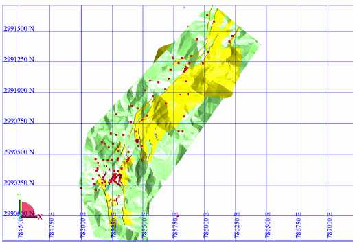
Figure 12.3: QFP and skarn interpretation
| November 17, 2006 | |
| Resource Estimate: | Project No.: 03PM69 |
| Tyler Resources Inc. Bahuerachi Property, | |
| Chihuahua State, Mexico | |
| Prepared for: Tyler Resources Inc. | 67 |
12.3 Statistical Analysis of Sample Data
Checks were done to validate the data as it went into the database. Surveys were checked by plotting these holes on the topographical digital terrain model (DTM).
From the 165 holes drilled, 117 were diamond drill holes; these holes produced 10,071 samples. The 48 remaining were RC holes from which 3767 samples were obtained. Of the sample data 53% was obtained from the 2006 drilling, 38.6% from the 2005 drilling and 8.9% from the 2004 drilling. No sample data was received from the 1997 drilling.
For puposes of this report the RC and DD holes were combined. 12.3.1 Sampling and Compositing 12.3.1.1 Quartz Feldspar Porphyry:
The statistics for the sample lengths are given below for the samples in the QFP. These were 4,916 samples in the QFP with an average sampling length of 1.99 m, and 1 % samples are longer than 3.2 m.
| Sample | |
| Length | |
| File | Samp Qfp0.str |
| Variable | All |
| Number of samples | 4916 |
| Minimum value | 0.4 |
| Maximum value | 24.5 |
| 50.0 Percentile (median) | 2 |
| 95.0 Percentile | 3 |
| 96.0 Percentile | 3 |
| 97.0 Percentile | 3 |
| 98.0 Percentile | 3.05 |
| 99.0 Percentile | 3.2 |
| 100.0 Percentile | 24.5 |
| Mean | 1.99 |
| November 17, 2006 | |
| Resource Estimate: | Project No.: 03PM69 |
| Tyler Resources Inc. Bahuerachi Property, | |
| Chihuahua State, Mexico | |
| Prepared for: Tyler Resources Inc. | 68 |
12.3.1.2 Skarn:
The statistics for the sample lengths are given below for the samples in the skarn. These were 1114 samples in the skarn with an average sampling length of 1.89 m, and 1 % samples are longer than 3.1 m.
| Sample | |
| Length | |
| File | Samp Skn0.str |
| Number of samples | 1114 |
| Minimum value | 0.1 |
| Maximum value | 18.15 |
| 50.0 Percentile (median) | 2 |
| 95.0 Percentile | 3 |
| 96.0 Percentile | 3 |
| 97.0 Percentile | 3.05 |
| 98.0 Percentile | 3.05 |
| 99.0 Percentile | 3.1 |
| 100.0 Percentile | 18.15 |
| Mean | 1.89 |
12.3.1.3 Global Statistical Analysis and Cutting of High-grade Values
Global statistical, special statistical work and grade estimation was only performed on the quartz feldspar porphyry and skarn units. Although there are some mineralized areas in the various sedimentary units. Further drilling is required in order to model these domains.
Based on the sample length results obtained it was decided that compositing to a length of 3 m would be appropriate as this figure was the median value on the skarn and that for both datasets the 99th percentile was very close to 3 m suggesting a very small portion of data is larger than 3 m.
The sample population contains a number of high grade sample values for all elements studied that would tend to over-influence the kriging process when estimating the model block grades. For this reason high grade values for each element were cut to the 99th percentile value. This level was selected by running various cut values at increasingly lower percentile values. A decision was made to use the 99th percentile as at this point the mean grade is affected minimally, but there is a large decrease in the variation and the coefficient of variation.
The Statistics of each element is given in tables in the following section.
| November 17, 2006 | |
| Resource Estimate: | Project No.: 03PM69 |
| Tyler Resources Inc. Bahuerachi Property, | |
| Chihuahua State, Mexico | |
| Prepared for: Tyler Resources Inc. | 69 |
Various statistical results are found in the tables.
| PERCENTILES: Percentiles are the grade at which the specified cumulative frequency percentage of the sample values occurs. The median is 50%. | |
| To determine the X percentile out of Y data points, X/100 * Y is used. If the Y is a even number, the next sample is (Y + 1) is added to Y and the total divide by 2. X percentile = (Y + (Y+1))/2. | |
| MEAN: The Mean is the arithmetic average of the data and is computed by dividing the sum of a set of data by the number of data points.
| |
| VARIANCE: The Variance describes the variability of the distribution or the spread of the data.
| |
| STANDARD DEVIATION: The Standard Deviation is simply the square root of the variance. | |
| SKEWNESS: The Skewness is a measure of the symmetry of the distribution. In a normal distribution, where the distribution is symmetric, the skewness is zero. The skewness is negative for distributions tailing to the left and positive for distributions tailing to the right. | |
| KURTOSIS: The Kurtosis is a measure of how peaked the distribution is, or the steepness of ascent near the mode of the distribution. It has a value of zero in a normal distribution and so is a good test for distribution normality. Most gold deposits display a very steep curve near the mode of the distribution so the value for the kurtosis can be expected to be quite high. | |

| November 17, 2006 | |
| Resource Estimate: | Project No.: 03PM69 |
| Tyler Resources Inc. Bahuerachi Property, | |
| Chihuahua State, Mexico | |
| Prepared for: Tyler Resources Inc. | 70 |
- COEFFICIENT OF VARIATION: The Coefficient of Variation is a measure ofthe relative variation of the data and is calculated by dividing the standarddeviation by the mean of the distribution. It provides a very useful guide to thevariability of the data and their subsequent suitability for use in geostatistics orvairiogram analysis. As a general rule, those distributions with a coefficient ofvariation less than one should produce a reasonable variogram model; if thecoefficient of variation is greater than one it implies that the data are quitevariable and it is difficult to produce a good variogram model; if the coefficientof variation is greater than two there is virtually no chance of producing a goodvariogram model.
12.4 Assessment of Grade Continuity – Spatial Statistics
Spatial statistics or variography is a recognized means of determining grade continuity in various directions. This is done by comparing sample pairs with each other at various distances and plotting the average variance at each of these distances. A mathematical equation is then fitted on the graph.
This process is done in various directions, as continuity changes depending on the direction being evaluated. By comparing the various directions with each other one gets three principal directions each perpendicular to each other, a major, semi-major and minor direction. By calculating the anisotropy ratio or ratios between Major/Semi-Major direction and Major/Minor directions we can determine the importance that each of the directions have on the grade interpolation.
12.4.1Variography
Since the orientation of the mineralized zones is different for each of the QFP and skarn as well as for each element they all had to be done separately. Tabled below are the results of all the statistics both for the raw and 3 m composite values. The global statistics after cutting to the 90th percentile is also tabled.
Once variogram parameters have been obtained, it is possible to compare the fit of the parameters on the original data in that a known point is estimated, and then compared with the original value. During this process it is clear that there will be a difference in the estimated and true values.
In general it could be said the variograms were moderate to good, and validated reasonably well to well. There was a good correlation in the kriged gradevs raw grades. The QFP variograms were the best compared to the skarn. The reason for this is that the QFP had a larger sample population.
| November 17, 2006 | |
| Resource Estimate: | Project No.: 03PM69 |
| Tyler Resources Inc. Bahuerachi Property, | |
| Chihuahua State, Mexico | |
| Prepared for: Tyler Resources Inc. | 71 |
Table 12.1: QFP Cu
| Validation | Validation | ||||
| Sample | 3 m Comp | Cut 3 m | |||
| Value | Value | Comp | Raw | Kriged | |
| Grade | Value | ||||
| Number of samples | 4322 | 3129 | 3129 | 3128 | 3128 |
| Minimum value | 0.001 | 0.0001 | 0.0001 | 0 | -0.005 |
| 50.0 Percentile (median) | 0.177 | 0.1705 | 0.1705 | 0.171 | 0.191 |
| 95.0 Percentile | 0.927 | 0.8752 | 0.8752 | 0.875 | 0.773 |
| 96.0 Percentile | 0.984 | 0.9391 | 0.9391 | 0.939 | 0.803 |
| 97.0 Percentile | 1.16 | 1.025 | 1.025 | 1.025 | 0.875 |
| 98.0 Percentile | 1.385 | 1.277 | 1.277 | 1.277 | 0.984 |
| 99.0 Percentile | 1.755 | 1.5933 | 1.5933 | 1.593 | 1.173 |
| 100.0 Percentile | 10000 | 10000 | 1.6103 | 1.61 | 1.604 |
| Mean | 9.539 | 9.0721 | 0.2611 | 0.261 | 0.261 |
| Variance | 92458.961 | 82115.0957 | 0.0875 | 0.088 | 0.062 |
| Standard Deviation | 304.071 | 286.5573 | 0.2959 | 0.296 | 0.248 |
| Coefficient of variation | 31.876 | 31.5867 | 1.1331 | 1.133 | 0.949 |
| Skewness | 32.825 | 32.9436 | 2.1257 | 2.125 | 1.838 |
| Kurtosis | 1078.498 | 1098.805 | 8.4057 | 8.403 | 7.366 |
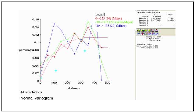
Figure 12.4: QFP Cu
| November 17, 2006 | |
| Resource Estimate: | Project No.: 03PM69 |
| Tyler Resources Inc. Bahuerachi Property, | |
| Chihuahua State, Mexico | |
| Prepared for: Tyler Resources Inc. | 72 |
Table 12.2: QFP Zn
| Validation | Validation | ||||
| Sample | 3 m Comp | Cut 3 m | |||
| Value | Value | Comp | Grade | Kriged | |
| Value | |||||
| Number of samples | 4391 | 3129 | 3129 | 3128 | 3128 |
| Minimum value | 0.001 | 0 | 0 | 0 | 0 |
| 50.0 Percentile (median) | 0.008 | 0.0084 | 0.0084 | 0.008 | 0.01 |
| 95.0 Percentile | 0.082 | 0.0771 | 0.0771 | 0.077 | 0.07 |
| 96.0 Percentile | 0.1 | 0.0895 | 0.0895 | 0.09 | 0.076 |
| 97.0 Percentile | 0.117 | 0.1066 | 0.1066 | 0.107 | 0.083 |
| 98.0 Percentile | 0.159 | 0.1485 | 0.1485 | 0.149 | 0.094 |
| 99.0 Percentile | 0.259 | 0.2016 | 0.2012 | 0.202 | 0.111 |
| 100.0 Percentile | 6.3 | 1.5415 | 0.2016 | 0.202 | 0.164 |
| Mean | 0.025 | 0.0215 | 0.0193 | 0.019 | 0.019 |
| Variance | 0.014 | 0.0031 | 0.001 | 0.001 | 0.001 |
| Standard Deviation | 0.117 | 0.056 | 0.032 | 0.032 | 0.023 |
| Coefficient of variation | 4.741 | 2.6072 | 1.657 | 1.653 | 1.182 |
| Skewness | 38.116 | 13.2505 | 3.7483 | 3.752 | 2.644 |
| Kurtosis | 1913.824 | 275.4949 | 18.6981 | 18.735 | 11.106 |
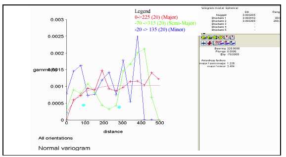
Figure 12.5: QFP Zn
| November 17, 2006 | |
| Resource Estimate: | Project No.: 03PM69 |
| Tyler Resources Inc. Bahuerachi Property, | |
| Chihuahua State, Mexico | |
| Prepared for: Tyler Resources Inc. | 73 |
Table 12.3: QFP Pb
| Validation | Validation | ||||
| Sample | 3 m Comp | Cut 3 m | |||
| Value | Value | Comp | Grade | Kriged Value | |
| Number of samples | 3050 | 3129 | 3129 | 3129 | 3129 |
| Minimum value | 0.001 | 0 | 0 | 0 | 0 |
| 50.0 Percentile (median) | 0.0026 | 0.0017 | 0.0017 | 0.002 | 0.003 |
| 95.0 Percentile | 0.0213 | 0.0154 | 0.0154 | 0.015 | 0.014 |
| 96.0 Percentile | 0.0253 | 0.0179 | 0.0179 | 0.018 | 0.016 |
| 97.0 Percentile | 0.0308 | 0.022 | 0.022 | 0.022 | 0.018 |
| 98.0 Percentile | 0.0431 | 0.0293 | 0.0293 | 0.03 | 0.021 |
| 99.0 Percentile | 0.077 | 0.0478 | 0.0478 | 0.048 | 0.024 |
| 100.0 Percentile | 1 | 0.6177 | 0.062 | 0.062 | 0.044 |
| Mean | 0.0072 | 0.005 | 0.0042 | 0.004 | 0.004 |
| Variance | 0.0008 | 0.0004 | 0 | 0 | 0 |
| Standard Deviation | 0.0286 | 0.0188 | 0.0079 | 0.008 | 0.005 |
| Coefficient of variation | 3.9468 | 3.7561 | 1.8653 | 1.842 | 1.131 |
| Skewness | 20.7682 | 18.8952 | 4.7912 | 4.788 | 2.979 |
| Kurtosis | 592.8709 | 489.1092 | 30.3716 | 30.347 | 15.198 |
![]()
Figure 12.6: QFP Pb
| November 17, 2006 | |
| Resource Estimate: | Project No.: 03PM69 |
| Tyler Resources Inc. Bahuerachi Property, | |
| Chihuahua State, Mexico | |
| Prepared for: Tyler Resources Inc. | 74 |
Table 12.4: QFP Mo
| Validation | Validation | ||||
| Sample | 3 m Comp | Cut 3 m | |||
| Value | Value | Comp | Grade | Kriged | |
| Value | |||||
| Number of samples | 3137 | 239 | 239 | 234 | 234 |
| Minimum value | 0.001 | 0 | 0 | 0 | 0 |
| 50.0 Percentile (median) | 0.0063 | 0.0032 | 0.0032 | 0.003 | 0.005 |
| 95.0 Percentile | 0.0383 | 0.0369 | 0.0369 | 0.037 | 0.03 |
| 96.0 Percentile | 0.0422 | 0.0388 | 0.0388 | 0.042 | 0.034 |
| 97.0 Percentile | 0.0485 | 0.0489 | 0.0489 | 0.049 | 0.047 |
| 98.0 Percentile | 0.0572 | 0.053 | 0.053 | 0.053 | 0.053 |
| 99.0 Percentile | 0.0762 | 0.1242 | 0.0983 | 0.098 | 0.084 |
| 100.0 Percentile | 0.288 | 0.176 | 0.1242 | 0.124 | 0.11 |
| Mean | 0.0116 | 0.0096 | 0.0092 | 0.009 | 0.009 |
| Variance | 0.0003 | 0.0004 | 0.0003 | 0 | 0 |
| Standard Deviation | 0.0174 | 0.0195 | 0.016 | 0.016 | 0.014 |
| Coefficient of variation | 1.4998 | 2.0305 | 1.7512 | 1.739 | 1.477 |
| Skewness | 6.6383 | 5.7673 | 4.1075 | 4.07 | 4.102 |
| Kurtosis | 80.5739 | 46.1416 | 25.4901 | 25.092 | 25.727 |
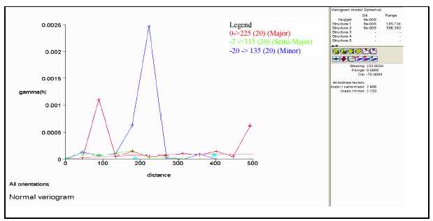
Figure 12.7: QFP Mo
| November 17, 2006 | |
| Resource Estimate: | Project No.: 03PM69 |
| Tyler Resources Inc. Bahuerachi Property, | |
| Chihuahua State, Mexico | |
| Prepared for: Tyler Resources Inc. | 75 |
Table 12.5: QFP Fe
| Validation | Validation | ||||
| Sample | 3 m Comp | Cut 3 m | |||
| Value | Value | Comp | Grade | Kriged | |
| Value | |||||
| Number of samples | 4475 | 3129 | 3129 | 3128 | 3128 |
| Minimum value | 0.14 | 0 | 0 | 0 | 0.228 |
| 50.0 Percentile (median) | 2.22 | 2.25 | 2.25 | 2.25 | 2.381 |
| 95.0 Percentile | 6 | 5.2951 | 5.2951 | 5.295 | 4.417 |
| 96.0 Percentile | 7 | 5.7999 | 5.7999 | 5.8 | 4.753 |
| 97.0 Percentile | 8.74 | 6.5102 | 6.5102 | 6.51 | 5.21 |
| 98.0 Percentile | 10 | 8.5816 | 8.5816 | 8.581 | 6.119 |
| 99.0 Percentile | 10 | 10 | 10 | 10 | 7.748 |
| 100.0 Percentile | 24.2 | 15.8 | 10 | 10 | 9.764 |
| Mean | 2.74 | 2.6175 | 2.6017 | 2.602 | 2.595 |
| Variance | 3.67 | 2.5855 | 2.2905 | 2.291 | 1.238 |
| Standard Deviation | 1.92 | 1.608 | 1.5135 | 1.514 | 1.113 |
| Coefficient of variation | 0.7 | 0.6143 | 0.5817 | 0.582 | 0.429 |
| Skewness | 3.5 | 3.1942 | 2.6427 | 2.642 | 2.724 |
| Kurtosis | 21.48 | 17.7741 | 12.2355 | 12.232 | 14.555 |
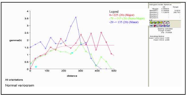
Figure 12.8 QFP Fe
| November 17, 2006 | |
| Resource Estimate: | Project No.: 03PM69 |
| Tyler Resources Inc. Bahuerachi Property, | |
| Chihuahua State, Mexico | |
| Prepared for: Tyler Resources Inc. | 76 |
Table 12.6: QFP Au
| Validation | Validation | ||||
| Sample | 3 m Comp | Cut 3 m | |||
| Value | Value | Comp | Grade | Kriged | |
| Value | |||||
| Number of samples | 3675 | 3129 | 3129 | 3128 | 3128 |
| Minimum value | 0.005 | 0 | 0 | 0 | 0 |
| 50.0 Percentile (median) | 0.017 | 0.0126 | 0.0126 | 0.013 | 0.014 |
| 95.0 Percentile | 0.169 | 0.1168 | 0.1168 | 0.117 | 0.11 |
| 96.0 Percentile | 0.221 | 0.1357 | 0.1357 | 0.136 | 0.125 |
| 97.0 Percentile | 0.4 | 0.175 | 0.175 | 0.175 | 0.16 |
| 98.0 Percentile | 0.8 | 0.3324 | 0.3324 | 0.332 | 0.356 |
| 99.0 Percentile | 1.4 | 0.9727 | 0.9727 | 0.973 | 0.912 |
| 100.0 Percentile | 6.2 | 4.3253 | 1.196 | 1.196 | 1.196 |
| Mean | 0.073 | 0.0492 | 0.0424 | 0.042 | 0.042 |
| Variance | 0.092 | 0.0449 | 0.0188 | 0.019 | 0.017 |
| Standard Deviation | 0.303 | 0.2119 | 0.137 | 0.137 | 0.132 |
| Coefficient of variation | 4.137 | 4.3026 | 3.2297 | 3.227 | 3.101 |
| Skewness | 10.65 | 10.7245 | 7.0072 | 7.006 | 6.716 |
| Kurtosis | 152.216 | 145.979 | 54.9805 | 54.965 | 50.248 |

Figure 12.9: QFP Au
| November 17, 2006 | |
| Resource Estimate: | Project No.: 03PM69 |
| Tyler Resources Inc. Bahuerachi Property, | |
| Chihuahua State, Mexico | |
| Prepared for: Tyler Resources Inc. | 77 |
Table 12.7: QFP Ag
| Validation | Validation | ||||
| Sample | 3 m Comp | Cut 3 m | |||
| Value | Value | Comp | Grade | Kriged | |
| Value | |||||
| Number of samples | 4292 | 3129 | 3129 | 3118 | 3118 |
| Minimum value | 0.2 | 0 | 0 | 0 | 0 |
| 50.0 Percentile (median) | 1.7 | 1.6298 | 1.6298 | 1.632 | 1.844 |
| 95.0 Percentile | 6.8 | 6.1967 | 6.1967 | 6.197 | 5.479 |
| 96.0 Percentile | 7.3 | 6.8134 | 6.8134 | 6.814 | 5.752 |
| 97.0 Percentile | 8.1 | 7.7567 | 7.7567 | 7.757 | 6.138 |
| 98.0 Percentile | 9.5 | 9.085 | 9.085 | 9.116 | 6.779 |
| 99.0 Percentile | 12.6 | 11.035 | 11.035 | 11.035 | 7.436 |
| 100.0 Percentile | 72.8 | 50.7333 | 11.1119 | 11.112 | 9.847 |
| Mean | 2.4 | 2.2667 | 2.1939 | 2.198 | 2.196 |
| Variance | 8.7 | 6.9268 | 4.2566 | 4.262 | 2.525 |
| Standard Deviation | 3 | 2.6319 | 2.0631 | 2.064 | 1.589 |
| Coefficient of variation | 1.2 | 1.1611 | 0.9404 | 0.939 | 0.723 |
| Skewness | 7.6 | 5.8556 | 1.941 | 1.94 | 1.352 |
| Kurtosis | 122.7 | 72.1992 | 7.6203 | 7.611 | 5.219 |

Figure 12.10: QFP Ag
| November 17, 2006 | |
| Resource Estimate: | Project No.: 03PM69 |
| Tyler Resources Inc. Bahuerachi Property, | |
| Chihuahua State, Mexico | |
| Prepared for: Tyler Resources Inc. | 78 |
Table 12.8: SKARN Cu
| Validation | Validation | ||||
| Sample | 3 m Comp | Cut 3 m | |||
| Value | Value | Comp | Grade | Kriged | |
| Value | |||||
| Number of samples | 1049 | 719 | 719 | 707 | 707 |
| Minimum value | 0 | 0.0003 | 0.0003 | 0 | 0.001 |
| 50.0 Percentile (median) | 0.42 | 0.3909 | 0.3909 | 0.383 | 0.467 |
| 95.0 Percentile | 2.42 | 2.3115 | 2.3115 | 2.315 | 2.054 |
| 96.0 Percentile | 2.64 | 2.3778 | 2.3778 | 2.406 | 2.128 |
| 97.0 Percentile | 2.95 | 2.5358 | 2.5358 | 2.581 | 2.253 |
| 98.0 Percentile | 3.18 | 2.9101 | 2.9101 | 2.91 | 2.338 |
| 99.0 Percentile | 3.73 | 3.3274 | 3.3155 | 3.316 | 2.511 |
| 100.0 Percentile | 9.77 | 8.8802 | 3.3274 | 3.327 | 2.793 |
| Mean | 0.76 | 0.6959 | 0.6821 | 0.68 | 0.696 |
| Variance | 0.9 | 0.6838 | 0.5591 | 0.564 | 0.429 |
| Standard Deviation | 0.95 | 0.8269 | 0.7477 | 0.751 | 0.655 |
| Coefficient of variation | 1.25 | 1.1883 | 1.0962 | 1.104 | 0.941 |
| Skewness | 3.16 | 2.6947 | 1.4257 | 1.432 | 0.998 |
| Kurtosis | 21.88 | 18.409 | 4.6385 | 4.634 | 3.119 |
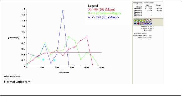
Figure 12.11: SKARN Cu
| November 17, 2006 | |
| Resource Estimate: | Project No.: 03PM69 |
| Tyler Resources Inc. Bahuerachi Property, | |
| Chihuahua State, Mexico | |
| Prepared for: Tyler Resources Inc. | 78 |
Table 12.9: SKARN Zn
| Validation | Validation | ||||
| Sample | 3 m Comp | Cut 3 m | |||
| Value | Value | Comp | Grade | Kriged | |
| Value | |||||
| Number of samples | 1012 | 719 | 719 | 708 | 708 |
| Minimum value | 0.001 | 0.0001 | 0.0001 | 0 | -0.004 |
| 50.0 Percentile (median) | 0.068 | 0.0617 | 0.0617 | 0.062 | 0.087 |
| 95.0 Percentile | 1.895 | 1.6069 | 1.6069 | 1.64 | 1.534 |
| 96.0 Percentile | 2.54 | 1.8996 | 1.8996 | 1.998 | 1.878 |
| 97.0 Percentile | 3.365 | 3.319 | 3.319 | 3.417 | 2.816 |
| 98.0 Percentile | 5.205 | 5.056 | 5.056 | 5.056 | 3.941 |
| 99.0 Percentile | 7.95 | 7.2484 | 7.1926 | 7.193 | 5.948 |
| 100.0 Percentile | 21.3 | 14.15 | 7.2484 | 7.248 | 7.146 |
| Mean | 0.486 | 0.4396 | 0.3988 | 0.403 | 0.402 |
| Variance | 2.4129 | 1.9365 | 1.1457 | 1.162 | 0.85 |
| Standard Deviation | 1.5533 | 1.3916 | 1.0704 | 1.078 | 0.922 |
| Coefficient of variation | 3.1958 | 3.1654 | 2.6842 | 2.675 | 2.295 |
| Skewness | 7.3479 | 6.5382 | 4.7925 | 4.753 | 4.672 |
| Kurtosis | 71.8253 | 53.4733 | 27.7733 | 27.341 | 27.918 |

Figure 12.12: SKARN Zn
| November 17, 2006 | |
| Resource Estimate: | Project No.: 03PM69 |
| Tyler Resources Inc. Bahuerachi Property, | |
| Chihuahua State, Mexico | |
| Prepared for: Tyler Resources Inc. | 80 |
Table 12.10: SKARN Pb
| Validation | Validation | ||||
| Sample | 3 m Comp | Cut 3m | |||
| Value | Value | Comp | Grade | Kriged | |
| Value | |||||
| Number of samples | 701 | 719 | 719 | 718 | 718 |
| Minimum value | 0.001 | 0 | 0 | 0 | 0 |
| 50.0 Percentile (median) | 0.0051 | 0.002 | 0.002 | 0.002 | 0.004 |
| 95.0 Percentile | 0.121 | 0.0487 | 0.0487 | 0.046 | 0.075 |
| 96.0 Percentile | 0.216 | 0.082 | 0.082 | 0.075 | 0.101 |
| 97.0 Percentile | 0.3055 | 0.1566 | 0.1566 | 0.157 | 0.13 |
| 98.0 Percentile | 0.435 | 0.2128 | 0.2128 | 0.213 | 0.147 |
| 99.0 Percentile | 1.235 | 0.4658 | 0.4658 | 0.465 | 0.231 |
| 100.0 Percentile | 3.15 | 2.5073 | 0.6662 | 0.666 | 0.628 |
| Mean | 0.045 | 0.0238 | 0.0177 | 0.018 | 0.018 |
| Variance | 0.0514 | 0.0211 | 0.0052 | 0.005 | 0.003 |
| Standard Deviation | 0.2268 | 0.1453 | 0.0721 | 0.072 | 0.059 |
| Coefficient of variation | 5.0354 | 6.1058 | 4.0756 | 4.095 | 3.361 |
| Skewness | 9.1051 | 12.3581 | 7.1429 | 7.162 | 7.838 |
| Kurtosis | 97.7691 | 178.9206 | 58.9517 | 59.149 | 74.203 |

Figure 12.13: SKARN Pb
| November 17, 2006 | |
| Resource Estimate: | Project No.: 03PM69 |
| Tyler Resources Inc. Bahuerachi Property, | |
| Chihuahua State, Mexico | |
| Prepared for: Tyler Resources Inc. | 81 |
Table 12.11: SKARN Mo
| Validation | Validation | ||||
| Sample | 3 m Comp | Cut 3 m | |||
| Value | Value | Comp | Grade | Kriged | |
| Value | |||||
| Number of samples | 743 | 38 | 38 | 30 | 30 |
| Minimum value | 0.001 | 0.0002 | 0.0002 | 0 | 0.001 |
| 50.0 Percentile (median) | 0.0051 | 0.0057 | 0.0057 | 0.005 | 0.004 |
| 95.0 Percentile | 0.0278 | 0.0538 | 0.0538 | 0.069 | 0.054 |
| 96.0 Percentile | 0.0301 | 0.0538 | 0.0538 | 0.069 | 0.055 |
| 97.0 Percentile | 0.0344 | 0.0685 | 0.0685 | 0.069 | 0.055 |
| 98.0 Percentile | 0.0407 | 0.0685 | 0.0685 | 0.069 | 0.055 |
| 99.0 Percentile | 0.0541 | 0.0685 | 0.0685 | 0.069 | 0.055 |
| 100.0 Percentile | 0.104 | 0.0685 | 0.0685 | 0.069 | 0.055 |
| Mean | 0.0087 | 0.0121 | 0.0121 | 0.012 | 0.012 |
| Variance | 0.0001 | 0.0003 | 0.0003 | 0 | 0 |
| Standard Deviation | 0.0107 | 0.0164 | 0.0164 | 0.017 | 0.014 |
| Coefficient of variation | 1.2305 | 1.3567 | 1.3567 | 1.475 | 1.2 |
| Skewness | 3.6239 | 2.2708 | 2.2708 | 2.453 | 1.75 |
| Kurtosis | 22.5499 | 7.7631 | 7.7631 | 8.369 | 5.333 |

Figure 12.14: SKARN Mo
| November 17, 2006 | |
| Resource Estimate: | Project No.: 03PM69 |
| Tyler Resources Inc. Bahuerachi Property, | |
| Chihuahua State, Mexico | |
| Prepared for: Tyler Resources Inc. | 82 |
Table 12.12: SKARN Fe
| Validation | Validation | ||||
| Sample | 3 m Comp | Cut 3 m | |||
| Value | Value | Comp | Grade | Kriged | |
| Value | |||||
| Number of samples | 1097 | 719 | 719 | 708 | 708 |
| Minimum value | 0.22 | 0.24 | 0.24 | 0.24 | 1.602 |
| 50.0 Percentile (median) | 8.38 | 8.6157 | 8.6157 | 8.644 | 9.146 |
| 95.0 Percentile | 26.8 | 25.975 | 25.975 | 26.025 | 22.604 |
| 96.0 Percentile | 28 | 26.8573 | 26.8573 | 26.944 | 23.665 |
| 97.0 Percentile | 29 | 27.8752 | 27.8752 | 27.992 | 24.484 |
| 98.0 Percentile | 30.45 | 29.1767 | 29.1767 | 29.176 | 25.371 |
| 99.0 Percentile | 32.7 | 32.6487 | 32.623 | 32.623 | 27.304 |
| 100.0 Percentile | 42.3 | 38.1 | 32.6487 | 32.649 | 31.547 |
| Mean | 10.56 | 10.4714 | 10.4491 | 10.474 | 10.515 |
| Variance | 59.69 | 50.7699 | 49.6945 | 49.904 | 32.92 |
| Standard Deviation | 7.73 | 7.1253 | 7.0494 | 7.064 | 5.738 |
| Coefficient of variation | 0.73 | 0.6805 | 0.6746 | 0.674 | 0.546 |
| Skewness | 1.16 | 1.1691 | 1.1059 | 1.105 | 0.975 |
| Kurtosis | 3.89 | 4.0535 | 3.7378 | 3.733 | 3.693 |

Figure 12.15: SKARN Fe
| November 17, 2006 | |
| Resource Estimate: | Project No.: 03PM69 |
| Tyler Resources Inc. Bahuerachi Property, | |
| Chihuahua State, Mexico | |
| Prepared for: Tyler Resources Inc. | 83 |
Table 12.13: SKARN Au
| Validation | Validation | ||||
| Sample | 3 m Comp | Cut 3 m | |||
| Value | Value | Comp | Grade | Kriged | |
| Value | |||||
| Number of samples | 895 | 719 | 719 | 711 | 711 |
| Minimum value | 0.005 | 0 | 0 | 0 | 0 |
| 50.0 Percentile (median) | 0.051 | 0.0327 | 0.0327 | 0.032 | 0.05 |
| 95.0 Percentile | 0.28 | 0.2347 | 0.2347 | 0.235 | 0.193 |
| 96.0 Percentile | 0.304 | 0.2654 | 0.2654 | 0.266 | 0.21 |
| 97.0 Percentile | 0.353 | 0.3012 | 0.3012 | 0.303 | 0.219 |
| 98.0 Percentile | 0.433 | 0.3716 | 0.3716 | 0.372 | 0.291 |
| 99.0 Percentile | 0.562 | 0.5211 | 0.5211 | 0.521 | 0.36 |
| 100.0 Percentile | 44.7 | 44.7 | 0.5317 | 0.532 | 0.491 |
| Mean | 0.142 | 0.137 | 0.0713 | 0.071 | 0.072 |
| Variance | 2.25 | 2.7878 | 0.0088 | 0.009 | 0.006 |
| Standard Deviation | 1.5 | 1.6697 | 0.094 | 0.094 | 0.075 |
| Coefficient of variation | 10.57 | 12.1847 | 1.3188 | 1.326 | 1.042 |
| Skewness | 29.302 | 26.4503 | 2.3771 | 2.393 | 1.871 |
| Kurtosis | 869.821 | 705.7479 | 10.2065 | 10.268 | 8.452 |
![]()
Figure 12.16: SKARN Au
| November 17, 2006 | |
| Resource Estimate: | Project No.: 03PM69 |
| Tyler Resources Inc. Bahuerachi Property, | |
| Chihuahua State, Mexico | |
| Prepared for: Tyler Resources Inc. | 84 |
Table 12.14: SKARN Ag
| Validation | Validation | ||||
| Sample | 3 m Comp | Cut 3 m | |||
| Value | Value | Comp | Grade | Kriged | |
| Value | |||||
| Number of samples | 999 | 719 | 719 | 718 | 718 |
| Minimum value | 0.2 | 0 | 0 | 0 | 0.005 |
| 50.0 Percentile (median) | 5 | 4 | 4 | 4 | 5.157 |
| 95.0 Percentile | 34.7 | 31.8821 | 31.8821 | 31.883 | 27.46 |
| 96.0 Percentile | 38.2 | 34.0863 | 34.0863 | 34.087 | 29.137 |
| 97.0 Percentile | 42.6 | 35.97 | 35.97 | 35.97 | 30.126 |
| 98.0 Percentile | 49.2 | 42.7992 | 42.7992 | 42.799 | 33.736 |
| 99.0 Percentile | 61.7 | 54.9473 | 54.8437 | 54.844 | 37.89 |
| 100.0 Percentile | 123 | 111.4183 | 54.9473 | 54.947 | 48.607 |
| Mean | 10.2 | 8.8578 | 8.67 | 8.671 | 8.764 |
| Variance | 177.3 | 145.0296 | 120.6891 | 120.856 | 90.575 |
| Standard Deviation | 13.3 | 12.0428 | 10.9859 | 10.993 | 9.517 |
| Coefficient of variation | 1.3 | 1.3596 | 1.2671 | 1.268 | 1.086 |
| Skewness | 2.8 | 2.7972 | 1.862 | 1.86 | 1.259 |
| Kurtosis | 15.1 | 15.8536 | 6.6729 | 6.663 | 4.083 |
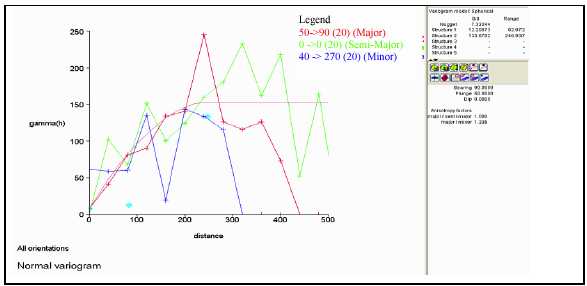
Figure 12.17: SKARN Ag
| November 17, 2006 | |
| Resource Estimate: | Project No.: 03PM69 |
| Tyler Resources Inc. Bahuerachi Property, | |
| Chihuahua State, Mexico | |
| Prepared for: Tyler Resources Inc. | 85 |
12.5 Block Modeling
The computer model containing the structural fault blocks, lithological units, mineralized envelopes grade information and specific gravity was loaded into the block model.
12.5.1 Block Model Dimensions
The block model origin and extents were chosen to cover the whole of the Bahuerachi Main Zone project area. Block sizes or dimensions were chosen to reflect the results of the spatial statistics as well as drillhole and data density. A technique called sub blocking was used to accurately model the structural and geological complexity of the model area. The table below depicts the parameters used in the block modeling process.
Table 12.15: Block Model Geometry

12.5.2 Structural and Geological Constraints
Spatial constraints were created that represent each and every structural block and lithological unit. Attributes were created and these constraints were then used to assign fault block, as well as the lithological codes. Assigning the lithological units with the lithological codes were done in the following order.
1.Fine grained sedimentary rock - 1
2.Marble - 2
3.Siliceous and calcareous bedded sedimentary rocks - 3
4.Fine grained clastic sedimentary rocks - 4
5.Andesite volcanic and volcaniclastic rocks - 5
6.Quartz feldspar porphyry - 6
7.Skarn - 8
8.Rhyolite dykes -9
9.Andesite dykes -10
10.Air – 0
In this way the blocks previously assigned would be overwritten by subsequent assigning. The figure below depicts the block model colour coded based on the lithological units.
| November 17, 2006 | |
| Resource Estimate: | Project No.: 03PM69 |
| Tyler Resources Inc. Bahuerachi Property, | |
| Chihuahua State, Mexico | |
| Prepared for: Tyler Resources Inc. | 86 |
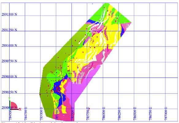
Figure 12.18: Block model colour codes
12.5.3 Grade Interpolation
Grade was interpolated using ordinary kriging. This interpolation method was selected because data distribution and density was sufficient for interpolating using this method. Good variograms were obtained during the special statistical part of the project and reasonable to good validation was obtained.
Each element was individually interpolated in each of the QFP and Skarn units. The table below depicts the kriging parameters used during the interpolation of grades into the block model. A minimum of five samples and a maximum of 15 samples were used in determining block grade.
| November 17, 2006 | |
| Resource Estimate: | Project No.: 03PM69 |
| Tyler Resources Inc. Bahuerachi Property, | |
| Chihuahua State, Mexico | |
| Prepared for: Tyler Resources Inc. | 87 |
Table 12.16: Variogram Parameters
| Nugget | Sill | Range | Direction of major Axis | Anisotropy ratios | ||||||||
| Zone | Element | Vairiogram model | Major/Semi- | |||||||||
| C0 | C1 | C2 | R1 | R2 | Bearing | Dip | Plunge | Major | Major/Minor | |||
| cu | Nested | 0.0075 | 0.02701 | 0.07773 | 113 | 329 | 45 | 0 | 70 | 1.25 | 2.4 | |
| Spherical | ||||||||||||
| zn | Nested | 0.00021 | 0.00044 | 0.00039 | 90 | 281 | 45 | 0 | 70 | 1.23 | 2.48 | |
| Spherical | ||||||||||||
| pb | Nested | 0.00002 | 0.00003 | 0.00003 | 87 | 266 | 45 | 0 | 70 | 1 | 2.53 | |
| Spherical | ||||||||||||
| QFP | mo | Nested | 0.00001 | 0.00001 | 0.00008 | 186 | 396 | 45 | 0 | 70 | 2.41 | 2.72 |
| Spherical | ||||||||||||
| fe | Nested | 0.38544 | 0.14641 | 1.12402 | 34 | 249 | 45 | 0 | 70 | 1 | 2.1 | |
| Spherical | ||||||||||||
| au | Nested | 0.00004 | 0.00006 | 0.00135 | 104 | 244 | 135 | 70 | 0 | 1 | 1.71 | |
| Spherical | ||||||||||||
| ag | Nested | 0.51539 | 0.39831 | 3.69994 | 93 | 187 | 135 | 70 | 0 | 1.17 | 2.18 | |
| Spherical | ||||||||||||
| cu | Nested | 0.04686 | 0.21779 | 0.2014 | 110 | 184 | 90 | 50 | 0 | 1 | 2.2 | |
| Spherical | ||||||||||||
| zn | Nested | 0.04888 | 0.14444 | 0.89374 | 89 | 220 | 90 | 50 | 0 | 1 | 3.76 | |
| Spherical | ||||||||||||
| pb | Spherical | 0.00102 | 0.00228 | 0.00153 | 52 | 182 | 90 | 50 | 0 | 1 | 1 | |
| SKARN | mo | Spherical | 0 | 0.00006 | 0.00008 | 55 | 208 | 90 | 50 | 0 | 1 | 1 |
| fe | Nested | 7.44958 | 16.39347 | 33.487 | 27 | 194 | 90 | 50 | 0 | 1 | 2.11 | |
| Spherical | ||||||||||||
| au | Nested | 0.00082 | 0.00123 | 0.00615 | 116 | 287 | 0 | 0 | 50 | 1 | 3.69 | |
| Spherical | ||||||||||||
| ag | Nested | 7.32244 | 12.20073 | 133.6702 | 83 | 247 | 90 | 50 | 0 | 1 | 1.34 | |
| Spherical | ||||||||||||
Estimation is done for each block by doing a number of point estimations which are averaged to give a block average or block grade. This process is called discretisation and for the estimation a discretisation of 4 m x 4 m x 2 m was used for the 25 m x 25 m x 10 m user block size. This has the effect that points at 5 m x 5 m x 5 m was used (homogeneous axis lengths in all directions).
During the estimation attributes were also added based on the data used during the estimation process of each block. These include for each element, the closest sample, average distance of samples used, number of samples used as well as the kriging variance.
12.5.4In Situ(Bulk) Density
A few bulk densities (g/cm3) were obtained for each lithological unit. These were then averaged to obtain a density figure to assign to an attribute for calculation the tonnage from the volume. The table below depicts the values used during the project.
| November 17, 2006 | |
| Resource Estimate: | Project No.: 03PM69 |
| Tyler Resources Inc. Bahuerachi Property, | |
| Chihuahua State, Mexico | |
| Prepared for: Tyler Resources Inc. | 88 |
Table 12.17: Bulk Densities
| Lithology - Zone number | Density |
| Fine grained sedimentary rock - 1 | 2.82 |
| Marble - 2 | 2.91 |
| Siliceous and calcareous bedded sedimentary rocks - 3 | 2.91 |
| Fine grained clastic sedimentary rocks - 4 | 2.82 |
| Andesite volcanic and volcaniclastic rocks - 5 | 2.71 |
| Quartz feldspar porphyry - 6 | 2.70 |
| Skarn - 8 | 3.53 |
| Rhyolite dykes -9 | 2.54 |
| Andesite dykes -10 | 2.54 |
| Air – 0 | 0.00 |
12.6 Validation
Validation is the process of looking at the interpolated grade, geological constraints and input date to measure how successful the interpolation was. There are various ways in validating the results obtained.
12.6.1 Kriging Efficiency (KE):
Kriging efficiency = [(Block Variance) – (Kriging error variance)]/(Block Variance). This formula means that efficiency ranges between +1 and -1.
Block variance is the theoretical variance that was obtained during the interpolation of grades. This value is obtained by integrating the variogram function over the sample support that are being kriging into. In this formula if the kriging error variance is larger than the block variance then it results in a negative efficiency, indicating that the estimates obtained are not reliable. If the efficiency is negative then two options exist: increase the block size and the number of data used to krige, or replace the kriged estimates with a single global mean value.
The kriging efficiency was calculated for the Cu estimation. The results obtained were all greater than 0. It was therefore assumed that the interpolation parameters were acceptable.
12.6.2 Graphically:
In Surpac vision the block model was colour coded on various elements and then compared to the drillhole information/composite values. The geometry of the interpolated blocks were also examined against the solid models.
| November 17, 2006 | |
| Resource Estimate: | Project No.: 03PM69 |
| Tyler Resources Inc. Bahuerachi Property, | |
| Chihuahua State, Mexico | |
| Prepared for: Tyler Resources Inc. | 89 |
The graphical validation was successful and higher grades are found in the region of high grade drill holes and vice versa. The interpolation was acceptable using graphical methods. The result of the graphical validation for two sections is given in the figure below. The blocks depict the Cu grade end the drillhole depict the Cu grade from the database. It can be noticed that the blocks are constrained on the edges of the ore boundaries, as are the grade correlations.

Figure 12.19: Graphical validation of blocksvs drill hole data

Figure 12.20: Graphical validation of blocksvs drill hole data
| November 17, 2006 | |
| Resource Estimate: | Project No.: 03PM69 |
| Tyler Resources Inc. Bahuerachi Property, | |
| Chihuahua State, Mexico | |
| Prepared for: Tyler Resources Inc. | 90 |
12.6.3 Graphing:
The last method that was used to determine the acceptability of the interpolated grades was comparing the composite grades with those of the interpolated grade along various section lines. These were plotted and the volume of material in each section displayed and relating this to the number of samples used in the interpolation.
It would be expected that where large volume of interpolated blocks exist more sample data would be present, and where higher grades in the composite samples exist, it would be expected to observe an increase in the average grade of the interpolated grades.
The graphing also yielded positive results with higher composite sample grades reporting higher interpolated blocks and where larger volumes were obtained in the model, there is an increase in the number of composite samples. The figures below depict the graphing validation used in this project; these are for each element and for both the QFP and skarn zones.

Figure 12.21: Validation of Cu for QFP
| November 17, 2006 | |
| Resource Estimate: | Project No.: 03PM69 |
| Tyler Resources Inc. Bahuerachi Property, | |
| Chihuahua State, Mexico | |
| Prepared for: Tyler Resources Inc. | 91 |
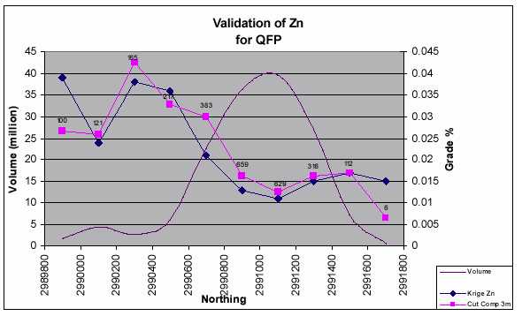
Figure 12.22: Validation of Zn for QFP

Figure 12.23: Validation of Pb for QFP
| November 17, 2006 | |
| Resource Estimate: | Project No.: 03PM69 |
| Tyler Resources Inc. Bahuerachi Property, | |
| Chihuahua State, Mexico | |
| Prepared for: Tyler Resources Inc. | 92 |

Figure 12.24: Validation of Mo for QFP

Figure 12.25: Validation of Fe for QFP
| November 17, 2006 | |
| Resource Estimate: | Project No.: 03PM69 |
| Tyler Resources Inc. Bahuerachi Property, | |
| Chihuahua State, Mexico | |
| Prepared for: Tyler Resources Inc. | 93 |
Figure 12.26: Validation of Au for QFP
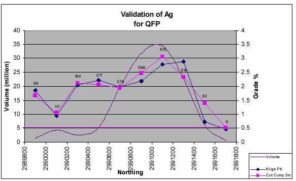
Figure 12.27: Validation of Ag for QFP
| November 17, 2006 | |
| Resource Estimate: | Project No.: 03PM69 |
| Tyler Resources Inc. Bahuerachi Property, | |
| Chihuahua State, Mexico | |
| Prepared for: Tyler Resources Inc. | 94 |

Figure 12.28: Validation of Cu for SKN

Figure 12.29: Validation of Zn for SKN
| November 17, 2006 | |
| Resource Estimate: | Project No.: 03PM69 |
| Tyler Resources Inc. Bahuerachi Property, | |
| Chihuahua State, Mexico | |
| Prepared for: Tyler Resources Inc. | 95 |

Figure 12.30: Validation of Pb for SKN
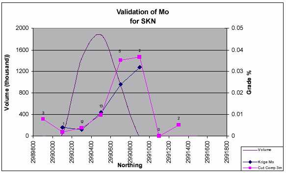
Figure 12.31: Validation of Mo for SKN
| November 17, 2006 | |
| Resource Estimate: | Project No.: 03PM69 |
| Tyler Resources Inc. Bahuerachi Property, | |
| Chihuahua State, Mexico | |
| Prepared for: Tyler Resources Inc. | 96 |
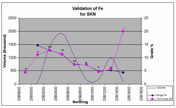
Figure 12.32: Validation of Fe for SKN

Figure 12.33: Validation of Au for SKN
| November 17, 2006 | |
| Resource Estimate: | Project No.: 03PM69 |
| Tyler Resources Inc. Bahuerachi Property, | |
| Chihuahua State, Mexico | |
| Prepared for: Tyler Resources Inc. | 97 |

Figure 12.34: Validation of Ag for SKN
12.7 Mineral Resource
12.7.1 Resource Classification
The mineral resource has been classified into the indicated and inferred mineral resource categories. It was determined with the current amount of drilling that no measured category existed. This categorization was based on various factors, including the variogram ranges obtained, sample to block estimation distances, and, the number of samples used in the estimation process. A block was determined to be indicated if it had 15 samples to estimate the block grade and the average distance of the samples used in the estimation was 100 m. The value of 100 m was selected as this is 1/3 the range obtained from the variogram analysis for the copper grade (329 m) and half the minimum range used in the estimation of 187 m for the silver. These values were obtained from the QFP variograms as the QFP accounts for 95% of the total resource, but this minimum holds true for 182 m measured for the lead in the skarn.
Blocks that have been estimated but fell beyond the 100 m average sample distance were assigned to the inferred category.
The mineral resource estimate is summarized in the Tables 13.16 with the attached grade/tonnage curves as Figures 13.34 and 13.35. Various copper cut-off grades (0.0%, 0.1%,
| November 17, 2006 | |
| Resource Estimate: | Project No.: 03PM69 |
| Tyler Resources Inc. Bahuerachi Property, | |
| Chihuahua State, Mexico | |
| Prepared for: Tyler Resources Inc. | 98 |
0.2%, 0.3%, 0.4% and 0.5%) have been applied and the resources have been classified in the indicated and inferred categories of mineral resources based on the CIM Definition Standards on Mineral Resources and Mineral Reserves.
A Mineral Resource is a concentration or occurrence of natural, solid, inorganic or fossilized organic material in or on the earth’s crust in such form and quantity and of such a grade or quality that it has reasonable prospects for economic extraction. The location, quantity, grade, geological characteristics and continuity of a Mineral Resource are known, estimated or interpreted from specific geological evidence and knowledge.
This definition suggests that it is appropriate to apply an economic cut-off grade even at an early stage of resource estimation. Producing mines from similar copper porphyry deposits in northern Mexico report resources at a copper cut-off grade of 0.3% . At current commodity prices AMCL would suggest that a copper cut-off grade of 0.2% may be appropriate.
Tables 13.17 and 13.18 present the indicated and inferred resources at 0.2% and 0.3% Cu cutoffs. Figures 13.36 to 13.37 are plan views clipped at topography illustrating the robust nature of mineralized body at various cut-offs.
An “Inferred Mineral Resource” is that part of a Mineral Resource for which quantity and grade or quality can be estimated on the basis of geological evidence and limited sampling and reasonably assumed, but not verified, geological and grade continuity. The estimate is based on limited information and sampling gathered through appropriate techniques from locations such as outcrops, trenches, pits, workings and drill holes.
An “Indicated Mineral Resource” is that part of a Mineral Resource for which quantity, grade or quality, densities, shape, and physical characteristics, can be estimated with a level of confidence sufficient to allow the appropriate application of technical and economic parameters, to support mine planning and evaluation of the economic viability of the deposit. The estimate is based on detailed and reliable exploration and testing information gathered through appropriate techniques from locations such outcrops, trenches, pits, workings, and drill holes that are spaced closely enough for geological and grade continuity to be reasonably assumed.
It should be noted that the volcano-sedimentary units have been modelled at a 0.0% copper grade. In fact, there are local high-grade, predominantly chalcocite occurrences which have not been included in the model due to erratic variograms across post-mineral faults, largely related to an insufficient amound of drilling.
| November 17, 2006 | |
| Resource Estimate: | Project No.: 03PM69 |
| Tyler Resources Inc. Bahuerachi Property, | |
| Chihuahua State, Mexico | |
| Prepared for: Tyler Resources Inc. | 99 |
A copper equivalent grade and tonnage has been estimated incorporating economic values for copper (US$/lb), molybdenum (US$/b) and silver (US$/lb). This calculation is based on cash values and does not incorporate metallurgical recoveries or treatment and refining charges (TC/RC).
This information is provided at the request of the client. AGL does not endorese the use of equivalent grades that do not incorporate metallurgical factors or smelter returns.
Grade tonnage curves for the indicated and inferred resources are displayed in the figures below:
| November 17, 2006 | |
| Resource Estimate: | Project No.: 03PM69 |
| Tyler Resources Inc. Bahuerachi Property, | |
| Chihuahua State, Mexico | |
| Prepared for: Tyler Resources Inc. | 100 |
Table 12.18: Total Resources
| % Cu Cut- | |||||||||||
| Category | Lithology | off | Tonnes | Cu % | Zn % | Pb % | Mo % | Au ppm | Ag ppm | Fe % | Cu_eq% |
| $/lb | $/lb | $/oz | |||||||||
| 1.5 | 10 | 7 | |||||||||
| Indicated | QPF & SKN | 0.0-99 | 202,006,507 | 0.362 | 0.062 | 0.007 | 0.008 | 0.037 | 3.282 | 3.102 | 0.547 |
| Indicated | QPF & SKN | 0.1-99 | 176,589,593 | 0.407 | 0.069 | 0.008 | 0.009 | 0.041 | 3.639 | 3.179 | 0.613 |
| Indicated | QPF & SKN | 0.2-99 | 134,693,967 | 0.486 | 0.084 | 0.009 | 0.009 | 0.050 | 4.247 | 3.398 | 0.717 |
| Indicated | QPF & SKN | 0.3-99 | 92,244,570 | 0.596 | 0.114 | 0.010 | 0.007 | 0.062 | 5.204 | 3.827 | 0.852 |
| Indicated | QPF & SKN | 0.4-99 | 63,082,536 | 0.712 | 0.156 | 0.013 | 0.006 | 0.074 | 6.332 | 4.389 | 1.007 |
| Indicated | QPF & SKN | 0.5-99 | 45,894,555 | 0.811 | 0.199 | 0.015 | 0.007 | 0.084 | 7.415 | 5.003 | 1.156 |
| Inferred | QPF & SKN | 0.0-99 | 237,569,006 | 0.255 | 0.020 | 0.005 | 0.005 | 0.020 | 1.609 | 2.341 | 0.353 |
| Inferred | QPF & SKN | 0.1-99 | 202,525,959 | 0.292 | 0.021 | 0.005 | 0.005 | 0.022 | 1.776 | 2.355 | 0.397 |
| Inferred | QPF & SKN | 0.2-99 | 134,221,239 | 0.364 | 0.024 | 0.005 | 0.005 | 0.028 | 2.108 | 2.449 | 0.482 |
| Inferred | QPF & SKN | 0.3-99 | 75,565,829 | 0.455 | 0.029 | 0.005 | 0.004 | 0.036 | 2.573 | 2.551 | 0.585 |
| Inferred | QPF & SKN | 0.4-99 | 40,482,465 | 0.553 | 0.038 | 0.006 | 0.004 | 0.047 | 3.218 | 2.861 | 0.709 |
| Inferred | QPF & SKN | 0.5-99 | 22,161,619 | 0.643 | 0.052 | 0.008 | 0.004 | 0.057 | 3.810 | 3.161 | 0.823 |
| November 17, 2006 | |
| Resource Estimate: | Project No.: 03PM69 |
| Tyler Resources Inc. Bahuerachi Property, | |
| Chihuahua State, Mexico | |
| Prepared for: Tyler Resources Inc. | 101 |

Figure 12.35: Indicated resource grade tonnage

Figure 12.36: Inferred resource grade tonnage
| November 17, 2006 | |
| Resource Estimate: | Project No.: 03PM69 |
| Tyler Resources Inc. Bahuerachi Property, | |
| Chihuahua State, Mexico | |
| Prepared for: Tyler Resources Inc. | 102 |
Table 12.19: 0.2%Cu Cutoff
| CAT | Lith | %Cu Cutoff | Volume | RD | Tonnes | Cu % | Zn % | Pb % | Mo % | Au ppm | Ag ppm | Fe % |
| Indicated | QFP | 0.2 -> 0.3 | 15,393,359 | 2.70 | 41,562,071 | 0.249 | 0.018 | 0.005 | 0.012 | 0.023 | 2.143 | 2.391 |
| 0.3 -> 0.4 | 10,188,672 | 2.70 | 27,509,415 | 0.343 | 0.019 | 0.005 | 0.009 | 0.036 | 2.696 | 2.441 | ||
| 0.4 -> 0.5 | 5,783,203 | 2.70 | 15,614,649 | 0.446 | 0.017 | 0.005 | 0.006 | 0.044 | 3.162 | 2.396 | ||
| 0.5 -> 999.0 | 12,431,250 | 2.70 | 33,564,376 | 0.686 | 0.015 | 0.004 | 0.005 | 0.073 | 4.263 | 2.552 | ||
| Sub Total | 43,796,484 | 118,250,510 | 0.421 | 0.017 | 0.005 | 0.008 | 0.043 | 3.008 | 2.449 | |||
| SKN | 0.2 -> 0.3 | 251,367 | 3.53 | 887,326 | 0.262 | 0.112 | 0.021 | 0.011 | 0.025 | 3.285 | 5.986 | |
| 0.3 -> 0.4 | 468,164 | 3.53 | 1,652,619 | 0.353 | 0.116 | 0.011 | 0.009 | 0.038 | 3.911 | 5.451 | ||
| 0.4 -> 0.5 | 445,703 | 3.53 | 1,573,332 | 0.448 | 0.279 | 0.025 | 0.008 | 0.06 | 6.186 | 6.243 | ||
| 0.5 -> 999.0 | 3,492,969 | 3.53 | 12,330,180 | 1.154 | 0.699 | 0.043 | 0.009 | 0.116 | 15.995 | 11.674 | ||
| Sub Total | 4,658,203 | 16,443,457 | 0.958 | 0.568 | 0.037 | 0.009 | 0.098 | 13.156 | 10.222 | |||
| Sub Total | 48,454,688 | 134,693,967 | 0.486 | 0.084 | 0.009 | 0.009 | 0.05 | 4.247 | 3.398 | |||
| Inferred | QFP | 0.2 -> 0.3 | 21,685,156 | 2.70 | 58,549,923 | 0.246 | 0.017 | 0.005 | 0.006 | 0.017 | 1.504 | 2.302 |
| 0.3 -> 0.4 | 12,916,211 | 2.70 | 34,873,770 | 0.342 | 0.013 | 0.004 | 0.004 | 0.023 | 1.81 | 2.156 | ||
| 0.4 -> 0.5 | 6,425,195 | 2.70 | 17,348,028 | 0.443 | 0.013 | 0.004 | 0.003 | 0.034 | 2.379 | 2.329 | ||
| 0.5 -> 999.0 | 7,239,453 | 2.70 | 19,546,524 | 0.613 | 0.015 | 0.005 | 0.004 | 0.053 | 3.176 | 2.516 | ||
| Sub Total | 48,266,016 | 130,318,244 | 0.353 | 0.015 | 0.005 | 0.005 | 0.026 | 1.953 | 2.299 | |||
| SKN | 0.2 -> 0.3 | 29,883 | 3.53 | 105,486 | 0.253 | 0.225 | 0.062 | 0.009 | 0.015 | 4.875 | 10.21 | |
| 0.3 -> 0.4 | 59,375 | 3.53 | 209,594 | 0.361 | 0.885 | 0.013 | 0.003 | 0.099 | 4.92 | 8.555 | ||
| 0.4 -> 0.5 | 275,586 | 3.53 | 972,818 | 0.451 | 0.138 | 0.008 | 0.002 | 0.072 | 4.696 | 5.513 | ||
| 0.5 -> 999.0 | 740,820 | 3.53 | 2,615,096 | 0.869 | 0.336 | 0.029 | 0.005 | 0.086 | 8.547 | 7.978 | ||
| Sub Total | 1,105,664 | 3,902,994 | 0.721 | 0.313 | 0.024 | 0.004 | 0.081 | 7.293 | 7.454 | |||
| Sub Total | 49,371,680 | 134,221,239 | 0.364 | 0.024 | 0.005 | 0.005 | 0.028 | 2.108 | 2.449 |
| November 17, 2006 | |
| Resource Estimate: | Project No.: 03PM69 |
| Tyler Resources Inc. Bahuerachi Property, | |
| Chihuahua State, Mexico | |
| Prepared for: Tyler Resources Inc. | 103 |
Table 12.20: 0.3% Cu Cutoff
| Category | Lith | %Cu Cutoff | Volume | RD | Tonnes | Cu % | Zn % | Pb % | Mo % | Au ppm | Ag ppm | Fe % |
| Indicated | QFP | 0.3 -> 0.4 | 10,188,672 | 2.70 | 27,509,415 | 0.343 | 0.019 | 0.005 | 0.009 | 0.036 | 2.696 | 2.441 |
| 0.4 -> 0.5 | 5,783,203 | 2.70 | 15,614,649 | 0.446 | 0.017 | 0.005 | 0.006 | 0.044 | 3.162 | 2.396 | ||
| 0.5 -> 999.0 | 12,431,250 | 2.70 | 33,564,376 | 0.686 | 0.015 | 0.004 | 0.005 | 0.073 | 4.263 | 2.552 | ||
| Sub Total | 28,403,125 | 76,688,439 | 0.514 | 0.017 | 0.005 | 0.007 | 0.054 | 3.477 | 2.48 | |||
| SKN | 0.3 -> 0.4 | 468,164 | 3.53 | 1,652,619 | 0.353 | 0.116 | 0.011 | 0.009 | 0.038 | 3.911 | 5.451 | |
| 0.4 -> 0.5 | 445,703 | 3.53 | 1,573,332 | 0.448 | 0.279 | 0.025 | 0.008 | 0.06 | 6.186 | 6.243 | ||
| 0.5 -> 999.0 | 3,492,969 | 3.53 | 12,330,180 | 1.154 | 0.699 | 0.043 | 0.009 | 0.116 | 15.995 | 11.674 | ||
| Sub Total | 4,406,836 | 15,556,131 | 0.998 | 0.594 | 0.038 | 0.009 | 0.102 | 13.719 | 10.464 | |||
| Sub Total | 32,809,961 | 92,244,570 | 0.596 | 0.114 | 0.01 | 0.007 | 0.062 | 5.204 | 3.827 | |||
| Inferred | QFP | 0.3 -> 0.4 | 12,916,211 | 2.70 | 34,873,770 | 0.342 | 0.013 | 0.004 | 0.004 | 0.023 | 1.81 | 2.156 |
| 0.4 -> 0.5 | 6,425,195 | 2.70 | 17,348,028 | 0.443 | 0.013 | 0.004 | 0.003 | 0.034 | 2.379 | 2.329 | ||
| 0.5 -> 999.0 | 7,239,453 | 2.70 | 19,546,524 | 0.613 | 0.015 | 0.005 | 0.004 | 0.053 | 3.176 | 2.516 | ||
| Sub Total | 26,580,859 | 71,768,322 | 0.44 | 0.013 | 0.004 | 0.004 | 0.034 | 2.32 | 2.296 | |||
| SKN | 0.3 -> 0.4 | 59,375 | 3.53 | 209,594 | 0.361 | 0.885 | 0.013 | 0.003 | 0.099 | 4.92 | 8.555 | |
| 0.4 -> 0.5 | 275,586 | 3.53 | 972,818 | 0.451 | 0.138 | 0.008 | 0.002 | 0.072 | 4.696 | 5.513 | ||
| 0.5 -> 999.0 | 740,820 | 3.53 | 2,615,096 | 0.869 | 0.336 | 0.029 | 0.005 | 0.086 | 8.547 | 7.978 | ||
| Sub Total | 1,075,781 | 3,797,508 | 0.734 | 0.315 | 0.023 | 0.004 | 0.083 | 7.36 | 7.378 | |||
| Sub Total | 27,656,641 | 75,565,829 | 0.455 | 0.029 | 0.005 | 0.004 | 0.036 | 2.573 | 2.551 |
| November 17, 2006 | |
| Resource Estimate: | Project No.: 03PM69 |
| Tyler Resources Inc. Bahuerachi Property, | |
| Chihuahua State, Mexico | |
| Prepared for: Tyler Resources Inc. | 104 |

Figure 12.37: Plan view of grade distribution @ 0.2% Cu cut-off
| November 17, 2006 | |
| Resource Estimate: | Project No.: 03PM69 |
| Tyler Resources Inc. Bahuerachi Property, | |
| Chihuahua State, Mexico | |
| Prepared for: Tyler Resources Inc. | 105 |

Figure 12.38: Plan view of grade distribution @ 0.3% Cu cut-off
| November 17, 2006 | |
| Resource Estimate: | Project No.: 03PM69 |
| Tyler Resources Inc. Bahuerachi Property, | |
| Chihuahua State, Mexico | |
| Prepared for: Tyler Resources Inc. | 106 |
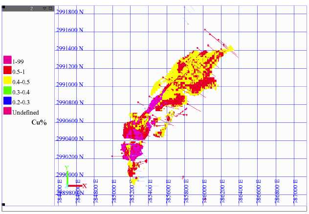
Figure 12.39: Plan view of grade distribution @ 0.4% Cu cut-off
| November 17, 2006 | |
| Resource Estimate: | Project No.: 03PM69 |
| Tyler Resources Inc. Bahuerachi Property, | |
| Chihuahua State, Mexico | |
| Prepared for: Tyler Resources Inc. | 107 |

Figure 12.40: Plan view of grade distribution @ 0.5% Cu cut-off
For public reporting purposes, Associated Geosciences Ltd. recommends that mineral resource tonnage and grade should be reported to no more than two significant decimal places in the inferred and indicated mineral resource categories. In the opinion of AGL, a 0.3% Cu cut-off is the most appropriate resource estimate to report as this cut-off is consistent with resource and reserve estimates from operating mines in this area of Mexico. At current prices a 0.2% Cu cutoff may also be considered appropriate.
The mineral resources in the Main Zone of the Bahuerachi porphyry complex, at a 0.2% Cu cutoff, are estimated to be 134.69 Mt grading 0.49% copper, 0.05 g/t gold, 4.25 g/t silver, 0.009% molybdenum and 0.08% zinc in the indicated category and an additional 134.22 Mt grading 0.36% copper, 0.03 g/t gold, 2.11 g/t silver, 0.005% molybdenum and 0.2% zinc in the inferred category.
The mineral resources in the Main Zone of the Bahuerachi porphyry complex, at a 0.3% Cu cutoff, are estimated to be 92.24 Mt grading 0.60% copper, 0.06 g/t gold, 5.20 g/t silver, 0.007 % molybdenum and 0.11% zinc in the indicated category and an additional 75.57 Mt grading
| November 17, 2006 | |
| Resource Estimate: | Project No.: 03PM69 |
| Tyler Resources Inc. Bahuerachi Property, | |
| Chihuahua State, Mexico | |
| Prepared for: Tyler Resources Inc. | 108 |
0.46% copper, 0.04 g/t gold, 2.57 g/t silver, 0.004% molybdenum and 0.3% zinc in the inferred category.
Per the United States Securities and Exchange Commission Industry Guide 7; Paragraph (b) (5), Instruction 3 states:
“Estimates other than proved (measured) or probable (indicated) reserves, and any estimated values of such reserves shall not be disclosed unless such information is required to be disclosed by foreign or state law; provided, however, that where such estimates previously have been provided to a person (or any of its affiliates) that is offering to acquire, merge, or consolidate with, the registrant or otherwise to acquire the registrant’s securities, such estimates may be included.”
The indicated mineral resource estimates in this report would qualify as “mineralized material”.
12.8 Mineral Reserve Estimates
No mineral reserve estimates have been completed for the property at this time
| November 17, 2006 | |
| Resource Estimate: | Project No.: 03PM69 |
| Tyler Resources Inc. Bahuerachi Property, | |
| Chihuahua State, Mexico | |
| Prepared for: Tyler Resources Inc. | 109 |
13.0 OTHER RELEVANT DATA
There is no other relevant data to be considered in an evaluation of this project.
| November 17, 2006 | |
| Resource Estimate: | Project No.: 03PM69 |
| Tyler Resources Inc. Bahuerachi Property, | |
| Chihuahua State, Mexico | |
| Prepared for: Tyler Resources Inc. | 110 |
14.0 INTERPRETATIONS AND CONCLUSIONS
14.1 Interpretations
Work to date has outlined a mineralized complex with overall surface widths and grades comparable to that of historical or present economic producers within a mineralized porphyry-style complex. Both high grade skarns and a stockworked, mineralized porphyritic intrusion of significant extent have been outlined by surface work to date on the Main Zone of the property.
The presence of mineralized outcrops over a wide topographic range along the system, relatively numerous and extensive historical underground workings and the 1997 drilling data outline the fact that significant continuity both at depth, and, areally can be expected within the system.
The presence of mineralization similar to or potentially genetically related to that seen at the Main Zone outline ore forming processes active over an area of more than 25 km2.
In many instances, the isolated nature of particular mineralized zones is a function of lack of data at this time. The potential exists for the Mina Mexicana, Main Zone and Colome showings to all be part of a larger complex which would span some 3.5 km in length and up to1 km in width. Several areas have been demonstrated to contain mineralization of potentially economic grade. Similarly, potential continuity between the San Juan and San Marcos occurrences as well as between the Cuesta Colorada and Los Alisos occurrences are promising exploration targets. Numerous other grassroots stage copper and gold occurrences have been identified on the property.
14.2 Conclusions
Sufficient resources have been identified to warrant continued exploration and to justify moving forward to a preliminary assessment (scoping level study) of the merits of placing the project into production
| November 17, 2006 | |
| Resource Estimate: | Project No.: 03PM69 |
| Tyler Resources Inc. Bahuerachi Property, | |
| Chihuahua State, Mexico | |
| Prepared for: Tyler Resources Inc. | 111 |
15.0 RECOMMENDATIONS
As a result of the recent site visit and discussions with Tyler staff, AGL has made the following recommendation:
- A scoping level study should be inititiated to establish the viability of projectdevelopment.
- Further in-fill drilling will be required to upgrade the mineral resource categoriesreported here-in.
- Further drilling will be required to assess the grade and tonnage of themineralized sedimentary units and the chalcocite blanket.
- Copper sequential analyses should be conducted on the majority of samplesgoing forward.
- The core drillers and helpers require more stringent field supervision and trainingto ensure that core integrity is maintained.
| November 17, 2006 | |
| Resource Estimate: | Project No.: 03PM69 |
| Tyler Resources Inc. Bahuerachi Property, | |
| Chihuahua State, Mexico | |
| Prepared for: Tyler Resources Inc. | 112 |
16.0 REFERENCES
Jutras, J.P.:
| 1998 : | Don David Reconnaissance Exploration Report, December 9th 1999. |
Kirkam, R.V., and Sinclair, W.D.:
| 1996 | Porphyry copper, gold, molybdenum, tungsten, tin, silver; In; |
McHale, K. Barry:
| 1996:. | Sampling Program and Preliminary Metallurgical Studies, |
| 1997 | Diamond Drilling Program and Metallurgical Studies, Bahuerachi |
Mejorda V., R.S.:
| 2001 | An Overview of Mining Law in Mexico, Latin Lawyer, Nov./Dec. |
Tan, G.:
2006: Phase 1 Metallurgical Test Program Bahuerachi Project.
| November 17, 2006 | |
| Resource Estimate: | Project No.: 03PM69 |
| Tyler Resources Inc. Bahuerachi Property, | |
| Chihuahua State, Mexico | |
| Prepared for: Tyler Resources Inc. | 113 |
17.0 CERTIFICATES OF QUALIFICATIONS
17.1 Keith McCandlish, P.Geol.
I, Keith McCandlish, P.Geol.:
| 1 | . | Am currently employed by: | Associated Geosciences Ltd. (AGL) |
| Suite 415, 708-11thAvenue S.W., | |||
| Calgary, Alberta, CANADA, T2R 0E4 | |||
| in the capacity of: | Vice President & General Manager | ||
| 2 | . | Am a Professional Geologist (P.Geol.) registered with the Association of Professional | |
| Engineers, Geologists and Geophysicists of Alberta (APEGGA-Member No.: M45717). | |||
| A summary of my relevant experience follows: | |||
| Over twenty-five years of consulting geological and engineering experience in minerals, | |||
| oil sands/heavy oil, precious stones, coal and industrial minerals. In 1988 I joined | |||
| Associated Mining Consultants Ltd. In 2006 I was transferred to Associated Geosciences | |||
| Ltd. where I am now Vice President & General Manager focusing on corporate finance, | |||
| due diligence and technical audits. | |||
| Mr. McCandlish has been actively involved on due diligence evaluations of mining | |||
| projects covering a range of mineral commodities and has had extensive experience in | |||
| exploration property valuations, analysis of project economics, exploration logistics, | |||
| assaying and project management. Detailed evaluations have been conducted on a | |||
| number of copper and polymetallic related mining operations and exploration projects, | |||
| internationally, including: | |||
- Sunshine Mining’s Pirquitas silver/tin/zinc proposed development, Argentina
- Navan Resources Chelopech copper-gold and Almagrera copper-zincunderground mines in Bulgaria and Spain, respectively
- Avocet Resources Zervashan gold operations and copper-gold exploration areas,Tajikistan
- Copper Fox Metals Inc. Schaft Creek copper porphyry project in northwesternBritish Columbia
- Carmen Copper Corporation copper porphyry project on Cebu in the Philippines.
- Mercator Minerals Mineral Park copper porphyry project at Kingman, Arizone
I have specific experience in the exploration for, and mining of calc-alkalic copper-gold porphyries and in Mexico.
| November 17, 2006 | |
| Resource Estimate: | Project No.: 03PM69 |
| Tyler Resources Inc. Bahuerachi Property, | |
| Chihuahua State, Mexico | |
| Prepared for: Tyler Resources Inc. | 114 |
| November 17, 2006 | |
| Resource Estimate: | Project No.: 03PM69 |
| Tyler Resources Inc. Bahuerachi Property, | |
| Chihuahua State, Mexico | |
| Prepared for: Tyler Resources Inc. | 115 |
17.2 J.P. Jutras, P.Geol.
I, Jean-Pierre Jutras P.Geol.:
| 1 | . | Am currently employed by: | Tyler Resources Inc. | |
| Suite 500, 926-5thAvenue S.W., | ||||
| Calgary, Alberta, CANADA, T2P 0N7 | ||||
| in the capacity of: | President/CEO, Director | |||
| 2 | . | Am a qualified geologist having obtained my Bachelor of Sciences (Honours) Degree in | ||
| Geology at the University of Alberta, Edmonton, Canada in 1991. | ||||
| 3 | . | Am a Professional Geologist (P.Geol.) registered with the Association of Professional | ||
| Engineers, Geologists and Geophysicists of Alberta (APEGGA-Member No.: M65297). | ||||
| A summary of my relevant experience follows: | ||||
| • | Exploration work on porphyry style projects with Placer Dome Explorations in | |||
| North-Central British Columbia in 1989 and 1990. | ||||
| • | Exploration work on both porphyry style targets and related copper gold | |||
| mineralization in the Mexican states of Sonora and Chihuahua in 1998 and 1999. | ||||
| I have practiced my profession as an exploration geologist on three continents and nine | ||||
| countries since 1991. | ||||
| 4 | . | I have read the definition of “Qualified Person” set out in National Instrument 43-101 and | ||
| certify that by reason of my education, affiliation with a Professional Association and | ||||
| past relevant work experience, I fulfill the requirements to be a “Qualified Person” for | ||||
| the purposes of NI 43-101. I am the internal “Qualified Person” for Tyler Resources Inc. | ||||
| 5 | . | I have reviewed and am familiar with all of the Bahuerachi project information on file at | ||
| the offices of Tyler Resources Inc. I first visited the property in 1998 and have personally | ||||
| directed the 1999, 2001 and 2003 work programs in the field, as well as all drilling and | ||||
| related activities since 2004. | ||||
| 6 | . | Have personally assembled and reviewed the technical information relevant to geology in | ||
| this report, outside of the Resource Estimate portion of the report. | ||||
| 7 | . | Am not aware of any material fact or material change with respect to the subject matter of | ||
| this technical report which is not reflected in the report, which the omission to disclose | ||||
| would make the technical report misleading. | ||||
| November 17, 2006 | |
| Resource Estimate: | Project No.: 03PM69 |
| Tyler Resources Inc. Bahuerachi Property, | |
| Chihuahua State, Mexico | |
| Prepared for: Tyler Resources Inc. | 116 |

| November 17, 2006 | |
| Resource Estimate: | Project No.: 03PM69 |
| Tyler Resources Inc. Bahuerachi Property, | |
| Chihuahua State, Mexico | |
| Prepared for: Tyler Resources Inc. | 117 |

| November 17, 2006 | |
![]()