Exhibit 99.1
CORPORACION RECURSOS IBERIA SL
AND
PETAQUILLA MINERALS LTD.
NI43-101 TECHNICAL REPORT ON THE
LOMERO-POYATOS Au-Cu-Pb-Zn MINE
IN ANDALUSIA, SPAIN
Prepared by
QUALIFIED PERSON
Richard Fletcher MSc, BSc,
FAusIMM, MIMMM, C.Geol. C.Eng. (Geologist)
29th July 2011
BEHRE DOLBEAR INTERNATIONAL LIMITED
3rdFLOOR, INTERNATIONAL HOUSE
DOVER PLACE, ASHFORD, KENT, UK
TN23 1HU
|
| NI43-101 Technical Report on the Lomero-Poyatos Mine |
| 29 July 2011 |
TABLE OF CONTENTS
| | |
| 1.0 | SUMMARY | 1 |
| 1.1 | THE PROPERTY | 1 |
| 1.2 | LOCATION | 1 |
| 1.3 | OWNERSHIP | 1 |
| 1.4 | GEOLOGY AND MINERALIZATION | 1 |
| 1.5 | EXPLORATION CONCEPT | 2 |
| 1.6 | STATUS OF EXPLORATION | 2 |
| 1.7 | DEVELOPMENT AND OPERATIONS | 2 |
| 1.8 | THE QUALIFIED PERSON’S CONCLUSIONS AND RECOMMENDATIONS | 3 |
| 2.0 | INTRODUCTION | 4 |
| 2.1 | THE PURPOSE OF THE ITR | 4 |
| 2.2 | THE SOURCES OF INFORMATION AND DATA | 4 |
| 2.3 | THE SCOPE OF THE PERSONAL INSPECTION ON THE PROPERTY | 4 |
| 3.0 | RELIANCE ON OTHER EXPERTS | 5 |
| 3.1 | LEGAL ISSUES | 5 |
| 3.2 | PREVIOUS STUDIES AND REPORTS | 6 |
| 4.0 | PROPERTY DESCRIPTION AND LOCATION | 6 |
| 4.1 | THE PROPERTY AREA | 6 |
| 4.2 | THE LOCATION, | 6 |
| 4.3 | THE TYPE OF MINERAL TENURE | 7 |
| 4.4 | MINERAL TITLE DETAILS | 8 |
| 4.5 | ENVIRONMENTAL ASPECTS | 10 |
| 4.6 | PERMITS REQUIRED | 11 |
| 5.0 | ACCESSIBILITY, CLIMATE, LOCAL RESOURCES, INFRASTRUCTURE | 12 |
| 5.1 | TOPOGRAPHY, ELEVATION AND VEGETATION | 12 |
| 5.2 | ACCESS TO THE PROPERTY | 12 |
| 5.3 | PROXIMITY TO POPULATION CENTRES | 13 |
| 5.4 | CLIMATE | 13 |
| 5.5 | SITE CONVENIENCE | 13 |
| 6.0 | HISTORY | 15 |
| 6.1 | PRIOR OWNERSHIP | 15 |
| 6.2 | EXPLORATION HISTORY | 18 |
| 6.3 | HISTORICAL ESTIMATES | 24 |
| 7.0 | GEOLOGICAL SETTING | 35 |
| 7.1 | REGIONAL GEOLOGY | 35 |
| 7.2 | LOCAL GEOLOGY | 36 |
| 7.3 | PROPERTY GEOLOGY | 36 |
| 8.0 | DEPOSIT TYPES | 38 |
| 9.0 | MINERALIZATION | 38 |
| 10.0 | EXPLORATION | 39 |
| 11.0 | DRILLING | 39 |
| 12.0 | SAMPLING METHOD AND APPROACH | 39 |
| 13.0 | SAMPLE PREPARATION, ANALYSES AND SECURITY | 39 |
| 14.0 | DATA VERIFICATION | 39 |
| 15.0 | ADJACENT PROPERTIES | 40 |
| 16.0 | MINERAL PROCESSING AND METALLURGICAL TESTING | 40 |
| 17.0 | MINERAL RESOURCE AND MINERAL RESERVE ESTIMATES | 47 |
| 17.1 | MINERAL RESOURCE ESTIMATES | 47 |
| 17.2 | GEMCOM RESOURCE MODEL | 50 |
| 17.3 | DATABASE PREPARATION AND VALIDATION | 51 |
| 17.4 | MINERAL RESOURCE ESTIMATION (GEMCOM, 2011) | 56 |
|
| NI43-101 Technical Report on the Lomero-Poyatos Mine |
| 29 July 2011 |
| | |
| 18.0 | OTHER RELEVANT DATA AND INFORMATION | 59 |
| 18.1 | INDICATIVE VALUATION | 59 |
| 18.2 | OTHER | 61 |
| 18.3 | LOMERO-POYATOS BLOCK MODELS | 63 |
| 19.0 | INTERPRETATION AND CONCLUSIONS | 70 |
| 19.1 | SUMMARY OF RESULTS | 70 |
| 19.2 | DATA ADEQUACY AND RELIABILITY | 70 |
| 19.3 | THE PROJECT OBJECTIVES | 71 |
| 20.0 | RECOMMENDATIONS | 71 |
| 20.1 | COST OF PROGRAMMES | 72 |
| 21.0 | REFERENCES | 73 |
| 22.0 | ADDITIONAL REQUIREMENTS FOR TECHNICAL REPORTS ON | 75 |
| 23.0 | CERTIFICATE AND CONSENT | 76 |
| 24.0 | CERTIFICATE AND CONSENT | 77 |
| | |
| LIST OF TABLES |
| |
| Table 1 | Lomero-Poyatos Mining Concessions | 8 |
| Table 2 | Significant Newmont/CMR Drillhole Intersections (Source: WAI, 2007 ) | 21 |
| Table 3 | Significant (>2m at 1g/t Au) gold value drill intercepts (CMR, 2002 – 2004) | 23 |
| Table 4 | Mineral Resource Statement (Source: SRK, 2002) | 25 |
| Table 5 | Concentrate Grades and Recoveries from AMCO-Robertson Test work | 27 |
| Table 6 | Lomero-Poyatos Indicated Mineral Resource Estimate (Source:- CMR, 2007) | 34 |
| Table 7 | Lomero-Poyatos Underground Resource Estimate at 1.5 g/t Au cut-off | 35 |
| Table 8 | Processing test results (Source: Amco-Robertson, 2002) | 41 |
| Table 9 | Assumptions used in deriving NSR for Lomero-Poyatos (in US$) | 41 |
| Table 10 | Correlation Coefficients of the Raw Assay Data (Source: Gemcom, 2011) | 53 |
| Table 11 | Inferred Mineral Resource Estimate assuming Open-pit mining at SG = 3.3 | 58 |
| Table 12 | Inferred Mineral Resource Estimate assuming underground mining at 1g/t Au | 58 |
| Table 13 | Assumptions used in deriving deposit sales value in US$ | 59 |
| Table 14 | Average Stock Market Value per oz of in-situ Gold Resource | 60 |
| | |
| LIST OF FIGURES | |
| | | |
| Figure 1 | Location map of the Lomero-Poyatos mine | 7 |
| Figure 2 | Location map showing mineral concessions (Red) and surface rights (blue) | 9 |
| Figure 3 | Satellite image showing location of mineral assets at Lomero-Poyatos | 10 |
| Figure 4 | Lomero-Poyatos mine shaft | 13 |
| Figure 5 | Poyatos pit (looking west) note exposed pyrite (grey) in bottom of pit | 14 |
| Figure 6 | Lomero pit (looking east) | 14 |
| Figure 7 | Isometric view showing extent of underground workings (Source- Sigiriya, 2009) | 16 |
| Figure 8 | Long section showing drill hole intersections and resource boundary | 17 |
| Figure 9 | Deposit structure and isopachs in vertical section (Source: CMR, 2006) | 17 |
| Figure 10 | Mineral distribution block model for Au-Zn-Cu (Source: CMR, 2006) | 18 |
| Figure 11 | Lomero-Poyatos Stratigraphy and Lithology (Source: CMR, 2006) | 19 |
| Figure 12 | Bedded sulphides in drill core (Source: CMR, 2006) | 20 |
| Figure 13 | Lomero-Poyatos – exploration potential (Source: CMR, 2006) | 20 |
| Figure 14 | Detail of the northeast extension of the Lomero-Poyatos deposit | 22 |
| Figure 15 | Mines in the Iberian pyrite belt | 35 |
| Figure 16 | Local geology of the Lomero-Poyatos district | 36 |
| Figure 17 | Geology of the Lomero-Poyatos mine site (Source: WAI, 2007) | 37 |
| Figure 18 | Schematic N-S cross-section through the Lomero-Poyatos deposit | 38 |
| Figure 19 | Histogram of Gold assay values showing 2 populations (blue line) | 42 |
|
| NI43-101 Technical Report on the Lomero-Poyatos Mine |
| 29 July 2011 |
| | |
| Figure 20 | Correlation plots of each metal pair assay values | 43 |
| Figure 21 | Plan view of CMR drillholes and section lines (source: Gemcom, 2011) | 48 |
| Figure 22 | Long section showing underground workings (Source: Gemcom, 2010) | 50 |
| Figure 23 | Block Model Solid of Lomero-Poyatos deposit at >25% S | 54 |
| Figure 24 | Primary Variogram – gold | 56 |
| Figure 25 | Model of Mine Workings | 57 |
| Figure 26 | Plan view showing Au mineralisation, drill holes and IK estimated block model | 63 |
| Figure 27 | Section view showing Au mineralisation at the eastern extremity of the block | 63 |
| Figure 28 | Inclined section looking towards the SW showing Au mineralisation | 64 |
| Figure 29 | Plan view showing Ag mineralisation, drill holes and IK estimated block model | 64 |
| Figure 30 | Section view showing Ag mineralisation at the eastern extremity of the block | 65 |
| Figure 31 | Inclined section looking towards the SW showing Ag mineralisation, drill holes | 65 |
| Figure 32 | Plan view showing Cu mineralisation, drill holes and IK estimated block model | 66 |
| Figure 33 | Section view showing Cu mineralisation at the eastern extremity of the block | 66 |
| Figure 34 | Inclined section looking towards the SW showing Cu mineralisation, drill holes | 67 |
| Figure 35 | Plan view showing Pb mineralisation, drill holes and IK estimated block model | 67 |
| Figure 36 | Section view showing Pb mineralisation at the eastern extremity of the block | 68 |
| Figure 37 | Inclined section looking towards the SW showing Pb mineralisation, drill holes | 68 |
| Figure 38 | Plan view showing Zn mineralisation, drill holes and IK estimated block model | 69 |
| Figure 39 | Section view showing Zn mineralisation at the eastern extremity of the block | 69 |
| Figure 40 | Inclined section looking towards the SW showing Zn mineralisation, drill holes | 70 |
| | |
| J11 - 132 | iii | BEHRE DOLBEAR |
|
| NI43-101 Technical Report on the Lomero-Poyatos Mine |
| 29 July 2011 |
1.0 SUMMARY
Behre Dolbear International Limited (Behre Dolbear) was commissioned by Corporacion Recursos Iberia SL (“CRI”) to review the Lomero-Poyatos Mine project in southwest Spain and prepare this report in compliance with Canadian National Instrument 43-101 – Standards of Disclosure for Mineral Projects (“NI 43-101”). Behre Dolbear understands that this technical report is to be used by CRI in connection with a contemplated transaction with Petaquilla Minerals Ltd.
The Behre Dolbear team visiting the project comprised Mr. Richard Fletcher, M.Sc, FAusIMM, MIMMM, C. Eng, C.Geol, a Qualified Person for geological reviews and mineral resource estimation. The Report has been reviewed by Mr. Denis Acheson, B.Sc. Eng, MMMSA, as Project Manager. Mr. Fletcher accepts responsibility for all Sections of this report.
CRI acquired an interest in the historic Lomero-Poyatos Mine from the previous owner Recursos Metalicos SL (RMSL) and commissioned Behre Dolbear to prepare a preliminary geological model and Mineral Resource Estimate of the Lomero-Poyatos deposit based on available historical data. It is this work that forms the basis for this NI43-101 Report. Much of the historical data, including most of the drill-hole data, was generated by Cambridge Mineral Resources plc (CMR), a company that previously owned the property during the period 2001- 2007.
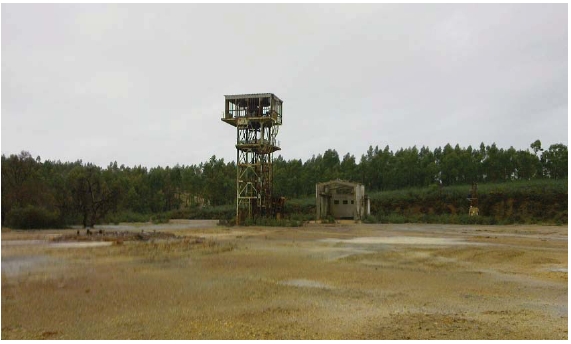
The Lomero-Poyatos mine produced about 2.6 Mt of pyrite ore, mostly by underground mining methods, for use as sulphuric acid feedstock, but has been closed for about 20 years. The site consists of a sealed vertical shaft and headgear that would need refurbishing, the Lomero open-pit mine to the east of the shaft and the Poyatos open-pit mine to the west of the shaft. It is likely that a Unified Environmental Authorisation (Autorización Ambiental Unificada - AAU) would be required prior to any significant re-development of the mine site.
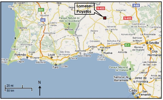
The Lomero-Poyatos mine is located at 37°48’N / 6°56’W in Huelva Province of the Autonomous Community of Andalucía in Southern Spain, about 500 km south of Madrid, 85 km north-west of Seville and 60 km north-east of the port of Huelva.
In June 2001, the Provincial Government in Spain granted a consolidation of the 13 Operating Concessions totalling about 175 ha. at Lomero-Poyatos, offering a long term (60 years) security to any future development plans. CRI acquired the Lomero-Poyatos Concessions in a public offering in April 2010. Behre Dolbear has not carried out any legal due diligence on the validity, legality, ownership or constraints of the Lomero-Poyatos mineral Concessions or any agreements with related or third parties. Behre Dolbear has assumed that the process of establishing the exploitation rights and a Mining Permit does not affect the likely viability of the mineral assets nor the estimation and classification of the Mineral Resources as reported herein.
| |
| 1.4 | GEOLOGY AND MINERALIZATION |
The Lomero-Poyatos mine is located in the north-east part of the Spanish/Portuguese (Iberian) pyrite belt which extends about 230 km between Seville in the east (in southern Spain) and the Atlantic coast near Lisbon in the west (in Portugal). Lomero-Poyatos is a poly-metallic, massive-sulphide deposit that is located on the northern limb of the San Telmo anticline, which is an E-W trending fold structure adjacent to a major thrust fault. The deposit has an ENE (075°) strike and dips about 35°N.
|
| NI43-101 Technical Report on the Lomero-Poyatos Mine |
| 29 July 2011 |
At the surface there are two separate orebodies - Lomero (east) and Poyatos (west) - that combine at depth to form a single deposit 900 m in strike length. The average thickness of massive sulphide, based on drill-hole intersections, is about 7.5m, although the maximum thickness of massive sulphide exceeds 20m. The mineralisation is known to extend at least 500m down dip.
The mineral assemblage consists of pyrite, tenantite, sphalerite, galena, chalcopyrite, minor arsenopyrite, barite, pyrrhotite and gold. There are some hematite-magnetite-rich bands.
CRI, the present owner of the Lomero-Poyatos mine, has not carried out any exploration of the property. All the available data is derived from the work carried out by the previous owners, particularly CMR. Exploration during CMR’s tenure included about 10,000m of drilling, 1,100m of trenching, detailed geological studies, metallurgical test work, resource evaluation and electromagnetic and gravity surveys. Resource modelling and assessment ranged from high-tonnage/low-grade open-pit development to high-grade/lower tonnage underground mining development options.
The Lomero-Poyatos deposit is still at the exploration stage and the mineral resource estimate is based on relatively wide-spaced drilling. Therefore, the mineral resource is categorised as an Inferred Mineral Resource. However, as stressed in this Independent Technical Report, resources that are not ore reserves do not have demonstrated economic viability and an Inferred Mineral Resources may not be upgraded to an Indicated or Measured Mineral Resource as a result of continued exploration. Until these Inferred Mineral Resources are upgraded to at least Indicated Mineral Resource category, the Inferred Mineral Resource estimate should not be included as part of any economic appraisal for NI 43-101 reporting purposes.
Recent (April, 2011) work carried out at the University of Madrid showed that the deposit contains at least three different ore types as follows:
Cupriferous Ore typically assaying 1.0% to 1.5% Cu with gold credits but with no Pb,Zn or Ag.
Arsenic/Pyrite Ore containing gold credits only.
Massive sulphide Ore containing all three base-metals, with silver associated withlead and gold associated with sulphides, and some free gold.
Consequently, these three different ore types may require at least three different processing flow-sheets.
| |
| 1.7 | DEVELOPMENT AND OPERATIONS |
The approximate size of the Lomero-Poyatos deposit, based mainly on the CMR drill-hole data, has been estimated by three independent consultants in the past nine years. The results are summarised below as two separate scenarios, namely open-pit and underground.
|
| NI43-101 Technical Report on the Lomero-Poyatos Mine |
| 29 July 2011 |
Open-pit Scenario:
SRK (2002) Inferred Mineral Resource:at a €50 value cut-off = 20.6 Mt at 3.1 g/tAu, 69.9 g/t Ag, 3.3% Zn, 1.2% Cu, 1.2% Pb. Containing 2.1 Moz Au.
Gemcom (2010) Inferred Mineral Resource:at 1 g/t Au cut-off grade = 20.9 Mt at3.08 g/t Au, 62.38 g/t Ag, 2.5% Zn, 0.7% Cu, 0.7% Pb. Containing 2.07 Moz Au.
This scenario does not look practical due to the great depth (>250 m) and the huge waste:ore ratio (>50:1) involved in open-pit mining below the existing underground workings.
Underground Scenario:
SRK (2002) Indicated Mineral Resource:at €70 value cut-off = 1.85 Mt at 3.4 g/tAu, 52 g/t Ag, 0.8% Cu, 1.4% Pb, 2.3% Zn. Containing 0.203 Moz Au.
WAl (2006) Indicated Mineral Resource:at 1.5 g/t Au cut-off = 3.71 Mt at 3.26 g/tAu, 27.9 g/t Ag, 0.87% Cu, 1.16% Pb, 1.57% Zn. Containing 0.39 Moz Au.
Gemcom (2011) Inferred Mineral Resource:at 1 g/t Au cut-off = 6.07 Mt at 4.25g/t Au, 88.74 g/t Ag. Containing 0.83 Moz Au.
| |
| 1.8 | THE QUALIFIED PERSON’S CONCLUSIONS AND RECOMMENDATIONS |
It is Behre Dolbear’s opinion that:
As a consequence of the mineral diversity, the geological and mineralogical domains need to be defined so as to provide separate tonnage and grade estimates for each of the ore types. Carefully selected and representative metallurgical samples need to be extracted from each of these ore type domains for metallurgical testing. In addition, further validation of the nature and distribution of the Au, Ag, Cu, Pb, Zn mineralisation is required, in order that the Inferred Mineral Resources can be upgraded.
The Mineral Resource estimates were based on assumptions made about the specific gravity of the main mineralised rock types and it is strongly recommended that studies of the specific gravity be undertaken to enable the Inferred Mineral Resources to be upgraded to Indicated and Measured Mineral Resource categories.
Behre Dolbear carried out a preliminary valuation of the Lomero-poyatos deposit based on; published average global stock market valuations per ounce of in-situ gold resources; and value from a comparable acquisition transaction. Taking the average of these two estimates, assuming equal weightings for each, Behre Dolbear conclude that an appropriate current value for the Lomero-Poyatos project is$53.5 million.
It is recommended that additional drilling (totalling 20,000m) be carried out, including some duplicate drill-holes, twinning selected surveyed historical holes, in order to cross-correlate the historical data with confirmatory data and some additional drill-holes to better define the physical extent of the solid at depth and along strike.
It is proposed to achieve this in two stages: as a Stage 1 drilling programme and scoping study at an estimated cost of €6 million; and a Stage 2 pre-feasibility study with further drilling and test-work at an estimated cost of €7 million.
|
| NI43-101 Technical Report on the Lomero-Poyatos Mine |
| 29 July 2011 |
2.0 INTRODUCTION
This Independent Technical Report (ITR) has been prepared for Corporacion Recursos Iberia SL (CRI), a wholly-owned affiliate of Vancouver based Iberian Resources Corp (IRC), a company recently incorporated under the laws of the Province of British Columbia, Canada; and Petaquilla Minerals Ltd. (“PML”), a company incorporated under the laws of the Province of British Columbia, Canada.
| |
| 2.1 | THE PURPOSE OF THE ITR |
CRI has acquired an interest in the historic Lomero-Poyatos mine from the previous owner Recursos Metalicos SL (RMSL), whose assets included a 100% interest in the mine that lies within a granted mining licence, with 30 years left to run. This ITR has been commissioned in relation to an interest by PML in acquiring IRC. PML is not currently part of the IRC/CRI corporate structure although 5 of its Directors and Officers are shareholders of IRC.
The Behre Dolbear team visiting the project comprised Mr. Richard Fletcher, M.Sc, FAusIMM, MIMMM, C. Eng, C.Geol, a Qualified Person for geological reviews and mineral resource estimation. This Report has been reviewed by Mr. Denis Acheson, B.Sc. Eng, MMMSA, as Project Manager.Mr. Fletcher accepts responsibility for all Sections of this report.
Behre Dolbear is acting in an independent capacity as a consultant to CRI and is receiving a pre-negotiated fee for its services. Neither Behre Dolbear nor any professional working on this assignment has any ownership interest, financial interest, or any other pecuniary interest in CRI, IRC or PML, or the Lomero-Poyatos project.
| |
| 2.2 | THE SOURCES OF INFORMATION AND DATA |
CRI commissioned Behre Dolbear International Ltd, to prepare a preliminary geological model and Mineral Resource Estimate of the Lomero-Poyatos deposit based on available historical data and it is this work that forms the basis for this NI43-101 Report. Much of the historical data, including most of the drill-hole data, was generated by Cambridge Mineral Resources plc, a company that previously owned the property during the period 2001 to 2007.
| |
| 2.3 | THE SCOPE OF THE PERSONAL INSPECTION ON THE PROPERTY |
Behre Dolbear carried out a site visit to the Lomero-Poyatos mine on the 8th-9th January 2011. The site visit team comprised Richard Fletcher (geologist), Wayne Taylor (mining engineer) and Susan Struthers (environmental) from Behre Dolbear; and Oriol Prósper Cardoso (legal) and Juan Leon Coullaut (mining CRN) representing Petaquilla. Richard Fifer (Chairman of PML) and several local dignitaries met the Behre Dolbear team on site and gave a brief summary of the project’s aims and objectives.
The Lomero-Poyatos mine has been inactive for about 20 years. The site consists of: a sealed vertical shaft and headgear that would need refurbishing; the Lomero open-pit mine to the east of the shaft; and the Poyatos open-pit mine to the west of the shaft. These are illustrated in the photographs included under Item 7 of this report.
The site visit coincided with a period of heavy rain that had flooded the open pits and made the ground conditions very slippery, so that it was not possible to examine the exposures in the lower parts of the pits.
|
| NI43-101 Technical Report on the Lomero-Poyatos Mine |
| 29 July 2011 |
Petaquilla’s consultant, Juan Leon Coullart, explained the general geology and history of the mine and showed some plans and sections of the drilling results and the historical underground workings. He also pointed out several of the drill sites and drill-hole collars from the Cambridge Mineral Resources drilling programme.
The Lomero pit is about 100m in length, about 40m wide and about 20m deep. It has been partially filled with mine waste at the western end and domestic refuse at the eastern end. The Poyatos pit is about 150m in length about 70m in width and about 20m deep. These two pits were worked by two separate companies prior to 1910 when they were merged into a single underground operation.
The massive sulphide body is visible in the deeper parts of the pits where it appears to be about 5m thick dipping at about 40 degrees to the north. The hanging wall consists of massive competent volcanic rock and the footwall consists of intensely sheared phyllite (clay, mica and talc) that merges downwards into more competent volcanic rock that contains significant amounts of disseminated sulphide minerals (mostly pyrite).
At the surface, the rocks are weathered and the sulphides are converted to hematite and limonite. The surface “gossan” extends to a depth of less than 5m and Juan Leon Coullaut advised that there was some evidence that the surface “gossan” zone had been worked for gold in Roman times but that virtually all archaeological remains had been destroyed by the open-pit mining.
The impression gained from the open pits was that the sulphide mineralisation occurred as separate lenses in the two pits with the mineralisation being thin or absent in the area between the pits. This appears to be reflected in the distribution of the stoped-out areas in the underground workings.
3.0 RELIANCE ON OTHER EXPERTS
Behre Dolbear’s review of the Lomero-Poyatos mine in Spain was conducted on a reasonableness basis and Behre Dolbear has noted herein where such provided information stemming from the review has raised questions. Except where noted, Behre Dolbear has relied upon the information provided by CRI and CRI’s Consultants as being accurate, reliable and suitable for use in this assessment. Behre Dolbear retains the right to modify its conclusions if new or undisclosed information is provided. Electronic mail copies of this report are not official unless authenticated and signed by Behre Dolbear and are not to be modified in any manner without Behre Dolbear’s written consent.
Behre Dolbear has not carried out any legal due diligence on the validity, legality, ownership or constraints of the Lomero-Poyatos mineral concessions or any agreements with related or third parties.
In consideration of all legal aspects relating to the Lomero-Poyatos project, Behre Dolbear has placed reliance on the representations by CRI’s legal advisor Oriol Prósper Cardoso in Madrid that, as of June 2011, the legal ownership of most of the land required for mining operations and the physical assets thereon, are secure. Behre Dolbear understands that exploitation rights and a Mining Permit are still in the process of review by the Junta de Andalucía and accepts the probability that these will be granted during 2011 and that access to required adjacent lands held by third parties, but required for certain operations, including tailings disposal, may then be facilitated by the regulatory process if private negotiations fail.
|
| NI43-101 Technical Report on the Lomero-Poyatos Mine |
| 29 July 2011 |
Behre Dolbear has assumed that the process of establishing the exploitation rights and the Mining Permit does not affect the likely viability of the mineral assets nor the estimation and classification of the Mineral Resources as reported herein.
| |
| 3.2 | PREVIOUS STUDIES AND REPORTS |
The Lomero-Poyatos Mine has been the subject of various technical studies by its previous owners.This work included an independent due diligence and verification by international consultants SRK, appointed by Cambridge Mineral Resources plc, covering geology, drilling, mineral resources and reserves, mining, processing and project economics. The 2002 SRK reports were prepared by “qualified persons” as defined by NI43-101 under the supervision of Mr R.A. (Dick) Watts, their Principal Mining Engineer. The 2006 CMR resource model was developed by Colin Andrew and Bill Sheppard, who would be “Qualified Persons” under the definitions of NI43-101.
Behre Dolbear has also been advised by mining experts from the University of Madrid, particularly Angel Rodrigues-Avello Sanz and Jose Antonio Botin Gonzalez, concerning the history of ownership, geology, mining and processing at Lomero-Poyatos.
Behre Dolbear commissioned Gemcom Software Europe Ltd to prepare a new computer generated block model and mineral resource estimate of the Lomerio-Poyatos deposit based on available historical drill-hole data.
This report, authored by Behre Dolbear, is largely based on these data contributions.
4.0 PROPERTY DESCRIPTION AND LOCATION
In Spain, the right to exploit a mine is granted by the Autonomous Community by means of a Concession. The Lomero-Poyatos Concession(s) were formerly owned and operated by Piritas de Huelva s.a.l, and in 1985 they were transferred to San Telmo Ibérica Minera S.A. (in receivership).
In June 2001, the Provincial Government in Spain granted a consolidation of the Lomrero-Poyatos Concessions, offering a long-term (60 years) security to any future development plans (SRK, 2002).
In May 2010, the Lomero-Poyatos Concession(s) were transferred to CRI.
The Lomero-Poyatos mine is located at 37°48’N / 6°56’W in Huelva Province of the Autonomous Community of Andalucía in Southern Spain, about 500 km south of Madrid, 85 km north-west of Seville and 60 km north-east of the port of Huelva.
|
| NI43-101 Technical Report on the Lomero-Poyatos Mine |
| 29 July 2011 |
| |
| Figure 1 | Location map of the Lomero-Poyatos mine |
The mine workings area located at UTM coordinates:
Lomero pit (east of the main shaft) 682.52/4186.25
Poyatos pit (west of the main shaft) 682.08/4186.26
Adjacent to road H-120 (Cabezas Rubias- N-435) pk.85, 4.4 km east of San Telmo.
| |
| 4.3 | THE TYPE OF MINERAL TENURE |
In Spain, there are typically three different types of mineral tenure:
Exploration Permits (Art. 40.2 Mining Law) granted for a period of 1 year, and whichmay be extended for a maximum of one more year.
Research Permits (Art. 45 Mining Law) granted for the period requested which maynot be more than 3 years, and which may be extended for a further 3 years.
Operating Concessions (Art. 62 Mining Law) also referred to as a Mining Permit,granted for a 30-year period, and which may be extended for equal periods up to amaximum of 90 years.
Lomero-Poyatos already has an Operating Concession (mining permit) and it is necessary to demonstrate actual work being performed in order to retain this. CRI proposes to accomplish this by a diamond drilling programme and further mining (effectively bulk sampling) initially at a rate of 100 tonnes per day over the next 3 years. A new decline ramp is proposed for this purpose. These proposals are presented in a document called a design feasibility study that is being prepared by Madrid University personnel. This document is also required by the Andalusian authorities to facilitate transfer of the property title to CRI.
|
| NI43-101 Technical Report on the Lomero-Poyatos Mine |
| 29 July 2011 |
In Spain, the right to exploit a mine is granted by the Autonomous Community by means of a Concession. The Lomero-Poyatos concession(s) were formerly owned and operated by Piritas de Huelva s.a.l, and in 1985 they were transferred to San Telmo Ibérica Minera S.A. (in receivership). The concessions were granted prior to the current Mining Act (1973) and were consolidated on May 2001 and are valid until August 2033.
CRI acquired the Lomero-Poyatos Concession(s) from the Spanish authorities through a public auction bid in April 2010. CRI did not obtain the surface rights at that time but acquired the surface rights to Finca Lomero at a later date. The Concessions grant the exclusive right to exploit Section C natural resources located beneath its surface. According to Article 3 of Mines Law 22/1973, July 23rd, Section C covers those (metallic) minerals and natural resources not included in Section A (low value construction minerals), section B (mineral water, thermal water, underground structures and others) or Section D ( radioactive minerals, geothermal resources, bituminous rocks and other energy minerals or geological resources).
The Concession cumulatively referred to by the name Lomero-Poyatos consists of 13 mining concessions covering a total of 175.6 ha, as follows:
| |
| Table 1 | Lomero-Poyatos Mining Concessions |
| | | | | |
| Number of | Nameof | Registration with the | Surface Date | Granted | Valid until |
| concession | concession | Real Estate Registry | area (ha) | | |
| 3,730 | El Lomero | Registry of Valverde, | 4.0 | 22/10/1877 | 13-08-2033 |
| | | plot number 1,364 | | | |
| 12,094 | Ampliación a | Registry of Valverde, | 20.0 | 10/10/1919 | 13-08-2033 |
| | Numancia | plot number 2,338 | | | |
| 6,503 | Segundo | Registry of Valverde, | 20.0 | 17/08/1891 | 13-08-2033 |
| | Lomero | plot number 1,943 | | | |
| 537 | Castilla | Registry of Aracena, | 12.0 | 22/05/1865 | 13-08-2033 |
| | | plot number 148 | | | |
| 506 | Numancia | Registry of Aracena, | 12.0 | 16/05/1865 | 13-08-2033 |
| | | plot number 149 | | | |
| 1,974 | San Miguel | Registry of Aracena, | 8.4 | 06/03/1876 | 13-08-2033 |
| (also 108) | | plot number 525 | | | |
| 12,529 | Ampliación | Registry of Aracena, | 10.0 | 05/04/1921 | 13-08-2033 |
| | Victoria | plot number 2,579 | | | |
| 12,318 | Victoria | Registry of Aracena, | 39.0 | 01/12/1919 | 13-08-2033 |
| | | plot number 2,547 | | | |
| 11,255 | Segunda A | Registry of Aracena, | 6.0 | 04/12/1913 | 13-08-2033 |
| | Castilla | plot number 2,372 | | | |
| 11,420 | Demasía San | Registry of Aracena, | 2.2 | 27/03/1915 | 13-08-2033 |
| | Miguel | plot number 2,417 | | | |
| 11,424 | Segunda | Registry of Aracena, | 14.0 | 27/03/1915 | 13-08-2033 |
| | Numancia | plot number 2,416 | | | |
| 11,232 | Tercer | Registry of Aracena, | 17.0 | 04/09/1913 | 13-08-2033 |
| | Lomero | plot number 2.373 | | | |
| 10,843 | Conchita | Registry of Aracena, | 11.0 | 29/03/1910 | 13-08-2033 |
| | | plot number 2,285 | | | |
| GRUPO LOMERO Y OTRAS | Total area (ha) | 175.6 | | |
|
| NI43-101 Technical Report on the Lomero-Poyatos Mine |
| 29 July 2011 |
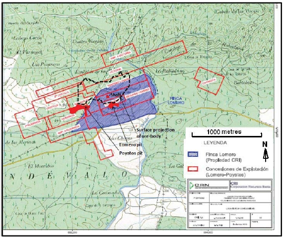
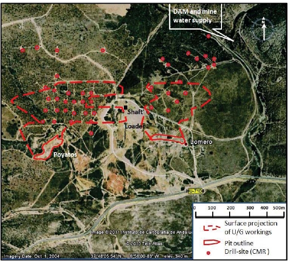
The Mining Concession boundary data was obtained from the Geographic Information System belonging to the Junta de Andalucia and have not been verified on the ground. The Concession boundaries are shown relative to the known mineral deposits, mineral resources and mining assets on figures 2 and 3 below.
Surface Rights
Corporación Recursos Iberia S.L. has acquired the rustic estate "Finca Lomero" in the Register of Valverde del Camino under number 2,697 duplicate (Area 1, Page ½), that extends over 57 hectares and 52 areas in the municipality of El Cerro de Andevalo,
The location of all known mineralized zones and the main mining and infrastructure assets are shown in figures 2 and 3.
| |
| Figure 2 | Location map showing mineral concessions (Red) and surface rights (blue) |
|
| NI43-101 Technical Report on the Lomero-Poyatos Mine |
| 29 July 2011 |
| |
| Figure 3 | Satellite image showing location of mineral assets at Lomero-Poyatos |
While the current ‘operating concession’ allows and requires the conduct of mining at the Lomero-Poyatos site, there will almost certainly be a need to demonstrate that the environmental impacts of this work have been assessed and mitigation methods defined.
It is therefore recommended that a study is undertaken to determine the environmental impacts of both the proposed drilling and development of the underground access ramp, dewatering and small scale mining. This should include a plan of how the water from the underground workings is to be treated and either stored or released. Such a report will be a strong indication to the authorities that this project takes environmental responsibilities seriously and is prepared to be proactive in this regard.
In the longer term (18 to 24 months), a Unified Environmental Authorisation (Autorización Ambiental Unificada - AAU) will almost certainly be required prior to any significant development of the mine site. The AAU consolidates all of the required environmental and land-use permits and applications into one document, including, but not limited to:
|
| NI43-101 Technical Report on the Lomero-Poyatos Mine |
| 29 July 2011 |
Noise emissions;
Production of waste products;
Soil use;
Forestry authorisations and fire prevention;
Protection of natural species both flora and fauna; and
Final restoration plan.
The overall permitting process of the Junta de Andalucía is co-ordinated by the Ministry of Innovation, Science and Companies together with the Ministry of Environment, including all environmental permits.
The restart of mining operations at the Lomero-Poyatos Mine can only proceed following receipt of various regulatory approvals. The principal regulatory approvals required are:
Approval by the Junta de Andalucía of the transfer of mineral rights to CRI;
Approval of the restart, operating and rehabilitation plans; and
Issue of a Mining Permit.
CRI must submit a request to the Government for authorisation of the transfer of Mineral Rights, (pursuant to the provisions of Articles 95.2, 97.1 and the Second Transitional Provision of the current Mining Act) for the development of the Lomero-Poyatos Mine. This request must be accompanied by supporting documentation, including relevant technical documentation, as well as contracts and title transfer deeds showing that CRI owns the mineral rights including, the registered Lease which incorporates the area of the mine, the facilities and the exclusive rights of operation and beneficiation of minerals from the soil and subsoil.
The necessary steps the CRI needs to complete in order to gain full authorisation for the recommencement of mining activities, include:
Submission of mining project and final restoration plan;
Review by local government authorities and corrections by CRI if required;
Formal departmental reporting, public hearing and processing of the UnifiedEnvironmental Authorisation (AAU);
Review by IGME and CEDEX and modification by CRI if required;
Review by the Provincial Delegado;
AAU-authorised approval of final restoration plan by Provincial Delegado;
Application to Regional Delegado for approval of mining project;
Transfer of Mineral Rights and approval of mining project;
Processing of other authorizations, use of tailings storage facilities, authorisation ofequipment usage, verification of operator permissions, etc;
Authorisation for blasting;
Verification of lodgement of bonds, insurances, etc; and
Commencement of operations.
In order to ensure compliance with the Government regulations and procedures and to expedite the approval of mineral rights, CRI has commissioned a number of leading Spanish consultancies to complete the various studies required in order meet the above requirements. The selection of these Spanish consultancies was based on their professional reputation and historical relationships with various Government authorities.
The process for compulsory acquisition of surface land rights is formal and may, in the best case scenario, take less than 12 months, or in the worst case scenario, up to 2 years to complete. The price
|
| NI43-101 Technical Report on the Lomero-Poyatos Mine |
| 29 July 2011 |
to be paid (if there is no agreement) is based on independent valuations, taking into account the tax value and recent transactions. Once the agreed compulsory value has been established, the expropriating party can occupy the lands or rights.
5.0 ACCESSIBILITY, CLIMATE, LOCAL RESOURCES, INFRASTRUCTUREAND PHYSIOGRAPHY
| |
| 5.1 | TOPOGRAPHY, ELEVATION AND VEGETATION |
The Lomero-Poyatos area is located at an altitude of 340m and consists of low rolling hills with a topographic relief of about 50m. The area has very thin, stony soils and is largely given over to native scrub-land and planted eucalyptus forests on the hills; and citrus fruits on the slightly better soils in the valleys. The area is sparsely populated with the population concentrated in small villages several kilometres apart.
Australian eucalypts, mostly introduced for paper production, have established themselves in the region as they are fast growing and well adapted to the climatic conditions and are therefore useful for re-vegetation and rehabilitation. However, they are considered a pest species in many instances, as they compete successfully with the native Spanish Oak and Cork Oak that are essential for established rural livelihoods.
| |
| 5.2 | ACCESS TO THE PROPERTY |
The Lomero-Poyatos mine is located at 37°48’N / 6°56’W, about 90 km west of Seville (1.5 hours by car) and about 10 km west of the operating Agua Tenidas mine and about 5 km east of the abandoned San Telmo mine. These are all served by good road access (HU-710 highway). Lomero-Poyatos is 3km northwest of the existing railway line at Valdelamusa (near Agua Tenidas) with an old spur line to San Telmo passing about 750m to the south of Lomero-Poyatos. There are existing electric power lines within 1km of the mine site. The original mine obtained its water supply from a small dam about 1km to the northeast on the stream that drains the eastern side of the mine site. This was not inspected at the time of the site visit due to the poor access and wet ground conditions, so its condition is not known. It is unlikely that it could provide an adequate water supply for a modern mining operation.
The Lomero-Poyatos Mine site is well serviced by paved highways to Seville, Huelva, Aracena and to several surrounding villages which represent potential sources of labour, accommodation and general services. Seville (population 700,000) is the administrative centre of the Autonomous Community of Andalucía. A high-speed train service links the regional towns of Cordoba, Seville and Huelva with the capital Madrid. There are many international flights that connect the provincial cities of Seville and Malaga with Madrid and other major cities in Europe and North America.
|
| NI43-101 Technical Report on the Lomero-Poyatos Mine |
| 29 July 2011 |
In 1970, a copper smelter and refinery were built next to the port of Huelva. In 1993 Freeport-McMoRan Copper & Gold Inc acquired Rio Tinto Minera SA and decided to dispose of the mining operation to local interests and concentrate on the metallurgy part of the business (Atlantic Copper S.A) by investing more than €200M (about $260M at current exchange rates) to double Huelva's smelting and refining capacity.
| |
| 5.3 | PROXIMITY TO POPULATION CENTRES |
As noted above, the Lomero-Poyatos mine site is reasonably close to several villages and readily accessible from major urban centres
Due to the geographical location and varied topography, the climate in the Andalucía province is diverse, with a Continental Mediterranean climate in the inland areas and a Mediterranean climate along the coast. The daily temperature ranges from 3ºC in January to 40ºC in July and August. The average annual mean temperature is 18.7ºC and the average annual precipitation is 795 mm.
The Lomero-Poyatos mine is located about 100m north of the HU0170 highway. The site consists of a sealed vertical shaft and headgear, that would need refurbishing, and the Lomero open-pit mine to the east and the Poyatos open-pit mine to the west of the shaft. These are illustrated in the photographs on the following pages.
With high, but short, rainfall periods and currently no storage capacities, there are water shortages in the area, not only for mining but also for agriculture. Two possible water storage areas have been identified for new water reservoirs.
| |
| Figure 4 | Lomero-Poyatos mine shaft |
|
| NI43-101 Technical Report on the Lomero-Poyatos Mine |
| 29 July 2011 |
| |
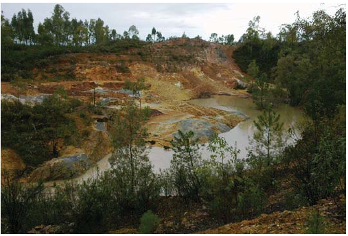
| Figure 5 | Poyatos pit (looking west) note exposed pyrite (grey) in bottom of pit |
| |
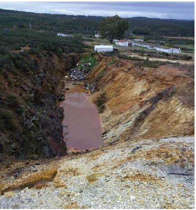
| Figure 6 | Lomero pit (looking east) |
|
| NI43-101 Technical Report on the Lomero-Poyatos Mine |
| 29 July 2011 |
6.0 HISTORY
Lomero-Poyatosis a former sulphide (pyrite) mine with underground development on eight levels, although they are currently flooded. The deposit was discovered in 1853 by Ernesto Deligny who noticed the distinctive gossan outcrop at Poyatos. Mining commenced in the late 1850’s and continued until 1990. Mining at Lomero-Poyatos was initially by open pit and since 1905 was by underground means.
The first three blocks of six terrace houses in the village of Lomero to the east of the mining operations were built between 1855 and 1867 when the Compagnie des Mines de Cuivre d'Huelva worked the mine. Later, after 1900, when the French “Society of Pyrites de Huelva" increased the workforce at the mine, these houses were divided into about 40 homes without any new construction in order to accommodate more workers. Currently, most are in ruins and only a few are inhabited as weekend homes.
In 1984, Billiton conducted a programme of 60 underground diamond drilling programme horizontally through the crown pillars in order to obtain full intersections of the massive sulphide (MS) and semi-massive sulphide (SMS) ores down to 25% sulphur content.
In 1986, Indumetal, the Bilbao smelting company that treated the roasted pyrite residue from Lomero-Poyatos, expressed interest in delineating the gold reserves and conducted some underground mapping and sampling to assess the base- and precious-metal grades.
In 1989, Outokumpu, in joint venture with Tharsis, drilled several (9) holes from surface to assess the potential at depth beyond the mined areas.
Following closure in 1991, the mine was held in receivership. The licences were acquired by Tethys Iberian Minerals Ltd who undertook some consolidation and valuation work before their acquisition by Cambridge Mineral Resources in 2000. The licenses were valid for 45 years, from 2001.
CMR carried out a major exploration programme, including drilling 49 holes, and commissioned several technical studies on potential mining and processing methods. In 2007, CMR surrendered the property to the government.
Previous Production
A small amount of ore came from the two pits at Lomero (east) and Poyatos (west), but most of the historical production (2.6 million tonnes) came from underground. The mined ore was massive pyrite that was used as a source of sulphur for sulphuric acid production. Mineralization with greater than about 43% sulphur was regarded as ore. Production ceased in 1984 with the final closure of the mine in 1991.
The estimated historical production was at least 2.6 million tonnes of massive sulphide ore grading 5g/t Au, 80g/t Ag, 1.20% Cu, 1.10% Pb and 2.91% Zn from orebodies containing variable, but significant amounts of copper, lead, zinc and silver.
In the 1970’s, the mine produced between 40 Kt and 60 Kt of ore per year and in 1980 produced 40,600 tons averaging 46% S and 0.7% Cu. The gold grades at Lomero-Poyatos, deduced from the sampling and exploration data, are some of the highest known in the Iberian Pyrite Belt.
|
| NI43-101 Technical Report on the Lomero-Poyatos Mine |
| 29 July 2011 |
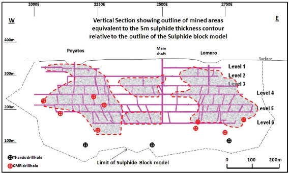
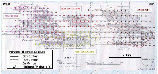
The massive sulphide deposit is tabular, continuous, and dips at moderate angles to the north. There are two zones, Lomero and Poyatos, where historical mining was concentrated, separated by a thinner central zone. In the eastern part of the deposit, the strike of the mineralization turns to the east-northeast and the massive sulphide thins out on the mine level plans.
| |
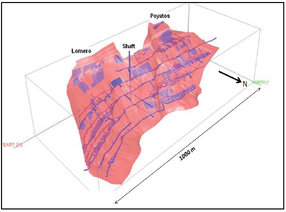
| Figure 7 | Isometric view showing extent of underground workings (Source- Sigiriya, 2009) |
The early open-pit mining proceeded to a depth of approximately 25m, whilst below the pits, three different underground mining methods were applied depending on the geometry of the deposit (flattening in the lower levels), the brittle characteristics of the ore, and the poor condition of the hanging wall contact.
Down to Level 3, an ascending cut and fill method was applied using 30m levels with 2.5m sublevel units. Extensive timber support w as required and a crown pillar w as left between levels.
Between Level 3 and Level 5, a descending cut and caving method was used, with levels mined from top to bottom by 2m sublevels. A wooden floor was laid down on every sublevel that acted as roof support for the next sublevel down. The timber was subsequently recovered and reused.
On Level 5 and Level 6, the last method used was ascending room and pillar with backfill. Stopes were typically 100m long and 10m to 15m wide. Within each stope, three 2.5m x 2.5m pillars were left for additional support. Each stope had an ore pass, footwall access, a hanging wall backfill raise and vent shafts. Back fill included low-sulphide (<43% S) underground waste and surface material quarried from the Poyatos pit.
|
| NI43-101 Technical Report on the Lomero-Poyatos Mine |
| 29 July 2011 |
| |
| Figure 8 | Long section showing drill hole intersections and resource boundary |
| | (Source: - Behre Dolbear, 2011) |
| |
| Figure 9 | Deposit structure and isopachs in vertical section (Source: CMR, 2006) |
|
| NI43-101 Technical Report on the Lomero-Poyatos Mine |
| 29 July 2011 |
| |
| Figure 10 | Mineral distribution block model for Au-Zn-Cu (Source: CMR, 2006) |
Note similar distribution of Au and Zn in Lomero and Poyatos lenses, but Cu is more central
Through Recursos, CMR spent about US $7.5 million on an extensive programme of exploration and drilling during the years 2001-2007.
Evaluation of the un-mined parts and exploration for extensions of the known massive sulphide deposit was the prime focus of CMR’s activities after the acquisition of the project in the year 2000. Activities during CMR’s tenure included about 10,000m of drilling, 1,100m of trenching, detailed geological studies, metallurgical testwork, resource evaluation and electromagnetic and gravity surveying. Resource modelling and assessment ranged from high-tonnage low-grade to high-grade options at lower tonnage.
Cambridge Mineral Resources commissioned SRK Consulting Ltd to prepare a “conceptual mining study” of the poly-metallic Lomero-Poyatos property. SRK was commissioned to undertake a JORC compliant resource estimate and an associated conceptual mining study in 2002 based on a gold price at time of study of US$ 330/oz.
|
| NI43-101 Technical Report on the Lomero-Poyatos Mine |
| 29 July 2011 |
Key outcomes of the study were as follows (as at December 2002).
SRK estimated that Lomero-Poyatos contained Indicated and Inferred Mineral Resources, comprising Indicated Mineral Resources of 1.6 Mt at 5.1 g/t Au, and Inferred Mineral Resources of 17.2 Mt at 2.9 g/t Au, totalling 20.6 Mt at an average grade of 3.1 g/t Au, containing 2.1 Moz of gold, 46 Moz of silver, 675,000 tonnes of zinc and 250,000 tonnes of copper, of which an open pit resource of 18.8Mt containing 1.9Moz and an U/G resource containing 0.2 Moz was “reasonably likely” to be mined economically.
The findings indicated that the deposit could be economically developed by open-pit and underground mining methods, over at least ten years. Ore was to be processed through locally available facilities at the Almagrera processing plant. Preliminary metallurgical testing indicated that recoveries were expected to be 75-77% for gold, 50% for copper and 78% for zinc.
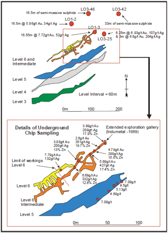
The results from drill testing within the northeast Lomeros extension included:
16.6 metres @ 7.7 g/t gold in drillhole L01-3,
21.5 metres @ 5 g/t gold in drillhole L01-2 and,
20.4 metres at a composite grade of 6.82 g/t gold, 139 g/t silver and high base metals in drill- hole L03–25. Drill hole L03-42 intersected 33 metres of semi-massive sulphide including 29.4 metres of 0.52 g/t gold containing a maximum value of 2.97 g/t gold.
The intersection of an extensive thickness of semi-massive sulphide in drill hole L03-42 indicated proximity to the core or "feeder zone" of the deposit. In support of this view, follow-up drill hole L03-46 intercepted an interpreted feeder zone with values in the range 0.3g/t gold to 0.8g/t gold, a 5.65 metre zone of massive sulphide and 16.55 metres of semi-massive sulphide including 5.8 metres of 0.93 g/t gold. These drill intersections extended the northeast extension zone beyond the limits of the known underground mine.
| |
| Figure 11 | Lomero-Poyatos Stratigraphy and Lithology (Source: CMR, 2006) |

|
| NI43-101 Technical Report on the Lomero-Poyatos Mine |
| 29 July 2011 |
| |
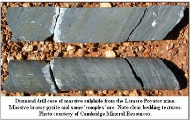
| Figure 12 | Bedded sulphides in drill core (Source: CMR, 2006) |
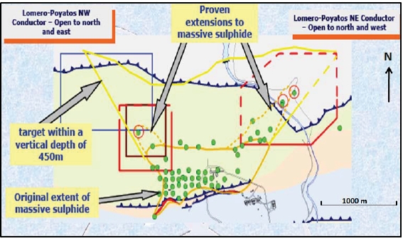
A strong EM conductor west of the known limits of the Poyatos orebody indicated a previously undefined target. Drill hole L01-4 highlighted the auriferous nature of the western area with an intercept of 3 metres of 4.9 g/t gold and associated base metals. West of L01-4, drill-hole L03-47 encountered 1.65 metres of 4.02 g/t gold in massive sulphide with a peak value of 11.12% zinc.
| |
| Figure 13 | Lomero-Poyatos – exploration potential (Source: CMR, 2006) |
|
| NI43-101 Technical Report on the Lomero-Poyatos Mine |
| 29 July 2011 |
| |
| Table 2 | Significant Newmont/CMR Drillhole Intersections (Source: WAI, 2007 ) |
| | | | | | | | | | |
| Hole | From | To | Width | Assay value | Mineral |
| No. | (m) | (m) | (m) | Au | Ag | Cu | Pb | Zn | S % | Type |
| | | | | g/t | g/t | % | % | % | | |
| L01-1 | 247,40 | 250,12 | 2,72 | 4,90 | 51,80 | 0,51 | 0,00 | 0,00 | 45,70 | Massive |
| L01-1 | 254,40 | 278,25 | 23,85 | 0,15 | 1,44 | 0,13 | 0,03 | 0,08 | 20,67 | Semi-Massive |
| L01-2 | 214,40 | 219,35 | 4,95 | 2,06 | 61,98 | 0,24 | 1,91 | 1,92 | 14,79 | Semi-Massive |
| L01-2 | 222,10 | 238,60 | 16,50 | 5,86 | 33,53 | 2,44 | 0,21 | 0,52 | 47,81 | Massive |
| L01-2 | 238,60 | 247,30 | 8,70 | 0,52 | 2,83 | 0,07 | 0,08 | 0,18 | 23,37 | Semi-Massive |
| L01-3 | 170,75 | 173,15 | 2,40 | 0,55 | 28,77 | 0,16 | 1,99 | 2,68 | 13,20 | Semi-Massive |
| L01-3 | 173,15 | 189,70 | 16,55 | 7,72 | 52,42 | 0,40 | 1,03 | 7,83 | 42,45 | Massive |
| L01-3 | 194,80 | 210,05 | 15,25 | 0,51 | 2,81 | 0,10 | 0,04 | 0,19 | 18,92 | Semi-Massive |
| L01-4 | 193,40 | 198,00 | 4,60 | 0,89 | 8,61 | 0,44 | 0,08 | 0,03 | 41,16 | Massive |
| L01-4 | 198,00 | 207,20 | 9,20 | 0,18 | 4,87 | 0,11 | 0,02 | 0,05 | 16,99 | Semi-Massive |
| L01-4 | 207,20 | 210,50 | 3,30 | 1,71 | 13,85 | 0,26 | 0,62 | 1,16 | 46,39 | Massive |
| L01-5 | 206,00 | 215,70 | 9,70 | 2,69 | 25,77 | 1,80 | 0,68 | 1,23 | 40,60 | Massive |
| L01-5 | 215,70 | 221,50 | 5,80 | 1,62 | 35,98 | 2,35 | 1,39 | 1,85 | 46,57 | Mine Opening |
| L01-6 | 148,65 | 151,9 | 3,25 | 1,11 | 47,66 | 1,06 | 1,57 | 2,79 | 46,97 | Massive |
| L01-7 | 231,20 | 235,40 | 4,20 | 4,06 | 28,56 | 0,68 | 0,26 | 0,39 | 42,32 | Massive |
| L01-7 | 235,40 | 249,90 | 14,50 | 0,35 | 2,40 | 0,05 | 0,04 | 0,07 | 24,77 | Semi-Massive |
| L01-8 | 148,30 | 151,70 | 3,40 | 7,29 | 112,41 | 0,31 | 3,75 | 5,12 | 42,04 | Massive |
| L01-8 | 151,70 | 154,10 | 2,40 | 0,18 | 12,47 | 0,20 | 0,04 | 0,08 | 10,23 | Semi-Massive |
| L01-9 | 105,60 | 116,00 | 10,40 | 1,65 | 7,50 | 1,25 | 0,12 | 0,06 | 50,00 | Massive |
| L01-9 | 116,00 | 119,20 | 3,20 | 0,44 | 2,80 | 0,33 | 0,02 | 0,03 | 31,85 | Semi-Massive |
| Northeast Extension Zone |
| | | | |
| Hole Number | Intersection (m) | Au g/t | Ag g/t | Comments |
| LO3-25 | 6.25 | 6.93 | 107 | 15.07% Zn+Pb |
| LO3-25 | 3.00 | 6.60 | 204 | 5.94% Zn+Pb |
| LO3-42 | 33m of semi-massive sulphide including 29.4m @ 0.52g/t Au |
| LO3-46 | A feeder zone with 16.55m of semi-massive sulphide including 5.8m @ 0.93g/t |
Northwest Extension Zone
|
| LO3-22 | 3.00 | 4.89 38 | | |
| LO3-47 | 1.65 | 4.02 | 115 | 11.51%Pb+Zn |
|
| NI43-101 Technical Report on the Lomero-Poyatos Mine |
| 29 July 2011 |
| |
Figure 14 | Detail of the northeast extension of the Lomero-Poyatos deposit |
| | |
| | (Source: WAI, 2007) |
|
| NI43-101 Technical Report on the Lomero-Poyatos Mine |
| 29 July 2011 |
| |
| Table 3 | Significant (>2m at 1g/t Au) gold value drill intercepts (CMR, 2002 – 2004) |
| | | |
| Drillhole | Intersection Depth (m) | Thickness (m) | Range of Assay values (g/t Au) |
| number | | | |
| TH-1 | 254 - 256 | 2 | 0.88 – 6.1 |
| TH-2 | 312 - 326 | 14 | 0.07 – 1.03 |
| Th-3 | 321 - 322 | 1 | 1.68 |
| TH-5 | 225 – 226 | 1 | 5.21 |
| | 245 – 250 | 5 | 1.12 |
| | 265 - 270 | 5 | 1.74 |
| LO1-1 | 247 - 251 | 4 | 4.2 – 4.9 |
| LO1-2 | 216 - 240 | 24 | 2 – 9 |
| LO1-3 | 173 – 190 | 17 | 4 – 14 |
| | 200 - 207 | 7 | 0.4 – 1.32 |
| LO1-4 | 193 - 210 | 17 | 0.1 – 2.34 |
| LO1-5 | 206 - 222 | 16 | 1.4 – 5.9 |
| LO1-6 | 141 - 153 | 12 | 0.37 – 3.27 |
| LO1-7 | 231 – 244 | 13 | 0.1 – 4.7 |
| LO1-8 | 148 - 152 | 4 | 6 – 8.4 |
| LO1-9 | 106 - 116 | 10 | 0.78 – 2.5 |
| LO3-10 | 105 - 110 | 5 | 2 – 11 |
| LO3-11 | 94 - 101 | 7 | 1 – 4 |
| LO3-13 | 126 - 131 | 5 | 0.01 – 1.55 |
| LO3-14 | 147 - 148 | 1 | 5.32 |
| LO3-15 | 55 - 58 | 3 | 0.94 – 3.1 |
| LO3-16 | 98 - 110 | 12 | 0.1 – 5.8 |
| LO3-17 | 44 - 45 | 1 | 4.4 |
| LO3-18 | 64 - 74 | 10 | 0.5 – 4.66 |
| LO3-19 | 74 - 81 | 7 | 2.3 – 3.8 |
| LO3-20 | 90 - 93 | 3 | 1.5 – 1.65 |
| LO3-22 | 103 - 106 | 3 | 1.2 – 9.88 |
| LO3-24 | 56 – 58 | 2 | 1.0 – 10.1 |
| LO3-25 | 155 - 181 | 24 | 1.3 – 10.1 |
| LO3-31 | 101 - 117 | 16 | 0.5 – 2.2 |
| LO3-32 | 63 - 76 | 13 | 0.1 – 2.4 |
| LO3-33 | 156 - 158 | 2 | 1.7 – 3.65 |
| LO3-35 | 96 - 104 | 8 | 0.3 – 1.8 |
| LO3-38 | 85 - 87 | 2 | 0.5 – 2.14 |
| LO3-41 | 141 - 144 | 3 | 0.3 – 1.3 |
| LO3-42 | 195 - 201 | 7 | 0.3 – 2.9 |
| LO3-44 | 19 - 21 | 2 | 3.2 – 5.32 |
| LO3-45 | 124 - 133 | 9 | 0.1 – 2.8 |
| LO3-46 | 225 - 233 | 8 | 0.6 – 1.1 |
| LO3-47 | 152 - 156 | 4 | 0.6 – 4.4 |
| LO4-48 | 277 - 284 | 7 | 0.1 – 4.6 |
| LO4-50 | 225 - 263 | 33 | 0.7 – 5.8 |
| LO4-51 | 314 - 318 | 4 | 0.7 – 8.4 |
| Range | | 1 – 33m | 0.1 - 14.0 |
| Average | | 7.85 m | |
|
| NI43-101 Technical Report on the Lomero-Poyatos Mine |
| 29 July 2011 |
Note: Most of these 40 drill-hole intersections were inclined southwards at 70° (from horizontal) but flattened by an average of 5° to 10° to intersect the deposit which dips northwards at about 30° at close to the true thickness of the deposit.
In 2002, SRK completed a Mineral Resource estimation, based on the results from the CMR exploration and drilling programme. Lomero-Poyatos was estimated, to contain an Indicated Mineral Resource of 3.71 million tonnes @ 3.26 g/t Au, 27.9 g/t Ag, 0.87% Cu, 1.57% Pb and 1.16% Zn using a 1.5 g/t gold equivalent cut-off (based on JORC compliant definitions).
In 2005, Wardell Armstrong International (“WAI”) completed an independent NI 43-101 compliant report (based on CIM definitions) and in April 2007 completed a Scoping Study based upon the above resource data.
There is no material difference between the CIM and JORC definitions of Mineral Reserves or Mineral Resources.
SRK Mining Study (2002) – Mineral Resource Estimate
Previous resource studies had concentrated their estimates in and adjacent to the existing mine workings. SRK took account of this work, but considered the un-mined Inferred Mineral Resource surrounding the existing mine workings demonstrated by the previous exploration work completed by Billiton, Indumetal and Newmont, to have additional potential for future mining, particularly as the results of the Newmont drilling programme showed a trend of gold grades improving to the northeast at increasing depth outside the existing mine workings.
There were indications that significant un-mined massive sulphide pillars and stope remnants within the mined area could be considered as open pit resources. These were quantified and incorporated into a geological model and optimised using Whittle 4D software.
The SRK estimate of resources is shown in the following table 4:
|
| NI43-101 Technical Report on the Lomero-Poyatos Mine |
| 11 July 2011 |
| |
| Table 4 | Mineral Resource Statement (Source: SRK, 2002) |
| | | | | | | | | |
| INFERRED MINERAL | Cut-off | Tonnage | Au | Ag | Zn | Cu | Pb | S | Total |
| RESOURCES | grade | (Mt) | (g/t) | (g/t) | (%) | (%) | (%) | (%) | Value |
| | €/t | | | | | | | | €/t |
| Open Pit Component | | | | | | | | | |
| Massive Sulphide | >50 | 1.61 | 5.1 | 102 | 4.4 | 1.4 | 1.7 | 41 | 125 |
| Massive Sulphide | >50 | 7.81 | 4.4 | 89 | 4.2 | 1.4 | 1.4 | 41 | 118 |
| Semi-massive Sulphide | >50 | 8.61 | 1.6 | 53 | 2 | 1 | 0.8 | 32 | 70 |
| Remnant Pillars and Fill | | >50 | 0.78 | 2.3 | 44 | 8.2 | 2.4 | 2.4 | 29 |
| Sub-total Open Pit | >50 | 17.2 | 2.9 | 69 | 3.3 | 1.2 | 1.1 | 36 | 93 |
| Sub-total Open Pit | >50 | 18.81 | 3.1 | 72 | 3.4 | 1.3 | 1.2 | 37 | 96 |
| Underground Component | | | | | | | | | |
| Massive Sulphide | >70 | 1.8 | 3.4 | 51 | 2.3 | 0.8 | 1.5 | 38 | 92 |
| Semi-massive Sulphide | >70 | 0.05 | 1.8 | 57 | 2.2 | 1.1 | 0.9 | 35 | 78 |
| Sub-total Underground | >70 | 1.85 | 3.4 | 52 | 2.3 | 0.8 | 1.4 | 38 | 92 |
| Combined O/P and U/G Resource | | | | | | | | | |
| Total | >50 / >70 | 20.61 | 3.1 | 70 | 3.3 | 1.2 | 1.2 | 37 | 96 |
|
| Updated NI43-101 Technical Report on the Lomero-Poyatos Mine |
| 29 July 2011 |
The SRK categorisation of resources into “Open Pit” and “Underground” was based on their opinion of the maximum open-pit potential of the modelled deposit and was not based on the current capacity of the locally available mining and processing facilities. SRK considered that gravity surveys had identified promising anomalies to the north and east of the mine area confirming indications that the orebody was open along strike and at depth.
Note: In Behre Dolbear’s opinion, this is an historical Mineral Resource estimate that may not be compliant with NI43-101 / CIM guidelines and is included here for the historical record only. This material should all be categorised as Inferred Mineral Resources due to the lack of certainty regarding the mining and processing methodology. Due to the uncertainty that may be attached to Inferred Mineral Resources, it cannot be assumed that all or any part of an Inferred Mineral Resource will be upgraded to an Indicated or Measured Mineral Resource as a result of continued exploration. Confidence in the estimate is insufficient to allow the meaningful application of technical and economic parameters or to enable the evaluation of economic viability worthy of public disclosure. Inferred Mineral Resources must be excluded from estimates forming the basis of feasibility or other economic studies.
Mining
The SRK model was based on a production rate of 350,000 run-of-mine (ROM) tonnes per year of massive sulphide material. They considered there was potential to increase this to as much as 1 million ROM tonnes per year once a full evaluation of other treatment options was completed.
Open Pit
The open-pit resource model was optimised using Whittle 4D software and indications were that there was sufficient ore in the open pit for more than 8 years at a production rate of 350K ROM tonnes per year. Geological losses and dilution were each estimated at 10% and the open pit was scheduled to start mining at the beginning of the second year (year 1 of mining) following completion of the permitting process, some further exploration drilling to upgrade the resources to the Measured and Indicated categories, and some modifications to the local processing facilities.
Underground
The underground mine was scheduled to begin operations as the open pit wound down in year 9. The underground mine would be developed from the bottom of the open pit with the production rate maintained at 350K ROM tonnes per year. The start-up of the underground mine will be dependent on the development of a ramp from the bottom of the open pit.
As the deposit dips at between 30oand 40oit is unlikely that ore could be extracted using a gravity-based mining method. It was planned to use mechanised cut and fill mining, which is relatively expensive, but is flexible and can be used to selectively mine high grade areas with low levels of dilution.
Newmont Metallurgical Testwork
As part of the investigation concluded during 2002, Newmont carried out a limited metallurgical test programme on core samples from ten diamond drill holes drilled in 2001.
To plan the test programme, Newmont carried out three mineralogical investigations. The first two were XRD-XRF analyses that provided useful information on the mineralogical nature of the samples to be tested. The deportment of gold in two samples was then investigated by microbeam techniques that showed that most of the gold existed as a solid solution in the pyrite lattice and a smaller amount occurred as a gold-silver-mercury alloy with an average grain size of 15 to 23 microns. For the samples analysed, Newmont concluded;
|
| Updated NI43-101 Technical Report on the Lomero-Poyatos Mine |
| 29 July 2011 |
i) For poly-metallic samples, with low levels of copper mineralization, the majority of the gold would report to pyrite.
ii) For cupriferous ores, 14 to 38% of the gold would report to a copper flotation concentrate and the rest to the pyrite.
Newmont concluded that if the gold was to be recovered, then the pyrite lattice needed to be oxidised prior to cyanidation. Subsequent test work has verified this. Newmont were unable to produce saleable zinc concentrates from the poly-metallic samples during their flotation test work.
AMCO-Robertson / CSMA Metallurgical Test work
The issues identified by Newmont’s metallurgical work led CMR to submit three ore samples, taken from the 2001 drill-core, to AMCO-Robertson for scoping flotation tests and these were reported in March 2002. For the poly-metallic sample, a zinc rougher concentrate was cleaned twice to give a cleaner concentrate of 51.2% Zn with a final recovery of 80.8%. Subsequent tests obtained a concentrate grade of 54.4% zinc and AMCO-Robertson concluded that a recovery of 85% could be achieved.
| |
| Table 5 | Concentrate Grades and Recoveries from AMCO-Robertson Test work |
| | | | | | | |
| Product | Expected | Cu (%) | Pb (%) | Zn (%) | Ag (g/t) | Au (g/t) | Gold |
| | Recovery | | | | | | Distribution |
| Copper conc | 50% | 23.0 | 3.1 | 5.3 | 177 | 100 | 13.0% |
| Lead conc | 42.5% | 0.3 | 44.3 | 5.7 | 98 | 7.0 | 2.2% |
| Zinc conc. | 80% | 0.2 | 0.7 | 54.4 | 38 | 3.2 | 4.8% |
| Pyrite conc. | - | - | - | - | - | 4.0 | 80.0% |
In July 2002, independent metallurgical consultant Tony Jackson reviewed this data and concluded from his experience of roaster and cyanidation test-work with other Pyrite Belt ores that gold recoveries of 80% could be anticipated from Lomero-Poyatos ore following refinement of the roast and cyanidation process.
CSMA Pyrite Cyanidation Test work
Two scoping tests were carried out on the pyrite-rich zinc flotation tailings to recover gold and these were reported in June 2002.
The material was subjected to a “dead roast” in a muffle furnace at temperatures of 720°C and 900°C.The roasted products were then leached with sulphuric acid to remove soluble copper and the residue cyanide leached to recover gold. Gold recovery was moderate at 60.4% for Test 1 and 65.2% for Test 2 but it was expected that following optimisation test work this could be increased to 78 to 80%.
Kvaerner review
Both the Newmont and CSMA/Tony Jackson test-work and conclusions were subsequently reviewed by Kvaerner E&C in September 2002 who concurred with Tony Jackson’s final report, with the proviso that the zinc recovery relationship was likely to be complex and dependent upon the marmatitic nature of the zinc mineralization.
|
| Updated NI43-101 Technical Report on the Lomero-Poyatos Mine |
| 29 July 2011 |
CSMA 2003 Test-work Programme
Further scoping tests were performed during early 2003 utilising coarse reject samples from the Newmont test-work programme and reported in April 2003. The test-work programme was designed to confirm flotation recoveries and concentrate grades and re-evaluate gold recovery after roasting of the floatation pyrite tailings. Test-work results were summarised as follows:
| | |
| 1. | Flotation testsdemonstrated that oxidation of the samples had taken place and therefore the test-work was stopped as no meaningful flotation tests could take place. |
| 2. | Roast-Cyanidation testsachieved gold recoveries of 62% in tests on Composite 1samples, and over 80% in three tests of Composite 2 samples. The difference was attributed to the roasting conditions. CSMA conclusion that further test work waswarranted to improve the standard method if a muffle furnace was to be used. |
| 3. | Pre-Concentration testswere conducted to evaluate the amenability of the ore topre-concentration upgrading of the semi-massive sulphide mineralisation. These testsindicated that the siliceous gangue associated with the semi-massive ore was notliberated at a large enough grind size that would allow it to be rejected by a practical method. |
| 4. | Gravity recoverable goldtests on one sample showed that no gravity recoverablegold was liberated. If pilot plant trials were conducted then samples from around thegrinding circuit should be taken for further test work. |
| 5. | Cyclosizer testwork on one sample indicated that 46% of the gold reported to the -7micron fines and the gold grade of the -7 micron fraction was more than twice that of the larger size fractions. Further test-work was recommended. |
Processing Plant
The concept of processing the ore from Lomero-Poyatos at locally available processing facilities was investigated. The Lomero-Poyatos ore is poly-metallic and refractory and requires primary flotation of base metal concentrates and roasting of pyrite-rich tailings for satisfactory levels of gold recovery.The basic treatment recommended was as follows:
Primary and secondary crushing followed by grinding.
Flotation of copper, zinc and lead concentrates (lead to be discarded).
De-watering of flotation tailings.
Roasting of flotation tails with the conversion of waste gases to sulphuric acid.
Acid leach of roaster cinders to extract copper and SXEW copper production.
Treatment of leached roaster cinders in a CIL plant for gold recovery, with gold doréproduction from carbon stripping and electro-winning.
A modified local facility would be capable of treating 350k ROM tonnes of ore per year and would provide the roaster with a capacity feed of 250k tonnes per year. The capital cost of modifying these facilities, including a gold extraction plant and mercury scrubbing facilities, was estimated to be about €13.3 million (at 2003 prices).
Summary Discussion
The SRK economic model indicated that the project was economically robust, but theeconomics could be improved by further drilling to upgrade the resources thusreducing the applied discount factor for calculation of the project NPV.
There was potential for a significant increase in resources as the deposit was openalong strike and down dip and a gravity survey had identified anomalies at depth.
There was an established infrastructure in the area including roads, railway, powerand water supplies, etc.
There was an existing Exploitation Permit for the Lomero-Poyatos project,consolidated for 60 years that reduces the permitting requirements of the project.
There were established local mining contractors and processing facilities for bothopen-pit and underground mining that offered potential for a quick-start option.
|
| Updated NI43-101 Technical Report on the Lomero-Poyatos Mine |
| 29 July 2011 |
There was potential to increase production to as much as 1 million ROM tonnes peryear.
Metal and gold recoveries needed to be confirmed through further test work and toevaluate alternative processing routes.
The cost of treating the mine water must be established before mine dewatering cancommence.
SRK concluded that, using the technical and financial parameters adopted in the SRK study, the Lomero-Poyatos Project appeared to be economically robust, based on mine production of 350,000 tonnes of ore per year and using locally available processing facilities.
CMR Resource Evaluation and Pre-feasibility Study (2006)
The 2006 CMR resource model was developed by Colin Andrew and Bill Sheppard, who meet the JORC and NI43-101 definitions of a “Qualified Person”.
Most of the 10,000m of drilling by CMR was focused on Resource delimitation. This included nine diamond drill-holes for 2,490m in 2001 and 48 surface drill-holes for 4,781m in 2003. The holes were typically drilled at an inclination of -70° and at an azimuth of 180° in order to provide almost true width intersections of the mineralisation. They were primarily intended to:
| | |
| i) | obtain in-situ massive sulphide mineralisation for metallurgical test work, |
| ii) | improve the knowledge of the grade distribution and |
| iii) | verify the historical mine records. The drill intersections obtained confirmed that themine records were reliable. |
A 3D model and Resource estimate for the known Lomero-Poyatos deposit was completed in March 2005 as a prerequisite to a pre-feasibility study. As a result of rigorous data verification and detailed research into previous mining practice, the veracity of the modelled in-situ massive sulphide deposit and previous mine development openings was established by comprehensive checking against CMR drill intersections.
In 2005, CMR commissioned a pre-feasibility study by WAI to assess the economic viability of the Lomero-Poyatos project as an underground mining operation with a view to processing ores using the nearby facilities at Almagrera. The WAI study concluded that, considering the anticipated development and operating costs and risks related to the acquisition of the processing facilities, and the project’s dependency on the long term regional acid market, the project would not generate a sufficiently attractive rate of return to justify its immediate development. WAI, however, supported the view that there was potential to increase the mineral resources at Lomero-Poyatos and recommended a surface drilling programme to test the established targets within the mine area and along strike.
Data Availability
Following an exhaustive search of all possible data sources incorporating discussion with numerous professional persons that had experience with the mine, all the data acquired by CMR was integrated into a Lomero-Poyatos database. This necessitated the transfer of data from various sources, including plans, surveys and maps, into a readily accessible digital format for use in geological and resource modelling software packages. Data incorporated into the Lomero-Poyatos Mineral Resource Model included:
|
| Updated NI43-101 Technical Report on the Lomero-Poyatos Mine |
| 29 July 2011 |
The underground data included:
Underground geochemical sampling on Levels 2, 3, 4 and 5 by Societe Francaise dePiritas de Huelva (SFPH) from 1934 onwards, taken every 2m during leveldevelopment;
Detailed, across-strike, underground geochemical sampling on Levels 4 and 5 withinthe Lomero area by Societe Francaise de Pyrites de Huelva in 1968; and
Detailed underground geochemical sampling on Levels 5 and 6 by Jeff Smith forIndumetal in 1986 to establish the gold grade and distribution on these Levels.
An important component of the ore-zone modelling was the detailed geological level plans prepared by the Spanish geological survey (IGME) in the early 1980s. These were updated to include mining activity between 1980 and the cessation of production in 1984. There was thus a very detailed and verified knowledge of the distribution of massive sulphide on each of the 6 mine Levels and Sub-Levels at vertical intervals of not more than 30m. CMR had:
Compiled and reviewed all data pertaining to the deposit in MapInfo© andGemcom© software.
Developed a detailed understanding of the disposition of the Mineral Resource inrelation to mined-out areas.
Verified the historical mine records through drilling.
Completed a detailed geological study of the deposit and its host rocks, including afull long-section interpretation of the deposit.
Established that zoning within the massive sulphide envelope, both lateral and acrossstrike, was reflected in the modelled grade distribution.
Data Handling
1313 “records” comprising 9 surface drill-holes completed by Outokumpu (TH-1 to TH-9), and 56 surface drill holes completed by Cambridge Mineral Resources plc (L01-1 to L04-56) and 1,248 underground channel samples taken by various previous operators were entered into a standard database structure comprising five tables:
| | |
| Header | 1,313 records |
| Survey | 1,585 records |
| Assay | 2,588 records |
| Lithology | 458 records |
| Composites | 10,717 records |
All underground channel samples were taken as being over a 2.0m horizontal interval orientated perpendicular to the azimuth of the specific drive from which they were collected.
All surface drill-hole collar locations were surveyed using a laser total station, and all surface drill-hole orientations were surveyed with a single shot photographic method of giving down-hole azimuth and dip.
Underground assay locations were digitised from underground level plans registered to fixed and constant points using MapInfo© and then exported into MSExcel as ASCII.csv files for eventual import into Gemcom©.
Following detailed assessment incorporating comparative geological and geochemical study using both 2D hard copy and 3D computer presentation, 43 underground drill-holes completed by Pyritas de Huelva in the early 1980’s were discarded from the initial data set as they were not considered to be reliable overall. It was noted, however, that, in certain areas, these drill-holes did appear to match all other data inputs. Nonetheless, given that significant doubt was cast on the veracity of the dataset and that there was a lack of signed-off laboratory returns, the entire dataset was discarded.
|
| Updated NI43-101 Technical Report on the Lomero-Poyatos Mine |
| 29 July 2011 |
Of the total records the 2,588 entries in the Assays Table the following entries were not available due to absence of assay data or the value being below detection limit:
| | |
| Au 220 | no assays |
| Ag 104 | no assays |
| Cu 75 | no assays and 72 below detection limit |
| Pb 81 | no assays |
| Zn 107 | no assays and 56 below detection limit |
| As 82 | no assays |
| Ba 264 | no assays |
All records possessed assay values for Sulphur.
Before continuing into any form of data analysis the data base was verified using Gemcom’s internal verification package and any errors (such as mismatched lengths, duplicate values etc.) removed.Following verification, the Composites Table was defined using an equal length method. The length of the composites was taken as 1.5m and 10,717 values were generated by the software.
From the Composites Table individual extraction files for Au, Ag, Cu, Pb, Zn, S, As and Ba containing 3D locations (X, Y and Z) and values were generated for use in the block model variography.
Missing Values
Due to variable assay practices within the historic datasets, certain assays were not completed for Au and Ag (and other elements as tabulated above). In order to consolidate the distribution of full assays sets across the deposit, advantage was taken of the good correlation coefficient between lead and silver (Ag:Pb = 0.82) enabling the estimation of silver values from lead values. This was done for 104 values. Similarly, the correlation for gold and arsenic was moderately good (As:Au = 0.65) so 220 values were estimated from this relationship.
Constraining Envelope
The model was only defined to investigate and evaluate the mineralization confined within the “Massive Sulphides”. The underlying “Semi-Massive Sulphides” were not evaluated at this time although it should be noted than significant mineralization does exist within such ore-types in part of the mine area. The massive sulphide envelope was constructed from historic underground mapping by various authors over the period of previous production. This data was captured as polygons for each mining level at the reference elevation shown below:
| | |
| 1 Level | 299.3m |
| 2 Level | 276.3m |
| 3 Level | 246.3m |
| 4 Level | 216.3m |
| 5 Level | 186.3m |
| 6b Level | 162.3m |
| 6 Level | 150.0m |
Where two Massive Sulphide zones overlapped in cross section, the hanging-wall of the envelope was constructed along the hanging-wall contact of the uppermost zone, while the footwall of the envelope was placed at the footwall of the lowermost zone. In these areas containing overlapping Massive Sulphide zones, care was taken to ensure that, during the modelling of both mineable in-situ panels of massive sulphide and the modelling of mined-out stopes (see below), internal boundaries of Massive Sulphide zones were used as constraining boundaries.
|
| Updated NI43-101 Technical Report on the Lomero-Poyatos Mine |
| 29 July 2011 |
A series of north-south sections was generated on 25m intervals between 683100 E to 683500 E and, using the intersection points of these polygons on these sections together with drill-hole data projected onto these sections, a series of vertical outlines was constructed for the massive sulphide envelope.
The next reiteration was to project these sections onto a series of level plans generated at levels 100m to 350m. The resultant outline of the envelope was modified to include off section drill-holes and any additional assay information from sub-levels, raises, etc.
The final solid was generated by constructing tie-lines between each 10m flitch in 3D view and generating the resultant solid. The final solid was then checked for its viability in that it had no re-entrants and was a valid solid by Gemcom©.
The Massive Sulphide solid was defined as a “Geology Solid” and given a precedence of 2 in the solids menu.
Previous Mine Workings
All underground development was digitised as centre lines from the historic level plans at the elevations defined above. These centre lines were then extruded as solids in Gemcom© based on a pre-defined average profile as follows:
Standard Drivage – Arched Profile
Width – 3.0m, Height – 2.5m, Radius – 6.0m.
Raises were similarly digitised and relevant elevations given to the ends of each centre line. These centre lines were then extruded as solids in Gemcom© based on a pre-defined average profile as follows:
The principal Renato Shaft has a profile of 4.0m by 3.5m.
All of these historic void spaces were defined as “Excavation Solids” and given precedence’s of 1 in the solids menu.
Existing stoping was constructed in the model by projecting the historic vertical longitudinal projection onto the Gemcom model. Where two Massive Sulphide zones within the envelope overlapped in longitudinal projection, a combination of discussion with former mine personnel and study of mine development lay out was used to establish if one or both zones had been extracted. Stope outlines on the projection were defined by X co-ordinates and by elevations and then digitized on the relevant level plans within Gemcom. Where mine production was recorded, the full width of the Massive Sulphide Zones within the modelled envelope was assumed to have been extracted within these stopes although this is known to have not been the case in certain areas of the mine from historical data. From these level polygons solids were created by attaching tie lines at the corners of the polygons and thus generating the void solids.
All of these historic stopes were defined as “Excavation Solids” and given precedence’s of 1 in the solids menu.
|
| Updated NI43-101 Technical Report on the Lomero-Poyatos Mine |
| 29 July 2011 |
Block Model
A Block Model grid based upon 5m x 5m by 10m (strike parallel) blocks was created from an origin located at 681800E / 4186400N. The Block Model contained 52 levels (5m) from 370m OD down to 110m OD; 100 rows (5m) and 120 columns (10m) for (624,000 blocks). These 624,000 blocks were all assigned cell addresses and a standard model set up to enable entry of the following values:
| | |
| 1. | Copper % |
| 2. | Zinc % |
| 3. | Au g/t |
| 4. | Lead % |
| 5. | Ag g/t |
| 6. | S % |
| 7. | Rock Type |
| 8. | Percentage |
Default values were generated to set up the model of 0.01% for Cu, Zn, Pb and S and 0.01 g/t for Au and Ag.
The Block Model was thus established. Then, by activating the Massive Sulphide solid and the mine working excavations (development and stopes), the “Rock Type” model was run to establish the presence of either void (code 1), massive sulphide (code10) or waste rock (code 0). In addition, the percentage model was run to generate the percentage of each rock type within each block (Precedence defined Massive Sulphides first, thus the minimum to register a block was 1% MS present). 10,019 blocks registered within the massive sulphide solid of which:
6,076 blocks validated with all assay grades and assigned percentage.
198 blocks registered with partial or incomplete assay data.
3,754 blocks registered as 100% void space from previous mining.
Kriging
Kriging was asymmetric using the parameters shown in the Control File above and by Inverse Distance Squared.
3D Variography proved difficult to model and was variable across the mine due to different ore types (cupriferous or polymetallic) so the block model was kriged using 3D asymmetric inverse distance squared “ID2” parameters for Cu, Zn, Pb, Au, Ag and S as shown in the Gemcom graphic below:
Reiterations
Throughout the Inverse Squared (“ID2”) block value estimation process several pre-defined blocks were used as Check Blocks to review the validity of the modelling. In addition certain specific surface drill-hole records were removed from the second runs of kriging to check the generation of block grades through which the drill holes passed. Good correlation between estimated blocks and actual drilled grades was observed, so a good level of confidence is believed to exist within the model.
Output
Output from the model was via ASCII.csv files into MSExcel rather than using the reporting formats within Gemcom due to ease of use of Excel in comparison. The final output in MSExcel was used to establish block tonnages based upon calculated SG’s estimated from the S% assay. This calculation closely mirrors the reality of SG’s directly measured from drill-core. The formula used was:
SG = 2.55+((S%/53.4)*2.5)
Block tonnages were then calculated using the standard block volume (5 x 5 x 10m = 250m3) multiplied by the calculated SG and then the percentage value.
Various cut-offs were then extracted from the MSExcel sheets by data sorting.
From this, the overall Resource was tabulated at various 0.5g/t Au interval cut-offs, as follows:
|
| Updated NI43-101 Technical Report on the Lomero-Poyatos Mine |
| 29 July 2011 |
| |
| Table 6 | Lomero-Poyatos Indicated Mineral Resource Estimate (Source:- CMR, 2007) |
| | | | | | | | |
| Cut-off | Tonnes | Au g/t | Ag g/t | Cu % | Pb % | Zn % |
| g/t Au | | | | | | |
| 5.0 | 434,245 | 6.28 | 42.57 | 0.61 | 3.30 | 2.24 |
| 4.5 | 675,938 | 5.73 | 42.07 | 0.63 | 2.77 | 1.95 |
| 4.0 | 998,299 | 5.25 | 40.57 | 0.66 | 2.46 | 1.87 |
| 3.5 | 1,289,917 | 4.91 | 38.44 | 0.70 | 2.33 | 1.77 |
| 3.0 | 1,652,358 | 4.53 | 35.88 | 0.74 | 2.12 | 1.65 |
| 2.5 | 2,286,556 | 4.04 | 32.93 | 0.77 | 1.90 | 1.47 |
| 2.0 | 3,027,982 | 3.60 | 30.46 | 0.89 | 1.74 | 1.30 |
| 1.5 | 3,708,655 | 3.26 | 27.99 | 0.87 | 1.57 | 1.16 |
| 1.0 | 4,231,174 | 3.01 | 26.16 | 0.89 | 1.43 | 1.08 |
| 0.5 | 4,922,446 | 2.70 | 23.98 | 0.89 | 1.29 | 1.00 |
| NOTES | | | | | | |
| | 1. | Due to the absence of certain assay data in parts of the orebody such as S% and Au g/t, some 198 blocks (1.97%) were not included in the resource totals. |
| | 2. | The total resources stated have not had unrecoverable blocks deducted from the totals. |
| | 3. | Blocks such as those within sill and crown pillars and as stope remnants, were not removed until a mining method is resolved. A mining plan is currently under construction utilizing ramp access. |
Classification
Given the:
Detailed and extensive nature of available underground sample data;
The very detailed available geological maps establishing the geometry, distributionand continuity of massive sulphide within the deposit;
The detailed knowledge of previous mining experiences;
The very detailed knowledge of the extent of previous mining; and
The confidence gained during surface drilling through the consistent verification ofpast records;
the authors of the CMR report believed there was sufficient level of confidence in the data that the overall Mineral Resource could be categorised as an Indicated Mineral Resource.
Mineral Reserve Estimation (WAI, 2007)
CMR commissioned WAI to update the Lomero-Poyatos resource estimate for a NI 43-101 compliant report (April 2007) based on the following parameters:-
Gold price at time of study was US$ 650/oz
Massive sulphide mineralisation only
Previously mined deposit at LP only
Focus only on the UG redevelopment of the operation
The resulting Lomero-Poyatos U/G resource (WAI, 2007) was significantly lower than the SRK(2002) open pit + UG resource, but was still attractive.
|
| Updated NI43-101 Technical Report on the Lomero-Poyatos Mine |
| 29 July 2011 |
| |
| Table 7 | Lomero-Poyatos Underground Resource Estimate at 1.5 g/t Au cut-off |
(Source: WAI , 2007)
| | | | | | |
| | Mt | Cu % | Pb % | Zn % | Au g/t | Ag g/t |
| IndicatedResources | 3.71 | 0.87 | 1.16 | 1.57 | 3.26 | 27.8 |
| | | Cu (kt) | Pb (kt) | Zn (kt) | Au (koz) | Ag (koz) |
| Contained Metal | | 32 | 43 | 58 | 389 | 3,316 |
It is Behre Dolbear’s opinion that:-
The most likely cut-off grade for this deposit was not known at the time of the WAIstudy and must be confirmed by appropriate economic studies.
The estimated contained metal content did not include consideration of mining,mineral processing, or metallurgical recoveries.
Grades, tonnes and ounces were rounded and this may have resulted in minordiscrepancies.
Mineral resources that are not mineral reserves do not have demonstrated economicviability. No mineral reserves were estimated.
7.0 GEOLOGICAL SETTING
The Lomero-Poyatos mine is located in the north-east part of the Spanish/Portuguese (Iberian) pyrite belt which extends about 230 km between Seville in the east (in southern Spain) and the Atlantic coast near Lisbon in the west (in Portugal). Within the pyrite belt there are eight major mining areas, each reported to contain more than 100 million tonnes of ore. These are from east to west: Aznalcollar-Los Frailes, Rio Tinto, Sotiel-Migollas, La Zarza, Tharsis, Masa Valverde, Neves Corvo and Aljustrel, and many other smaller deposits. The Lomero-Poyatos mine is located on the northern margin of the pyrite belt.
| |
| Figure 15 | Mines in the Iberian pyrite belt |
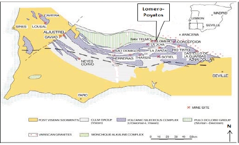
|
| Updated NI43-101 Technical Report on the Lomero-Poyatos Mine |
| 29 July 2011 |
The Lomero-Poyatos poly-metallic sulphide deposit is located on the northern limb of the San Telmo anticline, which is an E-W trending fold structure adjacent to a major thrust fault in the northern part of the Iberian Pyrite Belt (IPB). The San Telmo anticline contains several poly-metallic sulphide deposits of which the most important, from west to east are: El Carpio, Santa Bárbara, Cruzadillo, Lomero-Poyatos, Confesionarios, Aguas Teñidas, Castillejito, Cueva de la Mora and Monte Romero.These define a distinct mineral district where the massive sulphide deposits have small tonnages, but their base and precious metal grades are among the highest of any deposits in the IPB.
| |
| Figure 16 | Local geology of the Lomero-Poyatos district |
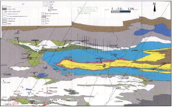
The deposit has an average ENE (075°) strike and dips about 35°N. At the surface there are two separate orebodies: Lomero (east) and Poyatos (west) that combine to form a single deposit at depth.At depth, the deposit seems to be formed by several thin (3 to 10 m) stacked ore lenses, 900 m in strike length located along the tectonic contact between shales and igneous rocks. The footwall is composed of massive dacites that show an increase in the cleavage and deformation towards the deposit. They are affected by highly irregular silicification, sericitization and chloritization. The hanging wall is also composed of massive dacites overlain by purple and green shales. The hanging-wall and foot-wall contacts of the massive sulphides are marked by highly sheared and silicified rocks.
The mineral assemblage of the massive sulphides is composed of pyrite, tenantite, sphalerite, galena, chalcopyrite, minor arsenopyrite, barite, pyrrhotite and gold. There are some hematite-magnetite-rich bands (ITGE, 1989).
|
| Updated NI43-101 Technical Report on the Lomero-Poyatos Mine |
| 29 July 2011 |
Western pit (Poyatos)
The Poyatos pit shows some irregular and highly strained sub-horizontal massive sulphide bodies mainly composed of coarse-grained pyrite. Below the massive sulphides there is highly chloritized dacite with increase of the intensity of chloritization and schistocity towards the contact with the massive sulphides, which may be a major thrust as it consists of strongly silicified tectonic melange with tectonic lenses of pyrite. This is clearly seen in the entrance to the adit below the old shaft. Above the massive sulphides there is auto-brecciated rhyodacite with a highly mylonitized footwall.The massive sulphides form highly strained boudin-like lenses a few metres in thickness that grade into mylonites formed from altered felsic rocks with pyritic tectonic lenses combined in a ramp and flat geometry (ITGE, 1989).
Eastern pit (Lomero)
The geology in the Lomero pit is similar to that at Poyatos. The hanging wall of the massive sulphides consists of highly chloritized dacite while the footwall consists of a tectonic melange overlying the dacites. The bottom of the open pit (when not flooded) shows the hanging wall of the massive sulphides with abundant tectonic and highly strained pyritic lenses in mylonitized rhyodacites (ITGE, 1989).
| |
| Figure 17 | Geology of the Lomero-Poyatos mine site(Source: WAI, 2007) |
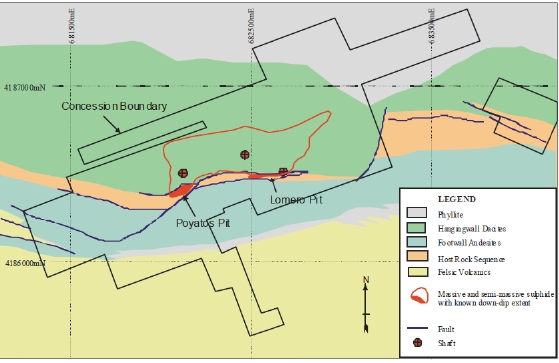
|
| Updated NI43-101 Technical Report on the Lomero-Poyatos Mine |
| 29 July 2011 |
| |
| Figure 18 | Schematic N-S cross-section through the Lomero-Poyatos deposit |
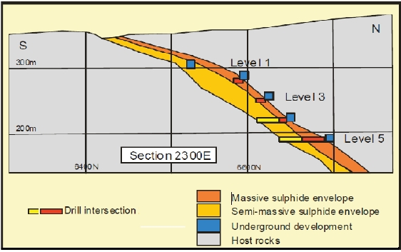
8.0 DEPOSIT TYPES
The Lomero-Poyatos deposit is a typical volcanic-hosted, poly-metallic, massive and semi-massive sulphide deposit, composed of pyrite, tenantite, sphalerite, galena, chalcopyrite, minor arsenopyrite, barite, pyrrhotite and gold, with some hematite-magnetite-rich bands.
Lomero-Poyatos is a combined Oko / Kuroko-type, strata-bound, polymetallic mineral deposit genetically related to submarine felsic volcanic activity. Kuroko-type deposits were first defined in Japan, where Kinoshita (1944) and Ohashi (1962) defined "Kuroko deposit" as a bedded sedimentary deposit formed by submarine volcanism, consisting of one or a combination of Kuroko (black ore consisting of sphalerite and galena), Oko (yellow ore consisting of pyrite and chalcopyrite), Keiko (siliceous pyritic ore) and Sekkoko (gypsum and / or barite ore). The term “Kuroko type deposit” should be limited to deposits in which typical Kuroko occurs, but the term may also be applied to allied deposit types consisting of only pyritic or pyritic-siliceous ores, or vein-type deposits formed along the paths of the mineralizing solutions that formed the Kuroko deposits. Kuroko-type deposits however, are so complicated in their nature that these brief definitions are not sufficient to cover their full characteristics (Tatsumi, 1970).
9.0 MINERALIZATION
The known massive sulphide deposit is tabular, extends laterally in an east-west direction for over 800m, has a moderate (35°) dip to the north and a down-dip extent of more than 350m. The average thickness of massive sulphide based on drill-hole intersections is about 7.5m although the maximum thickness of massive sulphide exceeds 20m.
|
| Updated NI43-101 Technical Report on the Lomero-Poyatos Mine |
| 29 July 2011 |
There are two zones, Lomeros and Poyatos, where historical mining was concentrated, separated by a thinner central zone. In the eastern part of the deposit, the strike of the mineralization turns to the east-northeast and the massive sulphide thins out on the mine level plans.
Pyrite is the predominant sulphide, but the sulphide minerals of greatest economic importance are sphalerite, chalcopyrite, tetrahedrite and galena. The massive sulphide and semi-massive sulphide zones at Lomero-Poyatos are significantly enriched in gold. In terms of gold content, the Lomero-Poyatos deposit has the highest gold grades in the IPB with values of 2.0m at 14.1 g/t Au and 0.55m at 16.84 g/t Au being returned from CMR drill holes. There is some copper-enrichment in the central part of the mine, with some zinc-lead-gold enrichment towards the eastern and western margins of the deposit.
10.0 EXPLORATION
CRI, the present owner of the Lomero-Poyatos mine, has not carried out any exploration of the property. All the available data is derived from the work carried out by previous owners, as described in Item 6 - History, above.
11.0 DRILLING
CRI, the present owner of the Lomero-Poyatos mine, has not carried out any drilling on the property. All the available drill-hole data is derived from work carried out by previous owners (CMR), as described in Item 6 - History, above.
12.0 SAMPLING METHOD AND APPROACH
CRI, the present owner of the Lomero-Poyatos mine has not carried out any sampling on the property. All the available sample data is derived from work carried out by previous owners, as described in Item 6 - History, above. Behre Dolbear has no direct knowledge and no way of acertaining who or how these historical samples were collected other than as described in section 6 of this report.
13.0 SAMPLE PREPARATION, ANALYSES AND SECURITY
CRI, the present owner of the Lomero-Poyatos mine has not carried out any sampling on the property. All the available sample data is derived from work carried out by previous owners, as described in Item 6 - History, above. Behre Dolbear has no direct knowledge and no way of acertaining who or how these historical samples were collected other than as described in section 6 of this report.
14.0 DATA VERIFICATION
CRI, the present owner of the Lomero-Poyatos mine, has not carried out any exploration or development work on the property other than a preliminary review of the metallurgical test work. All the available exploration data is derived from work carried out by previous owners, as described in Item 6 - History, above.
The author, as the qualified person responsible for this report, has verified the data as far as possible.This verification included:
|
| Updated NI43-101 Technical Report on the Lomero-Poyatos Mine |
| 29 July 2011 |
A site visit to examine and verify the geology and setting of the deposit;
Discussions with mining experts from the University of Madrid, particularly AngelRodrigues-Avello Sanz and Jose Antonio Botin Gonzalez, concerning the history ofownership, geology, mining and processing at Lomero-Poyatos;
Review and comparison of the geology, mineralisation, mining and processing datafrom the Lomero-Poyatos mine with published data from adjacent properties thatoccur in the same geological environment and are geologically and mineralogicallysimilar, in particular the Aguas Tenidas mine located about 10km along strike to theeast and the San Telmo mine located about 5 km along strike to the west;
Preparing, in cooperation with Gemcom Software Europe Ltd (Gemcom), a newgeological and mineral resource block model of the Lomero-Poyatos deposit based onall available drill-hole data, as described in Item 19 - Mineral Resource and MineralReserve Estimates (below).
No documentation relating to the legal ownership or control of the Lomero-Poyatos site were seen or verified by Behre Dolbear, as much of this data was not accessible due to the recent ownership changes. Arrangements are being made to obtain access to this ownership data in due course.
No original historical, mine or exploration records were seen and no historical assay data documentation or procedures were seen or verified, as much of this data was not accessible due to the recent ownership changes. Arrangements are being made to obtain access to this historical data in due course.
Drill core from the CMR exploration of the Lomero-Poyatos deposit is known to exist, but was not inspected during the site visit in January 2011, because the drill-core was stored off-site at a secured property that was owned by third parties and which was locked and not accessible at the time of the site visit. The CMR drill-core is believed to be a fairly complete record of the CMR drilling programme and:-
consists mostly of HQ or NQ size drill-core;
consists of about 2800 core boxes containing in total about 12,000m of core; and.
was securely boxed for storage, so may still be in reasonable condition.
The ownership of the Lomero-Poyatos drill-core is uncertain. Arrangements should be made to carry out an inspection of the drill-core as and when the storage facility becomes accessible.
15.0 ADJACENT PROPERTIES
There are no adjacent properties that are relevant to Lomero-Poyatos.
16.0 MINERAL PROCESSING AND METALLURGICAL TESTING
CRI, the present owner of the Lomero-Poyatos mine, has not carried out any mineral processing or metallurgical test work on the property. CRI has established a relationship with the University of Madrid to carry out mineral processing test work and mine development studies, but the results of this arrangement are not yet available.
The only available metallurgical data is derived from work carried out by previous owners, as described in Item 6 - History, above.
|
| Updated NI43-101 Technical Report on the Lomero-Poyatos Mine |
| 29 July 2011 |
Newmont (2002) demonstrated the gold existed in two forms:
Newmont concluded that for the samples analysed, the majority (70 to 85%) of the gold would report to pyrite and most of the remaining (15 to 30%) gold would report to the copper concentrate.
AMCO-Robertson (2002) confirmed the Newmont findings and reported the following test results:
| |
| Table 8 | Processing test results (Source: Amco-Robertson, 2002) |
| | | | | | | |
| Product | Recovery | Cu (%) | Pb (%) | Zn (%) | Ag (g/t) | Au (g/t) | Gold |
| | | | | | | | Distribution |
| Copper conc. | 50% | 23.0 | 3.1 | 5.3 | 177 | 100 | 13.0% |
| Lead conc. | 42.5% | 0.3 | 44.3 | 5.7 | 98 | 7.0 | 2.2% |
| Zinc conc. | 80% | 0.2 | 0.7 | 54.4 | 38 | 3.2 | 4.8% |
| Pyrite conc. | - | - | - | - | - | 4.0 | 80.0% |
CSMA (2002, 2003) reported that more than 80% gold recovery from pyrite-rich concentrate was possible following roasting/cyanidation.
Assessment of the value of the mineral resource requires various assumptions about processing costs, recoveries and subsequent smelting and refining charges, in order to arrive at a “net smelter return” (NSR), based on a given metals market price. Assuming a given cut-off grade, an average net smelter return per tonne of ore mined can be estimated and deductions can then be made to account for capital and operating costs, taxes and royalties, to arrive at the net value of the ore.
Based on the Gemcom (Dec, 2010) Resource Estimate and current (Feb 2011) metal prices in US$, the NSR value of the deposit may be considered to be as follows:
| |
| Table 9 | Assumptions used in deriving NSR for Lomero-Poyatos (in US$) |
| | | | | |
| Assumption | Gold | Silver | Copper | Zinc | Lead |
| Metal price in US$ | 1300/oz | 30/oz | 10,000/t | 2500/t | 2500/t |
| Loss on Mining and Processing | 20% | 30% | 45% | 30% | 30% |
| Cost of Freight, Insurance,Smelting, and Refining | 5% | 20% | 20% | 20% | 20% |
| Total loss of value | 25% | 50% | 65% | 50% | 50% |
| NSR value US$ | 975/oz | 15/oz | 3500/t | 1250/t | 1250/t |
| NSR value of 1 g/t or 1% grade | $ 34/g | $ 0.5/g | $ 35 / % | $ 12.5 / % | $ 12.5 / % |
| Average Grade at zero Au Cut-off | 2.15g/t | 48.06 g/t | 0.67% | 1.98% | 0.61% |
| NSR $ Value per tonne oremined | 73.94 | 24.03 | 23.45 | 24.75 | 7.63 |
From these figures, it is apparent that the ratio of net value in the ore is roughly:
This indicates that, after allowing for the relative costs of processing, transport, smelting and refining, gold represents about the same net value as all the other base-metal elements combined.
|
| Updated NI43-101 Technical Report on the Lomero-Poyatos Mine |
| 29 July 2011 |
From a mining and processing perspective this suggests that gold + silver represent the principal value in the deposit, that copper + zinc represent a useful by-product value and that lead is the least valuable mineral component.
These value relationships provide a useful constraint on the various mining and metallurgical process options available for the Lomero-Poyatos deposit. In order to better appreciate these variables, Gemcom prepared a series of scatter plots showing the correlation between all the main metal pairs.These correlation plots suggest these possible mineral associations:
Au is strongly related to Ag and Zn, and is moderately related to Pb.
Pb is strongly related to Zn and Ag, and is moderately related to Au.
Cu is poorly related to the other metals, but has a moderate correlation with S.
S is moderately associated with every element.
These elemental associations indicate that Copper mineralisation primarily occurred separately from the Au-Ag-Zn-Pb mineralisation.
There appear to be two separate mineralising events shown by the sulphur vs gold and the sulphur vs silver plots that both show a distinct High Sulphur / High Gold + Silver population and a separate or overlapping High Sulphur / Low Gold + Silver population.
| |
| Figure 19 | Histogram of Gold assay values showing 2 populations (blue line) |
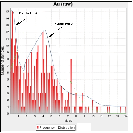
This suggests that there may two separate metal distributions within the primary sulphide mineralisation.
|
| Updated NI43-101 Technical Report on the Lomero-Poyatos Mine |
| 29 July 2011 |
This also appears to be reflected as a weak zonal distribution in the resource block model and to a lesser extent in the distribution of the old mine workings, as follows:
The western Poyatos zone with high Au-Ag-Zn-Pb values, but relatively low Cuvalues.
The eastern Lomeros zone with high Au-Ag-Zn-Pb values, but relatively low Cuvalues.
Separated by a central zone with relatively high Cu values and low Au-Ag-Zn values.
This may indicate a central (proximal) copper-rich feeder zone and lateral (distal) Au-Ag-Zn-Pb zones to the east (Lomero) and west (Poyatos) and possibly down dip at depth. It is important that any samples selected for metallurgical test-work should represent the full diversity of the mineralisation that may eventually be mined and processed.
On this basis, there could be as many as four (4) distinct mineral domains or populations:
Pyrite – Low gold (< 1g/t Au) domain
Pyrite – High gold (> 1g/t Au) domain
Pyrite – High copper domain
Zn-Pb-Au-Ag sulphide domain
Recent (April, 2011) work carried out at the University of Madrid showed that the deposit contains at least three different ore types as follows:
60% is Cupriferous Ore assaying typically 1.0% to 1.5%Cu with gold credits with noPb/Zn/Ag
32% is Arsenic/Pyrite Ore containing gold only
8% is massive sulphide containing all three base metals with silver associated withlead and gold associated with sulphides, and some free gold.
Consequently, these three different ore types may require at least three different processing flow-sheets.
| |
| Figure 20 | Correlation plots of each metal pair assay values |
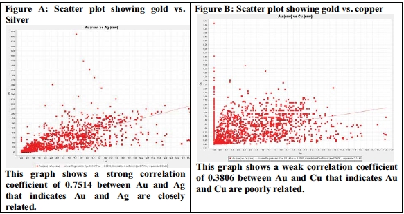
|
| Updated NI43-101 Technical Report on the Lomero-Poyatos Mine |
| 29 July 2011 |
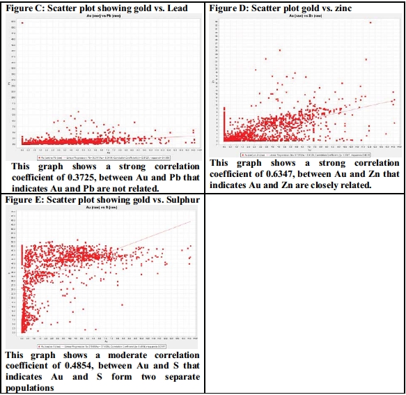
|
| Updated NI43-101 Technical Report on the Lomero-Poyatos Mine |
| 29 July 2011 |
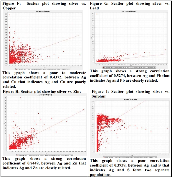
|
| Updated NI43-101 Technical Report on the Lomero-Poyatos Mine |
| 29 July 2011 |
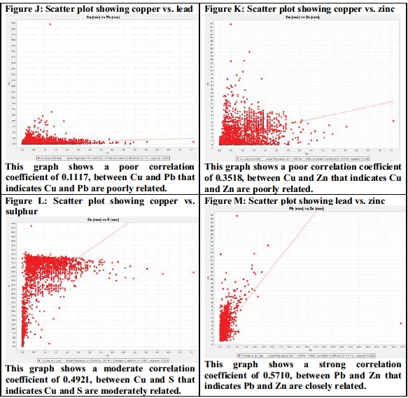
|
| Updated NI43-101 Technical Report on the Lomero-Poyatos Mine |
| 29 July 2011 |
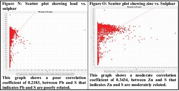
17.0 MINERAL RESOURCE AND MINERAL RESERVE ESTIMATES
| |
| 17.1 | MINERAL RESOURCE ESTIMATES |
After acquiring the Lomero-Poyatos mine in 2000, CMR carried out various drilling and resource estimation programmes in order to evaluate the un-mined parts of the deposit and to explore for major extensions of the known massive sulphide mineralisation. This activity included about 10,000m of drilling, 1100m of trenching, detailed geological studies, metallurgical test-work, resource evaluation and electromagnetic and gravity surveys. Nine diamond drill-holes totalling 2,490m were drilled in 2001 and 48 near-surface drill-holes totalling 4,781 m in 2003. The holes were typically drilled at an inclination of -70° and at an azimuth of 180°. They were primarily designed to:
verify the old mine records;
obtain in-situ massive sulphide for metallurgical test-work; and
improve knowledge of the grade distribution.
|
| Updated NI43-101 Technical Report on the Lomero-Poyatos Mine |
| 29 July 2011 |
| |
| Figure 21 | Plan view of CMR drillholes and section lines (source: Gemcom, 2011) |
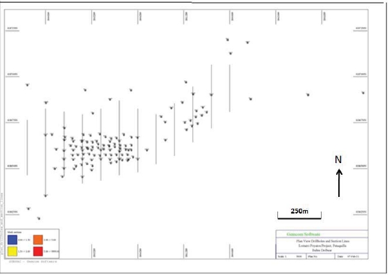
All the data acquired from CMR was integrated into a new Lomero-Poyatos database. This necessitated the transfer of data from various sources, including plans, surveys and maps, into a readily accessible digital format for use in geological and resource modelling software packages. Data incorporated into the Lomero-Poyatos Resource Model included:
The underground data included:
Underground development geochemical sampling on Levels 2, 3, 4 and 5 by SocieteFrancaise de Piritas de Huelva (SFPH) from 1934 onwards, taken every 2 m duringlevel development.
Detailed, across-strike, underground geochemical sampling on Levels 4 and 5 withinthe Lomero area by Societe Francaise de Pyrites de Huelva in 1968.
Detailed underground geochemical sampling on Levels 5 and 6 by Jeff Smith forIndumetal in 1986 to establish the gold grade and distribution on these Levels.
The approximate size of the Lomero-Poyatos deposit, based on drill-hole and other data in the Lomero-Poyatos database, has been estimated by three independent consultants in the past nine years. The results are summarised below as two separate scenarios, namely open-pit and underground.
|
| Updated NI43-101 Technical Report on the Lomero-Poyatos Mine |
| 29 July 2011 |
Open-pit Scenario:
SRK (2007) Inferred Mineral Resource:
Open-pit at a €50 value cut-off = 20.6 Mt at 3.1 g/t Au, 69.9 g/t Ag, 3.3% Zn, 1.2% Cu, 1.2% Pb. Containing 2.1 Moz Au
Gemcom (2010) Inferred Mineral Resource:
Open-pit at 1 g/t Au cut-off grade = 20.9 Mt at 3.08 g/t Au, 62.38 g/t Ag, 0.7% Cu, 2.5% Zn, 0.7% Pb. Containing 2.07 Moz Au
This scenario does not look practical due to the great depth (>250 m) and the huge waste:ore ratio (>50:1) involved in mining below the existing underground workings. Also, the deposit appears to have sharp hanging-wall and foot wall contacts, so there would be very little scope for adding additional stock-work mineralisation with the open-pit option.
Underground Scenario:
SRK (2007) Indicated Mineral Resource:
Underground at €70 value cut-off = 1.85 Mt at 3.4 g/t Au, 52 g/t Ag, 0.8%Cu,1.4%Pb, 2.3%Zn. Containing 0.203 Moz Au
WAI (2006) Indicated Mineral Resource:
Underground at 1.5 g/t Au cut-off = 3.71 Mt at 3.26 g/t Au, 27.9 g/t Ag, 0.87% Cu, 1.16% Pb, 1.57%Zn. Containing 0.39 Moz Au.
Gemcom (2011) Inferred Mineral Resource:
It is BehreDolbear’s opinion that:-
The most likely cut-off grade for this deposit is not known at this time and must beconfirmed by appropriate economic studies. The project has no mine design ordefined economic parameters.
The estimated metal content does not include any consideration of mining, mineralprocessing, or metallurgical recoveries.
Grades, tonnes and ounces have been rounded and this may have resulted in minordiscrepancies.
Mineral resources that are not mineral reserves do not have demonstrated economicviability.
No mineral reserves have been estimated. Due to the uncertainty that may be attached to Inferred Mineral Resources, it cannot be assumed that all or any part of an Inferred Mineral Resource will be upgraded to an Indicated or Measured Mineral Resource as a result of continued exploration. As confidence in the estimate is insufficient to allow the meaningful application of technical and economic parameters or to enable the evaluation of economic viability worthy of public disclosure, Inferred Mineral Resources must be excluded from estimates forming the basis of feasibility or other economic studies.
|
| Updated NI43-101 Technical Report on the Lomero-Poyatos Mine |
| 29 July 2011 |
| |
| 17.2 | GEMCOM RESOURCE MODEL |
Gemcom Software Europe Ltd (Gemcom) was commissioned by Behre Dolbear to undertake an independent review of the Lomero-Poyatos poly-metallic deposit, in order to quantify and model the mineral resource based on the currently available data.
Gemcom requested that all available geological and mineralogical data, including drill-hole logs, assay data and specific gravity (SG) data, as well as structural data, developed and historically worked out areas and the topographic DTM, be provided prior to the resource estimation. All available data was provided to Gemcom, although this did not include all the requested data as listed above.
Gemcom modelled the mineralisation of the Lomero-Poyatos deposit using both Gemcom GEMS and Surpac software. The following steps were involved in the resource estimation:
All available data was uploaded and/or opened in Surpac.
Drill-hole data was validated visually and the survey, logs and assay data wasvalidated digitally.
3D wireframes (solids) were digitised around the identified mineralisation in the validdrill hole data.
Variography was undertaken on the data within the solid to define the parameters forordinary kriging.
Indicator kriging was undertaken to create the block model to determine grade andtonnage estimates.
A Mineral Resource Estimate was developed by constraining the geological blockmodel with the following parameters as determined in consultation with BehreDolbear:
A minimum average grade of 1 g/t gold over a minimum compositedintersection of 2m.
Indicated Mineral Resource classified with a drill-hole spacing of <30m.
Inferred Mineral Resource classified with a drill-hole spacing of >30m.
| |
| Figure 22 | Long section showing underground workings (Source: Gemcom, 2010) |
|
| Updated NI43-101 Technical Report on the Lomero-Poyatos Mine |
| 29 July 2011 |
| |
| 17.3 | DATABASE PREPARATION AND VALIDATION |
Historical Exploration Data
The data provided to Gemcom comprised a variety of sample types and sources taken at different times and by different parties over the course of the history of the deposit. The history of ownership, operation and exploration of the deposit is summarised as follows:
| |
| Year | Comments |
| 1850’s onwards: | History of mining the deposit recorded. |
| 1930’s to 1982: | Pyritas de Huelva mined massive pyrite, largely underground, for sulphur to produce sulphuric acid; old workings extend for 1000m (E-W) and up to 500m down dip. The mine closure survey is reported to comprise a detailed plan of the mine levels. |
| 1984 | Billiton conducted an underground diamond drilling programme (60 underground horizontal holes) targeting the crown pillars comprising massive sulphide and semi-massive sulphide of >25% sulphur. |
| 1986 | Indumetal conducted underground mapping and sampling in the form of 650 rock-chip samples in the lower levels of the mine to assess base- and precious-metal grades. |
| 1989 | Discussions of JV between Tharsis and Outokumpu including 9 diamond drill holes from surface (Th-1 to Th-9) totalling 2,200m to assess the potential beyond the mined areas. Principally these investigations tested the dip and strike extensions within 1000m along strike and 100m down dip of the lowest workings (Level 6). |
| 1992-2000 | Licences held in receivership and then acquired by Tethys Iberian Minerals Ltd.; some consolidation and valuation work done. |
| 1999 | Recursos (a wholly owned subsidiary of Cambridge Mineral Resources plc) acquired the Exploitation Concessions through a rental agreement with the owner San Telmo Iberica Minera S.A. This agreement was signed to cover the duration of the vailidity of the Exploitation Concessions, which had a 60 year life commencing in 1973. |
| 2001 | Cambridge Mineral Resources and Newmont Mining Corporation drilled 48 diamond drill holes from surface to collect samples for metallurgical test work and provide further intersections through the deposit. |
| 2002 | SRK undertook a conceptual mining study and prepared a Mineral Resource Model on behalf of Cambridge. |
| 2002 | Bouger gravity survey undertaken by Williams Geophysics. |
| 2007 | WAI was commissioned to update the resource statement for a NI43-101 Technical Report, covering the massive sulphide mineralisation within the previously mined deposit focussing only on the underground redevelopment of the mine. |
| Sept 2010 | SRK produced a report on the additional mineral potential beyond the limits of the currently delineated Mineral Resource. |
Not all of the above data and sample results were made available to Gemcom to compile the database and some of the data that were provided were excluded for reasons of data integrity and validation.
|
| Updated NI43-101 Technical Report on the Lomero-Poyatos Mine |
| 29 July 2011 |
Data Handling and Validation
The following data was provided to Gemcom:
Log descriptions of 48 diamond drill holes from the CMR campaigns;
A Microsoft Access Database with 4 tables;
A topographic surface from AutoCAD; and
Historical workings as AutoCAD and GEMS files; Gemcom was unable to openthese files but was able to create solids of the historical workings from the levelplans.
Inspection of this data revealed some inconsistencies between the different sources and any unreferenced drill holes and samples with undefined intervals were identified and removed from the base data. Validation of the remaining data using standard Gems and Surpac database tools also revealed some overlaps of sample intervals, which were corrected where possible or removed from the data set.
Historical mine plans were provided as 2D level plans which deviated in places from the 3D infrastructure files provided. Information on individual stopes could not be accessed and was therefore interpolated from the level plans on the basis that ore in previously mined areas was effectively sterilised and would not be included in the resource estimation.
Lithology and structural domains
Of 124 known drill holes at Lomero-Poyatos, only 48 of them had drill-log data available. There was insufficient information to undertake a resource estimation based on lithology as no rock code legend was provided and it was difficult to determine what the rock types were from information based solely on the lithological codes and the associated description. No structural geology or geotechnical data such as indications of faults, shearing or description of contacts or bedding was provided, thereby limiting Gemcom’s ability to model the deposit.
Taking into account the above limitations, the relationship between rock type and mineralisation was modelled by graphically displaying the drill holes with the sulphur assay information together with the lithology codes.
The orebody was interpreted as one single domain and one single solid based on the >25% sulphur assay values. The >25% sulphur solid was extended in some areas to allow for some off-section drill-hole assays to be incorporated into the solid. End terminations of the solid were interpreted conservatively and based on the outer limit of drill-hole data.
Scatterplot Analyses
All assay correlation graphs were produced using the Basic Statistics functions in Surpac v.614 and the graphs plot elemental abundances against one another. The data was analysed in two formats, raw and composited data, because the composited data type was the primary source of data used in the block model estimation. This composited data was generated down each drill hole from the raw drill-hole data. These graphs (see Item 18 above) were analysed (see below) in conjunction with their corresponding correlation coefficients. This analytical method assessed the correlation of two sets of data by producing a number between -1 and +1. The closer to -1, the more negative the correlation and the closer to +1 the more positive. Thus, each pair from the 6 elements can receive a correlation coefficient that highlights the relationship between the selected elements.
|
| Updated NI43-101 Technical Report on the Lomero-Poyatos Mine |
| 29 July 2011 |
| |
| Table 10 | Correlation Coefficients of the Raw Assay Data (Source: Gemcom, 2011) |
| | | | | | |
| Element | Ag | Au | Cu | Pb | Zn | S |
| Ag | 1 | 0.7514 | 0.4372 | 0.5274 | 0.7449 | 0.3938 |
| Au | 0.7514 | 1 | 0.3806 | 0.3725 | 0.6347 | 0.4854 |
| Cu | 0.4372 | 0.3806 | 1 | 0.1117 | 0.3518 | 0.4921 |
| Pb | 0.5274 | 0.3725 | 0.1117 | 1 | 0.571 | 0.2183 |
| Zn | 0.7449 | 0.6347 | 0.3518 | 0.571 | 1 | 0.3434 |
| S | 0.3938 | 0.4854 | 0.4921 | 0.2183 | 0.3434 | 1 |
Gold values
Analysis of the data indicated that gold is not limited to one rock type. The Au grades appear to be higher where a high content of sulphur exists and therefore it was assumed that the Au values occur predominantly within the massive sulphides. Notably there are high Au values associated with the hanging-wall contact of the massive sulphides. Plots of Au vs S values indicated that there may be two separate populations of Au values.
Lead and Zinc values
There is a good correlation between the lead (Pb) and zinc (Zn) values in the massive sulphides. Zinc (Zn) showed a strong correlation with silver (Ag) and gold (Au) values, which indicates that Zn mineralisation is closely associated with both Ag and Au.
Copper values
Analyses of the copper content indicated that there is a correlation with the lower foot-wall part of the massive sulphides. However, the correlation coefficients of the data show that the copper mineralisation is distinctly different to the others metals (Au, Ag, Pb, Zn). This indicates that the Cu mineralisation and the poly-metallic mineralisation (Au, Ag, Pb, Zn) may represent different mineralising events that have different special distributions.
Modelling Methodology
The methodology followed in the resource estimation is summarised as follows:
| 1. | Histograms were drawn up on the raw data to analyse the distribution of the elements. |
| 2. | The ratio between gold and sulphur were modelled indicating a good positive correlation. |
| 3. | The solid was created with one single domain based on >25% sulphur and >1 g/t gold values. |
| 4. | Compositing was undertaken inside the solid. |
| 5. | Histograms were plotted on the composited data. |
| 6. | Indicator analysis was performed to generate the indicator range for indicator kriging. |
| 7. | Variograms were modelled based on the indicators. |
| 8. | The block model was created based on dimensions that would accommodate the solid and block size at half distance between drill holes. A partial percentage model was generated to ensure volumetric accuracy of the geological resource model. The classified mineral resource model utilised a minimum sub-blocking of 1.25m. |
| | 9. | Indicator kriging estimation method was run on the block model based on the variogram results for Ag, Au, Cu, Pb and Zn. |
|
| Updated NI43-101 Technical Report on the Lomero-Poyatos Mine |
| 29 July 2011 |
The resource was first estimated using ordinary kriging, but due to the lack of lithological data and difficulty in domaining the mineral distribution, it was concluded that ordinary kriging was not sufficiently robust and therefore indicator kriging was used to produce an estimate with greater certainty. Resource estimation was based on a solid created from >25% sulphur assay values. The solid included all drill holes, but excluded any erroneous data such as zero interval values. Therefore, the >25% S solid is a representation of the massive sulphide deposit, as shown in Figure 23. Any gold-rich zones were identified by plotting the assay data from the drill hole logs.
| |
| Figure 23 | Block Model Solid of Lomero-Poyatos deposit at >25% S |
| |
| | (Source: Gemcom, 2011) |
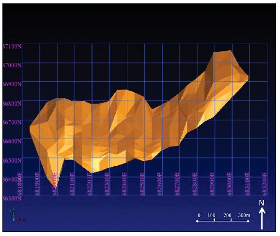
The solid represents the outer limits of the known mineralisation.
Compositing of samples was undertaken within the solid in order to avoid dilution. The solid was treated as a single domain and histograms indicated that the distribution of values was close to normal in preparation for the modelling.
Variography was undertaken on the composited data in order to model correlation between samples in 3D space. Through modelling the variograms, the nugget, sill and range were identified along with the major/semi-major ratio and major/minor ratio, which indicated the direction of maximum continuity of the elements inside the solid in preparation for kriging. The block model was generated
|
| Updated NI43-101 Technical Report on the Lomero-Poyatos Mine |
| 29 July 2011 |
with a block size of half the drill spacing in all 3 directions. Partial percentage modelling was performed in order to reflect the correct volume of the solid within the larger blocks.
Indicator kriging was the chosen methodology for estimation of the mineral resource as a result of clustering of the data; the high variability of the deposit as reflected in the drill holes; and the lack of detailed lithological data.
A block model was created to cover the area of exploration and limits of drill hole penetration. Block sizes were determined by drill hole spacing (half) distance to create blocks that were orientated N-S (Y) = 15m, E-W (X) = 10m, and Vertical (Z) = 15m.
The mineral resource was estimated at a cut off grade of 1g/t Au averaged over the 2m composite sample interval.
Statistical Procedures and Characteristics
Raw data statistical analysis was performed on all the samples to minimise data skew. The statistical analysis identified some mismatches between surface and underground borehole samples. This was particularly the case for the chip-samples and cross-cut samples of which a large proportion had to be dismissed from the data set.
Composite Selection
Down hole compositing was performed for all elements using a sample length of 2m following the statistical validation described above. 95% of all samples were successfully included in the composite data set. The mineral resource estimate utilised grade compositing of greater than 1 g/t Au with a minimum composite length of 2m. This was assumed to represent a minimum mining width for an underground mining project.
Grade Capping
From the composite histograms generated, it was clear that a number of no-grade composites were generated by the chip-samples and cross-cut samples, thus lowering the overall grade. Therefore these underground samples were eliminated as discussed (above) and only surface drill-hole data was used as the basis for the resource estimation. Top cutting was applied to all elements except Ag and S, by visualising their probability plot curves. However, as the top cut did not include any erratically high values it was removed as it was felt that it was unnecessary and that the entire population should be included in order to provide an estimate of all the contained metals.
Specific Gravity
No specific gravity data was available, nor known to exist. In the absence of SG data, the following assumptions were made:
The initial Mineral Resource estimate (Gemcom, 2010) was based on the >25% Ssolid assuming a specific gravity of 3.3. This was based on the assumption that,within the solid, there is likely to be some areas of massive sulphide and some areasof disseminated sulphide and therefore 3.3 was considered to be a fair estimate.
The subsequent Mineral Resource estimate (Gemcom, 2011) was based on a specificgravity of 4.5, based on the assumption that since minimum mining widths werebeing applied as a constraint to the data, the mineralisation would largely comprisemassive sulphide. As regionally analogous deposits have a known specific gravity of4.6, it seemed reasonable to assume an SG value of 4.5.
|
| Updated NI43-101 Technical Report on the Lomero-Poyatos Mine |
| 29 July 2011 |
Variography
Variograms were developed for all the elements using the variogram modelling feature in Gemcom Surpac as shown in Figure 24.
| |
| Figure 24 | Primary Variogram – gold |
| |
| | (Source: Gemcom, 2011) |
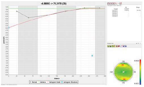
Validation
Basic validation steps were completed on the generated block model as follows:
Generation of histograms
Generation of cumulative frequency graphs
Generation of basic statistical parameters (i.e. mean, median, etc)
Comparison of basic statistical parameters
When comparing the estimation of the block model to the composites for the area enclosed by the 2 meter intersection at 1g/t Au, the following observations were made:
Mean of block model 4.2 Au g/t – Mean of Composites 4.0 Au g/t
Minimum of block model 0.6 Au g/t – Minimum of Composites 0 Au g/t
Maximum of block model 9.8 Au g/t – Maximum of Composites 14.1 Au g/t
The shift in maximum and minimum values is expected of any estimation as the extremes are reduced by averaging under estimation conditions. The mean is comparable, which shows that the majority of the estimation is similar to the composites; this initially shows the estimation is reliable.
| |
| 17.4 | MINERAL RESOURCE ESTIMATION (GEMCOM, 2011) |
A Mineral Resource estimation based on total mineral tonnage and average grade was produced for all elements in the block model.
The deposit block model was further constrained by the mine workings developed as solids from the mine plans. The volume of the stopes amounted to about 1.3 million m3or about 3.9 Mt of mined material assuming a Specific gravity of 3.3.
|
| Updated NI43-101 Technical Report on the Lomero-Poyatos Mine |
| 29 July 2011 |
| |
| Figure 25 | Model of Mine Workings |
| |
| | (Source: Gemcom, 2011) |

As no economic analysis or feasibility study has been made to determine what economic cut-off grade will be applied to the Lomero-Poyatos deposit, the tonnes and grades were estimated using a range of cut-off values. The block model estimate for the deposit, based on the >25% s solid at a specific gravity of 3.3 and excluding mined-out areas, was as follows:
|
| Updated NI43-101 Technical Report on the Lomero-Poyatos Mine |
| 29 July 2011 |
| |
| Table 11 | Inferred Mineral Resource Estimate assuming Open-pit mining at SG = 3.3 |
| |
| | (Source: Gemcom, 2011) |
| | | | | | | | | | |
Grade
Au g/t | Volume
(Mm3) | Tonnes
(Mt) | Au
g/t | Ag
g/t | Cu
% | Pb
% | Zn
% | Cumulative |
Tonnes
(Mt) | g/t
Au | g/t
Ag |
| < 1.0 | 2.85 | 9.42 | 0.62 | 11.42 | 0.16 | 0.27 | 0.78 | 30.35 | 2.31 | 46.56 |
| 1.0-2.0 | 1.38 | 4.58 | 1.51 | 37.86 | 0.67 | 0.60 | 1.82 | 20.93 | 3.08 | 62.38 |
| 2.0-3.0 | 2.109 | 6.96 | 2.46 | 46.13 | 0.74 | 0.68 | 2.42 | 16.35 | 3.52 | 69.25 |
| 3.0-4.0 | 1.214 | 4.01 | 3.49 | 68.69 | 1.04 | 0.89 | 3.38 | 9.38 | 4.30 | 86.40 |
| 4.0-5.0 | 0.864 | 2.85 | 4.46 | 92.27 | 1.18 | 1.15 | 4.35 | 5.38 | 4.90 | 99.59 |
| 5.0-6.0 | 0.766 | 2.53 | 5.41 | 107.8 | 1.20 | 1.37 | 5.05 | 2.53 | 5.41 | 107.8 |
| > 6.0 | 0 | 0 | 0.00 | 0.00 | 0.00 | 0.00 | 0.00 | 0 | 0 | 0 |
Grand
Total | 9.196 | 30.35 | 2.31 | 46.56 | 0.67 | 0.67 | 2.35 | | | |
Due to the uncertainty that may be attached to Inferred Mineral Resources, it cannot be assumed that all or any part of an Inferred Mineral Resource will be upgraded to an Indicated or Measured Mineral Resource as a result of continued exploration. Confidence in the estimate is insufficient to allow the meaningful application of technical and economic parameters or to enable the evaluation of economic viability worthy of public disclosure. Inferred Mineral Resources must be excluded from estimates forming the basis of feasibility or other economic studies.
It should be noted that approximately 30% of the above material is at a grade of less than 1 g/t Au occurring at depth and on the fringes of the deposit and has questionable economic value.
It was agreed to exclude any material of less than 1 g/t Au from the mineral resource estimation on the assumption that underground mining methods would be the most likely method of exploitation rather than open pit. Therefore, the Mineral Resource was estimated according to parameters chosen to fall within reasonable underground mining constraints, including a minimum composite grade of 1.0 g/t gold over a minimum intersection width of 2m.
| |
| Table 12 | Inferred Mineral Resource Estimate assuming underground mining at 1g/t Au cut-off and SG = 4.5 |
| |
| | (Source: Gemcom, 2011) |
| | | | | |
| Class | Cut-off | Volume m3 | Cumulative | Cumulative | Cumulative |
| | g/t Au | | Tonnes | Au g/t | Ag g/t |
| Inferred | > 1.0 | 1,348,656 | 6.07 | 4.25 | 88.74 |
| | > 2.0 | 1,261,039 | 5.66 | 4.45 | 92.33 |
| | >3.0 | 1,114,235 | 4.89 | 4.74 | 96.47 |
| | >4.0 | 864,606 | 3.63 | 5.16 | 102.24 |
| | >5.0 | 520,970 | 1.92 | 5.77 | 111.6 |
| | >6.0 | 162,814 | 0.59 | 6.51 | 124.57 |
| | >7.0 | 29,806 | 0.04 | 7.76 | 132.24 |
| | >8.0 | 4,703 | 0.01 | 9.02 | 171.03 |
| | >9.0 | 830 | 0.004 | 9.82 | 187.77 |
| Total | >1 g/t Au | 1,348,656 | 6.07 | 4.25 | 88.74 |
|
| Updated NI43-101 Technical Report on the Lomero-Poyatos Mine |
| 29 July 2011 |
Due to the uncertainty that may be attached to Inferred Mineral Resources, it cannot be assumed that all or any part of an Inferred Mineral Resource will be upgraded to an Indicated or Measured Mineral Resource as a result of continued exploration. Confidence in the estimate is insufficient to allow the meaningful application of technical and economic parameters or to enable the evaluation of economic viability worthy of public disclosure. Inferred Mineral Resources must be excluded from estimates forming the basis of feasibility or other economic studies.
18.0 OTHER RELEVANT DATA AND INFORMATION
In accordance with the Valmin Code, Behre Dolbear normally undertakes valuations of mining projects using three methods, where relevant:
Net Present Value (NPV) estimated from Discounted Cash Flow (DCF),
An appropriate percentage of the estimated gold content in the Mineral Resources,
Comparable market quotations or acquisition transactions.
Since financial estimates are not available for the Lomero-Poyatos project, it was not possible to use the NPV method of valuation. Accordingly, this valuation is based only on two methods; the appropriate percentage of Mineral Resource estimate method and the market comparables method, each of which are presented separately below.
Behre Dolbear concluded that an appropriate value assigned to the project should be: US$54 million
Valuation based on Mineral Resource Estimate
To make a valuation on the basis of estimated Mineral Resources at a reasonable level of accuracy, various assumptions need to be made for losses in order to arrive at a sales value per gram of Au, based on a given market metal price. Assuming a given cut-off grade, an average net sales value per tonne of ore mined can then be calculated. Deductions are then made to account for capital and operating costs, taxes and royalties, arriving at the net value of the ore.
Based on the Gemcom, 2011 Resource Estimate (Table 12) and Feb 2011 metal prices in US$ –which may be seen as conservative when considering the current (July 2011) record prices, the sustainability of which is speculative, the valuation of the Lomero-Poyatos deposit may be based on the assumptions in Table 13:
| |
| Table 13 | Assumptions used in deriving deposit sales value in US$ |
| | | | | |
| Assumption | Gold | Silver | Copper | Zinc | Lead |
| In situ metal value | 1300/oz | 30/oz | 10,000/t | 2500/t | 2500/t |
| Loss on mining | 10% | 10% | 10% | 10% | 10% |
| Loss on Processing | 10% | 20% | 35% | 20% | 20% |
| Freight / Insurance / Smelting /Refining | 5% | 20% | 20% | 20% | 20% |
| Total loss of value | 25% | 50% | 65%` | 50% | 50% |
| Net Sales value US$ | 975/oz | 15/oz | 3500/t | 1250/t | 1250/t |
| Net Sales value of1 g/t or 1% grade US$ | $ 34/g | $ 0.5/g | $ 35/% | $ 12.5/% | $ 12.5/% |
| Grade at 1g/t Au Cut-off * | 3.08 g/t | 62.38 g/t | 0.7 % | 2.5 % | 0.7 % |
| $ Value per tonne ore mined | 104.7 | 31.2 | 24.5 | 31.3 | 8.7 |
| Note: *Based on Gemcom 2010 Open-pit Inferred Mineral Resource estimate |
|
| Updated NI43-101 Technical Report on the Lomero-Poyatos Mine |
| 29 July 2011 |
From these figures, it is apparent that the ratio of net sales (net smelter return) value in ore is roughly
Au = Ag + Cu + Zn + Pb,
Meaning gold represents about the same value as all other base-metal elements combined, after allowing for the relative costs of processing, transport, smelting and refining. Therefore, Lomero-Poyatos should be valued as a gold deposit, with possible base-metal by-products / credits.
All mine operating costs, interest, royalties and taxes, as well as capital costs, must be deducted from the sales value, in order to arrive at the effective value of the mine.
The approach taken was to derive a value based on the resource estimate using a global average stock market valuation per ounce of in-situ gold resources. In a research report published in 2010, Edison Investment Research (EIR) calculated that the average global stock market value per ounce of in-situ gold resources (not reserves) was:
| |
| Table 14 | Average Stock Market Value per oz of in-situ Gold Resource |
| |
| | (Source: EIR, December 2010) |
| | | |
| | Worldwide | Australia | Canada |
| MeasuredGold Resources | US$340/oz | US$739/oz | - |
| IndicatedGold Resources | US$159/oz | - | US$244/oz |
| InferredGold Resources | US$34/oz | US$91/oz | - |
Therefore, if it is assumed that the Underground mineral Resources at Lomero-Poyatos are classified as Indicated Mineral Resources, the following estimates would apply:
SRK (2002) U/G (Indicated Mineral Resource @ $159/oz) = 202,900 oz Au = $ 32.26M
WAI (2007) U/G (Indicated Mineral Resource @ $159/oz) = 390,150 oz Au = $ 62.03M
If it is assumed that the Open-pit Mineral Resources at Lomero-Poyatos are classified as Inferred Mineral Resources, the following estimates would apply:
SRK (2002) O/P (Inferred Mineral Resource @ $34/oz) = 2.1 Moz Au = $ 71.4M
Gemcom (2010) (Inferred Mineral Resource @ $34/oz) = 2.1 Moz Au = $ 71.4M
It may be assumed that it would be prudent to discount the value of the Inferred Mineral Resources at Lomero-Poyatos to allow for the considerable uncertainty as to whether a large open-pit operation would receive regulatory approval, by a risk factor of 15%. Therefore the Inferred Resource valuation would be reduced to $ 60.7M.
Based on the average of these Mineral Resource estimates, thevalue is about $53.9M.
Valuation by Comparable Transactions
Recent acquisitions of companies with comparable properties can sometimes be used in providing a valuation. In this instance, a comparable transaction, both in terms of resource and region, is the acquisition in 2010 by Astur Gold Corporation of a 100% interest in the Salave Gold Deposit located in the province of Asturias in northern Spain, with a resource estimate of:
2.15 Mt of Measured Mineral Resources at an average grade of 3.88 g/t Au
15.8 Mt of Indicated Mineral Resources at an average grade of 2.79 g/t Au
2.6 Mt of Inferred Mineral Resources at an average grade of 1.94 g/t Au
1.17 Mt of Underground Inferred Mineral Resources at an average grade of 4.7 g/t Au
|
| Updated NI43-101 Technical Report on the Lomero-Poyatos Mine |
| 29 July 2011 |
Cut-off grades of:
Operating costs of:
The purchase price (in 2010) amounted to about $ 53.3M, comprising the following payments:
Cash payment of €1.1M (US$1.47M at exchange rate of €0.75 to 1US$)
5,296,688 shares of Astur Gold, currently valued at approximately C$95,000
Cash payment of €20M (US$26.7M at exchange rate of €0.75 to 1US$), 180 daysafter receiving necessary permits
Staged payments amounting to about $25M
Behre Dolbear suggests, on the basis of the purchase price of this comparable transaction, that a comparable value for Lomero-Poyatos may be$ 53M.
Conclusion of the Lomero-Poyatos Valuation
Behre Dolbear has indicated above that a possible valuation of the Lomero-poyatos deposit, based on:
A value applied to the resource ounces based on a published average global stockmarket valuations per ounce of in-situ gold resources, would be $53.9M
A value from a comparable acquisition transaction would be $53.3M.
Taking the average of these two estimates, assuming equal weightings for each, Behre Dolbear concludes that an appropriate value for the Lomero-Poyatos project is$53.5 million.
Due to the paucity of critical metallurgical data, Behre Dolbear regards the Lomero-Poyatos project as an advanced exploration project, not as a development project.
University of Madrid “scoping study”
The project is unique in having an ‘Operating Concession’ which requires mining to take place. To comply with the legal requirement of this Operating Concession, the University of Madrid Minerals Faculty is preparing a “scoping study” for Lomero-Poyatos mine commencing at 100t/day, rising to 250t/day and eventually to 800t/day over 3 years, all from underground. This is to be facilitated through 2 new decline ramps. The aim is to re-start mining underground in early 2012.
In parallel with this production, there will be an 18-month core-drilling programme totalling about 50,000m of HQ diameter. This is to upgrade the Mineral Resource to Indicated Mineral Resource and Probable Mineral Reserve status. These events have to occur in parallel in order to comply with the legal requirements of the Operating Concession.
There are two proposals being investigated in tandem: flotation and bio-oxidation at a rate of 100t/day for regulatory approval; also investigating the roasting and cyanidation route separately, with a final decision between the two methods in 18 months time. This is based on:
800t/day ROM to mill;
50t/day concentrates and 750t/day biox;
>25mm to jigs. Possible CIP/CIL for Ag (associated with Pb). Refractory Au; and
S:Au ratio could vary from 1%:1g/t to 3%:1g/t.
Tailings may possibly be used as backfill, although it is uncertain whether this would just be a means of disposal, or would be for mining support (depending on mining method).
|
| Updated NI43-101 Technical Report on the Lomero-Poyatos Mine |
| 29 July 2011 |
Discussions with the University of Madrid (SGS, May 2011) showed the deposit contains at least three different ore types as follows:
Cupriferous ore assaying typically 1.0% to 1.5% Cu with gold credits but with noPb/Zn/Ag.
Arseno-pyritic ore containing gold only.
Massive sulphide containing all three base-metals with silver associated with lead andgold associated with sulphides, some is free gold.
These three different ore types will require at least three different processing flow-sheets and the following has been suggested, subject to confirmation in the mining plan, that during the first years of operation the mine could potentially mine:
The cupriferous ore type that is likely to require a grinding and copper flotation plantwith any gold present taken as credits with the copper concentrate, assuming itreports to the concentrate.
Thearseno-pyritic orethat is likely to require fine grinding followed by sulphideoxygenation (BIOX or POX) followed by cyanide leach.
Thepoly-metallic orethat is likely to require fine grinding followed by differentialflotation followed by sulphide oxygenation followed by cyanide leach.
The previous mineralogy testwork indicated that 39% of thegoldis in solution in the pyrite, 42% is encapsulated, 5% is associated with other minerals and the remaining 14% is free gold (8%>5 microns in size and 6% <5 microns in size).
As a consequence of this mineral diversity, the geological /mineralogical domains need to be defined so as to provide separate tonnage and grade estimates for each of these ore types. Carefully selected and representative metallurgical samples need to be extracted from each of these ore type domains for metallurgical testing.
|
| Updated NI43-101 Technical Report on the Lomero-Poyatos Mine |
| 29 July 2011 |
| |
| 18.3 | LOMERO-POYATOS BLOCK MODELSBY ELEMENT BASED ON > 25% SULPUR SOLID (Source: Gemcom, 2011) |
GOLD
| |
| Figure 26 | Plan view showing Au mineralisation, drill holes and IK estimated block model |
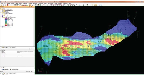
| |
Figure 27 | Section view showing Au mineralisation at the eastern extremity of the block model drill holes and IK estimated block model |
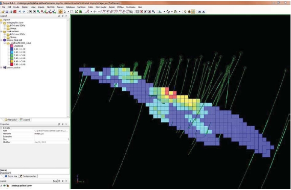
|
| Updated NI43-101 Technical Report on the Lomero-Poyatos Mine |
| 29 July 2011 |
| |
Figure 28 | Inclined section looking towards the SW showing Au mineralisation drill holes and IK estimated block model |
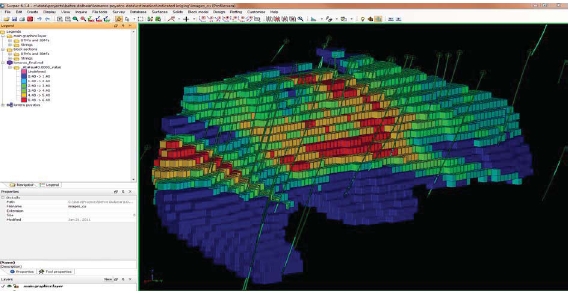
SILVER
| |
| Figure 29 | Plan view showing Ag mineralisation, drill holes and IK estimated block model |
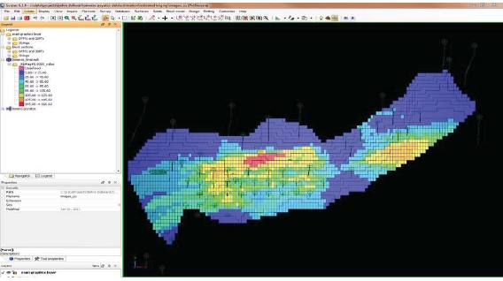
|
| Updated NI43-101 Technical Report on the Lomero-Poyatos Mine |
| 29 July 2011 |
| |
Figure 30 | Section view showing Ag mineralisation at the eastern extremity of the block Model drill holes and IK estimated block model |
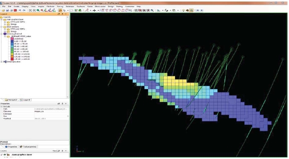
| |
Figure 31 | Inclined section looking towards the SW showing Ag mineralisation, drill holes and IK estimated block model |
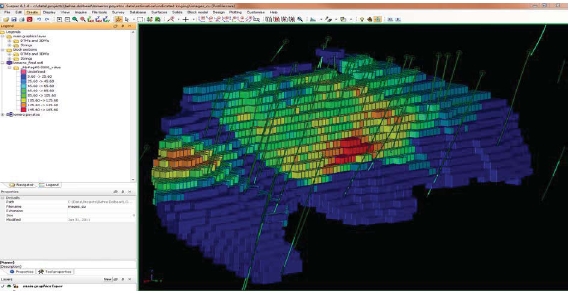
|
| Updated NI43-101 Technical Report on the Lomero-Poyatos Mine |
| 29 July 2011 |
COPPER
| |
| Figure 32 | Plan view showing Cu mineralisation, drill holes and IK estimated block model |
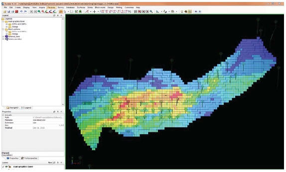
| |
Figure 33 | Section view showing Cu mineralisation at the eastern extremity of the block model, drill holes and IK estimated block model |
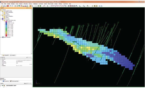
|
| Updated NI43-101 Technical Report on the Lomero-Poyatos Mine |
| 29 July 2011 |
| |
Figure 34 | Inclined section looking towards the SW showing Cu mineralisation, drill holes and IK estimated block model |
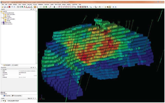
LEAD
| |
| Figure 35 | Plan view showing Pb mineralisation, drill holes and IK estimated block model |
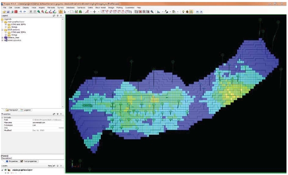
|
| Updated NI43-101 Technical Report on the Lomero-Poyatos Mine |
| 29 July 2011 |
| |
Figure 36 | Section view showing Pb mineralisation at the eastern extremity of the block model, drill holes and IK estimated block model |
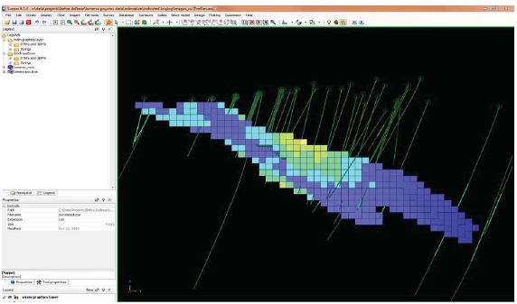
| |
Figure 37 | Inclined section looking towards the SW showing Pb mineralisation, drill holes and IK estimated block model |
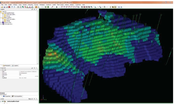
|
| Updated NI43-101 Technical Report on the Lomero-Poyatos Mine |
| 29 July 2011 |
ZINC
| |
| Figure 38 | Plan view showing Zn mineralisation, drill holes and IK estimated block model |
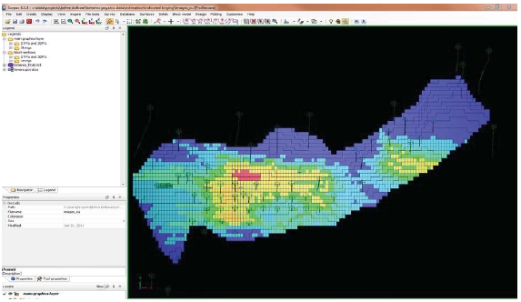
| |
| Figure 39 | Section view showing Zn mineralisation at the eastern extremity of the blockmodel, drill holes and IK estimated block model |
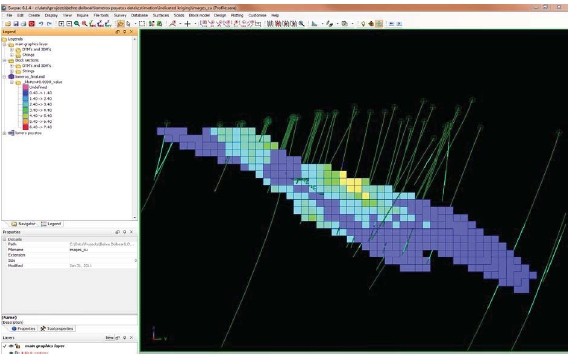
|
| Updated NI43-101 Technical Report on the Lomero-Poyatos Mine |
| 29 July 2011 |
| |
| Figure 40 | Inclined section looking towards the SW showing Zn mineralisation, drill holesand IK estimated block model |
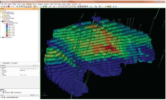
19.0 INTERPRETATION AND CONCLUSIONS
The Lomero-Poyatos deposit is a poly-metallic massive sulphide deposit. Based on the historical drill-hole data it was concluded (Gemcom, 2010) that the Lomero-Poyatos deposit contained an estimated geological open-pit Inferred Mineral Resource of 30.4 Mt averaging 2.31 g/t of gold, 46.56 g/t of silver, 0.67% copper, 0.67 % lead, 2.35 % zinc and 26.1% sulphur, accounting for the mined-out area, assuming an average SG of 3.3 and without application of any cut-off value.
Following consultation with Behre Dolbear and the application of potential underground mining constraints it was concluded (Gemcom, 2011) that the Lomero-Poyatos deposit contained an estimated geological underground Inferred Mineral Resource of 6.07 Mt at 4.25 g/t of gold and 88.74g/t of silver, after the application of a minimum drill-hole intersection of 2m at 1 g/t Au and accounting for the mined out area and assuming an average SG of 4.5.
Behre Dolbear carried out a preliminary valuation of the Lomero-poyatos deposit based on; published average global stock market valuations per ounce of in-situ gold resources; and value from a comparable acquisition transaction. Taking the average of these two estimates, assuming equal weightings for each, Behre Dolbear conclude that an appropriate current value for the Lomero-Poyatos project is$53.5 million.
| |
| 19.2 | DATA ADEQUACY AND RELIABILITY |
These estimates were based on assumptions made about the specific gravity of the main mineralised rock types and it is strongly recommended that studies of the specific gravity be undertaken before
|
| Updated NI43-101 Technical Report on the Lomero-Poyatos Mine |
| 29 July 2011 |
these Inferred Mineral Resources can be upgraded to Indicated and Measured Mineral Resource categories.
It is also recommended that additional drilling be carried out, including some duplicate drill holes twinning selected surveyed historical holes in order to cross-correlate the historical data with confirmatory data; also some additional drill holes to better define the physical extent of the solid at depth and along strike.
Further validation of the nature and distribution of the Au, Ag, Cu, Pb, Zn mineralisation is also required, in order that the Inferred Mineral Resources can be upgraded.
| |
| 19.3 | THE PROJECT OBJECTIVES |
The historical drilling and other test work carried out by CMR met its objective of identifying a potentially economic massive sulphide deposit and establishing the approximate grade and distribution of the associated Au, Ag, Cu, Pb, Zn mineralisation.
The validation work carried out by Behre Dolbear and the new block model and Mineral Resource Estimate prepared by Gemcom met the objective of confirming the reliability of the available historical data by identifying a potentially economic massive sulphide deposit and establishing the approximate grade and special distribution of the associated Au, Ag, Cu, Pb, Zn mineralisation.
20.0 RECOMMENDATIONS
Two phases of work are recommended.
Phase 1 – Drilling Programme, Metallurgical Testing and Scoping Study
A drilling programme comprising 20,000 metres of HQ drill core should be carried out, commencing between July and September 2011.
It is recommended that the drilling programme should consist of holes drilled at an inclination of 60° bearing 180° so as to provide true width intersections through the mineralised zone that dips 30° north (bearing 360°).
The Phase 1 drill holes should be spaced at about 50m intervals along ten (10) N-S section lines spaced 100m apart. The results of this drilling will provide a regular 50m x 100m drill spacing, that should be sufficient to upgrade the Mineral Resource estimates to the Indicated Resource category.
Phase 1 drilling programme at 50m intervals along N-S section lines 100m apart.
| | | |
| Depth of Intersection | Drill-hole length (m) | No. of Drill-holes | Total drilling (m) |
| 25 | 40 | 10 | 400 |
| 50 | 60 | 10 | 600 |
| 75 | 90 | 10 | 900 |
| 100 | 120 | 10 | 1200 |
| 150 | 175 | 10 | 1750 |
| 200 | 230 | 10 | 2300 |
| 250 | 289 | 10 | 2890 |
| TOTAL | | 70 | 10,040 |
The mineralised sections of drill-core need to be logged, cut and assayed and the data collated.
|
| Updated NI43-101 Technical Report on the Lomero-Poyatos Mine |
| 29 July 2011 |
The mineralised sections of the drill-core will provide feedstock for the scoping study metallurgical test work, requiring about 160 kg of core representing 30 metres of selected core intersections. The test work could start in late 2011 and should provide data for a pre-feasibility study which should take up to six months and be finished in 2012.
It is proposed that the scoping study will be carried out by a combined team of experts from Behre Dolbear and the University of Madrid, with SGS assisting with specialist mineralogy, chemical assays and gravity pre-concentration studies.
Phase 2 - Pre-feasibility Study (PFS )
Phase 2 will be contingent on the successful completion of and a positive result from the Phase 1 Scoping study. Phase 2 will be a standard PFS, which should be completed by the end of 2012.
The results of the Phase 1 drilling should be reviewed and then a similar pattern of in-fill drilling should be carried out along ten (10) in-fill section lines spaced 100m apart to provide a regular 50m x 50m drill spacing over a total surface area about 1000m E-W and 750m N-S, that should be sufficient to upgrade the Mineral Resource estimates to the Measured Resource category.
Phase 2 In-fill drilling programme at 50m intervals along N-S section lines 50m apart.
| | | |
| Depth of Intersection | Drill-hole length (m) | No. of Drill-holes | Total drilling (m) |
| 25 | 40 | 10 | 400 |
| 50 | 60 | 10 | 600 |
| 75 | 90 | 10 | 900 |
| 100 | 120 | 10 | 1200 |
| 150 | 175 | 10 | 1750 |
| 200 | 230 | 10 | 2300 |
| 250 | 289 | 10 | 2890 |
| TOTAL | | 70 | 10,040 |
The proposed budget (in Euros) for this programme of work is as follows:
Phase 1 to Scoping Study Stage
| | |
| | Drilling 10,000m of HQ core | €4 million |
| | Metallurgical and other test work | €1 million |
| | Environmental studies | €0.5 million |
| | Supervision and Reporting | €0.5 million |
| | Total Phase 1 | €6 million |
Phase 2 to Pre-Feasibility Study Stage
| | |
| | Additional drilling, 10,000m | €4 million |
| | Additional test work | €1 million |
| | Environmental Studies | €0.5 million |
| | Pre-feasibility Study and report | €1.5 million |
| | Total Phase 2 | €7 million |
|
| Updated NI43-101 Technical Report on the Lomero-Poyatos Mine |
| 29 July 2011 |
21.0 REFERENCES
Joint SGA IAGOD International Meeting Field trip B428 August - 3 September, 1999.
Cambridge Mineral Resources, 2002 Summary of recent metallurgical testwork on Lomero-Poyatos samples.
Cambridge Mineral Resources 2003 Electromagnetic survey and drilling confirms upside potential at Lomero-Poyatos. Press Release 24 July 2003.
Cambridge Mineral Resources 2006 The Geology of the Lomero-Poyatos VHMS Deposit, Iberian Pyrite Belt, Spain.
LiaMin Consulting The Study of Mineral Deposit Anatomy, an Essential Foundation for Deposit Evaluation and Exploration. 9th Biennial SGA Meeting Trinity College Dublin, 20th –23rd August 2007.
SRK Consulting 2002 A conceptual mining study of the Lomero-Poyatos polymetallic deposit, southwest Spain.
Wardell Armstrong International Ltd. 2007 The Lomero-Poyatos mine, southern Spain.
Gemcom 2010 Mineral Resource Estimation review and recommendation report for Behre Dolbear. Date: 17 December 2010. Gemcom Software Europe Ltd
Gemcom 2011 Mineral Resource Estimation final review and recommendation report for Behre Dolbear. Date: 17 March 2011. Gemcom Software Europe Ltd.
Tatsuo Tatsumi (editor) 1970 Volcanism and Ore Genesis. University of Tokio Press, Japan.
http://www.marketwire.com/press-release/Iberian-Minerals-Reports-Q3-Condestable-Operating-Results-Aguas-Tenidas-Hedging-Updates-TSX-VENTURE-IZN-1079973.htm
“Emerging Spanish Gold Producer” presentation, February 2011, Astur Gold Corporation.
|
| Updated NI43-101 Technical Report on the Lomero-Poyatos Mine |
| 29 July 2011 |
DATE AND SIGNATURE PAGE
The technical report must have a signature page at the end, signed in accordance with section 5.2 of the Instrument. The effective date of the technical report and date of signing must be on the signature page.
|
| Signed/s/ Richard Fletcher |
| For and on behalf of Behre Dolbear International Limited |
| Date 29thJuly 2011 |
|
| Updated NI43-101 Technical Report on the Lomero-Poyatos Mine |
| 29 July 2011 |
22.0 ADDITIONAL REQUIREMENTS FOR TECHNICAL REPORTS ONDEVELOPMENT PROPERTIES AND PRODUCTION PROPERTIES
This section is not relevant to this report on an exploration stage project.
|
| Updated NI43-101 Technical Report on the Lomero-Poyatos Mine |
| 29 July 2011 |
23.0 CERTIFICATE AND CONSENT
To Accompany the Report Entitled “Updated NI 43-101 Report on the Lomero-Poyatos Au-Cu-Pb-Zn Mine, in Andalusia, Spain”, dated 29th July 2011.
I, Richard James Fletcher, am a Senior Associate with the firm of Behre Dolbear International Limited with an office at: 3rd Floor, International House, Dover Place, Ashford, Kent, TN23 1HU, and do hereby certify that:-
1. I am a graduate of the University of Leicester with a Bachelor of Science honours degree in Geology and also have an MSc. in Exploration Geology from the University of North Queensland, Australia. I have practiced my profession continuously since 1966 and have more than 40 years experience of exploration and mining of gold, copper, lead and zinc deposits.
2. I am a Fellow in good standing of the Australasian Institute of Mining and Metallurgy and a Chartered Geologist, and a Member in good standing of the Institute of Materials, Minerals and Mining and a Chartered Engineer.
3. As of the date of this certificate, to the best of my knowledge, information and belief, this technical report contains all the scientific and technical information required to be disclosed to make this technical report not misleading.
4. I am a “qualified person” for the purposes of National Instrument 43-101 and am independent of Corporacion Recursos Iberia SL and Petaquilla Minerals Limited as defined in Section 1.4 of National Instrument 43-101 and I have not had any prior involvement with the property that is the subject of this report, nor have I received, nor do I expect to receive, any interest, directly or indirectly, in any of the property or securities of Corporacion Recursos Iberia SL or of Petaquilla Minerals Limited.
5. I have made a visit to the Lomero-Poyatos Mine area for one day in January 2011 and I have also reviewed technical data made available by Corporacion Recursos Iberia SL and I am responsible for all sections of this report.
6. I have read National Instrument 43-101 and Form 43-101F1 and this technical report has been prepared in compliance with National Instrument 43-101and Form 43-101F1.
7. I hereby consent to use of this report and my name in the preparation of a written disclosure for submission to any Provincial regulatory authority.
| |
| Signed /s/ R.J. Fletcher | Date 29thJuly 2011 |
| R. J. Fletcher M.Sc., B.Sc. FAusIMM, MIMMM, C.Geol, C.Eng.at Conwy, UK. | |
|
| Updated NI43-101 Technical Report on the Lomero-Poyatos Mine |
| 29 July 2011 |
24.0 CERTIFICATE AND CONSENT
To accompany the Report Entitled “Update NI 43-101 Report on the Lomero-Poyatos Au-Cu-Pb-Zn Mine, in Andalusia, Spain,” dated 29thJuly 2011.
I, William F. Jennings, am a Senior Associate with the firm of Behre Dolbear and Company (USA), with an office at 999 a8th Street, suite 1500, Denver, Colorado, 80202, USA and do hereby certify that –
1. I am a graduate of the University of Colorado with a Bachelor of Science in Civil Engineering and have a Master of Science in Geology from the University of Colorado. I have practiced my profession continuously since 1974 and have more than 35 years experience in the mineral industry.
2. I am a Registered Professional Engineer in the State of Colorado, USA.
3. I am a Certified Mineral Appraiser with the American Institute of Mineral Appraisers.
4. I am a member in good standing of the Society of Mining Engineers of the Society for Mining, Metallurgy, and Exploration, Inc.
5. As of the date of this certificate, to the best of my knowledge, information, and belief, this technical report contains all the scientific and technical information required to be disclosed to make this technical report not misleading.
6. I am a “qualified person” for the purpose of National Instrument 43-101 and am independent of Corporacion Recursos Iberia SL and Petaquilla Minerals Limited as defined in section 1.4 of National Instrument 43-101 and have not had any prior involvement with the property that is the subject of this report, nor have I received, nor do I expect to receive, any interest, directly or indirectly, in any of the properties or securities of Corporacion Recursos Iberia SL or of Petaquilla Minerals Limited.
7. I have read National Instrument 43-101 and Form 43-101F1 and this technical report has been prepared in compliance with National Instrument 43-101 and Form 43-101F1.
8. I hereby consent to use this report and my name in the preparation of a written disclosure for submission to any Provincial regulatory authority.
|
| Signed /s/ William F. Jennings |
| William F. Jennings P.E. C.MA. |
| Date July 29, 2011 at Denver, Colorado, USA |