Exhibit 99.1
Petaquilla Minerals Ltd
Technical Report on the
Palmilla Gold Project
Rio Belencillo Zone 1 Concession
Donoso District, Colón Province
Republic Of Panamá
Latitude 8° 54’ North, Longitude 80° 46’ West
Prepared for
Petaquilla Minerals, Ltd.
410-475 West Georgia Street
Vancouver, British Columbia
Canada V6B 4M9
11 December 2012
Prepared By:
Dr D. Brandt PhD, PrSciNat
Réjean Sirois BSc, PEng
Andrew Phillips MSc, FIMMM, CEng
Behre Dolbear & Company Limited
67 Yonge Street, Suite 1201
Toronto, Ontario M5E 1J8
A Member of the Behre Dolbear Group Inc.
© 2012, Behre Dolbear Group Inc. All Rights Reserved.
www.dolbear.com
|
| Technical Report on the Palmilla Gold Project |
| 11 December 2012 |
TABLE OF CONTENTS
| | | | |
| 1.0 | SUMMARY | | 1 |
| | 1.1 | GENERAL INFORMATION | 1 |
| | 1.2 | GEOLOGY AND MINERALIZATION | 1 |
| | 1.3 | STATUS OF EXPLORATION | 1 |
| | 1.4 | METALLURGICAL TEST WORK | 2 |
| | 1.5 | MINERAL RESOURCE ESTIMATE | 2 |
| | 1.6 | INTERPRETATION AND CONCLUSIONS | 2 |
| | 1.7 | RECOMMENDATIONS | 3 |
| 2.0 | INTRODUCTION | 3 |
| | 2.1 | ISSUER OF TECHNICAL REPORT | 3 |
| | 2.2 | TERMS OF REFERENCE | 4 |
| | 2.3 | MAIN SOURCES OF INFORMATION | 4 |
| | 2.4 | UNITS OF MEASUREMENT AND CURRENCY | 4 |
| | 2.5 | GLOSSARY | 5 |
| 3.0 | RELIANCE ON OTHER EXPERTS | 6 |
| | 3.1 | NI 43-101 REPORT PARTICIPANTS | 6 |
| | 3.2 | DISCLAIMER | 7 |
| 4.0 | PROPERTY DESCRIPTION AND LOCATION | 7 |
| | 4.1 | MINERAL PROPERTY DESCRIPTION | 7 |
| | 4.2 | MINERAL PROPERTY LOCATION | 10 |
| 5.0 | ACCESSIBILITY, CLIMATE, LOCAL RESOURCES, INFRASTRUCTURE AND | |
| | PHYSIOGRAPHY | 11 |
| | 5.1 | ACCESSIBILITY | 11 |
| | 5.2 | CLIMATE AND OPERATIONAL SEASON | 11 |
| | | 5.2.1 | Climate | 11 |
| | | 5.2.2 | Operational Season | 12 |
| | 5.3 | LOCAL RESOURCES AND VEGETATION | 12 |
| | 5.4 | LOCAL RESOURCES | 12 |
| | | 5.4.1 | Vegetation | 13 |
| | 5.5 | INFRASTRUCTURE | 13 |
| | 5.6 | PHYSIOGRAPHY | 14 |
| 6.0 | HISTORY | | 14 |
| | 6.1 | COLONIAL PRODUCTION HISTORY | 14 |
| | 6.2 | HISTORICAL EXPLORATION | 14 |
| | 6.3 | HISTORICAL RESOURCE ESTIMATES | 15 |
| | 6.4 | HISTORICAL MINING & PRODUCTION | 15 |
| 7.0 | GEOLOGICAL SETTING AND MINERALIZATION | 15 |
| | 7.1 | REGIONAL GEOLOGY | 15 |
| | 7.2 | LOCAL GEOLOGY | 18 |
| | 7.3 | RIO BELENCILLO CONCESSION PROPERTY GEOLOGY | 19 |
| 8.0 | DEPOSIT TYPES | 24 |
| 9.0 | EXPLORATION | 26 |
| | 9.1 | ADRIAN RESOURCES EXPLORATION ACTIVITIES AND RESULTS | 26 |
| | 9.2 | PETAQUILLA MINERALS EXPLORATION PROGRAMME | 29 |
| | | 9.2.1 | Petaquilla Minerals Surface Exploration Programme | 29 |
| | | 9.2.2 | Petaquilla Minerals Drilling Campaign | 30 |
| 10.0 | DRILLING | | 31 |
| | 10.1 | PML 2011-2012 DRILLING PROGRAM | 31 |
| | 10.2 | TWINNED HOLE DRILL PROGRAM | 33 |
| | 10.3 | DRILL HOLE SURVEYING | 41 |
| | 10.4 | CORE RECOVERY | 41 |
|
| Technical Report on the Palmilla Gold Project |
| 11 December 2012 |
| | | | |
| 11.0 | SAMPLE PREPARATION, ANALYSES AND SECURITY | 43 |
| | 11.1 | SAMPLE PREPARATION & ANALYSIS | 43 |
| | 11.2 | PML SAMPLE PREPARATION PROCEDURES | 44 |
| | 11.3 | QUALITY CONTROL (QC) PROCEDURES | 45 |
| | 11.4 | SAMPLE SECURITY | 46 |
| | 11.5 | QUALITY ASSURANCE (QA) PROCEDURES - ALS CHEMEX | |
| | | LABORATORIES | 47 |
| 12.0 | DATA VERIFICATION | 47 |
| | 12.1 | SITE VISIT - BDI | 47 |
| | 12.2 | SITE VISIT - G MINING SERVICES INC | 48 |
| | 12.3 | QA/QC PROCESS | 48 |
| | 12.4 | ADRIAN RESOURCES TRENCH QA/QC DATA | 49 |
| | | 12.4.1 | Adrian Resources 1996 Trench Blank Sample Values | 50 |
| | | 12.4.2 | Adrian Resources 1996 Trench Repeat Samples | 50 |
| | | 12.4.3 | Adrian Resources 1996 Trench Standard Sample Values | 51 |
| | 12.5 | PML DATA VERIFICATION | 51 |
| | 12.6 | PML DATA HANDLING VERIFICATION | 52 |
| | 12.7 | RESULTS OF GMS SAMPLING CHECKS | 53 |
| 13.0 | MINERAL PROCESSING AND METALLURGICAL TESTING | 55 |
| 14.0 | MINERAL RESOURCE ESTIMATES | 56 |
| | 14.1 | INTRODUCTION | 56 |
| | 14.2 | MINERAL RESOURCE | 56 |
| | 14.3 | SUMMARY OF DATA | 56 |
| | 14.4 | RESOURCE MODELLING & ESTIMATION METHODOLOGY | 56 |
| | 14.4.1.1Database | 56 |
| | 14.4.1.2Resource Modeling | 59 |
| | 14.4.1.3Assay Sample Grade Statistics | 61 |
| | | 14.4.2 | Grade Capping | 64 |
| | | 14.4.3 | Variography | 65 |
| | | 14.4.4 | Block Model and Grade Estimation | 66 |
| | 14.4.4.1Block Model Definition | 66 |
| | 14.4.4.2Grade Estimation | 66 |
| | 14.4.4.3Model Validation | 67 |
| | | 14.4.5 | Resource Classification | 68 |
| | | 14.4.6 | Mineral Resource Estimates | 68 |
| | 14.4.6.1Economic Discussion and Cut-off Grade | 69 |
| | 14.4.6.2Bulk Density | 70 |
| | | 14.4.7 | Whittle Optimisation | 71 |
| 15.0 | ADJACENT PROPERTIES | 72 |
| 16.0 | OTHER RELEVANT DATA AND INFORMATION | 76 |
| | 16.1 | SEISMIC ACTIVITY | 76 |
| 17.0 | INTERPRETATION AND CONCLUSIONS | 76 |
| | 17.1 | INTERPRETATION | 76 |
| | 17.2 | PALMILLA TECHNICAL REPORT CONCLUSIONS | 76 |
| 18.0 | RECOMMENDATIONS: | 77 |
| 19.0 | REFERENCES | | 78 |
| 20.0 | DATE AND SIGNATURE PAGES | 80 |
LIST OF APPENDICES
APPENDIX A - OREAS Certified Reference Material Certificates
|
| Technical Report on the Palmilla Gold Project |
| 11 December 2012 |
LIST OF TABLES
| | |
| Table 1 | 2012 Palmilla Whittle Shell Inferred Resource Estimate at 0.1 g/t Gold Cut-off | 2 |
| Table 2 | Rio Belencillo Concession Zone 1 Beacon Co-ordinates | 8 |
| Table 3 | Rio Belencillo Concession Zone 2 Beacon Co-ordinates | 8 |
| Table 4 | Summary Monthly Climatic Data for Colón | 12 |
| Table 5 | Adrian Resources 1996 Palmilla Trenching Data | 26 |
| Table 6 | Boreholes Drilled by Adrian Resources in 1994 | 27 |
| Table 7 | Boreholes Drilled by Adrian Resources in 1996 | 28 |
| Table 8 | PML 2012 Palmilla Trenching Data | 30 |
| Table 9 | Palmilla Proposed 2012 Drilling Program | 30 |
| Table 10 | PML 2012 Drill Program Progress To Date | 32 |
| Table 11 | Palmilla Project - Twinned Vertical Hole Data | 33 |
| Table 12 | PML 2012 Drilling Program Core Recovery and RQD Data | 41 |
| Table 13 | PML QA/QC Sample Frequency | 45 |
| Table 14 | Ore Research CRM Grade Statistics | 46 |
| Table 15 | Adrian Resources Trench Sampling QA/QC Data | 50 |
| Table 16 | QA/QC Summary Results for Palmilla Gold Project | 53 |
| Table 17 | Rock Codes in the Palmilla Gold Project | 58 |
| Table 18 | Summary of Metal Capping Levels Applied to Each Resource Domain | 64 |
| Table 19 | Basic Statistics for Raw-assays from Each Resource Domain | 65 |
| Table 20 | Basic Statistics for Capped 5 m Composites from Each Resource Domain | 65 |
| Table 21 | Variograms Parameters for All Resource Domains Grade Interpolation | 65 |
| Table 22 | Search Parameters for All Resource Domains Grade Interpolation | 66 |
| Table 23 | Palmilla Gold Project Block Model Parameters | 66 |
| Table 24 | Resource Estimation Parameters | 66 |
| Table 25 | Inferred Mineral Resources Within Whittle Shell Design (As of October 26, 2012). | 69 |
| Table 26 | Inferred Mineral Resources Within Whittle Shell Design | 70 |
| Table 27 | Core Specific Gravity Database | 71 |
| Table 28 | NSR Calculation Assumptions | 72 |
| Table 29 | History of Concession Exploration and Ownership in the Petaquilla Area | 73 |
LIST OF FIGURES
| | |
| Figure 1 | Location of Palmilla Project in Panamá | 4 |
| Figure 2 | Rio Belencillo Mineral Concession - Zones 1 and 2 | 9 |
| Figure 3 | Belencillo Concession and Regional Deposit Locations | 10 |
| Figure 4 | Tectonic Map of Central America | 16 |
| Figure 5 | Regional Geology Map of the Palmilla Project Area | 17 |
| Figure 6 | Epithermal Gold Deposits in Central America | 18 |
| Figure 7 | Local Structural Geology Map | 20 |
| Figure 8 | Palmilla Deposit Geology and Drilling Plan | 21 |
| Figure 9 | Geology and Drill Section 450 NW | 22 |
| Figure 10 | Epithermal Mineral Deposit Schematic | 24 |
| Figure 11 | Corbett Conceptual Mineralisation Model | 25 |
| Figure 12 | Palmilla Deposit Geophysical Magnetic Survey Map | 29 |
| Figure 13 | Log Graph Comparing Twinned Holes BE94-001 and PLDH-003 | 34 |
| Figure 14 | Log Graph Comparing Twinned Holes BE94-004 and PLDH-005 | 35 |
| Figure 15 | Log Graph Comparing Twinned Holes BE94-003 and PLDH-001 | 36 |
| Figure 16 | Log Graph Comparing Twinned Holes BE94-004 and PLDH-005 | 37 |
| Figure 17 | Log Graph Comparing Twinned Holes BE94-005 and PLDH-011 | 38 |
| Figure 18 | Log Graph Comparing Twinned Holes BE94-007 and PLDH-004 | 39 |
|
| Technical Report on the Palmilla Gold Project |
| 11 December 2012 |
| | |
| Figure 19 | Log Graph Comparing Twinned Holes BE94-004 and PLDH-005 | 40 |
| Figure 20 | Palmilla Project QA/QC Process Flow Sheet | 49 |
| Figure 21 | Q-Q Diagram of Adrian Resources Trench Repeat Assays | 51 |
| Figure 22 | Paired Palmilla Drill Sample Bias Check | 54 |
| Figure 23 | Palmilla 3-D Boreholes Location Schematic | 57 |
| Figure 24 | 3-D Schematic of Wireframes Supplied by PML | 58 |
| Figure 25 | 3-D Schematic of Leapfrog Shell for Gold (Threshold Value of 0.1 g/t Au) | 59 |
| Figure 26 | 3-D Schematic of Leapfrog Shell for Silver (Threshold Value of 0.3 g/t Ag) | 60 |
| Figure 27 | 3-D Schematic of Leapfrog Shell for Copper (Threshold Value of 0.1 % Cu) | 60 |
| Figure 28 | Histogram and Cumulative Frequency Plot for Gold Raw Assay Values | 61 |
| Figure 29 | Histogram and Cumulative Frequency Plot for Silver Raw Assay Values] | 62 |
| Figure 30 | Histogram and Cumulative Frequency Plot for Copper Raw Assay Values | 63 |
| Figure 31 | Cross-Section 525,475E Comparing Blocks Populated with Gold-Grades | 67 |
| Figure 32 | Cross-Section 525,475E Comparing Blocks Populated with Silver-Grades | 67 |
| Figure 33 | Cross-Section 525,475E Comparing Blocks Populated with Copper-Grades | 68 |
| Figure 34 | Specific Gravity Histogram | 71 |
|
| Technical Report on the Palmilla Gold Project |
| 11 December 2012 |
1.0 SUMMARY
Petaquilla Minerals Limited’s Palmilla Gold Project is located in Zone 1 of the Belencillo Concession, Donoso District, Colón Province in the Republic of Panamá (see Figures 1 & 2). The principal mineralisation is primarily of the porphyry copper type with an epithermal gold overprint and is centered on Latitude 8° 54’ North and Longitude 80° 46’ West.
The exploration on this 18 km2property is being carried out by Petaquilla Gold SA (“PMSA”), a 100 % owned subsidiary of Petaquilla Minerals Limited. The concession is registered with the Directorate of Mineral Resources as ARSA-EXPL Number 99-50, an exploration concession for gold and other metals registered in PMSA’s name.
The Palmilla Gold Project is located in the northwestern portion of the Petaquilla Mineral District in Panamá, adjacent to the developing Petaquilla porphyry copper deposit of Cobre de Panamá, its associated port development at Punta Rincon and Petaquilla’s own operational Molejón gold mine.
| |
| 1.2 | GEOLOGY AND MINERALIZATION |
The Palmilla Gold Project is typical of a porphyry style Copper-Molybdenum-Gold (“Cu-Mo-Au”) mineralization with possible precious metal enrichment and/or overprinting by structurally controlled epithermal style gold mineralization. This style of mineralisation is relatively common in the Central Panamá area.
Potential economic grade Au and Cu mineralisations are coincident and, based on current information, are confined to the volcanic-volcaniclastic lithostratigraphic sequences adjacent to a partially un-roofed, microgranodioritic apex of a hidden granodioritic pluton. A later stage, possibly structurally emplaced felsic intrusion could be interpreted as being the heat source supplying the hydrothermal fluids and volatiles necessary to drive the convection system which resulted in the epithermal type gold mineralization.
This possible mineralizing and alteration event subsequently obliterated all primary structure in the volcanic-volcaniclastic sequences. Pervasive hydrothermal silicification and propyllitic alteration, together with a possibly contemporaneous and/or subsequent phase of retrograde metamorphism probably contributed more to the gold mineralization than to the copper mineralization.
The deposit was originally discovered in the mid-1960’s as one of several geochemical anomalies by a UNDP (United Nations Developmental Program) exploration program focused on mineral exploration and development in Central Panamá.
Gold-copper-molybdenum geochemical anomalies led to the subsequent discovery and current development of the Cobre Panamá Copper Deposit by Inmet Mining Corp (TSX Code: IMN) of Toronto, Canada and the operating Molejón Gold Mine by Petaquilla Gold S.A., a 100 % subsidiary of Petaquilla Minerals Limited (“PML”) (TSX Code. PTQ).
A decision to carry out renewed trenching and drill exploration at Palmilla in late 2011 was based on an in-house, non-43-101 compliant resource estimate following a revised geological interpretation of the Adrian Resources Limited’s historical 1994 and 1996 drillhole and assay dataset.
|
| Technical Report on the Palmilla Gold Project |
| 11 December 2012 |
PML are utilizing HQ size (63.5 mm dia) core and have drilled 37 out of a total of 42 planned holes to date (05/12/2012) for a total of nearly 9,400 m. Included in this drilling is the twinning of eight of the 23 BTW size (42 mm dia) cored holes drilled in the 1994-1996 drill program by Adrian Resources. The core is helicoptered directly off the drill pad and flown to PML’s core facility at the Molejón mine. Here it is measured, logged, halved, sampled, crushed, pulverised and despatched in 200-300 gram sub-samples to ALS Minerals in Vancouver for assay and analysis.
The project is currently an intermediate stage exploration project with more than 4,900 m of surface trenching and 13,136 m of cored drilling in 60 holes (to early December, 2012). The deposit was initially explored in the mid-1990s and subsequently since late 2011. The exploration has outlined coincident copper-gold-molybdenum soil geochemical and magnetic anomalies on the Palmilla deposit and several smaller satellites. Exploration by trenching and drilling a further 5 holes is continuing, after which the results of the program will be evaluated.
This exploration program will be completed early in the new year. No mining development has taken place to date.
| |
| 1.4 | METALLURGICAL TEST WORK |
Preliminary bottle rolling cyanidation tests have been carried out by on composited core samples from the Palmilla deposit. These initial metallurgical tests show that:
Gold recoveries increase with finer grinds and longer retention times,
High gold recoveries (~82-99 %) in oxidised low copper content material fall off in more copper- rich sulphidic material (~52-73 %) due to increasing copper recovery (~12 versus 55 %) coupled with increased cyanide and lime consumption, and
No (<1 ppm) arsenic, antimony, cadmium or lead appear to be present in the metallurgical samples analysed to date.
| |
| 1.5 | MINERAL RESOURCE ESTIMATE |
The resource estimation using Ordinary Kriging based on the available assay and analytical results from the first 21 holes drilled in 2012 and all 1994 and 1996 holes is classified as an Inferred Mineral Resource. Mineral resources that are not mineral reserves do not have demonstrated economic viability (CIM, 2010). The effective date of this resource estimate is October 26, 2012.
| |
| Table 1 | 2012 Palmilla Whittle Shell Inferred Resource Estimate at 0.1 g/t Gold Cut-off |
| | | | |
Tonnes In
Whittle Shell | Contained Gold | Contained Copper | Contained Silver | Gold Equivalent |
| Grade / Ounces | Grade / Pounds | Grade / Ounces | Ounces |
| 19,725,000 | 0.50 g/t / 318,500 | 0.18 % / 80.368 M | 0.54 g/t / 345,600 | 502,800 |
Note:Gold equivalent is calculated at Gold US $ 1,600 / oz, Copper US $ 3.54 / lb and Silver US $ 30 / ounce. Resource based on drill values only. Resource estimate effective date is October 26, 2012.
| |
| 1.6 | INTERPRETATION AND CONCLUSIONS |
The Palmilla deposit is a weakly mineralised copper porphyry deposit with a telescoped epithermal gold deposit overprint associated with andesitic lavas and volcaniclastics intruded by cupriferous granodioritic rocks. It is marked by coincident Au-Cu-Mo geochemical and geophysical magnetic target anomalies. A further three subsidiary satellite mineral showings are present at nearby Trueno, Quebrada Dino close to the eastern concession boundary and (off-trend) to the south at Relampago, none of which three have been adequately explored to date.
|
| Technical Report on the Palmilla Gold Project |
| 11 December 2012 |
Drilling to date has disclosed an Inferred Mineral Resource of 19.7 Mt of relatively low grade gold-copper mineralisation based on the initial Adrian Resources drilling and the 21 recent holes for which assay and analytical data are available. The assay and analytical results of a further 21 holes and surface trenching are awaited.
The economic potential of the main Palmilla Au-Cu deposit should be investigated following the completion of the current trenching and 42 hole drilling program by integrating the prior Adrian Resources work into the study.
This investigation should include the re-estimation of the Palmilla deposits mineral resources to include the surface trench values from both Adrian Resources’ historic phased exploration campaign and PML’s own recent work. This reappraisal should be carried out with particular regard to the potential for the mining of an open pit oxide-gold deposit. Any Preliminary Economic Assessment (PEA) will be facilitated by PML having access to its own operations at Molejón.
The mineralization at Trueno has now been intersected by five boreholes and a focussed trenching and drill program could be carried out if a reappraisal of results warrants it.
Additional work should be carried out on the mineralized intrusive at Quebrada Dino and also at the third, off-trend satellite mineralization at Relampago.
2.0 INTRODUCTION
| |
| 2.1 | ISSUER OF TECHNICAL REPORT |
This technical report was prepared for Petaquilla Minerals Limited (“PML” or the “Company”), a Vancouver based, TSX-Listed Public Company (TSX Code: PTQ) which is currently operating its 100 %-owned Molejón open pit gold mine and gold processing plant located in the Donoso District, Colón Province, Republic of Panamá. The exploration operations are being carried out by Petaquilla Gold SA, a 100 % owned subsidiary of PML.
PML holds the exploration rights to the two-part Rio Belencillo Concession which covers 36 km2on the northern coast of Panamá (Figure 1) through its wholly-owned subsidiary Petaquilla Minerals SA (“PMSA”). This concession lies on the northwest extremity of the Petaquilla Concessions (see Figure 2) where PML owns the rights of exploration, exploitation, processing and commercialization of gold mineralization. The Petaquilla mining concessions were granted by the Panamanian Government through the enactment of Contract No. 9 of February 26, 1997 or the “Ley Petaquilla”.
The rights pertaining to gold in the Petaquilla Concessions are based on an inter-company agreement between Teck-Cominco Ltd (Teck), Inmet Mining Corp (Inmet) and Petaquilla Minerals Ltd, whereby PML may obtain 100% of the gold production in the Petaquilla Concessions, including the Molejón Gold Mine, the Botija Abajo gold deposit or any other deposit(s) in which that the gold content is equivalent to or exceeds 51% of the contained mineral inventory (i.e. gold majority value deposit(s)) discovered on the Petaquilla Concession.
|
| Technical Report on the Palmilla Gold Project |
| 11 December 2012 |
| |
| Figure 1 | Location of Palmilla Project in Panamá |

Behre Dolbear International Limited (“BDI”) was invited by Petaquilla Minerals Ltd., to visit and review PML’s 2012 exploration activities at Palmilla. G Mining Services Inc (“GMS”) were invited to undertake a preliminary estimate of mineral resources present in the Palmilla Gold Deposit following PML’s 2012 exploration program and the earlier work by Adrian Resources.
This report presents its findings as an initial qualifying report on the Palmilla Gold Project, Belencillo Concession, Donoso District in the Republic of Panamá. It has been prepared under the requirements of Canadian National Instrument 43-101 (NI 43-101) for use by Petaquilla Minerals Limited.
| |
| 2.3 | MAIN SOURCES OF INFORMATION |
In preparation of this report, the authors have relied on information obtained through a review of published papers, studies, public and private documents, reports and data provided by Petaquilla Minerals Ltd and site visits to the Palmilla gold deposit. All sources of information for this report are referenced in Item 19. Several of these reports are based on work done by several companies commissioned by Petaquilla Minerals Ltd or/and Joint Venture partners. The authors have relied on these records and maps with respect to Palmilla Property ownership, title and land status.
| |
| 2.4 | UNITS OF MEASUREMENT AND CURRENCY |
The metric system is used throughout this report and the currency used is the United States dollar (US$) unless specifically stated otherwise.
|
| Technical Report on the Palmilla Gold Project |
| 11 December 2012 |
| |
| ~ | About, approximately |
| % | percent, parts per hundred. Also 1 % = 10,000 ppm by weight |
| ° | degree angular measurement |
| 3-D | Three Dimensional [view] |
| °C | degree Celsius |
| A | annum (year) |
| Ag | Chemical symbol for Silver - after the Latin “Argentum” |
| As | Chemical symbol for Arsenic - after the Greek “Arsenikon” |
| Au | Chemical symbol for Gold - after the Latin “Aurum” |
| BTW | Diamond drill core of nominal 42 mm diameter |
| Cd | Chemical symbol for Cadmium |
| CDN $M | million Canadian Dollars |
| CDN $/t | Canadian Dollars per tonne |
| cm | centimetre |
| CRM | Certified Reference Material, assay or analytical standard of certified grade |
| Cu | Chemical symbol for Copper - after the Latin “Cuprum” |
| dia | diameter |
| DTM | Digital Terrain Model |
| EoH | End of Hole (Final bore hole depth measurement) |
| Fe | Chemical symbol for Iron - after the Latin “Ferrum” |
| g | grams |
| g/cm3 | grams per cubic centimetre |
| g/m3 | grams per cubic meter |
| g/t | grams per metric tonne (also 1 ppm by weight) |
| h | hour(s) |
| ha | hectare (10,000 square meters) |
| Hg | Chemical symbol for Mercury after the Latin “Hydragyrum” or ‘liquid silver’ |
| HQ | Diamond drill core of nominal 63.5 mm diameter |
| IDW | Inverse Distance Weighting method of resource estimation |
| kg | kilogram(s). A kilogram weighs 32.15074 troy ounces |
| km | kilometres |
| km2 | square kilometre(s), 1,000,000 square metres |
| k oz | thousand ounces |
| M | million |
| m3 | cubic meters |
| m | meter |
| Ma | Million years (Radiometric geological ages) |
| masl | meters above sea level |
| µm | micron (10-6 metres or 1 millionth of a metre) |
| mm | millimetres |
| mm/a | millimetres (of rain) per annum |
| Mo | Chemical symbol for Molybdenum - after the Greek “Molybdos” |
| Mt | million tonnes |
| Mt/yr | million tonnes per year |
| n.a. | Not Available |
| NA | Not Applicable |
| NiR | Not in Reserve |
| NQ | Diamond drill core of nominal 47.6 mm diameter |
| OK | Ordinary Kriging method of resource estimation |
| P80 | 80 % plus of a ground sample passing through a stated mesh (grind) size |
| Pounds/lbs | Imperial measure of weight (~454 grams or ~2.2 lbs per kilogram) |
|
| Technical Report on the Palmilla Gold Project |
| 11 December 2012 |
| |
| ppb | parts per billion (1,000 ppm) |
| ppm | parts per million (also 1 g/t and 10,000 ppm = 1.00 %) |
| QA | Quality Assurance of sampling procedures |
| QC | Quality Control checks on laboratory [metal] grades |
| QP | Qualified Person, as per NI 43-101 |
| RQD | Rock Quality Designation. Percentage of +10cm long core in a drill run/hole |
| Sb | Chemical symbol for Antimony - after the Latin “Stibium” |
| SG | Specific Gravity |
| t | tonne of 1,000 kg |
| t/h /d /m /a | tonnes per hour /day /month /annum (year) |
| t/a | tonnes per year |
| tpd | tonnes (metric) per day |
| Troy ounce | 31.10348 grams |
| US $M | million US Dollars |
| US $/t | Dollars per tonne |
| wt % | weight percent |
3.0 RELIANCE ON OTHER EXPERTS
| |
| 3.1 | NI 43-101 REPORT PARTICIPANTS |
The authors conducted an independent technical review of Petaquilla Minerals Limited’s Palmilla gold project in the Donoso District, Colón Province, Republic of Panamá. Two site visits were made to the property during late 2012 by:
Dr Dion Brandt, PrSciNat on geological matters; he visited the property on November 26 to 29, 2012.
Réjean Sirois, PEng on mineral resource matters; he visited the property on December 4 to 6, 2012.
The following author, Andrew Phillips, CEng, also participated in the collation and analysis of information and overall development of the present document, but did not make a site visit.
The two site-visit authors reviewed technical data, reports, and studies as well as information provided by Petaquilla Minerals Limited, inspected the Belencillo mineral concession on the ground and by air and visited and inspected the core handling, core logging and sampling infrastructure at the Molejón mine and visited the Santa Ana Exploration Office in Penonomé, Coclé Province, Panamá. They also reviewed technical data in databases whose content had been obtained from the Palmilla property by Petaquilla Minerals Limited and others during their prior tenure of the concession.
Dion Brandt, PrSciNat, a geologist, assisted with the field review and visited the property between November 26 to 29, 2012. He visited the sample preparation facility on the Molejón Gold Mine Project Site that was processing the Palmilla Drill Core Samples in order to adjudicate on the QA/QC and security protocol in place for the Palmilla 2012 drill core samples. He had detailed discussions with the Exploration and Site Geologist and Logging Geologist at the Palmilla Camp site and he also visited an active drill site at Palmilla Project, on Zone 1 of the Rio Belencillo Concession. He is responsible for sourcing information generally and for procedural investigations in Items 11 and 12 and Items 12.1 and Item 12.5 in particular.
Réjean Sirois, PEng, a geological engineer, essentially followed the same visit profile as Dr Brandt. He visited the property between December 4 and 6, 2012. While on site he carried out due diligence on the sampling methodology, drilling data and QA/QC checks on the assays and analytical data upon
|
| Technical Report on the Palmilla Gold Project |
| 11 December 2012 |
which GMS’ initial Inferred Mineral Resource estimate is based. He is responsible for Items 10.2 (Log Graphics and Comments), portions of Items 11 and 12, including Item 12.2, Item 12.5 and Item 12.7 and Item 14 in its entirety.
Andrew Phillips, CEng, a geologist has also reviewed technical data, reports, and studies as well as information provided by Petaquilla Minerals Ltd. and other historical data (i.e. Adrian Resources Limited). He was lead author, except where stated, and is responsible for collation of data sourced by Dr Brand and Mr Sirois, provision of graphics, including Items 1 through 9, most of Item 10, Item 13 and Items 15 through 18. He specifically carried out data analysis in Items 10.4 and 12.5.
The reviews were conducted on a reasonableness basis and it has been noted in this report where provided information engendered questions. Except for these noted instances, the authors have relied upon the information provided as being accurate and suitable for use in this report and they believe that the report’s conclusions and recommendations are valid and appropriate considering the status of the project and the purpose for which the report has been prepared.
The Authors have reviewed reports and analyzed data obtained from PML, published literature and company reports on the Palmilla Gold Project, The Belencillo Concession and adjacent and similar properties in Panamá. These sources of data contained information on the geology, mineralization, and exploration activities in the adjacent areas to the southwest of the Palmilla gold deposit. Work on the nearby Molejón Gold Mine operated by PML (Archibald et al, 2012) and on the nearby Botija Abajo Deposit (Cameron et al, 2012) are described in recent 43-101 reports. Other principal reports, papers and documentation used in this report are referenced in Item 19.
The authors have not conducted any due diligence review of the legal status, land tenure or concession information on the Belencillo Concession. Further, the authors have not carried out any due diligence or review of the agreements between Teck, Inmet and PML with respect to the Petaquilla Concessions and in particular the Palmilla Project area within the Belencillo Concession. Finally, the authors have not carried out any check sampling in the field, on borehole core or of other samples held at PML’s Molejón sampling facility.
4.0 PROPERTY DESCRIPTION AND LOCATION
| |
| 4.1 | MINERAL PROPERTY DESCRIPTION |
The Rio Belencillo Concession dates from the original ground holdings of Adrian Resources.
The concession is registered with the Directorate of Mineral Resources as ARSA-EXPL Number 99-50, an exploration concession for gold and other metals in the name of Petaquilla Minerals S.A. (“PMSA”). The concession was granted to PMSA on the September 14, 1999.
There had been a prior 50 / 50 Joint Venture (“JV”) finance agreement between Adrian Resources (as operator) and Madison Enterprises (Latin Americas) S.A which came into effect on August 10, 1993.
The Rio Belencillo Concession originally was an unitary concession that covered an area of 234 square kilometres (km2) bordering the Caribbean Sea (see Figure 2) and it was elongated in a north-south direction with a southern “L-shaped” extension off to the east.
|
| Technical Report on the Palmilla Gold Project |
| 11 December 2012 |
It was agreed that the concession would be reduced in size to 36 km2when the JV agreement between Adrian Resources and Madison was varied to 66.67 / 33.33 respective JV shares on January 18, 1999 (Stewart, 1999). The concession was split into two zones of equal 18 km2size.
This reduction in size and split into two zones was formalised by the Minerals Resources Directorate through Government Notice (‘Resolution’) Number 2007-24 on March 1, 2007 published in the Government Gazette. This confirms that the concession is eligible under the provisions of the Mineral Resources Code, for the exploration of metallic minerals (gold and others) in two zones with a total area of 3,600 hectares located in the districts of San Jose del General and Coclé del Norte, District of Donoso, Province of Colon, Republic of Panamá.
According to the Panamanian Mineral Resources Code, the holder of an exploration permit has the right to apply for a mining concession over the area for which the exploration concession is held.
The Palmilla gold deposit, a porphyry copper deposit with telescoped low sulphidation gold deposit overtones, lies in Zone 1 of the Rio Belencillo Concession. Its corner beacon co-ordinates, based on the Transverse Mercator projection (UTM Zone 17N) using the NAD 1927 Datum, are given in Table 2 and it covers an area of 18 km2(6 x 3 km), elongated in a north-south orientation.
The centre of the Palmilla Gold deposit is located in Zone 1 of the Rio Belencillo Concession at Latitude 8° 54’ 11” North and Longitude 80° 46’ 06” West.
| |
| Table 2 | Rio Belencillo Concession Zone 1 Beacon Co-ordinates |
| | | | |
| Beacon
ID | Easting
M | Northing
M | |
| 1 | 524,017.512 | 986,991.419 | |
| 2 | 527,017.512 | 986,991.419 | |
| 3 | 527,017.512 | 984,991.419 | |
| 4 | 527,017.512 | 980,991.419 | |
| 5 | 524,017.512 | 980,991.419 | |
The second area comprising the current Belencillo Concession (Zone 2) lies to the southeast of Zone 1 and is contiguous with the southern boundary of the Petaquilla Concession (Figure 2). Its UTM co-ordinates (Zone 17 N, NAD 27 Datum) are given in Table 3. It also covers an area of 18 km2(6 x 3 km), this time elongated in an east - west orientation.
| |
| Table 3 | Rio Belencillo Concession Zone 2 Beacon Co-ordinates |
| | | | |
| Beacon
ID | Easting
m | Northing
M | |
| 1 | 529,017.512 | 973,991.419 | |
| 2 | 535,017.512 | 973,991.419 | |
| 3 | 535,017.512 | 970,991.419 | |
| 4 | 529,017.512 | 970,991.419 | |
No due diligence was conducted on Zone 2 of the Rio Belencillo Concession and only Zone 1 of the Rio Belencillo Concession is discussed in this report.
|
| Technical Report on the Palmilla Gold Project |
| 11 December 2012 |
| |
| Figure 2 | Rio Belencillo Mineral Concession - Zones 1 and 2 |
(Annotated After Adrian Resources, 1999)
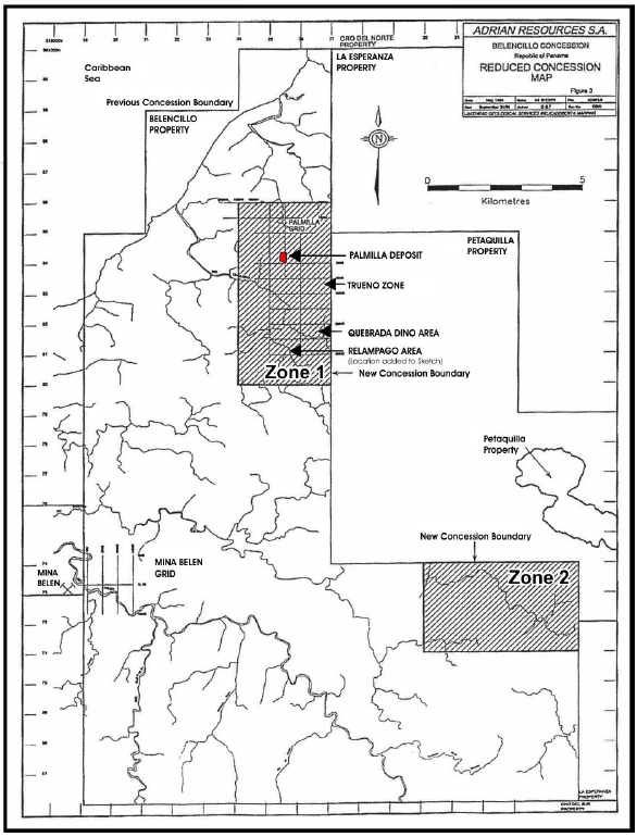
The locations of subsidiary centres of gold-copper mineralisation in Zone 1 of the Rio Belencillo Concession are shown here in Figure 2 for clarity.
|
| Technical Report on the Palmilla Gold Project |
| 11 December 2012 |
| |
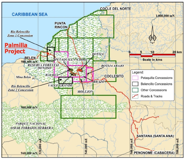
| 4.2 | MINERAL PROPERTY LOCATION |
The Rio Belencillo Zone 1 Concession property lies approximately 125 kilometres (km) west of Panamá City predominantly within the Donoso District of Colón Province in the Republic of Panamá and is centered at Latitude 8° 54’ 11” North, Longitude 80° 46’ 06” West.
It lies in the northern foothills of the central mountainous spine of Panamá, within the Donoso Forrest Reserve. It falls on 1:250,000 Map Sheet NC 17-15 Panamá.
Its relationship to the other mineral concessions and towns in the area is shown in Figure 3. In particular, the locations of the mineral deposits in the Petaquilla Concession are shown, namely PML’s Molejón and Botija Abajo Gold Deposits and the developing major Cobre Panamá deposit with its four open pit sections; Colina, Balboa, Valle Grande and Botija.
| |
| Figure 3 | Belencillo Concession and Regional Deposit Locations |
| | (After Petaquilla Minerals Limited, 2012) |
|
| Technical Report on the Palmilla Gold Project |
| 11 December 2012 |
5.0 ACCESSIBILITY, CLIMATE, LOCAL RESOURCES, INFRASTRUCTURE ANDPHYSIOGRAPHY
The Palmilla deposit is located in the Donoso District of Colón Province in the Republic of Panamá. It is about 125 km due west of Panamá City and about 60 km northwest of the city of Penonomé (Figures 1 & 3). Access to the general area from Panamá City, is south-westwards along the Pan-American Highway to km 149.7 at the town of Penonomé, then 13 km by paved road to the northwest to La Pintada, followed by 41 km on a well-maintained gravel road constructed in 2006 to the Molejón Mine. The road passes through La Pintada, a town of about 5,000 people and the village of Coclesito, which is the closest settlement of any size close to the project area, approximately 28 km to the southeast of the Palmilla project area. There is an airfield at Coclesito but flight operations are hampered by the frequent, thick cloud cover and rain.
The Palmilla area is inaccessible by road and at present, all exploration work on the Palmilla concession is helicopter supported. However, the gravel road to the Molejón mine is presently being upgraded and extended to Inmet’s developing Cobre Panamá Copper Deposit which lies some 12 kilometres to the Southeast of the Palmilla Deposit (Figure 3). Inmet are also developing a road and several pipelines (for concentrate export, return water and diesel) more or less due northwards from the Cobre Panamá mine complex to the Punta Rincón port site on the coast at the mouth of the Caimoto River (Rose et al, 2010 and Minera Panamá, 2012). Punta Rincón is being developed for concentrate export and coal import for a 300 mW coal fired power station to be completed by 2014. No completion date for this road is known (pers. comm. Ricardo Contasti).
Local, on-site accessibility is hampered by the high-crowned tropical forest which is cut by numerous rivers and tributary streams of varying sizes, making access to and around the area difficult, particularly in the rainy season. Movement of equipment on-site at Palmilla is by helicopter.
| |
| 5.2 | CLIMATE AND OPERATIONAL SEASON |
According to the Köppen classification (Köppen Class: Afi), the general climate in the Palmilla Project area in the northern region of Panamá on the Caribbean Coast is Wet, Tropical (Anon, 2012).
The climate is equatorial, tropical marine (about 8.5° North). It is characterized by high humidity, high rainfall and cloud. There is a pronounced rainy season from April/May to November/December, with the maximum rainfall occurring during the months of October and November, a short dry season occurs between December/January to March/April. The rainfall fluctuates between 3,000 millimetres per annum (mm/a) and 5,000 mm/a, with an average of approximately 4,700 mm/a. Tropical thunderstorms are generally of short duration, lasting from 1½ to 2 hours. Though the north Panamanian Coast lies south of the general track of North Atlantic Hurricanes, it is reportedly subject to occasional hurricane activity.
There is little seasonal variation in temperature (<5°C) here in the Tropics and average daily temperatures range between 25°C and 30°C. The average temperature during the coolest month is above 18°C and seasonal temperature differences are mostly due to variations in rainfall.
The prevailing winds inland are from the west and are generally moderate, with maximum gusts of 58 km/h. At the coast, the prevailing winds are from the north and can gust to 148 km/h.
|
| Technical Report on the Palmilla Gold Project |
| 11 December 2012 |
Some summary monthly climatic data for the coastal city of Colón (105 km to the East-northeast) are given in Table 4 (Data from www.myweather2.com, a travel industry website).
| |
| Table 4 | Summary Monthly Climatic Data for Colón |
| | | | | |
| Month | Average
Maximum
°C | Average
Minimum
°C | Monthly
Rainfall
mm | Relative
Humidity
% | Wind
Av./Max.
km/hr |
| January | 32 | 25 | 109 | 66 | 11 / 35 |
| February | 32 | 25 | 51 | 59 | 13 / 80 |
| March | 32 | 25 | 36 | 60 | 13 / 74 |
| April | 32 | 26 | 94 | 10 | 10 / 52 |
| May | 31 | 26 | 274 | 78 | 8 / 37 |
| June | 30 | 25 | 368 | 80 | 8 / 59 |
| July | 30 | 25 | 419 | 80 | 8 / 81 |
| August | 30 | 25 | 417 | 80 | 8 / 44 |
| September | 30 | 25 | 292 | 81 | 8 / 56 |
| October | 30 | 25 | 467 | 82 | 9 / 35 |
| November | 30 | 25 | 620 | 82 | 8 / 37 |
| December | 31 | 25 | 320 | 75 | 9 / 74 |
| Average | 29.6 | 24.1 | 3,467 | 69 | - |
The Belencillo Concession area is very sparsely populated and climatic measurements will have to be made on site for reliable climatic data as the central mountain spine of the Panamanian Isthmus has a marked orographic effect of rainfall.
Though operations are expected to take place continuously throughout the year, the seasonal high rainfall will have an effect on access to the property due to the extreme working conditions, lack of rock outcrops and the development of a thick saprolitic surface clay cover hampering road construction and maintenance. Exploration drilling continues during the months of heavy rainfall, with the exception of one or two days when the rainfall is too heavy.
Major impacts could also be expected during mining operations with regard to pit flooding and excess clay affecting crushing performance during early operations and the long term effect on heap leaching (e.g. dilution of pregnant solution ponds), if that is the chosen method of gold extraction.
However, these potential problems are known and planning will take them into account; e.g. currently logistics and exploration activities are planned according to weather and flying conditions and the experience of operations at Molejón and at Mina de Cobre Panamá will markedly assist PML with its planning.
| |
| 5.3 | LOCAL RESOURCES AND VEGETATION |
| |
| 5.4 | LOCAL RESOURCES |
There are currently no industrial developments in this part of Panamá, and the region is sparsely populated at present. Subsistence farming, cattle rearing and artisanal gold mining are the primary occupations of the local residents. This is changing with the introduction of large scale mining projects into the area.
|
| Technical Report on the Palmilla Gold Project |
| 11 December 2012 |
The nearest community to the project site is the village of Coclesito (population 900) in the province of Colón, 12 km southeast of the Molejón plant site. The city of Penonomé (population approximately 25,000), the capital of Coclé province, is 49 km further southeast of Coclesito.
The opening of the Mina de Cobre Panamá mine and its ancillary port facilities at Punta Rincon (see Figure 3) will employ more than 8,400 persons (Minera Panamá, 2012). This, plus the employees of PML’s Molejón mine will enable a pool of skilled mining personnel, light engineering, miscellaneous contractors and services to be rapidly built up in the immediate area.
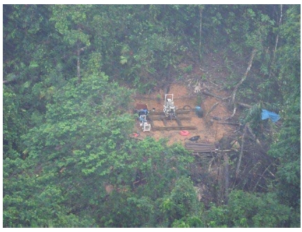
The Belencillo Concession lies within the Donoso Forrest Reserve. The vegetation is tropical, consisting of dense rainforest with a very high canopy (Plate 1), cut by dendritic drainage. The drill pad in the photo appears slightly out of focus due to rainfall.
Plate 1 - Palmilla Gold Project - Aerial View of Drill Pad in Jungle
Photo Credit: D. Brandt, 27/11/2012
Infrastructure on site is minimal. Buildings at the Palmilla field camp comprise bunk houses capable of housing up to 50 people, a kitchen and dining area, ablutions blocks, as well as a small geological office and laundry, all constructed from timber, corrugated iron sheeting and plastic sheeting for waterproofing.
The camp site has one helipad, and no refuelling facilities. Fuel is available near Molejón, approximately 22 km southeast of Palmilla, and 5 km west of the town of Coclesito. At present there is no electricity on site, necessitating two helicopter trips a day (morning and afternoon) to collect gas and fresh supplies from a storage facility at the same location where fuel is supplied, and where fridges are available. These daily helicopter flights also assist the need to continually transport staff to and from site: geologists leave site approximately every two weeks in order to update their acquired information at the office at Molejón. Cooking and lighting is presently gas powered, however, a generator will be installed shortly. Refuse is moved out by helicopter once a week.
|
| Technical Report on the Palmilla Gold Project |
| 11 December 2012 |
The drill pads are all cleared and constructed by hand with labourers using picks, shovels and other hand tools. The single drilling rig and other related and ancillary equipment are moved to and from the drill pads by helicopter.
After drilling of a hole is completed, the core is lifted in batches from site in wooden core boxes with lids and taken directly to a core facility at Molejón where it is logged, cut, sampled and stored. All the available storage space has been used up, with the plan of building more sheds in the near future.
Labourers and other workers at the Palmilla camp were reported to be from the surrounding towns, whereas the more senior staff are usually from larger towns and cities further afield. Therefore, no additional accommodation, other than on-site accommodation, is presently needed for the labourers and other workers. Some accommodation is available for staff working at Molejón in the core processing facility.
Infrastructure is rapidly increasing in the area with the development of a concentrate export port and a coal fired power station. At this stage it is not known to what extent these new facilities will be made available to PML by Minera Panamá SA (operators of Mina de Cobre Panamá). However, the sale of surplus electricity into the Panamanian grid is anticipated by Minera Panamá (Minera Panamá, 2012).
The property lies on the northern side of the central divide of the Panamanian Isthmus in tropical jungle, forest-clad rolling countryside. Elevations on the property as a whole are generally less than 200 meters above sea level (masl), with locally steep topography due to the deeply incised dendritic drainage pattern (McArthur, 1993) as shown in Figures 7 and 8. An oblique view of a 3-D, Digital Terrain Model (DTM) used in the resource estimation is shown in Figure 23.
Drill collar elevations vary between 47.7 to 129.4 m, averaging 101.1 metres. The topographic high on the concession is Cerro Belencillo at 375 masl.
The Palmilla deposit lies within the drainage basin of the Rio Chiquero which flows southwest from the deposit and then northwestwards to the Caribbean Sea.
6.0 HISTORY
| |
| 6.1 | COLONIAL PRODUCTION HISTORY |
Much of central Panamá has been prospected for placer and lode gold beginning with the indigenous peoples followed by early Spanish explorers. The first colonial gold mine established in the Americas in the early 1500's, 'Mina Belen', reportedly lies within one kilometre of the original Belencillo Concession’s western boundary (see Figures 2 and 3).
| |
| 6.2 | HISTORICAL EXPLORATION |
Porphyry copper style mineralization potential in this part of Panamá was first investigated in 1968 by a United Nations Development Program (UNDP) team as part of a regional geological and geochemical survey of central Panamá. Follow-up reconnaissance geological mapping and stream and soil sampling in 1969 (del Guidice and Recchi, 1969) resulted in the discovery of numerous mineralized areas including the Botija, Botija Abajo, Molejón and Cobre Panamá (Petaquilla) deposits on the adjacent Petaquilla Concession, and the Palmilla zone on the adjacent (to the west) Belencillo Concession (see Figure 2).
|
| Technical Report on the Palmilla Gold Project |
| 11 December 2012 |
Adrian Resources as operator, with funding provided by Madison Enterprises Corporation, carried out a phased exploration program between 1993 and 1996 on portions of the Belencillo and Petaquilla Concessions; including soil sampling, auger sampling, 3,550 m of trenching and 23 diamond drill holes for 3,758.00 m over the coincident Palmilla and Trueno geochemical and magnetic anomalies (McArthur, 1996) (see Figure 2). This work is discussed in Item 9.1.
| |
| 6.3 | HISTORICAL RESOURCE ESTIMATES |
Adrian Resources’ work in the early to mid-1990’s outlined significant porphyry style copper mineralization over-printed by low-sulphidation epithermal gold mineralisation at Palmilla and they estimated that a mineral resource of 14.0 Million tonnes (Mt) grading 1.02 g/t gold and 0.3 % copper at a 0.5 g/t gold cut-off was present (Madison Enterprises Corp. Press Release, November 4, 1994). This mineral resource estimate is historical and is not NI 43-101 compliant and should not be relied upon.
| |
| 6.4 | HISTORICAL MINING & PRODUCTION |
With the exception of 16thCentury colonial mining, no commercial mining and production is known to have been carried out on the Palmilla Project Area.
Artisanal mining is however well established on the property and local subsistence farmers have reportedly been able to recover a gram of gold per day by hand panning in the creeks on the Belencillo Concession.
7.0 GEOLOGICAL SETTING AND MINERALIZATION
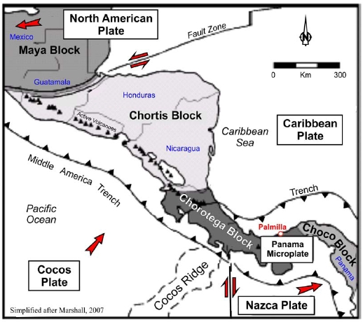
Central America is divided into four crustal blocks (Figure 4). To the north, the Maya and Chortis blocks are composed of Palaeozoic metamorphic and igneous rocks and siliceous and platform carbonate rocks classified as continental and transitional crust. To the south, the Chorotega and Choco blocks underlay Costa Rica and Panamá and are characterized by Mid-Oligocene accreted mafic oceanic crust and intermediate and basic island arc-related volcanic rocks (Marshall, 2007). Panamá is a tectonically active area as the result of its location at the junction of four lithospheric plates but currently has no active volcanoes.
Panamá is underlain by an island arc terrain overlying an amalgamation of mafic crust deposited after Triassic to Early Jurassic rifting. This composite terrain is represented by remnants such as the Nicoya Complex in Costa Rica and forms a Jurassic to Early Cretaceous basement complex of ophiolitic composition (Escalantes, 1990) which outcrop in southern Panamá on the Azuero Peninsula and near the Gulf of San Miguel (Weyl, 1980).
|
| Technical Report on the Palmilla Gold Project |
| 11 December 2012 |
Island arc volcanism, intrusions and sedimentation began in the Late Cretaceous to Early Eocene as a result of a northeast oriented tectonic regime associated with the formation of the ancestral Middle America Trench and has extended through the Cenozoic to the Present (Weyl, 1980 and Dengo & Case, 1990) (Figure 4). Younger, intrusive rocks are calcalkaline in composition and contain porphyry mineralization ranging from Oligocene (Mina de Cobre Panamá deposits ~32 Ma) to Pliocene (Cerro Colorado ~3.3 Ma) (Kesler et al, 1977).
| |
| Figure 4 | Tectonic Map of Central America |
| | (Simplified after Marshall, 2007) |
These volcanosedimentary sequences in the Petaquilla area comprise mainly submarine andesitic to basaltic flows, pillow breccias, pyroclastics and volcaniclastic sediments intercalated with clastic sedimentary rocks and minor biogenic reef limestones of probable Eocene to early Oligocene age (Kesler et al, 1977) (Figure 5). These rocks have been intruded by intermediate calc-alkaline intrusives such as granodiorites and quartz monzonites, of which the 400 km2Petaquilla Batholith is a prime example.
|
| Technical Report on the Palmilla Gold Project |
| 11 December 2012 |
| |
| Figure 5 | Regional Geology Map of the Palmilla Project Area |
(Anon, 1990, Geología de la República de Panamá)
The structure of the area, based on the interpretation of satellite imagery, suggests that major structural trends are expressed as topographic linears. These tend to be oriented largely in northeast and northwest trending directions. The northwest-trending linears are parallel to the granodioritic outcrops and the mineralisation in the Palmilla area follow this trend, which may be related to left-lateral shear zones in the region.
Many large gold deposits in Central America are associated with epithermal vein deposits (Figure 6). Epithermal-type vein deposits tend to occur in lens-shaped bodies that formed in ancient volcanic environments when deep, hot auriferous magmatic waters mixed with shallow, cool groundwater. Mineralization in this type of deposit generally occurs in branching fissures, vein structures, or bodies filled with fractured rock. Sometimes spectacular silver and gold grades occur as so-called “bonanza” deposits in association with epithermal precious metal deposits.
|
| Technical Report on the Palmilla Gold Project |
| 11 December 2012 |
| |
Figure 6 | Epithermal Gold Deposits in Central America
(Modified after Heffernan, 2004 and Nelson, 2007) |
Portions of central Panamá in general and also within the Belencillo Concession are underlain by Tertiary island arc sequences that commenced with the deposition of submarine Eocene to Oligocene pelites, tuffs and reef limestones, intercalated with volcanic and volcaniclastic rocks of andesitic and basaltic composition. This arc sequence became emergent during the Oligocene, and subsequent lithologies are dominated by terrestrial f ows and pyroclastics with lesser interbedde marine sediment. Submarine sandstones of the Santiago Formation and subaerial flows and pyroclastics of the San Pedrito and Canazas Formations were deposited during the Miocene. The Mio-Pliocene, La Yeguada Formation, a thick sequence of felsic ignimbrites, covers much of the continental divide south of Belencillo and Miocene to Recent basalts locally overlies the ignimbrites (Weyl, 1980, Dengo & Case, 1990, Del Guidice & Recchi, 1969 and Ferencic, 1971).
Kesler et al (1977 and 1990) described an evolution in the composition of plutonic rocks in Panamá through time, related to the evolution of the island arc and porphyry copper mineralisation. Early tholeiitic magmatism took place from 60 to 70 million years ago, resulting in emplacement of diorite and quartz diorite batholiths in the Azuero Peninsula. Porphyritic intrusive phases are rare and porphyry-style mineralization is absent from this tholeiitic stage.
Calc-alkaline magmatism began in the Eocene and has continued to the present day. The co position of the calc-alkaline plutons is dominantly granodiorite, but also includes quartz monzonites and quartz diorites. The potassium conte t of theseintrusives h s steadily increased with time (Nelson and Nietzen,2000) from 1.7 % K20 for the Rio Pito (49 my), through 2.3 % K20 for the Petaquilla Batholith immediately east of Belencillo (32.6 my), to 3.5 % K2O) for Cerro Colorado (3.3 my) with a near-constant 63 % silica content. Porphyritic intrusive phases are relatively abundant and porphyry
|
| Technical Report on the Palmilla Gold Project |
| 11 December 2012 |
copper deposits, including Cobre Panamá, Botija and Cerro Colorado, are associated with calc alkaline intrusives of Tertiary age.
| |
| 7.3 | RIO BELENCILLO CONCESSION PROPERTY GEOLOGY |
The climatic regime has resulted in the development of deeply weathered (leached) saprolitic clay soils and outcrops are limited to creeks and gulleys (McArthur, 1993) which obscures the local outcrops, reducing outcrops to gulleys and stream / river cuttings.
The geology of the Belencillo Concession is dominated by a Tertiary Andesitic sequence which consists, in ascending stratigraphic order, of feldspar and pyroxene phyric flows, pyroclastics, and volcaniclastics with interbedded sediments. This sequence of volcanic and volcaniclastic rocks has been intruded by a variety of calc-alkaline plutons, most prominent are a fine-grained equigranular Granodioritic phase and a more dioritic phase (Figures 7 & 8).
Some of these dioritic intrusives may represent feeders to some of the earlier andesitic flows. In the north, near the Caribbean coast, the andesite sequence is locally overlain by Recent basaltic flows. To the south, in the Cerro Belencillo area, the andesites appear to be overlain by feldspar porphyry flows and intruded by feldspar and quartz-feldspar porphyritic, subvolcanic intrusives. There are exposures of dacitic felsic pyroclastics in the southwest in the Quebrada Rojas area.
Several granodiorite plutons and dykes occur coincident with the northwest-southeast trending, multi-element, geochemical silt and soil anomaly which extends for 6 km from north of the Palmilla area, southeastwards to the concession boundary. This trend parallels one of the two regional fracture trends, the other trending northeast-southwest (Figure 7) These intrusions include mineralised granodioritic rocks at Palmilla, Trueno and Quebrada Dino, all of which have associated magnetic anomalies (Figure 2 Locations, Figures 7 and 8 Geology).
|
| Technical Report on the Palmilla Gold Project |
| 11 December 2012 |
| |
| Figure 7 | Local Structural Geology Map |
| | (After Petaquilla Minerals Limited, 2012) |

Diamond drilling (Figure 8) has confirmed the presence of porphyry style copper-gold mineralization in the more northerly of two fine grained granodioritic intrusives (Figure 7) that represent the southeastward trending apical portion of a partially-unroofed, hidden granodiorite pluton at Palmilla (McArthur, 1994). This ‘hidden’ pluton flanks and parallels the Petaquilla batholith of mid-Oligocene age (~36.4 Ma) which lies to the northeast and which also trends in a general southeasterly direction. A representative geological section across the deposit (Figure 9), along Drill Section Line 450 NW, is plan located on Figure 8.
|
| Technical Report on the Palmilla Gold Project |
| 11 December 2012 |
| |
| Figure 8 | Palmilla Deposit Geology and Drilling Plan |
| | (Made in MapInfo using Data supplied by PML, 2012) |
The northwestern of the two intrusives lies beneath the centre of the coincident Palmilla copper-gold-molybdenum stream sediment, soil sample and magnetic geophysical anomalies, whilst the southeastern intrusive is located in the headwaters of the Quebrada Dino three km to the southeast of the main anomaly (Figure 2 Location, Figure 7 Geology). This second area requires further investigation.
There is also some stream sediment evidence for yet another southeasterly trending zone of mineralization lying about four km southwest of the Palmilla - Quebrada Dino Axis of mineralisation.
PML’s delineated area of mineralisation is shown in Figure 8 (as the Limit of Mineralised Outcrop) and PML have a 50 m spaced section grid over this area. This grid is oriented normal to the general strike of the granodioritic intrusion on 070° - 250°. Currently there are 22, 50 m apart sections, from 000NW in the south-southeast to 1,100 NW to the north-northwest. These sections look to the north-northwest and are on a scale of 1: 1,500. A PML drilling section along Section Line 450NW forms Figure 9; its location is shown on Figure 8.
|
| Technical Report on the Palmilla Gold Project |
| 11 December 2012 |
| |
| Figure 9 | Geology and Drill Section 450 NW |
(After Petaquilla Minerals Limited, 2012)

Drilling to date in the Palmilla area has intersected a sequence of thin to thick bedded andesitic (volcanic) and sedimentary tuffaceous turbidites (volcaniclastics) which display slump, scour, graded bedding and fining upward sedimentary features. However, there are other areas where the rocks are predominantly siliclastic sediments with only portions of the sequence being volcanic. Overall, the rocks are locally predominantly volcanic with fine to coarse ash material of intermediate andesitic composition but they may also include felsic dacitic looking material.
Hydrothermal alteration associated with the emplacement of the partially-unroofed Palmilla granodioritic intrusive has affected the surrounding bedded volcanic and tuffaceous turbiditic sequence and a propyllitic alteration assemblage of chlorite-epidote-carbonate-silica accompanied by pyrite and magnetite is most common in these andesitic sediments. The siliceous sediments display silica or carbonate alteration.
Intrusive rocks of economic interest include plutons and dykes of fine to medium grained hornblende granodiorite which are possibly related to the Petaquilla Batholith. At Palmilla the intrusive is only weakly altered and mineralized with the best developed mineralization (quartz-magnetite-chalcopyrite-bornite and gold) occurring at the contact or within the adjacent altered volcanic and sedimentary rocks. Mineralized rocks are characterized by biotite hornfels overprinted with a stockwork of abundant fracture controlled quartz-magnetite micro-veinlets, as shown in Plate 2.
The mineralization at Palmilla is hosted within a phyllic and potassic altered granodiorite and to a lesser extent in the adjacent silica-magnetite altered volcanics and sediments. In the most southeasterly Quebrada Dino area, near the property boundary, anomalous soil geochemical results occur where fine grained granodiorite has been found to contain disseminated chalcopyrite and lesser bornite mineralization.
|
| Technical Report on the Palmilla Gold Project |
| 11 December 2012 |
Plate 2 - Palmilla Gold Project - Well Mineralized, 63.5 mm dia Cut Core
Photo Credit: D. Brandt, 27/11/2012 (Core is approximately to scale)
The typical alteration assemblage in the mineralized rocks is biotite homfels-chlorite-sericite-quartz-magnetite-pyrite-chalcopyrite-bomite-molybdenite. Biotite hornfels alteration is strongest in the sediments and still present, but less intensely developed, in the granodiorite and microgranodiorite.
Narrow halos of bleaching occur along the quartz-magnetite micro-veinlet selvages (Plate 2). Patchy zones of intense bleaching/leaching over some intervals have produced a white sugary-looking rock within which all mafic minerals have been destroyed. In vertical drill holes BE94-01, -02, and -03 there is a unit identified as a ‘quartzose sediment’ (coarse grained, well sorted, sandstone). The composition and gross appearance of this unit is similar to the fine-grained equigranular, mineralised apical granodiorite in surface exposures, particularly when the bleaching caused by alteration has destroyed most mafic minerals.
PML consider that a later stage, possibly structurally emplaced felsic intrusion could be interpreted as being the heat source supplying the hydrothermal fluids and volatiles necessary to drive the convection system which resulted in the epithermal-type gold mineralization. This possible late mineralizing and alteration event subsequently obliterated all primary structure in the volcanic-volcaniclastic sequences. Pervasive hydrothermal silicification and propyllitic alteration occur together with a possibly contemporaneous and/or subsequent phase of retrograde metamorphism which probably contributed more to the gold mineralization than to the copper mineralization.
|
| Technical Report on the Palmilla Gold Project |
| 11 December 2012 |
8.0 DEPOSIT TYPES
The gold and copper mineralization at Palmilla is confined largely to the volcanic-volcaniclastic series of lithology. The interpretation of geological features and mineralization at Palmilla indicates that the granodiorite stock seems to be a limb of a varying, but generally steeply northwesterly dipping phacolith with local andesite bodies and irregular dykes and sills. It appears that the intrusive was emplaced along the volcanic bedding and contacts and acted as the “heat pump” generating the convectional hydrothermal cell required for the mineralisation which is ascribed to both epithermal gold and porphyry copper styles of mineralisation.
The term epithermal is used loosely in field exploration to describe gold - silver - copper vein-type deposits formed in magmatic arc environments (including rifts) in elevated crustal settings, typically above the level of formation of porphyry copper-gold deposits (i.e. <1 km depth) and in many instances associated with subvolcanic intrusions. The original model of exploration for these types of veins was put forward by Dr. Larry Buchanan (1981) that set the basis for the understanding and interpretation of epithermal deposits that has since been widely used in exploration (Figure 10).
| |
| Figure 10 | Epithermal Mineral Deposit Schematic |
| (Modified after Buchanan, 1981) |

It is considered by PML that mineralisation at Palmilla commenced with initial porphyry copper deposition and that subsequent (or possibly) contemporaneous tectonism resulted in overprinting the copper porphyry mineralization with structurally controlled, epithermal gold mineralization, as suggested by Corbett (2002) and shown in Figure 11.
Thus epithermal gold deposition has been telescoped down over the porphyry copper mineralisation to partially overprint it, i.e. the mineralisation within the oval superimposed onto Corbett’s model overlaps rather than is spatially separated by hundreds of metres..
|
| Technical Report on the Palmilla Gold Project |
| 11 December 2012 |
This deposit type overprinting appears to be a district wide characterised mineralisation model along the southeast trending Palmilla - Petaquilla-Molejón mineralization trend; e.g. as observed at Botija Abajo and also along the southwest trending El Real trend which contains the Molejón deposit in the southeast on the Petaquilla Concession (Cameron et al, 2012).
| |
| Figure 11 | Corbett Conceptual Mineralisation Model |
| | (After Corbett, 2007) |

The distribution of gold and copper mineralization at Palmilla has since been further modified by late faulting and most recently by supergene enrichment processes although structuralcontrol are still very important to the distribution of [epithermal] gold grades (Figure 10 & 11).
The close spatial relationship between the Petaquilla Porphyry co per deposits and porphyry-style mineralization at Brazo and Botija Abajo and epithermal-type mineralization at Molejón, Botija Abajo and Palmilla, suggests a genetic relationship (Nelson, 2007).
Spatial and temporal links between epithermal and porphyry copper deposits have also been documented in many areas in the Circum-Pacific Ring (e.g. Lepanto, Philippines) and South America and in some deposits in North America, including Bingham Canyon (USA) and La Caridad (Mexico).
|
| Technical Report on the Palmilla Gold Project |
| 11 December 2012 |
9.0 EXPLORATION
| |
| 9.1 | ADRIAN RESOURCES EXPLORATION ACTIVITIES AND RESULTS |
Between 1993 and 1996, Adrian Resources, as operator, with funding provided by Madison Enterprises Corporation, carried out a phased exploration program on portions of the original unitary Rio Belencillo Concession including diamond drilling on the Palmilla Anomaly.
A Phase I (1993) regional reconnaissance exploration programme to evaluate the Palmilla Area within the Rio Belencillo Concession included stream drainage and east-west gridded soil sampling (McArthur, 1994).
The program outlined a northwest-southeast trending, multi-element, geochemical silt and soil anomaly which extends from north of the Palmilla area, southeast to the concession boundary. Within this six kilometre trend, detailed soil sampling over the Palmilla Zone outlined a 0.5 by 1.0 kilometre copper-gold-molybdenum anomaly defined by a 50 ppb gold and a 250 ppm copper contour and molybdenum values. Maximum values from this initial geochemical survey were 2.85 g/t gold (0.09 oz/t) and 3,800 ppm copper (i.e. 0.38 % Cu) in soil.
Anomalous gold in soil geochemical results occur along the western boundary of the original Rio Belencillo Concession are likely to be related to a system of auriferous quartz veins at the historic Mina Belen.
A Phase II (1994-95) exploration programme focussed on the Palmilla Zone (Turnbull and Laudrum, 1996). This included additional line cutting, 74 line km of a ground magnetic survey by Lloyd Geophysics of Vancouver, soil auger sampling, prospecting and geological mapping, trenching and the diamond drilling of 14 holes.
Adrian Resources’ trenching exercise was oriented north-south (N - S) and east-west (E - W) in the vicinity of the main Palmilla mineralization as shown in Table 5. These data are based on their 1996 trench database.
| |
| Table 5 | Adrian Resources 1996 Palmilla Trenching Data |
| | | | | | |
Trench
ID | Overall
Length | Length *
Sampled | Saprolite
Exposed m | Number of
Samples | Average
Length m | Length
> 0.4g/t Au |
| TRBE-01 | 318.6 | 286.0 | 263.3 | 90 | 3.18 | 182.10 |
| TRBE-02 | 288.5 | 273.0 | 40.5 | 163 | 1.66 | 18.0 |
| TRBE-03 | 367.2 | 292.7 | 245.7 | 82 | 3.57 | 209.0 |
| TRBE-04 | 488.50 | 473.4 | 77.9 | 316 | 1.50 | 190.4 |
| TRBE-05 | No Data | n.a. | n.a. | n.a. | n.a. | n.a. |
| TRBE-06 | 325.4 | 236.4 | 105.0 | 59 | 4.01 | 0.0 |
| TRBE-07 | 278.0 | 251.0 | 119.0 | 64 | 3.92 | 185.0 |
| TRBE-08 | 513.5 | 257.4 | 0.0 | 162 | 1.59 | 93.4 |
| TRBE-09 | 605.00 | 574.0 | 283.0 | 140 | 4.1 | 215.0 |
| TRBE-10 | 373.8 | 373.8 | 176.1 | 152 | 2.46 | 30.7 |
| Totals | 3,558.5 | 3,017.7 | 1,310.5 | 1,228 | 2.90 | 1,123.6 |
The 1996 trench “Length * Sampled” data summarised in this table have been adjusted to exclude stretches of sampling containing extraordinary sample “lengths” or sampling gaps in soil, alluvium, dense tree roots or sometimes extremely hard rock; e.g. 62.9 m not sampled in trench TRBE-08 (120.6 m to 183.5 m). Adrian Resources’ individual sample lengths varied widely up to 7.0 m, but
|
| Technical Report on the Palmilla Gold Project |
| 11 December 2012 |
generally tended to vary between 1.5 and 4 metres, the overall average sample being 2.9 metres long. Saprolitic material is noted separately in the table on account of its ‘sticky’ mining and handling characteristics.
Total sampled metres grading above 0.4 g/t are noted in the table as this value has recently come into common usage as a resource cut-off value in open-cast heap leach operations. Overall the +0.4 g/t Au sampled material is some 37.2 % of the metres sampled by Adrian Resources, varying between 6.5 and 73.7 % in different trenches. This +0.4 g/t Au material is not necessarily contiguous.
Fourteen cored, mostly vertical BTW drill holes (42 mm dia) were drilled by Adrian Resources in 1994 for a total of 2,494.00 metres. Only one of these holes was inclined (Hole BE94-11, at -55° on 180°). These holes were almost wholly sampled at 1.5 metre intervals. Collar and depth data for these 1994 holes are given in Table 6.
| |
| Table 6 | Boreholes Drilled by Adrian Resources in 1994 |
| | | | |
Bore Hole
ID | Eastings
M | Northings
M | Collar
Elevation m | Bore Hole
Length m |
| BE94-01 | 525,502.50 | 984,109.52 | 109.570 | 164.00 |
| BE94-02 | 525,477.35 | 984,301.71 | 101.400 | 157.90 |
| BE94-03 | 525,380.94 | 984,146.79 | 74.770 | 170.10 |
| BE94-04 | 525,576.22 | 984,176.18 | 87.440 | 164.90 |
| BE94-05 | 525,595.50 | 984,052.50 | 60.000 | 234.80 |
| BE94-06 | 525,375.00 | 984,033.00 | 60.970 | 328.60 |
| BE94-07 | 525,381.88 | 984,241.65 | 87.010 | 232.60 |
| BE94-08 | 525,479.53 | 984,436.71 | 80.000 | 164.90 |
| BE94-09 | 525,708.00 | 984,116.00 | 72.000 | 164.20 |
| BE94-10 | 525,601.00 | 984,300.00 | 105.000 | 230.40 |
| BE94-11#-55° on 180° | 525,477.66 | 984,434.61 | 80.000 | 249.30 |
| BE94-12 | 525,307.67 | 984,143.67 | 47.700 | 106.10 |
| BE94-13 | 525,663.43 | 984,293.91 | 89.520 | 63.40 |
| BE94-14 | 525,769.00 | 983,783.00 | 80.400 | 62.80 |
| Averages | 525,521.12 | 984,183.51 | 81.13 | 178.14 |
| Total | - | - | - | 2,494.00 |
Note:Co-ordinates are given in UTM Zone 17 Co-ordinates, based on the NAD 1927 Datum.
#Inclined borehole - EoH downhole surveyed at -52° on 180° at 249 metres..
This drilling program outlined a “geological resource” of 14 million tons that was then estimated to grade 1.02 g/t gold and 0.3% copper at a 0.5 g/t gold cut-off (Tumbull & Laudrum, 1996). This resource estimate is historical and is not NI 43-101 compliant.
Adrian Resources noted that there is a close correlation between the magnetic data (see Figure 12) and the copper-in-soil data which both define a rough ovoid feature representing the near-surface expression of the host intrusive body to the mineralisation. Though the stockwork quartz-magnetite veining played a significant role in controlling the mineralisation, the intrusive unit appears as a relative magnetic low surrounded by the mixed volcanosediments which are a relative magnetic high.
Further auger/soil sampling during Phase II of the program located another area of potential copper-gold-molybdenum mineralisation about two km southeast of the Palmilla zone of mineralisation.
|
| Technical Report on the Palmilla Gold Project |
| 11 December 2012 |
Adrian Resources termed this 500 x 700 m sized mineralised occurrence the Quebrada Dino area. It includes fine grained granodiorite with disseminated copper sulphides in outcrop.
A third phase of exploration was carried out by Adrian Resources during 1996 (Macarthur, 1996). This work included reinterpretation of the Lloyd Geophysics magnetic data resulting in the delineation of several areas analogous to the Palmilla mineralisation; one to the north of Palmilla and the Trueno (drilled in 1996 and 2012) and Relampago areas to the south, in addition to the on-trend Quebrada Dino discovered earlier to the south in 1994 (Figures 2 Locations, Figure 12 Geophysics).
A further nine inclined BTW holes for a total of 1,264 m were drilled in 1996 by Adrian Resources during Phase III of the project investigation, mostly in areas away from the main mineralisation. The only hole known to be surveyed was BE96-01. These holes, like the 1994 holes, were also essentially wholly sampled at 1.5 metre intervals. These new holes were drilled to check magnetic and geochemical anomalies satellite to the Palmilla mineralization, five of them in the Trueno area. Collar and depth data for these 1996 holes are given in Table 7.
| |
| Table 7 | Boreholes Drilled by Adrian Resources in 1996 |
| | | | | | |
Bore Hole
ID | Eastings
m | Northings
M | Elevation
m | Bore Hole
Length m | Azimuth
Degrees | Inclination
Degrees |
| BE96-01# | 525,142.10 | 984,376.46 | 99.86 | 151.8 | 180° | -75° |
| BE96-02 | 525,356.45 | 984,566.91 | 109.83 | 151.8 | 180° | -75° |
| BE96-03 | 525,892.31 | 984,495.49 | 124.77 | 146.9 | 180° | -75° |
| BE96-041 | 526,702.05 | 983,419.42 | 102.32 | 151.8 | 180° | -70° |
| BE96-051 | 526,699.67 | 983,543.21 | 79.98 | 151.8 | 180° | -60° |
| BE96-061 | 526,704.43 | 983,252.77 | 103.04 | 151.8 | 180° | -60° |
| BE96-071 | 526,616.31 | 983,419.42 | 96.02 | 54.5 | 180° | -60° |
| BE96-081 | 526,616.31 | 983,419.42 | 96.02 | 151.8 | 180° | -50° |
| BE96-09 | 525,446.95 | 984,566.91 | 114.88 | 151.8 | 180° | -90° |
| Averages | 526,130.73 | 983,895.56 | 102.97 | 140.44 | 180° | - |
| Total | - | - | - | 1,264.00 | - | - |
Notes:Co-ordinates are given in UTM Zone 17N Co-ordinates, based on the NAD 1927 Datum.1Holes drilled to test Trueno Target.#Denotes EoH downhole surveyed borehole, -73° at 150 m.
Four of these holes (BE96-01, -02, -03 and -09) were drilled to test magnetic and geochemical anomalies away from the main Palmilla mineralisation.
The remaining five holes (BE96-04, -05, -06, -07 and -08) were drilled over coincident magnetic and geochemical anomalies at the Trueno Target to the southeast of the Palmilla mineralisation, but without intersecting significant economically interesting results. This anomaly has been tested by a further, vertical drill hole in PML’s 2012 drilling program whose assay results are pending.
The Quebrada Dino and Relampago mineralized targets (see Figure 2) still remain to be drill tested.
|
| Technical Report on the Palmilla Gold Project |
| 11 December 2012 |
| |
| Figure 12 | Palmilla Deposit Geophysical Magnetic Survey Map |
(After Petaquilla Minerals Limited, 2012)

| |
| 9.2 | PETAQUILLA MINERALS EXPLORATION PROGRAMME |
The 2011-2012 exploration and drilling program at Palmilla consists of trenching, mapping and HQ size diamond drilling of 42 holes for approximately 9,000 m (9,378 m to date). Drill hole locations are shown in Figure 8. The drilling programme is further discussed in Item 10.
| |
| 9.2.1 | Petaquilla Minerals Surface Exploration Programme |
Approximately 1,360 m of trenching has been completed by PML on the property, some data for which is given in Table 8 below. As with Adrian Resources’ prior work, PML’s trenches are generally oriented north-south and east-west.
The deep clay weathering of the intermediate volcanosediments and granodiorites has lead to the development of a saprolitic soil weathering profile and this has severely reduced rock exposure in the trenches. Thus, the average thickness of saprolite in 32 vertical boreholes logged to date (end-October) was 9.58 m, with a minimum thickness of 2.50 m and a maximum thickness of 17.70 metres.
|
| Technical Report on the Palmilla Gold Project |
| 11 December 2012 |
| |
| Table 8 | PML 2012 Palmilla Trenching Data |
| | | | | |
Trench
ID | Overall
Length m | Length
Sampled m | Saprolite
Exposed m | Samples, m
Returned* | Length *
>0.4 g/t Au |
| PLTR-01 | 137 | 137 | 31 | 54* | 23* |
| PLTR-012 | 41 | 41 | 15 | 21* | 21* |
| PLTR-02 | 85 | 85 | 0 | 85 | 48* |
| PLTR-03 | 197 | 197 | 11 | 30* | 6* |
| PLTR-04 | 264 | 264 | 47 | 245* | 77* |
| PLTR-05 | 119 | 119 | 45 | 0* | n.a.* |
| PLTR-06 | 27 | 27 | 17 | 0* | n.a.* |
| PLTR-06A | 10 | 10 | 0 | 10 | 6 |
| PLTR-07 | 110 | 110 | 89 | 110 | 4 |
| PLTR-08 | 126 | 126 | 122 | 30* | 1* |
| PLTR-09 | 50 | 50 | 49 | 0* | n.a.* |
| PLTR-10 | 102 | 102 | 67 | 0* | n.a.* |
| PLTR-11 | n.a. | n.a. | n.a. | n.a. | n.a. |
| PLTR-12 | 91 | 91 | 54 | 0* | n.a.* |
| Totals | 1,359 | 1,359 | 547 | 585* | 186* |
Note:All samples are 1 metre long. * Denotes incomplete return of data.
The 2012 trenching data summarised in this table are based on an invariant sampling length of one metre. Like the Adrian Resources trenching data, the PML 2012 saprolitic material is noted separately on account of its mining and handling characteristics.
The sampled metres grading above 0.4 g/t are again noted in Table 8. However, at this time (November, 2012), the low number of returned sample values (only about 30 %) makes this value guide of little utility at present. As before, this +0.4 g/t Au material is not necessarily contiguous.
| |
| 9.2.2 | Petaquilla Minerals Drilling Campaign |
PML has nearly completed a 42 vertical hole diamond drilling programme of 9,000 m of HQ sized (63.5 mm dia) core. Included in this drilling are several holes recommended by BDI to twin Adrian Resources 1994 vertical holes for quality assurance purposes.
| |
| Table 9 | Palmilla Proposed 2012 Drilling Program |
| | | | |
Drill
Site ID | Hole
ID | Eastings
m | Northings
m | Proposed
Depth m |
| P-01 | PLDH-001 | 525,381 | 984,144 | 200 |
| P-02 | PLDH-002 | 525,479 | 984,301 | 200 |
| P-03 | PLDH-003 | 525,502 | 984,109 | 180 |
| P-04 | PLDH-004 | 5253,81 | 984,238 | 150 |
| P-05 | PLDH-012 | 525,654 | 984,292 | 120 |
| P-06 | PLDH-011 | 525,595 | 984,052 | 150 |
| P-07 | PLDH-019 | 525,501 | 984,454 | 140 |
| P-08 | PLDH-008 | 525,486 | 984,345 | 180 |
| P-09 | P-09 | 525,400 | 984,077 | 180 |
| P-10 | PLDH-006 | 525,414 | 984,279 | 200 |
| P-11 | PLDH-010 | 525,673 | 984,334 | 120 |
| P-12 | PLDH-014 | 525,673 | 984,261 | 110 |
|
| Technical Report on the Palmilla Gold Project |
| 11 December 2012 |
| | | | |
| P-13 | P-13 | 525,300 | 984,255 | 150 |
| P-14 | PLDH-021 | 525,412 | 984,339 | 200 |
| P-15 | PLDH-007 | 525,442 | 984,308 | 120 |
| P-16 | PLDH-013 | 525,495 | 984,179 | 150 |
| P-17 | PLDH-025 | 525,500 | 983,985 | 150 |
| P-18 | PLDH-018 | 525,528 | 984,407 | 150 |
| P-19 | PLDH-016 | 525,647 | 984,390 | 120 |
| P-20 | PLDH-015 | 525,665 | 984,226 | 120 |
| P-21 | PLDH-009 | 525,594 | 984,126 | 170 |
| P-22 | PLDH-017 | 525,443 | 984,144 | 140 |
| P-23 | P-23 | 525,450 | 984,062 | 180 |
| P-241 | P-24 | 526,600 | 983,419 | 150 |
| P-25 | PLDH-005 | 525,576 | 984,176 | 170 |
| P-26 | P-26 | 525,309 | 984,124 | 300 |
| P-27 | PLDH-020 | 525,456 | 984,236 | 300 |
| P-28 | PLDH-022 | 525,620 | 984,577 | 300 |
| P-29 | PLDH-023 | 525,620 | 984,577 | 300 |
| P-30 | PLDH-024 | 525,729 | 984,571 | 300 |
| P-31 | PLDH-028 | 525,157 | 984,061 | 300 |
| P-32 | PLDH-026 | 525,189 | 984,140 | 300 |
| P-33 | PLDH-030 | 525,513 | 984,647 | 300 |
| P-34 | PLDH-033 | 525,150 | 984,550 | 300 |
| P-35 | PLDH-027 | 525,771 | 984,182 | 300 |
| P-36 | PLDH-029 | 525,787 | 984,360 | 300 |
| P-37 | PLDH-032 | 525,150 | 983,900 | 300 |
| P-38 | PLDH-031 | 525,137 | 984,247 | 300 |
| P-39 | P-39 | 525,240 | 983,930 | 300 |
| P-40 | P-40 | 525,550 | 983,740 | 300 |
| P-41 | P-41 | 525,714 | 983,814 | 300 |
| P-42 | P-42 | 525,769 | 983,783 | 300 |
Note:1Vertical borehole drilled to test the Trueno mineralization.
Most of these holes (39 out of 42) have already been drilled for 9,378 m and abbreviated actual 2-D collar co-ordinates are given above where known, rather than the planned collar co-ordinates.
10.0 DRILLING
| |
| 10.1 | PML 2011-2012 DRILLING PROGRAM |
As mentioned in Item 9.2, PML’s current drilling program totals 42 HQ cored holes (63.5 mm dia) for a budgeted original total of 9,000 m, currently 9,378 metres. The holes drilled to date are shown in Table 10.
|
| Technical Report on the Palmilla Gold Project |
| 11 December 2012 |
The status of the evaluation drilling as of November 26this as follows:
Bore holes PLDH-001 to - 037 have been drilled, PLDH-038 in progress.
Core logging has been completed from PLDH-001 to PLDH-034.
Sample preparation had been completed to PLDH-033.
Samples up to and including PLDH-031 and some of PLDH-032 has been shipped out to ALS Minerals in Vancouver for analysis (Analytical schemes - Au GRA22 and others ME-ICP41).
Analytical results have been returned for holes PLDH-001 to PLDH-029 and partially for hole PLDH-030.
| |
| Table 10 | PML 2012 Drill Program Progress To Date |
| | | | | |
Bore Hole
ID | Eastings
m | Northings
m | Collar
Elevation m | Final Depth
EoH m | Date
Completed |
| PLDH-0011 | 525,381.734 | 984,144.628 | 94.749 | 211.35 | 09/01/2012 |
| PLDH-0021 | 525,479.284 | 984,301.399 | 121.048 | 238.20 | 09/01/2012 |
| PLDH-0031 | 525,502.187 | 984,109.576 | 129.456 | 202.20 | 17/01/2012 |
| PLDH-0041 | 525,381.227 | 984,238.764 | 107.194 | 187.50 | 11/01/2012 |
| PLDH-0051 | 525,576.090 | 984,176.939 | 107.406 | 215.05 | 22/01/2012 |
| PLDH-006 | 525,414.543 | 984,279.952 | 120.769 | 183.70 | 21/01/2012 |
| PLDH-007 | 525,442.099 | 984,308.967 | 122.932 | 230.10 | 26/01/2012 |
| PLDH-008 | 525,486.339 | 984,345.343 | 112.328 | 231.80 | 04/02/2012 |
| PLDH-009 | 525,594.479 | 984,126.230 | 128.844 | 209.30 | 12/02/2012 |
| PLDH-010 | 525,673.264 | 984,334.156 | 106.737 | 203.85 | 10/02/2012 |
| PLDH-0111 | 525,595.687 | 984,052.476 | 86.365 | 204.10 | 16/02/2012 |
| PLDH-0121 | 525,654.215 | 984,292.552 | 113.765 | 221.00 | 17/02/2012 |
| PLDH-013 | 525,495.898 | 984,179.631 | 106.349 | 175.20 | 22/02/2012 |
| PLDH-014 | 525,673.900 | 984,261.758 | 114.878 | 230.40 | 21/02/2012 |
| PLDH-015 | 525,665.502 | 984,226.031 | 98.031 | 224.80 | 28/02/2012 |
| PLDH-016 | 525,647.837 | 984,390.076 | 95.003 | 200.20 | 04/03/2012 |
| PLDH-017 | 525,443.664 | 984,144.694 | 112.277 | 260.30 | 17/03/2012 |
| PLDH-018 | 525,528.066 | 984,407.115 | 108.657 | 311.35 | 12/03/2012 |
| PLDH-019 | 525,501.209 | 984,454.508 | 93.780 | 299.40 | 18/03/2012 |
| PLDH-020 | 525,456.621 | 984,236.713 | 107.826 | 278.00 | 26/03/2012 |
| PLDH-021 | 525,412.587 | 984,339.174 | 102.609 | 208.65 | 23/03/2012 |
| PLDH-022 | 525,620.198 | 984,577.718 | 108.188 | 301.50 | 28/03/2012 |
| PLDH-023 | 525,729.074 | 984,571.214 | 105.034 | 241.00 | 04/04/2012 |
| PLDH-024 | 525,157.730 | 984,061.404 | 123.046 | 300.00 | 13/04/2012 |
| PLDH-025 | 525,500 | 983,985 | 55.8 | 302.50 | 14/04/2012 |
| PLDH-026 | 525,513.726 | 984,647.920 | 125.744 | 302.40 | 19/04/2012 |
| PLDH-027 | 525,771.353 | 984,182.775 | 103.328 | 243.30 | 20/04/2012 |
| PLDH-028 | 525,189.954 | 984,140.397 | 106.279 | 300.10 | 25/04/2012 |
| PLDH-029 | 525,787.642 | 984,360.838 | 120.133 | 301.30 | 28/04/2012 |
| PLDH-030 | 525,137.247 | 984,249.228 | 102.252 | 300.40 | 02/05/2012 |
| PLDH-031 | 525,137.067 | 984,247.820 | 102.235 | 300.05 | 09/05/2012 |
|
| Technical Report on the Palmilla Gold Project |
| 11 December 2012 |
| | | | | |
Bore Hole
ID | Eastings
m | Northings
m | Collar
Elevation m | Final Depth
EoH m | Date
Completed |
| PLDH-032* | 525,150 | 983,900 | 94.0 | 302.40 | 19/05/2012 |
| PLDH-033* | 525,147.26 | 984,547.07 | 94.30 | 304.80 | 27/05/2012 |
| PLDH-034* | 525,300 | 984,205 | 58.0 | 299.75 | 28/07/2012 |
| PLDH-0351* | 525,309 | 984,124 | 47.0 | 300.00 | 27/08/2012 |
| PLDH-036* | 525,240 | 983,930 | 89.0 | 300.55 | 09/09/2012 |
| PLDH-037* | 525,550 | 983,740 | 71.0 | 251.90 | 19/11/2012 |
| Totals | 37 | - | - | 9,378.40 | - |
| Average | 525,466.1 | 984,265.4 | 102.6 | 245.77 | - |
Notes:1Denotes twinned holes. * Final collar survey data awaited. Data to 26/11/2012.
The 2012 bore hole collar co-ordinates have been surveyed in Transverse Mercator projection (UTM Zone 17N, NAD 27 Datum). As far as is known, none of these vertical HQ holes has been downhole surveyed.
The spatial arrangement of these 2012 program holes, together with the earlier 1994 and 1996 holes, together with some surface features is shown in Figure 8.
| |
| 10.2 | TWINNED HOLE DRILL PROGRAM |
Eight Adrian Resources 1994 vertical holes were twinned for quality assurance purposes and the eight chosen holes have been completed; in some cases these holes were deepened to provide better coverage of the observed mineralisation (Table 11).
| |
| Table 11 | Palmilla Project - Twinned Vertical Hole Data |
| | | | |
1994
Hole ID | Hole Depth
m | 2012 Twin
Hole ID | Hole Depth
m | Depth
Change m |
| BE94 001 | 164.00 | PLDH-003 | 202.20 | 38.20 |
| BE94 002 | 157.90 | PLDH-002 | 238.20 | 80.30 |
| BE94 003 | 170.10 | PLDH-001 | 211.35 | 41.25 |
| BE94 004 | 164.90 | PLDH-005 | 215.05 | 50.15 |
| BE94 005 | 234.80 | PLDH-011 | 204.10 | - 30.70 |
| BE94 007 | 232.60 | PLDH-004 | 187.50 | - 45.10 |
| BE94 012 | 106.10 | PLDH-035 * | 300.00 | 193.90 |
| BE94 013 | 63.40 | PLDH-012 | 221.00 | 157.60 |
| Totals | 1,293.80 | - | 1,779.40 | 485.60 |
Note:* There is no logging or sampling data available for PLDH-035.
A visual correlation exercise with regard to gold and copper values and lithology in these twinned holes was conducted by R. Sirois, PEng as shown in Figures 13 through 19 below.
The correlation between BE94-001 and PLDH-003 is good for Au and Cu values (Figure 13). The significant intercepts found in the original hole are all well represented in the new hole especially for Au grades.
|
| Technical Report on the Palmilla Gold Project |
| 11 December 2012 |
| |
| Figure 13 | Log Graph Comparing Twinned Holes BE94-001 and PLDH-003 |

Holes BE94-002 and PLDH-002 correlate well for Au and Cu values (Figure 14). The thick intervals of Au noted in the original hole are also present in the twin hole which shows more variability in gold grades (usually higher grades) in the first 60 m portion of the PHLD-002 hole.
|
| Technical Report on the Palmilla Gold Project |
| 11 December 2012 |
| |
| Figure 14 | Log Graph Comparing Twinned Holes BE94-004 and PLDH-005 |

|
| Technical Report on the Palmilla Gold Project |
| 11 December 2012 |
The correlation between holes BE94-003 and PLDH-001 is fairly good for both Au and Cu (Figure 15). However, the higher Au grades found in BE94-003 near surface (above 30 m) are not reproduced in hole PLDH-001.
| |
| Figure 15 | Log Graph Comparing Twinned Holes BE94-003 and PLDH-001 |
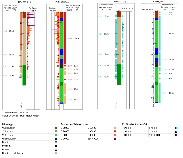
|
| Technical Report on the Palmilla Gold Project |
| 11 December 2012 |
The correlation between holes BE94-004 and PLDH-005 is good (Figure 16). The original hole content in Au and Cu is very low to barren and the twin hole results are concordant with a few low grades present locally.
| |
| Figure 16 | Log Graph Comparing Twinned Holes BE94-004 and PLDH-005 |
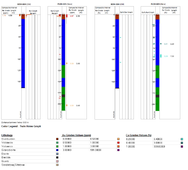
|
| Technical Report on the Palmilla Gold Project |
| 11 December 2012 |
The correlation between holes BE94-005 and PLDH-011 is poor (Figure 17). The original hole shows some small intervals with low values of Au where the new hole shows greater Au content over a significant interval (64 m). The correlation for Cu content is also mediocre.
| |
| Figure 17 | Log Graph Comparing Twinned Holes BE94-005 and PLDH-011 |

|
| Technical Report on the Palmilla Gold Project |
| 11 December 2012 |
Holes BE94-007 and PLDH-004 show good correlation (Figure 18). The Au content present in the original hole is correctly reproduced in the new hole. The very few interesting Cu intercepts found in the old hole are aligned with the intercepts from the newer hole.
| |
| Figure 18 | Log Graph Comparing Twinned Holes BE94-007 and PLDH-004 |
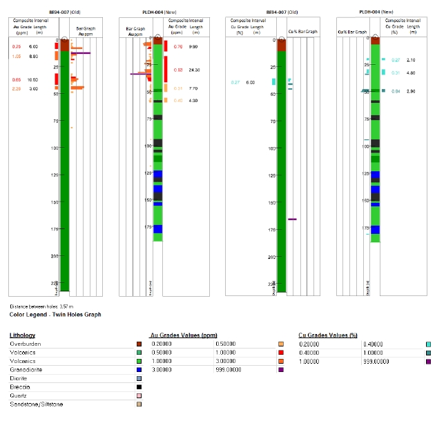
|
| Technical Report on the Palmilla Gold Project |
| 11 December 2012 |
The correlation between BE94-004 and PLDH-005 is not very good (Figure 19). However, the large distance that separates the holes (13 m), different hole depths and the difference in the lithologies can explain that poor correlation.
| |
| Figure 19 | Log Graph Comparing Twinned Holes BE94-004 and PLDH-005 |

Overall, it is considered that there is a fair correlation in gold and copper contents as well as a good comparison of the location and thickness of the significant intercepts between the original and the twin holes. There is however one hole (BE94-005) that stands out with a poor correlation for Au and Cu grades. Additionally, one twin hole (PLDH-005) might be too far from the original one (13 m) to be considered as a twin hole which would explain the mismatch in the lithology. From the seven holes that were twinned and for which logs and grades are known, five of them present a good correlation.
Based on the previous comments, it is believed by R. Sirois that the twinning of most of the 1994 holes has presented fair to good grade and lithology correlation and these holes can be used for resource estimation. As noted, the mismatch in some holes is probably due to the distance that might
|
| Technical Report on the Palmilla Gold Project |
| 11 December 2012 |
be too far between 1994 and 2012 holes to be considered as perfect twin holes. It is recommended that the distance should be less than 2 metres between twin holes to produce a good comparison.
Apart from collar location surveys, only two of Adrian Resources boreholes are known to have been downhole surveyed, both at the base or end of hole. These two holes were BE94-11 and BE96-01 and in both cases hole deviation was not significant.
Two of the recent, vertical PML holes are reported to have been surveyed (pers.comm. to D. Brandt by R. Constanti) with satisfactory results. PML has decided that, on this basis that no further surveys were required for these vertical holes but they intend to commence drilling inclined holes in the future and will survey these holes at 20 to 30 m intervals.
This assumption of accepting a low vertical borehole survey coverage could be readily checked with acid bottle measurements. The holes, though drilled vertically at HQ size with good core recovery, commonly reach depths of 300 m in steeply dipping lithologies with alternating hardnesses and containing marked zones of fracturing. The rock variations could refract the holes, though admittedly probably not markedly.
Core recovery and RQD data were provided in Excel database format by PML for the first 32 holes of their 2012 drilling program. This database was validated by Mr A. Phillips, is summarised in Table 12 and discussed below.
| |
| Table 12 | PML 2012 Drilling Program Core Recovery and RQD Data |
| | | | | | |
| Hole ID | EoH
m | Core
Runs | Recovered
Core m | Recovery
% | RQD m
>10 cm | RQD
% |
| PLDH-001 | 212.25 | 92 | 204.73 | 96.5 % | 125.99 | 59.4 % |
| PLDH-002 * | 238.20 | + 124 | + 181.86 | NA | + 97.62 | + 41.0 % |
| PLDH-003 * | 202.20 | + 81 | + 160.54 | NA | + 90.94 | + 45.0 % |
| PLDH-004 | 188.80 | 81 | 183.25 | 97.1 % | 71.54 | 37.9 % |
| PLDH-005 | 215.05 | 96 | 206.45 | 96.0 % | 102.03 | 47.4 % |
| PLDH-006 | 183.70 | 72 | 173.68 | 94.5 % | 100.27 | 54.6 % |
| PLDH-007 | 230.10 | 88 | 226.10 | 98.3 % | 167.44 | 72.8 % |
| PLDH-008 | 231.80 | 87 | 223.45 | 96.4 % | 149.08 | 64.3 % |
| PLDH-009 | 209.30 | 84 | 200.56 | 95.8 % | 123.02 | 58.8 % |
| PLDH-010 | 203.85 | 89 | 195.19 | 95.8 % | 86.26 | 42.3 % |
| PLDH-011 | 204.10 | 81 | 196.04 | 96.1 % | 106.13 | 52.0 % |
| PLDH-012 | 221.10 | 92 | 214.20 | 96.9 % | 124.04 | 56.1 % |
| PLDH-013 | 175.20 | 74 | 160.87 | 91.8 % | 46.16 | 26.3 % |
| PLDH-014 | 230.40 | 89 | 225.60 | 97.9 % | 150.70 | 65.4 % |
| PLDH-015 * | 224.80 | + 75 | 186.71 | NA | + 100.10 | + 44.5 % |
| PLDH-016 | 200.20 | 80 | 188.80 | 94.3 % | 90.99 | 45.4 % |
| PLDH-017 | 260.30 | 110 | 254.20 | 97.7 % | 147.65 | 56.7 % |
| PLDH-018 | 311.35 | 122 | 299.26 | 96.1 % | 209.92 | 67.4 % |
|
| Technical Report on the Palmilla Gold Project |
| 11 December 2012 |
| | | | | | |
| Hole ID | EoH
m | Core
Runs | Recovered
Core m | Recovery
% | RQD m
>10 cm | RQD
% |
| PLDH-019 | 300.40 | 107 | 293.83 | 97.8 % | 198.14 | 66.0 % |
| PLDH-020 | 278.10 | 96 | 272.55 | 98.0 % | 143.01 | 51.4 % |
| PLDH-021 * | 208.65 | + 67 | + 179.20 | NA | + 104.60 | + 50.1 % |
| PLDH-022 | 301.50 | 106 | 291.41 | 96.7 % | 200.74 | 66.6 % |
| PLDH-023 | 241.00 | 91 | 231.88 | 96.2 % | 122.91 | 51.0 % |
| PLDH-024 | 300.00 | 109 | 290.85 | 97.0 % | 151.26 | 50.4 % |
| PLDH-025 | 302.50 | 107 | 293.96 | 97.2 % | 210.35 | 69.5 % |
| PLDH-026 | 302.40 | 104 | 298.41 | 98.7 % | 209.53 | 69.3 % |
| PLDH-027 | 243.30 | 101 | 240.72 | 98.9 % | 128.88 | 53.0 % |
| PLDH-028 | 300.10 | 108 | 286.79 | 95.6 % | 170.62 | 56.9 % |
| PLDH-029 | 301.30 | 117 | 291.02 | 96.6 % | 223.35 | 74.1 % |
| PLDH-030 | 300.40 | 117 | 292.50 | 97.4 % | 171.52 | 57.1 % |
| PLDH-031 | 300.05 | 115 | 295.85 | 98.6 % | 201.27 | 67.1 % |
| PLDH-032 | 302.40 | 127 | 298.60 | 98.7 % | 136.17 | 45.0 % |
| AdjustedTotals | 7,050.95 | 2,742 | 6,830.75 | 96.9 % | 4,169.07 | 59.1 % |
| Overall Totals | 7,924.80 | 3,089 | 7,539.06 | 95.1 % | 4,462.23 | 56.3 % |
Notes: * Denotes 4 holes with +12.5 % missing recovery data.
There is length and recovery data for 3,089 drill runs in the database. The minimum run is 10 cm, the average run is 2.50 m, the median (halfway) run is 2.90 m, the modal (most common) run length is 3.00 m and the longest recorded run is 3.40 metres. Several minor discrepancies were noted in the database by A. Phillips and have been communicated to PML.
Overall core recoveries are generally very good and are in the plus-96 % range on a hole by hole basis (Table 12 and Plate 2). As with all large, active databases, the information in PML’s Recovery and RQD database is incomplete and four of the holes shown (PLDH-002, -003, -015 and -021) have data gaps exceeding 12.5% of core length and the adjusted totals in Table 12 exclude their data.
|
| Technical Report on the Palmilla Gold Project |
| 11 December 2012 |
Plate 3 - Palmilla Gold Project - Drill Core Awaiting Cutting
Photo Credit: D. Brandt, 27/11/2012. Core is 63.5 mm diameter.

As would be expected, both the recoveries and the RQD data (i.e. cumulative core pieces longer than 10 cm) are lowest in the upper portions of the holes (generally down to 10 to 20 m) in the intensely weathered saprock, with an average depth to first coherent 10 cm of core of about 16 m in the 32 PML holes in the core recovery database. Interestingly, granodiorite weathering corestones show up well in the RQD measurements and the first coherent core is usually an intrusive rock.
An easily carried-out check on core drilling operations is to look for +100 % core recoveries which occur where core is ‘picked-up’ in the subsequent drill run, having not been retrieved from the previous run due to weak core springs. There are none shown in the database, suggesting that tight control was exercised on the drilling at Palmilla. The internal length of a 10 foot (3.05 m) core barrel sets a maximum length of core that can be drilled in a run; beyond which the core will be ground inside the core barrel. There are 16 core runs longer than 3.11 m in the data set, ranging up to 3.4 m long (11.15 feet), none of whose recoveries exceeded 100 percent and which are commonly in the high 90 percents, i.e. a minimal amount of core was ground by overfilling the core barrel.
The rock RQDs are generally low, in the mid 50 percents, varying from 25 to 75 percent, with the higher values being in intrusives. This suggests that the rock is moderately well jointed and fractured.
11.0 SAMPLE PREPARATION, ANALYSES AND SECURITY
| |
| 11.1 | SAMPLE PREPARATION & ANALYSIS |
Palmilla chip, trench channel and drill core samples are prepared at the Molejón Mine Site Sample Preparation Facility and are prepared according to a procedure proposed by AAT Services pertaining originally to the Molejón and later the Botija Abajo Deposits (AAT, 2007). AAT undertook these studies to verify the reliability of the early drilling campaigns at Molejón and to review the QA/QC protocols at the Molejón project; to audit laboratory preparation of samples to ensure that drilling, trenching, and surveying activities were conducted to standards suitable for NI 43-101 reporting; to audit and qualify laboratory data; to compare prior drilling campaigns to current programs in terms of
|
| Technical Report on the Palmilla Gold Project |
| 11 December 2012 |
data integrity and usability; and to qualify data for digital input in a computer resource model. There is no mining or industrial heritage in the area and these protocols define each of the worker’s procedures and responsibilities in the process being carried out.
The AAT Service protocols for core handling, logging, sampling, QA/QC procedures and security have been adopted for the Palmilla 2012 trenching and drilling programs. The site visit QPs have reviewed the protocol and are in agreement with its procedures and have verified that the protocol is being executed by the personnel of PML on the on-going 2012 Palmilla Exploration program.
| |
| 11.2 | PML SAMPLE PREPARATION PROCEDURES |
The Palmilla 2012 exploration program sample preparation procedures are being executed at the Molejón Mine Site Sample Preparation Facility outlined for the 2005-2007 exploration campaigns, whereby PML had samples prepared at Petaquilla’s Colina Camp, Trench and drill core samples were handled and prepared for analysis by PML personnel under the guidance and supervision of AAT’s Sean Muller, QP. In the case of the present Palmilla 2012 drilling campaign, the samples are prepared at the Molejón Mine Site sample preparation facility under the supervision of an on-site geologist. Core samples received from drill sites were conditioned as previously described. After identifying the sample intervals, the core loggers stapled sample tags at the break between samples. Photographs were taken of the undisturbed core. The core box was sent to the rock saw where a technician cut the core samples in half and put a metal tag in the box showing where samples were taken. If the sample was unconsolidated, the core was carefully cut with a knife. Loose rock chips were separated by hand and placed in a numbered sample bag with the split core.
The sampled core was put on metal trays and sent to a drying shed where it remained for at least 24 hours. When needed the sample trays would be passed for drying for 5 hours to 10 hours at 105°C in the electric oven before passing to the crushing section. Where abundant, clayish material was found, the samples were dried for a period of 36 hours.
The remaining core split was returned to the core shed for photographing and storage. Each core sample was carefully put onto a numbered clear drying tray with the sample tag. After drying, the trays were brought to the crusher where the material was reduced in size to minus ¼ inch. Most of the sample at this point was minus 70 mesh to minus 100 mesh. The crushed sample was sent to the Jones Splitter, where it went through at least four cycles of splitting to reduce sample size to between 200 grams and 300 grams. The sample was then packaged for shipment to ALS Chemex laboratories (Plate 4) in Vancouver, Canada with the sample tag enclosed specifying sample number, as well as the analytical procedures.
|
| Technical Report on the Palmilla Gold Project |
| 11 December 2012 |
Plate 4 - Palmilla Gold Project - Sample Batch Ready for Despatch
Photo Credit: D. Brandt, 27/11/2012

Between crushing of each sample, basalt (<0.05 ppm Gold Sample #65) was crushed and discarded prior to and after cleaning the crusher jaws with pressured air. In this manner, any residual high-grade material from a preceding sample would not affect the subsequent sample.
To enable standards to be selected randomly, a sheet of random numbers was generated for designating the interval for each core hole. To prevent the wrong standard number from being written on the sample tags, the standard number from the original bag was attached to the sample tags in the master sample tag book.
| |
| 11.3 | QUALITY CONTROL (QC) PROCEDURES |
PML established a Quality Control set of protocols and implemented a sampling program at the Molejón Mine Site Sample Preparation Facility to ensure the repeatability and reliability of assay results. This program consisted of check samples inserted in the main sample stream, including the use of gold standards. Table 13 lists the regime implemented for the 2012 Palmilla Exploration Program which includes the type of control samples, gold content and frequency of insertion. A number of Oreas standards from Ore Research & Exploration Pty Ltd of Victoria, Australia have been used in the sample stream, the certificates of which are included in Appendix-A.
| |
| Table 13 | PML QA/QC Sample Frequency |
| | | |
| Standards / Duplicates | Code/Type | Gold
(g/t) | Insertion Frequency |
| Blank Standard | (Pure silica sand) | 0.00 | 1 per 30 samples |
| Standard | Oreas 52 Pb | 0.307 | 1 per 30 samples |
| Standard | Oreas 61 Pa | 4.46 | 1 per 30 samples |
| Standard | Oreas 50 Pb | 0.841 | 1 per 30 samples |
| Duplicate | Split of Coarse Reject | | 1 per 20 samples |
| Duplicate | Split From the Pulp | | 1per 20 samples |
|
| Technical Report on the Palmilla Gold Project |
| 11 December 2012 |
Blanks.A sample blank used to check the laboratory was composed of silica sand available locally from a supplier in 22.6 kg sacks. This sand historically produced analytical results below detection limits (in this case <0.050 ppm Au). Frequency for blanks to be added to the sample stream was randomly 1 in 30 samples. The actual interval for each blank came from a random number table. In nearly all instances, an elevated blank value occurred between high-grade samples submitted to the laboratory. While the values were not significant or elevated, it did indicate some instrument cross-contamination between samples that was not obvious from the laboratory’s QC sheets. When this occurred, the lab was alerted and QC procedures were improved.
Standards.Three (3) standards or “Certified Reference Material” (CRMs) were purchased from Ore Research & Exploration Pty Ltd (“Oreas”) of Victoria, Australia. The standards were independently packaged for usage in the random sample interval given to the laboratory. These CRM standards, with their recommended values and 95 % confidence levels, are shown in Table 14. Scanned copies of their certificates form Appendix A to this report.
| |
| Table 14 | Ore Research CRM Grade Statistics |
| | | | |
| CRM ID | Metallic
Constituent | Recommended
Value | 95 % Confidence Limit |
| Low | High |
| OREAS 52 Pb | Gold, Au (ppb) | 307 | 299 | 315 |
| Copper, Cu (ppm) | 3,338 | 3,301 | 3,375 |
| OREAS 50 Pb | Gold, Au (ppm) | 0.841 | 0.825 | 0.857 |
| Copper, Cu (wt %) | 0.744 | 0.733 | 0.755 |
| OREAS 61 Pa | Gold, Au (ppm) | 4.46 | 4.39 | 4.54 |
| Silver, Ag (ppm) | 8.54 | 8.35 | 8.72 |
When outliers occurred, pulp rejects stored in the core shed were generally resubmitted with additional standards and blanks to test the reliability of the sample batch.
Replicate Sampling.In addition to the utilization of standards and blanks, replicates were analyzed to check preparation laboratory accuracy. Replicates were sent to another laboratory to determine laboratory variance. Replicate or duplicate sampling was done on average of 1 duplicate in 30 samples. No duplicate or replicate sampling of the core split was done when drilled to afford that opportunity by a third-party at a later date if a due diligence is required. The reference split of the core in the box is viewed as an important part of the record for re-logging, if required. The procedure for replicate reject sampling involved a complete re-splitting of the sample versus a companion split of the last sample. In this manner, the true heterogeneity of the sample can be ascertained for the preparation laboratory. Such samples can easily be procured at a later date due to the comprehensive and secure storage of ground reject samples.
Sample security is a top priority for the core samples, both in the field and at the sample preparation laboratory. When there was no direct supervision by laboratory geologists, the sample preparation lab, drying facility, and storage facility for pulp rejects were locked at all times and only selected supervisory personnel had keys to the locks.
The chain-of-custody form was later duplicated such that each parcel contained a copy of this form. This ensured that the samples had not been tampered with. No record of the sample intervals followed the sample to the laboratory or the Petaquilla Santa Anna office. This procedure combined with the incorporation of blind standards, blanks, and replicates made it virtually impossible for
|
| Technical Report on the Palmilla Gold Project |
| 11 December 2012 |
tampering to occur during shipment without being noticed. Later, records management was improved from the shipping standpoint with clearly traceable waybills.
| |
| 11.5 | QUALITY ASSURANCE (QA) PROCEDURES - ALS CHEMEX LABORATORIES |
PML used the services of ALS Chemex (ALS) in Vancouver, Canada as the main assaying laboratory and a certificate of analysis (No VA12255786) was inspected by BDI.
Sample preparation at ALS follows established procedures for sample weighing, bar code recording, and pulverizing. ALS procedure code PUL-31 finalises the preparation of a pulp sample split at 85 % below 75 µm.
Pulps are assayed for gold using the ALS Chemex Au-GRA22 method, which uses a 50 gram aliquot for fire assay, with a gravimetric finish. The minimum detection limit is 0.05 ppm gold.
The sample pulps are also analysed using ALS Minerals’ ME-ICP41 procedure, which is a 35 element ICP-AES analysis following sample digestion in aqua regia. This geochemical method has minimum detection limits of 0.2 ppm for Silver, 0.5 ppm for Cadmium (a concentrate penalty element), 1 ppm for Copper and Molybdenum (maximum 1 % or 10,000 ppm copper) and 2 ppm for the penalty elements Arsenic, Bismuth and Antimony. Detailed analysis of the penalty and bonus elements likely to be present in any future sulphide concentrate is beyond this initial technical report.
ALS Chemex has developed and implemented at each of its processing locations a Quality Management System (QMS) designed to ensure the production of consistently reliable data. The system covers all laboratory activities and takes into consideration the requirements of ISO standards as recognized by receipt of the ISO 9001:2000 Quality Management System registration from QMI. The ALS Laboratory in Vancouver has also been accredited with conforming to the requirements of Canadian Regulations in this matter.
Routine QC procedures require the analysis of quality control samples (reference materials, duplicates, and blanks) with all sample batches. As part of the assessment of every data set, results from the control samples were evaluated to ensure they met set standards determined by the precision and accuracy requirements of the method. In the event that any reference material or duplicate result fell outside the established control limits, an Error Report was automatically generated. This ensured that the person evaluating the sample set for data release was made aware that a problem might exist with the data set and serve as the trigger for the initiation of an investigation. All data generated from QC samples were automatically captured and retained in a separate database used for Quality Assessment. Control charts for in-house reference materials from frequently used analytical methods were regularly generated and evaluated by senior technical staff at Quality Assurance meetings to ensure internal specifications for precision and accuracy were being met (www.alsglobal.com).
12.0 DATA VERIFICATION
Dr D. Brandt, PrSciNat visited the core facility on the 27thNovember, 2012 in the company of PML’s Exploration Manager Ricardo Constanti (Geologist) to site, who explained the core integrity and core transportation security protocol from the drill site to the core logging and cutting facility at the Molejón Preparation Facility. Core Logging Geologist Ms Helenis Flores was also in attendance.
|
| Technical Report on the Palmilla Gold Project |
| 11 December 2012 |
It was noted that the spacers used in the core boxes are wooden and depths and all relevant core box information is written onto the core boxes with indelible markers. In addition each core box is also tagged with a nailed-on aluminium strip on which the core box information has been punched.
Cores are halved for sampling purposes. The samples are dried, previously by wood fires, but more recently by gas, due to environmental restrictions. The cut-core samples typically average 1 m in length, with a minimum of 0.5 m and a maximum of 1.5 m, depending on lithology, mineralization and other geological features encountered.
Each sample is dried in a separate stainless steel pan which is numbered using a marker pen. Crushing is carried out in two stages using jaw crushers, after which it is riffle split and bagged. At this stage duplicates, and standards or blanks, are inserted into the stream of samples at a frequency of every 20 (5 %) and 30 (3 %) samples, respectively. Sample splits weighing about 200 grams are packed into larger bags and shipped to ALS in Canada for assay and analysis (see Plate 4).
Three drill cores (PLHD-001, -002 and -003) were laid out for viewing and core logs with assay data were visually compared to geological features in the core at selected depths, for continuity, accuracy and correlation of assay results; which correlated well with the observed mineralisation.
Dr Brandt verified the entire sample preparation protocol and it is his opinion that sampling procedures and control follow Industry Standards and provide reliable samples for the purpose of resource and reserve estimates. In his opinion, the chain-of-custody procedure in the Palmilla 2012 Exploration Program is sufficient to protect the security and integrity of the samples generated during the drilling and trenching programs.
| |
| 12.2 | SITE VISIT - G MINING SERVICES INC |
Réjean Sirois, PEng, visited the core facility on the 6thDecember, 2012. Core Logging Geologists Ms Helenis Flores and Mr. Marcos Piñero explained the core transportation security protocol from the drill site to the core logging and cutting facility at the Molejón Preparation Facility.
This visit confirmed that the procedure described by Dr. D. Brandt in the previous chapter is in place for the Palmilla core handling and sampling.
Three drill cores (PLHD-001, PLHD-002 and PLHD-003) were laid out for viewing and core logs with assay data sheets were visually compared to geological features in the core at selected depths, for continuity, accuracy and correlation of assay results; which correlated well with the observed mineralisation.
Mr R. Sirois, PEng verified the entire sample preparation protocol and it is his opinion that sampling procedures and controls follow Industry Standards and provide reliable samples for the purpose of resource and reserve estimates.
As mentioned above, the QA/QC process was originally established by PML at Molejón with the objective of providing credibility to the database and as a means of quantifying the precision and accuracy of the data in order to avoid the possible insertion of data errors that might affect the Resource and Reserve Estimates. The same process was followed in the exploration of the Botija Abajo project and is now being followed for the Palmilla 2012 Core drilling program.
|
| Technical Report on the Palmilla Gold Project |
| 11 December 2012 |
Sample control is accomplished with the insertion of Standards with known gold contents, blank samples, and duplicate samples within the flow of samples sent to the lab (Figure 20) using the protocol designed by AAT (AAT, 2007). Table 14 (in Item 11.3) shows a summary of the type of control samples, code name, gold content, and frequency of insertion.
| |
| Figure 20 | Palmilla Project QA/QC Process Flow Sheet |
| | (After AAT Mining Services, 2007) |
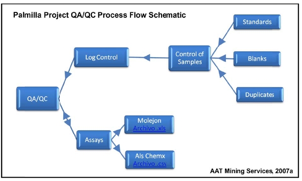
| |
| 12.4 | ADRIAN RESOURCES TRENCH QA/QC DATA |
Some database information is available concerning trenching gold values from the work done by Adrian Resources and the Quality Control (QC) and Quality Assurance (QA) checks carried out on that sampling. Table 15 shows the relative frequency of QA / QC sampling (i.e.blanks, duplicates and standards) by Adrian Resources.
|
| Technical Report on the Palmilla Gold Project |
| 11 December 2012 |
| |
| Table 15 | Adrian Resources Trench Sampling QA/QC Data |
| | | | | |
Adrian
Trench ID | Number of
Samples | Blank
Samples | Repeat
Samples | Standards
[CRM] | % QA
Samples |
| TRBE-01 | 90 | 2 | 2 | 2 | 6.7% |
| TRBE-02 | 163 | 6 | 2 | 9 | 10.4% |
| TRBE-03 | 82 | 3 | 1 | 4 | 9.8% |
| TRBE-04 | 316 | 4 | 6 | 10 | 6.3% |
| TRBE-05 | n.a. | n.a. | n.a. | n.a. | n.a. |
| TRBE-06 | 59 | 1 | 1 | 4 | 10.2% |
| TRBE-07 | 64 | 2 | 2 | 1 | 7.8% |
| TRBE-08 | 162 | 3 | 2 | 5 | 6.2% |
| TRBE-09 | 140 | 4 | 2 | 5 | 7.9% |
| TRBE-10 * | 152 | 3 | 3 | 5 | 7.2% |
| Totals | 1,228 | 28 | 21 | 45 | 7.7% |
Note:Repeat sample value missing from Trench TRBE-10
| |
| 12.4.1 | Adrian Resources 1996 Trench Blank Sample Values |
Analysis by A. Phillips shows that of the 28 Blank samples, eight were below 0.01 g/t Au, fourteen were 0.01 g/t Au, five were 0.02 g/t Au (of which four were probably adjacent sample contamination) and one sample returned a relatively high assay value of 0.78 g/t gold. On this basis it appears likely that, with 19 of the 28 Blank samples returning extremely low gold values, the Blank samples submitted by Adrian Resources were either not blank or more probably suffered from slight adjacent sample contamination. The single, high 0.78 g/t sample is considered aberrant and probably most likely to be the result of sample mislabelling.
Though neither significant nor elevated, minor sample cross-contamination did occur with Adrian Resources 1996 trench samples but that the likely contamination grade (<0.02 g/t Au) is far below any cut-off grades used for resource estimation.
| |
| 12.4.2 | Adrian Resources 1996 Trench Repeat Samples |
Analysis by Mr A. Phillips, CEng of the data shows that only twenty-one repeat sample values (including one missing value) are available out of a total of 1,228 samples, i.e. only 1.7 % which is low. It is not known what the source of these repeat samples were (e.g. sample pulps) or whether they were same batch repeats (“SBR”) or different batch repeats (“DBR”). Samples taken as DBRs are, together with analytical standards, an effective check on laboratory result drift with time.
A Q-Q diagram was constructed for these 20 sample pairs though 20 samples is insufficient to gain a real measure of inter-interval sample value variability. The interval chosen here were deciles (i.e. every 2ndsample). The value correspondence per interval is shown in Figure 21. Decile interval value correspondence is reasonably good, oscillating across the purple ‘perfect fit’ line, though some differences were noted between the actual sample pairs themselves. On this basis, it is considered by Mr Phillips that the Adrian Resources trench values can be used for resource estimation.
|
| Technical Report on the Palmilla Gold Project |
| 11 December 2012 |
| |
| Figure 21 | Q-Q Diagram of Adrian Resources Trench Repeat Assays |

The minimum value of the repeat samples was 0.04 g/t Au, the average was essentially the same at 0.61 g/t Au to two decimal places (0.614 original and 0.611 repeat) and the repeat maximum value was merely 4 % higher at 2.56 g/t compared to the original 2.46 g/t gold.
| |
| 12.4.3 | Adrian Resources 1996 Trench Standard Sample Values |
Forty five Reference samples are known to have been assayed from the Adrian Resources trench assay database. Though these samples were also supplied by Oreas (Ore Research & Exploration Pty Ltd) who supply the standards currently used by PML, these are far earlier versions of some of the current standards (e.g. 1996 versus 2012) and their certified assays are not immediately to hand. Unfortunately, not all of the Standards are named in the trench assay database. These data (certified assay values and database Oreas numbers) should be located if possible for final checks.
It is not possible to comment in this case as different sub-batches of the same assay standard will have slightly differing values and such ‘inter-batch’ variability does appear to be present in the values given in the trench database.
| |
| 12.5 | PML DATA VERIFICATION |
The authors made a review of available information derived from previous exploration work, with emphasis on the 2012 PML drilling campaigns at Palmilla. PML information, reviewed by the authors, included geological and sampling reports, drill logs as well as assay results. Verification consisted of limited field checking of geological information and drill hole locations (PML QA/QC procedures and chain of command; a review and discussion of field procedures, including core sample collection, transportation, handling and core logging; and a review of sampling procedures and storage. A review of data handling, data transfer, and input into the database processes was made.
|
| Technical Report on the Palmilla Gold Project |
| 11 December 2012 |
| |
| 12.6 | PML DATA HANDLING VERIFICATION |
Current PML drilling programs at Palmilla follow the same procedures as used during the 2006-2007 Molejón-Botija Abajo drilling campaign and the 1992-96 drilling at Palmilla (AAT, 2007).
After the sample preparation process, observed by the site-visit authors at the Molejón Sample Preparation Facility, core samples were controlled through sample books with four tags: (1) geologist control, (2) sample bag, (3) coarse material duplicate, and (4) core box location. Sample numbers were then registered in a format with a record of the area, drill hole (DH) number, and interval. A list of samples was generated, copies of which were included in the large, double sealed plastic bags that were sent to the PML’s Santa Ana storage facilities where the list of bags received was verified and put in 25 kg cardboard boxes for shipment to Panamá City and couriered to ALS Chemex in Vancouver.
A report was produced in Santa Ana when damaged sample bags were found. Sample list records were captured in Santa Ana into the database and sent back electronically to the camp for review by the Exploration Manager. Sample submittal forms were sent to the lab and a verification of sample arrival was made at the Santa Ana offices. At all times samples were kept under security at the sample preparation facilities, sample reception warehouse in Santa Ana, company transportation units and air courier facilities in Panamá City. Dr Brandt believes that, under the chain of custody established by the current protocol in use, all handling, preparation, storage, and transfer to the labs was properly done and conforms to current Industry Standards.
Geotechnical information was gathered from core boxes by trained geotechnicians registering depth and interval of run, recovery in meters and percent, core loss/gain, RQD (as a percentage of the sum of fragments larger than 10 cm, generally in a 1.5 meter run), core orientation and angle.
Palmilla Logging techniques by PML were standard and generally follow those used by previous companies. Log records include drill hole location, bearing, and inclination information as well as pertinent drilling operation data. Headings of log formats include: From (meter) – To (meter) – Rock Type – Color – Description – Phenocrystals – Alteration – Alternate Assemblage – Oxide (minimum) – Sulphide (minimum) – Veining – Structure. Digital geologic logs and a summary drill log were also produced for input into the database.
Drill hole information gathering activities were controlled with the help of a wall board format where drill hole number, basic statistics, recoveries, S.G. measurements, photographs, digital transfers, revisions, general observations and geologist responsible for the hole were recorded.
The information is keyed into the Gemcom® Mining Software System by the Systems Department in the Santa Ana offices and cross sections were produced for geological interpretation by PML staff. The authors reviewed PML logging and sampling procedures for the Palmilla 2012 drilling campaign, data collection, and data transfer as well as the controls and formats used in the chain of command all through the process and found that these are adequate and reliable as a basis for further mineral resource estimate.
|
| Technical Report on the Palmilla Gold Project |
| 11 December 2012 |
| |
| 12.7 | RESULTS OF GMS SAMPLING CHECKS |
Petaquilla Minerals provided GMS with external analytical control data in the form of Microsoft Excel spreadsheets containing the assay results for the quality control samples for holes PLDH-001 to PLDH-016 drilled in 2012.
Standards, pulp duplicates and blank data were summarized on time series plots to highlight the performance of the control samples.
The external analytical quality control data produced by Petaquilla Minerals on the Palmilla project for hole PLDH-001 to PLDH-016 are summarized in Table 16. The external quality control data produced on this project represent approximately 5.5% of the total number of samples.
| |
| Table 16 | QA/QC Summary Results for Palmilla Gold Project |
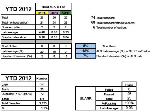
Standard reference material consists in pulverized rock material which gold content is certified by an independent lab (OREAS). This material is used to verify the precision (standard deviation) and the accuracy (average) of the lab during fire assay process. Outliers are calculated from a statistical test (Grubb's test) and removed from average and standard deviation calculations.
Pulp duplicates are the unused fraction of the pulverized rock sample left over from the assaying process. They are used to verify the reproducibility of the lab principally linked to the homogenization of the pulverized material. Samples with a relative difference >1000% are removed from the average calculations
Overall, all the Blank results passed the test. All the results, except 1 blank, were below the detection limit. One blank reports 0.08 g/t Au suggesting that the material was slightly contaminated by the previous sample (0.56 g/t Au). The mean of all the Blank (sourced from pure silica sand) samples is 0.03 ppm gold; which grade is well below any cut-off grades used for resource estimation.
Allcertified standards generally performed as expected. Six (6) outliers were captured by the Grubb’s test. Grubbs' test (named after Frank E. Grubbs), also known as the maximum normed residual test or extreme studentized deviate test and it is a statistical test used to detect outliers in a univariate data set assumed to come from a normally distributed population. The standard deviation averages 7% for the three (3) OREAS standard and this number is judged acceptable.
|
| Technical Report on the Palmilla Gold Project |
| 11 December 2012 |
Paired assay data suggests that gold grades can be reasonably reproduced, consistent with results expected from gold mineralization for this deposit style. Mean relative to half relative deviation plots show that there is no apparent bias between original and duplicate samples (Figure 22).
| |
| Figure 22 | Paired Palmilla Drill Sample Bias Check |
| | | |
| Average grade (g/t Au) | Standard deviation | STD Dev % | Check/Orig |
| 0.70 | 0.14 | 19% | 116% |
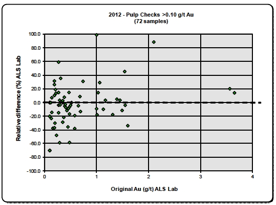
Overall, it is considered that analytical quality control data reviewed attests that the assay results delivered by the ALS laboratories used by Petaquilla Minerals for the Palmilla project are sufficiently reliable for the purpose of resource estimation. Other than indicated above, the apparent bias high is not considered to be material for the purpose of estimating gold grades. The author recommends that more care is taken when inserting control samples to overcome sample mislabelling.
The Santa Ana, Panamá exploration office was visited between December 4 and 5, 2012 and a random check was made of approximately 200 original assay records from hard copy assay certificates against data in the electronic assay database. Also examined was data from various periods and drill programs and Mr R. Sirois, PEng found no significant errors in the Palmilla Project data.
Petaquilla Minerals made available a GEMCOM database containing all electronic data accumulated on the Palmilla Gold Project. A series of routine verifications was conducted to ensure the reliability of this electronic data, using Gemcom validation tools that checks for gaps, overlaps and out of sequence intervals.
|
| Technical Report on the Palmilla Gold Project |
| 11 December 2012 |
The Gemcom collar, survey, lithology and assay tables did not contain obvious errors but it was noted that when a sample was re-assayed a second time by the laboratory the additional value was not captured in the GEMCOM database. It is recommended that any laboratory repeats be captured in the database in a separate column and an average of both assay results be used as the final grade.
It is concluded by Mr R. Sirois, PEng that the digital database for the Palmilla Gold Project is reliable for resource estimation.
13.0 MINERAL PROCESSING AND METALLURGICAL TESTING
Preliminary metallurgical extraction tests have been carried out (METCON, 2012) for gold; namely to evaluate the amenability of cyanide leaching of the gold contained in seven composited drill core samples from Palmilla at three grind sizes of approximately P80of 210, 149 and 75 microns (¼m) or 65, 100 and 200 # size.
The seven Palmilla samples were comprehensively analysed with the following results:
Gold assay values varied from 0.849 to 3.544 g/t Au.
Silver ICP analysis values varied from 1.8 to 3.9 g/t Ag.
Copper ICP analysis values ranged from 0.026 to 0.67 % Cu.
Total Carbon assays ranged from 0.18 to 0.33 % C.
ICP multi-element analysis was carried out for 25 elements, including Arsenic (As), Copper (Cu), Iron (Fe) and Mercury (Hg) as elements of special interest. Of interest is that Arsenic, Cadmium and Mercury were not detected in the Palmilla samples.
Whole rock analysis was carried out on a weight percent basis for the major elements.
The samples were subjected to cyanidation with agitation in bottle rolling tests at three grind sizes, at a constant cyanide concentration of 600 ppm (cyanide consumption), a pulp pH held at a constant 10.5 to 11.0 pH (protective alkalinity consumption) and 45 % pulp density. Solution and reagent sampling was carried out on the pregnant leachate at a range of timed intervals (2, 4, 6, 24, 48 and 72 hours). Gold, Silver and Copper assays and analysis were performed on the pregnant solutions derived from these samples and on their residues at the end of 72 hours.
The results of the cyanidation tests on composited Palmilla core samples showed that:
Recoveries were higher at finer grind sizes (75 ¼mor 200 # size).
Gold recoveries (after 72 hours) reached up to the mid-90 percents in one sample, coupled with low cyanide and high lime consumption.
Gold recoveries in other samples fell to 50 to 60 percent (after 72 hours) where sulphides were present, coupled with high cyanide (used by copper) and low lime consumption.
Copper extraction by cyanidation rose from about 12 % to above 40 % in the sulphide rich samples.
The other samples gave intermediate results suggesting to A. Phillips that a range of partially oxidised material was present in these samples.
The results of this initial testwork has prompted METCON to suggest rougher flotation on the more sulphidic material, with an agitated cyanide leach on the rougher flotation tails. The wide range of observed recoveries suggests that more work needs to be carried out on samples targeted from different weathering horizons.
|
| Technical Report on the Palmilla Gold Project |
| 11 December 2012 |
14.0 MINERAL RESOURCE ESTIMATES
In November 2012, G Mining Services, Inc. (GMS) was commissioned by Petaquilla Minerals to prepare an independent mineral resource model for the Palmilla Gold Project located in Panamá to consider old and new drilling data available up to drillhole PLDH-021. This resources estimate was performed by Réjean Sirois, PEng and incorporated the assay results from Adrian Resources 1994-1996 drilling and the assay results from diamond drill holes PLDH-001 to PLDH-021 of PML’s current 2012 drilling campaign.
The resource estimation reported herein is a reasonable representation of the mineral resources found in the Palmilla deposit at the current level of drilling and sampling. The mineral resources have been estimated in conformity with generally accepted CIM “Estimation of Mineral Resource and Mineral Reserves Best Practices” guidelines.
The evaluation of mineral resource for the Palmilla deposit involved the following procedures:
Database compilation;
Database verification was done by Randy Singh, an independent consultant to PML;
Construction of wireframe models for major grade units using Leapfrog3D software;
Definition of geostatistical resource domains;
Data conditioning (compositing and grade capping) for grade analysis and variography;
Selection of estimation strategy and estimation parameters;
Block modeling and grade interpolation;
Validation, classification and tabulation;
Assessment of “reasonable prospects for economic extraction” and selection of reporting cut-off grades;
Preparation of the Mineral Resource Statement.
| |
| 14.4 | RESOURCE MODELLING & ESTIMATION METHODOLOGY |
Exploration data used to evaluate the mineral resources for the Palmilla Gold Deposit was provided by Petaquilla Minerals as a set of Microsoft Excel files containing drilling information for 44 core boreholes (8,490 m) drilled by Petaquilla Minerals and Adrian Resources, the previous project operator. The database includes 21 boreholes (4,730 m) drilled by Petaquilla Minerals in 2012, and 23 boreholes (3,760 m) drilled by Adrian Resources between 1994 and 1996.
A three dimensional (3-D) schematic view of the drill holes and the deposit’s DTM topography is shown in Figure 23. The three axis shown in this and subsequent 3-D figures correspond to scaled XYZ orthogonal co-ordinate axis based on the local Zone 17N UTM grid co-ordinates (NAD 1927 Datum).
|
| Technical Report on the Palmilla Gold Project |
| 11 December 2012 |
| |
| Figure 23 | Palmilla 3-D Boreholes Location Schematic |

Petaquilla Minerals generated geological wireframes for 7 zones. Topography and overburden surfaces were also supplied in DXF format. The following validation steps were performed:
The different surface and solids were reviewed and the solids were not judged reasonable for the interpretation of the mineralization (see Figure 24) and therefore, new sets of solids were generated by GMS using Leapfrog software (Figures 25, 26 and 27). The generated shells help to constrain the Au, Ag and Cu grade thresholds.
|
| Technical Report on the Palmilla Gold Project |
| 11 December 2012 |
| |
| Figure 24 | 3-D Schematic of Wireframes Supplied by PML |
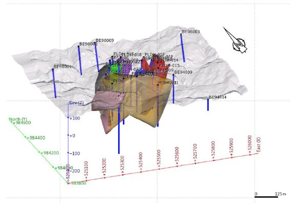
The Rock Codes domains used in the domaining exercise are presented in the following table.
| |
| Table 17 | Rock Codes in the Palmilla Gold Project |
| | |
| Zone | Domain | Rock Code |
| Gold | Above 0.1 gpt Au | 6000 |
| Silver | Above 0.3 gpt Ag | 7000 |
| Copper | Above 0.1% Cu | 8000 |
| Waste | | 5000 |
| Air | | 5 |
The current drilling information is sufficiently reliable to interpret the preliminary outlines of the gold mineralization with low to medium confidence level, and that the assay data is sufficiently reliable to support preliminary mineral resource estimation.
Mineralization wireframes were constructed using Leapfrog 3D modeling software. Statistical analysis and variography was completed with GSLib and Sage 2001 software, while resource estimation work was completed in Gemcom. Conceptual pit optimization work to test the “reasonable prospects” for economic extraction was completed with Whittle software.
|
| Technical Report on the Palmilla Gold Project |
| 11 December 2012 |
| |
| 14.4.1.2 | Resource Modeling |
A series of 3D wireframes were constructed to constrain the extent of the mineralization of the Palmilla Gold deposit, considering the grade trends. From these wireframes, resource domains were constructed and used as hard boundaries for estimating the mineral resources.
The Palmilla project encompasses 3 distinct mineralized zones for gold, silver and copper. The shapes for the three (3) main domains are illustrated in 3-D schematic Figures 25 (for Gold), 26 (for Silver) and 27 (for Copper) at the threshold values stated.
| |
| Figure 25 | 3-D Schematic of Leapfrog Shell for Gold (Threshold Value of 0.1 g/t Au) |

|
| Technical Report on the Palmilla Gold Project |
| 11 December 2012 |
| |
| Figure 26 | 3-D Schematic of Leapfrog Shell for Silver (Threshold Value of 0.3 g/t Ag) |
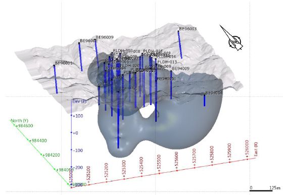
| |
| Figure 27 | 3-D Schematic of Leapfrog Shell for Copper (Threshold Value of 0.1 % Cu) |

Each resource domain was assigned a numerical rock code to facilitate identification during resource evaluation (see Table 18) and extraction of assay data for geostatistical analysis and variography. A
|
| Technical Report on the Palmilla Gold Project |
| 11 December 2012 |
total of 3 resource domains were defined in this Study. The outlines were guided by Leapfrog modeled gold shells and best enveloping a 0.1 g/t gold, 0.3 g/t silver and 0.1% copper grade shell.
| |
| 14.4.1.3 | Assay Sample Grade Statistics |
The core samples were taken at an average 1.2-metre intervals (from 0.3 to 4.4-metre). The histograms and Cumulative Probability Curve Plots of the raw assay data within each domain, which are shown in Figure 28 for Gold, Figure 29 for Silver and Figure 30 for Copper raw values. For geostatistical analysis, variography and grade estimation, the raw assay data were composited to equal 5-metre lengths.
| |
| Figure 28 | Histogram and Cumulative Frequency Plot for Gold Raw Assay Values |
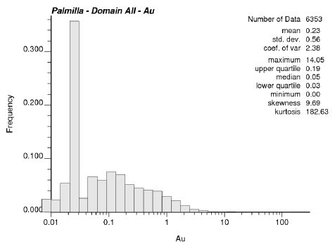
|
| Technical Report on the Palmilla Gold Project |
| 11 December 2012 |
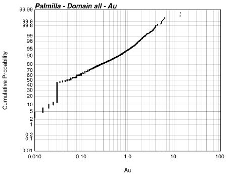
| |
| Figure 29 | Histogram and Cumulative Frequency Plot for Silver Raw Assay Values] |
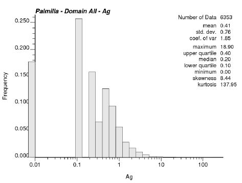
|
| Technical Report on the Palmilla Gold Project |
| 11 December 2012 |

| |
| Figure 30 | Histogram and Cumulative Frequency Plot for Copper Raw Assay Values |

|
| Technical Report on the Palmilla Gold Project |
| 11 December 2012 |

Considering the nature of the assay statistical distributions shown in the Cumulative Probability Curve plots, it was necessary to cap high-grade values to limit their influence during resource grade estimation. The impact of capping was analyzed and capping levels were adjusted for each metal separately. Capping was applied to the raw assay data before generating the composite values. The capping levels for gold, silver and copper are summarized in Table 18.
| |
| Table 18 | Summary of Metal Capping Levels Applied to Each Resource Domain |
| | | | | | | | |
| Gold | Silver | Copper |
| CAP (gpt) | Percentile | N Capped | CAP (gpt) | Percentile | N Capped | CAP (%) | Percentile | N Capped |
| 4 | 99.92 | 14 | 10 | 99.92 | 3 | 2 | 99.90 | 7 |
The basic statistics for the raw assay and capped composite data within each resource domains for gold, silver and copper are summarized in Table 19 and Table 20 respectively.
|
| Technical Report on the Palmilla Gold Project |
| 11 December 2012 |
| |
| Table 19 | Basic Statistics for Raw-assays from Each Resource Domain |
| | | | | | | | |
| Domain | Count | Minimum | Maximum | Mean | Standard
Deviation | Coefficient of
Variation | Skewness | Kurtosis |
| Gold | 6353 | 0.00 | 14.05 | 0.05 | 0.56 | 2.38 | 9.69 | 183 |
| Silver | 6353 | 0.00 | 18.90 | 0.20 | 0.76 | 1.85 | 8.44 | 138 |
| Copper | 6353 | 0.00 | 16.00 | 0.06 | 0.33 | 2.57 | 32.32 | 1,427 |
| |
| Table 20 | Basic Statistics for Capped 5 m Composites from Each Resource Domain |
| | | | | | | | |
| Domain | Count | Minimum | Maximum | Mean | Standard
Deviation | Coefficient of
Variation | Skewness | Kurtosis |
| Gold | 513 | 0.02 | 3.20 | 0.34 | 0.44 | 1.31 | 2.50 | 10 |
| Silver | 512 | 0.00 | 3.87 | 0.56 | 0.54 | 0.97 | 1.95 | 6 |
| Copper | 514 | 0.00 | 0.94 | 0.19 | 0.15 | 0.79 | 1.69 | 7 |
Variography was completed for gold, silver and copper using SAGE 2001 software package to characterize the spatial continuity of the metal grade data in each resource domain. The standard approach was used to generate and model the variography for each of the domains. The steps taken are summarized below:
Examination of the orientations and dips of the solids representing the domains to be studied to help determine the axes of better continuity.
Generate and model the down-hole direction correlogram, which allows the determination of the nugget effect (closed spaced variability).
Calculate and model the major, semi-major and minor axes of continuity.
Correlograms were generated at 30 degree azimuth intervals and at 15 degree dip increments for each domain using Sage 2001 software, which uses regressions to determine optimal anisotropy directions. All the variograms were modeled with a nugget effect and two spherical structures representing the larger scale spatial variability of the datasets.
Variogram parameters are summarized in Table 21 and search radius used in the grade interpolation in Table 22. A High Grade Transition threshold was applied to limit the influence of higher grade values.
| |
| Table 21 | Variograms Parameters for All Resource Domains Grade Interpolation |
| | | | | | | | | | | | |
| Domain | Rotation Z Y Z | C0 | C1 | RX | RY | RZ | C2 | RX | RY | RZ |
| Gold | 60 | 30 | 63 | 0.003 | 0.002 | 27 | 103 | 113 | 0.995 | 250 | 93 | 500 |
| Silver | 11 | 11 | 91 | 0.019 | 0.694 | 1 | 140 | 170 | 0.287 | 55 | 500 | 140 |
| Copper | 59 | 1 | 86 | 0.04 | 0.352 | 194 | 45 | 160 | 0.608 | 600 | 50 | 250 |
|
| Technical Report on the Palmilla Gold Project |
| 11 December 2012 |
| |
| Table 22 | Search Parameters for All Resource Domains Grade Interpolation |
| | | | | | | | | | |
| Domain | Rotation Z Y Z | RX | RY | RZ | High Grade
Transition | RX | RY | RZ |
| Gold | 60 | 30 | 63 | 100 | 100 | 100 | 2 gpt | 50 | 50 | 50 |
| Silver | 11 | 11 | 91 | 100 | 100 | 100 | 2 gpt | 50 | 50 | 50 |
| Copper | 59 | 1 | 86 | 100 | 100 | 100 | 0.6% | 50 | 50 | 50 |
| |
| 14.4.4 | Block Model and Grade Estimation |
| |
| 14.4.4.1 | Block Model Definition |
An unrotated block model was created in Gemcom to cover the entire extent of the Palmilla Project deposit area. Block size was set at 20 m x 20 m x 5 m (Table 23).
Criteria used in the selection of block size include the borehole spacing, composite assay length, consideration for the potential size of smallest mining unit and the geometry of the modeled domains.
| |
| Table 23 | Palmilla Gold Project Block Model Parameters |
| | | | |
| Direction | Size (metre) | Minimum | Maximum | Number of
Cells |
| East West | 20 | 525,000 | 526,000 | 50 |
| North South | 20 | 983,800 | 984,600 | 40 |
| Vertical | 5 | 300 | 200 | 100 |
Metal-grades were estimated using ordinary kriging as the principal estimator separately in each domain from capped composite data within that domain. Grade interpolation was completed in one (1) pass considering estimation parameters summarized in Tables 21 and 22 and search neighbourhoods summarized in Table 24
| |
| Table 24 | Resource Estimation Parameters |
| | | | | |
| Interpolation Parameters |
| Domain | Interpolation
Method | Search Type | Minimum Number
of Composites | Maximum Number of
Composites | Maximum Number of
Composite per hole |
| Gold | Ordinary Kriging | Ellipsoidal | 2 | 12 | 2 |
| Silver | Ordinary Kriging | Ellipsoidal | 2 | 12 | 2 |
| Copper | Ordinary Kriging | Ellipsoidal | 2 | 12 | 2 |
|
| Technical Report on the Palmilla Gold Project |
| 11 December 2012 |
The mineral resource model was validated by visually comparing block and borehole grades on a section by section and on an elevation by elevation basis (Figures 31 for Gold, 32 for Silver and 33 for Copper). This exercise satisfied Mr R. Sirois, PEng that the current block model fairly represents the Palmilla drill data considered for the purpose of resource estimation following NI 43-101 standards.
| |
Figure 31 | Cross-Section 525,475E Comparing Blocks Populated with Gold-Grades and Informing Data |
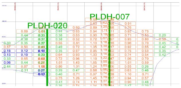
| |
Figure 32 | Cross-Section 525,475E Comparing Blocks Populated with Silver-Grades and Informing Data |

|
| Technical Report on the Palmilla Gold Project |
| 11 December 2012 |
| |
Figure 33 | Cross-Section 525,475E Comparing Blocks Populated with Copper-Grades and Informing Data |
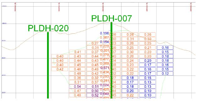
| |
| 14.4.5 | Resource Classification |
Mineral resources were classified according to the CIMDefinition Standards for Mineral Resources and Mineral Reserves(CIM, 2010) by Réjean Sirois, PEng.
The mineral resources are classified primarily based on the basis of a block’s distance from the nearest informing composites and on variography results. At this stage, only Inferred classification was used for all the estimated blocks. The classification strategy also considered the geological setting, the stage of exploration as well as what impact additional drill data could have on the shape of the modelled geological zones and the confidence in the grade continuity.
GMS considers that additional drilling has the potential to further expand the lateral and depth extensions of several domains.
| |
| 14.4.6 | Mineral Resource Estimates |
CIM Definition Standards for Mineral Resources and Mineral Reserves (November 2010) defines a mineral resource as:
“A concentration or occurrence of diamonds, natural solid inorganic material, or natural solid fossilized organic material including base and precious metals, coal, and industrial minerals in or on the Earth’s crust in such form and quantity and of such a grade or quality that it has reasonable prospects for economic extraction. The location, quantity, grade, geological characteristics and continuity of a Mineral Resource are known, estimated or interpreted from specific geological evidence and knowledge.”
The “reasonable prospects for economic extraction” requirement generally implies that the quantity and grade estimates meet certain economic thresholds and that the mineral resources are reported at an appropriate cut-off grade taking into account extraction scenarios and processing recoveries.
|
| Technical Report on the Palmilla Gold Project |
| 11 December 2012 |
In order to determine the quantities of material offering “reasonable prospects for economic extraction” by an open pit, a conceptual pit envelope was developed using the Whittle software and its Lerchs-Grossman optimising algorithm. The initial NSR optimization parameters used are stated in Table 17.
The reader is duly cautioned that the results from the pit optimization are used solely for the purpose of assessing those portions of the block models that show “reasonable prospects for economic extraction” by an open pit and does not represent an attempt to evaluate mineral reserves.
| |
| 14.4.6.1 | Economic Discussion and Cut-off Grade |
The Mineral Resource Statement was prepared on the basis of the gold content only and is reported at different gold cut-off grades considering the most likely extraction scenario without taking external, non-mining based factors into account. Open pit mineral resources are reported at a cut-off grade of 0.1 g/t gold. Cut-off grades are based on a long term gold price of US $1,600 per ounce and a gold metallurgical recovery of 85 % for open pit gold resources.
The consolidated Mineral Resource Statement for the Palmilla Gold Project is summarized in the table below. The effective date of this Mineral Resource Statement prepared for the Palmilla Gold Project is October 26, 2012. It should be noted that mineral resources that are not mineral reserves do not have demonstrated economic viability (CIM, 2010).
| |
Table 25 | Inferred Mineral Resources Within Whittle Shell Design (As of October 26, 2012) |
| | | | | | | | |
| | | Au
Contained | Cu
Contained | Ag
Contained | Au Equivalent
Contained
oz |
| | Kt | g/t | oz | % | k Llbs | g/t | oz | |
| Inferred | 19,725 | 0.50 | 318,500 | 0.18 | 80,368 | 0.54 | 345,600 | 502,800 |
Numbers may differ due to rounding
Resources are constrained within Whittle shell
Resources are reported using 0.1 g/t Au cut-off
Gold Equivalent Ounces 502,800
Gold $1,600/oz Copper $3.54/lb Silver $30/oz
Recoveries Au 85%, both Ag and Cu 75%
Cost: $2.10/t mined, processing and G & A $14.00/t processed
Royalties Au 4% and Cu 5%
Mineral resources by gold cut-off grades are summarized in Table 26.
|
| Technical Report on the Palmilla Gold Project |
| 11 December 2012 |
| |
Table 26 | Inferred Mineral Resources Within Whittle Shell Design (As of October 26, 2012) |
| | | | | | | | |
Gold
Cut-off
Grade
(g/t Au) | Kt | Au
Contained | Cu
Contained | Ag
Contained | Au Equivalent
Contained
oz |
| g/t | oz | % | K lbs | g/t | oz | |
| >0.3 | 13,499 | 0.64 | 276,,800 | 0.20 | 60,908 | 0.60 | 261,400 | 416,500 |
| >0.2 | 17,008 | 0.56 | 305,100 | 0.19 | 72,842 | 0.57 | 309,900 | 472,100 |
| >0.1 | 19,725 | 0.50 | 318,500 | 0.18 | 80,368 | 0.54 | 345,600 | 502,800 |
Numbers may differ due to rounding
Resources are constrained within Whittle shell
Resources are reported using various Au cut-offs
Gold $1.600/oz, copper $3.54/lb, silver $30/oz
Recoveries Au 85%, both Ag and Cu 75%
Costs: $2.10/t Mined, Processing and G & A $14.00/t processed
Royalties Au 4% and Cu 5%
The specific gravity database includes 556 core measurements completed by water displacement method on 10 cm core samples selected as representative of each modelled domain. Based on this database, GMS assigned an average specific gravity value of 2.69 tonne per cu-metre for all domains as indicated in Table 27 and Figure 34.
|
| Technical Report on the Palmilla Gold Project |
| 11 December 2012 |
| |
| Table 27 | Core Specific Gravity Database |
| | | | | | | |
| Count | Minimum | Maximum | Mean | Standard
Deviation | Coefficient of
Variation | Skewness | Kurtosis |
| 556 | 2.03 | 3.05 | 2.69 | 0.10 | 0.04 | 1.18 | 6 |
| |
| Figure 34 | Specific Gravity Histogram |

| |
| 14.4.7 | Whittle Optimisation |
To assess reasonable prospects of economic extraction by open pit the Palmilla resource model was imported into Whittle® (version 4.3) to determine optimal pit shells based on the Lerchs-Grossmann algorithm. The method works on a block model of the ore body, and progressively constructs lists of related blocks that should, or should not, be mined. The method uses the values of the blocks to define a pit outline that has the highest possible total economic value, subject to the required pit slopes defined as structure arcs in the software.
This section describes the conceptual mining parameters used to calculate block values in Whittle. All material currently classified as Inferred was valued in the optimization process to determine the confined resource within an optimal shell.
The Palmilla deposit is polymetallic with the presence of copper, gold and silver which would report to a copper concentrate. Various assumptions were made to calculate a net smelter return for each block in the resource model. These parameters are tabled below (Table 28). No penalty for deleterious elements has been assumed, given the extremely low levels found in the analysis from the preliminary metallurgical tests and in the ALS Minerals certificate seen for multi-element analysis carried out on the core.
|
| Technical Report on the Palmilla Gold Project |
| 11 December 2012 |
| |
| Table 28 | NSR Calculation Assumptions |
| | | | |
| Metal Prices US $ | | |
| Copper | 3.54 | $/lb | |
| Gold | 1,600.00 | $/oz | |
| Silver | 30.00 | $/oz | |
| Process Recovery | | | |
| Copper | 75 | % | |
| Gold | 85 | % | |
| Silver | 75 | % | |
| Payable Metal Rates | | | |
| Copper | 96.8 | % | |
| Gold | 97.5 | % | |
| Silver | 90.0 | % | |
| Minimum Deductions | | | |
| Copper | 1 | % | |
| Gold | 1 | g/t | |
| Silver | 30 | g/t | |
| Refining Rates | | | |
| Copper | 0.08 | $/lb | |
| Gold | 6.00 | $/oz | |
| Silver | 0.40 | $/oz | |
| Royalty Rates | | | |
| Copper | 5 | % | |
| Gold | 4 | % | |
| Silver | 4 | % | |
| Treatment Charge | 80.00 | $/t conc. | |
| Concentrate Transport | 40.00 | $/t conc. | |
An average mining cost of US $2.10/t was assumed along with an ore based cost of US $14.00/t which would include processing, power and general and administrative costs. No mining dilution or ore losses were applied at this stage of evaluation. A 47° overall slope angle was applied in the Whittle optimization process, which is not supported by any geotechnical studies at this stage.
The parameters used in the initial Palmilla Whittle pit optimisation study considered only the most likely extraction scenario, without taking external, non-mining based factors into account. Such factors would include environmental permitting, taxation, mineral royalties, surface rights and socio-economic factors which would only be recognised fully once a PEA were carried out.
15.0 ADJACENT PROPERTIES
The Palmilla Gold deposit and the Rio Belencillo Zone 1 Concession are peripheral to the northwest of a major cluster of mineral deposits within the Petaquilla Concession and which are considered to be associated with intrusives and mineralisation related to the Petaquilla Granodioritic Intrusives.
These deposits include the Petaquilla copper porphyry developing mine comprising the Colina, Valle Grande and Botija Sections, the Molejón* epithermal gold mine and numerous others, including the Botija Abajo*, Botija Abajo West*, Botija North Saprolite, Brazo*, Faldalito, Cuatro Crestas, Lata
|
| Technical Report on the Palmilla Gold Project |
| 11 December 2012 |
and Orca deposits, prospects and mineral occurrences; the more important of which are shown in Figure 2. The mineral deposits marked with an asterisk (*) lie along the northeast trending El Real Trend through the Molejón mine. The history of the exploration and ongoing development of the Petaquilla Concessions is outlined in part in Table 30 below and is recorded in public documents elsewhere (e.g. Cameron et al, 2012 and Rose et al, 2010).
On a historical basis, the establishment of the United Nations Development Program (UNDP) in 1965 resulted in the funding of mineral exploration activities throughout Latin America, including Panamá, in collaboration with local governments. Systematic exploration in the Panamanian project region covered an original area of 810 sq km where porphyry copper mineralization related to the late Tertiary intermediate intrusives was identified in 1967 by A. Metti, UNDP geologist.
Copper-gold-molybdenum porphyry mineralization was first discovered in the Petaquilla River region during a regional geological and geochemical survey by a UNDP team in 1968 and the location of the three main ore bearing prospects, Botija, Petaquilla, and Rio del Medio, as well as five minor mineralized zones were outlined by mid-1969 (Ferencic, 1971). Though the primary focus was on porphyry copper deposits, several epithermal gold deposits were located, including the Molejón, Botija Abajo and Palmilla deposits.
Table 24 summarises the history of company involvement in the exploration and mineral resource development of the area (see Figure 3). This work was largely carried out on concessions granted by theLey Petaquillain 1997. Most of these concessions are adjacent to east of the Rio Belencillo Zone 1 Concession containing the Palmilla Project. The historical information given in this table has been provided by PML and has not been verified by either BDI or GMS. The information provided is not necessarily indicative of the mineralization on the Palmilla Gold Project.
| |
| Table 29 | History of Concession Exploration and Ownership in the Petaquilla Area |
| | |
| HISTORY OF CONCESSION EXPLORATION & OWNERSHIP IN THE PETAQUILLA AREA |
| Date | Party | Exploration and Property History Description |
16th
Century | Spanish Colonialists | Mina Belen quartz vein mine adjacent to Petaquilla Concession Zone 1 (see Figure 2). |
1968 –
1969 | United Nations Development Program (UNDP) | Regional geological and geochemical survey of central Panamá by the UNDP, widespread silicification and copper mineralization discovered in the area of the Petaquilla and Botija deposits. Stream sediment sampling field magnetometer and preliminary drilling resulted in the discovery of the Petaquilla, Botija, Brazo, Vega, and Medio deposits. |
1969 –
1980 | Panamá Mineral Resources Development Company (PMRD) | Panamanian government tendered Petaquilla Concession exploration rights to international bidding; concession awarded in 1971 to Panamá Mineral Resources Development Company (PMRD), a consortium of seven Japanese copper companies. Approximately 14,000 meters of drilling at Petaquilla, Botija, Medio, and Vega, totalling approximately 14,000 meters, preliminary Resource and Reserve calculations based on prefeasibility report completed in 1977. Feasibility work updated; unsuccessful negotiations with the Panamanian government over terms of production, property abandoned in 1980 for 10 years. |
1990 –
1992 | Minnova | Property acquired by Minnova (now Inmet) 80% and Georecursos International S.A. 20%. Exploration activity included regional lithogeochemical sampling. |
1991 –
1992 | Minnova Geotec | Minnova and Geotec, in 1991, completed regional geochemical rock sampling covering the southeastern two-thirds of the original Petaquilla concession. Their work identified anomalous gold (>100 ppb) and |
|
| Technical Report on the Palmilla Gold Project |
| 11 December 2012 |
| | |
| HISTORY OF CONCESSION EXPLORATION & OWNERSHIP IN THE PETAQUILLA AREA |
| Date | Party | Exploration and Property History Description |
| | | arsenic (>12 ppm) values at Molejón area. |
| 1992 – 1993 | Adrian
Resources | Adrian Resources (now Petaquilla Minerals, Ltd.) was granted an option to earn 40% of Minnova’s interest through cash payments, work commitment, and production of a feasibility study. Adrian subsequently acquired Georecurso’s interest, bringing its total interest to 52%, and started formal exploration at Molejón in 1993. |
| 1992 – 1995 | Adrian
Resources | Adrian carried out grid-based soil sampling and magnetic surveying, geologic mapping of selected areas, and starting February 1994, drilling of approximately 396 diamond drill holes in Petaquilla, Botija, and other exploration targets. Activity included investigation of the Valle Grande deposit and discovery of epithermal gold mineralization at Molejón, as well as identification or investigation of several other targets (Palmilla, Botija Abajo, Botija Abajo West, Brazo, Faldalito, Cuatro Crestas, Lata and Orca)(see Figure 3). |
| 1997 | Minera
Petaquilla | Minera Petaquilla S.A. (Minera Petaquilla) was formed by Adrian Resources, Inmet, and Teck Corp in 1997. The Petaquilla Concession was granted by the Government of Panamá to Minera Petaquilla, S.A. through a Contract Law named “Ley Petaquilla, Contrato N° 9 del26/02/97” covering a total of 13,600 ha. |
| 2004 | PML | On October 12, 2004, the Company changed its name from Adrian Resources to PML to correspond with the Company’s Petaquilla project in Panamá. On December 13, 2004, the Company entered into a letter of intent with Teck and Inmet. Under the letter of intent, the Company may obtain 100% of the Molejón gold and Botija Abajo deposits (a gold deposit within the Minera Petaquilla S.A. project), subject to a 5 % NSR payable to Inmet and the Panamanian Government accepting a multi-phase mine development plan on terms acceptable to the Company, Teck and Inmet. In December 2004, the Company resumed exploration within Minera Petaquilla project in Panamá. |
| 2005 | PML,
Minera
Petaquilla | PML created two companies, Petaquilla Gold Ltd. and Petaquilla Copper. Ltd., to handle exploration, development, and operations of gold interests (Molejón, Botija Abajo) and copper deposits, respectively. Minera Petaquilla undertook a large trenching program comprised of 5,000 meters in 113 trenches during the summer of 2005. The trenches were often no more than 2.0 meters deep mostly on weathered material to fresh rock. Minera Petaquilla developed the mine plan (2005) that has been approved by the government. |
| 2006 | PML | In 2006, PML excavated in the general Molejón area 12,294 meters of new trenches and drilled 220 core holes on a 14,005 meter Phase II drill program, including 11,398 meters devoted to infill drilling to confirm resource estimates, 980 meters of condemnation drilling to establish the location of the plant site, and 1,627 meters devoted to exploration drilling. |
| 2006 - 2007 | PML | As of 2007, 10,142.4 metres of core drilling were completed on the Botija Abajo deposit: 18 core holes for 2,326.6 metres between 1993 and 1995 by Adrian Resources and 86 holes for 7815.8 metres between 2006 and 2007 by PML. |
|
| Technical Report on the Palmilla Gold Project |
| 11 December 2012 |
| | |
| HISTORY OF CONCESSION EXPLORATION & OWNERSHIP IN THE PETAQUILLA AREA |
| Date | Party | Exploration and Property History Description |
| 2007 – 2009 | PML | Inmet buys Petaquilla Copper and makes agreements with Teck creating Cobre Panamá, which is the owner of Minera Panamá S.A. Currently, there are two companies under the Law Number 9, Petaquilla Gold S.A. with a concession area of 1,186 ha and Minera Panamá S.A. with the rest of the concession, 12,414 ha. Phase II drilling at Molejón continued into 2007 to enable mine planning. The mine was developed and the processing plant was built. (Figure 3) |
| 2008 | PML | Environmental authorities (ANAM) on November 26, 2008, issued Resolution DIEORA IA-809-2008, approving the Environmental Impact Study Category III, submitted by Petaquilla Gold, S.A., for the implementation of the Molejón Mining Project and other measures mandated by the ANAM. |
| 2009 | PML | In accordance with Contract Law Number 9 of February 26, 1997, the Ministry of Commerce and Industry of the Government of Panamá issued a letter to the Company dated November 18, 2009, authorizing Petaquilla’s subsidiary, Petaquilla Gold, S.A., to initiate commercial production at its Molejón gold mine located in the District of Donoso, Province of Colón, Republic of Panamá. |
| 2010 | PML | Commercial production at Molejón started on January 8, 2010. The mine is used as an operational base for regional exploration for gold deposits By PML |
| 2011 - 2012 | PML | Surface exploration initiated at Palmilla, including trenching and diamond drilling program. |
|
| Technical Report on the Palmilla Gold Project |
| 11 December 2012 |
16.0 OTHER RELEVANT DATA AND INFORMATION
Most of Central and South America, including the eastern and western parts of Panamá, is considered to be very seismically active. However, the central part of Panamá has experienced very few earthquakes, particularly in the north along the Caribbean coast (Camacho, E., 2012).
17.0 INTERPRETATION AND CONCLUSIONS
Drilling to date in the Palmilla area has intersected a sequence of andesitic lavas and tuffaceous sediments and granodioritic intrusives which are mineralised in places along a six kilometre long, northwest-southeast trending, coincident multi-element geochemical and magnetic geophysical anomaly on the Palmilla grid in Zone 1 of the Rio Belencillo Exploration Concession. Mineralized intrusives occur at Palmilla, Trueno and Quebrada Dino, the last two being under-explored. A third, off-trend satellite mineralization also occurs at Relampago.
The intrusive at Palmilla is only weakly altered and mineralized with the best developed mineralization (quartz-magnetite-chalcopyrite-bornite and gold) occurring at the contact or within the adjacent altered volcanic and sedimentary rocks.
The Palmilla deposit is considered by PML to be a copper porphyry deposit with a telescoped epithermal gold deposit overprint.
| |
| 17.2 | PALMILLA TECHNICAL REPORT CONCLUSIONS |
The Palmilla Gold Project is in an intermediate stage of drilling exploration and currently comprises a dominant gold-copper deposit, Palmilla, with a 19.725 Mt inferred Au-Cu-Ag Resource. There are in addition three subsidiary satellite mineral showings, none of which three has been adequately explored.
|
| Technical Report on the Palmilla Gold Project |
| 11 December 2012 |
18.0 RECOMMENDATIONS:
The economic potential of the main Palmilla Au-Cu deposit should be investigated, following the completion of the current trenching and 42 hole drilling program with the integration of the prior Adrian Resources work into the study.
This investigation should include the re-estimation of the Palmilla deposits mineral resources to include the surface trench values from both Adrian Resources’ phased historical exploration campaign and PML’s own recent work. This reappraisal should be carried out with particular regard to the potential for the mining of an open pit-oxide gold deposit. Any Preliminary Economic Assessment (scoping study) will be facilitated by PML having access to its own operations at Molejón.
The mineralization at Trueno has now been intersected by five boreholes and a focussed trenching and drill program could be carried out if a reappraisal of results warrants it.
Additional work should be carried out on the mineralized intrusive at Quebrada Dino and also at the third, off-trend satellite mineralization at Relampago.
|
| Technical Report on the Palmilla Gold Project |
| 11 December 2012 |
19.0 REFERENCES
AAT Mining Services, 2007, Data Usability Assessment. Petaquilla, Botija & Valle Grande Copper Deposits. Colón Province, Panamá. Prepared for Petaquilla Copper Ltd by AAT Mining Services, Centennial, Colorado, USA in February, 2007.
Anon, 1990, Geología de la República de Panamá. Geological Map of Panamá on a scale of 1:250,000. Map prepared by the Ministerio de Comercio e Industrias, Dirección General de Recursos Minerales.
Anon, 2012, Web Document - Government of Panamá. Extract from Mapa de Climas de la Republica de Panamá”. Available at www.contraloria.gob.pa/inec/Publicaciones/21-01/3.pdf. Downloaded 20thNovember, 2012.
Archibald, R.D. et al, 2012, Molejón Project NI 43-101 Technical Report, Donoso District, Colón Province, Republic Of Panamá. Report Prepared By Behre Dolbear & Company (USA), Inc for Petaquilla Minerals Limited. Report No. J12-117, Dated May 2012. 159 Pages; Available onwww.sedar.com.
Buchanan, L. J., 1981, Precious metal deposits associated with volcanic environments in the southwest. Arizona Geological Society Digest, v.14, pgs 237 - 261.
Cameron, R., et al, 2012, A Technical Report on the Botija Abajo Project, A Satellite Deposit of the Molejón Mine. Report prepared by Behre Dolbear & Company (USA), Inc for Petaquilla Minerals Limited. Report No. J12-208, dated 24 September, 2012. 147 pages. Available onwww.Sedar.com.
Camacho, E., 2012, Earthquakes and Tsunamis in Panamá. Web translation of document produced by the Geoscience Institute, University of Panamá. Web address: http://www.geocienciaspanama.org/ publicaciones/18-terremotos-y-tsunamies-en-panama. Referenced 06/12/2012.
CIM, 2010, CIM Definition Standards for Mineral Resources and Mineral Reserves. Adopted by CIM Council November 27, 2010. 10 pgs. Available onwww.cim.org.
Corbett, G.J., 2002, Epithermal Gold for Explorationists, Australian Institute of Geoscientists Presidents Lecture - AIG Journal, Paper 2002-1. February 2002, 26 pgs.
Corbett, G.J., 2007, Controls to Low Sulphidation Epithermal Au-Ag. PowerPoint presentation presented on www.corbettgeology.com, 83 slides (pgs).
del Guidice, D., and Recchi, G., 1969, Geología del Area del Proyecto Minero de Azuero. Report compiled for the United Nations Development Program, dated September 1969, 58 pgs.
Dengo, G. and Case, J.H., Editors, 1990, The Caribbean Region: The Geology of North America, Volume H. Geological Society of America.
Escalantes, G., 1990, The Geology of Southern Central America and Western Colombia, in The Caribbean Region: The Geology of North America, Volume H. Geological Society of America, Chapter 8, pgs 201-229.
Ferencic, A., 1971, Metallogenic Provinces and Epochs in South Central America, Mineralium Deposita, Vol. 6, pgs 77-88.
|
| Technical Report on the Palmilla Gold Project |
| 11 December 2012 |
Fluor Daniel Wright, Ltd., 1997, Adrian Resources Ltd., Petaquilla Project, Scoping Study and Valuation, Final Report, Prepared by Fluor Daniel Wright Ltd. February 1997. Project 2397, 95 pgs.
Kesler, S.E., et al, 1977, Evolution of Porphyry Copper Mineralization in an Oceanic Island Arc: Panama. Economic Geology, V.72, Pgs 1,142 - 1,153.
Kesler, S.E., et al, 1990, Metallogenic Evolution of the Caribbean Region, in The Caribbean Region: The Geology of North America, Vol. H, Geol.Soc.Amer. Chapter 18, pgs 459-481.
McArthur, G.F., 1993, Qualifying Report on the Belencillo Property. Report prepared by McArthur Geological for Madison Enterprises Corp, July 1993. 25 pages.
McArthur, G.F., 1994, Summary Report, 1993 Phase I Exploration on the Belencillo Property (Abbreviated Version). Report prepared by McArthur Geological for Madison Enterprises Corp, 1993. 29 pages.
Minera Panamá, S.A., 2012, Basic Engineering Summary Report, Mina de Cobre Panamá Project. 140 pgs (Inmet Mining Corporation document, obtained fromwww.inmetmining.com).
McArthur, G.F., 1996, 1996 Phase III Exploration Belencillo Property. Report produced by Royal York Ventures Ltd for Madison Enterprise Corporation. Dated August 1996, 220 pgs.
Marshall, J. S., 2007, The Geomorphology and Physiographic Provinces of Central America. In: Geology, Resources and Hazards, Edited by Jochen Bundschuh and Guillermo E. Alvarado. Taylor & Francis, 2007.
METCON, 2012 Palmilla Project and Oro de Norte Project, Metallurgical Study. Progress Report dated 28 August 2012. Document No. METCON Q741-03-015.02, prepared for Petaquilla Mineral S.A., 45 pgs.
Nelson, C. E and Nietzen F., 2000, Metalogenia de Oro y Cobre en América Central. Revista Geológica de America Central, No. 23, 2000, pgs 25-41.
Nelson, C.E., 2007, Metallic Mineral Resources; Chapter 32 in Bundschuh, J., and Alvarado, G.E., editors, Central America: Geology, Resources and Hazards. Published by A.A. Balkema, Volume 2, pgs 885 to 915.
Petaquilla Minerals Inc, 2011, Informe Final, Estimacion De Recursos, Proyecto Palmilla by Fernando Becerra.
Rose, W. L., et al, 2010, Mina de Cobre Panamá Project, Panamá, NI 43-101 Technical Report. Report prepared for Inmet Mining Corporation by WLR Consulting, Inc. 188 pgs. Report available onwww.sedar.com.
Stewart, J.G., 1999, Re: Belencillo Concession (the “Property”). Letter from Adrian Resources, dated January 18, 1999, 3 pgs.
Turnbull, D., and Laudrum, D., 1996 Summary Report of the 1994 Phase II Exploration Program of the Belencillo Property. Volume 1, Assay Certificates and Drill Logs. Report produced by Lakehead Geological Services Inc for Madison Enterprise Corp. Dated April 1, 1996, 44 pgs.
Weyl, R., 1980, Geology of Central America, 2ndEdition, Gebruder Borntraeger, Berlin, 400 pgs.
|
| Technical Report on the Palmilla Gold Project |
| 11 December 2012 |
20.0 DATE AND SIGNATURE PAGES
The undersigned prepared this Technical Report, titled Technical Report on the Palmilla Gold Project dated 11 December_2012.
The format and content of the report are intended to conform to Form 43-101F1 of National Instrument 43–101 (NI 43–101) of the Canadian Securities Administrators.
Signed and Sealed
Dr D. Brandt PrSciNat 11 December 2012
Réjean Sirois, PEng 11 December 2012
Andrew Phillips CEng 11 December 2012
|
| Technical Report on the Palmilla Gold Project |
| 11 December 2012 |
CERTIFICATE OF QUALIFICATION OF DION BRANDT
I, Dion Brandt, PhD, SACNASP do hereby certify that:
| 1) | I am a Senior Geological Associate with Behre Dolbear International Limited of 3rdFloor, International House, Dover Place, Ashford, Kent, TN23 1HU, United Kingdom. |
| |
| 2) | I am an active member of the South African Council for Natural Scientific Professions (SACNASP), and of the Geological Society of South Africa (GSSA). |
| |
| 3) | I graduated from the University of the Witwatersrand with a BSc degree in Geology, with Honours (in the first class) in 1991, an MSc (with distinction) in 1992 - 1993 and with a Ph.D. in 1999. |
| |
| 4) | I have practiced my profession continuously as a geologist for a total of 19 years since graduation from university. |
| |
| 5) | I have read the definition of “qualified person” as set out in National Instrument 43-101 and certify that, by reason of my education, affiliation with a professional association as defined in NI 43-101 and relevant past work experience, I fulfill the requirements to be and am a “qualified person” for the purposes of NI 43-101 and for this report. |
| |
| 6) | I am co-responsible for the preparation of portions of this “TECHNICAL REPORT ON THE PALMILLA GOLD PROJECT” with an effective date of the 15thof December, 2012, including specifically Items 12.1 and 12.5 and where indicated within the report and for general background briefing material. |
| |
| 7) | As of the date of this report: to the best of my knowledge, information, and belief, my contributions to this technical report contain all scientific and technical information that is required to be disclosed to not make this report misleading. |
| |
| 8) | I am independent of Petaquilla Minerals Limited, holder of the Rio Belencillo Concession as set out in Section 1.5 of National Instrument 43-101. I have had no prior involvement with the property that is the subject of this Technical Report. |
| |
| 9) | I have read National Instrument 43-101 and Form 43-101 F1, and the Technical Report has been prepared in compliance with that instrument and form. |
| |
| 10) | I consent to the filing of this Technical Report with any stock exchange or other regulatory authority and publication by them for regulatory purposes, including electronic publication in public company files on their websites, where the Technical Report is accessible by the public. |
Effective on this 11th Day of December, 2012
Signed Dion Brandt, PrSciNat, PhD
|
| Technical Report on the Palmilla Gold Project |
| 11 December 2012 |
CERTIFICATE OF QUALIFICATION
I, Réjean Sirois,Vice President, Geology and Resources, at G Mining Services Inc., 1950 Blvd Taschereau, D Building, Suite 200, Brossard, Québec J4X 1C2, hereby certify that:
| | 1. | I am a registered member of Ordre des Ingénieurs du Québec, # 38754; |
| | |
| | 2. | I am a member of the Prospectors & Developers Association of Canada, # 14892; |
| | |
| | 3. | I graduated from the Université du Québec à Chicoutimi in 1983 and have a Bachelor’s degree in Geological Engineering; |
| | |
| | 4. | I have practiced as a geological engineer since my graduation in exploration and mine geology. Over the last 27 years, I have completed numerous resource estimates for gold, silver, base metals and industrial minerals; |
| | |
| | 5. | I have been working for G Mining Services Inc. since September 2012 as Vice President, Geology and Resources; |
| | |
| | 6. | I have visited the Palmilla Gold Deposit on December 5-6, 2012; |
| | |
| | 7. | As Vice President, Geology and Resources, I have prepared the section 14.0 and items 10.2, 12.2, 12.5 and 12.7 of the present technical report. I also verify that the resource estimate is done according to the industry standards and that reflect the current understanding of the geology and mineralization of the Palmilla Gold Deposit; |
| | |
| | 8. | The mineral resource estimate and the classification are done in accordance with the definitions and guidelines adopted by the Canadian Institute of Mining, Metallurgy and Petroleum and therefore, are compliant with the National Instrument 43-101 for mining projects; |
| | |
| | 9. | At the date of this certificate, to the best of my knowledge, the section 14 of the report entitled: “TECHNICAL REPORT ON THE PALMILLA GOLD PROJECT” with an effective date of the 11thof December, 2012 and also for the preparation of portions of this technical report where indicated in the report. The report contains all the necessary information that is required to be disclosed to make the report not misleading. |
| | |
| | 10. | I am a “Qualified Person” according to the NI 43-101 definition; |
| | |
| | 11. | I am independent of Petaquilla Minerals Limited, holder of the Rio Belencillo Concession as set out in Section 1.5 of National Instrument 43-101. I have had no prior involvement with the property that is the subject of this Technical Report. |
| | |
| | 12. | I am a full-time employee of G Mining Services Inc. and do not own shares of Petaquilla Minerals LTD. |
Effective on this 11th Day of December, 2012
Signed R. Sirois, ing.
Réjean Sirois, Ing.
Vice President, Geology and Resources
G Mining Services Inc.
|
| Technical Report on the Palmilla Gold Project |
| 11 December 2012 |
CERTIFICATE OF QUALIFICATION OF ANDREW HODSON PHILLIPS
I, Andrew Hodson Phillips, BSc (Hons), MSc, FIMMM, CEng do hereby certify that:
| 1) | I am a Senior Geological Associate with Behre Dolbear International Limited of 3rdFloor, International House, Dover Place, Ashford, Kent, TN23 1HU, United Kingdom. |
| |
| 2) | I am an active Fellow of the Institute of Materials, Minerals and Mining and I am a registered Chartered Engineer (No. 357990 - Granted 1986) in the United Kingdom. |
| |
| 3) | I am a graduate of Rhodes University with a BSc Honours Degree in Geology awarded in 1972 and of the University of the Witwatersrand with an MSc Degree in Geology awarded in 1983, both institutions being in South Africa. |
| |
| 4) | I have practiced my profession continuously as a geologist for nearly 40 years since graduation from Rhodes University and my exploration and mining experience covers the operation, reporting on and evaluation of a wide range of gold deposits. |
| |
| 5) | I have read the definition of “qualified person” as set out in National Instrument 43-101 and certify that, by reason of my education, affiliation with professional associations as defined in NI 43-101 and my relevant past work experience, I fulfill the requirements of a “qualified person” for the purposes of NI 43-101 and for the purposes of this report. |
| |
| 6) | I have not visited the Rio Belencillo Zone 1 Concession in Panama but am responsible for the general collation and integration of data from site visits by Behre Dolbear International Limited and from G Mining Services Inc and information from Petaquilla Minerals Limited into this “TECHNICAL REPORT ON THE PALMILLA GOLD PROJECT” with an effective date of the 11thof December, 2012, and also for the preparation of portions of this technical report where indicated in the report. |
| |
| 7) | As of the date of this report; my contributions to this technical report, involve the collection, collation and reporting of data, including Items 1 through 9, most of Item 10, Item 13, part of Item 12 and Items 15 through 18. I specifically carried out data analysis in Items 10.4 and 12.5. To the best of my knowledge, information, and belief, the report contains all scientific and technical information that is required to be disclosed so as not to make this report misleading. |
| |
| 8) | I am independent of Petaquilla Minerals Limited, holder of the Rio Belencillo Concession as set out in Section 1.5 of National Instrument 43-101. I have had no prior involvement with the property that is the subject of this Technical Report. |
| |
| 9) | I have read National Instrument 43-101 and Form 43-101 F1, and the Technical Report has been prepared in compliance with that instrument and form. |
| |
| 10) | I consent to the filing of this Technical Report with any stock exchange or other regulatory authority and to publication by them for regulatory purposes, including electronic publication in public company files on their websites, where the Technical Report is accessible by the public. |
Effective on this 11th Day of December, 2012
Signed Andrew Hodson Phillips, MSc, FIMMM, CEng.
|
| Technical Report on the Palmilla Gold Project |
| 11 December 2012 |
APPENDIX A
OREAS Certified Reference Material Certificates
|
| Technical Report on the Palmilla Gold Project |
| 11 December 2012 |
APPENDIX A - Oreas Certified Reference Material Certificates
