P.O. Box 370
KIRKLANDLAKE, ON, P2N 3J1
| September 19th, 2006 | Symbol – TSX & AIM:KGI |
Latest Drilling from 5300 Level Continues to Intersect High Grade
Gold Mineralization - 1.02 Ounces of Gold per Ton Over 30.9 feet
Kirkland Lake Gold Inc. (the “Company”) is pleased to announce an update on exploration drilling testing the new ore systems to the south of the No. 3 Shaft.
The Company has received assays for seven additional drill holes completed from new drill bays on the 5300 level cross cut. Multiple ore-grade intersections are present in all holes including an intersection of 1.02 ounces of gold per ton over a core length of 30.9 feet in drill hole 53-471. As drilling to the south continues, estimates on the size of these new ore bodies will be updated and reported on a regular basis.
“The intersection of 1.02 ounces per ton over 30.9 feet in drill hole 53-471 appears to correlate with the New South Zone 570 feet to the east. This indicates the substantial ore potential of this new sulphide ore body.” said Mike Sutton, Chief Geologist. “In addition, the multiple zones present in this area will quickly expand the current reserve and resource base.”
Highlights of the current results:
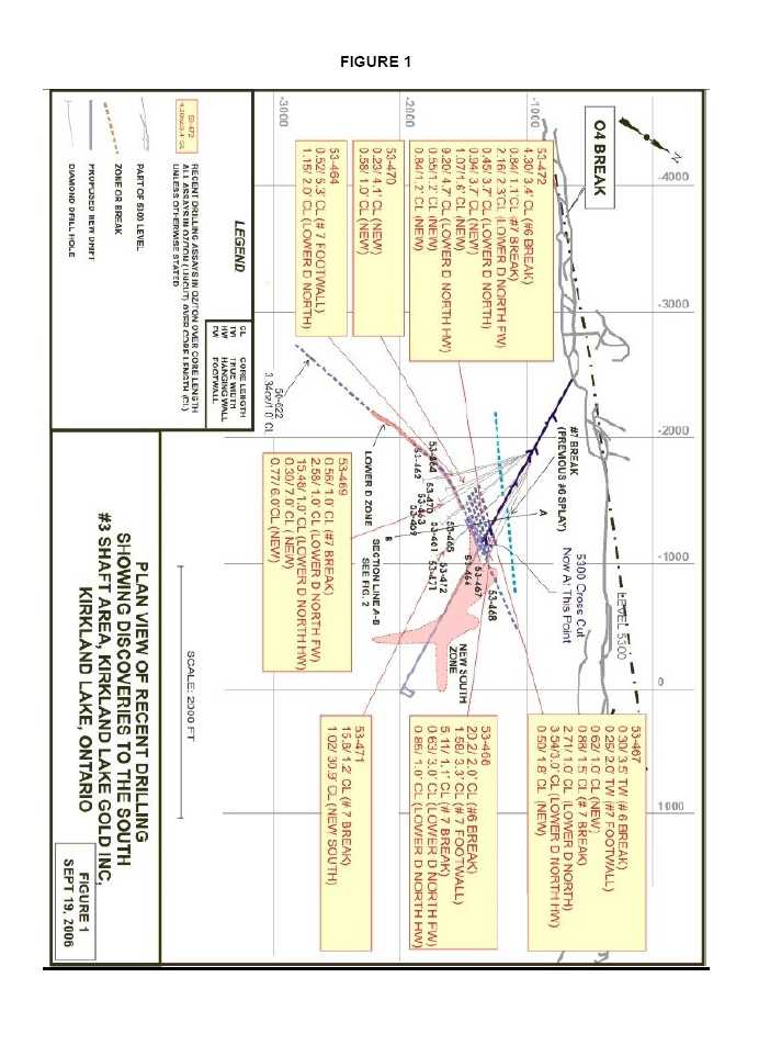
- The wide intersection in drill hole 53-471 appears to correlate with the New South Zone 570 feet to the east, with the New South Zone now exhibiting a more east- west strike in this area. (see figure #1)
- Drill hole 53-472 intersected 9 different mineralized zones from 164.1 to 418.9 feet with the best intersection being 9.20 ounces per ton over 4.7 feet on the Lower D North Hangingwall Zone. (see figure #2)
- Drill hole 53-468 intersected 20.2 ounces per ton over 2.0 feet on what is interpreted to be #6 Break. (see figure #2)
- Drilling thus far from the cross cut has covered a strike length of 800 feet with a vertical extent of 250 feet. Mineralization associated with the Lower D Zone/Lower D North and subsidiary mineralization has now been defined over a strike length of 2,000 feet. The newly designated #7 Break has been defined over a strike length of 400 feet with a vertical extent of 400 feet.
- 2 -
Extending a distance from 1,100 to 2,000 feet south of the mine workings and from a north to south direction, at least 8 parallel and sub-parallel zones have been identified which include:
| | #6 Break |
| | #7 Footwall Zone |
| | #7 Break |
| | Lower D North Footwall (FW) Zone |
| | Lower D Zone |
| | Lower D North |
| | Lower D North Hangingwall (HW) Zone |
| | New South Zone |
Additional mineralized zones are present but require further drilling to prove continuity and are thus designated as New Zones.
The diagrams referred to in this release may be viewed at the Company’s website,www.klgold.com and will provide context to the above statements.
Figure #1 is a plan view showing some of the latest intersections south of the #3 shaft mine workings. (see figure 1). Figure #2 is a composite schematic section through the area encompassing these new results. (see figure 2).
The following table summarizes the latest drilling program results. (Imperial values)
DRILL
HOLE No.
|
VEIN
|
FROM
(feet)
|
TO
(feet)
| HOLE
DIP
(degrees)
|
AZIMUTH
(degrees)
|
ASSAY
(oz. per ton/feet)
|
53-472
| #6 Break
Incl.
and
#7 Break
Lower D North
FW
Incl.
Lower D North
New
New
Lower D North
HW
Incl.
New
New | 164.1
164.1
166.2
213.9
243.8
245.0
285.0
306.4
316.6
333.4
333.4
386.0
417.7 | 167.5
165.1
167.5
215.0
246.1
246.1
288.7
310.1
318.2
338.1
335.3
387.2
418.9 | +12
| 100
| 4.30/3.4’ CL = 2.2’ TW, Uncut
3.07/3.4’ CL = 2.2’ TW, Cut
5.13/1.0’ CL = 0.7’ TW, VG
5.45/1.3’ CL = 0.8’ TW, VG
0.84/1.1’ CL = 0.8’ TW
2.16/2.3’ CL = 1.7’ TW, Uncut
1.84/2.3’ CL = 1.7’ TW, Cut
4.18/1.1’ CL = 0.8’ TW VG, Tell
0.45/3.7’ CL = 0.6’ TW, VG
0.94/3.7’ CL = TW?, VG
1.07/1.6’ CL = TW?, VG
9.20/4.7’ CL = 3.3’ TW, Uncut
1.76/4.7’ CL = 3.3’ TW, Cut
21.92/1.9’ CL = 1.3’ TW, VG, Tell
0.55/1.2’ CL = TW?
0.84/1.2’ CL = TW?, VG, |
53-471
| #7 Break
New South
Incl. | 236.9
692.8
704.0 | 238.1
723.7
706.5 | 0
| 100
| 15.80/1.2’ CL = 0.6’ TW, VG
1.02/30.9’ CL = 8.2’ TW, Uncut
0.94/30.9’ CL = 8.2’ TW, Cut
4.47/2.5’ CL = 0.7’ TW, VG |
- 3 -
DRILL
HOLE No.
|
VEIN
|
FROM
(feet)
|
TO
(feet)
| HOLE
DIP
(degrees)
|
AZIMUTH
(degrees)
|
ASSAY
(oz. per ton/feet)
|
53-464
| #7 Footwall
Lower D North
HW | 269.7
357.4
| 275.0
359.4
| +17
| 131
| 0.52/5.3’ CL = 5.2’ TW, VG
1.15/2.0’ CL = 1.9’ TW, VG
|
53-467
| #6 Break
#7 Footwall
New
#7 Break
Lower D North
Lower D North
HW
New | 326.5
410.0
427.0
440.5
523.0
717.0
782.0 | 330.0
412.0
428.0
442.0
524.0
720.0
783.8 | +20
| 084
| 0.30/3.5’ CL = 2.1’ TW
0.25/2.0’ CL = 1.3’ TW
0.62/1.0’ CL = TW Unknown
0.88/1.5’ CL = 0.8’ TW, VG
2.71/1.0’ CL = 0.5’ TW
3.54/3.0’ CL = 1.6’ TW
0.50/1.8’ CL = TW? |
53-468
| #6 Break
#7 Footwall
#7 Break
Lower D North
FW
Lower D North
HW | 353.8
444.5
455.2
507.0
789.7
| 355.8
447.8
456.3
510.0
790.7
| +19
| 080
| 20.2/2.0’ CL = 1.1’ TW, VG
1.58/3.3’ CL = 2.0’ TW, VG
5.11/1.1’ CL = 0.5’ TW, VG
0.63/3.0’ CL = 1.7’ TW, VG
0.85/1.0’ CL = 0.5’ TW, VG
|
53-469
| #7 Break
Lower D North
FW
Lower D North
HW
New
New | 353.1
363.5
456.3
472.0
820.0 | 354.1
364.5
457.3
479.0
826.0 | +5
| 116
| 0.56/1.0’ CL = 0.9’ TW, VG
2.58/1.0’ CL = 0.8’ TW, VG
15.48/1.0’ CL = 0.7’ TW, VG
0.30/7.0’ CL = TW?
0.77/6.0’ CL = TW? |
53-470
| New
New | 580.5
704.5 | 584.6
705.5 | +35
| 122
| 0.23/4.1’ CL = TW?
0.58/1.0’ CL = TW?, VG, Tell |
TW = True WidthCL = Core LengthVG = Visible GoldTELL = TelluridesCUT= cut to 3.50 oz/ton
The following table summarizes the latest drilling program results. (Metric values)
DRILL
HOLE No.
|
VEIN
|
FROM
(m)
|
TO
(m)
| HOLE
DIP
(degrees)
|
AZIMUTH
(degrees)
|
ASSAY
(grams per tonne/m)
|
53-472
| #6 Break
Incl.
and
#7 Break
Lower D North
FW
Incl.
Lower D North
New
New
Lower D North
HW
Incl. | 50.0
50.0
50.7
65.2
74.3
74.7
86.9
93.4
96.5
101.6
101.6 | 51.1
50.3
51.1
65.5
75.0
75.0
88.0
94.5
97.0
103.1
102.2 | +12
| 100
| 147.4/1.1m CL = 0.7m TW, Uncut
105.3/1.1m CL =0.7m TW, Cut
175.9/0.3m CL = 0.2m TW, VG
186.9/0.4m CL = 0.2m TW, VG
28.8/0.3m CL = 0.3m TW
74.1/0.7m CL = 0.5m TW, Uncut
63.1/0.7m CL = 0.5m TW, Cut
143.3/0.3m CL = 0.2m TW, VG,
15.4/1.1m CL = 0.2m TW, VG
32.2/1.1m CL = TW?, VG
36.7/0.5m’ CL = TW?, VG
315.4/1.5m CL = 1.0m TW, Uncut
60.3/1.5m CL = 1.0m TW, Cut
751.5/0.6m CL =0.4mTW, VG |
- 4 -
DRILL
HOLE No.
|
VEIN
|
FROM
(m)
|
TO
(m)
| HOLE
DIP
(degrees)
|
AZIMUTH
(degrees)
|
ASSAY
(grams per tonne/m)
|
| New
New | 117.7
127.3 | 118.0
127.7 |
|
| 18.9/0.3m CL = TW?
28.8/0.4m CL = TW?, VG, |
53-471
| #7 Break
New South
Incl.
| 72.2
211.2
214.6
| 72.6
220.6
215.4
| 0
| 100
| 541.7/0.4m CL = 0.2m TW, VG
35.0/9.4m CL = 2.5m TW, Uncut
32.2/9.4m CL = 2.5m TW, Cut
153.3/0.8m CL = 0.2m TW, VG
|
53-464
| #7 Footwall
Lower D North
HW
| 82.2
109.0
| 83.8
109.6
| +17
| 131
| 17.8/1.6m CL = 1.6m TW, VG
39.4/0.6m CL = 0.6m TW, VG
|
53-467
| #6 Break
#7 Footwall
New
#7 Break
Lower D North
Lower D North
HW
New | 99.5
125.0
130.2
134.3
159.5
218.6
238.4 | 100.6
125.6
130.5
134.8
159.8
219.5
239.0 | +20
| 084
| 10.3/1.1m CL = 0.6m TW
8.6/0.6m CL = 0.4m TW
21.3/0.3m CL = TW Unknown
30.2/0.5m CL = 0.2m TW, VG
92.9/0.3m CL = 0.2m TW
121.4/0.9m CL = 0.5m TW
17.1/0.6m CL = TW? |
53-468
| #6 Break
#7 Footwall
#7 Break
Lower D North
FW
Lower D North
HW | 107.9
135.5
138.8
154.6
240.8
| 108.5
136.5
139.1
155.5
241.1
| +19
| 080
| 692.6/0.6m CL = 0.3m TW, VG
54.2/1.0m CL = 0.6m TW, VG
175.2/0.3m CL = 0.2m TW, VG
21.6/0.9m CL = 0.5m TW, VG
29.1/0.3m = 0.2m TW, VG
|
53-469
| #7 Break
Lower D North
FW
Lower D North
HW
New
New | 107.7
110.8
139.1
143.9
250.0 | 108.0
111.1
139.4
146.0
251.8 | +5
| 116
| 19.2/0.3m CL = 0.3m TW, VG
88.5/0.3m CL = 0.2m TW, VG
530.7/0.3m = 0.2m TW, VG
10.3/2.1m CL = TW?
26.4/1.8m CL = TW? |
53-470
| New
New | 177.0
214.8 | 178.2
215.1 | +35
| 122
| 7.9/1.2m CL = TW?
19.9/0.3m CL = TW?, VG, Tell |
TW = True WidthCL = Core LengthVG = Visible GoldTELL = TelluridesCUT= cut to 120 grams/tonne
About the Company
The Company purchased the Macassa Mine and the 1,500 ton per day mill along with four former producing gold properties – Kirkland Minerals, Teck-Hughes, Lake Shore and Wright Hargreaves – in December 2001. These properties, which have historically produced some 22 million ounces of gold, extend over seven kilometres between the Macassa Mine on the east and Wright Hargreaves on the west and, for the first time, are being developed and explored under one owner. This camp is located in the Abitibi Southern Greenstone Belt of Kirkland Lake, Ontario, Canada.
- 5 -
The results of the Company’s underground diamond drilling program have been reviewed, verified (including sampling, analytical and test data) and compiled by the Company's geological staff (which includes a ‘qualified person’, Michael Sutton P.Geo., the Company’s Chief Geologist, for the purpose of National Instrument 43-101Standards of Disclosure for Mineral Projects, of the Canadian Securities Administrators).
The Company has implemented a quality assurance and control (QA/QC) program to ensure sampling and analysis of all exploration work is conducted in accordance with the best possible practices. The drill core is sawn in half with half of the core samples shipped to the Swastika Laboratories in Swastika, Ontario or to the Macassa mine laboratory for analysis. The other half of the core is retained for future assay verification. Other QA/QC includes the insertion of blanks, and the regular re-assaying of pulps/rejects at alternate certified labs (Polymet, Accurassay). Gold analysis is conducted by fire assay using atomic absorption or gravimetric finish. The laboratory re-assays at least 10% of all samples and additional checks may be run on anomalous values.
The Company’s Kirkland Lake properties are the subject of a report prepared by Roland H. Ridler, B.A.Sc.(Hons.), M.A.Sc., Ph.D.(Econ.Geol.), P.D., entitledKirkland Lake Mineral Properties (Macassa Mine, Kirkland Lake Gold, Teck-Hughes, Lake Shore, Wright-Hargreavesdated November 30, 2001. The Company’s Macassa Mine Property is the subject of reserve and resource report prepared by Glenn R. Clark, P. Eng., entitledReview of Resources and Reserves of Macassa Mine, Kirkland Lake, Ontariodated July 18, 2006. Both of these technical reports have been filed on SEDAR (www.sedar.com).
For further information, please contact:
| Brian Hinchcliffe | Scott Koyich |
| President | Investor Relations |
| Phone 1 705 567 5208 | Phone 1 403 215 5979 |
| Fax 1 705 568 6444 | E-mail:info@klgold.com |
| E-mail:bhinchcliffe@klgold.com | |
| | |
| Website-www.klgold.com | |
| | |
| Chelsea Hayes | |
| Pelham Public Relations | |
| Phone 020 7743 6675 | |
| E-mail:chelsea.hayes@pelhampr.com | |
Neither the Toronto Stock Exchange nor the AIM Market of the London Stock Exchange has reviewed and neither accepts responsibility for the adequacy or accuracy of this news release.