P.O. Box 370
KIRKLANDLAKE, ON, P2N 3J7
| September 6th, 2006 | Symbol – TSX & AIM:KGI |
Drilling to the South Returns
5.57 Ounces of Gold per Ton over 50 Feet (uncut);
Highest Grade Gold Intersection in New System and in Camp
Kirkland Lake Gold Inc. (the “Company”) is pleased to announce a significant drill hole intersection from the exploration and development program developing the new gold system to the south of the Camp’s Main Break.
As part of this program, the Company is attempting to define the scale and size of this gold system through drilling and development mining out to the area via the 5300 Level cross cut. In Drill Hole 50-740 the Company has intersected high-grade gold mineralization on what is interpreted to be the north extension of the Lower D North Zone, one of the mineralized zones in this system. Drill Hole 50-740 has intersected 5.57 ounces of gold per ton (uncut) over a core length of 50 feet, including 181.5 ounces of gold per ton over a core length of 1.0 feet
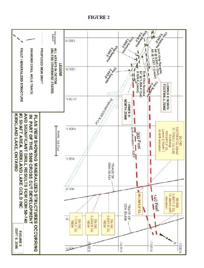
This new 50 foot intersection correlates well with the two zones drifted on the Lower D North from the 5300 Level cross cut 360 feet to the west. The first of the two zones averaged 1.23 ounces of gold per ton (uncut) over a horizontal width of 7.3 feet and a drift length of 86 feet. The second averaged 2.12 ounces of gold per ton (uncut) over a horizontal width of 6.4 feet and a drift length of 67 feet (see press release dated August 10th, 2006).
“These results confirm the Company’s decision to make generating information about this new area through stepped up drilling and development mining the operation’s top priority” commented Stewart Carmichael, Chief Exploration Geologist. “In addition to this intersection in Drill Hole 50-740, there are six other mineralized intercepts further down the hole, grading as high as 1.11 ounces of gold per ton over a core length of 4.7 feet and 1.87 ounces of gold per ton over a core length of 1.1 feet.”
Highlights of the current results include:
- Drill Hole 50-740 has intersected 5.57 ounces of gold per ton (uncut) over a core length of 50 feet, including 181.5 ounces of gold per ton (opt) over a core length of 1.0 feet. With all high assays cut to 3.50 opt, the interval averages 1.11 opt over a core length of 50 feet.
- The 181.5 opt assay over a core length of 1.0 feet within the 50 foot intersection is the highest recorded drill hole intersection in the history of the Kirkland Lake Camp and replaces LK Zone discovery hole which held the previous record of 102.5 opt over 1.5 foot core length (see press release dated September 20, 2004). The interval is characterised by an extraordinary abundance of telluride, in places semi-massive within the 1.0 foot section. Both follow-up chemistry and microscopy work has verified the abundant telluride, thought to be calaverite.
- 2 -
- Check assays (pulps and rejects) on the high-grade interval include 175.22 opt, 188.56 opt, 172.96 opt, and 189.42 opt averaging 181.54 opt.
- Of the 24 core samples comprising the 50 foot interval, 13 assayed greater than 1 opt and 4 assayed greater than 3.5 opt.
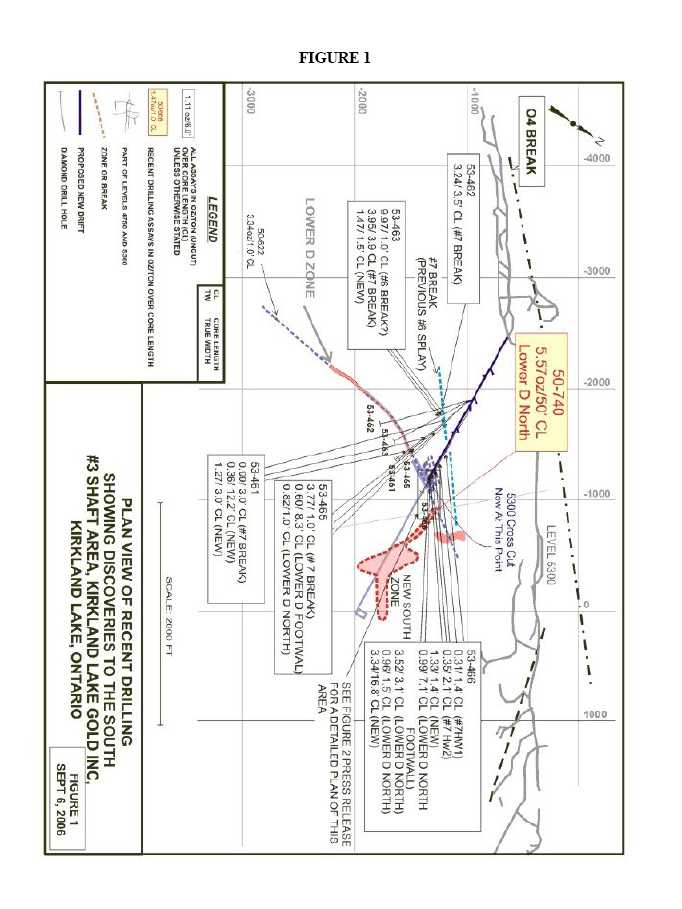
- The intersection is located 360 feet east of the drift on the 5300 Level where ore has been followed on 2 of 4 ore-bearing structures comprising a 50 foot width -- it is 140 feet west of previously announced drill hole 50-696 which assayed 0.49 opt over 11.2 feet of core (see press releases dated August 10th, 2006 and February 14th, 2006). The ore in the drift is thought to be the same as that in the intersection because of the direction of the ore, the visual similarities, the presence of similar very coarse tellurides, high grades, and similar widths (see figure #1 and figure #2).
- The mineralization comprises highly altered tuff, mineralized with up to 20% disseminated pyrite bridging a tuff/porphyry contact.
- The dip of the mineralization at the intersection point may vary from -40 degrees to -65 degrees. Further drilling will be required to accurately determine the dip and true width which is estimated to be from 22 feet to 39 feet.
- Drilling south of the No. 3 Shaft area has and will result in drill cost per ounce found in the $6.00 to $7.00/ounce range, much lower than the historical average of $15.00/ounce found for the Camp. This is due to overall wider mineralization and multiple zones intersected in each drill hole.
The diagrams referred to in this release may be viewed at the Company’s website,www.klgold.com and will provide context to the above statements.
Figure #1 is a plan view showing the latest intersection south of the No. 3 shaft mine workings.
The following table summarizes the latest drilling program results in imperial values:
DRILL
HOLE No. |
VEIN
|
FROM
(feet) |
TO
(feet) | HOLE
DIP
(degrees) |
AZIMUTH
(degrees) |
ASSAY
(oz. per ton/feet) |
50-740
| Lower D
North?
Incl.
and
and
and
New
New
New
New
New
New | 1,085
1,114.4
1,116.4
1,118.0
1,120.0
1,137.8
1,235.8
1,260.1
1,282.3
1,306.1
1,341.8 | 1,135
1,115.4
1,118.0
1,120.0
1,121.9
1,139.5
1,237.4
1,263.0
1,287.0
1,307.9
1,342.9 | -13.5
| 137
| 5.57/50.0’ CL = TW?, Uncut
1.11/50.0’ CL = TW?, Cut
181.54/1.0’ CL = TW?, Tell, VG
26.59/1.6’ CL = TW?
6.24/2.0’ CL = TW?
4.82/1.9’ CL = TW?
0.32/1.7’ CL = TW?, VG, Tell
0.93/1.6’ CL = TW?
0.35/2.9’ CL = TW?
1.11/4.7’ CL = TW?, VG
0.44/1.8’ CL = TW?, VG
1.87/1.1’ CL = TW? |
TW=True WidthCL = Core LengthVG = Visible GoldTELL = TelluridesCUT= cut to 3.50 oz/ton
- 3 -
The following table summarizes the latest drilling program results in metric values:
DRILL
HOLE No.
|
VEIN
|
FROM
(m)
|
TO
(m)
| HOLE
DIP
(degrees)
|
AZIMUTH
(degrees)
|
ASSAY
(grams per tonne/m)
|
50-740
| Lower D
North?
Incl.
and
and
and
New
New
New
New
New
New | 330.8
339.8
340.4
340.9
341.5
346.9
376.8
384.2
390.9
398.2
409.1 | 346.0
340.1
340.9
341.5
342.0
347.4
377.3
385.1
392.4
398.8
409.4 | -13.5
| 137
| 191.0/15.2m CL = TW?, Uncut
38.1/15.2m CL = TW?, Cut
6,224.3/0.3m CL = TW?, Tell,
VG
911.7/0.5m CL = TW?
213.9/0.6m CL = TW?
165.3/0.5m CL = TW?
10.80/0.5m = TW?, VG Tell
31.9/0.5m CL = TW?
12.0/0.9m CL = TW?
38.1/1.4m CL = TW?
15.1/0.6m CL = TW?, VG
64.1/0.3m CL = TW? |
TW = True WidthCL = Core LengthVG = Visible GoldTELL = TelluridesCUT= cut to 120 grams/tonne
About the Company
The Company purchased the Macassa Mine and the 1,500 ton per day mill along with four former producing gold properties – Kirkland Minerals, Teck-Hughes, Lake Shore and Wright Hargreaves – in December 2001. These properties, which have historically produced some 22 million ounces of gold, extend over seven kilometres between the Macassa Mine on the east and Wright Hargreaves on the west and, for the first time, are being developed and explored under one owner. This camp is located in the Abitibi Southern Greenstone Belt of Kirkland Lake, Ontario, Canada.
The results of the Company’s underground diamond drilling program have been reviewed, verified (including sampling, analytical and test data) and compiled by the Company's geological staff (which includes a ‘qualified person’, Michael Sutton P.Geo., the Company’s Chief Geologist, for the purpose of National Instrument 43-101Standards of Disclosure for Mineral Projects, of the Canadian Securities Administrators).
The Company has implemented a quality assurance and control (QA/QC) program to ensure sampling and analysis of all exploration work is conducted in accordance with the best possible practices. The drill core is sawn in half with half of the core samples shipped to the Swastika Laboratories in Swastika, Ontario or to the Macassa mine laboratory for analysis. The other half of the core is retained for future assay verification. Other QA/QC includes the insertion of blanks, and the regular re-assaying of pulps/rejects at alternate certified labs (Polymet, Accurassay). Gold analysis is conducted by fire assay using atomic absorption or gravimetric finish. The laboratory re-assays at least 10% of all samples and additional checks may be run on anomalous values.
The Company’s Kirkland Lake properties are the subject of a report prepared by Roland H. Ridler, B.A.Sc.(Hons.), M.A.Sc., Ph.D.(Econ.Geol.), P.D., entitledKirkland Lake Mineral Properties (Macassa Mine, Kirkland Lake Gold, Teck-Hughes, Lake Shore, Wright-Hargreavesdated November 30, 2001. The Company’s Macassa Mine Property is the subject of reserve
- 4 -
and resource report prepared by Glenn R. Clark, P. Eng., entitledReview of Resources and Reserves of Macassa Mine, Kirkland Lake, Ontariodated July 18, 2006. Both of these technical reports have been filed on SEDAR (www.sedar.com).
For further information, please contact:
| Brian Hinchcliffe | Scott Koyich |
| President | Investor Relations |
| Phone 1 705 567 5208 | Phone 1 403 215 5979 |
| Fax 1 705 568 6444 | E-mail:info@klgold.com |
| E-mail:bhinchcliffe@klgold.com | |
| | |
| Website-www.klgold.com | |
| | |
| Chelsea Hayes | |
| Pelham Public Relations | |
| Phone 020 7743 6675 | |
| E-mail:chelsea.hayes@pelhampr.com | |
Neither the Toronto Stock Exchange nor the AIM Market of the London Stock Exchange has reviewed and neither accepts responsibility for the adequacy or accuracy of this news release.