Exhibit 99.37
STRATA POWER CORPORATION (" Strata " or the " Corporation ") FORM NI 51 - 101F1 STATEMENT OF RESERVES DATA AND OTHER OIL AND GAS INFORMATION For fiscal year ended December 31, 2020 (This is the form referred to in item 1 of National Instrument 51 - 101 Standards of Disclosure for Oil and Gas Activities ("NI 51 - 101"). Terms for which a meaning is given in NI 51 - 101 have the same meaning in this Form 51 - 101F1.) TABLE OF CONTENTS DATE OF STATEMENT DISCLOSURE OF RESERVES DATA PRICING ASSUMPTIONS RECONCILIATION OF CHANGES IN RESERVES Page 1 Page 1 None – not included None – not included ADDITIONAL INFORMATION RELATING TO RESERVES DATA None – not included PART 1 PART 2 PART 3 PART 4 PART 5 PART 6 OTHER OIL AND GAS INFORMATION Page 1 Form 51 - 101F2 Report on Reserves Data by Independent Qualified Reserves Evaluator or Auditor Report of Management and Directors on Oil and Gas Disclosure Not required – no reserves Form 51 - 101F3 Filed separately PART 1 DATE OF STATEMENT Relevant Dates 1. The preparation date of the information provided in this statement is: May 4, 2021. 2. The effective date of the information provided in this statement is as of the Corporation's most recently completed fiscal year ended: December 31, 2020. PART 2 DISCLOSURE OF RESERVES DATA As of December 31, 2020, Strata did not have any reserves or production on any of its properties. Accordingly, Strata did not have any future net revenue related to reserves as of December 31, 2020. PART 6 OTHER OIL AND GAS INFORMATION Oil and Gas Properties The Company currently has interests in oil sands properties located in the Peace River area of Northern Alberta, Canada. The Company is currently engaged in the exploration and development of heavy oil and bitumen properties . The Company’s oil sands interests are unproven and there is no assurance that a commercially viable oil or gas deposit exists on any of its properties . Further evaluation will be required on each property before a final evaluation as to the economics and legal feasibility of the property is determined . The Company currently has an interest in 7 oil sands leases, totaling 8,704 hectares, all located in the Peace River oil sands area, and owns 3 non - producing wells.
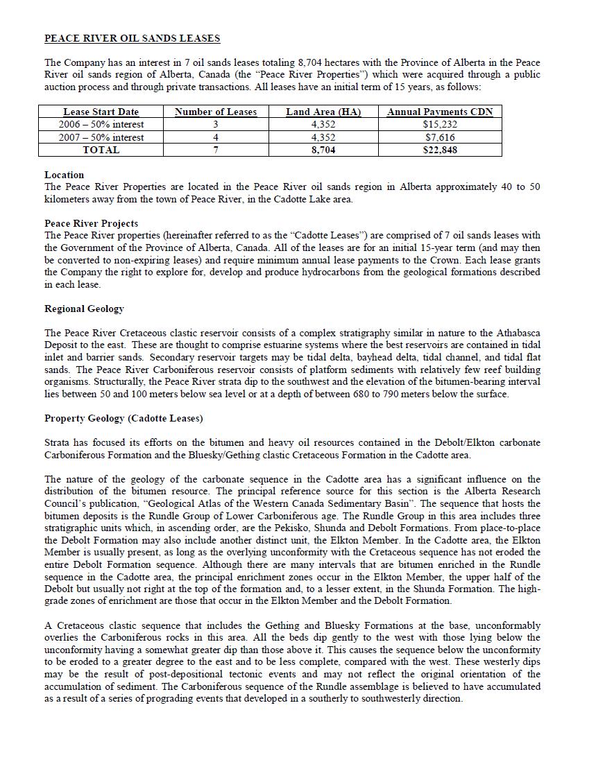
PEACE RIVER OIL SANDS LEASES The Company has an interest in 7 oil sands leases totaling 8 , 704 hectares with the Province of Alberta in the Peace River oil sands region of Alberta, Canada (the “Peace River Properties”) which were acquired through a public auction process and through private transactions . All leases have an initial term of 15 years, as follows : Annual Payments CDN Land Area (HA) Number of Leases Lease Start Date $15,232 4,352 3 2006 – 50% interest $7,616 4,352 4 2007 – 50% interest $22,848 8,704 7 TOTAL Location The Peace River Properties are located in the Peace River oil sands region in Alberta approximately 40 to 50 kilometers away from the town of Peace River, in the Cadotte Lake area. Peace River Projects The Peace River properties (hereinafter referred to as the “Cadotte Leases”) are comprised of 7 oil sands leases with the Government of the Province of Alberta, Canada . All of the leases are for an initial 15 - year term (and may then be converted to non - expiring leases) and require minimum annual lease payments to the Crown . Each lease grants the Company the right to explore for, develop and produce hydrocarbons from the geological formations described in each lease . Regional Geology The Peace River Cretaceous clastic reservoir consists of a complex stratigraphy similar in nature to the Athabasca Deposit to the east . These are thought to comprise estuarine systems where the best reservoirs are contained in tidal inlet and barrier sands . Secondary reservoir targets may be tidal delta, bayhead delta, tidal channel, and tidal flat sands . The Peace River Carboniferous reservoir consists of platform sediments with relatively few reef building organisms . Structurally, the Peace River strata dip to the southwest and the elevation of the bitumen - bearing interval lies between 50 and 100 meters below sea level or at a depth of between 680 to 790 meters below the surface . Property Geology (Cadotte Leases) Strata has focused its efforts on the bitumen and heavy oil resources contained in the Debolt/Elkton carbonate Carboniferous Formation and the Bluesky/Gething clastic Cretaceous Formation in the Cadotte area . The nature of the geology of the carbonate sequence in the Cadotte area has a significant influence on the distribution of the bitumen resource . The principal reference source for this section is the Alberta Research Council’s publication, “Geological Atlas of the Western Canada Sedimentary Basin” . The sequence that hosts the bitumen deposits is the Rundle Group of Lower Carboniferous age . The Rundle Group in this area includes three stratigraphic units which, in ascending order, are the Pekisko, Shunda and Debolt Formations . From place - to - place the Debolt Formation may also include another distinct unit, the Elkton Member . In the Cadotte area, the Elkton Member is usually present, as long as the overlying unconformity with the Cretaceous sequence has not eroded the entire Debolt Formation sequence . Although there are many intervals that are bitumen enriched in the Rundle sequence in the Cadotte area, the principal enrichment zones occur in the Elkton Member, the upper half of the Debolt but usually not right at the top of the formation and, to a lesser extent, in the Shunda Formation . The high - grade zones of enrichment are those that occur in the Elkton Member and the Debolt Formation . A Cretaceous clastic sequence that includes the Gething and Bluesky Formations at the base, unconformably overlies the Carboniferous rocks in this area . All the beds dip gently to the west with those lying below the unconformity having a somewhat greater dip than those above it . This causes the sequence below the unconformity to be eroded to a greater degree to the east and to be less complete, compared with the west . These westerly dips may be the result of post - depositional tectonic events and may not reflect the original orientation of the accumulation of sediment . The Carboniferous sequence of the Rundle assemblage is believed to have accumulated as a result of a series of prograding events that developed in a southerly to southwesterly direction .

The Carboniferous sequence mainly includes platform sediments that show generally shallower - water characteristics up - section . In a basinward direction the depositional facies proceed from beach and lagoonal environments through shoals of the shelf margin to marine basin muds . The lithologies that result include high energy siliciclastics of the beach environment, through various types of carbonates on the platform and its slope to shale in the deep marine environment . There even appear to be beds present that have the character of unconsolidated coarse sediments . Several transgressive events therefore resulted in the accumulation of clastic sediments interbedded with carbonate units . The carbonate units included relatively few reef building organisms and thus there was little tendency for irregular geological bodies such as reefs to form in this sequence in this area . From one well to the next the regular nature of the deposition that took place at this time is apparent and it is relatively easy to show the correlation that exists between the same units in adjacent wells in the target area . This feature of regular bed continuity is in strong contrast to the variability of the clastic units of the overlying Cretaceous sequence as seen in the Athabasca region . It is also noteworthy that the bitumen enrichment is strongly influenced by the bedded nature and continuity of the sediments . It is readily possible in many cases to show the same details of the enriched sequence in adjacent wells even when they are spaced a kilometer or more apart . This has a strong impact on the selection of data separation distances for the classification of resources ; in this sequence an equivalent assurance of existence is achieved with much wider spacing of wells than that used in the classification of bitumen resources for the Cretaceous surface mineable oil sands deposits near Fort McMurray in the Athabasca region of Alberta . Previous Work During the winter drill season of 2006 – 2007 , Strata drilled four wells on the Cadotte leases . Three of these wells were within the Cadotte Central Target Area and one was east of the Cadotte Central Target Area . Three wells were drilled with cores in the Cadotte Central Target Area, two of which were cased allowing for production testing with the ability to re - enter these wells for future testing . The other well was abandoned due to drilling fluid losses during drilling which did not allow the well to be cased for testing in the future . The fourth well drilled in the eastern location was cored and cased . The cores of all of these wells were tested and examined in a laboratory in Calgary . The results of these tests were that cold production was not viable . However, the results indicated that the bitumen would flow at approximately 85 ƒ C . These results will allow the Company to explore different means of extraction in addition to steam . Former leaseholders have drilled wells on and around the Company’s Cadotte lease area . Geophysical well logs are of variable quality but generally consist of a full suite of tools to evaluate the potential reservoirs . With respect to available drilling data, the leases of the Cadotte area are drilled at an average spacing of one well per section . However, not all the existing wells were drilled to investigate the sequence located on the Company’s Cadotte leases . The effective average spacing with wells that have penetrated the Carboniferous sequence is approximately 0 . 8 wells per section . This spacing is from twenty - three wells on or immediately adjacent to the leases . There are an additional two hundred nineteen wells in the surrounding area, the data from which has also been referenced and inspected by the Company to assist with its evaluation of the Cadotte leases . 15 However, the quality of the data from the wells of different vintage is quite variable . Several of the wells were drilled in the 1950 ’s . The drilling records and logs for these wells are sometimes poor or absent or they may be less complete than those of more recently drilled wells . A database search was done to identify higher quality data which was restricted to wells drilled since 1970 and this, plus the new Strata wells was used as the primary reference data . A total of eighteen wells of this vintage are located on or immediately adjacent to the Cadotte lease blocks . The well log data from these wells is the primary source of information on the leases available for Strata’s evaluations but this is supplemented by high quality data from a further thirty - nine more distant wells in the area .
In the United States, registrants, including foreign private issuers like us, are required to disclose proved reserves using the standards contained in Rule 4 - 10 (a) of the United States Securities and Exchange Commission’s (“SEC”) Regulation S - X . The Company has no proved reserves at this time . Cadotte Central The Company completed the drilling of its first four wells in the winter drilling season of 2006 – 2007 , and engaged Norwest Corporation (”Norwest”) of Calgary, Alberta Canada to assist Strata with the planning and undertaking of its exploration of the Cadotte leases . Subsequently, Strata completed the following technical reports relating to these leases : Evaluation of In - Place Bitumen Resources – Cadotte Central Leases (August 16, 2007) [Norwest] Preliminary Feasibility Study of the Cadotte Central Leases (February 29, 2008) [Norwest Questa] Pilot Projects: Carbonate - Hosted Bitumen Deposits in Alberta (July 17, 2008 [Norwest] Cadotte Central Resource Reclassification (Upgrade) (April 28, 2010) [Norwest] Evaluation of Bitumen Resources Cadotte Central and West Leases (May 10, 2013) [Norwest] These studies were designed to comply with the requirements of National Instrument 51 - 101 and the resource classification scheme and criteria elaborated in Volume 1 , of the Canadian Oil and Gas Evaluation Handbook (“COGEH”) at the time they were authored . However since that time, COGEH standards have been modified and therefore Strata is no longer permitted to publicize the contents of these reports under Canadian Securities Regulations . Subsequent to these studies, Strata completed additional analyses including a study entitled “Debolt Core Description and Interpretation” by Dr . Hans G . Machel, and also a seismic study by Norwest entitled “Seismic Study of Cadotte Leases” . The latter study utilized existing well and seismic data and focused on different physical properties and technical aspects related to the identification of pools and fields . The initial interpretation of the geological structure resulted in the identification of cold production targets which were then validated by seismic data . The Company's technical team subsequently identified multiple drilling locations in order to test the extent to which the Bluesky Formation has the fluid properties which permit the use of primary production methods . In late 2014 , Strata commenced initial planning and permitting activities needed to develop a drill program and continue exploration . The Company engaged specialized third - party service provider(s) to assist with the development of a drill program which included the submission of an Oil Sands Exploration plan, the ("OSE") to the Crown . Elements of an OSE application include, but are not limited to, mapping and locating services, sensitive areas, wildlife zones, historical work in the area, site access, environmental services, exploration operations detail, and stake holder consultation and project management services . The OSE program approval was received in February 2015 granting the Company two years from the date of issue to conduct its exploration program . Due to the oil market, the Company has not carried out its drilling program . In 2018, Strata completed the following technical report relating to a portion of its oil sands leases: Evaluation of Bitumen Resources, Cadotte Lease Blocks (November 19, 2018) [Gustavson Associates] This study was prepared according to National Instrument 51 - 101 and the resource classification scheme and criteria elaborated in the Canadian Oil and Gas Evaluation Handbook (COGEH v . 2 - section 2 . 5 . 5 , p . 2 - 71 ) . Planned Work by the Company for 2020 When adequate funding can be assembled, Strata intends to proceed with its exploration program . The Company expects the short and long - term funding of our oil and gas operations to be financed as in the past through equity in the form of private placements and warrant exercises . Tax Horizons
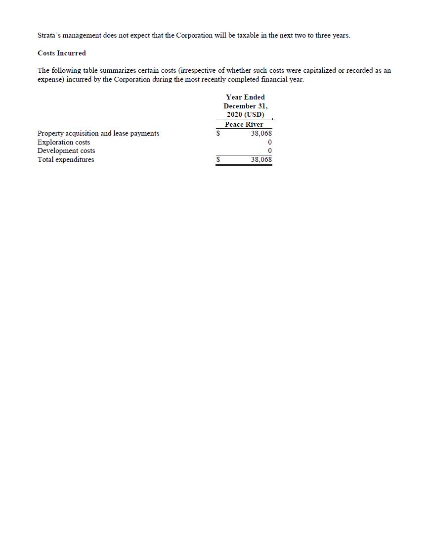
Strata’s management does not expect that the Corporation will be taxable in the next two to three years. Costs Incurred The following table summarizes certain costs (irrespective of whether such costs were capitalized or recorded as an expense) incurred by the Corporation during the most recently completed financial year. Year Ended December 31, 2020 (USD) Peace River $ 38,068 Property acquisition and lease payments 0 Exploration costs 0 Development costs $ 38,068 Total expenditures