UPDATED TECHNICAL REVIEW OF THE KIRUNA AREA IOCG PROJECTS IN
NORRBOTTEN COUNTY, SWEDEN FOR LUNDIN MINING CORPORATION
prepared by
Robert Lilljequist, Fil Lic
European and Senior Geologist Consultant
February 15, 2005
Stockholm, Sweden
TABLE OF CONTENTS
| Page | |
| 1.Summary | ..1 |
| 2.Introduction | 8 |
| 3.Reliance on Other Experts | 9 |
| 4.Property Description and Location | 9 |
| 5.Accessibility, Climate Local Resources, Infrastructure and Physiography | 9 |
| 6.History | 9 |
| 7.Geological Setting | 10 |
| 8.Deposit types | 10 |
| 9.Mineralization | 10 |
| 10.Exploration results, mineralization and potential | 10 |
| 10.1 RAKKURIJÄRVI NR 1 PERMIT | 10 |
| 10.1.1 The Rakkurijärvi Discovery zone (Lundin Mining Exploration Work | |
| December 2003 to December 2004) | 11 |
| 10.1.1.1 Geophysics | 11 |
| 10.1.1.2 Diamond Drilling and results | 15 |
| 10.1.2 Conglomerate zone | 22 |
| 10.1.3 Rakkurijärvi permit – other targets | 23 |
| 10.2 PUOLTSA No 1 | 23 |
| 10.2.1 Earlier exploration activities | 24 |
| 10.2.2 Geology | 28 |
| 10.2.3 Geophysics | 28 |
| 10.2.4 Core drilling and drill results | 29 |
| 10.2.5 Evaluation | 32 |
| 10.3 OTHER ANGLO/RIO TINTO PERMITS | 33 |
| 10.4 LUNDIN PROPERTIES | 33 |
ii
| 11.DRILLING | 34 |
| 12.CORE HANDLING AND LOGGING PROTOCOL | 34 |
| 13.SAMPLING METHOD AND APPROACH | 34 |
| 14.SAMPLE PREPARATION, ASSAYING AND SECURITY | 35 |
| 14.1 SAMPLE PREPARATION | 35 |
| 14.2 ASSAYING | 36 |
| 14.3 QAQC | 36 |
| 14.4 SECURITY | 36 |
| 15.MINERAL PROCESSING AND METALLURGICAL TESTING | 37 |
| 16.INTERPRETATION AND CONCLUSIONS | 37 |
| 17.RECOMMENDATIONS | 39 |
| CERTIFICATE | 40 |
| REFERENCES | 42 |
| LIST OF TABLES | |
| 1. Exploration permits | 5 |
| 2. Rakkurijärvi Discovery Zone, significant drilling results | 15 |
| 3. Ailatis area, significant drilling results | 30 |
| LIST OF FIGURES | |
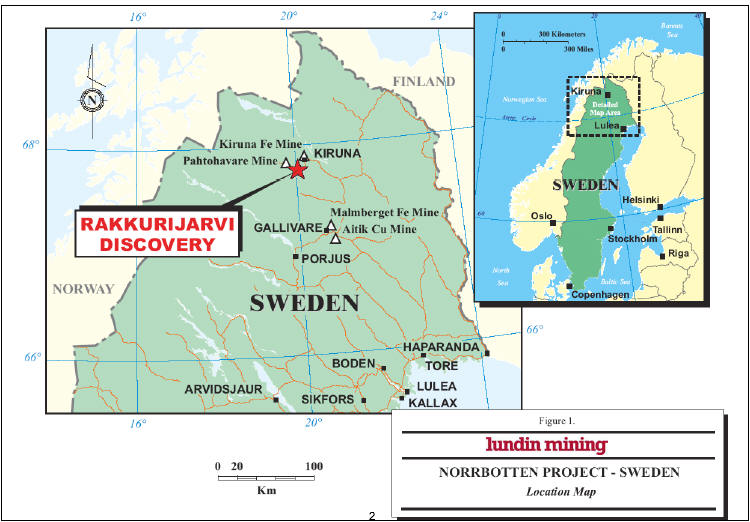
| 1. Location map | 2 |
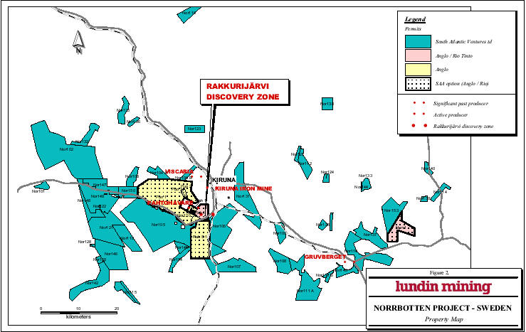
| 2. Property map | 6 |
| 3. Regional geology | 7 |
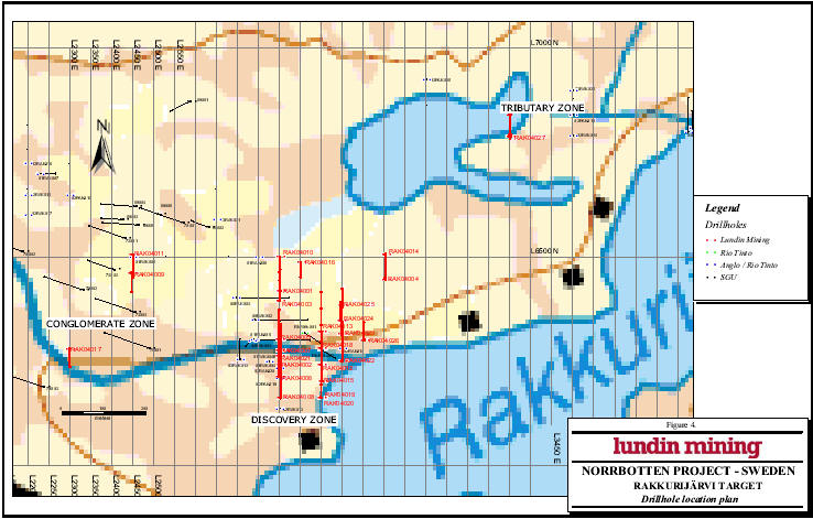
| 4. Drillhole location plan of the Rakkurijärvi Discovery Zone | 12 |
iii
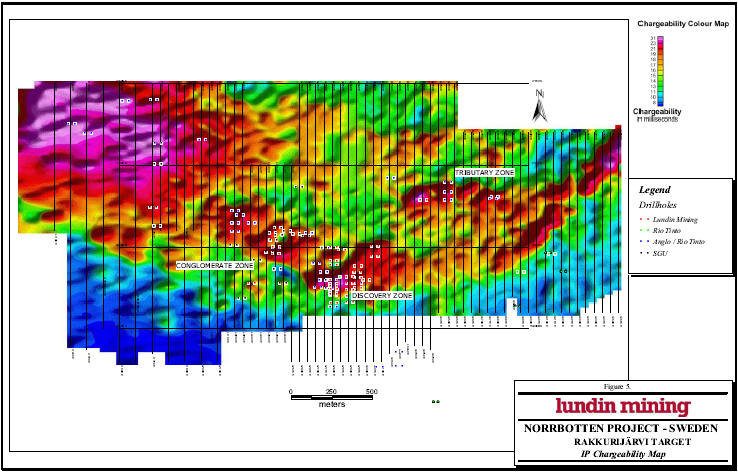
| 5. IP Chargeability map with drillhole locations at Rakkurijärvi | 13 | |
| 6. Magnetic survey map with drillhole locations at Rakkurijärvi | 14 | |
| 7. Cross section along L2800E | 18 | |
| 8. Cross section along L2900E | 19 | |
| 9. Cross section along L2950E | 20 | |
| 10. Ailatis target area, Geological map with drillhole locations | 25 | |
| 11. Ailatis target area, Geophysical IP Chargeability map | 26 | |
| 12. Ailatis target area, Geophysical Magnetic survey map | 27 | |
iv
1.SUMMARY
South Atlantic Ventures Ltd. ("SAA") signed a Letter of Intent in October 2003 to acquire an extensive land package in the Kiruna mining district in the county of Norrbotten in northern Sweden from Anglo American Exploration BV ("Anglo") and Rio Tinto Mining and Exploration Limited ("Rio Tinto") a subsidiary of Rio Tinto plc. The land package covered originally approximately 20,500 hectares (eight permits) and includes the Iron Ore Copper Gold ("IOCG") mineralization in the Discovery Zone at Rakkurijarvi. SAA, Anglo and Rio Tinto signed a definitive agreement March 31, 2004. SAA changed its name to Lundin Mining Corporation ("LUN") August 12, 2004.
Lundin Mining Corporation Ltd on its own account holds a large land position in the area covering 101 807 ha (including 3 016 ha under application). The permits are registered under the former name of South Atlantic Resources in Norrbotten Hb..
In this updated report "LUN" (Lundin Mining Corporation) will be used in the following, including activities undertaken earlier (before August 12, 2004) when the name was changed.
Watts, Griffis and McOuat Limited ("WGM") was engaged by LUN to prepare a Technical Review of the Kiruna Area IOGC projects in Norrbotten County, Sweden in compliance with the standards of National Instrument 43-101 ("NI 43-101"), which is dated April 14, 2004. The present review is an update including events and modifications that have occurred after that date and up to December 31, 2004.
The LUN exploration activities during 2004 have been concentrated to the permits Rakkurijärvi No 1 and Puoltsa No 1. The bedrock belongs to the Kiruna Greenstone Suite (2.2 to 1.96 Ga) and the Kiruna Porphyry group of volcanic rocks (1.95 to 1.85 Ga). The Kiruna Greenstone group consists mainly of ultramafic, and mafic to intermediate volcanic rocks with interlayered
1
graphitic sediments, banded iron formation and crystalline limestone.
The Porphyry group, which hosts the large apatite iron ores, varies in composition from basalts to rhyolite and is locally overlain by clastic sediments. The regional geology is reproduced in Fig. 3.
The sulphide mineralization at Rakkurijärvi is mostly associated with semi-massive to massive magnetite with chalcopyrite and pyrite, and includes sometimes late-formed native copper. The wall rocks to the south are altered (presumably volcanic) rocks with varying content of actinolite-biotite-scapolite ± albite, commonly sheared or brecciated. The other common wall rocks (dominating north of the magnetite zones) are carbonate or carbonate breccia, probably of hydrothermal origin. The Cu-Au mineralization occurs in near vertical, cross-cutting structures associated with calcite and overprinting the magnetite bodies and the wall rock. The "Discovery Zone" consists of northeast trending, subvertical zones of chalcopyrite and gold in magnetite, identified from a strong magnetic anomaly and associated IP anomaly. The width of the mineralized zone is in average about 50 meters. At Ailatis the sulphide mineralization occurs in different settings. Basalts in the Ailatis hill contain zones with disseminated low grade copper. Magnetite dykes with chalcopyrite have been intersected in two drillholes and chlorite-biotite altered ultramafic rocks contain zones with elevated values of copper, nickel and PGMs. One drillhole at Puoltsa went through graphitic schists which are thought to be the source of the geophysical anomaly at this locality.
The objective of the exploration activities is to better outline and define the Anglo/Rio Tinto IOCG discovery at Rakkurijärvi, known as the "Discovery Zone". In the first phase 5 000 meter of drilling was planned during the winter period 2004, but only 4 020 meter was achieved due to the un-prevented mild weather making further drilling on the wetlands impossible. The IOCG type of mineralization is best localized by a combined IP and Magnetic anomaly. In Ailatis a total of 23 drillholes have been completed, totaling 2 559 meters.
The continued exploration is focused on more coherent, large tonnage deposits with appropiate Cu-Au grades.
3
Based on the results obtained to date it is concluded that:
* The regional geological setting is consistent with the IOCG model including the giant Olympic Dam deposit, and the Rakkurijarvi Discovery Zone is a new IOCG discovery which warrants continued drilling to define resources.
* The drilling on the Discovery Zone has produced positive results. The best result has been 1.07% Cu and 0.27 g/t Au over 48.45 m in hole RAK04023 (including 12.80 m with 2.11% Cu and 0.52 g/t Au). The mineralized zones are, however, not sufficiently coherent to form a base for a sizable mineral resource estimation.
* The extensive and intensive hydrothermal alteration indicates large element redistribution that might result in large accumulation of sulphide minerals.
* The Anglo/Rio Tinto Pahtohavare oxide target, adjacent to the past-producing Pahtohavare mine, appears to have significant potential for the discovery of further copper oxide mineralization;
* At Ailatis eight IP anomalies were tested and the best intersections were 26m with 0.27% Cu (Dh AIL04023 ), 37.1 m with 0.15% Cu (Dh AIL04009) and 26.3 m with 0.18% Cu (Dh AIL04005). The continuation of the IP anomalies tested by AIL04023 and AIL04005 towards the east is interesting as an exploration target.
* The excellent land position in a highly prospective area warrants significant additional exploration.
In late 2003, LUN proposed a US$5.3 m budget, heavily oriented towards diamond drilling, to be spent over an approximate one year period for the combined Anglo/Rio Tinto option and wholly owned LUN properties (Fig. 2). During 2004 a total expenditure of approximately 12 MSEK (ca. 1.7 MUSD) has been spent on the two target areas.
4
TABLE 1
LUNDIN MINING AB
SOUTH ATLANTIC IN NORRBOTTEN HB (100 % LUNDIN MINING)
PERMIT NAME | Date granted | EXPIRY DATE | AREA (HA) |
Norrbotten nr 101 | 2002-12-06 | 2005-12-06 | 478 |
Norrbotten nr 103 | 2002-12-06 | 2005-12-06 | 925 |
Norrbotten nr 104 A | 2002-12-09 | 2005-12-09 | 967 |
Norrbotten nr 104 B | 2002-12-09 | 2005-12-09 | 558 |
Norrbotten nr 110 | 2002-12-10 | 2005-12-10 | 4071 |
Norrbotten nr 111 A | 2002-12-10 | 2005-12-10 | 4416 |
Norrbotten nr 111B | 2002-12-10 | 2005-12-10 | 89 |
Norrbotten nr 112 | 2002-12-10 | 2005-12-10 | 1317 |
Norrbotten nr 114 | 2002-12-10 | 2005-12-10 | 638 |
Norrbotten nr 106 | 2002-12-12 | 2005-12-12 | 5202 |
Norrbotten nr 107 | 2002-12-12 | 2005-12-12 | 4517 |
Norrbotten nr 108 | 2002-12-12 | 2005-12-12 | 2038 |
Norrbotten nr 109 | 2002-12-12 | 2005-12-12 | 1083 |
Norrbotten nr 115 | 2002-12-12 | 2005-12-12 | 419 |
Norrbotten nr 105 | 2002-12-18 | 2005-12-18 | 13670 |
Norrbotten nr 117 | 2002-12-18 | 2005-12-18 | 684 |
Norrbotten nr 102 | 2002-12-20 | 2005-12-20 | 14398 |
Norrbotten nr 118 | 2003-01-15 | 2006-01-15 | 1278 |
Norrbotten nr 119 | 2003-01-15 | 2006-01-15 | 2204 |
Norrbotten nr 120 | 2003-01-15 | 2006-01-15 | 59 |
Norrbotten nr 121 | 2003-02-04 | 2006-02-04 | 5267 |
Norrbotten nr 122 | 2003-02-04 | 2006-02-04 | 32 |
Norrbotten nr 123 | 2003-02-17 | 2006-02-17 | 1007 |
Norrbotten nr 124 | 2003-02-17 | 2006-02-17 | 331 |
Norrbotten nr 125 | 2003-02-17 | 2006-02-17 | 349 |
Norrbotten nr 134 | 2003-02-17 | 2006-02-17 | 902 |
Norrbotten nr 126 | 2003-02-25 | 2006-02-25 | 300 |
Norrbotten nr 127 | 2003-02-25 | 2006-02-25 | 304 |
Norrbotten nr 128 | 2003-02-25 | 2006-02-25 | 74 |
Norrbotten nr 129 | 2003-02-25 | 2006-02-25 | 245 |
Norrbotten nr 130 | 2003-02-25 | 2006-02-25 | 259 |
Norrbotten nr 131 | 2003-02-26 | 2006-02-26 | 4704 |
Norrbotten nr 132 | 2003-02-26 | 2006-02-26 | 1321 |
Norrbotten nr 133 | 2003-02-26 | 2006-02-26 | 583 |
Norrbotten nr 135 | 2003-03-11 | 2006-03-11 | 1079 |
Norrbotten nr 136 | 2003-03-11 | 2006-03-11 | 312 |
Norrbotten nr 137 | 2003-03-11 | 2006-03-11 | 2235 |
Norrbotten nr 138 | 2003-03-11 | 2006-03-11 | 869 |
Norrbotten nr 139 | 2003-03-12 | 2006-03-12 | 222 |
Norrbotten nr 140 | 2003-03-12 | 2006-03-12 | 410 |
Norrbotten nr 142 | 2003-03-12 | 2006-03-12 | 3245 |
Norrbotten nr 143 | 2003-04-01 | 2006-04-01 | 1005 |
Norrbotten nr 144 | 2003-04-03 | 2006-04-03 | 13 |
Norrbotten nr 145 | 2003-04-28 | 2006-04-28 | 582 |
Norrbotten nr 146 | 2003-06-26 | 2006-06-26 | 4574 |
Norrbotten nr 147 | 2003-12-03 | 2006-12-03 | 2000 |
Norrbotten nr 148 | 2003-12-03 | 2006-12-03 | 1296 |
Norrbotten nr 149 | 2003-12-09 | 2006-12-09 | 4791 |
Norrbotten nr 150 | 2004-06-16 | 2007-06-16 | 1469 |
Norrbotten nr 153 | Application | Application | 3016 |
| total | 101 807 | |
|
| ||
Rio Tinto and Anglo American |
| ||
JV permits |
| ||
Nunasvaara nr 1 | 1997-06-18 | 2005-06-18 | 2340 |
Pahtohavare nr 1 | 2002-06-27 | 2005-06-27 | 338 |
Puoltsa nr 1 | 2002-03-04 | 2005-03-04 | 10921 |
Puoltsa nr 2 | 2002-08-12 | 2005-08-12 | 139 |
Puoltsa nr 3 | 2002-08-20 | 2005-08-20 | 80 |
Rakkurijärvi nr 1 | 1998-04-17 | 2005-04-17 | 1101 |
Rakkurijärvi Södra nr 1 | 2001-11-26 | 2005-11-26 | 5059 |
| total | 19 978 |
5
6

7
2. INTRODUCTION
The Kiruna mining camp, located in the far north Norrbotten County of Sweden (Figure 1), became a focus of intensive Iron Ore Copper Gold ("IOCG") exploration programs in the mid to late 1990s as more explorationists recognized the similarities between the Kiruna iron deposits and those of the Olympic Dam and Ernest Henry deposits in Australia. Anglo American Exploration BV ("Anglo"), Rio Tinto, BHP Billiton (partly via Australian junior Equinox, which is run by Ernest Henry discoverers), and Phelps Dodge are amongst those who have been or remain active in the area. Of these, at least Anglo and Rio Tinto are known to have achieved success by finding new IOCG-type Cu, Au mineralization.
Lundin Mining Corporation began investigating the Kiruna area and its IOCG potential with reconnaissance work and ground acquisition in the fall of 2002.
Watts, Griffis and McOuat Limited ("WGM") was retained in September 2003 by LUN (at that time SAA) to carry out a due diligence review of the properties of Anglo/Rio Tinto in the Kiruna area, which LUN was planning to acquire. Since then, LUN has signed a Letter of Intent and definitive agreement whereby it has an option to acquire these properties from Anglo/Rio Tinto. In addition WGM reviewed the large 100% LUN held land package in the same area in order to assess LUN's plans for a combined exploration program and review the proposed budget for both land packages. In late-November 2003, WGM presented a confidential report, co-authored by Mary-Claire Ward and John Sullivan, to LUN based on its review of the properties.
WGM was later engaged to update its 2003 review and prepared a report in compliance with the standards of National Instrument 43-101 ("NI 43-101"), dated April 14, 2004. The review is here updated by Robert Lilljequist, Eurogeologist, consultant and Qualified Person. The updated review covers the period April 14 to December 31, 2004, and the exploration activities have continuously been followed up in the field by Robert Lilljequist.
The documents used in the preparation of this report are listed under "References".
8
Metric units are used throughout this report unless noted otherwise. Currency is primarily United States dollars ("US$") and Swedish kronor or crowns ("SEK"). The average exchange rate SEK/USD during 2004 has been 7.35 (SEK/CAD 5.65).
This report has been prepared for the use of LUNDIN MINING in meeting certain regulatory requirements. It may not be reproduced or used for any purpose other than those listed above. No responsibility or liability is assumed for losses occasioned by LUN or investors, or any other party, as a result of the circulation, publication or reproduction or use of this report contrary to the provisions of this paragraph.
3. RELIANCE ON OTHER EXPERTS
The author has not relied on report, opinion or statement of legal or other experts who are not qualified persons for information concerning legal, environmental, political or other issues and factors relevant to the technical report.
4. PROPERTY DESCRIPTION AND LOCATION
This information has been previously filed in a report for the property (A Technical Review of the Kiruna area IOCG projects in Norrbotten County, Sweden for South Atlantic Ventures Ltd, April 14, 2004). The up-to-date state of properties is listed in Table 1 and their location in Fig. 2.
5. ACCESSIBILITY, CLIMATE LOCAL RESOURCES, INFRASTRUCTURE AND PHYSIOGRAPHY
This information has been previously filed in a report for the property (A Technical Review of the Kiruna area IOCG projects in Norrbotten County, Sweden for South Atlantic Ventures Ltd, April 14, 2004)
6. HISTORY
This information has been previously filed in a report for the property (A Technical Review of the Kiruna area IOCG projects in Norrbotten County, Sweden for South Atlantic Ventures Ltd, April 14, 2004)
9
7. GEOLOGICAL SETTING
This information has been previously filed in a report for the property (A Technical Review of the Kiruna area IOCG projects in Norrbotten County, Sweden for South Atlantic Ventures Ltd, April 14, 2004)
8. DEPOSIT TYPES
This information has been previously filed in a report for the property (A Technical Review of the Kiruna area IOCG projects in Norrbotten County, Sweden for South Atlantic Ventures Ltd, April 14, 2004)
9. MINERALIZATION
This information has been previously filed in a report for the property (A Technical Review of the Kiruna area IOCG projects in Norrbotten County, Sweden for South Atlantic Ventures Ltd, April 14, 2004)'
10. EXPLORATION RESULTS, MINERALIZATION AND POTENTIAL
10.1 RAKKURIJÄRVI NR 1 PERMIT
The information on the earlier exploration activities by Rio Tinto and Anglo American has been previously filed in a report for the property (A Technical Review of the Kiruna area IOCG projects in Norrbotten County, Sweden for South Atlantic Ventures Ltd, April 14, 2004). LUN began a US$1,000,000 geophysical and diamond drilling program on and close to the Rakkurijärvi Discovery Zone in late 2003. Geophysics began in December 2003 and drilling in mid-January 2004. The primary purpose of this program was to confirm the results of the Anglo/Rio Tinto drilling, which had suffered from poor core recovery.
In addition, LUN tested for extensions of the mineralization both along strike and down dip
10
following mineralization and stratigraphy and for new mineralized zones in proximity to the Discovery Zone, targeting the north, NE and NW extensions of the Discovery Zone IP anomaly. Drilling was halted prior to mid-April because of an early spring break-up. During the summer and autumn drilling took place at Puoltsa and Ailatis, both localities within the Puoltsa No 1 concession area hold by Anglo. Drilling at Rakkurijärvi was resumed in December 2004. One new drill-hole was sunk before the end of year 2004 in the so called Tributary Zone (Fig. 4).
10.1.1 The Rakkurijärvi Discovery zone (Lundin Mining Exploration Work December 2003 to December 2004).
10.1.1.1 Geophysics
The Rakkurijärvi Discovery Zone and adjacent area have been covered by nine survey blocks of approximately 1 km2 in size, of magnetic and IP gradient array surveying. Line spacing was 50 m and IP and magnetic readings were taken at nominal 25 m and 10 m intervals respectively. The current electrodes spacing was 800m using "gradient array". Transient Electromagnetic survey has been done using 1 sq km loop, with lines spacing of 50 meters apart.
Two anomalous IP zones were outlined. One high chargeability response corresponds to the Discovery Zone on its west end. The anomaly extends to the NE as suggested by the Anglo/Rio Tinto survey. The chargeability response has a coincident high magnetic response and a resistivity low corresponding to the Discovery Zone area. The second chargeability anomaly corresponds with the Conglomerate Zone 400 m NW of the Discovery Zone and it is discussed below. Both anomalous areas are shown in Figures 5 and 6.
The "Discovery zone" is characterised geophysical at the surface by moderate to strong induced polarization response varying from 30 milliseconds to a high of 55 milliseconds. Average background IP varies from 2 to 10 milliseconds. The TEM response (using TEM 67) is characteristic of a moderate conductor. The mineralized zone also exhibits a coincident strong magnetic anomaly which is caused by the presence of magnetite.
11
12
13

14
10.1.1.2 Diamond Drilling and results
A total of 26 drillholes were drilled before the program was halted prior to mid-April due to an early spring break-up. One additional hole was drilled on the Tributary Zone in December 2004. Results of all twenty-seven holes are shown in Table 1 (for location see Figure 4).
| TABLE 2 | ||||||||
| Rakkurijärvi | Drill Results | |||||||
| Angle | Gold | |||||||
| Drill hole | Section | Station | azimuth | From(m) | To(m) | Interval(m) | Copper(%) | (g/t) |
| RAK04001 | 2800E | 6420N | -60 deg.North | 12.10 | 54.10 | 42.00 | 0.83 | 0.05 |
| 12.10 | 23.10 | 11.00 | 1.16 | 0.04 | ||||
| RAK04002 | 2800E | 6240N | -55 deg.North | 17.00 | 57.40 | 40.40 | 1.41 | 0.33 |
| including | 17.00 | 23.00 | 6.00 | 1.75 | 0.26 | |||
| including | 32.00 | 38.80 | 6.80 | 2.23 | 0.41 | |||
| including | 50.20 | 57.40 | 7.20 | 2.09 | 0.57 | |||
| 143.25 | 156.38 | 13.13 | 1.35 | 0.41 | ||||
| RAK04003 | 2800E | 6395N | -60 deg.North | 80.80 | 81.35 | 0.55 | 1.22 | 0.12 |
| RAK04004 | 3050E | 6440N | -60 deg.North | 70.40 | 91.25 | 20.85 | 1.09 | 0.22 |
| RAK04005 | 2800E | 6300N | -60 deg.North | 22.80 | 51.10 | 28.30 | 0.89 | 0.24 |
| including | 31.40 | 38.60 | 7.20 | 1.40 | 0.39 | |||
| RAK04006 | 2800E | 6210N | -60 deg.North | 66.70 | 86.45 | 19.75 | 1.68 | 0.41 |
| 169.60 | 173.20 | 3.60 | 1.32 | 0.42 | ||||
| 13.55 | 16.20 | 2.55 | 0.39 | 0.06 | ||||
| 28.00 | 37.00 | 9.00 | 0.35 | 0.06 | ||||
| RAK04007 | 2800E | 6275N | -60 deg.North | 40.90 | 59.00 | 18.10 | 0.94 | 0.14 |
| 76.80 | 80.10 | 3.30 | 1.50 | 0.15 | ||||
| 118.00 | 126.93 | 8.93 | 0.56 | 0.08 | ||||
| RAK04008 | 2800E | 6160N | -60 deg.North | 135.60 | 144.25 | 8.65 | 0.46 | 0.16 |
| including | 138.35 | 144.25 | 5.90 | 0.59 | 0.15 | |||
| 161.8 | 167.80 | 6.00 | 0.29 | 0.08 | ||||
| 210.90 | 211.60 | 1.80 | 0.92 | 0.26 | ||||
| 228.70 | 233.10 | 4.40 | 2.21 | 0.66 | ||||
15
| RAK04009 | 2450E | 6460N | 60 deg.Sout | 8.85 | 24.85 | 16.00 | 0.26 | 0.03 |
| (porphyry group) | 32.85 | 52.80 | 19.95 | 0.28 | 0.03 | |||
| RAK04010 | 2800E | 6500N | 60 deg.Sout | No samples | only traces of metals | |||
| RAK04011 | 2450E | 6500N | 60 deg.Nort | 64.70 | 65.00 | 0.30 | 0.28 | 0.03 |
| (porphyry group) | 100.30 | 100.85 | 0.55 | 0.46 | 0.05 | |||
| RAK04012 | 2900E | 6240N | 60 deg.Sout | 38.35 | 41.75 | 3.40 | 0.20 | 0.06 |
| 51.80 | 52.85 | 1.05 | 0.46 | 0.04 | ||||
| 124.00 | 129.00 | 5.00 | 0.33 | 0.12 | ||||
| 131.65 | 166.70 | 35.05 | 0.57 | 0.18 | ||||
| including | 131.65 | 147.90 | 16.25 | 0.94 | 0.31 | |||
| RAK04013 | 2900E | 6320N | 60 deg.Nort | 60.50 | 66.80 | 6.30 | 0.47 | 0.28 |
| RAK04014 | 3050E | 6500N | 60 deg.Sout | No samples | only traces of metals | |||
| RAK04015 | 2900E | 6200N | 60 deg.Nort | 179.85 | 207.40 | 27.55 | 0.70 | 0.18 |
| including | 179.85 | 193.30 | 13.45 | 1.11 | 0.26 | |||
| 143.05 | 157.65 | 14.60 | 0.31 | 0.06 | ||||
| 55.00 | 75.60 | 20.60 | 0.60 | 0.03 | ||||
| RAK04016 | 2850E | 6480N | 60 deg.Sout | 29.20 | 34.87 | 5.67 | 1.45 | 0.07 |
| RAK04017 | 2300E | 6280N | 60 deg.Sout | 40.80 | 41.60 | 0.80 | 0.28 | 0.23 |
| (W of Discovery Zone) | 75.55 | 76.50 | 0.95 | 0.29 | 0.02 | |||
| RAK04018 | 2900E | 6280N | 60 deg.Nort | 67.45 | 79.12 | 11.67 | 0.66 | 0,13 |
| 95.95 | 101.80 | 5.85 | 0.22 | 0.06 | ||||
| 143.95 | 159.00 | 15.05 | 0.29 | 0.01 | ||||
| RAK04019 | 2900E | 6160N | 60 deg.Nort | 133.50 | 156.70 | 23.20 | 0.60 | 0.11 |
| 226.00 | 259.30 | 33.30 | 0.87 | 0.27 | ||||
| including | 240.80 | 247.30 | 6.50 | 1.80 | 0.48 | |||
| RAK04020 | 2900E | 6160N | 85 deg.Nort | No samples | only traces of metals | |||
| RAK04021 | 2800E | 6260N | 60 deg.Nort | 8.60 | 21.60 | 13.00 | 1.13 | 0.07 |
| including | 9.70 | 16.90 | 7.20 | 1.85 | 0.11 | |||
| 33.70 | 44.50 | 10.80 | 0.65 | 0.08 | ||||
| RAK04022 | 2950E | 6252N | 65 deg.Nort | 88.60 | 99.55 | 10.95 | 0.76 | 0.13 |
| 145.30 | 148.80 | 3.50 | 0.58 | 0.09 | ||||
| 166.15 | 202.90 | 36.75 | 0.76 | 0.22 | ||||
| including | 185.15 | 200.60 | 15.45 | 1.18 | 0.35 | |||
| including | 189.50 | 190.70 | 1.20 | 1.91 | 2.14 | |||
| RAK04023 | 2950E | 6315N | 65 deg.Nort | 75.50 | 123.95 | 48.45 | 1.07 | 0.27 |
| including | 76.40 | 89.20 | 12.80 | 2.11 | 0.52 | |||
| RAK04024 | only traces of metals | |||||||
| RAK04025 | 2950E | 6380N | 65 deg.Nort | 9.70 | 11.40 | 1.70 | 1.01 | 0.05 |
| RAK04026 | 3002E | 6302N | 65 deg.Nort | 150.60 | 172.15 | 13.10 | 0.69 | 0.14 |
| RAK04027 | 3350E | 6789N | -60 deg.Nort | No samples | only traces of metals | |||
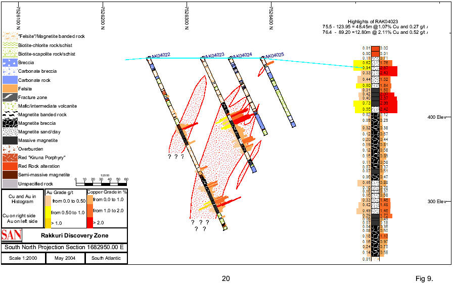
Schematic geological profiles have been drawn along L 2800E, L 2900E and L2950E including intersected mineralized zones (fig. 7-9).
16
A total number of 963 samples have been selected from the mineralized zones in the drill cores,
and subsequently analyzed.
** Three profiles have been completed along the lines L2800E, L2900E and L2950E. Line 2800E now encompasses 13 drill-holes (including 4 drill-holes by Anglo 2002), line 2900E includes 6 drill-holes, and line 2950E four drill-holes (including 02RAK014 by Anglo). One drill-hole has been sunk on line 3000E (RAK04026), and one drill-hole on line L2850E (RAK04016). The deepest penetration within all profiles is 200-230 meters vertical depth.
** Two drill-holes have additionally been located on the northwestern IP/MAG trend on line L3050E
** Outside the Discovery Zone trend, three drill-holes have been located on IP anomalies further to the east (line 2450 and line 2300), two penetrating weak pyrite-chalcopyrite mineralization in the Porphyry Group (RAK04009 and RAK04011) and one going through carbonate breccia (RAK04017)
The location of the drill-holes are indicated on a plan map (Fig.4), and the profiles (sections) with copper and gold values are given as graphs in Fig. 7-9, together with a more detailed division of geological units.
The best intersections in profile L2800E (fig. 7) are 42 meters with 0.83 % copper and 0.05 g/t Au (RAK04001), 40.4 meters with 1.41% copper and 0.33 g/t Au (RAK04002, and including 6.8 meters with 2.23% Cu and 0.41 g/t Au and 7.2 meters with 2.09 % Cu and 0.57 g/t Au), 19.75 meters with 1.68% Cu and 0.41 g/t Au (RAK04006), 18.10 meters with 0.94% Cu and 0.14 g/t Au (RAK04007), and 11.7 meters with 1.33% Cu and 0.42 g/t Au (RAK04022). RAK04008 has a richer mineralization from 210.90 to 233.10 meter with 4.4 m of 2.21% Cu and 0.66 g/t Au.
Profile L2900E (fig. 8) indicates mineralization at 110-220 m depth (cut in drill-holes RAK04019, RAK04015, RAK04012 and RAK04018). The northernmost drill-hole (RAK04013) has only 6.8 meters with 0.47 % Cu and 0.28 ppm Au, and the southernmost drill-hole (RAK04020) is without visible
17
Rakkuri Discovery Zone: Rock Types, Assays and Cu/Au Mineralisation/Magnetite Host
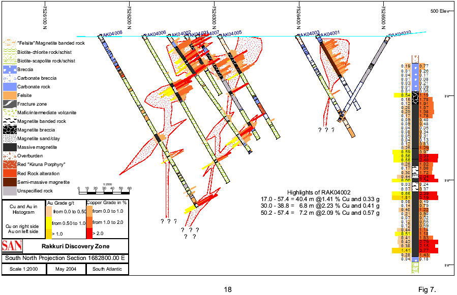
Rakkuri Discovery Zone: Rock Types, Assays and Interpreted Cu/Au Mineralisation/Magnetite Host
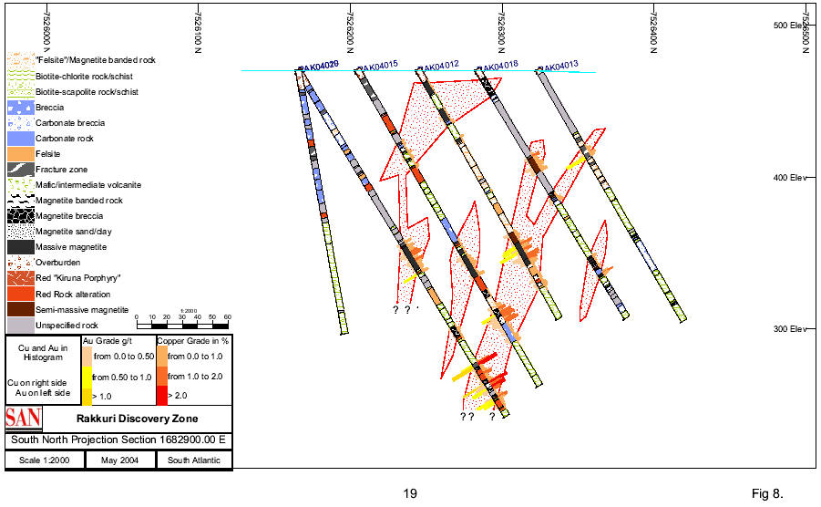
Rakkuri Discovery Zone: Rock Types, Assays and Cu/Au Mineralisation/Magnetite Host
sulphides. The best intersections along the drill-cores are 35.05 m with 0.57% Cu and 0.18 g/t Au (RAK04012), 27.55 m (RAK04015) with 0.70 % Cu and 0.18 g/t Au (including a section of 13.45 m with 1.11% Cu and 0.26 g/t Au) and 33.30 m with 0.87 % Cu and 0.27 g/t Au including 6.5 m with 1.80 % Cu and 0.48 g/t Au (RAK04019).
Profile 2950L (fig. 9) is drilled with 4 drill-holes (RAK04022, RAK04023, RAK04024 and RAK025). RAK04022 has a good copper intersection between 166 and 203 m depth along the drill-core (36.75 m with 0.6% Cu and 0.22 g/t Au, including 11.70 m with 1.33% Cu and 0.42 g/t Au) , and RAK04023 goes through an almost 50 m section with magnetite and sulphides from about 75 to 125 meters along the drill-core, and returned 50.95 meters with 1% Cu and 0.26 g/t Au including 12.80 m with 2.11% Cu and 0.52 g/t Au. An earlier drill-hole (AA 02RAK014) returned 21.50 m with 0.71% Cu, including 14.50 m with 0.94% Cu. The drill-holes further to the north in the same profile (Dh RAK04024 and RAK04025) went only through thin Cu-bearing horizons with low grades of copper and gold.
Dh RAK04026 on line 3000E penetrated a zone of 13.10 meters with 0.7% Cu and 0.14 g/t Au.
RAK04004 along L3050 intersected 20.85 m with 1.09% Cu and 0.22 g/t Au, while RAK04014, which was drilled in the same profile (but in an opposite direction), failed to go through copper mineralization.
Drill-hole RAK04016 at L2850 went through the same IP anomaly as RAK04001 and hit a 5.67 meters section with an average of 1.45% Cu and 0.07 g/t Au.
Three drill-holes have been sunk in the western area, underlain by porphyries and carbonate breccia. RAK04009 went through a weakly mineralized section of 17.95 meters with 0.25 % Cu and only traces of gold. RAK04011 and 04017 failed to intercept economical grades of copper mineralization.
The spatial relationship (configuration) between the mineralized sections in near-lying drill-holes is difficult to interpret although the distance between the drill-holes is only 20-50 meters. A richer mineralized area, comprising about 2500 m2 is present in the upper part of profile 2800E
21
(drill-holes AA 02RAK020-RAK04002-RAK04021-AA 01RAK4B, RAK04007 and RAK04005). It might be connected to the lower mineralized section in the same profile (Drill-holes AA-02RAK019, RAK04-006 and AA-01RAK004B) at 50-100 meters depth (Fig. 7). A narrow zone of weathered magnetite "sand" with sulphides appears to follow a vertical structure between 7626300-350. An interpretation of the connection between the mineralized zones in profiles 2800E and the mineralized zones in 2900E are given in simplified geological profiles (figures 7 and 8).
The mineralization found in RAK04001 could not be repeated in RAK04003 or 04010
Most holes on the Discovery Zone intersected a variety of strongly altered brecciated and schistose units. Biotite, calcite, scapolite and clay altered feldspar are often noted. Magnetite (massive in places) breccia is common and normally associated with significant chalcopyrite mineralization. The breccias appear to be of hydrothermal origin, and are characterized by stockworks and veins of chalcopyrite and pyrite.
While there is not yet enough drilling in detail to determine the exact orientation or size of the Discovery Zone mineralization, it appears that at depth it is vertical to sub-vertical.
10.1.2 Conglomerate Zone
Other areas within the Rakkurijärvi permit have been drilled with anomalous results in copper and gold. An intersection of 0.79% Cu, 0.12 g Au/t over 16.5 m has been cut in Anglo/Rio Tinto drillhole 01RAK007 in an area known as the Conglomerate Zone (also referred to as the Hydraulic Breccia Zone), located some 400 m to 600 m northwest of the Discovery Zone. The intercept contains disseminated Cu-Au mineralization within a porphyritic volcanic conglomerate unit that has been subjected to intense Na-Ca-K alteration. Several holes were drilled by the Swedish Geological Survey (SGU) in the area between this hole and the Discovery Zone between 1969 and 1979 and significant intersections were obtained over narrow widths in nine of these holes. Intersections ranged from 0.31% Cu over 2 m to 4.4% Cu over 1 m. Mineralization consists of disseminated chalcopyrite in a meta-conglomerate.
22
The "LUN" IP and magnetic surveys (referred to above) covered a portion of the Conglomerate Zone and outlined a high chargeability, high resistivity and high magnetic anomaly as shown on Figures 5 and 6. Two drillholes were located on this anomaly (009 and 017). RAK04009 went through a weakly mineralized section of 17.95 meters with 0.25 % Cu and only traces of gold. RAK04017 failed to intercept economical grades of copper mineralization.
10.1.3 Rakkurijärvi permit – other targets
In addition to the Discovery and Conglomerate Zones, Anglo/Rio Tinto have done some preliminary investigation, including scout diamond drilling of other anomalous zones, including the Hangar Zone just southeast of the Discovery Zone and the Tributary and Chair Zones to the east and NE. Further work is warranted in the vicinity of all but the Chair Zone. LUN started drilling activities on the Tributary Zone in December 2004, and finished the first hole before the Christmas holiday vacations. The drillhole went through brecciated carbonate rock (completely decomposed in the upper part) and magnetite rich rock with pyrite. No samples were taken.
10.2 PUOLTSA NR 1 PERMIT
The Lundin Mining drilling activities at the Ailatis area was initiated in June 2004 and up till 12th of October 2004, a total of 23 drill-holes were completed, totaling 2 559 meters with an average overburden depth of a little less than 6 meters. A total number of 386 samples (including 7 duplicates and 2 blanks) have been selected from mineralized zones from the drill cores, sampled, prepared and analyzed (Table 3). The Ailatisvaara is a topographical high, 6 km WNW of the former Pahtohavare mine and about 8 km WNW of the "Discovery Zone". The drill-holes are located on the southern slope of the Ailatisvaara and further 1 500 meter to the south.
The exploration permit Puoltsa nr 1 was granted 2002-03-04 and is valid until 2005-03-04. The area covers 1921 hectares in Kiruna Community, Norrbotten county. The exploration permit is issued to Anglo American (Table 1).
23
10.2.1 Earlier exploration activities
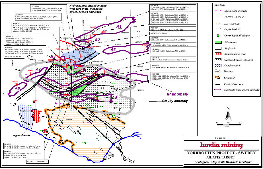
Swedish Geological AB (SGAB) performed exploration in the area 1986-1992. Basal till sampling indicated copper and gold anomalous areas. Geophysical airborne maps in the scale 1:50 000 were produced in context with iron ore exploration in the 1960s and geophysical ground surveys took place in the 1980s. Drilling has been done in 1986 (1 dh), 1989 (3 dh) and 1990 (8 dh). The drillhole locations are indicated in Fig. 10.
On the southern slope Dh 90 113 goes through an interesting sequence of strongly altered mafic and carbonate rocks. Other nearby drill-holes has gone through strongly weathered bedrock dominated by brecciated rocks: albite, chert, carbonate, altered greenstone and clay. Technical problems and heavy core losses are reported from the drilling activities in 1990, and some of the drill-holes had to be abandoned at a shallow depth (Dh 90 110 at 61 m, Dh 90 114 at 47 m, and Dh 90 115 at 41 m). To the west a granitic rock lies on top of carbonate and altered mafic rocks (Dh 90 120, 90 121 and 90 123).
In the northern part of the area, within the mafic rocks underneath the hill Ailitisvaara, a weak copper dissemination is affecting the rocks. 36.5 m with 0.16-0.51 % Cu has been analysed from Dh 90 103, and 40 m with 0.05-0.72 % Cu from Dh 90 105. Only traces of gold were present.
In Dh 90 113, a 17 m long core section in a vertical diamond drill hole penetrated an iron oxide (mostly magnetite) breccia with copper oxides and chalcopyrite. A 4,6 meter section contains 1.65% copper and the whole section 17.3 m with 0.88 % Cu. The entire core of 89 meters contains an average of 0.44% Cu. The gold values don't exceed 0.02 ppm Au. The type of mineralization in Dh 90 113 is quite similar to the Rakkurijärvi Fe-oxide-Cu-Au prospect, and the presence of carbonates and breccia have been noted in all the prospect and deposit areas in the Pahtohavare area.
Dh 90 108 (60 m SW of Dh 113) includes a 1.8 m section with 2.4 % Cu in a breccia associated with magnetite, and Dh 90 110 (40 m S of Dh 113) penetrated 11 m with 0.2 - 0.4 % Cu.
24
25
26
27
Dh 90 125 (160 m WSW of Dh 113) exhibit a very interesting hydrothermal breccia with 0.5 – 4 cm clasts of albite (partly hematite-stained) in a matrix of actinolite, tremolite, carbonate and minor biotite, hematite and K-feldspar grains.
10.2.2 Geology
The Ailatis mountain is mainly built up by lava flows with an intercalated banded iron formation. The formations are roughly striking in a NE-SW direction and are relatively well preserved. In the low land immediately to the south of the topographic high drilling has revealed a 200 m wide zone with carbonates, Cu-bearing magnetite dykes and hydrothermal clays and breccia. To the west this alteration zone is covered by a tongue of flat-lying younger granite coming in from the west (Fig. 10). The central part of the investigated area is occupied by an intrusive suite of rocks, giving rise to a distinct gravity anomaly. The intrusive is predominantly composed of gabbro with minor components of chlorite-biotite altered ultramafic rocks and mafic volcanic rocks (probably mainly as dykes and sills). The surrounding rocks belong to the Kiruna Greenstone Group and are mainly extrusive and intrusive basaltic rocks. The southeastern area is occupied by a large granite intrusive with large inclusions of gabbro and mafic volcanic rocks (Fig. 10). West of this intrusive a conglomerate is exposed in a few outcrops. It must be emphasied that the number of outcrops is scarce and most of the information of the geology must be based on drill-cores and magnetic maps.
Sulphide mineralization occurs in different settings. The basalts in the Ailatis hill contains up to 40m zones with disseminated sulphides with low grade copper. Magnetite dykes with chalcopyrite have been observed in SGAB holes No 90113 and 90108 and in AIL04006 and 04010. The chlorite-biotite altered ultramafic rocks contains zones with elevated values of copper, nickel and PGMs.
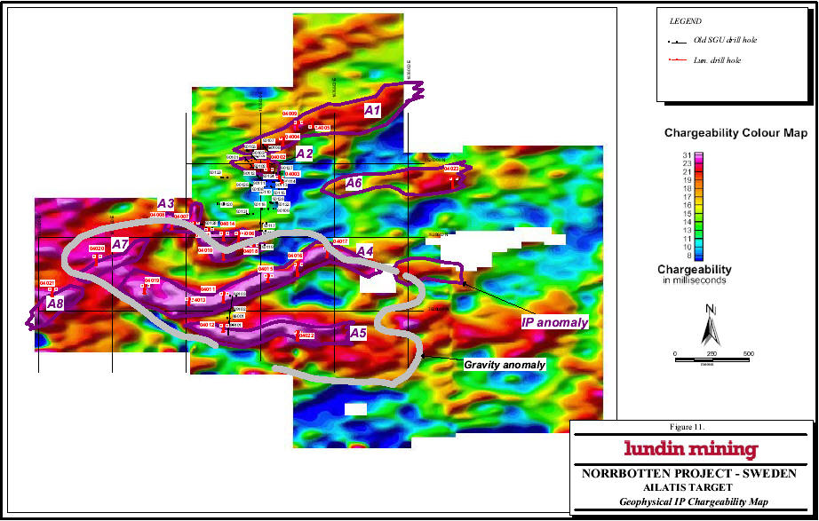
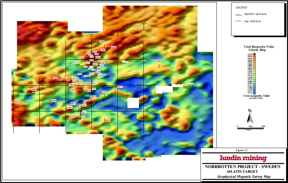
10.2.3 Geophysics
The geophysical ground survey at Ailatis has covered about a little less than 12 square kilometers with IP (Induced Polarization) and magnetic surveys (Fig. 11 and 12). All of the high chargeability anomalies are associated to a moderate magnetic feature. The IP surveying has been
28
successful in locating sulphide mineralization in practically every drill-hole. Eight separate anomaly zones can be distinguished and are named A1 to A8, roughly from the north to south. These zones have been focused in the selecting of drilling targets (Fig. 11).
10.2.4 Core drilling and drill results
The drilling at Ailatis was initiated the 16th of June 2004 and ended the 22nd of June 2004, and was then resumed the 2nd of August. The autumn campaign ended the 12th of October. The drill- hole location, dip and length are recorded in Table 3.
The IP geophysical map gives very coherent and obvious anomalies, roughly coinciding with magnetic high anomalies.
The anomaly zone A1, at the slope of Ailatisvaara, has been followed up with three drill-holes partly altered mafic volcanic rocks. The two eastern drill-holes ended in a banded iron formation (sulphide-poor).
Dh 04004 went through a 13.3 m section with an average of 0.17% Cu between 8.7 and 22 meters.
Dh 04005 went through a 26.3 m section with an average of 0.18% Cu between 32.3 and 58.6 m and another weak copper mineralization between 75 and 80 meters. Practically the whole core is copper anomalous.
Dh 04009 penetrated roughly 37.1 meters with 0.15% Cu (between 57.60 to 94.70 m) and a 5.5 m zone with 0.17% Cu between 21.10 and 26.60 m.
At the southern foot of the Ailatisvaara, two drill-holes investigated a minor anomaly (A2). The first drill-hole went through a mafic lava rock with only traces of sulphides as very tiny grains. The second hole penetrated weathered and crushed rocks of breccia and altered mafic rock with a 20 m section of carbonate (probably a hydrothermal dyke). A weak copper mineralization (with 0.14% Cu) was found in the uppermost 10 meters, associated with a relatively high potassium content.
29
| TABLE 3 | |||||||||||
| m | |||||||||||
| Dh No | Easting | Northing | Strike | Dip | from | to | interval | Cu % | Ni% | Au ppm | Pd ppm |
| PUOO4001 | 1672700 | 7529550 | 180 | -60 | |||||||
| AIL04001 | 1674650 | 7528550 | 180 | -60 | 103,25 | 103,6 | 0,35 | 1,1 | 0,16 | 0,06 | |
| 117 | 125,2 | 8,2 | 0,21 | 0,08 | |||||||
| AIL04002 | 1675050 | 7528960 | 0 | -60 | only traces of sulphides | ||||||
| AIL04003 | 1675124 | 7528909 | 150 | -60 | 9,6 | 18,9 | 9,3 | 0,13 | |||
| AIL04004 | 1675150 | 7529170 | 180 | -60 | 8,7 | 22 | 13,3 | 0,17 | |||
| AIL04005 | 1675350 | 7529250 | 0 | -55 | 17,2 | 21,2 | 4 | 0,15 | |||
| 32,3 | 36,5 | 4,2 | 0,21 | ||||||||
| 37,5 | 58,6 | 21,1 | 0,18 | ||||||||
| 63,7 | 64,6 | 0,9 | 0,4 | ||||||||
| 75,8 | 80,4 | 5,6 | 0,22 | ||||||||
| AIL04006 | 1674850 | 7528530 | 180 | -60 | 76,3 | 79 | 2,7 | 0,75 | |||
| AIL04007 | 1674550 | 7528600 | 180 | -55 | 8,2 | 12,2 | 4 | 0,45 | |||
| 28,3 | 30,2 | 1,9 | 0,6 | ||||||||
| 53,6 | 80,1 | 26,5 | 0,1 | ||||||||
| including | 53,6 | 54,6 | 1 | 0,15 | |||||||
| AIL04008 | 1674850 | 7528530 | 180 | -55 | only traces of sulphides | ||||||
| AIL04009 | 1675250 | 7529280 | 180 | -60 | 21,1 | 26,6 | 5,5 | 0,17 | |||
| 57,6 | 94,7 | 37,1 | 0,15 | ||||||||
| AIL04010 | 1674750 | 7528420 | 180 | -60 | 4 | 10,1 | 6,1 | 0,31 | |||
| 91,5 | 99,9 | 8,4 | 0,61 | ||||||||
| including | 94,5 | 96,2 | 1,7 | 1,4 | 0,1 | 0,06 | 0,31 | ||||
| AIL04011 | 1674750 | 7528120 | 180 | -60 | 100,1 | 107,1 | 7 | 0,3 | |||
| including | 102,2 | 103,2 | 1 | 1,34 | 0,08 | ||||||
| AIL04012 | 1674750 | 7527900 | 180 | -60 | No samples taken | ||||||
| AIL04013 | 1674500 | 7528080 | 180 | -60 | 31,9 | 37,9 | 6 | 0,13 | |||
| 73,8 | 79,9 | 6,1 | 0,17 | ||||||||
| AIL04014 | 1674750 | 7528530 | 180 | -60 | 82,5 | 92,9 | 0,4 | 2,13 | 0,25 | 0,69 | 0,14 |
| AIL04015 | 1675050 | 7528240 | 180 | -60 | 14,35 | 16,3 | 1,95 | 0,62 | |||
| AIL04016 | 1675250 | 7528320 | 180 | -60 | 56,5 | 68 | 11,5 | 0,18 | |||
| AIL04017 | 1675450 | 7528430 | 180 | -55 | only traces of sulphides | ||||||
| AIL04018 | 1674950 | 7528450 | 180 | -60 | 14 | 16 | 2 | 0,31 | |||
| AIL04019 | 1674200 | 7528150 | 180 | -60 | No samples taken | ||||||
| AIL04020 | 1673900 | 7528374 | 180 | -45 | only traces of sulphides | ||||||
| AIL04021 | 1673600 | 7528150 | 180 | -60 | No samples taken | ||||||
| AIL04022 | 1675250 | 7527860 | 180 | -60 | 19,8 | 30,65 | 10,85 | 0,29 | |||
| 1676300 | 7528900 | 180 | -60 | 94,6 | 106,1 | 11,5 | 0,25 | 0,11 | |||
| AIL04023 | 1676300 | 7528900 | 180 | -60 | 46 | 72 | 26 | 0,27 | |||
30
The third anomaly zone, A3, is located about 500 m to the SW of the Ailatis Mountain, and forms an irregular IP-MAG anomaly zone. The two westernmost holes (04008 and 04007) goes through an albite-rich rock in the upper (approximately) 30 meters and ends in a Mg-Fe-Chlorite-Biotite rich mafic rock, which is also found in the three drill-holes to the east. This mafic to ultramafic rock contains a very fine dissemination of sulphides, difficult to observe without a hand-lens. Dh 04001 is irregularly mineralized between 103 and 119 m with the best intervals of 0.35 m with 1.10% Cu and 0.16% Ni and 1.00 m with 0.71% Cu and 0.17% Ni. The Mg content in this first drill-hole is 12.5% in average. The precious metals (Au, Pt and Pd) are anomalous.
Dh 04006 goes through a 0.70 m zone with massive magnetite and chalcopyrite of Rakkurijärvi-type, containing 1.89% Cu. The half-meter section above is mineralized with 0.66% Cu. The highest Ni value is 0.14% Ni over 1 meters length.
Dh 04007 has scattered thin sections with copper values >0.5% (2 m with 0.5% Cu, 2 m with 0, 6% Cu and 1 m with 0.8% Cu and 0.15% Ni). The Cu in Dh 04008 occurs only as traces.
Dh 04010 contains almost 4 meters of magnetite breccia with sulphides. Between 94.50 and 98.10 m the core holds 3.6 meter with 1% Cu and 0.3 ppm Pd and slightly anomalous values of Au and Pt. This higher values are part of a 12.5 m section with 0.45% Cu. In the upper part of the drill-hole there is a weak chalcopyrite dissemination with 0.22% Cu between 4 and 14.25 meters depth.
In Dh 04014 a fine dissemination of sulphides occur in most of the core, difficult to observe without cutting the core. Between 82.50 – 82.90 there is a 40 cm wide quartz vein with chalcopyrite crystals, pyrrhotite, molybdenite and biotite crystals. This vein contains 2.13% Cu, 0.7 g/t Au, 0.14 g/t Pd, 4 g/t Ag and 0.25% Ni.
Dh 04118 has scattered chalcopyrite and pyrite in fractures. The best section contains 0.31% Cu over 2 meters length.
31
The IP (A4) anomaly is strong and persistent and occurs over gabbroic rocks with minor intercalations of mafic lava rocks. The mineralization consists of disseminations and veinlets with chalcopyrite, normally associated with magnetite. A total of six drill-holes have intersected this anomaly. The best intersection was found in the first drill-hole in this anomaly, Dh 04011 with 18.2 m with 0.17% Cu (100.1-118.2 m) including 6.2 m with 0.33% Cu, which includes a semi-massive sulphide mineralization with 1 m containing 1.34% Cu and 0.08 ppm Au. Dh 04013 have several intervals with low Cu content, maximum 0.32% Cu over 1 meter. Dh 04015 grows more mafic downwards and contains minor zones with weak chalcopyrite mineralization, the best intersection is 0.95 m with 0.8% Cu. Also Dh 04016 has weak chalcopyrite dissemination zones, max 0.44% Cu over 1.4 m. From about 65 m the content of Cr, Mg and Ni increases, indicating a more mafic rock.
The fifth anomaly zone (A5) lies some hundred meters further south and has only been investigated with two drill-hole: Dh 04012 and Dh 04022. The first drill-hole went through 8 meters of mafic volcanic rock and entered a very weakly mineralized gabbroic rock. No analyses have been taken from this drill-hole. The second drill-hole went through 95 m of gabbros and then through chlorite-rich ultramafic rocks. Between 19.80 and 30.65 m the core contains 0.29% Cu over 10.85 meters.
Anomaly zones A6, A7 and A8 have each been investigated with one drill-hole. Drill-hole 04021 went through a mafic volcanic rock without significant sulphide content. Drill-hole 04020 went through an interesting clast-supported hydrothermal breccia but with very low content of sulphides. The last drill-hole (Dh 04023) in the easternmost IP anomaly went through a mineralization with chalcopyrite between 46 and 72 meters. The content of copper in this section amounts to 0.27% Cu over 26 meters.
10.2.5 Evaluation
The geology of the Ailatis area is interesting with hydrothermal breccias and hydrothermal carbonate in the flanks of a gravity anomaly. The rocks within the area of the gravity anomaly are gabbros and ultramafics. The nickel content in the altered ultramafic rocks is anomalous and reach a maximum of 2 480 ppm. Dh 04010 has an average of 729 ppm over 116.70 meters.
32
Locally there is also anomalous values of Pd and Pt. Palladium values in Dh 04010 reach 0.3 ppm over 3.6 meters associated with a magnetite breccia (including 1.05 m core loss). Massive magnetite associated with sulphide occurs also in Dh 04006 and in the SGAB hole No 90108 and 90113. The appearance of sulphide disseminations, magnetite breccias and an intense alteration zone might indicate the presence of richer mineralizations at depth. The best copper mineralization has been found in the drill-holes in the eastern part of the area with 0.27% Cu over 26 meters in Dh 04023, and 26.3 m with 0.18% Cu in Dh 04005 and 37.1 m with 0.15% Cu in Dh 04009. The continuation of these zones eastwards might be of continued exploration interest.
There is a good correlation between combined IP and MAG anomalies and sulphide mineralization.
10.3 OTHER ANGLO/RIO TINTO PERMITS
Anglo/Rio Tinto have identified targets on other permits that warrant further exploration. In most cases ground geophysical surveys have been completed over AEM anomalies and a small amount of scout drilling has been carried out. Included in these areas are four test grids on the Puoltsa exploration permits, three grids on the Rakkurijärvi South permit and two areas to the east on the Nunasvaara. The Airivaara permit has been dropped. All of the remaining exploration permits warrant follow-up.
10.4 LUNDIN PROPERTIES
No additional work has been done on the LUN properties outside the Anglo/RT concession areas. The LUN properties and the exploration activities taken place on these have been described in the Technical Review Report of April 14, 2004 and will not be repeated here. However one new concession was granted the 16th of June 2004 (Norrbotten 150) comprising 1469 ha and another area of 3016 ha has been applied for (Table 1). The concessions are all registered in the name of South Atlantic in Norrbotten Hb.
33
11. DRILLING
LUN drilling has been carried out by Finnish contractor Oy Kati AB using two Hagby wireline drills recovering 57 mm diameter core and drilling 24 hours per day, seven days a week initially and later 4 days a week. Triple tube is used when coring through weathered and/or other difficult areas and some technical assistance has been provided on site by a Canadian drilling firm. Core recoveries have improved over those achieved by Anglo and Rio Tinto. Acid tests to verify hole dip are taken every 10 m down each hole. Azimuths are not verified down hole. Anglo/Rio Tinto used a Maxibor instrument to measure downhole dip and azimuth. Measurements were taken approximately every 5 m.
12. CORE HANDLING AND LOGGING PROTOCOL
Core is collected at the drill site by Lundin Mining personnel and delivered to the LUN office for core logging and storage facility in Kiruna. Core recovery and other geotechnical data are measured, and then all but obviously unmineralized and unbrecciated core is diamond sawed. Anglo/Rio Tinto also diamond sawed all their assay samples. Geological logging is carried out with data captured manually then entered into Downhole Explorer (Earthworks) software by LUN personnel.
13. SAMPLING METHOD AND APPROACH
The geologist marks the sample interval based on mineralization present and observed geological and alteration information. Samples vary in length from less than 0.5 m to 1.50 m and average approximately 1.00 m. Because of the disseminated nature of the chalcopyrite and difficulty estimating its content and the importance of the Au values and impossibility of estimating its
34
content, a very large portion of the split core is sent for assay. Samples are assigned a numbered sample tag. The number is written on the core box, adjacent to the location of the corresponding archived half core.
The core to be assayed is bagged along with the tag and shipped by bus to the prep lab of North Atlantic Natural Resources AB (74% owned by LUN) in Uppsala.
14. SAMPLE PREPARATION, ASSAYING AND SECURITY
14.1 SAMPLE PREPARATION
The sample prep facility was designed, set-up and commissioned by ALS Chemex of Vancouver, Canada.
LUN determines the Specific Gravity ("SG") of every core sample from the Rakkurijärvi Discovery Zone sent for assay except those exhibiting significant weathering. Only a few of the samples from Ailatis have the SG determined. SG is determined by weighing the sample in air and then when immersed in water. The difference in the two weights is the weight of the water displaced by the volume of the core. The specific gravity of the core is the ratio of its weight in air to the difference between its weight in air and its weight immersed in water. Anglo/Rio Tinto determined SGs for core samples using a similar procedure but on a far less frequent basis and there has not yet been a comparison made of the Anglo/Rio Tinto and LUN data.
Samples are then dried and passed through a jaw crusher. The sample is then passed though a Jones riffle splitter and a 200 g to 400 g split is pulverized using an Essa ring grinder. Inert rock is run through both the jaw crusher and pulveriser between samples. The sample is removed from the ring bowl onto a rubber mat. A small 100 g to 150 g split is placed into a small pre-labelled envelope and batches of varying sizes are air freighted to the ALS Chemex laboratory in Vancouver.
35
14.2 ASSAYING
ALS Chemex takes custody of the LUN samples in Vancouver. For routine analyses, 2 gram samples are subjected to four acid "near total" digestion followed by analysis using the ME-ICP61a (Inductively Coupled Plasma ("ICP"), Atomic Emission Spectroscopy ("AES")) package for 27 elements. High grade samples are run using the ICP-AES method following sodium peroxide fusion. Au, Pt and Pd are analysed by fire assay with an ICP-MS finish.
The laboratory is ISO 9002 certified.
14.3 QAQC
LUN introduces one blank and one duplicate per 20 sample batch prior to shipment. ALS Chemex introduces blanks and standards into the sample stream as part of its internal QAQC program.
14.4 SECURITY
Samples are shipped from Kiruna to Uppsala in tamper-proof plastic bags. There is little opportunity for anyone to tamper undetected with the samples at any step in the shipping, preparation and assaying process.
From the opinion of the author the sampling, sample preparation, security and analytical procedures has been performed satisfactory.
36
15. MINERAL PROCESSING AND METALLURGICAL TESTING
There is no report of any metallurgical testing having taken place on material from sources on any of the LUN or Anglo/Rio Tinto permits, including the Rakkurijärvi Discovery Zone.
16. INTERPRETATION AND CONCLUSIONS
The properties that LUN has optioned from Anglo/Rio Tinto complement and enhance LUN property position in the Kiruna area. This is an area that is clearly highly prospective for IOCG deposits. The presence of the Kiruna iron ore mines and the Viscaria and Pahtohavare deposits clearly demonstrates that there have been large mineralizing systems at work in the area and that there is excellent potential for finding more. The precise orientation of the Discovery Zone is still open to interpretation. The zone remains open at depth and along strike although its rough northern and southern extents have been defined. Its exact size and potential remain to be determined. There is also very good potential to find additional IOCG mineralization at the Conglomerate Zone and for oxide copper mineralization close to the Pahtohavare deposit. There are also other untested targets in other areas on the Anglo/Rio Tinto option.
LUN has embarked on a major exploration program in the search for IOCG deposits and has assembled a large land position in the Kiruna area of Norrbotten, Sweden. Initial permit acquisitions were guided by airborne geophysical results combined with a compilation of available geochemical and ground geophysical data and an examination of historic drill core and the limited outcrop exposures in the region. In addition, LUN has acquired under option, Anglo/Rio Tinto's substantial land position, which is anchored by the Rakkurijärvi Discovery Zone, a new discovery of IOCG mineralization.
37
LUN has already carried out drilling on this zone. This and past drilling confirm that it represents an as yet not fully defined IOCG occurrence meriting continued exploration.
At Rakkurijärvi the copper minerals occur mostly as chalcopyrite, but other copper minerals as sulphides, oxides, carbonates and native copper (in secondary position) may be present. In the absence of chalcopyrite it is not possible to estimate the Cu content visually. The content in mineralized zones will first be appreciated after the delivery of the analytical result. However, most of the copper and gold is associated with magnetite in massive sheets, as veins or in dissemination.
The configuration and extent of the Cu-Au mineralization is still not sufficiently known and the outline of the mineralized zone (-s) will be improved by systematic drilling, based on ground magnetic and IP surveys and geological interpretations. The impression from the geophysical surveys and the line profiles L2800 and L2900 is that the sulphides and magnetite occur in near vertical structures.
The drilled Fe-Cu-Au mineralization does not occur in a coherent massive body, but is rather irregular. It is likely that the mineralization, by analogy with the IOCG deposits in Chile and southern Peru, occurs in veins, formed both as replacement and associated open-space filling. Typically these veins occur as swarms, 2-30 m wide and 1-5 km long. In addition, isolated pipes and breccia formations (hydrothermal and tectonic) occur locally in Chile.
The gold content in the new Rakkurijärvi drill-holes is <0.6 ppm, and thus lower than expected (with exception to Dh RAK04019 with 5 values between 0.64 and 1.01 g/t Au and Dh RAK04023 with 1.20 m grading 2.14 g/t Au).
The continued exploration must be focused on richer Cu-Au mineralizations and more coherent, large tonnage deposits over minable width and length.
The IP geophysical map gives a very coherent and obvious anomaly, roughly coinciding with the magnetic high anomaly.
38
From its preliminary review of the Anglo/Rio Tinto option property, the LUN property and results to date, it can be concluded that:
* The regional geological setting is consistent with the IOCG model including the giant Olympic Dam deposit, and the Rakkurijärvi Discovery Zone is a new IOCG discovery which warrants continued drilling to define resources.
* The drilling on the Discovery Zone has produced positive results. The best result has been 1.07% Cu and 0.27 g/t Au over 48.45 m in hole RAK04023 (including 12.80 m with 2.11% Cu and 0.52 g/t Au). The mineralized zones are, however, not sufficiently coherent to form a base for a sizable mineral resource estimation at this stage.
* The extensive and intensive hydrothermal alteration indicates large element redistribution that might result in large accumulation of sulphide minerals.
* The Anglo/Rio Tinto Pahtohavare oxide target, adjacent to the past-producing Pahtohavare mine, appears to have significant potential for the discovery of further copper oxide mineralization;
* At Ailatis eight IP anomalies were tested and the best intersections were 26m with 0.27% Cu (Dh AIL04023 ), 37.1 m with 0.15% Cu (Dh AIL04009) and 26.3 m with 0.18% Cu (Dh AIL04005). The continuation of the IP anomalies tested by AIL04023 and AIL04005 towards the east is interesting as an exploration target.
* The excellent land position in a highly prospective area warrants significant additional exploration.
17. RECOMMENDATIONS
In November 2003, SAA/LUN prepared a ±one year work program and budget totalling approximately US$5.3 million. Up till December 31, 2004 US$1.7 million of this amount has been spent on the Rakkurijärvi and Ailatis target areas. The author endorses LUN's strategy of concentrating expenditures in the Rakkurijärvi Discovery area and Pahtohavare area, while at the same time carrying out ground geophysical surveys on its other holdings in an effort to outline and diamond drill anomalies which might represent (as did Rakkurijärvi) a new IOCG mineralized zone.
39
CERTIFICATE
To Accompany the Report titled "An updated Technical Review of the Kiruna Area IOCG Projects in Norrbotten County, Sweden for Lundin Mining Corporation, dated February 15, 2005.
I, Robert Lilljequist, do hereby certify that:
1. I reside at Calle Horno No 9, 296 80 Estepona, Prov de Malaga, Spain
2. I am a graduate from the University of Lund in Lund, Sweden with a Fil lic (similar to Canadian PhD degree) in Geology (1969), and I have practised my profession continuously since that time.
3. I am a registered member of the European Federation of Geologists (Certificate No 0222).
4. I am a Consultant Geologist and have provided geological consulting services to Lundin Mining Corporation Ltd (earlier South Atlantic Resources) since 2002 and continue to provide these services as of date of this certificate.
5. I am a qualified person under the requirements of the Swedish Mining Association (certificate No 18), which has formally adopted the standards and guidelines of Canadian National Instrument 43-101 ("NI 43-101"), and by virtue of my membership (No 222) in European Federation of Geologists, which is recognized by CIM in Canada, in Australia and South Africa. I have experiences with a variety of mineral deposits, including IOGC deposits
6. I have read the definition of "qualified person" set out in NI 43-101 and certify that by reason of my education, affiliation with a professional association (as defined in NI 43-101) and past relevant work experience, I fulfil the requirements to be a "qualified person" for the purposes of NI 43-101
40
7. I have extensively researched, visited and worked on and supervised work on the Lundin Mining Corporation and Anglo/Rio Tinto properties since early 2002 until present. I have co-authored "A Technical Review of the Kiruna Area IOGC Projects in Norrbotten County, Sweden", dated April 27, 2004 and authored some of the reports listed in "References".
8. I have no personal knowledge as of the date or this certificate of any material fact of change, which is not reflected in this report.
9. I am not independent of the issuer applying all of the test in section 1.5 of NT 43-101 by virtue of having provided geological consulting services to the issuer on the Norrbotten property.
10. I have read NI 43-101 and Form 43-101F1 and have prepared this report in compliance with NI 43-101 and Form 43-101F1, and have prepared the report in conformity with generally accepted Canadian mining industry practice.
| signed by |
| Robert Lilljequist |
| Fil lic, Eurogeologist |
| February 15, 2005 |
REFERENCES
Anglo American Exploration BV
1999-2003 Various unpublished electronic data, internal reports, drill logs and assays, geophysical reports and maps as provided to Robert Lilljequist by Lundin Mining
Municipalities of Kiruna and Gällivare
1997 Exploration Opportunities in Norrbotten (Sweden), Part 1 Municipality of Kiruna; Part 2 Municipality of Gällivare.
North Atlantic Natural Resources AB
2000 FeOx-Cu-Au Exploration Opportunities in Northern Sweden by R. Horsnail. Unpublished Information Memorandum for potential optionors
South Atlantic Ventures Ltd/Lundin Mining Corporation Ltd
March 2004 Report on Exploration Activities on the Rakkurijarvi No 1 Area, January-February 2004 by Robert Lilljequist. Unpublished internal report.
Sep. 2003 Status of exploration activities of all SAA concessions in North Norrbotten by R. Lilljequist. Unpublished internal report.
May 2003 Updated Technical Report on Norrbotten Exploration for South Atlantic Ventures Ltd. by R. Lilljequist. Unpublished internal report.
42
Mar. 2003 Norrbotten Copper-Gold Project, South Atlantic Ventures Ltd. by R. Lilljequist and A. Braña. Unpublished internal report.
Oct 2004 The Ailatis target area. Unpublished internal report
Dec 2004 North Norrbotten Project: Ailatis area. Unpublished internal report.
Strathcona Mineral Services Limited
2002 Technical Report on Norrbotten Exploration Project, Sweden, for South Atlantic Ventures Ltd by Henrik Thalenhorst. Filed with SEDAR.
Watts, Griffis and McQuat
2004 A technical review of the Kiruna area IOCG projects in Norrrbotten County, Sweden, for South Atlantic Ventures Ltd, SEDAR April 14, 2004
43