Law Offices of Thomas E. Puzzo, PLLC
4216 NE 70th Street
Seattle, Washington 98115
Telephone: (206) 522-2256 / Facsimile: (206) 260-0111
| Writer’s e-mail: tpuzzo@msn.com | |
| Writer’s cell: (206) 412-6868 |
October 25, 2011
VIA EDGAR
Anne Nguyen Parker
Branch Chief
U.S. Securities and Exchange Commission
100 F Street, N.E.
Washington, D.C. 20549
Re: Cassidy Ventures Inc.
Amendment No. 1 to Registration Statement on Form S-l
Filed October 24, 2011
File No. 333-176939
Dear Ms. Nguyen Parker:
Pursuant to the staff’s comment letter dated October 11, 2011, we respectfully submit this letter on behalf of our client, the Company.
Amendment No. 1 to the Company’s Form S-1 was filed with the Commission via EDGAR on October 25, 2011.
The staff’s comments are reproduced in bold italics in this letter, and the Company’s responses to the staff’s comments follow each staff comment.
Form S-1
General
| 1. | To eliminate the need for us to issue repetitive comments, please make appropriate corresponding changes to all disclosure to which a comment relates. If parallel information appears at more than one place in the document, provide in your response letter page references to all responsive disclosure in the marked version of the document. |
Company response: The Company acknowledges this comment.
1
| 2. | In light of your status as a Nevada corporation with only the option to explore one property in Ontario, Canada, explain to us in necessary detail each of the following items: |
| · | who prepared the registration statement; |
| · | what basis or source(s) the preparer relied upon in drafting the prospectus; |
| · | who created the business plan which is described; |
| · | how Ms. Lamb and Mr. Hayes first came to be affiliated with Cassidy Ventures; and |
| · | whether Ms. Lamb, Mr. Hayes and/or any others participating in the preparation of the registration statement have visited the subject property and if so, when such visit(s) took place. |
We may have additional comments based on your responses.
Company response: Edward Hayes, the company’s President and a director, and the Company’s accountants, auditors, geologist and legal counsel all had a role in preparing the registration statement.
The basis or sources upon which the preparer had to prepare the statements made with respect to geological information in the prospectus is from the geology report prepared by Caitlin L. Jeffs of Fladgate Consulting Corporation. Mr. Hayes formulated the initial exploration program, in consultation with Ms. Jeffs. The basis or sources upon which the preparer had to prepare statements made with respect to financial information of the Company itself are from Company records.
Mr. Hayes created the business plan which is described.
Ms. Lamb first became affiliated with the Company when she arranged for its formation through a Nevada incorporation service, Val-U-Corp Services, Inc. Mr. Hayes first became affiliated with the Company through Ms. Lamb, a person friend of his of approximately 20 years.
None of Ms. Lamb, Mr. Hayes and/or any others participating in the preparation of the registration statement have visited the subject property, though Mr. Hayes is familiar with the geology of the area from having had a career as a prospector in the area.
| 3. | As you may be aware, there have been acquisitions or business combinations involving public start-up mining companies which have no reserves. It appears that at least some of these acquisitions or combinations result in the change of the business initially described in the prospectus filed by the start-up company with the Commission. If true and with a view toward disclosure, confirm to us that Ms. Lamb and/or Mr. Hayes did not agree to serve as an officer or director of Cassidy Ventures at least in part due to a plan, agreement, or understanding that she/he would solicit, participate in, or facilitate the sale of the enterprise to (or a business combination with) a third party looking to obtain or become a public reporting entity. Also confirm that she/he has no such present intention, if true. |
2
Company response: Each of Mr. Hayes and Ms. Lamb confirms that he and she, respectively, did not agree to serve as an officer or director of Cassidy Ventures Inc. at least in part due to a plan, agreement or understanding that he and she, respectively, would solicit, participate in, or facilitate the sale of the enterprise to (or a business combination with) a third party looking to obtain or become a public reporting entity, and each of Mr. Hayes and Ms. Lamb also confirms that he and she, respectively, have no such present intention.
| 4. | Please explain how and when Ms. Lamb and Mr. Hayes developed an interest in owning and managing a mining enterprise. |
Company response: Ms. Lamb developed and interest in owning and managing a mining enterprise from attending investment seminars, as well as from having a general familiarity with the mining industry from living in Canada, a country whose economy is largely based on mining and other natural recourse development and commercialization. Mr. Hayes developed and interest in owning and managing a mining enterprise from his approximately 40-year career as a prospector and consult of mining project management and mineral exportation services coupled with his friendship with Ms. Lamb.
| 5. | If any of the following individuals has any experience in the marketing or sale or creation of a start-up mining or other new company for the purpose of engaging in a reverse acquisition or other similar business arrangement whereby the entity or resulting entity changes its business purpose from that which was described in the prospectus as initially included in a registration statement filed with the Commission, describe the particulars to us in necessary detail. This comment refers to any and all of the following individuals: |
| · | Ms. Lamb and Mr. Hayes; |
| · | named legal counsel; |
| · | your geologist; |
| · | those responsible for Ms. Lamb’s and/or Mr. Hayes’ connection with Cassidy Ventures; and |
| · | any others who participated in the preparation of the prospectus disclosure. |
Company response: None of the individuals mentioned has any experience in the marketing or sale or creation of a start-up mining or other new company for the purpose of engaging in a reverse acquisition or other similar business arrangement whereby the entity or resulting entity changes its business purpose from that which was described in the prospectus as initially included in a registration statement filed with the Commission.
| 6. | If any of those identified in the bullet points in the above comment has had any experience in the past ten years related to any start-up mining or other new company which subsequently (a) materially altered its business plan or its business, (b) named a new control person, (c) ceased mining activities, (d) became a delinquent filer, or (e) reported proven or probable reserves, please describe the circumstances to us in necessary detail. We may have additional comments. |
3
Company response: None of the individuals identified in the referenced bullet points had any experience in the past ten years related to any start-up mining or other new company which subsequently (a) materially altered its business plan or its business, (b) named a new control person, (c) ceased mining activities, (d) became a delinquent filer, or (e) reported proven or probable reserves.
| 7. | Please forward to our engineer, as supplemental information and not as part of your filing, the geology report referenced in your filing, pursuant to paragraph (c) of Industry Guide 7 and Rule 418(a) of Regulation C. If possible please provide this information on a CD, formatted as Adobe PDF files. Please also provide the name and phone number for a technical person whom our engineer may call if he has technical questions about your reserves. If you wish to have this supplemental material returned, you should make a written request with the letter of transmittal and indicate whether you believe that you meet the criteria outlined in Rule 418(b) of Regulation C. If there are any questions concerning the above request, please phone John Coleman, Mining Engineer at (202) 551-3610. |
Company response: As the Company’s counsel previously discussed with the staff via telephone, the Company has included with this letter the geology report referenced in the Company’s filing. The staff engineer may contact the Company’s counsel, Thomas Puzzo, at (206) 522-2246, with questions.
Preliminary Prospectus, page 2
| 8. | Please revise your references here and throughout your registration statement to “trading” on the OTC Bulletin Board. The OTCBB is an electronic quotation service. |
Company response: The Company has changed all references of “traded” or “trading” to “quoted” or “quotation,” as the case may be, as follows: one reference on pages 2, one reference on page 5, eight references on pages 13, one on page 14, and two references on page 25.
Prospectus Summary, page 4
Our Company, page 4
| 9. | Please revise to disclose that you are an exploration stage company that has not realized any revenues to date, and also disclose your accumulated net loss as of the date of this prospectus. In addition, please disclose the activities that you can complete with your current cash. |
4
Company response: The Company has added the following text to the Prospectus Summary on page 2:
We are an exploration stage company that has not realized any revenues to date, and also disclose your accumulated net loss as of the date of this prospectus is $38,808.
We anticipate that our current cash of $39,379 will be sufficient to operate our company for a period of one year from the date of this prospectus and complete the first and second phases of our planned exploration program on the Mobert mining claim. In Phase 1, we will make localized soil surveys, trenching and sampling over known and indicated mineralized zones. In Phase 2, we will make VLF-EM and magnetometer surveys. The third phase of our planned exploration program entails diamond drill testing, subject to the results of phases 1 and 2. We will require additional funding to proceed with phase 3 work on the claim; we have no current plans on how to raise the additional funding.
Selling Security Holders, page 11
| 10. | Please confirm if Tom Lamb or any other selling security holder is an immediate family member of one of your executive officers and/or directors or otherwise has a material relationship with the company or its affiliates. See Item 507 of Regulation S-K. |
Company response: The Company has confirmed the following by way of footnote on page 13:
| (1) | No selling security holder is an immediate family member of one of our executive officers and/or directors or otherwise has a material relationship with the Company or its affiliates. |
| (2) | Tom Lamb is a brother of Linda Lamb, our Secretary, Treasurer and a director. Linda Lamb disclaims any beneficial ownership in the shares of common stock held by Tom Lamb. |
Description of Business, page 15
Organization within the last five years, page 15
| 11. | You disclose that on October 16, 2009 you issued 2,500,000 shares of common stock to each of your two directors. However, you disclose here and on page 30 that Edward Hayes has only been President and director since July 30, 2010. As presently disclosed, only Linda Lamb appears an officer and director in October of 2009. Please explain. We may have further comment. |
Company response: Edward Hayes purchased 2,500,000 shares of common stock on October 16, 2009 but did not consent, by way of writing or other action, to participating in the Company as an officer or director until July 30, 2010. Therefore, the Company confirms the referenced disclosure is accurate.
5
| 12. | Please clarify the date you issued shares to your founder(s). You disclose October 16, 2009 on pages 16 and II-2; however, on page F-12, you disclose October 6, 2009. |
Company response: The Company confirms that October 16, 2009 is the correct date of the purchase of the referenced shares and that the October 6, 2009 date was a typographical error. Therefore, the Company has changed the date of October 6, 2009 to October 16, 2009 on page F-12.
| 13. | We note that your incorporator Daniel A. Kramer is listed in Exhibit 3.1 as your only director as of September 14, 2009, the date of your incorporation. Please explain how and when Linda Lamb came to become an officer and director of Cassidy Ventures, and when Daniel Kramer resigned his position. |
Company response: The Company has added the following disclosure to page 15:
Daniel Kramer served as the Company’s sole director for one day, September 14, 2009, which is the same date of our incorporation. Mr. Kramer is an employee of Val-U-Corp Services, Inc. (“Val-U-Corp”), which is a company which provides incorporation services in the state of Nevada, our state of incorporation. Linda Lamb, our current Secretary, Treasurer and a director, retained the services of Val-U-Corp for the purpose of incorporating our company. Nevada law requires that at least one director be named in a corporation’s Articles of Incorporation, upon filing with the Nevada Secretary of State. Mr. Kramer named himself a director in our Articles of Incorporation, solely for the purpose of meeting the statutory requirements in Nevada to file Articles of Incorporation, as part of Val-U-Corp’s incorporation’s services. On Septepmeber 14, 2009, the date our Articles of Incorporation were filed, Mr. Kramer appointed Linda Lamb as a director and Mr. Kramer resigned as a director.
Description of Property, page 17
| 14. | You disclose that the claim was staked on September 18, 2010 and recorded on September 23, 2010. Please disclose the name of the individual in which your claim is registered with the Ontario Ministry of Northern Development, Mines and Forestry and your relationship with this individual. |
Company response: The Company has added the following disclosure to page 16: “The claim is registered in the name of Kelvin Michael Ladoucour, who is a prospector retained by the Company to stake the Company’s claim. Mr. Ladoucour holds the claim in trust for the Company.”
6
Management’s Discussion and Analysis of Financial Condition and Results of Operation, page 26
| 15. | We note your disclosure on page 26 that total expenditures over the next 12 months are expected to be $35,000, comprised of $19,000 in spending for the first two phases of the exploration program and an additional $16,000 on general and administration expenses. On page 27, however, you indicate that over the next 12 months, you anticipate spending $11,000 for accounting and audit requirements and $10,000 in legal costs. Please clarify whether the $35,000 number on page 26 includes the $21,000 in accounting and legal costs. |
Company response: The $10,000 on page 27 should have been $5,000. Therefore, on page 26, the Company has corrected the figure of $10,000 to $5,000.
Involvement in certain legal proceedings, page 30.
| 16. | Please provide the disclosure required by Item 401(f) of Regulation S-K, regarding the involvement of directors and executive officers in certain legal proceedings over the last ten years. |
Company response: The Company has added the following disclosure to page 30:
No director, person nominated to become a director, executive officer, promoter or control person of our company has, during the last ten years: (i) been convicted in or is currently subject to a pending a criminal proceeding (excluding traffic violations and other minor offenses); (ii) been a party to a civil proceeding of a judicial or administrative body of competent jurisdiction and as a result of such proceeding was or is subject to a judgment, decree or final order enjoining future violations of, or prohibiting or mandating activities subject to any federal or state securities or banking or commodities laws including, without limitation, in any way limiting involvement in any business activity, or finding any violation with respect to such law, nor (iii) any bankruptcy petition been filed by or against the business of which such person was an executive officer or a general partner, whether at the time of the bankruptcy or for the two years prior thereto.
Signatures, page 33
| 17. | Please revise to provide the prefatory paragraph specified by Form S-1 in order to sign the registration statement on behalf of the registrant. |
Company response: The Company has complied with this comment as requested. Please see age 33.
7
| 18. | Please indicate who has signed your registration statement in the capacity of your principal executive officer, principal financial officer, and principal accounting officer or controller. Any person who occupies more than one of the specified positions should indicate each capacity in which he signs the registration statement. See Instructions 1 and 2 to the Signatures section of Form S-1. |
Company response: The Company has complied with this comment as requested. Please see page 33.
Please contact the undersigned with any questions, comments or other communications to the Company.
Very truly yours, | ||
| /s/ Thomas E. Puzzo | ||
| Thomas E. Puzzo | ||
8
MOBERT PROPERTY
Property Review Report
Prepared for:
Cassidy Ventures Inc.
Prepared by:
Caitlin L Jeffs, P.Geo.
Fladgate Exploration Consulting Corporation
Date:
June, 2011
FLADGATE EXPLORATION CONSULTING CORPORATION
195 Park Avenue Thunder Bay, Ontario P7B 1B9 Phone: (807) 345-5380 Fax: (807) 345-1875
9
| Table of Contents | ||||
| 1 | Introduction | 3 | ||
| 1.1 | Basis of report: | 3 | ||
| 2 | Terms of Reference | 3 | ||
| 3 | Disclaimer | 3 | ||
| 4 | Summary | 4 | ||
| 5 | Property Description and Location | 4 | ||
| 5.1 | Project Description: | 4 | ||
| 5.2 | Project Location: | 4 | ||
| 6 | Accessibility, Local Resources and Infrastructure | 7 | ||
| 7 | Climate and Physiography | 7 | ||
| 8 | Geological Interpertation | 9 | ||
| 8.1 | Regional Geology | 9 | ||
| 8.2 | Local Geology | 9 | ||
| 8.3 | Local Alteration and Mineralization | 10 | ||
| 9 | History | 13 | ||
| 10 | Conclusions | 13 | ||
| 11 | Recommended Exploration Program and Estimated Cost | 14 | ||
| 11.1 | Phase 1 Soil Sampling | 14 | ||
| 11.2 | Phase 2 Geological mapping and prospecting | |||
| 11.3 | Phase 3 Trenching and Initial Drilling program | |||
| 12 | References and Literature | 16 | ||
| List of Figures | ||||
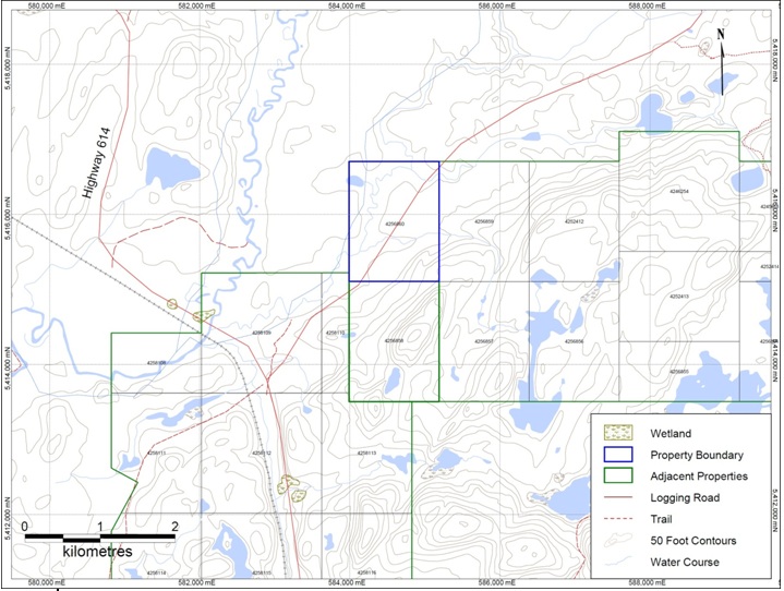
| Figure 1: Mobert Property Claims | 6 | |||
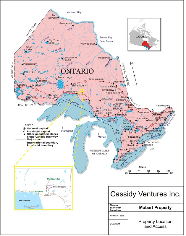
| Figure 2: Regional Location | 8 | |||
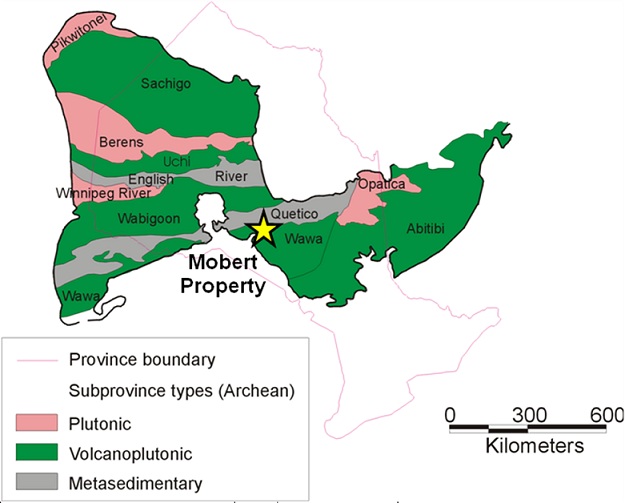
| Figure 3 Geological Subprovinces of the Canadian Shield | 11 | |||
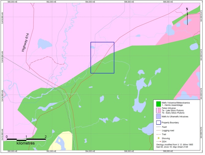
| Figure 4: Property Geology | 12 | |||
| List of Tables | ||||
| Table 1: Mobert Property Claims | 5 | |||
| Table 2: Past Exploration at Mobert Property | 13 | |||
| Table 3: Recommended Work Program Budget | 14 | |||
10
| 1 Introduction |
1.1 Basis of report:
Fladgate Exploration Consulting (“Fladgate”) was engaged by Cassidy Ventures Inc. (“Cassidy”) to review and write a summary report including exploration recommendations on the Mobert property, northwestern Ontario.
The Mobert property is comprised of 1 mining claim totaling 12 units and covering 190 hectares, 1.6 km long by roughly 1.2 km wide in a rectangular shape.
Exploration in the past consisting of geological mapping, prospecting, airborne and ground magnetic and electromagnetic surveys and some soil sampling, was centered on the Fairservice zinc showing that was initially found in 1957.
Recent exploration on the adjacent Dotted Lake property has discovered a previously unknown gold occurrence. In 2008 and 2009 soil sampling and prospecting was carried out on the Dotted Lake Property, which returned positive results for gold on the Dotted Lake property. The following year, a trenching and prospecting program was completed by Fladgate Exploration for Rouge Resources. Four trenches were cut following up on soil anomalies returned in the 2008 and 2009 programs and prospecting.
| 2 Terms of Reference |
This report was prepared at the request of Cassidy. The background sections of this report are in part an extract of a report titled “Independent Technical Report”, Dotted Lake Property, Thunder Bay Mining Division, Ontario Canada” 2005, for Rouge Resources Ltd., by Michael Thompson and Caitlin Jeffs.
The author examined all available documentation about the property and recommends a exploration program to realize the potential of the property.This report is based upon government publications and assessment reports which are publicly available in the assessment files on the website of Ontario Ministry of Natural Resources.
Map projections are in UTM, North American Datum 83, Zone 16 and all referenced UTM coordinates are in metres in this project unless stated otherwise. Contractions are “mm” = millimetre, “cm” = centimetre, “m” = metres, “km” = kilometres, “g” = gram, “kg” = kilogram, “in” = inch, “ft” = foot, “lb” = pound, “oz” = troy ounce, “oz/ton” = troy ounce per short ton, “g/T” is grams per metric tonne, and “ddh” = diamond drill hole.
11
3 Disclaimer |
This report is based on information from assessment reports, private reports and general geological reports and maps listed in the references. The writer disclaims responsibility for portions of the current report that rely on information from historic assessment files and government maps and reports which may not have been prepared in compliance with NI 43-101 Qualified Personnel standards.
4 Summary |
This report was prepared at the request of Cassidy to review, summarize and make recommendations on the Mobert property in northwestern Ontario.
The Mobert property is comprised of 1 mining claim totaling 12 units. The commodities zinc and gold being explored for at the Mobert property. The property covers a 1.2 km long portion of the Schreiber-Hemlo greenstone belt. The only access to the property is a logging road that branches east from Highway 614 and passes north-easterly through the middle of the property. The nearest towns are Manitouwadge 26 km to the north, Marathon 45 km to the southwest and White River 42 km to the southeast. A Hydro One high voltage power transmission line passes approximately 20 km south of the property.
The property is situated in the Wawa sub-province of the Superior province of the Canadian Shield. The predominant rock type on the property is the Dotted Lake arm is foliated, fine grained, dark green, amphibole rich metavolcanic rock. Exploration in the past consisted of geological mapping, prospecting, airborne and ground magnetic and electromagnetic surveys and some soil sampling.
A soiling sampling and prospecting program is recommended for the Mobert Property, on the success of the soil sampling, prospecting and trenching done on the adjacent Dotted Lake property. Samples should be taken every 50 m on 200 m spaced lines over the entire property.
| 5 Property Description and Location |
5.1 Project Description:
The Mobert property is comprised of 1 mining claim totaling 12 units, 100% owned by Cassidy Ventures Inc. The property covers a 1.2 km long portion of the Schreiber-Hemlo greenstone belt.
The primary commodity being explored for on the Mobert property is zinc and gold. Exploration in the past consisted of geological mapping, prospecting, airborne and ground magnetic and electromagnetic surveys and some soil sampling.
12
5.2 Project Location:
The Mobert property is located in the south central part of the Black River Area Township within the Thunder Bay Mining Division of Northwestern Ontario, Canada (Figure 1). The nearest towns are Manitouwadge 26 km to the north, Marathon 45 km to the southwest and White River 42 km to the southeast. The Hemlo Gold Camp is 23 km to the south-southwest along the TransCanada Highway.
The property is on NTS Sheet 42C13. The centre of the property has approximate geographic coordinates of 48°53’24.30”N, 85°50’44.44”W (UTM NAD83 Zone 16N 584614mE, 5415879mN). The Mobert property is comprised of 1 mining claim totaling 12 units and covering 190 hectares, 1.6km long by roughly 1.2km wide in a rectangular shape (Table 1).
The Mobert Property claims are outlined in Table 1 below and shown on Figure 1. The property claim boundaries were located by records provided from Ontario’s MNDMF website.
Table 1: Mobert Property Claims
Mining Claim No. | Township/Area | Units | Date Recorded | Date Due for Work Credits to be applied | $ Work Required/Year |
| 4256860 | Black River | 12 | 23-Sep-10 | 23-Sep-12 | $4800 |
13
14
| 6 Accessibility, Local Resources and Infrastructure |
The property location and access is illustrated on Figures 1 and 2. The property is situated in Northwestern Ontario at the west end of the Dotted Lake Property. Access to the property is a logging road that branches east from Highway 614 and passes north-easterly through the middle of the property (Figure 1).
The nearest towns are Manitouwadge 26 km to the north, Marathon 45 km to the southwest and White River 42 km to the southeast. The Hemlo Gold Camp is 23 km to the south-southwest along the TransCanada Highway. A pool of skilled labour for mining and exploration is present in the communities of Manitouwadge, Marathon and White River. All three communities have housing and facilities for educational, commercial and leisure activities. The city of Thunder Bay, 400 km to the west, is the nearest large regional population centre with many services and amenities for industrial, educational and leisure activities. The airport at Thunder Bay has daily schedules flights to Toronto, Ottawa, Calgary and Winnipeg. The nearest railroad is the Canadian Pacific Railroad 20 km to the south along the TransCanada Highway. A Hydro One high voltage power transmission line passes 18 km south of the property.
7 Climate and Physiography |
The climate is characterised by long cold winters and hot summers. Average daily temperatures in summer range from 10° to 24°C and from 0° to -22°C in the winter months. In general, soil sampling, geological
mapping and trenching programs are limited to the summer months. Snow cover and freezing conditions prevail from mid-November until late April and make transportation through the property easier for large
equipment during the months when swampy wet ground is frozen and easier to move across.
The property is covered by lakes, swamps and low wooded hills. Elevations on the property vary from 380 to 450 m above sea level. A steep slope that is difficult to move down or up crosses the centre of the property in a north-easterly direction. The slope is shown in the topography on Figure 1. Vegetation is typical for a mixed boreal forest and the dominant tree species are spruce, balsam, jackpine, birch and poplar.
15
16
| 8 Geological Interpertation |
8.1 Regional Geology
Information on the regional and area geology is mainly from government sources, maps and reports (Milne 1968, Sirgusa 1986). The property is situated in the Wawa sub-province of the Superior province of the Canadian Shield (Figure 3). All rocks are of Archaean age, with the exception of Proterozoic diabase dykes. The claim covers a portion of the north eastern part of the Schreiber-Hemlo Greenstone Belt. The eastern segment is subdivided into the 2.77 billion year old Hemlo-Black River assemblage to the northeast and the 2.7 billion year old Heron Bay Assemblage to the southwest. The assemblages are separated by the Lake Superior-Hemlo fault zone. The primary rock type of the Hemlo-Greenstone Black River assemblage is mafic volcanics. Felsic and intermediate volcanic rocks and clastics overlie the mafic volcanics. The belt is intruded by numerous felsic granitoids. Several stages of regional folding occurred in the belt, the latest stage is the most pervasive and occurred contemporaneous to, or predated, the intrusion of the granitoid bodies.
8.2 Local Geology
Local geological data is taken from government reports (Milne 1968, McKay 1994) and from exploration work by Clear Mines Ltd. (Symonds, 1983) and also from drill holes completed by Noranda in 1991 (Degagne 1991) and are supplemented by Andre M. Pauwels NI 43-101 technical report (Pauwels, 2005). The Mobert property claim covers both the northern felsic units and the Dotted Lake Arm portion of the Schreiber-Hemlo Greenstone Belt (Figure 4).
The predominant rock type in the area is foliated, fine grained, dark green, amphibole rich metavolcanic rock. Medium and coarse grained amphibolites are less common and occasional remnant pillow textures have been observed indicating a submarine depositional environment. Small sills and dykes of granitoid rocks are common in the volcanic rocks. A few thin (1 cm to 30 cm) layers of intermediate to felsic volcanic tuffs were observed in the area just north of Dotted Lake in the general vicinity of the Fairservice showing (Pauwels, 2005). A small patch of intermediate volcanics is indicated on Milne’s map (Milne 1968) in the same area and short sections of felsic volcanic rocks were intersected in the Noranda drill holes (Degagne 1991). Magnetite, pyrrhotite-rich and garnetiferous amphibolitic iron formation is reported from drill holes 2 and 3 drilled by Noranda and contains massive sphalerite at the Fairservice showing. These horizons, although volumetrically a small proportion of the rocks in the area, appear to be continuous along strike within the metavolcanic rocks according to geophysical surveys. Foliation of the metavolcanic rock is persistently east-northeasterly trending within an isoclinal syncline within the metavolcanics of the Dotted Lake Arm. This syncline appears to plunge to the west-southwest. The metamorphism within the belt is amphibolite grade.
To the east mafic and ultramafic intrusive complex of gabbro, peridotite and serpentinized peridotite intruded along the southern flank of the mafic volcanics. Ground magnetic surveys in the area indicate that this complex extends 800m further to the west than indicated on OGS Map 3086 (Siragusa 1986). This area is covered by overburden. Granitoid rocks of the Dotted Lake Batholith outcrop to the south. The granatoids are pink to light pink in colour, foliated and medium grained, and appear to intrude both the metavolcanics and mafic/ultramafic rocks.
17
8.3 Local Alteration and Mineralization
Pervasive alteration has not been found over large spans in the area. Small segments of bleached and epidotized amphibolite are described in the Noranda drill holes at the contact of iron formations intersected and in descriptions of the Fairservice showing.
Mineralization to the east of the Mobert Property was first discovered at the Fairservice zinc showing. The showing was described in detail by M. Smyk (McKay 1994). According to Smyk, the showing is hosted within a narrow band (up to 80 cm wide) of iron formation within mafic volcanic rock. It is described as follows:
“The mineralized zone occurs in the mafic volcanics and is oriented parallel to both the host rock foliation and the elongation direction of the pillows. The host metavolcanics become noticeably altered within 1 m of the mineralized zone.”
The mineralization is further described to be exposed over a maximum 20 m length and to contain sphalerite, magnetite, amphibole and disseminated garnet. The southern contact of the mineralization is a 1 m to 2 m thin felsic dyke, in part with the appearance of fissile sericite schist. The mineralization was interpreted by McKay to be hosted by iron formation which can be seen in intermittent outcrops over 200 m to the east of the showing. Grab samples from this iron formation reported by Smyk showed low anomalous zinc values.
Several rock samples at the OGS in Thunder Bay show a 2 cm band of massive, coarsely crystalline, dark brown sphalerite (35%) adjacent to well aligned coarse grains of magnetite (25%) intermixed with coarse crystals of sphalerite and a matrix of dark green amphibole and chlorite (40%) and a small amount of disseminated phyrrotite and chalcopyrite. A grab sample reported by Smyk (in McKay 1994) contained 9.44% Zn, 0.012% Cu, and 0.006 oz per ton gold.
One other zinc occurrence hosted in iron formation is reported from the Dotted Lake Arm. This occurrence, called the Brinklow zinc showing, is located approximately 6 km to the southwest of the Fairservice showing. The Brinklow showing was drilled by Noranda in 1994 with no significant results (Lockwood 1994).
The occurrence of massive sulphide bands hosted in an exhalative sedimentary unit within sea floor volcanic rocks with a component of intermediate to felsic volcanic rock classifies the mineralization as a metamorphosed volcanogenic massive sulphide (VMS) type of occurrence.
18
19
20
9 History |
Past documented exploration is summarized in Table 2. A high-grade zinc mineralization was first discovered in the area on Dotted Lake by trapper/prospector A. Fairservice in 1957. This discovery (the Fairservice zinc showing) occurred on the neighbouring Dotted Lake Property and being exploration in the area. In the 1960’s several geophysical surveys were completed on the Mobert Property and geologic mapping was completed by the OGS over the entire Black River area. In 1983, a combined VLF and magnetometer survey was done on the property. Most recently geological mapping and whole rock geochemical sampling was completely in 1993.
Recent exploration on the adjacent Dotted Lake property has discovered a previously unknown gold occurrence. In 2008 and 2009 soil sampling and prospecting was carried out on the Dotted Lake Property, which returned positive results for gold on the Dotted Lake property. The following year, a trenching and prospecting program was completed by Fladgate Exploration for Rouge Resources. Four trenches were cut following up on soil anomalies returned in the 2008 and 2009 programs and prospecting.
Table 2: Past Exploration at Mobert Property
| Year | Operator | Work | Principal Reference |
| 1957 | A. Fairservice | Discovery of nearby Fairservice showing, sampling and trenching | MNDMF Mineral Deposits Inventory (MDI) |
| 1965 | Carravelle Mines Ltd. | Combined VLF and magnetometer surveys | Domsalski, W., 1965 |
| 1965 | Selco Exploration Ltd. | Airborne geophysical survey | Lazenby, P.G., 1965 |
| 1968 | Ontario Department of Mines | Geological mapping of Black River area | Milne, V.G., 1968 |
| 1983 | Adnaron Minerals Ltd. | Combined VLF and magnetometer surveys | Ferderber, H., 1983 |
| 1993 | Noranda Minerals Inc. | Geologic mapping, whole rock geochemical sampling | Charlton, G., 1993 |
| 10 Conclusions |
Based on the recent gold discovery on the adjacent Dotted Lake property, the Mobert Property has potential for both gold and zinc mineralization.
21
11 Recommended Exploration Program and Estimated Cost |
Mobert property lies in an underexplored area of the Schrieber-Hemlo greenstone belt which is host to the Hemlo Gold deposit. Based on the positive results for gold from soil sampling and trenching on the neighboring Dotted Lake Property, it is the recommendation of the author for a similar exploration program. The initial soil sampling programs completed on the Dotted Lake Property in 2008 and 2009 successfully indicated the location of previously undiscovered gold mineralization.
It is recommended by Fladgate to conduct a three phase exploration project. Phase one is a soil sampling program covering the property. Phase two is a preliminary geological mapping and prospecting program, followed by Phase three a trenching program including detailed mapping of trenches and channel sampling and a 500 meter drilling program.
11.1 Phase 1 Soil Sampling
The soil sampling program will cover the entire Mobert Property. Continuing with the spacing used on the Dotted Lake Property (200 m spaced lines with 50 m spaced samples) the Mobert Property would require approximately 191 samples to cover the entire claim. The estimated cost of this program is $16,410.50.
11.2 Phase 2 Geological mapping and prospecting
Phase two will include geological mapping and prospecting covering the entire Mobert Property. This mapping and prospecting will take two weeks to complete and the estimated cost of this program is $20,832.25.
11.3 Phase 3 Trenching and Initial Drilling program
Phase three of exploration would include trenching and drilling of target areas exposed by soil sampling and prospecting (phase one and two). The estimated trenching will include 150 meters length by 4 meters width, with 150 channel samples. Trenching will be followed by a 500 meter drilling program to test the best target (or targets) at depth. Total cost of $182,016.25
Table 3: Recommended Work Program Budget
| Phase I Soil Sampling | |
| Item | Cost |
| Room and Board | $1,325.00 |
| Transportation | $1,060.00 |
| Wages | $4,200.00 |
| Assaying | $6,685.00 |
| Report Writing | $1,000.00 |
Sub‐Total | $14,270.00 |
| 15% Contingency | $2,140.50 |
| Total | $16,410.50 |
22
Phase II Mapping &Prospecting | |
| Item | Cost |
| Room and Board | $3,050.00 |
| Transportation | $2,340.00 |
| Wages | $9,800.00 |
| Assaying | $1,925.00 |
| Report Writing | $1,000.00 |
Sub‐Total | $18,115.00 |
| 15% Contingency | $2,717.25 |
| Total | $20,832.25 |
| Phase III Trenching | |
| Item | Cost |
| Room and Board | $4,575.00 |
| Transportation | $4,235.00 |
| ATV (rental and fuel) | $3,150.00 |
| Heavy Equipment | $7,840.00 |
| Consulting Geologist | $13,650.00 |
| Geotechnicians | $6,825.00 |
| Assaying | $5,250.00 |
| Report Writing | $1,000.00 |
Sub‐Total | $46,525.00 |
| 15% Contingency | $6,978.75 |
| Total | $53,503.75 |
| Phase III 500m Drilling | |
| Item | Cost |
| Room and Board | $6,500.00 |
| Transportation | $5,650.00 |
| Diamond Drilling | $55,000.00 |
| Consulting geologist | $19,500.00 |
| Geotechnician | $9,750.00 |
| Heavy Equipment Rental | $5,600.00 |
| Assaying (250 samples) | $8,750.00 |
| Report writing | $1,000.00 |
Sub‐Total | $111,750.00 |
| 15% Contingency | $16,762.50 |
| Total | $128,512.50 |
23
12 References and Literature |
| Author | Year | Title |
| Charlton, G. | 1993 | Noranda Minerals Inc. Geco Division Report of Work Lampson Lake – Pinegrove Lake Property |
| Degagne, P. | 1991 | Plans, Sections and Diamond Drill Logs for Noranda Ltd. and submitted for assessment. |
Domsalski, W. | 1965 | Carravelle Mins Ltd. Report on Combined Airborne Geophysical Survey Over Pulfa Group of Claims |
| Ferderber, H. | 1983 | Report on the Geophysical Surveys on the Property of the Adnaron Minerals Ltd. Black River – Wabikoba Areas, Ontario |
Lazenby, P.G. | 1965 | Selco Exploration Company Limited Airborne Geophysical Survey Report Moberg Creek Area, Ontario |
Lockwood, H.C. | 1994 | Report on Diamond Drilling, Lampson Property. Report for Noranda Ltd. and submitted for assessment. |
| McKay, D.B. | 1994 | Mineral Occurrences of the Manitouwadge Area, Ontario Geological Survey- Open File Report 5906 p. 43- 54. |
| Milne, V.G. | 1968 | Geology of the Black River Area, District of Thunder Bay, Ontario. Department of Mines-Geological Report 72. |
Pauwels, A.M. | 2005 | Evaluation Report – Dotted Lake Property. Report for Gemstar Resources Ltd. |
Siragusa, G.M. | 1986 | Precambrian Geology of the White Lake (Hemlo) Area, Dotted Lake and Black River Sections, Ontario Geological Survey, Preliminary Map p. 3046. |
Symonds, D.F. | 1983 | Geological and Geochemical Report on a Group of Mineral Claims in the Dotted Lake Area. Report for Clear Mines Ltd. and submitted for assessment. |
24