Statement of Coal Resources and Reserves
in Accordance with SEC and the JORC Code as of
December 31, 2021
Northern and Central Appalachian Coal Basins –
Virginia, West Virginia and Pennsylvania, USA
M
ARSHALL
M
ILLER
&
A
SSOCIATES
,
I
NC
.
21
Criteria
JORC Code explanation
Commentary
>
NPV ranges and sensitivity to variations in the
significant assumptions and
inputs.
>
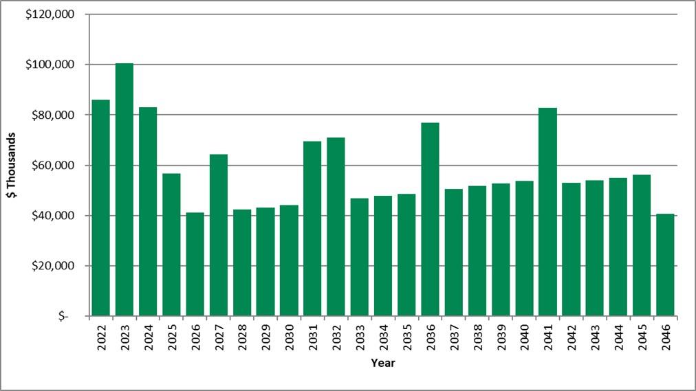
An estimate of NPV at a base discount rate of
10.0% was included in Section 19 of
the TRS.
>
NPV of the Buchanan, Russell, Mon Valley,
Logan and Greenbrier Properties was
estimated to be $1.580 billion, $89.7 million, $287.3
million, $611.3 million and
$66.0 million, respectively.
>
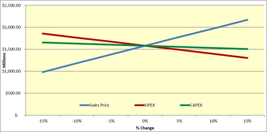
The sensitivity study shows the NPV at the 10.0%
discount rate when Base Case
sales prices, operating costs, and capital costs are
increased and decreased in
increments of 5% within a +/- 15% range.
>
The status of agreements with key stakeholders
and matters leading to social
license to operate.
>
Portions of the properties are located near
local communities.
Regulations prohibit
mining activities within 91 meters of a residential
dwelling, school, church, or similar
structure unless written consent is first obtained from
the owner of the structure.
Where required, such consents have been obtained
where mining is proposed
beyond the regulatory limits.
To the extent relevant, the impact of the following on the project and/or on the
estimation and classification of the Ore Reserves:
>
Any identified material naturally occurring risks.
>
No material naturally occurring risks have been
identified.
>
The status of material legal agreements and marketing
arrangements.
>
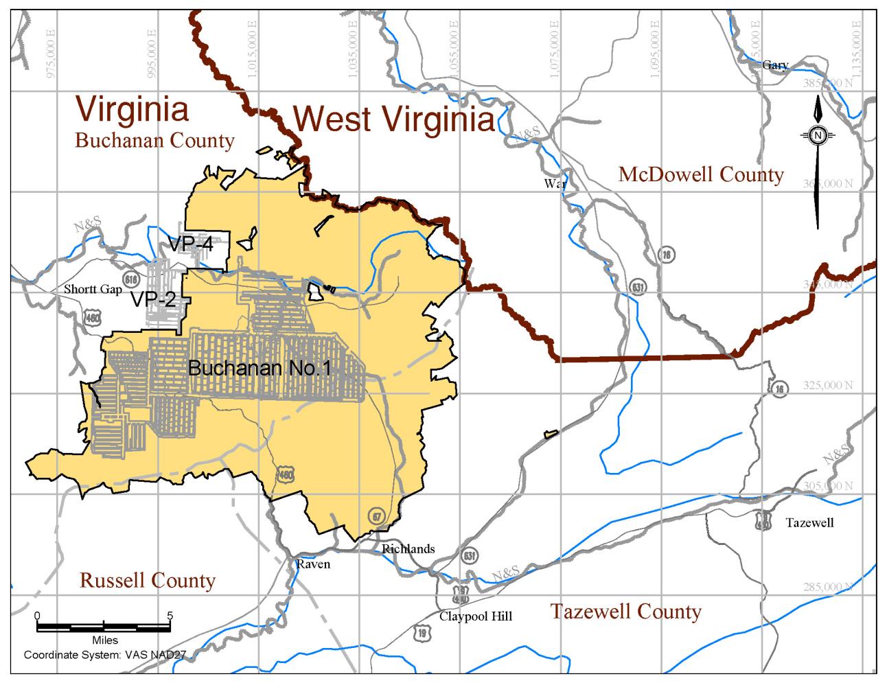
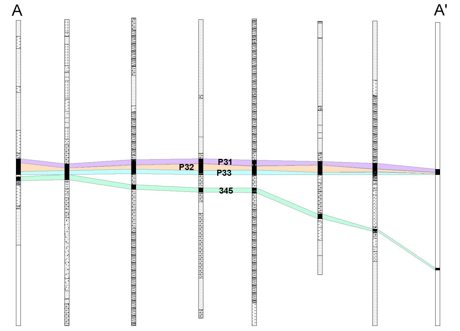
The Coronado coal resources are located in Buchanan,
Russell and Tazewell
Counties, Virginia; Greenbrier, Logan, Boone, Wyoming and Greenbrier Counties,
West Virginia; Allegheny, Washington and Westmoreland Counties, Pennsylvania.
>
MM&A has not carried out separate title verification for
the coal properties and has
not verified leases, deeds, surveys or other property
control instruments pertinent to
the subject resources.
>
Coronado has represented to MM&A that it controls
the mining rights to the reserves
as shown on its property maps, and MM&A
has accepted these as being a true and
accurate depiction of the mineral rights controlled by
Coronado.
The TRS assumes
the properties are developed under responsible and
experienced management.
>
The status of government agreements and approvals
critical to the viability of
the project, such as mineral tenement status and
government and statutory
approvals. There must be reasonable grounds
to expect that all necessary
Government approvals will be received within
the timeframes anticipated in the
Pre-Feasibility or Feasibility study. Highlight and discuss the materiality of any
unresolved matter that is dependent on a third part
on which extraction of the
reserve is contingent.
>
Coronado has obtained all mining and discharge permits
to operate 34 underground
mines, 13 surface mines, and 18 processing, loadout
or related facilities.
MM&A is
unaware of any obvious or current Coronado
permitting issues that are expected to
prevent the issuance of future permits.
Coronado, along with all Central and
Northern Appalachian basin coal producers, is
subject to a level of uncertainty
regarding future clean water permits due to
United States Environmental
Protection Agency
(
EPA
)
involvement with state programs.
>
The basis for the classification of the Ore Reserves
into varying confidence
categories. Whether the result appropriately reflects
the Competent Person’s
view of the deposit. The proportion of Probable
Ore Reserves that have been
derived from Measured Mineral Resources (if
any).
>
Measured and indicated resources have been
converted to proved and probable
reserves, respectively.
>
None of the probable coal reserves have been
derived from measured resources.
>
In a limited number of cases where there was
only very limited data available to
demonstrate the metallurgical suitability of a given
coal deposit, that deposit was
classified as a probable reserve instead of a
proved reserve.