Exhibit 99.112
| Practical Mining LLC | January 25, 2021 |
IMPORTANT NOTICE
This report was prepared as a National Instrument 43-101 Technical Report for i-80 Gold Corporation (i-80 Gold) by Wood Canada Limited (Wood). The quality of information, conclusions and estimates contained herein is consistent with the terms of reference, constraints, and circumstances under which the report was prepared by Wood and the report is based on i) information available at the time of preparation, ii) data supplied by outside sources, and iii) the assumptions, conditions, and qualifications set forth in this report.
This report is intended to be used by i-80 Gold subject to terms and conditions of its contract with Wood. That contract permits i-80 Gold to file this report as a technical report with Canadian securities regulatory authorities pursuant to Provincial and Territorial securities law. Except for the purposes legislated under Provincial and Territorial securities Law, any other use of this report by any third party is at that party’s sole risk.
Contents
| 1.4 | Mineral Tenure, Surface Rights, Royalties and Agreements | 1-3 |
| 1.4.2 | Purchase of Project by i-80 Gold | 1-3 |
| 1.5 | Geology and Mineralization | 1-4 |
| 1.5.1 | Mineral Point Trend | 1-4 |
| 1.7 | Drilling and Sampling | 1-7 |
| 1.9 | Mineral Resource Estimation | 1-9 |
| 1.10 | Mineral Resource Statement | 1-11 |
| 1.11 | Mineral Reserve Estimation | 1-13 |
| 1.13 | Metallurgy and Recovery Methods | 1-14 |
| 1.14 | Project Infrastructure | 1-14 |
| 1.15 | Environmental, Permitting and Social Considerations | 1-15 |
| 1.16 | Markets and Contracts | 1-15 |
| 1.17 | Risks and Opportunities | 1-15 |
| 2.3 | Site Visits and Scope of Personal Inspection | 2-3 |
| 2.5 | Information Sources and References | 2-4 |
May 2022
Project Number 250039 | TOC i |  |
 |
2021 Ruby Hill Mineral Resource Estimate
Eureka County, NV, USANI43-101Technical Report |
| 2.6 | Previous Technical Reports | 2-5 |
| 2.7 | Other Contributors to the Report | 2-5 |
| 3 | Reliance on Other Experts | 3-1 |
| 3.3 | Community Relations, Environmental and Permitting | 3-1 |
| 4 | Property Description and Royalties | 4-1 |
| 4.1 | Mineral Tenure in Nevada | 4-1 |
| 4.2 | Mineral Tenure for the Ruby Hill Project | 4-3 |
| 4.3 | Environmental Liabilities | 4-3 |
| 4.5.1 | Royal Gold Royalty | 4-5 |
| 4.5.4 | Placer Dome Royalty | 4-6 |
| 4.6 | Comments on Section 4 | 4-6 |
| 5 | Accesibility, Climate, Local Resources, Infrastructure AND Physiography | 5-1 |
| 5.5 | Comments on Section 5 | 5-2 |
| 6.1 | Exploration History | 6-1 |
| 6.2 | Petrology, Mineralogy, and Research Studies | 6-8 |
| 6.3 | Geotechnical and Hydrological Studies | 6-8 |
| 7 | Geological Setting and Mineralization | 7-1 |
| 7.1 | Regional and District Geology | 7-1 |
| 7.3.4 | Lower-Middle Ordovician | 7-9 |
| 7.3.6 | Tertiary/Quaternary | 7-11 |
May 2022
Project Number 250039 | TOC ii | |
|
2021 Ruby Hill Mineral Resource Estimate
Eureka County, NV, USANI43-101Technical Report |
| 7.4.1 | Archimedes Deposit | 7-13 |
| 7.4.2 | Mineral Point Trend | 7-15 |
| 7.5.1 | Archimedes Deposit | 7-19 |
| 7.5.2 | Mineral Point Trend | 7-19 |
| 7.6.1 | Archimedes Deposit | 7-23 |
| 7.6.2 | Mineral Point Trend | 7-24 |
| 7.7.1 | Archimedes Deposit | 7-25 |
| 7.7.2 | Mineral Point Trend | 7-25 |
| 8.1 | Characteristics of Polymetallic Replacement Deposits | 8-1 |
| 8.2 | Characteristics of Carlin-Type Gold Deposits | 8-1 |
| 8.3 | Carbonate Replacement and Carlin Style Mineralization at Ruby Hill | 8-2 |
| 8.4 | Comments on Section 8 | 8-3 |
| 9.3 | Geochemical Sampling | 9-2 |
| 9.6 | Metallurgical Studies | 9-2 |
| 9.7 | Exploration Potential | 9-2 |
| 9.8 | Comments on Section 9 | 9-3 |
| 10.2.1 | Reverse Circulation Drilling | 10-6 |
| 10.2.3 | Other Drilling Methods | 10-8 |
| 10.3 | Geological Logging | 10-8 |
| 10.3.3 | Logging by Other Operators | 10-9 |
| 10.6 | Downhole Surveys | 10-10 |
May 2022
Project Number 250039 | TOC iii | |
|
2021 Ruby Hill Mineral Resource Estimate
Eureka County, NV, USANI43-101Technical Report |
| 10.7 | Metallurgical Drilling | 10-10 |
| 10.8 | Sample Length/True Thickness | 10-13 |
| 10.9 | Potential Downhole Contamination | 10-13 |
| 10.10 | Summary and Interpretation of All Relevant Drilling Results | 10-13 |
| 10.11 | Comments on Section 10 | 10-14 |
| 11 | Sample Preparation, Analysis and Security | 11-1 |
| 11.2 | Analytical and Test Laboratories | 11-2 |
| 11.3 | Density Determinations | 11-2 |
| 11.4 | Sample Preparation and Analysis | 11-5 |
| 11.5 | Quality Assurance and Quality Control (QA/QC) | 11-7 |
| 11.5.1 | Barrick QA/QC Program | 11-7 |
| 11.8 | Comments on Section 11 | 11-15 |
| 12.1 | Historical Data Review | 12-1 |
| 12.1.2 | Resource Evaluation Inc (REI, 2005) | 12-2 |
| 12.2.1 | Down-Hole Contamination Studies | 12-7 |
| 12.2.2 | Core vs RC Drilling Comparison | 12-7 |
| 12.3 | Wood Verification | 12-7 |
| 12.3.1 | Checks on Primary Data | 12-7 |
| 12.3.2 | Assay Data Quality Assurance | 12-7 |
| 12.3.3 | Database Integrity Audit | 12-11 |
| 12.3.4 | Verification of Legacy Data | 12-12 |
| 12.3.5 | Verification of Potential Down Hole Contamination in RC Drilling | 12-12 |
| 13 | Mineral Processing and Metallurgical Testing | 13-1 |
| 13.1 | Historical Processing Operations | 13-1 |
| 13.2 | Metallurgical Testwork | 13-2 |
| 13.2.1 | KCA 24 June 2004 - Archimedes | 13-3 |
May 2022
Project Number 250039 | TOC iv | |
|
2021 Ruby Hill Mineral Resource Estimate
Eureka County, NV, USANI43-101Technical Report |
| 13.2.2 | KCA 20 May 2005 - Archimedes | 13-4 |
| 13.2.3 | KCA 26 January 2009 - 426 Zone | 13-5 |
| 13.2.4 | KCA 1 April 2010 - Watertank | 13-5 |
| 13.2.5 | KCA, 1 November 2011 - 426 Zone | 13-6 |
| 13.2.6 | KCA 4 February 2011 - Mineral Point | 13-7 |
| 13.2.7 | KCA 23 July 2012 - Mineral Point | 13-8 |
| 13.2.8 | KCA 2 February 2014 - Mineral Point | 13-9 |
| 13.2.9 | Barrick January 2008 - 426 Zone | 13-11 |
| 13.2.10 | Barrick February 2008 - 426 Zone | 13-11 |
| 13.2.11 | Barrick January 2011 - Mineral Point | 13-11 |
| 13.2.12 | Barrick November 2011 - 426 Zone | 13-12 |
| 13.2.13 | G&T 25 February 2008 - Blackjack Deposit | 13-12 |
| 13.2.14 | G&T 22 December 2008 - Blackjack Deposit | 13-13 |
| 13.3 | Sample Spatial Coverage | 13-14 |
| 13.4 | Metallurgical Variability | 13-15 |
| 13.5 | Deleterious Elements | 13-16 |
| 13.5.1 | Arsenic and Mercury | 13-16 |
| 13.5.2 | Sulfur and Carbon | 13-17 |
| 13.6 | Recovery Estimates | 13-18 |
| 13.6.1 | Oxide Mineralization | 13-19 |
| 13.6.2 | Refractory Mineralization | 13-24 |
| 13.6.3 | Mixed Mineralization | 13-25 |
| 13.7 | Recommendations for Further Work | 13-26 |
| 14 | Mineral Resource Estimates | 14-1 |
| 14.1 | Geological Modeling | 14-1 |
| 14.1.1 | Structural Model | 14-1 |
| 14.1.2 | Lithology Model | 14-3 |
| 14.1.3 | Oxidation Model | 14-3 |
| 14.1.4 | Estimation Domains | 14-3 |
| 14.2 | Exploratory Data Analysis | 14-3 |
| 14.2.1 | Mineral Point Trend | 14-5 |
| 14.2.2 | Archimedes Deposit | 14-6 |
| 14.3.1 | Mineral Point Trend Open Pit Resources | 14-10 |
| 14.3.2 | Archimedes Deposit Open Pit Resources | 14-13 |
| 14.3.3 | 426 and Ruby Deeps Underground Resources | 14-16 |
| 14.4 | Resource Model Validation | 14-18 |
| 14.4.1 | Mineral Point Trend Open Pit Resources | 14-18 |
May 2022
Project Number 250039 | TOC v | |
|
2021 Ruby Hill Mineral Resource Estimate
Eureka County, NV, USANI43-101Technical Report |
| 14.4.2 | Archimedes Deposit Open Pit Resources | 14-22 |
| 14.4.3 | 426 and Ruby Deeps Underground Resources | 14-27 |
| 14.6 | Mineral Resource Classification | 14-29 |
| 14.6.1 | Mineral Point Trend | 14-30 |
| 14.6.2 | Archimedes Deposit | 14-30 |
| 14.6.3 | 426 and Ruby Deeps Underground | 14-31 |
| 14.7 | Reasonable Prospects for Eventual Economic Extraction | 14-31 |
| 14.7.1 | Mineral Resources for Open Pit Mining and Run of Mine Heap Leach | 14-31 |
| 14.7.2 | Mineral Resources for Underground Mining and Toll Sulfide Processing | 14-33 |
| 14.8 | Mineral Resource Statement | 14-35 |
| 14.9 | Mineral Resource Sensitivity | 14-38 |
| 15 | Mineral Reserve Estimates | 15-1 |
| 18 | Project Infrastructure | 18-1 |
| 19 | Market Studies and Contracts | 19-1 |
| 20 | Environmental Studies, Permitting, and Social or Community Impact 20-1 |
| 20.1 | Environmental Liabilities | 20-1 |
| 20.3 | Water Use Permits | 20-2 |
| 20.4 | Community Relations and Stakeholder Consultation | 20-3 |
| 21 | Capital and Operating Costs | 21-1 |
| 23 | Adjacent Properties | 23-1 |
| 24 | Other Relevant Data and Information | 24-1 |
| 25 | Interpretation and Conclusions | 25-1 |
May 2022
Project Number 250039 | TOC vi | |
|
2021 Ruby Hill Mineral Resource Estimate
Eureka County, NV, USANI43-101Technical Report |
Tables
| Table 1-1: | Mineral Resource Statement, Open Pit Oxide Heap Leach Mineralization (effective date 31 July 2021) | 1-12 |
| Table 1-2: | Mineral Resource Statement, Underground Sulfide Gold Toll Processing (effective date 31 July 2021) | 1-13 |
| Table 6-1: | Property Exploration and Ownership History | 6-1 |
| Table 6-2: | Summary of Geotechnical Surveys | 6-8 |
| Table 6-3: | Summary of Hydrological Surveys | 6-9 |
| Table 6-4: | Production History Summary | 6-10 |
| Table 7-1: | Major Structural Features and Orientations within the Property Area | 7-12 |
| Table 10-1: | Drilling Statistics for Drillholes Included in the 2021 Ruby Hill Project Mineral Resource Estimate | 10-3 |
| Table 10-2: | Distribution of Drilling by Campaign | 10-3 |
| Table 10-3: | 2004 Barrick Metallurgical Holes | 10-11 |
| Table 10-4: | 2009 Metallurgical Holes | 10-12 |
| Table 10-5: | 2010 and 2011 Metallurgical Holes | 10-12 |
| Table 10-6: | 2011 Metallurgical Holes | 10-12 |
| Table 11-1: | Assay, Density and Metallurgical Laboratories | 11-3 |
| Table 11-2: | Barrick Rock Type Density Values | 11-4 |
| Table 11-3: | ALS Global Gold Analytical Parameters | 11-5 |
| Table 11-4: | Count and Description of QA/QC Samples by Year | 11-8 |
| Table 11-5: | SRM Performance | 11-10 |
| Table 12-1: | Downhole Grade Distribution in RC and Metallurgical Twin Core Holes | 12-6 |
| Table 12-2: | Summary of Wood Data Quality Checks | 12-8 |
| Table 13-1: | Key Testwork Campaign Summary | 13-2 |
| Table 13-2: | Column Leach Tests Results | 13-3 |
| Table 13-3: | Column Leach Tests Results | 13-4 |
| Table 13-4: | Column Leach Tests Results | 13-5 |
| Table 13-5: | Column Leach Tests Results | 13-6 |
| Table 13-6: | Column Leach Tests Results | 13-7 |
| Table 13-7: | Bottle Roll Tests Results | 13-8 |
| Table 13-8: | Column Leach Tests Results | 13-9 |
| Table 13-9: | Bottle Roll Tests Results | 13-9 |
| Table 13-10: | Column ach Tests Results | 13-10 |
| Table 13-11: | Roaster and Alkaline Autoclave Tests | 13-11 |
| Table 13-12: | Alkaline Autoclave Tests | 13-12 |
| Table 13-13: | Composite Samples for Tests | 13-13 |
| Table 13-14: | Flotation Test Results | 13-13 |
| Table 13-15: | Mercury Adsorbed in Carbon | 13-16 |
May 2022
Project Number 250039 | TOC vii | |
|
2021 Ruby Hill Mineral Resource Estimate
Eureka County, NV, USANI43-101Technical Report |
| Table 13-16: | Sulfur and Carbon Speciation Results | 13-17 |
| Table 13-17: | Recovery Estimates Summary Gold | 13-18 |
| Table 13-18: | Recovery Estimates Summary Silver | 13-19 |
| Table 13-19: | Recovery Estimates Base Metals | 13-19 |
| Table 13-20: | Column Leach Tests | 13-19 |
| Table 13-21: | Column Leach Tests | 13-21 |
| Table 13-22: | Gold Recovery Estimates for Oxides | 13-22 |
| Table 13-23: | Silver Recovery Estimates for Oxides | 13-23 |
| Table 13-24: | Gold Recovery Estimates for Oxides | 13-25 |
| Table 13-25: | Flotation Recovery Estimates | 13-26 |
| Table 14-1: | Au Estimation Strategy | 14-11 |
| Table 14-2: | Gold Grade Estimation Parameters for the Archimedes Deposit | 14-15 |
| Table 14-3: | Global Bias Check within Indicated Resources | 14-20 |
| Table 14-4: | Global Bias Check for the Archimedes Deposit Gold Grade Estimates | 14-25 |
| Table 14-5: | Parameters for Mineral Resource Pit Shell Construction | 14-32 |
| Table 14-6: | Mining Parameters for Mineral Resource Stope Outline Construction | 14-33 |
| Table 14-7: | Economic Parameters for Mineral Resource Stope Outline Construction | 14-34 |
| Table 14-8: | Mineral Resource Statement, Open Pit Oxide Heap Leach Mineralization (effective date 31 July 2021) | 14-36 |
| Table 14-9: | Mineral Resource Statement, Underground Sulfide Gold Toll Processing (effective date 31 July 2021) | 14-37 |
| Table 14-10: | Open Pit Oxide Heap Leach Mineral Resource Sensitivity to Gold Price | 14-38 |
| Table 14-11: | 426 Zone Underground Sulfide Mineral Resource Sensitivity to Gold Price | 14-38 |
| Table 14-12: | Ruby Deeps Zone Underground Sulfide Mineral Resource Sensitivity to Gold Price | 14-38 |
| Table 20-1: | Operating Permits for the Ruby Hill Project Site | 20-2 |
| Table 26-1: | Proposed Budget for Ruby Hill Development Options Study | 26-2 |
Figures
| Figure 1-1: | Layout of the Ruby Hill Project and Surface Projection of the Mineral Point and Archimedes Zones | 1-2 |
| Figure 2-1: | Project Location Plan | 2-2 |
| Figure 4-1: | Ruby Hill Project Mineral Tenure Map | 4-3 |
| Figure 4-2: | Permit Area for the Ruby Hill Project | 4-4 |
| Figure 6-1: | Known Geophysical Surveys in the Ruby Hill Property Area | 6-5 |
| Figure 6-2: | Rock Samples with Gold Grade (ounces per short ton) within the Ruby Hill Claim Block | 6-6 |
| Figure 6-3: | Soil Samples with Gold Grade in oz/st within the Ruby Hill Claim Block | 6-7 |
| Figure 7-1: | Regional Geologic Map | 7-2 |
| Figure 7-2: | Ruby Hill Project Geology and Deposit Locations (August 2021) | 7-5 |
May 2022
Project Number 250039 | TOC viii | |
|
2021 Ruby Hill Mineral Resource Estimate
Eureka County, NV, USANI43-101Technical Report |
| Figure 7-3: | Ruby Hill Stratigraphic Column | 7-6 |
| Figure 7-4: | East Archimedes and West Archimedes, 426, and Ruby Deeps Zone Geology (August 2021) | 7-14 |
| Figure 7-5: | Mineral Point Zone Geology (September 2021) | 7-16 |
| Figure 7-6: | Achilles and Hector Zone Geology (August 2021) | 7-17 |
| Figure 7-7: | Plan View of Mineral Point Trend and Archimedes Deposits | 7-21 |
| Figure 7-8: | Fence Section of Mineral Point Trend and Archimedes Deposits | 7-22 |
| Figure 9-1: | Exploration Targets at Ruby Hill (September, 2021) | 9-4 |
| Figure 10-1: | Drill Collar Locations for Ruby Hill Project Drillholes | 10-2 |
| Figure 10-2: | Distribution of Drill Types Included in the 2021 Ruby Hill Project Mineral Resource Estimate | 10-3 |
| Figure 10-3: | Plan View of Drilling by Campaign | 10-4 |
| Figure 10-4: | Fence Section of Drilling by Campaign (Looking North) | 10-5 |
| Figure 11-1: | Control Chart for Standard OREAS 54PA | 11-9 |
| Figure 11-2: | ALS Global (Chemex) Pulps Checked at Inspectorate | 11-11 |
| Figure 11-3: | Mean Versus Half Relative Difference for Field Duplicates | 11-12 |
| Figure 11-4: | Scatter Plot of all Lab Duplicates | 11-13 |
| Figure 11-5: | Mean Versus Half Relative Difference for Pulp Duplicates | 11-13 |
| Figure 12-1: | Isometric Section Showing Anomalous Gold Grade Intersection in Hole HRH-1762 | 12-10 |
| Figure 12-2: | Cross Section Showing Eureka Corp Drilling at Mineral Point (5,600 ft Elevation, View to North) | 12-11 |
| Figure 13-1: | Sample Spatial Coverage (Isometric View Looking North) | 13-14 |
| Figure 13-2: | Sample Spatial Coverage (Isometric View Looking Downward and to the North) | 13-15 |
| Figure 13-3: | Preg-robbing tests results (BTC) | 13-18 |
| Figure 13-4: | Low S2-, 100% Hamburg Dolomite Particle Size vs. Gold Recovery | 13-22 |
| Figure 13-5: | Sulfide vs CN/FA Extraction | 13-24 |
| Figure 14-1: | Fence Section Looking North Showing Main Faults and Stratigraphic Units for the Ruby Hill Project | 14-2 |
| Figure 14-2: | Fence Section Looking North Showing Mineralization Type Units and Estimation Domains for the Ruby Hill Project | 14-4 |
| Figure 14-3: | Gold and Silver Assay Grade Histograms for the Mineral Point Trend | 14-6 |
| Figure 14-4: | Histogram and Cumulative Frequency Plot of 25-foot Assay Composite Gold Grades for Archimedes | 14-8 |
| Figure 14-5: | Boxplot of 10-foot Assay Composite Gold Grades for Archimedes | 14-9 |
| Figure 14-6: | Indicator Threshold Selection - CV of Gold and Silver Assay Composite Grades | 14-10 |
| Figure 14-7: | Au Estimation - Implementation of a Soft Boundary between LG and HG composites | 14-12 |
| Figure 14-8: | Area of Au High-Grade Blow-out and Eureka Corp Underground Drilling | 14-13 |
| Figure 14-9: | Reference Cross Section Showing Low- and High-Grade Zones at Archimedes | 14-14 |
| Figure 14-10: | 3 g/t Au Grade Zone at 426 (Isometric View Looking 330°/-10°) | 14-17 |
| Figure 14-11: | 3 g/t Au Grade Zone at Ruby Deeps (Isometric View looking (300°/-10°) | 14-17 |
May 2022
Project Number 250039 | TOC ix | |
|
2021 Ruby Hill Mineral Resource Estimate
Eureka County, NV, USANI43-101Technical Report |
| Figure 14-12: | Resource Model - Estimated Au and 10 Foot Composite Grades - Section 121200 N Looking N | 14-19 |
| Figure 14-13: | Swath Plot - Au - Indicated Blocks | 14-21 |
| Figure 14-14: | Gold Grade Zone Maps from Blasthole (left), Regularized Blast Block (middle) and Resource Model Blocks (right) | 14-23 |
| Figure 14-15: | Cross Section of Gold Grades for the Archimedes Deposit | 14-24 |
| Figure 14-16: | Swath Plot for East Archimedes High- and Low-Grade Domains | 14-26 |
| Figure 14-17: | 426 Composite, OK and Nearest Neighbor Validation Model Gold Grades | 14-28 |
| Figure 14-18: | Ruby Deeps Composite, OK and Nearest Neighbor Validation Model Gold Grades | 14-28 |
| Figure 14-19: | Bulk Density Values by Lithology | 14-29 |
| Figure 14-20: | Cross Section Showing the Ruby Hill Project Resource Pit | 14-33 |
| Figure 14-21: | Cross Section (355° Azimuth) Showing Resource Stope Outlines for 426, and Ruby Deeps Zones | 14-35 |
May 2022
Project Number 250039 | TOC x | |
|
2021 Ruby Hill Mineral Resource Estimate
Eureka County, NV, USANI43-101Technical Report |
This Technical Report has been prepared to support public disclosure of a Mineral Resource Estimate for the Ruby Hill Project (the Project) in Eureka County Nevada by i-80 Gold Corporation (i-80 Gold) titled “i-80 to Acquire Lone Tree/Processing Facilities, Buffalo Mtn & Ruby Hill to Create Nevada Mining Complex” dated September 7, 2021. i-80 Gold is a reporting issuer on the Toronto Stock Exchange in Canada.
i-80 Gold acquired Ruby Hill Mining Company LLC (RHMC) and the Project in a transaction with Waterton Nevada Splitter LLC and Waterton Nevada Splitter II LLC (collectively Waterton), in July 2021. The Mineral Resource estimate and this report have been prepared with the help of RHMC.
The Project consists of mining and millsite claims and patents, surface landholdings, water rights, mine and mineral processing infrastructure and the Mineral Point Trend, and Archimedes Deposit. The Archimedes deposit is comprised of the West Archimedes, East Archimedes, Blackjack, 426 and Ruby Deeps zones shown in Figure 1-1.
RHMC acquired the Project from Barrick Gold Corporation (Barrick) in 2015. When Barrick sold the project the open pit mine was on care and maintenance following a slope failure on the south wall of the pit that caused suspension of mining activities in 2013. RHMC’s intent was to re-compile the Ruby Hill Mineral Resource Database and study restart of operations and development of the Mineral Point, 426, Blackjack and Ruby Deeps zones.
RHMC continued to irrigate and recover gold from the heap leach pads and re-activated the open pit in 2020 to mine 12 benches on the north wall of the pit to the level of the slide material from the south wall that filled bottom of the pit.
May 2022
Project Number 250039 | Page 1 - 1 | |
|
2021 Ruby Hill Mineral Resource Estimate
Eureka County, NV, USANI43-101Technical Report |
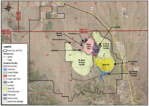
Figure 1-1: Layout of the Ruby Hill Project and Surface Projection of the Mineral Point and
Archimedes Zones
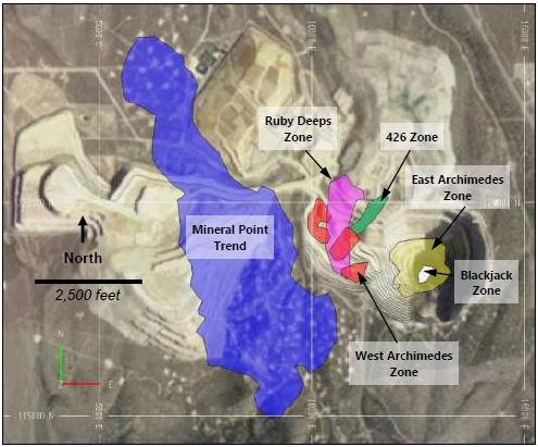
Note: Figure prepared by Wood using Satellite imagery from Google Earth. September 2021
The 2021 Ruby Hill Mineral Resource estimate was undertaken by Wood for RHMC. During the completion of the estimate Waterton entered into a transaction to sell the Ruby Hill Project to i-80 Gold Corporation.
Units used for the Project are US Imperial units for distance and tonnage and a combination of Imperial units (ounces per short ton) and metric units (parts per million or grams per tonne) for grade units. The Mineral Resource estimate was developed in Imperial units for tonnage and volume and metric units for grade. The estimate was converted to metric tonnes for the resource statement. Monetary units are in United States dollars (US$). Mineral Resource estimates are reported using the May 10, 2014 edition of the Canadian Institute of Mining and Metallurgy’s Definition Standards for Mineral Resources and Mineral Reserves (the 2014 CIM Definition Standards).
May 2022
Project Number 250039 | Page 1 - 2 | |
|
2021 Ruby Hill Mineral Resource Estimate
Eureka County, NV, USANI43-101Technical Report |
The Project is wholly controlled by RHMC. The Ruby Hill Mine property is located on the Battle Mountain/Eureka gold trend approximately 1.5 miles northwest of the town of Eureka in Eureka County, Nevada, USA, approximately 115 miles south of Elko and 245 miles east of the city of Reno, Nevada.
| 1.4 | Mineral Tenure, Surface Rights, Royalties and Agreements |
The QPs have not independently reviewed ownership of the Project area and any underlying property agreements, mineral tenure, surface rights, or royalties. The QPs have fully relied upon information derived from RHMC and legal experts retained by RHMC for this information (see Section 3 of this Report).
The Ruby Hill Project mineral tenure consists of 173 unpatented lode mining and millsite claims, five patented lode mining claims located and surface rights of approximately 666 hectares (1,644.94 acres) in Eureka County, NV (RHMC, 2021; Jensen, 2021).
| 1.4.2 | Purchase of Project by i-80 Gold |
On September 7, 2020 i-80 Gold Corp announced that it had entered into a definitive membership interest purchase agreement (the "Ruby Hill Agreement") with affiliates of Waterton to acquire the Ruby Hill Mine (i-80 Gold, 2021). Closing the transaction is subject to the satisfaction of a number of conditions precedent, including regulatory approvals and, finalization of customary due diligence and the negotiation and execution of mutually satisfactory definitive documentation for financing.
There are four royalties on different parts of the Ruby Hill mineral tenure that would apply to production from the Ruby Hill Project. The royalties range from 2.5% to 4.0% and include offer of first right of refusal if RHMC abandons any of the applicable claims or patents (Jensen, 2021). A 3% NSR on all production is assumed for the financial inputs to cut-off grade calculation and the construction of conceptual mining shapes.
May 2022
Project Number 250039 | Page 1 - 3 | |
|
2021 Ruby Hill Mineral Resource Estimate
Eureka County, NV, USANI43-101Technical Report |
| 1.5 | Geology and Mineralization |
The Ruby Hill Project is located along the southeastern end of the Battle Mountain/Eureka gold trend. The Eureka gold mining district exposes a nearly continuous sequence of Cambrian and Ordovician sedimentary rocks approximately 10,000' thick consisting of primarily carbonate units with subordinate shale and quartz sandstone.
The main precious metal mineralization at Ruby Hill occurs in favorable lithostratigraphic units bound by high angle structures that are interpreted to have been conduits for hydrothermal fluids responsible for gold and silver mineralization. There is also earlier carbonate replacement base metal mineralization in skarn-altered limestone units proximal to Cretaceous intrusions.
A description of the geology of the Mineral Point, West Archimedes, East Archimedes, Blackjack, 426, Ruby Deeps deposits follows.
The Mineral Point Trend deposit consists of gold and silver mineralization hosted by the Cambrian Hamburg dolomite in the nose of a broad anticline that plunges to the north-northeast and is bound to the east by the Holly Fault and to the west by the West Fault. The Mineral Point Trend is 9,000 ft long, 2,400 ft wide and up to 500 ft thick. The top of the Mineral Point Trend is near surface at its south end and 500 ft below surface at its north end. Majority of the mineralization in the Mineral Point Trend deposit is oxidized and has a high ratio of cyanide soluble to fire assay total gold. This deposit has not been mined and is the largest precious metal Mineral Resource in the Ruby Hill Project.
The West Archimedes deposit is hosted in the Ordovician Upper Goodwin limestone unit and is bound to the west by the Holly Fault. The zone strikes north-west and dips shallowly to the north-east. The deposit measures 2,000 ft along strike and 740 ft down dip and is up to 300 ft thick. The majority of West Archimedes was mined in an open pit before mining at East Archimedes. The mineralization in the West Archimedes deposit is oxidized and has a high ratio of cyanide soluble to fire assay total gold.
May 2022
Project Number 250039 | Page 1 - 4 | |
|
2021 Ruby Hill Mineral Resource Estimate
Eureka County, NV, USANI43-101Technical Report |
The East Archimedes Zone occurs east of the Graveyard Fault and proximal to the Graveyard Stock. Mineralization extends eastward from the West Archimedes Zone in the Upper Goodwin Formation and extends downward in the Lower Laminated and Lower Goodwin units along the contact with the Graveyard Stock. Silver and base metal grades are elevated in the East Archimedes zone in comparison with the other zones in the Ruby Hill Project in an envelope around the Blackjack zone replacement-style zinc mineralization described below. Mineralization in East Archimedes is roughly 1,200 ft wide and 1,200 ft long in plan and extends from surface where it is well defined by shallow drilling to several mineralized intersections over 1,800 ft below surface. The upper portion of the East Archimedes deposit, above an elevation of approximately 5,000 ft, is oxidized and transitional oxide-sulfide mineralization with a high ratio of cyanide soluble to total fire assay gold. The upper portion of the East Archimedes zone has been mined from surface.
The 426 zone occurs in the Lower Laminated unit of the Goodwin Formation and the upper part of the underlying basal Goodwin unit of the Goodwin Formation in the nose of a fold. The mineralized zone forms a rod-shaped body plunging shallowly to the northeast that is 1,400 ft long, 200 ft wide and 200 ft thick. The top of the zone is approximately 1,000’ below surface, but it is 500' below the bottom of the current East Archimedes pit bottom. Majority of the higher-grade mineralization occurring in the Goodwin Formation Lower Laminated unit is sulfide-style mineralization with a low ratio of cyanide soluble to total fire assay gold but the lower portion of the zone that is hosted in the basal Goodwin Unit has a moderate cyanide soluble to total fire assay gold mineralization.
The Ruby Deeps zone is a north-northeast striking, shallowly east dipping zone of mineralization hosted in the Windfall Formation in proximity to bodies of Bullwhacker Sill intrusive bound by the Graveyard Fault to the east and the Holly Fault to the west. The zone is 2,400 ft long 500 ft wide and 600 ft thick. The top of the zone is 1,600 ft below surface and 1,000 ft below the bottom of the West Archimedes pit. Within the zone there are several tabular horizons of higher-grade mineralization that are 40 ft to 100 ft thick.
May 2022
Project Number 250039 | Page 1 - 5 | |
|
2021 Ruby Hill Mineral Resource Estimate
Eureka County, NV, USANI43-101Technical Report |
The Blackjack zone is a pod of replacement style zinc mineralization hosted by the Lower Goodwin Unit directly in contact with the Graveyard Stock within the East Archimedes Zone. Mineralization occurs as a pod of sphalerite mineralization with elevated lead, copper, and silver. The base metal-rich carbonate replacement style mineralization has been overprinted by later Carlin-style gold mineralization. The Blackjack zone measures approximately 500 ft wide, 500 ft long, and 950 ft high. The upper part of the Blackjack zone is partially oxidized with a high-to-moderate ratio of cyanide soluble to total fire assay gold, but sphalerite is un-oxidized. The lower portion of the zone is un-oxidized.
The following summary of the history of the Ruby Hill Project is adapted from the 2012 Technical Report on the Ruby Hill Mine by RPA.
The Ruby Hill Project was originally owned by the Ruby Hill Mining Company which was purchased by Homestake in 1992. During the 1992 drilling program, significant gold mineralization was encountered in what would become the northwestern portion of the Archimedes deposits. Drilling continued on the Archimedes deposits for two more years and in 1994 plans were announced to develop an open pit mining operation for the West Archimedes deposit. The existing Ruby Hill infrastructure was constructed in 1997 and commercial production started in 1998 from the West Archimedes deposit.
Due to the combined effect of low gold prices, high waste stripping, and the difficulty of permitting a mine below the water table, the East Archimedes deposit was not included in the original project. Barrick acquired the Ruby Hill property during the 2001 merger with Homestake and mining of the West Archimedes deposit was completed in 2002.
In 2003 and 2004, Barrick undertook feasibility testwork and technical evaluation focused on resolving the outstanding issues facing East Archimedes. Areas of focus were dewatering, metallurgy, and Mineral Resource definition. Permitting of the East Archimedes Project started in November 2003 and production from the East Archimedes pit continued until failure of the south wall of the pit caused the mine to be placed on care and maintenance in November 2013.
May 2022
Project Number 250039 | Page 1 - 6 | |
|
2021 Ruby Hill Mineral Resource Estimate
Eureka County, NV, USANI43-101Technical Report |
RMC acquired the Project in 2015. RHMC has continued to irrigate the heap leach pad and recover gold while it has focused on database compilation and geological modeling as a basis for Mineral Resource estimates to support study of options for restart. In 2020, RHMC began a 12-month program to mine the last remaining accessible benches of Phase 8 which was the pushback that was being mined when the wall failure occurred. Mining of this material is scheduled to be complete in August 2021.
The Ruby Hill drillhole database was originally compiled by Barrick gold and consists of over 3,600 drillholes and 2.3 million feet of drilling from throughout the southern portion of Eureka County. The database includes holes that have been drilled to test 24 different targets and include reverse circulation, diamond core, reverse circulation pre-collar with diamond core tail and percussion and churn drill hole types.
A total of 2,491 drillholes have been drilled on the current Ruby Hill property and 2,100 drillholes totaling of 1.5 million feet of drilling define the Mineral Point Trend and Archimedes deposits. Of these holes, the main drilling and sampling campaigns, accounting for 95% of drill footage in these deposits are RC and diamond core holes drilled by Homestake and Barrick from 1992 to 2015.
| • | 44% of the drill footage is RC drilling and 4.5% is diamond drilling as core holes from surface, underground from exploration drifts at Mineral Point, or core holes from RC pre-collars by Homestake from 1992 to 2004 |
| • | 46% of the drill footage is RC drilling and 2.3% is diamond core drilling holes from surface and RC pre-collars by Barrick from 2004 to 2015. |
Drill core from the Barrick and Homestake programs was logged using graphic strip logs to record texture and structure with alteration, mineralization and mineralogy logged by intensity. RC chips were logged in a similar fashion using a strip log to record lithology, alteration and oxidation details and fields for mineral intensity used to capture information about alteration and mineralization. The majority of deeper drillholes were surveyed down the hole after drilling using an external survey contractor. RC cuttings and drill core were split on site, bagged, and dispatched to external commercial laboratories for gold fire assay and multi-element analysis by ICP. Selected intervals were also assayed for cyanide soluble gold.
May 2022
Project Number 250039 | Page 1 - 7 | |
|
2021 Ruby Hill Mineral Resource Estimate
Eureka County, NV, USANI43-101Technical Report |
A set of RC drillhole intervals were identified by Barrick Project Geologists as being potentially contaminated. Additional intervals were identified as being potentially contaminated using checks of downhole grade decay and cyclicity, comparisons of grade distributions and analysis of twin holes by RHMC in 2017 (Oakley, 2017).
Wood’s verification of the mineral resource database includes:
| • | Visual inspection of all collars versus the original topographic surface. No outliers were identified. All collar locations plot in the project area within 10 feet of the surface or bench elevation in the East Archimedes and West Archimedes pits and underground exploration development at Mineral Point. |
| • | Check of approximately 5% of gold and silver assay grades on certificates and digital lab assay files versus intervals in the 2020 Ruby Hill database used for the Mineral Resource estimate. No significant issues were found with gold and silver grades. |
| • | Visual inspection of all drillhole traces used in the estimate. Down hole deviations are moderate. Hole deflection is relatively consistent, and no anomalous deviations were identified. |
| • | Detailed review of original drillhole documentation in folders from twelve holes from the Homestake and Barrick campaigns randomly selected from RHMC vault of original hard copy drillhole data. This verification included checks of handwritten strip logs, sample registers, dispatch sheets, original assay certificates, email correspondence about QA/QC issues, and downhole survey. 90% of the randomly selected drillholes had complete original hardcopy documentation of good quality that allowed verification of downhole surveys, assays, and logging. Some drillholes included original color print photographs. |
| • | Site visit to review geology in the East Archimedes Pit and drill core stored on surface. The open pit exposure provides a good opportunity to check lithological contacts, alteration, structure, and the form of ore/waste contacts. Only limited drill core has been preserved and what is preserved is not in a condition that allows easy retrieval and review; however, intervals from several holes used in the estimates were located and compare well to original logging and assay data. |
May 2022
Project Number 250039 | Page 1 - 8 | |
|
2021 Ruby Hill Mineral Resource Estimate
Eureka County, NV, USANI43-101Technical Report |
| • | Review of assay quality control data was undertaken. Consistent use of CRMs and check assaying in the drill programs by Barrick provide assurance of gold and silver assay accuracy and reproducibility for the Mineral Point and Archimedes datasets. |
| • | Visual inspections were made of gold grades in cross section. Grade smearing potentially related to downhole contamination of RC drillholes was identified in four holes at Archimedes and added to the intervals identified by Barrick geologists supervising drilling in original drill hole logs as being potentially contaminated, and holes and intervals identified by RHMC as being potentially contaminated. All holes and intervals identified has having potential risk of contamination were excluded from use in estimation. |
| • | Visual inspection of grade trends also indicated a cluster of anomalously high-grade samples having grades ranging from 20 g/t Au to over 100 g/t Au in the underground exploration in the southwest corner of Mineral Point Trend in drilling by Eureka Corp. High grades are supported in a single high-grade intersection in a surface hole drilled by Barrick, but additional precautions were taken in estimation to limit the potential influence of the Eureka Corp. underground drilling to a cap grade of 5 g/t Au and a maximum range defined by a hand-drawn wireframe around the area drilled from underground. |
| • | Detailed comparison of Barrick and Homestake reverse circulation drilling with twin and nearby diamond drill hole intersections did not indicate systematic bias in RC grades related to sample representativity or sample quality issues apart from the RC holes identified as having potential downhole contamination from chip logging and visual inspection of grades in three dimensions. |
| • | Detailed comparison of Barrick to nearby legacy drillhole intersections also indicates that the drilling, sampling, and assaying by Homestake is relatively accurate and of good precision. |
| 1.9 | Mineral Resource Estimation |
The Mineral Resource workflow for Ruby Hill consisted of three steps: exploratory data analysis to understand grade trends and distributions, grade estimation, and grade validation.
May 2022
Project Number 250039 | Page 1 - 9 | |
|
2021 Ruby Hill Mineral Resource Estimate
Eureka County, NV, USANI43-101Technical Report |
Exploratory data analysis included construction and review of histograms, cumulative frequency plots, boxplots, and review of trends in three dimensions. A probability assigned constrained kriging (PACK) methodology was used for the Ruby Hill Mineral Resource Estimate. PACK estimates were produced using grade domains at nominally 0.1 g/t Au and 1.0 g/t Au thresholds for the Mineral Point, West Archimedes, East Archimedes, 426 and Ruby Deeps zones. Blocks were estimated into 25 ft x 25 ft x 25 ft blocks using 10 ft downhole composites. The grade shells were used to constrain higher grade zones and no outlier restriction was used in the estimate. Grade models were validated visually on cross section and bench plan. The volumes and forms of the grade domains were compared to blasthole data available for East Archimedes. Global bias was checked for each domain by comparing the grade estimate with declustered 25 ft assay composite statistics using a nearest neighbor model. Grade trends were checked using swath plots. A HERCO grade tonnage curve was produced to check change of support for the 25 ft x 25 ft x 25 ft selective mining unit. Several refinements were iteratively made for each domain as a result of the validation checks.
Several zones were identified for development of more detailed and selective models for underground modeling once the 25 ft x 25 ft x 25 ft model was estimated. The higher-grade zones at 426 and Ruby Deeps were modeled using 5 ft downhole assay composites and an additional 3 g/t Au grade domain to estimate the grades at 5 ft x 5 ft x 5 ft block support.
An open pit shell was constructed using conceptual mining, processing, and economic parameters to support definition of the oxide and transitional oxide-sulfide blocks in the 25 ft model that have reasonable prospects for eventual economic extraction. Conceptual underhand cut-and-fill (UCF) stopes using underground mining and toll autoclave processing parameters to define the portion of the 5 ft block modes for 426 that have reasonable prospects for underground mining. The underground shapes were used to cut any overlap from the underground mining shapes and the contents of the conceptual mining shapes were used to tabulate Mineral Resources amenable to open pit mining methods and processing of oxide by heap leach methods, or amenable to underground mining methods and processing of sulfide toll-treatment by autoclave scenarios.
May 2022
Project Number 250039 | Page 1 - 10 | |
|
2021 Ruby Hill Mineral Resource Estimate
Eureka County, NV, USANI43-101Technical Report |
| 1.10 | Mineral Resource Statement |
The estimated tonnages and grades in the Mineral Resource estimates have not been adjusted for mining recovery and dilution and contained metal estimates in the Mineral Resource tables have not been adjusted for metallurgical recoveries.
Mineral Resources are reported in Table 1-1 for open pit mining and oxide heap leach processing for the Mineral Point Trend and West Archimedes and East Archimedes zones. Mineral Resources for underground mining and sulfide toll milling for 426 and Ruby Deeps are reported in Table 1-2. The QP for the estimate is Mr. Christopher Wright, P.Geo., a Wood employee and the estimate has an effective date of 31 July 2021.
Areas of uncertainty that could materially affect the Mineral Resource estimates include the following: commodity pricing; interpretations of fault geometries; lithological interpretations on a local scale, including the thickness and amenability of the sedimentary units to host mineralization; geotechnical assumptions related to the open pit and underground mine designs, rock quality and stability; additional dilution considerations that may be refinements to open pit and underground mining methods in operation, metal recovery assumptions; product quality assumptions; assumptions as to operating costs used when assessing reasonable prospects of eventual economic extraction; and changes to drill spacing assumptions used to support confidence classification categories.
May 2022
Project Number 250039 | Page 1 - 11 | |
|
2021 Ruby Hill Mineral Resource Estimate
Eureka County, NV, USANI43-101Technical Report |
Table 1-1: Mineral Resource Statement, Open Pit Oxide Heap Leach Mineralization
(effective date 31 July 2021)
Mineral Resources above 0.1 g/t Au
Cut-off Grade | Tonnes | Au | Ag | Au | Ag |
| (Mt) | (g/t) | (g/t) | (koz) | (koz) |
| Mineral Point | | | | | |
| Indicated Mineral Resources | 203.2 | 0.49 | 14.9 | 3,217 | 97,457 |
| Inferred Mineral Resources | 157.3 | 0.37 | 14.3 | 1,872 | 72,370 |
| West Archimedes | | | | | |
| Indicated Mineral Resources | 2.4 | 0.83 | 0.6 | 63 | 47 |
| Inferred Mineral Resources | 0.1 | 0.23 | 0.1 | 0.6 | 0.4 |
| East Archimedes | | | | | |
| Indicated Mineral Resources | 18.9 | 0.98 | 9.6 | 594 | 5,831 |
| Inferred Mineral Resources | 5.3 | 1.10 | 6.4 | 189 | 1,102 |
| Total | | | | | |
| Indicated Mineral Resources | 224.4 | 0.54 | 14.3 | 3,874 | 103,335 |
| Inferred Mineral Resources | 162.7 | 0.39 | 14.0 | 2,062 | 73,472 |
Note: to accompany the Mineral Resource table for Ruby Hill Oxide Heap Leach mineralization:
| 1 | Mineral Resources have an effective date of 31 July 2021. Mr. Christopher Wright, P. Geo, a Wood Canada Ltd. employee, is the Qualified Person responsible for the Mineral Resource estimate. |
| 2 | Mineral Resources are not Mineral Reserves and do not have demonstrated economic viability. |
| 3 | Mineral Resources are the portion of the Mineral Point, West Archimedes and East Archimedes that can be mined profitably by open pit mining method and processed by oxide gold heap leaching. |
| 4 | Mineral Resources are below final design topography for Phase 8 completed in August 2021. |
| 5 | Mineral Resources are constrained to oxide and transitional oxide-sulfide mineralization inside a conceptual open pit shell. The main parameters for pit shell construction are a gold price of $1,650/oz Au, 75% recovery for gold for oxide and transitional mineralization, open pit mining costs of $2.03/tonne, heap leach processing costs of $2.32/tonne, general and administrative costs of $0.72/tonne processed, and a 3% royalty. |
| 6 | Mineral resources are shown above a 0.1 g/t Au cut-off grade. This is a marginal cutoff grade that generates sufficient revenue to cover conceptual processing, general and off-site costs given metallurgical recovery and long-range metal prices for gold and silver. |
| 7 | Mineral Resources are stated as in situ with no consideration for planned or unplanned external mining dilution. |
| 8 | The contained gold estimates in the Mineral Resource table have not been adjusted for metallurgical recoveries. |
| 9 | Units shown are metric tonnes. |
| 10 | Numbers have been rounded as required by reporting guidelines and may result in apparent summation differences. |
May 2022
Project Number 250039 | Page 1 - 12 | |
|
2021 Ruby Hill Mineral Resource Estimate
Eureka County, NV, USANI43-101Technical Report |
Table 1-2: Mineral Resource Statement, Underground Sulfide Gold Toll Processing
(effective date 31 July 2021)
Mineral Resources Above a Cut-off
grade of 3.6 g/t Au | Tonnes | Au | Ag | Au | Ag |
| (Mt) | (g/t) | (g/t) | (k Oz) | (k Oz) |
| 426 Underground | | | | | |
| Indicated Mineral Resources | 1.20 | 5.22 | 0.6 | 202 | 22 |
| Ruby Deeps Underground | | | | | |
| Inferred Mineral Resources | 8.21 | 6.02 | 1.7 | 1,588 | 439 |
Note: to accompany Mineral Resource table for Underground Sulfide Gold Toll Processing mineralization:
| 1 | Mineral Resources have an effective date of 31 July 2021. Mr. Christopher Wright, P. Geo, a Wood Canada Ltd. employee, is the Qualified Person responsible for the Mineral Resource estimate. |
| 2 | Mineral Resources are not Mineral Reserves and do not have demonstrated economic viability. |
| 3 | Mineral Resources are the portion of the 426 and Ruby Deeps deposits can be mined profitably using conceptual underhand drift and fill method and processed by sulfide gold toll milling. |
| 4 | Mineral Resources are below final design topography for Phase 8 completed in August 2021. |
| 5 | The gold price used for cut-off grade calculation is $1,650/oz Au. |
| 6 | Mineral Resources are constrained to gold mineralization inside conceptual drift and fill stope outlines using a gold price of $1,650/oz Au, 77% gold recovery, underground mining costs of $121/tonne, sustaining capital, general and administrative and other onsite costs of $21.00/tonne processed, toll autoclave treatment costs of $72/tonne of resource and a 3% royalty. |
| 7 | Mineral Resources are stated including 5% dilution. |
| 8 | The contained gold estimates in the Mineral Resource table have not been adjusted for metallurgical recoveries. |
| 9 | Units are metric tonnes. |
| 10 | Numbers have been rounded as required by reporting guidelines and may result in apparent summation differences. |
| 1.11 | Mineral Reserve Estimation |
There are no Mineral Reserves for the Ruby Hill Project.
Conceptual open pit and underhand drift and fill mining costs and mining shapes were developed to define mineralization with reasonable prospects for eventual economic extraction. No Mineral Reserves are reported for the Ruby Hill Project and detailed mining designs and mine planning have not been undertaken at this stage of the Project.
May 2022
Project Number 250039 | Page 1 - 13 | |
|
2021 Ruby Hill Mineral Resource Estimate
Eureka County, NV, USANI43-101Technical Report |
| 1.13 | Metallurgy and Recovery Methods |
Conceptual mineral processing parameters, including assumptions about metallurgical recovery and product quality were made to support assessment of the portion of the gold and base metal mineralization having reasonable prospects for eventual economic extraction. Assumptions are based on historic metallurgical performance and the testwork reports for oxide gold heap leaching, and benchmarks and the testwork reports for zinc sulfide flotation. No detailed process design or production planning has been undertaken at this stage of the Project.
Historically, there have been three destinations for treatment of mineralization from the Ruby Hill Mine: (i) run of mine (ROM) and crushed mineralization to a heap leach pad, (ii) crushing and tank leaching with agglomerated tailings routed to the heap leach pad, and (iii) higher-grade sulfide mineralization (DSO) routed to Goldstrike for autoclave processing.
Generally, previous operating experience as well as the metallurgical testwork confirms the amenability of oxide material to heap leaching for precious metals extraction. From 2004 to 2012, seven testwork programs were carried out, by KCA focusing on column leaching and bottle roll testing of the oxide deposits, namely Archimedes, 426 and Mineral Point. An eighth report was carried out on a sample from Watertank, which analyzed as sulfide.
Other testwork has been carried out by the Barrick Technology Centre (BTC) between 2008 and 2012. This work is summarized in five reports focusing on refractory mineralization and supports gold extraction via autoclave processing.
Additional work on base metals characterization and flotation was carried out by G&T in 2008. This work shows amenability to flotation, with additional work required to improve recovery uncertainty.
| 1.14 | Project Infrastructure |
The Ruby Hill Project includes mining and mineral processing infrastructure that has been used in open pit mining and oxide gold heap leaching activities by RHMC and previous owners; however, detailed project infrastructure design to mine and process the Mineral Resources estimated in 2021 has not been completed at this stage of the Project.
May 2022
Project Number 250039 | Page 1 - 14 | |
|
2021 Ruby Hill Mineral Resource Estimate
Eureka County, NV, USANI43-101Technical Report |
| 1.15 | Environmental, Permitting and Social Considerations |
The estimated cost to close and reclaim the Project is $23 million. This amount includes closure of all permitted mining and exploration disturbance at the Project. A bond in the amount of $22 million was received by the Bureau of Land Management in July 2020.
There are no other known environmental liabilities associated with pre-Project operations.
| 1.16 | Markets and Contracts |
RHMC is currently engaged in the sale of gold bullion to refineries. There are reasonable prospects for securing sales contract for future product.
| 1.17 | Risks and Opportunities |
Risks to the Ruby Hill Project Mineral Resource estimate include:
| • | Sensitivity and potential loss of resource tonnage due to poorer than expected rock quality and slope stability issues for the open pits. |
| • | Potential loss of resource tonnage due to increased operating costs related to rock mechanics and underground mine designs for the 426 and Ruby Deeps Mineral Resources. |
| • | Poorer than expected hydrometallurgical performance of transitional oxide/sulfide mineralization |
| • | Changes to permitting and closure requirements may have an impact on future resource development. |
The following opportunities were identified in preparation of the 2021 Ruby Hill Mineral Resource estimate:
| • | Exploration has the potential to add Mineral resources north of the Mineral Point deposit in the target area named Blue Sky where sparse historic drilling defined a large arsenic anomaly at the alluvium-bedrock contact and where mineralization encountered in widely spaced drillholes has suggested potential northward extension of mineralization in the Dunderberg Formation. |
May 2022
Project Number 250039 | Page 1 - 15 | |
|
2021 Ruby Hill Mineral Resource Estimate
Eureka County, NV, USANI43-101Technical Report |
| • | Exploration has the potential to add Mineral Resources south of the East Archimedes deposit at the Jackson target that is defined by an anomalous arsenic in soil anomaly at surface, parts of east-dipping Goodwin and Windfall Formations are favorable for gold mineralization and oxide gold mineralization has been encountered in several widely-spaced drill holes. |
| • | Expansion of underground sulfide gold resources around mineralization that is part of the current Mineral Resource estimate for the Ruby Deeps and 426 zones. |
| • | Further definition of the Blackjack zone zinc-rich polymetallic carbonate replacement mineralization occurring in favorable sedimentary units in contact with the Graveyard Stock. |
Further definition and strategic trade-off of different potential development options is recommended to identify a path forward for the Ruby Hill Project. The options analysis study scope should include geotechnical and hydrogeological testing, characterization, and modeling to produce open-pit and underground design recommendations, additional metallurgical testing of oxide and transitional oxide-sulfide mineralization refractory sulfide and base metal mineralization, mine, process and infrastructure design, project layout, capital and operating cost estimation, preliminary closure plan design high-level project scheduling. A drill program should be carried out to support the development options study including exploration drilling at Jackson and Blue Sky target areas, resource expansion and infill drilling at Archimedes and Mineral Point, including the Blackjack zone, geotechnical drilling and metallurgical drilling.
It is expected that the studies and concurrent drilling would have a duration of 24-36 months and have an estimated budget of $45.4 million.
May 2022
Project Number 250039 | Page 1 - 16 | |
|
2021 Ruby Hill Mineral Resource Estimate
Eureka County, NV, USANI43-101Technical Report |
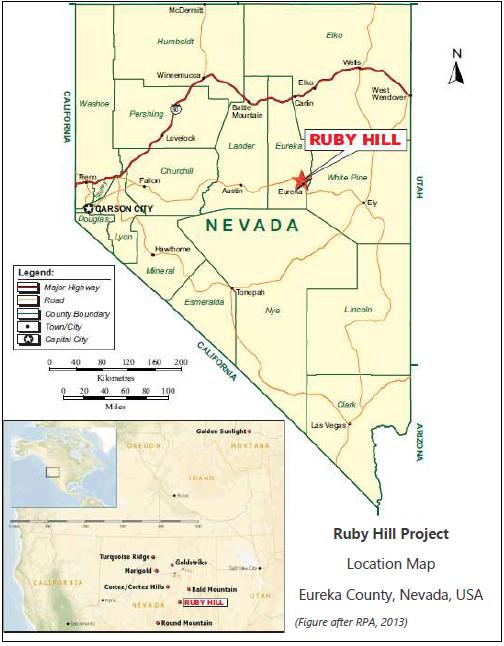
This Technical Report has been prepared to support an independent Mineral Resource Estimate for the Ruby Hill Project in Eureka County, Nevada (Figure 2-1) by Wood Canada Limited (Wood). i-80 Gold Corporation (i-80 Gold) acquired the Ruby Hill Mining Company (RHMC) and the Project in a transaction with Waterton Nevada Splitter LLC and Waterton Nevada Splitter II LLC (collectively Waterton), in July 2021. The Mineral Resource estimate and this report have been prepared with the help of RHMC.
The Project consists of mining and millsite claims and patents, surface landholdings, water rights, mine and mineral processing infrastructure and the Mineral Point Trend, and Archimedes Deposit. The Archimedes deposit is comprised of the West Archimedes, East Archimedes, 426, Ruby Deeps and Blackjack zones shown in Figure 1-1.
Waterton acquired the Project from Barrick Gold Corporation in 2015. When Barrick sold the project the open pit mine was on care and maintenance following a slope failure on the south wall of the pit that caused suspension of mining activities in 2013. Waterton’s intent was to re-compile the Ruby Hill Mineral Resource Database and study restart of operations and development of the Mineral Point, 426, Ruby Deeps and Blackjack zones.
This Technical Report has been prepared to support public disclosure of a Mineral Resource Estimate for the Ruby Hill Project in Eureka County Nevada, by i-80 Gold Corporation (i-80 Gold) titled “i-80 to Acquire Lone Tree/Processing Facilities, Buffalo Mtn & Ruby Hill to Create Nevada Mining Complex” dated September 7, 2021. i-80 Gold is a reporting issuer on the Toronto Stock Exchange in Canada.
The Ruby Hill Project and the Mineral Resource estimates presented in this Report comprise portions of the following gold and base metal deposits:
| • | Mineral Point Trend consisting of the Mineral Point, Achilles, Hector, and Silverlick Cyan zones |
| • | Archimedes Deposit consisting of the West Archimedes, East Archimedes, Blackjack, 426 and Ruby Deeps zones. |
May 2022
Project Number 250039 | Page 2 - 1 | |
|
2021 Ruby Hill Mineral Resource Estimate
Eureka County, NV, USANI43-101Technical Report |
Figure 2-1: Project Location Plan
May 2022
Project Number 250039 | Page 2 - 2 | |
|
2021 Ruby Hill Mineral Resource Estimate
Eureka County, NV, USANI43-101Technical Report |
Units used for the Project are US Imperial units and a combination of imperial units (ounces per short ton) and metric units (parts per million or grams per tonne) for grade units. Precious metal grades are typically specified in grams per tonne (g/t) and the concentrations of other elements are stated in parts per million (ppm) parts per billion (ppb) or percent (%). The Mineral Resource estimate was developed in Imperial Units for volume and tonnage using metric units for grade. The estimate was converted to metric units for tonnage for the Mineral Resource statement. Monetary units are in United States dollars (US$). Mineral Resources and Mineral Reserves are reported using the May 10, 2014 edition of the Canadian Institute of Mining and Metallurgy’s Definition Standards for Mineral Resources and Mineral Reserves (the 2014 CIM Definition Standards).
Mr. Christopher Wright, P.Geo., Technical Director Resource Estimation and Geometallurgy is a qualified person for this Report as defined in National Instrument 43-101, Standards of Disclosure for Mineral Projects (NI 43-101), and in accordance with Form 43-101F1. Mr. Wright Prepared Sections 1.1 to 1.12, 1.14 to 1.21, 2 to 12, 14 to 27 of this Report.
Mr. Ray Walton, P.Eng., President of Ray Walton Consulting Inc., is a qualified person for this Technical Report as defined in National Instrument 43-101, Standards of Disclosure for Mineral Projects and in Compliance with Form 43-101F1. Mr. Walton prepared Sections 1.13, 13, 25 and 26 of this report.
| 2.3 | Site Visits and Scope of Personal Inspection |
Mr. Wright visited the Waterton office in Reno Nevada to review archived hardcopy survey logs, assay certificates, drill core and reverse circulation (RC) drillhole logs, photographs, and other original documentation for the project on February 9th and 10th. Mr. Wright visited the Ruby Hill Project site on February 11th and 12th to carry out an inspection of property geology in exposures in the East Archimedes pit and drill core stored on site.
Mr. Walton visited the Property during April 2015.
May 2022
Project Number 250039 | Page 2 - 3 | |
|
2021 Ruby Hill Mineral Resource Estimate
Eureka County, NV, USANI43-101Technical Report |
The effective date of the Report is 31 July 2021 which is the date on which the topographic information, mining shapes, mining, metallurgical and financial parameters supporting reasonable prospects for eventual economic extraction and grade estimates were frozen for the Mineral Resource estimate.
| 2.5 | Information Sources and References |
The main sources of information used in the construction of the resource model for the 2021 Mineral Resource estimate and this Report are as follows:
| • | 2020_Resource_Update_DB. Digital directory containing geological models and drillhole databases used for the 2021 Mineral Resource estimation provided by Keith Fowlow of RHMC. |
| • | 2021 Strat Model Archimedes Ext_20210208. Digital file containing updated geological models for the 2021 Mineral Resource estimate provided by Joe Currie of Waterton Global Resource Management. |
| • | Delong, R., 2021. Environment and Communities Due Diligence. Unpublished slide presentation on the conclusions of an environment, permitting and community relations due diligence study completed for the Ruby Hill Mine site by Richard Delong of EM Strategies for i-80 Gold dated 20 May 2021. 12p. |
| • | Jensen, D.A., 2021. Title Report for the Ruby Hill Property, Eureka County, Nevada. Internal report prepared by Daniel A. Jensen of Parr Brown Gee and Loveless Attorneys at Law of Reno Nevada addressed to Ruby Hill Mining Company and Elko Mining Group dated 2 July 2021. 18p including exhibits. |
| • | Wood, 2021a. Open Pit Design Criteria for the Ruby Hill Resource Pit Shell. Unpublished document listing mining, processing, geotechnical and financial assumptions used in the construction of the Mineral Resource open pit shell. |
| • | Wood, 2021b. Underground Mine Design Criteria for the Ruby Hill Underground Stope Shapes. Unpublished document listing mining, processing, geotechnical and financial assumptions used in the construction of the Mineral Resource underground stope shapes. |
Complete references are included in Section 27 of this Report.
May 2022
Project Number 250039 | Page 2 - 4 | |
|
2021 Ruby Hill Mineral Resource Estimate
Eureka County, NV, USANI43-101Technical Report |
| 2.6 | Previous Technical Reports |
In 2012 Roscoe Postle Associates (RPA) produced a Technical Report for Barrick Gold Corporation titled: Technical Report on The Ruby Hill Mine, Eureka County, State of Nevada, U.S.A. with an effective date of March 16, 2012 (RPA, 2012).
| 2.7 | Other Contributors to the Report |
The Ruby Hill Mineral Resource estimate was prepared with support from:
| • | Joe Currie of Waterton Global Resource Management who prepared geological models for resource modeling. |
| • | Will Oakley of Elko Mining group, a subsidiary of Waterton Global Resource Management, who facilitated the site visit and provided guidance to the estimate based on production geology experience at Ruby Hill. |
| • | Keith Fowlow of Elko Mining Group, a subsidiary of Waterton Global Resource Management, who facilitated data review and provided insight into the Mineral Resource Database and QA/QC for the project. |
| • | Christine Hohl of Waterton Global Resource Management who provided compilations of exploration history and project geology for this Report. |
Contributors to the mineral resource estimate under the supervision of Mr. Wright include:
| • | Doug Reid, formerly of Wood Group USA in Reno Nevada, prepared the Mineral Resource estimate for Mineral Point. |
| • | Antonio Cortes, Senior Geostatistician, of Wood’s Mining and Metals Consulting Team in Chile prepared the resource model for the Archimedes Open Pit Mineral Resource estimate. |
| • | Henry Kim, Senior Resource Geologist of Wood Canada Ltd. in Vancouver prepared the resource models for the 426 and Ruby Deeps Underground Mineral Resource estimate. |
| • | Marco Ortega of Wood’s Mining and Metals Consulting Team in Peru ran stope optimizations for underground mining scenarios. |
| • | Alvaro Murga and Wilmer Cancho of Wood’s Mining and Metals Consulting Team in Peru ran open pit optimizations for open pit mining scenarios. |
May 2022
Project Number 250039 | Page 2 - 5 | |
|
2021 Ruby Hill Mineral Resource Estimate
Eureka County, NV, USANI43-101Technical Report |
The Report benefits from senior review from:
| • | Georges Verly Chief Geostatistician, of Wood Canada Ltd. in Vancouver, reviewed the Mineral Point resource model. |
| • | Greg Gosson, Technical Director of Geology and Compliance of Wood Canada Ltd. In Vancouver, reviewed the Report. |
May 2022
Project Number 250039 | Page 2 - 6 | |
|
2021 Ruby Hill Mineral Resource Estimate
Eureka County, NV, USANI43-101Technical Report |
| 3 | Reliance on Other Experts |
The QP has relied upon the following reports by other experts, which provided information regarding mineral rights, surface rights, property agreements, royalties, environmental, permitting and marketing sections of this Report.
The QP has not independently reviewed ownership of the Project area and any underlying property agreements, mineral tenure, surface rights, or royalties. The QPs have fully relied upon, and disclaim responsibility for, information derived from RHMC, and legal experts retained by RHMC for this information through the following documents:
| • | Jensen, D.A., 2021. Title Report for the Ruby Hill Property, Eureka County, Nevada. Internal report prepared by Daniel A. Jensen of Parr Brown Gee and Loveless Attorneys at Law of Reno Nevada addressed to Ruby Hill Mining Company and Elko Mining Group dated 2 July 2021. 18p including exhibits. |
| • | RHMC, 2021. Expert opinion on surface land holdings, mineral tenure, water rights, royalties and environmental liabilities provided to Wood by the Ruby Hill Mining Company dated 30 July 2021. |
This information is used in Section 1, Section 4, and Section19 of this Report. The information is also used in support of the Mineral Resource estimate in Section 14.
| 3.3 | Community Relations, Environmental and Permitting |
The QP has fully relied upon, and disclaim responsibility for, information supplied by Delong (2021) and RHMC (2018, 2021) for information related to water management and environmental liabilities, permitting and social and community impacts as follows:
| • | Delong, 2021. Environment and Communities Due Diligence. Unpublished slide presentation on the conclusions of an environment, permitting and community relations due diligence study completed for the Ruby Hill Mine site by Richard Delong of EM Strategies for i-80 Gold dated 20 May 2021. 12p. |
May 2022
Project Number 250039 | Page 3 - 1 | |
|
2021 Ruby Hill Mineral Resource Estimate
Eureka County, NV, USANI43-101Technical Report |
| • | RHMC, 2018. Reclamation Cost Update for the Ruby Hill Mine, Eureka County Nevada, 2018 Three-year Update for Reclamation Permit #107 BLM NVN-067782 prepared by Ruby Hill Mining Company LLC and Submitted to the Nevada Division of Environmental Protection Bureau of Mining Regulation and Reclamation and the Bureau of Land Management dated October 2018. 137p. |
| • | RHMC, 2021. Description of surface land holdings, mineral tenure, water rights, royalties and environmental liabilities provided to Wood by the Ruby Hill Mining Company dated 30 July 2021. |
This information is used in Section 1, Section 4, and Section 20 of the Report. This information is also used in support of the Mineral Resource estimate in Section 14.
May 2022
Project Number 250039 | Page 3 - 2 | |
|
2021 Ruby Hill Mineral Resource Estimate
Eureka County, NV, USANI43-101Technical Report |
| 4 | Property Description and Royalties |
The Ruby Hill Project is wholly owned and operated by RHMC which is subject to acquisition by i-80 Gold. The Project is located on the Battle Mountain/Eureka gold trend approximately 2 km northwest of the town of Eureka in Eureka County, Nevada, USA, approximately 145 km south of Elko and approximately 325 km east of the city of Reno, Nevada (Figure 2-1).
i-80 Gold is in the process of acquiring the Ruby Hill Mining Company, and the Ruby Hill Project from Waterton Global Resource Management (i-80 Gold, 2021). Waterton acquired the property from Barrick Gold in 2014 and Barrick had acquired the company in its merger with Homestake in 2001.
| 4.1 | Mineral Tenure in Nevada |
The following is a summary of mineral tenure for the Ruby Hill Project site taken from Jensen (2021):
“To locate a lode mining claim in Nevada, the locator must, in connection with the discovery of a valuable lode mineral, erect a monument at the place of discovery (known as a location monument) and post a written notice of location thereon. The locator must also distinctly mark the boundaries of the lode claim on the ground using a suitable monument at each claim corner. Similarly, to locate a millsite claim in Nevada, the locator must post a written notice of location somewhere on the millsite claim. The locator must also distinctly mark the boundaries of the millsite claim on the ground using a suitable monument at each claim corner. A certificate of location and a map showing the boundaries of the lode or millsite claim must be recorded with the relevant county recorder within 90 days after the date of location of the claim. A copy of the location certificate and a map showing the claim boundaries must also be filed with the relevant BLM office within 90 days after the date of location.
Patented Claims cover land that is privately owned in fee simple (both the surface and mineral estates) based on patents granted by the United States between 1875 and 1883. As stated above, Ruby Hill owns all of the Patented Claims. Because the Patented Claims are so old, Wolcott was not able to locate a few of the very early title records, resulting in some early gaps in the chain of title. However, in almost all of those cases, the property was later conveyed by Eureka County in connection with tax sales resulting from non-payment of property taxes, which conveyances had the effect of mooting such prior gaps in the chain of title. In addition, there are no breaks in the chain of title for at least the last 60 years. Further, we note that Nevada has a very short (two-year) adverse possession statute, such that any chain of title gaps would be readily capable of resolution through a quiet title action based on the payment of property taxes and other acts of dominion over the Patented Claims by Ruby Hill and its predecessors for decades.
May 2022
Project Number 250039 | Page 4 - 1 | |
|
2021 Ruby Hill Mineral Resource Estimate
Eureka County, NV, USANI43-101Technical Report |
Because of their patented status, the Patented Claims have no maintenance obligations other than payment of county property taxes.
The Fee Tract covers most, but not all, of the land covered by the Unpatented Claims. Many years after the subject unpatented lode mining claims were staked, the then owner of those claims obtained a patent from the United States, on August 5, 2003, granting fee simple title to the land within the Fee Tract, with the patent reserving to the United States all mineral deposits and with the patent being subject to all valid existing rights. The effect of the patent was to grant surface ownership of the Fee Tract to the unpatented mining claim owner, which owner already held valid existing rights to all locatable minerals within the Fee Tract by virtue of the lode Unpatented Claims. As stated above, Ruby Hill is now the owner of both the Fee Tract and the Unpatented Claims. Consequently, Ruby Hill owns both the surface estate and the unpatented locatable mineral estate within the boundaries of the Fee Tract but must maintain the unpatented lode claims there in order to continue holding the locatable mineral rights within the Fee Tract.”
May 2022
Project Number 250039 | Page 4 - 2 | |
|
2021 Ruby Hill Mineral Resource Estimate
Eureka County, NV, USANI43-101Technical Report |
| 4.2 | Mineral Tenure for the Ruby Hill Project |
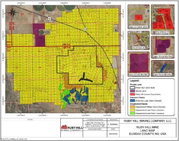
The Ruby Hill Project mineral tenure consists of 173 unpatented lode mining and millsite claims, five patented lode mining claims located and surface rights of approximately 666 hectares (1,644.94 acres) in Eureka County, NV. A map of the mineral tenure and surface land holdings is shown in Figure 4-1.
Figure 4-1: Ruby Hill Project Mineral Tenure Map
| 4.3 | Environmental Liabilities |
The closure cost for Ruby Hill is estimated to be $23 million (RHMC, 2021). A bond in the amount of $22 million was accepted by the Bureau of Land Management (BLM) on July 21, 2020 and covers authorized disturbance associated with issued permits for Ruby Hill (Delong, 2021). There are no other known environmental liabilities associated with pre-Project operations (RHMC, 2021).
May 2022
Project Number 250039 | Page 4 - 3 | |
|
2021 Ruby Hill Mineral Resource Estimate
Eureka County, NV, USANI43-101Technical Report |
The existing permits for Ruby Hill property are described in Section 20.2 and 20.3. The existing permits authorize 98.3 acres of exploration disturbance on private land and 51 acres of exploration disturbance on public land. A map showing the permitted area is shown in Figure 4-2. These permits allow RHMC to conduct the exploration, geotechnical and metallurgical field work to support the study work recommended in this Report (Delong, 2021) as long as the amount of new surface disturbance remains less than that available under the existing permits.
Figure 4-2: Permit Area for the Ruby Hill Project
Source: Delong, 2021
May 2022
Project Number 250039 | Page 4 - 4 | |
|
2021 Ruby Hill Mineral Resource Estimate
Eureka County, NV, USANI43-101Technical Report |
There are four royalties on different parts of the Ruby Hill mineral tenure that would apply to production from the Ruby Hill Project (RHMC, 2021; Jensen, 2021). The royalties range from 2.5% to 4.0% NSR and include offer of first right of refusal if RHMC abandons any of the applicable claims or patents. A 3% NSR on all production is assumed for the financial inputs to cut-off grade calculation and the construction of conceptual mining shapes for support of reasonable prospects for eventual economic extraction (RPEEE).
The Royal Gold Royalty is pursuant to a Warranty Deed dated June 29, 1994 between RHMC and Homestake Mining Company of California (the Royal Gold Deed), RHMC reserved to itself a 3% net smelter return (NSR) on the sale of all ores and minerals following the recovery and sale of 500,000 ounces of gold and/or quantities of other ores and minerals expressed as Gold Ounce Equivalents as defined in the Royal Gold Deed. The Royal Gold Royalty applies to 187 unpatented claims and 34 patented claims. The 500,000 ounce production threshold for the Royal Gold Royalty has already been reached. The Royal Gold Royalty is currently owned by RG Royalties, LLC.
Pursuant to a Quitclaim and Agreement dated August 1, 1992 by and between Homestake Mining Company of California and ASARCO Incorporated (ASARCO), ASARCO reserved to itself a four percent (4%) net returns royalty for all ores and minerals mined or otherwise recovered from the LH 1-25, 27-77, 98-120, 130, 132, 134-136, 139-141 and 137R-138R claims and the SP Claims (the ASARCO 1 Royalty). The ASARCO 1 Royalty remains owned of record by ASARCO.
Pursuant to a Royalty Deed dated effective September 15, 1993 by and between Homestake Mining Company of California and ASARCO, ASARCO was granted a four percent (4%) net returns royalty for all ores and minerals mined or otherwise recovered from the LH 78A-87A claims (the ASARCO 2 Royalty). The ASARCO 2 Royalty remains owned of record by ASARCO.
May 2022
Project Number 250039 | Page 4 - 5 | |
|
2021 Ruby Hill Mineral Resource Estimate
Eureka County, NV, USANI43-101Technical Report |
Pursuant to a Quitclaim and Agreement dated October 11, 1995 by and between Placer Dome U.S. Inc. (Placer Dome) and Homestake Mining Company of California, Placer Dome reserved to itself a two and one-half percent (2.5%) NSR royalty for all ores and minerals mined or otherwise recovered from the PLS Claims (the Placer Dome Royalty). The Placer Dome Royalty is currently owned by Barrick Gold U.S. Inc.
Information from Delong (2021), RHMC (2021) and experts retained by RHMC (Jensen, 2021) supports the following conclusions:
| • | The patented and unpatented claims that cover the Mineral Point Trend and Archimedes Deposits and the Ruby Hill Project site are valid and in good standing. |
| • | To the extent known to the QP, there are no other significant factors and risks that may affect access, title or right or ability to perform work on the Project that are not discussed in this Report. |
May 2022
Project Number 250039 | Page 4 - 6 | |
|
2021 Ruby Hill Mineral Resource Estimate
Eureka County, NV, USANI43-101Technical Report |
| 5 | Accesibility, Climate, Local Resources, Infrastructure AND Physiography |
The Ruby Hill Project is a 4.5-hour drive east of Reno, Nevada. Access to the property from Reno is via Interstate Highway 80 for 65 miles to the town of Fallon, then 180 miles east from Fallon on paved U.S. Highway 50 to its intersection with Nevada State Highway 278, and south from US Highway 50 on a well-graded dirt road for less than one mile to the site gate. The property can also be accessed from Elko via Interstate Highway 80 for 35 km, then south on Highway 278 for 115 miles to Eureka. Additionally, the property can be accessed from Ely, Nevada near the border with Utah, west along US Highway 50 for 78 miles.
The nearest airport is a regional airport located in Elko, Nevada, where scheduled commercial service is available. Year-round road access to the property is available from Elko, located to the north, Reno to the south and Eureka and Ely, located to the east of the Project.
The climate is semi-arid with 12 inches of annual precipitation as rain and snow. Most precipitation is received from December to March. Monthly average temperatures range from a low of 37°F to 41°F to an average high of 81°F. Exploration and mine development activities can be conducted year-round.
Eureka County has a long history of mining activity and is an active mining district with a number of large gold operations. Experienced and general labor is readily available in the local area and from Elko. Elko is approximately 230 miles from Salt Lake City, a major center.
May 2022
Project Number 250039 | Page 5 - 1 | |
|
2021 Ruby Hill Mineral Resource Estimate
Eureka County, NV, USANI43-101Technical Report |
The infrastructure at the Ruby Hill Project site currently includes infrastructure to support an oxide gold heap leach operation that is permitted to crush 10 ktpd. Project infrastructure includes:
| • | a two-stage crushing and stacking system |
| • | a carbon in column (CIC) and carbon regeneration system |
| • | offices, repair shops, laboratory, and warehouse facilities |
| • | power and fresh water supply. |
There is sufficient suitable land available within the Project area for mine waste disposal, heap leach pad expansions, and installations such as a process plant and tailings storage facilities that might be needed to support development of the Mineral Resources presented in this Report.
May 2022
Project Number 250039 | Page 5 - 2 | |
|
2021 Ruby Hill Mineral Resource Estimate
Eureka County, NV, USANI43-101Technical Report |
Table 6-1 summarizes ownership and exploration history of the Ruby Hill property. Figure 6-1 shows the locations of geophysical surveys, with Figure 6-2 and Figure 6-3 displaying the location of rock and soil samples respectively.
Table 6-1: Property Exploration and Ownership History
| Year | Company | Comment |
| 1864 | N/A | • Oxidized gold-silver deposits discovered by prospectors |
| 1869 | N/A | • Ruby Hill deposits discovered on Prospect Mountain • W.W. McCoy devises furnace for recovering metals from oxidized ores |
| 1873-1905 | Richmond Mining Company | • Production from the Ruby Hill deposit. Smelting ceases 1890 |
| 1873-1916 | Eureka Consolidated Mining Company | • Production from the Ruby Hill deposit • The Locan shaft was sunk to 1200 level. High water flow encountered in crosscut partially flooding shaft. Shaft dewatering unsuccessful, mine shut down • Smelting ceased 1891 |
| 1905-1912 | Richmond-Eureka Mining Company | • Richmond Mining Company and Eureka Consolidated Mining Company properties consolidated into Richmond-Eureka Mining Company • Controlling interest held by Unites States Smelting, Refining, and Mining Company (USSRAM) • Rehabilitation of Richmond and Eureka consolidated mines. Processing of stope fill and low-grade ore |
| 1919 | Ruby Hill Development Company | • Leased property from Richmond-Eureka Mining Company. Dewatered Locan shaft • Project abandoned due to exhaustion of finances |
| 1923 | Richmond-Eureka Mining Company | • Dewatered Locan shaft to 1,200 level • Drove SE crosscut to Ruby Hill fault, and a drift to SW. SW drift encountered high water flow and work stopped • Vertical exploration hole (type unknown) drilled from 900 level. Hole caved, and project abandoned |
| 1920's - 1930's | Various lessors | • Sporadic production |
May 2022
Project Number 250039 | Page 6 - 1 | |
|
2021 Ruby Hill Mineral Resource Estimate
Eureka County, NV, USANI43-101Technical Report |
| Year | Company | Comment |
| 1937-1959 | Eureka Corporation, Ltd. | • Obtained leases on Ruby Hill property from Richmond-Eureka Mining Company • Completed 4 churn holes (totaling 3,596 feet), 260 surface and underground core holes (87,633.8 feet), 13 mud rotary holes (14,252 feet), and 6 RC holes (9,903 feet) • Intersection of high-grade polymetallic mineralization in 5 surface core holes led to the FAD shaft being sunk to 2,500' depth to develop mineralization. Underground development encountered high water flow which flooded shaft • Rotary drilling in 1953 in Adams Hill area intersected mineralization in Hamburg Dolomite • Sinking of the T.L. shaft started in 1953 to exploit mineralization and was completed in 1955 to a depth of 1,127 feet • Mining commenced in 1956 and shut down in 1958 due to lack of ore |
| 1989-1991 | American Smelting and Refining Company (ASARCO) | • Drilled 12 RC exploration holes totaling 5,314 feet |
| 1960-1992 | Ruby Hill Mining Company | • Richmond-Eureka Mining Company (75%) and Eureka Corporation (25%) form Ruby Hill Mining Company • In June 1960 a consortium was formed consisting of Richmond-Eureka Mining Company, Eureka Corporation, Newmont Mining Company, Cyprus Mines Corporation, and Hecla Mining Company to finance additional drilling and produce a FAD feasibility study • Collectively, Consortium drilled 148 exploration holes (129,362.3 feet); 13 churn (3,641 feet); 33 Mud Rotary (74,039 feet); 6 percussion (395 feet); 3 RC (1,458 feet); and 93 core holes (50,218.3 feet) • Fourteen holes drilled in FAD shaft area intersected mineralization. Decision made to dewater FAD shaft to exploit new mineralization • In 1963 FAD shaft was dewatered to the 2250 level. New crosscut, 1,028' long, to evaluate mineralized zone completed in 1964. Crosscut used to drill exploration percussion and core holes • Drilling completed in 1966 and mine placed on inactive status pending economic evaluation • 1966 and 1974 Hecla feasibility studies indicate project not feasible • In 1974 Newmont withdrew from the consortium followed by Hecla in 1979 • Cyprus remains as surviving partner drilling 39 mud rotary (7,945 feet), and 98 air track (4,983 feet) exploration holes for near-surface, bulk-mineable gold mineralization between 1980-1981 • Exploration unsuccessful and property reverted to Sharon Steel Corporation successor to Ruby Hill Mining Company in 1982 • Sharon Steel Corporation drilled 127 exploration/definition RC holes totaling 31,539 between 1982 and 1991 |
May 2022
Project Number 250039 | Page 6 - 2 | |
|
2021 Ruby Hill Mineral Resource Estimate
Eureka County, NV, USANI43-101Technical Report |
| Year | Company | Comment |
| 1993-1994 | Placer Dome | • Drilled 11 RC exploration holes (12,350 feet) at Ruby Flats |
| 1994 | Unknown | • Drilled 1 RC hole for 500 feet |
| 1992-2001 | Homestake Mining Company | • Homestake acquired Ruby Hill property from Ruby Hill Mining Company in 1992 • Exploration/definition drilling between 1992-1993 discovers/defines the Archimedes deposit (both West and East) along with the 426 zone • In 1994 Homestake announced plans to develop an open pit mine and processing facility to exploit West Archimedes mineralization. Construction began in 1997 and production commenced in 1998 • The eastern portion of the Archimedes deposit (East Archimedes) not developed due to low gold prices, high strip ratio, change of mineralization from oxide to sulfide, and mineralization largely below water table creating permitting issues • Mining ceased in 2002 and reclamation activities started on mine waste dumps and pit area • Completed 1,502 (1,022,842.5 feet) exploration/definition holes between 1992-2001; 1374 RC holes (875,083 feet), and 128 core holes (147,759.5 feet) • DIGHEM Surveys conducted an airborne magnetic & electromagnetic survey in 1994 on E-W flight lines at nominal 600’ spacing with mean terrain clearance of 115 feet • Zonge Geosciences completed ground magnetics survey at 150' spacing in 2000. • In 1998, conducted dump sampling program on Diamond Tunnel dump to evaluate grade and tonnage • Between 1999-2000 conducted rock chip sampling program to determine potential for multi element correlation as pathfinder for gold |
| 2001-2015 | Barrick Gold Corporation | • Barrick acquired Ruby Hill property during 2001 merger with Homestake Mining Company • In 2002 Chadwick and Russell completed Archimedes pit mapping • Completed positive feasibility study on East Archimedes deposit in 2004, a mineral reserve audit in 2005, and NI 43-101 Technical Reports in 2008 and 2012 • 2005 East Archimedes developed as conventional open-pit mining and heap leach operation with initial gold production in 2007 • In 2013 the East Archimedes high wall failed, and mining was suspended pending economic assessment of moving failed material to continue mining • Barrick completed a pre-feasibility study on the 426 zone in 2009 and a feasibility study in 2012. The 2012 feasibility concluded that the 426 zone needed +$975/oz gold to be economical. • 2003-2015 drilled 674 (811,575 feet) exploration/infill/definition drill holes; 523 RC (630,745 feet). and 151 core (180,830) holes • 2002 Quantec Consulting Inc. conducted a 5-line Titan-24 magnetotelluric survey, added additional 4 lines in 2010 • 2006 merged gravity data from multiple sources and various scales • 2007 Magee Geophysics Services LLC conducted a 3,182 station gravity survey on 300' grid spacing • Conducted rock chip sampling program in 2002 |
May 2022
Project Number 250039 | Page 6 - 3 | |
|
2021 Ruby Hill Mineral Resource Estimate
Eureka County, NV, USANI43-101Technical Report |
| Year | Company | Comment |
| 2015 | Waterton Precious Metals Funds II Cayman, LP | • Purchased Ruby Hill mine from Barrick. Waterton formed new corporate entity called Ruby Hill Mining Company, LLC |
| 2015-2021 | Ruby Hill Mining Company, LLC | • Completed 42 sonic drill holes totaling 4,106.’ between 2019 - 2020 • 2017 reprocessing of selected historical geophysical datasets, multi-element analysis study of drill core to aid in lithology identification, and structural review by SRK • In August 2021 there was continued residual leaching and gold production from the East Archimedes heap leach pad |
May 2022
Project Number 250039 | Page 6 - 4 | |
|
2021 Ruby Hill Mineral Resource Estimate
Eureka County, NV, USANI43-101Technical Report |
Figure 6-1: Known Geophysical Surveys in the Ruby Hill Property Area

May 2022
Project Number 250039 | Page 6 - 5 | |
|
2021 Ruby Hill Mineral Resource Estimate
Eureka County, NV, USANI43-101Technical Report |
Figure 6-2: Rock Samples with Gold Grade (ounces per short ton) within the Ruby Hill Claim Block
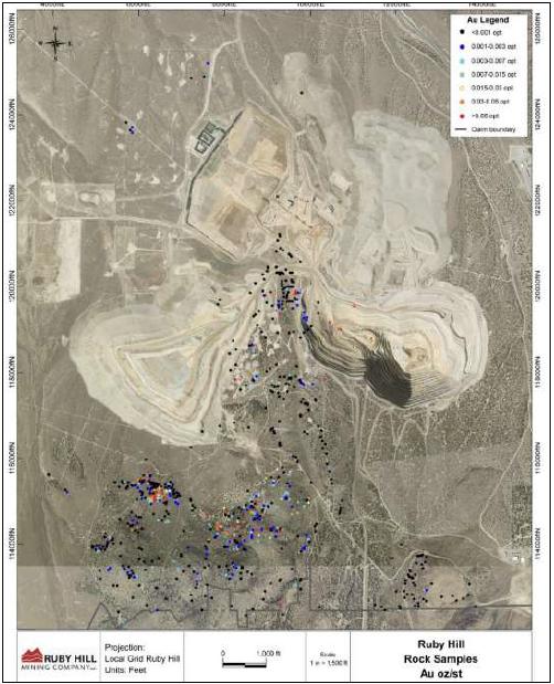
Source: RHMC, 2021
May 2022
Project Number 250039 | Page 6 - 6 | |
|
2021 Ruby Hill Mineral Resource Estimate
Eureka County, NV, USANI43-101Technical Report |
Figure 6-3: Soil Samples with Gold Grade in oz/st within the Ruby Hill Claim Block
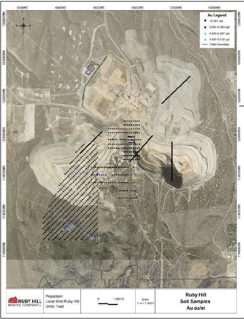
Source: RHMC, 2021
May 2022
Project Number 250039 | Page 6 - 7 | |
|
2021 Ruby Hill Mineral Resource Estimate
Eureka County, NV, USANI43-101Technical Report |
| 6.2 | Petrology, Mineralogy, and Research Studies |
Scott Halley of Mineral Mapping Pty Ltd., Australia, was contracted by RHMC in 2017 to conduct a lithogeochemical and alteration mapping exercise using a multi-element assay data. The work demonstrated use of major and trace element geochemistry and inter-element ratios for discrimination of lithologic units, differentiation between alteration types.
| 6.3 | Geotechnical and Hydrological Studies |
Geotechnical and hydrological surveys completed by previous owners include those listed in Table 6-2 and Table 6-3.
Table 6-2: Summary of Geotechnical Surveys
| Date | Report/Investigation | Author/Lead Consultant |
| 2004, November | Pit Slope Design Recommendations for the East Archimedes Pit | Golder Associates Inc. |
| 2012, October | Pre-Feasibility Level Pit Slope Design Bullwhacker Pit | Golder Associates Inc. |
| 2012, October | Feasibility-Level Pit Slope Design West Archimedes 426 Extension Pit | Golder Associates Inc. |
| 2013, November | 2013 Review of Southeast Slope of East Archimedes Pit | Golder Associates Inc. |
| 2016, December | Stability Evaluation of Slide Debris in Support of Mining in the North Wall of the East Archimedes Pit- Ruby Hill Mine (revised) | Golder Associates Inc. |
May 2022
Project Number 250039 | Page 6 - 8 | |
|
2021 Ruby Hill Mineral Resource Estimate
Eureka County, NV, USANI43-101Technical Report |
Table 6-3: Summary of Hydrological Surveys
| Date | Report/Investigation | Author/Lead Consultant |
| 2004, October | East Archimedes Project, Groundwater Flow Model | Jones, M.A. |
| 2004, October | East Archimedes Project, Assessment of the Hydrogeologic Conditions and Dewatering Feasibility | Water Management Consultants, Inc., |
| 2005, May | Final East Archimedes Pit Like Water Quality | Schafer Limited LLC |
| 2010, August | Revised Archimedes Pit Lake Water Quality | Schafer Limited LLC |
| 2010, June | Final Ruby Hill Mine Groundwater-Flow Model 2010 Update | J. Shomaker and Associates, Inc. |
| 2011 | Aquifer Test | J. Shomaker and Associates, Inc. |
| 2012 | Ruby Hill Mine Groundwater-Flow Model | J. Shomaker and Associates, Inc. |
| 2012, June | Bullwhacker dewatering evaluation | J. Shomaker and Associates, Inc. |
| 2013 | Spring Investigation | J. Shomaker and Associates, Inc. |
| 2015 | Aquifer Test, Mineral Point Dewatering Projection | J. Shomaker and Associates, Inc. |
| 2015 | Aquifer Test, Base Metals Dewatering Projection | J. Shomaker and Associates, Inc. |
| 2016, September | Ruby Hill Groundwater Characterization and Dewatering Update - Technical Memorandum | WSP Parsons Brinckerhoff |
| 2016, December | Pit Lake Water Balance and Evaporation to Validate Water Rights Requirements | WSP Parsons Brinckerhoff |
| 2017, July | Ruby Hill Mine Pit Lake Study | Piteau Associates Engineering, Ltd. |
| 2018, July | Mineral Point PW-15 Pumping Test and Updated Hydrogeological Model | Piteau Associates Engineering, Ltd. |
| 2020, May | Draft Ruby Hill Produced Water Management Plan, Preliminary Hydrogeological Conceptual Model and Alternatives Analysis | FloSolutions |
| 2020, June | Draft Ruby Hill RIB Characterization Plan | FloSolutions |
| 2021, March | Ruby Hill Mine Pit Lake Geochemical Model Report | SRK Consulting (U.S.), Inc. |
| 2021, March | Ruby Hill Projected Water Level and Water Balance for Permitted and Existing Pits - Technical Memorandum | J. Shomaker and Associates, Inc. |
A summary of the known production history in the broader Ruby Hill area is provided in Table 6-4. Most of the production prior to 1992 was from the FAD zone, located immediately south of the current Ruby Hill Property boundary (Nolan, 1962). Sporadic shipments of lower grade ores by lessors continued until about 1940 along with minor production from Adams Hill and Mineral Point. Production figures are fragmentary but Nolan and Hunt (1968) estimate district production between 1866 and 1964. Production from mines on Adams Hill and Mineral Point contributed no more than 125,000 tons of low-grade material, with most of the production, 67,000 tons, coming from the Holly mine (Nolan, 1962). Since 1992, most of the gold has been produced from Archimedes deposit area.
May 2022
Project Number 250039 | Page 6 - 9 | |
|
2021 Ruby Hill Mineral Resource Estimate
Eureka County, NV, USANI43-101Technical Report |
Table 6-4: Production History Summary
| Year | Company | Comment |
| 1866-1964 | Numerous | Eureka District produced 1.65 Moz Au, 39 Moz Ag, 625 Mlb Pb and 12 Mlb Zn from 2 Mtons of ore. • 1873-1905 Richmond Mining Company mined 488,081 tons of material valued at $15,209,012. • 1873-1916 Eureka Consolidated Mining Company mined 550,455 tons material valued at $19,242,012, • 1871-1939 Richmond-Eureka Mining Company mined 88,081 tons material valued at $4,021,674. • Small scale sporadic production from numerous lessors. |
| 1998-2000 | Homestake Mining Company | Produced 365,491 oz Au from 3.7 Mtons of mineralization from West Archimedes Pit |
| 2001-2015 | Barrick Gold Corporation | Produced 1,081,458 oz Au from approximately 18 Mtons of ore from West and East Archimedes Pits |
| 2016-2020 | Ruby Hill Mining Company | Produced 21,105 oz Au from residual leaching of pad. Began mining East Archimedes Pit in August 2020 |
May 2022
Project Number 250039 | Page 6 - 10 | |
|
2021 Ruby Hill Mineral Resource Estimate
Eureka County, NV, USANI43-101Technical Report |
| 7 | Geological Setting and Mineralization |
| 7.1 | Regional and District Geology |
The Ruby Hill Project is located in the Eureka mining district in east-central Nevada, within the northern part of the Fish Creek Range which is a nearly continuous sequence of Cambrian and Ordovician sedimentary rocks (Figure 7-1) totaling nearly 10,000 ft in thickness (Nolan, 1962). These strata accumulated on a stable continental shelf margin and consisted primarily of carbonate units with subordinate shale and sandstone (Dilles et al., 1996). The Cambrian Eldorado Dolomite, the Hamburg Dolomite and overlying Dunderberg Shale, portions of the Windfall Formation, and the Goodwin-Ninemile transition, host most of the mineralization within the district (Barrick, 2011).
During the Mississippian Antler Orogeny, the Roberts Mountains Allochthon, consisting primarily of deep marine sedimentary rocks, was thrust from the west onto the continental margin (Evans and Theodore, 1978), creating a foreland basin in the vicinity of the present-day location of the town of Eureka, NV (Poole, 1974). Post-Antler Mississippian and Permian strata deposited after the Antler Orogeny filled the basin with carbonaceous silts, sands, and conglomerates represented by the Chainman and Diamond Peak formations (Dilles et al, 1996).
Thrust faulting and significant deformation of the Paleozoic section occurred between Permian and Late Cretaceous time (Taylor et al., 1993), and culminated in the development of the Prospect Mountain duplex of the Early Cretaceous Hoosac thrust fault (Lisenbee, 2001); a major regional scale structure that cuts Permian rocks, and is in turn cut by intrusive units dated 110 to 100 Ma (Dilles et al., 1996). Most of the Eureka district is located in the hanging wall of the Hoosac thrust.
Cretaceous fresh-water sedimentary rocks unconformably overlie the older Paleozoic units east of Eureka, NV (Nolan, 1962). Cretaceous age granodiorite and quartz porphyry intrude the Paleozoic section. These include the Mineral Hill stock, Bullwhacker Sill, and Graveyard Flat intrusive which are interpreted to be genetically linked to the base metal carbonate replacement deposits at Ruby Hill, as well as to those in the Ruby Deeps (Barrick, 2011). Oligocene volcanic tuffs and andesite intrusive rocks are also present within the district, primarily to the NE and SE. The youngest deformational event occurred during the Miocene when basin and Range extension formed regional high-angle N-S trending normal faults.
May 2022
Project Number 250039 | Page 7 - 1 | |
|
2021 Ruby Hill Mineral Resource Estimate
Eureka County, NV, USANI43-101Technical Report |
Figure 7-1: Regional Geologic Map
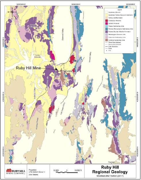
May 2022
Project Number 250039 | Page 7 - 2 | |
|
2021 Ruby Hill Mineral Resource Estimate
Eureka County, NV, USANI43-101Technical Report |
The Eureka district hosts mid-Cretaceous, igneous-related, polymetallic carbonate replacement deposits that have subsequently been overprinted by Carlin-type gold-silver mineralization. Gold and silver mineralization possibly dates to the early-middle Cenozoic (Eocene) and temporally coincides with the onset of extension and Eocene-Oligocene magmatism. Post mineral uplift exposed portions of the Archimedes gold deposit, and likely contributed to the relatively deep level of oxidation. Subsequent Miocene Basin and Range faulting resulted in reburial of the Archimedes system beneath 60 to 500 ft of Tertiary-Quaternary overburden in East Archimedes.
The Ruby Hill Project is located on the southeastern end of the Battle Mountain-Eureka gold trend, in the northern portion of the of the Eureka mining district. The Project is underlain by a thick (approximately 10,000 feet), sequence of carbonate units comprised of the Eldorado Dolomite, Geddes Limestone, Secret Canyon Shale, Hamburg Dolomite, Dunderberg Shale, and sections of the Windfall Formation and the Goodwin Formation, Ninemile Formation, Antelope Valley Formation, and the Eureka Quartzite. Intrusive units were emplaced during the Cretaceous and include the Graveyard Stock and the Bullwhacker Sill.
The district has undergone a series of complex structural events, beginning with the formation of the Roberts Mountain Allochthon (RMA) during the Late Devonian and Early Mississippian. Continued orogenic events and regional deformation produced a series of folds, thrusts, and high-angled faults. Locally, the Mineral Point anticline and Hoosac thrust fault are attributed to this deformational period (Hastings, 2008). During the Cretaceous, the region was subjected to widespread magmatic activity, resulting in emplacement of the Ruby Hill stock and the Graveyard Flats intrusive. Basin and Range extension during the Tertiary occurred, forming elongate N-trending basins and valleys and regional high-angled generally N-trending faults. Within the district, dominate structural trends are low and high-angled N-, NE-, and E-trending faults. Major structural features within the Property which control mineralization include the NNW-trending Mineral Point anticline, the bounding West Fault, the N-trending Bowman-Williamsburg Fault, and the NNW-trending Holly Fault, and the NW-trending Blanchard fault zone.
Mineralization within the Project area is characterized as:
| • | Au±Ag Carlin-type: West Archimedes, East Archimedes, Ruby Deeps, 426 zones and the Mineral Point Trend deposit |
| • | Zn-Pb-Ag-Au carbonate replacement deposit type (CRD): Blackjack zone. |
May 2022
Project Number 250039 | Page 7 - 3 | |
|
2021 Ruby Hill Mineral Resource Estimate
Eureka County, NV, USANI43-101Technical Report |
Mineralization is lithologically and structurally controlled and is focused primarily within the Ordovician and Cambrian formations. Minor skarn and epithermal style mineralization occur within the Cretaceous intrusive units.
Two main mineralized areas are defined as the Archimedes complex (consisting of West Archimedes, East Archimedes, 426, Ruby Deeps and Blackjack) and the Mineral Point Trend (consisting of Mineral Point, Achilles, and Hector) and are separated by the Holly Fault (Figure 7-2).
Alteration within the project area consists of silicic (jasperoid), argillic, decalcified (sanded and brecciated), and carbonate styles. Additionally, minor occurrences of skarn, propylitic, and dolomitic style alteration have been observed within the Property boundaries. Silicic alteration most commonly occurs as jasperoid and is most developed in the northern portion of the Property. Decalcified (sanded and brecciated) style, of dolomite is closely associated with the Carlin-type mineralization, and primarily occurs within the carbonate-rich formations.
A summary of the main stratigraphic units is provided below and in Figure 7-3.
Prospect Mountain Quartzite (Ꞓpm)
Light tan to white well-sorted quartzite. White, pink, tan, and brown when weathered. Commonly cross-laminated with rare pebble conglomerate interbeds. Micaceous to sandy shale interbeds common near base of unit. The unit is not observed within the Property area but within the region it is mapped up to 1,500 ft thick.
May 2022
Project Number 250039 | Page 7 - 4 | |
|
2021 Ruby Hill Mineral Resource Estimate
Eureka County, NV, USANI43-101Technical Report |
Figure 7-2: Ruby Hill Project Geology and Deposit Locations (August 2021)
May 2022
Project Number 250039 | Page 7 - 5 | |
|
2021 Ruby Hill Mineral Resource Estimate
Eureka County, NV, USANI43-101Technical Report |
Figure 7-3: Ruby Hill Stratigraphic Column
Source: RPA, 2012
May 2022
Project Number 250039 | Page 7 - 6 | |
|
2021 Ruby Hill Mineral Resource Estimate
Eureka County, NV, USANI43-101Technical Report |
Pioche Shale (Ꞓp)
Khaki to green, less commonly red-orange, sandy micaceous, locally calcareous shale. Contains thin interbeds of red-brown micaceous sandstone and quartzite, and mottled, well-bedded, dark-blue limestone with abundant trilobite fragments (Long et al, 2014). The unit unconformably overlies the Prospect Mountain Quartzite. It is not observed within the Property area but within the region it is mapped up to 500 ft thick.
Eldorado Dolomite (Ꞓed)
Medium-dark gray, massive weathering dolomite. Forms distinct gray cliffs. Commonly mottled and streaked with white stringers and spots. Dark dolomite locally alternates with lighter gray, rough textured dolomite giving the appearance of alternating light and dark bands up to 1 ft thick, which defines bedding (Long et al., 2014). Fenestral (birds’ eye) structure is common. Alters to a light-gray, coarse-crystalline (sanded), massive, featureless dolomite. Upper contact with is interfingered with the Geddes limestone. Within the Project area the unit is up to 2,240 ft thick.
Geddes Limestone (Ꞓp)
Well bedded, thin- to medium bedded, dark blue to black carbonaceous limestone, with maroon-weathering silty and shaly partings, and black nodular chert (Long et al., 2014). Forms angular blocky float. Lower contact is interfingered with the Eldorado Dolomite. Commonly folded at the outcrop scale. Black color and well-developed bedding diagnostic of the unit. Within the Project area the unit is up to 550 ft thick.
Secret Canyon Shale
Divided into two distinct interbedded members, the Lower Shale Member and the Clark Springs Member. Within the Project area the unit is up to 1,250 ft thick.
Lower Shale Member (Ꞓss)
Brown, olive to tan, calcareous, argillaceous shale with local interbedded limestone (Nolan, 1974). Weathers to a brown, red, and/or yellow (Nolan et al., 1956). Overlies the Geddes Limestone with a sharp conformable contact.
May 2022
Project Number 250039 | Page 7 - 7 | |
|
2021 Ruby Hill Mineral Resource Estimate
Eureka County, NV, USANI43-101Technical Report |
Clark Springs Member (Ꞓsc)
Thin- to well-bedded, bioturbated, silty, micritic limestone with distinctive mottled yellow or red argillaceous partings (Nolan, 1974; Long, 2014). Gradational contact with Lower Shale Member.
Hamburg Dolomite (Ꞓh)
Massive, light- to medium-gray, coarse crystalline dolomite with mottled white stringers that define bedding, and oblong “blue bird” stringers (Long, 2014). Typically porous or vuggy, commonly altered to jasperoid. Lower contact gradational with Clark Springs Member. Within the Project area the unit is up to 1,320 ft thick.
Dunderberg Shale (Ꞓd)
Brown, khaki, and gray, fissile, paper thin, generally non-calcareous shale with diagnostic nodular limestone discs, and interbeds of medium-bedded, medium-gray limestone (Long, 2014). Outcrop-scale folding is common. Within the Property the unit is up to 320 ft thick.
Windfall Formation
Formation is divided into two members, the Caitlin (Ꞓwc) and Bullwhacker (Ꞓwb) members. Within the Property the unit is up to 700 ft thick.
Caitlin Member (Ꞓwc)
The Caitlin Member consists of alternating thick-bedded, massive weathering, medium-coarse crystalline, medium-gray limestone (Long, 2014). Interbedded with thin-bedded, sandy-silty limestone with tan to red, sandy-shaly partings. Trilobite fossil hash common in thicker bedded limestone. Sharp conformable contact between Caitlin member and Dunderberg Shale (Nolan et al., 1956).
Bullwhacker Member (Ꞓwb)
The Bullwhacker Member is thin-bedded, tan to light-brown, sandy or shaly, medium gray limestone, with tan-red sandy-shaly partings and interbeds (Long, 2014). It weathers to a diagnostic tan to red color, and trilobite hash and brachiopods are common. Additionally, the unit contains rare gray chert nodules.
May 2022
Project Number 250039 | Page 7 - 8 | |
|
2021 Ruby Hill Mineral Resource Estimate
Eureka County, NV, USANI43-101Technical Report |
| 7.3.4 | Lower-Middle Ordovician |
Pogonip Group
The Pogonip Group is divided into three formations, the Antelope Valley (Oav), Ninemile (on), and Goodwin (Og) described below.
Goodwin Formation (Og1, Ogll, Og2)
The Goodwin Formation is a light- to medium-gray, massive weathering limestone, and medium-gray, medium to thick bedded, silty, well bedded, fine crystalline limestone (Long, 2014). It is divided into three units, the Basal unit (Og1), Lower Laminate unit (Ogll), and Upper Goodwin (Og2). Within the Property the unit is up to 1,100 ft thick.
Basal unit (Og1)
The basal unit consists of massive bedded, fine- to medium-grained, medium to dark gray, chert-bearing calcisiltite and calcarenite (Dilles et al., 1996). The Og1 unit is approximately 350 ft thick.
Lower Laminated unit (Ogll)
Consists of tan to gray, laminated to thin bedded micrite, calcisiltite, and shaly limestone (Dilles et al., 1996). The unit varies in thickness from 150 to 250 ft.
Upper Goodwin (Og2)
Composed of thin to medium bedded, chert bearing calcisiltite and calcarenite (Dilles, et al., 1996). Light gray, brown, and black chert nodules common (Long, 2014). It is approximately 500 ft thick.
Ninemile Formation (Opn)
Platy, thin bedded, porcelaneous, carbonaceous, fossiliferous, olive-green limey shale, and shaly medium-grained limestone (Dilles et al., 1996; Long, 2014). Weathers to a distinctive olive and brown color. Within the Property the unit is up to 520 ft thick.
Antelope Valley Formation (Opa)
Thin to medium and locally thick bedded, medium-blue gray, fine crystalline limestone (Long, 2014). Ubiquitous tan to yellow silty partings, and local tan, brown, and white chert nodules. Lower contact interfingers with Ninemile Formation. Within the Property the unit is up to 500 ft thick.
May 2022
Project Number 250039 | Page 7 - 9 | |
|
2021 Ruby Hill Mineral Resource Estimate
Eureka County, NV, USANI43-101Technical Report |
Eureka Quartzite
Vitreous white to dark gray, fine to medium grained, well sorted quartzite. Exhibits “sugary” quartz texture. Weathers gray to red and is commonly brecciated. The lower portion of the unit is commonly cross-laminated and it unconformably overlies Antelope Valley Formation (Nolan et al., 1956). Within the Property the unit is up to 535 ft thick.
Graveyard Flat Intrusion (Kgf)
The Graveyard Flat intrusion, discovered beneath alluvium cover during drilling at Archimedes, is the oldest intrusive in the district. Primary mineralogy is indeterminate due to intense intermediate argillic and propylitic alteration. The intrusive consists primarily of quartz, and variably altered plagioclase phenocrysts in a fine-grained, equigranular, plagioclase-dominated groundmass (Dilles et al., 1996). Common alteration products include sericite, kaolinite, calcite, chlorite, epidote, and pyrite (Dilles et al., 1996). Primary ferromagnesian minerals are not preserved. Dilles et al. (1996), based on observed textural variations within the intrusive, suggest that the intrusion may have been emplaced in multiple phases. Mortenson et al. (2000) reports a U-Pb zircon age of 106.2 ± 0.2 Ma for the intrusion.
Bullwhacker Sill (Kbs)
The Bullwhacker sill is located west of the Graveyard Flat intrusion, and dips gently east underneath the Archimedes pit where it may merge with the Graveyard Flat intrusion (Hoge, 2015). Within the Mineral Point deposit, the sill dips to the east and is intruded along the Windfall Formation and the Dunderberg Shale contact. (Dilles et al., 1996).
Langlois (1971) characterized the sill as an andesite porphyry. The sill exhibits strong sericitic alteration with feldspar phenocrysts replaced by kaolinite ± sericite ± calcite (Hastings, 2008). Quartz phenocrysts are common with relict biotite and hornblende phenocrysts in less altered areas. Groundmass texture is uncertain although relict mineralogy suggests that the sill was a granodiorite porphyry (Hoge, 2015). Mortensen et al. (2000) report a U-Pb zircon age of 106.8 ± 1.2 Ma for the Bullwhacker sill. The sill is typically emplaced between the Windfall Formation and Dunderberg Shale (Dilles et al., 1996).
May 2022
Project Number 250039 | Page 7 - 10 | |
|
2021 Ruby Hill Mineral Resource Estimate
Eureka County, NV, USANI43-101Technical Report |
Volcanic Units (Trf/Tv)
Tertiary rhyolitic flows, tuff and volcaniclastic rocks are present in the northern part of the district and exposed in eastern and southeastern Archimedes pit wall. Within the Property the unit is at least 200 ft thick.
Sparse intersections of west northwest-trending lamprophyre dikes also have been observed from pit mapping and noted in some East Archimedes drill holes.
Alluvium (Qal)
Within the Property the alluvium unit is up to 535 ft thick and consists of “stream alluvial, piedmont gravels, and slope wash” (Nolan, 1962).
The Property has undergone a complex tectonic history of deformational, extensional, and intrusive events, producing a series of folds, and high- to low-angled faults. Structures have been defined by a combination of surface mapping including Nolan (1962), Cooper (2002), Hauntz (1999), and Chadwick and Russell (2002), Uken (2017a 2017b), drill hole logging, and geologic modeling.
Paleozoic and Mesozoic deformational events produced a series of generally N-, NW-, and NE-trending faults and NW- to NE-trending folds within the Property area (Nolan, 1962). Tertiary Basin and Range extension and subsequent high-angled faulting (e.g., Holly Fault), have transected and possibly displaced some portions of the deposits within the Property (Nolan, 1962).
The main structural features within the Property area include early low-angled thrust faults (45°-95°), and apparent low- to high-angle normal faults (20°-45°) in three dominant orientations, which include 345°-015°, 030°-050°, and 80°-110° (Table 7-1). Major faults within the Property include the Holly Fault, Bowman-Williamsburg Fault, and the Blanchard fault zone (Table 7-1). A number of the high-angle normal faults are interpreted to crosscut and reactivated low-angle thrust faults.
May 2022
Project Number 250039 | Page 7 - 11 | |
|
2021 Ruby Hill Mineral Resource Estimate
Eureka County, NV, USANI43-101Technical Report |
Table 7-1: Major Structural Features and Orientations within the Property Area
| Structure | Orientation | Major Features | Kinematics | Dip | Notes |
| N-Trending Faults | NNW to NNE | The Bowman Fault, Holly Fault and associated splay faults including the Holly Splay Fault, Armpit Fault, 599 Fault, and 150 Splay Fault | Strike-slip | High-angle | The fault surface is typically undulating with up to 4 in of gouge fill. |
| NE-Trending Faults | NE | The 426 Fault, 194 Fault, Jackson fault, and Graveyard Fault | Strike-slip and oblique normal slip | Variable dips from steeply dipping to more shallow dipping | Faults are gouge filled with up to 4 in of gouge material. |
| E-Trending Faults | EWE-WNW | Blanchard fault zone and associated unnamed EW and WNW faults | Strike-slip | High-angle | The Blanchard fault zone may be up to 100 ft wide in portions of the Archimedes pit. |
| Thrust Faults | NS | The Hoosac Fault (off Property to the SE), and possibly reactivated normal faults within the district | Reverse | Low-angle | Commonly associated with folds, including the Mineral Point anticline. Folding typically occurs in well laminated units and vary in amplitude from approximately 20 inches to 3 feet. |
| Folds | NNW-NNE | The Mineral Point anticline | Anticline | | One control to mineralization |
May 2022
Project Number 250039 | Page 7 - 12 | |
|
2021 Ruby Hill Mineral Resource Estimate
Eureka County, NV, USANI43-101Technical Report |
Large-scale folds within the Property include the NNW-trending (330°-340°), gently N-plunging (5°-10°) Mineral Point anticline, located the central and north-west portions of the Property. The Mineral Point anticline is one control to mineralization within the Mineral Point, Achilles, and Hector deposits. Small-scale folds throughout the property control mineralization locally.
East Archimedes, West Archimedes, 426, Ruby Deeps and Blackjack are located on the eastern side of the near north-trending Holly Fault. Chadwick and Russell (2002), Hastings (2008), and Morkeh (2011), Uken (2017a, 2017b), mapped the structure and geology of the Archimedes pit.
On the western margin of West Archimedes is the N-trending high-angle normal Holly fault (east dipping, 79°), and the 150 fault (east dipping in the northern portion and west dipping in the southern; 85°; Chadwick and Russell, 2002; Hastings, 2008; Morkeh 2011). The 150 fault offsets the Bullwhacker Sill to the east by 500 ft (Hastings, 2008). The 194 fault, 426 fault, and Armpit faults are variable N- to NE-trending (345°-020°), east to west dipping, low- to high-angle faults (46°-87°), which transect the center portion of West Archimedes (Chadwick and Russell, 2002; Hastings, 2008; Morkeh 2011). The Blanchard fault zone is a NW-trending (295°), steeply dipping (NE; 75°-85°), fault zone which is reported to be 100 ft wide in some locations (Chadwick and Russell, 2002; Hastings, 2008).
Within the East Archimedes zone the Graveyard fault zone is a N-trending (350°-010°), west dipping (60°-80°), series of faults, which transects the east margin of the pit (Chadwick and Russell, 2002; Hastings, 2008; Morkeh 2011). The Blanchard fault zone continues east from the West Archimedes pit into East Archimedes for an unknown distance into the Graveyard Flat intrusion on the eastern margin of the pit (Chadwick and Russell, 2002; Hastings, 2008; Morkeh 2011).
The 426 zone is spatially associated with the NE-trending 426 fault zone and north of the Blanchard fault zone.
Structure within the Ruby Deeps deposit area is a continuation of faulting from the Archimedes deposit to the south and the Mineral Point deposit to the west. The Ruby Deeps deposits is bounded to the east by the Graveyard Flats fault and the west by the Holly fault. The Blanchard fault zone transects the center portion of the deposit but does not appear to offset mineralization.
May 2022
Project Number 250039 | Page 7 - 13 | |
|
2021 Ruby Hill Mineral Resource Estimate
Eureka County, NV, USANI43-101Technical Report |
Figure 7-4: East Archimedes and West Archimedes, 426, and Ruby Deeps Zone Geology (August 2021)
May 2022
Project Number 250039 | Page 7 - 14 | |
|
2021 Ruby Hill Mineral Resource Estimate
Eureka County, NV, USANI43-101Technical Report |
The Mineral Point deposit is in the central portion of the Property, south of Achilles and west of the Archimedes pit. It is situated within the district-scale NNW-trending Mineral Point open anticline that plunges gently to the north. Major structures at Mineral Point represent a horst-like anticlinal dome bounded on the east by the Holly Fault, and to the west by the West Fault (Figure 7-5).
Several steeply dipping normal faults of varying apparent displacement are associated with the Mineral Point anticline. From west to east these include the west-dipping West Fault which bounds the west limb of the anticline and defines the western limit of mineralization; the Bowman-Williamsburg Fault which parallels the axial plane of the anticline; and the Holly fault which is an offshoot or northward extension of the district scale Jackson-Lawton Fault system to the south (Loranger, 2013). The Bowman- Williamsburg and Holly Faults both dip steeply to the east. The eastern limb of the anticline within the Mineral Point area dips 30° eastwards and the western limb dips 35° westwards.
Within the Achilles zone, surface exposure is limited due to alluvial coverage (Figure 7-6). The NNW-trending (350°-010°), east-dipping Williamsburg Fault transects the eastern portion of the Achilles deposit area. The apex of the Mineral Point anticline is projected through the eastern portion of the deposit area, with most of the mineralization situated within the western limb. A series of presumably late NW-trending, SE- and NW-dipping normal faults cut the deposit area within the NW section. Bedding orientation within this area varies in dip from 20° to 50° to the W.
Surface exposure of lithologic or structural features is very limited within the Hector zone area due to alluvial coverage (Figure 7-6). Hector is situated along the northern portion and along the apex of the Mineral Point anticline. The eastern limb of the anticline within the deposit areas dips 55° to the E, and the western limb 25° to the W.
May 2022
Project Number 250039 | Page 7 - 15 | |
|
2021 Ruby Hill Mineral Resource Estimate
Eureka County, NV, USANI43-101Technical Report |
Figure 7-5: Mineral Point Zone Geology (September 2021)
May 2022
Project Number 250039 | Page 7 - 16 | |
|
2021 Ruby Hill Mineral Resource Estimate
Eureka County, NV, USANI43-101Technical Report |
Figure 7-6: Achilles and Hector Zone Geology (August 2021)
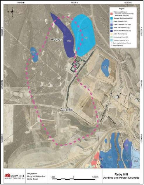
May 2022
Project Number 250039 | Page 7 - 17 | |
|
2021 Ruby Hill Mineral Resource Estimate
Eureka County, NV, USANI43-101Technical Report |
Within the Project area, four main forms of alteration types have been observed; silicic, argillic, decalcified, and carbonate. Other types of alteration identified within the Property include skarn, propylitic, sericite, and dolomitic.
Silicic is characterized by complete (jasperoid) or partial replacement by silica and development of quartz and silica infill of breccias. Silicic altered rocks often appear red to brown in color and are intensely silicified. Jasperoid alteration is commonly observed within the Ninemile Formation, Goodwin Formation, and the Hamburg Dolomite, and within the Mineral Point and Archimedes deposits. Outcrops of jasperoid alteration are common within the Property and are easily distinguished by coloration and resistance to weathering. Dilles et al. (1996) notes that jasperoid consists of quartz with minor late chalcedonic silica filling vugs and veins fractures. Iron oxides consist of limonite and hematite pseudomorphs after pyrite and indicate a proto-ore pyrite content ranging from 5% to 20%. Gold occurs on the margins of oxidized pyrite and along hairline fractures in jasperoid (Dilles et al., 1996).
Argillic altered units are predominantly characterized as replacement of feldspar in volcanic units by clay minerals (e.g., kaolinite and illite). Argillic alteration has been extensively logged within the carbonate units within the Property and most likely correlates with the removal of carbonate minerals during decalcification (Golder, 2012). Argillic altered material often appears white or bleached, and may vary from chalky to greasy in texture.
Decalcified units are characterized by brecciated and sanded textures associated with dissolution of the carbonate-rich matrix of limestones and dolomites. Decalcification has been observed across the property.
Carbonate altered units are characterized by carbonate minerals (calcite, dolomite, magnesite, and siderite) as replacement of other minerals and precipitate as breccia infill. Carbonization occurs throughout the Property but is more concentrated within the carbonate-rich sedimentary units.
Garnet-pyroxene skarn and retrograde alteration assemblages are present within West and East Archimedes at depth, proximal to the Graveyard Flat intrusion. Additionally, propylitic alteration (calcite, chlorite, epidote) is observed within the Bullwhacker Sill and the Graveyard Flat intrusions.
May 2022
Project Number 250039 | Page 7 - 18 | |
|
2021 Ruby Hill Mineral Resource Estimate
Eureka County, NV, USANI43-101Technical Report |
Within the East and West Archimedes deposits the four main alteration types are observed along with skarn and propylitic assemblages proximal to the intrusive units.
Silicic altered units are spatially associated with the Blanchard Fault zone, and subsequent intersecting N- to NE-trending faults (Holly 150, 194, Armpit, 426, and Graveyard Flats). Decalcified units with breccia textures are observed in carbonaceous sedimentary units. Carbonate altered units are concentrated within the Goodwin Formation, along the Kgf contact within East Archimedes and between the Holly and 150 faults in West Archimedes. Argillic altered units are logged extensively along the Blanchard fault zone and at the intersections of the Blanchard fault zone with the N- to NE-trending faults.
Common types of alteration along the Mineral Point Trend include silicic, decalcified (sanded and breccia texture development), and argillic assemblages (Golder Associates, 2012; Loranger, 2013). Silicic altered units occurs primarily within the Hamburg Dolomite, and is more prevalent within the SE portion of the deposit area. Silicic altered units are also observed as a series of stacked units that are interpreted to have preferentially developed along intraformational rock units in the folded Hamburg Dolomite. Sanded and brecciated textures are most common in the Hamburg Dolomite and varies from weak to strong.
Hydrothermal alteration of the Bullwhacker Sill consists of propylitic and argillic alteration assemblages (Langlois, 1971). Propylitic alteration resulted in the development of a chlorite-calcite-kaolinite assemblage. Argillic alteration consists of kaolinite, sericite, and quartz (Langlois, 1971). Golder Associates (2012) report that the most intense argillic alteration occurs in the upper 5 to 10’ of the sill.
Within the Property area, two styles of mineralization occur:
| • | Early polymetallic (Au-Ag-Pb-Zn) skarn or carbonate replacement deposit (CRD): Blackjack and TL). |
May 2022
Project Number 250039 | Page 7 - 19 | |
|
2021 Ruby Hill Mineral Resource Estimate
Eureka County, NV, USANI43-101Technical Report |
| • | Late Au±Ag Carlin-type: East Archimedes, West Archimedes, 426, Ruby Deeps, Mineral Point zones. |
The polymetallic skarn and CRD style is the oldest mineralization event recognized at the Property and related to emplacement of the Cretaceous intrusive units. The precious metal-rich Carlin style overprints the older CRD event and interpreted to have developed during early-middle Cenozoic (Eocene) times, similar to other Au-Ag deposits of the Battle Mountain/Eureka Trend. Mineralization is largely controlled by lithology and structure.
Gold-silver mineralization occurs broadly as a near N-trending zone (Mineral Point Trend), consisting of smaller zones of structurally and lithologically controlled deposits (East and West Archimedes, 426, Ruby Deeps, Mineral Point, Achilles, and Hector; Figure 7-??). Mineralization, both Au-Ag and Au-Au-Pb-Zn is primarily hosted within the Windfall and Goodwin Formations, and within the Hamburg Dolomite. Combined mineralization spans an area approximately 12,000 ft long, 9,000 ft wide, at the maxima, and spans from surface to approximately 2,400 ft below surface.
Mineralization is focused along high- and low-angle faults, lithologic contacts, fold axis, and sanded plus breccia zones.
Gold occurs as free grains within the oxide portions along with iron oxides, and associated with sulfide minerals (pyrite, arsenopyrite, arsenian pyrite, realgar, and orpiment) within the unoxidized portions of the deposits. Within the oxide horizons, petrographic work for samples from the Archimedes deposits “...indicate(s) that the gold was originally associated with pyrite grains, with no evidence of silica encapsulation. Higher grade gold mineralization occurs in zones of jasperoid and decalcified limestone,” (Resource Evaluations Inc., 2005).
A plan and cross section showing the geometry and relationships of the Archimedes Deposit and Mineral Point Trend are shown in Figure 7-7 and Figure 7-8.
May 2022
Project Number 250039 | Page 7 - 20 | |
|
2021 Ruby Hill Mineral Resource Estimate
Eureka County, NV, USANI43-101Technical Report |
Figure 7-7: Plan View of Mineral Point Trend and Archimedes Deposits
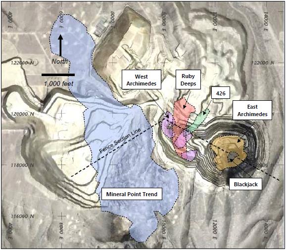
Source: Figure prepared by Wood with satellite imagery from Google Earth. September 2021
May 2022
Project Number 250039 | Page 7 - 21 | |
|
2021 Ruby Hill Mineral Resource Estimate
Eureka County, NV, USANI43-101Technical Report |
Figure 7-8: Fence Section of Mineral Point Trend and Archimedes Deposits
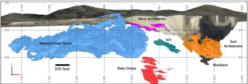
Source: Figure prepared by Wood with satellite imagery from Google Earth. September 2021
May 2022
Project Number 250039 | Page 7 - 22 | |
|
2021 Ruby Hill Mineral Resource Estimate
Eureka County, NV, USANI43-101Technical Report |
At East and West Archimedes, gold-rich mineralization is associated with jasperoid and moderately to strongly decalcified limestone. Gold occurs in the oxidized ores as discrete grains less than 3 microns in diameter (Barrick, 2004; Barrick, 2012). Mineralization is controlled by structure and lithology. Within both deposits, the main mineralized bodies are focused along the NW-trending Blanchard fault zone. Second order control to mineralization within West Archimedes is focused by steeply dipping, N-trending normal faults (Holly, 150, 194, 426, and Armpit faults; Barrick 2004). Within East Archimedes, second order control to mineralization is by the N-trending Graveyard fault and East Archimedes fault.
East Archimedes mineralization is a NW-trending, roughly tubular shaped mineralized body, approximately 1,350 ft in height, 800 ft in thick, and 1,900 ft wide. The upper portion flattens and flares out to the west and connects to West Archimedes. Mineralization extends from surface to approximately 1,400 ft below surface and the main host rocks include Ogll and Og2 of the Goodwin Formation.
The West Archimedes zone is a NW-trending, roughly cigar shaped, 1,700 ft long, 200 ft thick, and varies from 400 ft to 1,200 ft wide. Mineralization extends from surface to approximately 150 ft below surface and the main host rock is Og2 of the Goodwin Formation.
Mineralization at 426 is NE-trending, roughly rod-shaped, 1,300 ft long, 250 ft thick, and 250 ft wide. Mineralization is predominantly oxide at higher elevations and sulfide-bearing at lower elevations. The top of mineralization commences approximately 800 ft below surface with the main host rocks being the Og1 (oxide-rich) and Ogll (sulfide-rich) units of the Goodwin Formation.
Mineralization at Ruby Deeps is NNE-trending, tabular zone comprised of stacked mineralized bodies developed within favorable lithological horizons. The overall zone is 1,800 ft long, 900 ft thick, and 800 ft wide. Mineralization is predominantly oxide at higher elevations and sulfide-bearing at lower elevations. The top of mineralization is approximately 1,200 ft below surface with the main host rock being the Windfall Formation.
Polymetallic mineralization at Blackjack forms a pod that is approximately 500 ft wide, 500 ft long and 1700 ft high. Mineralization is a combination oxide at higher elevations and sulfide-bearing at lower elevations. Sulfide minerals include pyrite, sphalerite, galena, chalcopyrite and arsenopyrite. The top of mineralization is approximately 1,200 ft below surface; however the top of the deposit is partially exposed in the south west wall of the open pit at East Archimedes. The main lithology hosting the Blackjack zone is garnet-pyroxene altered skarn of the Og1 unit of the Goodwin Formation.
May 2022
Project Number 250039 | Page 7 - 23 | |
|
2021 Ruby Hill Mineral Resource Estimate
Eureka County, NV, USANI43-101Technical Report |
Gold-silver mineralization at Mineral Point is dominantly oxide in nature with small but higher-grade refractory material (Loranger, 2013). Mineralization is predominantly hosted within the Hamburg Dolomite and consists of dolomite breccias and coarsely recrystallized dolomite supporting silicified clasts and gossanous oxidized sulfide clasts. Higher grade breccia zones are cut by late, multistage quartz veins.
The main mineralized zone at Mineral Point is roughly elliptical in shape, NNW-trending, and is approximately 10,000 ft in length, 3,100 ft wide, and approximately 225 ft thick. The mineralization extends from approximately 240 to 1,400 ft below surface.
Mineralization is hosted within the Hamburg Dolomite and consists of sanded and brecciated units with coarsely recrystallized dolomite supporting silicified clasts and gossanous oxidized clasts, with better mineralized zones cut by late, multistage quartz veins (Loranger, 2013). Mineralization also occurs along the upper contact which into the overlying silicic altered Dunderberg Shale which hosts oxide and sulfide minerals.
Redox within the Project area includes oxidized, unoxidized, and sulfide bearing material. Dominate oxide mineralogy includes goethite, hematite, jarosite, and scorodite. Prevalent sulfide minerals include pyrite, galena, and sphalerite, which typically occur in the deeper portions of the deposits (Resource Evaluation Inc., 2005). Oxidation is strongly correlated with the upper portions of the Project, fault zones, and lithologic contacts. Sulfide horizons are concentrated at depth, below the oxide horizon.
Property wide cyanide solubility within logged oxide zones shows a minimum value of 0, a maximum of >1, and an average of 0.77 with a minimum 0.005 opt Au fire assay value for 20,665 fire assay-cyanide pairs. Zones not logged as oxide and therefore either barren or with the presence of unoxidized sulfide minerals, have a minimum value of 0, a maximum of >1, and an average of 0.39 with a minimum 0.005 opt Au fire assay value for 5,941 pairs.
May 2022
Project Number 250039 | Page 7 - 24 | |
|
2021 Ruby Hill Mineral Resource Estimate
Eureka County, NV, USANI43-101Technical Report |
Logged oxide occurs primarily within the upper portions of the deposit within the Goodwin Formation and portions of the Windfall Formation and extends approximately 180’ to 950’ below the current mining surface. Oxide minerals include goethite, hematite, jarosite, and scorodite. Oxidation is controlled by faulting and lithology. Oxidation is logged primarily within the Goodwin, Ninemile, Antelope Valley Formations, and alluvium. Logged sulfides are restricted primarily to the Windfall Formation, Dunderberg Shale, and Bullwhacker Sill.
Cyanide solubility for logged oxide material within East and West Archimedes as well as the upper portions of 426 ranges from 0.01 to >1, with an average of 0.80 with a 0.005 opt Au fire assay minimum value for 7,973 pairs. Non-oxidized and sulfide-bearing material combined have a cyanide solubility average of 0.31 with a minimum of 0 and a maximum of >1, with a 0.005 opt Au fire assay minimum value for 4,185 pairs.
Logged oxide occurs primarily within the upper portions of the deposit within the Goodwin Formation, Windfall Formation, Dunderberg Shale, and Hamburg Dolomite. Oxidation occurs within all formation and extends to a depth of 1,450 ft below surface. Oxide minerals include goethite, hematite, jarosite, and scorodite. Sulfide content and low CN soluble mineralization is almost entirely constrained within the Dunderberg Shale and Bullwhacker Sill. Minor amounts of logged sulfide occur within the Hamburg Dolomite in the NW portion of Mineral Point, although data is limited. East of the Holly Fault, logged sulfides occur within the Windfall Formation. The Bullwhacker sill contains primary pyrite except in the upper portions where it intrudes the Windfall Formation. The west-dipping Bullwhacker Fault appears to down drop (west-side down) sulfide-bearing horizons in the Dunderberg Shale.
Cyanide solubility for oxidized material for Mineral Point has an average value of 0.76, with a minimum value of 0.03, and a maximum >1 for a 0.005 opt Au fire assay minimum value and 9,788 pairs. Non-oxidized and sulfide bearing material has a minimum value of 0.03, a maximum of >1, and an average of 0.68 for a 0.005 opt Au fire assay minimum value and 936 pairs.
May 2022
Project Number 250039 | Page 7 - 25 | |
|
2021 Ruby Hill Mineral Resource Estimate
Eureka County, NV, USANI43-101Technical Report |
Mineralization at Ruby Hill is characterized by early polymetallic, intrusive-related carbonate replacement and skarn deposits that have been overprinted by younger Carlin-type precious metal mineralization.
| 8.1 | Characteristics of Polymetallic Replacement Deposits |
The carbonate replacement mineralization is similar to other polymetallic (Pb-Zn-Ag ± Au) deposits found worldwide that are spatially associated with Cretaceous age intrusive units (Cox and Singer, 1987; Megaw et al.,1988; Plumlee et al., 1995; Titley 1993 cited in Hammarstrom, 2002; and Kamona, 2011).
| 8.2 | Characteristics of Carlin-Type Gold Deposits |
Gold and silver mineralization within the Ruby Hill deposits is predominantly attributed to a Carlin-type overprint interpreted to temporally coincide with the onset of extensional tectonics and Eocene-Oligocene magmatism (Barrick, 2004).
The structural setting, alteration mineralogy, and mineralization characteristics of the Ruby Hill gold deposits is consistent with Carlin-type deposits as defined in Radtke (1985) and Hofstra and Cline (2000).
Carlin-type deposits formed in the mid-Tertiary after the onset of extension in an east-west trending, subduction-related magmatic belt. The deposits are located along long-lived, deep crustal structures inherited from Late Proterozoic rifting and the formation of a passive margin within Paleozoic carbonate sequences composed of silty limestone to calcareous siltstone. The carbonate sequences are overlain by either structurally controlled siliciclastic sequences controlled by the Early Mississippian-aged Roberts Mountain allochthon or by stratigraphically controlled siliciclastic sequences. The siliciclastic rocks are less permeable than the underlying carbonate rocks which traps fluids along major structures causing them to flow laterally into the permeable and reactive carbonate sequences.
Alteration of host carbonate sequences consists of decalcification, argillic, and selective silicic forming jasperoid. Gangue minerals in Carlin-type deposits consist of calcite, siderite, and ferroan dolomites that can occur as geochemical fronts beyond the mineralized zones.
May 2022
Project Number 250039 | Page 8 - 1 | |
|
2021 Ruby Hill Mineral Resource Estimate
Eureka County, NV, USANI43-101Technical Report |
Gold deposition occurs in arsenian pyrite, is predominantly hosted within carbonaceous sequences near major high-angle structural zones and is concentrated in structural traps and/or replacement horizons of reactive and permeable sedimentary beds.
The Carlin-type deposits typically show enrichment in antimony, arsenic, mercury, thallium, and barium, caused by hydrothermal fluids with temperatures up to 300°C. The source of hydrothermal fluids is interpreted as either from Eocene magmatic activity or widespread circulation of fluids through Basin-Range extension. Emplacement of Tertiary dikes (radiometric age dates between 42 and 39 Ma) and spatially association with mineralization provides evidence to support the former hypothesis.
Structural pathways, reactive rocks, and sources of heat, gold, sulfur, and iron are required for Carlin-type deposits to form. Large regional structures transecting reactive rocks create contacts, faults, and shears. These secondary structures create pathways and traps for hydrothermal and metalliferous fluids.
| 8.3 | Carbonate Replacement and Carlin Style Mineralization at Ruby Hill |
Elevated concentrations of zinc, lead, copper and silver are found in the Mineral Point Trend and the Blackjack zone and deeper parts of the Ruby Deeps zone of the Archimedes deposit. This mineralization is attributed to the earlier polymetallic carbonate replacement phase of mineralization and is found in favorable carbonate units proximal to the Graveyard Stock and Bullwhacker Sill.
The gold mineralization at Ruby Hill precious metal deposits have features typical of Carlin-type gold deposits and can consider to be members of the broad spectrum of Carlin-type gold deposits found in the Great Basin (Dilles et al., 1996; Loranger, 2013; Rehn and Mach, 2012; Mach, 2012, 2016). These include:
| • | Complex structural and stratigraphic controls on gold mineralization |
| • | Nature of alteration (jasperoid formation, decalcification, sanding, argillic alteration) |
| • | Association of micron scale gold with fine grained pyrite |
| • | General geochemical signature of anomalous As-Sb-Hg |
| • | Tertiary age of gold mineralization coinciding with Basin and Range extension. |
May 2022
Project Number 250039 | Page 8 - 2 | |
|
2021 Ruby Hill Mineral Resource Estimate
Eureka County, NV, USANI43-101Technical Report |
The QP concludes that the local structural setting, host rocks and mineralization style of the Blackjack zone and deeper parts of the Ruby Deeps Zone and Mineral Point Trend are consistent with a carbonate replacement or skarn type Zn-Pb-Cu-Ag-Au style mineralization.
The tectonic and local structural settings, lithological characteristics of the host rock, alteration mineralization style of the Mineral Point, Hector, East Archimedes, West Archimedes 426 and Ruby Deeps zones are consistent with the Carlin-style sediment-hosted precious metal mineralization found in northern Nevada.
The QP is of the opinion that deposit model concepts, and the understanding of the geological features of the Ruby Hill Project that control precious and base metal mineralization are sufficiently advanced to support exploration activities and Mineral Resource estimation.
May 2022
Project Number 250039 | Page 8 - 3 | |
|
2021 Ruby Hill Mineral Resource Estimate
Eureka County, NV, USANI43-101Technical Report |
Exploration for the Ruby Hill Project has consisted of rock-chip sampling, soil sampling, mapping, drilling, and geophysical surveys. More recent exploration conducted by Homestake Mining Company (Homestake), and Barrick Gold Corporation (Barrick) are also presented in Section 6. Historical drill programs are presented in Section 10.
The Project and previous operations at Ruby Hill have used a local grid system referred to as the Ruby Hill Mine Grid that uses the Locan Shaft as its origin and the NGVD29 as its vertical datum.
Surveying in UTM coordinates is done using NAD 27 UTM Zone 11 Northern US Survey grind in Feed.
In 2017, Ruby Hill Mining Company updated the Ruby Hill Mine Grid, applying NAD83_2011 Geodetic Datum (Lat/Long). The Formal Transverse Mercator Projection Parameters defining the Ruby Hill Mine Grid using NAD83_2011 as a Datum is as follows:
| • | Datum = NAD83(2011) Epoch 2010.0000 |
| • | Projection Type = Transverse Mercator |
| • | Origin Latitude = 39° 30' 41.00000" North |
| • | Central Meridian = 115° 57' 37.50967" West |
| • | Scale Reduction = 1.000 331 exactly (Unitless) |
| • | False Northing = 113,283.048 US Survey Feet |
| • | False Easting = 17, 949.394 US Survey Feet |
| • | Developed Surface = 6,990 NAVD 88 |
| • | NAVD88 equation = 0.112 US Survey Feet (based on N-44) |
| • | NGVD29 equation = 4.127 US Survey Feet (based on N-44) |
To reproduce the legacy NGVD29 elevations used at Ruby Hill, simple following Vertical Equations between NAD83 Ellipsoid Heights (Eh), GEOID12a/b (N), NAVD88 (eq88), and NGVD29 (eq29) were generated. The reference elevation is at 6,990’ NAVD88, which is very close to the elevation of the Locan Shaft collar which was the Origin of the original Mine Grid. The equation to convert to Local Mine Grid elevation is:
| • | NAD83 Eh (m) - GEOID12a/b (m) - eq88 (ft) - eq29 (ft) = Mine Grid Elevation (ft). |
May 2022
Project Number 250039 | Page 9 - 1 | |
|
2021 Ruby Hill Mineral Resource Estimate
Eureka County, NV, USANI43-101Technical Report |
Surficial geology maps have been produced at regional and local scale by previous owners and are summarized in Sections 6 and 7. Detailed pit mapping has also been undertaken in the open pits mining the West Archimedes and East Archimedes deposits.
Geochemical sampling completed by previous owners are summarized in Section 6. No geochemical sampling has been conducted by RHMC.
Geophysical surveys completed by previous owners are summarized in Section 6. No geophysical surveys have been conducted by RHMC.
No pits or trenches were excavated by RHMC.
Metallurgical studies are presented in Section 13.
RMHC’s focus from 2015 to 2019 has been on geological modeling to support resource estimation at Ruby Hill. The land package retains strong exploration potential, with a number of prospects identified outside of the present resource area by soil and rock sampling, analysis of geophysical data, geologic mapping, and exploration drilling. Areas of significant exploration interest include:
| • | the area north of the Ruby Deeps zone named Blue Sky, where sparse historic drilling defined a large arsenic anomaly at the alluvium-bedrock contact. |
| • | at depth beneath the Archimedes pit along the contact of the Graveyard Flats stock where skarn mineralization has been delineated. |
May 2022
Project Number 250039 | Page 9 - 2 | |
|
2021 Ruby Hill Mineral Resource Estimate
Eureka County, NV, USANI43-101Technical Report |
The Jackson target area is located immediately south of the Archimedes pit. The Jackson target is defined by an anomalous (>180 ppm) As in soil anomaly. Favorable stratigraphic units dip moderately to the east and include the Lower Unit (Og1) and Lower Laminated Unit (Ogll) of the Goodwin Formation, and the Bullwhacker Member (Cwb) of the Windfall Formation. Figure 9-1 shows the location of the Jackson and Blue Sky target areas in relation to the other mineralized zones.
The exploration tools used by RHMC and its predecessors are appropriate for exploration of sediment-hosted gold deposits. Vectoring using recognition of favorable statigraphic horizons and contacts, and geochemical surveys have proven to be a suitable exploration method for precious-metal and base-metal mineralization in the Project area.
May 2022
Project Number 250039 | Page 9 - 3 | |
|
2021 Ruby Hill Mineral Resource Estimate
Eureka County, NV, USANI43-101Technical Report |
Figure 9-1: Exploration Targets at Ruby Hill (September, 2021)
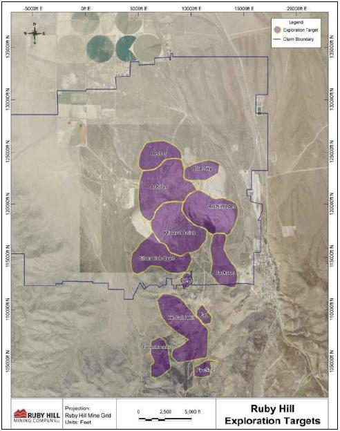
May 2022
Project Number 250039 | Page 9 - 4 | |
|
2021 Ruby Hill Mineral Resource Estimate
Eureka County, NV, USANI43-101Technical Report |
The RHMC drillhole database consists of data from over 3,600 drillholes and 2.3 million feet of drilling from throughout the southern portion of Eureka County. The database includes holes that have been drilled to test 24 different targets and includes reverse circulation, diamond core, reverse circulation pre-collar with diamond core tail and percussion and churn drill hole types. A total of 2,491 drillholes have been drilled on the current Ruby Hill property and 2,100 drillholes totaling of 1.5 million feet of drilling define the Mineral Point Trend and Archimedes deposits. A plan view of the drilling in relationship to the Property boundary, and the drill collars attributed to the Mineral Point Trend (Hector, Achilles, Mineral Point and Silverlick Cyan) and Archimedes Deposits are color coded in Figure 10-1.
The dataset used to produce the Mineral Resource Estimate for the Ruby Hill Project consists of drillhole data compiled from eight companies and work carried out from 1950 to 2015; however, 95% of the drilling was completed from 1992 to 2015 by Homestake, and subsequently by Barrick following completion of its acquisition of Homestake in 2004 (Table 10-1).
Just over 75% of drilling carried out at Ruby hill has been reverse circulation drilling. Diamond drilling has been used to provide drill core for detailed geological and geotechnical logging, metallurgical sample, to extend reverse circulation holes below the water table to ensure representative sampling for assaying and as twin holes to confirm reverse circulation hole sampling. Mud rotary and other drill types have mainly been used to drill pre-collar holes for diamond drilling.
The following discussion of drilling, sampling, sample preparation and data verification is sub-divided into five main drill campaigns by owner and type where standards and procedures for data acquisition and confidence in data quality are relatively consistent. The five campaigns are RC and diamond core drilling by Homestake, RC and diamond core drilling by Barrick and the relatively minor amount of drilling carried out by other operators. Table 10-2 lists the distribution of drill footage by campaign and Figure 10-1 and Figure 10-3 and Figure 10-4 show the location of the drilling by campaign in plan and fence section views.
May 2022
Project Number 250039 | Page 10 - 1 | |
|
2021 Ruby Hill Mineral Resource Estimate
Eureka County, NV, USANI43-101Technical Report |
Figure 10-1: Drill Collar Locations for Ruby Hill Project Drillholes
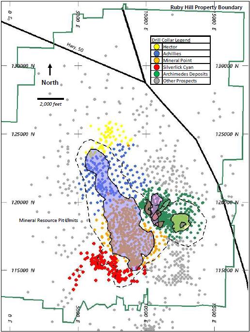
Note: Figure prepared by Wood. September, 2021.
May 2022
Project Number 250039 | Page 10 - 2 | |
|
2021 Ruby Hill Mineral Resource Estimate
Eureka County, NV, USANI43-101Technical Report |
Table 10-1: Drilling Statistics for Drillholes Included in the 2021 Ruby Hill Project Mineral Resource Estimate
| Company | Drill Holes | Footage | Proportion of Footage (%) | Start Date | End Date |
| Eureka Corp. | 250 | 55,558 | 3.5 | 1950 | 1956 |
| Hecla | 6 | 5,945 | 0.4 | January 1960 | August 1967 |
| Newmont | 1 | 4,666 | 0.3 | 1970 | 1970 |
| AMOCO-Cyprus | 27 | 3,962 | 0.3 | 1978 | 1978 |
| Sharon Steel Corp. | 45 | 8,510 | 0.5 | August 1982 | November 1988 |
| ASARCO | 2 | 635 | 0.0 | July 1989 | July 1989 |
| Homestake | 1,172 | 771,445 | 48.7 | March 1992 | September 2004 |
| Barrick | 597 | 733,667 | 46.3 | October 2003 | November 2015 |
| Total | 2,100 | 1,584,387 | 100.0 | 1950 | 2015 |
Figure 10-2: Distribution of Drill Types Included in the 2021 Ruby Hill Project
Mineral Resource Estimate
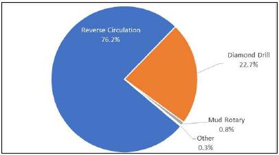
Note: Figure prepared by Wood.
Table 10-2: Distribution of Drilling by Campaign
| Owner | Type | Campaign | Footage | Proportion (%) |
| Homestake | RC | 1 | 638,077 | 40.3 |
| | DDH | 2 | 133,368 | 8.4 |
| Barrick | RC | 3 | 556,650 | 35.1 |
| | DDH | 4 | 177,017 | 11.2 |
| Other | | 5 | 79,275 | 5.0 |
| Total | | | 1,584,387 | 100.0 |
May 2022
Project Number 250039 | Page 10 - 3 | |
|
2021 Ruby Hill Mineral Resource Estimate
Eureka County, NV, USANI43-101Technical Report |
Figure 10-3: Plan View of Drilling by Campaign
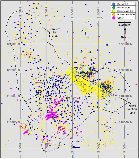
Note: Figure prepared by Wood.
May 2022
Project Number 250039 | Page 10 - 4 | |
|
2021 Ruby Hill Mineral Resource Estimate
Eureka County, NV, USANI43-101Technical Report |
Figure 10-4: Fence Section of Drilling by Campaign (Looking North)
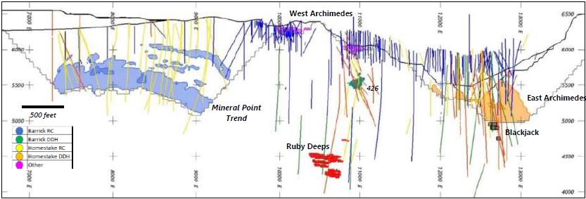
Note: Figure prepared by Wood.
May 2022
Project Number 250039 | Page 10 - 5 | |
|
2021 Ruby Hill Mineral Resource Estimate
Eureka County, NV, USANI43-101Technical Report |
Drilling at Mineral Point was 83% by RC with 53% of drill footage drilled by Barrick and 28% drilled by Homestake. Approximately 8% of drilling was diamond core drilling by Barrick and Homestake. Eureka Corporation drilled approximately 46,000 feet of underground and surface drill core accounting for about 6% of total drill footage.
Drilling at Archimedes was 70% RC with 52% of drill footage drilled by Homestake and 18% drilled by Barrick. Approximately 30% of drilling at Archimedes was diamond core drilling and contributions by other operators is negligible.
| 10.2.1 | Reverse Circulation Drilling |
Barrick drilled 336 RC holes at Mineral Point Trend and 119 RC holes at Archimedes. RC holes were both vertical and inclined. Drilling was conducted by Eklund Drilling Company (Elko, NV), and Boart Longyear (Salt Lake City, UT). Where documented drilling was conducted with a TH-75 drill rig. Hole diameters ranged from 5.0 to 6.75 in. Drill logs indicate that for deeper RC holes intersecting the water table, if the RC hole could not be kept dry during drilling it was extended using diamond drilling.
Homestake drilled 381 RC holes at Mineral Point and 671 holes at Archimedes. The majority of RC holes drilled by Homestake were vertical. Drilling was conducted by Eklund Drilling Company (Elko, NV). Where documented holes were drilled with an MPD-1500 drill rig. Hole diameters ranged from 4.75 to 6.0 inches.
Asarco drilled two short RC holes at Archimedes in 1989. Drilling was conducted by Eklund Drilling Company (Elko, NV), and Hackworth Drilling, Inc. (Elko, NV).
Sharon Steel drilled 45 vertical exploration and definition RC holes totaling 8,510 feet. Drilling was conducted by a number of companies including O’Keefe Drilling (Butte, MT), Boyles Brothers, Polar Drilling, Lang Exploratory Drilling (Elko, NV), and Tonto Drilling Services, Inc. (Salt Lake City, UT). Where documented drill rigs used were a Jaswell 2400, Long Year 44 core rig adapted for RC drilling, Drill Systems CSR 1000, Chicago Pneumatic 650 WS, and T4W. Where noted, hole diameters were 5.25 inches.
Eureka Corporation completed 2,788’ of RC drilling in two holes at Mineral Point. Drilling was conducted by Sierra Drilling Company (Bakersfield, CA). Drilling equipment, drill procedures, and sampling procedures from the Eureka RC drilling are not documented.
May 2022
Project Number 250039 | Page 10 - 6 | |
|
2021 Ruby Hill Mineral Resource Estimate
Eureka County, NV, USANI43-101Technical Report |
Barrick drilled 131,375 feet of diamond drill core holes at Mineral Point and Archimedes. 38,800 feet of the total were diamond drill tails from RC precollars, including the total footage downhole from the collar. Drilling was conducted by a number of companies including Boart Longyear (Salt Lake City, UT), Dynatec Drilling, Inc. (Salt Lake City, UT), Major Drilling (Elko, NV), EMM Core Drilling Services (Winnemucca, NV), National Drilling (Elko, NV), and Connors Drilling, LLC (Montrose, CO). Where documented, core sizes drilled include PQ (3.345 in), HQ3 (2.406 in), HQ (2.5 in), and NQ (1.875 in). Where noted, an LF90 D drill rig was used. Most core holes are inclined.
Homestake drilled 133,368 feet of core holes at Mineral Point and Archimedes. Drilling was conducted by a number of companies including Tonto Drilling Services, Inc. (Salt Lake City, UT), Boart Longyear (Salt Lake City, UT), Connors Drilling LLC (Montrose, CO), Inland Pacific Drilling (Newman Lake, WA), and Westec/Haztec Drilling, Inc. (Meridian, ID). Where documented, drill rigs used were an LS-244 truck mounted rig and an LY44 drill rig. Hole size was HQ (2.5 in), reduced to NQ (1.875 in) when poor ground conditions dictated. Holes were both vertical and inclined, drilled on azimuths of 025° to 357° and inclinations of -45° to -87°.
Hecla drilled two vertical surface core holes totaling 3,511.5 feet. Drilling was conducted by Nichols Universal Drilling Co., Sprague & Henwood Inc., Continental Drilling Company, and Boart Longyear (Salt Lake City, UT). Where documented, the drill rig used was a Longyear 34 diamond drill. Where noted, holes were collared with NX (2.125 in) size core and reduced to BX (1.625 in) or HQ (2.5 in) size core reduced to NQ (1.875 in), dependent on depth and/or ground conditions.
Eureka Corporation drilled 239 exploration and definition core holes totaling 46,123.8 ft with 232 holes drilled underground and 24 collared at surface. Forty-seven were vertical and the remaining 214 were oriented with azimuths that ranged from 006° to 359° and inclinations of -70° to -85°. Drilling was conducted by Boyles Brothers. Holes were typically collared with NX (2.125 in) size core, and reduced to BX (1.625 in), AX (1.125 in) or EX (0.845 in) core size as depth and ground conditions necessitated. Drilling equipment and drill procedures are undocumented.
May 2022
Project Number 250039 | Page 10 - 7 | |
|
2021 Ruby Hill Mineral Resource Estimate
Eureka County, NV, USANI43-101Technical Report |
| 10.2.3 | Other Drilling Methods |
Amoco-Cyprus drilled 25 exploration mud rotary holes totaling 3,830 ft, and 2 exploration air track holes totaling 1,143 ft. All holes were vertical. Drilling equipment, drill procedures, and sampling procedures are undocumented.
Newmont drilled three vertical mud rotary exploration holes totaling 11,697 ft. Collared hole size ranged from 11 to 15 in with reduction to 9.625 and 6.75 in as depth and ground conditions necessitated. Drilling equipment and drill procedures are undocumented.
Hecla drilled five mud rotary holes totaling 2,496 ft, and 3 churn holes totaling 1,143 ft. Mud rotary and churn holes were vertical. Where documented, drilling was conducted by Continental Drilling Company, and Boyles Brothers. Drilling equipment, drill procedures, and sampling procedures are undocumented. Hole size for mud rotary drilling was 5.625 in, whilst hole sizes for churn holes are undocumented.
Eureka Corporation drilled seven mud rotary holes totaling 7,011 ft, and nine churn holes totaling 4,802 ft. All holes were vertical. Drilling equipment, drill procedures, and sampling procedures are undocumented. Mud rotary holes ranged from 8.5 to 9.0 in in diameter, and churn hole sizes ranged from 10 to 15 inches.
Barrick geologists captured RC and core logging data on graphic strip logs on paper. The parameters captured included:
| • | stratigraphic unit, rock type |
| • | chert intensity and color |
| • | oxidation characteristics, iron oxide occurrence and intensity |
| • | modal percentage of pyrite and total sulfides |
| • | intensity of silicification, decalcification dolomitization, and skarn alteration |
| • | percentage of vein calcite and quartz |
| • | estimated percentage of downhole contamination (for RC) |
| • | intensity of realgar, orpiment, scorodite, carbon, carbonate mineralization |
| • | structure types and orientation |
May 2022
Project Number 250039 | Page 10 - 8 | |
|
2021 Ruby Hill Mineral Resource Estimate
Eureka County, NV, USANI43-101Technical Report |
Graphic logs have been retained in a folder for each hole including original assay sheets, downhole survey reports, daily drill company sheets and notes on performance of quality control samples, database issues and other drilling issues in the Waterton office in Reno Nevada.
Homestake logging was also captured on graphic strip logs, on paper and captured many of the same parameters as the Barrick log sheets.
The Homestake log sheets are also retained in drillhole folders and binders in the Waterton office in Reno Nevada.
| 10.3.3 | Logging by Other Operators |
Logging by all other operators was also captured on paper and the parameters logged include rock type, structure, alteration, mineralization and oxidation intensity and handwritten notes about drilling including water flow.
Core recovery for the Barrick drilling programs was 92%, and only suffered in broken zones. Core recovery for the Eureka Corporation, Hecla, and Homestake core drill programs are unknown.
Churn, rotary, percussion, air track and RC sample recovery for all drill programs is not documented.
Collar survey data exists for holes drilled from 1992 to 2015 when Homestake and Barrick were conducting mining operations at Ruby Hill. Collar locations were captured by mine survey personnel using a Trimble 4400 differential GPS survey system with centimeter accuracy.
The method of survey is unknown for drilling conducted prior to 1992.
May 2022
Project Number 250039 | Page 10 - 9 | |
|
2021 Ruby Hill Mineral Resource Estimate
Eureka County, NV, USANI43-101Technical Report |
Barrick engaged International Drilling Services (IDS) of Elko, Nevada, to conducted downhole surveys with measurements collected every 50 ft using a Humphrey Gyroscopic System instrument. Dependent on the survey year, declinations used to convert magnetic north to grid north migrated from 13° to 16.25° E.
Homestake employed both Silver State Survey, Inc. (NV) and Wellbore Navigation, Inc (CA) to conduct downhole surveys. Surveys were conducted on 50 ft intervals. Surveys conducted by Silver State Surveys, Inc used a Sperry Sun downhole camera survey instrument, and Wellbore Navigation, Inc. used an Inrun Survey Minimum Curvature gyro reference system bearing True North. Declinations are undocumented.
Survey procedures for earlier operators were variable and, in some cases, poorly documented:
| • | Eureka Corporation holes were surveyed by Houston Oil Field Material Company (HOMCO) of California at 100 to 200 ft intervals. Survey type, equipment and declination are undocumented. |
| • | Newmont engaged HOMCO and Eastman Directional Drilling Oil Well Services (Denver, CO) to conduct downhole surveys at 100 ft intervals. Survey type and equipment are undocumented. Where documented, a declination of 17.5° E was used. |
| • | Hecla captured directional surveys at 100 and 200 ft intervals downhole but the surveyor, survey type, survey equipment and declination are undocumented. |
| • | It is unknown if Amoco-Cyprus, Sharon Steel or ASARCO conducted downhole surveys. |
| 10.7 | Metallurgical Drilling |
In 2004 Barrick completed a cyanide soluble assay metallurgical program on mineralized drill intervals from East Archimedes to assist in gold recovery modeling. Material from 12 RC and two core holes was used (Table 10-3). Mineralogical study of 17 select samples was also conducted by Barrick Metallurgical Services Mineralogy Lab.
May 2022
Project Number 250039 | Page 10 - 10 | |
|
2021 Ruby Hill Mineral Resource Estimate
Eureka County, NV, USANI43-101Technical Report |
Table 10-3: 2004 Barrick Metallurgical Holes
| Hole ID | Easting
(ft) | Northing
(ft) | Elevation
(ft) | Azimuth
(degree) | Inclination
(degree) | Length
(ft) | Hole
Type | |
| |
| HRH237 | 12260.0 | 117964.0 | 6509.0 | 45 | -60 | 1,000.0 | RC | |
| HRH256 | 12336.0 | 118502.0 | 6490.0 | 94.5 | -48 | 1,045.0 | RC | |
| HRH262 | 12350.0 | 118500.0 | 6500.0 | 123.9 | -54 | 905.0 | RC | |
| HRH335 | 11944.9 | 118171.8 | 6512.7 | 0 | -90 | 945.0 | RC | |
| HRH385 | 12016.2 | 118522.7 | 6503.9 | 0 | -90 | 1,000.0 | RC | |
| HRC271 | 12226.2 | 118310.1 | 6504.8 | 88.3 | -60 | 1,983.0 | Core | |
| HC1408 | 12468.8 | 118515.6 | 6479.7 | 0 | -90 | 924.5 | Core | |
| HRH1387 | 12086.7 | 118879.8 | 6497.0 | 0 | -90 | 1,305.0 | RC | |
| HRH1389 | 12787.6 | 118455.5 | 6472.5 | 0 | -90 | 1,400.0 | RC | |
| HRH1400 | 12436.4 | 118381.6 | 6483.6 | 0 | -90 | 1,285.0 | RC | |
| HRH1402 | 12724.0 | 118074.0 | 6468.0 | 0 | -90 | 940.0 | RC | |
| HRH1407 | 12640.2 | 118673.7 | 6459.4 | 0 | -90 | 1,355.0 | RC | |
| HRH1413 | 12661.1 | 118144.7 | 6479.9 | 0 | -90 | 1,100.0 | RC | |
| HRH1415 | 12861.8 | 118527.1 | 6464.6 | 0 | -90 | 1,200.0 | RC | |
| HRH1416 | 12855.6 | 118670.2 | 6460.8 | 0 | -90 | 1,485.0 | RC | |
In 2009 Barrick engaged Kappes, Cassidy & Associates (KCA) of Reno, Nevada to complete metallurgical testwork on Archimedes drill holes. Material from 2 RC (hole size undocumented) and 10 core holes were used (Table 10-4).
In 2010 and 2011 Barrick engaged KCA to complete metallurgical testwork on Mineral Point core (Table 10-5) and RC cuttings Identified as “Watertank RC material” (hole number(s) undocumented).
In 2011, 16 refractory and two oxide samples from the 426 zone were tested at Barrick Technology Centre. Samples from nine core holes (Table 10-6) were received for the test program.
May 2022
Project Number 250039 | Page 10 - 11 | |
|
2021 Ruby Hill Mineral Resource Estimate
Eureka County, NV, USANI43-101Technical Report |
Table 10-4: 2009 Metallurgical Holes
| Hole ID | Easting
(ft) | Northing
(ft) | Elevation
(ft) | Azimuth
(degree) | Inclination
(degree) | Length
(ft) | Hole
Type | |
| |
| HRH1766 | 11,552.0 | 119,810.9 | 6,440.8 | 225 | -50 | 1,305.0 | Core | |
| BRH-36C | 10,639.0 | 119,759.4 | 6,453.9 | 106 | -48 | 1,500.0 | Core | |
| BRH-37C | 10,626.2 | 119,757.3 | 6,453.9 | 140 | -59 | 1,481.0 | Core | |
| BRH-38C | 10,864.4 | 119,628.9 | 6,445.4 | 133 | -69 | 1,463.0 | Core | |
| BRH-41C | 10,855.2 | 119,644.0 | 6,444.6 | 175 | -62 | 1,269.0 | Core | |
| BRH-67C | 10,979.2 | 119,697.6 | 6,448.1 | 102 | -70 | 1,141.0 | Core | |
| HRH1767 | 11,551.4 | 119,806.2 | 6,440.8 | 213 | -69 | 960.0 | RC | |
| BRH-08C | 12,563.2 | 118,542.1 | 6,466.3 | 35 | -90 | 2,062.0 | Core | |
| BRH-06C | 12,804.3 | 118,663.3 | 6,464.5 | 181 | -76 | 2,168.0 | Core | |
| BRH-12C | 12,936.0 | 118,662.1 | 6,453.8 | 180 | -80 | 2,044.0 | Core | |
| BRH-18C | 12,797.4 | 118,667.9 | 6,464.5 | 173 | -80 | 2,168.0 | Core | |
| BRH-17C | 12,556.3 | 118,712.1 | 6,473.8 | 175 | -76 | 1,750.0 | RC | |
Table 10-5: 2010 and 2011 Metallurgical Holes
| Hole ID | Easting
(ft) | Northing
(ft) | Elevation
(ft) | Azimuth
(degree) | Inclination
(degree) | Length
(ft) | Hole
Type | |
| |
| BRH-165C | 9,200.2 | 119,018.4 | 6,464.4 | 131.7 | -88.6 | 1,403.0 | Core | |
| BRH-166C | 8,617.7 | 119,549.8 | 6,447.3 | 173.4 | -88.9 | 682.0 | Core | |
| BRH-184C | 7,297.3 | 118,088.1 | 6,496.9 | 45.9 | -69.7 | 1,180.0 | Core | |
| BRH-231C | 8,536.3 | 118,702.8 | 6,405.0 | 42.2 | -89.7 | 1,102.0 | Core | |
| BRH-235C | 8,709.0 | 118,879.3 | 6,427.5 | 36.3 | -89.5 | 1,093.0 | Core | |
Table 10-6: 2011 Metallurgical Holes
| Hole ID | Easting
(ft) | Northing
(ft) | Elevation
(ft) | Azimuth
(degree) | Inclination
(degree) | Length
(ft) | Hole
Type | |
| |
| BRH-95C | 11,361.8 | 119,737.3 | 6,453.0 | 130.4 | -70.3 | 1,672.0 | Core | |
| BRH-99C | 11,138.3 | 119,826.4 | 6,478.7 | 97.3 | -83.5 | 1,660.0 | Core | |
| BRH-103C | 10,945.9 | 119,742.0 | 6,447.2 | 134.7 | -79.9 | 1,500.0 | Core | |
| BRH-210C | 11,319.4 | 120,089.8 | 6,505.0 | 113.0 | -74.7 | 1,380.5 | Core | |
| BRH-211C | 11,322.5 | 120,059.2 | 6,505.5 | 158.2 | -79.0 | 1,338.0 | Core | |
| BRH-212C | 11,163.9 | 119,805.8 | 6,478.1 | 126.2 | -78.7 | 1,277.0 | Core | |
| BRH-213C | 11,128.5 | 119,810.3 | 6,477.7 | 152.0 | -70.7 | 1,202.0 | Core | |
| BRH-214C | 10,822.3 | 119,793.5 | 6,446.8 | 138.3 | -63.4 | 1,266.0 | Core | |
| BRH-215C | 10,737.3 | 119,806.8 | 6,446.5 | 145.2 | -57.9 | 1,156.5 | Core | |
May 2022
Project Number 250039 | Page 10 - 12 | |
|
2021 Ruby Hill Mineral Resource Estimate
Eureka County, NV, USANI43-101Technical Report |
| 10.8 | Sample Length/True Thickness |
Approximately 66% of the drilling at Ruby Hill was vertical, producing essentially true-width intercepts through the relatively flat-lying mineralized zones. The remaining holes (34%) have steep inclinations and intersect mineralized units at high angles. Figure 10-4 provides a image of drill hole intersections with the mineralized bodies.
| 10.9 | Potential Downhole Contamination |
Oakley (1997) of the Elko Mining Group, a subsidiary of Waterton Global Resource Management, conducted a study of potential downhole contamination of reverse circulation holes drilled by Barrick. The study included compilation of intervals from 18 drill holes identified as having potential downhole contamination from drill core logging by Barrick, analysis of decay and cyclicity, and comparison of twin RC-diamond core holes including preparation of histograms and Q-Q plots comparing the grade distributions of twin holes, and downhole grade profile plots. The study concluded that the holes identified as being potentially contaminated by Barrick project geologists were likely contaminated and identified additional drillholes and intervals with potential sampling and assaying issues. The study culminated in a list of 30 holes for exclusion, nine holes having depths below which assays were suspected of being contaminated, and were flagged for exclusion, six holes with intervals flagged for exclusion, and six holes with anomalous silver grades that were flagged for exclusion.
A comprehensive review of Barrick, Homestake and other company drilling by Wood, and identification of additional intervals for exclusion is presented in Section 12.
| 10.10 | Summary and Interpretation of All Relevant Drilling Results |
Figure 10-3 and Figure 10-4 provides an example of the Ruby Hill drilling and the outlines of the mineralization in the Mineral Point and Archimedes deposits and illustrates the variability of density of drilling, the widths of mineralized intersections and drillhole intersection angles to mineralization. A discussion of the distribution and types of material intersected in metallurgical drilling, metallurgical testwork composites, and an interpretation of the results of the metallurgical testwork are presented in Section 13. Examples of the interpretation of the drilling in the construction of geological models and use of the interpretations in mineral resource estimation are presented and discussed in more detail in Section 14.
May 2022
Project Number 250039 | Page 10 - 13 | |
|
2021 Ruby Hill Mineral Resource Estimate
Eureka County, NV, USANI43-101Technical Report |
| 10.11 | Comments on Section 10 |
Diamond drilling and RC drilling by Homestake and Barrick account for over 95% of the drilling supporting the 2021 Mineral Resource estimate for the Ruby Hill Project. The drilling, drillhole surveying and logging for these campaigns have been reviewed in detail by the QP:
| • | Reverse circulation drilling is a good method for delineation of oxide and sulfide gold mineralization and Barrick and Homestake took appropriate precautions to ensure representative samples were produced from the RC drilling. |
| • | Diamond drilling has been used to generate drill core for detailed geological and geotechnical logging, metallurgical sampling and to verify reverse circulation drill intersections. |
| • | Collar surveying using differential GPS is good practice |
| • | Downhole surveying using gyro instruments is good practice for longer drillholes |
| • | Drill core and RC chip logging captures major geological information including lithology, alteration, mineralization and allows for documentation of drilling issues. |
The drilling carried out by other owners is limited and documentation of the drilling, surveying and geological information for this drilling is limited; however, the QP inspected the locations, downhole traces of this drilling and is of the opinion that it is appropriate for use in the 2021 Ruby Hill Mineral Resource Estimate. A further discussion of data verification is presented in Section 12.
The QP is of the opinion that the Mineral Resource is well defined by this drilling and that logging and mapping of exposures on surface and in the East and West Archimedes pits have provided a thorough understanding of the deposit geology.
May 2022
Project Number 250039 | Page 10 - 14 | |
|
2021 Ruby Hill Mineral Resource Estimate
Eureka County, NV, USANI43-101Technical Report |
| 11 | Sample Preparation, Analysis and Security |
The following section describes procedures employed by previous operators at Ruby Hill for the security, laboratory preparation, and analysis of reverse circulation (RC) and core samples during the drilling programs completed from 1992 to 2015. The descriptions are largely summarized from previous technical and feasibility reports (Barrick, 2004; REI, 2005; Newman and Mahoney, 2008; Barrick, 2012; RPA, 2012; and Barrick, 2013).
Homestake and Barrick employed similar sampling procedures for RC drilling. For most RC holes, only bedrock was sampled with the exception select alluvium intervals of alluvium saved for waste rock characterization (Barrick, 2004 & 2013). RC cuttings were sampled on 5’ intervals except in 1992 when 10 ft intervals were used on select holes. Coarse and fine fractions of RC cuttings were collected in cloth or plastic sample bags.
Homestake and Barrick also employed similar procedures for sampling drill core. Core was sampled in consistent 5 ft intervals except where shorter intervals were dictated by geologic conditions. Core was cut in half along the along axis using a diamond saw, and a half-split was bagged and submitted to the laboratory for analysis.
Sampling methods are not well documented for the drill campaigns carried out before the Barrick and Homestake campaigns from 1992-2015. The following information has been compiled from the drill logs and interrogation of the drillhole database:
| • | Eureka Corporation for rotary, RC and core hole samples were collected on 5 ft or shorter intervals based on geologic conditions. Newmont samples were generally collected on 5 ft intervals, although intervals ranged from 1 to 10 ft based on geologic conditions. |
| • | Hecla rotary holes were sampled on 10 ft intervals, percussion holes on 20 to 30 ft intervals, surface RC holes on 10 f’ intervals, and underground RC holes on 4 f’ intervals. Surface core holes were sampled on 5 ft intervals, and underground core holes on 4 ft intervals although intervals for both hole types ranged from 0.5 to 10 ft based on geologic conditions. |
| • | Amoco-Cyprus sampling for mud rotary holes was conducted on 10 ft intervals. Air track holes were sampled on 6 ft intervals, although intervals ranged from 2 to 10 ft based on geologic conditions. |
May 2022
Project Number 250039 | Page 11 - 1 | |
|
2021 Ruby Hill Mineral Resource Estimate
Eureka County, NV, USANI43-101Technical Report |
| • | Sharon Steel sampling was conducted primarily on 5 ft intervals although 10 ft intervals were used based on geologic conditions. |
| • | Asarco sampling was conducted on 10 ft intervals. |
| 11.2 | Analytical and Test Laboratories |
The Ruby Hill Mineral Resource estimate database is comprised of gold, silver, base metal and major and trace element geochemistry and density data acquired at independent laboratories. The majority of assaying of samples collected from drilling by Homestake was carried out at Berringer Laboratories in Reno Nevada, and assaying from the Barrick campaigns was carried out at the ALS Global laboratory in Reno Nevada. Details of other work are presented in Table 11-1.
| 11.3 | Density Determinations |
Density determinations were carried out during programs operated by Barrick with analyses at G&T Metallurgical Services in Kamloops, BC, Canada, McClelland laboratory in Reno Nevada and at the Bald Mountain mine site in Nevada.
Material densities used for the estimation of mineral resources in the East Archimedes deposit in 2004 were determined by traditional volume displacement procedures using drill core (holes unknown) sealed by acrylics (Barrick, 2004). Average bulk density values obtained by the tests are shown in Table 11-2.
Between 2007 and 2008, G&T Metallurgical Services performed 41 bulk density measurements from four core holes from the East Archimedes deposit. Bulk density measurements were determined using the water immersion volume displacement method.
In 2008, Barrick submitted 49 samples from two core holes to MLI for bulk density determinations. Only 47 samples were analyzed with 2 samples rejected due to being broken. Bulk density measurements were made using a standard volume displacement method on oven dried, coated (spray lacquer finish) pieces of drill core.
May 2022
Project Number 250039 | Page 11 - 2 | |
|
2021 Ruby Hill Mineral Resource Estimate
Eureka County, NV, USANI43-101Technical Report |
Table 11-1: Assay, Density and Metallurgical Laboratories
| Company | Year | Lab Name and Location | Accreditation | Testwork Performed |
| Eureka Corporation | 1950's - 1960's | Union Assay Office, Inc, Salt Lake City, UT | Unknown | Au, Ag, Pb assays |
| Amoco | 1980-1981 | Unknown | Unknown | Precious and base metal assays |
| Sharon Steel | 1980's, 1991 | Sharon Steel Corporation Mining Division | Unknown | Precious and base metal assays |
| Hecla | 1960, 1969 | • Union Assay Office, Inc, Salt Lake City, UT • Skyline Labs, Wheatridge, CO | Unknown | • Union Assay: Au, Ag, Pb, Zn (no analysis information) • Skyline labs: multi-element |
| Homestake | 1992-1993 | • Barringer Laboratories, Reno, Nevada • Legend Assay Laboratory, Reno, NV • Bondar Clegg, Sparks, NV (acquired by ALS Chemex, 2001) | Unknown | • Barringer: Au-FA/AA, Path 7 (Ag, As, Cu, Hg, Pb, Sb, Zn) • Legend: Au-FA/AA, 1AT • Bondar Clegg: Au-FA/AA, Ag, As, Cu, Hg, Pb, Sb, and Zn |
| 1994-2001 | • ALS Global (previously ALS Chemex Labs), Reno, NV • Bondar Clegg, Vancouver, BC (acquired by ALS Chemex, 2001) | • ALS Global - ISO Guide 25 moving to adopt ISO 9002 • Bondar Clegg moving to adopt ISO Guide 25 | • ALS Global: Au-FA/AA, Ag, As, Cu, Hg, Pb, Sb, Zn, and CN-Au • Bondar Clegg: Au-FA/AA, 35 multi-element suite, Hg |
| Barrick | 2003-2015 | • ALS Global, Reno, Nevada • BSI Inspectorate, Reno, NV • Kappes, Cassiday & Associates (KCA), Reno, NV • McClelland (MLI), Reno, NV • G&T Metallurgical Services, Kamloops, BC • Bald Mountain Mine Site, NV | • ALS Global - ISO 9001:2000; ISO 17025:2000 • BSI Inspectorate - ISO 9001:2000 certified • KCA was working towards ISO 9002 at the time | • ALS Global: gold assays, multi-element geochemistry, density determinations • BSI Inspectorate: Au check assays • KCA: metallurgical testwork, Au assays • MLI, G&T and Bald Mountain: density determinations |
| RHMC | 2017 | ALS Global | ALS Global - ISO 9001:2000; ISO 17025:2000 | Density determinations |
May 2022
Project Number 250039 | Page 11 - 3 | |
|
2021 Ruby Hill Mineral Resource Estimate
Eureka County, NV, USANI43-101Technical Report |
Table 11-2: Barrick Rock Type Density Values
| Unit | Density
(cu. ft/st) |
| Alluvium | 14.5 |
| Limestone (Goodwin Formation) | 13.5 |
| Intrusive (Graveyard Flats) | 13.5 |
| Volcanic tuff/Rhyolite Flow | 13.5 |
| Fill material | 18.2 |
In 2007 and 2008 ALS Global conducted bulk density determinations on 38 samples from 10 core holes located in East Archimedes. Bulk density determinations were conducted using the OA-GRA09A method utilizing the following equation:
Bulk Density = A/C - [(B-A)/Dwax]
A = weight of sample; B = weight of waxed sample in air; C = volume of displaced water; Dwax = density of wax.
Between 2009 and 2015, Barrick conducted an additional 878 bulk density determinations from 71 holes located in the East Archimedes and Mineral Point deposit areas. Determinations were conducted by Barrick’s Bald Mountain mine site laboratory. The density determination method is unknown.
RHMC collected samples representative of the different lithological, alteration and redox units for density determination. Twenty-two samples were collected from nine core holes collared in the Mineral Point area and submitted to ALS Global for analysis. Samples ranged from 0.25 to 0.60’ in length. Bulk density determinations were conducted using the OA-GRA09A method using the following equation:
Bulk Density = A/C - [(B-A)/Dwax]
A= weight of sample; B = weight of waxed sample in air; C = volume of displaced water; Dwax = density of wax
May 2022
Project Number 250039 | Page 11 - 4 | |
|
2021 Ruby Hill Mineral Resource Estimate
Eureka County, NV, USANI43-101Technical Report |
| 11.4 | Sample Preparation and Analysis |
Sample preparation and analysis procedures for the Barrick and Homestake drilling are reasonably well documented and have been confirmed by reviewing assay certificates from these programs. Details of the sample preparation and assay procedures follow.
Details about sample preparation and analysis procedures for samples analyzed prior to the Homestake campaigns beginning in 1992 are not well documented.
Exploration RC and core sample preparation and gold assaying were conducted by ALS Global. Sample preparation procedures included:
| • | Samples were dried and weighed |
| • | Samples were crushed and screened to minus 2 mm |
| • | Samples were split to 500 g then pulverized to minus 75 µm (-200 mesh) |
| • | A 30 g pulp (one assay ton) was split for assay |
| • | Pulp excess and coarse rejects were retained and stored. |
All samples were assayed using standard 30 g charge, FA digest with AA. Samples with greater than 0.10 oz/st Au were rerun by FA with gravimetric finish. Samples with greater than 0.010 oz/st Au were assayed using cyanide digestion with AA finish. This cut-off was reduced to 0.005 oz/st Au in September 2006 to provide AA assays closer to mine cut-off grades (Barrick, 2013). Table 11-3 lists ALS Global gold analytical parameters.
Table 11-3: ALS Global Gold Analytical Parameters
| ALS Global Code | Sample Digestion | Assay/Analysis | Pulp Weight
(g) | Detection Limit
(g/t Au) | Upper Limit
(g/t Au) |
| Au-AA13 | Cyanide Leach | AAS | 30 | 0.030 | 50 |
| Au-AA23 | Fire assay fusion | AAS | 30 | 0.005 | 10 |
| Au-GRA21 | Fire assay fusion | Gravimetric | 30 | 0.050 | 1,000 |
Mercury was analyzed using an aqua regia digestion with a cold vapor/AA finish (Hg-CV41). A 48 multi-element package (ME-MS61) included a 4-acid digest and inductively coupled plasma mass spectrometry (ICP-MS) finish. Base metal overlimits (>10,000 ppm) were rerun using an overlimit method with a 0.4 g charge, 4-acid digest and ICP finish.
May 2022
Project Number 250039 | Page 11 - 5 | |
|
2021 Ruby Hill Mineral Resource Estimate
Eureka County, NV, USANI43-101Technical Report |
With the exception of approximately 15 RC holes that were prepared at the Ruby Hill mine site assay laboratory, all drill samples from the Homestake drill programs were prepared at independent commercial laboratories including Barringer (1992-1993), Legend (1992-1993), ALS Global (1993-2001), and Bondar Clegg (1992-2001).
Barringer Laboratories (Barringer)
No documentation exists for the preparation procedures used for samples by Barringer. Gold content was determined using a 30 g charge with a fire assay (FA) digest and atomic absorption (AA) finish. Detection limit was 1 ppb. Samples assaying greater than 0.1 oz/st Au (3.43 g/t Au) were rerun using a gravimetric finish. A multi-element “Pathfinder” analysis package was used for Ag, As, Sb, Hg, Cu, Pb, and Zn analyses, although the analytical procedure is undocumented.
Legend Assay Laboratory (Legend)
No documentation exists for preparation protocols used by Legend. Gold was analyzed using a 30 g charge, FA digest and AA finish. Detection limit was 0.001 oz/st Au (0.031 g/t). Samples assaying greater than 0.1 oz/st Au (3.43 g/t Au) were rerun using a gravimetric finish.
ALS Global
Preparation protocols used by ALS Global included samples were crushed to 70% passing minus 2 mm, a 250 g split collected using a riffle splitter, and the split was pulverized to 85% passing -75 µm in a ring and puck mill. Gold was analyzed using a 30 g charge, FA digest and AA finish. Detection limit was 5 ppb. Samples assaying greater than 0.1 oz/st Au (3.43 g/t Au) were rerun using a gravimetric finish. Cold cyanide leach gold analyses (30 g) were also made on select samples. Silver, As, Cu, Pb, and Zn analyses were determined by nitric acid-aqua regia (AR) digest with an AA finish. Antimony analyses were determined using a hydrochloric acid-potassium chloride digestion and an AA finish. Mercury was analyzed using a nitric acid-hydrochloric acid digestion with an AA finish.
May 2022
Project Number 250039 | Page 11 - 6 | |
|
2021 Ruby Hill Mineral Resource Estimate
Eureka County, NV, USANI43-101Technical Report |
Bondar Clegg (Bondar)
Preparation protocols used by Bondar included samples were crushed to 75% passing minus 2 mm, a 250 g split collected, and the split was pulverized to 95% passing -150 µm. Gold was analyzed using a 30 g charge, FA digest and AA finish. Detection limit was 5 ppb. Samples assaying greater than 0.1 oz/st Au (3.43 g/t Au) were rerun using a gravimetric finish. Mercury was analyzed using a cold vapor digestion with an AA finish. A six multi-element package (Ag, As, Cu, Pb, Sb, Zn) included an AR digest and AA finish. The 35 multi-element package included an AR digest with an inductively coupled plasma atomic emission spectrometry (ICP-AES) finish. Antimony analyses were determined using a hydrochloric acid-potassium chloride digestion and an AA finish.
| 11.5 | Quality Assurance and Quality Control (QA/QC) |
Barrick implemented a QA/QC program for its RC and diamond drill programs from 2004 to 2015 and digital results of the QA/QC program are incorporated in the digital database for the project.
Review of drillhole logs, sample submission sheets and notes on assay certificates from the Homestake drilling indicates that a QA/QC program was used for some of the sampling and assaying; however, the extent of the implementation of QA/QC and full detailed results of the program are not available in the digital database for the project.
It is not clear whether operators prior to Homestake implemented QA/QC for data quality assurance prior to 1992.
The results of the Barrick QA/QC program have been reviewed in detail by REI (2005), Waterton (EMG, 2017) and by Wood in 2020.
A description of the QA/QC programs and selected results for the Barrick and Homestake programs follows.
| 11.5.1 | Barrick QA/QC Program |
The Barrick QA/QC program evolved from analysis of check samples at a secondary laboratory to a more robust program including routine insertion of standard reference materials, coarse blanks, pulp duplicates and filed duplicate samples with tolerances for standard reference materials and blank materials used to flag sample batches for re-assay prior to import into the digital database.
May 2022
Project Number 250039 | Page 11 - 7 | |
|
2021 Ruby Hill Mineral Resource Estimate
Eureka County, NV, USANI43-101Technical Report |
Table 11-4 shows the evolution of Barrick’s QA/QC program with the number of control samples of different types shown for each year, and the number of original sample assays analyzed per year. ALS Global also started re-assaying lab pulp duplicates in 2012.
Table 11-4: Count and Description of QA/QC Samples by Year
| Year | No. of
Standards/Blanks | No. of Field Duplicates | No. of Duplicates | No. of Lab Pulp Duplicates | No. of QA/QC samples | No. of Assays | Percentage of Assays |
| 2004 | 58 | 0 | 0 | 0 | 58 | 576 | 10.00 |
| 2005 | 201 | 0 | 15 | 0 | 216 | 1,980 | 10.90 |
| 2006 | 182 | 23 | 53 | 0 | 258 | 4,007 | 6.40 |
| 2007 | 165 | 2 | 16 | 0 | 183 | 4,877 | 3.80 |
| 2008 | 236 | 41 | 119 | 0 | 396 | 4,464 | 8.90 |
| 2009 | 755 | 197 | 401 | 0 | 1,353 | 14,408 | 9.40 |
| 2010 | 1,699 | 438 | 960 | 0 | 3,097 | 32,227 | 9.60 |
| 2011 | 1,220 | 295 | 679 | 0 | 2,194 | 22,639 | 9.70 |
| 2012 | 1,248 | 317 | 696 | 877 | 3,138 | 23,945 | 13.10 |
| 2013 | 506 | 117 | 225 | 363 | 1,211 | 8,309 | 14.60 |
| 2015 | 271 | 77 | 152 | 135 | 635 | 2,823 | 22.50 |
| UNKN | 21 | 0 | 0 | 0 | 21 | 1,900 | 1.10 |
| Total | 6,562 | 1,506 | 3,316 | 1,375 | 12,760 | 122,155 | Average: 10.8 |
Barrick inserted 3,445 standards of 25 different types with best values ranging between 0.214 g/t Au and 8.367 g/t Au between 2004 and 2015. Standards included commercially prepared oxide gold reference from OREAS and Rocklabs and internal oxide gold standards developed by Barrick. All standards were inserted under the guidance of the project geologist.
Barrick’s QA/QC guidelines stated that during the program re-runs were to be requested when the result exceeded ±3 standard deviations (3SD) of the expected value. Failed standards within non-mineralized intervals were reviewed and re-assayed at the discretion of the project geologist. A total of 99 samples (3%) were flagged as failed from 3,445 SRM samples. The weighted average bias of all standards is 1.15% and the biases of OREAS 54PA and BCH-OX-01, BCHOX-02 and BCH-03 standards which were the most commonly inserted standards range from 0.7% to 3.2%. Figure 11-1 presents the results of SRM OREAS 54PA which is one of the most commonly analyzed SRM. Eighty-six percent of samples were within 2 standard deviations (2SD), and 96% within 3SD of the expected value (Table 11-5).
May 2022
Project Number 250039 | Page 11 - 8 | |
|
2021 Ruby Hill Mineral Resource Estimate
Eureka County, NV, USANI43-101Technical Report |
Figure 11-1: Control Chart for Standard OREAS 54PA
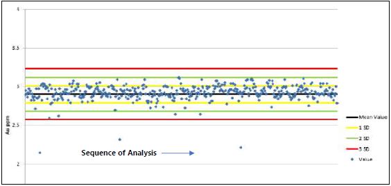
Source: RHMC, 2017
May 2022
Project Number 250039 | Page 11 - 9 | |
|
2021 Ruby Hill Mineral Resource Estimate
Eureka County, NV, USANI43-101Technical Report |
Table 11-5: SRM Performance
| Standard ID | Sample Count | Au Grade | % Within 2SD | % Within 3SD | Bias (%) | Relative Standard Deviation (%) |
| BCH-OX-01 | 338 | 0.214 | 91 | 97 | 1.10 | 5.30 |
| BCH-OX-02 | 203 | 0.338 | 77 | 93 | 3.20 | 4.00 |
| BCH-OX-03 | 541 | 2.260 | 85 | 98 | 3.20 | 4.40 |
| BCH-OX-04 | 204 | 6.450 | 96 | 100 | -0.30 | 2.30 |
| BCH-OX-06 | 108 | 0.283 | 96 | 99 | 2.00 | 4.20 |
| OREAS 2PD | 201 | 0.885 | 95 | 100 | -1.70 | 3.00 |
| OREAS 50PB | 29 | 0.841 | 83 | 90 | 0.70 | 6.00 |
| OREAS 52c | 190 | 0.346 | 99 | 99 | 3.60 | 6.20 |
| OREAS 52PB | 199 | 0.307 | 93 | 99 | 4.60 | 3.90 |
| OREAS 53PB | 41 | 0.623 | 90 | 95 | 0.00 | 5.70 |
| OREAS 54PA | 429 | 2.900 | 98 | 99 | 0.70 | 3.40 |
| OREAS 6PC | 158 | 1.520 | 99 | 100 | 0.50 | 3.10 |
| OxD57 | 61 | 0.413 | 95 | 98 | -0.80 | 3.00 |
| OxG38 | 86 | 1.031 | 94 | 99 | -0.30 | 4.00 |
| OxH29 | 33 | 1.298 | 73 | 88 | -1.80 | 5.10 |
| OxH52 | 37 | 1.291 | 89 | 95 | -1.10 | 3.70 |
| OxH55 | 124 | 1.282 | 92 | 96 | 1.50 | 3.60 |
| OxI23 | 81 | 1.844 | 78 | 91 | -1.20 | 4.50 |
| OxK48 | 31 | 3.557 | 58 | 87 | -1.10 | 3.30 |
| SF12 | 78 | 0.819 | 88 | 91 | -4.60 | 11.70 |
| SG14 | 71 | 0.989 | 96 | 100 | 0.90 | 3.70 |
| SJ10 | 36 | 2.643 | 72 | 97 | -2.30 | 3.30 |
| SK11 | 51 | 4.823 | 82 | 92 | -1.20 | 3.50 |
| SK21 | 77 | 4.048 | 70 | 94 | -0.20 | 3.90 |
| SN16 | 38 | 8.367 | 53 | 76 | -2.40 | 6.70 |
| Total | 3,445 | | 86 | 96 | | 4.50 |
A total of 3,116 blanks were inserted in the sample stream by Barrick with 51 samples (or 1.6%) plotting above the 0.025 g/t Au. Material used for blank samples was sourced from the Devonian Devils Gate Limestone.
May 2022
Project Number 250039 | Page 11 - 10 | |
|
2021 Ruby Hill Mineral Resource Estimate
Eureka County, NV, USANI43-101Technical Report |
| 11.5.1.3 | RC Sample Pulp Check Assays |
Ninety-eight sample pulps, representing approximately 4% of existing sample pulps from drilling at East Archimedes by Barrick were sent to BSI-Inspectorate Laboratory in Reno, Nevada for check assays. Original assays were performed by ALS Global. Six certified standard samples from OREAS of Australia were also randomly introduced with the pulps. Original ALS Global assays indicated approximately 70% of the 98 pulps consisted of mineralized material, the remainder was classified as waste.
Results from the BSI-Inspectorate check assays have a mean grade slightly lower than the ALS results for the same samples and the relative bias increases slightly with increasing grade (REI, 2005) (Figure 11-2). This relative bias confirms the small positive bias of approximately 1-3% evident in the analyses of the SRM materials analyzed at ALS.
Figure 11-2: ALS Global (Chemex) Pulps Checked at Inspectorate
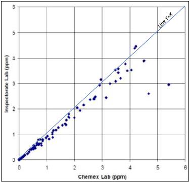
Source: Newman and Mahoney, 2008
May 2022
Project Number 250039 | Page 11 - 11 | |
|
2021 Ruby Hill Mineral Resource Estimate
Eureka County, NV, USANI43-101Technical Report |
Field duplicates were added to the QA/QC protocol as part of the 1 in 300 QA/QC samples. For core duplicates the other half of core was taken and analyzed. For RC duplicates, a secondary sample was taken at the splitter on the drill rig. Barrick used a sample ID that was consecutive to the original sample to identify the duplicate sample.
A total of 1,037 field duplicates (230 core and 807 RC) with mean values greater than 0.1 g/t Au were analyzed and 73.4% of the samples plot within ±15% of half the relative difference (Figure 11-3).
Figure 11-3: Mean Versus Half Relative Difference for Field Duplicates
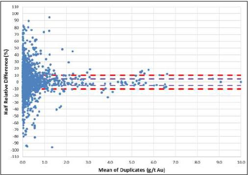
Source: RHMC, 2017
A plot of lab pulp duplicate samples on a scatter graph (Figure 11-4) indicates good repeatability for the pulp duplicates with 90% plotting within 5% half the relative difference of the original analysis. All samples were assayed by ALS Global between 2012 and 2015.
May 2022
Project Number 250039 | Page 11 - 12 | |
|
2021 Ruby Hill Mineral Resource Estimate
Eureka County, NV, USANI43-101Technical Report |
Pulp duplicates plotted on mean versus half relative difference graphs indicates over 90% of samples plot within 10% of half the relative difference (Figure 11-5). All values greater than 10% of half the relative distance are very low grade (<0.06 g/t).
Figure 11-4: Scatter Plot of all Lab Duplicates

Source: RHMC, 2017
Figure 11-5: Mean Versus Half Relative Difference for Pulp Duplicates

Source: RHMC, 2017
May 2022
Project Number 250039 | Page 11 - 13 | |
|
2021 Ruby Hill Mineral Resource Estimate
Eureka County, NV, USANI43-101Technical Report |
In early 2004 Barrick prepared the Ruby Hill drill hole database for use in resource modeling efforts. A systematic program was instituted to combine the various disparate databases into an accurate database. The program produced an accurate Ruby Hill drill hole database stored in Microsoft® Access.
More recent Barrick RC and core logging was performed by a company geologist using a logging template. All geologic, structural, geotechnical, metallurgical, and density measurements, taken at 50 ft intervals, were recorded on the template and entered into an acQuire database. It is unknown when Barrick migrated the database from Microsoft Access to acQuire. The acQuire database was maintained by the Barrick Gold Exploration Inc., office in Elko, Nevada.
In April 2016 RHMC contracted the Maxwell Geoservices of Vancouver, Canada to migrate the Ruby Hill acQuire database to Maxwell’s DataShed software. Original digital assay results were directly imported, csv files were generated from pdf or paper versions of each assay lot and then imported. As of the date of this Report, information that has been loaded into DataShed includes collar, downhole survey, assay, lithological and multi-element data.
The database is maintained on the RHMC server in Reno, and nightly back-ups are made at a secure off-site location.
Sample handling procedures and chain of custody for drilling prior to the 2002 closure of the Ruby Hill operation are not well documented. It is assumed samples from earlier drilling were in the custody of the drill contractor, Homestake geologists, or employees of the various laboratories that prepared and assayed the drilling samples. In 2005 REI (2005) notes that examination of remaining historical core was in good order in core boxes with drill run blocks in place and sample intervals clearly marked and was of the opinion that drill core in general was probably well handled, transported, and stored during the course of drilling.
The security procedures and chain of custody employed for drill samples is poorly documented. Newman and Mahoney (2008) report that no officer or employee of the company prepared drill samples, except that core samples were split by a company employee before sending to the assay lab, and a minor number of holes (14) were prepared and assayed at the company’s internal lab. RC drill cutting samples were picked up from the drill rig by the assay lab’s courier service. Core samples were first split in half by company staff, one half was archived, and the other half picked up by the lab courier service. Laboratory chain of custody was typical to commercial labs in Nevada at the time of activity according to Newman and Mahoney (2008).
May 2022
Project Number 250039 | Page 11 - 14 | |
|
2021 Ruby Hill Mineral Resource Estimate
Eureka County, NV, USANI43-101Technical Report |
All remaining pulps are securely stored in locked shipping containers on site. Remaining core is also stacked on pallets and stored on site with more than half of the core covered. Numerous uncovered core boxes have been partially to completely destroyed to due weathering.
| 11.8 | Comments on Section 11 |
The Ruby Hill Mineral Resource dataset has been acquired over many years during which time best practice for drilling, sampling, assaying, sample and data security practices have evolved significantly. The data acquired by Barrick from 2003 to 2015 has been acquired from RC and diamond drill core holes using industry standard practices for surveying, logging, sampling, sample preparation, assaying and assay QA/QC. Review of QC data indicates that the accuracy, sampling and analytical precision and reproducibility of the Barrick assaying for gold and silver is of good standard. Database compilation efforts by Barrick beginning in 2004, and by RHMC in 2016 included direct import of digital files wherever possible to limit the possibility of data transcription issues. The Barrick data has been used to provide data quality assurance for the Homestake data and data acquired by operators before Homestake and is discussed in Section 12 on data verification.
May 2022
Project Number 250039 | Page 11 - 15 | |
|
2021 Ruby Hill Mineral Resource Estimate
Eureka County, NV, USANI43-101Technical Report |
| 12.1 | Historical Data Review |
The following section summarizes previous data reviews conducted prior to the 2021 Ruby Hill Mineral Resource estimate.
In 2004, as part of its East Archimedes Project feasibility study, Barrick initiated a program to combine databases from previous operators at Ruby Hill into a single accurate database and validate data in the legacy databases with data from hard copy assay certificates. Several mine site databases, and a database from the Homestake Reno Exploration office, all containing differing and disparate data, were consolidated into a Microsoft® Access database.
Validation of the drillhole database focused on holes within the East Archimedes resource. Eighteen holes (~6%), 12 RC and 6 core holes, were selected based on a hole’s importance to the East Archimedes gold resource estimate (Newman and Mahoney, 2008). Database errors were tallied and corrected by Barrick.
The most common error in the drillhole collar data involved input of the wrong hole depth. Downhole survey errors were either intervals missing or incorrectly entered. The serious error rate for collar and survey data was 0.00% and 0.01%, respectively (Newman and Mahoney, 2008).
Numerous errors were discovered in the geologic log database, the most prevalent being in the Pyrite, FeOx, or Redox fields. Pyrite and FeOx were not used in modeling, although Redox data was used to identify oxide/sulfide boundaries. Redox data density was good, and sulfide boundaries were cross checked against cyanide solubility data. The few errors identified did not significantly affect the designation of oxide/sulfide domains (Newman and Mahoney, 2008). The serious error rate for the geologic data was 0.07%.
Errors in the assay database were minimal (0.03%). Most were rounding errors in converting gold fire assay ppb’s to oz/st. Only one serious error on a 5 ft sample was found to be serious (62,520 ppb Au entered vs. 32,520 ppb Au actual) (Newman and Mahoney, 2008). In addition, assay certificates for 2 of the 18 holes could not be verified. These holes were drilled for metallurgical purposes, and the metallurgical labs did not produce formal assay certificates.
May 2022
Project Number 250039 | Page 12 - 1 | |
|
2021 Ruby Hill Mineral Resource Estimate
Eureka County, NV, USANI43-101Technical Report |
Coordinates of 21 holes (~7%) in the East Archimedes area were field checked. Collars were located for 20 holes. The unfound collar occurred in a reclaimed area and could not be identified.
| 12.1.2 | Resource Evaluation Inc (REI, 2005) |
As part of a mineral reserve audit of the East Archimedes Project REI checked assays reported on laboratory assay certificates against assays in the electronic database from 12 drillholes. Holes were selected based on examination of geologic cross sections to ensure a broad representative distribution across the deposit. Seven RC holes and 5 core holes were selected. Assay intervals checked amounted to 9% for core holes and 2% for RC holes.
Of the checked assay intervals, REI (2005) found only three instances where there was a difference between the assay certificate and database entry. These occurred in RC holes HRH-232 (585 ft-590 ft), HRH-1401 (1,135 ft-1,260 ft), and HRH-610 (939 ft-976 ft). REI (2005) was of the opinion that the verification exercise indicated that the assay database was valid for mineral resource estimations, and that there was no evidence of significant data errors.
Barrick Reserve and Resources Group updated the Ruby Hill block model in 2011 incorporating new drilling from the 426 and Mineral Point areas. Collar, survey, assay, and geologic data files were checked for erroneous or anomalous values using simple database checks on the collar, survey, assay, and geologic tables (Barrick, 2013). Files were checked for overlaps, missing intervals, azimuth jumps, and inclination jumps. Only one drillhole (BRH-84) showed significant collar coordinate changes. The hole had been updated with actual surveyed coordinates. Numerous errors were also found in the “UNIT” field in the lithology table consisting of typos and multiple naming conventions which were corrected. Overall, the database was in good condition (Barrick, 2013).
May 2022
Project Number 250039 | Page 12 - 2 | |
|
2021 Ruby Hill Mineral Resource Estimate
Eureka County, NV, USANI43-101Technical Report |
In 2016, RHMC completed a verification review consisting of 100% of the collar locations, random 20% selection of down hole surveys (149 holes) and 10% of assays (75 holes) from 746 holes drilled in the resource area subsequent to the migration of the database from acQuire to Datashed.
Surface collar coordinate values for planned, surveyed, and DataShed entries were reviewed along with a comparison of elevation values to topography.
Protocols used to verify DataShed, surveyed and planned coordinate collar data included:
| • | Original survey file coordinate values were compiled and sorted by hole ID and copied into labeled columns of a MS Excel spreadsheet. A random number generator was used to determine holes for validation. |
| • | Planned coordinates were manually entered into the same spreadsheet under labeled X, Y, Z columns. |
| • | DataShed stored coordinates were sorted by hole ID and copied into the same spreadsheet under labeled columns. |
| • | Differences in coordinate values between DataShed and surveyed coordinates were calculated. |
| • | Differences in coordinates between surveyed and planned were also calculated. |
| • | Differences greater than 10’ for any X, Y, or Z value was flagged and color coded. |
No statistical comparison between planned and surveyed holes could be made since few holes have planned coordinates. Two hundred fifty-four holes (or 34.0%) were flagged in the comparison between surveyed and DataShed holes with common errors including no survey data, lack of elevation data, and incorrect coordinate errors. It should be noted that 232 of the failed holes were drilled underground, and did not have recorded collar locations, either digitally or on paper logs. If these holes are removed, the fail percentage becomes 4.3%. Ruby Hill investigated and corrected all errors within DataShed.
May 2022
Project Number 250039 | Page 12 - 3 | |
|
2021 Ruby Hill Mineral Resource Estimate
Eureka County, NV, USANI43-101Technical Report |
Protocols for the comparison of collar elevation values against topography included:
| • | Remove underground drill holes from topo collar elevation and mark as NA on “2016_RH_DataShed Validation dataset. This reduced the dataset from 745 to 514 holes |
| • | First pass cross section review of drill collar locations in relation to pre- Barrick/Homestake mining topography (rh_TOPO_COOPER_PreMine) to give an indication what additional topo files (by year) would be required for validation. |
| • | Located additional Topo Files “2009:RubyHill_TopoBase_MG_rev090509”, and :2010:RubyHill_2010. |
| • | Sorted dataset and used Micromine software to calculate distance from collar point to corresponding topo file. |
| • | Filtered dataset by differences less than 10 ft. Noted if collar was above or below topo. Compared collars with all topo files to determine if holes could be validated against one of the three topo files based on location, drill date, and topo date. |
| • | Datasets corrected to validate appropriate drill holes to corresponding topo files. |
A total of 14 collars (3%) were flagged with errors including:
| • | Three errors within ±20 ft range |
| • | Five errors were within ±20 to ±50 ft range |
| • | Five errors >±50 ft range |
Ruby Hill has subsequently investigated and corrected all the differences.
Down hole survey validation was conducted on 149 randomly selected holes within the resource area. The verification process involved down hole surveys being flagged if an azimuth or dip in database did not agree with the actual certificate value, there was an error in the survey depth, or if no log information existed. Drill holes were loaded into Vulcan to visually check and validate drill hole traces for irregular deviation changes. Drill hole data with the collar azimuth and dip were also checked manually against survey files.
Of the 149 drill holes reviewed, a total of 1,706 entries were verified with 11 (or 0.6%) flagged for further investigation. Of these:
| • | Nine holes had missing log information |
| • | One hole had two incorrect azimuth values |
| • | One hole had switched azimuth and TD values. |
May 2022
Project Number 250039 | Page 12 - 4 | |
|
2021 Ruby Hill Mineral Resource Estimate
Eureka County, NV, USANI43-101Technical Report |
Ruby Hill has subsequently investigated and corrected these errors except for holes with missing log information.
For assay verification, data was exported from DataShed into an MS Excel spreadsheet and ranked according to increasing confidence of analytical and assay procedures. To ensure that all gold assays had properly migrated, and assay methods were correctly coded, Ruby Hill employed the following protocol:
| • | Assay results and procedures were verified directly against laboratory certificate of assays |
| • | Inconsistencies were flagged in the MS Excel spreadsheet for further investigation.. |
Of 75 holes reviewed a total of 6,021 records were validated, with 1,674 records (or 19.8%) flagged for investigation. Inconsistencies included:
| • | Fourteen underground drill holes, 75 records (or 58%), had additional decimal places that were not in the original assay certificate. |
| • | Thirteen drill holes, 1,371 records (or 77%), failed because Au values were a calculated value from an Au ppb column in the assay certificates. The ppb column should have been uploaded instead of the calculated value. Also, Cyanide leach Au values were substituted for Au Fire Assay values in places due to the ranking issue. |
| • | One hole, 217 records (or 100%), had oz/st Au values uploaded instead of available Au ppb values. |
| • | One hole, the assay certificate could not be located. |
| • | Two holes, 11 records (or 22%), incorrect calculated Au assay value, and missing assay certificate. |
All errors and inconsistencies were subsequently corrected by RHMC.
Homestake Mining Company
Four RC drill holes were twinned with core holes in the Achilles area. Homestake compared the downhole grade and grade thickness of the mineralized intervals. Two of the RC holes showed longer mineralized zones than the core and concluded that the RC intervals are contaminated. These intervals have been removed from the resource estimation database.
May 2022
Project Number 250039 | Page 12 - 5 | |
|
2021 Ruby Hill Mineral Resource Estimate
Eureka County, NV, USANI43-101Technical Report |
Barrick Gold Corporation (Barrick)
Barrick compared two RC holes twinned by two metallurgical core holes to compare downhole grade distributions within mineralized zones (Table 12-1). Barrick concluded that the differences in grades between RC and core holes is attributed to fracture density and sanding of carbonate units, with mineralization hosted in silicified brecciated dolomite skirting areas of sanded dolomite (Pfeiffer, 2010).
Table 12-1: Downhole Grade Distribution in RC and Metallurgical Twin Core Holes
| Hole ID | Hole Type | Depth (ft) | Footage | Thickness (ft) | Gold oz/t | Gold GT oz/t x foot | Gold GT Core % of RC | |
| |
| BRH-88 | RC | 800 | 685-785 | 100 | 0.057 | 5.70 | | |
| BRH-165C | Core | 1403 | 590-610 | 20 | 0.015 | 0.29 | | |
| 640-660 | 20 | 0.016 | 0.32 | | |
| 670-690 | 20 | 0.018 | 0.27 | | |
| 710-725 | 15 | 0.011 | 0.16 | | |
| 750-755 | 5 | 0.013 | 0.07 | | |
| 980-1100 | 120 | 0.029 | 3.50 | | |
| Composite Core GT | 4.60 | 80.7 | |
| BRH-85 | RC | 800 | 535-665 | 130 | 0.027 | 3.50 | | |
| BRH-166C | Core | 682 | 495-560 | 65 | 0.036 | 2.40 | | |
| 640-650 | 10 | 0.011 | 0.10 | | |
| 670-682 | 12 | 0.012 | 0.15 | | |
| Composite Core GT | 2.70 | 77.1 | |
| | | | | | | | | | |
RHMC
Ruby Hill reviewed Barrick and Homestake twin holes and agreed with Barrick’s conclusions. RHMC also reviewed neighboring data by company and data type (Barrick vs Homestake and RC vs Core) as very few true twinned holes exist. Nearest-neighbor block estimates, statistical analyses of bin samples by distances, and down hole histograms were reviewed. Differences in grade are noted by type and by company but when reduced to small areas within the range of variance (200 feet) the data match reasonably well, indicating reproducible assay by type and company.
May 2022
Project Number 250039 | Page 12 - 6 | |
|
2021 Ruby Hill Mineral Resource Estimate
Eureka County, NV, USANI43-101Technical Report |
| 12.2.1 | Down-Hole Contamination Studies |
| 12.2.2 | Core vs RC Drilling Comparison |
Quantile-Quantile (Q-Q) plots were used to compare the grade distributions of the core samples and the RC samples. Raw results indicate a slight high bias in the core. The magnitude of bias is reduced significantly when filtered to data within the mineralized domains. Bias is interpreted to be related to different drill programs with varied analytical methods and different detection limits. When data is reduced to mineralized zones the high bias in the core is eliminated.
| 12.3.1 | Checks on Primary Data |
In February 2021 Wood conducted a site visit to Ruby Hill and the Waterton office in Reno Nevada to review project geology, verify original hard copy documentation and archived drill core. Table 12-2 presents a summary of Wood’s data quality verifications. Wood concluded that the Barrick surveying, logging, sampling, and QC is data is verifiable from the original hard copy data but original documentation of the Homestake data is less complete and further checks were recommended to understand the quality and integrity of this data. Wood’s subsequent checks involved inspection of legacy primary data on plans and cross sections and detailed comparison of legacy drill intersections with the Barrick data for which confidence is higher.
| 12.3.2 | Assay Data Quality Assurance |
Wood carried out a review of gold assay quality control results including certified reference material (CRM), blanks, core twins, RC field duplicates and pulp duplicates from the Barrick RC and diamond drill campaigns. The QC data indicate that gold assaying is reasonably accurate but has a relatively high sampling and analytical variance.
Quality control data for gold fire assays by Barrick (Oakley, 2017) are used to provide assay quality assurance for gold grades, but quality control data for silver is more limited. Data from analysis of certified reference materials and internal lab standards were compiled as part of this review can now be used to provide data quality assurance for the silver assays for the Barrick drill campaigns that can be extended to the Homestake and earlier campaigns.
May 2022
Project Number 250039 | Page 12 - 7 | |
|
2021 Ruby Hill Mineral Resource Estimate
Eureka County, NV, USANI43-101Technical Report |
Table 12-2: Summary of Wood Data Quality Checks
| Data Verified | Comments |
Checks on original
hardcopy
documentation | Ten drillholes were selected for checks on original hard copy documentation from the Homestake RC and diamond drill, and Barrick RC and diamond drill campaigns. Folders were found for eight of the ten holes. Each of the folders contained a graphic strip log that agrees reasonably well with the project geology and electronic database. Four of eight drillhole folders include gyro survey logs. Six of eight included original independent lab assay sheets with gold fire assay and multi-element and silver analyses. Three of three holes drilled by Barrick included QC data, control charts and correspondence about downhole contamination and database management. Wood concludes that the Barrick data is verifiable from the original hard copy data but original documentation of the Homestake data is less complete and required further checks to develop assurance of data quality and database integrity. |
Survey and assay
data integrity | • Wood checked digital database entries against original assay certificates for 100 drill holes for the collar and assay data audits and 50 holes for downhole survey and lithology audits. The collar surveys, downhole surveys, lithology, and assay data were validated by comparison of the database values to original documents. Wood compared the ALS assay certificates to the database and found no discrepancies. But there were a number of historic holes for which the collar data could not be verified, and Wood recommends RHMC continue to work on the database to locate supporting data from original paper files. • Wood also caried out visual inspection of gold grades in plan, section and in three-dimensions looking for examples anomalously high grade or long mineralized intersections and identified four drillholes having potential sampling or assay quality issues. These intervals were not used in estimation. |
Downhole survey
checks | Kinkcheck run, visual inspection in plan and section indicates significant deflection in some holes but none are identified as requiring correction. |
Collar survey
checks | Checks against original logs. Some original collar locations not available. No issues requiring correction were found from visual inspection against topo. |
| RC sampling representativity | Intervals flagged as potential downhole contamination by Barrick and Waterton were reviewed by Wood. Visual inspection identified several other issues. RC versus DH intersections for nearby holes were checked for both Barrick and Homestake drilling concluding that mineralized intersection lengths and average gold, silver and zinc grade, where available, compare reasonably closely. |
May 2022
Project Number 250039 | Page 12 - 8 | |
|
2021 Ruby Hill Mineral Resource Estimate
Eureka County, NV, USANI43-101Technical Report |
| Data Verified | Comments |
| Gold assay data QC | Wood reviewed results from Barrick assay data quality assurance including a study completed by Waterton in 2017. Routine analysis of CRMs for gold show Barrick gold fire assays are unbiased. Routine analysis of core twin, RC field duplicate, indicates considerable scatter between original and duplicate results and relatively high sampling error. Use of multiple samples from multiple holes to estimate grades is recommended to mitigate the high sampling error. Results from pulp duplicate samples show that assay precision is reasonable. Routine analysis of blank data indicates that some contamination may have occurred, but the contamination was not systematic, and the magnitude would not be expected to have an impact on grade estimation. There is evidence that Homestake had an assay data quality control program, but the results are not available to provide data quality assurance for the Homestake RC and Homestake DD programs. |
| Silver assay data QC | Analyses of internal lab standards and external CRMs were compiled to provide an assessment of silver assay data accuracy for assaying of Barrick RC and diamond core samples between 2004 and 2015. Mean assay grades of CRMs with grades from 0.2 g/t Ag to 50 g/t Ag, the range of the majority of silver assay grades at Ruby Hill, are within ±10% of best value indicating that silver assays are unbiased and suitable for use in mineral resource estimation. |
Checks on archived
drill core | Archived drill core, sample reject, and assay pulp materials are limited and in poor condition. Wood inspected cross piled drill core and could verify lithology, alteration, type of mineralization and grade against data in the digital Mineral Resource Database for intervals from four drillholes. This core is the only original material available for check assaying and metallurgical testwork that is available for Ruby Hill and should be moved to a secure storage location as soon as possible. |
Legacy Sampling
and Assay Data Checks | Wood checked results of Barrick core and RC drilling against the Homestake drilling that does not have QC for ten locations at East Archimedes, West Archimedes, Blackjack and Mineral Point. In all cases one or more nearby Homestake drillholes matched the Barrick intersection in length and average gold grade, and where available silver grade, providing assurance of the quality of the Homestake drilling. |
May 2022
Project Number 250039 | Page 12 - 9 | |
|
2021 Ruby Hill Mineral Resource Estimate
Eureka County, NV, USANI43-101Technical Report |
Wood carried out visual inspection of assay grades on plan, cross section and in three dimension and identified four anomalous intersections where the grades and lengths of intersections were different to adjacent drillholes and a good geological explanation for the anomalous intersection was not available. The intersections were in RC holes with potential for downhole contamination. These intersections were added to the list of intersections to be excluded from estimation due to potential downhole contamination and other assaying issues documented by Barrick and compiled by RHMC. An example of the anomalous grade intersection is shown in Figure 12-1.
Figure 12-1: Isometric Section Showing Anomalous Gold Grade
Intersection in Hole HRH-1762
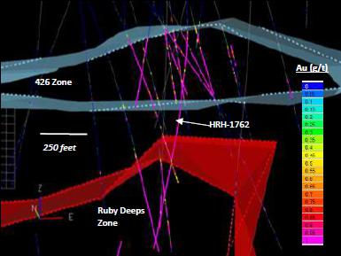
Note: Figure prepared by Wood.
The visual inspection of drill data also identified a set of drill intersections with grades of 20 g/t Au to over 100 g/t Au in an area from 5,450 ft elevation to 5,650 ft elevation measuring 300 ft wide and 200 ft long in the southwest corner of the Mineral Point Trend. Most of the high-grade intersections are in drill holes that had been drilled from underground exploration development by the Eureka Corporation. There are seven surface drill hole intersections drilled by Barrick around this area are that generally have intersections with grades more typical of Mineral Point with the exception of the Barrick core hole BRH-25C that intersected 13.5 feet with an average grade of 52.6 g/t Au and RC hole BRH-331 that intersected 3.26 g/t Au over 45 feet. The intersection in BRH-25C confirms the presence of very high grades in this part of the Mineral Point Trend; but steps were taken to limit the influence of the underground drilling by Eureka as discussed in Section 14.
May 2022
Project Number 250039 | Page 12 - 10 | |
|
2021 Ruby Hill Mineral Resource Estimate
Eureka County, NV, USANI43-101Technical Report |
Figure 12-2: Cross Section Showing Eureka Corp Drilling at Mineral Point (5,600 ft Elevation, View to North)
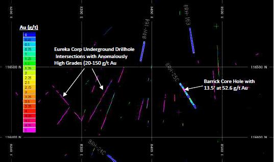
Note: Figure prepared by Wood.
| 12.3.3 | Database Integrity Audit |
Wood checked digital database entries against original assay certificates for 100 drill holes for the collar and assay data audits and 50 holes for downhole survey and lithology audits. The collar surveys, downhole surveys, lithology and assay data were validated by comparison of the database values to original documents. Conclusions of the audit are as follows:
| • | Wood compared the ALS assay certificates to the database and found no discrepancies. |
| • | There were a number of historical holes for which the collar data could not be verified. Wood recommends RHMC review the entire database, determine which holes are lacking support for collar locations and continue to attempt to locate the supporting data. |
May 2022
Project Number 250039 | Page 12 - 11 | |
|
2021 Ruby Hill Mineral Resource Estimate
Eureka County, NV, USANI43-101Technical Report |
| 12.3.4 | Verification of Legacy Data |
In addition to the overall inspection of primary data in three dimensions, Wood completed a review of legacy data to provide data quality assurance for the drilling completed by Homestake by comparing it with the data from the Barrick Campaigns for which there is good Quality Control data to provide quality assurance.
Ten areas were identified where Barrick drillholes were less than 100’ from drillholes from the Homestake campaigns. The lengths and gold and silver grades of the Barrick Holes were compared with the lengths and grades of the Homestake holes. In all cases the grades of one or more Homestake holes were found to compare closely with the Barrick data, confirming the quality of the drilling, sampling and assaying from the Homestake campaigns (Error! Reference source not found.).
Similar Comparisons were made of Barrick core to Barrick RC drilling and Homestake core to Homestake RC drilling. In call cases comparisons showed that the drilling, sampling and assaying is representative and no systematic biases related to downhole contamination issues can be demonstrated between RC and core drilling or Barrick and Legacy data.
| 12.3.5 | Verification of Potential Down Hole Contamination in RC Drilling |
In conjunction with the legacy data review, Wood did checks on the sampling representativity of the Barrick and Homestake RC drilling by checking the average grade and lengths of diamond drill intersections with RC intersections less than 100 feet away in four areas from Mineral Point, two areas from 426 and one area from Ruby Deeps. The average grade and length of the diamond drill intersections agreed (±35%) with the average grade and lengths of at least one nearby RC drill intersection in each of the areas checked.
The QP has completed a thorough review of data quality control data, checks on legacy data and a detailed audit of the integrity of the digital database used for the 2021 Ruby Hill Mineral Resource estimate. The QP is of the opinion that the data used for the estimate is of suitable quality to produce a high-quality Mineral Resource estimate.
May 2022
Project Number 250039 | Page 12 - 12 | |
|
2021 Ruby Hill Mineral Resource Estimate
Eureka County, NV, USANI43-101Technical Report |
| 13 | Mineral Processing and Metallurgical Testing |
The Ruby Hill project encompasses a number of deposits and mineralization types hosting both precious and base metals. Historical production date back to 1998, with intermittent operations up to the present date.
Deposit characteristics, historical production and metallurgical interpretation for these deposits are described on this section, based on data provided by Ruby Hill Mining LLC.
Generally, metallurgical testwork confirms the amenability of oxide material to heap leaching for precious metals extraction. Tests on refractory material support gold extraction via autoclave processing. Preliminary tests on base metal material show amenability to flotation, with additional work required to reduce recovery uncertainty.
| 13.1 | Historical Processing Operations |
Historically, there have been three destinations for treatment of mineralization from the Ruby Hill Mine: run of mine (ROM) and crushed mineralization to a heap leach pad, crushing and leaching with agglomerated tailings routed to the heap leach pad, and higher-grade sulfide mineralization (DSO) routed to Goldstrike for autoclave processing. A general description of each processing route is provided below.
ROM Heap Leach As blasted mineralization is trucked from the pit, with lime added to trucks before placing the mineralization on the heap leach pad. The ROM leach pad is constructed in 20 to 30 ft lifts. Barren cyanide solution is applied to the heap for gold extraction, with pregnant solution collected and directed to a lean pregnant solution tank. This pregnant solution is then mixed with make-up barren solution and additional cyanide and directed to the crushed mineralization leach pad.
Crushed Heap Leach As blasted mineralization is trucked from the pit and fed directly to the crusher feed hopper or stockpiled for future crushing. The crushing circuit includes three stages fitted with: a primary jaw crusher a secondary cone crusher, tertiary crusher, and ancillary equipment.
The circuit configuration allows for routing of ¾" secondary crushed product either directly to the heap pad or to a tertiary crushing stage generating a final ½" product. Tertiary crushing is reserved for higher grade material and further processing in a “pulp-agglomeration” operation.
May 2022
Project Number 250039 | Page 13 - 1 | |
|
2021 Ruby Hill Mineral Resource Estimate
Eureka County, NV, USANI43-101Technical Report |
Pulp-Agglomeration Tertiary crushing circuit product is directed to a 1,500 ton fine ore silo. The bin feeds a 900 st/d milling and classification circuit generating a 65 mesh product size, followed by thickening and leaching in a single tank for a nominal 15 hours. Belt filters are used to separate high grade gold solution from filter cake. The gold rich solution is directed to carbon adsorption whereas the filter cake is agglomerated with secondary crushed product before placement on the leach pad.
Direct Ship Mineralization Refractory sulfide mineralization that meets compositional criteria is classified as DSO. To date, this material has been transported by road to the Goldstrike operation for toll processing.
| 13.2 | Metallurgical Testwork |
From 2004 to 2012, seven testwork programs were carried out, by KCA focusing on column leaching and bottle roll testing of the oxide deposits, namely Archimedes, 426 and Mineral Point. An eighth report was carried out on a sample from Watertank, which analyzed as sulfide.
Other testwork has been carried out by the Barrick Technology Centre (BTC) between 2008 and 2012. The work is summarized in five reports focusing on refractory mineralization. Additional work on base metals characterization and flotation was carried out by G&T in 2008.
Table 13-1 summarizes key tests performed on the different deposits.
Table 13-1: Key Testwork Campaign Summary
| Year | Deposit | Laboratory | Test Description | # Key Tests |
| 2004 | Archimedes | KCA | Column Leach | 19 |
| 2005 | Archimedes | KCA | Column Leach | 8 |
| 2009 | 426 Zone | KCA | Column Leach | 2 |
| 2010 | Watertank | KCA | Column Leach | 1 |
| 2011 | 426 Zone | KCA | Column Leach | 8 |
| 2011 | Mineral Point | KCA | Column Leach | 6 |
| 2012 | Mineral Point | KCA | Column Leach | 8 |
| 2014 | Mineral Point | KCA | Column Leach | 12 |
| 2008 | 426 Zone | BTC | Roasting, Autoclave + Leach | 18 |
| 2008 | 426 Zone | G&T | As Pre-Float + Cyanidation | 7 |
| 2008 | Blackjack | G&T | Pb/Zn Flotation | 2 |
May 2022
Project Number 250039 | Page 13 - 2 | |
|
2021 Ruby Hill Mineral Resource Estimate
Eureka County, NV, USANI43-101Technical Report |
The main results from the testwork programs are summarized in the following sections. The summaries focus on gold recovery with silver recovery addressed in the conclusions section.
| 13.2.1 | KCA 24 June 2004 - Archimedes |
Nineteen separate column leach tests were conducted on the core composites, sulfide composite and bulk samples received from the Ruby Hill Project. Tests were conducted at a crush size approximating ROM material and crushed material at minus 1¼". Results are summarized in Table 13-2.
The overall average gold extraction for the samples was 82%, the average sodium cyanide consumption was 0.81 lb/st NaCN, and the average hydrated lime consumption was 3.59 lb/st Ca(OH)2. Sample 31624 was labelled “sulfide” and gave a low recovery of only 31%.
Table 13-2: Column Leach Tests Results
| Test No. | Sample Description | Crush Size
(inches) | Comp Au
opt | CLT Au Rec
(%) | NaCN
(lb/st) | Ca(OH)2
(lb/st) |
| 31631 | Ox, Low | 1¼ | 0.020 | 84 | 0.62 | 3.99 |
| 31634 | Ox, High | 1¼ | 0.156 | 84 | 0.74 | 2.99 |
| 31637 | Ox, Low | 1¼ | 0.029 | 81 | 0.62 | 2.00 |
| 31640 | Ox, Low | 1¼ | 0.015 | 72 | 0.29 | 2.00 |
| 31643 | Ox, High | 1¼ | 0.272 | 85 | 0.80 | 4.02 |
| 31646 | Ox, Medium | 1¼ | 0.089 | 86 | 1.08 | 6.03 |
| 31649 | Ox, Medium | 1¼ | 0.078 | 88 | 0.63 | 2.00 |
| 31652 | Intrusive, Medium | 1¼ | 0.063 | 87 | 0.97 | 5.02 |
| 31655 | Intrusive, Low | 1¼ | 0.018 | 78 | 0.71 | 5.00 |
| 31658 | Ox, Medium | 1¼ | 0.091 | 84 | 0.54 | 5.02 |
| 31661 | Oxide, Low | 1¼ | 0.044 | 79 | 0.46 | 5.02 |
| 31664 | Oxide, High | 1¼ | 0.241 | 88 | 0.82 | 2.01 |
| 31667 | Oxide, High | 1¼ | 0.387 | 86 | 0.86 | 2.01 |
| 31670 | Oxide, Medium | 1¼ | 0.061 | 87 | 0.44 | 2.01 |
| 31673 | Oxide | ROM | 0.032 | 90 | 0.42 | 2.19 |
| 61376 | Oxide | ROM | 0.030 | 91 | 0.48 | 2.19 |
| 31681 | Oxide | 1¼ | 0.032 | 90 | 0.84 | 2.19 |
| 31684 | Oxide | 1¼ | 0.030 | 89 | 0.69 | 2.13 |
| 31691 | Sul, High | 1¼ | 0.357 | 31 | 3.42 | 10.43 |
May 2022
Project Number 250039 | Page 13 - 3 | |
|
2021 Ruby Hill Mineral Resource Estimate
Eureka County, NV, USANI43-101Technical Report |
Cyanide bottle roll leach tests were completed on each individual composite sample for a period of 96 hours. The overall average gold extraction for the samples was 85%. This is only slightly higher than the column tests. The average sodium cyanide consumption was 1.07 lb/st NaCN and the average hydrated lime consumption was 1.82 lb/st Ca(OH)2.
| 13.2.2 | KCA 20 May 2005 - Archimedes |
Eight separate column leach tests were conducted on samples received from the Archimedes deposit. Two column tests were conducted on each sample, one at the as-received size and another at a crush size of minus 1½".
The P80 of the ROM and minus 1½" tests ranged from approximately 0.2" to 0.6" and there was little difference between the average gold extractions for the as-received and crushed material.
Table 13-3: Column Leach Tests Results
| Test No. | Sample Description | Crush Size
(inches) | Comp Au
opt | CLT Au Rec
(%) | NaCN
(lb/st) | Ca(OH)2
(lb/st) |
| 32505 | ROM3, As Rec'd | ROM | 0.147 | 90 | 0.32 | 2.00 |
| 32508 | ROM4, As Rec'd | ROM | 0.011 | 80 | 0.42 | 2.00 |
| 32511 | ROM5, As Rec'd | ROM | 0.088 | 70 | 0.23 | 2.00 |
| 32514 | ROM6, As Rec'd | ROM | 0.015 | 65 | 0.22 | 1.76 |
| 32517 | ROM3, Minus 1.50" | 1½ | 0.147 | 93 | 0.61 | 2.00 |
| 32520 | ROM4, Minus 1.50" | 1½ | 0.011 | 67 | 0.61 | 2.00 |
| 32523 | ROM5, Minus 1.50" | 1½ | 0.088 | 75 | 0.39 | 2.00 |
| 32526 | ROM6, minus 1.50" | 1½ | 0.015 | 71 | 0.74 | 2.00 |
| 32505 | ROM3, As Rec'd | ROM | 0.147 | 90 | 0.32 | 2.00 |
A cyanide bottle roll leach test was conducted on a portion of each composite sample. The bottle roll leach tests were completed on dry material pulverized to 100% minus 150 mesh and dry material crushed to 100% minus 10 mesh. The average gold recovery was 75% and 89% at minus 10 mesh and 150 mesh, respectively.
May 2022
Project Number 250039 | Page 13 - 4 | |
|
2021 Ruby Hill Mineral Resource Estimate
Eureka County, NV, USANI43-101Technical Report |
| 13.2.3 | KCA 26 January 2009 - 426 Zone |
Metallurgical testwork (Table 13-4) completed on two composites (low and high-grade oxide material) included density testing, head analyses, coarse and pulverized bottle roll leach tests, as well as compacted permeability tests and column leach tests.
The gold extraction from the low-grade composite material, crushed to 100% minus 1" was 85% after 74 days of leaching. Sodium cyanide consumption was 0.06 lb/st and hydrated lime addition was 3.0 lb/st.
Gold extraction from the high-grade composite material, crushed to 100% minus 1" was higher at 90% after 75 days of leaching. Sodium cyanide consumption was 0.07 lb/st and hydrated lime addition was 3.00 lb/st.
Table 13-4: Column Leach Tests Results
| Test No. | Sample Description | Crush Size
(inches) | Comp Au
Opt | CLT Au Rec
(%) | NaCN
(lb/st) | Ca(OH)2
(lb/st) |
| 40334 | Low grade | 1 | 0.020 | 85 | 0.06 | 3.00 |
| 40337 | High grade | 1 | 0.102 | 90 | 0.07 | 3.00 |
The bottle roll leach tests carried out on the low-grade composite indicated that gold recoveries of between 82% and 91% could be achieved on material crushed to 100% minus 1" and 89% on pulverized material. Sodium cyanide consumption ranged from minus 0.01 to 1.21 lbs NaCN/st, depending on the NaCN level in the leach solutions.
Bottle roll leach tests carried out on the high-grade composite indicated that slightly higher gold recoveries of between 86% and 91% could be achieved on material crushed to 100% minus 1"and 95% on pulverized material. Sodium cyanide consumption ranged up to 1.24 lb NaCN/st, depending on the initial NaCN level.
| 13.2.4 | KCA 1 April 2010 - Watertank |
A sample was received from the Ruby Hill Project, identified as Watertank RC sample. The material was utilized for head assay analyses, head screen analyses, bottle roll leach and column leach testwork.
May 2022
Project Number 250039 | Page 13 - 5 | |
|
2021 Ruby Hill Mineral Resource Estimate
Eureka County, NV, USANI43-101Technical Report |
A column leach test was conducted on as-received material (calculated P80 0.051"), for a period of 68 days. The gold recovery was 52%. The sodium cyanide consumption was 1.26 lb/st with a cement addition of 8.00 lb/st.
Bottle roll cyanide-leach tests were conducted on the crushed (100% passing 0.066") and pulverized (target 80% passing 0.003") material. The results for the 96 hour bottle roll test indicated an average gold extraction of 69%. The average sodium cyanide consumption was 0.86 lb/st, and the average hydrated lime addition was 3.00 lb/st.
The low recovery was likely due to the relatively high sulfide sulfur content of 0.37%.
| 13.2.5 | KCA, 1 November 2011 - 426 Zone |
Eight samples were prepared for metallurgical testing (Table 13-5). The samples were utilized for head assays, size fraction analyses with assays by size fraction, bottle roll and column leach testing.
Gold extractions in the column tests ranged from 81 to 93%. The sodium cyanide consumptions ranged from 0.52 to 3.02 lb/st and the hydrated lime addition was approximately 2.0 lb/st.
Table 13-5: Column Leach Tests Results
| Test No. | Sample Description | Crush Size
(inches) | Comp Au
opt | CLT Au Rec
(%) | NaCN
(lb/st) | Ca(OH)2
(lb/st) |
| 60101 | BRH-95C, BRH-99C | 1 | 0.0266 | 81 | 0.86 | 2.01 |
| 60104 | BRH-99C, BRH-211C | 1 | 0.0548 | 93 | 0.72 | 2.00 |
| 60107 | BRH-101C | 1 | 0.0702 | 92 | 0.52 | 2.05 |
| 60110 | BRH-210C, BRH-211C | 1 | 0.0451 | 93 | 1.28 | 2.01 |
| 60113 | BRH-213C | 1 | 0.0681 | 84 | 0.66 | 2.01 |
| 60116 | BRH-214C | 1 | 0.0273 | 91 | 0.97 | 1.99 |
| 60119 | BRH-214C | 1 | 0.1752 | 84 | 3.02 | 2.02 |
| 60122 | BRH-212C | 1 | 0.0497 | 89 | 2.05 | 2.00 |
Bottle roll tests showed that between 78 and 94% of the contained gold could be extracted when the material was pulverized to 80% minus 200 mesh. Other bottle roll tests showed that between 72 and 89% of the contained gold could be extracted when the material was crushed to a nominal 10 mesh.
May 2022
Project Number 250039 | Page 13 - 6 | |
|
2021 Ruby Hill Mineral Resource Estimate
Eureka County, NV, USANI43-101Technical Report |
| 13.2.6 | KCA 4 February 2011 - Mineral Point |
The Bullwhacker (later renamed Mineral Point) samples were described by Barrick as follows:
| • | BW-1 Hamburg Dolomite - This sample is dominated by hematite altered sanded dolomite containing secondary goethite after pyrite cubes. The entire interval is oxidized. |
| • | BW-2 Hamburg Dolomite - This sample is again dominantly hematite and limonite altered sanded dolomite. The entire zone is oxidized. |
| • | BW-3 Hamburg Dolomite and Dunderberg Shale - A small part of this sample is composed of a slightly calcareous limonite altered silicified shale. The rest of the interval is composed of a breccia containing clasts of vuggy silicified dolomite in an argillic, hematite, and goethite altered matrix. |
The material was utilized for head analyses, bottle roll cyanide leach, cyanide shake and column leach testwork, acid-base accounting (ABA) and meteoric water mobility procedure (MWMP) testing.
Column leach tests were conducted on samples from each of the composites. Five of the column tests were conducted at a crush size of 0.5" and were run for a period of 91 days. The column leach test average gold recovery was 80%. On one of the samples, two columns were run, one at 0.5" and the other at 1.5", the recovery from the coarser column was only 1% lower.
The sodium cyanide consumption was 1.38 lb/st of mineralization. The amount required varied greatly between each sample, ranging from 0.70 and 2.29 lb/st. Hydrated lime and cement additions were variable.
Table 13-6: Column Leach Tests Results
| Test No. | Sample
Description | Crush Size
(inches) | Comp Au
opt | CLT Au Rec
(%) | NaCN
(lb/st) | Ca(OH)2
(lb/st) | Cement
(lb/st) |
| 45143 | BW-1 | 0.5 | 0.010 | 85 | 1.10 | 2.0 | - |
| 45146 | BW-1, Agg | 0.5 | 0.013 | 84 | 0.70 | - | 8.0 |
| 45149 | BW-2 | 0.5 | 0.050 | 82 | 1.30 | 2.0 | - |
| 45152 | BW-2, Agg | 0.5 | 0.051 | 81 | 0.81 | - | 8.0 |
| 45155 | BW-3, -1.5” | 1.5 | 0.036 | 74 | 2.05 | 2.0 | - |
| 45158 | BW-3, -0.5” | 0.5 | 0.037 | 75 | 2.29 | 2.0 | - |
May 2022
Project Number 250039 | Page 13 - 7 | |
|
2021 Ruby Hill Mineral Resource Estimate
Eureka County, NV, USANI43-101Technical Report |
Bottle roll cyanide leach tests were conducted on each of the composites. Samples were taken from each composite and tested at pulverized and coarse sizes, as shown in Table 13-7.
For the pulverized bottle roll tests, gold extraction ranged from 77% to 84% with an average of 81%. For the coarse bottle roll tests, gold extraction ranged from 61% to 83% with an average of 72%.
Table 13-7: Bottle Roll Tests Results
| Test No. | Sample Description | Crush Size
(inches) | Comp Au
opt | BRT Au Rec
(%) | NaCN
(lb/st) | Ca(OH)2
(lb/st) |
| 45136A | BW-1, Pulverized | 0.003 | 0.013 | 77 | 0.75 | 1.00 |
| 45137A | BW-1, Coarse | 0.013 | 0.013 | 83 | 0.06 | 1.00 |
| 45136B | BW-2, Pulverized | 0.065 | 0.055 | 84 | 1.14 | 1.00 |
| 45137B | BW-2, Coarse | 0.013 | 0.055 | 74 | 0.40 | 1.00 |
| 45136C | BW-3, Pulverized | 0.003 | 0.044 | 82 | 1.00 | 2.00 |
| 45137C | BW-3, Coarse, -1.5" | 0.055 | 0.044 | 61 | 0.61 | 1.00 |
| 45161A | BW-3, Coarse, -0.5" | 0.225 | 0.044 | 70 | 0.70 | 1.00 |
| 13.2.7 | KCA 23 July 2012 - Mineral Point |
Bullwhacker (Mineral Point) material was utilized for head analyses, size fraction analyses with assays by size fraction, cyanide bottle roll leach testing, agglomeration testing and column leach testing, acid-base accounting (ABA) and meteoric water mobility testing (MWMT).
The overall gold extractions ranged from 81% to 86% and the overall silver extractions from 27% to 58% over a 93 day leach period. The cyanide consumptions ranged from 0.89 to 2.26 lb/st. Hydrated lime consumptions ranged from 1.00 to 1.02 lb/st, and cement additions ranged from 4.04 to 4.15 lb/st.
Three of the four pairs of column tests had a higher gold recovery at 1.5", compared with 0.5”, while the fourth pair had a lower gold recovery at 1.5", compared with 0.5”.
May 2022
Project Number 250039 | Page 13 - 8 | |
|
2021 Ruby Hill Mineral Resource Estimate
Eureka County, NV, USANI43-101Technical Report |
Table 13-8: Column Leach Tests Results
| Test No. | Sample
Description | Crush Size
(inches) | Comp Au
opt | CLT Au Rec
(%) | NaCN
(lb/st) | Ca(OH)2
(lb/st) | Cement
(lb/st) |
| 45451 | RH 184 | 1.5 | 0.0403 | 82 | 0.89 | 1.02 | 4.04 |
| 45454 | RH 184 | 0.5 | 0.0465 | 86 | 2.05 | 0.00 | 4.12 |
| 45457 | RH 231 | 1.5 | 0.0139 | 88 | 1.56 | 1.00 | 0.00 |
| 45460 | RH 231 | 0.5 | 0.0138 | 81 | 1.15 | 0.00 | 4.09 |
| 45463 | RH 235A | 1.5 | 0.0134 | 84 | 1.25 | 1.00 | 0.00 |
| 45466 | RH 235A | 0.5 | 0.0131 | 82 | 1.14 | 0.00 | 4.15 |
| 45469 | RH 235B | 1.5 | 0.0505 | 86 | 1.29 | 1.00 | 0.00 |
| 45472 | RH 235B | 0.5 | 0.0456 | 82 | 2.26 | 0.00 | 4.04 |
Cyanide bottle roll leach tests were conducted on each of the composite samples at each crush size (100% minus 1.5" and 0.5"). Additionally, a pulverized (80% minus 200 mesh) portion from each composite was utilized for bottle roll testing. Results are shown in Table 13-9.
Table 13-9: Bottle Roll Tests Results
| Test No. | Sample Description | Crush Size
(inches, mesh) | Comp Au
opt | BRT Au Rec
(%) | NaCN
(lb/st) | Ca(OH)2
(lb/st) |
| 45448 A | RH 184 | 1.5” | 0.0412 | 70 | 0.31 | 1.00 |
| 45448 B | RH 184 | 0.5” | 0.0436 | 74 | 0.32 | 1.00 |
| 45450 A | RH 184 | 200 mesh | 0.0424 | 84 | 1.65 | 1.50 |
| 45448 C | RH 231 | 1.5” | 0.0151 | 71 | 0.77 | 1.00 |
| 45448 D | RH 231 | 0.5” | 0.0156 | 76 | 0.78 | 1.00 |
| 45450 B | RH 231 | 200 mesh | 0.0154 | 57 | 0.98 | 1.50 |
| 45449 A | RH 235A | 1.5” | 0.0132 | 73 | 0.31 | 1.00 |
| 45449 B | RH 235A | 0.5” | 0.0134 | 72 | 0.33 | 1.00 |
| 45450 C | RH 235A | 200 mesh | 0.0133 | 58 | 0.51 | 1.00 |
| 45449 C | RH 235B | 1.5” | 0.0579 | 77 | 0.31 | 1.00 |
| 45449 D | RH 235B | 0.5” | 0.0533 | 77 | 0.41 | 1.00 |
| 45450 D | RH 235B | 200 mesh | 0.0556 | 76 | 0.83 | 1.50 |
| 13.2.8 | KCA 2 February 2014 - Mineral Point |
Samples were utilized for head analyses, head screen analyses with assays by size fraction, comminution testwork, bottle roll and column leach testwork.
May 2022
Project Number 250039 | Page 13 - 9 | |
|
2021 Ruby Hill Mineral Resource Estimate
Eureka County, NV, USANI43-101Technical Report |
For the column leach tests, gold extractions ranged from 29 to 85%. The sodium cyanide consumptions ranged from 0.62 to 4.82 lb/st. The material utilized in leaching was blended with 2.00 to 9.62 lb/st hydrated lime. Although the difference was variable, the extraction increased by an average of 4% when crushing the material from 100% minus 1" to 100% minus ¾".
One sample, 67901, exhibited low recovery, this was due to its high sulfide sulfur and arsenic content. The Barrick scoping report states this sample originates from the Dunderberg Shale zone of the Mineral Point deposit.
Table 13-10: Column ach Tests Results
| Test No. | Sample Description | Crush Size
(inches) | Comp Au
opt | CLT Au Rec
(%) | NaCN
(lb/st) | Ca(OH)2
(lb/st) |
| 67913 | BRH-445C | 1.00 | 0.0313 | 29 | 4.51 | 7.51 |
| 67916 | BRH-445C | 0.75 | 0.0326 | 31 | 4.82 | 9.62 |
| 67919 | BRH-445C | 1.00 | 0.0189 | 71 | 1.32 | 2.75 |
| 67922 | BRH-445C | 0.75 | 0.0165 | 70 | 0.62 | 6.96 |
| 67925 | BRH-266C | 1.00 | 0.0102 | 76 | 1.08 | 2.00 |
| 67928 | BRH-266C | 0.75 | 0.0107 | 81 | 2.72 | 6.04 |
| 67931 | BRH-317C | 1.00 | 0.0338 | 57 | 1.07 | 2.49 |
| 67934 | BRH-317C | 0.75 | 0.0288 | 62 | 0.79 | 6.98 |
| 67937 | BRH-515C | 1.00 | 0.0207 | 63 | 1.62 | 2.24 |
| 67940 | BRH-515C | 0.75 | 0.0144 | 85 | 0.98 | 6.98 |
| 67943 | BRH-343C | 1.00 | 0.0148 | 83 | 0.62 | 1.99 |
| 67946 | BRH-343C | 0.75 | 0.0162 | 74 | 0.69 | 4.01 |
In the bottle roll leach tests, gold extractions ranged from 22 to 86%. The sodium cyanide consumptions ranged from 0.03 to 3.47 lb/st. The material utilized in leaching was blended with 2.00 to 10.0 lb/st hydrated lime. Extraction increased by an average of 6% when the material was crushed from a nominal size of 10 mesh to a target size of 80% minus 200 mesh.
May 2022
Project Number 250039 | Page 13 - 10 | |
|
2021 Ruby Hill Mineral Resource Estimate
Eureka County, NV, USANI43-101Technical Report |
| 13.2.9 | Barrick January 2008 - 426 Zone |
This report summarizes the testing of three composites consisting of various blends of 426 material with typical Roaster feed material. Table 13-11 shows the results. In the report, an adverse trend is noted between gold recovery and increasing arsenic concentration. In the table, BTR stands for Bench Top Roaster and BTALK for Bench Top Alkaline autoclave.
Table 13-11: Roaster and Alkaline Autoclave Tests
| Sample Description | Comp Au
(g/t) | Comp As
(ppm) | BRT Au Rec
(%) | BTALK Au Rec
(%) | Pilot Plant Au Rec
(%) |
| BGMI Roaster Baseline | 0.252 | 861 | - | - | 87.0 |
| BGMI Roaster Baseline | 0.262 | 868 | 89.6 | - | |
| RH 426 Comp 1 | 0.351 | 9,808 | - | - | 51.0 |
| RH 426 Comp 1 | 0.367 | 10,211 | 81.9 | 90.1 | - |
| RH 426 Comp 2 | 0.184 | 2,194 | 85.3 | 91.0 | - |
| RH 426 Comp 3 | 0.125 | 1,208 | 88.1 | 89.6 | - |
| RH 426 Comp 2&3 | 0.156 | 1,787 | - | - | 86.1 |
| RH 426 Comp 2&3 BTR & BTalk | 0.152 | 1,787 | 83.5 | 91.3 | - |
| Blend 3.6% Comp 1 in Baseline | 0.260 | 993 | - | - | 87.3 |
| Blend 10% Comp 1 in Baseline | 0.253 | 1,751 | - | - | 82.9 |
| Blend 20% Comp 1 in Baseline | 0.261 | 1,735* | - | - | 80.6 |
| 13.2.10 | Barrick February 2008 - 426 Zone |
The report summarizes an attempt to recover arsenic to a “pre-flotation concentrate”, while minimizing gold losses. Up to 80% of the arsenic was recovered in the pre-flotation concentrate, with gold losses of approximately 5.0%, into 2.7% of the original mass. This was achieved in a single-stage cleaning step using strongly alkaline conditions. Subsequent gold recovery to a sulfide concentrate was only 66%, into 32% of the mass. Low selectivity and high mass pulls indicated poor liberation.
| 13.2.11 | Barrick January 2011 - Mineral Point |
The report focusses on fine grinding of a sample from Ruby Hill. Apart from the leach tests, no sample location or other details are provided. The Barrick scoping report states this sample originates from the Hamburg dolomite zone of the Mineral Point deposit.
May 2022
Project Number 250039 | Page 13 - 11 | |
|
2021 Ruby Hill Mineral Resource Estimate
Eureka County, NV, USANI43-101Technical Report |
| 13.2.12 | Barrick November 2011 - 426 Zone |
Sixteen refractory and two oxide samples from the 426 Zone were tested at BTC. For the refractory samples, CIL recoveries following alkaline pressure oxidation gave recoveries ranging from 77% to 93%, with an average recovery of 88%. No trend to explain the variability between 77 and 93% was apparent.
Direct CIL tests on the two oxide samples gave recoveries between 92% and 96%, averaging 94%. The sulfide sulfur (S2-) content of these oxide samples was minus 0.05%.
The following table shows results of BTALK tests followed by both Calcium Thiosulfate (CaTS) and CIL leaching.
Table 13-12: Alkaline Autoclave Tests
| Sample Description | Au
(g/t) | CO3
(ppm) | Corg
(%) | S2
(%) | As
(%) | Au CaTS Rec
(%) | Au CIL Rec
(%) |
| RFC-1/95C | 2.36 | 38.65 | 0.04 | 1.00 | 0.30 | 94.2 | 89.8 |
| RFC-2/95C | 4.53 | 16.75 | 0.02 | 1.82 | 0.18 | 86.8 | 89.0 |
| RFC-3/99C | 18.27 | 22.90 | 0.06 | 1.62 | 0.09 | 85.1 | 86.5 |
| RFC-4/99C | 14.08 | 1.50 | 0.09 | 2.20 | 2.58 | 79.7 | 79.4 |
| RFC-5/99C | 3.39 | 25.60 | 0.04 | 0.85 | 0.21 | 79.1 | 87.6 |
| RFC-6/99C | 5.71 | 19.30 | 0.06 | 1.20 | 0.18 | 90.8 | 90.8 |
| RFC-7/99C | 8.07 | 21.45 | 0.05 | 1.42 | 0.37 | 70.9 | 87.1 |
| RFC-8/103C | 3.32 | 45.40 | 0.09 | 0.73 | 0.14 | 91.7 | 85.1 |
| RFC-9/103C | 2.51 | 31.95 | 0.08 | 0.40 | 0.03 | 78.3 | 76.5 |
| RFC-10/210C | 2.90 | 15.45 | 0.04 | 1.56 | 0.38 | 93.2 | 92.4 |
| RFC-11/211C | 9.63 | 16.30 | 0.08 | 3.06 | 0.88 | 91.0 | 90.3 |
| RFC-12/212C | 4.25 | 19.85 | 0.06 | 2.17 | 0.16 | 86.0 | 90.9 |
| RFC-13/212C | 1.47 | 41.65 | 0.04 | 1.34 | 0.11 | 90.7 | 83.2 |
| RFC-14/213C | 0.88 | 34.70 | 0.04 | 1.71 | 0.06 | 91.1 | 87.5 |
| RFC-15/214C | 3.53 | 24.85 | 0.05 | 1.73 | 0.42 | 90.4 | 91.3 |
| RFC-16/215C | 6.81 | 33.95 | 0.04 | 1.99 | 0.46 | 92.0 | 93.1 |
| 13.2.13 | G&T 25 February 2008 - Blackjack Deposit |
The report focusses on mineralogy and flotation of lead and zinc. Three composites were prepared as shown in Table 13-13.
May 2022
Project Number 250039 | Page 13 - 12 | |
|
2021 Ruby Hill Mineral Resource Estimate
Eureka County, NV, USANI43-101Technical Report |
Table 13-13: Composite Samples for Tests
| Sample Description | Cu
(%) | Pb
(%) | Zn
(%) | Fe
(%) | Ag
(g/t) | Au
(g/t) | S
(%) | As
(%) |
| Low Zinc | 0.022 | 0.72 | 3.67 | 16.5 | 24 | 0.45 | 17.4 | 0.26 |
| High Zinc | 0.029 | 2.45 | 24.50 | 4.1 | 196 | 0.47 | 16.0 | 0.03 |
| Cut-off | 0.030 | 0.07 | 1.36 | 14.6 | 8 | 0.44 | 17.1 | 0.14 |
The samples are from the Graveyard Stock deposit and are dissimilar to the other oxide, or refractory samples tested to date.
The composites span a wide range of lead and zinc feed grades ranging from 0.72% to 2.5% lead and 1.36% to 24.5% zinc. Silver grades are also variable ranging from 0.23 opt to 5.71 opt. Gold content is fairly uniform across all the composites at about 0.013 opt. Arsenic content is higher in the low zinc composite at 0.26%, compared to the high zinc composite at 0.03% arsenic. Low grade, but probably saleable, lead and zinc concentrates were produced.
Table 13-14: Flotation Test Results
| Sample Description | Zn Conc Grade
(%) | Pb Conc Grade
(%) | Ag in Pb Conc
(g/t) | Zn Rec
(%) | Pb Rec
(%) | Ag Rec to Pb Conc
(%) |
| Low Zinc | 43.3 | 63.1 | 2,329 | 86 | 40 | 39 |
| High Zinc | 60.7 | 70.4 | 5,588 | 97 | 91 | 85 |
| 13.2.14 | G&T 22 December 2008 - Blackjack Deposit |
The test program investigated the potential for producing a pre-flotation concentrate with high arsenic and low gold recoveries. The arsenic occurs mainly as realgar in the 426 project samples. Realgar is very floatable and typically only requires frother to float.
Following the arsenic pre-float, a bulk sulfide rougher flotation step was included. The objective was to recover the sulfide mineralization and gold into a concentrate that could then be further processed for gold.
Rougher flotation tests, carried out on Composite 5, failed to produce greater than 50% arsenic recovery into a pre-float concentrate. A single test on Composite 6, with an arsenic feed content of 2.4%, achieved about 82% arsenic recovery to the pre-float concentrate.
May 2022
Project Number 250039 | Page 13 - 13 | |
|
2021 Ruby Hill Mineral Resource Estimate
Eureka County, NV, USANI43-101Technical Report |
Gold recovery, to a bulk sulfide rougher concentrate, carried out on the arsenic flotation tailing was only 50% at a mass pull of approximately 30%.
Cyanidation bottle roll tests were carried out on whole feed and flotation products produced from Composite 5, under a variety of test conditions. The best 48-hour gold extraction from any stream was approximately 30%. It does not appear probable that conventional flotation and cyanidation techniques can effectively recover gold from this feed.
| 13.3 | Sample Spatial Coverage |
Metallurgical tests sample coverage relative to the different deposits on the project is shown in Figure 13-1 and Figure 13-2.
Coverage for oxide material is considered suitable for the Hamburg Dolomite lithology of Mineral Point and oxides hosted at the Archimedes deposit. ROM samples included as part of column tests correspond to bulk samples extracted as part of mining and located within the existing pit.
Figure 13-1: Sample Spatial Coverage (Isometric View Looking North)
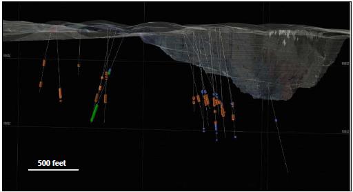
Note: Figure from R. Walton. September 2021.
May 2022
Project Number 250039 | Page 13 - 14 | |
|
2021 Ruby Hill Mineral Resource Estimate
Eureka County, NV, USANI43-101Technical Report |
Figure 13-2: Sample Spatial Coverage (Isometric View Looking Downward and to the North)
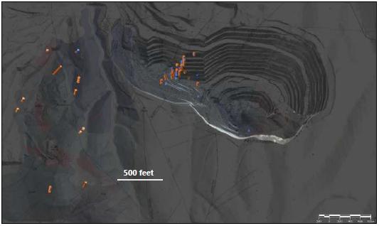
Note: Figure from R. Walton. September 2021.
Refractory samples are considered spatially representative, with good coverage for the 426 and Ruby Deeps zones.
A limited number of base metal composites were included as part of the testwork campaigns with two composites assembled from material at the Blackjack deposit.
| 13.4 | Metallurgical Variability |
A significant amount of metallurgical testwork has been completed to date on both oxide and refractory samples, both composite and variability, taken from around the deposit. The samples were mainly drill core. The sample grades are similar to the preliminary resource estimate and cover a wide range of oxidation states and other variables.
Analysis of the 16 refractory samples at BTC showed significant variation. Carbonate varied from 1.5% to 39%, while sulfide sulfur and arsenic from 0.45 to 3.1%, and 0.035% to 2.6% respectively.
May 2022
Project Number 250039 | Page 13 - 15 | |
|
2021 Ruby Hill Mineral Resource Estimate
Eureka County, NV, USANI43-101Technical Report |
A wide range of analyses were carried out on the various samples. As would be expected, deleterious elements content on oxide material is low, while sulfides are characterized by high levels of sulfide sulfur, arsenic, and mercury.
| 13.5.1 | Arsenic and Mercury |
The KCA January 2009 report conducted investigations into arsenic and mercury deportment. Although a note was added stating that as multi-acid digestion was specified, the values for arsenic and mercury may be biased low due to partial volatilization upon digestion.
The arsenic contents of the refractory samples were variable up to 2.6%, and averaged 0.4%. One of the two oxide samples had a relatively high arsenic content of 0.43%.
Mercury contents in the low and high-grade oxide composites from the 426 zone were moderate at 5.7g/t and 9.6 g/t respectively. The results of the mercury and gold analyses on the individual carbon samples are summarized in Table 13-15 along with the ratio of gold adsorbed to mercury adsorbed.
The KCA February 2014 report analyzed six samples for mercury, they were reported as being between 2 and 10 ppm. All 16 refractory samples documented in the BTC November 2011 report had levels of less than 10 ppm Hg.
Based on this, mercury retorts will be required for the refinery section of the plant.
Table 13-15: Mercury Adsorbed in Carbon
| Test Number | Carbon Period | C weight
(grams) | Au in Carbon
(g/t) | Hg in Carbon
(ppm) | Ratio
Au : Hg |
| 40334 | C-1 | 192.77 | 820.9 | 5.8 | 141.5 |
| | C-2 | 187.09 | 121.2 | 27.7 | 4.4 |
| | C-3 | 180.41 | 19.6 | 38.9 | 0.5 |
| | C-4 | 178.62 | 16.7 | 32.0 | 0.5 |
| 40337 | C-1 | 206.74 | 4,327.0 | 117.1 | 36.9 |
| | C-2 | 205.66 | 544.2 | 169.7 | 3.2 |
| | C-3 | 180.62 | 90.9 | 101.1 | 0.9 |
| | C-4 | 143.11 | 76.3 | 83.4 | 0.9 |
May 2022
Project Number 250039 | Page 13 - 16 | |
|
2021 Ruby Hill Mineral Resource Estimate
Eureka County, NV, USANI43-101Technical Report |
The 16 refractory and two oxide samples documented in the BTC November 2011 report were analyzed for total carbon and sulfur. Speciation for organic and inorganic carbon and speciation for sulfide and sulfate sulfur was included. Results are summarized in Table 13-16.
Table 13-16: Sulfur and Carbon Speciation Results
| Sample Description | CTotal
(%) | CInorg
(%) | CO3
(%) | Corg
(%) | STotal
(%) | SO4
(%) | S2-
(%) |
| RFC-1 | 7.77 | 7.73 | 38.65 | 0.04 | 1.06 | 0.06 | 1.00 |
| RFC-2 | 3.37 | 3.35 | 16.75 | 0.02 | 2.06 | 0.24 | 1.82 |
| RFC-3 | 4.64 | 4.58 | 22.90 | 0.06 | 1.82 | 0.20 | 1.62 |
| RFC-4 | 0.39 | 0.30 | 1.50 | 0.09 | 2.32 | 0.12 | 2.20 |
| RFC-5 | 5.16 | 5.12 | 25.60 | 0.04 | 0.91 | 0.06 | 0.85 |
| RFC-6 | 3.92 | 3.86 | 19.30 | 0.06 | 1.29 | 0.09 | 1.20 |
| RFC-7 | 4.34 | 4.29 | 21.45 | 0.05 | 1.55 | 0.13 | 1.42 |
| RFC-8 | 9.17 | 9.08 | 45.40 | 0.09 | 0.79 | 0.06 | 0.73 |
| RFC-9 | 6.47 | 6.39 | 31.95 | 0.05 | 0.44 | 0.04 | 0.40 |
| RFC-10 | 3.13 | 3.09 | 15.45 | 0.04 | 1.62 | 0.06 | 1.56 |
| RFC-11 | 3.34 | 3.26 | 16.30 | 0.08 | 3.20 | 0.14 | 3.06 |
| RFC-12 | 4.03 | 3.97 | 19.85 | 0.06 | 2.26 | 0.09 | 2.17 |
| RFC-13 | 8.37 | 8.33 | 41.65 | 0.04 | 1.39 | 0.05 | 1.34 |
| RFC-14 | 6.98 | 6.94 | 34.70 | 0.04 | 1.73 | 0.06 | 1.71 |
| RFC-15 | 5.02 | 4.97 | 24.85 | 0.05 | 1.79 | 0.06 | 1.73 |
| RFC-16 | 6.83 | 6.79 | 33.95 | 0.04 | 2.06 | 0.07 | 1.99 |
| Oxide-1 | 4.56 | 4.54 | 22.70 | 0.02 | 0.06 | 0.01 | 0.05 |
| Oxide-2 | 4.57 | 4.55 | 22.75 | 0.02 | 0.03 | 0.01 | 0.02 |
The sulfide contents of the refractory samples were variable up to 3.1%, and averaged 1.4%.
In addition, various shake flask tests were carried out (Figure 13-3). The spiked preg-rob shake flask test indicated low preg-robbing for most of the samples and moderate preg-robbing for the remainder. However, this effect was overcome by the use of carbon during leaching, i.e., CIL.
The two oxide samples exhibited almost no preg-robbing.
May 2022
Project Number 250039 | Page 13 - 17 | |
|
2021 Ruby Hill Mineral Resource Estimate
Eureka County, NV, USANI43-101Technical Report |
Figure 13-3: Preg-robbing tests results (BTC)
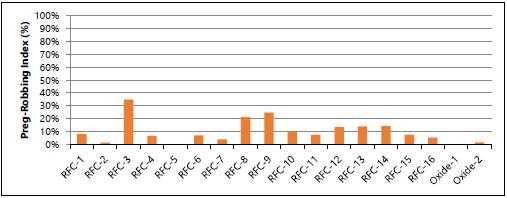
The gold and silver recovery estimates shown in this section have been derived as follows:
Oxide Mineralization Field recoveries are estimated for ROM and crushed mineralization for a heap leaching. Crushed material field recoveries are calculated using the arithmetic average of the column leach test. ROM field recoveries are estimated by discounting seven points from the crushed tests average. The testwork database includes a total of 79 column leach tests for all deposits. Recovery estimates for Mineral Point considers tests conducted on the Hamburg Dolomite lithology only as it is the main host of the mineralization on the deposit.
Refractory Mineralization Calculated using the average leach recovery from tests using alkaline oxidation followed by CIL on sulfide refractory material (16 data points).
Table 13-17: Recovery Estimates Summary Gold
| Ore Type | Deposit | Crushed Heap Au Rec
(%) | ROM Heap Au Rec
(%) | Autoclave-CIL Au Rec
(%) |
| Oxide | Archimedes | 80 | 73 | - |
| Oxide | 426 Zone | 88 | 81 | - |
| Oxide | Mineral Point* | 81 | 76 | - |
| Sulfide | Refractory | - | - | 88 |
Note: * Estimated for Hamburg Dolomite
May 2022
Project Number 250039 | Page 13 - 18 | |
|
2021 Ruby Hill Mineral Resource Estimate
Eureka County, NV, USANI43-101Technical Report |
Table 13-18: Recovery Estimates Summary Silver
| Redox | Deposit | Crushed Heap Ag Rec
(%) | ROM Heap Ag Rec
(%) | Autoclave-CIL Ag Rec
(%) |
| Oxide | Archimedes | 8 | 1 | - |
| Oxide | 426 Zone | 26 | 1 | - |
| Oxide | Mineral Point* | 33 | 1 | - |
| Sulfide | Refractory | - | - | - |
Table 13-19: Recovery Estimates Base Metals
| Concentrate Stream | Pb Rec
(%) | Ag Rec
(%) | Zn Rec
(%) | Pb Conc Grade
(%) | Ag Conc Grade
(g/t) | Zn Conc Grade
(%) |
| Pb Conc | 50 | 39 | - | 55 | 2,647 | - |
| Zn Conc | - | 13 | 90 | - | 28.4 | 50 |
The following sections provide details of the assumptions and considerations used to derive the recovery estimates.
| 13.6.1 | Oxide Mineralization |
The test results from the four KCA reports relevant to the Archimedes and 426 zones are summarized in Table 13-20.
Table 13-20: Column Leach Tests
| Test Program | Deposit | Crush Size
(inches) | CLT Au Rec
(%) | CLT Ag Rec
(%) | No. of Samples |
| KCA-07/2004 | East Archimedes | 1.25 | 84.0 | 13.5 | 15 |
| KCA-07/2004 | East Archimedes | ROM | 90.5 | 1.5 | 2 |
| KCA-05/2005 | East Archimedes | 1.5 | 76.0 | 3.0 | 4 |
| KCA-05/2005 | East Archimedes | ROM | 77.0 | 1.0 | 4 |
| KCA-01/2009 | 426 Zone | 0.75 | 87.5 | 10.0 | 2 |
| KCA-11/2011 | 426 Zone | 1.0 | 88.0 | 42.0 | 8 |
The two KCA reports - 24 June 2004 and 20 May 2005 were carried out on oxide samples from the East Archimedes deposit. The column tests show no variation of gold recovery with gold grade, or particle size. In fact, in the 2004 program, the two ROM samples had slightly higher recovery than the crushed samples. In the 2005 program, the particle size of the ROM, as-received material was only slightly coarser than the crushed material and recoveries were similar.
May 2022
Project Number 250039 | Page 13 - 19 | |
|
2021 Ruby Hill Mineral Resource Estimate
Eureka County, NV, USANI43-101Technical Report |
The KCA report - 26 January 2009 was carried out on oxide samples from the 426 zone.
The three KCA reports - 26 February 2011, 23 July 2012 and 2 February 2014 were carried out on thirteen samples. One was identified as sulfide, another as mixed and two others contained significant amounts of Dunderberg Shale. The remaining eight were identified as Hamburg Dolomite and were used to predict recoveries from that zone within Mineral Point. Due to the variation in the other five, it was determined there was insufficient data to confidently predict heap leach recoveries from sulfide or Dunderberg Shale mineralization.
The test results from the three KCA reports relevant to the Mineral Point Trend are summarized in Table 13.16. The lithologies used in these samples are also summarized. Table 13-21 shows CH referring to Hamburg Dolomite, CD to Dunderberg Shale and KI to intrusive material.
Tests carried out on pure, low sulfide, Hamburg Dolomite samples and considered on the recovery average are shown in Table 13-21.
The results for crushed material from East Archimedes average 80%, while the results for crushed material from 426 are higher at 88%. The average results from crushed material for Low Sulfide, 100% Hamburg Dolomite, Mineral Point are slightly lower at 81%. The deleterious effect of blending with Dunderberg Shale material can be clearly seen on the recovery results.
Also, the results from Low Sulfide, 100% Hamburg Dolomite from Mineral Point show little variation with particle size as shown on Figure 13-4.
May 2022
Project Number 250039 | Page 13 - 20 | |
|
2021 Ruby Hill Mineral Resource Estimate
Eureka County, NV, USANI43-101Technical Report |
Table 13-21: Column Leach Tests
Campaign
Date | Low S2- 100% CH | Redox | Litho | Crush
(inches) | Sulf S2
(%) | Au Rec
(%) | Ag Rec
(%) | NaCN
(lb/t) |
| 20110204 | x | Ox | 100% CH | 0.50 | - | 85 | 35 | 1.1 |
| | x | Ox | 100% CH | 0.50 | - | 84 | 39 | 0.7 |
| | x | Ox | 100% CH | 0.50 | - | 82 | 50 | 1.3 |
| | x | Ox | 100% CH | 0.50 | - | 81 | 46 | 0.8 |
| | | Ox | 72% CH, 29% CD | 0.50 | - | 74 | 14 | 2.0 |
| | | Ox | 72% CH, 29% CD | 0.50 | - | 75 | 15 | 2.3 |
| 20120723 | x | Ox | 57% KI, 40% CH | 1.50 | - | 82 | 34 | 0.9 |
| | x | Ox | 57% KI, 40% CH | 0.50 | - | 86 | 58 | 2.1 |
| | x | Ox | 100% CH | 1.50 | - | 88 | 34 | 1.6 |
| | x | Ox | 100% CH | 0.50 | - | 81 | 39 | 1.2 |
| | x | Ox | 100% CH | 1.50 | - | 84 | 27 | 1.3 |
| | x | Ox | 100% CH | 0.50 | - | 82 | 47 | 1.1 |
| | x | Ox | 100% CH | 1.50 | - | 86 | 48 | 1.3 |
| | x | Ox | 100% CH | 0.50 | - | 82 | 52 | 2.3 |
| 20140202 | | Sul | 95% CD | 1.00 | 3.41 | 29 | 32 | 4.5 |
| | | Sul | 95% CD | 0.75 | 3.42 | 31 | 48 | 4.8 |
| | | Mix | 88% CH, 11% CD | 1.00 | 0.45 | 71 | 39 | 1.3 |
| | | Mix | 88% CH, 11% CD | 0.75 | 0.45 | 70 | 43 | 0.6 |
| | x | Ox | 100% CH | 1.00 | 0.03 | 76 | 6 | 1.1 |
| | x | Ox | 100% CH | 0.75 | 0.03 | 81 | 15 | 2.7 |
| | | Ox | 71% CH, 28% NS | 1.00 | 0.04 | 57 | 24 | 1.1 |
| | | Ox | 71% CH, 28% NS | 0.75 | 0.04 | 62 | 29 | 0.8 |
| | x | Ox | 100% CH | 1.00 | 0.01 | 63 | 20 | 1.6 |
| | x | Ox | 100% CH | 0.75 | 0.01 | 85 | 20 | 1.0 |
| | x | Ox | 100% CH | 1.00 | 0.04 | 83 | 25 | 0.6 |
| | x | Ox | 100% CH | 0.75 | 0.04 | 74 | 27 | 0.7 |
| Average (low S2-, pure Hamburg Dolomite only) | 81 | 35 | 1.3 |
| | | | | | | | | | | | |
May 2022
Project Number 250039 | Page 13 - 21 | |
|
2021 Ruby Hill Mineral Resource Estimate
Eureka County, NV, USANI43-101Technical Report |
Figure 13-4: Low S2-, 100% Hamburg Dolomite Particle Size vs. Gold Recovery
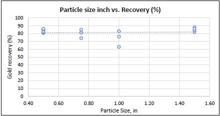
Table 13-22 shows actual results, as well as previous and current estimates for gold recovery from heap leaching of secondary crushed and ROM oxide mineralization.
Table 13-22: Gold Recovery Estimates for Oxides
| Deposit | Test Au Rec Average
(%) | Secondary Crush Au Rec
(%) | ROM* Au Rec
(%) |
| Actual 2007 to 2015 | - | 80 | 80 |
| RPA estimate 2012 (LOM) | - | 76 | 66 |
| Barrick estimate 2014 (Mineral Point) | - | 77 | 70 |
| East Archimedes | 80 | 80 | 73 |
| 426 Zone | 88 | 88 | 81 |
| Mineral Point (Hamburg Dolomite) | 81 | 81 | 76 |
Note: * Oxides are defined as being minus 0.05% sulfide sulfur. Above this level, reductions in leach efficiency occur.
The test results show little difference between from leaching crushed and ROM mineralization. However, the particle size distributions of the samples used in the tests are similar. Actual gold recovery results are only available for the blended ROM/crush leaching operation. As no estimated particle size distributions exist for “as-blasted” ROM mineralization from 426 and Mineral Point, a nominal 7% deduction from the estimated recovery for crushed material has been used. Operating experience, or the use of high intensity blasting, could increase these estimates.
May 2022
Project Number 250039 | Page 13 - 22 | |
|
2021 Ruby Hill Mineral Resource Estimate
Eureka County, NV, USANI43-101Technical Report |
The estimated recoveries are those that could be expected after approximately 150 days of leaching. Incremental increases of up to 3% could be expected after an extended leach period of up to 10 years as experienced in practice.
Silver recoveries are highly variable and very low for ROM tests. Estimates are shown in Table 13-23.
Table 13-23: Silver Recovery Estimates for Oxides
| Deposit | Test Results Average
(%) | Secondary Crushed Material
(%) | ROM*
(%) |
| East Archimedes | 8 | 8 | 1 |
| 426 | 26 | 26 | 1 |
| Mineral Point (Hamburg Dolomite) | 33 | 33 | 1 |
Other conclusions are drawn from the testwork which may affect the design of the processing plants.
The column tests show little variation with crush size in the range tested. An open-circuit, secondary crush size, of 80% passing 1.5", similar to the existing plant, is recommended. As is typically the case for secondary crushed material, the heap will be constructed using trucks. It is likely the heap will be “ripped” by a bull-dozer before irrigation. Some samples required agglomeration and exhibited “ponding” during testing, blending of material will be exercised and agglomeration may be required.
Laboratory cycle times are of the order of 60 days. There are various methods used to infer “field days” from “column days”. In this case the preferred method is that the first 30 column days are increased to 90 field days, the second 30 column days are increased to 60 days and no adjustment is made to the remaining days. Therefore, the “column days” of 60 becomes 150 “field days”. As typically occurs in actual heap leach operations, the final leach times are much higher as the solution from higher lifts percolates through lower lifts.
Column test cyanide consumptions are variable, and average in the order of 1 lb/st. The actual cyanide consumption is expected to be significantly less than this. Similarly, hydrated lime consumption is variable, no cement is required.
May 2022
Project Number 250039 | Page 13 - 23 | |
|
2021 Ruby Hill Mineral Resource Estimate
Eureka County, NV, USANI43-101Technical Report |
| 13.6.2 | Refractory Mineralization |
The data from the November 2011 Barrick BTC report has been used to predict leach recoveries, without oxidation. As would be expected, a trendline can be plotted between %S2- and the cyanide soluble gold to fire assay (CN/FA) value as shown in Figure 13-5.
Figure 13-5: Sulfide vs CN/FA Extraction
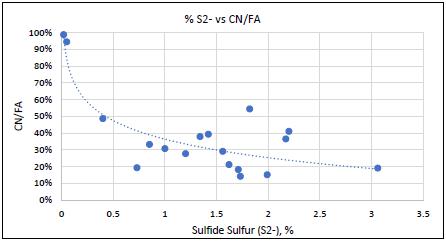
It is noted that there is no trend between either of the following pairs of data:
| • | Organic carbon (Corg) and preg-robbing. |
| • | Carbonate: sulfide ratio and CN/FA. |
The use of an arsenic pre-flotation step, presumably on the DSO, seems unlikely to be a viable process option. The removal of arsenic improves gold recovery by roasting, however, it has little or no effect when alkaline pressure oxidation is used.
The average of the 16 BTC refractory samples is 25.3 %CO3 and 1.4 %S2-. This gives a CO3 to sulfide ratio of 18. As a general rule, acid autoclaving is preferred when the CO3 to sulfide ratio is less than 5:1, while alkali autoclaving is preferred when the CO3 to sulfide ratio is higher 5:1. The average of the refractory samples is 23.2, therefore, this mineralization is firmly in the alkali autoclaving area.
The results from testing of alkaline pressure oxidation followed by CIL indicated an average leach recovery of 88% could be achieved. Recovery from acid pressure oxidation is likely to be higher but is expected to have poor economics due to the amount of sulfuric acid needed to destroy the carbonate ahead of autoclaving.
May 2022
Project Number 250039 | Page 13 - 24 | |
|
2021 Ruby Hill Mineral Resource Estimate
Eureka County, NV, USANI43-101Technical Report |
The following table contains current estimates for gold recovery from alkaline pressure oxidation or two-stage roasting followed by either CIL or CaTS of refractory mineralization. Silver recovery was not estimated, as no test data exists.
Refractory mineralization from 426, Ruby Deeps and Watertank are defined as being >0.05% sulfide sulfur. However, they are typically much higher, up to 1.5% with a peak of 3.0%.
Table 13-24: Gold Recovery Estimates for Oxides
| Process | Au Rec Estimate
(%) |
| Alkali autoclaving/CIL | 88 |
| Alkali autoclaving/CaTS | 87 |
| Roasting/CIL | 85 |
| Roasting/CaTS | 84 |
| 13.6.3 | Mixed Mineralization |
Certain mineralization with an intermediate sulfide content could be heap leached. While indications of recoveries can be inferred from the 2011 BTC report and two results from the 2014 KCA report, insufficient data exists to predict recoveries from mineralization such as Dunderberg Shale.
Flotation testwork data is limited to two samples, a high-grade and a low-grade composite. Results from locked cycle tests on the two composites are widely different pointing to differences in mineralogy generating variability and recovery uncertainty.
Gold revenues have not been included, due to the low grade on flotation feed and as poor recoveries are reported by leaching a pyrite concentrate from flotation tailings.
Recoveries were estimated based on preliminary resource grades (estimated by Wood) and the two locked cycle tests results available (Table 13-25).
May 2022
Project Number 250039 | Page 13 - 25 | |
|
2021 Ruby Hill Mineral Resource Estimate
Eureka County, NV, USANI43-101Technical Report |
Table 13-25: Flotation Recovery Estimates
| Sample Description | Zn Conc Grade
(%) | Pb Conc Grade
(%) | Ag in Pb Conc
(g/t) | Zn Rec
(%) | Pb Rec
(%) | Ag Rec to Pb Conc
(%) |
| Low Zinc | 43.3 | 63.1 | 2,329 | 86 | 40 | 39 |
| High Zinc | 60.7 | 70.4 | 5,588 | 97 | 91 | 85 |
| 13.7 | Recommendations for Further Work |
Additional work is needed to improve the confidence in the geologic model concerning the thickness of the sulfide and arsenic enrichment zone near the Dunderberg/Hamburg contact within the Mineral Point deposit. This work would include column tests on Dunderberg Shale samples to develop a relationship between sulfide content and gold recovery.
Further leaching studies are needed at coarser sizes to confirm the recovery expected for ROM sizes. These could be columns loaded with PQ core or preferably, bulk tests.
Further Sampling and testing of refractory mineralization from the 426 and Ruby Deeps deposits is suggested.
Future column tests should determine the need for agglomeration at the selected crush size.
Further tests on representative samples of the Blackjack deposit are recommended, including optimization of flotation parameters such as grind size and reagent suite. Penalty elements on concentrates need further investigation during the next stages of tests.
May 2022
Project Number 250039 | Page 13 - 26 | |
|
2021 Ruby Hill Mineral Resource Estimate
Eureka County, NV, USANI43-101Technical Report |
| 14 | Mineral Resource Estimates |
The Mineral Resource estimation workflow for the Ruby Hill Project consisted of three steps:
| • | exploratory data analysis to understand grade trends and distributions and select an approach and parameters for grade and density estimation |
| • | estimation of grades and bulk density |
| • | model validation including visual validation of block estimates against assay composite grades, checks of global bias between block estimates and declustered assay composite statistics from a nearest neighbor validation model, checks of grade model trends versus nearest neighbor and composites grades on swath plots. |
The Mineral Resource block model was classified according to the 2014 CIM Definition Standards following an assessment of the spatial continuity of grades and geological features, input data spacing and data quality.
A mineral resource pit shell was constructed to define the portion of the resource model having reasonable prospects for eventual economic extraction amenable to open pit mining and run of mine heap leaching. Underground stope shapes were constructed to define the portion of the resource having reasonable prospects for eventual economic extraction amenable to underground mining and sulfide mill processing.
Classified Mineral Resources blocks were tabulated and above conceptual cut off grades inside the resource pit shell and stope shapes and resource risks and opportunities were evaluated.
A structural model was developed for the Ruby Hill project by SRK (Uken, 2017a, 2017b). The structural model consists of a set of fault surfaces that offset lithological units and an assessment of fold geometry affecting the lithological units hosting gold mineralization. The model was developed from mapping in the open pit and analysis of blasthole, diamond drill and reverse circulation data. The main fault features are shown in Figure 14-1.
May 2022
Project Number 250039 | Page 14 - 1 | |
|
2021 Ruby Hill Mineral Resource Estimate
Eureka County, NV, USANI43-101Technical Report |
Figure 14-1: Fence Section Looking North Showing Main Faults and Stratigraphic Units for the Ruby Hill Project
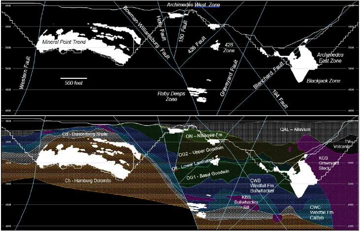
May 2022
Project Number 250039 | Page 14 - 2 | |
|
2021 Ruby Hill Mineral Resource Estimate
Eureka County, NV, USANI43-101Technical Report |
A three-dimensional wireframe model of the stratigraphic units hosting gold and base metal mineralization was constructed using the Project structural model faults and fold geometries and geological logging from diamond drill and reverse circulation drilling to guide interpretation. Figure 14-1 shows the lithology model for the Ruby Hill Project.
An oxidation model was constructed consisting of wireframe surfaces defining the base of oxide and top of sulfide mineralization. Wireframes were interpreted using the ratio of cyanide soluble gold to total gold grade (AURAT). Most of the drill intersections above the base of oxide surface have a ratio of cyanide soluble to total gold grades ranging from 0.8 to 1.0 and the majority of drill intersections below the base of oxide surface have ratios of less than 0.3. The material between the base of oxide and top of sulfide surfaces is a transitional zone containing a mix of high, medium and low cyanide soluble to total gold grade ratios. A cross section showing AURAT values and the base of oxides and top of sulfides surfaces is shown in Figure 14-2.
Drill hole grades were inspected in three dimensions to determine the major structural and lithological controls on gold mineralization and a set of estimation domain shapes were constructed to code drill hole assay composites and blocks for grade and bulk density estimation. A cross section showing the estimation domains is shown in Figure 14-2.
| 14.2 | Exploratory Data Analysis |
Exploratory data analysis (EDA) was carried out on raw assay sample and assay composite support and included construction and review of histograms, cumulative frequency plots, boxplots, visual review of spatial grade trends in three dimensions, and down hole and directional grade variography to develop the approach for grade estimation and generate parameters for interpolation. A summary of the EDA is presented here.
May 2022
Project Number 250039 | Page 14 - 3 | |
|
2021 Ruby Hill Mineral Resource Estimate
Eureka County, NV, USANI43-101Technical Report |
Figure 14-2: Fence Section Looking North Showing Mineralization Type Units and Estimation Domains for the Ruby Hill Project
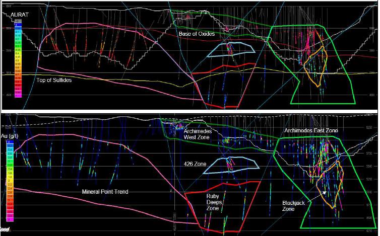
May 2022
Project Number 250039 | Page 14 - 4 | |
|
2021 Ruby Hill Mineral Resource Estimate
Eureka County, NV, USANI43-101Technical Report |
| 14.2.1 | Mineral Point Trend |
Visual assessment of gold grades at mineral point indicates that grades are moderate compared to the Archimedes Deposit, but lateral continuity is excellent along the broadly folded Hamburg dolomite unit that hosts most of the mineralization at Mineral Point. Locally varying anisotropy, using the hangingwall surface of the Hamburg Dolomite to orient the strike and dip of anisotropic search ellipsoids, was identified as a good way to model the folded grade trend evident at Mineral Point.
Figure 14-3 shows a histogram and cumulative frequency plot of gold assay grades for the Mineral Point Trend. The grade distribution is log-normal with a mean of 0.67 g/t Au and a median grade of 0.18 g/t Au with a long tail to a maximum grade of 128.5 g/t Au. The coefficient of variation (CV) of the gold assay grades is 4.6.
Based on an assessment of the relatively high variance of the assay grade distribution a 10’ composite length was selected to reduce variance of the nominally 5-foot assay grades at sample support to 3.6 for the 10’ assay composites.
To further manage the high variance of the gold grades the probability assigned constrained kriging (PACK) method was selected and indicator grade thresholds of 0.08 g/t Au and 1.0 g/t Au were selected to define low and high gold grade domains for Mineral Point Trend.
An analysis of the high-grade assays was undertaken, and assay capping thresholds were selected for the low-grade and high-grade domains.
Experimental correlograms were calculated using 10’ composites within the low- and high-grade domains. Down-hole variograms were used to define the nugget effect, and variogram maps were used to determine the directions of best continuity. Variograms were then modeled in the three primary directions.
EDA for silver grades indicated that although silver is not well correlated with gold grades, the grade distribution of silver is similar to that of gold and a similar approach would be suitable for silver grade estimation. Indicator grade thresholds of 4.0 g/t Ag and 40 g/t Ag were selected to define the low- and high-grade domains for silver.
May 2022
Project Number 250039 | Page 14 - 5 | |
|
2021 Ruby Hill Mineral Resource Estimate
Eureka County, NV, USANI43-101Technical Report |
Figure 14-3: Gold and Silver Assay Grade Histograms for the Mineral Point Trend
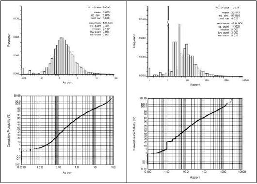
Note: Figure prepared by Wood.
Visual assessment of gold grades at Archimedes indicates that grades are higher but individual mineralized zones are smaller and more tightly constrained by lithological contracts and structures than at Mineral Point. A description of the occurrence and geometry of gold mineralization used in the construction of estimation domains, axis orientations for directional variography and the orientation of search ellipsoids is as follows:
| • | West Archimedes Zone: Mineralization occurs in favorable Upper Goodwin unit. Unit strikes 315° dips -20° to the northeast. |
| • | East Archimedes Zone: Mineralization occurs in Upper, LL and Basal Goodwin units near contact with the Graveyard stock. Goodwin Formation strikes 330°, dips -20° to the ENE. |
May 2022
Project Number 250039 | Page 14 - 6 | |
|
2021 Ruby Hill Mineral Resource Estimate
Eureka County, NV, USANI43-101Technical Report |
| • | 426 Zone: Mineralization occurs in a possible fold hinge of an open anticline of Goodwin Formation LL unit extending a few feet into the bottom of the Upper Goodwin. Mineralization has an elongated form with the major axis along 40° azimuth with a plunge of -20°. and the semi-major axis dipping -10° to the northwest. |
| • | Ruby Deeps: Mineralization occurs around the Bullwhacker sill but is influenced by orientation of the Upper and Caitlin beds of the Goodwin Formation. Trend of the major axis is 20° plunging -20° with the minor axis dipping -20° to the ESE. |
Histograms and boxplots show that gold grade distributions are lognormal and have continuous tails to maximum grades between 29.3 g/t Au and 166.5 g/t Au for each of the zones (Figure 14-4, Figure 14-5).
Ten-foot assay composites were selected for gold grade estimation; however, a large proportion of silver and multi-element analysis data at Archimedes is on 25 ft sample lengths, so silver was estimated separately with base metal grades, using 25 ft assay composites and a different methodology.
Indicator thresholds of 0.1 g/t Au and 1.0 g/t Au were selected for the PACK modeling at Archimedes based on an assessment of the grade distribution of the 10 ft assay composites.
Experimental variograms were calculated for gold grades and indicators along directions oriented along the directions of maximum and minimum continuity of each zone.
May 2022
Project Number 250039 | Page 14 - 7 | |
|
2021 Ruby Hill Mineral Resource Estimate
Eureka County, NV, USANI43-101Technical Report |
Figure 14-4: Histogram and Cumulative Frequency Plot of 25-foot
Assay Composite Gold Grades for Archimedes
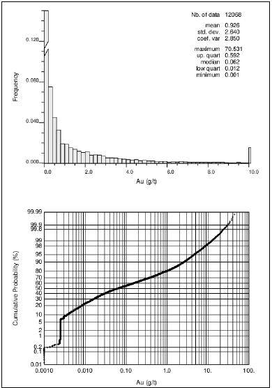
Note: Figure prepared by Wood.
May 2022
Project Number 250039 | Page 14 - 8 | |
|
2021 Ruby Hill Mineral Resource Estimate
Eureka County, NV, USANI43-101Technical Report |
Figure 14-5: Boxplot of 10-foot Assay Composite Gold Grades for Archimedes
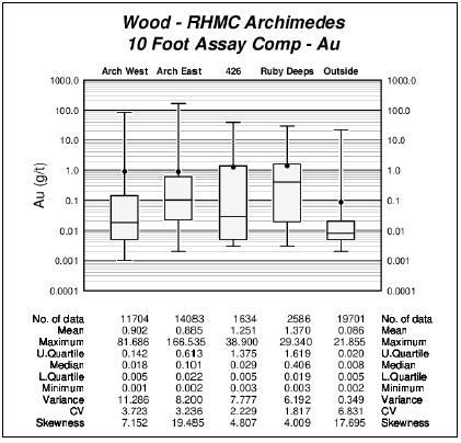
Note: Figure prepared by Wood.
Grade estimation was carried out using the PACK indicator kriging methodology using the Vulcan commercial mining software package for gold grade estimation. A composite length of 10 feet and block size of 25 ft x 25 ft x 25 ft were chosen to build models for open pit mining. This block size is consistent with the bench height and selectivity of historic mining in the Archimedes pits and the selectivity envisaged for future open pit mining.
A second set of models were estimated for resource estimates for underground mining scenarios. These models were estimated using composite lengths and block sizes to fit the geometry of the mineralization and selectivity of the proposed underground mining method for each zone. A composite length of 5 ft and a block size of 5 ft x 5 ft x 5 ft was used to estimate models to provide the selectivity to mine the deeper and higher-grade portions of the Archimedes Deposit by underhand cut-and-fill method.
May 2022
Project Number 250039 | Page 14 - 9 | |
|
2021 Ruby Hill Mineral Resource Estimate
Eureka County, NV, USANI43-101Technical Report |
| 14.3.1 | Mineral Point Trend Open Pit Resources |
Grades for the Mineral Point Trend were estimated into 25 ft x 25 ft x 25 ft blocks using 10 ft assay composites.
Based on an analysis of the CV at a range of grade thresholds (Figure 14-6), thresholds of around 1.0 g/t Au and 40 g/t Ag were selected to define low- and high-grade domains for gold and silver. This threshold allowed reduction of the variance of composite grades within the two grade domains and enough samples to support estimation in both domains.
Figure 14-6: Indicator Threshold Selection - CV of Gold and Silver Assay Composite Grades
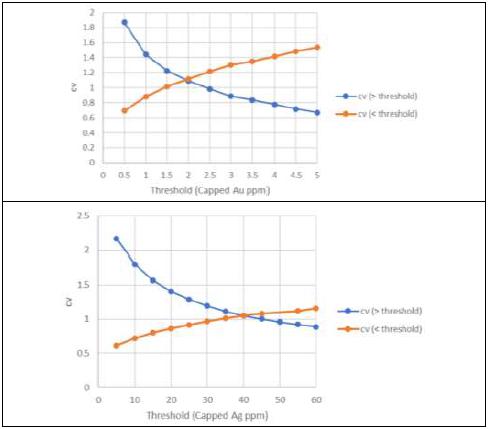
Note: Figure prepared by Wood.
May 2022
Project Number 250039 | Page 14 - 10 | |
|
2021 Ruby Hill Mineral Resource Estimate
Eureka County, NV, USANI43-101Technical Report |
Low and high-grade indicators were estimated using inverse distance weighting to the second power to estimate 10-foot assay composite grades with a search of 500 ft x 500 ft x 50 ft with a minimum of 6 samples, maximum of 15 samples and maximum of 3 samples per drillhole. Based on volumetric calibration to a Nearest Neighbor (NN) model of the high-grade indicator, an estimated indicator probability of 0.37 was selected as the probability threshold to define blocks for the high-grade domain. Indicator probabilities were back-flagged from blocks to 10 ft assay composites and composites having backflagged probabilities above the 0.37 threshold were used to estimate the high-grade zone. Composites with back-flagged probabilities below 0.37 were used to estimate the low-grade zone.
Gold grades for blocks within the high-grade domain were interpolated using the estimation parameters shown in Table 14-1. Estimation search ellipse orientation is based on locally varying anisotropy (LVA) in which each block is assigned an orientation based on the tangent plane to the hangingwall contact of the Hamburg dolomite at the point nearest to the block centroid.
Table 14-1: Au Estimation Strategy
| Estimation Pass | Min | Max | Max Per DH | X Axis | Y Axis | Z Axis | % Estimated |
| LG Domain | | | | | | | |
| 1 | 6 | 15 | 3 | 200 | 200 | 50.0 | 39 |
| 2 | 6 | 15 | 3 | 300 | 300 | 75.0 | 34 |
| 3 | 6 | 15 | 3 | 450 | 450 | 112.5 | 25 |
| 4 | 1 | 15 | 3 | 600 | 600 | 150.0 | 2 |
| HG Domain | | | | | | | |
| 1 | 5 | 15 | 3 | 200 | 200 | 50.0 | 42 |
| 2 | 5 | 15 | 3 | 300 | 300 | 75.0 | 24 |
| 3 | 5 | 15 | 3 | 450 | 450 | 112.5 | 20 |
| 4 | 1 | 15 | 2 | 600 | 600 | 150.0 | 14 |
May 2022
Project Number 250039 | Page 14 - 11 | |
|
2021 Ruby Hill Mineral Resource Estimate
Eureka County, NV, USANI43-101Technical Report |
A review of the grade tonnage curve for gold revealed an inflection at the 0.8 g/t Au indicator threshold. To soften the boundary between low- and high-grade domains, a mixing zone was applied by adjusting the composite selection allowed to estimate each domain. For Au estimates for Mineral Point the final gold grade estimate was based on allowing composites with a probability between 0 and 0.45 to estimate blocks in the LG domain and composites with a probability between 0.20 and 1 to estimate blocks in the HG domain. Figure 14-7 shows the reduction in the “valley” by applying this soft boundary.
Figure 14-7: Au Estimation - Implementation of a Soft Boundary between LG and HG composites
Note: Figure prepared by Wood.
A review of the estimated Au grades noted a high-grade blow-out in a limited area with existing underground development and drilling and assaying by Eureka Corp. To constrain the blowout Wood created a small wireframe around the affected area and applied a local cap grade of 5.0 g/t Au to composites within this area (Figure 14-8).
May 2022
Project Number 250039 | Page 14 - 12 | |
|
2021 Ruby Hill Mineral Resource Estimate
Eureka County, NV, USANI43-101Technical Report |
Figure 14-8: Area of Au High-Grade Blow-out and Eureka Corp
Underground Drilling
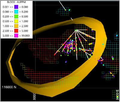
Note: Figure prepared by Wood.
| 14.3.2 | Archimedes Deposit Open Pit Resources |
PACK estimates were produced using grade domains at nominally 0.1 g/t Au and 1.0 g/t Au thresholds for the Mineral Point, West Archimedes, East Archimedes, 426 and Ruby Deeps zones. Blocks were estimated into 25 ft x 25 ft x 25 ft blocks using 10 ft downhole assay composites.
Low- and high-grade zones were estimated by kriging indicators and selecting an indicator probability threshold producing a volume similar to that of a nearest neighbor model for the indicator. Indicator probabilities were backflagged to composite and used to select composite for estimation of block grades in each of the grade zones Figure 14-9).
May 2022
Project Number 250039 | Page 14 - 13 | |
|
2021 Ruby Hill Mineral Resource Estimate
Eureka County, NV, USANI43-101Technical Report |
Figure 14-9: Reference Cross Section Showing Low- and High-Grade Zones at Archimedes
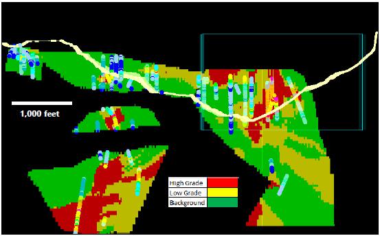
Note: Figure prepared by Wood. September 2021
Grades were estimated in a single pass of ordinary kriging for the high- and low-grade zones and by inverse distance weighting to the second power for blocks outside the low-grade zone. Composite selection parameters and high yield thresholds and ranges were selected and adjusted iteratively. The maximum number of composites per hole and maximum number of composites used in estimation were initially relatively high but were decreased to a maximum of three per hole and maximum of 15 total to reduce smoothing. Models were estimated without high yield restriction initially and then the threshold and range were adjusted for each domain until over projection of high-grade composites was controlled and mean grades matched declustered assay stats for each domain (Table 14-2).
May 2022
Project Number 250039 | Page 14 - 14 | |
|
2021 Ruby Hill Mineral Resource Estimate
Eureka County, NV, USANI43-101Technical Report |
Table 14-2: Gold Grade Estimation Parameters for the Archimedes Deposit
| Domain | Grade Zone | Estimator | Search Ellipsoid Orientation | | Search Ellipsoid Axis Length | | Composite Selection | | High Yield Restriction | |
Bearing
(degree) | Plunge
(degree) | Dip
(degree) | | Major
(feet) | Semi-maj.
(feet) | Minor
(feet) | | Min | Max | Max/hole | | Threshold
(Au, g/t) | Range
(feet) |
| East Archimedes | High | OK | 60 | -35 | 0 | | 1,200 | 600 | 600 | | 3 | 15 | 3 | | 30 | 40 |
| Low | OK | 60 | -35 | 0 | | 1,200 | 600 | 600 | | 3 | 15 | 3 | | 10 | 40 |
| Background | ID | 60 | -35 | 0 | | 1,200 | 600 | 600 | | 3 | 15 | 3 | | 1 | 40 |
| West Archimedes | High | OK | 45 | -20 | 0 | | 600 | 900 | 30 | | 3 | 15 | 3 | | 30 | 40 |
| Low | OK | 45 | -20 | 0 | | 600 | 900 | 30 | | 3 | 15 | 3 | | 10 | 40 |
| Background | ID | 45 | -20 | 0 | | 600 | 900 | 30 | | 3 | 15 | 3 | | 1 | 40 |
| 426 | High | OK | 40 | -20 | 10 | | 900 | 450 | 450 | | 3 | 15 | 3 | | 20 | 40 |
| Low | OK | 40 | -20 | 10 | | 900 | 450 | 450 | | 3 | 15 | 3 | | 10 | 40 |
| Background | ID | 40 | -20 | 10 | | 900 | 450 | 450 | | 3 | 15 | 3 | | 1 | 40 |
Ruby
Deeps | High | OK | 40 | -20 | 20 | | 1,200 | 600 | 300 | | 3 | 15 | 3 | | 30 | 40 |
| Low | OK | 40 | -20 | 20 | | 1,200 | 600 | 300 | | 3 | 15 | 3 | | 10 | 40 |
| Background | ID | 40 | -20 | 20 | | 1,200 | 600 | 300 | | 3 | 15 | 3 | | 1 | 40 |
| | | | | | | | | | | | | | | | | | | | |
May 2022
Project Number 250039 | Page 14 - 15 | |
|
2021 Ruby Hill Mineral Resource Estimate
Eureka County, NV, USANI43-101Technical Report |
| 14.3.3 | 426 and Ruby Deeps Underground Resources |
The 426 and Ruby Deeps zones were identified as potential candidates for underground development. Separate resource models were developed for 426 and the higher-grade portion of the Ruby Deeps deposit using 5 ft assay composites and 5 ft blocks to produce more selective resource models. The PACK approach was applied to the 5 ft composites and a grade zone was developed using a 3 g/t Au indicator. Indicator and grade variography were carried out using the 5 ft assay composites and nearest neighbor models of the indicator were generated to select the probability threshold of the kriged indicators. Kriged indicator probabilities were backflagged to composites and grades within the 3 g/t Au indicator grade zone were estimated using ordinary kriging.
The 3 g/t Au grade zone at 426 forms a shallowly north-northeast plunging core within the mineralization at 426 (Figure 14-10). The extents of the 3 g/t grade zone are relatively well defined by reasonably closely spaced drilling.
The 3 g/t Au grade zone forms a series of tabular, stacked north northeast striking, east dipping units in favorable stratigraphic units at Ruby Deeps (Figure 14-11). Drilling is more open at Ruby Deeps and the grade zones are not as tightly defined. Several of the upper horizons are only defined in one or two holes and were not modeled. A high yield restriction approach was used to constrain the dimensions of the gold grade zone on the south and west sides where the drill spacing is relatively open.
Silver grades were estimated for blocks inside the 3 g/t Au grade zones for 426 and Ruby Deeps using ordinary kriging following estimation of gold grades.
May 2022
Project Number 250039 | Page 14 - 16 | |
|
2021 Ruby Hill Mineral Resource Estimate
Eureka County, NV, USANI43-101Technical Report |
Figure 14-10: 3 g/t Au Grade Zone at 426 (Isometric View Looking 330°/-10°)
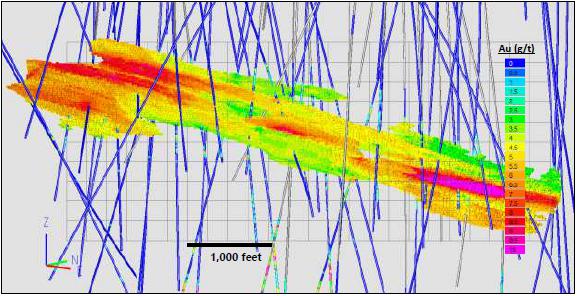
Note: Figure prepared by Wood. September 2021
Figure 14-11: 3 g/t Au Grade Zone at Ruby Deeps (Isometric View looking (300°/-10°)
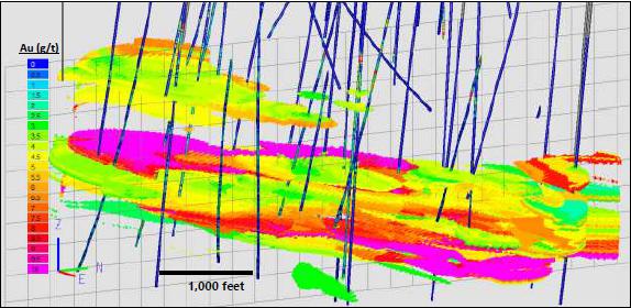
Note: Figure prepared by Wood. September 2021
May 2022
Project Number 250039 | Page 14 - 17 | |
|
2021 Ruby Hill Mineral Resource Estimate
Eureka County, NV, USANI43-101Technical Report |
| 14.4 | Resource Model Validation |
| 14.4.1 | Mineral Point Trend Open Pit Resources |
Visual Review
Estimated block model grades and composite grades were visually examined in cross section and plan view. This review showed that the composites and model blocks agreed well. Example sections for gold grades are shown Figure 14-12.
May 2022
Project Number 250039 | Page 14 - 18 | |
|
2021 Ruby Hill Mineral Resource Estimate
Eureka County, NV, USANI43-101Technical Report |
Figure 14-12: Resource Model - Estimated Au and 10 Foot Composite Grades - Section 121200 N Looking N
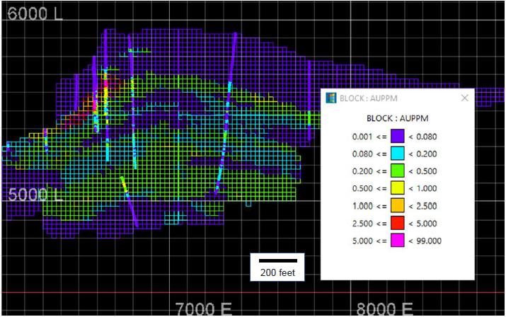
Note: Figure by Wood. March 2021
May 2022
Project Number 250039 | Page 14 - 19 | |
|
2021 Ruby Hill Mineral Resource Estimate
Eureka County, NV, USANI43-101Technical Report |
Global Bias
The Au and Ag block estimates were checked for global bias by comparing the average grade (with no cut-off) from the estimated OK model with that obtained from nearest-neighbor estimates. The nearest-neighbor estimator produces a theoretically globally unbiased estimate of the average value when no cut-off grade is applied and is a good basis for checking the performance of the different estimation methods. Global biases are within the recommended Wood guidelines of ±5% (relative) for Au and Ag for Indicated Resources. The comparison is summarized in Table 14-3.
Table 14-3: Global Bias Check within Indicated Resources
| Class | Element | Tons
(000s) | NN Mean | Estimated Mean
(OK) | Relative Difference
(%) |
| (OK-NN)/NN |
| Indicated | Ag (g/t) | 183546 | 0.496 | 0.493 | -0.6 |
| Au (g/t) | 15.104 | 15.251 | 1.0 |
| 14.4.1.1 | Local Bias Check (Swath Plots) |
Local bias checks for Au and Ag were performed within the mineralized envelope by creating and analyzing local trends in the grade estimates using swath plots as presented in Figure 14-13.
This was done by plotting the mean values from the NN estimate, the ID2 estimates and the OK estimates in east-west, north-south and vertical swaths or increments. Swath intervals are 100 feet in the easterly direction, 150 feet in the northerly direction, and 50 feet vertically. In the upper row of the swath plots, the red line represents the OK model grades, the blue line represents the ID2 model grades, and the black line represents the NN model grades. In the lower row of swath plots, the number of blocks contained in each swath is shown by the red, blue, and black lines. Because the NN model is declustered and the composites are not, the NN model is a better reference model to validate the OK resource model. Swath plots are for Indicated blocks, and both Au and Ag show good agreement, especially in areas supported by large numbers of blocks.
May 2022
Project Number 250039 | Page 14 - 20 | |
|
2021 Ruby Hill Mineral Resource Estimate
Eureka County, NV, USANI43-101Technical Report |
Figure 14-13: Swath Plot - Au - Indicated Blocks
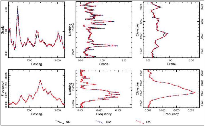
Note: Figure prepared by Wood.
May 2022
Project Number 250039 | Page 14 - 21 | |
|
2021 Ruby Hill Mineral Resource Estimate
Eureka County, NV, USANI43-101Technical Report |
| 14.4.2 | Archimedes Deposit Open Pit Resources |
The PACK grade zones were validated using maps of blasthole data to check the shapes and relative areas of the grade zones based on closely spaced data in comparison with the shapes and areas of the PACK model grade zones. Fire assay gold grades from blast holes from the East Archimedes pit were regularized by averaging within 25 ft by 25 ft by 25 ft resource model blocks and compared with the grade zones in the resource model blocks. Grades of Blasthole simples and two block models compared on bench plans at 5,500’, 5,650’ and 5,800’ elevation in the East Archimedes pit where there is a good distribution of mine blasthole data available (Figure 14-14).
Comparisons show a similar distribution and zonation of low-grade and high-grade blocks. The resource model zones are more continuous as a result of being interpolated from drillhole assay composites spaced 50 ft to 100 ft apart compared to the sub-20 foot resolution of the blasthole samples. Some of the noise in the blasthole blocks may be a result of blasthole sampling issues and relatively poor precision of individual blastholes. The blast block maps confirm that the indicator kriging does a good job of capturing the relative proportion and shape of the grade zones from relatively widely spaced data points.
Estimated block model grades and composite grades were visually examined in cross section and plan view. This review showed that the composites and model blocks agreed well. Example sections for gold grades for the Archimedes Deposit is shown in Figure 14-5.
May 2022
Project Number 250039 | Page 14 - 22 | |
|
2021 Ruby Hill Mineral Resource Estimate
Eureka County, NV, USANI43-101Technical Report |
Figure 14-14: Gold Grade Zone Maps from Blasthole (left), Regularized Blast Block (middle) and Resource
Model Blocks (right)
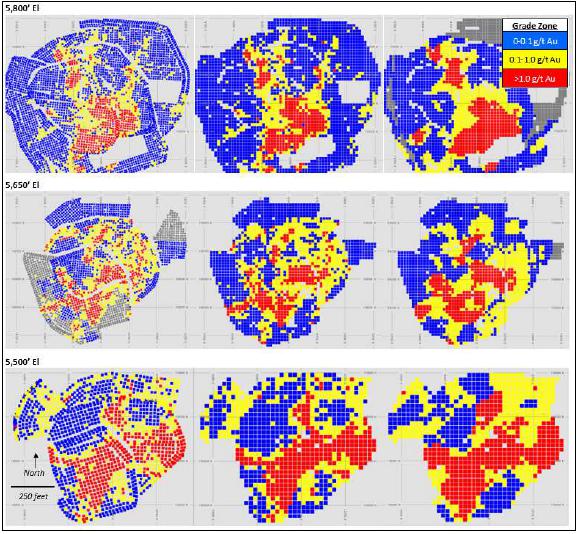
May 2022
Project Number 250039 | Page 14 - 23 | |
|
2021 Ruby Hill Mineral Resource Estimate
Eureka County, NV, USANI43-101Technical Report |
Figure 14-15: Cross Section of Gold Grades for the Archimedes Deposit
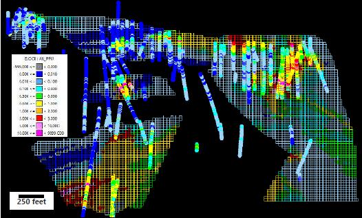
Note: Figure by Wood. September 2021
Mean estimated block grades and nearest neighbor validation model grades were tabulated for each grade zone. Table 14-4 compares nearest neighbor validation model grades and kriged block grades for blocks within 150 feet of a drillhole and all blocks. The kriged grades of the high- and low-grade zones tend to be slightly lower than the nearest neighbor grades because of the high yield restriction applied to the kriged grades. There is a very large difference between the kriged grades and NN grades for the Ruby Deeps low grade zone for blocks with an average distance of less than 150 feet from composites, but most block are beyond this range and the global population validates well for this domain.
May 2022
Project Number 250039 | Page 14 - 24 | |
|
2021 Ruby Hill Mineral Resource Estimate
Eureka County, NV, USANI43-101Technical Report |
Table 14-4: Global Bias Check for the Archimedes Deposit Gold Grade Estimates
| Domain | Grade Zone | Blocks within 150' of DH | | All Blocks | |
| Qty. Blocks | NN | Block | (Block-NN) | | Qty. Blocks | NN | Block | (Block-NN) |
| Au (g/t) | Au (g/t) | (%) | | Au (g/t) | Au (g/t) | (%) |
| East Archimedes | High | 12,340 | 2.97 | 2.85 | -4.0 | | 20,106 | 2.90 | 2.68 | -7.6 |
| Low | 22,041 | 0.50 | 0.49 | -2.0 | | 50,733 | 0.56 | 0.54 | -3.6 |
| West Archimedes | High | 4,544 | 4.71 | 4.75 | 0.8 | | 4,584 | 4.69 | 4.74 | 1.1 |
| Low | 6,521 | 0.87 | 0.75 | -13.8 | | 7,189 | 0.83 | 0.77 | -7.2 |
| 426 | High | 2,976 | 3.05 | 3.09 | 1.3 | | 2,224 | 2.97 | 3.04 | 2.4 |
| Low | 747 | 0.70 | 0.75 | 7.1 | | 3,563 | 0.70 | 0.81 | 15.7 |
| Ruby Deeps | High | 2,101 | 3.17 | 3.11 | -1.9 | | 47,033 | 2.76 | 2.65 | -4.0 |
| Low | 54 | 0.37 | 0.97 | 162.2 | | 39,807 | 0.60 | 0.61 | 1.7 |
| Total / Avg | | 51,324 | 1.77 | 1.73 | -2.5 | | 175,239 | 1.75 | 1.69 | -3.6 |
| | | | | | | | | | | | | | |
| 14.4.2.3 | Local Bias Check (Swath Plots) |
Swathplots were constructed for the high, low and background grade domains for each of the zones. Kriged grades profiles are smoother than the nearest neighbor model grade profiles but show the same trends with easting, northing and depth as the validation model. Figure 14-16 shows the swath plots for the East Archimedes High- and Low-grade domains as an example.
May 2022
Project Number 250039 | Page 14 - 25 | |
|
2021 Ruby Hill Mineral Resource Estimate
Eureka County, NV, USANI43-101Technical Report |
Figure 14-16: Swath Plot for East Archimedes High- and Low-Grade Domains
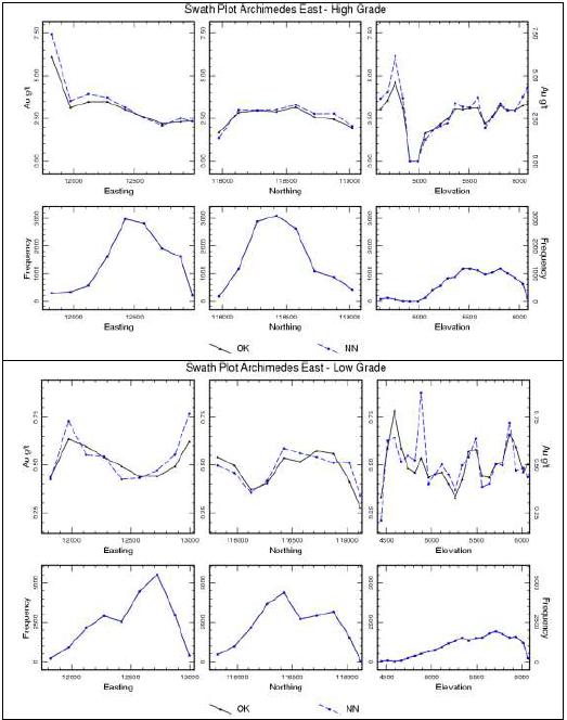
Note: Figure prepared by Wood.
May 2022
Project Number 250039 | Page 14 - 26 | |
|
2021 Ruby Hill Mineral Resource Estimate
Eureka County, NV, USANI43-101Technical Report |
| 14.4.3 | 426 and Ruby Deeps Underground Resources |
Estimated gold and silver block grades inside the 3 g/t Au grade zone were checked with composite grades on orthogonal sections. Initial inspections indicated minor issues with the shape of the 3 g/t Au grade shell and overprotection of isolated high-grade assay composites at Ruby Deeps. Minor modifications were made to the grade zones and high-yield restriction was applied to produce improved shapes and reduce over-projection of isolated high-grade intersections. Inspections of the final grade models for 426 and Ruby Deeps underground models confirmed that the modifications had the intended effect.
Statistics from nearest neighbor validation models were compared to estimated grades on tables comparing means to validate for potential global bias, and on swath plots to check grade spatial trends on easting, northing and elevation. Figure 14-17 and Figure 14-18 present statistics for composites, kriged grade models (OK) and nearest neighbor validation models (NN) for 426 and Ruby Deeps. The means of the grade models compare very closely to the means of the nearest neighbor models indicating that the grade models are globally unbiased.
May 2022
Project Number 250039 | Page 14 - 27 | |
|
2021 Ruby Hill Mineral Resource Estimate
Eureka County, NV, USANI43-101Technical Report |
| Figure 14-17: 426 Composite, OK and Nearest Neighbor Validation Model Gold Grades | Figure 14-18: Ruby Deeps Composite, OK and Nearest Neighbor Validation Model Gold Grades |
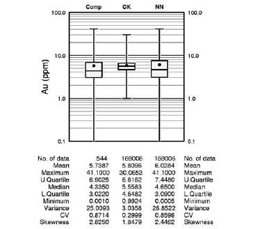 | 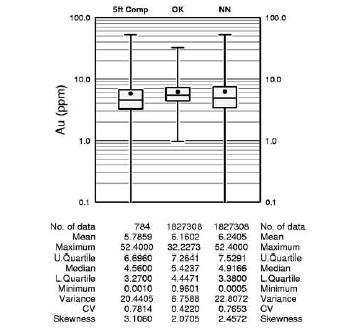 |
| Note: Figure prepared by Wood. | Note: Figure prepared by Wood. |
.
May 2022
Project Number 250039 | Page 14 - 28 | |
|
2021 Ruby Hill Mineral Resource Estimate
Eureka County, NV, USANI43-101Technical Report |
Bulk density was assigned to blocks based on lithology using the median of the bulk density measurements for each unit (Figure 14-19). A specific gravity value of 2.0 was assigned to quaternary alluvium, and a default value of 2.6 was assigned to lithologies for which there were no bulk density measurements. Dimensionless specific gravity values were converted to Imperial density in short tons per cubic foot for tabulation of resources and Imperial tonnage was converted to Metric tonnes for reporting.
Figure 14-19: Bulk Density Values by Lithology
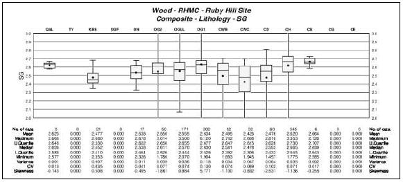
Note: Figure prepared by Wood.
| 14.6 | Mineral Resource Classification |
The Ruby Hill Project Mineral Resource Estimate has been classified according to the 2014 CIM Definition Standards and CIM Estimation of Mineral Resources & Mineral Reserves Best Practice Guidelines (Nov. 29, 2019). Parameters for Mineral Resource classification have been assessed separately for the Mineral Point Trend, Archimedes Open Pit and Archimedes Underground Mineral Resource Estimates. The parameters evaluated in the development of confidence classification criteria include the quality of the data used for the estimate, input data spacing, continuity of geological features and grade and geostatistical assessment of estimation error of forecast grade for quarterly and annual production volumes.
May 2022
Project Number 250039 | Page 14 - 29 | |
|
2021 Ruby Hill Mineral Resource Estimate
Eureka County, NV, USANI43-101Technical Report |
| 14.6.1 | Mineral Point Trend |
A geostatistical drillhole spacing study was carried out as part of the assessment of parameters for mineral resource classification for the Mineral Point Trend resource estimate. The drillhole spacing study used the gold grade variogram and the coefficient of variation of the assay composite database to calculate estimation error for forecasts of gold grade for quarterly and annual production volumes at a mining rate of 20 ktpd based on a range of drill patterns. The study indicated that based on the variance of the gold grades and their spatial continuity at Mineral Point a 100 ft x 100 ft square pattern would allow estimates of quarterly production with an error of approximately ±15% at the 80th confidence interval, and a 200 ft x 200 ft grid would be required to produce estimates within ±15% at the 80th confidence interval for annual production volumes. A portion of the Mineral Point block model is estimated by drillholes spaced closely enough for Measured but concerns about data quality for the legacy data caused a downgrade of confidence of this material, and all blocks within an average of 140 ft to the nearest three drillholes were classified as Indicated. Blocks estimated from drillholes from 140 ft to 500 ft were classified as Inferred. A smoothing routine was run to reduce the number of small, isolated patches of Measured and Indicated blocks in areas of predominantly Inferred classification and reduce the number of small, isolated islands of Inferred blocks inside areas of predominantly Indicated classification.
The range of continuity of grades is shorter at Archimedes than Mineral Point. Drillhole spacing metrics for classification determined by a drillhole spacing study for Archimedes are 80 ft maximum distance for Measured and 150 ft maximum distance for Indicated Mineral Resources. Blocks were flagged as Measured and Indicated using average distance to nearest three holes to assign an initial classification. Concerns about the quality of legacy data at Archimedes led to downgrade of the classification of blocks estimated within the 80 ft average distance to three drillholes to Indicated. Inferred category is assigned for blocks within the search volumes used for grade estimation that are not flagged for consideration as Measured or Indicated category. A smoothing routine was run to assign final classification to Indicated and Inferred Mineral Resources.
May 2022
Project Number 250039 | Page 14 - 30 | |
|
2021 Ruby Hill Mineral Resource Estimate
Eureka County, NV, USANI43-101Technical Report |
| 14.6.3 | 426 and Ruby Deeps Underground |
The drillhole spacing at 426 is relatively tight given the reasonably well-defined continuity of the 3 g/t Au grade zone so the 426 Mineral Resource was assigned Indicated confidence.
The drillhole spacing for Ruby Deeps is more open and mineralization is not well defined so blocks in the 3 g/t Au grade zone for Ruby Deeps were assigned Inferred confidence.
| 14.7 | Reasonable Prospects for Eventual Economic Extraction |
| 14.7.1 | Mineral Resources for Open Pit Mining and Run of Mine Heap Leach |
A Mineral Resource pit shell was constructed to define the portion of the Ruby Hill resource having reasonable prospects for eventual economic extraction (RPEEE) amenable to open pit mining and processing by run of mine heap leaching using the 25 ft x 25 ft x 25 ft block model and the Whittle Lerchs-Grossman (LG) open pit optimization algorithm. Conceptual mining, processing and economic assumptions for the open pit resource shell are presented in Table 14-5. The open pit shell was constrained to parts of the Mineral Point Trend, West Archimedes and East Archimedes Zones that were oxide and transitional blocks above the surface defining the top of sulfide mineralization. Open-pit Mineral Resources are reported above a fixed marginal cut-off grade of 0.1 g/t Au that excludes mining cost.
A cross section showing the extents of the Ruby Hill Resource Pit (yellow) and the current topographic surface (white) is shown in Figure 14-20.
May 2022
Project Number 250039 | Page 14 - 31 | |
|
2021 Ruby Hill Mineral Resource Estimate
Eureka County, NV, USANI43-101Technical Report |
Table 14-5: Parameters for Mineral Resource Pit Shell Construction
| Parameter | Unit | Rate | Source | Comments |
| Metals Price | | | | |
| Gold | US$/oz | 1,650 | Wood | |
| Silver | US$/oz | 21 | Wood | |
| Discount rate | % | 5 | Client | |
| Dilution | % | 0 | Client | |
| Mining Loses | % | 0 | Client | |
| Physical Constraints | Yes or No | | No | |
| Au Process Recovery (ROM) | % | 75 | RHMC | |
| Ag Process Recovery (ROM) | % | 50 | RHMC | |
| Mining Operating Cost | | | | |
| Base Mining Cost - Waste | US$/tonne | 2.04 | Wood | US$1.85/short ton |
| Base Mining Cost - Resource | US$/tonne | 2.04 | Wood | US$1.85/short ton |
| Overburden & Backfill | US$/tonne | 2.04 | Wood | US$1.85/short ton |
| Process Operating Cost | | | | |
| Incremental haulage | US$/tonne processed | 0.00 | Not Used | |
| Processing Cost (ROM) | | 2.23 | RHMC | US$2.04/short ton processed |
| Sustaining Capital Cost | US$/tonne processed | none | RHMC | |
| G&A Cost | US$/tonne processed | 0.72 | RHMC | US$0.65/short ton |
| Closure Cost | US$/tonne processed | | | |
| Royalty | % | 3.0% | RHMC | |
| Deductions | grade units | | | |
| Payable Metal | | | | |
| Gold | % | 99.90 | RHMC | |
| Silver | % | 99.50 | RHMC | |
| Penalties Au Dore | | | | |
| As | US$/oz | | | |
| Treatment & Refining Cost - Gold | US$/oz | 1.85 | RHMC | |
| Treatment & Refining Cost - Silver | US$/oz | 0.50 | RHMC | |
| Transport Cost | US$/oz | 0.00 | RHMC | |
| Insurance Cost | US$/oz | 0.00 | RHMC | |
| Overall Slope Angles (OSA) | | | | |
| Dumps | degree | 30.00 | RHMC | |
| Alluvium | degree | 55.00 | RHMC | |
| Bedrock | degree | 45.00 | RHMC | |
| Others* | degree | None | RHMC | |
May 2022
Project Number 250039 | Page 14 - 32 | |
|
2021 Ruby Hill Mineral Resource Estimate
Eureka County, NV, USANI43-101Technical Report |
Figure 14-20: Cross Section Showing the Ruby Hill Project Resource Pit
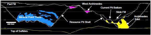
Note: Figure prepared by Wood.
| 14.7.2 | Mineral Resources for Underground Mining and Toll Sulfide Processing |
Mineral Resource stope outlines were constructed to define the portion of the Ruby Hill resource having RPEEE for underground mining and toll sulfide processing using the 5 ft x 5 ft x 5 ft block models for the 426 and Ruby Deeps Zones and the Deswik floating stope optimizer. Conceptual mining, processing and economic assumptions for the underground stope outlines are presented in Table 14-6 and Table 14-7. The stope outlines were constructed assuming mining using the underhand cut-and-fill (UCF) method with cemented rockfill to maximize mining selectivity and recovery.
Table 14-6: Mining Parameters for Mineral Resource Stope Outline Construction
| Criteria | Description | Unit | Value |
| Underhand Drift & Fill Stoping | Wide Min Width | feet | 15.0 |
| | Height (per lift) | feet | 15.0 |
| | Length | feet | 25.0 |
| | Dip | degree | <50 |
| | Internal dilution | % | 40 |
| | Footwall and Hanging Overbreak Dilution | % | 5.0 |
| | Mining recovery | % | 95.0 |
| LH Stoping Optimization | Maximum Stope Height | feet | 50.0 |
| | Maximum Stope Width | feet | 50.0 |
| | Minimum Stope Width | feet | 15.0 |
| | Maximum Stope Length | feet | 50.0 |
| | Minimum Stope Dip | degree | >50 |
| | Preferred Stope Dip | degree | >55 |
| | Maximum Stope Dip | degree | 90 |
| | Internal dilution | % | 40 |
| | Footwall and Hanging Overbreak Dilution | % | 10.0 |
| | Mining recovery | % | 85.0 |
May 2022
Project Number 250039 | Page 14 - 33 | |
|
2021 Ruby Hill Mineral Resource Estimate
Eureka County, NV, USANI43-101Technical Report |
Table 14-7: Economic Parameters for Mineral Resource Stope Outline Construction
| Parameter | Unit | 426 | Ruby Deeps | Comments |
| General | | | | |
| Production Rate | Tons per day | 400 | 1,600 | Empirical estimate |
| Metal Price | | | | |
| Gold | US$/oz | 1,650 | 1,650 | Wood metal price guidelines |
| Silver | US$/oz | 21 | 21 | Wood metal price guidelines |
| Mining Cost UDF | US$/t | 110.00 | 110.00 | Benchmark |
| Sustaining Capital | US$/t processed | 9.00 | 9.00 | Benchmark |
| G&A Cost | US$/t processed | 8.90 | 8.90 | Benchmark |
| Incremental haul | US$/t processed | 0.20 | 0.20 | 20 miles |
| Closure Cost | US$/t processed | 1.11 | 1.11 | Benchmark |
| Royalty | %NSR | 3.00 | 3.00 | RPA, (2012) |
| Deductions | grade units | 0.00 | 0.00 | |
| Payable Metal | | | | |
| Gold | % | 99.95 | 99.95 | Benchmark |
| Treatment & Refining Cost | US$/oz | 0.43 | 0.43 | RPA, (2012) |
| Transport Cost | US$/oz | 0.51 | 0.51 | RPA, (2012) |
| Selling Cost | US$/oz | 0.35 | 0.35 | Benchmark |
| Dilution | % | 5.0 | 5.0 | Benchmark |
| Cutoff Grade | | | | |
| Recovery Au | % | 77.00 | 77.00 | RPA, (2012) |
| Recovery Ag | % | 80.00 | 80.00 | Benchmark |
| Recovery Zn | % | 90.00 | 90.00 | Benchmark |
| DSO Autoclave | US$/t processed | 65.00 | 65.00 | RPA, (2012) |
| UDF Economic Cut-off | Au g/t | 3.6 | 3.6 | Calculated |
May 2022
Project Number 250039 | Page 14 - 34 | |
|
2021 Ruby Hill Mineral Resource Estimate
Eureka County, NV, USANI43-101Technical Report |
Figure 14-21: Cross Section (355° Azimuth) Showing Resource Stope Outlines for 426, and Ruby Deeps Zones
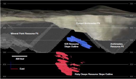
Note: Figure prepared by Wood. October 2021
| 14.8 | Mineral Resource Statement |
The estimated tonnages and grades in the Mineral Resource estimates have not been adjusted for mining recovery and dilution and contained metal estimates in the Mineral Resource tables have not been adjusted for metallurgical recoveries.
Mineral Resources are reported in Table 14-8 for open pit, oxide heap leach at Mineral Point, West Archimedes and East Archimedes, in Table 14-9 for underground mining and sulfide toll milling for 426 and Ruby Deeps. The QP for the estimate is Mr. Christopher Wright, P.Geo., a Wood employee.
May 2022
Project Number 250039 | Page 14 - 35 | |
|
2021 Ruby Hill Mineral Resource Estimate
Eureka County, NV, USANI43-101Technical Report |
Table 14-8: Mineral Resource Statement, Open Pit Oxide Heap Leach Mineralization
(effective date 31 July 2021)
| Mineral Resources above 0.1 g/t Au Cut-off Grade | Tonnes
(Mt) | Au
(g/t) | Ag
(g/t) | Au
(koz) | Ag
(koz) |
| Mineral Point | | | | | |
| Indicated Mineral Resources | 203.2 | 0.49 | 14.9 | 3,217 | 97,457 |
| Inferred Mineral Resources | 157.3 | 0.37 | 14.3 | 1,872 | 72,370 |
| West Archimedes | | | | | |
| Indicated Mineral Resources | 2.4 | 0.83 | 0.6 | 63 | 47 |
| Inferred Mineral Resources | 0.1 | 0.23 | 0.1 | 0.6 | 0.4 |
| East Archimedes | | | | | |
| Indicated Mineral Resources | 18.9 | 0.98 | 9.6 | 594 | 5,831 |
| Inferred Mineral Resources | 5.3 | 1.10 | 6.4 | 189 | 1,102 |
| Total | | | | | |
| Indicated Mineral Resources | 224.4 | 0.54 | 14.3 | 3,874 | 103,335 |
| Inferred Mineral Resources | 162.7 | 0.39 | 14.0 | 2,062 | 73,472 |
Note: to accompany the Mineral Resource table for Ruby Hill Oxide Heap Leach mineralization:
| 1 | Mineral Resources have an effective date of 31 July 2021. Mr. Christopher Wright, P. Geo, a Wood Canada Ltd. employee, is the Qualified Person responsible for the Mineral Resource estimate. |
| 2 | Mineral Resources are not Mineral Reserves and do not have demonstrated economic viability. |
| 3 | Mineral Resources are the portion of the Mineral Point, West Archimedes and East Archimedes that can be mined profitably by open pit mining method and processed by oxide gold heap leaching. |
| 4 | Mineral Resources are below final design topography for Phase 8 expected to be completed in August 2021. |
| 5 | Mineral Resources are constrained to oxide and transitional oxide-sulfide mineralization inside a conceptual open pit shell. The main parameters for pit shell construction are a gold price of $1,650/oz Au, 75% recovery for gold for oxide and transitional mineralization, open pit mining costs of $2.03/tonne, heap leach processing costs of $2.32/tonne, general and administrative costs of $0.72/tonne processed, and a 3% royalty. |
| 6 | Mineral resources are shown above a 0.1 g/t Au cut-off grade. This is a marginal cutoff grade that generates sufficient revenue to cover conceptual processing, general and off-site costs given metallurgical recovery and long-range metal prices for gold and silver |
| 7 | Mineral Resources are stated as in situ with no consideration for planned or unplanned external mining dilution. |
| 8 | The contained gold estimates in the Mineral Resource table have not been adjusted for metallurgical recoveries. |
| 9 | Units shown are metric tonnes. |
| 10 | Numbers have been rounded as required by reporting guidelines and may result in apparent summation differences. |
May 2022
Project Number 250039 | Page 14 - 36 | |
|
2021 Ruby Hill Mineral Resource Estimate
Eureka County, NV, USANI43-101Technical Report |
Table 14-9: Mineral Resource Statement, Underground Sulfide Gold Toll Processing
(effective date 31 July 2021)
Mineral Resources Above a
Cut-off grade of 3.6 g/t Au | Tonnes
(Mt) | Au
(g/t) | Ag
(g/t) | Au
(koz) | Ag
(koz) |
| 426 Underground | | | | | |
| Indicated Mineral Resources | 1.20 | 5.22 | 0.6 | 202 | 22 |
| Ruby Deeps Underground | | | | | |
| Inferred Mineral Resources | 8.21 | 6.02 | 1.7 | 1,588 | 439 |
Note: to accompany Mineral Resource table for Underground Sulfide Gold Toll Processing mineralization:
| 1 | Mineral Resources have an effective date of 31 July 2021. Mr. Christopher Wright, P. Geo, a Wood Canada Ltd. employee, is the Qualified Person responsible for the Mineral Resource estimate. |
| 2 | Mineral Resources are not Mineral Reserves and do not have demonstrated economic viability. |
| 3 | Mineral Resources are the portion of the 426 and Ruby Deeps deposits that have reasonable prospects of eventual economic extraction using conceptual underhand drift and fill method and processed by sulfide gold toll milling. |
| 4 | Mineral Resources are below final design topography for Phase 8 expected to be completed in August 2021. |
| 5 | The gold price used for cut-off grade calculation is $1,650/oz Au. |
| 6 | Mineral Resources are constrained to gold mineralization inside conceptual drift and fill stope outlines using a gold price of $1,650/oz Au, 77% gold recovery, underground mining costs of $121/tonne, sustaining capital, general and administrative and other onsite costs of $21.00/tonne processed, toll autoclave treatment costs of $72/tonne and a 3% royalty. |
| 7 | Mineral Resources are stated including 5% dilution. |
| 8 | The contained gold estimates in the Mineral Resource table have not been adjusted for metallurgical recoveries. |
| 9 | Units are metric tonnes. |
| 10 | Numbers have been rounded as required by reporting guidelines and may result in apparent summation differences. |
Areas of uncertainty that could materially affect the Mineral Resource estimates include the following: commodity pricing; interpretations of fault geometries; lithological interpretations on a local scale, including the thickness and amenability of the sedimentary units to host mineralization; geotechnical assumptions related to the open pit and underground mine designs, rock quality and material behavior; additional dilution considerations that may be refinements to open pit and underground mining methods in operation, metal recovery assumptions; product quality assumptions; assumptions as to operating costs used when assessing reasonable prospects of eventual economic extraction; and changes to drill spacing assumptions used to support confidence classification categories.
May 2022
Project Number 250039 | Page 14 - 37 | |
|
2021 Ruby Hill Mineral Resource Estimate
Eureka County, NV, USANI43-101Technical Report |
| 14.9 | Mineral Resource Sensitivity |
The Ruby Hill Open Pit Mineral Resource estimate is relatively robust to changes in metal price; however, the average grade of Inferred Mineral Resources is lower, and these resources are more sensitive to changes in metal price than the Indicated Mineral Resources.
Table 14-10, Table 14-11 and Table 14-12 show the change in tonnage, grade and contained metal at different metal prices with reference to the base case (highlighted) presented in the Mineral Resource statements at $1,650/oz gold and $21/oz silver.
Table 14-10: Open Pit Oxide Heap Leach Mineral Resource Sensitivity to Gold Price
| Total | | Indicated Mineral Resources | | Inferred Mineral Resources |
Gold Price
($/oz) | Silver Price
($/oz) | | Tonnage
(Mt) | Au
(g/t) | Ag
(g/t) | Au
(koz) | Ag
(koz) | | Tonnage
(Mt) | Au
(g/t) | Ag
(g/t) | Au
(koz) | Ag
(koz) |
| 2,000 | 25.50 | | 229.4 | 0.53 | 14.2 | 3,924.6 | 104,901 | | 189.2 | 0.38 | 14.0 | 2,291 | 84,869 |
| 1,800 | 23.00 | | 227.1 | 0.53 | 14.3 | 3,898.5 | 104,242 | | 180.8 | 0.38 | 13.9 | 2,210 | 81,081 |
| 1,650 | 21.20 | | 224.4 | 0.54 | 14.3 | 3,874.2 | 103,335 | | 162.7 | 0.39 | 14.0 | 2,062 | 73,472 |
| 1,500 | 19.10 | | 218.4 | 0.54 | 14.4 | 3,812.9 | 100,783 | | 141.9 | 0.40 | 13.9 | 1,831 | 63,428 |
Table 14-11: 426 Zone Underground Sulfide Mineral Resource Sensitivity to Gold Price
| Total | | Indicated Mineral Resources |
Gold Price ($/oz) | Silver Price ($/oz) | | Tonnage (Mt) | Au (g/t) | Ag (g/t) | Au (koz) | Ag (koz) |
| 2,000 | 25.5 | | 1.35 | 4.89 | 0.6 | 213 | 24 |
| 1,800 | 23 | | 1.27 | 5.07 | 0.6 | 208 | 23 |
| 1,650 | 21.2 | | 1.20 | 5.22 | 0.6 | 202 | 22 |
| 1,500 | 19.1 | | 1.10 | 5.42 | 0.6 | 192 | 21 |
Table 14-12: Ruby Deeps Zone Underground Sulfide Mineral Resource Sensitivity to Gold Price
| Total | | Inferred Mineral Resources |
Gold Price ($/oz) | Silver Price ($/oz) | | Tonnage (Mt) | Au (g/t) | Ag (g/t) | Au (koz) | Ag (koz) |
| 2,000 | 25.5 | | 9.18 | 5.70 | 1.57 | 1,683 | 463 |
| 1,800 | 23 | | 8.71 | 5.86 | 1.62 | 1,642 | 452 |
| 1,650 | 21.2 | | 8.21 | 6.02 | 1.66 | 1,588 | 439 |
| 1,500 | 19.1 | | 7.60 | 6.22 | 1.73 | 1,519 | 422 |
May 2022
Project Number 250039 | Page 14 - 38 | |
|
2021 Ruby Hill Mineral Resource Estimate
Eureka County, NV, USANI43-101Technical Report |
For the open-pit oxide heap leach Mineral Resources, if metal prices are adjusted downward 9% the tonnage and contained metal above cut-off for Indicated Resources decreases by approximately 2%. If metal prices are adjusted upwards by the same increment, tonnage and grade Indicated Resource increase by approximately 1%. Inferred open-pit resources are more sensitive to metal price changes. A 9% decrease in metal prices yields a 13% decrease in Inferred tonnes and metal above cut-off. A 9% increase in metal price yields an 11% increase in Inferred tonnes and metal above cut-off.
Underground Mineral Resources for 426 and Ruby Deeps are relatively robust to changes in gold price. If gold prices are adjusted upward by 9%, tonnage above cut-off for Indicated Resources increases by 6% and gold ounces above cut-off increase by only 3%. With a downward adjustment of gold price by 9% the tonnage above cut-off falls by 7% and ounces above cutoff fall by only 4% to 5%.
May 2022
Project Number 250039 | Page 14 - 39 | |
|
2021 Ruby Hill Mineral Resource Estimate
Eureka County, NV, USANI43-101Technical Report |
| 15 | Mineral Reserve Estimates |
There are no Mineral Reserve estimates for the Ruby Hill Project.
May 2022
Project Number 250039 | Page 15 - 1 | |
|
2021 Ruby Hill Mineral Resource Estimate
Eureka County, NV, USANI43-101Technical Report |
Mine design for the Ruby Hill project is limited to conceptual mining method selection and definition of parameters to support RPEEE discussed in Section 14.
May 2022
Project Number 250039 | Page 16 - 2 | |
|
2021 Ruby Hill Mineral Resource Estimate
Eureka County, NV, USANI43-101Technical Report |
Mineral process design and production scheduling for the Ruby Hill Project is limited to the metallurgical testwork described in Section 13 and process flowsheet selection and definition of parameters to support RPEEE discussed in Section 14.
May 2022
Project Number 250039 | Page 17 - 3 | |
|
2021 Ruby Hill Mineral Resource Estimate
Eureka County, NV, USANI43-101Technical Report |
The Ruby Hill Project includes mining and mineral processing infrastructure that has been used in open pit mining and oxide gold heap leaching activities by RHMC and previous owners; however, detailed project infrastructure design has not been completed at this stage of the Project.
May 2022
Project Number 250039 | Page 18 - 4 | |
|
2021 Ruby Hill Mineral Resource Estimate
Eureka County, NV, USANI43-101Technical Report |
| 19 | Market Studies and Contracts |
No market studies have been completed and there are no contracts for potential future product sales at this stage of Project development.
RHMC is currently engaged in the sale of gold bullion to refineries and there are reasonable prospects for securing sales contracts for future gold-silver doré product.
May 2022
Project Number 250039 | Page 19 - 5 | |
|
2021 Ruby Hill Mineral Resource Estimate
Eureka County, NV, USANI43-101Technical Report |
| 20 | Environmental Studies, Permitting, and Social or Community Impact |
| 20.1 | Environmental Liabilities |
The estimated cost to close and reclaim the Project is $23 million (RHMC, 2021). This amount includes closure of all permitted mining and exploration disturbance at the Project and is calculated using standardized reclamation cost estimators that assess the following:
| • | Exploration drill hole abandonment |
| • | Exploration roads and pads |
| • | Foundations and buildings |
| • | Other demolition and equipment removal |
| • | Sediment and drainage control |
| • | Mobilization and demobilization. |
A bond is the amount of $22 million was accepted by the Bureau of Land Management on 21 July 2020 (Delong, 2021). There are no other known environmental liabilities associated with pre-Project operations (RHMC, 2021).
May 2022 Project Number: 250039 | Page 20-1 | |
|
2021 Ruby Hill Mineral Resource Estimate
Eureka County, NV, USANI43-101Technical Report |
The Ruby Hill Mining Company is currently permitted to carry out mining operations, reclamation activities at the Project site. This permitting allows it to carry out the exploration, geotechnical and metallurgical field work recommend in this report. Specific permits related to site activities are presented in Table 20-1.
Table 20-1: Operating Permits for the Ruby Hill Project Site
| Permit Name | Permitting Agency/Authority | Permit Number |
| Mine Plan of Operations + amendment | BLM | NVN-NV-063-EIS04-34 |
| Rights of Way | BLM | N-60801; N-60802; N-60359; N-61422 |
| Class II Air Quality Operating Permit | NDEP/BAPC | AP1041-0713 |
| Mercury Operating Permit to Construct | NDEP/BAPC | MOPTC AP1041-2252 |
| Water Pollution Control Permit - Infiltration Project | NDEP/BMRR | NEV2005106 |
| Water Pollution Control Permit - Mine | NDEP/BMRR | NEV0096103 |
| Reclamation Permit (Mine) | NDEP/BMRR | #0107 |
| Mining Stormwater General Permit | NDEP/BWPC | NVR300000: MSW-44886 |
| Public Drinking Water System | NDEP-BSDW | EU-0885-12NTNC: NV0000885 |
| Nitrate Removal System | NDEP-BSDW | EU-0885-TP02: NV0000885 |
| Onsite Sewage Disposal System | NDEP/BWPC | GNEVOSDS09 |
| Industrial Artificial Pond Permit | NDOW | S-479016 |
| Hazardous Materials Storage Permit | Nevada State Fire Marshal | 82029 |
| Class III Waivered Landfill | NDEP-BWM | SW362 |
| Waters of the United States Jurisdictional Determination | USACOE | Letter confirmation. Expiry: 11/13/2022 |
| Stormwater Permit | BWPC | NVR3000000- MSW 44886 |
| Radio Station Authorization | FCC | WPLP234; WQQU614; WQNU777 |
| Toxic Release Inventory | EPA/SERC | 89316RBYHLINTER |
Ruby Hill Mining Company controls a total of 5,711 annual acre feet (AFA) of water rights for consumption and occupation (Delong, 2021).
May 2022 Project Number: 250039 | Page 20-2 | |
|
2021 Ruby Hill Mineral Resource Estimate
Eureka County, NV, USANI43-101Technical Report |
Due to a history of over pumping in the region due to a heavy reliance on agriculture, the Diamond Valley Basin was categorized as a Critical Management Area (CMA) by the Nevada State Engineer’s office in 2015. The designation allows the State Engineer and the community to agree on certain tools to reduce over-pumping, including implementing a Groundwater Management Plan. Since 2019, the community has been disputing in the courts the appropriateness of a Groundwater Management Plan over ordinary curtailment by priority. Regardless of the outcome of this dispute, the Company controls sufficient water rights to support its mining operations (Delong, 2021).
| 20.4 | Community Relations and Stakeholder Consultation |
The following information on community relations and stakeholder consultation is taken from Delong (2021).
Mining activity at the property began in the 1870s and has continued with some interruptions until the present day. As such, Ruby Hill has been a constant presence in the history of the town of Eureka and has been an economic benefit to the community by offering employment, direct and indirect benefits.
Ruby Hill and its predecessors, Homestake Mining Company, Barrick Gold Corporation have each maintained comprehensive community relations programs. Ruby Hill works closely with community and local stakeholders to provide updates on key developments, including:
| • | Project status (operations and permitting) |
| • | Community program and initiatives. |
As part of its community involvement, Ruby Hill has entered into an agreement with the University of Reno that will allow the University to locate a new agricultural research station in Eureka. The station will focus on dry-land agricultural research with an emphasis on issues associated with climate change. The station is expected to directly benefit the Diamond Valley farming community
Due to the proximity of the mine to the town, Ruby Hill diligently monitors the use of:
May 2022 Project Number: 250039 | Page 20-3 | |
|
2021 Ruby Hill Mineral Resource Estimate
Eureka County, NV, USANI43-101Technical Report |
The Ruby Hill Mining Company holds quarterly meetings with the public, landowners, and County officials on a quarterly basis to discuss operational status, safety and environmental compliance at the Project including monitoring, blasting schedules, and other matters of similar relevance to the Project’s neighbors. Overall, Eureka is a community that is familiar with and supportive of mining. The RHMC enjoys a positive professional relationship with its stakeholders, including its regulators at the federal and state agencies (RHMC, 2021).
May 2022 Project Number: 250039 | Page 20-4 | |
|
2021 Ruby Hill Mineral Resource Estimate
Eureka County, NV, USANI43-101Technical Report |
| 21 | Capital and Operating Costs |
No capital cost estimates have been undertaken at this stage of the Project.
May 2022 Project Number: 250039 | Page 21-1 | |
|
2021 Ruby Hill Mineral Resource Estimate
Eureka County, NV, USANI43-101Technical Report |
Assumptions about conceptual mine, process and site general and administrative operating costs were taken from historical operations at Ruby Hill and benchmarks for similar operations in Nevada to support definition of the portion of mineralization having reasonable prospects for eventual economic extraction, but detailed operating cost estimates were not developed, and financial modeling has not been carried out at this stage of the Project.
May 2022 Project Number: 250039 | Page 22-1 | |
|
2021 Ruby Hill Mineral Resource Estimate
Eureka County, NV, USANI43-101Technical Report |
There are no adjacent properties relevant to the Ruby Hill Mineral Resource estimate.
May 2022 Project Number: 250039 | Page 23-1 | |
|
2021 Ruby Hill Mineral Resource Estimate
Eureka County, NV, USANI43-101Technical Report |
| 24 | Other Relevant Data and Information |
There is no other data and information relevant to the Ruby Hill Mineral Resource estimate.
May 2022 Project Number: 250039 | Page 24-1 | |
|
2021 Ruby Hill Mineral Resource Estimate
Eureka County, NV, USANI43-101Technical Report |
| 25 | Interpretation and Conclusions |
Risks to the Ruby Hill Project Mineral Resource estimate include:
| • | Sensitivity and potential loss of resource tonnage due to poorer than expected rock quality and stability issues for the Mineral Point and Archimedes open pits |
| • | Potential loss of resource tonnage due to increased operating costs related to rock mechanics and underground mine designs for the 426 and Ruby Deeps Mineral Resources |
| • | Poorer than expected hydrometallurgical performance of transitional oxide-sulfide mineralization in the oxide heap leach Mineral Resources at Mineral Point Trend and the East Archimedes and West Archimedes zones |
| • | Issues with zinc concentrate quality including zinc recovery, zinc grade in final concentrate, deleterious elements in zinc concentrates including arsenic, and the payability of precious metals in zinc concentrates |
| • | Schedule for permitting and closure planning for future resource development may present challenges for larger development cases. |
The following opportunities were identified in preparation of the 2021 Ruby Hill Mineral Resource estimate:
| • | Exploration has the potential to add Mineral resources north of the Mineral Point deposit where mineralization encountered in widely spaced drillholes has suggested potential northward extension of mineralization in the Dunderberg Formation |
| • | Exploration has the potential to add Mineral Resources south of the East Archimedes deposit where widely spaced drilling has encountered oxide gold mineralization in several exploration holes |
| • | Expansion of underground gold sulfide resources |
| • | Additional open pit gold sulfide resources. |
May 2022 Project Number: 250039 | Page 25-1 | |
|
2021 Ruby Hill Mineral Resource Estimate
Eureka County, NV, USANI43-101Technical Report |
The 2021 Ruby Hill Mineral Resource estimate and resource model is a suitable basis for mine and infrastructure design, production planning and financial evaluation. Conceptual development options have been identified for both open pit and underground mining, processing of oxide and transitional material by heap leaching and milling of sulfide mineralization. Existing site infrastructure can be used to reduce project development requirements including capital costs and schedule duration for engineering and construction. The Mineral Resources for potential open pit and underground development are at different confidence categories and would have very different requirements for footprint, infrastructure and capital, environmental baseline, permitting and development schedule. Further definition and strategic trade-off of different potential development options is recommended to identify a path forward for the Project.
The options analysis study scope should include:
| • | geotechnical and hydrogeological testing, characterization, and modeling to produce open-pit and underground design recommendations |
| • | additional metallurgical testing of oxide and transitional oxide-sulfide mineralization refractory sulfide and base metal mineralization |
| • | mine, process and infrastructure design |
| • | project layout, capital and operating cost estimation |
| • | preliminary closure plan design |
| • | high-level project scheduling. |
The study could be led by an Owner’s team in Nevada supported by independent study consultants as required for the geotechnical, metallurgical and mine design packages. A significant budget would be required for drilling to support the options analysis including drilling for exploration, infill drilling, geotechnical drilling, and drilling to generate sample for metallurgy.
It is expected that the study would have a duration of 24-36 months including the concurrent drilling and fieldwork programs.
A budget for this work is presented in Table 26-1.
May 2022 Project Number: 250039 | Page 26-1 | |
|
2021 Ruby Hill Mineral Resource Estimate
Eureka County, NV, USANI43-101Technical Report |
Table 26-1: Proposed Budget for Ruby Hill Development Options Study
| Item | Budget
($M) |
| Owner's Team | 2.0 |
| Geotechnical Study | 0.6 |
| Metallurgical Testing | 0.6 |
| Study Engineering | 1.5 |
| Environmental and Closure Studies | 0.7 |
| Drilling (Exploration, Infill, Geotechnical Metallurgical) | 40.0 |
| Total | 45.4 |
May 2022 Project Number: 250039 | Page 26-2 | |
|
2021 Ruby Hill Mineral Resource Estimate
Eureka County, NV, USANI43-101Technical Report |
Barrick, 2004. East Archimedes Project Feasibility Ruby Hill Mine, Barrick Project Feasibility Report, 76 p.
Barrick, 2011. Ruby Hill East Archimedes 2011 Life of Mine Report, Barrick internal report, 50 p.
Barrick, 2013. Ruby Hill Mine 426 West Archimedes Expansion Project Feasibility Study, Internal Barrick report, Report date February 11, 2013
CIM, 2014. CIM Definition Standards for Mineral Resources and Mineral Reserves. Document prepared by the CIM Mineral Resources and Mineral Reserves Committee dated May 14, 2014. 10p.
CIM, 2019. CIM Estimation of Mineral Resources and Mineral Reserves Best Practice Guidelines. Document prepared by the CIM Mineral Resources and Mineral Reserves Committee dated November 29, 2019. 75p.
Chadwick, T., Russell, K., 2002. Ruby Hill Pit Interpretive Structure and Lithology Map, 2002, Barrick Gold Exploration Inc.
Delong, R., 2021. Environment and Communities Due Diligence. Unpublished slide presentation on the conclusions of an environment, permitting and community relations due diligence study completed for the Ruby Hill Mine site by Richard Delong of EM Strategies for i-80 Gold dated 20 May, 2021. 12p.
Dilles, P.A., Wright, W.A., Monteleone, S.E., Russell, K.D., Wood, R.A., and Margolis, J., 1996. The geology of the West Archimedes deposit: a new gold discovery in the Eureka mining district, Eureka County, Nevada, in Coyner, A.R., and Fahey, P.L., eds., Geology and Ore Deposits of the American Cordillera: Geological Society of Nevada Symposium Proceedings, Reno/Sparks, Nevada, April 1995, p. 159-171.
Evans, J.G., Theodore, T.G., 1978. Deformation of the Roberts Mountains Allochthon in North-Central Nevada: U.S. Geological Survey Professional paper 1060, 18 p.
Golder Associates, 2012. Feasibility-Level Pit Slope Design West Archimedes 426 Extension Pit, Ruby Hill Mine Eureka, Nevada, Report prepared for Barrick Gold Corporation, Dated October 2012
Hague, A., 1892. Geology of the Eureka Mining District, Nevada: U.S. Geological Survey Monograph, 419 p.
May 2022 Project Number: 250039 | Page 27-1 | |
|
2021 Ruby Hill Mineral Resource Estimate
Eureka County, NV, USANI43-101Technical Report |
Hastings, M.H., 2008. Relationship of base-metal skarn mineralization to Carlin-type gold mineralization at the Archimedes gold deposit, Eureka, Nevada: Unpublished M.S. thesis, University of Nevada, Reno, 111 p.
Hauntz, C.E., 1999. Ruby Hill Project Preliminary Geologic Map, Eureka County, Nevada, Homestake Mining Company, January 18, 1999
Hoge, A.K., Seedorf, E., Barton, M.D., Richardson, C.A., and Favorito, D.A., 2015. The Jackson-Lawton-Bowman Normal Fault System and its Relationship to Carlin-type Gold Mineralization, Eureka District, Nevada: Lowell Institute for Mineral Resources, department of Geosciences, University of Arizona, 34 p.
i-80 Gold, 2021. News release titled: “ i-80 to Acquire Lone Tree/Processing Facilities, Buffalo Mtn & Ruby Hill to Create Nevada Mining Complex” dated September 7, 2021.
Jensen, D.A., 2021. Title Report for the Ruby Hill Property, Eureka County, Nevada. Internal report prepared by Daniel A. Jensen of Parr Brown Gee and Loveless Attorneys at Law of Reno Nevada addressed to Ruby Hill Mining Company and Elko Mining Group dated 2 July 2021. 18p including exhibits.
Langlois, J.D., 1971. Hydrothermal alteration of intrusive igneous rocks in the Eureka mining district, Nevada. M.Sc. thesis, University of Arizona, 113 p.
Lisenbee, A.L., 2001. Structure and stratigraphy of the Eureka area, Nevada, in Miller, M.S., and Walker, J.P., eds., Structure and stratigraphy of the Eureka, Nevada, Area: Nevada Petroleum Society, 2001 Fieldtrip Guidebook, p.51-66.
Long, S.P., Henry, C.D., Muntean, J.L., Edondo, G.P., and Cassel, E.J., 2014. Early Cretaceous construction of a structural culmination, Eureka, Nevada, U.S.A.: Implictions for out-of-sequence deformation in the Sevier hinterland: Geopsphere, v. 10, no. 3, p. 564-584.
Loranger, R.J., 2013. Bullwhacker SE, Silver Lick-Cyan Ruby Hill - Minex, Internal Report prepared for barrack Gold Corporation, Report date October 9, 2013
Mach, C., 2012. Achilles Preliminary Summary Report, Ruby Hill, Internal report prepared for Barrick Gold Corporation, Report date October 22, 2012
Morkeh, J. 2011. Ruby Hill Mine Geologic Pit Map, Barrick Ruby Hill Mine Eureka, Nevada, November 2011, 1 p.
May 2022 Project Number: 250039 | Page 27-2 | |
|
2021 Ruby Hill Mineral Resource Estimate
Eureka County, NV, USANI43-101Technical Report |
Mortenson, J.K., Thompson, J.F.H., and Tosdal R.M., 2000. U-Pb age constraints on magmatism and mineralization in the northern great Basin, Nevada, in Cluer, J.K., Price, J.G., Struhsacker, E.M., Hardyman, R.F., and Morris, C.L., eds., Geology and Ore Deposits 2000: The Great Basin and Beyond: Geological Society of Nevada, Symposium, Reno/Sparks, May 2000, Proceedings, v. 1, p.419-438.
Newman, S, and Mahoney, E, 2008. Ruby Hill Mine Technical Report on Reserves and Resources As at Dec. 31, 2008, NI 43-101 Technical Report prepared for Barrick Gold Corporation, Report date December 31, 2008
Newman, S., and Mahoney, E., 2008. Ruby Hill Mine Technical Report on Reserves and Resources As at December 31, 2008, Technical Report prepared for Barrick Gold Corporation, report date December 31, 2008
Nolan, T.B., 1962. The Eureka Mining District, Nevada: U.S. Geological Survey Professional Paper 406, 78 p.
Nolan, T.B., Merriam, C.W., and Blake Jr., M.C., 1974. Geologic Map of the Pinto Summit Quadrangle, Eureka and White Pine Counties, Nevada: U.S. Geological Survey IMAP 793.
Nolan, T.B., Merriam, C.W., and Brew, D.A., 1971. Geologic Map of the Eureka Quadrangle, Eureka and White Pine Counties, Nevada: U.S. Geological Survey Miscellaneous Geologic Investigations Map I-612.
Nolan, T.B., Merriam, C.W., and Williams, J.S., 1956. The stratigraphic section in the vicinity of Eureka, Nevada: U.S. Geological Survey Professional Paper 276, 77 p.
Oakley, W. 1997. Ruby Hill Mineral Point Contaminated Drill Hole Review. Internal company document by Will Oakley of the Elko Mining Group, a subsidiary of Waterton Global Resource Management discussing a review of potentially contaminated drill holes from the Mineral Point and Archimedes Database. 45p.
Pfeiffer, N, 2010. Metallurgical Core Twins 165c and 166c, Internal report prepared for Barrick Gold Corporation, 4 p.
Poole, F.G., 1974. Flysch deposits of the Antler foreland basin, western United States; in Tectonics and Sedimentation, Dickinson, W.R., (ed), Society of Economic Paleontologists and Mineralogists, Special Publication no. 22, 204 p.
Rehn, W. and Mach, C., 2012. Hector AE Ruby Hill-Advanced Exploration, Internal report prepared for Barrick Gold Corporation, Report date Jan 4, 2012
May 2022 Project Number: 250039 | Page 27-3 | |
|
2021 Ruby Hill Mineral Resource Estimate
Eureka County, NV, USANI43-101Technical Report |
Resource Evaluation Inc. (REI), 2005. Mineral Reserve Audit East Archimedes Project Eureka County, Nevada, Technical report prepared for Barrick Gold Corporation, Report date January 2005
Resource Evaluation Inc., 2005. Mineral Reserve Audit East Archimedes Project Eureka County, Nevada Internal report prepared for Barrick Gold Corporation, Barrick, Report date January 2005, p. 147.
RHMC, 2017. Ruby Hill QA/QC Summary - Barrick 2004-2015. Internal company report by Keith Fowlow presenting QA/QC results from the Barrick RC and diamond drill campaigns. Dated November 1, 2017. 32p.
RHMC, 2018. Reclamation Cost Update for the Ruby Hill Mine, Eureka County Nevada, 2018 Three-year Update for Reclamation Permit #107 BLM NVN-067782 prepared by Ruby Hill Mining Company LLC and Submitted to the Nevada Division of Environmental Protection Bureau of Mining Regulation and Reclamation and the Bureau of Land Management dated October 2018. 137p.
RHMC, 2021. Expert opinion on surface land holdings, mineral tenure, water rights, royalties and environmental liabilities provided to Wood by the Ruby Hill Mining Company dated 30 July 2021
RHMC, 2021. Expert opinion on surface land holdings, mineral tenure, water rights, royalties and environmental liabilities provided to Wood by the Ruby Hill Mining Company dated 30 July 2021
Taylor, W.J., Barrley, J.M., Fryxell, J.E., Schmitt, J.G., and Vandervoot, D.S., 1993. Tectonic style and regional relations of the Central Nevada thrust belt (Field Trip #3), in Lahren, M.M., Trexler, J.H., and Spinosa, C., (eds.), Crustal evolution of the Great Basin and the Sierra Nevada: Guidebook for the 1993 Joint Meeting of the Cordilleran/Rocky Mountain Sections of the Geologic Society of America, Reno, Nevada, May 19-21, 1993, pp. 57-96.
Uken, R. 2017A. Ruby Hill Structural Model Phase1, Memo to Ruby Hill Mining Company LLC; SRK Consulting, Dated February 2017, 22p.
Uken, R. 2017B. Ruby Hill Structural Model Update - Phase 2, Memo to Ruby Hill Mining Company LLC; SRK Consulting, Dated July 5, 2017, 5p.
Vikre, P.G., 1998. Intrusion-related polymetallic carbonate replacement deposits in the Eureka district, Eureka County, Nevada: Nevada Bureau of Mines and Geology Bulletin 110, 52 p.
May 2022 Project Number: 250039 | Page 27-4 | |
|
2021 Ruby Hill Mineral Resource Estimate
Eureka County, NV, USANI43-101Technical Report |
Wood, 2021a. Open Pit Design Criteria for the Ruby Hill Resource Pit Shell. Unpublished document developed by Wood Mining and Metals Consulting listing mining, processing, geotechnical and financial assumptions used in the construction of the Mineral Resource open pit shell.
Wood, 2021b. Underground Mine Design Criteria for the Ruby Hill Underground Stope Shapes. Unpublished document developed by Wood Mining and Metals Consulting listing mining, processing, geotechnical and financial assumptions used in the construction of the Mineral Resource underground stope shapes.
May 2022 Project Number: 250039 | Page 27-5 | |