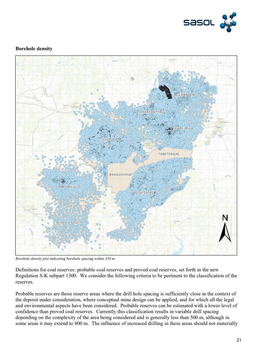
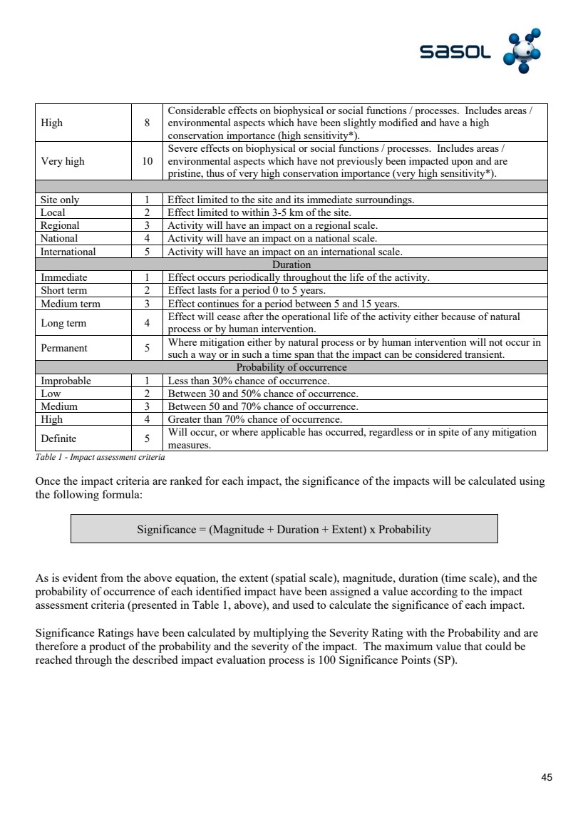
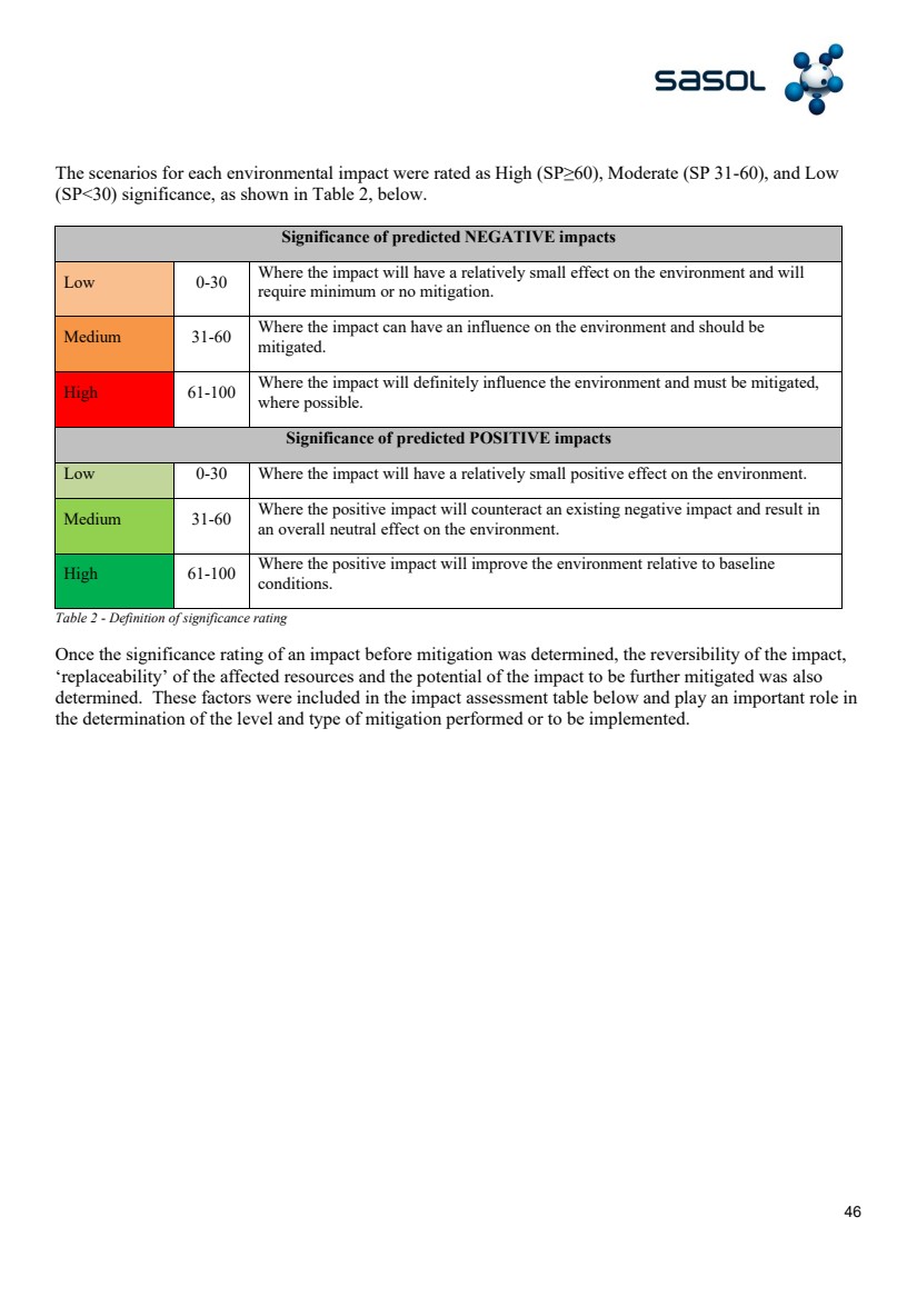
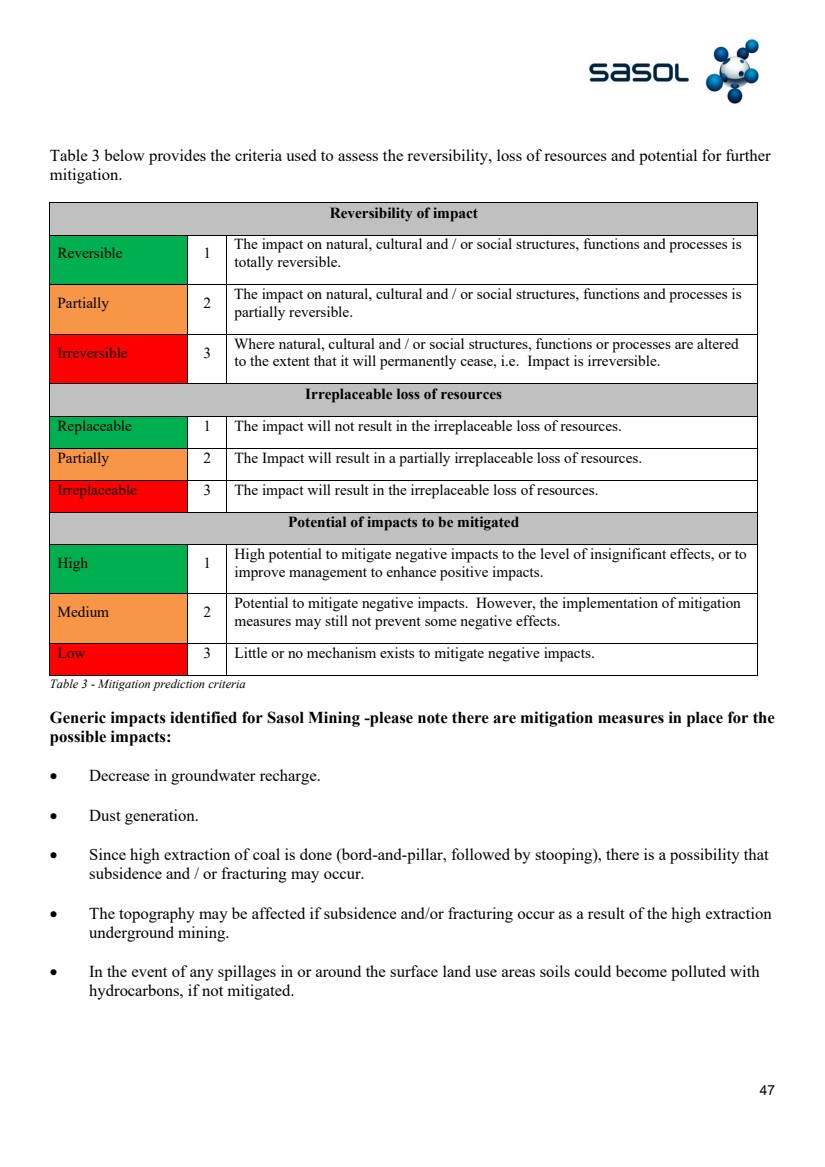
Sasol Mining 20F Technical Report Summary hydrikig Report Template C |
2 Contents Executive summary ................................. ................................. ................................. ................................. ................................. .. 3 Introduction ................................. ................................. ................................. ................................. ................................. ................... 4 Property Descrip tion ................................. ................................. ................................. ................................. ............................... 5 Geological setting, mineralisation and deposits ................................. ................................. ................................. ....... 6 Exploration ................................. ................................. ................................. ................................. ................................. ................ 14 Sample preparati on, analysis and security ................................. ................................. ................................. ............... 17 Data Verification ................................. ................................. ................................. ................................. ................................. ..... 18 Mineral Resource Estimates ................................. ................................. ................................. ................................. ............. 18 Mining Methods ................................. ................................. ................................. ................................. ................................. ....... 25 Processing Plants ................................. ................................. ................................. ................................. ................................. .... 36 Infrastruc ture ................................. ................................. ................................. ................................. ................................. ........... 38 Market Studies ................................. ................................. ................................. ................................. ................................. ......... 41 Environmental Management ................................. ................................. ................................. ................................. ............ 43 Clos ure and Decommissioning ................................. ................................. ................................. ................................. ........ 50 Agreements with Local Groups ................................. ................................. ................................. ................................. ....... 53 Capital and Operating Costs ................................. ................................. ................................. ................................. .............. 53 Economic Analysis ................................. ................................. ................................. ................................. ................................. .. 54 Risk Factors ................................. ................................. ................................. ................................. ................................. ............... 55 Glossary ................................. ................................. ................................. ................................. ................................. ....................... 55 Consent of Qualified Person ................................. ................................. ................................. ................................. .............. 56 Reliance of information provided by the Registrant ................................. ................................. ........................... 57 |
3 Executive summary Sasol Mining is the holder of various prospecting and mining rights for coal and associated minerals in Mpumalanga and the Free State provinces, for underground mining. These prospecting and mining rights are granted by the State acting as custodian of South Africa’s mineral and petroleum resources in accordance with the provisions of the MPRDA, as amended. In respect of the Secunda mining complex situated in Mpumalanga, Sasol Mining has three mining rights situated within the Bet hal, Secunda, Highveld Ridge, Balfour and Standerton Magisterial Districts. These mining rights are valid for periods of between 20 and 30 years, which allows Sasol Mining to provide a continuous and steady coal supply to Secunda Operations, which benefic iates the coal into higher value and in most cases, end - line products. Please refer to page M1 for a map of the Secunda mining complex layout. Coal mining activities in the Free State province near the town of Sasolburg are conducted by virtue of Sasol M ining holding a mining right which is valid for 30 years. The coal is mainly used for electricity and steam generation at our Sasolburg and Ekandustria operations. Steam is a major component which is required in the production of Sasol’s chemical product s as well as the refining of oil. The validity period of Sasol’s mining rights may, on application to the DMRE, be renewed or extended for further periods not exceeding 30 years each. Sasol Mining has been in operation since 1952, when mining started in the Free State and ha s operated the business from the beginning, hence there have been no previous owners or operato rs .. T here are no exploration targets and all resources have been converted into reserves and are disclosed accordingly. As the existing ope rations have been in existence for a number of years, feasibility studies are not relevant. The total book value of the property and its associated plant and equipment for Fiscal Year ( FY22 ) was R24 billion. |
4 Introduction The technical report summary was prepared for Sasol Mining Pty Limited. Where the registrant (Sasol Mining Limited) has relie d on more than one Qualified Person to prepare the information and documentation supporting its disclosure Mineral Reserves, the section(s) prepa red by each qualified person has been clearly delineated. In preparing this report the Qualified Person may have, when necessary, relied on information and inputs from others – as such, the table below lists the technical specialists who provided the rel evant information and inputs to the Qualified Person to include in this report. The registrant confirm s it has obtained the written consent of each Qualified Person to the use of the person’s name, or any quotation from, or summarization of, the Technical Report Summary in the relevant registration statement or report, and to the filing of the Technical Report Summary as an exhibit to the registration statement or report. The written consent only pertains to the section(s) of the Technical Report Summary p repared by each Qualified Person. The written consent has been filed together with the Technical Report Summary exhibit and will be retained , as Sasol Mining relies on the Qualified Person’s information and supporting documentation for its current estimat es regarding Mineral Resources or Reserves. Qualified Persons: Position Section(s) Paul Cronje Head Rights & Properties Mining Property Description Garth Truter Senior Manager Mine Planning Mining methods Short and Medium term Snoekie Madida Senior Manager Export Plant Processing Plant – Export Almon Mshiywa Head Sasol Coal Supply Processing Plant – SCS Schalk van Wyk VP Technical Services Infrastructure Nasir Hassan Senior Manager Marketing Market Studies – Export Gail Nussey Vos Senior Manager SHE Environment Environmental Management Jacques du Plessis Mine Closure Manager Mine Closure Caroline Shirindza Head Supply Chain Mining Local procurement Pieter Booysen VP Finance Mining Capital, Operating cost and Economic Analysis Richie Subramanian VP Safety, Health & Environmental Risk Factors Ms. L Jeffrey and Mr. N McGeorge, on behalf of SRK Consulting performed a comprehensive and independent audit of the coal resource/reserve estimations in Feb ruary 2019 and the estimates were certified as correct. The latest coal resource/reserve estimations were determined by following the same process. |
5 Internal controls used in the exploration and mineral reserve estimation consists of the following: • The Resources and Reserves document is compiled for submission to the Sasol Mining Board. Before submission the Vice President Integrated P lanning and Optimi z ation performs a high level reasonableness review to ensure the detailed process was f ollowed. This process includes a mass balance reconciliation. • Those involved in the Reserves and Resources estimation process are sufficiently qualified. The Head of Coal Geology signs off on the process and is classified as a Competent Person as defined by the South African Council for Natural and Scientific Professionals. Property Description Sasol Mining’s main underground coal mining facilities are located at the Secunda, Mpumalanga Mining Complex, which consists of underground collieries (Bosj esspruit; Impumelelo; Shondoni; Syferfontein; and Twistdraai Thubelisha) and the Mooikraal colliery near Sasolburg. The old order Sigma mining rights were not converted, and closure applications were lodged and are being assessed by the Department of Mine ral Resources and Energy (DMRE). Figure 1a) Plan showing location of Secunda reserve areas and Figure 1b) Plan showing Sigma Complex: Mooikraal reserve area and surrounding towns. inset indicating position of mine in relation to Sasolburg and surrounds Sasol Mining is the holder of various prospecting and mining rights for coal in Mpumalanga and one mining right in the Free State. These prospecting and mining rights are granted by the state acting as custodian of South Africa’s mineral and pet roleum resources in accordance with the provisions of the Mineral and Petroleum Resources Development Act, 2002 (Act 28 of 2002), as amended (MPRDA). In respect of Mpumalanga, Sasol Mining has three mining rights for coal situated within the Bethal, Secund a, Highveld Ridge, Balfour and Standerton magisterial districts with DMRE reference numbers MP |
6 30/5/1/2/2/138 MR, 10096 MR and 10125 MR. These mining rights are valid for periods of between 20 and 30 years, which allows Sasol Mining to provide a continuou s and steady coal supply to Sasol South Africa (SSA), which beneficiates the coal into higher value and in most cases, end line products. The bulk of Sasol mineral’s rights resides in 138 MR which was converted from old order mining licenses granted under the now repealed Minerals Act of 1991. The 138 MR has since been amended to include various prospecting and mining right areas which were either applied from or acquired from third parties. The 10096 MR was granted based on various acquired and applied for prospecting rights. The 10125 MR right was acquired as an existing mining right from a third party. Coal mining activities in the Free State province near the town of Sasolburg are conducted by virtue of Sasol Mining holding a mining right which is va lid for 30 years. It consists of a converted old order mining right and has been amended once to incorporate a new order mining right over areas held under prospecting rights. The coal is used for electricity and steam generation at our Sasolburg and Eka ndustria operations. Steam is a major component which is required in the production of Sasol’s chemical products as well as the refining of oil. As at 28 July 2022 Sasol Mining owns 105 farms portions in Mpumalanga, measuring 11 676 ha and four erven in S ecunda measuring 45 ha; and 35 farm portions measuring 1 114 ha in the Free State. Sasol Mining Mafutha owns 11 farm portions measuring 7 192ha in Limpopo province. The majority of farmland in Mpumalanga is lea s ed to farmers and other parties on an annual lease agreement basis and used for agricultural purposes. It is anticipated that approximately 37 lease agreements will be concluded for grazing and cultivated land in September 2022. Sasol Mining has acquired various types of servitudes over privately o wned land for mining - relat ed purposes ; these include underground mining, pipeline, powerlines, and conveyors, building restrictions, shafts, railways and roads. Portions of farmland are leased for periods of less than ten years for directional drilling and rescue and for utility boreholes .. S h ould the lease period be more than ten years, a servitude is required. Geological setting, minerali s ation and deposits Generali s ed s tratigraphy of the Secunda r eserve a rea The stratigraphy of the area comprises thick dolerite sills that form the topography , and overlay six coal seams, which occur in the Vryheid Formation of the Karoo Supergroup. The coal seams are numbered from the oldest to the youngest, from the bottom up. The principal coal horizon, the Number 4 Lower Coal Seam, provides approximately 91,00% (2021 — 91,67%) of the total proved and probable reserves. The Number 2 Coal Seam at Shondoni Colliery and Impumelelo Colliery has been included in our reserve base. N umerous thinner dolerites cross - cut the coal seams. The generali z ed stratigraphy from surface to basement is as follows: |
7 Overburden Thick packages of alternating siltstone and sandstone layers form the interburden between the thick dolerites and the Nu mber 5 Coal Seam. The interburden between the Number 5 Coal Seam (where present) and Number 4 Upper Coal Seam comprises alternating layers of siltstone and sandstone with minor coal bands. Grading from flaser to wavy to lenticular bedding and vice versa. Massive beds of sandstone occur in some areas. The sandstones and siltstones are typically massive to laminated respectively, with minor bioturbation. The depth to the base of the Number 4 Lower Coal Seam ranges from 40 m to 241 m with an average depth of 135 m below the surface topography. The average depth to the roof of the Number 2 Coal Seam is 150 m. Seam Thickness The Number 5 Coal Seam is thin and discontinuous in the area. The Number 4 Upper Coal Seam can be found approximately 120 m - 170 m b elow surface. It is a continuous seam however, too thin to be mined with current machinery. The Number 4 Lower Coal Seam has an average thickness of 4 , 2 m or a weighted average thickness of 3 , 7 m. In general, the Number 4 Lower Coal Seam is thinner to the south and thicker than average to the west adjacent to the pre - Karoo basement highs. It has a roof comprising gritstone with thin siltstone bands. The floor comprises predominantly micaceous mat erial (sandstone or siltstone). The Number 3 Coal Seam is sporadic. The Number 2 Coal Seam occurs approximately 30 m – 40 m below the Number 4 Lower Coal Seam. It is of lower quality than the Number 4 Lower Coal Seam however, it is still mineable. The roof of the Number 2 Coal Seam is comprised dominantly of siltstones. The Number 1 Coal Seam is sporadic. |
8 Seam Qualities The Number 4 Lower Coal Seam is a bituminous hard coal characteri s ed by the following: The inherent ash content (air dried basis) of the Number 4 Lower Coal Seam is an average of 27 , 04%. The volatile matter content is tightly clustered around a mean of 22 , 7% (air dried). The total s ulphur content (air dried), which primarily consists of mineral s ulphur in the form of pyrite and minor amounts of organic s ulphur, averages 1 , 03% of the total mass of the coal seam. Pre - Karoo lithology Pre - Karoo basement rocks comprise predominantly lavas, schist and shale. Dolerite Sills There are six dolerite sills that can be distinguished in the Secunda area. Number 4 Dolerite Sill (DO4) The DO4 typically forms the topography in the area. It weathers rapidly to form serpentinite when exposed and is highly jointed. The joints may be f illed with calcite. It is dark green - grey in colo u r and weathers to a dark, mossy, green. It forms thick intersections with the coal seams in the north of Impumelelo and causes the entire seam to devolatili z e, rendering it useless for mining. It attains a maximum thickness of 99 m and an average thickness of 19 m in the Secunda reserve area. Number 6 Dolerite Sill (DO6) The DO6 also forms the topography, typically within the Impumelelo reserve area. The DO6 is a more competent dolerite when compared to the DO4 as it is less susceptible to weathering and does not display the same frequency of jointing. It has a blue - grey appearance and is characteri z ed by having asteriated porphyries. It attains a maximum thickness of up to 75 m , however, it does not intersect the coal seam in the Secunda area. Number 8 Dolerite Sill (DO8) The DO8 commonly occurs across the Secunda reserve area. There are numerous intersections of the DO8 with the Number 4 Lower Coal Seam, with the Shondoni reserve area bei ng most affected. When exposed, it does not weather as intensely as the DO4 and is not as highly jointed. It has a green to grey - green appearance and is characterised by having elongated or needle porphyries. The thickness of the DO8 sill is on average 6 m, however, in some areas the sill is approximately 100 m thick. The DO8 sill is associated with extensive devolatili z ation of the coal seams. Number 10 Dolerite Sill (DO10) The DO10 appears very similar to the DO6, having the same colour and porphyries .. However, it is thin (up to 10 m thick) and occurs primarily towards the basement rocks. This intrusion typically intersects the coal seams in the Impumelelo reserve area. The DO10 is associated with devolatili s ation of the coal seam .. |
9 Number 12 Dolerit e Sill (DO12) The DO12 appears very similar to the DO8, having the same color and porphyries. However, it is thin (up to 10 m thick) and occurs primarily in the proximity of the Number 4 Lower Coal seam. The DO12 is most often described as occurring in the Syferfontein, Thubelisha and Shondoni reserve areas. Number 7 Dolerite Sill (DO7) The DO7 typically is found in the Shondoni reserve area. It appears very similar in colour and texture to the DO4. The DO7, however occurs close to and belo w the Number 4 Lower Coal Seam. It therefore does not exhibit the same proclivity to weathering as the DO4 based on where it is situated. It is dark green - grey in colour. It forms thick intersections with the coal seams in the Shondoni reserve area. It attains a maximum thickness of 25 m and an average thickness of 5 m. Dolerite Dykes The dolerite dykes in the area have been identified using aeromagnetic data and extrapolations from horizonal / directional drill data. The major dykes are predicted to c ut across the area from west to east. The most prominent dykes in the reserve area are known as the Syferfontein dyke and Impumelelo dyke, which ha ve a maximum thickness of 10 m. Structures Predominantly the faulting which is observed in the Number 4 Lowe r Coal seam is associated with minor displacements. The largest observed displacement is a maximum of 25 m in the mined - out portion of the Shondoni reserve area. Paleo - highs and lows result in undulations within the coal seam, with associated small - scale faulting and joints. |
10 Geological structures - Secunda Geological structures across Secunda area showing intersections of dolerites sills, dykes and faults with the Number 4 Lower Coal seam North - south cross section showing stratigraphy of the Secunda area. Number 4 and Number 6 dolerite sills form the topography whils t the Number 8 and Number 10 dolerite sills intersect and impact the coal seams. The Number 4 and Number 2 Coal seam are prominent in this example. |
11 General Stratigraphy of the Sigma: Mooikraal Reserve Area Data obtained from prospecting activities confirm that the stratigraphic succession in the Northern Free State is comparable in general to that of the Karoo Supergroup, except for the absence of the Pietermaritzburg Formation in this region. The Sigma - Mooikraal r eserve a rea forms part of the Koppies Coal field, w hich constitutes a portion of the larger Vereeniging - Sasolburg Coal field. The reserve block is located 20 km south - west of Sasolburg, with Parys to the west and Heilbron to the south - east. The coal deposit is at the northern periphery of the Karoo basin , and occurs within a well - defined, north - south orientated fluvial depositional environment. The Sigma - Mooikraal Colliery is actively mining within the Number 3 Coal Seam. Overburden The Vryheid Formation consists predominantly of sandstone with an inter calated siltstone zone, minor coal and mudstone horizons. Inorganic marker horizons, which include the Vertical Worm Tube Marker, the Mudstone Marker and the Glauconite Siltstone Marker are identified within the sedimentary strata. The depth to the base of the Number 3 Coal Seam ranges from 59 m to 210 m with an average depth of 127 m below the surface topography. |
12 Seam Thickness The Number 3 Coal Seam is the only seam which is developed in the Sigma - Mooikraal r eserve a rea. A relatively thick coal horizon occurs as a part of the succession of sedimentary rocks belonging to the Vryheid Formation of the Ecca Group. The thickness of this formation varies according to the topographical irregularities which may occur along the Dwyka - Ecca contact. The presence of inorganic layers or lenses results in the subdivision of the coal into secondary and tertiary seams. The average thickness of the coal seam is 4 m. Seam roof conditions The immediate roof of the Number 3 Coal Seam comprises of a mudstone horizon. This mudstone contains distinct lenses of siderite and is therefore identified as the Mudstone Marker (MM). Seam floor conditions The floor of the Number 3 Coal seam comprises mudstones and siltstones. In some instances, the Number 3 Coal seam occurs directly on the Dwyka horizon. Dolerite Sills Number 4 and 5 Dolerite Sill (DO4, DO5) Two dolerite sills occur in the Sigma - Mooikraal r eserve a rea. The DO4 and DO5 are thick sills which lie above the coal seam and generally follow the palaeotopography. The thickness of the Number 5 Dolerite sill increases towards the south of the block. The sills do not intersect the coal seam within the reserve boundary of Mooikraal. The dolerite sills typically occur at the same horizon above the coal seam across a large portion of the reserve area. The sills dip toward the south and begin lying lower in the stratigraphy toward the south of the re serve area. As a result, major devolatilisation of the coal seam is evident in this area. There are areas where the sills have affected only the upper portion of the coal seam and the lower portion is largely unaffected. Dolerite stringers have been int ersected during the mining activities at Sigma - Mooikraal and are believed to be off - shoots from the overlying dolerite sills. The stringers mapped as they occur underground, do not appear to have a specific orientation and are of variable thickness. Geolo gical structures Displacement of the coal seam can be expected along the fault zones and on the contact areas of different pre - Karoo lithologies. The coal seam at Sigma - Mooikraal was deposited in an undulating depositional environment, the structure of wh ich was influenced by the Vredefort impact structure. The palaeo - valleys and – highs created on the pre - Karoo strata were smoothed out by the glaciers, which deposited the Dwyka formation .. |
13 Pre - Karoo lithology An interpretation of the outcrop and sub - out crop of the pre - Karoo rocks reveal a complex folded environment caused by the deformation of the Vredefort impact structure. Pre - Karoo faults and joint systems are generally found radiating from the impact point, as well as on some contact areas between d ifferent lithological types due to different characteristics of strata competencies. Within the Sigma - Mooikraal reserve area the pre - Karoo lithology is predominantly lavas and quartzite, with minor occurrences of shale. Geological structures - Mooikraal Geological structures across Mooikraal Reserve area showing areas of steep dips and devolatilisation on the Number 3 Coal sea m |
14 West - east cross section across Sigma: Mooikraal r eserve area illustrating the occurrence o f the thick overlying dolerite sills and the Number 3 Coal seam Exploration Sasol Mining’s Geology Department employs several exploration techniques in assessing the geological risks associated with the exploitation of the coal deposits. These techniques are applied in a mutually supportive way to achieve an optimal geological mo del of the relevant coal seams, targeted for production purposes. The Highveld Coalfield is structurally complex when compared to the other coalfields in South Africa where mining activities take place. As a result, Sasol Mining bases its geological model ling on enough and varied geological information. This approach is utili z ed in order to achieve a high level of confidence and support to the production environment. Core Recovery Exploration Drilling This is the primary exploration technique that is app lied in all exploration areas, especially during reconnaissance phases. In and around operational mines, the average vertical borehole density varies from 1:10 to 1:15 (boreholes per hectare), while in medium term mining areas, the average borehole densit y is in the order of 1:25. Depths of the boreholes drilled vary, depending on the depth to the pre - Karoo basement, from 160 m to 380 m. The major application s of this technique are to locate the coal horizons, to determine coal quality and to gather stru ctural information about dolerite dykes and sills, and the associated devolatili z ation and displacement of coal reserves. This information is used to compile geological models and forms the basis of the geological interpretation. |
15 Borehole distribution Borehole distribution across reserve areas in the Secunda Area |
16 COMPANY DRILL TYPE NUMBER OF DRILL HOLES Sasol ANGLED DIAMOND 199 ANGLED PERCUSSION 8 VERTICAL DIAMOND 12100 VERTICAL PERCUSSION 225 External - TOTAL VERTICAL DIAMOND 200 External - GOLD BOREHOLES VERTICAL DIAMOND 361 External - BECSA VERTICAL DIAMOND 554 External - SOUTH32 VERTICAL DIAMOND 423 External - ANGLO AMERICAN VERTICAL DIAMOND 4580 External - GEMECS VERTICAL DIAMOND 4 Directional drilling Directional drilling from surface to in - seam has been successfully applied for several years at Sasol Mining. An area with a radius of approximately 1,4 km of coal deposit can be covered by this method from one drill site. The main objective of this appr oach is to locate dolerite dykes, transgressive dolerite sills, as well as faults with displacements larger than the coal seam thickness. Geophysical wireline surveys of directional boreholes Geophysical surveys are routinely conducted in the completed d irectional drilled boreholes. This results in the availability of detailed information leading to increased confidence of the surface directional drilling results. Horizontal drilling This technique is applied to operational underground mines in the Secu nda area and supplies short term (minimum three months) exploration coverage per mining section. The main objective is to locate dolerite dykes and transgressive sills intersecting the coal mining horizon, by drilling horizontal holes in the coal seam fro m a mined - out area. Core of intersected dolerite or roof/floor material is recovered if required. Boreholes drilled by this method can reach of up to 1 km, although the average length is usually 800 m in undisturbed coal. Aeromagnetic surveys Many exploration areas are usually aeromagnetically surveyed before the focused exploration is initiated. The main objective is to locate magnetic dolerite sills and dykes, as well as large scale fault zones. |
17 Sample preparation, a nalysis and s ecurity Co al is sampled from core recovered through the process of vertical diamond drilling. Prior to geological logging and sampling, the coal is split using a hammer and chisel to expose a fresh surface of coal to be examined and described. Descriptions or log entries within the coal seams are restricted to 50 cm intervals to ensure that all re levant detail is captured. For coal drilled in the TNW core diameter, a minimum of 60 cm of coal is sampled. A minimum length of 1 m is sampled for coal drilled in NQ core diameter. The minimum sample length is to ensure enough sample is available for th e necessary analyses to be conducted. Provided the minimum length per core diameter is maintained, samples are divided based on observed change s in the coal lithotype or the presence of an in - seam parting layer. Samples are labelled from the bottom of the seam, upwards. The sample identification must include the identification of the drill hole, the name of the coal seam and the label/identifier of the sample e. g. S542312 - C4L - A. Two identification tags are created per sample, with one being placed withi n the sample bag and the other secured to the outside of the sample bag. This ensures that the sample can still be correctly identified should the outer tag be misplaced or damaged. Sample details are included in the geological log and stored in the acQui re database. The associated sample identifications are generated within the database from the geological log. A sample despatch report, listing all the samples per drill hole and the analyses requested per sample is created within the geological database .. As a result of this process, the despatch report is only generated once a signed off verified geological log has been imported into the database. Personnel from the laboratory pick up batches of samples on a weekly basis. It is standard that coal sampl es be sent to the laboratory within a week of sampling to reduce the impact on the qualities as a result of the samples being exposed to ambient conditions for extended periods of time. Samples are checked against the despatch report to verify the number of samples per drill hole. The despatch report is signed by the person who receives the samples at the laboratory. Signed despatch reports are attached with the invoice and sent to Sasol once the analyses are complete and payment is due. Sasol uses the S ABS laboratory based in Secunda to conduct the analyses on the coal samples derived from the core recovery exploration drilling. The SABS laboratories are accredited by the South African National Accreditation System (SANAS). A typical suite of analyses conducted on the mineable coal seam includes washability with proximate analysis, ultimate analysis, calorific value determination, relative density determination and total s ulphur. Based on the current density of information and need, other analyses may be requested. The analytical results are received by the referring geologist and the Geology Information Management (IM) Department. The IM Department verifies that the results are aligned with the initial analytical request. Validations within the acQui re database include comparing the quality data with existing data within a pre - determined radius of the new drill hole. Results which are found to deviate 5% from the mean are flagged and queried. The geologist responsible for the drill hole further eval uates the results in comparison to the log description, after which the geologist is required to sign off the qualities as verified. Once the responsible geologist has signed off the qualities, the supervising geologist is additionally required to verify the qualities and sign off. |
18 Data Verification The qualified person conducted a comprehensive review of the geological models, raw data and modelling procedures. No material errors were found. The qualified person evaluated and verified all assumptions, losses and related information as part of the an nual update and Coal Resource estimate. Various checks were conducted on the model input data with no material aspects were identified that could have a material impact on the estimated Coal Resource. All assumptions and loss factors applied were found t o be appropriate. Additionally, Ms. L Jeffrey and Mr. N McGeorge, on behalf of SRK Consulting performed a comprehensive and independent audit of the coal resource/reserve estimations in February 2019 , which is valid for 3 years and the estimates were certi fied as correct. The latest coal resource/reserve estimations were determined by following the same process. Mineral Resource Estimates Geological models are created using the Geovia Minex. Minex is a modelling software that is speciali s ed for the model ling of stratified deposits such as coal. The Geovia Minex V6.5 was used for the July 2021 annual model update. A geological model is generated/updated annually by the responsible geologists at each colliery. The model process initiates with an alignmen t on the modelling assumptions to be applied. Key stakeholders including the Business Planning Managers, Planners, Senior Engineering Managers and Rock Engineers are consulted. The responsible geologist and indicated stakeholders sign off on the assumptions on which the geological model is to be built. Reserve Area Key model assumption Total number of drill holes Shondoni Colliery, Number 4 Coal Seam Full seam 2 926 Shondoni Colliery, Number 2 Coal Seam Full seam Bosjesspruit Colliery Full seam 3 020 Syferfontein Colliery Mining selection based on rock engineering recommendations pertaining to laminated roof, shallow mining depths and requirement of coal beam 3 313 Alexander Block Mining selection based on rock engineering recommendations pertaining to laminated roof, shallow mining depths and requirement of coal beam 3 866 Twistdraai Thubelisha Colliery Mining selection is made in areas where the in - seam parting layer > 80 cm thick 2 414 Impumelelo Colliery, Number 4 Coal Seam Mining height is restricted to a maximum of 4.5 m. Selection (C4M) is made from floor up, where coal seam exceeds 4.5 m, the upper portion of coal (C4T) is excluded from the mining selection. 1 599 |
19 Reserve Area Key model assumption Total number of drill holes Impumelelo Colliery, Number 2 Coal Seam Mining height is restricted to a maximum of 4.5 m. Selection (C4M) is made from floor up, where coal seam exceeds 4.5 m, the upper portion of coal (C4T) is excluded from the mining selection. Block 2 South, Number 4 Coal Seam Full seam 576 Block 2 South, Number 2 Coal Seam Full seam Geological models are created within model boundaries which include drill hole data located at least 500 m outside of the mine boundaries. All drill hole data within the model boundary is interrogated and evaluated. The topography is gridded first, foll owed by the structure grids (coal seam roof, floor and thickness) and then the quality grids. Drill hole data that has been found to be inaccurate by comparison to other sources of surface elevation information , is typically excluded from the topography g rid. These data points will be excluded for structure and quality gridding as well. Drill hole data which indicates that the coal seam thickness and / or qualities may have been influenced or affected by geological structures such as faults and dolerite intrusions is also excluded from the gridding process. All occurrences where geological structures have intersected/affected the mineable coal seam are interpreted and indicated on a plan which is used during the mine planning and scheduling processes. T he geological models per reserve area are meticulously reviewed by the Qualified Person as part of the annual update process. Once the model is approved by the Qualified Person, the geological model is shared with the Planning Department to be imported in to the scheduling software, UGCS. Upon import, the planners and geologists have scheduled discussions to ensure that the geological grid data that has been imported is accurate and represents the latest update. Gross I n - situ resource estimations per rese rve area are determined based on the impact of the following factors on each reserve base: 1. Devolatili s ed tonnes: Coal in areas and zones, where devolatili s ed coal is present and cannot be extracted safely through conventional mining methods (Bord and pillar). 2. Seam Thickness constraints In Situ: c oal in areas that will not be mined because the coal seam is thinner than the minimum mining height in line wit h the equipment strategy. 3. Coal Quality constraints In Situ: c oal in areas that will not be mined because the coal quality parameters are not met. 4. Uneconomic Coal Resource In Situ: c oal in areas that will not be mined because it is deemed uneconomic al to extract. Examples include cost to access the coal (isolated), low production rate, surface restrictions, etc. Uneconomic coal must be officially written off and must be supported by a business case and other supporting work e.g. Rock Engineering r ecommendations. 5. High Risk Coal Resource In Situ: c oal in areas that will not be mined because it is deemed unsafe to extract. Reasons may include high methane content or release rate and unstable roof. |
20 Geological discounts are factors applied to the Gross In Situ Tonnage to take into account unobserved geological features. This is determined by the mine geologist and agreed upon by the Qualified Person based on their experience, certainty and confidence regarding geological structures. Where there is no prior mining experience, geological discounts are high. Similarly, as one gains more geological data, the discount percentages are adjusted accordingly. Resources are classified as measured on the foll owing basis: 1. Established continuity and mineability of the coal seam. There are more than 18 000 boreholes across the Secunda reserve area. 2. SANS guidelines on borehole spacing – majority of the reserve areas have drill holes spaced closer than 350 m. |
21 Borehole density Borehole density plot indicating borehole spacing within 350 m D efinitions for coal reserves : probable coal reserves and proved coal reserves, set forth in the new Regulation S - K subpart 1300 .. W e consider the following criteria to be pertinent to the classification of the reserves .. Probable reserves are those reserve areas where the drill hole s pacing is sufficiently close in the context of the deposit under consideration, where conceptual mine design can be applied, and for which all the legal and environmental aspects have been considered. Probable reserves can be estimated with a lower level of confidence than proved coal reserves. Currently this classification results in variable drill spacing depending on the complexity of the area being considered and is generally less than 500 m, although in some areas it may extend to 800 m. The influen ce of increased drilling in these areas should not materially |
22 change the underlying geostatistics of the area on the critical parameters such as seam floor, seam thickness, ash and volatile content. Proved reserves are those reserves for which the drill h ole spacing is generally less than 350 m, for which a complete mine design has been applied which includes layouts and schedules resulting in a full financial estimation of the reserve. Mineable In Situ Tonnes (MIST) is the in situ available tonnes remaining in the layout from the XPAC model. It is exclusive of diluting materials and allows for the losses that may occur when the coal is mined. It refers only to that part of the coal seam that will be mined, e ither the full seam or a selective part of the seam. The geological discount factor must be applied. The Extractable In Situ Tonnes (EIST) are the air - dried, extractable coal tonnes, excluding contamination and superficial moisture, taking into account t he coal from development and high extraction mining. Run of Mine Tonnes (ROM) or Recoverable Reserve (AR) is the scheduled tonnes for the mine to the end of life of the mining area after all geological losses, mining losses, mining dilution, contamination and moisture content factors have been applied. Contamination tonnes is extraneous material unintentionally added to the practical mining horizon as a result of mining operations. Superficial Moisture tonnes is the expected moisture added to the ROM pro duct, expressed on mass basis, and derived as total moisture minus inherent moisture. Coal reserves are estimated taking all the above modifying factors into account. Reserve estimation is done annually as at 31 March instead of as at 30 June to accommodate internal control processes and approvals. The differences between reserves as at 31 March and as at 30 June are primarily attributable to the mining of proven reserves in the three - month period. Coal reserve estimations(1) as at 31 March 202 2, in the Secunda area where Sasol Mining has converted mining rights (signed on 29 March 2010) in terms of the Mineral and Petroleum Resources Development Act, Act 28 of 2002. Reserve area Gross in situ coal resource (2) (Mt) (5) Geological discount (Mt) (5) Mine layout losses (Mt) (5) Extraction rate (%) Recoverable reserves (3) (Mt) (5) Beneficiated yield (4) (%) Proved/ probable Operational Status* S hondoni colliery, number 4 seam 5 21 72 64 49 177 100 Proved CO Shondoni colliery, number 2 seam 61 12 6 41 19 100 Probable FO Bosjesspruit colliery 138 10 58 61 44 100 Proved CO Bosjesspruit colliery 38 2 9 45 12 100 Probable CO Syferfontein colliery 367 59 85 60 125 100 Proved CO Alexander Block 498 100 74 46 107 100 Proved FO Alexander Block - - - - 16 100 Probable FO Twistdraai Thubelisha colliery 612 117 117 53 234 P34,S37 Proved CO Impumelelo, Block 2, number 4 seam 597 90 73 54 205 100 Proved CO |
23 Reserve area Gross in situ coal resource (2) (Mt) (5) Geological discount (Mt) (5) Mine layout losses (Mt) (5) Extraction rate (%) Recoverable reserves (3) (Mt) (5) Beneficiated yield (4) (%) Proved/ probable Operational Status* Impumelelo, Block 2, number 2 seam 383 58 172 37 44 100 Probable FO Block 2 South, number 4 seam 363 98 49 54 123 100 Probable FO Block 2 South, number 2 seam 133 36 18 54 45 100 Probable FO Block 3 South 141 38 19 57 52 100 Probable FO Total Secunda area 3 8 52 1 203 Operational status: CO: Current Operation; FO: Future Operation Reserve area Gross in situ coal resource(2) (Mt)(5) Geological discount (Mt)(5) Mine layout losses (Mt)(5) Extraction rate (%) Recoverable reserves(3) (Mt)(5) Beneficiated yield(4) (%) Proved/ probable Operational Status* Sigma Mooikraal 167 15 22 47 26 100 Proved CO Total Mooikraal area 167 26 Operational status: CO: Current Operation / FO: Future Operation Both future operations and current operations are subject to exploration .. A s such , drilling activities are continuously required to ensure maximum return in mining methods. It does however not take away from the fact that the level of certainty associated with the reserve supports the classification thereof as a reserve .. Future operati ons will however still be subject to future development activities .. |
24 |
25 Secunda Mining complex mineral reserves estimations comparison: Sasolburg Mining complex mineral reserves estimations comparison: Mining Methods The predominant mining technique for Sasol Mining is the bord - and - pillar method with secondary extraction where applicable (depends on surface restrictions, safety factors and type of rock in the roof). The bord - and - pillar method uses a continuous miner, shuttle cars (three per section), a roof bolter and a feeder breaker. There is a specific cutting sequence to allow for ease of tramming the machinery, ventilation flow and support of cut faces. The Sasol Mining pillar extraction method (Nevid Mining) utilises the same equipme nt as the bord - and - pillar method. Supporting of the roof for breaker lines, is done prior to the cutting of the pillars. Wooden poles are inserted as a temporary support mechanism after pillar extraction. The bord and pillar method of mining is best suit ed to mine the coal reserve at Sasol Mining due to the horizontal tabular nature of the deposit which is intersected by geological structures with an average seam thickness of 1,8 to 5 m and found at a shallow depth of less than 300 m. |
26 Geotechnical modelli ng The aim of this is to give an overview of the methodology for mine design as required in the MHSA (Mine Health and Safety Act) Reg14.1.(8). Sasol Mining adopts a risk based approach to pillar design. Sasol Mining complex consists of a variable geotechnically environment and various risk factors to be included in the design. The purpose of design applied is to ensure a safe macro environment for the mines operate in the life of operation. The panels a re developed and scheduled on a risk - based approach and divided in tertiary, secondary and primary panels. A design is done on each panel through an approved Mine Stability Assessment (MSA) tool that will be discussed. To protect underground operations an d personnel, the following factors shall be considered in combination: 1. Required life of excavation ; 2. Consequence of loss of excavation ; 3. Likelihood of pillar failure occurring ; 4. Potential for sudden and cascading failure should pillars become overloaded an d 5. Potential for predicted pillar strength to be invalidated through geological structure and / or mining error .. In addition to the above, the following shall be considered when protection of surface infrastructure and/or land use is required: 6. Sensitivity of structure to be undermined and consequence of damage ; 7. Predicted severity of subsidence should pillar failure occur ; 8. Likelihood of exposure of persons to structural instability and / or surface cavities and 9. Uncertainty with regards to geological stru cture and / or mining error of inaccessible areas .. Mine stability assessment (MS) system The Mine Stability Assessment system is a computer - based system which has risk - based pillar design and subsidence criteria built in. The MSA system is based on rock engineering criteria and multi - disciplinary inputs regarding pillar safety factor and subsidence calculations and likelihood and impact of the unwanted event as guided with above 9 factors. |
27 The tool evaluates the Probability (P1 to P7) of failure in r elation to the potential Impact (I1 to I7) once failure do es occur. The final risk rating is summari z ed using the approved Sasol 7 x 7 Risk Matrix for each risk within the macro stability of the mine. See figure 1 below. Figure 1: Sasol Mining 7 x 7 Risk Matrix The risk level outcomes of MSA in the summary consists of: • Underground stability: Barrier pillars • Underground stability: In - panel pillars • Subsidence risk • Land surface cavity risk |
28 The Pillar Design criteria is specified in the following sec tion Two pillar strength formula are commonly applied within South Africa, based on the same South African failure database. The differences between the formula arise from the difference in statistical method used to separate failed and non - failed case hi stories, namely the maximum likelihood method as originally developed by Salamon, and the minimum overlap method developed by van der Merwe. Both formula were recently updated by van der Merwe and Mathey (refer to van der Merwe , J. N. & Mathey, M., 2013. Update of coal pillar strength formulae for South African coal using two methods of analysis). Sasol Mining utilizes the maximum likelihood method as updated by van der Merwe and Mathey. The alternate formula (based on the minimum overlap method) closely corresponds to the Mark - Bieniawski formula applied in the US. Note from the graph below (Figure 2) that the two approaches yield similar strengths at width to height less than 3, diverging at greater width to heights. This divergence results in potential for greater extraction through use of the minimum overlap formula, however the following must be noted when selecting between the formula: • Difference in strength prediction between formula is a statistical artefact. • The pillar failure database i s not well represented above width to height 4. Additionally, while probabilities of failure are available for both formula, these are based only on safety factor and as such do not capture critical sources of uncertainty relating to the effect of geology and mining error. Figure 3 below highlights the risk associated with pillar design at low width to height ratios (extracted from a SIMRAC report on pillar design - Esterhuizen). Given the increased uncertainty and sensitivity within this width to height range, Sasol Mining implements the van der Merwe and Mathey maximum likelihood formula. As width to height increases, the following occurs: 1. Increase in confidence associated with stated safety factors (illustrated conceptually in fig. 3); 2. Decrease in rate of failure should a pillar become overloaded; and 3. Decrease in subsidence severity due to reduced extraction percentage and greater mining depth. On the basis of this, safe optimi z ation is incorporated into the Sasol Mining pillar design approach by allowing a logical transition between V an der Merwe and Mathey’s maximum likelihood and minimum overlap formulas at width height > 6. This transition has been selected to minimi z e any p otential influence associated with geological structure and mining error, and also mitigate against sudden failure scenarios. This approach has been reviewed by, and is supported by, SRK Consulting. |
29 Figure 2 Pillar formula comparison (SRK Consulting) Figure 3 Impact of jointing on pillar strength (SIMRAC – Esterhuizen) Applying above methodology in the design tool MSA, deviations from the Pillar design guidelines below will be flagged and the design will either be adjusted, or an issue - based risk asses sment process will be applied with required approvals. |
30 Pillar parameters in a Macro Design Environment The MSA tool is also designed to indicate expected ground conditions and thus guided by the following table. It stipulates the parameters to ensure th at in - panel and barrier pillars are aligned with ground conditions. Pillar design shall meet both the safety factor and width to height ratio criteria, to ensure a high level of design integrity. Table 1: Risk based pillar design guideline The purpose of the above table is to maintain pillar stability during operational life of excavation, while maximi s ing extraction. Where stability is required post mine closure the above parameters may not be valid and therefor e require a formal issue - based risk assessment to assess consequence of failure. Risk Based Pillar Design Guideline Burnt Coal or Abnormal Loadin g Joint or Fracture Zone Normal Ground Parameters Width to height ratio Safety Factor Width to height ratio Safety Factor Width to height ratio Safety Factor In - Panel Pillar Design Standard Primary Development or ≥10 years planned life ≥5 ≥2 ≥4 ≥1.8 ≥3.75 ≥1.8 Secondary Development or ≥5 years planned life ≥4 ≥2 ≥3.75 ≥1.8 ≥3.75 ≥1.6 Standard Tertiary Panels ≥4 1.6 ≥3.75 1.6 ≥3.75 1.6 Shallow mining: Depth ≤60m Width to height ratio >4. Sa fety Factor calculation not valid. Risk assessment on crown failure likelihood and consequences of subsidence. Long life pillar and surface protection Minimum width to height ratio 5 and safety factor 2. Optimisation of the design may only proceed followi ng a multi - disciplinary risk assessment on failure probability, consequences and agreement on mitigation measures. Short life Tertiary Panels: side wall support required Do not p lan short life pillar s Max required life 6 2months Max required life 18 month s ≥3.75 1.4 ≥2.5 1.4* *SHORT LIFE PILLARS: ISSUE BASED RISK ASSESSMENT AND FORMAL SIGN OFF REQUIRED Pillar collapse expected at an undetermined time. Land Management must consider this. No water storage without a risk assessment and formal sealing stra tegy due to possible failure. Risk assessment required if pillar width is less than 10m and declare Special Area to ensure continuous monitoring. Pillar Extraction Panels Do not plan for Pillar Extraction >5 1.8 >4 1.6 Bottom Coal Panels SF > 1.4 after mining of floor is completed Do not plan for Bottom Coaling Do not plan for Bottom Coaling 6 (pre - bottoms) 2 (pre - bottoms) No floor coal mining underneath surface structures and at overburden depths more than 120m. Barrier Pillar Design Standard Prim ary and Secondary development ≥8 >2 ≥8 >2 >6 >2 |
31 The m ethodology explained is relevant to the design of the macro environment of g round management and does not cover the risk management approach in micro - environment namely excavations and support control in the underground work areas. The methodology and guidelines could be reviewed in future and potential adjustments will be evaluated by an independent third party and captured in the Sasol Mining Mandatory Code of Practice to c ombat fall of ground accidents in underground coal mines. Hydrological modelling During the design and planning of a mine, from an environmenta l perspective, an impact prediction assessment is conducted to understand the impacts that will be associated with mining throughout the mine ’s life .. The impact assessment conducted for the life of the mine is subdivided into construction stage, operation al stage and closure / post closure stage. This impact assessment and prediction is informed by GNR267 i.e. the regulation regarding the procedural requirements for water use license application (WUL(A) - a document which is usually a becomes a compass for the mine in terms of compliance with authori s ed uses as outlined in the National Water Act, Act No.36 of 1998) as well as the Best Practice Guidelines which give guidance to the whole water management chain. From a hydrology and groundwater viewpoint, th e following is undertaken as part of gathering baseline information: • geochemical models ; • groundwater flow and mass transport (pollution) models ; • storm water runoff models ; • water and salt balances ; • wetland impact models and • cumulative impact prediction/ blending simulation models. To compile the models, a comprehensive set of data is usually required. The data gathering commences on the planning stage of the mine. The data that is gathered, although it usually sparse durin g mine planning stage, aids with conceptualization of the underlying groundwater environment and setting up the models. The outcome is usually a very crude model , with low confidence levels in terms of accuracy. The accuracy levels improve over time duri ng the operational stage of the mine and closure / post closure stage. The latter two stages allow for more data gathering, calibration and refinement of the models, therefore the degree of error is adjusted with more model calibrations. These models do not just assist with the understanding of the impacts associated mining, but the associated infrastructure that aids with operating the mine , e.g. water balance and protection of water resources. Considering that mining - related impacts on the water resources are not bound by legislative or mining boundaries, Sasol Mining undertook a consolidated water aspect - related closure strategy to ensure that accurate, integrated, and holistic assessments can be made whereby each of the potential impacts on inte r alia the water resources have been adequately identified, quantified, monitored and modelled. |
32 Through the collective development and implementation of the mentioned water - related strategy, in alignment with the methodologies and procedures advocated in the Best Practice Guidelines, Sasol Mining will be able to quantify the predicted impacts, mitigation, or management measures within the respective catchments or management areas to a high and defendable level of certainty, both site - specifically and c umulatively to support the financial provisioning and consolidated application for mine closure at the required time. Production profile Below is a 10 year forward view of production from the various coal sources Table: 10 - year forward view of planned production profile Thubelisha beneficiation will cease at the end of financial year 2031 after which all the coal produced will be supplied to the Synfuels market. Based on the available resources Sasol Mining will continue to extract coal up to 20 50. |
33 Productivity Production capacity management consist of 3 integrated areas T he short - term forecasting , is based on capacity assurance (CA) process of independently determining the monthly production targets per section to meet the forecasting demands as required by the business for a given period. An effective (CA) target is the proposed productivity that a section can achieve in each period , considering relevant constraints such as ground conditions and day - to - day operational inefficiencies, but excluding unforeseen major events leading to production loss. The (CA) process follows an integrated approach involving multiple departments , which includes geology, rock engineering, survey, IP and colliery management. The process is repeated on a monthly rolling cycle, utili z ing three - month historical information and a six - month forward view. In the medium to l onger term the approach to productivity is based on the demonstrated capacity process which determines the production potential based on machine types and ground conditions. Demonstrated capacity excludes operational inefficiencies but includes approved m ajor shutdowns, section moves and planned maintenance activities. The process is repeated on a biannual basis , drawing on historical data for the previous six months. |
34 Major production equipment Below is a list of major production equipment utili s ed to ensure continuous mining operations underground per colliery , which vary in age and moderni s ation .. Th ese equipment are maintained using a reliability centered maintenance approach which defines short - , medium - and long - term maintenance interventions in support of the useful life of the Secunda and Sasolburg mining operation s .. This approached is also follow ed with regards to all conveyor systems and processing plants Table: List of major production equipment Staff establishment The t able below indicates the approved labo u r complement to support the execution of the production plan. Table: Approved labo u r complement |
35 Final planned complex outline The p lan indicates the mined out and future planned mining for the Secunda complex. The p lan indicates the mined out and future planned mining for the Sigma – Mooikraal complex. |
36 Processing Plants Export Plant Raw coal is moved by belt conveyors from Thubelisha Shaft, 25km east of Secunda towards Bethal town, along the N17, to Twistdraai Export Plant ( TEP ) the coal processing plant for screening and crushing in a 2,200t/h plant. The sized coal is then stacked o n six 30,000 ton longitudinal stockpiles used as buffer capacity and for blending and homogenising. Coal is reclaimed from the stockpiles with a 1,500t/h bridge scraper reclaimer. This feeds the beneficiation plant, which consists of a three - 500t/h - module primary plant for producing P58 export saleable product and a two - module secondary plant producing the Synfuels factory feed product (i.e. middlings) and discards. The beneficiation process for export saleable production is a magnetite based Dense Medium Separation ( DMS ) method using a bank of 18 (eighteen), 800mm - diameter, gravity - feed, dense - medium cyclones, with finer material forming feed for the Sasol conversion plant and its on - site power station. The reject from the primary plant is cleaned in the secondary plant, again using 2 (two), dense - medium cyclones, to produce middlings for blending with the synthetic fuels feedstock at Sasol Coal Supply (SCS) .. Quality Control Quality control is considered fundamental to Twistdraai/Thubelisha’s performance, the complete process having been designed around the quality control concept, employing the latest pseudo - intelligent technologies available to the current market. In order to ensure export quality compliance, there are sample stations on the raw coal st ockpile feed, the export product, the load - out and the middlings conveyors. The plant has an on - site laboratory and has capabilities for on - line ash and moisture monitors , for both export products and the middlings .. The monitors are used for real - time inf ormation on the coal qualities leaving the plant. The use of pre - blending stockpiles for the raw coal and continuous sampling of the feed to each stockpile means that proactive action can be taken to ensure product quality compliance and optimize the plan t’s operation. Production Twistdraai/Thubelisha produces coal for both Sasol’s own use in synthetic fuels manufacture and for export thermal - coal markets, mainly for overseas markets. The mine’s export of 2,3 mt in FY22 was marginally lower than previous years due to Transnet Freight Rail constraints. For the next years, export volumes will range between 3,0 – 3,2 m t. Transport and Port Facilities The export product is stored on two 30,000 t longitudinal stockpiles before loading at 4,500 t/h into 100 - wagon unit trains. These are marshalled at the Ermelo dispatch terminal for the 550 km trip to the Richards Bay Coal Terminal. After tipping in one of four tandem tipplers, the coal is placed on the appropriate stockpile for that spe cific quality, with further sampling and analysis carried out by an independent accredited laboratory both during stacking and on reclaim for ship loading. |
37 Current and projected resource requirements Thubelisha Shaft was one of the first new replacement mines and was commissioned in May 2012, replacing Twistdraai East, West and Central Shafts. The shaft will continue supplying feedstock to Sasol’s Secunda Synfuels operations as well as a high value export thermal coal product, which is exported through o ur shareholding in the Richards Bay Coal Terminal. Thubelisha has a nominated capacity of between 8,0 - 9,7 million tons of coal per annum (Mtpa). The shaft will sustain approximately 1 500 jobs at the Twistdraai/Thubelisha Colliery and 200 at Twistdraai Export Plant with no anticipated major changes in materials resource requirement projections. The plant’s life of business was developed based on a business model extending operations well beyond 2031, from financial year 2031 all the coal produced by Twis tdraai/Thublisha will be supplied to the Synfuels market. It must be noted that the useful life of the plant is not determined only by age but also by factors such as economic viability and strategic considerations. Sasol Coal Supply Plant (SCS) SCS extract coal from the surface bunkers which are fed through a c onveyor belt system from Impumelelo, Shondoni, Bosjesspruit, Syferfontein, Isibonelo and Middlings. The rate of pulling coal ranges from 1 500 t/hr to 2 800 t/hr. Coal goes through crushers and screens for sizing, which is followed by stacking process, u sing six stackers, i.e. three at our East plant and three at the West plant. The stackers have a capacity to stack at a rate of 1 800 t /hr. As a coal blending facility, we rely heavily on stable qualities which is driven by the a sh content of <29,5 , a - 6 , 3 mm fine coal particle and sinks <13 Relative Density (RD) of 1,95 .. We also focus on the reclaiming process which can only take place once the heaps have been stacked according to the blend specifications. Our six r eclaimers being three at the e ast ern a nd three at the w est ern plants, feed the Synfuels C oal P rocessing bunker at a rate of 1 800 t/hr, using a three conveyor belts system. The three conveyor belts at each plant (i.e. West and East) are also used to convey coal to the Synfuels C oal P rocessing system. We mostly utili s e our main belt to convey coal as it can convey at a higher capacity, as well co nsidering the benefit of conserving energy. As the main belt undergo es maintenance, the two small capacity conveyors run the feed to Synfuels Coal Processing. A dust suppression system is in place which only pulls processed water. This system ensures the separat ion of processed water from drinkable water. These dust suppression systems have been installed at transfer chutes and on the sides of Strategic and Live stockpiles. |
38 Infrastructure Sasol Mining ha s five large underground mines situated around Secunda in Mpumalanga and one smaller underground mine situated in the Free State at Sasolburg; all interconnected by the South African roads network. The coal mined by these underground mines is supplied to the Sasol Operations, both in Secunda (see Figure 1) and Sasolburg (see Figure 2), by conveyor systems. Figure 1: Sasol Mining operations infrastructure layout in Secunda |
39 Figure 2: Sigma - Mooikraal infrastructure at Sasolburg |
40 Coal produce d by Thubelisha Colliery, one of the five mines around Secunda, is mainly for the international coal export market via a DMS process at the Export Plant. Export coal product is transported via rail to Richards B ay Coal Terminal (RBCT), a national port, wh ere it gets loaded into ships for final delivery to international customers. The middlings product produced by the Export Plant is supplied to the Sasol Coal Supply (SCS) plant and the micro fines are pumped via pipelines into a slurry dam. All the coal p roduced by Sasol Mining’s coal to liquids (CTL) mines in Secunda (see Figure 1), is delivered to the central bulk materials handling facility at SCS (see Figure 3) via a network of conveyors where coal received from the different mines is mixed into a blen d optimi s ed for gasification at Sasol’s CTL plant. SCS consists of a large strategic stockpile (2.0 - million - ton capacity) and six live stockpiles (120 - thousand - ton capacity each). Figure 1: SCS infrastructure layout The blended coal is stockpiled onto the live stockpiles with stackers and reclaimed with drum reclaimers as a live coal feed into the CTL plant. The large coal stockpile serves as buffer capacity to the CTL plant to ensure a continuous coal supply during emergency situations or whe n a mine’s supply is interrupted during extended planned shutdowns. All the mines, both in Secunda and Sasolburg, are supplied with 132KV electrical power from the national power producer, Eskom, via a network of overhead lines. Each mine has a dua l feed system to ensure continuous power supply should a power failure occur on one of the supply feeds. Each mine has an electrical consumer substation where the Eskom power supply is fed into and distributed into each mine’s internal 11 KV power reticul ation network. |
41 Each of the mines and plants is supplied with potable water from Rand Water via the Municipality .. The potable water is supplied via a network of pipelines and delivered into reservoirs from where water is distributed to the different operat ions for human consumption, ablution facilities and overall washing facilities. Sasol Mining also supply potable water to some of the farmers via a network of pipelines. Process water supplied from the Secunda Operations (SO) water treatment plant is use d at Export Plant .. P rocessed water supplied from underground ( Middelbult and Bosjesspruit mines) to the Quary dam is used at SCS east and west plant .. T he future plan is to decommission the Quary dam and obtain supply from the SO water treatment plant. Water contaminated by the mining process underground is pumped into underground water storage compartments and some of it is also recycled to small surface water dams as feed to the continuous mining operations underground. Sasol M ining also have the following surface infrastructure established to support its mining operations both in Secunda and Sasolburg: • Riaan Rademan Training Centre for technical and mining skills development situated at Twistdraai Central in Secunda. • Various a ccommodation facilities in and around Secunda and Sasolburg for employees. • Management office complexes, warehouses, surface workshops, security buildings, on - site medical clinics, used assets storage yards, main ventilation shafts and fans, men and materi al winding plants and electrical substations. • Overland and Shaft incline conveyor systems. This section highlights Sasol Mining’s infrastructure which also supports the logistics networks to and from various suppliers of equipment and material. Sasol Min ing is a mature operation established to mine coal as the primary feedstock into the CTL plant at Secunda and the steam station in Sasolburg. The infrastructure is adequately designed and built to support Sasol Mining achieving the expected production an d safety, health and environmental (SHE) related targets at all the mines and plants. Market Studies Coal mined by coal to liquid (CTL) underground mines in Secunda and Sasolburg is supplied to Sasol Operations, in Secunda and Sasolburg Ekandustria Operations in Sasolburg. Coal mined at Twistdraai / Thubelisa is supplied for the e xport market. Markets f or the Export product The markets for Sasol thermal coal are mainly for power generation, steel and cements sectors. Up until the recent Russian invasion of Ukraine, the markets were predominantly confined to Asia. Sasol’s P58 is a high - demand niche prod uct with both traders and end - users due to is consistency and quality specifications. Traders have found a niche use of P58 as a blend partner to enhance the overall quality of blended products with targeted specifications. |
42 The graph below indicates the projected supply of P58 produced / washed from coal mined at Twistdraai / Thubelisha. The export business is expected to continue until at least financial year 2031 with Twistdraai / Thubelisha - mined coal. Figure 1: Sasol Thermal Coal projection Risks for Export Business Transnet Freight Rail (TFR) capacity reduction: In April 2022 TFR declared force majeure and cancelled its contracts with coal exporting parties. It is now attempting to implement new cont racts with each of the coal exporting parties, where the rail capacity of each party will be proportionately reduced to match an industry capacity of 60m tons/annum (from the previous 81mtpa). This amounts to a reduction of 25% of the rail capacity of ea ch coal exporting party. The impact to Sasol Mining is a reduction of product movement by rail to RBCT from 3,5mtpa to 2,7mtpa Full Calendar Operations ( Fulco ) 24/7 shift operation optimization : Fulco has not yet been fully operationali s ed .. On optimi s ed performance, an upside of mining output can be expected. In the interim, the ramp - up process could see intermittent swings in output. Potential diversion to Secunda Operations (SO): At times product is required to replenish the SO stockpile, and where pro duct cannot be purchased in the domestic market (or is economically not justifiable), product can be diverted from the Thubelisha mine to SO. It is reasonable to factor in 10% (approximately 300kt) as a potential risk of diversion of export product. |
43 Com modity price projections Figure 2: Commodity price projections (Source: Argus International Coal Forward Curves) Forward sales and hedging arrangements Most of our coal sales have been through term contracts (typically 1 - year), with the possibility of spot ting opportunities during the period. Our sales are all done on a free on board ( FOB ) Richards Bay basis. We follow the API#4 index on pricing. Hedging or swap arrangements (float to fixed) are done on the back of underlying physical c ommitments guided by expected forward contract prices .. These instruments are executed through Sasol Financing. Environmental Management Sasol Mining appoints an Environmental Assessment Practitioner (EAP) for: • The c ompilation of a Legal Framework to identify which environmental authorisations e.g. water use licenses, listed activities and/or waste licenses are required and prepare the application documents for these applications. • The e xecution of baseline surveys (s pecialist studies) and documentation thereof as discipline specific reports. • The c ompilation of environmental impact assessments. • The f ormulation of impact management (mitigation) measures. • The c onsultation with authorities and stakeholders; the project will involve extensive public participation in terms of NEMA. • The c ompilation of the Environmental Management Programme ( EMPr ) , Environmental Impact Assessment ( EIA ) , Integrated Water Use Licence Application ( IWULA ) (incl. Integrated Water and Waste Mana gement Plan (IWWMP) and Water Use Licenses Applications ( WULAs ) .. • Assessing comments from proponent and authorities on all documentation (incl. any supporting documentation). |
44 • The f inal submission of the EMPr, EIA, IWULA (incl. (IWWMP) and IWULA and other relevant .. The following identified specialist studies are conducted by the appointed EAP: Methodology used in determining and rating the nature, significance, consequences, extent, duration and probability of potential environmental impacts and risks: Impact Assessment Methodology: Regulation 982 3 h (iv) (2014), under the NEMA (1998) requires an assessment of the nature (status), extent, duration, probability and significance of the identified potential environmental impacts of the proposed mining operation. To comply with best practice principles, the evaluation of impacts was conducted in terms of the criteria presented in Table 1 below. The significance of the anticipated impacts, which exist even with mitigation measures in place, was determined using the methodology indicated below. Status Positive + Impact will be beneficial to the environment (a benefit). Negative - Impact will not be beneficial to the environment (a cost). Neutral 0 Where a negative impact is offset by a positive impact, or mitigation measures, to have no overall effect. Magnitude Minor 2 Negligible effects on biophysical or social functions / processes. Includes areas / environmental aspects which have already been altered significantly and have little to no conservation importance (negligible sensitivity*). Low 4 Minimal effects on biophysical or social functions / processes. Includes areas / environmental aspects which have been largely modified, and / or have a low conservation importance (low sensitivity*). Moderate 6 Notable effects on biophysical or social functions / processes. Includes ar eas / environmental aspects which have already been moderately modified and have a medium conservation importance (medium sensitivity*). • Geology • Climate • Surface topography • Land capability • Flora • Fauna • Surface water • Flood line determination • Groundwater • Wetlands (detailed assessment) • Air quality • Noise • Cultural and archaeological sites • Sensitive landscapes • Visual aspects • Socio - economic • Surface infrastructure • Source directed measures • Surface mine water balance • Underground water balance • Soil utilisation and surface rehabilitation • Underground water quality • Surface and groundwater monitoring system • EIA and EMP compilation • Compatible information systems • Public participation • Integrated water use license applications • Waste license (if required) |
45 High 8 Considerable effects on biophysical or social functions / processes. Includes areas / environmental aspects which have been slightly modified and have a high conservation importance (high sensitivity*). Very high 10 Severe effects on biophysical or social functions / processes. Includes areas / environmental aspects which have not previou sly been impacted upon and are pristine, thus of very high conservation importance (very high sensitivity*). Site only 1 Effect limited to the site and its immediate surroundings. Local 2 Effect limited to within 3 - 5 km of the site. Regional 3 Activity will have an impact on a regional scale. National 4 Activity will have an impact on a national scale. International 5 Activity will have an impact on an international scale. Duration Immediate 1 Effect occurs periodically throughout the life of the activity. Short term 2 Effect lasts for a period 0 to 5 years. Medium term 3 Effect continues for a period between 5 and 15 years. Long term 4 Effect will cease after the operational life of the activity either because of natural process or by human intervention. Permanent 5 Where mitigation either by natural process or by human intervention will not occur in such a way or in such a time span that the impact can be considered transient. Probability of occurrence Improbable 1 Less than 30% chance of occurrence. Low 2 Between 30 and 50% chance of occurrence. Medium 3 Between 50 and 70% chance of occurrence. High 4 Greater than 70% chance of occurrence. Definite 5 Will occur, or where applicable has occurred, regardless or in spite of any mitigation measures. Table 1 - Impact assessment criteria Once the impact criteria are ranked for each impact, the significance of the impacts will be calculated using the following formula: Significance = (Magnitu de + Duration + Extent) x Probability As is evident from the above equation, the extent (spatial scale), magnitude, duration (time scale), and the probability of occurrence of each identified impact have been assigned a value according to the impact assessment criteria (presented in Table 1, a bove), and used to calculate the significance of each impact. Significance Ratings have been calculated by multiplying the Severity Rating with the Probability and are therefore a product of the probability and the severity of the impact. The maximum value that could be reached through the described impact evaluatio n process is 100 Significance Points (SP). |
46 The scenarios for each environmental impact were rated as High (SP≥60), Moderate (SP 31 - 60), and Low (SP<30) significance , as shown in Table 2, below. Significance of predicted NEGATIVE impacts Low 0 - 30 Where the impact will have a relatively small effect on the environment and will require minimum or no mitigation. Medium 31 - 60 Where the impact can have an influence on the environment and should be mitigated. High 61 - 100 Where the impact will definitely influence the environment and must be mitigated, where possible. Significance of predicted POSITIVE impacts Low 0 - 30 Where the impact will have a relatively small positive effect on the environment. Medium 31 - 60 Where the positive impact will counteract an existing negative impact and result in an overall neutral effect on the environment. High 61 - 100 Where the positive impact will improve the environment relative to baseline conditions. Table 2 - Definition of significance rating Once the significance rating of an impact before mitigation was determined, the reversibility of the impact, ‘replaceability’ of the affected resources and the potential of the impact to be further mitigated was also determined. These factors were included in the impact assessment table below and play an important role in the determination of the level and type of mitigation performed or to be implemented. |
47 Table 3 below provides the criteria used to assess t he reversibility, loss of resources and potential for further mitigation. Reversibility of impact Reversible 1 The impact on natural, cultural and / or social structures, functions and processes is totally reversible. Partially 2 The impact on natural, cultural and / or social structures, functions and processes is partially reversible. Irreversible 3 Where natural, cultural and / or social structures, functions or processes are altered to the extent that it will permanently cease, i.e. Impact is irreversible. Irreplaceable loss of resources Replaceable 1 The impact will not result in the irreplaceable loss of resources. Partially 2 The Impact will result in a partially irreplaceable loss of resources. Irreplaceable 3 The impact will result in the irreplaceable loss of resources. Potential of impacts to be mitigated High 1 High potential to mitigate negative impacts to the level of insignificant effects, or to improve management to enhance positive impacts. Medium 2 Potential to mitigate negative impacts. However, the implementation of mitigation measures may still not prevent some negative effects. Low 3 Little or no mechanism exists to mitigate negative impacts. Table 3 - Mitigation prediction criteria Generic impacts identified for Sasol Mining - please note there are mitigation measures in place for the possible impacts: • Decrease in groundwater recharge. • Dust generation. • Since high extraction of coal is done (bord - and - pillar, followed by stooping), there is a possibility that subsidence and / or fracturing may occur. • The topography may be affected if subsidence and/or fracturing occur as a result of the high extraction underground mining. • In the event o f any spillages in or around the surface land use areas soils could become polluted with hydrocarbons, if not mitigated. |
48 • As a result of the high extraction underground mining methods used, subsidence and/or fracturing may occur; this may further result in the settling of soils on the surface impacting the soils in the surrounding area. Soils may also become more susceptible to erosion as a result of subsidence and/or fracturing and the resulting altered water flow regimes (groundwater and surface water ). • Land capability could be affected by the impacts on soils (degradation of soils as a result of changes in water quality and/or as a result of spillages). • If the groundwater levels are altered as a result of the abstraction of groundwater for the safe continuation of mining, this may influence potential land use. • Subsidence and/or fracturing may occur as a result of the high extraction mining methods. Where subsidence and / or fracturing occurs , this may prevent the continued use of the affected land for its current purpose. In such a case the land use will alter to an alternative appropriate land use for the affected area. • Surface water quality may be impacted on during heavy rainfall events, if not mitigated. Coal particles may be picked up b y water from the emergency ROM stockpile (if in use), compromising the quality of the runoff water. • Groundwater may need to be removed from portions of the underground mining area in order for safe mining to take place or because of high extraction. A co ne of depression will be created as a result of this extraction, which may affect the surrounding area, if not mitigated. • Groundwater quality may be affected by point and linear sources of pollution on the proposed mine, if not mitigated. Such sources ma y include pollution control dams, dirty water management areas, ROM stockpiles, the conveyor belt and roads. Water infiltrating from such areas may carry pollutants to the groundwater, if not prevented / mitigated. • Groundwater flow paths will be affected by the removal of coal and rock for the continuation of mining. The alteration of geological strata and thus groundwater flow paths is necessary and unavoidable i f mining of coal is to be undertaken at the proposed site. • Sites of archaeological and cultural interest may be affected if subsidence and/or fracturing occur as a result of the high extraction mining method. Subsidence and / or fracturing may damage or destroy sites of archaeological and cultural interest, if not prevent ed / mitigated. • Surface land use areas, especially areas previously disturbed, will be prone to the establishment of invader plant species. Invader plant species may become established it not mitigated. • Decrease in water quality can occur as a result of breaches in dirty water management structures and infrastructure, leaks in pipelines, or as a result of poorly stored waste materials. • The possibility of decanting within the mine boundary area exists post closure. |
49 Water monitoring at Sasol Mining Th e following water monitoring is done as stipulated by the environmental licenses to operate, i.e., water use authorisations, EMP, permits, etc. The data is stored in the dedicated database. Reports as are submitted to Government Departments as per licens e conditions. • From a groundwater perspective the following is monitored: - The shallow groundwater regime consisting of weathered Karoo rocks, associated with perched aquifer extending to a depth of 15 m. - The deep aquifer system associated with hard fractured Karoo rocks i.e. sandstone and dolerite of the Karoo. - The unnatural groundwater system which is being developed as the mining progresses. It resulted from mining of coal and has changed the hydrodynamics of the coal mined area. - Monitoring of groundwater levels using a dip meter and quality sampling is conducted on a quarterly and bi - annual frequency respectively. • Surface water quality up and down - stream of mining infrastructure. • Water quality stored in the various pollution con trol dams. • Bi - annual biomonitoring. Environmental license to operate The following is a list of the Sasol Mining Environmental Management Plans ( EMPs ) which includes an environmental impact assessment): • Shondoni EMP • Bosjesspruit EMP • Sasol Coal Supply (SCS) EMP • Twistdraai Export Plant (TEP) EMP • Syferfontein EMP • Thubelisha EMP • Impumelelo EMP • Sigma Mooikraal EMP |
50 • Brandspruit EMP - mine in decommissioning phase • Twistdraai EMP - mine in decommissioning phase • Sigma Defunct - mine in decommissio ning phase Site monitoring and water management are covered in the approved Environmental Management Plan (EMP). The EMP is prepared to enable the company to comply with relevant legal requirements. Sasol Mining is also required to have water use authorisations (WUA). Thubelisha, Impumelelo, Mooikraal WUAs have been approved. Other operational areas have applied for renewal of WUAs and are in consultation/discussion with the Department of Water and Sanitation (DWS). Sasol Mining operational areas are ISO 14001 certified. Sasol Mining operational areas are subject to regulatory audits and inspections. Controls are in place to ensure compliance with legal and other requirements through audits and in spections. Closure and Decommissioning The closure process aims to achieve sustainable closure which is governed by South African legislation. As mentioned above, Sigma Defunct, Brandspruit Defunct, and Twistdraai Defunct have commenced the closure process and are currently implementing variou s assessments to reach the specified closure objectives. The aim of Closure Plans is to provide both Sasol Mining and the DMRE with a comprehensive plan for the closure and post - closure phases. The structure for a typical Closure Plan is set out below 1 Introduction A brief introduction to the colliery, the closure process, and the objectives of this report. 2 Legal Framework The legal framework applicable to the colliery for closure and the closure application process. 3 Regulatory Approvals All authorisations applicable to the commencement, operation, and closure of the colliery as well as authorisations issued for projects to address closure objectives. 4 Closure Guiding Principles The Sasol Mining Closure Guidelines and the Department of Water and Sanitation (DWS) Best Practice Guideline G4 Impact Prediction. 5 Environmental Assessment Practitioner (EAP) Applicant The details of the EAP and the Applicant. |
51 6 Mining History The colliery’s mining history, mining methods, and closure work were undertaken in terms of the Rehabilitation Fund. 7 Regional Baseline Environment The baseline environment is discussed based on recent specialist studies. 8 Closure Objectives The closure objectives for the colliery are defined. 9 Proposed Final Post - Mining Land Use The proposed final land use for the colliery is defined. 10 Underground Stability Risk Assessment The different failures that can result from underground mining are defined. 11 Risk Assessment The risk assessment methodology and the findings from the assessment are discussed. 12 Closure Environnemental Management Plan (EMP) The colliery closure EMP is set out. 13 Progress with the Implementation of the Closure Plan The work already completed by Sasol Mining in addressing post - closure measures was initially identified. 14 Mining Contracts The third - party contracts between Sasol and stakeholders are set out and the work was undertaken to exit the contracts. 15 Final Environmental Audit The final environmental audit was undertaken in terms of Regulation 34 of the Environmental Impact Assessment (EIA) Regulations, 2014 (as amended). 16 Financial Provisioning Th e financial provisioning is aligned with GN R1147. 17 Monitoring and Maintenance The monitoring and maintenance are being undertaken in terms of monitoring plans and maintenance projects. 18 Stakeholder Participation The Department engagements and publ ic participation that have been undertaken by Sasol Mining are set out. 19 Closing Statement Conclusion of the Closure Plan intent and sustainable mine closure sought by Sasol Mining. 20 Reference A reference list of all the documents consulted in the compilation of this report. |
52 Financial Provisioning Regulation 11 of the Financial Provision Regulations, 2015 (as amended) requires a holder of an Old Order Mining Right to determine the quantum of the financial provision through detai led itemization of all activities and costs, calculated based on the actual costs of implementation of the measures required for: • Annual rehabilitation, as reflected in Annual Rehabilitation Plans (ARPs). • Final rehabilitation, decommissioning, and closure of the mining operations as per the Closure Plan which includes the findings of the Environmental Risk Assessment (E RA); and • Remediation of latent or residual environmental impacts as identified in the ERA. The MPRDA does furt her acknowledge the potential for latent or residual environmental impacts that may occur after mine closure. Section 24P of NEMA authorizes the Minister to make use of a portion of the financial provision made for rehabilitation to manage any latent or r esidual impacts post - closure. This provision applies notwithstanding the issuing of a Closure Certificate and the former holder of an Old Order Mining Right may remain liable for residual environmental responsibility indefinitely. Concurrent rehabilitatio n is being undertaken and was completed for most of the d efunct operations. Sasol Mining annually updates the closure cost estimates for all their operational coal mining operations in Mpumalanga (Secunda), Free State (Sasolburg), and Limpopo (Waterberg d istrict). An itemi s ed register was developed for all the applicable infrastructure deemed to be demolished as identified per the respective EMPs and the requirements of the MPRDA (2002). The purpose of the itemi s ed register is to provide a referenced system between the actual closure cost estimates. An itemized infrastructure register adds value to asset management and makes it possible to add new items to the estimate or to remove the costs associated with items once they are demolished. Furthermore, it establishes a framew ork for compiling tender documentation for projects, although it cannot be used for tender purposes in its current state as more detailed work is required to get to a level acceptable for tender document submission (e.g. project specifications, etc.). Th e closure cost estimate is updated on an annual basis, by adding new infrastructure and removing demolished infrastructure from the cost estimate and is based on realistic demolition and rehabilitation activities as well as obtaining contractor rates that were escalated for 3 years and then new rates obtained again in later updates. The above system is being audited annually as part of the company audit and at the financial year - end are submitted to the DMRE as proof of financial provision along with the required financial documents (bank guarantee/trust fund details). The current calculated financial liability for Sasol Mining amounts to R1,8 billion (undiscounted R9,2 billion). |
53 Agreements with Local Groups At Sasol, we acknowledge the socio - economic need to proactively develop, support and contribute to the sustainability of Small, Medium and Micro Enterprises (SMMEs) as well as firms owned by Historically Disadvantaged Persons (HDPs), particularly in the ar eas where we operate. We leverage our supply chain to advance this transformation imperative, thereby ensuring the integration of SMMEs and HDP - owned firms into the mainstream of our business. Capital and Operating Costs The technical report represents the reserve base owned by Sasol Mining (Pty) Ltd and therefore the Life of Mine (LOM) , up to 2050, cash flows include cash flows associated with the sale of produced coal. Currently Sasol Mining also purchases coal to supplement production and cash flow associated with purchased coal is excluded. Operating expenditure (OPEX) is estimated on a first principles budget process , applying known costs to mine planning and layouts together with maintenance norms and schedules. This is e stimated at R377,95 bn. The average cash cost per sales ton over the Mineral Reserve derived LOM plan equates to R429,46 / ton .. Stay in Business (SIB) Capital expenditure (CAPEX) was estimated on the basis of the annual February (2022) 10 year capital budget. Long term capital budgets were used and where this information was not available capital budgets were determined by using ratios according to production. The LOM CAPEX is estimated at R41,53 bn up to 2050, based on proven reserves. The CA PEX relates to coal reserve development, surface and underground infrastructure and related development, mining fleet replacemen t and other site SIB projects .. The total Mine Closure liability is included in the Balance sheet. The total liability estimated at FY22 year end is R1,8 bn. Operating cost The official capital and operational plans were used for the next few years (5 years for operational cost and 10 years for capital). The official group assumptions relating to the relevant indices were used for the official planning periods as well as the LOM. Risk Assessment The estimated cash flows will be impacted if risks such as failure to manage relationships with our stakeholders; failure to adopt and implement legislation; inability to optimally monetize underground reserves; as well as safety and health risks materiali ze which may affect our ability to conduct our operations effectively. Item Unit Total LOM Operating costs Mining Cost R bn 377,95 Total Operating costs R bn 377,95 Sustaining Capital R bn 41,53 |
54 Please see Item 3D of Form 20F for a detailed analysis of risks fac ed by Sasol. At Sasol, systems and processes are in place, monitored and improved upon, to ensure our compliance with laws and regulations applicable to Sasol and its obligations up and down the value chain. Risks are also tracked and action plans to address the mitig ation of these risks are regularly monitored. Economic Analysis Key assumptions. Parameters and methods include the following: • The Sasol Mining Board approved Business Plan for the Coal Reserve 2022 was used as base for the calculation .. • Cash flows represent produced coal sales for proven reserves .. • Approved capital budgets were used as base, LOM capital was determined by using ratios linked to the production tons .. • Coal transfer price s to customers are based on current contracted terms and escalate d with PPI for the long term; export coal sales prices used represent the official group assumption for the LOM. • Royalties are calculated based on the royalty formula sourced from the approved business plan; longer term royalties are calculated using an average of royalty % of cashflows over time. • Income Tax of 27% is the current statutory tax rate for South Africa .. • 10% discount rate was applied as per FAS 69 .. Cashflow and NPV (R bn): Using the above assumptions, a discounted cashflow of R24,84 bn is achieved over the LOM using a 10% discount rate. |
55 Sensitivities on the cash flows were calculated by changing the discount rate: • NPV @ 5% = R31,89 bn • NPV @ 10% = R24,84 bn • NPV @ 15% = R20,74 bn Risk Factors South African mining legislation may have an adverse effect on our mineral rights .. Legislation in South Africa related to petroleum and energy activities may have an adverse impact on our business, operating results, cash flows and financial condition .. Changes in safety, health, environmental and chemical regulations, other legislation and public opinion may adversely affect our business, operating results, cash flows and financial condition .. We are subject to risks associated with litigation and regulatory proceed ings .. In South Africa, there are various transformation regulations with which we are required to comply since Sasol operates in more than one sector of the economy. The broad risks that we face should we not comply with these transformation regulations i nclude the inability to obtain licenses to operate in certain sectors such as mining .. Water, as a resource, is becoming increasingly limited as global demand for water increases .. Glossary I. Directional Drilling: d irectional drilling is conducted from surface .. The borehole starts off vertically and the rods are then steered, or directed, to the horizontal direction, enabling the drillers to access the coal seam and follow the seam .. II. Horizontal Drilling: h orizontal drilling is a form of drilling conducted in u nderground environments parallel to the coal seam in order to detect structural impediments .. III. Aeromagnetic Surveys : a n aeromagnetic survey is a method of geophysical prospecting, which makes use of airborne geophysical surveying gauges installed in an airc raft at a certain flight height to acquire magnetic field strength from the subsurface .. IV. Geophysical Wireline Surveys: w ireline surveys determine physical properties in and beyond the wall of a borehole by devices attached to a cable, or wireline .. V. Mineral reserve: economically mineable part of a measured or indicated (or both) resource at the stated point of delivery .. |
56 VI. Run of Mine (ROM) (AR) : tonnage and coal quality, at a specified moisture content, contained in the coal seam or section of the coal seam, at the practical mining height, which is expected to be recovered after all geological losses, de - rating for previous mining activities, mining losses dilution factors, contamination factors, and moisture correction factors have been applied .. VII. Gross In Si tu Tonnages: Tonnages and coal quality at the in situ thickness, at specified moisture content, contained in the coal seam above the minimum thickness cut - off, depth cut - off, after de - rating for previous mining activities and the application of the relevan t coal quality cut - off parameters, as defined by the competent person that is shown to have reasonable prospects for eventual economic extraction, in terms of seam geometry, structure and coal quality. Consent of Qualified Person I, Viren Deonarain, a Sasol Mining employee, with 27 experience and a member of SACNASP, in connection with the Technical Report Summary for Sasol Mining Pty Ltd, dated 30 June 2022, as required by Item 601(b)(96) of Regulation S - K and filed as an exhibit to Sasol Mining Pty Ltd’s annual report on Form 20 - F for the year ended 30 June 2022 and any amendments or supplements and/or exhibits thereto (collectively, the Form 20 - F) pursuant to subpart 1300 of Regulation S - K promulgated by the US Securities and Exc hange Commission, consent to: • the public filing and use of the Technical Report Summary as an exhibit to the Form 20 - F ; • the use of and reference to my name, including my status as an expert or “Qualified Person” (as defined in 1300 Regulation S - K) in conn ection with the Form 20 - F and Technical Report Summary; and • any extracts from, or summary of, the Technical Report Summary in the Form 20 - F and the use of information derived, summarised, quoted or referenced from the Technical Report Summary, or portions thereof, that is included or incorporated by reference into the Form 20 - F. I certify that I have read the Form 20 - F and that it fairly and accurately represents the information in the Technical Report Summary for which I am responsible. I have relied on information provided by other experts as indicated in introduction for the following: • Property Description • Mining Methods • Processing and Recovery Methods • Infrastructure • Market Studies |
57 • Environmental Studies, Permitting • Closure and Decommissioning • Agr eements with Local Groups • Capital and Operating Cost • Economic Analysis • Risk Factors Reliance of information provided by the Registrant (Sasol Mining considers the below individuals as the subject matter expert , given their role in the organization for the ir respective areas of responsibility .. These individuals are all Sasol Mining employees. ) Name Title Section that reliance is being placed upon Paul Cronje Head Rights & Properties Mining Property Description Garth Truter Senior Manager Mine Plann ing Short and Medium Term Mining methods Snoekie Madida Senior Manager Export Plant Processing Plant - Export Almon Mshiywa Head Sasol Coal Supply Processing Plant - SCS Schalk van Wyk VP Technical Services Infrastructure Nasir Hassan Senior Manager Marketing Market Studies – Export Gail Nussey Vos Senior Manager SHE Environment Environmental Management Jacques du Plessis Mine Closure Manager Mine Closure Caroline Shirindza Head Supply Chain Mining Local procurement Pieter Booysen VP Finance Mining Capital, Operating cost and Economic Analysis Richie Subramanian VP SHE Risk Factors |