| P.O. Box 370 |
| KIRKLAND LAKE, ON, P2N 3J1 |
Symbol – TSX & AIM:KGI
August 10, 2006
Initial Drilling From New Drill Bays on the 5300 L South Cross Cut
Intersects High Grade Gold Mineralization – 3.34 ounces of gold per
ton over 16.8 Feet
Kirkland Lake Gold Inc. (the “Company”) is pleased to announce an update on exploration from the new 5300 L drift to the south of the #3 shaft.
The Company has advanced the 5300 level exploration drift 1,452 feet and excavated four new drill bays to facilitate drilling using smaller, mobile air machines. Initial drilling from this new drift has intersected multiple zones of mineralization. Drill hole 53-466, drilled horizontally from the drift and ahead of the advancement, has intersected five mineralized zones, one of which assayed 3.34 ounces of gold per ton (“opt”) uncut or 1.71 (cut) over a core length of 16.8 feet. This mineralization appears to be related to the Lower D North Zone.
“The new 5300 L drift to the south is now fulfilling one of its intended roles as a drill platform for smaller, high productivity air machines. With two machines working, up to six exploration holes are completed each month and will serve to bring in new resources and reserves quickly.” said Stewart Carmichael, Chief Exploration Geologist. Chief Geologist Mike Sutton also commented “The drift itself has now intersected some of the intervening ore zones on the way to the New South Zone; these ore zones display very good continuity, high grades, and are much more extensive than previously thought.”
Highlights of the current results:
- Drifting on two branches of the Lower D North Zone from the new cross cut has intersected 0.93 opt (cut; 1.23 opt uncut) over 7.3 feet width over a strike length of 86 feet, and 1.35 opt (cut; 2.12 opt uncut) over 6.4 feet width over a strike length of 67 feet. A number of other structures have chip samples as high as 2.43 opt over 6.0 feet width. Muck samples from the two branches and the entire area between have averaged 1419 tons of 0.65 opt (104 samples). One structure exhibits a change in direction and an increase in dip (from 45 degrees to 70 degrees); the intersection of 3.34 opt over 16.8 feet is located on the fold and a test hole into the east wall of the fold grades 0.80 opt over 6 feet. The true width of this zone is unknown. (see figure 2)
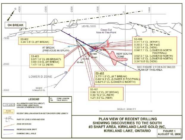
- The previously termed #6 Splay has been re-named as the #7 Break as it proving to be a much more substantial ore-bearing structure than previously thought. At least two parallel, stacked hangingwall mineralized structures associated with the #7 Break have been intersected from the 5300 X-Cut drilling as well as the Lower D North Zone. (see figure 1)
- 2 -
- The cross cut is now within 700 feet of the intended bulk sample area on the New South Zone where a previous intersection returned a 124.4 foot intersection of 1.4 opt.
- The new zones are different than the historically-mined quartz-hosted gold in that they comprise more consistently grading sulphide gold zones along extensive structures and are consistent with previous discoveries to the south including the Lower D Zone (see press releases dated March 29, 2004 and February 14, 2006)) and the New South Zone (see press release dated July 11th, 2005)
The diagrams referred to in this release may be viewed at the Company’s website,www.klgold.com and will provide context to the above statements.
Figure #1 is a plan view showing the 5300 cross cut and initial drilling results from the cross cut. Figure #2 is a detailed plan view of the 5300 cross cut with drift assays.
The following table summarizes the latest drilling program results. (imperial values)
| | | | | HOLE | | |
| DRILL | VEIN | FROM | TO | DIP | AZIMUTH | ASSAY |
| HOLE No. | | (feet) | (feet) | (degrees) | (degrees) | (oz. per ton/feet) |
| 53-466 | #7 HW1 | 585.7 | 587.1 | 0 | 089 | 0.31/1.4’ CL = 0.7’ TW, VG |
| | #7 HW2 | 600.3 | 602.4 | | | 0.35/2.1’ CL = 1.1’ TW, VG |
| | New | 632.3 | 633.7 | | | 1.33/1.4’ CL = 0.8’ TW,VG |
| | Lower D North | 642.9 | 650.0 | | | 0.99/7.1’ CL = 3.1’ TW, VG |
| | Footwall | | | | | |
| | Lower D North | 675.0 | 678.1 | | | 3.52/3.1’ CL = 1.7’ TW, Uncut |
| | | | | | | 1.81/3.1’ CL = 1.7’ TW, Cut |
| | Incl. | 675.0 | 676.5 | | | 7.02/1.5’ CL = 0.8’ TW, VG, Tell |
| | Lower D North | 682.8 | 684.3 | | | 0.96/1.5’ CL = 0.8’ TW, VG, Tell |
| | New | 696.5 | 713.3 | | | 3.34/16.8’ CL = TW ?, Uncut |
| | | | | | | 1.71/16.8’ Cut = TW?, VG, Tell |
| | Incl. | 696.5 | 698.5 | | | 10.97/2.0’ CL = TW?, VG, Tell |
| | and | 703.2 | 704.2 | | | 12.36/1.0’ CL = TW?, VG, Tell |
| | and | 705.2 | 706.2 | | | 5.88/1.0’ CL = TW?, VG |
| | and | 706.2 | 707.7 | | | 4.23/1.5’ CL = TW?, VG, Tell |
| 53-461 | #7 Break | 383.6 | 386.6 | +1 | 104 | 0.99/3.0’ CL = 2.2’ TW |
| | New | 685.8 | 698.0 | | | 0.36/12.2’ CL = 10.2’ TW |
| | New | 801.0 | 804.0 | | | 1.27/3.0’ CL = 2.7’ TW |
| 53-462 | #7 Break | 293.0 | 295.6 | +13 | 134 | 3.24/3.5’ CL = 3.2’ TW, Uncut |
| | | | | | | 2.37/3.5’ CL = 3.2’ TW, Cut |
| | Incl. | 294.3 | 296.5 | | | 4.89/2.2’ CL = 2.0’ TW, VG |
| 53-463 | #6 Break(?) | 240.5 | 241.5 | +16 | 116 | 9.97/1.0’ CL = 0.9’ TW, VG |
| | #7 Break | 312.5 | 316.4 | | | 3.95/3.9’ CL = 3.6’ TW, Uncut |
| | | | | | | 1.50/3.9’ CL = 3.6’ TW, Cut |
| | Incl. | 315.1 | 316.4 | | | 10.85/1.3’ CL = 1.2 TW, VG |
| | New | 322.8 | 324.3 | | | 1.47/1.5’ CL = 1.4’ TW |
- 3 -
| | | | | HOLE | | |
| DRILL | VEIN | FROM | TO | DIP | AZIMUTH | ASSAY |
| HOLE No. | | (feet) | (feet) | (degrees) | (degrees) | (oz. per ton/feet) |
| 53-464 | | | | +17 | 131 | Assays Pending |
| | | | | | | |
| | | | | | | |
| 53-465 | #7 Break | 353.0 | 354.0 | +9 | 104 | 3.77/1.0’ CL = 0.8’ TW, VG |
| | New | 367.2 | 368.8 | | | 0.73/1.6’ CL = 1.3’ TW, VG |
| | Lower D North | 456.7 | 465.0 | | | 0.60/8.3’ CL = 6.7’ TW |
| | Footwall | | | | | |
| | Lower D North | 493.8 | 494.8 | | | 0.82/1.0’ CL = 0.8’ TW |
TW = True WidthCL = Core LengthVG = Visible GoldTELL = TelluridesCUT= cut to 3.50 oz/ton
The following table summarizes the latest drilling program results. (metric values)
| | | | | HOLE | | |
| DRILL | VEIN | FROM | TO | DIP | AZIMUTH | ASSAY |
| HOLE No. | | (m) | (m) | (degrees) | (degrees) | (grams per tonne/m) |
| | | | | | |
| 53-466 | #7 HW1 | 178.6 | 179.0 | 0 | 089 | 10.6/0.4m CL = 0.2m TW, VG |
| | #7 HW2 | 183.0 | 183.6 | | | 12.0/0.6m CL = 0.3m TW, VG |
| | New | 192.7 | 193.2 | | | 45.6/0.5m CL = 0.2m TW,VG |
| | Lower D North | 196.0 | 198.0 | | | 33.9/2.0m CL = 0.9m TW, VG |
| | Footwall | | | | | |
| | Lower D North | 205.7 | 206.7 | | | 120.7/1.0m CL = 0.5m TW, |
| | | | | | | Uncut |
| | | | | | | 62.1/1.0m CL = 0.5m TW, Cut |
| | Incl. | 205.7 | 206.2 | | | 240.7/0.5m CL = 0.2m TW, VG, |
| | Lower D North | 208.1 | 208.6 | | | 32.9/0.5m CL = 0.2m TW, VG, |
| | New | 212.3 | 217.4 | | | 114.5/5.1m CL = TW ?, Uncut |
| | | | | | | 58.6/5.1m CL = TW?, VG, Cut |
| | Incl. | 212.3 | 212.9 | | | 376.1/0.6m CL = TW?, VG, Tell |
| | and | 214.3 | 214.6 | | | 423.8/0.3m CL = TW?, VG, Tell |
| | and | 214.9 | 215.2 | | | 201.6/0.3m CL = TW?, VG |
| | and | 215.2 | 215.7 | | | 145.0/0.5m CL = TW?, VG, Tell |
| 53-461 | #7 Break | 116.9 | 117.8 | +1 | 104 | 33.9/0.9m CL = 0.7m TW |
| | New | 209.0 | 212.8 | | | 12.3/3.8m CL = 3.1m TW |
| | New | 244.2 | 245.1 | | | 43.5/0.9m CL = 0.8m TW |
| 53-462 | #7 Break | 89.3 | 90.1 | +13 | 134 | 111.1/0.8m CL = 1.0m TW, Uncut |
| | | | | | | 81.3/0.8m CL = 1.0m TW, Cut |
| | Incl. | 89.7 | 90.4 | | | 167.7/0.7m CL = 0.6m TW, VG |
| 53-463 | #6 Break(?) | 73.3 | 73.6 | +16 | 116 | 341.8/0.3m CL = 0.3m TW, VG |
| | #7 Break | 95.3 | 96.4 | | | 135.4/1.1m CL = 1.1m TW, |
| | | | | | | Uncut |
| | | | | | | 51.4/1.1m CL = 1.1m TW, Cut |
| | Incl. | 96.0 | 96.4 | | | 372.0/0.4m CL = 0.4m TW, VG |
| | New | 98.4 | 98.8 | | | 50.4/0.4m CL = 0.4m TW |
- 4 -
| | | | | HOLE | | |
| DRILL | VEIN | FROM | TO | DIP | AZIMUTH | ASSAY |
| HOLE No. | | (m) | (m) | (degrees) | (degrees) | (grams per tonne/m) |
| | | | | | |
| 53-464 | | | | +17 | 131 | Assays Pending |
| | | | | | | |
| | | | | | | |
| 53-465 | #7 Break | 107.6 | 107.9 | +9 | 104 | 129.3/0.3m CL = 0.2m TW, VG |
| | New | 111.9 | 112.4 | | | 25.0/0.5m CL = 0.4m TW, VG |
| | Lower D North | 139.2 | 141.7 | | | 20.6/2.5m CL = 2.0m TW |
| | Footwall | | | | | |
| | Lower D North | 150.5 | 150.8 | | | 28.1/0.3m CL = 0.2m TW |
TW = True WidthCL = Core LengthVG = Visible GoldTELL = TelluridesCUT= cut to 120 grams/tonne
About the Company
The Company purchased the Macassa Mine and the 1,500 ton per day mill along with four former producing gold properties – Kirkland Minerals, Teck-Hughes, Lake Shore and Wright Hargreaves – in December 2001. These properties, which have historically produced some 22 million ounces of gold, extend over seven kilometres between the Macassa Mine on the east and Wright Hargreaves on the west and, for the first time, are being developed and explored under one owner. This camp is located in the Abitibi Southern Greenstone Belt of Kirkland Lake, Ontario, Canada.
The results of the Company’s underground diamond drilling program have been reviewed, verified (including sampling, analytical and test data) and compiled by the Company's geological staff (which includes a ‘qualified person’, Michael Sutton P.Geo., the Company’s Chief Geologist, for the purpose of National Instrument 43-101Standards of Disclosure for Mineral Projects, of the Canadian Securities Administrators).
The Company has implemented a quality assurance and control (QA/QC) program to ensure sampling and analysis of all exploration work is conducted in accordance with the best possible practices. The drill core is sawn in half with half of the core samples shipped to the Swastika Laboratories in Swastika, Ontario or to the Macassa mine laboratory for analysis. The other half of the core is retained for future assay verification. Other QA/QC includes the insertion of blanks, and the regular re-assaying of pulps and rejects at alternate certified labs (Polymet, Accurassay). Gold analysis is conducted by fire assay using atomic absorption or gravimetric finish. The laboratory re-assays at least 10% of all samples and additional checks may be run on anomalous values.
The Company’s Kirkland Lake properties are the subject of a report prepared by Roland H. Ridler, B.A.Sc.(Hons.), M.A.Sc., Ph.D.(Econ.Geol.), P.D., entitledKirkland Lake Mineral Properties (Macassa Mine, Kirkland Lake Gold, Teck-Hughes, Lake Shore, Wright-Hargreavesdated November 30, 2001. The Company’s Macassa Mine Property is the subject of resource and reserve report prepared by Glenn R. Clark, P. Eng., entitledReview of Resources and Reserves of Macassa Mine, Kirkland Lake, Ontariodated July 18, 2006. Both of these technical reports have been filed on SEDAR (www.sedar.com).
- 5 -
For further information, please contact:
| Brian Hinchcliffe | Scott Koyich |
| President | Investor Relations |
| Phone 1 705 567 5208 | Phone 1 403 215 5979 |
| Fax 1 705 568 6444 | E-mail:info@klgold.com |
| E-mail:bhinchcliffe@klgold.com | |
| | |
| Website-www.klgold.com | |
Neither the Toronto Stock Exchange nor the AIM Market of the London Stock Exchange
has reviewed and neither accepts responsibility for the adequacy or accuracy of this news release.
FIGURE 1
FIGURE 2