Exhibit 96.2
Rochester Operations
Nevada
Technical Report Summary
Prepared for: Coeur Mining, Inc. | Prepared by: Mr Christopher Pascoe, RM SME Mr. Brandon MacDougall, P.E. Mr. Matthew Bradford, RM SME Mr. Matthew Hoffer, P.G. |
| |
Report current as at: December 31, 2021 |
Date and Signature Page
The following Qualified Persons, who are employees of Coeur Mining, Inc. or its subsidiaries, prepared this technical report summary, entitled “Rochester Operations, Nevada, Technical Report Summary” and confirm that the information in the technical report summary is current as at December 31, 2021 and filed on February 16, 2022.
/s/ Christopher Pascoe
Christopher Pascoe, RM SME
/s/ Brandon MacDougall
Brandon MacDougall, P.E.
/s/ Matthew Bradford
Matthew Bradford, RM SME
/s/ Matthew Hoffer
Matthew Hoffer, P.G.
| CONTENTS |
| |
| 1.0 | EXECUTIVE SUMMARY | 1-1 |
| 1.1 | Introduction | 1-1 |
| 1.2 | Terms of Reference | 1-1 |
| 1.3 | Property Setting | 1-1 |
| 1.4 | Mineral Tenure, Surface Rights, Water Rights, Royalties and Agreements | 1-2 |
| 1.5 | Geology and Mineralization | 1-2 |
| 1.6 | History and Exploration | 1-3 |
| 1.7 | Drilling and Sampling | 1-3 |
| 1.8 | Data Verification | 1-4 |
| 1.9 | Metallurgical Test Work | 1-5 |
| 1.10 | Mineral Resource Estimation | 1-6 |
| 1.10.1 | Estimation Methodology | 1-6 |
| 1.10.2 | Mineral Resource Statement | 1-7 |
| 1.10.3 | Factors That May Affect the Mineral Resource Estimate | 1-8 |
| 1.11 | Mineral Reserve Estimation | 1-9 |
| 1.11.1 | Estimation Methodology | 1-9 |
| 1.11.2 | Mineral Reserve Statement | 1-9 |
| 1.11.3 | Factors That May Affect the Mineral Reserve Estimate | 1-10 |
| 1.12 | Mining Methods | 1-10 |
| 1.13 | Recovery Methods | 1-11 |
| 1.14 | Infrastructure | 1-12 |
| 1.15 | Markets and Contracts | 1-13 |
| 1.15.1 | Market Studies | 1-13 |
| 1.15.2 | Commodity Pricing | 1-13 |
| 1.15.3 | Contracts | 1-14 |
| 1.16 | Environmental, Permitting and Social Considerations | 1-14 |
| 1.16.1 | Environmental Studies and Monitoring | 1-14 |
| 1.16.2 | Closure and Reclamation Considerations | 1-14 |
| 1.16.3 | Permitting | 1-14 |
| 1.16.4 | Social Considerations, Plans, Negotiations and Agreements | 1-15 |
| 1.17 | Capital Cost Estimates | 1-15 |
| 1.18 | Operating Cost Estimates | 1-15 |
| 1.19 | Economic Analysis | 1-18 |
| 1.19.1 | Forward-Looking Information Caution | 1-18 |
| 1.19.2 | Methodology and Assumptions | 1-18 |
| 1.19.3 | Economic Analysis | 1-18 |
| 1.19.4 | Sensitivity Analysis | 1-19 |
| 1.20 | Risks and Opportunities | 1-19 |
| 1.20.1 | Risks | 1-19 |
| 1.20.2 | Opportunities | 1-21 |
| 1.21 | Conclusions | 1-21 |
| 1.22 | Recommendations | 1-21 |
| 2.0 | INTRODUCTION | 2-1 |
| 2.1 | Registrant | 2-1 |
| 2.2 | Terms of Reference | 2-1 |
| 2.2.1 | Report Purpose | 2-1 |
| 2.2.2 | Terms of Reference | 2-1 |
| 2.3 | Qualified Persons | 2-4 |
| 2.4 | Site Visits and Scope of Personal Inspection | 2-4 |
| 2.5 | Report Date | 2-4 |
| 2.6 | Information Sources and References | 2-5 |
| 2.7 | Previous Technical Report Summaries | 2-5 |
| 3.0 | PROPERTY DESCRIPTION | 3-1 |
| 3.1 | Property Location | 3-1 |
| 3.2 | Ownership | 3-1 |
| 3.3 | Mineral Title | 3-1 |
| 3.3.1 | Tenure Holdings | 3-1 |
| 3.3.2 | Tenure Maintenance Requirements | 3-1 |
| 3.4 | Property Agreements | 3-4 |
| 3.4.1 | Pershing County Road Maintenance Agreement | 3-4 |
| 3.4.2 | Pipeline, Electric Power Line, and Telephone Line License | 3-4 |
| 3.4.3 | Rights of Way | 3-4 |
| 3.5 | Surface Rights | 3-5 |
| 3.6 | Water Rights | 3-5 |
| 3.7 | Royalties | 3-5 |
| 3.7.1 | Asarco Royalty | 3-5 |
| 3.7.2 | Nelsen, Stice, and Kilrain Royalty | 3-7 |
| 3.7.3 | Davis Royalty | 3-7 |
| 3.7.4 | Midway Gold US Inc. and Barrick Royalty | 3-7 |
| 3.8 | Encumbrances | 3-7 |
| 3.8.1 | Credit Agreement | 3-7 |
| 3.8.2 | Permitting Requirements | 3-8 |
| 3.8.3 | Permitting Timelines | 3-8 |
| 3.8.4 | Permit Conditions | 3-8 |
| 3.8.5 | Violations and Fines | 3-8 |
| 3.9 | Significant Factors and Risks That May Affect Access, Title or Work Programs | 3-8 |
| 4.0 | ACCESSIBILITY, CLIMATE, LOCAL RESOURCES, INFRASTRUCTURE AND PHYSIOGRAPHY | 4-1 |
| 4.1 | Physiography | 4-1 |
| 4.2 | Accessibility | 4-1 |
| 4.3 | Climate | 4-1 |
| 4.4 | Infrastructure | 4-2 |
| 5.0 | HISTORY | 5-1 |
| 5.1 | Project Ownership History | 5-1 |
| 5.2 | Exploration and Development History | 5-1 |
| 6.0 | GEOLOGICAL SETTING, MINERALIZATION, AND DEPOSIT | 6-1 |
| 6.1 | Deposit Type | 6-1 |
| 6.2 | Regional Geology | 6-1 |
| 6.3 | Local Geology | 6-3 |
| 6.3.1 | Lithologies | 6-3 |
| 6.3.2 | Structure | 6-6 |
| 6.3.3 | Metamorphism and Alteration | 6-6 |
| 6.3.4 | Mineralization | 6-6 |
| 6.4 | Property Geology | 6-7 |
| 6.4.1 | Rochester | 6-7 |
| 6.4.1.1 | Deposit Dimensions | 6-7 |
| 6.4.1.2 | Lithologies | 6-7 |
| 6.4.1.3 | Structure | 6-7 |
| 6.4.1.4 | Alteration | 6-8 |
| 6.4.1.5 | Mineralization | 6-8 |
| 6.4.2 | Nevada Packard | 6-11 |
| 6.4.2.1 | Deposit Dimensions | 6-11 |
| 6.4.2.2 | Lithologies | 6-11 |
| 6.4.2.3 | Structure | 6-11 |
| 6.4.2.4 | Alteration | 6-11 |
| 6.4.2.5 | Mineralization | 6-11 |
| 7.0 | EXPLORATION | 7-1 |
| 7.1 | Exploration | 7-1 |
| 7.1.1 | Grids and Surveys | 7-1 |
| 7.1.2 | Geological Mapping | 7-1 |
| 7.1.3 | Geochemistry | 7-1 |
| 7.1.4 | Geophysics | 7-2 |
| 7.1.5 | Qualified Person’s Interpretation of the Exploration Information | 7-2 |
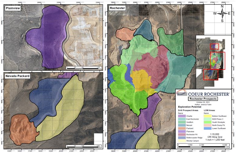
| 7.1.6 | Exploration Potential | 7-2 |
| 7.2 | Drilling | 7-4 |
| 7.2.1 | Overview | 7-4 |
| 7.2.2 | Drilling Excluded For Estimation Purposes | 7-4 |
| 7.2.3 | Drill Methods | 7-4 |
| 7.2.4 | Logging | 7-16 |
| 7.2.5 | Recovery | 7-18 |
| 7.2.6 | Collar Surveys | 7-18 |
| 7.2.7 | Down Hole Surveys | 7-18 |
| 7.2.8 | Comment on Material Results and Interpretation | 7-18 |
| 7.3 | Hydrogeology | 7-19 |
| 7.3.1 | Sampling Methods and Laboratory Determinations | 7-19 |
| 7.3.2 | Hydrogeology | 7-19 |
| 7.3.3 | Comment on Results | 7-20 |
| 7.3.4 | Groundwater Models | 7-20 |
| 7.3.5 | Water Balance | 7-21 |
| 7.4 | Geotechnical | 7-21 |
| 7.4.1 | Sampling Methods and Laboratory Determinations | 7-21 |
| 7.4.2 | Comment on Results | 7-22 |
| 8.0 | SAMPLE PREPARATION, ANALYSES, AND SECURITY | 8-1 |
| 8.1 | Sampling Methods | 8-1 |
| 8.1.1 | Reverse Circulation | 8-1 |
| 8.1.2 | Core | 8-1 |
| 8.1.3 | Grade Control | 8-1 |
| 8.2 | Sample Security Methods | 8-2 |
| 8.3 | Density Determinations | 8-2 |
| 8.4 | Analytical and Test Laboratories | 8-2 |
| 8.5 | Sample Preparation | 8-3 |
| 8.5.1 | Pre-2008 | 8-3 |
| 8.5.2 | 2008–Current | 8-3 |
| 8.6 | Analysis | 8-3 |
| 8.6.1 | Coeur Pre-2008 | 8-3 |
| 8.6.2 | 2008–2011 | 8-4 |
| 8.6.3 | 2012–Current | 8-4 |
| 8.6.4 | Multi-element Analysis | 8-6 |
| 8.6.5 | Alio Gold | 8-7 |
| 8.7 | Quality Assurance and Quality Control | 8-7 |
| 8.7.1 | Coeur Pre-2008 | 8-7 |
| 8.7.2 | 2008–2015 | 8-8 |
| 8.7.3 | 2016–Current | 8-8 |
| 8.7.4 | Alio Gold Results | 8-9 |
| 8.8 | Database | 8-9 |
| 8.9 | Qualified Person’s Opinion on Sample Preparation, Security, and Analytical Procedures | 8-9 |
| 9.0 | DATA VERIFICATION | 9-1 |
| 9.1 | Internal Data Verification | 9-1 |
| 9.1.1 | Rochester Review | 9-1 |
| 9.1.2 | Nevada Packard Review | 9-2 |
| 9.1.3 | Nevada Packard Stockpiles | 9-3 |
| 9.1.4 | South and Charlie Stockpiles | 9-4 |
| 9.1.5 | Rochester In-Pit Stockpile | 9-4 |
| 9.2 | External Data Verification | 9-4 |
| 9.3 | Data Verification by Qualified Person | 9-5 |
| 9.4 | Qualified Person’s Opinion on Data Adequacy | 9-5 |
| 10.0 | MINERAL PROCESSING AND METALLURGICAL TESTING | 10-1 |
| 10.1 | Test Laboratories | 10-1 |
| 10.2 | Metallurgical Test Work | 10-1 |
| 10.2.1 | Rochester | 10-1 |
| 10.2.2 | Packard | 10-1 |
| 10.2.3 | Current Metallurgical Testing | 10-2 |
| 10.3 | Recovery Estimates | 10-3 |
| 10.4 | Metallurgical Variability | 10-7 |
| 10.5 | Deleterious Elements | 10-7 |
| 10.6 | Qualified Person’s Opinion on Data Adequacy | 10-8 |
| 11.0 | MINERAL RESOURCE ESTIMATES | 11-1 |
| 11.1 | Introduction | 11-1 |
| 11.2 | Geological Model | 11-1 |
| 11.3 | Exploratory Data Analysis | 11-3 |
| 11.4 | Density | 11-3 |
| 11.5 | Composites | 11-3 |
| 11.6 | Grade Capping/Outlier Restrictions | 11-4 |
| 11.7 | Variography | 11-4 |
| 11.8 | Interpolation | 11-4 |
| 11.9 | Block Model Validation | 11-8 |
| 11.10 | Classification of Mineral Resources | 11-9 |
| 11.10.1 | Mineral Resource Confidence Classification | 11-9 |
| 11.10.2 | Uncertainties Considered During Confidence Classification | 11-9 |
| 11.11 | Reasonable Prospects of Economic Extraction | 11-9 |
| 11.11.1 | Input Assumptions | 11-9 |
| 11.11.2 | Commodity Price | 11-13 |
| 11.11.3 | Cut-off | 11-14 |
| 11.11.4 | QP Statement | 11-14 |
| 11.12 | Mineral Resource Statement | 11-15 |
| 11.13 | Uncertainties (Factors) That May Affect the Mineral Resource Estimate | 11-20 |
| 12.0 | MINERAL RESERVE ESTIMATES | 12-1 |
| 12.1 | Introduction | 12-1 |
| 12.2 | Development of Mining Case | 12-1 |
| 12.3 | Designs | 12-1 |
| 12.4 | Input Parameters | 12-1 |
| 12.5 | Net Smelter Return Cut-off | 12-2 |
| 12.6 | Cut-Off Grades | 12-2 |
| 12.7 | Surface Topography | 12-3 |
| 12.8 | Density and Moisture | 12-3 |
| 12.9 | Dilution and Mine Losses | 12-3 |
| 12.10 | Mineral Reserve Statement | 12-4 |
| 12.11 | Uncertainties (Factors) That May Affect the Mineral Reserve Estimate | 12-4 |
| 13.0 | MINING METHODS | 13-1 |
| 13.1 | Introduction | 13-1 |
| 13.2 | Geotechnical Considerations | 13-1 |
| 13.3 | Hydrogeological Considerations | 13-1 |
| 13.4 | Design Considerations | 13-2 |
| 13.5 | Blasting and Explosives | 13-3 |
| 13.6 | Grade Control and Production Monitoring | 13-3 |
| 13.7 | Waste Rock and Backfill | 13-6 |
| 13.8 | Production Schedule | 13-6 |
| 13.9 | Equipment | 13-11 |
| 13.10 | Personnel | 13-11 |
| 14.0 | RECOVERY METHODS | 14-1 |
| 14.1 | Process Method Selection | 14-1 |
| 14.2 | Flowsheet | 14-1 |
| 14.3 | Process Plant | 14-1 |
| 14.3.1 | Overview | 14-1 |
| 14.3.2 | Heap Leach Pads | 14-4 |
| 14.3.3 | Merrill-Crowe Plant | 14-5 |
| 14.4 | Equipment Sizing | 14-6 |
| 14.5 | Power and Consumables | 14-6 |
| 14.6 | Personnel | 14-6 |
| 15.0 | INFRASTRUCTURE | 15-1 |
| 15.1 | Roads and Logistics | 15-3 |
| 15.2 | Stockpiles | 15-3 |
| 15.3 | Waste Rock Storage Facilities | 15-5 |
| 15.4 | Water Management | 15-5 |
| 15.5 | Water Supply | 15-5 |
| 15.6 | Power and Electrical | 15-6 |
| 15.7 | Fuel | 15-7 |
| 16.0 | MARKET STUDIES AND CONTRACTS | 16-1 |
| 16.1 | Markets | 16-1 |
| 16.2 | Commodity Price Forecasts | 16-1 |
| 16.3 | Contracts | 16-2 |
| 16.4 | QP Statement | 16-3 |
| 17.0 | ENVIRONMENTAL STUDIES, PERMITTING, AND PLANS, NEGOTIATIONS, OR AGREEMENTS WITH LOCAL INDIVIDUALS OR GROUPS | 17-1 |
| 17.1 | Baseline and Supporting Studies | 17-1 |
| 17.2 | Environmental Considerations/Monitoring Programs | 17-1 |
| 17.2.1 | Environmental Protection Measures | 17-1 |
| 17.2.2 | Jurisdictional Wetlands and Waters of the United States | 17-2 |
| 17.3 | Closure and Reclamation Considerations | 17-2 |
| 17.4 | Permitting | 17-5 |
| 17.4.1 | Current Permits | 17-5 |
| 17.4.2 | POA 11 | 17-5 |
| 17.5 | Social Considerations, Plans, Negotiations and Agreements | 17-5 |
| 17.6 | Qualified Person’s Opinion on Adequacy of Current Plans to Address Issues | 17-8 |
| 18.0 | CAPITAL AND OPERATING COSTS | 18-1 |
| 18.1 | Introduction | 18-1 |
| 18.2 | Capital Cost Estimates | 18-1 |
| 18.2.1 | Basis of Estimate | 18-1 |
| 18.2.2 | Capital Cost Summary | 18-2 |
| 18.3 | Operating Cost Estimates | 18-2 |
| 18.3.1 | Basis of Estimate | 18-2 |
| 18.3.2 | Operating Cost Summary | 18-2 |
| 18.4 | QP Statement | 18-5 |
| 19.0 | ECONOMIC ANALYSIS | 19-1 |
| 19.1 | Forward-looking Information Caution | 19-1 |
| 19.2 | Methodology Used | 19-1 |
| 19.3 | Financial Model Parameters | 19-1 |
| 19.3.1 | Mineral Resource, Mineral Reserve, and Mine Life | 19-1 |
| 19.3.2 | Metallurgical Recoveries | 19-1 |
| 19.3.3 | Smelting and Refining Terms | 19-2 |
| 19.3.4 | Metal Prices | 19-2 |
| 19.3.5 | Capital and Operating Costs | 19-2 |
| 19.3.6 | Working Capital | 19-2 |
| 19.3.7 | Taxes and Royalties | 19-2 |
| 19.3.8 | Closure Costs and Salvage Value | 19-2 |
| 19.3.9 | Financing | 19-2 |
| 19.3.10 | Inflation | 19-3 |
| 19.4 | Economic Analysis | 19-3 |
| 19.5 | Sensitivity Analysis | 19-3 |
| 20.0 | ADJACENT PROPERTIES | 20-1 |
| 21.0 | OTHER RELEVANT DATA AND INFORMATION | 21-1 |
| 22.0 | INTERPRETATION AND CONCLUSIONS | 22-1 |
| 22.1 | Introduction | 22-1 |
| 22.2 | Mineral Tenure, Surface Rights, Water Rights, Royalties and Agreements | 22-1 |
| 22.3 | Geology and Mineralization | 22-1 |
| 22.4 | Exploration, Drilling, and Sampling | 22-1 |
| 22.5 | Data Verification | 22-2 |
| 22.6 | Metallurgical Test Work | 22-2 |
| 22.7 | Mineral Resource Estimates | 22-3 |
| 22.8 | Mineral Reserve Estimates | 22-3 |
| 22.9 | Mining Methods | 22-4 |
| 22.10 | Recovery Methods | 22-4 |
| 22.11 | Infrastructure | 22-4 |
| 22.12 | Market Studies | 22-5 |
| 22.13 | Environmental, Permitting and Social Considerations | 22-6 |
| 22.14 | Capital Cost Estimates | 22-6 |
| 22.15 | Operating Cost Estimates | 22-7 |
| 22.16 | Economic Analysis | 22-7 |
| 22.17 | Risks and Opportunities | 22-7 |
| 22.17.1 | Risks | 22-7 |
| 22.17.2 | Opportunities | 22-8 |
| 22.18 | Conclusions | 22-9 |
| 23.0 | RECOMMENDATIONS | 23-1 |
| 24.0 | REFERENCES | 24-1 |
| 24.1 | Bibliography | 24-1 |
| 24.2 | Abbreviations and Units of Measure | 24-2 |
| 24.3 | Glossary of Terms | 24-6 |
| 25.0 | RELIANCE ON INFORMATION PROVIDED BY THE REGISTRANT | 25-1 |
| 25.1 | Introduction | 25-1 |
| 25.2 | Macroeconomic Trends | 25-1 |
| 25.3 | Markets | 25-1 |
| 25.4 | Legal Matters | 25-1 |
| 25.5 | Environmental Matters | 25-1 |
| 25.6 | Stakeholder Accommodations | 25-2 |
| 25.7 | Governmental Factors | 25-2 |
| 25.8 | Internal Controls | 25-2 |
| 25.8.1 | Exploration and Drilling | 25-2 |
| 25.8.2 | Mineral Resource and Mineral Reserve Estimates | 25-3 |
| 25.8.3 | Risk Assessments | 25-3 |
| TABLES |
| |
| Table 1‑1: | Summary of Gold and Silver Measured and Indicated Mineral Resources, Rochester, Nevada Packard, and Stockpiles, as at December 31, 2021 (based on US$1,700/oz gold price and US$22/oz silver price) | 1-8 |
| Table 1‑2: | Summary of Gold and Silver Inferred Mineral Resources, Rochester, Nevada Packard, and Stockpiles, as at December 31, 2021 (based on US$1,700/oz gold price and US$22/oz silver price)) | 1-8 |
| Table 1‑3: | Summary of Gold and Silver Proven and Probable Mineral Reserve Estimates, as at December 31, 2021 (based on US$1,400/oz gold price and US$20/oz silver price) | 1-11 |
| Table 1‑4: | Capital Cost Estimate Summary | 1-16 |
| Table 1‑5: | Operating Cost Estimate Summary | 1-17 |
| Table 1‑6: | Summary Cashflow Table | 1-19 |
| Table 1‑7: | NPV Sensitivity | 1-20 |
| Table 2‑1: | QP Chapter Responsibilities | 2-5 |
| Table 3‑1: | Mineral Tenure Summary Table | 3-2 |
| Table 5‑1: | Exploration and Development History | 5-2 |
| Table 7‑1: | Property Drill Summary Table | 7-5 |
| Table 7‑2: | Drill Summary Table, Rochester | 7-11 |
| Table 7‑3: | Drill Summary Table, Nevada Packard | 7-12 |
| Table 8‑1: | Historical Primary and Secondary Laboratory Analysis Methods (2008–2011) | 8-5 |
| Table 10‑1: | Metallurgical Test Work Summary Table | 10-3 |
| Table 10‑2: | Leach Pad Recoveries to Date | 10-4 |
| Table 10‑3: | Historical Crushed and ROM Product Recoveries | 10-4 |
| Table 10‑4: | Stage III Crushed and ROM Product Recoveries | 10-6 |
| Table 10‑5: | Stage VI Recovery Confidence Intervals | 10-6 |
| Table 10‑6: | Ultimate Recovery Summary by Ore Type | 10-8 |
| Table 11‑1: | Capping Statistics for Rochester Silver Composites | 11-5 |
| Table 11‑2: | Capping Statistics for Rochester Gold Composites | 11-6 |
| Table 11‑3: | Capping Statistics for Nevada Packard Silver Composites | 11-7 |
| Table 11‑4: | Capping Statistics for Nevada Packard Gold Composites | 11-7 |
| Table 11‑5: | Confidence Classifications | 11-10 |
| Table 11‑6: | Operating Cost and Cut-offs for Mineral Resource Estimates | 11-13 |
| Table 11‑7: | Metallurgical Process Recoveries Used in Rochester Mineral Resources NSR Cutoff Calculations | 11-15 |
| Table 11‑8: | Gold and Silver Measured and Indicated Mineral Resources, Rochester, as at December 31, 2021 (based on US$1,700/oz gold price and US$22/oz silver price) | 11-16 |
| Table 11‑9: | Gold and Silver Inferred Mineral Resources, Rochester, as at December 31, 2021 (based on US$1,700/oz gold price and US$22/oz silver price) | 11-16 |
| Table 11‑10: | Gold and Silver Measured and Indicated Mineral Resources, Nevada Packard, as at December 31, 2021 (based on US$1,700/oz gold price and US$22/oz silver price) | 11-16 |
| Table 11‑11: | Gold and Silver Inferred Mineral Resources, Nevada Packard, as at December 31, 2021 (based on US$1,700/oz gold price and US$22/oz silver price) | 11-17 |
| Table 11‑12: | Gold and Silver Measured and Indicated Mineral Resources, Rochester Stockpile (South-Charlie and In-pit), as at December 31, 2021 (based on US$1,700/oz gold price and US$22/oz silver price) | 11-17 |
| Table 11‑13: | Gold and Silver Inferred Mineral Resources, Rochester Stockpile (South-Charlie and In-pit), as at December 31, 2021 (based on US$1,700/oz gold price and US$22/oz silver price) | 11-17 |
| Table 11‑14: | Gold and Silver Measured and Indicated Mineral Resources, Nevada Packard Stockpile as at December 31, 2021 (based on US$1,700/oz gold price and US$22/oz silver price) | 11-18 |
| Table 11‑15: | Gold and Silver Inferred Mineral Resources, Nevada Packard Stockpile Inferred Mineral Resource Statement as at December 31, 2021 (based on US$1,700/oz gold price and US$22/oz silver price) | 11-18 |
| Table 11‑16: | Summary of Gold and Silver Measured and Indicated Mineral Resources, Rochester, Nevada Packard, and Stockpiles, as at December 31, 2021 (based on US$1,700/oz gold price and US$22/oz silver price) | 11-19 |
| Table 11‑17: | Summary of Gold and Silver Inferred Mineral Resources, Rochester, Nevada Packard, and Stockpiles, as at December 31, 2021 (based on US$1,700/oz gold price and US$22/oz silver price)) | 11-19 |
| Table 12‑1: | Pit Shell Input Parameters | 12-2 |
| Table 12‑2: | LOM Operating Cost and Cut-offs for Mineral Reserve Estimates | 12-3 |
| Table 12‑3: | Gold and Silver Proven and Probable Mineral Reserves, Rochester, as at December 31, 2021 (based on US$1,400/oz gold price and US$20/oz silver price) | 12-5 |
| Table 12‑4: | Gold and Silver Proven and Probable Mineral Reserves, Nevada Packard, as at December 31, 2021 (based on US$1,400/oz gold price and US$20/oz silver price) | 12-5 |
| Table 12‑5: | Gold and Silver Proven and Probable Mineral Reserves, Rochester Stockpile (South and Charlie) as at December 31, 2021 (based on US$1,400/oz gold price and US$20/oz silver price) | 12-6 |
| Table 12‑6: | Gold and Silver Proven and Probable Mineral Reserves, Nevada Packard Stockpile, as at December 31, 2021 (based on US$1,400/oz gold price and US$20/oz silver price) | 12-6 |
| Table 12‑7: | Summary of Gold and Silver Mineral Reserve Estimates, as at December 31, 2021 (based on US$1,400/oz gold price and US$20/oz silver price) | 12-7 |
| Table 13‑1: | Rochester Zone Solid Pit Slope Design Criteria | 13-2 |
| Table 13‑2: | Nevada Packard Pit Slope Design Criteria by Material Type | 13-2 |
| Table 13‑3: | Pit Design Assumptions | 13-3 |
| Table 13‑4: | Rochester LOM Production Schedule (2022–2028) | 13-7 |
| Table 13‑5: | Rochester LOM Production Schedule (2029–2034) | 13-8 |
| Table 13‑6: | Nevada Packard LOM Production Schedule | 13-9 |
| Table 13‑7: | Combined LOM Production Schedule, Rochester and Nevada Packard | 13-10 |
| Table 13‑8: | LOM Equipment List | 13-11 |
| Table 14‑1: | Approximate Heap Leach Volumes | 14-5 |
| Table 14‑2: | Stage IV Heap Leach Pad Design Criteria | 14-6 |
| Table 14‑3: | Major Process Equipment | 14-7 |
| Table 14‑4 | Power Requirements | 14-8 |
| Table 17‑1: | Monitoring Components, Permit, Plans and Agencies | 17-3 |
| Table 17‑2: | Rochester Pit Waste Rock Management Procedures | 17-4 |
| Table 18‑1: | Estimated Capital Expenditures by Year ($M) | 18-3 |
| Table 18‑2: | Operating Costs by Year ($M) | 18-4 |
| Table 19‑1: | Tax Rates for Primary Taxes | 19-3 |
| Table 19‑2: | Cashflow Summary Table | 19-4 |
| Table 19‑3: | Annualized Cashflow (2022–2035) | 19-5 |
| Table 19‑4: | Annualized Cashflow (2036–2040) | 19-6 |
| Table 19‑5: | NPV Sensitivity | 19-7 |
| FIGURES |
| | | |
| Figure 2‑1: | Project Location Plan | 2-2 |
| Figure 2‑2: | Mining Operations Layout Plan | 2-3 |
| Figure 3‑1: | Mineral Tenure Location Map | 3-3 |
| Figure 3‑2: | Claims Subject to Royalties Plan | 3-6 |
| Figure 6‑1: | Regional Geology Plan | 6-2 |
| Figure 6‑2: | Project Geology Plan | 6-4 |
| Figure 6‑3: | Stratigraphic Column | 6-5 |
| Figure 6‑4: | Geological Plan, Rochester | 6-9 |
| Figure 6‑5: | Geological Cross Section, Rochester | 6-10 |
| Figure 6‑6: | Geological Plan, Nevada Packard | 6-12 |
| Figure 6‑7: | Geological Cross Section, Nevada Packard | 6-13 |
| Figure 7‑1: | Exploration Prospects | 7-3 |
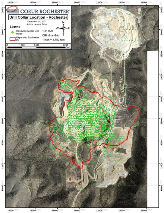
| Figure 7‑2: | Project Drill Collar Location Plan | 7-10 |
| Figure 7‑3: | Drill Collar Location Plan, Rochester | 7-13 |
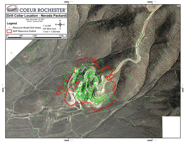
| Figure 7‑4: | Drill Collar Location Plan, Nevada Packard | 7-14 |
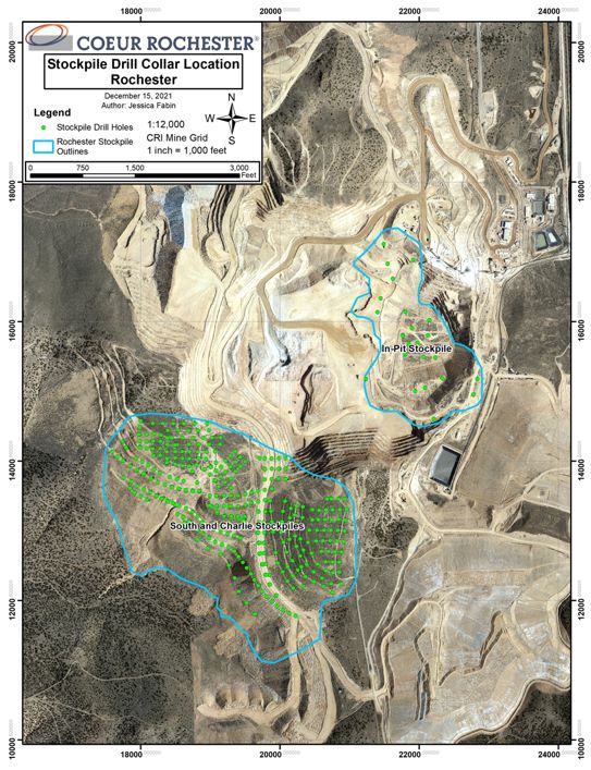
| Figure 7‑5: | Rochester Stockpile Drill Collar Location Map | 7-15 |
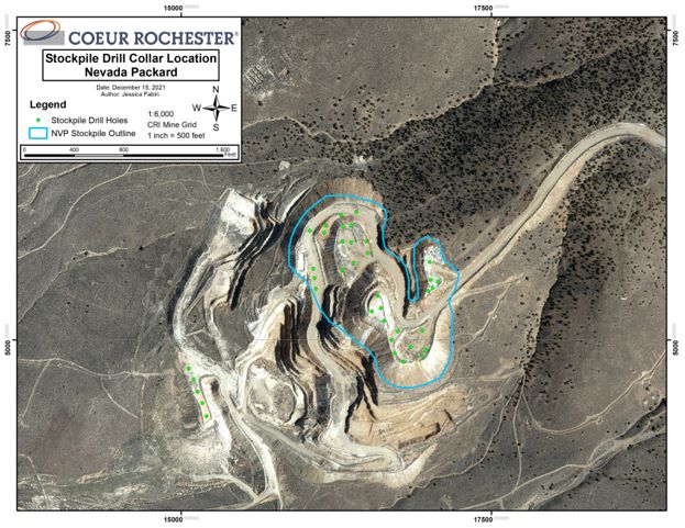
| Figure 7‑6: | Nevada Packard Stockpile Drill Collar Location Map | 7-16 |
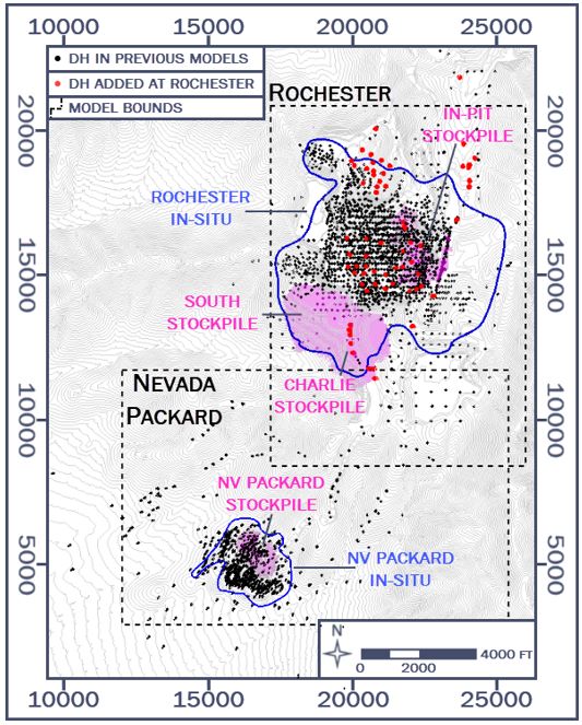
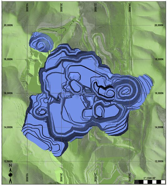
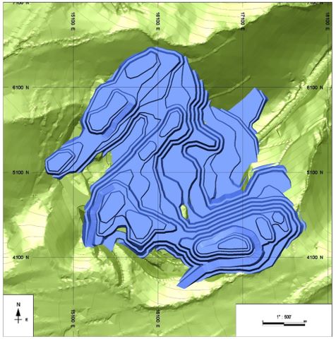
| Figure 11‑1: | Rochester and Nevada Packard Model Areas | 11-2 |
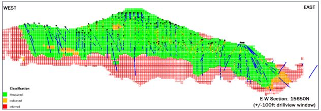
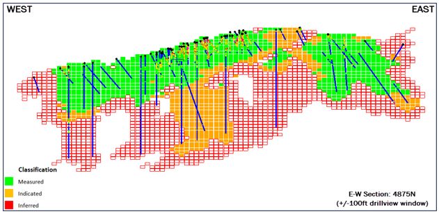
| Figure 11‑2: | Cross-Sectional View Of Rochester Model Classification | 11-11 |
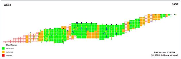
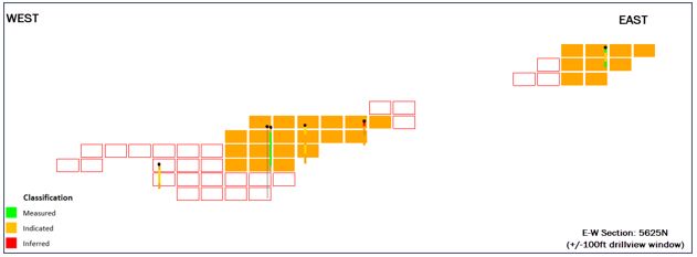
| Figure 11‑3: | Cross-Sectional View Of South-Charlie Stockpile Model Classification | 11-11 |
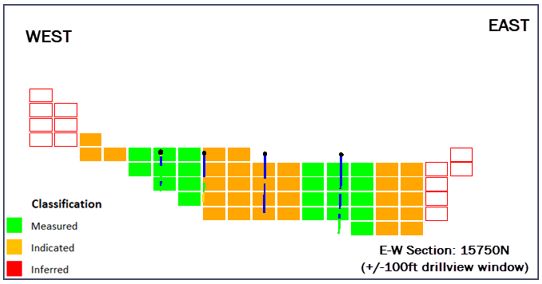
| Figure 11‑4: | Cross-Sectional View Of Rochester In Pit Stockpile Model Classification | 11-12 |
| Figure 11‑5: | Cross-sectional View Of Nevada Packard Model Classification | 11-12 |
| Figure 11‑6: | Cross-sectional View Of Nevada Packard Stockpile Model Classification | 11-13 |
| Figure 13‑1: | 2020 Rochester LOM Pit Design (final pit outline) | 13-4 |
| Figure 13‑2: | 2020 Nevada Packard LOM Pit Design (final pit outline) | 13-5 |
| Figure 14‑1: | Process Flowsheet, Rochester | 14-2 |
| Figure 15‑1: | POA 11 Authorized Facilities at Rochester | 15-4 |
Appendix A: Mineral Tenure
Mr. Christopher Pascoe, RM SME, Mr. Brandon MacDougall, P.E., Mr. Matthew Bradford, RM SME, and Mr. Matthew Hoffer, P.G., prepared a technical report summary (the Report) for Coeur Mining, Inc. (Coeur), on the Rochester Gold Operations (the Rochester Operations or the Project), located in Nevada.
Coeur’s wholly-owned subsidiary, Coeur Rochester, Inc. (Coeur Rochester) is the operating entity.
The Report was prepared to be attached as an exhibit to support mineral property disclosure, including mineral reserve and mineral resource estimates, for the Rochester Operations in Coeur’s Form 10-K for the year ended December 31, 2021.
Mineral resources and mineral reserves are reported for Rochester and Nevada Packard. Mineral reserves are also estimated for material in stockpiles.
Unless otherwise indicated, all financial values are reported in United States (US) currency (US$) including all operating costs, capital costs, cash flows, taxes, revenues, expenses, and overhead distributions. Unless otherwise indicated, the US customary system is used in this Report. Mineral resources and mineral reserves are reported using the definitions in Item 1300 of Regulation S–K (17 CFR Part 229) (SK1300). Illustrations, where specified in SK1300, are provided in the relevant Chapters of report where that content is requested. The Report uses US English.
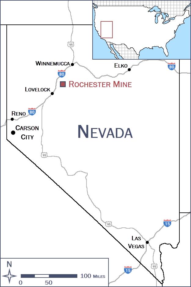
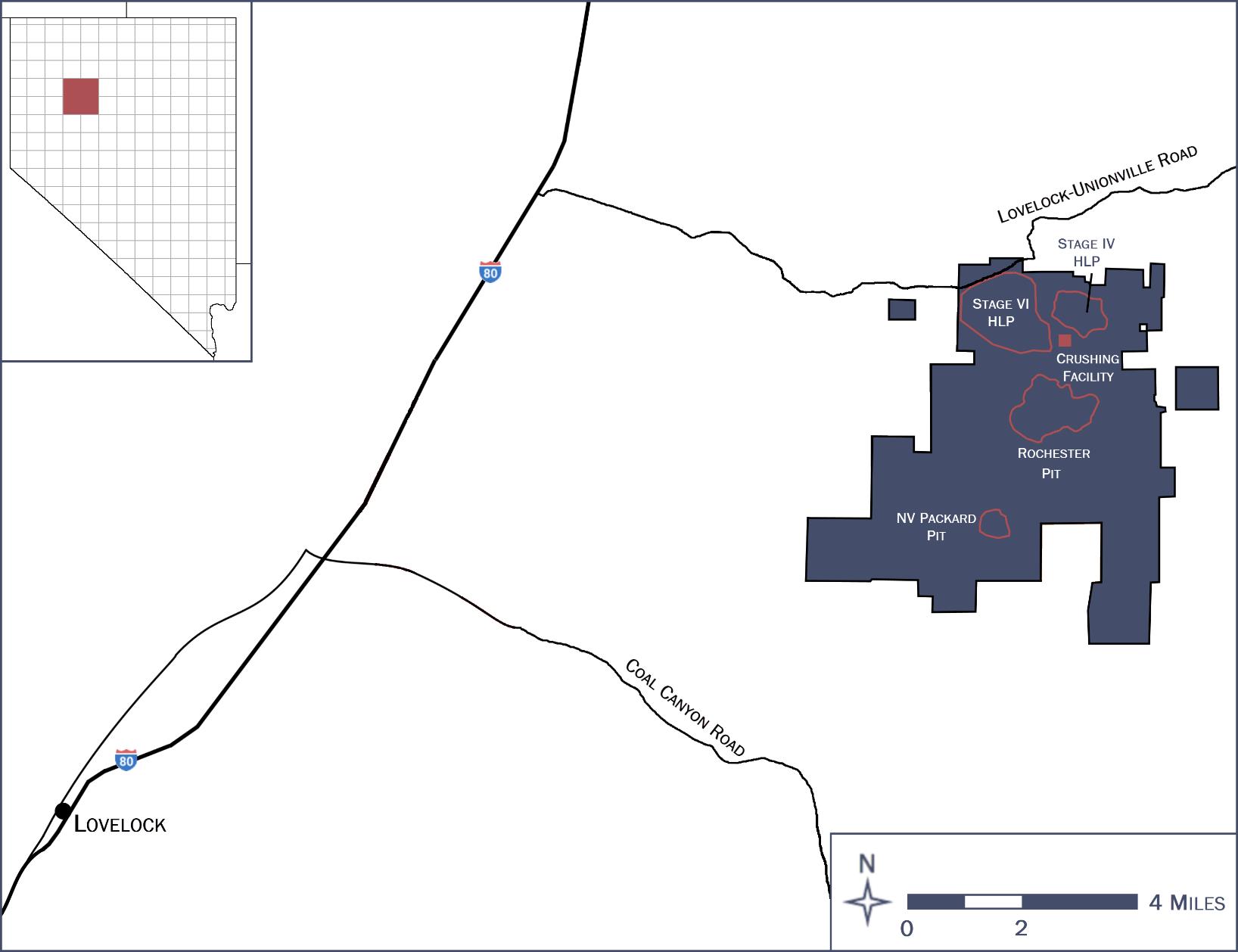
The Rochester Operations are located in the Humboldt Range of northwestern Nevada, approximately 13 miles east of Interstate 80 from the Oreana–Rochester exit, and 26 miles northeast of the City of Lovelock in Pershing County, Nevada. Lovelock, located approximately 90 miles northeast of Reno, Nevada, is the nearest town.
Primary access to Rochester is by way of the Limerick Canyon Road from Interstate Highway 80 (I-80) at the Oreana-Rochester exit (Exit 119). Primary access to Nevada Packard is by way of a two-mile haulage road from the Rochester Pit located on land controlled by Coeur Rochester.
The climate in the Rochester Operations area is typical of north–central Nevada, with hot summers and cold winters. Operations are conducted year-round.
The Rochester Operations are located within the basin-and-range physiographic province in the north–south trending Humboldt Range. The operations area encompasses elevations ranging from 4,960 ft at the Nevada Packard deposit, to approximately 7,090 ft at the highest point of the Rochester Operations. Vegetation is sparse, consisting of high desert grasses and shrubs with a sparse assortment of trees in the higher elevations.
| 1.4 | Mineral Tenure, Surface Rights, Water Rights, Royalties and Agreements |
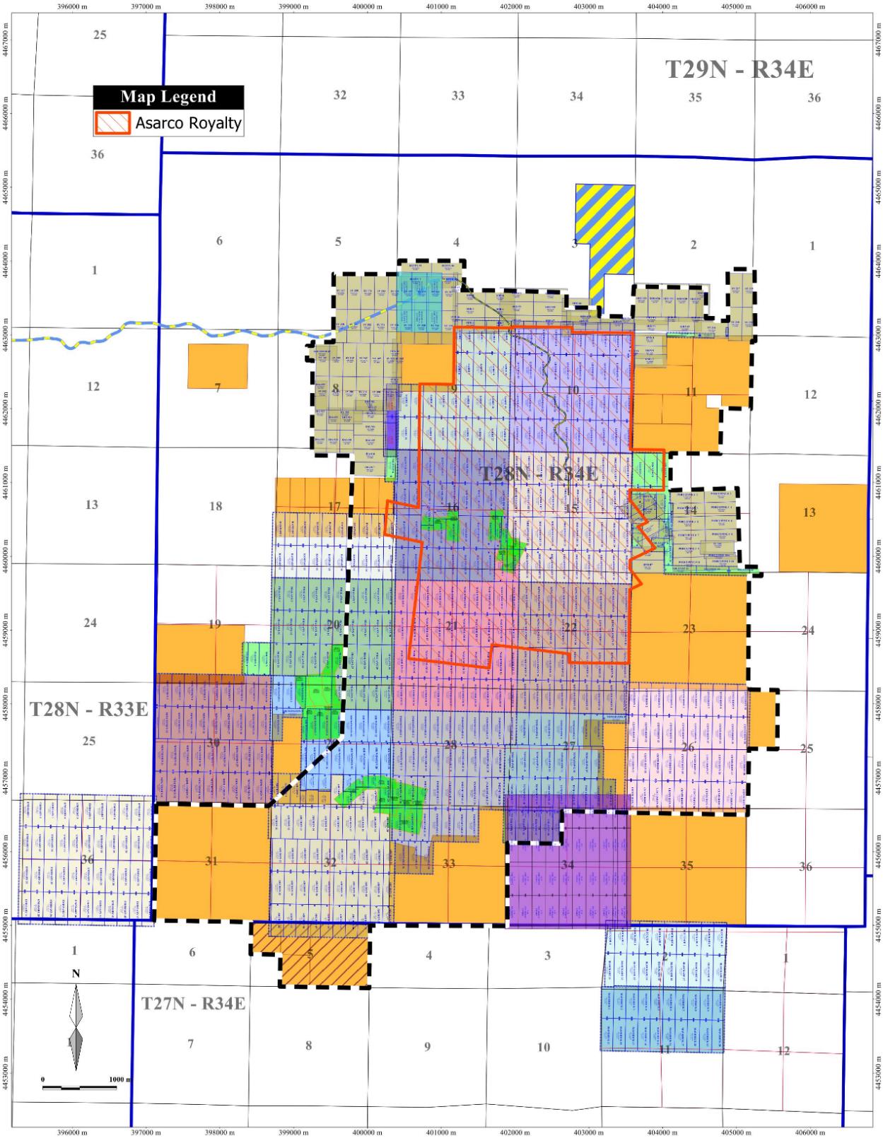
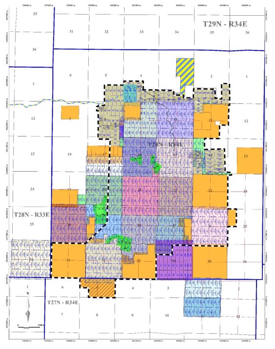
The entire Project area covers 17,004 net acres, consisting of 761 owned and 13 leased federal unpatented lode claims and six (6) owned federal unpatented placer claims, totalling 11,625 net acres of public land owned and 269 net acres of public land leased, in total 11,894 acres of public land; 21 patented lode claims consisting of 357 acres; and interests owned in 4,793 gross acres of additional real property.
The federal mining claims and fee lands provide Coeur with the required surface rights to support the life-of-mine (LOM) plan.
An agreement is in place with Pershing County for road maintenance. Coeur also has a nonexclusive pipeline, electric power line, and telephone line license in place, which is maintained with an annual fee payment. Coeur also holds a number of rights-of-way granted by the Bureau of Land Management (BLM).
Coeur holds a number of water right permits issued by the Nevada Division of Water Resources. These permits allow Coeur to appropriate water in the Buena Vista Valley Hydrographic Sub-Basin and the Packard Valley Sub-Basin. The water right permits held by Coeur are sufficient to operate under the current LOM plan.
There are a number of royalties payable on the claims. However, the only royalty that would be payable in the current LOM plan is to Asarco, and that royalty is tied to the silver price. The royalty is payable when the average quarterly market price of silver equals or exceeds $26.58/oz Ag, indexed for inflation, up to a maximum rate of 5% with the condition that the Rochester mine achieves positive cash flow for the applicable year. If cash flow is negative in any calendar year, the maximum royalty payable is $250,000.
The Rochester property is secured pursuant to Coeur’s revolving credit facility.
| 1.5 | Geology and Mineralization |
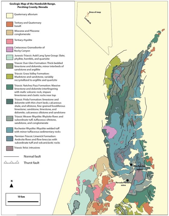
Mineralization in the Rochester district exhibits characteristics of both low-sulfidation and intermediate-sulfidation precious metal systems, complicated by supergene enrichment processes and significant oxidation.
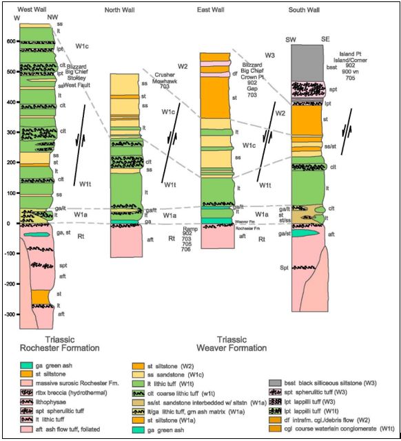
The Rochester and Nevada Packard mines are located on the southern flank of the Humboldt Range within the Basin-and-Range province, where late Tertiary extension created large listric normal faults bounding generally north–south-trending mountain ranges and adjacent down-dropped valleys. Tertiary volcanism produced the Limerick, Rochester, and Weaver Formations of the Koipato Group. Both the Rochester and Nevada Packard deposits are hosted in predominately rhyolitic flows and tuffs of the Koipato Group.
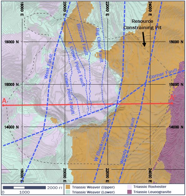
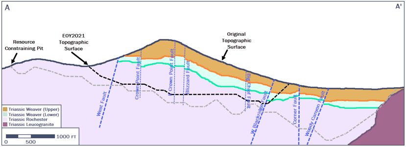
A major structural feature within the southern portion of the Humboldt Range is the Black Ridge fault system, which is an extensive shear zone that is, in places, hundreds of feet wide. Most of the Rochester silver–gold mineralization occurs in hanging wall faults, splays, and cross-faults within the Black Ridge system.
Mineralization is structurally controlled. Economic mineralization is hosted mainly in the oxide zone, where the Rochester–Weaver Formation contact is the primary host for silver–gold mineralization, followed and influenced by mineralized fault zones with associated fracture, stockwork and disseminated mineralization away from the faults. The contact is extensively brecciated and healed by silica in both the Rochester and Weaver Formations. Quartz veins and veinlets typically exhibit both parallel and cross-cutting features, indicating multiple mineralizing events.
Acanthite and chlorargyrite are the most abundant oxide silver phases. Below the oxidation zone, the hypogene profile is preserved, with the main minerals including pyrite, sphalerite, galena, argentiferous tetrahedrite, chalcopyrite, arsenopyrite, and pyrargyrite.
| 1.6 | History and Exploration |
Mineralization was discovered in the area in the early 1900s. Where known, the following companies have had involvement in the Project area, prior to Coeur’s Project interest: Rochester Hills Mining Co., Rochester Mines Co., Nevada Packard Mines Co., Rochester Silver Corp., Nenzel Crown Point Mining Co., Rochester Consolidated Mines Co., Western Properties Co., Silver State Mines Co., Asarco, Nevada Packard Mines Company, Cordero Mining Company, D.Z. Exploration, the Nevada Packard Joint Venture, Wharf Resources, Rye Patch Gold, and Alio Gold. Work completed included production from underground workings during the earlier 20th century, grab sampling, mud rotary, percussion, and reverse circulation (RC) drilling, metallurgical test work, production scale heap leach test work, and permitting activities.
Coeur acquired the Rochester property from Asarco in 1983, and the Nevada Packard property in 1996, from local prospectors. Work completed includes geological mapping, geochemical sampling (soil, rock chip, stream sediment), ground and airborne geophysical surveys (induced polarization, gravity, magnetic) RC and limited core drilling, mining studies, permitting activities, metallurgical test work, mineral resource and mineral reserve estimates, open pit mining, and heap leaching. Mining commenced in 1986 from the Rochester open pit and in 2003 from the Nevada Packard open pit.
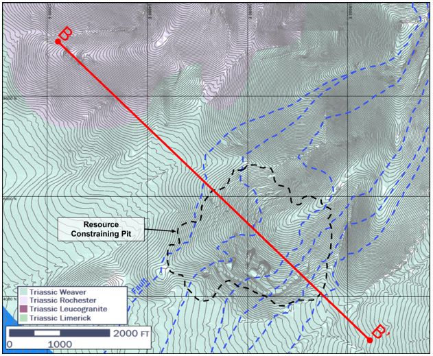
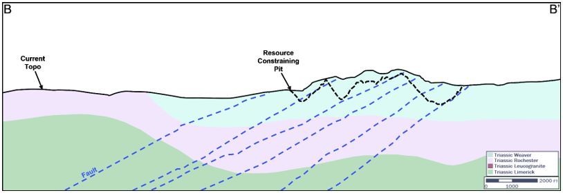
The Rochester deposit remains open at depth in areas where earlier drilling terminated in potentially economic grades. Several structural trends are being explored where the structures exit the pit walls. These areas are targeted based on grade and structural mapping. The area northwest of the pit is considered to have the most potential.
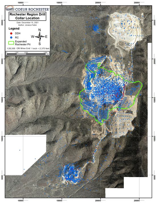
The drill database for the Project area contains 3,461 drill holes (1,563,181 ft). These data are primarily reverse circulation (RC) holes with limited core drilling. Core and RC drilling supports mineral resource estimation.
There are 588 drillholes completed by multiple operators that are flagged in the acQuire drill hole database to be excluded from the resource estimates. The drill holes are excluded due to unvalidated collar, survey, and/or analytical data. Of these drill holes, 529 are excluded from the Rochester model, 42 are excluded from the Nevada Packard model, and two are excluded from the stockpile model.
Depending on the drill program and drill type, geological data that could be collected from drill hole logging included location details, recovery data, rock character, lithology, alteration (type/degree), quartz veining, sulfide presence, oxidation intensity, structural indicators, and accessory mineralogy. Geotechnical data are collected from core holes. Currently, RC chip trays are retained, and core is photographed.
Core recovery is generally good.
Collar survey methods varied, depending on drill campaign, operator and deposit, and could include Total Station and global positioning system (GPS) instruments.
Prior to 1995, drill holes were sporadically down-hole surveyed with gyroscopic instruments. Downhole surveys were used after 1995 for all angled holes and for vertical holes >400 ft deep using either surface recording gyroscopic, Maxibor, or North Seeker gyroscopic instruments.
Coeur samples RC drill cuttings on either 5 ft or 10 ft intervals. Core logging and sampling intervals ranged from a minimum of 1 ft. to a maximum of 10 ft., based on geologic characteristics.
A density of 0.078 st/ft3 was used for both Rochester and Nevada Packard. This density was confirmed by the on-going mining operations and third-party studies.
Independent primary and umpire laboratories used, and where recorded in the database, include American Assay Laboratories in Sparks, Nevada, ALS Chemex, located in Sparks, Nevada (ALS); Pinnacle Laboratories, located in Lovelock, Nevada; Inspectorate/Bureau Veritas Laboratory, located in Sparks, Nevada; Skyline Laboratories, located in Tucson, Arizona; and McClelland Laboratories Inc., located in Sparks, Nevada (McClelland). Depending on the laboratory and time used, accreditations could include ISO17025:2005, ISO9001 and ISO9002. Samples were also submitted to the Rochester mine laboratory, which was not independent and was not ISO-certified. The Rochester mine laboratory is primarily used for grade control analysis.
Sample preparation depended on the analytical laboratory used. Methods included drying; crushing to -⅜ in, primary crushing to ¼ in, secondary crushing to 10 mesh, crushing to 10 mesh (70% passing) and pulverizing to -100 mesh, 150 mesh or 200 mesh (85% or 80% passing).
Analytical methods included:
| • | Gold: one assay ton fire assay, atomic absorption spectroscopy (AAS); fire assay with gravimetric finish; inductively-coupled plasma (ICP) finish |
| • | Silver: fire assay with AAS finish; fire assay with gravimetric finish; ICP finish; ICP atomic emission spectroscopy (AES) finish; ICP emission spectroscopy (ES) finish; ICP optical emission spectroscopy (OES) finish; |
| • | Multi-element: 33-element suite using ICP-ES; 35 element suite using ICP-ES; 45-element suite using ICP-ES or ICP mass spectrometry (MS). |
Prior to 2008, Coeur inserted blanks, duplicates and standard reference materials (standards) into the sample stream. From 2008–2015, insertions included a minimum of 5% standards, 5% blanks, and 7.5% duplicates. On a quarterly basis, 11% of all samples were selected (10% from pulps and 1% from coarse rejects) and sent to ALS for analysis as umpire samples. From 2016 onward, the quality assurance and quality control (QA/QC) program included insertion of blanks, duplicates and standards into the sample stream, and check assaying of selected samples at either Bureau Veritas or McClelland.
Data verification included internal and external database audits. Internal verification included: a detailed review of all documentation and assay data related to each drill hole; drill hole collar audits; and QA/QC reports. External verification was undertaken by third-parties.
The QP personally undertook selected QA/QC verification and participated in programs to verify selected drill data prior to mineral resource estimation. The QP also works on site, and is familiar with the ongoing operations.
The QP is of the opinion that the data verification programs for Project data adequately support the geological interpretations, the analytical and database quality, and therefore support the use of the data in mineral resource and mineral reserve estimation, and in mine planning.
For a portion of the drilling in the Nevada Packard stockpile area where no physical collar or downhole surveys were conducted, the confidence classification for blocks not supported by other drill holes was restricted to inferred.
| 1.9 | Metallurgical Test Work |
Independent metallurgical test work facilities used over the Project life include McClelland Laboratories, Kappes, Cassiday & Assoc., Newfields, FLSmidth and Eagle Engineering. Test work conducted included permeability testing, column leach and bottle roll leach test work. Additionally, bench-top high pressure grind roll (HPGR) test work as well as clay and mineralogical categorization have been performed.
The Rochester Operations have an on-site analytical laboratory that assays process solutions, crusher and run-of-mine (ROM) ore samples, and refinery samples. The on-site metallurgical laboratory is used for column leach test, bottle roll tests, and characterizing the behavior of new ores. The laboratory is not independent.
Current metallurgical test work can include:
| • | Daily samples: contained moisture, size fractions and assayed for precious metal content. Data generated from these daily samples is used to characterize daily production; dry tons produced from each ore source and gold and silver quantities delivered to the leach pad from each ore source; |
| • | Monthly column leach tests and bottle roll leach tests: recovery trends for gold and silver, size by grade recovery, reagent consumption, and permeability. Results are used to forecast leach pad recoveries. |
Metallurgical test work at Rochester, in coordination with modern heap leach modeling programs, continues to refine and confirm expected metal recovery rates and ultimate recovery values. This testing provides better understanding of process optimization of the leach pads, metal inventory in the leach pads, potential cost reduction, increase crusher throughput, and to provide engineering support on future operational planning. Ultimate recovery of Rochester ore is assumed to be 20 years from the date leaching commences.
Coeur uses heap leach recovery models and recovery curves based on test work and operations to forecast recovered gold and silver production from actual and/or forecasted mineralized product placed on the leach pads. The models apply recovery rates to the product type (crushed, ROM), tonnage, depth to liner, contained ounces placed on each leach pad, and various kinetic factors to determine the expected recovered production in each month. The predicted values are compared to actual production to ensure accuracy and provide confidence in the models’ ability to predict ounce production.
Metallurgical test results obtained from several test work programs conducted during the past three years show relatively low variability between several different locations with respect to gold and silver recovery assuming the sulfur content is below 0.7% and the crush size is held constant.
Based on extensive operating experience and test work, there are no known processing factors of deleterious elements that could have a significant effect on the economic extraction of the mineral reserve estimates. None of the deposits contain sufficient quantities of sulfide minerals, organic carbon or silica encapsulation to be categorized as refractory ore
| 1.10 | Mineral Resource Estimation |
| 1.10.1 | Estimation Methodology |
Mineral resources were estimated for Rochester and Nevada Packard, and for the Rochester in-pit, Charlie, South, and Nevada Packard stockpiles.
Geologic modeling can include inputs from in-pit geologic mapping, drill log interpretation and surface mapping. A total of 37 domains were generated for Rochester, seven for Nevada Packard. No domaining was used for the Charlie and South stockpiles. The Nevada Packard stockpile has four zones assigned, based on stockpile location, not geology.
All deposits were subject to exploratory data analysis methods, which included histograms, cumulative probability plots, box and whisker plots, and contact analysis. In general, domains were treated as soft for mineral resource estimation purposes.
Rock types were assigned a density of 0.078 st/ft3 at Rochester and Nevada Packard. The density assumption for stockpile material also 0.078 st/ft3, with a 37% swell factor applied.
All of the models use 10 ft composites. Review of outlier data indicated that gold and silver grade caps should be imposed at Rochester, Nevada Packard, and the South and Charlie stockpiles but no caps were required for the Rochester in-pit and Nevada Packard stockpiles.
Variography was performed on all models in Supervisor to obtain search distances and directions for interpolation.
Ordinary kriging (OK) was selected as the estimation method for all silver and gold domains in the Rochester model. A single pass estimate was completed for each domain. The Rochester search distances varied by domain. All domains were informed by a minimum of two composites, but the maximum number of composites used could vary from 20–32. The maximum number of composites per drill hole was set at four. The minimum number of octants was set at two, and the maximum number of composites per octant was set at eight.
The resource model for the South and Charlie stockpiles uses inverse distance weighting to the second power (ID2) interpolation with 10 ft composites and a 120 ft search distance, using 3–15 samples, with a limit of three samples per drill hole. A minimum of one drill hole was allowed for interpolation. A second estimation pass was applied to blocks that fell outside of the blocks that were estimated in the first pass. The second pass estimate used a search distance of 1,500 ft and a minimum of one sample and maximum of five samples to estimate outlier blocks.
The resource model for the Rochester in-pit stockpile uses a single pass ID2 interpolation with 10 ft composites and a 300 ft search distance, using 3–15 samples, with a limit of three samples per drill hole. A minimum of one drill hole was allowed for interpolation.
OK was selected as the reported estimation method for all silver and gold domains in the Nevada Packard estimate. A single pass estimation was completed for each domain. All domains were informed by a minimum of two composites, but the maximum number of composites used could vary from 24–40. The maximum number of composites per drill hole was set at four. The minimum number of octants was set at two, and the maximum number of composites per octant was set at eight.
The estimation method chosen for the Nevada Packard stockpile model uses ID2 interpolation with 10 ft composites and a 100 x 100 x 50 ft horizontal search ellipse using 1–12 samples, with a limit of two samples per drill hole. A second pass model was created to estimate outlier blocks using an ID2 interpolation with a 200 x 200 x 50 ft search ellipse using the same sample restrictions as the primary pass.
Model validation included visual validation, construction of grade–tonnage curves and comparison of the grade–tonnage curves to the original estimate, swath plots, comparison of block model statistics to the sample assay and composite statistics, and reconciliation with available blast-hole data by comparing the resource OK estimate to an ID2 blast-hole model for the Rochester and Nevada Packard models. No material biases or errors were noted from the reviews.
Mineral resources were classified based on a combination of the variogram range, distance to the nearest composite, number of composites used in the estimate, and number of drill holes used in the estimate.
For each resource estimate, an initial assessment was undertaken that assessed likely infrastructure, mining, and process plant requirements; mining methods; process recoveries and throughputs; environmental, permitting and social considerations relating to the proposed mining and processing methods, and proposed waste disposal, and technical and economic considerations in support of an assessment of reasonable prospects of economic extraction.
Mineral resources amenable to open pit mining were constrained within conceptual pit shells. Stockpile material was estimated within the stockpile dimensions.
The gold price used in resource estimation is based on long-term analyst and bank forecasts, supplemented with research by Coeur’s internal specialists. The estimated timeframe used is the 13-year LOM that supports the mineral reserve estimates. The forecast is US$1,700/oz Au and US$22/oz Ag for the mineral resource estimate.
The NSR cutoff used to tabulate resources within a constraining pit is not required to consider the mining costs and is only required to pay for the process and G&A costs. At Rochester, this equates to a NSR cutoff of $2.55 for oxides and $2.65 for sulfides (≥0.7% total sulfur). At Nevada Packard, this equates to a single NSR cutoff of $3.70 for all material because there are currently no sulfides estimated within the mineral resources there.
| 1.10.2 | Mineral Resource Statement |
Mineral resources are reported using the mineral resource definitions set out in SK1300.The reference point for the estimate is in situ for those estimates within conceptual open pit outlines, and within stockpiles for those estimates of stockpiled material.
Mineral resources are reported exclusive of mineral reserves in Table 1‑1 and Table 1‑2. The estimates are current as at December 31, 2021. Estimates are reported on a 100% ownership basis.
The Qualified Person for the estimate is Mr. Matthew Bradford, RM SME, a Coeur employee.
Table 1‑1: Summary of Gold and Silver Measured and Indicated Mineral Resources, Rochester, Nevada Packard, and Stockpiles, as at December 31, 2021 (based on US$1,700/oz gold price and US$22/oz silver price)
| Category | Tons (st) | Average Grade (oz/st) | Contained Ounces (oz) | NSR Cut-off (US$/st) | Metallurgical Recovery (%) |
| Au | Ag | Au | Ag | Au | Ag |
| Measured | 191,889,000 | 0.002 | 0.29 | 372,000 | 56,573,000 | 1.50–2.65 | 15.2–93.7 | 0–61.0 |
| Indicated | 39,565,000 | 0.002 | 0.33 | 74,000 | 12,932,000 | 1.50–2.65 | 15.2–93.7 | 0–61.0 |
| Total measured and indicated | 231,454,000 | 0.002 | 0.30 | 443,000 | 69,505,000 | 1.50–2.65 | 15.2–93.7 | 0–61.0 |
Table 1‑2: Summary of Gold and Silver Inferred Mineral Resources, Rochester, Nevada Packard, and Stockpiles, as at December 31, 2021 (based on US$1,700/oz gold price and US$22/oz silver price))
| Category | Tons (st) | Average Grade (oz/st) | Contained Ounces (oz) | NSR Cut-off (US$/st) | Metallurgical Recovery (%) |
| Au | Ag | Au | Ag | Au | Ag |
| Inferred | 128,410,000 | 0.002 | 0.30 | 243,000 | 38,626,000 | 1.50–2.65 | 15.2–93.7 | 0–59.5 |
Notes to accompany mineral resource estimates:
| 1. | The mineral resource estimates are current as of December 31, 2021, and are reported using the definitions in Item 1300 of Regulation S–K (17 CFR Part 229) (SK1300). |
| 2. | The reference point for the mineral resource estimate is in situ and stockpile. The Qualified Person for the estimate is Mr. Matthew Bradford, RM SME, a Coeur employee. |
| 3. | Mineral resources are reported exclusive of mineral reserves on a 100% ownership basis. |
| 4. | Mineral resources for Rochester and Nevada Packard are tabulated within a confining pit shell that uses the following input parameters: metal price Au = $1,700/oz and Ag = $22/oz; oxide recovery Au = 77.7–93.7% and Ag = 59–61%; sulfide recovery Au = 15.2–77.7% and Ag = 0.0–59% with a net smelter return cutoff of $2.55–$3.70/st oxide and $2.65/st sulfide, where the NSR is calculated as resource net smelter return (NSR) = silver grade (oz/ton) * silver recovery (%) * [silver price ($/oz) - refining cost ($/oz)] + gold grade (oz/ton) * gold recovery (%) * [gold price ($/oz) - refining cost ($/oz)]; and variable pit slope angles that approximately average 43º over the life-of-mine. |
| 5. | Rounding of short tons, grades, and troy ounces, as required by reporting guidelines, may result in apparent differences between tons, grades, and contained metal contents. |
| 1.10.3 | Factors That May Affect the Mineral Resource Estimate |
Factors that may affect the mineral resource estimates include: metal price and exchange rate assumptions; changes to the assumptions used to generate the gold equivalent grade cut-off grade; changes in local interpretations of mineralization geometry and continuity of mineralized zones; changes to geological and mineralization shape and geological and grade continuity assumptions; additional drilling, which may change confidence category classification in the pit margins from those assumed in the current pit optimization; additional sampling that may redefine the silver and/or gold grade estimates in certain areas of the resource estimation; density and domain assignments; changes to geotechnical, mining and metallurgical recovery assumptions; Changes to the input and design parameter assumptions that pertain to the assumptions for open pit mining or stockpile rehandling constraining the estimates; and assumptions as to the continued ability to access the site, retain mineral and surface rights titles, maintain environment and other regulatory permits, and maintain the social license to operate.
| 1.11 | Mineral Reserve Estimation |
Mineral reserves were converted from measured and indicated mineral resources. Inferred mineral resources were set to waste.
| 1.11.1 | Estimation Methodology |
Mining rates are primarily driven by crusher capabilities based on their physical configuration and environmental permit limits. The selective mining unit is sized at 50 x 50 x 30 ft. The LOM plan mines material below the water table, which is considered in the existing permitting.
Pit optimizations were done using the Lerchs–Grossmann algorithm using Whittle software. Appropriate cost and mining schedules were applied using cost estimates forecast for the LOM.
Cut-off grades were based on NSR equations. The break-even NSR cutoff grade is equal to the total estimated long-term processing costs (including general and administrative (G&A) costs. Mining costs are a sunk cost for blocks contained inside an economic pit limit and therefore do not need to be included in the break-even cutoff grade. If a given block meets or exceeds the processing cost, it should report to the crusher. If a block is placed in a low-grade stockpile, it must have an NSR value high enough to meet the break-even cutoff grade plus the cost of rehandle. If it does not, it is placed in a sub-grade stockpile that is effectively treated as waste.
The densities used for the mineral reserve estimate are:
| • | In situ (open pit): 0.078 ton/ft3; |
| • | Stockpile: 0.057 ton/ft3. |
The assigned in situ moisture is 3–5% and stockpile material is forecast to average 5% moisture.
No loss or dilution was modelled in the pit optimization runs. Due to the disseminated nature of the deposit, the margins around the orebody are mineralized waste, reducing the impacts of dilution during mining.
Break-even cut-offs are:
| • | Rochester: oxide: US$2.55/st; sulfide US$2.65/st; |
| • | Nevada Packard: oxide: US$3.70/st. There is no sulfide material mined at Nevada Packard. |
| 1.11.2 | Mineral Reserve Statement |
Mineral reserves have been classified using the mineral reserve definitions set out in SK1300 and are reported on a 100% ownership basis. The reference point for the mineral reserve estimate is the point of delivery to the heap leach facilities.
Mineral reserves are current as at December 31, 2021. Mineral reserves are reported in Table 1‑3. The Qualified Person for the estimate is Mr. Brandon MacDougall, P.E., a Coeur Rochester employee.
| 1.11.3 | Factors That May Affect the Mineral Reserve Estimate |
Factors that may affect the mineral resource estimates include: predicted commodity prices; metallurgical recovery forecasts; operating cost assumptions; geotechnical and hydrological assumptions; and permitting and social license assumptions.
Mineral reserves are exploited using conventional open pit methods and equipment.
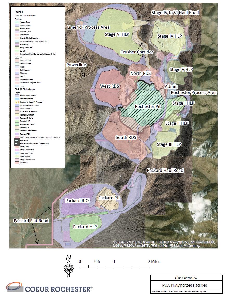
Mining operations at Rochester are currently at planned capacity under the current crusher configuration. The LOM plan will increase production levels in line with the 11th Plan of Operations Amendment (POA 11), which was issued in 2020. POA 11 allows for additional pad capacity, additional waste rock storage facilities (WRSFs), construction of new crushing and process facilities, and extensions of the Rochester pit and continued operations through the end of planned mine life.
Pit slope designs are based on evaluations and reports prepared by third-party consultants. The pit slope design parameters for Rochester and Nevada Packard assume overall pit slope angles that range from 20–51º and 37–52.4º respectively.
Groundwater pumping requirements to support ongoing mine and process operations are anticipated to be completed as needed through existing production wells. As such, hydrogeologic factors have not been considered in this report.
Detailed pit designs and phase plans are based on the economic pit limits and are used to generate a mining production schedule for both pits. Designs assumed 30 ft bench heights, double lane haul road design widths of 88 ft, single lane haul road design widths of 65 ft, and maximum haul road gradients of 10%.
Blasting services are contracted out, and the contractor is responsible for obtaining, securing explosive agents, loading blast holes, and initiating the blasts.
As part of the approved Plan of Operations (PoO), there is a waste rock management plan. All waste rock is placed either inside the pit perimeter as backfill, or outside the pit in approved WRSFs. All waste rock is evaluated to determine if it is potentially acid-generating (PAG).
Rochester annual crusher throughputs for 2022 through to Q3 2023 are based on the limitations of existing crushing facilities and are estimated at 13.9 Mst/a. Crusher throughputs are anticipated to increase to 32.0 Mst/a with the addition of a new crushing system in 2023. Rochester operations are expected to continue through late-2034, a mine life of approximately 12 years. Low grade stockpiles will be processed through the crushing system at the end of mine life during 2033-2034. The Nevada Packard production schedule is based on an assumed crusher throughput of 6 Mst/a. The anticipated LOM for the Nevada Packard deposit 6 years. Nevada Packard stockpiles will be processed at the end of mine life during years 6-7.
Equipment is conventional to open pit operations. The primary equipment fleet includes front-end loaders, hydraulic shovels, blasthole drills and haul trucks.
The personnel requirement for the remaining LOM averages 175 persons.
Table 1‑3: Summary of Gold and Silver Proven and Probable Mineral Reserve Estimates, as at December 31, 2021 (based on US$1,400/oz gold price and US$20/oz silver price)
| Category | Tons (Mst) | Average Grade (oz/st) | Contained Ounces
(koz)
| NSR Cut-off (US$/st) | Metallurgical Recovery (%) |
| Ag | Au | Ag | Au | Ag | Au |
| Total proven | 386,008 | 0.388 | 0.003 | 149,652 | 998 | 2.55–2.65 | 27–61 | 71-95 |
| Total probable | 31,769 | 0.365 | 0.003 | 11,593 | 82 | 2.55–2.65 | 27–61 | 71-95 |
| Total Proven & Probable | 417,777 | 0.386 | 0.003 | 161,245 | 1,080 | 2.55–2.65 | 27–61 | 71-95 |
Notes to accompany mineral reserve estimates:
| 6. | The mineral resource estimates are current as of December 31, 2021, and are reported using the definitions in Item 1300 of Regulation S–K (17 CFR Part 229) (SK1300). |
| 7. | The reference point for the mineral reserve estimate is the point of delivery to the heap leach facilities. The Qualified Person for the estimate is Mr. Brandon MacDougall, P.E., a Coeur Rochester employee. |
| 8. | Mineral reserve estimates are tabulated within a confining pit shell and use the following input parameters: gold price of US$1,400/oz Au and silver price of US$20/oz Au; Rochester oxide recovery Au = 85% and Ag = 59%; Nevada Packard oxide recovery Au = 95% and Ag = 61%; ROM recovery Au = 71% and Ag = 27%; with a Rochester net smelter return cutoff of $2.55/st oxide and US$2.65/st sulfide, and a Packard net smelter return cutoff of $3.70, where the NSR is calculated as resource net smelter return (NSR) = silver grade (oz/ton) * silver recovery (%) * [silver price ($/oz) - refining cost ($/oz)] + gold grade (oz/ton) * gold recovery (%) * [gold price ($/oz) - refining cost ($/oz)]; variable pit slope angles that approximately average 43º over the life-of-mine. |
| 9. | Rounding of short tons, grades, and troy ounces, as required by reporting guidelines, may result in apparent differences between tons, grades, and contained metal contents |
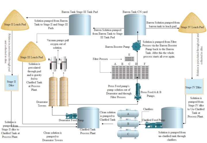
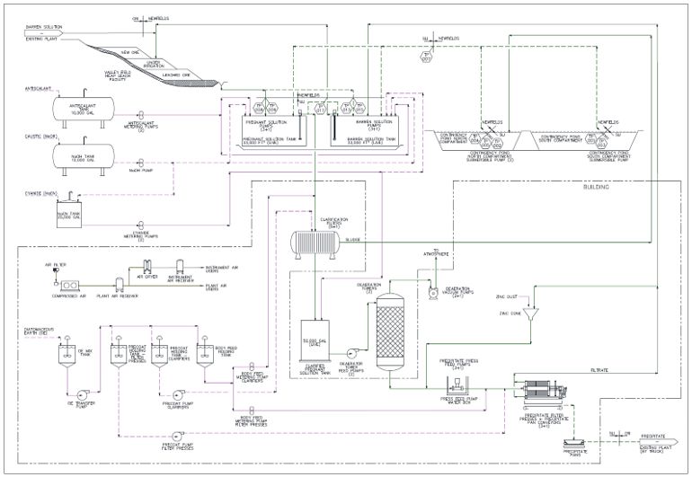
Silver and gold recovery at Rochester is via heap leach with a Merrill-Crowe process to recover metal from the leach solutions. The process design was based on a combination of metallurgical test work, study designs and industry standard practices, together with debottlenecking and optimization activities once the leach pads were operational. The design is conventional to the gold and silver industry and has no novel parameters.
From 1986 through mid-2019, Coeur used a three-stage crushing circuit with cone crushing in the tertiary position to produce a nominal ⅜-in product.
In 2019 Coeur adopted high-pressure grind roll crushing technology to replace cone crushers in the tertiary position. The product gradation and operational parameters of the high-pressure grind roll are being optimized for gradation, permeability, and recovery. Crushed material, and at times ROM ore, is placed on heap leach pads.
The crushing circuit currently consists of a jaw crusher followed by cone crusher and an HPGR in the tertiary position. The crusher is directly truck dump fed. The HPGR product is conveyed to the loadout where it is loaded into haul trucks and truck dumped onto the Stage IV heap leach pad.
Cyanide heap leaching is used to extract silver and gold from the ore. Metal-laden pregnant leach solution is then collected from a drain system and Merrill-Crowe processing is used to recover the precious metal.
The Merrill-Crowe facility is operating and assumptions in this Report were made with reference to actual operational results. Metal production is done using furnace flux-smelt refining. Active leaching of new ore and metal recovery is currently taking place on the Stage II, III and IV heap leach pads from material produced through crushing and ROM placement.
Future processing facilities include the Limerick Merrill-Crowe process plant that is planned to be in operation from 2023 through approximately 2035. This process plant is being sized for 13,750 gpm to process solution and recover ounces from the Stage VI leach pad facility, which has a design capacity of 300 Mst.
Metallurgical recovery forecasts are variable by source and destination, and over the LOM plan silver recoveries will range 27.1%-61.4% and gold recoveries will range 71.2%-95.9%. Full details of the various ore sources and destinations can be found in Table 10-6.
Power is supplied from an electrical grid, with generator backup. Water is supplied from production wells. Major consumables include lime, cyanide and zinc. The plant also consumes antiscalant, diatomaceous earth and refinery flux.
Current personnel requirements are approximately 67 persons for crushing and 70 persons for process. As POA 11 comes online Coeur will require approximately 73 persons for crushing and 93 persons for process. This ramp-up will occur over multiple years as equipment and processes are commissioned.
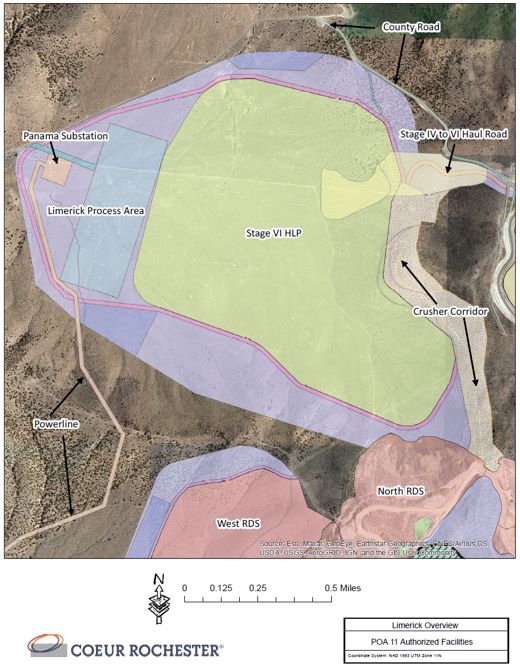
The majority of the infrastructure required to support operations has been constructed and is operational. This includes: two open pits (Rochester and Nevada Packard); crusher and conveyor system; three active heap leach pads (Stage II, Stage III, and Stage IV), one reclaimed heap leach pad (Stage I), one heap leach pad under construction (Stage VI), and one permitted heap leach pad (Stage V); seven waste rock storage facilities (WRSFs); powerlines; production and monitoring water wells; contingency ponds; potable water treatment plant; water pipelines; site buildings; access, light vehicle, and haul roads; consumables storage; security and fencing; explosives magazines; upper and lower parking areas; and data and communications infrastructure.
Additional infrastructure that will be required to support the LOM plan as envisaged in the approved POA 11 consists of the following major areas: expansion of the two open pits; expansion of selected WRSFs; construction of the Stage VI leach pad; Limerick and Nevada Packard Merrill-Crowe process facilities; Limerick crushing and screening facility; installation of a crusher at Nevada Packard; construction of additional water diversion structures, roads, and pipelines; and upgrades to the electrical system. Low-grade ore is stockpiled in the West WRSF and is segregated from the waste rock for potential future processing.
Seven WRSFs have been constructed. POA 11 includes expansions to existing WRSFs with sufficient capacity to handle all expected waste material over the LOM plan.
When mining activities necessitate removal of spent ore from existing leach pads, the spent ore is moved to one of the other heap leach pad facilities.
The Rochester Operations are a zero-discharge facility and has no on-site water treatment facilities. Non-contact stormwater is diverted around process components in permitted conveyances. Water supply for operations comes from three production wells. There is also a potable water well that supplies potable water to the site.
Power is supplied by NV Energy via a 60 kV transmission line that runs through Rochester Canyon. Power is initially received at the Sage Hen substation and terminates at a second mine-site substation located in American Canyon. Step-down transformers are located at the crushing facilities, the maintenance shop and warehouse building, the process building, and several locations along the Stage III leach pad overland conveyor. Motor control centers, which are located adjacent to these transformers, supply all additional electrical requirements.
Upgrades to the electrical utility system will be required to accommodate the proposed infrastructure associated with POA 11. NV Energy’s existing 60 kV transmission line will need upgrades to meet the load increase associated with the proposed Limerick Canyon and Nevada Packard process plants and associated crushing and conveying systems. The proposed upgrade will include service from NV Energy’s 120 kV system at the Oreana substation and approximately 10 miles of new transmission line. A new substation, the Panama substation, will be constructed in Limerick Canyon, on the west side of the proposed Stage VI heap leach pad.
| 1.15 | Markets and Contracts |
Coeur has established contracts and buyers for the silver and gold doré product from the Rochester Operations and has an internal marketing group that monitors markets for its key products. Together with public documents and analyst forecasts, these data support that there is a reasonable basis to assume that for the LOM plan, that the key products will be saleable at the assumed commodity pricing.
Coeur sells its payable silver and gold production on behalf of its subsidiaries on a spot or forward basis, primarily to multi-national banks and bullion trading houses. Markets for both silver and gold bullion are highly liquid, and the loss of a single trading counterparty would not impact Coeur’s ability to sell its bullion.
Coeur uses a combination of analysis of three-year rolling averages, long-term consensus pricing, and benchmarks to pricing used by industry peers over the past year, when considering long-term commodity price forecasts.
Higher metal prices are used for the mineral resource estimates to ensure the mineral reserves are a sub-set of, and not constrained by, the mineral resources, in accordance with industry-accepted practice.
The long-term gold price forecasts are US$1,400/oz Au and US$20/oz Ag for mineral reserves and US$1,700/oz Au and US$22/oz Ag for mineral resources. The QP considers the price forecasts to be reasonable.
Coeur has a contract with a U.S.-based refiner that refines the doré into silver and gold bullion.
There are numerous contracts in place at the Project to support mine development or processing. Currently there are contracts in place to provide supply for all major commodities used in mining and processing, such as equipment vendors, power, explosives, cyanide, tire suppliers, fuel, and drilling contractors. The terms and rates for these contracts are within industry norms. The contracts are periodically put up for bid or re-negotiated as required.
| 1.16 | Environmental, Permitting and Social Considerations |
An initial PoO was approved by the BLM and Nevada Division of Environmental Protection (NDEP) in February 1986. After the approval of the initial PoO, 11 amendments were submitted from 1988–2017, the most recent being POA 11. POA 11 was considered complete by the BLM in September 2017, which initiated an environmental impact statement (EIS) under the National Environmental Policy Act (NEPA). A Record of Decision (ROD) was issued by the BLM on March 30, 2020. A Reclamation Permit for the POA 11 expansion was issued by NDEP Bureau of Mining Regulation and Reclamation (BMRR) on November 5, 2020, with the surety bond in place with the BLM on November 25, 2020.
| 1.16.1 | Environmental Studies and Monitoring |
Baseline studies and monitoring were required for each mine permit obtained. Groundwater discharge plans and waste rock management plans are in place.
The U.S. Army Corps of Engineers issued a determination on October 16, 2018 that there are no Waters of the United States within and surrounding the Project area. This determination is valid until October 16, 2023.
As the mine plans change, permits will be updated as required. Air permits currently limit production through the crushing circuits to 21.9 Mst/a.
| 1.16.2 | Closure and Reclamation Considerations |
Financial surety sufficient to reclaim mine and processing facilities is up to date and held by the BLM, the primary federal agency responsible for regulatory oversight. The Reclamation Plan associated with the financial surety was updated in 2020 and accepted by both the BLM and NDEP–BMRR.
The reclamation cost estimate for Rochester Operations is approximately $163.7 M based on the 2020 Reclamation Cost Estimate. There is an additional approximate $11.4 M added to account for new disturbances within Nevada Packard. This would bring the total reclamation cost estimate to approximately $175.1 M using 2021 cost models.
The Rochester mine has been in operation since 1986 and obtained the required environmental permits and licenses from the appropriate county, state and federal agencies.
Operational standards and best management practices were established to maintain compliance with applicable county, state and federal regulatory standards and permits.
Under POA 11, early works construction began in September 2020 in Limerick Canyon and the construction will be completed in stages.
| 1.16.4 | Social Considerations, Plans, Negotiations and Agreements |
Coeur Rochester has consistently positively impacted the local community and its economy for more than 30 years. The Rochester Operations generate nearly 1,000 direct and indirect jobs, making it the largest employer in Pershing County.
In 2021, Coeur developed a Communication, Community & Government Engagement Strategy to develop new relationships with local communities and leverage existing support during permit actions or other activities influenced by public opinion.
Coeur supports future local leaders through multiple partnerships, including Lowry High School, Nevada Mining Association's Educational Committee, and Build NV. In addition to scholarship funds, Coeur is helping to develop programs that will prepare students for the workforce.
The company is committed to helping preserve Native American cultural heritage while developing mutually beneficial partnerships. Coeur Rochester has also assisted tribes in obtaining vital personal protective equipment to help reduce the spread of COVID-19.
| 1.17 | Capital Cost Estimates |
Capital cost estimates are at a minimum at a pre-feasibility level of confidence, having an accuracy level of ±25% and a contingency range not exceeding 15%.
The basis of the capital estimates are derived from expected equipment needs and project plans and are determined with the assistance of vendor quotes, previous buying experience and/or experience with construction of similar projects. The capital cost estimate includes consideration of historical capital cost estimates.
Major LOM capital costs include, but are not limited to, POA 11 crusher, Merrill-Crowe plant, heap leach pad construction, new crusher, new tertiary screening, and other infrastructure improvements. The POA 11 mine expansion is expected be completed in 2023. Development of the Nevada Packard mine is expected to break ground in 2025 with production commencing in 2027. This mine will also include a new crusher, Merrill-Crowe plant, heap leach facility, mobile equipment and supporting infrastructure.
Capital expenditure for the LOM is estimated at $641 M. Estimated capital expenditures are summarized in Table 1‑4.
| 1.18 | Operating Cost Estimates |
Operating cost estimates are at a minimum at a pre-feasibility level of confidence, having an accuracy level of ±25% and a contingency range not exceeding 15%.
Operating costs were developed based on historical cost performance and first principal calculations based on current commodity costs, labor rates, and equipment costs. The costs are provided for each major cost center: mining, processing, selling expense, and general and administrative (G&A).
Estimated operating costs are summarized in Table 1‑5. The total LOM operating cost estimate is US$2,246.6 M or US$5.38/t placed.
Table 1‑4: Capital Cost Estimate Summary ($k)
| Years | 2022 | 2023 | 2024 | 2025 | 2026 | 2027 | 2028 | 2029 | 2030 |
| POA 11/Development | 237,356 | 151,114 | | | | | | | |
| Sustaining | 27,850 | 45,449 | 32,624 | 55,800 | 28,679 | 21,530 | 4,689 | 1,680 | 1,744 |
| Nevada Packard | | | | 7,305 | 41,394 | 359 | 359 | 359 | 359 |
| New Leases | (32,245) | | | | | | | | |
| Total | 232,961 | 196,563 | 32,624 | 63,105 | 70,073 | 21,889 | 5,048 | 2,039 | 2,103 |
| Years | 2031 | 2032 | 2033 | 2034 | 2035 | 2036 | 2037 | 2038 | Total |
| POA 11/Development | | | | | | | | | 388,470 |
| Sustaining | 8,695 | 1,619 | 1,700 | 1,500 | | | | | 233,559 |
| Nevada Packard | 359 | 359 | 359 | | | | | | 51,212 |
| New Leases | | | | | | | | | (32,245) |
| Total | 9,054 | 1,978 | 2,059 | 1,500 | | | | | 640,996 |
Note: Numbers have been rounded.
Table 1‑5: Operating Cost Estimate Summary
| Years | Units | 2022 | 2023 | 2024 | 2025 | 2026 | 2027 | 2028 | 2029 | 2030 |
| Mining | $US (1,000) | 46,021 | 59,732 | 68,656 | 64,648 | 81,575 | 71,916 | 94,129 | 70,171 | 97,726 |
| $/st moved | 1.90 | 1.46 | 1.39 | 1.41 | 1.35 | 1.46 | 1.38 | 1.44 | 1.36 |
| Process | $US (1,000) | 60,201 | 65,016 | 74,159 | 71,679 | 67,936 | 80,098 | 80,662 | 81,666 | 82,341 |
| $/st placed | 3.54 | 4.29 | 2.31 | 2.23 | 2.07 | 2.09 | 2.09 | 2.14 | 2.16 |
| G&A | $US (1,000) | 21,503 | 21,654 | 22,280 | 22,600 | 21,944 | 22,972 | 22,326 | 22,314 | 22,804 |
| $/st placed | 1.26 | 1.43 | 0.70 | 0.70 | 0.67 | 0.60 | 0.58 | 0.59 | 0.60 |
| Selling Cost | $US (1,000) | 1,205 | 1,422 | 2,240 | 2,829 | 2,834 | 2,084 | 2,035 | 2,367 | 2,885 |
| Total Operating Costs | $US (1,000) | 128,503 | 147,823 | 167,335 | 161,819 | 174,289 | 177,131 | 199,291 | 176,671 | 205,883 |
| $/st placed | 7.58 | 9.76 | 5.22 | 5.03 | 5.30 | 4.62 | 5.15 | 4.64 | 5.40 |
| Years | | 2031 | 2032 | 2033 | 2034 | 2035 | 2036 | 2037 | 2038 | Total |
| Mining | $US (1,000) | 125,072 | 71,804 | 71,649 | 27,417 | | | | | 949,796 |
| $/st moved | 1.30 | 1.31 | 1.35 | 1.10 | | | | | 1.38 |
| Process | $US (1,000) | 81,313 | 83,235 | 70,248 | 53,202 | 13,947 | 6,626 | 2,126 | 2,133 | 976,624 |
| $/st placed | 2.10 | 2.17 | 2.11 | 2.13 | | | | | 2.34 |
| G&A | $US (1,000) | 22,038 | 22,358 | 21,296 | 19,293 | 2,749 | 915 | 692 | 374 | 290,112 |
| $/st placed | 0.57 | 0.58 | 0.64 | 0.77 | | | | | 0.69 |
| Selling Cost | $US (1,000) | 2,671 | 2,772 | 2,093 | 1,795 | 1,148 | 211 | 17 | 1 | 30,027 |
| Total Operating Costs | $US (1,000) | 230,666 | 179,450 | 165,340 | 101,725 | 17,844 | 7,752 | 2,872 | 2,508 | 2,247,329 |
| $/st placed | 5.97 | 4.67 | 4.98 | 4.07 | | | | | 5.38 |
Note: Numbers have been rounded.
| 1.19.1 | Forward-Looking Information Caution |
Results of the economic analysis represent forward- looking information that is subject to several known and unknown risks, uncertainties and other factors that may cause actual results to differ materially from those presented here.
Other forward-looking statements in this Report include, but are not limited to: statements with respect to future metal prices and concentrate sales contracts; the estimation of mineral reserves and mineral resources; the realization of mineral reserve estimates; the timing and amount of estimated future production; costs of production; capital expenditures; costs and timing of the development of new ore zones; permitting time lines; requirements for additional capital; government regulation of mining operations; environmental risks; unanticipated reclamation expenses; title disputes or claims; and, limitations on insurance coverage.
Factors that may cause actual results to differ from forward-looking statements include: actual results of current reclamation activities; results of economic evaluations; changes in Project parameters as mine and process plans continue to be refined, possible variations in mineral reserves, grade or recovery rates; geotechnical considerations during mining; failure of plant, equipment or processes to operate as anticipated; shipping delays and regulations; accidents, labor disputes and other risks of the mining industry; and, delays in obtaining governmental approvals.
| 1.19.2 | Methodology and Assumptions |
Coeur records its financial costs on an accrual basis and adheres to U.S. Generally Accepted Accounting Principles (GAAP).
The financial costs used for this analysis are based on the 2022 LOM budget model. The economic analysis is based on 100% equity financing and is reported on a 100% project ownership basis. The economic analysis assumes constant prices with no inflationary adjustments.
The mineral reserves support a mine life of 13 years with mining complete in 2034 and processing and gold–silver production continuing to 2037. Smelting and refining costs are defined by contract.
The active mining operation ceases in 2034; however, closure costs are estimated to be US$ 175.1 M. For the purposes of the financial model, all costs incurred beyond 2040 are included in the cash flow in 2040.
The NPV at 5% is US$ 348.1 M. As the cashflow is based on existing operations, considerations of payback and internal rate of return are not relevant.
The cashflow is summarized in Table 1‑6.
Table 1‑6: Summary Cashflow Table ($M)
| | LOM Total |
| Gross Revenue | 3,800.2 |
| Operating Costs |
| Mining | (949.8) |
| Process | (976.6) |
| G&A | (290.1) |
| Selling | (30.0) |
| Total Operating Costs | (2,246.6) |
| Other Costs | (1.2) |
| Operating Cashflow | 1,552.5 |
| Capital Expenditures | (641.0) |
| Reclamation | (175.1) |
| Cash Flow bef. Taxes | 736.4 |
| Tax | (48.9) |
| Total Free Cash Flow | 687.5 |
| NPV (5%) | 348.1 |
| 1.19.4 | Sensitivity Analysis |
The sensitivity of the Project to changes in metal prices, metallurgical recovery, sustaining capital costs and operating cost assumptions was tested using a range of 20% above and below the base case values. The NPV sensitivity to these parameters is illustrated in Table 1‑7.
The Project is most sensitive to metal prices, less sensitive to operating costs, and least sensitive to capital costs. Grade sensitivity mirrors the sensitivity to metal price.
| 1.20 | Risks and Opportunities |
Factors that may affect the mineral resource and mineral reserve estimates were identified in Chapter 1.10.3 and Chapter 1.11.3 respectively and discussed in more detail in Chapter 11 and Chapter 12.
Risks include:
| • | Changes to metallurgical recovery assumptions could affect revenues and operating costs. These changes could be due to inability to produce a crushed product with the HPGR that meets specification in terms of top-size or particle size distribution, or other material properties of the ore are different than base case assumptions. This could require revisions to cut-off grades and mineral reserve estimates or could require additional capital cost to upgrade the planned ore flow system; |
Table 1‑7: NPV Sensitivity ($M)
| Parameter | -20% | -10% | -5% | Base | 5% | 10% | 20% |
| Metal price | (144.8) | 101.8 | 224.9 | 348.1 | 470.0 | 591.5 | 833.2 |
| Operating cost | 661.3 | 505.2 | 426.8 | 348.1 | 268.7 | 189.3 | 30.4 |
| Capital cost | 459.6 | 403.9 | 376.0 | 348.1 | 320.1 | 292.0 | 235.9 |
| Grade | (156.5) | 96.0 | 222.0 | 348.1 | 472.9 | 597.4 | 844.5 |
Note: Numbers have been rounded.
| • | Coeur’s ability to timely complete POA 11, Nevada Packard or other future mine expansion and mine life extension projects on budget is dependent on numerous factors, many of which are outside of our control, including, among others, availability of funding on acceptable terms, timing of receipt of permits and approvals from regulatory authorities, extreme weather events, obtaining materials and equipment and construction, engineering and other services at favorable prices and terms, and disputes with third-party providers of materials, equipment or services. The construction services related to POA 11 will be performed by contractors, which creates a risk of delays or additional costs to the project resulting from inability of contractor to complete work; |
| • | Commodity price increases for key consumables such diesel, electricity, tires and other consumables could negatively impact operating costs and also the stated mineral reserves and mineral resources; |
| • | Labor cost increases or productivity decreases could also impact the stated mineral reserves and mineral resources, or impact the economic analysis that supports the mineral reserves; |
| • | Geotechnical and hydrological assumptions used in mine planning are based on historical performance, and to date historical performance has been a reasonable predictor of current conditions. As the mine gets deeper, any changes to the geotechnical and hydrological assumptions could affect mine planning, affect capital cost estimates if any major rehabilitation is required due to a geotechnical or hydrological event, affect operating costs due to mitigation measures that may need to be imposed, and impact the economic analysis that supports the mineral reserve estimates; |
| • | Changes in climate could result in drought and associated potential water shortages that could impact operating cost and ability to operate. |
| • | Assumptions that the long-term reclamation and mitigation of the Rochester Operations can be appropriately managed within the estimated closure timeframes and closure cost estimates; |
| • | Political risk from challenges to: |
| o | Coeur’s right to operate; |
| • | Changes to assumptions as to governmental tax or royalty rates, such as taxation rate increases or new taxation or royalty imposts. |
Opportunities include:
| • | Conversion of some or all of the measured and indicated mineral resources currently reported exclusive of mineral reserves to mineral reserves, with appropriate supporting studies; |
| • | Upgrade of some or all of the inferred mineral resources to higher-confidence categories, such that such better-confidence material could be used in mineral reserve estimation; |
| • | Exploration of the broader district for additional silver and gold targets; |
| • | Higher metal prices than forecast could present upside sales opportunities and potentially an increase in predicted Project economics; |
| • | Potential to find or gain access to new ore sources that could be processed at the existing Limerick Canyon leach pad. |
Under the assumptions in this Report, the operations evaluated show a positive cash flow over the remaining LOM. The mine plan is achievable under the set of assumptions and parameters used.
As the Rochester Operations is an operating mine, the QPs have no material recommendations to make.
Mr. Christopher Pascoe, RM SME, Mr. Brandon MacDougall, P.E., Mr. Matthew Bradford, RM SME, and Mr. Matthew Hoffer, P.G., prepared a technical report summary (the Report) for Coeur Mining, Inc. (Coeur), on the Rochester Gold and Silver Operations (the Rochester Operations or the Project), located in Nevada as shown in Figure 2‑1.
Coeur’s wholly-owned subsidiary, Coeur Rochester, Inc. (Coeur Rochester) is the operating entity.
The Report was prepared to be attached as an exhibit to support mineral property disclosure, including mineral resource and mineral reserve estimates, for the Rochester Operations in Coeur’s Form 10-K for the year ended December 31, 2021.
Mineral resources are reported for Rochester and Nevada Packard.
Mineral reserves are reported for Rochester and Nevada Packard. Mineral reserves are also estimated for material in stockpiles.
The Rochester Operations consist of the Rochester and Nevada Packard open pits and associated stockpiles.
Mining commenced in 1986 from the Rochester open pit and in 2003 from the Nevada Packard open pit. Figure 2‑2 shows the location of the current and mined-out open pits, and development prospects.
Unless otherwise indicated, all financial values are reported in United States (US) currency (US$) including all operating costs, capital costs, cash flows, taxes, revenues, expenses, and overhead distributions.
Unless otherwise indicated, the US customary system is used in this Report.
Mineral resources and mineral reserves are reported using the definitions in Item 1300 of Regulation S–K (17 CFR Part 229) (SK1300).
Illustrations, where specified in SK1300, are provided in the relevant Chapters of report where that content is requested.
The Report uses US English.
Figure 2‑1: Project Location Plan
Note: Figure prepared by Coeur, 2020.
Figure 2‑2: Mining Operations Layout Plan
Note: RDS = WRSF; HLP = heap leach pad.
The following Coeur or Coeur Rochester employees serve as the Qualified Persons (QPs) for the Report:
| • | Mr. Christopher Pascoe, RM SME, Senior Director, Technical Services; |
| • | Mr. Brandon MacDougall, P.E., Engineering Superintendent; Coeur Rochester |
| • | Mr. Matthew Bradford, RM SME, Geology Superintendent; Coeur Rochester |
| • | Mr. Matthew Hoffer, P.G., Senior Manager, Geology. |
The QPs are responsible for, or co-responsible for, the Report Chapters set out in Table 2‑1.
| 2.4 | Site Visits and Scope of Personal Inspection |
Mr. Pascoe’s most recent site visit was December 7, 2021. He had previously visited the site on a number of occasions from 2015–2021. During the site visits he reviewed mineral resource estimates, mine planning, metallurgy, and the overall operations.
Mr. MacDougall has been employed at the Rochester Operations since 2015, and this onsite experience serves as his scope of personal inspection. During his time at the Rochester Operations, Brandon has been involved in the capacities of long/short range planner, mine shift supervisor, mine operations general supervisor, acting mine operations superintendent, and mine engineering superintendent. In his current role he is responsible for the mine engineering group where he oversees all mine design and planning activities.
Mr. Bradford has been employed as the Geology Superintendent at the Rochester Operations since 2021, and this onsite experience serves as his scope of personal inspection. Prior to this position, Mr. Bradford worked for Coeur from 2017–2021 in multiple capacities including data validation, quality assurance and quality control (QA/QC), and resource modeling. In his current role, he is responsible for the mine geology and geotechnical engineering groups together with mineral resource modeling.
Mr. Hoffer has been employed at Coeur since 2014. Mr. Hoffer spent several months onsite at the Rochester Operations in 2021 as the Interim Exploration Manager. His most recent site visit occurred in July 2021. This onsite experience serves as his scope of personal inspection. During his time at the operations, Matthew inspected site geology, exploration activities, drilling activities, and supervised the geological data collection.
Information in the report is current as at December 31, 2021.
Table 2‑1: QP Chapter Responsibilities
| Chapter Responsibility |
| Mr. Chris Pascoe | 1.1, 1.2, 1.3, 1.4, 1.9,1.13,1.15, 1.16, 1.17, 1.18, 1.19, 1.20, 1.21, 1.22, 2,, 3,4, 10,14,16,17,18, 19, 20, 21, 22.1, 22.2, 22.12, 22.13, 22.14, 22.15, 22.16, 22.17, 22.18, 22.6, 23, 24, 25. |
| Mr. Brandon MacDougall | 1.1, 1.2, 1.3, 1.11, 1.12, 1.14, 1.15, 1.16, 1.17, 1.18, 1.20, 1.22, 4, 5, , 12, 13, 15, 16, 17, 18, 22.1, 22.2, 22.8, 22.9, 22.11, 22.12, 22.13, 22.14, 22.15, 22.17, 23, 24, 25 |
| Mr. Matthew Hoffer | 1.1, 1.2, 1.5, 1.6, 1.7, 1.8, 1.20, 1.22, 2, 5, 7, 22.1, 22.4, 22.17, 23, 24, 25 |
| Mr. Matthew Bradford | 1.1, 1.2, 1.10, 1.20, 1.22, 2, 6, 8, 9, 11, 22.1, 22.3, 22.5, 22.7, 22.17, 23, 24, 25 |
| 2.6 | Information Sources and References |
The reports and documents listed in Chapter 24 and Chapter 25 of this Report were used to support Report preparation.
| 2.7 | Previous Technical Report Summaries |
Coeur has not previously filed a technical report summary on the Project.
The Rochester Operations are located in the Humboldt Range of northwestern Nevada, approximately 13 miles east of Interstate 80 from the Oreana-Rochester exit, and 26 miles northeast of the City of Lovelock in Pershing County, Nevada.
The centroid for the Project is 400600 E, 4460300 N, UTM Zone 11T.
Centroid locations for the key Project components include:
| • | Rochester open pit: 402045 E, 4460050 N, UTM Zone 11T; |
| • | Nevada Packard open pit: 400600 E, 4456675 N, UTM Zone 11T. |
The Project is held in the name of Coeur’s wholly-owned subsidiary, Coeur Rochester.
The Rochester Operations are located within the following sections, which are located within the Mt. Diablo meridian, Sections 2, 3, 4, 5, 8, 9, 10, 11, 13, 14, 15, 16, 17, 20, 21, 22, 23, 24, 25, 26, 27, 28, 29, 31, 32, 33, 34, and 35 of T28N, R34E, and Section 5 of T27N, R34E.
The entire Project area covers 17,004 net acres, consisting of 761 owned and 13 leased federal unpatented lode claims and six (6) owned federal unpatented placer claims, totalling 11,625 net acres of public land owned and 269 net acres of public land leased, in total 11,894 acres of public land; 21 patented lode claims consisting of 357 acres; and interests owned in 4,793 gross acres of additional real property.
A summary of the claims is provided in Table 3‑1, and an overall tenure location plan provided in Figure 3‑2. Claim details are provided in Appendix A.
| 3.3.2 | Tenure Maintenance Requirements |
The federal unpatented lode claims are maintained by the timely annual payment of claim maintenance fees, which are $165.00 per claim, payable to the U.S. Department of the Interior, Bureau of Land Management (BLM), on or before September 1. Should the annual claim maintenance fee not be paid by that time, the unpatented lode claim(s) are, by operation of law, rendered forfeited. As of the effective date of this Report, all such payments were up to date.
Table 3‑1: Mineral Tenure Summary Table
| Claims Group | Claim Type | Number of Claims | Area (net acres) |
| Coeur Rochester Owned | Patented lode | 21 | 357 |
| Federal unpatented placer | 6 | 120 |
| Federal unpatented lode | 761 | 11,625 |
| Federal unpatented mill site | 0 | 0 |
| Fee Lands | 35 | 4,793 |
| Coeur Rochester Leased | Patented lode | 0 | 0 |
| Patented mill site | 0 | 0 |
| Federal unpatented mill site | 0 | 0 |
| Federal unpatented lode | 13 | 269 |
| Fee Lands | 0 | 00 |
Figure 3‑1: Mineral Tenure Location Map
Note: Figure prepared by Coeur, 2021.
The patented lode claims are private land, and therefore not subject to federal claim maintenance requirements. However, as private land, they, and Coeur Rochester’s additional real property, are subject to ad valorem property taxes assessed by Pershing County, Nevada, which are due annually on the third Monday of August. As of the effective date of this Report, all payments were up to date.
Coeur located new federal unpatented lode claims on grounds previously covered by those that were subject to lease agreements. Coeur has continued to pay lease fees to the lessors according to the rates set forth in the lease agreements. Coeur is not currently mining within any of these new claims; instead, it uses the property primarily to facilitate access to other portions of the Rochester Operations area and to provide space for infrastructure.
| 3.4.1 | Pershing County Road Maintenance Agreement |
A Road Maintenance Agreement dated January 3, 2011 was entered into by Pershing County, Nevada, and Coeur Rochester, for the maintenance of a 13-mile segment of the county-owned Limerick Canyon Road from Oreana to the Rochester mine site. The agreement has no expiry date.
The agreement allows for Pershing County to use its equipment, materials, and personnel to maintain and repair the road, with Coeur paying half of the annual materials costs.
Coeur is responsible for removing snow and ice from the segment of the road that is subject to the road agreement, using its own personnel and equipment; however, Pershing County supplies the sand and salt for snow removal.
| 3.4.2 | Pipeline, Electric Power Line, and Telephone Line License |
A nonexclusive pipeline, electric power line, and telephone line license granted by a predecessor in interest to Nevada Land and Resource Company, LLC. to Coeur covers 250 acres, and is located in Section 3, Township 28N, Range 34E Mount Diablo base and meridian.
The licence, which was granted on February 14, 1986, can be renewed annually, and is subject to an annual licence fee payment, which was $3,225.30 for the 2021 term.
A 30-year right-of-way grant was conveyed by the BLM to Coeur on December 6, 1985. The right-of-way was amended in 2016 to remove sections of land that were now within the plan of operations, and to extend the right-of-way for a further 20 years. The right-of-way covers a 3.41 acre area within Section 4, Township 28N, Range 34E Mount Diablo base and meridian. The right-of-way is subject to an annual lease payment, which was $118.27 for the 2021 term.
A 30-year right-of-way grant was conveyed by the BLM to Coeur on June 15, 1989, covering an area of 0.459 acres. The right-of-way is within Section 18, Township 27N, Range 31E Mount Diablo base and meridian, and is subject to an annual lease payment. The annual lease payment was $2,531.06 in 2021. The right-of-way was renewed in 2019, with an expiration date of December 31, 2050.
A non-exclusive right-of-way easement was granted by Coeur to Barrick Gold Exploration, Inc. (Barrick) while Barrick negotiated with the BLM for a right-of-way in its name. The right of way is located within Sections 3, 10 and 11 of Township 28N, Range 34E Mount Diablo base and meridian. The agreement envisages that if the BLM-granted right-of-way is obtained, the non-exclusive right-of-way agreement will continue for as long as the BLM-granted right-of-way is in effect.
The federal mining claims and fee lands provide Coeur with the required surface rights to support the life-of-mine (LOM) plan.
Coeur holds 13 water right permits issued by the Nevada Division of Water Resources. These permits allow Coeur to appropriate water in the Buena Vista Valley Hydrographic Sub-Basin for mining, milling, domestic and dewatering which can be applied to beneficial use not to exceed 1,927 acre-feet per annum with a discharge rate of 1,198.38 gpm.
Coeur also has permits to appropriate water in the Packard Valley Sub-Basin for mining, milling and dewatering which can be applied to beneficial use not to exceed 967.3 acre-feet per annum with a discharge rate of 725 gpm.
The water right permits held by Coeur are sufficient to operate under the current LOM plan.
A location map showing the locations of claims subject to royalties is provided in Figure 3‑2.
An Agreement of Sale, Assignment and Purchase, dated November 30, 1983 was entered into by Asarco Inc. (Asarco) and Coeur. Under that agreement, an overriding royalty is payable to Asarco on a quarterly basis on all ores, concentrates, metals, or other valuable mineral products produced and sold from portions of federal unpatented lode claims and patented lode claims located within township 28N, range 34E, Mount Diablo base and meridian, in the portions of S ½ of S ½ of S ½ of 03; portions of S ½ of S ½ of SE ¼ of 04 E ½, E ½ of SW ¼, of 09, 10, NW ¼; portions of SE ¼ of NW ¼ and W ½ of SW ¼, 15, E ¾, NW ¼ of SW ¼ of 16, NE ¼, E ½ of NW ¼; portions of N ½ of S ½ of 21, and N ¾ of 22.
Figure 3‑2: Claims Subject to Royalties Plan
Note: Figure prepared by Coeur, 2021.
The royalty is calculated on the percentage of net amounts paid by any smelter, refinery, or other buyer of said products after deduction of usual and customary charges and freight and insurance charges from the claims to a buyer’s plant. The overriding royalty varies according to the “adjusted price of silver”, as defined in the agreement. The royalty is payable when the average quarterly market price of silver equals or exceeds $26.58/oz Ag, indexed for inflation, up to a maximum rate of 5% with the condition that the Rochester mine achieves positive cash flow for the applicable year. If cash flow is negative in any calendar year, the maximum royalty payable is $250,000.
| 3.7.2 | Nelsen, Stice, and Kilrain Royalty |
The Canyon and Canyon No. 1 (M.S. 4158, Pat. 469396) patented lode claims are subject to a net smelter return (NSR) royalty of 5.0% that is payable to Gladys L. Nelsen (aka Gladys N. Stice), Pamela M. Kilrain, and Maurice A. Nelsen, as a result of a sales deed dated August 19, 1988.
No mineralization within these claims is included in the life-of-mine (LOM) plan described in this Report.
The Joplin No. 1, Joplin No. 2, Joplin No. 3, Joplin No. 4, Joplin No. 5, Joplin No. 6, Joplin Fraction, and Baltimore (M.S. 4395, Pat. 886486) patented lode claims are subject to a 2½% NSR payable to L.E. Davis and Anne C. Davis, as a result of a sales deed dated August 10, 1956.
No mineralization within these claims is included in the LOM plan described in this Report.
| 3.7.4 | Midway Gold US Inc. and Barrick Royalty |
The 101 Spring Valley unpatented lode claims are subject to a 3.0% NSR, payable to Midway Gold US Inc. and Barrick, under a quitclaim deed dated December 16, 2015.
No mineralization within these claims is included in the LOM plan described in this Report.
Under a September 29, 2017 Credit Agreement by and between Coeur Mining, Inc., certain subsidiaries of Coeur Mining, Inc. (including Coeur Rochester), and Bank of America, N.A., as administrative agent, and the other lenders party to the agreement (as amended, the Credit Agreement), a lien was placed upon the legal and beneficial title in and to the lands comprising the Rochester Property, securing a loan under the Credit Agreement, in an aggregate principal amount of up to $300,000,000. The Credit Agreement matures in March 2025.
| 3.8.2 | Permitting Requirements |
Permits in place for operations are discussed in Chapter 17.4.
| 3.8.3 | Permitting Timelines |
All permits required for operations are currently in place.
Permits are discussed in Chapter 17.4.
| 3.8.5 | Violations and Fines |
There are no major violations or fines as understood in the United States mining regulatory context that have been reported for the Rochester Operations.
| 3.9 | Significant Factors and Risks That May Affect Access, Title or Work Programs |
To the extent known to the QP, there are no other known significant factors and risks that may affect access, title, or the right or ability to perform work on the properties that comprise the Rochester Operations
that are not discussed in this Report.
| 4.0 | ACCESSIBILITY, CLIMATE, LOCAL RESOURCES, INFRASTRUCTURE AND PHYSIOGRAPHY |
The Rochester Operations are located within the basin-and-range physiographic province in the north–south trending Humboldt Range. The basin-and-range province consists of narrow, short mountain ranges of moderate to high relief, separated by broad alluvial valleys or basins. The Humboldt Range is bounded on the east by the Buena Vista Valley and to the west by the Humboldt River Valley.
The Rochester Operations area encompasses elevations ranging from 4,960 ft at the Nevada Packard deposit, to approximately 7,090 ft at the highest point of the Rochester Operations.
Vegetation is sparse, consisting of high desert grasses and shrubs with a sparse assortment of trees in the higher elevations.
Lovelock, Nevada, located approximately 90 miles northeast of Reno, Nevada, is the nearest town to the Rochester Operations.
Primary access to Rochester is by way of the Limerick Canyon Road from Interstate Highway 80 (I-80) at the Oreana-Rochester exit (Exit 119). Pershing County maintains the county road from I-80 to the cattle guard at the Limerick Canyon Summit/Spring Valley Pass. Coeur maintains, and will continue to maintain, the paved road from the Unionville Road cut-off to Rochester throughout the active mine life and post-mining responsibility period.
Primary access to Nevada Packard is by way of a two-mile haulage road from the Rochester Pit located on land controlled by Coeur Rochester. Road maintenance is performed using Rochester equipment.
The climate in the Rochester Operations area is typical of north–central Nevada, with hot summers and cold winters.
Precipitation in the form of snow and rain occurs mostly in the winter and spring months, and averages 13 inches. Evapo-transpiration is estimated at 53.6 inches per year, based on a site elevation of 6,400 ft. Average monthly temperatures range from 20.5–69.4ºF.
Operations are conducted year-round.
Mining vendors in Reno, Nevada, Winnemucca, Nevada, and Elko, Nevada provide most of the services required to support the Rochester Operations.
The Rochester Operations have a well-developed mine infrastructure and a local workforce with extensive experience in mining operations. Rochester is within a reasonable commuting distance from the Nevada cities of Lovelock, Winnemucca, Fernley, and Fallon.
Electrical power is supplied by NV Energy.
Water is sourced from three production wells and one potable water well located within the permitted mine boundary.
The Rochester Operations currently have all infrastructure in place to support mining and processing activities (see also discussions in Chapter 13, Chapter 14, and Chapter 15 of this Report). These Report chapters also discuss water sources, electricity, personnel, and supplies.
| 5.1 | Project Ownership History |
A high-grade silver deposit was discovered on Nenzel Hill in 1912 and mined primarily through underground methods by various operators until the closure of the Rochester Mill in 1929. Attempts were made to identify additional high-grade areas within the existing mines into the 1970’s with no success.
Asarco discovered a large tonnage, low-grade silver deposit at Nenzel Hill in the early 1980s. Coeur purchased Asarco’s Rochester area interests in 1983, and established its subsidiary company, Coeur Rochester.
The Nevada Packard area has been held by the Nevada Packard Mines Company, Cordero Mining Company, D.Z. Exploration, the Nevada Packard Joint Venture, and Wharf Resources. Coeur obtained a project interest in 1996 and purchased a 100% interest in 1999.
| | 5.2 | Exploration and Development History |
A summary of the exploration and development history for the Rochester Operations is provided in Table 5‑1. A summary of known total drill footage is provided in Chapter 7 of this Report.
Table 5‑1: Exploration and Development History
| Year | Operator | Comment |
| 1860s | Unknown | Rochester District discovered, mining in district commenced. Initial focus on underground exploitation, later on placer mining. |
1911– 1912 | Joseph Nenzel | Discovered high-grade silver mineralization on west slope of Nenzel Hill |
| 1912 | Dick Keyworth and partners | Discovered high-grade silver mineralization at Nevada Packard, sold interest to Frank Margrave Et. Al. |
1912– 1917 | Rochester Hills Mining Co., Rochester Mines Co., Nevada Packard Mines Co. | Four mining areas established within Rochester District, Nenzel Hill at the eastern head of Rochester Canyon; Lincoln and Independence Hills; north and south slopes of the lower end of Rochester Canyon; and the Nevada Packard Mine south of Rochester Canyon |
1918– 1935 | Rochester Silver Corp., Nenzel Crown Point Mining Co., | Production of silver, gold, lead, copper, zinc, antimony, tungsten, dumortierite, and andalusite. Nevada Packard mill closed in 1923, Lower Rochester mill closed in 1929. |
1935– 1961 | Rochester Consolidated Mines Co., Western Properties Co. | Limited development and exploration, no production |
1961– 1969 | Silver State Mines Co. | Expansion of historic underground workings, grab sample campaign, limited drilling |
1969– 1980 | Cordero Mining Company | Exploration campaign using a mud rotary drill at Rochester |
1969– 1983 | Asarco | Exploration drilling in the Nenzel Hill area of Rochester. Drilling consisted of mud rotary and RC drill holes. |
| 1970s | Cordero Mining Company | Cordero Mining Company holds Nevada Packard property under bond and lease, performs reconnaissance exploration at Nevada Packard |
| D.Z. Exploration | Exploration using a percussion drill rig at Rochester |
1977– 1978 | D.Z. Exploration | Drilling in Nevada Packard area. Completed production scale heap leach test work on historical dump material, with facilities to crush, agglomerate, and refine |
| 1979 | D.Z. Exploration | Nevada Packard mine permitting initiated |
1980– 1983 | D.Z. Exploration | Production scale metallurgical test work on a 100,000 st test was performed in 1981 on 70,000 st of newly-mined material and 30,000 st of historical dump material. Recoveries were lower than expected and the mine was placed on hold. Eight 1,600 st heaps were constructed through 1983, which tested the recoveries of different sized crushed ore, agglomerated with and without cyanide. |
| 1983 | Coeur | Coeur acquired the Rochester property from Asarco |
1983– 2021 | Coeur | Coeur completes several exploration drilling campaigns at Rochester. |
| 1986 | Coeur | An initial Plan of Operations (PoO) was approved by the BLM and Nevada Division of Environmental Protection (NDEP). Coeur commenced mining operations at the Rochester project in September. |
| 1987 | Nevada Packard Joint Venture | Daile Scholz leased Nevada Packard surface and mineral rights from Frank (Jr.) and Wilton Margrave. |
| Nevada Packard Joint Venture and Wharf Resources | Exploration drilling consisting of RC holes and HQ core holes at Nevada Packard; Economic studies indicated a negative return with the addition of crushing and processing facilities. Wharf Resources subsequently terminated the agreement. |
| 1996 | Coeur | Coeur Rochester entered into lease agreements with Scholz and Margrave for the Nevada Packard project area. |
| 1997 | Mapping and sampling program at Nevada Packard; results not encouraging. Focus shifted to shallower mineralization potential |
| 1998 | Initiated a development/confirmation drill program to check assay data generated by Scholz and Margrave. Silver grades were confirmed, but average gold grades dropped from 0.0074 oz/t Au to 0.0044 oz/t Au. Entered into buyout negotiations with Scholz. Completed mineral resource estimate. |
| 1999 | Buyout negotiations were completed for Nevada Packard area |
2000– 2021 | Additional drilling in Nevada Packard area |
2007– 2011 | Coeur shuts down operations at Rochester and Packard and begins residual leaching of existing heap leach pads |
| 2011 | Coeur resumes active mining operations at Rochester |
| 2012 | Rye Patch Gold | Completed exploration holes on the Nevada Packard deposit; information subsequently acquired by Coeur in 2018 following acquisition of Alio Gold. |
2012- 2021 | Coeur | Coeur maintains mining operations |
| 6.0 | GEOLOGICAL SETTING, MINERALIZATION, AND DEPOSIT |
Mineralization in the Rochester district exhibits characteristics of both low-sulfidation and intermediate-sulfidation precious metal systems, complicated by supergene enrichment processes and significant oxidation.
Epithermal mineralization associated with hydrothermal activity related to volcanism or the resulting geothermal activity of circulating meteoric waters at relatively shallow depths and low temperatures. Precious metal epithermal deposits may exhibit stockworks, breccia pipes, and disseminated mineralization. The level of sulfidation (high, intermediate, or low-sulfidation) refers only to sulfide mineralogy. Pyrite, chalcopyrite, arsenopyrite, polybasite, acanthite, and at depth, other base metals (including the minerals galena and sphalerite) are common.
Supergene enrichment is commonly found in porphyry copper deposits, but recent work has shown supergene enrichment in silver-rich deposits (Anderson, 2016). This appears to be the case at Rochester.
Rochester has few directly comparable deposits. Deposits that share some features include nearby Comstock, Nevada, and Tonopah, Nevada, which are intermediate sulfidation deposits (Sillitoe and Hedenquist, 2003). The degree of oxidation, depth of oxidation, contained metal, average grade, and amount of enrichment vary greatly among these deposits. These deposits have some characteristics in common with Rochester, including acanthite and usually polybasite as a hypogene mineral and native silver occurring as a supergene mineral (Sillitoe, 2009).
The Rochester and Nevada Packard mines are located on the southern flank of the Humboldt Range (Figure 6‑1). The Humboldt Range lies within the Basin-and-Range province, where late Tertiary extension created large listric normal faults bounding generally north–south-trending mountain ranges and adjacent down-dropped valleys.
Volcanic activity in the Humboldt Range began in the Permian, in association with the Sonoma orogeny (Silberling, 1973). Initial eruptions were mafic in composition, transitioning to felsic composition in the early Triassic. The Limerick, Rochester, and Weaver Formations of the Koipato Group represent the Triassic volcanism. Interbedded sandstone and siltstone occur near the top of the Triassic volcanic rocks, in some cases capping the rhyolite flows.
Large intrusions of leucogranite, accompanied by quartz–sericite–pyrite alteration, intruded the Limerick and Rochester Formations (but not the Weaver Formation) in early Triassic time (Vikre, 1981). Coeval with deposition of the lower Weaver Formation, intrusions of feldspar porphyry (LeLacheur and others, 2011) intruded Rochester and Weaver Formation rhyolitic ignimbrites and flows.
Figure 6‑1: Regional Geology Plan
Note: Figure prepared by Coeur, 2020.
A thick sequence of marine sediments dominated by limestones, was deposited on top of the transitional sandstones and siltstones of the Triassic units, forming the Star Peak Group and Grass Valley Formation.
During a mid-Jurassic orogeny, the southernmost Humboldt Range was intruded by an extensive gabbro lopolith and related dikes, and compressional tectonics related to the Luning-Fencemaker Thrust likely occurred at this time (Wyld et al., 2003).
In the mid-Mesozoic the tectonic regime changed with the onset of plate subduction at the western North America continental margin, resulting in back arc volcanism and formation of large batholiths, such as the Sierra Nevada, and time equivalent smaller intrusions in the Humboldt Range (gabbro). During the Cretaceous, granodiorite stocks intruded older rock units in west-central Nevada, including the Humboldt Range (Vikre 1981,
Crosby 2012). Faulting, folding, and uplift throughout the region accompanied subduction.
A period of significant erosion began in the Tertiary, with Miocene gravels deposited in the area of the Humboldt Range. Bimodal volcanism also occurred at this time. After the Miocene, basin-and-range extension became dominant. Uplift was a result with widespread erosion. Most of the Tertiary and Mesozoic rocks in the area were removed at this time, including some of the mineralized lithologies at Rochester (Vikre, 1981).
Both the Rochester and Nevada Packard deposits are hosted in predominately rhyolitic flows and tuffs of the Permian–Triassic Koipato Group (Figure 6‑2). A stratigraphic column showing the geology is provided in Figure 6‑3.
The oldest unit in the Project area is the Limerick Formation, which consists of andesitic flows altered to greenstone, lithic to crystal tuffs, and volcaniclastic siltstones. It is overlain by the Rochester Formation, comprising felsic to intermediate, poorly to strongly welded tuffs, rhyolitic ash flow tuffs, quartz latite to rhyolitic tuffs; and minor interbedded volcaniclastic rocks, siltstones, and conglomerates. The Weaver Formation unconformably overlies the Rochester Formation and consists of rhyolitic flows, tuffaceous, and volcaniclastic sediments.
Unconsolidated alluvium, colluvium, and minor lacustrine sediments in the Rochester area are limited in extent and deposited in a non-alluvial fan environment. At the Nevada Packard Mine, the area west of the pit is underlain by alluvial fan sediments along the northern margin of the Nevada Packard Flat.
Figure 6‑2: Project Geology Plan
Note: Figure prepared by Coeur, 2021.
Figure 6‑3: Stratigraphic Column
Note: Figure modified from
Chadwick and Harvey, 2001.
The mid-Jurassic Luning–Fencemaker fold and thrust belt is likely responsible for compressional features evident throughout the Humboldt Range, including the north–south-trending anticlinorium upon which the Rochester Mine is located. A number of low-angle thrust faults and related drag folds, are cut by younger, high-angle basin-and-range normal faults. These structures are interpreted to originally be related to the Luning–Fencemaker tectonism.
A major structural feature within the southern portion of the Humboldt Range is the Black Ridge fault system, which is an extensive shear zone that is, in places, hundreds of feet wide. Most of the Rochester silver–gold mineralization occurs in hanging wall faults, splays, and cross-faults within the Black Ridge system. Renewed movements during the late Tertiary uplifted the core of the Humboldt Range along its principal anticlinal axis.
A final tectonic event was related to basin-and-range tectonism. This event formed a graben block bounded by the Black Ridge Main Fault on the east side and the parallel West Graben Fault on the west side.
| 6.3.3 | Metamorphism and Alteration |
Weaver Formation lithologies can display a phyllitic texture, which is interpreted to be a product of greenschist facies regional metamorphism associated with the Luning–Fencemaker structure.
A hydrothermal quartz–sericite–pyrite alteration occurs throughout the Rochester district, associated with leucogranite intrusive bodies.
Mineralization is structurally controlled. Economic mineralization is hosted mainly in the oxide zone, where the Rochester–Weaver Formation contact is the primary host for silver–gold mineralization, followed and influenced by mineralized fault zones with associated fracture, stockwork and disseminated mineralization away from the faults. The contact is extensively brecciated and healed by silica in both the Rochester and Weaver Formations. Quartz veins and veinlets typically exhibit both parallel and cross-cutting features, indicating multiple mineralizing events.
Supergene oxide minerals present include acanthite (Ag2S), chlorargyrite (AgCl), embolite (Ag(Cl, Br), hematite, kaolinite, halloysite (Al2Si2O5(OH)4), goethite, amorphous iron oxides, chalcanthite (CuSO4•5H2O), chalcophanite ((Zn,Fe,Mn)Mn3O7 3H2O), melanterite (FeSO4•7H2O), jarosite, manganese oxides, and native silver. Acanthite and chlorargyrite are the most abundant oxide silver phases.
Below the oxidation zone, the hypogene profile is preserved, consisting of pyrite, sphalerite, galena, argentiferous tetrahedrite, chalcopyrite, arsenopyrite, pyrargyrite (Ag3SbS3), and possibly pyrrhotite and owyheeite (Pb7Ag2(Sb,Bi) 8S20).
| 6.4.1.1 | Deposit Dimensions |
Mineralization is discontinuous over an area of 5,100 ft. north to south and 6,000 ft. east to west. Mineralization dips westerly at an average of 30°, and mineralization is nearly parallel with topography, with an average true depth of 700 ft.
No mineralization is known to occur in the Limerick Formation.
The Rochester Formation, as exposed in the Rochester open pit, shows little continuity in the volcanic stratigraphy, either laterally or vertically, and is typically mapped as undifferentiated Rochester tuffs and flow banded rhyolites. Erratic intervals of conglomerate-breccia as thick as 100 ft, occur at various places in the stratigraphy. The Rochester Formation is extremely fractured in the mine area.
After deposition of the Rochester Formation, leucogranite stocks intruded the stratigraphic sequence.
The contact between the Rochester and Weaver Formations is marked by a discontinuous lithic tuff with up to cobble-sized clasts. A discontinuous lens-shaped ash layer (W1a) that is not a favourable host for mineralization is occasionally found along the base of the Weaver Formation. volcaniclastic unit (W1c) lies stratigraphically above W1a and is relatively thin, approximately 60 ft. in thickness. Unit W1c is composed of sandstones interbedded with lithic tuffs and minor siltstone. Overlying W1c is a siltstone unit (W2), followed by the uppermost Weaver unit (W3), which is a predominately dark siltstone with a discontinuous spherulitic tuff at its base.
In the mine area, spherulitic tuffs, ash-fall and water-lain ash, shale/siltstone, fine-grained volcaniclastic rocks, tuffs, and lithic tuffs comprise the Weaver Formation. Basal units of the Weaver Formation (W1t, W1lt) are the most favorable mineralized host rocks.
The Rochester deposit geology is characterized by penetrative reverse and normal faults overprinted by a complex structural system of high-angle fracture sets. Mineralization occurs along high- and low-angle faults, related breccias and veins, and can extend as far as 500 ft. laterally away from the structures in the vicinity of the Weaver–Rochester Formation contact. Vein intersections form the largest zones of mineralization, with triple point intersections (i.e., intersecting veins in conjunction with the Weaver–Rochester Formation contact) forming the largest volumes of mineralization.
Fracture intensity is poorly developed in the upper two units of the Weaver Formation (W2 and W3). The lack of fracturing resulted in poor mineralization in these units. Basal Weaver (W1t) and upper Rochester units (Rt) are extremely fractured which prepared these units for mineral deposition by allowing hydrothermal fluids extensive access in these hosts.
Silicification is common, and well-developed in the conglomerate-breccia that occurs at the Rochester–Weaver Formation contact.
Distinct zones of sericitization occur throughout the deposit, including sericitization in some breccia matrices, although zones of breccias are more commonly healed by silica.
Hydrothermal clay alteration, other than sericite, also occurs and consists of clay minerals such as kaolinite and halloysite. However, the presence of some clays is likely the result of the movement of meteoric water and subsequent oxidation of primary pyrite, particularly in the broken hanging wall of high angle normal faults. Hydrothermal clay zones extend as far as 50 ft. from the fault zones.
High-grade precious metal mineralization at Rochester occurs in discontinuous and anastomosing veins within compressional and extensional fault structures that range in thickness from a few inches to 3 ft. These veins are steeply dipping at the surface (>60°) but at depth become shallower dipping (<30°) and lower grade.
Lower-grade precious metal mineralization occurs in fractures, narrow veins, stockwork breccia stockwork and in disseminated zones associated with structures. In plan view, veins strike north and northeast with dominate orientations at approximately 0, 10, 30, 55 and 70° azimuth. The highest-grade, best-developed historical underground silver stopes were located on the East Vein, a conjugate 30°-striking shear between splays of the 10°- or northerly-striking Black Ridge Fault. In cross-section, mineralization associated with faults dips at 35–65° west, while mineralization occurring near the formational contact exhibits shallow dips (0–30°) both to the east and west.
Low-grade mineralization is controlled by hypogene processes and possible supergene enrichment. These low-grade systems vary in width (both along strike and down dip) from tens to hundreds of feet. Below the oxidation zone, metal grade typically drops off, but high grades of silver–gold with minor base metal content can be found in narrow quartz veins. The deposit is strongly oxidized to a depth of 200–500 ft. from the current pit bottom and partially oxidized to a depth of over 700 ft. Silver mineralization becomes erratic with increasing distance from favorable fault intersections, unit contacts, and structures.
Supergene processes are responsible for the remobilization and enrichment of silver at Rochester.
A geological plan of the Rochester deposit is included as Figure 6‑4, and a cross-section through the deposit geology is provided as Figure 6‑5.
Figure 6‑4: Geological Plan, Rochester
Note: Figure prepared by Coeur, 2021.
Figure 6‑5: Geological Cross Section, Rochester
Note: Figure prepared by Coeur, 2021.
| 6.4.2.1 | Deposit Dimensions |
The Nevada Packard mineralized zones are broad, but in general, smaller than those at Rochester, typically no larger than 200 ft wide. The discontinuous mineralized zones cover an area of 2,500 ft by 2,300 ft and as deep as 600 ft. Silver and gold mineralization below 300 ft. rapidly decrease in tenor.
Nevada Packard is situated in the same lithologies as described for Rochester. Units W2 and W3 of the Weaver Formation do not host mineralization at Rochester, but unit W3 is the dominant host at the Nevada Packard deposit, particularly the spherulitic tuff facies. Unit W3 at Nevada Packard shows much greater structural preparation, although it exhibits a similar structural domain when compared to the same unit at Rochester.
The structural setting as described for Rochester is similar to that of Nevada Packard.
The alteration styles as described for Rochester is similar to that of Nevada Packard.
Precious metal mineralization at Nevada Packard is like that at Rochester in that northeast-trending, west-dipping faults with associated disseminated metal, veins, and fractures, are the most dominant controls.
One difference in the Nevada Packard mineralization is that silver tends to be of higher grade than at Rochester, while the gold grades tend to be lower.
A geological plan of the Nevada Packard deposit is included as Figure 6‑6, and a cross-section through the deposit geology is provided as Figure 6‑7.
Figure 6‑6: Geological Plan, Nevada Packard
Note: Figure prepared by Coeur, 2021.
Figure 6‑7: Geological Cross Section, Nevada Packard
Note: Figure prepared by Coeur, 2021.
7.0 EXPLORATION
Survey data are collected using longitude and latitude in radians and converted into the coordinates of the current mine grid. The reference location of the mine grid is on Black Knob, south of the Nevada Packard pit. The mine grid covers the entire mine property and is used throughout the Rochester Operations.
All final survey coordinates used for exploration and near mine work are surveyed using Trimble GPS equipment converted to a local mine grid. Topography used for resource estimates is updated at year end. All active mining and waste rock storage facilities (WRSF) are surveyed on a regular basis. A final survey is completed at the end of each year. Topography contours updated in May 2020 outside the active surveyed areas are obtained from semi-annual orthophotos and photogrammetry. These contours are merged with the surveyed contours.
Coeur has combined information from historical geologic maps with mapping conducted by Coeur staff and consultants retained by Coeur to produce a comprehensive property wide geologic map at 1:11,992 scale. The compilation was augmented by digitized archival materials such as pit mapping data.
Highwall pit mapping is completed in hardcopy and/or directly into ESRI arcMap at a scale of 1:480. Highwall mapping includes the collection of lithologic, alteration, and structural data. Bench mapping is collected on all blastholes, drilled on 16 foot centers and includes the collection of material properties of the cuttings piles, alteration, oxidation and sulfide content.
Previous exploration programs in outlying targets such as Plainview, LM, Sunflower Ridge, Weaver Canyon, Woody Canyon, and South Mystic, included soil and rock geochemical sampling, and bulk leach extractable gold (BLEG) stream sediment sampling. These programs identified targets that were investigated post 2008.
An extensive soil geochemistry sample grid was collected in the Rochester district by Rye Patch Gold and that dataset became available to Coeur in 2016
No significant soil and rock geochemical sampling campaigns have been completed by Coeur Mining since 2008.
An induced polarization (IP) resistivity survey was conducted in 1999 by Zonge Geoscience. Lines were run in a northwest direction across the Packard Deposit into Packard Flat in between Packard Wash and Woody Canyon. The objective was to identify sulfide mineralization in the Triassic Weaver formation (Ellis, 2013).
A high-resolution helicopter magnetic survey was flown in 2011 by New Sense Geophysics Ltd. The flight line direction was N90W, with lines spaced 75 m apart. The objective was to identify structures and map the late Cretaceous granodiorite intrusions (Ellis, 2013).
A gravity survey was completed by Magee Geophysical Services LLC (MGS) in 2011. The station interval was variable but a 200m (656 ft) spacing was attempted. Significant coverage was achieved in mineralized areas. No official report was provided by MGS (Ellis, 2013).
In 2013 EGC, Inc was contracted to document and interpret the geophysical datasets through inversion modeling of the gravity and aeromagnetic surveys. The result was a three-dimensional (3D) solid of individual cells with assigned magnetic susceptibility which can be used in a number of two-dimensional (2D) and 3D software visualization packages.
| 7.1.5 | Qualified Person’s Interpretation of the Exploration Information |
The Rochester Operations area has been the subject of modern exploration and development activities since the late 1960s, and a considerable information database has been developed as a result of ongoing exploration activities. Procedures are consistent with industry-standard practices at the time the work was performed.
| 7.1.6 | Exploration Potential |
The Rochester deposit remains open at depth in areas where earlier drilling terminated in potentially economic grades, stopping typically after drilling encountered un-oxidized rock. Several structural trends are being explored where the structures exit the pit walls. These areas are targeted based on grade and structural mapping. The area northwest of the pit is considered to have the most potential. Exploration will target structures and known precious metal mineralization in the Plainview Mines and the Limerick Canyon project areas (Figure 7‑1).
The East Rochester zone is adjacent to the eastern margin of the Rochester pit, located under an existing leach pad and crushed material conveyer system. The zone was identified in 2015 and is open both to the north and the south, providing potential for continued near-pit exploration.
Figure 7‑1: Exploration Prospects
Limited drilling in 2017 tested the extents of the East Rochester zone, with a focus on the area under the Stage 1 leach pad, and the northern and southern extensions of the zone. Drilling in 2019 through 2021 defined a significant zone of mineralization at East Rochester.
Regional mapping, conducted in 2016, indicates favorable lithologic and structural targets between the Rochester and Nevada Packard pits. These targets were drill tested in 2021 with final results and geological interpretation pending.
The hanging wall of the Black Ridge fault, south of the Rochester pit in the Woody Canyon area, has been identified as another potential host of precious metals within Coeur’s land position.
The drill database for the Project area contains 2,938 drill holes (1,556,662.5 ft). These data are primarily reverse circulation (RC) holes with limited core drilling.
Drilling is summarized in Table 7‑1. A project-wide drill collar location plan is provided in Figure 7‑2.
Core and RC drilling supports mineral resource estimation. Drilling that supports each mineral resource estimate is summarized in Table 7‑2 and Table 7‑3. Collar location maps for drilling in the areas that support mineral resource estimation are provided in Figure 7‑3 to Figure 7‑6.
| 7.2.2 | Drilling Excluded For Estimation Purposes |
There are 588 drillholes completed by multiple operators which are flagged in the acQuire drillhole database to be excluded from the resource estimates. The holes are excluded due to unvalidated collar, survey, and/or analytical data. Of these drill holes, 529 are excluded from the Rochester model, 42 are excluded from the Nevada Packard model, and two are excluded from the stockpile model.
Where recorded in the database, drill companies have included Boart Longyear, Delong, Eklund, Hackworth, HD Drilling, Layne Christensen, Major, National EWP, O’Keefe, and Timberline.
Core diameter was typically HQ (2.5 in. core diameter).
RC drilling used 5.5–7.75-inch bits. In 2021 triple tube HQ3 (2.4 in core diameter) drilling was completed to provide better sample quality in fractured formations. In 2021 PQ (3.4 in core diameter) drilling was completed for metallurgical testing.
Table 7‑1: Property Drill Summary Table
| Year | Operator | Area | Number of Sonic Holes | Sonic Footage | Number of Core Holes | Core Footage | Number of RC Holes | RC Footage |
| Unknown | Unknown | Rochester | — | — | 4 | 1,681 | 3 | 870 |
| Nevada Packard | — | — | — | — | 104 | 18,011 |
| Sub-total | — | — | — | — | 107 | 18,881 |
| Pre-1971 | N/A | N/A | — | — | — | — | — | — |
| 1971 | Asarco | Rochester | — | — | — | — | 3 | 1,120 |
| Sub-total | — | — | — | — | 3 | 1,120 |
| 1972–1979 | N/A | N/A | — | — | — | — | — | — |
| 1980 | Asarco | Rochester | — | — | — | — | 5 | 2,010 |
| Sub-total | — | — | — | — | 5 | 2,010 |
| 1981–1985 | N/A | N/A | — | — | — | — | — | — |
| 1986 | Unknown | Rochester | — | — | — | — | 6 | 3,350 |
| Coeur | Rochester | — | — | — | — | 14 | 5,040 |
| | Sub-total | — | — | — | — | 20 | 8,390 |
| 1987 | Unknown | Rochester | 1 | 580 | — | — | 103 | 48,015 |
| Coeur | Rochester | — | — | — | — | 86 | 32,755 |
| | Sub-total | 1 | 580 | — | — | 189 | 80,770 |
| 1988 | Unknown | Rochester | — | — | — | — | 159 | 82,861 |
| Rochester | — | — | — | — | 58 | 26,075 |
| Coeur | Nevada Packard | — | — | — | — | 16 | 6,380 |
| | Sub-total | — | — | — | — | 233 | 115,316 |
| 1989 | Unknown | Rochester | — | — | — | — | 130 | 79,630 |
| Rochester | — | — | — | — | 107 | 53,063 |
| Coeur | Nevada Packard | — | — | — | — | 3 | 830 |
| | Sub-total | — | — | – | – | 240 | 133,523 |
| Year | Operator | Area | Number of Sonic Holes | Sonic Footage | Number of Core Holes | Core Footage | Number of RC Holes | RC Footage |
| 1990 | Coeur | Rochester | — | — | — | — | 159 | 75,706 |
| Sub-total | — | — | — | — | 159 | 75,706 |
| 1991 | Coeur | Rochester | — | — | — | — | 75 | 53,120 |
| Sub-total | — | — | — | — | 75 | 53,120 |
| 1992 | N/A | N/A | — | — | — | — | — | — |
| 1993 | Coeur | Rochester | — | — | — | — | 1 | 500 |
| Sub-total | — | — | — | — | 1 | 500 |
| 1994 | N/A | N/A | — | — | — | — | — | — |
| 1995 | Coeur | Rochester | — | — | 1 | 460 | — | — |
| Sub-total | — | — | 1 | 460 | — | — |
| 1996 | N/A | N/A | — | — | — | — | — | — |
| 1997 | Coeur | Rochester | — | — | 10 | 3,114 | 6 | 2,300 |
| Nevada Packard | — | — | — | — | 11 | 9,720 |
| Sub-total | — | — | 10 | 3,114 | 17 | 12,020 |
| 1998 | Coeur | Nevada Packard | — | — | 3 | 437 | — | — |
| Sub-total | — | — | 3 | 437 | — | — |
| 1999 | Coeur | Rochester | — | — | — | — | 5 | 2,500 |
| Sub-total | — | — | — | — | 5 | 2,500 |
| 2000 | Coeur | Rochester | — | — | — | — | 25 | 9,940 |
| Sub-total | — | — | — | — | 25 | 9,940 |
| 2001 | Unknown | Rochester | — | — | 4 | 1,942 | — | — |
| Coeur | Rochester | — | — | — | — | 2 | 700 |
| | Sub-total | — | — | 4 | 1,942 | 2 | 700 |
| Year | Operator | Area | Number of Sonic Holes | Sonic Footage | Number of Core Holes | Core Footage | Number of RC Holes | RC Footage |
| 2002 | Coeur | Rochester | — | — | — | — | 5 | 1,800 |
| Sub-total | — | — | — | — | 5 | 1,800 |
| 2003 | Coeur | Rochester | — | — | — | — | 1 | 280 |
| Sub-total | — | — | — | — | 1 | 280 |
| 2004 | N/A | N/A | — | — | — | — | — | — |
| 2005 | Coeur | Rochester | — | — | — | — | 10 | 4,780 |
| Sub-total | — | — | — | — | 10 | 4,780 |
| 2006 | NA | N/A | — | — | — | — | — | — |
| 2007 | Coeur | Rochester | — | — | 7 | 3,005 | — | — |
| Sub-total | — | — | 7 | 3,005 | — | — |
| 2008 | Coeur | Rochester | — | — | — | — | 5 | 2,045 |
| Nevada Packard | — | — | — | — | 1 | 415 |
| Sub-total | — | — | — | — | 6 | 2,460 |
| 2009 | Coeur | Nevada Packard | — | — | — | — | 2 | 1,080 |
| Sub-total | — | — | — | — | 2 | 1,080 |
| 2010 | Coeur | Nevada Packard | — | — | — | — | 33 | 13.750 |
| Sub-total | — | — | — | — | 33 | 13,750 |
| 2011 | Coeur | Rochester | — | — | 5 | 3,770 | 56 | 36,495 |
| Nevada Packard | — | — | 1 | 2,121 | 96 | 43,650 |
| Stockpile | — | — | — | — | 122 | 16,219 |
| Sub-total | — | — | 6 | 5,890 | 274 | 96,364 |
| Year | Operator | Area | Number of Sonic Holes | Sonic Footage | Number of Core Holes | Core Footage | Number of RC Holes | RC Footage |
| 2012 | RPG | Rochester | — | — | — | — | 26 | 21,900 |
| Nevada Packard | — | — | — | — | 38 | 20,765 |
| Rochester | — | — | — | — | 65 | 31,620 |
| Coeur | Nevada Packard | — | — | — | — | 22 | 10,170 |
| Stockpile | 40 | 7,591 | — | — | 420 | 88,680 |
| | Sub-total | 40 | 7,591 | — | — | 571 | 173,135 |
| 2013 | Coeur | Rochester | — | — | — | — | 56 | 39,810 |
| Stockpile | — | — | — | — | 750 | 127,280 |
| Sub-total | — | — | — | — | 806 | 167,090 |
| 2014 | Coeur | Rochester | — | — | 5 | 3,457 | 156 | 138,160 |
| Nevada Packard | — | — | — | — | 22 | 16,050 |
| Sub-total | — | — | 5 | 3,457 | 178 | 154,210 |
| 2015 | Coeur | Rochester | — | — | — | — | 52 | 38,710 |
| Nevada Packard | — | — | — | — | 38 | 34,620 |
| Sub-total | — | — | — | — | 90 | 73,330 |
| 2016 | Coeur | Rochester | — | — | | 8,786 | 119 | 82,600 |
| Nevada Packard | — | — | — | — | 10 | 7,960 |
| Sub-total | — | — | | 796 | 129 | 90,560 |
| 2017 | Coeur | Rochester | — | — | 2 | 2,118 | 47 | 42,740 |
| Sub-total | — | — | 2 | 2,118 | 47 | 42,740 |
| 2018 | Coeur | Rochester | — | — | — | — | 62 | 35,590 |
| Nevada Packard | — | — | — | — | 9 | 6,520 |
| Sub-total | — | — | — | — | 71 | 42,110 |
| 2019 | Coeur | Rochester | — | — | 7 | 7,171 | — | — |
| Sub-total | — | — | 7 | 7,171 | — | — |
| Year | Operator | Area | Number of Sonic Holes | Sonic Footage | Number of Core Holes | Core Footage | Number of RC Holes | RC Footage |
| 2020 | Coeur | Rochester | — | — | 22 | 25,697 | 40 | 31,310 |
| Sub-total | — | — | 22 | 25,697 | 40 | 31,310 |
| 2021 | Coeur | Rochester | — | — | 19 | 18, 882 | 61 | 59,934 |
| Nevada Packard | — | — | 8 | 6,502 | 21 | 19,005 |
| Sub-total | — | — | 26 | 23,561 | 79 | 75,565 |
| All | All | Rochester | 1 | 580 | 91 | 78,402 | 1,700 | 1,044,455 |
| Nevada Packard | — | — | 15 | 9,059 | 322 | 190,915 |
| Stockpile | 40 | 7,591 | — | — | 1,292 | 232,179 |
| Total | 41 | 8,171 | 106 | 87,461 | 3,314 | 1,467,549 |
Figure 7‑2: Project Drill Collar Location Plan
Table 7‑2: Drill Summary Table, Rochester
| Year | Number of Core Holes | Core Footage | Number of RC Holes | RC Footage |
| Unknown | 5 | 1,882 | 554 | 249,812 |
| 1986 | — | — | 14 | 7,020 |
| 1987 | — | — | 182 | 79,100 |
| 1988 | — | — | 216 | 108,506 |
| 1989 | — | — | 221 | 125,563 |
| 1990 | — | — | 158 | 75,106 |
| 1991 | — | — | 75 | 53,120 |
| 1993 | — | — | 1 | 500 |
| 1995 | 1 | 460 | — | — |
| 1997 | 10 | 3,114 | 6 | 2,300 |
| 1999 | — | — | 5 | 2,500 |
| 2000 | — | — | 24 | 9,540 |
| 2001 | 3 | 1,681 | 3 | 962 |
| 2002 | — | — | 5 | 1,800 |
| 2003 | — | — | 1 | 280 |
| 2005 | — | — | 10 | 4,780 |
| 2007 | 2 | 1,123 | — | — |
| 2008 | — | — | 5 | 2,045 |
| 2011 | 3 | 2,145 | 55 | 36,035 |
| 2012 | — | — | 62 | 30,060 |
| 2013 | — | — | 55 | 39,810 |
| 2014 | 5 | 3,457 | 156 | 138,160 |
| 2015 | — | — | 52 | 38,710 |
| 2016 | 9 | 8,786 | 119 | 82,600 |
| 2017 | 2 | 2,118 | 47 | 42,740 |
| 2018 | — | — | 51 | 29,900 |
| 2019 | 7 | 7,171 | — | — |
| 2020 | 20 | 24,725 | 38 | 29,060 |
| 2021 | 6 | 3,585 | 34 | 36,900 |
| All | 73 | 60,247 | 2,149 | 1,226,909 |
Table 7‑3: Drill Summary Table, Nevada Packard
| Year | Number of Core Holes | Core Footage | Number of RC Holes | RC Footage |
| Unknown | 1 | 142 | 457 | 121,825 |
| 1988 | — | — | 16 | 6,380 |
| 1989 | — | — | 3 | 830 |
| 1997 | — | — | 10 | 8,820 |
| 1998 | 3 | 437 | — | — |
| 2010 | — | — | 30 | 12,290 |
| 2011 | 3 | 1,298 | 80 | 34,530 |
| 2012 | — | — | 34 | 17,805 |
| 2014 | — | — | 22 | 16,050 |
| 2015 | — | — | 38 | 34,620 |
| 2016 | — | — | 10 | 7,960 |
| 2018 | — | — | 9 | 6,520 |
| All | 7 | 1,877 | 709 | 267,630 |
Figure 7‑3: Drill Collar Location Plan, Rochester
Figure 7‑4: Drill Collar Location Plan, Nevada Packard
Figure 7‑5: Rochester Stockpile Drill Collar Location Map
Figure 7‑6: Nevada Packard Stockpile Drill Collar Location Map
Prior drilling and sampling were conducted from 1969 through 1983 by Cordero Exploration, D.Z Exploration, Nevada Packard Joint Venture (NPJV), Wharf Resources, and Asarco.
Coeur geologists or contract geologists trained and supervised by Coeur personnel, performed the logging of the drill samples, beginning in 1987.
Geologists for Coeur and Asarco recorded detailed sample descriptions of standardized paper drill log forms. Descriptions included location details, recovery problems, rock character, lithology, alteration (type/degree), quartz veining, sulfide presence, oxidation intensity, structural indicators, and accessory mineralogy.
RC cuttings were logged by Coeur personnel for lithology, mineralization, alteration, structure, and oxide mineralogy. Chip trays are stored off-site at the exploration facility in Lovelock, NV.
RC cuttings from stockpile drilling completed from 2011–2013 was logged variably for only lithology information.
Coeur core samples are recovered in 5 ft. intervals using a triple tube core barrel. The core is removed from the split tube core barrel by the drillers and placed in a split PVC pipe. The length of the recovered core was measured, recorded, and written on a wooden core marker and placed at the end of the run by the drillers. The core remains in split PVC pipe until photographs are taken and field geotechnical data collection is completed for each run. Geotechnical data collected for each run at the drill rig includes:
| • | Rock quality designation (RQD); |
| • | Weathering/alteration index; |
| • | Footage of zones of breccia, gouge and/or broken core. |
After geotechnical logging, the core is placed in plastic core boxes. From 2008 to 2015, the full core boxes were picked up by a geologist or geotechnician and delivered to the geology core logging facilities before the end of each drill shift. Beginning in 2016, boxed core was transported to the core logging facilities by the drill crew before the end of each drill shift.
The core is photographed in the boxes and logged for:
| • | Detailed discontinuity attributes. |
Upon completion of geologic and geotechnical logging, the core is split in half and one half is split into quarters.
All logging data are stored in an acQuire database.
Drilling and sampling on the Project was historically from RC with limited core drilling completed from 1997–2021. The drill hole database indicates that recovery data was collected on 64 core holes from 2014–2021. The total footage logged with recovery data is 57,794 ft with a total recovery of 54,130 ft, which equates to a 6% core loss recorded over the life of the Project.
Prior to 2008 drill hole locations were surveyed using Total Station survey equipment.
After 2008 drill hole locations, were designed using Geovia GEMS software. The planned coordinates were staked out by mine survey personnel using a Trimble SPS882 GNSS Smart Antenna. Completed drill hole locations were surveyed with a Trimble GPS system by the Survey department. Geology personnel used an identical Trimble system to double check drill hole location coordinates.
As drilling and mining activities often occurred near each other, some drill holes did not receive a final survey by either the Survey or Geology departments. The database does not contain collar survey information on holes drilled prior to 2001, or on how non-surveyed holes were handled. Since 2001, geology personnel have attempted to find collar locations of any completed drill holes that did not have a final survey. If the collar location could not be located, the planned hole location coordinates in the database were used as final coordinates. This method was used on 1.8% of holes drilled from 2001–2015. In 2016, only three final surveys were not completed on drill holes. In 2017–2021, all completed drillholes had final collar surveys collected.
Stockpile drill holes completed between 2011–2013 were planned and located in the field using the standard practices described above. When available, final collar locations were surveyed with a Trimble GPS and the information is stored in the database. When surveyed coordinates were not collected, planned coordinates were used in the database.
Prior to 1995, drill holes were sporadically down-hole surveyed with gyroscopic instruments.
Downhole surveys were used after 1995 for all angled holes and for vertical holes >400 ft deep using either surface recording gyroscopic, Maxibor, or North Seeker gyroscopic instruments.
| 7.2.8 | Comment on Material Results and Interpretation |
The general orientation of ore zones is well understood at Rochester and drill orientations are targeted to intercept the ore body to best determine true thickness of the ore zone. In new exploration targets, core drilling is used to gain structural information to estimate accurate true thickness.
In the opinion of the QP, the quantity and quality of existing drilling data are sufficient for resource estimation of silver and gold, excluding rotary drilling samples collected by companies prior to Coeur’s Project ownership. Asarco, Wharf, Cordero, and D.Z. Exploration data are not used in Mineral Resource estimation for the Rochester Mine.
The QP acknowledges that a limited number of downhole surveys and collar surveys have been completed on the property. However, the drill hole spacing and generally shallow drill depths support the use of the drill hole data in estimation. The QP also acknowledges the inherent differences between RC drill sample quality and core sample quality.
| 7.3.1 | Sampling Methods and Laboratory Determinations |
Monitoring wells are the primary method of collecting hydrogeological data in support of mining operations. From 1985–2013 a total of 125 hydrologic drill holes were completed in the Rochester Mine and Nevada Packard mine areas, and the Buena Vista Valley area. During 2017, 10 piezometer wells were drilled and completed in Limerick Canyon. Two monitoring wells were completed and installed downgradient of the Stage VI heap leach pad in 2021. Currently, there are 62 active monitoring wells and piezometers.
Monitoring wells are sampled on a quarterly basis and analyses ran for the State of Nevada Profile I suite at a certified analytical laboratory, currently Coeur Rochester uses Western Environmental Testing Laboratory, located in Reno. Drill holes that have piezometers installed are monitored for piezometric head. There are also seeps and springs that are sampled on a quarterly basis as required by various permits. These requirements are detailed in Chapter 17.
Hydrogeologic units identified in the Rochester Mine include alluvial deposits and bedrock units. Groundwater flow at the Rochester Mine predominantly occurs in the Black Ridge Fault and adjacent bedrock groundwater system. Outside of the Black Ridge Fault, groundwater flow is slower and occurs through low hydraulic conductivity bedrock units. Comparatively less groundwater flow occurs within Quaternary alluvium in American Canyon and South American Canyon due to the limited saturated thickness and low hydraulic conductivity of the alluvial deposits.
Alluvial groundwater is not continuous within the Rochester Mine. The area north of the Stage I heap leach pad is not hydraulically connected to the American Canyon Spring or Lower American Canyon Spring. The area north of the Stage I heap leach pad hosts shallow, discrete, perched groundwater zones in alluvium composed of low permeability silt and clay materials with laterally discontinuous, poorly sorted sandy silt and gravelly silt deposits. These perched water zones occur at differing elevations with limited hydraulic communication.
Groundwater elevations in alluvial wells in the South American Canyon area indicate eastward groundwater flow towards South American Canyon Springs then towards Buena Vista Valley. Groundwater flow in Limerick Canyon alluvium is west towards the springs. Alluvial groundwater elevations in shallow Spring Valley wells suggest a southeast groundwater flow direction towards Buena Vista Valley.
The area to the north of the Stage I heap leach pad contains shallow, discrete, perched groundwater zones with limited hydraulic communication. Groundwater flow is generally towards the pumpback wells and towards the underdrains below the pregnant ponds. Data suggest the alluvial groundwater in the Stage I heap leach pad area is hydraulically separate from the bedrock aquifers.
Groundwater discharge in bedrock aquifers underlying the Project area is through structures, including faults, fractures, and jointing. The Black Ridge Fault is the primary bedrock groundwater discharge conduit in the Project area. Groundwater discharges towards the Black Ridge Fault from both the west and the east, primarily through northeast-trending structures. After intersection with the more permeable Black Ridge Fault, groundwater discharge is re-directed to the north or the south depending on where the structures intersect the basin divide. Groundwater flow in the Black Ridge Fault is northward from this basin divide towards Spring Valley. Groundwater flow in the Black Ridge Fault is southward from the basin divide towards Packard Flat.
The Black Ridge Fault zone is a key hydrogeologic feature in the Project area. Most of the groundwater flow within the Project area occurs in this zone and the adjacent bedrock groundwater system. Outside the Black Ridge Fault zone are numerous north–northeast-trending structures parallel to the Black Ridge Fault. These parallel features are believed to influence local groundwater flow directions because the groundwater flow is fracture dominated. However, the transmissivity and volume of water in storage in these parallel northeast trending structures in the Rochester Pit area is much lower than within the Black Ridge Fault zone (SWS 2015a).
The flow direction in the alluvial system south of the Packard Pit is primarily to the west–southwest (Piteau, 2019). The horizontal gradient in this area is approximately five percent, which is steep for alluvium. Bedrock piezometric levels and horizontal gradient mirror those observed in alluvium with a horizontal gradient of approximately 5%. Water levels show that alluvial levels are lower than bedrock levels and both levels are below land surface. The source of Black Knob Spring 1 and Black Knob Spring 2 is likely from bedrock to the northwest, perhaps associated with a splay or parallel structure associated with the northwest-striking fault located a few thousand feet to the northwest of the springs.
The hydrological data and hydrogeological models developed from those data are suitable for use in mine planning.
The conceptual and numerical flow models were updated in 2019 (Piteau, 2019) to include the key incremental changes expected for the 11th amendment to the Plan of Operations Amendment (POA 11). The groundwater flow model was calibrated using over 30 years of available data and captures the drawdown response in the Black Ridge Fault and also the lack of drawdown outside the flow model. The proposed water supply pumping rates are expected to be sufficient to maintain a dry Rochester Pit throughout the LOM for POA 11. Installation of dewatering wells will not be required as part of POA 11. By the end of mining, the water level will be approximately 100 ft below the bottom of the Rochester Pit.
NewFields Companies, LLC produced a revised and updated site wide water balance in 2021 that incorporates information on planned mining rates, the Stage VI heap pad and processing facility, and the existing site water balance. The water balance accounts for production wells, meteoric water, evaporative losses and production requirements for process, mining and ancillary operations.
Geotechnical data are collected from purpose-drilled geotechnical drill holes as required. Information from these drill holes are used for interpretation of structure and lithology in the pit walls.
| 7.4.1 | Sampling Methods and Laboratory Determinations |
Geotechnical logging of oriented core holes is an integral part of collecting rock mass data. Some of the information collected during logging include rock and structural type, weathering and alteration, total and solid core recovery, RQD, natural fracture count, average joint condition rating and estimated intact rock strength index. Televiewer surveys for structural orientation and cell mapping details included discontinuity type, length, spacing, orientation, structure frequency etc. RC chips provide limited geotechnical data so most of this information are collected from core holes and in-pit mapping.
Laboratory testing performed include direct shear test, triaxial test, unconfined compressive strength (UCS), splitting disk tensile (Brazilian) test and soil index test on selected core samples by Golder’s Lakewood, Colorado soil and rock testing laboratory, Advanced Terra Testing, Inc. in Lakewood, Colorado and Construction Materials Engineers, Inc. in Reno, Nevada. These laboratories are independent of Coeur. There is currently no recognized international accreditation for geotechnical tests.
Field point load testing was also conducted on core samples.
Structural orientation data from televiewer survey, geotechnical logging, point load, laboratory testing, and cell mapping data are used for geotechnical and structural characterization to support pit walls by defining geotechnical units or sectors to develop strength models and generate design parameters for the units or sectors. Evaluating the groundwater conditions in the geotechnical units also includes characterization of the groundwater pore pressure conditions in the rock mass.
Coeur currently has a prism monitoring system in place to detect any slope movement or disturbance. Coeur has recently procured real time monitoring radar, Robotic total stations, Seismographs, GPS, and Canary systems to improve existing monitoring processes. Installation should be completed by end of first quarter 2022.
A combination of historical and current geotechnical data, together with mining experience, is used in the operations. There is an existing geotechnical hazard map to track all historic and current slope failures and rockfall. The daily field inspection tracking form is also additional tool for assessing active mining areas and keeping track of daily slope observations, including overall slope, highwall, pit crest, active crest, and active toe. The blast vibration analysis database will serve as a register to keep records on blast vibration effect on slopes after the equipment is received on site.
| 8.0 | SAMPLE PREPARATION, ANALYSES, AND SECURITY |
There is no record of how previous operators such as Wharf and Asarco collected samples during their drill campaigns.
Due to the fine nature of the mineralization at Rochester and Nevada Packard, all of Coeur’s RC drilling is completed with wet drilling methods. The wet rotary splitter continuously splits drill cuttings, producing samples that are equivalent to approximately 20% of the entire drill run.
Coeur samples RC drill cuttings on either 5 ft or 10 ft intervals. Drill samples are collected in porous cloth bags that drain water without losing fine material. The cyclone is cleaned between samples. Field duplicate samples are collected from a second port on the cyclone.
Filled sample bags are placed on the ground near the drill rig so that residual water can drain. Before the sample bags are removed from the drill site, the bags are inventoried and checked off a sample list to eliminate the possibility of incorrect sampling. Filled sample bags and RC chip trays are picked up at least once a day. Sample bags are placed in a 48 ft3 plastic sample bin, and delivered to a holding area, where they are allowed to continue draining until the bins are placed on a transport vehicle to be taken to the assay laboratory. Chip trays are delivered to the geology logging facilities.
Core logging and sampling intervals ranged from a minimum of 1 ft. to a maximum of 10 ft., based on geologic characteristics.
After logging, core was cut, and split for assay. One quarter of the core was sent to the analytical laboratory for assaying; another quarter was used for metallurgical testing. The remaining half core was archived.
Photographs were taken of the core prior to splitting for a permanent record. These photographs are stored in binders at the Coeur Rochester geology facilities.
Grade control samples are collected with a through-the-deck pipe sampler that collects blast hole drill cuttings in openings along the side of the pipe. While the blast holes are being drilled, a portion of the sample cuttings go through the openings and fall down the pipe into a labeled sample bag that encases the bottom portion of the pipe. Prior to moving to the next blast hole, the driller pulls the pipe and the sample up to the drill deck. At the end of each drill row, the samples are left in organized piles where they are picked up by the survey team and delivered to the on-site laboratory for analysis.
| 8.2 | Sample Security Methods |
Samples were staged and prepared for shipment to a commercial analytical laboratory. The geotechnician either transports the samples directly to the laboratory or the contracted laboratory picks up the samples at the mine site where they are reviewed by a laboratory representative and chain of custody is transferred. Chain-of-custody documentation was maintained throughout the shipping and receiving process.
Core samples, RC trays, standard reference materials (standards), coarse rejects and returned pulps are stored with restricted access in the geology core shed/warehouse or outside covered with tarpaulins.
Pulps, RC trays, and core samples are retained for the duration of the project. Coarse rejects are retained for one to three years depending on resource relevance.
| 8.3 | Density Determinations |
A dry bank density of 0.078 st/ft
3 was used for all Rochester lithologies. This density was confirmed by the on-going mining operations and third-party studies completed in 1992 and 2002. These studies looked at the total dry bank tonnage for a known volume of material to calculate the dry bank density.
Good monthly reconciliation data between the modeled tonnage, as predicted from the dry bank density of 0.078 st/ft3, and dry loose tonnage, as measured by scales along the conveyor system of the crushing circuit, provide additional confirmation for the density values.
This same density was applied to Nevada Packard lithologies because of the proximity of the Nevada Packard deposit to Rochester, and similar lithologies in both pits. The density was supported by good monthly reconciliation data when the pit was in operation. There are currently no density determinations that are specific to the Nevada Packard pit.
Historically, no density samples were collected other than data collected for geotechnical studies.
A program of collecting and testing core samples from specific lithologies and alteration types in different regions of the Rochester and Nevada Packard pits began in 2021. However, no data were processed in time for use in this Report.
| 8.4 | Analytical and Test Laboratories |
Prior to 2008, exploration and development drill samples collected by Coeur were analyzed by Inspectorate America Laboratory (Inspectorate) and American Assay Laboratories, both of which are independent of Coeur and accredited by to ISO 9002. Samples were also submitted to the Rochester mine laboratory, which was not independent and was not ISO-certified.
A number of primary and secondary laboratories were used from 2008 onward to analyze core and RC samples.
| • | American Assay Laboratories, located in Sparks, Nevada; independent of Coeur and had ISO-IEC 17025 accreditations; |
| • | ALS Chemex, located in Sparks, Nevada (ALS); independent of Coeur and had ISO 9001 accreditations; |
| • | Pinnacle Laboratories, located in Lovelock, Nevada; independent of Coeur and had ANSI/ISO/IEC Standard 17025:2005; Testing Laboratory TL-484 accreditations; |
| • | Inspectorate/Bureau Veritas Laboratory, located in Sparks, Nevada; independent of Coeur and had ISO-ISD 9002 accreditations; |
| • | Skyline Laboratories, located in Tucson, Arizona; independent of Coeur and had ISO/IEC 17025:2005 accreditations; |
| • | McClelland Laboratories Inc., located in Sparks, Nevada (McClelland); independent of Coeur and had ISO 17025:2005; Testing Laboratory TL-466 accreditations. |
All grade control samples are analyzed by the Rochester mine laboratory.
The sample preparation method used by the Rochester mine laboratory consisted of drying the sample, crushing to -⅜ in, and pulverizing to a -100-mesh product.
Sample preparation at Inspectorate and American Assay Laboratories consisted of drying, primary crushing to ¼ in, secondary crushing to 10 mesh, and pulverizing to 150 mesh.
RC and core samples are weighed, dried, crushed to 10 mesh (70% passing), split, and pulverized to 200 mesh (85% passing).
Grade control samples are weighed, dried, crushed, split, and pulverized to 200 mesh (80% passing).
Samples were analyzed at the Rochester site laboratory with a one assay ton fire assay using a traditional lead oxide flux with a silver inquart. Doré were parted and dissolved in sodium cyanide solution. The analysis was finished using atomic absorption spectrophotometry (AAS).
During the initial period of time when third-party laboratories were used, there were multiple laboratory changes between primary and secondary laboratories. The decisions that led to changing laboratories include lack of certification (Rochester laboratory), poor turn-around times, laboratory closure (Pinnacle), and quality assurance and quality control (QA/QC) issues that necessitated excessive re-assay. Table 8‑1 shows the laboratories used during 2008–2011, together with the analytical methods.
Most of samples were analyzed using a 30 g fire assay with AAS finish. Due to the lower grade of stockpiled ore, 2012 stockpile inventory drill samples were analyzed using a 30 g fire assay for gold by AAS finish, and a two-acid digestion with AAS finish for silver. Assays >0.5 ppm Au and >50 ppm Ag were checked by fire assay with a gravimetric finish.
Beginning in 2012, Skyline was the primary laboratory. Four assay methods were used:
| • | Silver: Ag FA-3 (gravimetric finish; 0.001 lower detection limit; 29.2 oz/st upper detection limit) and Ag FA-9 (inductively-coupled plasma (ICP) finish; 0.003 oz/st lower detection limit, 2.92 oz/st upper detection limit); |
| • | Gold: Au FA-2 (gravimetric finish; 0.005 oz/st lower detection limit, 29.2 oz/st upper detection limit) and Au FA-9 (ICP finish; 0.001 oz/st lower detection limit, 0.088 oz/st upper detection limit). |
McClelland was selected as the primary laboratory after Skyline closed their Reno laboratory in mid-2015. Initially, McClelland used a palladium rather than silver inquart for fire assaying. The use of the palladium inquart method of fire assaying was discontinued by Coeur in August 2016. McClelland continued as the primary laboratory until early August 2016.
Four assay methods were used by McClelland:
| • | Silver: 4A-AA (0.03 oz/st lower detection limit, 2.92 oz/st upper detection limit), four-acid digestion with AAS finish, and GV-AuAg, (0.10 oz/st lower detection limit, 292.0 oz/st upper detection limit), 30 g fire assay with gravimetric finish; |
| • | Gold: FA-30-AA-Au (0.001 oz/st lower detection limit, 0.234 oz/st upper detection limit), 30 g fire assay with AAS finish and GV-AuAg, (0.005 oz/st lower detection limit, 292.0 oz/st upper detection limit), 30 g fire assay with gravimetric finish. |
Table 8‑1: Historical Primary and Secondary Laboratory Analysis Methods (2008–2011)
| Laboratory | Element | Analysis Name | Analysis Methodology | Lower Detection Limit (oz/st) | Upper Detection Limit (oz/st) |
| Inspectorate Reno | Ag | AR-TR | Aqua regia 2-acid digest (AA finish) | 0.003 | 5.83 |
| Inspectorate Reno | Ag | AuAg-1AT-ICP | 1AT fire assay (ICP Finish) | 0.03 | 2.92 |
| Inspectorate Reno | Ag | AuAg-1AT-GV | 1AT fire assay (grav finish) | 0.146 | 291.7 |
| Inspectorate Reno | Au | AuAg-1AT-AA | 1AT fire assay (AA finish) | 0.0001 | 0.29 |
| Inspectorate Reno | Au | AuAg-1AT-ICP | 1AT fire assay (ICP finish) | 0.001 | 0.29 |
| Inspectorate Reno | Au | AuAg-1AT-GV | 1AT fire assay (grav finish) | 0.029 | 29.17 |
| American Assay | Ag | D4A | 4-acid digest (ICP-OES finish) | 0.006 | 2.92 |
| American Assay | Ag | Ag(G)_GRAV | 30 g Fire Assay (grav finish) | 0.2 | 29167 |
| American Assay | Au | FA30 | 30 g fire assay (aa finish) | 0.0001 | 0.29 |
| American Assay | Au | Au(G)_GRAV | 30 g fire assay (grav finish) | 0.001 | 29167 |
| ALS-Chemex | Ag | Ag-AA61 | 4-acid digest (AAS finish) | 0.001 | 2.92 |
| ALS-Chemex | Ag | Ag-GRA21 | 30 g fire assay (grav finish) | 0.146 | 291.7 |
| ALS-Chemex | Au | AA23 | 30 g fire assay (AA finish) | 0.0001 | 0.29 |
| ALS-Chemex | Au | Au-GRA21 | 30 g fire assay (grav finish) | 0.001 | 291.7 |
| Pinnacle | Ag | AAS-2A-Ag | Aqua Regia 2-acid digest (AA finish) | 0.01 | 0.29 |
| Pinnacle | Ag | Ag-FAG-30 | 30 g fire assay (grav finish) | 0.1 | 291.7 |
| Pinnacle | Au | Au-FA-30 | 30 g fire assay (AA finish) | 0.001 | 0.29 |
| Pinnacle | Au | Au-FAG-30 | 30 g fire assay (grav finish) | 0.005 | 291.7 |
Notes: AA = atomic absorption; AT = assay ton; ICP = inductively coupled plasma; grav = gravimetric; OES = optical emission spectroscopy; AAS = atomic absorption spectroscopy.
In early August 2016, ALS became the primary laboratory. Four assay methods were used by ALS:
| • | Silver: Ag-GRA21 (0.1 oz/st lower detection limit, 292 oz/st upper detection limit), 30 g fire assay with gravimetric finish, and Ag-OG62b, (0.03 oz/st lower detection limit, 21.9 oz/st upper detection limit), four-acid digestion with ICP atomic emission spectroscopy (AES) finish; |
| • | Gold: Au-GRA21 (0.001 oz/st lower detection limit, 292 oz/st upper detection limit), 30 g fire assay with gravimetric finish and Au-AA23, (0.0001 oz/st lower detection limit, 0.292 z/st upper detection limit), 30 g fire assay with AAS finish. |
From the beginning of 2017 through the first quarter of 2018 Bureau Veritas/Inspectorate was the primary laboratory for all analysis and McClelland was the secondary laboratory for failed reruns and umpire samples. Four assay methods were used by Bureau Veritas:
| • | Silver: MA300 (0.15 oz/st lower detection limit, 58.3 oz/st upper detection limit), four-acid digestion with ICP emission spectroscopy (ES) finish, and FA530, (5.83 oz/st lower detection limit, 292.0 oz/st upper detection limit), 30 g fire assay with gravimetric finish; |
| • | Gold: FA430 (0.001 oz/st lower detection limit, 2.92 oz/st upper detection limit), 30 g fire assay with AA finish, and FA530, (0.26 oz/st lower detection limit, 291.7 oz/st upper detection limit), 30 g fire assay with gravimetric finish. |
Beginning in the second quarter of 2018 through the first quarter of 2021, McClelland was the primary laboratory with Bureau Veritas serving as secondary laboratory and doing the multi-element analysis. Beginning in the first quarter of 2021 through the effective date of this Report, Bureau Veritas was the primary laboratory for all analysis with McClelland serving as the secondary laboratory.
An additional analysis method was used for silver analysis at Bureau Veritas during this time:
| • | Silver: MA401 (0.029 oz/st lower detection limit, 23.3 oz/st upper detection limit), four-acid digestion with AAS finish. |
Grade control samples are analyzed at the Rochester site laboratory. Each sample was fire-assayed with a one assay ton sample using a traditional lead oxide flux with a silver inquart. Doré are parted and dissolved in nitric acid. The analysis is finished using AAS. Assays >5 ppm are checked by fire assay with a gravimetric finish.
| 8.6.4 | Multi-element Analysis |
Beginning in 2016, samples were analyzed for total sulfur through LECO analysis. This began with a selection of samples in 2016 being shipped to SVL Analytical. From 2017 through the effective date of this Report, Bureau Veritas has conducted the majority of the LECO analysis as well as multi-assay elemental analysis. These analyses were conducted under the following analysis methods:
| • | TC000: LECO analysis for total sulfur and total carbon; |
| • | MA300: Multi-acid digestion with ICP-ES finish for 35 elements; |
| • | MA200: Multi-acid digestion with ICP-ES/mass spectrometry (MS) finish for 45 elements. |
For a period of time in 2018, these analyses were conducted by ALS Laboratories. ALS used the following analysis method:
| • | ME-ICP61: Four-acid digestion with ICP-ES finish for 33 elements. |
The 38 holes acquired from Alio Gold from the Nevada Packard deposit were analyzed at American Assay. Three assay methods were used:
| • | Silver: D4A (0.006 oz/st lower detection limit, 2.92 oz/st upper detection limit), four-acid digestion with ICP optical emission spectroscopy (OES) finish, and Ag(G)-GRAV, (0.20 oz/st lower detection limit, no limit to upper detection limit), 30 g fire assay with gravimetric finish; |
| • | Gold: FA30 (0.0001 oz/st lower detection limit, 0.29 oz/st upper detection limit), 30 g fire assay with AAS finish. |
| 8.7 | Quality Assurance and Quality Control |
Three standard samples were collected from the Rochester area so that those materials had the same rock matrix as the samples being submitted for assay and represented typical Rochester mineralization. The standards were evaluated using a round-robin assay program, and splits of these standards were inserted into each fire assay tray to monitor the analytical quality and precision at Inspectorate and American Assay Laboratories.
Blanks were inserted into each development drill sample lot at regular downhole intervals to monitor potential sample contamination during sample preparation. The blank was sourced off-site, and assayed by several different laboratories to confirm very low or non-detectable levels of gold and silver. If the barren sample returned an anomalous value, the lot was considered invalid and the laboratory was instructed to prepare the coarse reject for re-assay. The re-assay value for the sample interval inserted into the database if the batch passed QA/QC guidelines.
Duplicate field samples were collected from random drill intervals.
At the Rochester mine laboratory, in addition to each load of 38 samples, two blanks (inquart, flux and silica sand), four duplicate samples, and one standard were included as QC samples (seven total per load). Every month, while in production, the Rochester mine laboratory randomly selected samples, either blast hole or metallurgical (e.g., column test sample), and sent them to third-party commercial laboratories for check assaying to evaluate the Rochester site laboratory precision and accuracy. It has been recorded these laboratories were accredited. However, there is no record of which laboratories were used.
Prior to 2010, check assays were completed by Inspectorate. From 2010–2016, ALS completed check assays. From 2017 through the effective date of this Report the secondary laboratory switched between McClelland and Bureau Veritas three times. The changes to the secondary laboratory conforms with the changes to the primary laboratories.
Prior to sample pick-up at site by the assay laboratory, QC samples were inserted into the sample stream. Those consisted of a minimum of 5% standards, 5% blanks, and 7.5% duplicates. When results were received, the assay certificate was imported directly into acQuire. After importing an assay certificate, QA/QC reports for the certificate were immediately generated. Potential issues with assay quality were identified via failed standards, blanks, and duplicate assays.
A standard was considered to have failed if it fell outside three standard deviations from the expected value. A standard was also considered unacceptable if two standards in sequence fell between two and three standard deviations on the same side of the mean (showing bias).
A failed blank was any blank that assayed >5x the detection limit of the analysis method.
A pulp duplicate was considered a failure if it was not within ±10% of the original assay. A crush/preparation duplicate was considered to have failed if it was not within ±15% of the original.
Assays associated with any failed QC samples were quarantined from the database so they were not unintentionally used before they passed Coeur’s QA/QC guidelines. Failed QC samples and their associated samples were rerun by the assay laboratory and the results were imported into the database. If the rerun assays passed the QA/QC guidelines, they were accepted and could be used for downstream activities.
On a quarterly basis, 11% of all samples were selected (10% from pulps and 1% from coarse rejects) and sent to ALS for analysis as umpire samples.
QA/QC procedures, along with the sample collection and submission process at Coeur, were unchanged from 2010–2015.
In addition to the standards and blanks submitted to the laboratory by Coeur personnel, each laboratory inserted their own standards, blanks, and duplicates into the sample stream. These consisted of a >10% insertion rate for duplicate and standard samples.
After importing an assay certificate and generating QA/QC reports for the certificate, samples are rejected primarily based on failing standards and blanks. Failed duplicates are considered but are not strictly used as a basis to reject samples.
When choosing which associated samples to rerun because of a standard or blank failure, the batch now consists of all assays both up and down the assay stream to, but not including, the next passing standard (in case of a failed standard) or blank (in case of a failed blank).
Umpire samples were not taken on a quarterly basis in 2016. In mid-December 2016, at the completion of drilling for the year, umpire samples were chosen at the same rate as previous years and sent to ALS for analysis. In 2017, umpire samples were sent out to the McClelland on a quarterly basis. From 2018 through Q1 of 2021, umpire samples were sent to Bureau Veritas. From Q1 2021 to the effective date of this Report, umpire samples were sent to McClelland. These changes to the secondary laboratory correspond to changes to the primary laboratories.
Review of QA/QC results of the 38 Alio Gold drill holes purchased in 2018 showed a lower insertion rate for standards and blanks than Coeur’s internal QA/QC policy. The review also noted that the criteria for failing batches of assays were less restrictive than Coeur’s internal QA/QC policy. To ensure the accuracy of these data, 176 out of 4,093 samples were sent for umpire analysis. This equates to 5% of the total dataset and ~15% of the dataset filtered to ≥0.2 oz/st Ag. The results of the umpire analysis show excellent correlation to the original analysis, and the 38 Alio Gold drill holes were included in the resource estimate database with no confidence restrictions.
An acQuire SQL Server database was implemented at Rochester in 2010. The system is secured using Windows based logins for data input and export privileges. Access to the SQL Server is restricted to Coeur Information Technology personnel and the database administrator at the Corporate level. An automated daily backup of the system is completed on-site.
| 8.9 | Qualified Person’s Opinion on Sample Preparation, Security, and Analytical Procedures |
In the opinion of the QPs, the sample preparation, analyses and security for the samples used in mineral resource estimation are acceptable, meet industry-standard practice, and are acceptable for mineral resource and mineral reserve estimation and mine planning purposes.
9.0 DATA VERIFICATION
| 9.1 | Internal Data Verification |
Data used for the Rochester open pit and stockpile resource estimates were exported from the Rochester acQuire database prior to verification. The data in the site acQuire database has been subjected to multiple reviews since its implementation in 2010. The database is currently under a thorough lockdown review by the Rochester Geology department.
The lockdown process is a detailed audit that involves reviewing all available data associated with each drill hole. All records are reviewed and compared to the records in the database. This includes collar survey records, downhole survey records, analytical certificates, and geologic logging. All hard copies are electronically scanned, and the data package associated with each drill hole is organized in an easily queried folder structure. Additional drill hole data stored include QA/QC reports along with any comments on missing data or data quality. There are currently 550 drill holes in the database that have been fully locked-down in this manner.
As part of any modelling exercise, the data associated with any new drilling is considered for data validation. In the case of data that has been subjected to Coeur’s QA/QC policy and procedures, ~10% of the drilling is randomly selected and the database records are reviewed for correctness/completeness against hard and/or electronic copies. In the case of new data coming from a source not subjected to the Coeur’s QA/QC policy and procedures, the entire dataset is investigated for correctness and completeness against hard and/or electronic copies.
Several major data reviews were conducted on the Rochester area drilling data. The most recent, in 2014, included a review of all drill holes in the Rochester resource area. The review included spatial verification and assay certificate verification. Based on this review, 384 Asarco drill holes were removed from the resource model dataset. Ten drill holes completed by Coeur Rochester since 1982, were removed from the resource dataset based on failed verification against original assays certificates.
Seventy-nine drill holes in the Limerick resource area were reviewed in 2014. No drill holes were found to have obvious collar, dip, or azimuth inconsistencies.
A total of 10% of the 83 drill holes completed at Rochester between 2018–2020 were selected for review against original assay certificates, while all assays were reviewed in cross-section. No significant issues were identified for these drill results. Hard copies of data exist for all drill holes reviewed and the data are properly stored.
A total of 73 drill holes completed between 2020–2021 were considered for assay review as part of the Rochester drilling campaigns. Ten percent of the drill holes were chosen for review against original assay certificates, while all assays were reviewed in cross-section. No significant issues were identified for these drill results. Hard copies of data exist for all drill holes reviewed and the data are properly stored.
All collar locations and downhole surveys for data used in the current resource estimate but acquired since the last resource estimate were investigated in 3D space as well as 100 ft spaced east–west and north–south cross-sections. Drill hole dip and direction were compared with surrounding assay results and interpreted geologic model structures. Issues were seen in the downhole survey records of 51 drill holes. Of these 51 issues, the majority (50 out of 51) were drill holes without a downhole survey. These were vertical holes that were not downhole surveyed. A typographic error in a single downhole survey record was the cause of error for the remaining hole.
Four East Rochester RC drill holes were twinned with core drilling in 2019. Detailed statistical analysis along with downhole comparison plots show no significant bias between the core and RC results. The analysis also shows little evidence of downhole contamination below the water table. The results compare very well between the datasets and there is no reason to discount the classification confidence for material below the water table. This had been the procedure for material below the table prior to these twin holes being completed.
Additional validation was completed in 2021 that focused on comparing the pre-2008 samples to more modern samples collected post-2008 that were quality controlled under modern industry standard practices. This comparison included a nearest neighbor search of 20 ft that paired samples from the two datasets. If the samples were within 20 ft of each other, they were deemed a pair and used in the comparison. These data were analyzed using similar statistical methods to those used in the twin hole analysis. These data compared well, and no significant issues were noted.
| 9.1.2 | Nevada Packard Review |
A complete review of the Nevada Packard area (all drilling south of the Rochester pit) assay data was conducted as of March 30, 2016. A total of 678 drill holes were reviewed. A total of 189 of those drill holes were completed by Wharf Resources. Documentation for these data is not available. Only visual validation was completed. A total of 281 drill holes completed by Coeur between 1988 and 2005, were validated. Data are available in hard copy only. A total of 208 drill holes were completed in the area between 2010–2015.
Assay validation showed the most significant problem was ‘mis-keyed’ data entry of historic assays from hard copy and inconsistent data entry and flagging of detection limit values. Visual review of the assay data in cross-section found inconsistencies in some of the 2011 drilling regarding surrounding drill hole intercepts and structural geology models. This led to 15 drill holes being removed from the resource dataset until remedial work was completed on the data to qualify them for inclusion in the resource estimate. Four drill holes (pre-1990) were removed after visual inspection of the results against geology and surrounding drilling results.
Review of collar surveys shows that the Wharf Resources drill hole locations appeared to be generated on several drilling grids and probably were not surveyed after completion. Wharf Resources drill hole locations were compared against historic topographic surfaces. Collars for the Wharf Resources drilling were not corrected back to the topographic surface and were considered reasonably correct. Drill hole collars for all Coeur drilling completed between 1990–2010 appear correct. Not all drilling completed in 2011 was surveyed after completion; 60 of the 2011 drill holes used planned coordinates. All the 2014 and 2015 drill hole locations appear to be correct regarding topography and geologic structures.
Downhole survey information was reviewed for drilling completed since 1990. Review of the 2014–2015 drill hole downhole surveys found several drill holes did not have downhole survey information entered.
Review of the data for 38 drill holes purchased from Alio Gold in 2018 together with the 19 drill holes completed by Coeur between 2016–2020 was completed in 2020. Ten percent of the Coeur drill holes were chosen for assay review against original certificates. All the 38 Alio Gold holes were reviewed against original certificates. All assays, collars, and downhole surveys were reviewed in cross-section. The database data were compared to hard copy or electronic assay reports. No significant issues were identified for these drill results. Hard copies of data exist for all drill holes reviewed and are properly stored. These Alio samples were also subjected to an additional umpire check described in Chapter 8.7.4. The results showed excellent correlation to the original analysis. All 38 drill holes were included in the resource estimation with no confidence restrictions.
Collar locations and downhole surveys for all recent drill holes included in the resource estimate were confirmed in 3D space as well as on 100 ft spaced east–west and north–south cross-sections. Drill hole collars were validated against the topographic surface. Drill hole dip and direction were compared with surrounding assay results and interpreted geologic model structures.
Two RC drill holes were twinned with RC drilling in 2011. Results of the twin comparison are inconclusive. The original drill hole samples were assayed at American Assay Laboratories, while the twin was analyzed at Pinnacle Laboratory. For the purposes of resource interpretation, the original drill holes were retained, while the twins were removed from the dataset.
| 9.1.3 | Nevada Packard Stockpiles |
Forty-six drill holes were considered for review. Initially, 105 drill holes were examined, but it was determined that the remaining 59 drill holes were not of sufficient quality to be used for resource estimation. Eleven drill holes from the original dataset of 105 drill holes were reviewed against the hardcopy certificate. No problems were found with regard to original assay certificates.
Seven drill hole locations were re-surveyed as a validation check in April 2015. Eleven of the 46 drill holes used in the resource estimate do not have final collar surveys. All drill holes were shifted vertically to the final topography for consistency and the original survey elevation was retained in the database for future review.
Drill holes range in length from 40–220 ft. No downhole surveys were performed. This drilling is used in the mineral resource estimate, but because no physical collar or downhole surveys were conducted, the confidence classification for blocks not supported by other drill holes is restricted to inferred.
| 9.1.4 | South and Charlie Stockpiles |
Collar locations and downhole surveys were reviewed in tabular format and 3D plots to determine the following:
| • | Location correlated with surrounding drill holes; |
| • | Vertical location relative to topographic surfaces; |
| • | Downhole dip and azimuth deviation. |
Minor corrections were made during the review period. Final collar surveys were not available for 26 of the drill holes and planned coordinates were used in these cases. All drill holes were used in the mineral resource estimate.
Downhole surveys were completed for 38 drill holes. No obvious dip and azimuth inconsistencies were discovered.
Sixteen twin drill holes were recorded for the South stockpile area. Of these, 15 pairs were analyzed. The remaining twinned drill hole was not included due to a discrepancy in collar surveys. During the time between the original and the twin drill holes completion, the primary assay laboratory was changed from Inspectorate to Skyline Laboratory. The twin data compare well with the original data.
| 9.1.5 | Rochester In-Pit Stockpile |
Twenty-four drill holes were used for the Rochester in-pit stockpile estimate. All collars and downhole surveys were investigated in tabular format as well as 3D space. All drill holes had final collars surveyed and all but three of them had downhole surveys. The three drill holes without downhole surveys were vertical holes less than 500 ft long.
The drill holes used for this estimate were designed to drill through the stockpile and test in-situ mineralization at-depth. The stockpile and in-situ samples were completely segregated from each other to avoid any influence on the other’s estimation.
Although the 24 drill holes used in this estimate would fall under the umbrella of existing in-situ data reviews, three were selected for review against their respective hard copy certificates. No problems were found with regard to original assay certificates and all 24 drill holes were used in the resource estimate.
| 9.2 | External Data Verification |
External data verifications take place on an annual basis as part of the company’s annual auditing process. External auditors randomly select 25 samples, drilled during the calendar year, and require a full chain of custody from assay certificates to QA/QC reports to screen shots of the samples in the modeling software. Any issues that come from this audit are promptly addressed. Persistent issues will prompt an additional sample review along with a full internal audit for all drilling conducted during the calendar year.
These audits have taken place annually since 2011. KPMG was Coeur Mining’s external auditor from 2011–2015 with Grant-Thornton taking over from 2016 to present.
| 9.3 | Data Verification by Qualified Person |
Internal validation work described above was either reviewed or completed by the QP. The specific data verification completed by the QP include any analyses generated from year-end 2018 to the Report effective date. This includes the twin hole analysis from 2019, the validation for all drilling added to the resource models from year-end 2018 to the Report effective date, the validation of the entire Alio dataset utilized at Nevada Packard, validation of the Rochester In-pit stockpile dataset, and the comparison of pre- and post-2008 samples. The QP has also worked at the Coeur Rochester Operation since April 2021.
The data verification reviewed, but not completed, by the QP includes data validation conducted prior to year-end 2018, together with validation of the South-Charlie and Nevada Packard stockpile data.
| 9.4 | Qualified Person’s Opinion on Data Adequacy |
The process of data verification for the Project was performed by the QP and other Coeur personnel. The QP considers that a reasonable level of verification has been completed, and that no material issues would have been left unidentified from the programs undertaken.
The QPs who rely upon this work have reviewed the appropriate reports and are of the opinion that the data verification programs for Project data adequately support the geological interpretations, the analytical and database quality, and therefore support the use of the data in mineral resource and mineral reserve estimation, and in mine planning.
For a portion of the drilling in the Nevada Packard stockpile area where no physical collar or downhole surveys were conducted, the confidence classification for blocks not supported by other drill holes was restricted to inferred.
10.0 MINERAL PROCESSING AND METALLURGICAL TESTING
Independent metallurgical test work facilities used over the Project life include McClelland Laboratories, Kappes, Cassiday & Assoc., Newfields, FLSmidth and Eagle Engineering. Test work conducted included permeability testing, column leach and bottle roll leach test work. Additionally, bench-top high pressure grind roll (HPGR) test work as well as clay and mineralogical categorization have been performed.
The Rochester Operations have an on-site analytical laboratory that assays process solutions, crusher and run-of-mine (ROM) ore samples, and refinery samples. The on-site metallurgical laboratory is used for column leach test, bottle roll tests, and characterizing the behavior of new ores. The laboratory is not independent.
There is no international standard of accreditation provided for metallurgical testing laboratories or metallurgical testing techniques.
| 10.2 | Metallurgical Test Work |
Coeur has operated the Rochester Merrill-Crowe circuit since 1986. Merrill-Crowe is a widely accepted industry standard recovery method for silver in solution. The plant has operated efficiently since installation and has undergone some improvements. In 2013, an additional deaerator tower was added to accommodate increased flow and to increase the oxygen removal efficiency. A second zinc feeder was added in 2014.
Metallurgical test work on Nevada Packard mineralization was conducted by previous mine owners/operators in the period 1988–1990.
In 1981 a 100,000 st production-scale heap leach test was conducted using about 70,000 st of newly mined mineralization and 30,000 st of previously-leached dump and surface mineralization. The material head grade was 1.73 oz/st Ag and 0.010 oz/st Au. The crush size of the test material was 70%, passing ⅝ in. The material was agglomerated with cement and heaped by stacker conveyor in 14 ft lifts. The material produced recovery values of 33% and 51% for silver and gold, respectively. Low recoveries were attributed to “crushing to too coarse a size especially for deeper ore where there is a higher proportion of acanthite” (N.L. Tribe, 1990).
In January 1988, Bateman Metallurgical Laboratories conducted column tests on several different rock types taken from core crushed to minus ⅜ in and found the average recoveries of 12 columns, containing 10 different rock types, were 87% for gold and 58% for silver.
In 1997, Coeur performed several column tests on HQ core and two column tests on stockpiled material. The material was crushed to match the size gradations typically seen from tertiary-crushed material at Rochester (nominal ⅜ in).
Average recoveries were concluded to be similar to Rochester oxidized material from a cone crushing product and projected to be 95.9% for gold and 61.4% for silver after 20 years.
The QP is unable to comment on the representative nature of the mineralized material samples used in test work conducted by previous mine owners and/or operators. It is presumed these material samples, having been obtained from the Nevada Packard stockpiles and pit, would provide representative test results consistent with the Nevada Packard mineralization.
| 10.2.3 | Current Metallurgical Testing |
A summary of the test work that may currently be performed is provided in Table 10‑1.
Material delivered to each leach pad from the crushing facilities and/or ROM stockpile is sampled and composited daily. Each sample is evaluated for contained moisture, size fractions and assayed for precious metal content to determine the dry tonnage, silver and gold content delivered to the leach pads. Daily laboratory bulk samples are categorized and split into proportionate test samples. One split of each ore type (crushed or ROM) is crushed, pulverized, divided and fire assayed to produce a set of values for contained silver and gold. The second split is used for moisture determination and screen analysis. A third split is used to generate monthly composites of ROM and crushed ore for metallurgical analysis using column leaching and bottle roll leaching. Data generated from these daily samples is used to characterize daily production; dry tons produced from each ore source and gold and silver quantities delivered to the leach pad from each ore source.
Monthly column leach tests and bottle roll leach tests are run in a manner that is analogous with production heap conditions and provide test results intended to correlate well with expected heap leach production performance. Results include recovery trends for gold and silver, size by grade recovery, reagent consumption, and permeability. Monthly metallurgical columns date back to 1986 and have been used as a resource to confirm historical recovery rates. Since 2011, metallurgical data have been used to forecast future recovery rates of the active leach pads.
Metallurgical test work at Rochester, in coordination with modern heap leach modeling programs, continues to refine and confirm expected metal recovery rates and ultimate recovery values. This testing provides better understanding of process optimization of the leach pads, metal inventory in the leach pads, potential cost reduction, increase crusher throughput, and to provide engineering support on future operational planning. Ultimate recovery of Rochester ore is assumed to be 20 years from the date leaching commences.
Table 10‑1: Metallurgical Test Work Summary Table
| In House Test work | Daily Composite | Monthly Composite |
| Au/Ag assay | X | X |
| Gradation | X | X |
| % moisture | X | X |
| Permeability | | X |
| Column leach | | X |
| Bottle roll | | X |
Coeur uses heap leach recovery models and recovery curves based on test work and operations to forecast recovered gold and silver production from actual and/or forecasted mineralized product placed on the leach pads. The models apply recovery rates to the product type (crushed, ROM), tonnage, depth to liner, contained ounces placed on each leach pad, and various kinetic factors to determine the expected recovered production in each month. The cumulative sum of prior months of placed production at that respective recovery rate in time determines the total ounces expected to be recovered each month. The predicted values are compared to actual production to ensure accuracy and provide confidence in the models’ ability to predict ounce production.
Historically, silver recovery averages about 58% and gold recovery averages about 90%. Project-to-date metallurgical recoveries calculated from contained ounces delivered to the pads, and recovered settled ounces are shown in Table 10‑2.
Coeur is continuing to define and refine HPGR product recovery rates for gold and silver ore types. Continuing metallurgical test work, both in house and with third parties, is optimizing gradation from mining and mineral processing methods to achieve desired heap leach performance. Future HPGR product mineralization placed on the Stage VI pad is assigned recovery rates that are indicative of operational crush size and potential recovery rates derived from available metallurgical data.
Monthly metallurgical gold and silver recovery information from column tests are compared against historical recoveries of crushed and ROM products. Historical crushed material recovery rates are provided in Table 10‑3 and were derived from third party verification of in-house metallurgical test results, crusher production and heap leach production results from 1986 through 2004 (KD Engineering Co., Inc., 2004). The historical recoveries are applied to cone crushed product from 1986 through 2019.
Table 10‑2: Leach Pad Recoveries to Date
Leach Pad | Contained Gold (oz) | Gold Recovered (oz) | Gold Recovery (%) | Silver Contained (oz) | Silver Recovered (oz) | Silver Recovery (%) |
| Stage I (complete) | 260,008 | 235,743 | 91 | 39,497,785 | 22,186,395 | 56 |
Stage II (in-progress) | 430,459 | 421,225 | 98 | 64,400,171 | 39,219,857 | 61 |
Stage III (in-progress) | 303,191 | 285,494 | 94 | 51,853,943 | 24,998,071 | 48 |
Stage IV (in-progress) | 1,053,351 | 902,262 | 86 | 135,328,128 | 81,379,587 | 60 |
| Total | 2,047,009 | 1,844,724 | 90 | 291,080,027 | 167,783,910 | 58 |
Table 10‑3: Historical Crushed and ROM Product Recoveries
Leaching
Years | Leaching Days | Cone Crushed Ore | Historical ROM Ore | Packard Crushed Ore |
| % Recovery | % Recovery |
| Ag | Au | Ag | Au | Ag | Au |
| | 30 | 30.5 | 73.1 | 10.4 | 51.0 | 30.5 | 73.1 |
| | 60 | 35.5 | 76.0 | 12.5 | 53.5 | 35.5 | 76.0 |
| | 90 | 38.2 | 77.7 | 13.7 | 55.0 | 38.2 | 77.7 |
| | 180 | 42.6 | 80.6 | 15.8 | 57.6 | 42.6 | 80.6 |
| 1 | 365 | 46.8 | 83.5 | 18.0 | 60.2 | 46.8 | 83.5 |
| 2 | 730 | 50.6 | 86.4 | 20.1 | 62.7 | 50.6 | 86.4 |
| 5 | 1,825 | 55.2 | 90.2 | 22.9 | 66.1 | 55.2 | 90.2 |
| 10 | 3,650 | 58.4 | 93.0 | 25.0 | 68.7 | 58.4 | 93.0 |
| 20 | 7,300 | 61.4 | 95.9 | 27.1 | 71.2 | 61.4 | 95.9 |
From mid-2019 through the current period all material from Rochester is assumed to be HPGR crushed at which point HPGR recovery rates are applied. Since the Rochester oxide deposit is relatively consistent, the gold and silver recovery trends have also been consistent over the life of Rochester. As new minerology is identified metallurgical characterization and recovery determinations will be updated. Recovery rates of gold and silver can be directly related to material particle size delivered to the leach pad and not contained gold and silver head grades.
As a result, the historical cone crushing circuits, operated in open configuration, targeted a product size of P80 3/8” to achieve optimal recovery rates of gold and silver while maximizing throughput. Historical crushed recovery rates are applied to crushed product placed on Stage II and IV heap leach pads and for X-pit product placed on Stage IV from 2017–2019. ROM product recovery rates, interpreted and historically adjusted from the same report, are applied to ROM product placed on Stage II and IV heap leach pads.
The Stage III heap leach pad was built in 2011 and continuous metallurgical sampling, test work and modeling evaluations provided updated recovery values for this leach pad. Coeur conducted an extensive study of ROM product via column tests and test heaps to further understand recoveries of material placed on Stage III heap leach pad since 2011. Historically, interpreted ROM recoveries were 27% Ag and 71% Au but this was for the traditional in situ ROM, which was different from the actual mineralized material characteristics hauled to Stage III for leaching. ROM delivered to the Stage III leach pad from 2013–2018 was mined from historical stockpiles and the natural material segregation of the piles provided fine ROM material. This mineralized material was sorted and delivered to the leach pad as an opportunity during mine operations with slightly better recoveries than the traditional ROM recovery rates.
These adjusted, improved, and applied recovery values can be seen in Table 10‑4. Any variation using the dynamic modeling software from these crushed and ROM values are minimal and ultimate recoveries have been consistent.
In 2019 Coeur Rochester adopted HPGR technology to replace tertiary cone crushing. The HPGR circuit was initially operated in an open circuit configuration and was being optimized for gradation and recovery. During this time the unit was producing material at a P80 of ⅝”, however, it was determined that operating the unit in open circuit configuration at this P80 could produce material that did not display optimum permeability on the leach pad.
In response to this, additional flowsheet options were analyzed to determine if a pre-screen option that would allow the fines to bypass the HPGR would produce a permeable product.
Crusher modeling was performed to determine the product gradation of a pre-screen system as well as a pre-screen plus edge protection system. The P80s were as follows: current 1”, pre-screen ¾” and pre-screen plus edge protection ⅝”.Based on this modeling the recoveries shown in Table 10‑5 are assumed for HPGR material.
In addition to the P80 calculations confidence intervals were also determined around the Stage VI ultimate recoveries. Table 10‑5 provides a summary of these determinations.
Table 10‑4: Stage III Crushed and ROM Product Recoveries
Leaching Years | Leaching Days | Stage 3 Crushed | Stage 3 ROM |
| % Recovery |
| Ag | Au | Ag | Au |
| | 30 | 26.3 | 76.4 | 1.7 | 65.0 |
| | 60 | 31.1 | 78.8 | 6.2 | 68.2 |
| | 90 | 33.9 | 80.1 | 8.8 | 70.0 |
| | 180 | 38.7 | 82.5 | 13.3 | 73.1 |
| 1 | 365 | 43.6 | 84.9 | 17.9 | 76.3 |
| 5 | 1,826 | 54.8 | 90.4 | 28.4 | 83.6 |
| 10 | 3,653 | 59.6 | 92.8 | 32.9 | 86.7 |
| 20 | 7,305 | 64.5 | 95.2 | 37.4 | 89.8 |
Table 10‑5: Stage VI Recovery Confidence Intervals
| Leaching Years | Leaching Days | % Recovery Stage VI |
25th Percentile | 50th Percentile | 75th Percentile |
| Ag | Au | Ag | Au | Ag | Au |
| | 30 | 51.3% | 82.9% | 46.2% | 78.4% | 42.2% | 75.1% |
| | 60 | 57.4% | 86.1% | 51.8% | 81.5% | 47.2% | 78.0% |
| | 90 | 59.9% | 87.3% | 54.0% | 82.6% | 49.3% | 79.1% |
| | 180 | 62.6% | 88.6% | 56.5% | 83.8% | 51.5% | 80.3% |
| 1 | 365 | 64.2% | 89.3% | 57.9% | 84.5% | 52.8% | 81.0% |
| 2 | 730 | 65.0% | 89.7% | 58.6% | 84.9% | 53.5% | 81.3% |
| 5 | 1825 | 65.5% | 89.9% | 59.1% | 85.1% | 53.9% | 81.5% |
| 10 | 3650 | 65.7% | 90.0% | 59.2% | 85.2% | 54.0% | 81.6% |
| 20 | 7300 | 65.9% | 90.1% | 59.4% | 85.3% | 54.2% | 81.7% |
Based on historic Rochester performance, as shown in Table 10‑2, the 50% confidence recovery of 59.4% for silver and the 25% confidence recovery of 85.3% Au was used for forecasting production on Stage VI (pre-screen plus edge protection). The 25% confidence recovery was chosen because gold performance tends to outperform model predictions and gold recoveries in Stages I–IV all have recoveries (Table 10‑2) that are higher than plan, and the 50% confidence recovery.
Based on this modeling the ultimate recoveries shown in Table 10‑6 are assumed for HPGR material based on the configuration of the crusher, the leach pads the material is placed on and the resultant P80.
| 10.4 | Metallurgical Variability |
Metallurgical test results obtained from several test work programs conducted during the past three years show relatively low variability between several different locations with respect to gold and silver recovery assuming the sulfur content is below 0.7% and the crush size is held constant.
Potentially acid-generating (PAG) ore is part of the mineral reserve estimate at Rochester. Historically, Coeur estimated the recoveries for all sulfide materials to be 61% silver and 60% gold from in-house prior test work and results. However, based on more recent test work the following discount equations are applied to ore over the 0.7% sulfur cut off where TS is equivalent to total sulfur in %.
| • | Ag: Recovery = (59.4)(-1.89*TS^2+1.81*TS+.667); |
| • | Au: Recovery = (85.3)(-0.267*TS+1.09). |
Metallurgical test work and characterization is continuously performed in parallel with ongoing operations. Gold and silver recoveries from the operational leach pads are continually being compared again with metallurgical column test work to further refine expected recovery profiles.
Based on extensive operating experience and test work, there are no known processing factors of deleterious elements that could have a significant effect on the economic extraction of the mineral reserve estimates.
None of the deposits contain sufficient quantities of sulfide minerals, organic carbon or silica encapsulation to be categorized as refractory ore.
Table 10‑6: Ultimate Recovery Summary by Ore Type
| Ore Product | Ultimate Recovery (20 Years) |
Silver (%) | Gold (%) |
| Historical cone crushed product | 61.4 | 95.9 |
| Packard cone crushed product | 61.4 | 95.9 |
| Traditional ROM | 27.1 | 71.2 |
| Stage 3 ROM | 37.4 | 89.8 |
| Stage 4 current config. | 56.1 | 82.4 |
| Stage 4 HPGR post pre-screen and side plate | 59.4 | 85.3 |
| Stage 6 HPGR | 59.4 | 90.1 |
| 10.6 | Qualified Person’s Opinion on Data Adequacy |
Current and ongoing metallurgical test work confirms the material to be mined presents a similar response to the heap leaching process to previously mined ores. The ultimate metal recovery assumptions are derived from historic and actual performance of the leaching operation, historical and ongoing metallurgical test work, and use of heap leach modeling tools.
Additional test work and operational optimizations will continue to refine high pressure grind roll recovery from operational heap leach pads and ore sources.
Crusher gradation, mineralization minerology, and heap leach kinetics have an impact on overall gold and silver recovery from heap leach operations. These factors are being evaluated to understand their impact on the overall recovery of current and future operations.
The QP is not aware of any other processing factors or deleterious elements that could have a significant impact on the economic extraction under similar and historic operating conditions.
11.0 MINERAL RESOURCE ESTIMATES
The Rochester mineral resource estimate was updated to include drilling completed and acquired in 2020 and 2021. The models were built and estimated using Hexagon Mining’s HxGN MinePlan V15.60-1 software (previously known as MineSight). Geostatistical work, including variography, was completed in Snowden Supervisor V8.13.
The mineral resource estimate for Rochester consists of five parts:
| • | Rochester mine mineral resource estimate (amenable to open pit mining methods), updated October 5, 2021 (effective date December 31, 2021); |
| • | Rochester in-pit stockpile mineral resource estimate completed October 5, 2021 (effective date December 31, 2021); |
| • | South and Charlie stockpile mineral resource estimate completed December 31, 2013. Re-blocking exercise was completed September 30, 2020 to go from a model framework of 50 x 50 x 25 ft to 50 x 50 x 30 ft (effective date December 31, 2021); |
| • | Nevada Packard mineral resource (amenable to open pit mining methods), updated August 31, 2020 (effective date December 31, 2021); |
| • | Nevada Packard stockpile mineral resource estimate completed December 31, 2015. Re-blocking exercise was completed August 31, 2020 to go from a model framework of 50 x 50 x 25 ft to 50 x 50 x 30 ft (effective date December 31, 2021). |
Figure 11‑1 shows the location of the five models.
Geologic modeling of the Rochester deposit incorporates in-pit geologic mapping, drill log interpretation and surface mapping. A total of 37 unique domain combinations were generated; however, seven domains were associated with greenstone and leucogranite lithologies that are considered non-mineralized and were not modeled.
The South and Charlie stockpiles along with the Rochester in-pit stockpile are approximately 250 ft thick. There are no domains delineated within these volumes of material. Both stockpiles are treated as distinct volumes of material with no domains segregated within them.
The Nevada Packard geological model incorporates historic pre-mine surface mapping, pit mapping and drill log interpretation. Seven domains were interpreted.
Four domains (Zones 1 through 4) were defined for the Nevada Packard stockpile material based on geographic location.
Figure 11‑1: Rochester and Nevada Packard Model Areas
Note: Figure prepared by Coeur, 2021.
| 11.3 | Exploratory Data Analysis |
All deposits were subject to exploratory data analysis methods, which included histograms, cumulative probability plots, box and whisker plots, and contact analysis.
Several domains in the Rochester model were merged based on silver data, resulting in 11 domains used for estimation purposes. All domains were treated as soft for the purposes of the model estimate.
Five of the seven domains defined at Nevada Packard were considered sufficiently unique to remain separate domains. The two westernmost domains, 100 and 800, were merged. This resulted in a total of six domains used for estimation. There was a strong correlation to the domains in the silver data at Nevada Packard, with a very weak correlation to any domain in the gold data. All domains were treated as soft for model estimation purposes.
Silver and gold values in the Charlie and South stockpiles had relatively high standard deviations. Ninety-nine percent of the gold values above the detection limit were <0.010 oz/st Au.
Silver and gold values in the Rochester in-pit stockpile had low standard deviations, which resulted in low coefficients of variation (CVs) in both datasets. Ninety-eight percent of the gold values above the detection limit were <0.010 oz/st Au.
Silver in the Nevada Packard stockpile has a bimodal distribution for Zones 1 and 3, while Zone 4 has a slightly positive skewed distribution. Gold values are highly skewed for all zones. Zone 1 contains five drill holes sampled on 10-ft intervals, approximately 100 ft apart. Given the volume of material and position of drilling, a resource estimate was not completed for Zone 1. Zone 2 contains five drill holes sampled on 10-ft intervals. Four drill holes are clustered within 75 ft of each other, while the fifth is approximately 125 ft from the cluster. Modeling parameters and classification parameters from Zones 3 and 4 were applied to Zone 2. Drilling completed in Zones 3 and 4 was spaced 60–250 ft apart. Sampling was completed on 10-ft intervals. All domains were treated as soft for purposes of the model estimate.
Rock types were assigned a density of 0.078 st/ft3 at Rochester and Nevada Packard. This density was confirmed by mining operations and third-party studies in 1992 and 2002.
The density assumption for stockpile material also 0.078 st/ft3, with a 37% swell factor applied.
Density samples from varying lithologies and alteration styles in the core drilling have been collected for additional analysis. However, no results had been returned at Report effective date.
All of the models use 10 ft composites. End-of-hole composite fractions <10 ft. long were retained and used in the estimate.
| 11.6 | Grade Capping/Outlier Restrictions |
To limit the over-extrapolation of high-grade samples, population statistics for composites were examined using histograms and cumulative probability plots. Results for each methodology were reviewed for their effect on the coefficient of variation and metal-at-risk. The method for capping was to look for disruptions in the distribution in the upper 1-2 % of the data as well as reducing the CV to approximately 2.0, if necessary.
The capping statistics for silver and gold in the Rochester model are summarized in Table 11‑1, respectively.
A silver grade cap of 2.29 oz/st and gold grade cap of 0.020 oz/st were used for the South and Charlie stockpiles.
Review of the data distribution for the Rochester in-pit stockpile material indicated that capping was not required for silver or gold.
The capping statistics for silver and gold in the Nevada Packard model are summarized in Table 11‑3 and Table 11‑4, respectively.
Review of the data distribution for the Nevada Packard stockpile material indicated that capping was not required for silver or gold.
Variography was performed on all models in Supervisor to obtain search distances and directions for interpolation.
Variography conducted on the Nevada Packard stockpile composites was inconclusive and indicated heterogeneity of the sample population.
Ordinary kriging (OK) was selected as the estimation method for all silver and gold domains in the Rochester model. A single pass estimate was completed for each domain. All domains were estimated using octants to help reduce negative kriging weights. Additional nearest neighbor (NN) and inverse distance squared (ID2) estimates were run for validation purposes. Search distances, min/max samples, min/max samples per octant, and discretization were all fine-tuned with kriging neighborhood analysis and experimentation.
The Rochester search distances varied by domain. All domains were informed by a minimum of two composites, but the maximum number of composites used could vary from 20–32. The maximum number of composites per drill hole was set at four. The minimum number of octants was set at two, and the maximum number of composites per octant was set at eight.
Table 11‑1: Capping Statistics for Rochester Silver Composites
| Domain | 7100 | 7221 | 7200 | 7300 | 7400 | 7500 | 7600 | 7630 | 7700 | 7800 | 7830 | Total |
| Composite cap | 22.25 | 0.3 | 9.0 | NA | 4.12 | 14.2 | NA | 5.0 | 8.4 | 1.2 | NA | NA |
| Total samples | 63,179 | 1,792 | 11,257 | 428 | 17,223 | 9,964 | 847 | 2,061 | 10,478 | 2,903 | 1,000 | 121,131 |
| Samples capped | 2 | 11 | 8 | 0 | 13 | 4 | 0 | 6 | 3 | 8 | 0 | 55 |
| Raw mean | 0.528 | 0.031 | 0.259 | 0.045 | 0.207 | 0.389 | 0.120 | 0.260 | 0.253 | 0.060 | 0.287 | 0.392 |
| Raw STDEV | 0.957 | 0.075 | 0.635 | 0.086 | 0.362 | 0.807 | 0.267 | 0.591 | 0.505 | 0.270 | 0.498 | 0.802 |
| Raw CV | 1.812 | 2.423 | 2.453 | 1.899 | 1.745 | 2.076 | 2.234 | 2.273 | 1.997 | 4.484 | 1.734 | 2.044 |
| Capped mean | 0.527 | 0.029 | 0.255 | 0.045 | 0.205 | 0.387 | 0.120 | 0.254 | 0.252 | 0.053 | 0.287 | 0.391 |
| Capped STDEV | 0.916 | 0.047 | 0.565 | 0.086 | 0.327 | 0.753 | 0.267 | 0.513 | 0.474 | 0.112 | 0.498 | 0.762 |
| Capped CV | 1.739 | 1.622 | 2.214 | 1.899 | 1.591 | 1.948 | 2.234 | 2.020 | 1.882 | 2.104 | 1.734 | 1.949 |
| % data affected | 0.0 | 0.7 | 0.1 | 0.0 | 0.1 | 0.0 | 0.0 | 0.3 | 0.0 | 0.3 | 0.0 | 0.05 |
| % mean change | -0.2 | -7.3 | -1.3 | 0.0 | -1.0 | -0.6 | 0.0 | -2.3 | -0.5 | -11.9 | 0.0 | -0.4 |
| % CV change | -4.1 | -33.1 | -9.7 | 0.0 | -8.8 | -6.2 | 0.0 | -11.1 | -5.8 | -53.1 | 0.0 | -4.6 |
Note: STDEV = standard deviation; CV = coefficient of variation
Table 11‑2: Capping Statistics for Rochester Gold Composites
| Domain | 7100 | 7221 | 7200 | 7300 | 7400 | 7500 | 7600 | 7630 | 7700 | 7800 | 7830 | Total |
| Composite cap | 0.15 | NA | 0.08 | NA | 0.05 | 0.101 | NA | 0.025 | 0.07 | 0.025 | 0.025 | NA |
| Total samples | 63,199 | 1,792 | 11,257 | 428 | 17,223 | 9,964 | 847 | 2,081 | 10,451 | 2,903 | 1,000 | 121,172 |
| Samples capped | 62 | 0 | 62 | 0 | 37 | 12 | 0 | 11 | 19 | 1 | 5 | 209 |
| Raw mean | 0.004 | 0.001 | 0.005 | 0.001 | 0.002 | 0.003 | 0.001 | 0.002 | 0.002 | 0.001 | 0.002 | 0.003 |
| Raw STDEV | 0.016 | 0.001 | 0.037 | 0.002 | 0.009 | 0.020 | 0.001 | 0.030 | 0.010 | 0.001 | 0.004 | 0.018 |
| Raw CV | 3.961 | 1.713 | 7.834 | 1.320 | 4.681 | 7.399 | 2.167 | 14.303 | 4.647 | 1.492 | 2.212 | 5.524 |
| Capped mean | 0.004 | 0.001 | 0.003 | 0.001 | 0.002 | 0.002 | 0.001 | 0.001 | 0.002 | 0.001 | 0.002 | 0.003 |
| Capped STDEV | 0.009 | 0.001 | 0.009 | 0.002 | 0.004 | 0.005 | 0.001 | 0.003 | 0.005 | 0.001 | 0.003 | 0.008 |
| Capped CV | 2.395 | 1.713 | 2.526 | 1.320 | 2.248 | 2.226 | 2.167 | 2.180 | 2.341 | 1.279 | 1.820 | 2.546 |
| % data affected | 0.1 | 0.0 | 0.6 | 0.0 | 0.2 | 0.1 | 0.0 | 0.5 | 0.2 | 0.0 | 0.5 | 0.2 |
| % mean change | -4.7 | 0.0 | -27.0 | 0.0 | -11.0 | -11.0 | 0.0 | -37.0 | -8.5 | -0.8 | -4.9 | -9.1 |
| % CV change | -39.5 | 0.0 | -67.8 | 0.0 | -52.0 | -69.9 | 0.0 | -84.8 | -49.6 | -14.2 | -17.7 | -53.9 |
Note: STDEV = standard deviation; CV = coefficient of variation
Table 11‑3: Capping Statistics for Nevada Packard Silver Composites
| Domain | 100_800 | 200 | 300 | 400 | 500 | 700 | Total |
| Composite cap | 4.65 | 17.6 | 3.9 | 6.8 | 6.65 | 1.75 | NA |
| Total samples | 4,823 | 7,324 | 3,548 | 3,488 | 1,916 | 4,802 | 25,901 |
| Samples capped | 5 | 4 | 4 | 3 | 6 | 13 | 35 |
| Raw mean | 0.172 | 0.574 | 0.179 | 0.212 | 0.398 | 0.084 | 0.292 |
| Raw STDEV | 0.461 | 1.307 | 0.369 | 0.529 | 1.544 | 0.287 | 0.899 |
| Raw CV | 2.680 | 2.279 | 2.066 | 2.492 | 3.878 | 3.423 | 3.074 |
| Capped mean | 0.168 | 0.567 | 0.175 | 0.209 | 0.357 | 0.077 | 0.285 |
| Capped STDEV | 0.367 | 1.170 | 0.314 | 0.472 | 0.772 | 0.158 | 0.735 |
| Capped CV | 2.186 | 2.062 | 1.792 | 2.255 | 2.161 | 2.046 | 2.583 |
| % data affected | 0.1% | 0.1% | 0.1% | 0.1% | 0.3% | 0.3% | 0.14% |
| % mean change | -2.6% | -1.1% | -1.9% | -1.5% | -10.3% | -8.0% | -2.65% |
| % CV change | -18.4% | -9.5% | -13.3% | -9.5% | -44.3% | -40.2% | -16.0% |
Note: STDEV = standard deviation; CV = coefficient of variation
Table 11‑4: Capping Statistics for Nevada Packard Gold Composites
| Domain | 100_800 | 200 | 300 | 400 | 500 | 700 | Total |
| Total Samples | 4,629 | 6,753 | 3,301 | 3,325 | 1,856 | 4,753 | 24,617 |
| Composite cap | NA | 0.09 | 0.03 | 0.026 | 0.027 | 0.012 | NA |
| Samples capped | 0 | 7 | 8 | 14 | 6 | 4 | 39 |
| Raw mean | 0.001 | 0.003 | 0.001 | 0.001 | 0.002 | 0.000 | 0.001 |
| Raw STDEV | 0.002 | 0.008 | 0.004 | 0.007 | 0.003 | 0.002 | 0.005 |
| Raw CV | 2.513 | 2.896 | 3.235 | 5.730 | 2.202 | 6.233 | 3.759 |
| Capped mean | 0.001 | 0.003 | 0.001 | 0.001 | 0.001 | 0.000 | 0.001 |
| Capped STDEV | 0.002 | 0.006 | 0.003 | 0.002 | 0.003 | 0.001 | 0.004 |
| Capped CV | 2.513 | 2.308 | 2.255 | 2.455 | 1.981 | 2.628 | 2.790 |
| % data affected | 0.0 | 0.1 | 0.2 | 0.4 | 0.3 | 0.1 | 0.16 |
| % mean change | 0.0 | -3.2 | -5.9 | -18.4 | -2.6 | -9.0 | -5.04 |
| % CV change | 0.0 | -20.3 | -30.3 | -57.2 | -10.0 | -57.8 | -25.8 |
Note: STDEV = standard deviation; CV = coefficient of variation
Since 2016, all Rochester exploration samples have been analyzed for total sulfur percent. While early estimates of total sulfur were relegated to the edges of the pit, sufficient data covering the pit were collected in 2020 and 2021 to provide a reliable estimate of the entire resource area. Total sulfur was estimated using an inverse distance to the sixth power (ID6) interpolation using the available drill holes and blastholes. This is estimate is currently being used to determine the delineation of oxide and sulfide, which determines the ultimate recoveries assigned to the blocks. Recoveries are described in greater detail in Chapter 10.3.
The resource model for the South and Charlie stockpiles uses ID2 interpolation with 10 ft composites and a 120 ft search distance, using 3–15 samples, with a limit of three samples per drill hole. A minimum of one drill hole was allowed for interpolation. A second estimation pass was applied to blocks that fell outside of the blocks that were estimated in the first pass. The second pass estimate used a search distance of 1,500 ft and a minimum of one sample and maximum of five samples to estimate outlier blocks.
The resource model for the Rochester in-pit stockpile uses a single pass ID2 interpolation with 10 ft composites and a 300 ft search distance, using 3–15 samples, with a limit of three samples per drill hole. A minimum of one drill hole was allowed for interpolation. Additional OK and NN estimates were run for validation purposes. The search distance and min/max samples were all fine-tuned with experimentation.
OK was selected as the reported estimation method for all silver and gold domains in the Nevada Packard estimate. A single pass estimation was completed for each domain. All domains were estimated using octants to help reduce negative kriging weights. Additional NN and ID2 estimates were run for validation purposes. Search distances, min/max samples, min/max samples per octant, and discretization were all fine-tuned with kriging neighborhood analysis and experimentation. The search distances varied by domain. All domains were informed by a minimum of two composites, but the maximum number of composites used could vary from 24–40. The maximum number of composites per drill hole was set at four. The minimum number of octants was set at two, and the maximum number of composites per octant was set at eight.
The estimation method chosen for the Nevada Packard stockpile model uses ID2 interpolation with 10 ft composites and a 100 x 100 x 50 ft horizontal search ellipse using 1–12 samples, with a limit of two samples per drill hole. A second pass model was created to estimate outlier blocks using an ID2 interpolation with a 200 x 200 x 50 ft search ellipse using the same sample restrictions as the primary pass.
| 11.9 | Block Model Validation |
The block models were validated using the following methods:
| • | Visual validation of model results to composites completed by stepping through east-west and north–south cross- sections spaced 100 ft apart as well as plan view sections placed at mid-block elevations (30 ft spacing); |
| • | Grade-tonnage curves looking at the average grade of OK, NN, and ID2 estimates at a 0.00 oz/st cut-off; |
| • | Comparison of block model statistics to the sample assay and composite statistics; |
| • | Comparison of grade-tonnage curves to the original estimate; |
| • | Reconciliation with available blast-hole data by comparing the resource OK estimate to an ID2 blast-hole model for the Rochester and Nevada Packard models. |
No material biases or errors were noted from the reviews.
| 11.10 | Classification of Mineral Resources |
| 11.10.1 | Mineral Resource Confidence Classification |
Mineral resources were classified based on a combination of the distance to the nearest composite, number of composites used in the estimate, and number of drill holes used in the estimate. The specific details for these parameters are unique to each deposit and the domains delineated within them. They are determined through a variety of methods including variogram ranges, reconciliation to production data, and operational history. The final classification criteria are summarized in Table 11‑5. Cross-sections showing examples of the block classifications for each of the mineral resources are provided in Figure 11‑2 to Figure 11‑6.
| 11.10.2 | Uncertainties Considered During Confidence Classification |
Following analysis that classified the mineral resource estimates into the measured, indicated and inferred confidence categories, uncertainties regarding sampling and drilling methods, data processing and handling, geological modelling, and estimation were incorporated into the classifications assigned. The areas with the most uncertainty were assigned to the inferred category, and the areas with fewest uncertainties were classified as measured.
| 11.11 | Reasonable Prospects of Economic Extraction |
For each resource estimate, an initial assessment was undertaken that assessed likely infrastructure, mining, and process plant requirements; mining methods; process recoveries and throughputs; environmental, permitting and social considerations relating to the proposed mining and processing methods, and proposed waste disposal, and technical and economic considerations in support of an assessment of reasonable prospects of economic extraction.
Mineral resources amenable to open pit mining were constrained within conceptual pit shells. Stockpile material was estimated within the stockpile dimensions.
Estimated mining, processing, and general and administrative (G&A) costs are summarized in Table 11‑6. These costs, together with Coeur’s resource metal price guidance of $22/oz Ag and $1,700/oz Au, were applied to a Lerchs–Grossmann pit optimization, which also considers recoveries and pit slope parameters.
Table 11‑5: Confidence Classifications
| Model | Confidence Classification | Criteria |
| Rochester | Measured | Distances from nearest composite of 60–135 ft, min 8 composites, min 5 drill holes |
| Indicated | Distances from nearest composite of 100–175 ft, min 5 composites, min 3 drill holes |
| Inferred | Distances from nearest composite of 195–330 ft, min 2 composites, min 1 drill hole |
| South and Charlie stockpile | Measured | Distance from nearest composite of ≤80 ft, min 3 drill holes |
| Indicated | Distance from nearest composite of ≤160 ft, min 2 drill holes |
| Inferred | Distance from nearest composite of >160 ft, min 2 drill holes; any block estimated in second pass |
| Rochester in-pit stockpile | Measured | Distance from nearest composite of ≤80 ft, min 3 drill holes |
| Indicated | Distance from nearest composite of ≤160 ft, min 2 drill holes |
| Inferred | Distance from nearest composite of >160 ft, min 1 drill hole |
| Nevada Packard | Measured | Distances from nearest composite of 75–100 ft, min 12 composites, min 5 drill holes |
| Indicated | Distances from nearest composite of 105–160 ft, min 7 composites, min 3 drill holes |
| Inferred | Distances from nearest composite of 165–280 ft, min 3 composites, min 1 drill hole |
| Nevada Packard stockpile | Indicated | Distances from nearest composite of <100 ft, >3 composites, >2 drill holes |
| Inferred | Distances from nearest composite of <200 ft, >1 composite, >1 drill hole; any block estimated in second pass |
Figure 11‑2: Cross-Sectional View Of Rochester Model Classification
Note: Figure prepared by Coeur, 2021. Section shown prior to depletion.
Figure 11‑3: Cross-Sectional View Of South-Charlie Stockpile Model Classification
Note: Figure prepared by Coeur, 2021. Section shown prior to depletion.
Figure 11‑4: Cross-Sectional View Of Rochester In Pit Stockpile Model Classification
Note: Figure prepared by Coeur, 2021. Section shown prior to depletion.
Figure 11‑5: Cross-sectional View Of Nevada Packard Model Classification
Note: Figure prepared by Coeur, 2021. Section shown prior to depletion.
Figure 11‑6: Cross-sectional View Of Nevada Packard Stockpile Model Classification
Note: Figure prepared by Coeur, 2021. Section shown prior to depletion.
Table 11‑6: Operating Cost and Cut-offs for Mineral Resource Estimates
| Item | Unit | Rochester | Nevada Packard |
| Mining | $/ton | 1.30 | 1.30 |
| Crushing and processing oxide | $/ton crushed | 2.05 | 3.50 |
| Crushing and processing sulfide | $/ton crushed | 2.15 | N/A |
| Processing ROM | $/ton | 1.00 | N/A |
| G&A | $/ton crushed | 0.50 | 0.20 |
Break-even NSR cut-off, oxide | $/ton | 2.55 | 3.70 |
Break-even NSR cut-off, sulfide | $/ton | 2.65 | n/a |
Break-even NSR cut-off, ROM | $/ton | 1.50 | n/a |
The Rochester Engineering Department provided the Lerchs–Grossmann optimized pit that was used to constrain the mineral resources.
Commodity prices used in resource estimation are based on long-term analyst and bank forecasts, supplemented with research by Coeur’s internal specialists. An explanation of the derivation of the commodity prices is provided in Chapter 16.2. The estimated timeframe used for the price forecasts is the three-year LOM that supports the mineral reserve estimates.
Reporting of mineral resources within the optimized pit is based on silver and gold price, associated metallurgical process recoveries, and refining costs. This produces the following NSR equation:
| • | Resource net smelter return (NSR) = silver grade (oz/ton) * silver recovery (%) * [silver price ($/oz) - refining cost ($/oz)] + gold grade (oz/ton) * gold recovery (%) * [gold price ($/oz) - refining cost ($/oz)]. |
The metal prices used in the formula are provided in Chapter 11.11.1 and Chapter 11.11.2. The refining costs for both silver and gold are estimated at $0.35 per ounce. Table 11‑7 summarizes the metallurgical process recoveries for silver and gold for the different ore types at the Rochester mineral resources. The Rochester pit also has an additional run-of-mine (ROM) ore stream. The ROM ore stream is sub-grade crusher ore that has sufficient grade to be economical when crushing costs are not required.
The Nevada Packard mineral resources are currently hosted entirely in oxide ore and there is no ore stream for ROM. This lack of ore type variability yields a single recovery for silver and a single recovery for gold. These recoveries are 61% and 92%, respectively.
The optimized resource constraining pit determines what volume of material can be economically extracted making the mining costs sunk. Therefore, the NSR cutoffs used to tabulate resources within the constraining pits are set to the “Break even NSR costs” for the respective material types. For Rochester mineral resources, this equates to a NSR cutoff of $2.55 for oxides, $2.65 for sulfides (≥0.7% total-sulfur), and $1.50 for ROM. For Nevada Packard mineral resources, this equates to a single NSR cutoff of $3.70 for oxide material because there are currently no sulfide or ROM mineral resources estimated.
The QP is of the opinion that any issues that arise in relation to relevant technical and economic factors likely to influence the prospect of economic extraction can be resolved with further work. The mineral resource estimates are performed for deposits that are in a well-documented geological setting. Coeur is very familiar with the economic parameters required for successful operations in the Rochester area; and Coeur has a history of being able to obtain and maintain permits, social licence and meet environmental standards. There is sufficient time in the three-year timeframe considered for the commodity price forecast for Coeur to address any issues that may arise, or perform appropriate additional drilling, test work and engineering studies to mitigate identified issues with the estimates.
Table 11‑7: Metallurgical Process Recoveries Used in Rochester Mineral Resources NSR Cutoff Calculations
| Material | Ag Recovery (Crusher Ore) | Au Recovery (Crusher Ore) | Ag Recovery (ROM) | Au Recovery (ROM) |
| Oxide | 59.4% | = (85.3%)*(-0.267*Total-Sulfur+1.09) | 27.1% | 71.2% |
| Sulfide (≥0.7% Total-Sulfur) | = (59.4%)*(-1.89*Total-Sulf^2+ 1.81*Total-Sulf+0.667) | 0.0% |
| 11.12 | Mineral Resource Statement |
Mineral resources are reported using the mineral resource definitions set out in SK1300 on a 100% ownership basis. Mineral resources are reported exclusive of those mineral resources converted to mineral reserves. The reference point for the estimate is in situ for those estimates within conceptual open pit outlines, and within stockpiles for those estimates of stockpiled material. Mineral resource estimates are current as at December 31, 2021.
Mineral resources are reported exclusive of mineral reserves as follows:
| • | Rochester: Table 11‑8 and Table 11‑9; |
| • | Nevada Packard: Table 11‑10 and Table 11‑11; |
| • | Rochester stockpiles (South-Charlie and in-pit): Table 11‑12 and Table 11‑13; |
| • | Nevada Packard stockpiles: Table 11‑14 and Table 11‑15; |
Table 11‑16 and Table 11‑17 summarize the mineral resource estimates for all of the areas. These two tables are not additive to Table 11‑8 to Table 11‑15.
The Qualified Person for the estimate is Mr. Bradford, RM SME, a Coeur employee.
Table 11‑8: Gold and Silver Measured and Indicated Mineral Resources, Rochester, as at December 31, 2021 (based on US$1,700/oz gold price and US$22/oz silver price)
| Category | Tons (st) | Average Grade | Contained Ounces | NSR Cut-off ($/st) | Recovery (%) |
| (oz/st) | (oz) |
| Au | Ag | Au | Ag | Oxide | Sulfide | ROM | Au | Ag |
| Measured | 155,049,000 | 0.002 | 0.29 | 313,000 | 44,695,000 | 2.55 | 2.65 | 1.50 | 15.2–93.7 | 0.0–59.5 |
| Indicated | 24,325,000 | 0.002 | 0.34 | 51,000 | 8,353,000 | 2.55 | 2.65 | 1.50 | 41.6–93.7 | 0.0–59.5 |
| Total measured and indicated | 179,374,000 | 0.002 | 0.30 | 363,000 | 53,048,000 | 2.55 | 2.65 | 1.50 | 15.2–93.7 | 0.0–59.5 |
Table 11‑9: Gold and Silver Inferred Mineral Resources, Rochester, as at December 31, 2021 (based on US$1,700/oz gold price and US$22/oz silver price)
| Category | Tons (st) | Average Grade (oz/st) | Contained Ounces (oz) | NSR Cut-off ($/st) | Recovery (%) |
| Au | Ag | Au | Ag | Oxide | Sulfide | ROM | Au | Ag |
| Inferred | 104,833,000 | 0.002 | 0.29 | 201,000 | 30,307,000 | 2.55 | 2.65 | 1.50 | 40.8–93.7 | 0.0–59.5 |
Table 11‑10: Gold and Silver Measured and Indicated Mineral Resources, Nevada Packard, as at December 31, 2021 (based on US$1,700/oz gold price and US$22/oz silver price)
| Category | Tons (st) | Average Grade (oz/st) | Contained Ounces (oz) | NSR Cut- off ($/st) | Recovery (%) |
| Au | Ag | Au | Ag | Oxide | Au | Ag |
| Measured | 20,558,000 | 0.002 | 0.33 | 39,000 | 6,754,000 | 3.70 | 92.0 | 61.0 |
| Indicated | 2,060,000 | 0.002 | 0.25 | 5,000 | 509,000 | 3.70 | 92.0 | 61.0 |
| Total measured and indicated | 22,618,000 | 0.002 | 0.32 | 43,000 | 7,263,000 | 3.70 | 92.0 | 61.0 |
Table 11‑11: Gold and Silver Inferred Mineral Resources, Nevada Packard, as at December 31, 2021 (based on US$1,700/oz gold price and US$22/oz silver price)
| Category | Tons (st) | Average Grade (oz/st) | Contained Ounces (oz) | NSR Cut-off ($/st) | Recovery (%) |
| Au | Ag | Au | Ag | Oxide | Au | Ag |
| Inferred | 5,287,000 | 0.002 | 0.36 | 11,000 | 1,913,000 | 3.70 | 92.0 | 61.0 |
Table 11‑12: Gold and Silver Measured and Indicated Mineral Resources, Rochester Stockpile (South-Charlie and In-pit), as at December 31, 2021 (based on US$1,700/oz gold price and US$22/oz silver price)
| Category | Tons (st) | Average Grade (oz/st) | Contained Ounces (oz) | NSR Cut-off ($/st) | Recovery (%) |
| Au | Ag | Au | Ag | Oxide | Sulfide | ROM | Au | Ag |
| Measured | 16,282,000 | 0.001 | 0.31 | 20,000 | 5,124,000 | 2.55 | 2.65 | 1.50 | 93.7 | 59.0 |
| Indicated | 12,946,000 | 0.001 | 0.31 | 18,000 | 3,960,000 | 2.55 | 2.65 | 1.50 | 93.7 | 59.0 |
| Total measured and indicated | 29,228,000 | 0.001 | 0.31 | 37,000 | 9,084,000 | 2.55 | 2.65 | 1.50 | 93.7 | 59.0 |
Table 11‑13: Gold and Silver Inferred Mineral Resources, Rochester Stockpile (South-Charlie and In-pit), as at December 31, 2021 (based on US$1,700/oz gold price and US$22/oz silver price)
| Category | Tons (st) | Average Grade (oz/st) | Contained Ounces (oz) | NSR Cut-off ($/st) | Recovery (%) |
| Au | Ag | Au | Ag | Oxide | Sulfide | ROM | Au | Ag |
| Inferred | 17,233,000 | 0.002 | 0.34 | 29,000 | 5,884,000 | 2.55 | 2.65 | 1.50 | 93.7 | 59.0 |
Table 11‑14: Gold and Silver Measured and Indicated Mineral Resources, Nevada Packard Stockpile as at December 31, 2021 (based on US$1,700/oz gold price and US$22/oz silver price)
| Category | Tons (st) | Average Grade (oz/st) | Contained Ounces (oz) | NSR Cut-off ($/st) | Recovery (%) |
| Au | Ag | Au | Ag | Oxide | Au | Ag |
| Measured | — | — | — | — | — | — | — | — |
| Indicated | 234,000 | — | 0.47 | — | 110,000 | 3.70 | 92.0 | 61.0 |
| Total measured and indicated | 234,000 | — | 0.47 | — | 110,000 | 3.70 | 92.0 | 61.0 |
Table 11‑15: Gold and Silver Inferred Mineral Resources, Nevada Packard Stockpile Inferred Mineral Resource Statement as at December 31, 2021 (based on US$1,700/oz gold price and US$22/oz silver price)
| Category | Tons (st) | Average Grade (oz/st) | Contained Ounces (oz) | NSR Cut-off ($/st) | Recovery (%) |
| Au | Ag | Au | Ag | Oxide | Au | Ag |
| Inferred | 1,057,000 | 0.002 | 0.49 | 2,000 | 522,000 | 3.70 | 92.0 | 61.0 |
Table 11‑16: Summary of Gold and Silver Measured and Indicated Mineral Resources, Rochester, Nevada Packard, and Stockpiles, as at December 31, 2021 (based on US$1,700/oz gold price and US$22/oz silver price)
| Category | Tons (st) | Average Grade (oz/st) | Contained Ounces (oz) | NSR Cut-off (US$/st) | Metallurgical Recovery (%) |
| Au | Ag | Au | Ag | Au | Ag |
| Measured | 191,889,000 | 0.002 | 0.29 | 372,000 | 56,573,000 | 1.50–2.65 | 15.2–93.7 | 0–61.0 |
| Indicated | 39,565,000 | 0.002 | 0.33 | 74,000 | 12,932,000 | 1.50–2.65 | 15.2–93.7 | 0–61.0 |
| Total measured and indicated | 231,454,000 | 0.002 | 0.30 | 443,000 | 69,505,000 | 1.50–2.65 | 15.2–93.7 | 0–61.0 |
Table 11‑17: Summary of Gold and Silver Inferred Mineral Resources, Rochester, Nevada Packard, and Stockpiles, as at December 31, 2021 (based on US$1,700/oz gold price and US$22/oz silver price))
| Category | Tons (st) | Average Grade (oz/st) | Contained Ounces (oz) | NSR Cut-off (US$/st) | Metallurgical Recovery (%) |
| Au | Ag | Au | Ag | Au | Ag |
| Inferred | 128,410,000 | 0.002 | 0.30 | 243,000 | 38,626,000 | 1.50–2.65 | 15.2–93.7 | 0–61.0 |
Notes to accompany mineral resource estimates:
| 1. | The mineral resource estimates are current as of December 31, 2021, and are reported using the definitions in SK1300. |
| 2. | The reference point for the mineral resource estimate is in situ and stockpile. The Qualified Person for the estimate is Mr. Matthew Bradford, RM SME, a Coeur employee. |
| 3. | Mineral resources are reported exclusive of mineral reserves on a 100% ownership basis. |
| 4. | Mineral resources for Rochester and Nevada Packard are tabulated within a confining pit shell that uses the following input parameters: metal price Au = $1,700/oz and Ag = $22/oz; oxide recovery Au = 77.7%-93.7% and Ag = 59%-61%; sulfide recovery Au = 15.2%-77.7% and Ag = 0.0%-59% with a net smelter return cutoff of $2.55–$3.70/st oxide and $2.65/st sulfide, where the NSR is calculated as resource net smelter return (NSR) = silver grade (oz/ton) * silver recovery (%) * [silver price ($/oz) - refining cost ($/oz)] + gold grade (oz/ton) * gold recovery (%) * [gold price ($/oz) - refining cost ($/oz)]; and variable pit slope angles that approximately average 43º over the life-of-mine. |
| 5. | Rounding of short tons, grades, and troy ounces, as required by reporting guidelines, may result in apparent differences between tons, grades, and contained metal contents. |
| 11.13 | Uncertainties (Factors) That May Affect the Mineral Resource Estimate |
Factors that may affect the mineral resource estimates include:
| • | Metal price and exchange rate assumptions; |
| • | Changes to the assumptions used to generate the NSR grade cut-off grade; |
| • | Changes in local interpretations of mineralization geometry and continuity of mineralized zones; |
| • | Changes to geological and mineralization shape and geological and grade continuity assumptions; |
| o | Additional drilling, which may change confidence category classification in the pit margins from those assumed in the current pit optimization; |
| o | Additional sampling that may redefine the silver and/or gold grade estimates in certain areas of the resource estimation; |
| • | Density and domain assignments; |
| • | Changes to geotechnical, mining and metallurgical recovery assumptions; |
| • | Changes to the input and design parameter assumptions that pertain to the assumptions for open pit mining or stockpile rehandling constraining the estimates; |
| • | Assumptions as to the continued ability to access the site, retain mineral and surface rights titles, maintain environment and other regulatory permits, and maintain the social license to operate. |
12.0 MINERAL RESERVE ESTIMATES
Mineral reserves were converted from measured and indicated mineral resources using a detailed pit design and estimated 2021 year-end topography and block model.
| 12.2 | Development of Mining Case |
Mining rates are primarily driven by crusher capabilities based on their physical configuration and environmental permit limits. The current operating crushing rate is 13.87 Mst/a, increasing to 32 Mst/a when the Limerick crusher becomes operational in 2023. Air permits limit production to 21.9 Mst/a (refer to discussion in Chapter 17). Based on historical experience, the QP considers it a reasonable expectation that this permit can be modified prior to the Limerick crusher becoming operational.
The selective mining unit is sized at 50 x 50 x 30 ft.
The LOM plan mines material below the water table, which is considered in the existing permitting.
Pit optimizations were done using the Lerchs–Grossmann algorithm using Whittle software. Whittle software uses the operating and processing costs in conjunction with a range of selling costs for the metal to produce a set of nested pits. Nested pits begin at the lowest metal price and get successively larger as the metal price is increased. If the pits are mined in order, they will generate the maximum value.
The nested pits generated from the Whittle software are brought into mine planning software and used as a template to design pits and laybacks. The individual pits are phased by the Coeur Rochester, Inc. engineering staff and consideration is given to mining the highest-grade areas first. Pits are designed in 30 ft vertical increments, designing in the toe, crest, and catch benches for the appropriate geotechnical domains.
Design input parameters used in the pit optimizations are summarized in Table 12‑1.
Input parameters used in the pit designs were summarized in Table 12‑1.
Geotechnical assumptions are discussed in Chapter 13.2. Hydrological assumptions are included in Chapter 13.3.
NSR and cut-off grade considerations are provided in Chapter 12.6 and Chapter 12.7 respectively.
Table 12‑1: Pit Shell Input Parameters
| Parameter | Rochester | Nevada Packard | Backfill |
| Bench height (ft.) | 30 | 30 | 30 |
| Batter angle (degrees) | Variable | Variable | 45 |
| Catch bench (ft.) | Variable | Variable | 20 |
| Minimum mining width (ft.) | 80 |
| Road design width (ft.) | 88 |
| Haul road grade (maximum; %) | 10 |
| 12.5 | Net Smelter Return Cut-off |
Cut-off grades are based on the following NSR equation:
| • | NSR = ((gold price – refining cost) * gold recovery * gold block grade) + ((silver price – refining cost) * silver recovery * silver block grade) |
| o | Gold price: US$1,400/oz; |
| o | Gold recovery: Rochester in oxide: 85%; in sulfide: Variable according to total sulfur percentage, expressed as Recovery = (86 X (-0.267 xTotal Sulfur + 1.09))/100; Nevada Packard in oxide: 95%; |
| o | Silver recovery: Rochester in oxide: 59%; in sulfide: Variable according to total sulfur percentage, expressed as Recovery = (59 X (-1.89 x Total Sulfur^2 + 1.81 x Total Sulfur + 0.667))/100; Nevada Packard in oxide: 61%; |
| o | Refining cost: $0.35/oz. |
Coeur annually determines the estimated metal prices used for mineral reserve and mineral resource reporting estimates at each of its operations. Corporate metal price guidance for the Mineral Reserves for this Report was $1,400/oz Au and $20.00/oz Ag (see discussion in Chapter 16.2).
The break-even NSR cutoff grade is equal to the total estimated long-term processing costs (including general and administrative (G&A) costs. Mining costs are a sunk cost for blocks contained inside an economic pit limit and therefore do not need to be included in the break-even cutoff grade. If a given block meets or exceeds the processing cost, it should report to the crusher. If a block is placed in a low-grade stockpile, it must have an NSR value high enough to meet the break-even cutoff grade plus the cost of rehandle. If it does not, it is placed in a sub-grade stockpile that is effectively treated as waste.
Costs and NSR cutoffs are summarized in Table 12‑2.
Table 12‑2: LOM Operating Cost and Cut-offs for Mineral Reserve Estimates
| Item | Unit | Rochester | Nevada Packard |
| Crushing and processing oxide | $/ton crushed | 2.05 | 3.50 |
| Crushing and processing sulfide | $/ton crushed | 2.15 | n/a |
| G&A | $/ton crushed | 0.55 | 0.20 |
| Break even NSR cut-off, oxide | $/ton | 2.55 | 3.70 |
| Break even NSR cut-off, sulfide | $/ton | 2.65 | n/a |
| Rehandle cost | $/ton | 0.98 | 1.05 |
| Sub-NSR cut-off | $/ton | 3.53 | 4.75 |
The topography used for reserve calculation was an extrapolated 2021 year-end surface that considers estimated depletion measured from the design date to year-end 2021. A survey of all active mining areas and WRSFs was completed at the end of October 2021, which was used to update the topography in active mining areas. Topography outside the active surveyed areas is obtained from orthophotos and photogrammetry. These two topographic sets were merged to create the surface used as the starting point for the extrapolated year end surface.
The densities used for the mineral reserve estimate are:
| • | In-situ (open pit): 0.078 ton/ft3. |
| • | Stockpile: 0.057 ton/ft3; |
The assigned in situ moisture is 3–5% and stockpile material is forecast to average 5% moisture.
Mineral reserve tonnages are reported as dry bank tons.
| 12.9 | Dilution and Mine Losses |
Due to the disseminated nature of the deposit, the margins around the orebody are mineralized waste, reducing the impacts of dilution during mining.
Reconciliation of the resource model to ore control is completed weekly and monthly. Reconciliation indicates that the actual mined material and projected mined material correlate with less than a 5% difference in tonnage.
| 12.10 | Mineral Reserve Statement |
Mineral reserves have been classified using the mineral reserve definitions set out in SK1300 and are reported on a 100% ownership basis. The reference point for the mineral reserve estimate is the point of delivery to the heap leach facilities. Mineral reserve estimates are current as at December 31, 2021.
Mineral reserves are reported as follows:
| • | Nevada Packard: Table 12‑4; |
| • | Rochester stockpiles (South-Charlie and in-pit): Table 12‑5; |
| • | Nevada Packard stockpiles: Table 12‑6; |
Table 12‑7 summarizes the mineral reserve estimates for all of the areas. This table is not additive to Table 12‑3 to Table 12‑6.
The Qualified Person for the estimate is Mr. MacDougall, P.E., a Coeur Rochester employee.
| 12.11 | Uncertainties (Factors) That May Affect the Mineral Reserve Estimate |
Factors that may affect the mineral reserve estimates include:
| • | Commodity prices: the mineral reserve estimates are sensitive to metal prices. Coeur’s current strategy is to sell most of the metal production at spot prices, exposing the company to both positive and negative changes in the market, both of which are outside of the company’s control; |
| • | Metallurgical recovery: changes in metallurgical recovery could also have an impact on the mineral reserve estimates; |
| • | Operating costs: higher or lower operating costs than those assumed could also affect the mineral reserve estimates. Operating costs could increase over the life of the Project, due to factors outside of the company’s control; |
| • | Geotechnical: unforeseen geotechnical issues could lead to additional dilution, difficulty accessing portions of the orebody, or sterilization of broken or in situ ore. There are sufficient management controls in place to effectively mitigate geotechnical risks. Designed pit slopes have been evaluated for stability in several geotechnical studies and are regularly evaluated by the engineering group at the mine. The QP considers that sufficient controls are in place for the Rochester Operations to effectively manage geotechnical risk, and the risk of significant impact on the mineral reserve estimate is low; |
| • | Hydrogeological: unexpected hydrogeological conditions could cause issues with access and extraction of areas of the mineral reserve due to higher than anticipated rates of water ingress. The QP considers the risk of encountering hydrogeological conditions which would significantly affect the mineral reserve estimate over the remaining LOM is low; |
| • | Permitting and social license: inability to maintain, renew, or obtain environmental and other regulatory permits, to retain mineral and surface right titles, to maintain site access, and to maintain social license to operate could result in the inability to extract some or all of the mineral reserve. |
| • | A crushing circuit using HPGR technology was commissioned in 2019, and, in 2020, the operation obtained permitting for, and began construction of POA 11, which is a significant additional expansion, including the construction of a new leach pad, a crushing facility equipped with two HPGR units, processing facilities and related infrastructure to support the extension of Rochester’s mine life. |
Table 12‑3: Gold and Silver Proven and Probable Mineral Reserves, Rochester, as at December 31, 2021 (based on US$1,400/oz gold price and US$20/oz silver price)
| Category | Tons (Mst) | Average Grade | Contained Ounces | NSR Cut- off ($/st) | Metallurgical Recovery (%) |
Ag (oz/st) | Au (oz/st) | Ag (koz) | Au (koz) | Ag | Au |
| Proven | 338,323 | 0.376 | 0.003 | 127,340 | 884 | 2.55–2.65 | 27-59 | 71-85 |
| Probable | 22,174 | 0.349 | 0.003 | 7,730 | 60 | 2.55–2.65 | 27-59 | 71-85 |
| Total proven and probable | 360,497 | 0.375 | 0.003 | 135,070 | 944 | 2.55–2.65 | 27-59 | 71-85 |
Table 12‑4: Gold and Silver Proven and Probable Mineral Reserves, Nevada Packard, as at December 31, 2021 (based on US$1,400/oz gold price and US$20/oz silver price)
| Category | Tons (Mst) | Average Grade | Contained Ounces | NSR Cut- off ($/st) | Metallurgical Recovery (%) |
Ag (oz/st) | Au (oz/st) | Ag (koz) | Au (koz) | Ag | Au |
| Proven | 34,231 | 0.502 | 0.002 | 17,183 | 84 | 3.70 | 61 | 95 |
| Probable | 1,014 | 0.363 | 0.002 | 368 | 2 | 3.70 | 61 | 95 |
| Total proven and probable | 35,245 | 0.498 | 0.002 | 17,551 | 86 | 3.70 | 61 | 95 |
Table 12‑5: Gold and Silver Proven and Probable Mineral Reserves, Rochester Stockpile (South and Charlie) as at December 31, 2021 (based on US$1,400/oz gold price and US$20/oz silver price)
| Category | Tons (Mst) | Average Grade | Contained Ounces | NSRCut- off ($/st) | Metallurgical Recovery (%) |
Ag (oz/st) | Au (oz/st) | Ag (koz) | Au (koz) | Ag | Au |
| Proven | 13,454 | 0.381 | 0.002 | 5,129 | 30 | 2.55–2.65 | 27-59 | 71-85 |
| Probable | 7,035 | 0.381 | 0.003 | 2,683 | 18 | 2.55–2.65 | 27-59 | 71-85 |
| Total proven and probable | 20,489 | 0.381 | 0.002 | 7,812 | 48 | 2.55–2.65 | 27-59 | 71-85 |
Table 12‑6: Gold and Silver Proven and Probable Mineral Reserves, Nevada Packard Stockpile, as at December 31, 2021 (based on US$1,400/oz gold price and US$20/oz silver price)
| Category | Tons (Mst) | Average Grade | Contained
Ounces | NSR Cut-off ($/st) | Metallurgical Recovery (%) |
Ag (oz/st) | Au (oz/st) | Ag (koz) | Au (koz) | Ag | Au |
| Proven | — | — | — | — | — | — | — | — |
| Probable | 1,546 | 0.525 | 0.001 | 812 | 2 | 3.70 | 61 | 95 |
| Total proven and probable | 1,546 | 0.525 | 0.001 | 812 | 2 | 3.70 | 61 | 95 |
Table 12‑7: Summary of Gold and Silver Mineral Reserve Estimates, as at December 31, 2021 (based on US$1,400/oz gold price and US$20/oz silver price)
| Category | Tons (Mst) | Average Grade (oz/st) | Contained Ounces (koz) | NSR Cut-off (US$/st) | Metallurgical Recovery (%) |
| Ag | Au | Ag | Au | Ag | Au |
| Total proven | 386,008 | 0.388 | 0.003 | 149,652 | 998 | 2.55–2.65 | 27–61 | 71-95 |
| Total probable | 31,769 | 0.365 | 0.003 | 11,593 | 82 | 2.55–2.65 | 27–61 | 71-95 |
| Total Proven & Probable | 417,777 | 0.386 | 0.003 | 161,245 | 1,080 | 2.55–2.65 | 27–61 | 71-95 |
Notes to accompany mineral reserve estimates:
| 1. | The mineral resource estimates are current as of December 31, 2021, and are reported using the definitions in Item 1300 of Regulation S–K (17 CFR Part 229) (SK1300). |
| 1. | The reference point for the mineral reserve estimate is the point of delivery to the heap leach facilities. The Qualified Person for the estimate is Mr. Brandon MacDougall, P.E., a Coeur Rochester employee. |
| 2. | Mineral reserve estimates are tabulated within a confining pit shell and use the following input parameters: gold price of US$1,400/oz Au and silver price of US$20/oz Au; Rochester oxide recovery Au = 85% and Ag = 59%; Nevada Packard oxide recovery Au = 95% and Ag = 61%; ROM recovery Au = 71% and Ag = 27%; with a Rochester net smelter return cutoff of $2.55/st oxide and US$2.65/st sulfide, and a Packard net smelter return cutoff of $3.70, where the NSR is calculated as resource net smelter return (NSR) = silver grade (oz/ton) * silver recovery (%) * [silver price ($/oz) - refining cost ($/oz)] + gold grade (oz/ton) * gold recovery (%) * [gold price ($/oz) - refining cost ($/oz)]; variable pit slope angles that approximately average 43º over the life-of-mine. |
| 3. | Rounding of short tons, grades, and troy ounces, as required by reporting guidelines, may result in apparent differences between tons, grades, and contained metal contents |
Mineral reserves are exploited using conventional open pit methods and equipment.
Mining operations at Rochester are currently at capacity and will increase under
POA 11, which was issued in 2020. POA 11 allows for additional pad capacity, additional WRSF facilities, and extensions of the Rochester pit and continued operations through the end of planned mine life.
| 13.2 | Geotechnical Considerations |
Several geotechnical studies and reports were completed by various independent third-party contractors. The most recent study, conducted in 2020-2021 by Golder Associates in the southeastern region of the current pit, assessed the highwall structures, and was documented in a 2021 engineering report. Prior to the 2020-2021 Golder study, Golder assessed the highwall structures in the southern region of the current pit in 2015, Call and Nicholas, Inc., performed geotechnical analyses and evaluations related to highwall slope and WRSF stability in 2006, 2011, and 2012. Other studies from Golder Associates (1990) and Steffen Robertson & Kirsten (2002) are still used as a basis for mining at Rochester.
Pit walls are subject to regular inspection as part of ongoing operations. No major pit wall issues have been detected and pit wall design parameters have been consistently validated.
The pit slope design parameters for Rochester and Nevada Packard are provided in Table 13‑1 and Table 13‑2 respectively.
The detailed pit designs adhere to the different domains and the pit slope angles recommended by Golder and Associates (1990, 2015 and 2021) and Steffen Robertson and Kirsten (2002) except for Sector 3 of the Rochester pit. The azimuth attributes for Sector 3 were no longer relevant in the pit design and the area that sector 3 covered displayed similar azimuth attributes to Sector 2. Coeur Rochester applied the recommended inter ramp angle and bench face angle for Sector 2 to the area previously covered by Sector 3. The geotechnical assumptions are also based on 37 years of production experience with no major concerns.
| 13.3 | Hydrogeological Considerations |
Ground water was encountered around the 5,975 ft elevation during mining operations in 2007 and the pit was subsequently backfilled to 6,175 ft. The POA 11 pit expansion will extend the Rochester Pit below the existing groundwater level and dewatering will be required. Under the currently identified strategic mine plan, assuming the current mining rate is maintained for the Rochester Pit expansion, Coeur Rochester anticipates that mining would encounter saturated areas associated with the BRF, in year 2030 or 2031. Dewatering activities are projected to be initiated in 2029, if necessary. Dewatering will primarily be accomplished with operation of existing vertical production wells. As such, Coeur Rochester does not anticipate any hydrogeological issues during LOM operations.
Table 13‑1: Rochester Zone Solid Pit Slope Design Criteria
| Zone Solid Description | Overall Slope (º) | Catch Bench Width (ft.) | Bench Face Angle (º) | Inter-Ramp Angle (º) |
| Undefined | 20 | 0 | 0 | 0 |
| North wall | 47 | 20 | 70 | 57 |
| North to east transition | 45 | 25 | 70 | 55 |
| East wall | 49 | 20 | 70 | 52 |
| South sector 1 | 45 | 25 | 70 | 49 |
| South sector 2 Weaver | 34 | 25 | 59 | 42 |
| South sector 2 Rochester | 39 | 25 | 64 | 45 |
| South sector 3 | 51 | 23 | 70 | 51 |
| West sector | 42 | 20 | 70 | 52 |
| West to north transition | 40 | 20 | 65 | 49 |
| Internal | 45 | 25 | 64 | 45 |
| Backfill/leach, unconsolidated | 27 | 20 | 62 | 27 |
| Default | 45 | 25 | 64 | 45 |
Table 13‑2: Nevada Packard Pit Slope Design Criteria by Material Type
| Material Description | Overall Slope (º) | Catch Bench Width (ft.) | Bench Face Angle (º) | Inter-Ramp Angle (º) |
| In-situ (oxide) | 52.4 | 25 | 70 | 52.4 |
| Unconsolidated (backfill/stockpile) | 37 | 25 | 47 | 37 |
Note: there are no haul roads located in the highwall therefore the inter-ramp angle is equivalent to the overall angle.
| 13.4 | Design Considerations |
Coeur Rochester developed detailed pit designs and phase plans based on the economic pit limits and used these to generate a mining production schedule for both pits. Coeur Rochester ran economic sensitivities and financial modeling on the tons, grades, and equipment hours in the production schedules.
Design input considerations are summarized in Table 13‑3. Mine designs also assumed:
| • | Shift schedule: two-12-hour shifts/day, seven days/week, 52 weeks/year |
| • | Operating standby time: 1.8 hours/shift. |
Table 13‑3: Pit Design Assumptions
| Item | Unit | Rochester | Nevada Packard |
| Bench height | ft | 30 | 30 |
| Catch bench vertical spacing | ft | 30–60 | 60 |
| Minimum mining width between phases | ft | 120 | 240 |
| Double lane haul road design width | ft | 88 | 88 |
| Single lane haul road design width | ft | 65 | 65 |
| Max haul road gradient | % | 10 | 10 |
| Rolling resistance | % | 2 | 2 |
The final pit outlines are provided in Figure 13‑1 and Figure 13‑2 for Rochester and Nevada Packard, respectively.
| 13.5 | Blasting and Explosives |
Blasting services are contracted out, and the contractor is responsible for obtaining and securing explosive agents, loading blast holes, and initiating the blasts.
Blast patterns and locations are designed by Coeur Rochester engineers and uploaded to an onboard GPS system in the drills. Blast hole drilling rigs are used to drill the typical square blast pattern of 16 x 16 ft on a 30 ft-high bench, with a 2 ft sub-drill.
Current blasting practices at the Rochester Operations employ the use of ammonium nitrate and fuel oil (ANFO). Emulsion blends are used where necessary. Electronic detonators are used for initiating and timing the blast. Stemming depth with crushed rock varies but is typically 14 to 15 ft deep.
| 13.6 | Grade Control and Production Monitoring |
Samples for material routing are collected while the blast patterns are being drilled. The blast hole drill rigs use onboard GPS systems to ensure holes are drilled to correct design specifications. Drill hole cuttings are collected in a plastic sample bag that is attached to a through the deck sampler. Hole numbers are written on the bags and delivered to the on site laboratory once per day.
Assay data from the blast hole samples is submitted to the Rochester engineering department where it is imported into Geovia GEMS mining software. Engineers create the ore control polygons within GEMS based on gold and silver grade as well as percent total sulfide. Ore control shapes are staked in the field by the survey group as well as imported into the onboard grade control system in the loading equipment. Grade values estimated within the ore control polygons are compared against crusher sample grade values at the end of each month.
Figure 13‑1: 2021 Rochester LOM Pit Design (final pit outline)
Note: Figure prepared by Coeur, 2021.
Figure 13‑2: 2021 Nevada Packard LOM Pit Design (final pit outline)
Note: Figure Prepared by Coeur, 2021.
The Rochester Operations engineering department also uses the Blast Movement Technologies Blast Movement Monitoring System in two to four blasts per month to quantify blast induced movement within ore polygons. Directional transmitters are placed in unloaded drillholes spaced throughout the pattern, following a blast the transmitters are located using a detector and the location data are uploaded to BMM Explorer software which calculates the 3D movement of each BMM. Ore control polygons are adjusted based on the movement estimates.
| 13.7 | Waste Rock and Backfill |
A waste rock management plan is included as part of the approved PoO. All waste rock is placed either inside the pit perimeter as backfill, or outside the pit in approved WRSFs. Waste rock is defined as material below cut-off; however, it can still contain some mineralization. All waste rock is evaluated to determine if it is PAG. If it is PAG, it is placed inside the West WRSF at a height of 50 ft above native topography and then covered with 20 ft of non-PAG material at closure. Actual scheduled waste tons do not necessarily fill all locations to maximum capacity.
When mining activities necessitate removal of spent ore from existing leach pads, the spent ore is moved to one of the remaining heap leach pad facilities.
Coeur Rochester based the production schedules on equipment requirements and availability, crusher production requirements, and permit constraints. A generalized long-range haul road network was used to develop cycle times for all major mining activities in both pits. The primary scheduling objective was set to maximize the NPV; however, the software routine did not include capital costs and therefore the pits were optimized on operating costs only.
Production schedules use dynamic cut-off grade optimization with low-grade and sub-grade stockpiles available. In any given period, material that is above cut-off grade but still could be considered “low-grade” material can be sent to the appropriate stockpile. If it can pay the rehandle cost, it is reclaimed as required to meet crusher throughput targets or with reclaim deferred to the end of the mine life.
The Rochester production schedule is provided in Table 13‑4 and Table 13‑5. The Nevada Packard production schedule is provided in Table 13‑6. The tables only include mineral reserve material reporting as ‘ore to crusher’. Table 13‑7 shows the combined Rochester and Nevada Packard production schedule that is used in the cashflow analysis in Chapter 19.
Rochester annual crusher throughputs for 2022 through to Q3 2023 are based on the limitations of existing crushing facilities and are estimated at 13.9 Mst/a. Crusher throughputs are anticipated to increase to 32.0 Mst/a with the addition of a new crushing system in 2023. Rochester operations are expected to continue through 2034, a mine life of approximately 13 years. Low-grade stockpiles will be processed through the crushing system primarily at the end of mine life in 2034.
The Nevada Packard production schedule for 2027 through Q1 2033 is based on an assumed crusher throughput of 6 Mst/a. The anticipated LOM for the Nevada Packard deposit is roughly six years. Nevada Packard stockpiles will be processed at the end of mine life in 2032 and 2033
The Rochester and Nevada Packard production profiles were used as the basis for the economic analysis discussed in Chapter 9
Table 13‑4: Rochester LOM Production Schedule (2022–2028)
| | Units | 2022 | 2023 | 2024 | 2025 | 2026 | 2027 | 2028 |
| Crusher ore | t x 1,000 | 11,602 | 14,937 | 29,644 | 30,048 | 30,137 | 30,860 | 30,225 |
| To stockpile | t x 1,000 | 3,600 | 15,626 | 5,032 | 3,112 | 1,993 | 1,189 | 1,800 |
| ROM ore | t x 1,000 | 5,411 | 205 | 36 | 190 | 870 | 308 | 679 |
| Spent leach | t x 1,000 | — | — | 1,758 | 5,441 | 10,672 | — | — |
| Waste | t x 1,000 | 3,668 | 10,259 | 10,395 | 5,080 | 14,812 | 5,800 | 23,965 |
| Total mined tons | t x 1,000 | 24,281 | 41,028 | 46,865 | 43,870 | 58,485 | 38,157 | 56,669 |
| Rehandle | t x 1,000 | — | — | 2,356 | 1,952 | 1,863 | 1,140 | 1,775 |
| Total moved tons | t x 1,000 | 24,281 | 41,028 | 49,221 | 45,822 | 60,348 | 49,297 | 68,444 |
| Crushed ore | t x 1,000 | 11,602 | 14,937 | 32,000 | 32,000 | 32,000 | 32,000 | 32,000 |
| ROM ore | t x 1,000 | 5,411 | 205 | 36 | 190 | 870 | 308 | 679 |
| Total placed ore | t x 1,000 | 17,013 | 15,143 | 32,036 | 32,190 | 32,870 | 32,308 | 32,679 |
| Silver grade | oz/st | 0.39 | 0.42 | 0.45 | 0.53 | 0.34 | 0.39 | 0.26 |
| Placed silver | oz x 1,000 | 6,705 | 6,304 | 14,377 | 16,990 | 11,157 | 12,573 | 8,572 |
| Gold grade | oz/st | 0.003 | 0.003 | 0.002 | 0.003 | 0.003 | 0.004 | 0.002 |
| Placed gold | oz x 1,000 | 56 | 46 | 75 | 99 | 84 | 124 | 58 |
Note: Numbers have been rounded.
Table 13‑5: Rochester LOM Production Schedule (2029–2034)
| | Units | 2029 | 2030 | 2031 | 2032 | 2033 | 2034 | LOM Total |
| Crusher ore | t x 1,000 | 29,236 | 32,000 | 28,014 | 32,000 | 30,921 | — | 329,623 |
| To stockpile | t x 1,000 | 955 | 2,043 | 306 | 169 | — | — | 35,824 |
| ROM ore | t x 1,000 | 101 | 102 | 662 | 445 | 432 | — | 9,442 |
| Spent leach | t x 1,000 | 75 | 16,093 | - | - | - | — | 34,040 |
| Waste | t x 1,000 | 7,775 | 14,598 | 56,092 | 10,269 | 19,189 | — | 181,903 |
| Total mined tons | t x 1,000 | 38,142 | 64,837 | 85,073 | 42,883 | 50,542 | — | 590,832 |
| Rehandle | t x 1,000 | 2,764 | — | 3,986 | — | 1,079 | 25,004 | 41,920 |
| Total moved tons | t x 1,000 | 48,850 | 71,814 | 96,054 | 54,072 | 53,202 | 25,004 | 687,437 |
| Crushed ore | t x 1,000 | 32,000 | 32,000 | 32,000 | 32,000 | 32,000 | 25,004 | 371,543 |
| ROM ore | t x 1,000 | 101 | 102 | 662 | 445 | 432 | — | 9,442 |
| Total placed ore | t x 1,000 | 32,101 | 32,102 | 32,662 | 32,445 | 32,432 | 25,004 | 380,985 |
| Silver grade | oz/st | 0.36 | 0.47 | 0.38 | 0.39 | 0.27 | 0.23 | 0.38 |
| Placed silver | oz x 1,000 | 11,461 | 14,994 | 12,370 | 12,768 | 8,829 | 5,782 | 142,881 |
| Gold grade | oz/st | 0.002 | 0.002 | 0.002 | 0.003 | 0.003 | 0.002 | 0.003 |
| Placed gold | oz x 1,000 | 69 | 74 | 78 | 102 | 86 | 40 | 991 |
Note: Numbers have been rounded.
Table 13‑6: Nevada Packard LOM Production Schedule
| | Units | 2027 | 2028 | 2029 | 2030 | 2031 | 2032 | 2033 | Total |
| Crusher ore | t x 1,000 | 6,000 | 6,000 | 6,000 | 6,000 | 6,000 | 6,000 | 790 | 36,790 |
| To stockpile | t x 1,000 | 2,079 | 2,958 | 869 | 0 | — | — | — | 5,907 |
| ROM ore | t x 1,000 | — | — | — | — | — | — | — | — |
| Waste | t x 1,000 | 1,921 | 1,042 | 1,074 | 977 | 995 | 72 | — | 6,080 |
| Total mined tons | t x 1,000 | 10,000 | 10,000 | 7,943 | 6,977 | 6,995 | 6,072 | 790 | 48,778 |
| Rehandle | t x 1,000 | — | — | — | — | — | 5,117 | 790 | 5,907 |
| Total moved tons | t x 1,000 | 10,000 | 10,000 | 7,943 | 6,977 | 6,995 | 11,189 | 1,581 | 54,685 |
| Crushed ore | t x 1,000 | 6,000 | 6,000 | 6,000 | 6,000 | 6,000 | 6,000 | 790 | 36,790 |
| ROM ore | t x 1,000 | — | — | — | — | — | — | — | — |
| Total placed ore | t x 1,000 | 6,000 | 6,000 | 6,000 | 6,000 | 6,000 | 6,000 | 790 | 36,790 |
| Silver grade | oz/st | 0.44 | 0.74 | 0.63 | 0.44 | 0.44 | 0.34 | 0.28 | 0.50 |
| Placed silver | oz x 1,000 | 2,670 | 4,410 | 3,765 | 2,652 | 2,624 | 2,018 | 224 | 18,363 |
| Gold grade | oz/st | 0.002 | 0.002 | 0.002 | 0.003 | 0.003 | 0.002 | 0.001 | 0.002 |
| Placed gold | oz x 1,000 | 13 | 15 | 14 | 17 | 17 | 11 | 1 | 88 |
Note: Numbers have been rounded.
Table 13‑7: Combined LOM Production Schedule, Rochester and Nevada Packard (2022-2028)
| | Units | 2022 | 2023 | 2024 | 2025 | 2026 | 2027 | 2028 |
| Crusher ore | t x 1,000 | 11,602 | 14,937 | 29,644 | 30,048 | 30,137 | 36,860 | 36,225 |
| To stockpile | t x 1,000 | 3,600 | 15,626 | 6,790 | 8,553 | 12,665 | 3,268 | 4,758 |
| ROM ore | t x 1,000 | 5,411 | 205 | 36 | 190 | 870 | 308 | 679 |
| Waste | t x 1,000 | 3,668 | 10,259 | 10,395 | 5,080 | 14,812 | 7,721 | 25,007 |
| Total mined tons | t x 1,000 | 24,281 | 41,028 | 46,865 | 43,870 | 58,485 | 48,157 | 66,669 |
| Rehandle | t x 1,000 | - | - | 2,356 | 1,952 | 1,863 | 1,140 | 1,775 |
| Total moved tons | t x 1,000 | 24,281 | 41,028 | 49,221 | 45,822 | 60,348 | 49,297 | 68,444 |
| Crushed ore | t x 1,000 | 11,602 | 14,937 | 32,000 | 32,000 | 32,000 | 38,000 | 38,000 |
| ROM ore | t x 1,000 | 5,411 | 205 | 36 | 190 | 870 | 308 | 679 |
| Total placed ore | t x 1,000 | 17,013 | 15,143 | 32,036 | 32,190 | 32,870 | 38,308 | 38,679 |
| Silver grade | oz/st | 0.39 | 0.42 | 0.45 | 0.53 | 0.34 | 0.40 | 0.34 |
| Placed silver | oz x 1,000 | 6,705 | 6,304 | 14,377 | 16,990 | 11,157 | 15,242 | 12,982 |
| Gold grade | oz/st | 0.003 | 0.003 | 0.002 | 0.003 | 0.003 | 0.004 | 0.002 |
| Placed gold | oz x 1,000 | 56 | 46 | 75 | 99 | 84 | 137 | 72 |
Note: Numbers have been rounded.
Table 13‑8: Combined LOM Production Schedule, Rochester and Nevada Packard (2029-LOM)
| | Units | 2029 | 2030 | 2031 | 2032 | 2033 | 2034 | LOM Total |
| Crusher ore | t x 1,000 | 35,236 | 38,000 | 34,014 | 38,000 | 31,711 | 0 | 366,414 |
| To stockpile | t x 1,000 | 1824 | 2,043 | 306 | 169 | 0 | 0 | 41,731 |
| ROM ore | t x 1,000 | 101 | 102 | 662 | 445 | 432 | 0 | 9,441 |
| Spent leach | t x 1,000 | 75 | 16,093 | 0 | 0 | 0 | 0 | 34,039 |
| Waste | t x 1,000 | 8,849 | 15,575 | 57,087 | 10,341 | 19,189 | 0 | 187,983 |
| Total mined tons | t x 1,000 | 46,085 | 71,814 | 92,068 | 48,955 | 51,332 | 0 | 639,609 |
| Rehandle | t x 1,000 | 2,764 | 0 | 3,986 | 5117 | 1,869 | 25,004 | 47,826 |
| Total moved tons | t x 1,000 | 56,793 | 78,791 | 103,049 | 65,261 | 54,783 | 25,004 | 742,122 |
| Crushed ore | t x 1,000 | 38,000 | 38,000 | 38,000 | 38,000 | 32,790 | 25,004 | 408,333 |
| ROM ore | t x 1,000 | 101 | 102 | 662 | 445 | 432 | 0 | 9,441 |
| Total placed ore | t x 1,000 | 38,101 | 38,102 | 38,662 | 38,445 | 33,222 | 25,004 | 417,775 |
| Silver grade | oz/st | 0.40 | 0.46 | 0.39 | 0.38 | 0.27 | 0.23 | 0.39 |
| Placed silver | oz x 1,000 | 15,226 | 17,646 | 14,994 | 14,786 | 9,053 | 5,782 | 161,245 |
| Gold grade | oz/st | 0.002 | 0.002 | 0.002 | 0.003 | 0.003 | 0.002 | 0.003 |
| Placed gold | oz x 1,000 | 83 | 91 | 95 | 113 | 87 | 40 | 1,079 |
Note: Numbers have been rounded.
The LOM peak equipment list is provided in Table 13‑9.
Mining personnel requirements for the LOM total 175 persons.
Table 13‑9: LOM Equipment List
| Item | Number of Units |
| Loading unit | 4 |
| Haul truck (160 st capacity) | 29 |
| Blasthole drill | 4 |
| Track dozer | 4 |
| Water truck | 2 |
| Road grader | 3 |
| Rubber tired dozer | 1 |
| Utility loader | 1 |
14.0 RECOVERY METHODS
| 14.1 | Process Method Selection |
Silver and gold recovery at Rochester is via heap leach with a Merrill-Crowe process to recover metal from the leach solutions.
The process design was based on a combination of metallurgical test work, study designs and industry standard practices, together with debottlenecking and optimization activities once the leach pads were operational. The design is conventional to the gold industry and has no novel parameters.
The Limerick facility will use the same method to recover gold and silver as the Rochester facility. A heap leach pad with a Merrill-Crowe process to recover the metal from the leach solutions. This new facility will operate at a slightly increased capacity compared to the original Rochester plant but the processing methodology is the same.
A summary process flowsheet is included as Figure 14‑1 for Rochester and Figure 14-2 for Limerick.
From 1986 through mid-2019, Coeur used a three-stage crushing circuit with cone crushing in the tertiary position to produce a nominal ⅜-in product.
In 2019 Coeur adopted high-pressure grind roll crushing technology to replace cone crushers in the tertiary position. The product gradation and operational parameters of the high-pressure grind roll are being optimized for gradation, permeability, and recovery. Crushed material, and at times ROM ore, is placed on heap leach pads.
The crushing circuit currently consists of a jaw crusher followed by cone crusher and an HPGR in the tertiary position. The crusher is directly truck dump fed. The HPGR product is conveyed to the loadout where it is loaded into haul trucks and truck dumped onto the Stage IV heap leach pad.
Cyanide heap leaching is used to extract silver and gold from the ore. Metal-laden pregnant leach solution is then collected from a drain system and Merrill-Crowe processing is used to recover the precious metal.
Figure 14‑1: Process Flowsheet, Rochester
Note: Figure prepared by Coeur, 2021.
Figure 14-2: Process Flowsheet Limerick
Note: Figure prepared by Coeur, 2021.
The Merrill-Crowe facility is operating and assumptions in this Report were made with reference to actual operational results. Metal production is done using furnace flux-smelt refining. Table 14‑1 summarizes the approximate total tons placed on Stage I, II, III, IV heap leach pads and future pad capacities. Active leaching of new ore and metal recovery is currently taking place on the Stage II, III and IV heap leach pads from material produced through crushing and ROM placement.
Future processing facilities include the Limerick Merrill-Crowe process plant that is planned to be in operation from 2023 through approximately 2035. This process plant is being sized for 13,750 gpm to process solution and recover ounces from the Stage VI leach pad facility, which has a design capacity of 300 Mst.
Currently, there are four dedicated valley-fill heap leach pads, Stages I, II, III, and IV, at the Rochester mine. The leach pads are typically constructed in 30–60 ft lifts with ultimate heights ranging from 200–400 ft above the pad liner.
Stages I and II are filled to their design capacity and Stage I has been recontoured and reclaimed with native topsoil and vegetation. Stage II is periodically leached.
The Stage III leach pad has a final design capacity of approximately 90 Mst. It is in the early residual leaching period, with no fresh ore currently being stacked. Leaching is expected to continue for another 4–6 years.
An expansion to the existing Stage IV leach pad was completed in 2017 and fresh ore is currently being stacked on Stage IV. Leaching on Stage IV is expected to continue for 4–6 years.
Future and expected leach pads to be constructed include Stage V and Stage VI expansions. The Stage IV and V expansion permitting was approved in July 2016 as part of the tenth amendment to the POA (POA 10) expansion, but Stage V was deferred due to anticipated lower capacity than the Stage IV leach pad at similar financial costs.
As part of POA 11, the Stage VI leach pad is permitted to contain 300 Mst of material and be put into operation in 2023. Stage VI has been engineered with sufficient capacity to contain all mineral reserves that are currently estimated within the LOM plan. An additional expansion of the Stage IV and Stage VI pads is being contemplated to accommodate some additional tonnage towards the end of mine life (2032+) and will be permitted at a later date.
Leaching on the heap leach pads uses a cyanide solution that is applied via drip tube at a rate of ~0.004 gpm/ft2 and allowed to percolate down through the crushed material to extract metals. Efficient silver extraction occurs at a pH near 10.0. Metal-laden pregnant solution percolates downward to pad liner and migrates via gravity drain lines to a collection point. The pregnant solution from each of the active leach pads is processed through a Merrill-Crowe plant. Table 14‑2 summarizes the heap leach pad design criteria for Stage IV.
Table 14‑1: Approximate Heap Leach Volumes
| Leach Pad Volume | Contained Tons (Mst) | Design Tons (Mst) | Remaining Capacity (%) |
| Stage I (complete) | 23.8 | 23.8 | 0 |
| Stage II (in-progress) | 47.3 | 47.3 | 0 |
| Stage III (in-progress) | 91.8 | 91.8 | 0 |
| Stage IV (in-progress) | 153.3 | 180 | 15 |
| Stage V (future) | 0 | 50 | 100 |
| Stage VI (future) | 1.8 | 300 | 99 |
| Nevada Packard (future) | 0 | 60 | 100 |
| Total | 318 | 752.9 | 58 |
| 14.3.3 | Merrill-Crowe Plant |
The Merrill-Crowe process is a separation method for removing dissolved metals from cyanide solution. At the plant, leaf filter clarifiers remove suspended solid contaminants from the pregnant solution, and dissolved oxygen is removed using two vacuum de-aerator towers (Crowe towers). Following clarification and de-aeration, zinc dust is added to the solution, causing precious metals to form solid precipitates. Precious metal precipitates are separated from solution using plate and frame filter presses in the refinery operation.
The refining of metal begins when the metal precipitates are removed from the filter presses, placed into trays, and retorted to remove moisture and extract mercury. Retorting is followed by batch flux-smelting using a propane-fired furnace. Slag impurities are skimmed from the top of the molten metal and the final product is poured from the furnace into doré bars.
Since 2011, several improvements to the Merrill-Crowe plant were completed with the goal of increasing process capacity and recovery rates. Over the course of the upgrades the process plant has improved in solution flow from 5,400 gpm to >12,000 gpm at improved gold and silver recovery rates of nearly 99% and 99% respectively from precious metal in solution.
Similar Merrill-Crowe processing will be incorporated into the POA 11 expansion for recovery of gold and silver from the Stage VI leach pad. This process plant is being designed for 13,750 gpm and will operate from 2022 through 2038 which includes residual leaching in the years beyond active stacking of material on the leach pad. Refining of precipitate and production of doré will take place at the existing refinery at Rochester.
The new processing facility will operate in the same manner as the Rochester facility; however, it will be sized to process an additional 1,750 gpm of solution.
Table 14‑2: Stage IV Heap Leach Pad Design Criteria
| Parameter | Unit | Value |
| Capacity | st | 300,000,000 |
| Phases | | 3 |
| Max depth to liner | ft | 400 |
| Leach cycle | Days | 30 |
| Max application rate | gal/min/ft2 | 0.005 |
| Pregnant solution flow | gpm | 13,750 |
Table 14‑3 summarizes the major process equipment for Rochester and Limerick.
| 14.5 | Power and Consumables |
Power supply for the process areas is discussed in Chapter 15.6.
Auxiliary generators are located throughout the area. Generator fuel is stored on the skids with the generators in secondary containment.
Updates to the existing Rochester power system are included under the scope of POA 11. These updates include the installation of new power distribution lines and relocation of existing lines that interfere with planned LOM operations and facilities.
The current and future LOM estimated power requirements on an annual basis are shown in Table 14‑4.
There are currently three production wells that supply water to the process plant and storage tanks for dust abatement and other uses. There is also a potable water well that supplies potable water to the site. A water treatment plant, which was updated in 2014, processes potable water to ensure it is safe for consumption.
Major consumables include lime, cyanide and zinc. The plant also consumes anti-scalant, diatomaceous earth and refinery flux.
Current personnel requirements are approximately 67 persons for crushing and 70 persons for process. As POA 11 comes online Coeur will require approximately 73 persons for crushing and 93 persons for process. This ramp-up will occur over multiple years as equipment and processes are commissioned.
Table 14‑3: Major Process Equipment
| Rochester Plant and Leach | Rochester Crusher | Limerick Plant and Leach | Limerick Crusher |
| Press feed pump 1 | Primary crusher | Press feed pump A | Gyratory |
| Press feed pump 2 | Primary crusher MCC | Press feed pump B | Primary discharge CV |
| East Deaerator Pump | Metal removal MCC | Press feed pump C | Primary discharge apron FDR |
| West deaerator pump | Secondary crusher MP800 | Press feed pump standby | Coarse ore stockpile CV |
| Barren booster pump | Secondary MCC | Vacuum pump A | Coarse ore stockpile reclaim CV |
| Clarifier feed pump | Secondary crusher MP1000 | Vacuum pump B | Coarse Ore Reclaim Apron FDR |
| North vacuum pump | Old tertiary crusher MCC | Vacuum pump Standby | Secondary crusher (MP1000) |
| South vacuum pump | MRS apron feeder | Deaerator FDR pump A | Secondary crusher (MP1000) |
| Retorts | MRS CV-1 | Deaerator FDR pump B | Secondary crushing product CV |
| Barren pump P1A | Primary apron feeder | Precoat pump | Secondary screen FDR #1 |
| Barren pump P2 | Primary A-belt | Barren wash pump | Secondary screen FDR #2 |
| Barren pump P1B | Secondary vibrating grizzly | Preg pump A | Secondary screen #1 |
| Stage IV north pump | Secondary feeder belt | Preg pump B | Secondary screen #2 |
| Stage IV south pump | Secondary B-belt | Preg pump C | Secondary crushed reclaim CV |
| | Secondary stacker | Preg pump D - standby | Secondary crushed reclaim FDR |
| | Tertiary CV-104 | Barren pump A | HPGR #1 feeder |
| | Tertiary CV-105 | Barren pump B | HPGR #2 feeder |
| | Tertiary CV-106 | Barren pump C | Tertiary HPGR #1 float motor |
| | HPGR fixed drive motor | Barren pump D - standby | Tertiary HPGR #1 fixed motor |
| | HPGR float drive motor | | Tertiary HPGR #2 float motor |
| | HPGR MCC Misc | | Tertiary HPGR #2 fixed motor |
| | Tertiary CV-107 | | Tertiary HPGR #1 cooler |
| | Tertiary CV-108 | | Tertiary HPGR #2 cooler |
| | Overland CV-118 | | Tertiary crushing product CV |
| | Overland CV-119 | | Tertiary HPGR #1 hydraulic |
| | Overland CV-120 | | Tertiary HPGR #2 hydraulic |
| | Overland CV-121 | | Final Product Loadout CV |
| | | | Final product loadout reclaim FDR |
Note: MCC = motor control center, CV = conveyor; FDR = feeder
Table 14‑4 Power Requirements
| Location | Estimated Power in KWH |
| 2022 | 2023 | 2024 |
| Rochester crusher | 31,113,027 | 24,771,715 | - |
| Rochester process plant totals | 10,804,122 | 9,263,509 | 9,288,888 |
| Rochester leaching totals | 36,020,307 | 23,263,850 | 9,319,739 |
| Limerick crusher totals | — | 21,761,324 | 73,067,796 |
| Limerick process plant totals | — | 7,604,046 | 16,565,956 |
| Limerick leaching totals | — | 13,197,038 | 31,569,386 |
15.0 INFRASTRUCTURE
The existing operations infrastructure includes:
| • | Two open pits (Rochester and Nevada Packard) |
| • | Crusher and conveyor system; |
| • | 3 active heap leach pads (Stage II, Stage III, and Stage IV), 1 reclaimed heap leach pad (Stage I), 1 heap leach pad under construction (Stage VI), and 1 permitted heap leach pad (Stage V); |
| • | 7 waste rock storage facilities (WRSFs); |
| • | Production and monitoring water wells; |
| • | Potable water treatment plant; |
| • | Site buildings, including: |
| o | Maintenance buildings (crusher, process, electro/mechanical and mobile equipment); |
| o | Laboratory (assay and metallurgical); |
| o | Merrill-Crowe processing plant; |
| • | Access, light vehicle, and haul roads; |
| • | Upper and lower parking areas; |
| • | Data and communications infrastructure. |
Additional infrastructure that will be required to support the LOM plan as envisaged in the approved POA 11 consists of:
| • | Expansion of the existing permitted disturbance area by 2,815.4 acres; |
| • | Expansion of the Rochester pit and the Nevada Packard pit. The bottom of the Rochester pit will extend below groundwater; |
| • | Removal of a portion of the existing Stage I heap leach pad and a portion of the Stage II heap leach pad, along with relocation of the existing solution pipelines and utilities from the Stage III heap leach pad to the existing process plant. Spent ore will be relocated to one of the remaining heap leach pads; |
| • | Expansion of the South and West WRSFs to provide 297 Mst of additional storage capacity and expansion of the Nevada Packard WRSF to add 45 Mst of waste rock storage capacity; |
| • | Construction and operation of the Limerick Canyon Stage VI heap leach pad, designed to provide 300 Mst of leaching capacity, and the Nevada Packard heap leach pad that will accommodate 60 Mst of leaching capacity; |
| • | Construction and operation of the Rochester Stage VI and Nevada Packard Merrill- Crowe process facilities, designed for an application rate on the heap leach pads of 13,750 gpm and 5,000 gpm, respectively; |
| • | Construction and operation of the Stage VI crushing and screening facility, designed to handle 60,000 st of ore. Associated infrastructure includes the Stage VI heap leach pad conveyor system, truck loadout, and ore stockpile; |
| • | Installation of a crusher at Nevada Packard and construction and operation of a conveyor system, associated loadout, and ore stockpile; |
| • | Construction and maintenance of new stormwater diversions sized to convey the 100-year, 24-hour storm event, with sediment collection basins; |
| • | Construction of a new Stage VI haul road to from the Stage IV heap leach pad to allow placement of material on the new heap leach plant; |
| • | Construction of a barren distribution pipeline from the Stage IV heap leach pad to the proposed Stage VI barren line to respond to process solution demands, reduce the drain-down in existing heap leach pads, and improve closure efficiency. The pipeline will follow the proposed Stage VI haul road corridor; |
| • | Construction of a light vehicle access road from the Stage VI crushing and screening facility to the Stage VI truck loadout, and construction of a light vehicle access road along the perimeter of Stage VI heap leach pad from the truck loadout to the Stage VI process facility |
| • | Construction and maintenance of a haul road from the Nevada Packard pit to the Packard crushing and screening facility and a light vehicle access road from the Nevada Packard process facility to the existing access road northeast of the Nevada Packard pit; |
| • | Widening and partial relocation of the existing Packard Flat Road; |
| • | Installation of a new water conveyance pipeline from existing production wells to the closed process circuit and installation of a new production water well to support the Nevada Packard operations; |
| • | Construction of six new growth media stockpiles; |
| • | Upgrades to the electrical utility system to support the proposed infrastructure at Limerick Canyon and Nevada Packard; |
| • | Construction and operation of ancillary facilities associated with the Limerick Canyon and Nevada Packard operations. |
An infrastructure layout plan for the Rochester Operations is provided in Figure 2‑2. Figure 15‑1 shows the layout of the proposed Stage VI heap leach and attached facilities as approved in POA 11. Construction of a mine at Nevada Packard requires an additional, permitted, heap leach pad, the location of which is also shown in Figure 15‑1.
Rochester is accessed by a three-mile-long arterial branch of Unionville–Lovelock County Road. This arterial branch leaves Unionville-Lovelock County Road nine miles from where the county road converges with Interstate 80 (I-80) at the Oreana–Rochester exit, which is located 13 miles north of Lovelock. Pavement terminates at the security building and gate that controls access to the mine. The county road is maintained for continuous access from I-80 to the security gate in all weather conditions by Coeur, and through a right-of-way agreement (N-042727) with the BLM and a road maintenance agreement with the Pershing County Road Department.
Active mining and processing areas are fenced to maintain perimeter safety and security.
Low-grade ore is stockpiled in the West WRSF and is segregated from the waste rock for potential future processing. As at end 2021, the stockpile contained 6 Mst of low-grade material and had remaining capacity for an additional 19 Mst. This capacity is sufficient for the LOM.
Material is truck dumped into the stockpile and managed with a track dozer. Stockpiles are inspected regularly for geotechnical issues by mine operations supervisors and geotechnical engineers.
Figure 15‑1: POA 11 Authorized Facilities at Rochester
Note: RDS = WRSF; HLP = heap leach pad.
| 15.3 | Waste Rock Storage Facilities |
Seven WRSFs have been constructed. These include the North, South, Charlie, East, West, Packard, and the low-grade stockpile. All current material placement is conducted in accordance with the authorized Waste Rock Management Plan (WRMP) as discussed in Chapter 17.2.
Between 1995–2010, seven geochemical characterization studies of the waste rock from the Rochester Pit. The purpose of these programs, which included standard acid-base accounting (ABA) via the LECO furnace method, net acid generation (NAG) pH testing, meteoric water mobility procedure testing, synthetic precipitation leaching procedure testing, and kinetic testing using humidity cells was to assess the potential for the waste rock placed in the WRSFs and the waste rock grade rock left in the pit walls to degrade Waters of the State. Characterization studies were conducted to assess the geochemistry of waste rock and pit wall rock associated with the proposed POA 11 Rochester Pit and Packard Pit expansions and to determine if changes to the WRMP were required.
The existing South and West WRSFs are proposed to be expanded during POA 11 to accommodate placement of the waste rock associated with the Rochester Pit expansion. The designed storage capacity of the South WRSF expansion will be approximately 163 Mst, while the West WRSF expansion will accommodate placement of an additional 134 Mst of waste rock, for a total WRSF capacity of approximately 297 Mst. Therefore, the capacity of the proposed WRSF expansions will be sufficient to store the estimated 220 Mst of waste rock generated by the proposed Rochester Pit expansion.
The WRSFs are constructed by end dumping in lifts to create slopes that stand at the natural angle of repose. Approximately 255 Mst of waste rock were placed in the Rochester WRSFs; some portions have been and are planned to be re-mined as ore. POA 11 includes expansions to existing WRSFs with sufficient capacity to handle all expected waste material over the LOM plan.
Rochester is a zero-discharge facility which means that any fluid that enter the process circuit are not discharged to outside sources. Since there are no discharges, there are no water treatment plants on-site. Non-contact stormwater is diverted around process components in permitted conveyances.
There are currently three production wells that supply water to the process plant and storage tanks for dust abatement and other uses. There is also a potable water well that supplies potable water to the site. A potable water treatment plant, which was updated in 2014 and 2019, processes potable water to ensure it is safe for consumption.
Power is supplied by NV Energy via a 60 kV transmission line that runs through Rochester Canyon (ROW N-043389). Power is distributed throughout the site under NV Energy rights-of way numbers N-065285 and N-058336.
Power is initially received at the Sage Hen substation and terminates at a second mine-site substation located in American Canyon. Electrical power exits at 5 kV substation. NV Energy is responsible for the maintenance of these Project area transmission lines and substations. Step-down transformers are located at the crushing facilities, the maintenance shop and warehouse building, the process building, and several locations along the Stage III leach pad overland conveyor. Motor control centers, which are located adjacent to these transformers, supply all additional electrical requirements.
Auxiliary generators are located throughout the area. Generator fuel is stored on the skids with the generators in secondary containment.
Upgrades to the electrical utility system will be required to accommodate the proposed infrastructure associated with POA 11. NV Energy’s existing 60 kV transmission line will need upgrades to meet the load increase associated with the proposed Limerick Canyon and Packard Flat process plants and associated crushing and conveying systems. The existing American Canyon and Sage Hen Flat substations do not have the capacity to serve the load increases, and the 4160 V distribution voltage cannot provide rated voltage with the longer feeder lengths.
The proposed upgrade will include service from NV Energy’s 120 kV system at the Oreana substation and approximately 10 miles of new transmission line. The proposed transmission line will follow the existing NV Energy 60 kV line that currently provides service to the mine, or another viable utility or transportation corridor to the Project area. After the line reaches the Project area, it will be constructed within the proposed POA 11 boundary.
A new substation, the Panama substation, will be constructed in Limerick Canyon, on the west side of the proposed Stage VI heap leach pad. The Panama substation will be located inside the proposed POA 11 boundary while still being outside of the mine fence to allow easy access by NV Energy and contract service workers for maintenance and repair. The Panama substation will transform the upgraded 120 kV transmission voltage to the new upgraded 24.9 kV distribution voltage. New power lines will be routed on the north side of the proposed Stage VI heap leach pad at Limerick Canyon.
Approximately 9.8 miles of new 24.9 kV power line will need to be constructed with fiber optic cable for communication and controls. The new 24.9 kV distribution lines will supply power to all the major load locations including to the proposed Packard Flat process facility. The Packard Flat distribution transformers will require one tap position to increase the output voltage to 2.5%.
The existing loads that are distributed from the American Canyon and Sage Hen Flat substations will be fed with 4160 V distribution transformers at the existing substation locations. Approximately 10 new distribution transformers will be installed, nine with a 4160 V service and one with a 480 V service.
As a consequence of the proposed Stage VI heap leach pad construction and West WRSF expansion, 4.2 miles of power line will be removed. Two 60 kV transformers at American Canyon and Sage Hen Flat substations, and six distribution transformers will also be removed.
There are currently two fuel storage facilities. The first facility includes one 7,050-gallon unleaded gasoline above-ground storage tank. The second fuel storage facility is located at the ready-line west of the primary crusher and consists of three above-ground diesel fuel storage tanks, two with capacities of 10,000 gallons and one with a capacity of 50,000 gallons. These tanks are located within a concrete secondary containment unit that is designed to contain at least 110% of the volume of the largest tank. Two fuel stations (gasoline and dyed diesel) will be added to the Limerick area, and fuel storage facility will be added in the Packard Flat area.
Auxiliary generators are located throughout the area. Generator fuel is stored on the skids with the generators in secondary containment.
16.0 MARKET STUDIES AND CONTRACTS
Coeur has established contracts and buyers for the gold concentrate product from the Rochester Operations and has an internal marketing group that monitors markets for its key products. Together with public documents and analyst forecasts, these data support that there is a reasonable basis to assume that for the LOM plan, that the key products will be saleable at the assumed commodity pricing.
There are no agency relationships relevant to the marketing strategies used.
Product valuation is included in the economic analysis in Chapter 19, and is based on a combination of the metallurgical recovery, commodity pricing, and consideration of processing charges.
Coeur sells its payable silver and gold production on behalf of its subsidiaries on a spot or forward basis, primarily to multi-national banks and bullion trading houses. Markets for both silver and gold bullion are highly liquid, and the loss of a single trading counterparty would not impact Coeur’s ability to sell its bullion.
| 16.2 | Commodity Price Forecasts |
Coeur uses a combination of analysis of three-year rolling averages, long-term consensus pricing, and benchmarks to pricing used by industry peers over the past year, when considering long-term commodity price forecasts.
Higher metal prices are used for the mineral resource estimates to ensure the mineral reserves are a sub-set of, and not constrained by, the mineral resources, in accordance with industry-accepted practice.
The long-term gold price forecasts are:
The economic analysis in Chapter 19 uses a reverting price curve.
All commodity prices are advised by the Coeur and revised as necessary throughout the budget and forecast process. This guidance is used to keep all sites using the same basis for revenue. The sites do not advise prices or deviate from the prices provided.
The Rochester Operations produce doré containing gold and silver, which is transported from the mine site to the refinery by a secure transportation provider. Transportation costs, which consist of a fixed charge plus a liability charge based on the declared value of the shipment, equate to approximately $1.15/oz of material shipped.
Coeur Rochester has a contract with a U.S.-based refiner that refines the doré into gold and silver bullion to meet certain benchmark standards set by the London Bullion Market Association, which regulates the acceptable requirements for bullion traded in the London precious metals markets. Coeur Rochester also uses a secondary refiner for the “slag” product, which is a by-product of the melting process that contains silver and gold that cannot be recovered by processes used by the primary refiner. By agreement, penalties in the metal processing are incurred for quantities of elements above specific levels. These elements include mercury, arsenic, lead, selenium nickel, zinc, iron and copper. Quantities of these elements above non-penalty limits are not commonly found in the doré shipped to the refiner. There are no penalties, per se, imposed by the secondary refinery who handles the slag product. If the material is above agreed limits of mercury it is returned to Coeur Rochester for treatment to reduce the mercury levels. The shipment and return cost is at Coeur Rochester’s expense.
Contract terms include: a treatment charge based on the weight of the doré bars received at the refinery; a metal return percentage applied to recoverable gold; a metal return percentage applied to recoverable silver; and, penalties charged for deleterious elements contained in the doré. The total of these charges can range from $1.00–$1.50/oz of doré based on the silver and gold grades of the doré, as well as the contained amount of deleterious elements.
In addition to the contracted terms, there are other uncontracted losses experienced through the refining of the Rochester Operations doré, including the loss of precious metals during the doré melting process as well as differences in assays between Coeur Rochester and the refiner. For the purposes of the cashflow analysis in Chapter 19, the QP assumed that uncontracted losses averaged $2.00–$4.00/oz doré received by the refiner.
There are numerous contracts in place at the Project to support mine development or processing. Currently there are contracts in place to provide supply for all major commodities used in mining and processing, such as equipment vendors, power, explosives, cyanide, tire suppliers, fuel, and drilling contractors. Engineering, construction and commissioning of the POA 11 facilities and infrastructure are being completed by specialist contractors. The terms and rates for these contracts are within industry norms. The contracts are periodically put up for bid or re-negotiated as required.
For the purposes of the gold and silver price forecasts used in the mineral resource and mineral reserve estimates, the QPs reviewed the corporate pricing provided by Coeur, and accepted these prices as reasonable. The reviews included checking the pricing used in technical reports recently filed with Canadian regulatory authorities, pricing reported by major mining company peers in recent public filings, the current spot gold and silver pricing, and three-year trailing average pricing.
The US$1,400/oz Au and US$20/oz Ag prices are considered to be a reasonable forecast for the nine year mine life envisaged in the mine plan. The US$1,700/oz Au and US$22/oz Ag mineral resource price is, as noted, selected to ensure that the mineral reserves are a subset of the mineral resources and assume that there is sufficient time in the nine-year mine life forecast for the mineral reserves for the mineral resources to potentially be converted to mineral reserves.
Overall, the QPs conclude that there is sufficient time in the nine-year timeframe considered for the commodity price forecasts for Coeur to address any issues that may arise, or perform appropriate additional drilling, test work and engineering studies to mitigate identified issues with the estimates or upgrade the confidence categories that are currently assigned.
| 17.0 | ENVIRONMENTAL STUDIES, PERMITTING, AND PLANS, NEGOTIATIONS, OR AGREEMENTS WITH LOCAL INDIVIDUALS OR GROUPS |
| 17.1 | Baseline and Supporting Studies |
Baseline studies and monitoring were required for each mine permit obtained.
An initial PoO was approved by the BLM and NDEP in February 1986. After the approval of the initial PoO, 11 amendments were submitted from 1988–2017, the most recent being POA 11. POA 11 was considered complete by the BLM in September 2017, which initiated an EIS under NEPA. A ROD was issued by the BLM on March 30, 2020. A Reclamation Permit for the POA 11 expansion was issued by NDEP BMRR on November 5, 2020, with the surety bond in place with the BLM on November 25, 2020.
| 17.2 | Environmental Considerations/Monitoring Programs |
| 17.2.1 | Environmental Protection Measures |
Design features were developed as a way of minimizing or avoiding environmental impacts. These environmental protection measures are part of Coeur Rochester’s commitments for the mine operation. Environmental protection measures have been implemented for:
| • | Native American religious concerns; |
| • | Paleontological resources; |
| • | Noxious weeds and non-native weed species; |
| • | Growth media management; |
| • | Wildlife including Special Status Species and migratory birds; |
| • | Erosion, sedimentation, and surface water quality; |
| • | Visual resources and lighting. |
Table 17‑1 summarizes the various monitoring activities performed under the granted permits and plans.
The site groundwater and air monitoring are outlined in detail in the Water Pollution Control Permit (WPCP) #NEV0050037, the Class II Air Quality Operating Permit (AQOP) #AP1044-0063, and Mercury Operating Permit to Construct (MOPTC) #AP1044-2242.
Coeur Rochester currently manages waste rock as per the WRMP that was approved by the NDEP–BMRR. All waste is reviewed and classified in accordance with the plan (Table 17‑2), and any PAG waste is placed as per the plan requirements.
| 17.2.2 | Jurisdictional Wetlands and Waters of the United States |
On October 31, 2011, Coeur submitted a request for a Waters of the United States jurisdictional determination to the U.S. Army Corps of Engineers. The 2011 survey mapped 1.36 acres of ephemeral drainages and 4.23 acres of wetlands as isolated features with no interstate commerce use. On June 6, 2012, Coeur received concurrence that there are no waters regulated by the U.S. Army Corps of Engineers within the Project area and surrounding site.
An expanded survey completed by SRK in 2016 inventoried previously verified aquatic resources and additional aquatic resources not previously inventoried. The new aquatic resources not previously inventoried include 199,979 linear feet of ephemeral drainages and 2.73 acres of wetlands. The 2017 survey reaffirmed previous determinations that the Project area does not contain any jurisdictional Waters of the United States.
The U.S. Army Corps of Engineers issued a determination on October 16, 2018 that there are no Waters of the United States within and surrounding the Project area. This determination is valid until October 16, 2023.
As the mine plans change, permits will be updated as required. Air permits currently limit production through the crushing circuits to 21.9 Mst/a. Based on historical experience, the QP considers it a reasonable expectation that this permit can be modified prior to the Limerick crusher becoming operational to meet operational rates.
| 17.3 | Closure and Reclamation Considerations |
Financial surety sufficient to reclaim mine and processing facilities is up to date and held by the BLM, the primary federal agency responsible for regulatory oversight. The Reclamation Plan associated with the financial surety was updated in 2020 and accepted by both the BLM and NDEP–BMRR.
Table 17‑1: Monitoring Components, Permit, Plans and Agencies
| Monitoring Component | Permit/Plan and Agency |
| Air quality | Throughput, Emissions, Fuel Use, and Stack Testing NDEP Bureau of Air Pollution Control |
| Solid waste | Landfill Visual Inspections (when in use) NDEP Solid Waste Branch |
| Hazardous waste | 90-Day Storage Area Weekly Visual Inspections Satellite Storage Area Weekly Visual Inspections RCRA Container Storage Area Weekly Visual Inspections NDEP Bureau of Sustainable Materials Management |
| Explosives | Weekly Visual Magazine Inspection Bureau of Alcohol, Tobacco, Firearms, and Explosives |
| Water | Process Water, Surface Water and Groundwater Quality and Quantity NDEP Bureau of Mining Regulation and Reclamation Inspection of Stormwater BMPs NDEP Bureau of Water Pollution Control Water Usage Nevada Division of Water Resources |
| Noxious weeds | Periodic Noxious Weed Surveys and Weed Management Plan BLM – under the Plan of Operations |
| Reclamation | Reclamation Revegetation Success NDEP Bureau of Mining Regulation and Reclamation – under the Reclamation Permit BLM – under the Plan of Operations |
| Slope stability | Visual Inspections BLM and NDEP Bureau of Mining Regulation and Reclamation |
| Waste and ore rock chemistry | Waste Rock and Ore Analysis NDEP Bureau of Mining Regulation and Reclamation BLM – under the Plan of Operations |
| Wildlife | Wildlife Mortality Wildlife Protection Measures (fencing, bird balls, barriers) Nevada Department of Wildlife |
Table 17‑2: Rochester Pit Waste Rock Management Procedures
| Classification | Management |
| PAG | Ex-pit WRSFs – encapsulate with non-PAG |
In-pit WRSFs above saturated zone1 – encapsulate with non-PAG |
| Non-PAG | Ex-pit WRSFs |
| In-pit PAG encapsulation amended to achieve ANP:AGP > 3 |
In-pit WRSFs above saturated zone1 |
| Used as construction material |
Non-PAG w/< 0.05 wt% Total Sulfur | Ex-pit WRSFs |
| In-pit PAG encapsulation without amendment |
In-pit WRSFs above saturated zone1 |
Pit backfill within saturated zone1 amended to achieve ANP:AGP > 3 |
| Used as construction material |
Note: 1. Saturated zone within pit is defined as the area below the pre-mining groundwater elevation (6,175 ft amsl).
The reclamation cost estimate for Rochester Operations is approximately $163.7 M based on the 2020 Reclamation Cost Estimate. There is an additional approximate $11.4 M added to account for new disturbances within Nevada Packard. This would bring the total reclamation cost estimate to approximately $175.1 M using 2021 cost models.
Coeur is required to provide an Asset Retirement Obligation (ARO) estimate under Internal Financial Reporting Standards, IAS 16. Reclamation and closure activities are established by mine operation permits and in compliance with environmental laws and regulations. POA 11 Standardized Reclamation Cost Estimator (SRCE), a regulatory agency-approved model used for calculation of bonding requirements, was used for the 2021 ARO liability statements.
The total estimated cost, which is still under review, to reclaim the Rochester Mine in its current configuration is $135.5 M.
The facility-wide reclamation plan is a combination of site-specific reclamation plans for each part of the mine facility that are required under the PoO for closure (Knight Piesold, 2013). Coeur also has an approved Final Plan for Permanent Closure. The Final Plan for Permanent Closure has the objective for a secure, low-risk closure, that maximizes as much as practical the reliance upon passive management in closure to return the mine to a sustainable, productive post-mining land use. This encompasses a strategy of source flow minimization for the heap leach pads using two different types of covers to reduce drain down to a quantity that can be managed on-site, in evaporation cells, and with provision of pumping capability under contingency circumstances. The Final Plan for Permanent Closure will be periodically reviewed, updated, and submitted to NDEP and BLM for approval; during this process the need for various included elements, such as pumping capability, will be revisited and changes made in response to collection and review of new field data.
The Rochester mine has been in operation since 1986 and obtained the required environmental permits and licenses from the appropriate county, state and federal agencies. Table 17-3 presents a list of the active permits, authorizations and approvals maintained by Coeur for the Project area.
Operational standards and best management practices were established to maintain compliance with applicable county, state and federal regulatory standards and permits.
Early works construction began in September 2020 in Limerick Canyon and the construction will be completed in stages.
| 17.5 | Social Considerations, Plans, Negotiations and Agreements |
Coeur Rochester has consistently positively impacted the local community and its economy for more than 30 years. The operations generate nearly 1,000 direct and indirect jobs, making it the largest employer in Pershing, County.
In 2021, Coeur developed a Communication, Community & Government Engagement Strategy to develop new relationships with local communities and leverage existing support during permit actions or other activities influenced by public opinion.
Coeur Rochester supports future local leaders through multiple partnerships, including Lowry High School, Nevada Mining Association's Educational Committee, and Build NV. In addition to scholarship funds, Coeur is helping to develop programs that will prepare students for the workforce.
The Nevada Mining Association's Educational Committee equips teachers to educate their students about modern mining while meeting educational standards. Lowry High School efforts include career expositions to job-shadowing opportunities. Additionally, Coeur Rochester awards scholarships to high school students across the region.
The company is committed to helping preserve Native American cultural heritage while developing mutually beneficial partnerships. Rochester has also assisted tribes in obtaining vital personal protective equipment to help reduce the spread of COVID-19.
Coeur Rochester helped clean up several properties in Lovelock increasing the opportunity for reinvestment. The company also completed an agreement with the Lovelock Meadows Water District related to the operation’s impact on water users or the environment.
Table 17‑3: Active Permits and Approvals
| Agency | Permit or Approval | Expiration Date |
| NDEP Bureau of Air Pollution Control | Class II Air Permit #AP1044-0063 | April 6, 2025 |
| Mercury Control Program #AP1044-2242 | Life of Project |
| Surface Area Disturbance Permit #AP1629-4340 | February 11, 2026 |
| NDEP Bureau of Air Quality Planning | Open Burn Variances | Applied for as needed |
| NDEP Bureau of Mining Regulation and Reclamation | Reclamation Permit #0087 (Rochester) | Life of Project |
| Reclamation Permit #0270 (Wilco Exploration) | Life of Project |
| Water Pollution Control Permit #NEV0050037 | July 1, 2025 |
| NDEP Bureau of Safe Drinking Water | Public Water System #PE-3076-12NTNC | Annual renewal (Oct) |
| Potable Water Treatment System Permit #PE-3076-TP02-12NTNC | Annual renewal (Oct) |
| Temporary Potable System for POA 11 Construction #PE-0006603-20A | Annual renewal (Oct) |
| NDEP Bureau of Sustainable Materials Management | Hazardous Waste ID #NVD-986767572 | Life of Project |
| Solid Waste Class III Landfill Waiver #SWMI-14-30 | Life of Project |
| NDEP Bureau of Water Pollution Control | General Stormwater Permit #NVR300000-MSW166 | February 28, 2018 (Administratively continued by NDEP) |
General Septic Permit #GNEVOSDS09-L0028 | May 8, 2014 (Administratively continued by NDEP) |
| Temporary Septic Holding Tanks Permit POA 11 Project Trailer #GNEVTHT09-0018 | February 26, 2022 |
| Temporary Septic Holding Tanks Permit POA 11 Washrooms & Breakrooms #GNEVTHT09-0019 | December 14, 2021 |
| Permanent Septic Holding Tank Permit to Construct - Process Facilities #GNEVPHT09-0034 | May 14, 2022 |
| Permanent Septic Holding Tank Permit to Construct - Primary Crushing Control Room #GNEVPHT09-0033 | May 14, 2022 |
| Agency | Permit or Approval | Expiration Date |
| Nevada Department of Wildlife | Industrial Artificial Pond Permit Rochester #40341 | June 30, 2025 |
| Industrial Artificial Pond Permit Limerick #40632 | April 30, 2026 |
| Nevada Division of Water Resources | Water Right #87503 (Well PW-2B) | Life of Project - PBU EOT due July 31, 2022 |
| Water Right #87509 (Well PW-4A) | Life of Project - PBU EOT due July 31, 2022 |
| Water Right #87504 (Well PW-3A) | Life of Project - PBU EOT due July 31, 2024 |
| Water Right #87505 (C-4 Corridor) | Life of Project – POC & PBU EOT due July 31, 2023 |
| Water Right #87506 (SAC) | Life of Project - PBU EOT due July 31, 2024 |
| Water Right #87507 (CBC) | Life of Project - PBU EOT due July 31, 2024 |
| Water Right #87508 (Well PW-1B) | Life of Project - PBU EOT due July 31, 2022 |
| Water Right #81234 (New Packard) | Life of Project – POC & PBU EOT due Sept. 4, 2023 |
| Water Right #81235 (Packard Well) | Life of Project – PBU EOT filed Sept. 15, 2021 |
| Water Right #87510 (Stage V Underdrain) | Life of Project – POC & PBU EOT due July 31, 2023 |
| Water Right #87511 (Stage IV Underdrain) | Life of Project - PBU EOT due July 31, 2024 |
| Temporary Water Right #91142T | Filed Sept. 17, 2021 |
| Temporary Water Right #91143T | Filed Sept. 17, 2021 |
| Temporary Water Right #91144T | Filed Sept. 17, 2021 |
| Stage III Contingency Pond Dam Safety Permit #J-721 | Life of Project |
| Stage V Contingency Pond Dam Safety Permit to Construct #J-723 | February 4, 2022 |
| Stage VI Contingency Pond Dam Safety Permit to Construct #J-771 | April 9, 2022 |
| Temporary Discharge Waiver #DW-177 | June 25, 2022 |
| Nevada Board for the Regulation of Liquefied Petroleum Gas | Class 5 License #5-3875-01 | Annual renewal (Jan) |
| Nevada State Fire Marshall | Hazardous Materials Permit #FDID 14000 | Annual renewal (Feb) |
| Agency | Permit or Approval | Expiration Date |
| Nevada State Business License | Business License #NV19851018129 | Annual renewal (Oct) |
| Pershing County Business License | Business License #5270 | Annual renewal (Jun) |
| U.S. Department of the Interior Bureau of Land Management, Winnemucca District Office | Rochester Mine Plan of Operations Casefile #NVN-064629 | Life of Project |
| Reclamation Bond NVN-064629 | Life of Project |
| Lincoln Hill Exploration Plan of Operations Casefile #NVN-100074 | Undergoing NEPA |
| ROW – Microwave Comm Site #NVN-050235 | December 31, 2050 |
| ROW – Access Road #NVN-042727 | December 31, 2035 |
| Notice – Buena Vista Playa Exploration #NVN-089944 | July 24, 2022 |
| Notice – Gold Ridge #NVN-089244 | Expired – Not released |
| Notice – Lincoln Hill Exploration #NVN-098613 | September 14, 2023 |
| Programmatic Agreement - Cultural Resources | Life of Project |
| U.S. Army Corps of Engineers | Jurisdictional Determination #SPK-2000-25123 | October 16, 2023 |
| U.S. Bureau of Alcohol, Tobacco, Firearms and Explosives | User of Explosives Permit #9-NV-027-33-3E-92862 | May 1, 2022 |
| U.S. Department of Transportation Pipeline and Hazardous Materials Safety Administration | Hazardous Materials Transportation General Permit HM Company ID #051785 | June 30, 2024 |
| U.S. Environmental Protection Agency | Toxic Release Inventory #89419CRRCH180EX - Form R’s | Annual Report (July 1) |
| Toxic Substances Control Act - Form U’s | September 30, 2026 (Report) |
| RCRA #NVD-986767572 – EPA Hazardous Waste ID Number | Life of Project |
| RCRA #NVD-986767572 - Biennial Report | March 1, 2022 Biennial report |
| U.S. Federal Communications Commission | Radio Station Authorization - Call sign #WNFH594 | December 18, 2030 |
| Microwave Authorization - Call sign #WQWW580 | December 9, 2025 |
| Microwave Authorization - Call sign #WQWW582 | December 9, 2025 |
| Microwave Authorization - Call sign #WQWW583 | December 9, 2025 |
| Microwave Authorization - Call sign #WQWW584 | December 9, 2025 |
| Radio Service - Call sign #WQGA721 | November 29, 2021 |
| Radio Service - Call sign #WQIZ530 | August 27, 2026 |
| 17.6 | Qualified Person’s Opinion on Adequacy of Current Plans to Address Issues |
Based on the information provided to the QP by Coeur (see Chapter 25), there are no material issues known to the QP that will require mitigation activities or allocation of remediation costs in respect of environmental, permitting, closure or social license considerations.
There are no environmental studies disclosing adverse effects known to the QP that would impact the ability to extract the mineral resources or mineral reserves.
| 18.0 | CAPITAL AND OPERATING COSTS |
Capital and operating cost estimates are at a minimum at a pre-feasibility level of confidence, having an accuracy level of ±25% and a contingency range not exceeding 15%.
The Rochester Operations have been in production since 1986 using the same mining and processing methods and the site has a history of successful project expansion.
| 18.2 | Capital Cost Estimates |
The basis of the capital estimates is derived from expected equipment needs and project plans and are determined with the assistance of vendor quotes, previous buying experience and/or experience with construction of similar projects. The capital cost estimate includes consideration of historical capital cost estimates.
Labor assumptions for capital projects are based on third-party contractor costs, internal employee wage rates plus benefits, or a combination of the two.
Material costs are based on current prices for consumables with no market or inflation rate assumed. POA 11 capital was re-baselined in 2021 to adjust for schedule delay and addition of tertiary pre-screening.
Major LOM capital costs include, but are not limited to, POA 11 crusher, Merrill-Crowe plant, heap leach pad construction, new crusher, and other infrastructure improvements.
The POA 11 mine expansion is expected be completed in 2023. Development of the Nevada Packard mine is expected to break ground in 2025 with production commencing in 2027. This mine will also include a new crusher, Merrill-Crowe plant, heap leach facility, mobile equipment and supporting infrastructure.
There is additional expansion capital planned for the construction of a new satellite crushing plant, Merrill-Crowe plant, leach pads, and infrastructure for Nevada Packard in 2025-2026, with planned commencement of production in 2027.
Sustaining mine capital costs consist of capital expenditures required to overhaul or replace mining equipment, access or preventative access to the mine property.
Process sustaining capital costs are solely capital expenditures required to maintain or increase processing plant capacity, crushing plant repairs and replacements, expand leach pads, and repair or replace leach system components.
Infrastructure capital costs are limited to minor new construction or additions to existing facilities, i.e., employee break rooms, warehouse, offices, etc.
Other sustaining capital costs consist of technology related purchases, light vehicles, and other general or administrative expenditure.
Capital needs and timing are subject to change with the needs of the mine plan.
| 18.2.2 | Capital Cost Summary |
Capital expenditure for the LOM is estimated at US$641 M and is shown in Table 18‑1.
| 18.3 | Operating Cost Estimates |
Operating costs were developed based on historical cost performance and first principal calculations based on current commodity costs, labor rates, and equipment costs. The costs are provided for each major cost center: mining, processing, selling expense, and G&A.
Consolidated mining costs, including Rochester and Nevada Packard, were based on the total costs to mine all ore and waste material as well as the internal stockpile rehandle costs where applicable and includes delivery to the crusher or stockpile destination. This includes drilling, blasting, loading, haulage, and mobile maintenance. Unit costs generally decrease over time due to economies of scale associated with higher production rates. There are fluctuations in costs depending on the ore source and the specific haulage requirement of the time. Mining costs decrease at the end of mine life due to mining of stockpile only.
Process costs include crushing (primary, secondary, and tertiary), conveyors, placement of crushed ore onto leach pads with trucks, and leaching of the ore. Operating costs decrease once the Limerick Canyon crusher is commissioned, and production rate is scaled to 32.0 Mst/a.
G&A costs include overhead costs, purchasing, warehousing, safety, environmental, accounting, IT, and other indirect costs. G&A costs are generally flat across the mine life, but there is a slight increase during the construction of POA 11.
Selling expenses include treatment and refining costs of the doré and product transport.
| 18.3.2 | Operating Cost Summary |
Operating costs are summarized in Table 18‑2. The total LOM operating cost estimate is US$2,247.3M or US$5.38/t placed.
Table 18‑1: Estimated Capital Expenditures by Year ($k)
| Years | 2022 | 2023 | 2024 | 2025 | 2026 | 2027 | 2028 | 2029 | 2030 |
| POA 11/Development | 237,356 | 151,114 | | | | | | | |
| Sustaining | 27,850 | 45,449 | 32,624 | 55,800 | 28,679 | 21,530 | 4,689 | 1,680 | 1,744 |
| Nevada Packard | | | | 7,305 | 41,394 | 359 | 359 | 359 | 359 |
| New Leases | (32,245) | | | | | | | | |
| Total | 232,961 | 196,563 | 32,624 | 63,105 | 70,073 | 21,889 | 5,048 | 2,039 | 2,103 |
| Years | 2031 | 2032 | 2033 | 2034 | 2035 | 2036 | 2037 | 2038 | Total |
| POA 11/Development | | | | | | | | | 388,470 |
| Sustaining | 8,695 | 1,619 | 1,700 | 1,500 | | | | | 233,559 |
| Nevada Packard | 359 | 359 | 359 | | | | | | 51,212 |
| New Leases | | | | | | | | | (32,245) |
| Total | 9,054 | 1,978 | 2,059 | 1,500 | | | | | 640,996 |
Note: Numbers have been rounded.
Table 18‑2: Operating Costs by Year
| Years | Units | 2022 | 2023 | 2024 | 2025 | 2026 | 2027 | 2028 | 2029 | 2030 |
| Mining | $US (1,000) | 46,021 | 59,732 | 68,656 | 64,648 | 81,575 | 71,916 | 94,129 | 70,171 | 97,726 |
| $/st moved | 1.90 | 1.46 | 1.39 | 1.41 | 1.35 | 1.46 | 1.38 | 1.44 | 1.36 |
| Process | $US (1,000) | 60,201 | 65,016 | 74,159 | 71,679 | 67,936 | 80,098 | 80,662 | 81,666 | 82,341 |
| $/st placed | 3.54 | 4.29 | 2.31 | 2.23 | 2.07 | 2.09 | 2.09 | 2.14 | 2.16 |
| G&A | $US (1,000) | 21,503 | 21,654 | 22,280 | 22,600 | 21,944 | 22,972 | 22,326 | 22,314 | 22,804 |
| $/st placed | 1.26 | 1.43 | 0.70 | 0.70 | 0.67 | 0.60 | 0.58 | 0.59 | 0.60 |
| Selling Cost | $US (1,000) | 1,205 | 1,422 | 2,240 | 2,829 | 2,834 | 2,084 | 2,035 | 2,367 | 2,885 |
| Total Operating Costs | $US (1,000) | 128931 | 147,823 | 167,335 | 161,819 | 174,289 | 177,070 | 199,152 | 176,517 | 205,775 |
| $/st placed | 7.58 | 9.76 | 5.22 | 5.03 | 5.30 | 4.62 | 5.15 | 4.63 | 5.40 |
| Years | | 2031 | 2032 | 2033 | 2034 | 2035 | 2036 | 2037 | 2038 | Total |
| Mining | $US (1,000) | 125,072 | 71,804 | 71,649 | 27,417 | | | | | 949,796 |
| $/st moved | 1.30 | 1.31 | 1.35 | 1.10 | | | | | 1.38 |
| Process | $US (1,000) | 81,313 | 83,235 | 70,248 | 53,202 | 13,947 | 6,626 | 2,126 | 2,133 | 976,624 |
| $/st placed | 2.10 | 2.17 | 2.11 | 2.13 | | | | | 2.34 |
| G&A | $US (1,000) | 22,038 | 22,358 | 21,296 | 19,293 | 2,749 | 915 | 692 | 374 | 290,112 |
| $/st placed | 0.57 | 0.58 | 0.64 | 0.77 | | | | | 0.69 |
| Selling Cost | $US (1,000) | 2,671 | 2,772 | 2,093 | 1,795 | 1,148 | 211 | 17 | 1 | 30,027 |
| Total Operating Costs | $US (1,000) | 230,551 | 179,349 | 165,286 | 101,706 | 17,844 | 7,752 | 2,872 | 2,508 | 2,246,559 |
| $/st placed | 5.96 | 4.67 | 4.98 | 4.07 | | | | | 5.38 |
Note: Numbers have been rounded.
Capital and operating cost estimates are at a minimum at a pre-feasibility level of confidence, having an accuracy level of ±25% and a contingency range not exceeding 15%. The estimate accuracies and ranges comply with the stated accuracy and contingency ranges required to meet a pre-feasibility level of study under SK1300. The QPs considered the risks associated with the engineering estimation methods used when stating the accuracy and contingency ranges
and preparing the cost estimate forecasts.
The capital and operating cost estimates are presented for an operating mine, with a 37-year production history. Analogues to prior similar environments are not relevant to the Rochester Operations given the production history and that the mine was in production as at year-end December 31, 2021.
| 19.1 | Forward-looking Information Caution |
Results of the economic analysis represent forward- looking information that is subject to several known and unknown risks, uncertainties and other factors that may cause actual results to differ materially from those presented here.
Other forward-looking statements in this Report include, but are not limited to: statements with respect to future metal prices and concentrate sales contracts; the estimation of mineral reserves and mineral resources; the realization of mineral reserve estimates; the timing and amount of estimated future production; costs of production; capital expenditures; costs and timing of the development of new ore zones; permitting time lines; requirements for additional capital; government regulation of mining operations; environmental risks; unanticipated reclamation expenses; title disputes or claims; and, limitations on insurance coverage.
Factors that may cause actual results to differ from forward-looking statements include: actual results of current reclamation activities; results of economic evaluations; changes in Project parameters as mine and process plans continue to be refined, possible variations in mineral reserves, grade or recovery rates; geotechnical considerations during mining; failure of plant, equipment or processes to operate as anticipated; shipping delays and regulations; accidents, labor disputes and other risks of the mining industry; and, delays in obtaining governmental approvals.
Coeur records its financial costs on an accrual basis and adheres to U.S. Generally Accepted Accounting Principles (GAAP).
The financial costs used for this analysis are based on the 2022 LOM budget model, which was built on a zero-based budgeting process that was validated through a historical cost comparison from the previous financial year. All the figures in this section are LOM averages and may vary from year to year depending on capital and production needs.
| 19.3 | Financial Model Parameters |
| 19.3.1 | Mineral Resource, Mineral Reserve, and Mine Life |
The mineral resources are discussed in Chapter 11, and the mineral reserves in Chapter 12.
The mineral reserves support a mine life of 13 years to 2034.
| 19.3.2 | Metallurgical Recoveries |
Forecast metallurgical recoveries are provided in Chapter 10.
| 19.3.3 | Smelting and Refining Terms |
Smelting and refining terms for the gold and silver dore are outlined in Chapter 16.
Metal price assumptions are provided in Chapter 16.
| 19.3.5 | Capital and Operating Costs |
Capital and operating cost forecasts price assumptions are outlined in Chapter 18.
Working capital is based upon historical trends for movement in payables and receivables. This is adjusted year over year for changes in spending levels. Inventory movement is also adjusted annually for production levels. In future years the working capital is adjusted from recent historical values based upon the timing of the remaining mine life.
| 19.3.7 | Taxes and Royalties |
Royalties are discussed in Chapter 3.7. With the use of the reserve metal pricing or with the metal price assumptions used in the evaluation model, the Asarco royalty is not being triggered at this time.
Mining companies doing business in Nevada are primarily subject to the Net Proceeds of Minerals Tax, sales and use tax, tax on real property and personal property, and employer unemployment insurance contributions (Table 19‑1). The state of Nevada has no corporate income tax. Recently, the State of Nevada has added a revenue-based excise tax on gold and silver.
Currently, Coeur pays no federal income tax due to historic net operating losses.
| 19.3.8 | Closure Costs and Salvage Value |
The 2021 year-end closure assessment for the actual disturbance for final reclamation at the Rochester Operations, is estimated at US$175.1 M and is discussed in Chapter 17.4. No salvage value is assumed or included in the economic analysis
The economic analysis is based on 100% equity financing and is reported on a 100% project ownership basis.
Table 19‑1: Tax Rates for Primary Taxes
| Tax Type | Tax Rate |
| Net Proceeds of Minerals Tax | 5% |
| Sales & Use Tax | 7.1% |
| Nevada Unemployment Insurance Rate | 1.5% for wages up to $26,900 |
| Mining Property Tax | 3.0968% |
| Modified Business Tax | 1.17% on total wages more than $62,500 |
| NV Gold and Silver Mining Excise Tax | 0.75% of revenue above $20 million upto $150 million |
| 1.1% of revenue above $150 million |
The economic analysis assumes constant prices with no inflationary adjustments.
The NPV5% is $348.1 M. As the cashflows are based on existing operations where all costs are considered sunk to December 31, 2021, considerations of payback and internal rate of return are not relevant.
A summary of the financial results is provided in Table 19‑2. An annualized cashflow statement is provided in Table 19‑3 and Table 19‑4.
The active mining operation ceases in 2034; however, closure costs are estimated to 2039.
The sensitivity of the Project to changes in metal prices, exchange rate, sustaining capital costs and operating cost assumptions was tested using a range of 20% above and below the base case values. The NPV sensitivity to these parameters is illustrated in Table 19‑4.
The Project is most sensitive to metal prices, less sensitive to operating costs, and least sensitive to capital costs. Grade sensitivity mirrors the sensitivity to metal price.
Table 19‑2: Cashflow Summary Table ($M)
| | LOM Total |
| Gross Revenue | 3,800.2 |
| Operating Costs |
| Mining | (949.8) |
| Process | (976.6) |
| G&A | (290.1) |
| Selling | (30.0) |
| Total Operating Costs | (2,246.6) |
| Other Costs | (1.2) |
| Operating Cashflow | 1,552.5 |
| Capital Expenditures | (641.0) |
| Reclamation | (175.1) |
| Cash Flow bef. Taxes | 736.4 |
| Tax | (48.9) |
| Total Free Cash Flow | 687.5 |
| NPV (5%) | 348.1 |
Table 19‑3: Annualized Cashflow (2022–2035) ($M)
| | 2022 | 2023 | 2024 | 2025 | 2026 | 2027 | 2028 | 2029 | 2030 | 2031 | 2032 | 2033 | 2034 | 2035 |
| Gross Revenue | 146.2 | 191.9 | 259.4 | 330.3 | 349.1 | 290.3 | 260.4 | 279.5 | 331.6 | 247.7 | 333.3 | 276.6 | 297.8 | 172.6 |
| Operating Costs | | | | | | | | | | | | | | |
| Mining | (46.0) | (59.7) | (68.7) | (64.6) | (81.6) | (71.9) | (94.1) | (70.2) | (97.7) | (125.1) | (71.1) | (71.6) | (27.4) | 0.0 |
| Process | (60.2) | (65.0) | (74.2) | (71.7) | (67.9) | (80.1) | (80.7) | (81.7) | (82.3) | (81.3) | (83.2) | (70.2) | (53.2) | (13.9) |
| G&A | (21.5) | (21.7) | (22.3) | (22.6) | (21.9) | (23.0) | (22.3) | (22.3) | (22.8) | (22.0) | (22.4) | (21.3) | (19.3) | (2.7) |
| Selling | (1.2) | (1.4) | (2.2) | (2.9) | (2.8) | (2.1) | (2.0) | (2.4) | (2.9) | (2.1) | (2.7) | (2.1) | (1.8) | (1.1) |
| Total Operating Costs | (128.9) | (147.8) | (167.3) | (161.8) | (174.3) | (177.1) | (199.2) | (176.5) | (205.8) | (230.6) | (179.3) | (165.3) | (101.7) | (17.8) |
| Other Costs | (0.9) | (0.1) | (0.0) | (0.0) | (0.0) | (0.0) | (0.0) | (0.0) | (0.0) | (0.0) | (0.0) | (0.0) | (0.0) | (0.0) |
| Operating Cashflow | 16.4 | 44.0 | 92.1 | 168.5 | 174.8 | 113.2 | 61.2 | 103.0 | 125.8 | 17.1 | 153.9 | 111.3 | 196.1 | 154.8 |
| Capital Expenditures | (233.0) | (196.6) | (32.6) | (63.1) | (70.1) | (21.9) | (5.0) | (2.0) | (2.1) | (9.1) | (2.0) | (2.1) | (1.5) | 0.0 |
| Reclamation | 0.0 | 0.0 | 0.0 | 0.0 | (1.5) | (2.1) | (12.0) | (13.3) | (14.1) | (17.7) | (16.8) | (7.8) | (4.8) | (7.4) |
| Cash Flow bef. Taxes | (216.6) | (152.6) | 59.4 | 105.4 | 103.2 | 89.2 | 44.2 | 87.6 | 109.6 | (9.6) | 135.2 | 101.4 | 189.8 | 147.4 |
| Tax | (11.5) | (7.6) | 0.1 | (3.1) | (4.6) | (1.6) | (1.2) | (0.5) | (0.2) | (1.3) | 0.6 | (1.0) | (7.3) | (7.4) |
| Total Free Cash Flow | (228.1) | (160.2) | 59.6 | 102.3 | 98.5 | 87.7 | 43.0 | 87.0 | 109.4 | (10.9) | 135.8 | 100.5 | 182.5 | 140.0 |
Note: Numbers have been rounded.
Table 19‑4: Annualized Cashflow (2036–2040) ($M)
| | 2036 | 2037 | 2038 | 2039 | 2040 | LOM |
| Gross Revenue | 30.9 | 2.5 | 0.1 | 0.0 | 0.0 | 3,800.2 |
| Operating Costs | | | | | | |
| Mining | 0.0 | 0.0 | 0.0 | 0.0 | 0.0 | (949.8) |
| Process | (6.6) | (2.2) | (2.1) | (0.0) | 0.0 | (976.6) |
| G&A | (0.9) | (0.7) | (0.4) | 0.0 | 0.0 | (290.1) |
| Selling | (0.2) | (0.0) | (0.0) | (0.0) | 0.0 | (30.0) |
| Total Operating Costs | (7.8) | (2.9) | (2.5) | (0.0) | 0.0 | (2,246.6) |
| Other Costs | (0.0) | 0.0 | 0.0 | 0.0 | 0.0 | (1.2) |
| Operating Cashflow | 23.2 | (0.4) | (2.4) | 0.0 | 0.0 | 1,552.5 |
| Capital Expenditures | 0.0 | 0.0 | 0.0 | 0.0 | 0.0 | (641.0) |
| Reclamation | (4.9) | (12.0) | (11.9) | (11.3) | (37.5) | (175.1) |
| Cash Flow bef. Taxes | 18.3 | (12.4) | (14.2) | (11.3) | (37.5) | 736.4 |
| Tax | (2.3) | 0.0 | (0.0) | (0.1) | 0.0 | (48.9) |
| Total Free Cash Flow | 15.9 | (12.4) | (14.3) | (11.4) | (37.5) | 687.5 |
Note: Numbers have been rounded.
Table 19‑5: NPV Sensitivity ($M)
| Parameter | -20% | -10% | -5% | Base | 5% | 10% | 20% |
| Metal price | (144.8) | 101.8 | 224.9 | 348.1 | 470.0 | 591.5 | 833.2 |
| Operating cost | 661.3 | 505.2 | 426.8 | 348.1 | 268.7 | 189.3 | 30.4 |
| Capital cost | 459.6 | 403.9 | 376.0 | 348.1 | 320.1 | 292.0 | 235.9 |
| Grade | (156.5) | 96.0 | 222.0 | 348.1 | 472.9 | 597.4 | 844.5 |
Note: Numbers have been rounded.
This Chapter is not relevant to this Report.
| 21.0 | OTHER RELEVANT DATA AND INFORMATION |
This Chapter is not relevant to this Report.
| 22.0 | INTERPRETATION AND CONCLUSIONS |
The QPs note the following interpretations and conclusions within their areas of expertise, based on the review of data available for this Report.
| 22.2 | Mineral Tenure, Surface Rights, Water Rights, Royalties and Agreements |
The operating entity is Coeur Rochester.
The entire Project area covers 17,004 net acres, consisting of 761 owned and 13 leased federal unpatented lode claims and six (6) owned federal unpatented placer claims, totalling 11,625 net acres of public land owned and 269 net acres of public land leased, in total 11,894 acres of public land; 21 patented lode claims consisting of 357 acres; and interests owned in 4,793 gross acres of additional real property.
The federal mining claims and fee lands provide Coeur with the required surface rights to support the LOM plan.
The mineral tenures are subject to a number of royalties; however all but one is outside the LOM plan area. There is a royalty payable to Asarco that is based on the “adjusted price of silver”.
Agreements are in place for road maintenance and there is a current pipeline, electric power line, and telephone line license. Rights-of way-were conveyed by the BLM to Coeur and have a 30-year term, which is renewable.
Coeur holds water rights in the Buena Vista Valley Hydrographic Sub-Basin and the
Packard Valley Sub-Basin. The water right permits held by Coeur are sufficient to operate under the current LOM plan.
| 22.3 | Geology and Mineralization |
Mineralization in the Rochester district exhibits characteristics of both low-sulfidation and intermediate-sulfidation precious metal systems, complicated by supergene enrichment processes and significant oxidation.
The geological understanding of the settings, lithologies, and structural and alteration controls on mineralization is sufficient to support estimation of mineral resources.
| 22.4 | Exploration, Drilling, and Sampling |
The exploration programs completed by Coeur to date and predecessor companies are appropriate for the mineralization styles.
The quantity and quality of the lithological, collar and down-hole survey data collected in the exploration program completed are sufficient to support mineral resource estimation. No drilling, sampling, or core recovery issues that could materially affect the accuracy or reliability of the core samples have been identified.
The collected sample data adequately reflect deposit dimensions, true widths of mineralization, and the deposit style.
Sampling is representative of the gold and silver values, reflecting areas of higher and lower grades.
The independent analytical laboratories used by Coeur and predecessor companies, where known, are accredited for selected analytical techniques.
Sample preparation has used procedures and protocols that are/were standard in the industry and has been adequate throughout the history of the Project. Sample analysis uses procedures that are standard in the industry.
The QA/QC programs adequately address issues of precision, accuracy and contamination, and indicate that the analytical results are adequately accurate, precise, and contamination free to support mineral resource estimation.
The sample preparation, analysis, and security procedures are adequate for use in the estimation of mineral resources.
The QP personally undertook selected QA/QC verification and participated in programs to verify selected drill data prior to mineral resource estimation. The QP also works on site and is familiar with the ongoing operations.
The data verification programs concluded that the data collected from the Project adequately support the geological interpretations and constitute a database of sufficient quality to support the use of the data in mineral resource estimation.
For a portion of the drilling in the Nevada Packard stockpile area where no physical collar or downhole surveys were conducted, the confidence classification for blocks not supported by other drill holes was restricted to inferred.
| 22.6 | Metallurgical Test Work |
The Rochester Operations have an on-site analytical laboratory that assays process solutions, crusher and run-of-mine (ROM) ore samples, and refinery samples. The on-site metallurgical laboratory is used for column leach test, bottle roll tests, and characterizing the behavior of new ores. The laboratory is not independent.
Current and ongoing metallurgical test work confirms the material to be mined presents a similar response to the heap leaching process to previously mined ores. The ultimate metal recovery assumptions are derived from historic and actual performance of the leaching operation, historical and ongoing metallurgical test work, and use of heap leach modeling tools.
Forecast metallurgical recoveries range from 27.1–61.4% Ag and 71.2–95.9% Au, depending on geological characteristics and crush size.
Based on extensive operating experience and test work, there are no known processing factors of deleterious elements that could have a significant effect on the economic extraction of the mineral reserve estimates.
| 22.7 | Mineral Resource Estimates |
The mineral resource estimate is reported using the definitions set out in SK-1300, and is reported exclusive of those mineral resources converted to mineral reserves. The reference point for the estimate is in situ or in stockpiles. The estimate is current as at December 31, 2021.
The estimate is primarily supported by RC drilling. The estimate was constrained using reasonable prospects of economic extraction that assumed open pit mining methods. Stockpiled material also supports estimation.
Factors that may affect the mineral resource estimates include: metal price and exchange rate assumptions; changes to the assumptions used to generate the gold equivalent grade cut-off grade; changes in local interpretations of mineralization geometry and continuity of mineralized zones; changes to geological and mineralization shape and geological and grade continuity assumptions; additional drilling, which may change confidence category classification in the pit margins from those assumed in the current pit optimization; additional sampling that may redefine the silver and/or gold grade estimates in certain areas of the resource estimation; density and domain assignments; changes to geotechnical, mining and metallurgical recovery assumptions; Changes to the input and design parameter assumptions that pertain to the assumptions for open pit mining or stockpile rehandling constraining the estimates; and assumptions as to the continued ability to access the site, retain mineral and surface rights titles, maintain environment and other regulatory permits, and maintain the social license to operate
| 22.8 | Mineral Reserve Estimates |
The mineral reserve estimate is reported using the definitions set out in SK-1300. The reference point for the estimate is the point of delivery to the heap leach facilities. The estimate is current as at December 31, 2021.
Mineral reserves were converted from measured and indicated mineral resources using a detailed pit design and block model. Inferred mineral resources were set to waste. The mine plans assume open pit mining, and a conventional truck and loader fleet. Mining rates are predominantly dictated by the crusher throughput. Break-even cut-offs are:
| • | Rochester: oxide: US$2.55/st; sulfide US$2.65/st; |
| • | Nevada Packard: oxide: US$3.70/st. |
Factors that may affect the mineral resource estimates include: predicted commodity prices; metallurgical recovery forecasts; operating cost assumptions; geotechnical and hydrological assumptions; and permitting and social license assumptions.
The current geotechnical design configurations were based on recommendations from third-party experts.
Rochester annual crusher throughputs for 2022 through to Q3 2023 are based on the limitations of existing crushing facilities and are estimated at 13.9 Mst/a. Crusher throughputs are anticipated to increase to 32.0 Mst/a with the addition of a new crushing system in 2023.
Rochester operations are expected to continue through 2034. Low-grade stockpiles will be processed through the crushing system at the end of mine life in 2033 through 2034.
The Nevada Packard production schedule is based on an assumed crusher throughput of 6 Mst/a.
The anticipated LOM for the Nevada Packard deposit is 2027 through Q1 2033. Nevada Packard stockpiles will be processed at the end of mine life in years 2032-2033.
Equipment is conventional to open pit operations.
Silver and gold recovery at Rochester is via heap leach with a Merrill-Crowe process to recover metal from the leach solutions. Coeur has operated the Rochester Merrill-Crowe circuit since 1986.
The process design was based on a combination of metallurgical test work, study designs and industry standard practices, together with debottlenecking and optimization activities once the leach pads were operational. The design is conventional to the gold industry and has no novel parameters.
Active leaching of new ore and metal recovery is currently taking place on the Stage II, III and IV heap leach pads from material produced through crushing and ROM placement.
Future processing facilities include the Limerick Merrill-Crowe process plant that is planned to be in operation from 2023 through approximately 2035. This process plant is being sized for 13,750 gpm to process solution and recover ounces from the Stage VI leach pad facility, which has a design capacity of 300 Mst.
The majority of the infrastructure required to support operations has been constructed and is operational. This includes: two open pits (Rochester and Nevada Packard); crusher and conveyor system; three active heap leach pads (Stage II, Stage III, and Stage IV), one reclaimed heap leach pad (Stage I), one heap leach pad under construction (Stage VI), and one permitted heap leach pad (Stage V); seven waste rock storage facilities (WRSFs); powerlines; production and monitoring water wells; contingency ponds; potable water treatment plant; water pipelines; site buildings; access, light vehicle, and haul roads; consumables storage; security and fencing; explosives magazines; upper and lower parking areas; and data and communications infrastructure.
Additional infrastructure that will be required to support the LOM plan as envisaged in the approved POA 11 consists of the following major areas: expansion of the two open pits; expansion of selected WRSFs; construction of the Limerick heap leach pad; Rochester Stage VI and Nevada Packard Merrill- Crowe process facilities; Stage VI crushing and screening facility; installation of a crusher at Nevada Packard; construction of additional water diversion structures, roads, and pipelines; and upgrades to the electrical system.
Low-grade ore is stockpiled in the West WRSF and is segregated from the waste rock for potential future processing.
Seven WRSFs have been constructed. POA 11 includes expansions to existing WRSFs with sufficient capacity to handle all expected waste material over the LOM plan.
When mining activities necessitate removal of spent ore from existing leach pads, the spent ore is moved to one of the other existing heap leach pad facilities.
Non-contact stormwater is diverted around process components in permitted conveyances.
Process and potable water is provided by wells.
Electrical power is supplied by NV Energy. Upgrades to the electrical utility system will be required to accommodate the proposed infrastructure associated with POA 11.
Coeur Rochester has contracts in place with several refiners for the silver and gold doredore from the Rochester Operations and has an internal marketing group that monitors this market.Together with public documents and analyst forecasts, these data support that there is a reasonable basis to assume that for the LOM plan, that the key products will be saleable at the assumed commodity pricing.
Coeur uses a combination of historical and current contract pricing, contract negotiations, knowledge of its key markets from a long operations production record, short-term versus long-term price forecasts prepared by the company’s internal marketing group, public documents, and analyst forecasts when considering long-term commodity price forecasts. Higher metal prices are used for the mineral resource estimates to ensure the mineral reserves are a sub-set of, and not constrained by, the mineral resources, in accordance with industry-accepted practice.
There are numerous contracts in place at the Project to support mine development or processing. Currently there are contracts in place to provide supply for all major commodities used in mining and processing, such as equipment vendors, power, explosives, cyanide, tire suppliers, fuel, and drilling contractors. The terms and rates for these contracts are within industry norms. The contracts are periodically put up for bid or re-negotiated as required.
| 22.13 | Environmental, Permitting and Social Considerations |
Baseline studies and monitoring were required for permitting. Design features were developed as a way of minimizing or avoiding environmental impacts. These environmental protection measures are part of the Coeur’s commitments for the mine operation. As the mine plans change, permits will be updated as required.
The reclamation cost estimate for Rochester Operations is approximately $163.7 M based on the 2020 Reclamation Cost Estimate. There is an additional approximate $11.4 M added to account for new disturbances within Nevada Packard. This would bring the total reclamation cost estimate to approximately $175.1 M using 2020 cost models.
The Rochester mine has been in operation since 1986 and obtained the required environmental permits and licenses from the appropriate county, state and federal agencies. Operational standards and best management practices were established to maintain compliance with applicable county, state and federal regulatory standards and permits.
Early works construction for infrastructure included in POA 11 began in September 2020 in Limerick Canyon and the construction will be completed in stages.
Coeur Rochester has consistently positively impacted the local community and its economy for more than 30 years. The Rochester Operations generate nearly 1,000 direct and indirect jobs, making it the largest employer in Pershing County.
In 2021, Coeur developed a Communication, Community & Government Engagement Strategy to develop new relationships with local communities and leverage existing support during permit actions or other activities influenced by public opinion.
Coeur Rochester supports future local leaders through multiple partnerships, including Lowry High School, Nevada Mining Association's Educational Committee, and Build NV. In addition to scholarship funds, Coeur is helping to develop programs that will prepare students for the workforce.
The company is committed to helping preserve Native American cultural heritage while developing mutually beneficial partnerships. Coeur Rochester has also assisted tribes in obtaining vital personal protective equipment to help reduce the spread of COVID-19.
| 22.14 | Capital Cost Estimates |
Capital cost estimates are at a minimum at a pre-feasibility level of confidence, having an accuracy level of ±25% and a contingency range not exceeding 15%. In later years, capital estimates are based on estimated annual operating requirements and are considered as sustaining capital.
The total LOM capital cost estimate is $641.0 M.
| 22.15 | Operating Cost Estimates |
Operating cost estimates are at a minimum at a pre-feasibility level of confidence, having an accuracy level of ±25% and a contingency range not exceeding 15%.
The total LOM operating cost estimate is US$2,247.1 M or US$5.38/t placed.
The mineral reserves support a mine life of 13 years with mining complete in 2034 and processing and gold–silver production continuing to 2038.
The active mining operation ceases in 2034; however, closure costs are estimated to 2039. For the purposes of the financial model, all costs incurred beyond 2040 are included in the cash flow in the same year.
The NPV at 5% is US$348.1 M. As the cashflow is based on existing operations, considerations of payback and internal rate of return are not relevant.
The sensitivity of the Project to changes in metal prices, metallurgical recovery, sustaining capital costs and operating cost assumptions was tested using a range of 20% above and below the base case values.
The Project is most sensitive to metal prices, less sensitive to operating costs, and least sensitive to capital costs. Grade sensitivity mirrors the sensitivity to metal price.
| 22.17 | Risks and Opportunities |
Factors that may affect the mineral resource and mineral reserve estimates were identified in Chapter 11.13 and Chapter 12.11 respectively.
Risks include:
| • | Changes to metallurgical recovery assumptions could affect revenues and operating costs. These changes could be due to inability to produce a crushed product with the HPGR that meets specification in terms of top-size or particle size distribution, or other material properties of the ore are different than base case assumptions. This could require revisions to cut-off grades and mineral reserve estimates or could require additional capital cost to upgrade the planned ore flow system; |
| • | Coeur’s ability to timely complete POA 11, Nevada Packard or other future mine expansion and mine life extension projects on budget is dependent on numerous factors, many of which are outside of our control, including, among others, availability of funding on acceptable terms, timing of receipt of permits and approvals from regulatory authorities, extreme weather events, obtaining materials and equipment and construction, engineering and other services at favorable prices and terms, and disputes with third-party providers of materials, equipment or services. The construction services related to POA 11 will be performed by contractors, which creates a risk of delays or additional costs to the project resulting from inability of contractor to complete work; |
| • | Commodity price increases for key consumables such diesel, electricity, tires and other consumables could negatively impact operating costs and also the stated mineral reserves and mineral resources; |
| • | Labor cost increases or productivity decreases could also impact the stated mineral reserves and mineral resources, or impact the economic analysis that supports the mineral reserves; |
| • | Geotechnical and hydrological assumptions used in mine planning are based on historical performance, and to date historical performance has been a reasonable predictor of current conditions. As the mine gets deeper, any changes to the geotechnical and hydrological assumptions could affect mine planning, affect capital cost estimates if any major rehabilitation is required due to a geotechnical or hydrological event, affect operating costs due to mitigation measures that may need to be imposed, and impact the economic analysis that supports the mineral reserve estimates; |
| • | Changes in climate could result in drought and associated potential water shortages and extreme weather events such as greater-than-100-year storm events as occurred in October 2021 that could impact operating cost and ability to operate. |
| • | Assumptions that the long-term reclamation and mitigation of the Rochester Operations can be appropriately managed within the estimated closure timeframes and closure cost estimates; |
| • | Political risk from challenges to: |
| o | Coeur’s right to operate; |
| • | Changes to assumptions as to governmental tax or royalty rates, such as taxation rate increases or new taxation or royalty imposts. |
Opportunities include:
| • | Conversion of some or all of the measured and indicated mineral resources currently reported exclusive of mineral reserves to mineral reserves, with appropriate supporting studies; |
| • | Upgrade of some or all of the inferred mineral resources to higher-confidence categories, such that such better-confidence material could be used in mineral reserve estimation; |
| • | Exploration of the broader district for additional silver and gold targets; |
| • | Higher metal prices than forecast could present upside sales opportunities and potentially an increase in predicted Project economics; |
| • | Potential to find or gain access to new ore sources that could be processed at the existing Limerick Canyon leach pad. |
Under the assumptions in this Report, the operations evaluated show a positive cash flow over the remaining LOM. The mine plan is achievable under the set of assumptions and parameters used.
As the Rochester Operations is an operating mine, the QPs have no material recommendations to make.
Anderson, T.L., 2016: Testing Silver Mobility: An investigation into supergene enrichment at the Rochester Mine in Pershing County, Nevada: M.Sc. thesis, University of Nevada Reno, 113 p
Chadwick, T.H. and Harvey, D., 2001: Internal report for Coeur Explorations, Inc., Rochester Group.
Crosby, B.L., 2012: Gold and Base Metal Mineralization, Hydrothermal Alteration, and Vein Paragenesis in the Spring Valley Deposit, Pershing County, Nevada: M.Sc. thesis, University of Nevada Reno, 172 p.
Golder Associates, 1990: Review of Geotechnical Program Coeur Rochester Mine: report prepared for Coeur Rochester Inc.
Golder Associates, 2015: South Highwall Pit Slope Design Study: report prepared for Coeur Rochester Inc.
KD Engineering Co., Inc., 2004: Process Audit and Assessment: report prepared for Coeur d’Alene Mines Corp., 64 p.
LeLacheur, E., Harris, D., Mosch, D., Edelen, J., and McMillin, S., 2009: Spring Valley Project, Nevada, NI 43-101 Technical Report: report prepared by MGC Resources Inc. for Midway Gold Corp.
N.L. Tribe and Associates Ltd., 1990: Update on Feasibility Studies Nevada Packard Silver Project: report prepared for Coeur d’Alene Mines Corp.
Piteau Associates, 2019: POA 11 Water Quantity and Quality Impacts Assessment Report, prepared for Coeur Rochester, Inc., March 2019, Project No: 3767.
Scholz Minerals Engineering Inc., 1984: Mine Design, Nevada Packard Mine; report prepared for Coeur d’Alene Mines Corp.
Silberling, N.J., 1973: Geologic events during Permian-Triassic time along the Pacific margin of the United States: in The Permian and Triassic Systems and Their Mutual Boundary, Canadian Society of Petroleum Geologists Memoir 2, pp. 345–362.
Sillitoe, R.H., 2009: Supergene Silver Enrichment Reassessed: Society of Economic Geologists, Special Publication n. 14, p. 15-32.
Sillitoe, R.H., and Hedenquist, J.W., 2003: Linkages Between Volcanotectonic Settings, Ore-Fluid Compositions, and epithermal Precious Metal Deposits: Society of Economic Geologists, Special Publication 10, 29 p.
Steffen Robertson & Kirsten, 2002: Design of Ultimate Pit Slopes: report prepared for Coeur Rochester, Inc.
Vikre, P.G., 1981: Silver Mineralization in the Rochester District, Pershing County, Nevada: Economic Geology, v. 76, pp. 580–609.
Wyld, S.J., Rogers, J.W. and Copeland, P., 2003: Metamorphic Evolution of the Luning–Fencemaker Fold-Thrust Belt, Nevada: Illite crystallinity, Metamorphic Petrology, and 40Ar/39Ar Geochronology: The Journal of Geology, v. 111, pp. 17–38.
| 24.2 | Abbreviations and Units of Measure |
| Abbreviation/Symbol | Definition |
| ' | seconds (geographic) |
| ' | foot/feet |
| " | minutes (geographic) |
| " | inches |
| # | number |
| % | percent |
| / | per |
| < | less than |
| > | greater than |
| µm | micrometer (micron) |
| a | annum/ year |
| Å | angstroms |
| asl | above sea level |
| BQ | 1.44 inch core size |
| c. | circa |
| d | day |
| d/wk | days per week |
| dmt | dry metric tonne |
| fineness | parts per thousand of gold in an alloy |
| ft | feet |
ft3 | cubic foot/cubic feet |
ft3/ton | cubic feet per ton |
| g | gram |
| Ga | billion years ago |
| HP | horsepower |
| HQ | 2.5 inch core size |
| in | inches |
| km | kilometer |
| koz | thousand ounces |
| kV | kilovolt |
| kVA | kilovolt–ampere |
| kW | kilowatt |
| kWh | kilowatt hour |
| lb | pound |
| M | million |
| Abbreviation/Symbol | Definition |
| m | meter |
| Ma | million years ago |
| mesh | size based on the number of openings in one inch of screen |
| Mft | million feet |
| mi | mile/miles |
| Mlb | million pounds |
| Moz | million ounces |
| Mt | million tons |
| Mt/a | million tons per annum |
| MW | megawatts |
| NQ | 1.87 inch core size |
| º | degrees |
| ºC | degrees Celsius |
| ºF | degrees Fahrenheit |
| oz | ounce/ounces (troy ounce) |
| oz/t | ounces per ton |
| pH | measure of the acidity or alkalinity of a solution |
| pop | population |
| ppb | parts per billion |
| ppm | parts per million |
| PQ | 3.35 inch core size |
| t | US ton (short ton), 2000 pounds |
| t/a | tons per annum (tons per year) |
| t/d | tons per day |
| t/h | tons per hour |
| TDS | total dissolved solids |
| TSS | total suspended solids |
| wt% | weight percent |
® | registered name |
| AA | atomic absorption spectroscopy |
| ANC | acid-neutralizing capacity |
| ANP | acid-neutralizing potential |
| ARD | acid-rock drainage |
| AuAA | cyanide-soluble gold |
| AuEq | gold equivalent |
| AuFA | fire assay |
| AuPR | Preg-rob gold |
| AuSF | screen fire assay |
| AusIMM | Australasian Institute of Mining and Metallurgy |
| Abbreviation/Symbol | Definition |
| BFA | bench face angle |
| BLM | US Bureau of Land Management |
| C.P.G. | Certified Professional Geologist |
| Capex | Capital expenditure |
| CIL | carbon-in-leach |
| CIM | Canadian Institute of Mining, Metallurgy and Petroleum |
CNwad | acid-dissociable cyanide |
| CRM | certified reference material |
| CST | cleaner scavenger tailings |
| CTOT | carbon total |
| Cu Eq | copper equivalent |
| CuCN | cyanide-soluble copper |
| E | east |
| EIS | Environmental Impact Statement |
| EOM | end of month |
| EOY | End-of-year |
| GPS | global positioning system |
| GSM | Groupe Spécial Mobile |
| H | horizontal |
| HPGR | high pressure grinding rolls |
| ICP | inductively-couple plasma |
| ICP-MS | inductively-coupled plasma mass spectrometry |
| ICP-OES | inductively-coupled plasma optical emission spectrometry |
| ID | inverse distance interpolation; number after indicates the power, eg ID6 indicates inverse distance to the 6th power. |
| JCR | joint condition rating |
| JORC | The Joint Ore Reserves Committee of The Australasian Institute of Mining and Metallurgy, Australian Institute of Geoscientists and Minerals Council of Australia |
| KV | kriging variance |
| L–G | Lerchs–Grossman |
| LOM | life-of-mine |
| LSK | large-scale kinetic |
| MAusIMM | Member of the Australasian Institute of Mining and Metallurgy |
| MIK | multiple-indicator kriging |
| MWMS | Mine Water Management System |
| MWMT | meteoric water mobility testing |
| N | north |
| NAG | net acid generation/net acid generating |
| NAPP | net acid-producing potential |
| Abbreviation/Symbol | Definition |
| NI 43-101 | Canadian National Instrument 43-101 “Standards of Disclosure for Mineral Companies” |
| NN | nearest-neighbor ( |
| NNP | net neutralizing potential |
| NSR | net smelter return |
| NW | northwest |
| OK | ordinary kriging |
| Opex | Operating expenditure |
| P.Eng. | Professional Engineer |
| P.Geol | Professional Geologist |
| PAG | potentially acid-generating ( |
| PLI | point load index |
| PoO | Plan of Operations |
| PSI | yield strength |
| QA/QC | quality assurance and quality control |
| QLT | quick leach test |
| QP | Qualified Person |
| RAB | rotary air blast |
| RC | reverse circulation |
| RMR | rock mass rating |
| ROM | Run-of-mine |
| RQD | rock quality designation |
| S | south |
| SAG | semi-autogenous grind |
| SE | southeast |
| SEIS | Supplemental Environmental Impact Statement |
| SG | specific gravity |
| SMU | selective mining unit |
| SRM | standard reference material |
| SS | sulfide sulfur |
| ST | scavenger tailings |
| STOT | Sulphur total |
| SX-EW | solvent extraction–electrowin |
| TF | tonnage factor |
| Topo | topography |
| UHF | ultra-high frequency |
| USGS | United States Geological Survey |
| V | Vertical |
| VHF | very high frequency |
| Abbreviation/Symbol | Definition |
| W | west |
| XRD | X-ray diffraction |
| XRF | X-ray fluorescence |
| Term | Definition |
| acid rock drainage/ acid mine drainage | Characterized by low pH, high sulfate, and high iron and other metal species. |
| adit | A passageway or opening driven horizontally into the side of a hill generally for the purpose of exploring or otherwise opening a mineral deposit. An adit is open to the atmosphere at one end, a tunnel at both ends. |
| adjacent property | A property in which the issuer does not have an interest; has a boundary reasonably proximate to the property being reported on; and has geological characteristics similar to those of the property being reported on |
| advanced argillic alteration | Consists of kaolinite + quartz + hematite + limonite. feldspars leached and altered to sericite. The presence of this assemblage suggests low pH (highly acidic) conditions. At higher temperatures, the mineral pyrophyllite (white mica) forms in place of kaolinite |
| advanced property | A means a property that has mineral reserves, or mineral resources the potential economic viability of which is supported by a preliminary economic assessment, a pre-feasibility study or a feasibility study. |
| alluvium | Unconsolidated terrestrial sediment composed of sorted or unsorted sand, gravel, and clay that has been deposited by water. |
| amphibolite facies | one of the major divisions of the mineral-facies classification of metamorphic rocks, the rocks of which formed under conditions of moderate to high temperatures (500° C, or about 950° F, maximum) and pressures. Amphibole, diopside, epidote, plagioclase, almandine and grossular garnet, and wollastonite are minerals typically found in rocks of the amphibolite facies |
| ANFO | A free-running explosive used in mine blasting made of 94% prilled aluminum nitrate and 6% No. 3 fuel oil. |
| aquifer | A geologic formation capable of transmitting significant quantities of groundwater under normal hydraulic gradients. |
| argillic alteration | Introduces any one of a wide variety of clay minerals, including kaolinite, smectite and illite. Argillic alteration is generally a low temperature event, and some may occur in atmospheric conditions |
| arroyo | A steep-sided and flat-bottomed gulley in an arid region that is occupied by a stream only intermittently, after rains. |
| autoclave | A special reaction vessel designed for high pressure and temperature hydrometallurgical reactions, for example in the treatment of refractory ores |
| Term | Definition |
| autogenous grinding | The process of grinding in a rotating mill which uses as a grinding medium large pieces or pebbles of the ore being ground, instead of conventional steel balls or rods. |
| Avoca | An underground mining method where stopes are advanced according to ground stability conditions, and progressively backfilled in conjunction with the mining. This avoids separate cycles for mining and backfilling activities in a stope location. |
| azimuth | The direction of one object from another, usually expressed as an angle in degrees relative to true north. Azimuths are usually measured in the clockwise direction, thus an azimuth of 90 degrees indicates that the second object is due east of the first. |
| background concentration | Naturally-occurring concentrations of compounds of environmental concern |
| ball mill | A piece of milling equipment used to grind ore into small particles. It is a cylindrical shaped steel container filled with steel balls into which crushed ore is fed. The ball mill is rotated causing the balls themselves to cascade, which in turn grinds the ore. |
| beneficiation | Physical treatment of crude ore to improve its quality for some specific purpose. Also called mineral processing. |
| bio-oxidation | A hydrometallurgical process where bacteria assist in the oxidation of sulphide minerals. |
| block caving | Large massive ore bodies may be broken up and removed by this method with a minimum of direct handling of the ore required. Generally, these deposits are of such a size that they would be mined by open-pit methods if the overburden were not so thick. Application of this method begins with the driving of horizontal crosscuts below the bottom of the ore body, or below that portion which is to be mined at this stage. From these passages, inclined raises are driven upward to the level of the bottom of the mass which is to be broken. Subsequently, a layer is mined so as to undercut the ore mass and allow it to settle and break up. Broken ore descends through the raises and can be dropped into mine cars for transport to the surface. When waste material appears at the outlet of a raise it signifies exhaustion of the ore in that interval. If the ore extends to a greater depth, the entire process can be continued by mining out the mass which contained the previous working passage. |
| Bond work index (BWi) | A measure of the energy required to break an ore to a nominal product size, determined in laboratory testing, and used to calculate the required power in a grinding circuit design. |
| bullion | Unrefined gold and/or silver mixtures that have been melted and cast into a bar or ingot. |
| carbon-in-column (CIC) | A method of recovering gold and silver from pregnant solution from the heap leaching process by adsorption of the precious metals onto fine carbon suspended by up-flow of solution through a tank. |
| carbon-in-leach (CIL) | A method of recovering gold and silver from fine ground ore by simultaneous dissolution and adsorption of the precious metals onto fine carbon in an agitated tank of ore solids/solution slurry. The carbon flows counter currently to the head of the leaching circuit. |
| carbon-in-pulp (CIP) | A method of recovering gold and silver from fine ground ore by adsorption of the precious metals onto fine carbon in an agitated tank of ore solids/solution slurry. This recovery step in the process follows the leaching process which is done in similarly agitated tanks, but without contained carbon. |
| Term | Definition |
| carbonaceous | Containing graphitic or hydrocarbon species, e.g. in an ore or concentrate; such materials generally present some challenge in processing, e.g. preg-robbing characteristics. |
| Caro’s acid | A reagent (H2SO5)generated through the combination of hydrogen peroxide and sulfuric acid, used in cyanide destruction and detoxification. |
| comminution/crushing/grinding | Crushing and/or grinding of ore by impact and abrasion. Usually, the word "crushing" is used for dry methods and "grinding" for wet methods. Also, "crushing" usually denotes reducing the size of coarse rock while "grinding" usually refers to the reduction of the fine sizes. |
| concentrate | The concentrate is the valuable product from mineral processing, as opposed to the tailing, which contains the waste minerals. The concentrate represents a smaller volume than the original ore |
| counter-current decantation (CCD) | A process where a slurry is thickened and washed in multiple stages, where clean water is added to the last thickener, and overflows from each thickener are progressively transferred to the previous thickener, countercurrent to the flow of thickened slurry. |
| critical path | Sequence of activities through a project network from start to finish, the sum of whose durations determines the overall project duration. Note: there may be more than one such path. (The path through a series of activities, taking into account interdependencies, in which the late completion of activities will have an impact on the project end date or delay a key milestone.) |
| crosscut | A horizontal opening driven across the course of a vein or structure, or in general across the strike of the rock formation; a connection from a shaft to an ore structure. |
| crown pillar | An ore pillar at the top of an open stope left for wall support and protection from wall sloughing above |
| cut and fill stoping | If it is undesirable to leave broken ore in the stope during mining operations (as in shrinkage stoping), the lower portion of the stope can be filled with waste rock and/or mill tailings. In this case, ore is removed as soon as it has been broken from overhead, and the stope filled with waste to within a few feet of the mining surface. This method eliminates or reduces the waste disposal problem associated with mining as well as preventing collapse of the ground at the surface. |
| cut-off grade | A grade level below which the material is not “ore” and considered to be uneconomical to mine and process. The minimum grade of ore used to establish reserves. |
| cyanidation | A method of extracting gold or silver by dissolving it in a weak solution of sodium cyanide. |
| data verification | The process of confirming that data has been generated with proper procedures, has been accurately transcribed from the original source and is suitable to be used for mineral resource and mineral reserve estimation |
| decline | A sloping underground opening for machine access from level to level or from the surface. Also called a ramp. |
| Term | Definition |
| density | The mass per unit volume of a substance, commonly expressed in grams/ cubic centimeter. |
| depletion | The decrease in quantity of ore in a deposit or property resulting from extraction or production. |
| development | Often refers to the construction of a new mine or; Is the underground work carried out for the purpose of reaching and opening up a mineral deposit. It includes shaft sinking, cross-cutting, drifting and raising. |
| development property | a property that is being prepared for mineral production or a material expansion of current production, and for which economic viability has been demonstrated by a pre-feasibility or feasibility study. |
| diabase | US terminology for an intrusive rock whose main components are labradorite and pyroxene, and characterized by an ophiolitic texture. Corresponds to a diorite. |
| diamictite | A poorly or non-sorted conglomerate or breccia with a wide range of clasts, up to 25% of them gravel sized (greater than 2 mm) |
| dilution | Waste of low-grade rock which is unavoidably removed along with the ore in the mining process. |
| disclosure | Any oral statement or written disclosure made by or on behalf of an issuer and intended to be, or reasonably likely to be, made available to the public in a jurisdiction of Canada, whether or not filed under securities legislation, but does not include written disclosure that is made available to the public only by reason of having been filed with a government or agency of government pursuant to a requirement of law other than securities legislation. |
| discounted cash flow (DCF) | Concept of relating future cash inflows and outflows over the life of a project or operation to a common base value thereby allowing more validity to comparison of projects with different durations and rates of cash flow. |
| drift | A horizontal mining passage underground. A drift usually follows the ore vein, as distinguished from a crosscut, which intersects it. |
| early-stage exploration property | A property for which the technical report being filed has no current mineral resources or mineral reserves defined; and no drilling or trenching proposed |
| Areas of land owned by the property owner, but in which other parties, such as utility companies, may have limited rights granted for a specific purpose. |
| effective date | With reference to a technical report, the date of the most recent scientific or technical information included in the technical report. |
| electrowinning. | The removal of precious metals from solution by the passage of current through an electrowinning cell. A direct current supply is connected to the anode and cathode. As current passes through the cell, metal is deposited on the cathode. When sufficient metal has been deposited on the cathode, it is removed from the cell and the sludge rinsed off the plate and dried for further treatment. |
| elution | Recovery of the gold from the activated carbon into solution before zinc precipitation or electro-winning. |
| EM | Geophysical method, electromagnetic system, measures the earth's response to electromagnetic signals transmitted by an induction coil |
| Term | Definition |
| An interest or partial right in real property which diminished the value of ownership, but does not prevent the transfer of ownership. Mortgages, taxes and judgements are encumbrances known as liens. Restrictions, easements, and reservations are also encumbrances, although not liens. |
| exploration information | Geological, geophysical, geochemical, sampling, drilling, trenching, analytical testing, assaying, mineralogical, metallurgical, and other similar information concerning a particular property that is derived from activities undertaken to locate, investigate, define, or delineate a mineral prospect or mineral deposit |
| feasibility study | A comprehensive study of a mineral deposit in which all geological, engineering, legal, operating, economic, social, environmental, and other relevant factors are considered in sufficient detail that it could reasonably serve as the basis for a final decision by a financial institution to finance the development of the deposit for mineral production. |
| flotation | Separation of minerals based on the interfacial chemistry of the mineral particles in solution. Reagents are added to the ore slurry to render the surface of selected minerals hydrophobic. Air bubbles are introduced to which the hydrophobic minerals attach. The selected minerals are levitated to the top of the flotation machine by their attachment to the bubbles and into a froth product, called the "flotation concentrate." If this froth carries more than one mineral as a designated main constituent, it is called a "bulk float". If it is selective to one constituent of the ore, where more than one will be floated, it is a "differential" float. |
| flowsheet | The sequence of operations, step by step, by which ore is treated in a milling, concentration, or smelting process. |
| footwall | The wall or rock on the underside of a vein or ore structure. |
| free milling | Ores of gold or silver from which the precious metals can be recovered by concentrating methods without resort to roasting or chemical treatment. |
| frother | A type of flotation reagent which, when dissolved in water, imparts to it the ability to form a stable froth |
| gangue | The fraction of ore rejected as tailing in a separating process. It is usually the valueless portion, but may have some secondary commercial use |
| geosyncline | A major downwarp in the Earth's crust, usually more than 1000 kilometers in length, in which sediments accumulate to thicknesses of many kilometers. The sediments may eventually be deformed and metamorphosed during a mountain-building episode. |
| gravity separation | Exploitation of differences in the densities of particles to achieve separation. Machines utilizing gravity separation include jigs and shaking tables. |
| gravity recoverable gold | A term that describes the portion of gold in an ore that is practically recoverable by gravity separation, determined through a standard laboratory test procedure. |
| greenschist facies | one of the major divisions of the mineral facies classification of metamorphic rocks, the rocks of which formed under the lowest temperature and pressure conditions usually produced by regional metamorphism. Temperatures between 300 and 450 °C (570 and 840 °F) and pressures of 1 to 4 kilobars are typical. The more common minerals found in such rocks include quartz, orthoclase, muscovite, chlorite, serpentine, talc, and epidote |
| Term | Definition |
| hanging wall | The wall or rock on the upper or top side of a vein or ore deposit. |
| heap leaching | A process whereby valuable metals, usually gold and silver, are leached from a heap or pad of crushed ore by leaching solutions percolating down through the heap and collected from a sloping, impermeable liner below the pad. |
| high pressure grinding rolls (HPGR) | A type of crushing machine consisting of two large studded rolls that rotate inwards and apply a high pressure compressive force to break rocks. |
| historical estimate | An estimate of the quantity, grade, or metal or mineral content of a deposit that an issuer has not verified as a current mineral resource or mineral reserve, and which was prepared before the issuer acquiring, or entering into an agreement to acquire, an interest in the property that contains the deposit |
| hydrometallurgy | A type of extractive metallurgy utilizing aqueous solutions/solvents to extract the metal value from an ore or concentrate. Leaching is the predominant type of hydrometallurgy. |
| Indicated Mineral Resource | An ‘Indicated Mineral Resource’ is that part of a Mineral Resource for which quantity, grade or quality, densities, shape and physical characteristics can be estimated with a level of confidence sufficient to allow the appropriate application of technical and economic parameters, to support mine planning and evaluation of the economic viability of the deposit. The estimate is based on detailed and reliable exploration and testing information gathered through appropriate techniques from locations such as outcrops, trenches, pits, workings and drill holes that are spaced closely enough for geological and grade continuity to be reasonably assumed. |
| Inferred Mineral Resource | An ‘Inferred Mineral Resource’ is that part of a Mineral Resource for which quantity and grade or quality can be estimated on the basis of geological evidence and limited sampling and reasonably assumed, but not verified, geological and grade continuity. The estimate is based on limited information and sampling gathered through appropriate techniques from locations such as outcrops, trenches, pits, workings and drill holes. |
| initial public offering (IPO) | A corporation’s first offering of stock to the public, usually by subscription from a group of investment dealers |
| internal rate of return (IRR) | The rate of return at which the Net Present Value of a project is zero; the rate at which the present value of cash inflows is equal to the present value of the cash outflows. |
| IP | Geophysical method, induced polarization; used to directly detect scattered primary sulfide mineralization. Most metal sulfides produce IP effects, e.g. chalcopyrite, bornite, chalcocite, pyrite, pyrrhotite |
| JORC code | The Australasian Code for Reporting of Mineral Resources and Ore Reserves prepared by the Joint Ore Reserves Committee of the Australasian Institute of Mining and Metallurgy, Australian Institute of Geoscientists and Mineral Council of Australia, as amended. Provides minimum standards for public reporting to ensure that investors and their advisers have all the information they would reasonably require for forming a reliable opinion on the results and estimates being reported. Adopted by the ASX for reporting ore body size and mineral concentrations. |
| Term | Definition |
| Knelson concentrator | a high-speed centrifuge that combines centrifugally enhanced gravitational force with a patented fluidization process to recover precious metals |
| leucogabbro | Light-colored gabbro |
| leucotroctolite | A plutonic rock, equivalent to a gabbro, composed primarily of calcic plagioclase, light-colored |
| lherzolite | A plutonic rock, in which olivine is dominant over orthopyroxene and clinopyroxene, a two-pyroxene peridotite. |
| liberation | Freeing, by comminution, of particles of specific mineral from their interlock with other constituents of the ore. |
| life of mine (LOM) | Number of years that the operation is planning to mine and treat ore, and is taken from the current mine plan based on the current evaluation of ore reserves. |
| lithogeochemistry | The chemistry of rocks within the lithosphere, such as rock, lake, stream, and soil sediments |
| lixiviant | A leach liquor used to dissolve a constituent in an ore, for example a cyanide solution used to dissolve gold. |
| locked cycle flotation test | A standard laboratory flotation test where certain intermediate streams are recycled into previous separation stages and the test is repeated across a number of cycles. This test provides a more realistic prediction of the overall recovery and concentrate grade that would be achieved in an actual flotation circuit, compared with a more simple batch flotation test. |
| lopolith | Large, concordant, typically layered igneous intrusion, usually lenticular in shape. |
| magnetic separation | Use of permanent or electro-magnets to remove relatively strong ferromagnetic particles from para- and dia-magnetic ores. |
| Measured Mineral Resource | A ‘Measured Mineral Resource’ is that part of a Mineral Resource for which quantity, grade or quality, densities, shape, and physical characteristics are so well established that they can be estimated with confidence sufficient to allow the appropriate application of technical and economic parameters, to support production planning and evaluation of the economic viability of the deposit. The estimate is based on detailed and reliable exploration, sampling and testing information gathered through appropriate techniques from locations such as outcrops, trenches, pits, workings and drill holes that are spaced closely enough to confirm both geological and grade continuity. |
| melagabbro | A plutonic rock in which the plagioclase content divided by the total plagioclase, olivine and pyroxene content is between 10 and 35. |
| merger | A voluntary combination of two or more companies whereby both stocks are merged into one. |
| Merrill-Crowe (M-C) circuit | A process which recovers precious metals from solution by first clarifying the solution, then removing the air contained in the clarified solution, and then precipitating the gold and silver from the solution by injecting zinc dust into the solution. The valuable sludge is collected in a filter press for drying and further treatment |
| Term | Definition |
| mill | Includes any ore mill, sampling works, concentration, and any crushing, grinding, or screening plant used at, and in connection with, an excavation or mine. |
| mineral project | Any exploration, development or production activity, including a royalty or similar interest in these activities, in respect of diamonds, natural solid inorganic material, or natural solid fossilized organic material including base and precious metals, coal, and industrial minerals |
| Mineral Reserve | A Mineral Reserve is the economically mineable part of a Measured or Indicated Mineral Resource demonstrated by at least a Preliminary Feasibility Study. This Study must include adequate information on mining, processing, metallurgical, economic and other relevant factors that demonstrate, at the time of reporting, that economic extraction can be justified. A Mineral Reserve includes diluting materials and allowances for losses that may occur when the material is mined. |
| Mineral Resource | A Mineral Resource is a concentration or occurrence of diamonds, natural solid inorganic material, or natural solid fossilized organic material including base and precious metals, coal, and industrial minerals in or on the Earth’s crust in such form and quantity and of such a grade or quality that it has reasonable prospects for economic extraction. The location, quantity, grade, geological characteristics and continuity of a Mineral Resource are known, estimated or interpreted from specific geological evidence and knowledge. |
| mining claim | A description by boundaries of real property in which metal ore and/or minerals may be located. |
| Monte Carlo simulation | A technique used to estimate the likely range of outcomes from a complex process by simulating the process under randomly selected conditions a large number of times. |
| net present value (NPV) | The present value of the difference between the future cash flows associated with a project and the investment required for acquiring the project. Aggregate of future net cash flows discounted back to a common base date, usually the present. NPV is an indicator of how much value an investment or project adds to a company. |
| net smelter return royalty (NSR) | A defined percentage of the gross revenue from a resource extraction operation, less a proportionate share of transportation, insurance, and processing costs. |
| open pit | A mine that is entirely on the surface. Also referred to as open-cut or open-cast mine. |
| open stope | In competent rock, it is possible to remove all of a moderate sized ore body, resulting in an opening of considerable size. Such large, irregularly-shaped openings are called stopes. The mining of large inclined ore bodies often requires leaving horizontal pillars across the stope at intervals in order to prevent collapse of the walls. |
| orogeny | A process in which a section of the earth's crust is folded and deformed by lateral compression to form a mountain range |
| ounce (oz) (troy) | Used in imperial statistics. A kilogram is equal to 32.1507 ounces. A troy ounce is equal to 31.1035 grams. |
| overburden | Material of any nature, consolidated or unconsolidated, that overlies a deposit of ore that is to be mined. |
| Term | Definition |
| pebble crushing | A crushing process on screened larger particles that exit through the grates of a SAG mill. Such particles (typically approx. 50 mm diameter) are not efficiently broken in the SAG mill and are therefore removed and broken, typically using a cone crusher. The crushed pebbles are then fed to a grinding mill for further breakage. |
| penalty elements | Elements that when recovered to a flotation concentrate, attract a penalty payment from the smelting customer. This is because those elements are deleterious, and cause quality, environmental or cost issues for the smelter. Includes elements such as As, Hg and Pb. |
| peridotite | A plutonic rock which has a mafic content equal to or greater than 90, and the olivine content, divided by the total plagioclase, orthopyroxene and clinopyroxene content is greater than 40. |
| petrography | Branch of geology that deals with the description and classification of rocks. |
| phyllic alteration | Minerals include quartz-sericite-pyrite |
| plant | A group of buildings, and especially to their contained equipment, in which a process or function is carried out; on a mine it will include warehouses, hoisting equipment, compressors, repair shops, offices, mill or concentrator. |
| portal. | The surface entrance to a tunnel or adit |
| potassic alteration | A relatively high temperature type of alteration which results from potassium enrichment. Characterized by biotite, K-feldspar, adularia. |
| poudinge | Local DRC name for conglomerate unit |
| preg-robbing | A characteristic of certain ores, typically that contain carbonaceous species, where dissolved gold is reabsorbed by these species, leading to an overall reduction in gold recovery. Such ores require more complex treatment circuits to maximize gold recovery. |
| preliminary economic assessment | A study, other than a pre-feasibility or feasibility study, that includes an economic analysis of the potential viability of mineral resources |
| preliminary feasibility study, pre-feasibility study | A comprehensive study of the viability of a mineral project that has advanced to a stage where the mining method, in the case of underground mining, or the pit configuration, in the case of an open pit, has been established and an effective method of mineral processing has been determined, and includes a financial analysis based on reasonable assumptions of technical, engineering, legal, operating, economic, social, and environmental factors and the evaluation of other relevant factors which are sufficient for a qualified person, acting reasonably, to determine if all or part of the mineral resource may be classified as a mineral reserve |
| Probable Mineral Reserve | A ‘Probable Mineral Reserve’ is the economically mineable part of an Indicated and, in some circumstances, a Measured Mineral Resource demonstrated by at least a Preliminary Feasibility Study. This Study must include adequate information on mining, processing, metallurgical, economic, and other relevant factors that demonstrate, at the time of reporting, that economic extraction can be justified. |
| producing issuer | An issuer with annual audited financial statements that disclose gross revenue, derived from mining operations, of at least $30 million Canadian for the issuer’s most recently completed financial year; and gross revenue, derived from mining operations, of at least $90 million Canadian in the aggregate for the issuer’s three most recently completed financial years |
| Term | Definition |
| propylitic | Characteristic greenish colour. Minerals include chlorite, actinolite and epidote. Typically contains the assemblage quartz-chlorite-carbonate |
| Proven Mineral Reserve | A ‘Proven Mineral Reserve’ is the economically mineable part of a Measured Mineral Resource demonstrated by at least a Preliminary Feasibility Study. This Study must include adequate information on mining, processing, metallurgical, economic, and other relevant factors that demonstrate, at the time of reporting, that economic extraction is justified. |
| pyrometallurgy | A type of extractive metallurgy where furnace treatments at high temperature are used to separate the metal values from an ore or concentrate. The waste product is removed as slag and/or gases. Smelting and refining are common pyrometallurgical processes. |
| quebrada | Gorge or ravine |
| raise | A vertical or inclined underground working that has been excavated from the bottom upward |
| reclamation | The restoration of a site after mining or exploration activity is completed. |
| refining | A high temperature process in which impure metal is reacted with flux to reduce the impurities. The metal is collected in a molten layer and the impurities in a slag layer. Refining results in the production of a marketable material. |
| refractory | Gold mineralization normally requiring more sophisticated processing technology for extraction, such as roasting or autoclaving under pressure. |
| Resistivity | Observation of electric fields caused by current introduced into the ground as a means of studying earth resistivity in geophysical exploration. Resistivity is the property of a material that resists the flow of electrical current |
| A parcel of land granted by deed or easement for construction and maintenance according to a designated use. This may include highways, streets, canals, ditches, or other uses |
| roasting | A high temperature oxidation process for refractory ores or concentrates. The material is reacted with air (possibly enriched with oxygen) to convert sulfur in sulfides to sulfur dioxide. Other constituents in ore (e.g. C, Fe) are also oxidized. The resulting calcine can then be leached with cyanide, resulting in economic gold recoveries. |
| rock quality designation (RQD) | A measure of the competency of a rock, determined by the number of fractures in a given length of drill core. For example, a friable ore will have many fractures and a low RQD. |
| rod mill | A rotating cylindrical mill which employs steel rods as a grinding medium. |
| room and pillar | This method is suitable for level deposits that are fairly uniform in thickness. It consists of excavating drifts (horizontal passages) in a rectilinear pattern so that evenly spaced pillars are left to support the overlying material. A fairly large portion of the ore (40–50%) must be left in place. Sometimes the remaining ore is recovered by removing or shaving the pillars as the mine is vacated, allowing the overhead to collapse or making future collapse more likely |
| Term | Definition |
| royalty | An amount of money paid at regular intervals by the lessee or operator of an exploration or mining property to the owner of the ground. Generally based on a specific amount per tonne or a percentage of the total production or profits. Also, the fee paid for the right to use a patented process. |
| run-of-mine | A term used to describe ore of average grade for the deposit. |
| semi-autogenous grinding (SAG) | A method of grinding rock into fine powder whereby the grinding media consists of larger chunks of rocks and steel balls. |
| shaft | A vertical or inclined excavation for the purpose of opening and servicing a mine. It is usually equipped with a hoist at the top, which lowers and raises a conveyance for handling men and material |
| shrinkage stoping | In this method, mining is carried out from the bottom of an inclined or vertical ore body upwards, as in open stoping. However, most of the broken ore is allowed to remain in the stope in order both to support the stope walls and to provide a working platform for the overhead mining operations. Ore is withdrawn from chutes in the bottom of the stope in order to maintain the correct amount of open space for working. When mining is completed in a particular stope, the remaining ore is withdrawn, and the walls are allowed to collapse. |
| solvent extraction-electrowinning (SX-EW) | A metallurgical technique primarily applied to copper ores, in which metal is dissolved from the rock by organic solvents and recovered from solution by electrolysis. |
| specific gravity | The weight of a substance compared with the weight of an equal volume of pure water at 4°C. |
| Squid TEM | Geophysical method. High temperature superconducting quantum interference device (SQUID) magnetometers have been developed in a collaborative project between BHP and CSIRO specifically for application in airborne time domain electromagnetic (TEM) surveying to improve the performance of the system in detection of conductors with longer decay time constants, particularly in the presence of a conductive overburden |
| stope | An excavation in a mine, other than development workings, made for the purpose of extracting ore. |
| strike length | The horizontal distance along the long axis of a structural surface, rock unit, mineral deposit or geochemical anomaly. |
| strip ratio | The ratio of waste tons to ore tons mined calculated as total tonnes mined less ore tonnes mined divided by ore tonnes mined. |
| stripping ratio | The ratio of tonnes removed as waste, to the number of tonnes of ore removed from an open pit mine. |
| sublevel caving | In this method, relatively small blocks of ore within a vertical or steeply sloping vein are undercut within a stope and allowed to settle and break up. The broken ore is then scraped into raises and dropped into mine cars. |
| supergene | Mineral enrichment produced by the chemical remobilization of metals in an oxidised or transitional environment. |
| t10 | A parameter determined in a standard breakage test (the Drop Weight test) used to predict the size of a SAG mill. |
| tailings | Material rejected from a mill after the recoverable valuable minerals have been extracted. |
| Term | Definition |
| taxitic | Volcanic rock texture that appears to be of clastic derivation because of the mixture of materials of varying texture and structure from the same flow. |
| tillite | Sedimentary rock that consists of consolidated masses of unweathered blocks (large, angular, detached rock bodies) and glacial till. |
| total free cashflow | Revenue less operating costs, selling expences, capital, reclamation and taxes. |
| tunnel | A horizontal underground passage that is open at both ends; the term is loosely applied in many cases to an adit, which is open at only one end |
| uniaxial compressive strength | A measure of the strength of a rock, which can be determined through laboratory testing, and used both for predicting ground stability underground, and the relative difficulty of crushing. |
| VTEM | Geophysical method, versatile time-domain electromagnetic system, used to detect conductive substances at shallow depths in the Earth's crust |
| wacke | A sandstone that consists of a mixed variety of angular and unsorted (or poorly sorted) mineral and rock fragments within an abundant matrix of clay and fine silt. |
| World Geodetic Reference System of 1984 (WGS-84)- | The United States Defense Mapping Agency's Datum. This datum is a global datum based on electronic technology which is still to some degree classified. Data on the relationship of as many as 65 different datums to WGS-84 is available to the public. As a result, WGS-84 is becoming the base datum for the processing and conversion of data from one datum to any other datum. The Global Positioning System (GPS) is based on this datum. |
| written disclosure | Any writing, picture, map, or other printed representation whether produced, stored or disseminated on paper or electronically, including websites. |
| A grouping of three numbers which designate the position of a point in relation to a common reference frame. In common usage, the X and Y coordinate fix the horizontal position of the point, and Z refers to the elevation. |
| 25.0 | RELIANCE ON INFORMATION PROVIDED BY THE REGISTRANT |
The QPs fully relied on the registrant for the guidance in the areas noted in the following sub-sections. As the operations have been in production for more than 35 years under Coeur management, the registrant has considerable experience in this area.
The QPs took undertook checks that the information provided by the registrant was suitable to be used in the Report.
| • | Information relating to inflation, interest rates, discount rates, taxes. |
This information is used in the economic analysis in Chapter 19. It supports the mineral resource estimate in Chapter 11, and the mineral reserve estimate in Chapter 12.
| • | Information relating to market studies/markets for product, market entry strategies, marketing and sales contracts, product valuation, product specifications, refining and treatment charges, transportation costs, agency relationships, material contracts (e.g. mining, concentrating, smelting, refining, transportation, handling, hedging arrangements, and forward sales contracts), and contract status (in place, renewals). |
This information is used when discussing the market, commodity price and contract information in Chapter 16, and in the economic analysis in Chapter 19. It supports the mineral resource estimate in Chapter 11, and the mineral reserve estimate in Chapter 12.
| • | Information relating to the corporate ownership interest, the mineral tenure (concessions, payments to retain, obligation to meet expenditure/reporting of work conducted), surface rights, water rights (water take allowances), royalties, encumbrances, easements and rights-of-way, violations and fines, permitting requirements, ability to maintain and renew permits |
This information is used in support of the property ownership information in Chapter 3, the permitting and closure discussions in Chapter 17, and the economic analysis in Chapter 19. It supports the mineral resource estimate in Chapter 11, and the mineral reserve estimate in Chapter 12.
| 25.5 | Environmental Matters |
| • | Information relating to baseline and supporting studies for environmental permitting, environmental permitting and monitoring requirements, ability to maintain and renew permits, emissions controls, closure planning, closure and reclamation bonding and bonding requirements, sustainability accommodations, and monitoring for and compliance with requirements relating to protected areas and protected species. |
This information is used when discussing property ownership information in Chapter 3, the permitting and closure discussions in Chapter 17, and the economic analysis in Chapter 19. It supports the mineral resource estimate in Chapter 11, and the mineral reserve estimate in Chapter 12.
| 25.6 | Stakeholder Accommodations |
| • | Information relating to social and stakeholder baseline and supporting studies, hiring and training policies for workforce from local communities, partnerships with stakeholders (including national, regional, and state mining associations; trade organizations; state and local chambers of commerce; economic development organizations; non-government organizations; and, state and federal governments), and the community relations plan. |
This information is used in the social and community discussions in Chapter 17, and the economic analysis in Chapter 19. It supports the mineral resource estimate in Chapter 11, and the mineral reserve estimate in Chapter 12.
Information relating to taxation and royalty considerations at the Project level, monitoring requirements and monitoring frequency, and bonding requirements.
This information is used in the economic analysis in Chapter 19. It supports the mineral resource estimate in Chapter 11, and the mineral reserve estimate in Chapter 12.
| 25.8.1 | Exploration and Drilling |
Internal controls are discussed where required in the relevant chapters of the technical report summary. The following sub-sections summarize the types of procedures, protocols, guidance and controls that Coeur has in place for its exploration and mineral resource and reserve estimation efforts, and the type of risk assessments that are undertaken.
Coeur has the following internal controls protocols in place for exploration data:
| • | Written procedures and guidelines to support preferred sampling methods and approaches; periodic compliance reviews of adherence to such written procedures and guidelines; |
| • | Maintenance of a complete chain-of-custody, ensuring the traceability and integrity of the samples at all handling stages from collection, transportation, sample preparation and analysis to long-term sample storage; |
| • | Geological logs are checked and verified, and there is a physical sign-off to attest to the validation protocol required; |
| • | Quality control checks on collar and downhole survey data for errors or significant deviations; |
| • | Appropriate types of quality control samples are inserted into the sample stream at appropriate frequencies to assess analytical data quality; |
| • | Third-party fully certified labs are used for assays used in public disclosure or resource models |
| • | Regular inspection of analytical and sample preparation facilities by appropriately experienced Coeur personnel; |
| • | QA/QC data are regularly verified to ensure that outliers sample mix-ups, contamination, or laboratory biases during the sample preparation and analysis steps are correctly identified, mitigated or remediated. Changes to database entries are required be documented; |
| • | Database upload and verification procedures to ensure the accuracy and integrity of the data being entered into the Project database(s). These are typically performed using software data-checking routines. Changes to database entries are required to be documented. Data are subject to regular backups. |
| 25.8.2 | Mineral Resource and Mineral Reserve Estimates |
Coeur has the following internal controls protocols in place for mineral resource and mineral reserve estimation:
| • | Prior to use in mineral resource or mineral reserve estimation, the selected data to support estimation are downloaded from the database into a project file and reviewed for improbable entries and high values; |
| • | Written procedures and guidelines are used to support estimation methods and approaches; |
| • | Completion of annual technical statements on each mineral resource and mineral reserve estimate by qualified persons. These technical statements include evaluation of modifying and technical factors, incorporate available reconciliation data, and are based on a cashflow analysis; |
| • | Internal reviews of block models, mineral resources and mineral reserves using a “layered responsibility” approach with Qualified Person involvement at the site and corporate levels; |
Coeur has established mine risk registers that are regularly reviewed and maintained. The registers record the risk type, the nature of the impact if the risk occurred, the frequency or probability of the risk occurrence, planned mitigation measures, and record of progress of the mitigation undertaken. Risks are removed from the registers if mitigation measures are successful or added to the registers as a new risk is recognized.
Other risk controls include aspects such as:
| • | Active monitoring programs such as mill performance, geotechnical networks, water sampling, waste management; |
| • | Regular review of markets, commodity and price forecasts by internal specialists; reviews of competitor activities; |
| • | Regular reviews of stakeholder concerns, accommodations to stakeholder concerns and ongoing community consultation; |
| • | Monitoring of key permits and obligations such as tenures, surface rights, mine environmental and operating permits, agreements and regulatory changes to ensure all reporting and payment obligations have been met to keep those items in good standing. |
APPENDIX A: MINERAL TENURE
| Serial Number | Lead File Number | Legacy Serial Number | Royalty | Claim Name | County | Case Disposition | Claim Type | Next Payment Due Date | Date Of Location | Meridian Township Range Section | Quadrant |
| NV101452332 | NV101452332 | NMC39595 | (ASARCO) Sliding Scale NSR 1% - 5% | CROWN HILLS NO. 10 | PERSHING | ACTIVE | LODE CLAIM | 9/1/2022 | 8/22/1972 | 21 0280N 0340E 014 | SW |
| NV101493000 | NV101493000 | NMC39574 | (ASARCO) Sliding Scale NSR 1% - 5% | CROWN HILLS NO. 7 | PERSHING | ACTIVE | LODE CLAIM | 9/1/2022 | 8/22/1972 | 21 0280N 0340E 014 | NW |
| SW |
| 21 0280N 0340E 015 | NE |
| SE |
| NV101498910 | NV101498910 | NMC39594 | (ASARCO) Sliding Scale NSR 1% - 5% | CROWN HILLS NO. 9 | PERSHING | ACTIVE | LODE CLAIM | 9/1/2022 | 8/22/1972 | 21 0280N 0340E 014 | SW |
| 21 0280N 0340E 015 | SE |
| NV101542019 | NV101542019 | NMC39593 | (ASARCO) Sliding Scale NSR 1% - 5% | CROWN HILLS NO. 8 | PERSHING | ACTIVE | LODE CLAIM | 9/1/2022 | 8/22/1972 | 21 0280N 0340E 014 | NW |
| SW |
| 21 0280N 0340E 015 | SE |
| NV101459582 | NV101459582 | NMC140863 | 3% NSR (Solidus) | HMS 5 | PERSHING | ACTIVE | LODE CLAIM | 9/1/2022 | 12/5/1979 | 21 0280N 0340E 011 | NW |
| NV101478182 | NV101478182 | NMC140862 | 3% NSR (Solidus) | HMS 4 | PERSHING | ACTIVE | LODE CLAIM | 9/1/2022 | 12/5/1979 | 21 0280N 0340E 011 | NW |
| NV101480081 | NV101480081 | NMC140864 | 3% NSR (Solidus) | HMS 6 | PERSHING | ACTIVE | LODE CLAIM | 9/1/2022 | 12/5/1979 | 21 0280N 0340E 011 | NW |
| NV101345410 | NV101345410 | NMC140941 | 3% NSR (Solidus) | HMS 84 | PERSHING | ACTIVE | LODE CLAIM | 9/1/2022 | 1/24/1980 | 21 0280N 0340E 014 | NW |
| NV101499467 | NV101499467 | NMC140942 | (ASARCO) Sliding Scale NSR 1% - 5% | HMS 85 | PERSHING | ACTIVE | LODE CLAIM | 9/1/2022 | 1/24/1980 | 21 0280N 0340E 014 | NW |
| SW |
| NV101454239 | NV101454239 | NMC140944 | 3% NSR (Solidus) | HMS 87 | PERSHING | ACTIVE | LODE CLAIM | 9/1/2022 | 1/25/1980 | 21 0280N 0340E 014 | SW |
| NV101547449 | NV101547449 | NMC140943 | 3% NSR (Solidus) | HMS 86 | PERSHING | ACTIVE | LODE CLAIM | 9/1/2022 | 1/25/1980 | 21 0280N 0340E 014 | SW |
| NV101304801 | NV101304801 | NMC349508 | 3% NSR (Solidus) | SDB-1 | PERSHING | ACTIVE | LODE CLAIM | 9/1/2022 | 9/5/1985 | 21 0280N 0340E 004 | SE |
| NV101348715 | NV101348715 | NMC349510 | 3% NSR (Solidus) | SDB-3 | PERSHING | ACTIVE | LODE CLAIM | 9/1/2022 | 9/5/1985 | 21 0280N 0340E 004 | SE |
| NV101479231 | NV101479231 | NMC349511 | 3% NSR (Solidus) | SDB-4 | PERSHING | ACTIVE | LODE CLAIM | 9/1/2022 | 9/5/1985 | 21 0280N 0340E 004 | SE |
| NV101755547 | NV101755547 | NMC349509 | 3% NSR (Solidus) | SDB-2 | PERSHING | ACTIVE | LODE CLAIM | 9/1/2022 | 9/5/1985 | 21 0280N 0340E 004 | SE |
| NV101303111 | NV101303111 | NMC349512 | 3% NSR (Solidus) | SDB-5 | PERSHING | ACTIVE | LODE CLAIM | 9/1/2022 | 9/6/1985 | 21 0280N 0340E 004 | SE |
Serial Number | Lead File Number | Legacy Serial Number | Royalty | Claim Name | County | Case Disposition | Claim Type | Next Payment Due Date | Date Of Location | Meridian Township Range Section | Quadrant |
| NV101478101 | NV101478101 | NMC349513 | 3% NSR (Solidus) | SDB-6 | PERSHING | ACTIVE | LODE CLAIM | 9/1/2022 | 9/6/1985 | 21 0280N 0340E 004 | SE |
| NV101301769 | NV101301769 | NMC364282 | 3% NSR (Solidus) | IDA #12 | PERSHING | ACTIVE | LODE CLAIM | 9/1/2022 | 3/11/1986 | 21 0280N 0340E 008 | SE |
| NV101302768 | NV101302768 | NMC364286 | 3% NSR (Solidus) | IDA #16 | PERSHING | ACTIVE | LODE CLAIM | 9/1/2022 | 21 0280N 0340E 008 | SE |
| 21 0280N 0340E 017 | NE |
| NV101305162 | NV101305162 | NMC364284 | 3% NSR (Solidus) | IDA #14 | PERSHING | ACTIVE | LODE CLAIM | 9/1/2022 | 3/11/1986 | 21 0280N 0340E 008 | SE |
| NV101349904 | NV101349904 | NMC364288 | 3% NSR (Solidus) | IDA #18 | PERSHING | ACTIVE | LODE CLAIM | 9/1/2022 | 3/11/1986 | 21 0280N 0340E 008 | SE |
| 21 0280N 0340E 017 | NE |
| NV101405719 | NV101405719 | NMC364290 | 3% NSR (Solidus) | IDA #20 | PERSHING | ACTIVE | LODE CLAIM | 9/1/2022 | 3/11/1986 | 21 0280N 0340E 008 | SE |
| SW |
| 21 0280N 0340E 017 | NE |
| NW |
| NV101406736 | NV101406736 | NMC364292 | 3% NSR (Solidus) | IDA #22 | PERSHING | ACTIVE | LODE CLAIM | 9/1/2022 | 21 0280N 0340E 008 | SW |
| 21 0280N 0340E 017 | NW |
| NV101520828 | NV101520828 | NMC364295 | 3% NSR (Solidus) | IDA #25 | PERSHING | ACTIVE | LODE CLAIM | 9/1/2022 | 3/11/1986 | 21 0280N 0340E 008 | NW |
| SW |
| NV101602899 | NV101602899 | NMC364293 | 3% NSR (Solidus) | IDA #23 | PERSHING | ACTIVE | LODE CLAIM | 9/1/2022 | 3/11/1986 | 21 0280N 0340E 008 | SW |
| NV101609073 | NV101609073 | NMC364291 | 3% NSR (Solidus) | IDA #21 | PERSHING | ACTIVE | LODE CLAIM | 9/1/2022 | 3/11/1986 | 21 0280N 0340E 008 | SE |
| SW |
| NV101731204 | NV101731204 | NMC364289 | 3% NSR (Solidus) | IDA #19 | PERSHING | ACTIVE | LODE CLAIM | 9/1/2022 | 3/11/1986 | 21 0280N 0340E 008 | SE |
| NV101731513 | NV101731513 | NMC364283 | 3% NSR (Solidus) | IDA #13 | PERSHING | ACTIVE | LODE CLAIM | 9/1/2022 | 21 0280N 0340E 008 | SE |
| NV101756716 | NV101756716 | NMC364285 | 3% NSR (Solidus) | IDA #15 | PERSHING | ACTIVE | LODE CLAIM | 9/1/2022 | 3/11/1986 | 21 0280N 0340E 008 | SE |
| NV101758195 | NV101758195 | NMC364287 | 3% NSR (Solidus) | IDA #17 | PERSHING | ACTIVE | LODE CLAIM | 9/1/2022 | 3/11/1986 | 21 0280N 0340E 017 | NE |
| NV101401214 | NV101401214 | NMC364392 | 3% NSR (Solidus) | SHO #32 | PERSHING | ACTIVE | LODE CLAIM | 9/1/2022 | 3/18/1986 | 21 0280N 0340E 002 | SE |
| SW |
| NV101479506 | NV101479506 | NMC364365 | 3% NSR (Solidus) | SHO #5 | PERSHING | ACTIVE | LODE CLAIM | 9/1/2022 | 3/18/1986 | 21 0280N 0340E 003 | SE |
| NV101607345 | NV101607345 | NMC364364 | 3% NSR (Solidus) | SHO #4 | PERSHING | ACTIVE | LODE CLAIM | 9/1/2022 | 3/18/1986 | 21 0280N 0340E 002 | SW |
| NV101301257 | NV101301257 | NMC364386 | 3% NSR (Solidus) | SHO #26 | PERSHING | ACTIVE | LODE CLAIM | 9/1/2022 | 3/19/1986 | 21 0280N 0340E 002 | SW |
| NV101302915 | NV101302915 | NMC364384 | 3% NSR (Solidus) | SHO #24 | PERSHING | ACTIVE | LODE CLAIM | 9/1/2022 | 3/19/1986 | 21 0280N 0340E 002 | SW |
Serial Number | Lead File Number | Legacy Serial Number | Royalty | Claim Name | County | Case Disposition | Claim Type | Next Payment Due Date | Date Of Location | Meridian Township Range Section | Quadrant |
| NV101304393 | NV101304393 | NMC364390 | 3% NSR (Solidus) | SHO #30 | PERSHING | ACTIVE | LODE CLAIM | 9/1/2022 | 3/19/1986 | 21 0280N 0340E 002 | SW |
| NV101305061 | NV101305061 | NMC364388 | 3% NSR (Solidus) | SHO #28 | PERSHING | ACTIVE | LODE CLAIM | 9/1/2022 | 3/19/1986 | 21 0280N 0340E 002 | SW |
| NV101460198 | NV101460198 | NMC364363 | 3% NSR (Solidus) | SHO #3 | PERSHING | ACTIVE | LODE CLAIM | 9/1/2022 | 3/19/1986 | 21 0280N 0340E 002 | SE |
| SW |
| NV101608367 | NV101608367 | NMC364394 | 3% NSR (Solidus) | SHO #34 | PERSHING | ACTIVE | LODE CLAIM | 9/1/2022 | 3/19/1986 | 21 0280N 0340E 002 | SE |
| NV101453173 | NV101453173 | NMC364370 | 3% NSR (Solidus) | SHO #10 | PERSHING | ACTIVE | LODE CLAIM | 9/1/2022 | 3/20/1986 | 21 0280N 0340E 003 | SW |
| NV101453344 | NV101453344 | NMC364371 | 3% NSR (Solidus) | SHO #11 | PERSHING | ACTIVE | LODE CLAIM | 9/1/2022 | 21 0280N 0340E 003 | SW |
| 21 0280N 0340E 004 | SE |
| NV101458053 | NV101458053 | NMC364372 | 3% NSR (Solidus) | SHO #12 | PERSHING | ACTIVE | LODE CLAIM | 9/1/2022 | 3/20/1986 | 21 0280N 0340E 003 | SW |
| NV101495583 | NV101495583 | NMC364368 | 3% NSR (Solidus) | SHO #8 | PERSHING | ACTIVE | LODE CLAIM | 9/1/2022 | 3/20/1986 | 21 0280N 0340E 003 | SW |
| 21 0280N 0340E 004 | SE |
| NV101601776 | NV101601776 | NMC364367 | 3% NSR (Solidus) | SHO #7 | PERSHING | ACTIVE | LODE CLAIM | 9/1/2022 | 3/20/1986 | 21 0280N 0340E 003 | SW |
| NV101604000 | NV101604000 | NMC364366 | 3% NSR (Solidus) | SHO #6 | PERSHING | ACTIVE | LODE CLAIM | 9/1/2022 | 3/20/1986 | 21 0280N 0340E 003 | SE |
| SW |
| NV101752967 | NV101752967 | NMC364369 | 3% NSR (Solidus) | SHO #9 | PERSHING | ACTIVE | LODE CLAIM | 9/1/2022 | 3/20/1986 | 21 0280N 0340E 003 | SW |
| 21 0280N 0340E 004 | SE |
| NV101340729 | NV101340729 | NMC371073 | 3% NSR (Solidus) | PORCUPINE # 2 | PERSHING | ACTIVE | LODE CLAIM | 9/1/2022 | 6/20/1986 | 21 0280N 0340E 014 | NE |
| NV101345612 | NV101345612 | NMC371079 | 3% NSR (Solidus) | PORCUPINE # 8 | PERSHING | ACTIVE | LODE CLAIM | 9/1/2022 | 6/20/1986 | 21 0280N 0340E 014 | SE |
| NV101348210 | NV101348210 | NMC371082 | 3% NSR (Solidus) | PORCUPINE # 11 | PERSHING | ACTIVE | LODE CLAIM | 9/1/2022 | 6/20/1986 | 21 0280N 0340E 014 | SE |
| SW |
| NV101400907 | NV101400907 | NMC371076 | 3% NSR (Solidus) | PORCUPINE # 5 | PERSHING | ACTIVE | LODE CLAIM | 9/1/2022 | 6/20/1986 | 21 0280N 0340E 014 | SE |
| SW |
| NV101403311 | NV101403311 | NMC371072 | 3% NSR (Solidus) | PORCUPINE # 1 | PERSHING | ACTIVE | LODE CLAIM | 9/1/2022 | 6/20/1986 | 21 0280N 0340E 014 | NE |
| NW |
| NV101403911 | NV101403911 | NMC371078 | 3% NSR (Solidus) | PORCUPINE # 7 | PERSHING | ACTIVE | LODE CLAIM | 9/1/2022 | 21 0280N 0340E 014 | SE |
| SW |
| NV101405483 | NV101405483 | NMC371074 | 3% NSR (Solidus) | PORCUPINE # 3 | PERSHING | ACTIVE | LODE CLAIM | 9/1/2022 | 21 0280N 0340E 014 | NE |
| NW |
| NV101459683 | NV101459683 | NMC371075 | 3% NSR (Solidus) | PORCUPINE # 4 | PERSHING | ACTIVE | LODE CLAIM | 9/1/2022 | 6/20/1986 | 21 0280N 0340E 014 | NE |
Serial Number | Lead File Number | Legacy Serial Number | Royalty | Claim Name | County | Case Disposition | Claim Type | Next Payment Due Date | Date Of Location | Meridian Township Range Section | Quadrant |
| NV101496977 | NV101496977 | NMC371077 | 3% NSR (Solidus) | PORCUPINE # 6 | PERSHING | ACTIVE | LODE CLAIM | 9/1/2022 | 6/20/1986 | 21 0280N 0340E 014 | SE |
| NV101508064 | NV101508064 | NMC371081 | 3% NSR (Solidus) | PORCUPINE # 10 | PERSHING | ACTIVE | LODE CLAIM | 9/1/2022 | 6/20/1986 | 21 0280N 0340E 014 | SE |
| NV101600985 | NV101600985 | NMC371080 | 3% NSR (Solidus) | PORCUPINE # 9 | PERSHING | ACTIVE | LODE CLAIM | 9/1/2022 | 6/20/1986 | 21 0280N 0340E 014 | SE |
| SW |
| NV102524546 | NV102524546 | NMC925039 | 3% NSR (Solidus) | SV 146 | PERSHING | ACTIVE | LODE CLAIM | 9/1/2022 | 2/11/2006 | 21 0280N 0340E 014 | SE |
| NV101318354 | NV101318354 | NMC925200 | 3% NSR (Solidus) | SV 327 | PERSHING | ACTIVE | LODE CLAIM | 9/1/2022 | 2/15/2006 | 21 0280N 0340E 005 | SE |
| SW |
| NV101318355 | NV101318355 | NMC925201 | 3% NSR (Solidus) | SV 328 | PERSHING | ACTIVE | LODE CLAIM | 9/1/2022 | 21 0280N 0340E 005 | SE |
| SW |
| 21 0280N 0340E 008 | NE |
| NW |
| NV101318356 | NV101318356 | NMC925202 | 3% NSR (Solidus) | SV 329 | PERSHING | ACTIVE | LODE CLAIM | 9/1/2022 | 21 0280N 0340E 005 | SE |
| NV101318357 | NV101318357 | NMC925203 | 3% NSR (Solidus) | SV 330 | PERSHING | ACTIVE | LODE CLAIM | 9/1/2022 | 21 0280N 0340E 005 | SE |
| 21 0280N 0340E 008 | NE |
| NV101318358 | NV101318358 | NMC925204 | 3% NSR (Solidus) | SV 331 | PERSHING | ACTIVE | LODE CLAIM | 9/1/2022 | 21 0280N 0340E 005 | SE |
| NV101318359 | NV101318359 | NMC925205 | 3% NSR (Solidus) | SV 332 | PERSHING | ACTIVE | LODE CLAIM | 9/1/2022 | 21 0280N 0340E 005 | SE |
| 21 0280N 0340E 008 | NE |
| NV101318360 | NV101318360 | NMC925206 | 3% NSR (Solidus) | SV 333 | PERSHING | ACTIVE | LODE CLAIM | 9/1/2022 | 21 0280N 0340E 005 | SE |
| NV101318361 | NV101318361 | NMC925207 | 3% NSR (Solidus) | SV 334 | PERSHING | ACTIVE | LODE CLAIM | 9/1/2022 | 21 0280N 0340E 005 | SE |
| 21 0280N 0340E 008 | NE |
| NV101318362 | NV101318362 | NMC925208 | 3% NSR (Solidus) | SV 335 | PERSHING | ACTIVE | LODE CLAIM | 9/1/2022 | 21 0280N 0340E 004 | SW |
| 21 0280N 0340E 005 | SE |
| NV101319584 | NV101319584 | NMC925209 | 3% NSR (Solidus) | SV 336 | PERSHING | ACTIVE | LODE CLAIM | 9/1/2022 | 21 0280N 0340E 004 | SW |
| 21 0280N 0340E 005 | SE |
| 21 0280N 0340E 008 | NE |
| 21 0280N 0340E 009 | NW |
| NV101319589 | NV101319589 | NMC925214 | 3% NSR (Solidus) | SV 341 | PERSHING | ACTIVE | LODE CLAIM | 9/1/2022 | 21 0280N 0340E 008 | NW |
| NV101319590 | NV101319590 | NMC925215 | 3% NSR (Solidus) | SV 342 | PERSHING | ACTIVE | LODE CLAIM | 9/1/2022 | 21 0280N 0340E 008 | NW |
| SW |
| NV101319591 | NV101319591 | NMC925216 | 3% NSR (Solidus) | SV 343 | PERSHING | ACTIVE | LODE CLAIM | 9/1/2022 | 21 0280N 0340E 008 | NE |
| NW |
Serial Number | Lead File Number | Legacy Serial Number | Royalty | Claim Name | County | Case Disposition | Claim Type | Next Payment Due Date | Date Of Location | Meridian Township Range Section | Quadrant |
| NV101319592 | NV101319592 | NMC925217 | 3% NSR (Solidus) | SV 344 | PERSHING | ACTIVE | LODE CLAIM | 9/1/2022 | | 21 0280N 0340E 008 | NE |
| NW |
| SE |
| SW |
| NV101319593 | NV101319593 | NMC925218 | 3% NSR (Solidus) | SV 345 | PERSHING | ACTIVE | LODE CLAIM | 9/1/2022 | 21 0280N 0340E 008 | NE |
| NV101319594 | NV101319594 | NMC925219 | 3% NSR (Solidus) | SV 346 | PERSHING | ACTIVE | LODE CLAIM | 9/1/2022 | 21 0280N 0340E 008 | NE |
| SE |
| NV101319595 | NV101319595 | NMC925220 | 3% NSR (Solidus) | SV 347 | PERSHING | ACTIVE | LODE CLAIM | 9/1/2022 | 21 0280N 0340E 008 | NE |
| NV101319596 | NV101319596 | NMC925221 | 3% NSR (Solidus) | SV 348 | PERSHING | ACTIVE | LODE CLAIM | 9/1/2022 | 21 0280N 0340E 008 | NE |
| SE |
| NV101319597 | NV101319597 | NMC925222 | 3% NSR (Solidus) | SV 349 | PERSHING | ACTIVE | LODE CLAIM | 9/1/2022 | 21 0280N 0340E 008 | NE |
| NV101319598 | NV101319598 | NMC925223 | 3% NSR (Solidus) | SV 350 | PERSHING | ACTIVE | LODE CLAIM | 9/1/2022 | 21 0280N 0340E 008 | NE |
| SE |
| NV101319599 | NV101319599 | NMC925224 | 3% NSR (Solidus) | SV 351 | PERSHING | ACTIVE | LODE CLAIM | 9/1/2022 | 21 0280N 0340E 008 | NE |
| NV101319600 | NV101319600 | NMC925225 | 3% NSR (Solidus) | SV 352 | PERSHING | ACTIVE | LODE CLAIM | 9/1/2022 | 21 0280N 0340E 008 | NE |
| SE |
| NV101319601 | NV101319601 | NMC925226 | 3% NSR (Solidus) | SV 353 | PERSHING | ACTIVE | LODE CLAIM | 9/1/2022 | 21 0280N 0340E 008 | NE |
| 21 0280N 0340E 009 | NW |
| NV101319602 | NV101319602 | NMC925227 | 3% NSR (Solidus) | SV 354 | PERSHING | ACTIVE | LODE CLAIM | 9/1/2022 | 21 0280N 0340E 009 | NW |
| SW |
| NV101313556 | NV101313556 | NMC925109 | 3% NSR (Solidus) | SV 216 | PERSHING | ACTIVE | LODE CLAIM | 9/1/2022 | 2/17/2006 | 21 0280N 0340E 002 | SE |
| NV101313557 | NV101313557 | NMC925110 | 3% NSR (Solidus) | SV 217 | PERSHING | ACTIVE | LODE CLAIM | 9/1/2022 | 21 0280N 0340E 002 | SE |
| NV101313558 | NV101313558 | NMC925111 | 3% NSR (Solidus) | SV 218 | PERSHING | ACTIVE | LODE CLAIM | 9/1/2022 | 21 0280N 0340E 002 | SE |
| 21 0280N 0340E 011 | NE |
| NV101313559 | NV101313559 | NMC925112 | 3% NSR (Solidus) | SV 219 | PERSHING | ACTIVE | LODE CLAIM | 9/1/2022 | 21 0280N 0340E 001 | SW |
| 21 0280N 0340E 002 | SE |
| NV101313560 | NV101313560 | NMC925113 | 3% NSR (Solidus) | SV 220 | PERSHING | ACTIVE | LODE CLAIM | 9/1/2022 | 21 0280N 0340E 001 | SW |
| 21 0280N 0340E 002 | SE |
| 21 0280N 0340E 011 | NE |
| 21 0280N 0340E 012 | NW |
| NV101319603 | NV101319603 | NMC925228 | 3% NSR (Solidus) | SV 355 | PERSHING | ACTIVE | LODE CLAIM | 9/1/2022 | 4/13/2006 | 21 0280N 0340E 008 | SE |
| SW |
Serial Number | Lead File Number | Legacy Serial Number | Royalty | Claim Name | County | Case Disposition | Claim Type | Next Payment Due Date | Date Of Location | Meridian Township Range Section | Quadrant |
| NV101651280 | NV101651280 | NMC1034799 | 3% NSR (Solidus) | SHO 5A | PERSHING | ACTIVE | LODE CLAIM | 9/1/2022 | 10/1/2010 | 21 0280N 0340E 002 | SW |
| 21 0280N 0340E 003 | NW |
| NV101651281 | NV101651281 | NMC1034800 | 3% NSR (Solidus) | HMS 4A | PERSHING | ACTIVE | LODE CLAIM | 9/1/2022 | 21 0280N 0340E 002 | SW |
| 21 0280N 0340E 003 | SE |
| 21 0280N 0340E 010 | NE |
| 21 0280N 0340E 011 | NW |
| NV101651279 | NV101651279 | NMC1034798 | 3% NSR (Solidus) | SHO 4A | PERSHING | ACTIVE | LODE CLAIM | 9/1/2022 | 11/8/2010 | 21 0280N 0340E 002 | SW |
| NV101502550 | NV101502550 | NMC1062742 | 3% NSR (Solidus) | SVB 16 | PERSHING | ACTIVE | LODE CLAIM | 9/1/2022 | 10/18/2011 | 21 0280N 0340E 004 | SE |
| SW |
| 21 0280N 0340E 009 | NE |
| NW |
| NV101502551 | NV101502551 | NMC1062743 | 3% NSR (Solidus) | SVB 17 | PERSHING | ACTIVE | LODE CLAIM | 9/1/2022 | 21 0280N 0340E 004 | SE |
| SW |
| NV101508610 | NV101508610 | NMC1061421 | | N 433 | PERSHING | ACTIVE | LODE CLAIM | 9/1/2022 | 12/13/2011 | 21 0280N 0340E 008 | NE |
| SE |
| 21 0280N 0340E 009 | NW |
| SW |
| NV101508611 | NV101508611 | NMC1061424 | | N 436 | PERSHING | ACTIVE | LODE CLAIM | 9/1/2022 | 21 0280N 0340E 008 | SE |
| 21 0280N 0340E 009 | SW |
| 21 0280N 0340E 016 | NW |
| 21 0280N 0340E 017 | NE |
| NV101757864 | NV101757864 | NMC1066726 | | X 1 | PERSHING | ACTIVE | LODE CLAIM | 9/1/2022 | 1/9/2012 | 21 0280N 0340E 033 | NE |
| 21 0280N 0340E 034 | NW |
| NV101757865 | NV101757865 | NMC1066727 | | X 2 | PERSHING | ACTIVE | LODE CLAIM | 9/1/2022 | 21 0280N 0340E 034 | NW |
| NV101759022 | NV101759022 | NMC1066728 | | X 3 | PERSHING | ACTIVE | LODE CLAIM | 9/1/2022 | 1/9/2012 | 21 0280N 0340E 034 | NW |
| NV101759023 | NV101759023 | NMC1066729 | | X 4 | PERSHING | ACTIVE | LODE CLAIM | 9/1/2022 | 21 0280N 0340E 034 | NW |
| NV101759024 | NV101759024 | NMC1066730 | | X 5 | PERSHING | ACTIVE | LODE CLAIM | 9/1/2022 | 21 0280N 0340E 027 | SE |
| SW |
| 21 0280N 0340E 034 | NE |
| NW |
| NV101759025 | NV101759025 | NMC1066731 | | X 6 | PERSHING | ACTIVE | LODE CLAIM | 9/1/2022 | 21 0280N 0340E 034 | NE |
| NW |
Serial Number | Lead File Number | Legacy Serial Number | Royalty | Claim Name | County | Case Disposition | Claim Type | Next Payment Due Date | Date Of Location | Meridian Township Range Section | Quadrant |
| NV101759026 | NV101759026 | NMC1066732 | | X 7 | PERSHING | ACTIVE | LODE CLAIM | 9/1/2022 | | 21 0280N 0340E 027 | SE |
| 21 0280N 0340E 034 | NE |
| NV101759027 | NV101759027 | NMC1066733 | | X 8 | PERSHING | ACTIVE | LODE CLAIM | 9/1/2022 | 21 0280N 0340E 034 | NE |
| NV101759028 | NV101759028 | NMC1066734 | | X 9 | PERSHING | ACTIVE | LODE CLAIM | 9/1/2022 | 21 0280N 0340E 027 | SE |
| 21 0280N 0340E 034 | NE |
| NV101759029 | NV101759029 | NMC1066735 | | X 10 | PERSHING | ACTIVE | LODE CLAIM | 9/1/2022 | 21 0280N 0340E 034 | NE |
| NV101759030 | NV101759030 | NMC1066736 | | X 11 | PERSHING | ACTIVE | LODE CLAIM | 9/1/2022 | 21 0280N 0340E 027 | SE |
| 21 0280N 0340E 034 | NE |
| NV101759031 | NV101759031 | NMC1066737 | | X 12 | PERSHING | ACTIVE | LODE CLAIM | 9/1/2022 | 21 0280N 0340E 034 | NE |
| NV101759032 | NV101759032 | NMC1066738 | | X 13 | PERSHING | ACTIVE | LODE CLAIM | 9/1/2022 | 21 0280N 0340E 027 | SE |
| 21 0280N 0340E 034 | NE |
| NV101759033 | NV101759033 | NMC1066739 | | X 14 | PERSHING | ACTIVE | LODE CLAIM | 9/1/2022 | 21 0280N 0340E 034 | NE |
| NV101759034 | NV101759034 | NMC1066740 | | X 15 | PERSHING | ACTIVE | LODE CLAIM | 9/1/2022 | 21 0280N 0340E 026 | SW |
| 21 0280N 0340E 027 | SE |
| 21 0280N 0340E 034 | NE |
| 21 0280N 0340E 035 | NW |
| NV101759035 | NV101759035 | NMC1066741 | | X 16 | PERSHING | ACTIVE | LODE CLAIM | 9/1/2022 | 21 0280N 0340E 034 | NE |
| 21 0280N 0340E 035 | NW |
| NV101759036 | NV101759036 | NMC1066742 | | X 17 | PERSHING | ACTIVE | LODE CLAIM | 9/1/2022 | 21 0280N 0340E 033 | NE |
| SE |
| 21 0280N 0340E 034 | NW |
| SW |
| NV101759037 | NV101759037 | NMC1066743 | | X 18 | PERSHING | ACTIVE | LODE CLAIM | 9/1/2022 | 21 0270N 0340E 003 | NW |
| 21 0280N 0340E 033 | SE |
| 21 0280N 0340E 034 | SW |
| NV101759038 | NV101759038 | NMC1066744 | | X 19 | PERSHING | ACTIVE | LODE CLAIM | 9/1/2022 | 21 0280N 0340E 034 | NW |
| SW |
| NV101759039 | NV101759039 | NMC1066745 | | X 20 | PERSHING | ACTIVE | LODE CLAIM | 9/1/2022 | 21 0270N 0340E 003 | NW |
| 21 0280N 0340E 034 | SW |
| NV101759040 | NV101759040 | NMC1066746 | | X 21 | PERSHING | ACTIVE | LODE CLAIM | 9/1/2022 | 21 0280N 0340E 034 | NW |
| SW |
Serial Number | Lead File Number | Legacy Serial Number | Royalty | Claim Name | County | Case Disposition | Claim Type | Next Payment Due Date | Date Of Location | Meridian Township Range Section | Quadrant |
| NV101759041 | NV101759041 | NMC1066747 | | X 22 | PERSHING | ACTIVE | LODE CLAIM | 9/1/2022 | | 21 0270N 0340E 003 | NW |
| 21 0280N 0340E 034 | SW |
| NV101759042 | NV101759042 | NMC1066748 | | X 23 | PERSHING | ACTIVE | LODE CLAIM | 9/1/2022 | 21 0280N 0340E 034 | NW |
| SW |
| NV101759043 | NV101759043 | NMC1066749 | | X 24 | PERSHING | ACTIVE | LODE CLAIM | 9/1/2022 | 21 0270N 0340E 003 | NE |
| NW |
| 21 0280N 0340E 034 | SW |
| NV101780422 | NV101780422 | NMC1066750 | | X 25 | PERSHING | ACTIVE | LODE CLAIM | 9/1/2022 | 21 0280N 0340E 034 | NE |
| NW |
| SE |
| SW |
| NV101780423 | NV101780423 | NMC1066751 | | X 26 | PERSHING | ACTIVE | LODE CLAIM | 9/1/2022 | 21 0270N 0340E 003 | NE |
| 21 0280N 0340E 034 | SE |
| SW |
| NV101780424 | NV101780424 | NMC1066752 | | X 27 | PERSHING | ACTIVE | LODE CLAIM | 9/1/2022 | 21 0280N 0340E 034 | NE |
| SE |
| NV101780425 | NV101780425 | NMC1066753 | | X 28 | PERSHING | ACTIVE | LODE CLAIM | 9/1/2022 | 21 0270N 0340E 003 | NE |
| 21 0280N 0340E 034 | SE |
| NV101780426 | NV101780426 | NMC1066754 | | X 29 | PERSHING | ACTIVE | LODE CLAIM | 9/1/2022 | 21 0280N 0340E 034 | NE |
| SE |
| NV101780427 | NV101780427 | NMC1066755 | | X 30 | PERSHING | ACTIVE | LODE CLAIM | 9/1/2022 | 21 0270N 0340E 003 | NE |
| 21 0280N 0340E 034 | SE |
| NV101780428 | NV101780428 | NMC1066756 | | X 31 | PERSHING | ACTIVE | LODE CLAIM | 9/1/2022 | 21 0280N 0340E 034 | NE |
| SE |
| NV101780429 | NV101780429 | NMC1066757 | | X 32 | PERSHING | ACTIVE | LODE CLAIM | 9/1/2022 | 21 0270N 0340E 002 | NW |
| 21 0270N 0340E 003 | NE |
| 21 0280N 0340E 034 | SE |
| NV101780430 | NV101780430 | NMC1066758 | | X 33 | PERSHING | ACTIVE | LODE CLAIM | 9/1/2022 | 21 0280N 0340E 034 | NE |
| SE |
| NV101780431 | NV101780431 | NMC1066759 | | X 34 | PERSHING | ACTIVE | LODE CLAIM | 9/1/2022 | 21 0270N 0340E 002 | NW |
| 21 0280N 0340E 034 | SE |
| NV101780432 | NV101780432 | NMC1066760 | | X 35 | PERSHING | ACTIVE | LODE CLAIM | 9/1/2022 | 21 0280N 0340E 034 | NE |
| SE |
| 21 0280N 0340E 035 | NW |
| SW |
Serial Number | Lead File Number | Legacy Serial Number | Royalty | Claim Name | County | Case Disposition | Claim Type | Next Payment Due Date | Date Of Location | Meridian Township Range Section | Quadrant |
| NV101780433 | NV101780433 | NMC1066761 | | X 36 | PERSHING | ACTIVE | LODE CLAIM | 9/1/2022 | | 21 0270N 0340E 002 | NW |
| 21 0280N 0340E 034 | SE |
| 21 0280N 0340E 035 | SW |
| NV101865210 | NV101865210 | NMC1096902 | 3% NSR (Solidus) | SVB 22 | PERSHING | ACTIVE | LODE CLAIM | 9/1/2022 | 9/14/2013 | 21 0280N 0340E 008 | SE |
| NV101865450 | NV101865450 | NMC1096912 | 3% NSR (Solidus) | SVB 32 | PERSHING | ACTIVE | LODE CLAIM | 9/1/2022 | 9/28/2013 | 21 0280N 0340E 002 | SW |
| NV101865451 | NV101865451 | NMC1096913 | 3% NSR (Solidus) | SVB 33 | PERSHING | ACTIVE | LODE CLAIM | 9/1/2022 | 21 0280N 0340E 002 | SE |
| SW |
| NV101865208 | NV101865208 | NMC1096900 | 3% NSR (Solidus) | SVB 20 | PERSHING | ACTIVE | LODE CLAIM | 9/1/2022 | 9/29/2013 | 21 0280N 0340E 008 | NE |
| 21 0280N 0340E 009 | NW |
| NV101865209 | NV101865209 | NMC1096901 | 3% NSR (Solidus) | SVB 21 | PERSHING | ACTIVE | LODE CLAIM | 9/1/2022 | 21 0280N 0340E 008 | NE |
| SE |
| 21 0280N 0340E 009 | NW |
| SW |
| NV101354525 | NV101354525 | NMC1094138 | (ASARCO) Sliding Scale NSR 1% - 5% | DREADNOUGHT 1 | PERSHING | ACTIVE | LODE CLAIM | 9/1/2022 | 10/7/2013 | 21 0280N 0340E 009 | SE |
| 21 0280N 0340E 010 | SW |
| 21 0280N 0340E 015 | NW |
| 21 0280N 0340E 016 | NE |
| NV101354526 | NV101354526 | NMC1094139 | (ASARCO) Sliding Scale NSR 1% - 5% | DREADNOUGHT 2 | PERSHING | ACTIVE | LODE CLAIM | 9/1/2022 | 21 0280N 0340E 010 | SW |
| 21 0280N 0340E 015 | NW |
| NV101354527 | NV101354527 | NMC1094140 | (ASARCO) Sliding Scale NSR 1% - 5% | DREADNOUGHT 3 | PERSHING | ACTIVE | LODE CLAIM | 9/1/2022 | 21 0280N 0340E 015 | NW |
| NV101354528 | NV101354528 | NMC1094141 | (ASARCO) Sliding Scale NSR 1% - 5% | DREADNOUGHT 4 | PERSHING | ACTIVE | LODE CLAIM | 9/1/2022 | 21 0280N 0340E 015 | NW |
| NV101354529 | NV101354529 | NMC1094142 | (ASARCO) Sliding Scale NSR 1% - 5% | DREADNOUGHT 5 | PERSHING | ACTIVE | LODE CLAIM | 9/1/2022 | 21 0280N 0340E 015 | NW |
| NV101354530 | NV101354530 | NMC1094143 | (ASARCO) Sliding Scale NSR 1% - 5% | DREADNOUGHT 6 | PERSHING | ACTIVE | LODE CLAIM | 9/1/2022 | 21 0280N 0340E 015 | NE |
| NW |
| NV101354531 | NV101354531 | NMC1094144 | (ASARCO) Sliding Scale NSR 1% - 5% | DREADNOUGHT 7 | PERSHING | ACTIVE | LODE CLAIM | 9/1/2022 | 21 0280N 0340E 015 | NE |
| NV101354532 | NV101354532 | NMC1094145 | (ASARCO) Sliding Scale NSR 1% - 5% | DREADNOUGHT 8 | PERSHING | ACTIVE | LODE CLAIM | 9/1/2022 | 21 0280N 0340E 015 | NE |
| NV101354533 | NV101354533 | NMC1094146 | (ASARCO) Sliding Scale NSR 1% - 5% | DREADNOUGHT 9 | PERSHING | ACTIVE | LODE CLAIM | 9/1/2022 | 21 0280N 0340E 015 | NE |
| NV101354534 | NV101354534 | NMC1094147 | (ASARCO) Sliding Scale NSR 1% - 5% | DREADNOUGHT 10 | PERSHING | ACTIVE | LODE CLAIM | 9/1/2022 | 21 0280N 0340E 014 | NW |
| 21 0280N 0340E 015 | NE |
| NV101354535 | NV101354535 | NMC1094148 | (ASARCO) Sliding Scale NSR 1% - 5% | DREADNOUGHT 11 | PERSHING | ACTIVE | LODE CLAIM | 9/1/2022 | 21 0280N 0340E 015 | NW |
| SW |
| 21 0280N 0340E 016 | NE |
| SE |
Serial Number | Lead File Number | Legacy Serial Number | Royalty | Claim Name | County | Case Disposition | Claim Type | Next Payment Due Date | Date Of Location | Meridian Township Range Section | Quadrant |
| NV101354536 | NV101354536 | NMC1094149 | (ASARCO) Sliding Scale NSR 1% - 5% | DREADNOUGHT 12 | PERSHING | ACTIVE | LODE CLAIM | 9/1/2022 | | 21 0280N 0340E 015 | NW |
| SW |
| NV101355357 | NV101355357 | NMC1094150 | (ASARCO) Sliding Scale NSR 1% - 5% | DREADNOUGHT 13 | PERSHING | ACTIVE | LODE CLAIM | 9/1/2022 | 10/7/2013 | 21 0280N 0340E 015 | NW |
| SW |
| NV101355358 | NV101355358 | NMC1094151 | (ASARCO) Sliding Scale NSR 1% - 5% | DREADNOUGHT 14 | PERSHING | ACTIVE | LODE CLAIM | 9/1/2022 | 21 0280N 0340E 015 | NW |
| SW |
| NV101355359 | NV101355359 | NMC1094152 | (ASARCO) Sliding Scale NSR 1% - 5% | DREADNOUGHT 15 | PERSHING | ACTIVE | LODE CLAIM | 9/1/2022 | 21 0280N 0340E 015 | NW |
| SW |
| NV101355360 | NV101355360 | NMC1094153 | (ASARCO) Sliding Scale NSR 1% - 5% | DREADNOUGHT 16 | PERSHING | ACTIVE | LODE CLAIM | 9/1/2022 | 21 0280N 0340E 015 | NE |
| NW |
| SE |
| SW |
| NV101355361 | NV101355361 | NMC1094154 | (ASARCO) Sliding Scale NSR 1% - 5% | DREADNOUGHT 17 | PERSHING | ACTIVE | LODE CLAIM | 9/1/2022 | 21 0280N 0340E 015 | NE |
| SE |
| NV101355362 | NV101355362 | NMC1094155 | (ASARCO) Sliding Scale NSR 1% - 5% | DREADNOUGHT 18 | PERSHING | ACTIVE | LODE CLAIM | 9/1/2022 | 21 0280N 0340E 015 | NE |
| SE |
| NV101355363 | NV101355363 | NMC1094156 | (ASARCO) Sliding Scale NSR 1% - 5% | DREADNOUGHT 19 | PERSHING | ACTIVE | LODE CLAIM | 9/1/2022 | 21 0280N 0340E 015 | NE |
| SE |
| NV101355364 | NV101355364 | NMC1094157 | (ASARCO) Sliding Scale NSR 1% - 5% | DREADNOUGHT 20 | PERSHING | ACTIVE | LODE CLAIM | 9/1/2022 | 21 0280N 0340E 014 | NW |
| SW |
| 21 0280N 0340E 015 | NE |
| SE |
| NV101355365 | NV101355365 | NMC1094158 | (ASARCO) Sliding Scale NSR 1% - 5% | DREADNOUGHT 21 | PERSHING | ACTIVE | LODE CLAIM | 9/1/2022 | 21 0280N 0340E 015 | SW |
| 21 0280N 0340E 016 | SE |
| NV101355366 | NV101355366 | NMC1094159 | (ASARCO) Sliding Scale NSR 1% - 5% | DREADNOUGHT 22 | PERSHING | ACTIVE | LODE CLAIM | 9/1/2022 | 21 0280N 0340E 015 | SW |
| NV101355367 | NV101355367 | NMC1094160 | (ASARCO) Sliding Scale NSR 1% - 5% | DREADNOUGHT 23 | PERSHING | ACTIVE | LODE CLAIM | 9/1/2022 | 21 0280N 0340E 015 | SW |
| NV101355368 | NV101355368 | NMC1094161 | (ASARCO) Sliding Scale NSR 1% - 5% | DREADNOUGHT 24 | PERSHING | ACTIVE | LODE CLAIM | 9/1/2022 | 21 0280N 0340E 015 | SW |
| NV101355369 | NV101355369 | NMC1094162 | (ASARCO) Sliding Scale NSR 1% - 5% | DREADNOUGHT 25 | PERSHING | ACTIVE | LODE CLAIM | 9/1/2022 | 21 0280N 0340E 015 | SW |
| NV101355370 | NV101355370 | NMC1094163 | (ASARCO) Sliding Scale NSR 1% - 5% | DREADNOUGHT 26 | PERSHING | ACTIVE | LODE CLAIM | 9/1/2022 | 21 0280N 0340E 015 | SE |
| SW |
Serial Number | Lead File Number | Legacy Serial Number | Royalty | Claim Name | County | Case Disposition | Claim Type | Next Payment Due Date | Date Of Location | Meridian Township Range Section | Quadrant |
| NV101355371 | NV101355371 | NMC1094164 | (ASARCO) Sliding Scale NSR 1% - 5% | DREADNOUGHT 27 | PERSHING | ACTIVE | LODE CLAIM | 9/1/2022 | | 21 0280N 0340E 015 | SE |
| NV101355372 | NV101355372 | NMC1094165 | (ASARCO) Sliding Scale NSR 1% - 5% | DREADNOUGHT 28 | PERSHING | ACTIVE | LODE CLAIM | 9/1/2022 | 21 0280N 0340E 015 | SE |
| NV101355373 | NV101355373 | NMC1094166 | (ASARCO) Sliding Scale NSR 1% - 5% | DREADNOUGHT 29 | PERSHING | ACTIVE | LODE CLAIM | 9/1/2022 | 21 0280N 0340E 015 | SE |
| NV101355374 | NV101355374 | NMC1094167 | (ASARCO) Sliding Scale NSR 1% - 5% | DREADNOUGHT 30 | PERSHING | ACTIVE | LODE CLAIM | 9/1/2022 | 21 0280N 0340E 014 | SW |
| 21 0280N 0340E 015 | SE |
| NV101355375 | NV101355375 | NMC1094168 | (ASARCO) Sliding Scale NSR 1% - 5% | DREADNOUGHT 31 | PERSHING | ACTIVE | LODE CLAIM | 9/1/2022 | 21 0280N 0340E 015 | SW |
| 21 0280N 0340E 022 | NW |
| NV101355376 | NV101355376 | NMC1094169 | (ASARCO) Sliding Scale NSR 1% - 5% | DREADNOUGHT 32 | PERSHING | ACTIVE | LODE CLAIM | 9/1/2022 | 21 0280N 0340E 015 | SW |
| 21 0280N 0340E 022 | NW |
| NV101355377 | NV101355377 | NMC1094170 | (ASARCO) Sliding Scale NSR 1% - 5% | DREADNOUGHT 33 | PERSHING | ACTIVE | LODE CLAIM | 9/1/2022 | 21 0280N 0340E 015 | SW |
| 21 0280N 0340E 022 | NW |
| NV101356351 | NV101356351 | NMC1094171 | (ASARCO) Sliding Scale NSR 1% - 5% | DREADNOUGHT 34 | PERSHING | ACTIVE | LODE CLAIM | 9/1/2022 | 10/7/2013 | 21 0280N 0340E 015 | SW |
| 21 0280N 0340E 022 | NW |
| NV101356352 | NV101356352 | NMC1094172 | (ASARCO) Sliding Scale NSR 1% - 5% | DREADNOUGHT 35 | PERSHING | ACTIVE | LODE CLAIM | 9/1/2022 | 21 0280N 0340E 015 | SE |
| SW |
| 21 0280N 0340E 022 | NE |
| NW |
| NV101356353 | NV101356353 | NMC1094173 | (ASARCO) Sliding Scale NSR 1% - 5% | DREADNOUGHT 36 | PERSHING | ACTIVE | LODE CLAIM | 9/1/2022 | 21 0280N 0340E 015 | SE |
| 21 0280N 0340E 022 | NE |
| NV101356354 | NV101356354 | NMC1094174 | (ASARCO) Sliding Scale NSR 1% - 5% | DREADNOUGHT 37 | PERSHING | ACTIVE | LODE CLAIM | 9/1/2022 | 21 0280N 0340E 015 | SE |
| 21 0280N 0340E 022 | NE |
| NV101356355 | NV101356355 | NMC1094175 | (ASARCO) Sliding Scale NSR 1% - 5% | DREADNOUGHT 38 | PERSHING | ACTIVE | LODE CLAIM | 9/1/2022 | 21 0280N 0340E 015 | SE |
| 21 0280N 0340E 022 | NE |
| NV101356356 | NV101356356 | NMC1094176 | (ASARCO) Sliding Scale NSR 1% - 5% | DREADNOUGHT 39 | PERSHING | ACTIVE | LODE CLAIM | 9/1/2022 | 21 0280N 0340E 015 | SE |
| 21 0280N 0340E 022 | NE |
| NV101356362 | NV101356362 | NMC1094182 | (ASARCO) Sliding Scale NSR 1% - 5% | DAUNTLESS 6 | PERSHING | ACTIVE | LODE CLAIM | 9/1/2022 | 10/7/2013 | 21 0280N 0340E 009 | SE |
| 21 0280N 0340E 016 | NE |
| NV101356363 | NV101356363 | NMC1094183 | (ASARCO) Sliding Scale NSR 1% - 5% | DAUNTLESS 7 | PERSHING | ACTIVE | LODE CLAIM | 9/1/2022 | 21 0280N 0340E 009 | SE |
| 21 0280N 0340E 016 | NE |
| NV101356364 | NV101356364 | NMC1094184 | (ASARCO) Sliding Scale NSR 1% - 5% | DAUNTLESS 8 | PERSHING | ACTIVE | LODE CLAIM | 9/1/2022 | 21 0280N 0340E 009 | SE |
| 21 0280N 0340E 016 | NE |
| NV101356365 | NV101356365 | NMC1094185 | (ASARCO) Sliding Scale NSR 1% - 5% | DAUNTLESS 9 | PERSHING | ACTIVE | LODE CLAIM | 9/1/2022 | 21 0280N 0340E 009 | SE |
| 21 0280N 0340E 016 | NE |
Serial Number | Lead File Number | Legacy Serial Number | Royalty | Claim Name | County | Case Disposition | Claim Type | Next Payment Due Date | Date Of Location | Meridian Township Range Section | Quadrant |
| NV101357342 | NV101357342 | NMC1094192 | (ASARCO) Sliding Scale NSR 1% - 5% | DAUNTLESS 16 | PERSHING | ACTIVE | LODE CLAIM | 9/1/2022 | 10/7/2013 | 21 0280N 0340E 016 | NE |
| SE |
| NV101357343 | NV101357343 | NMC1094193 | (ASARCO) Sliding Scale NSR 1% - 5% | DAUNTLESS 17 | PERSHING | ACTIVE | LODE CLAIM | 9/1/2022 | 21 0280N 0340E 016 | NE |
| SE |
| NV101357344 | NV101357344 | NMC1094194 | (ASARCO) Sliding Scale NSR 1% - 5% | DAUNTLESS 18 | PERSHING | ACTIVE | LODE CLAIM | 9/1/2022 | 21 0280N 0340E 016 | NE |
| SE |
| NV101357345 | NV101357345 | NMC1094195 | (ASARCO) Sliding Scale NSR 1% - 5% | DAUNTLESS 19 | PERSHING | ACTIVE | LODE CLAIM | 9/1/2022 | 21 0280N 0340E 016 | NE |
| SE |
| NV101357351 | NV101357351 | NMC1094201 | (ASARCO) Sliding Scale NSR 1% - 5% | DAUNTLESS 25 | PERSHING | ACTIVE | LODE CLAIM | 9/1/2022 | 10/7/2013 | 21 0280N 0340E 016 | SE |
| NV101357352 | NV101357352 | NMC1094202 | (ASARCO) Sliding Scale NSR 1% - 5% | DAUNTLESS 26 | PERSHING | ACTIVE | LODE CLAIM | 9/1/2022 | 21 0280N 0340E 016 | SE |
| NV101357353 | NV101357353 | NMC1094203 | (ASARCO) Sliding Scale NSR 1% - 5% | DAUNTLESS 27 | PERSHING | ACTIVE | LODE CLAIM | 9/1/2022 | 21 0280N 0340E 016 | SE |
| NV101357354 | NV101357354 | NMC1094204 | (ASARCO) Sliding Scale NSR 1% - 5% | DAUNTLESS 28 | PERSHING | ACTIVE | LODE CLAIM | 9/1/2022 | 21 0280N 0340E 016 | SE |
| NV101357355 | NV101357355 | NMC1094205 | (ASARCO) Sliding Scale NSR 1% - 5% | DAUNTLESS 29 | PERSHING | ACTIVE | LODE CLAIM | 9/1/2022 | 21 0280N 0340E 016 | SE |
| NV101357361 | NV101357361 | NMC1094211 | (ASARCO) Sliding Scale NSR 1% - 5% | DAUNTLESS 35 | PERSHING | ACTIVE | LODE CLAIM | 9/1/2022 | 10/7/2013 | 21 0280N 0340E 016 | SE |
| 21 0280N 0340E 021 | NE |
| NV101357362 | NV101357362 | NMC1094212 | (ASARCO) Sliding Scale NSR 1% - 5% | DAUNTLESS 36 | PERSHING | ACTIVE | LODE CLAIM | 9/1/2022 | 21 0280N 0340E 016 | SE |
| 21 0280N 0340E 021 | NE |
| NV101358339 | NV101358339 | NMC1094213 | (ASARCO) Sliding Scale NSR 1% - 5% | DAUNTLESS 37 | PERSHING | ACTIVE | LODE CLAIM | 9/1/2022 | 10/7/2013 | 21 0280N 0340E 016 | SE |
| 21 0280N 0340E 021 | NE |
| NV101485532 | NV101485532 | NMC1094291 | (ASARCO) Sliding Scale NSR 1% - 5% | SABRE 1 | PERSHING | ACTIVE | LODE CLAIM | 9/1/2022 | 10/7/2013 | 21 0280N 0340E 004 | SE |
| SW |
| 21 0280N 0340E 009 | NE |
| NW |
| NV101485533 | NV101485533 | NMC1094292 | (ASARCO) Sliding Scale NSR 1% - 5% | SABRE 2 | PERSHING | ACTIVE | LODE CLAIM | 9/1/2022 | 21 0280N 0340E 004 | SE |
| 21 0280N 0340E 009 | NE |
| NV101485534 | NV101485534 | NMC1094293 | (ASARCO) Sliding Scale NSR 1% - 5% | SABRE 3 | PERSHING | ACTIVE | LODE CLAIM | 9/1/2022 | 21 0280N 0340E 004 | SE |
| 21 0280N 0340E 009 | NE |
| NV101485535 | NV101485535 | NMC1094294 | (ASARCO) Sliding Scale NSR 1% - 5% | SABRE 4 | PERSHING | ACTIVE | LODE CLAIM | 9/1/2022 | 21 0280N 0340E 004 | SE |
| 21 0280N 0340E 009 | NE |
| NV101485536 | NV101485536 | NMC1094295 | (ASARCO) Sliding Scale NSR 1% - 5% | SABRE 5 | PERSHING | ACTIVE | LODE CLAIM | 9/1/2022 | 21 0280N 0340E 004 | SE |
| 21 0280N 0340E 009 | NE |
| NV101485537 | NV101485537 | NMC1094296 | (ASARCO) Sliding Scale NSR 1% - 5% | SABRE 6 | PERSHING | ACTIVE | LODE CLAIM | 9/1/2022 | 21 0280N 0340E 009 | NE |
| NW |
Serial Number | Lead File Number | Legacy Serial Number | Royalty | Claim Name | County | Case Disposition | Claim Type | Next Payment Due Date | Date Of Location | Meridian Township Range Section | Quadrant |
| NV101486522 | NV101486522 | NMC1094297 | (ASARCO) Sliding Scale NSR 1% - 5% | SABRE 7 | PERSHING | ACTIVE | LODE CLAIM | 9/1/2022 | 10/7/2013 | 21 0280N 0340E 009 | NE |
| NV101486523 | NV101486523 | NMC1094298 | (ASARCO) Sliding Scale NSR 1% - 5% | SABRE 8 | PERSHING | ACTIVE | LODE CLAIM | 9/1/2022 | 21 0280N 0340E 009 | NE |
| NV101486524 | NV101486524 | NMC1094299 | (ASARCO) Sliding Scale NSR 1% - 5% | SABRE 9 | PERSHING | ACTIVE | LODE CLAIM | 9/1/2022 | 21 0280N 0340E 009 | NE |
| NV101486525 | NV101486525 | NMC1094300 | (ASARCO) Sliding Scale NSR 1% - 5% | SABRE 10 | PERSHING | ACTIVE | LODE CLAIM | 9/1/2022 | 21 0280N 0340E 009 | NE |
| NV101486526 | NV101486526 | NMC1094301 | | SABRE 11 | PERSHING | ACTIVE | LODE CLAIM | 9/1/2022 | 21 0280N 0340E 009 | NW |
| SW |
| NV101486527 | NV101486527 | NMC1094302 | (ASARCO) Sliding Scale NSR 1% - 5% | SABRE 12 | PERSHING | ACTIVE | LODE CLAIM | 9/1/2022 | 21 0280N 0340E 009 | NW |
| SW |
| NV101486528 | NV101486528 | NMC1094303 | (ASARCO) Sliding Scale NSR 1% - 5% | SABRE 13 | PERSHING | ACTIVE | LODE CLAIM | 9/1/2022 | 21 0280N 0340E 009 | NW |
| SW |
| NV101486529 | NV101486529 | NMC1094304 | (ASARCO) Sliding Scale NSR 1% - 5% | SABRE 14 | PERSHING | ACTIVE | LODE CLAIM | 9/1/2022 | 21 0280N 0340E 009 | NW |
| SW |
| NV101486530 | NV101486530 | NMC1094305 | (ASARCO) Sliding Scale NSR 1% - 5% | SABRE 15 | PERSHING | ACTIVE | LODE CLAIM | 9/1/2022 | 21 0280N 0340E 009 | NE |
| NW |
| SE |
| SW |
| NV101486531 | NV101486531 | NMC1094306 | (ASARCO) Sliding Scale NSR 1% - 5% | SABRE 16 | PERSHING | ACTIVE | LODE CLAIM | 9/1/2022 | 21 0280N 0340E 009 | NE |
| SE |
| NV101486532 | NV101486532 | NMC1094307 | (ASARCO) Sliding Scale NSR 1% - 5% | SABRE 17 | PERSHING | ACTIVE | LODE CLAIM | 9/1/2022 | 21 0280N 0340E 009 | NE |
| SE |
| NV101486533 | NV101486533 | NMC1094308 | (ASARCO) Sliding Scale NSR 1% - 5% | SABRE 18 | PERSHING | ACTIVE | LODE CLAIM | 9/1/2022 | 21 0280N 0340E 009 | NE |
| SE |
| NV101486534 | NV101486534 | NMC1094309 | (ASARCO) Sliding Scale NSR 1% - 5% | SABRE 19 | PERSHING | ACTIVE | LODE CLAIM | 9/1/2022 | 21 0280N 0340E 009 | NE |
| SE |
| NV101486535 | NV101486535 | NMC1094310 | | SABRE 20 | PERSHING | ACTIVE | LODE CLAIM | 9/1/2022 | 21 0280N 0340E 009 | SW |
| NV101486536 | NV101486536 | NMC1094311 | (ASARCO) Sliding Scale NSR 1% - 5% | SABRE 21 | PERSHING | ACTIVE | LODE CLAIM | 9/1/2022 | 21 0280N 0340E 009 | SW |
| NV101486537 | NV101486537 | NMC1094312 | (ASARCO) Sliding Scale NSR 1% - 5% | SABRE 22 | PERSHING | ACTIVE | LODE CLAIM | 9/1/2022 | 21 0280N 0340E 009 | SW |
| NV101486538 | NV101486538 | NMC1094313 | (ASARCO) Sliding Scale NSR 1% - 5% | SABRE 23 | PERSHING | ACTIVE | LODE CLAIM | 9/1/2022 | 21 0280N 0340E 009 | SW |
Serial Number | Lead File Number | Legacy Serial Number | Royalty | Claim Name | County | Case Disposition | Claim Type | Next Payment Due Date | Date Of Location | Meridian Township Range Section | Quadrant |
| NV101486539 | NV101486539 | NMC1094314 | (ASARCO) Sliding Scale NSR 1% - 5% | SABRE 24 | PERSHING | ACTIVE | LODE CLAIM | 9/1/2022 | | 21 0280N 0340E 009 | SE |
| SW |
| NV101486540 | NV101486540 | NMC1094315 | (ASARCO) Sliding Scale NSR 1% - 5% | SABRE 25 | PERSHING | ACTIVE | LODE CLAIM | 9/1/2022 | 21 0280N 0340E 009 | SE |
| NV101486541 | NV101486541 | NMC1094316 | (ASARCO) Sliding Scale NSR 1% - 5% | SABRE 26 | PERSHING | ACTIVE | LODE CLAIM | 9/1/2022 | 21 0280N 0340E 009 | SE |
| NV101486542 | NV101486542 | NMC1094317 | (ASARCO) Sliding Scale NSR 1% - 5% | SABRE 27 | PERSHING | ACTIVE | LODE CLAIM | 9/1/2022 | 21 0280N 0340E 009 | SE |
| NV101487529 | NV101487529 | NMC1094318 | (ASARCO) Sliding Scale NSR 1% - 5% | SABRE 28 | PERSHING | ACTIVE | LODE CLAIM | 9/1/2022 | 10/7/2013 | 21 0280N 0340E 009 | SE |
| NV101354556 | NV101354556 | NMC1094484 | (ASARCO) Sliding Scale NSR 1% - 5% | KING SOLOMON 1 | PERSHING | ACTIVE | LODE CLAIM | 9/1/2022 | 10/8/2013 | 21 0280N 0340E 022 | NW |
| NV101354557 | NV101354557 | NMC1094485 | (ASARCO) Sliding Scale NSR 1% - 5% | KING SOLOMON 2 | PERSHING | ACTIVE | LODE CLAIM | 9/1/2022 | 21 0280N 0340E 022 | NW |
| NV101355378 | NV101355378 | NMC1094486 | (ASARCO) Sliding Scale NSR 1% - 5% | KING SOLOMON 3 | PERSHING | ACTIVE | LODE CLAIM | 9/1/2022 | 10/8/2013 | 21 0280N 0340E 022 | NW |
| NV101355379 | NV101355379 | NMC1094487 | (ASARCO) Sliding Scale NSR 1% - 5% | KING SOLOMON 4 | PERSHING | ACTIVE | LODE CLAIM | 9/1/2022 | 21 0280N 0340E 022 | NW |
| NV101355380 | NV101355380 | NMC1094488 | (ASARCO) Sliding Scale NSR 1% - 5% | KING SOLOMON 5 | PERSHING | ACTIVE | LODE CLAIM | 9/1/2022 | 21 0280N 0340E 022 | NE |
| NW |
| NV101355381 | NV101355381 | NMC1094489 | (ASARCO) Sliding Scale NSR 1% - 5% | KING SOLOMON 6 | PERSHING | ACTIVE | LODE CLAIM | 9/1/2022 | 21 0280N 0340E 022 | NE |
| NV101355382 | NV101355382 | NMC1094490 | (ASARCO) Sliding Scale NSR 1% - 5% | KING SOLOMON 7 | PERSHING | ACTIVE | LODE CLAIM | 9/1/2022 | 21 0280N 0340E 022 | NE |
| NV101355383 | NV101355383 | NMC1094491 | (ASARCO) Sliding Scale NSR 1% - 5% | KING SOLOMON 8 | PERSHING | ACTIVE | LODE CLAIM | 9/1/2022 | 21 0280N 0340E 022 | NE |
| NV101355384 | NV101355384 | NMC1094492 | (ASARCO) Sliding Scale NSR 1% - 5% | KING SOLOMON 9 | PERSHING | ACTIVE | LODE CLAIM | 9/1/2022 | 21 0280N 0340E 022 | NE |
| 21 0280N 0340E 023 | NW |
| NV101355385 | NV101355385 | NMC1094493 | (ASARCO) Sliding Scale NSR 1% - 5% | KING SOLOMON 10 | PERSHING | ACTIVE | LODE CLAIM | 9/1/2022 | 21 0280N 0340E 022 | NW |
| SW |
| NV101355386 | NV101355386 | NMC1094494 | (ASARCO) Sliding Scale NSR 1% - 5% | KING SOLOMON 11 | PERSHING | ACTIVE | LODE CLAIM | 9/1/2022 | 21 0280N 0340E 022 | NW |
| SW |
| NV101355387 | NV101355387 | NMC1094495 | (ASARCO) Sliding Scale NSR 1% - 5% | KING SOLOMON 12 | PERSHING | ACTIVE | LODE CLAIM | 9/1/2022 | 21 0280N 0340E 022 | NW |
| SW |
| NV101355388 | NV101355388 | NMC1094496 | (ASARCO) Sliding Scale NSR 1% - 5% | KING SOLOMON 13 | PERSHING | ACTIVE | LODE CLAIM | 9/1/2022 | 21 0280N 0340E 022 | NW |
| SW |
| NV101355389 | NV101355389 | NMC1094497 | (ASARCO) Sliding Scale NSR 1% - 5% | KING SOLOMON 14 | PERSHING | ACTIVE | LODE CLAIM | 9/1/2022 | 21 0280N 0340E 022 | NE |
| NW |
| SE |
| SW |
Serial Number | Lead File Number | Legacy Serial Number | Royalty | Claim Name | County | Case Disposition | Claim Type | Next Payment Due Date | Date Of Location | Meridian Township Range Section | Quadrant |
| NV101355390 | NV101355390 | NMC1094498 | (ASARCO) Sliding Scale NSR 1% - 5% | KING SOLOMON 15 | PERSHING | ACTIVE | LODE CLAIM | 9/1/2022 | | 21 0280N 0340E 022 | NE |
| SE |
| NV101355391 | NV101355391 | NMC1094499 | (ASARCO) Sliding Scale NSR 1% - 5% | KING SOLOMON 16 | PERSHING | ACTIVE | LODE CLAIM | 9/1/2022 | 21 0280N 0340E 022 | NE |
| SE |
| NV101355392 | NV101355392 | NMC1094500 | (ASARCO) Sliding Scale NSR 1% - 5% | KING SOLOMON 17 | PERSHING | ACTIVE | LODE CLAIM | 9/1/2022 | 21 0280N 0340E 022 | NE |
| SE |
| NV101355393 | NV101355393 | NMC1094501 | (ASARCO) Sliding Scale NSR 1% - 5% | KING SOLOMON 18 | PERSHING | ACTIVE | LODE CLAIM | 9/1/2022 | 21 0280N 0340E 022 | NE |
| SE |
| 21 0280N 0340E 023 | NW |
| SW |
| NV101355394 | NV101355394 | NMC1094502 | (ASARCO) Sliding Scale NSR 1% - 5% | KING SOLOMON 19 | PERSHING | ACTIVE | LODE CLAIM | 9/1/2022 | 21 0280N 0340E 022 | SW |
| NV101355395 | NV101355395 | NMC1094503 | (ASARCO) Sliding Scale NSR 1% - 5% | KING SOLOMON 20 | PERSHING | ACTIVE | LODE CLAIM | 9/1/2022 | 21 0280N 0340E 022 | SW |
| NV101356376 | NV101356376 | NMC1094511 | (ASARCO) Sliding Scale NSR 1% - 5% | KING SOLOMON 28 | PERSHING | ACTIVE | LODE CLAIM | 9/1/2022 | 10/8/2013 | 21 0280N 0340E 022 | SW |
| 21 0280N 0340E 027 | NW |
| NV101356377 | NV101356377 | NMC1094512 | (ASARCO) Sliding Scale NSR 1% - 5% | KING SOLOMON 29 | PERSHING | ACTIVE | LODE CLAIM | 9/1/2022 | 21 0280N 0340E 022 | SW |
| 21 0280N 0340E 027 | NW |
| NV101487530 | NV101487530 | NMC1094319 | (ASARCO) Sliding Scale NSR 1% - 5% | LEONIDAS 1 | PERSHING | ACTIVE | LODE CLAIM | 9/1/2022 | 10/8/2013 | 21 0280N 0340E 003 | SW |
| 21 0280N 0340E 004 | SE |
| 21 0280N 0340E 009 | NE |
| 21 0280N 0340E 010 | NW |
| NV101487531 | NV101487531 | NMC1094320 | (ASARCO) Sliding Scale NSR 1% - 5% | LEONIDAS 2 | PERSHING | ACTIVE | LODE CLAIM | 9/1/2022 | 21 0280N 0340E 003 | SW |
| 21 0280N 0340E 010 | NW |
| NV101487532 | NV101487532 | NMC1094321 | (ASARCO) Sliding Scale NSR 1% - 5% | LEONIDAS 3 | PERSHING | ACTIVE | LODE CLAIM | 9/1/2022 | 21 0280N 0340E 003 | SW |
| 21 0280N 0340E 010 | NW |
| NV101487533 | NV101487533 | NMC1094322 | (ASARCO) Sliding Scale NSR 1% - 5% | LEONIDAS 4 | PERSHING | ACTIVE | LODE CLAIM | 9/1/2022 | 21 0280N 0340E 003 | SW |
| 21 0280N 0340E 010 | NW |
| NV101487534 | NV101487534 | NMC1094323 | (ASARCO) Sliding Scale NSR 1% - 5% | LEONIDAS 5 | PERSHING | ACTIVE | LODE CLAIM | 9/1/2022 | 21 0280N 0340E 003 | SW |
| 21 0280N 0340E 010 | NW |
| NV101487535 | NV101487535 | NMC1094324 | (ASARCO) Sliding Scale NSR 1% - 5% | LEONIDAS 6 | PERSHING | ACTIVE | LODE CLAIM | 9/1/2022 | 21 0280N 0340E 003 | SE |
| SW |
| 21 0280N 0340E 010 | NE |
| NW |
| NV101487536 | NV101487536 | NMC1094325 | (ASARCO) Sliding Scale NSR 1% - 5% | LEONIDAS 7 | PERSHING | ACTIVE | LODE CLAIM | 9/1/2022 | 21 0280N 0340E 003 | SE |
| 21 0280N 0340E 010 | NE |
Serial Number | Lead File Number | Legacy Serial Number | Royalty | Claim Name | County | Case Disposition | Claim Type | Next Payment Due Date | Date Of Location | Meridian Township Range Section | Quadrant |
| NV101487537 | NV101487537 | NMC1094326 | (ASARCO) Sliding Scale NSR 1% - 5% | LEONIDAS 8 | PERSHING | ACTIVE | LODE CLAIM | 9/1/2022 | | 21 0280N 0340E 003 | SE |
| 21 0280N 0340E 010 | NE |
| NV101487538 | NV101487538 | NMC1094327 | (ASARCO) Sliding Scale NSR 1% - 5% | LEONIDAS 9 | PERSHING | ACTIVE | LODE CLAIM | 9/1/2022 | 21 0280N 0340E 003 | SE |
| 21 0280N 0340E 010 | NE |
| NV101487539 | NV101487539 | NMC1094328 | (ASARCO) Sliding Scale NSR 1% - 5% | LEONIDAS 10 | PERSHING | ACTIVE | LODE CLAIM | 9/1/2022 | 21 0280N 0340E 002 | SW |
| 21 0280N 0340E 003 | SE |
| 21 0280N 0340E 010 | NE |
| 21 0280N 0340E 011 | NW |
| NV101487540 | NV101487540 | NMC1094329 | (ASARCO) Sliding Scale NSR 1% - 5% | LEONIDAS 11 | PERSHING | ACTIVE | LODE CLAIM | 9/1/2022 | 21 0280N 0340E 009 | NE |
| 21 0280N 0340E 010 | NW |
| NV101487541 | NV101487541 | NMC1094330 | (ASARCO) Sliding Scale NSR 1% - 5% | LEONIDAS 12 | PERSHING | ACTIVE | LODE CLAIM | 9/1/2022 | 21 0280N 0340E 010 | NW |
| NV101487542 | NV101487542 | NMC1094331 | (ASARCO) Sliding Scale NSR 1% - 5% | LEONIDAS 13 | PERSHING | ACTIVE | LODE CLAIM | 9/1/2022 | 21 0280N 0340E 010 | NW |
| NV101487543 | NV101487543 | NMC1094332 | (ASARCO) Sliding Scale NSR 1% - 5% | LEONIDAS 14 | PERSHING | ACTIVE | LODE CLAIM | 9/1/2022 | 21 0280N 0340E 010 | NW |
| NV101487544 | NV101487544 | NMC1094333 | (ASARCO) Sliding Scale NSR 1% - 5% | LEONIDAS 15 | PERSHING | ACTIVE | LODE CLAIM | 9/1/2022 | 21 0280N 0340E 010 | NW |
| NV101487545 | NV101487545 | NMC1094334 | (ASARCO) Sliding Scale NSR 1% - 5% | LEONIDAS 16 | PERSHING | ACTIVE | LODE CLAIM | 9/1/2022 | 21 0280N 0340E 010 | NE |
| NW |
| NV101487546 | NV101487546 | NMC1094335 | (ASARCO) Sliding Scale NSR 1% - 5% | LEONIDAS 17 | PERSHING | ACTIVE | LODE CLAIM | 9/1/2022 | 21 0280N 0340E 010 | NE |
| NV101487547 | NV101487547 | NMC1094336 | (ASARCO) Sliding Scale NSR 1% - 5% | LEONIDAS 18 | PERSHING | ACTIVE | LODE CLAIM | 9/1/2022 | 21 0280N 0340E 010 | NE |
| NV101487548 | NV101487548 | NMC1094337 | (ASARCO) Sliding Scale NSR 1% - 5% | LEONIDAS 19 | PERSHING | ACTIVE | LODE CLAIM | 9/1/2022 | 21 0280N 0340E 010 | NE |
| NV101487549 | NV101487549 | NMC1094338 | (ASARCO) Sliding Scale NSR 1% - 5% | LEONIDAS 20 | PERSHING | ACTIVE | LODE CLAIM | 9/1/2022 | 21 0280N 0340E 010 | NE |
| 21 0280N 0340E 011 | NW |
| NV101488537 | NV101488537 | NMC1094339 | (ASARCO) Sliding Scale NSR 1% - 5% | LEONIDAS 21 | PERSHING | ACTIVE | LODE CLAIM | 9/1/2022 | 10/8/2013 | 21 0280N 0340E 009 | NE |
| SE |
| 21 0280N 0340E 010 | NW |
| SW |
| NV101488538 | NV101488538 | NMC1094340 | (ASARCO) Sliding Scale NSR 1% - 5% | LEONIDAS 22 | PERSHING | ACTIVE | LODE CLAIM | 9/1/2022 | 21 0280N 0340E 010 | NW |
| SW |
| NV101488539 | NV101488539 | NMC1094341 | (ASARCO) Sliding Scale NSR 1% - 5% | LEONIDAS 23 | PERSHING | ACTIVE | LODE CLAIM | 9/1/2022 | 21 0280N 0340E 010 | NW |
| SW |
Serial Number | Lead File Number | Legacy Serial Number | Royalty | Claim Name | County | Case Disposition | Claim Type | Next Payment Due Date | Date Of Location | Meridian Township Range Section | Quadrant |
| NV101488540 | NV101488540 | NMC1094342 | (ASARCO) Sliding Scale NSR 1% - 5% | LEONIDAS 24 | PERSHING | ACTIVE | LODE CLAIM | 9/1/2022 | | 21 0280N 0340E 010 | NW |
| SW |
| NV101488541 | NV101488541 | NMC1094343 | (ASARCO) Sliding Scale NSR 1% - 5% | LEONIDAS 25 | PERSHING | ACTIVE | LODE CLAIM | 9/1/2022 | 21 0280N 0340E 010 | NW |
| SW |
| NV101488542 | NV101488542 | NMC1094344 | (ASARCO) Sliding Scale NSR 1% - 5% | LEONIDAS 26 | PERSHING | ACTIVE | LODE CLAIM | 9/1/2022 | 21 0280N 0340E 010 | NE |
| NW |
| SE |
| SW |
| NV101488543 | NV101488543 | NMC1094345 | (ASARCO) Sliding Scale NSR 1% - 5% | LEONIDAS 27 | PERSHING | ACTIVE | LODE CLAIM | 9/1/2022 | 21 0280N 0340E 010 | NE |
| SE |
| NV101488544 | NV101488544 | NMC1094346 | (ASARCO) Sliding Scale NSR 1% - 5% | LEONIDAS 28 | PERSHING | ACTIVE | LODE CLAIM | 9/1/2022 | 21 0280N 0340E 010 | NE |
| SE |
| NV101488545 | NV101488545 | NMC1094347 | (ASARCO) Sliding Scale NSR 1% - 5% | LEONIDAS 29 | PERSHING | ACTIVE | LODE CLAIM | 9/1/2022 | 21 0280N 0340E 010 | NE |
| SE |
| NV101488546 | NV101488546 | NMC1094348 | (ASARCO) Sliding Scale NSR 1% - 5% | LEONIDAS 30 | PERSHING | ACTIVE | LODE CLAIM | 9/1/2022 | 21 0280N 0340E 010 | NE |
| SE |
| 21 0280N 0340E 011 | NW |
| SW |
| NV101488547 | NV101488547 | NMC1094349 | (ASARCO) Sliding Scale NSR 1% - 5% | LEONIDAS 31 | PERSHING | ACTIVE | LODE CLAIM | 9/1/2022 | 21 0280N 0340E 009 | SE |
| 21 0280N 0340E 010 | SW |
| NV101488548 | NV101488548 | NMC1094350 | (ASARCO) Sliding Scale NSR 1% - 5% | LEONIDAS 32 | PERSHING | ACTIVE | LODE CLAIM | 9/1/2022 | 21 0280N 0340E 010 | SW |
| 21 0280N 0340E 015 | NW |
| NV101488549 | NV101488549 | NMC1094351 | (ASARCO) Sliding Scale NSR 1% - 5% | LEONIDAS 33 | PERSHING | ACTIVE | LODE CLAIM | 9/1/2022 | 21 0280N 0340E 010 | SW |
| 21 0280N 0340E 015 | NW |
| NV101488550 | NV101488550 | NMC1094352 | (ASARCO) Sliding Scale NSR 1% - 5% | LEONIDAS 34 | PERSHING | ACTIVE | LODE CLAIM | 9/1/2022 | 21 0280N 0340E 010 | SW |
| 21 0280N 0340E 015 | NW |
| NV101488551 | NV101488551 | NMC1094353 | (ASARCO) Sliding Scale NSR 1% - 5% | LEONIDAS 35 | PERSHING | ACTIVE | LODE CLAIM | 9/1/2022 | 21 0280N 0340E 010 | SW |
| 21 0280N 0340E 015 | NW |
| NV101488552 | NV101488552 | NMC1094354 | (ASARCO) Sliding Scale NSR 1% - 5% | LEONIDAS 36 | PERSHING | ACTIVE | LODE CLAIM | 9/1/2022 | 21 0280N 0340E 010 | SE |
| SW |
| 21 0280N 0340E 015 | NE |
| NW |
| NV101488553 | NV101488553 | NMC1094355 | (ASARCO) Sliding Scale NSR 1% - 5% | LEONIDAS 37 | PERSHING | ACTIVE | LODE CLAIM | 9/1/2022 | 21 0280N 0340E 010 | SE |
| 21 0280N 0340E 015 | NE |
| NV101488554 | NV101488554 | NMC1094356 | (ASARCO) Sliding Scale NSR 1% - 5% | LEONIDAS 38 | PERSHING | ACTIVE | LODE CLAIM | 9/1/2022 | 21 0280N 0340E 010 | SE |
| 21 0280N 0340E 015 | NE |
Serial Number | Lead File Number | Legacy Serial Number | Royalty | Claim Name | County | Case Disposition | Claim Type | Next Payment Due Date | Date Of Location | Meridian Township Range Section | Quadrant |
| NV101488555 | NV101488555 | NMC1094357 | (ASARCO) Sliding Scale NSR 1% - 5% | LEONIDAS 39 | PERSHING | ACTIVE | LODE CLAIM | 9/1/2022 | | 21 0280N 0340E 010 | SE |
| 21 0280N 0340E 015 | NE |
| NV101488556 | NV101488556 | NMC1094358 | (ASARCO) Sliding Scale NSR 1% - 5% | LEONIDAS 40 | PERSHING | ACTIVE | LODE CLAIM | 9/1/2022 | 21 0280N 0340E 010 | SE |
| 21 0280N 0340E 011 | SW |
| 21 0280N 0340E 014 | NW |
| 21 0280N 0340E 015 | NE |
| NV101351587 | NV101351587 | NMC1094422 | | RAMPART 1 | PERSHING | ACTIVE | LODE CLAIM | 9/1/2022 | 10/9/2013 | 21 0280N 0340E 017 | SW |
| 21 0280N 0340E 018 | SE |
| NV101352558 | NV101352558 | NMC1094423 | | RAMPART 2 | PERSHING | ACTIVE | LODE CLAIM | 9/1/2022 | 10/9/2013 | 21 0280N 0340E 017 | SW |
| NV101352559 | NV101352559 | NMC1094424 | | RAMPART 3 | PERSHING | ACTIVE | LODE CLAIM | 9/1/2022 | 21 0280N 0340E 017 | SW |
| NV101352560 | NV101352560 | NMC1094425 | | RAMPART 4 | PERSHING | ACTIVE | LODE CLAIM | 9/1/2022 | 21 0280N 0340E 017 | SW |
| NV101352561 | NV101352561 | NMC1094426 | | RAMPART 5 | PERSHING | ACTIVE | LODE CLAIM | 9/1/2022 | 21 0280N 0340E 017 | SW |
| NV101352562 | NV101352562 | NMC1094427 | | RAMPART 6 | PERSHING | ACTIVE | LODE CLAIM | 9/1/2022 | 21 0280N 0340E 017 | SE |
| SW |
| NV101352563 | NV101352563 | NMC1094428 | | RAMPART 7 | PERSHING | ACTIVE | LODE CLAIM | 9/1/2022 | 21 0280N 0340E 017 | SE |
| NV101352564 | NV101352564 | NMC1094429 | | RAMPART 8 | PERSHING | ACTIVE | LODE CLAIM | 9/1/2022 | 21 0280N 0340E 017 | SE |
| NV101352565 | NV101352565 | NMC1094430 | | RAMPART 9 | PERSHING | ACTIVE | LODE CLAIM | 9/1/2022 | 21 0280N 0340E 017 | SE |
| NV101352566 | NV101352566 | NMC1094431 | | RAMPART 10 | PERSHING | ACTIVE | LODE CLAIM | 9/1/2022 | 21 0280N 0340E 016 | SW |
| 21 0280N 0340E 017 | SE |
| NV101352567 | NV101352567 | NMC1094432 | | RAMPART 11 | PERSHING | ACTIVE | LODE CLAIM | 9/1/2022 | 21 0280N 0340E 017 | SW |
| 21 0280N 0340E 018 | SE |
| 21 0280N 0340E 019 | NE |
| 21 0280N 0340E 020 | NW |
| NV101352568 | NV101352568 | NMC1094433 | | RAMPART 12 | PERSHING | ACTIVE | LODE CLAIM | 9/1/2022 | 21 0280N 0340E 017 | SW |
| 21 0280N 0340E 020 | NW |
| NV101352569 | NV101352569 | NMC1094434 | | RAMPART 13 | PERSHING | ACTIVE | LODE CLAIM | 9/1/2022 | 21 0280N 0340E 017 | SW |
| 21 0280N 0340E 020 | NW |
| NV101352570 | NV101352570 | NMC1094435 | | RAMPART 14 | PERSHING | ACTIVE | LODE CLAIM | 9/1/2022 | 21 0280N 0340E 017 | SW |
| 21 0280N 0340E 020 | NW |
Serial Number | Lead File Number | Legacy Serial Number | Royalty | Claim Name | County | Case Disposition | Claim Type | Next Payment Due Date | Date Of Location | Meridian Township Range Section | Quadrant |
| NV101352571 | NV101352571 | NMC1094436 | | RAMPART 15 | PERSHING | ACTIVE | LODE CLAIM | 9/1/2022 | | 21 0280N 0340E 017 | SW |
| 21 0280N 0340E 020 | NW |
| NV101352572 | NV101352572 | NMC1094437 | | RAMPART 16 | PERSHING | ACTIVE | LODE CLAIM | 9/1/2022 | 21 0280N 0340E 017 | SE |
| 21 0280N 0340E 020 | NE |
| NV101352573 | NV101352573 | NMC1094438 | | RAMPART 17 | PERSHING | ACTIVE | LODE CLAIM | 9/1/2022 | 21 0280N 0340E 017 | SE |
| 21 0280N 0340E 020 | NE |
| NV101352574 | NV101352574 | NMC1094439 | | RAMPART 18 | PERSHING | ACTIVE | LODE CLAIM | 9/1/2022 | 21 0280N 0340E 017 | SE |
| 21 0280N 0340E 020 | NE |
| NV101352575 | NV101352575 | NMC1094440 | | RAMPART 19 | PERSHING | ACTIVE | LODE CLAIM | 9/1/2022 | 21 0280N 0340E 017 | SE |
| 21 0280N 0340E 020 | NE |
| NV101352576 | NV101352576 | NMC1094441 | | RAMPART 20 | PERSHING | ACTIVE | LODE CLAIM | 9/1/2022 | 21 0280N 0340E 016 | SW |
| 21 0280N 0340E 017 | SE |
| 21 0280N 0340E 020 | NE |
| 21 0280N 0340E 021 | NW |
| NV101355396 | NV101355396 | NMC1094504 | | KING SOLOMON 21 | PERSHING | ACTIVE | LODE CLAIM | 9/1/2022 | 10/9/2013 | 21 0280N 0340E 022 | SW |
| NV101355397 | NV101355397 | NMC1094505 | | KING SOLOMON 22 | PERSHING | ACTIVE | LODE CLAIM | 9/1/2022 | 21 0280N 0340E 022 | SW |
| NV101355398 | NV101355398 | NMC1094506 | | KING SOLOMON 23 | PERSHING | ACTIVE | LODE CLAIM | 9/1/2022 | 21 0280N 0340E 022 | SE |
| SW |
| NV101356357 | NV101356357 | NMC1094177 | (ASARCO) Sliding Scale NSR 1% - 5% | DAUNTLESS 1 | PERSHING | ACTIVE | LODE CLAIM | 9/1/2022 | 10/9/2013 | 21 0280N 0340E 009 | SW |
| 21 0280N 0340E 016 | NW |
| NV101356358 | NV101356358 | NMC1094178 | | DAUNTLESS 2 | PERSHING | ACTIVE | LODE CLAIM | 9/1/2022 | 21 0280N 0340E 009 | SW |
| 21 0280N 0340E 016 | NW |
| NV101356359 | NV101356359 | NMC1094179 | (ASARCO) Sliding Scale NSR 1% - 5% | DAUNTLESS 3 | PERSHING | ACTIVE | LODE CLAIM | 9/1/2022 | 21 0280N 0340E 009 | SW |
| 21 0280N 0340E 016 | NW |
| NV101356360 | NV101356360 | NMC1094180 | (ASARCO) Sliding Scale NSR 1% - 5% | DAUNTLESS 4 | PERSHING | ACTIVE | LODE CLAIM | 9/1/2022 | 21 0280N 0340E 009 | SW |
| 21 0280N 0340E 016 | NW |
| NV101356361 | NV101356361 | NMC1094181 | (ASARCO) Sliding Scale NSR 1% - 5% | DAUNTLESS 5 | PERSHING | ACTIVE | LODE CLAIM | 9/1/2022 | 21 0280N 0340E 009 | SE |
| SW |
| 21 0280N 0340E 016 | NE |
| NW |
| NV101356366 | NV101356366 | NMC1094186 | (ASARCO) Sliding Scale NSR 1% - 5% | DAUNTLESS 10 | PERSHING | ACTIVE | LODE CLAIM | 9/1/2022 | 10/9/2013 | 21 0280N 0340E 016 | NW |
| SW |
| 21 0280N 0340E 017 | NE |
| SE |
Serial Number | Lead File Number | Legacy Serial Number | Royalty | Claim Name | County | Case Disposition | Claim Type | Next Payment Due Date | Date Of Location | Meridian Township Range Section | Quadrant |
| NV101356367 | NV101356367 | NMC1094187 | (ASARCO) Sliding Scale NSR 1% - 5% | DAUNTLESS 11 | PERSHING | ACTIVE | LODE CLAIM | 9/1/2022 | | 21 0280N 0340E 016 | NW |
| SW |
| NV101356368 | NV101356368 | NMC1094188 | (ASARCO) Sliding Scale NSR 1% - 5% | DAUNTLESS 12 | PERSHING | ACTIVE | LODE CLAIM | 9/1/2022 | 21 0280N 0340E 016 | NW |
| SW |
| NV101356369 | NV101356369 | NMC1094189 | (ASARCO) Sliding Scale NSR 1% - 5% | DAUNTLESS 13 | PERSHING | ACTIVE | LODE CLAIM | 9/1/2022 | 21 0280N 0340E 016 | NW |
| NV101356370 | NV101356370 | NMC1094190 | (ASARCO) Sliding Scale NSR 1% - 5% | DAUNTLESS 14 | PERSHING | ACTIVE | LODE CLAIM | 9/1/2022 | 21 0280N 0340E 016 | NW |
| NV101356371 | NV101356371 | NMC1094191 | (ASARCO) Sliding Scale NSR 1% - 5% | DAUNTLESS 15 | PERSHING | ACTIVE | LODE CLAIM | 9/1/2022 | 21 0280N 0340E 016 | NE |
| NW |
| NV101356372 | NV101356372 | NMC1094507 | (ASARCO) Sliding Scale NSR 1% - 5% | KING SOLOMON 24 | PERSHING | ACTIVE | LODE CLAIM | 9/1/2022 | 21 0280N 0340E 022 | SE |
| NV101356373 | NV101356373 | NMC1094508 | (ASARCO) Sliding Scale NSR 1% - 5% | KING SOLOMON 25 | PERSHING | ACTIVE | LODE CLAIM | 9/1/2022 | 21 0280N 0340E 022 | SE |
| NV101356374 | NV101356374 | NMC1094509 | (ASARCO) Sliding Scale NSR 1% - 5% | KING SOLOMON 26 | PERSHING | ACTIVE | LODE CLAIM | 9/1/2022 | 21 0280N 0340E 022 | SE |
| NV101356375 | NV101356375 | NMC1094510 | (ASARCO) Sliding Scale NSR 1% - 5% | KING SOLOMON 27 | PERSHING | ACTIVE | LODE CLAIM | 9/1/2022 | 21 0280N 0340E 022 | SE |
| 21 0280N 0340E 023 | SW |
| NV101356378 | NV101356378 | NMC1094513 | (ASARCO) Sliding Scale NSR 1% - 5% | KING SOLOMON 30 | PERSHING | ACTIVE | LODE CLAIM | 9/1/2022 | 10/9/2013 | 21 0280N 0340E 022 | SW |
| 21 0280N 0340E 027 | NW |
| NV101356379 | NV101356379 | NMC1094514 | (ASARCO) Sliding Scale NSR 1% - 5% | KING SOLOMON 31 | PERSHING | ACTIVE | LODE CLAIM | 9/1/2022 | 21 0280N 0340E 022 | SW |
| 21 0280N 0340E 027 | NW |
| NV101356380 | NV101356380 | NMC1094515 | (ASARCO) Sliding Scale NSR 1% - 5% | KING SOLOMON 32 | PERSHING | ACTIVE | LODE CLAIM | 9/1/2022 | 21 0280N 0340E 022 | SE |
| SW |
| 21 0280N 0340E 027 | NE |
| NW |
| NV101356381 | NV101356381 | NMC1094516 | (ASARCO) Sliding Scale NSR 1% - 5% | KING SOLOMON 33 | PERSHING | ACTIVE | LODE CLAIM | 9/1/2022 | 21 0280N 0340E 022 | SE |
| 21 0280N 0340E 027 | NE |
| NV101356382 | NV101356382 | NMC1094517 | (ASARCO) Sliding Scale NSR 1% - 5% | KING SOLOMON 34 | PERSHING | ACTIVE | LODE CLAIM | 9/1/2022 | 21 0280N 0340E 022 | SE |
| 21 0280N 0340E 027 | NE |
| NV101356383 | NV101356383 | NMC1094518 | (ASARCO) Sliding Scale NSR 1% - 5% | KING SOLOMON 35 | PERSHING | ACTIVE | LODE CLAIM | 9/1/2022 | 21 0280N 0340E 022 | SE |
| 21 0280N 0340E 027 | NE |
| NV101356384 | NV101356384 | NMC1094519 | (ASARCO) Sliding Scale NSR 1% - 5% | KING SOLOMON 36 | PERSHING | ACTIVE | LODE CLAIM | 9/1/2022 | 21 0280N 0340E 022 | SE |
| 21 0280N 0340E 023 | SW |
| 21 0280N 0340E 026 | NW |
| 21 0280N 0340E 027 | NE |
Serial Number | Lead File Number | Legacy Serial Number | Royalty | Claim Name | County | Case Disposition | Claim Type | Next Payment Due Date | Date Of Location | Meridian Township Range Section | Quadrant |
| NV101357346 | NV101357346 | NMC1094196 | (ASARCO) Sliding Scale NSR 1% - 5% | DAUNTLESS 20 | PERSHING | ACTIVE | LODE CLAIM | 9/1/2022 | 10/9/2013 | 21 0280N 0340E 016 | SW |
| NV101357347 | NV101357347 | NMC1094197 | (ASARCO) Sliding Scale NSR 1% - 5% | DAUNTLESS 21 | PERSHING | ACTIVE | LODE CLAIM | 9/1/2022 | 21 0280N 0340E 016 | SW |
| NV101357348 | NV101357348 | NMC1094198 | (ASARCO) Sliding Scale NSR 1% - 5% | DAUNTLESS 22 | PERSHING | ACTIVE | LODE CLAIM | 9/1/2022 | 21 0280N 0340E 016 | SW |
| NV101357349 | NV101357349 | NMC1094199 | (ASARCO) Sliding Scale NSR 1% - 5% | DAUNTLESS 23 | PERSHING | ACTIVE | LODE CLAIM | 9/1/2022 | 21 0280N 0340E 016 | SW |
| NV101357350 | NV101357350 | NMC1094200 | (ASARCO) Sliding Scale NSR 1% - 5% | DAUNTLESS 24 | PERSHING | ACTIVE | LODE CLAIM | 9/1/2022 | 21 0280N 0340E 016 | SE |
| SW |
| NV101357356 | NV101357356 | NMC1094206 | | DAUNTLESS 30 | PERSHING | ACTIVE | LODE CLAIM | 9/1/2022 | 10/9/2013 | 21 0280N 0340E 016 | SW |
| 21 0280N 0340E 021 | NW |
| NV101357357 | NV101357357 | NMC1094207 | (ASARCO) Sliding Scale NSR 1% - 5% | DAUNTLESS 31 | PERSHING | ACTIVE | LODE CLAIM | 9/1/2022 | 21 0280N 0340E 016 | SW |
| 21 0280N 0340E 021 | NW |
| NV101357358 | NV101357358 | NMC1094208 | (ASARCO) Sliding Scale NSR 1% - 5% | DAUNTLESS 32 | PERSHING | ACTIVE | LODE CLAIM | 9/1/2022 | 21 0280N 0340E 016 | SW |
| 21 0280N 0340E 021 | NW |
| NV101357359 | NV101357359 | NMC1094209 | (ASARCO) Sliding Scale NSR 1% - 5% | DAUNTLESS 33 | PERSHING | ACTIVE | LODE CLAIM | 9/1/2022 | 21 0280N 0340E 016 | SW |
| 21 0280N 0340E 021 | NW |
| NV101357360 | NV101357360 | NMC1094210 | (ASARCO) Sliding Scale NSR 1% - 5% | DAUNTLESS 34 | PERSHING | ACTIVE | LODE CLAIM | 9/1/2022 | 21 0280N 0340E 016 | SE |
| SW |
| 21 0280N 0340E 021 | NE |
| NW |
| NV101358340 | NV101358340 | NMC1094214 | | DAUNTLESS X | PERSHING | ACTIVE | LODE CLAIM | 9/1/2022 | 10/9/2013 | 21 0280N 0340E 016 | NE |
| NW |
| SE |
| SW |
| NV101358341 | NV101358341 | NMC1094215 | | DAUNTLESS Y | PERSHING | ACTIVE | LODE CLAIM | 9/1/2022 | 21 0280N 0340E 016 | NW |
| SW |
| NV101350559 | NV101350559 | NMC1094381 | | INDOMITABLE 23 | PERSHING | ACTIVE | LODE CLAIM | 9/1/2022 | 10/10/2013 | 21 0280N 0340E 028 | SW |
| 21 0280N 0340E 033 | NW |
| NV101350560 | NV101350560 | NMC1094382 | | INDOMITABLE 24 | PERSHING | ACTIVE | LODE CLAIM | 9/1/2022 | 21 0280N 0340E 028 | SE |
| SW |
| 21 0280N 0340E 033 | NE |
| NW |
| NV101350561 | NV101350561 | NMC1094383 | | INDOMITABLE 25 | PERSHING | ACTIVE | LODE CLAIM | 9/1/2022 | 21 0280N 0340E 028 | SE |
| 21 0280N 0340E 033 | NE |
| NV101350562 | NV101350562 | NMC1094384 | | INDOMITABLE 26 | PERSHING | ACTIVE | LODE CLAIM | 9/1/2022 | 21 0280N 0340E 028 | SE |
| 21 0280N 0340E 033 | NE |
Serial Number | Lead File Number | Legacy Serial Number | Royalty | Claim Name | County | Case Disposition | Claim Type | Next Payment Due Date | Date Of Location | Meridian Township Range Section | Quadrant |
| NV101350563 | NV101350563 | NMC1094385 | | INDOMITABLE 27 | PERSHING | ACTIVE | LODE CLAIM | 9/1/2022 | | 21 0280N 0340E 028 | SE |
| 21 0280N 0340E 033 | NE |
| NV101350564 | NV101350564 | NMC1094386 | | INDOMITABLE 28 | PERSHING | ACTIVE | LODE CLAIM | 9/1/2022 | 21 0280N 0340E 028 | SE |
| 21 0280N 0340E 033 | NE |
| NV101350565 | NV101350565 | NMC1094387 | | INDOMITABLE 29 | PERSHING | ACTIVE | LODE CLAIM | 9/1/2022 | 21 0280N 0340E 033 | NW |
| NV101350566 | NV101350566 | NMC1094388 | | INDOMITABLE 30 | PERSHING | ACTIVE | LODE CLAIM | 9/1/2022 | 21 0280N 0340E 033 | NW |
| NV101350567 | NV101350567 | NMC1094389 | | INDOMITABLE 31 | PERSHING | ACTIVE | LODE CLAIM | 9/1/2022 | 21 0280N 0340E 033 | NW |
| NV101350568 | NV101350568 | NMC1094390 | | INDOMITABLE 32 | PERSHING | ACTIVE | LODE CLAIM | 9/1/2022 | 21 0280N 0340E 033 | NW |
| NV101350569 | NV101350569 | NMC1094391 | | INDOMITABLE 33 | PERSHING | ACTIVE | LODE CLAIM | 9/1/2022 | 21 0280N 0340E 033 | NE |
| NW |
| NV101350570 | NV101350570 | NMC1094392 | | INDOMITABLE 34 | PERSHING | ACTIVE | LODE CLAIM | 9/1/2022 | 21 0280N 0340E 033 | NE |
| NV101350571 | NV101350571 | NMC1094393 | | INDOMITABLE 35 | PERSHING | ACTIVE | LODE CLAIM | 9/1/2022 | 21 0280N 0340E 033 | NE |
| NV101350572 | NV101350572 | NMC1094394 | | INDOMITABLE 36 | PERSHING | ACTIVE | LODE CLAIM | 9/1/2022 | 21 0280N 0340E 033 | NW |
| SW |
| NV101350573 | NV101350573 | NMC1094395 | | INDOMITABLE 37 | PERSHING | ACTIVE | LODE CLAIM | 9/1/2022 | 21 0280N 0340E 033 | NW |
| SW |
| NV101350574 | NV101350574 | NMC1094396 | | INDOMITABLE 38 | PERSHING | ACTIVE | LODE CLAIM | 9/1/2022 | 21 0280N 0340E 033 | NW |
| SW |
| NV101356385 | NV101356385 | NMC1094520 | | SIR WINSTON 1 | PERSHING | ACTIVE | LODE CLAIM | 9/1/2022 | 10/10/2013 | 21 0280N 0340E 019 | SE |
| 21 0280N 0340E 020 | SW |
| 21 0280N 0340E 029 | NW |
| 21 0280N 0340E 030 | NE |
| NV101356386 | NV101356386 | NMC1094521 | | SIR WINSTON 2 | PERSHING | ACTIVE | LODE CLAIM | 9/1/2022 | 21 0280N 0340E 020 | SW |
| 21 0280N 0340E 029 | NW |
| NV101356387 | NV101356387 | NMC1094522 | | SIR WINSTON 3 | PERSHING | ACTIVE | LODE CLAIM | 9/1/2022 | 21 0280N 0340E 020 | SW |
| 21 0280N 0340E 029 | NW |
| NV101356388 | NV101356388 | NMC1094523 | | SIR WINSTON 4 | PERSHING | ACTIVE | LODE CLAIM | 9/1/2022 | 21 0280N 0340E 029 | NW |
| 21 0280N 0340E 030 | NE |
| NV101356389 | NV101356389 | NMC1094524 | | SIR WINSTON 5 | PERSHING | ACTIVE | LODE CLAIM | 9/1/2022 | 21 0280N 0340E 029 | NW |
Serial Number | Lead File Number | Legacy Serial Number | Royalty | Claim Name | County | Case Disposition | Claim Type | Next Payment Due Date | Date Of Location | Meridian Township Range Section | Quadrant |
| NV101356390 | NV101356390 | NMC1094525 | | SIR WINSTON 6 | PERSHING | ACTIVE | LODE CLAIM | 9/1/2022 | | 21 0280N 0340E 029 | NW |
| NV101356391 | NV101356391 | NMC1094526 | | SIR WINSTON 7 | PERSHING | ACTIVE | LODE CLAIM | 9/1/2022 | 21 0280N 0340E 029 | NW |
| NV101356392 | NV101356392 | NMC1094527 | | SIR WINSTON 8 | PERSHING | ACTIVE | LODE CLAIM | 9/1/2022 | 21 0280N 0340E 029 | NW |
| NV101357363 | NV101357363 | NMC1094528 | | SIR WINSTON 9 | PERSHING | ACTIVE | LODE CLAIM | 9/1/2022 | 10/10/2013 | 21 0280N 0340E 029 | NE |
| NW |
| NV101357364 | NV101357364 | NMC1094529 | | SIR WINSTON 10 | PERSHING | ACTIVE | LODE CLAIM | 9/1/2022 | 21 0280N 0340E 029 | NE |
| NV101357365 | NV101357365 | NMC1094530 | | SIR WINSTON 11 | PERSHING | ACTIVE | LODE CLAIM | 9/1/2022 | 21 0280N 0340E 029 | NE |
| NV101357366 | NV101357366 | NMC1094531 | | SIR WINSTON 12 | PERSHING | ACTIVE | LODE CLAIM | 9/1/2022 | 21 0280N 0340E 029 | NE |
| NV101357367 | NV101357367 | NMC1094532 | | SIR WINSTON 13 | PERSHING | ACTIVE | LODE CLAIM | 9/1/2022 | 21 0280N 0340E 028 | NW |
| 21 0280N 0340E 029 | NE |
| NV101357368 | NV101357368 | NMC1094533 | | SIR WINSTON 14 | PERSHING | ACTIVE | LODE CLAIM | 9/1/2022 | 21 0280N 0340E 029 | NW |
| SW |
| NV101357369 | NV101357369 | NMC1094534 | | SIR WINSTON 15 | PERSHING | ACTIVE | LODE CLAIM | 9/1/2022 | 21 0280N 0340E 029 | NW |
| SW |
| NV101357370 | NV101357370 | NMC1094535 | | SIR WINSTON 16 | PERSHING | ACTIVE | LODE CLAIM | 9/1/2022 | 21 0280N 0340E 029 | NE |
| NW |
| SE |
| SW |
| NV101357371 | NV101357371 | NMC1094536 | | SIR WINSTON 17 | PERSHING | ACTIVE | LODE CLAIM | 9/1/2022 | 21 0280N 0340E 029 | NE |
| SE |
| NV101357372 | NV101357372 | NMC1094537 | | SIR WINSTON 18 | PERSHING | ACTIVE | LODE CLAIM | 9/1/2022 | 21 0280N 0340E 029 | NE |
| SE |
| NV101357373 | NV101357373 | NMC1094538 | | SIR WINSTON 19 | PERSHING | ACTIVE | LODE CLAIM | 9/1/2022 | 21 0280N 0340E 029 | NE |
| SE |
| NV101357374 | NV101357374 | NMC1094539 | | SIR WINSTON 20 | PERSHING | ACTIVE | LODE CLAIM | 9/1/2022 | 21 0280N 0340E 029 | NE |
| SE |
| NV101357375 | NV101357375 | NMC1094540 | | SIR WINSTON 21 | PERSHING | ACTIVE | LODE CLAIM | 9/1/2022 | 21 0280N 0340E 028 | NW |
| SW |
| 21 0280N 0340E 029 | NE |
| SE |
| NV101357376 | NV101357376 | NMC1094541 | | SIR WINSTON 22 | PERSHING | ACTIVE | LODE CLAIM | 9/1/2022 | 21 0280N 0340E 029 | SW |
Serial Number | Lead File Number | Legacy Serial Number | Royalty | Claim Name | County | Case Disposition | Claim Type | Next Payment Due Date | Date Of Location | Meridian Township Range Section | Quadrant |
| NV101357377 | NV101357377 | NMC1094542 | | SIR WINSTON 23 | PERSHING | ACTIVE | LODE CLAIM | 9/1/2022 | | 21 0280N 0340E 029 | SW |
| NV101357378 | NV101357378 | NMC1094543 | | SIR WINSTON 24 | PERSHING | ACTIVE | LODE CLAIM | 9/1/2022 | 21 0280N 0340E 029 | SE |
| SW |
| NV101357379 | NV101357379 | NMC1094544 | | SIR WINSTON 25 | PERSHING | ACTIVE | LODE CLAIM | 9/1/2022 | 21 0280N 0340E 029 | SE |
| NV101357380 | NV101357380 | NMC1094545 | | SIR WINSTON 26 | PERSHING | ACTIVE | LODE CLAIM | 9/1/2022 | 21 0280N 0340E 029 | SE |
| NV101357381 | NV101357381 | NMC1094546 | | SIR WINSTON 27 | PERSHING | ACTIVE | LODE CLAIM | 9/1/2022 | 21 0280N 0340E 029 | SE |
| NV101357382 | NV101357382 | NMC1094547 | | SIR WINSTON 28 | PERSHING | ACTIVE | LODE CLAIM | 9/1/2022 | 21 0280N 0340E 028 | SW |
| 21 0280N 0340E 029 | SE |
| 21 0280N 0340E 032 | NE |
| 21 0280N 0340E 033 | NW |
| NV101358342 | NV101358342 | NMC1094216 | | MINUTEMEN 1 | PERSHING | ACTIVE | LODE CLAIM | 9/1/2022 | 10/10/2013 | 21 0280N 0330E 024 | SE |
| 21 0280N 0330E 025 | NE |
| 21 0280N 0340E 019 | SW |
| 21 0280N 0340E 030 | NW |
| NV101358343 | NV101358343 | NMC1094217 | | MINUTEMEN 2 | PERSHING | ACTIVE | LODE CLAIM | 9/1/2022 | 21 0280N 0340E 019 | SW |
| 21 0280N 0340E 030 | NW |
| NV101358344 | NV101358344 | NMC1094218 | | MINUTEMEN 3 | PERSHING | ACTIVE | LODE CLAIM | 9/1/2022 | 21 0280N 0340E 019 | SW |
| 21 0280N 0340E 030 | NW |
| NV101358345 | NV101358345 | NMC1094219 | | MINUTEMEN 4 | PERSHING | ACTIVE | LODE CLAIM | 9/1/2022 | 21 0280N 0340E 019 | SW |
| 21 0280N 0340E 030 | NW |
| NV101358346 | NV101358346 | NMC1094220 | | MINUTEMEN 5 | PERSHING | ACTIVE | LODE CLAIM | 9/1/2022 | 21 0280N 0340E 019 | SW |
| 21 0280N 0340E 030 | NW |
| NV101358347 | NV101358347 | NMC1094221 | | MINUTEMEN 6 | PERSHING | ACTIVE | LODE CLAIM | 9/1/2022 | 21 0280N 0340E 019 | SE |
| SW |
| 21 0280N 0340E 030 | NE |
| NW |
| NV101358348 | NV101358348 | NMC1094222 | | MINUTEMEN 7 | PERSHING | ACTIVE | LODE CLAIM | 9/1/2022 | 21 0280N 0340E 019 | SE |
| 21 0280N 0340E 030 | NE |
| NV101358349 | NV101358349 | NMC1094223 | | MINUTEMEN 8 | PERSHING | ACTIVE | LODE CLAIM | 9/1/2022 | 21 0280N 0340E 019 | SE |
| 21 0280N 0340E 030 | NE |
| NV101358350 | NV101358350 | NMC1094224 | | MINUTEMEN 9 | PERSHING | ACTIVE | LODE CLAIM | 9/1/2022 | 21 0280N 0340E 019 | SE |
| 21 0280N 0340E 030 | NE |
| NV101358351 | NV101358351 | NMC1094225 | | MINUTEMEN 10 | PERSHING | ACTIVE | LODE CLAIM | 9/1/2022 | 21 0280N 0340E 019 | SE |
| 21 0280N 0340E 030 | NE |
Serial Number | Lead File Number | Legacy Serial Number | Royalty | Claim Name | County | Case Disposition | Claim Type | Next Payment Due Date | Date Of Location | Meridian Township Range Section | Quadrant |
| NV101358352 | NV101358352 | NMC1094226 | | MINUTEMEN 11 | PERSHING | ACTIVE | LODE CLAIM | 9/1/2022 | | 21 0280N 0330E 025 | NE |
| 21 0280N 0340E 030 | NW |
| NV101358353 | NV101358353 | NMC1094227 | | MINUTEMEN 12 | PERSHING | ACTIVE | LODE CLAIM | 9/1/2022 | 21 0280N 0340E 030 | NW |
| NV101358354 | NV101358354 | NMC1094228 | | MINUTEMEN 13 | PERSHING | ACTIVE | LODE CLAIM | 9/1/2022 | 21 0280N 0340E 030 | NW |
| NV101358355 | NV101358355 | NMC1094229 | | MINUTEMEN 14 | PERSHING | ACTIVE | LODE CLAIM | 9/1/2022 | 21 0280N 0340E 030 | NW |
| NV101358356 | NV101358356 | NMC1094230 | | MINUTEMEN 15 | PERSHING | ACTIVE | LODE CLAIM | 9/1/2022 | 21 0280N 0340E 030 | NW |
| NV101358357 | NV101358357 | NMC1094231 | | MINUTEMEN 16 | PERSHING | ACTIVE | LODE CLAIM | 9/1/2022 | 21 0280N 0340E 030 | NE |
| NW |
| NV101358358 | NV101358358 | NMC1094232 | | MINUTEMEN 17 | PERSHING | ACTIVE | LODE CLAIM | 9/1/2022 | 21 0280N 0340E 030 | NE |
| NV101358359 | NV101358359 | NMC1094233 | | MINUTEMEN 18 | PERSHING | ACTIVE | LODE CLAIM | 9/1/2022 | 21 0280N 0340E 030 | NE |
| NV101359369 | NV101359369 | NMC1094234 | | MINUTEMEN 19 | PERSHING | ACTIVE | LODE CLAIM | 9/1/2022 | 10/10/2013 | 21 0280N 0340E 030 | NE |
| NV101359370 | NV101359370 | NMC1094235 | | MINUTEMEN 20 | PERSHING | ACTIVE | LODE CLAIM | 9/1/2022 | 21 0280N 0340E 030 | NE |
| NV101359371 | NV101359371 | NMC1094236 | | MINUTEMEN 21 | PERSHING | ACTIVE | LODE CLAIM | 9/1/2022 | 21 0280N 0330E 025 | NE |
| SE |
| 21 0280N 0340E 030 | NW |
| SW |
| NV101359372 | NV101359372 | NMC1094237 | | MINUTEMEN 22 | PERSHING | ACTIVE | LODE CLAIM | 9/1/2022 | 21 0280N 0340E 030 | NW |
| SW |
| NV101359373 | NV101359373 | NMC1094238 | | MINUTEMEN 23 | PERSHING | ACTIVE | LODE CLAIM | 9/1/2022 | 21 0280N 0340E 030 | NW |
| SW |
| NV101359374 | NV101359374 | NMC1094239 | | MINUTEMEN 24 | PERSHING | ACTIVE | LODE CLAIM | 9/1/2022 | 21 0280N 0340E 030 | NW |
| SW |
| NV101359375 | NV101359375 | NMC1094240 | | MINUTEMEN 25 | PERSHING | ACTIVE | LODE CLAIM | 9/1/2022 | 21 0280N 0340E 030 | NE |
| NW |
| SE |
| SW |
| NV101359376 | NV101359376 | NMC1094241 | | MINUTEMEN 26 | PERSHING | ACTIVE | LODE CLAIM | 9/1/2022 | 21 0280N 0340E 030 | NE |
| SE |
Serial Number | Lead File Number | Legacy Serial Number | Royalty | Claim Name | County | Case Disposition | Claim Type | Next Payment Due Date | Date Of Location | Meridian Township Range Section | Quadrant |
| NV101359377 | NV101359377 | NMC1094242 | | MINUTEMEN 27 | PERSHING | ACTIVE | LODE CLAIM | 9/1/2022 | | 21 0280N 0340E 030 | NE |
| SE |
| NV101359378 | NV101359378 | NMC1094243 | | MINUTEMEN 28 | PERSHING | ACTIVE | LODE CLAIM | 9/1/2022 | 21 0280N 0340E 030 | NE |
| SE |
| NV101359379 | NV101359379 | NMC1094244 | | MINUTEMEN 29 | PERSHING | ACTIVE | LODE CLAIM | 9/1/2022 | 21 0280N 0340E 030 | NE |
| SE |
| NV101359380 | NV101359380 | NMC1094245 | | MINUTEMEN 30 | PERSHING | ACTIVE | LODE CLAIM | 9/1/2022 | 21 0280N 0340E 029 | NW |
| SW |
| 21 0280N 0340E 030 | NE |
| SE |
| NV101359381 | NV101359381 | NMC1094246 | | MINUTEMEN 31 | PERSHING | ACTIVE | LODE CLAIM | 9/1/2022 | 21 0280N 0330E 025 | SE |
| 21 0280N 0330E 036 | NE |
| 21 0280N 0340E 030 | SW |
| 21 0280N 0340E 031 | NW |
| NV101359382 | NV101359382 | NMC1094247 | | MINUTEMEN 32 | PERSHING | ACTIVE | LODE CLAIM | 9/1/2022 | 21 0280N 0340E 030 | SW |
| 21 0280N 0340E 031 | NW |
| NV101359383 | NV101359383 | NMC1094248 | | MINUTEMEN 33 | PERSHING | ACTIVE | LODE CLAIM | 9/1/2022 | 21 0280N 0340E 030 | SW |
| 21 0280N 0340E 031 | NW |
| NV101359384 | NV101359384 | NMC1094249 | | MINUTEMEN 34 | PERSHING | ACTIVE | LODE CLAIM | 9/1/2022 | 21 0280N 0340E 030 | SW |
| 21 0280N 0340E 031 | NW |
| NV101359385 | NV101359385 | NMC1094250 | | MINUTEMEN 35 | PERSHING | ACTIVE | LODE CLAIM | 9/1/2022 | 21 0280N 0340E 030 | SE |
| SW |
| 21 0280N 0340E 031 | NE |
| NW |
| NV101359386 | NV101359386 | NMC1094251 | | MINUTEMEN 36 | PERSHING | ACTIVE | LODE CLAIM | 9/1/2022 | 21 0280N 0340E 030 | SE |
| 21 0280N 0340E 031 | NE |
| NV101359387 | NV101359387 | NMC1094252 | | MINUTEMEN 37 | PERSHING | ACTIVE | LODE CLAIM | 9/1/2022 | 21 0280N 0340E 030 | SE |
| 21 0280N 0340E 031 | NE |
| NV101359388 | NV101359388 | NMC1094253 | | MINUTEMEN 38 | PERSHING | ACTIVE | LODE CLAIM | 9/1/2022 | 21 0280N 0340E 030 | SE |
| 21 0280N 0340E 031 | NE |
| NV101359389 | NV101359389 | NMC1094254 | | MINUTEMEN 39 | PERSHING | ACTIVE | LODE CLAIM | 9/1/2022 | 21 0280N 0340E 030 | SE |
| 21 0280N 0340E 031 | NE |
| NV101360393 | NV101360393 | NMC1094255 | | MINUTEMEN 40 | PERSHING | ACTIVE | LODE CLAIM | 9/1/2022 | 10/10/2013 | 21 0280N 0340E 029 | SW |
| 21 0280N 0340E 030 | SE |
| 21 0280N 0340E 031 | NE |
| 21 0280N 0340E 032 | NW |
Serial Number | Lead File Number | Legacy Serial Number | Royalty | Claim Name | County | Case Disposition | Claim Type | Next Payment Due Date | Date Of Location | Meridian Township Range Section | Quadrant |
| NV101488557 | NV101488557 | NMC1094359 | | INDOMITABLE 1 | PERSHING | ACTIVE | LODE CLAIM | 9/1/2022 | 10/10/2013 | 21 0280N 0340E 028 | NW |
| NV101489537 | NV101489537 | NMC1094360 | | INDOMITABLE 2 | PERSHING | ACTIVE | LODE CLAIM | 9/1/2022 | 10/10/2013 | 21 0280N 0340E 028 | NW |
| NV101489538 | NV101489538 | NMC1094361 | | INDOMITABLE 3 | PERSHING | ACTIVE | LODE CLAIM | 9/1/2022 | 21 0280N 0340E 028 | NW |
| NV101489539 | NV101489539 | NMC1094362 | | INDOMITABLE 4 | PERSHING | ACTIVE | LODE CLAIM | 9/1/2022 | 21 0280N 0340E 028 | NW |
| NV101489540 | NV101489540 | NMC1094363 | | INDOMITABLE 5 | PERSHING | ACTIVE | LODE CLAIM | 9/1/2022 | 21 0280N 0340E 028 | NE |
| NW |
| NV101489541 | NV101489541 | NMC1094364 | | INDOMITABLE 6 | PERSHING | ACTIVE | LODE CLAIM | 9/1/2022 | 21 0280N 0340E 028 | NE |
| NV101489542 | NV101489542 | NMC1094365 | | INDOMITABLE 7 | PERSHING | ACTIVE | LODE CLAIM | 9/1/2022 | 21 0280N 0340E 028 | NE |
| NV101489543 | NV101489543 | NMC1094366 | | INDOMITABLE 8 | PERSHING | ACTIVE | LODE CLAIM | 9/1/2022 | 21 0280N 0340E 028 | NE |
| NV101489544 | NV101489544 | NMC1094367 | | INDOMITABLE 9 | PERSHING | ACTIVE | LODE CLAIM | 9/1/2022 | 21 0280N 0340E 028 | NE |
| NV101489545 | NV101489545 | NMC1094368 | | INDOMITABLE 10 | PERSHING | ACTIVE | LODE CLAIM | 9/1/2022 | 21 0280N 0340E 027 | NW |
| 21 0280N 0340E 028 | NE |
| NV101489546 | NV101489546 | NMC1094369 | | INDOMITABLE 11 | PERSHING | ACTIVE | LODE CLAIM | 9/1/2022 | 21 0280N 0340E 028 | NW |
| SW |
| NV101489547 | NV101489547 | NMC1094370 | | INDOMITABLE 12 | PERSHING | ACTIVE | LODE CLAIM | 9/1/2022 | 21 0280N 0340E 028 | NW |
| SW |
| NV101489548 | NV101489548 | NMC1094371 | | INDOMITABLE 13 | PERSHING | ACTIVE | LODE CLAIM | 9/1/2022 | 21 0280N 0340E 028 | NW |
| SW |
| NV101489549 | NV101489549 | NMC1094372 | | INDOMITABLE 14 | PERSHING | ACTIVE | LODE CLAIM | 9/1/2022 | 21 0280N 0340E 028 | NW |
| SW |
| NV101489550 | NV101489550 | NMC1094373 | | INDOMITABLE 15 | PERSHING | ACTIVE | LODE CLAIM | 9/1/2022 | 21 0280N 0340E 028 | NE |
| NW |
| SE |
| SW |
| NV101489551 | NV101489551 | NMC1094374 | | INDOMITABLE 16 | PERSHING | ACTIVE | LODE CLAIM | 9/1/2022 | 21 0280N 0340E 028 | NE |
| SE |
| NV101489552 | NV101489552 | NMC1094375 | | INDOMITABLE 17 | PERSHING | ACTIVE | LODE CLAIM | 9/1/2022 | 21 0280N 0340E 028 | NE |
| SE |
| NV101489553 | NV101489553 | NMC1094376 | | INDOMITABLE 18 | PERSHING | ACTIVE | LODE CLAIM | 9/1/2022 | 21 0280N 0340E 028 | NE |
| SE |
Serial Number | Lead File Number | Legacy Serial Number | Royalty | Claim Name | County | Case Disposition | Claim Type | Next Payment Due Date | Date Of Location | Meridian Township Range Section | Quadrant |
| NV101489554 | NV101489554 | NMC1094377 | | INDOMITABLE 19 | PERSHING | ACTIVE | LODE CLAIM | 9/1/2022 | | 21 0280N 0340E 028 | NE |
| SE |
| NV101489555 | NV101489555 | NMC1094378 | | INDOMITABLE 20 | PERSHING | ACTIVE | LODE CLAIM | 9/1/2022 | 21 0280N 0340E 028 | SW |
| 21 0280N 0340E 033 | NW |
| NV101489556 | NV101489556 | NMC1094379 | | INDOMITABLE 21 | PERSHING | ACTIVE | LODE CLAIM | 9/1/2022 | 21 0280N 0340E 028 | SW |
| 21 0280N 0340E 033 | NW |
| NV101489557 | NV101489557 | NMC1094380 | | INDOMITABLE 22 | PERSHING | ACTIVE | LODE CLAIM | 9/1/2022 | 21 0280N 0340E 028 | SW |
| 21 0280N 0340E 033 | NW |
| NV101350575 | NV101350575 | NMC1094397 | | TOMAHAWK 1 | PERSHING | ACTIVE | LODE CLAIM | 9/1/2022 | 10/11/2013 | 21 0280N 0340E 027 | NW |
| NV101350576 | NV101350576 | NMC1094398 | | TOMAHAWK 2 | PERSHING | ACTIVE | LODE CLAIM | 9/1/2022 | 21 0280N 0340E 027 | NW |
| NV101350577 | NV101350577 | NMC1094399 | | TOMAHAWK 3 | PERSHING | ACTIVE | LODE CLAIM | 9/1/2022 | 21 0280N 0340E 027 | NW |
| NV101350578 | NV101350578 | NMC1094400 | | TOMAHAWK 4 | PERSHING | ACTIVE | LODE CLAIM | 9/1/2022 | 21 0280N 0340E 027 | NW |
| NV101350579 | NV101350579 | NMC1094401 | | TOMAHAWK 5 | PERSHING | ACTIVE | LODE CLAIM | 9/1/2022 | 21 0280N 0340E 027 | NE |
| NW |
| NV101351567 | NV101351567 | NMC1094402 | | TOMAHAWK 6 | PERSHING | ACTIVE | LODE CLAIM | 9/1/2022 | 10/11/2013 | 21 0280N 0340E 027 | NE |
| NV101351568 | NV101351568 | NMC1094403 | | TOMAHAWK 7 | PERSHING | ACTIVE | LODE CLAIM | 9/1/2022 | 21 0280N 0340E 027 | NE |
| NV101351569 | NV101351569 | NMC1094404 | | TOMAHAWK 8 | PERSHING | ACTIVE | LODE CLAIM | 9/1/2022 | 21 0280N 0340E 026 | NW |
| 21 0280N 0340E 027 | NE |
| NV101351570 | NV101351570 | NMC1094405 | | TOMAHAWK 9 | PERSHING | ACTIVE | LODE CLAIM | 9/1/2022 | 21 0280N 0340E 027 | NW |
| SW |
| 21 0280N 0340E 028 | NE |
| SE |
| NV101351571 | NV101351571 | NMC1094406 | | TOMAHAWK 10 | PERSHING | ACTIVE | LODE CLAIM | 9/1/2022 | 21 0280N 0340E 027 | NW |
| SW |
| NV101351572 | NV101351572 | NMC1094407 | | TOMAHAWK 11 | PERSHING | ACTIVE | LODE CLAIM | 9/1/2022 | 21 0280N 0340E 027 | NW |
| SW |
| NV101351573 | NV101351573 | NMC1094408 | | TOMAHAWK 12 | PERSHING | ACTIVE | LODE CLAIM | 9/1/2022 | 21 0280N 0340E 027 | NW |
| SW |
| NV101351574 | NV101351574 | NMC1094409 | | TOMAHAWK 13 | PERSHING | ACTIVE | LODE CLAIM | 9/1/2022 | 21 0280N 0340E 027 | NW |
| SW |
Serial Number | Lead File Number | Legacy Serial Number | Royalty | Claim Name | County | Case Disposition | Claim Type | Next Payment Due Date | Date Of Location | Meridian Township Range Section | Quadrant |
| NV101351575 | NV101351575 | NMC1094410 | | TOMAHAWK 14 | PERSHING | ACTIVE | LODE CLAIM | 9/1/2022 | | 21 0280N 0340E 027 | NE |
| NW |
| SE |
| SW |
| NV101351576 | NV101351576 | NMC1094411 | | TOMAHAWK 15 | PERSHING | ACTIVE | LODE CLAIM | 9/1/2022 | 21 0280N 0340E 027 | NE |
| SE |
| NV101351577 | NV101351577 | NMC1094412 | | TOMAHAWK 16 | PERSHING | ACTIVE | LODE CLAIM | 9/1/2022 | 21 0280N 0340E 027 | NE |
| SE |
| NV101351578 | NV101351578 | NMC1094413 | | TOMAHAWK 17 | PERSHING | ACTIVE | LODE CLAIM | 9/1/2022 | 21 0280N 0340E 027 | SW |
| 21 0280N 0340E 028 | SE |
| 21 0280N 0340E 033 | NE |
| 21 0280N 0340E 034 | NW |
| NV101351579 | NV101351579 | NMC1094414 | | TOMAHAWK 18 | PERSHING | ACTIVE | LODE CLAIM | 9/1/2022 | 21 0280N 0340E 027 | SW |
| 21 0280N 0340E 034 | NW |
| NV101351580 | NV101351580 | NMC1094415 | | TOMAHAWK 19 | PERSHING | ACTIVE | LODE CLAIM | 9/1/2022 | 21 0280N 0340E 027 | SW |
| 21 0280N 0340E 034 | NW |
| NV101351581 | NV101351581 | NMC1094416 | | TOMAHAWK 20 | PERSHING | ACTIVE | LODE CLAIM | 9/1/2022 | 21 0280N 0340E 027 | SW |
| 21 0280N 0340E 034 | NW |
| NV101351582 | NV101351582 | NMC1094417 | | TOMAHAWK 21 | PERSHING | ACTIVE | LODE CLAIM | 9/1/2022 | 21 0280N 0340E 027 | SW |
| 21 0280N 0340E 034 | NW |
| NV101351583 | NV101351583 | NMC1094418 | | TOMAHAWK 22 | PERSHING | ACTIVE | LODE CLAIM | 9/1/2022 | 21 0280N 0340E 027 | SE |
| SW |
| 21 0280N 0340E 034 | NE |
| NW |
| NV101351584 | NV101351584 | NMC1094419 | | TOMAHAWK 23 | PERSHING | ACTIVE | LODE CLAIM | 9/1/2022 | 21 0280N 0340E 027 | SE |
| 21 0280N 0340E 034 | NE |
| NV101351585 | NV101351585 | NMC1094420 | | TOMAHAWK 24 | PERSHING | ACTIVE | LODE CLAIM | 9/1/2022 | 21 0280N 0340E 027 | SE |
| 21 0280N 0340E 034 | NE |
| NV101351586 | NV101351586 | NMC1094421 | | TOMAHAWK 25 | PERSHING | ACTIVE | LODE CLAIM | 9/1/2022 | 21 0280N 0340E 027 | SE |
| 21 0280N 0340E 034 | NE |
| NV101358360 | NV101358360 | NMC1094548 | | ARCHON 1 | PERSHING | ACTIVE | LODE CLAIM | 9/1/2022 | 10/11/2013 | 21 0280N 0340E 029 | SW |
| 21 0280N 0340E 032 | NW |
| NV101358361 | NV101358361 | NMC1094549 | | ARCHON 2 | PERSHING | ACTIVE | LODE CLAIM | 9/1/2022 | 21 0280N 0340E 029 | SW |
| 21 0280N 0340E 032 | NW |
| NV101358362 | NV101358362 | NMC1094550 | | ARCHON 3 | PERSHING | ACTIVE | LODE CLAIM | 9/1/2022 | 21 0280N 0340E 029 | SW |
| 21 0280N 0340E 032 | NW |
Serial Number | Lead File Number | Legacy Serial Number | Royalty | Claim Name | County | Case Disposition | Claim Type | Next Payment Due Date | Date Of Location | Meridian Township Range Section | Quadrant |
| NV101358363 | NV101358363 | NMC1094551 | | ARCHON 4 | PERSHING | ACTIVE | LODE CLAIM | 9/1/2022 | | 21 0280N 0340E 029 | SW |
| 21 0280N 0340E 032 | NW |
| NV101358364 | NV101358364 | NMC1094552 | | ARCHON 5 | PERSHING | ACTIVE | LODE CLAIM | 9/1/2022 | 21 0280N 0340E 029 | SW |
| 21 0280N 0340E 032 | NW |
| NV101358365 | NV101358365 | NMC1094553 | | ARCHON 6 | PERSHING | ACTIVE | LODE CLAIM | 9/1/2022 | 21 0280N 0340E 029 | SW |
| 21 0280N 0340E 032 | NW |
| NV101358366 | NV101358366 | NMC1094554 | | ARCHON 7 | PERSHING | ACTIVE | LODE CLAIM | 9/1/2022 | 21 0280N 0340E 029 | SE |
| SW |
| 21 0280N 0340E 032 | NE |
| NW |
| NV101358367 | NV101358367 | NMC1094555 | | ARCHON 8 | PERSHING | ACTIVE | LODE CLAIM | 9/1/2022 | 21 0280N 0340E 029 | SE |
| 21 0280N 0340E 032 | NE |
| NV101358368 | NV101358368 | NMC1094556 | | ARCHON 9 | PERSHING | ACTIVE | LODE CLAIM | 9/1/2022 | 21 0280N 0340E 029 | SE |
| 21 0280N 0340E 032 | NE |
| NV101358369 | NV101358369 | NMC1094557 | | ARCHON 10 | PERSHING | ACTIVE | LODE CLAIM | 9/1/2022 | 21 0280N 0340E 029 | SE |
| 21 0280N 0340E 032 | NE |
| NV101358370 | NV101358370 | NMC1094558 | | ARCHON 11 | PERSHING | ACTIVE | LODE CLAIM | 9/1/2022 | 21 0280N 0340E 031 | NE |
| 21 0280N 0340E 032 | NW |
| NV101358371 | NV101358371 | NMC1094559 | | ARCHON 12 | PERSHING | ACTIVE | LODE CLAIM | 9/1/2022 | 21 0280N 0340E 032 | NW |
| NV101358372 | NV101358372 | NMC1094560 | | ARCHON 13 | PERSHING | ACTIVE | LODE CLAIM | 9/1/2022 | 21 0280N 0340E 032 | NW |
| NV101358373 | NV101358373 | NMC1094561 | | ARCHON 14 | PERSHING | ACTIVE | LODE CLAIM | 9/1/2022 | 21 0280N 0340E 032 | NW |
| NV101358374 | NV101358374 | NMC1094562 | | ARCHON 15 | PERSHING | ACTIVE | LODE CLAIM | 9/1/2022 | 21 0280N 0340E 032 | NW |
| NV101358375 | NV101358375 | NMC1094563 | | ARCHON 16 | PERSHING | ACTIVE | LODE CLAIM | 9/1/2022 | 21 0280N 0340E 032 | NE |
| NW |
| NV101358376 | NV101358376 | NMC1094564 | | ARCHON 17 | PERSHING | ACTIVE | LODE CLAIM | 9/1/2022 | 21 0280N 0340E 032 | NE |
| NV101358377 | NV101358377 | NMC1094565 | | ARCHON 18 | PERSHING | ACTIVE | LODE CLAIM | 9/1/2022 | 21 0280N 0340E 032 | NE |
| NV101358378 | NV101358378 | NMC1094566 | | ARCHON 19 | PERSHING | ACTIVE | LODE CLAIM | 9/1/2022 | 21 0280N 0340E 032 | NE |
| NV101358379 | NV101358379 | NMC1094567 | | ARCHON 20 | PERSHING | ACTIVE | LODE CLAIM | 9/1/2022 | 21 0280N 0340E 032 | NE |
| 21 0280N 0340E 033 | NW |
Serial Number | Lead File Number | Legacy Serial Number | Royalty | Claim Name | County | Case Disposition | Claim Type | Next Payment Due Date | Date Of Location | Meridian Township Range Section | Quadrant |
| NV101359390 | NV101359390 | NMC1094568 | | ARCHON 21 | PERSHING | ACTIVE | LODE CLAIM | 9/1/2022 | 10/11/2013 | 21 0280N 0340E 031 | NE |
| SE |
| 21 0280N 0340E 032 | NW |
| SW |
| NV101359391 | NV101359391 | NMC1094569 | | ARCHON 22 | PERSHING | ACTIVE | LODE CLAIM | 9/1/2022 | 21 0280N 0340E 032 | NW |
| SW |
| NV101359392 | NV101359392 | NMC1094570 | | ARCHON 23 | PERSHING | ACTIVE | LODE CLAIM | 9/1/2022 | 21 0280N 0340E 032 | NW |
| SW |
| NV101359393 | NV101359393 | NMC1094571 | | ARCHON 24 | PERSHING | ACTIVE | LODE CLAIM | 9/1/2022 | 21 0280N 0340E 032 | NW |
| SW |
| NV101359394 | NV101359394 | NMC1094572 | | ARCHON 25 | PERSHING | ACTIVE | LODE CLAIM | 9/1/2022 | 21 0280N 0340E 032 | NW |
| SW |
| NV101359395 | NV101359395 | NMC1094573 | | ARCHON 26 | PERSHING | ACTIVE | LODE CLAIM | 9/1/2022 | 21 0280N 0340E 032 | NE |
| NW |
| SE |
| SW |
| NV101359396 | NV101359396 | NMC1094574 | | ARCHON 27 | PERSHING | ACTIVE | LODE CLAIM | 9/1/2022 | 21 0280N 0340E 032 | NE |
| SE |
| NV101359397 | NV101359397 | NMC1094575 | | ARCHON 28 | PERSHING | ACTIVE | LODE CLAIM | 9/1/2022 | 21 0280N 0340E 032 | NE |
| SE |
| NV101359398 | NV101359398 | NMC1094576 | | ARCHON 29 | PERSHING | ACTIVE | LODE CLAIM | 9/1/2022 | 21 0280N 0340E 032 | NE |
| SE |
| NV101359399 | NV101359399 | NMC1094577 | | ARCHON 30 | PERSHING | ACTIVE | LODE CLAIM | 9/1/2022 | 21 0280N 0340E 032 | NE |
| SE |
| NV101359400 | NV101359400 | NMC1094578 | | ARCHON 31 | PERSHING | ACTIVE | LODE CLAIM | 9/1/2022 | 21 0280N 0340E 032 | NE |
| SE |
| 21 0280N 0340E 033 | NW |
| SW |
| NV101359549 | NV101359549 | NMC1094579 | | ARCHON 32 | PERSHING | ACTIVE | LODE CLAIM | 9/1/2022 | 21 0280N 0340E 031 | SE |
| 21 0280N 0340E 032 | SW |
| NV101359550 | NV101359550 | NMC1094580 | | ARCHON 33 | PERSHING | ACTIVE | LODE CLAIM | 9/1/2022 | 21 0280N 0340E 032 | SW |
| NV101359551 | NV101359551 | NMC1094581 | | ARCHON 34 | PERSHING | ACTIVE | LODE CLAIM | 9/1/2022 | 21 0280N 0340E 032 | SW |
| NV101359552 | NV101359552 | NMC1094582 | | ARCHON 35 | PERSHING | ACTIVE | LODE CLAIM | 9/1/2022 | 21 0280N 0340E 032 | SW |
Serial Number | Lead File Number | Legacy Serial Number | Royalty | Claim Name | County | Case Disposition | Claim Type | Next Payment Due Date | Date Of Location | Meridian Township Range Section | Quadrant |
| NV101359553 | NV101359553 | NMC1094583 | | ARCHON 36 | PERSHING | ACTIVE | LODE CLAIM | 9/1/2022 | | 21 0280N 0340E 032 | SW |
| NV101359554 | NV101359554 | NMC1094584 | | ARCHON 37 | PERSHING | ACTIVE | LODE CLAIM | 9/1/2022 | 21 0280N 0340E 032 | SE |
| SW |
| NV101359555 | NV101359555 | NMC1094585 | | ARCHON 38 | PERSHING | ACTIVE | LODE CLAIM | 9/1/2022 | 21 0280N 0340E 032 | SE |
| NV101359556 | NV101359556 | NMC1094586 | | ARCHON 39 | PERSHING | ACTIVE | LODE CLAIM | 9/1/2022 | 21 0280N 0340E 032 | SE |
| NV101359557 | NV101359557 | NMC1094587 | | ARCHON 40 | PERSHING | ACTIVE | LODE CLAIM | 9/1/2022 | 21 0280N 0340E 032 | SE |
| NV101359558 | NV101359558 | NMC1094588 | | ARCHON 41 | PERSHING | ACTIVE | LODE CLAIM | 9/1/2022 | 21 0280N 0340E 032 | SE |
| NV101450538 | NV101450538 | NMC1094589 | | ARCHON 42 | PERSHING | ACTIVE | LODE CLAIM | 9/1/2022 | 10/11/2013 | 21 0280N 0340E 032 | SE |
| 21 0280N 0340E 033 | SW |
| NV101450539 | NV101450539 | NMC1094590 | | ARCHON 43 | PERSHING | ACTIVE | LODE CLAIM | 9/1/2022 | 21 0270N 0340E 005 | NW |
| 21 0280N 0340E 031 | SE |
| 21 0280N 0340E 032 | SW |
| NV101450540 | NV101450540 | NMC1094591 | | ARCHON 44 | PERSHING | ACTIVE | LODE CLAIM | 9/1/2022 | 21 0270N 0340E 005 | NW |
| 21 0280N 0340E 032 | SW |
| NV101450541 | NV101450541 | NMC1094592 | | ARCHON 45 | PERSHING | ACTIVE | LODE CLAIM | 9/1/2022 | 21 0270N 0340E 005 | NW |
| 21 0280N 0340E 032 | SW |
| NV101450542 | NV101450542 | NMC1094593 | | ARCHON 46 | PERSHING | ACTIVE | LODE CLAIM | 9/1/2022 | 21 0270N 0340E 005 | NW |
| 21 0280N 0340E 032 | SW |
| NV101450543 | NV101450543 | NMC1094594 | | ARCHON 47 | PERSHING | ACTIVE | LODE CLAIM | 9/1/2022 | 21 0270N 0340E 005 | NE |
| NW |
| 21 0280N 0340E 032 | SW |
| NV101450544 | NV101450544 | NMC1094595 | | ARCHON 48 | PERSHING | ACTIVE | LODE CLAIM | 9/1/2022 | 21 0270N 0340E 005 | NE |
| 21 0280N 0340E 032 | SE |
| SW |
| NV101450545 | NV101450545 | NMC1094596 | | ARCHON 49 | PERSHING | ACTIVE | LODE CLAIM | 9/1/2022 | 21 0270N 0340E 005 | NE |
| 21 0280N 0340E 032 | SE |
| NV101450546 | NV101450546 | NMC1094597 | | ARCHON 50 | PERSHING | ACTIVE | LODE CLAIM | 9/1/2022 | 21 0270N 0340E 005 | NE |
| 21 0280N 0340E 032 | SE |
| NV101450547 | NV101450547 | NMC1094598 | | ARCHON 51 | PERSHING | ACTIVE | LODE CLAIM | 9/1/2022 | 21 0270N 0340E 005 | NE |
| 21 0280N 0340E 032 | SE |
| NV101450548 | NV101450548 | NMC1094599 | | ARCHON 52 | PERSHING | ACTIVE | LODE CLAIM | 9/1/2022 | 21 0270N 0340E 004 | NW |
| 21 0270N 0340E 005 | NE |
| 21 0280N 0340E 032 | SE |
Serial Number | Lead File Number | Legacy Serial Number | Royalty | Claim Name | County | Case Disposition | Claim Type | Next Payment Due Date | Date Of Location | Meridian Township Range Section | Quadrant |
| NV101450549 | NV101450549 | NMC1094600 | | ARCHON 53 | PERSHING | ACTIVE | LODE CLAIM | 9/1/2022 | | 21 0270N 0340E 004 | NW |
| 21 0280N 0340E 032 | SE |
| 21 0280N 0340E 033 | SW |
| NV101352577 | NV101352577 | NMC1094442 | (ASARCO) Sliding Scale NSR 1% - 5% | WAR EMBLEM 1 | PERSHING | ACTIVE | LODE CLAIM | 9/1/2022 | 10/14/2013 | 21 0280N 0340E 016 | SE |
| 21 0280N 0340E 021 | NE |
| NV101352578 | NV101352578 | NMC1094443 | (ASARCO) Sliding Scale NSR 1% - 5% | WAR EMBLEM 2 | PERSHING | ACTIVE | LODE CLAIM | 9/1/2022 | 21 0280N 0340E 015 | SW |
| 21 0280N 0340E 016 | SE |
| 21 0280N 0340E 021 | NE |
| 21 0280N 0340E 022 | NW |
| NV101353537 | NV101353537 | NMC1094444 | | WAR EMBLEM 3 | PERSHING | ACTIVE | LODE CLAIM | 9/1/2022 | 21 0280N 0340E 021 | NW |
| NV101353538 | NV101353538 | NMC1094445 | (ASARCO) Sliding Scale NSR 1% - 5% | WAR EMBLEM 4 | PERSHING | ACTIVE | LODE CLAIM | 9/1/2022 | 21 0280N 0340E 021 | NW |
| NV101353539 | NV101353539 | NMC1094446 | (ASARCO) Sliding Scale NSR 1% - 5% | WAR EMBLEM 5 | PERSHING | ACTIVE | LODE CLAIM | 9/1/2022 | 21 0280N 0340E 021 | NW |
| NV101353540 | NV101353540 | NMC1094447 | (ASARCO) Sliding Scale NSR 1% - 5% | WAR EMBLEM 6 | PERSHING | ACTIVE | LODE CLAIM | 9/1/2022 | 21 0280N 0340E 021 | NW |
| NV101353541 | NV101353541 | NMC1094448 | (ASARCO) Sliding Scale NSR 1% - 5% | WAR EMBLEM 7 | PERSHING | ACTIVE | LODE CLAIM | 9/1/2022 | 21 0280N 0340E 021 | NE |
| NW |
| NV101353542 | NV101353542 | NMC1094449 | (ASARCO) Sliding Scale NSR 1% - 5% | WAR EMBLEM 8 | PERSHING | ACTIVE | LODE CLAIM | 9/1/2022 | 21 0280N 0340E 021 | NE |
| NV101353543 | NV101353543 | NMC1094450 | (ASARCO) Sliding Scale NSR 1% - 5% | WAR EMBLEM 9 | PERSHING | ACTIVE | LODE CLAIM | 9/1/2022 | 21 0280N 0340E 021 | NE |
| NV101353544 | NV101353544 | NMC1094451 | (ASARCO) Sliding Scale NSR 1% - 5% | WAR EMBLEM 10 | PERSHING | ACTIVE | LODE CLAIM | 9/1/2022 | 21 0280N 0340E 021 | NE |
| NV101353545 | NV101353545 | NMC1094452 | (ASARCO) Sliding Scale NSR 1% - 5% | WAR EMBLEM 11 | PERSHING | ACTIVE | LODE CLAIM | 9/1/2022 | 21 0280N 0340E 021 | NE |
| NV101353546 | NV101353546 | NMC1094453 | (ASARCO) Sliding Scale NSR 1% - 5% | WAR EMBLEM 12 | PERSHING | ACTIVE | LODE CLAIM | 9/1/2022 | 21 0280N 0340E 021 | NE |
| 21 0280N 0340E 022 | NW |
| NV101353547 | NV101353547 | NMC1094454 | | WAR EMBLEM 13 | PERSHING | ACTIVE | LODE CLAIM | 9/1/2022 | 21 0280N 0340E 021 | NW |
| SW |
| NV101353548 | NV101353548 | NMC1094455 | (ASARCO) Sliding Scale NSR 1% - 5% | WAR EMBLEM 14 | PERSHING | ACTIVE | LODE CLAIM | 9/1/2022 | 21 0280N 0340E 021 | NW |
| SW |
| NV101353549 | NV101353549 | NMC1094456 | (ASARCO) Sliding Scale NSR 1% - 5% | WAR EMBLEM 15 | PERSHING | ACTIVE | LODE CLAIM | 9/1/2022 | 21 0280N 0340E 021 | NW |
| SW |
| NV101353550 | NV101353550 | NMC1094457 | (ASARCO) Sliding Scale NSR 1% - 5% | WAR EMBLEM 16 | PERSHING | ACTIVE | LODE CLAIM | 9/1/2022 | 21 0280N 0340E 021 | NW |
| SW |
Serial Number | Lead File Number | Legacy Serial Number | Royalty | Claim Name | County | Case Disposition | Claim Type | Next Payment Due Date | Date Of Location | Meridian Township Range Section | Quadrant |
| NV101353551 | NV101353551 | NMC1094458 | (ASARCO) Sliding Scale NSR 1% - 5% | WAR EMBLEM 17 | PERSHING | ACTIVE | LODE CLAIM | 9/1/2022 | | 21 0280N 0340E 021 | NE |
| NW |
| SE |
| SW |
| NV101353552 | NV101353552 | NMC1094459 | (ASARCO) Sliding Scale NSR 1% - 5% | WAR EMBLEM 18 | PERSHING | ACTIVE | LODE CLAIM | 9/1/2022 | 21 0280N 0340E 021 | NE |
| SE |
| NV101353553 | NV101353553 | NMC1094460 | (ASARCO) Sliding Scale NSR 1% - 5% | WAR EMBLEM 19 | PERSHING | ACTIVE | LODE CLAIM | 9/1/2022 | 21 0280N 0340E 021 | NE |
| SE |
| NV101353554 | NV101353554 | NMC1094461 | (ASARCO) Sliding Scale NSR 1% - 5% | WAR EMBLEM 20 | PERSHING | ACTIVE | LODE CLAIM | 9/1/2022 | 21 0280N 0340E 021 | NE |
| SE |
| NV101353555 | NV101353555 | NMC1094462 | (ASARCO) Sliding Scale NSR 1% - 5% | WAR EMBLEM 21 | PERSHING | ACTIVE | LODE CLAIM | 9/1/2022 | 21 0280N 0340E 021 | NE |
| SE |
| NV101353556 | NV101353556 | NMC1094463 | (ASARCO) Sliding Scale NSR 1% - 5% | WAR EMBLEM 22 | PERSHING | ACTIVE | LODE CLAIM | 9/1/2022 | 21 0280N 0340E 021 | NE |
| SE |
| 21 0280N 0340E 022 | NW |
| SW |
| NV101353557 | NV101353557 | NMC1094464 | | WAR EMBLEM 23 | PERSHING | ACTIVE | LODE CLAIM | 9/1/2022 | 21 0280N 0340E 021 | SW |
| NV101354537 | NV101354537 | NMC1094465 | (ASARCO) Sliding Scale NSR 1% - 5% | WAR EMBLEM 24 | PERSHING | ACTIVE | LODE CLAIM | 9/1/2022 | 10/14/2013 | 21 0280N 0340E 021 | SW |
| NV101354538 | NV101354538 | NMC1094466 | (ASARCO) Sliding Scale NSR 1% - 5% | WAR EMBLEM 25 | PERSHING | ACTIVE | LODE CLAIM | 9/1/2022 | 21 0280N 0340E 021 | SW |
| NV101354539 | NV101354539 | NMC1094467 | (ASARCO) Sliding Scale NSR 1% - 5% | WAR EMBLEM 26 | PERSHING | ACTIVE | LODE CLAIM | 9/1/2022 | 21 0280N 0340E 021 | SW |
| NV101354540 | NV101354540 | NMC1094468 | (ASARCO) Sliding Scale NSR 1% - 5% | WAR EMBLEM 27 | PERSHING | ACTIVE | LODE CLAIM | 9/1/2022 | 21 0280N 0340E 021 | SE |
| SW |
| NV101354541 | NV101354541 | NMC1094469 | (ASARCO) Sliding Scale NSR 1% - 5% | WAR EMBLEM 28 | PERSHING | ACTIVE | LODE CLAIM | 9/1/2022 | 21 0280N 0340E 021 | SE |
| NV101354542 | NV101354542 | NMC1094470 | (ASARCO) Sliding Scale NSR 1% - 5% | WAR EMBLEM 29 | PERSHING | ACTIVE | LODE CLAIM | 9/1/2022 | 21 0280N 0340E 021 | SE |
| NV101354543 | NV101354543 | NMC1094471 | (ASARCO) Sliding Scale NSR 1% - 5% | WAR EMBLEM 30 | PERSHING | ACTIVE | LODE CLAIM | 9/1/2022 | 21 0280N 0340E 021 | SE |
| NV101354544 | NV101354544 | NMC1094472 | | WAR EMBLEM 31 | PERSHING | ACTIVE | LODE CLAIM | 9/1/2022 | 21 0280N 0340E 021 | SE |
| NV101354545 | NV101354545 | NMC1094473 | | WAR EMBLEM 32 | PERSHING | ACTIVE | LODE CLAIM | 9/1/2022 | 21 0280N 0340E 021 | SE |
| 21 0280N 0340E 022 | SW |
| NV101354546 | NV101354546 | NMC1094474 | | WAR EMBLEM 33 | PERSHING | ACTIVE | LODE CLAIM | 9/1/2022 | 21 0280N 0340E 021 | SW |
| 21 0280N 0340E 028 | NW |
Serial Number | Lead File Number | Legacy Serial Number | Royalty | Claim Name | County | Case Disposition | Claim Type | Next Payment Due Date | Date Of Location | Meridian Township Range Section | Quadrant |
| NV101354547 | NV101354547 | NMC1094475 | | WAR EMBLEM 34 | PERSHING | ACTIVE | LODE CLAIM | 9/1/2022 | | 21 0280N 0340E 021 | SW |
| 21 0280N 0340E 028 | NW |
| NV101354548 | NV101354548 | NMC1094476 | | WAR EMBLEM 35 | PERSHING | ACTIVE | LODE CLAIM | 9/1/2022 | 21 0280N 0340E 021 | SW |
| 21 0280N 0340E 028 | NW |
| NV101354549 | NV101354549 | NMC1094477 | | WAR EMBLEM 36 | PERSHING | ACTIVE | LODE CLAIM | 9/1/2022 | 21 0280N 0340E 021 | SW |
| 21 0280N 0340E 028 | NW |
| NV101354550 | NV101354550 | NMC1094478 | | WAR EMBLEM 37 | PERSHING | ACTIVE | LODE CLAIM | 9/1/2022 | 21 0280N 0340E 021 | SE |
| SW |
| 21 0280N 0340E 028 | NE |
| NW |
| NV101354551 | NV101354551 | NMC1094479 | | WAR EMBLEM 38 | PERSHING | ACTIVE | LODE CLAIM | 9/1/2022 | 21 0280N 0340E 021 | SE |
| 21 0280N 0340E 028 | NE |
| NV101354552 | NV101354552 | NMC1094480 | | WAR EMBLEM 39 | PERSHING | ACTIVE | LODE CLAIM | 9/1/2022 | 21 0280N 0340E 021 | SE |
| 21 0280N 0340E 028 | NE |
| NV101354553 | NV101354553 | NMC1094481 | | WAR EMBLEM 40 | PERSHING | ACTIVE | LODE CLAIM | 9/1/2022 | 21 0280N 0340E 021 | SE |
| 21 0280N 0340E 028 | NE |
| NV101354554 | NV101354554 | NMC1094482 | | WAR EMBLEM 41 | PERSHING | ACTIVE | LODE CLAIM | 9/1/2022 | 21 0280N 0340E 021 | SE |
| 21 0280N 0340E 028 | NE |
| NV101354555 | NV101354555 | NMC1094483 | | WAR EMBLEM 42 | PERSHING | ACTIVE | LODE CLAIM | 9/1/2022 | 21 0280N 0340E 021 | SE |
| 21 0280N 0340E 022 | SW |
| 21 0280N 0340E 027 | NW |
| 21 0280N 0340E 028 | NE |
| NV101360394 | NV101360394 | NMC1094256 | | PHALANX 1 | PERSHING | ACTIVE | LODE CLAIM | 9/1/2022 | 10/14/2013 | 21 0280N 0340E 019 | NE |
| 21 0280N 0340E 020 | NW |
| NV101360395 | NV101360395 | NMC1094257 | | PHALANX 2 | PERSHING | ACTIVE | LODE CLAIM | 9/1/2022 | 21 0280N 0340E 020 | NW |
| NV101360396 | NV101360396 | NMC1094258 | | PHALANX 3 | PERSHING | ACTIVE | LODE CLAIM | 9/1/2022 | 21 0280N 0340E 020 | NW |
| NV101360397 | NV101360397 | NMC1094259 | | PHALANX 4 | PERSHING | ACTIVE | LODE CLAIM | 9/1/2022 | 21 0280N 0340E 020 | NW |
| NV101360398 | NV101360398 | NMC1094260 | | PHALANX 5 | PERSHING | ACTIVE | LODE CLAIM | 9/1/2022 | 21 0280N 0340E 020 | NW |
| NV101360399 | NV101360399 | NMC1094261 | | PHALANX 6 | PERSHING | ACTIVE | LODE CLAIM | 9/1/2022 | 21 0280N 0340E 020 | NE |
| NV101360400 | NV101360400 | NMC1094262 | | PHALANX 7 | PERSHING | ACTIVE | LODE CLAIM | 9/1/2022 | 21 0280N 0340E 020 | NE |
| NV101450525 | NV101450525 | NMC1094263 | | PHALANX 8 | PERSHING | ACTIVE | LODE CLAIM | 9/1/2022 | 10/14/2013 | 21 0280N 0340E 020 | NE |
Serial Number | Lead File Number | Legacy Serial Number | Royalty | Claim Name | County | Case Disposition | Claim Type | Next Payment Due Date | Date Of Location | Meridian Township Range Section | Quadrant |
| NV101450526 | NV101450526 | NMC1094264 | | PHALANX 9 | PERSHING | ACTIVE | LODE CLAIM | 9/1/2022 | | 21 0280N 0340E 020 | NE |
| NV101450527 | NV101450527 | NMC1094265 | | PHALANX 10 | PERSHING | ACTIVE | LODE CLAIM | 9/1/2022 | 21 0280N 0340E 020 | NE |
| 21 0280N 0340E 021 | NW |
| NV101450528 | NV101450528 | NMC1094266 | | PHALANX 11 | PERSHING | ACTIVE | LODE CLAIM | 9/1/2022 | 21 0280N 0340E 019 | NE |
| SE |
| 21 0280N 0340E 020 | NW |
| SW |
| NV101450529 | NV101450529 | NMC1094267 | | PHALANX 12 | PERSHING | ACTIVE | LODE CLAIM | 9/1/2022 | 21 0280N 0340E 020 | NW |
| SW |
| NV101450530 | NV101450530 | NMC1094268 | | PHALANX 13 | PERSHING | ACTIVE | LODE CLAIM | 9/1/2022 | 21 0280N 0340E 020 | NW |
| SW |
| NV101450531 | NV101450531 | NMC1094269 | | PHALANX 14 | PERSHING | ACTIVE | LODE CLAIM | 9/1/2022 | 21 0280N 0340E 020 | NW |
| SW |
| NV101450532 | NV101450532 | NMC1094270 | | PHALANX 15 | PERSHING | ACTIVE | LODE CLAIM | 9/1/2022 | 21 0280N 0340E 020 | NW |
| SW |
| NV101450533 | NV101450533 | NMC1094271 | | PHALANX 16 | PERSHING | ACTIVE | LODE CLAIM | 9/1/2022 | 21 0280N 0340E 020 | NE |
| NW |
| SE |
| SW |
| NV101450534 | NV101450534 | NMC1094272 | | PHALANX 17 | PERSHING | ACTIVE | LODE CLAIM | 9/1/2022 | 21 0280N 0340E 020 | NE |
| SE |
| NV101450535 | NV101450535 | NMC1094273 | | PHALANX 18 | PERSHING | ACTIVE | LODE CLAIM | 9/1/2022 | 21 0280N 0340E 020 | NE |
| SE |
| NV101450536 | NV101450536 | NMC1094274 | | PHALANX 19 | PERSHING | ACTIVE | LODE CLAIM | 9/1/2022 | 21 0280N 0340E 020 | NE |
| SE |
| NV101450537 | NV101450537 | NMC1094275 | | PHALANX 20 | PERSHING | ACTIVE | LODE CLAIM | 9/1/2022 | 21 0280N 0340E 020 | NE |
| SE |
| 21 0280N 0340E 021 | NW |
| SW |
| NV101485517 | NV101485517 | NMC1094276 | | PHALANX 21 | PERSHING | ACTIVE | LODE CLAIM | 9/1/2022 | 10/14/2013 | 21 0280N 0340E 019 | SE |
| 21 0280N 0340E 020 | SW |
| NV101485518 | NV101485518 | NMC1094277 | | PHALANX 22 | PERSHING | ACTIVE | LODE CLAIM | 9/1/2022 | 21 0280N 0340E 020 | SW |
| NV101485519 | NV101485519 | NMC1094278 | | PHALANX 23 | PERSHING | ACTIVE | LODE CLAIM | 9/1/2022 | 21 0280N 0340E 020 | SW |
Serial Number | Lead File Number | Legacy Serial Number | Royalty | Claim Name | County | Case Disposition | Claim Type | Next Payment Due Date | Date Of Location | Meridian Township Range Section | Quadrant |
| NV101485520 | NV101485520 | NMC1094279 | | PHALANX 24 | PERSHING | ACTIVE | LODE CLAIM | 9/1/2022 | | 21 0280N 0340E 020 | SW |
| NV101485521 | NV101485521 | NMC1094280 | | PHALANX 25 | PERSHING | ACTIVE | LODE CLAIM | 9/1/2022 | 21 0280N 0340E 020 | SW |
| NV101485522 | NV101485522 | NMC1094281 | | PHALANX 26 | PERSHING | ACTIVE | LODE CLAIM | 9/1/2022 | 21 0280N 0340E 020 | SE |
| SW |
| NV101485523 | NV101485523 | NMC1094282 | | PHALANX 27 | PERSHING | ACTIVE | LODE CLAIM | 9/1/2022 | 21 0280N 0340E 020 | SE |
| NV101485524 | NV101485524 | NMC1094283 | | PHALANX 28 | PERSHING | ACTIVE | LODE CLAIM | 9/1/2022 | 21 0280N 0340E 020 | SE |
| NV101485525 | NV101485525 | NMC1094284 | | PHALANX 29 | PERSHING | ACTIVE | LODE CLAIM | 9/1/2022 | 21 0280N 0340E 020 | SE |
| NV101485526 | NV101485526 | NMC1094285 | | PHALANX 30 | PERSHING | ACTIVE | LODE CLAIM | 9/1/2022 | 21 0280N 0340E 020 | SE |
| 21 0280N 0340E 021 | SW |
| NV101485527 | NV101485527 | NMC1094286 | | PHALANX 31 | PERSHING | ACTIVE | LODE CLAIM | 9/1/2022 | 21 0280N 0340E 020 | SE |
| SW |
| 21 0280N 0340E 029 | NE |
| NW |
| NV101485528 | NV101485528 | NMC1094287 | | PHALANX 32 | PERSHING | ACTIVE | LODE CLAIM | 9/1/2022 | 21 0280N 0340E 020 | SE |
| 21 0280N 0340E 029 | NE |
| NV101485529 | NV101485529 | NMC1094288 | | PHALANX 33 | PERSHING | ACTIVE | LODE CLAIM | 9/1/2022 | 21 0280N 0340E 020 | SE |
| 21 0280N 0340E 029 | NE |
| NV101485530 | NV101485530 | NMC1094289 | | PHALANX 34 | PERSHING | ACTIVE | LODE CLAIM | 9/1/2022 | 21 0280N 0340E 020 | SE |
| 21 0280N 0340E 029 | NE |
| NV101485531 | NV101485531 | NMC1094290 | | PHALANX 35 | PERSHING | ACTIVE | LODE CLAIM | 9/1/2022 | 21 0280N 0340E 020 | SE |
| 21 0280N 0340E 021 | SW |
| 21 0280N 0340E 028 | NW |
| 21 0280N 0340E 029 | NE |
| NV101358798 | NV101358798 | NMC1095352 | | TOLSTOY 3 | PERSHING | ACTIVE | LODE CLAIM | 9/1/2022 | 10/31/2013 | 21 0280N 0340E 019 | SE |
| NV101358799 | NV101358799 | NMC1095353 | | TOLSTOY 4 | PERSHING | ACTIVE | LODE CLAIM | 9/1/2022 | 21 0280N 0340E 019 | SE |
| NV101358800 | NV101358800 | NMC1095354 | | TOLSTOY 5 | PERSHING | ACTIVE | LODE CLAIM | 9/1/2022 | 21 0280N 0340E 019 | SE |
| NV101359780 | NV101359780 | NMC1095355 | | TOLSTOY 6 | PERSHING | ACTIVE | LODE CLAIM | 9/1/2022 | 10/31/2013 | 21 0280N 0340E 008 | SE |
| 21 0280N 0340E 009 | SW |
| 21 0280N 0340E 016 | NW |
| 21 0280N 0340E 017 | NE |
Serial Number | Lead File Number | Legacy Serial Number | Royalty | Claim Name | County | Case Disposition | Claim Type | Next Payment Due Date | Date Of Location | Meridian Township Range Section | Quadrant |
| NV101359791 | NV101359791 | NMC1095366 | | TOLSTOY 17 | PERSHING | ACTIVE | LODE CLAIM | 9/1/2022 | 10/31/2013 | 21 0280N 0340E 033 | NE |
| 21 0280N 0340E 034 | NW |
| NV101359792 | NV101359792 | NMC1095367 | | TOLSTOY 18 | PERSHING | ACTIVE | LODE CLAIM | 9/1/2022 | 21 0280N 0340E 034 | NW |
| NV101359793 | NV101359793 | NMC1095368 | | TOLSTOY 19 | PERSHING | ACTIVE | LODE CLAIM | 9/1/2022 | 21 0280N 0340E 034 | NW |
| NV101359794 | NV101359794 | NMC1095369 | | TOLSTOY 20 | PERSHING | ACTIVE | LODE CLAIM | 9/1/2022 | 21 0280N 0340E 034 | NW |
| NV101359795 | NV101359795 | NMC1095370 | | TOLSTOY 21 | PERSHING | ACTIVE | LODE CLAIM | 9/1/2022 | 21 0280N 0340E 034 | NW |
| NV101359781 | NV101359781 | NMC1095356 | (ASARCO) Sliding Scale NSR 1% - 5% | TOLSTOY 7 | PERSHING | ACTIVE | LODE CLAIM | 9/1/2022 | 11/1/2013 | 21 0280N 0340E 011 | SW |
| 21 0280N 0340E 014 | NW |
| NV101359782 | NV101359782 | NMC1095357 | (ASARCO) Sliding Scale NSR 1% - 5% | TOLSTOY 8 | PERSHING | ACTIVE | LODE CLAIM | 9/1/2022 | 21 0280N 0340E 011 | SW |
| 21 0280N 0340E 014 | NW |
| NV101359783 | NV101359783 | NMC1095358 | (ASARCO) Sliding Scale NSR 1% - 5% | TOLSTOY 9 | PERSHING | ACTIVE | LODE CLAIM | 9/1/2022 | 21 0280N 0340E 011 | SW |
| 21 0280N 0340E 014 | NW |
| NV101359784 | NV101359784 | NMC1095359 | (ASARCO) Sliding Scale NSR 1% - 5% | TOLSTOY 10 | PERSHING | ACTIVE | LODE CLAIM | 9/1/2022 | 21 0280N 0340E 014 | NW |
| SW |
| NV101359785 | NV101359785 | NMC1095360 | (ASARCO) Sliding Scale NSR 1% - 5% | TOLSTOY 11 | PERSHING | ACTIVE | LODE CLAIM | 9/1/2022 | 21 0280N 0340E 014 | NW |
| SW |
| NV101359786 | NV101359786 | NMC1095361 | (ASARCO) Sliding Scale NSR 1% - 5% | TOLSTOY 12 | PERSHING | ACTIVE | LODE CLAIM | 9/1/2022 | 21 0280N 0340E 014 | NW |
| SW |
| NV101359787 | NV101359787 | NMC1095362 | (ASARCO) Sliding Scale NSR 1% - 5% | TOLSTOY 13 | PERSHING | ACTIVE | LODE CLAIM | 9/1/2022 | 21 0280N 0340E 014 | SW |
| NV101359788 | NV101359788 | NMC1095363 | | TOLSTOY 14 | PERSHING | ACTIVE | LODE CLAIM | 9/1/2022 | 21 0280N 0340E 014 | SW |
| NV101359789 | NV101359789 | NMC1095364 | (ASARCO) Sliding Scale NSR 1% - 5% | TOLSTOY 15 | PERSHING | ACTIVE | LODE CLAIM | 9/1/2022 | 21 0280N 0340E 014 | SW |
| NV101359790 | NV101359790 | NMC1095365 | (ASARCO) Sliding Scale NSR 1% - 5% | TOLSTOY 16 | PERSHING | ACTIVE | LODE CLAIM | 9/1/2022 | 21 0280N 0340E 014 | SW |
| NV101864048 | NV101864048 | NMC1096127 | | EMISSARY 1 | PERSHING | ACTIVE | LODE CLAIM | 9/1/2022 | 11/19/2013 | 21 0280N 0330E 025 | SW |
| 21 0280N 0330E 026 | SE |
| 21 0280N 0330E 035 | NE |
| 21 0280N 0330E 036 | NW |
| NV101864049 | NV101864049 | NMC1096128 | | EMISSARY 2 | PERSHING | ACTIVE | LODE CLAIM | 9/1/2022 | 21 0280N 0330E 025 | SW |
| 21 0280N 0330E 036 | NW |
| NV101864050 | NV101864050 | NMC1096129 | | EMISSARY 3 | PERSHING | ACTIVE | LODE CLAIM | 9/1/2022 | 21 0280N 0330E 025 | SW |
| 21 0280N 0330E 036 | NW |
Serial Number | Lead File Number | Legacy Serial Number | Royalty | Claim Name | County | Case Disposition | Claim Type | Next Payment Due Date | Date Of Location | Meridian Township Range Section | Quadrant |
| NV101864051 | NV101864051 | NMC1096130 | | EMISSARY 4 | PERSHING | ACTIVE | LODE CLAIM | 9/1/2022 | | 21 0280N 0330E 025 | SW |
| 21 0280N 0330E 036 | NW |
| NV101864052 | NV101864052 | NMC1096131 | | EMISSARY 5 | PERSHING | ACTIVE | LODE CLAIM | 9/1/2022 | 21 0280N 0330E 025 | SW |
| 21 0280N 0330E 036 | NW |
| NV101864053 | NV101864053 | NMC1096132 | | EMISSARY 6 | PERSHING | ACTIVE | LODE CLAIM | 9/1/2022 | 21 0280N 0330E 025 | SE |
| SW |
| 21 0280N 0330E 036 | NE |
| NW |
| NV101864054 | NV101864054 | NMC1096133 | | EMISSARY 7 | PERSHING | ACTIVE | LODE CLAIM | 9/1/2022 | 21 0280N 0330E 025 | SE |
| 21 0280N 0330E 036 | NE |
| NV101864055 | NV101864055 | NMC1096134 | | EMISSARY 8 | PERSHING | ACTIVE | LODE CLAIM | 9/1/2022 | 21 0280N 0330E 025 | SE |
| 21 0280N 0330E 036 | NE |
| NV101864056 | NV101864056 | NMC1096135 | | EMISSARY 9 | PERSHING | ACTIVE | LODE CLAIM | 9/1/2022 | 21 0280N 0330E 025 | SE |
| 21 0280N 0330E 036 | NE |
| NV101864057 | NV101864057 | NMC1096136 | | EMISSARY 10 | PERSHING | ACTIVE | LODE CLAIM | 9/1/2022 | 21 0280N 0330E 025 | SE |
| 21 0280N 0330E 036 | NE |
| NV101864058 | NV101864058 | NMC1096137 | | EMISSARY 11 | PERSHING | ACTIVE | LODE CLAIM | 9/1/2022 | 21 0280N 0330E 025 | SE |
| 21 0280N 0330E 036 | NE |
| 21 0280N 0340E 030 | SW |
| 21 0280N 0340E 031 | NW |
| NV101864059 | NV101864059 | NMC1096138 | | EMISSARY 12 | PERSHING | ACTIVE | LODE CLAIM | 9/1/2022 | 21 0280N 0330E 035 | NE |
| 21 0280N 0330E 036 | NW |
| NV101864060 | NV101864060 | NMC1096139 | | EMISSARY 13 | PERSHING | ACTIVE | LODE CLAIM | 9/1/2022 | 21 0280N 0330E 036 | NW |
| NV101864061 | NV101864061 | NMC1096140 | | EMISSARY 14 | PERSHING | ACTIVE | LODE CLAIM | 9/1/2022 | 21 0280N 0330E 036 | NW |
| NV101864062 | NV101864062 | NMC1096141 | | EMISSARY 15 | PERSHING | ACTIVE | LODE CLAIM | 9/1/2022 | 21 0280N 0330E 036 | NW |
| NV101864443 | NV101864443 | NMC1096142 | | EMISSARY 16 | PERSHING | ACTIVE | LODE CLAIM | 9/1/2022 | 11/19/2013 | 21 0280N 0330E 036 | NW |
| NV101864444 | NV101864444 | NMC1096143 | | EMISSARY 17 | PERSHING | ACTIVE | LODE CLAIM | 9/1/2022 | 21 0280N 0330E 036 | NE |
| NW |
| SE |
| NV101864445 | NV101864445 | NMC1096144 | | EMISSARY 18 | PERSHING | ACTIVE | LODE CLAIM | 9/1/2022 | 21 0280N 0330E 036 | NE |
| SE |
| NV101864446 | NV101864446 | NMC1096145 | | EMISSARY 19 | PERSHING | ACTIVE | LODE CLAIM | 9/1/2022 | 21 0280N 0330E 036 | NE |
| SE |
Serial Number | Lead File Number | Legacy Serial Number | Royalty | Claim Name | County | Case Disposition | Claim Type | Next Payment Due Date | Date Of Location | Meridian Township Range Section | Quadrant |
| NV101864447 | NV101864447 | NMC1096146 | | EMISSARY 20 | PERSHING | ACTIVE | LODE CLAIM | 9/1/2022 | | 21 0280N 0330E 036 | NE |
| SE |
| NV101864448 | NV101864448 | NMC1096147 | | EMISSARY 21 | PERSHING | ACTIVE | LODE CLAIM | 9/1/2022 | 21 0280N 0330E 036 | NE |
| SE |
| NV101864449 | NV101864449 | NMC1096148 | | EMISSARY 22 | PERSHING | ACTIVE | LODE CLAIM | 9/1/2022 | 21 0280N 0330E 036 | NE |
| SE |
| 21 0280N 0340E 031 | NW |
| SW |
| NV101864450 | NV101864450 | NMC1096149 | | EMISSARY 23 | PERSHING | ACTIVE | LODE CLAIM | 9/1/2022 | 21 0280N 0330E 035 | NE |
| SE |
| 21 0280N 0330E 036 | NW |
| SW |
| NV101864451 | NV101864451 | NMC1096150 | | EMISSARY 24 | PERSHING | ACTIVE | LODE CLAIM | 9/1/2022 | 21 0280N 0330E 036 | NW |
| SW |
| NV101864452 | NV101864452 | NMC1096151 | | EMISSARY 25 | PERSHING | ACTIVE | LODE CLAIM | 9/1/2022 | 21 0280N 0330E 036 | NW |
| SW |
| NV101864453 | NV101864453 | NMC1096152 | | EMISSARY 26 | PERSHING | ACTIVE | LODE CLAIM | 9/1/2022 | 21 0280N 0330E 036 | NW |
| SW |
| NV101864454 | NV101864454 | NMC1096153 | | EMISSARY 27 | PERSHING | ACTIVE | LODE CLAIM | 9/1/2022 | 21 0280N 0330E 036 | NW |
| SW |
| NV101864455 | NV101864455 | NMC1096154 | | EMISSARY 28 | PERSHING | ACTIVE | LODE CLAIM | 9/1/2022 | 21 0280N 0330E 036 | SE |
| SW |
| NV101864456 | NV101864456 | NMC1096155 | | EMISSARY 29 | PERSHING | ACTIVE | LODE CLAIM | 9/1/2022 | 21 0280N 0330E 036 | SE |
| NV101864457 | NV101864457 | NMC1096156 | | EMISSARY 30 | PERSHING | ACTIVE | LODE CLAIM | 9/1/2022 | 21 0280N 0330E 036 | SE |
| NV101864458 | NV101864458 | NMC1096157 | | EMISSARY 31 | PERSHING | ACTIVE | LODE CLAIM | 9/1/2022 | 21 0280N 0330E 036 | SE |
| NV101864459 | NV101864459 | NMC1096158 | | EMISSARY 32 | PERSHING | ACTIVE | LODE CLAIM | 9/1/2022 | 21 0280N 0330E 036 | SE |
| NV101864460 | NV101864460 | NMC1096159 | | EMISSARY 33 | PERSHING | ACTIVE | LODE CLAIM | 9/1/2022 | 21 0280N 0330E 036 | SE |
| 21 0280N 0340E 031 | SW |
| NV101864461 | NV101864461 | NMC1096160 | | EMISSARY 34 | PERSHING | ACTIVE | LODE CLAIM | 9/1/2022 | 21 0270N 0330E 001 | NW |
| 21 0280N 0330E 035 | SE |
| 21 0280N 0330E 036 | SW |
| NV101864462 | NV101864462 | NMC1096161 | | EMISSARY 35 | PERSHING | ACTIVE | LODE CLAIM | 9/1/2022 | 21 0270N 0330E 001 | NW |
| 21 0280N 0330E 036 | SW |
Serial Number | Lead File Number | Legacy Serial Number | Royalty | Claim Name | County | Case Disposition | Claim Type | Next Payment Due Date | Date Of Location | Meridian Township Range Section | Quadrant |
| NV101864463 | NV101864463 | NMC1096162 | | EMISSARY 36 | PERSHING | ACTIVE | LODE CLAIM | 9/1/2022 | | 21 0270N 0330E 001 | NW |
| 21 0280N 0330E 036 | SW |
| NV101864822 | NV101864822 | NMC1096163 | | EMISSARY 37 | PERSHING | ACTIVE | LODE CLAIM | 9/1/2022 | 11/19/2013 | 21 0270N 0330E 001 | NW |
| 21 0280N 0330E 036 | SW |
| NV101864823 | NV101864823 | NMC1096164 | | EMISSARY 38 | PERSHING | ACTIVE | LODE CLAIM | 9/1/2022 | 21 0270N 0330E 001 | NE |
| NW |
| 21 0280N 0330E 036 | SW |
| NV101864824 | NV101864824 | NMC1096165 | | EMISSARY 39 | PERSHING | ACTIVE | LODE CLAIM | 9/1/2022 | 21 0270N 0330E 001 | NE |
| 21 0280N 0330E 036 | SE |
| SW |
| NV101864825 | NV101864825 | NMC1096166 | | EMISSARY 40 | PERSHING | ACTIVE | LODE CLAIM | 9/1/2022 | 21 0270N 0330E 001 | NE |
| 21 0280N 0330E 036 | SE |
| NV101864826 | NV101864826 | NMC1096167 | | EMISSARY 41 | PERSHING | ACTIVE | LODE CLAIM | 9/1/2022 | 21 0270N 0330E 001 | NE |
| 21 0280N 0330E 036 | SE |
| NV101864827 | NV101864827 | NMC1096168 | | EMISSARY 42 | PERSHING | ACTIVE | LODE CLAIM | 9/1/2022 | 21 0270N 0330E 001 | NE |
| 21 0280N 0330E 036 | SE |
| NV101864828 | NV101864828 | NMC1096169 | | EMISSARY 43 | PERSHING | ACTIVE | LODE CLAIM | 9/1/2022 | 21 0270N 0330E 001 | NE |
| 21 0270N 0340E 006 | NW |
| 21 0280N 0330E 036 | SE |
| NV101864829 | NV101864829 | NMC1096170 | | EMISSARY 44 | PERSHING | ACTIVE | LODE CLAIM | 9/1/2022 | 21 0270N 0340E 006 | NW |
| 21 0280N 0330E 036 | SE |
| 21 0280N 0340E 031 | SW |
| NV101865384 | NV101865384 | NMC1100571 | | TOLSTOY 22 | PERSHING | ACTIVE | LODE CLAIM | 9/1/2022 | 3/7/2014 | 21 0280N 0340E 014 | SE |
| SW |
| 21 0280N 0340E 023 | NE |
| NW |
| NV101865385 | NV101865385 | NMC1100572 | | TOLSTOY 23 | PERSHING | ACTIVE | LODE CLAIM | 9/1/2022 | 21 0280N 0340E 014 | SE |
| 21 0280N 0340E 023 | NE |
| NV101865386 | NV101865386 | NMC1100573 | | TOLSTOY 24 | PERSHING | ACTIVE | LODE CLAIM | 9/1/2022 | 21 0280N 0340E 013 | SW |
| 21 0280N 0340E 014 | SE |
| 21 0280N 0340E 023 | NE |
| 21 0280N 0340E 024 | NW |
| NV101864737 | NV101864737 | NMC1101232 | | TOLSTOY 25 | PERSHING | ACTIVE | LODE CLAIM | 9/1/2022 | 4/3/2014 | 21 0280N 0340E 002 | SE |
| SW |
| 21 0280N 0340E 011 | NE |
| NW |
Serial Number | Lead File Number | Legacy Serial Number | Royalty | Claim Name | County | Case Disposition | Claim Type | Next Payment Due Date | Date Of Location | Meridian Township Range Section | Quadrant |
| NV101864738 | NV101864738 | NMC1101233 | | TOLSTOY 26 | PERSHING | ACTIVE | LODE CLAIM | 9/1/2022 | | 21 0280N 0340E 002 | SE |
| 21 0280N 0340E 011 | NE |
| NV101864739 | NV101864739 | NMC1101234 | | TOLSTOY 27 | PERSHING | ACTIVE | LODE CLAIM | 9/1/2022 | 21 0280N 0340E 002 | SE |
| 21 0280N 0340E 011 | NE |
| NV101355815 | NV101355815 | NMC1102375 | | CENTURION 1 | PERSHING | ACTIVE | LODE CLAIM | 9/1/2022 | 4/29/2014 | 21 0280N 0340E 022 | SE |
| 21 0280N 0340E 023 | SW |
| 21 0280N 0340E 026 | NW |
| 21 0280N 0340E 027 | NE |
| NV101355816 | NV101355816 | NMC1102376 | | CENTURION 2 | PERSHING | ACTIVE | LODE CLAIM | 9/1/2022 | 21 0280N 0340E 023 | SW |
| 21 0280N 0340E 026 | NW |
| NV101355817 | NV101355817 | NMC1102377 | | CENTURION 3 | PERSHING | ACTIVE | LODE CLAIM | 9/1/2022 | 21 0280N 0340E 023 | SW |
| 21 0280N 0340E 026 | NW |
| NV101355818 | NV101355818 | NMC1102378 | | CENTURION 4 | PERSHING | ACTIVE | LODE CLAIM | 9/1/2022 | 21 0280N 0340E 023 | SW |
| 21 0280N 0340E 026 | NW |
| NV101355819 | NV101355819 | NMC1102379 | | CENTURION 5 | PERSHING | ACTIVE | LODE CLAIM | 9/1/2022 | 21 0280N 0340E 023 | SW |
| 21 0280N 0340E 026 | NW |
| NV101355820 | NV101355820 | NMC1102380 | | CENTURION 6 | PERSHING | ACTIVE | LODE CLAIM | 9/1/2022 | 21 0280N 0340E 023 | SE |
| SW |
| 21 0280N 0340E 026 | NE |
| NW |
| NV101355821 | NV101355821 | NMC1102381 | | CENTURION 7 | PERSHING | ACTIVE | LODE CLAIM | 9/1/2022 | 21 0280N 0340E 023 | SE |
| 21 0280N 0340E 026 | NE |
| NV101355822 | NV101355822 | NMC1102382 | | CENTURION 8 | PERSHING | ACTIVE | LODE CLAIM | 9/1/2022 | 21 0280N 0340E 023 | SE |
| 21 0280N 0340E 026 | NE |
| NV101355823 | NV101355823 | NMC1102383 | | CENTURION 9 | PERSHING | ACTIVE | LODE CLAIM | 9/1/2022 | 21 0280N 0340E 023 | SE |
| 21 0280N 0340E 026 | NE |
| NV101355824 | NV101355824 | NMC1102384 | | CENTURION 10 | PERSHING | ACTIVE | LODE CLAIM | 9/1/2022 | 21 0280N 0340E 023 | SE |
| 21 0280N 0340E 024 | SW |
| 21 0280N 0340E 025 | NW |
| 21 0280N 0340E 026 | NE |
| NV101355825 | NV101355825 | NMC1102385 | | CENTURION 11 | PERSHING | ACTIVE | LODE CLAIM | 9/1/2022 | 21 0280N 0340E 026 | NW |
| 21 0280N 0340E 027 | NE |
| NV101355826 | NV101355826 | NMC1102386 | | CENTURION 12 | PERSHING | ACTIVE | LODE CLAIM | 9/1/2022 | 21 0280N 0340E 026 | NW |
Serial Number | Lead File Number | Legacy Serial Number | Royalty | Claim Name | County | Case Disposition | Claim Type | Next Payment Due Date | Date Of Location | Meridian Township Range Section | Quadrant |
| NV101356777 | NV101356777 | NMC1102387 | | CENTURION 13 | PERSHING | ACTIVE | LODE CLAIM | 9/1/2022 | 4/29/2014 | 21 0280N 0340E 026 | NW |
| NV101356778 | NV101356778 | NMC1102388 | | CENTURION 14 | PERSHING | ACTIVE | LODE CLAIM | 9/1/2022 | 21 0280N 0340E 026 | NW |
| NV101356779 | NV101356779 | NMC1102389 | | CENTURION 15 | PERSHING | ACTIVE | LODE CLAIM | 9/1/2022 | 21 0280N 0340E 026 | NW |
| NV101356801 | NV101356801 | NMC1102390 | | CENTURION 16 | PERSHING | ACTIVE | LODE CLAIM | 9/1/2022 | 21 0280N 0340E 026 | NE |
| NW |
| NV101356802 | NV101356802 | NMC1102391 | | CENTURION 17 | PERSHING | ACTIVE | LODE CLAIM | 9/1/2022 | 21 0280N 0340E 026 | NE |
| NV101356803 | NV101356803 | NMC1102392 | | CENTURION 18 | PERSHING | ACTIVE | LODE CLAIM | 9/1/2022 | 21 0280N 0340E 026 | NE |
| NV101356804 | NV101356804 | NMC1102393 | | CENTURION 19 | PERSHING | ACTIVE | LODE CLAIM | 9/1/2022 | 21 0280N 0340E 026 | NE |
| NV101356805 | NV101356805 | NMC1102394 | | CENTURION 20 | PERSHING | ACTIVE | LODE CLAIM | 9/1/2022 | 21 0280N 0340E 025 | NW |
| 21 0280N 0340E 026 | NE |
| NV101356806 | NV101356806 | NMC1102395 | | CENTURION 21 | PERSHING | ACTIVE | LODE CLAIM | 9/1/2022 | 21 0280N 0340E 026 | NW |
| SW |
| 21 0280N 0340E 027 | NE |
| SE |
| NV101356807 | NV101356807 | NMC1102396 | | CENTURION 22 | PERSHING | ACTIVE | LODE CLAIM | 9/1/2022 | 21 0280N 0340E 026 | NW |
| SW |
| NV101356808 | NV101356808 | NMC1102397 | | CENTURION 23 | PERSHING | ACTIVE | LODE CLAIM | 9/1/2022 | 21 0280N 0340E 026 | NW |
| SW |
| NV101356809 | NV101356809 | NMC1102398 | | CENTURION 24 | PERSHING | ACTIVE | LODE CLAIM | 9/1/2022 | 21 0280N 0340E 026 | NW |
| SW |
| NV101356810 | NV101356810 | NMC1102399 | | CENTURION 25 | PERSHING | ACTIVE | LODE CLAIM | 9/1/2022 | 21 0280N 0340E 026 | NW |
| SW |
| NV101356811 | NV101356811 | NMC1102400 | | CENTURION 26 | PERSHING | ACTIVE | LODE CLAIM | 9/1/2022 | 21 0280N 0340E 026 | NE |
| NW |
| SE |
| SW |
| NV101356812 | NV101356812 | NMC1102401 | | CENTURION 27 | PERSHING | ACTIVE | LODE CLAIM | 9/1/2022 | 21 0280N 0340E 026 | NE |
| SE |
| NV101356813 | NV101356813 | NMC1102402 | | CENTURION 28 | PERSHING | ACTIVE | LODE CLAIM | 9/1/2022 | 21 0280N 0340E 026 | NE |
| SE |
| NV101356814 | NV101356814 | NMC1102403 | | CENTURION 29 | PERSHING | ACTIVE | LODE CLAIM | 9/1/2022 | 21 0280N 0340E 026 | NE |
| SE |
Serial Number | Lead File Number | Legacy Serial Number | Royalty | Claim Name | County | Case Disposition | Claim Type | Next Payment Due Date | Date Of Location | Meridian Township Range Section | Quadrant |
| NV101356815 | NV101356815 | NMC1102404 | | CENTURION 30 | PERSHING | ACTIVE | LODE CLAIM | 9/1/2022 | | 21 0280N 0340E 025 | NW |
| SW |
| 21 0280N 0340E 026 | NE |
| SE |
| NV101356816 | NV101356816 | NMC1102405 | | CENTURION 31 | PERSHING | ACTIVE | LODE CLAIM | 9/1/2022 | 21 0280N 0340E 026 | SW |
| 21 0280N 0340E 027 | SE |
| 21 0280N 0340E 034 | NE |
| 21 0280N 0340E 035 | NW |
| NV101356817 | NV101356817 | NMC1102406 | | CENTURION 32 | PERSHING | ACTIVE | LODE CLAIM | 9/1/2022 | 21 0280N 0340E 026 | SW |
| 21 0280N 0340E 035 | NW |
| NV101356818 | NV101356818 | NMC1102407 | | CENTURION 33 | PERSHING | ACTIVE | LODE CLAIM | 9/1/2022 | 21 0280N 0340E 026 | SW |
| 21 0280N 0340E 035 | NW |
| NV101357773 | NV101357773 | NMC1102408 | | CENTURION 34 | PERSHING | ACTIVE | LODE CLAIM | 9/1/2022 | 4/29/2014 | 21 0280N 0340E 026 | SW |
| 21 0280N 0340E 035 | NW |
| NV101357774 | NV101357774 | NMC1102409 | | CENTURION 35 | PERSHING | ACTIVE | LODE CLAIM | 9/1/2022 | 21 0280N 0340E 026 | SW |
| 21 0280N 0340E 035 | NW |
| NV101357775 | NV101357775 | NMC1102410 | | CENTURION 36 | PERSHING | ACTIVE | LODE CLAIM | 9/1/2022 | 21 0280N 0340E 026 | SE |
| SW |
| 21 0280N 0340E 035 | NE |
| NW |
| NV101357776 | NV101357776 | NMC1102411 | | CENTURION 37 | PERSHING | ACTIVE | LODE CLAIM | 9/1/2022 | 21 0280N 0340E 026 | SE |
| 21 0280N 0340E 035 | NE |
| NV101357777 | NV101357777 | NMC1102412 | | CENTURION 38 | PERSHING | ACTIVE | LODE CLAIM | 9/1/2022 | 21 0280N 0340E 026 | SE |
| 21 0280N 0340E 035 | NE |
| NV101357778 | NV101357778 | NMC1102413 | | CENTURION 39 | PERSHING | ACTIVE | LODE CLAIM | 9/1/2022 | 21 0280N 0340E 026 | SE |
| 21 0280N 0340E 035 | NE |
| NV101357779 | NV101357779 | NMC1102414 | | CENTURION 40 | PERSHING | ACTIVE | LODE CLAIM | 9/1/2022 | 21 0280N 0340E 025 | SW |
| 21 0280N 0340E 026 | SE |
| 21 0280N 0340E 035 | NE |
| 21 0280N 0340E 036 | NW |
| NV101351053 | NV101351053 | NMC1102873 | | MAVERICK 2 | PERSHING | ACTIVE | LODE CLAIM | 9/1/2022 | 6/5/2014 | 21 0270N 0340E 002 | SW |
| 21 0270N 0340E 011 | NW |
| NV101351054 | NV101351054 | NMC1102874 | | MAVERICK 3 | PERSHING | ACTIVE | LODE CLAIM | 9/1/2022 | 21 0270N 0340E 002 | SW |
| 21 0270N 0340E 011 | NW |
Serial Number | Lead File Number | Legacy Serial Number | Royalty | Claim Name | County | Case Disposition | Claim Type | Next Payment Due Date | Date Of Location | Meridian Township Range Section | Quadrant |
| NV101351055 | NV101351055 | NMC1102875 | | MAVERICK 4 | PERSHING | ACTIVE | LODE CLAIM | 9/1/2022 | | 21 0270N 0340E 002 | SW |
| 21 0270N 0340E 011 | NW |
| NV101351056 | NV101351056 | NMC1102876 | | MAVERICK 5 | PERSHING | ACTIVE | LODE CLAIM | 9/1/2022 | 21 0270N 0340E 002 | SE |
| SW |
| 21 0270N 0340E 011 | NE |
| NW |
| NV101351057 | NV101351057 | NMC1102877 | | MAVERICK 6 | PERSHING | ACTIVE | LODE CLAIM | 9/1/2022 | 21 0270N 0340E 002 | SE |
| 21 0270N 0340E 011 | NE |
| NV101351058 | NV101351058 | NMC1102878 | | MAVERICK 7 | PERSHING | ACTIVE | LODE CLAIM | 9/1/2022 | 21 0270N 0340E 002 | SE |
| 21 0270N 0340E 011 | NE |
| NV101351059 | NV101351059 | NMC1102879 | | MAVERICK 8 | PERSHING | ACTIVE | LODE CLAIM | 9/1/2022 | 21 0270N 0340E 002 | SE |
| 21 0270N 0340E 011 | NE |
| NV101351060 | NV101351060 | NMC1102880 | | MAVERICK 9 | PERSHING | ACTIVE | LODE CLAIM | 9/1/2022 | 21 0270N 0340E 002 | SE |
| 21 0270N 0340E 011 | NE |
| NV101351061 | NV101351061 | NMC1102881 | | MAVERICK 10 | PERSHING | ACTIVE | LODE CLAIM | 9/1/2022 | 21 0270N 0340E 001 | SW |
| 21 0270N 0340E 002 | SE |
| 21 0270N 0340E 011 | NE |
| 21 0270N 0340E 012 | NW |
| NV101351062 | NV101351062 | NMC1102882 | | MAVERICK 11 | PERSHING | ACTIVE | LODE CLAIM | 9/1/2022 | 21 0270N 0340E 010 | NE |
| SE |
| 21 0270N 0340E 011 | NW |
| SW |
| NV101351063 | NV101351063 | NMC1102883 | | MAVERICK 12 | PERSHING | ACTIVE | LODE CLAIM | 9/1/2022 | 21 0270N 0340E 011 | NW |
| SW |
| NV101351064 | NV101351064 | NMC1102884 | | MAVERICK 13 | PERSHING | ACTIVE | LODE CLAIM | 9/1/2022 | 21 0270N 0340E 011 | NW |
| SW |
| NV101351065 | NV101351065 | NMC1102885 | | MAVERICK 14 | PERSHING | ACTIVE | LODE CLAIM | 9/1/2022 | 21 0270N 0340E 011 | NW |
| SW |
| NV101351066 | NV101351066 | NMC1102886 | | MAVERICK 15 | PERSHING | ACTIVE | LODE CLAIM | 9/1/2022 | 21 0270N 0340E 011 | NE |
| NW |
| SE |
| SW |
| NV101351067 | NV101351067 | NMC1102887 | | MAVERICK 16 | PERSHING | ACTIVE | LODE CLAIM | 9/1/2022 | 21 0270N 0340E 011 | NE |
| SE |
| NV101351068 | NV101351068 | NMC1102888 | | MAVERICK 17 | PERSHING | ACTIVE | LODE CLAIM | 9/1/2022 | 21 0270N 0340E 011 | NE |
| SE |
Serial Number | Lead File Number | Legacy Serial Number | Royalty | Claim Name | County | Case Disposition | Claim Type | Next Payment Due Date | Date Of Location | Meridian Township Range Section | Quadrant |
| NV101351069 | NV101351069 | NMC1102889 | | MAVERICK 18 | PERSHING | ACTIVE | LODE CLAIM | 9/1/2022 | | 21 0270N 0340E 011 | NE |
| SE |
| NV101351070 | NV101351070 | NMC1102890 | | MAVERICK 19 | PERSHING | ACTIVE | LODE CLAIM | 9/1/2022 | 21 0270N 0340E 011 | NE |
| SE |
| NV101351071 | NV101351071 | NMC1102891 | | MAVERICK 20 | PERSHING | ACTIVE | LODE CLAIM | 9/1/2022 | 21 0270N 0340E 011 | NE |
| SE |
| 21 0270N 0340E 012 | NW |
| SW |
| NV101490022 | NV101490022 | NMC1102852 | | BLOCKADE 1 | PERSHING | ACTIVE | LODE CLAIM | 9/1/2022 | 6/5/2014 | 21 0270N 0340E 002 | NW |
| SW |
| 21 0270N 0340E 003 | NE |
| SE |
| 21 0280N 0340E 034 | SE |
| NV101490023 | NV101490023 | NMC1102853 | | BLOCKADE 2 | PERSHING | ACTIVE | LODE CLAIM | 9/1/2022 | 21 0270N 0340E 002 | NW |
| SW |
| 21 0280N 0340E 034 | SE |
| 21 0280N 0340E 035 | SW |
| NV101490024 | NV101490024 | NMC1102854 | | BLOCKADE 3 | PERSHING | ACTIVE | LODE CLAIM | 9/1/2022 | 21 0270N 0340E 002 | NW |
| SW |
| 21 0280N 0340E 035 | SW |
| NV101490025 | NV101490025 | NMC1102855 | | BLOCKADE 4 | PERSHING | ACTIVE | LODE CLAIM | 9/1/2022 | 21 0270N 0340E 002 | NW |
| SW |
| 21 0280N 0340E 035 | SW |
| NV101490026 | NV101490026 | NMC1102856 | | BLOCKADE 5 | PERSHING | ACTIVE | LODE CLAIM | 9/1/2022 | 21 0270N 0340E 002 | NW |
| SE |
| SW |
| 21 0280N 0340E 035 | SW |
| NV101490027 | NV101490027 | NMC1102857 | | BLOCKADE 6 | PERSHING | ACTIVE | LODE CLAIM | 9/1/2022 | 21 0270N 0340E 002 | NE |
| NW |
| SE |
| SW |
| 21 0280N 0340E 035 | SW |
Serial Number | Lead File Number | Legacy Serial Number | Royalty | Claim Name | County | Case Disposition | Claim Type | Next Payment Due Date | Date Of Location | Meridian Township Range Section | Quadrant |
| NV101490028 | NV101490028 | NMC1102858 | | BLOCKADE 7 | PERSHING | ACTIVE | LODE CLAIM | 9/1/2022 | | 21 0270N 0340E 002 | NE |
| SE |
| 21 0280N 0340E 035 | SE |
| SW |
| NV101490029 | NV101490029 | NMC1102859 | | BLOCKADE 8 | PERSHING | ACTIVE | LODE CLAIM | 9/1/2022 | 21 0270N 0340E 002 | NE |
| SE |
| 21 0280N 0340E 035 | SE |
| NV101490030 | NV101490030 | NMC1102860 | | BLOCKADE 9 | PERSHING | ACTIVE | LODE CLAIM | 9/1/2022 | 21 0270N 0340E 002 | NE |
| SE |
| 21 0280N 0340E 035 | SE |
| NV101490031 | NV101490031 | NMC1102861 | | BLOCKADE 10 | PERSHING | ACTIVE | LODE CLAIM | 9/1/2022 | 21 0270N 0340E 001 | NW |
| SW |
| 21 0270N 0340E 002 | NE |
| SE |
| 21 0280N 0340E 035 | SE |
| NV101490032 | NV101490032 | NMC1102862 | | BLOCKADE 11 | PERSHING | ACTIVE | LODE CLAIM | 9/1/2022 | 21 0270N 0340E 002 | SW |
| 21 0270N 0340E 003 | SE |
| NV101490033 | NV101490033 | NMC1102863 | | BLOCKADE 12 | PERSHING | ACTIVE | LODE CLAIM | 9/1/2022 | 21 0270N 0340E 002 | SW |
| NV101490034 | NV101490034 | NMC1102864 | | BLOCKADE 13 | PERSHING | ACTIVE | LODE CLAIM | 9/1/2022 | 21 0270N 0340E 002 | SW |
| NV101490035 | NV101490035 | NMC1102865 | | BLOCKADE 14 | PERSHING | ACTIVE | LODE CLAIM | 9/1/2022 | 21 0270N 0340E 002 | SW |
| NV101490036 | NV101490036 | NMC1102866 | | BLOCKADE 15 | PERSHING | ACTIVE | LODE CLAIM | 9/1/2022 | 21 0270N 0340E 002 | SE |
| SW |
| NV101490037 | NV101490037 | NMC1102867 | | BLOCKADE 16 | PERSHING | ACTIVE | LODE CLAIM | 9/1/2022 | 21 0270N 0340E 002 | SE |
| NV101490038 | NV101490038 | NMC1102868 | | BLOCKADE 17 | PERSHING | ACTIVE | LODE CLAIM | 9/1/2022 | 21 0270N 0340E 002 | SE |
| NV101490039 | NV101490039 | NMC1102869 | | BLOCKADE 18 | PERSHING | ACTIVE | LODE CLAIM | 9/1/2022 | 21 0270N 0340E 002 | SE |
| NV101490040 | NV101490040 | NMC1102870 | | BLOCKADE 19 | PERSHING | ACTIVE | LODE CLAIM | 9/1/2022 | 21 0270N 0340E 002 | SE |
| NV101490041 | NV101490041 | NMC1102871 | | BLOCKADE 20 | PERSHING | ACTIVE | LODE CLAIM | 9/1/2022 | 21 0270N 0340E 001 | SW |
| 21 0270N 0340E 002 | SE |
| NV101490042 | NV101490042 | NMC1102872 | | MAVERICK 1 | PERSHING | ACTIVE | LODE CLAIM | 9/1/2022 | 21 0270N 0340E 002 | SW |
| 21 0270N 0340E 003 | SE |
| 21 0270N 0340E 010 | NE |
| 21 0270N 0340E 011 | NW |
Serial Number | Lead File Number | Legacy Serial Number | Royalty | Claim Name | County | Case Disposition | Claim Type | Next Payment Due Date | Date Of Location | Meridian Township Range Section | Quadrant |
| NV101450895 | NV101450895 | NMC1103419 | | DREADNOUGHT 40 | PERSHING | ACTIVE | LODE CLAIM | 9/1/2022 | 7/17/2014 | 21 0280N 0340E 015 | NE |
| SE |
| NV101487294 | NV101487294 | NMC1105695 | | X 37 | PERSHING | ACTIVE | LODE CLAIM | 9/1/2022 | 8/20/2014 | 21 0280N 0340E 027 | SW |
| 21 0280N 0340E 028 | SE |
| 21 0280N 0340E 033 | NE |
| 21 0280N 0340E 034 | NW |
| NV101488307 | NV101488307 | NMC1105696 | | X 38 | PERSHING | ACTIVE | LODE CLAIM | 9/1/2022 | 8/20/2014 | 21 0280N 0340E 027 | SW |
| 21 0280N 0340E 034 | NW |
| NV101488308 | NV101488308 | NMC1105697 | | X 39 | PERSHING | ACTIVE | LODE CLAIM | 9/1/2022 | 21 0280N 0340E 027 | SW |
| 21 0280N 0340E 034 | NW |
| NV101488309 | NV101488309 | NMC1105698 | | X 40 | PERSHING | ACTIVE | LODE CLAIM | 9/1/2022 | 21 0280N 0340E 027 | SW |
| 21 0280N 0340E 034 | NW |
| NV101488310 | NV101488310 | NMC1105699 | | LYN 84 R | PERSHING | ACTIVE | LODE CLAIM | 9/1/2022 | 9/8/2014 | 21 0280N 0330E 002 | NE |
| NV101352180 | NV101352180 | NMC1104442 | | TOLSTOY 29 | PERSHING | ACTIVE | LODE CLAIM | 9/1/2022 | 9/25/2014 | 21 0280N 0340E 014 | NW |
| SW |
| NV101352181 | NV101352181 | NMC1104443 | | TOLSTOY 30 | PERSHING | ACTIVE | LODE CLAIM | 9/1/2022 | 21 0280N 0340E 014 | SW |
| NV101330776 | NV101330776 | NMC1119848 | 3% NSR (Solidus) | SHO 66 | PERSHING | ACTIVE | LODE CLAIM | 9/1/2022 | 3/10/2016 | 21 0280N 0340E 003 | SE |
| SW |
| NV101883155 | NV101883155 | NMC1169409 | | ELLISON #1 | PERSHING | FILED | PLACER CLAIM | 9/1/2022 | 3/27/2018 | 21 0280N 0340E 004 | SW |
| NV101883158 | NV101883158 | NMC1169412 | | ELLISON #4 | PERSHING | FILED | PLACER CLAIM | 9/1/2022 | 3/27/2018 | 21 0280N 0340E 004 | SW |
| NV101883156 | NV101883156 | NMC1169410 | | ELLISON #2 | PERSHING | FILED | PLACER CLAIM | 9/1/2022 | 3/28/2018 | 21 0280N 0340E 004 | SW |
| NV101883157 | NV101883157 | NMC1169411 | | ELLISON #3 | PERSHING | FILED | PLACER CLAIM | 9/1/2022 | 21 0280N 0340E 004 | SW |
| NV101883159 | NV101883159 | NMC1169413 | | ELLISON #5 | PERSHING | FILED | PLACER CLAIM | 9/1/2022 | 3/28/2018 | 21 0280N 0340E 004 | SW |
| NV101883928 | NV101883928 | NMC1169414 | | ELLISON #6 | PERSHING | FILED | PLACER CLAIM | 9/1/2022 | 21 0280N 0340E 004 | SW |
| NV101471339 | NV101471339 | NMC1154550 | 3% NSR (Solidus) | SHO 61B | PERSHING | FILED | LODE CLAIM | 9/1/2022 | 11/13/2017 | 21 0280N 0340E 003 | SE |
| SW |
| NV101471340 | NV101471340 | NMC1154551 | 3% NSR (Solidus) | PORCUPIINE 28A | PERSHING | FILED | LODE CLAIM | 9/1/2022 | 21 0280N 0340E 014 | SE |
| NV101508612 | NV101508612 | NMC1061499 | | LH 29 | PERSHING | ACTIVE | LODE CLAIM | 9/1/2022 | 10/27/2011 | 21 0280N 0340E 008 | NE |
| SE |
| 21 0280N 0340E 009 | NW |
| SW |
| NV101508613 | NV101508613 | NMC1061500 | | LH 30 | PERSHING | ACTIVE | LODE CLAIM | 9/1/2022 | 10/27/2011 | 21 0280N 0340E 008 | SE |
| 21 0280N 0340E 009 | SW |
| 21 0280N 0340E 016 | NW |
| 21 0280N 0340E 017 | NE |
Rochester Leased Claims
| Serial Number | Claimant | Legacy Serial Number | Royalty | Claim Name | County | Case Disposition | Claim Type | Next Payment Due Date | Date Of Location | Meridian Township Range Section | Quadrant |
| NV101319569 | Genevieve Duffy Pierce | NMC925188 | 3% NSR (Outside of Mine Plan) | SV 315 | PERSHING | ACTIVE | LODE CLAIM | 9/1/2022 | 2/17/2006 | 21 0280N 0340E 004 | SW |
| NV101319570 | Genevieve Duffy Pierce | NMC925189 | 3% NSR (Outside of Mine Plan) | SV 316 | PERSHING | ACTIVE | LODE CLAIM | 9/1/2022 | 2/17/2006 | 21 0280N 0340E 004 | SW |
| 21 0280N 0340E 009 | NW |
| NV101319571 | Genevieve Duffy Pierce | NMC925190 | 3% NSR (Outside of Mine Plan) | SV 317 | PERSHING | ACTIVE | LODE CLAIM | 9/1/2022 | 2/17/2006 | 21 0280N 0340E 004 | SE |
| SW |
| NV101319572 | Genevieve Duffy Pierce | NMC925191 | 3% NSR (Outside of Mine Plan) | SV 318 | PERSHING | ACTIVE | LODE CLAIM | 9/1/2022 | 2/17/2006 | 21 0280N 0340E 004 | SE |
| SW |
| 21 0280N 0340E 009 | NE |
| NW |
| NV101319585 | Genevieve Duffy Pierce | NMC925210 | 3% NSR (Outside of Mine Plan) | SV 337 | PERSHING | ACTIVE | LODE CLAIM | 9/1/2022 | 2/15/2006 | 21 0280N 0340E 004 | SW |
| NV101319586 | Genevieve Duffy Pierce | NMC925211 | 3% NSR (Outside of Mine Plan) | SV 338 | PERSHING | ACTIVE | LODE CLAIM | 9/1/2022 | 2/15/2006 | 21 0280N 0340E 004 | SW |
| 21 0280N 0340E 009 | NW |
| NV101319587 | Genevieve Duffy Pierce | NMC925212 | 3% NSR (Outside of Mine Plan) | SV 339 | PERSHING | ACTIVE | LODE CLAIM | 9/1/2022 | 2/15/2006 | 21 0280N 0340E 004 | SW |
| NV101319588 | Genevieve Duffy Pierce | NMC925213 | 3% NSR (Outside of Mine Plan) | SV 340 | PERSHING | ACTIVE | LODE CLAIM | 9/1/2022 | 2/15/2006 | 21 0280N 0340E 004 | SW |
| 21 0280N 0340E 009 | NW |
| NV101361491 | Genevieve Duffy Pierce | NMC965332 | 3% NSR (Outside of Mine Plan) | DUFFY 5 | PERSHING | ACTIVE | LODE CLAIM | 9/1/2022 | 9/5/2007 | 21 0280N 0340E 004 | SW |
| NV101361492 | Genevieve Duffy Pierce | NMC965333 | 3% NSR (Outside of Mine Plan) | DUFFY 6 | PERSHING | ACTIVE | LODE CLAIM | 9/1/2022 | 9/5/2007 | 21 0280N 0340E 004 | SE |
| SW |
| NV101361493 | Genevieve Duffy Pierce | NMC965334 | 3% NSR (Outside of Mine Plan) | DUFFY 7 | PERSHING | ACTIVE | LODE CLAIM | 9/1/2022 | 9/5/2007 | 21 0280N 0340E 004 | SW |
| NV101361494 | Genevieve Duffy Pierce | NMC965335 | 3% NSR (Outside of Mine Plan) | DUFFY 8 | PERSHING | ACTIVE | LODE CLAIM | 9/1/2022 | 9/5/2007 | 21 0280N 0340E 004 | SE |
| SW |
| NV101605673 | Dale and Diana Chabino | NMC780754 | 3% NSR (Outside of Mine Plan) | FREEDOM #2 | PERSHING | ACTIVE | PLACER CLAIM | 9/1/2022 | 11/3/1997 | 21 0280N 0340E 008 | NE |
| NW |
Federal Patented Claims
| Claim Name | Federal Patent № | Assessor’s Parcel № |
| Akron Quartz Mine | 959332 | 15-020-37 |
| Baltimore | 886486 | 15-020-36 |
| Canyon | 469396 | |
| Canyon No. 1 | 469396 | 15-020-30 |
| Crown Hills | 537044 | 15-020-35 |
| Crown Point No. 1 | 537044 | 15-020-35 |
| Crown Wedge Fraction | 537044 | 15-020-35 |
| Dorothea | 959332 | 15-020-37 |
| Iditarod | 959332 | 15-020-37 |
| Joplin No. 1 | 886486 | 15-020-36 |
| Joplin No. 2 | 886486 | 15-020-36 |
| Joplin No. 3 | 886486 | 15-020-36 |
| Joplin No. 4 | 886486 | 15-020-36 |
| Joplin No. 5 | 886486 | 15-020-36 |
| Joplin No. 6 | 886486 | 15-020-36 |
| Joplin Fraction | 886486 | 15-020-36 |
| Packard No. 1 | 959332 | 15-020-37 |
| Packard No. 2 | 959332 | 15-020-37 |
| Packard No. 3 | 959332 | 15-020-37 |
| Packard Fraction959332 | 15-020-37 | Packard Fraction959332 |
| West Slope | 1112519 | 15-020-35 |
Real Property Owned
The Surface Estate, together with rock, sand, clay, gravel, and placer minerals only, in and to the following parcels of land: Assessor’s Parcel Number (APN): 015-460-01, 015-460-02, 015-460-04, 015-050-32.
The Surface Estate and Mineral Estate in the following parcels of land: Assessor’s Parcel Number (APN): 015-020-24, 015-020-13, 015-430-01, 015-430-02, 015-430-03, 015-430-04, 015-430-05, 015-430-06, 015-430-07, 015-430-08, 015-020-18, 015-020-28, 015-020-39, 015-020-38, 015-020-16, 015-020-17, 015-020-21, 015-020-20, 015-020-19, 015-020-23, 015-020-22, 015-020-12.
Maps