Kensington Gold Operations
Alaska
Technical Report Summary
Prepared for: Coeur Mining, Inc. | Prepared by: Mr. Christopher Pascoe, RM SME Ms. Rae Keim, P. Geo Mr. Peter Haarala, RM SME |
| |
Report current as at: December 31, 2021 |
Date and Signature Page
The following Qualified Persons, who are employees of Coeur Mining, Inc or its subsidiaries, prepared this technical report summary, entitled “Kensington Gold Operations, Alaska, Technical Report Summary” and confirm that the information in the technical report summary is current as at December 31, 2021 and filed on February 16, 2022.
/s/ Christopher Pascoe
Christopher Pascoe, RM SME
/s/ Rae Keim
Rae Keim, P. Geo
/s/ Peter Haarala
Peter Haarala, RM SME
| 1.0 | EXECUTIVE SUMMARY | 1-1 |
| 1.1 | Introduction | 1-1 |
| 1.2 | Terms of Reference | 1-1 |
| 1.3 | Property Setting | 1-1 |
| 1.4 | Mineral Tenure, Surface Rights, Water Rights, Royalties and Agreements | 1-2 |
| 1.5 | Geology and Mineralization | 1-3 |
| 1.6 | History and Exploration | 1-4 |
| 1.7 | Drilling and Sampling | 1-4 |
| 1.8 | Data Verification | 1-5 |
| 1.9 | Metallurgical Testwork | 1-6 |
| 1.10 | Mineral Resource Estimation | 1-7 |
| 1.10.1 | Estimation Methodology | 1-7 |
| 1.10.2 | Mineral Resource Statement | 1-8 |
| 1.10.3 | Factors That May Affect the Mineral Resource Estimate | 1-8 |
| 1.11 | Mineral Reserve Estimation | 1-9 |
| 1.11.1 | Estimation Methodology | 1-9 |
| 1.11.2 | Mineral Reserve Statement | 1-10 |
| 1.11.3 | Factors That May Affect the Mineral Reserve Estimate | 1-11 |
| 1.12 | Mining Methods | 1-12 |
| 1.13 | Recovery Methods | 1-13 |
| 1.14 | Infrastructure | 1-14 |
| 1.15 | Markets and Contracts | 1-15 |
| 1.15.1 | Market Studies | 1-15 |
| 1.15.2 | Commodity Pricing | 1-15 |
| 1.15.3 | Contracts | 1-15 |
| 1.16 | Environmental, Permitting and Social Considerations | 1-16 |
| 1.16.1 | Environmental Studies and Monitoring | 1-16 |
| 1.16.2 | Closure and Reclamation Considerations | 1-16 |
| 1.16.3 | Permitting | 1-16 |
| 1.16.4 | Social Considerations, Plans, Negotiations and Agreements | 1-16 |
| 1.17 | Capital Cost Estimates | 1-16 |
| 1.18 | Operating Cost Estimates | 1-17 |
| 1.19 | Economic Analysis | 1-17 |
| 1.19.1 | Forward-Looking Information Caution | 1-17 |
| 1.19.2 | Methodology and Assumptions | 1-19 |
| 1.19.3 | Economic Analysis | 1-19 |
| 1.19.4 | Sensitivity Analysis | 1-20 |
| 1.20 | Risks and Opportunities | 1-20 |
| 1.20.1 | Risks | 1-20 |
| 1.20.2 | Opportunities | 1-21 |
| 1.21 | Conclusions | 1-21 |
| 1.22 | Recommendations | 1-21 |
| 2.0 | INTRODUCTION | 2-1 |
| 2.1 | Registrant | 2-1 |
| 2.2 | Terms of Reference | 2-1 |
| 2.2.1 | Report Purpose | 2-1 |
| 2.2.2 | Terms of Reference | 2-1 |
| 2.3 | Qualified Persons | 2-4 |
| 2.4 | Site Visits and Scope of Personal Inspection | 2-4 |
| 2.5 | Report Date | 2-4 |
| 2.6 | Information Sources and References | 2-4 |
| 2.7 | Previous Technical Report Summaries | 2-4 |
| 3.0 | PROPERTY DESCRIPTION | 3-1 |
| 3.1 | Introduction | 3-1 |
| 3.2 | Ownership | 3-1 |
| 3.3 | Mineral Title | 3-1 |
| 3.3.1 | Tenure Holdings | 3-1 |
| 3.3.2 | Tenure Maintenance Requirements | 3-1 |
| 3.4 | Surface Rights | 3-5 |
| 3.5 | Water Rights | 3-5 |
| 3.6 | Agreements and Royalties | 3-5 |
| 3.6.1 | Hyak Agreement | 3-5 |
| 3.6.2 | Hyak Working Agreement | 3-7 |
| 3.6.3 | Hyak Upland Mining Lease | 3-7 |
| 3.6.4 | Stoll/Mydske Lease | 3-7 |
| 3.6.5 | Slate Creek Cove Tideland Lease | 3-8 |
| 3.6.6 | Yankee Cove Lease | 3-9 |
| 3.6.7 | Comet Beach Right-of-Way | 3-9 |
| 3.6.8 | Jualin Mine Road Right-of-Way | 3-9 |
| 3.6.9 | Echo Bay | 3-9 |
| 3.7 | Encumbrances | 3-10 |
| 3.7.1 | Permitting Requirements | 3-10 |
| 3.7.2 | Permitting Timelines | 3-10 |
| 3.7.3 | Violations and Fines | 3-10 |
| 3.8 | Significant Factors and Risks That May Affect Access, Title or Work Programs | 3-11 |
| 4.0 | ACCESSIBILITY, CLIMATE, LOCAL RESOURCES, INFRASTRUCTURE AND PHYSIOGRAPHY | 4-1 |
| 4.1 | Physiography | 4-1 |
| 4.2 | Accessibility | 4-1 |
| 4.3 | Climate | 4-1 |
| 4.4 | Infrastructure | 4-1 |
| 5.0 | HISTORY | 5-1 |
| 6.0 | GEOLOGICAL SETTING, MINERALIZATION, AND DEPOSIT | 6-1 |
| 6.1 | Deposit Type | 6-1 |
| 6.2 | Regional Geology | 6-1 |
| 6.3 | Local Geology | 6-1 |
| 6.3.1 | Lithologies | 6-3 |
| 6.3.2 | Structure | 6-3 |
| 6.3.3 | Alteration | 6-4 |
| 6.3.4 | Mineralization | 6-4 |
| 6.3.4.1 | Discrete Veins | 6-4 |
| 6.3.4.2 | Extension Veins | 6-5 |
| 6.3.4.3 | Horizontal Veins | 6-5 |
| 6.3.4.4 | Mineralization | 6-6 |
| 6.4 | Property Geology | 6-6 |
| 6.4.1 | Kensington | 6-6 |
| 6.4.1.1 | Deposit Dimensions | 6-6 |
| 6.4.1.2 | Lithologies | 6-6 |
| 6.4.1.3 | Structure | 6-6 |
| 6.4.1.4 | Alteration | 6-6 |
| 6.4.1.5 | Mineralization | 6-7 |
| 6.4.2 | Eureka | 6-7 |
| 6.4.2.1 | Deposit Dimensions | 6-7 |
| 6.4.2.2 | Lithologies | 6-8 |
| 6.4.2.3 | Structure | 6-8 |
| 6.4.2.4 | Alteration | 6-8 |
| 6.4.2.5 | Mineralization | 6-8 |
| 6.4.3 | Raven | 6-8 |
| 6.4.3.1 | Deposit Dimensions | 6-8 |
| 6.4.3.2 | Lithologies | 6-9 |
| 6.4.3.3 | Structure | 6-9 |
| 6.4.3.4 | Alteration | 6-9 |
| 6.4.3.5 | Mineralization | 6-9 |
| 6.4.4 | Jualin | 6-9 |
| 6.4.4.1 | Deposit Dimensions | 6-9 |
| 6.4.4.2 | Lithologies | 6-9 |
| 6.4.4.3 | Structure | 6-11 |
| 6.4.4.4 | Alteration | 6-11 |
| 6.4.4.5 | Mineralization | 6-11 |
| 6.4.5 | Elmira | 6-11 |
| 6.4.5.1 | Deposit Dimensions | 6-11 |
| 6.4.5.2 | Lithologies | 6-11 |
| 6.4.5.3 | Structure | 6-11 |
| 6.4.5.4 | Alteration | 6-12 |
| 6.4.5.5 | Mineralization | 6-12 |
| 7.0 | EXPLORATION | 7-1 |
| 7.1 | Exploration | 7-1 |
| 7.1.1 | Grids and Surveys | 7-1 |
| 7.1.2 | Geological Mapping | 7-1 |
| 7.1.3 | Geochemistry | 7-1 |
| 7.1.4 | Geophysics | 7-1 |
| 7.1.5 | Qualified Person’s Interpretation of the Exploration Information | 7-2 |
| 7.1.6 | Exploration Potential | 7-2 |
| 7.2 | Drilling | 7-4 |
| 7.2.1 | Overview | 7-4 |
| 7.2.2 | Drilling Excluded for Estimation Purposes | 7-4 |
| 7.2.3 | Drilling Completed Since Database Close-out Date | 7-4 |
| 7.2.4 | Drill Methods | 7-4 |
| 7.2.5 | Logging | 7-15 |
| 7.2.6 | Recovery | 7-16 |
| 7.2.7 | Collar Surveys | 7-16 |
| 7.2.8 | Down Hole Surveys | 7-16 |
| 7.2.9 | Comment on Material Results and Interpretation | 7-16 |
| 7.3 | Hydrogeology | 7-17 |
| 7.3.1 | Sampling Methods and Laboratory Determinations | 7-17 |
| 7.3.2 | Comment on Results | 7-17 |
| 7.4 | Geotechnical | 7-17 |
| 7.4.1 | Sampling Methods and Laboratory Determinations | 7-17 |
| 7.4.2 | Comment on Results | 7-17 |
| 8.0 | SAMPLE PREPARATION, ANALYSES, AND SECURITY | 8-1 |
| 8.1 | Sampling Methods | 8-1 |
| 8.1.1 | Muck | 8-1 |
| 8.1.2 | Channel | 8-1 |
| 8.1.3 | Core | 8-1 |
| 8.2 | Sample Security Methods | 8-2 |
| 8.3 | Density Determinations | 8-2 |
| 8.4 | Analytical and Test Laboratories | 8-2 |
| 8.5 | Sample Preparation | 8-4 |
| 8.6 | Analysis | 8-4 |
| 8.7 | Quality Assurance and Quality Control | 8-5 |
| 8.8 | Database | 8-6 |
| 8.9 | Qualified Person’s Opinion on Sample Preparation, Security, and Analytical Procedures | 8-6 |
| 9.0 | DATA VERIFICATION | 9-1 |
| 9.1 | Internal Data Verification | 9-1 |
| 9.2 | External Data Verification | 9-1 |
| 9.3 | Data Verification by Qualified Person | 9-2 |
| 9.4 | Qualified Person’s Opinion on Data Adequacy | 9-2 |
| 10.0 | MINERAL PROCESSING AND METALLURGICAL TESTING | 10-1 |
| 10.1 | Test Laboratories | 10-1 |
| 10.2 | Metallurgical Testwork | 10-1 |
| 10.2.1 | Historical Testwork | 10-1 |
| 10.2.2 | Jualin Testwork | 10-1 |
| 10.3 | Recovery Estimates | 10-2 |
| 10.4 | Metallurgical Variability | 10-3 |
| 10.5 | Deleterious Elements | 10-3 |
| 10.6 | Qualified Person’s Opinion on Data Adequacy | 10-3 |
| 11.0 | MINERAL RESOURCE ESTIMATES | 11-1 |
| 11.1 | Introduction | 11-1 |
| 11.2 | Exploratory Data Analysis | 11-1 |
| 11.3 | Geological Models | 11-1 |
| 11.4 | Density Assignment | 11-8 |
| 11.5 | Grade Capping/Outlier Restrictions | 11-8 |
| 11.6 | Composites | 11-8 |
| 11.7 | Variography | 11-9 |
| 11.8 | Estimation/Interpolation Methods | 11-9 |
| 11.9 | Validation | 11-10 |
| 11.10 | Confidence Classification of Mineral Resource Estimate | 11-11 |
| 11.10.1 | Mineral Resource Confidence Classification | 11-11 |
| 11.10.2 | Uncertainties Considered During Confidence Classification | 11-12 |
| 11.11 | Reasonable Prospects of Economic Extraction | 11-12 |
| 11.11.1 | Input Assumptions | 11-12 |
| 11.11.2 | Commodity Price | 11-12 |
| 11.11.3 | Cut-off | 11-12 |
| 11.11.4 | QP Statement | 11-13 |
| 11.12 | Mineral Resource Statement | 11-13 |
| 11.13 | Uncertainties (Factors) That May Affect the Mineral Resource Estimate | 11-16 |
| 12.0 | MINERAL RESERVE ESTIMATES | 12-1 |
| 12.1 | Introduction | 12-1 |
| 12.2 | Development of Mining Case | 12-1 |
| 12.3 | Designs | 12-1 |
| 12.4 | Input Assumptions | 12-2 |
| 12.5 | Ore Loss and Dilution | 12-2 |
| 12.6 | Cut-off Grades | 12-2 |
| 12.7 | Commodity Price | 12-4 |
| 12.8 | Mineral Reserve Statement | 12-4 |
| 12.9 | Uncertainties (Factors) That May Affect the Mineral Reserve Estimate | 12-4 |
| 13.0 | MINING METHODS | 13-1 |
| 13.1 | Introduction | 13-1 |
| 13.2 | Geotechnical Considerations | 13-1 |
| 13.3 | Hydrogeological Considerations | 13-1 |
| 13.4 | Mine Access | 13-2 |
| 13.5 | Mining Method Selection | 13-2 |
| 13.5.1 | Kensington | 13-2 |
| 13.5.2 | Raven | 13-3 |
| 13.5.3 | Jualin | 13-3 |
| 13.5.4 | Elmira | 13-6 |
| 13.6 | Blasting and Explosives | 13-7 |
| 13.7 | Underground Sampling and Production Monitoring | 13-7 |
| 13.8 | Production Schedule | 13-8 |
| 13.9 | Backfill | 13-8 |
| 13.10 | Ventilation | 13-8 |
| 13.11 | Underground Infrastructure Facilities | 13-10 |
| 13.12 | Equipment | 13-10 |
| 13.13 | Personnel | 13-10 |
| 14.0 | RECOVERY METHODS | 14-1 |
| 14.1 | Process Method Selection | 14-1 |
| 14.2 | Flowsheet | 14-1 |
| 14.3 | Plant Design | 14-1 |
| 14.3.1 | Ore Sorting | 14-2 |
| 14.3.2 | Crushing | 14-3 |
| 14.3.3 | Grinding | 14-3 |
| 14.3.4 | Flotation | 14-3 |
| 14.3.5 | Dewatering | 14-3 |
| 14.3.6 | Tailings | 14-4 |
| 14.4 | Equipment | 14-4 |
| 14.5 | Power and Consumables | 14-4 |
| 14.5.1 | Power | 14-4 |
| 14.5.2 | Water | 14-4 |
| 14.5.3 | Consumables | 14-5 |
| 14.6 | Personnel | 14-5 |
| 15.0 | INFRASTRUCTURE | 15-6 |
| 15.1 | Introduction | 15-6 |
| 15.2 | Dumps and Leach Pads | 15-6 |
| 15.2.1 | Existing Waste Rock Stockpiles | 15-6 |
| 15.2.2 | Additional Waste Rock Stockpiles | 15-8 |
| 15.2.3 | Waste Rock Barged Offsite | 15-8 |
| 15.3 | Tailings Treatment Facility | 15-8 |
| 15.4 | Water Management | 15-9 |
| 15.4.1 | Domestic Water/Wastewater Plants Overview | 15-9 |
| 15.4.2 | Comet Water Treatment Facility and Process Background | 15-10 |
| 15.5 | Camps and Accommodation | 15-10 |
| 15.6 | Power and Electrical | 15-10 |
| 15.7 | Fuel | 15-10 |
| 16.0 | MARKET STUDIES AND CONTRACTS | 16-1 |
| 16.1 | Markets | 16-1 |
| 16.2 | Commodity Price Forecasts | 16-1 |
| 16.3 | Contracts | 16-1 |
| 16.4 | QP Statement | 16-2 |
| 17.0 | ENVIRONMENTAL STUDIES, PERMITTING, AND PLANS, NEGOTIATIONS, OR AGREEMENTS WITH LOCAL INDIVIDUALS OR GROUPS | 17-1 |
| 17.1 | Baseline and Supporting Studies | 17-1 |
| 17.2 | Environmental Considerations/Monitoring Programs | 17-1 |
| 17.3 | Closure and Reclamation Considerations | 17-1 |
| 17.4 | Permitting | 17-2 |
| 17.5 | Social Considerations, Plans, Negotiations and Agreements | 17-2 |
| 17.6 | Qualified Person’s Opinion on Adequacy of Current Plans to Address Issues | 17-4 |
| 18.0 | CAPITAL AND OPERATING COSTS | 18-1 |
| 18.1 | Introduction | 18-1 |
| 18.2 | Capital Cost Estimates | 18-1 |
| 18.2.1 | Basis of Estimate | 18-1 |
| 18.2.2 | Capital Cost Summary | 18-2 |
| 18.3 | Operating Cost Estimates | 18-2 |
| 18.3.1 | Basis of Estimate | 18-2 |
| 18.3.2 | Operating Cost Summary | 18-2 |
| 18.4 | QP Statement | 18-2 |
| 19.0 | ECONOMIC ANALYSIS | 19-1 |
| 19.1 | Forward-looking Information Caution | 19-1 |
| 19.2 | Methodology Used | 19-1 |
| 19.3 | Financial Model Parameters | 19-1 |
| 19.3.1 | Mineral Resource, Mineral Reserve, and Mine Life | 19-1 |
| 19.3.2 | Metallurgical Recoveries | 19-1 |
| 19.3.3 | Smelting and Refining Terms | 19-2 |
| 19.3.4 | Metal Prices | 19-2 |
| 19.3.5 | Capital and Operating Costs | 19-2 |
| 19.3.6 | Taxes and Royalties | 19-2 |
| 19.3.7 | Closure Costs and Salvage Value | 19-3 |
| 19.3.8 | Financing | 19-3 |
| 19.3.9 | Inflation | 19-3 |
| 19.4 | Economic Analysis | 19-3 |
| 19.5 | Sensitivity Analysis | 19-3 |
| 20.0 | ADJACENT PROPERTIES | 20-1 |
| 21.0 | OTHER RELEVANT DATA AND INFORMATION | 21-1 |
| 22.0 | INTERPRETATION AND CONCLUSIONS | 22-1 |
| 22.1 | Introduction | 22-1 |
| 22.2 | Mineral Tenure, Surface Rights, Water Rights, Royalties and Agreements | 22-1 |
| 22.3 | Geology and Mineralization | 22-1 |
| 22.4 | Exploration, Drilling, and Sampling | 22-1 |
| 22.5 | Data Verification | 22-2 |
| 22.6 | Metallurgical Testwork | 22-2 |
| 22.7 | Mineral Resource Estimates | 22-3 |
| 22.8 | Mineral Reserve Estimates | 22-3 |
| 22.9 | Mining Methods | 22-3 |
| 22.10 | Recovery Methods | 22-4 |
| 22.11 | Infrastructure | 22-4 |
| 22.12 | Market Studies | 22-5 |
| 22.13 | Environmental, Permitting and Social Considerations | 22-5 |
| 22.14 | Capital Cost Estimates | 22-6 |
| 22.15 | Operating Cost Estimates | 22-6 |
| 22.16 | Economic Analysis | 22-6 |
| 22.17 | Risks and Opportunities | 22-6 |
| 22.17.1 | Risks | 22-6 |
| 22.17.2 | Opportunities | 22-7 |
| 22.18 | Conclusions | 22-7 |
| 23.0 | RECOMMENDATIONS | 23-1 |
| 24.0 | REFERENCES | 24-1 |
| 24.1 | Bibliography | 24-1 |
| 24.2 | Abbreviations and Units of Measure | 24-2 |
| 24.3 | Glossary of Terms | 24-4 |
| 25.0 | RELIANCE ON INFORMATION PROVIDED BY THE REGISTRANT | 25-1 |
| 25.1 | Introduction | 25-1 |
| 25.2 | Macroeconomic Trends | 25-1 |
| 25.3 | Markets | 25-1 |
| 25.4 | Legal Matters | 25-1 |
| 25.5 | Environmental Matters | 25-1 |
| 25.6 | Stakeholder Accommodations | 25-2 |
| 25.7 | Governmental Factors | 25-2 |
| 25.8 | Internal Controls | 25-2 |
| 25.8.1 | Exploration and Drilling | 25-2 |
| 25.8.2 | Mineral Resource and Mineral Reserve Estimates | 25-3 |
| 25.8.3 | Risk Assessments | 25-3 |
| Table 1‑1: | Summary of Gold Measured and Indicated Mineral Resources at December 31, 2021 (based on US$1,700/oz gold price) | 1-9 |
| Table 1‑2: | Summary of Gold Inferred Mineral Resource Statement at December 31, 2021 (based on US$1,700/oz gold price) | 1-9 |
| Table 1‑3: | Summary of Gold Proven and Probable Mineral Reserve Statement at December 31, 2021 (based on US$1,400/oz gold price) | 1-12 |
| Table 1‑4: | LOM Capital Cost Estimate (US$ M) | 1-19 |
| Table 1‑5: | LOM Operating Cost Estimate (US$ M) | 1-19 |
| Table 1‑6: | Annualized Cashflow Statement | 1-20 |
| Table 1‑7: | NPV Sensitivity | 1-21 |
| Table 2‑1: | QP Chapter Responsibilities | 2-5 |
| Table 3‑1: | Mineral Tenure Summary Table | 3-2 |
| Table 3‑2: | Water Rights | 3-6 |
| Table 5‑1: | Exploration and Development History Summary Table | 5-2 |
| Table 6‑1: | Stratigraphic Column | 6-3 |
| Table 7‑1: | Project Drill Summary Table, Pre-Coeur Drilling | 7-5 |
| Table 7‑2: | Project Drill Summary Table, Coeur Drilling | 7-6 |
| Table 7‑3: | Drill Summary Table Supporting Mineral Resource Estimates, Kensington | 7-7 |
| Table 7‑4: | Drill Summary Table Supporting Mineral Resource Estimates, Eureka | 7-8 |
| Table 7‑5: | Drill Summary Table Supporting Mineral Resource Estimates, Raven | 7-8 |
| Table 7‑6: | Drill Summary Table Supporting Mineral Resource Estimates, Jualin | 7-9 |
| Table 7‑7: | Drill Summary Table Supporting Mineral Resource Estimates, Elmira | 7-10 |
| Table 8‑1: | Analytical and Sample Preparation Laboratories | 8-3 |
| Table 10‑1: | Historical Metallurgical Testwork | 10-2 |
| Table 11‑1: | Input Parameters to Cut-off Grade Determination, Mineral Resources | 11-13 |
| Table 11‑2: | Gold Measured and Indicated Mineral Resource Statement at December 31, 2021 (based on US$1,700/oz gold price) | 11-14 |
| Table 11‑3: | Gold Inferred Mineral Resource Statement at December 31, 2021 (based on US$1,700/oz gold price) | 11-15 |
| Table 12‑1: | Dilution Rate and Dilution Grade | 12-3 |
| Table 12‑2: | Input Parameters to Cut-off Grade Determination, Mineral Reserves | 12-3 |
| Table 12‑3: | Gold Proven and Probable Mineral Reserve Statement at December 31, 2021 (based on US$1,400/oz gold price) | 12-6 |
| Table 13‑1: | LOM Production Schedule | 13-9 |
| Table 13‑2: | Equipment List | 13-11 |
| Table 14‑1: | Process Equipment List | 14-5 |
| Table 17‑1: | Key Permits and Approvals | 17-3 |
| Table 18‑1: | LOM Capital Projects | 18-2 |
| Table 18‑2: | LOM Capital Cost Estimate (US$ M) | 18-3 |
| Table 18‑3: | LOM Operating Cost Estimate (US$ M) | 18-3 |
| Table 19‑2: | Annualized Cashflow Statement | 19-4 |
| Table 19‑3: | NPV Sensitivity | 19-4 |
| Figure 2‑1: | Project Location Plan | 2-2 |
| Figure 2‑2: | Mining Operations Layout Map | 2-3 |
| Figure 3‑1: | Mineral Tenure Overview Location Map | 3-3 |
| Figure 3‑2: | Mineral Tenure Location Map | 3-4 |
| Figure 6‑1: | Regional Geology Map | 6-2 |
| Figure 6‑2: | Schematic Showing Development of Discrete and Extensional Vein Arrays | 6-5 |
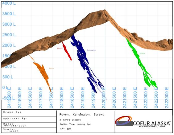
| Figure 6‑3: | Mineralization Cross-Section, Kensington, Eureka, Raven, and Elmira | 6-7 |
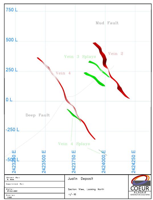
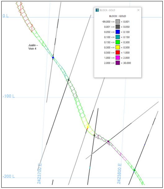
| Figure 6‑4: | Mineralization Cross-Section, Jualin Deposit | 6-10 |
| Figure 7‑1: | Exploration Areas | 7-3 |
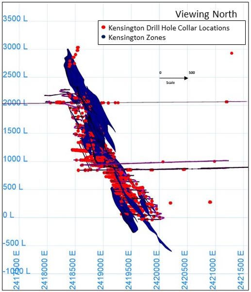
| Figure 7‑2: | Project Drill Collar Location Plan | 7-11 |
| Figure 7‑3: | Drill Section, Section, Kensington | 7-12 |
| Figure 7‑4: | Drill Collar Location Section, Raven | 7-13 |
| Figure 7‑5: | Drill Collar Location Section, Jualin | 7-14 |
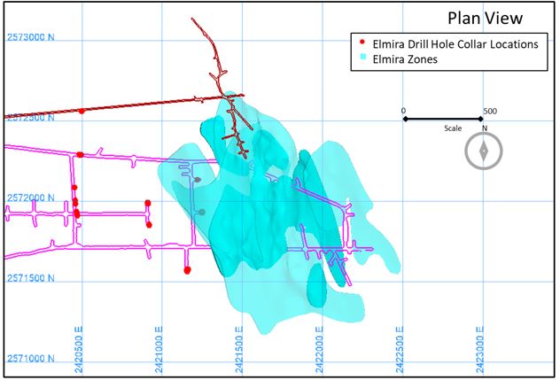
| Figure 7‑6: | Drill Collar Location Plan, Elmira | 7-15 |
| Figure 11‑1: | Kensington and Raven Model Areas | 11-2 |
| Figure 11‑2: | Kensington Model | 11-3 |
| Figure 11‑3: | Eureka Model | 11-4 |
| Figure 11‑4: | Raven Model | 11-5 |
| Figure 11‑5: | #4 Vein Model, Jualin | 11-6 |
| Figure 11‑6: | Elmira Model | 11-7 |
| Figure 13‑1: | Cross-Section, Kensington | 13-4 |
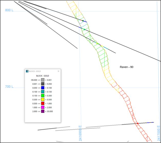
| Figure 13‑2: | Cross-Section, Raven | 13-5 |
| Figure 13‑3: | Cross-Section, Jualin | 13-6 |
| Figure 13‑4: | Cross-Section, Elmira | 13-7 |
| Figure 14‑1: | Process Flowsheet | 14-2 |
| Figure 15‑1: | Infrastructure Layout Plan | 15-7 |
Appendix A: Detailed Mineral Tenure Tables and Figures
Mr. Christopher Pascoe, RM SME, Ms. Rae Keim, P.Geo., and Mr. Peter Haarala, RM SME, prepared a technical report summary (the Report) for Coeur Mining, Inc. (Coeur), on the Kensington Gold Operations (the Kensington Operations or the Project), located in Alaska, USA.
Coeur’s wholly-owned subsidiary, Coeur Alaska, Inc. (Coeur Alaska), is the operating entity.
The Report was prepared to be attached as an exhibit to support mineral property disclosure, including mineral resource and mineral reserve estimates, for the Kensington Operations in Coeur’s Form 10-K for the year ended December 31, 2021.
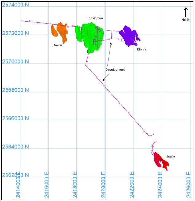
Mineral resources are reported for Kensington, Eureka, Raven, Jualin, and Elmira Zones. Mineral reserves are reported for Kensington, Eureka, Raven, Jualin, and Elmira Zones. Mineral reserves are also estimated for material in stockpiles.
Unless otherwise indicated, all financial values are reported in United States (US) currency (US$) including all operating costs, capital costs, cash flows, taxes, revenues, expenses, and overhead distributions. Unless otherwise indicated, the US Customary unit system is used in this Report. Mineral resources and mineral reserves are reported using the definitions in Item 1300 of Regulation S–K (17 CFR Part 229) (SK1300) of the United States Securities and Exchange Commission. Illustrations, where specified in SK1300, are provided in the relevant Chapters of report where that content is requested. The Report uses US English.
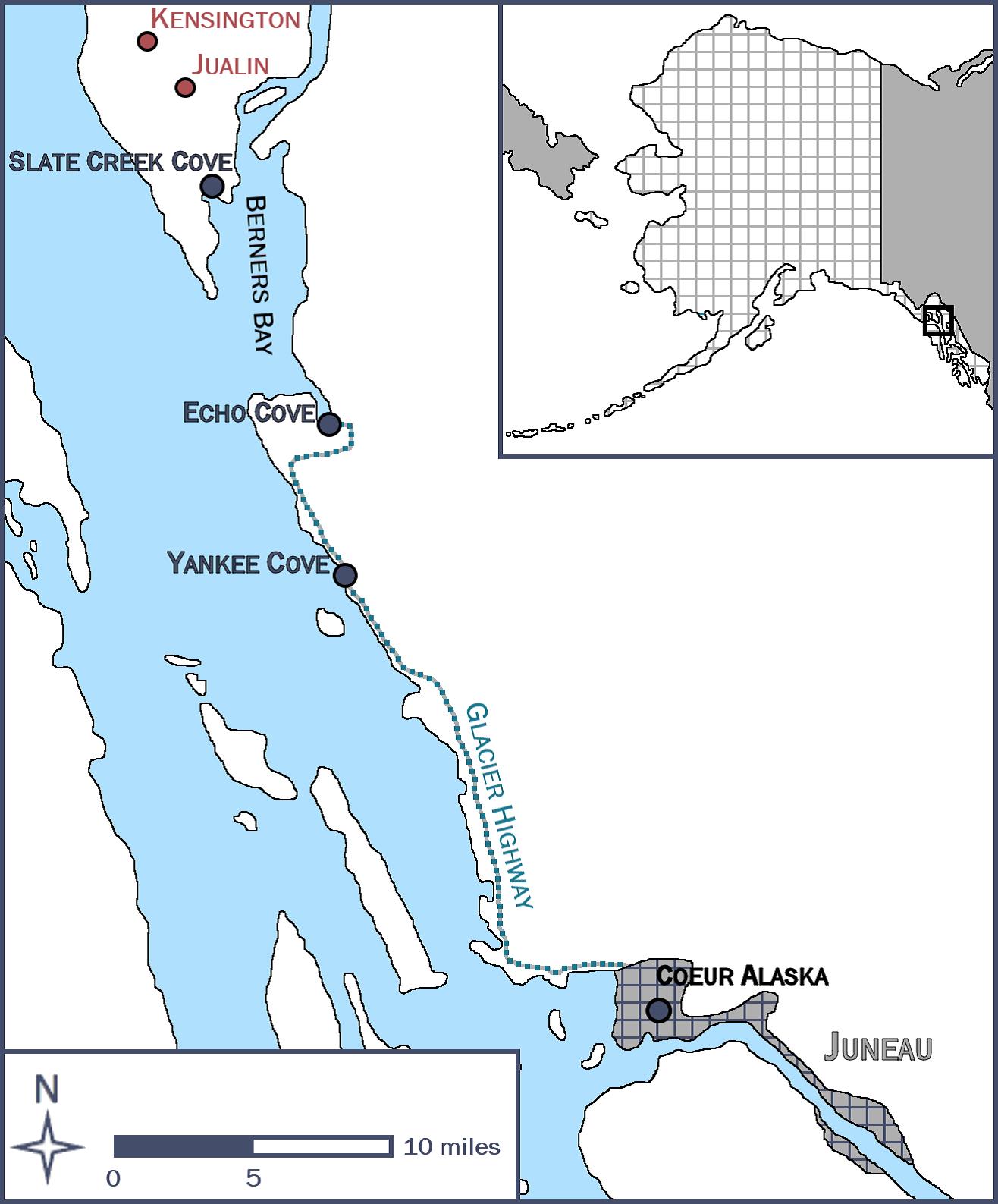
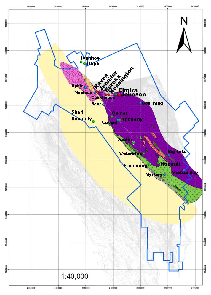
The Kensington Operations are located within the Berners Bay Mining District, approximately 48 miles northwest of the capital city of Juneau, Alaska.
Access to the Kensington Operations is by aircraft (helicopter or float plane) or boat from Juneau. The mine, mill, and camp complex at Jualin is accessed by boat from Auke Bay, Yankee Cove, or Echo Cove to the Slate Creek Cove dock facility (north side of Berners Bay), then five miles by an all-weather gravel road. Kensington is reached via Lynn Canal to the support facilities near the 850 Portal on the eastern shore of Lynn Canal or by transit through the mine. Access to existing mine workings (850 Level Portal) is by three miles of all-weather gravel road from Comet Beach or from the Jualin side of the property. Heavy equipment and supplies can be brought to both sides of the Project directly from Juneau by barge.
The climate in the Project vicinity is maritime with a mean annual precipitation of about 85 inches at the lower mine elevations. Annual snowfall varies from a few feet at sea level to greater than 10 feet at the 2050 Level Portal. Mining operations are conducted year-round. Snow removal equipment is required to keep site roads open during winter months.
Topographic relief ranges from moderate, near sea level, to rugged at the base of Lions Head Mountain.
Vegetation ranges from dense coniferous forest at sea level to dense brush and bare rock. The tree line is between 3,000–3,500 ft in elevation, depending on slope aspect.
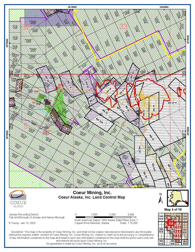
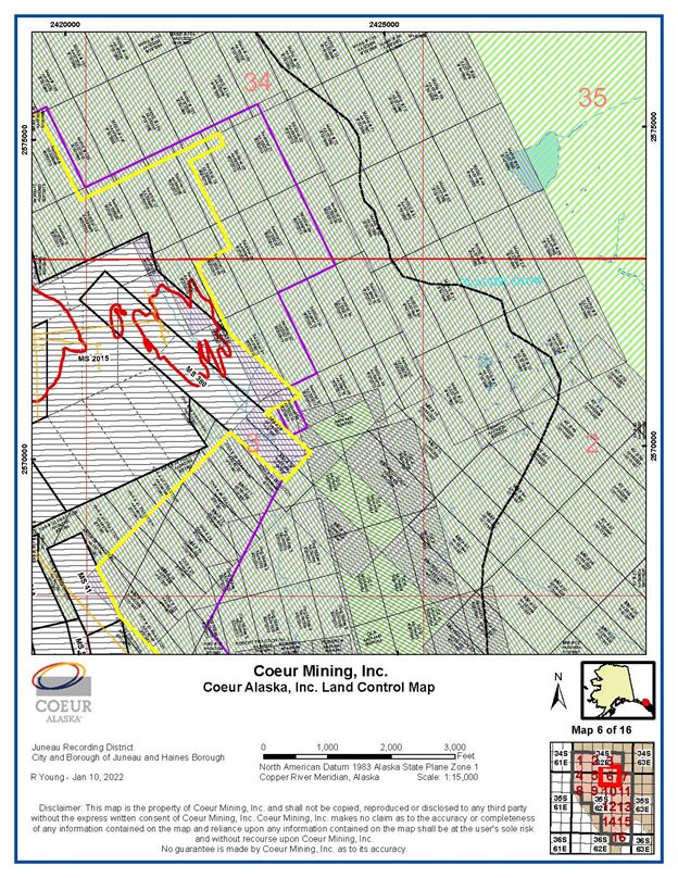
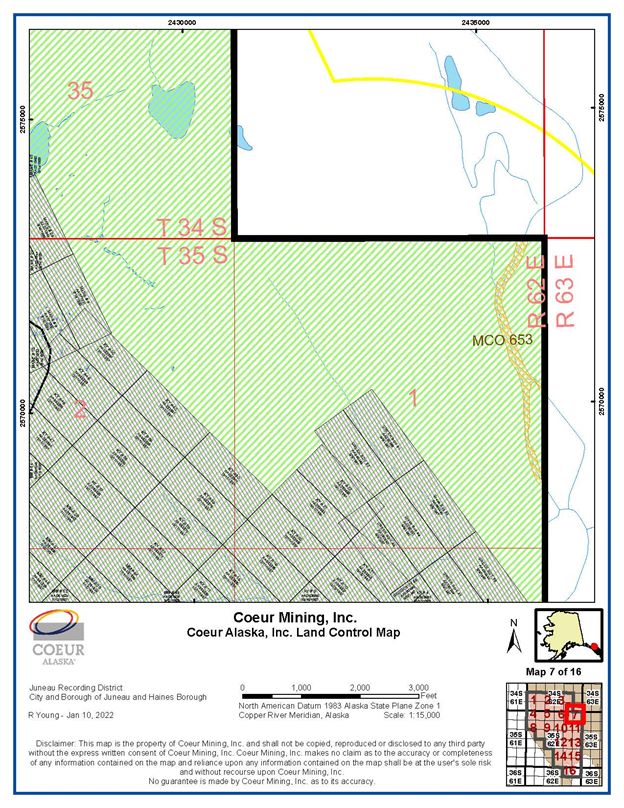
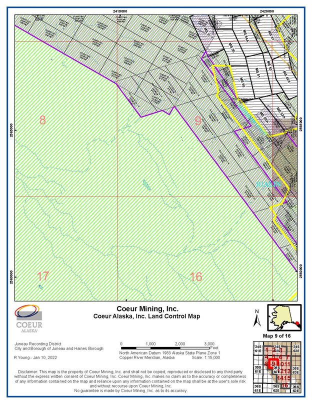
| 1.4 | Mineral Tenure, Surface Rights, Water Rights, Royalties and Agreements |
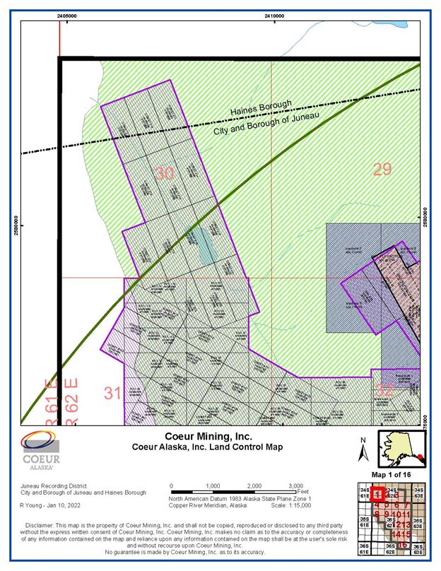
Coeur Alaska controls two contiguous claims groups: the Kensington group and Jualin group. The area covered under the Kensington group claims is 3,969 net acres, and under the Jualin group is 8,366 net acres. Fourteen of the 23 patented lode claims in the Jualin group cover private surface estate only. The mineral estate to these 14 patented lode claims located within the U.S. Mineral Surveys is owned by the State of Alaska, the mineral rights to which are secured by a State of Alaska upland mining lease. Coeur Alaska also controls the properties comprising the Jualin group, under a lease agreement with Hyak Mining Company.
The federal unpatented lode claims are maintained by the timely annual payment of claim maintenance fees, which are $165.00 per claim, payable to the United States Department of the Interior, Bureau of Land Management on or before September 1. State of Alaska mining claims and upland mining leases are maintained with fees and filings to the Alaska Department of Natural Resources, Division of Mining, Land and Water and the Juneau Recorder’s Office. These fees range from $35–$680 per claim, depending on the size and age of the claim. Annual labor in the amount of $100 or $400 per State mining claim, depending on the size of the claim, must be performed or a cash payment in-lieu of the performance of that labor must be paid to the State each year. The patented lode claims are private land and therefore not subject to federal claim maintenance requirements. However, as private land, they are subject to property taxes assessed by the Borough and City of Juneau, Alaska, which are due annually on or before September 30 each year.
The Kensington Operations hold all necessary surface and water rights to support the life-of-mine (LOM) plan.
Coeur Alaska has an agreement with the Hyak Mining Company (Hyak), as amended August 5, 2005, and further amended July 1, 2009, and October 24, 2013 over the Jualin group claims area (the Hyak Lease). The current Hyak Lease period, which is the second term of the lease, commenced on August 5, 2020 and ends on August 5, 2035. If production occurs from the leased premises, a 5% net returns royalty on production as defined by the Hyak Lease, is due, unless the amount of the net returns royalty is less than the adjusted advance minimum royalty. If the net returns royalty is less, then the advance minimum royalty is paid instead of the net returns royalty. The Hyak Lease will continue after 2035, provided mining and production are actively occurring within and from the leased premises.
Hyak entered into a working agreement, with an option to purchase, dated July 14, 1982, with Benjamin D. Fremming, Douglas L. Gregg, Thomas E. Schultz, William A. Wondriska, and Mr. and Mrs. Merrill J. Zay over certain patented lode mining claims, Federal unpatented lode and mill site claims and State of Alaska mining claims. The Hyak Lease incorporates the Hyak working agreement, and the rights awarded under the working agreement apply to the Hyak Lease. Coeur Alaska has an agreement with Hyak covering a State of Alaska Upland Mining Lease and separate agreements with individuals over a portion of the Falls and Diana patented lode claims within the Jualin group.
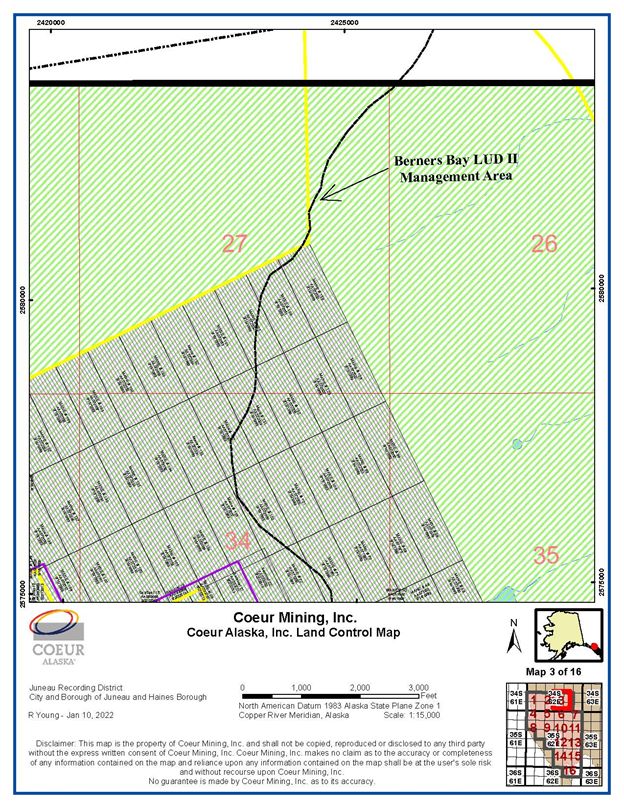
Rights for ancillary infrastructure at Slate Creek Cove are secured through a 25-year State of Alaska Tideland Lease, granted in 2011. Coeur Alaska controls a 7.2-acre parcel of land, consisting of a lodge and marine moorage facilities, under a lease agreement, as amended, with Yankee Cove Development, LLC, a Nevada limited liability company.
The State of Alaska granted a right-of-way permit to the Comet Beach facility on April 15, 1995; this was amended on August 15, 1995. The permit had a 30-year term on grant, expiring 2025, and is subject to an annual payment that is due on or before April 15.
Coeur Alaska holds a 10-year public, non-exclusive easement and right-of-way, granted in 2016, from the State of Alaska, Department of Transportation and Public Facilities and Department of Natural Resources authorizing construction and operation of the Jualin Mine Road from Slate Creek Cove to the Jualin Mine site for purposes of limiting public access and improving access to the Kensington operations.
Coeur Alaska acquired 100% ownership of the Kensington Group on July 7, 1995 from Echo Bay Mines Ltd. and Echo Bay Alaska (collectively Echo Bay). Under the acquisition agreement, Coeur Alaska is obligated to pay Echo Bay or its successors a scaled net smelter return royalty on 1 M troy ounces of gold production, after Coeur Alaska recoups the $32.5 million purchase price, plus (i) its construction and development expenditures incurred after July 7, 1995 in connection with placing the property into commercial production, and (ii) certain operating exploration and development costs thereafter. The royalty ranges from 1% at $400/oz gold prices to a maximum of 2½% at gold prices above $475/oz.
A credit agreement between Coeur, certain subsidiaries of Coeur (including Coeur Alaska), and Bank of America, N.A., was entered into on September 29, 2017, as amended (the “Credit Agreement”), under which a security interest in the Kensington property was granted securing a loan of up to $300M.
| 1.5 | Geology and Mineralization |
The deposits that comprise the Kensington Operations are considered to be examples of mesothermal vein-style, or orogenic-style gold deposits.
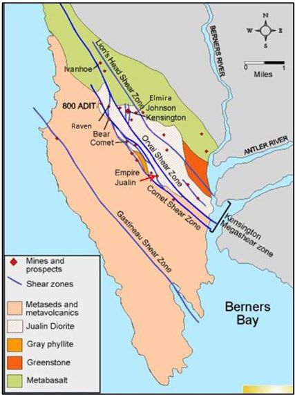
The Berners Bay mining district forms the northern end of the approximately 200-km-long Juneau gold belt and is situated along the western margin of the Coast Mountains. The district is underlain by Triassic mafic metavolcanic rocks of the Wrangellia Terrane. A Cretaceous stock, the Jualin diorite, intrudes the western margin of the Wrangellia Terrane. Both the Triassic metavolcanic rocks and the Jualin diorite are overlain by Cretaceous-aged metasedimentary and metavolcanic rocks of the Treadwell Formation of the Gravina Belt to the southwest. The unconformity between the Jualin diorite and the Gravina Belt metasedimentary rocks is marked by a Cretaceous conglomerate.
All significant gold vein deposits are hosted in the Jualin diorite between the northwest-trending, first-order Coastal Shear Zone, a broad chlorite-bearing ductile, and syn-metamorphic shear zone that passes through tonalite of the Coast Plutonic complex approximately 1.2 miles east of the diorite, and the Gastineau Shear Zone, which is the largest of a set of ductile shear zones that pass through the Gravina belt to the southwest. A zone of second- and third-order shears, termed the Kensington Megashear zone, appears to be the most significant influence on mineralized vein systems in the district. Brittle faults and third-order shear zones host discrete extensional quartz–carbonate veins and gold mineralization.
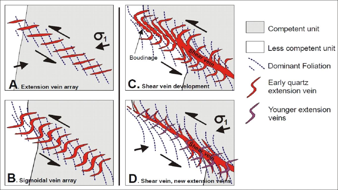
Discrete vein systems are defined by one or more through-going, fault-filling quartz veins. Discrete veins typically host the highest-grade gold mineralization, dip moderately to steeply east, and typically range between a few inches to several feet in width. Extensional veins consist of zones of numerous veins that mostly dip steeply to moderately west, but are contained within an overall east-dipping system, and occur adjacent to, or at, terminations of fault-fill veins.
Vein mineralization is characterized by gold and gold–silver telluride minerals with minor associated native gold. Most of the gold is contained in calaverite (AuTe2), which occurs in association with native gold as inclusions in and interstitial to pyrite grains and in microfractures in pyrite.
| 1.6 | History and Exploration |
Prior to Coeur’s acquisition of a 100% interest in the Project, the following companies were active in the area between 1978–1993: Hyak, Homestake Mining Co.; Placid Oil Company (Placid Oil); Bear Creek Mining Company (Bear Creek); International Curator Resources (Curator); Granges Exploration Inc.; Kensington Joint Venture (Coeur Alaska and Echo Bay); and Placer Dome U.S. Inc. (Placer). Work conducted included claim staking, geologic mapping and sampling, core drilling, construction of an access road, and completion of a feasibility study.
Coeur acquired its 100% interest in 1995. Work completed since the acquisition includes surveying and aerial photography, airborne magnetic geophysical survey, helicopter magnetic survey feasibility studies, studies in aid of permitting, mine and facility construction, and mine operations.
The Project area is a target-rich environment given that it is an orogenic gold system and the volcanic feeder at the bottom of the system has not been discovered. This means that veins likely continue deeper than is currently drilled. Using this interpretation, it becomes necessary to test offsetting relationships whenever it appears that a vein is closed down dip. Currently there are plans to continue resource infill and expansion drilling on all the current mining prospects. Two prospects are waiting on the most recent drilling results and subsequent interpretation but will likely require additional testwork.
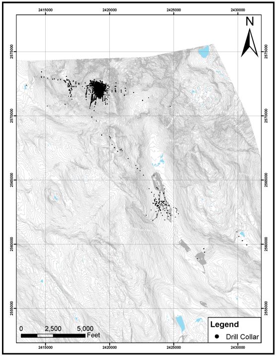
The drill database for the Project area contains 7,182 core drill holes (2,386,698 ft). Drilling that supports the mineral resource estimates consists of 4,600 core holes (2,119,138 ft).
Drilling that is excluded from estimation support includes production stope and utility holes, drill holes that have known spatial issues due to missing survey data, and drill holes that did not reach final depth.
Core loggers visually collect lithological intercepts, alteration type and intensity, mineralization type and concentration, vein composition, style, density, and structural type and intensity. Maximum and minimum intercept angles are collected for all planar features. During core logging core recovery and rock quality designation (RQD) measurements are collected. Core is photographed before sampling but after logging.
Surface collar surveys are taken using an RTK global positioning system (GPS) SPS 985 instrument. Underground surveys are recorded using a Trimble SPS 930. Before the widespread adoption of GPS for collar surveying, some collar shots were taken by triangulating off the AK NAD 27 SP Z21 grid topographic map. Downhole surveys were performed with Sperry Sun-type, Fotobor, Reflex Maxibor, Reflex Gyro, Axis Champ, and most recently IDS Gyromaster tools.
Drilling is oriented as practicable to intersect the vein systems, given the underground development available to act as drill stations. Typically, the drilled intercept width is longer than the true width.
Channel sampling has been conducted since 2014, taking one or two 1 ft horizontal samples from rib-to-rib. Core sample intervals are based on the distribution of vein density, vein type, mineralization, and any other geological feature needing assay definition. The geologist marks sample intervals, ranging from 1–5 ft in length. Whole core samples are taken from production drill holes (infill and stope holes). Half-core samples are taken from all exploration drill holes, where geologically warranted.
Density data determinations were collected using both water submersion (2010 drilling program) and more recent gas pycnometer (2020–present).
Independent primary and umpire laboratories used include Barringer, Bondar-Clegg, Cone Geochemical, ALS Chemex, American Assay Laboratories, Inspectorate America Corporation, Pinnacle Analytical Laboratories, Acme Laboratories, McClelland Laboratories and Bureau Veritas Commodities Canada, Ltd. Laboratories used early in Project exploration and development programs were not accredited; later laboratories had ISO9001 or ISO17025 accreditations. The non-independent Kensington mine assay laboratory was also used.
Sample preparation for channel and stope definition drill samples consisted of crushing to 80% passing a 12-mesh screen and pulverizing to 90% passing a 140-mesh screen. Core samples were initially crushed to 80% passing 10 mesh (2 mm), later to 70% passing 10 mesh (2 mm), and pulverized to 85% passing 200 mesh.
Gold analyses included 30 g fire assay with gravimetric finish or 30 g fire assay with atomic absorption spectroscopy (AAS) finish. Over-limit assays (>0.292 oz/st Au) were by fire assay with a gravimetric finish. Over-limit assays >1 oz/st were run by metallic screening until August 2018 when this practice was discontinued. Multi-element analyses included: four-acid digestion with inductively-coupled plasma atomic emission spectroscopy (ICP-AES) finish, 33-element suite; and four-acid digestion with ICP-mass spectrometry (ICP-MS) finish, 48-element suite, and multi-acid digest with ICP-MS/emission spectroscopy finish, 45 element suite.
Historically, quality assurance and quality control (QA/QC) procedures consisted of routine check assays of original pulps, check assays of duplicate pulps from coarse rejects and use of geochemical blanks to determine contamination during sample preparation. Metallic-screen analysis was performed prior to August 2018 to check for coarse gold. Current procedures include insertion of custom certified reference materials (CRMs), blanks, and duplicates (field, crush, pulp, and analytical). Field duplicates are taken only for exploration core. Insertion rates are as follows: insertion rates of 5% for standards, 5% for blanks, and 2.5% for duplicates. Check assays were selected at 5–10% of sample assays received monthly and were sent to an independent ISO certified secondary analytical laboratory for analysis. The QA/QC data are acceptable to support mineral resource estimation.
Data collected are stored in an acQuire Geologic Information Management System. The system stored traditional drill hole data (collar location, orientation, downhole survey, assay, and documentation), but was also used to store mine development sampling, surface exploration sampling, and channel sampling. Data are subject to regular backup.
Data verification included internal and external database audits. Drill collar surveys and downhole surveys are viewed in plan and section and checked against development workings. Contractor shift reports are compared to actual total drill hole footages. Core logging data and core photos are checked for completeness. Assay data and QA/QC data are reviewed. Data that have not been reviewed and passed QA/QC analysis do not pass the verification process. Once all data are complete and have been reviewed by the responsible persons, they are reviewed by a senior geologist and signed off on by the Chief Geologist or their designate and locked to further editing.
The QP
personally undertook QA/QC verification, participated in programs to verify drill data prior to mineral resource estimation, checked selected gold assay data, conducted drill hole lockdown, including checks of assay certificates, collar and downhole surveys, geology, and QA/QC reports, and signed off on 2015–present definition drill holes and the 2021 drilling.
The QP is of the opinion that the data verification programs for Project data adequately support the geological interpretations, the analytical and database quality, and therefore support the use of the data in mineral resource and mineral reserve estimation, and in mine planning.
| 1.9 | Metallurgical Testwork |
Independent metallurgical testwork facilities used over the Project life, where recorded, included Pittsburgh Minerals and Environmental Technology, Inc., Cannon Microprobe, SGS Vancouver, Colorado Minerals and Research Institute, Maxim Technologies, Inc., Dawson Metallurgical Laboratories, Inc., Knelson Research & Technology Center, Hazen Research, Inc., and G & T Metallurgical Services Ltd. The Kensington Operations have an on-site analytical laboratory that assays concentrates, in-process samples, and geological samples. The on-site metallurgical laboratory is used for testing flotation reagents, grind analysis, and characterizing the behavior of new ores. The laboratory is not independent.
Gold in the Kensington deposit is present as calaverite (AuTe2), and in the form of free gold or microscopic, “invisible” gold. The relationship of calaverite to pyrite is either as a rind, an inclusion, or a separate, discrete particle. Particles range from 3–20 µm in size. Prior to mill construction at Kensington, six different companies conducted extensive metallurgical testing, including comminution gravity separation, flotation (flash flotation, locked-cycle testing, and various reagent additions) and cyanidation of concentrates. Test results were used as a guideline for plant design. Metallurgical test results were consistent in the recommended methods of process design, extraction and recovery estimates.
Gold in the Jualin deposit is in the form of native gold and highly liberated gold minerals, and exhibits high gold–sulfide associations. Tests included flotation using similar operating conditions to those in use in the Kensington plant flotation circuit, and gravity testwork. Flotation recovery results that averaged 95.8% recovery indicated that the existing circuit could recover the Jualin material with minimal gold losses. However, it was decided to refurbish the existing Knelson concentrator in the plant in case material from Jualin did not mirror the results obtained from the Jualin Vein #4 mineralization.
Recovery factors estimated are based on appropriate metallurgical test work and confirmed with production data. Recovery factors are appropriate to the mineralization types and the selected process route. The LOM gold recovery forecast is 95.3%.
Based on extensive operating experience and testwork, there are no known processing factors of deleterious elements that could have a significant effect on the economic extraction of the mineral reserve estimates.
| 1.10 | Mineral Resource Estimation |
| 1.10.1 | Estimation Methodology |
All deposits were subject to exploratory data analysis, which could include histograms, cumulative probability plots, box and whisker plots, and contact analysis.
The Kensington resource model currently contains a total of 36 estimation domains that were based on combination of lithology and mineralization. The Eureka resource model has two estimation domains. The Raven resource model has five estimation domains. The Jualin resource model has four estimation domains. The Elmira resource model has three estimation domains. Each estimation domain is based on lithology and mineralization.
The estimation domains that inform the Elmira, Raven, and Jualin resource estimates are generated by selecting quartz vein intercepts regardless of the grade. Each lithological intercept is visually checked by reviewing photos of the drill core. Boundaries of each domain are snapped as close to the lithological breaks as possible. Each domain and the diorite host rock have a respective density factor. If the block is outside of a mineral estimation domain, the block is given the density determined for the diorite host rock. If inside the domain, it is given the determined density for that estimation domain.
Grade caps were determined by a study of the exploratory data analysis, general statistics, histograms, log normal probability plots, and reconciliation data. Depending on the domain, caps could range from 0.3–6 oz/st. For the Kensington and Eureka resource models, drill data were composited at 5 ft down-the-hole intervals by estimation domain using the run-length method. When compositing for Elmira, Raven, and Jualin, full vein width composites were created using the run-length method to accurately represent the full vein grade.
For the Kensington deposit, variograms were calculated for separate groupings of domains or zones because individual domains had insufficient number of samples to construct a valid variogram model. The resulting variogram for each zone was applied during estimation for all domains within each zone. Downhole variograms for the narrow vein deposits at Elmira, Jualin, and Raven were not possible due to the use of single, vein-width composites.
The Kensington model was sub-blocked. Gold grades were estimated into parent blocks using ordinary kriging (OK). Blocks within each domain were estimated using only composites from within that domain. Eureka was estimated using inverse distance weighting to the second power (ID2). Elmira, Jualin, and Raven, being narrow vein deposits using single vein-width composites, required a seam model (2D) to better represent each of the estimation domains. These deposits were estimated using ID2.
The block models were validated using some or all of the following methods: visually by stepping through sections and comparing the raw drill data and composite data with the block values; comparison of model statistics to drill data; swath plots; and mill to model reconciliation.
For all deposits other than the #4 Vein at Jualin, the classification of blocks as measured, indicated and inferred was based on drill hole spacing, and set numbers of informing drill holes and samples. All of the #4 Vein was classified as indicated because of the consistent geology of the discrete vein and the available production and reconciliation data.
For each resource estimate, an initial assessment was completed that assessed likely infrastructure, mining, and process plant requirements; mining methods; process recoveries and throughputs; environmental, permitting, and social considerations relating to the proposed mining and processing methods; proposed waste disposal; and technical and economic considerations in support of an assessment of reasonable prospects of economic extraction. Mineral resources are confined within conceptual underground mineable shapes. The estimate assumed that the preferred mining method will be longhole stoping, and that the minimum mining width was 5 ft.
The gold price used in resource estimation is based on long-term analyst and bank forecasts, supplemented with research by Coeur’s internal specialists. The estimated timeframe used is the three-year LOM that supports the mineral reserve estimates. The forecast is US$1,700/oz for the mineral resource estimate. The QP considers this price to be reasonable.
The mineral resources are reported using variable gold cut-off grades that range from 0.120–0.175 oz/st Au.
| 1.10.2 | Mineral Resource Statement |
Mineral resources are reported using the mineral resource definitions set out in SK1300 and are reported exclusive of those mineral resources converted to mineral reserves. The reference point for the estimate is in situ. All models were depleted through 2021, planned mining shapes were used for the month of December as depletion was run on December 7, 2021.
Measured and indicated mineral resources are summarized in Table 1‑1 and inferred mineral resources in Table 1‑2.
The Qualified Person for the estimate is Ms. Rae Keim, P.Geo., a Coeur Alaska employee.
| 1.10.3 | Factors That May Affect the Mineral Resource Estimate |
Factors that may affect the mineral resource estimates include: metal price and exchange rate assumptions; changes to the assumptions used to generate the gold cut-off grade; changes in local interpretations of mineralization geometry and continuity of mineralized zones; changes to geological and mineralization shape and geological and grade continuity assumptions; density and domain assignments; changes to geotechnical, mining and metallurgical recovery assumptions; changes to the input and design parameter assumptions that pertain to the assumptions for underground mining constraining the estimates; assumptions as to the continued ability to access the site, retain mineral and surface rights titles, maintain environment and other regulatory permits, and maintain the social license to operate.
Table 1‑1: Summary of Gold Measured and Indicated Mineral Resources at December 31, 2021 (based on US$1,700/oz gold price)
Confidence Category | Tons
(st x
1,000) | Gold
Grade
(oz/st) | Contained Ounces
(oz x 1,000) | Gold Cut-off
Grades
(oz/st) | Metallurgical
Recovery
(%) |
| Measured | 2,860 | 0.23 | 660 | 0.120–0.175 | 95 |
| Indicated | 1,263 | 0.26 | 323 | 0.120–0.175 | 95 |
| Total measured and indicated | 4,124 | 0.24 | 983 | 0.120–0.175 | 95 |
Table 1‑2: Summary of Gold Inferred Mineral Resource Statement at December 31, 2021 (based on US$1,700/oz gold price)
Confidence Category | Tons
(st x
1,000) | Gold
Grade
(oz/st) | Contained
Ounces
(oz x 1,000) | Gold Cut-off
Grades
(oz/st) | Metallurgical
Recovery
(%) |
| Inferred | 1,915 | 0.24 | 455 | 0.120–0.175 | 95 |
Notes to accompany mineral resource tables:
| 1. | The mineral resource estimates are current as of December 31, 2021 and are reported using the definitions in Item 1300 of Regulation S–K (17 CFR Part 229) (SK1300). |
| 2. | The reference point for the mineral resource estimate is in situ. The Qualified Person for the estimate is Ms. Rae Keim, P.Geo., a Coeur Alaska employee. |
| 3. | Mineral resources are reported exclusive of the mineral resources converted to mineral reserves. Mineral resources that are not mineral reserves do not have demonstrated economic viability. |
| 4. | The estimate uses the following key input parameters: assumption of conventional longhole underground mining; gold price of US$1,700/oz; reported above a variable gold cut-off grade that ranges from 0.120–0.175 oz/st Au; metallurgical recovery assumption of 95%; gold payability of 97.5%, variable mining costs that range from US$90.91–150.73/st mined, process costs of US$46.93/t processed, general and administrative costs of US$38.83/t processed, and concentrate refining and shipping costs of US$60.00/oz sold. |
| 5. | Rounding of short tons, grades, and troy ounces, as required by reporting guidelines, may result in apparent differences between tons, grades, and contained metal contents. |
| 1.11 | Mineral Reserve Estimation |
| 1.11.1 | Estimation Methodology |
Mineral reserves were converted from measured and indicated mineral resources. Inferred mineral resources were set to waste. The mine plans assume underground mining using longhole open stoping, trackless equipment and combination of cemented rock fill (CRF), waste, and paste backfill. Target mining rates are capped at approximately 2,000 tons per day, which is the permitted capacity limit.
Estimates of development rate are based on measured advance rates in Kensington, Raven, Jualin, and Elmira and any expected variation from manpower or equipment considerations. Stope production rates are based on measured values of production since the start of operations.
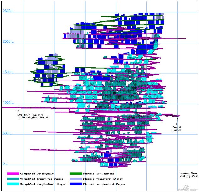
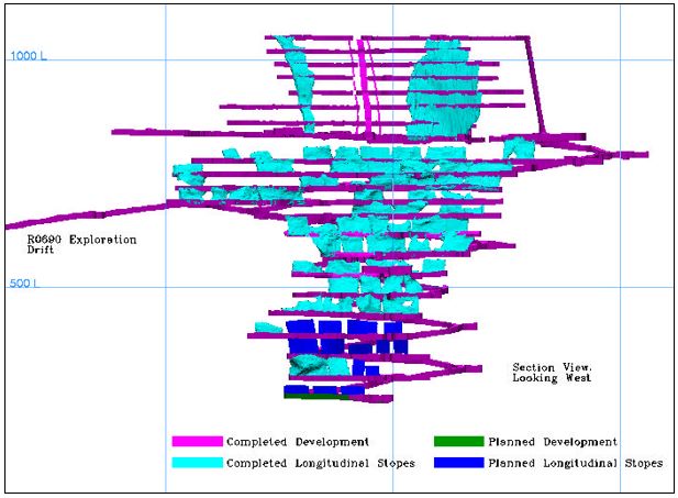
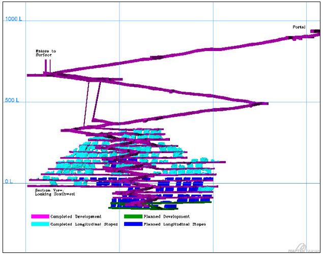
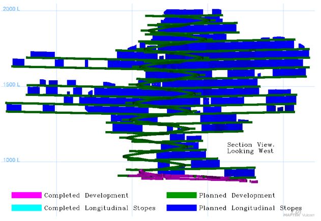
Transverse stoping is the main extraction method used in the Main Kensington center area. Stope outlines are created on 40 ft centers using the standard level spacing (75 ft in Kensington, 35–50 ft in Raven, 35 ft in Jualin, and 60 ft in Elmira) and the reserve model. Longitudinal stope designs exist in the fringe regions of Zone 10, much of Zones 12, 30, 35, and 50, much of Elmira, and all of Raven area and represent a majority of the tons in the LOM plan. These areas of longitudinal stoping are too narrow (>30 ft) to convert to transverse stoping, based on the requisite infrastructure required. Together with the conventional transverse and longitudinal stopes, there are also some blind back stopes, depending on the reserve model and stoping horizon.
For Kensington and Elmira, a dilution factor of 15% was used by for mine planning purposes. For Jualin and Raven, a dilution factor of 15% for development and 20% for mining was used in the mine plans to account for expected narrow vein longitudinal stoping. Unintentional mining of paste backfill or CRF has not been excessive to date, though instances of sloughing of material during and post blast have been observed in secondary stopes, adding 1–3% additional waste dilution in a few select stopes. A dilution grade of 0.063 oz/st Au was calculated and has subsequently been used for external dilution applications for the Kensington and Elmira stopes. A dilution grade of 0.0 oz/st was used for stopes at Raven and Jualin due to minimal or no mineralization extending past the vein itself.
Cut-off grades are determined through historical costing for Kensington, Raven, and Jualin. Mineral reserve cut-off grades range from 0.142–0.201 oz/st Au. Some blocks are classed as incremental material, which does not include the G&A or mining costs, as those costs are incurred regardless of what the resource classification may be. As such, this material must be removed from the mine and the consideration is whether it goes to the waste pile or to a low-grade stockpile that only carries the mining and refining costs. The intent of this material handling designation is for the material to only be processed when mill tonnage needs to be sustained, but where it does not offset other above cut-off grade material.
The gold price used in mineral reserve estimation is based on analysis of three-year rolling averages, long-term consensus pricing, and benchmarks of what other peer companies used for pricing over the past year. The price used is US$1,400/oz for gold for the mineral reserve estimate. The QP considers this price to be reasonable.
| 1.11.2 | Mineral Reserve Statement |
Mineral reserves have been classified using the mineral reserve definitions set out in SK1300. The reference point for the mineral reserve estimate is the point of delivery to the process plant. Mineral reserves are reported in Table 1‑3 that are current as at December 31, 2021. Estimates are reported on a 100% ownership basis.
The Qualified Person for the estimate is Mr. Peter Haarala, RM SME, a Coeur employee.
| 1.11.3 | Factors That May Affect the Mineral Reserve Estimate |
Factors that may affect the mineral reserve estimates include variations to the following assumptions: the commodity price; metallurgical recoveries; operating cost estimates; geotechnical conditions; hydrogeological conditions; geological and structural interpretations; changes to the input and design parameter assumptions that pertain to the assumptions for the mineable shapes constraining the estimates; changes to dilution assumptions that can impact grade and operating costs; the inability to maintain, renew, or obtain environmental and other regulatory permits, to retain mineral and surface right titles, to maintain site access, and to maintain the social license to operate.
Table 1‑3: Summary of Gold Proven and Probable Mineral Reserve Statement at December 31, 2021 (based on US$1,400/oz gold price)
Confidence Category | Tons
(st x 1,000) | Gold Grade
(oz/st) | Contained ounces
(oz x 1,000) | Gold Cut-off
Grades
(oz/st) | Metallurgical
Recovery
(%) |
| Proven | 656 | 0.19 | 125 | 0.142–0.201 | 95 |
| Probable | 690 | 0.20 | 136 | 0.142–0.201 | 95 |
| Total proven and probable | 1,346 | 0.19 | 261 | 0.142–0.201 | 95 |
Notes to accompany mineral reserve tables:
| 1. | The Mineral reserve estimates are current as of December 31, 2021 and are reported using the definitions in Item 1300 of Regulation S–K (17 CFR Part 229) (SK1300). |
| 2. | The reference point for the mineral reserve estimate is the point of deliver to the process plant. The Qualified Person for the estimate is Mr. Peter Haarala, RM SME, a Coeur employee. |
| 3. | The estimate uses the following key input parameters: assumption of conventional underground mining; gold price of US$1,400/oz; reported above a gold cut-off grade of 0.142-0.201 oz/st Au; metallurgical recovery assumption of 95%; gold payability of 97.5%, variable mining costs that range from US$90.91–150.73/st mined, process costs of US$46.93/st processed, general and administrative costs of US$38.83/st processed, and concentrate refining and shipping costs of US$60.00/oz sold. |
| 4. | Rounding of short tons, grades, and troy ounces, as required by reporting guidelines, may result in apparent differences between tons, grades, and contained metal contents. |
The Kensington Operations use conventional underground equipment and mining methods. The mine has been operating since July 2010. The remaining mine life is three years, to 2024.
Geotechnical conditions underground at Kensington are excellent. The interaction of the mining sequence on the overall stability of the hanging wall has been investigated by an outside geotechnical expert. Minor non-reportable occurrences have taken place within open stopes where personnel are not exposed. Regular additional evaluations by an outside geotechnical expert are ongoing.
Raven workings have been extended, using guidance from an outside geotechnical expert, with excellent results to date. The existing ground support guidelines were confirmed to be appropriate for use in the Jualin deposit.
There are few hydrogeological aspects to be considered beyond natural inflow of water to the workings within the Kensington and Raven orebodies. This inflow is monitored, and the water is captured within the workings to be either treated, or discharged, as per Coeur’s permit requirements. The Jualin deposit is near surface, with several faults and mineralized veins having surface expression. These structures collect runoff water and, together with the historic Jualin mine workings acting as a reservoir, channel water to the areas under mining development.
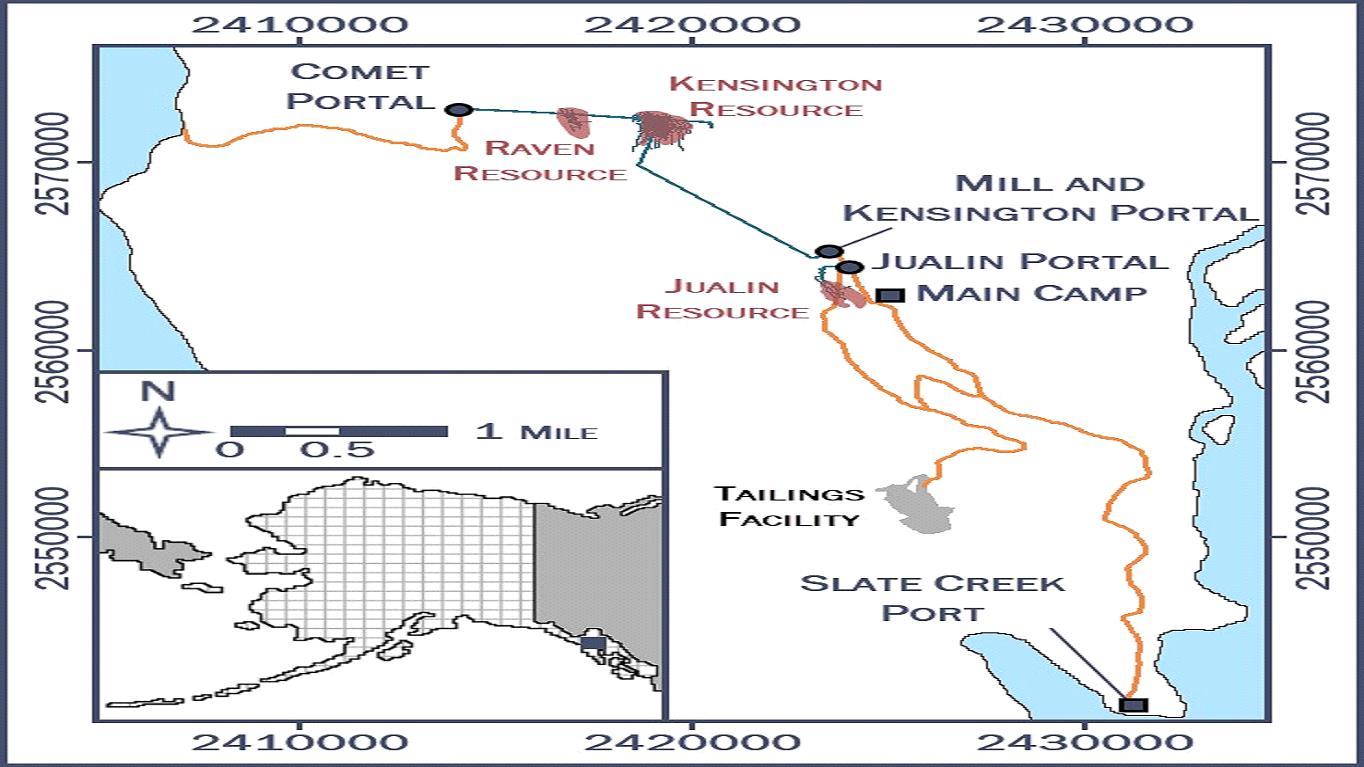
The primary access to the Kensington and Raven underground mine areas is via the Kensington Portal at the 964 elevation. This portal is the primary ingress/egress point for all equipment and personnel to access the Kensington and Raven workings. There is a secondary portal at 792-elevation on what is known as the Comet Beach side, geographically located on the Lynn Canal side of the mountain. The Jualin deposit is currently accessed by a decline collared from surface at the 926 elevation.
Stoping and paste backfill mining methods were selected and implemented based on the orebody location, ground conditions, and geological settings. Mining design assumptions for each mining region are typically standardized for each area and mining method assumed. Offsets from the ore, required infrastructure, and support are based on industry standards and best practices, modified by specific location required needs, and operational requirements to safely advance development and production in each area with a minimum of wasted development to maximize efficiency.
The mine production schedule is based on a maximum mill throughput rate of 2,000 st per day. Coeur typically processes between 1,750–1,950 st/day with a waste stream of about 10% rejected as a coarse pebble reject, which is then passed through a sorter to further extract ore grade material for re-feed back into the mill.
Primary ventilation in the Kensington and Raven mine areas is controlled by two fans located in the Comet drift, which pull air from the Kensington/process plant side, near the mill bench, straight through the mountain and exhaust out the Comet side. Ventilation raises throughout the mine assist in distributing airflow. Primary ventilation of the Jualin mine area is accomplished with a duct-mounted fan located at the Jualin portal and an in-line booster at the J0625 level, which direct air through to the working areas. The air exhausts out though the workings back to the portal via the ramp and up through a series of vent/escape raises exhausting through a 10 ft diameter bored raise to surface.
Backfill is a combination of cemented paste fill, CRF, and straight waste fill.
The Kensington underground infrastructure consists of the main underground shop, the paste plant, and electrical infrastructure. The Raven and Elmira deposits share underground infrastructure and portal access with Kensington. Jualin shares surface infrastructure with Kensington. However, Jualin is accessed from its own portal.
Major mining equipment includes the following equipment types: loaders, haul trucks, jumbo drills, longhole drills, and bolters. Ancillary support equipment consists of Getman and MacClean flatbeds, explosives loading vehicles, zoom boom forklifts, Kubota RTV’s and tractors, pickups, compressors, and other standard support equipment.
The mining/maintenance personnel requirement for the remaining LOM averages 169 persons.
The process plant design was based on a combination of metallurgical testwork, study designs, and industry standard practices, together with debottlenecking and optimization activities once the mill was operational. The design is conventional to the gold industry and has no novel parameters.
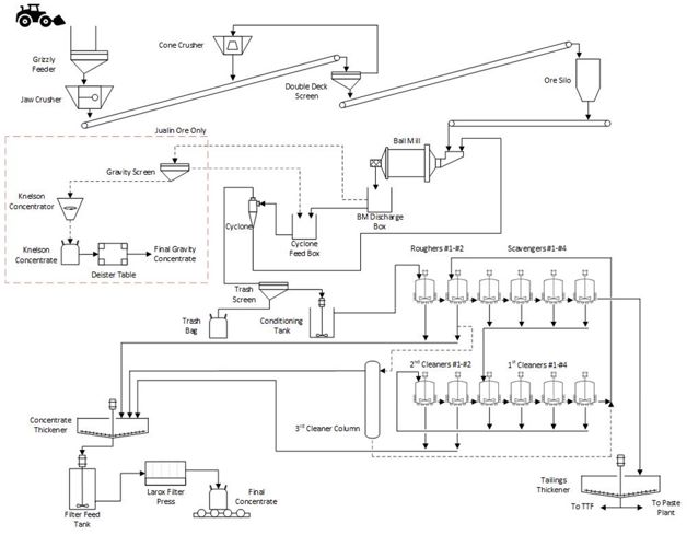
The Kensington Operations use a flotation mill to recover gold from sulfide-bearing rock. Crushing and milling facilities are located directly south of the Jualin Portal. On the portal bench, ore is segregated by grade and blended before being fed to the two-stage, closed-circuit crushing plant. Once crushed, ore is fed to a ball mill and then to a flotation circuit consisting of two rougher cells and four scavenger cells. Final cleaner concentrate reports to a concentrate thickener; flotation concentrates are thickened and filtered to approximately 10% moisture. The final product is a gold concentrate. The mill throughput was increased from a previous maximum of 69 st/hr in 2012 to 84 st/hr.
The mill requires approximately 1.5 to 2.0 MW of power to operate at full capacity. Currently, there is no expectation for this power demand to increase. Recycled water for use in the process plant is sent from the paste plant, the concentrate and tailings thickeners, and water reclaimed from the tailings treatment facility (TTF). Johnson Creek is a back-up fresh water source for the mine site, but extraction is subject to permit conditions.
Consumables used in processing include potassium amyl xanthate; methyl isobutyl carbinol (MIBC); AERO 3894 (promoter); MaxGold 900 (promoter); steel (grinding media); and Z-Flocc 2525.
The Slate Creek Cove Marine Terminal Facility and a 5.7-mile all-weather access road from the terminal to the mine provides all personnel and materials access to the mine. The Slate Creek Cove Marine Terminal Facility includes docking capabilities for main line ocean-going barges, personnel ferries, float planes, ramp barges, and landing craft.
Site infrastructure is located at both the Kensington and Jualin deposit areas:
| • | Surface facilities at Kensington include 2.3 miles of all-weather access road from Comet Beach to the Comet Portal (850 Level), the mine water treatment facility with two settling ponds, and a development rock storage facility. Underground infrastructure includes a paste backfill plant, maintenance shop, warehouse, explosive storage, dewatering, and ventilation. |
| • | Surface facilities at Jualin include a 375-person accommodation camp, dining facility, administration building with medical clinic, warehouse, run-of-mine ore stockpile, crusher and flotation mill, and the TTF at Lower Slate Lake. The Kensington Tunnel, completed in July 2007, connects the Jualin mill facilities to the orebody. The tunnel is the primary artery for ore haulage, materials transport, and personnel access. The tunnel includes 9,660 ft of development from the Kensington Portal to the Kensington ramp system. |
Kensington has several existing waste rock stockpiles onsite including at Comet, Pit 1, Pit 4, Pit 7, and the Portal Pad. With the approval of Coeur Alaska’s Plan of Operations Amendment 1 (POA-1), expected in early 2022, Coeur will be allowed to expand the existing Comet, Portal, and Pit 4 stockpiles and create one new stockpile.
The existing TTF is currently operating at Stage 3. Coeur has initiated engineering work for a possible Stage 4 dam raise if additional reserves are added. The current Stage 3 TTF has capacity to accommodate the remaining LOM storage requirements. Tailings will continue to be backfilled underground as paste to reduce the need for additional storage capacity at the TTF
Groundwater captured in the underground mine workings is conveyed to the Comet mine water treatment plant and treated and discharged to Sherman Creek. Surface water runoff and mill process waters that enter the tailings treatment facility are treated and discharged to the east fork of Slate Creek. The Comet water treatment facility consists of two water plants and a tertiary plant that supports the primary plants during high treatment demand periods.
Electrical power at Kensington is generated by four diesel engines located inside the powerhouse building on the north end of the mill bench. Power use continues to increase with current peak winter loads at 90–92% of three-generator capacity. Power capacity is sufficient for the LOM.
| 1.15 | Markets and Contracts |
The Kensington Operations produce flotation concentrate containing both gold and silver. The concentrate is highly desirable due to its elevated gold content and lack of deleterious elements. Concentrate is exported out of Seattle, Washington and delivered to smelters in Europe and Asia where it is consumed, processed, and the valuable metals extracted.
Concentrate is sold directly to international commodity traders, who then sell onto smelters in Europe and Asia. Subject to the gold and silver content, gold is typically payable around 98%, and silver payable around 80%. There are typically no penalties for deleterious elements. Treatment charges, refining charges, and all other terms and conditions are typical and consistent with standard industry practice for such gold concentrates.
Coeur uses a combination of analysis of three-year rolling averages, long-term consensus pricing, and benchmarks to pricing used by industry peers over the past year when considering long-term commodity price forecasts.
Higher metal prices are used for the mineral resource estimates to ensure the mineral reserves are a sub-set of, and not constrained by, the mineral resources, in accordance with industry-accepted practice.
The long-term gold price forecasts are:
The economic evaluation uses gold price forecasts of US$1,750/oz for 2022 and 2023, and US$1,700/oz in 2024.
The QP considers the price forecasts to be reasonable.
Concentrate is barged in bags in containers from Slate Creek Cove in Berners Bay, Alaska to Seattle, Washington. The bags are then transloaded from barge containers into international containers for export out of Seattle to Europe and Asia. The typical cost to transport concentrate from Slate Creek Cove to Europe and Asia is around US$220 per wet metric tonne, subject to the destination and international ocean freight market conditions.
There are numerous contracts in place at the Project to support mine development or processing. Currently there are contracts in place to provide supply for all major commodities used in mining and processing, such as equipment vendors, power, explosives, cyanide, tire suppliers, contract mining, ground support suppliers, and drilling contractors. The terms and rates for these contracts are within industry norms. The contracts are periodically put up for bid or re-negotiated as required.
| 1.16 | Environmental, Permitting and Social Considerations |
| 1.16.1 | Environmental Studies and Monitoring |
Numerous baseline studies were performed in support of Project permitting. These included air, water, aquatic resources, geology, wildlife, soil, vegetation, wetlands, and cultural resources. Four environmental impact statement (EIS) documents were prepared, the most recent being a supplemental EIS in 2021.
Environmental monitoring at the site includes water quality, aquatic resource, tailings and waste rock geochemistry, wildlife, and stormwater.
| 1.16.2 | Closure and Reclamation Considerations |
A reclamation and closure plan has been prepared and approved by the governing agencies for the Project. The current plan was updated in 2021 and reflects current mining, mitigation, and site facilities.
Coeur conducts an annual review of its potential reclamation responsibilities company-wide. The total LOM cost for physical reclamation and long-term monitoring of the Kensington Operations is currently estimated to be US$23.7 M. Reclamation is anticipated to be completed three years following cessation of mining. Closure-related activities will continue until about 2055.
All required local, state, and federal permits for operation have been issued. Plan of Operations Amendment 1 (POA-1) was submitted to the Forest Service in 2018 and is currently under review by the local, state, and federal agencies. POA-1 will provide 5 Mst of additional waste rock storage and 4 Mst of additional tailings storage at site. A Final Supplemental Impact Statement was completed in July 2021 and the Final Record of Decision (ROD) is expected in early 2022.
| 1.16.4 | Social Considerations, Plans, Negotiations and Agreements |
Coeur has had a long and positive relationship with the community of Juneau and southeast Alaska. Coeur partners with many stakeholders, including national, regional, and state mining associations; trade organizations; fishing organizations; state and local chambers of commerce; economic development organizations; non-government organizations; and state and federal governments.
| 1.17 | Capital Cost Estimates |
Capital cost estimates are at a minimum at a pre-feasibility level of confidence, having an accuracy level of ±25% and a contingency range not exceeding 15%.
The cost estimates are based on a combination of first principal estimates, historic performance, and quotations.
All major capital construction projects needed to maintain consistent production and extraction of mineral reserves at the Kensington Operations were completed in 2013. Additional capital projects have been completed since 2013 to improve mill throughput, enhance power generation, and increase tailings capacity.
Capital development is a concurrent allocation of costs that are derived by taking the number of capital feet driven times the recorded weighted costs to drive those feet in the period they were driven. Both types of capital expenditures are sustaining and or improvement capital projects. Each project is selected for the current year of operation, based on the annual allocation of corporate capital funds, the effect the project has on production and or the internal rate of return.
Exploration capital is the cost associated with activities involving resource infill drilling and the conversion of those mineral resources to mineral reserves.
Capital projects envisaged in the LOM include: Elmira paste booster station engineering; heat recovery detailed design; TTF stage 4 engineering; POA1 construction of WRSFs; and water treatment plant sulfate removal
The total LOM capital cost estimate is US$47.6 M (Table 1‑4).
| 1.18 | Operating Cost Estimates |
Operating cost estimates are at a minimum at a pre-feasibility level of confidence, having an accuracy level of ±25% and a contingency range not exceeding 15%.
Operating costs are based on actual costs seen during operations and are projected through the LOM plan. Historical costs are used as the basis for operating cost forecasts for supplies and services unless there are new contract terms for these items. Labor and energy costs are based on budgeted rates applied to headcounts and energy consumption estimates.
The total LOM operating cost estimate is US$274.4 M (Table 1‑5).
| 1.19.1 | Forward-Looking Information Caution |
Results of the economic analysis represent forward- looking information that is subject to several known and unknown risks, uncertainties, and other factors that may cause actual results to differ materially from those presented here.
Other forward-looking statements in this Report include, but are not limited to: statements with respect to future metal prices and concentrate sales contracts; the estimation of mineral reserves and mineral resources; the realization of mineral reserve estimates; the timing and amount of estimated future production; costs of production; capital expenditures; costs and timing of the development of new ore zones; permitting time lines; requirements for additional capital; government regulation of mining operations; environmental risks; unanticipated reclamation expenses; title disputes or claims; and limitations on insurance coverage.
Factors that may cause actual results to differ from forward-looking statements include: actual results of current reclamation activities; results of economic evaluations; changes in Project parameters as mine and process plans continue to be refined, possible variations in mineral reserves, grade or recovery rates; geotechnical considerations during mining; failure of plant, equipment or processes to operate as anticipated; shipping delays and regulations; accidents, labor disputes, and other risks of the mining industry; and delays in obtaining governmental approvals.
Table 1‑4: LOM Capital Cost Estimate (US$ M)
| Cost | 2022 | 2023 | 2024 | LOM |
| Capital mine development | 14.8 | 15.6 | 0 | 30.4 |
| Capital equipment (fixed and mobile) | 6.5 | 0.9 | 0 | 7.4 |
| Capital projects | 3.7 | 6.2 | 0 | 9.8 |
| Total Capital Expenditures | 25.0 | 22.6 | 0 | 47.6 |
Note: Numbers have been rounded.
Table 1‑5: LOM Operating Cost Estimate (US$ M)
| Cost | 2022 | 2023 | 2024 | 2025–2055 | LOM |
| Mining | 59.1 | 41.0 | 35.4 | 0 | 135.5 |
| Processing | 28.7 | 20.7 | 13.6 | 0 | 62.9 |
| G&A | 23.7 | 17.1 | 11.4 | 0 | 52.3 |
| Reclamation and closure | 7.4 | 6.4 | 3.6 | 6.2 | 23.7 |
| Total Operating Expenditures | 118.8 | 85.2 | 64.1 | 6.2 | 274.4 |
Note: Numbers have been rounded.
| 1.19.2 | Methodology and Assumptions |
Coeur records its financial costs on an accrual basis and adheres to U.S. Generally Accepted Accounting Principles (GAAP).
The financial costs used for this analysis are based on the 2022 LOM budget model. The economic analysis is based on 100% equity financing and is reported on a 100% project ownership basis. The economic analysis assumes constant prices with no inflationary adjustments.
The mineral reserves support a mine life of three years to 2024.
The NPV at a discount rate of 5% is $83.7 M. As the cashflows are based on existing operations where all costs are considered sunk, considerations of payback and internal rate of return are not relevant.
An annualized cashflow statement is provided in Table 1‑6. The active mining operation ceases in 2024. Closure costs are estimated to 2055; however, for presentation purposes, closure costs are shown in Table 1‑6 as occurring within 2025.
Table 1‑6: Annualized Cashflow Statement
| Summary | Units | 2022 | 2023 | 2024 | 2025–2055 | LOM Total |
| Gold price | US$/oz | 1,750 | 1,750 | 1,700 | 0.0 | 1,738 |
| Net revenue | US$ M | 183.2 | 128.6 | 94.9 | 0.0 | 406.7 |
| Total operating cost | US$ M | 118.8 | 85.2 | 64.1 | 6.2 | 274.4 |
| Operating cashflow | US$ M | 64.3 | 43.4 | 30.8 | (6.2) | 135.1 |
| Total capital expense | US$ M | 25.0 | 22.6 | 0.0 | 0.0 | 47.6 |
| Net cashflow | US$ M | 39.3 | 20.8 | 30.8 | (6.2) | 87.5 |
| Net present value | US$ M | 83.7 | | | | |
Note: Numbers have been rounded.
| 1.19.4 | Sensitivity Analysis |
The sensitivity of the Project to changes in metal prices, operating cost, capital cost, and grade assumptions was tested.
The Project is most sensitive to metal price and grade, less sensitive to operating costs, and least sensitive to capital costs (Table 1‑7).
| 1.20 | Risks and Opportunities |
Factors that may affect the mineral resource and mineral reserve estimates were identified in Chapter 1.10 and Chapter 1.11.3 respectively and discussed in more detail in Chapter 11 and Chapter 12.
Risks include:
| • | Commodity price increases for key consumables such diesel, electricity, tires and consumables would negatively impact the stated mineral reserves and mineral resources; |
| • | Labor cost increases or productivity decreases could also impact the stated mineral reserves and mineral resources, or impact the economic analysis that supports the mineral reserves; |
| • | Geotechnical and hydrological assumptions used in mine planning are based on historical performance, and to date historical performance has been a reasonable predictor of current conditions. Any changes to the geotechnical and hydrological assumptions could affect mine planning, affect capital cost estimates if any major rehabilitation is required due to a geotechnical or hydrological event, affect operating costs due to mitigation measures that may need to be imposed, and impact the economic analysis that supports the mineral reserve estimates; |
| • | The mineral resource estimates are sensitive to metal prices. Lower metal prices require revisions to the mineral resource estimates; |
| • | Assumptions that the long-term reclamation and mitigation of the Kensington Operations can be appropriately managed within the estimated closure timeframes and closure cost estimates; |
Table 1‑7: NPV Sensitivity
| Parameter | -30% | -20% | -10% | -5% | 0% | 5% | 10% | 20% | 30% |
| Metal price | 0 | 2.6 | 43.2 | 63.4 | 83.7 | 104.0 | 124.3 | 164.9 | 205.4 |
| Operating cost | 162.2 | 136.0 | 109.9 | 96.8 | 83.7 | 70.7 | 57.6 | 31.4 | 5.3 |
| Capital cost | 97.7 | 93.2 | 88.4 | 86.1 | 83.7 | 81.4 | 79.1 | 74.4 | 69.8 |
| Grade | 0 | 5.4 | 44.6 | 64.1 | 83.7 | 103.3 | 122.9 | 162.1 | 201.2 |
Note: Numbers have been rounded.
| • | Political risk from challenges to: |
| o | Coeur’s right to operate; |
| • | Changes to assumptions as to governmental tax or royalty rates, such as taxation rate increases or new taxation or royalty imposts. |
Opportunities include:
| • | Conversion of some or all of the measured and indicated mineral resources currently reported exclusive of mineral reserves to mineral reserves, with appropriate supporting studies; |
| • | Upgrade of some or all of the inferred mineral resources to higher-confidence categories, such that such better-confidence material could be used in mineral reserve estimation; |
| • | Higher metal prices than forecast could present upside sales opportunities and potentially an increase in predicted Project economics; |
| • | Ability to define additional mineralization around known veins through exploration; |
| • | Discovery and development of new exploration targets across the district; |
| • | Potential to find or gain access to new mineralization sources that could be processed at the existing Kensington process facilities. |
Under the assumptions in this Report, the operations evaluated show a positive cash flow over the remaining LOM. The mine plan is achievable under the set of assumptions and parameters used.
As the Kensington Operations is an operating mine, the QPs have no material recommendations to make.
Mr. Christopher Pascoe, RM SME, Ms. Rae Keim, P.Geo., and Mr. Peter Haarala, RM SME, prepared a technical report summary (the Report) for Coeur Mining, Inc. (Coeur), on the Kensington Gold Operations (the Kensington Operations or the Project), located in Alaska, as shown in Figure 2‑1.
Coeur‘s wholly-owned subsidiary, Coeur Alaska, Inc. (Coeur Alaska), is the operating entity.
The Report was prepared to be attached as an exhibit to support mineral property disclosure, including mineral resource and mineral reserve estimates, for the Kensington Operations in Coeur’s Form 10-K for the year ended December 31, 2021.
Mineral resources are reported for Kensington, Eureka, Raven, Jualin, and Elmira.
Mineral reserves are reported for Kensington, Eureka, Raven, Jualin, and Elmira. Mineral reserves are also estimated for material in stockpiles.
The Kensington Operations consist of underground operations at the Kensington Mine, including the Kensington, Raven, and Elmira zones; and the Jualin Mine.
Underground mining commenced in 2010 from the Kensington portal. Figure 2‑2 shows the location of the current operations.
Unless otherwise indicated, all financial values are reported in United States (US) currency (US$) including all operating costs, capital costs, cash flows, taxes, revenues, expenses, and overhead distributions.
Unless otherwise indicated, the US Customary unit system is used in this Report.
Mineral resources and mineral reserves are reported using the definitions in Item 1300 of Regulation S–K (17 CFR Part 229) (SK1300) of the United States Securities and Exchange Commission.
Illustrations, where specified in SK1300, are provided in the relevant Chapters of report where that content is requested.
The Report uses US English.
Figure 2‑1: Project Location Plan
Note: Figure prepared by Coeur, 2018.
Figure 2‑2: Mining Operations Layout Map
Note: Figure prepared by Coeur, 2018.
The following Coeur employees serve as the Qualified Persons (QPs) for the Report:
| • | Mr. Christopher Pascoe, RM SME, Senior Director, Technical Services, Coeur; |
| • | Ms. Rae Keim, P. Geo, Geology Superintendent, Coeur Alaska; |
| • | Mr. Peter Haarala, RM SME, Senior Manager, Mine Planning, Coeur; |
The QPs are responsible for, or co-responsible for, the Report Chapters set out in Table 2‑1.
| 2.4 | Site Visits and Scope of Personal Inspection |
Mr. Pascoe’s most recent site visit was July 12, 2021. He had previously visited the site on a number of occasions from 2015 to 2021. During the site visits he reviewed resource estimates, mine planning and the overall operations.
Ms. Keim has been employed at the Kensington Operations since June 2014, and this onsite experience serves as her scope of personal inspection. In her current role she is responsible for overseeing mineral resource estimation and production geology work.
Mr. Haarala’s most recent site visit was July 20, 2021. He has been employed at Coeur since May 2021. In his current role he is responsible for overseeing mine planning and designs for Coeur operations. During his site visit he reviewed mine operations, mine planning and design, and the overall Project area.
Information in the Report is current as at December 31, 2021.
| 2.6 | Information Sources and References |
The reports and documents listed in Chapter 24 and Chapter 25 of this Report were used to support Report preparation.
| 2.7 | Previous Technical Report Summaries |
Coeur has not previously filed a technical report summary on the Project.
Table 2‑1: QP Chapter Responsibilities
| QP Name | Chapter Responsibility |
| Mr. Chris Pascoe | 1.1, 1.2, 1.3, 1.4, 1.9, 1.13, 1.15, 1.16, 1.17, 1.18, 1.19, 1.20, 1.21, 1.22; 2; 3; 4; 10; 14; 16; 17; 18; 19; 20; 21; 22.1, 22.2, 22.6, 22.10, 22.12, 22.13, 22.14, 22.15, 22.16, 22.17, 22.18; 23; 24; 25. |
| Ms. Rae Keim | 1.1, 1.2, 1.5, 1.6, 1.7, 1.8, 1.20, 1.22; 2; 5; 6; 7.1, 7.2; 8; 9; 11; 22.1, 22.3, 22.4, 22.5, 22.17; 23; 24; 25 |
| Mr. Peter Haarala | 1.1, 1.2, 1.3, 1.11, 1.12, 1.14, 1.15, 1.16, 1.17, 1.18, 1.20, 1.22; 4; 7.3, 7.4; 12; 13; 15; 16; 17; 18; 22.1, 22.22.8, 22.9, 22.11, 22.12, 22.13, 22.14, 22.15, 22.17; 23; 24; 25 |
The Kensington Operations are located within the Berners Bay Mining District, approximately 48 miles northwest of the capital city of Juneau, Alaska.
The centroid for the Project is 0494796E, 6523068N in NAD 1983 UTM Zone 8V.
The Kensington Portal, which accesses the Kensington deposit, is located at 0496957 E, 6523068N. The Raven deposit is located at 0490156E, 6530584N and the Jualin deposit at 0497189E, 6522549N.
The Project is operated by Coeur Alaska, a wholly-owned Coeur subsidiary.
Coeur Alaska controls two contiguous claims groups: the Kensington group and Jualin group. Claim types are summarized in Table 3‑1. An overall claim location map is provided in Figure 3‑1. Detailed claim tables and claim location maps are provided in Appendix A.
The Kensington and Jualin claims groups are in all or part of the following
sections, which are located within the Juneau Recording District and Copper River Meridian, Alaska:
| • | Township 34 South, Range 62 East, Sections 27 through 35; |
| • | Township 35 South, Range 62 East, Sections 01 through 16, 22 through 27, 35, 36; |
| • | Township 36 South, Range 62 East, Sections 01 and 02. |
Fourteen of the 23 patented lode claims in the Jualin group cover private surface estate only. The mineral estate to these 14 patented lode claims located within the U.S. Mineral Surveys is owned by the State of Alaska, the mineral rights to which are secured by a State of Alaska upland mining lease. Coeur also controls the properties comprising the Jualin group, under a lease agreement with Hyak Mining Company (see Chapter 3.6).
| 3.3.2 | Tenure Maintenance Requirements |
The federal unpatented lode claims are maintained by the timely annual payment of claim maintenance fees, which are $165.00 per claim, payable to the United States Department of the Interior, Bureau of Land Management on or before September 1. Should the annual claim maintenance fee not be paid by then, the unpatented lode claims are, by operation of law, rendered forfeit.
Table 3‑1: Mineral Tenure Summary Table
| Claims Group | Claim Type | Number of Claims | Area
(net acres) |
| Kensington | Patented lode and | 44 | 731 |
| Patented mill site | 7 | 35 |
| Federal unpatented lode | 291 | 3,111 |
| State of Alaska mining claim | 13 | 95 |
| Subtotal | 355 | 3,972 |
| Jualin | Patented lode and | 23 | 388 |
| Patented mill site | 1 | 5 |
| Federal unpatented mill site | 75 | 366 |
| Federal unpatented lode | 444 | 7,448 |
| State of Alaska upland lease | 1 | 682 |
| State of Alaska mining claim | 1 | 3 |
| State-selected mining claim | 4 | 60 |
| Subtotal | 549 | 8,952 |
| Total | 904 | 12,924 |
Figure 3‑1: Mineral Tenure Overview Location Map
Note: Figure prepared by Coeur, 2021.
Figure 3‑2: Mineral Tenure Location Map
State of Alaska mining claims and upland mining leases are maintained with fees and filings to the Alaska Department of Natural Resources, Division of Mining, Land and Water and the Juneau Recorder’s Office. These fees range from $35–$680 per claim, depending on the size and age of the claim. Annual labor in the amount of $100 or $400 per State mining claim, depending on the size of the claim, must be performed or a cash payment in-lieu of the performance of that labor must be paid to the State each year.
The patented lode claims are private land and therefore not subject to federal claim maintenance requirements. However, as private land, they are subject to property taxes assessed by the Borough and City of Juneau, Alaska, which are due annually on or before September 30 each year.
All payments have been timely made and the claims are in good standing.
The Kensington Operations hold all necessary surface rights to support the life-of-mine (LOM) plan.
The Alaska Department of Natural Resources has granted the water use permits listed in Table 3‑2. Permits can be renewed on application. No additional water rights are required to support the LOM plan.
| 3.6 | Agreements and Royalties |
Of the royalties discussed in the following sub-sections, only the Hyak Mining Company (Hyak) royalty affects the mineral reserve estimates and is included in the economic analysis in Chapter 19. The royalty is only payable on production from the Jualin deposit.
Coeur Alaska has an agreement with the Hyak Mining Company (Hyak), as amended August 5, 2005, and further amended July 1, 2009, and October 24, 2013 over the Jualin group claims area (the Hyak Lease). The current Hyak Lease period, which is the second term of the lease, commenced on August 5, 2020 and ends on August 5, 2035.
Under the terms of the Hyak Lease, Coeur Alaska must pay Hyak annually, during the initial term, by or before May 1, an advance minimum royalty of $231,000, which is adjusted every three years in accordance with changes in the Consumer Price Index, published by the U.S. Department of Commerce for all Urban Consumers, City of Anchorage, Alaska.
Table 3‑2: Water Rights
| Agency | Permit/License Number | Description | Date Issued | Term/Expiration |
| ADNR | LAS 11711, amended | Permit to Appropriate Water (LAS 11711) Camp Creek, amended | 5/5/05 | 05/04/15; Permit application submitted 4/9/15; Administratively extended |
| ADNR | LAS 13147 | Permit to Appropriate Water (LAS 13147) Mine groundwater permit | 5/5/05 | 05/04/15; Permit application submitted 4/9/15; Administratively extended |
| ADNR | LAS 13148 | Permit to Appropriate Water (LAS 13148) Ophir Creek & Ivanhoe Creek permit | 5/5/05 | 05/04/15; Permit application submitted 4/9/15; Administratively extended |
| ADNR | LAS 13149 | Permit to Appropriate Water (LAS 13149) Upper Sherman Creek permit | 5/5/05 | 05/04/15; Permit application submitted 4/9/15; Administratively extended |
| ADNR | LAS 24432 | Permit to Appropriate Water (LAS 24432) Johnson Creek, amended | 10/17/06 | 05/04/15; Permit application submitted 4/9/15; Administratively extended |
| ADNR | LAS 24486 | Permit to Appropriate Water (LAS 24486) East Slate Creek/Lower Slate Lake | 5/5/05 | 05/04/15; Permit application submitted 4/9/15; Administratively extended |
| ADNR | TWUA F2017-021 | Temporary Water Use Authorization (TWUA F2017-021) | 2/21/17 | 2/20/22 |
| ADNR | TWUA F2018-116 | Temporary Water Use Authorization (TWUA F2018-116) | 8/28/18 | 8/27/23 |
If production occurs from the leased premises, a 5% net returns royalty on production as defined by the Hyak Lease, is due, unless the amount of the net returns royalty is less than the adjusted advance minimum royalty. If the net returns royalty is less, then the advance minimum royalty is paid instead of the net returns royalty. The leased premises under the Hyak lease is currently in production.
The Hyak Lease will continue after 2035, provided mining and production are actively occurring within and from the leased premises. The advance minimum royalties and prepaid consideration for the second lease term are recoupable by Coeur Alaska by the company crediting and recovering these payments against future net returns and royalties on production due to Hyak. The recoupment cannot in any given year cause the net returns royalties to be reduced to less than the advance minimum royalty amount, as adjusted.
| 3.6.2 | Hyak Working Agreement |
Hyak entered into a working agreement, with an option to purchase, dated July 14, 1982, with Benjamin D. Fremming, Douglas L. Gregg, Thomas E. Schultz, William A. Wondriska, and Mr. and Mrs. Merrill J. Zay. This agreement was amended on February 12, 1988 and February 10, 2010.
This agreement covers the patented lode mining claims included in Mineral Surveys 676 and 1496, all of Hyak’s Federal unpatented lode and mill site claims, as well as 15 State of Alaska mining claims (ADL Numbers 309740–309742, 323364–323368, 349102, 503245–503248, 509891, and 509892).
The Hyak Lease incorporates the Hyak working agreement, and the rights awarded under the working agreement apply to the Hyak Lease.
| 3.6.3 | Hyak Upland Mining Lease |
Coeur Alaska holds an assignment from Hyak to a State of Alaska Upland Mining Lease (ADL# 720953) granted on lands generally located within the following protracted sections of the following unsurveyed township:
| • | Copper River Meridian, Township 35 South, Range 62 East, Sections 10, 11, 14 and 15. |
This Upland Mining Lease converted claims ADL numbers 309740 through 309742, 323364 through 323368, 503245 through 503248, 509891 through 509892, and 719182 through 719190 to lease ADL number 720953, containing approximately 682 acres. The lease has a 20-year term from December 1, 2016.
Annual rental payments are determined according to AS 38.05.211 and 11 AAC 86.313. The rent is to be paid each year in advance and is subject to adjustment under AS 38.05.211 (d). All payments must be made payable to the Alaska Department of Revenue, unless otherwise specified. Annual labor is required to be performed at an annual rate of $100 for each partial or whole 40 acres of each mining lease.
The 2021 rental was paid timely in the amount of $3,519.12, and the Upland Mining Lease is paid up through September 1, 2022.
A lease agreement was concluded between Coeur Alaska and Maureen R. Stoll and Shari Mydske on September 29, 2005 (the Stoll/Mydske Lease), under which Coeur Alaska secured an undivided 25/36th interest in and to the Falls and Diana patented lode claims, (USMS 880), comprising approximately 37.896 net acres. These patented lode claims are part of the Jualin claims group.
The primary term of the Stoll/Mydske Lease was 10 years from execution, and included the right to renew and extend the Stoll/Mydske Lease for either:
| • | One additional term of five years; or |
| • | Five additional successive terms of one year each. |
| • | In 2020, this lease agreement was extended through September 4, 2035. |
The annual payment due to the Lessors under the Stoll/Mydske Lease is $90,000. Stoll and Mydske were also due a net smelter return royalty on production, if any, for and in accordance with, the following:
| • | For gold, if the fair market value is: |
| o | ≥$375.00 but ≤$450.00/oz: 4%; |
| • | For silver, if the fair market value is: |
| o | ≥$6.50 but l≤$8.00/oz: 4%; |
| o | 5% of the net smelter return; |
The property area subject to this lease is not currently in production status but is being maintained through annual anniversary payments and other terms as set out in the agreement.
| 3.6.5 | Slate Creek Cove Tideland Lease |
Rights for ancillary infrastructure at Slate Creek Cove are secured through a State of Alaska Tideland Lease (ADL No. 107154; referred to as the Tideland Lease). The Tideland Lease was granted with a term of 25 years from October 16, 2011 and is subject to annual lease compensation payments that are due each October 16. Under the terms of the Tideland Lease, the lease compensation is subject to adjustment by the State of Alaska as lessor, upon the commencement of the sixth year of the term and every fifth year thereafter.
The lands controlled by and through the Tideland Lease are defined by the Alaska Tideland Survey 1655, located within Section 01, Township 36 South, Range 62 East, Copper River Meridian.
Coeur Alaska controls a 7.2-acre parcel of land, consisting of a lodge and marine moorage facilities, under a lease agreement, as amended, with Yankee Cove Development, LLC, a Nevada limited liability company. The lease covers Lot P-1B and Accretion Land, U.S. Survey 571 according to Plat 2006-19 of the Juneau Recording District, situated within the following sections of the Copper River Meridian:
| • | Township 38 South, Range 64 East: Section 07. |
The Yankee Cove lease is subject to a $16,012.39 per month payment. The original lease agreement was effective as of June 1, 2007 and as amended and extended, this lease has been extended through December 31, 2030.
Coeur Alaska must pay property taxes to the City and Borough of Juneau under the Yankee Cove Lease. These were up to date at the Report date.
| 3.6.7 | Comet Beach Right-of-Way |
The State of Alaska granted a right-of-way permit to the Comet Beach facility on April 15, 1995; this was amended on August 15, 1995. The permit had a 30-year term on grant, expiring 2025, and is subject to an annual payment that is due on or before April 15, which is subject to adjustment by the State of Alaska as grantor, upon the commencement of the sixth year of the term and every fifth year thereafter.
The right-of-way covers Tracts A and B of Alaska Tidelands Survey 1481, located within Section 06, Township 35 South, Range 62 East, Copper River Meridian.
| 3.6.8 | Jualin Mine Road Right-of-Way |
Coeur Alaska holds a public, non-exclusive easement and right-of-way (JNU-16-05) from the State of Alaska, Department of Transportation and Public Facilities and Department of Natural Resources for the purpose of authorizing construction and operation of the Jualin Mine Road (RST 4) from Slate Creek Cove to the Jualin Mine site for purposes of limiting public access and improving access to the Kensington operations. The easement has a 10-year duration from May 6, 2016, unless terminated by the State.
Under JNU-16-005, Coeur Alaska is permitted to use the following described lands, subject to the stipulations described in the permit:
| • | Copper River Meridian, Township 35 South, Range 62 East: Sections 14, 15, 23, 24, 25, 36; and Township 36 South, Range 62 East: Section 01. |
Coeur Alaska acquired 100% ownership of the Kensington Group on July 7, 1995 from Echo Bay Mines Ltd. and Echo Bay Alaska (collectively, Echo Bay).
Pursuant to the acquisition agreement, Coeur Alaska is obligated to pay Echo Bay or its successors a scaled net smelter return royalty on 1 M troy ounces of gold production, after Coeur Alaska recoups the $32.5 million purchase price, plus (i) its construction and development expenditures incurred after July 7, 1995 in connection with placing the property into commercial production and (ii) certain operating, exploration, and development costs thereafter.
The royalty ranges from 1% at $400/oz gold prices to a maximum of 2½% at gold prices above $475/oz. The patented lode and patented mill site claims, the unpatented lode claims, and the State of Alaska mining claim, are situated, either wholly or partially, within the following sections of the Copper River Meridian, inside the Juneau Recording District:
| • | Township 34 South, Range 62 East, Sections 29, 30, 31, 32, 33, 34; |
| • | Township 35 South, Range 62 East, Sections 03, 04, 05, 06, 07, 08, 09, 10, 15, and 16. |
A credit agreement between Coeur, certain subsidiaries of Coeur (and Coeur Alaska), and Bank of America, N.A., was entered into on September 29, 2017, as amended (the “Credit Agreement”), under which a security interest in the Kensington property was granted.
Fee and Leasehold Deed of Trust with Power of Sale, Assignment of Production, Assignment of Leases and Rents, Security Agreement, Financing Statement, and Fixture Filing (the Instrument), executed by Coeur Alaska, Inc. as trustor and PRLAP, Inc., as trustee, and Bank of America, N.A., as administrative agent. Under the terms of the Instrument, a lien was placed upon the legal and beneficial title in and to the lands comprising the Kensington property, securing a loan under the Credit Agreement, in an aggregate principal amount of up to $300 M. The Instrument matures in March 2025, subject to the terms and/or the conditions of the Credit Agreement and the other Loan Documents, as defined in the Credit Agreement.
| 3.7.1 | Permitting Requirements |
The Kensington Operations are fully permitted (see also discussion in Chapter 17.4).
| 3.7.2 | Permitting Timelines |
There are no relevant permitting timelines that apply to the Kensington Operations; the operations as envisaged in the LOM plan are fully permitted.
| 3.7.3 | Violations and Fines |
There are no major violations or fines as understood in the United States mining regulatory context that have been reported for the Kensington Operations.
| 3.8 | Significant Factors and Risks That May Affect Access, Title or Work Programs |
To the extent known to the QP, there are no other known significant factors and risks that may affect access, title, or the right or ability to perform work on the properties that comprise the Kensington Operations
that are not discussed in this Report.
| 4.0 | ACCESSIBILITY, CLIMATE, LOCAL RESOURCES, INFRASTRUCTURE AND PHYSIOGRAPHY |
The Project area lies at the southern terminus of the Kakuhan Range, where it merges with the Coast Range Mountains. Terrain is generally rugged within the Project Area, extending from sea level to over 4,700 feet in elevation. Topographic relief ranges from moderate, near sea level, to rugged at the base of Lions Head Mountain. Four portals give access to the underground workings; the Kensington Portal at 964 ft. elevation, the Comet Portal at 792 ft. elevation, the 2050 Portal at 2,025 ft elevation, and the Jualin Portal at 926 ft. elevation.
Vegetation ranges from dense coniferous forest at sea level to dense brush and bare rock. The tree line is between 3,000–3,500 ft in elevation, depending on slope aspect.
The Kensington Gold Mine is approximately 48 miles northwest of the capital city of Juneau, Alaska, and access to the Kensington and Jualin properties is by aircraft (helicopter or float plane) or boat from Juneau. The mine, mill, and camp complex at Jualin is accessed by boat from Auke Bay, Yankee Cove, or Echo Cove to the Slate Creek Cove dock facility (north side of Berners Bay), then five miles by an all-weather gravel road.
Kensington can be reached via Lynn Canal to the support facilities near the 850 Portal on the eastern shore of Lynn Canal or by transit through the mine. Access to existing mine workings (850 Level Portal) is by three miles of all-weather gravel road from Comet Beach or from the Jualin side of the property.
Heavy equipment and supplies can be brought to both sides of the Project directly from Juneau by barge.
Southeastern Alaska’s climate is the warmest and wettest in Alaska with over 50 inches of annual rainfall in the Juneau area. The climate in the Project vicinity is maritime with a mean annual precipitation of about 85 inches at the lower mine elevations. Annual snowfall varies from a few feet at sea level to greater than 10 feet at the 2050 Level Portal.
Mining operations are conducted year-round. Snow removal equipment is required to keep site roads open during winter month.
Juneau provides most of the services required to support the Kensington Operations, with other nearby communities including Haines and Skagway adding to the potential employment base.
The area has a long mining history and there are active mines in the area from which Coeur can realize vendor synergies and have access to local skilled miners and technical personnel. The Alaska Marine Highway is the primary form of transportation between Juneau, Haines, and Skagway. A dedicated crew ferry and buses transport mine employees to and from Kensington on a regular basis from Juneau.
Electrical power is supplied by diesel generators.
Water is sourced for process operations from recycled water from the paste plant, the concentrate and tailings thickeners, and water reclaimed from the tailings treatment facility (TTF), and supplemented when needed from a permitted allowance for freshwater extraction from Johnson Creek.
The Kensington Operations currently have all infrastructure in place to support mining and processing activities (see also discussions in Chapter 13, Chapter 14, and Chapter 15 of this Report). These Report chapters also discuss water sources, electricity, personnel, and supplies.
Mining activity in the Berners Bay district began in the late 1890s, primarily exploiting gold deposits hosted in the Jualin diorite. The larger of the underground operations were focused on the Kensington, Comet, and Jualin deposits. Mining activity had largely ceased by the end of the first world war.
A summary of the recent exploration and development history of the Kensington Operations is provided in Table 5‑1.
Table 5‑1: Exploration and Development History Summary Table
| Year | Company | Note |
| 1960s | Alan Wright | Acquired claims in Kensington area; no work reported |
| 1978 | Hyak | Located claims along the core of the Jualin vein system |
| 1980 | Homestake Mining Co. | Optioned Kensington property from Alan Wright; no work reported |
| 1980–1985 | Placid Oil Company (Placid Oil) | Completed 10 core holes (3,731) on exploration targets and 45 core holes (18,366 ft) at Kensington. Identified gold mineralization in the upper levels of the Kensington deposit (Kensington Zone 30). |
| 1983–1984 | Bear Creek Mining Company (Bear Creek) | Explored Jualin property under option agreement with Hyak. Completed extensive surface geologic mapping and sampling and drilled five core holes totaling 2,438 ft. Terminated option at end of 1984. |
| 1987 | International Curator Resources (Curator) | Optioned Jualin property from Hyak. Staked additional claims and drilled an additional 24 core holes (13,434 ft). Commenced construction of an access road from Slate Creek Cove to the historic Jualin Mine portal |
| 1987–1994 | Kensington Joint Venture | Coeur Alaska acquired Kensington property from Placid Oil, formed Kensington Joint Venture (JV) with Echo Bay Mines (Echo Bay). Echo Bay was JV operator. Completed a feasibility study in 1993. |
| 1988 | Curator | Joint ventured Jualin property with Granges Exploration Inc. (Granges). Completed Slate Creek Cove to Jualin Mine Road. Completed 27 core-drill holes (12,591 ft). |
| 1989–1991 | Placer Dome U.S. Inc. (Placer) | Joined Curator/Granges JV. Completed 16 core holes (17,232 ft) in 1989 and 39 core holes (29,727 ft) in 1990. Dropped option in 1991. |
| 1993 | Coeur Alaska | Joint ventured Jualin property with Curator. Infill geochemical sampling, re-logging of selected core-hole intervals, and district-scale aerial photography. |
| 1994 | Surveying and aerial photography. Completed new topographic map of the area between Slate Creek Cove and Independence Lake (north of Kensington). Limited exploration targeting the northwest extension of the Jualin #4 vein. Acquired a 100% interest in the Jualin property from Curator |
| 1995 | Purchased 100% interest in Kensington property by buying out the 50% Echo Bay interest. |
| 1997 | Redefined the Kensington project, completed feasibility study, revised engineering studies and cost estimates and completed permitting |
| 1998 | Completed an extensive exploration program in the Kensington area to identify additional mineralization |
| 2004–2005 | Airborne magnetic geophysical survey in Kensington district compiled by Wave Geophysics. |
| 2005 | Completed 34,035 ft of drilling at Kensington during the second half of 2005 |
| 2006 | Completed 32,249 ft of drilling at Kensington |
| 2007 | 13,420 ft of underground lateral development, including completion of the Jualin (now Kensington) Tunnel. Construction of the Slate Creek Cove marine terminal, site access roads, bridges, a temporary personnel camp, crusher, crushed ore bin, mill facilities, flotation circuit, concentrate handling, and the diesel power generators. |
| 2009 | Construction of TTF recommenced after permit refused during initial construction in 2007. |
| 2010 | Mining operations commenced. |
| 2012 | High-sensitivity helicopter magnetic survey of 713 line-miles conducted by New-Sense Geophysics over the Kensington property. Mining and processing operations commence |
| 2012–2017 | Surface reconnaissance programs reviewing prospects in Berners Bay area. |
| 2019 | Millionth ounce produced from Kensington/Raven/Jualin |
| 6.0 | GEOLOGICAL SETTING, MINERALIZATION, AND DEPOSIT |
The deposits that comprise the Kensington Operations are considered to be examples of orogenic gold deposits. Such deposits have many synonyms including mesothermal vein-style, mesozonal and hypozonal deposits, lode gold, shear zone-related quartz–carbonate deposits, or gold-only deposits.
Orogenic gold deposits occur in variably deformed metamorphic terranes formed during Middle Archean to younger Precambrian, and continuously throughout the Phanerozoic. The host geological environments are typically volcano–plutonic or clastic sedimentary terranes, but gold deposits can be hosted by any rock type. There is a consistent spatial and temporal association with granitoids of a variety of compositions.
Gold deposition occurs adjacent to first-order, deep-crustal fault zones. Economic mineralization typically formed as vein fill of second- and third-order shears and faults, particularly at jogs or changes in strike along the crustal fault zones. Mineralization styles vary from stockworks and breccias in shallow, brittle regimes, through laminated crack-seal veins and sigmoidal vein arrays in brittle-ductile crustal regions, to replacement- and disseminated-type orebodies in deeper, ductile environments.
Quartz is the primary constituent of veins, with lesser carbonate and sulfide minerals. Sulfide minerals can include pyrite, pyrrhotite, chalcopyrite, galena, sphalerite, and arsenopyrite. Gold is usually associated with sulfide minerals, but native gold can occur.
The Berners Bay mining district forms the northern end of the approximately 200-km-long Juneau gold belt and is situated along the western margin of the Coast Mountains.
The district is underlain by Triassic mafic metavolcanic rocks of the Wrangellia Terrane. The Cretaceous Jualin Diorite stock intrudes the western margin of the Wrangellia Terrane. Both the Triassic metavolcanic rocks and the Jualin Diorite are overlain by Cretaceous-aged metasedimentary and metavolcanic rocks of the Treadwell Formation of the Gravina Belt. The unconformity between the Jualin Diorite and the Gravina Belt metasedimentary rocks is marked by a Cretaceous conglomerate.
A local geology plan is provided in Figure 6‑1, and a summary stratigraphic column in Table 6‑1.
Figure 6‑1: Regional Geology Map
Note: Figure prepared by Coeur, 2018.
Table 6‑1: Stratigraphic Column
| Unit | Age | Comment |
| Wrangellia Terrain | Triassic | Mafic metavolcanic rocks northeast of the Jualin Diorite |
| Jualin Diorite | Cretaceous (106 Ma) | Hosts mineralization; intrudes the Wrangellia Terrane |
| Gravina Belt | Cretaceous | Metasedimentary and metavolcanic rocks; unconformably overlies Jualin Diorite |
The mafic metavolcanic rocks of the Wrangellia Terrane in the Berners Bay area are composed of a series of massive pyroxene and feldspar porphyritic flows that locally contain pillows and are weakly foliated near the contact with the Jualin Diorite (Miller et al., 1995). Contact metamorphism of the basalt is readily visible within about 100 m of the Jualin Diorite (Knopf, 1911).
The Jualin Diorite is a 12 km2 elongate, northwest-trending body. Modal analyses (Miller et al., 1995) indicate it to be largely a quartz monzonite to quartz monzodiorite. Quartz monzodiorite is the primary mineralization host. It is medium-grained, granular hornblende–quartz monzodiorite with minor biotite ± magnetite and sphene. Where cross-cut by shear zones, chlorite is common. The Jualin Diorite is typically massive, jointed and blocky. Joints commonly strike north to northwest and dip steeply to the east, or strike northwest to north–northeast and dip shallowly to the east (Miller et al., 1995).
The Treadwell Formation in the Berners Bay area consists of a folded sequence of maroon, green, and black metasedimentary rocks with local volcaniclastic layers. The contact between the Wrangellia Terrane metabasalts and the Treadwell Formation is not exposed in the Berners Bay area. Redman (1984) described an unconformity and depositional contact between Treadwell Formation rocks and the Jualin Diorite. Because the Jualin diorite intrudes into the metabasalt, Treadwell Formation rocks are assumed to unconformably overlie the Wrangellia Terrane metabasalt (Miller et al., 1995).
All significant gold vein deposits are hosted in the Jualin diorite between the northwest-trending, first-order Coastal Shear Zone, a broad chlorite-bearing ductile, and syn-metamorphic shear zone that passes through tonalite of the Coast Plutonic complex approximately 1.2 miles east of the diorite, and the Gastineau Shear Zone, which is the largest of a set of ductile shear zones that pass through the Gravina belt to the southwest (Miller, 1995).
A zone of second- and third-order shears, termed the Kensington Megashear zone, appears to be the most significant influence on mineralized vein systems in the district (refer to Figure 6‑1).
Brittle faults and third-order shear zones host discrete and extensional quartz–carbonate veins and gold mineralization.
Discrete vein systems are defined by one or more through-going fault-fill quartz veins that typically host the highest-grade gold mineralization, dip moderately to steeply east, and typically range between a few inches to several feet in width. Extensional veins consist of zones of numerous veins that mostly dip steeply to moderately west but are contained within an overall east-dipping system, and occur adjacent to, or at, terminations of fault-fill veins.
Figure 6‑2 illustrates stages in the development of a sigmoidal extension vein array and discrete shear vein system.
In the Berners Bay area, mineral assemblages of chlorite–biotite + quartz in metabasalts and diorite indicate that metamorphism in this part of the Gravina belt and Wrangellia Terrane did not exceed greenschist facies (Miller et al., 1995).
Within the Jualin Diorite, the earliest alteration event is a late magmatic alkali metasomatism defined by sericitization and albitization of calcic plagioclase phenocrysts, and subsequent K feldspar flooding, much in the form of pegmatitic dikes. Chlorite, magnetite, chalcopyrite, and bornite are accessory minerals associated with the early metasomatism. A later, widespread propylitic event is dominated by calcite, epidote, and less commonly, sphene.
Mineralization of economic importance is restricted to veins within the Jualin Diorite. Minor gold-anomalous quartz veins have been reported in Wrangellia Terrane metabasalt and in the metasedimentary rocks of the Treadwell Formation.
Discrete veins are hosted in shear zones that typically trend to the north or northwest, and are steeply easterly or northeasterly dipping. East dipping fault-fill veins are the dominant structures in the Kensington deposit.
The quartz–pyrite–carbonate–sericite ± chlorite veins were developed along the plane of the shear zones, but also underwent continued deformation after emplacement.
Gold hosting shear zones have a northeast side up (reverse)–right lateral shear sense, typical of other shear zones in the deposit area. If this shear sense is coeval with vein formation, it may provide predictable potential ore shoot control. Evidence from previously-mined (e.g., Raven) and drill-tested veins suggests that shallow to moderate south–southwest plunging ore shoots occur at jogs and steps in the shear vein system, which is compatible with a dominantly reverse sense.
Discrete-style veins are observed in the Raven, Kensington Zone 41, Elmira, Eureka, Comet, and Jualin deposit areas.
Figure 6‑2: Schematic Showing Development of Discrete and Extensional Vein Arrays
Note: Figure from Rhys, (2010). Extension vein arrays typically evolve from an en-echelon array of early extension veins (A), through gradual deformation into sigmoidal shapes (B) with shear movement along the core of the array. Eventually, the original extension veins may become partially (C) or fully (D) transposed into the shear zone, and a continuous shear vein may propagate along the shear zone. Later phases of extension veining may be superimposed onto the forming shear vein system (D).
Mineralized zones of this style are defined by increases in concentration and abundance of quartz-carbonate-chlorite veins, and later quartz–iron-carbonate veining.
Extensional-style veins are recognized in the main Kensington deposit, the Eureka area and in the Elmira zone to the east. Most of the veins in the Kensington system are the extensional veins, which occur approximately orthogonal to the discrete fault-fill veins. These extensional veins are higher density and lower grade, and mostly occur between stacked fault-fill veins.
Horizontal to sub-horizontal thin (<1 ft) vein occurrences are found throughout the Kensington system. These veins or ‘flats’ are locally continuous for the entire width of the economic zone, are often very high-grade and locally host lenses composed of almost 100% pyrite.
Vein mineralization is characterized by gold and gold-silver telluride minerals with minor associated native gold. Most of the gold is contained in calaverite (AuTe2), which occurs in association with native gold as inclusions in and interstitial to pyrite grains and in microfractures in pyrite. Trace amounts of petzite (Ag3AuTe2), coloradoite (HgTe) and altaite (PbTe) have also been noted. Minor amounts of chalcopyrite are also present along with trace amounts of bornite, molybdenite, sphalerite, galena, and pyrrhotite. The auriferous pyrite typically occurs in small to large blebs or clots within the quartz and quartz–carbonate veins (Miller, 1995).
Deposit descriptions are provided for the deposits with mineral resource estimates, namely the Kensington, Eureka, Raven, Jualin and Elmira deposits.
| 6.4.1.1 | Deposit Dimensions |
The Kensington deposit consists of both discrete shear veins and a network of extensional veins. It is about 3,500 ft long, 2,100 ft wide, ranges in thickness from 1–100ft, and is drill tested to about -600 ft depth.
A cross section showing the deposit location is provided in Figure 6‑3.
The deposit is hosted in the Jualin Diorite.
The Kensington vein system is a north-trending, steeply east-dipping network of quartz extension veins and shear veins. The overall veining style is semi-brittle, defined by both vein development (an overall brittle structural style), and the development of sigmoidal folds to vein sets and foliation (ductile style), which accommodate ductile displacement and shortening across the zone.
Tan-colored sericite-carbonate-pyrite alteration is locally developed immediately adjacent to shear veins and vein arrays, but quickly gives way to surrounding chlorite-dominant, propylitic, alteration, which affects mafic minerals in the diorite (Rhys, 2008).
Figure 6‑3: Mineralization Cross-Section, Kensington, Eureka, Raven, and Elmira
Note: Figure prepared by Coeur, 2021.
Mineralization occurs primarily as disseminated pyrite or pyrite seams and blebs, that range from 1–6 inches in thickness, and are contained within discrete shear veins or stacked networks of sheeted extensional veins. Minor amounts of chalcopyrite occur within the deposit as well.
| 6.4.2.1 | Deposit Dimensions |
The Eureka deposit consists of both discrete shear veins and a network of extensional veins. It is about 950 ft long, 900 ft wide, ranges in thickness from 1–30ft, and is drill tested to about -1,350 ft depth. The Eureka deposit sits immediately in the footwall of the Kensington deposit and has many similar characteristics to the Kensington deposit.
The deposit was included in the cross-section provided as Figure 6‑3.
The deposit is hosted in the Jualin Diorite.
The Eureka vein system is a north-trending, steeply east-dipping network of quartz extension veins and shear veins. The overall veining style is semi-brittle, defined by both vein development (an overall brittle structural style), and the development of sigmoidal folds to vein sets and foliation (ductile style), which accommodate ductile displacement and shortening across the zone. The parallel, hosting, structure of the Eureka deposit commonly contains gouge, <1 inch thick, on both the footwall and hanging wall.
Tan-colored sericite–carbonate–pyrite alteration is locally developed immediately adjacent to shear veins and vein arrays, but quickly gives way to the surrounding chlorite-dominant, propylitic, alteration, which affects mafic minerals in the Jualin Diorite (Rhys, 2008). The Eureka system as a whole also shows moderate amounts of oxide staining along the control structure.
Mineralization occurs primarily as disseminated pyrite or pyrite seams and blebs, 1–6 inches thick, which are contained within discrete shear veins or stacked networks of sheeted extensional veins. Minor amounts of chalcopyrite occur within the deposit.
The Raven vein is located about 2,000 ft west of the main Kensington deposit.
| 6.4.3.1 | Deposit Dimensions |
The Raven deposit is about 2,200 ft long, 1,500 ft wide, ranges in thickness from 1–20 ft, and is drill tested to about -250 ft depth. It consists of one main, economic vein with associated splays that vary in grade.
A cross section showing the deposit location was provided in Figure 6‑3.
The deposit is hosted in the Jualin Diorite.
The Raven vein is a north-trending, moderately east-dipping shear vein hosted within a sub-parallel, tightly foliated, ductile, shear zone. Vein thickness and orientation is controlled by the prevalent C–S fabric (metamorphic fabric formed by the intersection of shear surfaces within rocks affected by dynamic metamorphism) of the shear with blow-outs occurring along jogs in the system.
Alteration is minimal in the Raven and is dominated by pervasive, weak to moderate, propylitic alteration of the surrounding Jualin Diorite.
The shear vein contains pods, lenses, and shear bands of pyrite, petzite, calaverite, hessite, chalcopyrite, galena and native gold. Mineralization occurs primarily as disseminated pyrite or pyrite seams and blebs, 1–6 inches thick, contained within the hosting discrete shear vein.
| 6.4.4.1 | Deposit Dimensions |
The Jualin deposit is about 675 ft long, 1,025 ft wide, ranges in thickness from 1–15 ft, and has been drill tested to about -322 ft depth. It consists of numerous stacked quartz veins but only Vein 2 and Vein 4 are currently considered economic.
A cross-section through the Jualin deposit is included as Figure 6‑4.
The deposit consists of stacked, discrete, quartz-veins hosted in the Jualin Diorite.
Figure 6‑4: Mineralization Cross-Section, Jualin Deposit
Note: Figure prepared by Coeur, 2021.
The Jualin deposit consists of north-trending, steeply east-dipping shear veins hosted within a sub-parallel, tightly foliated, shear zone. The vein thickness and orientation are controlled by the prevalent C–S fabric of the shear with blow outs occurring along jogs in the system. Occasional west-dipping, gouge-filled faults offset the vein as much as 40 ft in a reverse left-lateral sense similar to the overall structure fabric of the region.
Alteration is minimal in the Jualin and is dominated by pervasive, weak to moderate, propylitic alteration of the surrounding diorite with local zones of sericitic alteration and silica flooding.
The large veins (2 and 4) within the system tend to be high grade. The veins dominantly contain pyrite, chalcopyrite, galena, sphalerite, and native gold. Mineralization occurs as seams, blebs, and disseminated grains throughout the veins that rarely continues into the host diorite, and associated extensional veins are only weakly mineralized.
The Elmira deposit is located about 2,500 ft east of the main Kensington deposit and consists of one main quartz vein with associated splays.
| 6.4.5.1 | Deposit Dimensions |
The Elmira deposit is about 2,200 ft long, 1,400 ft wide, ranges in thickness from 1–20 ft, and is drill tested to about -50 ft elevation. A cross-section through the Elmira deposit was included in Figure 6‑3.
The deposit consists of stacked, discrete, quartz veins hosted in the Jualin Diorite.
While the veins are hosted within sub-parallel shear or fault fill structures, there does not appear to be interaction with other structures that control extents of veining and mineralization. That is, the current interpretation does not identify significant faults or fractures oblique or orthogonal to the mineralized body that control vein width, extent, or mineralization. Rather, vein width and extent appear to be purely a function of the dilatational extents within the C–S fabric of the hosting shear.
Alteration is dominantly weak propylitic alteration of the surrounding diorite with the exception of the immediate hanging wall to the main vein which shows strong alteration of plagioclase to muscovite with an associated decrease in competency.
Mineralization within the veins ranges from widely-disseminated pyrite to stringers, blebs, and pyrite breccias. The mineralization does not seem to favor either the footwall or hanging wall, though it tends to be more abundant near margins or smaller internal structures within the veins.
Coeur has used the Universal Transverse Mercator (UTM) coordinate system using the North America datum of 1983 (NAD83) and 1927 (NAD27) for all exploratory surface mapping and geochemical since 2012. The UTM Zone is Zone 8 North.
Coeur uses a local NAD 1927 State Plane Alaska ZONE 1 FIPSZONE:5001 coordinate grid for locating surface and underground drill holes. All data collected in UTM NAD83 and UTM NAD27 are converted into NAD27 Alaska State Plane using a coordinate transformation before being imported into the Project acQuire database.
Surface reconnaissance geological mapping was completed by Coeur personnel at scales ranging from regional scale 1:2,400 to 1:240 scales used in some detailed outcrop maps.
Underground mapping is completed at either 1:240 or 1:120 scales depending on the complexity of geology in the area.
Soil geochemical sampling was conducted with shovels and hand augers to collect 8–12 oz ounces of C horizon soils. Sample points were spaced in 25 northerly rows with 100 ft spacings and 15 easterly columns with 50 ft spacings.
Analysis used an unidentified multi-element analytical procedure. A total of 330 samples were collected in the period May–June, 2021. Sample results indicate that the material sampled does not accurately reflect mapping due to the C soil horizon being dominated by glacial till. Areas near Johnson Creek support bedrock mapping. Two areas of interest were identified as potential clusters to use for target generation; however, they are derived from the till samples and due to the proximity to the Fremming shaft are likely contaminated with mined material.
Two airborne geophysical surveys were completed:
| • | 2004–2005: Wave Geophysics of Boulder Colorado; airborne magnetic survey; |
| • | 2012: New-Sense Geophysics; high-sensitivity helicopter magnetic survey; 713 line-miles of total field magnetic data. |
The 2012 data are better resolution than the 2004–2005 survey information. Geophysical data were used for anomaly delineation, structural evaluation, and identification of lithologic trends.
| 7.1.5 | Qualified Person’s Interpretation of the Exploration Information |
The Kensington area has been extensively explored for more than 100 years and a considerable database has developed as a result of both exploration and mining activities. By volume the database is primarily built from core logging data. Codes are used for alteration and structural intensity and continuous numerical variables returned from assays. Information is synthesized from this data using statistical modelling with geological inferences. Statistical models are sometimes tested with simulations and/or additional sampling.
| 7.1.6 | Exploration Potential |
Kensington is a target-rich environment given that it is an orogenic gold system that can reasonably be expected to have an overall vertical and lateral extent of several thousand feet. Using this interpretation, it is necessary to test offsetting relationships whenever it appears that a vein is closed, down dip.
Exploration at Kensington is broken into four tiers:
| • | Tier one: consists of targets in currently-mined areas, and includes Kensington, Jualin, Raven, and Eureka targeting extension in both down-dip, laterally primarily to south, and up-dip to the limit of mining defined by the crown pillar; |
| • | Tier two: consists of prospects with advanced exploration. Currently this encompasses the Elmira and Johnson vein systems, and the hanging wall Jennifer target associated with Raven; |
| • | Tier three: ready-to-drill targets. Targets include Comet/Seward, Valentine/Fremming, Big Lake, and Gold King targets. These require additional drilling and interpretation work to be advanced; |
| • | Tier four: the lowest tier are prospects that require additional field work to generate a drill ready target. Field work will typically consist of ground truthing and soil sampling on prospects in dilation zones identified by interpretation of geophysical surveys. Depending on results of work conducted in each tier a decision is made to either drop or advance the prospect to a higher or lower tier or remove it completely from the prospect hierarchy. |
Figure 7‑1 shows the locations of the main exploration areas.
Figure 7‑1: Exploration Areas
Note: Figure prepared by Coeur, 2021.
The drill database for the Project area contains 7,182 core drill holes (2,386,698 ft).
Drilling is summarized in Table 7‑1.
Core drilling supports mineral resource estimation.
Drilling that supports each mineral resource estimate is summarized in Table 7‑2 to Table 7‑5.
| 7.2.2 | Drilling Excluded for Estimation Purposes |
Drill holes assayed at the onsite laboratory, which include most production stope holes and utility holes are not included in the resource estimation. Any drill holes that have known spatial issues due to missing survey data are not included in the database. Drill holes may have some incomplete survey data and still be included if they do not cause any spatial issues with the resource domains and are validated by surrounding drill holes. Incomplete drill holes that did not reach final depth for any variety of reasons are also not included in the estimate.
| 7.2.3 | Drilling Completed Since Database Close-out Date |
Drill holes that were completed in 2021 that were not used to support mineral resource estimates were not included because they did not have assay data returned before the database close out dates. A total of 19 exploration holes from Raven, nine exploration holes from Elmira and 15 exploration holes from Kensington were not included in the mineral resource estimation support
The QP reviewed the available information on the omitted drilling to determine what impact there could be to the block model and geological and grade interpretations.
Drilling at Kensington and Elmira was conducted to potentially support confidence category upgrades from inferred to indicated. All drill holes appear to have intersected the mineralized zone, and should provide support for confidence category upgrades within the drilled area.
Drilling at Raven was designed to extend the known mineralization in the upper Raven area and test the Jennifer target. The drilling in the upper Raven area appears to have mixed success, with some drill holes not intercepting mineralization or veins. In the Jennifer area, drill results were encouraging and will be used to support an initial mineral resource estimate during 2022.
Much of the drilling prior to 2013 was performed by Connors Drilling of Montrose, Colorado. Timberline Drilling Inc. of Coeur d’Alene, Idaho is the current drilling contractor and responsible for the majority of the holes drilled from 2013 to date. Swick Drilling completed some of the drilling from January 2017 to July 2017.
Where known, drill rigs used by Timberline included Atlas Copco U8 class drills for underground and Boart Longyear LF70 or Sandvik DE140 class for surface drilling. Equipment used by prior contractors is not recorded.
Table 7‑1: Project Drill Summary Table, Pre-Coeur Drilling
| Year | Company | Exploration | Jualin | Kensington | Raven | Total |
| Holes | Feet | Holes | Feet | Holes | Feet | Holes | Feet | Holes | Feet |
| Early 1980s | Placid Oil | 7
|
|
| 1,489 | 38
| 16472 |
|
| 45 | 18,624 |
| Late 1980s to early 1990s | Echo Bay Kensington Venture | 19 |
| 3 | 949 | 406
| 222,250 | 19 | 9,919 | 444 | 249,221 |
| 1983 | Bear Creek |
|
| 2 | 13,434 |
|
|
|
| 3 | 1,489 |
| 1984 | Bear Creek | | | 24 | 12,591 | | | | | 2 | 949 |
| 1987 | Curator | | | 27 | 17,232 | | | | | 24 | 13,434 |
| 1988 | Curator | | | 16 | 25,147 | | | | | 27 | 12,591 |
| 1989 | Placer Dome | | | 33 | 4580 | | | | | 16 | 17,232 |
| 1990 | Placer Dome | | | 6
|
| | | | | 33 | 25,147 |
| 1991 | Placer Dome | | |
|
| | | | | 6 | 4,580 |
| Total | | 26 | 19,20 | 111 | 75,422
| 444 | 238,722 | 19 | 9,919 | 600 | 331,346 |
Table 7‑2: Project Drill Summary Table, Coeur Drilling
| Year | Exploration Drilling | Definition Drilling | Stope Drilling | Total |
| Surface | Underground |
| Holes | Feet | Holes | Feet | Holes | Feet | Holes | Feet | Holes | Feet |
| 1993 | 3 | 2,414 | | | | | | | 3 | 2,414 |
| 1998 | | | 76 | 57,094 | | | | | 76 | 57,094 |
| 2005 | 3 | 5,171 | | | 74 | 34,118 | | | 77 | 39,289 |
| 2006 | 15 | 13,455 | | | 34 | 32,099 | | | 49 | 45,554 |
| 2007 | 3 | 2,181 | | | 122 | 12,458 | | | 125 | 14,639 |
| 2009 | | | 14 | 4,086 | 71 | 5,215 | | | 85 | 9,301 |
| 2010 | | | 47 | 21,534 | 173 | 36,236 | 158 | 18,546 | 378 | 76,316 |
| 2011 | | | 37 | 20,105 | 391 | 53,829 | 99 | 7,636 | 527 | 81,569 |
| 2012 | 13 | 7,641 | 56 | 54,192 | 239 | 73,513 | 151 | 9,839 | 459 | 145,185 |
| 2013 | 29 | 29,361 | 109 | 61,857 | 118 | 36,611 | 319 | 19,838 | 575 | 147,666 |
| 2014 | 47 | 57,731 | 76 | 43,006 | 150 | 56,227 | 385 | 24,413 | 659 | 181,376 |
| 2015 | 8 | 8,361 | 74 | 28,920 | 134 | 43,997 | 366 | 21,397 | 582 | 102,675 |
| 2016 | 10 | 11,285 | 154 | 80,551 | 112 | 37,500 | 150 | 10,873 | 426 | 140,208 |
| 2017 | 44 | 62,867 | 115 | 74,327 | 169 | 56,165 | 155 | 13,923 | 483 | 206,603 |
| 2018 | 11 | 7,183 | 115 | 86,493 | 191 | 39,924 | 240 | 21,372 | 557 | 154,969 |
| 2019 | 8 | 6,366 | 141 | 121,431 | 167 | 63,745 | 84 | 7169 | 424 | 204,699 |
| 2020 | 47 | 44,511 | 129 | 112,162 | 96 | 35,050 | 77 | 4,868 | 352 | 196,589 |
| 2021 | 15 | 18,464 | 158 | 140,932 | 84 | 27,205 | 15 | 1,395 | 272 | 187,996 |
| Total | 256 | 276,991 | 1,301 | 906,690 | 2,325 | 643,892 | 2,199 | 161,296 | 6,109 | 1,806,146 |
Table 7‑3: Drill Summary Table Supporting Mineral Resource Estimates, Kensington
| Company | Purpose | Year | Type | No. Drill Holes | Feet |
| Placid Oil | Exploration | 1981 | Core | 5 | 1,616 |
| Placid Oil | Exploration | 1982 | Core | 9 | 4.325 |
| Placid Oil | Exploration | 1983 | Core | 14 | 5,664 |
| Placid Oil | Exploration | 1984 | Core | 1 | 564 |
| Placid Oil | Exploration | 1985 | Core | 8 | 4,193 |
| Echo Bay | Exploration | 1988 | Core | 4 | 1,251 |
| Echo Bay | Exploration | 1989 | Core | 91 | 46,902 |
| Echo Bay | Exploration | 1990 | Core | 202 | 111,292 |
| Echo Bay | Exploration | 1991 | Core | 32 | 25,587 |
| Echo Bay | Exploration | 1992 | Core | 76 | 58,488 |
| Coeur | Exploration | 1998 | Core | 22 | 8,200 |
| Coeur | Exploration | 2005 | Core | 45 | 33,356 |
| Coeur | Exploration | 2006 | Core | 28 | 25,885 |
| Coeur | Definition | 2007 | Core | 100 | 10,167 |
| Coeur | Definition | 2009 | Core | 71 | 5,215 |
| Coeur | Definition | 2010 | Core | 334 | 55,574 |
| Coeur | Exploration | 2011 | Core | 2 | 4,873 |
| Coeur | Definition | 2011 | Core | 387 | 55,531 |
| Coeur | Exploration | 2012 | Core | 4 | 11,606 |
| Coeur | Definition | 2012 | Core | 245 | 77,103 |
| Coeur | Exploration | 2013 | Core | 77 | 47,056 |
| Coeur | Definition | 2013 | Core | 118 | 36,611 |
| Coeur | Exploration | 2014 | Core | 61 | 39,534 |
| Coeur | Definition | 2014 | Core | 108 | 48,513 |
| Coeur | Exploration | 2015 | Core | 74 | 28,920 |
| Coeur | Definition | 2015 | Core | 121 | 40,623 |
| Coeur | Stope | 2015 | Core | 111 | 7,803 |
| Coeur | Exploration | 2016 | Core | 83 | 41,843 |
| Coeur | Definition | 2016 | Core | 78 | 28,005 |
| Coeur | Exploration | 2017 | Core | 36 | 20,687 |
| Coeur | Definition | 2017 | Core | 136 | 43,730 |
| Coeur | Exploration | 2018 | Core | 55 | 39,794 |
| Coeur | Definition | 2018 | Core | 178 | 36,868 |
| Company | Purpose | Year | Type | No. Drill Holes | Feet |
| Coeur | Stope | 2018 | Core | 89 | 9,148 |
| Coeur | Exploration | 2019 | Core | 9 | 8,462 |
| Coeur | Definition | 2019 | Core | 151 | 55,119 |
| Coeur | Exploration | 2020 | Core | 6 | 7,582 |
| Coeur | Definition | 2020 | Core | 89 | 33,850 |
| Coeur | Exploration | 2021 | Core | 6 | 6,305 |
| Coeur | Definition | 2021 | Core | 13 | 6,103 |
| Total | | | | 3,279 | 1,129,627 |
Table 7‑4: Drill Summary Table Supporting Mineral Resource Estimates, Eureka
| Company | Purpose | Year | Type | No. Drill Holes | Feet |
| Placid Oil | Exploration | 1981 | Core | 3 | 1,057 |
| Placid Oil | Exploration | 1982 | Core | 2 | 605 |
| Echo Bay | Exploration | 1989 | Core | 2 | 1,250 |
| Coeur | Exploration | 1998 | Core | 25 | 11,257 |
| Coeur | Exploration | 2019 | Core | 48 | 25,662 |
| Coeur | Exploration | 2020 | Core | 31 | 10,814 |
| Coeur | Definition | 2021 | Core | 36 | 9,259 |
| Total | | | | 147 | 59,904 |
Table 7‑5: Drill Summary Table Supporting Mineral Resource Estimates, Raven
| Company | Purpose | Year | Type | No. Drill Holes | Feet |
| Echo Bay | Exploration | 1989 | Core | 13 | 7,167 |
| Echo Bay | Exploration | 1990 | Core | 6 | 2,752 |
| Echo Bay | Exploration | 1992 | Core | 56 | 32,025 |
| Coeur | Exploration | 2010 | Core | 43 | 20,120 |
| Coeur | Exploration | 2011 | Core | 20 | 7,864 |
| Coeur | Exploration | 2012 | Core | 22 | 12,289 |
| Coeur | Exploration | 2013 | Core | 26 | 12,008 |
| Coeur | Exploration | 2014 | Core | 56 | 11,160 |
| Company | Purpose | Year | Type | No. Drill Holes | Feet |
| Coeur | Definition | 2015 | Core | 13 | 3,374 |
| Coeur | Exploration | 2016 | Core | 18 | 9,475 |
| Coeur | Definition | 2016 | Core | 33 | 10,539 |
| Coeur | Exploration | 2017 | Core | 11 | 4,685 |
| Coeur | Definition | 2017 | Core | 27 | 11,496 |
| Coeur | Exploration | 2018 | Core | 33 | 17,682 |
| Coeur | Exploration | 2019 | Core | 33 | 21,713 |
| Coeur | Definition | 2019 | Core | 16 | 8,626 |
| Coeur | Exploration | 2020 | Core | 18 | 18,008 |
| Total | | | | 448 | 219,008 |
Table 7‑6: Drill Summary Table Supporting Mineral Resource Estimates, Jualin
| Company | Purpose | Year | Type | No. Drill Holes | Feet |
| Bear Creek | Exploration | 1983 | Core | 3 | 1,489 |
| Bear Creek | Exploration | 1984 | Core | 2 | 949 |
| Curator | Exploration | 1987 | Core | 24 | 13,434 |
| Curator | Exploration | 1988 | Core | 27 | 12,591 |
| Placer Dome | Exploration | 1989 | Core | 16 | 17,232 |
| Placer Dome | Exploration | 1990 | Core | 30 | 23,649 |
| Placer Dome | Exploration | 1991 | Core | 4 | 3,699 |
| Kensington Venture | Exploration | 1993 | Core | 3 | 2,414 |
| Coeur | Exploration | 2005 | Core | 3 | 5,171 |
| Coeur | Exploration | 2006 | Core | 15 | 13,455 |
| Coeur | Exploration | 2007 | Core | 3 | 2,181 |
| Coeur | Exploration | 2012 | Core | 8 | 6,145 |
| Coeur | Exploration | 2013 | Core | 21 | 26,076 |
| Coeur | Exploration | 2014 | Core | 49 | 60,679 |
| Coeur | Exploration | 2015 | Core | 8 | 8,361 |
| Coeur | Exploration | 2016 | Core | 45 | 28,840 |
| Coeur | Exploration | 2017 | Core | 116 | 112,656 |
| Coeur | Definition | 2017 | Core | 12 | 3,502 |
| Company | Purpose | Year | Type | No. Drill Holes | Feet |
| Coeur | Exploration | 2018 | Core | 3 | 4,838 |
| Coeur | Definition | 2018 | Core | 8 | 2,261 |
| Coeur | Exploration | 2019 | Core | 7 | 6,309 |
| Coeur | Exploration | 2020 | Core | 26 | 23,982 |
| Coeur | Exploration | 2021 | Core | 2 | 2,097 |
| Coeur | Definition | 2021 | Core | 36 | 12,116 |
| Total | | | | 471 | 394,122 |
Table 7‑7: Drill Summary Table Supporting Mineral Resource Estimates, Elmira
| Company | Purpose | Year | Type | No. Drill Holes | Feet |
| Placid Oil | Exploration | 1984 | Core | 1 | 387 |
| Echo Bay | Exploration | 1991 | Core | 3 | 5,545 |
| Echo Bay | Exploration | 1992 | Core | 4 | 8,342 |
| Coeur | Exploration | 1998 | Core | 28 | 37,291 |
| Coeur | Exploration | 2012 | Core | 14 | 21,975 |
| Coeur | Exploration | 2018 | Core | 15 | 21,503 |
| Coeur | Exploration | 2019 | Core | 41 | 56,630 |
| Coeur | Exploration | 2020 | Core | 72 | 77,623 |
| Coeur | Exploration | 2021 | Core | 77 | 87,182 |
| Total | | | | 255 | 316,477 |
Figure 7‑2: Project Drill Collar Location Plan
Note: Figure prepared by Coeur, 2021.
Figure 7‑3: Drill Section, Section, Kensington
Note: Figure prepared by Coeur, 2021.
Figure 7‑4: Drill Collar Location Section, Raven
Note: Figure prepared by Coeur, 2021.
Figure 7‑5: Drill Collar Location Section, Jualin
Note: Figure prepared by Coeur, 2021.
Figure 7‑6: Drill Collar Location Plan, Elmira
Note: Figure prepared by Coeur, 2021.
Core sizes included BQ (1.44 inch (36.5 mm) core diameter), NQ (1.875 inch (47.6 mm)), and HQ (2.5 inch (63.5 mm)).
Core logging is conducted by contract geologist through Geotemps working year-round two weeks on two weeks off rotations. No core is oriented.
Core loggers visually identify lithological intercepts, alteration type and intensity, mineralization type and concentration, vein composition, style, density, and structural type and intensity. Maximum and minimum intercept angles are collected for all planar features. Geotechnical data collection is discussed in Chapter 7.4.
Core is photographed before sampling but after logging.
Sampling is required for all projected intercepts and is broken out by mineralized zone lithology. Samples are collected from the wall rock on either side of the intercept to capture the alteration halo.
Core recovery is generally high because of the competent nature of the Jualin Diorite. Approximately 95% of drilled intervals have core recovery >95%. Poor recovery (<50%) occurs in approximately 1% of intervals and is generally localized to shear zones.
Surface collar surveys are taken using an RTK global positioning system (GPS) SPS 985 instrument. Underground surveys are recorded using a Trimble SPS 930. Before the widespread adoption of GPS for collar surveying, some collar shots were taken by triangulating off the AK NAD 27 SP Z21 grid topographical map.
Downhole surveying prior to 1989 was conducted using Sperry Sun-type downhole survey instruments. Drill holes from 1989 to 2010 were surveyed with Fotobor or Reflex Maxibor downhole survey instruments. Between 2010 and 2018, downhole surveys were collected using Reflex Gyro or Reflex Maxibor downhole survey instruments. From 2018 to 2021, downhole surveys were collected using Reflex Gyro, Axis Champ, and most recently IDS Gyromaster downhole survey instruments, and results were quality checked by Coeur geologists.
| 7.2.9 | Comment on Material Results and Interpretation |
Drilling from underground drill stations is oriented to intersect the vein systems at as steep an angle as possible (refer to drill sections in this Chapter). Typically, drilled intercepts are longer than the true width.
Drilling and surveying were conducted in accordance with industry standard practices at the time and provide suitable coverage of the mineralization. The collar and downhole survey methods used provide reliable sample locations. Logging procedures provide consistency in descriptions.
In the opinion of the QP, the quantity and quality of existing drilling data are sufficient for resource estimation at Kensington.
Factors that may impact the accuracy and reliability of drill results, such as sample location and sample recovery, have been adequately addressed through the use of appropriate surveying methodologies and careful drilling practices to ensure maximum recoveries.
| 7.3.1 | Sampling Methods and Laboratory Determinations |
In 2017 a hydrogeological field investigation was completed for the Jualin deposit by Golder Associates Inc. (Golder). Golder is independent of Coeur. The work involved in situ well response testing and installation of vibrating wire piezometers on nine core holes as well as long-term discharge tests and groundwater quality sample collection. This work helped Coeur understand expected water flow rates in the Jualin area as mining progressed.
Two holes were drilled in the Elmira area and packer instruments installed to collect hydrological data. Flow testing and shut-in testing were completed. Holes were grouted once testing was completed. Two additional holes farther to the north will also be drilled and tested using the same procedures.
There are no active efforts to dewater the workings. A dewatering well was attempted in Jualin with the goal of getting below the lowest planned development; however, a known major fault was encountered at 400 ft and the hole was lost. A pump was installed but by then the workings were below the pump and the effect was minimal. The well has since been abandoned.
The water capture and treatment requirements are well understood, and water is monitored and treated to support permit requirements. Current water data are sufficient to support the life-of-mine (LOM) plan. Additional information on water as it relates to the mining method is provided in Chapter 13.2.
Core recovery and rock quality designation (RQD) measurements are collected when the core is logged. Core recovery is the percentage of recovered core in a core run (core block to core block) and is measured for every core run. RQDs are taken by measuring and summing all core pieces greater than 0.33 ft (two times core diameter) in a run to calculate percent RQD.
| 7.4.1 | Sampling Methods and Laboratory Determinations |
Mine Fill Services, Inc. issued a report in early 2008 that outlined the suitability of the Kensington tailings for paste fill. Particle size distribution, paste rheology, and unconfined compressive strength of cured paste were determined. All tests showed that Kensington tailings were favorable for paste production.
There are currently no active geotechnical monitoring sites in place. The Raven hanging wall was monitored with extensometers while the shrinkage stopes were being mined. Monitoring was stopped after the stopes were backfilled with paste. No ground falls have occurred since production began and as such there is no register for rock events in place at this time.
A combination of historical and current geotechnical data, together with mining experience, is used in the operations. The data are suitable for use in mine planning. Additional information is provided in Chapter 13.1.
| 8.0 | SAMPLE PREPARATION, ANALYSES, AND SECURITY |
Where necessary, muck samples are taken to guide mining activity and route muck haulage to appropriate stockpiles. These samples are taken after the muck piles are washed down. Three imaginary lines are drawn over the muck pile; one sample is gathered from each line. An ore control geologist walks each line while grabbing fist-sized pieces of muck representative of the portions of ore to waste in the pile. The pieces are put in a medium canvas bag until the geologist collects approximately 22 lb of material. The process is repeated on the remaining two lines for a total of three samples.
Channel sampling has been conducted since 2014. Depending on location in the mine, one to three horizontal rows of 1-ft tall boxes are painted on the face from rib to rib. Each box is drawn to respect geologic boundaries and variations in mineralization, and each box marks the boundaries of a separate channel sample. Samples are taken by the mine geologist across the width of each box. Each sample is placed in a canvas bag with a unique sample number correlated to the box number. Box numbers are painted in each box before a face photo is taken. After the sample is assayed and passed internal quality assurance and quality control (QA/QC) protocols, grades are recorded on the face photos.
The basic procedure and protocol for taking surface and underground drill core samples has remained consistent throughout the Coeur and pre-Coeur drill programs. In 2012, core logging changed from manual data recording on paper to recording data directly into a digital database.
Sample intervals are 1–5 ft long and based on the distribution of vein density, vein type, mineralization, and any other geological feature needing assay definition.
Whole core samples are taken from production drill holes (infill and stope holes). Stope definition holes are sampled top to bottom unless otherwise directed by mine geology. Kensington and Raven infill definition holes are only sampled where geologically warranted.
Since June 2013, all exploration drill core has been cut with a saw, retaining half for reference. Half-core samples are taken from all exploration drill holes, where geologically warranted.
| 8.2 | Sample Security Methods |
Coeur technicians handled the transfer of samples to the Kensington laboratory and external laboratories by following chain-of-custody procedures. Exploration and definition drill samples were shipped off-site in shipping containers in canvas bags shrink-wrapped to pallets. Once the container was full, it was closed with a chain-of-custody seal and released with shipping paperwork to the Kensington warehouse to load on the barge to Juneau.
Shipments consisted of two to three pallets of canvas bags placed into polyester super-sacks with zip-tie chain-of-custody seals securing the sacks closed. A shipping notification was submitted to the Kensington warehouse crew to facilitate the transfer of the container to Juneau via the barge. Once at the yard in Juneau, the pallets were transported by Lynden Trucking to the Acme Juneau laboratory where they were received by Acme personnel. Acme’s chain-of-custody is initiated once the laboratory receives the samples.
Standard reference materials (standards), coarse rejects, and returned pulps are kept in locations with restricted access.
Half-core samples are stored within their original boxes at a designated area on the mine site. Sampled core is released to the geotechnician assistants for cutting at the core cutting shed.
Authorized Coeur personnel have access to the preparation and analytical laboratory job status websites to track jobs and samples as they move to, within, and from a given laboratory.
| 8.3 | Density Determinations |
The independent Inspectorate laboratory located in Reno, NV completed density measurements for the 2010 drilling program, which provided 1,600 analyses from the Kensington deposit. This data was used in the current resource model.
Prior to 2020, density was applied using the data collected in 2010. From 2020 onward samples of the mineralized domains that were flagged for density analysis were analyzed at the independent laboratory Bureau Veritas Commodities Canada Ltd. (Bureau Veritas) by gas pycnometer analysis. Prior to starting this program in 2020, a sensitivity study was completed comparing results from the classic submersion method and gas pycnometer which showed that the gas pycnometer analysis returned results within acceptable limits given the competent nature of the rock. As of December 1, 2021, the density database includes the following sample counts: 1,371 from the Elmira complex, 393 from Eureka, 220 from Jualin, 2,243 from Kensington (includes 2010 samples), and 196 from Raven.
| 8.4 | Analytical and Test Laboratories |
Laboratories used that support mineral resource and mineral reserve estimations or operations are summarized in Table 8‑1.
Table 8‑1: Analytical and Sample Preparation Laboratories
| Laboratory | Period Used | Independent | Accreditation | Comment |
| Barringer | 1980–2004 | Yes | Unknown | |
| Bondar-Clegg | 1980–2004 | Yes | Unknown | |
| Cone Geochemical | 1980–2004 | Yes | Unknown | |
| ALS Chemex | 2005–2009 | Yes | ISO 9001:2000 and ISO 17025:1999 | Sample preparation in Fairbanks, Alaska and Reno, Nevada. Analysis in Vancouver, Canada |
| American Assay Laboratories (AAL) | 2005–2009 | Yes | | Sparks, Nevada |
| Inspectorate America Corporation (Inspectorate) | 2010–March 2012 | Yes | ISO 9001:2008 | Sparks, Nevada |
| Pinnacle Analytical Laboratories | March–May 2012 | Yes | ISO 17025:2005 | Lovelock, Nevada |
| ALS Chemex | May 2012–January 2017 | Yes | | Reno, Nevada Analysis of exploration and definition drill holes to 2015; thereafter analysis of exploration drill holes |
| AAL | late 2013 to mid-2015 | Yes | ISO/IEC 17025:2005 | Check/umpire laboratory |
| Acme | 2013 | Yes | | Juneau, Alaska Sample preparation for exploration and definition drill holes, prior to shipment to ALS Chemex for analysis |
| Bureau Veritas Commodities Canada, Ltd. (formerly Acme) | Late 2015 | Yes | ISO 9001: ISO/IEC 17025:2005 | Vancouver, British Columbia Analysis of definition drill holes |
| Bureau Veritas | January 2017 onward | Yes | ISO 9001: ISO/IEC 17025:2005 | Juneau, Alaska (preparation laboratory) and Vancouver, British Columbia Primary laboratory for all exploration and definition drill hole samples |
| Laboratory | Period Used | Independent | Accreditation | Comment |
| ALS Chemex | January to Q2 2017 | Yes | | Secondary laboratory |
| McClelland Laboratories (McClelland) | Q2 2017 onwards | Yes | ISO 17025 | Replaced ALS Chemex as secondary laboratory |
| Kensington site laboratory | 2006–date | No | Not accredited | Analyses mine development heading samples and stope definition drill hole samples |
Sample preparation methods included:
| • | Muck and channel samples; stope definition drill samples: crush to 80% passing 12 mesh; pulverize to 90% passing 140 mesh; |
| o | 1987–2005: no information recorded in the database for sample preparation; |
| o | 2005–2010: crush to >70% passing 10 mesh (2 mm); pulverize to >85% passing 200 mesh; |
| o | 2010–2013: crush to 80% passing 10 mesh (2 mm); pulverize to 90% passing 140 mesh, 85% passing 200 mesh, or 90% passing 150 mesh (depending on laboratory); |
| o | 2013 onward: crush to ≥70% passing 2 mm; pulverize to 85% passing 200 mesh. |
Samples submitted to McClelland, the secondary laboratory, were already pulverized.
Gold was assayed using the following methods:
| • | 30 g fire assay with gravimetric finish; |
| • | 30 g fire assay with atomic absorption spectroscopy (AAS) finish; |
Over-limit assays (>0.292 oz/st Au) were by fire assay with a gravimetric finish (FA530). Over-limit assays >1 oz/st were metallic screen determinations (method code FS632) until August 2018 when the practice was discontinued after evaluating the difference in accuracy between metallic screen data against traditional fire assay. Metallic screen assays require a separate sample processed from reject material before assaying.
Multi-element analyses included:
| • | 2013 to mid-2014: four-acid digestion with inductively-coupled plasma atomic emission spectroscopy (ICP-AES) finish (ALS method ME-ICP61), 33-element suite; |
| • | Mid 2014 to 2017: four-acid digestion with ICP-mass spectrometry (ICP-MS) finish (ALS method ME-MS61), 48-element suite; |
| • | 2017 to present: four-acid ICP-ES/MS (Bureau Veritas MA200), 45 element suite. |
McClelland (secondary laboratory) used the same analytical methods as Bureau Veritas (primary laboratory), with the same over-limit triggers applied.
| 8.7 | Quality Assurance and Quality Control |
Historically, quality assurance and quality control (QA/QC) procedures consisted of routine check assays of original pulps, check assays of duplicate pulps from coarse rejects and use of geochemical blanks to determine contamination during sample preparation. Metallic-screen analysis was performed prior to August 2018 to check for coarse gold.
Current procedures include insertion of custom certified reference materials (CRMs), blanks, and duplicates (field, crush, pulp, and analytical). Field duplicates are taken only for exploration core. Insertion rates are as follows:
Insertion rates of 5% for standards, 5% for blanks and 2.5% for duplicates.
From 2010–2021 standards were sourced from Rocklabs, Inc., Barry Smee, Canadian Resource Laboratories, Ltd., and Ore Research & Exploration (OREAS). Custom CRMs produced by ORE Research & Exploration were implemented in May 2020. Standards assaying within ±3 standard deviations of the mean were considered to be acceptable. Standard results outside of these limits were considered to be failures and were re-assayed according to company protocols and procedures. The mean and standard deviations as provided in the certificate for each standard were used to determine acceptability criteria until December 2020. In 2021 the primary and secondary laboratories’ internal results for each standard were used to set the mean and standard deviation for the performance gates. The certified round robin values were used to determine performance in relation to the analytical laboratory’s level of bias.
Some blank material was collected from barren core from the district and some blanks were sourced from Rocklabs during early QA/QC programs. In late 2019 blank material was sourced by an aggregate/gravel supplier AGGPro (Juneau, AK) from Washington state. Blank samples assaying within ±5 standard deviations of the mean were considered to be acceptable. When a blank sample failed, it was either re-assayed, or it was accepted with a comment in the database documenting the reason for its acceptance.
Assay duplicate results from January 2019 to June 2021 as found in the quality control audit performed by Qualitica Consulting Inc. are as follows:
| • | Analytical duplicates: 94% report within ±25%; |
| • | Pulp duplicates: 88% report within ±25%; |
| • | Crush Duplicates: 82% report within ±25%; |
| • | Field Duplicates: 30% report within ±25%. The low reproducibility is expected given the nature of the deposit. |
Check assays were selected at 5–10% of sample assays received monthly and were sent to an independent ISO certified secondary analytical laboratory for analysis. From January 2019 to June 2021, check assay analysis included a total of 2,231 sample pulps. In September 2021, a quality control audit performed by third-party consultants Qualitica Consulting Inc. showed a strong comparison with 80% of duplicate pairs falling within ±25%.
Data collected are stored in an acQuire Geologic Information Management System. The system stored drill hole data (collar location, orientation, downhole survey, assay, and documentation) mine development sample results, surface exploration results, and channel sample results.
Aside from geological data, the database includes information about contractor daily activities, daily drilling footages, and core logging rates.
Automatic checks built into acQuire flag possible errors and deny permission for the questionable data to be added to the database without authorization from the database manager. Once data were successfully imported, all necessary QA/QC functions were performed. After passing QA/QC checks, geologists verified data by cross-referencing drillhole/face photos and updated existing models for geologic continuity.
All business-critical systems are backed up once per day by a backup software specifically designed for virtual environments. Backups are sent to a primary target that then synchronizes to a secondary target in a different building. All data files were stored on the company's server in addition to the acQuire database. Once drill hole data were received and QA/QC checks passed, the drill hole was locked by the designated person. Once locked, no adjustments could be made to the drill hole data in acQuire unless permitted by the designated person by unlocking the hole. Hard copies of drill hole logging data, assay certificates, and QA/QC checks are kept on site in filing cabinets or in boxes at the town warehouse.
| 8.9 | Qualified Person’s Opinion on Sample Preparation, Security, and Analytical Procedures |
In the opinion of the QPs, the sample preparation, analyses, and security for samples used in mineral resource estimation are acceptable, meet industry-standard practice, and are acceptable for mineral resource and mineral reserve estimation and mine planning purposes.
| 9.1 | Internal Data Verification |
The Coeur drill hole database includes data from 1981 to the Report date. The database was audited internally and externally a number of times in support of mineral resource estimates and in support of technical report filings.
In 2013, a detailed and systematic internal audit was initiated, with the goal of checking and verifying all data from original records. Most of the data were successfully verified. Some inconsistencies and errors were identified and corrected. Unverifiable data were removed.
Data evaluation and verification are performed in multiple steps throughout the life of a drill hole until it is “locked down” in the database. Drill collar surveys and downhole surveys are viewed in plan and section and checked against development workings. Contractor shift reports are compared to actual total drill hole footages. Core logging data and core photos are checked for completeness. Assay data and QA/QC data are reviewed. Data that have not been reviewed and passed QA/QC analysis do not pass the verification process. The system is configured so when assay data are imported, the data remain with a pending status until a geologist accepts the data, preventing the usage of data that have not undergone QA/QC review.
Once all data are complete and have been reviewed by the responsible persons, they are reviewed by a senior geologist and signed off on by the Chief Geologist or their designate and locked to further editing. A Drill Hole Amendment Form is required to document and approve any changes after the lockdown of the drill hole. This process ensures the security of all aspects of the drill hole database.
The confidence in the current drill hole database is therefore considered by the QP to be high, and the QP considers the data in the database to be adequate to support mineral resource and mineral reserve estimates.
| 9.2 | External Data Verification |
The Kensington drill hole database, including survey data, logging information, assays, and QA/QC results, has been audited by external consultants such as SRK (1997), Lynn Canal Geological Services (1999; specific to downhole survey data), Dr. Jeffrey Jaacks (2008), KPMG (2013), Dave Heberlin (2016 & 2018), and Qualitica Consulting (2021).
The most recent audit, completed on data collected since 2019, found no concerns with the data or QA/QC policies. A review of the database that included reviewing lockdown comments on historic holes that are included in the resource estimation and careful review of recent drill programs focusing on survey data, appropriate lithological logging, and accurate sampling methods. The review supported the use of the data for Mineral Resource Estimation given that:
| • | No significant sample biases were identified from the QA/QC programs; |
| • | Sample data collected adequately reflect deposit dimensions, true widths of mineralization, and the style of the deposit; |
| • | External reviews of the database were completed in support of acquisitions, feasibility-level studies, and of Mineral Resource and Mineral Reserve estimates, producing independent assessments of the database quality. No significant problems with the database, sampling protocols, flow sheets, check analysis program, or data storage were noted. |
| 9.3 | Data Verification by Qualified Person |
Data verification performed by the QP included:
| • | Reviewed the results of imported data and conducted QA/QC in acQuire on all assay data from 2007–present; |
| • | Reviewed the quarterly QA/QC reports of gold assay data from 2018–present; |
| • | Reviewed all geologic data logged and entered into acQuire from 2007 to present; |
| • | Participated in the 2018 project to review all Jualin drilling to validate inclusion in resource estimation; |
| • | Participated in the 2019 project to review all Elmira drilling to validate inclusion in resource estimation; |
| • | Reviewed the results of a 5–10% check of gold assays performed by an independent laboratory from 2013 to present; |
| • | Conducted drill hole lockdown, including checks of assay certificates, collar and downhole surveys, geology, and QA/QC reports; |
| • | Signed off as the geologist for the 2015–present definition drill holes; signed off on all drill holes for 2021 drilling; |
| • | Worked at the Kensington Operations from 2014–present. |
| 9.4 | Qualified Person’s Opinion on Data Adequacy |
The process of data verification for the Project was performed by external consulting firms from 2007 to present, and by Coeur personnel including the QP. The QP reviewed the appropriate reports. The QP considers the level of verification to be reasonable and is of the opinion that no material issues would have been left unidentified from the programs undertaken.
The QP is of the opinion that the data verification programs for Project data adequately support the geological interpretations, the analytical and database quality, and therefore support the use of the data in mineral resource and mineral reserve estimation, and in mine planning.
| 10.0 | MINERAL PROCESSING AND METALLURGICAL TESTING |
Independent metallurgical testwork facilities used over the Project life included Pittsburgh Minerals and Environmental Technology, Inc., Cannon Microprobe, SGS Vancouver, Colorado Minerals and Research Institute, Maxim Technologies, Inc., Dawson Metallurgical Laboratories, Inc., Knelson Research & Technology Center, Hazen Research, Inc., and G & T Metallurgical Services Ltd.
The Kensington Operations have an on-site analytical laboratory that assays concentrates, in-process samples, and geological samples. The on-site metallurgical laboratory is used for testing flotation reagents, grind analysis, and characterizing the behavior of new ores. The laboratory is not independent.
There is no international standard of accreditation provided for metallurgical testing laboratories or metallurgical testing procedures.
| 10.2 | Metallurgical Testwork |
| 10.2.1 | Historical Testwork |
Prior to mill construction at Kensington, six different companies conducted extensive metallurgical testing, including comminution gravity separation, flotation (flash flotation, locked-cycle testing, and various reagent additions), and cyanidation of concentrates (Table 10��1).
Gold in the Kensington deposit was present as calaverite (AuTe2), and in the form of free gold or microscopic, “invisible” gold. The relationship of calaverite to pyrite was either as a rind, an inclusion, or a separate, discrete particle. Particles ranged from 3–20 µm in size.
Test results were used as a guideline for plant design. Metallurgical testing results were consistent in the recommended methods of process design, extraction, and recovery estimates.
Gold in the Jualin deposit was in the form of native gold and highly liberated gold minerals, and exhibited high gold–sulfide associations.
In April 2017, two sets of test holes were drilled to provide composites of Jualin Vein #4 mineralization for flotation testwork using similar operating conditions to those in use in the Kensington plant flotation circuit, and gravity testwork. Flotation results achieved good recoveries for all tests performed (>96%). Initial mass pulls were high, then tapered down to match the Kensington mill performance.
Table 10‑1: Historical Metallurgical Testwork
| Title/Year | Facility | Description |
| Mineralogical Analyses of a Gold Ore Sample from the Kensington Mine, June 1998 | Colorado Minerals and Research Institute | Overall mineralogy, liberation/locking characteristics, particle size analyses. |
| Metallurgical Analyses of a Gold Ore Sample from the Kensington Mine, October 1998 | Colorado Minerals and Research Institute | Gold recovery through flotation, gravity and cyanide leaching, cyanide leaching of concentrate, flocculants testing, reagent addition, pilot plant trial, dewatering. |
| Reagent Analyses Report, 2000 | Maxim Technologies, Inc. | Investigation of flotation reagent performance and optimization and reagent degradation study. |
| Laboratory Metallurgical Testing, 2004 | Dawson Metallurgical Laboratories, Inc. | Centrifugal concentrator, reagent addition and dosage optimization, flash flotation, 2nd stage grinding, locked cycle. |
| Gravity Recoverable Gold, 2005 | Knelson Research & Technology Center | Determine the gravity recoverable gold content and distribution through particle size distribution. |
| Kensington Flotation Tails Project, 2008 | Hazen Research, Inc. | Evaluation of alternative tailings disposal methods through pilot plant simulations. |
| Kensington Flotation Pilot Plant for Kensington Mill, 2009 | Hazen Research, Inc. | Evaluation of proposed process designs performance using pilot plant. |
| Evaluations of Gold Recoveries from Gravity and Flotation Concentrates, 2009 | Hazen Research, Inc. | Chemical analyses, mineralogy, intensive cyanidation of gravity concentrate, oxidation roasting, pressure oxidation of flotation concentrates and CIL cyanidation. |
| Production of Concentrates from a Bulk Sample of Kensington Ore, 2010 | G & T Metallurgical Services Ltd. | Pilot plant simulation of proposed process design. Evaluating metallurgical response of ore sample to previously developed process conditions. |
In November 2017, a bulk sample of Jualin ore was run through the mill to determine actual mill performance. Flotation recovery results that averaged 95.8% recovery indicated that the existing circuit could recover the Jualin material with minimal gold losses.
It was decided to refurbish the existing Knelson concentrator in the plant in case material from Jualin did not mirror the results obtained from the Jualin Vein #4 mineralization.
Recovery estimates based on multiple metallurgical test programs using ore samples representative of the Kensington and Jualin ore bodies have correlated very well with results obtained in the flotation circuit since shortly after mill start up.
Recovery factors estimated are based on appropriate metallurgical test work and confirmed with production data. Recovery factors are appropriate to the mineralization types and the selected process route.
The LOM recovery forecast is 95.3%.
| 10.4 | Metallurgical Variability |
Metallurgical test results obtained from several testwork programs conducted during the past 20 years show low variability between several different locations with respect to gold recovery. This low variability has been verified through the actual mill performance.
Tests were performed on samples that are representative of the deposit and its mineralogy.
Based on extensive operating experience and testwork, there are no known deleterious elements that could have a significant adverse effect on the mine economics.
| 10.6 | Qualified Person’s Opinion on Data Adequacy |
Industry-standard studies were performed as part of process development and initial plant designs. Subsequent production experience and focused investigations, as well as marketing requirements, have guided mill process improvements and changes.
Testwork programs, both internal and external, continue to be performed to support current operations and potential improvements.
The QP reviewed the information compiled by Coeur, as summarized in this Chapter, and reviewed reconciliation data available to verify the information used in the LOM plan.
Based on these checks, in the opinion of the QP, the metallurgical testwork results and production data support the estimation of mineral resources and mineral reserves and can be used in the economic analysis.
| 11.0 | MINERAL RESOURCE ESTIMATES |
Mineral resources were estimated for the Kensington, Eureka, Raven, Jualin, and Elmira deposits/veins. Database closeout dates for the estimates are:
| • | Kensington: November 1, 2021; |
| • | Eureka: October 12, 2021; |
| • | Raven: October 16, 2021; |
| • | Jualin: October 17, 2021; |
| • | Elmira: December 1, 2021. |
Examples of the models for each area are provided in Figure 11‑1 to Figure 11‑6. While the Eureka deposit is estimated separately from the Kensington deposit due to its small size and close proximity to Kensington, it is reported with the Kensington estimate.
| 11.2 | Exploratory Data Analysis |
All deposits were subject to exploratory data analysis methods, which could include histograms, cumulative probability plots, box and whisker plots, and contact analysis.
Statistics were compiled and compared for raw drill hole data, length weighted drill holes, composites, declustered composites, and capped declustered composites to ensure that the grade distribution and true mean of the system were conserved through the estimation process. The coefficient of variation was analyzed to determine if the domaining produced sufficient stationarity for the estimate.
Mineralization is primarily hosted in north-trending and east-dipping structures and is hosted by mesothermal quartz veins and vein arrays. The Kensington mineralization is primarily hosted by vein arrays with some discontinuous discrete quartz veins. Jualin, Elmira, and Raven are narrow vein deposits hosted by large discrete quartz veins.
The Kensington resource model currently contains a total of 36 estimation domains. The Eureka resource model has two estimation domains. The Raven resource model has five estimation domains. The Jualin resource model has four estimation domains. The Elmira resource model has three estimation domains. Each estimation domain is based on lithology and mineralization.
Three-dimensional (3D) models of each estimation domain were created using Leapfrog Geo geological modeling software which uses implicit modeling to define geological shapes. This method requires significant diligence in geologic investigation before the procedure can be completed.
Figure 11‑1: Kensington and Raven Model Areas
Note: Figure prepared by Coeur, 2021.
Figure 11‑2: Kensington Model
Note: Figure prepared by Coeur, 2021. Gray lines are drill traces.
Figure 11‑3: Eureka Model
Note: Figure prepared by Coeur, 2021. Gray lines are drill traces.
Figure 11‑4: Raven Model
Note: Figure prepared by Coeur, 2021. Gray lines are drill traces.
Figure 11‑5: #4 Vein Model, Jualin
Note: Figure prepared by Coeur, 2021. Gray lines are drill traces.
Figure 11‑6: Elmira Model
Note: Figure prepared by Coeur, 2021. Gray lines are drill traces.
Estimation domains that inform Elmira, Raven, and Jualin resource estimates are generated by selecting quartz vein intercepts regardless of the grade. Each lithological intercept is visually checked by reviewing photos of the drill core. Boundaries of each domain are snapped as close to the lithological breaks as possible.
Density determinations discussed in Chapter 8.3 were used in interpolation. Each domain and the diorite host rock have a density factor. Densities are then applied in the model using a script during the post-processing phase. The script assigns each block the density of the estimation domain the block is in. If the block is outside of an estimation domain, the block is assigned the density determined for the diorite host rock.
| 11.5 | Grade Capping/Outlier Restrictions |
Due to variability of grade and outliers in the composite samples, grade capping is implemented. Grade capping reduces grade smearing and prevents the resource model from locally overestimating due to high-grade samples. Caps were determined by a study of the exploratory data analysis, general statistics, histograms, log normal probability plots and reconciliation data:
| • | Kensington: composites samples were capped at values ranging from 1.5–6.0 oz/st Au, depending on the statistics of the zone groups. Eureka was capped at 0.7–1.2 oz/st Au, depending on statistic of each domain. |
| • | Raven: composite samples were capped at values ranging from 0.3–3.0 oz/st Au, depending on the statistics of each estimation domain. |
| • | Jualin: composite samples were capped at values ranging from 1.0–3.5 oz/st Au, depending on the statistics of each estimation domain. |
| • | Elmira: composite samples were capped ats ranging from 0.5–1.0 oz/st Au, depending on the statistics of each estimation domain. |
For the Kensington and Eureka resource models, drill data were composited at 5 ft down-the-hole intervals by estimation domain using the run-length method. The 5 ft interval was selected because it was the largest sample length allowed. This helps prevent sample splitting during compositing.
When compositing for Elmira, Raven, and Jualin, full vein width composites were created using the run-length method to accurately represent the full vein grade. All samples that fall within the boundaries of a specified domain will be broken on the domain contact and composited into a single sample as specified by the boundaries of the estimation domain.
Due to the highly variable nature of the deposits, variograms were produced using normal scores transform then back-transformed to produce the final variogram.
For the Kensington and Eureka deposits, variograms were calculated for separate groupings of domains or zones where individual domains had insufficient number of samples to construct a valid variogram model. The resulting variogram for each zone was applied during estimation for all domains within each zone.
Downhole variograms for the narrow vein deposits at Elmira, Jualin, and Raven were not possible due to the use of single, vein-width composites. The nugget of these deposits was set using the major, semi-major variograms and knowledge of the deposit.
| 11.8 | Estimation/Interpolation Methods |
The Kensington parent block size was 10 x 10 x 10 ft and was sub-blocked down to 1 x 5 x 5 ft at domain boundaries, as needed. Estimation was done in the parent blocks, therefore the sub-blocks, which lay within the same parent block, had the same grade. The sub-block size was chosen to provide resolution along domain boundaries, as many of the domains have high angle dips. Gold grades were estimated into blocks using ordinary kriging (OK) on the 5 ft composite grades. Blocks within each domain were estimated using only composites from within that domain. The primary search ellipse was a product of variography and reconciliation. Each zone group had different dimensions based on results from the respective variogram models. The major axis was oriented roughly north–south, congruent with the average vein strike orientation. The semi-major axis dipped at -55º. Strike and dip were varied for each zone group depending on domain and vein orientations. The minimum and maximum samples were set to six and 12, respectively. The maximum number of samples per drill hole is set to 2 thus requiring a minimum of two drill holes to complete the estimation.
Eureka is estimated using inverse distance weighting to the second power (ID2). This was done due to the lack of sample data to support a robust variogram. In addition, during sensitivity studies, it was found that OK created an overly smooth estimate that did not respect the composite grades. A parent block size of 25 x 25 x 25 ft was sub-blocked to 5 x 5 x 0.1 ft at domain boundaries, as needed. A search ellipse of 300 x 200 x 100 ft was used to include sufficient samples for the estimation and to control local high-grade samples. The search ellipse used an anisotropic bearing and dip to better represent undulations in the estimation domains. The plunge of the ellipse was set at 36º to represent the visual trends in composite grades of the estimation domains. The minimum and maximum number of samples were set to three and nine respectively. The maximum number of samples per drill hole was set to two, thus requiring a minimum of two drill holes to complete the estimation.
Elmira, Jualin, and Raven, being narrow vein deposits using single vein-width composites, required a seam model (2D) to better represent each of the estimation domains. The seam model was rotated to the same strike and dip of the deposit and used a single block to fill the width of each domain. These deposits were estimated using ID2. The method does not have the tendency to smooth grade across blocks, but rather respects grade variability constrained within parent blocks which prevents the erroneous spreading of metal content. Blocks within each domain were estimated using only composites from within that domain. Each of these deposits also used an over-exaggerated minor axis for the search ellipse. Its purpose was to reduce artifacts in an estimation domain that has undulatory characteristics.
The Elmira estimate used a parent block size of 25 x 25 x 25 ft to help constrain the grade from erroneously spreading grades, while also giving a greater resolution. Parent blocks were sub-blocked to 5 x 5 x 0.5 ft where needed. A search ellipse of 600 x 300 x 1000 ft was used. The search ellipse used an anisotropic bearing and dip to better represent undulations in the estimation domains. The plunge of the ellipse was set at 10º to represent the visual trends in composite grade of the estimation domains and supported by the variogram. The minimum and maximum samples were set to three and nine.
Estimation for the Jualin zone used a parent block size of parent block size of 25 x 25 x 25 ft for Vein 4 to help constrain the grade from erroneously spreading grades, while also giving a greater resolution. The other domains in the deposit used parent blocks of 50 x 50 ft. Parent blocks were sub-blocked to 5 x 5 x 0.1 ft where needed. A search ellipse of 300 x 150 x 1000 ft was used. The search ellipse for Vein 4 had a bearing of 340º, a plunge of -20º and a dip of -50º. The search ellipse for Vein 2 had a bearing of 320º, a plunge of -15º and a dip of -55º. The minimum and maximum samples were set to three and nine.
The Raven estimate used a parent block size of parent block size of 25 x 25 x 25 ft to help constrain estimates from erroneously spreading metal content while also giving a greater resolution. The parent blocks were sub-blocked to 5 x 5 x 0.1 ft where needed. A search ellipse of 300 x 150 x 1,000 ft was used. The search ellipse used an anisotropic bearing and dip to better represent undulations in the estimation domains. The plunge of the ellipse was set at 60º to represent the visual trends in composite grade of the estimation domains. The minimum and maximum samples were set to three and 12.
The block models were validated using some or all of the following methods:
| • | Visually by stepping through sections and comparing the raw drill data and composite data with the block values; |
| • | Comparison of model statistics to drill data; |
| • | Mill to model reconciliation. |
| 11.10 | Confidence Classification of Mineral Resource Estimate |
| 11.10.1 | Mineral Resource Confidence Classification |
Mineral resources at Kensington and Eureka are classified as follows:
| • | Measured: average distance from an estimated block to the composites used is <50 ft, and the block estimation uses two or more drill holes and six or more samples; |
| • | Indicated: average distance from an estimated block to the composites used is <75 ft, and the block estimation uses two or more drill holes and three or more samples; |
| • | Inferred: average distance from an estimated block to the composites used is ≤150 ft, the block estimation uses two or more drill holes and two or more samples; |
| • | Unclassified: all other blocks. |
Mineral resources at Raven are classified as follows:
| • | Measured: average distance from an estimated block to the composites used is ≤50 ft, the block estimation uses two or more drill holes and uses six or more samples; |
| • | Indicated: average distance from an estimated block to the composites used is ≤75 ft, and the block estimation uses one or more drill holes and two or more samples; |
| • | Inferred: average distance from an estimated block to the composites used is ≤150 ft and uses one or more drill holes; |
| • | Unclassified: all other blocks. |
The estimation domain Vein 2 at Jualin is classified as:
| • | Indicated: average distance from an estimated block to the composites used is ≤100 ft and the block estimation uses two or more samples; |
| • | Inferred: average distance from an estimated block to the composites used is ≤150 ft and the block estimation uses two or more samples; |
| • | Unclassified: all other blocks. |
For the estimation domain Vein 4 at Jualin, the entire domain is considered to be indicated. This is because of the consistent geology of the discrete vein. In addition, a large amount of production and reconciliation data have been collected giving a high confidence in this domain.
Mineral resources at Elmira are classified as follows:
| • | Measured: average distance from an estimated block to composited used is ≤ 50 ft and uses six or more samples; |
| • | Indicated: average distance from an estimated block to composites used is ≤ 100 ft and uses four or more samples; |
| • | Inferred: average distance from an estimated block to composites used is ≤ 200 ft and uses two or more samples; |
| • | Unclassified: all other blocks. |
For all deposits, any block that falls within the crown pillar or within 200 ft of surface topography, are unclassified as “these blocks will not be mined”.
| 11.10.2 | Uncertainties Considered During Confidence Classification |
Following the drill spacing analysis that classified the mineral resource estimates into the measured, indicated and inferred confidence categories, uncertainties regarding sampling and drilling methods, data processing and handling, geological modelling, and estimation were incorporated into the classifications assigned. The areas with the most uncertainty were assigned to the inferred category, and the areas with fewest uncertainties were classified as measured.
| 11.11 | Reasonable Prospects of Economic Extraction |
For each resource estimate, an initial assessment was completed that assessed likely infrastructure, mining, and process plant requirements; mining methods; process recoveries and throughputs; environmental, permitting and social considerations relating to the proposed mining and processing methods, and proposed waste disposal, and technical and economic considerations in support of an assessment of reasonable prospects of economic extraction.
Mineral resources were confined within conceptual mineable shapes that used the assumptions in Table 11‑1. The estimate assumed that the preferred mining method will be longhole stoping, and that the minimum mining width was 5 ft.
Commodity prices used in resource estimation are based on long-term analyst and bank forecasts, supplemented with research by Coeur’s internal specialists. An explanation of the derivation of the commodity prices is provided in Chapter 16. The estimated timeframe used for the price forecasts is the three-year LOM that supports the mineral reserve estimates.
The mineral resources are reported using variable gold cut-off grades that range from 0.116–0.164 oz/t Au. The cut-off grades for Kensington, Eureka, Raven, and Elmira were calculated as follows:
The individual values and associated units for the above equation were reported in Table 11‑1.
The Jualin cut-off grade was calculated as above but with a 5% deduction taken per the royalty agreement with Hyak Mining.
Table 11‑1: Input Parameters to Cut-off Grade Determination, Mineral Resources
| Parameter | Units | Value |
| Gold price | $/ozAu | 1,700 |
| Concentrate refining | $/oz Au | 32.00 |
| Gold recovery | % | 95.00 |
| Gold payable | % | 97.50 |
| Mining cost | $/st mined | 90.91–150.73 |
| Mineralization costs: crushing & process | $/st processed | 46.93 |
| Shipping | $/oz sold | 28.00 |
| G&A | $/st processed | 38.83 |
| Au cut-off grade | oz/st | 0.120–0.175 |
The QP is of the opinion that any issues that arise in relation to relevant technical and economic factors likely to influence the prospect of economic extraction can be resolved with further work. The mineral resource estimates are performed for deposits that are in a well-documented geological setting. Coeur is very familiar with the economic parameters required for successful operations in the Kensington area; and Coeur has a history of being able to obtain and maintain permits, social license, and meet environmental standards. There is sufficient time in the three-year timeframe considered for the commodity price forecast for Coeur to address any issues that may arise, or perform appropriate additional drilling, testwork, and engineering studies to mitigate identified issues with the estimates.
| 11.12 | Mineral Resource Statement |
Mineral resources are reported using the mineral resource definitions set out in SK1300, and are reported exclusive of those mineral resources converted to mineral reserves. The reference point for the estimate is in situ.
All models were depleted through 2021. Planned mining shapes were used for the month of December as the depletion was estimated on December 7, 2021.
Measured and indicated mineral resources are summarized in Table 11‑2 and inferred mineral resources in Table 11‑3. The Qualified Person for the estimate is Ms. Rae Keim, P.Geo., a Coeur Alaska employee.
Table 11‑2: Gold Measured and Indicated Mineral Resource Statement at December 31, 2021 (based on US$1,700/oz gold price)
| Zone/Deposit | Mineral Resource Classification | Tons (kst) | Au Grade (oz/st) | Au Contained Ounces (koz) | Cut-off Grade (Au oz/st) | Metallurgical Recovery (%) |
| Kensington | Measured | 2,809 | 0.23 | 639 | 0.125 | 95 |
| Indicated | 1,056 | 0.23 | 242 | 0.125 | 95 |
| Subtotal measured & indicated | 3,865 | 0.23 | 880 | 0.125 | 95 |
| Raven | Measured | 29 | 0.52 | 15 | 0.125 | 95 |
| Indicated | 31 | 0.29 | 9 | 0.125 | 95 |
| Subtotal measured & indicated | 61 | 0.40 | 24 | 0.125 | 95 |
| Jualin | Measured | 0 | 0.00 | 0 | 0.175 | 95 |
| Indicated | 59 | 0.59 | 35 | 0.175 | 95 |
| Subtotal measured & indicated | 59 | 0.59 | 35 | 0.175 | 95 |
| Elmira | Measured | 0 | 0.00 | 0 | 0.120 | 95 |
| Indicated | 84 | 0.31 | 26 | 0.120 | 95 |
| Subtotal measured & indicated | 84 | 0.31 | 26 | 0.120 | 95 |
| Eureka | Measured | 22 | 0.29 | 6 | 0.125 | 95 |
| Indicated | 34 | 0.31 | 11 | 0.125 | 95 |
| Subtotal measured & indicated | 56 | 0.30 | 17 | 0.125 | 95 |
| Total measured and indicated mineral resources | Total measured | 2,860 | 0.23 | 660 | 0.120–0.175 | 95 |
| Total indicated | 1,263 | 0.26 | 323 | 0.120–0.175 | 95 |
| Total measured & indicated | 4,124 | 0.24 | 983 | 0.120–0.175 | 95 |
Table 11‑3: Gold Inferred Mineral Resource Statement at December 31, 2021 (based on US$1,700/oz gold price)
| Zone/Deposit | Mineral Resource Classification | Tons (kst) | Au Grade (oz/st) | Au Contained Ounces (koz) | Cut-off Grade (Au oz/st) | Metallurgical Recovery (%) |
| Kensington | Inferred | 1,043 | 0.22 | 229 | 0.125 | 95 |
| Raven | Inferred | 66 | 0.20 | 13 | 0.125 | 95 |
| Jualin | Inferred | 32 | 0.65 | 21 | 0.175 | 95 |
| Elmira | Inferred | 667 | 0.25 | 166 | 0.120 | 95 |
| Eureka | Inferred | 106 | 0.24 | 25 | 0.125 | 95 |
| Total inferred mineral resource | Total | 1,915 | 0.24 | 455 | 0.120–0.175 | 95 |
Notes to accompany mineral resource tables:
| 1. | The mineral resource estimates are current as at December 31, 2021 and are reported using the definitions in Item 1300 of Regulation S–K (17 CFR Part 229) (SK1300). |
| 2. | The reference point for the mineral resource estimate is in situ. The Qualified Person for the estimate is Ms. Rae Keim, P. Geo., a Coeur Alaska employee. |
| 3. | Mineral resources are reported exclusive of the mineral resources converted to mineral reserves. Mineral resources that are not mineral reserves do not have demonstrated economic viability. |
| 4. | The estimate uses the following key input parameters: assumption of conventional longhole underground mining; gold price of US$1,700/oz; reported above a variable gold cut-off grade that ranges from 0.120–0.175 oz/st Au; metallurgical recovery assumption of 95%; gold payability of 97.5%, variable mining costs that range from US$90.91–150.73/st mined, process costs of US$46.93/t processed, general and administrative costs of US$38.83/t processed, and concentrate refining and shipping costs of US$60.00/oz sold |
| 5. | Rounding of short tons, grades, and troy ounces, as required by reporting guidelines, may result in apparent differences between tons, grades, and contained metal contents. |
| 11.13 | Uncertainties (Factors) That May Affect the Mineral Resource Estimate |
Factors that may affect the mineral resource estimates include:
| • | Metal price and exchange rate assumptions; |
| • | Changes to the assumptions used to generate the gold equivalent grade cut-off grade; |
| • | Changes in local interpretations of mineralization geometry and continuity of mineralized zones; |
| • | Changes to geological and mineralization shape and geological and grade continuity assumptions; |
| • | Density and domain assignments; |
| • | Changes to geotechnical, mining and metallurgical recovery assumptions; |
| • | Changes to the input and design parameter assumptions that pertain to underground mine designs constraining the estimates; |
| • | Assumptions as to the continued ability to access the site, retain mineral and surface rights titles, maintain environment and other regulatory permits, and maintain the social license to operate. |
| 12.0 | MINERAL RESERVE ESTIMATES |
Mineral reserves were converted from measured and indicated mineral resources. Inferred mineral resources were set to waste.
The mine plans assume underground mining using longhole open stoping, trackless equipment and combination of cemented rock fill (CRF), waste, and paste backfill. Target mining rates are capped at approximately 2,000 tons per day, which is the permitted capacity limit.
| 12.2 | Development of Mining Case |
The mineral reserve estimate is based on the following inputs and considerations:
| • | Mineral resource block model estimating tonnage and gold grade; |
| • | Cut-off grade calculations; |
| • | Stope and development designs; |
| • | Geotechnical and hydrogeological information; |
| • | Depletion from previous mining; |
| • | Consideration of other modifying factors. |
Maptek Vulcan mine planning software was used to for the creation of the mining shapes and Deswik mine planning software was used for the interrogation of the mining shapes against the block model.
The surveyed “as-built” mining excavations were depleted from the designed solids and the resource block model.
Mining, geotechnical, and hydrological factors were considered in the estimation of the mineral reserves.
Mining excavations (stopes and ore development) were designed to include mineralization above the cut-off grade. These excavations were then assessed for economic viability. In addition to the mining cut-off grade, an incremental cut-off grade (excluding the mining cost) was calculated to classify mineralization mined as a result of essential development to access higher-grade mining areas. Mineralization above this cut-off grade will add value, and is therefore, included as process plant feed.
Estimates of development rate are based on measured advance rates in Kensington, Raven, Jualin, and Elmira and any expected variation from manpower or equipment considerations. Stope production rates are based on measured values of production since the start of operations.
Transverse stoping is the main extraction method used in the Main Kensington center area. Stope outlines are created on 40 ft centers using the standard level spacing (75 ft in Kensington, 35–50 ft in Raven, 35 ft in Jualin, and 60 ft in Elmira) and the reserve model. Longitudinal stope designs were used in the fringe regions of Zone 10, much of Zones 12, 30, 35, and 50, much of Elmira, and all of Raven area and represent a majority of the tons in the LOM plan. These areas of longitudinal stoping are too narrow (>30 ft) to convert to transverse stoping, based on the requisite infrastructure required. Together with the conventional transverse and longitudinal stopes, there are also some blind back stopes, depending on the reserve model and stoping horizon.
| 12.5 | Ore Loss and Dilution |
Recovery and dilution percentages along with dilution grade were derived from stope reconciliation data from 2012–2020 for Kensington, Raven, and Jualin. Kensington mining performance has been applied to Elmira for planning and reserve purposes and will be updated as Elmira moves through production. Reserve estimates and mine plans include dilution and recovery as shown in Table 12‑1.
Unintentional mining of paste backfill, or CRF has not been excessive to date, though instances of sloughing of material during, and post, blast have been observed in secondary stopes, adding 1–3% additional waste dilution in a few select stopes.
Beginning in 2020 dilution grades were calculated using reconciliation data instead of relying on the original dilution grade of 0.063 oz/st that was calculated by a third-party consultant at the beginning of the Project. Also beginning in 2020, a dilution grade was applied to stopes in the Raven and Jualin using reconciliation data instead of assuming 0.0 oz/st due to minimal or no mineralization extending past the vein.
Cut-off grades are determined through historical costing for Kensington, Raven and Jualin. Cut-offs range from 0.142–0.201 oz/st. The cut-off includes consideration of concentrate and shipping costs, mining costs, crushing and process costs, general and administrative (G&A) costs, gold recovery and gold payability (Table 12‑2).
Table 12‑1: Dilution Rate and Dilution Grade
| Zone | Development/ Stope | Recovery (%) | Dilution (%) | Grade (oz/st) |
| Kensington | Development | | 15 | 0 |
| Stope | 85 | 20 | 0.087 |
| Raven | Development | | 15 | 0 |
| Stope | 85 | 20 | .06 |
| Elmira | Development | | 15 | 0 |
| Stope | 85 | 20 | .087 |
| Jualin | Development | | 15 | 0 |
| Stope | 85 | 20 | .06 |
Table 12‑2: Input Parameters to Cut-off Grade Determination, Mineral Reserves
| Parameter | Units | Value |
| Gold price | $/oz | 1,400 |
| Concentrate refining | $/oz Au | 32.00 |
| Gold recovery | % | 95 |
| Gold payable | % | 97.5 |
| Mining cost | $/ore ton mined | 90.91–150.73 |
| Processing | $/ore ton mined | 46.93 |
| G&A | $/ ore ton mined | 38.83 |
| Shipping | $/oz sold | 28.00 |
| Au cut-off grade | oz/t | 0.142–0.201 |
| Marginal AuEq cut-off grade | oz/t | 0.037-0.040 |
| Gold price | $/oz | 1,400 |
Some blocks are classed as incremental material, which does not include the G&A or mining costs, as those costs are incurred regardless of what the resource classification may be. This material must be removed from the mine and its destination, the waste pile or low-grade stockpile, is determined by the requirement that it carries only the mining and refining costs. This material is only processed when mill tonnage needs to be sustained, but where it does not offset other above cut-off grade material.
The gold price used in mineral reserve estimation is based on analysis of three-year rolling averages, long-term consensus pricing, and benchmarks to pricing used by industry peers over the past year. The estimated timeframe used is the three-year LOM that supports the mineral reserves estimates. The gold price forecast for the mineral resource estimate is US$1,400/oz. The QP reviewed the forecast as outlined in Chapter 16.
| 12.8 | Mineral Reserve Statement |
Mineral reserves were classified using the mineral reserve definitions set out in SK1300. The reference point for the mineral reserve estimate is the point of delivery to the process plant. Mineral reserves are reported in Table 12‑3.
The Qualified Person for the estimate is Mr. Peter Haarala, RM SME, a Coeur employee.
| 12.9 | Uncertainties (Factors) That May Affect the Mineral Reserve Estimate |
| • | Operating costs: higher or lower operating costs than those assumed could also affect the mineral reserve estimates. While the trend over 2014–2020 showed operating cost reductions at the Kensington Operations, this trend could reverse and costs could increase over the life of the Project, due to factors outside of the company’s control; |
| • | Dilution: additional dilution has the effect of increasing the overall volume of material mined, hauled and processed. This results in an increase in operating costs and could result in mineral reserve losses if broken stocks are diluted to the point where it is uneconomic to muck, haul, and process the material and the broken stocks are abandoned. The operations have developed a number of methods to control dilution, including the installation of stope support, a flexible mine plan with the ability to limit stope wall spans, and good development practices that avoid undercutting the stope hanging wall. To assist in these efforts, site geotechnical reviews are carried out regularly by external consultants; |
| • | Geotechnical: geotechnical issues could lead to additional dilution, difficulty accessing portions of the ore body, or sterilization of broken or in situ ore. In addition to the controls discussed in the dilution section there are significant management controls in place to effectively mitigate geotechnical risks; |
| • | Hydrogeological: unexpected hydrogeological conditions could cause issues with access and extraction of areas of the mineral reserve due to higher than anticipated rates of water ingress; |
| • | Geological and structural interpretations: changes in the underlying geology model including changes in local interpretations of mineralization geometry and continuity of mineralized zones, changes to geological and mineralization shape and geological and grade continuity assumptions, and density and domain assignments could result in changes to the geology model upon which mineral reserve estimate is based; |
| • | Permitting and social license: inability to maintain, renew, or obtain environmental and other regulatory permits, to retain mineral and surface right titles, to maintain site access, and to maintain social license to operate could result in the inability to extract some or all of the mineral reserve. |
Table 12‑3: Gold Proven and Probable Mineral Reserve Statement at December 31, 2021 (based on US$1,400/oz gold price)
| Zone/Deposit | Mineral Reserve Classification | Tons (kst) | Au Grade (oz/st) | Au Contained Ounces (koz) | Cut-off Grade (Au oz/st) | Metallurgical Recovery (%) |
| Kensington | Proven | 595 | 0.18 | 109 | 0.143 | 95 |
| Probable | 337 | 0.17 | 56 | 0.143 | 95 |
| Subtotal proven & probable | 932 | 0.18 | 165 | 0.143 | 95 |
| Raven | Proven | 9 | 0.46 | 4 | 0.143 | 95 |
| Probable | 1 | 0.33 | 0 | 0.143 | 95 |
| Subtotal proven & probable | 10 | 0.44 | 5 | 0.143 | 95 |
| Jualin | Proven | 0 | 0.00 | 0 | 0.201 | 95 |
| Probable | 48 | 0.33 | 16 | 0.201 | 95 |
| Subtotal proven & probable | 48 | 0.33 | 16 | 0.201 | 95 |
| Elmira | Proven | 0 | 0.00 | 0 | 0.142 | 95 |
| Probable | 273 | 0.21 | 58 | 0.142 | 95 |
| Subtotal proven & probable | 273 | 0.21 | 58 | 0.142 | 95 |
| Eureka | Proven | 52 | 0.22 | 12 | 0.143 | 95 |
| Probable | 31 | 0.21 | 6 | 0.143 | 95 |
| Subtotal proven & probable | 83 | 0.22 | 18 | 0.143 | 95 |
| Total proven and probable mineral reserve | Total proven | 656 | 0.19 | 125 | 0.142–0.201 | 95 |
| Total probable | 690 | 0.20 | 136 | 0.142–0.201 | 95 |
| Total proven & probable | 1,346 | 0.19 | 261 | 0.142–0.201 | 95 |
Notes to accompany mineral reserve tables:
| 1. | The Mineral Reserve estimates are current as at December 31, 2021 and are reported using the definitions in Item 1300 of Regulation S–K (17 CFR Part 229) (SK1300). |
| 2. | The reference point for the mineral reserve estimate is the point of deliver to the process plant. The Qualified Person for the estimate is Peter Haarala, RM SME, a Coeur employee. |
| 3. | The estimate uses the following key input parameters: assumption of conventional underground mining; gold price of US$1,400/oz; reported above a gold cut-off grade of 0.142-0.201 oz/st Au; metallurgical recovery assumption of 95%; gold payability of 97.5%, variable mining costs that range from US$90.91–150.73/st mined, process costs of US$46.93/st processed, general and administrative costs of US$38.83/st processed, and concentrate refining and shipping costs of US$60.00/oz sold. |
| 4. | Rounding of short tons, grades, and troy ounces, as required by reporting guidelines, may result in apparent differences between tons, grades, and contained metal contents. |
The Kensington Operations use conventional underground equipment and mining methods. The mine has been operating since July 2012.
| 13.2 | Geotechnical Considerations |
Geotechnical conditions underground at Kensington are excellent. No Mine Safety and Health Administration (MSHA) reportable ground falls have occurred at Kensington during the current phase of operation that began in 2009. This is attributable to a stable, competent rock mass, appropriate ground support standards, and proper installation of ground support.
The interaction of the mining sequence on the overall stability of the hanging wall has been investigated by an outside geotechnical expert. Minor non-reportable occurrences have taken place within open stopes where personnel are not exposed. Regular additional evaluations by an outside geotechnical expert will be ongoing to assess any additional changes that may be necessary.
Raven workings have been extended, using guidance from an outside geotechnical expert, with excellent results to date. No MSHA-reportable ground falls have been identified in Raven, and more visits by an outside geotechnical expert will allow changes as necessary while Coeur proceeds with operations in this region of the mine.
The existing ground support guidelines were confirmed to be appropriate for use in the Jualin deposit. Pillars were recommended in the stoping regions to reduce potential hanging wall dilution and have been shown to be effective. The ground support guidelines document will continue to be updated as new information and understanding of the geotechnical properties is gained.
| 13.3 | Hydrogeological Considerations |
There are few hydrogeological aspects to be considered beyond natural inflow of water to the workings within the Kensington and Raven orebodies. This inflow is monitored, and the water is captured within the workings to be either treated, or discharged, as per Coeur’s permit requirements. Water quality, including suspended solids and mining-introduced contaminants is measured, and the water is treated accordingly, to meet discharge limits.
Some water ingress is associated with regional fracture systems. There is a measurable variance in flow within the mine which corresponds with seasonal precipitation events. Water influx decreases with depth as fractures become tighter and fewer, and less weathering of the fractures has occurred over time. As the up-ramp is extended, inflows of 200–300 gpm are expected while mining above the K2050 Level.
The Jualin deposit is near surface, with several faults and mineralized veins having surface expression. These structures collect runoff water and, together with the historic Jualin mine workings acting as a reservoir, channel water to the areas under mining development. An upgraded dewatering system was installed in 2020 and is expected to meet or exceed water handling requirements through the Jualin LOM.
Water in flow from future Elmira production is expected to be minimal in the bottom two thirds of the deposit. No major water courses were encountered during extensive diamond drilling activities. Diamond drill holes collared in the historic 2050 level show water inflows from the upper reaches of the Elmira deposit.
As mining advances and more open ground is created, mine in flows have increased. During the freshet there may be more water in flow than currently permitted for discharge. In this case water is impounded in mined out voids in the Raven and lower Kensington and discharged as in flows decrease and capacity is available in the water treatment plant.
A permit from the State of Alaska is expected in May 2022 to increase the discharge limit from 3,000 gpm to 4,500 gpm. Upgrades to the Comet Water Treatment Plant were performed in 2020 and 2021 in anticipation of the limit increase.
The primary access for all equipment and personnel to the Kensington, Raven, and Elmira underground mine areas is via the Kensington Portal at 964 ft. elevation, located on an upper bench adjacent to the main mill site at the base of Lion’s Head Mt.
There is a secondary portal at 792 ft. elevation on the east side of Lynn Canal (Comet Beach) side of the mountain, south of Haines.
The Jualin deposit is accessed by a -15% grade, nominal 15 x 17 ft decline collared from surface at 926 ft. elevation on an intermediate bench behind the main mill site.
| 13.5 | Mining Method Selection |
Stoping and paste backfill mining methods were selected and implemented based on the orebody location, ground conditions, and geological settings. Mining design assumptions for each mining region are typically standardized for each area and mining method assumed. Offsets from the ore, required infrastructure, and support are based on industry standards and best practices, modified by specific location required needs and operational requirements to safely advance development and production in each area while minimizing waste development to maximize efficiency.
The Kensington deposit is mined using longitudinal longhole stoping or transverse longhole stoping. Key metrics include:
| • | Longitudinal stopes: 25 ft maximum width, strike length of <100 ft, with 80 ft as the optimum length open; |
| • | Transverse stopes: 40 ft width, nominal height of 75 ft, and variable lengths, from 25–150 ft along strike. |
Both stope types are backfilled with paste.
When developing a level for longitudinal stoping, the drift is placed within the orebody, and follows the primary structures as much as possible to minimize waste development and allow a retreat mining approach from the farthest extent of the orebody back to the central access corridor. Ore is extracted by driving along the orebody on two levels, drilling and blasting with 60–90 ft rings of blast holes drilled down dip, creating an open stope parallel to the strike and dip of the ore.
In areas exploited using transverse stoping, access ramps (16 x 16 ft) and level development (15 x 15 ft) are driven in the footwall (above 910 level) or hanging wall (below 850 Level) of the orebody. Development is placed such that the ramps are 200–250 ft from the orebody. Footwall drifts, when developing for transverse stopes, are placed 100 ft from the orebody, whenever possible, with some consideration given to optimal equipment access. When both mining methods are present on a level, then transverse stoping designs take precedence, and longitudinal work is placed, as possible, where it follows the traditional longitudinal approach.
Equipment used includes twin boom jumbos, load–haul–dump (LHD) vehicles, and low-profile mine haul trucks.
Infrastructure such as vent raises, sumps, utilities, and paste line corridors are placed, whenever possible, between the ramp and footwall and the services are then distributed throughout the level as operations progresses.
A cross-section showing the stope layout is provided in Figure 13‑1.
Upper Raven is accessed by two Alimak raises. The primary raise (10 x 10 feet) is in the south–central portion of the orebody, and is equipped with a manway and equipment slide, and flanked by 4 x 4 ft muck passes to the north and south. The 7 x 7 ft secondary raise, located on the north end of the orebody, is used as an escapeway. Upper Raven is completely mined out and shrinkage stopes are backfilled with paste. Access is still retained via the raises.
Lower Raven is accessed by a 12 x 12 ft nominal ramp driven from the Comet main, and currently has ventilation and escapeways from the access level at the 820 elevation down to the lower levels. The orebody in Lower Raven is intersected approximately every 30–50 ft vertically by 12 x 12 ft mechanically-driven development drifts that are excavated off varying points on the main ramp, and by internal ramps connecting the orebody levels. Mining equipment includes single boom jumbos, jacklegs, and LHDs. Longitudinal stopes are blasted between levels, mucked along strike, and paste backfilled.
A cross-section showing the stope layout is provided in Figure 13‑2.
Jualin is a high-grade, narrow, discrete vein orebody. The main mining method is longitudinal stoping similar to lower Raven.
Due to a higher density of geologic structures in Jualin the stope length and therefore the hanging wall exposure is limited to 60 ft. All stopes in Jualin are designed with a minimum 4 ft width. One third of the designed stopes have an ore width of <4 ft. and rely on the high-grade of the narrow vein to carry the additional dilution.
Figure 13‑1: Cross-Section, Kensington
Note: Figure prepared by Coeur, 2021. .
Figure 13‑2: Cross-Section, Raven
Note: Figure prepared by Coeur, 2021.
Jualin is mined with conventional single and double boom jumbos, jackleg and mechanized bolting, and LHD/trucks. Drifts dimensions are 15 x 17 ft in the ramps and level access stubs, 12 x 12 ft in the level access/infrastructure, and 10 x 10 ft in the longitudinal stope development drifts.
Levels are spaced every 35 ft vertically due to variable dip and are connected by a spiral ramp. The ramp is placed between Vein 4 and Vein 2 to allow access to both veins from a single ramp.
Cemented rock fill (CRF) and waste are used to backfill stopes in Jualin. At the bottom of every stoping horizon a sill prep of cable bolts and CRF is placed to allow backstopes from below without undue dilution from backfill.
A cross-section showing the stope layout is provided in Figure 13‑3.
Figure 13‑3: Cross-Section, Jualin
Note: Figure prepared by Coeur, 2021. Looking from east to west.
Elmira is a narrow, disseminated, vein orebody. The main mining method will be longitudinal stoping, similar that used at upper Kensington. A figure eight up-ramp has been started on the hanging wall side of the ore body from 900 ft. elevation with level accesses every 60 vertical ft. leading to longitudinal ore drifts. Ore and waste passes will be available on all levels with the muck sent to the 900 level for load out to the surface by haul truck. All levels are configured to utilize automated mining processes such as mucking and drilling.
All stopes are designed with a minimum width of 5 ft. Elmira will be mined with conventional double boom jumbos, mechanized bolting, and LHD/trucks. All stopes will be filled with paste backfill supplied from the existing Kensington paste plant.
A cross-section showing the stope layout is provided in Figure 13‑4.
Figure 13‑4: Cross-Section, Elmira
Note: Figure prepared by Coeur, 2021.
| 13.6 | Blasting and Explosives |
Blasting underground is controlled from surface, using Dyno-Nobel blasting products. Most blasting is done with either packaged or bulk ANFO emulsion. Trim and perimeter explosives are nitro based. Kensington, Raven, and Elmira utilize a carrier mounted bulk emulsion delivery system for both development and stoping. Jualin uses hand loaded stick emulsion for development and stopes due to narrow drifts limiting powder truck access. All stoping utilizes electronic detonators, development rounds use non-electric detonators for timing and are initiated with electronic detonators.
| 13.7 | Underground Sampling and Production Monitoring |
Every ore development round is visited after blasting and the material routed as ore or waste by the Mine Geologist. During this inspection the face advance distance is recorded, and a description of the ore body made. Transverse headings are not sampled after blast as they receive vertical stope drill holes for modeling purposes. Longitudinal headings are sampled after every face advance as described in Chapter 8.1.2. Muck samples are taken on an as needed basis to help understand grade as described in Chapter 8.1.1. All production headings are mapped every 100-200 ft of advance.
The mine production schedule is based on a maximum mill throughput rate of 2,000 st per day. Coeur Alaska typically processes between 1,750–1,950 st/day with a waste stream of about 10% rejected as a coarse pebble reject, which is then passed through an optical sorter to extract additional ore-grade material for re-feed back into the mill. Deswik planning software is used for the detailed scheduling. Rolling three-month plans are completed every month and updated forecasts for end of year are completed every quarter. The LOM planned development and production schedule is provided in Table 13‑1.
Backfill is a combination of cemented paste fill, CRF, and straight waste fill. For cemented paste fill, as much as 100% of the tailings from the mill are sent back underground via pipe to the paste plant located at the 910 elevation, where the tailings are mixed with a 1–6% slag/cement binder mix and pumped to open stopes. Binder percentages vary depending on if mine personnel will need to work adjacent to filled stopes. Kensington, Raven, and Elmira use paste backfill and Jualin uses a combination of CRF and waste.
Primary ventilation in the Kensington and Raven mine areas is controlled by two 500 HP fans located in the Comet drift, which pull air from the Kensington Portal straight through the mountain and exhaust out the Comet side. Two 200 HP booster fans pull a portion of this fresh air up and down the ramps that then supply air to the remainder of the existing workings. Various 150, 125, 75, and 30 HP fans then direct air flow into each individual level, and active mining headings on those levels through hard ventilation ducting and flexible vent bag ducting. The main and booster fans are powered by variable frequency drives (VFD) which allow the air volumes to be finely adjusted.
In 2021 one of the two main fans was switched out with a newly-built exact replacement unit as a result of approaching the recommended service life. The second main fan will be switched out in Q1 2022 with a newly rebuilt exact replacement that is currently on site awaiting installation.
Elmira shares the backbone of the Kensington ventilation system. Two 20 HP high volume low pressure fans draw a split of air from the Kensington down-ramp and ventilate 2,000 ft of lateral development exhausting back into the Kensington airflow at the main underground shop. As mining progresses and ventilation needs increase, the smaller fans will be replaced by a 200 HP booster fan.
Primary ventilation of the Jualin mine area is accomplished with a single 200 HP bulkhead mounted fan located in the J0625 level which pulls air in from the Jualin Portal, down to the bottom of the decline and up a series of vent/escape raises, exhausting to surface through a 10 ft. diameter bored raise. Various 150, 125, 75, and 30 HP fans then direct air flow into each individual level, and active mining headings on those levels through hard ventilation ducting and flexible vent bag ducting.
Table 13‑1: LOM Production Schedule
| Area | Unit | 2022 | 2023 | 2024 | 2025 | 2026 | LOM Total |
| Kensington Mine Development |
| Total capital development | equiv. feet | 4,963 | 4,208 | — | — | — | 9,171 |
| Total expensed development | equiv. feet | 6,580 | 3,256 | 293 | — | — | 10,129 |
| Total development (cap + exp) | equiv. feet | 11,543 | 7,464 | 293 | — | — | 19,300 |
| Drift advance per day | ft/day | 31.63 | 20.45 | 0.8 | — | — | 5.87 |
| Raven Mine Development |
| Total capital development | equiv. feet | — | — | — | — | — | — |
| Total expensed development | equiv. feet | 97 | — | — | — | — | 97 |
| Total development (cap + exp) | equiv. feet | 97 | — | — | — | — | 97 |
| Drift advance per day | ft/day | 0.27 | — | — | — | — | 0.03 |
| Jualin Mine Development |
| Total capital development | equiv. feet | 373 | — | — | — | — | 373 |
| Total expensed development | equiv. feet | 983 | — | — | — | — | 983 |
| Total development (cap + exp) | equiv. feet | 1,355 | — | — | — | — | 1,355 |
| Drift advance per day | ft/day | 3.71 | — | — | — | — | 0.41 |
| Elmira Mine Development |
| Total capital development | equiv. feet | 4,540 | 6,189 | 5,651 | — | — | 16,379 |
| Total expensed development | equiv. feet | 1,331 | 1,542 | 3,249 | — | — | 6,122 |
| Total development (cap + exp) | equiv. feet | 5,870 | 7,731 | 8,900 | — | — | 22,501 |
| Drift advance per day | ft/day | 16.08 | 21.18 | 24.32 | — | — | 6.84 |
| Total Mine Development |
| Total capital development | equiv. feet | 9,876 | 10,397 | 5,651 | — | — | 25,923 |
| Total expensed development | equiv. feet | 8,991 | 4,798 | 3,542 | — | — | 17,331 |
| Total development (cap + exp) | equiv. feet | 18,866 | 15,195 | 9,193 | — | — | 43,254 |
| Drift advance per day | ft/day | 51.69 | 41.63 | 25.12 | — | — | 13.15 |
| Kensington Mine Production |
| Total ore production | tons | 508,821 | 386,110 | 119,952 | | | 1,014,883 |
| Total ore grade | oz/ton | 0.18 | 0.18 | 0.18 | — | — | 0.18 |
| Total contained ounces | oz | 90,268 | 71,011 | 21,065 | | | 182,344 |
| Ore tons mined per day | tons/day | 1,394 | 1,058 | 328 | — | — | 309 |
| Raven Mine Production |
| Total ore production | tons | 10,494 | — | | | | 10,494 |
| Total ore grade | oz/ton | 0.44 | — | — | — | — | 0.44 |
| Total contained ounces | oz | 4,668 | — | | | | 4,668 |
| Ore tons mined per day | tons/day | 29 | — | — | — | — | 3 |
| Area | Unit | 2022 | 2023 | 2024 | 2025 | 2026 | LOM Total |
| Jualin Mine Production |
| Total ore production | tons | 47,499 | — | | | | 47,499 |
| Total ore grade | oz/ton | 0.33 | — | — | — | — | 0.33 |
| Total contained ounces | oz | 15,808 | — | | | | 15,808 |
| Ore tons mined per day | tons/day | 130 | — | — | — | — | 14 |
| Elmira Mine Production |
| Total ore production | tons | 43,943 | 59,440 | 174,801 | | | 278,184 |
| Total ore grade | oz/ton | 0.14 | 0.18 | 0.24 | — | — | 0.21 |
| Total contained ounces | oz | 6,259 | 10,904 | 41,191 | | | 58,354 |
| Ore tons mined per day | tons/day | 120 | 163 | 478 | — | — | 85 |
| Total Mine Production |
| Total ore production | tons | 610,757 | 445,549 | 294,753 | — | — | 1,351,059 |
| Total ore grade | oz/ton | 0.19 | 0.18 | 0.21 | — | — | 0.19 |
| Total contained ounces | oz | 117,003 | 81,915 | 62,256 | — | — | 261,174 |
| Ore tons mined per day | tons/day | 1,673 | 1,221 | 805 | — | — | 411 |
| 13.11 | Underground Infrastructure Facilities |
The Kensington and Raven underground infrastructure consists of the main underground shop, the paste plant, clean and discharge water handling systems, and the electrical distribution system. Ventilation raises throughout the mine assist in distributing airflow. Ore and waste passes in the upper region of the mine deliver Kensington ore and waste to the 910 elevation for haulage out either the Comet or Kensington side of the mine, depending on material type and desired dumping location. Below the 910 elevation, all ore and the waste not being used as backfill is moved to surface by haul truck.
Jualin underground infrastructure consists of clean and discharge water handling systems and the electrical distribution system. The Jualin maintenance shop is located on the surface adjacent to the portal.
There is currently no dedicated Elmira infrastructure.
Major mining equipment is shown in Table 13‑2. Ancillary support equipment consists of Getman and MacClean flatbeds, explosives loading vehicles, zoom boom forklifts, Kubota RTV’s and tractors, pickups, compressors, and other standard support equipment.
Total Coeur Alaska mining/mining maintenance personnel requirements for the LOM average 169 persons.
Table 13‑2: Equipment List
| Type | Make/Model | Peak Requirements |
| Loader | CAT R1300G | 1 |
| Sandvik LH204 | 2 |
| Sandvik LH410 | 4 |
| Sandvik LH514 | 2 |
| Sandvik LH307 | 2 |
| Haul truck | CAT AD45B | 1 |
| Wagner MT2000 | 2 |
| CAT AD30 | 2 |
| Sandvik TH320 | 1 |
| Sandvik TH430 | 6 |
| Jumbo drill | Atlas Copco M2C SP | 2 |
| Sandvik DD422i | 2 |
| Sandvik DD210 | 2 |
| Longhole drill | Cubex Aries | 1 |
| Atlas Copco Simba M7C | 1 |
| Atlas Copco Simba ME7C | 1 |
| Boart Stopemate | 2 |
| Sandvik DU311 | 1 |
| Bolter | Atlas Copco Boltec MC | 3 |
| Sandvik DS311D-EC | 3 |
| 14.1 | Process Method Selection |
The process plant design was based on a combination of metallurgical testwork, study designs and industry standard practices, together with debottlenecking and optimization activities once the mill was operational. The design is conventional to the gold industry and has no novel parameters.
A summary process flowsheet is included as Figure 14‑1.
The Kensington Operations use a flotation mill to recover gold from sulfide-bearing rock. Crushing and milling facilities are located directly south of the Jualin Portal. On the portal bench, ore is segregated by grade and blended before being fed to the two stage, closed-circuit crushing plant. Once crushed, ore is fed to a ball mill and then to a flotation circuit. The initial design for the recovery process was a standard rougher/scavenger, cleaner re-cleaner configuration. However, the flotation circuit was modified in 2012 to maximize recovery.
Prior to 2012, a flash flotation cell and regrind mill were in use. Due to the high density coming from the primary ball mill, the flash flotation cell did not perform well and experienced excessive wear. It was taken offline and rougher cell 1 was utilized as a flash flotation cell. Reagents that were originally fed into the conditioning tank were added further down the flotation train to accommodate this change. The regrind mill was taken down due to a hole in the outer shell. While it was down, an increase in overall recovery occurred. Based on this observation, the decision was made to keep the ball mill down indefinitely. The final product is a gold concentrate.
Mill throughput was increased from a previous maximum of 69 st/hr in 2012 to 84 st/hr. This was achieved by splitting flows between paste plant and tailings pond, also by continuous removal of less enriched, harder, granitic rock pebbles that used to be recycled back to the ball mill feed. This system allows the mill to run at peak capacity of 160% above design, averaging 149% (original design capacity of 1,250 st/d, or 52 st/hr). Granitic rock pebbles are rejected using an X-ray transmission (XRT) ore-sorting technology, with the positively-sorted material fed back into the mill and processed as ore.
Figure 14‑1: Process Flowsheet
Note: Figure prepared by Coeur, 2021.
In late September 2015, Coeur Alaska commissioned a TOMRA COM Tertiary XRT 1200 ore sorter. This device uses XRT technology that identifies pockets of high-density minerals (pyrite in this case) on, or in the bulk of, the lower-density quartz and diorite being fed to it across the sorter conveyor belt. The software identifies, targets, and tracks the rocks containing the selected mineral, then uses one or more jets of air to alter an individual rock’s trajectory at the discharge of the sorter’s conveyor belt. Waste goes onto a conveyor belt to be stockpiled separately and the ore onto another conveyor belt to be recycled back to the process. Ore pebbles are fed back through the milling process at an average grade of 0.247 oz/st Au (24% higher than LOM feed grade). During normal operation, the average processing rate is 52 st/hr.
Through 2021, 240,485 tons of pebbles were sorted, yielding 18,492 tons of ore containing 4,216 ounces of gold.
Test work is in progress to determine the feasibility of sorting development grade ore (~0.5 oz/st Au) and waste rock. Waste rejected from the sorter is shipped offsite for use as fill material for Tideline.
After blending based on grade, ore is fed to the crushing plant using a vibratory feeder. First stage crushing is achieved by using a jaw crusher to reduce the ore size to minus 4 inches. The primary crusher product is fed to a vibrating double deck screen. The lower screen deck separates material at a mixture of 1 inch and 1.5-inch openings. This allows higher throughput by reducing circulating load in the crushing circuit. The oversize screen product is conveyed to a cone crusher, set at 0.75 inch. The secondary crusher product returns to the screen deck. The undersize screen product is fed to the mill. Mill feed is stored in a 1,100 st-capacity fine ore bin.
Ore from the fine ore bin is fed to the primary ball mill by a conveyor belt. Grinding is accomplished using a 19.8 x 11.1 ft ball mill equipped with a 1,250 HP motor. Ball mill discharge is fed to one of two 20-inch cyclones. Cyclone overflow, at P80 of 210 µm, is fed to the flotation circuit, while the underflow is returned to the ball mill.
Primary flotation is conducted in a circuit comprised of two rougher cells and four scavenger cells. Rougher–flotation product is either sent directly to the concentrate thickener or to the cleaner circuit. Scavenger product is sent directly to the cleaner circuit, which consists of four primary cleaner cells and two secondary re-cleaner cells.
Reagent addition points were designed to give the telluride mineral (calaverite) priority in rougher flotation, then allow for flotation of the bulk sulfides, i.e., a selective flotation strategy. The discrete calaverite particles can be floated first, followed by those existing as rinds and inclusions with pyrite. Flotation recovery is about 96% with an overall recovery of 95%.
Final cleaner concentrate reports to a concentrate thickener, the underflow of which supplies a filter feed tank. The thickener overflow returns to the process water system.
Flotation concentrates are thickened and filtered to approximately 10% moisture. The filter feed tank contents are pumped to a Larox filter press for further dewatering. Dried filter cake from the Larox is weighed into 2 st flexible intermediate bulk containers (FIBCs); 12 FIBCs are loaded into each 20 ft sea container. Storage space at the mill is limited, so tractor trailer trucks are used to haul sea containers of concentrate product to a staging area at the Kensington port. The containers are staged until the desired lot size is achieved, at which time, a barge takes the lot to Seattle, and a container ship delivers the product to the overseas smelter.
Tailings from the scavenger cells are mixed with flocculent and sent to a 29.5 ft diameter high-rate thickener. The underflow is then pumped 3.5 miles either the TTF, or pumped underground to the paste plant to create backfill. The overflow returns to the process water system.
The paste plant uses a disc filter to decrease the moisture to 20% before the filter cake is mixed with binder and the resulting slurry is pumped to the appropriate stope. Water removed by the disc filter is sent back to the mill as recycled water.
Supernatant water at the TTF is sent to a tailings treatment facility for processing where suspended solids and deleterious elements are removed. The plant discharges clean water into Slate Creek via pipeline.
Table 14‑1 is a list of equipment in the process plant.
| 14.5 | Power and Consumables |
The mill requires approximately 1.5–2.0 MW of power to operate at full capacity. Currently, there is no expectation for this power demand to increase. The power source is discussed in Chapter 15.10.
The Kensington Operations are allowed by permit to withdraw water from Johnson Creek only when creek levels are higher than a permitted level. This provides a back-up source of fresh water to the entire site, including the mill and potable water system, with up to 520 gpm of fresh water being available for mill use. However, the mill requires approximately 1,600 gpm of total water to operate. The difference between the recycled water and total water required for the mill is made up using fresh water. Recycled water is sent from the paste plant, the concentrate and tailings thickeners, and water reclaimed from the TTF.
Table 14‑1: Process Equipment List
| Type | Make | Model | Number |
| Jaw crusher | Metso Outotec | C100 | 1 |
| Cone crusher | Metso Outotec | HP200 | 1 |
| Ore silo | N/A | 1,200 ton cap. | 1 |
| Ball mill | FLSmidth | 3.4m x 6m | 1 |
| Hydrocyclone | Weir | 500CVX1 | 2 |
| Knelson concentrator | FLSmidth | CD-20 | 1 |
| Deister table | Deister | Deister #14 Table | 1 |
| Rougher/scavenger flotation cell | Metso Outotec | TC30 | 6 |
| Cleaner flotation cell | Metso Outotec | TC5 | 6 |
| Column cell | Eriez | 4' x 22' | 1 |
| Concentrate thickener | Metso Outotec | SF6HRT | 1 |
| Tailings thickener | Metso Outotec | SF9HRT | 1 |
| Larox filter press | Metso Outotec | PF16/25 | 1 |
The key reagents and consumables used are:
| • | Potassium amyl xanthate; |
| • | Methyl isobutyl carbinol (MIBC); |
The personnel requirements in the process plant for the LOM total mill operations is 84 and mill maintenance is 35.
The Slate Creek Cove Marine Terminal Facility and a 5.7-mile all-weather access road from the terminal to the mine provides all personnel and materials access to the mine. The Slate Creek Cove Marine Terminal Facility includes docking capabilities for main line ocean-going barges, personnel ferries, float planes, ramp barges, and landing craft.
Site infrastructure is located at both the Kensington and Jualin deposit areas:
| • | Surface facilities at Kensington include 2.3 miles of all-weather access road from Comet Beach to the Comet Portal (850 Level), the mine water treatment facility with two settling ponds, and a development rock storage facility. Underground infrastructure includes a paste backfill plant, maintenance shop, warehouse, explosive storage, dewatering, and ventilation; |
| • | Surface facilities at Jualin include a 375-person camp, dining facility, administration building with medical clinic, warehouse, run-of-mine ore stockpile, crusher and flotation mill, and the TTF at Lower Slate Lake. The Kensington Tunnel, completed in July 2007, connects the Jualin mill facilities to the orebody. The tunnel is the primary artery for ore haulage, materials transport, and personnel access. The tunnel includes 9,660 ft of development from the Kensington Portal to the Kensington ramp system. |
An infrastructure location plan is provided in Figure 15‑1.
| 15.2.1 | Existing Waste Rock Stockpiles |
Kensington has several existing waste rock stockpiles onsite including at Comet, Pit 1, Pit 4, Pit 7, and the Portal Pad.
The Comet waste stockpile is located just outside the Comet portal. The toe of the stockpile sits just above the Comet water treatment plant. This stockpile is currently full and not able to receive additional waste rock.
Pit 1 is a temporary waste rock stockpile that is used to stage material that will be barged offsite. Pit 1 can hold approximately 15,000 st and is currently full.
The Pit 4 waste stockpile is located in Pit 4 approximately 1 mile south of camp on the main site access road. Pit 4 is currently permitted to hold 323,040 st, although there is no additional space available until other structures are moved. Pit 4 contains the pug mill, original mobile maintenance shop, graphitic phyllite rock stockpiles, and surface operations containers and equipment. The original carpenter shop was relocated from Pit 4 to lower camp for use as an emergency response building. All but the pug mill is planned to be removed by end of summer, 2022. This will provide additional waste rock storage space on the north end of Pit 4.
Figure 15‑1: Infrastructure Layout Plan
Note: Figure prepared by Coeur, 2021.
Pit 7 is located on Pipeline Road approximately 2.4 miles from camp and can hold approximately 125,000 st. Pit 7 is not permitted as a permanent waste rock stockpile. Between 2015 and 2018 Pit 7 was used to stockpile waste rock for the Stage 3 tailings dam raise and also crushing equipment. Pit 7 was completely empty at the end of 2018. In early 2021 due to Pit 4 being full, approximately 11,000 st of waste rock was hauled to Pit 7. Additional rock is scheduled to be hauled to Pit 7 during the summer and fall of 2021.
The Kensington Portal stockpile can hold approximately 90,000 st of waste rock and continually receives waste from Kensington and Jualin. This waste rock is moved twice each year to Pit 4 to allow the mine continuous stockpile space.
| 15.2.2 | Additional Waste Rock Stockpiles |
With the approval of an amended plan of operations (POA-1) by the US Forest Service, which is expected in early 2022, Coeur Alaska will be allowed to expand existing stockpiles and create one new stockpile. Stockpile capacities will be:
| • | Kensington Portal Stockpile Expansion: 73,000 st; |
| • | Pit 4 Waste Stockpile Expansion: 1,600,000 st; |
| • | Comet Waste Stockpile Expansion: 1,000,000 st; |
| • | Pipeline Road New Waste Stockpile: 2,300,000 st. |
| 15.2.3 | Waste Rock Barged Offsite |
For the past several years Coeur Alaska has had a contractor crush waste rock and barge it offsite. Approximately 45,000 st was sent offsite in 2020 and 6,340 st in 2021
| 15.3 | Tailings Treatment Facility |
The existing TTF is currently operating at Stage 3 which was constructed 2018–2019 with a crest elevation of 740 ft amsl. Stage 4 is currently undergoing engineering design that would raise the dam crest to 760 ft amsl and also include a back dam that would separate Upper and Lower Slate Lake. The back dam would have a crest height of 749 ft amsl. Both dams are being engineered with the potential for a Stage 5 dam that would increase the main dam crest to 776 ft amsl and the back dam to 765 ft amsl.
Stage 3 accommodates the remaining LOM storage requirements. The following operational measures and/or features will continue to be used:
| • | Conventional slurry tailings are generated at the mill, and pumped to the TTF through the existing pipeline; |
| • | Tailings are deposited into the TTF via a subaqueous pipeline whose location is adjusted based on the shape of the tailings deposition that forms and the depth of the water cover that is being maintained within the facility; |
| • | Reclaim water is pumped from the TTF to the mill for use as process water using the reclaim pump station; |
| • | Some water from the TTF is pumped to the TTF water treatment plant, treated by flocculation and filtration, and discharged at Outfall 002 as currently permitted (Alaska Pollutant Discharge Elimination System (APDES) Discharge Permit AK005057-1) on East Slate Creek; |
| • | The existing discharge bypass pipelines between Upper Slate Lake and East Slate Creek below the TTF will be maintained; |
| • | A minimum water cover of 9 ft will be present during operation of the TTF; |
| • | A minimum water cover of 28 ft will be present following closure of the TTF to support benthic and fish populations; |
| • | Following closure, fish passage from Upper Slate Lake to the TTF (Lower Slate Lake) and to East Slate Creek below the TTF will be provided. |
Tailings will continue to be backfilled underground as paste. To support the LOM plan, this amount will be increased to reduce, to the extent reasonably practicable, the need for expansion of the surface disturbance of the TTF. Growth media salvaged from the proposed TTF expansion will be stockpiled below the TTF dam and within the proposed water treatment plant relocation area.
Groundwater captured in the underground mine workings is conveyed to the Comet mine water treatment plant and treated and discharged to Sherman Creek. The discharge is permitted as outfall 001 in the APDES permit.
Surface water runoff and mill process waters that enter the tailings treatment facility are treated and discharged to the east fork of Slate Creek. The discharge is permitted as outfall 002 in the APDES permit.
Runoff from the roads and site facilities is managed using best management practices, as described in the Stormwater Pollution Prevention Plan. All storm water discharges are covered under EPA Multi-Sector General Permit AKR-06-0000.
| 15.4.1 | Domestic Water/Wastewater Plants Overview |
Potable water is supplied from Johnson Creek and Bay 19 in the mine to a potable water treatment skid located on the mill bench. Kensington camp is served by a 22 gpm potable water plant. This plant uses prefiltration, chlorination, media filtration and UV disinfection to meet state compliance. Treated water is distributed by pipelines to the mill and camp.
The Kensington camp is served by two MBR (membrane bioreactor) sewage plants. Capacity is permitted to 10,000 gallons per day. These plants use pre-screening, aeration, anoxic denitrification and activated sludge to reduce solids and remove ammonia and nitrates. Generated sludge waste is shipped offsite for final treatment.
| 15.4.2 | Comet Water Treatment Facility and Process Background |
The Comet water treatment facility consists of two water plants and a tertiary plant that supports the primary plants during high treatment demand periods. All three plants use classical clarification and media filtration.
The treatment facility is permitted for 3,000 gpm discharge of treated effluent to the 002 outfall.
| • | Comet plant 1: 1,600 gpm nominal; |
| • | Comet plant 2: 1,500 gpm nominal; |
| • | Comet plant 2.5: 500 gpm nominal. |
The raw water supply comes from the Comet Portal through an 18” diameter discharge pipe that is reduced down to 14” diameter pipe which discharges into two supply ponds. This water is classified as industrial wastewater.
The water treatment plants operate together as one larger conventional water treatment plant. Processes included are coagulation, flocculation, sedimentation, and filtration.
| 15.5 | Camps and Accommodation |
Camp accommodations have a 375-person capacity, a kitchen dining recreation (KDR) facility, gym, and administration building.
Electrical power at Kensington is generated by four diesel engines located inside the powerhouse building on the north end of the mill bench. The powerhouse was completed in early 2019. Three generators running simultaneously can produce a maximum of 10.7 MW. Power is sent to transformers located on the mill bench and form there distributed across the site.
Power use continues to increase with current peak winter loads at 90–92% of three-generator capacity. There is sufficient power for the planned LOM.
Annual fuel consumption at the mine includes 100,000 gal of propane for mine heat, 3.6 Mgal of diesel for power generation, and 0.9 Mgal of diesel for rolling stock.
| 16.0 | MARKET STUDIES AND CONTRACTS |
The Kensington Operations produce flotation concentrate containing both gold and silver. The concentrate is highly marketable due to its elevated gold content and lack of deleterious elements.
Concentrate is exported out of Seattle, Washington and is delivered to smelters in Europe and Asia where it is consumed, processed, and the valuable metals extracted.
Product from the Kensington Operations is sold by in-house marketing experts.
Coeur has established contracts and buyers for concentrate products and has an internal marketing group that monitors markets for its concentrate. There is a reasonable basis to assume that for the LOM plan, the flotation concentrate will be saleable.
There are no agency relationships relevant to the marketing strategies used.
| 16.2 | Commodity Price Forecasts |
Coeur uses a combination of analysis of three-year rolling averages, long-term consensus pricing, and benchmarks to pricing used by industry peers over the past year, when considering long-term commodity price forecasts.
Higher metal prices are used for the mineral resource estimates to ensure the mineral reserves are a sub-set of, and not constrained by, the mineral resources, in accordance with industry-accepted practice.
The long-term gold price forecasts are:
The economic evaluation uses gold price forecasts that
of US$1,750/oz for 2022 and 2023, and US$1700/oz in 2024.
All commodity prices are advised by Coeur across its operations and revised as necessary throughout the budget and forecast process. The sites do not advise on commodity prices or deviate from the prices provided.
Concentrate is sold directly to international commodity traders, who then sell onto smelters in Europe and Asia. Subject to the gold and silver content, gold is typically payable around 98%, and silver payable around 80%. There are typically no penalties for deleterious elements. Treatment charges, refining charges, and all other terms and conditions are typical of, and consistent with, standard industry practice for such gold concentrates.
Concentrate is barged in bags in containers from Slate Creek Cove in Berners Bay, Alaska to Seattle in Washington State. The bags are then transloaded from barge containers into international containers for export from Seattle to Europe and Asia.
There are numerous contracts in place at the Project to support mine development or processing. Currently there are contracts in place to provide supply for all major commodities used in mining and processing, such as equipment vendors, power, explosives, cyanide, tire suppliers, contract mining, ground support suppliers and drilling contractors.
The terms and rates for these contracts are within industry norms. The contracts are periodically put up for bid or re-negotiated as required.
Coeur’s overall hedging strategy remains focused on supporting cash flow generation during expansion projects, specifically in Nevada. Coeur proactively monitors market conditions to layer in zero cost collars on as much as 50% of expected gold production in 2022. Coeur’s silver price exposure remains unhedged. Currently, 132,000 gold ounces have been hedged by Coeur for 2022 with an average ceiling of $2,038/oz and average floor of $1,630/oz.
For the purposes of the gold price forecasts used in the mineral resource and mineral reserve estimates, the QPs reviewed the corporate pricing provided by Coeur, and accepted these prices as reasonable. The reviews included checking the pricing used in technical reports recently filed with Canadian regulatory authorities, pricing reported by major mining company peers in recent public filings, the current spot gold pricing, and three-year trailing average pricing.
The US$1,400/oz Au price is considered to be a reasonable forecast for the three-year mine life envisaged in the mine plan. The US$1,700/oz Au mineral resource price is, as noted, selected to ensure that the mineral reserves are a subset of the mineral resources and assume that there is sufficient time in the three-year mine life forecast for the mineral reserves for the mineral resources to potentially be converted to mineral reserves.
Overall, the QPs conclude that there is sufficient time in the three-year timeframe considered for the commodity price forecasts for Coeur to address any issues that may arise, or perform appropriate additional drilling, testwork and engineering studies to mitigate identified issues with the estimates or upgrade the confidence categories that are currently assigned.
| 17.0 | ENVIRONMENTAL STUDIES, PERMITTING, AND PLANS, NEGOTIATIONS, OR AGREEMENTS WITH LOCAL INDIVIDUALS OR GROUPS |
| 17.1 | Baseline and Supporting Studies |
Numerous baseline studies were performed in support of Project permitting. These included air, water, aquatic resources, geology, wildlife, soil, vegetation, wetlands, and cultural resources.
Four environmental impact statement (EIS) documents were prepared:
| 17.2 | Environmental Considerations/Monitoring Programs |
Environmental monitoring at the site includes water quality, aquatic resource, tailings and waste rock geochemistry, wildlife, and stormwater.
Water quality and aquatic resource monitoring is conducted in accordance with the Alaska Pollutant Discharge Elimination System (APDES Permit). Discharges from the water treatment plants along with receiving waters are included in this monitoring program. Aquatic resource monitoring is conducted at the three receiving waters adjacent to the mine operations.
Tailings and waste rock geochemistry is conducted on a quarterly basis and include meteoric water mobility procedure (MWMP) and acid base accounting.
Wildlife monitoring occurs at the TTF during the summer months on a weekly basis. This monitoring is conducted according to the Terrestrial Wildlife Monitoring Plan.
Stormwater monitoring at the site is conducted according to the approved Stormwater Pollution Prevention Plan (SWPPP).
| 17.3 | Closure and Reclamation Considerations |
Coeur Alaska conducts an annual review of its potential reclamation responsibilities company- wide. The total LOM cost for physical reclamation and long-term monitoring of the Kensington Operations is currently estimated to be US$23.7 M. For this Report, Coeur used the 2021 internal update costs for the total Project, which presents the best information currently available on-site conditions and probable reclamation costs. The estimates are based on unit costs developed using third-party costs, where applicable, and reflect current pricing conditions.
At the time of release of the TTF from reclamation liability, long-term monitoring and maintenance would be implemented based on the schedule developed in the final reclamation plan.
Coeur intends to fund the long-term monitoring component through establishment of a trust agreement with the state and/or federal agencies. In anticipation of this requirement, the company has pre-funded the long-term monitoring and maintenance account with an insurance carrier.
A reclamation and closure plan has been prepared and approved by the governing agencies for the Project. The current plan was updated in 2021 and reflects current mining, mitigation, and site facilities.
The facility-wide reclamation plan is a combination of site-specific reclamation plans for each part of the mine facility that are required under the Plan of Operations for closure.
The plan reflects the alternative chosen in the Final Supplemental EIS Record of Decision and includes comprehensive cost estimates to be used for bonding purposes. The plan incorporates key reclamation, closure, and monitoring requirements described in the Final Supplemental EIS Record of Decision, and individual, applicable permits for the Project.
The closure cost estimate used in the economic model in Chapter 19 is $23.7 M. Reclamation is anticipated to be completed three years following cessation of mining. Closure-related activities will continue until about 2055.
All required local, state, and federal permits for operation have been issued. The key approvals and permits are summarized in Table 17‑1.
POA-1 was submitted to the Forest Service in 2018 and is currently under review by the local, state, and federal agencies. POA-1 will provide 5 Mst of additional waste rock storage and 4 Mst of additional tailings storage at site. A Final Supplemental Impact Statement was completed in July 2021 and the Final Record of Decision (ROD) is expected in early 2022.
| 17.5 | Social Considerations, Plans, Negotiations and Agreements |
Coeur Alaska has had a long and positive relationship with the community of Juneau and southeast Alaska. The operations are well established as an employer providing high-paying jobs. In addition to direct payroll, Coeur Alaska purchases local goods and services, and is a local taxpayer. Coeur Alaska employees also volunteer hundreds of hours each year in schools and for local organizations.
Coeur Alaska partners with many stakeholders, including national, regional, and state mining associations; trade organizations; fishing organizations; state and local chambers of commerce; economic development organizations; non-government organizations; and, state and federal governments.
Coeur Alaska has a partnership with the Berners Bay Consortium, which includes three Alaska Native corporations. Since 1996, this partnership has provided these corporations with business opportunities and shareholder employment.
Table 17‑1: Key Permits and Approvals
| | Agency | Permit/License Number | Description | Date Issued | Term/Expiration |
| Federal | ACOE | POA-1990-592-M8 | Lower Slate Lake | 11/24/2020 | Construction Completion: 11/30/2025 |
| USFS | Env. Assessment | USFS – FONSI – 5 yr. Exploration Project | 04/06/18 | 4/06/2023 |
| State | ADEC | AK0050571 | Alaska Pollutant Discharge Elimination System | Effective: 8/1/17 | 5/31/22 |
| ADEC | 2013DB0002 | Waste Management Permit | 9/20/13; Administratively extension issued on 11/30/18. | 5 years from issuance date |
| ADEC | 2007DB0021-Modified | Jualin WWTF Wastewater Disposal Permit | 12/02/10 | 06/02/13; Renewal application submitted on 4/20/13, Administratively Extended |
| ADEC | 113010820 | Food Permit | 01/01/21 | 12/31/21 |
| ADNR | APMA #4243 | Surface exploration drilling approval (2007-2021) | 2007 | 12/2021 |
| ADOT | JNU-16-005 | Public Non-exclusive Easement JNU-16-005; Jualin Mine Road | 5/06/16 | 5/05/2026 |
| ADNR | AK00308 | Certificate of Approval to Operate a Dam - TTF | 2/9/21 | 2/9/2023 |
| ADNR | AK00308 | Certificate of Approval to Modify a Dam – Spillway ARD mitigation | 7/1/21 | 6/2/23 |
| ADNR | AK00407 | Certificate of Approval to Operate a Dam – Avalanche Ponds Dam System | 5/25/21 | 9/21/2024 |
| ADNR | AK00406 | Certificate of Approval to Operate a Dam – Camp Ponds Dam System | 3/30/21 | 9/21/2024 |
| ADNR | AK00405 | Certificate of Approval to Operate a Dam – Mud Dump Ponds Dam System | 3/30/21 | 9/21/2024 |
| | Agency | Permit/License Number | Description | Date Issued | Term/Expiration |
| | ADNR | ADL 107154, Final Finding and Decision | Tideland Lease, Slate Creek Cove | 10/16/11 | 10/15/36 |
| ADNR | TWUA F2017-021 | Temporary Water Use Authorization (TWUA F2017-021) | 02/21/17 | 02/20/22 |
| ADNR | TWUA F2018-116 | Temporary Water Use Authorization (TWUA F2018-116) | 08/28/18 | 08/27/23 |
Note: ACOE = Army Corps of Engineers; USFS = United States Forestry Service; ADEC = Alaska Department of Environmental Conservation; ADNR = Alaska Department of Natural Resources.
Coeur Alaska focuses on hiring its workforce from local communities and providing those employees with training that will afford them sustained success into the future. Coeur has formed industry and educational partnerships for job training, recruitment, and hiring with the Alaska Department of Labor and the University of Alaska Southeast.
Coeur Alaska developed a community relations plan to identify and ensure an understanding of the needs of the surrounding communities and to determine appropriate programs for filling those needs. The company monitors socio-economic trends, community perceptions and mining impacts.
| 17.6 | Qualified Person’s Opinion on Adequacy of Current Plans to Address Issues |
Based on the information provided to the QP by Coeur and Coeur Alaska, there are no material issues known to the QP that will require additional mitigation activities or allocation of remediation costs in respect of environmental, permitting, closure, or social license considerations beyond what is included in the existing plans. Currently, the Kensington Operations are a mature mining operation that have demonstrated the ability to maintain environmental compliance and attain permits in a timely manner. Coeur Alaska has a strong social license to operate within its local communities.
| 18.0 | CAPITAL AND OPERATING COSTS |
Capital and operating cost estimates are at a minimum at a pre-feasibility level of confidence, having an accuracy level of ±25% and a contingency range not exceeding 15%.
| 18.2 | Capital Cost Estimates |
All major capital construction projects needed to maintain consistent production and extraction of mineral reserves at the Kensington Operations were completed in 2013. Since 2013, additional capital projects were completed to improve mill throughput, enhance power generation, and increase tailings storage capacity.
Capital development is a concurrent allocation of costs derived by taking the number of capital feet driven times the recorded weighted costs to drive those feet in the period they were driven. Both types of capital expenditures are sustaining and or improvement capital projects. Each project is selected for the current year of operation, based on the annual allocation of corporate capital funds, the effect the project has on production and or the internal rate of return.
Exploration capital is the cost associated with activities involving infill drilling and the conversion of mineral resources to mineral reserves.
Capital projects contemplated in the LOM plan are summarized in Table 18‑1.
The Kensington Operations are scheduled to run 24 hours per day, 365 days a year, at or near designed capacity. Financial estimations are based on a zero-base budget approach to building cost estimates for LOM modeling. All applied consumption rates and cost factors are relative to the sites historical financial data and adjusted for anticipated future inflationary increases.
Mine and mill manpower requirements are determined by the respective production rates necessary to meet economic based production requirements. Coeur Alaska uses four rotating shifts to cover two, 12-hour shifts per day. The primary shift rotation is two weeks on and two weeks off. Other shift schedules are used on a limited basis to meet varying business needs.
G&A manpower requirements are based on supporting production activities, management of employees and departments, and meeting external reporting/data requirements. The primary shift rotation is four days on and three days off per working week.
Most of the material costs are based on the applied engineering designs to excavate and maintain safe underground tunneling for the access to and extraction of ore and maintain the equipment necessary to perform these duties. Among the top material costs is diesel, which is estimated on the utilization rates of seven generators needed to provide the electricity needs primarily to the mine and mill and for running the operation/support equipment needed to perform mining activities.
Table 18‑1: LOM Capital Projects
| LOM Capital Expenditures | Total Cost (US$ M) |
| Capital development | 30.4 |
| Capital equipment (fixed and mobile) | 7.4 |
| Capital projects | 9.8 |
Note: Numbers have been rounded.
| 18.2.2 | Capital Cost Summary |
The LOM capital cost estimate is summarized in Table 18‑2, and totals US$47.6 M over the LOM.
| 18.3 | Operating Cost Estimates |
Operating costs are based on actual costs seen during operations and are projected through the LOM plan. Historical costs are used as the basis for operating cost forecasts for supplies and services unless there are new contract terms for these items. Labor and energy costs are based on budgeted rates applied to headcounts and energy consumption estimates.
| 18.3.2 | Operating Cost Summary |
The LOM operating cost estimate is summarized in Table 18‑3, and totals US$274.4 M over the LOM.
Capital and operating cost estimates are at a minimum at a pre-feasibility level of confidence, having an accuracy level of ±25% and a contingency range not exceeding 15%. The estimate accuracies and ranges comply with the stated accuracy and contingency ranges required to meet a pre-feasibility level of study under SK1300. The QPs considered the risks associated with the engineering estimation methods used when stating the accuracy and contingency ranges
and preparing the cost estimate forecasts.
The capital and operating cost estimates are presented for an operating mine, with an 11-year production history. Analogues to prior similar environments are not relevant to the Kensington Operations given the production history and that the mine was in production as at December 31, 2021.
Table 18‑2: LOM Capital Cost Estimate (US$ M)
| Cost | 2022 | 2023 | 2024 | LOM |
| Capital mine development | 14.8 | 15.6 | 0 | 30.4 |
| Capital equipment (fixed and mobile) | 6.5 | 0.9 | 0 | 7.4 |
| Capital projects | 3.7 | 6.2 | 0 | 9.8 |
| Total Capital Expenditures | 25.0 | 22.6 | 0 | 47.6 |
Note: Numbers have been rounded.
Table 18‑3: LOM Operating Cost Estimate (US$ M)
| Cost | 2022 | 2023 | 2024 | 2025–2055 | LOM |
| Mining | 59.1 | 41.0 | 35.4 | 0 | 135.5 |
| Processing | 28.7 | 20.7 | 13.6 | 0 | 62.9 |
| G&A | 23.7 | 17.1 | 11.4 | 0 | 52.3 |
| Reclamation and closure | 7.4 | 6.4 | 3.6 | 6.2 | 23.7 |
| Total Operating Expenditures | 118.8 | 85.2 | 64.1 | 6.2 | 274.4 |
Note: Numbers have been rounded.
| 19.1 | Forward-looking Information Caution |
Results of the economic analysis represent forward- looking information that is subject to several known and unknown risks, uncertainties and other factors that may cause actual results to differ materially from those presented here.
Other forward-looking statements in this Report include, but are not limited to: statements with respect to future metal prices and concentrate sales contracts; the estimation of mineral reserves and mineral resources; the realization of mineral reserve estimates; the timing and amount of estimated future production; costs of production; capital expenditures; costs and timing of the development of new ore zones; permitting time lines; requirements for additional capital; government regulation of mining operations; environmental risks; unanticipated reclamation expenses; title disputes or claims; and, limitations on insurance coverage.
Factors that may cause actual results to differ from forward-looking statements include: actual results of current reclamation activities; results of economic evaluations; changes in Project parameters as mine and process plans continue to be refined, possible variations in mineral reserves, grade or recovery rates; geotechnical considerations during mining; failure of plant, equipment or processes to operate as anticipated; shipping delays and regulations; accidents, labor disputes and other risks of the mining industry; and, delays in obtaining governmental approvals.
Coeur records its financial costs on an accrual basis and adheres to U.S. Generally Accepted Accounting Principles (GAAP).
The financial costs used for this analysis are based on the 2022 LOM budget model. The economic analysis is based on 100% equity financing and is reported on a 100% project ownership basis. The economic analysis assumes constant prices with no inflationary adjustments.
| 19.3 | Financial Model Parameters |
| 19.3.1 | Mineral Resource, Mineral Reserve, and Mine Life |
The mineral resources are discussed in Chapter 11, and the mineral reserves in Chapter 12.
The mineral reserves support a mine life of three years to 2024.
| 19.3.2 | Metallurgical Recoveries |
Forecast metallurgical recoveries are provided in Chapter 10.
| 19.3.3 | Smelting and Refining Terms |
Smelting and refining terms for the gold concentrates are outlined in Chapter 16.
Metal price assumptions are provided in Chapter 16.
| 19.3.5 | Capital and Operating Costs |
Capital and operating cost forecasts price assumptions are outlined in Chapter 18.
| 19.3.6 | Taxes and Royalties |
Royalties are discussed in Chapter 3.6. For the purposes of the economic analysis, the Alaska State Royalty at 7% and a corporate tax rate of 15% were applied to the 2021 LOM budget calculated net income.
Currently, Coeur pays no federal income tax due to historic Net Operating Losses.
Coeur Alaska is obligated to pay Echo Bay or its successors a scaled net smelter return royalty on 1 M troy ounces of gold production, after Coeur Alaska recoups the $32.5 million purchase price, plus (i) its construction and development expenditures incurred after July 7, 1995 in connection with placing the property into commercial production and (ii) certain operating, exploration and development costs thereafter. Due to the amount of capital to be recovered, no royalty payments are anticipated to be triggered within the LOM plan.
Coeur Alaska has an agreement with the Hyak Mining Company (Hyak), as amended August 5, 2005, and further amended July 1, 2009, and October 24, 2013 over the Jualin group claims area (the Hyak Lease). The current Hyak Lease period, which is the second term of the lease, commenced on August 5, 2020 and ends on August 5, 2035.
Under the terms of the Hyak Lease, Coeur Alaska must pay Hyak annually, during the initial term, by or before May 1, an advance minimum royalty of $231,000, which is adjusted every three years in accordance with changes in the Consumer Price Index, published by the U.S. Department of Commerce for all Urban Consumers, City of Anchorage, Alaska.
If production occurs from the leased premises, a 5% net returns royalty on production as defined by the Hyak Lease, is due, unless the amount of the net returns royalty is less than the adjusted advance minimum royalty. If the net returns royalty is less, then the advance minimum royalty is paid instead of the net returns royalty.
The Hyak Lease will continue after 2035, provided mining and production are actively occurring within and from the leased premises. The advance minimum royalties and prepaid consideration for the second lease term are recoupable by Coeur Alaska by the company crediting and recovering these payments against future net returns and royalties on production due to Hyak. The recoupment cannot in any given year cause the net returns royalties to be reduced to less than the advance minimum royalty amount, as adjusted.
| 19.3.7 | Closure Costs and Salvage Value |
The closure cost estimate used in the economic model in Chapter 19 is $23.7 M. Reclamation is anticipated to be completed three years following cessation of mining. Closure-related activities are expected to continue until about 2055.
The economic analysis is based on 100% equity financing and is reported on a 100% project ownership basis.
The economic analysis assumes constant prices with no inflationary adjustments.
The NPV at a discount rate of 5% is $83.7 M.
As the cashflows are based on existing operations where all costs are considered sunk, considerations of payback and internal rate of return are not relevant.
An annualized cashflow statement is provided in Table 19‑2.
The analysis assumes active mining operations cease in 2024. Closure costs are estimated to 2055; however, for presentation purposes, closure costs are shown in Table 19‑2 as occurring within 2025.
The sensitivity of the Project to changes in metal prices, operating cost, capital cost and grade assumptions was tested.
The Project is most sensitive to metal price and grade, less sensitive to operating costs, and least sensitive to capital costs (Table 19‑3).
Table 19‑2: Annualized Cashflow Statement
| Summary | Units | 2022 | 2023 | 2024 | 2025–2055 | LOM Total |
| Gold price | US$/oz | 1,750 | 1,750 | 1,700 | 0.0 | 1,738 |
| Net revenue | US$ M | 183.2 | 128.6 | 94.9 | 0.0 | 406.7 |
| Total operating cost | US$ M | 118.8 | 85.2 | 64.1 | 6.2 | 274.4 |
| Operating cashflow | US$ M | 64.3 | 43.4 | 30.8 | (6.2) | 135.1 |
| Total capital expense | US$ M | 25.0 | 22.6 | 0.0 | 0.0 | 47.6 |
| Net cashflow | US$ M | 39.3 | 20.8 | 30.8 | (6.2) | 87.5 |
| Net present value | US$ M | 83.7 | | | | |
Note: Numbers have been rounded.
Table 19‑3: NPV Sensitivity
| Parameter | -30% | -20% | -10% | -5% | 0% | 5% | 10% | 20% | 30% |
| Metal price | 0 | 2.6 | 43.2 | 63.4 | 83.7 | 104.0 | 124.3 | 164.9 | 205.4 |
| Operating cost | 162.2 | 136.0 | 109.9 | 96.8 | 83.7 | 70.7 | 57.6 | 31.4 | 5.3 |
| Capital cost | 97.7 | 93.2 | 88.4 | 86.1 | 83.7 | 81.4 | 79.1 | 74.4 | 69.8 |
| Grade | 0 | 5.4 | 44.6 | 64.1 | 83.7 | 103.3 | 122.9 | 162.1 | 201.2 |
Note: Numbers have been rounded.
This Chapter is not relevant to this Report.
| 21.0 | OTHER RELEVANT DATA AND INFORMATION |
This Chapter is not relevant to this Report.
| 22.0 | INTERPRETATION AND CONCLUSIONS |
The QPs note the following interpretations and conclusions within their areas of expertise, based on the review of data available for this Report.
| 22.2 | Mineral Tenure, Surface Rights, Water Rights, Royalties and Agreements |
Coeur Alaska is the operating entity.
Coeur Alaska controls two contiguous claims groups: the Kensington group and Jualin group. The area covered under the Kensington group claims is 3,969 net acres, and under the Jualin group is 8,366 net acres. Fourteen of the 23 patented lode claims in the Jualin group cover private surface estate only. The mineral estate to these 14 patented lode claims located within the U.S. Mineral Surveys is owned by the State of Alaska, the mineral rights to which are secured by a State of Alaska upland mining lease. Coeur Alaska also controls the properties comprising the Jualin group, under a lease agreement with Hyak.
The Kensington Operations hold all necessary surface and water rights to support the LOM plan.
Rights for ancillary infrastructure at Slate Creek Cove are secured through a 25-year State of Alaska Tideland Lease, granted in 2011.
The State of Alaska granted a right-of-way permit to the Comet Beach facility.
Coeur Alaska holds a 10-year public, non-exclusive easement and right-of-way for the Jualin mine road.
A scaled net smelter return royalty on 1 M troy ounces of gold production is payable to Echo Bay after certain conditions are met.
The property is secured in favor of Coeur’s lender under its revolving credit facility.
| 22.3 | Geology and Mineralization |
The deposits that comprise the Kensington Operations are considered to be examples of orogenic gold deposits.
The geological understanding of the settings, lithologies, and structural and alteration controls on mineralization is sufficient to support estimation of mineral resources.
| 22.4 | Exploration, Drilling, and Sampling |
The exploration programs completed by Coeur Alaska to date and predecessor companies are appropriate for the mineralization styles.
The quantity and quality of the lithological, collar, and down hole survey data collected in the exploration program completed are sufficient to support mineral resource estimation. No drilling, sampling, or core recovery issues that could materially affect the accuracy or reliability of the core samples have been identified.
The collected sample data adequately reflect deposit dimensions, true widths of mineralization, and the deposit style.
Sampling is representative of the gold values, reflecting areas of higher and lower grades.
The independent analytical laboratories used by Coeur Alaska and predecessor companies, where known, are accredited for selected analytical techniques.
Sample preparation procedures and protocols are/were standard in the industry and have been adequate throughout the history of the Project. Sample analysis uses procedures that are standard in the industry.
The QA/QC programs adequately address issues of precision, accuracy, and contamination, and indicate that the analytical results are adequately accurate, precise, and contamination free to support mineral resource estimation.
The sample preparation, analysis, and security procedures are adequate for use in the estimation of mineral resources.
The QP undertook QA/QC verification, participated in programs to verify drill data prior to mineral resource estimation, checked selected gold assay data, conducted drill hole lockdown, including checks of assay certificates, collar and downhole surveys, geology, and QA/QC reports, and signed off on 2015–present definition drill holes and the 2021 drilling.
The QP is of the opinion that the data verification programs for Project data adequately support the geological interpretations, the analytical and database quality, and therefore support the use of the data in mineral resource and mineral reserve estimation, and in mine planning.
| 22.6 | Metallurgical Testwork |
Metallurgical testwork was conducted by reputable laboratories and is supported by nearly a decade of production data. Test results were used as a guideline for plant design. Metallurgical testing results were consistent in the recommended methods of process design, extraction and recovery estimates.
Recovery factors estimated are based on appropriate metallurgical test work and confirmed with production data. Recovery factors are appropriate to the mineralization types and the selected process route. The LOM recovery forecast is 95.3%.
Based on extensive operating experience and testwork, there are no known processing factors of deleterious elements that could have a significant effect on the economic extraction of the mineral reserve estimates.
| 22.7 | Mineral Resource Estimates |
The mineral resource estimate conforms to industry best practices and is reported using the definitions set out in SK-1300 and are reported exclusive of those mineral resources converted to mineral reserves. The reference point for the estimate is in situ. The estimate is primarily supported by core drilling. The estimate was constrained using reasonable prospects of economic extraction that assumed longhole stoping underground mining methods.
Factors that may affect the mineral resource estimates include: metal price and exchange rate assumptions; changes to the assumptions used to generate the gold cut-off grade; changes in local interpretations of mineralization geometry and continuity of mineralized zones; changes to geological and mineralization shape and geological and grade continuity assumptions; density and domain assignments; changes to geotechnical, mining, and metallurgical recovery assumptions; changes to the input and design parameter assumptions that pertain to the assumptions for underground mining constraining the estimates; assumptions as to the continued ability to access the site, retain mineral and surface rights titles, maintain environment and other regulatory permits, and maintain the social license to operate.
| 22.8 | Mineral Reserve Estimates |
The mineral reserve estimate conforms to industry best practices and is reported using the definitions set out in SK-1300. The reference point for the estimate is the point of delivery to the process facilities.
Mineral reserves were converted from measured and indicated mineral resources. Inferred mineral resources were set to waste. The mine plans assume underground mining using longhole open stoping, trackless equipment and combination of CRF, waste, and paste backfill. Target mining rates are capped at approximately 2,000 tons per day, which is the permitted capacity limit.
Factors that may affect the mineral reserve estimates include variations to the following assumptions: the commodity price; metallurgical recoveries; operating cost estimates; geotechnical conditions; hydrogeological conditions; geological and structural interpretations; changes to the input and design parameter assumptions that pertain to the assumptions for the mineable shapes constraining the estimates; changes to dilution assumptions that can impact grade and operating costs; the inability to maintain, renew, or obtain environmental and other regulatory permits, to retain mineral and surface right titles, to maintain site access, and to maintain the social license to operate.
The Kensington Operations use conventional underground equipment and mining methods. The mine has been operating since July 2012.
Geotechnical conditions are reasonably understood, and geotechnical assumptions are supported by third-party expert reviews.
There are few hydrogeological aspects to be considered beyond natural inflow of water to the workings within the Kensington and Raven orebodies.
Stoping and paste backfill mining methods were selected and implemented based on the orebody location, ground conditions and geological settings. Mining design assumptions for each mining region are typically standardized for each area and mining method assumed.
The Kensington Operations typically process between 1,750–1,950 st/day with a waste stream of about 10% rejected as a coarse pebble reject, which is then passed through a sorter to further extract ore grade material for re-feed back into the mill.
Ventilation is provided by fans and ventilation raises.
Backfill is a combination of cemented paste fill, CRF, and straight waste fill.
The production plan assumes a three-year mine life to 2024.
The process plant design was based on a combination of metallurgical testwork, study designs and industry standard practices, together with debottlenecking and optimization activities once the mill was operational. The design is conventional to the gold industry and has no novel parameters.
All infrastructure required to support operations has been constructed and is operational. On-site infrastructure includes the Slate Creek Cove Marine Terminal Facility, access roads, accommodations camp, mine water treatment facility with two settling ponds, a development rock storage facility, paste backfill plant, maintenance shop, warehouse, explosive storage, dewatering and ventilation infrastructure, administration buildings, medical clinic, warehouse, run-of-mine ore stockpile, crusher and flotation mill, and the TTF.
The Kensington Operations have several existing waste rock stockpiles onsite. With the approval of POA-1, Coeur Alaska will be allowed to expand existing stockpiles and create one new stockpile.
The existing TTF is currently operating at Stage 3, which was constructed 2018–2019. Stage 3 will accommodate the remaining LOM storage requirements. Stage 4 is currently undergoing engineering design that would raise the dam crest to 760 ft amsl and also include a back dam that would separate Upper and Lower Slate Lake. Both dams are being engineered with the potential for a Stage 5 dam.
Groundwater, surface water runoff and mill process waters that enter the tailings treatment facility are sent to a water treatment plant. The Comet water treatment facility consists of two water plants and a tertiary plant that supports the primary plants during high treatment demand periods.
Electrical power is supplied by diesel generators.
Water is sourced for process operations from recycled water from the paste plant, the concentrate and tailings thickeners, and water reclaimed from the TSF, and supplemented when needed from a permitted allowance for freshwater extraction from Johnson Creek.
The Kensington Operations produce flotation concentrate containing both gold and silver. The concentrate is highly desirable due to its elevated gold content and lack of deleterious elements. Concentrate is sold directly to international commodity traders, who then sell onto smelters in Europe and Asia. Subject to the gold and silver content, gold is typically payable around 98%, and silver payable around 80%.
Coeur uses a combination of analysis of three-year rolling averages, long-term consensus pricing, and benchmarks to pricing used by industry peers over the past year, when considering long-term commodity price forecasts. Higher metal prices are used for the mineral resource estimates to ensure the mineral reserves are a sub-set of, and not constrained by, the mineral resources, in accordance with industry-accepted practice.
Concentrate is sold directly to international commodity traders, who then sell onto smelters in Europe and Asia. Subject to the gold and silver content, gold is typically payable around 98%, and silver payable around 80%. There are typically no penalties for deleterious elements. Treatment charges, refining charges, and all other terms and conditions are typical of, and consistent with, standard industry practice for such gold concentrates.
There are numerous contracts in place at the Project to support mine development or processing. Currently there are contracts in place to provide supply for all major commodities used in mining and processing, such as equipment vendors, power, explosives, cyanide, tire suppliers, contract mining, ground support suppliers and drilling contractors. The terms and rates for these contracts are within industry norms. The contracts are periodically put up for bid or re-negotiated as required.
| 22.13 | Environmental, Permitting and Social Considerations |
Baseline studies and monitoring were required in support of Project permitting.
The closure cost estimate used in the economic model in Chapter 19 is $23.7 M. Reclamation is anticipated to be completed three years following cessation of mining. Closure-related activities will continue until about 2055.
All required local, state, and federal permits for operation have been issued. POA-1 was submitted to the Forest Service in 2018 and is currently under review by the local, state, and federal agencies.
Coeur Alaska developed a
community relations plan to identify and ensure an understanding of the needs of the surrounding communities and to determine appropriate programs for filling those needs. The company appropriately monitors socio-economic trends, community perceptions and mining impacts.
| 22.14 | Capital Cost Estimates |
Capital cost estimates are at a minimum at a pre-feasibility level of confidence, having an accuracy level of ±25% and a contingency range not exceeding 15%.
The total LOM capital cost estimate is US$47.6 M.
| 22.15 | Operating Cost Estimates |
Operating cost estimates are at a minimum at a pre-feasibility level of confidence, having an accuracy level of ±25% and a contingency range not exceeding 15%.
The total LOM operating cost estimate is US$274.4 M.
The mineral reserves support a mine life of three-years to 2024. Closure costs are estimated to 2055.
The NPV at a discount rate of 5% is $83.7 M. As the cashflows are based on existing operations where all costs are considered sunk, considerations of payback and internal rate of return are not relevant.
The sensitivity of the Project to changes in metal prices, exchange rate, sustaining capital costs and operating cost assumptions was tested using a ±30% range.
The Project is most sensitive to metal price and grade, less sensitive to operating costs, and least sensitive to capital costs
| 22.17 | Risks and Opportunities |
Factors that may affect the mineral resource and mineral reserve estimates were identified in Chapter 11 and Chapter 12.
Risks include:
| • | Commodity price increases for key consumables such diesel, electricity, tires and consumables would negatively impact the stated mineral reserves and mineral resources; |
| • | Labor cost increases or productivity decreases could also impact the stated mineral reserves and mineral resources, or impact the economic analysis that supports the mineral reserves; |
| • | Geotechnical and hydrological assumptions used in mine planning are based on historical performance, and to date historical performance has been a reasonable predictor of current conditions. Any changes to the geotechnical and hydrological assumptions could affect mine planning, affect capital cost estimates if any major rehabilitation is required due to a geotechnical or hydrological event, affect operating costs due to mitigation measures that may need to be imposed, and impact the economic analysis that supports the mineral reserve estimates; |
| • | The mineral resource estimates are sensitive to metal prices. Lower metal prices require revisions to the mineral resource estimates; |
| • | Assumptions that the long-term reclamation and mitigation of the Kensington Operations can be appropriately managed within the estimated closure timeframes and closure cost estimates; |
| • | Political risk from challenges to: |
| o | Coeur Alaska’s right to operate; |
| • | Changes to assumptions as to governmental tax or royalty rates, such as taxation rate increases or new taxation or royalty imposts. |
Opportunities include:
| • | Conversion of some or all of the measured and indicated mineral resources currently reported exclusive of mineral reserves to mineral reserves, with appropriate supporting studies; |
| • | Upgrade of some or all of the inferred mineral resources to higher-confidence categories, such that such better-confidence material could be used in mineral reserve estimation; |
| • | Higher metal prices than forecast could present upside sales opportunities and potentially an increase in predicted Project economics; |
| • | Ability to define additional mineralization around known veins through exploration; |
| • | Discovery and development of new exploration targets across the district; |
| • | Potential to find or gain access to new mineralization sources that could be processed at the existing Kensington process facilities. |
Under the assumptions in this Report, the operations evaluated show a positive cash flow over the remaining LOM. The mine plan is achievable under the set of assumptions and parameters used.
As the Kensington Operations is an operating mine, the QPs have no material recommendations to make.
Barry, J., and Sims, J., 2010: Kensington Gold Mine, Southeast Alaska, U.S.A. Technical Report: report prepared for Coeur d’Alene Mines Corporation, effective date January 1, 2010.
Barry, J., 2012: Kensington Gold Mine, Southeast Alaska, U.S.A. Year End 2012, Technical Report: report prepared for Coeur d’Alene Mines Corporation, effective date January 1, 2013.
Beebe, K., Oduro, I., and Mondragon, R., 2014: Technical Report for the Kensington Gold Mine, Juneau, Southeast Alaska, U.S.A. NI 43-101 Technical Report: report prepared for Coeur Mining Corporation, effective date December 31, 2014
Beebe, K., Oduro, I., and Mondragon, R., 2017: Technical Report for the Kensington Gold Mine, Juneau, Southeast Alaska, U.S.A. NI 43-101 Technical Report: report prepared for Coeur Mining Corporation, effective date December 31, 2017.
Behre Dolbear & Company, Inc., 2012: Review of Kensington Mineral Resource Modeling Procedures: report prepared for Coeur Alaska, Inc., , October 19, 2012, 6 p.
Birak, D., 2004: Kensington Gold Mine, Southeast Alaska, U.S.A. Technical Report: report prepared for Coeur d’Alene Mines Corporation, effective date July 15, 2004.
Birak, D., 2006: Kensington Gold Mine, Southeast Alaska, U.S.A. Technical Report: report prepared for Coeur d’Alene Mines Corporation, effective date February 22, 2007.
Birak, D., 2007: Kensington Gold Mine, Southeast Alaska, U.S.A. Technical Report: report prepared for Coeur d’Alene Mines Corporation, effective date January 1, 2008.
Birak, D., Sims, J., and Blaylock, G., 2008: Kensington Gold Mine, Southeast Alaska, U.S.A. Technical Report: report prepared for Coeur d’Alene Mines Corporation, effective date January 1, 2009.
Caddey, S.W., Harvey, D., Buxton, C., and Cato, K., 1994: Structural Analysis of the Kensington Gold Deposit: Deformation History, Deposit Formation, Ore Controls, and Exploration Guides, Juneau, Southeast Alaska: report prepared for Coeur Alaska, Inc., 18 p.
Goodwin, R. and Ross A., 2004: Reserve Evaluation and Mine Planning for the 2004 Kensington Gold Project Feasibility Study: report prepared for Coeur Alaska, Inc., by Snowden Mining Industry Consultants, 102 p.
Kingsley, T., 2007: Kinematic Analysis and Age Constraints of Gold Mineralization at the Kensington Gold Deposit, Southeast Alaska: M.Sc. Thesis, University of Idaho, 54 p.
Leveille, R.A., 1991: Geology and Gold Deposits of the Jualin Mine Area, Berners Bay district, Southeastern Alaska: M.S. Thesis, Univ. of Alaska, 215 p.
Miller, L., Goldfarb, R., Snee, L.W., Gent, C. and Kirkham, R.A., 1995: Structural Geology, Age and Mechanisms of Gold Vein Formation at the Kensington and Jualin Deposits, Berners Bay District, Southeast Alaska: Economic Geology, v. 90, pp. 342–368.
Naugle, C. T., 2010: H204 Production Reconciliation: report prepared by Coeur Alaska, Inc., October 19, 2010, internal R 69 p.
O’Leary, B., and Sims, J., 2009: Kensington Gold Mine, Southeast Alaska, U.S.A. Technical Report: report prepared for Coeur d’Alene Mines Corporation, effective date January 1, 2010.
Petsel, S, 1992: Report on the Horrible Vein Deposit, Kensington Venture Juneau, Alaska, Year-End 1992: report for Echo Bay Alaska, Inc. 195 p.
Rhys, D.A., 2008: Structural Observations from a June 2008 Reconnaissance Visit to the Kensington Deposit, Southeast Alaska: report prepared by Panterra Geoservices, Inc. for Coeur Alaska, Inc., July 9, 2008, 36 p.
Rhys, D.A., 2010: Structural Geology Study of Vein Patterns in the Kensington Gold Deposit, with Mining and Exploration Implications: report prepared by Panterra Geoservices, Inc. for Coeur d’Alene Mines Corporation, 51 p.
Schaff, J., 1993: Report on the Comet Vein Exploration Program, 1992: Echo Bay Alaska: report prepared by Echo Bay Alaska, 16 p.
Sibson, R.H., Robert, F., Poulsen, H., 1988: High-angle Reverse Faults, Fluid-Pressure Cycling, and Mesothermal Gold-Quartz Deposits: Geology, v.16, pp. 551–555.
Sibson, R.H., Scott, J., 1998: Stress/Fault Controls on the Containment and Release of Overpressured Fluids: Examples from Gold-Quartz Vein Systems in Juneau, Alaska; Victoria, Australia and Otago, New Zealand: Ore Geology Reviews, v. 13, pp. 293–306.
Trigg, C.M., Woollett, G.N., 1990: Jualin Project, Berners Bay Mining District, Alaska: report prepared by Trigg, Woollett, Olson Consulting Ltd. for International Curator Resources Ltd., 30 p.
Trueman, A. and Sims, J., 2006: Resource Review and Parallel Estimation: report prepared for Coeur Alaska, Inc., by Snowden Mining Industry Consultants, 36 p.
| 24.2 | Abbreviations and Units of Measure |
| Abbreviation/Symbol | Term |
| # | number |
| % | percent |
| / | per |
| < | less than |
| > | greater than |
| µm | micrometer (micron) |
| BQ | 1.44 inch core size |
| ft | feet |
| g | gram |
| HP | horsepower |
| Abbreviation/Symbol | Term |
| HQ | 2.5 inch core size |
| km | kilometer |
km2 | square kilometers |
| lb | pound |
| m | meter |
| Ma | million years ago |
| mesh | size based on the number of openings in one inch of screen |
| Moz | million ounces |
| °MW | megawatts |
| NQ | 1.87 inch core size |
| º | degrees |
| oz | ounce/ounces (troy ounce) |
| oz/t | ounces per ton |
| st | US ton (short ton), 2000 pounds |
| st/d | short tons per day |
| st/h | short tons per hour |
| AAS | atomic absorption spectroscopy |
| ARD | acid-rock drainage |
| AuEq | gold equivalent |
| CPG | Certified Professional Geologist |
| CPG AIPG | Certified Professional Geologist of the American Institute of Professional Geologists |
| CRM | certified reference material |
| EIS | Environmental Impact Statement |
| GAAP | generally-accepted accounting principles |
| GPS | global positioning system |
| ICP | inductively-couple plasma |
| ICP ES | inductively-coupled plasma emission spectroscopy |
| ICP-MS | inductively-coupled plasma mass spectrometry |
| ICP-OES | inductively-coupled plasma optical emission spectrometry |
| Abbreviation/Symbol | Term |
| ID | inverse distance interpolation; number after indicates the power, eg ID6 indicates inverse distance to the 6th power. |
| ID2 | inverse distance interpolation; number after indicates the power, eg ID2 indicates inverse distance to the 2nd power. |
| LOM | life-of-mine |
| NI 43-101 | Canadian National Instrument 43-101 “Standards of Disclosure for Mineral Companies” |
| OK | ordinary kriging |
| P.Geo. | Professional Geologist |
| QA/QC | quality assurance and quality control |
| QP | Qualified Person |
| RM SME | Registered Member of the Society of Mining, Metallurgy and Exploration |
| RQD | rock quality designation |
| SAG | semi-autogenous grind |
| SG | specific gravity |
| SME | Society of Mining, Metallurgy and Exploration |
| St | Short ton |
| Term | Definition |
| ANFO | A free-running explosive used in mine blasting made of 94% prilled aluminum nitrate and 6% No. 3 fuel oil. |
| aquifer | A geologic formation capable of transmitting significant quantities of groundwater under normal hydraulic gradients. |
| ball mill | A piece of milling equipment used to grind ore into small particles. It is a cylindrical shaped steel container filled with steel balls into which crushed ore is fed. The ball mill is rotated causing the balls themselves to cascade, which in turn grinds the ore. |
| comminution/crushing/grinding | Crushing and/or grinding of ore by impact and abrasion. Usually, the word "crushing" is used for dry methods and "grinding" for wet methods. Also, "crushing" usually denotes reducing the size of coarse rock while "grinding" usually refers to the reduction of the fine sizes. |
| concentrate | The concentrate is the valuable product from mineral processing, as opposed to the tailing, which contains the waste minerals. The concentrate represents a smaller volume than the original ore |
| Term | Definition |
| cut-off grade | The grade (i.e., the concentration of metal or mineral in rock) that determines the destination of the material during mining. For purposes of establishing “prospects of economic extraction,” the cut-off grade is the grade that distinguishes material deemed to have no economic value (it will not be mined in underground mining or if mined in surface mining, its destination will be the waste dump) from material deemed to have economic value (its ultimate destination during mining will be a processing facility). Other terms used in similar fashion as cut-off grade include net smelter return, pay limit, and break-even stripping ratio. |
| cyanidation | A method of extracting gold or silver by dissolving it in a weak solution of sodium cyanide. |
| data verification | The process of confirming that data has been generated with proper procedures, has been accurately transcribed from the original source and is suitable to be used for mineral resource and mineral reserve estimation |
| decline | A sloping underground opening for machine access from level to level or from the surface. Also called a ramp. |
| density | The mass per unit volume of a substance, commonly expressed in grams/ cubic centimeter. |
| depletion | The decrease in quantity of ore in a deposit or property resulting from extraction or production. |
| development | Often refers to the construction of a new mine or; Is the underground work carried out for the purpose of reaching and opening up a mineral deposit. It includes shaft sinking, cross-cutting, drifting and raising. |
| dilution | Waste of low-grade rock which is unavoidably removed along with the ore in the mining process. |
| drift | A horizontal mining passage underground. A drift usually follows the ore vein, as distinguished from a crosscut, which intersects it. |
| Areas of land owned by the property owner, but in which other parties, such as utility companies, may have limited rights granted for a specific purpose. |
| An interest or partial right in real property which diminished the value of ownership, but does not prevent the transfer of ownership. Mortgages, taxes and judgements are encumbrances known as liens. Restrictions, easements, and reservations are also encumbrances, although not liens. |
| exploration information | Geological, geophysical, geochemical, sampling, drilling, trenching, analytical testing, assaying, mineralogical, metallurgical, and other similar information concerning a particular property that is derived from activities undertaken to locate, investigate, define, or delineate a mineral prospect or mineral deposit |
| feasibility study | A feasibility study is a comprehensive technical and economic study of the selected development option for a mineral project, which includes detailed assessments of all applicable modifying factors, as defined by this section, together with any other relevant operational factors, and detailed financial analysis that are necessary to demonstrate, at the time of reporting, that extraction is economically viable. The results of the study may serve as the basis for a final decision by a proponent or financial institution to proceed with, or finance, the development of the project. A feasibility study is more comprehensive, and with a higher degree of accuracy, than a pre-feasibility study. It must contain mining, infrastructure, and process designs completed with sufficient rigor to serve as the basis for an investment decision or to support project financing. |
| Term | Definition |
| flotation | Separation of minerals based on the interfacial chemistry of the mineral particles in solution. Reagents are added to the ore slurry to render the surface of selected minerals hydrophobic. Air bubbles are introduced to which the hydrophobic minerals attach. The selected minerals are levitated to the top of the flotation machine by their attachment to the bubbles and into a froth product, called the "flotation concentrate." If this froth carries more than one mineral as a designated main constituent, it is called a "bulk float". If it is selective to one constituent of the ore, where more than one will be floated, it is a "differential" float. |
| flowsheet | The sequence of operations, step by step, by which ore is treated in a milling, concentration, or smelting process. |
| footwall | The wall or rock on the underside of a vein or ore structure. |
| Gravity concentrate | |
| gravity separation | Exploitation of differences in the densities of particles to achieve separation. Machines utilizing gravity separation include jigs and shaking tables. |
| gravity recoverable gold | A term that describes the portion of gold in an ore that is practically recoverable by gravity separation, determined through a standard laboratory test procedure. |
| greenschist facies | one of the major divisions of the mineral facies classification of metamorphic rocks, the rocks of which formed under the lowest temperature and pressure conditions usually produced by regional metamorphism. Temperatures between 300 and 450 °C (570 and 840 °F) and pressures of 1 to 4 kilobars are typical. The more common minerals found in such rocks include quartz, orthoclase, muscovite, chlorite, serpentine, talc, and epidote |
| hanging wall | The wall or rock on the upper or top side of a vein or ore deposit. |
| indicated mineral resource | An indicated mineral resource is that part of a mineral resource for which quantity and grade or quality are estimated on the basis of adequate geological evidence and sampling. The term adequate geological evidence means evidence that is sufficient to establish geological and grade or quality continuity with reasonable certainty. The level of geological certainty associated with an indicated mineral resource is sufficient to allow a qualified person to apply modifying factors in sufficient detail to support mine planning and evaluation of the economic viability of the deposit. |
| inferred mineral resource | An inferred mineral resource is that part of a mineral resource for which quantity and grade or quality are estimated on the basis of limited geological evidence and sampling. The term limited geological evidence means evidence that is only sufficient to establish that geological and grade or quality continuity is more likely than not. The level of geological uncertainty associated with an inferred mineral resource is too high to apply relevant technical and economic factors likely to influence the prospects of economic extraction in a manner useful for evaluation of economic viability. A qualified person must have a reasonable expectation that the majority of inferred mineral resources could be upgraded to indicated or measured mineral resources with continued exploration; and should be able to defend the basis of this expectation before his or her peers. |
| initial assessment | An initial assessment is a preliminary technical and economic study of the economic potential of all or parts of mineralization to support the disclosure of mineral resources. The initial assessment must be prepared by a qualified person and must include appropriate assessments of reasonably assumed technical and economic factors, together with any other relevant operational factors, that are necessary to demonstrate at the time of reporting that there are reasonable prospects for economic extraction. An initial assessment is required for disclosure of mineral resources but cannot be used as the basis for disclosure of mineral reserves |
| Term | Definition |
| internal rate of return (IRR) | The rate of return at which the Net Present Value of a project is zero; the rate at which the present value of cash inflows is equal to the present value of the cash outflows. |
| Knelson concentrator | a high-speed centrifuge that combines centrifugally enhanced gravitational force with a patented fluidization process to recover precious metals |
| life of mine (LOM) | Number of years that the operation is planning to mine and treat ore, and is taken from the current mine plan based on the current evaluation of ore reserves. |
| locked cycle | A repetitive batch flotation test |
| locked cycle flotation test | A standard laboratory flotation test where certain intermediate streams are recycled into previous separation stages and the test is repeated across a number of cycles. This test provides a more realistic prediction of the overall recovery and concentrate grade that would be achieved in an actual flotation circuit, compared with a simpler batch flotation test. |
| longitudinal longhole stoping | A form of sublevel stoping where the long axis of the stope is along (or parallel) to the strike of the orebody. |
| measured mineral resource | A measured mineral resource is that part of a mineral resource for which quantity and grade or quality are estimated on the basis of conclusive geological evidence and sampling. The the term conclusive geological evidence means evidence that is sufficient to test and confirm geological and grade or quality continuity. The level of geological certainty associated with a measured mineral resource is sufficient to allow a qualified person to apply modifying factors, as defined in this section, in sufficient detail to support detailed mine planning and final evaluation of the economic viability of the deposit. |
| mill | Includes any ore mill, sampling works, concentration, and any crushing, grinding, or screening plant used at, and in connection with, an excavation or mine. |
| mineral project | Any exploration, development or production activity, including a royalty or similar interest in these activities, in respect of diamonds, natural solid inorganic material, or natural solid fossilized organic material including base and precious metals, coal, and industrial minerals |
| mineral reserve | A mineral reserve is an estimate of tonnage and grade or quality of indicated and measured mineral resources that, in the opinion of the qualified person, can be the basis of an economically viable project. More specifically, it is the economically mineable part of a measured or indicated mineral resource, which includes diluting materials and allowances for losses that may occur when the material is mined or extracted. The determination that part of a measured or indicated mineral resource is economically mineable must be based on a preliminary feasibility (pre-feasibility) or feasibility study, as defined by this section, conducted by a qualified person applying the modifying factors to indicated or measured mineral resources. Such study must demonstrate that, at the time of reporting, extraction of the mineral reserve is economically viable under reasonable investment and market assumptions. The study must establish a life of mine plan that is technically achievable and economically viable, which will be the basis of determining the mineral reserve. The term economically viable means that the qualified person has determined, using a discounted cash flow analysis, or has otherwise analytically determined, that extraction of the mineral reserve is economically viable under reasonable investment and market assumptions. The term investment and market assumptions includes all assumptions made about the prices, exchange rates, interest and discount rates, sales volumes, and costs that are necessary to determine the economic viability of the mineral reserves. The qualified person must use a price for each commodity that provides a reasonable basis for establishing that the project is economically viable. |
| Term | Definition |
| mineral resource | A mineral resource is a concentration or occurrence of material of economic interest in or on the Earth’s crust in such form, grade or quality, and quantity that there are reasonable prospects for economic extraction. The term material of economic interest includes mineralization, including dumps and tailings, mineral brines, and other resources extracted on or within the earth’s crust. It does not include oil and gas resources as defined in Regulation S-X (§210.4-10(a)(16)(D) of this chapter), gases (e.g., helium and carbon dioxide), geothermal fields, and water. When determining the existence of a mineral resource, a qualified person, as defined by this section, must be able to estimate or interpret the location, quantity, grade or quality continuity, and other geological characteristics of the mineral resource from specific geological evidence and knowledge, including sampling; and conclude that there are reasonable prospects for economic extraction of the mineral resource based on an initial assessment, as defined in this section, that he or she conducts by qualitatively applying relevant technical and economic factors likely to influence the prospect of economic extraction. |
| mining claim | A description by boundaries of real property in which metal ore and/or minerals may be located. |
| modifying factors | The factors that a qualified person must apply to indicated and measured mineral resources and then evaluate in order to establish the economic viability of mineral reserves. A qualified person must apply and evaluate modifying factors to convert measured and indicated mineral resources to proven and probable mineral reserves. These factors include, but are not restricted to: mining; processing; metallurgical; infrastructure; economic; marketing; legal; environmental compliance; plans, negotiations, or agreements with local individuals or groups; and governmental factors. The number, type and specific characteristics of the modifying factors applied will necessarily be a function of and depend upon the mineral, mine, property, or project. |
| net present value (NPV) | The present value of the difference between the future cash flows associated with a project and the investment required for acquiring the project. Aggregate of future net cash flows discounted back to a common base date, usually the present. NPV is an indicator of how much value an investment or project adds to a company. |
| net smelter return royalty (NSR) | A defined percentage of the gross revenue from a resource extraction operation, less a proportionate share of transportation, insurance, and processing costs. |
| open stope | In competent rock, it is possible to remove all of a moderate sized ore body, resulting in an opening of considerable size. Such large, irregularly-shaped openings are called stopes. The mining of large inclined ore bodies often requires leaving horizontal pillars across the stope at intervals in order to prevent collapse of the walls. |
| Term | Definition |
| ounce (oz) (troy) | Used in imperial statistics. A kilogram is equal to 32.1507 ounces. A troy ounce is equal to 31.1035 grams. |
| plant | A group of buildings, and especially to their contained equipment, in which a process or function is carried out; on a mine it will include warehouses, hoisting equipment, compressors, repair shops, offices, mill or concentrator. |
| portal | The surface entrance to a tunnel or adit |
| preliminary feasibility study, pre-feasibility study | A preliminary feasibility study (prefeasibility study) is a comprehensive study of a range of options for the technical and economic viability of a mineral project that has advanced to a stage where a qualified person has determined (in the case of underground mining) a preferred mining method, or (in the case of surface mining) a pit configuration, and in all cases has determined an effective method of mineral processing and an effective plan to sell the product. A pre-feasibility study includes a financial analysis based on reasonable assumptions, based on appropriate testing, about the modifying factors and the evaluation of any other relevant factors that are sufficient for a qualified person to determine if all or part of the indicated and measured mineral resources may be converted to mineral reserves at the time of reporting. The financial analysis must have the level of detail necessary to demonstrate, at the time of reporting, that extraction is economically viable |
| probable mineral reserve | A probable mineral reserve is the economically mineable part of an indicated and, in some cases, a measured mineral resource. For a probable mineral reserve, the qualified person’s confidence in the results obtained from the application of the modifying factors and in the estimates of tonnage and grade or quality is lower than what is sufficient for a classification as a proven mineral reserve, but is still sufficient to demonstrate that, at the time of reporting, extraction of the mineral reserve is economically viable under reasonable investment and market assumptions. The lower level of confidence is due to higher geologic uncertainty when the qualified person converts an indicated mineral resource to a probable reserve or higher risk in the results of the application of modifying factors at the time when the qualified person converts a measured mineral resource to a probable mineral reserve. A qualified person must classify a measured mineral resource as a probable mineral reserve when his or her confidence in the results obtained from the application of the modifying factors to the measured mineral resource is lower than what is sufficient for a proven mineral reserve. |
| propylitic | Characteristic greenish colour. Minerals include chlorite, actinolite and epidote. Typically contains the assemblage quartz-chlorite-carbonate |
| proven mineral reserve | A proven mineral reserve is the economically mineable part of a measured mineral resource. For a proven mineral reserve, the qualified person has a high degree of confidence in the results obtained from the application of the modifying factors and in the estimates of tonnage and grade or quality. A proven mineral reserve can only result from conversion of a measured mineral resource. |
| Term | Definition |
| qualified person | A qualified person is an individual who is a mineral industry professional with at least five years of relevant experience in the type of mineralization and type of deposit under consideration and in the specific type of activity that person is undertaking on behalf of the registrant; and an eligible member or licensee in good standing of a recognized professional organization at the time the technical report is prepared. For an organization to be a recognized professional organization, it must: (A) Be either: (1) An organization recognized within the mining industry as a reputable professional association, or (2) A board authorized by U.S. federal, state or foreign statute to regulate professionals in the mining, geoscience or related field; (B) Admit eligible members primarily on the basis of their academic qualifications and experience; (C) Establish and require compliance with professional standards of competence and ethics; (D) Require or encourage continuing professional development; (E) Have and apply disciplinary powers, including the power to suspend or expel a member regardless of where the member practices or resides; and; (F) Provide a public list of members in good standing. |
| raise | A vertical or inclined underground working that has been excavated from the bottom upward |
| reclamation | The restoration of a site after mining or exploration activity is completed. |
| refining | A high temperature process in which impure metal is reacted with flux to reduce the impurities. The metal is collected in a molten layer and the impurities in a slag layer. Refining results in the production of a marketable material. |
| A parcel of land granted by deed or easement for construction and maintenance according to a designated use. This may include highways, streets, canals, ditches, or other uses |
| rock quality designation (RQD) | A measure of the competency of a rock, determined by the number of fractures in a given length of drill core. For example, a friable ore will have many fractures and a low RQD. |
| royalty | An amount of money paid at regular intervals by the lessee or operator of an exploration or mining property to the owner of the ground. Generally based on a specific amount per tonne or a percentage of the total production or profits. Also, the fee paid for the right to use a patented process. |
| semi-autogenous grinding (SAG) | A method of grinding rock into fine powder whereby the grinding media consists of larger chunks of rocks and steel balls. |
| specific gravity | The weight of a substance compared with the weight of an equal volume of pure water at 4°C. |
| stope | An excavation in a mine, other than development workings, made for the purpose of extracting ore. |
| strike length | The horizontal distance along the long axis of a structural surface, rock unit, mineral deposit or geochemical anomaly. |
| tailings | Material rejected from a mill after the recoverable valuable minerals have been extracted. |
| transverse stoping | A type of sublevel stoping where the long axis of the stope is perpendicular to the strike of the orebody |
| tunnel | A horizontal underground passage that is open at both ends; the term is loosely applied in many cases to an adit, which is open at only one end |
| 25.0 | RELIANCE ON INFORMATION PROVIDED BY THE REGISTRANT |
The QPs fully relied on the registrant for the guidance in the areas noted in the following sub-sections. As the operations have been in production for over 11 years, the registrant has considerable experience in this area.
The QPs took undertook checks that the information provided by the registrant was suitable to be used in the Report.
Information relating to inflation, interest rates, discount rates, taxes.
This information is used in the economic analysis in Chapter 19. It supports the mineral resource estimate in Chapter 11, and the mineral reserve estimate in Chapter 12.
Information relating to market studies/markets for product, market entry strategies, marketing and sales contracts, product valuation, product specifications, refining and treatment charges, transportation costs, agency relationships, material contracts (e.g. mining, concentrating, smelting, refining, transportation, handling, hedging arrangements, and forward sales contracts), and contract status (in place, renewals).
This information is used when discussing the market, commodity price and contract information in Chapter 16, and in the economic analysis in Chapter 19. It supports the mineral resource estimate in Chapter 11, and the mineral reserve estimate in Chapter 12.
Information relating to the corporate ownership interest, the mineral tenure (concessions, payments to retain, obligation to meet expenditure/reporting of work conducted), surface rights, water rights (water take allowances), royalties, encumbrances, easements and rights-of-way, violations and fines, permitting requirements, ability to maintain and renew permits
This information is used in support of the property ownership information in Chapter 3, the permitting and closure discussions in Chapter 17, and the economic analysis in Chapter 19. It supports the mineral resource estimate in Chapter 11, and the mineral reserve estimate in Chapter 12.
| 25.5 | Environmental Matters |
Information relating to baseline and supporting studies for environmental permitting, environmental permitting and monitoring requirements, ability to maintain and renew permits, emissions controls, closure planning, closure and reclamation bonding and bonding requirements, sustainability accommodations, and monitoring for and compliance with requirements relating to protected areas and protected species.
This information is used when discussing property ownership information in Chapter 3, the permitting and closure discussions in Chapter 17, and the economic analysis in Chapter 19. It supports the mineral resource estimate in Chapter 11, and the mineral reserve estimate in Chapter 12.
| 25.6 | Stakeholder Accommodations |
Information relating to social and stakeholder baseline and supporting studies, the partnership with the Berners Bay Consortium, hiring and training policies for workforce from local communities, partnerships with stakeholders (including national, regional, and state mining associations; trade organizations; fishing organizations; state and local chambers of commerce; economic development organizations; non-government organizations; and, state and federal governments), and the community relations plan.
This information is used in the social and community discussions in Chapter 17, and the economic analysis in Chapter 19. It supports the mineral resource estimate in Chapter 11, and the mineral reserve estimate in Chapter 12.
Information relating to taxation and royalty considerations at the Project level, monitoring requirements and monitoring frequency, and bonding requirements.
This information is used in the economic analysis in Chapter 19. It supports the mineral resource estimate in Chapter 11, and the mineral reserve estimate in Chapter 12.
| 25.8.1 | Exploration and Drilling |
Internal controls are discussed where required in the relevant chapters of the technical report summary. The following sub-sections summarize the types of procedures, protocols, guidance and controls that Coeur has in place for its exploration and mineral resource and reserve estimation efforts, and the type of risk assessments that are undertaken.
Coeur has the following internal controls protocols in place for exploration data:
| • | Written procedures and guidelines to support preferred sampling methods and approaches; periodic compliance reviews of adherence to such written procedures and guidelines; |
| • | Maintenance of a complete chain-of-custody, ensuring the traceability and integrity of the samples at all handling stages from collection, transportation, sample preparation and analysis to long-term sample storage; |
| • | Geological logs are checked and verified, and there is a physical sign-off to attest to the validation protocol required; |
| • | Quality control checks on collar and downhole survey data for errors or significant deviations; |
| • | Appropriate types of quality control samples are inserted into the sample stream at appropriate frequencies to assess analytical data quality; |
| • | Third-party fully certified labs are used for assays used in public disclosure or resource models |
| • | Regular inspection of analytical and sample preparation facilities by appropriately experienced Coeur personnel; |
| • | QA/QC data are regularly verified to ensure that outliers sample mix-ups, contamination, or laboratory biases during the sample preparation and analysis steps are correctly identified, mitigated or remediated. Changes to database entries are required be documented; |
| • | Database upload and verification procedures to ensure the accuracy and integrity of the data being entered into the Project database(s). These are typically performed using software data-checking routines. Changes to database entries are required to be documented. Data are subject to regular backups. |
| 25.8.2 | Mineral Resource and Mineral Reserve Estimates |
Coeur has the following internal controls protocols in place for mineral resource and mineral reserve estimation:
| • | Prior to use in mineral resource or mineral reserve estimation, the selected data to support estimation are downloaded from the database into a project file and reviewed for improbable entries and high values; |
| • | Written procedures and guidelines are used to support estimation methods and approaches; |
| • | Completion of annual technical statements on each mineral resource and mineral reserve estimate by qualified persons. These technical statements include evaluation of modifying and technical factors, incorporate available reconciliation data, and are based on a cashflow analysis; |
| • | Internal reviews of block models, mineral resources and mineral reserves using a “layered responsibility” approach with Qualified Person involvement at the site and corporate levels; |
Coeur has established mine risk registers that are regularly reviewed and maintained. The registers record the risk type, the nature of the impact if the risk occurred, the frequency or probability of the risk occurrence, planned mitigation measures, and record of progress of the mitigation undertaken. Risks are removed from the registers if mitigation measures are successful or added to the registers as a new risk is recognized.
Other risk controls include aspects such as:
| • | Active monitoring programs such as mill performance, geotechnical networks, water sampling, waste management; |
| • | Regular review of markets, commodity and price forecasts by internal specialists; reviews of competitor activities; |
| • | Regular reviews of stakeholder concerns, accommodations to stakeholder concerns and ongoing community consultation; |
| • | Monitoring of key permits and obligations such as tenures, surface rights, mine environmental and operating permits, agreements and regulatory changes to ensure all reporting and payment obligations have been met to keep those items in good standing. |
APPENDIX A: MINERAL TENURE
UNPATENTED
| | Code | | Name | | Owner/Parties | | Type | | Group |
| | AA 042185 | | KNS # 19 FRACTION | | Coeur Alaska, Inc. | | Federal Lode Claim | | Kensington |
| | AA 042186 | | KNS # 20 FRACTION | | Coeur Alaska, Inc. | | Federal Lode Claim | | Kensington |
| | AA 042187 | | KNS # 21 FRACTION | | Coeur Alaska, Inc. | | Federal Lode Claim | | Kensington |
| | AA 042188 | | KNS # 22 | | Coeur Alaska, Inc. | | Federal Lode Claim | | Kensington |
| | AA 042189 | | KNS # 23 | | Coeur Alaska, Inc. | | Federal Lode Claim | | Kensington |
| | AA 042190 | | KNS # 24 | | Coeur Alaska, Inc. | | Federal Lode Claim | | Kensington |
| | AA 042191 | | KNS # 25 FRACTION | | Coeur Alaska, Inc. | | Federal Lode Claim | | Kensington |
| | AA 042192 | | KNS # 26 FRACTION | | Coeur Alaska, Inc. | | Federal Lode Claim | | Kensington |
| | AA 042193 | | KNS # 27 FRACTION | | Coeur Alaska, Inc. | | Federal Lode Claim | | Kensington |
| | AA 042194 | | KNS # 28 FRACTION | | Coeur Alaska, Inc. | | Federal Lode Claim | | Kensington |
| | AA 042195 | | KNS # 29 FRACTION | | Coeur Alaska, Inc. | | Federal Lode Claim | | Kensington |
| | AA 042196 | | KNS # 30 FRACTION | | Coeur Alaska, Inc. | | Federal Lode Claim | | Kensington |
| | AA 042197 | | KNS # 31 FRACTION | | Coeur Alaska, Inc. | | Federal Lode Claim | | Kensington |
| | AA 042198 | | KNS # 32 FRACTION | | Coeur Alaska, Inc. | | Federal Lode Claim | | Kensington |
| | AA 042199 | | KNS # 33 FRACTION | | Coeur Alaska, Inc. | | Federal Lode Claim | | Kensington |
| | AA 042200 | | KNS # 34 FRACTION | | Coeur Alaska, Inc. | | Federal Lode Claim | | Kensington |
| | AA 042201 | | KNS # 35 FRACTION | | Coeur Alaska, Inc. | | Federal Lode Claim | | Kensington |
| | AA 042202 | | KNS # 36 FRACTION | | Coeur Alaska, Inc. | | Federal Lode Claim | | Kensington |
| | AA 042203 | | KNS # 37 FRACTION | | Coeur Alaska, Inc. | | Federal Lode Claim | | Kensington |
| | AA 042204 | | KNS # 38 FRACTION | | Coeur Alaska, Inc. | | Federal Lode Claim | | Kensington |
| | AA 042205 | | KNS # 39 FRACTION | | Coeur Alaska, Inc. | | Federal Lode Claim | | Kensington |
| | AA 042206 | | KNS # 40 | | Coeur Alaska, Inc. | | Federal Lode Claim | | Kensington |
| | AA 042207 | | KNS # 41 FRACTION | | Coeur Alaska, Inc. | | Federal Lode Claim | | Kensington |
| | AA 042208 | | KNS # 42 FRACTION | | Coeur Alaska, Inc. | | Federal Lode Claim | | Kensington |
| | AA 042209 | | KNS # 43 FRACTION | | Coeur Alaska, Inc. | | Federal Lode Claim | | Kensington |
| | AA 042210 | | KNS # 44 | | Coeur Alaska, Inc. | | Federal Lode Claim | | Kensington |
| | AA 042211 | | KNS # 45 FRACTION | | Coeur Alaska, Inc. | | Federal Lode Claim | | Kensington |
| | AA 042212 | | KNS # 46 FRACTION | | Coeur Alaska, Inc. | | Federal Lode Claim | | Kensington |
| | AA 042213 | | KNS # 47 FRACTION | | Coeur Alaska, Inc. | | Federal Lode Claim | | Kensington |
| | AA 042214 | | KNS # 48 FRACTION | | Coeur Alaska, Inc. | | Federal Lode Claim | | Kensington |
| | AA 042215 | | KNS # 49 FRACTION | | Coeur Alaska, Inc. | | Federal Lode Claim | | Kensington |
| | AA 042216 | | KNS # 50 FRACTION | | Coeur Alaska, Inc. | | Federal Lode Claim | | Kensington |
| | AA 042217 | | KNS # 51 FRACTION | | Coeur Alaska, Inc. | | Federal Lode Claim | | Kensington |
| | AA 042218 | | KNS # 52 FRACTION | | Coeur Alaska, Inc. | | Federal Lode Claim | | Kensington |
| | AA 042219 | | KNS # 53 FRACTION | | Coeur Alaska, Inc. | | Federal Lode Claim | | Kensington |
| | AA 042220 | | KNS # 54 FRACTION | | Coeur Alaska, Inc. | | Federal Lode Claim | | Kensington |
| | AA 042221 | | KNS # 55 | | Coeur Alaska, Inc. | | Federal Lode Claim | | Kensington |
| | AA 042222 | | KNS # 56 | | Coeur Alaska, Inc. | | Federal Lode Claim | | Kensington |
| | AA 042223 | | KNS # 57 | | Coeur Alaska, Inc. | | Federal Lode Claim | | Kensington |
| | AA 042224 | | KNS # 58 | | Coeur Alaska, Inc. | | Federal Lode Claim | | Kensington |
| | AA 042225 | | KNS # 59 | | Coeur Alaska, Inc. | | Federal Lode Claim | | Kensington |
| | AA 042226 | | KNS # 60 | | Coeur Alaska, Inc. | | Federal Lode Claim | | Kensington |
| Code |
| Name |
| Owner/Parties |
| Type |
| Group |
| | AA 042227 | | KNS # 61 | | Coeur Alaska, Inc. | | Federal Lode Claim | | Kensington |
| | AA 042228 | | KNS # 62 | | Coeur Alaska, Inc. | | Federal Lode Claim | | Kensington |
| | AA 042230 | | KNS # 64 | | Coeur Alaska, Inc. | | Federal Lode Claim | | Kensington |
| | AA 042231 | | KNS # 65 FRACTION | | Coeur Alaska, Inc. | | Federal Lode Claim | | Kensington |
| | AA 042232 | | KNS # 66 | | Coeur Alaska, Inc. | | Federal Lode Claim | | Kensington |
| | AA 042233 | | KNS # 67 | | Coeur Alaska, Inc. | | Federal Lode Claim | | Kensington |
| | AA 042234 | | KNS # 68 | | Coeur Alaska, Inc. | | Federal Lode Claim | | Kensington |
| | AA 044071 | | KNS 63 FRACTION | | Coeur Alaska, Inc. | | Federal Lode Claim | | Kensington |
| | AA 044072 | | KNS 64 FRACTION | | Coeur Alaska, Inc. | | Federal Lode Claim | | Kensington |
| | AA 044948 | | KNS No. 71 | | Coeur Alaska, Inc. | | Federal Lode Claim | | Kensington |
| | AA 044949 | | KNS No. 72 | | Coeur Alaska, Inc. | | Federal Lode Claim | | Kensington |
| | AA 044950 | | KNS No. 73 | | Coeur Alaska, Inc. | | Federal Lode Claim | | Kensington |
| | AA 044951 | | KNS FRACTION No. 74 | | Coeur Alaska, Inc. | | Federal Lode Claim | | Kensington |
| | AA 044956 | | KNS No. 79 | | Coeur Alaska, Inc. | | Federal Lode Claim | | Kensington |
| | AA 044957 | | KNS No. 80 | | Coeur Alaska, Inc. | | Federal Lode Claim | | Kensington |
| | AA 044958 | | BIG SEVEN FRACTION 1 | | Coeur Alaska, Inc. | | Federal Lode Claim | | Kensington |
| | AA 044959 | | BIG SEVEN FRACTION 2 | | Coeur Alaska, Inc. | | Federal Lode Claim | | Kensington |
| | AA 044960 | | BIG SEVEN FRACTION 3 | | Coeur Alaska, Inc. | | Federal Lode Claim | | Kensington |
| | AA 044961 | | BIG SEVEN NUMBER 1 | | Coeur Alaska, Inc. | | Federal Lode Claim | | Kensington |
| | AA 044962 | | BIG SEVEN No. 2 | | Coeur Alaska, Inc. | | Federal Lode Claim | | Kensington |
| | AA 046193 | | BIG SEVEN No. 12 | | Coeur Alaska, Inc. | | Federal Lode Claim | | Kensington |
| | AA 046194 | | BIG SEVEN No 13 | | Coeur Alaska, Inc. | | Federal Lode Claim | | Kensington |
| | AA 046195 | | BIG SEVEN No. 14 | | Coeur Alaska, Inc. | | Federal Lode Claim | | Kensington |
| | AA 046196 | | BIG SEVEN No 15 | | Coeur Alaska, Inc. | | Federal Lode Claim | | Kensington |
| | AA 046197 | | BIG SEVEN No. 16 | | Coeur Alaska, Inc. | | Federal Lode Claim | | Kensington |
| | AA 050980 | | BIG SEVEN No 17 | | Coeur Alaska, Inc. | | Federal Lode Claim | | Kensington |
| | AA 050981 | | BIG SEVEN No 18 | | Coeur Alaska, Inc. | | Federal Lode Claim | | Kensington |
| | AA 050987 | | BIG SEVEN No 24 | | Coeur Alaska, Inc. | | Federal Lode Claim | | Kensington |
| | AA 050988 | | BIG SEVEN No 25 | | Coeur Alaska, Inc. | | Federal Lode Claim | | Kensington |
| | AA 050994 | | BIG SEVEN No 31 | | Coeur Alaska, Inc. | | Federal Lode Claim | | Kensington |
| | AA 051000 | | BIG SEVEN No 37 | | Coeur Alaska, Inc. | | Federal Lode Claim | | Kensington |
| | AA 051009 | | KNS No 81 FRACTION | | Coeur Alaska, Inc. | | Federal Lode Claim | | Kensington |
| | AA 061054 | | POX 1 | | Coeur Alaska, Inc. | | Federal Lode Claim | | Kensington |
| | AA 061055 | | POX 2 | | Coeur Alaska, Inc. | | Federal Lode Claim | | Kensington |
| | AA 061056 | | POX 3 | | Coeur Alaska, Inc. | | Federal Lode Claim | | Kensington |
| | AA 061057 | | POX 4 | | Coeur Alaska, Inc. | | Federal Lode Claim | | Kensington |
| | AA 061058 | | POX - 5 | | Coeur Alaska, Inc. | | Federal Lode Claim | | Kensington |
| | AA 061059 | | POX 6 | | Coeur Alaska, Inc. | | Federal Lode Claim | | Kensington |
| | AA 061060 | | POX - 7 | | Coeur Alaska, Inc. | | Federal Lode Claim | | Kensington |
| | AA 061061 | | POX - 8 | | Coeur Alaska, Inc. | | Federal Lode Claim | | Kensington |
| | AA 061062 | | POX - 9 | | Coeur Alaska, Inc. | | Federal Lode Claim | | Kensington |
| | AA 061063 | | POX - 10 | | Coeur Alaska, Inc. | | Federal Lode Claim | | Kensington |
| | AA 061064 | | POX - 11 | | Coeur Alaska, Inc. | | Federal Lode Claim | | Kensington |
| | AA 061065 | | POX - 12 | | Coeur Alaska, Inc. | | Federal Lode Claim | | Kensington |
| | AA 061066 | | POX - 13 | | Coeur Alaska, Inc. | | Federal Lode Claim | | Kensington |
| | AA 061067 | | POX - 14 | | Coeur Alaska, Inc. | | Federal Lode Claim | | Kensington |
| Code |
| Name |
| Owner/Parties |
| Type |
| Group |
| | AA 061068 | | POX 15 | | Coeur Alaska, Inc. | | Federal Lode Claim | | Kensington |
| | AA 061069 | | POX 16 | | Coeur Alaska, Inc. | | Federal Lode Claim | | Kensington |
| | AA 061070 | | POX 17 | | Coeur Alaska, Inc. | | Federal Lode Claim | | Kensington |
| | AA 061071 | | POX 18 | | Coeur Alaska, Inc. | | Federal Lode Claim | | Kensington |
| | AA 061072 | | POX 19 | | Coeur Alaska, Inc. | | Federal Lode Claim | | Kensington |
| | AA 061073 | | POX 20 | | Coeur Alaska, Inc. | | Federal Lode Claim | | Kensington |
| | AA 061074 | | POX 21 | | Coeur Alaska, Inc. | | Federal Lode Claim | | Kensington |
| | AA 061075 | | POX - 22 | | Coeur Alaska, Inc. | | Federal Lode Claim | | Kensington |
| | AA 061076 | | POX - 23 | | Coeur Alaska, Inc. | | Federal Lode Claim | | Kensington |
| | AA 061077 | | POX 24 | | Coeur Alaska, Inc. | | Federal Lode Claim | | Kensington |
| | AA 061078 | | POX 25 | | Coeur Alaska, Inc. | | Federal Lode Claim | | Kensington |
| | AA 061079 | | POX 26 | | Coeur Alaska, Inc. | | Federal Lode Claim | | Kensington |
| | AA 061080 | | POX 27 | | Coeur Alaska, Inc. | | Federal Lode Claim | | Kensington |
| | AA 061081 | | POX 28 | | Coeur Alaska, Inc. | | Federal Lode Claim | | Kensington |
| | AA 061082 | | POX 29 | | Coeur Alaska, Inc. | | Federal Lode Claim | | Kensington |
| | AA 061083 | | POX 30 | | Coeur Alaska, Inc. | | Federal Lode Claim | | Kensington |
| | AA 061084 | | POX 31 | | Coeur Alaska, Inc. | | Federal Lode Claim | | Kensington |
| | AA 061085 | | POX 32 | | Coeur Alaska, Inc. | | Federal Lode Claim | | Kensington |
| | AA 061086 | | POX 33 | | Coeur Alaska, Inc. | | Federal Lode Claim | | Kensington |
| | AA 061087 | | POX 34 | | Coeur Alaska, Inc. | | Federal Lode Claim | | Kensington |
| | AA 061088 | | POX 35 | | Coeur Alaska, Inc. | | Federal Lode Claim | | Kensington |
| | AA 061089 | | POX 36 | | Coeur Alaska, Inc. | | Federal Lode Claim | | Kensington |
| | AA 061090 | | POX 37 | | Coeur Alaska, Inc. | | Federal Lode Claim | | Kensington |
| | AA 061091 | | POX 38 | | Coeur Alaska, Inc. | | Federal Lode Claim | | Kensington |
| | AA 061092 | | POX 39 | | Coeur Alaska, Inc. | | Federal Lode Claim | | Kensington |
| | AA 061093 | | POX 40 | | Coeur Alaska, Inc. | | Federal Lode Claim | | Kensington |
| | AA 061094 | | POX 41 | | Coeur Alaska, Inc. | | Federal Lode Claim | | Kensington |
| | AA 061095 | | POX - 42 | | Coeur Alaska, Inc. | | Federal Lode Claim | | Kensington |
| | AA 061096 | | POX 43 | | Coeur Alaska, Inc. | | Federal Lode Claim | | Kensington |
| | AA 061097 | | POX 44 | | Coeur Alaska, Inc. | | Federal Lode Claim | | Kensington |
| | AA 061098 | | POX 45 | | Coeur Alaska, Inc. | | Federal Lode Claim | | Kensington |
| | AA 061099 | | POX 46 | | Coeur Alaska, Inc. | | Federal Lode Claim | | Kensington |
| | AA 061393 | | COMET #1 | | Coeur Alaska, Inc. | | Federal Lode Claim | | Kensington |
| | AA 061394 | | COMET #2 | | Coeur Alaska, Inc. | | Federal Lode Claim | | Kensington |
| | AA 061395 | | COMET #3 | | Coeur Alaska, Inc. | | Federal Lode Claim | | Kensington |
| | AA 061396 | | COMET #4 | | Coeur Alaska, Inc. | | Federal Lode Claim | | Kensington |
| | AA 061397 | | COMET #5 | | Coeur Alaska, Inc. | | Federal Lode Claim | | Kensington |
| | AA 061398 | | COMET #6 | | Coeur Alaska, Inc. | | Federal Lode Claim | | Kensington |
| | AA 061404 | | COMET #12 | | Coeur Alaska, Inc. | | Federal Lode Claim | | Kensington |
| | AA 061405 | | COMET #13 | | Coeur Alaska, Inc. | | Federal Lode Claim | | Kensington |
| | AA 061411 | | COMET #19 | | Coeur Alaska, Inc. | | Federal Lode Claim | | Kensington |
| | AA 061412 | | COMET #20 | | Coeur Alaska, Inc. | | Federal Lode Claim | | Kensington |
| | AA 061418 | | COMET #26 | | Coeur Alaska, Inc. | | Federal Lode Claim | | Kensington |
| | AA 061419 | | COMET #27 | | Coeur Alaska, Inc. | | Federal Lode Claim | | Kensington |
| | AA 061425 | | COMET #33 | | Coeur Alaska, Inc. | | Federal Lode Claim | | Kensington |
| | AA 061426 | | COMET #34 | | Coeur Alaska, Inc. | | Federal Lode Claim | | Kensington |
| Code |
| Name |
| Owner/Parties |
| Type |
| Group |
| | AA 061427 | | COMET #35 | | Coeur Alaska, Inc. | | Federal Lode Claim | | Kensington |
| | AA 061428 | | COMET #36 | | Coeur Alaska, Inc. | | Federal Lode Claim | | Kensington |
| | AA 061429 | | COMET #37 | | Coeur Alaska, Inc. | | Federal Lode Claim | | Kensington |
| | AA 061430 | | COMET #38 | | Coeur Alaska, Inc. | | Federal Lode Claim | | Kensington |
| | AA 061431 | | COMET #39 | | Coeur Alaska, Inc. | | Federal Lode Claim | | Kensington |
| | AA 061432 | | COMET #40 | | Coeur Alaska, Inc. | | Federal Lode Claim | | Kensington |
| | AA 061433 | | COMET #41 | | Coeur Alaska, Inc. | | Federal Lode Claim | | Kensington |
| | AA 061434 | | COMET #42 | | Coeur Alaska, Inc. | | Federal Lode Claim | | Kensington |
| | AA 061435 | | COMET #43 | | Coeur Alaska, Inc. | | Federal Lode Claim | | Kensington |
| | AA 061436 | | COMET #44 | | Coeur Alaska, Inc. | | Federal Lode Claim | | Kensington |
| | AA 061437 | | COMET #45 | | Coeur Alaska, Inc. | | Federal Lode Claim | | Kensington |
| | AA 061438 | | COMET #46 | | Coeur Alaska, Inc. | | Federal Lode Claim | | Kensington |
| | AA 061439 | | COMET #47 | | Coeur Alaska, Inc. | | Federal Lode Claim | | Kensington |
| | AA 061440 | | COMET #48 | | Coeur Alaska, Inc. | | Federal Lode Claim | | Kensington |
| | AA 061441 | | COMET #49 | | Coeur Alaska, Inc. | | Federal Lode Claim | | Kensington |
| | AA 061442 | | COMET #50 | | Coeur Alaska, Inc. | | Federal Lode Claim | | Kensington |
| | AA 061443 | | COMET #51 | | Coeur Alaska, Inc. | | Federal Lode Claim | | Kensington |
| | AA 061444 | | COMET #52 | | Coeur Alaska, Inc. | | Federal Lode Claim | | Kensington |
| | AA 061445 | | COMET #53 | | Coeur Alaska, Inc. | | Federal Lode Claim | | Kensington |
| | AA 061446 | | COMET #54 | | Coeur Alaska, Inc. | | Federal Lode Claim | | Kensington |
| | AA 061447 | | COMET #55 | | Coeur Alaska, Inc. | | Federal Lode Claim | | Kensington |
| | AA 061448 | | COMET #56 | | Coeur Alaska, Inc. | | Federal Lode Claim | | Kensington |
| | AA 061449 | | COMET #57 | | Coeur Alaska, Inc. | | Federal Lode Claim | | Kensington |
| | AA 061450 | | COMET #58 | | Coeur Alaska, Inc. | | Federal Lode Claim | | Kensington |
| | AA 061451 | | COMET #59 | | Coeur Alaska, Inc. | | Federal Lode Claim | | Kensington |
| | AA 061452 | | COMET #60 | | Coeur Alaska, Inc. | | Federal Lode Claim | | Kensington |
| | AA 061453 | | COMET #61 | | Coeur Alaska, Inc. | | Federal Lode Claim | | Kensington |
| | AA 061454 | | COMET #62 | | Coeur Alaska, Inc. | | Federal Lode Claim | | Kensington |
| | AA 061455 | | COMET #63 | | Coeur Alaska, Inc. | | Federal Lode Claim | | Kensington |
| | AA 061456 | | COMET #64 | | Coeur Alaska, Inc. | | Federal Lode Claim | | Kensington |
| | AA 061457 | | COMET #65 | | Coeur Alaska, Inc. | | Federal Lode Claim | | Kensington |
| | AA 061458 | | COMET #66 | | Coeur Alaska, Inc. | | Federal Lode Claim | | Kensington |
| | AA 061459 | | COMET #67 | | Coeur Alaska, Inc. | | Federal Lode Claim | | Kensington |
| | AA 061460 | | COMET #68 | | Coeur Alaska, Inc. | | Federal Lode Claim | | Kensington |
| | AA 061461 | | COMET #69 | | Coeur Alaska, Inc. | | Federal Lode Claim | | Kensington |
| | AA 061462 | | COMET #70 | | Coeur Alaska, Inc. | | Federal Lode Claim | | Kensington |
| | AA 061463 | | COMET #71 | | Coeur Alaska, Inc. | | Federal Lode Claim | | Kensington |
| | AA 061464 | | COMET #72 | | Coeur Alaska, Inc. | | Federal Lode Claim | | Kensington |
| | AA 061465 | | COMET #73 | | Coeur Alaska, Inc. | | Federal Lode Claim | | Kensington |
| | AA 061466 | | COMET #74 | | Coeur Alaska, Inc. | | Federal Lode Claim | | Kensington |
| | AA 061467 | | COMET #75 | | Coeur Alaska, Inc. | | Federal Lode Claim | | Kensington |
| | AA 061468 | | COMET #76 | | Coeur Alaska, Inc. | | Federal Lode Claim | | Kensington |
| | AA 061469 | | COMET #77 | | Coeur Alaska, Inc. | | Federal Lode Claim | | Kensington |
| | AA 061470 | | COMET #78 | | Coeur Alaska, Inc. | | Federal Lode Claim | | Kensington |
| | AA 061471 | | COMET #79 | | Coeur Alaska, Inc. | | Federal Lode Claim | | Kensington |
| | AA 061472 | | COMET #80 | | Coeur Alaska, Inc. | | Federal Lode Claim | | Kensington |
| Code |
| Name |
| Owner/Parties |
| Type |
| Group |
| | AA 061473 | | COMET #81 | | Coeur Alaska, Inc. | | Federal Lode Claim | | Kensington |
| | AA 061474 | | COMET #82 | | Coeur Alaska, Inc. | | Federal Lode Claim | | Kensington |
| | AA 061475 | | COMET #83 | | Coeur Alaska, Inc. | | Federal Lode Claim | | Kensington |
| | AA 061476 | | COMET #84 | | Coeur Alaska, Inc. | | Federal Lode Claim | | Kensington |
| | AA 061477 | | COMET #85 | | Coeur Alaska, Inc. | | Federal Lode Claim | | Kensington |
| | AA 061478 | | COMET #86 | | Coeur Alaska, Inc. | | Federal Lode Claim | | Kensington |
| | AA 061479 | | COMET #87 | | Coeur Alaska, Inc. | | Federal Lode Claim | | Kensington |
| | AA 061480 | | COMET #88 | | Coeur Alaska, Inc. | | Federal Lode Claim | | Kensington |
| | AA 061481 | | COMET #89 | | Coeur Alaska, Inc. | | Federal Lode Claim | | Kensington |
| | AA 061482 | | COMET #90 | | Coeur Alaska, Inc. | | Federal Lode Claim | | Kensington |
| | AA 061483 | | COMET #91 | | Coeur Alaska, Inc. | | Federal Lode Claim | | Kensington |
| | AA 061484 | | COMET #92 | | Coeur Alaska, Inc. | | Federal Lode Claim | | Kensington |
| | AA 061485 | | COMET #93 | | Coeur Alaska, Inc. | | Federal Lode Claim | | Kensington |
| | AA 061486 | | COMET #94 | | Coeur Alaska, Inc. | | Federal Lode Claim | | Kensington |
| | AA 061487 | | COMET #95 | | Coeur Alaska, Inc. | | Federal Lode Claim | | Kensington |
| | AA 061488 | | COMET #96 | | Coeur Alaska, Inc. | | Federal Lode Claim | | Kensington |
| | AA 061489 | | COMET #97 | | Coeur Alaska, Inc. | | Federal Lode Claim | | Kensington |
| | AA 061490 | | COMET #98 | | Coeur Alaska, Inc. | | Federal Lode Claim | | Kensington |
| | AA 061491 | | COMET #99 | | Coeur Alaska, Inc. | | Federal Lode Claim | | Kensington |
| | AA 061492 | | COMET #100 | | Coeur Alaska, Inc. | | Federal Lode Claim | | Kensington |
| | AA 061493 | | COMET #101 | | Coeur Alaska, Inc. | | Federal Lode Claim | | Kensington |
| | AA 061494 | | COMET #102 | | Coeur Alaska, Inc. | | Federal Lode Claim | | Kensington |
| | AA 061495 | | COMET #103 | | Coeur Alaska, Inc. | | Federal Lode Claim | | Kensington |
| | AA 061496 | | COMET #104 | | Coeur Alaska, Inc. | | Federal Lode Claim | | Kensington |
| | AA 061497 | | COMET #105 | | Coeur Alaska, Inc. | | Federal Lode Claim | | Kensington |
| | AA 061498 | | COMET #106 | | Coeur Alaska, Inc. | | Federal Lode Claim | | Kensington |
| | AA 061499 | | COMET #107 | | Coeur Alaska, Inc. | | Federal Lode Claim | | Kensington |
| | AA 061500 | | COMET #108 | | Coeur Alaska, Inc. | | Federal Lode Claim | | Kensington |
| | AA 061501 | | COMET #109 | | Coeur Alaska, Inc. | | Federal Lode Claim | | Kensington |
| | AA 061502 | | COMET #110 | | Coeur Alaska, Inc. | | Federal Lode Claim | | Kensington |
| | AA 061503 | | COMET #111 | | Coeur Alaska, Inc. | | Federal Lode Claim | | Kensington |
| | AA 061504 | | COMET #112 | | Coeur Alaska, Inc. | | Federal Lode Claim | | Kensington |
| | AA 061505 | | COMET #113 | | Coeur Alaska, Inc. | | Federal Lode Claim | | Kensington |
| | AA 061506 | | COMET #114 | | Coeur Alaska, Inc. | | Federal Lode Claim | | Kensington |
| | AA 061507 | | COMET #115 | | Coeur Alaska, Inc. | | Federal Lode Claim | | Kensington |
| | AA 061508 | | COMET #116 | | Coeur Alaska, Inc. | | Federal Lode Claim | | Kensington |
| | AA 061509 | | COMET #117 | | Coeur Alaska, Inc. | | Federal Lode Claim | | Kensington |
| | AA 061510 | | COMET #118 | | Coeur Alaska, Inc. | | Federal Lode Claim | | Kensington |
| | AA 061511 | | COMET #119 | | Coeur Alaska, Inc. | | Federal Lode Claim | | Kensington |
| | AA 061671 | | POX 5 | | Coeur Alaska, Inc. | | Federal Lode Claim | | Kensington |
| | AA 061672 | | POX 6 | | Coeur Alaska, Inc. | | Federal Lode Claim | | Kensington |
| | AA 061673 | | POX 7 | | Coeur Alaska, Inc. | | Federal Lode Claim | | Kensington |
| | AA 061674 | | POX 8 | | Coeur Alaska, Inc. | | Federal Lode Claim | | Kensington |
| | AA 061675 | | POX 9 | | Coeur Alaska, Inc. | | Federal Lode Claim | | Kensington |
| | AA 061676 | | POX 10 | | Coeur Alaska, Inc. | | Federal Lode Claim | | Kensington |
| | AA 061677 | | POX 11 | | Coeur Alaska, Inc. | | Federal Lode Claim | | Kensington |
| Code |
| Name |
| Owner/Parties |
| Type |
| Group |
| | AA 061678 | | POX 12 | | Coeur Alaska, Inc. | | Federal Lode Claim | | Kensington |
| | AA 061679 | | POX 13 | | Coeur Alaska, Inc. | | Federal Lode Claim | | Kensington |
| | AA 061680 | | POX 14 | | Coeur Alaska, Inc. | | Federal Lode Claim | | Kensington |
| | AA 061681 | | POX 22 | | Coeur Alaska, Inc. | | Federal Lode Claim | | Kensington |
| | AA 061682 | | POX 23 | | Coeur Alaska, Inc. | | Federal Lode Claim | | Kensington |
| | AA 061683 | | POX 42 | | Coeur Alaska, Inc. | | Federal Lode Claim | | Kensington |
| | AA 062965 | | KNS 100 FRACTION | | Coeur Alaska, Inc. | | Federal Lode Claim | | Kensington |
| | AA 064393 | | COMET 211 | | Coeur Alaska, Inc. | | Federal Lode Claim | | Kensington |
| | AA 064394 | | COMET 212 | | Coeur Alaska, Inc. | | Federal Lode Claim | | Kensington |
| | AA 064395 | | COMET 213 | | Coeur Alaska, Inc. | | Federal Lode Claim | | Kensington |
| | AA 064396 | | COMET 214 | | Coeur Alaska, Inc. | | Federal Lode Claim | | Kensington |
| | AA 064397 | | COMET 215 | | Coeur Alaska, Inc. | | Federal Lode Claim | | Kensington |
| | AA 064398 | | COMET 216 | | Coeur Alaska, Inc. | | Federal Lode Claim | | Kensington |
| | AA 064399 | | COMET 217 | | Coeur Alaska, Inc. | | Federal Lode Claim | | Kensington |
| | AA 064400 | | COMET 218 | | Coeur Alaska, Inc. | | Federal Lode Claim | | Kensington |
| | AA 064401 | | COMET 219 | | Coeur Alaska, Inc. | | Federal Lode Claim | | Kensington |
| | AA 064402 | | COMET 220 | | Coeur Alaska, Inc. | | Federal Lode Claim | | Kensington |
| | AA 064403 | | COMET 221 | | Coeur Alaska, Inc. | | Federal Lode Claim | | Kensington |
| | AA 064404 | | COMET 222 | | Coeur Alaska, Inc. | | Federal Lode Claim | | Kensington |
| | AA 064405 | | COMET 223 | | Coeur Alaska, Inc. | | Federal Lode Claim | | Kensington |
| | AA 065035 | | BIG Seven Number 3 | | Coeur Alaska, Inc. | | Federal Lode Claim | | Kensington |
| | AA 069981 | | Cover Lode | | Coeur Alaska, Inc. | | Federal Lode Claim | | Kensington |
| | AA 093665 | | Beachhead 1 | | Coeur Alaska, Inc. | | Federal Lode Claim | | Kensington |
| | AA 093666 | | Beachhead 2 | | Coeur Alaska, Inc. | | Federal Lode Claim | | Kensington |
| | AA 093667 | | Beachhead 3 | | Coeur Alaska, Inc. | | Federal Lode Claim | | Kensington |
| | AA 093668 | | Beachhead 4 | | Coeur Alaska, Inc. | | Federal Lode Claim | | Kensington |
| | AA 093669 | | Beachhead 5 | | Coeur Alaska, Inc. | | Federal Lode Claim | | Kensington |
| | AA 093670 | | Beachhead 6 | | Coeur Alaska, Inc. | | Federal Lode Claim | | Kensington |
| | AA 093671 | | Beachhead 7 | | Coeur Alaska, Inc. | | Federal Lode Claim | | Kensington |
| | AA 093681 | | Sentinel 1 | | Coeur Alaska, Inc. | | Federal Lode Claim | | Kensington |
| | AA 093682 | | Sentinel 2 | | Coeur Alaska, Inc. | | Federal Lode Claim | | Kensington |
| | AA 093683 | | Sentinel 3 | | Coeur Alaska, Inc. | | Federal Lode Claim | | Kensington |
| | AA 093684 | | Sentinel 4 | | Coeur Alaska, Inc. | | Federal Lode Claim | | Kensington |
| | AA 093685 | | Sentinel 5 | | Coeur Alaska, Inc. | | Federal Lode Claim | | Kensington |
| | AA 093686 | | Sentinel 6 | | Coeur Alaska, Inc. | | Federal Lode Claim | | Kensington |
| | AA 093687 | | Sentinel 7 | | Coeur Alaska, Inc. | | Federal Lode Claim | | Kensington |
| | AA 093688 | | Sentinel 8 | | Coeur Alaska, Inc. | | Federal Lode Claim | | Kensington |
| | AA 093689 | | Sentinel 9 | | Coeur Alaska, Inc. | | Federal Lode Claim | | Kensington |
| | AA 093690 | | Sentinel 10 | | Coeur Alaska, Inc. | | Federal Lode Claim | | Kensington |
| | AA 093691 | | Sentinel 11 | | Coeur Alaska, Inc. | | Federal Lode Claim | | Kensington |
| | AA 093692 | | Sentinel 12 | | Coeur Alaska, Inc. | | Federal Lode Claim | | Kensington |
| | AA 093693 | | Sentinel 13 | | Coeur Alaska, Inc. | | Federal Lode Claim | | Kensington |
| | AA 093694 | | Sentinel 14 | | Coeur Alaska, Inc. | | Federal Lode Claim | | Kensington |
| | AA 093695 | | Sentinel 15 | | Coeur Alaska, Inc. | | Federal Lode Claim | | Kensington |
| | AA 093696 | | Sentinel 16 | | Coeur Alaska, Inc. | | Federal Lode Claim | | Kensington |
| | AA 093697 | | Sentinel 17 | | Coeur Alaska, Inc. | | Federal Lode Claim | | Kensington |
| Code |
| Name |
| Owner/Parties |
| Type |
| Group |
| | AA 093698 | | Sentinel 18 | | Coeur Alaska, Inc. | | Federal Lode Claim | | Kensington |
| | AA 093703 | | Sentinel 23 | | Coeur Alaska, Inc. | | Federal Lode Claim | | Kensington |
| | AA 093704 | | Sentinel 24 | | Coeur Alaska, Inc. | | Federal Lode Claim | | Kensington |
| | AA 093710 | | Sentinel 30 | | Coeur Alaska, Inc. | | Federal Lode Claim | | Kensington |
| | AA 093722 | | Vigilant 2 | | Coeur Alaska, Inc. | | Federal Lode Claim | | Kensington |
| | AA 093723 | | Vigilant 3 | | Coeur Alaska, Inc. | | Federal Lode Claim | | Kensington |
| | AA 093724 | | Vigilant 4 | | Coeur Alaska, Inc. | | Federal Lode Claim | | Kensington |
| | AA 093725 | | Vigilant 5 | | Coeur Alaska, Inc. | | Federal Lode Claim | | Kensington |
| | AA 093726 | | Vigilant 6 | | Coeur Alaska, Inc. | | Federal Lode Claim | | Kensington |
| | AA 093899 | | Avalanche 1 | | Coeur Alaska, Inc. | | Federal Lode Claim | | Kensington |
| | AA 093900 | | Avalanche 2 | | Coeur Alaska, Inc. | | Federal Lode Claim | | Kensington |
| | AA 093901 | | Avalanche 3 | | Coeur Alaska, Inc. | | Federal Lode Claim | | Kensington |
| | AA 042180 | | KNS # 14 | | Coeur Alaska, Inc. | | Federal Lode Claim | | Jualin |
| | AA 042181 | | KNS # 15 | | Coeur Alaska, Inc. | | Federal Lode Claim | | Jualin |
| | AA 042182 | | KNS # 16 | | Coeur Alaska, Inc. | | Federal Lode Claim | | Jualin |
| | AA 042183 | | KNS # 17 | | Coeur Alaska, Inc. | | Federal Lode Claim | | Jualin |
| | AA 042184 | | KNS # 18 | | Coeur Alaska, Inc. | | Federal Lode Claim | | Jualin |
| | AA 060988 | | GREEK BOY #1 | | Coeur Alaska, Inc. | | Federal Lode Claim | | Jualin |
| | AA 060989 | | GREEK BOY #2 | | Coeur Alaska, Inc. | | Federal Lode Claim | | Jualin |
| | AA 060990 | | Greek Boy #3 | | Coeur Alaska, Inc. | | Federal Lode Claim | | Jualin |
| | AA 060991 | | Greek Boy #4 | | Coeur Alaska, Inc. | | Federal Lode Claim | | Jualin |
| | AA 060992 | | GREEK BOY #5 | | Coeur Alaska, Inc. | | Federal Lode Claim | | Jualin |
| | AA 060993 | | GREEK BOY #6 | | Coeur Alaska, Inc. | | Federal Lode Claim | | Jualin |
| | AA 060994 | | GREEK BOY #7 | | Coeur Alaska, Inc. | | Federal Lode Claim | | Jualin |
| | AA 060995 | | GREEK BOY #8 | | Coeur Alaska, Inc. | | Federal Lode Claim | | Jualin |
| | AA 061583 | | MM # 1 | | Coeur Alaska, Inc. | | Federal Lode Claim | | Jualin |
| | AA 061584 | | MM # 2 | | Coeur Alaska, Inc. | | Federal Lode Claim | | Jualin |
| | AA 061585 | | MM # 3 | | Coeur Alaska, Inc. | | Federal Lode Claim | | Jualin |
| | AA 061586 | | MM # 4 | | Coeur Alaska, Inc. | | Federal Lode Claim | | Jualin |
| | AA 061587 | | MM # 5 | | Coeur Alaska, Inc. | | Federal Lode Claim | | Jualin |
| | AA 061588 | | MM # 6 | | Coeur Alaska, Inc. | | Federal Lode Claim | | Jualin |
| | AA 061589 | | MM # 7 | | Coeur Alaska, Inc. | | Federal Lode Claim | | Jualin |
| | AA 061590 | | MM # 8 | | Coeur Alaska, Inc. | | Federal Lode Claim | | Jualin |
| | AA 061591 | | MM # 9 | | Coeur Alaska, Inc. | | Federal Lode Claim | | Jualin |
| | AA 061592 | | MM # 10 | | Coeur Alaska, Inc. | | Federal Lode Claim | | Jualin |
| | AA 061593 | | MM # 11 | | Coeur Alaska, Inc. | | Federal Lode Claim | | Jualin |
| | AA 061594 | | MM # 12 | | Coeur Alaska, Inc. | | Federal Lode Claim | | Jualin |
| | AA 061595 | | MM # 13 | | Coeur Alaska, Inc. | | Federal Lode Claim | | Jualin |
| | AA 061596 | | MM # 14 | | Coeur Alaska, Inc. | | Federal Lode Claim | | Jualin |
| | AA 061597 | | MM # 15 | | Coeur Alaska, Inc. | | Federal Lode Claim | | Jualin |
| | AA 061598 | | MM # 16 | | Coeur Alaska, Inc. | | Federal Lode Claim | | Jualin |
| | AA 061599 | | MM # 17 | | Coeur Alaska, Inc. | | Federal Lode Claim | | Jualin |
| | AA 061600 | | MM # 18 | | Coeur Alaska, Inc. | | Federal Lode Claim | | Jualin |
| | AA 061601 | | MM # 19 | | Coeur Alaska, Inc. | | Federal Lode Claim | | Jualin |
| | AA 061602 | | MM # 20 | | Coeur Alaska, Inc. | | Federal Lode Claim | | Jualin |
| | AA 061603 | | MM # 21 | | Coeur Alaska, Inc. | | Federal Lode Claim | | Jualin |
| Code |
| Name |
| Owner/Parties |
| Type |
| Group |
| | AA 061604 | | MM # 22 | | Coeur Alaska, Inc. | | Federal Lode Claim | | Jualin |
| | AA 061605 | | MM # 23 | | Coeur Alaska, Inc. | | Federal Lode Claim | | Jualin |
| | AA 061606 | | MM # 24 | | Coeur Alaska, Inc. | | Federal Lode Claim | | Jualin |
| | AA 061607 | | MM # 25 | | Coeur Alaska, Inc. | | Federal Lode Claim | | Jualin |
| | AA 061608 | | MM # 26 | | Coeur Alaska, Inc. | | Federal Lode Claim | | Jualin |
| | AA 061609 | | MM # 27 | | Coeur Alaska, Inc. | | Federal Lode Claim | | Jualin |
| | AA 061610 | | MM # 28 | | Coeur Alaska, Inc. | | Federal Lode Claim | | Jualin |
| | AA 061611 | | MM # 29 | | Coeur Alaska, Inc. | | Federal Lode Claim | | Jualin |
| | AA 061612 | | MM # 30 | | Coeur Alaska, Inc. | | Federal Lode Claim | | Jualin |
| | AA 061613 | | MM # 31 | | Coeur Alaska, Inc. | | Federal Lode Claim | | Jualin |
| | AA 061614 | | MM # 32 | | Coeur Alaska, Inc. | | Federal Lode Claim | | Jualin |
| | AA 061615 | | MM # 33 | | Coeur Alaska, Inc. | | Federal Lode Claim | | Jualin |
| | AA 061616 | | MM # 34 | | Coeur Alaska, Inc. | | Federal Lode Claim | | Jualin |
| | AA 061617 | | MM # 35 | | Coeur Alaska, Inc. | | Federal Lode Claim | | Jualin |
| | AA 061618 | | MM # 36 | | Coeur Alaska, Inc. | | Federal Lode Claim | | Jualin |
| | AA 061619 | | MM # 37 | | Coeur Alaska, Inc. | | Federal Lode Claim | | Jualin |
| | AA 061620 | | MM # 38 | | Coeur Alaska, Inc. | | Federal Lode Claim | | Jualin |
| | AA 061621 | | MM # 39 | | Coeur Alaska, Inc. | | Federal Lode Claim | | Jualin |
| | AA 061622 | | MM # 40 | | Coeur Alaska, Inc. | | Federal Lode Claim | | Jualin |
| | AA 061623 | | MM # 41 | | Coeur Alaska, Inc. | | Federal Lode Claim | | Jualin |
| | AA 061624 | | MM # 42 | | Coeur Alaska, Inc. | | Federal Lode Claim | | Jualin |
| | AA 061625 | | MM # 43 | | Coeur Alaska, Inc. | | Federal Lode Claim | | Jualin |
| | AA 061626 | | MM # 44 | | Coeur Alaska, Inc. | | Federal Lode Claim | | Jualin |
| | AA 061627 | | MM # 45 | | Coeur Alaska, Inc. | | Federal Lode Claim | | Jualin |
| | AA 061628 | | MM # 46 | | Coeur Alaska, Inc. | | Federal Lode Claim | | Jualin |
| | AA 061629 | | MM # 47 | | Coeur Alaska, Inc. | | Federal Lode Claim | | Jualin |
| | AA 061630 | | MM # 48 | | Coeur Alaska, Inc. | | Federal Lode Claim | | Jualin |
| | AA 061631 | | MM # 49 | | Coeur Alaska, Inc. | | Federal Lode Claim | | Jualin |
| | AA 061632 | | MM # 50 | | Coeur Alaska, Inc. | | Federal Lode Claim | | Jualin |
| | AA 061633 | | MM # 51 | | Coeur Alaska, Inc. | | Federal Lode Claim | | Jualin |
| | AA 061634 | | MM # 52 | | Coeur Alaska, Inc. | | Federal Lode Claim | | Jualin |
| | AA 061635 | | MM # 53 | | Coeur Alaska, Inc. | | Federal Lode Claim | | Jualin |
| | AA 061636 | | MM # 54 | | Coeur Alaska, Inc. | | Federal Lode Claim | | Jualin |
| | AA 061637 | | MM # 55 | | Coeur Alaska, Inc. | | Federal Lode Claim | | Jualin |
| | AA 061638 | | MM # 56 | | Coeur Alaska, Inc. | | Federal Lode Claim | | Jualin |
| | AA 061639 | | MM # 57 | | Coeur Alaska, Inc. | | Federal Lode Claim | | Jualin |
| | AA 061640 | | MM # 58 | | Coeur Alaska, Inc. | | Federal Lode Claim | | Jualin |
| | AA 061644 | | MM # 62 | | Coeur Alaska, Inc. | | Federal Lode Claim | | Jualin |
| | AA 061645 | | MM # 63 | | Coeur Alaska, Inc. | | Federal Lode Claim | | Jualin |
| | AA 061646 | | MM # 64 | | Coeur Alaska, Inc. | | Federal Lode Claim | | Jualin |
| | AA 061652 | | MM # 70 | | Coeur Alaska, Inc. | | Federal Lode Claim | | Jualin |
| | AA 061653 | | MM # 71 | | Coeur Alaska, Inc. | | Federal Lode Claim | | Jualin |
| | AA 061654 | | MM # 72 | | Coeur Alaska, Inc. | | Federal Lode Claim | | Jualin |
| | AA 061655 | | MM # 73 | | Coeur Alaska, Inc. | | Federal Lode Claim | | Jualin |
| | AA 061656 | | MM # 74 | | Coeur Alaska, Inc. | | Federal Lode Claim | | Jualin |
| | AA 061657 | | MM # 75 | | Coeur Alaska, Inc. | | Federal Lode Claim | | Jualin |
| Code |
| Name |
| Owner/Parties |
| Type |
| Group |
| | AA 061658 | | MM # 76 | | Coeur Alaska, Inc. | | Federal Lode Claim | | Jualin |
| | AA 061659 | | MM # 77 | | Coeur Alaska, Inc. | | Federal Lode Claim | | Jualin |
| | AA 061660 | | MM # 78 | | Coeur Alaska, Inc. | | Federal Lode Claim | | Jualin |
| | AA 061661 | | MM # 79 | | Coeur Alaska, Inc. | | Federal Lode Claim | | Jualin |
| | AA 061801 | | SLATE CREEK 3 | | Coeur Alaska, Inc. | | Federal Lode Claim | | Jualin |
| | AA 061802 | | SLATE CREEK 4 | | Coeur Alaska, Inc. | | Federal Lode Claim | | Jualin |
| | AA 061809 | | SLATE CREEK 11 | | Coeur Alaska, Inc. | | Federal Lode Claim | | Jualin |
| | AA 061810 | | SLATE CREEK 12 | | Coeur Alaska, Inc. | | Federal Lode Claim | | Jualin |
| | AA 061811 | | SLATE CREEK 13 | | Coeur Alaska, Inc. | | Federal Lode Claim | | Jualin |
| | AA 061812 | | SLATE CREEK 14 | | Coeur Alaska, Inc. | | Federal Lode Claim | | Jualin |
| | AA 061813 | | SLATE CREEK 18 | | Coeur Alaska, Inc. | | Federal Lode Claim | | Jualin |
| | AA 061814 | | SLATE CREEK 19 | | Coeur Alaska, Inc. | | Federal Lode Claim | | Jualin |
| | AA 061815 | | SLATE CREEK 20 | | Coeur Alaska, Inc. | | Federal Lode Claim | | Jualin |
| | AA 061816 | | SLATE CREEK 21 | | Coeur Alaska, Inc. | | Federal Lode Claim | | Jualin |
| | AA 061817 | | SLATE CREEK 22 | | Coeur Alaska, Inc. | | Federal Lode Claim | | Jualin |
| | AA 061818 | | SLATE CREEK 23 | | Coeur Alaska, Inc. | | Federal Lode Claim | | Jualin |
| | AA 061819 | | SLATE CREEK 24 | | Coeur Alaska, Inc. | | Federal Lode Claim | | Jualin |
| | AA 061826 | | SLATE CREEK 31 | | Coeur Alaska, Inc. | | Federal Lode Claim | | Jualin |
| | AA 061827 | | SLATE CREEK 32 | | Coeur Alaska, Inc. | | Federal Lode Claim | | Jualin |
| | AA 061828 | | SLATE CREEK 33 | | Coeur Alaska, Inc. | | Federal Lode Claim | | Jualin |
| | AA 061829 | | SLATE CREEK 34 | | Coeur Alaska, Inc. | | Federal Lode Claim | | Jualin |
| | AA 061830 | | SLATE CREEK 35 | | Coeur Alaska, Inc. | | Federal Lode Claim | | Jualin |
| | AA 061831 | | SLATE CREEK 36 | | Coeur Alaska, Inc. | | Federal Lode Claim | | Jualin |
| | AA 061832 | | SLATE CREEK 37 | | Coeur Alaska, Inc. | | Federal Lode Claim | | Jualin |
| | AA 061833 | | SLATE CREEK 38 | | Coeur Alaska, Inc. | | Federal Lode Claim | | Jualin |
| | AA 061837 | | SLATE CREEK 42 | | Coeur Alaska, Inc. | | Federal Lode Claim | | Jualin |
| | AA 061838 | | SLATE CREEK 43 | | Coeur Alaska, Inc. | | Federal Lode Claim | | Jualin |
| | AA 061839 | | SLATE CREEK 44 | | Coeur Alaska, Inc. | | Federal Lode Claim | | Jualin |
| | AA 061840 | | SLATE CREEK 45 | | Coeur Alaska, Inc. | | Federal Lode Claim | | Jualin |
| | AA 061841 | | SLATE CREEK 46 | | Coeur Alaska, Inc. | | Federal Lode Claim | | Jualin |
| | AA 061842 | | SLATE CREEK 47 | | Coeur Alaska, Inc. | | Federal Lode Claim | | Jualin |
| | AA 061843 | | SLATE CREEK 48 | | Coeur Alaska, Inc. | | Federal Lode Claim | | Jualin |
| | AA 061844 | | SLATE CREEK 49 | | Coeur Alaska, Inc. | | Federal Lode Claim | | Jualin |
| | AA 061845 | | SLATE CREEK 50 | | Coeur Alaska, Inc. | | Federal Lode Claim | | Jualin |
| | AA 061846 | | SLATE CREEK 51 | | Coeur Alaska, Inc. | | Federal Lode Claim | | Jualin |
| | AA 061849 | | SLATE CREEK 63 | | Coeur Alaska, Inc. | | Federal Lode Claim | | Jualin |
| | AA 061850 | | SLATE CREEK 64 | | Coeur Alaska, Inc. | | Federal Lode Claim | | Jualin |
| | AA 061851 | | SLATE CREEK 65 | | Coeur Alaska, Inc. | | Federal Lode Claim | | Jualin |
| | AA 061854 | | SLATE CREEK 68 | | Coeur Alaska, Inc. | | Federal Lode Claim | | Jualin |
| | AA 061855 | | SLATE CREEK 69 | | Coeur Alaska, Inc. | | Federal Lode Claim | | Jualin |
| | AA 061856 | | SLATE CREEK 70 | | Coeur Alaska, Inc. | | Federal Lode Claim | | Jualin |
| | AA 061859 | | SLATE CREEK 82 | | Coeur Alaska, Inc. | | Federal Lode Claim | | Jualin |
| | AA 061860 | | SLATE CREEK 83 | | Coeur Alaska, Inc. | | Federal Lode Claim | | Jualin |
| | AA 061861 | | SLATE CREEK 84 | | Coeur Alaska, Inc. | | Federal Lode Claim | | Jualin |
| | AA 061862 | | SLATE CREEK 85 | | Coeur Alaska, Inc. | | Federal Lode Claim | | Jualin |
| | AA 061863 | | SLATE CREEK 86 | | Coeur Alaska, Inc. | | Federal Lode Claim | | Jualin |
| Code |
| Name |
| Owner/Parties |
| Type |
| Group |
| | AA 061864 | | SLATE CREEK 87 | | Coeur Alaska, Inc. | | Federal Lode Claim | | Jualin |
| | AA 061865 | | SLATE CREEK 88 | | Coeur Alaska, Inc. | | Federal Lode Claim | | Jualin |
| | AA 061866 | | SLATE CREEK 89 | | Coeur Alaska, Inc. | | Federal Lode Claim | | Jualin |
| | AA 061867 | | SLATE CREEK 90 | | Coeur Alaska, Inc. | | Federal Lode Claim | | Jualin |
| | AA 061869 | | SLATE CREEK 94 | | Coeur Alaska, Inc. | | Federal Lode Claim | | Jualin |
| | AA 061870 | | SLATE CREEK 95 | | Coeur Alaska, Inc. | | Federal Lode Claim | | Jualin |
| | AA 061871 | | SLATE CREEK 96 | | Coeur Alaska, Inc. | | Federal Lode Claim | | Jualin |
| | AA 061872 | | SLATE CREEK 97 | | Coeur Alaska, Inc. | | Federal Lode Claim | | Jualin |
| | AA 061899 | | E.J # 3 | | Coeur Alaska, Inc. | | Federal Lode Claim | | Jualin |
| | AA 061900 | | E.J # 4 | | Coeur Alaska, Inc. | | Federal Lode Claim | | Jualin |
| | AA 061901 | | E.J. # 5 | | Coeur Alaska, Inc. | | Federal Lode Claim | | Jualin |
| | AA 061902 | | E.J # 6 | | Coeur Alaska, Inc. | | Federal Lode Claim | | Jualin |
| | AA 061903 | | E.J # 7 | | Coeur Alaska, Inc. | | Federal Lode Claim | | Jualin |
| | AA 061904 | | EJ # 8 | | Coeur Alaska, Inc. | | Federal Lode Claim | | Jualin |
| | AA 061905 | | EJ # 15 | | Coeur Alaska, Inc. | | Federal Lode Claim | | Jualin |
| | AA 061906 | | EJ # 16 | | Coeur Alaska, Inc. | | Federal Lode Claim | | Jualin |
| | AA 061907 | | EJ # 17 | | Coeur Alaska, Inc. | | Federal Lode Claim | | Jualin |
| | AA 061908 | | EJ # 18 | | Coeur Alaska, Inc. | | Federal Lode Claim | | Jualin |
| | AA 061910 | | EJ # 19 | | Coeur Alaska, Inc. | | Federal Lode Claim | | Jualin |
| | AA 061911 | | EJ # 20 | | Coeur Alaska, Inc. | | Federal Lode Claim | | Jualin |
| | AA 061912 | | EJ # 20S | | Coeur Alaska, Inc. | | Federal Lode Claim | | Jualin |
| | AA 061913 | | EJ # 21 | | Coeur Alaska, Inc. | | Federal Lode Claim | | Jualin |
| | AA 061920 | | MM FRACTION # 1 | | Coeur Alaska, Inc. | | Federal Lode Claim | | Jualin |
| | AA 061921 | | MM FRACTION # 2 | | Coeur Alaska, Inc. | | Federal Lode Claim | | Jualin |
| | AA 061922 | | MM FRACTION # 3 | | Coeur Alaska, Inc. | | Federal Lode Claim | | Jualin |
| | AA 061924 | | INDOMITABLE FRACTION | | Coeur Alaska, Inc. | | Federal Lode Claim | | Jualin |
| | AA 062971 | | BLOC # 1 | | Coeur Alaska, Inc. | | Federal Lode Claim | | Jualin |
| | AA 062983 | | BLOC # 13 | | Coeur Alaska, Inc. | | Federal Lode Claim | | Jualin |
| | AA 062984 | | BLOC # 14 | | Coeur Alaska, Inc. | | Federal Lode Claim | | Jualin |
| | AA 062995 | | BLOC # 25 | | Coeur Alaska, Inc. | | Federal Lode Claim | | Jualin |
| | AA 062996 | | BLOC # 26 | | Coeur Alaska, Inc. | | Federal Lode Claim | | Jualin |
| | AA 063007 | | BLOC # 37 | | Coeur Alaska, Inc. | | Federal Lode Claim | | Jualin |
| | AA 063008 | | BLOC # 38 | | Coeur Alaska, Inc. | | Federal Lode Claim | | Jualin |
| | AA 063019 | | BLOC # 49 | | Coeur Alaska, Inc. | | Federal Lode Claim | | Jualin |
| | AA 063020 | | BLOC # 50 | | Coeur Alaska, Inc. | | Federal Lode Claim | | Jualin |
| | AA 063031 | | BLOC # 61 | | Coeur Alaska, Inc. | | Federal Lode Claim | | Jualin |
| | AA 063032 | | BLOC # 62 | | Coeur Alaska, Inc. | | Federal Lode Claim | | Jualin |
| | AA 063648 | | KY # 1 | | Coeur Alaska, Inc. | | Federal Lode Claim | | Jualin |
| | AA 063649 | | KY # 2 | | Coeur Alaska, Inc. | | Federal Lode Claim | | Jualin |
| | AA 063650 | | KY # 3 | | Coeur Alaska, Inc. | | Federal Lode Claim | | Jualin |
| | AA 063651 | | KY # 4 | | Coeur Alaska, Inc. | | Federal Lode Claim | | Jualin |
| | AA 063655 | | KY # 8 | | Coeur Alaska, Inc. | | Federal Lode Claim | | Jualin |
| | AA 063656 | | KY # 9 | | Coeur Alaska, Inc. | | Federal Lode Claim | | Jualin |
| | AA 063657 | | KY # 10 | | Coeur Alaska, Inc. | | Federal Lode Claim | | Jualin |
| | AA 063658 | | KY # 11 | | Coeur Alaska, Inc. | | Federal Lode Claim | | Jualin |
| | AA 063664 | | KY # 17 | | Coeur Alaska, Inc. | | Federal Lode Claim | | Jualin |
| Code |
| Name |
| Owner/Parties |
| Type |
| Group |
| | AA 063665 | | KY # 18 | | Coeur Alaska, Inc. | | Federal Lode Claim | | Jualin |
| | AA 063666 | | KY # 19 | | Coeur Alaska, Inc. | | Federal Lode Claim | | Jualin |
| | AA 063667 | | KY # 20 | | Coeur Alaska, Inc. | | Federal Lode Claim | | Jualin |
| | AA 063668 | | KY # 21 | | Coeur Alaska, Inc. | | Federal Lode Claim | | Jualin |
| | AA 063669 | | KY # 22 | | Coeur Alaska, Inc. | | Federal Lode Claim | | Jualin |
| | AA 063674 | | KY # 27 | | Coeur Alaska, Inc. | | Federal Lode Claim | | Jualin |
| | AA 063675 | | KY # 28 | | Coeur Alaska, Inc. | | Federal Lode Claim | | Jualin |
| | AA 063676 | | KY # 29 | | Coeur Alaska, Inc. | | Federal Lode Claim | | Jualin |
| | AA 063677 | | KY # 30 | | Coeur Alaska, Inc. | | Federal Lode Claim | | Jualin |
| | AA 063684 | | KY # 37 | | Coeur Alaska, Inc. | | Federal Lode Claim | | Jualin |
| | AA 063685 | | KY # 38 | | Coeur Alaska, Inc. | | Federal Lode Claim | | Jualin |
| | AA 063686 | | KY # 39 | | Coeur Alaska, Inc. | | Federal Lode Claim | | Jualin |
| | AA 063687 | | KY # 40 | | Coeur Alaska, Inc. | | Federal Lode Claim | | Jualin |
| | AA 063694 | | KY # 47 | | Coeur Alaska, Inc. | | Federal Lode Claim | | Jualin |
| | AA 063695 | | KY # 48 | | Coeur Alaska, Inc. | | Federal Lode Claim | | Jualin |
| | AA 063696 | | KY # 49 | | Coeur Alaska, Inc. | | Federal Lode Claim | | Jualin |
| | AA 063697 | | KY # 50 | | Coeur Alaska, Inc. | | Federal Lode Claim | | Jualin |
| | AA 071931 | | MANE # 8 | | Coeur Alaska, Inc. | | Federal Lode Claim | | Jualin |
| | AA 071932 | | MANE # 9 | | Coeur Alaska, Inc. | | Federal Lode Claim | | Jualin |
| | AA 071933 | | MANE # 10 | | Coeur Alaska, Inc. | | Federal Lode Claim | | Jualin |
| | AA 071934 | | MANE # 11 | | Coeur Alaska, Inc. | | Federal Lode Claim | | Jualin |
| | AA 071935 | | MANE # 12 | | Coeur Alaska, Inc. | | Federal Lode Claim | | Jualin |
| | AA 071943 | | MANE # 28 | | Coeur Alaska, Inc. | | Federal Lode Claim | | Jualin |
| | AA 071944 | | MANE # 29 | | Coeur Alaska, Inc. | | Federal Lode Claim | | Jualin |
| | AA 071945 | | MANE # 30 | | Coeur Alaska, Inc. | | Federal Lode Claim | | Jualin |
| | AA 071946 | | MANE # 31 | | Coeur Alaska, Inc. | | Federal Lode Claim | | Jualin |
| | AA 071947 | | MANE # 32 | | Coeur Alaska, Inc. | | Federal Lode Claim | | Jualin |
| | AA 071960 | | MANE # 48 | | Coeur Alaska, Inc. | | Federal Lode Claim | | Jualin |
| | AA 071961 | | MANE # 49 | | Coeur Alaska, Inc. | | Federal Lode Claim | | Jualin |
| | AA 071962 | | MANE # 50 | | Coeur Alaska, Inc. | | Federal Lode Claim | | Jualin |
| | AA 071963 | | MANE # 51 | | Coeur Alaska, Inc. | | Federal Lode Claim | | Jualin |
| | AA 071964 | | MANE # 52 | | Coeur Alaska, Inc. | | Federal Lode Claim | | Jualin |
| | AA 071978 | | MANE # 68 | | Coeur Alaska, Inc. | | Federal Lode Claim | | Jualin |
| | AA 071979 | | MANE # 69 | | Coeur Alaska, Inc. | | Federal Lode Claim | | Jualin |
| | AA 071980 | | MANE # 70 | | Coeur Alaska, Inc. | | Federal Lode Claim | | Jualin |
| | AA 071981 | | MANE # 71 | | Coeur Alaska, Inc. | | Federal Lode Claim | | Jualin |
| | AA 071982 | | MANE # 72 | | Coeur Alaska, Inc. | | Federal Lode Claim | | Jualin |
| | AA 072002 | | MANE # 98 | | Coeur Alaska, Inc. | | Federal Lode Claim | | Jualin |
| | AA 072003 | | MANE # 99 | | Coeur Alaska, Inc. | | Federal Lode Claim | | Jualin |
| | AA 072004 | | MANE # 100 | | Coeur Alaska, Inc. | | Federal Lode Claim | | Jualin |
| | AA 072005 | | MANE # 101 | | Coeur Alaska, Inc. | | Federal Lode Claim | | Jualin |
| | AA 072006 | | MANE # 102 | | Coeur Alaska, Inc. | | Federal Lode Claim | | Jualin |
| | AA 072007 | | Mane # 103 | | Coeur Alaska, Inc. | | Federal Lode Claim | | Jualin |
| | AA 072008 | | MANE # 104 | | Coeur Alaska, Inc. | | Federal Lode Claim | | Jualin |
| | AA 072009 | | MANE # 105 | | Coeur Alaska, Inc. | | Federal Lode Claim | | Jualin |
| | AA 072010 | | MANE # 106 | | Coeur Alaska, Inc. | | Federal Lode Claim | | Jualin |
| Code |
| Name |
| Owner/Parties |
| Type |
| Group |
| | AA 072011 | | MANE # 107 | | Coeur Alaska, Inc. | | Federal Lode Claim | | Jualin |
| | AA 072012 | | MANE # 108 | | Coeur Alaska, Inc. | | Federal Lode Claim | | Jualin |
| | AA 072026 | | MANE # 128 | | Coeur Alaska, Inc. | | Federal Lode Claim | | Jualin |
| | AA 072027 | | MANE # 129 | | Coeur Alaska, Inc. | | Federal Lode Claim | | Jualin |
| | AA 072028 | | MANE # 130 | | Coeur Alaska, Inc. | | Federal Lode Claim | | Jualin |
| | AA 072029 | | Mane # 131 | | Coeur Alaska, Inc. | | Federal Lode Claim | | Jualin |
| | AA 072030 | | Mane # 132 | | Coeur Alaska, Inc. | | Federal Lode Claim | | Jualin |
| | AA 072031 | | Mane # 133 | | Coeur Alaska, Inc. | | Federal Lode Claim | | Jualin |
| | AA 072032 | | MANE # 134 | | Coeur Alaska, Inc. | | Federal Lode Claim | | Jualin |
| | AA 072033 | | MANE # 135 | | Coeur Alaska, Inc. | | Federal Lode Claim | | Jualin |
| | AA 072034 | | MANE # 136 | | Coeur Alaska, Inc. | | Federal Lode Claim | | Jualin |
| | AA 072035 | | MANE # 137 | | Coeur Alaska, Inc. | | Federal Lode Claim | | Jualin |
| | AA 072036 | | Mane # 138 | | Coeur Alaska, Inc. | | Federal Lode Claim | | Jualin |
| | AA 072037 | | MANE # 139 | | Coeur Alaska, Inc. | | Federal Lode Claim | | Jualin |
| | AA 072038 | | MANE # 140 | | Coeur Alaska, Inc. | | Federal Lode Claim | | Jualin |
| | AA 072039 | | MANE # 141 | | Coeur Alaska, Inc. | | Federal Lode Claim | | Jualin |
| | AA 072040 | | MANE # 142 | | Coeur Alaska, Inc. | | Federal Lode Claim | | Jualin |
| | AA 072041 | | MANE # 143 | | Coeur Alaska, Inc. | | Federal Lode Claim | | Jualin |
| | AA 072042 | | MANE # 144 | | Coeur Alaska, Inc. | | Federal Lode Claim | | Jualin |
| | AA 072050 | | MANE # 158 | | Coeur Alaska, Inc. | | Federal Lode Claim | | Jualin |
| | AA 072051 | | MANE # 159 | | Coeur Alaska, Inc. | | Federal Lode Claim | | Jualin |
| | AA 072052 | | MANE # 160 | | Coeur Alaska, Inc. | | Federal Lode Claim | | Jualin |
| | AA 072053 | | MANE # 161 | | Coeur Alaska, Inc. | | Federal Lode Claim | | Jualin |
| | AA 072054 | | Mane # 162 | | Coeur Alaska, Inc. | | Federal Lode Claim | | Jualin |
| | AA 072055 | | MANE # 163 | | Coeur Alaska, Inc. | | Federal Lode Claim | | Jualin |
| | AA 072056 | | MANE # 164 | | Coeur Alaska, Inc. | | Federal Lode Claim | | Jualin |
| | AA 072057 | | MANE # 165 | | Coeur Alaska, Inc. | | Federal Lode Claim | | Jualin |
| | AA 072058 | | MANE # 166 | | Coeur Alaska, Inc. | | Federal Lode Claim | | Jualin |
| | AA 072059 | | MANE # 167 | | Coeur Alaska, Inc. | | Federal Lode Claim | | Jualin |
| | AA 072060 | | MANE # 168 | | Coeur Alaska, Inc. | | Federal Lode Claim | | Jualin |
| | AA 072061 | | MANE # 169 | | Coeur Alaska, Inc. | | Federal Lode Claim | | Jualin |
| | AA 072062 | | MANE # 170 | | Coeur Alaska, Inc. | | Federal Lode Claim | | Jualin |
| | AA 072063 | | MANE # 171 | | Coeur Alaska, Inc. | | Federal Lode Claim | | Jualin |
| | AA 072064 | | MANE # 172 | | Coeur Alaska, Inc. | | Federal Lode Claim | | Jualin |
| | AA 072065 | | MANE # 173 | | Coeur Alaska, Inc. | | Federal Lode Claim | | Jualin |
| | AA 072066 | | MANE # 174 | | Coeur Alaska, Inc. | | Federal Lode Claim | | Jualin |
| | AA 077798 | | ZACh 1 | | Coeur Alaska, Inc. | | Federal Lode Claim | | Jualin |
| | AA 077799 | | ZACh 2 | | Coeur Alaska, Inc. | | Federal Lode Claim | | Jualin |
| | AA 077800 | | ZACh 3 | | Coeur Alaska, Inc. | | Federal Lode Claim | | Jualin |
| | AA 077801 | | ZACh 4 | | Coeur Alaska, Inc. | | Federal Lode Claim | | Jualin |
| | AA 077802 | | ZACh 5 | | Coeur Alaska, Inc. | | Federal Lode Claim | | Jualin |
| | AA 077803 | | ZACh 6 | | Coeur Alaska, Inc. | | Federal Lode Claim | | Jualin |
| | AA 077804 | | ZACh 7 | | Coeur Alaska, Inc. | | Federal Lode Claim | | Jualin |
| | AA 077805 | | ZACh 8 | | Coeur Alaska, Inc. | | Federal Lode Claim | | Jualin |
| | AA 077806 | | ZACh 9 | | Coeur Alaska, Inc. | | Federal Lode Claim | | Jualin |
| | AA 077807 | | ZACh 10 | | Coeur Alaska, Inc. | | Federal Lode Claim | | Jualin |
| Code |
| Name |
| Owner/Parties |
| Type |
| Group |
| | AA 077808 | | ZACh 11 | | Coeur Alaska, Inc. | | Federal Lode Claim | | Jualin |
| | AA 077809 | | ZACh 12 | | Coeur Alaska, Inc. | | Federal Lode Claim | | Jualin |
| | AA 077810 | | ZACh 13 | | Coeur Alaska, Inc. | | Federal Lode Claim | | Jualin |
| | AA 077811 | | ZACh 14 | | Coeur Alaska, Inc. | | Federal Lode Claim | | Jualin |
| | AA 078936 | | CONVEN No. 1 | | Coeur Alaska, Inc. | | Federal Lode Claim | | Jualin |
| | AA 078937 | | CONVEN No. 2 | | Coeur Alaska, Inc. | | Federal Lode Claim | | Jualin |
| | AA 078938 | | CONVEN No. 3 Fraction | | Coeur Alaska, Inc. | | Federal Lode Claim | | Jualin |
| | AA 078939 | | CONVEN No. 4 Fraction | | Coeur Alaska, Inc. | | Federal Lode Claim | | Jualin |
| | AA 078941 | | SLATE No. 1 FRACTION | | Coeur Alaska, Inc. | | Federal Lode Claim | | Jualin |
| | AA 078942 | | SLATE No. 2 FRACTION | | Coeur Alaska, Inc. | | Federal Lode Claim | | Jualin |
| | AA 093672 | | King Midas 1 | | Coeur Alaska, Inc. | | Federal Lode Claim | | Jualin |
| | AA 093673 | | King Midas 2 | | Coeur Alaska, Inc. | | Federal Lode Claim | | Jualin |
| | AA 093674 | | King Midas 3 | | Coeur Alaska, Inc. | | Federal Lode Claim | | Jualin |
| | AA 093675 | | King Midas 4 | | Coeur Alaska, Inc. | | Federal Lode Claim | | Jualin |
| | AA 093676 | | King Midas 5 | | Coeur Alaska, Inc. | | Federal Lode Claim | | Jualin |
| | AA 093677 | | King Midas 6 | | Coeur Alaska, Inc. | | Federal Lode Claim | | Jualin |
| | AA 093678 | | King Midas 7 | | Coeur Alaska, Inc. | | Federal Lode Claim | | Jualin |
| | AA 093679 | | King Midas 8 | | Coeur Alaska, Inc. | | Federal Lode Claim | | Jualin |
| | AA 093680 | | King Midas 9 | | Coeur Alaska, Inc. | | Federal Lode Claim | | Jualin |
| | AA 093699 | | Sentinel 19 | | Coeur Alaska, Inc. | | Federal Lode Claim | | Jualin |
| | AA 093700 | | Sentinel 20 | | Coeur Alaska, Inc. | | Federal Lode Claim | | Jualin |
| | AA 093701 | | Sentinel 21 | | Coeur Alaska, Inc. | | Federal Lode Claim | | Jualin |
| | AA 093702 | | Sentinel 22 | | Coeur Alaska, Inc. | | Federal Lode Claim | | Jualin |
| | AA 093705 | | Sentinel 25 | | Coeur Alaska, Inc. | | Federal Lode Claim | | Jualin |
| | AA 093706 | | Sentinel 26 | | Coeur Alaska, Inc. | | Federal Lode Claim | | Jualin |
| | AA 093707 | | Sentinel 27 | | Coeur Alaska, Inc. | | Federal Lode Claim | | Jualin |
| | AA 093708 | | Sentinel 28 | | Coeur Alaska, Inc. | | Federal Lode Claim | | Jualin |
| | AA 093709 | | Sentinel 29 | | Coeur Alaska, Inc. | | Federal Lode Claim | | Jualin |
| | AA 093711 | | Sentinel 31 | | Coeur Alaska, Inc. | | Federal Lode Claim | | Jualin |
| | AA 093712 | | Sentinel 32 | | Coeur Alaska, Inc. | | Federal Lode Claim | | Jualin |
| | AA 093713 | | Sentinel 33 | | Coeur Alaska, Inc. | | Federal Lode Claim | | Jualin |
| | AA 093714 | | Sentinel 34 | | Coeur Alaska, Inc. | | Federal Lode Claim | | Jualin |
| | AA 093715 | | Sentinel 35 | | Coeur Alaska, Inc. | | Federal Lode Claim | | Jualin |
| | AA 093716 | | Sentinel 36 | | Coeur Alaska, Inc. | | Federal Lode Claim | | Jualin |
| | AA 093717 | | Sentinel 37 | | Coeur Alaska, Inc. | | Federal Lode Claim | | Jualin |
| | AA 093718 | | Sentinel 38 | | Coeur Alaska, Inc. | | Federal Lode Claim | | Jualin |
| | AA 093719 | | Sentinel 39 | | Coeur Alaska, Inc. | | Federal Lode Claim | | Jualin |
| | AA 093720 | | Sentinel 40 | | Coeur Alaska, Inc. | | Federal Lode Claim | | Jualin |
| | AA 093721 | | Vigilant 1 | | Coeur Alaska, Inc. | | Federal Lode Claim | | Jualin |
| | AA 093727 | | Vigilant 9 | | Coeur Alaska, Inc. | | Federal Lode Claim | | Jualin |
| | AA 093728 | | Vigilant 16 | | Coeur Alaska, Inc. | | Federal Lode Claim | | Jualin |
| | AA 093729 | | Vigilant 18 | | Coeur Alaska, Inc. | | Federal Lode Claim | | Jualin |
| | AA 093730 | | Vigilant 20 | | Coeur Alaska, Inc. | | Federal Lode Claim | | Jualin |
| | AA 093731 | | Vigilant 21 | | Coeur Alaska, Inc. | | Federal Lode Claim | | Jualin |
| | AA 093732 | | Vigilant 22 | | Coeur Alaska, Inc. | | Federal Lode Claim | | Jualin |
| | AA 093733 | | Vigilant 23 | | Coeur Alaska, Inc. | | Federal Lode Claim | | Jualin |
| Code |
| Name |
| Owner/Parties |
| Type |
| Group |
| | AA 093734 | | Vigilant 24 | | Coeur Alaska, Inc. | | Federal Lode Claim | | Jualin |
| | AA 093735 | | Vigilant 25 | | Coeur Alaska, Inc. | | Federal Lode Claim | | Jualin |
| | AA 093736 | | Vigilant 26 | | Coeur Alaska, Inc. | | Federal Lode Claim | | Jualin |
| | AA 093737 | | Vigilant 27 | | Coeur Alaska, Inc. | | Federal Lode Claim | | Jualin |
| | AA 095793 | | Mill Site 1 | | Coeur Alaska, Inc. | | Federal Millsite Claim | | Jualin |
| | AA 095794 | | Mill Site 2 | | Coeur Alaska, Inc. | | Federal Millsite Claim | | Jualin |
| | AA 095795 | | Mill Site 3 | | Coeur Alaska, Inc. | | Federal Millsite Claim | | Jualin |
| | AA 095796 | | Mill Site 4 | | Coeur Alaska, Inc. | | Federal Millsite Claim | | Jualin |
| | AA 095797 | | Mill Site 5 | | Coeur Alaska, Inc. | | Federal Millsite Claim | | Jualin |
| | AA 095798 | | Mill Site 6 | | Coeur Alaska, Inc. | | Federal Millsite Claim | | Jualin |
| | AA 095799 | | Mill Site 7 | | Coeur Alaska, Inc. | | Federal Millsite Claim | | Jualin |
| | AA 095800 | | Mill Site 8 | | Coeur Alaska, Inc. | | Federal Millsite Claim | | Jualin |
| | AA 095801 | | Mill Site 9 | | Coeur Alaska, Inc. | | Federal Millsite Claim | | Jualin |
| | AA 095802 | | Mill Site 10 | | Coeur Alaska, Inc. | | Federal Millsite Claim | | Jualin |
| | AA 095803 | | Mill Site 11 | | Coeur Alaska, Inc. | | Federal Millsite Claim | | Jualin |
| | AA 095804 | | Mill Site 12 | | Coeur Alaska, Inc. | | Federal Millsite Claim | | Jualin |
| | AA 095805 | | Mill Site 13 | | Coeur Alaska, Inc. | | Federal Millsite Claim | | Jualin |
| | AA 095806 | | Mill Site 14 | | Coeur Alaska, Inc. | | Federal Millsite Claim | | Jualin |
| | AA 095807 | | Mill Site 15 | | Coeur Alaska, Inc. | | Federal Millsite Claim | | Jualin |
| | AA 095808 | | Mill Site 16 | | Coeur Alaska, Inc. | | Federal Millsite Claim | | Jualin |
| | AA 095809 | | Mill Site 17 | | Coeur Alaska, Inc. | | Federal Millsite Claim | | Jualin |
| | AA 095810 | | Mill Site 18 | | Coeur Alaska, Inc. | | Federal Millsite Claim | | Jualin |
| | AA 095811 | | Mill Site 19 | | Coeur Alaska, Inc. | | Federal Millsite Claim | | Jualin |
| | AA 095812 | | Mill Site 20 | | Coeur Alaska, Inc. | | Federal Millsite Claim | | Jualin |
| | AA 095813 | | Mill Site 21 | | Coeur Alaska, Inc. | | Federal Millsite Claim | | Jualin |
| | AA 095814 | | Mill Site 22 | | Coeur Alaska, Inc. | | Federal Millsite Claim | | Jualin |
| | AA 095815 | | Mill Site 23 | | Coeur Alaska, Inc. | | Federal Millsite Claim | | Jualin |
| | AA 095816 | | Mill Site 24 | | Coeur Alaska, Inc. | | Federal Millsite Claim | | Jualin |
| | AA 095817 | | Mill Site 25 | | Coeur Alaska, Inc. | | Federal Millsite Claim | | Jualin |
| | AA 095818 | | Mill Site 26 | | Coeur Alaska, Inc. | | Federal Millsite Claim | | Jualin |
| | AA 095819 | | Mill Site 27 | | Coeur Alaska, Inc. | | Federal Millsite Claim | | Jualin |
| | AA 095820 | | Mill Site 28 | | Coeur Alaska, Inc. | | Federal Millsite Claim | | Jualin |
| | AA 095821 | | Mill Site 29 | | Coeur Alaska, Inc. | | Federal Millsite Claim | | Jualin |
| | AA 095822 | | Mill Site 30 | | Coeur Alaska, Inc. | | Federal Millsite Claim | | Jualin |
| | AA 095823 | | Mill Site 31 | | Coeur Alaska, Inc. | | Federal Millsite Claim | | Jualin |
| | AA 095824 | | Mill Site 32 | | Coeur Alaska, Inc. | | Federal Millsite Claim | | Jualin |
| | AA 095825 | | Mill Site 33 | | Coeur Alaska, Inc. | | Federal Millsite Claim | | Jualin |
| | AA 095826 | | Mill Site 34 | | Coeur Alaska, Inc. | | Federal Millsite Claim | | Jualin |
| | AA 095827 | | Mill Site 35 | | Coeur Alaska, Inc. | | Federal Millsite Claim | | Jualin |
| | AA 095828 | | Mill Site 36 | | Coeur Alaska, Inc. | | Federal Millsite Claim | | Jualin |
| | AA 095829 | | Mill Site 37 | | Coeur Alaska, Inc. | | Federal Millsite Claim | | Jualin |
| | AA 095830 | | Mill Site 38 | | Coeur Alaska, Inc. | | Federal Millsite Claim | | Jualin |
| | AA 095831 | | Mill Site 39 | | Coeur Alaska, Inc. | | Federal Millsite Claim | | Jualin |
| | AA 095832 | | Mill Site 40 | | Coeur Alaska, Inc. | | Federal Millsite Claim | | Jualin |
| | AA 095833 | | Mill Site 41 | | Coeur Alaska, Inc. | | Federal Millsite Claim | | Jualin |
| | AA 095834 | | Mill Site 42 | | Coeur Alaska, Inc. | | Federal Millsite Claim | | Jualin |
| Code |
| Name |
| Owner/Parties |
| Type |
| Group |
| | AA 095835 | | Mill Site 43 | | Coeur Alaska, Inc. | | Federal Millsite Claim | | Jualin |
| | AA 095836 | | Mill Site 44 | | Coeur Alaska, Inc. | | Federal Millsite Claim | | Jualin |
| | AA 095837 | | Mill Site 45 | | Coeur Alaska, Inc. | | Federal Millsite Claim | | Jualin |
| | AA 095838 | | Mill Site 46 | | Coeur Alaska, Inc. | | Federal Millsite Claim | | Jualin |
| | AA 095839 | | Mill Site 47 | | Coeur Alaska, Inc. | | Federal Millsite Claim | | Jualin |
| | AA 095840 | | Mill Site 48 | | Coeur Alaska, Inc. | | Federal Millsite Claim | | Jualin |
| | AA 095841 | | Mill Site 49 | | Coeur Alaska, Inc. | | Federal Millsite Claim | | Jualin |
| | AA 095842 | | Mill Site 50 | | Coeur Alaska, Inc. | | Federal Millsite Claim | | Jualin |
| | AA 095843 | | Mill Site 51 | | Coeur Alaska, Inc. | | Federal Millsite Claim | | Jualin |
| | AA 095844 | | Mill Site 52 | | Coeur Alaska, Inc. | | Federal Millsite Claim | | Jualin |
| | AA 095845 | | Mill Site 53 | | Coeur Alaska, Inc. | | Federal Millsite Claim | | Jualin |
| | AA 095846 | | Mill Site 54 | | Coeur Alaska, Inc. | | Federal Millsite Claim | | Jualin |
| | AA 095847 | | Mill Site 55 | | Coeur Alaska, Inc. | | Federal Millsite Claim | | Jualin |
| | AA 095848 | | Mill Site 56 | | Coeur Alaska, Inc. | | Federal Millsite Claim | | Jualin |
| | AA 095849 | | Mill Site 57 | | Coeur Alaska, Inc. | | Federal Millsite Claim | | Jualin |
| | AA 095850 | | Mill Site 58 | | Coeur Alaska, Inc. | | Federal Millsite Claim | | Jualin |
| | AA 095851 | | Mill Site 59 | | Coeur Alaska, Inc. | | Federal Millsite Claim | | Jualin |
| | AA 095852 | | Mill Site 60 | | Coeur Alaska, Inc. | | Federal Millsite Claim | | Jualin |
| | AA 095853 | | Mill Site 61 | | Coeur Alaska, Inc. | | Federal Millsite Claim | | Jualin |
| | AA 095854 | | Mill Site 62 | | Coeur Alaska, Inc. | | Federal Millsite Claim | | Jualin |
| | AA 095855 | | Mill Site 63 | | Coeur Alaska, Inc. | | Federal Millsite Claim | | Jualin |
| | AA 095856 | | Mill Site 64 | | Coeur Alaska, Inc. | | Federal Millsite Claim | | Jualin |
| | AA 095857 | | Mill Site 65 | | Coeur Alaska, Inc. | | Federal Millsite Claim | | Jualin |
| | AA 095858 | | Mill Site 66 | | Coeur Alaska, Inc. | | Federal Millsite Claim | | Jualin |
| | AA 095859 | | Mill Site 67 | | Coeur Alaska, Inc. | | Federal Millsite Claim | | Jualin |
| | AA 095860 | | Mill Site 68 | | Coeur Alaska, Inc. | | Federal Millsite Claim | | Jualin |
| | AA 095861 | | Mill Site 69 | | Coeur Alaska, Inc. | | Federal Millsite Claim | | Jualin |
| | AA 095862 | | Mill Site 70 | | Coeur Alaska, Inc. | | Federal Millsite Claim | | Jualin |
| | AA 095863 | | Mill Site 71 | | Coeur Alaska, Inc. | | Federal Millsite Claim | | Jualin |
| | AA 095864 | | Mill Site 72 | | Coeur Alaska, Inc. | | Federal Millsite Claim | | Jualin |
| | AA 095865 | | Mill Site 73 | | Coeur Alaska, Inc. | | Federal Millsite Claim | | Jualin |
| | AA 095866 | | Mill Site 74 | | Coeur Alaska, Inc. | | Federal Millsite Claim | | Jualin |
| | AA 095786 | | LODE 2 | | Coeur Alaska, Inc. | | Federal Lode Claim | | Kensington |
| | AA 095787 | | LODE 3 | | Coeur Alaska, Inc. | | Federal Lode Claim | | Kensington |
| | AA 095788 | | LODE 4 | | Coeur Alaska, Inc. | | Federal Lode Claim | | Kensington |
| | AA 095789 | | LODE 5 | | Coeur Alaska, Inc. | | Federal Lode Claim | | Kensington |
| | AA 095790 | | LODE 6 | | Coeur Alaska, Inc. | | Federal Lode Claim | | Kensington |
| | AA 095791 | | LODE 7 | | Coeur Alaska, Inc. | | Federal Lode Claim | | Kensington |
| | AA 095792 | | LODE 8 | | Coeur Alaska, Inc. | | Federal Lode Claim | | Kensington |
| | AA 043684 | | MARIA A LODE | | Hyak Mining Company | | Federal Lode Claim | | Jualin |
| | AA 043685 | | MARIA B LODE | | Hyak Mining Company | | Federal Lode Claim | | Jualin |
| | AA 043686 | | MARIA C LODE (AMMENDED) | | Hyak Mining Company | | Federal Lode Claim | | Jualin |
| | AA 043687 | | THOMAS FRACTION No 6 LODE | | Hyak Mining Company | | Federal Lode Claim | | Jualin |
| | AA 043688 | | MARIA J LODE (AMMENDED) | | Hyak Mining Company | | Federal Lode Claim | | Jualin |
| | AA 043689 | | MARIA K LODE | | Hyak Mining Company | | Federal Lode Claim | | Jualin |
| | AA 043690 | | MARIA L LODE | | Hyak Mining Company | | Federal Lode Claim | | Jualin |
| Code |
| Name |
| Owner/Parties |
| Type |
| Group |
| | AA 043691 | | MARIA Y LODE | | Hyak Mining Company | | Federal Lode Claim | | Jualin |
| | AA 043692 | | MARIA Z LODE | | Hyak Mining Company | | Federal Lode Claim | | Jualin |
| | AA 043693 | | CONTACT No 1 | | Hyak Mining Company | | Federal Lode Claim | | Jualin |
| | AA 043694 | | CONTACT No. 2 LODE | | Hyak Mining Company | | Federal Lode Claim | | Jualin |
| | AA 043695 | | CONTACT No 3 LODE | | Hyak Mining Company | | Federal Lode Claim | | Jualin |
| | AA 043696 | | CONTACT No 4 | | Hyak Mining Company | | Federal Lode Claim | | Jualin |
| | AA 043697 | | CONTACT No. 5 LODE | | Hyak Mining Company | | Federal Lode Claim | | Jualin |
| | AA 043698 | | THOMAS No 8 - AMMENDED | | Hyak Mining Company | | Federal Lode Claim | | Jualin |
| | AA 043887 | | THOMAS No 1 LODE | | Hyak Mining Company | | Federal Lode Claim | | Jualin |
| | AA 043888 | | THOMAS No 2 LODE | | Hyak Mining Company | | Federal Lode Claim | | Jualin |
| | AA 043889 | | THOMAS No 3 LODE | | Hyak Mining Company | | Federal Lode Claim | | Jualin |
| | AA 043890 | | Thomas No 4 | | Hyak Mining Company | | Federal Lode Claim | | Jualin |
| | AA 043891 | | THOMAS # 5 | | Hyak Mining Company | | Federal Lode Claim | | Jualin |
| | AA 043892 | | THOMAS No 6 LODE | | Hyak Mining Company | | Federal Lode Claim | | Jualin |
| | AA 043893 | | THOMAS No 7 LODE | | Hyak Mining Company | | Federal Lode Claim | | Jualin |
| | AA 043894 | | THOMAS FRACTION | | Hyak Mining Company | | Federal Lode Claim | | Jualin |
| | AA 043896 | | MARIA D LODE | | Hyak Mining Company | | Federal Lode Claim | | Jualin |
| | AA 043897 | | MARIA E LODE | | Hyak Mining Company | | Federal Lode Claim | | Jualin |
| | AA 043898 | | MARIA F LODE | | Hyak Mining Company | | Federal Lode Claim | | Jualin |
| | AA 043899 | | MARIA G LODE | | Hyak Mining Company | | Federal Lode Claim | | Jualin |
| | AA 043900 | | MARIA H LODE | | Hyak Mining Company | | Federal Lode Claim | | Jualin |
| | AA 043901 | | MARIA I LODE | | Hyak Mining Company | | Federal Lode Claim | | Jualin |
| | AA 043902 | | MARIA F EXTENSION | | Hyak Mining Company | | Federal Lode Claim | | Jualin |
| | AA 043903 | | MARTHA | | Hyak Mining Company | | Federal Lode Claim | | Jualin |
| | AA 043904 | | PONCIN | | Hyak Mining Company | | Federal Lode Claim | | Jualin |
| | AA 045000 | | SUE DEAN | | Hyak Mining Company | | Federal Lode Claim | | Jualin |
| | AA 045002 | | COONJOHN | | Hyak Mining Company | | Federal Lode Claim | | Jualin |
| | AA 045003 | | SALLY | | Hyak Mining Company | | Federal Lode Claim | | Jualin |
| | AA 045004 | | CHRISTINA | | Hyak Mining Company | | Federal Lode Claim | | Jualin |
| | AA 045005 | | STACEY FRACTION | | Hyak Mining Company | | Federal Lode Claim | | Jualin |
| | AA 045006 | | MARGEN FRACTION | | Hyak Mining Company | | Federal Lode Claim | | Jualin |
| | AA 045007 | | KIRSTEN | | Hyak Mining Company | | Federal Lode Claim | | Jualin |
| | AA 045009 | | ROBERT 3 | | Hyak Mining Company | | Federal Lode Claim | | Jualin |
| | AA 045010 | | ROBERT FRACTION No. 2 | | Hyak Mining Company | | Federal Lode Claim | | Jualin |
| | AA 045011 | | ROBERT 4 | | Hyak Mining Company | | Federal Lode Claim | | Jualin |
| | AA 045014 | | LEO STEWART FRACTION | | Hyak Mining Company | | Federal Lode Claim | | Jualin |
| | AA 045015 | | CINQ | | Hyak Mining Company | | Federal Lode Claim | | Jualin |
| | AA 045016 | | DEUZE | | Hyak Mining Company | | Federal Lode Claim | | Jualin |
| | AA 045017 | | NEUF | | Hyak Mining Company | | Federal Lode Claim | | Jualin |
| | AA 045018 | | DUEX | | Hyak Mining Company | | Federal Lode Claim | | Jualin |
| | AA 045019 | | UNE FRACTION | | Hyak Mining Company | | Federal Lode Claim | | Jualin |
| | AA 045020 | | UNE | | Hyak Mining Company | | Federal Lode Claim | | Jualin |
| | AA 045021 | | CONTACT No 8 | | Hyak Mining Company | | Federal Lode Claim | | Jualin |
| | AA 045022 | | CONTACT No 7 | | Hyak Mining Company | | Federal Lode Claim | | Jualin |
| | AA 045023 | | CONTACT No 6 | | Hyak Mining Company | | Federal Lode Claim | | Jualin |
| | AA 045024 | | CONTACT No 11 | | Hyak Mining Company | | Federal Lode Claim | | Jualin |
| Code |
| Name |
| Owner/Parties |
| Type |
| Group |
| | AA 045025 | | CONTACT 111 | | Hyak Mining Company | | Federal Lode Claim | | Jualin |
| | AA 045026 | | CONTACT 1111 | | Hyak Mining Company | | Federal Lode Claim | | Jualin |
| | AA 045027 | | CONTACT 1113 | | Hyak Mining Company | | Federal Lode Claim | | Jualin |
| | AA 045028 | | CONTACT 1112 | | Hyak Mining Company | | Federal Lode Claim | | Jualin |
| | AA 045029 | | CONTACT 113 | | Hyak Mining Company | | Federal Lode Claim | | Jualin |
| | AA 045030 | | CONTACT 112 | | Hyak Mining Company | | Federal Lode Claim | | Jualin |
| | AA 045031 | | CONTACT No 18 | | Hyak Mining Company | | Federal Lode Claim | | Jualin |
| | AA 045032 | | CONTACT 17 | | Hyak Mining Company | | Federal Lode Claim | | Jualin |
| | AA 045033 | | CONTACT No 16 | | Hyak Mining Company | | Federal Lode Claim | | Jualin |
| | AA 045034 | | CONTACT No 15 | | Hyak Mining Company | | Federal Lode Claim | | Jualin |
| | AA 045035 | | CONTACT No 14 | | Hyak Mining Company | | Federal Lode Claim | | Jualin |
| | AA 045036 | | CONTACT No 13 | | Hyak Mining Company | | Federal Lode Claim | | Jualin |
| | AA 045037 | | CONTACT No 12 | | Hyak Mining Company | | Federal Lode Claim | | Jualin |
| | AA 045668 | | MARTHA EXTENSION | | Hyak Mining Company | | Federal Lode Claim | | Jualin |
| | AA 045669 | | BROWNIE | | Hyak Mining Company | | Federal Lode Claim | | Jualin |
| | AA 045670 | | SEWANEE | | Hyak Mining Company | | Federal Lode Claim | | Jualin |
| | AA 045671 | | DRAKE ESQUIRE | | Hyak Mining Company | | Federal Lode Claim | | Jualin |
| | AA 045672 | | MARIA G EXTENSION | | Hyak Mining Company | | Federal Lode Claim | | Jualin |
| | AA 045673 | | MR. CHENEY | | Hyak Mining Company | | Federal Lode Claim | | Jualin |
| | AA 045674 | | Pretty Patti Fraction | | Hyak Mining Company | | Federal Lode Claim | | Jualin |
| | AA 045675 | | MR. FROST FRACTION | | Hyak Mining Company | | Federal Lode Claim | | Jualin |
| | AA 045676 | | CONTACT 118 FRACTION | | Hyak Mining Company | | Federal Lode Claim | | Jualin |
| | AA 045677 | | CONTACT 1114 | | Hyak Mining Company | | Federal Lode Claim | | Jualin |
| | AA 045678 | | CONTACT 114 | | Hyak Mining Company | | Federal Lode Claim | | Jualin |
| | AA 045679 | | CONTACT 115 | | Hyak Mining Company | | Federal Lode Claim | | Jualin |
| | AA 045680 | | CONTACT 1115 | | Hyak Mining Company | | Federal Lode Claim | | Jualin |
| | AA 045681 | | CONTACT 1116 | | Hyak Mining Company | | Federal Lode Claim | | Jualin |
| | AA 045682 | | CONTACT 116 | | Hyak Mining Company | | Federal Lode Claim | | Jualin |
| | AA 045683 | | CONTACT 117 | | Hyak Mining Company | | Federal Lode Claim | | Jualin |
| | AA 045684 | | CONTACT 1117 | | Hyak Mining Company | | Federal Lode Claim | | Jualin |
| | AA 045685 | | CONTACT 1118 FRACTION | | Hyak Mining Company | | Federal Lode Claim | | Jualin |
| | AA 045686 | | JANA | | Hyak Mining Company | | Federal Lode Claim | | Jualin |
| | AA 045687 | | DENISE | | Hyak Mining Company | | Federal Lode Claim | | Jualin |
| | AA 045688 | | MONICA | | Hyak Mining Company | | Federal Lode Claim | | Jualin |
| | AA 045689 | | CAROLYN | | Hyak Mining Company | | Federal Lode Claim | | Jualin |
| | AA 045690 | | SHANNON | | Hyak Mining Company | | Federal Lode Claim | | Jualin |
| | AA 045692 | | LISA | | Hyak Mining Company | | Federal Lode Claim | | Jualin |
| | AA 045693 | | ROBINSON | | Hyak Mining Company | | Federal Lode Claim | | Jualin |
| | AA 045694 | | DRAKE | | Hyak Mining Company | | Federal Lode Claim | | Jualin |
| | AA 045695 | | FROST | | Hyak Mining Company | | Federal Lode Claim | | Jualin |
| | AA 045696 | | Wiley Fraction | | Hyak Mining Company | | Federal Lode Claim | | Jualin |
| | AA 045697 | | ANNIE FRACTION | | Hyak Mining Company | | Federal Lode Claim | | Jualin |
| | AA 045698 | | SARA | | Hyak Mining Company | | Federal Lode Claim | | Jualin |
| | AA 045699 | | KATHRYN | | Hyak Mining Company | | Federal Lode Claim | | Jualin |
| | AA 045700 | | ANNIE FRACTION 2 | | Hyak Mining Company | | Federal Lode Claim | | Jualin |
| | AA 045701 | | SANDY ANNE FRACTION | | Hyak Mining Company | | Federal Lode Claim | | Jualin |
| Code |
| Name |
| Owner/Parties |
| Type |
| Group |
| | AA 045702 | | SARA FRACTION | | Hyak Mining Company | | Federal Lode Claim | | Jualin |
| | AA 045703 | | KATHRYN FRACTION | | Hyak Mining Company | | Federal Lode Claim | | Jualin |
| | AA 050215 | | ROBERT 1 | | Hyak Mining Company | | Federal Lode Claim | | Jualin |
| | AA 050216 | | ROBERT 2 | | Hyak Mining Company | | Federal Lode Claim | | Jualin |
| | AA 050217 | | ROBERT FRACTION | | Hyak Mining Company | | Federal Lode Claim | | Jualin |
| | AA 054403 | | DZ-1 | | Hyak Mining Company | | Federal Lode Claim | | Jualin |
| | AA 054404 | | DZ-2 | | Hyak Mining Company | | Federal Lode Claim | | Jualin |
| | AA 054405 | | DZ-3 | | Hyak Mining Company | | Federal Lode Claim | | Jualin |
| | AA 054406 | | DZ-4 | | Hyak Mining Company | | Federal Lode Claim | | Jualin |
| | AA 054407 | | DZ 5 | | Hyak Mining Company | | Federal Lode Claim | | Jualin |
| | AA 054408 | | DZ 6 | | Hyak Mining Company | | Federal Lode Claim | | Jualin |
| | AA 054409 | | DZ 7 | | Hyak Mining Company | | Federal Lode Claim | | Jualin |
| | AA 054410 | | DZ 8 | | Hyak Mining Company | | Federal Lode Claim | | Jualin |
| | AA 054411 | | DZ-9 | | Hyak Mining Company | | Federal Lode Claim | | Jualin |
| | AA 054412 | | DZ 10 | | Hyak Mining Company | | Federal Lode Claim | | Jualin |
| | AA 054413 | | DZ-11 | | Hyak Mining Company | | Federal Lode Claim | | Jualin |
| | AA 054414 | | DZ-12 | | Hyak Mining Company | | Federal Lode Claim | | Jualin |
| | AA 054415 | | DZ-13 | | Hyak Mining Company | | Federal Lode Claim | | Jualin |
| | AA 054416 | | DZ-14 | | Hyak Mining Company | | Federal Lode Claim | | Jualin |
| | AA 054417 | | DZ-15 | | Hyak Mining Company | | Federal Lode Claim | | Jualin |
| | AA 054418 | | DZ 16 | | Hyak Mining Company | | Federal Lode Claim | | Jualin |
| | AA 054419 | | DZ-17 | | Hyak Mining Company | | Federal Lode Claim | | Jualin |
| | AA 054420 | | DZ 18 | | Hyak Mining Company | | Federal Lode Claim | | Jualin |
| | AA 054421 | | DZ-19 | | Hyak Mining Company | | Federal Lode Claim | | Jualin |
| | AA 054422 | | DZ-20 | | Hyak Mining Company | | Federal Lode Claim | | Jualin |
| | AA 054423 | | DZ-21 | | Hyak Mining Company | | Federal Lode Claim | | Jualin |
| | AA 054424 | | DZ-22 | | Hyak Mining Company | | Federal Lode Claim | | Jualin |
| | AA 054425 | | DZ-23 | | Hyak Mining Company | | Federal Lode Claim | | Jualin |
| | AA 054426 | | DZ-24 | | Hyak Mining Company | | Federal Lode Claim | | Jualin |
| | AA 093738 | | RBT 2 | | Hyak Mining Company | | Federal Lode Claim | | Jualin |
| | AA 093739 | | RBT 4 | | Hyak Mining Company | | Federal Lode Claim | | Jualin |
| | AA 043895 | | Thomas Millsite | | Hyak Mining Company | | Federal Mill site Claim | | Jualin |
| | ADL 309740 | | HYAK No 1 (AMMENDED | | Hyak Mining Company | | Traditional State Mining Claim (AK) | | Jualin |
| | ADL 309741 | | HYAK No 2 (AMMENDED | | Hyak Mining Company | | Traditional State Mining Claim (AK) | | Jualin |
| | ADL 309742 | | HYAK No 3 (AMENDED) | | Hyak Mining Company | | Traditional State Mining Claim (AK) | | Jualin |
| | ADL 323364 | | HYAK No 4 (AMENDED) | | Hyak Mining Company | | Traditional State Mining Claim (AK) | | Jualin |
| | ADL 323365 | | HYAK No 5 (AMENDED) | | Hyak Mining Company | | Traditional State Mining Claim (AK) | | Jualin |
| | ADL 323366 | | HYAK No 6 | | Hyak Mining Company | | Traditional State Mining Claim (AK) | | Jualin |
| | ADL 323367 | | HYAK No 7 | | Hyak Mining Company | | Traditional State Mining Claim (AK) | | Jualin |
| | ADL 323368 | | HYAK No 8 | | Hyak Mining Company | | Traditional State Mining Claim (AK) | | Jualin |
| | ADL 349102 | | LUCKY CHANCE LODE | | Hyak Mining Company | | Traditional State Mining Claim (AK) | | Jualin |
| | ADL 503245 | | HYAK No 9 | | Hyak Mining Company | | Traditional State Mining Claim (AK) | | Jualin |
| | ADL 503246 | | HYAK No 10 | | Hyak Mining Company | | Traditional State Mining Claim (AK) | | Jualin |
| | ADL 503247 | | HYAK No 10A | | Hyak Mining Company | | Traditional State Mining Claim (AK) | | Jualin |
| | ADL 503248 | | HYAK No 11 | | Hyak Mining Company | | Traditional State Mining Claim (AK) | | Jualin |
| | ADL 509891 | | HYAK No 1A | | Hyak Mining Company | | Traditional State Mining Claim (AK) | | Jualin |
| Code |
| Name |
| Owner/Parties |
| Type |
| Group |
| | ADL 509892 | | HYAK No 1B | | Hyak Mining Company | | Traditional State Mining Claim (AK) | | Jualin |
| | ADL 651759 | | UNDINE MILLSITE | | Coeur Alaska, Inc. | | Traditional State Mining Claim (AK) | | Jualin |
| | ADL 719182 | | Lucky Chance Lode 2 | | Hyak Mining Company | | Traditional State Mining Claim (AK) | | Jualin |
| | ADL 563238 | | Casey #11 | | Coeur Alaska, Inc. | | State-Select Mining Claim (AK) | | Jualin |
| | ADL 563239 | | Casey #10 | | Coeur Alaska, Inc. | | State-Select Mining Claim (AK) | | Jualin |
| | ADL 563241 | | Casey #13 | | Coeur Alaska, Inc. | | State-Select Mining Claim (AK) | | Jualin |
| | ADL 563242 | | Casey #14 | | Coeur Alaska, Inc. | | State-Select Mining Claim (AK) | | Jualin |
| | ADL 719183 | | Lockie 1 | | Hyak Mining Company | | State MTRSC-160 Mining Claim (AK) | | Jualin |
| | ADL 719184 | | Lockie 2 | | Hyak Mining Company | | State MTRSC-160 Mining Claim (AK) | | Jualin |
| | ADL 719185 | | Lockie 3 | | Hyak Mining Company | | State MTRSC-160 Mining Claim (AK) | | Jualin |
| | ADL 719186 | | Lockie 4 | | Hyak Mining Company | | State MTRSC-40 Mining Claim (AK) | | Jualin |
| | ADL 719187 | | Lockie 5 | | Hyak Mining Company | | State MTRSC-40 Mining Claim (AK) | | Jualin |
| | ADL 719188 | | Lockie 6 | | Hyak Mining Company | | State MTRSC-40 Mining Claim (AK) | | Jualin |
| | ADL 719189 | | Lockie 7 | | Hyak Mining Company | | State MTRSC-40 Mining Claim (AK) | | Jualin |
| | ADL 719190 | | Lockie 8 | | Hyak Mining Company | | State MTRSC-40 Mining Claim (AK) | | Jualin |
| | ADL 337383 | | KNS 65 Fraction | | Coeur Alaska, Inc. | | Traditional State Mining Claim (AK) | | Kensington |
| | ADL 337384 | | KNS 66 Fraction | | Coeur Alaska, Inc. | | Traditional State Mining Claim (AK) | | Kensington |
| | ADL 337385 | | KNS 67 Fraction | | Coeur Alaska, Inc. | | Traditional State Mining Claim (AK) | | Kensington |
| | ADL 337386 | | KNS 68 Fraction | | Coeur Alaska, Inc. | | Traditional State Mining Claim (AK) | | Kensington |
| | ADL 337387 | | KNS 69 Fraction | | Coeur Alaska, Inc. | | Traditional State Mining Claim (AK) | | Kensington |
| | ADL 337388 | | KNS 70 Fraction | | Coeur Alaska, Inc. | | Traditional State Mining Claim (AK) | | Kensington |
| | ADL 514549 | | Ellen | | Coeur Alaska, Inc. | | Traditional State Mining Claim (AK) | | Kensington |
| | ADL 651758 | | KNS 71 Fraction | | Coeur Alaska, Inc. | | Traditional State Mining Claim (AK) | | Kensington |
| | ADL 719191 | | Ivanhoe 1 | | Coeur Alaska, Inc. | | Traditional State Mining Claim (AK) | | Kensington |
| | ADL 719192 | | Ivanhoe 2 | | Coeur Alaska, Inc. | | Traditional State Mining Claim (AK) | | Kensington |
| | ADL 719193 | | Ivanhoe 3 | | Coeur Alaska, Inc. | | Traditional State Mining Claim (AK) | | Kensington |
| | ADL 719194 | | Ivanhoe 4 | | Coeur Alaska, Inc. | | Traditional State Mining Claim (AK) | | Kensington |
| | ADL 719195 | | Ivanhoe 5 | | Coeur Alaska, Inc. | | Traditional State Mining Claim (AK) | | Kensington |
PATENTED
| | Code | | Name | | Owner/Parties | | Type | | Group |
| | MS 37A: Ophir Lode | | Ophir Lode | | Coeur Alaska, Inc. | | Patented Lode Claim | | Kensington |
| | MS 37B: Ophir Mill Site | | Ophir Mill Site | | Coeur Alaska, Inc. | | Patented Mill site Claim | | Kensington |
| | MS 38A: Bear Lode | | Bear Lode | | Coeur Alaska, Inc. | | Patented Lode Claim | | Kensington |
| | MS 38B: Bear No. 2 Mill Site | | Bear No. 2 Mill Site | | Coeur Alaska, Inc. | | Patented Mill site Claim | | Kensington |
| | MS 39: Savage Lode | | Savage Lode | | Coeur Alaska, Inc. | | Patented Lode Claim | | Kensington |
| | MS 40A: Seward Lode | | Seward Lode | | Coeur Alaska, Inc. | | Patented Lode Claim | | Kensington |
| | MS 40B: Seward Millsite | | Seward Millsite | | Coeur Alaska, Inc. | | Patented Mill site Claim | | Kensington |
| | MS 41: Seward No. 2 Lode | | Seward No. 2 Lode | | Coeur Alaska, Inc. | | Patented Lode Claim | | Kensington |
| | MS 42: Elmira Lode | | Elmira Lode | | Coeur Alaska, Inc. | | Patented Lode Claim | | Kensington |
| | MS 43: Northern Belle Lode | | Northern Belle Lode | | Coeur Alaska, Inc. | | Patented Lode Claim | | Kensington |
| | MS 44: Yellow Jacket Lode | | Yellow Jacket Lode | | Coeur Alaska, Inc. | | Patented Lode Claim | | Kensington |
| | MS 45: Kensington Lode | | Kensington Lode | | Coeur Alaska, Inc. | | Patented Lode Claim | | Kensington |
| | MS 46: Eureka Lode | | Eureka Lode | | Coeur Alaska, Inc. | | Patented Lode Claim | | Kensington |
| | MS 47A: Esmeralda Lode | | Esmeralda Lode | | Coeur Alaska, Inc. | | Patented Lode Claim | | Kensington |
| | MS 47B: Esmeralda Millsite | | Esmeralda Millsite | | Coeur Alaska, Inc. | | Patented Mill site Claim | | Kensington |
| | MS 48: Excelsior Lode | | Excelsior Lode | | Coeur Alaska, Inc. | | Patented Lode Claim | | Kensington |
| | MS 49: North West Lode | | North West Lode | | Coeur Alaska, Inc. | | Patented Lode Claim | | Kensington |
| | MS 50A: Cumberland Lode | | Cumberland Lode | | Coeur Alaska, Inc. | | Patented Lode Claim | | Kensington |
| | MS 50B: Cumberland Millsite | | Cumberland Millsite | | Coeur Alaska, Inc. | | Patented Mill site Claim | | Kensington |
| | MS 51: Comet Lode | | Comet Lode | | Coeur Alaska, Inc. | | Patented Lode Claim | | Kensington |
| | MS 52A: Thomas Lode | | Thomas Lode | | Coeur Alaska, Inc. | | Patented Lode Claim | | Kensington |
| | MS 52B: Thomas Millsite | | Thomas Millsite | | Coeur Alaska, Inc. | | Patented Mill site Claim | | Kensington |
| | MS 53: Poor Richard Lode | | Poor Richard Lode | | Coeur Alaska, Inc. | | Patented Lode Claim | | Kensington |
| | MS 54A: Comet Extension Lode | | Comet Extension Lode | | Coeur Alaska, Inc. | | Patented Lode Claim | | Kensington |
| | MS 54B: Comet Extension Millsite | | Comet Extension Millsite | | Coeur Alaska, Inc. | | Patented Mill site Claim | | Kensington |
| | MS 55: Snowflake Lode | | Snowflake Lode | | Coeur Alaska, Inc. | | Patented Lode Claim | | Kensington |
| | MS 56: Last Chance Lode | | Last Chance Lode | | Coeur Alaska, Inc. | | Patented Lode Claim | | Kensington |
| | MS 57: Banner Lode | | Banner Lode | | Coeur Alaska, Inc. | | Patented Lode Claim | | Kensington |
| | MS 58: Eclipse Lode | | Eclipse Lode | | Coeur Alaska, Inc. | | Patented Lode Claim | | Kensington |
| | MS 59: Hartford Lode | | Hartford Lode | | Coeur Alaska, Inc. | | Patented Lode Claim | | Kensington |
| | MS 60: Horrible Lode | | Horrible Lode | | Coeur Alaska, Inc. | | Patented Lode Claim | | Kensington |
| | MS 61: Mexican Lode | | Mexican Lode | | Coeur Alaska, Inc. | | Patented Lode Claim | | Kensington |
| | MS 380: Northern Light Ex. No. 1 Emma Lode | | Northern Light Ex. No. 1 Emma Lode | | Coeur Alaska, Inc. | | Patented Lode Claim | | Kensington |
| | MS 380: Northern Light Ex. No. 2 Lode | | Northern Light Ex. No. 2 Lode | | Coeur Alaska, Inc. | | Patented Lode Claim | | Kensington |
| | MS 380: Northern Light Lode | | Northern Light Lode | | Coeur Alaska, Inc. | | Patented Lode Claim | | Kensington |
| | MS 2015: Bat Lode | | Bat Lode | | Coeur Alaska, Inc. | | Patented Lode Claim | | Kensington |
| | MS 2015: Bee Lode | | Bee Lode | | Coeur Alaska, Inc. | | Patented Lode Claim | | Kensington |
| | MS 2015: Lions Paw Lode | | Lions Paw Lode | | Coeur Alaska, Inc. | | Patented Lode Claim | | Kensington |
| | MS 2015: Lions Paw No. 1 Lode | | Lions Paw No. 1 Lode | | Coeur Alaska, Inc. | | Patented Lode Claim | | Kensington |
| | MS 2015: Lions Paw No. 2 Lode | | Lions Paw No. 2 Lode | | Coeur Alaska, Inc. | | Patented Lode Claim | | Kensington |
| | MS 2015: Lions Paw No. 3 Lode | | Lions Paw No. 3 Lode | | Coeur Alaska, Inc. | | Patented Lode Claim | | Kensington |
| | MS 2015: Lions Paw No. 4 Lode | | Lions Paw No. 4 Lode | | Coeur Alaska, Inc. | | Patented Lode Claim | | Kensington |
| | MS 2015: Lions Tail Lode | | Lions Tail Lode | | Coeur Alaska, Inc. | | Patented Lode Claim | | Kensington |
| | MS 2015: Olga No. 1 Lode | | Olga No. 1 Lode | | Coeur Alaska, Inc. | | Patented Lode Claim | | Kensington |
| | MS 2015: Olga No. 2 Lode | | Olga No. 2 Lode | | Coeur Alaska, Inc. | | Patented Lode Claim | | Kensington |
| | MS 2015: Olga No. 3 Lode | | Olga No. 3 Lode | | Coeur Alaska, Inc. | | Patented Lode Claim | | Kensington |
| | MS 2015: Olga No. 4 Lode | | Olga No. 4 Lode | | Coeur Alaska, Inc. | | Patented Lode Claim | | Kensington |
| | MS 2015: Stanley Lode | | Stanley Lode | | Coeur Alaska, Inc. | | Patented Lode Claim | | Kensington |
| | MS 2018: Arnold Lode | | Arnold Lode | | Coeur Alaska, Inc. | | Patented Lode Claim | | Kensington |
| | MS 2018: Lucky Boy Fraction Lode | | Lucky Boy Fraction Lode | | Coeur Alaska, Inc. | | Patented Lode Claim | | Kensington |
| | MS 2018: Plucky Girl Fraction Lode | | Plucky Girl Fraction Lode | | Coeur Alaska, Inc. | | Patented Lode Claim | | Kensington |
| | MS 261: Banshee Lode | | Banshee Lode | | Hyak Mining Company | | Patented Lode Claim | | Jualin |
| | MS 264: Undine Lode | | Undine Lode | | Hyak Mining Company | | Patented Lode Claim | | Jualin |
| | MS 265: Cover Lode | | Cover Lode | | Hyak Mining Company | | Patented Lode Claim | | Jualin |
| | MS 266: Minerva Lode | | Minerva Lode | | Hyak Mining Company | | Patented Lode Claim | | Jualin |
| | MS 578: Hard Scrabble Lode | | Hard Scrabble Lode | | Hyak Mining Company | | Patented Lode Claim | | Jualin |
| | MS 578: Independence Lode | | Independence Lode | | Hyak Mining Company | | Patented Lode Claim | | Jualin |
| | MS 578: Jean Burke Lode | | Jean Burke Lode | | Hyak Mining Company | | Patented Lode Claim | | Jualin |
| | MS 578: Last Chance Lode | | Last Chance Lode | | Hyak Mining Company | | Patented Lode Claim | | Jualin |
| | MS 578: Lucky Chance Lode | | Lucky Chance Lode | | Hyak Mining Company | | Patented Lode Claim | | Jualin |
| | MS 578: Ophir Lode | | Ophir Lode | | Hyak Mining Company | | Patented Lode Claim | | Jualin |
| | MS 578: Rose Lode | | Rose Lode | | Hyak Mining Company | | Patented Lode Claim | | Jualin |
| | MS 578: Rover Lode | | Rover Lode | | Hyak Mining Company | | Patented Lode Claim | | Jualin |
| | MS 578: Trixie Lode | | Trixie Lode | | Hyak Mining Company | | Patented Lode Claim | | Jualin |
| | MS 578: Wonder Lode | | Wonder Lode | | Hyak Mining Company | | Patented Lode Claim | | Jualin |
| | MS 676: Grace R Lode | | Grace R Lode | | Fremming Group Royalty Trust | | Patented Lode Claim | | Jualin |
| | MS 676: Humming Bird Lode | | Humming Bird Lode | | Fremming Group Royalty Trust | | Patented Lode Claim | | Jualin |
| | MS 676: Indomitable Lode | | Indomitable Lode | | Fremming Group Royalty Trust | | Patented Lode Claim | | Jualin |
| | MS 676: Mystery Lode | | Mystery Lode | | Fremming Group Royalty Trust | | Patented Lode Claim | | Jualin |
| | MS 676: Perhaps Lode | | Perhaps Lode | | Fremming Group Royalty Trust | | Patented Lode Claim | | Jualin |
| | MS 676: Victor Lode | | Victor Lode | | Fremming Group Royalty Trust | | Patented Lode Claim | | Jualin |
| | MS 880: Diana Lode | | Diana Lode | | Hyak, Stoll, Stevens | | Patented Lode Claim | | Jualin |
| | MS 880: Falls Lode | | Falls Lode | | Hyak, Stoll, Stevens | | Patented Lode Claim | | Jualin |
| | MS 1496: Mystery Lode Millsite | | Mystery Lode Millsite | | Fremming Group Royalty Trust | | Patented Mill site Claim | | Jualin |