CANADIAN ZINC CORPORATION
ANNUAL INFORMATION FORM
FOR THE FISCAL YEAR ENDED DECEMBER 31, 2007
Canadian Zinc Corporation (“Canadian Zinc” or “the Company”) was incorporated in British Columbia, Canada, on December 16, 1965 under the Companies Act of British Columbia. The Company changed its name to "San Andreas Resources Corporation" on August 29, 1991 and to "Canadian Zinc Corporation" on May 25, 1999. The Company currently exists under the Business Corporations Act (British Columbia). On June 16, 2004, the Company’s shareholders adopted new Articles to bring the Company’s Charter documents up to date and into conformity with the new Business Corporations Act (British Columbia).
The Company’s shareholders passed a resolution to amend the authorized share capital from 50,000,000 common shares with no par value to 100,000,000 on May 24, 2002 and from 100,000,000 to 200,000,000 on December 30, 2003. On June 16, 2004, shareholders passed a resolution to change the authorized share capital to an unlimited number of common shares with no par value.
The Company has no subsidiaries.
The Company's head office, which is also its registered office, is located at Suite 1710, 650 West Georgia Street, Vancouver, British Columbia, Canada V6B 4N9.
Canadian Zinc is a public company listed on the Toronto Stock Exchange under the symbol "CZN" and is engaged in the business of exploration and, when warranted, development of natural resource properties. The Company’s principal focus is exploration and development of the Prairie Creek Property, a zinc/lead/silver deposit with adjacent mill and infrastructure facilities, located approximately 500 kilometres west of Yellowknife in the Northwest Territories, Canada.
Three Year History
Throughout the years 2005, 2006 and 2007, the Company’s principal focus was its efforts to advance the Prairie Creek Project towards development, principally in the permitting process and in 2006/2007 in underground exploration and development.
Permitting Process
In 2001 the Company applied for two surface exploration drilling permits, an underground exploration permit, a pilot plant metallurgical permit and a permit for use of part of the road from the Property. Following Environmental Assessment the two surface exploration land use permits were issued in 2001.
The underground exploration and pilot plant permit applications were referred for Environmental Assessment which lasted throughout all of 2001, 2002 and into June of 2003. In September 2003, a Land Use Permit and Water License for underground exploration and development and for metallurgical testing in a pilot plant in the mill were issued to the Company by the Mackenzie Valley Land and Water Board (the “Water Board”). An appeal to the Federal Court (the “Court”) seeking judicial review of the decision of the Water Board to issue the Water License was filed in October 2003 by the Dehcho First Nations and heard by the Court in August 2005. In December 2005 the Court issued its Judgment directing the Water Board to reissue the License containing modified language which had been agreed between the Company and the Minister of Indian and Northern Affairs Canada. The License was reissued by the Water Board in February 2006.
In 2003 the Company submitted a separate application for a Land Use Permit for use of the existing road from the Liard Highway to the mine site and claimed legal exemption from the Environmental Assessment process. The claim for exemption was denied by the Water Board and the Company filed an appeal to the Supreme Court of the Northwest Territories. That Appeal was heard by the Supreme Court in December 2004 and in May 2005 the Supreme Court issued its Judgment ruling that the proposed development is exempt under the Act from Environmental Assessment. Subsequently the Nahanni Butte Dene Band of the Dehcho First Nations alleged infringement of their constitutional rights and inadequate consultation. The Department of Indian Affairs and Northern Development carried out a Section 35 Consultation with Nahanni and issued its report to the Water Board in February 2007. In April 2007 the Water Board approved the issue of Land Permit MV2003F0028 for a period of five years to April 10, 2012.
After receiving the Land Use Permit MV2003F0028 on April 11, 2007 for the Winter Road from the Water Board the Company was advised that additional permits were required in order to carry out the rehabilitation work on the road. In June 2007, Canadian Zinc applied to the Mackenzie Valley Land and Water Board for a Class B water license (MV2007L8-0026) to rehabilitate a portion of the road in the proximity of the mine site and sought authorization from the Department of Fisheries and Oceans to carry out the work. Also in June 2007, the Company applied to Indian and Northern Affairs Canada for a quarrying permit to obtain rock to be used in the road rehabilitation. The issuance of these permits was delayed as they were referred to consultation between the Crown and the Nahanni Band. The Company received the quarry permit on February 29, 2008 and the water license on March 20, 2008.
In the spring of 2004 the Company applied to the Mackenzie Valley Land and Water Board for an amendment to expand the area of an existing diamond drill Land Use Exploration Permit. The application was referred for Environmental Assessment and this assessment was conducted by the Mackenzie Valley Impact Review Board (the “Review Board”) throughout 2005, culminating in a decision dated December 23, 2005 in which the Review Board recommended to the Minister of Indian Affairs and Northern Development that the development proceed to the regulatory phase of approvals. On February 3, 2006 the Minister accepted the recommendations of the Review Board and the application was referred back to the Water Board to finalize the terms and conditions of the permit. The Land Use Permit was issued by the Water Board in May 2006, is valid for five years and permits exploration anywhere on the Prairie Creek Property.
2005 – 2007 Work Program
During 2005 the Company carried out an extensive program of site rehabilitation and maintenance including design of a new water treatment plant, upgrade of fuel facilities and the construction of a new water treatment pond.
During 2006 the Company undertook a major underground exploration and development program driving a new decline about 400 metres within the underground mine, from which a detailed underground drilling program was initiated. A surface exploration program was carried out on Zone 5 about five kilometres south of the minesite.
The 2007 program included the continuation of the underground drilling program which commenced in 2006. Underground drilling was carried out from drill stations at 50 metre intervals along a new 400 metre internal decline. Phase 1 of the drilling program was completed in early June 2007 and consisted of 400 metres of decline development from which 41 drill holes, of which 40 intersected mineralization, totaling 8,217 metres of drilling from six drill stations have been completed. The results of the Phase 1 program were incorporated into a Technical Report that complies with National Instrument 43-101 standards for determining and defining mineral resources. Further details with regard to the work undertaken in 2007 are detailed in this Annual Information Form at “3.1.6--Exploration Activities” and “3.1.7--2007 Resource Estimation.”
Other
The Company continues to search for projects of merit and has examined a number of opportunities during the year, none of which have come to fruition at this time. This activity will continue in 2008.
The Company’s principal focus is exploration and development of the Prairie Creek Property and adjacent ground (a zinc/lead/silver, partially developed property) located approximately 500 kilometres west of Yellowknife in the Northwest Territories, Canada. The Mine is believed to be one of the highest grade non-operating base metal properties in the world and is potentially a major Canadian resource.
The original discovery of mineralization on the Prairie Creek Property was made in 1928 at the showing known as the “No. 5 Zone.” In 1958, a limited mapping program was undertaken by Fort Reliance Minerals Ltd. The claims lapsed in 1965 and were restaked by the prospector and subsequently conveyed to Cadillac Explorations Ltd. ("Cadillac") in 1966. Cadillac also acquired a 182,590 acre prospecting permit.
During 1966 to 1969, trenching was carried out on a number of zones and underground exploration commenced. This prospecting permit expired in 1969 and 6,659 acres (210 claims) were selected by Cadillac and brought to lease. The property was optioned to Penarroya Canada Ltee. ("Penarroya") in 1970 and the underground development was extended. Surface drilling and preliminary metallurgical testing was also conducted. Penarroya discontinued their work in late 1970 and Cadillac resumed full operation of the project. Cadillac further developed the underground workings and resampled the crosscuts in 1979.
In 1980 an independent feasibility study was completed for Cadillac by Kilborn Engineering which resulted in a decision to put the property into production. In December 1980, Procan Exploration Company Ltd. ("Procan") (a company associated with Herbert and Bunker Hunt of Texas) agreed to provide financing for construction, mine development and working capital necessary to attain production based on the Kilborn feasibility study. Between 1980 and 1982, extensive mine development took place. Cadillac acquired a 1,000-ton per day mill concentrator and transported it to the minesite. The mill was erected and a camp established. Two adits and extensive underground workings were developed. During this time the winter road connecting the mine to the Liard Highway was constructed and over 500 loads of supplies were transported to site. Construction activities continued until May 1982 and were almost complete when they were suspended due to lack of financing. Subsequently Cadillac went into bankruptcy in May 1983 and site maintenance and operations were taken over by Procan.
In 1991, Nanisivik Mines Limited (an unaffiliated third party) acquired the property through the bankruptcy proceedings. Pursuant to an August 23, 1991 Option Agreement, the Company entered into an option to acquire a 60% interest in the Prairie Creek Property from Nanisivik Mines Ltd. Subsequently, pursuant to a March 29, 1993 Asset Purchase Agreement that superseded the Option Agreement, the Company acquired a 100% interest in the Prairie Creek Property, and a 60% interest in the plant and equipment, subject to a net smelter royalty of 2% in favour of Titan Pacific Resources Ltd. In January 2004, the Company acquired all of Titan’s interest, including the 2% net smelter royalty, and now holds a 100% interest in the Prairie Creek property, plant and equipment.
Between 1991 and 2000 the Company carried out various exploration programs on the Prairie Creek Property. In January 2001, the Company completed a Scoping Study designed to outline and guide the re-development of the existing mine and mill on the Prairie Creek Property. The preliminary study indicated the feasibility of a mining and milling operation on the site and identified a number of different development and production scenarios. The operation would utilize the existing mine and mill infrastructure that had been put in place in 1982, but which had never been operated. Indicated capital costs for the new operation were estimated in 2000 to be $40.5 million, including the construction of an all weather access road to the site. The Scoping Study has not been updated and is now considered to be out of date. It is now anticipated that the capital costs to place the Prairie Creek mine into production will be significantly higher than indicated in the 2001 Scoping Study.
In October 2007, an updated Technical Report (the “Report”) with regard to Mineral Resource Estimation on the Main Zone at Prairie Creek was independently prepared by Minefill Services Inc. following the results of the 2006/2007 underground drilling program, in compliance with National Instrument 43-101. This report verifies and confirms the previous historical resource estimate completed by MRDI in 1998 and notes significant upgrades in resource categories. The Report indicates that the Prairie Creek Property hosts total Measured and Indicated Resources of 5,840,329 tonnes grading 10.71% zinc, 9.90% lead, 161.12 grams silver per tonne and 0.326% copper. In addition, the Report confirms that there remains a large Inferred Resource of 5,541,576 tonnes grading at 13.53% zinc, 11.43% lead, 215 grams per tonne silver and 0.514% copper and additional exploration potential.
3.1 Principal Property – Prairie Creek, Northwest Territories
The following information contained in Sub-Sections 3.1.1 to 3.1.8 relating to the Prairie Creek Property has been prepared or reviewed by Alan Taylor (P.Geo), Vice-President of Exploration and Chief Operating Officer of Canadian Zinc Corporation, who is a Qualified Person as defined in National Instrument 43-101 or have been extracted from the Report prepared by Minefill Services Inc. (as described above).
3.1.1 Land Tenure
The Prairie Creek Property consists of a 100% interest in the mining leases, surface leases and staked mineral claims described below. The Prairie Creek Property is comprised of:
| · | Mining Leases Numbers 2854, 2931, 2932, 2933, 3313, 3314, 3315, and 3338; (8,749.4 acres), expiring from July 13, 2010 to August 5, 2020. |
| · | Surface Leases Numbers 95 F/10-5-5 and 95 F/10-7-4; (325.81 acres). The Surface Leases are held from the Department of Indian Affairs and Northern Development and expire March 31, 2012. |
| · | Mineral Claims: Four additional mineral claims, referred to as the Gate Claims, were staked in 1999 in the vicinity of the Prairie Creek Property. These claims consist of the Gate 1-4 Claims covering an area of 9,245.35 acres. Sufficient assessment work has been filed on these claims to hold them in good standing until July 19, 2008. Six additional mineral claims (Way 1 – 6) covering an area of 10,196.18 hectares were staked in 2006 adjacent to existing mining leases or mineral claims to enlarge the size of the Prairie Creek property and are in good standing until November 2008. |
All of the above leases and claims are in good standing at the date hereof.
The Prairie Creek mine is located on land claimed by the Nahanni Butte Dene Band of the Dehcho First Nations (“DCFN”) as their traditional territory. The DCFN are engaged in ongoing land settlement negotiations with the Government of Canada and the Government of the Northwest Territories in what is referred to as the Dehcho Process. [Refer to Section 3.1.11--First Nations below].
In July 2003, as part of the Interim Measures Agreement entered into between Canada and the DCFN as part of the Dehcho Process, Canada made an interim withdrawal of certain lands for a period of five years. Part of the lands withdrawn under the interim withdrawal order include the area represented by the Company’s Mining Lease No. 2854, a portion of Mining Leases No. 2931, 3314 and 3313 and part of the area over which the road that connects the Property to the highway passes. In accordance with Sections 19 and 23 of the Interim Measures Agreement such withdrawal is subject to the continuing exercise of existing rights, titles, interests, entitlements, licenses, permits, reservations, benefits and privileges and does not affect access to or across withdrawn land.
In July 2007, Canada made a further interim withdrawal of certain lands for the purpose of the potential expansion of Nahanni National Park Reserve. The lands withdrawn cover approximately 28,000 square kilometres and completely surround but do not include the area of approximately 367 square kilometres surrounding the Prairie Creek Mine, which by Schedule 2 is specifically excluded from the Interim Land Withdrawal Order.
Both Interim Land Withdrawals expire in October 2008. See the details in Section 3.1.10-- Environmental Matters--Nahanni National Park Reserve.”
| 3.1.2 | Location, Access and Climate |
The Prairie Creek Property is situated approximately 500 kilometres west of Yellowknife, the administrative centre of the Northwest Territories, in the Mackenzie mountain range that locally has an average relief of approximately 300 metres and comprises low mountains with moderate to steep sides and intervening narrow valleys. The Prairie Creek Property is located at an elevation of 850 metres above mean sea level. The valleys are well incised and the area is located within the Alpine forest-tundra section of the boreal forest, characterized by stunted fir and limited undergrowth. The trees, that grow at the lower elevations, give way to mossy, open Alpine-type country in the upper parts of the mountains.
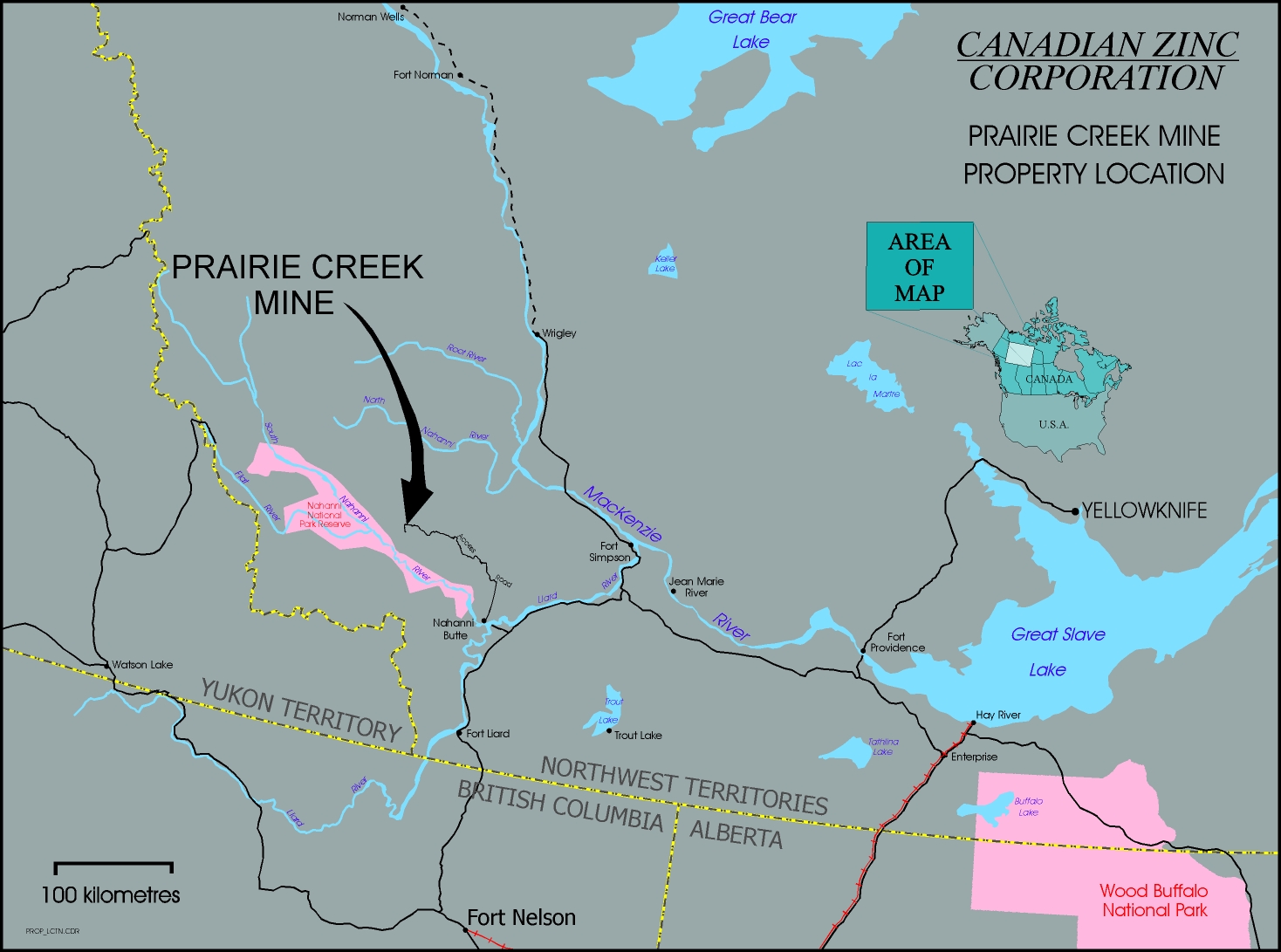
Year round access to the Property is provided by aircraft to a 3,000-foot gravel airstrip immediately adjacent to the camp. The Prairie Creek Property is also accessible by road which extends from the Property to the Liard Highway, a distance of 170 kilometres and which was originally permitted for use in the winter months throughout its full length and for year round use for the first 40 kilometres out from the mine site. The road needs to be re-established, which the Company plans to perform in 2008 upon receipt of pertinent permits and authorization. The Liard Highway #7 is the major north-south transportation route, which connects Fort Nelson, British Columbia to Fort Simpson, Northwest Territories.
The climate is sub-Arctic, being characterized by long cold winters with pleasant summers. Snowfall is moderate and only minor difficulty has been experienced in operating throughout the winter months.
| 3.1.3 | Property Geological Summary |
Regional Geology
The 1987 Geological Survey of Canada Memoir 412 by Morrow and Cook provides the best description of the regional geological setting of the Property. Morrow and Cook describe the stratigraphy that accumulated during Siluro-Devonian time and formed in a paleo-basin adjacent to the ancient North American Platformal sediments. The east-dipping Tundra Thrust (that is located on the Property) and, 30 kilometres to the west, the west-dipping Arnica Thrust, define the present margins of the Prairie Creek paleo-basin in which accumulated a thick Devonian sequence of sediments, including the Cadillac and Funeral Formations.
Units within the Prairie Creek paleo-basin underwent structural deformation in the form of folds and faults during regional Laramide deformation. The prevalent regional structural trend is approximately north-south; the Prairie Creek paleo-basin is broken into a series of north-south trending, five to 20 kilometre wide fault blocks.
Property Geology
Canadian Zinc’s existing mineral claims and leases overlie two major fault blocks of sediments: the Prairie Creek Block and western Gate Block. The north-eastern part of the Property also includes some of the marginal platformal sequence of rocks that are relatively undeformed by the faulting and folding that is apparent within the Prairie Creek paleo-basin sequence.
Marginal Platform. The northern part of the Company’s claims, from Lease 3313 south to the Way 2 mineral claim, straddles the Tundra Thrust, which separates the Prairie Creek paleo-basin sequence to the west from the platformal series of sedimentary formations to the east. The platformal sediments are relatively undeformed and comprise a stratigraphic sequence starting with the Road River Formation that is overlain by the Root River, Camsell and Sombre Formations (listed from oldest to youngest). Mississippi Valley-type mineralization is hosted in biohermal reefs of the Root River Formation, or facies equivalent.
In the southern part of the Company’s claims a reverse fault continuation of the Tundra Thrust separates the Prairie Creek Block from the marginal platform, approximately two kilometres east of the Mine Site. The Platformal sequence in this area is dominated by a thick assemblage of Sombre Formation dolomites.
Prairie Creek Block. Overall, the southern part of the Property is outlined by a one to two kilometre wide, doubly plunging antiform with a north-south trending fold axis that is referred to as the Prairie Creek Block. It is bordered to the west by the so-called Gate Fault and to the east by the Tundra Thrust. It is underlain by a conformable sedimentary sequence including the Lower Ordovician Whittaker Formation dolomites, Silurian Road River Formation shales and the thinly bedded, limy shales of the Cadillac Formation. Lower to Middle Devonian Arnica and Funeral Formation dolomites and limestone overlie this assemblage on the northern part of the Property.
Structurally, the longitudinal arch of the antiform occurs approximately five kilometres south of the Mine Site. A local fault, referred to as the Prairie Creek fault, offsets the eastern flank of the antiformal fold and juxtaposes Cadillac stratigraphy against the Road River Formation. Erosion of the antiformal structure has resulted in windows of older Road River shales, cored by the Whittaker Formation dolomites. The antiform plunges at about 15 degrees to the north, so the geological units young in age to the north, which is also the case underground.
Gate Mineral Claims. The six contiguous Gate claims (that together define what is termed the Gate Block) are located to the west of the main mining leases and overlie similar type rock assemblages to those found on the Prairie Creek Block. Grassroots exploration was completed on this ground to test for mineralization similar to that found in the Prairie Creek Block.
The geological formations of the Whittaker and Road River Formations are known to occur within the Gate Block, as relatively flat-lying to gently dipping units. Compared to the Prairie Creek Block, there is much more exposure of the prospective Whittaker Formation in the Gate Block.
Main Zone Geology. The Mine Site is situated on the western flank of the Prairie Creek antiform, referred to as the Main Zone. It is Main Zone mineralization that was and is the focus for Mine development and exploitation.
The three levels of available underground development assist in identifying the detail of Main Zone geology:
• 870 metre Level is collared in the Ordovician, Upper Whittaker Formation, which is the oldest geological formation in the Main Zone area and which forms the core of the Prairie Creek antiform;
• the Whittaker Formation is in turn overlain by a large exposure of the carbon-rich graphitic shales/dolomites of the Road River Formation;
• the iron-bearing Cadillac Formation shales overly the Road River Formation and are located immediately adjacent to the Mine Site; and
• the bluff-forming rocks immediately to the west of the Mine Site are formed by the cherty Arnica Formation which overlie the Cadillac Formation and form the more resistant hilltops in the immediate vicinity of the Mine Site.
Property Base Metal Mineralization
Three main styles of base metal mineralization have been identified on the Property: Vein mineralization (sulphide with secondary oxide), Stratabound sulphides and Mississippi Valley type sulphides (“MVT”). Exploration at Prairie Creek has revealed many base metal mineral showings along the entire 17-kilometre length of the Property. Historical exploration of the property has led to referencing some of these surface mineral showings by name and some by numbers.
• Quartz vein mineralization occurs in a north-south trending, 16 kilometre long corridor in the southern portion of the Property where the occurrences are exposed on surface;
• the mineralized vein showings are referred to as sequentially numbered Zones, some ofwhich are known to contain sub-surface stratabound mineralization:
- the subsurface area above the underground workings is referred to as Zone 3 or the Main Zone,
- extending for about ten kilometres to the south of the Mine Site is a semi-continuous pattern of other vein exposures referred to as Zones 4 to 12, inclusive,
- a further expression of vein mineralization, known as the Rico showing, is located approximately four kilometres to the north of the Main Zone; and
• the MVT showings in northern section of the Property are developed over a distance of approximately ten kilometres. They are referred to, from north to south, as the Samantha, Joe, Horse, Zulu, Zebra and Road showings.
Stockwork and stratabound mineralization is not exposed on surface; it has only been intersected in drillholes. These mineralized bodies have not been individually named.
Vein Mineralization. Vein mineralization comprises massive to disseminated galena and sphalerite with lesser pyrite and tennantite-tetrahedrite in a quartz-carbonate-dolomite matrix. Secondary oxidation is locally developed to variable levels of severity, yielding mainly cerussite (lead oxide) and smithsonite (zinc oxide); minor oxidation only of tetrahedrite-tennantite has been found. Silver is present in solid solution with tennantite-tetrahedrite and to a lesser extent with galena. Vein widths vary between less than 0.1 metre and more than five metres; overall averages indicate a horizontal thickness (i.e. not true thickness) of approximately 2.7 metres.
The most extensively developed vein is the Main Quartz Vein which trends approximately north-south and dips between the vertical and 40 degrees east (average = 65 degrees east). It remains open to the north and is expected to continue for a further four kilometres to the south, evidence for which is the so-called Rico showing. Diamond drilling to depth has indicated its transverse continuance, but little information is currently available below an elevation of 600 metres above mean sea level (i.e. about 250 metres below the Mine Site elevation).
Vein mineralization developed within the cherty dolomites of the Ordovician-Silurian, Upper Whittaker Formation and shaley dolomites of the lower Road River Formation. It apparently formed in axial plane of weakness within the Prairie Creek structural antiform:
• it is thought that the more competent units of the Lower Road River and Whittaker Formations more readily formed tension features in which vein sulphide mineralization is hosted; and
• the rock type changes to a much more graphitic shale in the mid- and upper-parts of the Road
River Formation, which units are less competent and provide a poor host for the vein-type formation.
For example, at the end of 930 metre Level the Main Quartz Vein can be seen to dissipate into the mid- Road River shales. The vein does not appear to be well developed in either the upper shales of the Road River and Cadillac Formations.
Preliminary structural evidence suggests that the various mineralized vein showings might be structurally linked, as a series of en-echelon segments comprising a single, but nevertheless structurally complex, mineralized vein structure. The presence of an en-echelon vein structure might go a long way to explaining the apparent off-sets between the various vein showings.
Towards the end of 930 metre Level (at Crosscut 30) a series of narrow (average 0.5 metre wide), massive sphalerite-tennantite veins are developed at about 40 degrees to the average trend of the Main Quartz Vein. This mineralization is referred to as the (vein) stockwork that is postulated to have developed in tensional openings formed by primary movement along the main vein structure. Oxidation is not apparent; the sulphide mineral assemblages are reported by the Company to be similar to those outlined for Main Quartz Vein material.
Stratabound Mineralization. Stratabound mineralization was discovered in 1992 while drilling to extend Vein resources at depth. So far indications of Stratabound mineralization have been found by drilling along the trend of the Prairie Creek Vein System over a strike length of more than 3 kilometres. This type of deposit has so far been located by drill holes in the Main Zone as well as in Zones 4, 5 and 6.
Oxidation is low in stratabound mineralized material, the sulphide mineralization:
• is generally fine-grained, banded to semi-massive and comprises massive fine-grained
sphalerite, coarse-grained galena and disseminated to massive pyrite (silver is contained in solid solution within galena);
• contains no tennantite-tetrahedrite and very little copper; and
• contains only half as much galena as, but substantially more iron sulphide/pyrite than, typical vein material.
The majority of stratabound massive sulphides located thus far occur mainly within a Mottled Dolomite unit of the Whittaker Formation, which the mineralization totally replaces without any significant alteration. The stratabound sulphides are developed close to both the vein system and the axis of the Prairie Creek anticline; the vein structure cuts through the stratabound indicating the vein to be younger than the stratabound deposit. An apparent thickness of 28 metres of stratabound mineralization has been intersected in Main Zone drillholes where it occurs approximately 200 metres below 870 metre Level.
Mississippi Valley Type Sulphides – (“MVT”). The MVT mineralization found on the Property is comprised of colliform rims of sphalerite, brassy pyrite-marcasite and minor galena, with or without later dolomite infilling. The mineralization appears to occur discontinuously within coarse biohermal reefs of the Root River Formation, and always at approximately the same stratigraphic horizon. It appears to be classic MVT mineralization, insofar as it occurs in open cavity-type settings.
During 1999 the Gate 1-4 Mineral Claims were staked covering an area of 9,245.35 acres to the west of the main property adjacent to the existing land holdings. A small exploration program on the newly staked mineral claims consisted of geological mapping, soil and rock sampling over areas that contain similar geology with that of the Prairie Creek Property. This exploration resulted in the discovery of a Vein in outcrop, with select samples grading similar with that of the main established Vein at the Prairie Creek Property. Also a large zinc soil anomaly was located over favourable geology. A small heli-portable drilling program was carried out on part of the Gate Claims during 2007 but revealed no significant mineralization in drillcore.
In 2000/2001, the Company completed a preliminary Scoping Study designed to outline and guide the re-development of the existing mine and mill on the Prairie Creek Property.
The Study took six months to complete and included metallurgical testwork, mill re-design, alternative mining methods, inclusion of paste backfill in the mine design, capital and operating cost estimates, a review of smelter terms and conditions for the Prairie Creek concentrates and other operating parameters. In connection with the Scoping Study further metallurgical samples were collected and the mill equipment was reassessed. The road access corridor, tailings pond and the underground workings were re-examined for future production considerations and capital cost estimates. The Scoping Study was prepared in-house using consultants and contractors at a cost of approximately $0.4 million. The Scoping Study has not been updated.
The complete Scoping Study, dated January 29, 2001, has been filed on SEDAR, and may be found under the Company’s profile on SEDAR at www.SEDAR.com [Technical Reports April 24, 2001].
It should be noted that the economic assessment in the Scoping Study was preliminary and based, in part, on mineral resources that are considered too speculative geologically to have the economic considerations applied to them that would enable them to be categorized as reserves in accordance with National Instrument 43-101. Mineral resources that are not mineral reserves do not have demonstrated economic viability. In addition, the Scoping Study was preliminary in nature, despite the existing underground development and the on-site mill, and the assumptions made within the Scoping Study and its subsequent results may not be attained.
The Scoping Study outlined the plan for the development of the Prairie Creek Project was based on the historical development and existing infrastructure at the Prairie Creek Property and on the Resource Estimation. The Resource Estimation does not constitute mineable reserves. The historical development was carried out principally in 1980 to 1982 and the infrastructure, including the mill, was constructed in the same period based on a feasibility study prepared by Kilborn Engineering (Pacific) Limited in 1980. The Kilborn feasibility study is outdated and cannot be relied upon. The existing infrastructure, including the mill, buildings, camp etc. is now over twenty-five years old and although it has been held under care and maintenance it has lain idle for more than twenty-five years and was never operated. There is a significant risk attaching to the proposed operation of aged equipment.
The Scoping Study is now considered to be out of date and should not be relied upon. The indicated capital costs were estimated in 2000 and are now outdated. The Company anticipates that the capital costs to place the Prairie Creek Mine into production will be significantly greater than estimated in the Scoping Study.
| 3.1.6 | Exploration Activities |
The 2007 program included the continuation of the underground drilling program which commenced in 2006. Underground drilling was carried out from drill stations at 50 metre intervals along a new 400 metre internal decline. Phase 1 of the drilling program was completed in early June 2007 and consisted of 400 metres of decline development from which 41 drill holes, of which 40 intersected mineralization, totaling 8,217 metres of drilling from six drill stations have been completed. The results of the Phase 1 program were incorporated into a Technical Report dated October 12, 2007 which was prepared in accordance with the standards in National Instrument 43-101 as described in “Section 3.1.7--2007 Resource Estimation” below.
Phase 2 of the underground exploration program commenced in August 2007 with the completion of a further 200 metre extension of the underground decline to create additional underground drill stations. The underground drilling program from the new drill stations commenced in late September 2007 and continued until December 2007. Ten holes totaling 2,407 metres of coring were completed, all of which intersected mineralization.
A summary of the Phase 1 and 2 underground exploration programs at Prairie Creek as described above is included below:
| Timeframe | Advance |
August - December 2006 | Cross-cut: 75 metres Decline: 350 metres Cut outs/safety bays/sumps: 20 metres Drill stations: 6 |
September - November 2007 | Decline: 200 metres Cut outs/safety bays/sumps: 5 metres Drill stations: 4 |
TOTAL | Cross-cut: 75metres Decline: 550m Cut outs/safety bays/sumps: 25 metres Drill stations: 10 |
Drilling:
| Timeframe | Number of holes | Coring (metres) |
| October 2006 - May 2007 | 41 (Phase 1) | 8,217 |
| September 2007 - December 2007 | 10 (Phase 2) | 2,407 |
| TOTAL | 51 | 10,624 |
Between July and early September 2007 the Company also carried out a surface helicopter supported diamond drill exploration program totaling 1,671 metres of core in 12 holes. This reconnaissance drilling program was targeted in the Gate Claims, located about 5 kilometres west of the Prairie Creek minesite, and in Zones 8, 9 and 11 located on the same Prairie Creek geological structure as the minesite but located 5 – 10 kilometres south of the minesite. No significant mineral intersections were encountered. The data from this drill program is currently being incorporated into the Prairie Creek property dataset in order to determine future exploration strategy.
| 3.1.7 | 2007 Resource Estimation |
In October 2007, an updated Technical Report (the “Report”) with regard to Mineral Resource Estimation on the Main Zone at Prairie Creek was independently prepared by Minefill Services Inc. (David Stone and Stephen Godden – Qualified Independent Persons), following the results of part of the 2006/7 underground drilling program, in compliance with the standards in National Instrument 43-101. This report verifies and confirms the previous historical resource estimate completed in 1998 and notes significant upgrades in resource categories resulting from the 2006/2007 underground drilling.
The Report indicates that the Prairie Creek Property hosts total Measured and Indicated Resources of 5,840,329 tonnes grading 10.71% zinc, 9.90% lead, 161.12 grams silver per tonne and 0.326% copper. In addition, the Report confirms a large Inferred Resource of 5,541,576 tonnes grading at 13.53% zinc, 11.43% lead, 215 grams per tonne silver and 0.514% copper and additional exploration potential. A summary table is presented below:
| Zone | Classification | Tonnes | Ag (g/t) | Cu (%) | Pb (%) | Zn (%) |
| Main Quartz Vein | Measured | 938,624 | 211.89 | 0.465 | 11.63 | 13.11 |
| Indicated | 2,944,862 | 212.39 | 0.472 | 12.67 | 11.16 |
| Measured + Indicated | 3,883,486 | 212.27 | 0.470 | 12.41 | 11.63 |
| Inferred | 5,516,297 | 215.53 | 0.516 | 11.46 | 13.55 |
| Stockwork | Indicated | 682,165 | 50.15 | 0.112 | 2.68 | 5.85 |
| Inferred | 4,045 | 51.31 | 0.126 | 2.51 | 5.54 |
| Stratabound | Measured | 611,417 | 67.6 | - | 6.68 | 10.85 |
| Indicated | 663,261 | 62.0 | - | 5.53 | 10.15 |
| Measured + Indicated | 1,274,678 | 64.7 | - | 6.08 | 10.49 |
| Inferred | 21,234 | 55.7 | - | 5.65 | 10.49 |
| Combined | Measured | 1,550,041 | 154.9 | 0.282 | 9.67 | 12.22 |
| Indicated | 4,290,288 | 163.3 | 0.342 | 9.98 | 10.16 |
| Measured + Indicated | 5,840,329 | 161.1 | 0.326 | 9.89 | 10.71 |
| Inferred | 5,541,576 | 214.8 | 0.514 | 11.43 | 13.54 |
Note: copper grades for stratabound material were not estimated due to the consistently low to negligible assay grades reported in the available database.
Cautionary note: Mineral Resources that are not mineral reserves do not have demonstrated economic viability. Inferred mineral resources are considered too speculative geologically to have economic considerations applied to them that would enable them to be categorized as mineral reserves and there is no certainty that all or any part of an inferred mineral resource will ever be upgraded to a measured or indicated mineral resource or to a mineral reserve.
Highlights of the Report include:
| · | Total Measured and Indicated Resource calculated at 5.8 million tonnes at >20% combined lead and zinc; |
| · | Measured Resources in Vein tonnage increased 73% at 25% combined lead and zinc with 212 grams per tonne silver; |
| · | Indicated Resources in Vein tonnage increased 105% at 24% combined lead and zinc with 212 grams per tonne silver; |
| · | Inferred Resource in Vein calculated at 5.5 million tonnes at 25% combined lead with silver with 216 grams per tonne silver; |
| · | Average increase of 10% in silver grades; and |
| · | Confirmation of grade and continuity in a NI 43-101 compliant resource report. |
The Resource estimate was determined applying the following methodology:
One metre composites were created from the assay data honoring the geological zone codes provided in the dataset. Classical statistics were gathered for silver, copper, lead and zinc, as well as for each of the three mineralized zones considered in analysis (Main Quartz Vein, stockwork and stratabound).
A three-dimensional block model was developed; a block size of ten metres (easting) by 30 metres (northing) by 30 metres (elevation) was used. Inverse distance weighting with a power of three was used for all three mineralized zones; grades were interpolated for silver, copper, lead and zinc.
A primary search distance of 300 metres was used to enable filling of all the blocks in the down-plunge extension of the Main Quartz Vein. The search direction was orientated along a major axis of 357 degrees and a dip of 65 degrees east (i.e. to conform to the average strike and dip of the vein). The search was horizontal between sections 1,055N and 1,825N and plunging at 15 degrees north from sections 1,825N to 3,155N.
Coded composites from the same zone as the block being estimated were selected for block estimation. The minimum length composite selected for grade interpolation was 0.3 metres. The minimum number of composites used for the interpolation was one and the maximum was ten. The maximum number of composites per hole was limited to three, to thereby provide a more uniform grade interpolation. The resource grades include all intercepts in a specific area and had no blocks removed by cut-off grade, which is appropriate for the type of massive sulphide, selective mineralization considered in analysis.
The Measured and Indicated Resource is now capable of supporting a mine life in excess of ten years at the planned 1,000 – 1,300 tonnes per day production rate.
The complete Technical Report has been filed on SEDAR, and may be found under the Company’s profile on SEDAR at www.SEDAR.com [Technical Report (NI 43-101) October 16, 2007].
Cautionary Note to United States Investors Concerning Estimates of Measured, Indicated or Inferred Resources:
The information presented herein uses the terms “measured”, “indicated” and “inferred” mineral resources. United States investors are advised that while such terms are recognized and required by Canadian regulations, the United States Securities and Exchange Commission does not recognize these terms. “Inferred mineral resources” have significant uncertainty as to their existence, and as to their economic feasibility. United States investors are cautioned not to assume that all or any part of an inferred mineral resource exists or is economically mineable. It cannot be assumed that all or any part of an inferred mineral resource would ever be upgraded to a higher category. United States investors are cautioned not to assume that all or any part of measured or indicated mineral resources will ever be converted into mineral reserves.
| 3.1.8 | 2008 Pre-Feasibility Study |
The Company is now examining the various alternatives outlined within the 2001 Scoping Study and is working towards updating and converting this into a Pre-Feasibility study. As a prelude to completing the Pre-Feasibility program, the Company has carried out the following programs:
During 2004, 2005 and 2006 metallurgical testing was carried out on the mineralization from the Prairie Creek mine. During 2004 representative bulk samples of vein mineralization were extracted from various locations within the existing underground workings at the Prairie Creek mine. In addition, diamond drill core samples of Stratabound Mineralization were also collected from this deeper lying deposit which has not yet been accessed by underground development. Vein mineralization type was collected in the upper and lower level of existing developed underground workings. It is typically high in zinc, silver and lead in a mixture of sulphide and oxide minerals. Stratabound mineralization contains zinc, lead, silver and iron sulphide minerals.
The metallurgical samples were shipped to SGS Lakefield Research Laboratories at Lakefield, Ontario (“SGS Lakefield”) where a total of 60 bench scale tests were undertaken over six months under the direction of the Company’s metallurgical consultant. The samples were first assayed for both sulphide and oxide mineralization and then combined into composite samples to ensure true representation of the Prairie Creek mineral deposit. Mineral samples from two separate zones of vein mineralization (Upper and Lower Zones), and including both sulphide and oxide mineralization, and from the stratabound zone, and additional composite samples from all three zones, were tested to develop and optimize the Prairie Creek mill flow sheet. The batch and locked cycle tests provided extensive analytical information and positive metallurgical results.
During 2006 a new metallurgical bulk sample was collected from multiple headings of the vein within the existing underground development and also shipped to SGS Lakefield for further testing and optimization studies. These samples were composited and blended to create representative samples of the ore that will provide feed to a future operating mill. The metallurgical program has shown that heavy media separation, demonstrated in earlier tests, is repeatable and that higher grade concentrates can be produced by processing the upgraded material.
Discussions with concentrate sales professionals and preliminary discussions with smelters indicate that the Prairie Creek concentrates will be readily saleable, subject to the payment of usual penalties for elevated impurity levels, including mercury, in the Vein zinc, lead and copper concentrates.
The development plan for the Prairie Creek Project will now be updated and based upon the updated Technical Report with regard to Mineral Resource Estimation on the Main Zone at Prairie Creek which was independently prepared by Minefill Services Inc. as described in Section 3.1.7 2007 Resource Estimation. The Pre-Feasibility Study, which is being undertaken by SNC-Lavalin Inc., is scheduled to be completed in 2008.
| 3.1.9 | Permitting at Prairie Creek |
(a) Regulatory Framework
At the time of its construction in 1980 - 1982, the Prairie Creek mine had been fully permitted for full scale mining and milling operations. Permitting had been undertaken under the regulatory regime of the day, which involved a comprehensive environmental assessment and public review before the Northwest Territories Water Board. A considerable number of technical and baseline studies describing the proposed development and the physical and biological environment were undertaken at that time.
Water License N3L3-0932 was issued by the Department of Indian Affairs and Northern Development on July 1, 1982 pursuant to the Northern Inland Waters Act and Regulations, authorizing the use of up to 1,150 m3/day and 420,000 m3/year of water from the Prairie Creek Valley Aquifer and setting standards for discharge of process effluent to Prairie Creek. Land Use Permit N80F249 was issued July 2, 1980 for the road connecting Prairie Creek to the Liard Highway, the first 40 kilometres being permitted for year round use with the remaining 130 kilometres permitted for use in winter months only. The Land Use Permit was extended in 1981 and again in 1982 to June 1983. Surface Leases were issued for the minesite area and airstrip. The Water License and Land Use Permit subsequently expired.
In 1998, a totally new regulatory and resource management scheme was introduced in this part of Canada. During the negotiation of native land claim settlements in the Mackenzie Valley, first with the Dene/Metis in the late 1980’s and then with the Gwich’in and Sahtu Dene/Metis people, the Federal Government agreed to establish a new resources management system through the creation of boards with joint membership which reflects First Nations’ desire to participate more effectively in the regulation of land and water throughout the Mackenzie Valley.
The Mackenzie Valley Resource Management Act (“MVRMA” or the “Act”) was enacted in 1998 for a defined area called the “Mackenzie Valley,” which includes the area where the Prairie Creek Mine is situated. Prior to that, the applicable legislation was the Canadian Environmental Assessment Act, S.C. 1992 c.37. (“CEAA”). The CEAA no longer applies in the Mackenzie Valley, except under very specific situations.
The MVRMA is a piece of federal legislation that creates an integrated co-management structure for public and private lands and waters throughout the Mackenzie Valley in the Northwest Territories. The Act was proclaimed on December 22, 1998; however, Part IV, which establishes the Mackenzie Valley Land and Water Board, was not proclaimed until March 31, 2000.
The overall legislative scheme of the MVRMA is designed to implement the Gwich’in and the Sahtu Land Claim Settlement Agreements (collectively the “Comprehensive Agreements”) by providing for an integrated system of land and water management in the Mackenzie Valley. Under the Comprehensive Agreements, Land Use Planning Boards and Land and Water Boards must be established for the settlement areas referred to in those Agreements. In addition, an Environmental Impact Review Board must be established for the Mackenzie Valley along with a Land and Water Board for an area extending beyond the settlement areas.
The Act established public boards to regulate the use of land and water, to prepare regional land use plans to guide development, and to carry out environmental assessment and reviews of proposed projects in the Mackenzie Valley. The Act also makes provisions for monitoring cumulative impacts on the environment, and for periodic, independent environmental audits.
As institutions of public government, the Boards regulate all uses of land and water while considering the economic, social and cultural well-being of residents and communities in the Mackenzie Valley. These Boards are charged with regulating all land and water uses, including deposits of waste, in the areas in the Mackenzie Valley under their jurisdiction.
The MVRMA ensures a greater role for Aboriginal people in land use planning, environmental assessment, and the regulation of land and water use. As stated in the MVRMA, ‘the purpose of the establishment of boards by this Act is to enable residents of the Mackenzie Valley to participate in the management of its resources for the benefit of the residents and of other Canadians.’ To reflect the desire of First Nations to be more actively involved in resource management decision-making, half the members of each Board will be nominated by First Nations, and half by the Federal and Territorial governments. Public boards are formed through nominations. Under the land claims agreements, First Nations are entitled to nominate one-half of the members of the board, reflecting the board’s jurisdiction over all lands including First Nation settlement lands. The Federal Government, Territorial Government and First Nations can each nominate at their own discretion.
The Act also anticipates amendments to accommodate new land settlements and self-governments as they are finalized. As land claims are settled, the Act provides for additional regional boards to be established in the Dehcho, North Slave and South Slave regions. The Dehcho area is not settled. Prior to additional regional Boards being established, First Nations in the Dehcho region were asked to participate in the new system by recommending members to the Mackenzie Valley Environmental Impact Review Board and the Mackenzie Valley Land and Water Board.
Under the MVRMA, public boards are responsible for:
| · | preparing regional land use plans to guide the development and use of land, waters and other resources [Land Use Planning Board]; |
| · | regulating all uses of land and water [Mackenzie Valley Land and Water Board (MVLWB)]; and |
| · | carrying out the environmental assessment and review process [Mackenzie Valley Environmental Impact Review Board (MVEIRB)]. |
Consultation is the cornerstone of the MVRMA. Public Boards under the Act have established their own consultation guidelines.
Each Board has its own specific jurisdiction.
The Land Use Planning Board develops and implements a land use plan for the respective settlement areas in the Mackenzie Valley.
Land and water boards issue land use permits and water licenses under the Mackenzie Valley Land Use Regulations and the Northwest Territories Waters Act and Regulations, within the Mackenzie Valley.
The MVEIRB is responsible for environmental impact review and assessment at a valley-wide level, including the Sahtu and Gwich’in settlement areas.
The public boards perform regulatory functions, such as permitting and licensing, and conducting environmental reviews, previously undertaken by the Department of Indian Affairs and Northern Development (DIAND) and the NWT Water Board. Inspection and enforcement continue to be the responsibility of DIAND.
After consultation with the Land and Water Board, the Minister of DIAND may give written policy direction to the Board with respect to the exercise of any of its functions. The Minister also approves the issuance of Type ‘A’ water licenses. Regarding a Type ‘A’ water license, the Minister may attach terms and conditions such as provision for a security deposit, a requirement for water quality and quantity measurements, and a requirement for abandonment and restoration plans.
DIAND controls, manages and administers all Crown lands in the Mackenzie Valley under the authority of the Territorial Lands Act, and the Federal Real Property Act. Aside from managing Crown lands and waters, DIAND is still responsible for the administration, inspection and enforcement requirements associated with renewable, non-renewable and environmental legislation. This includes the Mackenzie Valley Resource Management Act, the Northwest Territories Waters Act, and the Federal Real Property Act.
DIAND inspectors are responsible for ensuring compliance with legislation, regulations and the terms and conditions that are part of permits and licenses issued by the Land and Water Boards. These responsibilities are exercised by DIAND under the authority of the Territorial Lands Regulations, Territorial Quarry Regulations, Canada Mining Regulations and the Federal Property Regulations.
Under the Northwest Territories Waters Act, S.C. 1992, (C.29) (Waters Act) no person can use water or deposit waste in specific areas in the Northwest Territories without a license to do so. Section 102 of the MVRMA provides that it is the MVLWB which has the jurisdiction with respect of all uses of water and deposits of waste in the area for which a license is required under the Waters Act. The MVLWB may issue, amend, renew and cancel licenses in accordance with the Waters Act and exercise any other power of the Northwest Territories Water Board under the Waters Act.
The stated objective of the MVLWB is to “regulate the use of land and waters and the deposit of waste so as to provide for the conservation, development and utilization of land and water resources in a manner that will provide optimum benefit to the residents of the settlement areas and of the Mackenzie Valley and to all Canadians.” The MVLWB’s main function which is relevant to the Company, is to issue land use permits and water licenses on land in unsettled land claim areas in the Mackenzie Valley, inclusive of the Dehcho area.
On November 7, 2007 the Minister of Indian Affairs and Northern Development announced the Northern Regulatory Improvement Initiative and the appointment of a Special Representative responsible to advance this initiative. As announced by the Minister, the Northern Regulatory Improvement Initiative is a strategy to improve the current regulatory regime and the overall Northern regulatory environment and to ensure that regulatory regimes across the North are effective and predictable, and will better equip the North to develop and benefit from its resources in the best way possible. The Minister’s Special Representative has been asked to work to improve existing regulatory regimes across the North, and to submit a report to the Government of Canada outlining proposed recommendations for advancing the regulatory regime, after which Canada will develop a strategy for action. The Special Representative is expected to report to the Minister in April 2008.
(b) Permitting Process
All applications for a land use permit or a water license in relation to a development in the Mackenzie Valley are made to the Water Board or one of its regional boards, as determined by the location of the development. In the case of Prairie Creek, being located within the Dehcho First Nations territory, for which a land claim settlement agreement has not as yet been reached, applications are processed by the MVLWB.
There are three stages in the environmental impact assessment process in the Mackenzie Valley: preliminary screening, environmental assessment and environmental impact review. Not all developments will necessarily go through each of the three stages. All projects undergo a preliminary screening, after which it is decided whether a project must proceed to a full environmental assessment or go straight to the regulatory phase.
The environmental impact assessment process is triggered by an application to the MVLWB for a water license. The application requires the inclusion of certain baseline and other technical information to allow them to be appropriately assessed and processed. Information provided with an application is used for undertaking a preliminary screening and for regulatory review of the application.
Preliminary screening is the first step in the environmental impact assessment process. Preliminary screening applications are done by the Land and Water Board. It is during the preliminary screening that the Board determines whether there is any public concern related to a proposed project or if it might have significant adverse environmental impacts.
During the preliminary screening, a systematic approach is taken to documenting the potential environmental effects of a proposed project. Next, the Board determines whether these effects need to be eliminated or minimized and, if so, how the project plan should be modified. In the end, the Board makes a recommendation on the need for further assessment.
The legislation requires that the MVLWB conduct a pre-screening of a proposal for development (s.124). Where the MVLWB determines that the development might have a significant adverse impact on the environment, or might be a cause of public concern, the MVLWB refers the proposal to the MVEIRB for an environmental assessment (s.125).
Environmental assessment is the second stage of the environmental impact assessment process. Projects may be referred to the MVEIRB by the Water Board (the preliminary screener), some other government department or agency, the First Nation qualified to make a referral, or on the Mackenzie Valley Environmental Impact Review Board’s own motion.
The MVEIRB is responsible for the environmental impact assessment process throughout the Mackenzie Valley. It is the main instrument for environmental assessment and review, replacing the CEAA in the Mackenzie Valley except under specific instances.
The MVEIRB:
| · | Conducts environmental assessments; |
| · | Conducts environmental impact reviews; |
| · | Maintains a public registry of all preliminary screenings conducted by Regulatory Authorities; and |
| · | Makes recommendations to the Minister of DIAND for rejection or approval of any proposal. |
Once a development proposal is referred to the Mackenzie Valley Environmental Impact Review Board for an environmental assessment, notices are placed in northern newspapers. The next step is for the developer to submit a “project description” to the Review Board. The project description describes what the developer plans to do and how it will be carried out. The MVEIRB develops a work plan and terms of reference in order to conduct the Environmental Assessment.
The public has an opportunity to comment on the project and identify issues which may require consideration. Public information submitted to the Review Board throughout this process, including the project description, and all technical and public submissions, are placed on a public registry.
The Review Board has guidelines for how they conduct environmental assessments. These guidelines provide information for submissions to the Review Board, including timelines and opportunities to present information at any public hearings that may be held. The environmental impact assessment process has several points where the local government and other stakeholders can contribute to and affect the regulatory process. There will also be occasions where the local government will be asked to comment on a proposed development.
The environmental assessment process looks at the same factors considered in the preliminary screening, as well as addressing potential cumulative effects, socio-cultural considerations and alternate means of carrying out the project that are technically and economically feasible and the potential environmental effects of such alternate means. If the Mackenzie Valley Environmental Impact Review Board determines there will be significant adverse environmental impact from a project, it has the choice of referring the development to an environmental impact public review before a panel. The Review Board may also recommend measures to prevent or mitigate these impacts.
The environmental impact review (“EIR”) stage is a detailed analysis and public review. This is normally reserved for development projects where the environmental impact may be significant and could include public hearings in affected communities. An environmental impact review is conducted by a panel consisting of members of the Mackenzie Valley Environmental Impact Review Board, as well as any expert members they may appoint. The panel is required to issue terms of reference and the applicant must submit an impact statement. There must be public notification of the submission of the impact statement, and public consultation or hearings in communities which may be affected by the development. The panel conducts an analysis of the information received.
Upon completing the assessment, the MVEIRB submits its Environmental Assessment Report (“EAR”) to the Federal Minister of Indian Affairs and Northern Development who is responsible for distributing the EAR to other Ministers with jurisdiction over the proposed development (s.128).
The Minister of DIAND, along with the other Responsible Ministers, is required to make a decision on the EAR. The Minister may adopt the recommendations of the Mackenzie Valley Environmental Impact Review Board, refer the report back to the Review Board for further consideration (s.130) or reject the Report and order further environmental impact review. Once the recommendations contained in the EAR are adopted by the Minister, and the other responsible Ministers, those recommendations are to be included by the MVLWB as conditions of any Water License or Land Use Permit that it issues for that proposed development (s.62).
When finally adopted by the Minister the application is sent to MVLWB for issuance of permits and licenses by the MVLWB in the regulatory phase. The regulatory phase is the process of issuing regulatory authorizations once the development is approved through the environmental assessment process. The authorizations include terms and conditions which reflect the recommendations approved during the EA process, as well as other standard conditions for carrying out development.
Decisions of the Mackenzie Valley Land and Water Board are subject to review by the Supreme Court of the Northwest Territories.
| (c) | “Grandfather” Provisions |
Part 5 of the Mackenzie Valley Resource Management Act, S.C. 1998, C.25 requires that any “proposals for development” comply with environmental assessment process consisting of a preliminary screening by the regulatory authority and, if applicable, an environmental assessment and an environmental impact review by the Mackenzie Valley Environmental Impact Review Board.
However, Section 157.1 of the Act provides that Part 5 does not apply in respect of any license, permit or other authorization related to an undertaking that is the subject of a license or a permit issued before June 22, 1984, except the license, permit, or other authorization for an abandonment, decommissioning or other significant alteration of the project.
Section 157.1 of the Act has been considered by the Court of Appeal of the Northwest Territories in the case North American Tungsten Corporation Ltd. V Mackenzie Valley Land and Water Board (2003 NWTCA5). In that case the Court said (at paragraphs 24 to 27):
“24 However, both the Comprehensive Agreements and the MVRMA also clearly recognize that a full scale environmental review will not be appropriate in respect of certain existing permits, projects and licenses. Instead, both reflect some grandfathering of existing developments is required to balance competing interests. Those interests include the legitimate goal of protecting land and water resources in the Mackenzie Valley for the benefit of its citizens, on the one hand, while, at the same time, exempting from the full force of the new environmental legislation undertakings developed under an earlier legislative regime. For example, the Comprehensive Agreements explicitly protect certain mineral interests, and arguably the rights associated therewith, in existence as of the date of the settlement legislation.”
“25 This respect for vested interests is reflected in the MVRMA. Part 7 contains a number of transitional provisions designed to preserve and protect the existing rights and interests. For example, Section 151 provides that certain existing permits continue in effect despite the implementation of the new legislation. Section 152 protects all existing rights to the use of any lands under any lease, easement, or other interest granted under any territorial law, again despite what would otherwise have been the impact of the new legislation on such interests….”
“26 Further confirmation that Parliament did not intend the MVRMA to interfere with existing rights can be seen in the fact that even pending applications for permits and licenses are to be dealt with under the prior applicable legislation and not under the MVRMA….”
“27 These provisions collectively reflect that Parliament did not intend to impose an entirely new environmental review process on every project in the Mackenzie Valley irrespective of the status of that project at the time the MVRMA came into effect. Instead, the MVRMA grandfathered certain projects and provided that others yet would be dealt with under prior applicable legislation. In interpreting Section 157.1 therefore, one must recognize that it is designed to grandfather certain undertakings which predate June 22, 1984. Accordingly, this section must be interpreted in a manner which best comports with its intended purpose.”
The Prairie Creek Project was the subject of both a Water License and Land Use Permit issued prior to June 22, 1984.
In May 2003, the Company applied to the MVLWB for a Land Use Permit for use of the existing road from the Liard Highway to the Prairie Creek Mine. The Company submitted that this development is exempt from the Environmental Assessment process by virtue of Section 157.1 of the Act. The Company’s argument was rejected by the Water Board on June 1, 2004 and the Company filed an Appeal to the Supreme Court of the Northwest Territories seeking judicial review of the decision of the Water Board. The Appeal was heard by the Supreme Court in December 2004.
In a written decision dated May 6, 2005 in the case Canadian Zinc Corporation v Mackenzie Valley Land and Water Board (SCNWT S-0001-CV2004) the Supreme Court of the Northwest Territories ruled in favour of the Company that its Winter Road permit application is “grandfathered” and is therefore exempt from the environmental assessment process under the Mackenzie Valley Resource Management Act (“MVRMA”).
The Supreme Court quoted with approval, the earlier 2003 decision of the Northwest Territories Court of Appeal in the case North American Tungsten Corp. Ltd. v Mackenzie Valley Land and Water Board. The Supreme Court found:
“The reasoning in Tungsten appears to apply squarely to the circumstances of CZC’s (Canadian Zinc Corporation’s) permit application. The Court (of Appeal) referred to the legislative intention that projects which predate June 22, 1984 are to be subjected to a full scale environmental assessment only if they depart significantly from their approved mode of operation and engage in decommissioning, abandonment or significant alteration of the project. The project, in this case, the operation of the winter access road, predates June 22, 1984. As found by the (Water) Board, the permit sought by CZC (Canadian Zinc) is not based on any intentions to significantly alter that project or to abandon or decommission it”.
In its decision the Supreme Court said that the permit sought by Canadian Zinc is related to the operation of the winter access road, a permit in respect of that same undertaking had been issued before 1984, and therefore the exemption provided in Section 157.1 of the MVRMA governs and a Part 5 assessment does not apply.
| (d) | Recent Permitting History at Prairie Creek |
In 1992 the Company was granted an Exploration Land Use Permit by the Minister of Indian Affairs and Northern Development under the Territorial Lands Act. Further baseline studies were undertaken in 1994 in support of planned re-development and permitting activity at that time. A permit application was screened in 1995 as a Level 1 screening pursuant to the Canadian Environmental Assessment Act (CEAA) and it was determined that that project could proceed as it was not likely to cause significant adverse effects pursuant to section 20(1)(a) of the CEAA. A new Exploration Land Use Permit N95F346 was issued by the Minister in 1995 under the Territorial Lands Act, which included use of a portion of the winter road.
In 1995 environmental and geotechnical studies were carried out to facilitate the pre-production permitting process. A project description report was compiled by Rescan Environmental Ltd. and filed with the Northwest Territories Regional Environmental Review Committee (“RERC”). This report contains details of all the environmental work completed at the Prairie Creek Property. The report was filed to elicit terms of reference for an initial environmental evaluation report. A Land Use Permit Application for upgrading the access road to an all-weather road was also filed with the appropriate government agency. While the re-permitting process was subsequently discontinued in 1995, these studies represent a significant contribution to the information database in support the Prairie Creek Project.
The Mackenzie Valley Land and Water Board (MVLWB) was created on March 31, 2000. The MVLWB and its associated regional boards took over regulatory functions previously performed by the DIAND, the Northwest Territories Water Board, and the Government of the Northwest Territory’s Department of Municipal and Community Affairs on Commissioner’s Lands.
The Company initiated preliminary discussions with the new MVLWB and regulatory authorities in Yellowknife in August, 2000 with respect to re-development and re-permitting of the Prairie Creek mine. A follow up presentation was made to the Governmental Mineral Development Advisory Group (“MDAG”) in November 2000 to elicit specific feedback from each of the regulatory agencies on the information requirements necessary for them to fulfill their roles in review of an environmental impact report to be submitted in support of applications for permits and licenses authorizing full production from the Prairie Creek mine.
Since August 2000, Prairie Creek has undergone six Environmental Assessments by the MVEIRB and has received five separate Land Use Permits and a Water License to carry out exploration at the Prairie Creek Mine and in the immediately surrounding area, through the new Mackenzie Valley Resource Management Process.
| (e) | Land Use Permit – Phase 1 Exploration |
Canadian Zinc applied to MVLWB on July 28, 2000 for a Land Use Permit (“LUP”) (MV2000C0030) to carry out a seven drill hole program and to access the Sundog (or CAT) Camp located along the winter road to retrieve fuel and clean up the camp area, which work was planned for the fall of 2000. On October 4, 2000 MVLWB referred the application to the Mackenzie Valley Environmental Impact Review Board for environmental assessment. The application was then split into separate LUP applications with specific reference to the drilling program and the Cat Camp clean-up.
Following environmental assessment, a LUP was issued by MVLWB on June 14, 2001 which permitted the seven drill hole program (MV2000C0030A).
| (f) | Sundog (CAT) Camp – Clean Up Permit |
On May 9, 2001, the Review Board issued its Report to the Minister recommending that the Cat Camp permit be approved but that the work be done in winter 2001/2002. Canadian Zinc preferred to do it in the summer season when the Prairie Creek Camp was open and there would be easier access. In June 2001 Environment Canada issued a direction to DIAND to take steps to prevent the deposit of petroleum products at Cat Camp into the surrounding environment. In March 2002 DIAND flew in and incinerated the fuel. On June 17, 2002, three months after the fuel was incinerated, the Minister of Indian Affairs and Northern Development referred the Environmental Assessment Report back to the Review Board for further consideration, pointing out that it was no longer possible to carry out the proposed development work as there was no longer any fuel to be retrieved. In July 2002 the Review Board dismissed the proceeding.
| (g) | Land Use Permit – Phase 2 Exploration |
On March 5, 2001, the Company submitted a Land Use Permit application for a Phase 2 Exploration Drilling Program and this application was also referred for Environmental Assessment. After Environmental Assessment by the Review Board, on November 30, 2001 the Water Board issued Land Use Permit MV2001C0022A, valid for a period of five years, authorizing the drilling of up to 60 exploration holes on the Zone 3 Mining Lease and within 1000 metres of the Prairie Creek Mine. In November 2006 this Land Use Permit was renewed for a further period of two years to November 30, 2008.
| (h) | Water License and Land Use Permit – Underground Development |
The Company applied to the Mackenzie Valley Land and Water Board on March 5, 2001 for Type ‘B’ Water License and a Land Use Permit (MV2001L2-0003) for underground decline development and metallurgical pilot plant operation planned for the Prairie Creek mine. The application was distributed to government agencies, First Nations communities and other organizations in order for the MVLWB to conduct a preliminary screening as required by Part 5 of the Mackenzie Valley Resource Management Act.
However in April 2001, both the Parks Canada Agency and Pehdzeh Ki First Nation referred the proposal to the Mackenzie Valley Environmental Impact Review Board for Environmental Assessment (“EA”) pursuant to section 126(2) of the MVRMA. The referral to EA occurred prior to the Water Board’s completion of its preliminary screening of the proposed development.
The Environmental Assessment was conducted throughout 2001 and into 2002. The MVEIRB submitted its Report of Environmental Assessment (“EA Report”) on February 5, 2002 to the Minister of Indian Affairs and Northern Development. On September 3, 2002, the Minister requested that, as per section 130(1)(b)(i) of the MVRMA, the MVEIRB was to give further consideration to unresolved issues in the EA Report relating to the tailings containment area and water treatment in general.
Following further assessment the MVEIRB submitted its Reasons for Decision on April 4, 2003, outlining recommended revisions and additions to the recommendations in its February 5, 2002 EA Report. On June 16, 2003, the Minister approved the Reasons for Decision and directed the MVLWB to proceed with the licensing process.
On September 10, 2003 the Water Board approved the issue of Water License MV2001L2-0003, and the Land Use Permit MV2001C0023 subject to the conditions set out therein. The Water License contains the terms and conditions that the Board felt necessary to protect the environment, conserve the water resources of the Prairie Creek watershed and provide appropriate safeguards in respect of the Company’s use of waters and deposit of wastes.
On October 10, 2003 an appeal to the Federal Court was filed by the Nahanni Butte Dene Band, Pehdzeh Ki First Nation and the Dehcho First Nations against the Mackenzie Valley Land and Water Board and the Company seeking Judicial Review of the decision of the Water Board to issue the Water License to the Company. The Applicants’ grounds were that the Water Board issued the Water License without including certain conditions included in the recommendations of the MVEIRB and in the Minister’s approval, and that the Water Board failed to provide the Applicants with adequate consultation throughout the License process. Subsequently both the Attorney General of Canada, representing the Minister of Indian Affairs and Northern Development and the Canadian Parks and Wilderness Society, represented by the Sierra Legal Defense Fund, applied to the Federal Court to be joined as Intervenors in this Appeal.
The Judicial Review hearing was heard by the Court in August 2005. The Lawyers representing the First Nations had argued that the Water Board had exceeded its jurisdiction in issuing the Water License without including certain conditions on water treatment which had been recommended by the Mackenzie Valley Environmental Impact Review Board and approved by the Minister, and that the Water Board had failed to observe the principles of natural justice.
In December 2005 the Court issued its Judgment directing the Water Board to reissue the Water License with the inclusion of additional language which had been agreed between the Company and the Minister of Indian Affairs and Northern Development. On February 6, 2006 the Water Board reissued the Water License incorporating the wording as per the Order of the Federal Court of Canada. The Water License is valid for a period of five years expiring September 10, 2008.
As contemplated in the Water License, the following plans were prepared and have been approved by the Water Board: Minewater Treatment Contingency Plan; Effluent Treatment Options Plan; Abandonment and Reclamation Plan. An existing Fuel Spill Contingency Plan was revised and approved. A Probable Maximum Flood calculation was updated and approved, and flood protection structures and the tank farm facility and associated containment structures were inspected and approved.
| (i) | Land Use Permit – Winter Road |
In May 2003, the Company applied to the MVLWB for a Land Use Permit for use of the existing Winter Road from the Liard Highway to the Prairie Creek Mine. The Company argued that this application is exempt from the Environmental Assessment process by virtue of Section 157.1 of the Act. [See 3.1.9(c) “Grandfather” Provisions] The Company’s argument was rejected by the Water Board on June 1, 2004. The Company filed an Appeal to the Supreme Court of the Northwest Territories seeking judicial review of the decision of the Water Board. The Appeal was heard by the Supreme Court in December 2004.
In a written decision dated May 6, 2005 in the case Canadian Zinc Corporation v Mackenzie Valley Land and Water Board (SCNWT S-0001-CV2004) the Supreme Court of the Northwest Territories ruled in favour of the Company that its Winter Road permit application is “grandfathered” and is therefore exempt from the Environmental Assessment process under the Mackenzie Valley Resource Management Act (“MVRMA”).
In its decision the Supreme Court said that the permit sought by Canadian Zinc is related to the operation of the Winter Access Road, a permit in respect of that same undertaking had been issued before 1984, and therefore the exemption provided in Section 157.1 of the MVRMA governs and a Part 5 assessment does not apply.
This application for a Land Use Permit for the road was referred back to the Water Board. In June 2005 the Nahanni Butte Dene Band wrote to the Water Board asserting infringement of Aboriginal rights and inadequate consultation under Section 35 of the Constitution of Canada. The issue was referred to the Department of Indian Affairs and Northern Development which conducted a preliminary assessment and submitted its report to the Water Board in February 2007.
On April 11, 2007 the Water Board approved the issue of Land Use Permit MV2003F0028 for a period of five years to April 10, 2012.
| (j) | Land Use Permit – Phase 3 Exploration |
In April 2004, Canadian Zinc applied to the Mackenzie Valley Land and Water Board for an amendment to its previously approved Land Use Permit MV2001C0022A allowing a 60 hole mineral exploration program within 1,000 metres of the Prairie Creek Mine site facility. The amendment was submitted in order to obtain permission to drill anywhere on the extensive mineral leases and claims held by Canadian Zinc at the Prairie Creek Property. Following a Preliminary Screening in June 2004, the Water Board referred the proposed development for Environmental Assessment to the Mackenzie Valley Environmental Impact Review Board citing “public concern about the cumulative effects of this project on the South Nahanni Watershed”.
A detailed Environmental Assessment was carried out throughout 2005. Five government agencies, two first nations and one non-governmental organization (CPAWS) participated in the Environmental Assessment, which continued over a period of about eighteen months. Canadian Zinc submitted a Detailed Development Description dated December 2004. The Review Board issued its Terms of Reference in April 2005 and held scoping sessions (public meetings) during March and April 2005 in the NWT communities of Fort Liard, Fort Simpson and Wrigley, NT. Canadian Zinc submitted its Developer’s Assessment Report in May 2005 and Technical Reports were submitted by the end of August 2005. A Public Hearing was held in Fort Simpson NT, on October 6, 2005.
The Mackenzie Valley Environmental Impact Review Board completed its Report of Environmental Assessment and submitted the Report to the Minister of Indian and Northern Affairs Canada on December 23, 2005.
The Review Board has concluded that, with the implementation of the commitments made by Canadian Zinc and three mitigation measures recommended in the Report, the proposed development is not likely to have a significant adverse impact on the environment or be cause for significant public concern. The Review Board recommended to the Minister that this development proceed to the regulatory phase of approvals.
The Review Board examined the Public Record for evidence of possible significant adverse impact on the environment, for evidence of cumulative effects from the development in combination with other past, present and reasonably foreseeable future developments, and for evidence of public concern.
The Review Board found that significant adverse cumulative impacts on the environment can be prevented with adequate environmental management. The Review Board also found that the proposed development is not likely to be cause for significant public concern as long as all of the Company’s commitments and all of the measures recommended by the Review Board are implemented.
The Review Board concluded that some public concern over cumulative effects on the Nahanni watershed exists but that this concern would be greatly diminished if the public had assurance that the Company’s commitments, and the additional mitigation measures recommended by the Review Board, would be effectively implemented. The Review Board found that there would not be a concern if the public is kept up-to-date about the environmental protection measures Canadian Zinc will be using. “The best way for the public to receive this assurance is through an independent community environmental monitor who reports back to the effected communities”.
“The Review Board is of the view that the full responsibility for monitoring, evaluation and management should not necessarily rest on the Company alone. Expert agencies of government, such as Department of Indian Affairs and Northern Development, Environment Canada, Department of Fisheries and Oceans, and Government of the Northwest Territories, should be involved co-operatively in the design of this comprehensive monitoring program”.
The Review Board noted that incremental development in the Prairie Creek area is likely to continue and is likely to increase rather than decrease in the foreseeable future. There has already been considerable development in the Prairie Creek watershed and development is likely to increase. On the other hand, all present and reasonable foreseeable future developments are by the same developer, are in close proximity, and are operated, if not as one development, in a co-ordinated and overlapping fashion. This provides Canadian Zinc with an opportunity to effectively manage cumulative effects through responsible environmental management of its activities in each of the developments in the area.
The Review Board recommended approval of the proposed development subject to three mitigation measures. The measures are the actions necessary, in the opinion of the Review Board, to prevent or mitigate adverse impacts on the environment. The three measures recommended by the Review Board are:
| · | Government and regulatory authorities are to ensure that all drill waste is disposed of in a manner that does not allow any harmful substance to enter surface waters. |
| · | Canadian Zinc shall take every reasonable effort to employ a local person, selected in consultation with the Dehcho First Nations, as community environmental monitor, who will independently report back to the Dehcho First Nations. |
| · | DIAND shall ensure that a comprehensive program to monitor cumulative impacts on fish, wildlife, vegetation and water quality is implemented. |
In February 2006 the Minister of Indian Affairs and Northern Development, and on behalf of the Responsible Ministers with jurisdiction (Environment and Natural Resources, Government of the Northwest Territories, Fisheries and Oceans, and the Minister of the Environment on behalf of Environment Canada and Parks Canada), approved the report of the Review Board.
In May 2006 the MVLWB issued the Land Use Permit for the Phase 3 exploration drill program, which is valid for five years commencing May 11, 2006.
| (k) | Water License and Quarrying Permit – Road Rehabilitation |
After receiving the Land Use Permit MV2003F0028 on April 11, 2007 for the Winter Road from the Water Board the Company was advised that additional permits were required in order to carry out the rehabilitation work on the road. In June 2007, Canadian Zinc applied to the Mackenzie Valley Land and Water Board for a Class B water license (MV2007L8-0026) to rehabilitate a portion of the road in the proximity of the mine site and sought authorization from the Department of Fisheries and Oceans to carry out the work. Also in June 2007, the Company applied to Indian and Northern Affairs Canada for a quarrying permit to obtain rock to be used in the road rehabilitation.
In June 2007, the Dehcho First Nations claimed that the rehabilitation work constituted a significant alteration to the Winter Road project and requested that the application for the water license for the proposed rehabilitation work be referred for Environmental Assessment. In December 2007, the Mackenzie Valley Land and Water Board ruled that the proposed rehabilitation work did not constitute a significant alteration.
The issuance of these permits was delayed as they were referred to consultation between the Crown and the Nahanni Band. The Company received the quarry permit on February 29, 2008 and the Water License on March 20, 2008; the Water License is valid for a period of five years expiring March 19, 2013.
Since August 2000 Canadian Zinc has been working on moving the Prairie Creek Project through the permitting process. The Mackenzie Valley resource management and permitting process is very cumbersome, slow and political, and to date has caused extreme delays to the Company in its efforts develop the Prairie Creek Property. Various permit applications have been the subject of six separate Environmental Assessments. Five Land Use Permits, including a permit to use the access road in winter months, and a Water License have been issued to the Company since 2001 and two appeals for judicial review have been made to the Courts, in both of which the Company has prevailed. The Company intends to submit an application for a Type ‘A’ Water License for the operation of the Prairie Creek Mine during 2008. It is estimated that the processing of this permitting work will take around two years and cost between $3 and $5 million, depending on the level of environmental review and assessment work required to be carried out.
| 3.1.10 | Environmental Matters |
Nahanni National Park Reserve
The Prairie Creek Mine, located adjacent to Prairie Creek, is within the watershed of the South Nahanni River, 32 kilometres upstream of the point where Prairie Creek crosses the boundary of the Nahanni National Park Reserve and 48 kilometres upstream of the point where Prairie Creek joins the South Nahanni River. The confluence of Prairie Creek and the South Nahanni River is 65 kilometres upstream of the point where the South Nahanni River leaves the Nahanni National Park Reserve crossing its downstream boundary.
The South Nahanni River is 500 kilometres in length of which 300 kilometres are contained within the Nahanni National Park Reserve. The watershed of the South Nahanni River is 37,000 km2, of which 4,766 km2 are contained within the Nahanni National Park Reserve. The watershed of Prairie Creek above the minesite is 495 km2, or less than 2% of South Nahanni watershed. In accordance with the relative sizes of their respective watersheds, water flow in the South Nahanni averages 75 times that of Prairie Creek and ranges from 50 to 180 times as much.
The South Nahanni is highly valued as a wilderness recreation river and is used for canoeing trips during the summer months. These wilderness adventure tours are supported by a number of outfitting companies from as far away as Ontario.
The Nahanni National Park Reserve was created in 1972, following a canoe trip down the river by then Prime Minister Pierre Elliot Trudeau, specifically for the purpose of setting aside the South Nahanni River for wilderness recreational purposes. Exploration activity at Prairie Creek had been ongoing for many years prior to 1972 and underground development was well advanced at that point in time.
Parliament formally established Nahanni National Park Reserve of Canada in 1972, legally protecting it as Canada’s 26th National Park under the Canada National Parks Act. It was established as a National Park Reserve in view of the fact that there were outstanding land claims in the area. It will only become a fully fledged National Park once an agreement has been reached with the Dehcho First Nations.
Nahanni National Park Reserve is considered to be of global significance. In 1978, it was the first area added by UNESCO to its list of World Heritage Sites. There are only 13 sites in Canada designated as World Heritage Sites, eight of them being National Parks. Nahanni received this designation because of the geological processes and natural phenomena in the area. In UNESCO’s view, Nahanni is special because it is an unexploited natural area. The presence in this area of three river canyons cutting at right angles to the mountain ranges, with walls of up to 1,000 metres high, Virginia Falls which falls over 90 metres, hot springs, sink holes and karst topography are considered a special combination.
In considering and approving the nomination of Nahanni National Park Reserve for World Heritage Status, the World Heritage Committee stated that “it would be desirable to incorporate the entire upstream watershed in the World Heritage Site”. In 1977, the Minister responsible for Parks Canada directed Parks Canada to examine the possibility of expanding Nahanni National Park Reserve to include more of the head waters of the South Nahanni and the karst terrain. Several studies were conducted to assess this potential.
In August 2007 the Prime Minister of Canada visited Fort Simpson to announce the proposed expansion of Nahanni National Park Reserve. The Prime Minister announced that the Government of Canada had approved an Order in Council (PC-2007-1202 July 31, 2007), withdrawing certain lands for the proposed park expansion. The area surrounding the Prairie Creek mine, containing approximately 367 square kilometres, is not included in the interim land withdrawal area and, as specified in Schedule 2 to the Order, is specifically excluded and exempted. Canadian Zinc has been assured by the Government of Canada and by Parks Canada that the final boundaries of the expanded park will not include the site of or the access road to the Prairie Creek mine and that in the proposed expansion of the Nahanni National Park Reserve the existing mining and access rights of Canadian Zinc to the Prairie Creek mine will be respected and protected.
Canadian Zinc welcomed the Government’s announcement and anticipates that the exclusion of the Prairie Creek mine from the proposed park expansion area will bring clarity to the different policy objectives for the region. Canadian Zinc believes that the Prairie Creek mine and the expanded Nahanni National Park Reserve can co-exist and that, properly planned and managed, the expanded park will not interfere with the operation of the Prairie Creek mine and similarly that the operation of the mine will not adversely impact upon the Park or its ecological integrity.
In October 2007 the Nahanni Expansion Working Group undertook a series of open houses throughout the Dehcho communities to present proposals for developing boundary options for an expanded park. In a document dated October 2007 entitled “Expansion of Nahanni National Park Reserve: Boundary Options for Public Consultation” Parks Canada proposed three options all of which included protecting all existing third party rights and tenures. In addition, all three options include the understanding that access to the Prairie Creek Minesite will be provided and will require a right of way or corridor across or through an expanded park.
The Company has continued to hold meetings and discussions with Indian and Northern Affairs Canada and Parks Canada to seek further clarity with regard to road access into the Prairie Creek mine. The final boundaries for the proposed park expansion have not yet been determined. The senior Mineral Energy and Resource Assessment (“MERA”) Committee is considering a number of options regarding the proposed park expansion area.
Endangered Species
The Committee on the Status of Endangered Wildlife in Canada (“COSEWIC”) lists only two species in the area of the Prairie Creek Mine: the Grizzly Bear (Ursus arctos) and the Wolverine (Gulo gulo), both of which are listed in the Special Concern category. In areas removed from the minesite, COSEWIC lists the Peregrin Falcon (Falco peregrinus anatum), the Woodland Caribou, Boreal population (Rangifer tarandus caribou) and the Wood Bison (Bison bison athabascae), each of which are considered threatened. No rare or highly valued species of vegetation or plant communities have been identified in the area. COSEWIC does not list any plant species as endangered, threatened or of special concern in the area of the Prairie Creek Mine.
Detailed field studies of wildlife populations and wildlife habitat in the area of the Prairie Creek Mine and the access road were conducted by Beak Consultants Inc. in 1980-81 and again by Rescan in 1994. None of the listed species and no critical habitats, such as denning or nesting areas, were identified in the area of the mine. Grizzly bears and wolverine have been observed or encountered only very infrequently in the area surrounding the mine over the past 20 years.
Caribou populations and potential caribou habitat have been identified in areas removed from the minesite to the north and east in the Mackenzie Mountains. Potential impacts to these populations are primarily transportation related and can be mitigated through standard road safety practices.
Specific surveys of potential Peregrine falcon nesting habitat have identified no nesting sites in the area of the minesite.
Wood bison were re-introduced into the Nahanni Butte area, 90 kilometres to the southeast of the Prairie Creek Mine, in 1980 with additions to the herd made in 1989 and again in 1998. As with caribou, potential impacts to these populations are primarily transportation related, in this case primarily in the area of the Liard Highway, and can be mitigated through standard road safety practices.
Acid Rock Drainage
The mineral resources at the Prairie Creek Mine are hosted in carbonate rocks. The low sulphide values and high excess neutralization potential of the host rocks (and tailings products) indicate that these materials will pose no long term hazard to the environment through sulphide oxidation processes.
Rescan Environmental of Vancouver, B.C. undertook a detailed analysis of the acid generating characteristics of all dominant rock types at the Prairie Creek Mine in 1994. The results indicated an overwhelming dominance of acid neutralizing minerals, with acid neutralizing carbonate minerals exceeding the total capacity to generate acidity by an average factor of almost 200. Initial analysis of flotation tailings generated from metallurgical testwork has indicated a similar excess of neutralization potential. The Company does not anticipate the potential for any acid rock drainage impacts.
Mesh Environmental Inc. (“Mesh”) undertook a follow-up study during 2005/06, with the objectives of significantly expanding Rescan’s 1994 rock sample dataset and incorporating analyses on mineralized rock samples, tailings and concentrates. Sample collection was completed by Mesh at the Mine Site during September 2005. A total 66 samples were included in Mesh’s characterization program.
A total of ten process waste samples, including mill rock, flotation feed, tailings and concentrate samples from tests performed in 2005 were provided by SGS Lakefield Research Limited in Lakefield, Ontario (“SGS Lakefield”, ISO 9001-2000 accredited). So-called mill rock is wall rock dilution that will be separated from mineralized material in the processing plant.
Static laboratory geochemical characterizations were carried out by Mesh, including acid-base accounting (“ABA”), along with: total inorganic carbon and multi-element Inductively Coupled
Plasma (“ICP”) analyses on all samples; and mineralogy, expanded ABA (pyritic sulphur, siderite correction, acid-buffering characterization curves) and grain size analyses on a sub-set of samples. The following conclusions were made:
• all the host rock units are non-potentially acid generating (“non-PAG”), due to generally low amounts of contained sulphur (less than one percent of total sulphur) and the substantial effective buffering capacity provided by reactive carbonates, the latter reflecting the carbonate-rich nature of the host rock material (which conclusion is supported by the behavior of mixed waste rock that has been exposed on surface at the Mine Site for 25 years, which waste rock does not demonstrate acidic pH values and remains classified as non-PAG as a result);
• Main Zone vein- and stratabound-mineralization are classified as potentially acid generating due to an abundance of sulphide mineralization (although Mesh’s kinetic test data to December 2006 suggests that it may take a substantial amount of time for acidity to be generated, due to the significant amount of buffering capacity available from the carbonate host rocks);
• the two mill rock samples produced as by-products from Main Zone vein mineralization and overbreak are non-PAG and contain relatively low sulphur values (approximately 0.3 percent, or less);
• the final composite tailings samples are classified as non-PAG and contain sufficient buffering capacity to maintain neutral conditions under laboratory conditions;
• tailings supernatant is alkaline (pH 10.7 to 10.9), with total solids in solution (“TSS”) of five to 500 milligrams and relatively high sulphate concentrations of 170 to 230 milligrams per litre, respectively, over the two hour test period;
• sulphide concentrates are classified as potentially acid generating due to slightly elevated pyritic sulphur content and very little neutralization capacity; but
• as a result of substantially higher neutralization potential, oxide concentrates are classified as non-PAG (oxide zinc concentrate) and as having uncertain acid generation potential (oxide lead concentrate).
Mesh emphasized that, with regard to the conclusions made in their December 13, 2006 report, the options being considered for waste rock, mill rock and tailings management include:
• returning all dewatered tailings, the majority of mill rock and waste rock in close proximity to mineralized areas to the underground workings, as backfill;
• placement of excess mill rock and waste rock in engineered and non-engineered surface storage facilities; and
• storage, treatment and additional settling in a polishing pond of tailings supernatant, prior to its discharge.
Current planning calls for concentrates to be stored on or near site in sheltered containers, prior to their removal for off-site smelting.
Hazardous Materials
Hazardous and toxic waste materials are currently stored at the Prairie Creek minesite, including sodium cyanide and PCB’s that remain from Cadillac operations in the early 1980’s. The substances are stored in a secured manner and are regularly inspected by government agencies. Diesel fuel is also stored on site.
A disposal project for the cyanide and PCB’s was commenced in 2007 which involved repackaging the materials such that they are ready for removal from the site for ultimate disposal. This program contracted professional toxic waste specialists to repack the new containers which are stored under tarpaulins on the approved chemical storage pad. The removal will ideally occur at the same time as the opening of the road to the Liard Highway.
Environmental Obligations
As at December 31, 2007, the Company has estimated the present value of expenditures required for reclamation costs at the Prairie Creek Property to be approximately $1.2 million ($2.5 million on an undiscounted basis), mostly to be incurred at the end of the life of the mine. Other than specific environmental matters discussed in this Annual Information Form, the Company is not aware of any material matter requiring significant capital outlays in the immediate future.
The Prairie Creek Mine is located on land claimed by the Nahanni Butte Dene Band of the Dehcho First Nations (“Dehcho” or “DCFN”) as their traditional territory. The Nahanni Butte (Nahaahdee) First Nation is a “band” pursuant to the Indian Act RSC 1985. The members of the Dehcho First Nations are Aboriginal people within the meaning of Section 35 of the Constitution Act, 1982.
The Dehcho are a distinct group of Aboriginal people, whose ancestors were among the South Slavey people of the Dene Nation of what is now the Northwest Territories, and the Metis people within the DCFN territory. The Dehcho have had their own system of laws, religion, economy, customs, traditions and language since time immemorial. Many Dehcho people continue to rely heavily on the land, water and resources within DCFN territory for sustenance, social and ceremonial purposes.
The DCFN is an organization representing all of the Dene and Metis peoples in the Dehcho territory of the Northwest Territories which comprise thirteen separate communities. The DCFN have incorporated a society under the laws of the Northwest Territories in order to provide leadership, governance, administration and program delivery to their member communities. The DCFN is a governing body of the Dehcho people lands, administers oversees a number of programs and services for its member communities including those relating to health, employment, education, and land and resource management.
The DCFN and their member Aboriginal communities hold collective Aboriginal title and rights and treaty rights to Dehcho territory and hold other Aboriginal rights as a collective in relation to their land and governance over the land and the Dehcho people.
In the Mackenzie Valley, land is owned, or managed, controlled and administered by different governments or landowners. Land can be either Crown or Commissioner’s land administered by land managers, or privately owned.
In the Northwest Territories, private lands are owned largely by First Nations with settled land claims. There are currently three major landowners in the Mackenzie Valley - the Gwich’in, Sahtu and Tlicho. It is anticipated that as claims are settled in the Dehcho region, more private lands will be created and Aboriginal groups will become recognized landowners in their respective regions.
The Federal Government has recognized that the inherent right of self government is an existing Aboriginal right recognized and affirmed by Section 35 of the Constitution Act, 1982. The Dehcho are engaged in ongoing land settlement negotiations with the Government of Canada and the Government of the Northwest Territories in what is referred to as the “Dehcho Process.” The Federal Government first attempted to negotiate land claim settlements in the Northwest Territories, with the Dene/Metis in the late 1980’s without success. Subsequently settlement agreements were reached first with the Gwich’in and Sahtu Dene/Metis people and later with the Tlicho in 2005. The Dehcho have not settled their land claim with the Federal Government. The Dehcho and the Federal Government of Canada both claim legal title to this territory, the Dehcho by virtue of historical occupation and the Federal Government under Treaty 8, signed in 1900, and Treaty 11 signed in 1921 and 1922. The Federal Government and the Dehcho First Nations disagree on the interpretation of Treaties 8 and 11 and legal title to the land remains in dispute. Canada maintains that under the Treaties the Dehcho extinguished ownership of their traditional lands. The Dehcho have threatened to take the Federal Government to court, or to the United Nations, over the key issue of sovereignty. The Dehcho territory has an area of approximately 210,000 square kilometres and has a native population of approximately 6,000.
Since the mid 1990’s the Dehcho and the Federal Government have been engaged in the Dehcho Process whereby the Federal Government and the Government of the Northwest Territories have agreed to negotiate with the Dehcho First Nations on a government to government basis in order to set out land, resources and governance rights to apply in the Dehcho territory. The objective of negotiations is to complete a Dehcho Final Agreement which clarifies and builds upon existing Treaties by implementing a Dehcho government which will make laws and deliver programs and services; be a public government based upon Dehcho First Nations laws and customs and other Canadian laws and customs; and be the primary government for the delivery of programs and services to residents of the Dehcho territory. The Final Agreement will also describe intergovernmental relationships and jurisdictions, provide for certainty and clarity of rights respecting land, resources and governance and provide for the use, management and conservation of land, water and other resources, including wildlife, fish and their habitat in the Dehcho territory.
Early negotiations proved very slow in part because the Dehcho initially rejected the land selection process by which other land claim disputes have been typically settled in the North. Under the typical system, the Federal Government and First Nations select by negotiation particular areas of land in the area under dispute. Once selected the Government makes a financial payment and the claim is settled. However, the Dehcho have been holding out for full constitutional, legal and governmental control over their entire region, where effectively the laws of Canada would no longer apply, and this has led to lengthy and difficult negotiations.
The DCFN’s position is that the Mackenzie Valley Resource Management Act cannot and should not apply within Dehcho territory, that the legislation was enacted without the participation of, or any consultation with, the DCFN and was imposed on the Dehcho territory against DCFN wishes. The DCFN have stated that the Final Agreement must, among other things, include a new resource management regime in Dehcho territory other than the Mackenzie Valley Resource Management Act.
In 2001, the Federal Government and the Dehcho First Nations entered into a Framework Agreement dated May 23, 2001. The Framework Agreement contemplates providing a structure for the negotiation of the Final Agreement. However, all negotiations are without prejudice to the legal position of the parties and nothing in the Framework Agreement is to be interpreted as creating, recognizing or denying rights or obligations of any of the parties. The Federal Government and the Dehcho agreed that it is desirable that the negotiations proceed at a pace which allows for the people of the Dehcho territory, and particularly the Elders, to remain fully informed and involved in the process.
As contemplated in the Framework Agreement, an Interim Measures Agreement, also dated May 23, 2001, was executed between the parties to provide for interim arrangements pending the negotiation and signing of the Dehcho Final Agreement.
Under the Interim Measures Agreement, the Governments and the Dehcho agreed to develop a land use plan for the Dehcho lands outside Nahanni National Park Reserve and for that purpose to establish a Land Use Planning Committee. The purpose of the Land Use Plan is to provide for the conservation, development and utilization of the land, waters and other resources in the Dehcho territory, taking into consideration the principles of respect for the land, as understood and explained by the Dehcho Elders, and sustainable development.
Under the Interim Measures Agreement, Canada and the Dehcho agreed to negotiate for the purpose of identifying lands to be withdrawn from disposal and mineral staking and Canada agreed to withdraw from disposal, by Order in Council under the Territorial Lands Act, the lands identified in this process.
The Interim Measures Agreement specifically provides at sections 19 and 23 that land withdrawn from disposal under the Agreement shall be subject to the continuing exercise of existing rights, titles, interests, entitlements, licenses and permits and that the provisions of the Agreement shall not effect access to or across withdrawn lands.
The Agreement also provides that no new water licenses or land use permits will be issued under the Mackenzie Valley Resource Management Act within the Dehcho territory except after written notice to the Dehcho First Nations and after a reasonable period of time for the Dehcho to make representations with respect to the application for such license or permit. Canada also agreed not to issue any new prospecting permits under the Canada Mining Regulations in the Dehcho territory without the support of the affected Dehcho First Nation.
The parties also agreed to enter into negotiations for the purpose of concluding an Interim Resource Development Agreement with the objective of fostering resource development in the Dehcho Territory and to accrue benefits from Canada to the Dehcho First Nations. An Interim Resource Development Agreement was signed on April 17, 2003 under which Canada agreed to provide to the Dehcho First Nations a percentage of Federal resource royalties collected from the Dehcho area of the Mackenzie Valley.
Canada also agreed that the Final Agreement will ensure that a major mining project that requires any authorization from Canada, and that will impact on the Dehcho, shall be subject to negotiation with the Dehcho of an agreement relating to that project. A major mining project is defined as a project related to the development or production of minerals that will employ an average of 50 persons annually for the first five years in the Dehcho territory and for which more that $50 million will be expended in capital costs. The Company believes that the Prairie Creek Project is currently the only such major mining project in the Dehcho territory.
The Interim Measures Agreement also provided that the Dehcho may propose protected areas for land withdrawal or permanent protection under the Northwest Territories Protected Areas Strategy. The parties also agreed to negotiate an interim management arrangement respecting the management of Nahanni National Park Reserve.
The Interim Measures Agreement was made without prejudice to the legal position of the parties and nothing in the Agreement is to be interpreted as creating, recognizing or denying rights or obligations on the part of the parties.
In 2003, Canada and the Dehcho agreed to an interim withdrawal of lands covering an area of approximately 80,000 square kilometres for a period of five years. The withdrawal was confirmed by Order in Council dated August 13, 2003. The areas of the withdrawn lands do not include the Prairie Creek Mine but include all of the Company’s Mining Lease 2854 and part of Mining Leases 2931, 3314 and 3313. The withdrawn land also includes an area over which part of the Company’s road to the Prairie Creek Property passes. However in accordance with Sections 19 and 23 of the Interim Measures Agreement such withdrawal is subject to the continuing exercise of existing rights, titles, interests, entitlements, licenses, permits, reservations, benefits and privileges and does not affect access to or across withdrawn land.
In August 2003, a Memorandum of Understanding respecting the expansion of Nahanni National Park Reserve dated 24 June 2003 was signed between the Dehcho and the Parks Canada Agency, whereby as part of the Dehcho Process, Parks Canada and the Dehcho agreed to work co-operatively towards completion of a feasibility study towards the addition of the identified lands to the Nahanni National Parks Reserve and to recommend an amendment to the Canada National Parks Act for a new boundary for the expansion of the Nahanni National Park Reserve and, as part of the Dehcho Final Agreement, moving the Nahanni National Park Reserve to full National Park status under the Canada National Parks Act.
At the same time in August 2003, an Interim Park Management Arrangement for the Nahanni National Park Reserve was signed between the Dehcho and Parks Canada Agency designed to give the Dehcho a greater role in the Park management process. A Consensus Team was established, comprising three appointees of Parks Canada and four from the Dehcho First Nations (two from Nahanni Butte) to address, amongst other things, making recommendations in respect of impacts of land and resource uses in areas outside Nahanni National Park Reserve.
Under the Arrangement the Dehcho and Parks Canada agreed that while the current jurisdiction of Parks Canada is restricted to Nahanni National Park Reserve, the ecological integrity of the Park Reserve depends on the ecological integrity of the South Nahanni River watershed as a whole. The Prairie Creek Mine is located within the watershed of the South Nahanni River.
The Interim Park Management Arrangement is a statement of interests only and is not legally binding. Nothing in the Arrangement obliges Canada to act in a manner inconsistent with federal or territorial legislative or regulatory jurisdictions or authorities and the Nahanni National Park Reserve shall be administered and managed in accordance with the Canada National Parks Act.
During 2005 negotiations on the Dehcho Process broke down because of issues surrounding the proposed Mackenzie Valley gas pipeline. In June 2005 the Dehcho First Nations entered into a Settlement Agreement with Canada [represented by the Minister of Indian Affairs and Northern Development] to settle Court actions which had been commenced by the Dehcho in the Northwest Territories Supreme Court and in the Federal Court against Canada and the Mackenzie Valley Environmental Impact Review Board arising out of disputes concerning the Mackenzie Gas Project. In the Settlement Agreement Canada and the Dehcho agreed to resolve issues related to the participation of the Dehcho in the environmental and regulatory review of the Mackenzie Gas Project and which they agreed to facilitate.
The Settlement Agreement recites that Canada and the Dehcho have differing views as to the existence and scope of the rights of the Dehcho First Nation(s) recognized by Section 35 of the Constitution Act 1982, and the nature and extent of Canada’s requirements to consult with the Dehcho First Nations. In the Settlement Agreement the parties agreed to take all reasonable steps to negotiate the terms of the Dehcho Final Agreement which would include agreement to establish a Dehcho Resource Management Authority (DCRMA) which will be a body of public government. The Final Agreement will describe the legal capacity, structure, accountability, rights, powers, privileges and responsibilities of the DCRMA; source(s) of the DCRMA’s powers, privileges and responsibilities; relationship of the DCRMA to the Mackenzie Valley Resource Management Act, and rules regarding conflict of laws and the priorities of laws. For greater certainty, the Final Agreement may provide for a stand alone DCRMA harmonized with the Mackenzie Valley Resource Management Act. The Settlement Agreement provides that the Final Agreement will provide for the circumstances in which laws within the jurisdiction of the Dehcho First Nations, any successor organization, or any government established pursuant to a Final Agreement, will take priority over the laws of Canada in the event of a conflict. The parties agreed to negotiate a Final Agreement in accordance with the Dehcho First Nations Framework Agreement.
In the Settlement Agreement, the parties agreed to implement a Land Use Plan that is approved by the Dehcho First Nations, approved the Minister of Environment and Natural Resources of the Northwest Territories, and favourably considered by the Minister of Indian and Northern Affairs, Canada, as soon as possible after the Plan’s completion.
In the Settlement Agreement the parties affirmed the Interim Resource Development Agreement dated April 17, 2003 and agreed to take immediate steps to establish a working group comprised of the parties to the Dehcho First Nations Interim Measures Agreement for the purposes of ensuring that the issues arising from the implementation of the Resource Development Agreement are addressed in a timely manner. The parties also agreed that once an Agreement in Principle is ratified, the resource royalty sharing formula set out in the Interim Resource Development Agreement will be replaced with any Resource Revenue Sharing Formula agreed to in the Agreement in Principle.
The Settlement Agreement further provides that, except for certain specified articles of the Agreement, the Settlement Agreement is not legally binding and is intended as an expression of goodwill and as a political commitment.
Negotiations under the Dehcho Process continued during 2006 with Canada presenting a formal comprehensive offer of land selection, local governance provisions and financial compensation but this offer was rejected by the Dehcho First Nations. Negotiations continued in 2007 with no apparent progress reported.
The Dehcho Land Use Planning Committee (the Committee), was formally established in February 2002 under the authority of the Dehcho Interim Measures Agreement with the responsibility to prepare a land use plan for the Dehcho territory. The land use planning process is a community driven process where the goals and values of the residents of the Dehcho guide the development of the Plan. The Committee works closely with other planning partners such as governments, public agencies, non-government organizations and businesses to fulfill its mandate.
Land use planning boards are responsible for preparing comprehensive land use plans for their respective settlement areas. These plans guide the use of Crown, settlement, and other private lands and provide direction for the conservation, development and use of land, waters and other resources. Essentially, the land use planning boards create plans which lay out the permitted and prohibited uses of all land within a settlement area. They develop land use plans for their regions and recommend approvals, exceptions and amendments to related plans.
A Land Use Plan is a public document that sets aside different areas for different uses, and describes what activities are permitted or not permitted in specified areas. The land use plan applies to both Crown and settlement lands. It does not apply to lands within municipal boundaries or lands within national parks or historic sites.
Once the land use planning board has adopted a Land Use Plan, it must submit the plan to the First Nation of the settlement area, the Territorial Minister and the Federal Minister for approval.
The mission statement of the Dehcho Land Use Planning Committee is to develop a land use plan as a management tool to determine what type of land use activities should occur and where they should take place. The plan will balance economic, social, environmental and cultural needs and interests. The plan will be guided by the principals of sustainable development and respect for the land as understood and explained by the Dehcho Elders. The planning area excludes municipal areas and Nahanni National Park Reserve.
The purpose of the Land Use Plan is to promote the social, environmental, cultural and economic well being of residents and communities in the Dehcho territory, having regard to the interests of all Canadians. The Plan shall provide for the conservation, development and utilization of the land, waters and other resources in the Dehcho territory.
The Dehcho Land Use Planning Committee includes representatives of the Dehcho First Nations, the Government of the Northwest Territories and Government of Canada. As outlined under the Dehcho Interim Measures Agreement the DCFN appointed two members while the two Governments each appointed one member. Upon the recommendation of the Committee, the parties to the Interim Measures Agreement appoint a fifth member as Chairperson.
Once approved the Land Use Plan will provide legally binding direction to regulatory agencies and decision-makers in their assessment of development projects, protected areas proposals and other land uses.
The Land Use planning process considered the traditional use and occupancy information that was gathered to determine the Interim Land Withdrawals, along with other information on the natural resources and the economic and social needs of the communities. In turn, the Plan will guide the revision of the Interim Land Withdrawals based on the new information that has been gathered. Representatives of the Planning Committee visited the Prairie Creek minesite in September 2004.
The Company made a detailed submission to the Dehcho Land Use Planning Committee and participated in the planning process. The Company commented on each draft of the Plan as such draft was produced and participated in various Public Forums. The Company had concerns about the latest draft of the Land Use Plan (November 2005 – Revised February 2006) and recommended that the draft in its current form not be approved. The Department of Indian Affairs and Northern Development has also expressed concern to the Committee (January 2006).
The draft Land Use Plan was approved by the General Assembly of the Dehcho First Nations in May 2006 and submitted to the Minister for consideration. The Minister did not accept the Plan arguing that it incorporated too much land to be preserved from development. In April 2007 the Federal Government and the Dehcho First Nations entered into an agreement to form a new committee with representatives from all sides to negotiate a new revised plan.
The outcome of the Dehcho Process negotiations is expected to be a Final Agreement that will provide, amongst other things, for the implementation of a Dehcho government within the Dehcho territory. It is expected that the negotiations towards a Dehcho Final Agreement will take five years to complete.
The Company cannot predict the impact, if any, that the Dehcho Final Agreement if eventually approved and signed may have on the Prairie Creek Mine or the permitting thereof.
| 3.1.12 | Co-Operation Agreement |
The Prairie Creek Mine is located 90 kilometres from the nearest settled community of Nahanni Butte, located at the confluence of the South Nahanni and Liard Rivers, 146 kilometres downstream of the minesite. The population of Nahanni Butte is approximately 100 people and water for domestic purposes is supplied by well. There is no permanent road access into the Prairie Creek Property, other than the existing Winter Road which was established in 1981. Regular access is by air only to a private airstrip controlled by the Company. There is no other existing land occupation, nor commercial land or water based activities in the vicinity of the mine. Similarly, no traditional use or trapping activity has been observed in the minesite area in recent history.
On December 10, 1996 the Company completed the negotiation of the Prairie Creek Development Co-Operation Agreement with the Nahanni Butte Dene Band (the “Band”) of the Dehcho First Nations. The agreement provides that in consideration for the Band providing support for the project, quiet enjoyment, access easements, assistance in obtaining permits, potential cost savings as a result of the Band's involvement, and assembling and providing the Band's traditional knowledge in support of the project, the Company will:
| (a) | pay the Band annually 5% of the profits before tax, after recovery of the aggregate costs incurred in establishing access and bringing the project into production; |
| (b) | grant the Band an option to purchase 10% or 15% of the project for $6,000,000 or $9,000,000 respectively subject to adjustment for inflation and additional development costs, exercisable within three months following delivery of a Bankable Feasibility Study and receipt of all major permits for the project; and |
| (c) | give the Band preferential access on providing contract services; being competitive as to price, delivery, capability, performance and quality. |
Following commencement of production, the Band and the Company will jointly fund (a) the establishment of an education centre to a maximum of $150,000 and annual operating costs up to $50,000; and (b) a scholarship fund of $20,000 per year, increasing to $30,000 per year following payback of all capital costs. In addition, the project will contribute $25,000 per year to a trust on commencement of construction of access to the project, to compensate traditional harvesters who are negatively affected by the project and the access.
The overall intent of the Co-Operation Agreement was to establish and maintain a positive and cooperative working relationship between the Company and the Nahanni Band in respect of the further development and operation of the Prairie Creek Mine, while at the same time supporting an economically viable and environmentally sound operation and maximizing economic opportunity and benefits to the Band and other Dehcho First Nations. This Agreement foresaw the many benefits which could accrue to the Nahanni Band and the DCFN in conjunction with development of the road and mine, and made provision for maximizing opportunities to realize these benefits. To this end, the Agreement provides employment and contracting opportunities, as well as equity participation for the Band and the DCFN.
In the Agreement, the Band proclaimed its support for the Prairie Creek Mine and the establishment of the access road in recognition of the significant benefits to the Band and the DCFN communities as a whole, and undertook to assist the Company in procuring permits, approvals and licenses necessary to bring the mine into production, as well as grants, guarantees or other financial assistance from Government towards the establishment of the access road.
On November 28, 1996 the Nahanni Butte Dene Band issued a Band Council Resolution stating that the Band on behalf of its membership “does fully ratify and endorse the Prairie Creek Development Co-Operation Agreement” in which the Nahanni Butte Dene Band proclaimed its support for the Prairie Creek Mine and the establishment of an all weather access road to the mine in recognition of the significant benefits to Nahanni Butte and the DCFN communities as a whole. The Agreement was supported as well by the DCFN by Tribal Council Resolution.
The Nahanni Butte Dene Band issued a Band Council Resolution on May 18, 2000 in support of protecting the South Nahanni watershed, stating that “the Nahanni National Park Reserve was created without the consent or participation of the Dehcho First Nations” and that the “Final Agreement should provide for the recognition of Dehcho First Nations jurisdiction over the entire Nahanni watershed, including the Park or Park Reserve.”
On January 29, 2001 the Band issued a further Band Council Resolution rescinding their support for the Protected Areas Strategy for the Nahanni National Park Reserve watershed.
On January 17, 2002 the Band issued a further resolution reconfirming their support for the Prairie Creek Mine Project.
A change in Band leadership occurred in September 2003 following elections for Chief. Thereafter yet another different Band Chief was elected during 2004.
On October 10, 2003 an appeal to the Federal Court was filed by the Nahanni Butte Dene Band, Pehdzeh KI First Nation and the Dehcho First Nations, against the Mackenzie Valley Land and Water Board and the Company seeking judicial review of the decision of the Water Board to grant a Water License to the Company. Filing of these proceedings by the Nahanni Butte Dene Band was in breach of the Co-Operation Agreement. The Nahanni Butte Dene Band informed the Company that Nahanni considers the Agreement terminated. Such termination is not in accordance with the provisions of the Agreement.
Canadian Zinc seeks to consult on a regular basis with the Nahanni Butte Dene Band and other First Nations and local communities to keep them informed about the Prairie Creek project and as to opportunities for implementing the provisions of the Co-Operation Agreement as the Company moves forward with its plans for re-development of the property. In 2004 the Company opened a Community Liaison and Information Office in Fort Simpson and since 2004 significantly increased its First Nations and local communities information and awareness programs and activities.
In June 2005 the Chief of Nahanni wrote to the Mackenzie Valley Land & Water Board in connection with the Company’s application for a Land Use Permit to use the winter road which connects the mine with the Liard Highway [see Section 3.1.8 Permitting at Prairie Creek--(i) Land Use Permit – Winter Road above] alleging infringement of aboriginal rights and inadequate consultation under Section 35 of the Constitution of Canada. The Water Board referred the matter to the Department of Indian Affairs and Northern Development which conducted a preliminary assessment which lasted throughout most of 2006. In February 2007 the Department issued its report on consultation to the Water Board in which it concluded that in the Department of Indian Affairs and Northern Development’s view adequate consultation had taken place and in which it made certain recommendations. The Water Board issued the Land Use Permit in April 2007 and included among the Permit terms and conditions those recommendations from the consultation report that are within the Board’s mandate, including provisions for the protection of wildlife habitat.
In June 2007, the Dehcho First Nations claimed that the Company’s application for a Class B water license to rehabilitate a portion of the road in proximity to the mine [see Section “3.1.9 Permitting at Prairie Creek--(k) Water License and Quarrying Permit – Road Rehabilitation”] constituted a significant alteration to the Winter Road project and requested that the proposed rehabilitation work be referred for Environmental Assessment. They also alleged inadequate consultation under section 35 of the Constitution of Canada. In November 2007 the Mackenzie Valley Land & Water Board ruled that the proposed work was not a significant alteration to the project. The Department of Indian Affairs and Northern Development conducted a preliminary assessment on consultation with the Nahanni Butte Dene Band and in March 2008 issued its report to the Mackenzie Valley Land & Water Board in which it concluded that adequate consultation had taken place. The Water Board issued the water license in March 2008.
The Company believes that the separate goals of the Dehcho First Nations in achieving political sovereignty and economic self-sufficiency whilst protecting the environment are compatible. The Prairie Creek Development Co-operation Agreement provides for a positive and cooperative working relationship between the Company, Nahanni Butte and the Dehcho First Nations in respect of developing and operating an environmentally sound mining undertaking at Prairie Creek, which will not have significant adverse environmental effects on the ecological integrity of the South Nahanni River or the Nahanni National Park Reserve.
In conducting its business, Canadian Zinc faces a number of risks common to the mining and exploration industry. These are summarized below. There are also certain specific risks including those listed below, associated with an investment in the Company and prospective investors and their advisors should consider carefully these specific risk factors associated with an investment in Canadian Zinc.
4.1 Political and Legislative Risk
Canadian Zinc conducts its operations in the Mackenzie Valley in the Northwest Territories of Canada in an area which is claimed by the Dehcho First Nations as their traditional territory. The Dehcho have not settled their land claim with the Federal Government of Canada. The Dehcho and the Federal Government both claim legal title to this territory and legal title to the land remains in dispute. The Company’s operations are potentially subject to a number of political, legislative and other risks. Canadian Zinc is not able to determine the impact of political, legislative or other risks on its business or its future financial position.
Canadian Zinc’s operations are exposed to various levels of political, legislative and other risks and uncertainties. These risks and uncertainties include, but are not limited to, cancellation, renegotiation or nullification of existing leases, claims, permits and contracts; expropriation or nationalization of property; changes in laws or regulations; changes in taxation laws or policies; royalty and tax increases or claims by governmental, Aboriginal or other entities; retroactive tax or royalty claims and changing political conditions; government mandated social expenditures; governmental regulations or policies that favour or require the awarding of contracts to local or Aboriginal contractors or require contractors to employ residents of, or purchase supplies from, a particular jurisdiction or area; or that require that an operating project have a local joint venture partner, which may require to be subsidized; and other risks arising out of sovereignty or land claims over the area in which Canadian Zinc’s operations are conducted.
The mining, processing, development and mineral exploration activities of Canadian Zinc are subject to extensive federal, territorial and local laws and regulations, including various laws governing prospecting, development, production, taxes, labour standards and occupational health, mine safety, toxic substances, land use, water use and other matters. Such laws and regulations are subject to change and can become more stringent and costly over time. No assurance can be given that new rules and regulations will not be enacted or that existing rules and regulations will not be applied in a manner which could limit or curtail exploration, production or development. Amendments to current laws and regulations governing operations and activities of exploration and mining, or more stringent implementation thereof, could have a substantial adverse impact on Canadian Zinc Corporation.
In 1998/2000 there was a major change to the legislative and regulatory framework and regulations in the Mackenzie Valley. There can be no assurance that these laws and regulations will not change in the future in a manner that could have an adverse effect on the Company’s activities and/or its financial condition.
In relation to Northwest Territories specifically, a number of policy and social issues exist which increase Canadian Zinc’s political and legislative risk. The Government of Canada is facing legal and political issues, such as land claims and social issues, all of which may impact future operations. This political climate increases the risk of the Government making changes in the future to its position on issues such as mining rights and land tenure, which in turn may adversely affect Canadian Zinc’s operations. Future government actions cannot be predicted, but may impact the operation and regulation of the Prairie Creek mine. Changes, if any, in Government policies, or shifts in local political attitude in the Northwest Territories may adversely affect Canadian Zinc Corporation’s operations or business.
As noted at “3.1.10 Environmental Matters--Nahanni National Park Reserve” in this Annual Information Form, in August 2007, the Prime Minister of Canada visited Fort Simpson to announce the proposed expansion of Nahanni National Park Reserve. The Prime Minister announced that the Government of Canada had approved an Order in Council (PC-2007-1202 July 31, 2007), withdrawing certain lands for the proposed park expansion. While Canadian Zinc has been assured that its current rights will be respected, there is a risk that the Park Expansion will detrimentally impact the existing mining and access rights of Canadian Zinc.
Canadian Zinc’s exploration, development and production activities may be substantially affected by factors beyond Canadian Zinc’s control, any of which could materially adversely affect Canadian Zinc’s financial position or results of operations. The occurrence of these various factors and uncertainties cannot be accurately predicted. The Company is not able to determine the impact of these risks on its business.
4.2 Permitting, Environmental and other Regulatory Requirements
The operations of Canadian Zinc require licenses and permits from various governmental and regulatory authorities. Canadian Zinc believes that it is presently complying in all material respects with the terms of its current licenses and permits. However, such licenses and permits are subject to change in various circumstances. Canadian Zinc does not hold all necessary licenses and permits under applicable laws and regulations for the operation of the Prairie Creek mine. There can be no guarantee Canadian Zinc will be able to obtain or maintain all necessary licenses and permits as are required to explore and develop its properties, commence construction or operation of mining facilities or properties under exploration or development, or to obtain them within a reasonable time.
The Prairie Creek Project is located in an environmentally sensitive remote area in the Mackenzie Mountains, within the watershed of the South Nahanni River and in proximity to, but outside, the Nahanni National Park Reserve. The Company has experienced long delays in obtaining permits to date. The Company anticipates continuing difficulties and delays with its permitting activities and faces ongoing opposition and legal challenges from certain interests.
Canadian Zinc’s activities are subject to extensive federal, provincial, territorial and local laws and regulations governing environmental protection and employee health and safety. Canadian Zinc is required to obtain governmental permits and provide bonding requirements under federal and territorial water and mine rules and permits. All phases of Canadian Zinc’s operations are subject to environmental regulation. These regulations mandate, among other things, the maintenance of water and air quality standards and land reclamation. They also set forth limitations on the generation, transportation, storage and disposal of solid and hazardous waste. Environmental legislation is evolving in a manner, which will require stricter standards and enforcement, increased fines and penalties for non-compliance, and more stringent environmental assessments of proposed projects. There is no assurance that future changes in environmental regulation, if any, will not adversely affect Canadian Zinc’s operations.
Environmental laws and regulations are complex and have tended to become more stringent over time. These laws are continuously evolving. Any changes in such laws, or in the environmental conditions at Prairie Creek, could have a material adverse effect on Canadian Zinc’s financial condition, liquidity or results of operations. Canadian Zinc is not able to determine the impact of any future changes in environmental laws and regulations on its future financial position due to the uncertainty surrounding the ultimate form such changes may take. The Company does not currently consider that its expenditures required to maintain ongoing environmental monitoring obligations at the Prairie Creek mine are material to the results and financial condition of the Company. However, these costs could become material in the future and would be reported in the Company’s public filings at that time.
Although Canadian Zinc makes provision for reclamation costs, it cannot be assured that these provisions will be adequate to discharge its obligations for these costs. As environmental protection laws and administrative policies change, Canadian Zinc will revise the estimate of its total obligations and may be obliged to make further provisions or provide further security for mine reclamation cost. The ultimate amount of reclamation to be incurred for existing and past mining interests is uncertain. Additional discussion on the impact of reclamation costs is included in this Annual Information Form at “3.1.10. Environmental Matters--Environmental Obligations.”
Existing and possible future environmental legislation, regulations and actions could cause additional expense, capital expenditures, restrictions and delays in the activities of the Company, the extent of which cannot be predicted. Before production can commence on the Prairie Creek Property the Company must obtain regulatory approval, permits and licenses and there is no assurance that such approvals will be obtained. No assurance can be given that new rules and regulations will not be enacted or made, or that existing rules and regulations will not be applied, in a manner which could limit or curtail production or development.
Regulatory approvals and permits are currently, and will in the future be, required in connection with Canadian Zinc’s operations. To the extent such approvals are required and not obtained, Canadian Zinc may be curtailed or prohibited from proceeding with planned exploration or development of its mineral properties or from continuing its mining operations.
Failure to comply with applicable laws, regulations and permitting requirements may result in enforcement actions thereunder, including orders issued by regulatory or judicial authorities causing operations to cease or be curtailed, and may include corrective measures requiring capital expenditures, installation of additional equipment, or remedial actions. The Company may have civil or criminal fines or penalties imposed for violations of applicable laws or regulations.
Failure to comply with applicable environmental and health and safety laws can result in injunctions, damages, suspension or revocation of permits and imposition of penalties. There can be no assurance that Canadian Zinc has been or will be at all times in complete compliance with all such laws, regulations and permits, or that the costs of complying with current and future environmental and health and safety laws and permits will not materially adversely affect Canadian Zinc’s business, results of operations or financial condition. Environmental hazards may exist on the properties on which Canadian Zinc holds interests which are unknown to Canadian Zinc at present and which have been caused by previous owners or operators of the properties.
Amendments to current laws, regulations and permits governing operations and activities of mining and exploration companies, or more stringent implementation thereof, could have a material adverse impact on Canadian Zinc Corporation and cause increases in exploration expenses, capital expenditures or production costs or require abandonment or delays in the development of mining properties.
The Prairie Creek project has, on numerous occasions, experienced significant delays in obtaining permits and licenses necessary for the conduct of its operations. If at any time in the future permits essential to operations are not obtained, or not obtained in a timely manner, or exemptions not granted, there is a risk that the Prairie Creek mine may not be able to operate.
4.3 Exploration and Development Risks
The business of exploring for minerals and mining involves a high degree of risk. There is no assurance the Company’s mineral exploration activities will be successful. Few properties that are explored are ultimately developed into producing mines. In exploring and developing its mineral deposits the Company is subjected to an array of complex economic factors and technical considerations. Unusual or unexpected formations, formation pressures, power outages, labour disruptions, flooding, explosions, cave-ins, landslides, environmental hazards, and the inability to obtain suitable or adequate machinery, equipment or labour are other risks involved in the conduct of exploration and development programs. Such risks could materially adversely affect the business or the financial performance of the Company.
There is no certainty that the expenditures made by Canadian Zinc towards the search and evaluation of mineral deposits will result in discoveries of commercial quantities of ore. The exploration for and development of mineral deposits involves significant risks which even a combination of careful evaluation, experience and knowledge may not eliminate. Major expenses may be required to locate and establish mineral reserves, to develop metallurgical processes and to construct mining and processing facilities at a particular site. It is impossible to ensure that the exploration or development programs planned by Canadian Zinc will result in a profitable commercial mining operation. Whether a mineral deposit will be commercially viable depends on a number of factors, some of which are: the particular attributes of the deposit, such as size, grade and proximity to infrastructure; metal prices which are highly cyclical; and government regulations, including regulations relating to prices, taxes, royalties, land tenure, land use, importing and exporting of minerals and environmental protection. The exact effect of these factors cannot be accurately predicted, but the combination of these factors may result in Canadian Zinc not receiving an adequate return on invested capital.
A specific risk associated with the Prairie Creek Property is its remote location. Mining, processing, development and exploration activities depend, to one degree or another, on adequate infrastructure. Reliable roads, bridges, power sources and water supply are important factors, which affect capital and operating costs. Unusual or infrequent weather phenomena, government or other interference in the maintenance or provision of such infrastructure could adversely affect Canadian Zinc’s operations, financial condition and results of operations.
Exploration for minerals and development of mining operations involve many risks, most of which are outside the Company’s control. In addition to the normal and unusual risks of exploration and mining, the Prairie Creek Property is situated in a remote location and does not have the benefit of infrastructure or easy access.
The development plan for the Prairie Creek Project is based upon a Scoping Study prepared internally by the Company in 2001 and which is now considered to be out of date and which should not be relied upon. A Scoping Study is not a Feasibility Study. The Scoping Study outlined the plan for the development of the Prairie Creek Project based on the historical development and existing infrastructure at the Prairie Creek Property and on a Resource Estimation. The Resource Estimation does not constitute mineable reserves. The historical development was carried out principally in 1980 to 1982 and the infrastructure, including the mill, was constructed in the same period based on a feasibility study prepared by Kilborn Engineering (Pacific) Limited in 1980. The Kilborn feasibility study is outdated and cannot be relied upon. The existing infrastructure, including the mill, buildings, camp etc. is now over twenty-five years old and, although it has been held under care and maintenance, it has lain idle for more than twenty-five years and was never operated. There is significant risk attaching to the proposed operation of aged equipment. The Company is also examining the various operating alternatives outlined in the 2001 preliminary Scoping Study (which is now considered to be out of date and should not be relied upon) and is working towards updating and converting the Scoping Study into a Pre-Feasibility study. The Pre-Feasibility study, which is being undertaken by SNC-Lavalin Inc., is scheduled to be completed in 2008.
Mining operations generally involve a high degree of risk. Canadian Zinc’s mining operations will be subject to all the hazards and risks normally encountered in the development and production of minerals, including unusual and unexpected geologic formations, seismic activity, rock bursts, cave-ins, flooding and other conditions involved in the drilling and removal of material, any of which could result in damage to, or destruction of, mines and other producing facilities, damage to life or property, environmental damage and possible legal liability. Mining and milling operations are subject to hazards such as equipment failure or failure of retaining dams around tailings disposal areas, which may result in environmental pollution and consequent liability.
4.4 Metal Prices and Market Sentiment
The market price of metals and minerals is volatile and cannot be controlled. Metal prices have fluctuated widely, particularly in recent years. If the price of metals and minerals should drop significantly, the economic prospects for the Prairie Creek Project could be significantly reduced or rendered uneconomic. There is no assurance that, even if commercial quantities of ore are delineated, a profitable market may exist for the sale of products, including concentrates from that ore. Factors beyond the control of the Company may affect the marketability of any minerals discovered or concentrates produced. The marketability of minerals is affected by numerous other factors beyond the control of the Company, including quality issues, impurities, government regulations, royalties, allowable production and importing and exporting of minerals, the effect of which cannot be accurately predicted. Factors tending to affect the price of metals include:
| | • The relative strength of the U.S. dollar against other currencies; |
| | • Government monetary and fiscal policies; |
| | • Expectations of the future rate of global monetary inflation and interest rates; |
| | • General economic conditions and the perception of risk in capital markets; |
| | • Political conditions including the threat of terrorism or war; |
| | • Investment and industrial demand; and |
| | • Global production and inventory stocks. |
The effects of these factors, individually or in aggregate, on the prices of zinc, lead and/or silver is impossible to predict with accuracy. Fluctuations in metal prices may adversely affect Canadian Zinc’s financial performance and results of operations. Further, if the market price of zinc, lead and/or silver falls, Canadian Zinc may experience losses or asset write-downs and may curtail or suspend some or all of its exploration, development and mining activities.
Furthermore, sustained low metal prices can halt or delay the development of new projects; reduce funds available for mineral exploration and may result in the recording of a write-down of mining interests due to the determination that future cash flows would not be expected to recover the carrying value.
Metal prices fluctuate widely and are affected by numerous factors beyond Canadian Zinc’s control such as the sale or purchase of such commodities by various central banks and financial institutions, interest rates, exchange rates, inflation or deflation, fluctuation in the value of the United States dollar and foreign currencies, global and regional supply and demand, and the political and economic conditions of major mineral and metal producing countries throughout the world. Future production from Canadian Zinc’s mining properties is dependent on mineral prices that are adequate to make these properties economic. The prices of metals have fluctuated widely in recent years, and future serious price declines could cause continued development of and commercial production from Canadian Zinc’s properties to be impracticable. Depending on the price of metal, cash flow from mining operations may not be sufficient and Canadian Zinc could be forced to discontinue production and may lose its interest in, or may be forced to sell, its properties.
In addition to adversely affecting Canadian Zinc’s reserve or resource estimates and its financial condition, declining commodity prices can impact operations by requiring a reassessment of the feasibility of a particular project. The need to conduct such a reassessment may cause substantial delays or may interrupt operations until the reassessment can be completed.
Currency fluctuations may affect the costs that Canadian Zinc incurs at its operations. Zinc, lead and silver are sold throughout the world based principally on the U.S. dollar price, but operating expenses are incurred in currencies other than the U.S. dollar. The appreciation of the Canadian dollar against the U.S. dollar increases the cost of production in U.S. dollar terms at mines located in Canada.
The development of the Company’s properties will depend upon the Company’s ability to obtain financing through private placement financing, public financing, the joint venturing of projects, bank financing or other means. There is no assurance that the Company will be successful in obtaining the required financing.
Securities of junior and small-cap companies have experienced substantial volatility in the past, often based on factors unrelated to the financial performance or prospects of the companies involved. These factors include macroeconomic developments in North America and global and market perceptions of the attractiveness of particular industries. The share price of Canadian Zinc is likely to be significantly affected by short-term changes in metal prices. Other factors unrelated to Canadian Zinc’s performance that may have an effect on the price of its shares include the following: the extent of analytical coverage available to investors concerning Canadian Zinc’s business may be limited if investment banks with research capabilities do not follow the Company’s securities; lessening in trading volume and general market interest in the Company’s securities may affect an investor’s ability to trade significant numbers of common shares; the size of Company’s public float may limit the ability of some institutions to invest in the Company’s securities; and a substantial decline in the price of the common shares that persists for a significant period of time could cause the Company’s securities to be delisted from an exchange, further reducing market liquidity.
As a result of any of these factors, the market price of its shares at any given point in time may not accurately reflect Canadian Zinc’s long-term value. Securities class action litigation often has been brought against companies following periods of volatility in the market price of their securities. Canadian Zinc may in the future be the target of similar litigation. Securities litigation could result in substantial costs and damages and divert management’s attention and resources.
The development and exploration of Canadian Zinc’s Properties, will require substantial additional financing. Failure to obtain sufficient financing will result in delaying or indefinite postponement of exploration, development or production on Canadian Zinc’s properties or even a loss of property interest. There can be no assurance that additional capital or other types of financing will be available when needed or that, if available, the terms of such financing will be favourable to Canadian Zinc.
4.5 Uncertainty in the Estimation of Mineral Resources
The figures for Mineral Resources contained in this document are estimates only and no assurance can be given that the anticipated tonnages and grades will be achieved, that the indicated level of recovery will be realized or that Mineral Resources can be mined or processed profitably. There are numerous uncertainties inherent in estimating Mineral Resources, including many factors beyond Canadian Zinc Corporation’s control. Such estimation is a subjective process, and the accuracy of any resource estimate is a function of the quantity and quality of available data and of the assumptions made and judgments used in engineering and geological interpretation. In addition, there can be no assurance that mineral or metal recoveries in small scale laboratory tests will be duplicated in larger scale tests under on-site conditions or during production.
Inferred mineral resources do not have demonstrated economic viability. Due to the uncertainty which may attach to inferred mineral resources, there is no assurance that inferred mineral resources will be upgraded to proven and probable mineral reserves as a result of continued exploration.
Fluctuation in metal prices, results of drilling, metallurgical testing and production and the evaluation of mine plans subsequent to the date of any estimate may require revision of any such resource or reserve estimate. The volume and grade of resources mined and processed and recovery rates may not be the same as currently anticipated. Any material reductions in estimates of Mineral Resources, or of Canadian Zinc’s ability to extract these Mineral Resources, could have a material adverse effect on Canadian Zinc’s results of operations and financial condition.
Mineral reserve and mineral resource estimates are imprecise and depend partly on statistical inferences drawn from drilling and other data which may prove to be unreliable. Future production could differ dramatically from mineral resource estimates for the following reasons:
| | • Mineralization or formations could be different from those predicted by drilling, sampling and similar examinations; |
| | • Declines in the market price of metals may render the mining of some or all of Canadian Zinc’s mineral resources uneconomic; |
| | • Increases in operating mining costs and processing costs could adversely affect mineral reserves or resources; and |
| | • The grade of mineral reserves or resources may vary significantly from time to time and there can be no assurance that any particular level of metal may be recovered from the mineral reserves. |
Any of these factors may require Canadian Zinc to reduce its mineral reserve and mineral resources estimates.
4.6 Insurance and Uninsured Risks
Canadian Zinc’s business is subject to a number of risks and hazards generally, including adverse environmental conditions, industrial accidents, labour disputes, unusual or unexpected geological conditions, ground or slope failures, cave-ins, changes in the regulatory environment and natural phenomena such as inclement weather conditions, floods and earthquakes. Such occurrences could result in damage to mineral properties or production facilities, personal injury or death, environmental damage to Canadian Zinc’s properties or the properties of others, delays in mining, monetary losses and possible legal liability.
Although Canadian Zinc maintains insurance to protect against certain risks in such amounts as it considers to be reasonable, its insurance will not cover all the potential risks associated with the Company’s mining operations. Canadian Zinc may also be unable to maintain insurance to cover these risks at economically feasible premiums. Insurance coverage may not continue to be available or may not be adequate to cover any resulting liability. Moreover, insurance against risks such as environmental pollution or other hazards as a result of exploration and production is not generally available to Canadian Zinc or to other companies in the mining industry on acceptable terms. In particular, the Company is not insured for environmental liability or earthquake damage.
Canadian Zinc might also become subject to liability for pollution or other hazards which may not be insured against, or which Canadian Zinc may elect not to insure against, because of premium costs or other reasons. Losses from these events may cause Canadian Zinc to incur significant costs that could have a material adverse effect upon its financial performance and results of operations.
4.7 Key Executives and Conflicts of Interest
Canadian Zinc is dependent on the services of key executives, including the President and Chief Executive Officer and the Vice President of Exploration and Chief Operating Officer of the Company, and a small number of other skilled and experienced executives and personnel. Due to the relatively small size of the Company, the loss of these persons or Canadian Zinc’s inability to attract and retain additional highly skilled or experienced employees may adversely affect its business and future operations.
Certain of the directors and officers of the Company also serve as directors and/or officers of, or have significant shareholdings in, other companies involved in natural resource exploration and development and consequently there exists the possibility for such directors and officers to be in a position of conflict. Any decision made by any of such directors and officers involving Canadian Zinc will be made in accordance with their duties and obligations to deal fairly and in good faith with a view to the best interests of the Company and its shareholders. In addition, each of the directors is required to declare and refrain from voting on any matter in which such directors may have a conflict of interest in accordance with the procedures set forth in the Business Corporations Act (British Columbia) and other applicable laws.
To the extent that such other companies may participate in ventures in which Canadian Zinc may participate, the directors of Canadian Zinc may have a conflict of interest in negotiating and concluding terms respecting the extent of such participation. In the event that such a conflict of interest arises at a meeting of the Company’s directors, a director who has such a conflict will abstain from voting for the approval of such participation or such terms.
From time to time several companies may collectively participate in the acquisition, exploration and development of natural resource properties thereby allowing for their participation in larger programs, permitting involvement in a greater number of programs and reducing financial exposure in respect of any one program. It may also occur that a particular company will assign all or a portion of its interest in a particular program to another of these companies due to the financial position of the company making the assignment. Under the laws of the Province of British Columbia, the directors of the Company are required to act honestly, in good faith and in the best interests of the Company. In determining whether or not Canadian Zinc will participate in a particular program and the interest therein to be acquired by it, the directors will primarily consider the degree of risk to which the Company may be exposed and its financial position at that time.
4.8 Title Matters
Mining leases and surface leases issued to the Company by the Federal Government have been surveyed but other parties may dispute the Company’s title to its mining properties. The mining claims in which the Company has an interest have not been surveyed and, accordingly, the precise location of the boundaries of the claims and ownership of mineral rights on specific tracts of land comprising the claims may be in doubt. These claims have not been converted to lease, and are, accordingly, subject to regular compliance with assessment work requirements.
Failure to comply strictly with applicable laws, regulations and local practices relating to mineral right applications and tenure, could result in loss, reduction or expropriation of entitlements.
While the Company has investigated its title to all its mining leases, surface leases and mining claims and, to the best of its knowledge, title to all properties is in good standing, this should not be construed as a guarantee of title and title may be affected by undetected defects. The validity and ownership of mining property holdings can be uncertain and may be contested. There are currently a number of pending Native title or traditional land ownership claims relating to Northwest Territories. The Company’s properties at Prairie Creek are subject to Native land claims. Title insurance generally is not available, and Canadian Zinc’s ability to ensure that it has obtained secure title to individual mineral properties or mining concessions may be severely constrained. Canadian Zinc’s mineral properties may be subject to prior unregistered liens, agreements, transfers or claims, including Native land claims, and title may be affected by, among other things, undetected defects. No assurances can be given that there are no title defects affecting such properties.
4.9 Competition
The mining industry is competitive in all of its phases. There is aggressive competition within the mining industry for the discovery and acquisition of properties considered to have commercial potential. Canadian Zinc faces strong competition from other mining companies in connection with the acquisition of properties, mineral claims, leases and other mineral interests as well as for the recruitment and retention of qualified employees and other personnel. Many of these companies have greater financial resources, operational experience and technical capabilities than Canadian Zinc. As a result of this competition, Canadian Zinc may be unable to maintain or acquire attractive mining properties on terms it considers acceptable or at all. Consequently, Canadian Zinc’s operations and financial condition could be materially adversely affected.
4.10 Acquisitions
From time to time Canadian Zinc undertakes evaluations of opportunities to acquire additional mining assets and businesses. Any resultant acquisitions may be significant in size, may change the scale of Canadian Zinc’s business, and may expose Canadian Zinc to new geographic, political, operating financial and geological risks. Canadian Zinc’s success in its acquisition activities depends on its ability to identify suitable acquisition candidates, to acquire them on acceptable terms, and integrate their operations successfully with those of Canadian Zinc. Any acquisition would be accompanied by risks, such as a significant decline in metal prices; the ore body proving to be below expectations; the difficulty of assimilating the operation and personnel; the potential disruption of Canadian Zinc’s ongoing business; the inability of management to maximize the financial and strategic position of Canadian Zinc through the successful integration of acquired assets and businesses; the maintenance of uniform standards, control, procedures and policies; the impairment of relationships with employees, customers and contractors as a result of any integration of new management personnel; and the potential unknown liabilities associated with acquired assets and business. In addition Canadian Zinc may need additional capital to finance an acquisition. Debt financing related to any acquisition will expose Canadian Zinc to the risk of leverage, while equity financing may cause existing shareholders to suffer dilution. There can be no assurance that Canadian Zinc would be successful in overcoming these risks or any other problems encountered in connection with such acquisitions.
4.11 Dividend Policy
No dividends have been paid by the Company to date. The Company anticipates that it will retain all future earnings and other cash resources for the future operation and development of its business and the Company does not intend to declare or pay any cash dividends in the foreseeable future. Payment of any future dividends will be at the discretion of the Company’s board of directors after taking into account many factors, including the Company’s operating results, financial condition and current and anticipated cash needs.
4.12 History of Losses and No Assurance of Profitable Operations
The Company has incurred losses since inception of $13.609 million through December 31, 2007. There can be no assurance that the Company will be able to operate profitably during future periods.
4.13 Shareholder Dilution
As of the date hereof, the Company had share purchase options outstanding allowing the holders of these options to purchase 4,815,000 common shares and share purchase warrants outstanding allowing the holders to purchase 9,715,012 common shares. Directors and officers of the Company (including former directors) hold 4,200,000 of these share purchase options and 615,000 share purchase options are held by employees of the Company. None of the share purchase warrants are held by directors and officers. As of December 31, 2007 there were 120,213,962 common shares outstanding, the exercise of all of the existing share purchase options and warrants would result in percentage ownership dilution to the existing shareholders.
4.14 Potential Future Equity Financings
The Company has used equity financing in order to meet its needs for capital and may engage in equity financings during future periods. Subsequent issuances of equity securities or securities convertible into or exchangeable or exercisable for equity securities would result in further percentage ownership dilution to existing shareholders and could depress the price of the Company’s shares.
4.15 Requirements of the Sarbanes-Oxley Act and Similar Canadian Regulations
In 2007, the Company documented and tested its internal control procedures in order to satisfy the requirements of Section 404 of the Sarbanes-Oxley Act of 2002 (“SOX”). As of December 31, 2007, SOX requires an annual assessment by management of the effectiveness of the Company’s internal control over financial reporting and an attestation by the Company’s independent auditors addressing internal controls over financial reporting.
If the Company fails to maintain the adequacy of its internal control over financial reporting, as such standards are modified, supplemented, or amended from time to time, the Company may not be able to ensure that it can conclude on an ongoing basis that it has effective internal controls over financial reporting in accordance with Section 404 of SOX. The Company’s failure to satisfy the requirements of Section 404 of SOX on an ongoing, timely basis could result in the loss of investor confidence in the reliability of its financial statements, which in turn could harm the Company’s business and negatively impact the trading price of its common shares. In addition, any failure to implement required new or improved controls, or difficulties encountered in their implementation, could impact the Company’s operating results or cause it to fail to meet its reporting obligations. Future acquisitions of companies (if any) may provide the Company with challenges in implementing the required processes, procedures and controls in its acquired operations. Acquired companies may not have disclosure controls and procedures or internal control over financial reporting that are as thorough or effective as those required by securities laws currently applicable to the Company.
No evaluation can provide complete assurance that the Company’s internal control over financial reporting will detect or uncover all failures of persons within the Company to disclose material information otherwise required to be reported. The effectiveness of the Company’s controls and procedures could also be limited by simple errors or faulty judgments. In addition, as the Company continues to develop, the challenges involved in implementing appropriate internal controls over financial reporting will increase and will require that the Company continue to improve its internal controls over financial reporting. Although the Company intends to devote substantial time and incur substantial costs, as necessary, to ensure ongoing compliance, the Company cannot be certain that it will be successful in continuing to comply with Section 404 of SOX.
Canadian Zinc's capital structure consists of only one class of common shares without par value, with an unlimited authorized capital. Each common share is entitled to one vote and all common shares rank equally for the payment of dividends and for all distributions, whether upon dissolution, a winding up or otherwise.
At December 31, 2007 the Company had 120,213,962 shares issued and outstanding and at March 28, 2008 had 120,685,063 shares issued and outstanding.
At December 31, 2007 the Company also had 4,865,000 stock options and 17,569,243 share purchase warrants outstanding. At March 28, 2008 the Company had 4,815,000 stock options and 9,715,012 share purchase warrants and stock options outstanding. Each share purchase warrant and stock option entitles the holder to purchase one common share.
| Stock Options |
| Options December 31, 2007 | Options March 28, 2008 | Exercise/Conversion Price | Expiry Date |
| 2,860,000 | 2,860,000 | $0.60 | January 14, 2010 |
| 110,000 | 110,000 | $0.89 | June 27, 2011 |
| 1,200,000 | 1,200,000 | $0.90 | December 13, 2011 |
| 695,000 | 645,000 | $0.94 | October 15, 2012 |
| 4,865,000 | 4,815,000 | | |
On October 15, 2007, the Company granted 695,000 stock options to acquire common shares in the Company for a period of five years at $0.94 per common share.
| Warrants |
| Warrants December 31, 2007 | Warrants March 28, 2008 | Exercise/Conversion Price | Expiry Date |
| 6,666,666 | - | $1.00 | January 30, 2008 |
| 520,899 | - | $0.72 | January 30, 2008 |
| 666,666 | - | $1.00 | January 30, 2008 |
| 2,777,778 | 2,777,778 | $1.15 | November 23, 2008 |
| 681,401 | 681,401 | $1.15 | November 23, 2008 |
| 373,333 | 373,333 | $0.93 | November 23, 2008 |
| 5,882,500 | 5,882,500 | $1.20 | July 23, 2009 |
| 17,569,243 | 9,715,012 | | |
On July 23, 2007, the Company completed a private placement of 11,765,000 Units at a price of $0.85 per unit for total proceeds of $10,000,250. Each Unit consisted of one common share and one-half of one common share purchase warrant. Each whole Warrant entitles the holder to purchase one common share at a price of $1.20 per Warrant Share, until July 23, 2009 (for a total of 5,882,500 warrants issued).
The Company's common shares trade on the Toronto Stock Exchange under the symbol “CZN”.
The following table shows the price ranges and volume traded of the Company’s common shares on the Toronto Stock Exchange on a monthly basis for each month of 2007.
| Price Range 2007 |
| Month | High Cdn. $ | Low Cdn $ | Volume |
| January | 0.92 | 0.72 | 5,303,318 |
| February | 0.76 | 0.63 | 5,799,717 |
| March | 0.72 | 0.58 | 6,282,907 |
| April | 0.95 | 0.69 | 12,589,066 |
| May | 1.12 | 0.82 | 11,927,487 |
| June | 0.96 | 0.77 | 3,083,311 |
| July | 0.98 | 0.80 | 6,896,249 |
| August | 0.96 | 0.60 | 5,489,166 |
| September | 0.93 | 0.73 | 3,865,491 |
| October | 0.97 | 0.80 | 5,334,968 |
| November | 0.89 | 0.64 | 4,607,986 |
| December | 0.80 | 0.61 | 2,794,062 |
| Year 2007 | 1.12 | 0.58 | 73,973,728 |
Source: TSX
| 7.1 | Name, Occupation and Security Holding |
Name, Province or State and Country of Ordinary Residence and Position Held with the Company | Principal Occupation During Preceding Five Years | Date First Became Director of the Company(5) | Common Shares beneficially owned, controlled or directed, directly or indirectly (1) (6) |
Robert Gayton (2)(3) British Columbia, Canada Director | Financial consultant. Director of 11 public companies including Western Copper Corporation, Quaterra Resources Inc., B2Gold Corp., Bravo Venture Group, Northern Orion Resources Inc., Amerigo Resources Ltd. and Nevsun Resources Ltd. | May 2000 | 10,000 common shares |
John F. Kearney Ontario, Canada Chairman, President, Chief Executive Officer and Director | Chairman, President and Chief Executive Officer of Canadian Zinc Corporation since 2003; Chairman of Labrador Iron Mines Limited since May 2007; Chairman of Conquest Resources Limited since 2001; Chairman of Anglesey Mining plc since 1994 | November 2001 | 765,409 common shares |
John MacPherson British Columbia, Canada Director | Director and Chairman of Tower Energy Ltd.; Chairman of Canadian Zinc Corporation from 2000 to June 2003 | May 1999 | Nil |
Dave Nickerson (2) (4) Northwest Territories, Canada Director | Professional Engineer, Mining consultant, Director, Tyhee Development Corp.; previously Chairman of Northwest Territories Water Board; Member of Parliament, Member of NWT Legislative Assembly; Government Minister | March 2004 | 3,000 common shares |
Alan C. Savage(2) (3) British Columbia, Canada Director | Director of Selkirk Metals Corp., Copper Ridge Exploration Ltd. and Hi Ho Silver Resources Inc. | June 2003 | 2,000 common shares |
Alan Taylor (4) British Columbia, Canada Vice President, Exploration, Chief Operating Officer and Director | Vice President, Exploration of Canadian Zinc Corporation since 1999 and Chief Operating Officer of Canadian Zinc Corporation since March 2004; Director of Cronus Resources Ltd. (formerly Sunrise Minerals Inc.). | March 2004 | Nil |
Bea Service Ontario, Canada Secretary (7) | Treasurer, Energold Minerals Inc. (resource company); Administrator, Conquest Resources Inc. (resource company) | N/A | Nil |
Martin Rip British Columbia, Canada Chief Financial Officer, Vice President Finance and Secretary (7) | Chief Financial Officer and Vice President Finance of Canadian Zinc Corporation since October 15, 2007; Chartered Accountant; former VP Finance and CFO of Pine Valley Mining Corporation (February 2005 – June 2007); Senior Manager – Grant Thornton LLP (March 2001 – February 2005). | N/A | Nil |
| (1) | The information as to common shares beneficially owned, controlled or directed by the above-named directors as at the date hereof, not being within the knowledge of the Company, has been furnished by the respective directors individually. |
| (2) | Member of the Audit Committee |
| (3) | Member of the Compensation Committee |
| (4) | Member of Health and Safety Committee |
| (5) | All Directors are elected annually to hold office until the next Annual Meeting of Shareholders. |
| (6) | All directors and executive officers as a group own, control or direct, directly or indirectly a total of 780,409 common shares. |
| (7) | Martin Rip was appointed Corporate Secretary of the Company effective March 25, 2008. |
7.2 Cease Trade Orders, Bankruptcies, Penalties or Sanctions
John Kearney served as a non-executive director of McCarthy Corporation plc from July 2000 to March 2003. In June 2003, McCarthy Corporation plc adopted a voluntary arrangement with its creditors pursuant to the legislation of the United Kingdom.
Alan Savage served as a director of Consolidated Van Anda Gold Ltd., which became the subject of a cease trade order of the Alberta Securities Commission in February 2002 for failure to file financial statements. Mr. Savage resigned as a director of Consolidated Van Anda Gold Ltd. in August 2003.
Robert Gayton served as a director of Newcoast Silver Mines Ltd., which became the subject of a cease trade order of the British Columbia Securities Commission in September 2003 and of the Alberta Securities Commission in October 2003 for failure to file financial statements. The orders were revoked in October 2003 and March 2004, respectively.
Martin Rip served as Chief Financial Officer of Pine Valley Mining Corporation (“Pine Valley”) which filed for protection under the Companies’ Creditors Arrangement Act (“CCAA”) on October 20, 2006. Subsequent to filing for CCAA protection, Pine Valley was suspended from trading on the TSX for failing to meet the minimum listing requirements. Mr. Rip’s employment with Pine Valley was terminated on June 29, 2007 as part of the CCAA proceedings.
7.3 Conflicts of Interest
Certain of the directors and officers of the Corporation, including the President and Chief Executive Officer, also serve as directors and/or officers of, or have significant shareholdings in, other companies involved in natural resource exploration and development and consequently there exists the possibility for such directors and officers to be in a conflict of interest position.
The Transfer Agent and Registrar for the Company’s common shares is:
Computershare Investor Services Inc.
510 Burrard Street, 4th floor
Vancouver, BC V6C 3B9
and
100 University Avenue
Toronto, ON M5J 2Y1
The Company acts as its own Agent and Registrar for the Company’s Share Purchase Warrants. The Share Purchase Warrants are not traded or quoted on any stock exchange.
The Company is not a party to any material contract, other than a contract entered into in the ordinary course of business, entered into within the last financial year or before the last financial year (if the contract is still in effect), other than an Agreement dated January 29, 2004 with Titan Logix Corp. pursuant to which the Company acquired the outstanding 40% equipment interest and 2% Net Smelter Royalty in the Prairie Creek mine (see “Section 3. Description of the Business”).
Minefill Services, Inc. (David Stone and Stephen Godden – Qualified Independent Persons (the “Authors”)) prepared the October 2007 Technical Report on the Prairie Creek Mine (see “3. Description of the Business--3.1.7. 2007 Resource Estimation”). Minefill and the Authors are independent of the Company and to the knowledge of the Company, do not hold any registered or beneficial interests, direct or indirect, in any securities or other property of the Company.
Alan Taylor, P.Geo., Vice President of Exploration and Chief Operating Officer of the Company, who is a Qualified Person as defined in National Instrument 43-101, has prepared, supervised the preparation of or reviewed, the parts of this Annual Information Form that are of a scientific or technical nature. Alan Taylor beneficially owns, directly or indirectly, none of the outstanding common shares of the Company. Mr. Taylor does hold 900,000 stock options to purchase common shares of the Company at prices ranging from $0.60 to $0.90.
The Company’s auditors are Ernst & Young LLP, Chartered Accountants, who have prepared an independent auditors’ report dated March 25, 2008 in respect of the Company’s audited financial statements with accompanying notes as at and for the year ended December 31, 2007 and 2006. Ernst & Young LLP have advised that they are independent with respect to the Company within the meaning of the Rules of Professional Conduct of the Institute of Chartered Accountants of British Columbia.
11.1 Audit Committee Charter
The Audit Committee has adopted a Charter, the text of which is set out below:
“Charter of the Audit Committee of the Board of Directors”
I. MANDATE
The Audit Committee (the “Committee”) is appointed by the Board of Directors (the “Board”) of Canadian Zinc Corporation (the “Corporation”) to assist the Board in fulfilling its oversight responsibilities relating to financial accounting and reporting process and internal controls for the Corporation. The Committee’s mandate and responsibilities are to:
• recommend to the Board the external auditors to be nominated and the compensation of suchauditor;
• oversee and monitor the work and performance of the Corporation's external auditors,including meeting with the external auditors and reviewing and recommending allrenewals or replacements of the external auditors and their remuneration;
• pre-approve all non-audit services to be provided to the Corporation by the externalauditors;
• review the financial statements and management's discussion and analysis (MD&A) andannual and interim financial results press releases of the Corporation;
• oversees the integrity of internal controls and financial reporting procedures of theCorporation and ensure implementation of such controls and procedures;
• provide oversight to any related party transactions entered into by the Corporation.
II. AUTHORITY OF THE AUDIT COMMITTEE
The Committee shall have the authority to:
| | (1) | engage independent counsel and other advisors as it determines necessary to carry out its duties; |
(2) set and pay the compensation for advisors employed by the Audit Committee; and
(3) communicate directly with the external auditors.
III. COMPOSITION AND MEETINGS
| | (1) | The Committee and its membership shall meet all applicable legal, regulatory and listing requirements, including those of all applicable securities regulatory authorities. |
(2) The Committee shall be composed of three directors as shall be designated by the Boardfrom time to time. The members of the Committee shall appoint from among themselves amember who shall serve as Chair. A minimum of two members of the Committee present either in person or by telephone shall constitute a quorum.
The Committee members will be elected annually at the first meeting of the Board following the annual general meeting of shareholders.
| (1) | Each member of the Committee shall be “independent” and shall be “financially literate” (as each such term is defined in Multilateral Instrument 52-110) |
| (2) | The Committee shall meet at least quarterly, as circumstances dictate or as may be required by applicable legal or listing requirements. |
| (3) | Any member of the Committee may participate in the meeting of the Committee by means of conference telephone or other communication equipment, and the member participating in a meeting pursuant to this paragraph shall be deemed, for purposes hereof, to be present in person at the meeting. |
IV. RESPONSIBILITIES
| (1) | The Committee shall review the annual audited financial statements to satisfy itself that they are presented in accordance with applicable generally accepted accounting principles (“GAAP”) and report thereon to the Board and recommend to the Board whether or not same should be approved, prior to their being filed with the appropriate regulatory authorities. The Committee shall also review the interim financial statements. |
| (2) | The Committee shall review any internal control reports prepared by management and the evaluation of such report by the external auditors, together with management’s response. |
| (3) | The Committee shall be satisfied that adequate procedures are in place for the review of the Corporation’s public disclosure of financial information extracted or derived from the Corporation’s financial statements, management’s discussion and analysis and annual and interim earnings press releases before the Corporation publicly discloses this information. |
| (4) | The Committee shall review management’s discussion and analysis relating to annual and interim financial statements and any other public disclosure documents, including interim earnings press releases, before the Corporation publicly discloses this information. |
| (5) | The Committee shall meet no less frequently than annually with the external auditors to review accounting practices, internal controls and such other matters as the Committee deems appropriate. |
| (6) | The Committee shall establish procedures for |
(a) the receipt, retention and treatment of complaints received by the Corporationregarding accounting, internal accounting controls or auditing matters; and
(b) the confidential, anonymous submission by employees of the Corporation ofconcerns regarding questionable accounting or auditing matters.
| (7) | The Committee shall provide oversight to any related party transactions entered into by the Corporation. |
| (8) | In the event that the Corporation wishes to retain the services of the Corporation’s external auditors for tax compliance or tax advice or any non-audit services the Chief Financial Officer of the Corporation shall consult with the Audit Committee, who shall have the authority to approve or disapprove such non-audit services. The Audit Committee shall maintain a record of non-audit services approved by the Audit Committee for each fiscal year and provide a report to the Board on an annual basis. |
| (9) | The Committee shall review and approve the Corporation's hiring policies regarding partners, employees and former partners and employees of the present and former auditors of the Corporation. |
| (10) | The Committee shall perform any other activities consistent with this Charter and governing law, as the Committee or the Board deems necessary or appropriate. |
11.2 Composition of Audit Committee
The Audit Committee is composed of Robert Gayton, Dave Nickerson and Alan Savage. The Company considers each member of the Audit Committee to be financially literate and independent for the purposes of National Instrument 52-110 (“NI 52-110”) (see additional comment with respect to the independence of Robert Gayton under “Reliance on Exemption” below).
The education and experience of each Audit Committee Member is set out below:
Robert Gayton B.Comm., Ph.D., FCA, Dr. Gayton is a fellow of the Institute of Chartered Accountants. He graduated from the University of British Columbia with a Bachelor of Commerce and earned the Chartered Accountant (CA) designation at Peat Marwick Mitchell. Dr. Gayton joined the Faculty of Business Administration at the University of British Columbia where he spent ten years teaching, including time at the University of California Berkley, earning a Ph.D. in Business. Dr. Gayton rejoined Peat Marwick Mitchell in 1974, becoming a partner in 1976 where he provided audit and consulting services to private and public companies for eleven years. Dr. Gayton has directed the accounting and financial matters of numerous public companies in the resource and non-resource fields since 1987. He has served as an officer of public companies for a period in excess of twenty years. He has an in depth understanding of the accounting principles used by the Company to prepare its financial statements and has the ability to assess the general application of such accounting principles in connection with the accounting for estimates, accruals and reserves. He has in depth experience preparing, auditing, analyzing and evaluating financial statements with accounting issues at least comparable to the financial statements and the issues that can reasonably be expected to be raised by the Company’s financial statements. He has an in depth understanding of internal controls and procedures for financial reporting.
Dave Nickerson B.Sc., M.Sc. Mr. Nickerson holds a Bachelors degree in Mining Engineering from the University of Birmingham and a Masters degree in Mineral Exploration from Laurentian University and has taken Post-Graduate Courses in Mineral Development and in Legislation Strategy at McGill University, Montreal. He is a Professional Engineer and a member of the Association of Professional Engineers, Geologists and Geophysicists of the Northwest Territories. He was elected as Member of Parliament for three terms 1979 to 1988, during part of which time he served as a member of the House Standing Committee on Public Accounts, and as a Member of the Legislative Assembly of the Northwest Territories 1975 to 1979. He served as the Chairman of the Northwest Territories Water Board from 1988 to 1994. He has served as a director of public companies for a period in excess of five years. He has an understanding of the accounting principles used by the Company to prepare its financial statements and has the ability to assess the general application of such accounting principles in connection with the accounting for estimates, accruals and reserves. He has experience evaluating financial statements with accounting issues comparable to the financial statements and issues that can reasonably be expected to be raised by the Company’s financial statements. He has an understanding of internal controls and procedures for financial reporting.
Alan Savage BA has served as an officer of public companies for a period in excess of forty years. He has an understanding of the accounting principles used by the Company to prepare its financial statements and has the ability to assess the general application of such accounting principles in connection with the accounting for estimates, accruals and reserves. He has experience supervising the preparation and auditing of financial statements with accounting issues comparable to the financial statements and the issues that can reasonably be expected to be raised by the Company’s financial statements. He has experience analyzing and evaluating the financial statements of public companies and has an understanding of internal controls and procedures for financial reporting.
11.3 Reliance on Exemption
Robert Gayton has been a member of the Company’s Audit Committee since 2000 and is particularly experienced in accounting, accounting principles and in the preparation, auditing, analyzing and evaluation of financial statements. The Company considers Robert Gayton to be independent for the purposes of NI 52-110 in that he has no direct or indirect relationship with the Company which could, in the view of the Board of Directors of the Company, be reasonably expected to interfere with the exercise of independent judgment.
However, Mr. Gayton did serve as a part-time Interim Chief Financial Officer of the Company during the period January 1, 2002 until December 9, 2004 pending the appointment of a permanent Chief Financial Officer and may, for the purposes of the independence tests in NI 52-110, be deemed to have been an Executive Officer of the Company during that time. Mr. Gayton also received consulting fees of $8,483, $5,625 and $6,000 in respect of the calendar years 2002, 2003, 2004 respectively, (in addition to remuneration for acting as a Member of the Board of Directors), which fees may be deemed, for the purposes of the independence tests in NI 52-110, to have been consulting fees for acting in his capacity as an Executive Officer of the Company.
Section 3.6 (Temporary Exemption for Limited and Exceptional Circumstances) of NI 52-110 provides temporary relief from the independence requirements in NI 52-110 with respect to a particular audit committee member in circumstances where, among other things, the Board of Directors determines in its reasonable judgment that the member is able to exercise the impartial judgment necessary for the member to fulfill his responsibilities as an audit committee member and the appointment of the member is required by the best interests of the Company and its shareholders. The Company has relied on this exemption with respect to Mr. Gayton for the past three fiscal years up to December 9, 2007, being three years after the date Mr. Gayton served as interim Chief Financial Officer.
11.4 Pre-Approval Policies and Procedures
The Audit Committee has adopted procedures requiring Audit Committee review and approval in advance of all particular engagement for services provided by the Auditors. Consistent with applicable laws, the procedures permit limited amounts of services, other than audit services, to be approved by the Audit Committee provided the audit committee is informed of each particular service. All of the engagements and fees for Fiscal 2006 and 2007 were approved by the Audit Committee. The Audit Committee reviews with the auditors whether the non-audit services to be provided are compatible with maintaining the Auditor’s independence.
Since the commencement of the Company’s most recently completed financial year (January 1, 2007) there has not been a recommendation of the Audit Committee to nominate or compensate an external auditor which was not adopted by the Board of Directors.
11.5 Audit Fees and Services
The aggregate amounts billed by auditors for the two fiscal years ended December 31, 2007 and 2006 for audit fees, audit related fees, tax fees and all other fees are set forth below:
| | Year Ended December 31, 2007 | Year Ended December 30, 2006 |
Audit Fees (1) | $59,740 | $53,429 |
Audit-Relates Fees (2) | 30,900 | 11,742 |
Tax Fees (3) | - | 6,660 |
| All Other Fees | - | 7,500 |
| Total | $90,640 | $79,331 |
(1) “Audit Fees” represent fees for the audit of the annual financial statements, and review in connection with the statutory and regulatory filings.
(2) “Audit Related Fees” represent fees for assurance and related services that are related to the performance of the audit.
(3) “Tax Fees” represent fees for tax compliance, tax advice and planning.
Additional information, including Directors' and officers' remuneration and indebtedness, principal holders of the Company's securities, options to purchase securities and interests of insiders in material transactions, where applicable, are contained in the Company's Information Circular dated May 4, 2007 for its most recent Annual Meeting of Shareholders held on June 13, 2007, which may be found on SEDAR at www.SEDAR.com.
Additional financial information is contained in the Company’s Audited Financial Statements and Management’s Discussion and Analysis for the years ended December 31, 2007 and 2006 which may be found on SEDAR at www.SEDAR.com.
The Issuer shall provide, upon request and upon payment of a reasonable charge where permitted, a copy of its 2007 Annual Information Form, the December 31, 2007 audited financial statements and the accompanying auditor’s report thereon, Management Discussion and Analysis, any subsequent interim financial statements and the Information Circular.
This Annual Information Form contains forward-looking statements, such as estimates and statements that describe the Company’s future plans, objectives or goals, including words to the effect that the Company or management expects a stated condition or result to occur. Words such as “believes”, “anticipates”, “expects”, “estimates”, “may”, “could”, “would”, “will”, or “plan”, or similar expressions, are intended to identify forward-looking statements. Such forward-looking statements are made pursuant to the safe harbour provisions of the United States Private Securities Litigation Reform Act of 1995.
Since forward-looking statements are based on assumptions and address future events and conditions, by their very nature they involve inherent risks and uncertainties. Actual results relating to, among other things, mineral reserves, mineral resources, results of exploration, reclamation and other post-closure costs, capital costs, mine production costs, the timing of exploration, development and mining activities and the Company’s financial condition and prospects, could differ materially from those currently anticipated in such statements by reason of factors such as changes in general economic conditions and conditions in the financial markets, changes in demand and prices for the minerals the Company expects to produce, delays in obtaining permits, litigation, legislative, environmental and other judicial, regulatory, political and competitive developments in areas in which the Company operates, technological and operational difficulties encountered in connection with the Company’s activities, labour relations matters, costs and changing foreign exchange rates and other matters discussed under “Risk Factors” herein and under “Management’s Discussion and Analysis for the year ended December 31, 2007 - Liquidity and Capital Resources and Review of Financial Results”.
Other delays in factors that may cause actual results to vary materially include, but are not limited to, the receipt of permits or approvals, changes in commodity and power prices, changes in interest and currency exchange rates, geological and metallurgical assumptions (including with respect to the size, grade and recoverability of mineral resources), unanticipated operational difficulties (including failure with plant, equipment or processes to operate in accordance with specifications or expectations), cost escalation, unavailability of materials and equipment, industrial disturbances or other job action, and unanticipated events related to health, safety and environmental matters, political risk, social unrest, and changes in general economic conditions or conditions in the financial markets.
Mineral resources that are not mineral reserves do not have demonstrated economic viability. Inferred mineral resources are considered too speculative geologically to have economic considerations applied to them that would enable them to be categorized as mineral reserves. There is no certainty that mineral resources will be converted into mineral reserves. The Company does not currently hold a permit for the operation of the Prairie Creek Mine.
This list is not exhaustive of the factors that may affect any of the Company’s forward-looking statements. These and other factors should be considered carefully and readers should not place undue reliance on the Company’s forward-looking statements. Further information regarding these and other factors which may cause results to differ materially from those projected in forward-looking statements are included in the filings by the Company with securities regulatory authorities. The Company does not undertake to update any forward-looking statements that may be made from time to time by the Company or on its behalf, except in accordance with applicable securities laws.