Exhibit 99.126
[LOGO] LAKE SHORE GOLD CORP. | 181 University Ave., Suite 2000 Toronto, ON M5H 3M7 Tel: 416.703-6298 Fax: 416-703-7764 |
NEWS RELEASE
LAKE SHORE GOLD INTERSECTS HIGH-GRADE MINERALIZATION AT THORNE
PROPERTY, EXPANDS RESOURCE POTENTIAL NEAR SURFACE AND AT DEPTH
· TH-10-21 intersects 18.18 gpt over 11.00 m, including 33.54 gpt over 5.00 m, 2.68 gpt over 21.20 m and 5.32 gpt over 8.00 m within 75 m of surface, up plunge of previous drilling on Fold Nose target.
· TH-10-24 intersects 13.19 gpt over 8.70 m, including 21.43 gpt over 4.20 m, 250 m below surface in Fold Nose target, 50 m down dip of previous drilling.
· TH-10-26 intersects 13.06 gpt over 8.50 m, including 295.00 gpt over 0.30 m, extends North Porphyry Zone 150 m down dip to 650 m below surface.
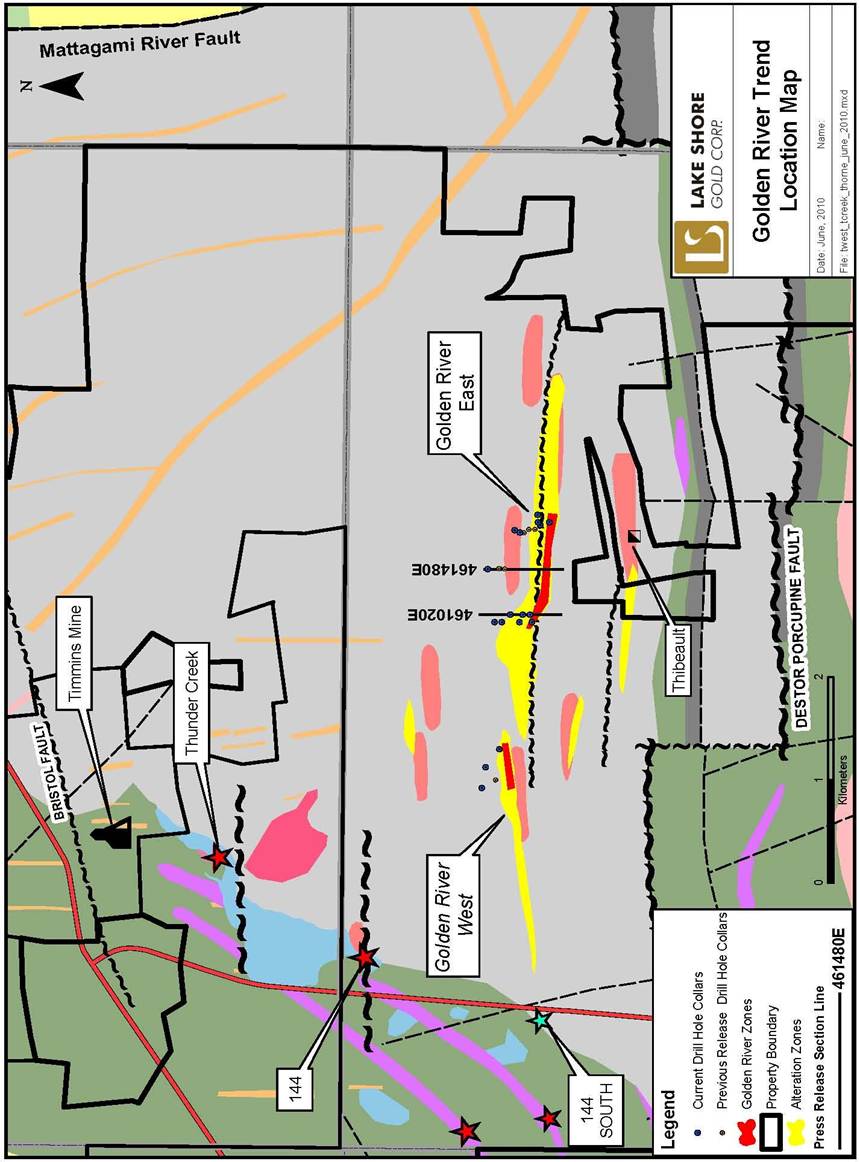
Toronto, Ontario (June 23, 2010) — Lake Shore Gold Corp. (LSG-TSX) (“Lake Shore Gold” or the “Company”) today announced results from an additional 17 holes (5,885 m) of the 2010 drill program at the 100% Thorne property, the Company’s third major target within its Timmins West Complex. The program is focused on the Gold River Trend, an east-west trending mineralized deformation and alteration zone, located approximately 2 km north of the Destor-Porcupine Fault Zone (DPFZ) and 3 km south of the Company’s Thunder Creek and Timmins Mine deposits. The Gold River Deformation Zone is interpreted to represent a branch fault from the DPFZ with broad similarities to the Dome fault, a major ore control at the Dome mine and has been traced for over 3.0 kms of strike length.
Tony Makuch, President and CEO of Lake Shore Gold, commented: “Today’s results include significant extensions to mineralization in both the Fold Nose and North Porphyry zones with high grades and good widths. Both zones remain open along strike and at depth and include wide shallow mineralization with the possibility for open pit and/or underground bulk mining, as well as deeper higher-grade mineralization. We also continue to make good progress in the Gold River West area where there is also considerable opportunity for extensions along strike and at depth. The Thorne property is a very important project, one whose potential continues to grow as work progresses with a third drill having recently been mobilized to the property.”
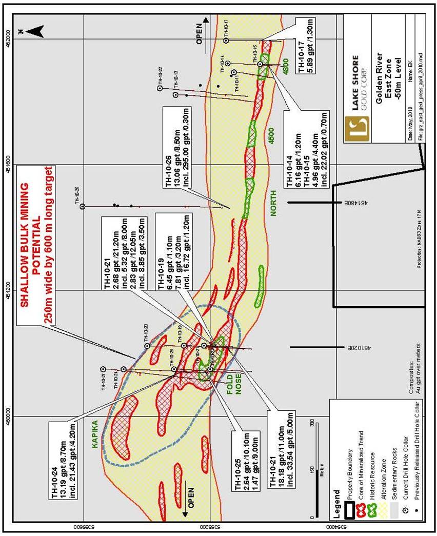
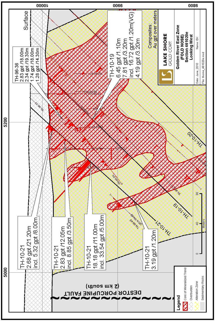
Significant results announced today include 13 holes from Gold River East which were designed to test areas surrounding the Fold Nose, North Porphyry and 4800 zones. Holes drilled in the Fold Nose Zone were focused near the east and west limits of past drilling to evaluate possibilities for increasing the current resource for this area of 1.2 million tonnes grading 3.00 gpt (121,000 ounces). TH-10-21 was collared on the east side of the current resource block and intersected 18.18 gpt over 11.00 m, including 33.54 gpt over 5.00 m, 2.68 gpt over 21.20 m, 5.32 gpt over 8.00 m and 2.83 gpt over 12.05 m. These intersections are within 75 metres of surface and vary from between 25 to 35 m above previously reported TH-96-36. TH-10-19 undercut TH-96-36 by 35 m and intersected 6.45 gpt over 1.10 m, 7.81 gpt over 3.20 m, including 16.72 gpt over 1.20 m with visible gold and 4.19 gpt over 3.20 m.
TH-10-24 was collared on the west edge of the current resource and intersected 13.19 gpt over 8.70 m, including 21.43 gpt over 4.20 m, 250 m below surface and 50 m down dip of previous holes on this section. Observations to date suggest mineralization is contained in a combination of wide and narrow zones situated within a broad east-west trending fold structure measuring approximately 250 m across and plunging moderately to the west. Higher grade zones appear to be associated with small scale fold noses within the broader structure and later cross cutting fractures. Given that past drilling in the Fold Nose Zone has largely been confined to a strike length of less than 140 m and less than 200 m from surface, the potential to extend zones to depth and define a combined open pit and underground resource are considered excellent.
At the North Porphyry Zone, TH-10-26 intersected 13.06 gpt over 8.50 m at a vertical depth of 650 m from surface and approximately 150 m below previously reported TH-10-09 and TH-10- 04, which intersected 3.95 gpt over 10.85 m, including 8.20 over 2.55 m, and 13.64 gpt over 2.55 m, respectively (see press release May 4, 2010). As with TH-10-09 and TH-10-04, mineralization in TH-10-26 is closely associated with strong hydrothermal alteration, minor quartz, 5 to 15 % sulphides measuring approximately 10 m wide and located on the south side an east west trending porphyry dike. TH-10-26 also contained several specks of visible gold.
In addition, TH-10-14 intersected 6.16 gpt over 1.20 m and TH-10-15 intersected 4.96 gpt over 4.40 m, including 22.02 gpt over 0.70 m, 480 m to the east of TH-10-26. TH-10-17, located 540 m east of TH-10-26, was the furthest east hole completed on the Gold River Trend and intersected 5.89 gpt over 1.30 m 130 m below surface and the zone remains open along strike and at depth. Interpretation of results received to date suggests a continuous series of mineralized lenses extending for over 500 m of strike length between the North Porphyry and 4800 zones. Most areas of this strike length have little to no testing below 100 m from surface with the exception of the North Porphyry Zone where new holes completed since February this year have extended mineralization from a vertical depth of 360 to 650 m below surface with mineralization being open along strike and at depth. Given the above new drill results, the potential to expand resources within this area from the current level of 0.29 million tonnes grading 10.60 gpt (98,000 ounces) are also considered excellent.
Additional encouraging results include 4 holes drilled in the Gold River West area which were designed mainly to confirm the current resource and examine possibilities for refining the geologic model. The most significant results are from TH-10-10 and TH-10-12 which were collared in untested gaps approximately 100 and 300 m east of previously reported TH-10-06, which intersected multiple high grade intercepts including 5.52 gpt over 5.40 m, 10.46 gpt over 9.00 m and 4.97 gpt over 6.00 m (see press release May 4, 2010). TH-10-10 intersected 5.05 gpt over 1.70 m and TH-10-12 intersected 5.68 gpt over 1.00 m and continued to confirm the continuity of the Hangingwall zones in the up-plunge direction towards surface. In addition, TH- 10-18 intersected 2.02 gpt over 17.60 m, 100 m west of TH10-06 near the west limit of the current resource and confirms the target here is still open to the west and downplunge. Past drilling west of TH-10-12 and along the projected westerly plunge line is very limited for the next 2 kilometers.
Drilling to date at the Thorne property has been ongoing with two drills active and a third drill recently being mobilized to accelerate testing along strike and to depth of the Fold Nose, North Porphyry and 4800 zones in the Gold River East area, as well as to conduct some wide spaced exploratory holes in the westerly down plunge extension of the Gold River West area.
Quality Control
The Qualified Person (“QP”) for Lake Shore Gold’s drill program at the Thorne Property is Jacques Samson, P.Geo. who as QP has prepared or supervised the preparation of the scientific or technical information for the property and verified the data disclosed in this press release.
Lake Shore Gold has implemented a quality-control program to ensure best practice in the sampling and analysis of the drill core. Assays have been completed using a standard fire assay with a 30-gram aliquot. For samples that return a value greater than three grams per tonne gold, another pulp is taken and fire assayed with a gravimetric finish. Zones with visible gold are tested by pulp metallic analysis. NQ size drill core is saw cut and half the drill core is sampled in standard intervals. The remaining half of the core is stored in a secure location. The drill core is transported in security-sealed bags for preparation at ALS Chemex Prep Lab located in Timmins, Ontario, and the pulps shipped to ALS Chemex Assay Laboratory in Vancouver, B.C. ALS Chemex is an ISO 9001-2000 registered laboratory preparing for ISO 17025 certification.
2
About Lake Shore Gold Corp.
Lake Shore Gold is a rapidly growing mining company with a goal to become a North American mid-tier gold producer through the successful exploration, development and operation of three wholly owned mines in Timmins, Ontario: Timmins Mine, Thunder Creek and Bell Creek Complex. The Company is currently carrying out an underground advanced exploration program at the Timmins Mine project, where it has both a shaft and a ramp, and is drifting from Timmins Mine to the adjacent Thunder Creek property. Progress is also being made with an underground advanced exploration program at its Bell Creek Complex, located on the east side of Timmins. The Bell Creek Mill has been refurbished to a capacity of 1,500 tonnes per day with plans in place to expand the Mill incrementally to 3,000 tonnes per day. The Company continues to invest aggressively in exploration primarily in Timmins and in select other areas of Northern Ontario and Quebec, and owns a large land position in Mexico. The Company’s common shares trade on the TSX under the symbol LSG.
Forward-looking Statements
Certain statements in this press release relating to the Company’s exploration activities, potential for increasing resources, project expenditures and business plans are “forward-looking statements” within the meaning of securities legislation. The Company does not intend, and does not assume any obligation, to update these forward-looking statements. These forward- looking statements represent management’s best judgment based on current facts and assumptions that management considers reasonable, including that operating and capital plans will not be disrupted by issues such as mechanical failure, unavailability of parts, labour disturbances, interruption in transportation or utilities, or adverse weather conditions, that there are no material unanticipated variations in budgeted costs, that contractors will complete projects according to schedule, and that actual mineralization on properties will not be less than identified mineral reserves. The Company makes no representation that reasonable business people in possession of the same information would reach the same conclusions. Forward- looking statements involve known and unknown risks, uncertainties and other factors which may cause the actual results, performance or achievements of the Company to be materially different from any future results, performance or achievements expressed or implied by the forward-looking statements. In particular, fluctuations in the price of gold or in currency markets could prevent the Company from achieving its targets. Readers should not place undue reliance on forward-looking statements. More information about risks and uncertainties affecting the Company and its business is available in Lake Shore Gold’s most recent Annual Information Form and other regulatory filings which are posted on sedar at www.sedar.com.
There is no guarantee that drill results reported in this news release will lead to the identification of a deposit that can be mined economically, and further work is required to identify resources and reserves.
FOR FURTHER INFORMATION PLEASE CONTACT:
Tony Makuch
President & CEO
Lake Shore Gold
(416) 703-6298
Email: info@lsgold.com
Mark Utting
Vice-President, Investor Relations
Lake Shore Gold
(416) 703-6298
Email: info@lsgold.com
3
Thorne Project - Significant Assay Results (June 2010)
Hole | | East | | From | | To | | Interval | | Grade | | |
Number | | nad 83 | | (m) | | (m) | | (m) | | (gpt) | | Zone |
TH-10-10 | | 459715 | | 88.00 | | 89.70 | | 1.70 | | 5.05 | | West Zone |
| | | | 175.50 | | 176.00 | | 0.50 | | 1.55 | | incl VG |
TH-10-12 | | 459541 | | 232.75 | | 247.00 | | 14.25 | | 1.41 | | West Zone |
| | incl. | | 242.50 | | 243.50 | | 1.00 | | 5.68 | | |
TH-10-14 | | 461920 | | 137.35 | | 138.55 | | 1.20 | | 6.16 | | 4800 Zone |
TH-10-15 | | 461920 | | 35.30 | | 39.70 | | 4.40 | | 4.96 | | 4800 Zone |
| | incl | | 35.30 | | 36.00 | | 0.70 | | 22.02 | | |
TH-10-17 | | 461994 | | 172.00 | | 173.30 | | 1.30 | | 5.89 | | 4800 Zone |
TH-10-18 | | 459340 | | 354.40 | | 372.00 | | 17.60 | | 2.02 | | West Zone |
| | incl. | | 368.00 | | 371.30 | | 3.30 | | 4.04 | | |
TH-10-19 | | 461025 | | 101.70 | | 102.80 | | 1.10 | | 6.45 | | Fold Nose |
| | | | 114.00 | | 117.20 | | 3.20 | | 7.81 | | |
| | incl. | | 116.00 | | 117.20 | | 1.20 | | 16.72 | | incl. VG |
| | | | 179.80 | | 183.00 | | 3.20 | | 4.19 | | |
| | | | 220.70 | | 221.00 | | 0.30 | | 6.80 | | |
TH-10-20 | | 461025 | | 182.50 | | 183.00 | | 0.50 | | 7.38 | | Fold Nose |
| | | | 195.70 | | 196.30 | | 0.60 | | 7.36 | | |
TH-10-21 | | 461025 | | 33.40 | | 54.60 | | 21.20 | | 2.68 | | Fold Nose |
| | incl. | | 34.00 | | 42.00 | | 8.00 | | 5.32 | | |
| | | | 61.50 | | 73.55 | | 12.05 | | 2.83 | | |
| | incl. | | 61.50 | | 65.00 | | 3.50 | | 8.85 | | |
| | or incl. | | 61.50 | | 62.50 | | 1.00 | | 21.38 | | |
| | | | 104.00 | | 115.00 | | 11.00 | | 18.18 | | |
| | incl. | | 104.00 | | 109.00 | | 5.00 | | 33.54 | | |
| | | | 186.00 | | 187.20 | | 1.20 | | 3.19 | | |
TH-10-22 | | 461843 | | 379.05 | | 379.80 | | 0.75 | | 4.05 | | 4800 Zone |
TH-10-24 | | 460950 | | 254.80 | | 263.50 | | 8.70 | | 13.19 | | Fold Nose |
| | incl. | | 256.30 | | 260.50 | | 4.20 | | 21.43 | | |
TH-10-25 | | 460950 | | 45.00 | | 49.00 | | 4.00 | | 1.26 | | Fold Nose |
| | | | 108.40 | | 118.50 | | 10.10 | | 2.64 | | |
| | | | 162.90 | | 163.50 | | 0.60 | | 8.06 | | |
| | | | 183.00 | | 192.00 | | 9.00 | | 1.47 | | |
| | | | 222.70 | | 230.00 | | 7.30 | | 1.52 | | |
| | incl. | | 227.00 | | 228.50 | | 1.50 | | 3.04 | | incl. VG |
4
Thorne Project - Significant Assay Results (June 2010)
Hole | | East | | From | | To | | Interval | | Grade | | |
Number | | nad 83 | | (m) | | (m) | | (m) | | (gpt) | | Zone |
TH-10-26 | | 461467 | | 683.00 | | 688.85 | | 5.85 | | 2.06 | | North Porphyry |
| | | | 769.50 | | 778.00 | | 8.50 | | 13.06 | | |
| | and incl. | | 772.40 | | 772.70 | | 0.30 | | 295.00 | | incl. VG |
| | and incl. | | 775.50 | | 776.00 | | 0.50 | | 19.15 | | |
TH-10-27 | | 460950 | | 161.00 | | 162.00 | | 1.00 | | 5.20 | | Fold Nose |
| | | | 172.60 | | 173.10 | | 0.50 | | 9.62 | | |
| | | | 391.30 | | 393.50 | | 2.20 | | 3.17 | | |
Notes:
1) TH-10-11,TH10-13,TH10-16 and TH10-23 did not return significant assays.
2) TH-10-11 and TH10-13 were drilled on sections 461895 and 461820E, respectively (4800 Zone), and TH-10-16 was drilled on section 459340E (upper portion of the West Zone).
3) TH-10-23 was drilled on 460950E (Fold Nose).
4) Assays are reported uncut.
5) True widths are not reported at this time.
5
Figure 1. Location Map
6
Figure 2. Plan View (Gold River East)
7
Figure 3. Cross Section (Fold Nose — Gold River East)
8
Figure 4. Cross Section (North Porphyry — Gold River East)

9