Exhibit 99.141
[LOGO] LAKE SHORE GOLD CORP. | 181 University Ave., Suite 2000 Toronto, ON M5H 3M7 tel 416 703 6298 fax 416 703 7764 | info@lsgold.com www.lsgold.com |
NEWS RELEASE
LAKE SHORE GOLD EXTENDS THUNDER CREEK TO DEPTH, CONFIRMS HIGH-GRADE
CORE AND DISCOVERS NEW ZONE
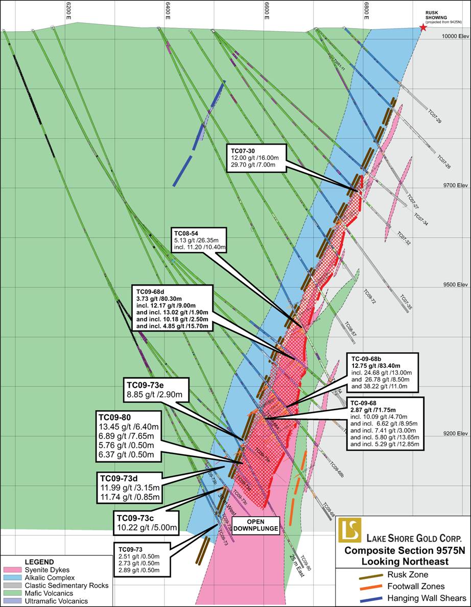
· TC09-80 intersects 13.45 gpt over 6.40 m, including 64.69 gpt over 1.20 m, and 6.89 gpt over 7.65 m, and extends northeasterly plunging zone 110 meters from TC09-68.
· TC09-69b intersects 11.24 gpt over 18.35 m, including 17.17 gpt over 10.50 m or 31.67 gpt over 4.30 m, followed by 12.88 gpt over 8.85 m, confirms thick high-grade core to mineralization near 650 Level close to planned development from Timmins Mine.
· TC09-79 intersects 7.69 gpt over 1.90 m, including 22.00 gpt over 0.50 m, in new zone 65 m south and in the footwall of the Porphyry Zone.
Toronto, Ontario (January 26, 2010) — Lake Shore Gold Corp. (LSG-TSX) (“Lake Shore Gold” or the “Company”) today announced assay results for 7 holes and 11 wedge holes, for a total of 12,883 meters drilled, as part of its ongoing diamond drill program at the 100% owned Thunder Creek property. Among significant intercepts are 13.45 gpt over 6.40 m, including 64.69 gpt over 1.20 m, and 6.89 gpt over 7.65 m in TC09-80, which are contained within a 95 m wide zone of typical alteration from the Rusk and Porphyry zones and which confirmed the extension of the zones at least 110 m to the northeast and down plunge of previously reported TC09-68. The downward extension of mineralization from TC09-80 projects into a 150 meter wide gap between TC09-73 and TC09-75 and remains open.
TC09-69b intersected 11.24 gpt over 18.35 m, including 17.17 gpt over 10.50 m or 31.67 gpt over 4.30 m, followed by 12.88 gpt over 8.85 m approximately 50 m above TC09-69, which had previously reported values of 8.86 gpt over 24.85 m (see press release dated May 5, 2009). TC09-69c intersected 5.30 gpt over 10.05 m, including 10.01 gpt over 3.30 m and 11.81 gpt over 3.65 m, 43 m further above TC09-69b. TC09-69d intersected 4.50 gpt over 17.25 m, including 10.50 gpt over 5.30 m in the Rusk Zone, while TC09-69e had multiple intersections highlighted by 6.16 gpt over 11.20 m in the area 50 m below previously reported TC09-69a (7.97 gpt over 19.45 m — see press release dated May 5, 2009). These results confirm the presence of a high-grade core to the mineralization near the 650 m level and along the north-east plunge line which is the main target for development currently being driven from the Timmins Mine 650 Level to Thunder Creek.
Holes TC09-73c/73d/73e tested the west edge of the northeasterly plunging zone below the 700 m level with the best results being 10.22 gpt over 5.00 m in TC09-73c. TC09-73d had multiple intersections highlighted by 11.99 gpt over 3.15 m 60 m above TC09-73c. TC09-73e intersected the zone 30 m above TC09-73d and obtained 8.85 gpt over 2.90 m.
TC09-79 tested the area 70 meters west of TC09-73c and intersected 4.75 gpt over 1.15 m in the Porphyry Zone as well as 7.69 gpt over 1.90 m, including 22.00 gpt over 0.50 m, and 7.30 gpt over 0.50 m in a new zone located 65 m south and in the footwall of the Porphyry Zone. The new zone is related to a separate porphyry lens which appears to be trending more westerly than other zones discovered to date. The orientation of the new zone suggests a possible connection to a major eastwest shear located approximately 200 m to the south. The area between TC09-79 and the east-west shear remains largely untested below the 650 m level.
Of the holes being reported todayTC09-73b, TC09-77a and TC09-78 were abandoned prior to reaching their intended targets and TC09-69d and TC09-69e are only partial intercepts of the targets as they were abandoned during drilling due to ground core, stuck and/or broken rods and/or excessive deviations.
Tony Makuch, President and CEO of Lake Shore Gold, commented: “Today’s results confirm a substantial thickness of high-grade mineralization surrounding the 650 m level and establish the combined Rusk and Porphyry zones as a well defined, broad mineralized system varying from a few meters to tens of meters wide over at least 300 meters in strike length and 900 meters in vertical height. The full dimensions of the mineralized system are unknown at the present time as the zones remain open along strike and at depth. In addition, the new zone we have discovered is encouraging as it may be associated with a major east-west shear approximately 200 meters to the south. This discovery highlights the highly prospective nature of the Thunder Creek property and the potential to identify new zones as we continue work to establish a large gold deposit.
“We currently have three surface drills active on the property and we plan to commence underground drilling by mid-year as we approach the Thunder Creek zones from underground ramp development advancing from the 200 and 650 levels at Timmins Mine. Given the difficulty encountered in drilling deep holes from surface, which has contributed to abandoning some holes and reporting partial results from others, we expect the speed of evaluating the zones to increase and the cost of drilling to decline significantly once underground drilling begins.
“These results, combined with the recently announced results for Bell Creek and continued progress at Timmins Mine, clearly show that it is exciting times for Lake Shore Gold as we work towards building three new mines in the Timmins Camp with there being many additional targets to explore.”
The Company also has one surface drill rig active at the Timmins Mine property located immediately to the north and is testing the westerly down plunge extension of the main deposit below 1,200 metres. In addition, the Company is in the process of mobilizing a drill to the Gold River North project located immediately to the south of the Thunder Creek property where recent drilling by West Timmins Mining intersected multiple zones of high-grade mineralization (see West Timmins Mining press release dated October 28, 2009 — available at www.lsgold.com — Properties section — “Other TW Properties,” or at www.sedar.com).
Hole TC09-75 tested mineralization 180 meters down plunge from TC09-80 and intersected a value of 3.85 gpt over 0.75 m and only a narrow zone of porphyry suggesting it passed slightly above of the northeast plunging mineralized package.
Holes TC09-74 and TC09-76 were designed as broad scale step out holes to test the area 250 m to 400 m southwest of the main zones of mineralization and closer to surface. Both holes intersected the Rusk shear zone and encountered weak alteration and anomalous gold values similar to that found in areas above the main northeast trending zone, suggesting future drilling may have to target deeper elevations.
Drilling to date has defined at least two main zones of mineralization which occur within the sheared and altered contact zone between an ultramafic body (pyroxenite) and a sequence of intercalated mafic volcanics and sediments, intruded by numerous felsic dykes and quartz-carbonate veining. The Rusk Zone is mainly characterized by vein and fracture-controlled to disseminated pyrite zone, strongly sheared to brecciated, accompanied by very strong iron-carbonate, hematite and sericite alteration. Numerous felsite to feldspar porphyritic syenite dykes intrude the contact zone. Many of these dykes are strongly hematized, variably silicified, intruded by sheets of quartz veinlets, accompanied by minor amounts of pyrite, molybdenite, galena, sphalerite, scheelite, tellurides, and visible gold.
Quality Control
The Company’s Qualified Person (“QP”) for the Thunder Creek property is Jacques Samson, P. Geo. As QP, he has prepared or supervised the preparation of the scientific or technical information for the property and has verified the data disclosed in this press release.
Lake Shore Gold has a quality control program to ensure best practices in the sampling and analysis of drill core. Assays have been completed using a standard fire assay with a 30-gram aliquot. For samples that return a value greater than three grams per tonne gold, another pulp is taken and fire assayed with a gravimetric finish. Zones with visible gold are tested by pulp metallic analysis. NQ size drill core is saw cut and half the drill core is sampled in standard intervals. The remaining half of the core is stored in a secure location. The drill core is transported in security-sealed bags for preparation at ALS Chemex Prep Lab located in Timmins, Ontario, and the pulps shipped to ALS Chemex Assay Laboratory in Vancouver, B.C. ALS Chemex is an ISO 9001-2000 registered laboratory preparing for ISO 17025 certification.
About Lake Shore Gold
Lake Shore Gold is a rapidly growing mining company with large land positions on the west and east sides of the Timmins Gold Camp. The Company is carrying out an underground advanced exploration program at its 100%-owned Timmins Mine project, where it has both a shaft and a ramp, and is currently commencing advanced exploration work at the adjacent Thunder Creek property. The Bell Creek Mill, located on the east side of Timmins, has been refurbished to a capacity of 1,500 tonnes per day. The Company is also making progress with an underground advanced exploration program at its Bell Creek Complex, including the Bell Creek Mine, Schumacher and Vogel properties, which is moving forward to become the Company’s second mining operation in the Timmins Camp. The Company continues to invest aggressively in exploration primarily in Timmins and in select other areas of Northern Ontario and Quebec, and owns a large land position in Mexico. The Company’s common shares trade on the TSX under the symbol LSG.
Forward-looking Statements
Certain statements in this press release relating to the Company’s exploration activities, geological interpretations, project expenditures and business plans are “forward-looking statements” within the meaning of securities legislation. The Company does not intend, and does not assume any obligation, to update these forward-looking statements. These forward-looking statements represent management’s best judgment based on current facts and assumptions that management considers reasonable, including that operating and capital plans will not be disrupted by issues such as mechanical failure, unavailability of parts, labour disturbances, interruption in transportation or utilities, or adverse weather conditions, that there are no material unanticipated variations in budgeted costs, that contractors will complete projects according to schedule, and that actual mineralization on properties will not be less than identified mineral reserves. The Company makes no representation that reasonable business people in possession of the same information would reach the same conclusions. Forward-looking statements involve known and unknown risks, uncertainties and other factors which may cause the actual results, performance or achievements of the Company to be materially different from any future results, performance or achievements expressed or implied by the forward-looking statements. In particular, fluctuations in the price of gold or in currency markets could prevent the Company from achieving its targets. Readers should not place undue reliance on forward-looking statements. More information about risks and uncertainties affecting the Company and its business is available in Lake Shore Gold’s most recent Annual Information Form and other regulatory filings which are posted on sedar at www.sedar.com.
There is no guarantee that drill results reported in this news release will lead to the identification of a deposit that can be mined economically, and further work is required to identify a reserve or resource.
FOR FURTHER INFORMATION PLEASE CONTACT:
Tony Makuch
President & CEO
Lake Shore Gold
(416) 703-6298
Email: info@lsgold.com
Mark Utting
Vice-President, Investor Relations
Lake Shore Gold
(416) 703-6298
Email: info@lsgold.com
Thunder Creek Property-Significant New Assay Results
Hole Number | | From
m | | To
m | | Interval
m | | Grade
gpt Au | | Section | | Comments |
TC09-69b | | 758.15 | | 776.50 | | 18.35 | | 11.24 | | 9500N | | Rusk (incl porph inject.) |
includes | | 766.00 | | 776.50 | | 10.50 | | 17.17 | | | | |
or includes | | 771.80 | | 776.10 | | 4.30 | | 31.67 | | | | |
| | 797.60 | | 806.45 | | 8.85 | | 12.88 | | | | Porphyry Zone |
includes | | 798 | | 798.95 | | 0.95 | | 109.67 | | | | |
TC09-69c | | 736.30 | | 746.35 | | 10.05 | | 5.30 | | 9500N | | Rusk Zone |
| | 759.50 | | 762.80 | | 3.30 | | 10.01 | | | | Rusk Zone |
| | 767.20 | | 770.35 | | 3.15 | | 2.17 | | | | Porphyry Zone |
| | 778.50 | | 782.15 | | 3.65 | | 11.81 | | | | Porphyry Zone |
TC09-69d | | 820.75 | | 838.00 | | 17.25 | | 4.50 | | 9500N | | Rusk Zone |
includes | | 828.70 | | 834.00 | | 5.30 | | 10.50 | | | | |
| | 872.50 | | 875.50 | | 3.00 | | 3.20 | | | | Porphyry Contact |
includes | | 875.00 | | 875.75 | | 0.75 | | 12.70 | | | | |
TC09-69e | | 820.55 | | 831.75 | | 11.20 | | 6.16 | | 9500N | | Rusk Zone |
includes | | 824.90 | | 830.75 | | 5.85 | | 9.44 | | | | |
| | 856.75 | | 857.65 | | 0.90 | | 7.44 | | | | Felsite/Rusk Zone |
| | 864.70 | | 865.00 | | 0.30 | | 10.60 | | | | Porphyry |
| | 887.60 | | 888.10 | | 0.50 | | 13.10 | | | | Porphyry |
TC09-73c | | 1026.20 | | 1031.20 | | 5.00 | | 10.22 | | 9550N | | Rusk Zone |
| | 1087.30 | | 1087.70 | | 0.40 | | 4.67 | | | | Porphyry |
| | 1101.60 | | 1102.00 | | 0.40 | | 2.08 | | | | Porphyry |
TC09-73d | | 976.20 | | 979.35 | | 3.15 | | 11.99 | | 9550N | | Rusk Zone |
| | 1007.50 | | 1008.35 | | 0.85 | | 11.74 | | | | Rusk Zone |
| | 1042.50 | | 1043.00 | | 0.50 | | 8.01 | | | | Porphyry |
| | 1083.40 | | 1083.95 | | 0.55 | | 4.14 | | | | Porphyry |
TC09-73e | | 978.00 | | 980.90 | | 2.90 | | 8.85 | | 9550N | | Rusk Zone |
| | 999.70 | | 1000.50 | | 0.80 | | 2.79 | | | | Porphyry |
| | 1054.50 | | 1058.50 | | 4.00 | | 2.67 | | | | Porphyry |
includes | | 1056.50 | | 1057.00 | | 0.50 | | 11.25 | | | | |
TC09-75 | | 1123.50 | | 1124.00 | | 0.50 | | 1.38 | | 9700N | | Porphyry Zone |
| | 1129.70 | | 1130.45 | | 0.75 | | 3.85 | | 9700N | | Porphyry Zone |
TC09-77 | | 945.00 | | 945.75 | | 0.75 | | 5.40 | | 9400N | | Rusk Horizon |
TC09-79 | | 1033.00 | | 1034.15 | | 1.15 | | 4.75 | | 9450N | | Porphyry |
| | 1080.30 | | 1088.00 | | 7.70 | | 2.99 | | | | New Porphyry Footwall Zone |
| | 1080.30 | | 1082.20 | | 1.90 | | 7.69 | | | | New Porphyry Footwall Zone |
includes | | 1080.30 | | 1080.80 | | 0.50 | | 22.00 | | | | |
| | 1096.85 | | 1097.35 | | 0.50 | | 7.30 | | | | |
TC09-80 | | 933.00 | | 940.65 | | 7.65 | | 6.89 | | 9600N | | Rusk |
| | 958.00 | | 958.50 | | 0.50 | | 5.76 | | | | Porphyry |
| | 966.90 | | 967.40 | | 0.50 | | 6.37 | | | | Porphyry |
| | 1023.30 | | 1029.70 | | 6.40 | | 13.45 | | | | Porphyry |
includes | | 1026.00 | | 1027.20 | | 1.20 | | 64.69 | | | | |
Notes:
· TC09-69d was abandoned at 883m due to broken rods.
· TC09-69e was abandoned at 899m due to displaced steel wedge.
· TC09-71a, 73a, -74 and -76 had no significant assays.
· TC09-73b was abandoned at 976m due to broken rods.
· TC09-77a was a 32m long redrill of the Rusk due to ground core in TC09-77; no significant assays.
· TC09-78 was abandoned at 282m due to excessive deviations.
Due to uncertainties in zone orientations, true widths are not known at this time.
Assays reported are uncut.
Figure 1. Plan View
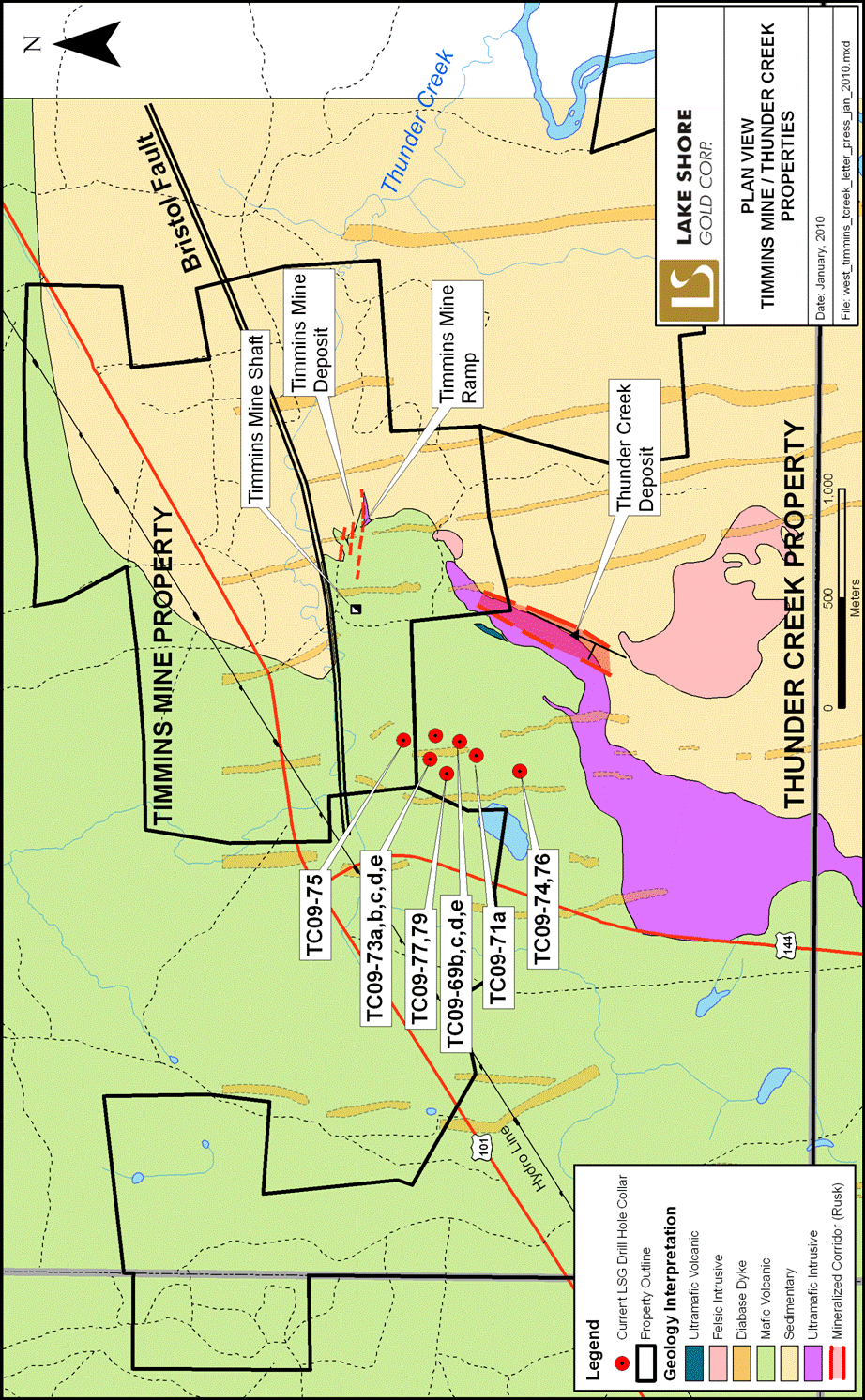
Figure 2. Long Section

Figure 3. Cross Section