Exhibit 99.130
[LOGO] LAKE SHORE GOLD CORP. | | | 181 University Ave., Suite 2000 |
| | Toronto, ON M5H 3M7 |
| | Tel: 416.703-6298 |
| | Fax: 416-703-7764 |
NEWS RELEASE
LAKE SHORE GOLD ADVANCES THIRD MAJOR GOLD TARGET IN TIMMINS
WEST COMPLEX, CONFIRMS PRESENCE OF LARGE GOLD-BEARING SYSTEM
ALONG GOLD RIVER TREND EXTENDING TO DEPTH
· North Porphyry extended 120 m to depth (to 520 metres) with TH10-04 intersecting 13.64 gpt over 2.55 m, 6.87 gpt over 2.35 m, 8.89 gpt over 1.10 m, 8.79 gpt over 1.00 m and 8.07 gpt over 0.95 m and TH10-09 intersecting 3.95 gpt over 10.85 m, including 8.20 over 2.55 m.
· TH10-03 intersects 99.78 gpt over 1.85 m and 5.84 gpt over 0.80 m, TH10-05 intersects 22.78 gpt over 1.30 m and TH10-02 intersects 15.75 gpt over 1.00 m and 6.11 gpt over 0.85 m, confirm 125 m downplunge extension of 4800 Zone.
· Multiple high-grade intercepts at Gold River West Zone, TH10-06 intersects 5.52 gpt over 5.40 m (including 21.96 gpt over 1.25 m), 10.46 gpt over 9.00 m (including 85.70 gpt over 1.00 m) and 4.97 gpt over 6.00 m (including 18.55 gpt over 1.00 m).
· New geological model for Gold River East suggests wide fold structure with potential to contain significant resources at shallow depths and potential for open pit and/or bulk underground mining.
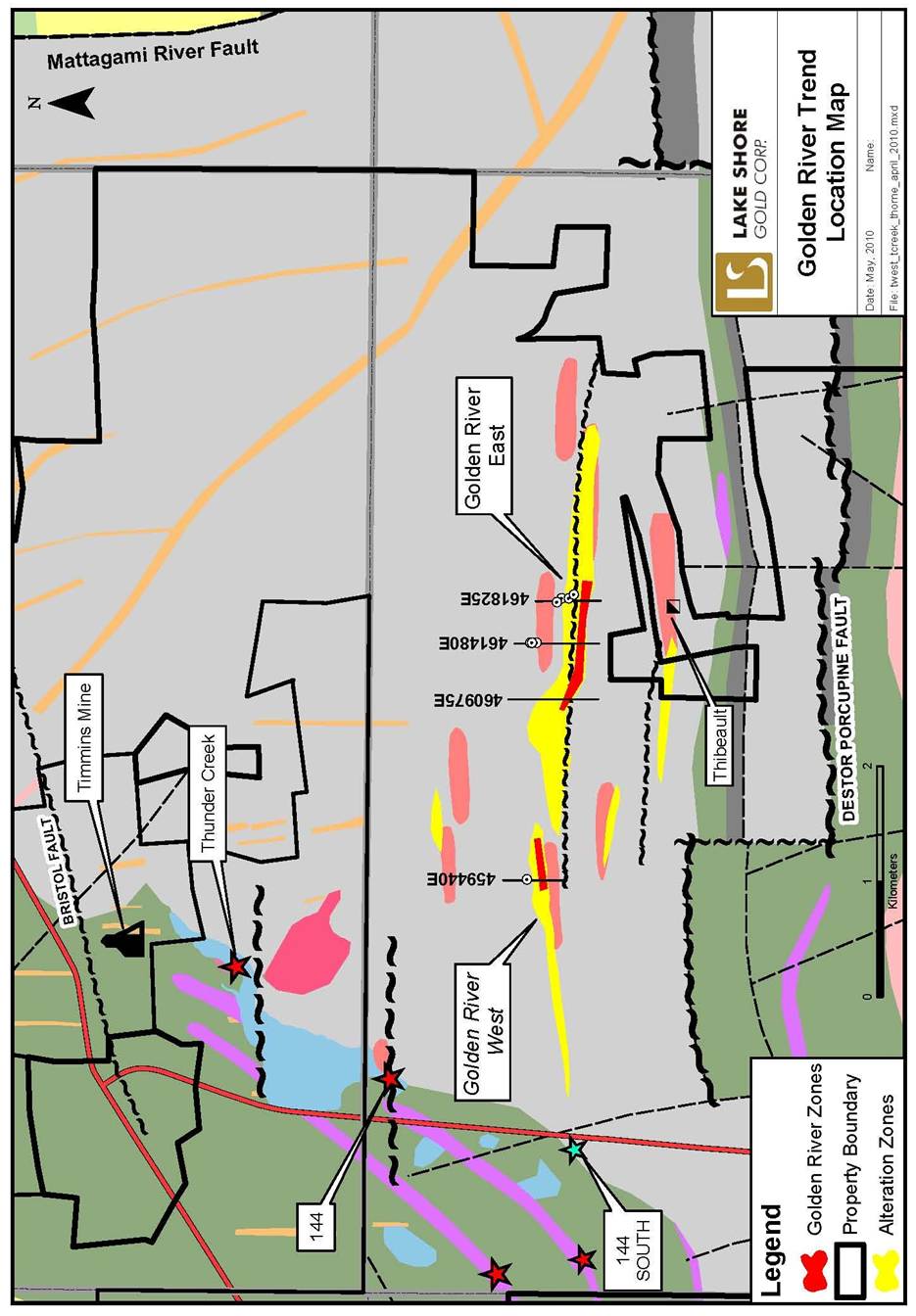
Toronto, Ontario (May 4, 2010) — Lake Shore Gold Corp. (LSG-TSX) (“Lake Shore Gold” or the “Company”) today announced results from the initial 9 holes (3,320 m) of the 2010 drill program at the 100% owned Thorne Property, the Company’s third major target within its Timmins West Complex. The program is focused on the Gold River Trend, an east-west trending mineralized deformation and alteration zone, located approximately 2 km north of the Destor-Porcupine Fault Zone (DPFZ) and 3 km south of the Company’s Thunder Creek and Timmins Mines deposits. The Gold River Deformation Zone is interpreted to represent a branch fault from the DPFZ with broad similarities to the Dome fault, a major ore control at the Dome mine.
Tony Makuch, President and CEO of Lake Shore Gold, commented: “With today’s results, we have confirmed that an extensive gold-bearing system covering at least 2.5 kilometres of strike exists on the Thorne Property along the Gold River Trend with similarities to the major deposits in the Timmins Camp. The results also demonstrate the considerable potential that exists to delineate resources at the Thorne Property at depth and along strike through further drilling and by re-interpreting geological models. The Property includes zones of both wide shallow mineralization with the potential for open pit and/or underground bulk mining, and deeper higher-grade mineralization which we believe can be extended considerably at depth.
“The Thorne Property is an important third target for Lake Shore Gold within our Timmins West Complex, in addition to Timmins Mine and Thunder Creek, which could significantly enhance overall returns and contribute to building a large-scale gold complex in the Timmins West area. We are continuing our 2010 drill program along the Gold River Trend, with two drills currently operating in the area.”
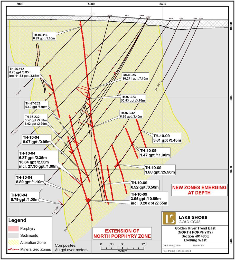
Significant new results from eight holes in the Gold River East portion of the property include the extension of the North Porphyry and 4800 zones to depth (see figures 3 and 4). In the North Porphyry area, TH10-04 intersected 13.64 gpt over 2.55 m, 6.87 gpt over 2.35 m, 8.89 gpt over 1.10 m, 8.79 gpt over 1.00 m and 8.07 gpt over 0.95 m approximately 40 metres below GS09-33, which had intersected 7.67 gpt over 4.50 m, 6.38 gpt over 1.50 m and 7.06 gpt over 0.40 m and was the previous deepest hole in this area (see West Timmins Mining Inc. press release dated October 28, 2009 — available at www.lsgold.com — Properties — Other TW Properties). TH10-09 intersected the North Porphyry Zone a further 60 metres down plunge of TH09-04 and obtained values of 3.95 gpt over 10.85 m, including 8.20 over 2.55 m.
In the 4800 Zone area, TH10-03 intersected 99.78 gpt over 1.85 m and 5.84 gpt over 0.80 m, TH10-05 intersected 22.78 gpt over 1.30 m and TH10-02 intersected 15.75 gpt over 1.00 m and 6.11 gpt over 0.85 m, to confirm a 120 metre down plunge extension of mineralization from historic hole TH97-225, which had intersected 40.40 gpt over 1.00 m to a depth of 200 metres from surface (see Figure 4). All three of the holes contained visible gold. The only other hole in this area below the 75 metre level prior to drilling was TH97-183 which had obtained a value of 5.30 gpt over 3.60 m.
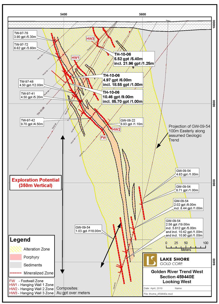
Results from one new hole in the Gold River West area include 5.52 gpt over 5.40 m (including 21.96 gpt over 1.25 m), 10.46 gpt over 9.00 m (including 85.70 gpt over 1.00 m) and 4.97 gpt over 6.00 m (including 18.55 gpt over 1.00 m) in TH10-06 which intersected an untested gap in the central portion of the zone (Figure 5). The results of this hole confirm the continuity of the Footwall Zone along the south margin of a Porphyry dyke which trends east-west and dips steeply to the north.
In addition to data from new drilling, work has been ongoing to review the geologic model and current resources for the property previously established by West Timmins Mining Inc. Results of this work to date indicate that numerous intersections of gold mineralization occur along the Gold River Trend for most of the 2.5 km of strike length in a combination of wide low-grade and smaller high-grade zones. Given the wide spacing, limited testing along strike and at depth to date and opportunities to improve the existing geologic models, the potential to establish resources at higher quantities and grades than in the existing National Instrument (“NI”) 43-101 resource, which currently stands at approximately 400,000 ounces, are considered excellent. The NI 43-101 resource was compiled by Spiteri Geological and Mining Consultants Inc. Resources cited in the analysis that follows are based on the published NI 43-101 resource.
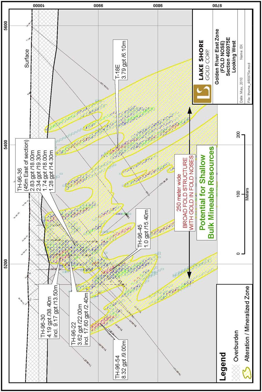
Some of the best shorter-term resource potential is contained in the Gold River East area, which has a current resource of approximately 1.90 million tonnes grading 4.70 gpt (283,000 ounces). Of the existing resource, 1.20 million tonnes grading 3.00 gpt (121,000 ounces) is in wide shallow-depth zones, which have potential for open pit or bulk underground mining, while 0.62 million tonnes grading 8.15 gpt (162,000 ounces) is in narrower zones with potential for underground mining (Figures 1 and 2). Most of the existing wide and shallow resources occur in the Fold Nose resource block located near the western edge of the Gold River East area where the alteration package becomes tightly folded and thickens to over 250 metres (Figure 6). Typical intersections from past drilling here include 2.83 gpt over 18.00 m, 1.74 gpt over 19.30 m and 1.20 gpt over 14.30 m in TH-96-36, 2.20 gpt over 22.00 m in TH-96-43 and 3.62 gpt over 22.00 m in TH-96-22. Current drilling to the west of the Fold Nose resource and along the projected northwesterly trend of the alteration zone and folded package is very limited with the exception of the Kapika zone at a distance of 600 metres.
2
Current high-grade resources in the Gold River East area occur within tight fold noses associated with the folded package near the Fold Nose resource as well as in narrow east-west trending high-grade structures at the North Porphyry, 4500 and 4800 zones which appear to plunge at a steep angle to the west. Mineralization in the latter three areas is closely associated zones containing grey quartz veining, strong serecite-carbonate alteration, increased sulphides and a higher than normal frequency of visible gold located near the margins of porphyry dykes which intrude the south side of the Gold River Trend. Current drill spacing, below the 100 metre level and along strike to the east, is very limited.
Existing resources in the Gold River West area are contained in the Footwall and Hanging Wall zones which occur on the north and south margins of a swarm of porphyry dykes. The current resource in this area is estimated at 1.30 million tonnes grading 2.76 gpt (117,000 ounces) using a bulk underground mining scenario. Typical widths of drill intersections making up the resource often exceed 20 metres and, as with TH10-06, can often contain multiple higher-grade intersections, leaving open the possibility to remodel some areas to increase the overall resource grade. The area is also considered open to the east, west and to depth with the deepest intersections to date being GW09-54, which intersected 1.03 gpt over 118.20 m, including 8.64 gpt over 1.00 m, 7.98 gpt over 1.00 m and 5.72 gpt over 5.00 m, and 3.60 gpt over 2.00 m at a vertical depth of approximately 600 metres below surface and 350 metres below the current resource (see West Timmins Mining Inc. press release dated Nov 4, 2009 — available at www.lsgold.com — Properties — Other TW Properties). Resources included in this press release exclude certain low-grade zones considered by Lake Shore Gold to be lower priority for future exploration.
Current drilling at the Thorne Property is continuing with two drills which are focusing on continued testing of the North Porphyry, 4800 and Gold River West zones to depth as well as some initial testing for wider bulk mineralization near the fold nose area.
Quality Control
The Qualified Person (“QP”) for Lake Shore Gold’s drill program at the Thorne Property is Jacques Samson, P.Geo. who as QP has prepared or supervised the preparation of the scientific or technical information for the property and verified the data disclosed in this press release.
Lake Shore Gold has implemented a quality-control program to ensure best practice in the sampling and analysis of the drill core. Assays have been completed using a standard fire assay with a 30-gram aliquot. For samples that return a value greater than three grams per tonne gold, another pulp is taken and fire assayed with a gravimetric finish. Zones with visible gold are tested by pulp metallic analysis. NQ size drill core is saw cut and half the drill core is sampled in standard intervals. The remaining half of the core is stored in a secure location. The drill core is transported in security-sealed bags for preparation at ALS Chemex Prep Lab located in Timmins, Ontario, and the pulps shipped to ALS Chemex Assay Laboratory in Vancouver, B.C. ALS Chemex is an ISO 9001-2000 registered laboratory preparing for ISO 17025 certification.
About Lake Shore Gold Corp.
Lake Shore Gold is a rapidly growing mining company with a goal to become a North American mid-tier gold producer through the successful exploration, development and operation of three wholly owned mines in Timmins, Ontario: Timmins Mine, Thunder Creek and Bell Creek Complex. The Company is currently carrying out an underground advanced exploration program at the Timmins Mine project, where it has both a shaft and a ramp, and is drifting from Timmins Mine to the adjacent Thunder Creek property. Progress is also being made with an underground
3
advanced exploration program at its Bell Creek Complex, located on the east side of Timmins, which is moving forward to become the Company’s second mining operation in the Timmins Camp. The Bell Creek Mill has been refurbished to a capacity of 1,500 tonnes per day with plans in place to expand the Mill incrementally to 3,000 tonnes per day. The Company continues to invest aggressively in exploration primarily in Timmins and in select other areas of Northern Ontario and Quebec, and owns a large land position in Mexico. The Company’s common shares trade on the TSX under the symbol LSG.
Forward-looking Statements
Certain statements in this press release relating to the Company’s exploration activities, potential for increasing resources, project expenditures and business plans are “forward-looking statements” within the meaning of securities legislation. The Company does not intend, and does not assume any obligation, to update these forward-looking statements. These forward-looking statements represent management’s best judgment based on current facts and assumptions that management considers reasonable, including that operating and capital plans will not be disrupted by issues such as mechanical failure, unavailability of parts, labour disturbances, interruption in transportation or utilities, or adverse weather conditions, that there are no material unanticipated variations in budgeted costs, that contractors will complete projects according to schedule, and that actual mineralization on properties will not be less than identified mineral reserves. The Company makes no representation that reasonable business people in possession of the same information would reach the same conclusions. Forward-looking statements involve known and unknown risks, uncertainties and other factors which may cause the actual results, performance or achievements of the Company to be materially different from any future results, performance or achievements expressed or implied by the forward-looking statements. In particular, fluctuations in the price of gold or in currency markets could prevent the Company from achieving its targets. Readers should not place undue reliance on forward-looking statements. More information about risks and uncertainties affecting the Company and its business is available in Lake Shore Gold’s most recent Annual Information Form and other regulatory filings which are posted on sedar at www.sedar.com.
There is no guarantee that drill results reported in this news release will lead to the identification of a deposit that can be mined economically, and further work is required to identify resources and reserves.
FOR FURTHER INFORMATION PLEASE CONTACT:
Tony Makuch
President & CEO
Lake Shore Gold
(416) 703-6298
Email: info@lsgold.com
Mark Utting
Vice-President, Investor Relations
Lake Shore Gold
(416) 703-6298
Email: info@lsgold.com
Website: www.lsgold.com
4
Thorne Project - Significant Assay Results
Hole
Number | | East
nad 83 | | From
(m) | | To
(m) | | Interval
(m) | | Grade
(gpt) | | Comments |
TH-10-01 | | 461851 | | 103.00 | | 103.55 | | 0.55 | | 4.52 | | 4800 Zone |
| | | | 126.15 | | 126.50 | | 0.35 | | 4.07 | | |
TH-10-02 | | 461851 | | 174.00 | | 175.00 | | 1.00 | | 15.75 | | 4800 Zone |
| | | | 193.90 | | 194.40 | | 0.50 | | 2.03 | | |
| | | | 229.15 | | 230.00 | | 0.85 | | 6.11 | | VG |
| | incl. | | 229.15 | | 229.50 | | 0.35 | | 13.05 | | |
TH-10-03 | | 461820 | | 56.40 | | 58.50 | | 2.10 | | 2.61 | | 4800 Zone |
| | | | 139.00 | | 139.50 | | 0.50 | | 3.02 | | |
| | | | 276.00 | | 277.85 | | 1.85 | | 99.78 | | VG |
| | | | 307.00 | | 307.80 | | 0.80 | | 5.84 | | |
TH-10-04 | | 461467 | | 336.20 | | 338.35 | | 2.15 | | 1.66 | | North Porphyry |
| | | | 370.00 | | 381.00 | | 11.00 | | 1.49 | | |
| | | | 509.55 | | 510.50 | | 0.95 | | 8.07 | | |
| | | | 531.65 | | 534.00 | | 2.35 | | 6.87 | | |
| | | | 538.80 | | 541.35 | | 2.55 | | 13.64 | | |
| | incl. | | 539.40 | | 540.50 | | 1.00 | | 27.30 | | |
| | | | 587.40 | | 588.50 | | 1.10 | | 8.89 | | |
| | | | 616.10 | | 617.10 | | 1.00 | | 8.79 | | |
TH-10-05 | | 461820 | | 30.00 | | 31.00 | | 1.00 | | 2.49 | | 4800 Zone |
| | | | 55.90 | | 58.50 | | 2.60 | | 1.53 | | |
| | | | 172.00 | | 173.00 | | 1.00 | | 2.02 | | |
| | | | 210.90 | | 211.30 | | 0.40 | | 3.30 | | |
| | | | 259.50 | | 260.80 | | 1.30 | | 22.78 | | VG |
TH-10-06 | | 459416 | | 75.50 | | 80.90 | | 5.40 | | 5.52 | | VG, West Zone |
| | incl. | | 77.60 | | 78.85 | | 1.25 | | 21.96 | | |
| | | | 152.00 | | 154.00 | | 2.00 | | 2.96 | | |
| | | | 181.00 | | 187.00 | | 6.00 | | 4.97 | | |
| | incl. | | 185.00 | | 186.00 | | 1.00 | | 18.55 | | |
| | | | 195.00 | | 204.00 | | 9.00 | | 10.46 | | |
| | incl. | | 203.00 | | 204.00 | | 1.00 | | 85.70 | | |
TH-10-08 | | 461883 | | 117.00 | | 118.20 | | 1.20 | | 4.73 | | 4800 Zone |
TH-10-09 | | 461467 | | 349.70 | | 353.15 | | 3.45 | | 3.61 | | North Porphyry |
| | | | 387.40 | | 398.70 | | 11.30 | | 1.47 | | |
| | | | 453.00 | | 478.50 | | 25.50 | | 1.88 | | |
| | | | 533.80 | | 534.30 | | 0.50 | | 6.52 | | |
| | | | 591.80 | | 602.65 | | 10.85 | | 3.95 | | |
| | incl. | | 594.50 | | 597.05 | | 2.55 | | 8.20 | | |
Notes:
1. Hole TH-10-07 was abandoned due to deviation and returned no significant assay.
2. Assays are reported uncut.
3. True widths are not reported at this time.
Figure 1. Location Map
6
Figure 2. Geological View East Area

7
Figure 3. Cross Section East Area — North Porphyry
8
Figure 4. Cross Section East Area — 4800 Zone

9
Figure 5. Cross Section — Gold River West
10
Figure 6. Gold River East Fold Nose
11